Home page ... Links ... Resources for Students
Arizona — Mountain Standard Time, not daylight saving time
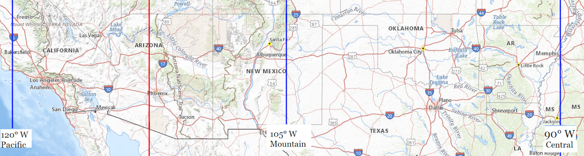
Pacific Standard Time is the mean solar time of 120° west, the blue line on the left. Mountain Standard Time is the mean solar time of 105° west, the blue line in the middle. The red line is halfway between Pacific and Mountain, where the time zone boundary belongs. Mountain Daylight Saving Time equals Central Standard Time, the blue line on the right.
While part of Arizona belongs on Pacific Standard Time, a majority of it belongs on Mountain Standard Time, and dividing the State may be inconvenient.
Clocks in the Rio Colorado Elementary School in San Luis show a time 39 minutes and 7 seconds ahead of their local mean solar time. Switching to Pacific Standard Time would put those clocks 20 minutes and 53 seconds behind their local mean solar time. Switching to Mountain Daylight Saving Time, which equals Central Standard Time, would put those clocks 1 hour, 39 minutes and 7 seconds ahead of their local mean solar time, onto the mean solar time of Memphis, Tennessee.
Daylight saving time, which is singular, is supported by clods who think that politicians can give them more hours of daylight.
“Facts are stubborn things; and whatever may be our wishes, our inclinations, or the dictates of our passion, they cannot alter the state of facts and evidence.” — John Adams, Argument in Defense of the British Soldiers in the Boston Massacre Trials, 4 December 1770.
Supporters of year-round daylight saving time argue: Changing the clocks twice a year really stinks. Let’s keep the clocks set to the wrong time year-round. They think the government can give them more daylight by tampering with the clocks, which is like thinking you can gain or lose weight by tampering with your scale.
Supporters of year-round daylight saving time argue that folks have become habituated more to daylight saving time, observing it 8 months every year, than to standard time; but this is because lawmakers forced it onto us. If this bad habit is passed onto little children who are learning how to tell time, when will the bad habit ever be broken?
Supporters of year-round standard time argue: Changing the clocks twice a year really stinks, and forces people to observe the wrong time of day when daylight saving time is in effect. End it, don’t extend it. Let’s not kick the can down the road and burden future generations with the wrong time. Over the years, businesses will adapt, using winter hours and summer hours, same as libraries do. Let’s keep the clocks set to the time that most closely approximates their actual mean solar time. If you want a long sunlit afternoon, then work from 7:00 to 16:00 standard time, which is the same as 8:00 to 17:00 daylight saving time. Petition your employer, but don’t try to force everybody to keep their clocks set to the wrong time.
A State can exempt herself from daylight saving time without federal approval. See15 U.S. Code § 260a(a)(1) , but year-round daylight saving time requires an Act of Congress.
Earth rotates on its axis in 23 hours, 56 minutes and 4.098903691 seconds1, but moves along on its orbit during that time, so it takes a few minutes longer for your hemisphere to face the Sun again. Since the orbit is not circular, the length of a solar day varies during the year. To avoid having days of different lengths, the mean (average) day of 24 hours is used. If the Sun transits your meridian, on average, 12 hours after your clock strikes midnight, then your clock is set to the mean (average) solar time of your longitude. For more about solar (Sun) days versus sidereal (other stars) days, see https://www.universetoday.com/47181/earths-rotation/
As used on this website, a place belongs on a time that is no more than 30 minutes away from its local mean solar time. A time zone boundary belongs at the meridian where the local mean solar time is 30 minutes ahead of the standard time in the time zone to the west and 30 minutes behind the standard time in the time zone to the east. Obviously, minor adjustments are recommendable so that the actual boundaries do not run through Tampa, Florida or Oklahoma City, Oklahoma and Brownsville, Texas. The boundary between the Eastern Time Zone and the Atlantic Time Zone, running along the international boundary between Maine, U.S.A. and New Brunswick, Canada, is an example of a minor adjustment.
Yellow background indicates the correct time zone, with a difference less than 30 minutes from local mean solar time.
| Location | Co-Ordinates (Latitude, Longitude and Elevation) |
Pacific Standard Time |
Pacific Daylight Saving Time) |
(Mountain Daylight Saving Time) |
| 91st Psalm Christian School, Maricopa County |
12:31:50 | 11:31:50 | 10:31:50 | |
| A J Mitchell Elementary School, Santa Cruz County |
12:36:14 | 11:36:14 | 10:36:14 | |
| ARCHES Academy, Pinal County |
12:33:45 | 11:33:45 | 10:33:45 | |
| Abbie School, Pima County |
12:36:32 | 11:36:32 | 10:36:32 | |
| Abia Judd Elementary School, Yavapai County |
12:30:00 | 11:30:00 | 10:30:00 | |
| Abiding Savior School, Maricopa County |
12:32:16 | 11:32:16 | 10:32:16 | |
| Abraham Lincoln Traditional School, Maricopa County |
12:31:25 | 11:31:25 | 10:31:25 | |
| Acacia Elementary School, Maricopa County |
12:31:30 | 11:31:30 | 10:31:30 | |
| Acacia Elementary School, Pima County |
12:37:07 | 11:37:07 | 10:37:07 | |
| Academia del Pueblo, Maricopa County |
12:31:42 | 11:31:42 | 10:31:42 | |
| Academy Adventures Primary School, Pima County |
12:36:01 | 11:36:01 | 10:36:01 | |
| Academy of Arizona North Campus, Maricopa County |
12:31:29 | 11:31:29 | 10:31:29 | |
| Academy of Excellence, Maricopa County |
12:31:59 | 11:31:59 | 10:31:59 | |
| Academy of Math and Science, Pima County |
12:36:00 | 11:36:00 | 10:36:00 | |
| Academy of Tucson High School, Pima County |
12:36:56 | 11:36:56 | 10:36:56 | |
| Academy of Tucson Middle School, Pima County |
12:36:39 | 11:36:39 | 10:36:39 | |
| Academy of the Sacred Heart, Pima County |
12:36:09 | 11:36:09 | 10:36:09 | |
| Academy with Community Partners, Maricopa County |
12:32:49 | 11:32:49 | 10:32:49 | |
| Accelerated Learning Center, Maricopa County |
12:32:01 | 11:32:01 | 10:32:01 | |
| Accelerated Learning Charter School, Yavapai County |
12:31:57 | 11:31:57 | 10:31:57 | |
| Acclaim Academy, Maricopa County |
12:31:06 | 11:31:06 | 10:31:06 | |
| Accommodation School, Maricopa County |
12:31:31 | 11:31:31 | 10:31:31 | |
| Ace Elementary School, Maricopa County |
12:31:33 | 11:31:33 | 10:31:33 | |
| Acorn Montessori School, Yavapai County |
12:30:40 | 11:30:40 | 10:30:40 | |
| Adams Elementary School, Maricopa County |
12:32:31 | 11:32:31 | 10:32:31 | |
| Adams School, Maricopa County |
12:31:39 | 11:31:39 | 10:31:39 | |
| Adobe Adventist Christian School, Maricopa County |
12:33:31 | 11:33:31 | 10:33:31 | |
| Adobe Mountain School North, Maricopa County |
12:31:31 | 11:31:31 | 10:31:31 | |
| Agua Caliente Elementary School, Pima County |
12:37:00 | 11:37:00 | 10:37:00 | |
| Agua Fria High School, Maricopa County |
12:30:37 | 11:30:37 | 10:30:37 | |
| Aguila Elementary School, Maricopa County |
12:27:18 | 11:27:18 | 10:27:18 | |
| Aguila Post Office, Maricopa County |
12:27:19 | 11:27:19 | 10:27:19 | |
| Aguilar Elementary School, Maricopa County |
12:32:15 | 11:32:15 | 10:32:15 | |
| Aha Macav High School, Mohave County |
12:21:37 | 11:21:37 | 10:21:37 | |
| Ahwatukee Foothills Montessori School, Maricopa County |
12:31:56 | 11:31:56 | 10:31:56 | |
| Ahwatukee Post Office, Maricopa County |
12:32:05 | 11:32:05 | 10:32:05 | |
| Air Academy Charter High School, Maricopa County |
12:31:06 | 11:31:06 | 10:31:06 | |
| Aire Libre Elementary School, Maricopa County |
12:31:50 | 11:31:50 | 10:31:50 | |
| Ajo Elementary School, Pima County |
12:28:33 | 11:28:33 | 10:28:33 | |
| Ajo High School, Pima County |
12:28:33 | 11:28:33 | 10:28:33 | |
| Ajo Post Office, Pima County |
12:28:33 | 11:28:33 | 10:28:33 | |
| Al - Huda Islamic School, Pima County |
12:36:16 | 11:36:16 | 10:36:16 | |
| Alchesay High School, Navajo County |
12:40:07 | 11:40:07 | 10:40:07 | |
| Alfred F. Garcia Elementary School, Maricopa County |
12:31:32 | 11:31:32 | 10:31:32 | |
| Alger School, Graham County |
12:41:41 | 11:41:41 | 10:41:41 | |
| Alhambra High School, Maricopa County |
12:31:26 | 11:31:26 | 10:31:26 | |
| Alhambra School, Maricopa County |
12:31:26 | 11:31:26 | 10:31:26 | |
| Alhambra Traditional School, Maricopa County |
12:31:32 | 11:31:32 | 10:31:32 | |
| Alhambra Traditional School, Maricopa County |
12:31:26 | 11:31:26 | 10:31:26 | |
| Alice Byrne Elementary School, Yuma County |
12:21:28 | 11:21:28 | 10:21:28 | |
| Alice Vail Middle School, Pima County |
12:36:29 | 11:36:29 | 10:36:29 | |
| All Aboard Charter School, Maricopa County |
12:31:27 | 11:31:27 | 10:31:27 | |
| All Saints Catholic School, Cochise County |
12:38:51 | 11:38:51 | 10:38:51 | |
| All Saints Episcopal Day School, Maricopa County |
12:31:42 | 11:31:42 | 10:31:42 | |
| All Saints School, Pima County |
12:36:07 | 11:36:07 | 10:36:07 | |
| Alpine Elementary School, Apache County |
12:43:25 | 11:43:25 | 10:43:25 | |
| Alpine Post Office, Apache County |
12:43:24 | 11:43:24 | 10:43:24 | |
| Alta E Butler Elementary School, Maricopa County |
12:31:25 | 11:31:25 | 10:31:25 | |
| Alta Loma Elementary School, Maricopa County |
12:31:00 | 11:31:00 | 10:31:00 | |
| Alta Vista Elementary School, Maricopa County |
12:31:29 | 11:31:29 | 10:31:29 | |
| Altar Valley Middle School, Pima County |
12:34:44 | 11:34:44 | 10:34:44 | |
| Amado Post Office, Pima County |
12:35:45 | 11:35:45 | 10:35:45 | |
| Amberlea Elementary School, Maricopa County |
12:31:02 | 11:31:02 | 10:31:02 | |
| Amelia Maldonado Elementary School, Pima County |
12:35:49 | 11:35:49 | 10:35:49 | |
| AmeriSchools Academy, Pima County |
12:36:17 | 11:36:17 | 10:36:17 | |
| American Christian Academy, Maricopa County |
12:32:10 | 11:32:10 | 10:32:10 | |
| American Evangelist Day School, Maricopa County |
12:31:36 | 11:31:36 | 10:31:36 | |
| American Heritage Academy, Yavapai County |
12:31:58 | 11:31:58 | 10:31:58 | |
| American Indian Christian School, Navajo County |
12:39:24 | 11:39:24 | 10:39:24 | |
| American Leadership Academy, Maricopa County |
12:33:03 | 11:33:03 | 10:33:03 | |
| Amerischools Academy Camelback Campus, Maricopa County |
12:31:38 | 11:31:38 | 10:31:38 | |
| Amerischools Academy, Yuma County |
12:21:30 | 11:21:30 | 10:21:30 | |
| Amphitheater District Alternative School, Pima County |
12:35:56 | 11:35:56 | 10:35:56 | |
| Amphitheater High School, Pima County |
12:36:05 | 11:36:05 | 10:36:05 | |
| Amphitheater Middle School, Pima County |
12:36:07 | 11:36:07 | 10:36:07 | |
| Amy L Houston Academy, Maricopa County |
12:31:46 | 11:31:46 | 10:31:46 | |
| Anasazi Elementary School, Maricopa County |
12:32:45 | 11:32:45 | 10:32:45 | |
| Andalucia Middle School, Maricopa County |
12:31:21 | 11:31:21 | 10:31:21 | |
| Andalucia Primary School, Maricopa County |
12:31:21 | 11:31:21 | 10:31:21 | |
| Anderson Adventist School, Gila County |
12:34:44 | 11:34:44 | 10:34:44 | |
| Anderson Elementary School, Maricopa County |
12:32:30 | 11:32:30 | 10:32:30 | |
| Anderson Junior High School, Maricopa County |
12:32:29 | 11:32:29 | 10:32:29 | |
| Anderson Springs Post Office, Maricopa County |
12:32:29 | 11:32:29 | 10:32:29 | |
| Anna Henry Elementary School, Pima County |
12:36:48 | 11:36:48 | 10:36:48 | |
| Anna Lawrence Elementary School, Pima County |
12:35:42 | 11:35:42 | 10:35:42 | |
| Anna Lawrence Intermediate School, Pima County |
12:35:43 | 11:35:43 | 10:35:43 | |
| Annie W Kellond Elementary School, Pima County |
12:36:35 | 11:36:35 | 10:36:35 | |
| Antelope Union High School, Yuma County |
12:23:54 | 11:23:54 | 10:23:54 | |
| Anthem K - 8 School, Pinal County |
12:34:05 | 11:34:05 | 10:34:05 | |
| Anthem School, Maricopa County |
12:31:28 | 11:31:28 | 10:31:28 | |
| Anza Trail School, Pima County |
12:36:06 | 11:36:06 | 10:36:06 | |
| Apache Elementary School, Cochise County |
12:43:28 | 11:43:28 | 10:43:28 | |
| Apache Elementary School, Maricopa County |
12:32:25 | 11:32:25 | 10:32:25 | |
| Apache Elementary School, Maricopa County |
12:31:01 | 11:31:01 | 10:31:01 | |
| Apache Junction High School, Pinal County |
12:33:45 | 11:33:45 | 10:33:45 | |
| Apache Junction Junior High School, Pinal County |
12:33:45 | 11:33:45 | 10:33:45 | |
| Apache Junction Post Office, Pinal County |
12:33:48 | 11:33:48 | 10:33:48 | |
| Apache Mission School, Navajo County |
12:38:04 | 11:38:04 | 10:38:04 | |
| Apache Trail High School, Pinal County |
12:33:46 | 11:33:46 | 10:33:46 | |
| Apex Public Charter Academy, Maricopa County |
12:31:46 | 11:31:46 | 10:31:46 | |
| Apollo High School, Maricopa County |
12:31:21 | 11:31:21 | 10:31:21 | |
| Apollo Middle School, Pima County |
12:36:06 | 11:36:06 | 10:36:06 | |
| Aravaipa School, Graham County |
12:38:26 | 11:38:26 | 10:38:26 | |
| Arcadia High School, Maricopa County |
12:32:04 | 11:32:04 | 10:32:04 | |
| Arcadia Music Academy, Maricopa County |
12:32:09 | 11:32:09 | 10:32:09 | |
| Arcadia Post Office, Maricopa County |
12:32:00 | 11:32:00 | 10:32:00 | |
| Argosy University Phoenix Campus, Maricopa County |
12:31:34 | 11:31:34 | 10:31:34 | |
| Aripine Post Office, Navajo County |
12:38:23 | 11:38:23 | 10:38:23 | |
| Arivaca Post Office, Pima County |
12:34:40 | 11:34:40 | 10:34:40 | |
| Arizona Academy of Leadership, Pima County |
12:36:17 | 11:36:17 | 10:36:17 | |
| Arizona Academy of Science and Technology, Maricopa County |
12:31:42 | 11:31:42 | 10:31:42 | |
| Arizona Agribusiness and Equine Center Public Charter School, Maricopa County |
12:31:59 | 11:31:59 | 10:31:59 | |
| Arizona Agribusiness and Equine School, Maricopa County |
12:31:52 | 11:31:52 | 10:31:52 | |
| Arizona Bible School, Graham County |
12:40:23 | 11:40:23 | 10:40:23 | |
| Arizona Cardinals Preparatory Academy, Maricopa County |
12:31:35 | 11:31:35 | 10:31:35 | |
| Arizona Christian University, Maricopa County |
12:31:16 | 11:31:16 | 10:31:16 | |
| Arizona City Elementary School, Pinal County |
12:33:12 | 11:33:12 | 10:33:12 | |
| Arizona College Prep Erie Campus, Maricopa County |
12:32:33 | 11:32:33 | 10:32:33 | |
| Arizona College of Allied Health, Maricopa County |
12:31:22 | 11:31:22 | 10:31:22 | |
| Arizona Connections Academy Charter School, Maricopa County |
12:32:50 | 11:32:50 | 10:32:50 | |
| Arizona Department of Corrections Marana School, Pima County |
12:35:02 | 11:35:02 | 10:35:02 | |
| Arizona Desert Elementary School, Maricopa County |
12:30:59 | 11:30:59 | 10:30:59 | |
| Arizona Desert Elementary School, Yuma County |
12:20:52 | 11:20:52 | 10:20:52 | |
| Arizona Desert School, Pima County |
12:36:11 | 11:36:11 | 10:36:11 | |
| Arizona Job College, Pinal County |
12:32:58 | 11:32:58 | 10:32:58 | |
| Arizona Lutheran Academy, Maricopa County |
12:31:31 | 11:31:31 | 10:31:31 | |
| Arizona Montessori Charter School at Anthem, Maricopa County |
12:31:35 | 11:31:35 | 10:31:35 | |
| Arizona School for The Arts, Maricopa County |
12:31:43 | 11:31:43 | 10:31:43 | |
| Arizona State College, Coconino County |
12:33:22 | 11:33:22 | 10:33:22 | |
| Arizona State School, Pima County |
12:36:02 | 11:36:02 | 10:36:02 | |
| Arizona State University Downtown Phoenix Campus, Maricopa County |
12:31:42 | 11:31:42 | 10:31:42 | |
| Arizona State University Polytechnic Campus Academic Center Building, Maricopa County |
12:33:17 | 11:33:17 | 10:33:17 | |
| Arizona State University Polytechnic Campus Administration Building, Maricopa County |
12:33:16 | 11:33:16 | 10:33:16 | |
| Arizona State University Polytechnic Campus Agribusiness Center, Maricopa County |
12:33:17 | 11:33:17 | 10:33:17 | |
| Arizona State University Polytechnic Campus Applied Arts Pavilion, Maricopa County |
12:33:17 | 11:33:17 | 10:33:17 | |
| Arizona State University Polytechnic Campus Engineering Studio, Maricopa County |
12:33:17 | 11:33:17 | 10:33:17 | |
| Arizona State University Polytechnic Campus Exercise and Wellness Building, Maricopa County |
12:33:18 | 11:33:18 | 10:33:18 | |
| Arizona State University Polytechnic Campus Health Sciences Center, Maricopa County |
12:33:16 | 11:33:16 | 10:33:16 | |
| Arizona State University Polytechnic Campus Interdisciplinary Science and Technology Building 3, Maricopa County |
12:33:18 | 11:33:18 | 10:33:18 | |
| Arizona State University Polytechnic Campus Peralta Hall, Maricopa County |
12:33:16 | 11:33:16 | 10:33:16 | |
| Arizona State University Polytechnic Campus Picacho Hall, Maricopa County |
12:33:16 | 11:33:16 | 10:33:16 | |
| Arizona State University Polytechnic Campus Santa Catalina Hall, Maricopa County |
12:33:17 | 11:33:17 | 10:33:17 | |
| Arizona State University Polytechnic Campus Santan Hall, Maricopa County |
12:33:17 | 11:33:17 | 10:33:17 | |
| Arizona State University Polytechnic Campus Simulator Building, Maricopa County |
12:33:18 | 11:33:18 | 10:33:18 | |
| Arizona State University Polytechnic Campus Student Union, Maricopa County |
12:33:17 | 11:33:17 | 10:33:17 | |
| Arizona State University Polytechnic Campus Sutton Hall, Maricopa County |
12:33:17 | 11:33:17 | 10:33:17 | |
| Arizona State University Polytechnic Campus Technology Center, Maricopa County |
12:33:16 | 11:33:16 | 10:33:16 | |
| Arizona State University Polytechnic Campus Wanner Hall, Maricopa County |
12:33:17 | 11:33:17 | 10:33:17 | |
| Arizona State University Polytechnic Campus, Maricopa County |
12:33:17 | 11:33:17 | 10:33:17 | |
| Arizona State University West Campus Faculty Administration Building, Maricopa County |
12:31:21 | 11:31:21 | 10:31:21 | |
| Arizona State University West Campus Sands Classroom Building, Maricopa County |
12:31:21 | 11:31:21 | 10:31:21 | |
| Arizona State University West Campus University Center Building, Maricopa County |
12:31:21 | 11:31:21 | 10:31:21 | |
| Arizona State University West Campus, Maricopa County |
12:31:21 | 11:31:21 | 10:31:21 | |
| Arizona State University, Maricopa County |
12:32:15 | 11:32:15 | 10:32:15 | |
| Arizona Sunshine School, Pima County |
12:36:30 | 11:36:30 | 10:36:30 | |
| Arizona Western College Main Campus, Yuma County |
12:22:00 | 11:22:00 | 10:22:00 | |
| Arlington Elementary School, Maricopa County |
12:28:52 | 11:28:52 | 10:28:52 | |
| Arlington Elementary School, Maricopa County |
12:28:43 | 11:28:43 | 10:28:43 | |
| Arlington Post Office, Maricopa County |
12:28:56 | 11:28:56 | 10:28:56 | |
| Arredondo Elementary School, Maricopa County |
12:32:20 | 11:32:20 | 10:32:20 | |
| Arrowhead Elementary School, Maricopa County |
12:32:00 | 11:32:00 | 10:32:00 | |
| Arrowhead Elementary School, Maricopa County |
12:31:07 | 11:31:07 | 10:31:07 | |
| Arrowhead Post Office, Maricopa County |
12:31:15 | 11:31:15 | 10:31:15 | |
| Arroyo Elementary School, Maricopa County |
12:31:22 | 11:31:22 | 10:31:22 | |
| Artesia School, Graham County |
12:41:12 | 11:41:12 | 10:41:12 | |
| Arthur M Hamilton Elementary School, Maricopa County |
12:31:35 | 11:31:35 | 10:31:35 | |
| Artworks Academy, Pima County |
12:36:20 | 11:36:20 | 10:36:20 | |
| Ascending Roots Scholastic and Athletic Premise School, Maricopa County |
12:31:31 | 11:31:31 | 10:31:31 | |
| Ash Creek Elementary School, Cochise County |
12:41:27 | 11:41:27 | 10:41:27 | |
| Ash Fork Elementary School, Yavapai County |
12:30:03 | 11:30:03 | 10:30:03 | |
| Ash Fork High School, Yavapai County |
12:30:03 | 11:30:03 | 10:30:03 | |
| Ash Fork Middle School, Yavapai County |
12:30:03 | 11:30:03 | 10:30:03 | |
| Ash Fork Post Office, Yavapai County |
12:30:03 | 11:30:03 | 10:30:03 | |
| Ashland Ranch Elementary School, Maricopa County |
12:32:56 | 11:32:56 | 10:32:56 | |
| Ashton Ranch Elementary School, Maricopa County |
12:30:28 | 11:30:28 | 10:30:28 | |
| Aspen University School of Nursing, Maricopa County |
12:32:04 | 11:32:04 | 10:32:04 | |
| Atkinson Sixth Grade Center, Maricopa County |
12:31:19 | 11:31:19 | 10:31:19 | |
| Augusta Ranch Elementary School, Maricopa County |
12:33:28 | 11:33:28 | 10:33:28 | |
| Augustus H Shaw Jr Montessori School, Maricopa County |
12:31:47 | 11:31:47 | 10:31:47 | |
| Austin Centers for Exceptional Students - Peoria Campus, Maricopa County |
12:31:10 | 11:31:10 | 10:31:10 | |
| Autism Spectrum Therapies - Evens Learning Center School, Maricopa County |
12:32:15 | 11:32:15 | 10:32:15 | |
| Avalon Charter School, Pinal County |
12:33:47 | 11:33:47 | 10:33:47 | |
| Avenue B Elementary School, Pinal County |
12:37:28 | 11:37:28 | 10:37:28 | |
| Avondale Elementary School, Maricopa County |
12:30:35 | 11:30:35 | 10:30:35 | |
| Avondale Goodyear Post Office, Maricopa County |
12:30:26 | 11:30:26 | 10:30:26 | |
| Avondale Junior High School, Maricopa County |
12:30:36 | 11:30:36 | 10:30:36 | |
| Avondale Post Office, Maricopa County |
12:30:34 | 11:30:34 | 10:30:34 | |
| Awakening Seed School, Maricopa County |
12:32:00 | 11:32:00 | 10:32:00 | |
| Aztec High School, Yuma County |
12:21:24 | 11:21:24 | 10:21:24 | |
| Aztec Middle College East Campus, Pima County |
12:36:43 | 11:36:43 | 10:36:43 | |
| Aztec Middle College Northwest Campus, Pima County |
12:35:53 | 11:35:53 | 10:35:53 | |
| Aztec Middle College West Campus, Pima County |
12:35:56 | 11:35:56 | 10:35:56 | |
| BASIS Ahwatukee School, Maricopa County |
12:32:05 | 11:32:05 | 10:32:05 | |
| Baboquivari High School, Pima County |
12:32:39 | 11:32:39 | 10:32:39 | |
| Baboquivari Middle School, Pima County |
12:32:39 | 11:32:39 | 10:32:39 | |
| Bagdad Elementary School, Yavapai County |
12:27:15 | 11:27:15 | 10:27:15 | |
| Bagdad Middle / High School, Yavapai County |
12:27:15 | 11:27:15 | 10:27:15 | |
| Bagdad Post Office, Yavapai County |
12:27:16 | 11:27:16 | 10:27:16 | |
| Bales Elementary School, Maricopa County |
12:29:36 | 11:29:36 | 10:29:36 | |
| Barbara B Robey Elementary School, Maricopa County |
12:30:40 | 11:30:40 | 10:30:40 | |
| Barcelona Elementary School, Maricopa County |
12:31:22 | 11:31:22 | 10:31:22 | |
| Barcelona North School, Maricopa County |
12:31:22 | 11:31:22 | 10:31:22 | |
| Barcelona South School, Maricopa County |
12:31:22 | 11:31:22 | 10:31:22 | |
| Barry Goldwater High School, Maricopa County |
12:31:31 | 11:31:31 | 10:31:31 | |
| Basha Elementary School, Maricopa County |
12:32:34 | 11:32:34 | 10:32:34 | |
| Basha High School, Maricopa County |
12:32:58 | 11:32:58 | 10:32:58 | |
| Basis School, Pima County |
12:36:21 | 11:36:21 | 10:36:21 | |
| Beautiful Savior Academy, Pima County |
12:35:48 | 11:35:48 | 10:35:48 | |
| Beaver Creek School, Yavapai County |
12:32:56 | 11:32:56 | 10:32:56 | |
| Beaver Dam Elementary School, Mohave County |
12:24:17 | 11:24:17 | 10:24:17 | |
| Beaver Dam Junior - Senior High School, Mohave County |
12:24:17 | 11:24:17 | 10:24:17 | |
| Beaver Dam Middle School, Mohave County |
12:24:17 | 11:24:17 | 10:24:17 | |
| Bell Canyon Charter School, Maricopa County |
12:31:32 | 11:31:32 | 10:31:32 | |
| Bella Vista Elementary School, Cochise County |
12:38:52 | 11:38:52 | 10:38:52 | |
| Bellair Elementary School, Maricopa County |
12:31:21 | 11:31:21 | 10:31:21 | |
| Belle Affeld Beloved Humanities Academy, Yavapai County |
12:32:53 | 11:32:53 | 10:32:53 | |
| Benchmark Elementary School, Maricopa County |
12:32:01 | 11:32:01 | 10:32:01 | |
| Benjamin Franklin Charter School - Queen Creek, Maricopa County |
12:33:32 | 11:33:32 | 10:33:32 | |
| Benjamin Franklin Charter School, Maricopa County |
12:32:51 | 11:32:51 | 10:32:51 | |
| Benjamin Franklin Charter School, Maricopa County |
12:32:44 | 11:32:44 | 10:32:44 | |
| Benjamin Franklin School, Gila County |
12:36:29 | 11:36:29 | 10:36:29 | |
| Bennett Academy Middle School, Maricopa County |
12:31:30 | 11:31:30 | 10:31:30 | |
| Benson Elementary School, Cochise County |
12:38:48 | 11:38:48 | 10:38:48 | |
| Benson High School, Cochise County |
12:38:47 | 11:38:47 | 10:38:47 | |
| Benson Middle School, Cochise County |
12:38:48 | 11:38:48 | 10:38:48 | |
| Benson Post Office, Cochise County |
12:38:46 | 11:38:46 | 10:38:46 | |
| Bernard Black Elementary School, Maricopa County |
12:31:31 | 11:31:31 | 10:31:31 | |
| Bethany Bible School, Maricopa County |
12:31:40 | 11:31:40 | 10:31:40 | |
| Bethany Christian School, Mohave County |
12:22:35 | 11:22:35 | 10:22:35 | |
| Bethany Learning Center, Maricopa County |
12:32:25 | 11:32:25 | 10:32:25 | |
| Bethel School, Maricopa County |
12:31:38 | 11:31:38 | 10:31:38 | |
| Bethune School, Maricopa County |
12:31:38 | 11:31:38 | 10:31:38 | |
| Bethune School, Maricopa County |
12:31:37 | 11:31:37 | 10:31:37 | |
| Betty H Fairfax High School, Maricopa County |
12:31:16 | 11:31:16 | 10:31:16 | |
| Bicentennial North School, Maricopa County |
12:31:08 | 11:31:08 | 10:31:08 | |
| Bicentennial South School, Maricopa County |
12:31:08 | 11:31:08 | 10:31:08 | |
| Big Park Community School, Yavapai County |
12:32:53 | 11:32:53 | 10:32:53 | |
| Billy Lane Lauffer Middle School, Pima County |
12:36:29 | 11:36:29 | 10:36:29 | |
| Biltmore Preparatory Academy, Maricopa County |
12:31:57 | 11:31:57 | 10:31:57 | |
| Bioscience High School, Maricopa County |
12:31:43 | 11:31:43 | 10:31:43 | |
| Bisbee High School, Cochise County |
12:40:26 | 11:40:26 | 10:40:26 | |
| Bisbee Middle School, Cochise County |
12:40:17 | 11:40:17 | 10:40:17 | |
| Bisbee Post Office, Cochise County |
12:40:20 | 11:40:20 | 10:40:20 | |
| Bisbee Post Office, Cochise County |
12:40:17 | 11:40:17 | 10:40:17 | |
| Black Canyon City Post Office, Yavapai County |
12:31:23 | 11:31:23 | 10:31:23 | |
| Black Canyon School, Maricopa County |
12:31:31 | 11:31:31 | 10:31:31 | |
| Black Canyon School, Yavapai County |
12:31:22 | 11:31:22 | 10:31:22 | |
| Black Mountain Elementary School, Maricopa County |
12:32:11 | 11:32:11 | 10:32:11 | |
| Black Mountain Elementary School, Mohave County |
12:23:06 | 11:23:06 | 10:23:06 | |
| Blackwater Community Center and School, Pinal County |
12:33:36 | 11:33:36 | 10:33:36 | |
| Blake Primary School, La Paz County |
12:22:48 | 11:22:48 | 10:22:48 | |
| Blenman Elementary School, Pima County |
12:36:17 | 11:36:17 | 10:36:17 | |
| Bloom Elementary School, Pima County |
12:36:44 | 11:36:44 | 10:36:44 | |
| Blue Elementary School, Greenlee County |
12:43:37 | 11:43:37 | 10:43:37 | |
| Blue Gap School, Apache County |
12:40:12 | 11:40:12 | 10:40:12 | |
| Blue Post Office, Greenlee County |
12:43:34 | 11:43:34 | 10:43:34 | |
| Blue Post Office, Greenlee County |
12:43:34 | 11:43:34 | 10:43:34 | |
| Blue Ridge Elementary / Middle School, Navajo County |
12:40:06 | 11:40:06 | 10:40:06 | |
| Blue Ridge Elementary School, Navajo County |
12:36:07 | 11:36:07 | 10:36:07 | |
| Blue Ridge High School, Navajo County |
12:40:07 | 11:40:07 | 10:40:07 | |
| Blue Ridge Junior High School, Navajo County |
12:40:07 | 11:40:07 | 10:40:07 | |
| Blue Ridge Junior High School, Navajo County |
12:36:05 | 11:36:05 | 10:36:05 | |
| Blue Ridge Middle School, Navajo County |
12:40:07 | 11:40:07 | 10:40:07 | |
| Bogle Junior High School, Maricopa County |
12:32:31 | 11:32:31 | 10:32:31 | |
| Bologna Elementary School, Maricopa County |
12:32:44 | 11:32:44 | 10:32:44 | |
| Bonillas Traditional Academic Magnet School, Pima County |
12:36:26 | 11:36:26 | 10:36:26 | |
| Bonita Elementary School, Graham County |
12:40:06 | 11:40:06 | 10:40:06 | |
| Bonnie Brennan Elementary School, Navajo County |
12:37:05 | 11:37:05 | 10:37:05 | |
| Booker T Washington School, Maricopa County |
12:31:46 | 11:31:46 | 10:31:46 | |
| Booth - Fickett Math Science Magnet School, Pima County |
12:36:38 | 11:36:38 | 10:36:38 | |
| Booth Elementary School, Pima County |
12:36:39 | 11:36:39 | 10:36:39 | |
| Borman Elementary School, Pima County |
12:36:32 | 11:36:32 | 10:36:32 | |
| Borton Primary Magnet School, Pima County |
12:36:09 | 11:36:09 | 10:36:09 | |
| Bostrom Alternative Center, Maricopa County |
12:31:32 | 11:31:32 | 10:31:32 | |
| Boulder Canyon High School, Maricopa County |
12:33:33 | 11:33:33 | 10:33:33 | |
| Boulder Creek Elementary School, Maricopa County |
12:33:21 | 11:33:21 | 10:33:21 | |
| Boulder Creek Elementary School, Maricopa County |
12:31:51 | 11:31:51 | 10:31:51 | |
| Boulder Creek High School, Maricopa County |
12:31:26 | 11:31:26 | 10:31:26 | |
| Boulder Hills Post Office, Maricopa County |
12:31:53 | 11:31:53 | 10:31:53 | |
| Bourgade Catholic High School, Maricopa County |
12:31:29 | 11:31:29 | 10:31:29 | |
| Bouse Elementary School, La Paz County |
12:24:01 | 11:24:01 | 10:24:01 | |
| Bouse Post Office, La Paz County |
12:23:59 | 11:23:59 | 10:23:59 | |
| Bowie Elementary School, Cochise County |
12:42:02 | 11:42:02 | 10:42:02 | |
| Bowie High School, Cochise County |
12:42:02 | 11:42:02 | 10:42:02 | |
| Bowie Post Office, Cochise County |
12:42:02 | 11:42:02 | 10:42:02 | |
| Boys Ranch Post Office, Maricopa County |
12:33:23 | 11:33:23 | 10:33:23 | |
| Bradshaw Mountain High School, Yavapai County |
12:30:36 | 11:30:36 | 10:30:36 | |
| Bradshaw Mountain High School, Yavapai County |
12:30:36 | 11:30:36 | 10:30:36 | |
| Bradshaw Mountain Middle School, Yavapai County |
12:30:59 | 11:30:59 | 10:30:59 | |
| Bret R Tarver Elementary School, Maricopa County |
12:31:18 | 11:31:18 | 10:31:18 | |
| Brichta Elementary School, Pima County |
12:35:56 | 11:35:56 | 10:35:56 | |
| Bridgepoint Education Center, Maricopa County |
12:32:02 | 11:32:02 | 10:32:02 | |
| Bright Beginnings School, Maricopa County |
12:32:30 | 11:32:30 | 10:32:30 | |
| Brimhall Junior High School (historical), Maricopa County |
12:33:05 | 11:33:05 | 10:33:05 | |
| Brinton Elementary School, Maricopa County |
12:33:40 | 11:33:40 | 10:33:40 | |
| Broadmor Elementary School, Maricopa County |
12:32:15 | 11:32:15 | 10:32:15 | |
| Broadway Alternative Middle School, Pima County |
12:36:14 | 11:36:14 | 10:36:14 | |
| Brookline College, Maricopa County |
12:32:09 | 11:32:09 | 10:32:09 | |
| Brophy College Preparatory School, Maricopa County |
12:31:42 | 11:31:42 | 10:31:42 | |
| Brown Road Baptist School, Maricopa County |
12:33:14 | 11:33:14 | 10:33:14 | |
| Brown School, Pima County |
12:36:31 | 11:36:31 | 10:36:31 | |
| Brownmoor School, Maricopa County |
12:32:12 | 11:32:12 | 10:32:12 | |
| Brunson - Lee Elementary School, Maricopa County |
12:32:04 | 11:32:04 | 10:32:04 | |
| Buckeye Elementary School, Maricopa County |
12:29:40 | 11:29:40 | 10:29:40 | |
| Buckeye Middle School, Maricopa County |
12:29:40 | 11:29:40 | 10:29:40 | |
| Buckeye Post Office, Maricopa County |
12:29:38 | 11:29:38 | 10:29:38 | |
| Buckeye Primary School, Maricopa County |
12:29:40 | 11:29:40 | 10:29:40 | |
| Buckeye Union High School, Maricopa County |
12:29:41 | 11:29:41 | 10:29:41 | |
| Buckhorn Post Office, Maricopa County |
12:33:11 | 11:33:11 | 10:33:11 | |
| Buena High School, Cochise County |
12:39:02 | 11:39:02 | 10:39:02 | |
| Buena High School, Cochise County |
12:38:57 | 11:38:57 | 10:38:57 | |
| Buena School, Cochise County |
12:38:58 | 11:38:58 | 10:38:58 | |
| Bullhead City Annex Post Office, Mohave County |
12:21:33 | 11:21:33 | 10:21:33 | |
| Bullhead City Junior High School, Mohave County |
12:21:33 | 11:21:33 | 10:21:33 | |
| Bullhead City Post Office, Mohave County |
12:21:33 | 11:21:33 | 10:21:33 | |
| Bullion Plaza School, Gila County |
12:36:30 | 11:36:30 | 10:36:30 | |
| Bureau of Indian Affairs Dormitory School, Navajo County |
12:39:18 | 11:39:18 | 10:39:18 | |
| Burk Elementary School, Maricopa County |
12:32:52 | 11:32:52 | 10:32:52 | |
| Burk Street School, Maricopa County |
12:32:52 | 11:32:52 | 10:32:52 | |
| Burke Basic School, Maricopa County |
12:32:41 | 11:32:41 | 10:32:41 | |
| Bush Elementary School, Maricopa County |
12:33:06 | 11:33:06 | 10:33:06 | |
| Bustoz Elementary School (historical), Maricopa County |
12:32:23 | 11:32:23 | 10:32:23 | |
| Butterfield Elementary School, Pima County |
12:35:50 | 11:35:50 | 10:35:50 | |
| Butterfield Elementary School, Pinal County |
12:31:50 | 11:31:50 | 10:31:50 | |
| Bylas Day School, Graham County |
12:39:32 | 11:39:32 | 10:39:32 | |
| Bylas Post Office, Graham County |
12:39:33 | 11:39:33 | 10:39:33 | |
| Byron A Barry Elementary School, Maricopa County |
12:31:14 | 11:31:14 | 10:31:14 | |
| C Doby Middle School, Maricopa County |
12:31:35 | 11:31:35 | 10:31:35 | |
| C E Rose PreK - 8 School, Pima County |
12:36:05 | 11:36:05 | 10:36:05 | |
| C I Waggoner Elementary School, Maricopa County |
12:32:18 | 11:32:18 | 10:32:18 | |
| C J Jorgensen Elementary School, Maricopa County |
12:31:37 | 11:31:37 | 10:31:37 | |
| C O Greenfield School, Maricopa County |
12:31:46 | 11:31:46 | 10:31:46 | |
| C W McGraw Elementary School, Yuma County |
12:21:32 | 11:21:32 | 10:21:32 | |
| CPU Arizona City Post Office, Pinal County |
12:33:16 | 11:33:16 | 10:33:16 | |
| Cactus Canyon Junior High School, Pinal County |
12:33:46 | 11:33:46 | 10:33:46 | |
| Cactus High School, Maricopa County |
12:31:13 | 11:31:13 | 10:31:13 | |
| Cactus High School, Maricopa County |
12:31:13 | 11:31:13 | 10:31:13 | |
| Cactus Middle School, Pinal County |
12:33:03 | 11:33:03 | 10:33:03 | |
| Cactus Post Office, Maricopa County |
12:31:55 | 11:31:55 | 10:31:55 | |
| Cactus Shadows High School, Maricopa County |
12:32:10 | 11:32:10 | 10:32:10 | |
| Cactus View Elementary School, Maricopa County |
12:31:42 | 11:31:42 | 10:31:42 | |
| Cactus Wren Elementary School, Maricopa County |
12:31:25 | 11:31:25 | 10:31:25 | |
| Calabasas School, Santa Cruz County |
12:36:07 | 11:36:07 | 10:36:07 | |
| Calderwood Alternative School, Maricopa County |
12:30:49 | 11:30:49 | 10:30:49 | |
| Calli Ollin Academy, Pima County |
12:36:06 | 11:36:06 | 10:36:06 | |
| Calvary Baptist School, Yuma County |
12:21:31 | 11:21:31 | 10:21:31 | |
| Calvary Christian Academy, Mohave County |
12:22:57 | 11:22:57 | 10:22:57 | |
| Cambridge Academy - Mesa Campus, Maricopa County |
12:33:29 | 11:33:29 | 10:33:29 | |
| Camelback Academy, Maricopa County |
12:31:06 | 11:31:06 | 10:31:06 | |
| Camelback Christian School, Maricopa County |
12:32:00 | 11:32:00 | 10:32:00 | |
| Camelback Desert School Scottsdale Campus, Maricopa County |
12:32:30 | 11:32:30 | 10:32:30 | |
| Camelback Desert School, Maricopa County |
12:32:13 | 11:32:13 | 10:32:13 | |
| Camelback High School, Maricopa County |
12:31:54 | 11:31:54 | 10:31:54 | |
| Cameron Post Office, Coconino County |
12:34:20 | 11:34:20 | 10:34:20 | |
| Camp Mohave Elementary School, Mohave County |
12:21:38 | 11:21:38 | 10:21:38 | |
| Camp Verde Elementary School, Yavapai County |
12:32:34 | 11:32:34 | 10:32:34 | |
| Camp Verde High School, Yavapai County |
12:32:34 | 11:32:34 | 10:32:34 | |
| Camp Verde Middle School, Yavapai County |
12:32:33 | 11:32:33 | 10:32:33 | |
| Camp Verde Post Office, Yavapai County |
12:32:33 | 11:32:33 | 10:32:33 | |
| Camp Verde School, Yavapai County |
12:32:35 | 11:32:35 | 10:32:35 | |
| Camp Verde United Christian School, Yavapai County |
12:32:31 | 11:32:31 | 10:32:31 | |
| Campo Bello Elementary School, Maricopa County |
12:31:53 | 11:31:53 | 10:31:53 | |
| Canille School, Santa Cruz County |
12:37:57 | 11:37:57 | 10:37:57 | |
| Canon School, Yavapai County |
12:31:26 | 11:31:26 | 10:31:26 | |
| Canyon Breeze Elementary School, Maricopa County |
12:30:45 | 11:30:45 | 10:30:45 | |
| Canyon Day Junior High School, Gila County |
12:39:52 | 11:39:52 | 10:39:52 | |
| Canyon De Chelly Elementary School, Apache County |
12:41:39 | 11:41:39 | 10:41:39 | |
| Canyon Del Oro High School, Pima County |
12:36:06 | 11:36:06 | 10:36:06 | |
| Canyon Elementary School, Maricopa County |
12:31:17 | 11:31:17 | 10:31:17 | |
| Canyon Ridge School, Maricopa County |
12:30:16 | 11:30:16 | 10:30:16 | |
| Canyon Rim Elementary School, Maricopa County |
12:33:29 | 11:33:29 | 10:33:29 | |
| Canyon Springs School, Maricopa County |
12:31:22 | 11:31:22 | 10:31:22 | |
| Canyon State Academy, Maricopa County |
12:33:24 | 11:33:24 | 10:33:24 | |
| Canyon View Elementary School, Pima County |
12:36:41 | 11:36:41 | 10:36:41 | |
| Canyon del Muerta School, Apache County |
12:42:15 | 11:42:15 | 10:42:15 | |
| Canyon del Muerto School, Apache County |
12:42:15 | 11:42:15 | 10:42:15 | |
| Capital Academic Charter School, Maricopa County |
12:31:42 | 11:31:42 | 10:31:42 | |
| Capitol Elementary School, Maricopa County |
12:31:37 | 11:31:37 | 10:31:37 | |
| Capitol Elementary School, Maricopa County |
12:31:37 | 11:31:37 | 10:31:37 | |
| Capitol Post Office, Maricopa County |
12:31:27 | 11:31:27 | 10:31:27 | |
| Capps Middle School, Navajo County |
12:37:36 | 11:37:36 | 10:37:36 | |
| Carden Christian Academy Central, Pima County |
12:36:25 | 11:36:25 | 10:36:25 | |
| Carden Traditional School, Maricopa County |
12:31:21 | 11:31:21 | 10:31:21 | |
| Carden of the Peaks School, Coconino County |
12:33:57 | 11:33:57 | 10:33:57 | |
| Career Success High School Main Campus, Maricopa County |
12:31:31 | 11:31:31 | 10:31:31 | |
| Carefree Post Office, Maricopa County |
12:32:18 | 11:32:18 | 10:32:18 | |
| Carl Hayden Community High School, Maricopa County |
12:31:28 | 11:31:28 | 10:31:28 | |
| Carmel Community Arts and Technology Charter School, Cochise County |
12:40:29 | 11:40:29 | 10:40:29 | |
| Carmel Community Arts and Technology Charter School, Maricopa County |
12:32:37 | 11:32:37 | 10:32:37 | |
| Carmichael Elementary School, Cochise County |
12:38:48 | 11:38:48 | 10:38:48 | |
| Carminati Elementary School, Maricopa County |
12:32:16 | 11:32:16 | 10:32:16 | |
| Carol G Peck Elementary School, Maricopa County |
12:31:20 | 11:31:20 | 10:31:20 | |
| Carol Rae Ranch Elementary School, Maricopa County |
12:33:09 | 11:33:09 | 10:33:09 | |
| Carrillo Elementary Magnet School, Pima County |
12:36:06 | 11:36:06 | 10:36:06 | |
| Carrillo Magnet School, Pima County |
12:36:06 | 11:36:06 | 10:36:06 | |
| Carrington College Phoenix North Campus, Maricopa County |
12:31:32 | 11:31:32 | 10:31:32 | |
| Carrizo Mission School, Apache County |
12:43:34 | 11:43:34 | 10:43:34 | |
| Carson Junior High School, Maricopa County |
12:32:35 | 11:32:35 | 10:32:35 | |
| Carson Middle School, Pima County |
12:36:41 | 11:36:41 | 10:36:41 | |
| Cartwright School, Maricopa County |
12:31:15 | 11:31:15 | 10:31:15 | |
| Carver High School, Maricopa County |
12:31:43 | 11:31:43 | 10:31:43 | |
| Casa Blanca Middle School, Pinal County |
12:32:27 | 11:32:27 | 10:32:27 | |
| Casa Grande Middle School, Pinal County |
12:32:58 | 11:32:58 | 10:32:58 | |
| Casa Grande Post Office, Pinal County |
12:32:58 | 11:32:58 | 10:32:58 | |
| Casa Grande Union High School, Pinal County |
12:33:03 | 11:33:03 | 10:33:03 | |
| Casa Ninos School of Montessori, Pima County |
12:36:45 | 11:36:45 | 10:36:45 | |
| Casa Verde High School, Pinal County |
12:33:00 | 11:33:00 | 10:33:00 | |
| Casa Vida School, Maricopa County |
12:31:58 | 11:31:58 | 10:31:58 | |
| Casas Christian School, Pima County |
12:35:55 | 11:35:55 | 10:35:55 | |
| Cascabel School, Cochise County |
12:38:27 | 11:38:27 | 10:38:27 | |
| Cashion Post Office, Maricopa County |
12:30:48 | 11:30:48 | 10:30:48 | |
| Castle Dome Middle School, Yuma County |
12:22:02 | 11:22:02 | 10:22:02 | |
| Castlehill Country Day School, Pima County |
12:36:29 | 11:36:29 | 10:36:29 | |
| Casy Country Day School, Maricopa County |
12:32:17 | 11:32:17 | 10:32:17 | |
| Catalina Foothills High School, Pima County |
12:36:24 | 11:36:24 | 10:36:24 | |
| Catalina High School, Pima County |
12:36:20 | 11:36:20 | 10:36:20 | |
| Catalina Mountain School, Pima County |
12:36:18 | 11:36:18 | 10:36:18 | |
| Catalina Post Office, Pima County |
12:36:17 | 11:36:17 | 10:36:17 | |
| Catalina Ventura School, Maricopa County |
12:31:25 | 11:31:25 | 10:31:25 | |
| Cave Creek Post Office, Maricopa County |
12:32:13 | 11:32:13 | 10:32:13 | |
| Cave Creek School, Maricopa County |
12:32:13 | 11:32:13 | 10:32:13 | |
| Cavett Elementary School, Pima County |
12:36:14 | 11:36:14 | 10:36:14 | |
| Cedar Hills Elementary School, Mohave County |
12:24:53 | 11:24:53 | 10:24:53 | |
| Cedar Middle School, Coconino County |
12:33:32 | 11:33:32 | 10:33:32 | |
| Centennial Elementary School, Pima County |
12:35:56 | 11:35:56 | 10:35:56 | |
| Centennial High School, Maricopa County |
12:31:04 | 11:31:04 | 10:31:04 | |
| Centennial Middle School, Yuma County |
12:21:23 | 11:21:23 | 10:21:23 | |
| Center For Academic Success, Cochise County |
12:38:49 | 11:38:49 | 10:38:49 | |
| Center for Academic Success High School, Cochise County |
12:41:46 | 11:41:46 | 10:41:46 | |
| Centerra Mirage STEM Academy, Maricopa County |
12:30:27 | 11:30:27 | 10:30:27 | |
| Central Arizona College - Superstition Mountain Campus, Pinal County |
12:33:49 | 11:33:49 | 10:33:49 | |
| Central Arizona College Aravaipa Campus, Pinal County |
12:37:11 | 11:37:11 | 10:37:11 | |
| Central Arizona College Casa Grande Center, Pinal County |
12:33:02 | 11:33:02 | 10:33:02 | |
| Central Arizona College Coolidge Center, Pinal County |
12:33:55 | 11:33:55 | 10:33:55 | |
| Central Arizona College Florence Center, Pinal County |
12:34:30 | 11:34:30 | 10:34:30 | |
| Central Arizona College San Tan Center, Pinal County |
12:33:50 | 11:33:50 | 10:33:50 | |
| Central Arizona College Signal Peak Campus Bradley Sizer Jr Center for Business Studies, Pinal County |
12:33:23 | 11:33:23 | 10:33:23 | |
| Central Arizona College Signal Peak Campus C Leroy Hoyt Hall Science - Engineering Building, Pinal County |
12:33:23 | 11:33:23 | 10:33:23 | |
| Central Arizona College Signal Peak Campus Filberto Rudolfo Ortiz Building, Pinal County |
12:33:23 | 11:33:23 | 10:33:23 | |
| Central Arizona College Signal Peak Campus George Young Activity Center, Pinal County |
12:33:23 | 11:33:23 | 10:33:23 | |
| Central Arizona College Signal Peak Campus Gloria R Sheldon University Center, Pinal County |
12:33:23 | 11:33:23 | 10:33:23 | |
| Central Arizona College Signal Peak Campus Interactive Learning Center, Pinal County |
12:33:23 | 11:33:23 | 10:33:23 | |
| Central Arizona College Signal Peak Campus James T O'Neil Administration Hall, Pinal County |
12:33:23 | 11:33:23 | 10:33:23 | |
| Central Arizona College Signal Peak Campus Leslie A Wakefield Center for Health and Home, Pinal County |
12:33:23 | 11:33:23 | 10:33:23 | |
| Central Arizona College Signal Peak Campus Library and Communications Building, Pinal County |
12:33:23 | 11:33:23 | 10:33:23 | |
| Central Arizona College Signal Peak Campus Mel A Everingham Student Center, Pinal County |
12:33:23 | 11:33:23 | 10:33:23 | |
| Central Arizona College Signal Peak Campus Paul Pearce Center for Technological Studies, Pinal County |
12:33:23 | 11:33:23 | 10:33:23 | |
| Central Arizona College Signal Peak Campus Student Services Center, Pinal County |
12:33:23 | 11:33:23 | 10:33:23 | |
| Central Arizona College Signal Peak Campus, Pinal County |
12:33:23 | 11:33:23 | 10:33:23 | |
| Central Elementary School, Maricopa County |
12:31:03 | 11:31:03 | 10:31:03 | |
| Central Heights School, Gila County |
12:36:45 | 11:36:45 | 10:36:45 | |
| Central High School, Maricopa County |
12:31:42 | 11:31:42 | 10:31:42 | |
| Central Post Office, Graham County |
12:40:49 | 11:40:49 | 10:40:49 | |
| Central School, Cochise County |
12:40:20 | 11:40:20 | 10:40:20 | |
| Central School, Pinal County |
12:33:47 | 11:33:47 | 10:33:47 | |
| Central School, Pinal County |
12:32:59 | 11:32:59 | 10:32:59 | |
| Cerbat Elementary School, Mohave County |
12:23:55 | 11:23:55 | 10:23:55 | |
| Cesar Chavez Elementary School, Yuma County |
12:20:59 | 11:20:59 | 10:20:59 | |
| Cesar Chavez High School, Maricopa County |
12:31:24 | 11:31:24 | 10:31:24 | |
| Cesar Chavez Middle School, Pima County |
12:36:07 | 11:36:07 | 10:36:07 | |
| Challenge Charter School, Maricopa County |
12:31:15 | 11:31:15 | 10:31:15 | |
| Challenger Elementary School, Santa Cruz County |
12:36:20 | 11:36:20 | 10:36:20 | |
| Challenger Middle School, Maricopa County |
12:31:09 | 11:31:09 | 10:31:09 | |
| Challenger Middle School, Pima County |
12:36:07 | 11:36:07 | 10:36:07 | |
| Champie School, Yavapai County |
12:30:35 | 11:30:35 | 10:30:35 | |
| Chandler - Gilbert Community College Pecos Campus Agave Hall, Maricopa County |
12:32:48 | 11:32:48 | 10:32:48 | |
| Chandler - Gilbert Community College Pecos Campus Bradshaw Hall, Maricopa County |
12:32:49 | 11:32:49 | 10:32:49 | |
| Chandler - Gilbert Community College Pecos Campus Cholla Hall, Maricopa County |
12:32:48 | 11:32:48 | 10:32:48 | |
| Chandler - Gilbert Community College Pecos Campus Estrella Hall, Maricopa County |
12:32:49 | 11:32:49 | 10:32:49 | |
| Chandler - Gilbert Community College Pecos Campus Gila Hall, Maricopa County |
12:32:49 | 11:32:49 | 10:32:49 | |
| Chandler - Gilbert Community College Pecos Campus Ironwood Hall, Maricopa County |
12:32:48 | 11:32:48 | 10:32:48 | |
| Chandler - Gilbert Community College Pecos Campus Jacaranda Hall, Maricopa County |
12:32:49 | 11:32:49 | 10:32:49 | |
| Chandler - Gilbert Community College Pecos Campus Javalina Hall, Maricopa County |
12:32:49 | 11:32:49 | 10:32:49 | |
| Chandler - Gilbert Community College Pecos Campus Saguaro Hall, Maricopa County |
12:32:49 | 11:32:49 | 10:32:49 | |
| Chandler - Gilbert Community College Pecos Campus Student Center, Maricopa County |
12:32:48 | 11:32:48 | 10:32:48 | |
| Chandler - Gilbert Community College Pecos Campus, Maricopa County |
12:32:48 | 11:32:48 | 10:32:48 | |
| Chandler - Gilbert Community College Williams Campus Bluford Hall, Maricopa County |
12:33:18 | 11:33:18 | 10:33:18 | |
| Chandler - Gilbert Community College Williams Campus Engel Hall, Maricopa County |
12:33:18 | 11:33:18 | 10:33:18 | |
| Chandler - Gilbert Community College Williams Campus Mortuary Science Building, Maricopa County |
12:33:18 | 11:33:18 | 10:33:18 | |
| Chandler - Gilbert Community College Williams Campus Physical Education Center, Maricopa County |
12:33:18 | 11:33:18 | 10:33:18 | |
| Chandler - Gilbert Community College Williams Campus Thomas Hall, Maricopa County |
12:33:18 | 11:33:18 | 10:33:18 | |
| Chandler Academy of Arts and Technology, Maricopa County |
12:32:29 | 11:32:29 | 10:32:29 | |
| Chandler Christian School, Maricopa County |
12:32:36 | 11:32:36 | 10:32:36 | |
| Chandler Early College, Maricopa County |
12:32:48 | 11:32:48 | 10:32:48 | |
| Chandler Environmental Education Center at Veterans Oasis Park, Maricopa County |
12:32:55 | 11:32:55 | 10:32:55 | |
| Chandler Heights School, Maricopa County |
12:33:14 | 11:33:14 | 10:33:14 | |
| Chandler High School, Maricopa County |
12:32:37 | 11:32:37 | 10:32:37 | |
| Chandler Junior High School, Maricopa County |
12:32:36 | 11:32:36 | 10:32:36 | |
| Chandler Post Office, Maricopa County |
12:32:38 | 11:32:38 | 10:32:38 | |
| Chandler Traditional Academy - Freedom Campus, Maricopa County |
12:33:06 | 11:33:06 | 10:33:06 | |
| Chandler Traditional Academy - Goodman, Maricopa County |
12:32:27 | 11:32:27 | 10:32:27 | |
| Chandler Traditional Academy - Humphrey Campus, Maricopa County |
12:32:48 | 11:32:48 | 10:32:48 | |
| Chandler Traditional Academy - Independence, Maricopa County |
12:32:32 | 11:32:32 | 10:32:32 | |
| Chandler Traditional Academy Liberty Campus, Maricopa County |
12:32:48 | 11:32:48 | 10:32:48 | |
| Chaparral College, Pima County |
12:36:25 | 11:36:25 | 10:36:25 | |
| Chaparral Elementary School, Maricopa County |
12:33:07 | 11:33:07 | 10:33:07 | |
| Chaparral Elementary School, Maricopa County |
12:31:26 | 11:31:26 | 10:31:26 | |
| Chaparral High School, Maricopa County |
12:32:16 | 11:32:16 | 10:32:16 | |
| Chaparral Middle School, Pima County |
12:36:20 | 11:36:20 | 10:36:20 | |
| Charles W Harris Elementary School, Maricopa County |
12:31:17 | 11:31:17 | 10:31:17 | |
| Charleston Post Office (historical), Cochise County |
12:39:18 | 11:39:18 | 10:39:18 | |
| Charlotte Upham Patterson Elementary School, Maricopa County |
12:33:02 | 11:33:02 | 10:33:02 | |
| Charter For Excellence School, Maricopa County |
12:32:09 | 11:32:09 | 10:32:09 | |
| Chavez Leadership Academy, Maricopa County |
12:31:43 | 11:31:43 | 10:31:43 | |
| Cherokee Elementary School, Maricopa County |
12:32:09 | 11:32:09 | 10:32:09 | |
| Chester Newton Charter and Montessori School, Yavapai County |
12:32:34 | 11:32:34 | 10:32:34 | |
| Chevelon Butte School, Coconino County |
12:36:19 | 11:36:19 | 10:36:19 | |
| Cheyenne Elementary School, Maricopa County |
12:31:00 | 11:31:00 | 10:31:00 | |
| Cheyenne Traditional School, Maricopa County |
12:32:38 | 11:32:38 | 10:32:38 | |
| Cheyenne Traditional School, Maricopa County |
12:32:32 | 11:32:32 | 10:32:32 | |
| Chinie Junior High School, Apache County |
12:43:32 | 11:43:32 | 10:43:32 | |
| Chinle Adventist School, Apache County |
12:41:46 | 11:41:46 | 10:41:46 | |
| Chinle Boarding School, Apache County |
12:41:29 | 11:41:29 | 10:41:29 | |
| Chinle Elementary Boarding School, Apache County |
12:41:45 | 11:41:45 | 10:41:45 | |
| Chinle Elementary School, Apache County |
12:41:47 | 11:41:47 | 10:41:47 | |
| Chinle High School, Apache County |
12:41:40 | 11:41:40 | 10:41:40 | |
| Chinle High School, Apache County |
12:41:40 | 11:41:40 | 10:41:40 | |
| Chinle Junior High School, Apache County |
12:41:39 | 11:41:39 | 10:41:39 | |
| Chinle Post Office, Apache County |
12:41:39 | 11:41:39 | 10:41:39 | |
| Chino Valley High School, Yavapai County |
12:30:11 | 11:30:11 | 10:30:11 | |
| Chino Valley Post Office, Yavapai County |
12:30:11 | 11:30:11 | 10:30:11 | |
| Chloride Elementary School, Mohave County |
12:23:10 | 11:23:10 | 10:23:10 | |
| Chloride Post Office, Mohave County |
12:23:12 | 11:23:12 | 10:23:12 | |
| Cholla Alternative School, Maricopa County |
12:31:59 | 11:31:59 | 10:31:59 | |
| Cholla Elementary School, Pinal County |
12:33:03 | 11:33:03 | 10:33:03 | |
| Cholla High Magnet School, Pima County |
12:35:57 | 11:35:57 | 10:35:57 | |
| Cholla Middle School, Maricopa County |
12:31:29 | 11:31:29 | 10:31:29 | |
| Christ Lutheran School, Maricopa County |
12:32:00 | 11:32:00 | 10:32:00 | |
| Christ Rereemer Lutheran School, Maricopa County |
12:31:23 | 11:31:23 | 10:31:23 | |
| Christ the King Catholic School, Maricopa County |
12:32:48 | 11:32:48 | 10:32:48 | |
| Christensen Elementary School, Coconino County |
12:33:39 | 11:33:39 | 10:33:39 | |
| Christian School, Maricopa County |
12:31:32 | 11:31:32 | 10:31:32 | |
| Chrysalis Academy, Maricopa County |
12:32:20 | 11:32:20 | 10:32:20 | |
| Cibecue Community School, Navajo County |
12:38:01 | 11:38:01 | 10:38:01 | |
| Cibola High School, Yuma County |
12:21:19 | 11:21:19 | 10:21:19 | |
| Cienega High School, Pima County |
12:37:06 | 11:37:06 | 10:37:06 | |
| Cimarron Springs Elementary School, Maricopa County |
12:30:17 | 11:30:17 | 10:30:17 | |
| Circle Cross Ranch K - 8 School, Pinal County |
12:33:42 | 11:33:42 | 10:33:42 | |
| Civano Community School, Pima County |
12:36:56 | 11:36:56 | 10:36:56 | |
| Civano Middle School, Pima County |
12:36:54 | 11:36:54 | 10:36:54 | |
| Clarendon Elementary School, Maricopa County |
12:31:38 | 11:31:38 | 10:31:38 | |
| Clark School, Pinal County |
12:37:38 | 11:37:38 | 10:37:38 | |
| Clark Street School, Yavapai County |
12:31:32 | 11:31:32 | 10:31:32 | |
| Clarkdale - Jerome School, Yavapai County |
12:31:44 | 11:31:44 | 10:31:44 | |
| Clarkdale Elementary School, Yavapai County |
12:31:47 | 11:31:47 | 10:31:47 | |
| Clarkdale Junior High School, Yavapai County |
12:31:46 | 11:31:46 | 10:31:46 | |
| Clarkdale Post Office, Yavapai County |
12:31:46 | 11:31:46 | 10:31:46 | |
| Clawson Elementary School, Cochise County |
12:41:49 | 11:41:49 | 10:41:49 | |
| Clay Springs Post Office, Navajo County |
12:38:48 | 11:38:48 | 10:38:48 | |
| Clay Springs School, Navajo County |
12:38:48 | 11:38:48 | 10:38:48 | |
| Claypool Post Office, Gila County |
12:36:37 | 11:36:37 | 10:36:37 | |
| Clemenceau Public School, Yavapai County |
12:31:53 | 11:31:53 | 10:31:53 | |
| Clifton High School, Greenlee County |
12:42:49 | 11:42:49 | 10:42:49 | |
| Clifton Post Office, Greenlee County |
12:42:45 | 11:42:45 | 10:42:45 | |
| Cloves C Campbell Sr School, Maricopa County |
12:31:53 | 11:31:53 | 10:31:53 | |
| Coal Mine Mesa School, Coconino County |
12:36:14 | 11:36:14 | 10:36:14 | |
| Coatimundi Middle School, Santa Cruz County |
12:35:56 | 11:35:56 | 10:35:56 | |
| Cochise College - Willcox Center, Cochise County |
12:40:37 | 11:40:37 | 10:40:37 | |
| Cochise College Benson Center, Cochise County |
12:38:38 | 11:38:38 | 10:38:38 | |
| Cochise College Douglas Campus, Cochise County |
12:41:14 | 11:41:14 | 10:41:14 | |
| Cochise College Nogales Santa Cruz Center, Santa Cruz County |
12:36:16 | 11:36:16 | 10:36:16 | |
| Cochise College Sierra Vista Campus, Cochise County |
12:39:00 | 11:39:00 | 10:39:00 | |
| Cochise Elementary School, Cochise County |
12:40:19 | 11:40:19 | 10:40:19 | |
| Cochise Elementary School, Maricopa County |
12:32:24 | 11:32:24 | 10:32:24 | |
| Cochise Post Office, Cochise County |
12:40:18 | 11:40:18 | 10:40:18 | |
| Coconino Community College, Coconino County |
12:34:09 | 11:34:09 | 10:34:09 | |
| Coconino High School, Coconino County |
12:33:30 | 11:33:30 | 10:33:30 | |
| Coconino High School, Coconino County |
12:33:30 | 11:33:30 | 10:33:30 | |
| Cocopah Elementary School, Maricopa County |
12:32:14 | 11:32:14 | 10:32:14 | |
| Cocopah Middle School, Maricopa County |
12:32:14 | 11:32:14 | 10:32:14 | |
| Coe School, Maricopa County |
12:31:25 | 11:31:25 | 10:31:25 | |
| Coldwater Academy, Maricopa County |
12:30:38 | 11:30:38 | 10:30:38 | |
| College of Ganado, Apache County |
12:41:49 | 11:41:49 | 10:41:49 | |
| Collier Elementary School, Maricopa County |
12:30:44 | 11:30:44 | 10:30:44 | |
| Collier Elementary School, Pima County |
12:36:48 | 11:36:48 | 10:36:48 | |
| Colonel Johnston Elementary School, Cochise County |
12:38:37 | 11:38:37 | 10:38:37 | |
| Colonel Smith Middle School, Cochise County |
12:38:38 | 11:38:38 | 10:38:38 | |
| Colorado City Elementary School (historical), Mohave County |
12:28:06 | 11:28:06 | 10:28:06 | |
| Colorado City Post Office, Mohave County |
12:28:06 | 11:28:06 | 10:28:06 | |
| Colorado River Day School, La Paz County |
12:22:26 | 11:22:26 | 10:22:26 | |
| Combs High School, Pinal County |
12:33:50 | 11:33:50 | 10:33:50 | |
| Combs Traditional Academy, Pinal County |
12:33:45 | 11:33:45 | 10:33:45 | |
| Community Service Center and School, Pinal County |
12:32:27 | 11:32:27 | 10:32:27 | |
| Compadre Academy, Maricopa County |
12:32:12 | 11:32:12 | 10:32:12 | |
| Compass Center, Maricopa County |
12:31:54 | 11:31:54 | 10:31:54 | |
| Concho Elementary School, Apache County |
12:41:26 | 11:41:26 | 10:41:26 | |
| Concho Post Office, Apache County |
12:41:29 | 11:41:29 | 10:41:29 | |
| Congress Elementary School, Yavapai County |
12:28:33 | 11:28:33 | 10:28:33 | |
| Congress Post Office, Yavapai County |
12:28:34 | 11:28:34 | 10:28:34 | |
| Conley Elementary School, Maricopa County |
12:32:31 | 11:32:31 | 10:32:31 | |
| Connolly Middle School, Maricopa County |
12:32:24 | 11:32:24 | 10:32:24 | |
| Constitution Elementary School, Maricopa County |
12:31:37 | 11:31:37 | 10:31:37 | |
| Continental Elementary School, Pima County |
12:36:09 | 11:36:09 | 10:36:09 | |
| Convert School, Pima County |
12:36:06 | 11:36:06 | 10:36:06 | |
| Coolidge 9th Grade Academy, Pinal County |
12:33:54 | 11:33:54 | 10:33:54 | |
| Coolidge Alternative Program School, Pinal County |
12:33:52 | 11:33:52 | 10:33:52 | |
| Coolidge High School Success Center, Pinal County |
12:33:23 | 11:33:23 | 10:33:23 | |
| Coolidge High School, Pinal County |
12:33:53 | 11:33:53 | 10:33:53 | |
| Coolidge Post Office, Pinal County |
12:33:55 | 11:33:55 | 10:33:55 | |
| Copper Basin K - 8 School, Pinal County |
12:33:53 | 11:33:53 | 10:33:53 | |
| Copper Canyon Academy, Maricopa County |
12:31:05 | 11:31:05 | 10:31:05 | |
| Copper Canyon Elementary School, Maricopa County |
12:32:08 | 11:32:08 | 10:32:08 | |
| Copper Canyon High School, Maricopa County |
12:30:58 | 11:30:58 | 10:30:58 | |
| Copper Creek Elementary School, Maricopa County |
12:31:09 | 11:31:09 | 10:31:09 | |
| Copper Creek Elementary School, Pima County |
12:36:03 | 11:36:03 | 10:36:03 | |
| Copper King Elementary School, Maricopa County |
12:30:49 | 11:30:49 | 10:30:49 | |
| Copper Queen Post Office, Cochise County |
12:40:20 | 11:40:20 | 10:40:20 | |
| Copper Ridge School, Maricopa County |
12:32:32 | 11:32:32 | 10:32:32 | |
| Copper Rim Elementary School, Gila County |
12:36:54 | 11:36:54 | 10:36:54 | |
| Copper Trails Elementary School, Maricopa County |
12:30:18 | 11:30:18 | 10:30:18 | |
| Copperwood Elementary School, Maricopa County |
12:31:12 | 11:31:12 | 10:31:12 | |
| Corbet Elementary School, Pima County |
12:36:32 | 11:36:32 | 10:36:32 | |
| Corbett Elementary School, Pima County |
12:36:32 | 11:36:32 | 10:36:32 | |
| Cordova Middle School, Maricopa County |
12:31:28 | 11:31:28 | 10:31:28 | |
| Cordova Primary School, Maricopa County |
12:31:26 | 11:31:26 | 10:31:26 | |
| Cornerstone Charter School, Maricopa County |
12:31:33 | 11:31:33 | 10:31:33 | |
| Cornerstone Christian Academy, Yavapai County |
12:32:01 | 11:32:01 | 10:32:01 | |
| Cornville Post Office, Yavapai County |
12:32:18 | 11:32:18 | 10:32:18 | |
| Corona Foothills Middle School, Pima County |
12:36:55 | 11:36:55 | 10:36:55 | |
| Corona del Sol High School, Maricopa County |
12:32:17 | 11:32:17 | 10:32:17 | |
| Coronada School, Maricopa County |
12:32:18 | 11:32:18 | 10:32:18 | |
| Coronado Elementary School, Apache County |
12:42:33 | 11:42:33 | 10:42:33 | |
| Coronado Elementary School, Cochise County |
12:39:12 | 11:39:12 | 10:39:12 | |
| Coronado Elementary School, Greenlee County |
12:42:31 | 11:42:31 | 10:42:31 | |
| Coronado Elementary School, Maricopa County |
12:33:08 | 11:33:08 | 10:33:08 | |
| Coronado Elementary School, Santa Cruz County |
12:36:09 | 11:36:09 | 10:36:09 | |
| Coronado High School, Maricopa County |
12:32:19 | 11:32:19 | 10:32:19 | |
| Coronado K - 8 School, Pima County |
12:36:19 | 11:36:19 | 10:36:19 | |
| Cortaro Post Office, Pima County |
12:35:38 | 11:35:38 | 10:35:38 | |
| Corte Sierra Elementary School, Maricopa County |
12:30:39 | 11:30:39 | 10:30:39 | |
| Cortez High School, Maricopa County |
12:31:29 | 11:31:29 | 10:31:29 | |
| Cortez Park Charter Middle School, Maricopa County |
12:31:32 | 11:31:32 | 10:31:32 | |
| Cortina Elementary School, Maricopa County |
12:33:17 | 11:33:17 | 10:33:17 | |
| Cotton Boll Elementary School, Maricopa County |
12:31:01 | 11:31:01 | 10:31:01 | |
| Cottonwood Creek School, Cochise County |
12:43:29 | 11:43:29 | 10:43:29 | |
| Cottonwood Day School, Apache County |
12:40:26 | 11:40:26 | 10:40:26 | |
| Cottonwood Elementary School, Pima County |
12:36:52 | 11:36:52 | 10:36:52 | |
| Cottonwood Elementary School, Pinal County |
12:33:01 | 11:33:01 | 10:33:01 | |
| Cottonwood Elementary School, Yavapai County |
12:31:53 | 11:31:53 | 10:31:53 | |
| Cottonwood Middle School, Yavapai County |
12:31:54 | 11:31:54 | 10:31:54 | |
| Cottonwood Post Office, Yavapai County |
12:31:54 | 11:31:54 | 10:31:54 | |
| Cottonwood-Oak Creek School, Yavapai County |
12:31:54 | 11:31:54 | 10:31:54 | |
| Country Meadows Elementary School, Maricopa County |
12:30:48 | 11:30:48 | 10:30:48 | |
| Country Place Leadership Academy, Maricopa County |
12:30:53 | 11:30:53 | 10:30:53 | |
| Countryside Elementary School, Maricopa County |
12:30:26 | 11:30:26 | 10:30:26 | |
| Court Alternative Program of Education Juvenile School, Pima County |
12:36:06 | 11:36:06 | 10:36:06 | |
| Cove School, Apache County |
12:43:07 | 11:43:07 | 10:43:07 | |
| Covenant Home School Resource Center, Maricopa County |
12:31:46 | 11:31:46 | 10:31:46 | |
| Coy Payne Learning Center, Maricopa County |
12:32:37 | 11:32:37 | 10:32:37 | |
| Coyote Canyon School, Mohave County |
12:21:33 | 11:21:33 | 10:21:33 | |
| Coyote Hills Elementary School, Maricopa County |
12:31:00 | 11:31:00 | 10:31:00 | |
| Coyote Ridge School, Maricopa County |
12:31:06 | 11:31:06 | 10:31:06 | |
| Coyote Springs Elementary School, Yavapai County |
12:30:42 | 11:30:42 | 10:30:42 | |
| Coyote Trail Elementary School, Pima County |
12:35:34 | 11:35:34 | 10:35:34 | |
| Cradleboard Elementary School, Navajo County |
12:40:12 | 11:40:12 | 10:40:12 | |
| Cragin Elementary School, Pima County |
12:36:15 | 11:36:15 | 10:36:15 | |
| Crane Middle School, Yuma County |
12:21:17 | 11:21:17 | 10:21:17 | |
| Craycroft Elementary School, Pima County |
12:36:29 | 11:36:29 | 10:36:29 | |
| Creighton School, Maricopa County |
12:31:55 | 11:31:55 | 10:31:55 | |
| Crismon Elementary School, Maricopa County |
12:32:35 | 11:32:35 | 10:32:35 | |
| Cromer Elementary School, Coconino County |
12:33:54 | 11:33:54 | 10:33:54 | |
| Cross Middle School, Pima County |
12:36:03 | 11:36:03 | 10:36:03 | |
| Crown King Elementary School, Yavapai County |
12:30:38 | 11:30:38 | 10:30:38 | |
| Crown King Post Office, Yavapai County |
12:30:38 | 11:30:38 | 10:30:38 | |
| Curiel Elementary School Annex, Pinal County |
12:33:45 | 11:33:45 | 10:33:45 | |
| Curiel Primary School, Pinal County |
12:33:45 | 11:33:45 | 10:33:45 | |
| Curley School, Pima County |
12:28:32 | 11:28:32 | 10:28:32 | |
| Curry Elementary School, Maricopa County |
12:32:23 | 11:32:23 | 10:32:23 | |
| Cyber High School, Maricopa County |
12:31:26 | 11:31:26 | 10:31:26 | |
| D W Higgins Institute, Maricopa County |
12:32:21 | 11:32:21 | 10:32:21 | |
| Daisy Mountain Post Office, Maricopa County |
12:31:23 | 11:31:23 | 10:31:23 | |
| Dan Hinton Accommodation School, Graham County |
12:40:42 | 11:40:42 | 10:40:42 | |
| Daniel C Lincoln Elementary School (historical), Yavapai County |
12:27:18 | 11:27:18 | 10:27:18 | |
| Dateland Elementary School, Yuma County |
12:25:50 | 11:25:50 | 10:25:50 | |
| David Crockett Elementary School, Maricopa County |
12:31:59 | 11:31:59 | 10:31:59 | |
| David Crockett Elementary School, Maricopa County |
12:31:59 | 11:31:59 | 10:31:59 | |
| Davidson Elementary School, Pima County |
12:36:22 | 11:36:22 | 10:36:22 | |
| Davis Bilingual Elementary Magnet School, Pima County |
12:36:04 | 11:36:04 | 10:36:04 | |
| Davis Monthan Air Force Base Post Office, Pima County |
12:36:29 | 11:36:29 | 10:36:29 | |
| Daytona Middle School, Mohave County |
12:22:43 | 11:22:43 | 10:22:43 | |
| DeGrazia Elementary School, Pima County |
12:35:42 | 11:35:42 | 10:35:42 | |
| DeVry University Phoenix, Maricopa County |
12:31:34 | 11:31:34 | 10:31:34 | |
| Deer Valley Charter School, Maricopa County |
12:31:37 | 11:31:37 | 10:31:37 | |
| Deer Valley Crossroads School, Maricopa County |
12:31:19 | 11:31:19 | 10:31:19 | |
| Deer Valley High School, Maricopa County |
12:31:19 | 11:31:19 | 10:31:19 | |
| Deer Valley Middle School, Maricopa County |
12:31:31 | 11:31:31 | 10:31:31 | |
| Deer Valley School, Maricopa County |
12:30:50 | 11:30:50 | 10:30:50 | |
| Del Rio Elementary School, Yavapai County |
12:30:08 | 11:30:08 | 10:30:08 | |
| Demiguel Elementary School, Coconino County |
12:33:16 | 11:33:16 | 10:33:16 | |
| Dennehotso Boarding School, Apache County |
12:40:37 | 11:40:37 | 10:40:37 | |
| Denver Elementary School, Maricopa County |
12:32:36 | 11:32:36 | 10:32:36 | |
| Desert Arroyo Middle School, Maricopa County |
12:32:09 | 11:32:09 | 10:32:09 | |
| Desert Canyon Elementary School, Maricopa County |
12:32:33 | 11:32:33 | 10:32:33 | |
| Desert Canyon Middle School, Maricopa County |
12:32:33 | 11:32:33 | 10:32:33 | |
| Desert Christian High School, Pima County |
12:36:40 | 11:36:40 | 10:36:40 | |
| Desert Christian K - 8 School, Pima County |
12:36:50 | 11:36:50 | 10:36:50 | |
| Desert Cove Elementary School, Maricopa County |
12:31:54 | 11:31:54 | 10:31:54 | |
| Desert Dawn Private School, Maricopa County |
12:32:01 | 11:32:01 | 10:32:01 | |
| Desert Eagle Secondary School, Maricopa County |
12:32:33 | 11:32:33 | 10:32:33 | |
| Desert Edge High School, Maricopa County |
12:30:24 | 11:30:24 | 10:30:24 | |
| Desert Foothills Junior High School, Maricopa County |
12:31:28 | 11:31:28 | 10:31:28 | |
| Desert Garden Elementary School, Maricopa County |
12:31:09 | 11:31:09 | 10:31:09 | |
| Desert Harbor Elementary School, Maricopa County |
12:30:59 | 11:30:59 | 10:30:59 | |
| Desert Hills High School, Maricopa County |
12:32:58 | 11:32:58 | 10:32:58 | |
| Desert Horizon Elementary School, Maricopa County |
12:31:01 | 11:31:01 | 10:31:01 | |
| Desert Marigold School, Maricopa County |
12:31:54 | 11:31:54 | 10:31:54 | |
| Desert Mesa Elementary School, Yuma County |
12:21:58 | 11:21:58 | 10:21:58 | |
| Desert Mirage Elementary School, Maricopa County |
12:31:01 | 11:31:01 | 10:31:01 | |
| Desert Moon School, Maricopa County |
12:30:19 | 11:30:19 | 10:30:19 | |
| Desert Mosaic School, Pima County |
12:35:39 | 11:35:39 | 10:35:39 | |
| Desert Mountain Elementary School, Maricopa County |
12:33:23 | 11:33:23 | 10:33:23 | |
| Desert Mountain High School, Maricopa County |
12:32:45 | 11:32:45 | 10:32:45 | |
| Desert Mountain School, Maricopa County |
12:31:41 | 11:31:41 | 10:31:41 | |
| Desert Oasis Elementary School, Maricopa County |
12:31:00 | 11:31:00 | 10:31:00 | |
| Desert Oasis Elementary School, Maricopa County |
12:30:16 | 11:30:16 | 10:30:16 | |
| Desert Palms Elementary School, Maricopa County |
12:31:17 | 11:31:17 | 10:31:17 | |
| Desert Pointe Academy, Maricopa County |
12:31:05 | 11:31:05 | 10:31:05 | |
| Desert Ridge High School, Maricopa County |
12:33:31 | 11:33:31 | 10:33:31 | |
| Desert Ridge Junior High School, Maricopa County |
12:33:32 | 11:33:32 | 10:33:32 | |
| Desert Rose Academy, Pima County |
12:36:05 | 11:36:05 | 10:36:05 | |
| Desert Rose Community Church Christian College, Maricopa County |
12:31:31 | 11:31:31 | 10:31:31 | |
| Desert Sage Elementary School, Maricopa County |
12:31:24 | 11:31:24 | 10:31:24 | |
| Desert Sage Post Office, Maricopa County |
12:33:23 | 11:33:23 | 10:33:23 | |
| Desert Sands Middle School, Maricopa County |
12:31:12 | 11:31:12 | 10:31:12 | |
| Desert Sands Sixth Grade Center, Maricopa County |
12:31:13 | 11:31:13 | 10:31:13 | |
| Desert Shadows Elementary School, Maricopa County |
12:32:11 | 11:32:11 | 10:32:11 | |
| Desert Shadows Middle School, Maricopa County |
12:32:11 | 11:32:11 | 10:32:11 | |
| Desert Shadows Middle School, Santa Cruz County |
12:36:07 | 11:36:07 | 10:36:07 | |
| Desert Shadows Montessori School, Maricopa County |
12:33:15 | 11:33:15 | 10:33:15 | |
| Desert Sky Community School, Pima County |
12:36:26 | 11:36:26 | 10:36:26 | |
| Desert Sky Middle School, Maricopa County |
12:31:19 | 11:31:19 | 10:31:19 | |
| Desert Sky Middle School, Pima County |
12:36:52 | 11:36:52 | 10:36:52 | |
| Desert Sonora Elementary School, Yuma County |
12:21:08 | 11:21:08 | 10:21:08 | |
| Desert Spirit Elementary School, Maricopa County |
12:31:07 | 11:31:07 | 10:31:07 | |
| Desert Springs Academy, Pima County |
12:36:55 | 11:36:55 | 10:36:55 | |
| Desert Springs Academy, Pima County |
12:36:53 | 11:36:53 | 10:36:53 | |
| Desert Springs Preparatory School, Maricopa County |
12:32:11 | 11:32:11 | 10:32:11 | |
| Desert Star School, Maricopa County |
12:30:24 | 11:30:24 | 10:30:24 | |
| Desert Sun Academy, Maricopa County |
12:32:13 | 11:32:13 | 10:32:13 | |
| Desert Thunder School, Maricopa County |
12:30:19 | 11:30:19 | 10:30:19 | |
| Desert Trails Elementary School, Maricopa County |
12:32:04 | 11:32:04 | 10:32:04 | |
| Desert Valley Christian School, Pima County |
12:36:27 | 11:36:27 | 10:36:27 | |
| Desert Valley Elementary School, Maricopa County |
12:31:13 | 11:31:13 | 10:31:13 | |
| Desert Valley School, Mohave County |
12:21:33 | 11:21:33 | 10:21:33 | |
| Desert View Academy, Yuma County |
12:21:33 | 11:21:33 | 10:21:33 | |
| Desert View Elementary School, Maricopa County |
12:31:43 | 11:31:43 | 10:31:43 | |
| Desert View Elementary School, Yuma County |
12:20:59 | 11:20:59 | 10:20:59 | |
| Desert View High School, Pima County |
12:36:22 | 11:36:22 | 10:36:22 | |
| Desert View Intermediate School, Coconino County |
12:34:09 | 11:34:09 | 10:34:09 | |
| Desert View Learning Center, Maricopa County |
12:32:01 | 11:32:01 | 10:32:01 | |
| Desert Vista Elementary School, Pinal County |
12:33:58 | 11:33:58 | 10:33:58 | |
| Desert Vista High School, Maricopa County |
12:31:56 | 11:31:56 | 10:31:56 | |
| Desert Willow Elementary School, Maricopa County |
12:32:02 | 11:32:02 | 10:32:02 | |
| Desert Willow Elementary School, Pima County |
12:36:50 | 11:36:50 | 10:36:50 | |
| Desert Willow Elementary School, Pinal County |
12:33:09 | 11:33:09 | 10:33:09 | |
| Desert Wind Middle School, Pinal County |
12:32:11 | 11:32:11 | 10:32:11 | |
| Desert Winds Elementary School, Pima County |
12:35:02 | 11:35:02 | 10:35:02 | |
| Desert Winds Learning Center, Pinal County |
12:33:00 | 11:33:00 | 10:33:00 | |
| Destiny Community School, Maricopa County |
12:32:46 | 11:32:46 | 10:32:46 | |
| Destiny School, Gila County |
12:36:56 | 11:36:56 | 10:36:56 | |
| Dewey Post Office, Yavapai County |
12:31:00 | 11:31:00 | 10:31:00 | |
| Diamond Canyon School, Maricopa County |
12:31:35 | 11:31:35 | 10:31:35 | |
| Diamondback Elementary School, Mohave County |
12:21:45 | 11:21:45 | 10:21:45 | |
| Dietz Elementary School, Pima County |
12:36:40 | 11:36:40 | 10:36:40 | |
| Dilkon Community School, Navajo County |
12:38:40 | 11:38:40 | 10:38:40 | |
| Dilkon Indian Mission School, Navajo County |
12:38:39 | 11:38:39 | 10:38:39 | |
| Dine College Tsaile Campus Guy Gorman Sr Classroom Building, Apache County |
12:43:08 | 11:43:08 | 10:43:08 | |
| Dine College Tsaile Campus Gymnasium, Apache County |
12:43:08 | 11:43:08 | 10:43:08 | |
| Dine College Tsaile Campus Ned Hatathli Center, Apache County |
12:43:08 | 11:43:08 | 10:43:08 | |
| Dine College Tsaile Campus Student Services, Apache County |
12:43:08 | 11:43:08 | 10:43:08 | |
| Dine College Tsaile Campus Student Union, Apache County |
12:43:08 | 11:43:08 | 10:43:08 | |
| Dine College, Apache County |
12:43:08 | 11:43:08 | 10:43:08 | |
| Discovery Plus Academy, Graham County |
12:40:37 | 11:40:37 | 10:40:37 | |
| Discovery School, Maricopa County |
12:31:05 | 11:31:05 | 10:31:05 | |
| Dobson Academy, Maricopa County |
12:32:29 | 11:32:29 | 10:32:29 | |
| Dobson High School, Maricopa County |
12:32:31 | 11:32:31 | 10:32:31 | |
| Dobson Montessori School, Maricopa County |
12:32:36 | 11:32:36 | 10:32:36 | |
| Dobson Montessori School, Maricopa County |
12:32:27 | 11:32:27 | 10:32:27 | |
| Doctor Charles A Bejarano Elementary School, Gila County |
12:36:39 | 11:36:39 | 10:36:39 | |
| Doctor Daniel Bright Elementary School, Yavapai County |
12:31:53 | 11:31:53 | 10:31:53 | |
| Dodge Traditional Magnet Middle School, Pima County |
12:36:31 | 11:36:31 | 10:36:31 | |
| Dolan Springs Post Office, Mohave County |
12:22:54 | 11:22:54 | 10:22:54 | |
| Don Luis School, Cochise County |
12:40:19 | 11:40:19 | 10:40:19 | |
| Don Mensendick School, Maricopa County |
12:31:11 | 11:31:11 | 10:31:11 | |
| Doolen Junior High School, Pima County |
12:36:17 | 11:36:17 | 10:36:17 | |
| Doolen Middle School, Pima County |
12:36:17 | 11:36:17 | 10:36:17 | |
| Dorothy Stinson Elementary School, Graham County |
12:41:08 | 11:41:08 | 10:41:08 | |
| Dos Rios Elementary School, Maricopa County |
12:31:00 | 11:31:00 | 10:31:00 | |
| Double Adobe Elementary School, Cochise County |
12:41:12 | 11:41:12 | 10:41:12 | |
| Douglas Early Learning Center, Cochise County |
12:41:49 | 11:41:49 | 10:41:49 | |
| Douglas High School, Cochise County |
12:41:50 | 11:41:50 | 10:41:50 | |
| Douglas Post Office, Cochise County |
12:41:47 | 11:41:47 | 10:41:47 | |
| Dove Christian School, Pima County |
12:36:07 | 11:36:07 | 10:36:07 | |
| Downtown Alternative High School, Pima County |
12:36:07 | 11:36:07 | 10:36:07 | |
| Drachman Montessori Magnet School, Pima County |
12:36:06 | 11:36:06 | 10:36:06 | |
| Dragonfeye Science School, Maricopa County |
12:31:35 | 11:31:35 | 10:31:35 | |
| Dragoon Post Office, Cochise County |
12:39:49 | 11:39:49 | 10:39:49 | |
| Dreaming Summit Elementary School, Maricopa County |
12:30:36 | 11:30:36 | 10:30:36 | |
| Drexel Elementary School, Pima County |
12:36:09 | 11:36:09 | 10:36:09 | |
| Duffy Elementary School, Pima County |
12:36:28 | 11:36:28 | 10:36:28 | |
| Dunbar Elementary School, Maricopa County |
12:31:39 | 11:31:39 | 10:31:39 | |
| Duncan Elementary School, Greenlee County |
12:43:39 | 11:43:39 | 10:43:39 | |
| Duncan High School, Greenlee County |
12:43:33 | 11:43:33 | 10:43:33 | |
| Duncan Post Office, Greenlee County |
12:43:34 | 11:43:34 | 10:43:34 | |
| Duncan Primary School, Greenlee County |
12:43:39 | 11:43:39 | 10:43:39 | |
| Dunham Elementary School, Pima County |
12:36:52 | 11:36:52 | 10:36:52 | |
| Duquesne School, Santa Cruz County |
12:37:15 | 11:37:15 | 10:37:15 | |
| Durango Detention Center, Maricopa County |
12:31:28 | 11:31:28 | 10:31:28 | |
| Dysart Elementary School, Maricopa County |
12:30:38 | 11:30:38 | 10:30:38 | |
| Dysart Elementary School, Maricopa County |
12:30:38 | 11:30:38 | 10:30:38 | |
| Dysart High School, Maricopa County |
12:30:38 | 11:30:38 | 10:30:38 | |
| Dzil Libei Elementary School, Coconino County |
12:34:13 | 11:34:13 | 10:34:13 | |
| E C Nash Elementary School, Pima County |
12:36:04 | 11:36:04 | 10:36:04 | |
| E-Institute Charter Schools, Maricopa County |
12:31:21 | 11:31:21 | 10:31:21 | |
| EVIT - Fountain Hills Vocational Center, Maricopa County |
12:33:09 | 11:33:09 | 10:33:09 | |
| Eagar Elementary School, Apache County |
12:42:49 | 11:42:49 | 10:42:49 | |
| Eagar Post Office, Apache County |
12:42:49 | 11:42:49 | 10:42:49 | |
| Eagle Academy, Mohave County |
12:23:03 | 11:23:03 | 10:23:03 | |
| Eagle Elementary School, Greenlee County |
12:42:01 | 11:42:01 | 10:42:01 | |
| Eagle Ridge Elementary School, Maricopa County |
12:31:46 | 11:31:46 | 10:31:46 | |
| Eagles Nest Intermediate School, Coconino County |
12:35:02 | 11:35:02 | 10:35:02 | |
| East Flagstaff Junior High School, Coconino County |
12:33:32 | 11:33:32 | 10:33:32 | |
| East Fork Lutheran School, Navajo County |
12:40:16 | 11:40:16 | 10:40:16 | |
| East Globe Elementary School, Gila County |
12:36:53 | 11:36:53 | 10:36:53 | |
| East High School, Maricopa County |
12:32:05 | 11:32:05 | 10:32:05 | |
| East Mesa Charter Elementary School, Maricopa County |
12:31:32 | 11:31:32 | 10:31:32 | |
| East Valley Academy, Maricopa County |
12:32:36 | 11:32:36 | 10:32:36 | |
| East Valley Academy, Maricopa County |
12:32:24 | 11:32:24 | 10:32:24 | |
| East Valley Christian Academy, Pinal County |
12:34:01 | 11:34:01 | 10:34:01 | |
| East Valley High School, Maricopa County |
12:33:19 | 11:33:19 | 10:33:19 | |
| East Valley Institute of Technology - Main Campus, Maricopa County |
12:32:32 | 11:32:32 | 10:32:32 | |
| Eastern Arizona College Thatcher Campus Academic Programs Building, Graham County |
12:40:57 | 11:40:57 | 10:40:57 | |
| Eastern Arizona College Thatcher Campus Allied Health Lab, Graham County |
12:40:56 | 11:40:56 | 10:40:56 | |
| Eastern Arizona College Thatcher Campus Art Building B, Graham County |
12:40:57 | 11:40:57 | 10:40:57 | |
| Eastern Arizona College Thatcher Campus Art Building C, Graham County |
12:40:57 | 11:40:57 | 10:40:57 | |
| Eastern Arizona College Thatcher Campus Family Consumer Resources Building, Graham County |
12:40:57 | 11:40:57 | 10:40:57 | |
| Eastern Arizona College Thatcher Campus Gherald L Hoopes Jr Activities Center, Graham County |
12:40:57 | 11:40:57 | 10:40:57 | |
| Eastern Arizona College Thatcher Campus Guitteau Gymnasium, Graham County |
12:40:57 | 11:40:57 | 10:40:57 | |
| Eastern Arizona College Thatcher Campus Industrial Technology Building, Graham County |
12:40:56 | 11:40:56 | 10:40:56 | |
| Eastern Arizona College Thatcher Campus Math and Science Building, Graham County |
12:40:57 | 11:40:57 | 10:40:57 | |
| Eastern Arizona College Thatcher Campus Student Learning Center, Graham County |
12:40:57 | 11:40:57 | 10:40:57 | |
| Eastern Arizona College Thatcher Campus Student Services Building, Graham County |
12:40:57 | 11:40:57 | 10:40:57 | |
| Eastern Arizona College Thatcher Campus Wayne M McGrath High Tech Center, Graham County |
12:40:57 | 11:40:57 | 10:40:57 | |
| Eastern Arizona College, Graham County |
12:40:57 | 11:40:57 | 10:40:57 | |
| Eastpointe High School, Pima County |
12:36:45 | 11:36:45 | 10:36:45 | |
| Echo Canyon School, Maricopa County |
12:32:12 | 11:32:12 | 10:32:12 | |
| Echo Mountain Primary School, Maricopa County |
12:31:49 | 11:31:49 | 10:31:49 | |
| Ecotech Agricultural Charter School (historical), Maricopa County |
12:32:42 | 11:32:42 | 10:32:42 | |
| Ed Pastor Elementary School, Yuma County |
12:20:55 | 11:20:55 | 10:20:55 | |
| Ed and Verma Pastor Elementary School, Maricopa County |
12:31:34 | 11:31:34 | 10:31:34 | |
| Eden Post Office, Graham County |
12:40:25 | 11:40:25 | 10:40:25 | |
| Edge High School - Himmel Park Campus, Pima County |
12:36:15 | 11:36:15 | 10:36:15 | |
| Edge High School - Northwest Campus, Pima County |
12:36:05 | 11:36:05 | 10:36:05 | |
| Edge High School Child and Family Resources, Pima County |
12:36:16 | 11:36:16 | 10:36:16 | |
| Edge High School, Pima County |
12:36:16 | 11:36:16 | 10:36:16 | |
| Edison Elementary School, Maricopa County |
12:32:44 | 11:32:44 | 10:32:44 | |
| Edison Elementary School, Maricopa County |
12:31:49 | 11:31:49 | 10:31:49 | |
| EduPreneurship Student Center, Maricopa County |
12:31:31 | 11:31:31 | 10:31:31 | |
| Educational Opportunity Center, Yuma County |
12:21:18 | 11:21:18 | 10:21:18 | |
| Eduprize School, Maricopa County |
12:32:47 | 11:32:47 | 10:32:47 | |
| Ehrenberg Elementary School, La Paz County |
12:21:57 | 11:21:57 | 10:21:57 | |
| Ehrenberg Post Office, La Paz County |
12:21:58 | 11:21:58 | 10:21:58 | |
| Eisenhower Center for Innovation, Maricopa County |
12:32:42 | 11:32:42 | 10:32:42 | |
| El Capitan K - 12 Public School, Mohave County |
12:27:59 | 11:27:59 | 10:27:59 | |
| El Dorado High School, Maricopa County |
12:32:37 | 11:32:37 | 10:32:37 | |
| El Dorado Private School, Maricopa County |
12:32:19 | 11:32:19 | 10:32:19 | |
| El Dorado Public Charter High School, Maricopa County |
12:31:46 | 11:31:46 | 10:31:46 | |
| El Dorado School, Cochise County |
12:42:22 | 11:42:22 | 10:42:22 | |
| El Hogar de la Paz Alternative School, Pima County |
12:36:08 | 11:36:08 | 10:36:08 | |
| El Mirage Annex Post Office, Maricopa County |
12:30:41 | 11:30:41 | 10:30:41 | |
| El Mirage Elementary School, Maricopa County |
12:30:41 | 11:30:41 | 10:30:41 | |
| El Mirage Post Office, Maricopa County |
12:30:43 | 11:30:43 | 10:30:43 | |
| El Mirage School, Maricopa County |
12:30:41 | 11:30:41 | 10:30:41 | |
| El Rio School, Pima County |
12:36:01 | 11:36:01 | 10:36:01 | |
| Elfrida Elementary School, Cochise County |
12:41:16 | 11:41:16 | 10:41:16 | |
| Elfrida Post Office, Cochise County |
12:41:15 | 11:41:15 | 10:41:15 | |
| Elgin Elementary School, Santa Cruz County |
12:37:35 | 11:37:35 | 10:37:35 | |
| Elgin School, Santa Cruz County |
12:33:54 | 11:33:54 | 10:33:54 | |
| Eliseo C Felix School, Maricopa County |
12:30:35 | 11:30:35 | 10:30:35 | |
| Ellsworth Elementary School, Pinal County |
12:33:46 | 11:33:46 | 10:33:46 | |
| Elm Street School, Santa Cruz County |
12:36:14 | 11:36:14 | 10:36:14 | |
| Eloy Intermediate School, Pinal County |
12:33:48 | 11:33:48 | 10:33:48 | |
| Eloy Junior High School, Pinal County |
12:33:48 | 11:33:48 | 10:33:48 | |
| Eloy Post Office, Pinal County |
12:33:46 | 11:33:46 | 10:33:46 | |
| Elvira Elementary School, Pima County |
12:36:06 | 11:36:06 | 10:36:06 | |
| Embry - Riddle Aeronautical University Prescott Campus, Yavapai County |
12:30:12 | 11:30:12 | 10:30:12 | |
| Embry-Riddle Aeronautical University, Yavapai County |
12:30:11 | 11:30:11 | 10:30:11 | |
| Emerson Elementary School, Maricopa County |
12:32:35 | 11:32:35 | 10:32:35 | |
| Emerson Elementary School, Maricopa County |
12:31:45 | 11:31:45 | 10:31:45 | |
| Emerson School, Coconino County |
12:33:23 | 11:33:23 | 10:33:23 | |
| Emery Park Post Office, Pima County |
12:36:09 | 11:36:09 | 10:36:09 | |
| Emily Gray Junior High School, Pima County |
12:36:58 | 11:36:58 | 10:36:58 | |
| Emmanuel Christian Academy, Mohave County |
12:23:48 | 11:23:48 | 10:23:48 | |
| Emmanuel Lutheran School, Maricopa County |
12:32:12 | 11:32:12 | 10:32:12 | |
| Emmaus Evangelical Lutheran School, Maricopa County |
12:31:26 | 11:31:26 | 10:31:26 | |
| Empire High School, Pima County |
12:36:56 | 11:36:56 | 10:36:56 | |
| Empire School, Pima County |
12:37:10 | 11:37:10 | 10:37:10 | |
| Encanto Elementary School, Maricopa County |
12:31:38 | 11:31:38 | 10:31:38 | |
| Enterprise Academy, Maricopa County |
12:31:40 | 11:31:40 | 10:31:40 | |
| Entz Elementary School, Maricopa County |
12:33:01 | 11:33:01 | 10:33:01 | |
| Envision High School, Pima County |
12:36:05 | 11:36:05 | 10:36:05 | |
| Epworth United Methodist Day School and Day Care Center, Maricopa County |
12:31:15 | 11:31:15 | 10:31:15 | |
| Erickson Elementary School, Pima County |
12:36:36 | 11:36:36 | 10:36:36 | |
| Esperanza Academy - Grand Canyon Campus, Coconino County |
12:33:24 | 11:33:24 | 10:33:24 | |
| Esperanza Elementary School, Maricopa County |
12:31:41 | 11:31:41 | 10:31:41 | |
| Esperanza Elementary School, Maricopa County |
12:31:29 | 11:31:29 | 10:31:29 | |
| Esperanza Elementary School, Pima County |
12:36:15 | 11:36:15 | 10:36:15 | |
| Esperanza Montessori Academy, Maricopa County |
12:31:42 | 11:31:42 | 10:31:42 | |
| Esperero Canyon Middle School, Pima County |
12:36:41 | 11:36:41 | 10:36:41 | |
| Estes Elementary School, Pima County |
12:35:10 | 11:35:10 | 10:35:10 | |
| Estrella Foothills High School, Maricopa County |
12:30:18 | 11:30:18 | 10:30:18 | |
| Estrella High School, Maricopa County |
12:30:35 | 11:30:35 | 10:30:35 | |
| Estrella Middle School, Maricopa County |
12:31:07 | 11:31:07 | 10:31:07 | |
| Estrella Mountain Community College Estrella Hall, Maricopa County |
12:30:37 | 11:30:37 | 10:30:37 | |
| Estrella Mountain Community College Fitness Center, Maricopa County |
12:30:37 | 11:30:37 | 10:30:37 | |
| Estrella Mountain Community College Komatke Hall, Maricopa County |
12:30:37 | 11:30:37 | 10:30:37 | |
| Estrella Mountain Community College Mariposa Hall, Maricopa County |
12:30:37 | 11:30:37 | 10:30:37 | |
| Estrella Mountain Community College Montezuma Hall, Maricopa County |
12:30:37 | 11:30:37 | 10:30:37 | |
| Estrella Mountain Community College Ocotillo Hall, Maricopa County |
12:30:36 | 11:30:36 | 10:30:36 | |
| Estrella Mountain Community College Southwest Skill Center, Maricopa County |
12:30:37 | 11:30:37 | 10:30:37 | |
| Estrella Mountain Community College, Maricopa County |
12:30:37 | 11:30:37 | 10:30:37 | |
| Estrella Mountain Elementary School, Maricopa County |
12:30:13 | 11:30:13 | 10:30:13 | |
| Estrella Mountain Ranch School, Maricopa County |
12:31:53 | 11:31:53 | 10:31:53 | |
| Estrella Public Charter High School, Maricopa County |
12:31:46 | 11:31:46 | 10:31:46 | |
| Estrella Vista STEM Academy, Maricopa County |
12:30:44 | 11:30:44 | 10:30:44 | |
| Everest College, Maricopa County |
12:31:32 | 11:31:32 | 10:31:32 | |
| Evergreen Elementary School, Pinal County |
12:33:03 | 11:33:03 | 10:33:03 | |
| Excalibur Charter School, Maricopa County |
12:33:36 | 11:33:36 | 10:33:36 | |
| Excel Education Centers - Chino Valley, Yavapai County |
12:30:08 | 11:30:08 | 10:30:08 | |
| Excel Education Centers Cottonwood, Yavapai County |
12:31:56 | 11:31:56 | 10:31:56 | |
| Excel Education Centers Prescott Valley, Yavapai County |
12:30:39 | 11:30:39 | 10:30:39 | |
| Excel Education Centers Prescott, Yavapai County |
12:30:03 | 11:30:03 | 10:30:03 | |
| Excelenda School, Maricopa County |
12:31:51 | 11:31:51 | 10:31:51 | |
| Explorer Middle School, Maricopa County |
12:32:03 | 11:32:03 | 10:32:03 | |
| F O Holaway Elementary School, Pima County |
12:36:12 | 11:36:12 | 10:36:12 | |
| Faith Christian School, Maricopa County |
12:33:14 | 11:33:14 | 10:33:14 | |
| Faith Community Academy, Pima County |
12:35:54 | 11:35:54 | 10:35:54 | |
| Faith Lutheran School, Pima County |
12:36:21 | 11:36:21 | 10:36:21 | |
| Faith Mountain Christian Center School, Maricopa County |
12:33:10 | 11:33:10 | 10:33:10 | |
| Faith North Montessori School at Shaw, Maricopa County |
12:31:47 | 11:31:47 | 10:31:47 | |
| Faith North Montessori School, Maricopa County |
12:31:45 | 11:31:45 | 10:31:45 | |
| Falcon Hill Elementary School, Maricopa County |
12:33:18 | 11:33:18 | 10:33:18 | |
| Faras Elementary School, Cochise County |
12:41:43 | 11:41:43 | 10:41:43 | |
| Fees College Preparatory Middle School, Maricopa County |
12:32:20 | 11:32:20 | 10:32:20 | |
| Fees Middle School, Maricopa County |
12:32:20 | 11:32:20 | 10:32:20 | |
| Fenster Boarding School, Pima County |
12:36:45 | 11:36:45 | 10:36:45 | |
| Fenster School, Pima County |
12:36:18 | 11:36:18 | 10:36:18 | |
| Festival Foothills Elementary School, Maricopa County |
12:29:32 | 11:29:32 | 10:29:32 | |
| Field Elementary School, Maricopa County |
12:32:52 | 11:32:52 | 10:32:52 | |
| Fifteenth Street School, Cochise County |
12:41:48 | 11:41:48 | 10:41:48 | |
| Finley Farms Elementary School, Maricopa County |
12:33:01 | 11:33:01 | 10:33:01 | |
| First Avenue Elementary School, Pinal County |
12:37:26 | 11:37:26 | 10:37:26 | |
| First Baptist Christian Academy, Cochise County |
12:38:49 | 11:38:49 | 10:38:49 | |
| First Southern Christian School, Pima County |
12:36:08 | 11:36:08 | 10:36:08 | |
| First United Methodist Church of Phoenix Weekday School, Maricopa County |
12:31:42 | 11:31:42 | 10:31:42 | |
| Flagstaff (Downtown) Post Office, Coconino County |
12:33:24 | 11:33:24 | 10:33:24 | |
| Flagstaff Arts and Leadership Academy, Coconino County |
12:33:19 | 11:33:19 | 10:33:19 | |
| Flagstaff High School, Coconino County |
12:33:23 | 11:33:23 | 10:33:23 | |
| Flagstaff Junior Academy, Coconino County |
12:33:24 | 11:33:24 | 10:33:24 | |
| Flagstaff Middle School, Coconino County |
12:33:23 | 11:33:23 | 10:33:23 | |
| Flagstaff Post Office, Coconino County |
12:33:33 | 11:33:33 | 10:33:33 | |
| Flagstaff Unified School District Office, Coconino County |
12:33:34 | 11:33:34 | 10:33:34 | |
| Flor Del Sol School, Maricopa County |
12:31:11 | 11:31:11 | 10:31:11 | |
| Flora View School, Maricopa County |
12:32:25 | 11:32:25 | 10:32:25 | |
| Florence High School, Pinal County |
12:34:26 | 11:34:26 | 10:34:26 | |
| Florence K - 8 School, Pinal County |
12:34:27 | 11:34:27 | 10:34:27 | |
| Florence Post Office, Pinal County |
12:34:27 | 11:34:27 | 10:34:27 | |
| Flowing Wells Early Childhood Center, Pima County |
12:36:00 | 11:36:00 | 10:36:00 | |
| Flowing Wells High School, Pima County |
12:36:00 | 11:36:00 | 10:36:00 | |
| Flowing Wells Junior High School, Pima County |
12:35:56 | 11:35:56 | 10:35:56 | |
| Foothills Elementary School, Maricopa County |
12:32:03 | 11:32:03 | 10:32:03 | |
| Foothills Elementary School, Maricopa County |
12:31:13 | 11:31:13 | 10:31:13 | |
| Ford Elementary School, Pima County |
12:36:43 | 11:36:43 | 10:36:43 | |
| Fort Apache Post Office, Navajo County |
12:40:02 | 11:40:02 | 10:40:02 | |
| Fort Defiance Elementary School, Apache County |
12:43:43 | 11:43:43 | 10:43:43 | |
| Fort Defiance Junior High School, Apache County |
12:43:44 | 11:43:44 | 10:43:44 | |
| Fort Defiance Post Office, Apache County |
12:43:43 | 11:43:43 | 10:43:43 | |
| Fort Grant State Industrial School, Graham County |
12:40:12 | 11:40:12 | 10:40:12 | |
| Fort Lowell Elementary School, Pima County |
12:36:28 | 11:36:28 | 10:36:28 | |
| Fort Mohave Elementary School, Mohave County |
12:21:38 | 11:21:38 | 10:21:38 | |
| Fort Mohave Post Office, Mohave County |
12:21:35 | 11:21:35 | 10:21:35 | |
| Fort Thomas Elementary School, Graham County |
12:40:08 | 11:40:08 | 10:40:08 | |
| Fort Thomas High School, Graham County |
12:40:09 | 11:40:09 | 10:40:09 | |
| Fort Thomas Post Office, Graham County |
12:40:08 | 11:40:08 | 10:40:08 | |
| Fortieth Street School, Maricopa County |
12:32:01 | 11:32:01 | 10:32:01 | |
| Fountain Hills Charter School, Maricopa County |
12:33:07 | 11:33:07 | 10:33:07 | |
| Fountain Hills Elementary and Junior High School, Maricopa County |
12:33:09 | 11:33:09 | 10:33:09 | |
| Fountain Hills High School, Maricopa County |
12:33:03 | 11:33:03 | 10:33:03 | |
| Fountain Hills Middle School, Maricopa County |
12:33:07 | 11:33:07 | 10:33:07 | |
| Fountain of Life Lutheran School, Pima County |
12:36:37 | 11:36:37 | 10:36:37 | |
| Four Peaks Elementary School, Maricopa County |
12:33:09 | 11:33:09 | 10:33:09 | |
| Four Peaks Elementary School, Pinal County |
12:33:49 | 11:33:49 | 10:33:49 | |
| Fourth Avenue Junior High School, Yuma County |
12:21:29 | 11:21:29 | 10:21:29 | |
| Fowler Elementary School, Maricopa County |
12:31:10 | 11:31:10 | 10:31:10 | |
| Fox Creek Junior High School, Mohave County |
12:21:46 | 11:21:46 | 10:21:46 | |
| Frances Brandon - Pickett Elementary School, Maricopa County |
12:33:33 | 11:33:33 | 10:33:33 | |
| Frances J Warren Elementary School, Pima County |
12:35:50 | 11:35:50 | 10:35:50 | |
| Frank Borman Middle School, Maricopa County |
12:31:17 | 11:31:17 | 10:31:17 | |
| Frank Elementary School, Maricopa County |
12:32:09 | 11:32:09 | 10:32:09 | |
| Frank Lloyd Wright School of Architecture Taliesin West Campus, Maricopa County |
12:32:37 | 11:32:37 | 10:32:37 | |
| Franklin East Elementary School, Maricopa County |
12:32:49 | 11:32:49 | 10:32:49 | |
| Franklin High School, Maricopa County |
12:33:09 | 11:33:09 | 10:33:09 | |
| Franklin High School, Maricopa County |
12:32:54 | 11:32:54 | 10:32:54 | |
| Franklin Northeast Elementary School, Maricopa County |
12:33:16 | 11:33:16 | 10:33:16 | |
| Franklin Phonetic School, Yavapai County |
12:30:34 | 11:30:34 | 10:30:34 | |
| Franklin Police and Fire High School, Maricopa County |
12:31:37 | 11:31:37 | 10:31:37 | |
| Franklin School, Maricopa County |
12:32:42 | 11:32:42 | 10:32:42 | |
| Franklin West Elementary School, Maricopa County |
12:32:40 | 11:32:40 | 10:32:40 | |
| Franklin at Alma Elementary School, Maricopa County |
12:32:33 | 11:32:33 | 10:32:33 | |
| Franklin at Brimhall Elementary School, Maricopa County |
12:33:06 | 11:33:06 | 10:33:06 | |
| Fredonia Elementary School, Coconino County |
12:29:55 | 11:29:55 | 10:29:55 | |
| Fredonia High School, Coconino County |
12:29:54 | 11:29:54 | 10:29:54 | |
| Fredonia Post Office, Coconino County |
12:29:53 | 11:29:53 | 10:29:53 | |
| Freedom Academy, Maricopa County |
12:32:00 | 11:32:00 | 10:32:00 | |
| Freedom Elementary School, Maricopa County |
12:29:53 | 11:29:53 | 10:29:53 | |
| Fremont Junior High School, Maricopa County |
12:33:16 | 11:33:16 | 10:33:16 | |
| Friendship Christian School, Maricopa County |
12:32:09 | 11:32:09 | 10:32:09 | |
| Frontier Elementary School, Gila County |
12:34:46 | 11:34:46 | 10:34:46 | |
| Frontier Elementary School, Maricopa County |
12:31:04 | 11:31:04 | 10:31:04 | |
| Fruchthendler Elementary School, Pima County |
12:36:40 | 11:36:40 | 10:36:40 | |
| Frye Elementary School, Maricopa County |
12:32:40 | 11:32:40 | 10:32:40 | |
| Full Gospel Assembly School, Cochise County |
12:38:48 | 11:38:48 | 10:38:48 | |
| Fuller Elementary School, Maricopa County |
12:32:23 | 11:32:23 | 10:32:23 | |
| Fulton Elementary School, Maricopa County |
12:32:36 | 11:32:36 | 10:32:36 | |
| G Frank Davidson School, Maricopa County |
12:31:09 | 11:31:09 | 10:31:09 | |
| G P S Junior High Learning Center, Maricopa County |
12:32:50 | 11:32:50 | 10:32:50 | |
| G P S Traditional Academy, Maricopa County |
12:32:48 | 11:32:48 | 10:32:48 | |
| G S Skiff School, Maricopa County |
12:31:49 | 11:31:49 | 10:31:49 | |
| GEM Charter School, Maricopa County |
12:32:40 | 11:32:40 | 10:32:40 | |
| Gadsden Elementary School, Yuma County |
12:20:52 | 11:20:52 | 10:20:52 | |
| Gadsden Post Office, Yuma County |
12:20:51 | 11:20:51 | 10:20:51 | |
| Gale Elementary School, Pima County |
12:36:48 | 11:36:48 | 10:36:48 | |
| Gallego Primary Magnet School, Pima County |
12:36:20 | 11:36:20 | 10:36:20 | |
| Galveston Elementary School, Maricopa County |
12:32:40 | 11:32:40 | 10:32:40 | |
| Ganado High School, Apache County |
12:41:28 | 11:41:28 | 10:41:28 | |
| Ganado Intermediate School, Apache County |
12:41:51 | 11:41:51 | 10:41:51 | |
| Ganado Middle School, Apache County |
12:41:50 | 11:41:50 | 10:41:50 | |
| Ganado Post Office, Apache County |
12:41:49 | 11:41:49 | 10:41:49 | |
| Ganado Primary School, Apache County |
12:41:51 | 11:41:51 | 10:41:51 | |
| Gap Primary School, Coconino County |
12:34:10 | 11:34:10 | 10:34:10 | |
| Garcia School, Maricopa County |
12:29:03 | 11:29:03 | 10:29:03 | |
| Garden Lakes Elementary School, Maricopa County |
12:30:49 | 11:30:49 | 10:30:49 | |
| Garden Park School, Maricopa County |
12:31:32 | 11:31:32 | 10:31:32 | |
| Garfield Elementary School, Maricopa County |
12:31:47 | 11:31:47 | 10:31:47 | |
| Gary A Knox Elementary School, Yuma County |
12:21:24 | 11:21:24 | 10:21:24 | |
| GateWay Community College, Maricopa County |
12:32:00 | 11:32:00 | 10:32:00 | |
| Gateway Community College Center for Health Careers Education, Maricopa County |
12:32:00 | 11:32:00 | 10:32:00 | |
| Gateway Community College Main Building, Maricopa County |
12:32:00 | 11:32:00 | 10:32:00 | |
| Gateway Community College South Building, Maricopa County |
12:32:00 | 11:32:00 | 10:32:00 | |
| Gateway Early College High School, Maricopa County |
12:32:00 | 11:32:00 | 10:32:00 | |
| Gateway Pointe Elementary School, Maricopa County |
12:33:13 | 11:33:13 | 10:33:13 | |
| Gateway School, Maricopa County |
12:31:58 | 11:31:58 | 10:31:58 | |
| Gavilan Peak School, Maricopa County |
12:31:31 | 11:31:31 | 10:31:31 | |
| General Myer Elementary School, Cochise County |
12:38:35 | 11:38:35 | 10:38:35 | |
| Genesis Academy, Maricopa County |
12:31:44 | 11:31:44 | 10:31:44 | |
| George B Brooks Academy, Maricopa County |
12:31:56 | 11:31:56 | 10:31:56 | |
| George Washington Carver Elementary School, Yuma County |
12:21:27 | 11:21:27 | 10:21:27 | |
| George Washington School, Gila County |
12:36:35 | 11:36:35 | 10:36:35 | |
| Gerard High School, Maricopa County |
12:32:02 | 11:32:02 | 10:32:02 | |
| Geronimo Post Office, Graham County |
12:39:52 | 11:39:52 | 10:39:52 | |
| Gethsemane Lutheran School, Maricopa County |
12:32:17 | 11:32:17 | 10:32:17 | |
| Getz School, Maricopa County |
12:32:11 | 11:32:11 | 10:32:11 | |
| Gila Bend Elementary School, Maricopa County |
12:29:07 | 11:29:07 | 10:29:07 | |
| Gila Bend High School, Maricopa County |
12:29:07 | 11:29:07 | 10:29:07 | |
| Gila Bend Post Office, Maricopa County |
12:29:07 | 11:29:07 | 10:29:07 | |
| Gila Community College Gila Pueblo Campus, Gila County |
12:36:55 | 11:36:55 | 10:36:55 | |
| Gila Community College Payson Campus, Gila County |
12:34:46 | 11:34:46 | 10:34:46 | |
| Gila Community College San Carlos Campus, Gila County |
12:38:09 | 11:38:09 | 10:38:09 | |
| Gila Crossing Day School, Maricopa County |
12:31:19 | 11:31:19 | 10:31:19 | |
| Gila Preparatory Academy, Graham County |
12:41:04 | 11:41:04 | 10:41:04 | |
| Gila Ridge High School, Yuma County |
12:21:57 | 11:21:57 | 10:21:57 | |
| Gila Vista Junior High School, Yuma County |
12:21:32 | 11:21:32 | 10:21:32 | |
| Gilbert Classical Academy, Maricopa County |
12:32:52 | 11:32:52 | 10:32:52 | |
| Gilbert Community Education Center, Maricopa County |
12:33:15 | 11:33:15 | 10:33:15 | |
| Gilbert Elementary School, Maricopa County |
12:32:49 | 11:32:49 | 10:32:49 | |
| Gilbert High School, Maricopa County |
12:32:55 | 11:32:55 | 10:32:55 | |
| Gilbert Junior High School, Maricopa County |
12:32:52 | 11:32:52 | 10:32:52 | |
| Gilbert Post Office, Maricopa County |
12:32:51 | 11:32:51 | 10:32:51 | |
| Gilland Middle School, Maricopa County |
12:32:10 | 11:32:10 | 10:32:10 | |
| Girls Leadership Academy of Arizona, Maricopa County |
12:31:39 | 11:31:39 | 10:31:39 | |
| Glassford Hill Middle School, Yavapai County |
12:30:37 | 11:30:37 | 10:30:37 | |
| Glen L Downs School, Maricopa County |
12:31:21 | 11:31:21 | 10:31:21 | |
| Glendale (Downtown) Post Office, Maricopa County |
12:31:17 | 11:31:17 | 10:31:17 | |
| Glendale American School, Maricopa County |
12:31:17 | 11:31:17 | 10:31:17 | |
| Glendale Community College Main Campus Administration Building, Maricopa County |
12:31:14 | 11:31:14 | 10:31:14 | |
| Glendale Community College Main Campus Business Building, Maricopa County |
12:31:14 | 11:31:14 | 10:31:14 | |
| Glendale Community College Main Campus Center for Learning, Maricopa County |
12:31:14 | 11:31:14 | 10:31:14 | |
| Glendale Community College Main Campus Counseling and Career Services, Maricopa County |
12:31:14 | 11:31:14 | 10:31:14 | |
| Glendale Community College Main Campus Fine Arts Building, Maricopa County |
12:31:14 | 11:31:14 | 10:31:14 | |
| Glendale Community College Main Campus Fitness Center, Maricopa County |
12:31:13 | 11:31:13 | 10:31:13 | |
| Glendale Community College Main Campus Fitness and Wellness Building, Maricopa County |
12:31:13 | 11:31:13 | 10:31:13 | |
| Glendale Community College Main Campus Gym, Maricopa County |
12:31:13 | 11:31:13 | 10:31:13 | |
| Glendale Community College Main Campus High Tech Center Building 1, Maricopa County |
12:31:14 | 11:31:14 | 10:31:14 | |
| Glendale Community College Main Campus High Tech Center Building 2, Maricopa County |
12:31:14 | 11:31:14 | 10:31:14 | |
| Glendale Community College Main Campus Humanities Building, Maricopa County |
12:31:14 | 11:31:14 | 10:31:14 | |
| Glendale Community College Main Campus Language Arts Building, Maricopa County |
12:31:14 | 11:31:14 | 10:31:14 | |
| Glendale Community College Main Campus Library Media Center, Maricopa County |
12:31:14 | 11:31:14 | 10:31:14 | |
| Glendale Community College Main Campus Life Sciences Building, Maricopa County |
12:31:14 | 11:31:14 | 10:31:14 | |
| Glendale Community College Main Campus Mathematics Building, Maricopa County |
12:31:14 | 11:31:14 | 10:31:14 | |
| Glendale Community College Main Campus Music Building 1, Maricopa County |
12:31:14 | 11:31:14 | 10:31:14 | |
| Glendale Community College Main Campus Music Building 2, Maricopa County |
12:31:15 | 11:31:15 | 10:31:15 | |
| Glendale Community College Main Campus Physical Science Building, Maricopa County |
12:31:14 | 11:31:14 | 10:31:14 | |
| Glendale Community College Main Campus Student Union, Maricopa County |
12:31:14 | 11:31:14 | 10:31:14 | |
| Glendale Community College Main Campus Technology Building 1, Maricopa County |
12:31:14 | 11:31:14 | 10:31:14 | |
| Glendale Community College Main Campus Technology Building 2, Maricopa County |
12:31:13 | 11:31:13 | 10:31:13 | |
| Glendale Community College Main Campus Technology Building 3, Maricopa County |
12:31:13 | 11:31:13 | 10:31:13 | |
| Glendale Community College, Maricopa County |
12:31:14 | 11:31:14 | 10:31:14 | |
| Glendale High School, Maricopa County |
12:31:13 | 11:31:13 | 10:31:13 | |
| Glendale Landmark School, Maricopa County |
12:31:16 | 11:31:16 | 10:31:16 | |
| Glendale Post Office, Maricopa County |
12:31:14 | 11:31:14 | 10:31:14 | |
| Glendale School Number Four, Maricopa County |
12:31:20 | 11:31:20 | 10:31:20 | |
| Glendale School Number Two, Maricopa County |
12:31:20 | 11:31:20 | 10:31:20 | |
| Glendale Success Academy, Maricopa County |
12:31:16 | 11:31:16 | 10:31:16 | |
| Glendale Union High School District Online Learning Academy, Maricopa County |
12:31:22 | 11:31:22 | 10:31:22 | |
| Glenn F Burton School, Maricopa County |
12:31:20 | 11:31:20 | 10:31:20 | |
| Glenn L Downs School, Maricopa County |
12:31:21 | 11:31:21 | 10:31:21 | |
| Glenview Adventist Academy, Maricopa County |
12:31:23 | 11:31:23 | 10:31:23 | |
| Globe High School, Gila County |
12:36:52 | 11:36:52 | 10:36:52 | |
| Globe Post Office, Gila County |
12:36:51 | 11:36:51 | 10:36:51 | |
| Gold Canyon Elementary School, Pinal County |
12:34:14 | 11:34:14 | 10:34:14 | |
| Good Earth Montessori and GEM Charter School, Maricopa County |
12:32:40 | 11:32:40 | 10:32:40 | |
| Good Shepherd Lutheran School, Maricopa County |
12:31:39 | 11:31:39 | 10:31:39 | |
| Good Shepherd School for Girls, Maricopa County |
12:31:36 | 11:31:36 | 10:31:36 | |
| Gospel Center School, Maricopa County |
12:31:45 | 11:31:45 | 10:31:45 | |
| Gospel Outreach Christian School, Maricopa County |
12:29:03 | 11:29:03 | 10:29:03 | |
| Grace Brethren School, Maricopa County |
12:31:30 | 11:31:30 | 10:31:30 | |
| Grace Christian Academy, Cochise County |
12:38:50 | 11:38:50 | 10:38:50 | |
| Grace Christian School, Pima County |
12:36:33 | 11:36:33 | 10:36:33 | |
| Grace Community Christian School, Maricopa County |
12:32:18 | 11:32:18 | 10:32:18 | |
| Grace Lutheran School, Maricopa County |
12:31:16 | 11:31:16 | 10:31:16 | |
| Grand Avenue School, Maricopa County |
12:31:33 | 11:31:33 | 10:31:33 | |
| Grand Canyon Elementary School, Coconino County |
12:31:26 | 11:31:26 | 10:31:26 | |
| Grand Canyon High School, Coconino County |
12:31:26 | 11:31:26 | 10:31:26 | |
| Grand Canyon Post Office, Coconino County |
12:31:30 | 11:31:30 | 10:31:30 | |
| Grand Canyon University, Maricopa County |
12:31:28 | 11:31:28 | 10:31:28 | |
| Grandview School, Maricopa County |
12:31:39 | 11:31:39 | 10:31:39 | |
| Granite Mountain Middle School, Yavapai County |
12:30:00 | 11:30:00 | 10:30:00 | |
| Grant School, Maricopa County |
12:31:40 | 11:31:40 | 10:31:40 | |
| Granville Elementary School, Yavapai County |
12:30:36 | 11:30:36 | 10:30:36 | |
| Gray School, Maricopa County |
12:31:42 | 11:31:42 | 10:31:42 | |
| Grayhawk Elementary School, Maricopa County |
12:32:19 | 11:32:19 | 10:32:19 | |
| Greasewood Springs Community School, Navajo County |
12:40:34 | 11:40:34 | 10:40:34 | |
| Great Beginnings Montessori School, Maricopa County |
12:32:22 | 11:32:22 | 10:32:22 | |
| Great Expectations Academy, Pima County |
12:36:00 | 11:36:00 | 10:36:00 | |
| Green Fields Country Day School, Pima County |
12:35:51 | 11:35:51 | 10:35:51 | |
| Green Valley Post Office, Pima County |
12:36:02 | 11:36:02 | 10:36:02 | |
| Greenbrier Elementary School, Maricopa County |
12:31:13 | 11:31:13 | 10:31:13 | |
| Greenfield Elementary School, Maricopa County |
12:33:03 | 11:33:03 | 10:33:03 | |
| Greenfield Junior High School, Maricopa County |
12:33:03 | 11:33:03 | 10:33:03 | |
| Greenlee Alternative School, Greenlee County |
12:42:48 | 11:42:48 | 10:42:48 | |
| Greenway Elementary School, Cochise County |
12:40:28 | 11:40:28 | 10:40:28 | |
| Greenway High School, Maricopa County |
12:31:25 | 11:31:25 | 10:31:25 | |
| Greenway Middle School, Maricopa County |
12:31:56 | 11:31:56 | 10:31:56 | |
| Greer Post Office, Apache County |
12:42:10 | 11:42:10 | 10:42:10 | |
| Grenada East School, Maricopa County |
12:31:29 | 11:31:29 | 10:31:29 | |
| Grenada Primary School, Maricopa County |
12:31:29 | 11:31:29 | 10:31:29 | |
| Gridley Middle School, Pima County |
12:36:50 | 11:36:50 | 10:36:50 | |
| Griffith Elementary School, Maricopa County |
12:32:03 | 11:32:03 | 10:32:03 | |
| Guerrero Elementary School, Maricopa County |
12:32:34 | 11:32:34 | 10:32:34 | |
| Guiding Light School, Maricopa County |
12:31:39 | 11:31:39 | 10:31:39 | |
| Gump School, Pima County |
12:36:27 | 11:36:27 | 10:36:27 | |
| Gwyneth Ham Elementary School, Yuma County |
12:21:33 | 11:21:33 | 10:21:33 | |
| H L Suverkrup Elementary School, Yuma County |
12:21:19 | 11:21:19 | 10:21:19 | |
| Ha:san Preparatory and Leadership Charter School, Pima County |
12:36:11 | 11:36:11 | 10:36:11 | |
| Hackberry Elementary School, Mohave County |
12:25:05 | 11:25:05 | 10:25:05 | |
| Hackberry Post Office, Mohave County |
12:25:09 | 11:25:09 | 10:25:09 | |
| Haley Elementary School, Maricopa County |
12:32:53 | 11:32:53 | 10:32:53 | |
| Hamilton High School, Maricopa County |
12:32:37 | 11:32:37 | 10:32:37 | |
| Hamilton Preparatory School, Maricopa County |
12:32:34 | 11:32:34 | 10:32:34 | |
| Hancock Elementary School, Maricopa County |
12:32:35 | 11:32:35 | 10:32:35 | |
| Happy Jack Post Office (historical), Coconino County |
12:34:22 | 11:34:22 | 10:34:22 | |
| Harding School, Pinal County |
12:35:33 | 11:35:33 | 10:35:33 | |
| Harold Steele Elementary School, Pima County |
12:36:44 | 11:36:44 | 10:36:44 | |
| Harold W Smith School, Maricopa County |
12:31:13 | 11:31:13 | 10:31:13 | |
| Harquahala Valley School, Maricopa County |
12:27:20 | 11:27:20 | 10:27:20 | |
| Harris Elementary School, Maricopa County |
12:32:48 | 11:32:48 | 10:32:48 | |
| Hartford Sylvia Encinas Elementary School, Maricopa County |
12:32:35 | 11:32:35 | 10:32:35 | |
| Harvest Christian Academy, Santa Cruz County |
12:37:23 | 11:37:23 | 10:37:23 | |
| Harvest Preparatory Academy, Yuma County |
12:21:31 | 11:21:31 | 10:21:31 | |
| Hassayampa Elementary School, Maricopa County |
12:29:05 | 11:29:05 | 10:29:05 | |
| Havasupai Elementary School, Coconino County |
12:29:14 | 11:29:14 | 10:29:14 | |
| Havasupai Elementary School, Mohave County |
12:22:44 | 11:22:44 | 10:22:44 | |
| Hawkins Elementary School, Maricopa County |
12:31:52 | 11:31:52 | 10:31:52 | |
| Hawley Lake Post Office, Apache County |
12:40:58 | 11:40:58 | 10:40:58 | |
| Hawthorne Elementary School, Maricopa County |
12:32:48 | 11:32:48 | 10:32:48 | |
| Hayden High School, Gila County |
12:36:54 | 11:36:54 | 10:36:54 | |
| Hayden Post Office, Gila County |
12:36:51 | 11:36:51 | 10:36:51 | |
| Hayden Unified School, Gila County |
12:36:54 | 11:36:54 | 10:36:54 | |
| Headstart School, Apache County |
12:43:08 | 11:43:08 | 10:43:08 | |
| Headstart School, Coconino County |
12:35:58 | 11:35:58 | 10:35:58 | |
| Health Science High School, Maricopa County |
12:32:32 | 11:32:32 | 10:32:32 | |
| Heard Elementary School, Maricopa County |
12:31:33 | 11:31:33 | 10:31:33 | |
| Hearn Academy, Maricopa County |
12:31:40 | 11:31:40 | 10:31:40 | |
| Heartland Ranch Elementary School, Pinal County |
12:33:48 | 11:33:48 | 10:33:48 | |
| Heatherbrae Elementary School, Maricopa County |
12:31:09 | 11:31:09 | 10:31:09 | |
| Heber Post Office, Navajo County |
12:37:36 | 11:37:36 | 10:37:36 | |
| Helen Keeling Elementary School, Pima County |
12:36:08 | 11:36:08 | 10:36:08 | |
| Hendrix Junior High School, Maricopa County |
12:32:31 | 11:32:31 | 10:32:31 | |
| Hereford Post Office, Cochise County |
12:39:00 | 11:39:00 | 10:39:00 | |
| Heritage Academy, Maricopa County |
12:32:40 | 11:32:40 | 10:32:40 | |
| Heritage Elementary School, Maricopa County |
12:31:18 | 11:31:18 | 10:31:18 | |
| Heritage Elementary School, Maricopa County |
12:30:36 | 11:30:36 | 10:30:36 | |
| Heritage Middle School, Yavapai County |
12:30:08 | 11:30:08 | 10:30:08 | |
| Hermosa Montessori School, Pima County |
12:37:03 | 11:37:03 | 10:37:03 | |
| Hermosa Vista Elementary School, Maricopa County |
12:32:52 | 11:32:52 | 10:32:52 | |
| Herrera Elementary School, Maricopa County |
12:31:45 | 11:31:45 | 10:31:45 | |
| Hidden Hills Elementary School, Maricopa County |
12:31:49 | 11:31:49 | 10:31:49 | |
| High Desert Middle School, Gila County |
12:37:01 | 11:37:01 | 10:37:01 | |
| Highland Arts Elementary School, Maricopa County |
12:32:56 | 11:32:56 | 10:32:56 | |
| Highland Free School, Pima County |
12:36:11 | 11:36:11 | 10:36:11 | |
| Highland High School, Maricopa County |
12:33:12 | 11:33:12 | 10:33:12 | |
| Highland Junior High School, Maricopa County |
12:33:15 | 11:33:15 | 10:33:15 | |
| Highland Lakes School, Maricopa County |
12:31:12 | 11:31:12 | 10:31:12 | |
| Highland Park Elementary School, Maricopa County |
12:33:09 | 11:33:09 | 10:33:09 | |
| Highland Primary School, Navajo County |
12:39:39 | 11:39:39 | 10:39:39 | |
| Higley High School, Maricopa County |
12:33:11 | 11:33:11 | 10:33:11 | |
| Higley Post Office, Maricopa County |
12:33:07 | 11:33:07 | 10:33:07 | |
| Higley Traditional Academy, Maricopa County |
12:33:07 | 11:33:07 | 10:33:07 | |
| Hillcrest Middle School, Maricopa County |
12:31:09 | 11:31:09 | 10:31:09 | |
| Hillside Elementary School, Yavapai County |
12:28:20 | 11:28:20 | 10:28:20 | |
| Hilltop Christian School, Apache County |
12:43:47 | 11:43:47 | 10:43:47 | |
| Hohokam Elementary School, Maricopa County |
12:32:24 | 11:32:24 | 10:32:24 | |
| Hohokam Middle School, Pima County |
12:35:46 | 11:35:46 | 10:35:46 | |
| Holbrook High School, Navajo County |
12:39:19 | 11:39:19 | 10:39:19 | |
| Holbrook Indian School, Navajo County |
12:39:13 | 11:39:13 | 10:39:13 | |
| Holbrook Junior High School, Navajo County |
12:39:20 | 11:39:20 | 10:39:20 | |
| Holbrook Post Office, Navajo County |
12:39:21 | 11:39:21 | 10:39:21 | |
| Holdeman Elementary School, Maricopa County |
12:32:09 | 11:32:09 | 10:32:09 | |
| Holiday Park School, Maricopa County |
12:31:11 | 11:31:11 | 10:31:11 | |
| Holladay Intermediate Magnet School, Pima County |
12:36:10 | 11:36:10 | 10:36:10 | |
| Hollinger Elementary School, Pima County |
12:36:07 | 11:36:07 | 10:36:07 | |
| Holmes Elementary School, Maricopa County |
12:32:44 | 11:32:44 | 10:32:44 | |
| Holy Angels School, Gila County |
12:36:53 | 11:36:53 | 10:36:53 | |
| Holy Cross Evangelical Lutheran School, Maricopa County |
12:31:38 | 11:31:38 | 10:31:38 | |
| Homer Davis Elementary School, Pima County |
12:35:59 | 11:35:59 | 10:35:59 | |
| Hopi Day School, Navajo County |
12:37:32 | 11:37:32 | 10:37:32 | |
| Hopi Elementary School, Maricopa County |
12:32:07 | 11:32:07 | 10:32:07 | |
| Hopi Junior Senior High School, Navajo County |
12:38:24 | 11:38:24 | 10:38:24 | |
| Hopi Mission School, Navajo County |
12:37:34 | 11:37:34 | 10:37:34 | |
| Horace Mann School, Cochise County |
12:40:19 | 11:40:19 | 10:40:19 | |
| Horizon Community Learning Center, Maricopa County |
12:32:05 | 11:32:05 | 10:32:05 | |
| Horizon High School, Maricopa County |
12:32:09 | 11:32:09 | 10:32:09 | |
| Horizon School, Maricopa County |
12:31:21 | 11:31:21 | 10:31:21 | |
| Horse Mesa Accommodation School, Maricopa County |
12:34:35 | 11:34:35 | 10:34:35 | |
| Horseshoe Trails Elementary School, Maricopa County |
12:32:08 | 11:32:08 | 10:32:08 | |
| Hotevilla Bacavi Community School, Navajo County |
12:37:19 | 11:37:19 | 10:37:19 | |
| Hotevilla Post Office, Navajo County |
12:37:19 | 11:37:19 | 10:37:19 | |
| Houston Elementary School, Maricopa County |
12:32:52 | 11:32:52 | 10:32:52 | |
| Howard S Gray Education Center, Maricopa County |
12:31:58 | 11:31:58 | 10:31:58 | |
| Howenstine High Magnet School, Pima County |
12:36:15 | 11:36:15 | 10:36:15 | |
| Huachuca City Post Office, Cochise County |
12:38:39 | 11:38:39 | 10:38:39 | |
| Huachuca City School, Cochise County |
12:38:40 | 11:38:40 | 10:38:40 | |
| Huachuca Mountain Elementary School, Cochise County |
12:38:55 | 11:38:55 | 10:38:55 | |
| Hualapai Elementary School, Mohave County |
12:23:57 | 11:23:57 | 10:23:57 | |
| Hudlow Elementary School, Pima County |
12:36:37 | 11:36:37 | 10:36:37 | |
| Hudson Elementary School, Maricopa County |
12:32:19 | 11:32:19 | 10:32:19 | |
| Hulet Elementary School, Navajo County |
12:39:19 | 11:39:19 | 10:39:19 | |
| Hull Elementary School, Maricopa County |
12:32:48 | 11:32:48 | 10:32:48 | |
| Humanities and Sciences High School, Maricopa County |
12:31:44 | 11:31:44 | 10:31:44 | |
| Humboldt Elementary School, Greenlee County |
12:42:31 | 11:42:31 | 10:42:31 | |
| Humboldt Elementary School, Yavapai County |
12:31:02 | 11:31:02 | 10:31:02 | |
| Humboldt Junior High School, Yavapai County |
12:31:02 | 11:31:02 | 10:31:02 | |
| Humboldt Post Office, Yavapai County |
12:31:01 | 11:31:01 | 10:31:01 | |
| Hunters Point Boarding School, Apache County |
12:43:35 | 11:43:35 | 10:43:35 | |
| Hurley Ranch Elementary School, Maricopa County |
12:30:59 | 11:30:59 | 10:30:59 | |
| ITT Technical Institute, Maricopa County |
12:32:07 | 11:32:07 | 10:32:07 | |
| ITT Technical Institute, Pima County |
12:36:00 | 11:36:00 | 10:36:00 | |
| Ignacio Conchos Elementary School, Maricopa County |
12:31:37 | 11:31:37 | 10:31:37 | |
| Imagine Elementary School at Coolidge, Pinal County |
12:33:51 | 11:33:51 | 10:33:51 | |
| Imagine Preparatory High School, Pinal County |
12:33:44 | 11:33:44 | 10:33:44 | |
| Immaculate Conception Elementary School, Yuma County |
12:21:24 | 11:21:24 | 10:21:24 | |
| Immaculate Heart High School, Pima County |
12:36:09 | 11:36:09 | 10:36:09 | |
| Immaculate Heart School, Pima County |
12:36:08 | 11:36:08 | 10:36:08 | |
| Immanuel Mission School, Apache County |
12:42:24 | 11:42:24 | 10:42:24 | |
| Inca Elementary School, Maricopa County |
12:29:45 | 11:29:45 | 10:29:45 | |
| Independence High School, Maricopa County |
12:31:06 | 11:31:06 | 10:31:06 | |
| Indian Bend Elementary School, Maricopa County |
12:31:59 | 11:31:59 | 10:31:59 | |
| Indian Bible Academy, Yavapai County |
12:31:53 | 11:31:53 | 10:31:53 | |
| Indian Oasis Intermediate School, Pima County |
12:32:33 | 11:32:33 | 10:32:33 | |
| Indian Oasis Primary Elementary School, Pima County |
12:32:28 | 11:32:28 | 10:32:28 | |
| Indian Oasis School, Pima County |
12:32:42 | 11:32:42 | 10:32:42 | |
| Indian School (historical), Maricopa County |
12:31:43 | 11:31:43 | 10:31:43 | |
| Indian Wells Elementary School, Navajo County |
12:39:43 | 11:39:43 | 10:39:43 | |
| Ingleside Elementary School, Maricopa County |
12:32:08 | 11:32:08 | 10:32:08 | |
| Ingleside Middle School, Maricopa County |
12:32:08 | 11:32:08 | 10:32:08 | |
| Inspiration Addition School, Gila County |
12:36:30 | 11:36:30 | 10:36:30 | |
| Inspiration Post Office, Gila County |
12:36:27 | 11:36:27 | 10:36:27 | |
| Integrity Education Centre, Maricopa County |
12:32:18 | 11:32:18 | 10:32:18 | |
| Intelli - School Glendale Campus, Maricopa County |
12:31:19 | 11:31:19 | 10:31:19 | |
| IntelliSchool - Paradise Valley, Maricopa County |
12:31:47 | 11:31:47 | 10:31:47 | |
| Intellischool Metro Center, Maricopa County |
12:31:28 | 11:31:28 | 10:31:28 | |
| International Baptist College, Maricopa County |
12:32:28 | 11:32:28 | 10:32:28 | |
| International Commerce High School, Maricopa County |
12:31:44 | 11:31:44 | 10:31:44 | |
| International Commerce Secondary School, Maricopa County |
12:31:44 | 11:31:44 | 10:31:44 | |
| International School of Arizona, Maricopa County |
12:32:29 | 11:32:29 | 10:32:29 | |
| International School of Tucson, Pima County |
12:36:12 | 11:36:12 | 10:36:12 | |
| International Studies Academy, Maricopa County |
12:31:21 | 11:31:21 | 10:31:21 | |
| Iola Frans School, Pima County |
12:36:01 | 11:36:01 | 10:36:01 | |
| Ira Murphy Elementary School, Maricopa County |
12:31:08 | 11:31:08 | 10:31:08 | |
| Irah H Hayes High School, Pinal County |
12:32:27 | 11:32:27 | 10:32:27 | |
| Irene Lopez Elementary School, Maricopa County |
12:31:46 | 11:31:46 | 10:31:46 | |
| Iron Springs Post Office, Yavapai County |
12:29:42 | 11:29:42 | 10:29:42 | |
| Ironwood Elementary School, Maricopa County |
12:31:25 | 11:31:25 | 10:31:25 | |
| Ironwood Elementary School, Pima County |
12:35:51 | 11:35:51 | 10:35:51 | |
| Ironwood Elementary School, Pima County |
12:35:51 | 11:35:51 | 10:35:51 | |
| Ironwood Elementary School, Pinal County |
12:33:05 | 11:33:05 | 10:33:05 | |
| Ironwood High School, Maricopa County |
12:31:14 | 11:31:14 | 10:31:14 | |
| Ironwood Hills Christian School, Pima County |
12:35:56 | 11:35:56 | 10:35:56 | |
| Ironwood Ridge High School, Pima County |
12:35:55 | 11:35:55 | 10:35:55 | |
| Irving Elementary School, Maricopa County |
12:32:57 | 11:32:57 | 10:32:57 | |
| Isaac E Imes School, Maricopa County |
12:31:17 | 11:31:17 | 10:31:17 | |
| Isaac Middle School, Maricopa County |
12:31:27 | 11:31:27 | 10:31:27 | |
| Isaac School, Maricopa County |
12:31:29 | 11:31:29 | 10:31:29 | |
| Ishikawa Elementary School, Maricopa County |
12:32:57 | 11:32:57 | 10:32:57 | |
| Islands Elementary School, Maricopa County |
12:32:42 | 11:32:42 | 10:32:42 | |
| J B Sutton Elementary School, Maricopa County |
12:31:30 | 11:31:30 | 10:31:30 | |
| J O Combs Middle School, Pinal County |
12:33:48 | 11:33:48 | 10:33:48 | |
| J Robert Hendricks Elementary School, Pima County |
12:35:50 | 11:35:50 | 10:35:50 | |
| Jack Barnes Elementary School, Maricopa County |
12:33:30 | 11:33:30 | 10:33:30 | |
| Jack Daley Primary School, Graham County |
12:40:57 | 11:40:57 | 10:40:57 | |
| Jack L Kuban Elementary School, Maricopa County |
12:31:29 | 11:31:29 | 10:31:29 | |
| Jack W Harmon Elementary School, Pinal County |
12:33:46 | 11:33:46 | 10:33:46 | |
| Jackson School, Maricopa County |
12:31:35 | 11:31:35 | 10:31:35 | |
| Jacobson Elementary School, Maricopa County |
12:32:31 | 11:32:31 | 10:32:31 | |
| Jamaica Elementary School, Mohave County |
12:22:50 | 11:22:50 | 10:22:50 | |
| James B Rolle Elementary School, Yuma County |
12:21:37 | 11:21:37 | 10:21:37 | |
| James D Price Elementary School, Yuma County |
12:22:15 | 11:22:15 | 10:22:15 | |
| James Sandoval Preparatory High School, Maricopa County |
12:31:15 | 11:31:15 | 10:31:15 | |
| Jane D Hull Elementary School, Pinal County |
12:32:48 | 11:32:48 | 10:32:48 | |
| Jane Wayland Child Guidance Center, Maricopa County |
12:31:35 | 11:31:35 | 10:31:35 | |
| Jeddito School, Navajo County |
12:39:26 | 11:39:26 | 10:39:26 | |
| Jefferson Elementary School, Maricopa County |
12:33:17 | 11:33:17 | 10:33:17 | |
| Jefferson Elementary School, Navajo County |
12:37:13 | 11:37:13 | 10:37:13 | |
| Jefferson Park Elementary School, Pima County |
12:36:13 | 11:36:13 | 10:36:13 | |
| Jerome Post Office, Yavapai County |
12:31:32 | 11:31:32 | 10:31:32 | |
| Joe Carlson Elementary School, Cochise County |
12:41:51 | 11:41:51 | 10:41:51 | |
| John B Wright Elementary School, Pima County |
12:36:23 | 11:36:23 | 10:36:23 | |
| John E White Elementary School, Pima County |
12:35:55 | 11:35:55 | 10:35:55 | |
| John F Kennedy Day School, Gila County |
12:39:18 | 11:39:18 | 10:39:18 | |
| John F Kennedy Day School, Navajo County |
12:40:06 | 11:40:06 | 10:40:06 | |
| John F Kennedy Elementary School, Pinal County |
12:35:33 | 11:35:33 | 10:35:33 | |
| John F Kennedy School, Maricopa County |
12:31:46 | 11:31:46 | 10:31:46 | |
| John F Long School, Maricopa County |
12:31:17 | 11:31:17 | 10:31:17 | |
| John F Long School, Maricopa County |
12:31:17 | 11:31:17 | 10:31:17 | |
| John Jacobs Elementary School, Maricopa County |
12:31:33 | 11:31:33 | 10:31:33 | |
| John L Wyatt Junior High School, Cochise County |
12:39:45 | 11:39:45 | 10:39:45 | |
| John R Davis Elementary School, Maricopa County |
12:31:38 | 11:31:38 | 10:31:38 | |
| John Spring Junior High, Pima County |
12:36:05 | 11:36:05 | 10:36:05 | |
| John Wesley Powell School, Maricopa County |
12:31:17 | 11:31:17 | 10:31:17 | |
| Johnson Elementary School, Maricopa County |
12:33:00 | 11:33:00 | 10:33:00 | |
| Johnson Primary School, Pima County |
12:35:42 | 11:35:42 | 10:35:42 | |
| Joseph City Elementary School, Navajo County |
12:38:40 | 11:38:40 | 10:38:40 | |
| Joseph City Junior / Senior High School, Navajo County |
12:38:42 | 11:38:42 | 10:38:42 | |
| Joseph City Post Office, Navajo County |
12:38:41 | 11:38:41 | 10:38:41 | |
| Joseph Zito Elementary School, Maricopa County |
12:31:22 | 11:31:22 | 10:31:22 | |
| Joseph Zito Elementary School, Maricopa County |
12:31:22 | 11:31:22 | 10:31:22 | |
| Joy Christian School, Maricopa County |
12:31:06 | 11:31:06 | 10:31:06 | |
| Joyce C Drake Alternative Middle School, Pima County |
12:36:10 | 11:36:10 | 10:36:10 | |
| Joyce Clark Middle School, Cochise County |
12:38:51 | 11:38:51 | 10:38:51 | |
| Juan Bautista de Anza High School, Maricopa County |
12:30:58 | 11:30:58 | 10:30:58 | |
| Judson School, Maricopa County |
12:32:15 | 11:32:15 | 10:32:15 | |
| Julia Keen Elementary School, Pima County |
12:36:19 | 11:36:19 | 10:36:19 | |
| Julia Randall Elementary School, Gila County |
12:34:37 | 11:34:37 | 10:34:37 | |
| Justine Spitalny Elementary School, Maricopa County |
12:31:22 | 11:31:22 | 10:31:22 | |
| Kachina Country Day School 1, Maricopa County |
12:32:14 | 11:32:14 | 10:32:14 | |
| Kachina Country Day School 2, Maricopa County |
12:32:25 | 11:32:25 | 10:32:25 | |
| Kachina Country Day School North Campus, Maricopa County |
12:32:09 | 11:32:09 | 10:32:09 | |
| Kachina Elementary School, Maricopa County |
12:31:17 | 11:31:17 | 10:31:17 | |
| Kachina School, Maricopa County |
12:32:02 | 11:32:02 | 10:32:02 | |
| Kaibab Elementary School, Maricopa County |
12:32:12 | 11:32:12 | 10:32:12 | |
| Kaibeto Boarding School, Coconino County |
12:35:37 | 11:35:37 | 10:35:37 | |
| Kathryn Sue Simonton Elementary School, Pinal County |
12:33:54 | 11:33:54 | 10:33:54 | |
| Kayenta Boarding School, Navajo County |
12:38:59 | 11:38:59 | 10:38:59 | |
| Kayenta Elementary School, Navajo County |
12:39:02 | 11:39:02 | 10:39:02 | |
| Kayenta Middle School, Navajo County |
12:39:01 | 11:39:01 | 10:39:01 | |
| Kayenta Post Office, Navajo County |
12:38:58 | 11:38:58 | 10:38:58 | |
| Kayenta Preschool, Navajo County |
12:38:58 | 11:38:58 | 10:38:58 | |
| Kayenta Primary School, Navajo County |
12:38:58 | 11:38:58 | 10:38:58 | |
| Keams Canyon Boarding School, Navajo County |
12:39:14 | 11:39:14 | 10:39:14 | |
| Keams Canyon Day School, Navajo County |
12:39:14 | 11:39:14 | 10:39:14 | |
| Keams Canyon Post Office, Navajo County |
12:39:12 | 11:39:12 | 10:39:12 | |
| Kearny Post Office, Pinal County |
12:36:22 | 11:36:22 | 10:36:22 | |
| Keller Elementary School, Maricopa County |
12:32:48 | 11:32:48 | 10:32:48 | |
| Kenilworth Elementary School, Maricopa County |
12:31:40 | 11:31:40 | 10:31:40 | |
| Kenilworth School, Pinal County |
12:34:04 | 11:34:04 | 10:34:04 | |
| Kerr Elementary School, Maricopa County |
12:32:41 | 11:32:41 | 10:32:41 | |
| Kerwo Day School, Pima County |
12:29:42 | 11:29:42 | 10:29:42 | |
| Keystone Montessori School, Maricopa County |
12:31:45 | 11:31:45 | 10:31:45 | |
| Khalsa Montessori School, Maricopa County |
12:31:43 | 11:31:43 | 10:31:43 | |
| Khalsa Montessori School, Pima County |
12:36:20 | 11:36:20 | 10:36:20 | |
| Khalsa School Camden Campus, Pima County |
12:36:18 | 11:36:18 | 10:36:18 | |
| Kids First Preschool, Pima County |
12:36:43 | 11:36:43 | 10:36:43 | |
| Killip Elementary School, Coconino County |
12:33:32 | 11:33:32 | 10:33:32 | |
| Kin Dah Lichi'i Olta' Charter School, Apache County |
12:42:14 | 11:42:14 | 10:42:14 | |
| Kingman (Downtown) Post Office, Mohave County |
12:23:46 | 11:23:46 | 10:23:46 | |
| Kingman Academy of Learning High School, Mohave County |
12:23:53 | 11:23:53 | 10:23:53 | |
| Kingman Academy of Learning Intermediate School, Mohave County |
12:23:53 | 11:23:53 | 10:23:53 | |
| Kingman Academy of Learning Middle School, Mohave County |
12:23:53 | 11:23:53 | 10:23:53 | |
| Kingman Academy of Learning Primary School, Mohave County |
12:23:53 | 11:23:53 | 10:23:53 | |
| Kingman Adventist School, Mohave County |
12:23:45 | 11:23:45 | 10:23:45 | |
| Kingman High School, Mohave County |
12:23:57 | 11:23:57 | 10:23:57 | |
| Kingman Junior High School, Mohave County |
12:23:45 | 11:23:45 | 10:23:45 | |
| Kingman Middle School, Mohave County |
12:23:52 | 11:23:52 | 10:23:52 | |
| Kingman Post Office, Mohave County |
12:23:52 | 11:23:52 | 10:23:52 | |
| Kings Ridge Preparatory Academy, Maricopa County |
12:31:12 | 11:31:12 | 10:31:12 | |
| Kingswood Elementary School, Maricopa County |
12:30:27 | 11:30:27 | 10:30:27 | |
| Kino Junior High School, Maricopa County |
12:32:44 | 11:32:44 | 10:32:44 | |
| Kinsey School, Coconino County |
12:33:24 | 11:33:24 | 10:33:24 | |
| Kirkland Elementary School, Yavapai County |
12:29:09 | 11:29:09 | 10:29:09 | |
| Kirkland Post Office, Yavapai County |
12:29:10 | 11:29:10 | 10:29:10 | |
| Kiser Elementary School, Maricopa County |
12:29:04 | 11:29:04 | 10:29:04 | |
| Kiva Elementary School, Maricopa County |
12:32:16 | 11:32:16 | 10:32:16 | |
| Knoles Elementary School, Coconino County |
12:33:36 | 11:33:36 | 10:33:36 | |
| Knox Gifted Academy, Maricopa County |
12:32:35 | 11:32:35 | 10:32:35 | |
| Kofa High School, Yuma County |
12:21:27 | 11:21:27 | 10:21:27 | |
| Kohls Ranch Post Office (historical), Gila County |
12:35:37 | 11:35:37 | 10:35:37 | |
| Kyrene Akimel A - al Middle School, Maricopa County |
12:31:54 | 11:31:54 | 10:31:54 | |
| Kyrene Altadeña Middle School, Maricopa County |
12:31:46 | 11:31:46 | 10:31:46 | |
| Kyrene Aprende Middle School, Maricopa County |
12:32:19 | 11:32:19 | 10:32:19 | |
| Kyrene Centennial Middle School, Maricopa County |
12:31:58 | 11:31:58 | 10:31:58 | |
| Kyrene Middle School, Maricopa County |
12:32:18 | 11:32:18 | 10:32:18 | |
| Kyrene Monte Vista Elementary School, Maricopa County |
12:31:53 | 11:31:53 | 10:31:53 | |
| Kyrene Traditional Academy, Maricopa County |
12:32:23 | 11:32:23 | 10:32:23 | |
| Kyrene de la Colina Elementary School, Maricopa County |
12:31:58 | 11:31:58 | 10:31:58 | |
| Kyrene de la Esperanza Elementary School, Maricopa County |
12:32:01 | 11:32:01 | 10:32:01 | |
| Kyrene de la Estrella Elementary School, Maricopa County |
12:31:53 | 11:31:53 | 10:31:53 | |
| Kyrene de la Mariposa Computer Science Academy, Maricopa County |
12:32:15 | 11:32:15 | 10:32:15 | |
| Kyrene de la Mirada Elementary School, Maricopa County |
12:32:15 | 11:32:15 | 10:32:15 | |
| Kyrene de la Paloma Elementary School, Maricopa County |
12:32:16 | 11:32:16 | 10:32:16 | |
| Kyrene de la Sierra Elementary School, Maricopa County |
12:31:45 | 11:31:45 | 10:31:45 | |
| Kyrene de las Brisas Elementary School, Maricopa County |
12:32:19 | 11:32:19 | 10:32:19 | |
| Kyrene de las Lomas Elementary School, Maricopa County |
12:32:01 | 11:32:01 | 10:32:01 | |
| Kyrene de las Manitas Elementary School, Maricopa County |
12:32:10 | 11:32:10 | 10:32:10 | |
| Kyrene de los Lagos Elementary School, Maricopa County |
12:31:58 | 11:31:58 | 10:31:58 | |
| Kyrene de los Ninos Elementary School, Maricopa County |
12:32:19 | 11:32:19 | 10:32:19 | |
| Kyrene del Cielo Elementary School, Maricopa County |
12:32:19 | 11:32:19 | 10:32:19 | |
| Kyrene del Milenio Elementary School, Maricopa County |
12:32:03 | 11:32:03 | 10:32:03 | |
| Kyrene del Norte Elementary School, Maricopa County |
12:32:19 | 11:32:19 | 10:32:19 | |
| Kyrene del Pueblo Middle School, Maricopa County |
12:32:17 | 11:32:17 | 10:32:17 | |
| Kyrene del los Cerritos Elementary School, Maricopa County |
12:31:46 | 11:31:46 | 10:31:46 | |
| La Cima Middle School, Pima County |
12:36:01 | 11:36:01 | 10:36:01 | |
| La Joya Community High School, Maricopa County |
12:30:45 | 11:30:45 | 10:30:45 | |
| La Otra School, Maricopa County |
12:31:27 | 11:31:27 | 10:31:27 | |
| La Paloma Academy Central Campus, Pima County |
12:36:34 | 11:36:34 | 10:36:34 | |
| La Paloma Academy Lakeside Campus, Pima County |
12:36:43 | 11:36:43 | 10:36:43 | |
| La Senita Elementary School, Mohave County |
12:23:59 | 11:23:59 | 10:23:59 | |
| La Tierra Community School, Yavapai County |
12:30:09 | 11:30:09 | 10:30:09 | |
| Lafayette School, Maricopa County |
12:31:54 | 11:31:54 | 10:31:54 | |
| Lafayette School, Maricopa County |
12:31:54 | 11:31:54 | 10:31:54 | |
| Lafe Nelson School, Graham County |
12:41:07 | 11:41:07 | 10:41:07 | |
| Laguna Elementary School, Maricopa County |
12:32:34 | 11:32:34 | 10:32:34 | |
| Laguna Elementary School, Pima County |
12:35:52 | 11:35:52 | 10:35:52 | |
| Laird School, Maricopa County |
12:32:18 | 11:32:18 | 10:32:18 | |
| Lake Havasu Charter School, Mohave County |
12:22:47 | 11:22:47 | 10:22:47 | |
| Lake Havasu City Post Office, Mohave County |
12:22:38 | 11:22:38 | 10:22:38 | |
| Lake Havasu High School, Mohave County |
12:22:43 | 11:22:43 | 10:22:43 | |
| Lake Montezuma Post Office, Yavapai County |
12:32:53 | 11:32:53 | 10:32:53 | |
| Lake Powell Academy, Coconino County |
12:34:09 | 11:34:09 | 10:34:09 | |
| Lake Valley Elementary School, Yavapai County |
12:30:35 | 11:30:35 | 10:30:35 | |
| Lake View Primary School, Coconino County |
12:34:09 | 11:34:09 | 10:34:09 | |
| Lakeside Post Office, Navajo County |
12:40:06 | 11:40:06 | 10:40:06 | |
| Lakeview Elementary School, Maricopa County |
12:31:30 | 11:31:30 | 10:31:30 | |
| Lamson College, Maricopa County |
12:32:17 | 11:32:17 | 10:32:17 | |
| Larkspur Elementary School, Maricopa County |
12:31:53 | 11:31:53 | 10:31:53 | |
| Larry C Kennedy School, Maricopa County |
12:31:54 | 11:31:54 | 10:31:54 | |
| Las Brisas Elementary School, Maricopa County |
12:31:15 | 11:31:15 | 10:31:15 | |
| Las Lomas Elementary School, Gila County |
12:36:38 | 11:36:38 | 10:36:38 | |
| Las Sendas Elementary School, Maricopa County |
12:33:17 | 11:33:17 | 10:33:17 | |
| Lattie Coor School, Maricopa County |
12:30:35 | 11:30:35 | 10:30:35 | |
| Laugharn Elementary School, Greenlee County |
12:42:49 | 11:42:49 | 10:42:49 | |
| Laura Nobles Banks Elementary School, Pima County |
12:35:26 | 11:35:26 | 10:35:26 | |
| Laveen Elementary School, Maricopa County |
12:31:19 | 11:31:19 | 10:31:19 | |
| Laveen Post Office, Maricopa County |
12:31:19 | 11:31:19 | 10:31:19 | |
| Le Pera Elementary School, La Paz County |
12:22:16 | 11:22:16 | 10:22:16 | |
| Lead Charter School, Maricopa County |
12:32:50 | 11:32:50 | 10:32:50 | |
| Leading Edge Academy, Maricopa County |
12:32:50 | 11:32:50 | 10:32:50 | |
| Learning Crossroads Basic Academy, Maricopa County |
12:32:44 | 11:32:44 | 10:32:44 | |
| Lee Kornegay Junior High School, Gila County |
12:36:39 | 11:36:39 | 10:36:39 | |
| Lee Williams High School, Mohave County |
12:23:45 | 11:23:45 | 10:23:45 | |
| Legacy Traditional School - Maricopa, Pinal County |
12:31:58 | 11:31:58 | 10:31:58 | |
| Legend Springs Elementary School, Maricopa County |
12:31:13 | 11:31:13 | 10:31:13 | |
| Lehi Elementary School, Maricopa County |
12:32:47 | 11:32:47 | 10:32:47 | |
| Lela Alston Elementary School, Maricopa County |
12:31:25 | 11:31:25 | 10:31:25 | |
| Leonor Hambly Middle School, Gila County |
12:36:54 | 11:36:54 | 10:36:54 | |
| Leupp Boarding School, Coconino County |
12:35:57 | 11:35:57 | 10:35:57 | |
| Leupp Post Office, Coconino County |
12:36:09 | 11:36:09 | 10:36:09 | |
| Leupp Public School, Coconino County |
12:35:57 | 11:35:57 | 10:35:57 | |
| Liberty Elementary School, Maricopa County |
12:32:07 | 11:32:07 | 10:32:07 | |
| Liberty Elementary School, Maricopa County |
12:30:03 | 11:30:03 | 10:30:03 | |
| Liberty Elementary School, Pima County |
12:36:06 | 11:36:06 | 10:36:06 | |
| Liberty High School, Gila County |
12:36:53 | 11:36:53 | 10:36:53 | |
| Liberty High School, Maricopa County |
12:30:56 | 11:30:56 | 10:30:56 | |
| Liberty Traditional Charter School, Maricopa County |
12:31:22 | 11:31:22 | 10:31:22 | |
| Liberty Traditional School, Yavapai County |
12:30:39 | 11:30:39 | 10:30:39 | |
| Liem Primary School, Greenlee County |
12:42:49 | 11:42:49 | 10:42:49 | |
| Life School College Preparatory Downtown Campus, Maricopa County |
12:32:40 | 11:32:40 | 10:32:40 | |
| Life School College Preparatory, Navajo County |
12:39:51 | 11:39:51 | 10:39:51 | |
| Lincoln Elementary School, Maricopa County |
12:32:41 | 11:32:41 | 10:32:41 | |
| Lincoln Elementary School, Navajo County |
12:37:12 | 11:37:12 | 10:37:12 | |
| Lincoln Elementary School, Santa Cruz County |
12:36:17 | 11:36:17 | 10:36:17 | |
| Lincoln Elementary School, Yavapai County |
12:30:05 | 11:30:05 | 10:30:05 | |
| Lincoln Heights Christian School, Maricopa County |
12:31:51 | 11:31:51 | 10:31:51 | |
| Lincoln Learning Center, Maricopa County |
12:31:43 | 11:31:43 | 10:31:43 | |
| Lincoln School, Cochise County |
12:40:17 | 11:40:17 | 10:40:17 | |
| Lincoln School, Maricopa County |
12:32:40 | 11:32:40 | 10:32:40 | |
| Lincoln School, Maricopa County |
12:31:45 | 11:31:45 | 10:31:45 | |
| Linda Abril Education Academy, Maricopa County |
12:31:35 | 11:31:35 | 10:31:35 | |
| Lindbergh Elementary School, Maricopa County |
12:32:47 | 11:32:47 | 10:32:47 | |
| Linden Elementary School, Navajo County |
12:39:26 | 11:39:26 | 10:39:26 | |
| Lineweaver Elementary School, Pima County |
12:36:23 | 11:36:23 | 10:36:23 | |
| Litchfield Elementary School, Maricopa County |
12:30:35 | 11:30:35 | 10:30:35 | |
| Litchfield Elementary School, Maricopa County |
12:30:34 | 11:30:34 | 10:30:34 | |
| Litchfield Park Post Office, Maricopa County |
12:30:36 | 11:30:36 | 10:30:36 | |
| Lito Pena Learning Center, Maricopa County |
12:30:35 | 11:30:35 | 10:30:35 | |
| Little Lamb Community School, Maricopa County |
12:32:47 | 11:32:47 | 10:32:47 | |
| Little Red School Elementary, Santa Cruz County |
12:36:30 | 11:36:30 | 10:36:30 | |
| Little Singer Community Junior High School, Coconino County |
12:36:56 | 11:36:56 | 10:36:56 | |
| Littlefield Post Office, Mohave County |
12:24:15 | 11:24:15 | 10:24:15 | |
| Littleton Elementary STEM Academy, Maricopa County |
12:30:46 | 11:30:46 | 10:30:46 | |
| Lo Loma Elementary School, Maricopa County |
12:32:17 | 11:32:17 | 10:32:17 | |
| Lo Loma School, Maricopa County |
12:32:16 | 11:32:16 | 10:32:16 | |
| LoLoma School, Maricopa County |
12:32:17 | 11:32:17 | 10:32:17 | |
| Loma Linda Elementary School, Maricopa County |
12:31:50 | 11:31:50 | 10:31:50 | |
| Lone Mountain Elementary School, Maricopa County |
12:32:07 | 11:32:07 | 10:32:07 | |
| Longfellow Elementary School, Greenlee County |
12:42:40 | 11:42:40 | 10:42:40 | |
| Longfellow Elementary School, Maricopa County |
12:32:49 | 11:32:49 | 10:32:49 | |
| Longfellow School, Maricopa County |
12:31:49 | 11:31:49 | 10:31:49 | |
| Longview Elementary School, Maricopa County |
12:31:46 | 11:31:46 | 10:31:46 | |
| Lookout Mountain Elementary School, Maricopa County |
12:31:41 | 11:31:41 | 10:31:41 | |
| Loretto Catholic School, Cochise County |
12:41:49 | 11:41:49 | 10:41:49 | |
| Los Amigos Tech Academy, Pima County |
12:36:14 | 11:36:14 | 10:36:14 | |
| Los Milagros Academy, Graham County |
12:41:10 | 11:41:10 | 10:41:10 | |
| Los Ninos Elementary School, Pima County |
12:36:21 | 11:36:21 | 10:36:21 | |
| Los Ranchitos Elementary School, Pima County |
12:36:14 | 11:36:14 | 10:36:14 | |
| Lourdes Catholic School, Santa Cruz County |
12:36:19 | 11:36:19 | 10:36:19 | |
| Low Mountain Boarding School, Navajo County |
12:39:33 | 11:39:33 | 10:39:33 | |
| Lowell Elementary School, Maricopa County |
12:32:45 | 11:32:45 | 10:32:45 | |
| Lowell Elementary School, Maricopa County |
12:31:41 | 11:31:41 | 10:31:41 | |
| Lowell H Smith Elementary School, Pima County |
12:36:31 | 11:36:31 | 10:36:31 | |
| Lowell Junior High School, Cochise County |
12:40:26 | 11:40:26 | 10:40:26 | |
| Lukachukai Boarding School, Apache County |
12:43:04 | 11:43:04 | 10:43:04 | |
| Lukachukai Post Office, Apache County |
12:42:59 | 11:42:59 | 10:42:59 | |
| Luke Air Force Base Post Office, Maricopa County |
12:30:33 | 11:30:33 | 10:30:33 | |
| Luke Elementary School, Maricopa County |
12:30:37 | 11:30:37 | 10:30:37 | |
| Lulu Walker Elementary School, Pima County |
12:35:59 | 11:35:59 | 10:35:59 | |
| Lura Kinsey Community School, Coconino County |
12:33:24 | 11:33:24 | 10:33:24 | |
| Luz Academy of Tucson, Pima County |
12:35:54 | 11:35:54 | 10:35:54 | |
| Lynn - Urquides Elementary School, Pima County |
12:36:00 | 11:36:00 | 10:36:00 | |
| Lyons Elementary School, Pima County |
12:36:40 | 11:36:40 | 10:36:40 | |
| MacArthur Elementary School, Maricopa County |
12:32:48 | 11:32:48 | 10:32:48 | |
| MacLennan School, Maricopa County |
12:29:03 | 11:29:03 | 10:29:03 | |
| Madison 1 Middle School, Maricopa County |
12:31:49 | 11:31:49 | 10:31:49 | |
| Madison Camelview Elementary School, Maricopa County |
12:31:50 | 11:31:50 | 10:31:50 | |
| Madison Elementary School, Maricopa County |
12:33:08 | 11:33:08 | 10:33:08 | |
| Madison Heights Elementary School, Maricopa County |
12:31:51 | 11:31:51 | 10:31:51 | |
| Madison Meadows Middle School, Maricopa County |
12:31:41 | 11:31:41 | 10:31:41 | |
| Madison Park School, Maricopa County |
12:31:47 | 11:31:47 | 10:31:47 | |
| Madison Rose Lane Elementary School, Maricopa County |
12:31:46 | 11:31:46 | 10:31:46 | |
| Madison Simis Elementary School, Maricopa County |
12:31:45 | 11:31:45 | 10:31:45 | |
| Madison Traditional Academy, Maricopa County |
12:31:48 | 11:31:48 | 10:31:48 | |
| Madrid School, Maricopa County |
12:31:26 | 11:31:26 | 10:31:26 | |
| Magee Middle School, Pima County |
12:36:44 | 11:36:44 | 10:36:44 | |
| Magnet Traditional School, Maricopa County |
12:31:33 | 11:31:33 | 10:31:33 | |
| Maine Consolidated School, Coconino County |
12:32:12 | 11:32:12 | 10:32:12 | |
| Mammoth Elementary School, Pinal County |
12:37:24 | 11:37:24 | 10:37:24 | |
| Mammoth Post Office, Pinal County |
12:37:26 | 11:37:26 | 10:37:26 | |
| Mansfield Middle School, Pima County |
12:36:11 | 11:36:11 | 10:36:11 | |
| Manuel Pena Junior School, Maricopa County |
12:31:04 | 11:31:04 | 10:31:04 | |
| Many Farms Child Development Center, Apache County |
12:41:30 | 11:41:30 | 10:41:30 | |
| Many Farms Elementary School, Apache County |
12:41:29 | 11:41:29 | 10:41:29 | |
| Many Farms High School, Apache County |
12:41:29 | 11:41:29 | 10:41:29 | |
| Many Farms Public School, Apache County |
12:41:31 | 11:41:31 | 10:41:31 | |
| Manzanita Elementary School, Maricopa County |
12:31:25 | 11:31:25 | 10:31:25 | |
| Manzanita Elementary School, Mohave County |
12:23:55 | 11:23:55 | 10:23:55 | |
| Manzanita Elementary School, Pima County |
12:36:17 | 11:36:17 | 10:36:17 | |
| Manzo Elementary School, Pima County |
12:36:01 | 11:36:01 | 10:36:01 | |
| Marana Career and Technical High School, Pima County |
12:35:09 | 11:35:09 | 10:35:09 | |
| Marana Elementary School, Pima County |
12:35:09 | 11:35:09 | 10:35:09 | |
| Marana High School, Pima County |
12:35:07 | 11:35:07 | 10:35:07 | |
| Marana Middle School, Pima County |
12:35:10 | 11:35:10 | 10:35:10 | |
| Marana Post Office, Pima County |
12:35:09 | 11:35:09 | 10:35:09 | |
| Marc T Atkinson Middle School, Maricopa County |
12:31:18 | 11:31:18 | 10:31:18 | |
| Marcos de Niza High School, Maricopa County |
12:32:18 | 11:32:18 | 10:32:18 | |
| Maria Montessori School, Mohave County |
12:21:37 | 11:21:37 | 10:21:37 | |
| Maricopa County Accommodation School, Maricopa County |
12:32:02 | 11:32:02 | 10:32:02 | |
| Maricopa Elementary School, Pinal County |
12:31:46 | 11:31:46 | 10:31:46 | |
| Maricopa High School, Pinal County |
12:31:47 | 11:31:47 | 10:31:47 | |
| Maricopa Post Office, Pinal County |
12:31:47 | 11:31:47 | 10:31:47 | |
| Maricopa Unified School, Pinal County |
12:31:48 | 11:31:48 | 10:31:48 | |
| Maricopa Wells Middle School, Pinal County |
12:31:45 | 11:31:45 | 10:31:45 | |
| Marion Donaldson Elementary School, Pima County |
12:35:57 | 11:35:57 | 10:35:57 | |
| Marley Park Elementary School, Maricopa County |
12:30:28 | 11:30:28 | 10:30:28 | |
| Marshall Elementary Magnet School, Coconino County |
12:33:23 | 11:33:23 | 10:33:23 | |
| Marshall Elementary School, Pima County |
12:36:48 | 11:36:48 | 10:36:48 | |
| Marshall Ranch Elementary School, Maricopa County |
12:31:17 | 11:31:17 | 10:31:17 | |
| Martin Luther King Jr Elementary School, Maricopa County |
12:31:52 | 11:31:52 | 10:31:52 | |
| Martin Luther School, Maricopa County |
12:31:36 | 11:31:36 | 10:31:36 | |
| Martin School, Pima County |
12:36:06 | 11:36:06 | 10:36:06 | |
| Mary A Otondo Elementary School, Yuma County |
12:22:02 | 11:22:02 | 10:22:02 | |
| Mary E Dill Primary School Historical Site, Pima County |
12:34:44 | 11:34:44 | 10:34:44 | |
| Mary E Post Elementary School, Yuma County |
12:21:29 | 11:21:29 | 10:21:29 | |
| Mary L Welty Elementary School, Santa Cruz County |
12:36:11 | 11:36:11 | 10:36:11 | |
| Mary Meredith School, Pima County |
12:36:28 | 11:36:28 | 10:36:28 | |
| Mary O'Brien Elementary School, Pinal County |
12:33:43 | 11:33:43 | 10:33:43 | |
| Maryland School, Maricopa County |
12:31:35 | 11:31:35 | 10:31:35 | |
| Maryvale High School, Maricopa County |
12:31:15 | 11:31:15 | 10:31:15 | |
| Maryvale School, Cochise County |
12:41:54 | 11:41:54 | 10:41:54 | |
| Maryville Post Office, Maricopa County |
12:31:18 | 11:31:18 | 10:31:18 | |
| Masada Charter School, Mohave County |
12:28:04 | 11:28:04 | 10:28:04 | |
| Maurice C Cash Elementary School, Maricopa County |
12:31:26 | 11:31:26 | 10:31:26 | |
| Maurice C Cash Elementary School, Maricopa County |
12:31:26 | 11:31:26 | 10:31:26 | |
| Maxine O Bush Elementary School, Maricopa County |
12:31:43 | 11:31:43 | 10:31:43 | |
| Maxwell Middle School, Pima County |
12:35:53 | 11:35:53 | 10:35:53 | |
| Maya High School, Maricopa County |
12:31:26 | 11:31:26 | 10:31:26 | |
| Mayer Elementary School, Yavapai County |
12:31:01 | 11:31:01 | 10:31:01 | |
| Mayer Junior Senior High School, Yavapai County |
12:31:22 | 11:31:22 | 10:31:22 | |
| Mayer Post Office, Yavapai County |
12:31:02 | 11:31:02 | 10:31:02 | |
| McCartney Ranch Elementary School, Pinal County |
12:33:00 | 11:33:00 | 10:33:00 | |
| McClintock High School, Maricopa County |
12:32:22 | 11:32:22 | 10:32:22 | |
| McDowell Mountain Elementary School, Maricopa County |
12:33:05 | 11:33:05 | 10:33:05 | |
| McDowell Post Office, Maricopa County |
12:31:54 | 11:31:54 | 10:31:54 | |
| McGee School, Pima County |
12:35:16 | 11:35:16 | 10:35:16 | |
| McKellips Middle School, Maricopa County |
12:32:42 | 11:32:42 | 10:32:42 | |
| McKinley School, Maricopa County |
12:31:43 | 11:31:43 | 10:31:43 | |
| McNary Annex School, Apache County |
12:40:34 | 11:40:34 | 10:40:34 | |
| McNary Elementary School, Apache County |
12:40:34 | 11:40:34 | 10:40:34 | |
| McNary High School, Apache County |
12:40:34 | 11:40:34 | 10:40:34 | |
| McNary Post Office, Apache County |
12:40:35 | 11:40:35 | 10:40:35 | |
| McNeal Elementary School, Cochise County |
12:41:18 | 11:41:18 | 10:41:18 | |
| McNeal Post Office, Cochise County |
12:41:19 | 11:41:19 | 10:41:19 | |
| Melvin E Sine School, Maricopa County |
12:31:20 | 11:31:20 | 10:31:20 | |
| Mendoza Elementary School, Maricopa County |
12:33:10 | 11:33:10 | 10:33:10 | |
| Menlo Park Elementary School, Pima County |
12:36:02 | 11:36:02 | 10:36:02 | |
| Mennonite Mission School, Navajo County |
12:40:29 | 11:40:29 | 10:40:29 | |
| Mercury Mine Elementary School, Maricopa County |
12:31:54 | 11:31:54 | 10:31:54 | |
| Meridian Elementary School, Maricopa County |
12:33:37 | 11:33:37 | 10:33:37 | |
| Mesa Academy for Advanced Studies, Maricopa County |
12:33:16 | 11:33:16 | 10:33:16 | |
| Mesa Arts Academy, Maricopa County |
12:32:39 | 11:32:39 | 10:32:39 | |
| Mesa Center for Success at Jordan, Maricopa County |
12:32:27 | 11:32:27 | 10:32:27 | |
| Mesa Center for Success, Maricopa County |
12:32:38 | 11:32:38 | 10:32:38 | |
| Mesa Central High School, Maricopa County |
12:32:40 | 11:32:40 | 10:32:40 | |
| Mesa Community College Red Mountain Campus Desert Willow Building, Maricopa County |
12:33:17 | 11:33:17 | 10:33:17 | |
| Mesa Community College Red Mountain Campus Palo Verde Building, Maricopa County |
12:33:17 | 11:33:17 | 10:33:17 | |
| Mesa Community College Red Mountain Campus Rosewood Building, Maricopa County |
12:33:16 | 11:33:16 | 10:33:16 | |
| Mesa Community College Red Mountain Campus Saguaro Building, Maricopa County |
12:33:16 | 11:33:16 | 10:33:16 | |
| Mesa Community College Red Mountain Campus, Maricopa County |
12:33:17 | 11:33:17 | 10:33:17 | |
| Mesa Community College Southern and Dobson Campus Biology Center, Maricopa County |
12:32:30 | 11:32:30 | 10:32:30 | |
| Mesa Community College Southern and Dobson Campus Computer Science and Math Building, Maricopa County |
12:32:30 | 11:32:30 | 10:32:30 | |
| Mesa Community College Southern and Dobson Campus English Building, Maricopa County |
12:32:30 | 11:32:30 | 10:32:30 | |
| Mesa Community College Southern and Dobson Campus Health - Wellness and Exercise Science Building, Maricopa County |
12:32:30 | 11:32:30 | 10:32:30 | |
| Mesa Community College Southern and Dobson Campus Heap Gymnasium, Maricopa County |
12:32:31 | 11:32:31 | 10:32:31 | |
| Mesa Community College Southern and Dobson Campus Kirk Student Center, Maricopa County |
12:32:30 | 11:32:30 | 10:32:30 | |
| Mesa Community College Southern and Dobson Campus Life Science Building, Maricopa County |
12:32:30 | 11:32:30 | 10:32:30 | |
| Mesa Community College Southern and Dobson Campus Music Building, Maricopa County |
12:32:31 | 11:32:31 | 10:32:31 | |
| Mesa Community College Southern and Dobson Campus Physical Science Building, Maricopa County |
12:32:30 | 11:32:30 | 10:32:30 | |
| Mesa Community College, Maricopa County |
12:32:30 | 11:32:30 | 10:32:30 | |
| Mesa Desert Post Office, Maricopa County |
12:33:14 | 11:33:14 | 10:33:14 | |
| Mesa Detention Center, Maricopa County |
12:32:41 | 11:32:41 | 10:32:41 | |
| Mesa Dobson Post Office, Maricopa County |
12:32:27 | 11:32:27 | 10:32:27 | |
| Mesa East Learning Center, Maricopa County |
12:33:29 | 11:33:29 | 10:33:29 | |
| Mesa Education Center, Maricopa County |
12:32:36 | 11:32:36 | 10:32:36 | |
| Mesa Falcon Field Post Office, Maricopa County |
12:33:07 | 11:33:07 | 10:33:07 | |
| Mesa Four Peaks Post Office, Maricopa County |
12:33:31 | 11:33:31 | 10:33:31 | |
| Mesa High School, Maricopa County |
12:32:49 | 11:32:49 | 10:32:49 | |
| Mesa Junior High School (historical), Maricopa County |
12:32:44 | 11:32:44 | 10:32:44 | |
| Mesa Montessori School, Maricopa County |
12:32:25 | 11:32:25 | 10:32:25 | |
| Mesa Mountain View Post Office, Maricopa County |
12:32:54 | 11:32:54 | 10:32:54 | |
| Mesa Post Office Pioneer Carrier Annex, Maricopa County |
12:32:46 | 11:32:46 | 10:32:46 | |
| Mesa Post Office, Maricopa County |
12:32:40 | 11:32:40 | 10:32:40 | |
| Mesa Sherwood Post Office, Maricopa County |
12:32:55 | 11:32:55 | 10:32:55 | |
| Mesa Superstition Springs Post Office, Maricopa County |
12:33:18 | 11:33:18 | 10:33:18 | |
| Mesa Verde Elementary School, Pima County |
12:35:59 | 11:35:59 | 10:35:59 | |
| Mesa View Elementary School, Apache County |
12:41:39 | 11:41:39 | 10:41:39 | |
| Mesquite Elementary School, Maricopa County |
12:32:55 | 11:32:55 | 10:32:55 | |
| Mesquite Elementary School, Pima County |
12:36:50 | 11:36:50 | 10:36:50 | |
| Mesquite Elementary School, Pinal County |
12:33:08 | 11:33:08 | 10:33:08 | |
| Mesquite Elementary School, Yuma County |
12:21:18 | 11:21:18 | 10:21:18 | |
| Mesquite High School, Maricopa County |
12:32:41 | 11:32:41 | 10:32:41 | |
| Mesquite Junior High School, Maricopa County |
12:32:49 | 11:32:49 | 10:32:49 | |
| Metcalf Elementary School, Greenlee County |
12:42:42 | 11:42:42 | 10:42:42 | |
| Metcalf Post Office (historical), Greenlee County |
12:42:30 | 11:42:30 | 10:42:30 | |
| Metro Tech High School, Maricopa County |
12:31:35 | 11:31:35 | 10:31:35 | |
| Metropolitan Arts Institute, Maricopa County |
12:31:44 | 11:31:44 | 10:31:44 | |
| Metropolitan College, Maricopa County |
12:32:02 | 11:32:02 | 10:32:02 | |
| Mexicayotl Academy, Santa Cruz County |
12:36:17 | 11:36:17 | 10:36:17 | |
| Meyer Elementary School, Maricopa County |
12:32:20 | 11:32:20 | 10:32:20 | |
| Meyer School, Maricopa County |
12:32:20 | 11:32:20 | 10:32:20 | |
| Meyers School, Pima County |
12:36:26 | 11:36:26 | 10:36:26 | |
| Miami Junior Senior High School, Gila County |
12:36:39 | 11:36:39 | 10:36:39 | |
| Miami Post Office, Gila County |
12:36:31 | 11:36:31 | 10:36:31 | |
| Michael Anderson School, Maricopa County |
12:30:35 | 11:30:35 | 10:30:35 | |
| Middle School, Gila County |
12:36:51 | 11:36:51 | 10:36:51 | |
| Midland School, Gila County |
12:36:42 | 11:36:42 | 10:36:42 | |
| Midtown Primary School, Maricopa County |
12:31:36 | 11:31:36 | 10:31:36 | |
| Midwestern University, Maricopa County |
12:31:16 | 11:31:16 | 10:31:16 | |
| Miles Exploratory Learning Center, Pima County |
12:36:11 | 11:36:11 | 10:36:11 | |
| Milestones Charter School, Maricopa County |
12:32:08 | 11:32:08 | 10:32:08 | |
| Millennium High School, Maricopa County |
12:30:29 | 11:30:29 | 10:30:29 | |
| Miller Elementary School, Pima County |
12:35:51 | 11:35:51 | 10:35:51 | |
| Miller Valley Elementary School, Yavapai County |
12:30:04 | 11:30:04 | 10:30:04 | |
| Mingus Mountain Academy, Yavapai County |
12:31:04 | 11:31:04 | 10:31:04 | |
| Mingus Springs Charter School, Yavapai County |
12:30:01 | 11:30:01 | 10:30:01 | |
| Mingus Union High School, Yavapai County |
12:31:58 | 11:31:58 | 10:31:58 | |
| Miracle Valley Bible College and Seminary, Cochise County |
12:39:22 | 11:39:22 | 10:39:22 | |
| Mirage Elementary School, Maricopa County |
12:31:25 | 11:31:25 | 10:31:25 | |
| Mission Charter School, Maricopa County |
12:31:41 | 11:31:41 | 10:31:41 | |
| Mission Christian School, Maricopa County |
12:31:30 | 11:31:30 | 10:31:30 | |
| Mission Manor Elementary School, Pima County |
12:36:05 | 11:36:05 | 10:36:05 | |
| Mission View Elementary School, Pima County |
12:36:06 | 11:36:06 | 10:36:06 | |
| Mitchell Elementary School, Maricopa County |
12:31:24 | 11:31:24 | 10:31:24 | |
| Mitchell School, Maricopa County |
12:32:12 | 11:32:12 | 10:32:12 | |
| Mobile Elementary School, Maricopa County |
12:30:54 | 11:30:54 | 10:30:54 | |
| Mocassin Post Office, Mohave County |
12:28:57 | 11:28:57 | 10:28:57 | |
| Moccasin Elementary School, Mohave County |
12:28:58 | 11:28:58 | 10:28:58 | |
| Model Creek School, Yavapai County |
12:29:00 | 11:29:00 | 10:29:00 | |
| Moencopi Day School, Coconino County |
12:35:05 | 11:35:05 | 10:35:05 | |
| Mogollon High School, Navajo County |
12:37:39 | 11:37:39 | 10:37:39 | |
| Mogollon Junior High School, Navajo County |
12:37:39 | 11:37:39 | 10:37:39 | |
| Mohave Community College - Neal Campus - Kingman, Mohave County |
12:23:52 | 11:23:52 | 10:23:52 | |
| Mohave Community College Bullhead City Campus, Mohave County |
12:21:39 | 11:21:39 | 10:21:39 | |
| Mohave Community College Lake Havasu City Campus, Mohave County |
12:22:38 | 11:22:38 | 10:22:38 | |
| Mohave Community College North Mohave Campus, Mohave County |
12:28:06 | 11:28:06 | 10:28:06 | |
| Mohave High School, Mohave County |
12:21:36 | 11:21:36 | 10:21:36 | |
| Mohave Middle School, Maricopa County |
12:32:24 | 11:32:24 | 10:32:24 | |
| Mohave Valley Elementary School, Mohave County |
12:21:35 | 11:21:35 | 10:21:35 | |
| Mohave Valley Junior High School, Mohave County |
12:21:46 | 11:21:46 | 10:21:46 | |
| Mohave Valley Post Office, Mohave County |
12:21:36 | 11:21:36 | 10:21:36 | |
| Mohawk Valley School, Yuma County |
12:24:07 | 11:24:07 | 10:24:07 | |
| Monroe School, Maricopa County |
12:31:44 | 11:31:44 | 10:31:44 | |
| Monte Vista School, Maricopa County |
12:31:58 | 11:31:58 | 10:31:58 | |
| Montecito Community School, Maricopa County |
12:31:44 | 11:31:44 | 10:31:44 | |
| Monterey Park School, Maricopa County |
12:31:43 | 11:31:43 | 10:31:43 | |
| Montessori Center School, Maricopa County |
12:31:36 | 11:31:36 | 10:31:36 | |
| Montessori Childrens House School, Maricopa County |
12:31:40 | 11:31:40 | 10:31:40 | |
| Montessori Day Public School Charter, Maricopa County |
12:32:13 | 11:32:13 | 10:32:13 | |
| Montessori Day School Phoenix Mountainside Campus, Maricopa County |
12:31:47 | 11:31:47 | 10:31:47 | |
| Montessori Day School, Maricopa County |
12:32:30 | 11:32:30 | 10:32:30 | |
| Montessori Education Centre - Main Campus, Maricopa County |
12:32:55 | 11:32:55 | 10:32:55 | |
| Montessori House, Maricopa County |
12:32:47 | 11:32:47 | 10:32:47 | |
| Montessori International School, Maricopa County |
12:32:50 | 11:32:50 | 10:32:50 | |
| Montessori Kingdom of Learning School, Maricopa County |
12:30:57 | 11:30:57 | 10:30:57 | |
| Montessori Learning Center, Maricopa County |
12:32:44 | 11:32:44 | 10:32:44 | |
| Montessori School House, Mohave County |
12:21:48 | 11:21:48 | 10:21:48 | |
| Montessori School of Flagstaff - Switzer Mesa Campus, Coconino County |
12:33:28 | 11:33:28 | 10:33:28 | |
| Montessori Schoolhouse, Pima County |
12:36:11 | 11:36:11 | 10:36:11 | |
| Montessori Schoolhouse, Pima County |
12:36:07 | 11:36:07 | 10:36:07 | |
| Montezuma Public Charter Middle School, Maricopa County |
12:31:47 | 11:31:47 | 10:31:47 | |
| Montezuma School, Yavapai County |
12:31:59 | 11:31:59 | 10:31:59 | |
| Monument Valley High School, Navajo County |
12:39:01 | 11:39:01 | 10:39:01 | |
| Moon Mountain Elementary School, Maricopa County |
12:31:36 | 11:31:36 | 10:31:36 | |
| Moon Valley High School, Maricopa County |
12:31:27 | 11:31:27 | 10:31:27 | |
| Morenci High School, Greenlee County |
12:42:43 | 11:42:43 | 10:42:43 | |
| Morenci Post Office, Greenlee County |
12:42:41 | 11:42:41 | 10:42:41 | |
| Mormon Lake Post Office (historical), Coconino County |
12:34:08 | 11:34:08 | 10:34:08 | |
| Morningstar Academy, Pinal County |
12:33:45 | 11:33:45 | 10:33:45 | |
| Morris K Udall Middle School, Maricopa County |
12:31:26 | 11:31:26 | 10:31:26 | |
| Morristown Elementary School, Maricopa County |
12:29:30 | 11:29:30 | 10:29:30 | |
| Morristown Post Office, Maricopa County |
12:29:30 | 11:29:30 | 10:29:30 | |
| Most Holy Trinity Catholic School, Maricopa County |
12:31:44 | 11:31:44 | 10:31:44 | |
| Mount Calvary Lutheran School, Coconino County |
12:33:21 | 11:33:21 | 10:33:21 | |
| Mount Carmel School, Maricopa County |
12:32:15 | 11:32:15 | 10:32:15 | |
| Mount Elden Middle School, Coconino County |
12:33:32 | 11:33:32 | 10:33:32 | |
| Mount Graham High School, Graham County |
12:41:09 | 11:41:09 | 10:41:09 | |
| Mount Lemmon Post Office, Pima County |
12:36:57 | 11:36:57 | 10:36:57 | |
| Mount Tipton School, Mohave County |
12:22:58 | 11:22:58 | 10:22:58 | |
| Mount Trumbull Post Office (historical), Mohave County |
12:27:17 | 11:27:17 | 10:27:17 | |
| Mountain Brook Montessori Academy, Pinal County |
12:33:51 | 11:33:51 | 10:33:51 | |
| Mountain Meadows Primary School, Navajo County |
12:37:46 | 11:37:46 | 10:37:46 | |
| Mountain Pointe High School, Maricopa County |
12:32:02 | 11:32:02 | 10:32:02 | |
| Mountain Ridge High School, Maricopa County |
12:31:10 | 11:31:10 | 10:31:10 | |
| Mountain Rose Academy, Pima County |
12:35:49 | 11:35:49 | 10:35:49 | |
| Mountain School Highland Campus, Coconino County |
12:33:27 | 11:33:27 | 10:33:27 | |
| Mountain Shadows Elementary School, Maricopa County |
12:31:21 | 11:31:21 | 10:31:21 | |
| Mountain Sky Junior High School, Maricopa County |
12:31:40 | 11:31:40 | 10:31:40 | |
| Mountain Trail Middle School, Maricopa County |
12:31:51 | 11:31:51 | 10:31:51 | |
| Mountain View Christian School, Cochise County |
12:41:54 | 11:41:54 | 10:41:54 | |
| Mountain View Elementary School, Mohave County |
12:21:44 | 11:21:44 | 10:21:44 | |
| Mountain View Elementary School, Santa Cruz County |
12:35:56 | 11:35:56 | 10:35:56 | |
| Mountain View Elementary School, Yavapai County |
12:30:44 | 11:30:44 | 10:30:44 | |
| Mountain View High School, Maricopa County |
12:32:54 | 11:32:54 | 10:32:54 | |
| Mountain View High School, Pima County |
12:35:48 | 11:35:48 | 10:35:48 | |
| Mountain View Lutheran School, Pinal County |
12:33:57 | 11:33:57 | 10:33:57 | |
| Mountain View Post Office, Pima County |
12:35:48 | 11:35:48 | 10:35:48 | |
| Mountain View School, Maricopa County |
12:31:39 | 11:31:39 | 10:31:39 | |
| Mountain View School, Maricopa County |
12:31:37 | 11:31:37 | 10:31:37 | |
| Mountain View School, Maricopa County |
12:30:11 | 11:30:11 | 10:30:11 | |
| Mountain Vista Academy, Pinal County |
12:33:34 | 11:33:34 | 10:33:34 | |
| Mountain Vista School, Pinal County |
12:36:47 | 11:36:47 | 10:36:47 | |
| Mountainside Middle School, Maricopa County |
12:32:46 | 11:32:46 | 10:32:46 | |
| Moya Elementary School, Maricopa County |
12:31:24 | 11:31:24 | 10:31:24 | |
| Multi Educational Learning Center (historical), Pima County |
12:36:06 | 11:36:06 | 10:36:06 | |
| Munds Park Post Office, Coconino County |
12:33:23 | 11:33:23 | 10:33:23 | |
| Murdock Elementary School, Greenlee County |
12:42:43 | 11:42:43 | 10:42:43 | |
| Murphy School Number Two, Maricopa County |
12:31:29 | 11:31:29 | 10:31:29 | |
| Murphy School Three, Maricopa County |
12:31:35 | 11:31:35 | 10:31:35 | |
| Murphy School, Maricopa County |
12:31:32 | 11:31:32 | 10:31:32 | |
| Museum of Northern Arizona Colton Research Center Campus Museum Administration Building, Coconino County |
12:33:21 | 11:33:21 | 10:33:21 | |
| Museum of Northern Arizona Colton Research Center Campus Museum Anthropology Building, Coconino County |
12:33:21 | 11:33:21 | 10:33:21 | |
| Museum of Northern Arizona Colton Research Center Campus Museum Bailey Building, Coconino County |
12:33:21 | 11:33:21 | 10:33:21 | |
| Museum of Northern Arizona Colton Research Center Campus Museum Biology Lab, Coconino County |
12:33:21 | 11:33:21 | 10:33:21 | |
| Museum of Northern Arizona Colton Research Center Campus Museum Bird's Nest Building, Coconino County |
12:33:20 | 11:33:20 | 10:33:20 | |
| Museum of Northern Arizona Colton Research Center Campus Museum Brady Building, Coconino County |
12:33:21 | 11:33:21 | 10:33:21 | |
| Museum of Northern Arizona Colton Research Center Campus Museum Branigar - Chase Discovery Center, Coconino County |
12:33:20 | 11:33:20 | 10:33:20 | |
| Museum of Northern Arizona Colton Research Center Campus Museum Dutton Building, Coconino County |
12:33:21 | 11:33:21 | 10:33:21 | |
| Museum of Northern Arizona Colton Research Center Campus Museum Exhibition Building, Coconino County |
12:33:20 | 11:33:20 | 10:33:20 | |
| Museum of Northern Arizona Colton Research Center Campus Museum Fewkes Building, Coconino County |
12:33:20 | 11:33:20 | 10:33:20 | |
| Museum of Northern Arizona Colton Research Center Campus Museum Gilbert Building, Coconino County |
12:33:21 | 11:33:21 | 10:33:21 | |
| Museum of Northern Arizona Colton Research Center Campus Museum Gregory Building, Coconino County |
12:33:21 | 11:33:21 | 10:33:21 | |
| Museum of Northern Arizona Colton Research Center Campus Museum Heye Building, Coconino County |
12:33:21 | 11:33:21 | 10:33:21 | |
| Museum of Northern Arizona Colton Research Center Campus Museum Hilltop Building, Coconino County |
12:33:20 | 11:33:20 | 10:33:20 | |
| Museum of Northern Arizona Colton Research Center Campus Museum Jr Science Building, Coconino County |
12:33:20 | 11:33:20 | 10:33:20 | |
| Museum of Northern Arizona Colton Research Center Campus Museum Marcou Building, Coconino County |
12:33:21 | 11:33:21 | 10:33:21 | |
| Museum of Northern Arizona Colton Research Center Campus Museum Matthews Building, Coconino County |
12:33:21 | 11:33:21 | 10:33:21 | |
| Museum of Northern Arizona Colton Research Center Campus Museum McMillan Homestead, Coconino County |
12:33:20 | 11:33:20 | 10:33:20 | |
| Museum of Northern Arizona Colton Research Center Campus Museum Merriam Building, Coconino County |
12:33:21 | 11:33:21 | 10:33:21 | |
| Museum of Northern Arizona Colton Research Center Campus Museum Milt's Barn, Coconino County |
12:33:21 | 11:33:21 | 10:33:21 | |
| Museum of Northern Arizona Colton Research Center Campus Museum Newberry Building, Coconino County |
12:33:21 | 11:33:21 | 10:33:21 | |
| Museum of Northern Arizona Colton Research Center Campus Museum Parson's Building, Coconino County |
12:33:21 | 11:33:21 | 10:33:21 | |
| Museum of Northern Arizona Colton Research Center Campus Museum Pearson Lecture Hall, Coconino County |
12:33:21 | 11:33:21 | 10:33:21 | |
| Museum of Northern Arizona Colton Research Center Campus Museum Pima Building, Coconino County |
12:33:21 | 11:33:21 | 10:33:21 | |
| Museum of Northern Arizona Colton Research Center Campus Museum Pollock Herbarium, Coconino County |
12:33:21 | 11:33:21 | 10:33:21 | |
| Museum of Northern Arizona Colton Research Center Campus Museum Potato Barn, Coconino County |
12:33:21 | 11:33:21 | 10:33:21 | |
| Museum of Northern Arizona Colton Research Center Campus Museum Powell Building, Coconino County |
12:33:21 | 11:33:21 | 10:33:21 | |
| Museum of Northern Arizona Colton Research Center Campus Museum Reichard Building, Coconino County |
12:33:20 | 11:33:20 | 10:33:20 | |
| Museum of Northern Arizona Colton Research Center Campus Museum Schaefer Building, Coconino County |
12:33:21 | 11:33:21 | 10:33:21 | |
| Museum of Northern Arizona Colton Research Center Campus Museum Walcott Building, Coconino County |
12:33:21 | 11:33:21 | 10:33:21 | |
| Museum of Northern Arizona Colton Research Center Campus Museum Wetherill Building, Coconino County |
12:33:21 | 11:33:21 | 10:33:21 | |
| Museum of Northern Arizona Colton Research Center Campus Museum Woodhouse Building, Coconino County |
12:33:20 | 11:33:20 | 10:33:20 | |
| Museum of Northern Arizona Colton Research Center Campus Robinson Building, Coconino County |
12:33:21 | 11:33:21 | 10:33:21 | |
| Music Mountain High School, Mohave County |
12:25:53 | 11:25:53 | 10:25:53 | |
| Myers Ganoung Elementary School, Pima County |
12:36:27 | 11:36:27 | 10:36:27 | |
| NFL Yet Academy, Maricopa County |
12:31:42 | 11:31:42 | 10:31:42 | |
| Naco Elementary School, Cochise County |
12:40:12 | 11:40:12 | 10:40:12 | |
| Naco Post Office, Cochise County |
12:40:12 | 11:40:12 | 10:40:12 | |
| Nadaburg Elementary School, Maricopa County |
12:29:54 | 11:29:54 | 10:29:54 | |
| Nadaburg Elementary School, Maricopa County |
12:29:54 | 11:29:54 | 10:29:54 | |
| Nathan Hale Elementary School, Maricopa County |
12:32:52 | 11:32:52 | 10:32:52 | |
| National Park Service Training Center, Coconino County |
12:31:28 | 11:31:28 | 10:31:28 | |
| Nativity School, Coconino County |
12:33:24 | 11:33:24 | 10:33:24 | |
| Nautilus Elementary School, Mohave County |
12:22:37 | 11:22:37 | 10:22:37 | |
| Navajo Community College, Apache County |
12:41:29 | 11:41:29 | 10:41:29 | |
| Navajo Elementary School, Maricopa County |
12:32:24 | 11:32:24 | 10:32:24 | |
| Navajo Lutheran Mission School, Apache County |
12:41:29 | 11:41:29 | 10:41:29 | |
| Navajo Mission School, Navajo County |
12:39:13 | 11:39:13 | 10:39:13 | |
| Navajo Mountain High School, Coconino County |
12:36:12 | 11:36:12 | 10:36:12 | |
| Navarrete Elementary School, Maricopa County |
12:32:57 | 11:32:57 | 10:32:57 | |
| Naylor Middle School, Pima County |
12:36:24 | 11:36:24 | 10:36:24 | |
| Nazlini Boarding School, Apache County |
12:42:11 | 11:42:11 | 10:42:11 | |
| Nazlini Charter School, Apache County |
12:42:11 | 11:42:11 | 10:42:11 | |
| Neely Traditional Academy, Maricopa County |
12:32:48 | 11:32:48 | 10:32:48 | |
| Nevitt Elementary School, Maricopa County |
12:32:03 | 11:32:03 | 10:32:03 | |
| New Horizon School for the Performing Arts, Maricopa County |
12:32:42 | 11:32:42 | 10:32:42 | |
| New Impact Christian Academy, Maricopa County |
12:31:19 | 11:31:19 | 10:31:19 | |
| New River Elementary School, Maricopa County |
12:31:26 | 11:31:26 | 10:31:26 | |
| New School for the Arts and Academics, Maricopa County |
12:32:19 | 11:32:19 | 10:32:19 | |
| New Visions Academy - Saint John's Campus, Apache County |
12:42:29 | 11:42:29 | 10:42:29 | |
| New Visions Academy, Yavapai County |
12:31:54 | 11:31:54 | 10:31:54 | |
| New Vistas Academy, Maricopa County |
12:32:37 | 11:32:37 | 10:32:37 | |
| New West School, Cochise County |
12:38:16 | 11:38:16 | 10:38:16 | |
| New World Educational Center, Maricopa County |
12:31:44 | 11:31:44 | 10:31:44 | |
| Newell Barney Junior High School, Maricopa County |
12:33:19 | 11:33:19 | 10:33:19 | |
| Noah Webster Basic School, Maricopa County |
12:33:21 | 11:33:21 | 10:33:21 | |
| Nogales High School, Santa Cruz County |
12:36:12 | 11:36:12 | 10:36:12 | |
| Nogales Post Office, Santa Cruz County |
12:36:15 | 11:36:15 | 10:36:15 | |
| Noor Academy of Arizona, Maricopa County |
12:32:10 | 11:32:10 | 10:32:10 | |
| Norterra Canyon School, Maricopa County |
12:31:34 | 11:31:34 | 10:31:34 | |
| North Canyon High School, Maricopa County |
12:31:49 | 11:31:49 | 10:31:49 | |
| North High School, Maricopa County |
12:31:46 | 11:31:46 | 10:31:46 | |
| North Junior High School, Pinal County |
12:32:58 | 11:32:58 | 10:32:58 | |
| North Phoenix High School, Maricopa County |
12:31:45 | 11:31:45 | 10:31:45 | |
| North Pointe Preparatory School, Maricopa County |
12:31:23 | 11:31:23 | 10:31:23 | |
| North Ranch Elementary School, Maricopa County |
12:32:12 | 11:32:12 | 10:32:12 | |
| North Rim Post Office (historical), Coconino County |
12:31:45 | 11:31:45 | 10:31:45 | |
| North School (historical), Pinal County |
12:33:54 | 11:33:54 | 10:33:54 | |
| Northcentral University, Yavapai County |
12:30:49 | 11:30:49 | 10:30:49 | |
| Northeast Post Office, Maricopa County |
12:31:50 | 11:31:50 | 10:31:50 | |
| Northeast Post Office, Maricopa County |
12:31:50 | 11:31:50 | 10:31:50 | |
| Northern Arizona Academy For Career Development Winslow, Navajo County |
12:37:08 | 11:37:08 | 10:37:08 | |
| Northern Arizona Academy, Navajo County |
12:39:36 | 11:39:36 | 10:39:36 | |
| Northern Arizona University Flagstaff Campus Adel Mathematics Building, Coconino County |
12:33:22 | 11:33:22 | 10:33:22 | |
| Northern Arizona University Flagstaff Campus Ashurst Building, Coconino County |
12:33:22 | 11:33:22 | 10:33:22 | |
| Northern Arizona University Flagstaff Campus Babbitt Administrative Center, Coconino County |
12:33:22 | 11:33:22 | 10:33:22 | |
| Northern Arizona University Flagstaff Campus Bilby Research Center, Coconino County |
12:33:22 | 11:33:22 | 10:33:22 | |
| Northern Arizona University Flagstaff Campus Biological Sciences Building, Coconino County |
12:33:23 | 11:33:23 | 10:33:23 | |
| Northern Arizona University Flagstaff Campus Biology - Biochemistry Building, Coconino County |
12:33:23 | 11:33:23 | 10:33:23 | |
| Northern Arizona University Flagstaff Campus Blome Building, Coconino County |
12:33:22 | 11:33:22 | 10:33:22 | |
| Northern Arizona University Flagstaff Campus Business Administration Building, Coconino County |
12:33:22 | 11:33:22 | 10:33:22 | |
| Northern Arizona University Flagstaff Campus Centennial Building, Coconino County |
12:33:23 | 11:33:23 | 10:33:23 | |
| Northern Arizona University Flagstaff Campus Chemistry Building, Coconino County |
12:33:23 | 11:33:23 | 10:33:23 | |
| Northern Arizona University Flagstaff Campus Communication Building, Coconino County |
12:33:22 | 11:33:22 | 10:33:22 | |
| Northern Arizona University Flagstaff Campus Eastman Education Center, Coconino County |
12:33:22 | 11:33:22 | 10:33:22 | |
| Northern Arizona University Flagstaff Campus Engineering and Technology Building, Coconino County |
12:33:22 | 11:33:22 | 10:33:22 | |
| Northern Arizona University Flagstaff Campus Gammage Building, Coconino County |
12:33:22 | 11:33:22 | 10:33:22 | |
| Northern Arizona University Flagstaff Campus Geology Building, Coconino County |
12:33:22 | 11:33:22 | 10:33:22 | |
| Northern Arizona University Flagstaff Campus Graduate College, Coconino County |
12:33:22 | 11:33:22 | 10:33:22 | |
| Northern Arizona University Flagstaff Campus Health Professions Building, Coconino County |
12:33:22 | 11:33:22 | 10:33:22 | |
| Northern Arizona University Flagstaff Campus Hospitality Resource and Research Center, Coconino County |
12:33:23 | 11:33:23 | 10:33:23 | |
| Northern Arizona University Flagstaff Campus Hotel and Restaurant Management Building, Coconino County |
12:33:23 | 11:33:23 | 10:33:23 | |
| Northern Arizona University Flagstaff Campus Information Systems Building, Coconino County |
12:33:22 | 11:33:22 | 10:33:22 | |
| Northern Arizona University Flagstaff Campus Institute for Human Development, Coconino County |
12:33:21 | 11:33:21 | 10:33:21 | |
| Northern Arizona University Flagstaff Campus Liberal Arts Building, Coconino County |
12:33:23 | 11:33:23 | 10:33:23 | |
| Northern Arizona University Flagstaff Campus Nursing Building, Coconino County |
12:33:22 | 11:33:22 | 10:33:22 | |
| Northern Arizona University Flagstaff Campus Performing and Fine Arts Building, Coconino County |
12:33:22 | 11:33:22 | 10:33:22 | |
| Northern Arizona University Flagstaff Campus Physical Sciences Building, Coconino County |
12:33:23 | 11:33:23 | 10:33:23 | |
| Northern Arizona University Flagstaff Campus Plateau Center, Coconino County |
12:33:22 | 11:33:22 | 10:33:22 | |
| Northern Arizona University Flagstaff Campus Ponderosa Building, Coconino County |
12:33:21 | 11:33:21 | 10:33:21 | |
| Northern Arizona University Flagstaff Campus Riles Building, Coconino County |
12:33:22 | 11:33:22 | 10:33:22 | |
| Northern Arizona University Flagstaff Campus Rolle Activity Center, Coconino County |
12:33:22 | 11:33:22 | 10:33:22 | |
| Northern Arizona University Flagstaff Campus Science Lab, Coconino County |
12:33:22 | 11:33:22 | 10:33:22 | |
| Northern Arizona University Flagstaff Campus Social and Behavioral Sciences Building, Coconino County |
12:33:22 | 11:33:22 | 10:33:22 | |
| Northern Arizona University Flagstaff Campus Social and Behavioral Sciences West Building, Coconino County |
12:33:21 | 11:33:21 | 10:33:21 | |
| Northern Arizona University Flagstaff Campus Southwest Forest Science Complex, Coconino County |
12:33:22 | 11:33:22 | 10:33:22 | |
| Northern Arizona University Flagstaff Campus University Union, Coconino County |
12:33:22 | 11:33:22 | 10:33:22 | |
| Northern Arizona University Flagstaff Campus du Bois Center, Coconino County |
12:33:22 | 11:33:22 | 10:33:22 | |
| Northern Arizona University Yuma Campus, Yuma County |
12:22:01 | 11:22:01 | 10:22:01 | |
| Northern Arizona University, Coconino County |
12:33:22 | 11:33:22 | 10:33:22 | |
| Northland Pioneer College Hopi Center, Navajo County |
12:38:24 | 11:38:24 | 10:38:24 | |
| Northland Pioneer College Little Colorado Campus Blunk Health Sciences Center, Navajo County |
12:37:15 | 11:37:15 | 10:37:15 | |
| Northland Pioneer College Little Colorado Campus Ruby Hall Building, Navajo County |
12:37:16 | 11:37:16 | 10:37:16 | |
| Northland Pioneer College Little Colorado Campus, Navajo County |
12:37:15 | 11:37:15 | 10:37:15 | |
| Northland Pioneer College Painted Desert Campus Nizhoni Learning Center, Navajo County |
12:39:26 | 11:39:26 | 10:39:26 | |
| Northland Pioneer College Painted Desert Campus Tawa Center, Navajo County |
12:39:25 | 11:39:25 | 10:39:25 | |
| Northland Pioneer College Saint Johns Center, Apache County |
12:42:31 | 11:42:31 | 10:42:31 | |
| Northland Pioneer College Silver Creek Campus Learning Center, Navajo County |
12:39:40 | 11:39:40 | 10:39:40 | |
| Northland Pioneer College Silver Creek Campus Student Center, Navajo County |
12:39:40 | 11:39:40 | 10:39:40 | |
| Northland Pioneer College Springerville - Eagar Center, Apache County |
12:42:49 | 11:42:49 | 10:42:49 | |
| Northland Pioneer College White Mountain Campus Cosmetology Building, Navajo County |
12:39:47 | 11:39:47 | 10:39:47 | |
| Northland Pioneer College White Mountain Campus Goldwater Center, Navajo County |
12:39:47 | 11:39:47 | 10:39:47 | |
| Northland Pioneer College White Mountain Campus Learning Center, Navajo County |
12:39:46 | 11:39:46 | 10:39:46 | |
| Northland Pioneer College White Mountain Campus Ponderosa Center, Navajo County |
12:39:46 | 11:39:46 | 10:39:46 | |
| Northland Pioneer College White Mountain Campus, Navajo County |
12:39:47 | 11:39:47 | 10:39:47 | |
| Northland Pioneer College, Navajo County |
12:39:47 | 11:39:47 | 10:39:47 | |
| Northland Preparatory Academy, Coconino County |
12:33:34 | 11:33:34 | 10:33:34 | |
| Northpoint Expeditionary Learning Academy, Yavapai County |
12:30:06 | 11:30:06 | 10:30:06 | |
| Northwest Christian Academy, Maricopa County |
12:31:23 | 11:31:23 | 10:31:23 | |
| Northwest Christian School, Maricopa County |
12:31:24 | 11:31:24 | 10:31:24 | |
| Northwest Post Office, Maricopa County |
12:31:31 | 11:31:31 | 10:31:31 | |
| Nosotros Academy, Pima County |
12:36:02 | 11:36:02 | 10:36:02 | |
| Notre Dame Prepratory School, Maricopa County |
12:32:30 | 11:32:30 | 10:32:30 | |
| Nutrioso Post Office, Apache County |
12:43:09 | 11:43:09 | 10:43:09 | |
| O C Johnson Elementary School, Yuma County |
12:21:27 | 11:21:27 | 10:21:27 | |
| O'Conner Elementary School, Maricopa County |
12:33:05 | 11:33:05 | 10:33:05 | |
| Oak Creek Elementary School, Yavapai County |
12:32:23 | 11:32:23 | 10:32:23 | |
| Oak Creek Ranch School, Yavapai County |
12:32:25 | 11:32:25 | 10:32:25 | |
| Oak Street School, Gila County |
12:36:38 | 11:36:38 | 10:36:38 | |
| Oak Tree Elementary School, Maricopa County |
12:32:47 | 11:32:47 | 10:32:47 | |
| Oakwood Elementary School, Maricopa County |
12:31:09 | 11:31:09 | 10:31:09 | |
| Oasis Elementary School, Maricopa County |
12:31:05 | 11:31:05 | 10:31:05 | |
| Oatman Post Office, Mohave County |
12:22:27 | 11:22:27 | 10:22:27 | |
| Ochoa Elementary School, Pima County |
12:36:07 | 11:36:07 | 10:36:07 | |
| Ocotillo Alternative School, Pinal County |
12:32:58 | 11:32:58 | 10:32:58 | |
| Ocotillo Elementary School, Maricopa County |
12:31:29 | 11:31:29 | 10:31:29 | |
| Ocotillo Learning Center, Pima County |
12:36:13 | 11:36:13 | 10:36:13 | |
| Ocotillo Post Office, Maricopa County |
12:32:37 | 11:32:37 | 10:32:37 | |
| Ocotillo Ridge Elementary School, Pima County |
12:37:11 | 11:37:11 | 10:37:11 | |
| Old Bisbee High School, Cochise County |
12:40:19 | 11:40:19 | 10:40:19 | |
| Old Kaibito Boarding School, Coconino County |
12:35:42 | 11:35:42 | 10:35:42 | |
| Old Second Mesa School (historical), Navajo County |
12:37:55 | 11:37:55 | 10:37:55 | |
| Old Sopori School, Pima County |
12:35:15 | 11:35:15 | 10:35:15 | |
| Old Vail Middle School, Pima County |
12:37:09 | 11:37:09 | 10:37:09 | |
| Ombudsman Charter Northeast School, Maricopa County |
12:32:17 | 11:32:17 | 10:32:17 | |
| Omega Academy, Maricopa County |
12:31:15 | 11:31:15 | 10:31:15 | |
| Omega Alpha Academy, Cochise County |
12:41:51 | 11:41:51 | 10:41:51 | |
| Opportunity Hall Special School, Maricopa County |
12:32:34 | 11:32:34 | 10:32:34 | |
| Oracle Post Office, Pinal County |
12:36:56 | 11:36:56 | 10:36:56 | |
| Oracle Ridge School, Pinal County |
12:36:57 | 11:36:57 | 10:36:57 | |
| Oraibi Post Office, Navajo County |
12:37:31 | 11:37:31 | 10:37:31 | |
| Orange Grove Elementary School, Yuma County |
12:21:21 | 11:21:21 | 10:21:21 | |
| Orange Grove Middle School, Pima County |
12:36:13 | 11:36:13 | 10:36:13 | |
| Orangedale Early Learning Center, Maricopa County |
12:32:06 | 11:32:06 | 10:32:06 | |
| Orangewood School, Maricopa County |
12:31:36 | 11:31:36 | 10:31:36 | |
| Orme School, Yavapai County |
12:31:43 | 11:31:43 | 10:31:43 | |
| Oro Grande Elementary School, Mohave County |
12:22:54 | 11:22:54 | 10:22:54 | |
| Oro Valley Post Office, Pima County |
12:36:01 | 11:36:01 | 10:36:01 | |
| Osborn Middle School, Maricopa County |
12:31:38 | 11:31:38 | 10:31:38 | |
| Osborn Post Office, Maricopa County |
12:31:40 | 11:31:40 | 10:31:40 | |
| Osho Academy, Yavapai County |
12:32:45 | 11:32:45 | 10:32:45 | |
| Ottawa University Phoenix Campus, Maricopa County |
12:31:32 | 11:31:32 | 10:31:32 | |
| Ottawa University Tempe Campus, Maricopa County |
12:32:06 | 11:32:06 | 10:32:06 | |
| Ottawa University, Maricopa County |
12:32:17 | 11:32:17 | 10:32:17 | |
| Our Lady of Guadalupe School, Coconino County |
12:33:22 | 11:33:22 | 10:33:22 | |
| Our Lady of Mount Carmel School, Maricopa County |
12:32:17 | 11:32:17 | 10:32:17 | |
| Our Lady of Perpetual Help School, Maricopa County |
12:32:19 | 11:32:19 | 10:32:19 | |
| Our Lady of Perpetual Help School, Maricopa County |
12:31:07 | 11:31:07 | 10:31:07 | |
| Our Mother of Sorrows School, Pima County |
12:36:37 | 11:36:37 | 10:36:37 | |
| Our Savior Lutheran School, Graham County |
12:39:30 | 11:39:30 | 10:39:30 | |
| Overgaard Post Office, Navajo County |
12:37:44 | 11:37:44 | 10:37:44 | |
| Owens Elementary School, Mohave County |
12:25:32 | 11:25:32 | 10:25:32 | |
| Oyama Elementary School, Pima County |
12:35:56 | 11:35:56 | 10:35:56 | |
| P H Gonzales Elementary School, Maricopa County |
12:30:57 | 11:30:57 | 10:30:57 | |
| P T Coe Elementary School, Maricopa County |
12:31:25 | 11:31:25 | 10:31:25 | |
| PASS Alternative High School, Pima County |
12:36:14 | 11:36:14 | 10:36:14 | |
| PCJTED - Aztec Middle College Desert Vista Campus, Pima County |
12:36:02 | 11:36:02 | 10:36:02 | |
| PPEP TEC High School - Celestino Fernandez Learning Center, Pima County |
12:36:13 | 11:36:13 | 10:36:13 | |
| PPEP TEC High School - Raul H Castro Learning Center, Cochise County |
12:41:46 | 11:41:46 | 10:41:46 | |
| PPEP Tec High School - Colin L Powell Learning Center, Cochise County |
12:38:58 | 11:38:58 | 10:38:58 | |
| PPEP Tec High School Alice S Paul Learning Center, Pinal County |
12:32:59 | 11:32:59 | 10:32:59 | |
| Pace Alternative High School, Pima County |
12:36:13 | 11:36:13 | 10:36:13 | |
| Page Elementary School, Coconino County |
12:34:09 | 11:34:09 | 10:34:09 | |
| Page High School, Coconino County |
12:34:10 | 11:34:10 | 10:34:10 | |
| Page Middle School, Coconino County |
12:34:11 | 11:34:11 | 10:34:11 | |
| Page Post Office, Coconino County |
12:34:09 | 11:34:09 | 10:34:09 | |
| Painted Sky Elementary School, Pima County |
12:36:07 | 11:36:07 | 10:36:07 | |
| Paiute Elementary School, Maricopa County |
12:32:13 | 11:32:13 | 10:32:13 | |
| Palm Lane North School, Maricopa County |
12:31:12 | 11:31:12 | 10:31:12 | |
| Palm Lane School, Maricopa County |
12:31:12 | 11:31:12 | 10:31:12 | |
| Palm Valley Elementary School, Maricopa County |
12:30:36 | 11:30:36 | 10:30:36 | |
| Palmcroft Elementary School, Yuma County |
12:21:28 | 11:21:28 | 10:21:28 | |
| Palmdale School, Maricopa County |
12:31:56 | 11:31:56 | 10:31:56 | |
| Palo Christi Elementary School, Mohave County |
12:23:47 | 11:23:47 | 10:23:47 | |
| Palo Verde Christian School, Pima County |
12:36:19 | 11:36:19 | 10:36:19 | |
| Palo Verde Elementary School, Maricopa County |
12:29:17 | 11:29:17 | 10:29:17 | |
| Palo Verde Elementary School, Pinal County |
12:33:02 | 11:33:02 | 10:33:02 | |
| Palo Verde High Magnet School, Pima County |
12:36:37 | 11:36:37 | 10:36:37 | |
| Palo Verde Middle School, Maricopa County |
12:31:25 | 11:31:25 | 10:31:25 | |
| Palo Verde Middle School, Maricopa County |
12:31:25 | 11:31:25 | 10:31:25 | |
| Palominas Elementary School, Cochise County |
12:39:30 | 11:39:30 | 10:39:30 | |
| Palominas Post Office, Cochise County |
12:39:30 | 11:39:30 | 10:39:30 | |
| Palomino Intermediate School, Maricopa County |
12:31:55 | 11:31:55 | 10:31:55 | |
| Palomino Primary School K - 3, Maricopa County |
12:31:55 | 11:31:55 | 10:31:55 | |
| Pan-American Elementary Charter School, Maricopa County |
12:31:30 | 11:31:30 | 10:31:30 | |
| Pantano High School, Pima County |
12:36:54 | 11:36:54 | 10:36:54 | |
| Papago Post Office, Maricopa County |
12:32:20 | 11:32:20 | 10:32:20 | |
| Papago School, Maricopa County |
12:31:59 | 11:31:59 | 10:31:59 | |
| Paradise Mount Christ Academy, Maricopa County |
12:31:56 | 11:31:56 | 10:31:56 | |
| Paradise Valley Christian Preparatory School, Maricopa County |
12:31:52 | 11:31:52 | 10:31:52 | |
| Paradise Valley Community College Administration Building, Maricopa County |
12:31:57 | 11:31:57 | 10:31:57 | |
| Paradise Valley Community College Business and Information Technology Division Building, Maricopa County |
12:31:57 | 11:31:57 | 10:31:57 | |
| Paradise Valley Community College Fitness Center, Maricopa County |
12:31:57 | 11:31:57 | 10:31:57 | |
| Paradise Valley Community College Kranitz Student Center, Maricopa County |
12:31:57 | 11:31:57 | 10:31:57 | |
| Paradise Valley Community College L Building, Maricopa County |
12:31:57 | 11:31:57 | 10:31:57 | |
| Paradise Valley Community College Learning Resources Complex, Maricopa County |
12:31:57 | 11:31:57 | 10:31:57 | |
| Paradise Valley Community College Life Sciences Building, Maricopa County |
12:31:57 | 11:31:57 | 10:31:57 | |
| Paradise Valley Community College M Building East Wing, Maricopa County |
12:31:57 | 11:31:57 | 10:31:57 | |
| Paradise Valley Community College M Building West Wing, Maricopa County |
12:31:57 | 11:31:57 | 10:31:57 | |
| Paradise Valley Community College Music Building, Maricopa County |
12:31:57 | 11:31:57 | 10:31:57 | |
| Paradise Valley Community College Science Building, Maricopa County |
12:31:57 | 11:31:57 | 10:31:57 | |
| Paradise Valley Community College Science and Mathematics Divisions Building, Maricopa County |
12:31:57 | 11:31:57 | 10:31:57 | |
| Paradise Valley Community College, Maricopa County |
12:31:57 | 11:31:57 | 10:31:57 | |
| Paradise Valley High School, Maricopa County |
12:32:00 | 11:32:00 | 10:32:00 | |
| Paradise Valley School, Maricopa County |
12:31:53 | 11:31:53 | 10:31:53 | |
| Paramount Academy, Maricopa County |
12:30:48 | 11:30:48 | 10:30:48 | |
| Parde Jewish Day School, Maricopa County |
12:32:00 | 11:32:00 | 10:32:00 | |
| Park Elementary School, Navajo County |
12:39:23 | 11:39:23 | 10:39:23 | |
| Park Meadows Elementary School, Maricopa County |
12:31:27 | 11:31:27 | 10:31:27 | |
| Park View Middle School, Yavapai County |
12:30:46 | 11:30:46 | 10:30:46 | |
| Parker Canyon School, Santa Cruz County |
12:37:54 | 11:37:54 | 10:37:54 | |
| Parker High School, La Paz County |
12:22:50 | 11:22:50 | 10:22:50 | |
| Parker Post Office, La Paz County |
12:22:51 | 11:22:51 | 10:22:51 | |
| Parkridge Elementary School, Maricopa County |
12:30:54 | 11:30:54 | 10:30:54 | |
| Parkview Elementary School, Maricopa County |
12:30:27 | 11:30:27 | 10:30:27 | |
| Parkway Special School, Maricopa County |
12:32:49 | 11:32:49 | 10:32:49 | |
| Paseo Hills Schools, Maricopa County |
12:31:28 | 11:31:28 | 10:31:28 | |
| Paseo Verde Elementary School, Maricopa County |
12:31:05 | 11:31:05 | 10:31:05 | |
| Patagonia Elementary School, Santa Cruz County |
12:37:00 | 11:37:00 | 10:37:00 | |
| Patagonia Post Office, Santa Cruz County |
12:36:59 | 11:36:59 | 10:36:59 | |
| Patagonia School of Montessori, Santa Cruz County |
12:36:58 | 11:36:58 | 10:36:58 | |
| Patagonia Union High School, Santa Cruz County |
12:37:01 | 11:37:01 | 10:37:01 | |
| Pathfinder Academy, Maricopa County |
12:33:17 | 11:33:17 | 10:33:17 | |
| Pathways Learning Center, Maricopa County |
12:32:37 | 11:32:37 | 10:32:37 | |
| Patriot Academy, Pinal County |
12:33:18 | 11:33:18 | 10:33:18 | |
| Patterson Elementary School, Maricopa County |
12:33:34 | 11:33:34 | 10:33:34 | |
| Patterson Elementary School, Maricopa County |
12:32:56 | 11:32:56 | 10:32:56 | |
| Paul Huber Middle School, Cochise County |
12:41:52 | 11:41:52 | 10:41:52 | |
| Paulden Community School, Yavapai County |
12:30:04 | 11:30:04 | 10:30:04 | |
| Paulden Post Office, Yavapai County |
12:30:07 | 11:30:07 | 10:30:07 | |
| Paulo Freire Freedom School, Pima County |
12:36:07 | 11:36:07 | 10:36:07 | |
| Payne Junior High School, Maricopa County |
12:33:07 | 11:33:07 | 10:33:07 | |
| Payson Center for Success High School, Gila County |
12:34:40 | 11:34:40 | 10:34:40 | |
| Payson Christian School, Gila County |
12:34:46 | 11:34:46 | 10:34:46 | |
| Payson Elementary School, Gila County |
12:34:44 | 11:34:44 | 10:34:44 | |
| Payson Post Office, Gila County |
12:34:42 | 11:34:42 | 10:34:42 | |
| Peach Springs Elementary School, Mohave County |
12:26:17 | 11:26:17 | 10:26:17 | |
| Peach Springs Post Office, Mohave County |
12:26:17 | 11:26:17 | 10:26:17 | |
| Pearce Elementary School, Cochise County |
12:40:42 | 11:40:42 | 10:40:42 | |
| Pearce Post Office, Cochise County |
12:40:41 | 11:40:41 | 10:40:41 | |
| Pecan Grove Elementary School, Yuma County |
12:21:24 | 11:21:24 | 10:21:24 | |
| Pecos Post Office, Maricopa County |
12:31:44 | 11:31:44 | 10:31:44 | |
| Peeples Valley School, Yavapai County |
12:29:06 | 11:29:06 | 10:29:06 | |
| Pena Blanca Elementary School (historical), Santa Cruz County |
12:36:07 | 11:36:07 | 10:36:07 | |
| Pendergast Elementary School, Maricopa County |
12:30:58 | 11:30:58 | 10:30:58 | |
| Peoria Accelerated High School, Maricopa County |
12:31:00 | 11:31:00 | 10:31:00 | |
| Peoria Downtown Post Office, Maricopa County |
12:31:01 | 11:31:01 | 10:31:01 | |
| Peoria Elementary School, Maricopa County |
12:31:05 | 11:31:05 | 10:31:05 | |
| Peoria High School, Maricopa County |
12:31:02 | 11:31:02 | 10:31:02 | |
| Peoria Horizons Charter School, Maricopa County |
12:31:03 | 11:31:03 | 10:31:03 | |
| Peoria Post Office, Maricopa County |
12:31:02 | 11:31:02 | 10:31:02 | |
| Peralta School, Maricopa County |
12:31:08 | 11:31:08 | 10:31:08 | |
| Peralta Trail Elementary School, Pinal County |
12:34:17 | 11:34:17 | 10:34:17 | |
| Percy L Julian School, Maricopa County |
12:31:51 | 11:31:51 | 10:31:51 | |
| Peridot Lutheran Elementary School, Gila County |
12:38:10 | 11:38:10 | 10:38:10 | |
| Peridot Post Office, Gila County |
12:38:09 | 11:38:09 | 10:38:09 | |
| Perry High School, Maricopa County |
12:33:00 | 11:33:00 | 10:33:00 | |
| Peter Howell Elementary School, Pima County |
12:36:22 | 11:36:22 | 10:36:22 | |
| Phenix School, Navajo County |
12:39:22 | 11:39:22 | 10:39:22 | |
| Phoenix (Downtown) Post Office, Maricopa County |
12:31:42 | 11:31:42 | 10:31:42 | |
| Phoenix (Downtown) Post Office, Maricopa County |
12:31:42 | 11:31:42 | 10:31:42 | |
| Phoenix Advantage Charter School, Maricopa County |
12:31:48 | 11:31:48 | 10:31:48 | |
| Phoenix Bible College and Seminary, Maricopa County |
12:31:26 | 11:31:26 | 10:31:26 | |
| Phoenix Center For Education, Maricopa County |
12:31:48 | 11:31:48 | 10:31:48 | |
| Phoenix Christian Academy, Maricopa County |
12:31:36 | 11:31:36 | 10:31:36 | |
| Phoenix Christian Elementary School, Maricopa County |
12:31:36 | 11:31:36 | 10:31:36 | |
| Phoenix Christian High School, Maricopa County |
12:31:36 | 11:31:36 | 10:31:36 | |
| Phoenix Christian School, Maricopa County |
12:31:53 | 11:31:53 | 10:31:53 | |
| Phoenix College Downtown Campus Business and English Building, Maricopa County |
12:31:38 | 11:31:38 | 10:31:38 | |
| Phoenix College Downtown Campus Computer Services Building, Maricopa County |
12:31:38 | 11:31:38 | 10:31:38 | |
| Phoenix College Downtown Campus Dalby Building, Maricopa County |
12:31:39 | 11:31:39 | 10:31:39 | |
| Phoenix College Downtown Campus Dental Programs Building, Maricopa County |
12:31:38 | 11:31:38 | 10:31:38 | |
| Phoenix College Downtown Campus F Building, Maricopa County |
12:31:38 | 11:31:38 | 10:31:38 | |
| Phoenix College Downtown Campus Fine Arts Building, Maricopa County |
12:31:38 | 11:31:38 | 10:31:38 | |
| Phoenix College Downtown Campus Gymnasium, Maricopa County |
12:31:38 | 11:31:38 | 10:31:38 | |
| Phoenix College Downtown Campus H Building, Maricopa County |
12:31:38 | 11:31:38 | 10:31:38 | |
| Phoenix College Downtown Campus Hannelly Center, Maricopa County |
12:31:38 | 11:31:38 | 10:31:38 | |
| Phoenix College Downtown Campus LC Building, Maricopa County |
12:31:38 | 11:31:38 | 10:31:38 | |
| Phoenix College Downtown Campus Liberal Arts Building, Maricopa County |
12:31:38 | 11:31:38 | 10:31:38 | |
| Phoenix College Downtown Campus Music Building, Maricopa County |
12:31:39 | 11:31:39 | 10:31:39 | |
| Phoenix College Downtown Campus Noble Engineering Sciences Building, Maricopa County |
12:31:39 | 11:31:39 | 10:31:39 | |
| Phoenix College Downtown Campus Public Service Building, Maricopa County |
12:31:38 | 11:31:38 | 10:31:38 | |
| Phoenix College Downtown Campus Science Building, Maricopa County |
12:31:38 | 11:31:38 | 10:31:38 | |
| Phoenix College, Maricopa County |
12:31:38 | 11:31:38 | 10:31:38 | |
| Phoenix Country Day School, Maricopa County |
12:32:00 | 11:32:00 | 10:32:00 | |
| Phoenix First Pastors College, Maricopa County |
12:31:51 | 11:31:51 | 10:31:51 | |
| Phoenix Hebrew Academy, Maricopa County |
12:31:43 | 11:31:43 | 10:31:43 | |
| Phoenix Junior College, Maricopa County |
12:31:48 | 11:31:48 | 10:31:48 | |
| Phoenix Junior College, Maricopa County |
12:31:38 | 11:31:38 | 10:31:38 | |
| Phoenix Junior College, Maricopa County |
12:31:36 | 11:31:36 | 10:31:36 | |
| Phoenix Post Office Capitol Station, Maricopa County |
12:31:27 | 11:31:27 | 10:31:27 | |
| Phoenix Post Office Indian School Station, Maricopa County |
12:31:44 | 11:31:44 | 10:31:44 | |
| Phoenix Post Office McDowell Station, Maricopa County |
12:31:54 | 11:31:54 | 10:31:54 | |
| Phoenix Post Office, Maricopa County |
12:32:05 | 11:32:05 | 10:32:05 | |
| Phoenix Preparatory Academy, Maricopa County |
12:31:44 | 11:31:44 | 10:31:44 | |
| Phoenix School of Academic Excellence, Maricopa County |
12:32:04 | 11:32:04 | 10:32:04 | |
| Phoenix Seminary, Maricopa County |
12:32:21 | 11:32:21 | 10:32:21 | |
| Picacho Elementary School, Pinal County |
12:34:00 | 11:34:00 | 10:34:00 | |
| Pickett Junior High School, Pima County |
12:36:38 | 11:36:38 | 10:36:38 | |
| Picture Rocks Elementary School, Pima County |
12:35:03 | 11:35:03 | 10:35:03 | |
| Picture Rocks Intermediate School, Pima County |
12:35:03 | 11:35:03 | 10:35:03 | |
| Pierson Vocational High School, Santa Cruz County |
12:36:14 | 11:36:14 | 10:36:14 | |
| Pilgrim Lutheran School, Maricopa County |
12:32:57 | 11:32:57 | 10:32:57 | |
| Pima Butte Elementary School, Pinal County |
12:31:54 | 11:31:54 | 10:31:54 | |
| Pima Central School, Pinal County |
12:33:02 | 11:33:02 | 10:33:02 | |
| Pima Community College - Community Campus, Pima County |
12:36:03 | 11:36:03 | 10:36:03 | |
| Pima Community College - Desert Vista Campus, Pima County |
12:36:02 | 11:36:02 | 10:36:02 | |
| Pima Community College - Northwest Campus, Pima County |
12:35:53 | 11:35:53 | 10:35:53 | |
| Pima Community College - West Campus, Pima County |
12:35:56 | 11:35:56 | 10:35:56 | |
| Pima Community College Adult Basic Education - El Rio Learning Center, Pima County |
12:36:01 | 11:36:01 | 10:36:01 | |
| Pima Community College Aviation Technology Center, Pima County |
12:36:09 | 11:36:09 | 10:36:09 | |
| Pima Community College Downtown Campus, Pima County |
12:36:06 | 11:36:06 | 10:36:06 | |
| Pima Community College East Campus, Pima County |
12:36:43 | 11:36:43 | 10:36:43 | |
| Pima Community College Eastside Learning Center, Pima County |
12:36:21 | 11:36:21 | 10:36:21 | |
| Pima Community College Lindsey Center, Pima County |
12:36:08 | 11:36:08 | 10:36:08 | |
| Pima Community College, Pima County |
12:35:56 | 11:35:56 | 10:35:56 | |
| Pima Elementary School, Graham County |
12:40:41 | 11:40:41 | 10:40:41 | |
| Pima Elementary School, Maricopa County |
12:32:23 | 11:32:23 | 10:32:23 | |
| Pima High School, Graham County |
12:40:41 | 11:40:41 | 10:40:41 | |
| Pima Junior High School, Graham County |
12:40:42 | 11:40:42 | 10:40:42 | |
| Pima Medical Institute - Phoenix, Maricopa County |
12:31:31 | 11:31:31 | 10:31:31 | |
| Pima Medical Institute - Tucson Campus, Pima County |
12:36:18 | 11:36:18 | 10:36:18 | |
| Pima Post Office, Graham County |
12:40:41 | 11:40:41 | 10:40:41 | |
| Pima Vocational High School, Pima County |
12:36:16 | 11:36:16 | 10:36:16 | |
| Pimeria Alta Academy, Santa Cruz County |
12:36:12 | 11:36:12 | 10:36:12 | |
| Pinal County Juvenile Detention Center, Pinal County |
12:34:25 | 11:34:25 | 10:34:25 | |
| Pine Forest Charter School, Coconino County |
12:33:20 | 11:33:20 | 10:33:20 | |
| Pine Post Office, Gila County |
12:34:10 | 11:34:10 | 10:34:10 | |
| Pine Springs Day School, Apache County |
12:43:04 | 11:43:04 | 10:43:04 | |
| Pine Strawberry Elementary School, Gila County |
12:34:10 | 11:34:10 | 10:34:10 | |
| Pinedale Post Office, Navajo County |
12:39:01 | 11:39:01 | 10:39:01 | |
| Pinedale School, Navajo County |
12:39:00 | 11:39:00 | 10:39:00 | |
| Pinetop Post Office, Navajo County |
12:40:12 | 11:40:12 | 10:40:12 | |
| Pinnacle Charter High School, Santa Cruz County |
12:36:16 | 11:36:16 | 10:36:16 | |
| Pinnacle High School Casa Grande, Pinal County |
12:32:58 | 11:32:58 | 10:32:58 | |
| Pinnacle High School Tempe, Maricopa County |
12:32:06 | 11:32:06 | 10:32:06 | |
| Pinnacle High School, Maricopa County |
12:31:57 | 11:31:57 | 10:31:57 | |
| Pinnacle Peak Elementary School, Maricopa County |
12:32:20 | 11:32:20 | 10:32:20 | |
| Pinnacle Virtual High School, Maricopa County |
12:32:41 | 11:32:41 | 10:32:41 | |
| Pinon Boarding School, Navajo County |
12:39:06 | 11:39:06 | 10:39:06 | |
| Pinon Elementary School, Navajo County |
12:39:08 | 11:39:08 | 10:39:08 | |
| Pinon High School, Navajo County |
12:39:08 | 11:39:08 | 10:39:08 | |
| Pinon Middle School, Navajo County |
12:39:08 | 11:39:08 | 10:39:08 | |
| Pinon Post Office, Navajo County |
12:39:06 | 11:39:06 | 10:39:06 | |
| Pioneer Elementary School, Maricopa County |
12:33:02 | 11:33:02 | 10:33:02 | |
| Pioneer Elementary School, Maricopa County |
12:31:13 | 11:31:13 | 10:31:13 | |
| Pioneer School, Apache County |
12:42:31 | 11:42:31 | 10:42:31 | |
| Pirtleville Post Office, Cochise County |
12:41:43 | 11:41:43 | 10:41:43 | |
| Pisinimo School, Pima County |
12:30:43 | 11:30:43 | 10:30:43 | |
| Pistor Middle School, Pima County |
12:35:53 | 11:35:53 | 10:35:53 | |
| Pittman Elementary School, Navajo County |
12:39:19 | 11:39:19 | 10:39:19 | |
| Playa del Rey Elementary School, Maricopa County |
12:32:43 | 11:32:43 | 10:32:43 | |
| Pleasant View Christian Elementary School, Maricopa County |
12:31:38 | 11:31:38 | 10:31:38 | |
| Polacca Day School, Navajo County |
12:38:26 | 11:38:26 | 10:38:26 | |
| Polacca Post Office, Navajo County |
12:38:26 | 11:38:26 | 10:38:26 | |
| Polaris High School, Maricopa County |
12:32:02 | 11:32:02 | 10:32:02 | |
| Pomerene Elementary School, Cochise County |
12:38:51 | 11:38:51 | 10:38:51 | |
| Pomerene Post Office, Cochise County |
12:38:51 | 11:38:51 | 10:38:51 | |
| Pomeroy Elementary School, Maricopa County |
12:32:31 | 11:32:31 | 10:32:31 | |
| Portal Elementary School, Cochise County |
12:43:25 | 11:43:25 | 10:43:25 | |
| Porter Elementary School, Maricopa County |
12:32:54 | 11:32:54 | 10:32:54 | |
| Post Office, Pima County |
12:36:06 | 11:36:06 | 10:36:06 | |
| Poston Junior High School, Maricopa County |
12:32:53 | 11:32:53 | 10:32:53 | |
| Powell School, Maricopa County |
12:31:17 | 11:31:17 | 10:31:17 | |
| Power Middle School, Maricopa County |
12:33:16 | 11:33:16 | 10:33:16 | |
| Power Ranch Elementary School, Maricopa County |
12:33:12 | 11:33:12 | 10:33:12 | |
| Ppep Tec High School Eugene Lopez Learning Center, Cochise County |
12:40:40 | 11:40:40 | 10:40:40 | |
| Ppep Tec High School Jan Olson Learning Center, Pima County |
12:36:47 | 11:36:47 | 10:36:47 | |
| Ppep Tec High School John David Arnold Learning Center, Pima County |
12:35:47 | 11:35:47 | 10:35:47 | |
| Ppep Tec High School Manuel Borjorquez Learning Center, Cochise County |
12:40:27 | 11:40:27 | 10:40:27 | |
| Ppep Tec High School Robles Junction Learning Center, Pima County |
12:34:43 | 11:34:43 | 10:34:43 | |
| Ppep Tec High School Victor Soltero Learning Center, Pima County |
12:36:44 | 11:36:44 | 10:36:44 | |
| Prescott College, Yavapai County |
12:30:11 | 11:30:11 | 10:30:11 | |
| Prescott College, Yavapai County |
12:30:05 | 11:30:05 | 10:30:05 | |
| Prescott High School, Yavapai County |
12:30:05 | 11:30:05 | 10:30:05 | |
| Prescott Mile High Middle School, Yavapai County |
12:30:06 | 11:30:06 | 10:30:06 | |
| Prescott Old Junior High School, Yavapai County |
12:30:56 | 11:30:56 | 10:30:56 | |
| Prescott Post Office Goodwin Station, Yavapai County |
12:30:07 | 11:30:07 | 10:30:07 | |
| Prescott Post Office, Yavapai County |
12:30:05 | 11:30:05 | 10:30:05 | |
| Prescott Valley Annex Post Office, Yavapai County |
12:30:35 | 11:30:35 | 10:30:35 | |
| Presidio School, Pima County |
12:36:12 | 11:36:12 | 10:36:12 | |
| Primavera School, Yavapai County |
12:30:00 | 11:30:00 | 10:30:00 | |
| Prince Elementary School, Pima County |
12:36:07 | 11:36:07 | 10:36:07 | |
| Project More High School, Pima County |
12:36:10 | 11:36:10 | 10:36:10 | |
| Prospect Middle School, Maricopa County |
12:32:02 | 11:32:02 | 10:32:02 | |
| Pueblo Del Sol Elementary School, Cochise County |
12:39:01 | 11:39:01 | 10:39:01 | |
| Pueblo Elementary School, Maricopa County |
12:32:22 | 11:32:22 | 10:32:22 | |
| Pueblo Elementary School, Yuma County |
12:21:22 | 11:21:22 | 10:21:22 | |
| Pueblo Gardens Elementary School, Pima County |
12:36:14 | 11:36:14 | 10:36:14 | |
| Pueblo Magnet High School, Pima County |
12:36:05 | 11:36:05 | 10:36:05 | |
| Pueblo del Sol Elementary School, Maricopa County |
12:31:25 | 11:31:25 | 10:31:25 | |
| Puente de Hozho School, Coconino County |
12:33:32 | 11:33:32 | 10:33:32 | |
| Puerco Elementary School, Apache County |
12:42:40 | 11:42:40 | 10:42:40 | |
| Punkin Center Post Office, Gila County |
12:34:44 | 11:34:44 | 10:34:44 | |
| Quail Run Elementary School, Maricopa County |
12:31:57 | 11:31:57 | 10:31:57 | |
| Quail Run Elementary School, Pima County |
12:35:44 | 11:35:44 | 10:35:44 | |
| Quartz Hill Elementary School, Maricopa County |
12:32:57 | 11:32:57 | 10:32:57 | |
| Quartzsite Elementary School, La Paz County |
12:23:04 | 11:23:04 | 10:23:04 | |
| Quartzsite Post Office, La Paz County |
12:23:07 | 11:23:07 | 10:23:07 | |
| Queen Creek Elementary School, Maricopa County |
12:33:25 | 11:33:25 | 10:33:25 | |
| Queen Creek High School, Maricopa County |
12:33:34 | 11:33:34 | 10:33:34 | |
| Queen Creek Middle School, Maricopa County |
12:33:28 | 11:33:28 | 10:33:28 | |
| Queen Creek Post Office, Maricopa County |
12:33:26 | 11:33:26 | 10:33:26 | |
| Queen of Peace School, Maricopa County |
12:32:39 | 11:32:39 | 10:32:39 | |
| Quentin STEM Academy, Maricopa County |
12:30:48 | 11:30:48 | 10:30:48 | |
| R Pete Woodard Junior High School, Yuma County |
12:21:28 | 11:21:28 | 10:21:28 | |
| Rainbow Foundation School, Navajo County |
12:39:25 | 11:39:25 | 10:39:25 | |
| Rainbow Montessori School Cactus Campus, Maricopa County |
12:32:14 | 11:32:14 | 10:32:14 | |
| Rainbow Montessori School Voltaire Campus, Maricopa County |
12:32:13 | 11:32:13 | 10:32:13 | |
| Rainbow Valley Elementary School, Maricopa County |
12:30:05 | 11:30:05 | 10:30:05 | |
| Rainstar University Main Campus, Maricopa County |
12:32:23 | 11:32:23 | 10:32:23 | |
| Ranch Elementary School, Pinal County |
12:33:49 | 11:33:49 | 10:33:49 | |
| Rancho Gabriela Elementary School, Maricopa County |
12:30:26 | 11:30:26 | 10:30:26 | |
| Rancho Santa Fe Elementary School, Maricopa County |
12:30:40 | 11:30:40 | 10:30:40 | |
| Rancho Viejo Elementary School, Yuma County |
12:21:19 | 11:21:19 | 10:21:19 | |
| Rattlesnake Ridge Elementary School, Pima County |
12:35:30 | 11:35:30 | 10:35:30 | |
| Rattlesnake Ridge Elementary School, Pima County |
12:35:29 | 11:35:29 | 10:35:29 | |
| Raul Grijalva Elementary School, Pima County |
12:35:58 | 11:35:58 | 10:35:58 | |
| Ray Borane Middle School, Cochise County |
12:41:48 | 11:41:48 | 10:41:48 | |
| Ray Elementary School, Pinal County |
12:36:21 | 11:36:21 | 10:36:21 | |
| Ray High School, Pinal County |
12:36:20 | 11:36:20 | 10:36:20 | |
| Ray Primary School, Pinal County |
12:36:21 | 11:36:21 | 10:36:21 | |
| Raymond S Kellis High School, Maricopa County |
12:30:59 | 11:30:59 | 10:30:59 | |
| Red Mesa Day School, Apache County |
12:42:32 | 11:42:32 | 10:42:32 | |
| Red Mesa Elementary and Junior High School, Apache County |
12:42:28 | 11:42:28 | 10:42:28 | |
| Red Mesa High School, Apache County |
12:42:28 | 11:42:28 | 10:42:28 | |
| Red Mountain High School, Maricopa County |
12:33:18 | 11:33:18 | 10:33:18 | |
| Red Mountain Ranch Elementary School, Maricopa County |
12:33:15 | 11:33:15 | 10:33:15 | |
| Red Rock Boarding School, Apache County |
12:43:46 | 11:43:46 | 10:43:46 | |
| Red Rock Day School, Apache County |
12:43:46 | 11:43:46 | 10:43:46 | |
| Red Rock Elementary School, Pinal County |
12:34:37 | 11:34:37 | 10:34:37 | |
| Red Rock Post Office, Pinal County |
12:34:40 | 11:34:40 | 10:34:40 | |
| Red Valley / Cove High School, Apache County |
12:43:46 | 11:43:46 | 10:43:46 | |
| Redbird Elementary School, Maricopa County |
12:32:36 | 11:32:36 | 10:32:36 | |
| Redeemer Lutheran School, Pima County |
12:35:28 | 11:35:28 | 10:35:28 | |
| Redfield Elementary School, Maricopa County |
12:32:27 | 11:32:27 | 10:32:27 | |
| Redwood Academy, Maricopa County |
12:32:44 | 11:32:44 | 10:32:44 | |
| Redwood Academy, Maricopa County |
12:31:06 | 11:31:06 | 10:31:06 | |
| Reed Montessori School, Maricopa County |
12:31:42 | 11:31:42 | 10:31:42 | |
| Regina School, Pima County |
12:36:54 | 11:36:54 | 10:36:54 | |
| Remington College Tempe Campus (historical), Maricopa County |
12:32:11 | 11:32:11 | 10:32:11 | |
| Renaissance Academy Anasazi Campus, Navajo County |
12:40:12 | 11:40:12 | 10:40:12 | |
| Renaissance Academy John Reeder Campus, Navajo County |
12:39:54 | 11:39:54 | 10:39:54 | |
| Renaissance Academy Malpais Campus, Apache County |
12:42:50 | 11:42:50 | 10:42:50 | |
| Renaissance Magnet Middle School, Coconino County |
12:33:32 | 11:33:32 | 10:33:32 | |
| Reynolds Elementary School, Pima County |
12:36:40 | 11:36:40 | 10:36:40 | |
| Reynolds Elementary School, Pima County |
12:36:39 | 11:36:39 | 10:36:39 | |
| Rhodes Junior High School, Maricopa County |
12:32:31 | 11:32:31 | 10:32:31 | |
| Rice Elementary School, Gila County |
12:38:11 | 11:38:11 | 10:38:11 | |
| Richard B Wilson Junior K - 8 School, Pima County |
12:35:55 | 11:35:55 | 10:35:55 | |
| Richard E Miller Elementary School, Maricopa County |
12:31:35 | 11:31:35 | 10:31:35 | |
| Richardson Elementary School, Pima County |
12:35:50 | 11:35:50 | 10:35:50 | |
| Richey Elementary School, Pima County |
12:36:04 | 11:36:04 | 10:36:04 | |
| Riggs Elementary School, Maricopa County |
12:33:08 | 11:33:08 | 10:33:08 | |
| Rillito Center Alternative School, Pima County |
12:36:07 | 11:36:07 | 10:36:07 | |
| Rillito Post Office, Pima County |
12:35:22 | 11:35:22 | 10:35:22 | |
| Rim Country Middle School, Gila County |
12:34:41 | 11:34:41 | 10:34:41 | |
| Rimrock Post Office, Yavapai County |
12:32:51 | 11:32:51 | 10:32:51 | |
| Rimrock Public High School, Yavapai County |
12:32:51 | 11:32:51 | 10:32:51 | |
| Rincon High School, Pima County |
12:36:26 | 11:36:26 | 10:36:26 | |
| Rincon School, Yavapai County |
12:29:01 | 11:29:01 | 10:29:01 | |
| Rio Colorado Elementary School, Yuma County |
12:20:52 | 11:20:52 | 10:20:52 | |
| Rio Rico High School, Santa Cruz County |
12:35:55 | 11:35:55 | 10:35:55 | |
| Rio Rico Post Office, Santa Cruz County |
12:36:00 | 11:36:00 | 10:36:00 | |
| Rio Salado Community College, Maricopa County |
12:32:05 | 11:32:05 | 10:32:05 | |
| Rio Salado Post Office, Maricopa County |
12:31:47 | 11:31:47 | 10:31:47 | |
| Rio Verde Post Office - CPU, Maricopa County |
12:33:18 | 11:33:18 | 10:33:18 | |
| Rio Vista Elementary School, Maricopa County |
12:30:52 | 11:30:52 | 10:30:52 | |
| Rio Vista Elementary School, Pima County |
12:36:11 | 11:36:11 | 10:36:11 | |
| Rio Vista School, Maricopa County |
12:31:43 | 11:31:43 | 10:31:43 | |
| Rita Ranch Post Office, Pima County |
12:36:54 | 11:36:54 | 10:36:54 | |
| Ritter School, Maricopa County |
12:32:17 | 11:32:17 | 10:32:17 | |
| River Valley High School, Mohave County |
12:21:43 | 11:21:43 | 10:21:43 | |
| River of Life Christian School, Pima County |
12:36:37 | 11:36:37 | 10:36:37 | |
| Rivera Elementary School, Pima County |
12:36:12 | 11:36:12 | 10:36:12 | |
| Riverside Traditional School, Maricopa County |
12:31:19 | 11:31:19 | 10:31:19 | |
| Riverview High School, Maricopa County |
12:32:38 | 11:32:38 | 10:32:38 | |
| Riverview School, Maricopa County |
12:30:45 | 11:30:45 | 10:30:45 | |
| Riviera Post Office, Mohave County |
12:21:28 | 11:21:28 | 10:21:28 | |
| Roadrunner Elementary School, Maricopa County |
12:31:25 | 11:31:25 | 10:31:25 | |
| Roadrunner Elementary School, Pima County |
12:34:42 | 11:34:42 | 10:34:42 | |
| Roadrunner School, Maricopa County |
12:31:58 | 11:31:58 | 10:31:58 | |
| Robert Bracker Elementary School, Santa Cruz County |
12:36:06 | 11:36:06 | 10:36:06 | |
| Roberts - Naylor School, Pima County |
12:36:24 | 11:36:24 | 10:36:24 | |
| Robins Elementary School, Pima County |
12:35:47 | 11:35:47 | 10:35:47 | |
| Robison Elementary School, Pima County |
12:36:16 | 11:36:16 | 10:36:16 | |
| Robles Elementary School, Pima County |
12:34:43 | 11:34:43 | 10:34:43 | |
| Robson Elementary School, Maricopa County |
12:32:51 | 11:32:51 | 10:32:51 | |
| Rock Point Boarding School, Apache County |
12:41:31 | 11:41:31 | 10:41:31 | |
| Rock Point Community School, Apache County |
12:41:31 | 11:41:31 | 10:41:31 | |
| Rocky Ridge School, Navajo County |
12:37:37 | 11:37:37 | 10:37:37 | |
| Ron Watson Middle School, Yuma County |
12:22:08 | 11:22:08 | 10:22:08 | |
| Ronald Reagan Fundamental School, Yuma County |
12:21:22 | 11:21:22 | 10:21:22 | |
| Roosevelt Elementary School, Maricopa County |
12:32:28 | 11:32:28 | 10:32:28 | |
| Roosevelt Elementary School, Navajo County |
12:37:12 | 11:37:12 | 10:37:12 | |
| Roosevelt Elementary School, Pinal County |
12:35:36 | 11:35:36 | 10:35:36 | |
| Roosevelt Elementary School, Yuma County |
12:21:29 | 11:21:29 | 10:21:29 | |
| Roosevelt Post Office, Gila County |
12:35:58 | 11:35:58 | 10:35:58 | |
| Roosevelt School, Maricopa County |
12:31:44 | 11:31:44 | 10:31:44 | |
| Roosevelt School, Pima County |
12:36:06 | 11:36:06 | 10:36:06 | |
| Rose Lane Junior High School, Maricopa County |
12:31:46 | 11:31:46 | 10:31:46 | |
| Roskruge Bilingual Elementary School, Pima County |
12:36:08 | 11:36:08 | 10:36:08 | |
| Roskruge Bilingual Magnet Middle School, Pima County |
12:36:08 | 11:36:08 | 10:36:08 | |
| Rothery Educational Center, Cochise County |
12:38:56 | 11:38:56 | 10:38:56 | |
| Rough Rock Community School, Apache County |
12:40:30 | 11:40:30 | 10:40:30 | |
| Round Rock Day School, Apache County |
12:42:06 | 11:42:06 | 10:42:06 | |
| Round Rock Elementary and Junior High School, Apache County |
12:42:05 | 11:42:05 | 10:42:05 | |
| Round Table Program School, Mohave County |
12:22:40 | 11:22:40 | 10:22:40 | |
| Round Valley Elementary School, Apache County |
12:42:51 | 11:42:51 | 10:42:51 | |
| Round Valley High School, Apache County |
12:42:50 | 11:42:50 | 10:42:50 | |
| Round Valley Middle School, Apache County |
12:42:49 | 11:42:49 | 10:42:49 | |
| Round Valley Primary School, Apache County |
12:42:53 | 11:42:53 | 10:42:53 | |
| Rover Elementary School, Maricopa County |
12:32:19 | 11:32:19 | 10:32:19 | |
| Royal Palm Middle School, Maricopa County |
12:31:35 | 11:31:35 | 10:31:35 | |
| Rucker School, Cochise County |
12:42:04 | 11:42:04 | 10:42:04 | |
| Running River School, Coconino County |
12:32:56 | 11:32:56 | 10:32:56 | |
| Rural School, Maricopa County |
12:32:18 | 11:32:18 | 10:32:18 | |
| Ruth Fisher School, Maricopa County |
12:28:31 | 11:28:31 | 10:28:31 | |
| Ruth Powell Elementary School, Graham County |
12:41:06 | 11:41:06 | 10:41:06 | |
| Ryan Elementary School, Maricopa County |
12:32:52 | 11:32:52 | 10:32:52 | |
| SAGU American Indian College, Maricopa County |
12:31:37 | 11:31:37 | 10:31:37 | |
| Sabino High School, Pima County |
12:36:50 | 11:36:50 | 10:36:50 | |
| Sabino Junior High, Pima County |
12:36:50 | 11:36:50 | 10:36:50 | |
| Sabis International School, Maricopa County |
12:31:50 | 11:31:50 | 10:31:50 | |
| Sacaton Elementary School, Pinal County |
12:32:57 | 11:32:57 | 10:32:57 | |
| Sacaton Middle School, Pinal County |
12:32:58 | 11:32:58 | 10:32:58 | |
| Sacaton Post Office, Pinal County |
12:33:01 | 11:33:01 | 10:33:01 | |
| Sacred Heart Catholic School, Santa Cruz County |
12:36:14 | 11:36:14 | 10:36:14 | |
| Sacred Heart Catholic School, Yavapai County |
12:30:06 | 11:30:06 | 10:30:06 | |
| Saddleback Elementary School, Pinal County |
12:31:56 | 11:31:56 | 10:31:56 | |
| Safford Christian Academy, Graham County |
12:41:09 | 11:41:09 | 10:41:09 | |
| Safford Elementary School, Pima County |
12:36:08 | 11:36:08 | 10:36:08 | |
| Safford Engineering - Technology Magnet Middle Schoo, Pima County |
12:36:08 | 11:36:08 | 10:36:08 | |
| Safford High School, Graham County |
12:41:05 | 11:41:05 | 10:41:05 | |
| Safford Middle School, Graham County |
12:41:08 | 11:41:08 | 10:41:08 | |
| Safford Post Office, Graham County |
12:41:08 | 11:41:08 | 10:41:08 | |
| Safford Seventh Day Adventist School, Graham County |
12:41:10 | 11:41:10 | 10:41:10 | |
| Sage Valley School, Pima County |
12:35:57 | 11:35:57 | 10:35:57 | |
| Saguaro Elementary School, Pinal County |
12:32:59 | 11:32:59 | 10:32:59 | |
| Saguaro High School, Maricopa County |
12:32:22 | 11:32:22 | 10:32:22 | |
| Saguaro Hills Adventist Christian School, Pima County |
12:35:46 | 11:35:46 | 10:35:46 | |
| Saguaro Hills Christian School, Maricopa County |
12:33:15 | 11:33:15 | 10:33:15 | |
| Sahuarita Elementary School, Pima County |
12:36:12 | 11:36:12 | 10:36:12 | |
| Sahuarita High School, Pima County |
12:36:06 | 11:36:06 | 10:36:06 | |
| Sahuarita Intermediate School, Pima County |
12:36:05 | 11:36:05 | 10:36:05 | |
| Sahuarita Middle School, Pima County |
12:36:05 | 11:36:05 | 10:36:05 | |
| Sahuarita Post Office, Pima County |
12:36:04 | 11:36:04 | 10:36:04 | |
| Sahuarita Primary School, Pima County |
12:36:04 | 11:36:04 | 10:36:04 | |
| Sahuaro Elementary School, Maricopa County |
12:31:29 | 11:31:29 | 10:31:29 | |
| Sahuaro High School, Pima County |
12:36:46 | 11:36:46 | 10:36:46 | |
| Sahuaro Ranch Elementary School, Maricopa County |
12:31:13 | 11:31:13 | 10:31:13 | |
| Sahuaro School, Pima County |
12:35:39 | 11:35:39 | 10:35:39 | |
| Saint Agnes Catholic School, Maricopa County |
12:31:52 | 11:31:52 | 10:31:52 | |
| Saint Ambrose Catholic School, Pima County |
12:36:15 | 11:36:15 | 10:36:15 | |
| Saint Anthony School, Navajo County |
12:39:53 | 11:39:53 | 10:39:53 | |
| Saint Anthony of Padua Catholic School, Pinal County |
12:33:00 | 11:33:00 | 10:33:00 | |
| Saint Augustine Catholic High School, Pima County |
12:36:46 | 11:36:46 | 10:36:46 | |
| Saint Catherine of Siena Catholic School, Maricopa County |
12:31:42 | 11:31:42 | 10:31:42 | |
| Saint Charles Apache Mission School, Gila County |
12:38:11 | 11:38:11 | 10:38:11 | |
| Saint Cyril of Alexandria School, Pima County |
12:36:26 | 11:36:26 | 10:36:26 | |
| Saint David Elementary School, Cochise County |
12:39:07 | 11:39:07 | 10:39:07 | |
| Saint David High School, Cochise County |
12:39:07 | 11:39:07 | 10:39:07 | |
| Saint David Post Office, Cochise County |
12:39:06 | 11:39:06 | 10:39:06 | |
| Saint Francis Xavier Elementary School, Maricopa County |
12:31:43 | 11:31:43 | 10:31:43 | |
| Saint Francis of Assisi School, Yuma County |
12:21:29 | 11:21:29 | 10:21:29 | |
| Saint Gregory Catholic School, Maricopa County |
12:31:36 | 11:31:36 | 10:31:36 | |
| Saint Isabel Mission, Apache County |
12:43:04 | 11:43:04 | 10:43:04 | |
| Saint Jerome Catholic School, Maricopa County |
12:31:28 | 11:31:28 | 10:31:28 | |
| Saint Joan of Arc Catholic Preschool and Kindergarten, Maricopa County |
12:32:00 | 11:32:00 | 10:32:00 | |
| Saint John Vianney Catholic School, Maricopa County |
12:30:35 | 11:30:35 | 10:30:35 | |
| Saint John the Evangelist School, Pima County |
12:36:05 | 11:36:05 | 10:36:05 | |
| Saint Johns High School, Apache County |
12:42:26 | 11:42:26 | 10:42:26 | |
| Saint Johns Indian School, Maricopa County |
12:31:18 | 11:31:18 | 10:31:18 | |
| Saint Johns Middle School, Apache County |
12:42:30 | 11:42:30 | 10:42:30 | |
| Saint Johns Post Office, Apache County |
12:42:29 | 11:42:29 | 10:42:29 | |
| Saint Joseph Catholic School, Pima County |
12:36:30 | 11:36:30 | 10:36:30 | |
| Saint Josephs Academy, Pima County |
12:36:36 | 11:36:36 | 10:36:36 | |
| Saint Josephs Catholic School, Navajo County |
12:37:12 | 11:37:12 | 10:37:12 | |
| Saint Louis the King School, Maricopa County |
12:31:23 | 11:31:23 | 10:31:23 | |
| Saint Marks School, Maricopa County |
12:31:55 | 11:31:55 | 10:31:55 | |
| Saint Mary - Basha Catholic School, Maricopa County |
12:32:36 | 11:32:36 | 10:32:36 | |
| Saint Mary School, Mohave County |
12:23:47 | 11:23:47 | 10:23:47 | |
| Saint Mary's Catholic High School, Maricopa County |
12:31:43 | 11:31:43 | 10:31:43 | |
| Saint Marys Catholic School, Coconino County |
12:33:24 | 11:33:24 | 10:33:24 | |
| Saint Marys Elementary School, Maricopa County |
12:31:43 | 11:31:43 | 10:31:43 | |
| Saint Matthew Catholic School, Maricopa County |
12:31:35 | 11:31:35 | 10:31:35 | |
| Saint Michael Elementary School, Apache County |
12:43:36 | 11:43:36 | 10:43:36 | |
| Saint Michael High School, Apache County |
12:43:36 | 11:43:36 | 10:43:36 | |
| Saint Michael's Catholic School, Pima County |
12:36:34 | 11:36:34 | 10:36:34 | |
| Saint Michaels Post Office, Apache County |
12:43:34 | 11:43:34 | 10:43:34 | |
| Saint Patrick School, Cochise County |
12:40:18 | 11:40:18 | 10:40:18 | |
| Saint Paul's Preparatory Academy, Maricopa County |
12:31:54 | 11:31:54 | 10:31:54 | |
| Saint Peter Indian Mission School, Pinal County |
12:32:30 | 11:32:30 | 10:32:30 | |
| Saint Peters Montessori School, Maricopa County |
12:30:33 | 11:30:33 | 10:30:33 | |
| Saint Theresa Catholic School, Maricopa County |
12:32:06 | 11:32:06 | 10:32:06 | |
| Saint Thomas School, Maricopa County |
12:31:52 | 11:31:52 | 10:31:52 | |
| Saint Vincent de Paul Catholic School, Maricopa County |
12:31:19 | 11:31:19 | 10:31:19 | |
| Saints Peter and Paul Catholic School, Pima County |
12:36:13 | 11:36:13 | 10:36:13 | |
| Saints Simon and Jude Elementary School, Maricopa County |
12:31:32 | 11:31:32 | 10:31:32 | |
| Salida del Sol School, Yuma County |
12:21:19 | 11:21:19 | 10:21:19 | |
| Salk Elementary School, Maricopa County |
12:33:17 | 11:33:17 | 10:33:17 | |
| Salome Elementary School, La Paz County |
12:25:31 | 11:25:31 | 10:25:31 | |
| Salome High School, La Paz County |
12:25:35 | 11:25:35 | 10:25:35 | |
| Salome Post Office, La Paz County |
12:25:32 | 11:25:32 | 10:25:32 | |
| Salpointe Catholic High School, Pima County |
12:36:11 | 11:36:11 | 10:36:11 | |
| Salt River Day School, Maricopa County |
12:32:32 | 11:32:32 | 10:32:32 | |
| Salt River Pima-Maricopa Community School, Maricopa County |
12:32:32 | 11:32:32 | 10:32:32 | |
| Salt River Post Office, Maricopa County |
12:32:32 | 11:32:32 | 10:32:32 | |
| Sam Hughes Elementary School, Pima County |
12:36:14 | 11:36:14 | 10:36:14 | |
| San Carlos Intermediate School, Gila County |
12:38:11 | 11:38:11 | 10:38:11 | |
| San Carlos Junior High School, Gila County |
12:37:39 | 11:37:39 | 10:37:39 | |
| San Carlos Post Office, Gila County |
12:38:11 | 11:38:11 | 10:38:11 | |
| San Carlos Secondary School, Gila County |
12:38:06 | 11:38:06 | 10:38:06 | |
| San Cayetano Elementary School, Santa Cruz County |
12:36:08 | 11:36:08 | 10:36:08 | |
| San Fernando Elementary School, Pima County |
12:33:50 | 11:33:50 | 10:33:50 | |
| San Luis High School, Yuma County |
12:20:56 | 11:20:56 | 10:20:56 | |
| San Luis Middle School, Yuma County |
12:20:52 | 11:20:52 | 10:20:52 | |
| San Luis Post Office, Yuma County |
12:20:52 | 11:20:52 | 10:20:52 | |
| San Manuel Elementary School, Pinal County |
12:37:30 | 11:37:30 | 10:37:30 | |
| San Manuel Junior Senior High School, Pinal County |
12:37:28 | 11:37:28 | 10:37:28 | |
| San Manuel Post Office, Pinal County |
12:37:28 | 11:37:28 | 10:37:28 | |
| San Marcos Elementary School, Maricopa County |
12:32:36 | 11:32:36 | 10:32:36 | |
| San Pedro Valley High School, Cochise County |
12:38:48 | 11:38:48 | 10:38:48 | |
| San Simon Elementary School, Cochise County |
12:43:06 | 11:43:06 | 10:43:06 | |
| San Simon High School, Cochise County |
12:43:06 | 11:43:06 | 10:43:06 | |
| San Simon Post Office, Cochise County |
12:43:05 | 11:43:05 | 10:43:05 | |
| San Tan Elementary School, Maricopa County |
12:33:08 | 11:33:08 | 10:33:08 | |
| San Tan Foothills High School, Pinal County |
12:33:40 | 11:33:40 | 10:33:40 | |
| San Tan Heights Elementary School, Pinal County |
12:33:37 | 11:33:37 | 10:33:37 | |
| San Xavier Mission School, Pima County |
12:35:57 | 11:35:57 | 10:35:57 | |
| Sanborn Elementary School, Maricopa County |
12:32:43 | 11:32:43 | 10:32:43 | |
| Sanders Elementary School, Apache County |
12:42:39 | 11:42:39 | 10:42:39 | |
| Sanders Middle School, Apache County |
12:42:40 | 11:42:40 | 10:42:40 | |
| Sanders Post Office, Apache County |
12:42:41 | 11:42:41 | 10:42:41 | |
| Sandpiper Elementary School, Maricopa County |
12:32:15 | 11:32:15 | 10:32:15 | |
| Sandra Day O'Conner High School, Maricopa County |
12:31:26 | 11:31:26 | 10:31:26 | |
| Santa Clara Elementary School, Pima County |
12:36:04 | 11:36:04 | 10:36:04 | |
| Santa Cruz Catholic School, Pima County |
12:36:07 | 11:36:07 | 10:36:07 | |
| Santa Cruz Elementary School, Pinal County |
12:32:10 | 11:32:10 | 10:32:10 | |
| Santa Cruz Valley Union High School, Pinal County |
12:33:46 | 11:33:46 | 10:33:46 | |
| Santa Fe Elementary School, Maricopa County |
12:31:05 | 11:31:05 | 10:31:05 | |
| Santa Maria Middle School, Maricopa County |
12:31:08 | 11:31:08 | 10:31:08 | |
| Santa Rita High School, Pima County |
12:36:42 | 11:36:42 | 10:36:42 | |
| Santa Rosa Boarding School, Pima County |
12:31:44 | 11:31:44 | 10:31:44 | |
| Santa Rosa Elementary School, Pinal County |
12:31:53 | 11:31:53 | 10:31:53 | |
| Santa Rosa Ranch School, Pima County |
12:33:16 | 11:33:16 | 10:33:16 | |
| Santa Rosa School, Pima County |
12:31:44 | 11:31:44 | 10:31:44 | |
| Santan Day School, Pinal County |
12:32:56 | 11:32:56 | 10:32:56 | |
| Santan Elementary School, Maricopa County |
12:32:44 | 11:32:44 | 10:32:44 | |
| Santan Junior High School, Maricopa County |
12:32:44 | 11:32:44 | 10:32:44 | |
| Sarah Marley Elementary School, Cochise County |
12:41:47 | 11:41:47 | 10:41:47 | |
| Sasabe Post Office, Pima County |
12:33:49 | 11:33:49 | 10:33:49 | |
| Satori School, Pima County |
12:36:09 | 11:36:09 | 10:36:09 | |
| Sawmill Post Office, Apache County |
12:43:20 | 11:43:20 | 10:43:20 | |
| Sawmill Primary Learning Center, Apache County |
12:43:20 | 11:43:20 | 10:43:20 | |
| Sawtooth School, Pinal County |
12:33:18 | 11:33:18 | 10:33:18 | |
| Scales School, Maricopa County |
12:32:12 | 11:32:12 | 10:32:12 | |
| Scales Technology Academy, Maricopa County |
12:32:10 | 11:32:10 | 10:32:10 | |
| Scholars Academy, La Paz County |
12:23:10 | 11:23:10 | 10:23:10 | |
| Schumaker Elementary School, Pima County |
12:36:43 | 11:36:43 | 10:36:43 | |
| Scott L Libby Elementary School, Maricopa County |
12:30:09 | 11:30:09 | 10:30:09 | |
| Scottsdale Airpark Post Office, Maricopa County |
12:32:22 | 11:32:22 | 10:32:22 | |
| Scottsdale Christian Academy, Maricopa County |
12:32:05 | 11:32:05 | 10:32:05 | |
| Scottsdale Community College Main Campus Administration Building, Maricopa County |
12:32:27 | 11:32:27 | 10:32:27 | |
| Scottsdale Community College Main Campus Applied Sciences Building, Maricopa County |
12:32:28 | 11:32:28 | 10:32:28 | |
| Scottsdale Community College Main Campus Art Building, Maricopa County |
12:32:27 | 11:32:27 | 10:32:27 | |
| Scottsdale Community College Main Campus Computer Technology Building, Maricopa County |
12:32:28 | 11:32:28 | 10:32:28 | |
| Scottsdale Community College Main Campus Fitness and Wellness Center, Maricopa County |
12:32:27 | 11:32:27 | 10:32:27 | |
| Scottsdale Community College Main Campus Language and Communication Building, Maricopa County |
12:32:28 | 11:32:28 | 10:32:28 | |
| Scottsdale Community College Main Campus Life Sciences Building, Maricopa County |
12:32:28 | 11:32:28 | 10:32:28 | |
| Scottsdale Community College Main Campus Mathematics Building, Maricopa County |
12:32:28 | 11:32:28 | 10:32:28 | |
| Scottsdale Community College Main Campus Music Building, Maricopa County |
12:32:27 | 11:32:27 | 10:32:27 | |
| Scottsdale Community College Main Campus Natural Science Building, Maricopa County |
12:32:27 | 11:32:27 | 10:32:27 | |
| Scottsdale Community College Main Campus Nursing Building, Maricopa County |
12:32:28 | 11:32:28 | 10:32:28 | |
| Scottsdale Community College Main Campus Performing Arts Building, Maricopa County |
12:32:27 | 11:32:27 | 10:32:27 | |
| Scottsdale Community College Main Campus Physical Education Building, Maricopa County |
12:32:27 | 11:32:27 | 10:32:27 | |
| Scottsdale Community College Main Campus Social Behavioral Science Building, Maricopa County |
12:32:28 | 11:32:28 | 10:32:28 | |
| Scottsdale Community College Main Campus Student Center, Maricopa County |
12:32:27 | 11:32:27 | 10:32:27 | |
| Scottsdale Community College Main Campus Student Services Building, Maricopa County |
12:32:27 | 11:32:27 | 10:32:27 | |
| Scottsdale Community College Main Campus University Center, Maricopa County |
12:32:28 | 11:32:28 | 10:32:28 | |
| Scottsdale Community College, Maricopa County |
12:32:27 | 11:32:27 | 10:32:27 | |
| Scottsdale Culinary Institute, Maricopa County |
12:32:22 | 11:32:22 | 10:32:22 | |
| Scottsdale Fountain Hills Post Office, Maricopa County |
12:33:06 | 11:33:06 | 10:33:06 | |
| Scottsdale High School, Maricopa County |
12:32:18 | 11:32:18 | 10:32:18 | |
| Scottsdale Hopi Post Office, Maricopa County |
12:32:25 | 11:32:25 | 10:32:25 | |
| Scottsdale Horizons Charter School, Maricopa County |
12:32:18 | 11:32:18 | 10:32:18 | |
| Scottsdale Kachina Post Office, Maricopa County |
12:32:18 | 11:32:18 | 10:32:18 | |
| Scottsdale Post Office, Maricopa County |
12:32:17 | 11:32:17 | 10:32:17 | |
| Seba Dalkai School, Navajo County |
12:38:12 | 11:38:12 | 10:38:12 | |
| Sechrist Elementary School, Coconino County |
12:33:23 | 11:33:23 | 10:33:23 | |
| Second Mesa Day School, Navajo County |
12:37:58 | 11:37:58 | 10:37:58 | |
| Second Mesa Post Office, Navajo County |
12:38:01 | 11:38:01 | 10:38:01 | |
| Second Street School, Pima County |
12:36:15 | 11:36:15 | 10:36:15 | |
| Secrist Middle School, Pima County |
12:36:54 | 11:36:54 | 10:36:54 | |
| Sedona Charter School, Yavapai County |
12:32:43 | 11:32:43 | 10:32:43 | |
| Sedona Christian School (historical), Coconino County |
12:32:55 | 11:32:55 | 10:32:55 | |
| Sedona Montessori School, Yavapai County |
12:32:45 | 11:32:45 | 10:32:45 | |
| Sedona Post Office, Coconino County |
12:32:56 | 11:32:56 | 10:32:56 | |
| Sedona Red Rock High School, Yavapai County |
12:32:40 | 11:32:40 | 10:32:40 | |
| Sedona Sky Academy, Yavapai County |
12:32:48 | 11:32:48 | 10:32:48 | |
| Sedona Village Of Oak Creek Post Office, Yavapai County |
12:32:56 | 11:32:56 | 10:32:56 | |
| Self Development Academy, Maricopa County |
12:31:47 | 11:31:47 | 10:31:47 | |
| Seligman Elementary School, Yavapai County |
12:28:30 | 11:28:30 | 10:28:30 | |
| Seligman High School, Yavapai County |
12:28:30 | 11:28:30 | 10:28:30 | |
| Seligman Post Office, Yavapai County |
12:28:28 | 11:28:28 | 10:28:28 | |
| Sells Post Office, Pima County |
12:32:26 | 11:32:26 | 10:32:26 | |
| Senita School, Maricopa County |
12:31:25 | 11:31:25 | 10:31:25 | |
| Senita Valley Elementary School, Pima County |
12:36:57 | 11:36:57 | 10:36:57 | |
| Sentinel Elementary School, Maricopa County |
12:27:09 | 11:27:09 | 10:27:09 | |
| Sentinel Peak High School, Pima County |
12:35:47 | 11:35:47 | 10:35:47 | |
| Sequoia Charter School Secondary, Maricopa County |
12:32:44 | 11:32:44 | 10:32:44 | |
| Sequoia Choice Precision High School, Maricopa County |
12:32:00 | 11:32:00 | 10:32:00 | |
| Sequoia Elementary School, Maricopa County |
12:32:44 | 11:32:44 | 10:32:44 | |
| Sequoia Village School, Navajo County |
12:39:30 | 11:39:30 | 10:39:30 | |
| Sequoia Village School, Navajo County |
12:39:30 | 11:39:30 | 10:39:30 | |
| Sequoya Elementary School, Maricopa County |
12:32:13 | 11:32:13 | 10:32:13 | |
| Seton Catholic Preparatory High School, Maricopa County |
12:32:29 | 11:32:29 | 10:32:29 | |
| Settler's Point Elementary School, Maricopa County |
12:32:52 | 11:32:52 | 10:32:52 | |
| Seven Mile Elementary School, Navajo County |
12:40:07 | 11:40:07 | 10:40:07 | |
| Sevilla Primary School, Maricopa County |
12:31:26 | 11:31:26 | 10:31:26 | |
| Sevilla West School, Maricopa County |
12:31:25 | 11:31:25 | 10:31:25 | |
| Sewel Elementary School, Pima County |
12:36:31 | 11:36:31 | 10:36:31 | |
| Shadow Mountain High School, Maricopa County |
12:31:55 | 11:31:55 | 10:31:55 | |
| Shaw Butte Elementary School, Maricopa County |
12:31:34 | 11:31:34 | 10:31:34 | |
| Shaw Butte Post Office, Maricopa County |
12:31:35 | 11:31:35 | 10:31:35 | |
| Shea Middle School, Maricopa County |
12:31:54 | 11:31:54 | 10:31:54 | |
| Sheely Farms Elementary School, Maricopa County |
12:30:56 | 11:30:56 | 10:30:56 | |
| Sheldon Elementary School, Navajo County |
12:39:21 | 11:39:21 | 10:39:21 | |
| Shepard of the Desert Lutheran School, Maricopa County |
12:32:30 | 11:32:30 | 10:32:30 | |
| Shepherd Junior High School, Maricopa County |
12:33:10 | 11:33:10 | 10:33:10 | |
| Shepherd's Christian Academy, Maricopa County |
12:32:07 | 11:32:07 | 10:32:07 | |
| Shiloh Christian School, Cochise County |
12:38:47 | 11:38:47 | 10:38:47 | |
| Shonto Preparatory Elementary School, Navajo County |
12:37:22 | 11:37:22 | 10:37:22 | |
| Shonto Preparatory Technology High School, Navajo County |
12:37:22 | 11:37:22 | 10:37:22 | |
| Show Low High School, Navajo County |
12:39:48 | 11:39:48 | 10:39:48 | |
| Show Low Junior High School, Navajo County |
12:39:48 | 11:39:48 | 10:39:48 | |
| Show Low Junior High School, Navajo County |
12:39:48 | 11:39:48 | 10:39:48 | |
| Show Low Post Office, Navajo County |
12:39:49 | 11:39:49 | 10:39:49 | |
| Show Low Primary School, Navajo County |
12:39:49 | 11:39:49 | 10:39:49 | |
| Shumway Leadership Academy, Maricopa County |
12:32:43 | 11:32:43 | 10:32:43 | |
| Shungapavy Post Office (historical), Navajo County |
12:37:51 | 11:37:51 | 10:37:51 | |
| Sierra Adobe Post Office, Maricopa County |
12:31:35 | 11:31:35 | 10:31:35 | |
| Sierra Linda High School, Maricopa County |
12:31:10 | 11:31:10 | 10:31:10 | |
| Sierra Middle School, Pima County |
12:36:12 | 11:36:12 | 10:36:12 | |
| Sierra Oaks School, Pinal County |
12:36:52 | 11:36:52 | 10:36:52 | |
| Sierra Summit Academy, Cochise County |
12:38:59 | 11:38:59 | 10:38:59 | |
| Sierra Verde School, Maricopa County |
12:31:07 | 11:31:07 | 10:31:07 | |
| Sierra Vista Academy, Maricopa County |
12:32:19 | 11:32:19 | 10:32:19 | |
| Sierra Vista Elementary School, Maricopa County |
12:31:48 | 11:31:48 | 10:31:48 | |
| Sierra Vista Post Office, Cochise County |
12:38:54 | 11:38:54 | 10:38:54 | |
| Sierra Vista School, Maricopa County |
12:31:15 | 11:31:15 | 10:31:15 | |
| Silver Bell Post Office, Pima County |
12:33:59 | 11:33:59 | 10:33:59 | |
| Silver Creek Post Office (historical), Navajo County |
12:40:12 | 11:40:12 | 10:40:12 | |
| Simpson School, Maricopa County |
12:31:33 | 11:31:33 | 10:31:33 | |
| Sinagua High School, Coconino County |
12:33:35 | 11:33:35 | 10:33:35 | |
| Sirrine Elementary School, Maricopa County |
12:32:36 | 11:32:36 | 10:32:36 | |
| Sitgreaves School, Navajo County |
12:37:47 | 11:37:47 | 10:37:47 | |
| Sitgreaves School, Navajo County |
12:37:36 | 11:37:36 | 10:37:36 | |
| Skiff School, Maricopa County |
12:31:49 | 11:31:49 | 10:31:49 | |
| Skull Valley Elementary School, Yavapai County |
12:29:15 | 11:29:15 | 10:29:15 | |
| Skull Valley Post Office, Yavapai County |
12:29:15 | 11:29:15 | 10:29:15 | |
| Skull Valley Ranch School, Yavapai County |
12:29:14 | 11:29:14 | 10:29:14 | |
| Sky Islands Public Charter School, Pima County |
12:36:32 | 11:36:32 | 10:36:32 | |
| Sky View Elementary School, Maricopa County |
12:31:01 | 11:31:01 | 10:31:01 | |
| Skyline District 5 School, Pinal County |
12:32:27 | 11:32:27 | 10:32:27 | |
| Skyline High School, Maricopa County |
12:33:32 | 11:33:32 | 10:33:32 | |
| Skyline Junior High School, Maricopa County |
12:30:58 | 11:30:58 | 10:30:58 | |
| Skyline Preparatory and Arts Academy, Maricopa County |
12:32:36 | 11:32:36 | 10:32:36 | |
| Skyline Preparatory and Arts Academy, Maricopa County |
12:30:58 | 11:30:58 | 10:30:58 | |
| Skyline Ranch K - 8 School, Pinal County |
12:33:41 | 11:33:41 | 10:33:41 | |
| Skyline Technical High School, Maricopa County |
12:30:58 | 11:30:58 | 10:30:58 | |
| Skyline West Preparatory School, Maricopa County |
12:30:58 | 11:30:58 | 10:30:58 | |
| Skyview School, Yavapai County |
12:30:10 | 11:30:10 | 10:30:10 | |
| Smith Junior High School, Maricopa County |
12:33:32 | 11:33:32 | 10:33:32 | |
| Smith Middle School, Maricopa County |
12:31:23 | 11:31:23 | 10:31:23 | |
| Smoketree Elementary School, Mohave County |
12:22:42 | 11:22:42 | 10:22:42 | |
| Snowflake Elementary School, Navajo County |
12:39:40 | 11:39:40 | 10:39:40 | |
| Snowflake High School, Navajo County |
12:39:40 | 11:39:40 | 10:39:40 | |
| Snowflake Intermediate School, Navajo County |
12:39:40 | 11:39:40 | 10:39:40 | |
| Snowflake Junior High School, Navajo County |
12:39:40 | 11:39:40 | 10:39:40 | |
| Snowflake Post Office, Navajo County |
12:39:40 | 11:39:40 | 10:39:40 | |
| Solano Elementary School, Maricopa County |
12:31:37 | 11:31:37 | 10:31:37 | |
| Solano School, Maricopa County |
12:31:37 | 11:31:37 | 10:31:37 | |
| Soleng Tom Elementary School, Pima County |
12:36:55 | 11:36:55 | 10:36:55 | |
| Solomon Elementary School, Graham County |
12:41:28 | 11:41:28 | 10:41:28 | |
| Solomon Post Office, Graham County |
12:41:28 | 11:41:28 | 10:41:28 | |
| Solon Academy of Arts and Sciences, Maricopa County |
12:32:21 | 11:32:21 | 10:32:21 | |
| Somerton Middle School, Yuma County |
12:21:09 | 11:21:09 | 10:21:09 | |
| Somerton Post Office, Yuma County |
12:21:10 | 11:21:10 | 10:21:10 | |
| Sonoita District Number Twenty-Fiver School, Santa Cruz County |
12:37:22 | 11:37:22 | 10:37:22 | |
| Sonoita Post Office, Santa Cruz County |
12:37:22 | 11:37:22 | 10:37:22 | |
| Sonoma Ranch Elementary School, Maricopa County |
12:33:00 | 11:33:00 | 10:33:00 | |
| Sonoran Desert School, Maricopa County |
12:33:03 | 11:33:03 | 10:33:03 | |
| Sonoran Heights Elementary School, Maricopa County |
12:30:23 | 11:30:23 | 10:30:23 | |
| Sonoran Science Academy, Pima County |
12:35:55 | 11:35:55 | 10:35:55 | |
| Sonoran Sky Elementary School, Maricopa County |
12:32:18 | 11:32:18 | 10:32:18 | |
| Sonoran Sky Elementary School, Maricopa County |
12:30:53 | 11:30:53 | 10:30:53 | |
| Sonoran Trails Middle School, Maricopa County |
12:32:09 | 11:32:09 | 10:32:09 | |
| Sonrise Christian School, Coconino County |
12:33:32 | 11:33:32 | 10:33:32 | |
| Sopori Elementary School, Pima County |
12:35:42 | 11:35:42 | 10:35:42 | |
| Sousa Elementary School, Maricopa County |
12:33:38 | 11:33:38 | 10:33:38 | |
| South Beaver Elementary Magnet School, Coconino County |
12:33:23 | 11:33:23 | 10:33:23 | |
| South Mountain Community College Art Building, Maricopa County |
12:31:52 | 11:31:52 | 10:31:52 | |
| South Mountain Community College Business Education Building, Maricopa County |
12:31:52 | 11:31:52 | 10:31:52 | |
| South Mountain Community College Gymnasium, Maricopa County |
12:31:51 | 11:31:51 | 10:31:51 | |
| South Mountain Community College Learning Resource Center, Maricopa County |
12:31:52 | 11:31:52 | 10:31:52 | |
| South Mountain Community College Liberal Arts Building, Maricopa County |
12:31:52 | 11:31:52 | 10:31:52 | |
| South Mountain Community College Life Sciences Building, Maricopa County |
12:31:51 | 11:31:51 | 10:31:51 | |
| South Mountain Community College Music Building, Maricopa County |
12:31:52 | 11:31:52 | 10:31:52 | |
| South Mountain Community College Physical Sciences Building, Maricopa County |
12:31:51 | 11:31:51 | 10:31:51 | |
| South Mountain Community College Student Services Building, Maricopa County |
12:31:52 | 11:31:52 | 10:31:52 | |
| South Mountain Community College Student Union Building, Maricopa County |
12:31:52 | 11:31:52 | 10:31:52 | |
| South Mountain Community College Technology Center, Maricopa County |
12:31:52 | 11:31:52 | 10:31:52 | |
| South Mountain Community College, Maricopa County |
12:31:52 | 11:31:52 | 10:31:52 | |
| South Mountain High School, Maricopa County |
12:31:44 | 11:31:44 | 10:31:44 | |
| South Mountain Post Office, Maricopa County |
12:31:44 | 11:31:44 | 10:31:44 | |
| South Pointe Elementary School, Maricopa County |
12:31:51 | 11:31:51 | 10:31:51 | |
| South Ridge High School, Maricopa County |
12:31:47 | 11:31:47 | 10:31:47 | |
| South School, Pinal County |
12:33:54 | 11:33:54 | 10:33:54 | |
| South School, Pinal County |
12:32:58 | 11:32:58 | 10:32:58 | |
| South Tucson Post Office, Pima County |
12:36:07 | 11:36:07 | 10:36:07 | |
| South Valley Academy, Maricopa County |
12:31:51 | 11:31:51 | 10:31:51 | |
| South Valley Junior High School, Maricopa County |
12:32:54 | 11:32:54 | 10:32:54 | |
| South Verde High School, Yavapai County |
12:32:34 | 11:32:34 | 10:32:34 | |
| Southeast Station Post Office, Maricopa County |
12:31:49 | 11:31:49 | 10:31:49 | |
| Southern Arizona Community High School, Pima County |
12:36:15 | 11:36:15 | 10:36:15 | |
| Southgate Academy, Pima County |
12:36:04 | 11:36:04 | 10:36:04 | |
| Southside Community School, Pima County |
12:36:13 | 11:36:13 | 10:36:13 | |
| Southwest Alternative High School, Pima County |
12:35:42 | 11:35:42 | 10:35:42 | |
| Southwest Alternative Middle School, Pima County |
12:35:42 | 11:35:42 | 10:35:42 | |
| Southwest Christian School, Maricopa County |
12:31:00 | 11:31:00 | 10:31:00 | |
| Southwest College of Naturopathic Medicine, Maricopa County |
12:32:25 | 11:32:25 | 10:32:25 | |
| Southwest Indian School, Maricopa County |
12:31:08 | 11:31:08 | 10:31:08 | |
| Southwest Junior High School, Yuma County |
12:20:57 | 11:20:57 | 10:20:57 | |
| Southwest School, Maricopa County |
12:31:38 | 11:31:38 | 10:31:38 | |
| Southwestern Academy Beaver Creek Ranch Campus, Yavapai County |
12:33:13 | 11:33:13 | 10:33:13 | |
| Southwestern Christian School, Yuma County |
12:21:53 | 11:21:53 | 10:21:53 | |
| Southwestern College, Maricopa County |
12:31:53 | 11:31:53 | 10:31:53 | |
| Spanish Trail School, Pima County |
12:36:49 | 11:36:49 | 10:36:49 | |
| Spectrum Elementary School, Maricopa County |
12:32:57 | 11:32:57 | 10:32:57 | |
| Speedway Post Office, Pima County |
12:36:19 | 11:36:19 | 10:36:19 | |
| Spirit of Hope Montessori School, Maricopa County |
12:31:07 | 11:31:07 | 10:31:07 | |
| Spring Junior High School, Pima County |
12:36:05 | 11:36:05 | 10:36:05 | |
| Springerville Post Office, Apache County |
12:42:51 | 11:42:51 | 10:42:51 | |
| Springfield Elementary School, Apache County |
12:42:54 | 11:42:54 | 10:42:54 | |
| Stanfield Elementary School, Pinal County |
12:32:08 | 11:32:08 | 10:32:08 | |
| Stanfield Post Office, Pinal County |
12:32:08 | 11:32:08 | 10:32:08 | |
| Stapley Hall Special School, Maricopa County |
12:32:47 | 11:32:47 | 10:32:47 | |
| Stapley Junior High School, Maricopa County |
12:32:57 | 11:32:57 | 10:32:57 | |
| Star Charter School, Coconino County |
12:34:48 | 11:34:48 | 10:34:48 | |
| Star Technology Professional Center, Maricopa County |
12:32:00 | 11:32:00 | 10:32:00 | |
| Starlight Park School, Maricopa County |
12:31:04 | 11:31:04 | 10:31:04 | |
| Starline Elementary School, Mohave County |
12:22:48 | 11:22:48 | 10:22:48 | |
| Stars Preparatory Academy, Maricopa County |
12:32:08 | 11:32:08 | 10:32:08 | |
| Starshine Academy, Maricopa County |
12:31:56 | 11:31:56 | 10:31:56 | |
| Stellar Preparatory School, Maricopa County |
12:31:35 | 11:31:35 | 10:31:35 | |
| Stepping Stones Academy, Maricopa County |
12:31:44 | 11:31:44 | 10:31:44 | |
| Sterling Academy of Mathematics and Science, Maricopa County |
12:32:20 | 11:32:20 | 10:32:20 | |
| Stetson Hills School, Maricopa County |
12:31:23 | 11:31:23 | 10:31:23 | |
| Steven R Jasinski Elementary School, Maricopa County |
12:29:40 | 11:29:40 | 10:29:40 | |
| Stevenson Elementary School, Cochise County |
12:41:53 | 11:41:53 | 10:41:53 | |
| Stevenson Elementary School, Maricopa County |
12:33:29 | 11:33:29 | 10:33:29 | |
| Stevenson School, Maricopa County |
12:31:46 | 11:31:46 | 10:31:46 | |
| Stoneman Lake Post Office (historical), Coconino County |
12:33:56 | 11:33:56 | 10:33:56 | |
| Sulphur Spring School, Cochise County |
12:40:52 | 11:40:52 | 10:40:52 | |
| Summerhaven Post Office (historical), Pima County |
12:36:57 | 11:36:57 | 10:36:57 | |
| Summit Academy, Maricopa County |
12:32:31 | 11:32:31 | 10:32:31 | |
| Summit Elementary School, Maricopa County |
12:31:42 | 11:31:42 | 10:31:42 | |
| Summit High School, Maricopa County |
12:31:44 | 11:31:44 | 10:31:44 | |
| Summit View Elementary School, Pima County |
12:36:13 | 11:36:13 | 10:36:13 | |
| Sun Canyon Elementary School, Maricopa County |
12:31:03 | 11:31:03 | 10:31:03 | |
| Sun City Post Office, Maricopa County |
12:30:54 | 11:30:54 | 10:30:54 | |
| Sun City West Post Office, Maricopa County |
12:30:33 | 11:30:33 | 10:30:33 | |
| Sun Valley Elementary School, Maricopa County |
12:30:56 | 11:30:56 | 10:30:56 | |
| Sun Valley High School, Maricopa County |
12:32:55 | 11:32:55 | 10:32:55 | |
| Sun Valley Indian School, Navajo County |
12:39:45 | 11:39:45 | 10:39:45 | |
| Sun and Shield Christian Academy, Pima County |
12:35:23 | 11:35:23 | 10:35:23 | |
| Sunburst Elementary School, Maricopa County |
12:31:21 | 11:31:21 | 10:31:21 | |
| Sundance Elementary School, Maricopa County |
12:31:09 | 11:31:09 | 10:31:09 | |
| Sundance Elementary School, Maricopa County |
12:29:44 | 11:29:44 | 10:29:44 | |
| Sunland Elementary School, Maricopa County |
12:31:40 | 11:31:40 | 10:31:40 | |
| Sunnyside Charter and Montessori School, Yavapai County |
12:32:34 | 11:32:34 | 10:32:34 | |
| Sunnyside High School, Pima County |
12:36:13 | 11:36:13 | 10:36:13 | |
| Sunnyside School, Maricopa County |
12:31:56 | 11:31:56 | 10:31:56 | |
| Sunnyside School, Pima County |
12:36:08 | 11:36:08 | 10:36:08 | |
| Sunnyslope High School, Maricopa County |
12:31:41 | 11:31:41 | 10:31:41 | |
| Sunnyslope Post Office, Maricopa County |
12:31:44 | 11:31:44 | 10:31:44 | |
| Sunnyslope School, Maricopa County |
12:31:43 | 11:31:43 | 10:31:43 | |
| Sunridge Elementary School, Maricopa County |
12:31:13 | 11:31:13 | 10:31:13 | |
| Sunridge Learning Center, Maricopa County |
12:32:35 | 11:32:35 | 10:32:35 | |
| Sunrise Drive Elementary School, Pima County |
12:36:28 | 11:36:28 | 10:36:28 | |
| Sunrise Elementary School, Maricopa County |
12:31:29 | 11:31:29 | 10:31:29 | |
| Sunrise Elementary School, Mohave County |
12:21:49 | 11:21:49 | 10:21:49 | |
| Sunrise Elementary School, Yuma County |
12:22:09 | 11:22:09 | 10:22:09 | |
| Sunrise Middle School, Maricopa County |
12:32:06 | 11:32:06 | 10:32:06 | |
| Sunrise Mountain High School, Maricopa County |
12:31:02 | 11:31:02 | 10:31:02 | |
| Sunset Canyon School, Maricopa County |
12:31:54 | 11:31:54 | 10:31:54 | |
| Sunset Elementary School, Maricopa County |
12:31:21 | 11:31:21 | 10:31:21 | |
| Sunset Hills Elementary School, Maricopa County |
12:30:13 | 11:30:13 | 10:30:13 | |
| Sunset Ridge Elementary School, Maricopa County |
12:31:01 | 11:31:01 | 10:31:01 | |
| Sunset School, Maricopa County |
12:31:11 | 11:31:11 | 10:31:11 | |
| Sunset Vista Elementary School, Maricopa County |
12:31:05 | 11:31:05 | 10:31:05 | |
| Supai Post Office, Coconino County |
12:29:14 | 11:29:14 | 10:29:14 | |
| Superior Junior / Senior High School, Pinal County |
12:35:33 | 11:35:33 | 10:35:33 | |
| Superior Junior High School, Pinal County |
12:35:33 | 11:35:33 | 10:35:33 | |
| Superior Post Office, Pinal County |
12:35:37 | 11:35:37 | 10:35:37 | |
| Superstition High School, Maricopa County |
12:33:33 | 11:33:33 | 10:33:33 | |
| Superstition Mountain Elementary School, Pinal County |
12:33:44 | 11:33:44 | 10:33:44 | |
| Superstition Springs Elementary School, Maricopa County |
12:33:16 | 11:33:16 | 10:33:16 | |
| Suriya Montessori School, Maricopa County |
12:32:11 | 11:32:11 | 10:32:11 | |
| Surprise Dysart Retail Post Office, Maricopa County |
12:30:37 | 11:30:37 | 10:30:37 | |
| Surprise Elementary School, Maricopa County |
12:30:38 | 11:30:38 | 10:30:38 | |
| Surprise Post Office, Maricopa County |
12:30:28 | 11:30:28 | 10:30:28 | |
| Surrey Garden Christian School, Maricopa County |
12:33:05 | 11:33:05 | 10:33:05 | |
| Sweetwater School, Maricopa County |
12:31:22 | 11:31:22 | 10:31:22 | |
| Sycamore Elementary School, Pima County |
12:36:55 | 11:36:55 | 10:36:55 | |
| Synergy Public School, Maricopa County |
12:31:31 | 11:31:31 | 10:31:31 | |
| T G Barr School, Maricopa County |
12:31:51 | 11:31:51 | 10:31:51 | |
| Tacna Post Office, Yuma County |
12:24:11 | 11:24:11 | 10:24:11 | |
| Taft Elementary School, Maricopa County |
12:33:31 | 11:33:31 | 10:33:31 | |
| Tanque Verde Elementary School, Pima County |
12:37:05 | 11:37:05 | 10:37:05 | |
| Tanque Verde High School, Pima County |
12:36:58 | 11:36:58 | 10:36:58 | |
| Tartesso Elementary School, Maricopa County |
12:29:14 | 11:29:14 | 10:29:14 | |
| Tarwater Elementary School, Maricopa County |
12:32:31 | 11:32:31 | 10:32:31 | |
| Tavacsi Elementary School, Yavapai County |
12:32:01 | 11:32:01 | 10:32:01 | |
| Tavan Elementary School, Maricopa County |
12:32:04 | 11:32:04 | 10:32:04 | |
| Tavern School, Maricopa County |
12:32:04 | 11:32:04 | 10:32:04 | |
| Taylor Elementary School, Navajo County |
12:39:39 | 11:39:39 | 10:39:39 | |
| Taylor Hicks Elementary School, Yavapai County |
12:30:06 | 11:30:06 | 10:30:06 | |
| Taylor Intermediate School, Navajo County |
12:39:36 | 11:39:36 | 10:39:36 | |
| Taylor Junior High School, Maricopa County |
12:32:57 | 11:32:57 | 10:32:57 | |
| Taylor Post Office, Navajo County |
12:39:38 | 11:39:38 | 10:39:38 | |
| Technology and Leadership Academy, Maricopa County |
12:33:02 | 11:33:02 | 10:33:02 | |
| Teec Nos Pos Post Office, Apache County |
12:43:39 | 11:43:39 | 10:43:39 | |
| Tegakwithan Mission, Apache County |
12:43:07 | 11:43:07 | 10:43:07 | |
| Telesis Preparatory Academy, Mohave County |
12:22:43 | 11:22:43 | 10:22:43 | |
| Tempe Academy of International Studies McKemy Campus, Maricopa County |
12:32:15 | 11:32:15 | 10:32:15 | |
| Tempe Accelerated High School, Maricopa County |
12:32:25 | 11:32:25 | 10:32:25 | |
| Tempe Adventist Christian School, Maricopa County |
12:32:12 | 11:32:12 | 10:32:12 | |
| Tempe Apache Station Post Office, Maricopa County |
12:32:23 | 11:32:23 | 10:32:23 | |
| Tempe Christian School, Maricopa County |
12:32:17 | 11:32:17 | 10:32:17 | |
| Tempe High School, Maricopa County |
12:32:14 | 11:32:14 | 10:32:14 | |
| Tempe Montessori School, Maricopa County |
12:32:27 | 11:32:27 | 10:32:27 | |
| Tempe Post Office, Maricopa County |
12:32:15 | 11:32:15 | 10:32:15 | |
| Tempe Preparatory Academy, Maricopa County |
12:32:19 | 11:32:19 | 10:32:19 | |
| Tempe Retail Store Post Office, Maricopa County |
12:32:14 | 11:32:14 | 10:32:14 | |
| Tempe South Station Post Office, Maricopa County |
12:32:09 | 11:32:09 | 10:32:09 | |
| Temple Solel School, Maricopa County |
12:32:15 | 11:32:15 | 10:32:15 | |
| Terra Rosa Charter School, Yavapai County |
12:32:51 | 11:32:51 | 10:32:51 | |
| Terramar Academy of the Arts, Maricopa County |
12:31:09 | 11:31:09 | 10:31:09 | |
| Territorial Early Childhood Center School, Yavapai County |
12:30:12 | 11:30:12 | 10:30:12 | |
| Tesseract School - Middle and Upper School Campus, Maricopa County |
12:32:00 | 11:32:00 | 10:32:00 | |
| Tesseract School, Maricopa County |
12:32:05 | 11:32:05 | 10:32:05 | |
| Thatcher Elementary School, Graham County |
12:40:58 | 11:40:58 | 10:40:58 | |
| Thatcher High School, Graham County |
12:40:59 | 11:40:59 | 10:40:59 | |
| Thatcher Middle School, Graham County |
12:40:58 | 11:40:58 | 10:40:58 | |
| Thatcher Post Office, Graham County |
12:40:56 | 11:40:56 | 10:40:56 | |
| The Academy of Tucson, Pima County |
12:36:48 | 11:36:48 | 10:36:48 | |
| The Art Institute of Phoenix, Maricopa County |
12:31:34 | 11:31:34 | 10:31:34 | |
| The Gregroy School, Pima County |
12:36:29 | 11:36:29 | 10:36:29 | |
| The Highway Station Post Office, Mohave County |
12:21:44 | 11:21:44 | 10:21:44 | |
| The Learning Center - Mountain Heights Academy, Pinal County |
12:33:45 | 11:33:45 | 10:33:45 | |
| The New Foundation / Marion Burton School, Maricopa County |
12:32:20 | 11:32:20 | 10:32:20 | |
| The Odyssey Preparatory Academy - Buckeye Apache Campus, Maricopa County |
12:29:42 | 11:29:42 | 10:29:42 | |
| The Orme School, Yavapai County |
12:31:43 | 11:31:43 | 10:31:43 | |
| The Payne Academy, Maricopa County |
12:32:22 | 11:32:22 | 10:32:22 | |
| The Rising School, Pima County |
12:36:39 | 11:36:39 | 10:36:39 | |
| The Sahuaro School, Pima County |
12:36:32 | 11:36:32 | 10:36:32 | |
| Theba Elementary School, Maricopa County |
12:28:26 | 11:28:26 | 10:28:26 | |
| Theodore Roosevelt School, Navajo County |
12:40:02 | 11:40:02 | 10:40:02 | |
| Thew Elementary School, Maricopa County |
12:32:25 | 11:32:25 | 10:32:25 | |
| Thomas Elementary School, Coconino County |
12:33:36 | 11:33:36 | 10:33:36 | |
| Thomas J Pappas Elementary School, Maricopa County |
12:31:40 | 11:31:40 | 10:31:40 | |
| Thomas Jefferson High School, Maricopa County |
12:31:38 | 11:31:38 | 10:31:38 | |
| Thomas R Weitzel Elementary School (historical), Coconino County |
12:33:32 | 11:33:32 | 10:33:32 | |
| Thompson Ranch Elementary School, Maricopa County |
12:30:44 | 11:30:44 | 10:30:44 | |
| Thompson Valley School, Yavapai County |
12:28:20 | 11:28:20 | 10:28:20 | |
| Thornydale Elementary School, Pima County |
12:35:46 | 11:35:46 | 10:35:46 | |
| Thornydale Elementary School, Pima County |
12:35:46 | 11:35:46 | 10:35:46 | |
| Three D Street School, Maricopa County |
12:31:43 | 11:31:43 | 10:31:43 | |
| Thunder Mountain Middle School, Pinal County |
12:33:58 | 11:33:58 | 10:33:58 | |
| Thunderbird Adventist Academy, Maricopa County |
12:32:19 | 11:32:19 | 10:32:19 | |
| Thunderbird Christian Elementary School, Maricopa County |
12:32:19 | 11:32:19 | 10:32:19 | |
| Thunderbird High School, Maricopa County |
12:31:36 | 11:31:36 | 10:31:36 | |
| Thunderbolt Middle School, Mohave County |
12:22:50 | 11:22:50 | 10:22:50 | |
| Tierra del Sol Elementary School, Yuma County |
12:21:09 | 11:21:09 | 10:21:09 | |
| Tiis Nazbas Community School, Apache County |
12:43:34 | 11:43:34 | 10:43:34 | |
| Tillman Middle School, Maricopa County |
12:32:02 | 11:32:02 | 10:32:02 | |
| Tohono O'Odham High School, Pima County |
12:30:24 | 11:30:24 | 10:30:24 | |
| Tohono O'Odham High School, Pima County |
12:30:22 | 11:30:22 | 10:30:22 | |
| Tolani Lake Day School, Coconino County |
12:36:37 | 11:36:37 | 10:36:37 | |
| Tolani Lake Elementary School Academy, Coconino County |
12:36:36 | 11:36:36 | 10:36:36 | |
| Tolleson Elementary School, Maricopa County |
12:30:57 | 11:30:57 | 10:30:57 | |
| Tolleson Post Office, Maricopa County |
12:30:59 | 11:30:59 | 10:30:59 | |
| Tolleson Union High School, Maricopa County |
12:30:56 | 11:30:56 | 10:30:56 | |
| Tolleson Unit II School, Maricopa County |
12:30:57 | 11:30:57 | 10:30:57 | |
| Tolson Elementary School, Pima County |
12:35:55 | 11:35:55 | 10:35:55 | |
| Toltec Elementary School, Pinal County |
12:33:30 | 11:33:30 | 10:33:30 | |
| Tomahawk School, Maricopa County |
12:31:05 | 11:31:05 | 10:31:05 | |
| Tombstone High School, Cochise County |
12:39:43 | 11:39:43 | 10:39:43 | |
| Tombstone Post Office, Cochise County |
12:39:42 | 11:39:42 | 10:39:42 | |
| Tonalea Elementary School, Maricopa County |
12:32:15 | 11:32:15 | 10:32:15 | |
| Tonalea K - 8 School, Maricopa County |
12:32:15 | 11:32:15 | 10:32:15 | |
| Tonalea Post Office, Coconino County |
12:36:12 | 11:36:12 | 10:36:12 | |
| Tonopah Post Office, Maricopa County |
12:28:15 | 11:28:15 | 10:28:15 | |
| Tonopah Valley High School, Maricopa County |
12:28:30 | 11:28:30 | 10:28:30 | |
| Tonto Basin Elementary School, Gila County |
12:34:44 | 11:34:44 | 10:34:44 | |
| Tonto Basin Post Office, Gila County |
12:34:44 | 11:34:44 | 10:34:44 | |
| Tonto School, Maricopa County |
12:32:19 | 11:32:19 | 10:32:19 | |
| Topawa Post Office, Pima County |
12:32:41 | 11:32:41 | 10:32:41 | |
| Topock Elementary School, Mohave County |
12:22:04 | 11:22:04 | 10:22:04 | |
| Topock Post Office, Mohave County |
12:22:04 | 11:22:04 | 10:22:04 | |
| Toreva Post Office (historical), Navajo County |
12:38:00 | 11:38:00 | 10:38:00 | |
| Tortolita Middle School, Pima County |
12:35:46 | 11:35:46 | 10:35:46 | |
| Town and Country Elementary School, Cochise County |
12:38:51 | 11:38:51 | 10:38:51 | |
| Towne Meadows Elementary School, Maricopa County |
12:33:11 | 11:33:11 | 10:33:11 | |
| Townsend Middle School, Pima County |
12:36:29 | 11:36:29 | 10:36:29 | |
| Toyei School, Apache County |
12:40:14 | 11:40:14 | 10:40:14 | |
| Treehaven School, Pima County |
12:36:30 | 11:36:30 | 10:36:30 | |
| Tres Rios Service Academy, Maricopa County |
12:30:53 | 11:30:53 | 10:30:53 | |
| Trevor G Browne High School, Maricopa County |
12:31:07 | 11:31:07 | 10:31:07 | |
| Tri - City Christian Academy, Maricopa County |
12:32:28 | 11:32:28 | 10:32:28 | |
| Tri - city College Preparatory High School, Yavapai County |
12:30:22 | 11:30:22 | 10:30:22 | |
| Tribal Headstart Preschool, Navajo County |
12:38:00 | 11:38:00 | 10:38:00 | |
| Trinity Lutheran School, Maricopa County |
12:30:37 | 11:30:37 | 10:30:37 | |
| Triumphant Learning Center, Graham County |
12:41:10 | 11:41:10 | 10:41:10 | |
| Tsaile Elementary School, Apache County |
12:43:09 | 11:43:09 | 10:43:09 | |
| Tsehootsooi Dine Bi Olta School, Apache County |
12:43:47 | 11:43:47 | 10:43:47 | |
| Tsehootsooi Intermediate Learning Center, Apache County |
12:43:47 | 11:43:47 | 10:43:47 | |
| Tsehootsooi Primary Learning Center, Apache County |
12:43:47 | 11:43:47 | 10:43:47 | |
| Tsinaabaas Habitiin Elementary School, Coconino County |
12:34:20 | 11:34:20 | 10:34:20 | |
| Tuba City Boarding School, Coconino County |
12:35:02 | 11:35:02 | 10:35:02 | |
| Tuba City High School, Coconino County |
12:35:06 | 11:35:06 | 10:35:06 | |
| Tuba City Junior High School, Coconino County |
12:35:03 | 11:35:03 | 10:35:03 | |
| Tuba City Post Office, Coconino County |
12:35:06 | 11:35:06 | 10:35:06 | |
| Tuba City Primary School, Coconino County |
12:35:02 | 11:35:02 | 10:35:02 | |
| Tucson Academy of Excellence, Pima County |
12:36:13 | 11:36:13 | 10:36:13 | |
| Tucson Academy of Leadership and Arts, Pima County |
12:36:07 | 11:36:07 | 10:36:07 | |
| Tucson Accelerated High School, Pima County |
12:36:41 | 11:36:41 | 10:36:41 | |
| Tucson Christian School, Pima County |
12:36:29 | 11:36:29 | 10:36:29 | |
| Tucson Community School, Pima County |
12:36:14 | 11:36:14 | 10:36:14 | |
| Tucson Country Day School, Pima County |
12:36:49 | 11:36:49 | 10:36:49 | |
| Tucson Downtown Post Office, Pima County |
12:36:07 | 11:36:07 | 10:36:07 | |
| Tucson Hebrew Academy, Pima County |
12:36:21 | 11:36:21 | 10:36:21 | |
| Tucson International Academy Broadway Campus, Pima County |
12:36:11 | 11:36:11 | 10:36:11 | |
| Tucson International Academy Midvale Campus, Pima County |
12:36:00 | 11:36:00 | 10:36:00 | |
| Tucson Magnet High School, Pima County |
12:36:09 | 11:36:09 | 10:36:09 | |
| Tucson Midtown Post Office, Pima County |
12:36:29 | 11:36:29 | 10:36:29 | |
| Tucson Old Pueblo Annex Post Office, Pima County |
12:36:09 | 11:36:09 | 10:36:09 | |
| Tucson Post Office Casas Adobes Branch, Pima County |
12:36:05 | 11:36:05 | 10:36:05 | |
| Tucson Post Office College Station, Pima County |
12:36:11 | 11:36:11 | 10:36:11 | |
| Tucson Post Office Coronado Station, Pima County |
12:36:27 | 11:36:27 | 10:36:27 | |
| Tucson Post Office Desert Foothills Station, Pima County |
12:36:12 | 11:36:12 | 10:36:12 | |
| Tucson Post Office Fort Lowell Station, Pima County |
12:36:34 | 11:36:34 | 10:36:34 | |
| Tucson Post Office Kino Station, Pima County |
12:36:04 | 11:36:04 | 10:36:04 | |
| Tucson Post Office Mission Station, Pima County |
12:36:06 | 11:36:06 | 10:36:06 | |
| Tucson Post Office Rincon Station, Pima County |
12:36:42 | 11:36:42 | 10:36:42 | |
| Tucson Post Office San Xavier Station, Pima County |
12:35:44 | 11:35:44 | 10:35:44 | |
| Tucson Post Office Silver Bell Station, Pima County |
12:35:58 | 11:35:58 | 10:35:58 | |
| Tucson Post Office, Pima County |
12:36:13 | 11:36:13 | 10:36:13 | |
| Tucson Preparatory School, Pima County |
12:36:05 | 11:36:05 | 10:36:05 | |
| Tucson Seventh Day Adventist Junior Academy, Pima County |
12:36:13 | 11:36:13 | 10:36:13 | |
| Tucson Sun Post Office, Pima County |
12:36:14 | 11:36:14 | 10:36:14 | |
| Tucson Urban League Charter School, Pima County |
12:36:10 | 11:36:10 | 10:36:10 | |
| Tucson Waldorf School, Pima County |
12:36:20 | 11:36:20 | 10:36:20 | |
| Tuller Pre School, Apache County |
12:43:36 | 11:43:36 | 10:43:36 | |
| Tully Elementary Magnet School, Pima County |
12:35:59 | 11:35:59 | 10:35:59 | |
| Tumacacori Post Office, Santa Cruz County |
12:35:47 | 11:35:47 | 10:35:47 | |
| Tumbleweed Elementary School, Maricopa County |
12:31:25 | 11:31:25 | 10:31:25 | |
| Turning Point School, Pima County |
12:36:07 | 11:36:07 | 10:36:07 | |
| Turquoise Dawn Alternative School, Apache County |
12:41:40 | 11:41:40 | 10:41:40 | |
| Tuscano Elementary School, Maricopa County |
12:31:04 | 11:31:04 | 10:31:04 | |
| Twenieth Street School, Maricopa County |
12:31:50 | 11:31:50 | 10:31:50 | |
| Twin Peaks Elementary School, Pima County |
12:35:27 | 11:35:27 | 10:35:27 | |
| Twin Peaks Elementary School, Pima County |
12:35:27 | 11:35:27 | 10:35:27 | |
| UEI College, Maricopa County |
12:31:32 | 11:31:32 | 10:31:32 | |
| Underdown Junior High School, Maricopa County |
12:30:50 | 11:30:50 | 10:30:50 | |
| Union Elementary School, Maricopa County |
12:30:58 | 11:30:58 | 10:30:58 | |
| Union High School, Cochise County |
12:39:44 | 11:39:44 | 10:39:44 | |
| Union High School, Maricopa County |
12:31:43 | 11:31:43 | 10:31:43 | |
| Union High School, Maricopa County |
12:31:13 | 11:31:13 | 10:31:13 | |
| Union High School, Pinal County |
12:33:00 | 11:33:00 | 10:33:00 | |
| Unit Seven School, Maricopa County |
12:31:20 | 11:31:20 | 10:31:20 | |
| Unity High School, Maricopa County |
12:31:29 | 11:31:29 | 10:31:29 | |
| Unity of Tucson School, Pima County |
12:36:27 | 11:36:27 | 10:36:27 | |
| Universal Technical Institute Avondale, Maricopa County |
12:30:50 | 11:30:50 | 10:30:50 | |
| University Archeological School, Graham County |
12:41:01 | 11:41:01 | 10:41:01 | |
| University Heights School, Pima County |
12:36:10 | 11:36:10 | 10:36:10 | |
| University High School, Pima County |
12:36:26 | 11:36:26 | 10:36:26 | |
| University of Advancing Technology, Maricopa County |
12:32:05 | 11:32:05 | 10:32:05 | |
| University of Arizona Administration Building, Pima County |
12:36:11 | 11:36:11 | 10:36:11 | |
| University of Arizona Aerospace and Mechanical Engineering Building, Pima County |
12:36:11 | 11:36:11 | 10:36:11 | |
| University of Arizona Beal Center, Pima County |
12:36:11 | 11:36:11 | 10:36:11 | |
| University of Arizona Biolofical Sciences East Building, Pima County |
12:36:11 | 11:36:11 | 10:36:11 | |
| University of Arizona Biological Sciences West Building, Pima County |
12:36:10 | 11:36:10 | 10:36:10 | |
| University of Arizona Carl S Marvel Laboratories of Chemistry, Pima County |
12:36:11 | 11:36:11 | 10:36:11 | |
| University of Arizona Center for English as a Second Language, Pima County |
12:36:10 | 11:36:10 | 10:36:10 | |
| University of Arizona Cesar E Chavez Building, Pima County |
12:36:10 | 11:36:10 | 10:36:10 | |
| University of Arizona Charles E Sonett Space Sciences Building, Pima County |
12:36:12 | 11:36:12 | 10:36:12 | |
| University of Arizona Chemical Sciences Building, Pima County |
12:36:11 | 11:36:11 | 10:36:11 | |
| University of Arizona Chemistry Building, Pima County |
12:36:11 | 11:36:11 | 10:36:11 | |
| University of Arizona Civil Engineering Building, Pima County |
12:36:11 | 11:36:11 | 10:36:11 | |
| University of Arizona Civil Engineering Building, Pima County |
12:36:11 | 11:36:11 | 10:36:11 | |
| University of Arizona College of Architecture and Landscape Architecture Building, Pima County |
12:36:10 | 11:36:10 | 10:36:10 | |
| University of Arizona Communications Building, Pima County |
12:36:10 | 11:36:10 | 10:36:10 | |
| University of Arizona Computer Center, Pima County |
12:36:11 | 11:36:11 | 10:36:11 | |
| University of Arizona Dennis DeConcini Environment and Natural Resources Building, Pima County |
12:36:10 | 11:36:10 | 10:36:10 | |
| University of Arizona Douglass Building, Pima County |
12:36:10 | 11:36:10 | 10:36:10 | |
| University of Arizona Dr Martin Luther King Jr Student Center, Pima County |
12:36:11 | 11:36:11 | 10:36:11 | |
| University of Arizona Drama Building, Pima County |
12:36:10 | 11:36:10 | 10:36:10 | |
| University of Arizona Education Building, Pima County |
12:36:12 | 11:36:12 | 10:36:12 | |
| University of Arizona Electrical and Computer Engineering Building, Pima County |
12:36:11 | 11:36:11 | 10:36:11 | |
| University of Arizona Emil W Haury Building, Pima County |
12:36:10 | 11:36:10 | 10:36:10 | |
| University of Arizona Family and Consumer Science Building, Pima County |
12:36:10 | 11:36:10 | 10:36:10 | |
| University of Arizona Forbes Building, Pima County |
12:36:11 | 11:36:11 | 10:36:11 | |
| University of Arizona Gerard P Kuiper Space Sciences Building, Pima County |
12:36:12 | 11:36:12 | 10:36:12 | |
| University of Arizona Gould Simpson Building, Pima County |
12:36:10 | 11:36:10 | 10:36:10 | |
| University of Arizona Henry Koffler Building, Pima County |
12:36:11 | 11:36:11 | 10:36:11 | |
| University of Arizona Herbert K Abrams Building, Pima County |
12:36:12 | 11:36:12 | 10:36:12 | |
| University of Arizona Herring Hall, Pima County |
12:36:11 | 11:36:11 | 10:36:11 | |
| University of Arizona Homer L Shantz Building, Pima County |
12:36:11 | 11:36:11 | 10:36:11 | |
| University of Arizona Ina A Gittings Building, Pima County |
12:36:12 | 11:36:12 | 10:36:12 | |
| University of Arizona John P Schaefer Center for Creative Photography, Pima County |
12:36:10 | 11:36:10 | 10:36:10 | |
| University of Arizona John W Harshbarger Building, Pima County |
12:36:11 | 11:36:11 | 10:36:11 | |
| University of Arizona Law Building, Pima County |
12:36:11 | 11:36:11 | 10:36:11 | |
| University of Arizona Learning Services Building, Pima County |
12:36:12 | 11:36:12 | 10:36:12 | |
| University of Arizona Life Sciences South Building, Pima County |
12:36:10 | 11:36:10 | 10:36:10 | |
| University of Arizona Louise Foucar Marshall Building, Pima County |
12:36:10 | 11:36:10 | 10:36:10 | |
| University of Arizona Magnetic Resonance Imaging Laboratory, Pima County |
12:36:12 | 11:36:12 | 10:36:12 | |
| University of Arizona Marley Building, Pima County |
12:36:11 | 11:36:11 | 10:36:11 | |
| University of Arizona Marvin D Swede Johnson Building, Pima County |
12:36:12 | 11:36:12 | 10:36:12 | |
| University of Arizona Mathematics Building, Pima County |
12:36:11 | 11:36:11 | 10:36:11 | |
| University of Arizona Mathematics East Building, Pima County |
12:36:11 | 11:36:11 | 10:36:11 | |
| University of Arizona Mathematics Teaching Laboratory, Pima County |
12:36:11 | 11:36:11 | 10:36:11 | |
| University of Arizona McClelland Hall, Pima County |
12:36:10 | 11:36:10 | 10:36:10 | |
| University of Arizona McClelland Park Building, Pima County |
12:36:10 | 11:36:10 | 10:36:10 | |
| University of Arizona McKale Memorial Center, Pima County |
12:36:12 | 11:36:12 | 10:36:12 | |
| University of Arizona Medical Research Building, Pima County |
12:36:12 | 11:36:12 | 10:36:12 | |
| University of Arizona Meinel Optical Sciences Building, Pima County |
12:36:12 | 11:36:12 | 10:36:12 | |
| University of Arizona Mines and Metallurgy Building, Pima County |
12:36:11 | 11:36:11 | 10:36:11 | |
| University of Arizona Modern Languages Building, Pima County |
12:36:11 | 11:36:11 | 10:36:11 | |
| University of Arizona Music Building, Pima County |
12:36:10 | 11:36:10 | 10:36:10 | |
| University of Arizona Nursing Building, Pima County |
12:36:13 | 11:36:13 | 10:36:13 | |
| University of Arizona Old Main Building, Pima County |
12:36:11 | 11:36:11 | 10:36:11 | |
| University of Arizona Park Student Union, Pima County |
12:36:10 | 11:36:10 | 10:36:10 | |
| University of Arizona Pharmacy Building, Pima County |
12:36:12 | 11:36:12 | 10:36:12 | |
| University of Arizona Physics and Atmospheric Sciences Building, Pima County |
12:36:11 | 11:36:11 | 10:36:11 | |
| University of Arizona Psychology Building, Pima County |
12:36:12 | 11:36:12 | 10:36:12 | |
| University of Arizona Richard P Harvill Building, Pima County |
12:36:10 | 11:36:10 | 10:36:10 | |
| University of Arizona Robert L Nugent Building, Pima County |
12:36:11 | 11:36:11 | 10:36:11 | |
| University of Arizona Rogers Roundtree Hall, Pima County |
12:36:11 | 11:36:11 | 10:36:11 | |
| University of Arizona Roy Drachman Hall, Pima County |
12:36:12 | 11:36:12 | 10:36:12 | |
| University of Arizona Roy P Drachman Institute for Land and Regional Development Studies, Pima County |
12:36:09 | 11:36:09 | 10:36:09 | |
| University of Arizona Sarver Heart Center, Pima County |
12:36:12 | 11:36:12 | 10:36:12 | |
| University of Arizona Slonaker House, Pima County |
12:36:10 | 11:36:10 | 10:36:10 | |
| University of Arizona Social Sciences Building, Pima County |
12:36:10 | 11:36:10 | 10:36:10 | |
| University of Arizona South, Cochise County |
12:39:01 | 11:39:01 | 10:39:01 | |
| University of Arizona Steele Memorial Children's Research Center, Pima County |
12:36:12 | 11:36:12 | 10:36:12 | |
| University of Arizona Strategic Alternative Learning Techniques Center, Pima County |
12:36:11 | 11:36:11 | 10:36:11 | |
| University of Arizona Student Union Memorial Center, Pima County |
12:36:11 | 11:36:11 | 10:36:11 | |
| University of Arizona Sydney E Salmon Building, Pima County |
12:36:13 | 11:36:13 | 10:36:13 | |
| University of Arizona Udall Center for Studies in Public Policy, Pima County |
12:36:09 | 11:36:09 | 10:36:09 | |
| University of Arizona University Services, Pima County |
12:36:09 | 11:36:09 | 10:36:09 | |
| University of Arizona Veterinary Science and Microbiology Building, Pima County |
12:36:11 | 11:36:11 | 10:36:11 | |
| University of Arizona Women's Studies Building, Pima County |
12:36:10 | 11:36:10 | 10:36:10 | |
| University of Arizona, Pima County |
12:36:11 | 11:36:11 | 10:36:11 | |
| Utterback Middle School, Pima County |
12:36:15 | 11:36:15 | 10:36:15 | |
| V H Lassen Elementary School, Maricopa County |
12:31:39 | 11:31:39 | 10:31:39 | |
| Vail Academy and High School, Pima County |
12:36:41 | 11:36:41 | 10:36:41 | |
| Vail Post Office, Pima County |
12:37:08 | 11:37:08 | 10:37:08 | |
| Val Vista Lakes Elementary School, Maricopa County |
12:32:58 | 11:32:58 | 10:32:58 | |
| Val Vista Post Office, Maricopa County |
12:32:58 | 11:32:58 | 10:32:58 | |
| Vale District School, Pinal County |
12:37:36 | 11:37:36 | 10:37:36 | |
| Valencia Middle School, Pima County |
12:35:46 | 11:35:46 | 10:35:46 | |
| Valentine Elementary School, Mohave County |
12:25:43 | 11:25:43 | 10:25:43 | |
| Valentine Post Office, Mohave County |
12:25:24 | 11:25:24 | 10:25:24 | |
| Valle del Encanto Learning Center, Yuma County |
12:21:07 | 11:21:07 | 10:21:07 | |
| Valley Academy, Maricopa County |
12:31:37 | 11:31:37 | 10:31:37 | |
| Valley Christian High School, Maricopa County |
12:32:09 | 11:32:09 | 10:32:09 | |
| Valley Classical Christian School, Maricopa County |
12:31:42 | 11:31:42 | 10:31:42 | |
| Valley Farms Post Office, Pinal County |
12:34:12 | 11:34:12 | 10:34:12 | |
| Valley High School, Apache County |
12:42:44 | 11:42:44 | 10:42:44 | |
| Valley Horizon Elementary School, Yuma County |
12:21:17 | 11:21:17 | 10:21:17 | |
| Valley Lutheran High School, Maricopa County |
12:31:40 | 11:31:40 | 10:31:40 | |
| Valley School for Girls, Pima County |
12:36:25 | 11:36:25 | 10:36:25 | |
| Valley Union High School, Cochise County |
12:41:16 | 11:41:16 | 10:41:16 | |
| Valley View Early Learning Center, Pima County |
12:36:19 | 11:36:19 | 10:36:19 | |
| Valley View Elementary School, Cochise County |
12:39:10 | 11:39:10 | 10:39:10 | |
| Valley View School, Maricopa County |
12:31:39 | 11:31:39 | 10:31:39 | |
| Valley Vista High School, Maricopa County |
12:30:27 | 11:30:27 | 10:30:27 | |
| Valley of the Sun School, Maricopa County |
12:31:37 | 11:31:37 | 10:31:37 | |
| Van Buskirk Elementary School, Pima County |
12:36:09 | 11:36:09 | 10:36:09 | |
| Van Horne Elementary School, Pima County |
12:36:40 | 11:36:40 | 10:36:40 | |
| Ventana Academic School, Maricopa County |
12:32:13 | 11:32:13 | 10:32:13 | |
| Ventana Vista Elementary School, Pima County |
12:36:35 | 11:36:35 | 10:36:35 | |
| Verde Christian Academy, Yavapai County |
12:31:53 | 11:31:53 | 10:31:53 | |
| Verde Valley Adventist School, Yavapai County |
12:31:53 | 11:31:53 | 10:31:53 | |
| Verde Valley School, Yavapai County |
12:32:46 | 11:32:46 | 10:32:46 | |
| Veritas Preparatory Academy, Maricopa County |
12:31:51 | 11:31:51 | 10:31:51 | |
| Vernon Elementary School, Apache County |
12:41:13 | 11:41:13 | 10:41:13 | |
| Vernon Post Office (historical), Apache County |
12:41:13 | 11:41:13 | 10:41:13 | |
| Vernon Post Office, Apache County |
12:41:13 | 11:41:13 | 10:41:13 | |
| Verrado Elementary School, Maricopa County |
12:29:58 | 11:29:58 | 10:29:58 | |
| Verrado High School, Maricopa County |
12:30:02 | 11:30:02 | 10:30:02 | |
| Verrado Middle School, Maricopa County |
12:29:57 | 11:29:57 | 10:29:57 | |
| Vesey Elementary School, Pima County |
12:35:42 | 11:35:42 | 10:35:42 | |
| Vicki Romero High School, Maricopa County |
12:31:55 | 11:31:55 | 10:31:55 | |
| Villa Montessori School Phoenix Campus, Maricopa County |
12:31:54 | 11:31:54 | 10:31:54 | |
| Villa Montessori School Scottsdale Campus, Maricopa County |
12:32:15 | 11:32:15 | 10:32:15 | |
| Villa Oasis Interscholastic Center for Education, Pinal County |
12:33:31 | 11:33:31 | 10:33:31 | |
| Villa de Paz Elementary School, Maricopa County |
12:30:51 | 11:30:51 | 10:30:51 | |
| Village Meadows Elementary School, Cochise County |
12:38:55 | 11:38:55 | 10:38:55 | |
| Village Meadows Elementary School, Maricopa County |
12:31:35 | 11:31:35 | 10:31:35 | |
| Village Vista Elementary School, Maricopa County |
12:32:02 | 11:32:02 | 10:32:02 | |
| Villago Middle School, Pinal County |
12:33:01 | 11:33:01 | 10:33:01 | |
| Ville De Marie Academy, Maricopa County |
12:32:21 | 11:32:21 | 10:32:21 | |
| Vision High School, Pima County |
12:36:02 | 11:36:02 | 10:36:02 | |
| Visions Unlimited Academy, Cochise County |
12:38:55 | 11:38:55 | 10:38:55 | |
| Vista Alternative High School, Yuma County |
12:21:27 | 11:21:27 | 10:21:27 | |
| Vista Del Sur Accelerated Academy, Maricopa County |
12:31:25 | 11:31:25 | 10:31:25 | |
| Vista Grande High School, Pinal County |
12:33:09 | 11:33:09 | 10:33:09 | |
| Vista Peak School, Maricopa County |
12:31:38 | 11:31:38 | 10:31:38 | |
| Vista School, Maricopa County |
12:31:55 | 11:31:55 | 10:31:55 | |
| Vista Verde Middle School, Maricopa County |
12:31:55 | 11:31:55 | 10:31:55 | |
| Vistancia Elementary School, Maricopa County |
12:30:40 | 11:30:40 | 10:30:40 | |
| Vulture Peak Middle School, Maricopa County |
12:28:54 | 11:28:54 | 10:28:54 | |
| Waddell Post Office, Maricopa County |
12:30:17 | 11:30:17 | 10:30:17 | |
| Wade Carpenter Middle School, Santa Cruz County |
12:36:14 | 11:36:14 | 10:36:14 | |
| Wakefield Middle School, Pima County |
12:36:06 | 11:36:06 | 10:36:06 | |
| Walker Butte K - 8 School, Pinal County |
12:33:46 | 11:33:46 | 10:33:46 | |
| Wallace Elementary School, La Paz County |
12:22:50 | 11:22:50 | 10:22:50 | |
| Wallace Junior High School, La Paz County |
12:22:50 | 11:22:50 | 10:22:50 | |
| Walnut Grove School, Yavapai County |
12:29:48 | 11:29:48 | 10:29:48 | |
| Walter Douglas Elementary School, Pima County |
12:36:01 | 11:36:01 | 10:36:01 | |
| Walter J Meyer Elementary School, Cochise County |
12:39:45 | 11:39:45 | 10:39:45 | |
| Ward School, Maricopa County |
12:32:23 | 11:32:23 | 10:32:23 | |
| Ward Traditional Academy, Maricopa County |
12:32:23 | 11:32:23 | 10:32:23 | |
| Warren Post Office, Cochise County |
12:40:29 | 11:40:29 | 10:40:29 | |
| Washington Elementary School, Maricopa County |
12:32:28 | 11:32:28 | 10:32:28 | |
| Washington Elementary School, Maricopa County |
12:31:32 | 11:31:32 | 10:31:32 | |
| Washington Elementary School, Navajo County |
12:37:12 | 11:37:12 | 10:37:12 | |
| Washington High School, Maricopa County |
12:31:34 | 11:31:34 | 10:31:34 | |
| Washington Post Office, Maricopa County |
12:31:33 | 11:31:33 | 10:31:33 | |
| Washington School, Maricopa County |
12:32:40 | 11:32:40 | 10:32:40 | |
| Washington School, Maricopa County |
12:31:45 | 11:31:45 | 10:31:45 | |
| Washington Traditional School, Yavapai County |
12:30:08 | 11:30:08 | 10:30:08 | |
| Webster Elementary School, Maricopa County |
12:32:30 | 11:32:30 | 10:32:30 | |
| Webster School, Maricopa County |
12:32:40 | 11:32:40 | 10:32:40 | |
| Wee Learners Christian Preschool, Maricopa County |
12:31:31 | 11:31:31 | 10:31:31 | |
| Weekend Academy, Pima County |
12:36:10 | 11:36:10 | 10:36:10 | |
| Weinberg Elementary School, Maricopa County |
12:32:59 | 11:32:59 | 10:32:59 | |
| Wellton Elementary School, Yuma County |
12:23:26 | 11:23:26 | 10:23:26 | |
| Wellton Post Office, Yuma County |
12:23:24 | 11:23:24 | 10:23:24 | |
| Wenden Elementary School, La Paz County |
12:25:50 | 11:25:50 | 10:25:50 | |
| Wenden Post Office, La Paz County |
12:25:49 | 11:25:49 | 10:25:49 | |
| West Elementary School, Pinal County |
12:33:52 | 11:33:52 | 10:33:52 | |
| West Gilbert Charter Elementary School, Maricopa County |
12:31:32 | 11:31:32 | 10:31:32 | |
| West Gilbert Charter Middle School, Maricopa County |
12:31:32 | 11:31:32 | 10:31:32 | |
| West Park Elementary School, Maricopa County |
12:29:34 | 11:29:34 | 10:29:34 | |
| West Phoenix High School, Maricopa County |
12:31:26 | 11:31:26 | 10:31:26 | |
| West Phoenix Public Charter High School, Maricopa County |
12:31:47 | 11:31:47 | 10:31:47 | |
| West Point Elementary School, Maricopa County |
12:30:34 | 11:30:34 | 10:30:34 | |
| West Sedona Elementary School, Yavapai County |
12:28:50 | 11:28:50 | 10:28:50 | |
| West Sedona Post Office, Yavapai County |
12:32:48 | 11:32:48 | 10:32:48 | |
| West Sedona School, Yavapai County |
12:32:51 | 11:32:51 | 10:32:51 | |
| West Side Private School, Maricopa County |
12:31:23 | 11:31:23 | 10:31:23 | |
| West Wing School, Maricopa County |
12:31:00 | 11:31:00 | 10:31:00 | |
| Westar Elementary School, Maricopa County |
12:30:16 | 11:30:16 | 10:30:16 | |
| Western Peaks Elementary School, Maricopa County |
12:30:12 | 11:30:12 | 10:30:12 | |
| Western Sky Middle School, Maricopa County |
12:30:31 | 11:30:31 | 10:30:31 | |
| Western Valley Elementary School, Maricopa County |
12:31:13 | 11:31:13 | 10:31:13 | |
| Western Valley Middle School, Maricopa County |
12:31:13 | 11:31:13 | 10:31:13 | |
| Westland Charter School, Maricopa County |
12:31:11 | 11:31:11 | 10:31:11 | |
| Westmark High School, Maricopa County |
12:32:06 | 11:32:06 | 10:32:06 | |
| Westpark Elementary School, Maricopa County |
12:29:39 | 11:29:39 | 10:29:39 | |
| Westview High School, Maricopa County |
12:30:49 | 11:30:49 | 10:30:49 | |
| Westwind Elementary School, Maricopa County |
12:30:59 | 11:30:59 | 10:30:59 | |
| Westwind Intermediate School, Maricopa County |
12:30:59 | 11:30:59 | 10:30:59 | |
| Westwind Preparatory Academy, Maricopa County |
12:31:35 | 11:31:35 | 10:31:35 | |
| Westwood Christian School, Maricopa County |
12:31:33 | 11:31:33 | 10:31:33 | |
| Westwood Elementery School, Maricopa County |
12:31:34 | 11:31:34 | 10:31:34 | |
| Westwood High School, Maricopa County |
12:32:36 | 11:32:36 | 10:32:36 | |
| Westwood High School, Maricopa County |
12:32:35 | 11:32:35 | 10:32:35 | |
| Wetmore School, Pima County |
12:36:04 | 11:36:04 | 10:36:04 | |
| Wheeler Elementary School, Pima County |
12:36:35 | 11:36:35 | 10:36:35 | |
| Whippoorwill School, Navajo County |
12:39:40 | 11:39:40 | 10:39:40 | |
| Whispering Wind Academy, Maricopa County |
12:32:02 | 11:32:02 | 10:32:02 | |
| White Cone High School, Navajo County |
12:39:44 | 11:39:44 | 10:39:44 | |
| White Mountain Lake Post Office, Navajo County |
12:40:07 | 11:40:07 | 10:40:07 | |
| White Tanks Learning Center, Maricopa County |
12:30:08 | 11:30:08 | 10:30:08 | |
| Whiteriver Elementary School, Navajo County |
12:40:07 | 11:40:07 | 10:40:07 | |
| Whiteriver Post Office, Navajo County |
12:40:04 | 11:40:04 | 10:40:04 | |
| Whitman Elementary School, Maricopa County |
12:32:39 | 11:32:39 | 10:32:39 | |
| Whitmore Elementary School, Pima County |
12:36:29 | 11:36:29 | 10:36:29 | |
| Whittier Elementary School, Maricopa County |
12:32:32 | 11:32:32 | 10:32:32 | |
| Whittier Elementary School, Maricopa County |
12:31:48 | 11:31:48 | 10:31:48 | |
| Wickenburg Christian Academy, Maricopa County |
12:29:03 | 11:29:03 | 10:29:03 | |
| Wickenburg High School, Maricopa County |
12:29:05 | 11:29:05 | 10:29:05 | |
| Wickenburg High School, Maricopa County |
12:28:53 | 11:28:53 | 10:28:53 | |
| Wickenburg Post Office, Maricopa County |
12:28:54 | 11:28:54 | 10:28:54 | |
| Wickenburg Virtual Academy, Maricopa County |
12:28:52 | 11:28:52 | 10:28:52 | |
| Wide Ruins Junior High School, Apache County |
12:42:00 | 11:42:00 | 10:42:00 | |
| Wigwam Creek Middle School, Maricopa County |
12:30:40 | 11:30:40 | 10:30:40 | |
| Wikieup Post Office, Mohave County |
12:25:33 | 11:25:33 | 10:25:33 | |
| Wildfire Elementary School, Maricopa County |
12:32:02 | 11:32:02 | 10:32:02 | |
| Wildflower Accelerated Academy, Maricopa County |
12:30:22 | 11:30:22 | 10:30:22 | |
| Willcox Elementary School, Cochise County |
12:40:39 | 11:40:39 | 10:40:39 | |
| Willcox High School, Cochise County |
12:40:37 | 11:40:37 | 10:40:37 | |
| Willcox Middle School, Cochise County |
12:40:37 | 11:40:37 | 10:40:37 | |
| Willcox Post Office, Cochise County |
12:40:39 | 11:40:39 | 10:40:39 | |
| William C Jack School, Maricopa County |
12:31:11 | 11:31:11 | 10:31:11 | |
| William R. Sullivan Elementary School, Maricopa County |
12:31:29 | 11:31:29 | 10:31:29 | |
| William T Machan Elementary School, Maricopa County |
12:31:51 | 11:31:51 | 10:31:51 | |
| Williams Elementary Middle School, Coconino County |
12:31:12 | 11:31:12 | 10:31:12 | |
| Williams Field High School, Maricopa County |
12:33:06 | 11:33:06 | 10:33:06 | |
| Williams Grade School, Coconino County |
12:31:15 | 11:31:15 | 10:31:15 | |
| Williams High School, Coconino County |
12:31:13 | 11:31:13 | 10:31:13 | |
| Williams Post Office, Coconino County |
12:31:15 | 11:31:15 | 10:31:15 | |
| Williamson Valley School, Yavapai County |
12:28:29 | 11:28:29 | 10:28:29 | |
| Willis Junior High School, Maricopa County |
12:32:42 | 11:32:42 | 10:32:42 | |
| Willow Canyon High School, Maricopa County |
12:30:13 | 11:30:13 | 10:30:13 | |
| Willow Creek Charter School, Yavapai County |
12:30:04 | 11:30:04 | 10:30:04 | |
| Wilson Elementary School, Maricopa County |
12:33:09 | 11:33:09 | 10:33:09 | |
| Wilson Elementary School, Maricopa County |
12:31:55 | 11:31:55 | 10:31:55 | |
| Wilson Primary School, Maricopa County |
12:31:56 | 11:31:56 | 10:31:56 | |
| Wilson School, Maricopa County |
12:31:52 | 11:31:52 | 10:31:52 | |
| Window Rock Elementary School, Apache County |
12:43:45 | 11:43:45 | 10:43:45 | |
| Window Rock High School, Apache County |
12:43:48 | 11:43:48 | 10:43:48 | |
| Window Rock Post Office, Apache County |
12:43:47 | 11:43:47 | 10:43:47 | |
| Winfield Scott School, Maricopa County |
12:32:19 | 11:32:19 | 10:32:19 | |
| Winifred Harelson Elementary School, Pima County |
12:36:03 | 11:36:03 | 10:36:03 | |
| Winkelman Elementary School, Gila County |
12:36:54 | 11:36:54 | 10:36:54 | |
| Winkelman Intermediate School, Gila County |
12:36:54 | 11:36:54 | 10:36:54 | |
| Winkelman Post Office, Gila County |
12:36:54 | 11:36:54 | 10:36:54 | |
| Winn School, Maricopa County |
12:32:38 | 11:32:38 | 10:32:38 | |
| Winslow High School, Navajo County |
12:37:14 | 11:37:14 | 10:37:14 | |
| Winslow Job Corps Civilian Conservation Center, Coconino County |
12:36:40 | 11:36:40 | 10:36:40 | |
| Winslow Junior High School, Navajo County |
12:37:14 | 11:37:14 | 10:37:14 | |
| Winslow Post Office, Navajo County |
12:37:12 | 11:37:12 | 10:37:12 | |
| Winslow Residential Hall, Navajo County |
12:37:10 | 11:37:10 | 10:37:10 | |
| Winters Well Elementary School, Maricopa County |
12:28:45 | 11:28:45 | 10:28:45 | |
| Wittmann Post Office, Maricopa County |
12:29:51 | 11:29:51 | 10:29:51 | |
| Wood Elementary School, Maricopa County |
12:32:11 | 11:32:11 | 10:32:11 | |
| World University, Pima County |
12:38:07 | 11:38:07 | 10:38:07 | |
| Wrightstown Elementary School, Pima County |
12:36:47 | 11:36:47 | 10:36:47 | |
| Xavier College Preparatory School, Maricopa County |
12:31:44 | 11:31:44 | 10:31:44 | |
| Xavier High School, Maricopa County |
12:31:43 | 11:31:43 | 10:31:43 | |
| Yahta Indian School, Navajo County |
12:39:20 | 11:39:20 | 10:39:20 | |
| Yarbo School, Yavapai County |
12:31:22 | 11:31:22 | 10:31:22 | |
| Yarnell Elementary School, Yavapai County |
12:29:01 | 11:29:01 | 10:29:01 | |
| Yarnell Post Office, Yavapai County |
12:29:00 | 11:29:00 | 10:29:00 | |
| Yavapai College - Prescott Valley Campus, Yavapai County |
12:30:37 | 11:30:37 | 10:30:37 | |
| Yavapai College - Verde Valley Campus, Yavapai County |
12:31:46 | 11:31:46 | 10:31:46 | |
| Yavapai College Agribusiness and Science Technology Center, Yavapai County |
12:30:20 | 11:30:20 | 10:30:20 | |
| Yavapai College, Yavapai County |
12:30:11 | 11:30:11 | 10:30:11 | |
| Yavapai Elementary School, Maricopa County |
12:32:19 | 11:32:19 | 10:32:19 | |
| Young Elementary School, Gila County |
12:36:08 | 11:36:08 | 10:36:08 | |
| Young High School, Gila County |
12:36:08 | 11:36:08 | 10:36:08 | |
| Young Post Office, Gila County |
12:36:16 | 11:36:16 | 10:36:16 | |
| Young Scholars Academy, Mohave County |
12:21:36 | 11:21:36 | 10:21:36 | |
| Youngberg Post Office (historical), Pinal County |
12:34:03 | 11:34:03 | 10:34:03 | |
| Youngker High School, Maricopa County |
12:29:41 | 11:29:41 | 10:29:41 | |
| Youngtown Post Office, Maricopa County |
12:30:47 | 11:30:47 | 10:30:47 | |
| Yucca Elementary School, Mohave County |
12:23:23 | 11:23:23 | 10:23:23 | |
| Yucca Post Office, Mohave County |
12:23:24 | 11:23:24 | 10:23:24 | |
| Yuma Adventist Christian School, Yuma County |
12:21:29 | 11:21:29 | 10:21:29 | |
| Yuma Catholic High School, Yuma County |
12:21:25 | 11:21:25 | 10:21:25 | |
| Yuma Foothills Post Office, Yuma County |
12:22:13 | 11:22:13 | 10:22:13 | |
| Yuma High School, Yuma County |
12:21:29 | 11:21:29 | 10:21:29 | |
| Yuma Lutheran School, Yuma County |
12:21:37 | 11:21:37 | 10:21:37 | |
| Yuma Marine Corps Air Station Post Office, Yuma County |
12:21:38 | 11:21:38 | 10:21:38 | |
| Yuma Post Office, Yuma County |
12:21:29 | 11:21:29 | 10:21:29 | |
| Zaharis Elementary School, Maricopa County |
12:33:29 | 11:33:29 | 10:33:29 | |
| Zimmerman Elementary School, Pima County |
12:36:57 | 11:36:57 | 10:36:57 | |
| Zuni Hills Elementary School, Maricopa County |
12:30:49 | 11:30:49 | 10:30:49 |
The times were computed by subtracting the longitude from the longitude of the meridian where the stated standard time is the local mean solar time, dividing the result by 15 (the number of degrees of longitude it takes to make a difference of one hour), to arrive at the number of hours (which may be negative), adding the result to 12 (the number of hours that 12:00:00 is), and then converting the result in hours to hours, minutes and seconds. Any decimal fraction of a second is truncated (removed), so 11:30:00.9 is closer to 12:00:00 than to 11:00 even though it appears as 11:30:00. The latitude is not involved in the calculation but is supplied for reference.
* While the source file (downloaded from here) also gives elevations in feet, and elevation is totally irrelevant to the point made here, this is the webmaster’s way of saying “in your face” to those potholes who have been preventing us from securing the blessings of the metric system to ourselves and our posterity all these years.