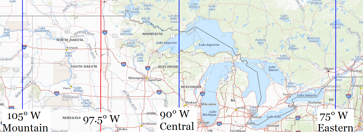
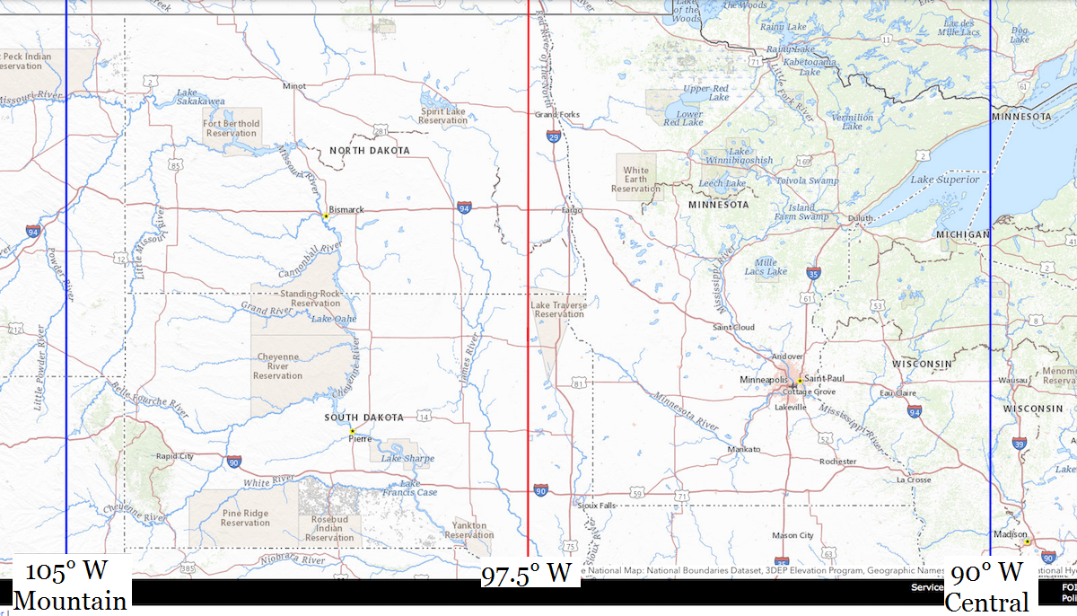
South Dakota
Location |
Co-Ordinates
(Latitude, Longitude and Elevation) |
Mean solar time at noon
Mountain Standard Time |
Mean solar time at noon
Central Standard Time
(Mountain Daylight Saving Time) |
Mean solar time at noon
Eastern Standard Time
(Central Daylight Saving Time) |
Aaberg School,
Fall River County
|
Elevation: 1131 meters*
Latitude: 43.4708137° N
Longitude: 103.4615845° W
|
12:06:09 |
11:06:09 |
10:06:09 |
Aberdeen Christian Elementary School,
Brown County
|
Elevation: 397 meters*
Latitude: 45.443738° N
Longitude: 98.465309° W
|
12:26:08 |
11:26:08 |
10:26:08 |
Aberdeen Christian High School,
Brown County
|
Elevation: 397 meters*
Latitude: 45.443738° N
Longitude: 98.465309° W
|
12:26:08 |
11:26:08 |
10:26:08 |
Aberdeen Christian Junior High School,
Brown County
|
Elevation: 397 meters*
Latitude: 45.443738° N
Longitude: 98.465309° W
|
12:26:08 |
11:26:08 |
10:26:08 |
Aberdeen Post Office,
Brown County
|
Elevation: 397 meters*
Latitude: 45.4527015° N
Longitude: 98.49626° W
|
12:26:00 |
11:26:00 |
10:26:00 |
Academic Evaluation and Assessment Building,
Brookings County
|
Elevation: 500 meters*
Latitude: 44.31532° N
Longitude: 96.78924° W
|
12:32:50 |
11:32:50 |
10:32:50 |
Ackerman School,
Beadle County
|
Elevation: 403 meters*
Latitude: 44.4710896° N
Longitude: 98.0323112° W
|
12:27:52 |
11:27:52 |
10:27:52 |
Ada Post Office (historical),
Jerauld County
|
Elevation: 394 meters*
Latitude: 44.9638639° N
Longitude: 98.555929° W
|
12:25:46 |
11:25:46 |
10:25:46 |
Adams School,
Brown County
|
Elevation: 397 meters*
Latitude: 45.4585876° N
Longitude: 98.4914829° W
|
12:26:02 |
11:26:02 |
10:26:02 |
Addams School,
Minnehaha County
|
Elevation: 436 meters*
Latitude: 43.5596974° N
Longitude: 96.7603289° W
|
12:32:57 |
11:32:57 |
10:32:57 |
Adkins School,
Perkins County
|
Elevation: 731 meters*
Latitude: 45.8461093° N
Longitude: 102.2393235° W
|
12:11:02 |
11:11:02 |
10:11:02 |
Administration Building,
Brookings County
|
Elevation: 505 meters*
Latitude: 44.31666° N
Longitude: 96.785908° W
|
12:32:51 |
11:32:51 |
10:32:51 |
Afton District Number 12 School,
Brookings County
|
Elevation: 516 meters*
Latitude: 44.4124668° N
Longitude: 96.7469984° W
|
12:33:00 |
11:33:00 |
10:33:00 |
Afton District Number 13 School,
Brookings County
|
Elevation: 516 meters*
Latitude: 44.4121891° N
Longitude: 96.7475539° W
|
12:33:00 |
11:33:00 |
10:33:00 |
Afton District Number 14 School,
Brookings County
|
Elevation: 514 meters*
Latitude: 44.3830224° N
Longitude: 96.6978299° W
|
12:33:12 |
11:33:12 |
10:33:12 |
Afton District Number 15 School,
Brookings County
|
Elevation: 528 meters*
Latitude: 44.4202439° N
Longitude: 96.6744964° W
|
12:33:18 |
11:33:18 |
10:33:18 |
Afton Post Office (historical),
Hyde County
|
Elevation: 508 meters*
Latitude: 44.6352604° N
Longitude: 99.3698332° W
|
12:22:31 |
11:22:31 |
10:22:31 |
Agar Post Office,
Sully County
|
Elevation: 563 meters*
Latitude: 44.8384348° N
Longitude: 100.0749779° W
|
12:19:42 |
11:19:42 |
10:19:42 |
Agricultural Engineering Building,
Brookings County
|
Elevation: 497 meters*
Latitude: 44.319227° N
Longitude: 96.78232° W
|
12:32:52 |
11:32:52 |
10:32:52 |
Agriculture and Custom Paint and Fab Building,
Codington County
|
Elevation: 539 meters*
Latitude: 44.902684° N
Longitude: 97.094743° W
|
12:31:37 |
11:31:37 |
10:31:37 |
Akeley-Lawrence Science Center,
Clay County
|
Elevation: 376 meters*
Latitude: 42.784189° N
Longitude: 96.928757° W
|
12:32:17 |
11:32:17 |
10:32:17 |
Al Neuharth Media Center,
Clay County
|
Elevation: 376 meters*
Latitude: 42.785906° N
Longitude: 96.928682° W
|
12:32:17 |
11:32:17 |
10:32:17 |
Alatalo School,
Brown County
|
Elevation: 426 meters*
Latitude: 45.9088609° N
Longitude: 98.3828784° W
|
12:26:28 |
11:26:28 |
10:26:28 |
Albion Post Office (historical),
Edmunds County
|
Elevation: 431 meters*
Latitude: 45.3621982° N
Longitude: 98.7673252° W
|
12:24:55 |
11:24:55 |
10:24:55 |
Albion School,
Bon Homme County
|
Elevation: 424 meters*
Latitude: 42.9447194° N
Longitude: 97.9320143° W
|
12:28:16 |
11:28:16 |
10:28:16 |
Alcester Post Office,
Union County
|
Elevation: 419 meters*
Latitude: 43.0212514° N
Longitude: 96.6293° W
|
12:33:28 |
11:33:28 |
10:33:28 |
Alcester-Hudson Elementary School,
Union County
|
Elevation: 427 meters*
Latitude: 43.024706° N
Longitude: 96.623688° W
|
12:33:30 |
11:33:30 |
10:33:30 |
Alcester-Hudson High School,
Union County
|
Elevation: 430 meters*
Latitude: 43.025173° N
Longitude: 96.630507° W
|
12:33:28 |
11:33:28 |
10:33:28 |
Alcester-Hudson Junior High School,
Union County
|
Elevation: 430 meters*
Latitude: 43.025173° N
Longitude: 96.630507° W
|
12:33:28 |
11:33:28 |
10:33:28 |
Alden Central School,
Hand County
|
Elevation: 485 meters*
Latitude: 44.6791468° N
Longitude: 99.1314951° W
|
12:23:28 |
11:23:28 |
10:23:28 |
Alexandria Post Office,
Hanson County
|
Elevation: 412 meters*
Latitude: 43.654607° N
Longitude: 97.7831537° W
|
12:28:52 |
11:28:52 |
10:28:52 |
Alfalfa Valley School,
Haakon County
|
Elevation: 736 meters*
Latitude: 44.1188762° N
Longitude: 101.9076493° W
|
12:12:22 |
11:12:22 |
10:12:22 |
Alfred Dairy Microbiology Building,
Brookings County
|
Elevation: 501 meters*
Latitude: 44.319174° N
Longitude: 96.787459° W
|
12:32:51 |
11:32:51 |
10:32:51 |
Alkali School,
Custer County
|
Elevation: 1943 meters*
Latitude: 43.8205359° N
Longitude: 103.7704757° W
|
12:04:55 |
11:04:55 |
10:04:55 |
All City Elementary School,
Minnehaha County
|
Elevation: 436 meters*
Latitude: 43.5597° N
Longitude: 96.760333° W
|
12:32:57 |
11:32:57 |
10:32:57 |
All Saints School,
Minnehaha County
|
Elevation: 453 meters*
Latitude: 43.5369195° N
Longitude: 96.7278279° W
|
12:33:05 |
11:33:05 |
10:33:05 |
Allard School,
Clay County
|
Elevation: 341 meters*
Latitude: 42.605552° N
Longitude: 96.6450348° W
|
12:33:25 |
11:33:25 |
10:33:25 |
Allen Post Office,
Bennett County
|
Elevation: 1033 meters*
Latitude: 43.2721525° N
Longitude: 101.9153649° W
|
12:12:20 |
11:12:20 |
10:12:20 |
Allum School,
Gregory County
|
Elevation: 632 meters*
Latitude: 43.0608332° N
Longitude: 99.2767676° W
|
12:22:53 |
11:22:53 |
10:22:53 |
Allyn School,
Lyman County
|
Elevation: 567 meters*
Latitude: 43.7391586° N
Longitude: 100.0409573° W
|
12:19:50 |
11:19:50 |
10:19:50 |
Alpen High School,
Jerauld County
|
Elevation: 402 meters*
Latitude: 44.1810989° N
Longitude: 98.3664793° W
|
12:26:32 |
11:26:32 |
10:26:32 |
Alpena Elementary School,
Jerauld County
|
Elevation: 402 meters*
Latitude: 44.1810989° N
Longitude: 98.3664793° W
|
12:26:32 |
11:26:32 |
10:26:32 |
Alpena Middle School,
Jerauld County
|
Elevation: 402 meters*
Latitude: 44.1810989° N
Longitude: 98.3664793° W
|
12:26:32 |
11:26:32 |
10:26:32 |
Alpena Post Office,
Jerauld County
|
Elevation: 401 meters*
Latitude: 44.1815797° N
Longitude: 98.3650422° W
|
12:26:32 |
11:26:32 |
10:26:32 |
Alpha Post Office (historical),
McPherson County
|
Elevation: 483 meters*
Latitude: 45.9158072° N
Longitude: 98.8337154° W
|
12:24:39 |
11:24:39 |
10:24:39 |
Altruria Post Office (historical),
Deuel County
|
Elevation: 536 meters*
Latitude: 44.7055205° N
Longitude: 96.754504° W
|
12:32:58 |
11:32:58 |
10:32:58 |
Altruria School (historical),
Deuel County
|
Elevation: 532 meters*
Latitude: 44.6971872° N
Longitude: 96.7572816° W
|
12:32:58 |
11:32:58 |
10:32:58 |
America Horse School,
Bennett County
|
Elevation: 1005 meters*
Latitude: 43.2800589° N
Longitude: 101.9261432° W
|
12:12:17 |
11:12:17 |
10:12:17 |
America School,
Brule County
|
Elevation: 544 meters*
Latitude: 43.571388° N
Longitude: 99.1917614° W
|
12:23:13 |
11:23:13 |
10:23:13 |
American Horse Middle School,
Bennett County
|
Elevation: 1004 meters*
Latitude: 43.280033° N
Longitude: 101.926078° W
|
12:12:17 |
11:12:17 |
10:12:17 |
American Indian Education and Cultural Center,
Brookings County
|
Elevation: 499 meters*
Latitude: 44.315032° N
Longitude: 96.789057° W
|
12:32:50 |
11:32:50 |
10:32:50 |
Amherst Post Office (historical),
Marshall County
|
Elevation: 400 meters*
Latitude: 45.736384° N
Longitude: 97.921636° W
|
12:28:18 |
11:28:18 |
10:28:18 |
Anderson School (historical),
Douglas County
|
Elevation: 499 meters*
Latitude: 43.3777688° N
Longitude: 98.4850809° W
|
12:26:03 |
11:26:03 |
10:26:03 |
Anderson School,
Spink County
|
Elevation: 395 meters*
Latitude: 44.9527499° N
Longitude: 98.2578692° W
|
12:26:58 |
11:26:58 |
10:26:58 |
Anderson School,
Yankton County
|
Elevation: 393 meters*
Latitude: 43.1108273° N
Longitude: 97.4425625° W
|
12:30:13 |
11:30:13 |
10:30:13 |
Andes Central Elementary School,
Charles Mix County
|
Elevation: 447 meters*
Latitude: 43.157813° N
Longitude: 98.530176° W
|
12:25:52 |
11:25:52 |
10:25:52 |
Andes Central High School,
Charles Mix County
|
Elevation: 453 meters*
Latitude: 43.160059° N
Longitude: 98.539478° W
|
12:25:50 |
11:25:50 |
10:25:50 |
Andes Central Junior High School,
Charles Mix County
|
Elevation: 453 meters*
Latitude: 43.160059° N
Longitude: 98.539478° W
|
12:25:50 |
11:25:50 |
10:25:50 |
Andover Post Office,
Day County
|
Elevation: 451 meters*
Latitude: 45.41086° N
Longitude: 97.9047222° W
|
12:28:22 |
11:28:22 |
10:28:22 |
Andrus Post Office (historical),
Bon Homme County
|
Elevation: 397 meters*
Latitude: 42.8805533° N
Longitude: 98.1125743° W
|
12:27:32 |
11:27:32 |
10:27:32 |
Animal Disease Research Building,
Brookings County
|
Elevation: 497 meters*
Latitude: 44.321745° N
Longitude: 96.785817° W
|
12:32:51 |
11:32:51 |
10:32:51 |
Animal Research Wing,
Brookings County
|
Elevation: 496 meters*
Latitude: 44.322505° N
Longitude: 96.786278° W
|
12:32:51 |
11:32:51 |
10:32:51 |
Animal Science Arena,
Brookings County
|
Elevation: 496 meters*
Latitude: 44.322206° N
Longitude: 96.787791° W
|
12:32:50 |
11:32:50 |
10:32:50 |
Animal Science Complex,
Brookings County
|
Elevation: 497 meters*
Latitude: 44.32176° N
Longitude: 96.786869° W
|
12:32:51 |
11:32:51 |
10:32:51 |
Anne Sullivan Elementary School,
Minnehaha County
|
Elevation: 454 meters*
Latitude: 43.554318° N
Longitude: 96.680567° W
|
12:33:16 |
11:33:16 |
10:33:16 |
Antelope School,
Butte County
|
Elevation: 970 meters*
Latitude: 44.9891546° N
Longitude: 103.9327101° W
|
12:04:16 |
11:04:16 |
10:04:16 |
Antelope Valley School (historical),
Deuel County
|
Elevation: 582 meters*
Latitude: 44.731909° N
Longitude: 96.7142256° W
|
12:33:08 |
11:33:08 |
10:33:08 |
Appomattox School,
Potter County
|
Elevation: 586 meters*
Latitude: 45.1438745° N
Longitude: 100.1315139° W
|
12:19:28 |
11:19:28 |
10:19:28 |
Archeology Laboratory,
Minnehaha County
|
Elevation: 445 meters*
Latitude: 43.526172° N
Longitude: 96.741035° W
|
12:33:02 |
11:33:02 |
10:33:02 |
Arena School,
Potter County
|
Elevation: 595 meters*
Latitude: 45.1802617° N
Longitude: 99.8784513° W
|
12:20:29 |
11:20:29 |
10:20:29 |
Argo District Number 24 School,
Brookings County
|
Elevation: 563 meters*
Latitude: 44.5216318° N
Longitude: 96.6867205° W
|
12:33:15 |
11:33:15 |
10:33:15 |
Argo District Number 25 School,
Brookings County
|
Elevation: 533 meters*
Latitude: 44.5271878° N
Longitude: 96.7378331° W
|
12:33:02 |
11:33:02 |
10:33:02 |
Argo District Number 26 School,
Brookings County
|
Elevation: 523 meters*
Latitude: 44.4710771° N
Longitude: 96.7275541° W
|
12:33:05 |
11:33:05 |
10:33:05 |
Argo District Number 27 School,
Brookings County
|
Elevation: 565 meters*
Latitude: 44.4857986° N
Longitude: 96.6767196° W
|
12:33:17 |
11:33:17 |
10:33:17 |
Argo District Number 53 School,
Brookings County
|
Elevation: 529 meters*
Latitude: 44.5002435° N
Longitude: 96.7375548° W
|
12:33:02 |
11:33:02 |
10:33:02 |
Argyle School,
Custer County
|
Elevation: 1429 meters*
Latitude: 43.5041439° N
Longitude: 103.6688058° W
|
12:05:19 |
11:05:19 |
10:05:19 |
Arlington Elementary School,
Kingsbury County
|
Elevation: 558 meters*
Latitude: 44.362228° N
Longitude: 97.131797° W
|
12:31:28 |
11:31:28 |
10:31:28 |
Arlington High School,
Kingsbury County
|
Elevation: 558 meters*
Latitude: 44.362228° N
Longitude: 97.131797° W
|
12:31:28 |
11:31:28 |
10:31:28 |
Arlington Junior High School,
Kingsbury County
|
Elevation: 558 meters*
Latitude: 44.362228° N
Longitude: 97.131797° W
|
12:31:28 |
11:31:28 |
10:31:28 |
Arlington Post Office,
Kingsbury County
|
Elevation: 562 meters*
Latitude: 44.3641129° N
Longitude: 97.1341618° W
|
12:31:27 |
11:31:27 |
10:31:27 |
Armour Elementary School,
Douglas County
|
Elevation: 467 meters*
Latitude: 43.320549° N
Longitude: 98.348569° W
|
12:26:36 |
11:26:36 |
10:26:36 |
Armour High School,
Douglas County
|
Elevation: 467 meters*
Latitude: 43.32012° N
Longitude: 98.34873° W
|
12:26:36 |
11:26:36 |
10:26:36 |
Armour Middle School,
Douglas County
|
Elevation: 467 meters*
Latitude: 43.320549° N
Longitude: 98.348569° W
|
12:26:36 |
11:26:36 |
10:26:36 |
Armour Post Office,
Douglas County
|
Elevation: 465 meters*
Latitude: 43.3194017° N
Longitude: 98.3462138° W
|
12:26:36 |
11:26:36 |
10:26:36 |
Arrow Head School,
Perkins County
|
Elevation: 714 meters*
Latitude: 45.118592° N
Longitude: 102.0340459° W
|
12:11:51 |
11:11:51 |
10:11:51 |
Arrowhead School,
Perkins County
|
Elevation: 709 meters*
Latitude: 45.1838683° N
Longitude: 102.0576562° W
|
12:11:46 |
11:11:46 |
10:11:46 |
Artesian Post Office,
Sanborn County
|
Elevation: 401 meters*
Latitude: 44.0086199° N
Longitude: 97.921625° W
|
12:28:18 |
11:28:18 |
10:28:18 |
Artichoke Post Office (historical),
Potter County
|
Elevation: 585 meters*
Latitude: 44.9249816° N
Longitude: 100.0651212° W
|
12:19:44 |
11:19:44 |
10:19:44 |
Arts and Sciences Building,
Clay County
|
Elevation: 377 meters*
Latitude: 42.782898° N
Longitude: 96.922942° W
|
12:32:18 |
11:32:18 |
10:32:18 |
Asbury School,
Lawrence County
|
Elevation: 1088 meters*
Latitude: 44.5108173° N
Longitude: 103.6740845° W
|
12:05:18 |
11:05:18 |
10:05:18 |
Ash Creek School (historical),
Clay County
|
Elevation: 386 meters*
Latitude: 43.0541571° N
Longitude: 96.8975459° W
|
12:32:24 |
11:32:24 |
10:32:24 |
Ash Grove School,
Turner County
|
Elevation: 379 meters*
Latitude: 43.2358176° N
Longitude: 96.9442161° W
|
12:32:13 |
11:32:13 |
10:32:13 |
Ashgrove School,
Spink County
|
Elevation: 401 meters*
Latitude: 44.7044201° N
Longitude: 98.1392587° W
|
12:27:26 |
11:27:26 |
10:27:26 |
Ashton Post Office,
Spink County
|
Elevation: 393 meters*
Latitude: 44.995224° N
Longitude: 98.497763° W
|
12:26:00 |
11:26:00 |
10:26:00 |
Astoria Post Office,
Deuel County
|
Elevation: 555 meters*
Latitude: 44.5584296° N
Longitude: 96.5453481° W
|
12:33:49 |
11:33:49 |
10:33:49 |
Atall Elementary School,
Meade County
|
Elevation: 900 meters*
Latitude: 44.640367° N
Longitude: 102.788657° W
|
12:08:50 |
11:08:50 |
10:08:50 |
Augusta Post Office (historical),
Hughes County
|
Elevation: 520 meters*
Latitude: 44.5402595° N
Longitude: 100.3731903° W
|
12:18:30 |
11:18:30 |
10:18:30 |
Augustana Academy,
Lincoln County
|
Elevation: 391 meters*
Latitude: 43.3035922° N
Longitude: 96.5786527° W
|
12:33:41 |
11:33:41 |
10:33:41 |
Augustana College,
Minnehaha County
|
Elevation: 449 meters*
Latitude: 43.5263641° N
Longitude: 96.738106° W
|
12:33:02 |
11:33:02 |
10:33:02 |
Aurora Plains Academy High School,
Aurora County
|
Elevation: 459 meters*
Latitude: 43.7248569° N
Longitude: 98.46666° W
|
12:26:08 |
11:26:08 |
10:26:08 |
Aurora Plains Academy Middle School,
Aurora County
|
Elevation: 459 meters*
Latitude: 43.7250643° N
Longitude: 98.466681° W
|
12:26:07 |
11:26:07 |
10:26:07 |
Aurora Post Office,
Brookings County
|
Elevation: 495 meters*
Latitude: 44.2845733° N
Longitude: 96.6879298° W
|
12:33:14 |
11:33:14 |
10:33:14 |
Austin School,
Clay County
|
Elevation: 374 meters*
Latitude: 42.7830528° N
Longitude: 96.9355994° W
|
12:32:15 |
11:32:15 |
10:32:15 |
Automotive Technology Building,
Codington County
|
Elevation: 539 meters*
Latitude: 44.904311° N
Longitude: 97.094529° W
|
12:31:37 |
11:31:37 |
10:31:37 |
Avera Health and Science Center,
Brookings County
|
Elevation: 505 meters*
Latitude: 44.317201° N
Longitude: 96.785871° W
|
12:32:51 |
11:32:51 |
10:32:51 |
Avon Elementary School,
Bon Homme County
|
Elevation: 494 meters*
Latitude: 43.005306° N
Longitude: 98.056916° W
|
12:27:46 |
11:27:46 |
10:27:46 |
Avon High School,
Bon Homme County
|
Elevation: 494 meters*
Latitude: 43.005306° N
Longitude: 98.056916° W
|
12:27:46 |
11:27:46 |
10:27:46 |
Avon Junior High School,
Bon Homme County
|
Elevation: 494 meters*
Latitude: 43.005306° N
Longitude: 98.056916° W
|
12:27:46 |
11:27:46 |
10:27:46 |
Avon Post Office,
Bon Homme County
|
Elevation: 494 meters*
Latitude: 43.0047° N
Longitude: 98.0604313° W
|
12:27:45 |
11:27:45 |
10:27:45 |
Axtell Park Middle School,
Minnehaha County
|
Elevation: 440 meters*
Latitude: 43.5483084° N
Longitude: 96.7475508° W
|
12:33:00 |
11:33:00 |
10:33:00 |
Bachand School,
Meade County
|
Elevation: 780 meters*
Latitude: 44.4585976° N
Longitude: 103.0724001° W
|
12:07:42 |
11:07:42 |
10:07:42 |
Badger Clark/Carrousel Elementary School,
Pennington County
|
Elevation: 962 meters*
Latitude: 44.137562° N
Longitude: 103.06489° W
|
12:07:44 |
11:07:44 |
10:07:44 |
Badger Post Office,
Kingsbury County
|
Elevation: 527 meters*
Latitude: 44.484951° N
Longitude: 97.2049244° W
|
12:31:10 |
11:31:10 |
10:31:10 |
Badus Post Office (historical),
Lake County
|
Elevation: 532 meters*
Latitude: 44.148861° N
Longitude: 97.1420075° W
|
12:31:25 |
11:31:25 |
10:31:25 |
Baier School (historical),
Douglas County
|
Elevation: 465 meters*
Latitude: 43.3610996° N
Longitude: 98.2086879° W
|
12:27:09 |
11:27:09 |
10:27:09 |
Bailey Rotunda,
Brookings County
|
Elevation: 502 meters*
Latitude: 44.316633° N
Longitude: 96.7838° W
|
12:32:51 |
11:32:51 |
10:32:51 |
Bailey School,
Lincoln County
|
Elevation: 411 meters*
Latitude: 43.3297027° N
Longitude: 96.6678228° W
|
12:33:19 |
11:33:19 |
10:33:19 |
Baird School (historical),
Douglas County
|
Elevation: 444 meters*
Latitude: 43.3041564° N
Longitude: 98.2850779° W
|
12:26:51 |
11:26:51 |
10:26:51 |
Baker School Number 4 (historical),
Jerauld County
|
Elevation: 510 meters*
Latitude: 43.9791609° N
Longitude: 98.906484° W
|
12:24:22 |
11:24:22 |
10:24:22 |
Baker School,
Davison County
|
Elevation: 492 meters*
Latitude: 43.5424869° N
Longitude: 98.2653568° W
|
12:26:56 |
11:26:56 |
10:26:56 |
Baldwin School,
Faulk County
|
Elevation: 512 meters*
Latitude: 45.099975° N
Longitude: 99.2478904° W
|
12:23:00 |
11:23:00 |
10:23:00 |
Balster School,
Brule County
|
Elevation: 518 meters*
Latitude: 43.9213844° N
Longitude: 98.988151° W
|
12:24:02 |
11:24:02 |
10:24:02 |
Baltic Elementary School,
Minnehaha County
|
Elevation: 459 meters*
Latitude: 43.759084° N
Longitude: 96.733696° W
|
12:33:03 |
11:33:03 |
10:33:03 |
Baltic High School,
Minnehaha County
|
Elevation: 459 meters*
Latitude: 43.759084° N
Longitude: 96.733696° W
|
12:33:03 |
11:33:03 |
10:33:03 |
Baltic Middle School,
Minnehaha County
|
Elevation: 459 meters*
Latitude: 43.759084° N
Longitude: 96.733696° W
|
12:33:03 |
11:33:03 |
10:33:03 |
Baltic Post Office,
Minnehaha County
|
Elevation: 456 meters*
Latitude: 43.7603576° N
Longitude: 96.7400437° W
|
12:33:02 |
11:33:02 |
10:33:02 |
Bancroft School,
Minnehaha County
|
Elevation: 449 meters*
Latitude: 43.5488639° N
Longitude: 96.705605° W
|
12:33:10 |
11:33:10 |
10:33:10 |
Banner School,
Lincoln County
|
Elevation: 401 meters*
Latitude: 43.3583126° N
Longitude: 96.5497638° W
|
12:33:48 |
11:33:48 |
10:33:48 |
Bard School,
Hanson County
|
Elevation: 405 meters*
Latitude: 43.6885935° N
Longitude: 97.907574° W
|
12:28:22 |
11:28:22 |
10:28:22 |
Barker School,
Butte County
|
Elevation: 884 meters*
Latitude: 44.8030417° N
Longitude: 103.649363° W
|
12:05:24 |
11:05:24 |
10:05:24 |
Barker School,
Tripp County
|
Elevation: 673 meters*
Latitude: 43.2269455° N
Longitude: 99.5626097° W
|
12:21:44 |
11:21:44 |
10:21:44 |
Barnard Post Office,
Brown County
|
Elevation: 424 meters*
Latitude: 45.7326965° N
Longitude: 98.4967787° W
|
12:26:00 |
11:26:00 |
10:26:00 |
Barnes School,
Brown County
|
Elevation: 392 meters*
Latitude: 45.6607914° N
Longitude: 98.1045471° W
|
12:27:34 |
11:27:34 |
10:27:34 |
Barnett Physical Education and Convocation Center,
Brown County
|
Elevation: 396 meters*
Latitude: 45.449805° N
Longitude: 98.480372° W
|
12:26:04 |
11:26:04 |
10:26:04 |
Barry School,
Meade County
|
Elevation: 817 meters*
Latitude: 44.4374868° N
Longitude: 102.6823922° W
|
12:09:16 |
11:09:16 |
10:09:16 |
Baruth School (historical),
Sanborn County
|
Elevation: 393 meters*
Latitude: 44.0677632° N
Longitude: 98.1873085° W
|
12:27:15 |
11:27:15 |
10:27:15 |
Batesland Elementary School,
Oglala Lakota County
|
Elevation: 1041 meters*
Latitude: 43.126922° N
Longitude: 102.099906° W
|
12:11:36 |
11:11:36 |
10:11:36 |
Batesland Post Office,
Oglala Lakota County
|
Elevation: 1041 meters*
Latitude: 43.1289907° N
Longitude: 102.1014077° W
|
12:11:35 |
11:11:35 |
10:11:35 |
Bath Post Office,
Brown County
|
Elevation: 398 meters*
Latitude: 45.4671668° N
Longitude: 98.323561° W
|
12:26:42 |
11:26:42 |
10:26:42 |
Battle Creek School (historical),
Deuel County
|
Elevation: 586 meters*
Latitude: 44.6096865° N
Longitude: 96.6225539° W
|
12:33:30 |
11:33:30 |
10:33:30 |
Bauer School,
Edmunds County
|
Elevation: 714 meters*
Latitude: 45.1330386° N
Longitude: 100.7862538° W
|
12:16:51 |
11:16:51 |
10:16:51 |
Beacom Hall,
Clay County
|
Elevation: 376 meters*
Latitude: 42.785339° N
Longitude: 96.927524° W
|
12:32:17 |
11:32:17 |
10:32:17 |
Beadle Elementary School,
Yankton County
|
Elevation: 378 meters*
Latitude: 42.881145° N
Longitude: 97.386396° W
|
12:30:27 |
11:30:27 |
10:30:27 |
Beadle Hall,
Lake County
|
Elevation: 514 meters*
Latitude: 44.012154° N
Longitude: 97.112349° W
|
12:31:33 |
11:31:33 |
10:31:33 |
Beadle School,
Aurora County
|
Elevation: 471 meters*
Latitude: 43.9149914° N
Longitude: 98.5509228° W
|
12:25:47 |
11:25:47 |
10:25:47 |
Beadle School,
Minnehaha County
|
Elevation: 432 meters*
Latitude: 43.5410861° N
Longitude: 96.7169942° W
|
12:33:07 |
11:33:07 |
10:33:07 |
Beadle School,
Walworth County
|
Elevation: 509 meters*
Latitude: 45.5386052° N
Longitude: 100.4390245° W
|
12:18:14 |
11:18:14 |
10:18:14 |
Bealer School,
Perkins County
|
Elevation: 830 meters*
Latitude: 45.7438872° N
Longitude: 102.7757161° W
|
12:08:53 |
11:08:53 |
10:08:53 |
Bear Creek Day School,
Dewey County
|
Elevation: 673 meters*
Latitude: 45.0694252° N
Longitude: 101.4420993° W
|
12:14:13 |
11:14:13 |
10:14:13 |
Beaver Creek School,
Lawrence County
|
Elevation: 1148 meters*
Latitude: 44.502762° N
Longitude: 104.0157656° W
|
12:03:56 |
11:03:56 |
10:03:56 |
Beaver Creek School,
Tripp County
|
Elevation: 733 meters*
Latitude: 43.0394504° N
Longitude: 100.1670691° W
|
12:19:19 |
11:19:19 |
10:19:19 |
Beaver Creek School,
Yankton County
|
Elevation: 365 meters*
Latitude: 42.9611078° N
Longitude: 97.3614468° W
|
12:30:33 |
11:30:33 |
10:30:33 |
Beckman Building,
Brown County
|
Elevation: 396 meters*
Latitude: 45.448759° N
Longitude: 98.478044° W
|
12:26:05 |
11:26:05 |
10:26:05 |
Beckman School,
Jerauld County
|
Elevation: 486 meters*
Latitude: 43.9655468° N
Longitude: 98.551479° W
|
12:25:47 |
11:25:47 |
10:25:47 |
Belbas Center,
Clay County
|
Elevation: 376 meters*
Latitude: 42.784197° N
Longitude: 96.925249° W
|
12:32:17 |
11:32:17 |
10:32:17 |
Belford School,
Aurora County
|
Elevation: 415 meters*
Latitude: 43.8949881° N
Longitude: 98.3614752° W
|
12:26:33 |
11:26:33 |
10:26:33 |
Bell School,
Brown County
|
Elevation: 407 meters*
Latitude: 45.8783028° N
Longitude: 98.2473239° W
|
12:27:00 |
11:27:00 |
10:27:00 |
Bell School,
Moody County
|
Elevation: 499 meters*
Latitude: 44.0519152° N
Longitude: 96.7469954° W
|
12:33:00 |
11:33:00 |
10:33:00 |
Belle Fourche High School,
Butte County
|
Elevation: 938 meters*
Latitude: 44.663693° N
Longitude: 103.842312° W
|
12:04:37 |
11:04:37 |
10:04:37 |
Belle Fourche Middle School,
Butte County
|
Elevation: 963 meters*
Latitude: 44.6497222° N
Longitude: 103.8441667° W
|
12:04:37 |
11:04:37 |
10:04:37 |
Belle Fourche Post Office,
Butte County
|
Elevation: 918 meters*
Latitude: 44.6712689° N
Longitude: 103.8488741° W
|
12:04:36 |
11:04:36 |
10:04:36 |
Bellview School (historical),
Clay County
|
Elevation: 395 meters*
Latitude: 43.0208259° N
Longitude: 97.060049° W
|
12:31:45 |
11:31:45 |
10:31:45 |
Belvidere Post Office,
Jackson County
|
Elevation: 712 meters*
Latitude: 43.8318409° N
Longitude: 101.2710474° W
|
12:14:54 |
11:14:54 |
10:14:54 |
Bemis School (historical),
Deuel County
|
Elevation: 551 meters*
Latitude: 44.6624652° N
Longitude: 96.8447834° W
|
12:32:37 |
11:32:37 |
10:32:37 |
Bench School,
Meade County
|
Elevation: 1006 meters*
Latitude: 44.5185954° N
Longitude: 103.5288017° W
|
12:05:53 |
11:05:53 |
10:05:53 |
Bend School,
Meade County
|
Elevation: 882 meters*
Latitude: 44.2249868° N
Longitude: 103.0310091° W
|
12:07:52 |
11:07:52 |
10:07:52 |
Bender School,
Yankton County
|
Elevation: 410 meters*
Latitude: 43.1552706° N
Longitude: 97.4489521° W
|
12:30:12 |
11:30:12 |
10:30:12 |
Bennett County High School,
Bennett County
|
Elevation: 1011 meters*
Latitude: 43.174481° N
Longitude: 101.730309° W
|
12:13:04 |
11:13:04 |
10:13:04 |
Bennett County Junior High School,
Bennett County
|
Elevation: 1011 meters*
Latitude: 43.174481° N
Longitude: 101.730309° W
|
12:13:04 |
11:13:04 |
10:13:04 |
Bennett School,
Lincoln County
|
Elevation: 395 meters*
Latitude: 43.3016489° N
Longitude: 96.8664381° W
|
12:32:32 |
11:32:32 |
10:32:32 |
Benoit School,
Meade County
|
Elevation: 961 meters*
Latitude: 44.2272091° N
Longitude: 103.2718499° W
|
12:06:54 |
11:06:54 |
10:06:54 |
Berens School,
Lincoln County
|
Elevation: 428 meters*
Latitude: 43.4035908° N
Longitude: 96.9056073° W
|
12:32:22 |
11:32:22 |
10:32:22 |
Beresford Elementary School,
Union County
|
Elevation: 458 meters*
Latitude: 43.078653° N
Longitude: 96.775947° W
|
12:32:53 |
11:32:53 |
10:32:53 |
Beresford High School,
Union County
|
Elevation: 455 meters*
Latitude: 43.076035° N
Longitude: 96.779015° W
|
12:32:53 |
11:32:53 |
10:32:53 |
Beresford Middle School,
Union County
|
Elevation: 456 meters*
Latitude: 43.075816° N
Longitude: 96.776891° W
|
12:32:53 |
11:32:53 |
10:32:53 |
Beresford Post Office,
Union County
|
Elevation: 458 meters*
Latitude: 43.0803309° N
Longitude: 96.7736741° W
|
12:32:54 |
11:32:54 |
10:32:54 |
Berg Agricultural Hall,
Brookings County
|
Elevation: 504 meters*
Latitude: 44.318421° N
Longitude: 96.787813° W
|
12:32:50 |
11:32:50 |
10:32:50 |
Berg School Number 6 (historical),
Jerauld County
|
Elevation: 394 meters*
Latitude: 44.9533068° N
Longitude: 98.3698149° W
|
12:26:31 |
11:26:31 |
10:26:31 |
Bergquist School,
Pennington County
|
Elevation: 986 meters*
Latitude: 44.0855434° N
Longitude: 103.1982361° W
|
12:07:12 |
11:07:12 |
10:07:12 |
Berkley School,
Yankton County
|
Elevation: 356 meters*
Latitude: 42.9241626° N
Longitude: 97.2206081° W
|
12:31:07 |
11:31:07 |
10:31:07 |
Bern Post Office (historical),
Brown County
|
Elevation: 442 meters*
Latitude: 45.6471991° N
Longitude: 98.7020448° W
|
12:25:11 |
11:25:11 |
10:25:11 |
Berry School,
Haakon County
|
Elevation: 699 meters*
Latitude: 44.0819323° N
Longitude: 101.6068104° W
|
12:13:34 |
11:13:34 |
10:13:34 |
Beth Eden School,
Hughes County
|
Elevation: 541 meters*
Latitude: 44.4094279° N
Longitude: 99.8251184° W
|
12:20:41 |
11:20:41 |
10:20:41 |
Bethel Lutheran School,
Minnehaha County
|
Elevation: 455 meters*
Latitude: 43.52897° N
Longitude: 96.801701° W
|
12:32:47 |
11:32:47 |
10:32:47 |
Bethel School (historical),
Clay County
|
Elevation: 411 meters*
Latitude: 42.9708274° N
Longitude: 97.0794935° W
|
12:31:40 |
11:31:40 |
10:31:40 |
Bethel School (historical),
Roberts County
|
Elevation: 366 meters*
Latitude: 45.8488479° N
Longitude: 97.1336984° W
|
12:31:27 |
11:31:27 |
10:31:27 |
Bethesda Lutheran Elementary School,
Fall River County
|
Elevation: 1078 meters*
Latitude: 43.427246° N
Longitude: 103.479498° W
|
12:06:04 |
11:06:04 |
10:06:04 |
Beukelman School,
Douglas County
|
Elevation: 497 meters*
Latitude: 43.384714° N
Longitude: 98.5586928° W
|
12:25:45 |
11:25:45 |
10:25:45 |
Beulah Post Office (historical),
Douglas County
|
Elevation: 470 meters*
Latitude: 43.484711° N
Longitude: 98.3725799° W
|
12:26:30 |
11:26:30 |
10:26:30 |
Beulah School (historical),
Douglas County
|
Elevation: 470 meters*
Latitude: 43.4860999° N
Longitude: 98.3725799° W
|
12:26:30 |
11:26:30 |
10:26:30 |
Bible School,
Spink County
|
Elevation: 407 meters*
Latitude: 45.2316426° N
Longitude: 98.647321° W
|
12:25:24 |
11:25:24 |
10:25:24 |
Bierke School,
Harding County
|
Elevation: 880 meters*
Latitude: 45.8075005° N
Longitude: 102.9826672° W
|
12:08:04 |
11:08:04 |
10:08:04 |
Big Bottom School,
Meade County
|
Elevation: 941 meters*
Latitude: 44.5749846° N
Longitude: 103.5479694° W
|
12:05:48 |
11:05:48 |
10:05:48 |
Big Foot School,
Pennington County
|
Elevation: 803 meters*
Latitude: 43.8066584° N
Longitude: 102.0784894° W
|
12:11:41 |
11:11:41 |
10:11:41 |
Big Stone City Elementary School,
Grant County
|
Elevation: 323 meters*
Latitude: 45.294803° N
Longitude: 96.465604° W
|
12:34:08 |
11:34:08 |
10:34:08 |
Big Stone City Middle School,
Grant County
|
Elevation: 323 meters*
Latitude: 45.294803° N
Longitude: 96.465604° W
|
12:34:08 |
11:34:08 |
10:34:08 |
Big Stone City Post Office,
Grant County
|
Elevation: 317 meters*
Latitude: 45.2917468° N
Longitude: 96.4635226° W
|
12:34:08 |
11:34:08 |
10:34:08 |
Big White Elementary School,
Pennington County
|
Elevation: 807 meters*
Latitude: 44.1830421° N
Longitude: 102.0654315° W
|
12:11:44 |
11:11:44 |
10:11:44 |
Bijou Ridge School (historical),
Clay County
|
Elevation: 427 meters*
Latitude: 43.0166602° N
Longitude: 97.1294952° W
|
12:31:28 |
11:31:28 |
10:31:28 |
Bijou School,
Tripp County
|
Elevation: 583 meters*
Latitude: 43.4727776° N
Longitude: 99.6023314° W
|
12:21:35 |
11:21:35 |
10:21:35 |
Bison Elementary School,
Perkins County
|
Elevation: 851 meters*
Latitude: 45.524247° N
Longitude: 102.463378° W
|
12:10:08 |
11:10:08 |
10:10:08 |
Bison High School,
Perkins County
|
Elevation: 851 meters*
Latitude: 45.524247° N
Longitude: 102.463378° W
|
12:10:08 |
11:10:08 |
10:10:08 |
Bison Junior High School,
Perkins County
|
Elevation: 851 meters*
Latitude: 45.524247° N
Longitude: 102.463378° W
|
12:10:08 |
11:10:08 |
10:10:08 |
Bison Post Office,
Perkins County
|
Elevation: 848 meters*
Latitude: 45.5225947° N
Longitude: 102.4659473° W
|
12:10:08 |
11:10:08 |
10:10:08 |
Bixby Post Office (historical),
Perkins County
|
Elevation: 767 meters*
Latitude: 45.1691527° N
Longitude: 102.591272° W
|
12:09:38 |
11:09:38 |
10:09:38 |
Black Dog School,
Lyman County
|
Elevation: 540 meters*
Latitude: 44.0499889° N
Longitude: 99.6456669° W
|
12:21:25 |
11:21:25 |
10:21:25 |
Black Hawk Elementary School,
Meade County
|
Elevation: 1080 meters*
Latitude: 44.152767° N
Longitude: 103.317586° W
|
12:06:43 |
11:06:43 |
10:06:43 |
Black Hawk Post Office,
Meade County
|
Elevation: 1073 meters*
Latitude: 44.1556249° N
Longitude: 103.3116199° W
|
12:06:45 |
11:06:45 |
10:06:45 |
Black Hills Lutheran Middle School,
Pennington County
|
Elevation: 999 meters*
Latitude: 44.093653° N
Longitude: 103.220024° W
|
12:07:07 |
11:07:07 |
10:07:07 |
Black Hills State University,
Lawrence County
|
Elevation: 1111 meters*
Latitude: 44.4972061° N
Longitude: 103.871037° W
|
12:04:30 |
11:04:30 |
10:04:30 |
Blaha Post Office (historical),
Bon Homme County
|
Elevation: 436 meters*
Latitude: 43.0833333° N
Longitude: 97.7833333° W
|
12:28:52 |
11:28:52 |
10:28:52 |
Blaha School,
Bon Homme County
|
Elevation: 437 meters*
Latitude: 43.0836056° N
Longitude: 97.7878453° W
|
12:28:50 |
11:28:50 |
10:28:50 |
Blaine School,
Sully County
|
Elevation: 553 meters*
Latitude: 44.6791488° N
Longitude: 99.9890096° W
|
12:20:02 |
11:20:02 |
10:20:02 |
Blair School,
Pennington County
|
Elevation: 1074 meters*
Latitude: 43.9844328° N
Longitude: 103.2696276° W
|
12:06:55 |
11:06:55 |
10:06:55 |
Blanchard School,
Lincoln County
|
Elevation: 416 meters*
Latitude: 43.148596° N
Longitude: 96.489757° W
|
12:34:02 |
11:34:02 |
10:34:02 |
Blanchard School,
Sanborn County
|
Elevation: 398 meters*
Latitude: 43.8658164° N
Longitude: 98.0303577° W
|
12:27:52 |
11:27:52 |
10:27:52 |
Blendon School,
Davison County
|
Elevation: 411 meters*
Latitude: 43.8041527° N
Longitude: 98.2653611° W
|
12:26:56 |
11:26:56 |
10:26:56 |
Bloodgood School,
Beadle County
|
Elevation: 399 meters*
Latitude: 44.2969263° N
Longitude: 98.0739765° W
|
12:27:42 |
11:27:42 |
10:27:42 |
Bluebell School,
Spink County
|
Elevation: 396 meters*
Latitude: 44.6980324° N
Longitude: 98.2000925° W
|
12:27:11 |
11:27:11 |
10:27:11 |
Blumengard Colony Elementary School,
Faulk County
|
Elevation: 488 meters*
Latitude: 45.242941° N
Longitude: 99.167844° W
|
12:23:19 |
11:23:19 |
10:23:19 |
Blunt Elementary School,
Hughes County
|
Elevation: 494 meters*
Latitude: 44.51441° N
Longitude: 99.989308° W
|
12:20:02 |
11:20:02 |
10:20:02 |
Blunt Post Office,
Hughes County
|
Elevation: 493 meters*
Latitude: 44.515152° N
Longitude: 99.986326° W
|
12:20:03 |
11:20:03 |
10:20:03 |
Boeson School,
Brule County
|
Elevation: 519 meters*
Latitude: 43.9069396° N
Longitude: 98.8673157° W
|
12:24:31 |
11:24:31 |
10:24:31 |
Bolte School,
Beadle County
|
Elevation: 446 meters*
Latitude: 44.2616547° N
Longitude: 98.6198158° W
|
12:25:31 |
11:25:31 |
10:25:31 |
Bolton Post Office (historical),
Clay County
|
Elevation: 390 meters*
Latitude: 42.9083279° N
Longitude: 97.0017132° W
|
12:31:59 |
11:31:59 |
10:31:59 |
Bolton School Number 3 (historical),
Jerauld County
|
Elevation: 574 meters*
Latitude: 44.1241572° N
Longitude: 98.6720375° W
|
12:25:18 |
11:25:18 |
10:25:18 |
Bon Homme High School,
Bon Homme County
|
Elevation: 431 meters*
Latitude: 42.98951° N
Longitude: 97.869236° W
|
12:28:31 |
11:28:31 |
10:28:31 |
Bon Homme Middle School,
Bon Homme County
|
Elevation: 431 meters*
Latitude: 42.98951° N
Longitude: 97.869236° W
|
12:28:31 |
11:28:31 |
10:28:31 |
Boneita Springs School,
Meade County
|
Elevation: 801 meters*
Latitude: 44.4452654° N
Longitude: 102.5415562° W
|
12:09:50 |
11:09:50 |
10:09:50 |
Bonesteel Post Office,
Gregory County
|
Elevation: 598 meters*
Latitude: 43.0758556° N
Longitude: 98.9449601° W
|
12:24:13 |
11:24:13 |
10:24:13 |
Boock School,
Jackson County
|
Elevation: 745 meters*
Latitude: 43.8505479° N
Longitude: 101.7423681° W
|
12:13:01 |
11:13:01 |
10:13:01 |
Boot Bar School,
Hughes County
|
Elevation: 569 meters*
Latitude: 44.2324855° N
Longitude: 99.7348377° W
|
12:21:03 |
11:21:03 |
10:21:03 |
Borge School,
Spink County
|
Elevation: 396 meters*
Latitude: 45.2155311° N
Longitude: 98.4723154° W
|
12:26:06 |
11:26:06 |
10:26:06 |
Bothun School,
Minnehaha County
|
Elevation: 453 meters*
Latitude: 43.703307° N
Longitude: 96.6433811° W
|
12:33:25 |
11:33:25 |
10:33:25 |
Bothwell School,
Hand County
|
Elevation: 455 meters*
Latitude: 44.3985958° N
Longitude: 98.7409293° W
|
12:25:02 |
11:25:02 |
10:25:02 |
Boulder Park School,
Lawrence County
|
Elevation: 1207 meters*
Latitude: 44.3958179° N
Longitude: 103.5993595° W
|
12:05:36 |
11:05:36 |
10:05:36 |
Bourne School,
Pennington County
|
Elevation: 630 meters*
Latitude: 44.4269306° N
Longitude: 102.0648779° W
|
12:11:44 |
11:11:44 |
10:11:44 |
Bovine School,
Jones County
|
Elevation: 540 meters*
Latitude: 44.1152631° N
Longitude: 100.9070834° W
|
12:16:22 |
11:16:22 |
10:16:22 |
Bowdle Elementary School,
Edmunds County
|
Elevation: 611 meters*
Latitude: 45.450633° N
Longitude: 99.650905° W
|
12:21:23 |
11:21:23 |
10:21:23 |
Bowdle High School,
Edmunds County
|
Elevation: 611 meters*
Latitude: 45.450633° N
Longitude: 99.650905° W
|
12:21:23 |
11:21:23 |
10:21:23 |
Bowdle Junior High School,
Edmunds County
|
Elevation: 611 meters*
Latitude: 45.450633° N
Longitude: 99.650905° W
|
12:21:23 |
11:21:23 |
10:21:23 |
Bowdle Post Office,
Edmunds County
|
Elevation: 609 meters*
Latitude: 45.4532032° N
Longitude: 99.6534794° W
|
12:21:23 |
11:21:23 |
10:21:23 |
Box Elder Post Office,
Pennington County
|
Elevation: 964 meters*
Latitude: 44.1339994° N
Longitude: 103.0714772° W
|
12:07:42 |
11:07:42 |
10:07:42 |
Boxelder School,
Lawrence County
|
Elevation: 1741 meters*
Latitude: 44.2244291° N
Longitude: 103.7068626° W
|
12:05:10 |
11:05:10 |
10:05:10 |
Boz Post Office (historical),
Spink County
|
Elevation: 416 meters*
Latitude: 44.7505331° N
Longitude: 98.6884316° W
|
12:25:14 |
11:25:14 |
10:25:14 |
Bradley Post Office,
Clark County
|
Elevation: 553 meters*
Latitude: 45.0908012° N
Longitude: 97.6431795° W
|
12:29:25 |
11:29:25 |
10:29:25 |
Bradley School,
Meade County
|
Elevation: 662 meters*
Latitude: 44.370542° N
Longitude: 102.4768325° W
|
12:10:05 |
11:10:05 |
10:10:05 |
Brady School,
Jackson County
|
Elevation: 708 meters*
Latitude: 43.951657° N
Longitude: 101.5623656° W
|
12:13:45 |
11:13:45 |
10:13:45 |
Brainerd Indian Training School,
Fall River County
|
Elevation: 1040 meters*
Latitude: 43.3405315° N
Longitude: 103.5638069° W
|
12:05:44 |
11:05:44 |
10:05:44 |
Brandon Elementary School,
Minnehaha County
|
Elevation: 410 meters*
Latitude: 43.593509° N
Longitude: 96.584523° W
|
12:33:39 |
11:33:39 |
10:33:39 |
Brandon Post Office,
Minnehaha County
|
Elevation: 415 meters*
Latitude: 43.5949975° N
Longitude: 96.5751716° W
|
12:33:41 |
11:33:41 |
10:33:41 |
Brandon Valley High School,
Minnehaha County
|
Elevation: 413 meters*
Latitude: 43.592056° N
Longitude: 96.573515° W
|
12:33:42 |
11:33:42 |
10:33:42 |
Brandon Valley Middle School,
Minnehaha County
|
Elevation: 410 meters*
Latitude: 43.593509° N
Longitude: 96.584523° W
|
12:33:39 |
11:33:39 |
10:33:39 |
Brandt Post Office,
Deuel County
|
Elevation: 564 meters*
Latitude: 44.6639823° N
Longitude: 96.6268682° W
|
12:33:29 |
11:33:29 |
10:33:29 |
Brant School,
Harding County
|
Elevation: 1054 meters*
Latitude: 45.4152718° N
Longitude: 103.8527058° W
|
12:04:35 |
11:04:35 |
10:04:35 |
Brchan School,
Brule County
|
Elevation: 496 meters*
Latitude: 43.8627744° N
Longitude: 99.0073171° W
|
12:23:58 |
11:23:58 |
10:23:58 |
Brechtel School,
Meade County
|
Elevation: 836 meters*
Latitude: 44.3619311° N
Longitude: 102.9996198° W
|
12:08:00 |
11:08:00 |
10:08:00 |
Brehm School,
Meade County
|
Elevation: 864 meters*
Latitude: 44.2027642° N
Longitude: 102.929895° W
|
12:08:16 |
11:08:16 |
10:08:16 |
Brenner School (historical),
Douglas County
|
Elevation: 456 meters*
Latitude: 43.3124893° N
Longitude: 98.2170213° W
|
12:27:07 |
11:27:07 |
10:27:07 |
Brentford Post Office,
Spink County
|
Elevation: 396 meters*
Latitude: 45.1587906° N
Longitude: 98.3227905° W
|
12:26:42 |
11:26:42 |
10:26:42 |
Brentwood Colony Elementary School,
Faulk County
|
Elevation: 523 meters*
Latitude: 45.153444° N
Longitude: 99.301193° W
|
12:22:47 |
11:22:47 |
10:22:47 |
Bridgewater Elementary School,
McCook County
|
Elevation: 432 meters*
Latitude: 43.553035° N
Longitude: 97.501817° W
|
12:29:59 |
11:29:59 |
10:29:59 |
Bridgewater Post Office,
McCook County
|
Elevation: 432 meters*
Latitude: 43.5504686° N
Longitude: 97.5025395° W
|
12:29:59 |
11:29:59 |
10:29:59 |
Bridgewater-Emery High School,
Hanson County
|
Elevation: 423 meters*
Latitude: 43.602669° N
Longitude: 97.618107° W
|
12:29:31 |
11:29:31 |
10:29:31 |
Bridgewater-Emery Middle School,
McCook County
|
Elevation: 432 meters*
Latitude: 43.553035° N
Longitude: 97.501817° W
|
12:29:59 |
11:29:59 |
10:29:59 |
Bright Star School,
Brown County
|
Elevation: 396 meters*
Latitude: 45.2569193° N
Longitude: 98.4512042° W
|
12:26:11 |
11:26:11 |
10:26:11 |
Brink School,
Spink County
|
Elevation: 395 meters*
Latitude: 44.8794198° N
Longitude: 98.4325939° W
|
12:26:16 |
11:26:16 |
10:26:16 |
Bristol Post Office,
Day County
|
Elevation: 545 meters*
Latitude: 45.3463281° N
Longitude: 97.750326° W
|
12:28:59 |
11:28:59 |
10:28:59 |
Britton Post Office,
Marshall County
|
Elevation: 414 meters*
Latitude: 45.7931539° N
Longitude: 97.7502697° W
|
12:28:59 |
11:28:59 |
10:28:59 |
Britton-Hecla Elementary School,
Marshall County
|
Elevation: 416 meters*
Latitude: 45.79419° N
Longitude: 97.751799° W
|
12:28:59 |
11:28:59 |
10:28:59 |
Britton-Hecla High School,
Marshall County
|
Elevation: 416 meters*
Latitude: 45.79419° N
Longitude: 97.751799° W
|
12:28:59 |
11:28:59 |
10:28:59 |
Britton-Hecla Junior High School,
Marshall County
|
Elevation: 416 meters*
Latitude: 45.79419° N
Longitude: 97.751799° W
|
12:28:59 |
11:28:59 |
10:28:59 |
Bronson School,
Perkins County
|
Elevation: 746 meters*
Latitude: 45.6736024° N
Longitude: 102.1226537° W
|
12:11:30 |
11:11:30 |
10:11:30 |
Brookings High School,
Brookings County
|
Elevation: 507 meters*
Latitude: 44.299712° N
Longitude: 96.783575° W
|
12:32:51 |
11:32:51 |
10:32:51 |
Brookings Post Office,
Brookings County
|
Elevation: 494 meters*
Latitude: 44.3105163° N
Longitude: 96.7982679° W
|
12:32:48 |
11:32:48 |
10:32:48 |
Brooklyn School,
Lincoln County
|
Elevation: 400 meters*
Latitude: 43.1074884° N
Longitude: 96.8450457° W
|
12:32:37 |
11:32:37 |
10:32:37 |
Brooks School,
Brule County
|
Elevation: 502 meters*
Latitude: 43.8777739° N
Longitude: 98.9495387° W
|
12:24:12 |
11:24:12 |
10:24:12 |
Brookside School,
Brown County
|
Elevation: 407 meters*
Latitude: 45.488588° N
Longitude: 98.5567625° W
|
12:25:46 |
11:25:46 |
10:25:46 |
Brookside School,
Turner County
|
Elevation: 454 meters*
Latitude: 43.3647085° N
Longitude: 97.3795069° W
|
12:30:28 |
11:30:28 |
10:30:28 |
Brown High School,
Meade County
|
Elevation: 995 meters*
Latitude: 44.4169° N
Longitude: 103.464625° W
|
12:06:08 |
11:06:08 |
10:06:08 |
Bruce Post Office,
Brookings County
|
Elevation: 495 meters*
Latitude: 44.4378611° N
Longitude: 96.8899565° W
|
12:32:26 |
11:32:26 |
10:32:26 |
Bruget School,
Yankton County
|
Elevation: 358 meters*
Latitude: 42.9452738° N
Longitude: 97.2597759° W
|
12:30:57 |
11:30:57 |
10:30:57 |
Brule School,
Lyman County
|
Elevation: 565 meters*
Latitude: 44.0947084° N
Longitude: 100.1070692° W
|
12:19:34 |
11:19:34 |
10:19:34 |
Brule School,
Union County
|
Elevation: 403 meters*
Latitude: 42.9397155° N
Longitude: 96.7755975° W
|
12:32:53 |
11:32:53 |
10:32:53 |
Brushy School,
Perkins County
|
Elevation: 841 meters*
Latitude: 45.2544289° N
Longitude: 102.5479363° W
|
12:09:48 |
11:09:48 |
10:09:48 |
Bryant Post Office,
Hamlin County
|
Elevation: 564 meters*
Latitude: 44.5907516° N
Longitude: 97.4679858° W
|
12:30:07 |
11:30:07 |
10:30:07 |
Buchanan Elementary School,
Beadle County
|
Elevation: 392 meters*
Latitude: 44.360491° N
Longitude: 98.237091° W
|
12:27:03 |
11:27:03 |
10:27:03 |
Buchanan Elementary School,
Hughes County
|
Elevation: 471 meters*
Latitude: 44.364153° N
Longitude: 100.32069° W
|
12:18:43 |
11:18:43 |
10:18:43 |
Buffalo Creek School,
Tripp County
|
Elevation: 626 meters*
Latitude: 43.0166693° N
Longitude: 99.5539996° W
|
12:21:47 |
11:21:47 |
10:21:47 |
Buffalo Elementary School,
Harding County
|
Elevation: 893 meters*
Latitude: 45.589221° N
Longitude: 103.54257° W
|
12:05:49 |
11:05:49 |
10:05:49 |
Buffalo Gap Post Office,
Custer County
|
Elevation: 996 meters*
Latitude: 43.4929167° N
Longitude: 103.3131841° W
|
12:06:44 |
11:06:44 |
10:06:44 |
Buffalo Post Office,
Harding County
|
Elevation: 876 meters*
Latitude: 45.5821422° N
Longitude: 103.5468034° W
|
12:05:48 |
11:05:48 |
10:05:48 |
Buffalo School,
Sully County
|
Elevation: 537 meters*
Latitude: 44.7074827° N
Longitude: 99.8584519° W
|
12:20:33 |
11:20:33 |
10:20:33 |
Building Trades Technology Building,
Codington County
|
Elevation: 537 meters*
Latitude: 44.904113° N
Longitude: 97.094829° W
|
12:31:37 |
11:31:37 |
10:31:37 |
Bull Creek School (historical),
Tripp County
|
Elevation: 665 meters*
Latitude: 43.4827779° N
Longitude: 99.5517739° W
|
12:21:47 |
11:21:47 |
10:21:47 |
Bull Creek School,
Tripp County
|
Elevation: 534 meters*
Latitude: 43.6305525° N
Longitude: 99.507049° W
|
12:21:58 |
11:21:58 |
10:21:58 |
Bull Creek School,
Tripp County
|
Elevation: 437 meters*
Latitude: 43.6463854° N
Longitude: 99.5245496° W
|
12:21:54 |
11:21:54 |
10:21:54 |
Bull Flats School,
Custer County
|
Elevation: 1682 meters*
Latitude: 43.713868° N
Longitude: 103.77742° W
|
12:04:53 |
11:04:53 |
10:04:53 |
Bullhead Post Office,
Corson County
|
Elevation: 541 meters*
Latitude: 45.7674829° N
Longitude: 101.0835776° W
|
12:15:39 |
11:15:39 |
10:15:39 |
Bultje School (historical),
Douglas County
|
Elevation: 489 meters*
Latitude: 43.4430473° N
Longitude: 98.5670267° W
|
12:25:43 |
11:25:43 |
10:25:43 |
Bunker Hill School,
Fall River County
|
Elevation: 1175 meters*
Latitude: 43.2027513° N
Longitude: 103.5046422° W
|
12:05:58 |
11:05:58 |
10:05:58 |
Burdick School,
Perkins County
|
Elevation: 774 meters*
Latitude: 45.7758303° N
Longitude: 102.3607128° W
|
12:10:33 |
11:10:33 |
10:10:33 |
Burdock School,
Fall River County
|
Elevation: 1100 meters*
Latitude: 43.4488624° N
Longitude: 103.9960396° W
|
12:04:00 |
11:04:00 |
10:04:00 |
Burke Elementary School,
Gregory County
|
Elevation: 674 meters*
Latitude: 43.181257° N
Longitude: 99.290464° W
|
12:22:50 |
11:22:50 |
10:22:50 |
Burke High School,
Gregory County
|
Elevation: 674 meters*
Latitude: 43.181257° N
Longitude: 99.290464° W
|
12:22:50 |
11:22:50 |
10:22:50 |
Burke Middle School,
Gregory County
|
Elevation: 674 meters*
Latitude: 43.181257° N
Longitude: 99.290464° W
|
12:22:50 |
11:22:50 |
10:22:50 |
Burke Post Office,
Gregory County
|
Elevation: 670 meters*
Latitude: 43.1817495° N
Longitude: 99.2925667° W
|
12:22:49 |
11:22:49 |
10:22:49 |
Burma School,
Lincoln County
|
Elevation: 401 meters*
Latitude: 43.3308149° N
Longitude: 96.9053282° W
|
12:32:22 |
11:32:22 |
10:32:22 |
Burney School,
Lincoln County
|
Elevation: 398 meters*
Latitude: 43.2147068° N
Longitude: 96.8167136° W
|
12:32:43 |
11:32:43 |
10:32:43 |
Burr House,
Clay County
|
Elevation: 376 meters*
Latitude: 42.786945° N
Longitude: 96.923962° W
|
12:32:18 |
11:32:18 |
10:32:18 |
Bushby School,
Brown County
|
Elevation: 407 meters*
Latitude: 45.8352469° N
Longitude: 98.2798233° W
|
12:26:52 |
11:26:52 |
10:26:52 |
Busse School Number 2 (historical),
Jerauld County
|
Elevation: 421 meters*
Latitude: 44.170544° N
Longitude: 98.4339799° W
|
12:26:15 |
11:26:15 |
10:26:15 |
Busy Bee School,
Hughes County
|
Elevation: 461 meters*
Latitude: 44.1505419° N
Longitude: 99.846784° W
|
12:20:36 |
11:20:36 |
10:20:36 |
Busy Bend School (historical),
Clay County
|
Elevation: 350 meters*
Latitude: 42.7833305° N
Longitude: 96.9697668° W
|
12:32:07 |
11:32:07 |
10:32:07 |
Butte School,
Corson County
|
Elevation: 634 meters*
Latitude: 45.8041647° N
Longitude: 100.5417993° W
|
12:17:49 |
11:17:49 |
10:17:49 |
Butte Valley School,
Gregory County
|
Elevation: 635 meters*
Latitude: 43.1838881° N
Longitude: 99.2120425° W
|
12:23:09 |
11:23:09 |
10:23:09 |
Butterview School,
Yankton County
|
Elevation: 786 meters*
Latitude: 45.4019238° N
Longitude: 101.8573657° W
|
12:12:34 |
11:12:34 |
10:12:34 |
Cadwell School (historical),
Deuel County
|
Elevation: 501 meters*
Latitude: 44.8402418° N
Longitude: 96.5406106° W
|
12:33:50 |
11:33:50 |
10:33:50 |
Cain Creek School,
Oglala Lakota County
|
Elevation: 780 meters*
Latitude: 43.6441588° N
Longitude: 102.2787735° W
|
12:10:53 |
11:10:53 |
10:10:53 |
Callahan School Number 1 (historical),
Jerauld County
|
Elevation: 405 meters*
Latitude: 44.0097107° N
Longitude: 98.3711994° W
|
12:26:30 |
11:26:30 |
10:26:30 |
Calvary Christian Elementary School,
Pennington County
|
Elevation: 1174 meters*
Latitude: 44.037697° N
Longitude: 103.247983° W
|
12:07:00 |
11:07:00 |
10:07:00 |
Calvin School,
Minnehaha County
|
Elevation: 464 meters*
Latitude: 43.5413638° N
Longitude: 96.6847709° W
|
12:33:15 |
11:33:15 |
10:33:15 |
Camelot Intermediate School,
Brookings County
|
Elevation: 495 meters*
Latitude: 44.289368° N
Longitude: 96.782738° W
|
12:32:52 |
11:32:52 |
10:32:52 |
Cameron Colony Elementary School,
Turner County
|
Elevation: 488 meters*
Latitude: 43.188614° N
Longitude: 97.262869° W
|
12:30:56 |
11:30:56 |
10:30:56 |
Cameron School,
McCook County
|
Elevation: 453 meters*
Latitude: 43.6013696° N
Longitude: 97.3467295° W
|
12:30:36 |
11:30:36 |
10:30:36 |
Camp Crook Elementary School,
Harding County
|
Elevation: 952 meters*
Latitude: 45.552022° N
Longitude: 103.975135° W
|
12:04:05 |
11:04:05 |
10:04:05 |
Camp Crook Post Office,
Harding County
|
Elevation: 951 meters*
Latitude: 45.5497593° N
Longitude: 103.9750641° W
|
12:04:05 |
11:04:05 |
10:04:05 |
Camp Galena Post Office,
Custer County
|
Elevation: 1460 meters*
Latitude: 44.3335959° N
Longitude: 103.6410274° W
|
12:05:26 |
11:05:26 |
10:05:26 |
Camp Judson Post Office (historical),
Pennington County
|
Elevation: 814 meters*
Latitude: 43.9041568° N
Longitude: 102.380998° W
|
12:10:28 |
11:10:28 |
10:10:28 |
Campbell Post Office (historical),
Campbell County
|
Elevation: 583 meters*
Latitude: 45.6611057° N
Longitude: 100.2837375° W
|
12:18:51 |
11:18:51 |
10:18:51 |
Camrose Colony Elementary School,
Spink County
|
Elevation: 395 meters*
Latitude: 44.932496° N
Longitude: 98.216014° W
|
12:27:08 |
11:27:08 |
10:27:08 |
Canistota Elementary School,
McCook County
|
Elevation: 471 meters*
Latitude: 43.597456° N
Longitude: 97.295169° W
|
12:30:49 |
11:30:49 |
10:30:49 |
Canistota High School,
McCook County
|
Elevation: 471 meters*
Latitude: 43.597456° N
Longitude: 97.295169° W
|
12:30:49 |
11:30:49 |
10:30:49 |
Canistota Junior High School,
McCook County
|
Elevation: 471 meters*
Latitude: 43.597456° N
Longitude: 97.295169° W
|
12:30:49 |
11:30:49 |
10:30:49 |
Canistota Post Office,
McCook County
|
Elevation: 473 meters*
Latitude: 43.5978445° N
Longitude: 97.2915941° W
|
12:30:50 |
11:30:50 |
10:30:50 |
Canova Post Office,
Miner County
|
Elevation: 465 meters*
Latitude: 43.8813058° N
Longitude: 97.5030354° W
|
12:29:59 |
11:29:59 |
10:29:59 |
Canton High School,
Lincoln County
|
Elevation: 396 meters*
Latitude: 43.3072222° N
Longitude: 96.5911111° W
|
12:33:38 |
11:33:38 |
10:33:38 |
Canton Middle School,
Lincoln County
|
Elevation: 396 meters*
Latitude: 43.307177° N
Longitude: 96.591132° W
|
12:33:38 |
11:33:38 |
10:33:38 |
Canton Post Office,
Lincoln County
|
Elevation: 384 meters*
Latitude: 43.3006433° N
Longitude: 96.589363° W
|
12:33:38 |
11:33:38 |
10:33:38 |
Canyon Lake Elementary School,
Pennington County
|
Elevation: 1012 meters*
Latitude: 44.0716545° N
Longitude: 103.276294° W
|
12:06:53 |
11:06:53 |
10:06:53 |
Caputa Post Office,
Pennington County
|
Elevation: 887 meters*
Latitude: 43.9943967° N
Longitude: 102.9799932° W
|
12:08:04 |
11:08:04 |
10:08:04 |
Carlin School,
Ziebach County
|
Elevation: 606 meters*
Latitude: 44.7072057° N
Longitude: 101.3037604° W
|
12:14:47 |
11:14:47 |
10:14:47 |
Carpenter Post Office,
Clark County
|
Elevation: 443 meters*
Latitude: 44.6371536° N
Longitude: 97.9172731° W
|
12:28:19 |
11:28:19 |
10:28:19 |
Carpenter School,
Meade County
|
Elevation: 938 meters*
Latitude: 44.4458184° N
Longitude: 103.4068537° W
|
12:06:22 |
11:06:22 |
10:06:22 |
Carr School,
Perkins County
|
Elevation: 802 meters*
Latitude: 45.7166625° N
Longitude: 102.5162682° W
|
12:09:56 |
11:09:56 |
10:09:56 |
Carr School,
Stanley County
|
Elevation: 636 meters*
Latitude: 44.6563714° N
Longitude: 101.1445929° W
|
12:15:25 |
11:15:25 |
10:15:25 |
Carroll School,
Charles Mix County
|
Elevation: 482 meters*
Latitude: 43.4572167° N
Longitude: 98.76564° W
|
12:24:56 |
11:24:56 |
10:24:56 |
Carthage Post Office,
Miner County
|
Elevation: 437 meters*
Latitude: 44.1709595° N
Longitude: 97.7160632° W
|
12:29:08 |
11:29:08 |
10:29:08 |
Cascade Post Office (historical),
Fall River County
|
Elevation: 1054 meters*
Latitude: 43.3327513° N
Longitude: 103.7879741° W
|
12:04:50 |
11:04:50 |
10:04:50 |
Case School,
Meade County
|
Elevation: 1046 meters*
Latitude: 44.408318° N
Longitude: 103.506023° W
|
12:05:58 |
11:05:58 |
10:05:58 |
Casey Post Office (historical),
Pennington County
|
Elevation: 836 meters*
Latitude: 43.6947143° N
Longitude: 102.4143355° W
|
12:10:20 |
11:10:20 |
10:10:20 |
Cash School,
Perkins County
|
Elevation: 809 meters*
Latitude: 45.6041589° N
Longitude: 102.6498818° W
|
12:09:24 |
11:09:24 |
10:09:24 |
Cass School,
Sully County
|
Elevation: 574 meters*
Latitude: 44.8313719° N
Longitude: 100.2231839° W
|
12:19:06 |
11:19:06 |
10:19:06 |
Castalia School,
Charles Mix County
|
Elevation: 510 meters*
Latitude: 43.3838865° N
Longitude: 98.9939781° W
|
12:24:01 |
11:24:01 |
10:24:01 |
Castle Rock School,
Pennington County
|
Elevation: 1829 meters*
Latitude: 44.0310925° N
Longitude: 103.8424234° W
|
12:04:37 |
11:04:37 |
10:04:37 |
Castlewood Elementary School,
Hamlin County
|
Elevation: 517 meters*
Latitude: 44.725367° N
Longitude: 97.027983° W
|
12:31:53 |
11:31:53 |
10:31:53 |
Castlewood High School,
Hamlin County
|
Elevation: 517 meters*
Latitude: 44.725367° N
Longitude: 97.027983° W
|
12:31:53 |
11:31:53 |
10:31:53 |
Castlewood Junior High School,
Hamlin County
|
Elevation: 517 meters*
Latitude: 44.725367° N
Longitude: 97.027983° W
|
12:31:53 |
11:31:53 |
10:31:53 |
Castlewood Post Office,
Hamlin County
|
Elevation: 514 meters*
Latitude: 44.7225227° N
Longitude: 97.0315235° W
|
12:31:52 |
11:31:52 |
10:31:52 |
Cavour Post Office,
Beadle County
|
Elevation: 400 meters*
Latitude: 44.3701742° N
Longitude: 98.0374054° W
|
12:27:51 |
11:27:51 |
10:27:51 |
Cedar Butte School,
Pennington County
|
Elevation: 854 meters*
Latitude: 44.1099873° N
Longitude: 102.2876601° W
|
12:10:50 |
11:10:50 |
10:10:50 |
Cedar Grove Colony Elementary School,
Brule County
|
Elevation: 490 meters*
Latitude: 43.530061° N
Longitude: 98.808525° W
|
12:24:45 |
11:24:45 |
10:24:45 |
Cedar School,
Hand County
|
Elevation: 584 meters*
Latitude: 44.326931° N
Longitude: 99.2276035° W
|
12:23:05 |
11:23:05 |
10:23:05 |
Cedar Valley School,
Lyman County
|
Elevation: 557 meters*
Latitude: 44.1947064° N
Longitude: 100.2220736° W
|
12:19:06 |
11:19:06 |
10:19:06 |
Center Moss School,
Tripp County
|
Elevation: 562 meters*
Latitude: 43.5438872° N
Longitude: 99.6831676° W
|
12:21:16 |
11:21:16 |
10:21:16 |
Center Point School,
Clay County
|
Elevation: 365 meters*
Latitude: 42.866662° N
Longitude: 96.8792101° W
|
12:32:28 |
11:32:28 |
10:32:28 |
Center School (historical),
Sanborn County
|
Elevation: 392 meters*
Latitude: 44.0730402° N
Longitude: 98.1461967° W
|
12:27:24 |
11:27:24 |
10:27:24 |
Center School Number 1,
Hand County
|
Elevation: 507 meters*
Latitude: 44.8519216° N
Longitude: 99.1301077° W
|
12:23:28 |
11:23:28 |
10:23:28 |
Center School Number 2,
Hand County
|
Elevation: 491 meters*
Latitude: 44.8380328° N
Longitude: 99.1087183° W
|
12:23:33 |
11:23:33 |
10:23:33 |
Center School Number 4 (historical),
Jerauld County
|
Elevation: 402 meters*
Latitude: 44.1547034° N
Longitude: 98.0011953° W
|
12:27:59 |
11:27:59 |
10:27:59 |
Center School Number 5 (historical),
Jerauld County
|
Elevation: 394 meters*
Latitude: 44.9810859° N
Longitude: 98.5087054° W
|
12:25:57 |
11:25:57 |
10:25:57 |
Center School,
Corson County
|
Elevation: 669 meters*
Latitude: 45.7199952° N
Longitude: 101.8601403° W
|
12:12:33 |
11:12:33 |
10:12:33 |
Center School,
Corson County
|
Elevation: 669 meters*
Latitude: 45.7199952° N
Longitude: 101.8606959° W
|
12:12:33 |
11:12:33 |
10:12:33 |
Center School,
Haakon County
|
Elevation: 598 meters*
Latitude: 44.0210991° N
Longitude: 101.186251° W
|
12:15:15 |
11:15:15 |
10:15:15 |
Center School,
Hand County
|
Elevation: 418 meters*
Latitude: 44.7655328° N
Longitude: 98.7673219° W
|
12:24:55 |
11:24:55 |
10:24:55 |
Center School,
Hand County
|
Elevation: 570 meters*
Latitude: 44.3272083° N
Longitude: 98.8834305° W
|
12:24:27 |
11:24:27 |
10:24:27 |
Center School,
Hand County
|
Elevation: 455 meters*
Latitude: 44.5908137° N
Longitude: 99.0092689° W
|
12:23:57 |
11:23:57 |
10:23:57 |
Center School,
Hand County
|
Elevation: 548 meters*
Latitude: 44.5005382° N
Longitude: 99.1448263° W
|
12:23:25 |
11:23:25 |
10:23:25 |
Center School,
Hand County
|
Elevation: 500 meters*
Latitude: 44.5905376° N
Longitude: 99.2323294° W
|
12:23:04 |
11:23:04 |
10:23:04 |
Center School,
Sanborn County
|
Elevation: 398 meters*
Latitude: 44.1555384° N
Longitude: 98.0711966° W
|
12:27:42 |
11:27:42 |
10:27:42 |
Center for Disabilities Building,
Clay County
|
Elevation: 377 meters*
Latitude: 42.784354° N
Longitude: 96.923758° W
|
12:32:18 |
11:32:18 |
10:32:18 |
Center for Visual Arts,
Minnehaha County
|
Elevation: 443 meters*
Latitude: 43.524632° N
Longitude: 96.739941° W
|
12:33:02 |
11:33:02 |
10:33:02 |
Centerville Elementary School,
Turner County
|
Elevation: 374 meters*
Latitude: 43.118669° N
Longitude: 96.958315° W
|
12:32:10 |
11:32:10 |
10:32:10 |
Centerville High School,
Turner County
|
Elevation: 374 meters*
Latitude: 43.118669° N
Longitude: 96.958315° W
|
12:32:10 |
11:32:10 |
10:32:10 |
Centerville Junior High School,
Turner County
|
Elevation: 374 meters*
Latitude: 43.118669° N
Longitude: 96.958315° W
|
12:32:10 |
11:32:10 |
10:32:10 |
Centerville Post Office,
Turner County
|
Elevation: 374 meters*
Latitude: 43.1175997° N
Longitude: 96.9615771° W
|
12:32:09 |
11:32:09 |
10:32:09 |
Centerville School,
Faulk County
|
Elevation: 429 meters*
Latitude: 45.0413628° N
Longitude: 98.8998267° W
|
12:24:24 |
11:24:24 |
10:24:24 |
Centerville School,
Pennington County
|
Elevation: 808 meters*
Latitude: 43.9841553° N
Longitude: 102.5376675° W
|
12:09:50 |
11:09:50 |
10:09:50 |
Central High School,
Brown County
|
Elevation: 396 meters*
Latitude: 45.4461111° N
Longitude: 98.4555556° W
|
12:26:10 |
11:26:10 |
10:26:10 |
Central High School,
Lake County
|
Elevation: 525 meters*
Latitude: 44.015529° N
Longitude: 97.1039495° W
|
12:31:35 |
11:31:35 |
10:31:35 |
Central High School,
Pennington County
|
Elevation: 986 meters*
Latitude: 44.088225° N
Longitude: 103.23064° W
|
12:07:04 |
11:07:04 |
10:07:04 |
Central School,
Bennett County
|
Elevation: 1047 meters*
Latitude: 43.1769392° N
Longitude: 101.9898738° W
|
12:12:02 |
11:12:02 |
10:12:02 |
Central School,
Custer County
|
Elevation: 1234 meters*
Latitude: 43.8349892° N
Longitude: 103.3335235° W
|
12:06:39 |
11:06:39 |
10:06:39 |
Central School,
Hand County
|
Elevation: 462 meters*
Latitude: 44.8380322° N
Longitude: 99.0392725° W
|
12:23:50 |
11:23:50 |
10:23:50 |
Central School,
Jerauld County
|
Elevation: 538 meters*
Latitude: 43.9922159° N
Longitude: 98.7489818° W
|
12:25:00 |
11:25:00 |
10:25:00 |
Chadwick School,
Marshall County
|
Elevation: 397 meters*
Latitude: 45.8788478° N
Longitude: 97.8114919° W
|
12:28:45 |
11:28:45 |
10:28:45 |
Challenge Center School,
Minnehaha County
|
Elevation: 436 meters*
Latitude: 43.5399752° N
Longitude: 96.7564398° W
|
12:32:58 |
11:32:58 |
10:32:58 |
Chamberlain Academy HIgh School,
Brule County
|
Elevation: 440 meters*
Latitude: 43.800004° N
Longitude: 99.339559° W
|
12:22:38 |
11:22:38 |
10:22:38 |
Chamberlain Academy Middle School,
Brule County
|
Elevation: 440 meters*
Latitude: 43.800004° N
Longitude: 99.339559° W
|
12:22:38 |
11:22:38 |
10:22:38 |
Chamberlain Elementary School,
Brule County
|
Elevation: 446 meters*
Latitude: 43.806551° N
Longitude: 99.329544° W
|
12:22:40 |
11:22:40 |
10:22:40 |
Chamberlain High School,
Brule County
|
Elevation: 531 meters*
Latitude: 43.789654° N
Longitude: 99.326314° W
|
12:22:41 |
11:22:41 |
10:22:41 |
Chamberlain Junior High School,
Brule County
|
Elevation: 531 meters*
Latitude: 43.789654° N
Longitude: 99.3263314° W
|
12:22:41 |
11:22:41 |
10:22:41 |
Chamberlain Post Office,
Brule County
|
Elevation: 431 meters*
Latitude: 43.811204° N
Longitude: 99.3290664° W
|
12:22:41 |
11:22:41 |
10:22:41 |
Chamberlain School,
Moody County
|
Elevation: 507 meters*
Latitude: 44.0663596° N
Longitude: 96.6781045° W
|
12:33:17 |
11:33:17 |
10:33:17 |
Chambers School,
Faulk County
|
Elevation: 531 meters*
Latitude: 45.1013646° N
Longitude: 99.3095577° W
|
12:22:45 |
11:22:45 |
10:22:45 |
Chancellor Post Office,
Turner County
|
Elevation: 416 meters*
Latitude: 43.3731005° N
Longitude: 96.9867468° W
|
12:32:03 |
11:32:03 |
10:32:03 |
Chandler School (historical),
Douglas County
|
Elevation: 480 meters*
Latitude: 43.3277681° N
Longitude: 98.3836904° W
|
12:26:27 |
11:26:27 |
10:26:27 |
Chapel School,
Corson County
|
Elevation: 654 meters*
Latitude: 45.5452694° N
Longitude: 101.079588° W
|
12:15:40 |
11:15:40 |
10:15:40 |
Chapelle School,
Hyde County
|
Elevation: 601 meters*
Latitude: 44.4110959° N
Longitude: 99.6040031° W
|
12:21:35 |
11:21:35 |
10:21:35 |
Chase School,
Butte County
|
Elevation: 874 meters*
Latitude: 44.7055407° N
Longitude: 103.5888048° W
|
12:05:38 |
11:05:38 |
10:05:38 |
Chase School,
McCook County
|
Elevation: 438 meters*
Latitude: 43.6302582° N
Longitude: 97.3881194° W
|
12:30:26 |
11:30:26 |
10:30:26 |
Chaudoin School,
Perkins County
|
Elevation: 798 meters*
Latitude: 45.2558162° N
Longitude: 102.4107143° W
|
12:10:21 |
11:10:21 |
10:10:21 |
Chemistry/Chemical Engineering Building,
Pennington County
|
Elevation: 975 meters*
Latitude: 44.074498° N
Longitude: 103.20488° W
|
12:07:10 |
11:07:10 |
10:07:10 |
Cherry School,
Haakon County
|
Elevation: 656 meters*
Latitude: 44.1174874° N
Longitude: 101.4679205° W
|
12:14:07 |
11:14:07 |
10:14:07 |
Chester Elementary School,
Lake County
|
Elevation: 489 meters*
Latitude: 43.900158° N
Longitude: 96.92968° W
|
12:32:16 |
11:32:16 |
10:32:16 |
Chester High School,
Lake County
|
Elevation: 489 meters*
Latitude: 43.900158° N
Longitude: 96.92968° W
|
12:32:16 |
11:32:16 |
10:32:16 |
Chester Middle School,
Lake County
|
Elevation: 489 meters*
Latitude: 43.900158° N
Longitude: 96.92968° W
|
12:32:16 |
11:32:16 |
10:32:16 |
Chester Post Office,
Lake County
|
Elevation: 489 meters*
Latitude: 43.8947401° N
Longitude: 96.9272258° W
|
12:32:17 |
11:32:17 |
10:32:17 |
Cheyenne Elementary School,
Stanley County
|
Elevation: 631 meters*
Latitude: 44.5605374° N
Longitude: 101.1368138° W
|
12:15:27 |
11:15:27 |
10:15:27 |
Cheyenne River BIE High School,
Dewey County
|
Elevation: 735 meters*
Latitude: 45.0007136° N
Longitude: 101.2367683° W
|
12:15:03 |
11:15:03 |
10:15:03 |
Cheyenne River BIE Junior High School,
Dewey County
|
Elevation: 736 meters*
Latitude: 45.0011561° N
Longitude: 101.2357994° W
|
12:15:03 |
11:15:03 |
10:15:03 |
Cheyenne River College Center,
Dewey County
|
Elevation: 738 meters*
Latitude: 45.001428° N
Longitude: 101.226225° W
|
12:15:05 |
11:15:05 |
10:15:05 |
Cheyenne School,
Haakon County
|
Elevation: 761 meters*
Latitude: 44.4019295° N
Longitude: 101.8043139° W
|
12:12:46 |
11:12:46 |
10:12:46 |
Christ the King Elementary School,
Minnehaha County
|
Elevation: 450 meters*
Latitude: 43.529116° N
Longitude: 96.745343° W
|
12:33:01 |
11:33:01 |
10:33:01 |
Christensen School,
Sanborn County
|
Elevation: 404 meters*
Latitude: 44.1847087° N
Longitude: 98.2312° W
|
12:27:04 |
11:27:04 |
10:27:04 |
Christian Center Elementary School,
Minnehaha County
|
Elevation: 464 meters*
Latitude: 43.5161111° N
Longitude: 96.8038889° W
|
12:32:47 |
11:32:47 |
10:32:47 |
Churchill-Haines Laboratory,
Clay County
|
Elevation: 376 meters*
Latitude: 42.784677° N
Longitude: 96.92659° W
|
12:32:17 |
11:32:17 |
10:32:17 |
Circle Grove School (historical),
Clay County
|
Elevation: 401 meters*
Latitude: 42.9708279° N
Longitude: 97.1364394° W
|
12:31:27 |
11:31:27 |
10:31:27 |
Civil Bend School,
Union County
|
Elevation: 340 meters*
Latitude: 42.5758292° N
Longitude: 96.6064226° W
|
12:33:34 |
11:33:34 |
10:33:34 |
Civil/Mechanical Engineering Building,
Pennington County
|
Elevation: 985 meters*
Latitude: 44.073859° N
Longitude: 103.207251° W
|
12:07:10 |
11:07:10 |
10:07:10 |
Claeys School,
Brown County
|
Elevation: 429 meters*
Latitude: 45.8788616° N
Longitude: 98.445933° W
|
12:26:12 |
11:26:12 |
10:26:12 |
Claire City Post Office,
Roberts County
|
Elevation: 366 meters*
Latitude: 45.8571508° N
Longitude: 97.1039949° W
|
12:31:35 |
11:31:35 |
10:31:35 |
Clare and Josef Meier Hall,
Lawrence County
|
Elevation: 1109 meters*
Latitude: 44.496245° N
Longitude: 103.871881° W
|
12:04:30 |
11:04:30 |
10:04:30 |
Claremont Colony Elementary School,
Hamlin County
|
Elevation: 548 meters*
Latitude: 44.711549° N
Longitude: 96.950151° W
|
12:32:11 |
11:32:11 |
10:32:11 |
Clark Colony Elementary School,
Spink County
|
Elevation: 431 meters*
Latitude: 44.790424° N
Longitude: 97.97896° W
|
12:28:05 |
11:28:05 |
10:28:05 |
Clark Elementary School,
Clark County
|
Elevation: 559 meters*
Latitude: 44.879502° N
Longitude: 97.737722° W
|
12:29:02 |
11:29:02 |
10:29:02 |
Clark High School,
Clark County
|
Elevation: 566 meters*
Latitude: 44.879943° N
Longitude: 97.742625° W
|
12:29:01 |
11:29:01 |
10:29:01 |
Clark Joubert School,
Douglas County
|
Elevation: 476 meters*
Latitude: 43.4416601° N
Longitude: 98.688139° W
|
12:25:14 |
11:25:14 |
10:25:14 |
Clark Middle School,
Clark County
|
Elevation: 566 meters*
Latitude: 44.879943° N
Longitude: 97.742625° W
|
12:29:01 |
11:29:01 |
10:29:01 |
Clark Post Office,
Clark County
|
Elevation: 550 meters*
Latitude: 44.8783573° N
Longitude: 97.734686° W
|
12:29:03 |
11:29:03 |
10:29:03 |
Clark School (historical),
Douglas County
|
Elevation: 479 meters*
Latitude: 43.3847125° N
Longitude: 98.4267468° W
|
12:26:17 |
11:26:17 |
10:26:17 |
Clark School,
Davison County
|
Elevation: 419 meters*
Latitude: 43.5133178° N
Longitude: 97.9942393° W
|
12:28:01 |
11:28:01 |
10:28:01 |
Clark School,
Harding County
|
Elevation: 859 meters*
Latitude: 45.7197209° N
Longitude: 103.0435028° W
|
12:07:49 |
11:07:49 |
10:07:49 |
Clay Valley School,
Yankton County
|
Elevation: 431 meters*
Latitude: 43.0686046° N
Longitude: 97.2631106° W
|
12:30:56 |
11:30:56 |
10:30:56 |
Claybaugh School (historical),
Douglas County
|
Elevation: 447 meters*
Latitude: 43.2819347° N
Longitude: 98.326745° W
|
12:26:41 |
11:26:41 |
10:26:41 |
Clayton School,
Hutchinson County
|
Elevation: 401 meters*
Latitude: 43.4438729° N
Longitude: 97.6689552° W
|
12:29:19 |
11:29:19 |
10:29:19 |
Clear Lake Elementary School,
Deuel County
|
Elevation: 556 meters*
Latitude: 44.7542° N
Longitude: 96.684709° W
|
12:33:15 |
11:33:15 |
10:33:15 |
Clear Lake Middle School,
Deuel County
|
Elevation: 556 meters*
Latitude: 44.7542° N
Longitude: 96.684709° W
|
12:33:15 |
11:33:15 |
10:33:15 |
Clear Lake Post Office,
Deuel County
|
Elevation: 554 meters*
Latitude: 44.7570305° N
Longitude: 96.6845932° W
|
12:33:15 |
11:33:15 |
10:33:15 |
Clearfield Colony Elementary School,
Charles Mix County
|
Elevation: 529 meters*
Latitude: 43.146448° N
Longitude: 98.139936° W
|
12:27:26 |
11:27:26 |
10:27:26 |
Clearwater Post Office (historical),
Hughes County
|
Elevation: 621 meters*
Latitude: 44.52498° N
Longitude: 100.9179242° W
|
12:16:19 |
11:16:19 |
10:16:19 |
Cleghorn School,
Pennington County
|
Elevation: 1042 meters*
Latitude: 44.0580434° N
Longitude: 103.3057394° W
|
12:06:46 |
11:06:46 |
10:06:46 |
Cleveland Elementary School,
Minnehaha County
|
Elevation: 474 meters*
Latitude: 43.538112° N
Longitude: 96.683807° W
|
12:33:15 |
11:33:15 |
10:33:15 |
Cleveland Professional Development Center,
Minnehaha County
|
Elevation: 453 meters*
Latitude: 43.530201° N
Longitude: 96.738406° W
|
12:33:02 |
11:33:02 |
10:33:02 |
Cleveland School,
Union County
|
Elevation: 407 meters*
Latitude: 42.9677704° N
Longitude: 96.7758756° W
|
12:32:53 |
11:32:53 |
10:32:53 |
Clifford Carl Lee Elementary School,
Brown County
|
Elevation: 396 meters*
Latitude: 45.48529° N
Longitude: 98.477604° W
|
12:26:05 |
11:26:05 |
10:26:05 |
Clifton School,
Beadle County
|
Elevation: 393 meters*
Latitude: 44.2622076° N
Longitude: 98.194256° W
|
12:27:13 |
11:27:13 |
10:27:13 |
Clifton School,
Spink County
|
Elevation: 396 meters*
Latitude: 44.9960833° N
Longitude: 98.3303697° W
|
12:26:40 |
11:26:40 |
10:26:40 |
Clifton School,
Sully County
|
Elevation: 547 meters*
Latitude: 44.656094° N
Longitude: 100.2029062° W
|
12:19:11 |
11:19:11 |
10:19:11 |
Climbing Hill School,
Gregory County
|
Elevation: 689 meters*
Latitude: 43.1258344° N
Longitude: 99.4453846° W
|
12:22:13 |
11:22:13 |
10:22:13 |
Clover School,
Meade County
|
Elevation: 826 meters*
Latitude: 44.4524867° N
Longitude: 102.9251745° W
|
12:08:17 |
11:08:17 |
10:08:17 |
Coal Spring School,
Perkins County
|
Elevation: 786 meters*
Latitude: 45.4427599° N
Longitude: 102.1596033° W
|
12:11:21 |
11:11:21 |
10:11:21 |
Coffee Flat School,
Fall River County
|
Elevation: 1000 meters*
Latitude: 43.2994193° N
Longitude: 103.5776959° W
|
12:05:41 |
11:05:41 |
10:05:41 |
Cold Brook School,
Custer County
|
Elevation: 1334 meters*
Latitude: 43.4980353° N
Longitude: 103.5404727° W
|
12:05:50 |
11:05:50 |
10:05:50 |
Cold Spring School,
Custer County
|
Elevation: 1422 meters*
Latitude: 43.6233166° N
Longitude: 103.5068609° W
|
12:05:58 |
11:05:58 |
10:05:58 |
Cole School (historical),
Deuel County
|
Elevation: 369 meters*
Latitude: 44.912464° N
Longitude: 96.4753309° W
|
12:34:05 |
11:34:05 |
10:34:05 |
Cole School (historical),
Douglas County
|
Elevation: 488 meters*
Latitude: 43.3555463° N
Longitude: 98.4434136° W
|
12:26:13 |
11:26:13 |
10:26:13 |
Coleman School Number 2 (historical),
Jerauld County
|
Elevation: 595 meters*
Latitude: 44.1686011° N
Longitude: 98.7803723° W
|
12:24:52 |
11:24:52 |
10:24:52 |
Coleman School,
Fall River County
|
Elevation: 997 meters*
Latitude: 43.3397003° N
Longitude: 103.3818639° W
|
12:06:28 |
11:06:28 |
10:06:28 |
Coleman School,
Moody County
|
Elevation: 494 meters*
Latitude: 44.1383032° N
Longitude: 96.729773° W
|
12:33:04 |
11:33:04 |
10:33:04 |
Collins Colony Elementary School,
Clark County
|
Elevation: 538 meters*
Latitude: 44.548349° N
Longitude: 97.697001° W
|
12:29:12 |
11:29:12 |
10:29:12 |
Colman Elementary School,
Moody County
|
Elevation: 518 meters*
Latitude: 43.9811° N
Longitude: 96.810145° W
|
12:32:45 |
11:32:45 |
10:32:45 |
Colman Post Office,
Moody County
|
Elevation: 518 meters*
Latitude: 43.9838603° N
Longitude: 96.8143155° W
|
12:32:44 |
11:32:44 |
10:32:44 |
Colman-Egan High School,
Moody County
|
Elevation: 518 meters*
Latitude: 43.9811° N
Longitude: 96.810145° W
|
12:32:45 |
11:32:45 |
10:32:45 |
Colman-Egan Junior High School,
Moody County
|
Elevation: 518 meters*
Latitude: 43.9811° N
Longitude: 96.810145° W
|
12:32:45 |
11:32:45 |
10:32:45 |
Colome Elementary School,
Tripp County
|
Elevation: 703 meters*
Latitude: 43.262284° N
Longitude: 99.71892° W
|
12:21:07 |
11:21:07 |
10:21:07 |
Colome High School,
Tripp County
|
Elevation: 704 meters*
Latitude: 43.261847° N
Longitude: 99.719274° W
|
12:21:07 |
11:21:07 |
10:21:07 |
Colome Junior High School,
Tripp County
|
Elevation: 704 meters*
Latitude: 43.261847° N
Longitude: 99.719274° W
|
12:21:07 |
11:21:07 |
10:21:07 |
Colome Post Office,
Tripp County
|
Elevation: 694 meters*
Latitude: 43.26133° N
Longitude: 99.7149947° W
|
12:21:08 |
11:21:08 |
10:21:08 |
Colony School (historical),
Sanborn County
|
Elevation: 390 meters*
Latitude: 44.0016498° N
Longitude: 98.0678609° W
|
12:27:43 |
11:27:43 |
10:27:43 |
Colorado Technical University - Sioux Falls,
Lincoln County
|
Elevation: 444 meters*
Latitude: 43.496752° N
Longitude: 96.773844° W
|
12:32:54 |
11:32:54 |
10:32:54 |
Colton Post Office,
Minnehaha County
|
Elevation: 489 meters*
Latitude: 43.7868305° N
Longitude: 96.9280279° W
|
12:32:17 |
11:32:17 |
10:32:17 |
Columbia Post Office,
Brown County
|
Elevation: 398 meters*
Latitude: 45.6111106° N
Longitude: 98.311415° W
|
12:26:45 |
11:26:45 |
10:26:45 |
Communications Center,
Brookings County
|
Elevation: 503 meters*
Latitude: 44.31646° N
Longitude: 96.784852° W
|
12:32:51 |
11:32:51 |
10:32:51 |
Como School,
Hand County
|
Elevation: 569 meters*
Latitude: 44.2524881° N
Longitude: 99.2464916° W
|
12:23:00 |
11:23:00 |
10:23:00 |
Conde Post Office,
Spink County
|
Elevation: 403 meters*
Latitude: 45.1576652° N
Longitude: 98.0949311° W
|
12:27:37 |
11:27:37 |
10:27:37 |
Conley School,
Brule County
|
Elevation: 490 meters*
Latitude: 43.8238853° N
Longitude: 99.1328741° W
|
12:23:28 |
11:23:28 |
10:23:28 |
Convent School,
Hyde County
|
Elevation: 571 meters*
Latitude: 44.2522095° N
Longitude: 99.3803848° W
|
12:22:28 |
11:22:28 |
10:22:28 |
Cook House,
Clay County
|
Elevation: 377 meters*
Latitude: 42.782315° N
Longitude: 96.922567° W
|
12:32:18 |
11:32:18 |
10:32:18 |
Coolidge School,
Buffalo County
|
Elevation: 472 meters*
Latitude: 43.9519387° N
Longitude: 99.1473208° W
|
12:23:24 |
11:23:24 |
10:23:24 |
Copp School,
Potter County
|
Elevation: 575 meters*
Latitude: 44.9263691° N
Longitude: 99.7353926° W
|
12:21:03 |
11:21:03 |
10:21:03 |
Cornbelt School,
Yankton County
|
Elevation: 412 meters*
Latitude: 43.0827717° N
Longitude: 97.3489475° W
|
12:30:36 |
11:30:36 |
10:30:36 |
Cornwall School,
Spink County
|
Elevation: 394 meters*
Latitude: 44.6910892° N
Longitude: 98.3214825° W
|
12:26:42 |
11:26:42 |
10:26:42 |
Corona Post Office,
Roberts County
|
Elevation: 356 meters*
Latitude: 45.3332907° N
Longitude: 96.7636647° W
|
12:32:56 |
11:32:56 |
10:32:56 |
Corothers School Number 36,
Minnehaha County
|
Elevation: 488 meters*
Latitude: 43.7855286° N
Longitude: 96.6322697° W
|
12:33:28 |
11:33:28 |
10:33:28 |
Corral Drive Elementary School,
Pennington County
|
Elevation: 1073 meters*
Latitude: 44.039841° N
Longitude: 103.280046° W
|
12:06:52 |
11:06:52 |
10:06:52 |
Corrin School,
Hand County
|
Elevation: 547 meters*
Latitude: 44.3999842° N
Longitude: 98.9837103° W
|
12:24:03 |
11:24:03 |
10:24:03 |
Corsica Elementary School,
Douglas County
|
Elevation: 476 meters*
Latitude: 43.423074° N
Longitude: 98.403264° W
|
12:26:23 |
11:26:23 |
10:26:23 |
Corsica High School,
Douglas County
|
Elevation: 476 meters*
Latitude: 43.423627° N
Longitude: 98.399118° W
|
12:26:24 |
11:26:24 |
10:26:24 |
Corsica Middle School,
Douglas County
|
Elevation: 476 meters*
Latitude: 43.423627° N
Longitude: 98.399118° W
|
12:26:24 |
11:26:24 |
10:26:24 |
Corsica Post Office,
Douglas County
|
Elevation: 478 meters*
Latitude: 43.4234791° N
Longitude: 98.4078564° W
|
12:26:22 |
11:26:22 |
10:26:22 |
Cottage Grove School,
Lincoln County
|
Elevation: 419 meters*
Latitude: 43.2294282° N
Longitude: 96.7275452° W
|
12:33:05 |
11:33:05 |
10:33:05 |
Cottonwood School,
Bon Homme County
|
Elevation: 399 meters*
Latitude: 42.9230534° N
Longitude: 97.8322897° W
|
12:28:40 |
11:28:40 |
10:28:40 |
Cottonwood School,
Brule County
|
Elevation: 531 meters*
Latitude: 43.8313843° N
Longitude: 99.2439871° W
|
12:23:01 |
11:23:01 |
10:23:01 |
Cottonwood School,
Butte County
|
Elevation: 898 meters*
Latitude: 45.1524898° N
Longitude: 103.2551799° W
|
12:06:58 |
11:06:58 |
10:06:58 |
Cottonwood School,
Custer County
|
Elevation: 1012 meters*
Latitude: 43.5927652° N
Longitude: 103.1863061° W
|
12:07:15 |
11:07:15 |
10:07:15 |
Cottonwood School,
Meade County
|
Elevation: 888 meters*
Latitude: 44.5538736° N
Longitude: 103.4671334° W
|
12:06:07 |
11:06:07 |
10:06:07 |
Cottonwood School,
Pennington County
|
Elevation: 775 meters*
Latitude: 43.9655452° N
Longitude: 102.0482094° W
|
12:11:48 |
11:11:48 |
10:11:48 |
Cottonwood School,
Perkins County
|
Elevation: 770 meters*
Latitude: 45.0933182° N
Longitude: 102.4096052° W
|
12:10:21 |
11:10:21 |
10:10:21 |
Couch Ranch,
Butte County
|
Elevation: 988 meters*
Latitude: 44.6852625° N
Longitude: 104.0074329° W
|
12:03:58 |
11:03:58 |
10:03:58 |
Cowen School,
Meade County
|
Elevation: 808 meters*
Latitude: 44.4813772° N
Longitude: 102.4821108° W
|
12:10:04 |
11:10:04 |
10:10:04 |
Cox School,
Harding County
|
Elevation: 897 meters*
Latitude: 45.9063906° N
Longitude: 103.461854° W
|
12:06:09 |
11:06:09 |
10:06:09 |
Coyne School,
Hanson County
|
Elevation: 404 meters*
Latitude: 43.51415° N
Longitude: 97.8953479° W
|
12:28:25 |
11:28:25 |
10:28:25 |
Coyote Center School (historical),
Douglas County
|
Elevation: 488 meters*
Latitude: 43.4847103° N
Longitude: 98.3211902° W
|
12:26:42 |
11:26:42 |
10:26:42 |
Coyote School,
Union County
|
Elevation: 370 meters*
Latitude: 42.7647197° N
Longitude: 96.7272607° W
|
12:33:05 |
11:33:05 |
10:33:05 |
Craig School,
Spink County
|
Elevation: 395 meters*
Latitude: 44.9238622° N
Longitude: 98.3087033° W
|
12:26:45 |
11:26:45 |
10:26:45 |
Crandall School (historical),
Sanborn County
|
Elevation: 406 meters*
Latitude: 44.1830343° N
Longitude: 97.9106381° W
|
12:28:21 |
11:28:21 |
10:28:21 |
Crazy Horse Elementary School,
Jackson County
|
Elevation: 810 meters*
Latitude: 43.572984° N
Longitude: 101.668983° W
|
12:13:19 |
11:13:19 |
10:13:19 |
Crazy Horse High School,
Jackson County
|
Elevation: 810 meters*
Latitude: 43.572984° N
Longitude: 101.668983° W
|
12:13:19 |
11:13:19 |
10:13:19 |
Crazy Horse Middle School,
Jackson County
|
Elevation: 810 meters*
Latitude: 43.572984° N
Longitude: 101.6689893° W
|
12:13:19 |
11:13:19 |
10:13:19 |
Crazy Post Office,
Custer County
|
Elevation: 1814 meters*
Latitude: 43.8282936° N
Longitude: 103.6316531° W
|
12:05:28 |
11:05:28 |
10:05:28 |
Creekside Elementary School,
Lawrence County
|
Elevation: 1090 meters*
Latitude: 44.508182° N
Longitude: 103.861377° W
|
12:04:33 |
11:04:33 |
10:04:33 |
Cresbard Post Office,
Faulk County
|
Elevation: 442 meters*
Latitude: 45.1685868° N
Longitude: 98.9480803° W
|
12:24:12 |
11:24:12 |
10:24:12 |
Crooks Post Office,
Minnehaha County
|
Elevation: 485 meters*
Latitude: 43.662142° N
Longitude: 96.8104827° W
|
12:32:45 |
11:32:45 |
10:32:45 |
Crothers Engineering Hall,
Brookings County
|
Elevation: 504 meters*
Latitude: 44.314852° N
Longitude: 96.785898° W
|
12:32:51 |
11:32:51 |
10:32:51 |
Crow Lake Post Office (historical),
Jerauld County
|
Elevation: 527 meters*
Latitude: 43.9574939° N
Longitude: 98.7389812° W
|
12:25:02 |
11:25:02 |
10:25:02 |
Crow Lake School,
Jerauld County
|
Elevation: 538 meters*
Latitude: 43.9924937° N
Longitude: 98.748704° W
|
12:25:00 |
11:25:00 |
10:25:00 |
Crowell School,
Meade County
|
Elevation: 637 meters*
Latitude: 44.4585984° N
Longitude: 102.2821066° W
|
12:10:52 |
11:10:52 |
10:10:52 |
Crowley School,
Lincoln County
|
Elevation: 412 meters*
Latitude: 43.3599804° N
Longitude: 96.8483833° W
|
12:32:36 |
11:32:36 |
10:32:36 |
Cruthoff School,
Aurora County
|
Elevation: 474 meters*
Latitude: 43.8316589° N
Longitude: 98.5850886° W
|
12:25:39 |
11:25:39 |
10:25:39 |
Cuny Table School,
Oglala Lakota County
|
Elevation: 969 meters*
Latitude: 43.5060999° N
Longitude: 102.6646237° W
|
12:09:20 |
11:09:20 |
10:09:20 |
Curry School,
Union County
|
Elevation: 342 meters*
Latitude: 42.634163° N
Longitude: 96.6458684° W
|
12:33:24 |
11:33:24 |
10:33:24 |
Curtis School,
Beadle County
|
Elevation: 428 meters*
Latitude: 44.2688767° N
Longitude: 98.552593° W
|
12:25:47 |
11:25:47 |
10:25:47 |
Curtis School,
Hand County
|
Elevation: 558 meters*
Latitude: 44.2380438° N
Longitude: 99.2803814° W
|
12:22:52 |
11:22:52 |
10:22:52 |
Custer Elementary School,
Custer County
|
Elevation: 1610 meters*
Latitude: 43.764965° N
Longitude: 103.582342° W
|
12:05:40 |
11:05:40 |
10:05:40 |
Custer High School,
Custer County
|
Elevation: 1609 meters*
Latitude: 43.765273° N
Longitude: 103.58133° W
|
12:05:40 |
11:05:40 |
10:05:40 |
Custer Middle School,
Custer County
|
Elevation: 1647 meters*
Latitude: 43.770598° N
Longitude: 103.601916° W
|
12:05:35 |
11:05:35 |
10:05:35 |
Custer Post Office,
Custer County
|
Elevation: 1621 meters*
Latitude: 43.7671934° N
Longitude: 103.5977375° W
|
12:05:36 |
11:05:36 |
10:05:36 |
Custer School,
Beadle County
|
Elevation: 390 meters*
Latitude: 44.2974833° N
Longitude: 98.133422° W
|
12:27:27 |
11:27:27 |
10:27:27 |
Dahlenburg School,
Bon Homme County
|
Elevation: 427 meters*
Latitude: 42.8513873° N
Longitude: 98.0897958° W
|
12:27:38 |
11:27:38 |
10:27:38 |
Dakota Christian Elementary School,
Douglas County
|
Elevation: 487 meters*
Latitude: 43.385308° N
Longitude: 98.662763° W
|
12:25:20 |
11:25:20 |
10:25:20 |
Dakota Christian High School,
Douglas County
|
Elevation: 488 meters*
Latitude: 43.4305479° N
Longitude: 98.6086936° W
|
12:25:33 |
11:25:33 |
10:25:33 |
Dakota Christian High School,
Douglas County
|
Elevation: 487 meters*
Latitude: 43.385308° N
Longitude: 98.662763° W
|
12:25:20 |
11:25:20 |
10:25:20 |
Dakota City Post Office (historical),
Pennington County
|
Elevation: 711 meters*
Latitude: 44.016655° N
Longitude: 102.4712766° W
|
12:10:06 |
11:10:06 |
10:10:06 |
Dakota Hall,
Clay County
|
Elevation: 377 meters*
Latitude: 42.783953° N
Longitude: 96.922814° W
|
12:32:18 |
11:32:18 |
10:32:18 |
Dakota Middle School,
Pennington County
|
Elevation: 993 meters*
Latitude: 44.076402° N
Longitude: 103.228419° W
|
12:07:05 |
11:07:05 |
10:07:05 |
Dakota Range School,
Butte County
|
Elevation: 874 meters*
Latitude: 45.0397117° N
Longitude: 103.2296237° W
|
12:07:04 |
11:07:04 |
10:07:04 |
Dakota State University,
Lake County
|
Elevation: 515 meters*
Latitude: 44.0127513° N
Longitude: 97.1100607° W
|
12:31:33 |
11:31:33 |
10:31:33 |
Dakota Valley Elementary School,
Union County
|
Elevation: 339 meters*
Latitude: 42.55146° N
Longitude: 96.518594° W
|
12:33:55 |
11:33:55 |
10:33:55 |
Dakota Valley High School,
Union County
|
Elevation: 339 meters*
Latitude: 42.54897° N
Longitude: 96.525407° W
|
12:33:53 |
11:33:53 |
10:33:53 |
Dakota Valley Junior High School,
Union County
|
Elevation: 339 meters*
Latitude: 42.54897° N
Longitude: 96.525407° W
|
12:33:53 |
11:33:53 |
10:33:53 |
Dakota Valley Upper Elementary School,
Union County
|
Elevation: 339 meters*
Latitude: 42.54897° N
Longitude: 96.525407° W
|
12:33:53 |
11:33:53 |
10:33:53 |
Dakota Wesleyan University,
Davison County
|
Elevation: 410 meters*
Latitude: 43.698595° N
Longitude: 98.0314657° W
|
12:27:52 |
11:27:52 |
10:27:52 |
Dalesburg School,
Clay County
|
Elevation: 376 meters*
Latitude: 42.9686041° N
Longitude: 96.9039338° W
|
12:32:23 |
11:32:23 |
10:32:23 |
Danefield School,
Clay County
|
Elevation: 415 meters*
Latitude: 43.0186025° N
Longitude: 96.8347663° W
|
12:32:39 |
11:32:39 |
10:32:39 |
Date School,
Perkins County
|
Elevation: 803 meters*
Latitude: 45.429154° N
Longitude: 102.6373825° W
|
12:09:27 |
11:09:27 |
10:09:27 |
Davidson Building,
Clay County
|
Elevation: 376 meters*
Latitude: 42.784661° N
Longitude: 96.925335° W
|
12:32:17 |
11:32:17 |
10:32:17 |
Davidson Post Office (historical),
Potter County
|
Elevation: 588 meters*
Latitude: 44.9130372° N
Longitude: 100.0615101° W
|
12:19:45 |
11:19:45 |
10:19:45 |
Davis Dairy Plant,
Brookings County
|
Elevation: 499 meters*
Latitude: 44.320187° N
Longitude: 96.78777° W
|
12:32:50 |
11:32:50 |
10:32:50 |
Davis Post Office,
Turner County
|
Elevation: 381 meters*
Latitude: 43.2579004° N
Longitude: 96.9929953° W
|
12:32:01 |
11:32:01 |
10:32:01 |
Davis School,
Brown County
|
Elevation: 397 meters*
Latitude: 45.5605249° N
Longitude: 98.3300969° W
|
12:26:40 |
11:26:40 |
10:26:40 |
Davis School,
Faulk County
|
Elevation: 468 meters*
Latitude: 44.9119198° N
Longitude: 99.0523286° W
|
12:23:47 |
11:23:47 |
10:23:47 |
Dawkins School,
Pennington County
|
Elevation: 943 meters*
Latitude: 44.0238768° N
Longitude: 102.8901728° W
|
12:08:26 |
11:08:26 |
10:08:26 |
De Grey Post Office (historical),
Hughes County
|
Elevation: 434 meters*
Latitude: 44.270817° N
Longitude: 99.9476208° W
|
12:20:12 |
11:20:12 |
10:20:12 |
De Grey School,
Hughes County
|
Elevation: 446 meters*
Latitude: 44.2799835° N
Longitude: 99.9640101° W
|
12:20:08 |
11:20:08 |
10:20:08 |
De Lange School (historical),
Douglas County
|
Elevation: 482 meters*
Latitude: 43.4708249° N
Longitude: 98.5600823° W
|
12:25:45 |
11:25:45 |
10:25:45 |
De Smet High School,
Kingsbury County
|
Elevation: 529 meters*
Latitude: 44.385396° N
Longitude: 97.555772° W
|
12:29:46 |
11:29:46 |
10:29:46 |
De Smet Middle School,
Kingsbury County
|
Elevation: 529 meters*
Latitude: 44.385396° N
Longitude: 97.555772° W
|
12:29:46 |
11:29:46 |
10:29:46 |
De Smet Post Office,
Kingsbury County
|
Elevation: 524 meters*
Latitude: 44.3866168° N
Longitude: 97.5494474° W
|
12:29:48 |
11:29:48 |
10:29:48 |
De Vol School,
Yankton County
|
Elevation: 394 meters*
Latitude: 42.966663° N
Longitude: 97.3186673° W
|
12:30:43 |
11:30:43 |
10:30:43 |
DePuy Military Hall,
Brookings County
|
Elevation: 499 meters*
Latitude: 44.318107° N
Longitude: 96.784101° W
|
12:32:51 |
11:32:51 |
10:32:51 |
Deadwood Post Office,
Lawrence County
|
Elevation: 1385 meters*
Latitude: 44.37534° N
Longitude: 103.7294512° W
|
12:05:04 |
11:05:04 |
10:05:04 |
Dean School Number 3 (historical),
Jerauld County
|
Elevation: 582 meters*
Latitude: 44.0366587° N
Longitude: 98.6709257° W
|
12:25:18 |
11:25:18 |
10:25:18 |
Dedrick School,
Turner County
|
Elevation: 406 meters*
Latitude: 43.27082° N
Longitude: 97.2008897° W
|
12:31:11 |
11:31:11 |
10:31:11 |
Deep Creek School,
Perkins County
|
Elevation: 738 meters*
Latitude: 45.1158167° N
Longitude: 102.3034935° W
|
12:10:47 |
11:10:47 |
10:10:47 |
Deerfield Colony Elementary School,
Edmunds County
|
Elevation: 457 meters*
Latitude: 45.588741° N
Longitude: 98.89957° W
|
12:24:24 |
11:24:24 |
10:24:24 |
Deerfield School,
Pennington County
|
Elevation: 1846 meters*
Latitude: 44.0297039° N
Longitude: 103.7999215° W
|
12:04:48 |
11:04:48 |
10:04:48 |
Deiter School,
Spink County
|
Elevation: 395 meters*
Latitude: 44.8649751° N
Longitude: 98.3720379° W
|
12:26:30 |
11:26:30 |
10:26:30 |
Delhi Post Office (historical),
McPherson County
|
Elevation: 449 meters*
Latitude: 45.6916439° N
Longitude: 98.7476012° W
|
12:25:00 |
11:25:00 |
10:25:00 |
Dell Rapids Elementary School,
Minnehaha County
|
Elevation: 466 meters*
Latitude: 43.832174° N
Longitude: 96.704868° W
|
12:33:10 |
11:33:10 |
10:33:10 |
Dell Rapids High School,
Minnehaha County
|
Elevation: 466 meters*
Latitude: 43.832174° N
Longitude: 96.704868° W
|
12:33:10 |
11:33:10 |
10:33:10 |
Dell Rapids Middle School,
Minnehaha County
|
Elevation: 466 meters*
Latitude: 43.832174° N
Longitude: 96.704868° W
|
12:33:10 |
11:33:10 |
10:33:10 |
Dell Rapids Post Office,
Minnehaha County
|
Elevation: 457 meters*
Latitude: 43.8231743° N
Longitude: 96.7132098° W
|
12:33:08 |
11:33:08 |
10:33:08 |
Delmont Post Office,
Douglas County
|
Elevation: 455 meters*
Latitude: 43.2673533° N
Longitude: 98.1633288° W
|
12:27:20 |
11:27:20 |
10:27:20 |
Delzell Education Center,
Clay County
|
Elevation: 376 meters*
Latitude: 42.785402° N
Longitude: 96.923854° W
|
12:32:18 |
11:32:18 |
10:32:18 |
Delzer School,
Hutchinson County
|
Elevation: 412 meters*
Latitude: 43.3549873° N
Longitude: 97.5806219° W
|
12:29:40 |
11:29:40 |
10:29:40 |
Denmark Post Office (historical),
Kingsbury County
|
Elevation: 529 meters*
Latitude: 44.5216331° N
Longitude: 97.2300708° W
|
12:31:04 |
11:31:04 |
10:31:04 |
Detroit Post Office (historical),
Brown County
|
Elevation: 393 meters*
Latitude: 45.7902334° N
Longitude: 98.0206613° W
|
12:27:55 |
11:27:55 |
10:27:55 |
Deubrook High School,
Brookings County
|
Elevation: 544 meters*
Latitude: 44.433749° N
Longitude: 96.649261° W
|
12:33:24 |
11:33:24 |
10:33:24 |
Deubrook Junior High School,
Brookings County
|
Elevation: 544 meters*
Latitude: 44.433749° N
Longitude: 96.649261° W
|
12:33:24 |
11:33:24 |
10:33:24 |
Deuel High School,
Deuel County
|
Elevation: 556 meters*
Latitude: 44.7542° N
Longitude: 96.684709° W
|
12:33:15 |
11:33:15 |
10:33:15 |
Deuel Post Office (historical),
Deuel County
|
Elevation: 545 meters*
Latitude: 44.630519° N
Longitude: 96.4850506° W
|
12:34:03 |
11:34:03 |
10:34:03 |
Devaney School,
Moody County
|
Elevation: 500 meters*
Latitude: 43.9060836° N
Longitude: 96.7681072° W
|
12:32:55 |
11:32:55 |
10:32:55 |
Devine School Number 24 (historical),
Clay County
|
Elevation: 405 meters*
Latitude: 42.9902714° N
Longitude: 97.0711601° W
|
12:31:42 |
11:31:42 |
10:31:42 |
Devorak School,
Spink County
|
Elevation: 397 meters*
Latitude: 44.9255309° N
Longitude: 98.4825942° W
|
12:26:04 |
11:26:04 |
10:26:04 |
Dewald School,
Bon Homme County
|
Elevation: 476 meters*
Latitude: 43.1049934° N
Longitude: 97.9706269° W
|
12:28:07 |
11:28:07 |
10:28:07 |
Dewitt School,
Perkins County
|
Elevation: 707 meters*
Latitude: 45.773329° N
Longitude: 102.0354266° W
|
12:11:51 |
11:11:51 |
10:11:51 |
Dicks School,
Turner County
|
Elevation: 440 meters*
Latitude: 43.4480393° N
Longitude: 97.3395064° W
|
12:30:38 |
11:30:38 |
10:30:38 |
Dimock Post Office,
Hutchinson County
|
Elevation: 419 meters*
Latitude: 43.4741467° N
Longitude: 97.9858966° W
|
12:28:03 |
11:28:03 |
10:28:03 |
Dinger School,
Brown County
|
Elevation: 393 meters*
Latitude: 45.8357935° N
Longitude: 98.0612156° W
|
12:27:45 |
11:27:45 |
10:27:45 |
Dirksen School,
Turner County
|
Elevation: 449 meters*
Latitude: 43.4469236° N
Longitude: 96.964498° W
|
12:32:08 |
11:32:08 |
10:32:08 |
Discovery Elementary School,
Minnehaha County
|
Elevation: 459 meters*
Latitude: 43.532449° N
Longitude: 96.82133° W
|
12:32:42 |
11:32:42 |
10:32:42 |
Divide School,
Meade County
|
Elevation: 909 meters*
Latitude: 44.6183218° N
Longitude: 102.5643343° W
|
12:09:44 |
11:09:44 |
10:09:44 |
Dodds School,
Aurora County
|
Elevation: 488 meters*
Latitude: 43.803328° N
Longitude: 98.7048119° W
|
12:25:10 |
11:25:10 |
10:25:10 |
Dodge School,
Pennington County
|
Elevation: 969 meters*
Latitude: 43.9124892° N
Longitude: 103.1026814° W
|
12:07:35 |
11:07:35 |
10:07:35 |
Doland Elementary School,
Spink County
|
Elevation: 414 meters*
Latitude: 44.897304° N
Longitude: 98.102449° W
|
12:27:35 |
11:27:35 |
10:27:35 |
Doland High School,
Spink County
|
Elevation: 414 meters*
Latitude: 44.897304° N
Longitude: 98.102449° W
|
12:27:35 |
11:27:35 |
10:27:35 |
Doland Junior High School,
Spink County
|
Elevation: 414 meters*
Latitude: 44.897304° N
Longitude: 98.102449° W
|
12:27:35 |
11:27:35 |
10:27:35 |
Doland Post Office,
Spink County
|
Elevation: 414 meters*
Latitude: 44.8955917° N
Longitude: 98.1015382° W
|
12:27:35 |
11:27:35 |
10:27:35 |
Domsch School,
Hand County
|
Elevation: 563 meters*
Latitude: 44.2619324° N
Longitude: 98.7417613° W
|
12:25:01 |
11:25:01 |
10:25:01 |
Donnely School,
Bon Homme County
|
Elevation: 451 meters*
Latitude: 42.8072221° N
Longitude: 98.0103487° W
|
12:27:57 |
11:27:57 |
10:27:57 |
Doty School,
Pennington County
|
Elevation: 1196 meters*
Latitude: 44.1135983° N
Longitude: 103.3621302° W
|
12:06:33 |
11:06:33 |
10:06:33 |
Douglas High School,
Pennington County
|
Elevation: 962 meters*
Latitude: 44.135745° N
Longitude: 103.06195° W
|
12:07:45 |
11:07:45 |
10:07:45 |
Douglas Middle School,
Pennington County
|
Elevation: 962 meters*
Latitude: 44.139379° N
Longitude: 103.061972° W
|
12:07:45 |
11:07:45 |
10:07:45 |
Dover Post Office (historical),
McCook County
|
Elevation: 425 meters*
Latitude: 43.8249776° N
Longitude: 97.5822912° W
|
12:29:40 |
11:29:40 |
10:29:40 |
Doyle School,
Meade County
|
Elevation: 788 meters*
Latitude: 44.3730417° N
Longitude: 102.8435053° W
|
12:08:37 |
11:08:37 |
10:08:37 |
Drake School,
Bon Homme County
|
Elevation: 455 meters*
Latitude: 42.9236084° N
Longitude: 98.0306276° W
|
12:27:52 |
11:27:52 |
10:27:52 |
Draper Post Office,
Jones County
|
Elevation: 686 meters*
Latitude: 43.9249385° N
Longitude: 100.5406017° W
|
12:17:50 |
11:17:50 |
10:17:50 |
Dry Creek School,
Custer County
|
Elevation: 1052 meters*
Latitude: 43.7136017° N
Longitude: 103.2504713° W
|
12:06:59 |
11:06:59 |
10:06:59 |
Duck Creek School,
Perkins County
|
Elevation: 863 meters*
Latitude: 45.7758325° N
Longitude: 102.7568262° W
|
12:08:58 |
11:08:58 |
10:08:58 |
Dumont School,
Lawrence County
|
Elevation: 1933 meters*
Latitude: 44.2427623° N
Longitude: 103.7868657° W
|
12:04:51 |
11:04:51 |
10:04:51 |
Duncan School Number 3 (historical),
Buffalo County
|
Elevation: 516 meters*
Latitude: 44.1374906° N
Longitude: 99.0059309° W
|
12:23:58 |
11:23:58 |
10:23:58 |
Dunker School,
Spink County
|
Elevation: 396 meters*
Latitude: 45.2302512° N
Longitude: 98.4109264° W
|
12:26:21 |
11:26:21 |
10:26:21 |
Dunsmore Post Office (historical),
Faulk County
|
Elevation: 592 meters*
Latitude: 44.898313° N
Longitude: 99.5017812° W
|
12:21:59 |
11:21:59 |
10:21:59 |
Dupree Elementary School,
Ziebach County
|
Elevation: 730 meters*
Latitude: 45.046897° N
Longitude: 101.599427° W
|
12:13:36 |
11:13:36 |
10:13:36 |
Dupree High School,
Ziebach County
|
Elevation: 730 meters*
Latitude: 45.046897° N
Longitude: 101.599427° W
|
12:13:36 |
11:13:36 |
10:13:36 |
Dupree Junior High School,
Ziebach County
|
Elevation: 730 meters*
Latitude: 45.046897° N
Longitude: 101.599427° W
|
12:13:36 |
11:13:36 |
10:13:36 |
Dupree Post Office,
Ziebach County
|
Elevation: 726 meters*
Latitude: 45.0478137° N
Longitude: 101.6028113° W
|
12:13:35 |
11:13:35 |
10:13:35 |
Dyce Post Office (historical),
Moody County
|
Elevation: 516 meters*
Latitude: 44.0910821° N
Longitude: 96.8683884° W
|
12:32:31 |
11:32:31 |
10:32:31 |
Dykhouse Student-Athletic Center,
Brookings County
|
Elevation: 496 meters*
Latitude: 44.32173° N
Longitude: 96.780045° W
|
12:32:52 |
11:32:52 |
10:32:52 |
E.A.G.L.E. Center,
Dewey County
|
Elevation: 735 meters*
Latitude: 45.0022471° N
Longitude: 101.2375389° W
|
12:15:02 |
11:15:02 |
10:15:02 |
Eagle Butte Elementary School,
Ziebach County
|
Elevation: 739 meters*
Latitude: 44.992453° N
Longitude: 101.236932° W
|
12:15:03 |
11:15:03 |
10:15:03 |
Eagle Butte Post Office,
Dewey County
|
Elevation: 734 meters*
Latitude: 44.9967349° N
Longitude: 101.2344643° W
|
12:15:03 |
11:15:03 |
10:15:03 |
Eagle Butte Primary School,
Dewey County
|
Elevation: 735 meters*
Latitude: 45.0009133° N
Longitude: 101.2361256° W
|
12:15:03 |
11:15:03 |
10:15:03 |
Eagle Butte Upper Elementary School,
Ziebach County
|
Elevation: 739 meters*
Latitude: 44.9925° N
Longitude: 101.2369444° W
|
12:15:03 |
11:15:03 |
10:15:03 |
Eales Post Office (historical),
Potter County
|
Elevation: 569 meters*
Latitude: 45.157486° N
Longitude: 100.1512371° W
|
12:19:23 |
11:19:23 |
10:19:23 |
East Buffalo School,
Jones County
|
Elevation: 672 meters*
Latitude: 43.864156° N
Longitude: 100.6268025° W
|
12:17:29 |
11:17:29 |
10:17:29 |
East Campbell School,
Hand County
|
Elevation: 496 meters*
Latitude: 44.6924808° N
Longitude: 99.2326084° W
|
12:23:04 |
11:23:04 |
10:23:04 |
East Cattron School,
Potter County
|
Elevation: 571 meters*
Latitude: 44.9410937° N
Longitude: 100.2056825° W
|
12:19:10 |
11:19:10 |
10:19:10 |
East Chance School,
Perkins County
|
Elevation: 788 meters*
Latitude: 45.4291496° N
Longitude: 102.2259959° W
|
12:11:05 |
11:11:05 |
10:11:05 |
East Cooper School,
Lyman County
|
Elevation: 552 meters*
Latitude: 43.8036042° N
Longitude: 99.5239942° W
|
12:21:54 |
11:21:54 |
10:21:54 |
East Cora School,
Sully County
|
Elevation: 571 meters*
Latitude: 44.8449815° N
Longitude: 99.7145601° W
|
12:21:08 |
11:21:08 |
10:21:08 |
East Douglas School,
Hyde County
|
Elevation: 515 meters*
Latitude: 44.6938716° N
Longitude: 99.4526135° W
|
12:22:11 |
11:22:11 |
10:22:11 |
East Ellisville School,
Faulk County
|
Elevation: 586 meters*
Latitude: 44.9558114° N
Longitude: 99.449558° W
|
12:22:12 |
11:22:12 |
10:22:12 |
East Fredlund School,
Perkins County
|
Elevation: 825 meters*
Latitude: 45.7347191° N
Longitude: 102.5882134° W
|
12:09:38 |
11:09:38 |
10:09:38 |
East Hall,
Clay County
|
Elevation: 377 meters*
Latitude: 42.783575° N
Longitude: 96.923275° W
|
12:32:18 |
11:32:18 |
10:32:18 |
East Hall,
Lake County
|
Elevation: 515 meters*
Latitude: 44.012154° N
Longitude: 97.110236° W
|
12:31:33 |
11:31:33 |
10:31:33 |
East Headhouse,
Brookings County
|
Elevation: 499 meters*
Latitude: 44.320601° N
Longitude: 96.784819° W
|
12:32:51 |
11:32:51 |
10:32:51 |
East Lincoln School,
Potter County
|
Elevation: 593 meters*
Latitude: 45.1435952° N
Longitude: 99.9398406° W
|
12:20:14 |
11:20:14 |
10:20:14 |
East Sherman School,
Faulk County
|
Elevation: 567 meters*
Latitude: 45.2238665° N
Longitude: 99.4720604° W
|
12:22:06 |
11:22:06 |
10:22:06 |
East View School,
Hutchinson County
|
Elevation: 398 meters*
Latitude: 43.1969363° N
Longitude: 97.6170109° W
|
12:29:31 |
11:29:31 |
10:29:31 |
East View School,
Lincoln County
|
Elevation: 430 meters*
Latitude: 43.1052643° N
Longitude: 96.5694813° W
|
12:33:43 |
11:33:43 |
10:33:43 |
Eastman School Number 4 (historical),
Jerauld County
|
Elevation: 406 meters*
Latitude: 44.1310992° N
Longitude: 98.372312° W
|
12:26:30 |
11:26:30 |
10:26:30 |
Eaton School,
Hand County
|
Elevation: 467 meters*
Latitude: 44.6930346° N
Longitude: 99.0387157° W
|
12:23:50 |
11:23:50 |
10:23:50 |
Ebenezer School (historical),
Douglas County
|
Elevation: 483 meters*
Latitude: 43.4097111° N
Longitude: 98.319801° W
|
12:26:43 |
11:26:43 |
10:26:43 |
Eckard Post Office (historical),
Fall River County
|
Elevation: 1136 meters*
Latitude: 43.0083014° N
Longitude: 103.9007625° W
|
12:04:23 |
11:04:23 |
10:04:23 |
Ed Wood Trade and Industry Center,
Minnehaha County
|
Elevation: 450 meters*
Latitude: 43.56685° N
Longitude: 96.779702° W
|
12:32:52 |
11:32:52 |
10:32:52 |
Eden Post Office,
Marshall County
|
Elevation: 560 meters*
Latitude: 45.6163394° N
Longitude: 97.4195239° W
|
12:30:19 |
11:30:19 |
10:30:19 |
Eden School Number 5 (historical),
Jerauld County
|
Elevation: 565 meters*
Latitude: 44.0369373° N
Longitude: 98.7889827° W
|
12:24:50 |
11:24:50 |
10:24:50 |
Eden School,
Hyde County
|
Elevation: 535 meters*
Latitude: 44.7802584° N
Longitude: 99.3448338° W
|
12:22:37 |
11:22:37 |
10:22:37 |
Eden School,
Meade County
|
Elevation: 1025 meters*
Latitude: 44.4566511° N
Longitude: 103.5563025° W
|
12:05:46 |
11:05:46 |
10:05:46 |
Eden School,
Tripp County
|
Elevation: 581 meters*
Latitude: 43.5436072° N
Longitude: 100.0498485° W
|
12:19:48 |
11:19:48 |
10:19:48 |
Edgemont Elementary School,
Fall River County
|
Elevation: 1059 meters*
Latitude: 43.301298° N
Longitude: 103.834072° W
|
12:04:39 |
11:04:39 |
10:04:39 |
Edgemont High School,
Fall River County
|
Elevation: 1059 meters*
Latitude: 43.301298° N
Longitude: 103.834072° W
|
12:04:39 |
11:04:39 |
10:04:39 |
Edgemont Post Office,
Fall River County
|
Elevation: 1054 meters*
Latitude: 43.2991149° N
Longitude: 103.8248188° W
|
12:04:42 |
11:04:42 |
10:04:42 |
Edison Middle School,
Minnehaha County
|
Elevation: 442 meters*
Latitude: 43.5266419° N
Longitude: 96.7469952° W
|
12:33:00 |
11:33:00 |
10:33:00 |
Edison School,
Beadle County
|
Elevation: 397 meters*
Latitude: 44.47137° N
Longitude: 98.173702° W
|
12:27:18 |
11:27:18 |
10:27:18 |
Edmunds Central Elementary School,
Edmunds County
|
Elevation: 559 meters*
Latitude: 45.452454° N
Longitude: 99.337928° W
|
12:22:38 |
11:22:38 |
10:22:38 |
Edmunds Central High School,
Edmunds County
|
Elevation: 559 meters*
Latitude: 45.452454° N
Longitude: 99.337928° W
|
12:22:38 |
11:22:38 |
10:22:38 |
Edmunds Central Middle School,
Edmunds County
|
Elevation: 559 meters*
Latitude: 45.452454° N
Longitude: 99.337928° W
|
12:22:38 |
11:22:38 |
10:22:38 |
Edna School,
Lyman County
|
Elevation: 543 meters*
Latitude: 43.7177716° N
Longitude: 99.9023414° W
|
12:20:23 |
11:20:23 |
10:20:23 |
Edwards School,
Union County
|
Elevation: 363 meters*
Latitude: 43.0108216° N
Longitude: 96.5216992° W
|
12:33:54 |
11:33:54 |
10:33:54 |
Edwin Post Office (historical),
Hyde County
|
Elevation: 512 meters*
Latitude: 44.7202596° N
Longitude: 99.3798342° W
|
12:22:28 |
11:22:28 |
10:22:28 |
Egge Post Office (historical),
Lake County
|
Elevation: 512 meters*
Latitude: 44.0527496° N
Longitude: 96.9536687° W
|
12:32:11 |
11:32:11 |
10:32:11 |
Elbon School,
Haakon County
|
Elevation: 769 meters*
Latitude: 44.2913739° N
Longitude: 101.7073668° W
|
12:13:10 |
11:13:10 |
10:13:10 |
Elder Grove School,
Brown County
|
Elevation: 397 meters*
Latitude: 45.3935852° N
Longitude: 98.4328719° W
|
12:26:16 |
11:26:16 |
10:26:16 |
Electrical Engineering and Computer Science Building,
Brookings County
|
Elevation: 504 meters*
Latitude: 44.314545° N
Longitude: 96.784261° W
|
12:32:51 |
11:32:51 |
10:32:51 |
Electrical Engineering/Physics Building,
Pennington County
|
Elevation: 979 meters*
Latitude: 44.073959° N
Longitude: 103.204901° W
|
12:07:10 |
11:07:10 |
10:07:10 |
Elk Dale School,
Meade County
|
Elevation: 893 meters*
Latitude: 44.2130426° N
Longitude: 103.1110116° W
|
12:07:33 |
11:07:33 |
10:07:33 |
Elk Mountain School,
Custer County
|
Elevation: 1497 meters*
Latitude: 43.7094214° N
Longitude: 103.9954855° W
|
12:04:01 |
11:04:01 |
10:04:01 |
Elk Point Post Office,
Union County
|
Elevation: 344 meters*
Latitude: 42.6868559° N
Longitude: 96.6856366° W
|
12:33:15 |
11:33:15 |
10:33:15 |
Elk Point-Jefferson Elementary School,
Union County
|
Elevation: 343 meters*
Latitude: 42.681939° N
Longitude: 96.688946° W
|
12:33:14 |
11:33:14 |
10:33:14 |
Elk Point-Jefferson High School,
Union County
|
Elevation: 345 meters*
Latitude: 42.68268° N
Longitude: 96.688153° W
|
12:33:14 |
11:33:14 |
10:33:14 |
Elk Point-Jefferson Middle School,
Union County
|
Elevation: 345 meters*
Latitude: 42.68268° N
Longitude: 96.688153° W
|
12:33:14 |
11:33:14 |
10:33:14 |
Elkton Elementary School,
Brookings County
|
Elevation: 532 meters*
Latitude: 44.231794° N
Longitude: 96.482234° W
|
12:34:04 |
11:34:04 |
10:34:04 |
Elkton High School,
Brookings County
|
Elevation: 532 meters*
Latitude: 44.231794° N
Longitude: 96.482234° W
|
12:34:04 |
11:34:04 |
10:34:04 |
Elkton Junior High School,
Brookings County
|
Elevation: 532 meters*
Latitude: 44.2316667° N
Longitude: 96.4822222° W
|
12:34:04 |
11:34:04 |
10:34:04 |
Elkton Post Office,
Brookings County
|
Elevation: 534 meters*
Latitude: 44.2358793° N
Longitude: 96.4813166° W
|
12:34:04 |
11:34:04 |
10:34:04 |
Ellingson School,
Perkins County
|
Elevation: 815 meters*
Latitude: 45.8616685° N
Longitude: 102.872663° W
|
12:08:30 |
11:08:30 |
10:08:30 |
Elliott School,
Sanborn County
|
Elevation: 398 meters*
Latitude: 43.8955422° N
Longitude: 98.2734184° W
|
12:26:54 |
11:26:54 |
10:26:54 |
Ellisville Post Office (historical),
Faulk County
|
Elevation: 585 meters*
Latitude: 44.9541448° N
Longitude: 99.447058° W
|
12:22:12 |
11:22:12 |
10:22:12 |
Elm Springs Elementary School,
Pennington County
|
Elevation: 817 meters*
Latitude: 44.311942° N
Longitude: 102.528448° W
|
12:09:53 |
11:09:53 |
10:09:53 |
Elmen Center,
Minnehaha County
|
Elevation: 439 meters*
Latitude: 43.521777° N
Longitude: 96.742054° W
|
12:33:01 |
11:33:01 |
10:33:01 |
Elmira Post Office (historical),
Grant County
|
Elevation: 345 meters*
Latitude: 45.1227426° N
Longitude: 96.517278° W
|
12:33:55 |
11:33:55 |
10:33:55 |
Elmwood School,
Clay County
|
Elevation: 352 meters*
Latitude: 42.7838861° N
Longitude: 97.0350464° W
|
12:31:51 |
11:31:51 |
10:31:51 |
Elmwood School,
Lincoln County
|
Elevation: 432 meters*
Latitude: 43.1077649° N
Longitude: 96.6480955° W
|
12:33:24 |
11:33:24 |
10:33:24 |
Elshers School,
Haakon County
|
Elevation: 690 meters*
Latitude: 44.5258182° N
Longitude: 101.6979245° W
|
12:13:12 |
11:13:12 |
10:13:12 |
Emerson School,
Minnehaha County
|
Elevation: 455 meters*
Latitude: 43.5424751° N
Longitude: 96.7456063° W
|
12:33:01 |
11:33:01 |
10:33:01 |
Emery Elementary School,
Hanson County
|
Elevation: 423 meters*
Latitude: 43.602669° N
Longitude: 97.618107° W
|
12:29:31 |
11:29:31 |
10:29:31 |
Emery Post Office,
Hanson County
|
Elevation: 422 meters*
Latitude: 43.6024207° N
Longitude: 97.6222935° W
|
12:29:30 |
11:29:30 |
10:29:30 |
Empire School,
Butte County
|
Elevation: 842 meters*
Latitude: 44.6185972° N
Longitude: 103.3079619° W
|
12:06:46 |
11:06:46 |
10:06:46 |
Endlee School,
Perkins County
|
Elevation: 857 meters*
Latitude: 45.253043° N
Longitude: 102.7748855° W
|
12:08:54 |
11:08:54 |
10:08:54 |
England School,
Bennett County
|
Elevation: 913 meters*
Latitude: 43.2008333° N
Longitude: 101.3745945° W
|
12:14:30 |
11:14:30 |
10:14:30 |
Engle School,
Brown County
|
Elevation: 404 meters*
Latitude: 45.9085818° N
Longitude: 98.2698238° W
|
12:26:55 |
11:26:55 |
10:26:55 |
Enning Post Office,
Meade County
|
Elevation: 927 meters*
Latitude: 44.575684° N
Longitude: 102.5623983° W
|
12:09:45 |
11:09:45 |
10:09:45 |
Enning/Union Center Elementary School,
Meade County
|
Elevation: 925 meters*
Latitude: 44.574772° N
Longitude: 102.568156° W
|
12:09:43 |
11:09:43 |
10:09:43 |
Enterprise School,
Haakon County
|
Elevation: 739 meters*
Latitude: 44.1863749° N
Longitude: 101.7309779° W
|
12:13:04 |
11:13:04 |
10:13:04 |
Episcopal Boys School (historical),
Stanley County
|
Elevation: 491 meters*
Latitude: 44.7027601° N
Longitude: 100.6506994° W
|
12:17:23 |
11:17:23 |
10:17:23 |
Erskine School,
Meade County
|
Elevation: 1045 meters*
Latitude: 44.4124847° N
Longitude: 103.5149121° W
|
12:05:56 |
11:05:56 |
10:05:56 |
Estelline Elementary School,
Hamlin County
|
Elevation: 505 meters*
Latitude: 44.576506° N
Longitude: 96.897483° W
|
12:32:24 |
11:32:24 |
10:32:24 |
Estelline High School,
Hamlin County
|
Elevation: 505 meters*
Latitude: 44.576537° N
Longitude: 96.896989° W
|
12:32:24 |
11:32:24 |
10:32:24 |
Estelline Junior High School,
Hamlin County
|
Elevation: 505 meters*
Latitude: 44.576506° N
Longitude: 96.897483° W
|
12:32:24 |
11:32:24 |
10:32:24 |
Estelline Post Office,
Hamlin County
|
Elevation: 504 meters*
Latitude: 44.5731887° N
Longitude: 96.9021443° W
|
12:32:23 |
11:32:23 |
10:32:23 |
Ethan Elementary School,
Davison County
|
Elevation: 412 meters*
Latitude: 43.544668° N
Longitude: 97.984539° W
|
12:28:03 |
11:28:03 |
10:28:03 |
Ethan High School,
Davison County
|
Elevation: 412 meters*
Latitude: 43.544668° N
Longitude: 97.984539° W
|
12:28:03 |
11:28:03 |
10:28:03 |
Ethan Junior High School,
Davison County
|
Elevation: 412 meters*
Latitude: 43.544668° N
Longitude: 97.984539° W
|
12:28:03 |
11:28:03 |
10:28:03 |
Ethan Post Office,
Davison County
|
Elevation: 411 meters*
Latitude: 43.5476188° N
Longitude: 97.9867548° W
|
12:28:03 |
11:28:03 |
10:28:03 |
Ethel A Martin Building,
Brookings County
|
Elevation: 503 meters*
Latitude: 44.318536° N
Longitude: 96.786665° W
|
12:32:51 |
11:32:51 |
10:32:51 |
Eugene Field Elementary School,
Minnehaha County
|
Elevation: 437 meters*
Latitude: 43.5430306° N
Longitude: 96.704216° W
|
12:33:10 |
11:33:10 |
10:33:10 |
Eureka Elementary School,
McPherson County
|
Elevation: 576 meters*
Latitude: 45.768788° N
Longitude: 99.622886° W
|
12:21:30 |
11:21:30 |
10:21:30 |
Eureka High School,
McPherson County
|
Elevation: 576 meters*
Latitude: 45.768788° N
Longitude: 99.622886° W
|
12:21:30 |
11:21:30 |
10:21:30 |
Eureka Junior High School,
McPherson County
|
Elevation: 576 meters*
Latitude: 45.768788° N
Longitude: 99.622886° W
|
12:21:30 |
11:21:30 |
10:21:30 |
Eureka Post Office,
McPherson County
|
Elevation: 575 meters*
Latitude: 45.7693481° N
Longitude: 99.6205958° W
|
12:21:31 |
11:21:31 |
10:21:31 |
Evans School (historical),
Douglas County
|
Elevation: 435 meters*
Latitude: 43.2694344° N
Longitude: 98.2656332° W
|
12:26:56 |
11:26:56 |
10:26:56 |
Evans School,
Hand County
|
Elevation: 546 meters*
Latitude: 44.3852625° N
Longitude: 98.8845422° W
|
12:24:27 |
11:24:27 |
10:24:27 |
Evergreen Colony Elementary School,
Faulk County
|
Elevation: 461 meters*
Latitude: 45.123119° N
Longitude: 99.046544° W
|
12:23:48 |
11:23:48 |
10:23:48 |
Evergreen School,
Custer County
|
Elevation: 1689 meters*
Latitude: 43.7147057° N
Longitude: 103.5829723° W
|
12:05:40 |
11:05:40 |
10:05:40 |
Evergreen School,
Minnehaha County
|
Elevation: 446 meters*
Latitude: 43.6202523° N
Longitude: 96.6892157° W
|
12:33:14 |
11:33:14 |
10:33:14 |
Evergreen School,
Pennington County
|
Elevation: 1054 meters*
Latitude: 44.1260985° N
Longitude: 103.2926835° W
|
12:06:49 |
11:06:49 |
10:06:49 |
Everson School,
Brown County
|
Elevation: 397 meters*
Latitude: 45.5746879° N
Longitude: 98.2464871° W
|
12:27:00 |
11:27:00 |
10:27:00 |
Excelsior School,
Brown County
|
Elevation: 397 meters*
Latitude: 45.3935775° N
Longitude: 98.2478729° W
|
12:27:00 |
11:27:00 |
10:27:00 |
Explorer Elementary School,
Lincoln County
|
Elevation: 462 meters*
Latitude: 43.479522° N
Longitude: 96.775566° W
|
12:32:53 |
11:32:53 |
10:32:53 |
Fagerhaug School,
Jerauld County
|
Elevation: 540 meters*
Latitude: 43.9936048° N
Longitude: 98.7878713° W
|
12:24:50 |
11:24:50 |
10:24:50 |
Fairbank Post Office (historical),
Sully County
|
Elevation: 491 meters*
Latitude: 44.7805388° N
Longitude: 100.5093063° W
|
12:17:57 |
11:17:57 |
10:17:57 |
Fairburn Elementary School,
Custer County
|
Elevation: 1006 meters*
Latitude: 43.687278° N
Longitude: 103.207712° W
|
12:07:10 |
11:07:10 |
10:07:10 |
Fairburn Post Office,
Custer County
|
Elevation: 1008 meters*
Latitude: 43.6862722° N
Longitude: 103.2130483° W
|
12:07:08 |
11:07:08 |
10:07:08 |
Fairfax Post Office,
Gregory County
|
Elevation: 593 meters*
Latitude: 43.0280879° N
Longitude: 98.8881975° W
|
12:24:26 |
11:24:26 |
10:24:26 |
Fairview Center School,
Lincoln County
|
Elevation: 424 meters*
Latitude: 43.1991506° N
Longitude: 96.5303155° W
|
12:33:52 |
11:33:52 |
10:33:52 |
Fairview Post Office,
Lincoln County
|
Elevation: 375 meters*
Latitude: 43.2217981° N
Longitude: 96.488578° W
|
12:34:02 |
11:34:02 |
10:34:02 |
Fairview School (historical),
Deuel County
|
Elevation: 467 meters*
Latitude: 44.8846864° N
Longitude: 96.5406108° W
|
12:33:50 |
11:33:50 |
10:33:50 |
Fairview School,
Brown County
|
Elevation: 403 meters*
Latitude: 45.7346927° N
Longitude: 98.3742654° W
|
12:26:30 |
11:26:30 |
10:26:30 |
Fairview School,
Brule County
|
Elevation: 483 meters*
Latitude: 43.8177748° N
Longitude: 99.0617618° W
|
12:23:45 |
11:23:45 |
10:23:45 |
Fairview School,
Butte County
|
Elevation: 877 meters*
Latitude: 44.719431° N
Longitude: 103.3235178° W
|
12:06:42 |
11:06:42 |
10:06:42 |
Fairview School,
Clay County
|
Elevation: 373 meters*
Latitude: 42.7786085° N
Longitude: 96.8711534° W
|
12:32:30 |
11:32:30 |
10:32:30 |
Fairview School,
Custer County
|
Elevation: 1141 meters*
Latitude: 43.7313786° N
Longitude: 103.3190821° W
|
12:06:43 |
11:06:43 |
10:06:43 |
Fairview School,
Fall River County
|
Elevation: 966 meters*
Latitude: 43.3758132° N
Longitude: 103.3226976° W
|
12:06:42 |
11:06:42 |
10:06:42 |
Fairview School,
Fall River County
|
Elevation: 1015 meters*
Latitude: 43.2710851° N
Longitude: 103.6218624° W
|
12:05:30 |
11:05:30 |
10:05:30 |
Fairview School,
Hutchinson County
|
Elevation: 401 meters*
Latitude: 43.363042° N
Longitude: 97.7384003° W
|
12:29:02 |
11:29:02 |
10:29:02 |
Fairview School,
Jackson County
|
Elevation: 749 meters*
Latitude: 43.9149907° N
Longitude: 101.8609822° W
|
12:12:33 |
11:12:33 |
10:12:33 |
Fairview School,
Lyman County
|
Elevation: 574 meters*
Latitude: 43.5447209° N
Longitude: 99.6026088° W
|
12:21:35 |
11:21:35 |
10:21:35 |
Fairview School,
Minnehaha County
|
Elevation: 453 meters*
Latitude: 43.6946956° N
Longitude: 96.5908794° W
|
12:33:38 |
11:33:38 |
10:33:38 |
Fairview School,
Perkins County
|
Elevation: 870 meters*
Latitude: 45.8333344° N
Longitude: 102.9012753° W
|
12:08:23 |
11:08:23 |
10:08:23 |
Fairview School,
Sully County
|
Elevation: 595 meters*
Latitude: 44.7716491° N
Longitude: 99.8581736° W
|
12:20:34 |
11:20:34 |
10:20:34 |
Fairview School,
Turner County
|
Elevation: 438 meters*
Latitude: 43.2997099° N
Longitude: 97.3395053° W
|
12:30:38 |
11:30:38 |
10:30:38 |
Fairyview School,
Yankton County
|
Elevation: 411 meters*
Latitude: 43.0349965° N
Longitude: 97.4967306° W
|
12:30:00 |
11:30:00 |
10:30:00 |
Faith Elementary School,
Meade County
|
Elevation: 781 meters*
Latitude: 45.018806° N
Longitude: 102.040973° W
|
12:11:50 |
11:11:50 |
10:11:50 |
Faith High School,
Meade County
|
Elevation: 781 meters*
Latitude: 45.018806° N
Longitude: 102.040973° W
|
12:11:50 |
11:11:50 |
10:11:50 |
Faith Junior High School,
Meade County
|
Elevation: 781 meters*
Latitude: 45.018806° N
Longitude: 102.040973° W
|
12:11:50 |
11:11:50 |
10:11:50 |
Faith Post Office,
Meade County
|
Elevation: 789 meters*
Latitude: 45.0226176° N
Longitude: 102.0378774° W
|
12:11:50 |
11:11:50 |
10:11:50 |
Faith School,
Turner County
|
Elevation: 383 meters*
Latitude: 43.2005411° N
Longitude: 96.9506046° W
|
12:32:11 |
11:32:11 |
10:32:11 |
Falls School,
Fall River County
|
Elevation: 1020 meters*
Latitude: 43.4488704° N
Longitude: 103.3582525° W
|
12:06:34 |
11:06:34 |
10:06:34 |
Falls School,
Fall River County
|
Elevation: 984 meters*
Latitude: 43.3988683° N
Longitude: 103.4093633° W
|
12:06:21 |
11:06:21 |
10:06:21 |
Fangon School,
Brown County
|
Elevation: 395 meters*
Latitude: 45.7785726° N
Longitude: 98.1459367° W
|
12:27:24 |
11:27:24 |
10:27:24 |
Fantle Building,
Minnehaha County
|
Elevation: 444 meters*
Latitude: 43.524616° N
Longitude: 96.737012° W
|
12:33:03 |
11:33:03 |
10:33:03 |
Farview School,
Meade County
|
Elevation: 898 meters*
Latitude: 44.5830409° N
Longitude: 103.407965° W
|
12:06:22 |
11:06:22 |
10:06:22 |
Farwell School,
Sanborn County
|
Elevation: 405 meters*
Latitude: 43.8722027° N
Longitude: 97.8911881° W
|
12:28:26 |
11:28:26 |
10:28:26 |
Faulkton Elementary School,
Faulk County
|
Elevation: 485 meters*
Latitude: 45.034309° N
Longitude: 99.129864° W
|
12:23:28 |
11:23:28 |
10:23:28 |
Faulkton High School,
Faulk County
|
Elevation: 485 meters*
Latitude: 45.034309° N
Longitude: 99.129864° W
|
12:23:28 |
11:23:28 |
10:23:28 |
Faulkton Junior High School,
Faulk County
|
Elevation: 485 meters*
Latitude: 45.034309° N
Longitude: 99.129864° W
|
12:23:28 |
11:23:28 |
10:23:28 |
Faulkton Post Office,
Faulk County
|
Elevation: 482 meters*
Latitude: 45.0345421° N
Longitude: 99.1238844° W
|
12:23:30 |
11:23:30 |
10:23:30 |
Fauston Post Office (historical),
Jerauld County
|
Elevation: 531 meters*
Latitude: 44.0641585° N
Longitude: 98.7081486° W
|
12:25:10 |
11:25:10 |
10:25:10 |
Fayette School,
Potter County
|
Elevation: 602 meters*
Latitude: 45.1872088° N
Longitude: 100.1023464° W
|
12:19:35 |
11:19:35 |
10:19:35 |
Featherhoff School,
Brown County
|
Elevation: 397 meters*
Latitude: 45.617456° N
Longitude: 98.0623247° W
|
12:27:45 |
11:27:45 |
10:27:45 |
Fedora Post Office,
Miner County
|
Elevation: 418 meters*
Latitude: 44.0080033° N
Longitude: 97.7907016° W
|
12:28:50 |
11:28:50 |
10:28:50 |
Felicia School,
Hughes County
|
Elevation: 544 meters*
Latitude: 44.5144266° N
Longitude: 100.0681801° W
|
12:19:43 |
11:19:43 |
10:19:43 |
Ferguson School,
Sanborn County
|
Elevation: 394 meters*
Latitude: 44.0394266° N
Longitude: 98.0320275° W
|
12:27:52 |
11:27:52 |
10:27:52 |
Ferney Post Office (historical),
Brown County
|
Elevation: 397 meters*
Latitude: 45.330416° N
Longitude: 98.09753° W
|
12:27:36 |
11:27:36 |
10:27:36 |
Field School,
Davison County
|
Elevation: 405 meters*
Latitude: 43.7016506° N
Longitude: 98.0303546° W
|
12:27:52 |
11:27:52 |
10:27:52 |
Fielder Post Office (historical),
Hughes County
|
Elevation: 491 meters*
Latitude: 44.5469251° N
Longitude: 100.5056947° W
|
12:17:58 |
11:17:58 |
10:17:58 |
Fineran School (historical),
Douglas County
|
Elevation: 499 meters*
Latitude: 43.4430442° N
Longitude: 98.32119° W
|
12:26:42 |
11:26:42 |
10:26:42 |
Fish Draw School,
Butte County
|
Elevation: 863 meters*
Latitude: 45.1180449° N
Longitude: 103.059618° W
|
12:07:45 |
11:07:45 |
10:07:45 |
Fisher School,
Corson County
|
Elevation: 647 meters*
Latitude: 45.5019371° N
Longitude: 100.8123642° W
|
12:16:45 |
11:16:45 |
10:16:45 |
Fitzgerald School,
Corson County
|
Elevation: 688 meters*
Latitude: 45.5008196° N
Longitude: 101.2857014° W
|
12:14:51 |
11:14:51 |
10:14:51 |
Flagel School,
Sanborn County
|
Elevation: 403 meters*
Latitude: 44.1727615° N
Longitude: 98.1111976° W
|
12:27:33 |
11:27:33 |
10:27:33 |
Flandreau Elementary School,
Moody County
|
Elevation: 469 meters*
Latitude: 44.051586° N
Longitude: 96.602601° W
|
12:33:35 |
11:33:35 |
10:33:35 |
Flandreau High School,
Moody County
|
Elevation: 470 meters*
Latitude: 44.051709° N
Longitude: 96.603802° W
|
12:33:35 |
11:33:35 |
10:33:35 |
Flandreau Indian School,
Moody County
|
Elevation: 484 meters*
Latitude: 44.061082° N
Longitude: 96.5922684° W
|
12:33:37 |
11:33:37 |
10:33:37 |
Flandreau Middle School,
Moody County
|
Elevation: 470 meters*
Latitude: 44.051933° N
Longitude: 96.605444° W
|
12:33:34 |
11:33:34 |
10:33:34 |
Flandreau Post Office,
Moody County
|
Elevation: 476 meters*
Latitude: 44.0496637° N
Longitude: 96.5958095° W
|
12:33:37 |
11:33:37 |
10:33:37 |
Flensburg Post Office (historical),
Douglas County
|
Elevation: 452 meters*
Latitude: 43.477764° N
Longitude: 98.1322976° W
|
12:27:28 |
11:27:28 |
10:27:28 |
Fletcher School,
Moody County
|
Elevation: 508 meters*
Latitude: 44.0799706° N
Longitude: 96.4872651° W
|
12:34:03 |
11:34:03 |
10:34:03 |
Flora Post Office (historical),
Walworth County
|
Elevation: 501 meters*
Latitude: 45.5666614° N
Longitude: 100.4490243° W
|
12:18:12 |
11:18:12 |
10:18:12 |
Florence Elementary School,
Codington County
|
Elevation: 539 meters*
Latitude: 45.054257° N
Longitude: 97.330402° W
|
12:30:40 |
11:30:40 |
10:30:40 |
Florence High School,
Codington County
|
Elevation: 539 meters*
Latitude: 45.054257° N
Longitude: 97.330402° W
|
12:30:40 |
11:30:40 |
10:30:40 |
Florence Junior High School,
Codington County
|
Elevation: 539 meters*
Latitude: 45.054257° N
Longitude: 97.330402° W
|
12:30:40 |
11:30:40 |
10:30:40 |
Florence Post Office,
Codington County
|
Elevation: 539 meters*
Latitude: 45.0542258° N
Longitude: 97.3265368° W
|
12:30:41 |
11:30:41 |
10:30:41 |
Flynn Post Office (historical),
Aurora County
|
Elevation: 495 meters*
Latitude: 43.640271° N
Longitude: 98.635086° W
|
12:25:27 |
11:25:27 |
10:25:27 |
Follette School,
Meade County
|
Elevation: 872 meters*
Latitude: 44.5835967° N
Longitude: 103.3471298° W
|
12:06:36 |
11:06:36 |
10:06:36 |
Forbes School,
Charles Mix County
|
Elevation: 474 meters*
Latitude: 43.4497178° N
Longitude: 98.8450859° W
|
12:24:37 |
11:24:37 |
10:24:37 |
Forbes School,
Sanborn County
|
Elevation: 394 meters*
Latitude: 43.9524833° N
Longitude: 98.0717489° W
|
12:27:42 |
11:27:42 |
10:27:42 |
Ford School,
Hand County
|
Elevation: 519 meters*
Latitude: 44.4433167° N
Longitude: 98.8670426° W
|
12:24:31 |
11:24:31 |
10:24:31 |
Fordham Colony Elementary School,
Clark County
|
Elevation: 451 meters*
Latitude: 44.768438° N
Longitude: 97.907968° W
|
12:28:22 |
11:28:22 |
10:28:22 |
Forest City School,
Potter County
|
Elevation: 571 meters*
Latitude: 45.0080384° N
Longitude: 100.2259609° W
|
12:19:05 |
11:19:05 |
10:19:05 |
Fort Meade Post Office,
Meade County
|
Elevation: 1005 meters*
Latitude: 44.4108319° N
Longitude: 103.4712802° W
|
12:06:06 |
11:06:06 |
10:06:06 |
Fort Pierre Post Office,
Stanley County
|
Elevation: 436 meters*
Latitude: 44.358147° N
Longitude: 100.373851° W
|
12:18:30 |
11:18:30 |
10:18:30 |
Fort Thompson Post Office,
Buffalo County
|
Elevation: 440 meters*
Latitude: 44.068547° N
Longitude: 99.437031° W
|
12:22:15 |
11:22:15 |
10:22:15 |
Foster School,
Hutchinson County
|
Elevation: 401 meters*
Latitude: 43.4630396° N
Longitude: 97.8589579° W
|
12:28:33 |
11:28:33 |
10:28:33 |
Foster School,
Minnehaha County
|
Elevation: 471 meters*
Latitude: 43.6021981° N
Longitude: 96.8511641° W
|
12:32:35 |
11:32:35 |
10:32:35 |
Foundation Seed Conditioning Building,
Brookings County
|
Elevation: 498 meters*
Latitude: 44.321522° N
Longitude: 96.784776° W
|
12:32:51 |
11:32:51 |
10:32:51 |
Fountain School,
Brookings County
|
Elevation: 512 meters*
Latitude: 44.3555227° N
Longitude: 96.6875514° W
|
12:33:14 |
11:33:14 |
10:33:14 |
Four Bear School (historical),
Dewey County
|
Elevation: 490 meters*
Latitude: 45.2127651° N
Longitude: 100.2781875° W
|
12:18:53 |
11:18:53 |
10:18:53 |
Four Corners School,
Spink County
|
Elevation: 395 meters*
Latitude: 44.8346969° N
Longitude: 98.2609259° W
|
12:26:57 |
11:26:57 |
10:26:57 |
Fourmile School,
Custer County
|
Elevation: 1631 meters*
Latitude: 43.7285926° N
Longitude: 103.6760291° W
|
12:05:17 |
11:05:17 |
10:05:17 |
Fourmile School,
Meade County
|
Elevation: 818 meters*
Latitude: 44.5333198° N
Longitude: 103.1254571° W
|
12:07:29 |
11:07:29 |
10:07:29 |
Fox Ridge School,
Meade County
|
Elevation: 864 meters*
Latitude: 45.0260983° N
Longitude: 102.540441° W
|
12:09:50 |
11:09:50 |
10:09:50 |
Francis Case Elementary School,
Pennington County
|
Elevation: 961 meters*
Latitude: 44.137501° N
Longitude: 103.061264° W
|
12:07:45 |
11:07:45 |
10:07:45 |
Frankfort Post Office,
Spink County
|
Elevation: 395 meters*
Latitude: 44.8754191° N
Longitude: 98.3057286° W
|
12:26:46 |
11:26:46 |
10:26:46 |
Franklin School,
Beadle County
|
Elevation: 437 meters*
Latitude: 44.4283174° N
Longitude: 98.6703733° W
|
12:25:19 |
11:25:19 |
10:25:19 |
Franklin School,
Hyde County
|
Elevation: 584 meters*
Latitude: 44.8527588° N
Longitude: 99.6137262° W
|
12:21:32 |
11:21:32 |
10:21:32 |
Franklin School,
Minnehaha County
|
Elevation: 430 meters*
Latitude: 43.5552527° N
Longitude: 96.7106051° W
|
12:33:09 |
11:33:09 |
10:33:09 |
Franklyn School,
Brown County
|
Elevation: 437 meters*
Latitude: 45.7219205° N
Longitude: 98.6223209° W
|
12:25:30 |
11:25:30 |
10:25:30 |
Fred Assam Elementary School,
Minnehaha County
|
Elevation: 426 meters*
Latitude: 43.548113° N
Longitude: 96.628758° W
|
12:33:29 |
11:33:29 |
10:33:29 |
Frederick Elementary School,
Brown County
|
Elevation: 423 meters*
Latitude: 45.832672° N
Longitude: 98.504351° W
|
12:25:58 |
11:25:58 |
10:25:58 |
Frederick HIgh School,
Brown County
|
Elevation: 423 meters*
Latitude: 45.832672° N
Longitude: 98.504351° W
|
12:25:58 |
11:25:58 |
10:25:58 |
Frederick Junior High School,
Brown County
|
Elevation: 423 meters*
Latitude: 45.832672° N
Longitude: 98.5043531° W
|
12:25:58 |
11:25:58 |
10:25:58 |
Frederick Post Office,
Brown County
|
Elevation: 419 meters*
Latitude: 45.8321046° N
Longitude: 98.5074195° W
|
12:25:58 |
11:25:58 |
10:25:58 |
Fredlund School,
Perkins County
|
Elevation: 839 meters*
Latitude: 45.7311083° N
Longitude: 102.6559921° W
|
12:09:22 |
11:09:22 |
10:09:22 |
Freedom Elementary School,
Lincoln County
|
Elevation: 440 meters*
Latitude: 43.441336° N
Longitude: 96.719159° W
|
12:33:07 |
11:33:07 |
10:33:07 |
Freeman Academy Elementary School,
Hutchinson County
|
Elevation: 464 meters*
Latitude: 43.346591° N
Longitude: 97.437294° W
|
12:30:15 |
11:30:15 |
10:30:15 |
Freeman Academy High School,
Hutchinson County
|
Elevation: 464 meters*
Latitude: 43.346591° N
Longitude: 97.437294° W
|
12:30:15 |
11:30:15 |
10:30:15 |
Freeman Davis Elementary School,
Walworth County
|
Elevation: 506 meters*
Latitude: 45.5381134° N
Longitude: 100.4285939° W
|
12:18:17 |
11:18:17 |
10:18:17 |
Freeman Elementary School,
Hutchinson County
|
Elevation: 461 meters*
Latitude: 43.35266° N
Longitude: 97.430057° W
|
12:30:16 |
11:30:16 |
10:30:16 |
Freeman High School,
Hutchinson County
|
Elevation: 465 meters*
Latitude: 43.345717° N
Longitude: 97.429011° W
|
12:30:17 |
11:30:17 |
10:30:17 |
Freeman Junior College,
Hutchinson County
|
Elevation: 464 meters*
Latitude: 43.346654° N
Longitude: 97.4375641° W
|
12:30:14 |
11:30:14 |
10:30:14 |
Freeman Junior High School,
Hutchinson County
|
Elevation: 465 meters*
Latitude: 43.345717° N
Longitude: 97.429011° W
|
12:30:17 |
11:30:17 |
10:30:17 |
Freeman Post Office,
Hutchinson County
|
Elevation: 462 meters*
Latitude: 43.3506827° N
Longitude: 97.4362205° W
|
12:30:15 |
11:30:15 |
10:30:15 |
French Creek School,
Custer County
|
Elevation: 930 meters*
Latitude: 43.650822° N
Longitude: 103.0838024° W
|
12:07:39 |
11:07:39 |
10:07:39 |
French Creek School,
Custer County
|
Elevation: 1050 meters*
Latitude: 43.6805447° N
Longitude: 103.2774164° W
|
12:06:53 |
11:06:53 |
10:06:53 |
French School,
Davison County
|
Elevation: 403 meters*
Latitude: 43.6591511° N
Longitude: 98.0667435° W
|
12:27:43 |
11:27:43 |
10:27:43 |
Friedrick School,
Fall River County
|
Elevation: 913 meters*
Latitude: 43.4127591° N
Longitude: 103.3015866° W
|
12:06:47 |
11:06:47 |
10:06:47 |
Frog Creek School (historical),
Clay County
|
Elevation: 375 meters*
Latitude: 43.0722127° N
Longitude: 97.0225488° W
|
12:31:54 |
11:31:54 |
10:31:54 |
Fuller School,
Pennington County
|
Elevation: 865 meters*
Latitude: 44.0666539° N
Longitude: 102.5887787° W
|
12:09:38 |
11:09:38 |
10:09:38 |
Fulton Post Office,
Hanson County
|
Elevation: 406 meters*
Latitude: 43.7252313° N
Longitude: 97.8234699° W
|
12:28:42 |
11:28:42 |
10:28:42 |
G S Mickelson Middle School,
Brookings County
|
Elevation: 501 meters*
Latitude: 44.293399° N
Longitude: 96.775753° W
|
12:32:53 |
11:32:53 |
10:32:53 |
Gabler School,
Todd County
|
Elevation: 726 meters*
Latitude: 43.143617° N
Longitude: 100.2501268° W
|
12:18:59 |
11:18:59 |
10:18:59 |
Gaffney School,
Faulk County
|
Elevation: 452 meters*
Latitude: 44.918586° N
Longitude: 99.0023276° W
|
12:23:59 |
11:23:59 |
10:23:59 |
Gale Post Office (historical),
Campbell County
|
Elevation: 589 meters*
Latitude: 45.7930508° N
Longitude: 100.2629012° W
|
12:18:56 |
11:18:56 |
10:18:56 |
Gale Ridge School,
Moody County
|
Elevation: 499 meters*
Latitude: 43.9635829° N
Longitude: 96.7281058° W
|
12:33:05 |
11:33:05 |
10:33:05 |
Galla School,
Moody County
|
Elevation: 501 meters*
Latitude: 44.1746921° N
Longitude: 96.8081091° W
|
12:32:46 |
11:32:46 |
10:32:46 |
Gallup School,
Spink County
|
Elevation: 394 meters*
Latitude: 45.0496967° N
Longitude: 98.472038° W
|
12:26:06 |
11:26:06 |
10:26:06 |
Gann Valley Post Office,
Buffalo County
|
Elevation: 517 meters*
Latitude: 44.0329058° N
Longitude: 98.9867386° W
|
12:24:03 |
11:24:03 |
10:24:03 |
Gardeman School,
Douglas County
|
Elevation: 488 meters*
Latitude: 43.4430434° N
Longitude: 98.2656337° W
|
12:26:56 |
11:26:56 |
10:26:56 |
Garden City Post Office,
Clark County
|
Elevation: 566 meters*
Latitude: 44.9573974° N
Longitude: 97.5829378° W
|
12:29:40 |
11:29:40 |
10:29:40 |
Garden Valley School (historical),
Douglas County
|
Elevation: 478 meters*
Latitude: 43.4708239° N
Longitude: 98.4892482° W
|
12:26:02 |
11:26:02 |
10:26:02 |
Garfield Elementary School,
Codington County
|
Elevation: 527 meters*
Latitude: 44.8941312° N
Longitude: 97.0995172° W
|
12:31:36 |
11:31:36 |
10:31:36 |
Garfield Elementary School,
Minnehaha County
|
Elevation: 436 meters*
Latitude: 43.5399752° N
Longitude: 96.7564398° W
|
12:32:58 |
11:32:58 |
10:32:58 |
Garfield School,
Brown County
|
Elevation: 396 meters*
Latitude: 45.4577538° N
Longitude: 98.4803719° W
|
12:26:04 |
11:26:04 |
10:26:04 |
Garfield School,
Davison County
|
Elevation: 395 meters*
Latitude: 43.7744283° N
Longitude: 98.0675789° W
|
12:27:43 |
11:27:43 |
10:27:43 |
Garfield School,
Lake County
|
Elevation: 513 meters*
Latitude: 44.0002515° N
Longitude: 97.1117272° W
|
12:31:33 |
11:31:33 |
10:31:33 |
Garfield School,
Pennington County
|
Elevation: 1006 meters*
Latitude: 44.0935988° N
Longitude: 103.2249036° W
|
12:07:06 |
11:07:06 |
10:07:06 |
Garfield School,
Yankton County
|
Elevation: 366 meters*
Latitude: 42.8752755° N
Longitude: 97.3939479° W
|
12:30:25 |
11:30:25 |
10:30:25 |
Garland School,
Union County
|
Elevation: 412 meters*
Latitude: 42.88666° N
Longitude: 96.6658708° W
|
12:33:20 |
11:33:20 |
10:33:20 |
Garner School,
Jackson County
|
Elevation: 786 meters*
Latitude: 43.5491653° N
Longitude: 101.8015368° W
|
12:12:47 |
11:12:47 |
10:12:47 |
Garretson Elementary School,
Minnehaha County
|
Elevation: 453 meters*
Latitude: 43.714123° N
Longitude: 96.503842° W
|
12:33:59 |
11:33:59 |
10:33:59 |
Garretson High School,
Minnehaha County
|
Elevation: 453 meters*
Latitude: 43.7141932° N
Longitude: 96.5038204° W
|
12:33:59 |
11:33:59 |
10:33:59 |
Garretson Middle School,
Minnehaha County
|
Elevation: 453 meters*
Latitude: 43.714123° N
Longitude: 96.503842° W
|
12:33:59 |
11:33:59 |
10:33:59 |
Garretson Post Office,
Minnehaha County
|
Elevation: 459 meters*
Latitude: 43.7168588° N
Longitude: 96.5030103° W
|
12:33:59 |
11:33:59 |
10:33:59 |
Gary Post Office,
Deuel County
|
Elevation: 446 meters*
Latitude: 44.7928836° N
Longitude: 96.4568685° W
|
12:34:10 |
11:34:10 |
10:34:10 |
Gassman School,
Tripp County
|
Elevation: 526 meters*
Latitude: 43.673885° N
Longitude: 99.6662219° W
|
12:21:20 |
11:21:20 |
10:21:20 |
Gayville Post Office,
Yankton County
|
Elevation: 355 meters*
Latitude: 42.8884561° N
Longitude: 97.1727687° W
|
12:31:18 |
11:31:18 |
10:31:18 |
Gayville-Volin Elementary School,
Yankton County
|
Elevation: 356 meters*
Latitude: 42.893487° N
Longitude: 97.17301° W
|
12:31:18 |
11:31:18 |
10:31:18 |
Gayville-Volin High School,
Yankton County
|
Elevation: 356 meters*
Latitude: 42.893487° N
Longitude: 97.17301° W
|
12:31:18 |
11:31:18 |
10:31:18 |
Gayville-Volin Middle School,
Yankton County
|
Elevation: 356 meters*
Latitude: 42.893487° N
Longitude: 97.17301° W
|
12:31:18 |
11:31:18 |
10:31:18 |
Gearhart School,
Brule County
|
Elevation: 520 meters*
Latitude: 43.87694° N
Longitude: 99.1278748° W
|
12:23:29 |
11:23:29 |
10:23:29 |
Geddes Post Office,
Charles Mix County
|
Elevation: 489 meters*
Latitude: 43.2533476° N
Longitude: 98.6953702° W
|
12:25:13 |
11:25:13 |
10:25:13 |
Gedstad School,
Lincoln County
|
Elevation: 394 meters*
Latitude: 43.2713718° N
Longitude: 96.8458817° W
|
12:32:36 |
11:32:36 |
10:32:36 |
General Beadle Elementary School,
Pennington County
|
Elevation: 997 meters*
Latitude: 44.093719° N
Longitude: 103.213398° W
|
12:07:08 |
11:07:08 |
10:07:08 |
George S Mickelson Center,
Minnehaha County
|
Elevation: 449 meters*
Latitude: 43.570644° N
Longitude: 96.779294° W
|
12:32:52 |
11:32:52 |
10:32:52 |
Georgia Morse Middle School,
Hughes County
|
Elevation: 455 meters*
Latitude: 44.363912° N
Longitude: 100.333634° W
|
12:18:39 |
11:18:39 |
10:18:39 |
Gerlach School (historical),
Douglas County
|
Elevation: 490 meters*
Latitude: 43.4430429° N
Longitude: 98.2031325° W
|
12:27:11 |
11:27:11 |
10:27:11 |
Germantown Country Schoolhouse (historical),
Codington County
|
Elevation: 591 meters*
Latitude: 45.12251° N
Longitude: 97.04618° W
|
12:31:48 |
11:31:48 |
10:31:48 |
Germantown School,
Turner County
|
Elevation: 427 meters*
Latitude: 43.4172028° N
Longitude: 97.0233875° W
|
12:31:54 |
11:31:54 |
10:31:54 |
Gertie Belle Rogers Elementary School,
Davison County
|
Elevation: 403 meters*
Latitude: 43.721994° N
Longitude: 98.024032° W
|
12:27:54 |
11:27:54 |
10:27:54 |
Gettysburg Elementary School,
Potter County
|
Elevation: 628 meters*
Latitude: 45.007584° N
Longitude: 99.95497° W
|
12:20:10 |
11:20:10 |
10:20:10 |
Gettysburg High School,
Potter County
|
Elevation: 628 meters*
Latitude: 45.007584° N
Longitude: 99.95497° W
|
12:20:10 |
11:20:10 |
10:20:10 |
Gettysburg Junior High School,
Potter County
|
Elevation: 628 meters*
Latitude: 45.007584° N
Longitude: 99.95497° W
|
12:20:10 |
11:20:10 |
10:20:10 |
Gettysburg Post Office,
Potter County
|
Elevation: 630 meters*
Latitude: 45.0123368° N
Longitude: 99.9560216° W
|
12:20:10 |
11:20:10 |
10:20:10 |
Gibson School,
Union County
|
Elevation: 338 meters*
Latitude: 42.5827726° N
Longitude: 96.5266983° W
|
12:33:53 |
11:33:53 |
10:33:53 |
Giddings Post Office (historical),
Hughes County
|
Elevation: 506 meters*
Latitude: 44.3110954° N
Longitude: 99.8062287° W
|
12:20:46 |
11:20:46 |
10:20:46 |
Giedd School,
Bon Homme County
|
Elevation: 504 meters*
Latitude: 43.0536055° N
Longitude: 98.0197944° W
|
12:27:55 |
11:27:55 |
10:27:55 |
Gilbert Science Center,
Minnehaha County
|
Elevation: 444 meters*
Latitude: 43.52299° N
Longitude: 96.737398° W
|
12:33:03 |
11:33:03 |
10:33:03 |
Ginsbach School,
Minnehaha County
|
Elevation: 476 meters*
Latitude: 43.6883098° N
Longitude: 96.9708895° W
|
12:32:06 |
11:32:06 |
10:32:06 |
Glen Post Office (historical),
Jerauld County
|
Elevation: 427 meters*
Latitude: 44.9416415° N
Longitude: 98.871214° W
|
12:24:30 |
11:24:30 |
10:24:30 |
Glenda K Corrigan Health Sciences Center,
Davison County
|
Elevation: 409 meters*
Latitude: 43.696327° N
Longitude: 98.029708° W
|
12:27:52 |
11:27:52 |
10:27:52 |
Glendale Colony Elementary School,
Spink County
|
Elevation: 394 meters*
Latitude: 44.800231° N
Longitude: 98.286266° W
|
12:26:51 |
11:26:51 |
10:26:51 |
Glendo School,
Perkins County
|
Elevation: 816 meters*
Latitude: 45.6827747° N
Longitude: 102.8887753° W
|
12:08:26 |
11:08:26 |
10:08:26 |
Glenerin School,
Custer County
|
Elevation: 1570 meters*
Latitude: 43.7583192° N
Longitude: 103.5235269° W
|
12:05:54 |
11:05:54 |
10:05:54 |
Glenham Post Office,
Walworth County
|
Elevation: 514 meters*
Latitude: 45.532837° N
Longitude: 100.2718713° W
|
12:18:54 |
11:18:54 |
10:18:54 |
Glenwood School,
Clay County
|
Elevation: 426 meters*
Latitude: 43.0622121° N
Longitude: 96.8389338° W
|
12:32:38 |
11:32:38 |
10:32:38 |
Glidden Hall,
Minnehaha County
|
Elevation: 458 meters*
Latitude: 43.532706° N
Longitude: 96.739018° W
|
12:33:02 |
11:33:02 |
10:33:02 |
Globe University,
Lincoln County
|
Elevation: 449 meters*
Latitude: 43.498978° N
Longitude: 96.786697° W
|
12:32:51 |
11:32:51 |
10:32:51 |
Goering School,
Sanborn County
|
Elevation: 402 meters*
Latitude: 43.9522028° N
Longitude: 97.9323016° W
|
12:28:16 |
11:28:16 |
10:28:16 |
Goldenrod School,
Lincoln County
|
Elevation: 464 meters*
Latitude: 43.4835885° N
Longitude: 96.8856084° W
|
12:32:27 |
11:32:27 |
10:32:27 |
Goldenview Colony School,
McCook County
|
Elevation: 454 meters*
Latitude: 43.6929879° N
Longitude: 97.4513161° W
|
12:30:11 |
11:30:11 |
10:30:11 |
Good Shepherd Elementary School,
Minnehaha County
|
Elevation: 450 meters*
Latitude: 43.501093° N
Longitude: 96.687418° W
|
12:33:15 |
11:33:15 |
10:33:15 |
Good View School (historical),
Deuel County
|
Elevation: 552 meters*
Latitude: 44.609686° N
Longitude: 96.5614412° W
|
12:33:45 |
11:33:45 |
10:33:45 |
Goodman School,
Gregory County
|
Elevation: 657 meters*
Latitude: 43.0172215° N
Longitude: 99.1978763° W
|
12:23:12 |
11:23:12 |
10:23:12 |
Goodwater School,
Sully County
|
Elevation: 537 meters*
Latitude: 44.6202608° N
Longitude: 100.2276295° W
|
12:19:05 |
11:19:05 |
10:19:05 |
Goodwill Post Office (historical),
Roberts County
|
Elevation: 475 meters*
Latitude: 45.5705154° N
Longitude: 97.0792487° W
|
12:31:40 |
11:31:40 |
10:31:40 |
Goodwin Post Office,
Deuel County
|
Elevation: 609 meters*
Latitude: 44.8773955° N
Longitude: 96.8499668° W
|
12:32:36 |
11:32:36 |
10:32:36 |
Goodwin School,
Davison County
|
Elevation: 398 meters*
Latitude: 43.8330397° N
Longitude: 98.1070252° W
|
12:27:34 |
11:27:34 |
10:27:34 |
Gopher School,
Corson County
|
Elevation: 708 meters*
Latitude: 45.5319277° N
Longitude: 101.6754131° W
|
12:13:17 |
11:13:17 |
10:13:17 |
Gordon Post Office (historical),
Jerauld County
|
Elevation: 394 meters*
Latitude: 44.9810859° N
Longitude: 98.5045387° W
|
12:25:58 |
11:25:58 |
10:25:58 |
Gordon School,
Gregory County
|
Elevation: 646 meters*
Latitude: 43.1547232° N
Longitude: 99.4451066° W
|
12:22:13 |
11:22:13 |
10:22:13 |
Gothland School,
Union County
|
Elevation: 422 meters*
Latitude: 43.0688778° N
Longitude: 96.7064304° W
|
12:33:10 |
11:33:10 |
10:33:10 |
Government Indian School (historical),
Roberts County
|
Elevation: 456 meters*
Latitude: 45.56246° N
Longitude: 97.0634148° W
|
12:31:44 |
11:31:44 |
10:31:44 |
Govert School,
Harding County
|
Elevation: 855 meters*
Latitude: 45.2566564° N
Longitude: 103.1465646° W
|
12:07:24 |
11:07:24 |
10:07:24 |
Gracevale Colony Elementary School,
Lake County
|
Elevation: 481 meters*
Latitude: 43.927757° N
Longitude: 97.287278° W
|
12:30:51 |
11:30:51 |
10:30:51 |
Graham Hall,
Brown County
|
Elevation: 396 meters*
Latitude: 45.451596° N
Longitude: 98.484149° W
|
12:26:03 |
11:26:03 |
10:26:03 |
Grand Central School,
Perkins County
|
Elevation: 815 meters*
Latitude: 45.5160947° N
Longitude: 102.1512692° W
|
12:11:23 |
11:11:23 |
10:11:23 |
Grand Crossing Post Office (historical),
Brown County
|
Elevation: 394 meters*
Latitude: 45.4294202° N
Longitude: 98.4745385° W
|
12:26:06 |
11:26:06 |
10:26:06 |
Grand Valley School,
Lincoln County
|
Elevation: 406 meters*
Latitude: 43.2577605° N
Longitude: 96.6378206° W
|
12:33:26 |
11:33:26 |
10:33:26 |
Grandview Elementary School,
Pennington County
|
Elevation: 1007 meters*
Latitude: 44.0533213° N
Longitude: 103.2174032° W
|
12:07:07 |
11:07:07 |
10:07:07 |
Grandview School (historical),
Douglas County
|
Elevation: 491 meters*
Latitude: 43.3847117° N
Longitude: 98.3545237° W
|
12:26:34 |
11:26:34 |
10:26:34 |
Grandview School (historical),
Hughes County
|
Elevation: 491 meters*
Latitude: 44.4633138° N
Longitude: 100.4948604° W
|
12:18:01 |
11:18:01 |
10:18:01 |
Grandview School,
Lyman County
|
Elevation: 450 meters*
Latitude: 43.7138842° N
Longitude: 99.4351019° W
|
12:22:15 |
11:22:15 |
10:22:15 |
Grandview School,
Turner County
|
Elevation: 473 meters*
Latitude: 43.2149892° N
Longitude: 97.2611684° W
|
12:30:57 |
11:30:57 |
10:30:57 |
Grant School,
Beadle County
|
Elevation: 399 meters*
Latitude: 44.2547088° N
Longitude: 98.2339789° W
|
12:27:03 |
11:27:03 |
10:27:03 |
Grant School,
Codington County
|
Elevation: 539 meters*
Latitude: 44.9082978° N
Longitude: 97.1075731° W
|
12:31:34 |
11:31:34 |
10:31:34 |
Grant School,
Corson County
|
Elevation: 646 meters*
Latitude: 45.8480548° N
Longitude: 101.2237452° W
|
12:15:06 |
11:15:06 |
10:15:06 |
Grant School,
Davison County
|
Elevation: 396 meters*
Latitude: 43.7969273° N
Longitude: 97.9881333° W
|
12:28:02 |
11:28:02 |
10:28:02 |
Grant-Deuel Elementary School,
Grant County
|
Elevation: 369 meters*
Latitude: 45.010304° N
Longitude: 96.567678° W
|
12:33:43 |
11:33:43 |
10:33:43 |
Grant-Deuel High School,
Grant County
|
Elevation: 369 meters*
Latitude: 45.010304° N
Longitude: 96.567678° W
|
12:33:43 |
11:33:43 |
10:33:43 |
Grant-Deuel Junior High School,
Grant County
|
Elevation: 369 meters*
Latitude: 45.010304° N
Longitude: 96.567678° W
|
12:33:43 |
11:33:43 |
10:33:43 |
Grass Ranch Colony Elementary School,
Brule County
|
Elevation: 501 meters*
Latitude: 43.647333° N
Longitude: 98.881438° W
|
12:24:28 |
11:24:28 |
10:24:28 |
Grass Ranch Colony High School,
Brule County
|
Elevation: 501 meters*
Latitude: 43.647333° N
Longitude: 98.881438° W
|
12:24:28 |
11:24:28 |
10:24:28 |
Grassland Colony Elementary School,
McPherson County
|
Elevation: 450 meters*
Latitude: 45.665961° N
Longitude: 98.78888° W
|
12:24:50 |
11:24:50 |
10:24:50 |
Gravning School (historical),
Deuel County
|
Elevation: 580 meters*
Latitude: 44.6096876° N
Longitude: 96.7642245° W
|
12:32:56 |
11:32:56 |
10:32:56 |
Great Plains Lutheran High School,
Codington County
|
Elevation: 538 meters*
Latitude: 44.914424° N
Longitude: 97.10603° W
|
12:31:34 |
11:31:34 |
10:31:34 |
Green Valley School,
Fall River County
|
Elevation: 1013 meters*
Latitude: 43.3177565° N
Longitude: 103.2835316° W
|
12:06:51 |
11:06:51 |
10:06:51 |
Greenfield School,
Clay County
|
Elevation: 378 meters*
Latitude: 42.8883281° N
Longitude: 96.835876° W
|
12:32:39 |
11:32:39 |
10:32:39 |
Greenmont Post Office (historical),
Lawrence County
|
Elevation: 1940 meters*
Latitude: 44.3499841° N
Longitude: 103.8393685° W
|
12:04:38 |
11:04:38 |
10:04:38 |
Greenwood Colony Elementary School,
Douglas County
|
Elevation: 501 meters*
Latitude: 43.21185° N
Longitude: 98.150375° W
|
12:27:23 |
11:27:23 |
10:27:23 |
Gregory Elementary School,
Gregory County
|
Elevation: 663 meters*
Latitude: 43.231603° N
Longitude: 99.422606° W
|
12:22:18 |
11:22:18 |
10:22:18 |
Gregory Hall,
Yankton County
|
Elevation: 394 meters*
Latitude: 42.873291° N
Longitude: 97.409935° W
|
12:30:21 |
11:30:21 |
10:30:21 |
Gregory High School,
Gregory County
|
Elevation: 663 meters*
Latitude: 43.231603° N
Longitude: 99.422606° W
|
12:22:18 |
11:22:18 |
10:22:18 |
Gregory Junior High School,
Gregory County
|
Elevation: 663 meters*
Latitude: 43.231603° N
Longitude: 99.422606° W
|
12:22:18 |
11:22:18 |
10:22:18 |
Gregory Post Office,
Gregory County
|
Elevation: 661 meters*
Latitude: 43.2319741° N
Longitude: 99.4304671° W
|
12:22:16 |
11:22:16 |
10:22:16 |
Greives School,
Custer County
|
Elevation: 940 meters*
Latitude: 43.5063751° N
Longitude: 103.024918° W
|
12:07:54 |
11:07:54 |
10:07:54 |
Grenell School,
Sanborn County
|
Elevation: 405 meters*
Latitude: 43.9658128° N
Longitude: 97.8917454° W
|
12:28:25 |
11:28:25 |
10:28:25 |
Grenville Post Office,
Day County
|
Elevation: 560 meters*
Latitude: 45.465829° N
Longitude: 97.3881421° W
|
12:30:26 |
11:30:26 |
10:30:26 |
Grisinger School Number 3 (historical),
Jerauld County
|
Elevation: 421 meters*
Latitude: 44.0688779° N
Longitude: 98.4317565° W
|
12:26:16 |
11:26:16 |
10:26:16 |
Grobe Post Office (historical),
Spink County
|
Elevation: 396 meters*
Latitude: 44.9816387° N
Longitude: 98.2923137° W
|
12:26:49 |
11:26:49 |
10:26:49 |
Groton Area Elementary School,
Brown County
|
Elevation: 398 meters*
Latitude: 45.453655° N
Longitude: 98.102406° W
|
12:27:35 |
11:27:35 |
10:27:35 |
Groton Area High School,
Brown County
|
Elevation: 398 meters*
Latitude: 45.450392° N
Longitude: 98.100904° W
|
12:27:35 |
11:27:35 |
10:27:35 |
Groton Area Middle School,
Brown County
|
Elevation: 398 meters*
Latitude: 45.450392° N
Longitude: 98.100904° W
|
12:27:35 |
11:27:35 |
10:27:35 |
Groton Post Office,
Brown County
|
Elevation: 397 meters*
Latitude: 45.4474792° N
Longitude: 98.0983566° W
|
12:27:36 |
11:27:36 |
10:27:36 |
Grove Hall,
Brookings County
|
Elevation: 500 meters*
Latitude: 44.316134° N
Longitude: 96.781912° W
|
12:32:52 |
11:32:52 |
10:32:52 |
Grove School,
Yankton County
|
Elevation: 362 meters*
Latitude: 42.8869418° N
Longitude: 97.3720027° W
|
12:30:30 |
11:30:30 |
10:30:30 |
Gull School,
Fall River County
|
Elevation: 1153 meters*
Latitude: 43.3141403° N
Longitude: 103.7363058° W
|
12:05:03 |
11:05:03 |
10:05:03 |
Gull School,
Oglala Lakota County
|
Elevation: 835 meters*
Latitude: 43.4699895° N
Longitude: 102.4643365° W
|
12:10:08 |
11:10:08 |
10:10:08 |
Gunn School,
Bon Homme County
|
Elevation: 393 meters*
Latitude: 43.1436043° N
Longitude: 97.6578441° W
|
12:29:22 |
11:29:22 |
10:29:22 |
Gunther School,
Aurora County
|
Elevation: 489 meters*
Latitude: 43.8327725° N
Longitude: 98.7150903° W
|
12:25:08 |
11:25:08 |
10:25:08 |
Gustafson School,
Brown County
|
Elevation: 443 meters*
Latitude: 45.8880295° N
Longitude: 98.578989° W
|
12:25:41 |
11:25:41 |
10:25:41 |
H P Gerber Building,
Brown County
|
Elevation: 397 meters*
Latitude: 45.450896° N
Longitude: 98.482615° W
|
12:26:04 |
11:26:04 |
10:26:04 |
Haas School,
Hand County
|
Elevation: 481 meters*
Latitude: 44.6713689° N
Longitude: 99.1106613° W
|
12:23:33 |
11:23:33 |
10:23:33 |
Hainey School Number 4 (historical),
Jerauld County
|
Elevation: 540 meters*
Latitude: 44.0308261° N
Longitude: 98.7373153° W
|
12:25:03 |
11:25:03 |
10:25:03 |
Hall School,
Buffalo County
|
Elevation: 488 meters*
Latitude: 43.9922164° N
Longitude: 98.967874° W
|
12:24:07 |
11:24:07 |
10:24:07 |
Hall School,
Jerauld County
|
Elevation: 551 meters*
Latitude: 43.961104° N
Longitude: 98.6700915° W
|
12:25:19 |
11:25:19 |
10:25:19 |
Hall School,
Meade County
|
Elevation: 888 meters*
Latitude: 44.3588752° N
Longitude: 103.2474049° W
|
12:07:00 |
11:07:00 |
10:07:00 |
Hamill Post Office,
Tripp County
|
Elevation: 538 meters*
Latitude: 43.5945705° N
Longitude: 99.6820507° W
|
12:21:16 |
11:21:16 |
10:21:16 |
Hamilton School,
Hyde County
|
Elevation: 521 meters*
Latitude: 44.5913719° N
Longitude: 99.3737218° W
|
12:22:30 |
11:22:30 |
10:22:30 |
Hamlin Elementary School,
Hamlin County
|
Elevation: 519 meters*
Latitude: 44.657069° N
Longitude: 97.292025° W
|
12:30:49 |
11:30:49 |
10:30:49 |
Hamlin High School,
Hamlin County
|
Elevation: 519 meters*
Latitude: 44.657069° N
Longitude: 97.292025° W
|
12:30:49 |
11:30:49 |
10:30:49 |
Hamlin Middle School,
Hamlin County
|
Elevation: 519 meters*
Latitude: 44.657069° N
Longitude: 97.292025° W
|
12:30:49 |
11:30:49 |
10:30:49 |
Hamm School,
Meade County
|
Elevation: 937 meters*
Latitude: 44.4874847° N
Longitude: 103.428521° W
|
12:06:17 |
11:06:17 |
10:06:17 |
Hammann School,
Pennington County
|
Elevation: 801 meters*
Latitude: 44.3697086° N
Longitude: 102.2021036° W
|
12:11:11 |
11:11:11 |
10:11:11 |
Hand City School,
Hand County
|
Elevation: 442 meters*
Latitude: 44.7658107° N
Longitude: 98.9281588° W
|
12:24:17 |
11:24:17 |
10:24:17 |
Handel School,
Hutchinson County
|
Elevation: 418 meters*
Latitude: 43.2222137° N
Longitude: 97.4986767° W
|
12:30:00 |
11:30:00 |
10:30:00 |
Hanson Elementary School,
Hanson County
|
Elevation: 413 meters*
Latitude: 43.655911° N
Longitude: 97.785015° W
|
12:28:51 |
11:28:51 |
10:28:51 |
Hanson High School,
Hanson County
|
Elevation: 413 meters*
Latitude: 43.655911° N
Longitude: 97.785015° W
|
12:28:51 |
11:28:51 |
10:28:51 |
Hanson Middle School,
Hanson County
|
Elevation: 413 meters*
Latitude: 43.655911° N
Longitude: 97.785015° W
|
12:28:51 |
11:28:51 |
10:28:51 |
Hanson School Number 1 (historical),
Jerauld County
|
Elevation: 556 meters*
Latitude: 44.1813785° N
Longitude: 98.7206495° W
|
12:25:07 |
11:25:07 |
10:25:07 |
Hanson School,
Brown County
|
Elevation: 397 meters*
Latitude: 45.3569082° N
Longitude: 98.185373° W
|
12:27:15 |
11:27:15 |
10:27:15 |
Hanson School,
Haakon County
|
Elevation: 752 meters*
Latitude: 44.4016523° N
Longitude: 101.940985° W
|
12:12:14 |
11:12:14 |
10:12:14 |
Happy Hill School,
Jerauld County
|
Elevation: 577 meters*
Latitude: 44.008881° N
Longitude: 98.6406474° W
|
12:25:26 |
11:25:26 |
10:25:26 |
Happy Hollow School,
Spink County
|
Elevation: 402 meters*
Latitude: 44.76303° N
Longitude: 98.1392589° W
|
12:27:26 |
11:27:26 |
10:27:26 |
Happy Hour School,
Brown County
|
Elevation: 399 meters*
Latitude: 45.5666239° N
Longitude: 98.0823233° W
|
12:27:40 |
11:27:40 |
10:27:40 |
Happy Valley School,
Brown County
|
Elevation: 396 meters*
Latitude: 45.3435844° N
Longitude: 98.4134272° W
|
12:26:20 |
11:26:20 |
10:26:20 |
Harding County High School,
Harding County
|
Elevation: 893 meters*
Latitude: 45.589221° N
Longitude: 103.54257° W
|
12:05:49 |
11:05:49 |
10:05:49 |
Harding County Middle School,
Harding County
|
Elevation: 893 meters*
Latitude: 45.589221° N
Longitude: 103.54257° W
|
12:05:49 |
11:05:49 |
10:05:49 |
Harding Grove School,
Haakon County
|
Elevation: 685 meters*
Latitude: 44.5027627° N
Longitude: 101.7182017° W
|
12:13:07 |
11:13:07 |
10:13:07 |
Harding Hall,
Brookings County
|
Elevation: 504 meters*
Latitude: 44.314898° N
Longitude: 96.784294° W
|
12:32:51 |
11:32:51 |
10:32:51 |
Harding School,
Corson County
|
Elevation: 646 meters*
Latitude: 45.5524938° N
Longitude: 100.8331964° W
|
12:16:40 |
11:16:40 |
10:16:40 |
Hargens School,
Hand County
|
Elevation: 453 meters*
Latitude: 44.7513667° N
Longitude: 99.0087161° W
|
12:23:57 |
11:23:57 |
10:23:57 |
Harlow School,
Meade County
|
Elevation: 955 meters*
Latitude: 44.300542° N
Longitude: 103.2935173° W
|
12:06:49 |
11:06:49 |
10:06:49 |
Harlow School,
Meade County
|
Elevation: 989 meters*
Latitude: 44.314986° N
Longitude: 103.3526855° W
|
12:06:35 |
11:06:35 |
10:06:35 |
Harmony Hill High School,
Codington County
|
Elevation: 544 meters*
Latitude: 44.8677422° N
Longitude: 97.1161839° W
|
12:31:32 |
11:31:32 |
10:31:32 |
Harmony School (historical),
Clay County
|
Elevation: 353 meters*
Latitude: 42.8374965° N
Longitude: 97.1058823° W
|
12:31:34 |
11:31:34 |
10:31:34 |
Harmony School,
Meade County
|
Elevation: 931 meters*
Latitude: 44.2274869° N
Longitude: 103.1707357° W
|
12:07:19 |
11:07:19 |
10:07:19 |
Harmony School,
Mellette County
|
Elevation: 687 meters*
Latitude: 43.8172151° N
Longitude: 101.060141° W
|
12:15:45 |
11:15:45 |
10:15:45 |
Harmony School,
Pennington County
|
Elevation: 883 meters*
Latitude: 44.0924867° N
Longitude: 102.6279457° W
|
12:09:29 |
11:09:29 |
10:09:29 |
Harrington School,
Jones County
|
Elevation: 683 meters*
Latitude: 44.0102642° N
Longitude: 100.7662482° W
|
12:16:56 |
11:16:56 |
10:16:56 |
Harris School,
Brown County
|
Elevation: 397 meters*
Latitude: 45.6030171° N
Longitude: 98.1667669° W
|
12:27:19 |
11:27:19 |
10:27:19 |
Harris School,
Hand County
|
Elevation: 463 meters*
Latitude: 44.4424836° N
Longitude: 98.7717635° W
|
12:24:54 |
11:24:54 |
10:24:54 |
Harris School,
Jackson County
|
Elevation: 723 meters*
Latitude: 43.9516566° N
Longitude: 101.3334748° W
|
12:14:39 |
11:14:39 |
10:14:39 |
Harrisburg High School,
Lincoln County
|
Elevation: 438 meters*
Latitude: 43.434894° N
Longitude: 96.720285° W
|
12:33:07 |
11:33:07 |
10:33:07 |
Harrisburg Middle School,
Lincoln County
|
Elevation: 432 meters*
Latitude: 43.426596° N
Longitude: 96.704922° W
|
12:33:10 |
11:33:10 |
10:33:10 |
Harrisburg Post Office,
Lincoln County
|
Elevation: 435 meters*
Latitude: 43.4312821° N
Longitude: 96.6987906° W
|
12:33:12 |
11:33:12 |
10:33:12 |
Harrison Flat School,
Custer County
|
Elevation: 909 meters*
Latitude: 43.5205417° N
Longitude: 103.0893626° W
|
12:07:38 |
11:07:38 |
10:07:38 |
Harrison School,
Sully County
|
Elevation: 557 meters*
Latitude: 44.8385927° N
Longitude: 100.0009528° W
|
12:19:59 |
11:19:59 |
10:19:59 |
Harrold Post Office,
Hughes County
|
Elevation: 548 meters*
Latitude: 44.5224578° N
Longitude: 99.7392725° W
|
12:21:02 |
11:21:02 |
10:21:02 |
Hart School,
Haakon County
|
Elevation: 754 meters*
Latitude: 44.4155405° N
Longitude: 101.7193122° W
|
12:13:07 |
11:13:07 |
10:13:07 |
Hartford Elementary School,
Minnehaha County
|
Elevation: 479 meters*
Latitude: 43.622687° N
Longitude: 96.941589° W
|
12:32:14 |
11:32:14 |
10:32:14 |
Hartford Post Office,
Minnehaha County
|
Elevation: 489 meters*
Latitude: 43.6312413° N
Longitude: 96.9476293° W
|
12:32:12 |
11:32:12 |
10:32:12 |
Harvey Dunn Elementary School,
Minnehaha County
|
Elevation: 460 meters*
Latitude: 43.5241417° N
Longitude: 96.6800485° W
|
12:33:16 |
11:33:16 |
10:33:16 |
Hathaway School,
Lawrence County
|
Elevation: 1033 meters*
Latitude: 44.5047063° N
Longitude: 103.6038042° W
|
12:05:35 |
11:05:35 |
10:05:35 |
Hawk School,
Gregory County
|
Elevation: 534 meters*
Latitude: 43.4727782° N
Longitude: 99.3953793° W
|
12:22:25 |
11:22:25 |
10:22:25 |
Hawthorne Elementary School,
Minnehaha County
|
Elevation: 450 meters*
Latitude: 43.5541417° N
Longitude: 96.7339392° W
|
12:33:03 |
11:33:03 |
10:33:03 |
Hay Hill School Number 1,
Perkins County
|
Elevation: 752 meters*
Latitude: 45.6294334° N
Longitude: 102.1104315° W
|
12:11:33 |
11:11:33 |
10:11:33 |
Hay Hill School Number 2,
Perkins County
|
Elevation: 744 meters*
Latitude: 45.5699859° N
Longitude: 102.1098768° W
|
12:11:33 |
11:11:33 |
10:11:33 |
Hay Hill School Number 3,
Perkins County
|
Elevation: 783 meters*
Latitude: 45.614433° N
Longitude: 102.1640458° W
|
12:11:20 |
11:11:20 |
10:11:20 |
Hayes Post Office (historical),
Stanley County
|
Elevation: 473 meters*
Latitude: 44.280815° N
Longitude: 100.5534702° W
|
12:17:47 |
11:17:47 |
10:17:47 |
Hayes School (historical),
Buffalo County
|
Elevation: 547 meters*
Latitude: 44.1652677° N
Longitude: 99.0659322° W
|
12:23:44 |
11:23:44 |
10:23:44 |
Hayes School,
Meade County
|
Elevation: 780 meters*
Latitude: 44.4088755° N
Longitude: 103.0443436° W
|
12:07:49 |
11:07:49 |
10:07:49 |
Hayti Post Office,
Hamlin County
|
Elevation: 517 meters*
Latitude: 44.6572799° N
Longitude: 97.2058552° W
|
12:31:10 |
11:31:10 |
10:31:10 |
Hayward Elementary School,
Minnehaha County
|
Elevation: 439 meters*
Latitude: 43.543309° N
Longitude: 96.7994963° W
|
12:32:48 |
11:32:48 |
10:32:48 |
Haywood School,
Brown County
|
Elevation: 425 meters*
Latitude: 45.2607908° N
Longitude: 98.0225944° W
|
12:27:54 |
11:27:54 |
10:27:54 |
Hazel Post Office,
Hamlin County
|
Elevation: 540 meters*
Latitude: 44.7592799° N
Longitude: 97.3813721° W
|
12:30:28 |
11:30:28 |
10:30:28 |
He Dog Elementary School,
Todd County
|
Elevation: 823 meters*
Latitude: 43.2986139° N
Longitude: 101.0598702° W
|
12:15:45 |
11:15:45 |
10:15:45 |
He Sapa College Center,
Pennington County
|
Elevation: 1019 meters*
Latitude: 44.102518° N
Longitude: 103.214986° W
|
12:07:08 |
11:07:08 |
10:07:08 |
Healy School,
Brule County
|
Elevation: 517 meters*
Latitude: 43.8213849° N
Longitude: 99.1842637° W
|
12:23:15 |
11:23:15 |
10:23:15 |
Hecla Post Office,
Brown County
|
Elevation: 397 meters*
Latitude: 45.882719° N
Longitude: 98.1529177° W
|
12:27:23 |
11:27:23 |
10:27:23 |
Hegg School,
Sanborn County
|
Elevation: 394 meters*
Latitude: 44.1844295° N
Longitude: 98.1711989° W
|
12:27:18 |
11:27:18 |
10:27:18 |
Hein Post Office (historical),
Campbell County
|
Elevation: 592 meters*
Latitude: 45.9138761° N
Longitude: 99.9184492° W
|
12:20:19 |
11:20:19 |
10:20:19 |
Heinemann School,
Brown County
|
Elevation: 396 meters*
Latitude: 45.7910693° N
Longitude: 98.0717714° W
|
12:27:42 |
11:27:42 |
10:27:42 |
Hennink School (historical),
Douglas County
|
Elevation: 476 meters*
Latitude: 43.4430487° N
Longitude: 98.6670277° W
|
12:25:19 |
11:25:19 |
10:25:19 |
Henry Elementary School,
Codington County
|
Elevation: 553 meters*
Latitude: 44.881714° N
Longitude: 97.461026° W
|
12:30:09 |
11:30:09 |
10:30:09 |
Henry High School,
Codington County
|
Elevation: 553 meters*
Latitude: 44.881714° N
Longitude: 97.461026° W
|
12:30:09 |
11:30:09 |
10:30:09 |
Henry Middle School,
Codington County
|
Elevation: 553 meters*
Latitude: 44.881714° N
Longitude: 97.461026° W
|
12:30:09 |
11:30:09 |
10:30:09 |
Henry Post Office,
Codington County
|
Elevation: 556 meters*
Latitude: 44.8783177° N
Longitude: 97.4685494° W
|
12:30:07 |
11:30:07 |
10:30:07 |
Hereford Elementary School,
Meade County
|
Elevation: 812 meters*
Latitude: 44.401997° N
Longitude: 102.864985° W
|
12:08:32 |
11:08:32 |
10:08:32 |
Hereford School,
Meade County
|
Elevation: 799 meters*
Latitude: 44.3802643° N
Longitude: 102.9232294° W
|
12:08:18 |
11:08:18 |
10:08:18 |
Hermosa Elementary School,
Custer County
|
Elevation: 1026 meters*
Latitude: 43.839623° N
Longitude: 103.195433° W
|
12:07:13 |
11:07:13 |
10:07:13 |
Hermosa Post Office,
Custer County
|
Elevation: 1015 meters*
Latitude: 43.8398595° N
Longitude: 103.1916402° W
|
12:07:14 |
11:07:14 |
10:07:14 |
Herreid Elementary School,
Campbell County
|
Elevation: 515 meters*
Latitude: 45.836177° N
Longitude: 100.069844° W
|
12:19:43 |
11:19:43 |
10:19:43 |
Herreid High School,
Campbell County
|
Elevation: 515 meters*
Latitude: 45.836177° N
Longitude: 100.069844° W
|
12:19:43 |
11:19:43 |
10:19:43 |
Herreid Middle School,
Campbell County
|
Elevation: 515 meters*
Latitude: 45.836177° N
Longitude: 100.069844° W
|
12:19:43 |
11:19:43 |
10:19:43 |
Herreid Post Office,
Campbell County
|
Elevation: 514 meters*
Latitude: 45.8345452° N
Longitude: 100.0694864° W
|
12:19:43 |
11:19:43 |
10:19:43 |
Herrick Post Office,
Gregory County
|
Elevation: 659 meters*
Latitude: 43.1147273° N
Longitude: 99.1880707° W
|
12:23:14 |
11:23:14 |
10:23:14 |
Herting School,
McCook County
|
Elevation: 452 meters*
Latitude: 43.6588689° N
Longitude: 97.4286758° W
|
12:30:17 |
11:30:17 |
10:30:17 |
Hessdorfer School Number 5 (historical),
Jerauld County
|
Elevation: 408 meters*
Latitude: 44.0688769° N
Longitude: 98.3511999° W
|
12:26:35 |
11:26:35 |
10:26:35 |
Hi-Way School,
Jackson County
|
Elevation: 778 meters*
Latitude: 43.9655453° N
Longitude: 101.9759852° W
|
12:12:05 |
11:12:05 |
10:12:05 |
Hidden Valley School,
Hughes County
|
Elevation: 461 meters*
Latitude: 44.1338763° N
Longitude: 99.68678° W
|
12:21:15 |
11:21:15 |
10:21:15 |
Hieb School,
Lyman County
|
Elevation: 548 meters*
Latitude: 43.8108269° N
Longitude: 99.6845558° W
|
12:21:15 |
11:21:15 |
10:21:15 |
Higbee Hall,
Lake County
|
Elevation: 515 meters*
Latitude: 44.013042° N
Longitude: 97.110611° W
|
12:31:33 |
11:31:33 |
10:31:33 |
High Point School,
Ziebach County
|
Elevation: 742 meters*
Latitude: 45.1622012° N
Longitude: 101.6504314° W
|
12:13:23 |
11:13:23 |
10:13:23 |
Highland Center School,
Jackson County
|
Elevation: 708 meters*
Latitude: 43.9511009° N
Longitude: 101.2829188° W
|
12:14:52 |
11:14:52 |
10:14:52 |
Highland Center School,
Lincoln County
|
Elevation: 454 meters*
Latitude: 43.2288724° N
Longitude: 96.6289308° W
|
12:33:29 |
11:33:29 |
10:33:29 |
Highland School,
Brule County
|
Elevation: 513 meters*
Latitude: 43.6141645° N
Longitude: 98.9545344° W
|
12:24:10 |
11:24:10 |
10:24:10 |
Highland School,
Hutchinson County
|
Elevation: 398 meters*
Latitude: 43.42304° N
Longitude: 97.7392333° W
|
12:29:02 |
11:29:02 |
10:29:02 |
Highland School,
Lincoln County
|
Elevation: 456 meters*
Latitude: 43.1844294° N
Longitude: 96.6678201° W
|
12:33:19 |
11:33:19 |
10:33:19 |
Highland School,
Perkins County
|
Elevation: 889 meters*
Latitude: 45.2549859° N
Longitude: 102.649605° W
|
12:09:24 |
11:09:24 |
10:09:24 |
Highland School,
Tripp County
|
Elevation: 737 meters*
Latitude: 43.0969473° N
Longitude: 99.7412256° W
|
12:21:02 |
11:21:02 |
10:21:02 |
Highland View School,
Corson County
|
Elevation: 726 meters*
Latitude: 45.7986112° N
Longitude: 101.7406905° W
|
12:13:02 |
11:13:02 |
10:13:02 |
Highmore Elementary School,
Hyde County
|
Elevation: 579 meters*
Latitude: 44.516472° N
Longitude: 99.442089° W
|
12:22:13 |
11:22:13 |
10:22:13 |
Highmore High School,
Hyde County
|
Elevation: 579 meters*
Latitude: 44.516472° N
Longitude: 99.442089° W
|
12:22:13 |
11:22:13 |
10:22:13 |
Highmore Junior High School,
Hyde County
|
Elevation: 579 meters*
Latitude: 44.516472° N
Longitude: 99.442089° W
|
12:22:13 |
11:22:13 |
10:22:13 |
Highmore Post Office,
Hyde County
|
Elevation: 576 meters*
Latitude: 44.5199014° N
Longitude: 99.4405119° W
|
12:22:14 |
11:22:14 |
10:22:14 |
Hill City Elementary School,
Pennington County
|
Elevation: 1519 meters*
Latitude: 43.930647° N
Longitude: 103.575261° W
|
12:05:41 |
11:05:41 |
10:05:41 |
Hill City High School,
Pennington County
|
Elevation: 1524 meters*
Latitude: 43.928739° N
Longitude: 103.575604° W
|
12:05:41 |
11:05:41 |
10:05:41 |
Hill City Middle School,
Pennington County
|
Elevation: 1519 meters*
Latitude: 43.929674° N
Longitude: 103.575164° W
|
12:05:41 |
11:05:41 |
10:05:41 |
Hill City Post Office,
Pennington County
|
Elevation: 1522 meters*
Latitude: 43.9344602° N
Longitude: 103.5744678° W
|
12:05:42 |
11:05:42 |
10:05:42 |
Hill School,
Lincoln County
|
Elevation: 408 meters*
Latitude: 43.3266478° N
Longitude: 96.8072708° W
|
12:32:46 |
11:32:46 |
10:32:46 |
Hill Side School,
Lawrence County
|
Elevation: 1622 meters*
Latitude: 44.1602632° N
Longitude: 103.588248° W
|
12:05:38 |
11:05:38 |
10:05:38 |
Hill View School,
Custer County
|
Elevation: 992 meters*
Latitude: 43.5302637° N
Longitude: 103.1838077° W
|
12:07:15 |
11:07:15 |
10:07:15 |
Hillcrest Colony Elementary School,
Clark County
|
Elevation: 543 meters*
Latitude: 44.948695° N
Longitude: 97.66813° W
|
12:29:19 |
11:29:19 |
10:29:19 |
Hillcrest School,
Brookings County
|
Elevation: 511 meters*
Latitude: 44.3083016° N
Longitude: 96.7789425° W
|
12:32:53 |
11:32:53 |
10:32:53 |
Hillcrest School,
Tripp County
|
Elevation: 730 meters*
Latitude: 43.1113914° N
Longitude: 99.69178° W
|
12:21:13 |
11:21:13 |
10:21:13 |
Hillside Colony Elementary School,
Spink County
|
Elevation: 420 meters*
Latitude: 44.738976° N
Longitude: 98.044996° W
|
12:27:49 |
11:27:49 |
10:27:49 |
Hillside School (historical),
Deuel County
|
Elevation: 600 meters*
Latitude: 44.5652422° N
Longitude: 96.622553° W
|
12:33:30 |
11:33:30 |
10:33:30 |
Hillside School (historical),
Douglas County
|
Elevation: 489 meters*
Latitude: 43.48332° N
Longitude: 98.2031326° W
|
12:27:11 |
11:27:11 |
10:27:11 |
Hillside School,
Butte County
|
Elevation: 901 meters*
Latitude: 44.6480403° N
Longitude: 103.6085275° W
|
12:05:33 |
11:05:33 |
10:05:33 |
Hillside School,
Turner County
|
Elevation: 449 meters*
Latitude: 43.3213756° N
Longitude: 97.299782° W
|
12:30:48 |
11:30:48 |
10:30:48 |
Hilltop School (historical),
Deuel County
|
Elevation: 577 meters*
Latitude: 44.8624649° N
Longitude: 96.7836735° W
|
12:32:51 |
11:32:51 |
10:32:51 |
Hilltop School,
Jones County
|
Elevation: 677 meters*
Latitude: 44.0238763° N
Longitude: 100.9668053° W
|
12:16:07 |
11:16:07 |
10:16:07 |
Hillview School,
Hand County
|
Elevation: 564 meters*
Latitude: 44.8516448° N
Longitude: 99.2323318° W
|
12:23:04 |
11:23:04 |
10:23:04 |
Himango School,
Brown County
|
Elevation: 413 meters*
Latitude: 45.8213584° N
Longitude: 98.3103784° W
|
12:26:45 |
11:26:45 |
10:26:45 |
Hisega Post Office (historical),
Pennington County
|
Elevation: 1227 meters*
Latitude: 44.0533208° N
Longitude: 103.4018537° W
|
12:06:23 |
11:06:23 |
10:06:23 |
Hitchcock Post Office,
Beadle County
|
Elevation: 407 meters*
Latitude: 44.6304971° N
Longitude: 98.4066154° W
|
12:26:22 |
11:26:22 |
10:26:22 |
Hitchcock-Tulare Elementary School,
Beadle County
|
Elevation: 409 meters*
Latitude: 44.631673° N
Longitude: 98.410656° W
|
12:26:21 |
11:26:21 |
10:26:21 |
Hitchcock-Tulare High School,
Spink County
|
Elevation: 401 meters*
Latitude: 44.738347° N
Longitude: 98.510064° W
|
12:25:57 |
11:25:57 |
10:25:57 |
Hitchcock-Tulare Junior High School,
Spink County
|
Elevation: 401 meters*
Latitude: 44.738347° N
Longitude: 98.510064° W
|
12:25:57 |
11:25:57 |
10:25:57 |
Hodson School,
Sanborn County
|
Elevation: 396 meters*
Latitude: 43.9880363° N
Longitude: 97.952025° W
|
12:28:11 |
11:28:11 |
10:28:11 |
Hofer School,
Beadle County
|
Elevation: 404 meters*
Latitude: 44.528589° N
Longitude: 98.052312° W
|
12:27:47 |
11:27:47 |
10:27:47 |
Hoff School,
Bon Homme County
|
Elevation: 444 meters*
Latitude: 43.0677723° N
Longitude: 97.9009031° W
|
12:28:23 |
11:28:23 |
10:28:23 |
Hokenstad School,
Lincoln County
|
Elevation: 411 meters*
Latitude: 43.3874784° N
Longitude: 96.5497643° W
|
12:33:48 |
11:33:48 |
10:33:48 |
Holgate Middle School,
Brown County
|
Elevation: 398 meters*
Latitude: 45.48708° N
Longitude: 98.47239° W
|
12:26:06 |
11:26:06 |
10:26:06 |
Hollister School,
Minnehaha County
|
Elevation: 450 meters*
Latitude: 43.5296973° N
Longitude: 96.7128274° W
|
12:33:08 |
11:33:08 |
10:33:08 |
Holmes School,
Meade County
|
Elevation: 1045 meters*
Latitude: 44.1544316° N
Longitude: 103.2876835° W
|
12:06:50 |
11:06:50 |
10:06:50 |
Holy Cross Elementary School,
Edmunds County
|
Elevation: 469 meters*
Latitude: 45.444077° N
Longitude: 99.032714° W
|
12:23:52 |
11:23:52 |
10:23:52 |
Holy Name School,
Codington County
|
Elevation: 547 meters*
Latitude: 44.9121866° N
Longitude: 97.1206291° W
|
12:31:31 |
11:31:31 |
10:31:31 |
Holy Rosary Elementary School,
Codington County
|
Elevation: 606 meters*
Latitude: 44.892618° N
Longitude: 96.918978° W
|
12:32:19 |
11:32:19 |
10:32:19 |
Holy Rosary School,
Oglala Lakota County
|
Elevation: 960 meters*
Latitude: 43.0780404° N
Longitude: 102.5862772° W
|
12:09:39 |
11:09:39 |
10:09:39 |
Holy Spirit Elementary School,
Minnehaha County
|
Elevation: 448 meters*
Latitude: 43.505231° N
Longitude: 96.682638° W
|
12:33:16 |
11:33:16 |
10:33:16 |
Holy Trinity Catholic Elementary School,
Beadle County
|
Elevation: 392 meters*
Latitude: 44.342285° N
Longitude: 98.221051° W
|
12:27:06 |
11:27:06 |
10:27:06 |
Home School,
Turner County
|
Elevation: 470 meters*
Latitude: 43.4810895° N
Longitude: 96.9633875° W
|
12:32:08 |
11:32:08 |
10:32:08 |
Hope School,
Meade County
|
Elevation: 782 meters*
Latitude: 44.4147089° N
Longitude: 102.6218353° W
|
12:09:30 |
11:09:30 |
10:09:30 |
Hope School,
Minnehaha County
|
Elevation: 450 meters*
Latitude: 43.5508082° N
Longitude: 96.7019938° W
|
12:33:11 |
11:33:11 |
10:33:11 |
Hopen School,
Aurora County
|
Elevation: 443 meters*
Latitude: 43.7041551° N
Longitude: 98.3864725° W
|
12:26:27 |
11:26:27 |
10:26:27 |
Horace Mann Elementary School,
Minnehaha County
|
Elevation: 450 meters*
Latitude: 43.528864° N
Longitude: 96.7078272° W
|
12:33:10 |
11:33:10 |
10:33:10 |
Hornbeck School,
Gregory County
|
Elevation: 620 meters*
Latitude: 43.241665° N
Longitude: 99.1187056° W
|
12:23:31 |
11:23:31 |
10:23:31 |
Hornstra School,
Bon Homme County
|
Elevation: 461 meters*
Latitude: 42.8369434° N
Longitude: 98.0503501° W
|
12:27:47 |
11:27:47 |
10:27:47 |
Horse Butte School,
Meade County
|
Elevation: 883 meters*
Latitude: 45.0233213° N
Longitude: 102.6273864° W
|
12:09:29 |
11:09:29 |
10:09:29 |
Horse Creek School,
Butte County
|
Elevation: 861 meters*
Latitude: 44.7347078° N
Longitude: 103.5074135° W
|
12:05:58 |
11:05:58 |
10:05:58 |
Horseshoe Bend School,
Hand County
|
Elevation: 558 meters*
Latitude: 44.3485966° N
Longitude: 98.9248201° W
|
12:24:18 |
11:24:18 |
10:24:18 |
Horticulture Greenhouse,
Brookings County
|
Elevation: 499 meters*
Latitude: 44.320571° N
Longitude: 96.784251° W
|
12:32:51 |
11:32:51 |
10:32:51 |
Horticulture and Forestry Building,
Brookings County
|
Elevation: 499 meters*
Latitude: 44.320855° N
Longitude: 96.784251° W
|
12:32:51 |
11:32:51 |
10:32:51 |
Hosmer Post Office,
Edmunds County
|
Elevation: 581 meters*
Latitude: 45.5786099° N
Longitude: 99.4744768° W
|
12:22:06 |
11:22:06 |
10:22:06 |
Hot Springs Elementary School,
Fall River County
|
Elevation: 1083 meters*
Latitude: 43.431754° N
Longitude: 103.484859° W
|
12:06:03 |
11:06:03 |
10:06:03 |
Hot Springs High School,
Fall River County
|
Elevation: 1077 meters*
Latitude: 43.430468° N
Longitude: 103.481061° W
|
12:06:04 |
11:06:04 |
10:06:04 |
Hot Springs Middle School,
Fall River County
|
Elevation: 1077 meters*
Latitude: 43.430842° N
Longitude: 103.481448° W
|
12:06:04 |
11:06:04 |
10:06:04 |
Hot Springs Post Office,
Fall River County
|
Elevation: 1050 meters*
Latitude: 43.4317862° N
Longitude: 103.475591° W
|
12:06:05 |
11:06:05 |
10:06:05 |
Houston School,
Lyman County
|
Elevation: 456 meters*
Latitude: 43.7127732° N
Longitude: 99.7826153° W
|
12:20:52 |
11:20:52 |
10:20:52 |
Hoven Elementary School,
Potter County
|
Elevation: 581 meters*
Latitude: 45.239821° N
Longitude: 99.77766° W
|
12:20:53 |
11:20:53 |
10:20:53 |
Hoven High School,
Potter County
|
Elevation: 581 meters*
Latitude: 45.241695° N
Longitude: 99.777548° W
|
12:20:53 |
11:20:53 |
10:20:53 |
Hoven Junior High School,
Potter County
|
Elevation: 581 meters*
Latitude: 45.241695° N
Longitude: 99.777548° W
|
12:20:53 |
11:20:53 |
10:20:53 |
Hoven Post Office,
Potter County
|
Elevation: 581 meters*
Latitude: 45.24255° N
Longitude: 99.7768917° W
|
12:20:53 |
11:20:53 |
10:20:53 |
Howard Elementary School,
Miner County
|
Elevation: 482 meters*
Latitude: 44.012988° N
Longitude: 97.529004° W
|
12:29:53 |
11:29:53 |
10:29:53 |
Howard Hedger School,
Brown County
|
Elevation: 396 meters*
Latitude: 45.474421° N
Longitude: 98.4920385° W
|
12:26:01 |
11:26:01 |
10:26:01 |
Howard High School,
Miner County
|
Elevation: 482 meters*
Latitude: 44.016807° N
Longitude: 97.529562° W
|
12:29:52 |
11:29:52 |
10:29:52 |
Howard Junior High School,
Miner County
|
Elevation: 482 meters*
Latitude: 44.016807° N
Longitude: 97.529562° W
|
12:29:52 |
11:29:52 |
10:29:52 |
Howard Post Office,
Miner County
|
Elevation: 481 meters*
Latitude: 44.011344° N
Longitude: 97.5265469° W
|
12:29:53 |
11:29:53 |
10:29:53 |
Howard School,
Yankton County
|
Elevation: 357 meters*
Latitude: 42.8794412° N
Longitude: 97.275332° W
|
12:30:53 |
11:30:53 |
10:30:53 |
Howell School,
Brule County
|
Elevation: 548 meters*
Latitude: 43.8694397° N
Longitude: 99.1873201° W
|
12:23:15 |
11:23:15 |
10:23:15 |
Howell School,
Hand County
|
Elevation: 448 meters*
Latitude: 44.7655331° N
Longitude: 98.9901046° W
|
12:24:02 |
11:24:02 |
10:24:02 |
Howes Post Office,
Meade County
|
Elevation: 737 meters*
Latitude: 44.6202854° N
Longitude: 102.051351° W
|
12:11:47 |
11:11:47 |
10:11:47 |
Hubbard School,
Perkins County
|
Elevation: 846 meters*
Latitude: 45.7472199° N
Longitude: 102.6446029° W
|
12:09:25 |
11:09:25 |
10:09:25 |
Huber School,
Hutchinson County
|
Elevation: 440 meters*
Latitude: 43.2997115° N
Longitude: 97.5003437° W
|
12:29:59 |
11:29:59 |
10:29:59 |
Huber School,
Yankton County
|
Elevation: 409 meters*
Latitude: 43.0674953° N
Longitude: 97.4589516° W
|
12:30:09 |
11:30:09 |
10:30:09 |
Hudson Post Office,
Lincoln County
|
Elevation: 372 meters*
Latitude: 43.1301681° N
Longitude: 96.4537624° W
|
12:34:11 |
11:34:11 |
10:34:11 |
Hughes School,
Spink County
|
Elevation: 395 meters*
Latitude: 44.8358085° N
Longitude: 98.3225931° W
|
12:26:42 |
11:26:42 |
10:26:42 |
Hughes Science Hall,
Davison County
|
Elevation: 411 meters*
Latitude: 43.698053° N
Longitude: 98.032304° W
|
12:27:52 |
11:27:52 |
10:27:52 |
Humboldt Elementary School,
Minnehaha County
|
Elevation: 521 meters*
Latitude: 43.640163° N
Longitude: 97.073908° W
|
12:31:42 |
11:31:42 |
10:31:42 |
Humboldt Post Office,
Minnehaha County
|
Elevation: 513 meters*
Latitude: 43.6459589° N
Longitude: 97.0840033° W
|
12:31:39 |
11:31:39 |
10:31:39 |
Hunstad School,
Brown County
|
Elevation: 396 meters*
Latitude: 45.4010804° N
Longitude: 98.3189837° W
|
12:26:43 |
11:26:43 |
10:26:43 |
Hurley Elementary School,
Turner County
|
Elevation: 396 meters*
Latitude: 43.282173° N
Longitude: 97.094405° W
|
12:31:37 |
11:31:37 |
10:31:37 |
Hurley High School,
Turner County
|
Elevation: 396 meters*
Latitude: 43.282173° N
Longitude: 97.094405° W
|
12:31:37 |
11:31:37 |
10:31:37 |
Hurley Junior High School,
Turner County
|
Elevation: 396 meters*
Latitude: 43.282173° N
Longitude: 97.094405° W
|
12:31:37 |
11:31:37 |
10:31:37 |
Hurley Post Office,
Turner County
|
Elevation: 392 meters*
Latitude: 43.2831512° N
Longitude: 97.0901056° W
|
12:31:38 |
11:31:38 |
10:31:38 |
Huron Colony Elementary School,
Beadle County
|
Elevation: 384 meters*
Latitude: 44.565928° N
Longitude: 98.206916° W
|
12:27:10 |
11:27:10 |
10:27:10 |
Huron High School,
Beadle County
|
Elevation: 392 meters*
Latitude: 44.346256° N
Longitude: 98.226968° W
|
12:27:05 |
11:27:05 |
10:27:05 |
Huron Middle School,
Beadle County
|
Elevation: 391 meters*
Latitude: 44.347123° N
Longitude: 98.232322° W
|
12:27:04 |
11:27:04 |
10:27:04 |
Huron Post Office,
Beadle County
|
Elevation: 391 meters*
Latitude: 44.3617175° N
Longitude: 98.2136949° W
|
12:27:08 |
11:27:08 |
10:27:08 |
Huron University,
Beadle County
|
Elevation: 392 meters*
Latitude: 44.3574842° N
Longitude: 98.2195351° W
|
12:27:07 |
11:27:07 |
10:27:07 |
Huston School (historical),
Douglas County
|
Elevation: 442 meters*
Latitude: 43.3374894° N
Longitude: 98.2878559° W
|
12:26:50 |
11:26:50 |
10:26:50 |
Hutterische Colony Elementary School,
Bon Homme County
|
Elevation: 377 meters*
Latitude: 42.863265° N
Longitude: 97.706507° W
|
12:29:10 |
11:29:10 |
10:29:10 |
Hutterville Colony Elementary School,
Brown County
|
Elevation: 397 meters*
Latitude: 45.264278° N
Longitude: 98.21227° W
|
12:27:09 |
11:27:09 |
10:27:09 |
Hutterville Colony High School,
Brown County
|
Elevation: 397 meters*
Latitude: 45.264278° N
Longitude: 98.21227° W
|
12:27:09 |
11:27:09 |
10:27:09 |
Hyde Post Office (historical),
Jerauld County
|
Elevation: 559 meters*
Latitude: 44.1213799° N
Longitude: 98.8539842° W
|
12:24:35 |
11:24:35 |
10:24:35 |
Hyde School Number 69 (historical),
Codington County
|
Elevation: 562 meters*
Latitude: 45.1388519° N
Longitude: 97.1239659° W
|
12:31:30 |
11:31:30 |
10:31:30 |
Ideal Post Office,
Tripp County
|
Elevation: 575 meters*
Latitude: 43.5437091° N
Longitude: 99.9209272° W
|
12:20:18 |
11:20:18 |
10:20:18 |
Illinois Township School,
Hyde County
|
Elevation: 549 meters*
Latitude: 44.7683155° N
Longitude: 99.492337° W
|
12:22:01 |
11:22:01 |
10:22:01 |
Immaculate Conception School,
Codington County
|
Elevation: 529 meters*
Latitude: 44.8980201° N
Longitude: 97.1106286° W
|
12:31:33 |
11:31:33 |
10:31:33 |
Inch School,
Yankton County
|
Elevation: 356 meters*
Latitude: 42.8966631° N
Longitude: 97.2397751° W
|
12:31:02 |
11:31:02 |
10:31:02 |
Independence School,
Hutchinson County
|
Elevation: 471 meters*
Latitude: 43.2422125° N
Longitude: 97.4383971° W
|
12:30:14 |
11:30:14 |
10:30:14 |
Indian Creek School,
Perkins County
|
Elevation: 799 meters*
Latitude: 45.44276° N
Longitude: 102.1684927° W
|
12:11:19 |
11:11:19 |
10:11:19 |
Indian Mission School (historical),
Roberts County
|
Elevation: 449 meters*
Latitude: 45.5657932° N
Longitude: 97.0634148° W
|
12:31:44 |
11:31:44 |
10:31:44 |
Indian Orphan Home,
Todd County
|
Elevation: 878 meters*
Latitude: 43.1030614° N
Longitude: 100.7462523° W
|
12:17:00 |
11:17:00 |
10:17:00 |
Indian School Number 11,
Oglala Lakota County
|
Elevation: 888 meters*
Latitude: 43.3130421° N
Longitude: 102.5718386° W
|
12:09:42 |
11:09:42 |
10:09:42 |
Indian Springs School,
Haakon County
|
Elevation: 715 meters*
Latitude: 44.4733189° N
Longitude: 101.9007067° W
|
12:12:23 |
11:12:23 |
10:12:23 |
Industrial Arts Building,
Brookings County
|
Elevation: 505 meters*
Latitude: 44.315297° N
Longitude: 96.784943° W
|
12:32:51 |
11:32:51 |
10:32:51 |
Ingersol School,
Butte County
|
Elevation: 916 meters*
Latitude: 44.6913734° N
Longitude: 103.7752° W
|
12:04:53 |
11:04:53 |
10:04:53 |
Inland School,
Perkins County
|
Elevation: 825 meters*
Latitude: 45.1385998° N
Longitude: 102.8848902° W
|
12:08:27 |
11:08:27 |
10:08:27 |
Interior Elementary School,
Jackson County
|
Elevation: 726 meters*
Latitude: 43.726406° N
Longitude: 101.983198° W
|
12:12:04 |
11:12:04 |
10:12:04 |
Interior Post Office (historical),
Jackson County
|
Elevation: 726 meters*
Latitude: 43.726886° N
Longitude: 101.985376° W
|
12:12:03 |
11:12:03 |
10:12:03 |
Intramural Building,
Brookings County
|
Elevation: 504 meters*
Latitude: 44.318229° N
Longitude: 96.78601° W
|
12:32:51 |
11:32:51 |
10:32:51 |
Ipswich Elementary School,
Edmunds County
|
Elevation: 469 meters*
Latitude: 45.445887° N
Longitude: 99.031786° W
|
12:23:52 |
11:23:52 |
10:23:52 |
Ipswich High School,
Edmunds County
|
Elevation: 469 meters*
Latitude: 45.445887° N
Longitude: 99.031786° W
|
12:23:52 |
11:23:52 |
10:23:52 |
Ipswich Middle School,
Edmunds County
|
Elevation: 469 meters*
Latitude: 45.445887° N
Longitude: 99.031786° W
|
12:23:52 |
11:23:52 |
10:23:52 |
Ipswich Post Office,
Edmunds County
|
Elevation: 468 meters*
Latitude: 45.4444885° N
Longitude: 99.0287534° W
|
12:23:53 |
11:23:53 |
10:23:53 |
Ireland School Number 54 (historical),
Clay County
|
Elevation: 393 meters*
Latitude: 43.0805465° N
Longitude: 97.0822726° W
|
12:31:40 |
11:31:40 |
10:31:40 |
Irene Post Office,
Clay County
|
Elevation: 419 meters*
Latitude: 43.0829627° N
Longitude: 97.1596339° W
|
12:31:21 |
11:31:21 |
10:31:21 |
Irene-Wakonda Elementary School,
Clay County
|
Elevation: 424 meters*
Latitude: 43.005204° N
Longitude: 97.111287° W
|
12:31:33 |
11:31:33 |
10:31:33 |
Irene-Wakonda High School,
Clay County
|
Elevation: 426 meters*
Latitude: 43.085478° N
Longitude: 97.156557° W
|
12:31:22 |
11:31:22 |
10:31:22 |
Irene-Wakonda Junior High School,
Clay County
|
Elevation: 426 meters*
Latitude: 43.085478° N
Longitude: 97.156557° W
|
12:31:22 |
11:31:22 |
10:31:22 |
Iron Lightning School,
Ziebach County
|
Elevation: 664 meters*
Latitude: 45.1799785° N
Longitude: 101.8490423° W
|
12:12:36 |
11:12:36 |
10:12:36 |
Iron Nation Post Office (historical),
Lyman County
|
Elevation: 433 meters*
Latitude: 44.1233206° N
Longitude: 99.7492811° W
|
12:21:00 |
11:21:00 |
10:21:00 |
Ironsides School,
Spink County
|
Elevation: 394 meters*
Latitude: 44.8869204° N
Longitude: 98.5637071° W
|
12:25:44 |
11:25:44 |
10:25:44 |
Iroquois Elementary School,
Kingsbury County
|
Elevation: 427 meters*
Latitude: 44.366684° N
Longitude: 97.852542° W
|
12:28:35 |
11:28:35 |
10:28:35 |
Iroquois High School,
Kingsbury County
|
Elevation: 427 meters*
Latitude: 44.366684° N
Longitude: 97.852542° W
|
12:28:35 |
11:28:35 |
10:28:35 |
Iroquois Middle School,
Kingsbury County
|
Elevation: 427 meters*
Latitude: 44.366684° N
Longitude: 97.852542° W
|
12:28:35 |
11:28:35 |
10:28:35 |
Iroquois Post Office,
Kingsbury County
|
Elevation: 426 meters*
Latitude: 44.3671598° N
Longitude: 97.8495758° W
|
12:28:36 |
11:28:36 |
10:28:36 |
Irving Post Office (historical),
Spink County
|
Elevation: 395 meters*
Latitude: 44.7780306° N
Longitude: 98.2003704° W
|
12:27:11 |
11:27:11 |
10:27:11 |
Irving School,
Minnehaha County
|
Elevation: 446 meters*
Latitude: 43.5449751° N
Longitude: 96.7325502° W
|
12:33:04 |
11:33:04 |
10:33:04 |
Isabel Post Office,
Dewey County
|
Elevation: 732 meters*
Latitude: 45.3933069° N
Longitude: 101.4301505° W
|
12:14:16 |
11:14:16 |
10:14:16 |
Island School,
Union County
|
Elevation: 340 meters*
Latitude: 42.5472176° N
Longitude: 96.5653105° W
|
12:33:44 |
11:33:44 |
10:33:44 |
Jackson Number 1 School (historical),
Charles Mix County
|
Elevation: 413 meters*
Latitude: 43.1491612° N
Longitude: 98.7614733° W
|
12:24:57 |
11:24:57 |
10:24:57 |
Jacobus School,
Sanborn County
|
Elevation: 399 meters*
Latitude: 43.8949835° N
Longitude: 98.0714701° W
|
12:27:42 |
11:27:42 |
10:27:42 |
James E Martin Paleontology Research Laboratory,
Pennington County
|
Elevation: 980 meters*
Latitude: 44.073473° N
Longitude: 103.204923° W
|
12:07:10 |
11:07:10 |
10:07:10 |
James School,
Brown County
|
Elevation: 395 meters*
Latitude: 45.6905176° N
Longitude: 98.1764906° W
|
12:27:17 |
11:27:17 |
10:27:17 |
James Valley Christian Elementary School,
Beadle County
|
Elevation: 389 meters*
Latitude: 44.386515° N
Longitude: 98.212248° W
|
12:27:09 |
11:27:09 |
10:27:09 |
James Valley Christian High School,
Beadle County
|
Elevation: 389 meters*
Latitude: 44.386515° N
Longitude: 98.212248° W
|
12:27:09 |
11:27:09 |
10:27:09 |
James Valley Christian Junior High School,
Beadle County
|
Elevation: 389 meters*
Latitude: 44.386515° N
Longitude: 98.212248° W
|
12:27:09 |
11:27:09 |
10:27:09 |
Jamesville Colony Elementary School,
Yankton County
|
Elevation: 362 meters*
Latitude: 43.103317° N
Longitude: 97.48273° W
|
12:30:04 |
11:30:04 |
10:30:04 |
Jamesville Colony High School,
Yankton County
|
Elevation: 362 meters*
Latitude: 43.103317° N
Longitude: 97.48273° W
|
12:30:04 |
11:30:04 |
10:30:04 |
Jandahl School,
Day County
|
Elevation: 563 meters*
Latitude: 45.5643973° N
Longitude: 97.6406527° W
|
12:29:26 |
11:29:26 |
10:29:26 |
Java Post Office,
Walworth County
|
Elevation: 638 meters*
Latitude: 45.503521° N
Longitude: 99.8870677° W
|
12:20:27 |
11:20:27 |
10:20:27 |
Java School,
Walworth County
|
Elevation: 634 meters*
Latitude: 45.4997093° N
Longitude: 99.8865083° W
|
12:20:27 |
11:20:27 |
10:20:27 |
Jefferson Academy,
Pennington County
|
Elevation: 978 meters*
Latitude: 44.0780434° N
Longitude: 103.21657° W
|
12:07:08 |
11:07:08 |
10:07:08 |
Jefferson Elementary School,
Beadle County
|
Elevation: 390 meters*
Latitude: 44.356778° N
Longitude: 98.20808° W
|
12:27:10 |
11:27:10 |
10:27:10 |
Jefferson Elementary School,
Codington County
|
Elevation: 547 meters*
Latitude: 44.921866° N
Longitude: 97.112333° W
|
12:31:33 |
11:31:33 |
10:31:33 |
Jefferson Elementary School,
Hughes County
|
Elevation: 485 meters*
Latitude: 44.3794266° N
Longitude: 100.3540222° W
|
12:18:35 |
11:18:35 |
10:18:35 |
Jefferson Elementary School,
Minnehaha County
|
Elevation: 455 meters*
Latitude: 43.5310863° N
Longitude: 96.7444951° W
|
12:33:01 |
11:33:01 |
10:33:01 |
Jefferson Post Office,
Union County
|
Elevation: 340 meters*
Latitude: 42.6027156° N
Longitude: 96.5594548° W
|
12:33:45 |
11:33:45 |
10:33:45 |
Jefferson School,
Davison County
|
Elevation: 393 meters*
Latitude: 43.8335942° N
Longitude: 98.0184124° W
|
12:27:55 |
11:27:55 |
10:27:55 |
Jenner School,
Spink County
|
Elevation: 394 meters*
Latitude: 44.9558085° N
Longitude: 98.5128723° W
|
12:25:56 |
11:25:56 |
10:25:56 |
Jensvold School,
Lincoln County
|
Elevation: 466 meters*
Latitude: 43.1847069° N
Longitude: 96.6092069° W
|
12:33:33 |
11:33:33 |
10:33:33 |
Jeppeson School,
Gregory County
|
Elevation: 685 meters*
Latitude: 43.096668° N
Longitude: 99.4501072° W
|
12:22:11 |
11:22:11 |
10:22:11 |
Jeschke Fine Arts Center,
Minnehaha County
|
Elevation: 459 meters*
Latitude: 43.531314° N
Longitude: 96.738256° W
|
12:33:02 |
11:33:02 |
10:33:02 |
Jesfield School,
Perkins County
|
Elevation: 780 meters*
Latitude: 45.6972186° N
Longitude: 102.7432155° W
|
12:09:01 |
11:09:01 |
10:09:01 |
Joan of Arc School,
Brown County
|
Elevation: 396 meters*
Latitude: 45.4369095° N
Longitude: 98.2273183° W
|
12:27:05 |
11:27:05 |
10:27:05 |
Jobgen School,
Pennington County
|
Elevation: 893 meters*
Latitude: 43.821936° N
Longitude: 102.4882262° W
|
12:10:02 |
11:10:02 |
10:10:02 |
Joe Foss Alternative School,
Minnehaha County
|
Elevation: 430 meters*
Latitude: 43.555247° N
Longitude: 96.710742° W
|
12:33:09 |
11:33:09 |
10:33:09 |
John F Kennedy Elementary School,
Minnehaha County
|
Elevation: 455 meters*
Latitude: 43.503772° N
Longitude: 96.800559° W
|
12:32:47 |
11:32:47 |
10:32:47 |
John Harris Elementary School,
Minnehaha County
|
Elevation: 452 meters*
Latitude: 43.507044° N
Longitude: 96.683925° W
|
12:33:15 |
11:33:15 |
10:33:15 |
John Paul II Elementary School,
Davison County
|
Elevation: 411 meters*
Latitude: 43.703859° N
Longitude: 98.044304° W
|
12:27:49 |
11:27:49 |
10:27:49 |
Johnson Fine Arts Center,
Brown County
|
Elevation: 398 meters*
Latitude: 45.452183° N
Longitude: 98.481123° W
|
12:26:04 |
11:26:04 |
10:26:04 |
Johnson School Number 5 (historical),
Jerauld County
|
Elevation: 395 meters*
Latitude: 44.9527521° N
Longitude: 98.4309268° W
|
12:26:16 |
11:26:16 |
10:26:16 |
Johnson School,
Brown County
|
Elevation: 395 meters*
Latitude: 45.8785737° N
Longitude: 98.0614929° W
|
12:27:45 |
11:27:45 |
10:27:45 |
Johnson School,
Minnehaha County
|
Elevation: 457 meters*
Latitude: 43.6238651° N
Longitude: 96.8903318° W
|
12:32:26 |
11:32:26 |
10:32:26 |
Johnson School,
Perkins County
|
Elevation: 795 meters*
Latitude: 45.3438722° N
Longitude: 102.3590494° W
|
12:10:33 |
11:10:33 |
10:10:33 |
Jolly Elementary School,
Clay County
|
Elevation: 376 meters*
Latitude: 42.7763863° N
Longitude: 96.9236546° W
|
12:32:18 |
11:32:18 |
10:32:18 |
Jonas Hall - Academic,
Lawrence County
|
Elevation: 1110 meters*
Latitude: 44.495181° N
Longitude: 103.871881° W
|
12:04:30 |
11:04:30 |
10:04:30 |
Jonas Hall - Science,
Lawrence County
|
Elevation: 1111 meters*
Latitude: 44.494692° N
Longitude: 103.871731° W
|
12:04:30 |
11:04:30 |
10:04:30 |
Jones County Elementary School,
Jones County
|
Elevation: 705 meters*
Latitude: 43.888035° N
Longitude: 100.709417° W
|
12:17:09 |
11:17:09 |
10:17:09 |
Jones County High School,
Jones County
|
Elevation: 706 meters*
Latitude: 43.887702° N
Longitude: 100.707057° W
|
12:17:10 |
11:17:10 |
10:17:10 |
Jones County Middle School,
Jones County
|
Elevation: 706 meters*
Latitude: 43.887702° N
Longitude: 100.707057° W
|
12:17:10 |
11:17:10 |
10:17:10 |
Jones School,
Haakon County
|
Elevation: 702 meters*
Latitude: 44.0597103° N
Longitude: 101.7470893° W
|
12:13:00 |
11:13:00 |
10:13:00 |
Jones School,
Perkins County
|
Elevation: 860 meters*
Latitude: 45.3438783° N
Longitude: 102.8954439° W
|
12:08:25 |
11:08:25 |
10:08:25 |
Jones West Central School,
Gregory County
|
Elevation: 656 meters*
Latitude: 43.125834° N
Longitude: 99.3851045° W
|
12:22:27 |
11:22:27 |
10:22:27 |
Jongejeugd School (historical),
Douglas County
|
Elevation: 479 meters*
Latitude: 43.4124932° N
Longitude: 98.6767498° W
|
12:25:17 |
11:25:17 |
10:25:17 |
Jorden Hall,
Minnehaha County
|
Elevation: 461 meters*
Latitude: 43.532169° N
Longitude: 96.739082° W
|
12:33:02 |
11:33:02 |
10:33:02 |
Joubert Post Office (historical),
Douglas County
|
Elevation: 479 meters*
Latitude: 43.4277709° N
Longitude: 98.6698053° W
|
12:25:19 |
11:25:19 |
10:25:19 |
Journey Elementary School,
Lincoln County
|
Elevation: 460 meters*
Latitude: 43.483652° N
Longitude: 96.737537° W
|
12:33:02 |
11:33:02 |
10:33:02 |
Joy School,
Lincoln County
|
Elevation: 388 meters*
Latitude: 43.0980445° N
Longitude: 96.8939354° W
|
12:32:25 |
11:32:25 |
10:32:25 |
Junker School,
Ziebach County
|
Elevation: 715 meters*
Latitude: 45.1552572° N
Longitude: 101.9454329° W
|
12:12:13 |
11:12:13 |
10:12:13 |
Kadoka Area High School,
Jackson County
|
Elevation: 748 meters*
Latitude: 43.837189° N
Longitude: 101.510233° W
|
12:13:57 |
11:13:57 |
10:13:57 |
Kadoka Elementary School,
Jackson County
|
Elevation: 748 meters*
Latitude: 43.837189° N
Longitude: 101.510233° W
|
12:13:57 |
11:13:57 |
10:13:57 |
Kadoka Post Office,
Jackson County
|
Elevation: 751 meters*
Latitude: 43.8326878° N
Longitude: 101.5104806° W
|
12:13:57 |
11:13:57 |
10:13:57 |
Kanaly School,
Hand County
|
Elevation: 542 meters*
Latitude: 44.3994288° N
Longitude: 98.8525974° W
|
12:24:35 |
11:24:35 |
10:24:35 |
Kansas Flat School,
Tripp County
|
Elevation: 702 meters*
Latitude: 43.1541687° N
Longitude: 99.6823351° W
|
12:21:16 |
11:21:16 |
10:21:16 |
Kapsch School,
Hutchinson County
|
Elevation: 406 meters*
Latitude: 43.4002632° N
Longitude: 97.6717332° W
|
12:29:18 |
11:29:18 |
10:29:18 |
Karinen School,
Harding County
|
Elevation: 1000 meters*
Latitude: 45.891668° N
Longitude: 103.689087° W
|
12:05:14 |
11:05:14 |
10:05:14 |
Karlan School,
Brown County
|
Elevation: 402 meters*
Latitude: 45.7771909° N
Longitude: 98.3089892° W
|
12:26:45 |
11:26:45 |
10:26:45 |
Kaspar Post Office (historical),
Sully County
|
Elevation: 573 meters*
Latitude: 44.8269262° N
Longitude: 99.8170614° W
|
12:20:43 |
11:20:43 |
10:20:43 |
Kassel School,
Hutchinson County
|
Elevation: 412 meters*
Latitude: 43.2980447° N
Longitude: 97.5786775° W
|
12:29:41 |
11:29:41 |
10:29:41 |
Kaylor Post Office,
Hutchinson County
|
Elevation: 426 meters*
Latitude: 43.1872103° N
Longitude: 97.8383701° W
|
12:28:38 |
11:28:38 |
10:28:38 |
Keck School,
Hand County
|
Elevation: 574 meters*
Latitude: 44.2977646° N
Longitude: 98.8842636° W
|
12:24:27 |
11:24:27 |
10:24:27 |
Kehrer School,
Hutchinson County
|
Elevation: 406 meters*
Latitude: 43.3222101° N
Longitude: 97.6984004° W
|
12:29:12 |
11:29:12 |
10:29:12 |
Keller School,
Spink County
|
Elevation: 395 meters*
Latitude: 44.9708082° N
Longitude: 98.5500954° W
|
12:25:47 |
11:25:47 |
10:25:47 |
Kellett School,
Faulk County
|
Elevation: 461 meters*
Latitude: 45.1435847° N
Longitude: 99.0531656° W
|
12:23:47 |
11:23:47 |
10:23:47 |
Kelly School,
Brown County
|
Elevation: 401 meters*
Latitude: 45.6252495° N
Longitude: 98.3942636° W
|
12:26:25 |
11:26:25 |
10:26:25 |
Kenel School,
Corson County
|
Elevation: 609 meters*
Latitude: 45.8336081° N
Longitude: 100.4590191° W
|
12:18:09 |
11:18:09 |
10:18:09 |
Kennebec Elementary School,
Lyman County
|
Elevation: 513 meters*
Latitude: 43.902384° N
Longitude: 99.856501° W
|
12:20:34 |
11:20:34 |
10:20:34 |
Kennebec Post Office,
Lyman County
|
Elevation: 513 meters*
Latitude: 43.9031985° N
Longitude: 99.8615934° W
|
12:20:33 |
11:20:33 |
10:20:33 |
Kennedy Center,
Lake County
|
Elevation: 514 meters*
Latitude: 44.012239° N
Longitude: 97.111362° W
|
12:31:33 |
11:31:33 |
10:31:33 |
Kennedy School,
Butte County
|
Elevation: 888 meters*
Latitude: 44.7919304° N
Longitude: 103.6088059° W
|
12:05:33 |
11:05:33 |
10:05:33 |
Kerley School,
Lincoln County
|
Elevation: 412 meters*
Latitude: 43.3016481° N
Longitude: 96.6872674° W
|
12:33:15 |
11:33:15 |
10:33:15 |
Keuning School (historical),
Douglas County
|
Elevation: 499 meters*
Latitude: 43.3833256° N
Longitude: 98.6059156° W
|
12:25:34 |
11:25:34 |
10:25:34 |
Keystone Post Office,
Pennington County
|
Elevation: 1330 meters*
Latitude: 43.8931204° N
Longitude: 103.4259846° W
|
12:06:17 |
11:06:17 |
10:06:17 |
Kibben-Kuster School,
Pennington County
|
Elevation: 1010 meters*
Latitude: 44.0717° N
Longitude: 103.274038° W
|
12:06:54 |
11:06:54 |
10:06:54 |
Kieser School Number 7 (historical),
Jerauld County
|
Elevation: 395 meters*
Latitude: 44.9541415° N
Longitude: 98.4720384° W
|
12:26:06 |
11:26:06 |
10:26:06 |
Kietzman School,
Yankton County
|
Elevation: 404 meters*
Latitude: 43.010552° N
Longitude: 97.4081157° W
|
12:30:22 |
11:30:22 |
10:30:22 |
Kilborn Post Office (historical),
Grant County
|
Elevation: 376 meters*
Latitude: 45.280519° N
Longitude: 96.8031238° W
|
12:32:47 |
11:32:47 |
10:32:47 |
Kilian Community College,
Minnehaha County
|
Elevation: 425 meters*
Latitude: 43.551612° N
Longitude: 96.722989° W
|
12:33:06 |
11:33:06 |
10:33:06 |
Kimball Elementary School,
Brule County
|
Elevation: 543 meters*
Latitude: 43.7455556° N
Longitude: 98.9547222° W
|
12:24:10 |
11:24:10 |
10:24:10 |
Kimball High School,
Brule County
|
Elevation: 543 meters*
Latitude: 43.745545° N
Longitude: 98.954785° W
|
12:24:10 |
11:24:10 |
10:24:10 |
Kimball Junior High School,
Brule County
|
Elevation: 543 meters*
Latitude: 43.745545° N
Longitude: 98.954785° W
|
12:24:10 |
11:24:10 |
10:24:10 |
Kimball Post Office,
Brule County
|
Elevation: 546 meters*
Latitude: 43.7461653° N
Longitude: 98.9578056° W
|
12:24:10 |
11:24:10 |
10:24:10 |
King Center,
Pennington County
|
Elevation: 989 meters*
Latitude: 44.072964° N
Longitude: 103.207186° W
|
12:07:10 |
11:07:10 |
10:07:10 |
King School Number 37 (historical),
Codington County
|
Elevation: 532 meters*
Latitude: 45.0805171° N
Longitude: 97.4517493° W
|
12:30:11 |
11:30:11 |
10:30:11 |
King School,
Haakon County
|
Elevation: 695 meters*
Latitude: 44.4880402° N
Longitude: 101.5987566° W
|
12:13:36 |
11:13:36 |
10:13:36 |
King School,
Perkins County
|
Elevation: 781 meters*
Latitude: 45.7647196° N
Longitude: 102.4793235° W
|
12:10:04 |
11:10:04 |
10:10:04 |
King School,
Tripp County
|
Elevation: 558 meters*
Latitude: 43.5436086° N
Longitude: 99.8031724° W
|
12:20:47 |
11:20:47 |
10:20:47 |
Kinker School (historical),
Sanborn County
|
Elevation: 395 meters*
Latitude: 44.0419292° N
Longitude: 98.1573076° W
|
12:27:22 |
11:27:22 |
10:27:22 |
Kintigh School,
Hand County
|
Elevation: 553 meters*
Latitude: 44.2613764° N
Longitude: 98.9839867° W
|
12:24:03 |
11:24:03 |
10:24:03 |
Kirkwood School,
Bon Homme County
|
Elevation: 457 meters*
Latitude: 42.8369437° N
Longitude: 98.0111821° W
|
12:27:57 |
11:27:57 |
10:27:57 |
Klaudt School,
Hutchinson County
|
Elevation: 401 meters*
Latitude: 43.1983254° N
Longitude: 97.5481215° W
|
12:29:48 |
11:29:48 |
10:29:48 |
Klein Elementary School,
Todd County
|
Elevation: 741 meters*
Latitude: 43.207588° N
Longitude: 100.412722° W
|
12:18:20 |
11:18:20 |
10:18:20 |
Kleppin School Number 5 (historical),
Jerauld County
|
Elevation: 489 meters*
Latitude: 44.0411018° N
Longitude: 98.5512021° W
|
12:25:47 |
11:25:47 |
10:25:47 |
Klimisch School,
Yankton County
|
Elevation: 400 meters*
Latitude: 43.0388846° N
Longitude: 97.4189497° W
|
12:30:19 |
11:30:19 |
10:30:19 |
Kline School,
Union County
|
Elevation: 342 meters*
Latitude: 42.7219415° N
Longitude: 96.6883702° W
|
12:33:14 |
11:33:14 |
10:33:14 |
Klug School,
Gregory County
|
Elevation: 672 meters*
Latitude: 43.0169442° N
Longitude: 99.2573226° W
|
12:22:58 |
11:22:58 |
10:22:58 |
Knecht School,
Brown County
|
Elevation: 395 meters*
Latitude: 45.7049648° N
Longitude: 98.2273231° W
|
12:27:05 |
11:27:05 |
10:27:05 |
Kneirem School Number 2 (historical),
Jerauld County
|
Elevation: 415 meters*
Latitude: 44.1124887° N
Longitude: 98.4231458° W
|
12:26:18 |
11:26:18 |
10:26:18 |
Knodel School,
Yankton County
|
Elevation: 364 meters*
Latitude: 43.0322176° N
Longitude: 97.360614° W
|
12:30:33 |
11:30:33 |
10:30:33 |
Knollwood Heights Elementary School,
Pennington County
|
Elevation: 999 meters*
Latitude: 44.1005433° N
Longitude: 103.2065697° W
|
12:07:10 |
11:07:10 |
10:07:10 |
Knuppe School,
Pennington County
|
Elevation: 830 meters*
Latitude: 43.9402661° N
Longitude: 102.782118° W
|
12:08:52 |
11:08:52 |
10:08:52 |
Knutson School Number 2 (historical),
Jerauld County
|
Elevation: 429 meters*
Latitude: 44.0833229° N
Longitude: 98.4909241° W
|
12:26:02 |
11:26:02 |
10:26:02 |
Koch Elementary School,
Grant County
|
Elevation: 351 meters*
Latitude: 45.2116313° N
Longitude: 96.6320054° W
|
12:33:28 |
11:33:28 |
10:33:28 |
Kolda School,
Hand County
|
Elevation: 495 meters*
Latitude: 44.7502572° N
Longitude: 99.1598299° W
|
12:23:21 |
11:23:21 |
10:23:21 |
Komstad School Number 46 (historical),
Clay County
|
Elevation: 384 meters*
Latitude: 43.0249914° N
Longitude: 96.8947676° W
|
12:32:25 |
11:32:25 |
10:32:25 |
Kovanda School,
Brule County
|
Elevation: 496 meters*
Latitude: 43.877496° N
Longitude: 99.0667628° W
|
12:23:43 |
11:23:43 |
10:23:43 |
Kranzburg Post Office,
Codington County
|
Elevation: 605 meters*
Latitude: 44.8912083° N
Longitude: 96.9194851° W
|
12:32:19 |
11:32:19 |
10:32:19 |
Krikac Administration Building,
Brown County
|
Elevation: 397 meters*
Latitude: 45.451559° N
Longitude: 98.482593° W
|
12:26:04 |
11:26:04 |
10:26:04 |
Kube School,
Pennington County
|
Elevation: 850 meters*
Latitude: 43.8511013° N
Longitude: 102.6160065° W
|
12:09:32 |
11:09:32 |
10:09:32 |
Kulm School,
Hutchinson County
|
Elevation: 399 meters*
Latitude: 43.3563759° N
Longitude: 97.8447913° W
|
12:28:37 |
11:28:37 |
10:28:37 |
Kunefke School (historical),
Douglas County
|
Elevation: 479 meters*
Latitude: 43.4430454° N
Longitude: 98.4198026° W
|
12:26:19 |
11:26:19 |
10:26:19 |
Kurth School,
Haakon County
|
Elevation: 710 meters*
Latitude: 44.0097112° N
Longitude: 101.5865323° W
|
12:13:39 |
11:13:39 |
10:13:39 |
Kurtz School,
Spink County
|
Elevation: 396 meters*
Latitude: 44.9260858° N
Longitude: 98.4312047° W
|
12:26:16 |
11:26:16 |
10:26:16 |
Kyle Post Office,
Oglala Lakota County
|
Elevation: 890 meters*
Latitude: 43.4235463° N
Longitude: 102.1766335° W
|
12:11:17 |
11:11:17 |
10:11:17 |
L B Williams Elementary School,
Davison County
|
Elevation: 410 meters*
Latitude: 43.695781° N
Longitude: 98.031843° W
|
12:27:52 |
11:27:52 |
10:27:52 |
LaFoon School,
Faulk County
|
Elevation: 457 meters*
Latitude: 45.0271958° N
Longitude: 99.0228846° W
|
12:23:54 |
11:23:54 |
10:23:54 |
LaRoche Academy Grade School,
Charles Mix County
|
Elevation: 442 meters*
Latitude: 43.3724984° N
Longitude: 99.0859256° W
|
12:23:39 |
11:23:39 |
10:23:39 |
LaRoche School,
Stanley County
|
Elevation: 445 meters*
Latitude: 44.2383175° N
Longitude: 99.9234535° W
|
12:20:18 |
11:20:18 |
10:20:18 |
LaValley School,
Lincoln County
|
Elevation: 425 meters*
Latitude: 43.3738682° N
Longitude: 96.7278256° W
|
12:33:05 |
11:33:05 |
10:33:05 |
Labolt Post Office (historical),
Grant County
|
Elevation: 417 meters*
Latitude: 45.050453° N
Longitude: 96.675771° W
|
12:33:17 |
11:33:17 |
10:33:17 |
Lackey School,
Minnehaha County
|
Elevation: 455 meters*
Latitude: 43.5724753° N
Longitude: 96.7806071° W
|
12:32:52 |
11:32:52 |
10:32:52 |
Lake Andes Post Office,
Charles Mix County
|
Elevation: 452 meters*
Latitude: 43.1564944° N
Longitude: 98.5390002° W
|
12:25:50 |
11:25:50 |
10:25:50 |
Lake Area Technical Institute,
Codington County
|
Elevation: 536 meters*
Latitude: 44.902973° N
Longitude: 97.095709° W
|
12:31:37 |
11:31:37 |
10:31:37 |
Lake Byron School,
Beadle County
|
Elevation: 395 meters*
Latitude: 44.6055334° N
Longitude: 98.1389803° W
|
12:27:26 |
11:27:26 |
10:27:26 |
Lake City Post Office,
Marshall County
|
Elevation: 567 meters*
Latitude: 45.7229193° N
Longitude: 97.4135652° W
|
12:30:20 |
11:30:20 |
10:30:20 |
Lake George School,
Charles Mix County
|
Elevation: 525 meters*
Latitude: 43.4563872° N
Longitude: 99.0417567° W
|
12:23:49 |
11:23:49 |
10:23:49 |
Lake Norden Post Office,
Hamlin County
|
Elevation: 516 meters*
Latitude: 44.58074° N
Longitude: 97.2105823° W
|
12:31:09 |
11:31:09 |
10:31:09 |
Lake Preston Elementary School,
Kingsbury County
|
Elevation: 525 meters*
Latitude: 44.36143° N
Longitude: 97.373135° W
|
12:30:30 |
11:30:30 |
10:30:30 |
Lake Preston High School,
Kingsbury County
|
Elevation: 525 meters*
Latitude: 44.36143° N
Longitude: 97.373135° W
|
12:30:30 |
11:30:30 |
10:30:30 |
Lake Preston Junior High School,
Kingsbury County
|
Elevation: 525 meters*
Latitude: 44.36143° N
Longitude: 97.373135° W
|
12:30:30 |
11:30:30 |
10:30:30 |
Lake Preston Post Office,
Kingsbury County
|
Elevation: 525 meters*
Latitude: 44.3631524° N
Longitude: 97.3770029° W
|
12:30:29 |
11:30:29 |
10:30:29 |
Lake Side School,
Campbell County
|
Elevation: 519 meters*
Latitude: 45.7672135° N
Longitude: 100.0342842° W
|
12:19:51 |
11:19:51 |
10:19:51 |
Lake View School,
Hand County
|
Elevation: 574 meters*
Latitude: 44.2541545° N
Longitude: 98.9239859° W
|
12:24:18 |
11:24:18 |
10:24:18 |
Lakeview Colony Elementary School,
Charles Mix County
|
Elevation: 469 meters*
Latitude: 43.219751° N
Longitude: 98.464279° W
|
12:26:08 |
11:26:08 |
10:26:08 |
Lakeview Elementary School,
Todd County
|
Elevation: 879 meters*
Latitude: 43.075365° N
Longitude: 100.749988° W
|
12:17:00 |
11:17:00 |
10:17:00 |
Lakeview School,
Brown County
|
Elevation: 400 meters*
Latitude: 45.7408016° N
Longitude: 98.3114888° W
|
12:26:45 |
11:26:45 |
10:26:45 |
Lakeview School,
Hutchinson County
|
Elevation: 408 meters*
Latitude: 43.1905475° N
Longitude: 97.7159005° W
|
12:29:08 |
11:29:08 |
10:29:08 |
Lakeview School,
Minnehaha County
|
Elevation: 503 meters*
Latitude: 43.521367° N
Longitude: 96.9892218° W
|
12:32:02 |
11:32:02 |
10:32:02 |
Lamont School,
Union County
|
Elevation: 365 meters*
Latitude: 42.8086073° N
Longitude: 96.7169831° W
|
12:33:07 |
11:33:07 |
10:33:07 |
Lampson School,
Moody County
|
Elevation: 494 meters*
Latitude: 44.1380262° N
Longitude: 96.8697775° W
|
12:32:31 |
11:32:31 |
10:32:31 |
Lane Post Office (historical),
Jerauld County
|
Elevation: 419 meters*
Latitude: 44.070459° N
Longitude: 98.426975° W
|
12:26:17 |
11:26:17 |
10:26:17 |
Lanesboro School,
Harding County
|
Elevation: 891 meters*
Latitude: 45.86389° N
Longitude: 103.2523999° W
|
12:06:59 |
11:06:59 |
10:06:59 |
Langdon School,
Butte County
|
Elevation: 864 meters*
Latitude: 44.6483184° N
Longitude: 103.492968° W
|
12:06:01 |
11:06:01 |
10:06:01 |
Langford Area Elementary School,
Marshall County
|
Elevation: 417 meters*
Latitude: 45.60431° N
Longitude: 97.833027° W
|
12:28:40 |
11:28:40 |
10:28:40 |
Langford Area High School,
Marshall County
|
Elevation: 417 meters*
Latitude: 45.60431° N
Longitude: 97.833027° W
|
12:28:40 |
11:28:40 |
10:28:40 |
Langford Area Middle School,
Marshall County
|
Elevation: 417 meters*
Latitude: 45.60431° N
Longitude: 97.833027° W
|
12:28:40 |
11:28:40 |
10:28:40 |
Langford Post Office,
Marshall County
|
Elevation: 417 meters*
Latitude: 45.602344° N
Longitude: 97.831192° W
|
12:28:40 |
11:28:40 |
10:28:40 |
Lantaff School,
Lincoln County
|
Elevation: 402 meters*
Latitude: 43.2716491° N
Longitude: 96.6786555° W
|
12:33:17 |
11:33:17 |
10:33:17 |
Lantry Post Office,
Dewey County
|
Elevation: 729 meters*
Latitude: 45.0174868° N
Longitude: 101.4266563° W
|
12:14:17 |
11:14:17 |
10:14:17 |
Larson Commons,
Brookings County
|
Elevation: 502 meters*
Latitude: 44.315213° N
Longitude: 96.779155° W
|
12:32:53 |
11:32:53 |
10:32:53 |
Larson School (historical),
Campbell County
|
Elevation: 585 meters*
Latitude: 45.6527724° N
Longitude: 100.2956827° W
|
12:18:49 |
11:18:49 |
10:18:49 |
Latham School,
Faulk County
|
Elevation: 556 meters*
Latitude: 45.0274766° N
Longitude: 99.3887241° W
|
12:22:26 |
11:22:26 |
10:22:26 |
Laura B Anderson Elementary School,
Minnehaha County
|
Elevation: 418 meters*
Latitude: 43.564036° N
Longitude: 96.707325° W
|
12:33:10 |
11:33:10 |
10:33:10 |
Laura Ingalls Wilder Elementary School,
Kingsbury County
|
Elevation: 526 meters*
Latitude: 44.3836111° N
Longitude: 97.5569444° W
|
12:29:46 |
11:29:46 |
10:29:46 |
Laura Wilder Elementary School,
Minnehaha County
|
Elevation: 452 meters*
Latitude: 43.5244196° N
Longitude: 96.7531064° W
|
12:32:59 |
11:32:59 |
10:32:59 |
Laurel Post Office (historical),
Sully County
|
Elevation: 562 meters*
Latitude: 44.8388721° N
Longitude: 100.3129095° W
|
12:18:44 |
11:18:44 |
10:18:44 |
Laurel School,
Brown County
|
Elevation: 392 meters*
Latitude: 45.7341234° N
Longitude: 98.0823267° W
|
12:27:40 |
11:27:40 |
10:27:40 |
Laurel School,
Meade County
|
Elevation: 961 meters*
Latitude: 44.4233189° N
Longitude: 103.3335184° W
|
12:06:39 |
11:06:39 |
10:06:39 |
Lauzon School,
Custer County
|
Elevation: 1344 meters*
Latitude: 43.6377539° N
Longitude: 103.9754841° W
|
12:04:05 |
11:04:05 |
10:04:05 |
Law School (historical),
Douglas County
|
Elevation: 445 meters*
Latitude: 43.2402681° N
Longitude: 98.1892428° W
|
12:27:14 |
11:27:14 |
10:27:14 |
Lawrence School,
Lincoln County
|
Elevation: 400 meters*
Latitude: 43.3072032° N
Longitude: 96.5817085° W
|
12:33:40 |
11:33:40 |
10:33:40 |
Lawrence School,
Spink County
|
Elevation: 396 meters*
Latitude: 44.8352507° N
Longitude: 98.1603696° W
|
12:27:21 |
11:27:21 |
10:27:21 |
Lead Post Office,
Lawrence County
|
Elevation: 1597 meters*
Latitude: 44.3517538° N
Longitude: 103.7678576° W
|
12:04:55 |
11:04:55 |
10:04:55 |
Lead-Deadwood Elementary School,
Lawrence County
|
Elevation: 1389 meters*
Latitude: 44.375423° N
Longitude: 103.732299° W
|
12:05:04 |
11:05:04 |
10:05:04 |
Lead-Deadwood High School,
Lawrence County
|
Elevation: 1646 meters*
Latitude: 44.347146° N
Longitude: 103.776244° W
|
12:04:53 |
11:04:53 |
10:04:53 |
Lead-Deadwood Middle School,
Lawrence County
|
Elevation: 1648 meters*
Latitude: 44.347852° N
Longitude: 103.775579° W
|
12:04:53 |
11:04:53 |
10:04:53 |
Leddy School (historical),
Douglas County
|
Elevation: 503 meters*
Latitude: 43.3569358° N
Longitude: 98.5198034° W
|
12:25:55 |
11:25:55 |
10:25:55 |
Lee Medical Building,
Clay County
|
Elevation: 376 meters*
Latitude: 42.782087° N
Longitude: 96.927953° W
|
12:32:17 |
11:32:17 |
10:32:17 |
Leesch School,
Spink County
|
Elevation: 396 meters*
Latitude: 44.9546968° N
Longitude: 98.4523158° W
|
12:26:11 |
11:26:11 |
10:26:11 |
Lemmon Elementary School,
Perkins County
|
Elevation: 783 meters*
Latitude: 45.936557° N
Longitude: 102.166071° W
|
12:11:20 |
11:11:20 |
10:11:20 |
Lemmon High School,
Perkins County
|
Elevation: 783 meters*
Latitude: 45.942235° N
Longitude: 102.163035° W
|
12:11:20 |
11:11:20 |
10:11:20 |
Lemmon Junior High School,
Perkins County
|
Elevation: 783 meters*
Latitude: 45.942235° N
Longitude: 102.163035° W
|
12:11:20 |
11:11:20 |
10:11:20 |
Lemmon Post Office,
Perkins County
|
Elevation: 783 meters*
Latitude: 45.9411755° N
Longitude: 102.1605672° W
|
12:11:21 |
11:11:21 |
10:11:21 |
Lennox Elementary School,
Lincoln County
|
Elevation: 408 meters*
Latitude: 43.350351° N
Longitude: 96.894886° W
|
12:32:25 |
11:32:25 |
10:32:25 |
Lennox High School,
Lincoln County
|
Elevation: 406 meters*
Latitude: 43.342752° N
Longitude: 96.893299° W
|
12:32:25 |
11:32:25 |
10:32:25 |
Lennox Middle School,
Lincoln County
|
Elevation: 410 meters*
Latitude: 43.351014° N
Longitude: 96.892848° W
|
12:32:25 |
11:32:25 |
10:32:25 |
Lennox Post Office,
Lincoln County
|
Elevation: 410 meters*
Latitude: 43.3541328° N
Longitude: 96.8914237° W
|
12:32:26 |
11:32:26 |
10:32:26 |
Leola Elementary School,
McPherson County
|
Elevation: 484 meters*
Latitude: 45.720068° N
Longitude: 98.937206° W
|
12:24:15 |
11:24:15 |
10:24:15 |
Leola High School,
McPherson County
|
Elevation: 484 meters*
Latitude: 45.720068° N
Longitude: 98.937206° W
|
12:24:15 |
11:24:15 |
10:24:15 |
Leola Junior High School,
McPherson County
|
Elevation: 484 meters*
Latitude: 45.720068° N
Longitude: 98.937206° W
|
12:24:15 |
11:24:15 |
10:24:15 |
Leola Post Office,
McPherson County
|
Elevation: 485 meters*
Latitude: 45.7223396° N
Longitude: 98.9389478° W
|
12:24:14 |
11:24:14 |
10:24:14 |
Lesterville Post Office,
Yankton County
|
Elevation: 424 meters*
Latitude: 43.039195° N
Longitude: 97.5944654° W
|
12:29:37 |
11:29:37 |
10:29:37 |
Letcher Post Office,
Sanborn County
|
Elevation: 397 meters*
Latitude: 43.8980973° N
Longitude: 98.1380743° W
|
12:27:26 |
11:27:26 |
10:27:26 |
Lewiston Post Office (historical),
Sully County
|
Elevation: 571 meters*
Latitude: 44.7569277° N
Longitude: 100.3237437° W
|
12:18:42 |
11:18:42 |
10:18:42 |
Liberty Elementary School,
Lincoln County
|
Elevation: 434 meters*
Latitude: 43.431988° N
Longitude: 96.70033° W
|
12:33:11 |
11:33:11 |
10:33:11 |
Liberty School,
Corson County
|
Elevation: 677 meters*
Latitude: 45.6177677° N
Longitude: 101.3626414° W
|
12:14:32 |
11:14:32 |
10:14:32 |
Liberty School,
Perkins County
|
Elevation: 784 meters*
Latitude: 45.8736112° N
Longitude: 102.3834907° W
|
12:10:27 |
11:10:27 |
10:10:27 |
Liebelt School,
Dewey County
|
Elevation: 678 meters*
Latitude: 45.2424781° N
Longitude: 101.4870984° W
|
12:14:03 |
11:14:03 |
10:14:03 |
Lightcap School,
Corson County
|
Elevation: 695 meters*
Latitude: 45.6024884° N
Longitude: 101.4095861° W
|
12:14:21 |
11:14:21 |
10:14:21 |
Lincoln Center School,
Lincoln County
|
Elevation: 404 meters*
Latitude: 43.2413725° N
Longitude: 96.7864357° W
|
12:32:51 |
11:32:51 |
10:32:51 |
Lincoln Elementary School,
Codington County
|
Elevation: 541 meters*
Latitude: 44.912555° N
Longitude: 97.093263° W
|
12:31:37 |
11:31:37 |
10:31:37 |
Lincoln Elementary School,
Yankton County
|
Elevation: 369 meters*
Latitude: 42.877694° N
Longitude: 97.400365° W
|
12:30:23 |
11:30:23 |
10:30:23 |
Lincoln Hall,
Brown County
|
Elevation: 396 meters*
Latitude: 45.452168° N
Longitude: 98.484321° W
|
12:26:03 |
11:26:03 |
10:26:03 |
Lincoln High School,
Minnehaha County
|
Elevation: 430 meters*
Latitude: 43.5185862° N
Longitude: 96.7092161° W
|
12:33:09 |
11:33:09 |
10:33:09 |
Lincoln Music Hall,
Brookings County
|
Elevation: 502 meters*
Latitude: 44.315439° N
Longitude: 96.786793° W
|
12:32:51 |
11:32:51 |
10:32:51 |
Lincoln School,
Beadle County
|
Elevation: 392 meters*
Latitude: 44.355262° N
Longitude: 98.217035° W
|
12:27:07 |
11:27:07 |
10:27:07 |
Lincoln School,
Brown County
|
Elevation: 397 meters*
Latitude: 45.4755184° N
Longitude: 98.1862086° W
|
12:27:15 |
11:27:15 |
10:27:15 |
Lincoln School,
Brown County
|
Elevation: 399 meters*
Latitude: 45.4602547° N
Longitude: 98.5028718° W
|
12:25:59 |
11:25:59 |
10:25:59 |
Lincoln School,
Clay County
|
Elevation: 353 meters*
Latitude: 42.7944417° N
Longitude: 97.1303271° W
|
12:31:28 |
11:31:28 |
10:31:28 |
Lincoln School,
Davison County
|
Elevation: 399 meters*
Latitude: 43.8185948° N
Longitude: 98.0678575° W
|
12:27:43 |
11:27:43 |
10:27:43 |
Lincoln School,
Haakon County
|
Elevation: 837 meters*
Latitude: 44.2119304° N
Longitude: 101.9593172° W
|
12:12:09 |
11:12:09 |
10:12:09 |
Lincoln School,
Harding County
|
Elevation: 897 meters*
Latitude: 45.775833° N
Longitude: 103.2476778° W
|
12:07:00 |
11:07:00 |
10:07:00 |
Lincoln School,
Hughes County
|
Elevation: 461 meters*
Latitude: 44.3724823° N
Longitude: 100.3542999° W
|
12:18:34 |
11:18:34 |
10:18:34 |
Lincoln School,
Hyde County
|
Elevation: 540 meters*
Latitude: 44.5913728° N
Longitude: 99.4942804° W
|
12:22:01 |
11:22:01 |
10:22:01 |
Lincoln School,
Lake County
|
Elevation: 517 meters*
Latitude: 44.0088625° N
Longitude: 97.1206164° W
|
12:31:31 |
11:31:31 |
10:31:31 |
Lincoln School,
Minnehaha County
|
Elevation: 449 meters*
Latitude: 43.5477529° N
Longitude: 96.7422728° W
|
12:33:01 |
11:33:01 |
10:33:01 |
Lincoln School,
Pennington County
|
Elevation: 828 meters*
Latitude: 43.9805445° N
Longitude: 102.41822° W
|
12:10:19 |
11:10:19 |
10:10:19 |
Lincoln School,
Pennington County
|
Elevation: 1010 meters*
Latitude: 44.0794322° N
Longitude: 103.2410152° W
|
12:07:02 |
11:07:02 |
10:07:02 |
Lincoln School,
Spink County
|
Elevation: 397 meters*
Latitude: 44.6619233° N
Longitude: 98.3723161° W
|
12:26:30 |
11:26:30 |
10:26:30 |
Lincoln School,
Sully County
|
Elevation: 537 meters*
Latitude: 44.6202598° N
Longitude: 100.0001213° W
|
12:19:59 |
11:19:59 |
10:19:59 |
Lindbergh School (historical),
Douglas County
|
Elevation: 475 meters*
Latitude: 43.3694325° N
Longitude: 98.140631° W
|
12:27:26 |
11:27:26 |
10:27:26 |
Lindbergh School,
Beadle County
|
Elevation: 391 meters*
Latitude: 44.4269267° N
Longitude: 98.1939797° W
|
12:27:13 |
11:27:13 |
10:27:13 |
Lindbergh School,
Walworth County
|
Elevation: 536 meters*
Latitude: 45.535825° N
Longitude: 100.1820699° W
|
12:19:16 |
11:19:16 |
10:19:16 |
Lindgren School,
Tripp County
|
Elevation: 561 meters*
Latitude: 43.6733293° N
Longitude: 99.5931634° W
|
12:21:37 |
11:21:37 |
10:21:37 |
Lindhorst School,
Faulk County
|
Elevation: 459 meters*
Latitude: 45.1871956° N
Longitude: 99.0495555° W
|
12:23:48 |
11:23:48 |
10:23:48 |
Lindley School,
Lyman County
|
Elevation: 544 meters*
Latitude: 43.9047139° N
Longitude: 99.4856613° W
|
12:22:03 |
11:22:03 |
10:22:03 |
Lindsay Post Office (historical),
Stanley County
|
Elevation: 481 meters*
Latitude: 44.7191492° N
Longitude: 100.9962603° W
|
12:16:00 |
11:16:00 |
10:16:00 |
Lindsey School (historical),
Sanborn County
|
Elevation: 391 meters*
Latitude: 44.0105411° N
Longitude: 98.19203° W
|
12:27:13 |
11:27:13 |
10:27:13 |
Linn School Number 2 (historical),
Jerauld County
|
Elevation: 525 meters*
Latitude: 44.1833227° N
Longitude: 98.6628711° W
|
12:25:20 |
11:25:20 |
10:25:20 |
Linn School,
Meade County
|
Elevation: 808 meters*
Latitude: 44.2988742° N
Longitude: 102.4687765° W
|
12:10:07 |
11:10:07 |
10:10:07 |
Linwood School,
Minnehaha County
|
Elevation: 454 meters*
Latitude: 43.5455305° N
Longitude: 96.6714371° W
|
12:33:18 |
11:33:18 |
10:33:18 |
Litchfield School,
Davison County
|
Elevation: 403 meters*
Latitude: 43.7213727° N
Longitude: 98.0253549° W
|
12:27:53 |
11:27:53 |
10:27:53 |
Lithia Post Office (historical),
Fall River County
|
Elevation: 979 meters*
Latitude: 43.2991434° N
Longitude: 103.4049194° W
|
12:06:22 |
11:06:22 |
10:06:22 |
Lithia School,
Fall River County
|
Elevation: 1035 meters*
Latitude: 43.2819206° N
Longitude: 103.4115862° W
|
12:06:21 |
11:06:21 |
10:06:21 |
Little Bend Post Office (historical),
Sully County
|
Elevation: 491 meters*
Latitude: 44.777205° N
Longitude: 100.7115344° W
|
12:17:09 |
11:17:09 |
10:17:09 |
Little Bird School (historical),
Charles Mix County
|
Elevation: 413 meters*
Latitude: 43.0697168° N
Longitude: 98.5564713° W
|
12:25:46 |
11:25:46 |
10:25:46 |
Little Brook School (historical),
Deuel County
|
Elevation: 570 meters*
Latitude: 44.8902428° N
Longitude: 96.7406169° W
|
12:33:02 |
11:33:02 |
10:33:02 |
Little Eagle Post Office,
Corson County
|
Elevation: 506 meters*
Latitude: 45.6856118° N
Longitude: 100.8032814° W
|
12:16:47 |
11:16:47 |
10:16:47 |
Little Oak School,
Corson County
|
Elevation: 653 meters*
Latitude: 45.5163782° N
Longitude: 101.1626449° W
|
12:15:20 |
11:15:20 |
10:15:20 |
Little Wound Elementary School,
Oglala Lakota County
|
Elevation: 885 meters*
Latitude: 43.425373° N
Longitude: 102.175485° W
|
12:11:17 |
11:11:17 |
10:11:17 |
Little Wound High School,
Oglala Lakota County
|
Elevation: 884 meters*
Latitude: 43.4258267° N
Longitude: 102.1748795° W
|
12:11:18 |
11:11:18 |
10:11:18 |
Little Wound Middle School,
Oglala Lakota County
|
Elevation: 885 meters*
Latitude: 43.425373° N
Longitude: 102.175485° W
|
12:11:17 |
11:11:17 |
10:11:17 |
Littleburg Elementary School,
Todd County
|
Elevation: 812 meters*
Latitude: 43.046405° N
Longitude: 100.451603° W
|
12:18:11 |
11:18:11 |
10:18:11 |
Lodge School,
Meade County
|
Elevation: 831 meters*
Latitude: 44.4163755° N
Longitude: 102.9035072° W
|
12:08:23 |
11:08:23 |
10:08:23 |
Lodgepole School,
Perkins County
|
Elevation: 850 meters*
Latitude: 45.788888° N
Longitude: 102.6526583° W
|
12:09:23 |
11:09:23 |
10:09:23 |
Lone Star School,
Brown County
|
Elevation: 396 meters*
Latitude: 45.2696903° N
Longitude: 98.2692598° W
|
12:26:55 |
11:26:55 |
10:26:55 |
Lone Star School,
Hand County
|
Elevation: 519 meters*
Latitude: 44.4433165° N
Longitude: 98.9625994° W
|
12:24:08 |
11:24:08 |
10:24:08 |
Lone Star School,
Meade County
|
Elevation: 845 meters*
Latitude: 44.1688744° N
Longitude: 102.7471129° W
|
12:09:00 |
11:09:00 |
10:09:00 |
Lone Star School,
Tripp County
|
Elevation: 573 meters*
Latitude: 43.6299965° N
Longitude: 99.7828934° W
|
12:20:52 |
11:20:52 |
10:20:52 |
Lone Tree School,
Corson County
|
Elevation: 654 meters*
Latitude: 45.5455446° N
Longitude: 101.2440334° W
|
12:15:01 |
11:15:01 |
10:15:01 |
Lone Tree School,
Hand County
|
Elevation: 532 meters*
Latitude: 44.4144283° N
Longitude: 98.9242653° W
|
12:24:18 |
11:24:18 |
10:24:18 |
Lone Tree School,
Pennington County
|
Elevation: 922 meters*
Latitude: 44.0308215° N
Longitude: 103.0712878° W
|
12:07:42 |
11:07:42 |
10:07:42 |
Lone Tree School,
Perkins County
|
Elevation: 795 meters*
Latitude: 45.429429° N
Longitude: 102.3971053° W
|
12:10:24 |
11:10:24 |
10:10:24 |
Lonetree Lake Post Office (historical),
Deuel County
|
Elevation: 476 meters*
Latitude: 44.8819086° N
Longitude: 96.5489443° W
|
12:33:48 |
11:33:48 |
10:33:48 |
Long Butte School,
Corson County
|
Elevation: 644 meters*
Latitude: 45.5005471° N
Longitude: 101.0187554° W
|
12:15:55 |
11:15:55 |
10:15:55 |
Long Lake Colony Elementary School,
McPherson County
|
Elevation: 450 meters*
Latitude: 45.607819° N
Longitude: 98.818417° W
|
12:24:43 |
11:24:43 |
10:24:43 |
Long Lake Post Office,
McPherson County
|
Elevation: 596 meters*
Latitude: 45.8568737° N
Longitude: 99.2065912° W
|
12:23:10 |
11:23:10 |
10:23:10 |
Longfellow Elementary School,
Davison County
|
Elevation: 398 meters*
Latitude: 43.71006° N
Longitude: 98.013631° W
|
12:27:56 |
11:27:56 |
10:27:56 |
Longfellow Elementary School,
Minnehaha County
|
Elevation: 454 meters*
Latitude: 43.5349751° N
Longitude: 96.719772° W
|
12:33:07 |
11:33:07 |
10:33:07 |
Longfellow School,
Aurora County
|
Elevation: 485 meters*
Latitude: 43.8636047° N
Longitude: 98.6714791° W
|
12:25:18 |
11:25:18 |
10:25:18 |
Longman School (historical),
Deuel County
|
Elevation: 548 meters*
Latitude: 44.5652433° N
Longitude: 96.7531121° W
|
12:32:59 |
11:32:59 |
10:32:59 |
Longvalley Elementary School,
Jackson County
|
Elevation: 795 meters*
Latitude: 43.51423° N
Longitude: 101.500154° W
|
12:13:59 |
11:13:59 |
10:13:59 |
Longvalley Post Office (historical),
Jackson County
|
Elevation: 814 meters*
Latitude: 43.461684° N
Longitude: 101.495197° W
|
12:14:01 |
11:14:01 |
10:14:01 |
Looby School (historical),
Sanborn County
|
Elevation: 398 meters*
Latitude: 44.0969257° N
Longitude: 98.0000833° W
|
12:27:59 |
11:27:59 |
10:27:59 |
Loomis School,
Davison County
|
Elevation: 399 meters*
Latitude: 43.7891509° N
Longitude: 98.1070244° W
|
12:27:34 |
11:27:34 |
10:27:34 |
Loomis School,
Hyde County
|
Elevation: 546 meters*
Latitude: 44.5935947° N
Longitude: 99.6159487° W
|
12:21:32 |
11:21:32 |
10:21:32 |
Lorettta Post Office (historical),
Bon Homme County
|
Elevation: 440 meters*
Latitude: 42.9036085° N
Longitude: 98.0759067° W
|
12:27:41 |
11:27:41 |
10:27:41 |
Lost Nation School,
Meade County
|
Elevation: 873 meters*
Latitude: 44.2413743° N
Longitude: 102.8485037° W
|
12:08:36 |
11:08:36 |
10:08:36 |
Louder School Number 1 (historical),
Jerauld County
|
Elevation: 465 meters*
Latitude: 44.1761005° N
Longitude: 98.630093° W
|
12:25:28 |
11:25:28 |
10:25:28 |
Loup School,
Butte County
|
Elevation: 927 meters*
Latitude: 44.6238737° N
Longitude: 103.5485253° W
|
12:05:48 |
11:05:48 |
10:05:48 |
Lowell Elementary School,
Minnehaha County
|
Elevation: 457 meters*
Latitude: 43.5369195° N
Longitude: 96.7364393° W
|
12:33:03 |
11:33:03 |
10:33:03 |
Lowell School,
Yankton County
|
Elevation: 461 meters*
Latitude: 43.1544362° N
Longitude: 97.347004° W
|
12:30:36 |
11:30:36 |
10:30:36 |
Lower Alkali School,
Meade County
|
Elevation: 871 meters*
Latitude: 44.3869309° N
Longitude: 103.1260125° W
|
12:07:29 |
11:07:29 |
10:07:29 |
Lower Battle Creek School,
Custer County
|
Elevation: 928 meters*
Latitude: 43.7633233° N
Longitude: 103.006574° W
|
12:07:58 |
11:07:58 |
10:07:58 |
Lower Brule Elementary School,
Lyman County
|
Elevation: 443 meters*
Latitude: 44.074098° N
Longitude: 99.579756° W
|
12:21:40 |
11:21:40 |
10:21:40 |
Lower Brule High School,
Lyman County
|
Elevation: 443 meters*
Latitude: 44.06726° N
Longitude: 99.576033° W
|
12:21:41 |
11:21:41 |
10:21:41 |
Lower Brule Junior High School,
Lyman County
|
Elevation: 443 meters*
Latitude: 44.06726° N
Longitude: 99.576033° W
|
12:21:41 |
11:21:41 |
10:21:41 |
Lower Brule Post Office,
Lyman County
|
Elevation: 442 meters*
Latitude: 44.0723765° N
Longitude: 99.5781004° W
|
12:21:41 |
11:21:41 |
10:21:41 |
Lowry Hall,
Lake County
|
Elevation: 512 meters*
Latitude: 44.012046° N
Longitude: 97.113562° W
|
12:31:32 |
11:31:32 |
10:31:32 |
Ludlow Elementary School,
Harding County
|
Elevation: 937 meters*
Latitude: 45.834503° N
Longitude: 103.376176° W
|
12:06:29 |
11:06:29 |
10:06:29 |
Ludwig School,
Sanborn County
|
Elevation: 404 meters*
Latitude: 43.9080357° N
Longitude: 97.8914666° W
|
12:28:26 |
11:28:26 |
10:28:26 |
Ludwig School,
Union County
|
Elevation: 438 meters*
Latitude: 42.982213° N
Longitude: 96.6564267° W
|
12:33:22 |
11:33:22 |
10:33:22 |
Lund School,
Campbell County
|
Elevation: 553 meters*
Latitude: 45.6166592° N
Longitude: 100.1729014° W
|
12:19:18 |
11:19:18 |
10:19:18 |
Lutheran High School of Sioux Falls,
Lincoln County
|
Elevation: 443 meters*
Latitude: 43.497694° N
Longitude: 96.745884° W
|
12:33:00 |
11:33:00 |
10:33:00 |
Lutz School,
Gregory County
|
Elevation: 642 meters*
Latitude: 43.1116665° N
Longitude: 99.2770451° W
|
12:22:53 |
11:22:53 |
10:22:53 |
Lyle School,
Sanborn County
|
Elevation: 401 meters*
Latitude: 43.8799812° N
Longitude: 97.9306336° W
|
12:28:16 |
11:28:16 |
10:28:16 |
Lyman High School,
Lyman County
|
Elevation: 551 meters*
Latitude: 43.909681° N
Longitude: 100.063342° W
|
12:19:44 |
11:19:44 |
10:19:44 |
Lyman Middle School,
Lyman County
|
Elevation: 513 meters*
Latitude: 43.902384° N
Longitude: 99.856501° W
|
12:20:34 |
11:20:34 |
10:20:34 |
Lyman Post Office (historical),
Lyman County
|
Elevation: 423 meters*
Latitude: 43.8388832° N
Longitude: 99.3387118° W
|
12:22:38 |
11:22:38 |
10:22:38 |
Lyman School (historical),
Douglas County
|
Elevation: 482 meters*
Latitude: 43.3263798° N
Longitude: 98.4420245° W
|
12:26:13 |
11:26:13 |
10:26:13 |
Lyon School,
Brule County
|
Elevation: 474 meters*
Latitude: 43.8958293° N
Longitude: 98.9878729° W
|
12:24:02 |
11:24:02 |
10:24:02 |
Lyons Post Office,
Minnehaha County
|
Elevation: 469 meters*
Latitude: 43.7229263° N
Longitude: 96.8687564° W
|
12:32:31 |
11:32:31 |
10:32:31 |
Lytle School,
Deuel County
|
Elevation: 408 meters*
Latitude: 44.8699639° N
Longitude: 96.478942° W
|
12:34:05 |
11:34:05 |
10:34:05 |
Madison Elementary School,
Beadle County
|
Elevation: 390 meters*
Latitude: 44.3466509° N
Longitude: 98.2087014° W
|
12:27:09 |
11:27:09 |
10:27:09 |
Madison Elementary School,
Lake County
|
Elevation: 519 meters*
Latitude: 44.01646° N
Longitude: 97.122767° W
|
12:31:30 |
11:31:30 |
10:31:30 |
Madison High School,
Lake County
|
Elevation: 525 meters*
Latitude: 44.015688° N
Longitude: 97.104614° W
|
12:31:34 |
11:31:34 |
10:31:34 |
Madison Middle School,
Lake County
|
Elevation: 525 meters*
Latitude: 44.015812° N
Longitude: 97.103348° W
|
12:31:35 |
11:31:35 |
10:31:35 |
Madison Post Office,
Lake County
|
Elevation: 511 meters*
Latitude: 44.0048678° N
Longitude: 97.1130225° W
|
12:31:32 |
11:31:32 |
10:31:32 |
Madsen Social Science Center,
Minnehaha County
|
Elevation: 442 meters*
Latitude: 43.523994° N
Longitude: 96.737602° W
|
12:33:02 |
11:33:02 |
10:33:02 |
Magnuson School,
Haakon County
|
Elevation: 667 meters*
Latitude: 44.053044° N
Longitude: 101.5673655° W
|
12:13:43 |
11:13:43 |
10:13:43 |
Maher School,
Aurora County
|
Elevation: 486 meters*
Latitude: 43.7744377° N
Longitude: 98.6234217° W
|
12:25:30 |
11:25:30 |
10:25:30 |
Mahto Post Office (historical),
Corson County
|
Elevation: 553 meters*
Latitude: 45.7586097° N
Longitude: 100.676245° W
|
12:17:17 |
11:17:17 |
10:17:17 |
Main Building,
Codington County
|
Elevation: 536 meters*
Latitude: 44.902836° N
Longitude: 97.095666° W
|
12:31:37 |
11:31:37 |
10:31:37 |
Maitland School,
Fall River County
|
Elevation: 1024 meters*
Latitude: 43.2463627° N
Longitude: 103.5824184° W
|
12:05:40 |
11:05:40 |
10:05:40 |
Malone School,
Haakon County
|
Elevation: 680 meters*
Latitude: 44.5308179° N
Longitude: 101.5987575° W
|
12:13:36 |
11:13:36 |
10:13:36 |
Maloney School,
Faulk County
|
Elevation: 553 meters*
Latitude: 44.9708092° N
Longitude: 99.2462217° W
|
12:23:00 |
11:23:00 |
10:23:00 |
Manchester Post Office (historical),
Kingsbury County
|
Elevation: 467 meters*
Latitude: 44.3696948° N
Longitude: 97.7136916° W
|
12:29:08 |
11:29:08 |
10:29:08 |
Manderson Post Office,
Oglala Lakota County
|
Elevation: 928 meters*
Latitude: 43.2348829° N
Longitude: 102.4703422° W
|
12:10:07 |
11:10:07 |
10:10:07 |
Mann School,
Hutchinson County
|
Elevation: 401 meters*
Latitude: 43.2327685° N
Longitude: 97.7372897° W
|
12:29:03 |
11:29:03 |
10:29:03 |
Mann School,
Pennington County
|
Elevation: 929 meters*
Latitude: 43.9483221° N
Longitude: 103.009066° W
|
12:07:57 |
11:07:57 |
10:07:57 |
Mann School,
Pennington County
|
Elevation: 1013 meters*
Latitude: 44.0977655° N
Longitude: 103.2307371° W
|
12:07:04 |
11:07:04 |
10:07:04 |
Mansfield Post Office,
Spink County
|
Elevation: 395 meters*
Latitude: 45.2426948° N
Longitude: 98.5628188° W
|
12:25:44 |
11:25:44 |
10:25:44 |
Manufacturing Energy and Transportation Center,
Codington County
|
Elevation: 531 meters*
Latitude: 44.90004° N
Longitude: 97.094765° W
|
12:31:37 |
11:31:37 |
10:31:37 |
Maresh School,
Brule County
|
Elevation: 504 meters*
Latitude: 43.5713873° N
Longitude: 99.0325906° W
|
12:23:52 |
11:23:52 |
10:23:52 |
Marietta School,
Fall River County
|
Elevation: 1079 meters*
Latitude: 43.3916402° N
Longitude: 103.904924° W
|
12:04:22 |
11:04:22 |
10:04:22 |
Marion Elementary School,
Turner County
|
Elevation: 442 meters*
Latitude: 43.421765° N
Longitude: 97.258637° W
|
12:30:57 |
11:30:57 |
10:30:57 |
Marion High School,
Turner County
|
Elevation: 442 meters*
Latitude: 43.421765° N
Longitude: 97.258637° W
|
12:30:57 |
11:30:57 |
10:30:57 |
Marion Middle School,
Turner County
|
Elevation: 442 meters*
Latitude: 43.421765° N
Longitude: 97.258637° W
|
12:30:57 |
11:30:57 |
10:30:57 |
Marion Post Office,
Turner County
|
Elevation: 442 meters*
Latitude: 43.4236115° N
Longitude: 97.2609731° W
|
12:30:57 |
11:30:57 |
10:30:57 |
Mark Twain Elementary School,
Minnehaha County
|
Elevation: 452 meters*
Latitude: 43.5280307° N
Longitude: 96.7292168° W
|
12:33:04 |
11:33:04 |
10:33:04 |
Markus School,
Douglas County
|
Elevation: 481 meters*
Latitude: 43.4847133° N
Longitude: 98.5295266° W
|
12:25:52 |
11:25:52 |
10:25:52 |
Markwed School,
Haakon County
|
Elevation: 666 meters*
Latitude: 44.530539° N
Longitude: 101.3368129° W
|
12:14:39 |
11:14:39 |
10:14:39 |
Marlene School Number 2 (historical),
Jerauld County
|
Elevation: 579 meters*
Latitude: 44.0930472° N
Longitude: 98.7873163° W
|
12:24:51 |
11:24:51 |
10:24:51 |
Marlette School,
Spink County
|
Elevation: 403 meters*
Latitude: 44.9266422° N
Longitude: 98.5664849° W
|
12:25:44 |
11:25:44 |
10:25:44 |
Marshall School,
Beadle County
|
Elevation: 395 meters*
Latitude: 44.6183129° N
Longitude: 98.3023153° W
|
12:26:47 |
11:26:47 |
10:26:47 |
Marshalltown School (historical),
Clay County
|
Elevation: 366 meters*
Latitude: 42.9277717° N
Longitude: 96.887822° W
|
12:32:26 |
11:32:26 |
10:32:26 |
Marston Post Office (historical),
Sully County
|
Elevation: 555 meters*
Latitude: 44.5930382° N
Longitude: 100.1426266° W
|
12:19:25 |
11:19:25 |
10:19:25 |
Martel Post Office (historical),
McPherson County
|
Elevation: 600 meters*
Latitude: 45.7152546° N
Longitude: 99.3365048° W
|
12:22:39 |
11:22:39 |
10:22:39 |
Martilla School,
Brown County
|
Elevation: 410 meters*
Latitude: 45.7919152° N
Longitude: 98.373155° W
|
12:26:30 |
11:26:30 |
10:26:30 |
Martin Elementary School,
Bennett County
|
Elevation: 1011 meters*
Latitude: 43.173675° N
Longitude: 101.739846° W
|
12:13:02 |
11:13:02 |
10:13:02 |
Martin Post Office,
Bennett County
|
Elevation: 1011 meters*
Latitude: 43.175694° N
Longitude: 101.7347391° W
|
12:13:03 |
11:13:03 |
10:13:03 |
Martin School Number 1 (historical),
Jerauld County
|
Elevation: 574 meters*
Latitude: 44.0074921° N
Longitude: 98.6412029° W
|
12:25:26 |
11:25:26 |
10:25:26 |
Martin Valley School,
Custer County
|
Elevation: 1108 meters*
Latitude: 43.5213713° N
Longitude: 103.4199179° W
|
12:06:19 |
11:06:19 |
10:06:19 |
Marty Elementary School,
Charles Mix County
|
Elevation: 444 meters*
Latitude: 42.99427° N
Longitude: 98.424808° W
|
12:26:18 |
11:26:18 |
10:26:18 |
Marty Indian School,
Charles Mix County
|
Elevation: 444 meters*
Latitude: 42.99427° N
Longitude: 98.424808° W
|
12:26:18 |
11:26:18 |
10:26:18 |
Marty Middle School,
Charles Mix County
|
Elevation: 444 meters*
Latitude: 42.99427° N
Longitude: 98.424808° W
|
12:26:18 |
11:26:18 |
10:26:18 |
Marty Post Office (historical),
Charles Mix County
|
Elevation: 440 meters*
Latitude: 42.991935° N
Longitude: 98.426578° W
|
12:26:17 |
11:26:17 |
10:26:17 |
Marty School,
Fall River County
|
Elevation: 1228 meters*
Latitude: 43.3858081° N
Longitude: 103.7079726° W
|
12:05:10 |
11:05:10 |
10:05:10 |
Marvin Post Office,
Grant County
|
Elevation: 501 meters*
Latitude: 45.2614325° N
Longitude: 96.9126575° W
|
12:32:20 |
11:32:20 |
10:32:20 |
Masopia Post Office (historical),
Bennett County
|
Elevation: 930 meters*
Latitude: 43.2516635° N
Longitude: 101.5840392° W
|
12:13:39 |
11:13:39 |
10:13:39 |
Mathews Post Office (historical),
Kingsbury County
|
Elevation: 501 meters*
Latitude: 44.265804° N
Longitude: 97.5511849° W
|
12:29:47 |
11:29:47 |
10:29:47 |
Matson School,
Hand County
|
Elevation: 486 meters*
Latitude: 44.5622037° N
Longitude: 99.1109375° W
|
12:23:33 |
11:23:33 |
10:23:33 |
Matthew School,
Stanley County
|
Elevation: 507 meters*
Latitude: 44.1960935° N
Longitude: 100.7398612° W
|
12:17:02 |
11:17:02 |
10:17:02 |
Maucher School,
Potter County
|
Elevation: 599 meters*
Latitude: 45.1010951° N
Longitude: 100.0417874° W
|
12:19:49 |
11:19:49 |
10:19:49 |
Maunu School,
Brown County
|
Elevation: 425 meters*
Latitude: 45.9088616° N
Longitude: 98.4448222° W
|
12:26:13 |
11:26:13 |
10:26:13 |
Maupin School,
Haakon County
|
Elevation: 528 meters*
Latitude: 44.6010952° N
Longitude: 101.4540365° W
|
12:14:11 |
11:14:11 |
10:14:11 |
Maurer School,
Sanborn County
|
Elevation: 397 meters*
Latitude: 44.1258157° N
Longitude: 98.0509181° W
|
12:27:47 |
11:27:47 |
10:27:47 |
Maurine Elementary School,
Meade County
|
Elevation: 879 meters*
Latitude: 45.022382° N
Longitude: 102.595595° W
|
12:09:37 |
11:09:37 |
10:09:37 |
Maxwell Colony Elementary School,
Hutchinson County
|
Elevation: 363 meters*
Latitude: 43.184394° N
Longitude: 97.635965° W
|
12:29:27 |
11:29:27 |
10:29:27 |
Mayfield Colony Elementary School,
Clark County
|
Elevation: 546 meters*
Latitude: 44.696023° N
Longitude: 97.576286° W
|
12:29:41 |
11:29:41 |
10:29:41 |
Mayo School,
Custer County
|
Elevation: 1594 meters*
Latitude: 43.676371° N
Longitude: 103.6060282° W
|
12:05:34 |
11:05:34 |
10:05:34 |
McBride School,
Beadle County
|
Elevation: 427 meters*
Latitude: 44.3130424° N
Longitude: 98.558149° W
|
12:25:46 |
11:25:46 |
10:25:46 |
McCamley Post Office (historical),
Sully County
|
Elevation: 532 meters*
Latitude: 44.7083161° N
Longitude: 99.8290069° W
|
12:20:41 |
11:20:41 |
10:20:41 |
McClelland School,
Custer County
|
Elevation: 1306 meters*
Latitude: 43.5221973° N
Longitude: 103.8665892° W
|
12:04:32 |
11:04:32 |
10:04:32 |
McCook Central Elementary School,
McCook County
|
Elevation: 465 meters*
Latitude: 43.727964° N
Longitude: 97.385688° W
|
12:30:27 |
11:30:27 |
10:30:27 |
McCook Central High School,
McCook County
|
Elevation: 465 meters*
Latitude: 43.727964° N
Longitude: 97.385688° W
|
12:30:27 |
11:30:27 |
10:30:27 |
McCook Central Middle School,
McCook County
|
Elevation: 466 meters*
Latitude: 43.727964° N
Longitude: 97.3835688° W
|
12:30:27 |
11:30:27 |
10:30:27 |
McCook School,
Union County
|
Elevation: 338 meters*
Latitude: 42.5402725° N
Longitude: 96.4969755° W
|
12:34:00 |
11:34:00 |
10:34:00 |
McCool School,
Hand County
|
Elevation: 585 meters*
Latitude: 44.2977644° N
Longitude: 98.9825982° W
|
12:24:04 |
11:24:04 |
10:24:04 |
McCrossan Boys Ranch Elementary School,
Minnehaha County
|
Elevation: 469 meters*
Latitude: 43.61537° N
Longitude: 96.785549° W
|
12:32:51 |
11:32:51 |
10:32:51 |
McCrossan Boys Ranch High School,
Minnehaha County
|
Elevation: 469 meters*
Latitude: 43.61537° N
Longitude: 96.785549° W
|
12:32:51 |
11:32:51 |
10:32:51 |
McCrossan Boys Ranch Middle School,
Minnehaha County
|
Elevation: 469 meters*
Latitude: 43.61537° N
Longitude: 96.785549° W
|
12:32:51 |
11:32:51 |
10:32:51 |
McCumber School,
Gregory County
|
Elevation: 683 meters*
Latitude: 43.0166673° N
Longitude: 99.3362145° W
|
12:22:39 |
11:22:39 |
10:22:39 |
McCurdy School,
Moody County
|
Elevation: 515 meters*
Latitude: 44.1313594° N
Longitude: 96.8292207° W
|
12:32:40 |
11:32:40 |
10:32:40 |
McDaniel School,
Beadle County
|
Elevation: 397 meters*
Latitude: 44.5605365° N
Longitude: 98.3217597° W
|
12:26:42 |
11:26:42 |
10:26:42 |
McDonald Center,
Minnehaha County
|
Elevation: 458 meters*
Latitude: 43.531586° N
Longitude: 96.739093° W
|
12:33:02 |
11:33:02 |
10:33:02 |
McDonald School,
Sanborn County
|
Elevation: 395 meters*
Latitude: 44.1272078° N
Longitude: 98.1914762° W
|
12:27:14 |
11:27:14 |
10:27:14 |
McDonald School,
Turner County
|
Elevation: 430 meters*
Latitude: 43.3660952° N
Longitude: 97.181446° W
|
12:31:16 |
11:31:16 |
10:31:16 |
McFarland School,
Yankton County
|
Elevation: 397 meters*
Latitude: 43.0108285° N
Longitude: 97.2692211° W
|
12:30:55 |
11:30:55 |
10:30:55 |
McGillvery School,
Hand County
|
Elevation: 511 meters*
Latitude: 44.3130423° N
Longitude: 98.733984° W
|
12:25:03 |
11:25:03 |
10:25:03 |
McIntosh Elementary School,
Corson County
|
Elevation: 708 meters*
Latitude: 45.923517° N
Longitude: 101.351141° W
|
12:14:35 |
11:14:35 |
10:14:35 |
McIntosh High School,
Corson County
|
Elevation: 708 meters*
Latitude: 45.923517° N
Longitude: 101.351141° W
|
12:14:35 |
11:14:35 |
10:14:35 |
McIntosh Junior High School,
Corson County
|
Elevation: 708 meters*
Latitude: 45.923517° N
Longitude: 101.351141° W
|
12:14:35 |
11:14:35 |
10:14:35 |
McIntosh Post Office,
Corson County
|
Elevation: 707 meters*
Latitude: 45.9218673° N
Longitude: 101.3492846° W
|
12:14:36 |
11:14:36 |
10:14:36 |
McKinley Elementary School,
Codington County
|
Elevation: 527 meters*
Latitude: 44.902031° N
Longitude: 97.135014° W
|
12:31:27 |
11:31:27 |
10:31:27 |
McKinley Elementary School,
Hughes County
|
Elevation: 439 meters*
Latitude: 44.361352° N
Longitude: 100.345589° W
|
12:18:37 |
11:18:37 |
10:18:37 |
McKinley School,
Beadle County
|
Elevation: 393 meters*
Latitude: 44.3749838° N
Longitude: 98.2150906° W
|
12:27:08 |
11:27:08 |
10:27:08 |
McKinzie School,
Tripp County
|
Elevation: 691 meters*
Latitude: 43.1836126° N
Longitude: 99.5784437° W
|
12:21:41 |
11:21:41 |
10:21:41 |
McKusick Technology Center,
Clay County
|
Elevation: 377 meters*
Latitude: 42.783126° N
Longitude: 96.922771° W
|
12:32:18 |
11:32:18 |
10:32:18 |
McLaughlin Elementary School,
Corson County
|
Elevation: 612 meters*
Latitude: 45.80971° N
Longitude: 100.811405° W
|
12:16:45 |
11:16:45 |
10:16:45 |
McLaughlin High School,
Corson County
|
Elevation: 612 meters*
Latitude: 45.80971° N
Longitude: 100.811405° W
|
12:16:45 |
11:16:45 |
10:16:45 |
McLaughlin Middle School,
Corson County
|
Elevation: 612 meters*
Latitude: 45.80971° N
Longitude: 100.811405° W
|
12:16:45 |
11:16:45 |
10:16:45 |
McLaughlin Post Office,
Corson County
|
Elevation: 610 meters*
Latitude: 45.8137234° N
Longitude: 100.8109951° W
|
12:16:45 |
11:16:45 |
10:16:45 |
McLaury Building,
Pennington County
|
Elevation: 979 meters*
Latitude: 44.075007° N
Longitude: 103.206789° W
|
12:07:10 |
11:07:10 |
10:07:10 |
McLeod School,
Minnehaha County
|
Elevation: 506 meters*
Latitude: 43.6530325° N
Longitude: 96.9803339° W
|
12:32:04 |
11:32:04 |
10:32:04 |
McMann School,
Custer County
|
Elevation: 849 meters*
Latitude: 43.7811009° N
Longitude: 102.7593458° W
|
12:08:57 |
11:08:57 |
10:08:57 |
McNeil School,
Hand County
|
Elevation: 459 meters*
Latitude: 44.3488748° N
Longitude: 98.721762° W
|
12:25:06 |
11:25:06 |
10:25:06 |
McNenny School,
Meade County
|
Elevation: 757 meters*
Latitude: 44.3944311° N
Longitude: 103.0001755° W
|
12:07:59 |
11:07:59 |
10:07:59 |
McVay School,
Lincoln County
|
Elevation: 420 meters*
Latitude: 43.0985974° N
Longitude: 96.5267017° W
|
12:33:53 |
11:33:53 |
10:33:53 |
Meadow Brook School,
Gregory County
|
Elevation: 699 meters*
Latitude: 43.0894463° N
Longitude: 99.5137205° W
|
12:21:56 |
11:21:56 |
10:21:56 |
Meadow Central School,
Perkins County
|
Elevation: 842 meters*
Latitude: 45.5152627° N
Longitude: 102.2762753° W
|
12:10:53 |
11:10:53 |
10:10:53 |
Meadow Post Office,
Perkins County
|
Elevation: 806 meters*
Latitude: 45.5297473° N
Longitude: 102.2172978° W
|
12:11:07 |
11:11:07 |
10:11:07 |
Meadowbrook Elementary School,
Pennington County
|
Elevation: 1011 meters*
Latitude: 44.0635989° N
Longitude: 103.2710161° W
|
12:06:54 |
11:06:54 |
10:06:54 |
Meadows Postal Store Post Office,
Minnehaha County
|
Elevation: 432 meters*
Latitude: 43.5240402° N
Longitude: 96.7743479° W
|
12:32:54 |
11:32:54 |
10:32:54 |
Medary Elementary School,
Brookings County
|
Elevation: 503 meters*
Latitude: 44.300226° N
Longitude: 96.792254° W
|
12:32:49 |
11:32:49 |
10:32:49 |
Melius School,
Faulk County
|
Elevation: 456 meters*
Latitude: 45.0858068° N
Longitude: 99.022886° W
|
12:23:54 |
11:23:54 |
10:23:54 |
Mellette Elementary School,
Codington County
|
Elevation: 546 meters*
Latitude: 44.9091311° N
Longitude: 97.1175734° W
|
12:31:31 |
11:31:31 |
10:31:31 |
Mellette Post Office,
Spink County
|
Elevation: 396 meters*
Latitude: 45.154602° N
Longitude: 98.4965575° W
|
12:26:00 |
11:26:00 |
10:26:00 |
Melrose School,
Gregory County
|
Elevation: 680 meters*
Latitude: 43.1836124° N
Longitude: 99.5137198° W
|
12:21:56 |
11:21:56 |
10:21:56 |
Memorial Middle School,
Minnehaha County
|
Elevation: 460 meters*
Latitude: 43.532037° N
Longitude: 96.817446° W
|
12:32:43 |
11:32:43 |
10:32:43 |
Menno Elementary School,
Hutchinson County
|
Elevation: 406 meters*
Latitude: 43.236605° N
Longitude: 97.577455° W
|
12:29:41 |
11:29:41 |
10:29:41 |
Menno High School,
Hutchinson County
|
Elevation: 406 meters*
Latitude: 43.236605° N
Longitude: 97.577455° W
|
12:29:41 |
11:29:41 |
10:29:41 |
Menno Middle School,
Hutchinson County
|
Elevation: 406 meters*
Latitude: 43.236605° N
Longitude: 97.577455° W
|
12:29:41 |
11:29:41 |
10:29:41 |
Menno Post Office,
Hutchinson County
|
Elevation: 406 meters*
Latitude: 43.2385652° N
Longitude: 97.5783294° W
|
12:29:41 |
11:29:41 |
10:29:41 |
Mennonite School,
Bon Homme County
|
Elevation: 441 meters*
Latitude: 42.88722° N
Longitude: 98.0697953° W
|
12:27:43 |
11:27:43 |
10:27:43 |
Mentor School,
Hughes County
|
Elevation: 522 meters*
Latitude: 44.4980373° N
Longitude: 100.3512451° W
|
12:18:35 |
11:18:35 |
10:18:35 |
Merna Post Office (historical),
Brown County
|
Elevation: 396 meters*
Latitude: 45.7932963° N
Longitude: 98.1642696° W
|
12:27:20 |
11:27:20 |
10:27:20 |
Messing School (historical),
Douglas County
|
Elevation: 474 meters*
Latitude: 43.419434° N
Longitude: 98.3836908° W
|
12:26:27 |
11:26:27 |
10:26:27 |
Mewaldt-Jensen Building,
Brown County
|
Elevation: 397 meters*
Latitude: 45.450633° N
Longitude: 98.483387° W
|
12:26:03 |
11:26:03 |
10:26:03 |
Meyer School,
Corson County
|
Elevation: 638 meters*
Latitude: 45.5672161° N
Longitude: 100.8834744° W
|
12:16:27 |
11:16:27 |
10:16:27 |
Meyer School,
Meade County
|
Elevation: 886 meters*
Latitude: 44.5249858° N
Longitude: 103.2465715° W
|
12:07:00 |
11:07:00 |
10:07:00 |
Meyers School,
Sanborn County
|
Elevation: 393 meters*
Latitude: 43.9238723° N
Longitude: 98.0706373° W
|
12:27:43 |
11:27:43 |
10:27:43 |
Middle Creek School,
Butte County
|
Elevation: 942 meters*
Latitude: 44.7072068° N
Longitude: 103.8929833° W
|
12:04:25 |
11:04:25 |
10:04:25 |
Middle False Bottom School,
Lawrence County
|
Elevation: 1105 meters*
Latitude: 44.5030395° N
Longitude: 103.7196417° W
|
12:05:07 |
11:05:07 |
10:05:07 |
Midland Elementary School,
Haakon County
|
Elevation: 579 meters*
Latitude: 44.071369° N
Longitude: 101.160564° W
|
12:15:21 |
11:15:21 |
10:15:21 |
Midland Post Office,
Haakon County
|
Elevation: 573 meters*
Latitude: 44.0707155° N
Longitude: 101.156774° W
|
12:15:22 |
11:15:22 |
10:15:22 |
Midway School,
Brown County
|
Elevation: 396 meters*
Latitude: 45.307194° N
Longitude: 98.3712046° W
|
12:26:30 |
11:26:30 |
10:26:30 |
Midway School,
Moody County
|
Elevation: 502 meters*
Latitude: 44.1383035° N
Longitude: 96.7883861° W
|
12:32:50 |
11:32:50 |
10:32:50 |
Midway School,
Todd County
|
Elevation: 851 meters*
Latitude: 43.1280616° N
Longitude: 100.6087477° W
|
12:17:33 |
11:17:33 |
10:17:33 |
Midwest School Number 71,
Minnehaha County
|
Elevation: 498 meters*
Latitude: 43.5435896° N
Longitude: 97.035334° W
|
12:31:51 |
11:31:51 |
10:31:51 |
Mikkelson School (historical),
Deuel County
|
Elevation: 586 meters*
Latitude: 44.5610761° N
Longitude: 96.6933882° W
|
12:33:13 |
11:33:13 |
10:33:13 |
Milbank High School,
Grant County
|
Elevation: 351 meters*
Latitude: 45.216903° N
Longitude: 96.62349° W
|
12:33:30 |
11:33:30 |
10:33:30 |
Milbank Middle School,
Grant County
|
Elevation: 351 meters*
Latitude: 45.216903° N
Longitude: 96.62349° W
|
12:33:30 |
11:33:30 |
10:33:30 |
Milbank Post Office,
Grant County
|
Elevation: 351 meters*
Latitude: 45.2197829° N
Longitude: 96.6346962° W
|
12:33:27 |
11:33:27 |
10:33:27 |
Milberg School,
Butte County
|
Elevation: 860 meters*
Latitude: 44.6666524° N
Longitude: 103.4118542° W
|
12:06:21 |
11:06:21 |
10:06:21 |
Mildrew School,
Perkins County
|
Elevation: 791 meters*
Latitude: 45.1108203° N
Longitude: 102.6201625° W
|
12:09:31 |
11:09:31 |
10:09:31 |
Milesville Elementary School,
Haakon County
|
Elevation: 691 meters*
Latitude: 44.50174° N
Longitude: 101.688209° W
|
12:13:14 |
11:13:14 |
10:13:14 |
Milesville Post Office,
Haakon County
|
Elevation: 717 meters*
Latitude: 44.457325° N
Longitude: 101.678413° W
|
12:13:17 |
11:13:17 |
10:13:17 |
Milford Post Office (historical),
Sully County
|
Elevation: 573 meters*
Latitude: 44.8458152° N
Longitude: 100.0601217° W
|
12:19:45 |
11:19:45 |
10:19:45 |
Milford School,
Beadle County
|
Elevation: 409 meters*
Latitude: 44.6183098° N
Longitude: 98.0781464° W
|
12:27:41 |
11:27:41 |
10:27:41 |
Millard School,
Faulk County
|
Elevation: 495 meters*
Latitude: 45.1441412° N
Longitude: 99.1853901° W
|
12:23:15 |
11:23:15 |
10:23:15 |
Millbrook Colony Elementary School,
Hanson County
|
Elevation: 403 meters*
Latitude: 43.668686° N
Longitude: 97.872509° W
|
12:28:30 |
11:28:30 |
10:28:30 |
Miller Elementary School,
Hand County
|
Elevation: 480 meters*
Latitude: 44.520955° N
Longitude: 98.987321° W
|
12:24:03 |
11:24:03 |
10:24:03 |
Miller High School,
Hand County
|
Elevation: 480 meters*
Latitude: 44.519658° N
Longitude: 98.9798° W
|
12:24:04 |
11:24:04 |
10:24:04 |
Miller Junior High School,
Hand County
|
Elevation: 480 meters*
Latitude: 44.519658° N
Longitude: 98.9798° W
|
12:24:04 |
11:24:04 |
10:24:04 |
Miller Post Office,
Hand County
|
Elevation: 480 meters*
Latitude: 44.5192605° N
Longitude: 98.988272° W
|
12:24:02 |
11:24:02 |
10:24:02 |
Miller School,
Brule County
|
Elevation: 525 meters*
Latitude: 43.8633291° N
Longitude: 98.8684263° W
|
12:24:31 |
11:24:31 |
10:24:31 |
Miller School,
Fall River County
|
Elevation: 1238 meters*
Latitude: 43.4416438° N
Longitude: 103.6182506° W
|
12:05:31 |
11:05:31 |
10:05:31 |
Miller School,
Gregory County
|
Elevation: 608 meters*
Latitude: 43.0669437° N
Longitude: 99.207043° W
|
12:23:10 |
11:23:10 |
10:23:10 |
Miller School,
Lincoln County
|
Elevation: 404 meters*
Latitude: 43.3302591° N
Longitude: 96.8467161° W
|
12:32:36 |
11:32:36 |
10:32:36 |
Millerdale Colony Elementary School,
Hand County
|
Elevation: 589 meters*
Latitude: 44.4013889° N
Longitude: 99.1133333° W
|
12:23:32 |
11:23:32 |
10:23:32 |
Milwaukee School (historical),
Sanborn County
|
Elevation: 391 meters*
Latitude: 44.0985967° N
Longitude: 98.1920314° W
|
12:27:13 |
11:27:13 |
10:27:13 |
Mineral Industries Building,
Pennington County
|
Elevation: 973 meters*
Latitude: 44.075277° N
Longitude: 103.204826° W
|
12:07:10 |
11:07:10 |
10:07:10 |
Mission Hill Post Office,
Yankton County
|
Elevation: 361 meters*
Latitude: 42.9205172° N
Longitude: 97.279212° W
|
12:30:52 |
11:30:52 |
10:30:52 |
Mission Post Office,
Todd County
|
Elevation: 787 meters*
Latitude: 43.3050037° N
Longitude: 100.6575915° W
|
12:17:22 |
11:17:22 |
10:17:22 |
Mission School,
Todd County
|
Elevation: 910 meters*
Latitude: 43.1402832° N
Longitude: 100.9043132° W
|
12:16:22 |
11:16:22 |
10:16:22 |
Missouri Valley Christian Academy,
Yankton County
|
Elevation: 386 meters*
Latitude: 42.897621° N
Longitude: 97.395027° W
|
12:30:25 |
11:30:25 |
10:30:25 |
Mitchell Christian Elementary School,
Davison County
|
Elevation: 402 meters*
Latitude: 43.726514° N
Longitude: 98.03666° W
|
12:27:51 |
11:27:51 |
10:27:51 |
Mitchell Christian High School,
Davison County
|
Elevation: 402 meters*
Latitude: 43.726514° N
Longitude: 98.03666° W
|
12:27:51 |
11:27:51 |
10:27:51 |
Mitchell Christian Junior High School,
Davison County
|
Elevation: 402 meters*
Latitude: 43.726514° N
Longitude: 98.03666° W
|
12:27:51 |
11:27:51 |
10:27:51 |
Mitchell High School,
Davison County
|
Elevation: 401 meters*
Latitude: 43.718194° N
Longitude: 98.016415° W
|
12:27:56 |
11:27:56 |
10:27:56 |
Mitchell Middle School,
Davison County
|
Elevation: 402 meters*
Latitude: 43.718288° N
Longitude: 98.035823° W
|
12:27:51 |
11:27:51 |
10:27:51 |
Mitchell Post Office,
Davison County
|
Elevation: 399 meters*
Latitude: 43.7137666° N
Longitude: 98.0274335° W
|
12:27:53 |
11:27:53 |
10:27:53 |
Mitchell School,
Mellette County
|
Elevation: 743 meters*
Latitude: 43.4616666° N
Longitude: 100.6323604° W
|
12:17:28 |
11:17:28 |
10:17:28 |
Mitchell Technical Institute - North Campus,
Codington County
|
Elevation: 402 meters*
Latitude: 43.717419° N
Longitude: 98.018045° W
|
12:27:55 |
11:27:55 |
10:27:55 |
Mitchell Technical Institute - South Campus,
Codington County
|
Elevation: 412 meters*
Latitude: 43.689381° N
Longitude: 98.004076° W
|
12:27:59 |
11:27:59 |
10:27:59 |
Mobridge - Pollock Upper Elementary School,
Walworth County
|
Elevation: 513 meters*
Latitude: 45.5437995° N
Longitude: 100.4330336° W
|
12:18:16 |
11:18:16 |
10:18:16 |
Mobridge High School,
Walworth County
|
Elevation: 512 meters*
Latitude: 45.5428873° N
Longitude: 100.4335338° W
|
12:18:15 |
11:18:15 |
10:18:15 |
Mobridge Middle School,
Walworth County
|
Elevation: 512 meters*
Latitude: 45.5428802° N
Longitude: 100.4333482° W
|
12:18:15 |
11:18:15 |
10:18:15 |
Mobridge Post Office,
Walworth County
|
Elevation: 507 meters*
Latitude: 45.536659° N
Longitude: 100.4336538° W
|
12:18:15 |
11:18:15 |
10:18:15 |
Moe School,
Lincoln County
|
Elevation: 455 meters*
Latitude: 43.1494301° N
Longitude: 96.6092061° W
|
12:33:33 |
11:33:33 |
10:33:33 |
Molan School,
Hutchinson County
|
Elevation: 457 meters*
Latitude: 43.2133243° N
Longitude: 97.4264519° W
|
12:30:17 |
11:30:17 |
10:30:17 |
Moncur School,
Hand County
|
Elevation: 466 meters*
Latitude: 44.6194246° N
Longitude: 99.0498258° W
|
12:23:48 |
11:23:48 |
10:23:48 |
Money School,
Hyde County
|
Elevation: 586 meters*
Latitude: 44.8733127° N
Longitude: 99.4137241° W
|
12:22:20 |
11:22:20 |
10:22:20 |
Monitor School,
Aurora County
|
Elevation: 453 meters*
Latitude: 43.8319355° N
Longitude: 98.5250879° W
|
12:25:53 |
11:25:53 |
10:25:53 |
Monroe School,
Brown County
|
Elevation: 396 meters*
Latitude: 45.4705319° N
Longitude: 98.4859275° W
|
12:26:03 |
11:26:03 |
10:26:03 |
Monroe School,
Walworth County
|
Elevation: 557 meters*
Latitude: 45.5280466° N
Longitude: 100.1198458° W
|
12:19:31 |
11:19:31 |
10:19:31 |
Montrose Elementary School,
McCook County
|
Elevation: 451 meters*
Latitude: 43.698154° N
Longitude: 97.187355° W
|
12:31:15 |
11:31:15 |
10:31:15 |
Montrose High School,
McCook County
|
Elevation: 451 meters*
Latitude: 43.698154° N
Longitude: 97.187355° W
|
12:31:15 |
11:31:15 |
10:31:15 |
Montrose Middle School,
McCook County
|
Elevation: 451 meters*
Latitude: 43.698154° N
Longitude: 97.187355° W
|
12:31:15 |
11:31:15 |
10:31:15 |
Montrose Post Office,
McCook County
|
Elevation: 451 meters*
Latitude: 43.7008864° N
Longitude: 97.1842378° W
|
12:31:15 |
11:31:15 |
10:31:15 |
Moore School,
Jerauld County
|
Elevation: 516 meters*
Latitude: 43.9797139° N
Longitude: 98.5917575° W
|
12:25:37 |
11:25:37 |
10:25:37 |
Moreau School,
Butte County
|
Elevation: 862 meters*
Latitude: 45.1152684° N
Longitude: 103.4057412° W
|
12:06:22 |
11:06:22 |
10:06:22 |
Morgan School,
Spink County
|
Elevation: 396 meters*
Latitude: 45.1283077° N
Longitude: 98.4520377° W
|
12:26:11 |
11:26:11 |
10:26:11 |
Moritz School (historical),
Deuel County
|
Elevation: 508 meters*
Latitude: 44.8416308° N
Longitude: 96.5628335° W
|
12:33:44 |
11:33:44 |
10:33:44 |
Morning Star School (historical),
Lincoln County
|
Elevation: 381 meters*
Latitude: 43.1422095° N
Longitude: 96.8919916° W
|
12:32:25 |
11:32:25 |
10:32:25 |
Morningstar School,
Hutchinson County
|
Elevation: 448 meters*
Latitude: 43.1833251° N
Longitude: 97.4283962° W
|
12:30:17 |
11:30:17 |
10:30:17 |
Morrill School,
Beadle County
|
Elevation: 391 meters*
Latitude: 44.4283164° N
Longitude: 98.2339802° W
|
12:27:03 |
11:27:03 |
10:27:03 |
Morris Creek School,
Meade County
|
Elevation: 962 meters*
Latitude: 44.3008199° N
Longitude: 103.2515717° W
|
12:06:59 |
11:06:59 |
10:06:59 |
Morristown Post Office,
Corson County
|
Elevation: 687 meters*
Latitude: 45.9379045° N
Longitude: 101.7206777° W
|
12:13:07 |
11:13:07 |
10:13:07 |
Morse Creek School,
Meade County
|
Elevation: 958 meters*
Latitude: 44.3002645° N
Longitude: 103.1104562° W
|
12:07:33 |
11:07:33 |
10:07:33 |
Mound City Post Office,
Campbell County
|
Elevation: 525 meters*
Latitude: 45.7254982° N
Longitude: 100.0685938° W
|
12:19:43 |
11:19:43 |
10:19:43 |
Mount Hope School,
Lincoln County
|
Elevation: 396 meters*
Latitude: 43.1849857° N
Longitude: 96.846158° W
|
12:32:36 |
11:32:36 |
10:32:36 |
Mount Marty College,
Yankton County
|
Elevation: 384 meters*
Latitude: 42.874478° N
Longitude: 97.409742° W
|
12:30:21 |
11:30:21 |
10:30:21 |
Mount Pleasant School Number 32 (historical),
Clay County
|
Elevation: 398 meters*
Latitude: 43.0402699° N
Longitude: 97.0711607° W
|
12:31:42 |
11:31:42 |
10:31:42 |
Mount Pleasant School,
Minnehaha County
|
Elevation: 529 meters*
Latitude: 43.7460881° N
Longitude: 97.0983923° W
|
12:31:36 |
11:31:36 |
10:31:36 |
Mount Vernon Elementary School,
Davison County
|
Elevation: 428 meters*
Latitude: 43.715318° N
Longitude: 98.261418° W
|
12:26:57 |
11:26:57 |
10:26:57 |
Mount Vernon High School,
Davison County
|
Elevation: 428 meters*
Latitude: 43.715318° N
Longitude: 98.261418° W
|
12:26:57 |
11:26:57 |
10:26:57 |
Mount Vernon Middle School,
Davison County
|
Elevation: 428 meters*
Latitude: 43.715318° N
Longitude: 98.261418° W
|
12:26:57 |
11:26:57 |
10:26:57 |
Mount Vernon Post Office,
Davison County
|
Elevation: 430 meters*
Latitude: 43.7099047° N
Longitude: 98.2609088° W
|
12:26:57 |
11:26:57 |
10:26:57 |
Mountain School,
Spink County
|
Elevation: 407 meters*
Latitude: 44.9088645° N
Longitude: 98.696488° W
|
12:25:12 |
11:25:12 |
10:25:12 |
Mud Butte School,
Harding County
|
Elevation: 890 meters*
Latitude: 45.8413901° N
Longitude: 102.9773893° W
|
12:08:05 |
11:08:05 |
10:08:05 |
Mud Butte School,
Meade County
|
Elevation: 862 meters*
Latitude: 44.9963782° N
Longitude: 102.876836° W
|
12:08:29 |
11:08:29 |
10:08:29 |
Muenster University Center,
Clay County
|
Elevation: 376 meters*
Latitude: 42.786268° N
Longitude: 96.9257° W
|
12:32:17 |
11:32:17 |
10:32:17 |
Mulehead School (historical),
Gregory County
|
Elevation: 413 meters*
Latitude: 43.1944402° N
Longitude: 98.8878654° W
|
12:24:26 |
11:24:26 |
10:24:26 |
Muller School,
Lincoln County
|
Elevation: 417 meters*
Latitude: 43.4385881° N
Longitude: 96.6281012° W
|
12:33:29 |
11:33:29 |
10:33:29 |
Murdo Post Office,
Jones County
|
Elevation: 708 meters*
Latitude: 43.8890091° N
Longitude: 100.7129787° W
|
12:17:08 |
11:17:08 |
10:17:08 |
Murphy School,
Union County
|
Elevation: 338 meters*
Latitude: 42.6330505° N
Longitude: 96.5472543° W
|
12:33:48 |
11:33:48 |
10:33:48 |
Murtha School (historical),
Sanborn County
|
Elevation: 395 meters*
Latitude: 44.0547086° N
Longitude: 98.2342537° W
|
12:27:03 |
11:27:03 |
10:27:03 |
Mutchelknaus School,
Hutchinson County
|
Elevation: 423 meters*
Latitude: 43.3719313° N
Longitude: 97.5503439° W
|
12:29:47 |
11:29:47 |
10:29:47 |
N R G School,
Hughes County
|
Elevation: 523 meters*
Latitude: 44.5122048° N
Longitude: 99.8856755° W
|
12:20:27 |
11:20:27 |
10:20:27 |
Nahant School,
Lawrence County
|
Elevation: 1763 meters*
Latitude: 44.198873° N
Longitude: 103.7618645° W
|
12:04:57 |
11:04:57 |
10:04:57 |
National American University - Rapid City,
Pennington County
|
Elevation: 985 meters*
Latitude: 44.0777778° N
Longitude: 103.2225° W
|
12:07:06 |
11:07:06 |
10:07:06 |
National American University - Sioux Falls,
Lincoln County
|
Elevation: 449 meters*
Latitude: 43.494635° N
Longitude: 96.788135° W
|
12:32:50 |
11:32:50 |
10:32:50 |
National American University - Watertown,
Codington County
|
Elevation: 532 meters*
Latitude: 44.889034° N
Longitude: 97.069584° W
|
12:31:43 |
11:31:43 |
10:31:43 |
Native American Cultural Center,
Clay County
|
Elevation: 376 meters*
Latitude: 42.78237° N
Longitude: 96.925474° W
|
12:32:17 |
11:32:17 |
10:32:17 |
Nedved School,
Bon Homme County
|
Elevation: 445 meters*
Latitude: 43.0255513° N
Longitude: 97.8425684° W
|
12:28:37 |
11:28:37 |
10:28:37 |
Neely School,
Pennington County
|
Elevation: 1011 meters*
Latitude: 43.9444333° N
Longitude: 103.1599038° W
|
12:07:21 |
11:07:21 |
10:07:21 |
Neeman School,
Beadle County
|
Elevation: 410 meters*
Latitude: 44.4724832° N
Longitude: 98.5603724° W
|
12:25:45 |
11:25:45 |
10:25:45 |
Negro Creek School (historical),
Meade County
|
Elevation: 732 meters*
Latitude: 44.5966544° N
Longitude: 102.0726587° W
|
12:11:42 |
11:11:42 |
10:11:42 |
Neill School,
Brown County
|
Elevation: 395 meters*
Latitude: 45.4599756° N
Longitude: 98.4700942° W
|
12:26:07 |
11:26:07 |
10:26:07 |
Nelson School,
Brown County
|
Elevation: 397 meters*
Latitude: 45.3421906° N
Longitude: 98.2884275° W
|
12:26:50 |
11:26:50 |
10:26:50 |
Nelson School,
Hand County
|
Elevation: 574 meters*
Latitude: 44.3494298° N
Longitude: 98.9834321° W
|
12:24:03 |
11:24:03 |
10:24:03 |
Nelson School,
Jerauld County
|
Elevation: 524 meters*
Latitude: 43.9502702° N
Longitude: 98.6314798° W
|
12:25:28 |
11:25:28 |
10:25:28 |
Nelson School,
Lincoln County
|
Elevation: 397 meters*
Latitude: 43.2727604° N
Longitude: 96.786714° W
|
12:32:51 |
11:32:51 |
10:32:51 |
Nelson Service Center,
Minnehaha County
|
Elevation: 445 meters*
Latitude: 43.52632° N
Longitude: 96.74023° W
|
12:33:02 |
11:33:02 |
10:33:02 |
Nemo Post Office,
Lawrence County
|
Elevation: 1412 meters*
Latitude: 44.1927343° N
Longitude: 103.5037433° W
|
12:05:59 |
11:05:59 |
10:05:59 |
Nesmith School Number 3 (historical),
Jerauld County
|
Elevation: 492 meters*
Latitude: 44.009991° N
Longitude: 98.5531463° W
|
12:25:47 |
11:25:47 |
10:25:47 |
Neuharth School,
Gregory County
|
Elevation: 684 meters*
Latitude: 43.0602782° N
Longitude: 99.3356587° W
|
12:22:39 |
11:22:39 |
10:22:39 |
Nevada Gulch School,
Lawrence County
|
Elevation: 1638 meters*
Latitude: 44.3374843° N
Longitude: 103.7926996° W
|
12:04:49 |
11:04:49 |
10:04:49 |
Neville School,
Mellette County
|
Elevation: 701 meters*
Latitude: 43.4472227° N
Longitude: 100.7393067° W
|
12:17:02 |
11:17:02 |
10:17:02 |
New Beginnings School,
Brown County
|
Elevation: 397 meters*
Latitude: 45.464059° N
Longitude: 98.461812° W
|
12:26:09 |
11:26:09 |
10:26:09 |
New Effington Elementary School,
Roberts County
|
Elevation: 335 meters*
Latitude: 45.850109° N
Longitude: 96.918812° W
|
12:32:19 |
11:32:19 |
10:32:19 |
New Effington Post Office,
Roberts County
|
Elevation: 337 meters*
Latitude: 45.856838° N
Longitude: 96.9195773° W
|
12:32:19 |
11:32:19 |
10:32:19 |
New Elm Spring Colony Elementary School,
Hutchinson County
|
Elevation: 397 meters*
Latitude: 43.486139° N
Longitude: 97.829567° W
|
12:28:40 |
11:28:40 |
10:28:40 |
New Holland Post Office,
Douglas County
|
Elevation: 487 meters*
Latitude: 43.4276225° N
Longitude: 98.606278° W
|
12:25:34 |
11:25:34 |
10:25:34 |
New Nixon School,
Tripp County
|
Elevation: 681 meters*
Latitude: 43.0533363° N
Longitude: 99.6823355° W
|
12:21:16 |
11:21:16 |
10:21:16 |
New Technology High School,
Minnehaha County
|
Elevation: 455 meters*
Latitude: 43.568257° N
Longitude: 96.782019° W
|
12:32:52 |
11:32:52 |
10:32:52 |
New Technology High,
Minnehaha County
|
Elevation: 455 meters*
Latitude: 43.568514° N
Longitude: 96.782062° W
|
12:32:52 |
11:32:52 |
10:32:52 |
New Underwood Elementary School,
Pennington County
|
Elevation: 868 meters*
Latitude: 44.094543° N
Longitude: 102.83275° W
|
12:08:40 |
11:08:40 |
10:08:40 |
New Underwood High School,
Pennington County
|
Elevation: 868 meters*
Latitude: 44.094543° N
Longitude: 102.83275° W
|
12:08:40 |
11:08:40 |
10:08:40 |
New Underwood Junior High School,
Pennington County
|
Elevation: 868 meters*
Latitude: 44.094543° N
Longitude: 102.83275° W
|
12:08:40 |
11:08:40 |
10:08:40 |
New Underwood Post Office,
Pennington County
|
Elevation: 867 meters*
Latitude: 44.0928235° N
Longitude: 102.8361409° W
|
12:08:39 |
11:08:39 |
10:08:39 |
Newdale Colony Elementary School,
Brookings County
|
Elevation: 520 meters*
Latitude: 44.289302° N
Longitude: 96.526024° W
|
12:33:53 |
11:33:53 |
10:33:53 |
Newdale School,
Clay County
|
Elevation: 400 meters*
Latitude: 42.9749926° N
Longitude: 96.8361547° W
|
12:32:39 |
11:32:39 |
10:32:39 |
Newell Elementary School,
Brule County
|
Elevation: 867 meters*
Latitude: 44.716795° N
Longitude: 103.426237° W
|
12:06:17 |
11:06:17 |
10:06:17 |
Newell Experiment Station,
Butte County
|
Elevation: 875 meters*
Latitude: 44.7305415° N
Longitude: 103.4521337° W
|
12:06:11 |
11:06:11 |
10:06:11 |
Newell High School,
Brule County
|
Elevation: 867 meters*
Latitude: 44.716795° N
Longitude: 103.426237° W
|
12:06:17 |
11:06:17 |
10:06:17 |
Newell Middle School,
Brule County
|
Elevation: 867 meters*
Latitude: 44.716795° N
Longitude: 103.426237° W
|
12:06:17 |
11:06:17 |
10:06:17 |
Newell Post Office,
Butte County
|
Elevation: 865 meters*
Latitude: 44.7138981° N
Longitude: 103.4208422° W
|
12:06:18 |
11:06:18 |
10:06:18 |
Newman School Number 4 (historical),
Jerauld County
|
Elevation: 412 meters*
Latitude: 44.0408223° N
Longitude: 98.4184227° W
|
12:26:19 |
11:26:19 |
10:26:19 |
Newport Colony Elementary School,
Marshall County
|
Elevation: 399 meters*
Latitude: 45.679804° N
Longitude: 97.935616° W
|
12:28:15 |
11:28:15 |
10:28:15 |
Ney Post Office (historical),
Sully County
|
Elevation: 544 meters*
Latitude: 44.6605376° N
Longitude: 100.0023433° W
|
12:19:59 |
11:19:59 |
10:19:59 |
Nightingale School,
Brown County
|
Elevation: 397 meters*
Latitude: 45.4360733° N
Longitude: 98.1656526° W
|
12:27:20 |
11:27:20 |
10:27:20 |
Ninemile School,
Meade County
|
Elevation: 876 meters*
Latitude: 44.5472076° N
Longitude: 103.3471299° W
|
12:06:36 |
11:06:36 |
10:06:36 |
Nisland Post Office,
Butte County
|
Elevation: 870 meters*
Latitude: 44.6728024° N
Longitude: 103.5531359° W
|
12:05:47 |
11:05:47 |
10:05:47 |
Nora Post Office (historical),
Union County
|
Elevation: 409 meters*
Latitude: 42.9708248° N
Longitude: 96.6878169° W
|
12:33:14 |
11:33:14 |
10:33:14 |
Nora School,
Union County
|
Elevation: 442 meters*
Latitude: 42.9313817° N
Longitude: 96.7072617° W
|
12:33:10 |
11:33:10 |
10:33:10 |
Norbeck School,
Harding County
|
Elevation: 883 meters*
Latitude: 45.8175006° N
Longitude: 103.1293397° W
|
12:07:28 |
11:07:28 |
10:07:28 |
Norden Post Office (historical),
Deuel County
|
Elevation: 547 meters*
Latitude: 44.6860746° N
Longitude: 96.5169973° W
|
12:33:55 |
11:33:55 |
10:33:55 |
Norfeld Colony Elementary School,
Brookings County
|
Elevation: 594 meters*
Latitude: 44.425038° N
Longitude: 96.560769° W
|
12:33:45 |
11:33:45 |
10:33:45 |
Norfeld Colony High School,
Brookings County
|
Elevation: 594 meters*
Latitude: 44.425038° N
Longitude: 96.560769° W
|
12:33:45 |
11:33:45 |
10:33:45 |
Norfolk School,
Sully County
|
Elevation: 553 meters*
Latitude: 44.7658162° N
Longitude: 99.7367832° W
|
12:21:03 |
11:21:03 |
10:21:03 |
Norman School (historical),
Deuel County
|
Elevation: 603 meters*
Latitude: 44.6596872° N
Longitude: 96.7336691° W
|
12:33:03 |
11:33:03 |
10:33:03 |
Norris Elementary School,
Mellette County
|
Elevation: 767 meters*
Latitude: 43.470651° N
Longitude: 101.20252° W
|
12:15:11 |
11:15:11 |
10:15:11 |
Norris Post Office,
Mellette County
|
Elevation: 765 meters*
Latitude: 43.4681591° N
Longitude: 101.1979121° W
|
12:15:12 |
11:15:12 |
10:15:12 |
Norris School,
Turner County
|
Elevation: 414 meters*
Latitude: 43.2430438° N
Longitude: 97.2481129° W
|
12:31:00 |
11:31:00 |
10:31:00 |
North 71 Table School,
Pennington County
|
Elevation: 857 meters*
Latitude: 43.8647128° N
Longitude: 102.5365597° W
|
12:09:51 |
11:09:51 |
10:09:51 |
North Canton School,
Potter County
|
Elevation: 615 meters*
Latitude: 45.055812° N
Longitude: 99.6128924° W
|
12:21:32 |
11:21:32 |
10:21:32 |
North Clark School,
Faulk County
|
Elevation: 540 meters*
Latitude: 45.2310873° N
Longitude: 99.3690043° W
|
12:22:31 |
11:22:31 |
10:22:31 |
North Cooper School,
Lyman County
|
Elevation: 544 meters*
Latitude: 43.832215° N
Longitude: 99.565385° W
|
12:21:44 |
11:21:44 |
10:21:44 |
North Creighton School,
Pennington County
|
Elevation: 809 meters*
Latitude: 44.3122082° N
Longitude: 102.1896026° W
|
12:11:14 |
11:11:14 |
10:11:14 |
North East Washington School,
Tripp County
|
Elevation: 720 meters*
Latitude: 43.2269468° N
Longitude: 99.9092845° W
|
12:20:21 |
11:20:21 |
10:20:21 |
North Elementary School,
Todd County
|
Elevation: 784 meters*
Latitude: 43.30414° N
Longitude: 100.661019° W
|
12:17:21 |
11:17:21 |
10:17:21 |
North Freedom School,
Faulk County
|
Elevation: 477 meters*
Latitude: 45.2316405° N
Longitude: 99.1228908° W
|
12:23:30 |
11:23:30 |
10:23:30 |
North Greenwood School,
Tripp County
|
Elevation: 563 meters*
Latitude: 43.6594378° N
Longitude: 100.0723482° W
|
12:19:42 |
11:19:42 |
10:19:42 |
North Illinois School,
Hyde County
|
Elevation: 551 meters*
Latitude: 44.7744265° N
Longitude: 99.4917815° W
|
12:22:01 |
11:22:01 |
10:22:01 |
North King School,
Meade County
|
Elevation: 800 meters*
Latitude: 44.2769292° N
Longitude: 102.5696111° W
|
12:09:43 |
11:09:43 |
10:09:43 |
North Lincoln School,
Tripp County
|
Elevation: 708 meters*
Latitude: 43.1547239° N
Longitude: 99.5934442° W
|
12:21:37 |
11:21:37 |
10:21:37 |
North Lowell School,
Potter County
|
Elevation: 615 meters*
Latitude: 45.2241537° N
Longitude: 99.9806755° W
|
12:20:04 |
11:20:04 |
10:20:04 |
North Middle Alkali School,
Meade County
|
Elevation: 919 meters*
Latitude: 44.4235971° N
Longitude: 103.2460161° W
|
12:07:00 |
11:07:00 |
10:07:00 |
North Middle School,
Pennington County
|
Elevation: 1019 meters*
Latitude: 44.0997099° N
Longitude: 103.2137921° W
|
12:07:08 |
11:07:08 |
10:07:08 |
North Park Elementary School,
Butte County
|
Elevation: 937 meters*
Latitude: 44.680631° N
Longitude: 103.851174° W
|
12:04:35 |
11:04:35 |
10:04:35 |
North Red Owl School,
Meade County
|
Elevation: 824 meters*
Latitude: 44.7408221° N
Longitude: 102.5115555° W
|
12:09:57 |
11:09:57 |
10:09:57 |
North Riverside School (historical),
Clay County
|
Elevation: 382 meters*
Latitude: 43.0805452° N
Longitude: 96.9253246° W
|
12:32:17 |
11:32:17 |
10:32:17 |
North Rural School,
Jackson County
|
Elevation: 745 meters*
Latitude: 43.8786029° N
Longitude: 101.3631979° W
|
12:14:32 |
11:14:32 |
10:14:32 |
North Sioux City Post Office,
Union County
|
Elevation: 338 meters*
Latitude: 42.5288436° N
Longitude: 96.4967177° W
|
12:34:00 |
11:34:00 |
10:34:00 |
North Spink School,
Union County
|
Elevation: 402 meters*
Latitude: 42.8811058° N
Longitude: 96.7461516° W
|
12:33:00 |
11:33:00 |
10:33:00 |
North Star School,
Lincoln County
|
Elevation: 441 meters*
Latitude: 43.1419314° N
Longitude: 96.7764339° W
|
12:32:53 |
11:32:53 |
10:32:53 |
North Star School,
Meade County
|
Elevation: 784 meters*
Latitude: 44.4019306° N
Longitude: 102.7782267° W
|
12:08:53 |
11:08:53 |
10:08:53 |
North Star School,
Pennington County
|
Elevation: 881 meters*
Latitude: 43.9661003° N
Longitude: 102.3190504° W
|
12:10:43 |
11:10:43 |
10:10:43 |
North Star School,
Pennington County
|
Elevation: 943 meters*
Latitude: 43.8874893° N
Longitude: 103.0196246° W
|
12:07:55 |
11:07:55 |
10:07:55 |
North Star School,
Turner County
|
Elevation: 454 meters*
Latitude: 43.3649858° N
Longitude: 97.3192274° W
|
12:30:43 |
11:30:43 |
10:30:43 |
North Strool School,
Perkins County
|
Elevation: 854 meters*
Latitude: 45.5280458° N
Longitude: 102.7459946° W
|
12:09:00 |
11:09:00 |
10:09:00 |
Northeast Riverside School,
Hand County
|
Elevation: 496 meters*
Latitude: 44.6341479° N
Longitude: 99.1920514° W
|
12:23:13 |
11:23:13 |
10:23:13 |
Northern Hills Training Center,
Lawrence County
|
Elevation: 1133 meters*
Latitude: 44.489189° N
Longitude: 103.872643° W
|
12:04:30 |
11:04:30 |
10:04:30 |
Northern Plains Biostress Laboratory,
Brookings County
|
Elevation: 499 meters*
Latitude: 44.320647° N
Longitude: 96.785817° W
|
12:32:51 |
11:32:51 |
10:32:51 |
Northern State University,
Brown County
|
Elevation: 397 meters*
Latitude: 45.4524761° N
Longitude: 98.4817607° W
|
12:26:04 |
11:26:04 |
10:26:04 |
Northville Post Office,
Spink County
|
Elevation: 395 meters*
Latitude: 45.1538717° N
Longitude: 98.5824036° W
|
12:25:40 |
11:25:40 |
10:25:40 |
Northwest Crystal Rose School,
Tripp County
|
Elevation: 697 meters*
Latitude: 43.3144466° N
Longitude: 100.1067909° W
|
12:19:34 |
11:19:34 |
10:19:34 |
Northwestern Elementary School,
Spink County
|
Elevation: 396 meters*
Latitude: 45.156039° N
Longitude: 98.500049° W
|
12:25:59 |
11:25:59 |
10:25:59 |
Northwestern High School,
Spink County
|
Elevation: 396 meters*
Latitude: 45.156039° N
Longitude: 98.500049° W
|
12:25:59 |
11:25:59 |
10:25:59 |
Northwestern Lutheran Academy,
Walworth County
|
Elevation: 509 meters*
Latitude: 45.5413832° N
Longitude: 100.4493027° W
|
12:18:12 |
11:18:12 |
10:18:12 |
Northwestern Middle School,
Spink County
|
Elevation: 396 meters*
Latitude: 45.156039° N
Longitude: 98.500049° W
|
12:25:59 |
11:25:59 |
10:25:59 |
Norway School,
Clay County
|
Elevation: 352 meters*
Latitude: 42.7905528° N
Longitude: 97.0764366° W
|
12:31:41 |
11:31:41 |
10:31:41 |
Norway School,
Yankton County
|
Elevation: 372 meters*
Latitude: 43.1508266° N
Longitude: 97.5745102° W
|
12:29:42 |
11:29:42 |
10:29:42 |
Noteboom Hall,
Clay County
|
Elevation: 377 meters*
Latitude: 42.784425° N
Longitude: 96.923007° W
|
12:32:18 |
11:32:18 |
10:32:18 |
Notre Dame School,
Davison County
|
Elevation: 399 meters*
Latitude: 43.7108171° N
Longitude: 98.0220213° W
|
12:27:54 |
11:27:54 |
10:27:54 |
Nunda Post Office,
Lake County
|
Elevation: 536 meters*
Latitude: 44.1623268° N
Longitude: 97.0196523° W
|
12:31:55 |
11:31:55 |
10:31:55 |
O Donnell School,
Dewey County
|
Elevation: 671 meters*
Latitude: 45.1688682° N
Longitude: 101.4765433° W
|
12:14:05 |
11:14:05 |
10:14:05 |
O'Gorman High School,
Minnehaha County
|
Elevation: 444 meters*
Latitude: 43.5174754° N
Longitude: 96.7628288° W
|
12:32:56 |
11:32:56 |
10:32:56 |
O'Gorman Junior High School,
Minnehaha County
|
Elevation: 444 meters*
Latitude: 43.517622° N
Longitude: 96.765143° W
|
12:32:56 |
11:32:56 |
10:32:56 |
O'Hara Building,
Pennington County
|
Elevation: 981 meters*
Latitude: 44.073693° N
Longitude: 103.206151° W
|
12:07:10 |
11:07:10 |
10:07:10 |
O'Kreek Elementary School,
Todd County
|
Elevation: 692 meters*
Latitude: 43.358293° N
Longitude: 100.390223° W
|
12:18:26 |
11:18:26 |
10:18:26 |
O'Neil School,
Faulk County
|
Elevation: 559 meters*
Latitude: 45.1444213° N
Longitude: 99.4153925° W
|
12:22:20 |
11:22:20 |
10:22:20 |
O'Neil School,
Lawrence County
|
Elevation: 2014 meters*
Latitude: 44.2024826° N
Longitude: 104.0004867° W
|
12:03:59 |
11:03:59 |
10:03:59 |
Oacoma Post Office,
Lyman County
|
Elevation: 426 meters*
Latitude: 43.7978551° N
Longitude: 99.3960466° W
|
12:22:24 |
11:22:24 |
10:22:24 |
Oahe Post Office (historical),
Hughes County
|
Elevation: 491 meters*
Latitude: 44.4558137° N
Longitude: 100.52875° W
|
12:17:53 |
11:17:53 |
10:17:53 |
Oakdale School,
Lawrence County
|
Elevation: 961 meters*
Latitude: 44.56054° N
Longitude: 103.5976932° W
|
12:05:36 |
11:05:36 |
10:05:36 |
Oakdale School,
Yankton County
|
Elevation: 398 meters*
Latitude: 42.9824946° N
Longitude: 97.1611623° W
|
12:31:21 |
11:31:21 |
10:31:21 |
Oaklane Colony Elementary School,
Hanson County
|
Elevation: 398 meters*
Latitude: 43.506745° N
Longitude: 97.743881° W
|
12:29:01 |
11:29:01 |
10:29:01 |
Oakwood School,
Deuel County
|
Elevation: 592 meters*
Latitude: 44.7388536° N
Longitude: 96.8439515° W
|
12:32:37 |
11:32:37 |
10:32:37 |
Odessa School,
Hand County
|
Elevation: 433 meters*
Latitude: 44.6494237° N
Longitude: 98.906768° W
|
12:24:22 |
11:24:22 |
10:24:22 |
Oelrichs Elementary School,
Fall River County
|
Elevation: 1025 meters*
Latitude: 43.180388° N
Longitude: 103.23341° W
|
12:07:03 |
11:07:03 |
10:07:03 |
Oelrichs High School,
Fall River County
|
Elevation: 1025 meters*
Latitude: 43.180388° N
Longitude: 103.23341° W
|
12:07:03 |
11:07:03 |
10:07:03 |
Oelrichs Junior High School,
Fall River County
|
Elevation: 1025 meters*
Latitude: 43.180388° N
Longitude: 103.23341° W
|
12:07:03 |
11:07:03 |
10:07:03 |
Oelrichs Post Office,
Fall River County
|
Elevation: 1024 meters*
Latitude: 43.1822173° N
Longitude: 103.2317709° W
|
12:07:04 |
11:07:04 |
10:07:04 |
Oglala Lakota College,
Oglala Lakota County
|
Elevation: 949 meters*
Latitude: 43.367356° N
Longitude: 102.240583° W
|
12:11:02 |
11:11:02 |
10:11:02 |
Oglala Post Office,
Oglala Lakota County
|
Elevation: 915 meters*
Latitude: 43.1872603° N
Longitude: 102.7362494° W
|
12:09:03 |
11:09:03 |
10:09:03 |
Oglala School,
Oglala Lakota County
|
Elevation: 983 meters*
Latitude: 43.023596° N
Longitude: 102.5709972° W
|
12:09:42 |
11:09:42 |
10:09:42 |
Oglala School,
Oglala Lakota County
|
Elevation: 904 meters*
Latitude: 43.199705° N
Longitude: 102.7710123° W
|
12:08:54 |
11:08:54 |
10:08:54 |
Ohio School,
Hand County
|
Elevation: 585 meters*
Latitude: 44.3238749° N
Longitude: 98.9831541° W
|
12:24:04 |
11:24:04 |
10:24:04 |
Okaton Post Office,
Jones County
|
Elevation: 716 meters*
Latitude: 43.885139° N
Longitude: 100.891898° W
|
12:16:25 |
11:16:25 |
10:16:25 |
Okobojo School,
Sully County
|
Elevation: 534 meters*
Latitude: 44.663594° N
Longitude: 100.3234662° W
|
12:18:42 |
11:18:42 |
10:18:42 |
Okreek Post Office,
Todd County
|
Elevation: 702 meters*
Latitude: 43.3601994° N
Longitude: 100.385275° W
|
12:18:27 |
11:18:27 |
10:18:27 |
Old Ada School,
Perkins County
|
Elevation: 750 meters*
Latitude: 45.3102613° N
Longitude: 102.4101593° W
|
12:10:21 |
11:10:21 |
10:10:21 |
Old Elm Spring Colony Elementary School,
Hutchinson County
|
Elevation: 403 meters*
Latitude: 43.497134° N
Longitude: 97.795819° W
|
12:28:49 |
11:28:49 |
10:28:49 |
Old Horticulture Building,
Brookings County
|
Elevation: 505 meters*
Latitude: 44.316291° N
Longitude: 96.785442° W
|
12:32:51 |
11:32:51 |
10:32:51 |
Old Johnson School,
Perkins County
|
Elevation: 838 meters*
Latitude: 45.3410936° N
Longitude: 102.2804397° W
|
12:10:52 |
11:10:52 |
10:10:52 |
Old Main Building,
Clay County
|
Elevation: 377 meters*
Latitude: 42.783945° N
Longitude: 96.92438° W
|
12:32:18 |
11:32:18 |
10:32:18 |
Old Trail School,
Haakon County
|
Elevation: 711 meters*
Latitude: 44.1974862° N
Longitude: 101.5606993° W
|
12:13:45 |
11:13:45 |
10:13:45 |
Oldenburg School,
Beadle County
|
Elevation: 401 meters*
Latitude: 44.2097033° N
Longitude: 98.0089741° W
|
12:27:57 |
11:27:57 |
10:27:57 |
Oldham Post Office,
Kingsbury County
|
Elevation: 525 meters*
Latitude: 44.2274308° N
Longitude: 97.3085743° W
|
12:30:45 |
11:30:45 |
10:30:45 |
Oldham-Ramona Elementary School,
Lake County
|
Elevation: 554 meters*
Latitude: 44.120905° N
Longitude: 97.21938° W
|
12:31:07 |
11:31:07 |
10:31:07 |
Oldham-Ramona High School,
Lake County
|
Elevation: 554 meters*
Latitude: 44.120905° N
Longitude: 97.21938° W
|
12:31:07 |
11:31:07 |
10:31:07 |
Oldham-Ramona Junior High School,
Lake County
|
Elevation: 554 meters*
Latitude: 44.120905° N
Longitude: 97.21938° W
|
12:31:07 |
11:31:07 |
10:31:07 |
Olivet Post Office,
Hutchinson County
|
Elevation: 372 meters*
Latitude: 43.2406084° N
Longitude: 97.6747883° W
|
12:29:18 |
11:29:18 |
10:29:18 |
Olson School,
Brule County
|
Elevation: 473 meters*
Latitude: 43.9191616° N
Longitude: 99.1381535° W
|
12:23:26 |
11:23:26 |
10:23:26 |
Olson School,
Harding County
|
Elevation: 840 meters*
Latitude: 45.6727751° N
Longitude: 102.9823891° W
|
12:08:04 |
11:08:04 |
10:08:04 |
Onaka Post Office,
Faulk County
|
Elevation: 571 meters*
Latitude: 45.1915551° N
Longitude: 99.4663067° W
|
12:22:08 |
11:22:08 |
10:22:08 |
One Road School (historical),
Roberts County
|
Elevation: 622 meters*
Latitude: 45.543293° N
Longitude: 97.1339722° W
|
12:31:27 |
11:31:27 |
10:31:27 |
Onida Elementary School,
Sully County
|
Elevation: 572 meters*
Latitude: 44.70307° N
Longitude: 100.063761° W
|
12:19:44 |
11:19:44 |
10:19:44 |
Onida Post Office,
Sully County
|
Elevation: 573 meters*
Latitude: 44.7065263° N
Longitude: 100.0650592° W
|
12:19:44 |
11:19:44 |
10:19:44 |
Ontario School,
Hand County
|
Elevation: 527 meters*
Latitude: 44.7794243° N
Longitude: 99.2723322° W
|
12:22:54 |
11:22:54 |
10:22:54 |
Opal Elementary School,
Meade County
|
Elevation: 802 meters*
Latitude: 44.892892° N
Longitude: 102.450208° W
|
12:10:11 |
11:10:11 |
10:10:11 |
Opal Post Office (historical),
Meade County
|
Elevation: 804 meters*
Latitude: 44.8933216° N
Longitude: 102.6126656° W
|
12:09:32 |
11:09:32 |
10:09:32 |
Oral Post Office,
Fall River County
|
Elevation: 904 meters*
Latitude: 43.40511° N
Longitude: 103.2692388° W
|
12:06:55 |
11:06:55 |
10:06:55 |
Orient Post Office,
Faulk County
|
Elevation: 489 meters*
Latitude: 44.8973771° N
Longitude: 99.0884611° W
|
12:23:38 |
11:23:38 |
10:23:38 |
Orland Colony Elementary School,
McCook County
|
Elevation: 530 meters*
Latitude: 43.82054° N
Longitude: 97.200036° W
|
12:31:11 |
11:31:11 |
10:31:11 |
Orleans School,
Faulk County
|
Elevation: 500 meters*
Latitude: 45.2233078° N
Longitude: 99.2259478° W
|
12:23:05 |
11:23:05 |
10:23:05 |
Orman School,
Butte County
|
Elevation: 904 meters*
Latitude: 44.7341517° N
Longitude: 103.6485292° W
|
12:05:24 |
11:05:24 |
10:05:24 |
Ortley Post Office (historical),
Roberts County
|
Elevation: 570 meters*
Latitude: 45.33298° N
Longitude: 97.196152° W
|
12:31:12 |
11:31:12 |
10:31:12 |
Orton School,
Stanley County
|
Elevation: 607 meters*
Latitude: 44.7235935° N
Longitude: 100.818481° W
|
12:16:43 |
11:16:43 |
10:16:43 |
Oscar Howe Elementary School,
Minnehaha County
|
Elevation: 455 meters*
Latitude: 43.519769° N
Longitude: 96.801589° W
|
12:32:47 |
11:32:47 |
10:32:47 |
Oswald School,
Yankton County
|
Elevation: 428 meters*
Latitude: 43.1483258° N
Longitude: 97.3997835° W
|
12:30:24 |
11:30:24 |
10:30:24 |
Overby School,
Brown County
|
Elevation: 397 meters*
Latitude: 45.4505316° N
Longitude: 98.478983° W
|
12:26:05 |
11:26:05 |
10:26:05 |
Owattonna School,
Potter County
|
Elevation: 589 meters*
Latitude: 44.9430368° N
Longitude: 100.0212303° W
|
12:19:54 |
11:19:54 |
10:19:54 |
Owl Creek School,
Butte County
|
Elevation: 924 meters*
Latitude: 44.8224858° N
Longitude: 103.84576° W
|
12:04:37 |
11:04:37 |
10:04:37 |
Pactola School,
Pennington County
|
Elevation: 1491 meters*
Latitude: 44.1041532° N
Longitude: 103.5232463° W
|
12:05:54 |
11:05:54 |
10:05:54 |
Paddock School Number 12 (historical),
Jerauld County
|
Elevation: 526 meters*
Latitude: 43.9961049° N
Longitude: 98.8253719° W
|
12:24:41 |
11:24:41 |
10:24:41 |
Page School,
Custer County
|
Elevation: 1421 meters*
Latitude: 43.5210899° N
Longitude: 103.6090837° W
|
12:05:33 |
11:05:33 |
10:05:33 |
Pahapesto School,
Tripp County
|
Elevation: 606 meters*
Latitude: 43.6227719° N
Longitude: 100.1634633° W
|
12:19:20 |
11:19:20 |
10:19:20 |
Painter School,
Harding County
|
Elevation: 915 meters*
Latitude: 45.7766662° N
Longitude: 103.8721503° W
|
12:04:30 |
11:04:30 |
10:04:30 |
Paleck School,
Mellette County
|
Elevation: 659 meters*
Latitude: 43.6505494° N
Longitude: 100.5701363° W
|
12:17:43 |
11:17:43 |
10:17:43 |
Palmer School,
Hand County
|
Elevation: 562 meters*
Latitude: 44.3455414° N
Longitude: 98.8442635° W
|
12:24:37 |
11:24:37 |
10:24:37 |
Palmer School,
Hand County
|
Elevation: 576 meters*
Latitude: 44.8663665° N
Longitude: 99.2112204° W
|
12:23:09 |
11:23:09 |
10:23:09 |
Pardee Laboratory,
Clay County
|
Elevation: 377 meters*
Latitude: 42.784039° N
Longitude: 96.926537° W
|
12:32:17 |
11:32:17 |
10:32:17 |
Paris School,
Perkins County
|
Elevation: 842 meters*
Latitude: 45.7897223° N
Longitude: 102.9479438° W
|
12:08:12 |
11:08:12 |
10:08:12 |
Park School,
Custer County
|
Elevation: 1745 meters*
Latitude: 43.7997051° N
Longitude: 103.6482508° W
|
12:05:24 |
11:05:24 |
10:05:24 |
Park School,
Hand County
|
Elevation: 449 meters*
Latitude: 44.8371985° N
Longitude: 98.9870493° W
|
12:24:03 |
11:24:03 |
10:24:03 |
Parker Elementary School,
Turner County
|
Elevation: 411 meters*
Latitude: 43.3974° N
Longitude: 97.140491° W
|
12:31:26 |
11:31:26 |
10:31:26 |
Parker High School,
Turner County
|
Elevation: 411 meters*
Latitude: 43.3974° N
Longitude: 97.140491° W
|
12:31:26 |
11:31:26 |
10:31:26 |
Parker Middle School,
Turner County
|
Elevation: 411 meters*
Latitude: 43.3974° N
Longitude: 97.140491° W
|
12:31:26 |
11:31:26 |
10:31:26 |
Parker Post Office,
Turner County
|
Elevation: 410 meters*
Latitude: 43.3963014° N
Longitude: 97.1370916° W
|
12:31:27 |
11:31:27 |
10:31:27 |
Parker School,
Perkins County
|
Elevation: 879 meters*
Latitude: 45.7922217° N
Longitude: 102.7084921° W
|
12:09:09 |
11:09:09 |
10:09:09 |
Parkston Elementary School,
Hutchinson County
|
Elevation: 427 meters*
Latitude: 43.39337° N
Longitude: 97.975999° W
|
12:28:05 |
11:28:05 |
10:28:05 |
Parkston High School,
Hutchinson County
|
Elevation: 427 meters*
Latitude: 43.39337° N
Longitude: 97.975999° W
|
12:28:05 |
11:28:05 |
10:28:05 |
Parkston Junior High School,
Hutchinson County
|
Elevation: 427 meters*
Latitude: 43.39337° N
Longitude: 97.975999° W
|
12:28:05 |
11:28:05 |
10:28:05 |
Parkston Post Office,
Hutchinson County
|
Elevation: 427 meters*
Latitude: 43.3955938° N
Longitude: 97.9862343° W
|
12:28:03 |
11:28:03 |
10:28:03 |
Parkway School,
Brown County
|
Elevation: 394 meters*
Latitude: 45.4452519° N
Longitude: 98.4345389° W
|
12:26:15 |
11:26:15 |
10:26:15 |
Parmelee Post Office,
Todd County
|
Elevation: 805 meters*
Latitude: 43.3223347° N
Longitude: 101.0273265° W
|
12:15:53 |
11:15:53 |
10:15:53 |
Patrick Henry Middle School,
Minnehaha County
|
Elevation: 450 meters*
Latitude: 43.5252529° N
Longitude: 96.7186608° W
|
12:33:07 |
11:33:07 |
10:33:07 |
Patten School,
Aurora County
|
Elevation: 574 meters*
Latitude: 43.8924947° N
Longitude: 98.7489804° W
|
12:25:00 |
11:25:00 |
10:25:00 |
Patterson Hall,
Clay County
|
Elevation: 376 meters*
Latitude: 42.786346° N
Longitude: 96.923425° W
|
12:32:18 |
11:32:18 |
10:32:18 |
Pault School,
Beadle County
|
Elevation: 431 meters*
Latitude: 44.4435949° N
Longitude: 98.6203729° W
|
12:25:31 |
11:25:31 |
10:25:31 |
Pearl Creek Colony Elementary School,
Beadle County
|
Elevation: 415 meters*
Latitude: 44.326964° N
Longitude: 97.916454° W
|
12:28:20 |
11:28:20 |
10:28:20 |
Pearl School,
Beadle County
|
Elevation: 399 meters*
Latitude: 44.2249822° N
Longitude: 98.0539752° W
|
12:27:47 |
11:27:47 |
10:27:47 |
Pearl School,
Sully County
|
Elevation: 567 meters*
Latitude: 44.7510944° N
Longitude: 100.3756903° W
|
12:18:29 |
11:18:29 |
10:18:29 |
Pearson School,
Brown County
|
Elevation: 400 meters*
Latitude: 45.9169078° N
Longitude: 98.0195486° W
|
12:27:55 |
11:27:55 |
10:27:55 |
Peaver Post Office,
Roberts County
|
Elevation: 367 meters*
Latitude: 45.5414503° N
Longitude: 96.9573199° W
|
12:32:10 |
11:32:10 |
10:32:10 |
Peck School,
Brown County
|
Elevation: 432 meters*
Latitude: 45.6496986° N
Longitude: 98.6223207° W
|
12:25:30 |
11:25:30 |
10:25:30 |
Pembrook Colony Elementary School,
Edmunds County
|
Elevation: 452 meters*
Latitude: 45.373365° N
Longitude: 99.000463° W
|
12:23:59 |
11:23:59 |
10:23:59 |
Penfield School,
Perkins County
|
Elevation: 749 meters*
Latitude: 45.8444423° N
Longitude: 102.1148741° W
|
12:11:32 |
11:11:32 |
10:11:32 |
Pennington Square School,
Pennington County
|
Elevation: 864 meters*
Latitude: 44.0383215° N
Longitude: 102.2873823° W
|
12:10:51 |
11:10:51 |
10:10:51 |
Peno School,
Hyde County
|
Elevation: 568 meters*
Latitude: 44.3035977° N
Longitude: 99.3812187° W
|
12:22:28 |
11:22:28 |
10:22:28 |
Performing Arts Center,
Brookings County
|
Elevation: 498 meters*
Latitude: 44.319319° N
Longitude: 96.77688° W
|
12:32:53 |
11:32:53 |
10:32:53 |
Perkins School,
Bon Homme County
|
Elevation: 442 meters*
Latitude: 42.8661096° N
Longitude: 98.0300718° W
|
12:27:52 |
11:27:52 |
10:27:52 |
Pershing School,
Buffalo County
|
Elevation: 488 meters*
Latitude: 43.948328° N
Longitude: 99.087042° W
|
12:23:39 |
11:23:39 |
10:23:39 |
Pershing School,
Walworth County
|
Elevation: 591 meters*
Latitude: 45.48638° N
Longitude: 100.182904° W
|
12:19:16 |
11:19:16 |
10:19:16 |
Pershing School,
Yankton County
|
Elevation: 396 meters*
Latitude: 42.9744414° N
Longitude: 97.4178381° W
|
12:30:19 |
11:30:19 |
10:30:19 |
Peterson School,
Yankton County
|
Elevation: 412 meters*
Latitude: 43.1255489° N
Longitude: 97.419784° W
|
12:30:19 |
11:30:19 |
10:30:19 |
Pflamm School Number 2 (historical),
Jerauld County
|
Elevation: 535 meters*
Latitude: 43.9916606° N
Longitude: 98.8656502° W
|
12:24:32 |
11:24:32 |
10:24:32 |
Philip Elementary School,
Haakon County
|
Elevation: 682 meters*
Latitude: 44.043203° N
Longitude: 101.668543° W
|
12:13:19 |
11:13:19 |
10:13:19 |
Philip High School,
Haakon County
|
Elevation: 682 meters*
Latitude: 44.043203° N
Longitude: 101.668543° W
|
12:13:19 |
11:13:19 |
10:13:19 |
Philip Junior High School,
Haakon County
|
Elevation: 682 meters*
Latitude: 44.043203° N
Longitude: 101.668543° W
|
12:13:19 |
11:13:19 |
10:13:19 |
Philip Post Office,
Haakon County
|
Elevation: 659 meters*
Latitude: 44.0392547° N
Longitude: 101.6628455° W
|
12:13:20 |
11:13:20 |
10:13:20 |
Physiology Laboratory,
Brookings County
|
Elevation: 500 meters*
Latitude: 44.320148° N
Longitude: 96.785989° W
|
12:32:51 |
11:32:51 |
10:32:51 |
Pickstown Post Office,
Charles Mix County
|
Elevation: 452 meters*
Latitude: 43.0692904° N
Longitude: 98.532355° W
|
12:25:52 |
11:25:52 |
10:25:52 |
Piedmont Post Office,
Meade County
|
Elevation: 1068 meters*
Latitude: 44.2313962° N
Longitude: 103.390195° W
|
12:06:26 |
11:06:26 |
10:06:26 |
Piedmont Valley Elementary School,
Meade County
|
Elevation: 1069 meters*
Latitude: 44.233223° N
Longitude: 103.392366° W
|
12:06:25 |
11:06:25 |
10:06:25 |
Pierce School,
Meade County
|
Elevation: 793 meters*
Latitude: 44.2849849° N
Longitude: 102.528222° W
|
12:09:53 |
11:09:53 |
10:09:53 |
Pierpoint Post Office,
Day County
|
Elevation: 461 meters*
Latitude: 45.49523° N
Longitude: 97.8304626° W
|
12:28:40 |
11:28:40 |
10:28:40 |
Pierre Indian School,
Hughes County
|
Elevation: 441 meters*
Latitude: 44.353368° N
Longitude: 100.30877° W
|
12:18:45 |
11:18:45 |
10:18:45 |
Pierre Post Office,
Hughes County
|
Elevation: 439 meters*
Latitude: 44.367179° N
Longitude: 100.3537882° W
|
12:18:35 |
11:18:35 |
10:18:35 |
Pierson School (historical),
Yankton County
|
Elevation: 364 meters*
Latitude: 42.871665° N
Longitude: 97.4772846° W
|
12:30:05 |
11:30:05 |
10:30:05 |
Pike School,
Yankton County
|
Elevation: 394 meters*
Latitude: 43.0247187° N
Longitude: 97.4581179° W
|
12:30:10 |
11:30:10 |
10:30:10 |
Pine Grove School,
Pennington County
|
Elevation: 1320 meters*
Latitude: 43.9430441° N
Longitude: 103.3240752° W
|
12:06:42 |
11:06:42 |
10:06:42 |
Pine Ridge Elementary School,
Oglala Lakota County
|
Elevation: 984 meters*
Latitude: 43.023051° N
Longitude: 102.569711° W
|
12:09:43 |
11:09:43 |
10:09:43 |
Pine Ridge High School,
Oglala Lakota County
|
Elevation: 984 meters*
Latitude: 43.023051° N
Longitude: 102.569711° W
|
12:09:43 |
11:09:43 |
10:09:43 |
Pine Ridge Post Office,
Oglala Lakota County
|
Elevation: 989 meters*
Latitude: 43.025345° N
Longitude: 102.555882° W
|
12:09:46 |
11:09:46 |
10:09:46 |
Pinedale Elementary School,
Pennington County
|
Elevation: 1065 meters*
Latitude: 44.0852654° N
Longitude: 103.3007393° W
|
12:06:47 |
11:06:47 |
10:06:47 |
Pinkerton School,
Pennington County
|
Elevation: 1286 meters*
Latitude: 44.1255426° N
Longitude: 103.4171319° W
|
12:06:19 |
11:06:19 |
10:06:19 |
Pioneer Post Office (historical),
Edmunds County
|
Elevation: 450 meters*
Latitude: 45.5766434° N
Longitude: 98.8023256° W
|
12:24:47 |
11:24:47 |
10:24:47 |
Pioneer School,
Faulk County
|
Elevation: 416 meters*
Latitude: 45.0280301° N
Longitude: 98.7781574° W
|
12:24:53 |
11:24:53 |
10:24:53 |
Pioneer School,
Lincoln County
|
Elevation: 419 meters*
Latitude: 43.1883187° N
Longitude: 96.7869904° W
|
12:32:51 |
11:32:51 |
10:32:51 |
Plain View School,
Lincoln County
|
Elevation: 446 meters*
Latitude: 43.1847075° N
Longitude: 96.7264333° W
|
12:33:05 |
11:33:05 |
10:33:05 |
Plainview School (historical),
Deuel County
|
Elevation: 586 meters*
Latitude: 44.7013538° N
Longitude: 96.8045053° W
|
12:32:46 |
11:32:46 |
10:32:46 |
Plainview School (historical),
Douglas County
|
Elevation: 488 meters*
Latitude: 43.4430449° N
Longitude: 98.3795243° W
|
12:26:28 |
11:26:28 |
10:26:28 |
Plainview School,
Brown County
|
Elevation: 396 meters*
Latitude: 45.4880305° N
Longitude: 98.4553723° W
|
12:26:10 |
11:26:10 |
10:26:10 |
Plainview School,
Buffalo County
|
Elevation: 519 meters*
Latitude: 43.9561059° N
Longitude: 98.9667623° W
|
12:24:07 |
11:24:07 |
10:24:07 |
Plainview School,
Butte County
|
Elevation: 833 meters*
Latitude: 44.6630419° N
Longitude: 103.306295° W
|
12:06:46 |
11:06:46 |
10:06:46 |
Plainview School,
Hughes County
|
Elevation: 513 meters*
Latitude: 44.5188699° N
Longitude: 100.4306922° W
|
12:18:16 |
11:18:16 |
10:18:16 |
Plainview School,
Tripp County
|
Elevation: 651 meters*
Latitude: 43.3849999° N
Longitude: 99.7128911° W
|
12:21:08 |
11:21:08 |
10:21:08 |
Plainview School,
Union County
|
Elevation: 344 meters*
Latitude: 42.7283315° N
Longitude: 96.747261° W
|
12:33:00 |
11:33:00 |
10:33:00 |
Plainview School,
Yankton County
|
Elevation: 494 meters*
Latitude: 43.1041591° N
Longitude: 97.2586665° W
|
12:30:57 |
11:30:57 |
10:30:57 |
Plankinton Elementary School,
Aurora County
|
Elevation: 464 meters*
Latitude: 43.711161° N
Longitude: 98.479332° W
|
12:26:04 |
11:26:04 |
10:26:04 |
Plankinton High School,
Aurora County
|
Elevation: 464 meters*
Latitude: 43.711161° N
Longitude: 98.479332° W
|
12:26:04 |
11:26:04 |
10:26:04 |
Plankinton Junior High School,
Aurora County
|
Elevation: 464 meters*
Latitude: 43.711161° N
Longitude: 98.479332° W
|
12:26:04 |
11:26:04 |
10:26:04 |
Plankinton Post Office,
Aurora County
|
Elevation: 465 meters*
Latitude: 43.7157633° N
Longitude: 98.4848619° W
|
12:26:03 |
11:26:03 |
10:26:03 |
Plano School,
Hanson County
|
Elevation: 399 meters*
Latitude: 43.8049815° N
Longitude: 97.9095207° W
|
12:28:21 |
11:28:21 |
10:28:21 |
Plant Science Building,
Brookings County
|
Elevation: 500 meters*
Latitude: 44.320079° N
Longitude: 96.785045° W
|
12:32:51 |
11:32:51 |
10:32:51 |
Platte Colony Elementary School,
Charles Mix County
|
Elevation: 525 meters*
Latitude: 43.468774° N
Longitude: 99.124918° W
|
12:23:30 |
11:23:30 |
10:23:30 |
Platte Post Office,
Charles Mix County
|
Elevation: 488 meters*
Latitude: 43.3859514° N
Longitude: 98.8437903° W
|
12:24:37 |
11:24:37 |
10:24:37 |
Platte-Geddes Elementary School,
Charles Mix County
|
Elevation: 494 meters*
Latitude: 43.386743° N
Longitude: 98.837235° W
|
12:24:39 |
11:24:39 |
10:24:39 |
Platte-Geddes High School,
Charles Mix County
|
Elevation: 492 meters*
Latitude: 43.386712° N
Longitude: 98.83996° W
|
12:24:38 |
11:24:38 |
10:24:38 |
Platte-Geddes Junior High School,
Charles Mix County
|
Elevation: 492 meters*
Latitude: 43.386712° N
Longitude: 98.83996° W
|
12:24:38 |
11:24:38 |
10:24:38 |
Pleasant Dell School (historical),
Clay County
|
Elevation: 375 meters*
Latitude: 42.9458271° N
Longitude: 96.9961578° W
|
12:32:00 |
11:32:00 |
10:32:00 |
Pleasant Grove School,
Brule County
|
Elevation: 511 meters*
Latitude: 43.5430534° N
Longitude: 98.972311° W
|
12:24:06 |
11:24:06 |
10:24:06 |
Pleasant Grove School,
Turner County
|
Elevation: 387 meters*
Latitude: 43.1858194° N
Longitude: 96.9853272° W
|
12:32:03 |
11:32:03 |
10:32:03 |
Pleasant Grove School,
Union County
|
Elevation: 343 meters*
Latitude: 42.6202748° N
Longitude: 96.6878139° W
|
12:33:14 |
11:33:14 |
10:33:14 |
Pleasant Hill School,
Aurora County
|
Elevation: 495 meters*
Latitude: 43.9066588° N
Longitude: 98.592312° W
|
12:25:37 |
11:25:37 |
10:25:37 |
Pleasant Hill School,
Gregory County
|
Elevation: 670 meters*
Latitude: 43.0241684° N
Longitude: 99.4487187° W
|
12:22:12 |
11:22:12 |
10:22:12 |
Pleasant Hill School,
Hutchinson County
|
Elevation: 397 meters*
Latitude: 43.2699897° N
Longitude: 97.7170119° W
|
12:29:07 |
11:29:07 |
10:29:07 |
Pleasant Hill School,
Lincoln County
|
Elevation: 455 meters*
Latitude: 43.1058208° N
Longitude: 96.6878192° W
|
12:33:14 |
11:33:14 |
10:33:14 |
Pleasant Hill School,
Lyman County
|
Elevation: 564 meters*
Latitude: 43.7458241° N
Longitude: 100.1404059° W
|
12:19:26 |
11:19:26 |
10:19:26 |
Pleasant Hill School,
Meade County
|
Elevation: 969 meters*
Latitude: 44.1547096° N
Longitude: 103.0401759° W
|
12:07:50 |
11:07:50 |
10:07:50 |
Pleasant Hill School,
Pennington County
|
Elevation: 844 meters*
Latitude: 44.0533204° N
Longitude: 102.7079472° W
|
12:09:10 |
11:09:10 |
10:09:10 |
Pleasant Lake School,
Aurora County
|
Elevation: 500 meters*
Latitude: 43.6416605° N
Longitude: 98.664253° W
|
12:25:20 |
11:25:20 |
10:25:20 |
Pleasant Ridge School,
Lincoln County
|
Elevation: 438 meters*
Latitude: 43.2291504° N
Longitude: 96.6778213° W
|
12:33:17 |
11:33:17 |
10:33:17 |
Pleasant Ridge School,
Perkins County
|
Elevation: 755 meters*
Latitude: 45.6872156° N
Longitude: 102.3590475° W
|
12:10:33 |
11:10:33 |
10:10:33 |
Pleasant Ridge School,
Turner County
|
Elevation: 424 meters*
Latitude: 43.314153° N
Longitude: 97.2408913° W
|
12:31:02 |
11:31:02 |
10:31:02 |
Pleasant School,
Sully County
|
Elevation: 543 meters*
Latitude: 44.692761° N
Longitude: 99.7367834° W
|
12:21:03 |
11:21:03 |
10:21:03 |
Pleasant Valley Colony Elementary School,
Moody County
|
Elevation: 503 meters*
Latitude: 44.057723° N
Longitude: 96.468726° W
|
12:34:07 |
11:34:07 |
10:34:07 |
Pleasant Valley School (historical),
Deuel County
|
Elevation: 512 meters*
Latitude: 44.9194092° N
Longitude: 96.6586701° W
|
12:33:21 |
11:33:21 |
10:33:21 |
Pleasant Valley School,
Bennett County
|
Elevation: 896 meters*
Latitude: 43.2588871° N
Longitude: 101.3948724° W
|
12:14:25 |
11:14:25 |
10:14:25 |
Pleasant Valley School,
Custer County
|
Elevation: 1443 meters*
Latitude: 43.6091446° N
Longitude: 103.7299177° W
|
12:05:04 |
11:05:04 |
10:05:04 |
Pleasant Valley School,
Deuel County
|
Elevation: 574 meters*
Latitude: 44.9346873° N
Longitude: 96.7914524° W
|
12:32:50 |
11:32:50 |
10:32:50 |
Pleasant Valley School,
Gregory County
|
Elevation: 669 meters*
Latitude: 43.1258349° N
Longitude: 99.5039978° W
|
12:21:59 |
11:21:59 |
10:21:59 |
Pleasant Valley School,
Lincoln County
|
Elevation: 440 meters*
Latitude: 43.1422088° N
Longitude: 96.7164321° W
|
12:33:08 |
11:33:08 |
10:33:08 |
Pleasant Valley School,
Perkins County
|
Elevation: 740 meters*
Latitude: 45.5183156° N
Longitude: 102.028761° W
|
12:11:53 |
11:11:53 |
10:11:53 |
Pleasant Valley School,
Yankton County
|
Elevation: 363 meters*
Latitude: 42.9819398° N
Longitude: 97.2392198° W
|
12:31:02 |
11:31:02 |
10:31:02 |
Pleasant View School (historical),
Deuel County
|
Elevation: 530 meters*
Latitude: 44.9555207° N
Longitude: 96.7308951° W
|
12:33:04 |
11:33:04 |
10:33:04 |
Pleasant View School (historical),
Deuel County
|
Elevation: 554 meters*
Latitude: 44.6166322° N
Longitude: 96.8461715° W
|
12:32:36 |
11:32:36 |
10:32:36 |
Pleasant View School,
Corson County
|
Elevation: 669 meters*
Latitude: 45.6319344° N
Longitude: 101.4054185° W
|
12:14:22 |
11:14:22 |
10:14:22 |
Pleasant View School,
Gregory County
|
Elevation: 694 meters*
Latitude: 43.0241677° N
Longitude: 99.3856608° W
|
12:22:27 |
11:22:27 |
10:22:27 |
Pleasant View School,
Hutchinson County
|
Elevation: 399 meters*
Latitude: 43.458039° N
Longitude: 97.7795116° W
|
12:28:52 |
11:28:52 |
10:28:52 |
Pleasant View School,
Jerauld County
|
Elevation: 574 meters*
Latitude: 44.0794363° N
Longitude: 98.7492602° W
|
12:25:00 |
11:25:00 |
10:25:00 |
Pleasant View School,
Lincoln County
|
Elevation: 395 meters*
Latitude: 43.2294286° N
Longitude: 96.8464365° W
|
12:32:36 |
11:32:36 |
10:32:36 |
Pleasant View School,
Pennington County
|
Elevation: 813 meters*
Latitude: 44.3010968° N
Longitude: 102.0470982° W
|
12:11:48 |
11:11:48 |
10:11:48 |
Pleasant View School,
Perkins County
|
Elevation: 906 meters*
Latitude: 45.5169362° N
Longitude: 102.8901644° W
|
12:08:26 |
11:08:26 |
10:08:26 |
Pleasant View School,
Potter County
|
Elevation: 591 meters*
Latitude: 44.9269241° N
Longitude: 99.6137257° W
|
12:21:32 |
11:21:32 |
10:21:32 |
Pleasant View School,
Union County
|
Elevation: 341 meters*
Latitude: 42.6636073° N
Longitude: 96.6361459° W
|
12:33:27 |
11:33:27 |
10:33:27 |
Plum Creek School,
Haakon County
|
Elevation: 773 meters*
Latitude: 44.3658181° N
Longitude: 101.4584776° W
|
12:14:09 |
11:14:09 |
10:14:09 |
Plum Creek school,
Haakon County
|
Elevation: 773 meters*
Latitude: 44.3658181° N
Longitude: 101.4581998° W
|
12:14:10 |
11:14:10 |
10:14:10 |
Poinsett Colony Elementary School,
Hamlin County
|
Elevation: 549 meters*
Latitude: 44.642567° N
Longitude: 96.89833° W
|
12:32:24 |
11:32:24 |
10:32:24 |
Poinsett Post Office (historical),
Hamlin County
|
Elevation: 506 meters*
Latitude: 44.5771882° N
Longitude: 97.1042346° W
|
12:31:34 |
11:31:34 |
10:31:34 |
Pollock Post Office,
Campbell County
|
Elevation: 508 meters*
Latitude: 45.899118° N
Longitude: 100.2874411° W
|
12:18:51 |
11:18:51 |
10:18:51 |
Ponca Valley School,
Gregory County
|
Elevation: 635 meters*
Latitude: 43.1547228° N
Longitude: 99.3845488° W
|
12:22:27 |
11:22:27 |
10:22:27 |
Porcupine Elementary School,
Oglala Lakota County
|
Elevation: 963 meters*
Latitude: 43.246258° N
Longitude: 102.330029° W
|
12:10:40 |
11:10:40 |
10:10:40 |
Porcupine Post Office,
Oglala Lakota County
|
Elevation: 969 meters*
Latitude: 43.240212° N
Longitude: 102.3303581° W
|
12:10:40 |
11:10:40 |
10:10:40 |
Potato Creek School,
Jackson County
|
Elevation: 860 meters*
Latitude: 43.5197211° N
Longitude: 101.9801507° W
|
12:12:04 |
11:12:04 |
10:12:04 |
Potter Post Office (historical),
Sully County
|
Elevation: 571 meters*
Latitude: 44.8972047° N
Longitude: 100.1698479° W
|
12:19:19 |
11:19:19 |
10:19:19 |
Powell School Number 1 (historical),
Jerauld County
|
Elevation: 540 meters*
Latitude: 44.095269° N
Longitude: 98.7081488° W
|
12:25:10 |
11:25:10 |
10:25:10 |
Power School,
Meade County
|
Elevation: 808 meters*
Latitude: 44.2019296° N
Longitude: 102.4887769° W
|
12:10:02 |
11:10:02 |
10:10:02 |
Prairie Bell School,
Clay County
|
Elevation: 374 meters*
Latitude: 42.8236074° N
Longitude: 96.9633783° W
|
12:32:08 |
11:32:08 |
10:32:08 |
Prairie Belle School,
Buffalo County
|
Elevation: 502 meters*
Latitude: 43.9630503° N
Longitude: 99.0278745° W
|
12:23:53 |
11:23:53 |
10:23:53 |
Prairie Belle School,
Jerauld County
|
Elevation: 521 meters*
Latitude: 43.9633277° N
Longitude: 98.8875946° W
|
12:24:26 |
11:24:26 |
10:24:26 |
Prairie Center School,
Buffalo County
|
Elevation: 511 meters*
Latitude: 44.1391571° N
Longitude: 99.205379° W
|
12:23:10 |
11:23:10 |
10:23:10 |
Prairie Center School,
Clay County
|
Elevation: 372 meters*
Latitude: 42.8527734° N
Longitude: 96.8461536° W
|
12:32:36 |
11:32:36 |
10:32:36 |
Prairie Grove School,
Lincoln County
|
Elevation: 430 meters*
Latitude: 43.3733124° N
Longitude: 96.6686569° W
|
12:33:19 |
11:33:19 |
10:33:19 |
Prairie Pride School,
Brown County
|
Elevation: 412 meters*
Latitude: 45.3485675° N
Longitude: 98.0225967° W
|
12:27:54 |
11:27:54 |
10:27:54 |
Prairie Rock School,
Turner County
|
Elevation: 435 meters*
Latitude: 43.3644292° N
Longitude: 97.2203358° W
|
12:31:07 |
11:31:07 |
10:31:07 |
Prairie Rose School (historical),
Deuel County
|
Elevation: 424 meters*
Latitude: 44.9194087° N
Longitude: 96.5419998° W
|
12:33:49 |
11:33:49 |
10:33:49 |
Prairie School,
Meade County
|
Elevation: 778 meters*
Latitude: 44.3849861° N
Longitude: 102.6921138° W
|
12:09:13 |
11:09:13 |
10:09:13 |
Prairie Side School,
Brown County
|
Elevation: 405 meters*
Latitude: 45.3919001° N
Longitude: 98.0209312° W
|
12:27:54 |
11:27:54 |
10:27:54 |
Prairie View School,
Brown County
|
Elevation: 398 meters*
Latitude: 45.6902469° N
Longitude: 98.3309322° W
|
12:26:40 |
11:26:40 |
10:26:40 |
Prairie View School,
Brown County
|
Elevation: 398 meters*
Latitude: 45.5319159° N
Longitude: 98.3809292° W
|
12:26:28 |
11:26:28 |
10:26:28 |
Prairie View School,
Hand County
|
Elevation: 562 meters*
Latitude: 44.2547101° N
Longitude: 98.8509294° W
|
12:24:35 |
11:24:35 |
10:24:35 |
Prairie View School,
Hand County
|
Elevation: 470 meters*
Latitude: 44.6530353° N
Longitude: 99.0498263° W
|
12:23:48 |
11:23:48 |
10:23:48 |
Prairie View School,
Hand County
|
Elevation: 477 meters*
Latitude: 44.5913699° N
Longitude: 99.0901041° W
|
12:23:38 |
11:23:38 |
10:23:38 |
Prairie View School,
Lincoln County
|
Elevation: 457 meters*
Latitude: 43.4902536° N
Longitude: 96.767273° W
|
12:32:55 |
11:32:55 |
10:32:55 |
Prairie View School,
Meade County
|
Elevation: 940 meters*
Latitude: 44.2716534° N
Longitude: 103.0507321° W
|
12:07:47 |
11:07:47 |
10:07:47 |
Prairie View School,
Perkins County
|
Elevation: 776 meters*
Latitude: 45.4291469° N
Longitude: 102.0354294° W
|
12:11:51 |
11:11:51 |
10:11:51 |
Prairie View School,
Spink County
|
Elevation: 394 meters*
Latitude: 44.7921978° N
Longitude: 98.2598151° W
|
12:26:57 |
11:26:57 |
10:26:57 |
Prairie View School,
Sully County
|
Elevation: 552 meters*
Latitude: 44.6630379° N
Longitude: 100.4465262° W
|
12:18:12 |
11:18:12 |
10:18:12 |
Pratt School,
Hyde County
|
Elevation: 638 meters*
Latitude: 44.3241521° N
Longitude: 99.6037246° W
|
12:21:35 |
11:21:35 |
10:21:35 |
Presentation College,
Brown County
|
Elevation: 400 meters*
Latitude: 45.4835876° N
Longitude: 98.491483° W
|
12:26:02 |
11:26:02 |
10:26:02 |
Presho Elementary School,
Lyman County
|
Elevation: 551 meters*
Latitude: 43.909681° N
Longitude: 100.063342° W
|
12:19:44 |
11:19:44 |
10:19:44 |
Presho Post Office,
Lyman County
|
Elevation: 540 meters*
Latitude: 43.9101565° N
Longitude: 100.0584317° W
|
12:19:45 |
11:19:45 |
10:19:45 |
Pretty Creek School,
Ziebach County
|
Elevation: 705 meters*
Latitude: 45.1535905° N
Longitude: 101.5468212° W
|
12:13:48 |
11:13:48 |
10:13:48 |
Pringle Post Office,
Custer County
|
Elevation: 1485 meters*
Latitude: 43.6078421° N
Longitude: 103.5918934° W
|
12:05:37 |
11:05:37 |
10:05:37 |
Progress School,
Brown County
|
Elevation: 398 meters*
Latitude: 45.5307875° N
Longitude: 98.0217681° W
|
12:27:54 |
11:27:54 |
10:27:54 |
Progress School,
Hand County
|
Elevation: 573 meters*
Latitude: 44.8819214° N
Longitude: 99.1689975° W
|
12:23:19 |
11:23:19 |
10:23:19 |
Progress School,
Perkins County
|
Elevation: 791 meters*
Latitude: 45.4430378° N
Longitude: 102.1643258° W
|
12:11:20 |
11:11:20 |
10:11:20 |
Prospect School,
Mellette County
|
Elevation: 762 meters*
Latitude: 43.6847185° N
Longitude: 101.1198652° W
|
12:15:31 |
11:15:31 |
10:15:31 |
Prosper Center School,
Davison County
|
Elevation: 401 meters*
Latitude: 43.6288731° N
Longitude: 98.025631° W
|
12:27:53 |
11:27:53 |
10:27:53 |
Prosperity Flats School,
Mellette County
|
Elevation: 604 meters*
Latitude: 43.7252696° N
Longitude: 100.6106917° W
|
12:17:33 |
11:17:33 |
10:17:33 |
Pugsley Continuing Education Center,
Brookings County
|
Elevation: 500 meters*
Latitude: 44.314664° N
Longitude: 96.787298° W
|
12:32:51 |
11:32:51 |
10:32:51 |
Pukwana Post Office,
Brule County
|
Elevation: 472 meters*
Latitude: 43.7809679° N
Longitude: 99.1810974° W
|
12:23:16 |
11:23:16 |
10:23:16 |
Quinn Post Office,
Pennington County
|
Elevation: 796 meters*
Latitude: 43.9856762° N
Longitude: 102.1276069° W
|
12:11:29 |
11:11:29 |
10:11:29 |
Quinn Table School,
Pennington County
|
Elevation: 867 meters*
Latitude: 43.894157° N
Longitude: 102.4571121° W
|
12:10:10 |
11:10:10 |
10:10:10 |
R F Pettigrew Elementary School,
Minnehaha County
|
Elevation: 464 meters*
Latitude: 43.505484° N
Longitude: 96.824564° W
|
12:32:42 |
11:32:42 |
10:32:42 |
Rabbit Creek School,
Perkins County
|
Elevation: 718 meters*
Latitude: 45.2633148° N
Longitude: 102.2634942° W
|
12:10:56 |
11:10:56 |
10:10:56 |
Rabenberg School,
Campbell County
|
Elevation: 544 meters*
Latitude: 45.6138827° N
Longitude: 100.2754048° W
|
12:18:53 |
11:18:53 |
10:18:53 |
Raber School,
Hughes County
|
Elevation: 507 meters*
Latitude: 44.3097064° N
Longitude: 99.8198402° W
|
12:20:43 |
11:20:43 |
10:20:43 |
Rader School,
Lincoln County
|
Elevation: 455 meters*
Latitude: 43.4538661° N
Longitude: 96.7875506° W
|
12:32:50 |
11:32:50 |
10:32:50 |
Rainbow School,
Perkins County
|
Elevation: 826 meters*
Latitude: 45.5158192° N
Longitude: 102.3759952° W
|
12:10:29 |
11:10:29 |
10:10:29 |
Ralph Post Office (historical),
Harding County
|
Elevation: 837 meters*
Latitude: 45.776144° N
Longitude: 103.064954° W
|
12:07:44 |
11:07:44 |
10:07:44 |
Rambrandt School,
Gregory County
|
Elevation: 639 meters*
Latitude: 43.2272218° N
Longitude: 99.2681552° W
|
12:22:55 |
11:22:55 |
10:22:55 |
Ramey School,
Haakon County
|
Elevation: 751 meters*
Latitude: 44.3841524° N
Longitude: 101.9801527° W
|
12:12:04 |
11:12:04 |
10:12:04 |
Ramis School,
Gregory County
|
Elevation: 653 meters*
Latitude: 43.0100022° N
Longitude: 99.4906649° W
|
12:22:02 |
11:22:02 |
10:22:02 |
Ramona Post Office,
Lake County
|
Elevation: 553 meters*
Latitude: 44.1192492° N
Longitude: 97.2154959° W
|
12:31:08 |
11:31:08 |
10:31:08 |
Ramus School,
Hutchinson County
|
Elevation: 399 meters*
Latitude: 43.2844337° N
Longitude: 97.658678° W
|
12:29:21 |
11:29:21 |
10:29:21 |
Rankin School,
Sanborn County
|
Elevation: 392 meters*
Latitude: 43.9658155° N
Longitude: 98.0114703° W
|
12:27:57 |
11:27:57 |
10:27:57 |
Ranthun School,
Brown County
|
Elevation: 398 meters*
Latitude: 45.6613588° N
Longitude: 98.3525981° W
|
12:26:35 |
11:26:35 |
10:26:35 |
Rapid City Christian High School,
Pennington County
|
Elevation: 1047 meters*
Latitude: 43.960442° N
Longitude: 103.218055° W
|
12:07:07 |
11:07:07 |
10:07:07 |
Rapid City Christian Middle School,
Pennington County
|
Elevation: 1047 meters*
Latitude: 43.960442° N
Longitude: 103.218055° W
|
12:07:07 |
11:07:07 |
10:07:07 |
Rapid City Lutheran Elementary School,
Pennington County
|
Elevation: 1170 meters*
Latitude: 44.039405° N
Longitude: 103.244579° W
|
12:07:01 |
11:07:01 |
10:07:01 |
Rapid City Post Office,
Pennington County
|
Elevation: 976 meters*
Latitude: 44.0785756° N
Longitude: 103.2145665° W
|
12:07:08 |
11:07:08 |
10:07:08 |
Rapid Valley Elementary School,
Pennington County
|
Elevation: 955 meters*
Latitude: 44.0655435° N
Longitude: 103.1590682° W
|
12:07:21 |
11:07:21 |
10:07:21 |
Rassmussen School,
Brown County
|
Elevation: 398 meters*
Latitude: 45.7630101° N
Longitude: 98.0306614° W
|
12:27:52 |
11:27:52 |
10:27:52 |
Raymond Post Office,
Clark County
|
Elevation: 444 meters*
Latitude: 44.9111284° N
Longitude: 97.9387996° W
|
12:28:14 |
11:28:14 |
10:28:14 |
Red Cloud Elementary School,
Oglala Lakota County
|
Elevation: 959 meters*
Latitude: 43.078081° N
Longitude: 102.586448° W
|
12:09:39 |
11:09:39 |
10:09:39 |
Red Cloud High School,
Oglala Lakota County
|
Elevation: 959 meters*
Latitude: 43.078081° N
Longitude: 102.586448° W
|
12:09:39 |
11:09:39 |
10:09:39 |
Red Lake School,
Brule County
|
Elevation: 486 meters*
Latitude: 43.7013864° N
Longitude: 99.1920401° W
|
12:23:13 |
11:23:13 |
10:23:13 |
Red Shirt Table Elementary School,
Oglala Lakota County
|
Elevation: 823 meters*
Latitude: 43.665737° N
Longitude: 102.896125° W
|
12:08:24 |
11:08:24 |
10:08:24 |
Red Top School,
Meade County
|
Elevation: 826 meters*
Latitude: 44.1833191° N
Longitude: 102.8237812° W
|
12:08:42 |
11:08:42 |
10:08:42 |
Redfield Elementary School,
Spink County
|
Elevation: 398 meters*
Latitude: 44.877635° N
Longitude: 98.515922° W
|
12:25:56 |
11:25:56 |
10:25:56 |
Redfield High School,
Spink County
|
Elevation: 398 meters*
Latitude: 44.877635° N
Longitude: 98.515922° W
|
12:25:56 |
11:25:56 |
10:25:56 |
Redfield Junior High School,
Spink County
|
Elevation: 398 meters*
Latitude: 44.877635° N
Longitude: 98.515922° W
|
12:25:56 |
11:25:56 |
10:25:56 |
Redfield Post Office,
Spink County
|
Elevation: 398 meters*
Latitude: 44.8767344° N
Longitude: 98.517194° W
|
12:25:55 |
11:25:55 |
10:25:55 |
Redig Post Office,
Harding County
|
Elevation: 927 meters*
Latitude: 45.2716259° N
Longitude: 103.5493135° W
|
12:05:48 |
11:05:48 |
10:05:48 |
Redig School,
Harding County
|
Elevation: 921 meters*
Latitude: 45.270825° N
Longitude: 103.5110222° W
|
12:05:57 |
11:05:57 |
10:05:57 |
Ree Heights Post Office,
Hand County
|
Elevation: 529 meters*
Latitude: 44.517296° N
Longitude: 99.2000868° W
|
12:23:11 |
11:23:11 |
10:23:11 |
Reed School,
Faulk County
|
Elevation: 479 meters*
Latitude: 45.1149741° N
Longitude: 99.1237217° W
|
12:23:30 |
11:23:30 |
10:23:30 |
Reich School,
Pennington County
|
Elevation: 937 meters*
Latitude: 43.9710998° N
Longitude: 103.084345° W
|
12:07:39 |
11:07:39 |
10:07:39 |
Reichert School,
Meade County
|
Elevation: 815 meters*
Latitude: 44.4813759° N
Longitude: 102.7829505° W
|
12:08:52 |
11:08:52 |
10:08:52 |
Reilly School,
Tripp County
|
Elevation: 704 meters*
Latitude: 43.2852791° N
Longitude: 99.862895° W
|
12:20:32 |
11:20:32 |
10:20:32 |
Reinbold School,
Corson County
|
Elevation: 629 meters*
Latitude: 45.5302714° N
Longitude: 100.7512515° W
|
12:16:59 |
11:16:59 |
10:16:59 |
Reindl School Number 2 (historical),
Jerauld County
|
Elevation: 540 meters*
Latitude: 44.0661034° N
Longitude: 98.8267612° W
|
12:24:41 |
11:24:41 |
10:24:41 |
Reis School House,
Todd County
|
Elevation: 809 meters*
Latitude: 43.3591686° N
Longitude: 101.079314° W
|
12:15:40 |
11:15:40 |
10:15:40 |
Reiswig School,
Hutchinson County
|
Elevation: 395 meters*
Latitude: 43.393041° N
Longitude: 97.7484002° W
|
12:29:00 |
11:29:00 |
10:29:00 |
Reliance Post Office,
Lyman County
|
Elevation: 543 meters*
Latitude: 43.8796198° N
Longitude: 99.6067335° W
|
12:21:34 |
11:21:34 |
10:21:34 |
Remedy High School,
Lincoln County
|
Elevation: 387 meters*
Latitude: 43.301196° N
Longitude: 96.592977° W
|
12:33:37 |
11:33:37 |
10:33:37 |
Rempp School,
Yankton County
|
Elevation: 413 meters*
Latitude: 42.9963849° N
Longitude: 97.3236676° W
|
12:30:42 |
11:30:42 |
10:30:42 |
Renberg Elementary School,
Minnehaha County
|
Elevation: 467 meters*
Latitude: 43.646041° N
Longitude: 96.759644° W
|
12:32:57 |
11:32:57 |
10:32:57 |
Reva Post Office,
Harding County
|
Elevation: 337 meters*
Latitude: 45.545177° N
Longitude: 96.571766° W
|
12:33:42 |
11:33:42 |
10:33:42 |
Reva School,
Harding County
|
Elevation: 922 meters*
Latitude: 45.5152716° N
Longitude: 103.0954492° W
|
12:07:37 |
11:07:37 |
10:07:37 |
Revillo Post Office,
Grant County
|
Elevation: 367 meters*
Latitude: 45.016159° N
Longitude: 96.571573° W
|
12:33:42 |
11:33:42 |
10:33:42 |
Reynolds Prairie School,
Pennington County
|
Elevation: 1840 meters*
Latitude: 44.0683155° N
Longitude: 103.7990882° W
|
12:04:48 |
11:04:48 |
10:04:48 |
Rezek Post Office (historical),
Hutchinson County
|
Elevation: 417 meters*
Latitude: 43.3277657° N
Longitude: 97.8767365° W
|
12:28:29 |
11:28:29 |
10:28:29 |
Rhodes School,
Sanborn County
|
Elevation: 399 meters*
Latitude: 44.1847044° N
Longitude: 98.0503634° W
|
12:27:47 |
11:27:47 |
10:27:47 |
Rhodes School,
Stanley County
|
Elevation: 623 meters*
Latitude: 44.4766466° N
Longitude: 100.7118099° W
|
12:17:09 |
11:17:09 |
10:17:09 |
Rice Lake School,
Hyde County
|
Elevation: 562 meters*
Latitude: 44.8660912° N
Longitude: 99.4706697° W
|
12:22:07 |
11:22:07 |
10:22:07 |
Rich Valley School,
Sully County
|
Elevation: 568 meters*
Latitude: 44.7663711° N
Longitude: 99.9384526° W
|
12:20:14 |
11:20:14 |
10:20:14 |
Richland Center School,
Beadle County
|
Elevation: 404 meters*
Latitude: 44.3363693° N
Longitude: 98.0331429° W
|
12:27:52 |
11:27:52 |
10:27:52 |
Richland School,
Beadle County
|
Elevation: 395 meters*
Latitude: 44.3555366° N
Longitude: 98.0736993° W
|
12:27:42 |
11:27:42 |
10:27:42 |
Richland School,
Brule County
|
Elevation: 530 meters*
Latitude: 43.6294428° N
Longitude: 99.0925929° W
|
12:23:37 |
11:23:37 |
10:23:37 |
Ridge Post Office (historical),
Spink County
|
Elevation: 402 meters*
Latitude: 44.7930327° N
Longitude: 98.6259307° W
|
12:25:29 |
11:25:29 |
10:25:29 |
Ridgeview Post Office,
Dewey County
|
Elevation: 720 meters*
Latitude: 45.0876314° N
Longitude: 100.8003442° W
|
12:16:47 |
11:16:47 |
10:16:47 |
Rieman School,
Turner County
|
Elevation: 390 meters*
Latitude: 43.2352626° N
Longitude: 97.0233843° W
|
12:31:54 |
11:31:54 |
10:31:54 |
Riggs School,
Meade County
|
Elevation: 878 meters*
Latitude: 44.5902627° N
Longitude: 103.4793562° W
|
12:06:04 |
11:06:04 |
10:06:04 |
Ring Thunder School,
Mellette County
|
Elevation: 747 meters*
Latitude: 43.4455566° N
Longitude: 100.877921° W
|
12:16:29 |
11:16:29 |
10:16:29 |
River Bottom School Number 50 (historical),
Stanley County
|
Elevation: 491 meters*
Latitude: 44.5030356° N
Longitude: 100.5754184° W
|
12:17:41 |
11:17:41 |
10:17:41 |
Riverdale School,
Hughes County
|
Elevation: 509 meters*
Latitude: 44.2088745° N
Longitude: 99.7887276° W
|
12:20:50 |
11:20:50 |
10:20:50 |
Riverside Colony Elementary School,
Beadle County
|
Elevation: 385 meters*
Latitude: 44.485622° N
Longitude: 98.137125° W
|
12:27:27 |
11:27:27 |
10:27:27 |
Riverside School (historical),
Charles Mix County
|
Elevation: 413 meters*
Latitude: 43.2933307° N
Longitude: 99.0117571° W
|
12:23:57 |
11:23:57 |
10:23:57 |
Riverside School,
Brown County
|
Elevation: 396 meters*
Latitude: 45.5246859° N
Longitude: 98.2070425° W
|
12:27:10 |
11:27:10 |
10:27:10 |
Riverside School,
Butte County
|
Elevation: 883 meters*
Latitude: 44.6766521° N
Longitude: 103.4693563° W
|
12:06:07 |
11:06:07 |
10:06:07 |
Riverside School,
Hanson County
|
Elevation: 399 meters*
Latitude: 43.7177607° N
Longitude: 97.9486865° W
|
12:28:12 |
11:28:12 |
10:28:12 |
Riverside School,
Hutchinson County
|
Elevation: 368 meters*
Latitude: 43.2822117° N
Longitude: 97.6214556° W
|
12:29:30 |
11:29:30 |
10:29:30 |
Riverside School,
Lincoln County
|
Elevation: 393 meters*
Latitude: 43.2580382° N
Longitude: 96.5783742° W
|
12:33:41 |
11:33:41 |
10:33:41 |
Riverview School,
Mellette County
|
Elevation: 564 meters*
Latitude: 43.6738826° N
Longitude: 100.6479146° W
|
12:17:24 |
11:17:24 |
10:17:24 |
Riverview School,
Moody County
|
Elevation: 488 meters*
Latitude: 44.1524697° N
Longitude: 96.6689379° W
|
12:33:19 |
11:33:19 |
10:33:19 |
Robbinsdale Elementary School,
Pennington County
|
Elevation: 993 meters*
Latitude: 44.0624879° N
Longitude: 103.2082364° W
|
12:07:10 |
11:07:10 |
10:07:10 |
Robbs Flat School,
Haakon County
|
Elevation: 651 meters*
Latitude: 44.6183167° N
Longitude: 101.3165367° W
|
12:14:44 |
11:14:44 |
10:14:44 |
Robert Bennis Elementary School,
Minnehaha County
|
Elevation: 403 meters*
Latitude: 43.570613° N
Longitude: 96.589887° W
|
12:33:38 |
11:33:38 |
10:33:38 |
Robert Frost Elementary School,
Minnehaha County
|
Elevation: 432 meters*
Latitude: 43.5166419° N
Longitude: 96.7217165° W
|
12:33:06 |
11:33:06 |
10:33:06 |
Roberts School (historical),
Sanborn County
|
Elevation: 397 meters*
Latitude: 44.0469247° N
Longitude: 97.950637° W
|
12:28:11 |
11:28:11 |
10:28:11 |
Robinson School (historical),
Buffalo County
|
Elevation: 492 meters*
Latitude: 43.9494392° N
Longitude: 99.0484302° W
|
12:23:48 |
11:23:48 |
10:23:48 |
Robinson School,
Fall River County
|
Elevation: 1208 meters*
Latitude: 43.4563635° N
Longitude: 103.8221425° W
|
12:04:42 |
11:04:42 |
10:04:42 |
Rock Creek Elementary School,
Corson County
|
Elevation: 543 meters*
Latitude: 45.767852° N
Longitude: 101.084776° W
|
12:15:39 |
11:15:39 |
10:15:39 |
Rock Ranch School,
Harding County
|
Elevation: 961 meters*
Latitude: 45.4147145° N
Longitude: 103.1454522° W
|
12:07:25 |
11:07:25 |
10:07:25 |
Rock Springs School,
Jackson County
|
Elevation: 842 meters*
Latitude: 43.6208296° N
Longitude: 101.9662628° W
|
12:12:08 |
11:12:08 |
10:12:08 |
Rockerville Post Office (historical),
Pennington County
|
Elevation: 1332 meters*
Latitude: 43.9580438° N
Longitude: 103.3585202° W
|
12:06:33 |
11:06:33 |
10:06:33 |
Rockham Post Office,
Faulk County
|
Elevation: 425 meters*
Latitude: 44.904461° N
Longitude: 98.8246215° W
|
12:24:42 |
11:24:42 |
10:24:42 |
Rockport Colony Elementary School,
Hanson County
|
Elevation: 382 meters*
Latitude: 43.581545° N
Longitude: 97.84324° W
|
12:28:37 |
11:28:37 |
10:28:37 |
Rockport Colony High School,
Hanson County
|
Elevation: 382 meters*
Latitude: 43.581545° N
Longitude: 97.84324° W
|
12:28:37 |
11:28:37 |
10:28:37 |
Rocky Ridge School (historical),
Douglas County
|
Elevation: 481 meters*
Latitude: 43.4124877° N
Longitude: 98.2003545° W
|
12:27:11 |
11:27:11 |
10:27:11 |
Rocky Ridge School,
Turner County
|
Elevation: 459 meters*
Latitude: 43.4899789° N
Longitude: 97.0236666° W
|
12:31:54 |
11:31:54 |
10:31:54 |
Rockyford Lower Elementary School,
Oglala Lakota County
|
Elevation: 833 meters*
Latitude: 43.483333° N
Longitude: 102.48785° W
|
12:10:02 |
11:10:02 |
10:10:02 |
Rockyford Upper Elementary School,
Oglala Lakota County
|
Elevation: 833 meters*
Latitude: 43.483333° N
Longitude: 102.48785° W
|
12:10:02 |
11:10:02 |
10:10:02 |
Rogers School,
Beadle County
|
Elevation: 434 meters*
Latitude: 44.389985° N
Longitude: 98.6606506° W
|
12:25:21 |
11:25:21 |
10:25:21 |
Rolland Colony Elementary School,
Brookings County
|
Elevation: 532 meters*
Latitude: 44.341982° N
Longitude: 96.588031° W
|
12:33:38 |
11:33:38 |
10:33:38 |
Roller School,
Fall River County
|
Elevation: 1128 meters*
Latitude: 43.0485793° N
Longitude: 103.7782594° W
|
12:04:53 |
11:04:53 |
10:04:53 |
Rolling Green School,
Stanley County
|
Elevation: 614 meters*
Latitude: 44.1977621° N
Longitude: 100.9570841° W
|
12:16:10 |
11:16:10 |
10:16:10 |
Rombough School,
Hand County
|
Elevation: 558 meters*
Latitude: 44.3924847° N
Longitude: 98.7917632° W
|
12:24:49 |
11:24:49 |
10:24:49 |
Roncalli Elementary School,
Brown County
|
Elevation: 397 meters*
Latitude: 45.4629° N
Longitude: 98.480008° W
|
12:26:04 |
11:26:04 |
10:26:04 |
Roncalli High School,
Brown County
|
Elevation: 397 meters*
Latitude: 45.479467° N
Longitude: 98.472905° W
|
12:26:06 |
11:26:06 |
10:26:06 |
Roncalli Junior High School,
Brown County
|
Elevation: 397 meters*
Latitude: 45.479467° N
Longitude: 98.472905° W
|
12:26:06 |
11:26:06 |
10:26:06 |
Roncalli Primary School,
Brown County
|
Elevation: 397 meters*
Latitude: 45.46743° N
Longitude: 98.481252° W
|
12:26:04 |
11:26:04 |
10:26:04 |
Rondell Post Office (historical),
Brown County
|
Elevation: 390 meters*
Latitude: 45.2716379° N
Longitude: 98.3525931° W
|
12:26:35 |
11:26:35 |
10:26:35 |
Roosevelt Elementary School,
Codington County
|
Elevation: 524 meters*
Latitude: 44.8946867° N
Longitude: 97.1125731° W
|
12:31:32 |
11:31:32 |
10:31:32 |
Roosevelt High School,
Minnehaha County
|
Elevation: 463 meters*
Latitude: 43.516432° N
Longitude: 96.808037° W
|
12:32:46 |
11:32:46 |
10:32:46 |
Roosevelt School (historical),
Deuel County
|
Elevation: 613 meters*
Latitude: 44.6124648° N
Longitude: 96.6822778° W
|
12:33:16 |
11:33:16 |
10:33:16 |
Roosevelt School,
Beadle County
|
Elevation: 423 meters*
Latitude: 44.3555414° N
Longitude: 98.5606494° W
|
12:25:45 |
11:25:45 |
10:25:45 |
Roosevelt School,
Brown County
|
Elevation: 397 meters*
Latitude: 45.4627539° N
Longitude: 98.4806497° W
|
12:26:04 |
11:26:04 |
10:26:04 |
Roosevelt School,
Davison County
|
Elevation: 395 meters*
Latitude: 43.7613723° N
Longitude: 98.0067442° W
|
12:27:58 |
11:27:58 |
10:27:58 |
Roosevelt School,
Lyman County
|
Elevation: 536 meters*
Latitude: 43.8044382° N
Longitude: 99.7028898° W
|
12:21:11 |
11:21:11 |
10:21:11 |
Roosevelt School,
Pennington County
|
Elevation: 991 meters*
Latitude: 44.08721° N
Longitude: 103.2099031° W
|
12:07:09 |
11:07:09 |
10:07:09 |
Rosa Parks Elementary School,
Minnehaha County
|
Elevation: 460 meters*
Latitude: 43.530855° N
Longitude: 96.659646° W
|
12:33:21 |
11:33:21 |
10:33:21 |
Roscoe Post Office,
Edmunds County
|
Elevation: 559 meters*
Latitude: 45.449963° N
Longitude: 99.3383683° W
|
12:22:38 |
11:22:38 |
10:22:38 |
Rosebad School,
Perkins County
|
Elevation: 771 meters*
Latitude: 45.7624967° N
Longitude: 102.3740461° W
|
12:10:30 |
11:10:30 |
10:10:30 |
Rosebud Boarding School Reserve (historical),
Todd County
|
Elevation: 771 meters*
Latitude: 43.2963927° N
Longitude: 100.6034707° W
|
12:17:35 |
11:17:35 |
10:17:35 |
Rosebud Elementary School,
Todd County
|
Elevation: 814 meters*
Latitude: 43.233104° N
Longitude: 100.856579° W
|
12:16:34 |
11:16:34 |
10:16:34 |
Rosebud Post Office,
Todd County
|
Elevation: 842 meters*
Latitude: 43.2488713° N
Longitude: 100.8386059° W
|
12:16:38 |
11:16:38 |
10:16:38 |
Rosebud School,
Spink County
|
Elevation: 390 meters*
Latitude: 44.8285868° N
Longitude: 98.3717604° W
|
12:26:30 |
11:26:30 |
10:26:30 |
Rosedale Colony Elementary School,
Hanson County
|
Elevation: 381 meters*
Latitude: 43.626423° N
Longitude: 97.875051° W
|
12:28:29 |
11:28:29 |
10:28:29 |
Rosefield School,
Turner County
|
Elevation: 393 meters*
Latitude: 43.1272113° N
Longitude: 97.0617172° W
|
12:31:45 |
11:31:45 |
10:31:45 |
Rosette Colony Elementary School,
Edmunds County
|
Elevation: 481 meters*
Latitude: 45.580834° N
Longitude: 99.006214° W
|
12:23:58 |
11:23:58 |
10:23:58 |
Rosholt Elementary School,
Roberts County
|
Elevation: 330 meters*
Latitude: 45.864538° N
Longitude: 96.737484° W
|
12:33:03 |
11:33:03 |
10:33:03 |
Rosholt High School,
Roberts County
|
Elevation: 330 meters*
Latitude: 45.864538° N
Longitude: 96.737484° W
|
12:33:03 |
11:33:03 |
10:33:03 |
Rosholt Junior High School,
Roberts County
|
Elevation: 330 meters*
Latitude: 45.864538° N
Longitude: 96.737484° W
|
12:33:03 |
11:33:03 |
10:33:03 |
Rosholt Post Office,
Roberts County
|
Elevation: 330 meters*
Latitude: 45.8664014° N
Longitude: 96.7324588° W
|
12:33:04 |
11:33:04 |
10:33:04 |
Roslyn Post Office,
Day County
|
Elevation: 569 meters*
Latitude: 45.4964484° N
Longitude: 97.4920717° W
|
12:30:01 |
11:30:01 |
10:30:01 |
Ross School,
Faulk County
|
Elevation: 460 meters*
Latitude: 44.9702521° N
Longitude: 99.0417731° W
|
12:23:49 |
11:23:49 |
10:23:49 |
Roswell Post Office (historical),
Miner County
|
Elevation: 428 meters*
Latitude: 44.0071976° N
Longitude: 97.6959079° W
|
12:29:12 |
11:29:12 |
10:29:12 |
Rousseau School,
Hughes County
|
Elevation: 440 meters*
Latitude: 44.3230387° N
Longitude: 100.0790136° W
|
12:19:41 |
11:19:41 |
10:19:41 |
Rousseau Station and Post Office (historical),
Hughes County
|
Elevation: 440 meters*
Latitude: 44.321372° N
Longitude: 100.0831804° W
|
12:19:40 |
11:19:40 |
10:19:40 |
Rowen School,
Hand County
|
Elevation: 540 meters*
Latitude: 44.3555412° N
Longitude: 98.8020408° W
|
12:24:47 |
11:24:47 |
10:24:47 |
Roy Post Office (historical),
Sully County
|
Elevation: 520 meters*
Latitude: 44.7533163° N
Longitude: 99.7076164° W
|
12:21:10 |
11:21:10 |
10:21:10 |
Rubert School,
Sanborn County
|
Elevation: 397 meters*
Latitude: 44.0827603° N
Longitude: 98.0520285° W
|
12:27:47 |
11:27:47 |
10:27:47 |
Ruff School (historical),
Douglas County
|
Elevation: 451 meters*
Latitude: 43.3847107° N
Longitude: 98.2600779° W
|
12:26:57 |
11:26:57 |
10:26:57 |
Running Bird School,
Mellette County
|
Elevation: 711 meters*
Latitude: 43.5897207° N
Longitude: 101.0206997° W
|
12:15:55 |
11:15:55 |
10:15:55 |
Russell Post Office,
Lake County
|
Elevation: 533 meters*
Latitude: 44.0063638° N
Longitude: 97.2442295° W
|
12:31:01 |
11:31:01 |
10:31:01 |
Rustic Acres Elementary School,
Lake County
|
Elevation: 528 meters*
Latitude: 43.870219° N
Longitude: 97.09134° W
|
12:31:38 |
11:31:38 |
10:31:38 |
Rutland Elementary School,
Lake County
|
Elevation: 507 meters*
Latitude: 44.089542° N
Longitude: 96.965359° W
|
12:32:08 |
11:32:08 |
10:32:08 |
Rutland High School,
Lake County
|
Elevation: 507 meters*
Latitude: 44.089542° N
Longitude: 96.965359° W
|
12:32:08 |
11:32:08 |
10:32:08 |
Rutland Junior High School,
Lake County
|
Elevation: 507 meters*
Latitude: 44.089542° N
Longitude: 96.965359° W
|
12:32:08 |
11:32:08 |
10:32:08 |
Ryan School,
Union County
|
Elevation: 340 meters*
Latitude: 42.7080519° N
Longitude: 96.6450353° W
|
12:33:25 |
11:33:25 |
10:33:25 |
STAR Evergreen High School,
Custer County
|
Elevation: 1631 meters*
Latitude: 43.704301° N
Longitude: 103.600849° W
|
12:05:35 |
11:05:35 |
10:05:35 |
STAR Evergreen Junior High School,
Custer County
|
Elevation: 1631 meters*
Latitude: 43.704301° N
Longitude: 103.600849° W
|
12:05:35 |
11:05:35 |
10:05:35 |
Saathoff School,
Tripp County
|
Elevation: 664 meters*
Latitude: 43.2408344° N
Longitude: 99.6131665° W
|
12:21:32 |
11:21:32 |
10:21:32 |
Sacred Heart Elementary School,
Yankton County
|
Elevation: 388 meters*
Latitude: 42.907052° N
Longitude: 97.418872° W
|
12:30:19 |
11:30:19 |
10:30:19 |
Sacred Heart Middle School,
Yankton County
|
Elevation: 367 meters*
Latitude: 42.873106° N
Longitude: 97.390924° W
|
12:30:26 |
11:30:26 |
10:30:26 |
Sacred Heart School,
Brown County
|
Elevation: 397 meters*
Latitude: 45.4624761° N
Longitude: 98.4806497° W
|
12:26:04 |
11:26:04 |
10:26:04 |
Saint Agnes Elementary School,
Clay County
|
Elevation: 376 meters*
Latitude: 42.774889° N
Longitude: 96.917924° W
|
12:32:19 |
11:32:19 |
10:32:19 |
Saint Francis Elementary School,
Todd County
|
Elevation: 909 meters*
Latitude: 43.140859° N
Longitude: 100.900755° W
|
12:16:23 |
11:16:23 |
10:16:23 |
Saint Francis High School,
Todd County
|
Elevation: 908 meters*
Latitude: 43.139285° N
Longitude: 100.901742° W
|
12:16:23 |
11:16:23 |
10:16:23 |
Saint Francis Junior High School,
Todd County
|
Elevation: 908 meters*
Latitude: 43.139285° N
Longitude: 100.901742° W
|
12:16:23 |
11:16:23 |
10:16:23 |
Saint Francis Post Office,
Todd County
|
Elevation: 911 meters*
Latitude: 43.1440892° N
Longitude: 100.9055157° W
|
12:16:22 |
11:16:22 |
10:16:22 |
Saint Herbert Post Office (historical),
Edmunds County
|
Elevation: 433 meters*
Latitude: 45.2666412° N
Longitude: 98.8642736° W
|
12:24:32 |
11:24:32 |
10:24:32 |
Saint John School,
Brown County
|
Elevation: 408 meters*
Latitude: 45.3591432° N
Longitude: 98.6192645° W
|
12:25:31 |
11:25:31 |
10:25:31 |
Saint Joseph School,
Hughes County
|
Elevation: 470 meters*
Latitude: 44.3705379° N
Longitude: 100.3479108° W
|
12:18:36 |
11:18:36 |
10:18:36 |
Saint Joseph School,
Minnehaha County
|
Elevation: 454 meters*
Latitude: 43.5535861° N
Longitude: 96.7353282° W
|
12:33:03 |
11:33:03 |
10:33:03 |
Saint Josephs Indian School,
Brule County
|
Elevation: 426 meters*
Latitude: 43.8261057° N
Longitude: 99.3231557° W
|
12:22:42 |
11:22:42 |
10:22:42 |
Saint Katharine Drexel Elementary School,
Minnehaha County
|
Elevation: 461 meters*
Latitude: 43.528825° N
Longitude: 96.836897° W
|
12:32:39 |
11:32:39 |
10:32:39 |
Saint Lambert Elementary School,
Minnehaha County
|
Elevation: 472 meters*
Latitude: 43.5380305° N
Longitude: 96.6808819° W
|
12:33:16 |
11:33:16 |
10:33:16 |
Saint Lawrence Post Office,
Hand County
|
Elevation: 479 meters*
Latitude: 44.5165982° N
Longitude: 98.9384186° W
|
12:24:14 |
11:24:14 |
10:24:14 |
Saint Lawrence School,
Grant County
|
Elevation: 349 meters*
Latitude: 45.2210757° N
Longitude: 96.6295054° W
|
12:33:28 |
11:33:28 |
10:33:28 |
Saint Martins Elementary School,
Codington County
|
Elevation: 536 meters*
Latitude: 44.9149645° N
Longitude: 97.1100732° W
|
12:31:33 |
11:31:33 |
10:31:33 |
Saint Mary Elementary School,
Minnehaha County
|
Elevation: 447 meters*
Latitude: 43.526672° N
Longitude: 96.720572° W
|
12:33:07 |
11:33:07 |
10:33:07 |
Saint Mary's Elementary School,
McCook County
|
Elevation: 465 meters*
Latitude: 43.727305° N
Longitude: 97.389373° W
|
12:30:26 |
11:30:26 |
10:30:26 |
Saint Mary's Elementary School,
Minnehaha County
|
Elevation: 471 meters*
Latitude: 43.827453° N
Longitude: 96.707899° W
|
12:33:10 |
11:33:10 |
10:33:10 |
Saint Mary's High School,
Minnehaha County
|
Elevation: 469 meters*
Latitude: 43.827878° N
Longitude: 96.707679° W
|
12:33:10 |
11:33:10 |
10:33:10 |
Saint Mary's Junior High School,
Minnehaha County
|
Elevation: 469 meters*
Latitude: 43.827878° N
Longitude: 96.707679° W
|
12:33:10 |
11:33:10 |
10:33:10 |
Saint Marys School,
Brown County
|
Elevation: 397 meters*
Latitude: 45.4677539° N
Longitude: 98.4812052° W
|
12:26:04 |
11:26:04 |
10:26:04 |
Saint Michael Elementary School,
Minnehaha County
|
Elevation: 436 meters*
Latitude: 43.53129° N
Longitude: 96.788446° W
|
12:32:50 |
11:32:50 |
10:32:50 |
Saint Onge Post Office,
Lawrence County
|
Elevation: 1044 meters*
Latitude: 44.5478597° N
Longitude: 103.7210055° W
|
12:05:06 |
11:05:06 |
10:05:06 |
Saint Patricks Catholic Church,
Clay County
|
Elevation: 400 meters*
Latitude: 42.9672161° N
Longitude: 97.0519928° W
|
12:31:47 |
11:31:47 |
10:31:47 |
Saint Patricks School,
Lawrence County
|
Elevation: 1597 meters*
Latitude: 44.3505399° N
Longitude: 103.7654762° W
|
12:04:56 |
11:04:56 |
10:04:56 |
Saint Paul's Elementary School,
Pennington County
|
Elevation: 996 meters*
Latitude: 44.052605° N
Longitude: 103.20304° W
|
12:07:11 |
11:07:11 |
10:07:11 |
Saint Peters School,
Roberts County
|
Elevation: 374 meters*
Latitude: 45.6682926° N
Longitude: 97.0439711° W
|
12:31:49 |
11:31:49 |
10:31:49 |
Saint Theresa School,
Beadle County
|
Elevation: 389 meters*
Latitude: 44.3605396° N
Longitude: 98.2114794° W
|
12:27:09 |
11:27:09 |
10:27:09 |
Saint Therese School,
Minnehaha County
|
Elevation: 443 meters*
Latitude: 43.5491417° N
Longitude: 96.7103273° W
|
12:33:09 |
11:33:09 |
10:33:09 |
Saint Thomas More High School,
Pennington County
|
Elevation: 1021 meters*
Latitude: 44.059281° N
Longitude: 103.223462° W
|
12:07:06 |
11:07:06 |
10:07:06 |
Saint Thomas School,
Brookings County
|
Elevation: 501 meters*
Latitude: 44.3088572° N
Longitude: 96.7894985° W
|
12:32:50 |
11:32:50 |
10:32:50 |
Saint Thomas School,
Lake County
|
Elevation: 513 meters*
Latitude: 44.0085847° N
Longitude: 97.1156163° W
|
12:31:32 |
11:31:32 |
10:31:32 |
Salem Post Office,
McCook County
|
Elevation: 465 meters*
Latitude: 43.7268903° N
Longitude: 97.3876778° W
|
12:30:26 |
11:30:26 |
10:30:26 |
Salsbury Science Center,
Minnehaha County
|
Elevation: 456 meters*
Latitude: 43.531703° N
Longitude: 96.737065° W
|
12:33:03 |
11:33:03 |
10:33:03 |
Sana Post Office (historical),
Kingsbury County
|
Elevation: 435 meters*
Latitude: 44.2624745° N
Longitude: 97.770358° W
|
12:28:55 |
11:28:55 |
10:28:55 |
Sanborn Central Elementary School,
Sanborn County
|
Elevation: 392 meters*
Latitude: 44.021089° N
Longitude: 98.115077° W
|
12:27:32 |
11:27:32 |
10:27:32 |
Sanborn Central High School,
Sanborn County
|
Elevation: 392 meters*
Latitude: 44.021089° N
Longitude: 98.115077° W
|
12:27:32 |
11:27:32 |
10:27:32 |
Sanborn Central Middle School,
Sanborn County
|
Elevation: 392 meters*
Latitude: 44.021089° N
Longitude: 98.115077° W
|
12:27:32 |
11:27:32 |
10:27:32 |
Sand Creek School,
Beadle County
|
Elevation: 436 meters*
Latitude: 44.3277642° N
Longitude: 98.6459278° W
|
12:25:24 |
11:25:24 |
10:25:24 |
Sanford School of Medicine,
Clay County
|
Elevation: 376 meters*
Latitude: 42.782087° N
Longitude: 96.927953° W
|
12:32:17 |
11:32:17 |
10:32:17 |
Sanner School,
Potter County
|
Elevation: 610 meters*
Latitude: 45.0352601° N
Longitude: 100.074288° W
|
12:19:42 |
11:19:42 |
10:19:42 |
Santa Clara Post Office (historical),
Brown County
|
Elevation: 544 meters*
Latitude: 45.8074749° N
Longitude: 98.9795521° W
|
12:24:04 |
11:24:04 |
10:24:04 |
Saratoga School,
Faulk County
|
Elevation: 515 meters*
Latitude: 45.1446972° N
Longitude: 99.2570579° W
|
12:22:58 |
11:22:58 |
10:22:58 |
Saugstad School,
Spink County
|
Elevation: 392 meters*
Latitude: 44.6477565° N
Longitude: 98.2614818° W
|
12:26:57 |
11:26:57 |
10:26:57 |
Saul School,
Brown County
|
Elevation: 396 meters*
Latitude: 45.2635838° N
Longitude: 98.3920376° W
|
12:26:25 |
11:26:25 |
10:26:25 |
Sausoman School,
Spink County
|
Elevation: 395 meters*
Latitude: 45.0838617° N
Longitude: 98.3870372° W
|
12:26:27 |
11:26:27 |
10:26:27 |
Savo Post Office (historical),
Brown County
|
Elevation: 410 meters*
Latitude: 45.9069148° N
Longitude: 98.2509352° W
|
12:26:59 |
11:26:59 |
10:26:59 |
Saybrook School,
Clay County
|
Elevation: 385 meters*
Latitude: 42.9388839° N
Longitude: 97.1306057° W
|
12:31:28 |
11:31:28 |
10:31:28 |
Scandinavia Post Office (historical),
Deuel County
|
Elevation: 552 meters*
Latitude: 44.6166307° N
Longitude: 96.5822752° W
|
12:33:40 |
11:33:40 |
10:33:40 |
Scenic Post Office,
Pennington County
|
Elevation: 857 meters*
Latitude: 43.7794843° N
Longitude: 102.5539145° W
|
12:09:47 |
11:09:47 |
10:09:47 |
Schaeffer School,
Yankton County
|
Elevation: 396 meters*
Latitude: 43.1258273° N
Longitude: 97.4872866° W
|
12:30:03 |
11:30:03 |
10:30:03 |
Schatz School,
Hutchinson County
|
Elevation: 391 meters*
Latitude: 43.1838811° N
Longitude: 97.6572888° W
|
12:29:22 |
11:29:22 |
10:29:22 |
Schiager School,
Lincoln County
|
Elevation: 400 meters*
Latitude: 43.315814° N
Longitude: 96.5489297° W
|
12:33:48 |
11:33:48 |
10:33:48 |
Schimke School,
Jackson County
|
Elevation: 756 meters*
Latitude: 43.9519346° N
Longitude: 101.6412553° W
|
12:13:26 |
11:13:26 |
10:13:26 |
Schlosser School,
Turner County
|
Elevation: 454 meters*
Latitude: 43.371652° N
Longitude: 97.2795042° W
|
12:30:52 |
11:30:52 |
10:30:52 |
Schoffelman School,
Lincoln County
|
Elevation: 447 meters*
Latitude: 43.4463673° N
Longitude: 96.8864411° W
|
12:32:27 |
11:32:27 |
10:32:27 |
Scholastica Learning Center,
Yankton County
|
Elevation: 386 meters*
Latitude: 42.874439° N
Longitude: 97.41075° W
|
12:30:21 |
11:30:21 |
10:30:21 |
School Number 1 (historical),
Jerauld County
|
Elevation: 447 meters*
Latitude: 44.0969343° N
Longitude: 98.5328691° W
|
12:25:52 |
11:25:52 |
10:25:52 |
School Number 1 (historical),
Jerauld County
|
Elevation: 587 meters*
Latitude: 44.1513792° N
Longitude: 98.8395397° W
|
12:24:38 |
11:24:38 |
10:24:38 |
School Number 1 (historical),
Kingsbury County
|
Elevation: 545 meters*
Latitude: 44.2830259° N
Longitude: 97.1633988° W
|
12:31:20 |
11:31:20 |
10:31:20 |
School Number 1 (historical),
Kingsbury County
|
Elevation: 520 meters*
Latitude: 44.2952479° N
Longitude: 97.3303474° W
|
12:30:40 |
11:30:40 |
10:30:40 |
School Number 1 (historical),
Kingsbury County
|
Elevation: 516 meters*
Latitude: 44.3244139° N
Longitude: 97.3917381° W
|
12:30:25 |
11:30:25 |
10:30:25 |
School Number 1 (historical),
Kingsbury County
|
Elevation: 531 meters*
Latitude: 44.4258018° N
Longitude: 97.4717418° W
|
12:30:06 |
11:30:06 |
10:30:06 |
School Number 1 (historical),
Kingsbury County
|
Elevation: 527 meters*
Latitude: 44.4124709° N
Longitude: 97.6311901° W
|
12:29:28 |
11:29:28 |
10:29:28 |
School Number 1 (historical),
Kingsbury County
|
Elevation: 455 meters*
Latitude: 44.3108061° N
Longitude: 97.7020236° W
|
12:29:11 |
11:29:11 |
10:29:11 |
School Number 1 (historical),
Kingsbury County
|
Elevation: 512 meters*
Latitude: 44.5283045° N
Longitude: 97.710083° W
|
12:29:09 |
11:29:09 |
10:29:09 |
School Number 1 (historical),
Kingsbury County
|
Elevation: 438 meters*
Latitude: 44.426919° N
Longitude: 97.8309176° W
|
12:28:40 |
11:28:40 |
10:28:40 |
School Number 1 (historical),
Roberts County
|
Elevation: 334 meters*
Latitude: 45.3402424° N
Longitude: 96.5247811° W
|
12:33:54 |
11:33:54 |
10:33:54 |
School Number 1 (historical),
Roberts County
|
Elevation: 308 meters*
Latitude: 45.9196819° N
Longitude: 96.6203489° W
|
12:33:31 |
11:33:31 |
10:33:31 |
School Number 1 (historical),
Roberts County
|
Elevation: 331 meters*
Latitude: 45.7619048° N
Longitude: 96.708128° W
|
12:33:10 |
11:33:10 |
10:33:10 |
School Number 1 (historical),
Roberts County
|
Elevation: 357 meters*
Latitude: 45.3994075° N
Longitude: 96.7083999° W
|
12:33:09 |
11:33:09 |
10:33:09 |
School Number 1 (historical),
Roberts County
|
Elevation: 333 meters*
Latitude: 45.9055149° N
Longitude: 96.7622976° W
|
12:32:57 |
11:32:57 |
10:32:57 |
School Number 1 (historical),
Roberts County
|
Elevation: 354 meters*
Latitude: 45.3991294° N
Longitude: 96.7639573° W
|
12:32:56 |
11:32:56 |
10:32:56 |
School Number 1 (historical),
Roberts County
|
Elevation: 341 meters*
Latitude: 45.486073° N
Longitude: 96.7803481° W
|
12:32:52 |
11:32:52 |
10:32:52 |
School Number 1 (historical),
Roberts County
|
Elevation: 339 meters*
Latitude: 45.6894048° N
Longitude: 96.8111858° W
|
12:32:45 |
11:32:45 |
10:32:45 |
School Number 1 (historical),
Roberts County
|
Elevation: 333 meters*
Latitude: 45.7969039° N
Longitude: 96.8745226° W
|
12:32:30 |
11:32:30 |
10:32:30 |
School Number 1 (historical),
Roberts County
|
Elevation: 381 meters*
Latitude: 45.3844066° N
Longitude: 96.8831283° W
|
12:32:28 |
11:32:28 |
10:32:28 |
School Number 1 (historical),
Roberts County
|
Elevation: 365 meters*
Latitude: 45.4860725° N
Longitude: 96.8834075° W
|
12:32:27 |
11:32:27 |
10:32:27 |
School Number 1 (historical),
Roberts County
|
Elevation: 337 meters*
Latitude: 45.9152368° N
Longitude: 96.8945242° W
|
12:32:25 |
11:32:25 |
10:32:25 |
School Number 1 (historical),
Roberts County
|
Elevation: 354 meters*
Latitude: 45.5735718° N
Longitude: 96.9050761° W
|
12:32:22 |
11:32:22 |
10:32:22 |
School Number 1 (historical),
Roberts County
|
Elevation: 356 meters*
Latitude: 45.7021818° N
Longitude: 96.9473017° W
|
12:32:12 |
11:32:12 |
10:32:12 |
School Number 1 (historical),
Roberts County
|
Elevation: 354 meters*
Latitude: 45.6688485° N
Longitude: 96.999803° W
|
12:32:00 |
11:32:00 |
10:32:00 |
School Number 1 (historical),
Roberts County
|
Elevation: 552 meters*
Latitude: 45.3555174° N
Longitude: 97.0017435° W
|
12:31:59 |
11:31:59 |
10:31:59 |
School Number 1 (historical),
Roberts County
|
Elevation: 367 meters*
Latitude: 45.7977367° N
Longitude: 97.0198051° W
|
12:31:55 |
11:31:55 |
10:31:55 |
School Number 1 (historical),
Roberts County
|
Elevation: 542 meters*
Latitude: 45.3988502° N
Longitude: 97.0220224° W
|
12:31:54 |
11:31:54 |
10:31:54 |
School Number 1 (historical),
Roberts County
|
Elevation: 458 meters*
Latitude: 45.5452379° N
Longitude: 97.0586921° W
|
12:31:45 |
11:31:45 |
10:31:45 |
School Number 1 (historical),
Roberts County
|
Elevation: 430 meters*
Latitude: 45.6174595° N
Longitude: 97.0761937° W
|
12:31:41 |
11:31:41 |
10:31:41 |
School Number 1 (historical),
Roberts County
|
Elevation: 582 meters*
Latitude: 45.3541277° N
Longitude: 97.1331362° W
|
12:31:28 |
11:31:28 |
10:31:28 |
School Number 1 (historical),
Roberts County
|
Elevation: 417 meters*
Latitude: 45.7124585° N
Longitude: 97.1450863° W
|
12:31:25 |
11:31:25 |
10:31:25 |
School Number 1 (historical),
Roberts County
|
Elevation: 403 meters*
Latitude: 45.7619025° N
Longitude: 97.1850884° W
|
12:31:15 |
11:31:15 |
10:31:15 |
School Number 1 (historical),
Roberts County
|
Elevation: 369 meters*
Latitude: 45.849959° N
Longitude: 97.1989785° W
|
12:31:12 |
11:31:12 |
10:31:12 |
School Number 10 (historical),
Bon Homme County
|
Elevation: 419 meters*
Latitude: 43.1466596° N
Longitude: 97.7739565° W
|
12:28:54 |
11:28:54 |
10:28:54 |
School Number 10 (historical),
Kingsbury County
|
Elevation: 533 meters*
Latitude: 44.491636° N
Longitude: 97.5734125° W
|
12:29:42 |
11:29:42 |
10:29:42 |
School Number 10 (historical),
Kingsbury County
|
Elevation: 424 meters*
Latitude: 44.2246984° N
Longitude: 97.8234143° W
|
12:28:42 |
11:28:42 |
10:28:42 |
School Number 10 (historical),
Union County
|
Elevation: 445 meters*
Latitude: 43.0958213° N
Longitude: 96.7086532° W
|
12:33:09 |
11:33:09 |
10:33:09 |
School Number 103,
Minnehaha County
|
Elevation: 495 meters*
Latitude: 43.6955326° N
Longitude: 97.0303352° W
|
12:31:52 |
11:31:52 |
10:31:52 |
School Number 10,
Brown County
|
Elevation: 426 meters*
Latitude: 45.7927523° N
Longitude: 98.5100976° W
|
12:25:57 |
11:25:57 |
10:25:57 |
School Number 10,
McCook County
|
Elevation: 489 meters*
Latitude: 43.62998° N
Longitude: 97.2670058° W
|
12:30:55 |
11:30:55 |
10:30:55 |
School Number 11 (historical),
Bon Homme County
|
Elevation: 436 meters*
Latitude: 43.1541592° N
Longitude: 97.8447912° W
|
12:28:37 |
11:28:37 |
10:28:37 |
School Number 11 (historical),
Kingsbury County
|
Elevation: 530 meters*
Latitude: 44.4541366° N
Longitude: 97.5936899° W
|
12:29:37 |
11:29:37 |
10:29:37 |
School Number 11,
Deuel County
|
Elevation: 503 meters*
Latitude: 44.7469078° N
Longitude: 96.4806085° W
|
12:34:04 |
11:34:04 |
10:34:04 |
School Number 12 (historical),
Bon Homme County
|
Elevation: 452 meters*
Latitude: 43.1055493° N
Longitude: 97.8489578° W
|
12:28:36 |
11:28:36 |
10:28:36 |
School Number 12 (historical),
Kingsbury County
|
Elevation: 541 meters*
Latitude: 44.4563578° N
Longitude: 97.5328551° W
|
12:29:52 |
11:29:52 |
10:29:52 |
School Number 13 (historical),
Bon Homme County
|
Elevation: 427 meters*
Latitude: 43.1047162° N
Longitude: 97.7739563° W
|
12:28:54 |
11:28:54 |
10:28:54 |
School Number 13 (historical),
Kingsbury County
|
Elevation: 515 meters*
Latitude: 44.4869113° N
Longitude: 97.1475677° W
|
12:31:24 |
11:31:24 |
10:31:24 |
School Number 13,
Faulk County
|
Elevation: 568 meters*
Latitude: 44.9266448° N
Longitude: 99.3890015° W
|
12:22:26 |
11:22:26 |
10:22:26 |
School Number 14 (historical),
Bon Homme County
|
Elevation: 418 meters*
Latitude: 43.111105° N
Longitude: 97.7161777° W
|
12:29:08 |
11:29:08 |
10:29:08 |
School Number 14 (historical),
Kingsbury County
|
Elevation: 550 meters*
Latitude: 44.4569118° N
Longitude: 97.2792378° W
|
12:30:52 |
11:30:52 |
10:30:52 |
School Number 142,
Day County
|
Elevation: 544 meters*
Latitude: 45.3852316° N
Longitude: 97.7653729° W
|
12:28:56 |
11:28:56 |
10:28:56 |
School Number 143,
Day County
|
Elevation: 529 meters*
Latitude: 45.3896762° N
Longitude: 97.8170403° W
|
12:28:43 |
11:28:43 |
10:28:43 |
School Number 15 (historical),
Bon Homme County
|
Elevation: 398 meters*
Latitude: 43.1111052° N
Longitude: 97.6656218° W
|
12:29:20 |
11:29:20 |
10:29:20 |
School Number 15 (historical),
Kingsbury County
|
Elevation: 532 meters*
Latitude: 44.4569118° N
Longitude: 97.2084025° W
|
12:31:09 |
11:31:09 |
10:31:09 |
School Number 16 (historical),
Bon Homme County
|
Elevation: 421 meters*
Latitude: 43.0541623° N
Longitude: 97.6670103° W
|
12:29:19 |
11:29:19 |
10:29:19 |
School Number 16 (historical),
Kingsbury County
|
Elevation: 535 meters*
Latitude: 44.5199664° N
Longitude: 97.2092368° W
|
12:31:09 |
11:31:09 |
10:31:09 |
School Number 17 (historical),
Kingsbury County
|
Elevation: 538 meters*
Latitude: 44.5141332° N
Longitude: 97.2703496° W
|
12:30:55 |
11:30:55 |
10:30:55 |
School Number 18 (historical),
Bon Homme County
|
Elevation: 437 meters*
Latitude: 43.0611061° N
Longitude: 97.7914564° W
|
12:28:50 |
11:28:50 |
10:28:50 |
School Number 18 (historical),
Kingsbury County
|
Elevation: 535 meters*
Latitude: 44.4849668° N
Longitude: 97.230348° W
|
12:31:04 |
11:31:04 |
10:31:04 |
School Number 180,
Day County
|
Elevation: 475 meters*
Latitude: 45.4285646° N
Longitude: 97.8275969° W
|
12:28:41 |
11:28:41 |
10:28:41 |
School Number 19 (historical),
Bon Homme County
|
Elevation: 452 meters*
Latitude: 43.0611059° N
Longitude: 97.8531243° W
|
12:28:35 |
11:28:35 |
10:28:35 |
School Number 19 (historical),
Kingsbury County
|
Elevation: 546 meters*
Latitude: 44.4844114° N
Longitude: 97.2914607° W
|
12:30:50 |
11:30:50 |
10:30:50 |
School Number 19,
Turner County
|
Elevation: 403 meters*
Latitude: 43.332204° N
Longitude: 96.9444956° W
|
12:32:13 |
11:32:13 |
10:32:13 |
School Number 1,
Beadle County
|
Elevation: 396 meters*
Latitude: 44.3944261° N
Longitude: 98.1339785° W
|
12:27:27 |
11:27:27 |
10:27:27 |
School Number 1,
Brown County
|
Elevation: 396 meters*
Latitude: 45.3135781° N
Longitude: 98.2481494° W
|
12:27:00 |
11:27:00 |
10:27:00 |
School Number 1,
Brown County
|
Elevation: 420 meters*
Latitude: 45.8355272° N
Longitude: 98.3925996° W
|
12:26:25 |
11:26:25 |
10:26:25 |
School Number 1,
Brown County
|
Elevation: 432 meters*
Latitude: 45.8305301° N
Longitude: 98.560099° W
|
12:25:45 |
11:25:45 |
10:25:45 |
School Number 1,
Charles Mix County
|
Elevation: 440 meters*
Latitude: 43.1983248° N
Longitude: 98.327023° W
|
12:26:41 |
11:26:41 |
10:26:41 |
School Number 1,
Gregory County
|
Elevation: 663 meters*
Latitude: 43.2408334° N
Longitude: 99.3559361° W
|
12:22:34 |
11:22:34 |
10:22:34 |
School Number 1,
Hanson County
|
Elevation: 404 meters*
Latitude: 43.5580385° N
Longitude: 97.8867375° W
|
12:28:27 |
11:28:27 |
10:28:27 |
School Number 1,
Hanson County
|
Elevation: 399 meters*
Latitude: 43.6149827° N
Longitude: 97.89785° W
|
12:28:24 |
11:28:24 |
10:28:24 |
School Number 1,
Marshall County
|
Elevation: 382 meters*
Latitude: 45.9216267° N
Longitude: 97.3112043° W
|
12:30:45 |
11:30:45 |
10:30:45 |
School Number 1,
Marshall County
|
Elevation: 595 meters*
Latitude: 45.7619008° N
Longitude: 97.3162039° W
|
12:30:44 |
11:30:44 |
10:30:44 |
School Number 1,
Marshall County
|
Elevation: 412 meters*
Latitude: 45.9219044° N
Longitude: 97.3906504° W
|
12:30:26 |
11:30:26 |
10:30:26 |
School Number 1,
Marshall County
|
Elevation: 591 meters*
Latitude: 45.8282892° N
Longitude: 97.4817642° W
|
12:30:04 |
11:30:04 |
10:30:04 |
School Number 1,
Marshall County
|
Elevation: 544 meters*
Latitude: 45.9060703° N
Longitude: 97.4970416° W
|
12:30:00 |
11:30:00 |
10:30:00 |
School Number 1,
Marshall County
|
Elevation: 562 meters*
Latitude: 45.8710687° N
Longitude: 97.5014865° W
|
12:29:59 |
11:29:59 |
10:29:59 |
School Number 1,
Marshall County
|
Elevation: 565 meters*
Latitude: 45.7766199° N
Longitude: 97.5264879° W
|
12:29:53 |
11:29:53 |
10:29:53 |
School Number 1,
Marshall County
|
Elevation: 417 meters*
Latitude: 45.8202327° N
Longitude: 97.6378785° W
|
12:29:26 |
11:29:26 |
10:29:26 |
School Number 1,
Marshall County
|
Elevation: 567 meters*
Latitude: 45.6463409° N
Longitude: 97.6389879° W
|
12:29:26 |
11:29:26 |
10:29:26 |
School Number 1,
Marshall County
|
Elevation: 392 meters*
Latitude: 45.9138492° N
Longitude: 97.6462111° W
|
12:29:24 |
11:29:24 |
10:29:24 |
School Number 1,
Marshall County
|
Elevation: 450 meters*
Latitude: 45.6455065° N
Longitude: 97.761768° W
|
12:28:57 |
11:28:57 |
10:28:57 |
School Number 1,
Marshall County
|
Elevation: 399 meters*
Latitude: 45.8277329° N
Longitude: 97.7712142° W
|
12:28:54 |
11:28:54 |
10:28:54 |
School Number 1,
Marshall County
|
Elevation: 399 meters*
Latitude: 45.7293949° N
Longitude: 97.8131595° W
|
12:28:44 |
11:28:44 |
10:28:44 |
School Number 1,
Marshall County
|
Elevation: 398 meters*
Latitude: 45.8791262° N
Longitude: 97.8942705° W
|
12:28:25 |
11:28:25 |
10:28:25 |
School Number 1,
McCook County
|
Elevation: 474 meters*
Latitude: 43.5672031° N
Longitude: 97.2681166° W
|
12:30:55 |
11:30:55 |
10:30:55 |
School Number 1,
Roberts County
|
Elevation: 338 meters*
Latitude: 45.5152394° N
Longitude: 96.8009049° W
|
12:32:47 |
11:32:47 |
10:32:47 |
School Number 1,
Spink County
|
Elevation: 396 meters*
Latitude: 45.2146908° N
Longitude: 98.2684259° W
|
12:26:55 |
11:26:55 |
10:26:55 |
School Number 2 (historical),
Bon Homme County
|
Elevation: 437 meters*
Latitude: 42.7966665° N
Longitude: 98.0531278° W
|
12:27:47 |
11:27:47 |
10:27:47 |
School Number 2 (historical),
Kingsbury County
|
Elevation: 543 meters*
Latitude: 44.3033034° N
Longitude: 97.2220119° W
|
12:31:06 |
11:31:06 |
10:31:06 |
School Number 2 (historical),
Kingsbury County
|
Elevation: 521 meters*
Latitude: 44.2685816° N
Longitude: 97.3317359° W
|
12:30:40 |
11:30:40 |
10:30:40 |
School Number 2 (historical),
Kingsbury County
|
Elevation: 529 meters*
Latitude: 44.3974687° N
Longitude: 97.4117399° W
|
12:30:21 |
11:30:21 |
10:30:21 |
School Number 2 (historical),
Kingsbury County
|
Elevation: 535 meters*
Latitude: 44.4260812° N
Longitude: 97.5934117° W
|
12:29:37 |
11:29:37 |
10:29:37 |
School Number 2 (historical),
Kingsbury County
|
Elevation: 479 meters*
Latitude: 44.2971943° N
Longitude: 97.6528552° W
|
12:29:23 |
11:29:23 |
10:29:23 |
School Number 2 (historical),
Kingsbury County
|
Elevation: 456 meters*
Latitude: 44.3977513° N
Longitude: 97.7723046° W
|
12:28:54 |
11:28:54 |
10:28:54 |
School Number 2 (historical),
Kingsbury County
|
Elevation: 440 meters*
Latitude: 44.3113636° N
Longitude: 97.7923037° W
|
12:28:49 |
11:28:49 |
10:28:49 |
School Number 2 (historical),
Kingsbury County
|
Elevation: 469 meters*
Latitude: 44.5277506° N
Longitude: 97.7939738° W
|
12:28:49 |
11:28:49 |
10:28:49 |
School Number 2 (historical),
Roberts County
|
Elevation: 329 meters*
Latitude: 45.3777417° N
Longitude: 96.5970066° W
|
12:33:36 |
11:33:36 |
10:33:36 |
School Number 2 (historical),
Roberts County
|
Elevation: 333 meters*
Latitude: 45.7913491° N
Longitude: 96.6989613° W
|
12:33:12 |
11:33:12 |
10:33:12 |
School Number 2 (historical),
Roberts County
|
Elevation: 331 meters*
Latitude: 45.9227372° N
Longitude: 96.7006292° W
|
12:33:11 |
11:33:11 |
10:33:11 |
School Number 2 (historical),
Roberts County
|
Elevation: 348 meters*
Latitude: 45.3399634° N
Longitude: 96.720066° W
|
12:33:07 |
11:33:07 |
10:33:07 |
School Number 2 (historical),
Roberts County
|
Elevation: 346 meters*
Latitude: 45.3694074° N
Longitude: 96.7586789° W
|
12:32:57 |
11:32:57 |
10:32:57 |
School Number 2 (historical),
Roberts County
|
Elevation: 338 meters*
Latitude: 45.7196825° N
Longitude: 96.7925745° W
|
12:32:49 |
11:32:49 |
10:32:49 |
School Number 2 (historical),
Roberts County
|
Elevation: 335 meters*
Latitude: 45.907737° N
Longitude: 96.8211884° W
|
12:32:42 |
11:32:42 |
10:32:42 |
School Number 2 (historical),
Roberts County
|
Elevation: 351 meters*
Latitude: 45.4846839° N
Longitude: 96.8220163° W
|
12:32:42 |
11:32:42 |
10:32:42 |
School Number 2 (historical),
Roberts County
|
Elevation: 362 meters*
Latitude: 45.5210723° N
Longitude: 96.8817412° W
|
12:32:28 |
11:32:28 |
10:32:28 |
School Number 2 (historical),
Roberts County
|
Elevation: 359 meters*
Latitude: 45.4552395° N
Longitude: 96.8831292° W
|
12:32:28 |
11:32:28 |
10:32:28 |
School Number 2 (historical),
Roberts County
|
Elevation: 344 meters*
Latitude: 45.7194042° N
Longitude: 96.8970225° W
|
12:32:24 |
11:32:24 |
10:32:24 |
School Number 2 (historical),
Roberts County
|
Elevation: 409 meters*
Latitude: 45.3996839° N
Longitude: 96.9453531° W
|
12:32:13 |
11:32:13 |
10:32:13 |
School Number 2 (historical),
Roberts County
|
Elevation: 354 meters*
Latitude: 45.7605149° N
Longitude: 96.945358° W
|
12:32:13 |
11:32:13 |
10:32:13 |
School Number 2 (historical),
Roberts County
|
Elevation: 348 meters*
Latitude: 45.9219033° N
Longitude: 96.9506371° W
|
12:32:11 |
11:32:11 |
10:32:11 |
School Number 2 (historical),
Roberts County
|
Elevation: 370 meters*
Latitude: 45.6241268° N
Longitude: 96.9564676° W
|
12:32:10 |
11:32:10 |
10:32:10 |
School Number 2 (historical),
Roberts County
|
Elevation: 366 meters*
Latitude: 45.6882925° N
Longitude: 97.0398046° W
|
12:31:50 |
11:31:50 |
10:31:50 |
School Number 2 (historical),
Roberts County
|
Elevation: 452 meters*
Latitude: 45.5866265° N
Longitude: 97.0714709° W
|
12:31:42 |
11:31:42 |
10:31:42 |
School Number 2 (historical),
Roberts County
|
Elevation: 360 meters*
Latitude: 45.7994032° N
Longitude: 97.074807° W
|
12:31:42 |
11:31:42 |
10:31:42 |
School Number 2 (historical),
Roberts County
|
Elevation: 618 meters*
Latitude: 45.4010721° N
Longitude: 97.0828576° W
|
12:31:40 |
11:31:40 |
10:31:40 |
School Number 2 (historical),
Roberts County
|
Elevation: 357 meters*
Latitude: 45.7524586° N
Longitude: 97.0831404° W
|
12:31:40 |
11:31:40 |
10:31:40 |
School Number 2 (historical),
Roberts County
|
Elevation: 605 meters*
Latitude: 45.5816262° N
Longitude: 97.1245281° W
|
12:31:30 |
11:31:30 |
10:31:30 |
School Number 2 (historical),
Roberts County
|
Elevation: 630 meters*
Latitude: 45.6732918° N
Longitude: 97.1873094° W
|
12:31:15 |
11:31:15 |
10:31:15 |
School Number 2 (historical),
Roberts County
|
Elevation: 379 meters*
Latitude: 45.7977362° N
Longitude: 97.1909223° W
|
12:31:14 |
11:31:14 |
10:31:14 |
School Number 2 (historical),
Roberts County
|
Elevation: 584 meters*
Latitude: 45.4419044° N
Longitude: 97.2053618° W
|
12:31:10 |
11:31:10 |
10:31:10 |
School Number 2-16,
McCook County
|
Elevation: 456 meters*
Latitude: 43.5652579° N
Longitude: 97.1897817° W
|
12:31:14 |
11:31:14 |
10:31:14 |
School Number 20 (historical),
Bon Homme County
|
Elevation: 422 meters*
Latitude: 43.0244408° N
Longitude: 97.6664545° W
|
12:29:20 |
11:29:20 |
10:29:20 |
School Number 20 (historical),
Kingsbury County
|
Elevation: 523 meters*
Latitude: 44.3041368° N
Longitude: 97.5314629° W
|
12:29:52 |
11:29:52 |
10:29:52 |
School Number 204,
Day County
|
Elevation: 545 meters*
Latitude: 45.5224526° N
Longitude: 97.7028751° W
|
12:29:11 |
11:29:11 |
10:29:11 |
School Number 205,
Day County
|
Elevation: 572 meters*
Latitude: 45.5221755° N
Longitude: 97.6406517° W
|
12:29:26 |
11:29:26 |
10:29:26 |
School Number 20,
Charles Mix County
|
Elevation: 500 meters*
Latitude: 43.2352701° N
Longitude: 98.5653589° W
|
12:25:44 |
11:25:44 |
10:25:44 |
School Number 20,
Meade County
|
Elevation: 846 meters*
Latitude: 44.1769299° N
Longitude: 102.5882225° W
|
12:09:38 |
11:09:38 |
10:09:38 |
School Number 21 (historical),
Bon Homme County
|
Elevation: 427 meters*
Latitude: 43.0258294° N
Longitude: 97.7245107° W
|
12:29:06 |
11:29:06 |
10:29:06 |
School Number 21 (historical),
Kingsbury County
|
Elevation: 505 meters*
Latitude: 44.3027489° N
Longitude: 97.5914646° W
|
12:29:38 |
11:29:38 |
10:29:38 |
School Number 216,
Day County
|
Elevation: 516 meters*
Latitude: 45.2982888° N
Longitude: 97.8895388° W
|
12:28:26 |
11:28:26 |
10:28:26 |
School Number 217,
Day County
|
Elevation: 444 meters*
Latitude: 45.2835672° N
Longitude: 97.9600947° W
|
12:28:09 |
11:28:09 |
10:28:09 |
School Number 219,
Day County
|
Elevation: 530 meters*
Latitude: 45.268567° N
Longitude: 97.8898157° W
|
12:28:26 |
11:28:26 |
10:28:26 |
School Number 21,
Charles Mix County
|
Elevation: 510 meters*
Latitude: 43.2349925° N
Longitude: 98.6050815° W
|
12:25:34 |
11:25:34 |
10:25:34 |
School Number 22 (historical),
Bon Homme County
|
Elevation: 432 meters*
Latitude: 43.0258293° N
Longitude: 97.7822893° W
|
12:28:52 |
11:28:52 |
10:28:52 |
School Number 224,
Day County
|
Elevation: 555 meters*
Latitude: 45.1977355° N
Longitude: 97.9025921° W
|
12:28:23 |
11:28:23 |
10:28:23 |
School Number 226,
Day County
|
Elevation: 500 meters*
Latitude: 45.573563° N
Longitude: 97.7137098° W
|
12:29:08 |
11:29:08 |
10:29:08 |
School Number 23 (historical),
Bon Homme County
|
Elevation: 416 meters*
Latitude: 42.9955523° N
Longitude: 97.7822891° W
|
12:28:52 |
11:28:52 |
10:28:52 |
School Number 23 (historical),
Kingsbury County
|
Elevation: 476 meters*
Latitude: 44.2694167° N
Longitude: 97.6517436° W
|
12:29:23 |
11:29:23 |
10:29:23 |
School Number 23,
Turner County
|
Elevation: 393 meters*
Latitude: 43.3024825° N
Longitude: 96.9442172° W
|
12:32:13 |
11:32:13 |
10:32:13 |
School Number 24 (historical),
Bon Homme County
|
Elevation: 421 meters*
Latitude: 42.9966636° N
Longitude: 97.7233994° W
|
12:29:06 |
11:29:06 |
10:29:06 |
School Number 24 (historical),
Kingsbury County
|
Elevation: 480 meters*
Latitude: 44.2641384° N
Longitude: 97.6131312° W
|
12:29:32 |
11:29:32 |
10:29:32 |
School Number 24 (historical),
Kingsbury County
|
Elevation: 494 meters*
Latitude: 44.3974717° N
Longitude: 97.6720243° W
|
12:29:18 |
11:29:18 |
10:29:18 |
School Number 24,
Turner County
|
Elevation: 385 meters*
Latitude: 43.2722054° N
Longitude: 96.9439389° W
|
12:32:13 |
11:32:13 |
10:32:13 |
School Number 25 (historical),
Bon Homme County
|
Elevation: 421 meters*
Latitude: 42.9966637° N
Longitude: 97.665621° W
|
12:29:20 |
11:29:20 |
10:29:20 |
School Number 25,
Charles Mix County
|
Elevation: 476 meters*
Latitude: 43.1919373° N
Longitude: 98.565637° W
|
12:25:44 |
11:25:44 |
10:25:44 |
School Number 26 (historical),
Bon Homme County
|
Elevation: 412 meters*
Latitude: 42.9672196° N
Longitude: 97.6647875° W
|
12:29:20 |
11:29:20 |
10:29:20 |
School Number 26 (historical),
Kingsbury County
|
Elevation: 532 meters*
Latitude: 44.2241372° N
Longitude: 97.4922936° W
|
12:30:01 |
11:30:01 |
10:30:01 |
School Number 266,
Brown County
|
Elevation: 419 meters*
Latitude: 45.306068° N
Longitude: 98.0217623° W
|
12:27:54 |
11:27:54 |
10:27:54 |
School Number 27 (historical),
Bon Homme County
|
Elevation: 417 meters*
Latitude: 42.9669417° N
Longitude: 97.7231214° W
|
12:29:06 |
11:29:06 |
10:29:06 |
School Number 27 (historical),
Kingsbury County
|
Elevation: 497 meters*
Latitude: 44.2110825° N
Longitude: 97.5531286° W
|
12:29:47 |
11:29:47 |
10:29:47 |
School Number 27,
Davison County
|
Elevation: 419 meters*
Latitude: 43.7024845° N
Longitude: 98.1059118° W
|
12:27:34 |
11:27:34 |
10:27:34 |
School Number 27,
Turner County
|
Elevation: 491 meters*
Latitude: 43.2424889° N
Longitude: 97.3089482° W
|
12:30:45 |
11:30:45 |
10:30:45 |
School Number 28 (historical),
Bon Homme County
|
Elevation: 413 meters*
Latitude: 42.965275° N
Longitude: 97.7836779° W
|
12:28:51 |
11:28:51 |
10:28:51 |
School Number 28 (historical),
Kingsbury County
|
Elevation: 475 meters*
Latitude: 44.2233054° N
Longitude: 97.6114638° W
|
12:29:33 |
11:29:33 |
10:29:33 |
School Number 29 (historical),
Kingsbury County
|
Elevation: 467 meters*
Latitude: 44.2230283° N
Longitude: 97.6511872° W
|
12:29:23 |
11:29:23 |
10:29:23 |
School Number 2,
Bon Homme County
|
Elevation: 394 meters*
Latitude: 42.907776° N
Longitude: 97.7642327° W
|
12:28:56 |
11:28:56 |
10:28:56 |
School Number 2,
Brown County
|
Elevation: 397 meters*
Latitude: 45.5230222° N
Longitude: 98.2681527° W
|
12:26:55 |
11:26:55 |
10:26:55 |
School Number 2,
Brown County
|
Elevation: 426 meters*
Latitude: 45.7930305° N
Longitude: 98.5595429° W
|
12:25:45 |
11:25:45 |
10:25:45 |
School Number 2,
Charles Mix County
|
Elevation: 440 meters*
Latitude: 42.9730513° N
Longitude: 98.1292417° W
|
12:27:28 |
11:27:28 |
10:27:28 |
School Number 2,
Charles Mix County
|
Elevation: 427 meters*
Latitude: 43.1838805° N
Longitude: 98.2881337° W
|
12:26:50 |
11:26:50 |
10:26:50 |
School Number 2,
Gregory County
|
Elevation: 662 meters*
Latitude: 43.2080559° N
Longitude: 99.3764926° W
|
12:22:29 |
11:22:29 |
10:22:29 |
School Number 2,
Hanson County
|
Elevation: 402 meters*
Latitude: 43.6580387° N
Longitude: 97.9456298° W
|
12:28:13 |
11:28:13 |
10:28:13 |
School Number 2,
Hanson County
|
Elevation: 400 meters*
Latitude: 43.5680392° N
Longitude: 97.9459058° W
|
12:28:12 |
11:28:12 |
10:28:12 |
School Number 2,
Marshall County
|
Elevation: 556 meters*
Latitude: 45.8044016° N
Longitude: 97.3259266° W
|
12:30:41 |
11:30:41 |
10:30:41 |
School Number 2,
Marshall County
|
Elevation: 583 meters*
Latitude: 45.8046784° N
Longitude: 97.3925951° W
|
12:30:25 |
11:30:25 |
10:30:25 |
School Number 2,
Marshall County
|
Elevation: 522 meters*
Latitude: 45.8271777° N
Longitude: 97.5578769° W
|
12:29:46 |
11:29:46 |
10:29:46 |
School Number 2,
Marshall County
|
Elevation: 398 meters*
Latitude: 45.8277329° N
Longitude: 97.7073242° W
|
12:29:10 |
11:29:10 |
10:29:10 |
School Number 2,
Marshall County
|
Elevation: 463 meters*
Latitude: 45.6527289° N
Longitude: 97.7098227° W
|
12:29:09 |
11:29:09 |
10:29:09 |
School Number 2,
Marshall County
|
Elevation: 438 meters*
Latitude: 45.7188393° N
Longitude: 97.7101021° W
|
12:29:09 |
11:29:09 |
10:29:09 |
School Number 2,
Marshall County
|
Elevation: 405 meters*
Latitude: 45.7043948° N
Longitude: 97.7714917° W
|
12:28:54 |
11:28:54 |
10:28:54 |
School Number 2,
Marshall County
|
Elevation: 395 meters*
Latitude: 45.8210662° N
Longitude: 97.8223259° W
|
12:28:42 |
11:28:42 |
10:28:42 |
School Number 2,
Marshall County
|
Elevation: 404 meters*
Latitude: 45.660229° N
Longitude: 97.8337136° W
|
12:28:39 |
11:28:39 |
10:28:39 |
School Number 2,
Marshall County
|
Elevation: 395 meters*
Latitude: 45.9213511° N
Longitude: 97.8756587° W
|
12:28:29 |
11:28:29 |
10:28:29 |
School Number 2,
McCook County
|
Elevation: 478 meters*
Latitude: 43.687757° N
Longitude: 97.3075624° W
|
12:30:46 |
11:30:46 |
10:30:46 |
School Number 3 (historical),
Kingsbury County
|
Elevation: 529 meters*
Latitude: 44.3108032° N
Longitude: 97.2800689° W
|
12:30:52 |
11:30:52 |
10:30:52 |
School Number 3 (historical),
Kingsbury County
|
Elevation: 525 meters*
Latitude: 44.2085825° N
Longitude: 97.3442351° W
|
12:30:37 |
11:30:37 |
10:30:37 |
School Number 3 (historical),
Kingsbury County
|
Elevation: 536 meters*
Latitude: 44.4271905° N
Longitude: 97.3920178° W
|
12:30:25 |
11:30:25 |
10:30:25 |
School Number 3 (historical),
Kingsbury County
|
Elevation: 529 meters*
Latitude: 44.4258024° N
Longitude: 97.5311877° W
|
12:29:52 |
11:29:52 |
10:29:52 |
School Number 3 (historical),
Kingsbury County
|
Elevation: 498 meters*
Latitude: 44.4991383° N
Longitude: 97.7128605° W
|
12:29:08 |
11:29:08 |
10:29:08 |
School Number 3 (historical),
Kingsbury County
|
Elevation: 458 meters*
Latitude: 44.3399731° N
Longitude: 97.7334139° W
|
12:29:03 |
11:29:03 |
10:29:03 |
School Number 3 (historical),
Kingsbury County
|
Elevation: 445 meters*
Latitude: 44.3546965° N
Longitude: 97.7925822° W
|
12:28:49 |
11:28:49 |
10:28:49 |
School Number 3 (historical),
Roberts County
|
Elevation: 335 meters*
Latitude: 45.3541307° N
Longitude: 96.5995063° W
|
12:33:36 |
11:33:36 |
10:33:36 |
School Number 3 (historical),
Roberts County
|
Elevation: 338 meters*
Latitude: 45.3430194° N
Longitude: 96.6558971° W
|
12:33:22 |
11:33:22 |
10:33:22 |
School Number 3 (historical),
Roberts County
|
Elevation: 323 meters*
Latitude: 45.8938485° N
Longitude: 96.7000733° W
|
12:33:11 |
11:33:11 |
10:33:11 |
School Number 3 (historical),
Roberts County
|
Elevation: 345 meters*
Latitude: 45.3835738° N
Longitude: 96.7997918° W
|
12:32:48 |
11:32:48 |
10:32:48 |
School Number 3 (historical),
Roberts County
|
Elevation: 354 meters*
Latitude: 45.442462° N
Longitude: 96.8431276° W
|
12:32:37 |
11:32:37 |
10:32:37 |
School Number 3 (historical),
Roberts County
|
Elevation: 342 meters*
Latitude: 45.5571832° N
Longitude: 96.8606299° W
|
12:32:33 |
11:32:33 |
10:32:33 |
School Number 3 (historical),
Roberts County
|
Elevation: 341 meters*
Latitude: 45.7532929° N
Longitude: 96.8967452° W
|
12:32:24 |
11:32:24 |
10:32:24 |
School Number 3 (historical),
Roberts County
|
Elevation: 375 meters*
Latitude: 45.4277396° N
Longitude: 96.902574° W
|
12:32:23 |
11:32:23 |
10:32:23 |
School Number 3 (historical),
Roberts County
|
Elevation: 418 meters*
Latitude: 45.3696842° N
Longitude: 96.9425748° W
|
12:32:13 |
11:32:13 |
10:32:13 |
School Number 3 (historical),
Roberts County
|
Elevation: 346 meters*
Latitude: 45.8930146° N
Longitude: 96.9536925° W
|
12:32:11 |
11:32:11 |
10:32:11 |
School Number 3 (historical),
Roberts County
|
Elevation: 360 meters*
Latitude: 45.7624587° N
Longitude: 97.0609175° W
|
12:31:45 |
11:31:45 |
10:31:45 |
School Number 3 (historical),
Roberts County
|
Elevation: 599 meters*
Latitude: 45.6302366° N
Longitude: 97.1873087° W
|
12:31:15 |
11:31:15 |
10:31:15 |
School Number 3 (historical),
Roberts County
|
Elevation: 566 meters*
Latitude: 45.3191275° N
Longitude: 97.2045266° W
|
12:31:10 |
11:31:10 |
10:31:10 |
School Number 30 (historical),
Bon Homme County
|
Elevation: 406 meters*
Latitude: 42.9291644° N
Longitude: 97.8531236° W
|
12:28:35 |
11:28:35 |
10:28:35 |
School Number 30 (historical),
Kingsbury County
|
Elevation: 549 meters*
Latitude: 44.4560788° N
Longitude: 97.3492395° W
|
12:30:36 |
11:30:36 |
10:30:36 |
School Number 30,
Charles Mix County
|
Elevation: 506 meters*
Latitude: 43.0386055° N
Longitude: 98.3706355° W
|
12:26:31 |
11:26:31 |
10:26:31 |
School Number 31 (historical),
Bon Homme County
|
Elevation: 427 meters*
Latitude: 42.9380529° N
Longitude: 97.915625° W
|
12:28:20 |
11:28:20 |
10:28:20 |
School Number 31 (historical),
Kingsbury County
|
Elevation: 556 meters*
Latitude: 44.473301° N
Longitude: 97.388963° W
|
12:30:26 |
11:30:26 |
10:30:26 |
School Number 31 (historical),
Union County
|
Elevation: 374 meters*
Latitude: 43.0860975° N
Longitude: 96.4989225° W
|
12:34:00 |
11:34:00 |
10:34:00 |
School Number 32 (historical),
Bon Homme County
|
Elevation: 436 meters*
Latitude: 42.9369416° N
Longitude: 97.9817375° W
|
12:28:04 |
11:28:04 |
10:28:04 |
School Number 32 (historical),
Kingsbury County
|
Elevation: 553 meters*
Latitude: 44.4546904° N
Longitude: 97.4522975° W
|
12:30:11 |
11:30:11 |
10:30:11 |
School Number 32,
Charles Mix County
|
Elevation: 476 meters*
Latitude: 43.0244393° N
Longitude: 98.4423032° W
|
12:26:13 |
11:26:13 |
10:26:13 |
School Number 33 (historical),
Bon Homme County
|
Elevation: 422 meters*
Latitude: 42.8944426° N
Longitude: 97.9322917° W
|
12:28:16 |
11:28:16 |
10:28:16 |
School Number 33 (historical),
Kingsbury County
|
Elevation: 555 meters*
Latitude: 44.3985795° N
Longitude: 97.170345° W
|
12:31:19 |
11:31:19 |
10:31:19 |
School Number 33,
Douglas County
|
Elevation: 464 meters*
Latitude: 43.2974906° N
Longitude: 98.3836902° W
|
12:26:27 |
11:26:27 |
10:26:27 |
School Number 33,
Gregory County
|
Elevation: 674 meters*
Latitude: 43.0613903° N
Longitude: 99.4351068° W
|
12:22:15 |
11:22:15 |
10:22:15 |
School Number 33,
Lincoln County
|
Elevation: 436 meters*
Latitude: 43.4033114° N
Longitude: 96.6086554° W
|
12:33:33 |
11:33:33 |
10:33:33 |
School Number 34 (historical),
Bon Homme County
|
Elevation: 425 meters*
Latitude: 42.9061091° N
Longitude: 97.9125691° W
|
12:28:20 |
11:28:20 |
10:28:20 |
School Number 34 (historical),
Codington County
|
Elevation: 549 meters*
Latitude: 45.1416283° N
Longitude: 97.3336928° W
|
12:30:39 |
11:30:39 |
10:30:39 |
School Number 34 (historical),
Kingsbury County
|
Elevation: 553 meters*
Latitude: 44.5274676° N
Longitude: 97.4734107° W
|
12:30:06 |
11:30:06 |
10:30:06 |
School Number 35 (historical),
Bon Homme County
|
Elevation: 424 meters*
Latitude: 42.8944427° N
Longitude: 97.8600679° W
|
12:28:33 |
11:28:33 |
10:28:33 |
School Number 36 (historical),
Bon Homme County
|
Elevation: 387 meters*
Latitude: 42.8944428° N
Longitude: 97.807289° W
|
12:28:46 |
11:28:46 |
10:28:46 |
School Number 36 (historical),
Kingsbury County
|
Elevation: 545 meters*
Latitude: 44.5271891° N
Longitude: 97.3517409° W
|
12:30:35 |
11:30:35 |
10:30:35 |
School Number 37 (historical),
Bon Homme County
|
Elevation: 433 meters*
Latitude: 42.8724986° N
Longitude: 97.9759037° W
|
12:28:05 |
11:28:05 |
10:28:05 |
School Number 37 (historical),
Kingsbury County
|
Elevation: 541 meters*
Latitude: 44.4908005° N
Longitude: 97.3500734° W
|
12:30:35 |
11:30:35 |
10:30:35 |
School Number 38 (historical),
Bon Homme County
|
Elevation: 440 meters*
Latitude: 42.8374994° N
Longitude: 97.9461806° W
|
12:28:12 |
11:28:12 |
10:28:12 |
School Number 38 (historical),
Kingsbury County
|
Elevation: 529 meters*
Latitude: 44.4421906° N
Longitude: 97.4920205° W
|
12:30:01 |
11:30:01 |
10:30:01 |
School Number 39 (historical),
Bon Homme County
|
Elevation: 423 meters*
Latitude: 42.8727765° N
Longitude: 97.9217359° W
|
12:28:18 |
11:28:18 |
10:28:18 |
School Number 39,
McCook County
|
Elevation: 452 meters*
Latitude: 43.6519238° N
Longitude: 97.2286718° W
|
12:31:05 |
11:31:05 |
10:31:05 |
School Number 3,
Beadle County
|
Elevation: 394 meters*
Latitude: 44.225819° N
Longitude: 98.1945334° W
|
12:27:13 |
11:27:13 |
10:27:13 |
School Number 3,
Beadle County
|
Elevation: 397 meters*
Latitude: 44.4727602° N
Longitude: 98.244814° W
|
12:27:01 |
11:27:01 |
10:27:01 |
School Number 3,
Charles Mix County
|
Elevation: 403 meters*
Latitude: 42.9374964° N
Longitude: 98.1270194° W
|
12:27:29 |
11:27:29 |
10:27:29 |
School Number 3,
Fall River County
|
Elevation: 1272 meters*
Latitude: 43.4338645° N
Longitude: 103.6968615° W
|
12:05:12 |
11:05:12 |
10:05:12 |
School Number 3,
Hanson County
|
Elevation: 401 meters*
Latitude: 43.5291482° N
Longitude: 97.756178° W
|
12:28:58 |
11:28:58 |
10:28:58 |
School Number 3,
Hanson County
|
Elevation: 408 meters*
Latitude: 43.6522037° N
Longitude: 97.8264603° W
|
12:28:41 |
11:28:41 |
10:28:41 |
School Number 3,
Hanson County
|
Elevation: 399 meters*
Latitude: 43.7174819° N
Longitude: 97.8803518° W
|
12:28:28 |
11:28:28 |
10:28:28 |
School Number 3,
Hanson County
|
Elevation: 400 meters*
Latitude: 43.6588712° N
Longitude: 97.8870174° W
|
12:28:27 |
11:28:27 |
10:28:27 |
School Number 3,
Marshall County
|
Elevation: 375 meters*
Latitude: 45.9216267° N
Longitude: 97.2595366° W
|
12:30:57 |
11:30:57 |
10:30:57 |
School Number 3,
Marshall County
|
Elevation: 570 meters*
Latitude: 45.7757876° N
Longitude: 97.4500969° W
|
12:30:11 |
11:30:11 |
10:30:11 |
School Number 3,
Marshall County
|
Elevation: 437 meters*
Latitude: 45.8780137° N
Longitude: 97.5734323° W
|
12:29:42 |
11:29:42 |
10:29:42 |
School Number 3,
Marshall County
|
Elevation: 426 meters*
Latitude: 45.7905087° N
Longitude: 97.6434345° W
|
12:29:25 |
11:29:25 |
10:29:25 |
School Number 3,
Marshall County
|
Elevation: 488 meters*
Latitude: 45.6096738° N
Longitude: 97.7103773° W
|
12:29:09 |
11:29:09 |
10:29:09 |
School Number 3,
Marshall County
|
Elevation: 400 meters*
Latitude: 45.7916203° N
Longitude: 97.8762157° W
|
12:28:29 |
11:28:29 |
10:28:29 |
School Number 3,
Marshall County
|
Elevation: 413 meters*
Latitude: 45.8788488° N
Longitude: 97.9476043° W
|
12:28:12 |
11:28:12 |
10:28:12 |
School Number 3,
Marshall County
|
Elevation: 398 meters*
Latitude: 45.6466189° N
Longitude: 97.9545483° W
|
12:28:10 |
11:28:10 |
10:28:10 |
School Number 3,
McCook County
|
Elevation: 438 meters*
Latitude: 43.6019256° N
Longitude: 97.4683988° W
|
12:30:07 |
11:30:07 |
10:30:07 |
School Number 3,
Meade County
|
Elevation: 995 meters*
Latitude: 44.1672095° N
Longitude: 103.2115701° W
|
12:07:09 |
11:07:09 |
10:07:09 |
School Number 3,
Spink County
|
Elevation: 395 meters*
Latitude: 45.214972° N
Longitude: 98.3706485° W
|
12:26:31 |
11:26:31 |
10:26:31 |
School Number 4 (historical),
Jerauld County
|
Elevation: 395 meters*
Latitude: 44.9810843° N
Longitude: 98.3806482° W
|
12:26:28 |
11:26:28 |
10:26:28 |
School Number 4 (historical),
Jerauld County
|
Elevation: 394 meters*
Latitude: 44.9783082° N
Longitude: 98.55454° W
|
12:25:46 |
11:25:46 |
10:25:46 |
School Number 4 (historical),
Kingsbury County
|
Elevation: 529 meters*
Latitude: 44.2610818° N
Longitude: 97.2911795° W
|
12:30:50 |
11:30:50 |
10:30:50 |
School Number 4 (historical),
Kingsbury County
|
Elevation: 528 meters*
Latitude: 44.2233043° N
Longitude: 97.370347° W
|
12:30:31 |
11:30:31 |
10:30:31 |
School Number 4 (historical),
Kingsbury County
|
Elevation: 527 meters*
Latitude: 44.3035809° N
Longitude: 97.4020157° W
|
12:30:23 |
11:30:23 |
10:30:23 |
School Number 4 (historical),
Kingsbury County
|
Elevation: 525 meters*
Latitude: 44.3983021° N
Longitude: 97.4906306° W
|
12:30:02 |
11:30:02 |
10:30:02 |
School Number 4 (historical),
Kingsbury County
|
Elevation: 426 meters*
Latitude: 44.2685872° N
Longitude: 97.8345263° W
|
12:28:39 |
11:28:39 |
10:28:39 |
School Number 4 (historical),
Kingsbury County
|
Elevation: 426 meters*
Latitude: 44.3321982° N
Longitude: 97.8525833° W
|
12:28:35 |
11:28:35 |
10:28:35 |
School Number 4 (historical),
Roberts County
|
Elevation: 338 meters*
Latitude: 45.3855191° N
Longitude: 96.6475641° W
|
12:33:24 |
11:33:24 |
10:33:24 |
School Number 4 (historical),
Roberts County
|
Elevation: 314 meters*
Latitude: 45.8941264° N
Longitude: 96.6486829° W
|
12:33:24 |
11:33:24 |
10:33:24 |
School Number 4 (historical),
Roberts County
|
Elevation: 333 meters*
Latitude: 45.8502374° N
Longitude: 96.7703529° W
|
12:32:55 |
11:32:55 |
10:32:55 |
School Number 4 (historical),
Roberts County
|
Elevation: 353 meters*
Latitude: 45.4277401° N
Longitude: 96.8034037° W
|
12:32:47 |
11:32:47 |
10:32:47 |
School Number 4 (historical),
Roberts County
|
Elevation: 332 meters*
Latitude: 45.5560724° N
Longitude: 96.819795° W
|
12:32:43 |
11:32:43 |
10:32:43 |
School Number 4 (historical),
Roberts County
|
Elevation: 367 meters*
Latitude: 45.3699625° N
Longitude: 96.8436821° W
|
12:32:37 |
11:32:37 |
10:32:37 |
School Number 4 (historical),
Roberts County
|
Elevation: 331 meters*
Latitude: 45.9291257° N
Longitude: 96.8875796° W
|
12:32:26 |
11:32:26 |
10:32:26 |
School Number 4 (historical),
Roberts County
|
Elevation: 349 meters*
Latitude: 45.6730157° N
Longitude: 96.8964662° W
|
12:32:24 |
11:32:24 |
10:32:24 |
School Number 4 (historical),
Roberts County
|
Elevation: 452 meters*
Latitude: 45.3424622° N
Longitude: 96.9461857° W
|
12:32:12 |
11:32:12 |
10:32:12 |
School Number 4 (historical),
Roberts County
|
Elevation: 598 meters*
Latitude: 45.3255168° N
Longitude: 97.1339691° W
|
12:31:27 |
11:31:27 |
10:31:27 |
School Number 4-16,
McCook County
|
Elevation: 469 meters*
Latitude: 43.5199813° N
Longitude: 97.2289489° W
|
12:31:05 |
11:31:05 |
10:31:05 |
School Number 4-9,
McCook County
|
Elevation: 459 meters*
Latitude: 43.60748° N
Longitude: 97.2289493° W
|
12:31:05 |
11:31:05 |
10:31:05 |
School Number 40 (historical),
Bon Homme County
|
Elevation: 433 meters*
Latitude: 42.8944424° N
Longitude: 98.0100713° W
|
12:27:57 |
11:27:57 |
10:27:57 |
School Number 40 (historical),
Kingsbury County
|
Elevation: 553 meters*
Latitude: 44.3246918° N
Longitude: 97.1700662° W
|
12:31:19 |
11:31:19 |
10:31:19 |
School Number 41 (historical),
Kingsbury County
|
Elevation: 531 meters*
Latitude: 44.3488582° N
Longitude: 97.2281238° W
|
12:31:05 |
11:31:05 |
10:31:05 |
School Number 42 (historical),
Bon Homme County
|
Elevation: 443 meters*
Latitude: 42.8805534° N
Longitude: 98.1003518° W
|
12:27:35 |
11:27:35 |
10:27:35 |
School Number 42 (historical),
Kingsbury County
|
Elevation: 548 meters*
Latitude: 44.3610801° N
Longitude: 97.1889561° W
|
12:31:14 |
11:31:14 |
10:31:14 |
School Number 43 (historical),
Union County
|
Elevation: 398 meters*
Latitude: 42.922216° N
Longitude: 96.7753195° W
|
12:32:53 |
11:32:53 |
10:32:53 |
School Number 44 (historical),
Kingsbury County
|
Elevation: 535 meters*
Latitude: 44.3974684° N
Longitude: 97.2089572° W
|
12:31:09 |
11:31:09 |
10:31:09 |
School Number 45 (historical),
Kingsbury County
|
Elevation: 528 meters*
Latitude: 44.4271901° N
Longitude: 97.2209025° W
|
12:31:06 |
11:31:06 |
10:31:06 |
School Number 46 (historical),
Kingsbury County
|
Elevation: 529 meters*
Latitude: 44.4196902° N
Longitude: 97.2689592° W
|
12:30:55 |
11:30:55 |
10:30:55 |
School Number 47 (historical),
Bon Homme County
|
Elevation: 441 meters*
Latitude: 43.0158293° N
Longitude: 97.8420128° W
|
12:28:37 |
11:28:37 |
10:28:37 |
School Number 47 (historical),
Kingsbury County
|
Elevation: 526 meters*
Latitude: 44.3610802° N
Longitude: 97.2689583° W
|
12:30:55 |
11:30:55 |
10:30:55 |
School Number 47,
Turner County
|
Elevation: 522 meters*
Latitude: 43.2424896° N
Longitude: 97.3689503° W
|
12:30:31 |
11:30:31 |
10:30:31 |
School Number 48 (historical),
Kingsbury County
|
Elevation: 525 meters*
Latitude: 44.253859° N
Longitude: 97.5109057° W
|
12:29:57 |
11:29:57 |
10:29:57 |
School Number 49 (historical),
Bon Homme County
|
Elevation: 513 meters*
Latitude: 43.1388814° N
Longitude: 98.0106278° W
|
12:27:57 |
11:27:57 |
10:27:57 |
School Number 49 (historical),
Union County
|
Elevation: 388 meters*
Latitude: 42.8861055° N
Longitude: 96.7336512° W
|
12:33:03 |
11:33:03 |
10:33:03 |
School Number 4,
Beadle County
|
Elevation: 397 meters*
Latitude: 44.5155371° N
Longitude: 98.2453699° W
|
12:27:01 |
11:27:01 |
10:27:01 |
School Number 4,
Brown County
|
Elevation: 395 meters*
Latitude: 45.3138531° N
Longitude: 98.1859277° W
|
12:27:15 |
11:27:15 |
10:27:15 |
School Number 4,
Charles Mix County
|
Elevation: 543 meters*
Latitude: 43.1827692° N
Longitude: 98.1292416° W
|
12:27:28 |
11:27:28 |
10:27:28 |
School Number 4,
Charles Mix County
|
Elevation: 440 meters*
Latitude: 43.09666° N
Longitude: 98.3270235° W
|
12:26:41 |
11:26:41 |
10:26:41 |
School Number 4,
Clark County
|
Elevation: 442 meters*
Latitude: 45.1369044° N
Longitude: 97.9634251° W
|
12:28:08 |
11:28:08 |
10:28:08 |
School Number 4,
Hanson County
|
Elevation: 412 meters*
Latitude: 43.746091° N
Longitude: 97.7592388° W
|
12:28:57 |
11:28:57 |
10:28:57 |
School Number 4,
Hanson County
|
Elevation: 401 meters*
Latitude: 43.6010927° N
Longitude: 97.8070143° W
|
12:28:46 |
11:28:46 |
10:28:46 |
School Number 4,
Hanson County
|
Elevation: 403 meters*
Latitude: 43.6149834° N
Longitude: 97.9470179° W
|
12:28:12 |
11:28:12 |
10:28:12 |
School Number 4,
Marshall County
|
Elevation: 399 meters*
Latitude: 45.9210714° N
Longitude: 97.5814876° W
|
12:29:40 |
11:29:40 |
10:29:40 |
School Number 4,
Marshall County
|
Elevation: 550 meters*
Latitude: 45.6105081° N
Longitude: 97.6284313° W
|
12:29:29 |
11:29:29 |
10:29:29 |
School Number 4,
Marshall County
|
Elevation: 397 meters*
Latitude: 45.8782915° N
Longitude: 97.6484338° W
|
12:29:24 |
11:29:24 |
10:29:24 |
School Number 4,
Marshall County
|
Elevation: 397 meters*
Latitude: 45.6321742° N
Longitude: 97.917603° W
|
12:28:19 |
11:28:19 |
10:28:19 |
School Number 4,
Marshall County
|
Elevation: 402 meters*
Latitude: 45.9221849° N
Longitude: 97.9376036° W
|
12:28:14 |
11:28:14 |
10:28:14 |
School Number 4,
McCook County
|
Elevation: 463 meters*
Latitude: 43.5291482° N
Longitude: 97.2675608° W
|
12:30:55 |
11:30:55 |
10:30:55 |
School Number 4,
McCook County
|
Elevation: 488 meters*
Latitude: 43.7174788° N
Longitude: 97.3092292° W
|
12:30:45 |
11:30:45 |
10:30:45 |
School Number 4,
McCook County
|
Elevation: 443 meters*
Latitude: 43.5210933° N
Longitude: 97.3872856° W
|
12:30:27 |
11:30:27 |
10:30:27 |
School Number 5 (historical),
Kingsbury County
|
Elevation: 529 meters*
Latitude: 44.2466379° N
Longitude: 97.2492341° W
|
12:31:00 |
11:31:00 |
10:31:00 |
School Number 5 (historical),
Kingsbury County
|
Elevation: 526 meters*
Latitude: 44.3535803° N
Longitude: 97.3211815° W
|
12:30:42 |
11:30:42 |
10:30:42 |
School Number 5 (historical),
Kingsbury County
|
Elevation: 527 meters*
Latitude: 44.2108044° N
Longitude: 97.3997917° W
|
12:30:24 |
11:30:24 |
10:30:24 |
School Number 5 (historical),
Kingsbury County
|
Elevation: 525 meters*
Latitude: 44.3683023° N
Longitude: 97.4720184° W
|
12:30:06 |
11:30:06 |
10:30:06 |
School Number 5 (historical),
Kingsbury County
|
Elevation: 544 meters*
Latitude: 44.4852462° N
Longitude: 97.5206332° W
|
12:29:55 |
11:29:55 |
10:29:55 |
School Number 5 (historical),
Kingsbury County
|
Elevation: 501 meters*
Latitude: 44.2610819° N
Longitude: 97.5531293° W
|
12:29:47 |
11:29:47 |
10:29:47 |
School Number 5 (historical),
Kingsbury County
|
Elevation: 485 meters*
Latitude: 44.3546942° N
Longitude: 97.6717457° W
|
12:29:18 |
11:29:18 |
10:29:18 |
School Number 5 (historical),
Kingsbury County
|
Elevation: 495 meters*
Latitude: 44.4699717° N
Longitude: 97.7025819° W
|
12:29:11 |
11:29:11 |
10:29:11 |
School Number 5 (historical),
Kingsbury County
|
Elevation: 464 meters*
Latitude: 44.4269177° N
Longitude: 97.7723051° W
|
12:28:54 |
11:28:54 |
10:28:54 |
School Number 5 (historical),
Roberts County
|
Elevation: 319 meters*
Latitude: 45.8502378° N
Longitude: 96.6453491° W
|
12:33:25 |
11:33:25 |
10:33:25 |
School Number 5 (historical),
Roberts County
|
Elevation: 352 meters*
Latitude: 45.4410735° N
Longitude: 96.75868° W
|
12:32:57 |
11:32:57 |
10:32:57 |
School Number 5 (historical),
Roberts County
|
Elevation: 366 meters*
Latitude: 45.3413518° N
Longitude: 96.8225698° W
|
12:32:42 |
11:32:42 |
10:32:42 |
School Number 5 (historical),
Roberts County
|
Elevation: 391 meters*
Latitude: 45.3541291° N
Longitude: 96.8814612° W
|
12:32:28 |
11:32:28 |
10:32:28 |
School Number 5 (historical),
Roberts County
|
Elevation: 333 meters*
Latitude: 45.8421815° N
Longitude: 96.8975792° W
|
12:32:24 |
11:32:24 |
10:32:24 |
School Number 5-16,
McCook County
|
Elevation: 435 meters*
Latitude: 43.520814° N
Longitude: 97.1900592° W
|
12:31:14 |
11:31:14 |
10:31:14 |
School Number 50 (historical),
Kingsbury County
|
Elevation: 556 meters*
Latitude: 44.5274673° N
Longitude: 97.4306318° W
|
12:30:16 |
11:30:16 |
10:30:16 |
School Number 50,
Charles Mix County
|
Elevation: 447 meters*
Latitude: 43.0519382° N
Longitude: 98.2664673° W
|
12:26:56 |
11:26:56 |
10:26:56 |
School Number 50,
Hutchinson County
|
Elevation: 404 meters*
Latitude: 43.4872048° N
Longitude: 97.6681217° W
|
12:29:19 |
11:29:19 |
10:29:19 |
School Number 51 (historical),
Kingsbury County
|
Elevation: 547 meters*
Latitude: 44.4560787° N
Longitude: 97.3103496° W
|
12:30:45 |
11:30:45 |
10:30:45 |
School Number 51 (historical),
Union County
|
Elevation: 399 meters*
Latitude: 43.0291564° N
Longitude: 96.6683725° W
|
12:33:19 |
11:33:19 |
10:33:19 |
School Number 51,
Charles Mix County
|
Elevation: 455 meters*
Latitude: 43.0544384° N
Longitude: 98.3281349° W
|
12:26:41 |
11:26:41 |
10:26:41 |
School Number 52 (historical),
Bon Homme County
|
Elevation: 500 meters*
Latitude: 42.9736071° N
Longitude: 98.0684067° W
|
12:27:43 |
11:27:43 |
10:27:43 |
School Number 52 (historical),
Union County
|
Elevation: 425 meters*
Latitude: 43.0874878° N
Longitude: 96.6544843° W
|
12:33:22 |
11:33:22 |
10:33:22 |
School Number 52,
Charles Mix County
|
Elevation: 495 meters*
Latitude: 43.0238833° N
Longitude: 98.3078569° W
|
12:26:46 |
11:26:46 |
10:26:46 |
School Number 52,
Hutchinson County
|
Elevation: 400 meters*
Latitude: 43.4833157° N
Longitude: 97.7192329° W
|
12:29:07 |
11:29:07 |
10:29:07 |
School Number 53 (historical),
Bon Homme County
|
Elevation: 458 meters*
Latitude: 42.9527745° N
Longitude: 98.0178496° W
|
12:27:55 |
11:27:55 |
10:27:55 |
School Number 53,
Charles Mix County
|
Elevation: 459 meters*
Latitude: 43.0227721° N
Longitude: 98.2661896° W
|
12:26:56 |
11:26:56 |
10:26:56 |
School Number 54 (historical),
Bon Homme County
|
Elevation: 467 meters*
Latitude: 42.981385° N
Longitude: 98.0197942° W
|
12:27:55 |
11:27:55 |
10:27:55 |
School Number 54 (historical),
Union County
|
Elevation: 436 meters*
Latitude: 43.0249891° N
Longitude: 96.6086476° W
|
12:33:33 |
11:33:33 |
10:33:33 |
School Number 55 (historical),
Bon Homme County
|
Elevation: 481 meters*
Latitude: 43.0252729° N
Longitude: 98.0089607° W
|
12:27:57 |
11:27:57 |
10:27:57 |
School Number 56 (historical),
Bon Homme County
|
Elevation: 493 meters*
Latitude: 43.0111064° N
Longitude: 98.0481284° W
|
12:27:48 |
11:27:48 |
10:27:48 |
School Number 56,
Lincoln County
|
Elevation: 409 meters*
Latitude: 43.301926° N
Longitude: 96.7475472° W
|
12:33:00 |
11:33:00 |
10:33:00 |
School Number 57 (historical),
Bon Homme County
|
Elevation: 468 meters*
Latitude: 43.0105507° N
Longitude: 98.0872961° W
|
12:27:39 |
11:27:39 |
10:27:39 |
School Number 57 (historical),
Union County
|
Elevation: 407 meters*
Latitude: 43.0361013° N
Longitude: 96.7294863° W
|
12:33:04 |
11:33:04 |
10:33:04 |
School Number 59 (historical),
Bon Homme County
|
Elevation: 413 meters*
Latitude: 42.9380534° N
Longitude: 97.7150655° W
|
12:29:08 |
11:29:08 |
10:29:08 |
School Number 59 (historical),
Codington County
|
Elevation: 560 meters*
Latitude: 45.1416287° N
Longitude: 97.2781363° W
|
12:30:53 |
11:30:53 |
10:30:53 |
School Number 5,
Brown County
|
Elevation: 397 meters*
Latitude: 45.3494083° N
Longitude: 98.1870395° W
|
12:27:15 |
11:27:15 |
10:27:15 |
School Number 5,
Charles Mix County
|
Elevation: 382 meters*
Latitude: 42.8708305° N
Longitude: 98.209244° W
|
12:27:09 |
11:27:09 |
10:27:09 |
School Number 5,
Charles Mix County
|
Elevation: 429 meters*
Latitude: 43.1255482° N
Longitude: 98.2884118° W
|
12:26:50 |
11:26:50 |
10:26:50 |
School Number 5,
Davison County
|
Elevation: 402 meters*
Latitude: 43.7458176° N
Longitude: 98.1061902° W
|
12:27:34 |
11:27:34 |
10:27:34 |
School Number 5,
Hanson County
|
Elevation: 399 meters*
Latitude: 43.7463706° N
Longitude: 97.8786856° W
|
12:28:29 |
11:28:29 |
10:28:29 |
School Number 5,
Marshall County
|
Elevation: 399 meters*
Latitude: 45.6605072° N
Longitude: 97.8859366° W
|
12:28:27 |
11:28:27 |
10:28:27 |
School Number 6 (historical),
Bon Homme County
|
Elevation: 439 meters*
Latitude: 42.8083333° N
Longitude: 97.9697921° W
|
12:28:07 |
11:28:07 |
10:28:07 |
School Number 6 (historical),
Kingsbury County
|
Elevation: 536 meters*
Latitude: 44.2110827° N
Longitude: 97.221177° W
|
12:31:06 |
11:31:06 |
10:31:06 |
School Number 6 (historical),
Kingsbury County
|
Elevation: 537 meters*
Latitude: 44.4266349° N
Longitude: 97.369795° W
|
12:30:31 |
11:30:31 |
10:30:31 |
School Number 6 (historical),
Kingsbury County
|
Elevation: 516 meters*
Latitude: 44.2383039° N
Longitude: 97.4100701° W
|
12:30:21 |
11:30:21 |
10:30:21 |
School Number 6 (historical),
Kingsbury County
|
Elevation: 523 meters*
Latitude: 44.3546919° N
Longitude: 97.531464° W
|
12:29:52 |
11:29:52 |
10:29:52 |
School Number 6 (historical),
Kingsbury County
|
Elevation: 543 meters*
Latitude: 44.5141351° N
Longitude: 97.5348008° W
|
12:29:51 |
11:29:51 |
10:29:51 |
School Number 6 (historical),
Kingsbury County
|
Elevation: 491 meters*
Latitude: 44.3260826° N
Longitude: 97.6311884° W
|
12:29:28 |
11:29:28 |
10:29:28 |
School Number 6 (historical),
Kingsbury County
|
Elevation: 457 meters*
Latitude: 44.2755285° N
Longitude: 97.6925782° W
|
12:29:13 |
11:29:13 |
10:29:13 |
School Number 6 (historical),
Kingsbury County
|
Elevation: 467 meters*
Latitude: 44.4560839° N
Longitude: 97.7614721° W
|
12:28:57 |
11:28:57 |
10:28:57 |
School Number 6 (historical),
Roberts County
|
Elevation: 328 meters*
Latitude: 45.8502376° N
Longitude: 96.6978507° W
|
12:33:12 |
11:33:12 |
10:33:12 |
School Number 6 (historical),
Roberts County
|
Elevation: 354 meters*
Latitude: 45.3399632° N
Longitude: 96.7614564° W
|
12:32:57 |
11:32:57 |
10:32:57 |
School Number 6 (historical),
Roberts County
|
Elevation: 351 meters*
Latitude: 45.8491258° N
Longitude: 96.9509144° W
|
12:32:11 |
11:32:11 |
10:32:11 |
School Number 6-16,
McCook County
|
Elevation: 453 meters*
Latitude: 43.5219246° N
Longitude: 97.1497806° W
|
12:31:24 |
11:31:24 |
10:31:24 |
School Number 6-9,
McCook County
|
Elevation: 470 meters*
Latitude: 43.6085902° N
Longitude: 97.1495034° W
|
12:31:24 |
11:31:24 |
10:31:24 |
School Number 60 (historical),
Bon Homme County
|
Elevation: 419 meters*
Latitude: 42.9380533° N
Longitude: 97.7920113° W
|
12:28:49 |
11:28:49 |
10:28:49 |
School Number 60 (historical),
Bon Homme County
|
Elevation: 418 meters*
Latitude: 42.8944425° N
Longitude: 97.9697925° W
|
12:28:07 |
11:28:07 |
10:28:07 |
School Number 60 (historical),
Union County
|
Elevation: 413 meters*
Latitude: 43.094431° N
Longitude: 96.5475357° W
|
12:33:48 |
11:33:48 |
10:33:48 |
School Number 61,
Charles Mix County
|
Elevation: 441 meters*
Latitude: 42.9683287° N
Longitude: 98.3095238° W
|
12:26:45 |
11:26:45 |
10:26:45 |
School Number 61,
Minnehaha County
|
Elevation: 482 meters*
Latitude: 43.5221998° N
Longitude: 96.9503322° W
|
12:32:11 |
11:32:11 |
10:32:11 |
School Number 62 (historical),
Bon Homme County
|
Elevation: 398 meters*
Latitude: 42.8952762° N
Longitude: 97.7150653° W
|
12:29:08 |
11:29:08 |
10:29:08 |
School Number 62,
Charles Mix County
|
Elevation: 494 meters*
Latitude: 42.9644397° N
Longitude: 98.2581342° W
|
12:26:58 |
11:26:58 |
10:26:58 |
School Number 63 (historical),
Bon Homme County
|
Elevation: 448 meters*
Latitude: 42.8944428° N
Longitude: 97.6683983° W
|
12:29:19 |
11:29:19 |
10:29:19 |
School Number 63 (historical),
Union County
|
Elevation: 442 meters*
Latitude: 42.9513805° N
Longitude: 96.655871° W
|
12:33:22 |
11:33:22 |
10:33:22 |
School Number 63,
Charles Mix County
|
Elevation: 450 meters*
Latitude: 42.9319403° N
Longitude: 98.2686899° W
|
12:26:55 |
11:26:55 |
10:26:55 |
School Number 64,
Charles Mix County
|
Elevation: 427 meters*
Latitude: 42.9355516° N
Longitude: 98.3086905° W
|
12:26:45 |
11:26:45 |
10:26:45 |
School Number 65 (historical),
Bon Homme County
|
Elevation: 555 meters*
Latitude: 43.1377702° N
Longitude: 98.0697958° W
|
12:27:43 |
11:27:43 |
10:27:43 |
School Number 66 (historical),
Bon Homme County
|
Elevation: 514 meters*
Latitude: 43.1044377° N
Longitude: 98.0184057° W
|
12:27:55 |
11:27:55 |
10:27:55 |
School Number 66 (historical),
Union County
|
Elevation: 402 meters*
Latitude: 42.9527678° N
Longitude: 96.5475331° W
|
12:33:48 |
11:33:48 |
10:33:48 |
School Number 67 (historical),
Bon Homme County
|
Elevation: 522 meters*
Latitude: 43.1036043° N
Longitude: 98.0795183° W
|
12:27:40 |
11:27:40 |
10:27:40 |
School Number 69 (historical),
Bon Homme County
|
Elevation: 496 meters*
Latitude: 43.0611052° N
Longitude: 98.0809072° W
|
12:27:40 |
11:27:40 |
10:27:40 |
School Number 69 (historical),
Union County
|
Elevation: 358 meters*
Latitude: 42.9527674° N
Longitude: 96.5197541° W
|
12:33:55 |
11:33:55 |
10:33:55 |
School Number 6,
Charles Mix County
|
Elevation: 405 meters*
Latitude: 42.8605534° N
Longitude: 98.1514644° W
|
12:27:23 |
11:27:23 |
10:27:23 |
School Number 6,
McCook County
|
Elevation: 445 meters*
Latitude: 43.5147041° N
Longitude: 97.3075617° W
|
12:30:46 |
11:30:46 |
10:30:46 |
School Number 7 (historical),
Bon Homme County
|
Elevation: 424 meters*
Latitude: 43.0741616° N
Longitude: 97.7336777° W
|
12:29:03 |
11:29:03 |
10:29:03 |
School Number 7 (historical),
Kingsbury County
|
Elevation: 546 meters*
Latitude: 44.2408042° N
Longitude: 97.1508979° W
|
12:31:23 |
11:31:23 |
10:31:23 |
School Number 7 (historical),
Kingsbury County
|
Elevation: 526 meters*
Latitude: 44.3988574° N
Longitude: 97.3509052° W
|
12:30:35 |
11:30:35 |
10:30:35 |
School Number 7 (historical),
Kingsbury County
|
Elevation: 523 meters*
Latitude: 44.2677481° N
Longitude: 97.3920148° W
|
12:30:25 |
11:30:25 |
10:30:25 |
School Number 7 (historical),
Kingsbury County
|
Elevation: 520 meters*
Latitude: 44.3402486° N
Longitude: 97.5906321° W
|
12:29:38 |
11:29:38 |
10:29:38 |
School Number 7 (historical),
Kingsbury County
|
Elevation: 541 meters*
Latitude: 44.524136° N
Longitude: 97.5920246° W
|
12:29:37 |
11:29:37 |
10:29:37 |
School Number 7 (historical),
Kingsbury County
|
Elevation: 480 meters*
Latitude: 44.4271943° N
Longitude: 97.7123036° W
|
12:29:09 |
11:29:09 |
10:29:09 |
School Number 7 (historical),
Kingsbury County
|
Elevation: 444 meters*
Latitude: 44.2396959° N
Longitude: 97.7231341° W
|
12:29:06 |
11:29:06 |
10:29:06 |
School Number 7 (historical),
Kingsbury County
|
Elevation: 439 meters*
Latitude: 44.4624744° N
Longitude: 97.8364738° W
|
12:28:39 |
11:28:39 |
10:28:39 |
School Number 70 (historical),
Bon Homme County
|
Elevation: 440 meters*
Latitude: 43.0236067° N
Longitude: 97.8906249° W
|
12:28:26 |
11:28:26 |
10:28:26 |
School Number 71 (historical),
Bon Homme County
|
Elevation: 438 meters*
Latitude: 43.0244398° N
Longitude: 97.9322924° W
|
12:28:16 |
11:28:16 |
10:28:16 |
School Number 72 (historical),
Bon Homme County
|
Elevation: 451 meters*
Latitude: 43.0263842° N
Longitude: 97.968682° W
|
12:28:07 |
11:28:07 |
10:28:07 |
School Number 73,
Charles Mix County
|
Elevation: 448 meters*
Latitude: 42.9736065° N
Longitude: 98.1853544° W
|
12:27:15 |
11:27:15 |
10:27:15 |
School Number 73,
Perkins County
|
Elevation: 785 meters*
Latitude: 45.1699868° N
Longitude: 102.6662733° W
|
12:09:20 |
11:09:20 |
10:09:20 |
School Number 75 (historical),
Bon Homme County
|
Elevation: 437 meters*
Latitude: 42.9672188° N
Longitude: 97.9711818° W
|
12:28:06 |
11:28:06 |
10:28:06 |
School Number 76 (historical),
Bon Homme County
|
Elevation: 423 meters*
Latitude: 42.9672189° N
Longitude: 97.9345145° W
|
12:28:15 |
11:28:15 |
10:28:15 |
School Number 77 (historical),
Bon Homme County
|
Elevation: 433 meters*
Latitude: 42.9658302° N
Longitude: 97.8928469° W
|
12:28:25 |
11:28:25 |
10:28:25 |
School Number 79 (historical),
Bon Homme County
|
Elevation: 409 meters*
Latitude: 43.0824948° N
Longitude: 97.667566° W
|
12:29:19 |
11:29:19 |
10:29:19 |
School Number 7,
Davison County
|
Elevation: 406 meters*
Latitude: 43.658317° N
Longitude: 97.9878529° W
|
12:28:02 |
11:28:02 |
10:28:02 |
School Number 8 (historical),
Bon Homme County
|
Elevation: 418 meters*
Latitude: 42.9666637° N
Longitude: 97.8420125° W
|
12:28:37 |
11:28:37 |
10:28:37 |
School Number 8 (historical),
Jerauld County
|
Elevation: 415 meters*
Latitude: 44.1410997° N
Longitude: 98.4312017° W
|
12:26:16 |
11:26:16 |
10:26:16 |
School Number 8 (historical),
Kingsbury County
|
Elevation: 540 meters*
Latitude: 44.2691374° N
Longitude: 97.221178° W
|
12:31:06 |
11:31:06 |
10:31:06 |
School Number 8 (historical),
Kingsbury County
|
Elevation: 519 meters*
Latitude: 44.2405264° N
Longitude: 97.3506247° W
|
12:30:35 |
11:30:35 |
10:30:35 |
School Number 8 (historical),
Kingsbury County
|
Elevation: 524 meters*
Latitude: 44.3405249° N
Longitude: 97.4317392° W
|
12:30:16 |
11:30:16 |
10:30:16 |
School Number 8 (historical),
Kingsbury County
|
Elevation: 536 meters*
Latitude: 44.5130257° N
Longitude: 97.6334144° W
|
12:29:27 |
11:29:27 |
10:29:27 |
School Number 8 (historical),
Kingsbury County
|
Elevation: 444 meters*
Latitude: 44.2108069° N
Longitude: 97.7039664° W
|
12:29:11 |
11:29:11 |
10:29:11 |
School Number 8 (historical),
Roberts County
|
Elevation: 331 meters*
Latitude: 45.8496816° N
Longitude: 96.8334106° W
|
12:32:39 |
11:32:39 |
10:32:39 |
School Number 81,
Charles Mix County
|
Elevation: 437 meters*
Latitude: 42.9791623° N
Longitude: 98.4053585° W
|
12:26:22 |
11:26:22 |
10:26:22 |
School Number 81,
Turner County
|
Elevation: 465 meters*
Latitude: 43.1841579° N
Longitude: 97.3675606° W
|
12:30:31 |
11:30:31 |
10:30:31 |
School Number 82,
Charles Mix County
|
Elevation: 382 meters*
Latitude: 42.9499962° N
Longitude: 98.4464703° W
|
12:26:12 |
11:26:12 |
10:26:12 |
School Number 82,
Turner County
|
Elevation: 492 meters*
Latitude: 43.1841573° N
Longitude: 97.3078363° W
|
12:30:46 |
11:30:46 |
10:30:46 |
School Number 83,
Charles Mix County
|
Elevation: 391 meters*
Latitude: 42.9211076° N
Longitude: 98.3811916° W
|
12:26:28 |
11:26:28 |
10:26:28 |
School Number 84,
Turner County
|
Elevation: 437 meters*
Latitude: 43.4172019° N
Longitude: 96.9444971° W
|
12:32:13 |
11:32:13 |
10:32:13 |
School Number 85,
Turner County
|
Elevation: 434 meters*
Latitude: 43.4177579° N
Longitude: 96.9844978° W
|
12:32:03 |
11:32:03 |
10:32:03 |
School Number 86,
Charles Mix County
|
Elevation: 544 meters*
Latitude: 43.1555492° N
Longitude: 98.6056378° W
|
12:25:34 |
11:25:34 |
10:25:34 |
School Number 88,
Turner County
|
Elevation: 421 meters*
Latitude: 43.3891471° N
Longitude: 96.9436632° W
|
12:32:13 |
11:32:13 |
10:32:13 |
School Number 89,
Turner County
|
Elevation: 412 meters*
Latitude: 43.3597033° N
Longitude: 96.9442183° W
|
12:32:13 |
11:32:13 |
10:32:13 |
School Number 8,
Brown County
|
Elevation: 392 meters*
Latitude: 45.2699632° N
Longitude: 98.1559271° W
|
12:27:22 |
11:27:22 |
10:27:22 |
School Number 8,
Davison County
|
Elevation: 412 meters*
Latitude: 43.6291516° N
Longitude: 98.106466° W
|
12:27:34 |
11:27:34 |
10:27:34 |
School Number 9 (historical),
Jerauld County
|
Elevation: 552 meters*
Latitude: 44.0072153° N
Longitude: 98.7228705° W
|
12:25:06 |
11:25:06 |
10:25:06 |
School Number 9 (historical),
Kingsbury County
|
Elevation: 545 meters*
Latitude: 44.2088603° N
Longitude: 97.1692312° W
|
12:31:19 |
11:31:19 |
10:31:19 |
School Number 9 (historical),
Kingsbury County
|
Elevation: 529 meters*
Latitude: 44.3727468° N
Longitude: 97.4317398° W
|
12:30:16 |
11:30:16 |
10:30:16 |
School Number 9 (historical),
Kingsbury County
|
Elevation: 541 meters*
Latitude: 44.463304° N
Longitude: 97.641747° W
|
12:29:25 |
11:29:25 |
10:29:25 |
School Number 9 (historical),
Kingsbury County
|
Elevation: 429 meters*
Latitude: 44.2158082° N
Longitude: 97.7745241° W
|
12:28:54 |
11:28:54 |
10:28:54 |
School Number 90,
Charles Mix County
|
Elevation: 550 meters*
Latitude: 43.1113827° N
Longitude: 98.4964701° W
|
12:26:00 |
11:26:00 |
10:26:00 |
School Number 91,
Minnehaha County
|
Elevation: 494 meters*
Latitude: 43.7327541° N
Longitude: 96.9867236° W
|
12:32:03 |
11:32:03 |
10:32:03 |
School Number 99,
Turner County
|
Elevation: 497 meters*
Latitude: 43.2133237° N
Longitude: 97.3678388° W
|
12:30:31 |
11:30:31 |
10:30:31 |
Schoun School,
Meade County
|
Elevation: 805 meters*
Latitude: 44.2266514° N
Longitude: 102.7290564° W
|
12:09:05 |
11:09:05 |
10:09:05 |
Schroeder School,
Douglas County
|
Elevation: 455 meters*
Latitude: 43.3249892° N
Longitude: 98.2461886° W
|
12:27:00 |
11:27:00 |
10:27:00 |
Schubert School,
Jerauld County
|
Elevation: 604 meters*
Latitude: 44.081102° N
Longitude: 98.63037° W
|
12:25:28 |
11:25:28 |
10:25:28 |
Schumaker School,
Brown County
|
Elevation: 396 meters*
Latitude: 45.3577486° N
Longitude: 98.3503719° W
|
12:26:35 |
11:26:35 |
10:26:35 |
Schwiesow School,
Brule County
|
Elevation: 544 meters*
Latitude: 43.8622172° N
Longitude: 99.2462098° W
|
12:23:00 |
11:23:00 |
10:23:00 |
Science Building,
Lawrence County
|
Elevation: 1110 meters*
Latitude: 44.494738° N
Longitude: 103.873372° W
|
12:04:30 |
11:04:30 |
10:04:30 |
Science Center,
Lake County
|
Elevation: 513 meters*
Latitude: 44.013003° N
Longitude: 97.112553° W
|
12:31:32 |
11:31:32 |
10:31:32 |
Scobey Hall,
Brookings County
|
Elevation: 502 meters*
Latitude: 44.316525° N
Longitude: 96.789862° W
|
12:32:50 |
11:32:50 |
10:32:50 |
Scotch Cap School,
Perkins County
|
Elevation: 850 meters*
Latitude: 45.5172109° N
Longitude: 102.6451602° W
|
12:09:25 |
11:09:25 |
10:09:25 |
Scotland Elementary School,
Bon Homme County
|
Elevation: 411 meters*
Latitude: 43.148127° N
Longitude: 97.71546° W
|
12:29:08 |
11:29:08 |
10:29:08 |
Scotland High School,
Bon Homme County
|
Elevation: 411 meters*
Latitude: 43.148127° N
Longitude: 97.71546° W
|
12:29:08 |
11:29:08 |
10:29:08 |
Scotland Middle School,
Bon Homme County
|
Elevation: 411 meters*
Latitude: 43.148127° N
Longitude: 97.71546° W
|
12:29:08 |
11:29:08 |
10:29:08 |
Scotland Post Office,
Bon Homme County
|
Elevation: 410 meters*
Latitude: 43.1491097° N
Longitude: 97.7205025° W
|
12:29:07 |
11:29:07 |
10:29:07 |
Scott Post Office (historical),
Douglas County
|
Elevation: 485 meters*
Latitude: 43.3847102° N
Longitude: 98.1697982° W
|
12:27:19 |
11:27:19 |
10:27:19 |
Scott School,
Aurora County
|
Elevation: 490 meters*
Latitude: 43.7749961° N
Longitude: 98.7750903° W
|
12:24:53 |
11:24:53 |
10:24:53 |
Sefrna School,
Jerauld County
|
Elevation: 550 meters*
Latitude: 43.9930488° N
Longitude: 98.710648° W
|
12:25:09 |
11:25:09 |
10:25:09 |
Selby Elementary School,
Walworth County
|
Elevation: 583 meters*
Latitude: 45.508764° N
Longitude: 100.031601° W
|
12:19:52 |
11:19:52 |
10:19:52 |
Selby High School,
Walworth County
|
Elevation: 583 meters*
Latitude: 45.5088889° N
Longitude: 100.0316667° W
|
12:19:52 |
11:19:52 |
10:19:52 |
Selby Junior High School,
Walworth County
|
Elevation: 583 meters*
Latitude: 45.508764° N
Longitude: 100.031601° W
|
12:19:52 |
11:19:52 |
10:19:52 |
Selby Post Office,
Walworth County
|
Elevation: 578 meters*
Latitude: 45.505828° N
Longitude: 100.0324809° W
|
12:19:52 |
11:19:52 |
10:19:52 |
Selting School,
Faulk County
|
Elevation: 461 meters*
Latitude: 44.9983073° N
Longitude: 99.0617736° W
|
12:23:45 |
11:23:45 |
10:23:45 |
Seneca Common School,
Faulk County
|
Elevation: 564 meters*
Latitude: 45.0435885° N
Longitude: 99.4706697° W
|
12:22:07 |
11:22:07 |
10:22:07 |
Seneca Post Office,
Faulk County
|
Elevation: 582 meters*
Latitude: 45.0599442° N
Longitude: 99.5116711° W
|
12:21:57 |
11:21:57 |
10:21:57 |
Senn School,
Brown County
|
Elevation: 426 meters*
Latitude: 45.8796959° N
Longitude: 98.5175992° W
|
12:25:55 |
11:25:55 |
10:25:55 |
Serr School (historical),
Douglas County
|
Elevation: 477 meters*
Latitude: 43.3111002° N
Longitude: 98.1489643° W
|
12:27:24 |
11:27:24 |
10:27:24 |
Seton Elementary School,
Pennington County
|
Elevation: 1029 meters*
Latitude: 44.059833° N
Longitude: 103.22594° W
|
12:07:05 |
11:07:05 |
10:07:05 |
Seton Middle School,
Pennington County
|
Elevation: 1029 meters*
Latitude: 44.059833° N
Longitude: 103.22594° W
|
12:07:05 |
11:07:05 |
10:07:05 |
Seton Pre-Kindergarten School,
Pennington County
|
Elevation: 1029 meters*
Latitude: 44.059833° N
Longitude: 103.22594° W
|
12:07:05 |
11:07:05 |
10:07:05 |
Sevenmile School,
Custer County
|
Elevation: 1573 meters*
Latitude: 43.6941469° N
Longitude: 103.7018626° W
|
12:05:11 |
11:05:11 |
10:05:11 |
Severns School,
Corson County
|
Elevation: 683 meters*
Latitude: 45.5097068° N
Longitude: 101.3679228° W
|
12:14:31 |
11:14:31 |
10:14:31 |
Shaffer School (historical),
Sanborn County
|
Elevation: 396 meters*
Latitude: 44.054148° N
Longitude: 97.9920269° W
|
12:28:01 |
11:28:01 |
10:28:01 |
Shamrock Colony Elementary School,
Beadle County
|
Elevation: 433 meters*
Latitude: 44.622571° N
Longitude: 97.950346° W
|
12:28:11 |
11:28:11 |
10:28:11 |
Shannon Colony Elementary School,
Miner County
|
Elevation: 503 meters*
Latitude: 43.979884° N
Longitude: 97.424135° W
|
12:30:18 |
11:30:18 |
10:30:18 |
Shannon County Alternative School,
Oglala Lakota County
|
Elevation: 1045 meters*
Latitude: 43.047479° N
Longitude: 102.460245° W
|
12:10:09 |
11:10:09 |
10:10:09 |
Shannon County Virtual High School,
Oglala Lakota County
|
Elevation: 1041 meters*
Latitude: 43.126922° N
Longitude: 102.099906° W
|
12:11:36 |
11:11:36 |
10:11:36 |
Shaw School (historical),
Clay County
|
Elevation: 405 meters*
Latitude: 43.079158° N
Longitude: 97.1072732° W
|
12:31:34 |
11:31:34 |
10:31:34 |
Shelby Post Office (historical),
Brown County
|
Elevation: 394 meters*
Latitude: 45.7219044° N
Longitude: 98.1403808° W
|
12:27:26 |
11:27:26 |
10:27:26 |
Sheldon School,
Sanborn County
|
Elevation: 399 meters*
Latitude: 43.9235921° N
Longitude: 97.9403568° W
|
12:28:14 |
11:28:14 |
10:28:14 |
Sheps Canyon School,
Fall River County
|
Elevation: 1168 meters*
Latitude: 43.3474763° N
Longitude: 103.5465847° W
|
12:05:48 |
11:05:48 |
10:05:48 |
Sherman School,
Lincoln County
|
Elevation: 422 meters*
Latitude: 43.3741463° N
Longitude: 96.7875491° W
|
12:32:50 |
11:32:50 |
10:32:50 |
Shiloh Post Office (historical),
Sully County
|
Elevation: 534 meters*
Latitude: 44.5755382° N
Longitude: 100.2904097° W
|
12:18:50 |
11:18:50 |
10:18:50 |
Shindler School,
Lincoln County
|
Elevation: 431 meters*
Latitude: 43.4608097° N
Longitude: 96.670603° W
|
12:33:19 |
11:33:19 |
10:33:19 |
Shrank School,
Douglas County
|
Elevation: 491 meters*
Latitude: 43.4847096° N
Longitude: 98.2711895° W
|
12:26:54 |
11:26:54 |
10:26:54 |
Shultz School Number 2 (historical),
Jerauld County
|
Elevation: 448 meters*
Latitude: 44.0086017° N
Longitude: 98.512868° W
|
12:25:56 |
11:25:56 |
10:25:56 |
Sidney School,
Perkins County
|
Elevation: 780 meters*
Latitude: 45.6972186° N
Longitude: 102.7448822° W
|
12:09:01 |
11:09:01 |
10:09:01 |
Silver City Post Office (historical),
Pennington County
|
Elevation: 1410 meters*
Latitude: 44.0844303° N
Longitude: 103.563803° W
|
12:05:44 |
11:05:44 |
10:05:44 |
Silver Lake Colony School,
Clark County
|
Elevation: 543 meters*
Latitude: 44.874841° N
Longitude: 97.615628° W
|
12:29:32 |
11:29:32 |
10:29:32 |
Silver Lake School,
Lincoln County
|
Elevation: 449 meters*
Latitude: 43.1052659° N
Longitude: 96.7469882° W
|
12:33:00 |
11:33:00 |
10:33:00 |
Simmons Junior High School,
Brown County
|
Elevation: 397 meters*
Latitude: 45.4516433° N
Longitude: 98.4934273° W
|
12:26:01 |
11:26:01 |
10:26:01 |
Simmons School Number 3 (historical),
Jerauld County
|
Elevation: 438 meters*
Latitude: 44.1258228° N
Longitude: 98.5323138° W
|
12:25:52 |
11:25:52 |
10:25:52 |
Simmons School,
Brown County
|
Elevation: 397 meters*
Latitude: 45.4488655° N
Longitude: 98.4931495° W
|
12:26:01 |
11:26:01 |
10:26:01 |
Simmons School,
Lincoln County
|
Elevation: 437 meters*
Latitude: 43.4896976° N
Longitude: 96.6597697° W
|
12:33:21 |
11:33:21 |
10:33:21 |
Simon School,
Pennington County
|
Elevation: 892 meters*
Latitude: 44.1116532° N
Longitude: 102.5885007° W
|
12:09:38 |
11:09:38 |
10:09:38 |
Sims School,
Aurora County
|
Elevation: 509 meters*
Latitude: 43.818329° N
Longitude: 98.7750909° W
|
12:24:53 |
11:24:53 |
10:24:53 |
Sinai Post Office,
Brookings County
|
Elevation: 542 meters*
Latitude: 44.2443631° N
Longitude: 97.0423517° W
|
12:31:49 |
11:31:49 |
10:31:49 |
Sinte Gleska University,
Todd County
|
Elevation: 786 meters*
Latitude: 43.3044221° N
Longitude: 100.6419454° W
|
12:17:25 |
11:17:25 |
10:17:25 |
Sioux Falls Christian Elementary School,
Lincoln County
|
Elevation: 450 meters*
Latitude: 43.488081° N
Longitude: 96.699568° W
|
12:33:12 |
11:33:12 |
10:33:12 |
Sioux Falls Christian High School,
Lincoln County
|
Elevation: 450 meters*
Latitude: 43.488081° N
Longitude: 96.699568° W
|
12:33:12 |
11:33:12 |
10:33:12 |
Sioux Falls Christian Middle School,
Lincoln County
|
Elevation: 450 meters*
Latitude: 43.488081° N
Longitude: 96.699568° W
|
12:33:12 |
11:33:12 |
10:33:12 |
Sioux Falls Lutheran Elementary School,
Minnehaha County
|
Elevation: 433 meters*
Latitude: 43.519011° N
Longitude: 96.729544° W
|
12:33:04 |
11:33:04 |
10:33:04 |
Sioux Falls Lutheran Pre-Kindergarten East School,
Minnehaha County
|
Elevation: 457 meters*
Latitude: 43.521516° N
Longitude: 96.67045° W
|
12:33:19 |
11:33:19 |
10:33:19 |
Sioux Falls Post Office,
Minnehaha County
|
Elevation: 429 meters*
Latitude: 43.5440064° N
Longitude: 96.7231589° W
|
12:33:06 |
11:33:06 |
10:33:06 |
Sioux Falls Seminary,
Minnehaha County
|
Elevation: 440 meters*
Latitude: 43.525425° N
Longitude: 96.735864° W
|
12:33:03 |
11:33:03 |
10:33:03 |
Sioux School,
Lyman County
|
Elevation: 586 meters*
Latitude: 43.8036002° N
Longitude: 100.2765213° W
|
12:18:53 |
11:18:53 |
10:18:53 |
Sioux Valley Elementary School,
Brookings County
|
Elevation: 498 meters*
Latitude: 44.322482° N
Longitude: 96.920056° W
|
12:32:19 |
11:32:19 |
10:32:19 |
Sioux Valley High School,
Brookings County
|
Elevation: 498 meters*
Latitude: 44.322482° N
Longitude: 96.920056° W
|
12:32:19 |
11:32:19 |
10:32:19 |
Sioux Valley Middle School,
Brookings County
|
Elevation: 498 meters*
Latitude: 44.322482° N
Longitude: 96.920056° W
|
12:32:19 |
11:32:19 |
10:32:19 |
Sioux Valley School,
Gregory County
|
Elevation: 703 meters*
Latitude: 43.0602798° N
Longitude: 99.5142763° W
|
12:21:56 |
11:21:56 |
10:21:56 |
Sisseton High School,
Roberts County
|
Elevation: 385 meters*
Latitude: 45.664776° N
Longitude: 97.062439° W
|
12:31:45 |
11:31:45 |
10:31:45 |
Sisseton Middle School,
Roberts County
|
Elevation: 385 meters*
Latitude: 45.664776° N
Longitude: 97.062439° W
|
12:31:45 |
11:31:45 |
10:31:45 |
Sisseton Post Office,
Roberts County
|
Elevation: 379 meters*
Latitude: 45.6649261° N
Longitude: 97.0481935° W
|
12:31:48 |
11:31:48 |
10:31:48 |
Sisseton Wahpeton College,
Roberts County
|
Elevation: 451 meters*
Latitude: 45.563501° N
Longitude: 97.060776° W
|
12:31:45 |
11:31:45 |
10:31:45 |
Sitting Bull School,
Corson County
|
Elevation: 502 meters*
Latitude: 45.675715° N
Longitude: 100.806148° W
|
12:16:46 |
11:16:46 |
10:16:46 |
Skjold Post Office (historical),
Deuel County
|
Elevation: 549 meters*
Latitude: 44.5596857° N
Longitude: 96.4614373° W
|
12:34:09 |
11:34:09 |
10:34:09 |
Slagle Hall,
Clay County
|
Elevation: 377 meters*
Latitude: 42.783157° N
Longitude: 96.924455° W
|
12:32:18 |
11:32:18 |
10:32:18 |
Slate Prairie School,
Pennington County
|
Elevation: 1833 meters*
Latitude: 44.0199825° N
Longitude: 103.7251965° W
|
12:05:05 |
11:05:05 |
10:05:05 |
Sletten School,
Turner County
|
Elevation: 444 meters*
Latitude: 43.4460909° N
Longitude: 97.0133878° W
|
12:31:56 |
11:31:56 |
10:31:56 |
Sletten School,
Yankton County
|
Elevation: 454 meters*
Latitude: 43.1458242° N
Longitude: 97.2386666° W
|
12:31:02 |
11:31:02 |
10:31:02 |
Smith Hall,
Davison County
|
Elevation: 411 meters*
Latitude: 43.698418° N
Longitude: 98.031285° W
|
12:27:52 |
11:27:52 |
10:27:52 |
Smith School,
Brule County
|
Elevation: 515 meters*
Latitude: 43.7161092° N
Longitude: 99.0914829° W
|
12:23:38 |
11:23:38 |
10:23:38 |
Smithwick Post Office (historical),
Fall River County
|
Elevation: 988 meters*
Latitude: 43.303695° N
Longitude: 103.21798° W
|
12:07:07 |
11:07:07 |
10:07:07 |
Smyth School,
Moody County
|
Elevation: 508 meters*
Latitude: 44.1091369° N
Longitude: 96.7294952° W
|
12:33:04 |
11:33:04 |
10:33:04 |
Snake Butte School,
Hughes County
|
Elevation: 571 meters*
Latitude: 44.3241513° N
Longitude: 99.744283° W
|
12:21:01 |
11:21:01 |
10:21:01 |
Snoma School,
Butte County
|
Elevation: 895 meters*
Latitude: 44.6474845° N
Longitude: 103.6929747° W
|
12:05:13 |
11:05:13 |
10:05:13 |
Snow Mound School (historical),
Deuel County
|
Elevation: 546 meters*
Latitude: 44.6096857° N
Longitude: 96.5211623° W
|
12:33:54 |
11:33:54 |
10:33:54 |
Solberg Hall,
Brookings County
|
Elevation: 505 meters*
Latitude: 44.315547° N
Longitude: 96.785474° W
|
12:32:51 |
11:32:51 |
10:32:51 |
Solberg School Number 1 (historical),
Jerauld County
|
Elevation: 421 meters*
Latitude: 44.0102679° N
Longitude: 98.4762008° W
|
12:26:05 |
11:26:05 |
10:26:05 |
Solheim School,
Spink County
|
Elevation: 393 meters*
Latitude: 44.9099743° N
Longitude: 98.3703708° W
|
12:26:31 |
11:26:31 |
10:26:31 |
Sorenson Center,
Brookings County
|
Elevation: 503 meters*
Latitude: 44.316533° N
Longitude: 96.788875° W
|
12:32:50 |
11:32:50 |
10:32:50 |
Sorum School,
Perkins County
|
Elevation: 851 meters*
Latitude: 45.4474909° N
Longitude: 102.9096099° W
|
12:08:21 |
11:08:21 |
10:08:21 |
South Canyon Elementary School,
Pennington County
|
Elevation: 1031 meters*
Latitude: 44.0844321° N
Longitude: 103.2846277° W
|
12:06:51 |
11:06:51 |
10:06:51 |
South Central Elementary School,
Gregory County
|
Elevation: 599 meters*
Latitude: 43.077156° N
Longitude: 98.951486° W
|
12:24:11 |
11:24:11 |
10:24:11 |
South Central High School,
Gregory County
|
Elevation: 599 meters*
Latitude: 43.077156° N
Longitude: 98.951486° W
|
12:24:11 |
11:24:11 |
10:24:11 |
South Central Middle School,
Gregory County
|
Elevation: 599 meters*
Latitude: 43.077156° N
Longitude: 98.951486° W
|
12:24:11 |
11:24:11 |
10:24:11 |
South Clark School,
Faulk County
|
Elevation: 537 meters*
Latitude: 45.1724763° N
Longitude: 99.3698369° W
|
12:22:31 |
11:22:31 |
10:22:31 |
South Creek School,
Jackson County
|
Elevation: 733 meters*
Latitude: 43.9366573° N
Longitude: 101.4834762° W
|
12:14:03 |
11:14:03 |
10:14:03 |
South Creighton School,
Pennington County
|
Elevation: 795 meters*
Latitude: 44.2724857° N
Longitude: 102.167657° W
|
12:11:19 |
11:11:19 |
10:11:19 |
South Dakota School for the Blind and Visually Impaired,
Brown County
|
Elevation: 396 meters*
Latitude: 45.447664° N
Longitude: 98.480882° W
|
12:26:04 |
11:26:04 |
10:26:04 |
South Dakota School of Mines and Technology,
Pennington County
|
Elevation: 981 meters*
Latitude: 44.0735989° N
Longitude: 103.2060141° W
|
12:07:10 |
11:07:10 |
10:07:10 |
South Dakota State University Foundation Building,
Brookings County
|
Elevation: 499 meters*
Latitude: 44.314664° N
Longitude: 96.789073° W
|
12:32:50 |
11:32:50 |
10:32:50 |
South Dakota State University Pasture Research Center,
Faulk County
|
Elevation: 506 meters*
Latitude: 45.2010856° N
Longitude: 99.2081693° W
|
12:23:10 |
11:23:10 |
10:23:10 |
South Dakota State University,
Brookings County
|
Elevation: 499 meters*
Latitude: 44.3194126° N
Longitude: 96.7883875° W
|
12:32:50 |
11:32:50 |
10:32:50 |
South Dakota Union Building,
Clay County
|
Elevation: 377 meters*
Latitude: 42.782882° N
Longitude: 96.927309° W
|
12:32:17 |
11:32:17 |
10:32:17 |
South Elementary School,
Todd County
|
Elevation: 787 meters*
Latitude: 43.300821° N
Longitude: 100.65956° W
|
12:17:21 |
11:17:21 |
10:17:21 |
South Fork School,
Custer County
|
Elevation: 1014 meters*
Latitude: 43.6041544° N
Longitude: 103.138805° W
|
12:07:26 |
11:07:26 |
10:07:26 |
South Highland School,
Meade County
|
Elevation: 907 meters*
Latitude: 44.5333188° N
Longitude: 103.3074064° W
|
12:06:46 |
11:06:46 |
10:06:46 |
South Illinois School,
Hyde County
|
Elevation: 537 meters*
Latitude: 44.7366494° N
Longitude: 99.4909482° W
|
12:22:02 |
11:22:02 |
10:22:02 |
South King School,
Meade County
|
Elevation: 801 meters*
Latitude: 44.2697068° N
Longitude: 102.6085002° W
|
12:09:33 |
11:09:33 |
10:09:33 |
South Liberty School,
Jones County
|
Elevation: 646 meters*
Latitude: 43.8497115° N
Longitude: 100.5676353° W
|
12:17:43 |
11:17:43 |
10:17:43 |
South Lincoln School,
Tripp County
|
Elevation: 710 meters*
Latitude: 43.1041688° N
Longitude: 99.5934445° W
|
12:21:37 |
11:21:37 |
10:21:37 |
South Middle School,
Pennington County
|
Elevation: 992 meters*
Latitude: 44.0630435° N
Longitude: 103.2168477° W
|
12:07:07 |
11:07:07 |
10:07:07 |
South Park Elementary School,
Butte County
|
Elevation: 937 meters*
Latitude: 44.657794° N
Longitude: 103.853502° W
|
12:04:35 |
11:04:35 |
10:04:35 |
South Park Elementary School,
Pennington County
|
Elevation: 1000 meters*
Latitude: 44.064015° N
Longitude: 103.222615° W
|
12:07:06 |
11:07:06 |
10:07:06 |
South Pleasant View School,
Meade County
|
Elevation: 976 meters*
Latitude: 44.6185993° N
Longitude: 102.6618358° W
|
12:09:21 |
11:09:21 |
10:09:21 |
South Shore Post Office,
Codington County
|
Elevation: 571 meters*
Latitude: 45.1061782° N
Longitude: 96.928897° W
|
12:32:17 |
11:32:17 |
10:32:17 |
South Sioux School,
Minnehaha County
|
Elevation: 433 meters*
Latitude: 43.5144196° N
Longitude: 96.7358837° W
|
12:33:03 |
11:33:03 |
10:33:03 |
South Slate School,
Pennington County
|
Elevation: 1931 meters*
Latitude: 43.9560929° N
Longitude: 103.7324189° W
|
12:05:04 |
11:05:04 |
10:05:04 |
Southeast Technical Institute,
Minnehaha County
|
Elevation: 455 meters*
Latitude: 43.568079° N
Longitude: 96.782041° W
|
12:32:52 |
11:32:52 |
10:32:52 |
Southeast Technology Center,
Minnehaha County
|
Elevation: 455 meters*
Latitude: 43.568079° N
Longitude: 96.782041° W
|
12:32:52 |
11:32:52 |
10:32:52 |
Southwest Middle School,
Pennington County
|
Elevation: 1073 meters*
Latitude: 44.040558° N
Longitude: 103.280636° W
|
12:06:52 |
11:06:52 |
10:06:52 |
Southwest School,
Harding County
|
Elevation: 894 meters*
Latitude: 45.8352788° N
Longitude: 103.0354471° W
|
12:07:51 |
11:07:51 |
10:07:51 |
Spafford Hall,
Brown County
|
Elevation: 397 meters*
Latitude: 45.452048° N
Longitude: 98.48255° W
|
12:26:04 |
11:26:04 |
10:26:04 |
Spearfish High School,
Lawrence County
|
Elevation: 1092 meters*
Latitude: 44.500944° N
Longitude: 103.862675° W
|
12:04:32 |
11:04:32 |
10:04:32 |
Spearfish Middle School,
Lawrence County
|
Elevation: 1094 meters*
Latitude: 44.500087° N
Longitude: 103.862869° W
|
12:04:32 |
11:04:32 |
10:04:32 |
Spearfish Post Office,
Lawrence County
|
Elevation: 1092 meters*
Latitude: 44.507134° N
Longitude: 103.8606157° W
|
12:04:33 |
11:04:33 |
10:04:33 |
Spencer Post Office,
McCook County
|
Elevation: 422 meters*
Latitude: 43.7257196° N
Longitude: 97.5937794° W
|
12:29:37 |
11:29:37 |
10:29:37 |
Spiers School,
Hand County
|
Elevation: 504 meters*
Latitude: 44.5152598° N
Longitude: 99.0839917° W
|
12:23:39 |
11:23:39 |
10:23:39 |
Spink Colony Elementary School,
Spink County
|
Elevation: 392 meters*
Latitude: 44.747053° N
Longitude: 98.291416° W
|
12:26:50 |
11:26:50 |
10:26:50 |
Spink School,
Union County
|
Elevation: 376 meters*
Latitude: 42.8374958° N
Longitude: 96.7417065° W
|
12:33:01 |
11:33:01 |
10:33:01 |
Sport Hill School Number 9,
Buffalo County
|
Elevation: 583 meters*
Latitude: 44.169712° N
Longitude: 98.9475968° W
|
12:24:12 |
11:24:12 |
10:24:12 |
Spring Creek Colony Elementary School,
McPherson County
|
Elevation: 506 meters*
Latitude: 45.907428° N
Longitude: 98.878852° W
|
12:24:29 |
11:24:29 |
10:24:29 |
Spring Creek Elementary School,
Todd County
|
Elevation: 800 meters*
Latitude: 43.118982° N
Longitude: 101.030563° W
|
12:15:52 |
11:15:52 |
10:15:52 |
Spring Creek School,
Lawrence County
|
Elevation: 1029 meters*
Latitude: 44.5547062° N
Longitude: 103.828813° W
|
12:04:41 |
11:04:41 |
10:04:41 |
Spring Creek School,
Meade County
|
Elevation: 962 meters*
Latitude: 44.4747067° N
Longitude: 103.4876892° W
|
12:06:02 |
11:06:02 |
10:06:02 |
Spring Dell School (historical),
Deuel County
|
Elevation: 546 meters*
Latitude: 44.6888523° N
Longitude: 96.5003302° W
|
12:33:59 |
11:33:59 |
10:33:59 |
Spring Hill School (historical),
Clay County
|
Elevation: 382 meters*
Latitude: 42.8930505° N
Longitude: 97.003102° W
|
12:31:59 |
11:31:59 |
10:31:59 |
Spring Lake Colony Elementary School,
Kingsbury County
|
Elevation: 543 meters*
Latitude: 44.236683° N
Longitude: 97.176325° W
|
12:31:17 |
11:31:17 |
10:31:17 |
Spring Lake School,
Corson County
|
Elevation: 651 meters*
Latitude: 45.5086034° N
Longitude: 100.9370877° W
|
12:16:15 |
11:16:15 |
10:16:15 |
Spring Lake School,
Hand County
|
Elevation: 568 meters*
Latitude: 44.2435992° N
Longitude: 98.8828741° W
|
12:24:28 |
11:24:28 |
10:24:28 |
Spring Valley Colony Elementary School,
Jerauld County
|
Elevation: 511 meters*
Latitude: 44.0397151° N
Longitude: 98.8864842° W
|
12:24:27 |
11:24:27 |
10:24:27 |
Spring Valley Colony High School,
Jerauld County
|
Elevation: 510 meters*
Latitude: 44.0391° N
Longitude: 98.886234° W
|
12:24:27 |
11:24:27 |
10:24:27 |
Spring Valley Post Office (historical),
Turner County
|
Elevation: 406 meters*
Latitude: 43.2560991° N
Longitude: 97.2581134° W
|
12:30:58 |
11:30:58 |
10:30:58 |
Spring Valley School,
Hand County
|
Elevation: 463 meters*
Latitude: 44.6919231° N
Longitude: 98.9889925° W
|
12:24:02 |
11:24:02 |
10:24:02 |
Spring Valley School,
Minnehaha County
|
Elevation: 450 meters*
Latitude: 43.5260876° N
Longitude: 96.8608862° W
|
12:32:33 |
11:32:33 |
10:32:33 |
Spring Valley School,
Turner County
|
Elevation: 467 meters*
Latitude: 43.1838784° N
Longitude: 97.2195001° W
|
12:31:07 |
11:31:07 |
10:31:07 |
Springdale School,
Hand County
|
Elevation: 448 meters*
Latitude: 44.472205° N
Longitude: 98.7625969° W
|
12:24:56 |
11:24:56 |
10:24:56 |
Springdale School,
Lincoln County
|
Elevation: 427 meters*
Latitude: 43.4780313° N
Longitude: 96.6081012° W
|
12:33:34 |
11:33:34 |
10:33:34 |
Springfield Elementary School,
Bon Homme County
|
Elevation: 389 meters*
Latitude: 42.857143° N
Longitude: 97.891708° W
|
12:28:25 |
11:28:25 |
10:28:25 |
Springfield Post Office,
Bon Homme County
|
Elevation: 395 meters*
Latitude: 42.8540084° N
Longitude: 97.8961873° W
|
12:28:24 |
11:28:24 |
10:28:24 |
Springs Post Office (historical),
Potter County
|
Elevation: 577 meters*
Latitude: 45.1516467° N
Longitude: 99.6612266° W
|
12:21:21 |
11:21:21 |
10:21:21 |
Springview School,
Mellette County
|
Elevation: 619 meters*
Latitude: 43.6380491° N
Longitude: 100.3106895° W
|
12:18:45 |
11:18:45 |
10:18:45 |
Squaw Butte School (historical),
Meade County
|
Elevation: 806 meters*
Latitude: 44.8788778° N
Longitude: 102.7865568° W
|
12:08:51 |
11:08:51 |
10:08:51 |
Squaw Creek School (historical),
Pennington County
|
Elevation: 775 meters*
Latitude: 44.3238751° N
Longitude: 102.2684939° W
|
12:10:55 |
11:10:55 |
10:10:55 |
Stanford School,
Turner County
|
Elevation: 411 meters*
Latitude: 43.3883145° N
Longitude: 97.0236647° W
|
12:31:54 |
11:31:54 |
10:31:54 |
Stanley County Elementary School,
Stanley County
|
Elevation: 438 meters*
Latitude: 44.354688° N
Longitude: 100.373164° W
|
12:18:30 |
11:18:30 |
10:18:30 |
Stanley County High School,
Stanley County
|
Elevation: 437 meters*
Latitude: 44.354258° N
Longitude: 100.372564° W
|
12:18:30 |
11:18:30 |
10:18:30 |
Stanley County Middle School,
Stanley County
|
Elevation: 437 meters*
Latitude: 44.354258° N
Longitude: 100.372564° W
|
12:18:30 |
11:18:30 |
10:18:30 |
Stanley J Marshall Health Physical Education and Recreation Center,
Brookings County
|
Elevation: 499 meters*
Latitude: 44.318559° N
Longitude: 96.779101° W
|
12:32:53 |
11:32:53 |
10:32:53 |
Star Corner School (historical),
Clay County
|
Elevation: 421 meters*
Latitude: 43.0069379° N
Longitude: 97.1003276° W
|
12:31:35 |
11:31:35 |
10:31:35 |
Star Prairie School,
Tripp County
|
Elevation: 707 meters*
Latitude: 43.2133372° N
Longitude: 100.0701217° W
|
12:19:43 |
11:19:43 |
10:19:43 |
Star School (historical),
Sanborn County
|
Elevation: 395 meters*
Latitude: 44.0972087° N
Longitude: 98.2342543° W
|
12:27:03 |
11:27:03 |
10:27:03 |
Star School,
Union County
|
Elevation: 418 meters*
Latitude: 42.9686031° N
Longitude: 96.7175403° W
|
12:33:07 |
11:33:07 |
10:33:07 |
Star Valley School,
Tripp County
|
Elevation: 560 meters*
Latitude: 43.6086066° N
Longitude: 99.922343° W
|
12:20:18 |
11:20:18 |
10:20:18 |
Stark School Number 1 (historical),
Jerauld County
|
Elevation: 404 meters*
Latitude: 44.0958213° N
Longitude: 98.3531448° W
|
12:26:35 |
11:26:35 |
10:26:35 |
State Park Post Office (historical),
Custer County
|
Elevation: 1460 meters*
Latitude: 44.3336111° N
Longitude: 103.6411111° W
|
12:05:26 |
11:05:26 |
10:05:26 |
State Park School,
Custer County
|
Elevation: 1285 meters*
Latitude: 43.7641555° N
Longitude: 103.3832483° W
|
12:06:28 |
11:06:28 |
10:06:28 |
Staufer School,
Hand County
|
Elevation: 595 meters*
Latitude: 44.8810892° N
Longitude: 99.2923331° W
|
12:22:49 |
11:22:49 |
10:22:49 |
Steele School,
Oglala Lakota County
|
Elevation: 820 meters*
Latitude: 43.4538775° N
Longitude: 102.5443398° W
|
12:09:49 |
11:09:49 |
10:09:49 |
Steichen School Number 3 (historical),
Jerauld County
|
Elevation: 395 meters*
Latitude: 44.9810848° N
Longitude: 98.4170375° W
|
12:26:19 |
11:26:19 |
10:26:19 |
Stekl School,
Sanborn County
|
Elevation: 396 meters*
Latitude: 43.9235938° N
Longitude: 98.031192° W
|
12:27:52 |
11:27:52 |
10:27:52 |
Stephan Post Office (historical),
Hyde County
|
Elevation: 565 meters*
Latitude: 44.2510979° N
Longitude: 99.4609429° W
|
12:22:09 |
11:22:09 |
10:22:09 |
Stephan School,
Hyde County
|
Elevation: 558 meters*
Latitude: 44.2372094° N
Longitude: 99.442331° W
|
12:22:13 |
11:22:13 |
10:22:13 |
Steptoe School,
Hand County
|
Elevation: 491 meters*
Latitude: 44.6066481° N
Longitude: 99.1712172° W
|
12:23:18 |
11:23:18 |
10:23:18 |
Steptoe School,
Hand County
|
Elevation: 494 meters*
Latitude: 44.6641474° N
Longitude: 99.1812181° W
|
12:23:16 |
11:23:16 |
10:23:16 |
Stevens High School,
Pennington County
|
Elevation: 1054 meters*
Latitude: 44.075184° N
Longitude: 103.290786° W
|
12:06:50 |
11:06:50 |
10:06:50 |
Stevenson School,
Faulk County
|
Elevation: 531 meters*
Latitude: 45.2163642° N
Longitude: 99.2967816° W
|
12:22:48 |
11:22:48 |
10:22:48 |
Stewart Elementary School,
Yankton County
|
Elevation: 378 meters*
Latitude: 42.8913864° N
Longitude: 97.3942258° W
|
12:30:25 |
11:30:25 |
10:30:25 |
Stickney Elementary School,
Aurora County
|
Elevation: 500 meters*
Latitude: 43.589476° N
Longitude: 98.43529° W
|
12:26:15 |
11:26:15 |
10:26:15 |
Stickney High School,
Aurora County
|
Elevation: 500 meters*
Latitude: 43.589476° N
Longitude: 98.43529° W
|
12:26:15 |
11:26:15 |
10:26:15 |
Stickney Junior High School,
Aurora County
|
Elevation: 500 meters*
Latitude: 43.589476° N
Longitude: 98.43529° W
|
12:26:15 |
11:26:15 |
10:26:15 |
Stickney Post Office,
Aurora County
|
Elevation: 502 meters*
Latitude: 43.5888788° N
Longitude: 98.4375978° W
|
12:26:14 |
11:26:14 |
10:26:14 |
Stilwell School,
Lincoln County
|
Elevation: 420 meters*
Latitude: 43.4138668° N
Longitude: 96.6692132° W
|
12:33:19 |
11:33:19 |
10:33:19 |
Stirling School,
Hutchinson County
|
Elevation: 402 meters*
Latitude: 43.3991525° N
Longitude: 97.847569° W
|
12:28:36 |
11:28:36 |
10:28:36 |
Stock Post Office (historical),
Jerauld County
|
Elevation: 477 meters*
Latitude: 44.1694339° N
Longitude: 98.6364819° W
|
12:25:27 |
11:25:27 |
10:25:27 |
Stockholm Post Office,
Grant County
|
Elevation: 507 meters*
Latitude: 45.099717° N
Longitude: 96.8017496° W
|
12:32:47 |
11:32:47 |
10:32:47 |
Stoddard School,
Turner County
|
Elevation: 386 meters*
Latitude: 43.3166495° N
Longitude: 97.0247746° W
|
12:31:54 |
11:31:54 |
10:31:54 |
Stoller School,
Yankton County
|
Elevation: 388 meters*
Latitude: 43.1438823° N
Longitude: 97.6064548° W
|
12:29:34 |
11:29:34 |
10:29:34 |
Stony Butte School,
Perkins County
|
Elevation: 798 meters*
Latitude: 45.2105404° N
Longitude: 102.5376591° W
|
12:09:50 |
11:09:50 |
10:09:50 |
Stony Point School Number 3 (historical),
Jerauld County
|
Elevation: 615 meters*
Latitude: 44.1238799° N
Longitude: 98.7792609° W
|
12:24:52 |
11:24:52 |
10:24:52 |
Storm School (historical),
Douglas County
|
Elevation: 473 meters*
Latitude: 43.4124881° N
Longitude: 98.2531335° W
|
12:26:59 |
11:26:59 |
10:26:59 |
Stoughton School,
Butte County
|
Elevation: 874 meters*
Latitude: 44.7560965° N
Longitude: 103.608528° W
|
12:05:33 |
11:05:33 |
10:05:33 |
Stover School,
Spink County
|
Elevation: 395 meters*
Latitude: 45.0271959° N
Longitude: 98.4312042° W
|
12:26:16 |
11:26:16 |
10:26:16 |
Strandburg Post Office (historical),
Grant County
|
Elevation: 512 meters*
Latitude: 45.043994° N
Longitude: 96.76098° W
|
12:32:57 |
11:32:57 |
10:32:57 |
Strine School (historical),
Charles Mix County
|
Elevation: 427 meters*
Latitude: 43.1694393° N
Longitude: 98.8053632° W
|
12:24:46 |
11:24:46 |
10:24:46 |
Strool School,
Perkins County
|
Elevation: 867 meters*
Latitude: 45.5305467° N
Longitude: 102.8093293° W
|
12:08:45 |
11:08:45 |
10:08:45 |
Stroud School (historical),
Buffalo County
|
Elevation: 485 meters*
Latitude: 43.9638831° N
Longitude: 99.1462098° W
|
12:23:24 |
11:23:24 |
10:23:24 |
Struck School,
Douglas County
|
Elevation: 453 meters*
Latitude: 43.4847084° N
Longitude: 98.1420201° W
|
12:27:25 |
11:27:25 |
10:27:25 |
Sturgis Elementary School,
Meade County
|
Elevation: 1071 meters*
Latitude: 44.402779° N
Longitude: 103.516107° W
|
12:05:56 |
11:05:56 |
10:05:56 |
Sturgis Post Office,
Meade County
|
Elevation: 1037 meters*
Latitude: 44.4168782° N
Longitude: 103.5146609° W
|
12:05:56 |
11:05:56 |
10:05:56 |
Sullivan Health/Science Center,
Minnehaha County
|
Elevation: 446 meters*
Latitude: 43.569493° N
Longitude: 96.780324° W
|
12:32:52 |
11:32:52 |
10:32:52 |
Sully Buttes High School,
Sully County
|
Elevation: 572 meters*
Latitude: 44.70307° N
Longitude: 100.063761° W
|
12:19:44 |
11:19:44 |
10:19:44 |
Sully Buttes Junior High School,
Sully County
|
Elevation: 572 meters*
Latitude: 44.70307° N
Longitude: 100.063761° W
|
12:19:44 |
11:19:44 |
10:19:44 |
Sully School,
Tripp County
|
Elevation: 591 meters*
Latitude: 43.3863892° N
Longitude: 99.5926094° W
|
12:21:37 |
11:21:37 |
10:21:37 |
Summit Elementary School,
Roberts County
|
Elevation: 615 meters*
Latitude: 45.304625° N
Longitude: 97.039855° W
|
12:31:50 |
11:31:50 |
10:31:50 |
Summit High School,
Roberts County
|
Elevation: 615 meters*
Latitude: 45.304625° N
Longitude: 97.039855° W
|
12:31:50 |
11:31:50 |
10:31:50 |
Summit Post Office,
Roberts County
|
Elevation: 615 meters*
Latitude: 45.305629° N
Longitude: 97.0366893° W
|
12:31:51 |
11:31:51 |
10:31:51 |
Sumption School,
Brown County
|
Elevation: 429 meters*
Latitude: 45.7933059° N
Longitude: 98.4356541° W
|
12:26:15 |
11:26:15 |
10:26:15 |
Sundy School,
Lincoln County
|
Elevation: 462 meters*
Latitude: 43.1460972° N
Longitude: 96.6572633° W
|
12:33:22 |
11:33:22 |
10:33:22 |
Sunflower School,
Beadle County
|
Elevation: 415 meters*
Latitude: 44.5741433° N
Longitude: 98.0289788° W
|
12:27:53 |
11:27:53 |
10:27:53 |
Sunny Side School,
Lincoln County
|
Elevation: 390 meters*
Latitude: 43.2724831° N
Longitude: 96.9047715° W
|
12:32:22 |
11:32:22 |
10:32:22 |
Sunny Side School,
Perkins County
|
Elevation: 830 meters*
Latitude: 45.4294303° N
Longitude: 102.5221033° W
|
12:09:54 |
11:09:54 |
10:09:54 |
Sunny Slope School (historical),
Deuel County
|
Elevation: 537 meters*
Latitude: 44.558299° N
Longitude: 96.8045025° W
|
12:32:46 |
11:32:46 |
10:32:46 |
Sunny Slope School,
Butte County
|
Elevation: 1004 meters*
Latitude: 44.6766514° N
Longitude: 104.012433° W
|
12:03:57 |
11:03:57 |
10:03:57 |
Sunny Slope School,
Meade County
|
Elevation: 873 meters*
Latitude: 44.6627664° N
Longitude: 102.5540561° W
|
12:09:47 |
11:09:47 |
10:09:47 |
Sunny West School,
Perkins County
|
Elevation: 844 meters*
Latitude: 45.820834° N
Longitude: 102.7765485° W
|
12:08:53 |
11:08:53 |
10:08:53 |
Sunnyside School (historical),
Deuel County
|
Elevation: 593 meters*
Latitude: 44.6596868° N
Longitude: 96.6822788° W
|
12:33:16 |
11:33:16 |
10:33:16 |
Sunnyside School,
Hughes County
|
Elevation: 556 meters*
Latitude: 44.4755382° N
Longitude: 100.1895732° W
|
12:19:14 |
11:19:14 |
10:19:14 |
Sunnyside School,
Lincoln County
|
Elevation: 407 meters*
Latitude: 43.3294248° N
Longitude: 96.599765° W
|
12:33:36 |
11:33:36 |
10:33:36 |
Sunnyside School,
Lincoln County
|
Elevation: 413 meters*
Latitude: 43.3305362° N
Longitude: 96.7278248° W
|
12:33:05 |
11:33:05 |
10:33:05 |
Sunnyside School,
Marshall County
|
Elevation: 596 meters*
Latitude: 45.7563436° N
Longitude: 97.392873° W
|
12:30:25 |
11:30:25 |
10:30:25 |
Sunnyside School,
Pennington County
|
Elevation: 882 meters*
Latitude: 44.1824864° N
Longitude: 102.2634929° W
|
12:10:56 |
11:10:56 |
10:10:56 |
Sunnyside School,
Union County
|
Elevation: 448 meters*
Latitude: 43.0324907° N
Longitude: 96.7861544° W
|
12:32:51 |
11:32:51 |
10:32:51 |
Sunnyview School,
Brown County
|
Elevation: 396 meters*
Latitude: 45.2708036° N
Longitude: 98.3298153° W
|
12:26:40 |
11:26:40 |
10:26:40 |
Sunnyview School,
Spink County
|
Elevation: 396 meters*
Latitude: 44.7485868° N
Longitude: 98.2003706° W
|
12:27:11 |
11:27:11 |
10:27:11 |
Sunnyview School,
Tripp County
|
Elevation: 693 meters*
Latitude: 43.0677803° N
Longitude: 99.6126117° W
|
12:21:32 |
11:21:32 |
10:21:32 |
Sunrise School,
Hand County
|
Elevation: 429 meters*
Latitude: 44.7002563° N
Longitude: 98.8862127° W
|
12:24:27 |
11:24:27 |
10:24:27 |
Sunrise School,
Yankton County
|
Elevation: 445 meters*
Latitude: 43.0947153° N
Longitude: 97.3039459° W
|
12:30:47 |
11:30:47 |
10:30:47 |
Sunset Colony Elementary School,
Marshall County
|
Elevation: 401 meters*
Latitude: 45.809852° N
Longitude: 97.887604° W
|
12:28:26 |
11:28:26 |
10:28:26 |
Sunshine Bible Elementary School,
Hand County
|
Elevation: 584 meters*
Latitude: 44.328714° N
Longitude: 98.986269° W
|
12:24:03 |
11:24:03 |
10:24:03 |
Sunshine Bible High School,
Hand County
|
Elevation: 584 meters*
Latitude: 44.328714° N
Longitude: 98.986269° W
|
12:24:03 |
11:24:03 |
10:24:03 |
Sunshine School (historical),
Douglas County
|
Elevation: 469 meters*
Latitude: 43.3694337° N
Longitude: 98.3198008° W
|
12:26:43 |
11:26:43 |
10:26:43 |
Sunshine School,
Beadle County
|
Elevation: 396 meters*
Latitude: 44.5002573° N
Longitude: 98.1125903° W
|
12:27:32 |
11:27:32 |
10:27:32 |
Sunshine School,
Brown County
|
Elevation: 396 meters*
Latitude: 45.2991409° N
Longitude: 98.4337045° W
|
12:26:15 |
11:26:15 |
10:26:15 |
Sunshine School,
Brown County
|
Elevation: 396 meters*
Latitude: 45.3727543° N
Longitude: 98.4928714° W
|
12:26:01 |
11:26:01 |
10:26:01 |
Sunshine School,
Brown County
|
Elevation: 394 meters*
Latitude: 45.3155321° N
Longitude: 98.5750962° W
|
12:25:41 |
11:25:41 |
10:25:41 |
Sunshine School,
Haakon County
|
Elevation: 703 meters*
Latitude: 44.1110984° N
Longitude: 101.6776442° W
|
12:13:17 |
11:13:17 |
10:13:17 |
Sunshine School,
Minnehaha County
|
Elevation: 496 meters*
Latitude: 43.5655329° N
Longitude: 96.9497769° W
|
12:32:12 |
11:32:12 |
10:32:12 |
Sunshine School,
Spink County
|
Elevation: 395 meters*
Latitude: 44.6616443° N
Longitude: 98.2000924° W
|
12:27:11 |
11:27:11 |
10:27:11 |
Surbeck Center,
Pennington County
|
Elevation: 976 meters*
Latitude: 44.075947° N
Longitude: 103.208259° W
|
12:07:10 |
11:07:10 |
10:07:10 |
Surprise Valley School,
Mellette County
|
Elevation: 784 meters*
Latitude: 43.4258349° N
Longitude: 100.987646° W
|
12:16:02 |
11:16:02 |
10:16:02 |
Sutley Post Office (historical),
Campbell County
|
Elevation: 543 meters*
Latitude: 45.6360971° N
Longitude: 99.8276184° W
|
12:20:41 |
11:20:41 |
10:20:41 |
Swanson School Number 3 (historical),
Jerauld County
|
Elevation: 415 meters*
Latitude: 44.0105449° N
Longitude: 98.4231446° W
|
12:26:18 |
11:26:18 |
10:26:18 |
Swanson School,
Brule County
|
Elevation: 510 meters*
Latitude: 43.7736086° N
Longitude: 99.093706° W
|
12:23:37 |
11:23:37 |
10:23:37 |
Swanson School,
Perkins County
|
Elevation: 886 meters*
Latitude: 45.7802775° N
Longitude: 102.8801637° W
|
12:08:28 |
11:08:28 |
10:08:28 |
Sweet Clover School,
Meade County
|
Elevation: 830 meters*
Latitude: 44.2780403° N
Longitude: 102.7287788° W
|
12:09:05 |
11:09:05 |
10:09:05 |
Swift Bird Day School,
Dewey County
|
Elevation: 575 meters*
Latitude: 45.0833174° N
Longitude: 100.4254137° W
|
12:18:17 |
11:18:17 |
10:18:17 |
Sylvan Lake Post Office (historical),
Custer County
|
Elevation: 1874 meters*
Latitude: 43.8460964° N
Longitude: 103.5643601° W
|
12:05:44 |
11:05:44 |
10:05:44 |
Synaground School,
Brown County
|
Elevation: 397 meters*
Latitude: 45.3924615° N
Longitude: 98.1442631° W
|
12:27:25 |
11:27:25 |
10:27:25 |
T F Riggs High School,
Hughes County
|
Elevation: 464 meters*
Latitude: 44.3677602° N
Longitude: 100.3384662° W
|
12:18:38 |
11:18:38 |
10:18:38 |
Tabor Elementary School,
Bon Homme County
|
Elevation: 413 meters*
Latitude: 42.951036° N
Longitude: 97.658447° W
|
12:29:21 |
11:29:21 |
10:29:21 |
Tabor Post Office,
Bon Homme County
|
Elevation: 411 meters*
Latitude: 42.9483087° N
Longitude: 97.6587287° W
|
12:29:21 |
11:29:21 |
10:29:21 |
Takini Elementary School,
Ziebach County
|
Elevation: 694 meters*
Latitude: 44.648086° N
Longitude: 101.844045° W
|
12:12:37 |
11:12:37 |
10:12:37 |
Takini High School,
Ziebach County
|
Elevation: 694 meters*
Latitude: 44.648086° N
Longitude: 101.844045° W
|
12:12:37 |
11:12:37 |
10:12:37 |
Tamworth School,
Faulk County
|
Elevation: 488 meters*
Latitude: 45.0271966° N
Longitude: 99.1337201° W
|
12:23:27 |
11:23:27 |
10:23:27 |
Taylor School,
Faulk County
|
Elevation: 558 meters*
Latitude: 44.9702543° N
Longitude: 99.3078893° W
|
12:22:46 |
11:22:46 |
10:22:46 |
Tea Area Elementary School,
Lincoln County
|
Elevation: 455 meters*
Latitude: 43.450131° N
Longitude: 96.841714° W
|
12:32:37 |
11:32:37 |
10:32:37 |
Tea Area High School,
Lincoln County
|
Elevation: 457 meters*
Latitude: 43.454368° N
Longitude: 96.842852° W
|
12:32:37 |
11:32:37 |
10:32:37 |
Tea Area Middle School,
Lincoln County
|
Elevation: 457 meters*
Latitude: 43.454368° N
Longitude: 96.842852° W
|
12:32:37 |
11:32:37 |
10:32:37 |
Tea Post Office,
Lincoln County
|
Elevation: 450 meters*
Latitude: 43.4477883° N
Longitude: 96.8269873° W
|
12:32:41 |
11:32:41 |
10:32:41 |
Teasdale School Number 1 (historical),
Jerauld County
|
Elevation: 424 meters*
Latitude: 44.1838775° N
Longitude: 98.4712026° W
|
12:26:06 |
11:26:06 |
10:26:06 |
Technical Education Center,
Codington County
|
Elevation: 537 meters*
Latitude: 44.901772° N
Longitude: 97.0947° W
|
12:31:37 |
11:31:37 |
10:31:37 |
Templeton Post Office (historical),
Jerauld County
|
Elevation: 566 meters*
Latitude: 44.1297127° N
Longitude: 98.6898154° W
|
12:25:14 |
11:25:14 |
10:25:14 |
Templeton School Number 4 (historical),
Jerauld County
|
Elevation: 553 meters*
Latitude: 44.1247129° N
Longitude: 98.7095379° W
|
12:25:09 |
11:25:09 |
10:25:09 |
Terry Redlin Elementary School,
Minnehaha County
|
Elevation: 450 meters*
Latitude: 43.54896° N
Longitude: 96.704766° W
|
12:33:10 |
11:33:10 |
10:33:10 |
Thompson School,
Brown County
|
Elevation: 397 meters*
Latitude: 45.5163499° N
Longitude: 98.1542655° W
|
12:27:22 |
11:27:22 |
10:27:22 |
Thompson School,
Perkins County
|
Elevation: 778 meters*
Latitude: 45.6027667° N
Longitude: 102.2746062° W
|
12:10:54 |
11:10:54 |
10:10:54 |
Thorpe School,
Perkins County
|
Elevation: 766 meters*
Latitude: 45.34387° N
Longitude: 102.1776592° W
|
12:11:17 |
11:11:17 |
10:11:17 |
Thorson School,
Brown County
|
Elevation: 397 meters*
Latitude: 45.5244183° N
Longitude: 98.433984° W
|
12:26:15 |
11:26:15 |
10:26:15 |
Thunderbird Colony Elementary School,
Faulk County
|
Elevation: 521 meters*
Latitude: 45.188396° N
Longitude: 99.27009° W
|
12:22:55 |
11:22:55 |
10:22:55 |
Thury School (historical),
Douglas County
|
Elevation: 470 meters*
Latitude: 43.3985987° N
Longitude: 98.140631° W
|
12:27:26 |
11:27:26 |
10:27:26 |
Tidd School,
Moody County
|
Elevation: 499 meters*
Latitude: 44.1230256° N
Longitude: 96.6833827° W
|
12:33:15 |
11:33:15 |
10:33:15 |
Tiemens School (historical),
Douglas County
|
Elevation: 475 meters*
Latitude: 43.4861037° N
Longitude: 98.6295276° W
|
12:25:28 |
11:25:28 |
10:25:28 |
Tiffany School,
Brown County
|
Elevation: 397 meters*
Latitude: 45.4744202° N
Longitude: 98.4756498° W
|
12:26:05 |
11:26:05 |
10:26:05 |
Timber Creek School,
Meade County
|
Elevation: 694 meters*
Latitude: 44.4772089° N
Longitude: 102.1379362° W
|
12:11:26 |
11:11:26 |
10:11:26 |
Timber Lake Elementary School,
Dewey County
|
Elevation: 665 meters*
Latitude: 45.426468° N
Longitude: 101.074449° W
|
12:15:42 |
11:15:42 |
10:15:42 |
Timber Lake High School,
Dewey County
|
Elevation: 665 meters*
Latitude: 45.426468° N
Longitude: 101.074449° W
|
12:15:42 |
11:15:42 |
10:15:42 |
Timber Lake Middle School,
Dewey County
|
Elevation: 665 meters*
Latitude: 45.4264688° N
Longitude: 101.074449° W
|
12:15:42 |
11:15:42 |
10:15:42 |
Timber Lake Post Office,
Dewey County
|
Elevation: 661 meters*
Latitude: 45.429371° N
Longitude: 101.0742393° W
|
12:15:42 |
11:15:42 |
10:15:42 |
Tiospa Zina Elementary School,
Roberts County
|
Elevation: 486 meters*
Latitude: 45.560233° N
Longitude: 97.077899° W
|
12:31:41 |
11:31:41 |
10:31:41 |
Tiospa Zina High School,
Roberts County
|
Elevation: 486 meters*
Latitude: 45.560233° N
Longitude: 97.077899° W
|
12:31:41 |
11:31:41 |
10:31:41 |
Tiospa Zina Middle School,
Roberts County
|
Elevation: 486 meters*
Latitude: 45.560233° N
Longitude: 97.077899° W
|
12:31:41 |
11:31:41 |
10:31:41 |
Tiospa Zina Primary School,
Roberts County
|
Elevation: 486 meters*
Latitude: 45.560233° N
Longitude: 97.077899° W
|
12:31:41 |
11:31:41 |
10:31:41 |
Tiospaye Topa Elementary School,
Dewey County
|
Elevation: 598 meters*
Latitude: 45.146407° N
Longitude: 100.640152° W
|
12:17:26 |
11:17:26 |
10:17:26 |
Tiospaye Topa High School,
Dewey County
|
Elevation: 598 meters*
Latitude: 45.146407° N
Longitude: 100.640152° W
|
12:17:26 |
11:17:26 |
10:17:26 |
Tiry School,
Brown County
|
Elevation: 394 meters*
Latitude: 45.9199649° N
Longitude: 98.0606592° W
|
12:27:45 |
11:27:45 |
10:27:45 |
Tislo Post Office (historical),
Campbell County
|
Elevation: 574 meters*
Latitude: 45.6319372° N
Longitude: 100.180957° W
|
12:19:16 |
11:19:16 |
10:19:16 |
Titus School,
Sanborn County
|
Elevation: 398 meters*
Latitude: 43.8660947° N
Longitude: 98.0717474° W
|
12:27:42 |
11:27:42 |
10:27:42 |
Todd County High School,
Todd County
|
Elevation: 783 meters*
Latitude: 43.300833° N
Longitude: 100.657516° W
|
12:17:22 |
11:17:22 |
10:17:22 |
Todd County Middle School,
Todd County
|
Elevation: 782 meters*
Latitude: 43.297932° N
Longitude: 100.654539° W
|
12:17:22 |
11:17:22 |
10:17:22 |
Todd School,
Hand County
|
Elevation: 557 meters*
Latitude: 44.2685988° N
Longitude: 98.7912064° W
|
12:24:50 |
11:24:50 |
10:24:50 |
Todd School,
Lawrence County
|
Elevation: 1024 meters*
Latitude: 44.5794285° N
Longitude: 103.7604768° W
|
12:04:57 |
11:04:57 |
10:04:57 |
Todd School,
Sully County
|
Elevation: 573 meters*
Latitude: 44.874705° N
Longitude: 100.2031828° W
|
12:19:11 |
11:19:11 |
10:19:11 |
Togstad Post Office (historical),
Deuel County
|
Elevation: 604 meters*
Latitude: 44.6638539° N
Longitude: 96.7392249° W
|
12:33:02 |
11:33:02 |
10:33:02 |
Tolstoy Post Office,
Potter County
|
Elevation: 595 meters*
Latitude: 45.2060128° N
Longitude: 99.6149654° W
|
12:21:32 |
11:21:32 |
10:21:32 |
Tompkins Alumni Center,
Brookings County
|
Elevation: 502 meters*
Latitude: 44.315796° N
Longitude: 96.788961° W
|
12:32:50 |
11:32:50 |
10:32:50 |
Toronto Elementary School,
Deuel County
|
Elevation: 610 meters*
Latitude: 44.569674° N
Longitude: 96.640098° W
|
12:33:26 |
11:33:26 |
10:33:26 |
Toronto Post Office,
Deuel County
|
Elevation: 610 meters*
Latitude: 44.5726356° N
Longitude: 96.6419897° W
|
12:33:25 |
11:33:25 |
10:33:25 |
Torrey Lake School,
Brule County
|
Elevation: 496 meters*
Latitude: 43.5441629° N
Longitude: 98.8523091° W
|
12:24:35 |
11:24:35 |
10:24:35 |
Tracy School Number 4 (historical),
Jerauld County
|
Elevation: 439 meters*
Latitude: 44.1694335° N
Longitude: 98.5512032° W
|
12:25:47 |
11:25:47 |
10:25:47 |
Trail City Post Office,
Corson County
|
Elevation: 653 meters*
Latitude: 45.473446° N
Longitude: 100.7269799° W
|
12:17:05 |
11:17:05 |
10:17:05 |
Trent Post Office,
Moody County
|
Elevation: 458 meters*
Latitude: 43.9061368° N
Longitude: 96.6544156° W
|
12:33:22 |
11:33:22 |
10:33:22 |
Tri-Valley Elementary School,
Minnehaha County
|
Elevation: 480 meters*
Latitude: 43.733065° N
Longitude: 96.921376° W
|
12:32:18 |
11:32:18 |
10:32:18 |
Tri-Valley High School,
Minnehaha County
|
Elevation: 480 meters*
Latitude: 43.733065° N
Longitude: 96.921376° W
|
12:32:18 |
11:32:18 |
10:32:18 |
Tri-Valley Junior High School,
Minnehaha County
|
Elevation: 480 meters*
Latitude: 43.733065° N
Longitude: 96.921376° W
|
12:32:18 |
11:32:18 |
10:32:18 |
Trinity Lutheran Elementary School,
Brown County
|
Elevation: 397 meters*
Latitude: 45.455017° N
Longitude: 98.474214° W
|
12:26:06 |
11:26:06 |
10:26:06 |
Trinity Lutheran School,
Charles Mix County
|
Elevation: 520 meters*
Latitude: 43.372498° N
Longitude: 99.0437019° W
|
12:23:49 |
11:23:49 |
10:23:49 |
Tripp Elementary School,
Hutchinson County
|
Elevation: 476 meters*
Latitude: 43.226232° N
Longitude: 97.967502° W
|
12:28:07 |
11:28:07 |
10:28:07 |
Tripp Post Office,
Hutchinson County
|
Elevation: 477 meters*
Latitude: 43.2242939° N
Longitude: 97.965806° W
|
12:28:08 |
11:28:08 |
10:28:08 |
Tripp-Delmont High School,
Hutchinson County
|
Elevation: 476 meters*
Latitude: 43.226232° N
Longitude: 97.967502° W
|
12:28:07 |
11:28:07 |
10:28:07 |
Tripp-Delmont Middle School,
Hutchinson County
|
Elevation: 476 meters*
Latitude: 43.226232° N
Longitude: 97.967502° W
|
12:28:07 |
11:28:07 |
10:28:07 |
Troy Post Office (historical),
Grant County
|
Elevation: 573 meters*
Latitude: 45.049687° N
Longitude: 96.8742346° W
|
12:32:30 |
11:32:30 |
10:32:30 |
Troy School,
Sully County
|
Elevation: 566 meters*
Latitude: 44.8385943° N
Longitude: 100.3042981° W
|
12:18:46 |
11:18:46 |
10:18:46 |
Trumbo School,
Bon Homme County
|
Elevation: 422 meters*
Latitude: 42.9227748° N
Longitude: 98.0886848° W
|
12:27:38 |
11:27:38 |
10:27:38 |
Tschetter Colony Elementary School,
Hutchinson County
|
Elevation: 367 meters*
Latitude: 43.37119° N
Longitude: 97.686718° W
|
12:29:15 |
11:29:15 |
10:29:15 |
Tulare Post Office,
Spink County
|
Elevation: 403 meters*
Latitude: 44.738404° N
Longitude: 98.507597° W
|
12:25:58 |
11:25:58 |
10:25:58 |
Tunheim Classroom Building,
Lake County
|
Elevation: 513 meters*
Latitude: 44.012262° N
Longitude: 97.112918° W
|
12:31:32 |
11:31:32 |
10:31:32 |
Turner School,
Aurora County
|
Elevation: 460 meters*
Latitude: 43.7747134° N
Longitude: 98.5245316° W
|
12:25:54 |
11:25:54 |
10:25:54 |
Turton Post Office,
Spink County
|
Elevation: 406 meters*
Latitude: 45.0496738° N
Longitude: 98.0972672° W
|
12:27:36 |
11:27:36 |
10:27:36 |
Twilight School,
Butte County
|
Elevation: 891 meters*
Latitude: 44.9574891° N
Longitude: 103.1268435° W
|
12:07:29 |
11:07:29 |
10:07:29 |
Twin Brooks Post Office,
Grant County
|
Elevation: 384 meters*
Latitude: 45.2067243° N
Longitude: 96.7811099° W
|
12:32:52 |
11:32:52 |
10:32:52 |
Twin Butte School,
Stanley County
|
Elevation: 629 meters*
Latitude: 44.2116503° N
Longitude: 100.9062507° W
|
12:16:22 |
11:16:22 |
10:16:22 |
Tyler School,
Davison County
|
Elevation: 404 meters*
Latitude: 43.6155395° N
Longitude: 97.9864632° W
|
12:28:03 |
11:28:03 |
10:28:03 |
Tyndall Elementary School,
Bon Homme County
|
Elevation: 431 meters*
Latitude: 42.98951° N
Longitude: 97.869236° W
|
12:28:31 |
11:28:31 |
10:28:31 |
Tyndall Post Office,
Bon Homme County
|
Elevation: 433 meters*
Latitude: 42.9929967° N
Longitude: 97.8629493° W
|
12:28:32 |
11:28:32 |
10:28:32 |
Tysdal School (historical),
Sanborn County
|
Elevation: 400 meters*
Latitude: 44.0910913° N
Longitude: 97.9511931° W
|
12:28:11 |
11:28:11 |
10:28:11 |
Ulmer School,
Hutchinson County
|
Elevation: 406 meters*
Latitude: 43.1838813° N
Longitude: 97.4878427° W
|
12:30:02 |
11:30:02 |
10:30:02 |
Underwood School (historical),
Deuel County
|
Elevation: 393 meters*
Latitude: 44.9638534° N
Longitude: 96.5489446° W
|
12:33:48 |
11:33:48 |
10:33:48 |
Union Center Post Office,
Meade County
|
Elevation: 884 meters*
Latitude: 44.561518° N
Longitude: 102.673266° W
|
12:09:18 |
11:09:18 |
10:09:18 |
Union Center School,
Meade County
|
Elevation: 834 meters*
Latitude: 44.4974878° N
Longitude: 102.6429478° W
|
12:09:25 |
11:09:25 |
10:09:25 |
Union District School (historical),
Roberts County
|
Elevation: 357 meters*
Latitude: 45.7338476° N
Longitude: 97.0731398° W
|
12:31:42 |
11:31:42 |
10:31:42 |
Union Prairie School,
Day County
|
Elevation: 517 meters*
Latitude: 45.435231° N
Longitude: 97.775652° W
|
12:28:53 |
11:28:53 |
10:28:53 |
Union School,
Aurora County
|
Elevation: 457 meters*
Latitude: 43.8641579° N
Longitude: 98.5303662° W
|
12:25:52 |
11:25:52 |
10:25:52 |
Union School,
Brown County
|
Elevation: 435 meters*
Latitude: 45.7499758° N
Longitude: 98.6012096° W
|
12:25:35 |
11:25:35 |
10:25:35 |
Union School,
Perkins County
|
Elevation: 837 meters*
Latitude: 45.4597114° N
Longitude: 102.7748844° W
|
12:08:54 |
11:08:54 |
10:08:54 |
Union School,
Perkins County
|
Elevation: 837 meters*
Latitude: 45.3222106° N
Longitude: 102.8148863° W
|
12:08:44 |
11:08:44 |
10:08:44 |
United School,
Meade County
|
Elevation: 777 meters*
Latitude: 44.792212° N
Longitude: 102.2457182° W
|
12:11:01 |
11:11:01 |
10:11:01 |
University of Sioux Falls,
Minnehaha County
|
Elevation: 461 meters*
Latitude: 43.5319195° N
Longitude: 96.7383838° W
|
12:33:02 |
11:33:02 |
10:33:02 |
University of South Dakota Law School,
Clay County
|
Elevation: 376 meters*
Latitude: 42.786268° N
Longitude: 96.927609° W
|
12:32:17 |
11:32:17 |
10:32:17 |
University of South Dakota at Springfield (historical),
Bon Homme County
|
Elevation: 402 meters*
Latitude: 42.8602767° N
Longitude: 97.8995131° W
|
12:28:24 |
11:28:24 |
10:28:24 |
University of South Dakota,
Clay County
|
Elevation: 376 meters*
Latitude: 42.7847194° N
Longitude: 96.9242103° W
|
12:32:18 |
11:32:18 |
10:32:18 |
Updike School,
Beadle County
|
Elevation: 431 meters*
Latitude: 44.4097068° N
Longitude: 98.6200948° W
|
12:25:31 |
11:25:31 |
10:25:31 |
Upland Colony Elementary School,
Sanborn County
|
Elevation: 396 meters*
Latitude: 43.877881° N
Longitude: 97.977303° W
|
12:28:05 |
11:28:05 |
10:28:05 |
Upper Pleasant Valley School,
Meade County
|
Elevation: 1075 meters*
Latitude: 44.3447077° N
Longitude: 103.4293542° W
|
12:06:16 |
11:06:16 |
10:06:16 |
Upper Rapid School,
Pennington County
|
Elevation: 1023 meters*
Latitude: 44.0824877° N
Longitude: 103.2718495° W
|
12:06:54 |
11:06:54 |
10:06:54 |
Utica Post Office,
Yankton County
|
Elevation: 419 meters*
Latitude: 42.9786401° N
Longitude: 97.4977772° W
|
12:30:00 |
11:30:00 |
10:30:00 |
Vail School,
Perkins County
|
Elevation: 814 meters*
Latitude: 45.6219382° N
Longitude: 102.7648831° W
|
12:08:56 |
11:08:56 |
10:08:56 |
Vale Post Office,
Butte County
|
Elevation: 845 meters*
Latitude: 44.6194653° N
Longitude: 103.4037448° W
|
12:06:23 |
11:06:23 |
10:06:23 |
Valley School (historical),
Clay County
|
Elevation: 377 meters*
Latitude: 42.8249963° N
Longitude: 96.8072635° W
|
12:32:46 |
11:32:46 |
10:32:46 |
Valley School,
Hughes County
|
Elevation: 516 meters*
Latitude: 44.4174827° N
Longitude: 99.967066° W
|
12:20:07 |
11:20:07 |
10:20:07 |
Valley School,
Hyde County
|
Elevation: 540 meters*
Latitude: 44.6780388° N
Longitude: 99.6151156° W
|
12:21:32 |
11:21:32 |
10:21:32 |
Valley Springs Elementary School,
Minnehaha County
|
Elevation: 422 meters*
Latitude: 43.582652° N
Longitude: 96.472819° W
|
12:34:06 |
11:34:06 |
10:34:06 |
Valley Springs Post Office,
Minnehaha County
|
Elevation: 428 meters*
Latitude: 43.5824505° N
Longitude: 96.4673262° W
|
12:34:07 |
11:34:07 |
10:34:07 |
Valley View Elementary School,
Pennington County
|
Elevation: 997 meters*
Latitude: 44.077389° N
Longitude: 103.13894° W
|
12:07:26 |
11:07:26 |
10:07:26 |
Valley View School,
Bon Homme County
|
Elevation: 488 meters*
Latitude: 42.8077775° N
Longitude: 98.0400718° W
|
12:27:50 |
11:27:50 |
10:27:50 |
Valley View School,
Mellette County
|
Elevation: 604 meters*
Latitude: 43.6663839° N
Longitude: 100.7901386° W
|
12:16:50 |
11:16:50 |
10:16:50 |
Van Vuren School (historical),
Douglas County
|
Elevation: 477 meters*
Latitude: 43.4861006° N
Longitude: 98.4211917° W
|
12:26:18 |
11:26:18 |
10:26:18 |
Van Zee School (historical),
Douglas County
|
Elevation: 506 meters*
Latitude: 43.3555474° N
Longitude: 98.5586926° W
|
12:25:45 |
11:25:45 |
10:25:45 |
Van Zee School,
Hand County
|
Elevation: 486 meters*
Latitude: 44.7074798° N
Longitude: 99.1476069° W
|
12:23:24 |
11:23:24 |
10:23:24 |
Vanden Hoek School (historical),
Douglas County
|
Elevation: 482 meters*
Latitude: 43.4430462° N
Longitude: 98.4795257° W
|
12:26:04 |
11:26:04 |
10:26:04 |
Vandenberg Elementary School,
Pennington County
|
Elevation: 965 meters*
Latitude: 44.140788° N
Longitude: 103.069814° W
|
12:07:43 |
11:07:43 |
10:07:43 |
Vanderbilt Post Office (historical),
Campbell County
|
Elevation: 496 meters*
Latitude: 45.9111068° N
Longitude: 100.4162383° W
|
12:18:20 |
11:18:20 |
10:18:20 |
Veblen Post Office,
Marshall County
|
Elevation: 392 meters*
Latitude: 45.8617751° N
Longitude: 97.2877899° W
|
12:30:50 |
11:30:50 |
10:30:50 |
Vega School,
Brule County
|
Elevation: 458 meters*
Latitude: 43.9124953° N
Longitude: 99.0889859° W
|
12:23:38 |
11:23:38 |
10:23:38 |
Vermillion High School,
Clay County
|
Elevation: 378 meters*
Latitude: 42.778299° N
Longitude: 96.914542° W
|
12:32:20 |
11:32:20 |
10:32:20 |
Vermillion Middle School,
Clay County
|
Elevation: 375 meters*
Latitude: 42.784409° N
Longitude: 96.940162° W
|
12:32:14 |
11:32:14 |
10:32:14 |
Vermillion Post Office,
Clay County
|
Elevation: 375 meters*
Latitude: 42.7785982° N
Longitude: 96.9319383° W
|
12:32:16 |
11:32:16 |
10:32:16 |
Viborg Elementary School,
Turner County
|
Elevation: 398 meters*
Latitude: 43.170013° N
Longitude: 97.084111° W
|
12:31:39 |
11:31:39 |
10:31:39 |
Viborg High School,
Turner County
|
Elevation: 398 meters*
Latitude: 43.170013° N
Longitude: 97.084111° W
|
12:31:39 |
11:31:39 |
10:31:39 |
Viborg Junior High School,
Turner County
|
Elevation: 398 meters*
Latitude: 43.170013° N
Longitude: 97.084111° W
|
12:31:39 |
11:31:39 |
10:31:39 |
Viborg Post Office,
Turner County
|
Elevation: 399 meters*
Latitude: 43.1700896° N
Longitude: 97.0818498° W
|
12:31:40 |
11:31:40 |
10:31:40 |
Victory School,
Buffalo County
|
Elevation: 485 meters*
Latitude: 43.9622166° N
Longitude: 99.0887088° W
|
12:23:38 |
11:23:38 |
10:23:38 |
Vienna Post Office (historical),
Clark County
|
Elevation: 559 meters*
Latitude: 44.703665° N
Longitude: 97.501152° W
|
12:29:59 |
11:29:59 |
10:29:59 |
Vietor School,
Lincoln County
|
Elevation: 398 meters*
Latitude: 43.301649° N
Longitude: 96.9058833° W
|
12:32:22 |
11:32:22 |
10:32:22 |
Viola Valley School,
Jerauld County
|
Elevation: 451 meters*
Latitude: 43.980824° N
Longitude: 98.5123121° W
|
12:25:57 |
11:25:57 |
10:25:57 |
Vitters School,
Hand County
|
Elevation: 485 meters*
Latitude: 44.4866491° N
Longitude: 98.8439871° W
|
12:24:37 |
11:24:37 |
10:24:37 |
Vivian Post Office,
Lyman County
|
Elevation: 581 meters*
Latitude: 43.9268077° N
Longitude: 100.2922116° W
|
12:18:49 |
11:18:49 |
10:18:49 |
Vodnany Post Office (historical),
Bon Homme County
|
Elevation: 464 meters*
Latitude: 43.1319374° N
Longitude: 97.8822918° W
|
12:28:28 |
11:28:28 |
10:28:28 |
Volga Christian Elementary School,
Brookings County
|
Elevation: 498 meters*
Latitude: 44.318483° N
Longitude: 96.923736° W
|
12:32:18 |
11:32:18 |
10:32:18 |
Volga Post Office,
Brookings County
|
Elevation: 498 meters*
Latitude: 44.3222343° N
Longitude: 96.9280144° W
|
12:32:17 |
11:32:17 |
10:32:17 |
Volin Post Office,
Yankton County
|
Elevation: 369 meters*
Latitude: 42.9574806° N
Longitude: 97.182218° W
|
12:31:16 |
11:31:16 |
10:31:16 |
Volunteer School,
Meade County
|
Elevation: 797 meters*
Latitude: 44.5049863° N
Longitude: 103.1132347° W
|
12:07:32 |
11:07:32 |
10:07:32 |
Volunteer School,
Meade County
|
Elevation: 837 meters*
Latitude: 44.4891525° N
Longitude: 103.2257377° W
|
12:07:05 |
11:07:05 |
10:07:05 |
Von Wald School,
Brown County
|
Elevation: 397 meters*
Latitude: 45.3999639° N
Longitude: 98.1964848° W
|
12:27:12 |
11:27:12 |
10:27:12 |
Voorhees School Number 2 (historical),
Jerauld County
|
Elevation: 576 meters*
Latitude: 44.0530466° N
Longitude: 98.6017584° W
|
12:25:35 |
11:25:35 |
10:25:35 |
W G Flat School,
Fall River County
|
Elevation: 942 meters*
Latitude: 43.419705° N
Longitude: 103.1782531° W
|
12:07:17 |
11:07:17 |
10:07:17 |
Wagner Center,
Clay County
|
Elevation: 373 meters*
Latitude: 42.791559° N
Longitude: 96.93042° W
|
12:32:16 |
11:32:16 |
10:32:16 |
Wagner Elementary School,
Charles Mix County
|
Elevation: 446 meters*
Latitude: 43.079969° N
Longitude: 98.304656° W
|
12:26:46 |
11:26:46 |
10:26:46 |
Wagner Hall,
Brookings County
|
Elevation: 500 meters*
Latitude: 44.317139° N
Longitude: 96.783607° W
|
12:32:51 |
11:32:51 |
10:32:51 |
Wagner High School,
Charles Mix County
|
Elevation: 446 meters*
Latitude: 43.079969° N
Longitude: 98.304656° W
|
12:26:46 |
11:26:46 |
10:26:46 |
Wagner Middle School,
Charles Mix County
|
Elevation: 446 meters*
Latitude: 43.079969° N
Longitude: 98.304656° W
|
12:26:46 |
11:26:46 |
10:26:46 |
Wagner Post Office,
Charles Mix County
|
Elevation: 440 meters*
Latitude: 43.0796855° N
Longitude: 98.2924411° W
|
12:26:49 |
11:26:49 |
10:26:49 |
Wagner Primary School,
Charles Mix County
|
Elevation: 446 meters*
Latitude: 43.079969° N
Longitude: 98.304656° W
|
12:26:46 |
11:26:46 |
10:26:46 |
Wagner School,
Hutchinson County
|
Elevation: 402 meters*
Latitude: 43.3216548° N
Longitude: 97.6586779° W
|
12:29:21 |
11:29:21 |
10:29:21 |
Wahbay Post Office (historical),
Day County
|
Elevation: 550 meters*
Latitude: 45.4249585° N
Longitude: 97.3489763° W
|
12:30:36 |
11:30:36 |
10:30:36 |
Wakonda Post Office,
Clay County
|
Elevation: 424 meters*
Latitude: 43.0089367° N
Longitude: 97.1071886° W
|
12:31:34 |
11:31:34 |
10:31:34 |
Wakpala Elementary School,
Corson County
|
Elevation: 519 meters*
Latitude: 45.625166° N
Longitude: 100.522521° W
|
12:17:54 |
11:17:54 |
10:17:54 |
Wakpala High School,
Corson County
|
Elevation: 519 meters*
Latitude: 45.625166° N
Longitude: 100.522521° W
|
12:17:54 |
11:17:54 |
10:17:54 |
Wakpala Post Office,
Corson County
|
Elevation: 498 meters*
Latitude: 45.6575233° N
Longitude: 100.534317° W
|
12:17:51 |
11:17:51 |
10:17:51 |
Walcott School,
Tripp County
|
Elevation: 498 meters*
Latitude: 43.7163838° N
Longitude: 99.5637175° W
|
12:21:44 |
11:21:44 |
10:21:44 |
Waldro School,
Brule County
|
Elevation: 522 meters*
Latitude: 43.8311079° N
Longitude: 98.9431491° W
|
12:24:13 |
11:24:13 |
10:24:13 |
Walgamuth School,
Faulk County
|
Elevation: 529 meters*
Latitude: 45.0430308° N
Longitude: 99.2465005° W
|
12:23:00 |
11:23:00 |
10:23:00 |
Walker School,
Brown County
|
Elevation: 395 meters*
Latitude: 45.8219095° N
Longitude: 98.1851025° W
|
12:27:15 |
11:27:15 |
10:27:15 |
Walker School,
Lyman County
|
Elevation: 486 meters*
Latitude: 43.7455499° N
Longitude: 99.4551023° W
|
12:22:10 |
11:22:10 |
10:22:10 |
Wall Elementary School,
Pennington County
|
Elevation: 863 meters*
Latitude: 43.99046° N
Longitude: 102.247299° W
|
12:11:00 |
11:11:00 |
10:11:00 |
Wall High School,
Pennington County
|
Elevation: 863 meters*
Latitude: 43.99046° N
Longitude: 102.247299° W
|
12:11:00 |
11:11:00 |
10:11:00 |
Wall Middle School,
Pennington County
|
Elevation: 863 meters*
Latitude: 43.99046° N
Longitude: 102.247299° W
|
12:11:00 |
11:11:00 |
10:11:00 |
Wall Post Office,
Pennington County
|
Elevation: 860 meters*
Latitude: 43.992336° N
Longitude: 102.2421731° W
|
12:11:01 |
11:11:01 |
10:11:01 |
Wallace Post Office,
Codington County
|
Elevation: 546 meters*
Latitude: 45.0862846° N
Longitude: 97.4782168° W
|
12:30:05 |
11:30:05 |
10:30:05 |
Walnut Grove School,
Union County
|
Elevation: 373 meters*
Latitude: 42.80833° N
Longitude: 96.7869852° W
|
12:32:51 |
11:32:51 |
10:32:51 |
Walshtown School,
Yankton County
|
Elevation: 406 meters*
Latitude: 43.0391615° N
Longitude: 97.3200569° W
|
12:30:43 |
11:30:43 |
10:30:43 |
Walthall School,
Meade County
|
Elevation: 750 meters*
Latitude: 44.3544301° N
Longitude: 102.7754479° W
|
12:08:53 |
11:08:53 |
10:08:53 |
Walz School,
Hutchinson County
|
Elevation: 417 meters*
Latitude: 43.3285993° N
Longitude: 97.560344° W
|
12:29:45 |
11:29:45 |
10:29:45 |
Wanblee Post Office,
Jackson County
|
Elevation: 803 meters*
Latitude: 43.5690045° N
Longitude: 101.6613748° W
|
12:13:21 |
11:13:21 |
10:13:21 |
Ward Academy (historical),
Charles Mix County
|
Elevation: 497 meters*
Latitude: 43.4499987° N
Longitude: 99.0864804° W
|
12:23:39 |
11:23:39 |
10:23:39 |
Warnecke Post Office (historical),
Sully County
|
Elevation: 543 meters*
Latitude: 44.6397051° N
Longitude: 100.209851° W
|
12:19:09 |
11:19:09 |
10:19:09 |
Warner Elementary School,
Brown County
|
Elevation: 396 meters*
Latitude: 45.323883° N
Longitude: 98.497501° W
|
12:26:00 |
11:26:00 |
10:26:00 |
Warner High School,
Brown County
|
Elevation: 396 meters*
Latitude: 45.323883° N
Longitude: 98.497501° W
|
12:26:00 |
11:26:00 |
10:26:00 |
Warner Middle School,
Brown County
|
Elevation: 396 meters*
Latitude: 45.323883° N
Longitude: 98.497501° W
|
12:26:00 |
11:26:00 |
10:26:00 |
Warner Post Office,
Brown County
|
Elevation: 396 meters*
Latitude: 45.3257255° N
Longitude: 98.4968017° W
|
12:26:00 |
11:26:00 |
10:26:00 |
Warren M Lee Center for the Fine Arts,
Clay County
|
Elevation: 376 meters*
Latitude: 42.788835° N
Longitude: 96.923296° W
|
12:32:18 |
11:32:18 |
10:32:18 |
Washington Elementary School,
Beadle County
|
Elevation: 392 meters*
Latitude: 44.3497066° N
Longitude: 98.2214794° W
|
12:27:06 |
11:27:06 |
10:27:06 |
Washington Elementary School,
Hughes County
|
Elevation: 455 meters*
Latitude: 44.3638714° N
Longitude: 100.3337437° W
|
12:18:39 |
11:18:39 |
10:18:39 |
Washington High School,
Minnehaha County
|
Elevation: 440 meters*
Latitude: 43.543864° N
Longitude: 96.728939° W
|
12:33:05 |
11:33:05 |
10:33:05 |
Washington Number 1 School,
Douglas County
|
Elevation: 477 meters*
Latitude: 43.47082° N
Longitude: 98.1784098° W
|
12:27:17 |
11:27:17 |
10:27:17 |
Washington School,
Brown County
|
Elevation: 397 meters*
Latitude: 45.566626° N
Longitude: 98.1239892° W
|
12:27:30 |
11:27:30 |
10:27:30 |
Washington School,
Brown County
|
Elevation: 396 meters*
Latitude: 45.4624762° N
Longitude: 98.4850941° W
|
12:26:03 |
11:26:03 |
10:26:03 |
Washington School,
Davison County
|
Elevation: 397 meters*
Latitude: 43.8035945° N
Longitude: 98.0267453° W
|
12:27:53 |
11:27:53 |
10:27:53 |
Washington School,
Hyde County
|
Elevation: 509 meters*
Latitude: 44.6785933° N
Longitude: 99.3748337° W
|
12:22:30 |
11:22:30 |
10:22:30 |
Washington School,
Lake County
|
Elevation: 512 meters*
Latitude: 44.0094179° N
Longitude: 97.1092273° W
|
12:31:33 |
11:31:33 |
10:31:33 |
Wasta Post Office,
Pennington County
|
Elevation: 708 meters*
Latitude: 44.0669522° N
Longitude: 102.4474387° W
|
12:10:12 |
11:10:12 |
10:10:12 |
Waterbury Post Office (historical),
Jerauld County
|
Elevation: 528 meters*
Latitude: 44.0488815° N
Longitude: 98.8267611° W
|
12:24:41 |
11:24:41 |
10:24:41 |
Waterbury School Number 3 (historical),
Jerauld County
|
Elevation: 515 meters*
Latitude: 44.0611035° N
Longitude: 98.8864843° W
|
12:24:27 |
11:24:27 |
10:24:27 |
Watertown High School,
Codington County
|
Elevation: 532 meters*
Latitude: 44.902259° N
Longitude: 97.097763° W
|
12:31:36 |
11:31:36 |
10:31:36 |
Watertown Junior High School,
Codington County
|
Elevation: 531 meters*
Latitude: 44.908064° N
Longitude: 97.098026° W
|
12:31:36 |
11:31:36 |
10:31:36 |
Watertown Post Office,
Codington County
|
Elevation: 528 meters*
Latitude: 44.8996484° N
Longitude: 97.1074835° W
|
12:31:34 |
11:31:34 |
10:31:34 |
Watson School,
Beadle County
|
Elevation: 485 meters*
Latitude: 44.2516549° N
Longitude: 98.6798162° W
|
12:25:16 |
11:25:16 |
10:25:16 |
Watznauer School (historical),
Sanborn County
|
Elevation: 399 meters*
Latitude: 44.1410911° N
Longitude: 97.952305° W
|
12:28:11 |
11:28:11 |
10:28:11 |
Waubay Elementary School,
Day County
|
Elevation: 562 meters*
Latitude: 45.338878° N
Longitude: 97.308° W
|
12:30:46 |
11:30:46 |
10:30:46 |
Waubay High School,
Day County
|
Elevation: 562 meters*
Latitude: 45.338878° N
Longitude: 97.308° W
|
12:30:46 |
11:30:46 |
10:30:46 |
Waubay Junior High School,
Day County
|
Elevation: 562 meters*
Latitude: 45.338878° N
Longitude: 97.308° W
|
12:30:46 |
11:30:46 |
10:30:46 |
Waubay Post Office,
Day County
|
Elevation: 557 meters*
Latitude: 45.3300044° N
Longitude: 97.3050553° W
|
12:30:46 |
11:30:46 |
10:30:46 |
Waverly-South Shore Elementary School,
Codington County
|
Elevation: 605 meters*
Latitude: 44.999888° N
Longitude: 96.969784° W
|
12:32:07 |
11:32:07 |
10:32:07 |
Waverly-South Shore High School,
Codington County
|
Elevation: 605 meters*
Latitude: 44.999888° N
Longitude: 96.969784° W
|
12:32:07 |
11:32:07 |
10:32:07 |
Waverly-South Shore Middle School,
Codington County
|
Elevation: 605 meters*
Latitude: 44.999888° N
Longitude: 96.969784° W
|
12:32:07 |
11:32:07 |
10:32:07 |
Wayside School,
Campbell County
|
Elevation: 595 meters*
Latitude: 45.659994° N
Longitude: 100.2342912° W
|
12:19:03 |
11:19:03 |
10:19:03 |
Wayside School,
Pennington County
|
Elevation: 855 meters*
Latitude: 44.0958201° N
Longitude: 102.5379446° W
|
12:09:50 |
11:09:50 |
10:09:50 |
Weaver School,
Tripp County
|
Elevation: 707 meters*
Latitude: 43.256669° N
Longitude: 99.94873° W
|
12:20:12 |
11:20:12 |
10:20:12 |
Webb School,
Butte County
|
Elevation: 836 meters*
Latitude: 44.662486° N
Longitude: 103.3576857° W
|
12:06:34 |
11:06:34 |
10:06:34 |
Webster Area Elementary School,
Day County
|
Elevation: 565 meters*
Latitude: 45.333779° N
Longitude: 97.519219° W
|
12:29:55 |
11:29:55 |
10:29:55 |
Webster Area High School,
Day County
|
Elevation: 565 meters*
Latitude: 45.333779° N
Longitude: 97.519219° W
|
12:29:55 |
11:29:55 |
10:29:55 |
Webster Area Middle School,
Day County
|
Elevation: 565 meters*
Latitude: 45.333779° N
Longitude: 97.519219° W
|
12:29:55 |
11:29:55 |
10:29:55 |
Webster Elementary School,
Yankton County
|
Elevation: 365 meters*
Latitude: 42.874749° N
Longitude: 97.387549° W
|
12:30:26 |
11:30:26 |
10:30:26 |
Webster Post Office,
Day County
|
Elevation: 567 meters*
Latitude: 45.3328122° N
Longitude: 97.5205065° W
|
12:29:55 |
11:29:55 |
10:29:55 |
Wecota Hall,
Brookings County
|
Elevation: 502 meters*
Latitude: 44.317508° N
Longitude: 96.789057° W
|
12:32:50 |
11:32:50 |
10:32:50 |
Weedman School,
Perkins County
|
Elevation: 731 meters*
Latitude: 45.1552619° N
Longitude: 102.4071044° W
|
12:10:22 |
11:10:22 |
10:10:22 |
Weiss School,
Hyde County
|
Elevation: 590 meters*
Latitude: 44.8666457° N
Longitude: 99.3634455° W
|
12:22:32 |
11:22:32 |
10:22:32 |
Welby School,
Yankton County
|
Elevation: 386 meters*
Latitude: 42.9308299° N
Longitude: 97.318945° W
|
12:30:43 |
11:30:43 |
10:30:43 |
Wellman School,
Moody County
|
Elevation: 483 meters*
Latitude: 44.1749696° N
Longitude: 96.7489405° W
|
12:33:00 |
11:33:00 |
10:33:00 |
Wells School,
Lawrence County
|
Elevation: 1105 meters*
Latitude: 44.5027617° N
Longitude: 103.8929824° W
|
12:04:25 |
11:04:25 |
10:04:25 |
Wenona Hall,
Brookings County
|
Elevation: 502 meters*
Latitude: 44.31803° N
Longitude: 96.789014° W
|
12:32:50 |
11:32:50 |
10:32:50 |
Wentworth Post Office,
Lake County
|
Elevation: 517 meters*
Latitude: 43.9977227° N
Longitude: 96.9639577° W
|
12:32:08 |
11:32:08 |
10:32:08 |
Wenzel School (historical),
Douglas County
|
Elevation: 471 meters*
Latitude: 43.4416536° N
Longitude: 98.1517425° W
|
12:27:23 |
11:27:23 |
10:27:23 |
Werckman School,
Stanley County
|
Elevation: 577 meters*
Latitude: 44.1760947° N
Longitude: 100.5470803° W
|
12:17:48 |
11:17:48 |
10:17:48 |
Werning School,
Hutchinson County
|
Elevation: 405 meters*
Latitude: 43.4510946° N
Longitude: 97.7197885° W
|
12:29:07 |
11:29:07 |
10:29:07 |
Wertz School (historical),
Douglas County
|
Elevation: 476 meters*
Latitude: 43.4138783° N
Longitude: 98.3698017° W
|
12:26:31 |
11:26:31 |
10:26:31 |
Wessington Post Office,
Beadle County
|
Elevation: 432 meters*
Latitude: 44.4539147° N
Longitude: 98.6977295° W
|
12:25:12 |
11:25:12 |
10:25:12 |
Wessington Springs Elementary School,
Jerauld County
|
Elevation: 494 meters*
Latitude: 44.0813792° N
Longitude: 98.5623137° W
|
12:25:45 |
11:25:45 |
10:25:45 |
Wessington Springs High School,
Jerauld County
|
Elevation: 501 meters*
Latitude: 44.081657° N
Longitude: 98.5706472° W
|
12:25:43 |
11:25:43 |
10:25:43 |
Wessington Springs Middle School,
Jerauld County
|
Elevation: 494 meters*
Latitude: 44.0813792° N
Longitude: 98.5623137° W
|
12:25:45 |
11:25:45 |
10:25:45 |
Wessington Springs Post Office,
Jerauld County
|
Elevation: 512 meters*
Latitude: 44.0785181° N
Longitude: 98.5691437° W
|
12:25:43 |
11:25:43 |
10:25:43 |
West 22d Street School,
Beadle County
|
Elevation: 390 meters*
Latitude: 44.342207° N
Longitude: 98.2334241° W
|
12:27:03 |
11:27:03 |
10:27:03 |
West Campbell School,
Hand County
|
Elevation: 502 meters*
Latitude: 44.6780371° N
Longitude: 99.2937207° W
|
12:22:49 |
11:22:49 |
10:22:49 |
West Central High School,
Minnehaha County
|
Elevation: 477 meters*
Latitude: 43.622936° N
Longitude: 96.935806° W
|
12:32:15 |
11:32:15 |
10:32:15 |
West Central Middle School,
Minnehaha County
|
Elevation: 477 meters*
Latitude: 43.622936° N
Longitude: 96.935806° W
|
12:32:15 |
11:32:15 |
10:32:15 |
West Cooper School,
Lyman County
|
Elevation: 540 meters*
Latitude: 43.8041601° N
Longitude: 99.6037194° W
|
12:21:35 |
11:21:35 |
10:21:35 |
West Deep Creek School,
Perkins County
|
Elevation: 839 meters*
Latitude: 45.0666533° N
Longitude: 102.5287733° W
|
12:09:53 |
11:09:53 |
10:09:53 |
West Elementary School,
Lawrence County
|
Elevation: 1117 meters*
Latitude: 44.4927617° N
Longitude: 103.8721481° W
|
12:04:30 |
11:04:30 |
10:04:30 |
West Fairbank School,
Sully County
|
Elevation: 581 meters*
Latitude: 44.7522054° N
Longitude: 100.4673604° W
|
12:18:07 |
11:18:07 |
10:18:07 |
West Fredlund School,
Perkins County
|
Elevation: 810 meters*
Latitude: 45.7013849° N
Longitude: 102.65377° W
|
12:09:23 |
11:09:23 |
10:09:23 |
West Hall,
Brookings County
|
Elevation: 502 meters*
Latitude: 44.317093° N
Longitude: 96.789722° W
|
12:32:50 |
11:32:50 |
10:32:50 |
West Headhouse and Greenhouse,
Brookings County
|
Elevation: 498 meters*
Latitude: 44.320256° N
Longitude: 96.787158° W
|
12:32:51 |
11:32:51 |
10:32:51 |
West High School,
Pennington County
|
Elevation: 1056 meters*
Latitude: 44.0749877° N
Longitude: 103.28935° W
|
12:06:50 |
11:06:50 |
10:06:50 |
West Indian Creek School,
Jackson County
|
Elevation: 696 meters*
Latitude: 43.9519345° N
Longitude: 101.3951419° W
|
12:14:25 |
11:14:25 |
10:14:25 |
West Middle School,
Pennington County
|
Elevation: 1026 meters*
Latitude: 44.0763766° N
Longitude: 103.276294° W
|
12:06:53 |
11:06:53 |
10:06:53 |
West Paint School (historical),
Clay County
|
Elevation: 365 meters*
Latitude: 42.8597177° N
Longitude: 96.9211554° W
|
12:32:18 |
11:32:18 |
10:32:18 |
West Prairie School,
Yankton County
|
Elevation: 405 meters*
Latitude: 43.0391611° N
Longitude: 97.2789441° W
|
12:30:53 |
11:30:53 |
10:30:53 |
West Riverside School,
Hand County
|
Elevation: 509 meters*
Latitude: 44.5797047° N
Longitude: 99.2720526° W
|
12:22:54 |
11:22:54 |
10:22:54 |
West School,
Charles Mix County
|
Elevation: 467 meters*
Latitude: 43.2419359° N
Longitude: 98.4464686° W
|
12:26:12 |
11:26:12 |
10:26:12 |
Western Dakota Technical Institute,
Pennington County
|
Elevation: 978 meters*
Latitude: 44.07599° N
Longitude: 103.179469° W
|
12:07:16 |
11:07:16 |
10:07:16 |
Westerville School (historical),
Clay County
|
Elevation: 415 meters*
Latitude: 42.9083281° N
Longitude: 97.0225471° W
|
12:31:54 |
11:31:54 |
10:31:54 |
Weston School,
Sanborn County
|
Elevation: 395 meters*
Latitude: 43.8947048° N
Longitude: 98.0111911° W
|
12:27:57 |
11:27:57 |
10:27:57 |
Westport Post Office,
Brown County
|
Elevation: 406 meters*
Latitude: 45.6483421° N
Longitude: 98.496382° W
|
12:26:00 |
11:26:00 |
10:26:00 |
Westside Elementary School,
Roberts County
|
Elevation: 385 meters*
Latitude: 45.66156° N
Longitude: 97.055776° W
|
12:31:46 |
11:31:46 |
10:31:46 |
Westwood Rural Elementary School,
Marshall County
|
Elevation: 399 meters*
Latitude: 45.885408° N
Longitude: 97.780799° W
|
12:28:52 |
11:28:52 |
10:28:52 |
Wetz School,
Meade County
|
Elevation: 816 meters*
Latitude: 44.5722085° N
Longitude: 103.2060147° W
|
12:07:10 |
11:07:10 |
10:07:10 |
Whaley School,
Moody County
|
Elevation: 507 meters*
Latitude: 44.0508043° N
Longitude: 96.7922746° W
|
12:32:49 |
11:32:49 |
10:32:49 |
Wheat Commission Greenhouse,
Brookings County
|
Elevation: 498 meters*
Latitude: 44.320187° N
Longitude: 96.786708° W
|
12:32:51 |
11:32:51 |
10:32:51 |
Whipple School,
Minnehaha County
|
Elevation: 452 meters*
Latitude: 43.5144195° N
Longitude: 96.6822707° W
|
12:33:16 |
11:33:16 |
10:33:16 |
Whispering Pine School,
Pennington County
|
Elevation: 1251 meters*
Latitude: 44.0091547° N
Longitude: 103.3143507° W
|
12:06:44 |
11:06:44 |
10:06:44 |
White Bell School,
Haakon County
|
Elevation: 584 meters*
Latitude: 44.0524871° N
Longitude: 101.0170836° W
|
12:15:55 |
11:15:55 |
10:15:55 |
White Deer School,
Corson County
|
Elevation: 700 meters*
Latitude: 45.790276° N
Longitude: 101.8643073° W
|
12:12:32 |
11:12:32 |
10:12:32 |
White Draw School,
Fall River County
|
Elevation: 1119 meters*
Latitude: 43.3771959° N
Longitude: 103.8349207° W
|
12:04:39 |
11:04:39 |
10:04:39 |
White Eagle School,
Pennington County
|
Elevation: 944 meters*
Latitude: 44.0427659° N
Longitude: 103.1115668° W
|
12:07:33 |
11:07:33 |
10:07:33 |
White Hill School,
Perkins County
|
Elevation: 898 meters*
Latitude: 45.5180475° N
Longitude: 102.8976646° W
|
12:08:24 |
11:08:24 |
10:08:24 |
White Lake Elementary School,
Aurora County
|
Elevation: 502 meters*
Latitude: 43.730848° N
Longitude: 98.70748° W
|
12:25:10 |
11:25:10 |
10:25:10 |
White Lake High School,
Aurora County
|
Elevation: 502 meters*
Latitude: 43.730848° N
Longitude: 98.70748° W
|
12:25:10 |
11:25:10 |
10:25:10 |
White Lake Junior High School,
Aurora County
|
Elevation: 502 meters*
Latitude: 43.730848° N
Longitude: 98.70748° W
|
12:25:10 |
11:25:10 |
10:25:10 |
White Lake Post Office,
Aurora County
|
Elevation: 500 meters*
Latitude: 43.7273371° N
Longitude: 98.7142396° W
|
12:25:08 |
11:25:08 |
10:25:08 |
White Lake Public School (historical),
Aurora County
|
Elevation: 500 meters*
Latitude: 43.7249949° N
Longitude: 98.6975884° W
|
12:25:12 |
11:25:12 |
10:25:12 |
White Owl Post Office,
Meade County
|
Elevation: 840 meters*
Latitude: 44.5941662° N
Longitude: 102.4295095° W
|
12:10:16 |
11:10:16 |
10:10:16 |
White Post Office,
Brookings County
|
Elevation: 543 meters*
Latitude: 44.4345613° N
Longitude: 96.6505669° W
|
12:33:23 |
11:33:23 |
10:33:23 |
White River Elementary School,
Mellette County
|
Elevation: 650 meters*
Latitude: 43.568133° N
Longitude: 100.74317° W
|
12:17:01 |
11:17:01 |
10:17:01 |
White River High School,
Mellette County
|
Elevation: 651 meters*
Latitude: 43.568102° N
Longitude: 100.744511° W
|
12:17:01 |
11:17:01 |
10:17:01 |
White River Middle School,
Mellette County
|
Elevation: 651 meters*
Latitude: 43.568102° N
Longitude: 100.744511° W
|
12:17:01 |
11:17:01 |
10:17:01 |
White River Post Office,
Mellette County
|
Elevation: 646 meters*
Latitude: 43.5695728° N
Longitude: 100.7487316° W
|
12:17:00 |
11:17:00 |
10:17:00 |
White Rock Colony Elementary School,
Roberts County
|
Elevation: 312 meters*
Latitude: 45.90857° N
Longitude: 96.625539° W
|
12:33:29 |
11:33:29 |
10:33:29 |
White School,
Butte County
|
Elevation: 952 meters*
Latitude: 44.6194286° N
Longitude: 103.8143683° W
|
12:04:44 |
11:04:44 |
10:04:44 |
White Swan School,
Ziebach County
|
Elevation: 721 meters*
Latitude: 44.842485° N
Longitude: 101.7951562° W
|
12:12:49 |
11:12:49 |
10:12:49 |
White Willow School,
Minnehaha County
|
Elevation: 460 meters*
Latitude: 43.7469167° N
Longitude: 96.5105991° W
|
12:33:57 |
11:33:57 |
10:33:57 |
Whitehorse Post Office,
Dewey County
|
Elevation: 522 meters*
Latitude: 45.2698137° N
Longitude: 100.8873497° W
|
12:16:27 |
11:16:27 |
10:16:27 |
Whitewood Elementary School,
Lawrence County
|
Elevation: 1107 meters*
Latitude: 44.463306° N
Longitude: 103.635718° W
|
12:05:27 |
11:05:27 |
10:05:27 |
Whitewood Post Office,
Lawrence County
|
Elevation: 1097 meters*
Latitude: 44.4670644° N
Longitude: 103.6374407° W
|
12:05:27 |
11:05:27 |
10:05:27 |
Whittier Middle School,
Minnehaha County
|
Elevation: 436 meters*
Latitude: 43.5516417° N
Longitude: 96.7144942° W
|
12:33:08 |
11:33:08 |
10:33:08 |
Whittier School,
Aurora County
|
Elevation: 509 meters*
Latitude: 43.9202707° N
Longitude: 98.6514796° W
|
12:25:23 |
11:25:23 |
10:25:23 |
Whittier School,
Beadle County
|
Elevation: 399 meters*
Latitude: 44.4427591° N
Longitude: 98.154257° W
|
12:27:22 |
11:27:22 |
10:27:22 |
Whittier School,
Davison County
|
Elevation: 399 meters*
Latitude: 43.7108172° N
Longitude: 98.0303548° W
|
12:27:52 |
11:27:52 |
10:27:52 |
Whittier School,
Yankton County
|
Elevation: 418 meters*
Latitude: 43.1111043° N
Longitude: 97.3681153° W
|
12:30:31 |
11:30:31 |
10:30:31 |
Wicksville Community School,
Pennington County
|
Elevation: 887 meters*
Latitude: 44.0963756° N
Longitude: 102.5876674° W
|
12:09:38 |
11:09:38 |
10:09:38 |
Wiggin School,
Lincoln County
|
Elevation: 403 meters*
Latitude: 43.2727603° N
Longitude: 96.7278238° W
|
12:33:05 |
11:33:05 |
10:33:05 |
Wilbur Center School,
Brule County
|
Elevation: 496 meters*
Latitude: 43.6305523° N
Longitude: 98.8545332° W
|
12:24:34 |
11:24:34 |
10:24:34 |
Wiles School,
Spink County
|
Elevation: 396 meters*
Latitude: 44.9671947° N
Longitude: 98.3098141° W
|
12:26:45 |
11:26:45 |
10:26:45 |
Williams Junior High School,
Meade County
|
Elevation: 1042 meters*
Latitude: 44.4113736° N
Longitude: 103.513801° W
|
12:05:56 |
11:05:56 |
10:05:56 |
Williamson School,
Meade County
|
Elevation: 858 meters*
Latitude: 44.5841526° N
Longitude: 103.3076841° W
|
12:06:46 |
11:06:46 |
10:06:46 |
Willow Bend School,
Aurora County
|
Elevation: 462 meters*
Latitude: 43.8036027° N
Longitude: 98.5450877° W
|
12:25:49 |
11:25:49 |
10:25:49 |
Willow Creek School,
Stanley County
|
Elevation: 592 meters*
Latitude: 44.4008136° N
Longitude: 100.7329201° W
|
12:17:04 |
11:17:04 |
10:17:04 |
Willow Creek School,
Tripp County
|
Elevation: 698 meters*
Latitude: 43.1544481° N
Longitude: 99.9717857° W
|
12:20:06 |
11:20:06 |
10:20:06 |
Willow Lake Elementary School,
Clark County
|
Elevation: 543 meters*
Latitude: 44.628909° N
Longitude: 97.636893° W
|
12:29:27 |
11:29:27 |
10:29:27 |
Willow Lake High School,
Clark County
|
Elevation: 543 meters*
Latitude: 44.628909° N
Longitude: 97.636893° W
|
12:29:27 |
11:29:27 |
10:29:27 |
Willow Lake Middle School,
Clark County
|
Elevation: 543 meters*
Latitude: 44.628909° N
Longitude: 97.636893° W
|
12:29:27 |
11:29:27 |
10:29:27 |
Willow Lake Post Office,
Clark County
|
Elevation: 544 meters*
Latitude: 44.6265629° N
Longitude: 97.6370055° W
|
12:29:27 |
11:29:27 |
10:29:27 |
Willow Lake School,
Brule County
|
Elevation: 547 meters*
Latitude: 43.8036076° N
Longitude: 98.8564807° W
|
12:24:34 |
11:24:34 |
10:24:34 |
Willow Row School (historical),
Deuel County
|
Elevation: 587 meters*
Latitude: 44.695798° N
Longitude: 96.7031135° W
|
12:33:11 |
11:33:11 |
10:33:11 |
Willowdale School,
Yankton County
|
Elevation: 358 meters*
Latitude: 42.8886082° N
Longitude: 97.3231118° W
|
12:30:42 |
11:30:42 |
10:30:42 |
Wilmont Elementary School,
Roberts County
|
Elevation: 365 meters*
Latitude: 45.406232° N
Longitude: 96.85608° W
|
12:32:34 |
11:32:34 |
10:32:34 |
Wilmont High School,
Roberts County
|
Elevation: 365 meters*
Latitude: 45.406232° N
Longitude: 96.85608° W
|
12:32:34 |
11:32:34 |
10:32:34 |
Wilmont Middle School,
Roberts County
|
Elevation: 365 meters*
Latitude: 45.406232° N
Longitude: 96.85608° W
|
12:32:34 |
11:32:34 |
10:32:34 |
Wilmot Post Office,
Roberts County
|
Elevation: 364 meters*
Latitude: 45.4099392° N
Longitude: 96.857679° W
|
12:32:34 |
11:32:34 |
10:32:34 |
Wilmsen School,
Brown County
|
Elevation: 410 meters*
Latitude: 45.86497° N
Longitude: 98.2912122° W
|
12:26:50 |
11:26:50 |
10:26:50 |
Wilson School,
Beadle County
|
Elevation: 393 meters*
Latitude: 44.3588732° N
Longitude: 98.2237017° W
|
12:27:06 |
11:27:06 |
10:27:06 |
Wilson School,
Brown County
|
Elevation: 397 meters*
Latitude: 45.4799648° N
Longitude: 98.2275969° W
|
12:27:05 |
11:27:05 |
10:27:05 |
Wilson School,
Meade County
|
Elevation: 873 meters*
Latitude: 44.4747076° N
Longitude: 103.3121289° W
|
12:06:45 |
11:06:45 |
10:06:45 |
Winans School,
Roberts County
|
Elevation: 333 meters*
Latitude: 45.8019039° N
Longitude: 96.8670224° W
|
12:32:31 |
11:32:31 |
10:32:31 |
Winfred Post Office,
Lake County
|
Elevation: 523 meters*
Latitude: 43.9966775° N
Longitude: 97.362563° W
|
12:30:32 |
11:30:32 |
10:30:32 |
Winkler School,
Butte County
|
Elevation: 896 meters*
Latitude: 44.7924864° N
Longitude: 103.5265808° W
|
12:05:53 |
11:05:53 |
10:05:53 |
Winner Elementary School,
Tripp County
|
Elevation: 604 meters*
Latitude: 43.37507° N
Longitude: 99.868727° W
|
12:20:31 |
11:20:31 |
10:20:31 |
Winner High School,
Tripp County
|
Elevation: 622 meters*
Latitude: 43.371108° N
Longitude: 99.852698° W
|
12:20:35 |
11:20:35 |
10:20:35 |
Winner Middle School,
Tripp County
|
Elevation: 605 meters*
Latitude: 43.374933° N
Longitude: 99.859017° W
|
12:20:33 |
11:20:33 |
10:20:33 |
Winner Post Office,
Tripp County
|
Elevation: 609 meters*
Latitude: 43.3741611° N
Longitude: 99.858° W
|
12:20:34 |
11:20:34 |
10:20:34 |
Winship Post Office (historical),
Brown County
|
Elevation: 436 meters*
Latitude: 45.9241399° N
Longitude: 98.5156556° W
|
12:25:56 |
11:25:56 |
10:25:56 |
Winther School,
Pennington County
|
Elevation: 1252 meters*
Latitude: 44.0555432° N
Longitude: 103.353241° W
|
12:06:35 |
11:06:35 |
10:06:35 |
Wintrode Student Center,
Brookings County
|
Elevation: 502 meters*
Latitude: 44.314433° N
Longitude: 96.7863° W
|
12:32:51 |
11:32:51 |
10:32:51 |
Wiso School (historical),
Sanborn County
|
Elevation: 394 meters*
Latitude: 44.0110926° N
Longitude: 97.9911928° W
|
12:28:02 |
11:28:02 |
10:28:02 |
Witten Elementary School,
Tripp County
|
Elevation: 603 meters*
Latitude: 43.439903° N
Longitude: 100.083486° W
|
12:19:39 |
11:19:39 |
10:19:39 |
Witten Post Office,
Tripp County
|
Elevation: 601 meters*
Latitude: 43.4381228° N
Longitude: 100.0801116° W
|
12:19:40 |
11:19:40 |
10:19:40 |
Wittenberg Post Office (historical),
Hutchinson County
|
Elevation: 403 meters*
Latitude: 43.3285987° N
Longitude: 97.7384005° W
|
12:29:02 |
11:29:02 |
10:29:02 |
Wittenberg School,
Hutchinson County
|
Elevation: 405 meters*
Latitude: 43.3208212° N
Longitude: 97.737845° W
|
12:29:02 |
11:29:02 |
10:29:02 |
Wolf Creek Colony Elementary School,
Hutchinson County
|
Elevation: 371 meters*
Latitude: 43.352559° N
Longitude: 97.620639° W
|
12:29:31 |
11:29:31 |
10:29:31 |
Wolf Creek Lower Elementary School,
Oglala Lakota County
|
Elevation: 1045 meters*
Latitude: 43.047479° N
Longitude: 102.460245° W
|
12:10:09 |
11:10:09 |
10:10:09 |
Wolf Creek Upper Elementary School,
Oglala Lakota County
|
Elevation: 1045 meters*
Latitude: 43.047479° N
Longitude: 102.460245° W
|
12:10:09 |
11:10:09 |
10:10:09 |
Wolff School,
Meade County
|
Elevation: 830 meters*
Latitude: 44.4891529° N
Longitude: 103.1446244° W
|
12:07:25 |
11:07:25 |
10:07:25 |
Wolsey Post Office,
Beadle County
|
Elevation: 409 meters*
Latitude: 44.410983° N
Longitude: 98.4746936° W
|
12:26:06 |
11:26:06 |
10:26:06 |
Wolsey-Wessington Elementary School,
Beadle County
|
Elevation: 415 meters*
Latitude: 44.405596° N
Longitude: 98.471156° W
|
12:26:06 |
11:26:06 |
10:26:06 |
Wolsey-Wessington High School,
Beadle County
|
Elevation: 415 meters*
Latitude: 44.405596° N
Longitude: 98.471156° W
|
12:26:06 |
11:26:06 |
10:26:06 |
Wolsey-Wessington Middle School,
Beadle County
|
Elevation: 415 meters*
Latitude: 44.405596° N
Longitude: 98.471156° W
|
12:26:06 |
11:26:06 |
10:26:06 |
Wood Elementary School,
Mellette County
|
Elevation: 655 meters*
Latitude: 43.497538° N
Longitude: 100.476086° W
|
12:18:05 |
11:18:05 |
10:18:05 |
Wood Post Office,
Mellette County
|
Elevation: 656 meters*
Latitude: 43.4978908° N
Longitude: 100.4788266° W
|
12:18:05 |
11:18:05 |
10:18:05 |
Woodbine Cottage,
Brookings County
|
Elevation: 503 meters*
Latitude: 44.317078° N
Longitude: 96.7888° W
|
12:32:50 |
11:32:50 |
10:32:50 |
Woodburn Hall,
Lawrence County
|
Elevation: 1110 meters*
Latitude: 44.497278° N
Longitude: 103.871248° W
|
12:04:30 |
11:04:30 |
10:04:30 |
Woodrow Wilson Elementary School,
Pennington County
|
Elevation: 1009 meters*
Latitude: 44.070471° N
Longitude: 103.233526° W
|
12:07:03 |
11:07:03 |
10:07:03 |
Woonsocket Elementary School,
Sanborn County
|
Elevation: 398 meters*
Latitude: 44.054855° N
Longitude: 98.279303° W
|
12:26:52 |
11:26:52 |
10:26:52 |
Woonsocket High School,
Sanborn County
|
Elevation: 398 meters*
Latitude: 44.054855° N
Longitude: 98.279303° W
|
12:26:52 |
11:26:52 |
10:26:52 |
Woonsocket Post Office,
Sanborn County
|
Elevation: 399 meters*
Latitude: 44.052795° N
Longitude: 98.2755034° W
|
12:26:53 |
11:26:53 |
10:26:53 |
Worthing Elementary School,
Lincoln County
|
Elevation: 416 meters*
Latitude: 43.32885° N
Longitude: 96.7665° W
|
12:32:56 |
11:32:56 |
10:32:56 |
Worthing Post Office,
Lincoln County
|
Elevation: 416 meters*
Latitude: 43.3296088° N
Longitude: 96.7627608° W
|
12:32:56 |
11:32:56 |
10:32:56 |
Wounded Knee Elementary School,
Oglala Lakota County
|
Elevation: 929 meters*
Latitude: 43.232291° N
Longitude: 102.46783° W
|
12:10:07 |
11:10:07 |
10:10:07 |
Wounded Knee Post Office,
Oglala Lakota County
|
Elevation: 980 meters*
Latitude: 43.1474996° N
Longitude: 102.3736702° W
|
12:10:30 |
11:10:30 |
10:10:30 |
Yale Post Office (historical),
Beadle County
|
Elevation: 409 meters*
Latitude: 44.433075° N
Longitude: 97.989925° W
|
12:28:02 |
11:28:02 |
10:28:02 |
Yankton College,
Yankton County
|
Elevation: 377 meters*
Latitude: 42.8802754° N
Longitude: 97.3903367° W
|
12:30:26 |
11:30:26 |
10:30:26 |
Yankton High School,
Yankton County
|
Elevation: 376 meters*
Latitude: 42.885941° N
Longitude: 97.409763° W
|
12:30:21 |
11:30:21 |
10:30:21 |
Yankton Middle School,
Yankton County
|
Elevation: 383 meters*
Latitude: 42.888786° N
Longitude: 97.386299° W
|
12:30:27 |
11:30:27 |
10:30:27 |
Yankton Post Office,
Yankton County
|
Elevation: 375 meters*
Latitude: 42.8984644° N
Longitude: 97.4000845° W
|
12:30:23 |
11:30:23 |
10:30:23 |
Yeager Hall,
Brookings County
|
Elevation: 502 meters*
Latitude: 44.318137° N
Longitude: 96.785023° W
|
12:32:51 |
11:32:51 |
10:32:51 |
York School,
Lincoln County
|
Elevation: 416 meters*
Latitude: 43.3594238° N
Longitude: 96.6072657° W
|
12:33:34 |
11:33:34 |
10:33:34 |
Yorkville Post Office (historical),
Brown County
|
Elevation: 389 meters*
Latitude: 45.53052° N
Longitude: 98.2220424° W
|
12:27:06 |
11:27:06 |
10:27:06 |
Young America School (historical),
Deuel County
|
Elevation: 473 meters*
Latitude: 44.9471869° N
Longitude: 96.6072798° W
|
12:33:34 |
11:33:34 |
10:33:34 |
Youngman School,
Brown County
|
Elevation: 421 meters*
Latitude: 45.908027° N
Longitude: 98.3314899° W
|
12:26:40 |
11:26:40 |
10:26:40 |
Zeeb School,
Hutchinson County
|
Elevation: 396 meters*
Latitude: 43.1827702° N
Longitude: 97.587566° W
|
12:29:38 |
11:29:38 |
10:29:38 |
Zell School,
Spink County
|
Elevation: 396 meters*
Latitude: 44.9983072° N
Longitude: 98.4525934° W
|
12:26:11 |
11:26:11 |
10:26:11 |