Home page ... Resources for Students
What time should be observed in Georgia?
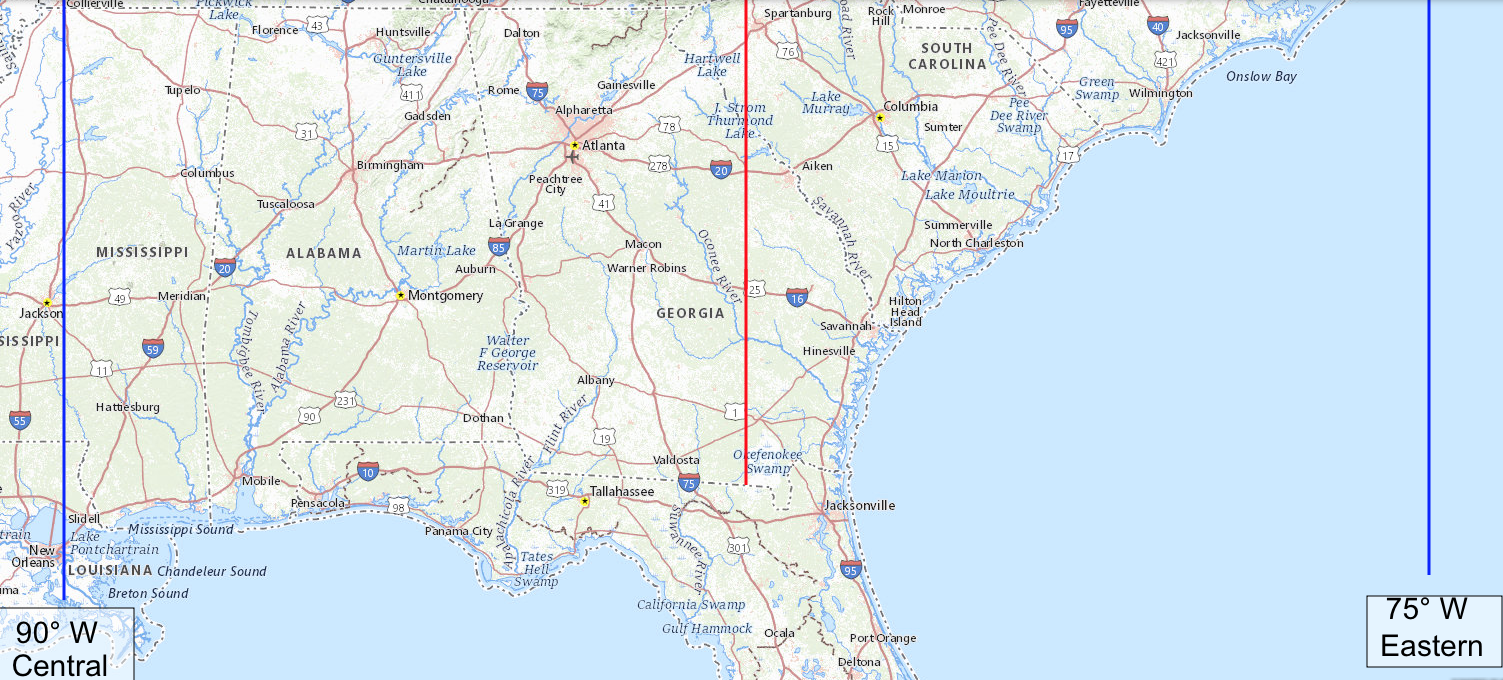
During standard time, the clocks in the Dade Elementary School in Trenton are 42 minutes ahead of their local mean solar time. During daylight saving time, they are 1 hour and 42 minutes ahead of their local mean solar time. Putting that part of Georgia onto Central Standard Time would mean those clocks would be 18 minutes behind their local mean solar time.
“Facts are stubborn things; and whatever may be our wishes, our inclinations, or the dictates of our passion, they cannot alter the state of facts and evidence.” — John Adams, Argument in Defense of the British Soldiers in the Boston Massacre Trials, 4 December 1770.
Supporters of year-round daylight saving time argue: Changing the clocks twice a year really stinks. Let’s keep the clocks set to the wrong time year-round. They think the government can give them more daylight by tampering with the clocks, which is like thinking you can gain or lose weight by tampering with your scale.
Supporters of year-round daylight saving time argue that folks have become habituated more to daylight saving time, observing it 8 months every year, than to standard time; but this is because lawmakers forced it onto us. If this bad habit is passed onto little children who are learning how to tell time, when will the bad habit ever be broken?
Supporters of year-round standard time argue: Changing the clocks twice a year really stinks, and forces people to observe the wrong time of day when daylight saving time is in effect. End it, don’t extend it. Let’s not kick the can down the road and burden future generations with the wrong time. Over the years, businesses will adapt, using winter hours and summer hours, same as libraries do. Let’s keep the clocks set to the time that most closely approximates their actual mean solar time. If you want a long sunlit afternoon, then work from 7:00 to 16:00 standard time, which is the same as 8:00 to 17:00 daylight saving time. Petition your employer, but don’t try to force everybody to keep their clocks set to the wrong time.
A State can exempt herself from daylight saving time without federal approval. See15 U.S. Code § 260a(a)(1) , but year-round daylight saving time requires an Act of Congress.
Earth rotates on its axis in 23 hours, 56 minutes and 4.098903691 seconds1, but moves along on its orbit during that time, so it takes a few minutes longer for your hemisphere to face the Sun again. Since the orbit is not circular, the length of a solar day varies during the year. To avoid having days of different lengths, the mean (average) day of 24 hours is used. If the Sun transits your meridian, on average, 12 hours after your clock strikes midnight, then your clock is set to the mean (average) solar time of your longitude. For more about solar (Sun) days versus sidereal (other stars) days, see https://www.universetoday.com/47181/earths-rotation/
As used on this website, a place belongs on a time that is no more than 30 minutes away from its local mean solar time. A time zone boundary belongs at the meridian where the local mean solar time is 30 minutes ahead of the standard time in the time zone to the west and 30 minutes behind the standard time in the time zone to the east. Obviously, minor adjustments are recommendable so that the actual boundaries do not run through Tampa, Florida or Oklahoma City, Oklahoma and Brownsville, Texas. The boundary between the Eastern Time Zone and the Atlantic Time Zone, running along the international boundary between Maine, U.S.A. and New Brunswick, Canada, is an example of a minor adjustment.
Yellow background indicates the correct time zone, with a difference less than 30 minutes from local mean solar time.
| Location | Co-Ordinates (Latitude, Longitude and Elevation) |
(Mountain Daylight Saving Time) |
Eastern Standard Time (Central Daylight Saving Time) |
Atlantic Standard Time (Eastern Daylight Saving Time) |
| A C Griggs Alternative School, Richmond County |
12:32:03 | 11:32:03 | 10:32:03 | |
| A Dorothy Hains Elementary School, Richmond County |
12:31:56 | 11:31:56 | 10:31:56 | |
| A L Burruss Elementary School, Cobb County |
12:21:41 | 11:21:41 | 10:21:41 | |
| A Philip Randolph Elementary School, Fulton County |
12:21:45 | 11:21:45 | 10:21:45 | |
| A R Johnson Junior High School, Richmond County |
12:32:04 | 11:32:04 | 10:32:04 | |
| A S Clark Elementary School, Crisp County |
12:24:49 | 11:24:49 | 10:24:49 | |
| A Z Kelsey Academy, Spalding County |
12:22:58 | 11:22:58 | 10:22:58 | |
| Abbeville Elementary School, Wilcox County |
12:26:44 | 11:26:44 | 10:26:44 | |
| Abbeville Post Office, Wilcox County |
12:26:45 | 11:26:45 | 10:26:45 | |
| Abbotts Hill Elementary School, Fulton County |
12:23:12 | 11:23:12 | 10:23:12 | |
| Abercorn Street School, Chatham County |
12:35:38 | 11:35:38 | 10:35:38 | |
| Abrams School (historical), Worth County |
12:24:29 | 11:24:29 | 10:24:29 | |
| Academe of the Oaks, DeKalb County |
12:22:51 | 11:22:51 | 10:22:51 | |
| Academics Plus School, Columbia County |
12:31:30 | 11:31:30 | 10:31:30 | |
| Academy School (historical), Jackson County |
12:25:31 | 11:25:31 | 10:25:31 | |
| Academy of Fulton County, DeKalb County |
12:23:27 | 11:23:27 | 10:23:27 | |
| Academy of Lithonia Charter School, DeKalb County |
12:23:28 | 11:23:28 | 10:23:28 | |
| Academy of Medicine, Fulton County |
12:22:27 | 11:22:27 | 10:22:27 | |
| Achieve Academy of Atlanta, Fulton County |
12:21:54 | 11:21:54 | 10:21:54 | |
| Acworth Christian School, Cobb County |
12:21:16 | 11:21:16 | 10:21:16 | |
| Acworth Elementary School, Cobb County |
12:21:23 | 11:21:23 | 10:21:23 | |
| Acworth Post Office, Cobb County |
12:21:16 | 11:21:16 | 10:21:16 | |
| Adair Street School (historical), Lowndes County |
12:26:52 | 11:26:52 | 10:26:52 | |
| Adairsville Elementary School, Bartow County |
12:20:14 | 11:20:14 | 10:20:14 | |
| Adairsville High School, Bartow County |
12:20:19 | 11:20:19 | 10:20:19 | |
| Adairsville Middle School, Bartow County |
12:20:14 | 11:20:14 | 10:20:14 | |
| Adairsville Post Office, Bartow County |
12:20:16 | 11:20:16 | 10:20:16 | |
| Adams School (historical), Jackson County |
12:26:30 | 11:26:30 | 10:26:30 | |
| Adams School (historical), McDuffie County |
12:30:31 | 11:30:31 | 10:30:31 | |
| Adamson Middle School, Clayton County |
12:22:51 | 11:22:51 | 10:22:51 | |
| Adamsville Elementary School, Fulton County |
12:21:56 | 11:21:56 | 10:21:56 | |
| Addison Elementary School, Cobb County |
12:22:01 | 11:22:01 | 10:22:01 | |
| Adel Elementary School, Cook County |
12:26:19 | 11:26:19 | 10:26:19 | |
| Adel Post Office, Cook County |
12:26:19 | 11:26:19 | 10:26:19 | |
| Adkins School (historical), Crisp County |
12:24:30 | 11:24:30 | 10:24:30 | |
| Adlai School (historical), Brooks County |
12:25:15 | 11:25:15 | 10:25:15 | |
| Administer Tabernacle School, Newton County |
12:24:27 | 11:24:27 | 10:24:27 | |
| Adrian Elementary School, Emanuel County |
12:29:37 | 11:29:37 | 10:29:37 | |
| Adrian Post Office, Johnson County |
12:29:38 | 11:29:38 | 10:29:38 | |
| Adult Education Center, DeKalb County |
12:23:02 | 11:23:02 | 10:23:02 | |
| Advace Preparatory Academy, DeKalb County |
12:23:09 | 11:23:09 | 10:23:09 | |
| Aerial School (historical), Habersham County |
12:25:28 | 11:25:28 | 10:25:28 | |
| Agnes School (historical), Lincoln County |
12:30:18 | 11:30:18 | 10:30:18 | |
| Agnes Scott College, DeKalb County |
12:22:49 | 11:22:49 | 10:22:49 | |
| Ailey Post Office, Montgomery County |
12:29:44 | 11:29:44 | 10:29:44 | |
| Air Line Elementary School, Hart County |
12:27:52 | 11:27:52 | 10:27:52 | |
| Air Line School, Hall County |
12:24:57 | 11:24:57 | 10:24:57 | |
| Airline School (historical), Hall County |
12:24:57 | 11:24:57 | 10:24:57 | |
| Airline School (historical), Thomas County |
12:24:48 | 11:24:48 | 10:24:48 | |
| Akers Mill Post Office, Cobb County |
12:22:10 | 11:22:10 | 10:22:10 | |
| Al Burruss School, Cobb County |
12:21:41 | 11:21:41 | 10:21:41 | |
| Alabaha School (historical), Pierce County |
12:30:41 | 11:30:41 | 10:30:41 | |
| Alabama Street School, Carroll County |
12:19:40 | 11:19:40 | 10:19:40 | |
| Alamo Post Office, Wheeler County |
12:28:52 | 11:28:52 | 10:28:52 | |
| Alapaha Elementary School, Berrien County |
12:27:07 | 11:27:07 | 10:27:07 | |
| Alapaha Post Office, Berrien County |
12:27:06 | 11:27:06 | 10:27:06 | |
| Albany Academy (historical), Dougherty County |
12:23:21 | 11:23:21 | 10:23:21 | |
| Albany Area Vocational High School, Dougherty County |
12:23:19 | 11:23:19 | 10:23:19 | |
| Albany High School, Dougherty County |
12:23:19 | 11:23:19 | 10:23:19 | |
| Albany Junior College, Dougherty County |
12:23:09 | 11:23:09 | 10:23:09 | |
| Albany Middle School, Dougherty County |
12:23:22 | 11:23:22 | 10:23:22 | |
| Albany Post Office, Dougherty County |
12:23:17 | 11:23:17 | 10:23:17 | |
| Albany State University, Dougherty County |
12:23:25 | 11:23:25 | 10:23:25 | |
| Albany Vocational-Technical School, Dougherty County |
12:23:18 | 11:23:18 | 10:23:18 | |
| Alcova Elementary School, Gwinnett County |
12:24:24 | 11:24:24 | 10:24:24 | |
| Alcovy High School, Newton County |
12:24:37 | 11:24:37 | 10:24:37 | |
| Alderman High School (historical), Bulloch County |
12:32:23 | 11:32:23 | 10:32:23 | |
| Alexander High School, Douglas County |
12:20:51 | 11:20:51 | 10:20:51 | |
| Alexander School (historical), Bulloch County |
12:32:31 | 11:32:31 | 10:32:31 | |
| Alexander School Number 2, Bibb County |
12:25:25 | 11:25:25 | 10:25:25 | |
| Alexander School Number 4, Bibb County |
12:25:15 | 11:25:15 | 10:25:15 | |
| Alexander School, Bibb County |
12:25:30 | 11:25:30 | 10:25:30 | |
| Alexander Smith Academy, DeKalb County |
12:22:49 | 11:22:49 | 10:22:49 | |
| Alford School (historical), Meriwether County |
12:21:51 | 11:21:51 | 10:21:51 | |
| Alfred and Adele Davis Academy Elementary School, Fulton County |
12:22:38 | 11:22:38 | 10:22:38 | |
| Alfred and Adele Davis Academy Middle School, Fulton County |
12:22:38 | 11:22:38 | 10:22:38 | |
| Alfretta A Harper Elementary School, Clayton County |
12:22:26 | 11:22:26 | 10:22:26 | |
| Alice M Daley Adventist School, Walker County |
12:19:08 | 11:19:08 | 10:19:08 | |
| Alice Street School, Ware County |
12:30:36 | 11:30:36 | 10:30:36 | |
| All Star Kids Academy, DeKalb County |
12:23:07 | 11:23:07 | 10:23:07 | |
| Allatoona Elementary School, Bartow County |
12:21:19 | 11:21:19 | 10:21:19 | |
| Allatoona High School, Cobb County |
12:21:03 | 11:21:03 | 10:21:03 | |
| Allen Elementary School, Muscogee County |
12:20:08 | 11:20:08 | 10:20:08 | |
| Allendale School (historical), Banks County |
12:25:37 | 11:25:37 | 10:25:37 | |
| Allenhurst Post Office, Liberty County |
12:33:33 | 11:33:33 | 10:33:33 | |
| Allentown Post Office, Wilkinson County |
12:27:05 | 11:27:05 | 10:27:05 | |
| Allgood Elementary School, DeKalb County |
12:23:09 | 11:23:09 | 10:23:09 | |
| Allgood Elementary School, Paulding County |
12:20:36 | 11:20:36 | 10:20:36 | |
| Allgood School, Cobb County |
12:21:50 | 11:21:50 | 10:21:50 | |
| Alma Post Office, Bacon County |
12:30:07 | 11:30:07 | 10:30:07 | |
| Alpha Academy, Rockdale County |
12:23:54 | 11:23:54 | 10:23:54 | |
| Alpha School (historical), Cook County |
12:26:38 | 11:26:38 | 10:26:38 | |
| Alpharetta Christian Academy, Fulton County |
12:22:49 | 11:22:49 | 10:22:49 | |
| Alpharetta Elementary School, Fulton County |
12:22:47 | 11:22:47 | 10:22:47 | |
| Alpharetta High School, Fulton County |
12:22:58 | 11:22:58 | 10:22:58 | |
| Alpharetta International Academy, Fulton County |
12:23:06 | 11:23:06 | 10:23:06 | |
| Alpharetta Methodist Christian Academy, Fulton County |
12:22:49 | 11:22:49 | 10:22:49 | |
| Alpharetta Post Office, Fulton County |
12:22:50 | 11:22:50 | 10:22:50 | |
| Alpharetta School, Fulton County |
12:22:47 | 11:22:47 | 10:22:47 | |
| Alpine Educational Program School, Hall County |
12:24:47 | 11:24:47 | 10:24:47 | |
| Alps Road Elementary School, Clarke County |
12:26:22 | 11:26:22 | 10:26:22 | |
| Alsobrook School (historical), Fannin County |
12:22:50 | 11:22:50 | 10:22:50 | |
| Alsobrook School (historical), Fannin County |
12:22:49 | 11:22:49 | 10:22:49 | |
| Alston Post Office, Montgomery County |
12:30:05 | 11:30:05 | 10:30:05 | |
| Altama Elementary School, Glynn County |
12:34:04 | 11:34:04 | 10:34:04 | |
| Altamaha Elementary School, Appling County |
12:30:33 | 11:30:33 | 10:30:33 | |
| Altamaha School, Wayne County |
12:32:29 | 11:32:29 | 10:32:29 | |
| Altamaha Technical College, Wayne County |
12:32:21 | 11:32:21 | 10:32:21 | |
| Alto Park Elementary School, Floyd County |
12:19:03 | 11:19:03 | 10:19:03 | |
| Alto Post Office, Habersham County |
12:25:42 | 11:25:42 | 10:25:42 | |
| Alto School (historical), Banks County |
12:25:42 | 11:25:42 | 10:25:42 | |
| Alton C Crews Middle School, Gwinnett County |
12:23:57 | 11:23:57 | 10:23:57 | |
| Amana Academy, Fulton County |
12:22:47 | 11:22:47 | 10:22:47 | |
| Ambrose Elementary School, Coffee County |
12:27:57 | 11:27:57 | 10:27:57 | |
| Ambrose Post Office, Coffee County |
12:27:56 | 11:27:56 | 10:27:56 | |
| American Heritage Academy, Cherokee County |
12:21:51 | 11:21:51 | 10:21:51 | |
| Americus High School, Sumter County |
12:23:04 | 11:23:04 | 10:23:04 | |
| Americus Post Office, Sumter County |
12:23:04 | 11:23:04 | 10:23:04 | |
| Anderson Elementary School, Chatham County |
12:35:37 | 11:35:37 | 10:35:37 | |
| Anderson Elementary School, Clayton County |
12:22:40 | 11:22:40 | 10:22:40 | |
| Anderson Park Elementary School (historical), Fulton County |
12:22:10 | 11:22:10 | 10:22:10 | |
| Anderson School (historical), Jefferson County |
12:30:37 | 11:30:37 | 10:30:37 | |
| Andersonville Post Office, Sumter County |
12:23:26 | 11:23:26 | 10:23:26 | |
| Andrew College, Randolph County |
12:20:49 | 11:20:49 | 10:20:49 | |
| Andrews School (historical), Greene County |
12:27:59 | 11:27:59 | 10:27:59 | |
| Angiers Academy (historical), Fulton County |
12:22:24 | 11:22:24 | 10:22:24 | |
| Anita White Carson Middle School, Greene County |
12:27:16 | 11:27:16 | 10:27:16 | |
| Anna K Davie Elementary School, Floyd County |
12:19:15 | 11:19:15 | 10:19:15 | |
| Anne Street Elementary School, Spalding County |
12:22:53 | 11:22:53 | 10:22:53 | |
| Annette Winn Elementary School, Douglas County |
12:21:22 | 11:21:22 | 10:21:22 | |
| Annie Shockley Grade School (historical), Spalding County |
12:22:53 | 11:22:53 | 10:22:53 | |
| Anniebel School (historical), Upson County |
12:23:25 | 11:23:25 | 10:23:25 | |
| Annistown Elementary School, Gwinnett County |
12:23:43 | 11:23:43 | 10:23:43 | |
| Anointed Word Christian School, DeKalb County |
12:23:03 | 11:23:03 | 10:23:03 | |
| Answer Center Christian Academy, Gwinnett County |
12:23:13 | 11:23:13 | 10:23:13 | |
| Anthony School (historical), Sumter County |
12:23:08 | 11:23:08 | 10:23:08 | |
| Antioch Baptist Bible College, Cobb County |
12:21:52 | 11:21:52 | 10:21:52 | |
| Antioch Elementary School, Whitfield County |
12:20:15 | 11:20:15 | 10:20:15 | |
| Antioch School (historical), Carroll County |
12:19:09 | 11:19:09 | 10:19:09 | |
| Antioch School (historical), Polk County |
12:19:20 | 11:19:20 | 10:19:20 | |
| Antioch School (historical), Twiggs County |
12:26:07 | 11:26:07 | 10:26:07 | |
| Antioch School (historical), Union County |
12:23:56 | 11:23:56 | 10:23:56 | |
| Antioch School, Chatham County |
12:35:02 | 11:35:02 | 10:35:02 | |
| Antioch School, Evans County |
12:32:39 | 11:32:39 | 10:32:39 | |
| Anvil Block School (historical), Henry County |
12:22:57 | 11:22:57 | 10:22:57 | |
| Apalachee High School, Barrow County |
12:24:51 | 11:24:51 | 10:24:51 | |
| Apostolic Christian Training Center, Cobb County |
12:21:42 | 11:21:42 | 10:21:42 | |
| Appalachian Technical College, Pickens County |
12:22:17 | 11:22:17 | 10:22:17 | |
| Appleton School (historical), Tattnall County |
12:32:01 | 11:32:01 | 10:32:01 | |
| Appling County Elementary School, Appling County |
12:30:34 | 11:30:34 | 10:30:34 | |
| Appling County High School, Appling County |
12:30:35 | 11:30:35 | 10:30:35 | |
| Appling County Junior High School, Appling County |
12:30:36 | 11:30:36 | 10:30:36 | |
| Appling County Primary School, Appling County |
12:30:34 | 11:30:34 | 10:30:34 | |
| Appling High School, Bibb County |
12:25:35 | 11:25:35 | 10:25:35 | |
| Appling Post Office, Columbia County |
12:30:44 | 11:30:44 | 10:30:44 | |
| Aquinas High School, Richmond County |
12:31:50 | 11:31:50 | 10:31:50 | |
| Arabi Post Office, Crisp County |
12:25:02 | 11:25:02 | 10:25:02 | |
| Arabia Mountain High School, DeKalb County |
12:23:28 | 11:23:28 | 10:23:28 | |
| Aragon Post Office, Polk County |
12:19:46 | 11:19:46 | 10:19:46 | |
| Arbor Montessori School, DeKalb County |
12:22:51 | 11:22:51 | 10:22:51 | |
| Arbor Springs Elementary School, Coweta County |
12:21:13 | 11:21:13 | 10:21:13 | |
| Arbor Station Elementary School, Douglas County |
12:20:59 | 11:20:59 | 10:20:59 | |
| Arcado Elementary School, Gwinnett County |
12:23:26 | 11:23:26 | 10:23:26 | |
| Archbishop R Ryan Memorial School, Fulton County |
12:22:30 | 11:22:30 | 10:22:30 | |
| Archer High School, Gwinnett County |
12:24:25 | 11:24:25 | 10:24:25 | |
| Archers Grove School (historical), Jackson County |
12:26:10 | 11:26:10 | 10:26:10 | |
| Arco School, Glynn County |
12:33:58 | 11:33:58 | 10:33:58 | |
| Argosy University Atlanta Campus, Fulton County |
12:22:34 | 11:22:34 | 10:22:34 | |
| Argyle Elementary School, Cobb County |
12:22:03 | 11:22:03 | 10:22:03 | |
| Argyle Post Office, Clinch County |
12:29:24 | 11:29:24 | 10:29:24 | |
| Arkwright Elementary School (historical), Fulton County |
12:22:14 | 11:22:14 | 10:22:14 | |
| Arlington Christian School, Fulton County |
12:21:25 | 11:21:25 | 10:21:25 | |
| Arlington Christian School, Fulton County |
12:21:23 | 11:21:23 | 10:21:23 | |
| Arlington Elementary School, Calhoun County |
12:21:04 | 11:21:04 | 10:21:04 | |
| Arlington Post Office, Calhoun County |
12:21:05 | 11:21:05 | 10:21:05 | |
| Armstrong Atlantic State University Savannah Campus Aquatic and Recreation Center, Chatham County |
12:35:21 | 11:35:21 | 10:35:21 | |
| Armstrong Atlantic State University Savannah Campus Armstrong Center, Chatham County |
12:35:19 | 11:35:19 | 10:35:19 | |
| Armstrong Atlantic State University Savannah Campus Ashmore Hall, Chatham County |
12:35:20 | 11:35:20 | 10:35:20 | |
| Armstrong Atlantic State University Savannah Campus Burnett Hall, Chatham County |
12:35:20 | 11:35:20 | 10:35:20 | |
| Armstrong Atlantic State University Savannah Campus Fine Arts Center, Chatham County |
12:35:20 | 11:35:20 | 10:35:20 | |
| Armstrong Atlantic State University Savannah Campus Gamble Hall, Chatham County |
12:35:21 | 11:35:21 | 10:35:21 | |
| Armstrong Atlantic State University Savannah Campus Hawes Hall, Chatham County |
12:35:20 | 11:35:20 | 10:35:20 | |
| Armstrong Atlantic State University Savannah Campus Jenkins Hall, Chatham County |
12:35:21 | 11:35:21 | 10:35:21 | |
| Armstrong Atlantic State University Savannah Campus Memorial College Center, Chatham County |
12:35:20 | 11:35:20 | 10:35:20 | |
| Armstrong Atlantic State University Savannah Campus Science Center, Chatham County |
12:35:21 | 11:35:21 | 10:35:21 | |
| Armstrong Atlantic State University Savannah Campus Solms Hall, Chatham County |
12:35:20 | 11:35:20 | 10:35:20 | |
| Armstrong Atlantic State University Savannah Campus Student Recreation Center, Chatham County |
12:35:21 | 11:35:21 | 10:35:21 | |
| Armstrong Atlantic State University Savannah Campus University Hall, Chatham County |
12:35:20 | 11:35:20 | 10:35:20 | |
| Armstrong Atlantic State University Savannah Campus Victor Hall, Chatham County |
12:35:21 | 11:35:21 | 10:35:21 | |
| Armstrong Atlantic State University, Chatham County |
12:35:37 | 11:35:37 | 10:35:37 | |
| Armstrong Atlantic State University, Chatham County |
12:35:21 | 11:35:21 | 10:35:21 | |
| Armstrong Atlantic State University, Chatham County |
12:35:21 | 11:35:21 | 10:35:21 | |
| Armstrong Atlantic State University, Liberty County |
12:33:40 | 11:33:40 | 10:33:40 | |
| Armuchee Elementary School, Floyd County |
12:19:18 | 11:19:18 | 10:19:18 | |
| Armuchee High School, Floyd County |
12:19:17 | 11:19:17 | 10:19:17 | |
| Armuchee Post Office, Floyd County |
12:19:18 | 11:19:18 | 10:19:18 | |
| Armuchee Valley School, Walker County |
12:19:27 | 11:19:27 | 10:19:27 | |
| Armunchee Middle School, Floyd County |
12:19:19 | 11:19:19 | 10:19:19 | |
| Arnall Middle School, Coweta County |
12:21:11 | 11:21:11 | 10:21:11 | |
| Arnco - Sargent Elementary School, Coweta County |
12:20:30 | 11:20:30 | 10:20:30 | |
| Arnett School, Screven County |
12:33:11 | 11:33:11 | 10:33:11 | |
| Arnold Junior High School, Muscogee County |
12:20:09 | 11:20:09 | 10:20:09 | |
| Arnold Mill Elementary School, Cherokee County |
12:22:14 | 11:22:14 | 10:22:14 | |
| Arnoldsville Post Office, Oglethorpe County |
12:27:07 | 11:27:07 | 10:27:07 | |
| Arp School (historical), Banks County |
12:26:21 | 11:26:21 | 10:26:21 | |
| Art Institute of Atlanta, Fulton County |
12:22:34 | 11:22:34 | 10:22:34 | |
| Arthur Williams Middle School, Wayne County |
12:32:29 | 11:32:29 | 10:32:29 | |
| Ascalon School (historical), Walker County |
12:18:17 | 11:18:17 | 10:18:17 | |
| Ash Street Baptist Learning Center, Clayton County |
12:22:32 | 11:22:32 | 10:22:32 | |
| Ash Street Center, Clayton County |
12:22:32 | 11:22:32 | 10:22:32 | |
| Ashburn Elementary School, Turner County |
12:25:24 | 11:25:24 | 10:25:24 | |
| Ashburn Post Office, Turner County |
12:25:23 | 11:25:23 | 10:25:23 | |
| Ashford Academy, DeKalb County |
12:22:43 | 11:22:43 | 10:22:43 | |
| Ashford Park Elementary School, DeKalb County |
12:22:42 | 11:22:42 | 10:22:42 | |
| Ashton School (historical), Ben Hill County |
12:27:22 | 11:27:22 | 10:27:22 | |
| Ashworth Middle School, Gordon County |
12:20:18 | 11:20:18 | 10:20:18 | |
| Astondale School (historical), Oconee County |
12:26:33 | 11:26:33 | 10:26:33 | |
| Atco Post Office (historical), Bartow County |
12:20:43 | 11:20:43 | 10:20:43 | |
| Atco Public School (historical), Bartow County |
12:20:43 | 11:20:43 | 10:20:43 | |
| Atcooga School (historical), Whitfield County |
12:20:07 | 11:20:07 | 10:20:07 | |
| Atha Road Elementary School, Walton County |
12:24:51 | 11:24:51 | 10:24:51 | |
| Athens Academy, Clarke County |
12:26:21 | 11:26:21 | 10:26:21 | |
| Athens Academy, Oconee County |
12:26:24 | 11:26:24 | 10:26:24 | |
| Athens Area Vocational School, Clarke County |
12:26:27 | 11:26:27 | 10:26:27 | |
| Athens Christian School, Clarke County |
12:26:42 | 11:26:42 | 10:26:42 | |
| Athens Female High School (historical), Clarke County |
12:26:30 | 11:26:30 | 10:26:30 | |
| Athens High and Industrial School (historical), Clarke County |
12:26:23 | 11:26:23 | 10:26:23 | |
| Athens Hill School, Stewart County |
12:20:25 | 11:20:25 | 10:20:25 | |
| Athens Montessori School, Clarke County |
12:26:39 | 11:26:39 | 10:26:39 | |
| Athens Post Office Promenade Station, Clarke County |
12:26:10 | 11:26:10 | 10:26:10 | |
| Athens Post Office, Clarke County |
12:26:36 | 11:26:36 | 10:26:36 | |
| Athens Seventh Day Adventist School, Clarke County |
12:26:15 | 11:26:15 | 10:26:15 | |
| Athens Technical College Walton County Campus, Walton County |
12:25:10 | 11:25:10 | 10:25:10 | |
| Athens Technicial College, Clarke County |
12:26:38 | 11:26:38 | 10:26:38 | |
| Atherton Elementary School, DeKalb County |
12:23:06 | 11:23:06 | 10:23:06 | |
| Atkins School (historical), Dooly County |
12:25:17 | 11:25:17 | 10:25:17 | |
| Atkins School (historical), Spalding County |
12:23:16 | 11:23:16 | 10:23:16 | |
| Atkinson County Junior High School, Atkinson County |
12:28:33 | 11:28:33 | 10:28:33 | |
| Atkinson Elementary School, Coweta County |
12:20:48 | 11:20:48 | 10:20:48 | |
| Atkinson Elementary School, Spalding County |
12:22:57 | 11:22:57 | 10:22:57 | |
| Atlanta Adventist Academy Marietta Campus, Cobb County |
12:21:45 | 11:21:45 | 10:21:45 | |
| Atlanta Adventist Academy, Fulton County |
12:21:56 | 11:21:56 | 10:21:56 | |
| Atlanta Adventist Academy, Gwinnett County |
12:23:28 | 11:23:28 | 10:23:28 | |
| Atlanta Area Accelerated Academy, DeKalb County |
12:22:56 | 11:22:56 | 10:22:56 | |
| Atlanta Area School for the Deaf, DeKalb County |
12:23:02 | 11:23:02 | 10:23:02 | |
| Atlanta Baptist College, Henry County |
12:22:57 | 11:22:57 | 10:22:57 | |
| Atlanta Charter Middle School, Fulton County |
12:22:34 | 11:22:34 | 10:22:34 | |
| Atlanta Christian College, Fulton County |
12:22:06 | 11:22:06 | 10:22:06 | |
| Atlanta Classical Christian Academy, Cobb County |
12:22:05 | 11:22:05 | 10:22:05 | |
| Atlanta Country Day School, Forsyth County |
12:23:11 | 11:23:11 | 10:23:11 | |
| Atlanta Country Day School, Fulton County |
12:22:36 | 11:22:36 | 10:22:36 | |
| Atlanta Female Institute (historical), Fulton County |
12:22:27 | 11:22:27 | 10:22:27 | |
| Atlanta Girls School, Fulton County |
12:22:18 | 11:22:18 | 10:22:18 | |
| Atlanta International School, Fulton County |
12:22:29 | 11:22:29 | 10:22:29 | |
| Atlanta Language Institute, Fulton County |
12:22:35 | 11:22:35 | 10:22:35 | |
| Atlanta Medical Center Contract Postal Unit, Fulton County |
12:22:30 | 11:22:30 | 10:22:30 | |
| Atlanta Medical College (historical), Fulton County |
12:22:28 | 11:22:28 | 10:22:28 | |
| Atlanta Metropolitan College, Fulton County |
12:22:23 | 11:22:23 | 10:22:23 | |
| Atlanta New Century School, Fulton County |
12:22:27 | 11:22:27 | 10:22:27 | |
| Atlanta North School of Seventh Day Adventists, DeKalb County |
12:22:41 | 11:22:41 | 10:22:41 | |
| Atlanta Post Office, Fulton County |
12:22:25 | 11:22:25 | 10:22:25 | |
| Atlanta School, Fulton County |
12:22:34 | 11:22:34 | 10:22:34 | |
| Atlanta Speech School, Fulton County |
12:22:18 | 11:22:18 | 10:22:18 | |
| Atlanta Street Academy, Fulton County |
12:22:16 | 11:22:16 | 10:22:16 | |
| Atlanta Technical College, Fulton County |
12:22:22 | 11:22:22 | 10:22:22 | |
| Atlanta Theological Seminary (historical), Fulton County |
12:22:22 | 11:22:22 | 10:22:22 | |
| Atlanta University, Fulton County |
12:22:22 | 11:22:22 | 10:22:22 | |
| Atlanta Youth Academies Main Campus, Fulton County |
12:22:33 | 11:22:33 | 10:22:33 | |
| Atlanta Youth Academies YMCA Campus, Fulton County |
12:22:09 | 11:22:09 | 10:22:09 | |
| Attala Seminary (historical), Fannin County |
12:22:27 | 11:22:27 | 10:22:27 | |
| Attapulgus Post Office, Decatur County |
12:22:03 | 11:22:03 | 10:22:03 | |
| Atwater School, Upson County |
12:22:38 | 11:22:38 | 10:22:38 | |
| Atwell School, Jefferson County |
12:30:50 | 11:30:50 | 10:30:50 | |
| Auburn Elementary School, Barrow County |
12:24:42 | 11:24:42 | 10:24:42 | |
| Auburn Post Office, Barrow County |
12:24:42 | 11:24:42 | 10:24:42 | |
| Augusta Area Vocational Technical School, Richmond County |
12:31:47 | 11:31:47 | 10:31:47 | |
| Augusta Christian Academy, Richmond County |
12:31:57 | 11:31:57 | 10:31:57 | |
| Augusta Christian Day School, Columbia County |
12:31:41 | 11:31:41 | 10:31:41 | |
| Augusta Christian School, Columbia County |
12:31:41 | 11:31:41 | 10:31:41 | |
| Augusta Country Day School, Columbia County |
12:31:33 | 11:31:33 | 10:31:33 | |
| Augusta Post Office, Richmond County |
12:32:07 | 11:32:07 | 10:32:07 | |
| Augusta Preparatory Day School, Columbia County |
12:31:33 | 11:31:33 | 10:31:33 | |
| Augusta Seventh Day Adventist School, Columbia County |
12:31:30 | 11:31:30 | 10:31:30 | |
| Augusta State University, Richmond County |
12:31:54 | 11:31:54 | 10:31:54 | |
| Augusta Vocational School, Richmond County |
12:32:01 | 11:32:01 | 10:32:01 | |
| Austell Elementary School, Cobb County |
12:21:27 | 11:21:27 | 10:21:27 | |
| Austell Intermediate School, Cobb County |
12:21:18 | 11:21:18 | 10:21:18 | |
| Austell Post Office, Cobb County |
12:21:27 | 11:21:27 | 10:21:27 | |
| Austell Primary School, Cobb County |
12:21:27 | 11:21:27 | 10:21:27 | |
| Austin Elementary School, DeKalb County |
12:22:39 | 11:22:39 | 10:22:39 | |
| Austin Middle School, Paulding County |
12:20:40 | 11:20:40 | 10:20:40 | |
| Austin Road Elementary School, Henry County |
12:23:15 | 11:23:15 | 10:23:15 | |
| Austin Road Middle School, Henry County |
12:23:15 | 11:23:15 | 10:23:15 | |
| Autrey Mill Middle School, Fulton County |
12:23:02 | 11:23:02 | 10:23:02 | |
| Autreyville School (historical), Colquitt County |
12:24:56 | 11:24:56 | 10:24:56 | |
| Ava Street High School, Ware County |
12:30:36 | 11:30:36 | 10:30:36 | |
| Avalon School (historical), Stephens County |
12:27:11 | 11:27:11 | 10:27:11 | |
| Avera Junior High School, Jefferson County |
12:29:54 | 11:29:54 | 10:29:54 | |
| Avera Post Office, Jefferson County |
12:29:53 | 11:29:53 | 10:29:53 | |
| Avery Elementary School, Cherokee County |
12:22:25 | 11:22:25 | 10:22:25 | |
| Avery School, Fulton County |
12:22:09 | 11:22:09 | 10:22:09 | |
| Aviation Institute of Maintenance, Gwinnett County |
12:24:08 | 11:24:08 | 10:24:08 | |
| Avington School (historical), Richmond County |
12:30:55 | 11:30:55 | 10:30:55 | |
| Avondale Elementary School, DeKalb County |
12:22:57 | 11:22:57 | 10:22:57 | |
| Avondale Estates Post Office, DeKalb County |
12:22:54 | 11:22:54 | 10:22:54 | |
| Avondale High School, DeKalb County |
12:22:55 | 11:22:55 | 10:22:55 | |
| Avondale Middle School, DeKalb County |
12:22:57 | 11:22:57 | 10:22:57 | |
| Avondale Patillo Christian School, DeKalb County |
12:22:58 | 11:22:58 | 10:22:58 | |
| Avondale School, DeKalb County |
12:22:58 | 11:22:58 | 10:22:58 | |
| Awtrey Middle School, Cobb County |
12:21:24 | 11:21:24 | 10:21:24 | |
| Axson Post Office, Atkinson County |
12:29:04 | 11:29:04 | 10:29:04 | |
| B B Harris Elementary School, Gwinnett County |
12:23:27 | 11:23:27 | 10:23:27 | |
| B C Haynie Elementary School, Clayton County |
12:22:35 | 11:22:35 | 10:22:35 | |
| BEST Academy at Benjamin E Carson, Fulton County |
12:22:29 | 11:22:29 | 10:22:29 | |
| Babb Middle School, Clayton County |
12:22:35 | 11:22:35 | 10:22:35 | |
| Bachelors School (historical), Jackson County |
12:25:38 | 11:25:38 | 10:25:38 | |
| Bacon County Elementary School, Bacon County |
12:30:08 | 11:30:08 | 10:30:08 | |
| Bacon County High School, Bacon County |
12:30:09 | 11:30:09 | 10:30:09 | |
| Bacon County Middle School, Bacon County |
12:30:10 | 11:30:10 | 10:30:10 | |
| Baconton Post Office, Mitchell County |
12:23:21 | 11:23:21 | 10:23:21 | |
| Baggett Elementary School, Paulding County |
12:20:58 | 11:20:58 | 10:20:58 | |
| Bagley Middle School, Murray County |
12:20:45 | 11:20:45 | 10:20:45 | |
| Bailey School, Tift County |
12:26:02 | 11:26:02 | 10:26:02 | |
| Bailey Street School, Ware County |
12:30:33 | 11:30:33 | 10:30:33 | |
| Bainbridge Air Base Contract School (historical), Decatur County |
12:21:27 | 11:21:27 | 10:21:27 | |
| Bainbridge High School, Decatur County |
12:21:46 | 11:21:46 | 10:21:46 | |
| Bainbridge Junior College, Decatur County |
12:21:51 | 11:21:51 | 10:21:51 | |
| Bainbridge Junior High School (historical), Decatur County |
12:21:42 | 11:21:42 | 10:21:42 | |
| Bainbridge Male and Female Academy (historical), Decatur County |
12:21:42 | 11:21:42 | 10:21:42 | |
| Bainbridge Post Office, Decatur County |
12:21:41 | 11:21:41 | 10:21:41 | |
| Baker Academy, Baker County |
12:21:45 | 11:21:45 | 10:21:45 | |
| Baker Academy, Pulaski County |
12:26:03 | 11:26:03 | 10:26:03 | |
| Baker County Elementary School, Baker County |
12:22:38 | 11:22:38 | 10:22:38 | |
| Baker Elementary School, Cobb County |
12:21:30 | 11:21:30 | 10:21:30 | |
| Baker School (historical), Laurens County |
12:28:13 | 11:28:13 | 10:28:13 | |
| Baker Village Post Office, Muscogee County |
12:20:13 | 11:20:13 | 10:20:13 | |
| Baker Village School, Muscogee County |
12:20:13 | 11:20:13 | 10:20:13 | |
| Bakers Ferry Residential Facility, Fulton County |
12:21:51 | 11:21:51 | 10:21:51 | |
| Bald Knob School (historical), Fannin County |
12:23:02 | 11:23:02 | 10:23:02 | |
| Baldwin College, Tift County |
12:25:53 | 11:25:53 | 10:25:53 | |
| Baldwin Elementary School, Banks County |
12:25:50 | 11:25:50 | 10:25:50 | |
| Baldwin High School, Baldwin County |
12:26:57 | 11:26:57 | 10:26:57 | |
| Baldwin Post Office, Banks County |
12:25:50 | 11:25:50 | 10:25:50 | |
| Baldwin School, Baldwin County |
12:27:02 | 11:27:02 | 10:27:02 | |
| Baldwin Vocational School, Baldwin County |
12:26:58 | 11:26:58 | 10:26:58 | |
| Balfour School, Thomas County |
12:24:04 | 11:24:04 | 10:24:04 | |
| Ball Creek School (historical), Pickens County |
12:21:39 | 11:21:39 | 10:21:39 | |
| Ball Ground Elementary School, Cherokee County |
12:22:29 | 11:22:29 | 10:22:29 | |
| Ball Ground Post Office, Cherokee County |
12:22:29 | 11:22:29 | 10:22:29 | |
| Ballard Elementary School, Glynn County |
12:33:58 | 11:33:58 | 10:33:58 | |
| Ballard-Hudson High School, Bibb County |
12:25:22 | 11:25:22 | 10:25:22 | |
| Banks County Elementary School, Banks County |
12:26:00 | 11:26:00 | 10:26:00 | |
| Banks County High School, Banks County |
12:26:00 | 11:26:00 | 10:26:00 | |
| Banks County Middle School, Banks County |
12:26:05 | 11:26:05 | 10:26:05 | |
| Banks County Primary School, Banks County |
12:25:57 | 11:25:57 | 10:25:57 | |
| Banks School, Bibb County |
12:25:28 | 11:25:28 | 10:25:28 | |
| Banks School, Elbert County |
12:29:05 | 11:29:05 | 10:29:05 | |
| Banks School, Floyd County |
12:19:20 | 11:19:20 | 10:19:20 | |
| Banks Stephens Middle School, Monroe County |
12:24:20 | 11:24:20 | 10:24:20 | |
| Banks-Stephens Elementary School, Monroe County |
12:24:15 | 11:24:15 | 10:24:15 | |
| Baptist Memorial Institute (historical), Fulton County |
12:22:31 | 11:22:31 | 10:22:31 | |
| Baptist University of America, DeKalb County |
12:22:52 | 11:22:52 | 10:22:52 | |
| Barber Middle School, Cobb County |
12:21:23 | 11:21:23 | 10:21:23 | |
| Barbers Creek School (historical), Barrow County |
12:25:38 | 11:25:38 | 10:25:38 | |
| Barden School, Bibb County |
12:25:10 | 11:25:10 | 10:25:10 | |
| Bargeron School (historical), Burke County |
12:32:53 | 11:32:53 | 10:32:53 | |
| Barksdale Elementary School, Rockdale County |
12:23:53 | 11:23:53 | 10:23:53 | |
| Barksdale School (historical), Lamar County |
12:23:39 | 11:23:39 | 10:23:39 | |
| Barnesville Academy, Lamar County |
12:23:24 | 11:23:24 | 10:23:24 | |
| Barnesville Post Office, Lamar County |
12:23:23 | 11:23:23 | 10:23:23 | |
| Barnett Shoals Elementary School, Clarke County |
12:26:38 | 11:26:38 | 10:26:38 | |
| Barney Post Office, Brooks County |
12:25:56 | 11:25:56 | 10:25:56 | |
| Barnsley School (historical), Bartow County |
12:19:58 | 11:19:58 | 10:19:58 | |
| Barnwell Elementary School, Fulton County |
12:22:59 | 11:22:59 | 10:22:59 | |
| Barrel Head School (historical), Jeff Davis County |
12:28:56 | 11:28:56 | 10:28:56 | |
| Barrett Parkway Post Office, Cobb County |
12:21:41 | 11:21:41 | 10:21:41 | |
| Barrow County Alternative Center, Barrow County |
12:24:53 | 11:24:53 | 10:24:53 | |
| Barrow Elementary School, Clarke County |
12:26:28 | 11:26:28 | 10:26:28 | |
| Bartlett Middle School, Chatham County |
12:35:32 | 11:35:32 | 10:35:32 | |
| Barton Chapel Elementary School, Richmond County |
12:31:38 | 11:31:38 | 10:31:38 | |
| Bartow Academy, Bartow County |
12:20:34 | 11:20:34 | 10:20:34 | |
| Bartow Elementary School, Chatham County |
12:35:29 | 11:35:29 | 10:35:29 | |
| Bartow High School, Jefferson County |
12:30:06 | 11:30:06 | 10:30:06 | |
| Bartow Post Office, Jefferson County |
12:30:06 | 11:30:06 | 10:30:06 | |
| Barwick Elementary School, Brooks County |
12:25:03 | 11:25:03 | 10:25:03 | |
| Barwick Post Office, Brooks County |
12:25:02 | 11:25:02 | 10:25:02 | |
| Bascom School (historical), Screven County |
12:33:29 | 11:33:29 | 10:33:29 | |
| Bascomb Elementary School, Cherokee County |
12:21:41 | 11:21:41 | 10:21:41 | |
| Bass High School, Fulton County |
12:22:35 | 11:22:35 | 10:22:35 | |
| Bass School (historical), Baldwin County |
12:27:12 | 11:27:12 | 10:27:12 | |
| Bass School (historical), Floyd County |
12:19:38 | 11:19:38 | 10:19:38 | |
| Batson School (historical), Laurens County |
12:27:43 | 11:27:43 | 10:27:43 | |
| Battlefield Elementary School, Catoosa County |
12:19:04 | 11:19:04 | 10:19:04 | |
| Battlefield Primary School, Catoosa County |
12:19:04 | 11:19:04 | 10:19:04 | |
| Bauder College Atlanta Campus, Fulton County |
12:22:23 | 11:22:23 | 10:22:23 | |
| Baxley High School (historical), Appling County |
12:30:35 | 11:30:35 | 10:30:35 | |
| Baxley Post Office, Appling County |
12:30:37 | 11:30:37 | 10:30:37 | |
| Baxley School (historical), Pierce County |
12:30:33 | 11:30:33 | 10:30:33 | |
| Baxley School, Appling County |
12:30:35 | 11:30:35 | 10:30:35 | |
| Bay Branch School (historical), Evans County |
12:32:05 | 11:32:05 | 10:32:05 | |
| Bay Branch School (historical), Screven County |
12:32:58 | 11:32:58 | 10:32:58 | |
| Bay Creek Christian Academy, Gwinnett County |
12:24:10 | 11:24:10 | 10:24:10 | |
| Bay Creek Elementary School, Walton County |
12:24:26 | 11:24:26 | 10:24:26 | |
| Bay Creek Middle School, Gwinnett County |
12:24:09 | 11:24:09 | 10:24:09 | |
| Bay Spring School (historical), Crisp County |
12:25:21 | 11:25:21 | 10:25:21 | |
| Bay Spring School (historical), Johnson County |
12:29:19 | 11:29:19 | 10:29:19 | |
| Bay Springs Middle School, Carroll County |
12:20:14 | 11:20:14 | 10:20:14 | |
| Bayboro School (historical), Colquitt County |
12:25:38 | 11:25:38 | 10:25:38 | |
| Bayvale Elementary School, Richmond County |
12:31:47 | 11:31:47 | 10:31:47 | |
| Bayvale School (historical), Richmond County |
12:31:41 | 11:31:41 | 10:31:41 | |
| Beach High School, Chatham County |
12:35:32 | 11:35:32 | 10:35:32 | |
| Beallwood Post Office, Muscogee County |
12:20:06 | 11:20:06 | 10:20:06 | |
| Bealwood School, Muscogee County |
12:20:06 | 11:20:06 | 10:20:06 | |
| Bear Branch School (historical), Long County |
12:32:51 | 11:32:51 | 10:32:51 | |
| Bear Creek Middle School, Fulton County |
12:21:29 | 11:21:29 | 10:21:29 | |
| Beards Creek School (historical), Tattnall County |
12:32:29 | 11:32:29 | 10:32:29 | |
| Beasley School (historical), Evans County |
12:32:29 | 11:32:29 | 10:32:29 | |
| Beaver Ridge Elementary School, Gwinnett County |
12:23:18 | 11:23:18 | 10:23:18 | |
| Beaver School, Fulton County |
12:22:09 | 11:22:09 | 10:22:09 | |
| Beaverbrook Elementary School, Spalding County |
12:22:49 | 11:22:49 | 10:22:49 | |
| Beaverdale Elementary School, Whitfield County |
12:20:32 | 11:20:32 | 10:20:32 | |
| Beaverdale School (historical), Whitfield County |
12:20:36 | 11:20:36 | 10:20:36 | |
| Beaverdam Elementary School, Elbert County |
12:28:34 | 11:28:34 | 10:28:34 | |
| Beaverdam School (historical), Long County |
12:32:19 | 11:32:19 | 10:32:19 | |
| Beck Branch School, Grady County |
12:22:38 | 11:22:38 | 10:22:38 | |
| Becker Adventist School, DeKalb County |
12:22:59 | 11:22:59 | 10:22:59 | |
| Beckman School (historical), Jefferson County |
12:30:29 | 11:30:29 | 10:30:29 | |
| Beech Branch School (historical), Burke County |
12:32:53 | 11:32:53 | 10:32:53 | |
| Beech Spring Academy (historical), Twiggs County |
12:26:05 | 11:26:05 | 10:26:05 | |
| Beecher Hills Elementary School, Fulton County |
12:22:08 | 11:22:08 | 10:22:08 | |
| Beechwood School, Burke County |
12:31:38 | 11:31:38 | 10:31:38 | |
| Beersheba School (historical), Henry County |
12:23:57 | 11:23:57 | 10:23:57 | |
| Bel Air Elementary School, Columbia County |
12:31:26 | 11:31:26 | 10:31:26 | |
| Believers Bible Christian Academy, Fulton County |
12:21:58 | 11:21:58 | 10:21:58 | |
| Bell School (historical), Union County |
12:24:09 | 11:24:09 | 10:24:09 | |
| Bell School, Fannin County |
12:23:05 | 11:23:05 | 10:23:05 | |
| Bell-Dixon School (historical), Decatur County |
12:22:26 | 11:22:26 | 10:22:26 | |
| Belleview School (historical), Thomas County |
12:24:24 | 11:24:24 | 10:24:24 | |
| Bellevue School, Bibb County |
12:25:16 | 11:25:16 | 10:25:16 | |
| Bells Ferry Elementary School, Cobb County |
12:21:48 | 11:21:48 | 10:21:48 | |
| Bellview School (historical), Floyd County |
12:18:51 | 11:18:51 | 10:18:51 | |
| Bellville School (historical), Evans County |
12:32:05 | 11:32:05 | 10:32:05 | |
| Belmont Hills Elementary School, Cobb County |
12:21:51 | 11:21:51 | 10:21:51 | |
| Belmont School (historical), Clarke County |
12:26:45 | 11:26:45 | 10:26:45 | |
| Belvedrere Plaza Post Office, DeKalb County |
12:22:55 | 11:22:55 | 10:22:55 | |
| Belwood Elementary School, Gordon County |
12:20:20 | 11:20:20 | 10:20:20 | |
| Ben Daniel School (historical), Stewart County |
12:20:54 | 11:20:54 | 10:20:54 | |
| Ben Hill County Elementary School, Ben Hill County |
12:26:57 | 11:26:57 | 10:26:57 | |
| Ben Hill Elementary School, Fulton County |
12:21:56 | 11:21:56 | 10:21:56 | |
| Ben Hill Post Office, Fulton County |
12:21:57 | 11:21:57 | 10:21:57 | |
| Ben Hill School (historical), Hall County |
12:24:29 | 11:24:29 | 10:24:29 | |
| Ben Hill School (historical), Upson County |
12:22:53 | 11:22:53 | 10:22:53 | |
| Ben Hill-Irwin Vocational School, Ben Hill County |
12:26:56 | 11:26:56 | 10:26:56 | |
| Benedict School, Polk County |
12:18:58 | 11:18:58 | 10:18:58 | |
| Benedictine Military School, Chatham County |
12:35:37 | 11:35:37 | 10:35:37 | |
| Benefield Elementary School, Gwinnett County |
12:23:52 | 11:23:52 | 10:23:52 | |
| Benjamin Banneker High School, Fulton County |
12:21:55 | 11:21:55 | 10:21:55 | |
| Benjamin E Mays High School, Fulton County |
12:21:59 | 11:21:59 | 10:21:59 | |
| Benjamin Franklin Academy, DeKalb County |
12:22:42 | 11:22:42 | 10:22:42 | |
| Benjamin S Carsons Honors Preparatory Academy, Fulton County |
12:22:09 | 11:22:09 | 10:22:09 | |
| Benjamin S Carsons Honors Preparatory Middle School, Fulton County |
12:22:12 | 11:22:12 | 10:22:12 | |
| Bennetts Mill Middle School, Fayette County |
12:21:57 | 11:21:57 | 10:21:57 | |
| Benning Hill School, Muscogee County |
12:20:15 | 11:20:15 | 10:20:15 | |
| Benton Elementary School, Jackson County |
12:26:15 | 11:26:15 | 10:26:15 | |
| Berean Christian School, Putnam County |
12:26:26 | 11:26:26 | 10:26:26 | |
| Berkeley Lake Elementary School, Gwinnett County |
12:23:15 | 11:23:15 | 10:23:15 | |
| Berkmar High School, Gwinnett County |
12:23:32 | 11:23:32 | 10:23:32 | |
| Berkmar Middle School, Gwinnett County |
12:23:29 | 11:23:29 | 10:23:29 | |
| Berlin Elementary School, Colquitt County |
12:25:30 | 11:25:30 | 10:25:30 | |
| Berlin Post Office, Colquitt County |
12:25:30 | 11:25:30 | 10:25:30 | |
| Berlin School (historical), Richmond County |
12:31:54 | 11:31:54 | 10:31:54 | |
| Bernd School, Bibb County |
12:25:43 | 11:25:43 | 10:25:43 | |
| Berrien County High School, Berrien County |
12:27:00 | 11:27:00 | 10:27:00 | |
| Berry Academy, Floyd County |
12:19:03 | 11:19:03 | 10:19:03 | |
| Berry College, Floyd County |
12:19:14 | 11:19:14 | 10:19:14 | |
| Berry School (historical), Union County |
12:24:22 | 11:24:22 | 10:24:22 | |
| Berryman School (historical), Madison County |
12:27:37 | 11:27:37 | 10:27:37 | |
| Berta Weathersbee Elementary School, Troup County |
12:19:48 | 11:19:48 | 10:19:48 | |
| Bessie Chapel School (historical), Bibb County |
12:25:26 | 11:25:26 | 10:25:26 | |
| Bethany School (historical), Bartow County |
12:21:10 | 11:21:10 | 10:21:10 | |
| Bethany School (historical), Morgan County |
12:26:24 | 11:26:24 | 10:26:24 | |
| Bethany School (historical), Union County |
12:23:35 | 11:23:35 | 10:23:35 | |
| Bethel Academy (historical), Heard County |
12:19:32 | 11:19:32 | 10:19:32 | |
| Bethel School (historical), Barrow County |
12:24:56 | 11:24:56 | 10:24:56 | |
| Bethel School (historical), Chatham County |
12:34:52 | 11:34:52 | 10:34:52 | |
| Bethel School (historical), Hancock County |
12:28:27 | 11:28:27 | 10:28:27 | |
| Bethel School (historical), Lamar County |
12:23:34 | 11:23:34 | 10:23:34 | |
| Bethel School (historical), Liberty County |
12:33:13 | 11:33:13 | 10:33:13 | |
| Bethel School (historical), Wayne County |
12:32:00 | 11:32:00 | 10:32:00 | |
| Bethesda Elementary School, Gwinnett County |
12:23:39 | 11:23:39 | 10:23:39 | |
| Bethesda Home For Boys School, Chatham County |
12:35:38 | 11:35:38 | 10:35:38 | |
| Bethesda School (historical), Burke County |
12:33:28 | 11:33:28 | 10:33:28 | |
| Bethesda School (historical), Meriwether County |
12:21:36 | 11:21:36 | 10:21:36 | |
| Bethesda School (historical), Tattnall County |
12:31:43 | 11:31:43 | 10:31:43 | |
| Bethlehem Elementary School, Barrow County |
12:25:07 | 11:25:07 | 10:25:07 | |
| Bethlehem Elementary School, Henry County |
12:23:25 | 11:23:25 | 10:23:25 | |
| Bethlehem Junior High School (historical), Barrow County |
12:25:07 | 11:25:07 | 10:25:07 | |
| Bethlehem Post Office, Barrow County |
12:25:08 | 11:25:08 | 10:25:08 | |
| Bethlehem School (historical), Banks County |
12:25:57 | 11:25:57 | 10:25:57 | |
| Bethlehem School (historical), Union County |
12:23:41 | 11:23:41 | 10:23:41 | |
| Bethlehem School, Stephens County |
12:26:49 | 11:26:49 | 10:26:49 | |
| Bethone Middle School, Charlton County |
12:32:01 | 11:32:01 | 10:32:01 | |
| Bethune Elementary School, Charlton County |
12:32:01 | 11:32:01 | 10:32:01 | |
| Beulah Elementary School, Douglas County |
12:21:11 | 11:21:11 | 10:21:11 | |
| Beulah Heights Bible College, Fulton County |
12:22:34 | 11:22:34 | 10:22:34 | |
| Beulah School (historical), Elbert County |
12:29:15 | 11:29:15 | 10:29:15 | |
| Beulah School (historical), Greene County |
12:27:17 | 11:27:17 | 10:27:17 | |
| Beulah School (historical), Long County |
12:32:41 | 11:32:41 | 10:32:41 | |
| Beulah School (historical), Pierce County |
12:31:07 | 11:31:07 | 10:31:07 | |
| Beulah School (historical), Tattnall County |
12:32:05 | 11:32:05 | 10:32:05 | |
| Beulah School (historical), Terrell County |
12:22:10 | 11:22:10 | 10:22:10 | |
| Beulah School, Douglas County |
12:21:11 | 11:21:11 | 10:21:11 | |
| Bibb City Elementary School, Muscogee County |
12:20:01 | 11:20:01 | 10:20:01 | |
| Bible Baptist Christian School, Henry County |
12:22:53 | 11:22:53 | 10:22:53 | |
| Bible Baptist Day School, Chatham County |
12:35:42 | 11:35:42 | 10:35:42 | |
| Bible School, Coweta County |
12:20:55 | 11:20:55 | 10:20:55 | |
| Biffle Road Elementary School, DeKalb County |
12:23:18 | 11:23:18 | 10:23:18 | |
| Big A Elementary School, Stephens County |
12:26:49 | 11:26:49 | 10:26:49 | |
| Big Creek Elementary School, Forsyth County |
12:23:17 | 11:23:17 | 10:23:17 | |
| Big Creek School (historical), Gilmer County |
12:22:52 | 11:22:52 | 10:22:52 | |
| Big Shanty Elementary School, Cobb County |
12:21:36 | 11:21:36 | 10:21:36 | |
| Biggers School (historical), Polk County |
12:19:17 | 11:19:17 | 10:19:17 | |
| Bill Arp Elementary School, Douglas County |
12:20:49 | 11:20:49 | 10:20:49 | |
| Bingville Post Office, Chatham County |
12:35:33 | 11:35:33 | 10:35:33 | |
| Bio School (historical), Hart County |
12:28:09 | 11:28:09 | 10:28:09 | |
| Birch Street School, Lamar County |
12:23:12 | 11:23:12 | 10:23:12 | |
| Birdwood Junior College, Thomas County |
12:24:08 | 11:24:08 | 10:24:08 | |
| Birmington Road Elementary School, Fulton County |
12:22:38 | 11:22:38 | 10:22:38 | |
| Birney Elementary School, Cobb County |
12:21:41 | 11:21:41 | 10:21:41 | |
| Bishop Elementary School, Oconee County |
12:26:15 | 11:26:15 | 10:26:15 | |
| Bishop Post Office, Oconee County |
12:26:15 | 11:26:15 | 10:26:15 | |
| Bits and Bytes Learning Center, DeKalb County |
12:23:30 | 11:23:30 | 10:23:30 | |
| Black Creek School (historical), Bryan County |
12:33:59 | 11:33:59 | 10:33:59 | |
| Black Creek School, Bryan County |
12:34:02 | 11:34:02 | 10:34:02 | |
| Black School (historical), Lowndes County |
12:27:10 | 11:27:10 | 10:27:10 | |
| Black's Mill Elementary School, Dawson County |
12:23:40 | 11:23:40 | 10:23:40 | |
| Blackburn Elementary School, Lumpkin County |
12:23:54 | 11:23:54 | 10:23:54 | |
| Blackjack School (historical), Coweta County |
12:21:20 | 11:21:20 | 10:21:20 | |
| Blackshear Elementary School, Pierce County |
12:31:01 | 11:31:01 | 10:31:01 | |
| Blackshear Grammar School, Pierce County |
12:31:03 | 11:31:03 | 10:31:03 | |
| Blackshear High School, Pierce County |
12:31:04 | 11:31:04 | 10:31:04 | |
| Blackshear Post Office, Pierce County |
12:31:02 | 11:31:02 | 10:31:02 | |
| Blackshear Trail School, Crisp County |
12:24:54 | 11:24:54 | 10:24:54 | |
| Blackstock Montessori School, Carroll County |
12:20:05 | 11:20:05 | 10:20:05 | |
| Blackwell Elementary School, Cobb County |
12:21:53 | 11:21:53 | 10:21:53 | |
| Blackwell Elementary School, Elbert County |
12:28:35 | 11:28:35 | 10:28:35 | |
| Blackwood School (historical), Gordon County |
12:20:23 | 11:20:23 | 10:20:23 | |
| Blaine Street Elementary School, Walton County |
12:25:11 | 11:25:11 | 10:25:11 | |
| Blairsville Post Office, Union County |
12:24:10 | 11:24:10 | 10:24:10 | |
| Blakely Post Office, Early County |
12:20:15 | 11:20:15 | 10:20:15 | |
| Blakeney Elementary School, Burke County |
12:31:53 | 11:31:53 | 10:31:53 | |
| Blalock Elementary School, Fulton County |
12:22:00 | 11:22:00 | 10:22:00 | |
| Blanchard Elementary School, Muscogee County |
12:20:15 | 11:20:15 | 10:20:15 | |
| Blandford Elementary School, Effingham County |
12:35:01 | 11:35:01 | 10:35:01 | |
| Blandtown School, Fulton County |
12:22:20 | 11:22:20 | 10:22:20 | |
| Blandy Hills Elementary School, Baldwin County |
12:26:54 | 11:26:54 | 10:26:54 | |
| Bleckley County High School, Bleckley County |
12:26:37 | 11:26:37 | 10:26:37 | |
| Bleckley Elementary School, Bleckley County |
12:26:42 | 11:26:42 | 10:26:42 | |
| Bleckley School, Bleckley County |
12:26:29 | 11:26:29 | 10:26:29 | |
| Blessed Sacrament Catholic School, Chatham County |
12:35:39 | 11:35:39 | 10:35:39 | |
| Blessed Trinity Catholic High School, Fulton County |
12:22:26 | 11:22:26 | 10:22:26 | |
| Bloodworth School (historical), Monroe County |
12:24:04 | 11:24:04 | 10:24:04 | |
| Bloomingdale Elementary School, Chatham County |
12:34:47 | 11:34:47 | 10:34:47 | |
| Bloomingdale Post Office, Chatham County |
12:34:49 | 11:34:49 | 10:34:49 | |
| Blount School (historical), Monroe County |
12:24:09 | 11:24:09 | 10:24:09 | |
| Blounts Chapel School, Burke County |
12:31:51 | 11:31:51 | 10:31:51 | |
| Blue Ridge Elementary School, Columbia County |
12:31:34 | 11:31:34 | 10:31:34 | |
| Blue Ridge Elementary School, Fannin County |
12:22:41 | 11:22:41 | 10:22:41 | |
| Blue Ridge Elementary School, Whitfield County |
12:20:10 | 11:20:10 | 10:20:10 | |
| Blue Ridge Post Office, Fannin County |
12:22:47 | 11:22:47 | 10:22:47 | |
| Blue Ridge School (historical), Gilmer County |
12:22:54 | 11:22:54 | 10:22:54 | |
| Blue Ridge School (historical), Monroe County |
12:24:20 | 11:24:20 | 10:24:20 | |
| Blue Ridge School (historical), Toombs County |
12:31:00 | 11:31:00 | 10:31:00 | |
| Blue Ridge School (historical), White County |
12:24:35 | 11:24:35 | 10:24:35 | |
| Blue Spring School (historical), Laurens County |
12:29:04 | 11:29:04 | 10:29:04 | |
| Blue Springs School (historical), Screven County |
12:34:12 | 11:34:12 | 10:34:12 | |
| Bluestone School (historical), Madison County |
12:27:11 | 11:27:11 | 10:27:11 | |
| Bluff Springs School, Stewart County |
12:20:25 | 11:20:25 | 10:20:25 | |
| Bluffton High School (historical), Clay County |
12:20:31 | 11:20:31 | 10:20:31 | |
| Bluffton Post Office, Clay County |
12:20:32 | 11:20:32 | 10:20:32 | |
| Blythe Elementary School, Richmond County |
12:31:10 | 11:31:10 | 10:31:10 | |
| Blythe High School, Richmond County |
12:31:11 | 11:31:11 | 10:31:11 | |
| Blythe Post Office, Richmond County |
12:31:11 | 11:31:11 | 10:31:11 | |
| Boardtown School (historical), Gilmer County |
12:22:13 | 11:22:13 | 10:22:13 | |
| Bob Mathis Elementary School, DeKalb County |
12:23:02 | 11:23:02 | 10:23:02 | |
| Bobo School (historical), Gordon County |
12:21:17 | 11:21:17 | 10:21:17 | |
| Boddie Middle School, Baldwin County |
12:27:06 | 11:27:06 | 10:27:06 | |
| Bogart Developmental Center, Oconee County |
12:25:52 | 11:25:52 | 10:25:52 | |
| Bogart Post Office, Oconee County |
12:25:51 | 11:25:51 | 10:25:51 | |
| Boggs Academy, Burke County |
12:31:19 | 11:31:19 | 10:31:19 | |
| Boggs Road Post Office, Gwinnett County |
12:23:38 | 11:23:38 | 10:23:38 | |
| Bold Springs School (historical), Carroll County |
12:19:40 | 11:19:40 | 10:19:40 | |
| Bolingbroke Post Office, Monroe County |
12:24:47 | 11:24:47 | 10:24:47 | |
| Bolton Academy Elementary School, Fulton County |
12:22:10 | 11:22:10 | 10:22:10 | |
| Bonaire Elementary School, Houston County |
12:25:35 | 11:25:35 | 10:25:35 | |
| Bonaire Post Office, Houston County |
12:25:36 | 11:25:36 | 10:25:36 | |
| Bonds Academy (historical), Greene County |
12:26:45 | 11:26:45 | 10:26:45 | |
| Bonds Academy (historical), Madison County |
12:27:14 | 11:27:14 | 10:27:14 | |
| Booker T Washington High School, Fulton County |
12:22:19 | 11:22:19 | 10:22:19 | |
| Boones Creek School (historical), Charlton County |
12:31:46 | 11:31:46 | 10:31:46 | |
| Booth School (historical), Laurens County |
12:27:22 | 11:27:22 | 10:27:22 | |
| Booths Academy (historical), Oconee County |
12:26:16 | 11:26:16 | 10:26:16 | |
| Boston Elementary School, Cherokee County |
12:21:38 | 11:21:38 | 10:21:38 | |
| Boston Post Office, Thomas County |
12:24:50 | 11:24:50 | 10:24:50 | |
| Bostwick Post Office, Morgan County |
12:25:56 | 11:25:56 | 10:25:56 | |
| Bottsford School (historical), Burke County |
12:32:28 | 11:32:28 | 10:32:28 | |
| Boulder Crest School, DeKalb County |
12:22:44 | 11:22:44 | 10:22:44 | |
| Boulevard School (historical), Pierce County |
12:31:15 | 11:31:15 | 10:31:15 | |
| Bowdon Elementary School, Carroll County |
12:18:59 | 11:18:59 | 10:18:59 | |
| Bowdon High School, Carroll County |
12:18:57 | 11:18:57 | 10:18:57 | |
| Bowdon Junction Post Office, Carroll County |
12:19:24 | 11:19:24 | 10:19:24 | |
| Bowdon Open Campus High School, Carroll County |
12:18:59 | 11:18:59 | 10:18:59 | |
| Bowdon Post Office, Carroll County |
12:18:58 | 11:18:58 | 10:18:58 | |
| Bowen School (historical), Worth County |
12:24:41 | 11:24:41 | 10:24:41 | |
| Bowersville Post Office, Hart County |
12:27:39 | 11:27:39 | 10:27:39 | |
| Bowman Elementary School, Elbert County |
12:27:53 | 11:27:53 | 10:27:53 | |
| Bowman Post Office, Elbert County |
12:27:52 | 11:27:52 | 10:27:52 | |
| Box Spring School, Talbot County |
12:21:48 | 11:21:48 | 10:21:48 | |
| Box Springs Post Office, Talbot County |
12:21:24 | 11:21:24 | 10:21:24 | |
| Boyds School (historical), Screven County |
12:34:06 | 11:34:06 | 10:34:06 | |
| Boydsville High School (historical), McDuffie County |
12:30:12 | 11:30:12 | 10:30:12 | |
| Boylston Crown School (historical), Whitfield County |
12:20:07 | 11:20:07 | 10:20:07 | |
| Boynton Elementary School, Catoosa County |
12:19:15 | 11:19:15 | 10:19:15 | |
| Bozeman Junior High School, Pulaski County |
12:26:06 | 11:26:06 | 10:26:06 | |
| Bozeman School (historical), Turner County |
12:24:57 | 11:24:57 | 10:24:57 | |
| Bradley School (historical), Barrow County |
12:24:58 | 11:24:58 | 10:24:58 | |
| Bradley-Wayside School, Jones County |
12:25:42 | 11:25:42 | 10:25:42 | |
| Bradwell Institute, Liberty County |
12:33:35 | 11:33:35 | 10:33:35 | |
| Bradwell School (historical), Bulloch County |
12:32:20 | 11:32:20 | 10:32:20 | |
| Braelinn Elementary School, Fayette County |
12:21:51 | 11:21:51 | 10:21:51 | |
| Bramlett Elementary School, Barrow County |
12:24:45 | 11:24:45 | 10:24:45 | |
| Branch Christian Community School, Gwinnett County |
12:24:08 | 11:24:08 | 10:24:08 | |
| Brandon Hall School, Fulton County |
12:22:47 | 11:22:47 | 10:22:47 | |
| Brannen School (historical), Bulloch County |
12:33:12 | 11:33:12 | 10:33:12 | |
| Brannen School (historical), Bulloch County |
12:33:02 | 11:33:02 | 10:33:02 | |
| Brannon School (historical), Brooks County |
12:25:20 | 11:25:20 | 10:25:20 | |
| Brantley County High School, Brantley County |
12:31:52 | 11:31:52 | 10:31:52 | |
| Brantley County Middle School, Brantley County |
12:31:53 | 11:31:53 | 10:31:53 | |
| Branton School, Richmond County |
12:31:21 | 11:31:21 | 10:31:21 | |
| Braselton Hoschton Carrier Annex Post Office, Jackson County |
12:24:54 | 11:24:54 | 10:24:54 | |
| Braselton Post Office, Jackson County |
12:24:56 | 11:24:56 | 10:24:56 | |
| Brasstown School (historical), Towns County |
12:24:30 | 11:24:30 | 10:24:30 | |
| Brasstown Zion School (historical), Union County |
12:24:19 | 11:24:19 | 10:24:19 | |
| Braswell School (historical), Morgan County |
12:25:47 | 11:25:47 | 10:25:47 | |
| Bremen Academy, Haralson County |
12:19:31 | 11:19:31 | 10:19:31 | |
| Bremen Crossroads Academy, Haralson County |
12:19:26 | 11:19:26 | 10:19:26 | |
| Bremen High School, Haralson County |
12:19:26 | 11:19:26 | 10:19:26 | |
| Bremen Middle School, Haralson County |
12:19:31 | 11:19:31 | 10:19:31 | |
| Bremen Post Office, Haralson County |
12:19:24 | 11:19:24 | 10:19:24 | |
| Brenau Academy, Hall County |
12:24:42 | 11:24:42 | 10:24:42 | |
| Brenau University, Hall County |
12:24:42 | 11:24:42 | 10:24:42 | |
| Brenau University, Hall County |
12:24:40 | 11:24:40 | 10:24:40 | |
| Brewer Elementary School, Fulton County |
12:22:24 | 11:22:24 | 10:22:24 | |
| Brewster School, Polk County |
12:18:49 | 11:18:49 | 10:18:49 | |
| Brewton - Parker College Liberty Site, Liberty County |
12:33:46 | 11:33:46 | 10:33:46 | |
| Brewton - Parker College Mount Vernon Campus Briscoe Center, Montgomery County |
12:29:40 | 11:29:40 | 10:29:40 | |
| Brewton - Parker College Mount Vernon Campus Conner House, Montgomery County |
12:29:39 | 11:29:39 | 10:29:39 | |
| Brewton - Parker College Mount Vernon Campus Cook Building, Montgomery County |
12:29:39 | 11:29:39 | 10:29:39 | |
| Brewton - Parker College Mount Vernon Campus Dowling Hall, Montgomery County |
12:29:40 | 11:29:40 | 10:29:40 | |
| Brewton - Parker College Mount Vernon Campus Friendship Hall, Montgomery County |
12:29:40 | 11:29:40 | 10:29:40 | |
| Brewton - Parker College Mount Vernon Campus Gates Hall, Montgomery County |
12:29:39 | 11:29:39 | 10:29:39 | |
| Brewton - Parker College Mount Vernon Campus Holliman Fountain Education Center, Montgomery County |
12:29:39 | 11:29:39 | 10:29:39 | |
| Brewton - Parker College Mount Vernon Campus John W Mcarther Clinic, Montgomery County |
12:29:39 | 11:29:39 | 10:29:39 | |
| Brewton - Parker College Mount Vernon Campus Jordan Business Building, Montgomery County |
12:29:39 | 11:29:39 | 10:29:39 | |
| Brewton - Parker College Mount Vernon Campus Leroy Hall, Montgomery County |
12:29:39 | 11:29:39 | 10:29:39 | |
| Brewton - Parker College Mount Vernon Campus Mcallister Hall, Montgomery County |
12:29:40 | 11:29:40 | 10:29:40 | |
| Brewton - Parker College Mount Vernon Campus Miller Music Building, Montgomery County |
12:29:39 | 11:29:39 | 10:29:39 | |
| Brewton - Parker College Mount Vernon Campus Morgan Moses Science Center, Montgomery County |
12:29:39 | 11:29:39 | 10:29:39 | |
| Brewton - Parker College Mount Vernon Campus Newton Building, Montgomery County |
12:29:40 | 11:29:40 | 10:29:40 | |
| Brewton - Parker College Mount Vernon Campus Palmer Building, Montgomery County |
12:29:39 | 11:29:39 | 10:29:39 | |
| Brewton - Parker College Mount Vernon Campus Parker Building, Montgomery County |
12:29:39 | 11:29:39 | 10:29:39 | |
| Brewton - Parker College Mount Vernon Campus Parker Gymnasium, Montgomery County |
12:29:39 | 11:29:39 | 10:29:39 | |
| Brewton - Parker College Mount Vernon Campus Phillips Student Center, Montgomery County |
12:29:40 | 11:29:40 | 10:29:40 | |
| Brewton - Parker College Mount Vernon Campus Saliba Chapel, Montgomery County |
12:29:39 | 11:29:39 | 10:29:39 | |
| Brewton - Parker College Mount Vernon Campus Salter Building, Montgomery County |
12:29:40 | 11:29:40 | 10:29:40 | |
| Brewton - Parker College Mount Vernon Campus Student Activities Center, Montgomery County |
12:29:39 | 11:29:39 | 10:29:39 | |
| Brewton - Parker College Mount Vernon Campus Thompson Hall, Montgomery County |
12:29:40 | 11:29:40 | 10:29:40 | |
| Brewton - Parker College, Montgomery County |
12:29:39 | 11:29:39 | 10:29:39 | |
| Brewton Mill School (historical), Evans County |
12:32:22 | 11:32:22 | 10:32:22 | |
| Brewton Post Office, Laurens County |
12:28:48 | 11:28:48 | 10:28:48 | |
| Brewton School (historical), Evans County |
12:32:16 | 11:32:16 | 10:32:16 | |
| Brian Merry Elementary School, Richmond County |
12:31:50 | 11:31:50 | 10:31:50 | |
| Briar Vista Elementary School, DeKalb County |
12:22:38 | 11:22:38 | 10:22:38 | |
| Briarcliff Post Office, DeKalb County |
12:22:45 | 11:22:45 | 10:22:45 | |
| Briarlake Elementary School, DeKalb County |
12:22:55 | 11:22:55 | 10:22:55 | |
| Briarwood Academy, Warren County |
12:29:41 | 11:29:41 | 10:29:41 | |
| Bridge Creek School (historical), Colquitt County |
12:24:23 | 11:24:23 | 10:24:23 | |
| Bridge Hammock School (historical), Camden County |
12:33:51 | 11:33:51 | 10:33:51 | |
| Bridgehaven Day School, Glynn County |
12:34:23 | 11:34:23 | 10:34:23 | |
| Bridges School (historical), Crisp County |
12:24:32 | 11:24:32 | 10:24:32 | |
| Bridgeway Christian Academy, Fulton County |
12:23:07 | 11:23:07 | 10:23:07 | |
| Bright Star Elementary School, Douglas County |
12:20:52 | 11:20:52 | 10:20:52 | |
| Brimarsh Academy, Fulton County |
12:22:44 | 11:22:44 | 10:22:44 | |
| Brinson Post Office, Decatur County |
12:21:03 | 11:21:03 | 10:21:03 | |
| Bristol Post Office, Pierce County |
12:31:08 | 11:31:08 | 10:31:08 | |
| Bristol School (historical), Hall County |
12:24:15 | 11:24:15 | 10:24:15 | |
| Britt David Elementary School, Muscogee County |
12:20:10 | 11:20:10 | 10:20:10 | |
| Brittin Elementary School, Liberty County |
12:33:36 | 11:33:36 | 10:33:36 | |
| Broad Oaks School (historical), Richmond County |
12:31:57 | 11:31:57 | 10:31:57 | |
| Broad River School (historical), Banks County |
12:26:03 | 11:26:03 | 10:26:03 | |
| Broad School, Dougherty County |
12:23:21 | 11:23:21 | 10:23:21 | |
| Broadview Post Office, Fulton County |
12:22:33 | 11:22:33 | 10:22:33 | |
| Brockett Elementary School, DeKalb County |
12:23:06 | 11:23:06 | 10:23:06 | |
| Brockington School (historical), Camden County |
12:33:28 | 11:33:28 | 10:33:28 | |
| Bronwood Post Office, Terrell County |
12:22:32 | 11:22:32 | 10:22:32 | |
| Bronwood School (historical), Terrell County |
12:22:31 | 11:22:31 | 10:22:31 | |
| Brookfield Post Office, Tift County |
12:26:26 | 11:26:26 | 10:26:26 | |
| Brooklet Elementary School, Bulloch County |
12:33:19 | 11:33:19 | 10:33:19 | |
| Brooklet Post Office, Bulloch County |
12:33:21 | 11:33:21 | 10:33:21 | |
| Brooks County High School (historical), Brooks County |
12:25:44 | 11:25:44 | 10:25:44 | |
| Brooks County High School, Brooks County |
12:25:41 | 11:25:41 | 10:25:41 | |
| Brooks Elementary School, Fayette County |
12:22:09 | 11:22:09 | 10:22:09 | |
| Brooks Post Office, Fayette County |
12:22:10 | 11:22:10 | 10:22:10 | |
| Brookstone Post Office, Cobb County |
12:21:10 | 11:21:10 | 10:21:10 | |
| Brookstone School, Muscogee County |
12:20:03 | 11:20:03 | 10:20:03 | |
| Brookview Elementary School, Fulton County |
12:22:01 | 11:22:01 | 10:22:01 | |
| Brookwood Elementary School, Columbia County |
12:31:22 | 11:31:22 | 10:31:22 | |
| Brookwood Elementary School, Forsyth County |
12:23:16 | 11:23:16 | 10:23:16 | |
| Brookwood Elementary School, Gwinnett County |
12:23:49 | 11:23:49 | 10:23:49 | |
| Brookwood Elementary School, Whitfield County |
12:20:06 | 11:20:06 | 10:20:06 | |
| Brookwood High School, Gwinnett County |
12:23:50 | 11:23:50 | 10:23:50 | |
| Brookwood School, Thomas County |
12:23:56 | 11:23:56 | 10:23:56 | |
| Brown Avenue School, Muscogee County |
12:20:09 | 11:20:09 | 10:20:09 | |
| Brown Elementary School, Cobb County |
12:21:53 | 11:21:53 | 10:21:53 | |
| Brown Gap School (historical), Dade County |
12:17:45 | 11:17:45 | 10:17:45 | |
| Brown Hill School (historical), Bleckley County |
12:26:57 | 11:26:57 | 10:26:57 | |
| Brown Middle School, Fulton County |
12:22:18 | 11:22:18 | 10:22:18 | |
| Browns Grove School (historical), Washington County |
12:29:22 | 11:29:22 | 10:29:22 | |
| Browns Mill Elementary School, DeKalb County |
12:23:14 | 11:23:14 | 10:23:14 | |
| Broxton Post Office, Coffee County |
12:28:27 | 11:28:27 | 10:28:27 | |
| Bruce School, Bibb County |
12:25:23 | 11:25:23 | 10:25:23 | |
| Bruce School, Union County |
12:23:23 | 11:23:23 | 10:23:23 | |
| Bruce Street School, DeKalb County |
12:23:36 | 11:23:36 | 10:23:36 | |
| Brumby Elementary School, Cobb County |
12:22:07 | 11:22:07 | 10:22:07 | |
| Brunswick Christian Academy, Glynn County |
12:34:10 | 11:34:10 | 10:34:10 | |
| Brunswick High School, Glynn County |
12:34:01 | 11:34:01 | 10:34:01 | |
| Brunswick Post Office, Glynn County |
12:34:01 | 11:34:01 | 10:34:01 | |
| Brushy Creek School (historical), Cook County |
12:26:19 | 11:26:19 | 10:26:19 | |
| Bryan Academy, Bryan County |
12:34:01 | 11:34:01 | 10:34:01 | |
| Bryan County Elementary School, Bryan County |
12:33:31 | 11:33:31 | 10:33:31 | |
| Bryan County High School, Bryan County |
12:33:33 | 11:33:33 | 10:33:33 | |
| Bryan County Middle School, Bryan County |
12:33:34 | 11:33:34 | 10:33:34 | |
| Bryan Normal Institute (historical), Bryan County |
12:33:30 | 11:33:30 | 10:33:30 | |
| Bryan School (historical), Stewart County |
12:20:05 | 11:20:05 | 10:20:05 | |
| Bryan School, Jackson County |
12:25:43 | 11:25:43 | 10:25:43 | |
| Bryant Elementary School, Cobb County |
12:21:42 | 11:21:42 | 10:21:42 | |
| Bryant School (historical), Laurens County |
12:27:31 | 11:27:31 | 10:27:31 | |
| Bryant School, Bulloch County |
12:32:48 | 11:32:48 | 10:32:48 | |
| Buchanan Elementary School, Haralson County |
12:19:15 | 11:19:15 | 10:19:15 | |
| Buchanan High School of Technology, Gwinnett County |
12:23:11 | 11:23:11 | 10:23:11 | |
| Buchanan Middle School, Haralson County |
12:19:15 | 11:19:15 | 10:19:15 | |
| Buchanan Post Office, Haralson County |
12:19:14 | 11:19:14 | 10:19:14 | |
| Buchanan Primary School, Haralson County |
12:19:14 | 11:19:14 | 10:19:14 | |
| Buck Branch School (historical), Tattnall County |
12:32:24 | 11:32:24 | 10:32:24 | |
| Buck Swamp School (historical), Glynn County |
12:33:18 | 11:33:18 | 10:33:18 | |
| Buckaloo School (historical), Worth County |
12:24:11 | 11:24:11 | 10:24:11 | |
| Buckhead Academy, Jenkins County |
12:31:36 | 11:31:36 | 10:31:36 | |
| Buckhead Loop Post Office, Fulton County |
12:22:31 | 11:22:31 | 10:22:31 | |
| Buckhead Post Office, Morgan County |
12:26:32 | 11:26:32 | 10:26:32 | |
| Buckhead School (historical), Colquitt County |
12:24:30 | 11:24:30 | 10:24:30 | |
| Bucktown School (historical), Gilmer County |
12:22:58 | 11:22:58 | 10:22:58 | |
| Buena Vista Post Office, Marion County |
12:21:55 | 11:21:55 | 10:21:55 | |
| Buena Vista School (historical), Greene County |
12:27:57 | 11:27:57 | 10:27:57 | |
| Buffington Elementary School (historical), Cherokee County |
12:22:20 | 11:22:20 | 10:22:20 | |
| Buford Academy, Gwinnett County |
12:24:02 | 11:24:02 | 10:24:02 | |
| Buford Elementary School, Gwinnett County |
12:24:02 | 11:24:02 | 10:24:02 | |
| Buford High School, Gwinnett County |
12:24:03 | 11:24:03 | 10:24:03 | |
| Buford Middle School, Gwinnett County |
12:24:02 | 11:24:02 | 10:24:02 | |
| Buford Post Office, Gwinnett County |
12:23:59 | 11:23:59 | 10:23:59 | |
| Bull Island School (historical), Glynn County |
12:33:28 | 11:33:28 | 10:33:28 | |
| Bullard Elementary School, Cobb County |
12:21:22 | 11:21:22 | 10:21:22 | |
| Bullard School (historical), Twiggs County |
12:26:00 | 11:26:00 | 10:26:00 | |
| Bulloch Academy, Bulloch County |
12:32:44 | 11:32:44 | 10:32:44 | |
| Bunche High School (historical), Camden County |
12:33:07 | 11:33:07 | 10:33:07 | |
| Bunche Middle School, Fulton County |
12:21:52 | 11:21:52 | 10:21:52 | |
| Bunche School, Cherokee County |
12:22:02 | 11:22:02 | 10:22:02 | |
| Bungalow Road Elementary School, Richmond County |
12:31:54 | 11:31:54 | 10:31:54 | |
| Bunker Hill School (historical), Union County |
12:23:49 | 11:23:49 | 10:23:49 | |
| Bunker Hill School, Fannin County |
12:23:12 | 11:23:12 | 10:23:12 | |
| Burdell School, Bibb County |
12:25:32 | 11:25:32 | 10:25:32 | |
| Burden School (historical), Jones County |
12:26:11 | 11:26:11 | 10:26:11 | |
| Burges School (historical), Turner County |
12:25:49 | 11:25:49 | 10:25:49 | |
| Burgess - Peterson Elementary School, DeKalb County |
12:22:40 | 11:22:40 | 10:22:40 | |
| Burghard School, Bibb County |
12:25:10 | 11:25:10 | 10:25:10 | |
| Burke County Comprehensive High School, Burke County |
12:32:01 | 11:32:01 | 10:32:01 | |
| Burke County High School, Burke County |
12:31:04 | 11:31:04 | 10:31:04 | |
| Burke County Middle School, Burke County |
12:31:54 | 11:31:54 | 10:31:54 | |
| Burke School (historical), Screven County |
12:32:55 | 11:32:55 | 10:32:55 | |
| Burke School, Bibb County |
12:25:25 | 11:25:25 | 10:25:25 | |
| Burkett School (historical), Upson County |
12:22:27 | 11:22:27 | 10:22:27 | |
| Burnett Elementary School, Douglas County |
12:21:05 | 11:21:05 | 10:21:05 | |
| Burney - Harris - Lyons Middle School, Clarke County |
12:26:06 | 11:26:06 | 10:26:06 | |
| Burney Street School (historical), Morgan County |
12:26:08 | 11:26:08 | 10:26:08 | |
| Burning Bush School (historical), Catoosa County |
12:19:08 | 11:19:08 | 10:19:08 | |
| Burnt Fort School (historical), Camden County |
12:32:26 | 11:32:26 | 10:32:26 | |
| Burnt Hickory Elementary school, Paulding County |
12:20:46 | 11:20:46 | 10:20:46 | |
| Burnt Mill School, Walker County |
12:18:41 | 11:18:41 | 10:18:41 | |
| Burroughs - Molette Elementary School, Glynn County |
12:34:02 | 11:34:02 | 10:34:02 | |
| Burruss School, Cobb County |
12:21:41 | 11:21:41 | 10:21:41 | |
| Burton Post Office (historical), Rabun County |
12:25:47 | 11:25:47 | 10:25:47 | |
| Burton School (historical), Burke County |
12:32:20 | 11:32:20 | 10:32:20 | |
| Bush River School (historical), Banks County |
12:26:15 | 11:26:15 | 10:26:15 | |
| Bushville School (historical), Banks County |
12:26:08 | 11:26:08 | 10:26:08 | |
| Bussey School (historical), Turner County |
12:25:37 | 11:25:37 | 10:25:37 | |
| Butler Elementary School, Chatham County |
12:35:29 | 11:35:29 | 10:35:29 | |
| Butler Hill School (historical), Dooly County |
12:25:20 | 11:25:20 | 10:25:20 | |
| Butler Post Office, Taylor County |
12:23:03 | 11:23:03 | 10:23:03 | |
| Button Gwinnett Elementary School, Liberty County |
12:33:35 | 11:33:35 | 10:33:35 | |
| Bynes Chapel School (historical), Richmond County |
12:31:30 | 11:31:30 | 10:31:30 | |
| Byrd School (historical), Bulloch County |
12:32:22 | 11:32:22 | 10:32:22 | |
| Byromville Post Office, Dooly County |
12:24:22 | 11:24:22 | 10:24:22 | |
| Byron Elementary School, Peach County |
12:24:57 | 11:24:57 | 10:24:57 | |
| Byron Post Office, Peach County |
12:24:57 | 11:24:57 | 10:24:57 | |
| Byron School (historical), Early County |
12:20:18 | 11:20:18 | 10:20:18 | |
| Byron School, Peach County |
12:24:59 | 11:24:59 | 10:24:59 | |
| C H Gullatt Elementary School, Fulton County |
12:21:50 | 11:21:50 | 10:21:50 | |
| C H Gullatt Elementary School, Fulton County |
12:21:50 | 11:21:50 | 10:21:50 | |
| C J Hicks Elementary School, Rockdale County |
12:23:58 | 11:23:58 | 10:23:58 | |
| C W Davis Middle School, Hall County |
12:24:24 | 11:24:24 | 10:24:24 | |
| C W Hill Elementary School, Fulton County |
12:22:30 | 11:22:30 | 10:22:30 | |
| CNN Center Post Office, Fulton County |
12:22:25 | 11:22:25 | 10:22:25 | |
| Cabaniss School (historical), Monroe County |
12:24:28 | 11:24:28 | 10:24:28 | |
| Cadwell Post Office, Laurens County |
12:27:49 | 11:27:49 | 10:27:49 | |
| Cadwell School, Laurens County |
12:27:49 | 11:27:49 | 10:27:49 | |
| Cairo High School, Grady County |
12:23:12 | 11:23:12 | 10:23:12 | |
| Cairo Post Office, Grady County |
12:23:09 | 11:23:09 | 10:23:09 | |
| Calhoun Academy (historical), Gordon County |
12:20:12 | 11:20:12 | 10:20:12 | |
| Calhoun County Elementary School, Calhoun County |
12:21:07 | 11:21:07 | 10:21:07 | |
| Calhoun County High School, Calhoun County |
12:21:05 | 11:21:05 | 10:21:05 | |
| Calhoun Elementary School, Gordon County |
12:20:15 | 11:20:15 | 10:20:15 | |
| Calhoun High School, Gordon County |
12:20:10 | 11:20:10 | 10:20:10 | |
| Calhoun Learning Center, Gordon County |
12:20:10 | 11:20:10 | 10:20:10 | |
| Calhoun Middle School, Gordon County |
12:20:10 | 11:20:10 | 10:20:10 | |
| Calhoun Post Office, Gordon County |
12:20:11 | 11:20:11 | 10:20:11 | |
| Calhoun Primary School, Gordon County |
12:20:15 | 11:20:15 | 10:20:15 | |
| Calhoun School, Wilkinson County |
12:27:14 | 11:27:14 | 10:27:14 | |
| Callaway Elementary School, Clayton County |
12:22:25 | 11:22:25 | 10:22:25 | |
| Callaway Elementary School, Troup County |
12:20:06 | 11:20:06 | 10:20:06 | |
| Callaway High School, Troup County |
12:20:04 | 11:20:04 | 10:20:04 | |
| Callaway Middle School, Troup County |
12:20:06 | 11:20:06 | 10:20:06 | |
| Callaway Public School (historical), Meriwether County |
12:21:33 | 11:21:33 | 10:21:33 | |
| Calloway School (historical), Columbia County |
12:30:29 | 11:30:29 | 10:30:29 | |
| Callum School (historical), Coweta County |
12:21:13 | 11:21:13 | 10:21:13 | |
| Calvary Baptist Day School, Chatham County |
12:35:37 | 11:35:37 | 10:35:37 | |
| Calvary Christian School, Polk County |
12:19:51 | 11:19:51 | 10:19:51 | |
| Calvary Post Office, Grady County |
12:22:36 | 11:22:36 | 10:22:36 | |
| Calvary School, Towns County |
12:24:37 | 11:24:37 | 10:24:37 | |
| Camak Post Office, Warren County |
12:29:24 | 11:29:24 | 10:29:24 | |
| Cambridge Academy, DeKalb County |
12:22:47 | 11:22:47 | 10:22:47 | |
| Camden County High School Ninth Grade Center, Camden County |
12:33:24 | 11:33:24 | 10:33:24 | |
| Camden County High School, Camden County |
12:33:24 | 11:33:24 | 10:33:24 | |
| Camden Middle School, Camden County |
12:33:25 | 11:33:25 | 10:33:25 | |
| Camelot Christian Academy, Clayton County |
12:22:50 | 11:22:50 | 10:22:50 | |
| Camilla Post Office, Mitchell County |
12:23:10 | 11:23:10 | 10:23:10 | |
| Camp Creek Elementary School, Gwinnett County |
12:23:32 | 11:23:32 | 10:23:32 | |
| Camp Creek Middle School, Fulton County |
12:21:53 | 11:21:53 | 10:21:53 | |
| Camp Ground School (historical), Heard County |
12:19:24 | 11:19:24 | 10:19:24 | |
| Camp Ground School (historical), Union County |
12:23:33 | 11:23:33 | 10:23:33 | |
| Campbell Elementary School, Fulton County |
12:21:42 | 11:21:42 | 10:21:42 | |
| Campbell High School, Cobb County |
12:21:53 | 11:21:53 | 10:21:53 | |
| Campbell Middle School, Cobb County |
12:22:00 | 11:22:00 | 10:22:00 | |
| Campbell School (historical), Meriwether County |
12:21:37 | 11:21:37 | 10:21:37 | |
| Campbells School (historical), Burke County |
12:31:08 | 11:31:08 | 10:31:08 | |
| Campbellton Street Post Office, Douglas County |
12:21:01 | 11:21:01 | 10:21:01 | |
| Canaday School (historical), Charlton County |
12:31:15 | 11:31:15 | 10:31:15 | |
| Canby Lane Elementary School, DeKalb County |
12:23:07 | 11:23:07 | 10:23:07 | |
| Candler School of Theology Emory University, DeKalb County |
12:22:42 | 11:22:42 | 10:22:42 | |
| Candler Street School, Hall County |
12:24:42 | 11:24:42 | 10:24:42 | |
| Cannon Bluff School, McIntosh County |
12:34:26 | 11:34:26 | 10:34:26 | |
| Cannon Street Elementary School, Troup County |
12:19:53 | 11:19:53 | 10:19:53 | |
| Canon Post Office, Franklin County |
12:27:33 | 11:27:33 | 10:27:33 | |
| Canongate Elementary School, Coweta County |
12:21:24 | 11:21:24 | 10:21:24 | |
| Canoochee School, Evans County |
12:32:30 | 11:32:30 | 10:32:30 | |
| Canterbury School, Fulton County |
12:22:36 | 11:22:36 | 10:22:36 | |
| Canton Elementary School, Cherokee County |
12:21:59 | 11:21:59 | 10:21:59 | |
| Canton Grammar School (historical), Cherokee County |
12:22:01 | 11:22:01 | 10:22:01 | |
| Canton High School (historical), Cherokee County |
12:22:01 | 11:22:01 | 10:22:01 | |
| Canton Post Office, Cherokee County |
12:22:06 | 11:22:06 | 10:22:06 | |
| Canton Public School (historical), Cherokee County |
12:22:04 | 11:22:04 | 10:22:04 | |
| Capitol Hill Post Office (historical), Fulton County |
12:22:26 | 11:22:26 | 10:22:26 | |
| Capitol View Elementary School, Fulton County |
12:22:22 | 11:22:22 | 10:22:22 | |
| Captolo School (historical), Screven County |
12:33:39 | 11:33:39 | 10:33:39 | |
| Carey School, Fulton County |
12:22:06 | 11:22:06 | 10:22:06 | |
| Carithers School (historical), Madison County |
12:27:18 | 11:27:18 | 10:27:18 | |
| Carl G Renfroe Middle School, DeKalb County |
12:22:48 | 11:22:48 | 10:22:48 | |
| Carl Scoggins Sr Middle School, Paulding County |
12:20:11 | 11:20:11 | 10:20:11 | |
| Carlton Post Office, Madison County |
12:27:52 | 11:27:52 | 10:27:52 | |
| Carman Adventist School, Cobb County |
12:21:45 | 11:21:45 | 10:21:45 | |
| Carmel Elementary School, Cherokee County |
12:21:43 | 11:21:43 | 10:21:43 | |
| Carnes Creek School, Stephens County |
12:26:40 | 11:26:40 | 10:26:40 | |
| Carnesville Elementary School, Franklin County |
12:27:04 | 11:27:04 | 10:27:04 | |
| Carnesville Post Office, Franklin County |
12:27:03 | 11:27:03 | 10:27:03 | |
| Carnesville Trade School, Franklin County |
12:27:06 | 11:27:06 | 10:27:06 | |
| Carnot School (historical), Banks County |
12:26:23 | 11:26:23 | 10:26:23 | |
| Carolyn Barron Montessori School, Coweta County |
12:20:47 | 11:20:47 | 10:20:47 | |
| Carrie D Kendrick Middle School, Clayton County |
12:22:27 | 11:22:27 | 10:22:27 | |
| Carroll County Crossroads Academy, Carroll County |
12:18:59 | 11:18:59 | 10:18:59 | |
| Carroll County Crossroads Middle School, Carroll County |
12:19:15 | 11:19:15 | 10:19:15 | |
| Carroll County Technical Education Center, Carroll County |
12:19:48 | 11:19:48 | 10:19:48 | |
| Carrollton Elementary School, Carroll County |
12:19:39 | 11:19:39 | 10:19:39 | |
| Carrollton High School, Carroll County |
12:19:40 | 11:19:40 | 10:19:40 | |
| Carrollton Junior High School, Carroll County |
12:19:40 | 11:19:40 | 10:19:40 | |
| Carrollton Middle School, Carroll County |
12:19:39 | 11:19:39 | 10:19:39 | |
| Carrollton Post Office, Carroll County |
12:19:46 | 11:19:46 | 10:19:46 | |
| Carswell School (historical), Burke County |
12:31:24 | 11:31:24 | 10:31:24 | |
| Carter G Woodson Elementary School, Fulton County |
12:22:14 | 11:22:14 | 10:22:14 | |
| Carter Hill School (historical), Barrow County |
12:25:00 | 11:25:00 | 10:25:00 | |
| Carter School (historical), Lanier County |
12:27:36 | 11:27:36 | 10:27:36 | |
| Carter School, Fulton County |
12:22:34 | 11:22:34 | 10:22:34 | |
| Carter School, Talbot County |
12:21:49 | 11:21:49 | 10:21:49 | |
| Carters Chapel School (historical), Appling County |
12:31:03 | 11:31:03 | 10:31:03 | |
| Carters Hill School (historical), Walton County |
12:24:41 | 11:24:41 | 10:24:41 | |
| Cartersville Elementary School, Bartow County |
12:20:44 | 11:20:44 | 10:20:44 | |
| Cartersville Grade School (historical), Bartow County |
12:20:46 | 11:20:46 | 10:20:46 | |
| Cartersville High School, Bartow County |
12:20:50 | 11:20:50 | 10:20:50 | |
| Cartersville Middle School, Bartow County |
12:20:42 | 11:20:42 | 10:20:42 | |
| Cartersville Post Office, Bartow County |
12:20:51 | 11:20:51 | 10:20:51 | |
| Cartersville Primary School, Bartow County |
12:20:45 | 11:20:45 | 10:20:45 | |
| Caruthers School, Oconee County |
12:25:40 | 11:25:40 | 10:25:40 | |
| Carver - Wadley Junior High School, Jefferson County |
12:30:24 | 11:30:24 | 10:30:24 | |
| Carver Elementary School, Muscogee County |
12:20:12 | 11:20:12 | 10:20:12 | |
| Carver Health Sciences and Research School, Fulton County |
12:22:26 | 11:22:26 | 10:22:26 | |
| Carver High School, Muscogee County |
12:20:13 | 11:20:13 | 10:20:13 | |
| Carver High School, Walton County |
12:25:08 | 11:25:08 | 10:25:08 | |
| Carver Junior High School, Terrell County |
12:22:14 | 11:22:14 | 10:22:14 | |
| Carver Middle School, Walton County |
12:25:17 | 11:25:17 | 10:25:17 | |
| Carver Road Middle School, Spalding County |
12:22:47 | 11:22:47 | 10:22:47 | |
| Carver School, Baldwin County |
12:27:06 | 11:27:06 | 10:27:06 | |
| Carver School, Bibb County |
12:25:26 | 11:25:26 | 10:25:26 | |
| Carver School, Early County |
12:19:51 | 11:19:51 | 10:19:51 | |
| Carver School, Terrell County |
12:22:14 | 11:22:14 | 10:22:14 | |
| Cary Reynolds Elementary School, DeKalb County |
12:22:54 | 11:22:54 | 10:22:54 | |
| Casa Montessori School, Cobb County |
12:21:58 | 11:21:58 | 10:21:58 | |
| Cascade Adventist Academy, Fulton County |
12:21:56 | 11:21:56 | 10:21:56 | |
| Cascade Adventist Elementary School, Fulton County |
12:21:56 | 11:21:56 | 10:21:56 | |
| Cascade Elementary School, Fulton County |
12:22:08 | 11:22:08 | 10:22:08 | |
| Cascade Heights Post Office, Fulton County |
12:22:08 | 11:22:08 | 10:22:08 | |
| Casey Springs School (historical), Murray County |
12:20:40 | 11:20:40 | 10:20:40 | |
| Cashes Valley School (historical), Gilmer County |
12:22:11 | 11:22:11 | 10:22:11 | |
| Cass High School, Bartow County |
12:20:43 | 11:20:43 | 10:20:43 | |
| Cass Middle School, Bartow County |
12:20:31 | 11:20:31 | 10:20:31 | |
| Cassville Post Office, Bartow County |
12:20:34 | 11:20:34 | 10:20:34 | |
| Cat Den School (historical), Gordon County |
12:20:29 | 11:20:29 | 10:20:29 | |
| Cataula Post Office, Harris County |
12:20:27 | 11:20:27 | 10:20:27 | |
| Cataula School, Harris County |
12:20:31 | 11:20:31 | 10:20:31 | |
| Cathedral Academy, DeKalb County |
12:23:03 | 11:23:03 | 10:23:03 | |
| Cathedral of Christ the King, Fulton County |
12:22:27 | 11:22:27 | 10:22:27 | |
| Catoosa Performance Learning Center, Catoosa County |
12:18:57 | 11:18:57 | 10:18:57 | |
| Catoosa School, Catoosa County |
12:19:52 | 11:19:52 | 10:19:52 | |
| Catoosa Springs Post Office (historical), Catoosa County |
12:19:46 | 11:19:46 | 10:19:46 | |
| Cave Spring Elementary School, Floyd County |
12:18:39 | 11:18:39 | 10:18:39 | |
| Cave Spring Post Office, Floyd County |
12:18:38 | 11:18:38 | 10:18:38 | |
| Cavenders Creek School, Lumpkin County |
12:24:13 | 11:24:13 | 10:24:13 | |
| Cawthon School (historical), Greene County |
12:27:29 | 11:27:29 | 10:27:29 | |
| Cecil Post Office, Cook County |
12:26:25 | 11:26:25 | 10:26:25 | |
| Cedar Creek School (historical), Crisp County |
12:24:25 | 11:24:25 | 10:24:25 | |
| Cedar Creek School (historical), Crisp County |
12:24:23 | 11:24:23 | 10:24:23 | |
| Cedar Creek School (historical), Tattnall County |
12:31:33 | 11:31:33 | 10:31:33 | |
| Cedar Grove Elementary School, DeKalb County |
12:22:48 | 11:22:48 | 10:22:48 | |
| Cedar Grove High School, DeKalb County |
12:22:49 | 11:22:49 | 10:22:49 | |
| Cedar Grove Middle School, DeKalb County |
12:22:49 | 11:22:49 | 10:22:49 | |
| Cedar Grove School (historical), Greene County |
12:27:02 | 11:27:02 | 10:27:02 | |
| Cedar Grove School (historical), Rockdale County |
12:24:11 | 11:24:11 | 10:24:11 | |
| Cedar Grove School (historical), Upson County |
12:22:34 | 11:22:34 | 10:22:34 | |
| Cedar Grove School, Laurens County |
12:28:28 | 11:28:28 | 10:28:28 | |
| Cedar Grove School, Walker County |
12:18:16 | 11:18:16 | 10:18:16 | |
| Cedar Hill Elementary School, Gwinnett County |
12:23:54 | 11:23:54 | 10:23:54 | |
| Cedar Hill High School (historical), Polk County |
12:18:59 | 11:18:59 | 10:18:59 | |
| Cedar Hill School (historical), Bleckley County |
12:26:14 | 11:26:14 | 10:26:14 | |
| Cedar Hill School, Polk County |
12:19:00 | 11:19:00 | 10:19:00 | |
| Cedar Ridge Elementary School, Columbia County |
12:31:07 | 11:31:07 | 10:31:07 | |
| Cedar Rock School (historical), Meriwether County |
12:21:23 | 11:21:23 | 10:21:23 | |
| Cedar Shoals High School, Clarke County |
12:26:40 | 11:26:40 | 10:26:40 | |
| Cedar Springs Post Office, Early County |
12:19:51 | 11:19:51 | 10:19:51 | |
| Cedar Valley Christian Academy, Whitfield County |
12:20:20 | 11:20:20 | 10:20:20 | |
| Cedartown High School, Polk County |
12:19:06 | 11:19:06 | 10:19:06 | |
| Cedartown Middle School, Polk County |
12:19:07 | 11:19:07 | 10:19:07 | |
| Cedartown Post Office, Polk County |
12:18:58 | 11:18:58 | 10:18:58 | |
| Centennial Elementary School, Hall County |
12:24:37 | 11:24:37 | 10:24:37 | |
| Centennial High School, Fulton County |
12:22:50 | 11:22:50 | 10:22:50 | |
| Centennial Place Elementary School, Fulton County |
12:22:25 | 11:22:25 | 10:22:25 | |
| Centennial School (historical), Grady County |
12:23:09 | 11:23:09 | 10:23:09 | |
| Centennial School (historical), Thomas County |
12:24:34 | 11:24:34 | 10:24:34 | |
| Center Academy (historical), Oglethorpe County |
12:27:20 | 11:27:20 | 10:27:20 | |
| Center High School, Ware County |
12:30:33 | 11:30:33 | 10:30:33 | |
| Center Hill School (historical), Murray County |
12:20:46 | 11:20:46 | 10:20:46 | |
| Center Hill School (historical), Pierce County |
12:30:56 | 11:30:56 | 10:30:56 | |
| Center Hill School (historical), Thomas County |
12:23:44 | 11:23:44 | 10:23:44 | |
| Center Hill School (historical), Union County |
12:23:58 | 11:23:58 | 10:23:58 | |
| Center Hill School, Fulton County |
12:22:08 | 11:22:08 | 10:22:08 | |
| Center Junior High School, Ware County |
12:30:34 | 11:30:34 | 10:30:34 | |
| Center Post School, Walker County |
12:18:35 | 11:18:35 | 10:18:35 | |
| Center School (historical), Carroll County |
12:20:04 | 11:20:04 | 10:20:04 | |
| Center School (historical), Habersham County |
12:25:43 | 11:25:43 | 10:25:43 | |
| Center School (historical), Hall County |
12:24:03 | 11:24:03 | 10:24:03 | |
| Center School (historical), Oconee County |
12:26:33 | 11:26:33 | 10:26:33 | |
| Center School (historical), Union County |
12:24:24 | 11:24:24 | 10:24:24 | |
| Center School, Troup County |
12:19:29 | 11:19:29 | 10:19:29 | |
| Center Union School (historical), Jackson County |
12:24:55 | 11:24:55 | 10:24:55 | |
| Centerville Branch Post Office, Gwinnett County |
12:23:49 | 11:23:49 | 10:23:49 | |
| Centerville Elementary School, Gwinnett County |
12:23:51 | 11:23:51 | 10:23:51 | |
| Centerville Elementary School, Houston County |
12:25:14 | 11:25:14 | 10:25:14 | |
| Centerville Post Office, Houston County |
12:25:14 | 11:25:14 | 10:25:14 | |
| Centerville School (historical), Elbert County |
12:28:25 | 11:28:25 | 10:28:25 | |
| Centerville School (historical), Talbot County |
12:22:06 | 11:22:06 | 10:22:06 | |
| Centerville School (historical), Washington County |
12:27:56 | 11:27:56 | 10:27:56 | |
| Centerville School, Gwinnett County |
12:23:51 | 11:23:51 | 10:23:51 | |
| Central Avenue High School, Ware County |
12:30:38 | 11:30:38 | 10:30:38 | |
| Central Avenue School, Lowndes County |
12:26:52 | 11:26:52 | 10:26:52 | |
| Central City Post Office, Fulton County |
12:22:25 | 11:22:25 | 10:22:25 | |
| Central Education Center, Coweta County |
12:20:52 | 11:20:52 | 10:20:52 | |
| Central Elementary School, Carroll County |
12:19:43 | 11:19:43 | 10:19:43 | |
| Central Elementary School, Laurens County |
12:28:20 | 11:28:20 | 10:28:20 | |
| Central Fellowship Academy, Bibb County |
12:25:23 | 11:25:23 | 10:25:23 | |
| Central Franklin Elementary School, Franklin County |
12:27:13 | 11:27:13 | 10:27:13 | |
| Central Georgia Technical College - Crawford County Center, Crawford County |
12:23:54 | 11:23:54 | 10:23:54 | |
| Central Georgia Technical College - Jones County Center, Jones County |
12:25:50 | 11:25:50 | 10:25:50 | |
| Central Georgia Technical College - Macon Campus, Bibb County |
12:25:13 | 11:25:13 | 10:25:13 | |
| Central Georgia Technical College - Milledgeville Campus, Baldwin County |
12:26:56 | 11:26:56 | 10:26:56 | |
| Central Georgia Technical College - Monroe County Center, Monroe County |
12:24:28 | 11:24:28 | 10:24:28 | |
| Central Georgia Technical College - Putnam County Center, Putnam County |
12:26:23 | 11:26:23 | 10:26:23 | |
| Central Georgia Technical College - Twiggs County Center, Twiggs County |
12:26:40 | 11:26:40 | 10:26:40 | |
| Central Grove School (historical), Floyd County |
12:19:06 | 11:19:06 | 10:19:06 | |
| Central Gwinnett High School, Gwinnett County |
12:24:00 | 11:24:00 | 10:24:00 | |
| Central High School (historical), Bulloch County |
12:32:33 | 11:32:33 | 10:32:33 | |
| Central High School (historical), Columbia County |
12:30:53 | 11:30:53 | 10:30:53 | |
| Central High School (historical), Pulaski County |
12:26:16 | 11:26:16 | 10:26:16 | |
| Central High School, Carroll County |
12:19:43 | 11:19:43 | 10:19:43 | |
| Central High School, Gwinnett County |
12:24:00 | 11:24:00 | 10:24:00 | |
| Central High School, Thomas County |
12:24:11 | 11:24:11 | 10:24:11 | |
| Central Junior High School, Effingham County |
12:34:41 | 11:34:41 | 10:34:41 | |
| Central Junior High School, Laurens County |
12:28:20 | 11:28:20 | 10:28:20 | |
| Central Middle School, Carroll County |
12:19:43 | 11:19:43 | 10:19:43 | |
| Central Middle School, Screven County |
12:33:23 | 11:33:23 | 10:33:23 | |
| Central Park School, Fulton County |
12:22:12 | 11:22:12 | 10:22:12 | |
| Central Primary School, Floyd County |
12:19:19 | 11:19:19 | 10:19:19 | |
| Central School (historical), Brooks County |
12:25:32 | 11:25:32 | 10:25:32 | |
| Central School (historical), Candler County |
12:31:45 | 11:31:45 | 10:31:45 | |
| Central School (historical), Lamar County |
12:23:38 | 11:23:38 | 10:23:38 | |
| Central School (historical), Lamar County |
12:23:10 | 11:23:10 | 10:23:10 | |
| Central School (historical), Long County |
12:32:27 | 11:32:27 | 10:32:27 | |
| Central School (historical), Putnam County |
12:26:03 | 11:26:03 | 10:26:03 | |
| Central School, Coffee County |
12:28:36 | 11:28:36 | 10:28:36 | |
| Central School, Colquitt County |
12:24:50 | 11:24:50 | 10:24:50 | |
| Central School, Columbia County |
12:30:58 | 11:30:58 | 10:30:58 | |
| Central School, Elbert County |
12:28:29 | 11:28:29 | 10:28:29 | |
| Central School, Telfair County |
12:28:26 | 11:28:26 | 10:28:26 | |
| Centralhatchee Elementary School, Heard County |
12:19:34 | 11:19:34 | 10:19:34 | |
| Centralhatchee High School (historical), Heard County |
12:19:34 | 11:19:34 | 10:19:34 | |
| Centralia School (historical), Washington County |
12:28:38 | 11:28:38 | 10:28:38 | |
| Centreville School (historical), Colquitt County |
12:24:42 | 11:24:42 | 10:24:42 | |
| Chalker Elementary School, Cobb County |
12:21:45 | 11:21:45 | 10:21:45 | |
| Challenge Charter Academy, Newton County |
12:24:29 | 11:24:29 | 10:24:29 | |
| Chamblee High School, DeKalb County |
12:22:46 | 11:22:46 | 10:22:46 | |
| Chamblee Middle School, DeKalb County |
12:22:45 | 11:22:45 | 10:22:45 | |
| Chamblee Post Office, DeKalb County |
12:22:48 | 11:22:48 | 10:22:48 | |
| Chambliss School (historical), Sumter County |
12:23:46 | 11:23:46 | 10:23:46 | |
| Champion School, DeKalb County |
12:23:18 | 11:23:18 | 10:23:18 | |
| Chance Hill School (historical), Twiggs County |
12:25:49 | 11:25:49 | 10:25:49 | |
| Chandler Academy, Fulton County |
12:22:49 | 11:22:49 | 10:22:49 | |
| Chandler School (historical), Banks County |
12:26:23 | 11:26:23 | 10:26:23 | |
| Chapel Christian School, Chatham County |
12:35:24 | 11:35:24 | 10:35:24 | |
| Chapel Hill Academy, Bibb County |
12:25:16 | 11:25:16 | 10:25:16 | |
| Chapel Hill Elementary School, DeKalb County |
12:23:07 | 11:23:07 | 10:23:07 | |
| Chapel Hill Elementary School, Douglas County |
12:21:02 | 11:21:02 | 10:21:02 | |
| Chapel Hill High School, Douglas County |
12:21:06 | 11:21:06 | 10:21:06 | |
| Chapel Hill Middle School, DeKalb County |
12:23:08 | 11:23:08 | 10:23:08 | |
| Chapel Hill Middle School, Douglas County |
12:21:07 | 11:21:07 | 10:21:07 | |
| Chapel Hill School (historical), Laurens County |
12:27:30 | 11:27:30 | 10:27:30 | |
| Chapman Intermediate School, Cherokee County |
12:21:45 | 11:21:45 | 10:21:45 | |
| Charing Post Office (historical), Taylor County |
12:22:33 | 11:22:33 | 10:22:33 | |
| Charity Grove School (historical), Worth County |
12:24:22 | 11:24:22 | 10:24:22 | |
| Charles Brant Chesney Elementary School, Gwinnett County |
12:23:24 | 11:23:24 | 10:23:24 | |
| Charles Holmes Herty Elementary School, Chatham County |
12:35:43 | 11:35:43 | 10:35:43 | |
| Charles R Drew Charter School, DeKalb County |
12:22:44 | 11:22:44 | 10:22:44 | |
| Charles R Drew High School, Clayton County |
12:22:25 | 11:22:25 | 10:22:25 | |
| Charlotte F Lockhart Academy, Cobb County |
12:21:37 | 11:21:37 | 10:21:37 | |
| Charlton County High School, Charlton County |
12:31:59 | 11:31:59 | 10:31:59 | |
| Charlton County High School, Charlton County |
12:31:56 | 11:31:56 | 10:31:56 | |
| Charter BHC at Laurel Heights, DeKalb County |
12:22:37 | 11:22:37 | 10:22:37 | |
| Chase Street Elementary School, Clarke County |
12:26:25 | 11:26:25 | 10:26:25 | |
| Chatham Academy, Chatham County |
12:35:33 | 11:35:33 | 10:35:33 | |
| Chatham County Junior High School, Chatham County |
12:35:37 | 11:35:37 | 10:35:37 | |
| Chatham School (historical), Pierce County |
12:30:26 | 11:30:26 | 10:30:26 | |
| Chatsworth Christian Academy, Murray County |
12:20:39 | 11:20:39 | 10:20:39 | |
| Chatsworth Elementary School, Murray County |
12:20:53 | 11:20:53 | 10:20:53 | |
| Chatsworth Post Office, Murray County |
12:20:55 | 11:20:55 | 10:20:55 | |
| Chattahoochee Christian School, Hall County |
12:24:55 | 11:24:55 | 10:24:55 | |
| Chattahoochee County Education Center, Chattahoochee County |
12:20:54 | 11:20:54 | 10:20:54 | |
| Chattahoochee Elementary School, Forsyth County |
12:23:39 | 11:23:39 | 10:23:39 | |
| Chattahoochee Elementary School, Fulton County |
12:22:05 | 11:22:05 | 10:22:05 | |
| Chattahoochee Elementary School, Gwinnett County |
12:23:24 | 11:23:24 | 10:23:24 | |
| Chattahoochee High School, Fulton County |
12:23:09 | 11:23:09 | 10:23:09 | |
| Chattahoochee Technical College Marietta Campus, Cobb County |
12:21:47 | 11:21:47 | 10:21:47 | |
| Chattahoochee Technical College Mountain View, Cobb County |
12:22:07 | 11:22:07 | 10:22:07 | |
| Chattahoochee Technical College Paulding Campus, Paulding County |
12:20:41 | 11:20:41 | 10:20:41 | |
| Chattahoochee Technical College South Cobb Campus, Cobb County |
12:21:36 | 11:21:36 | 10:21:36 | |
| Chattahoochee Technical College Woodstock Campus, Cherokee County |
12:21:55 | 11:21:55 | 10:21:55 | |
| Chattanooga Valley Elementary School, Walker County |
12:18:36 | 11:18:36 | 10:18:36 | |
| Chattanooga Valley Middle School, Walker County |
12:18:33 | 11:18:33 | 10:18:33 | |
| Chattooga Academy (historical), Walker County |
12:18:52 | 11:18:52 | 10:18:52 | |
| Chattooga Academy (historical), Walker County |
12:18:35 | 11:18:35 | 10:18:35 | |
| Chattooga County Crossroads Alternative School, Chattooga County |
12:18:44 | 11:18:44 | 10:18:44 | |
| Chattooga High School, Chattooga County |
12:18:33 | 11:18:33 | 10:18:33 | |
| Chattooga High School, Chattooga County |
12:18:33 | 11:18:33 | 10:18:33 | |
| Chauncey Elementary School, Dodge County |
12:27:45 | 11:27:45 | 10:27:45 | |
| Chauncey Post Office, Dodge County |
12:27:45 | 11:27:45 | 10:27:45 | |
| Cheatham Hill Elementary School, Cobb County |
12:21:30 | 11:21:30 | 10:21:30 | |
| Chechero School (historical), Rabun County |
12:26:37 | 11:26:37 | 10:26:37 | |
| Cherokee Christian School, Cherokee County |
12:22:07 | 11:22:07 | 10:22:07 | |
| Cherokee Christian School, Cobb County |
12:22:00 | 11:22:00 | 10:22:00 | |
| Cherokee Elementary School, Polk County |
12:18:57 | 11:18:57 | 10:18:57 | |
| Cherokee High School, Cherokee County |
12:21:59 | 11:21:59 | 10:21:59 | |
| Cherokee Ridge Elementary School, Walker County |
12:18:50 | 11:18:50 | 10:18:50 | |
| Cherokee School, Sumter County |
12:23:08 | 11:23:08 | 10:23:08 | |
| Cherry Grove School (historical), Cherokee County |
12:22:41 | 11:22:41 | 10:22:41 | |
| Cherry Grove School (historical), Tattnall County |
12:32:42 | 11:32:42 | 10:32:42 | |
| Cherry Grove School, Wilkes County |
12:29:12 | 11:29:12 | 10:29:12 | |
| Cherry Hill School, Terrell County |
12:21:57 | 11:21:57 | 10:21:57 | |
| Cherry Log Post Office, Gilmer County |
12:22:26 | 11:22:26 | 10:22:26 | |
| Cherrying School, Gilmer County |
12:22:32 | 11:22:32 | 10:22:32 | |
| Chesnut Elementary School, DeKalb County |
12:22:48 | 11:22:48 | 10:22:48 | |
| Chesser School (historical), Charlton County |
12:31:29 | 11:31:29 | 10:31:29 | |
| Chestatee Elementary School, Forsyth County |
12:24:00 | 11:24:00 | 10:24:00 | |
| Chestatee High School, Hall County |
12:24:25 | 11:24:25 | 10:24:25 | |
| Chestatee Middle School, Hall County |
12:24:24 | 11:24:24 | 10:24:24 | |
| Chester Elementary School, Dodge County |
12:27:23 | 11:27:23 | 10:27:23 | |
| Chester Post Office, Dodge County |
12:27:22 | 11:27:22 | 10:27:22 | |
| Chestnut Grove School (historical), Clarke County |
12:26:14 | 11:26:14 | 10:26:14 | |
| Chestnut Log Middle School, Douglas County |
12:21:13 | 11:21:13 | 10:21:13 | |
| Chestnut Mountain Elementary School, Hall County |
12:24:33 | 11:24:33 | 10:24:33 | |
| Chestnut Mountain Post Office, Hall County |
12:24:34 | 11:24:34 | 10:24:34 | |
| Chickamauga Elementary School, Walker County |
12:18:48 | 11:18:48 | 10:18:48 | |
| Chickamauga High School (historical), Walker County |
12:18:49 | 11:18:49 | 10:18:49 | |
| Chickamauga Post Office, Walker County |
12:18:50 | 11:18:50 | 10:18:50 | |
| Chicopee Woods Elementary School, Hall County |
12:24:42 | 11:24:42 | 10:24:42 | |
| Children Center School, Thomas County |
12:23:46 | 11:23:46 | 10:23:46 | |
| Chimney School (historical), Henry County |
12:23:45 | 11:23:45 | 10:23:45 | |
| China Hill School (historical), Columbia County |
12:30:43 | 11:30:43 | 10:30:43 | |
| Chipley School, Harris County |
12:20:35 | 11:20:35 | 10:20:35 | |
| Chism School (historical), Charlton County |
12:31:49 | 11:31:49 | 10:31:49 | |
| Choestoe School (historical), Union County |
12:24:29 | 11:24:29 | 10:24:29 | |
| Chokee School (historical), Lee County |
12:23:35 | 11:23:35 | 10:23:35 | |
| Christ Lutheran School, Fulton County |
12:22:10 | 11:22:10 | 10:22:10 | |
| Christ Our Savior Lutheran School, Cobb County |
12:21:13 | 11:21:13 | 10:21:13 | |
| Christ the King School, Fulton County |
12:22:27 | 11:22:27 | 10:22:27 | |
| Christian Brothers School (historical), Richmond County |
12:32:08 | 11:32:08 | 10:32:08 | |
| Christian College of Georgia, Clarke County |
12:26:29 | 11:26:29 | 10:26:29 | |
| Christian Heritage School, Whitfield County |
12:20:14 | 11:20:14 | 10:20:14 | |
| Christian Life College of Theology, Muscogee County |
12:20:09 | 11:20:09 | 10:20:09 | |
| Christian Life International Bible College, Fulton County |
12:23:01 | 11:23:01 | 10:23:01 | |
| Christian Life School, Houston County |
12:25:35 | 11:25:35 | 10:25:35 | |
| Christian Park Academy, Wayne County |
12:32:19 | 11:32:19 | 10:32:19 | |
| Christian Renewal Academy, Glynn County |
12:33:58 | 11:33:58 | 10:33:58 | |
| Christian School Number 1, Decatur County |
12:21:45 | 11:21:45 | 10:21:45 | |
| Christian School Number 2, Decatur County |
12:21:46 | 11:21:46 | 10:21:46 | |
| Chrysalis Experiential Academy, Fulton County |
12:22:40 | 11:22:40 | 10:22:40 | |
| Chula Post Office, Tift County |
12:25:50 | 11:25:50 | 10:25:50 | |
| Church Street Elementary School, Clayton County |
12:22:19 | 11:22:19 | 10:22:19 | |
| Church Street Post Office, Clayton County |
12:22:20 | 11:22:20 | 10:22:20 | |
| Church Street School, Fulton County |
12:22:13 | 11:22:13 | 10:22:13 | |
| Cisco Post Office, Murray County |
12:21:03 | 11:21:03 | 10:21:03 | |
| City Park Elementary School, Whitfield County |
12:20:06 | 11:20:06 | 10:20:06 | |
| City Park School, Whitfield County |
12:20:07 | 11:20:07 | 10:20:07 | |
| Civic Center Post Office, Fulton County |
12:22:28 | 11:22:28 | 10:22:28 | |
| Clairemont Elementary School, DeKalb County |
12:22:48 | 11:22:48 | 10:22:48 | |
| Clanttian Grove School (historical), Columbia County |
12:31:06 | 11:31:06 | 10:31:06 | |
| Clara Mohammed School, DeKalb County |
12:22:44 | 11:22:44 | 10:22:44 | |
| Clara Muhammad School, Fulton County |
12:22:17 | 11:22:17 | 10:22:17 | |
| Clark Atlanta University, Fulton County |
12:22:21 | 11:22:21 | 10:22:21 | |
| Clark School, Tift County |
12:25:56 | 11:25:56 | 10:25:56 | |
| Clarkdale Elementary School, Cobb County |
12:21:24 | 11:21:24 | 10:21:24 | |
| Clarkdale Post Office, Cobb County |
12:21:23 | 11:21:23 | 10:21:23 | |
| Clarke Central High School, Clarke County |
12:26:26 | 11:26:26 | 10:26:26 | |
| Clarke Middle School, Clarke County |
12:26:22 | 11:26:22 | 10:26:22 | |
| Clarke School (historical), Camden County |
12:32:41 | 11:32:41 | 10:32:41 | |
| Clarkesville Elementary School, Habersham County |
12:25:49 | 11:25:49 | 10:25:49 | |
| Clarkesville Post Office, Habersham County |
12:25:55 | 11:25:55 | 10:25:55 | |
| Clarkston High School, DeKalb County |
12:23:03 | 11:23:03 | 10:23:03 | |
| Clarkston Post Office, DeKalb County |
12:23:01 | 11:23:01 | 10:23:01 | |
| Classic City High School, Clarke County |
12:26:16 | 11:26:16 | 10:26:16 | |
| Classic City Performance Learning Center, Clarke County |
12:26:16 | 11:26:16 | 10:26:16 | |
| Clatin Elementary School, Muscogee County |
12:20:02 | 11:20:02 | 10:20:02 | |
| Claxton Elementary School, Evans County |
12:32:19 | 11:32:19 | 10:32:19 | |
| Claxton High School, Evans County |
12:32:20 | 11:32:20 | 10:32:20 | |
| Claxton Post Office, Evans County |
12:32:22 | 11:32:22 | 10:32:22 | |
| Clay County High School, Clay County |
12:19:48 | 11:19:48 | 10:19:48 | |
| Clay Elementary School, Cobb County |
12:21:41 | 11:21:41 | 10:21:41 | |
| Clay Hill School (historical), Lincoln County |
12:30:09 | 11:30:09 | 10:30:09 | |
| Claybank School (historical), Liberty County |
12:34:01 | 11:34:01 | 10:34:01 | |
| Clayton County Alternative School, Clayton County |
12:22:34 | 11:22:34 | 10:22:34 | |
| Clayton County Regional Law Enforcement Academy, Clayton County |
12:22:38 | 11:22:38 | 10:22:38 | |
| Clayton County Schools Performing Arts Center, Clayton County |
12:22:46 | 11:22:46 | 10:22:46 | |
| Clayton Elementary School, Cherokee County |
12:22:02 | 11:22:02 | 10:22:02 | |
| Clayton Elementary School, Rabun County |
12:26:22 | 11:26:22 | 10:26:22 | |
| Clayton High School (historical), Clayton County |
12:22:34 | 11:22:34 | 10:22:34 | |
| Clayton Post Office, Rabun County |
12:26:23 | 11:26:23 | 10:26:23 | |
| Clayton State University, Clayton County |
12:22:41 | 11:22:41 | 10:22:41 | |
| Clear Creek Elementary School, Bartow County |
12:20:32 | 11:20:32 | 10:20:32 | |
| Clear Creek Middle School, Gilmer County |
12:22:10 | 11:22:10 | 10:22:10 | |
| Clear Spring School (historical), Burke County |
12:30:54 | 11:30:54 | 10:30:54 | |
| Clear Springs Christian Academy, Fulton County |
12:23:08 | 11:23:08 | 10:23:08 | |
| Clement School, Fulton County |
12:22:14 | 11:22:14 | 10:22:14 | |
| Clements Middle School, Newton County |
12:24:14 | 11:24:14 | 10:24:14 | |
| Clements School (historical), Crisp County |
12:24:46 | 11:24:46 | 10:24:46 | |
| Clermont Post Office, Hall County |
12:24:54 | 11:24:54 | 10:24:54 | |
| Cleveland Elementary School, Fayette County |
12:21:56 | 11:21:56 | 10:21:56 | |
| Cleveland Elementary School, Fulton County |
12:22:25 | 11:22:25 | 10:22:25 | |
| Cleveland Field School, Lowndes County |
12:26:52 | 11:26:52 | 10:26:52 | |
| Cleveland Post Office, White County |
12:24:56 | 11:24:56 | 10:24:56 | |
| Cleveland Road Elementary School, Clarke County |
12:25:58 | 11:25:58 | 10:25:58 | |
| Cleveland School (historical), Clarke County |
12:26:03 | 11:26:03 | 10:26:03 | |
| Cleveland School (historical), Madison County |
12:26:44 | 11:26:44 | 10:26:44 | |
| Cliff Valley School, DeKalb County |
12:22:45 | 11:22:45 | 10:22:45 | |
| Clifton Elementary School, DeKalb County |
12:22:47 | 11:22:47 | 10:22:47 | |
| Clifton Ridge Middle School, Jones County |
12:25:40 | 11:25:40 | 10:25:40 | |
| Cliftondale Elementary School, Fulton County |
12:21:36 | 11:21:36 | 10:21:36 | |
| Climax Elementary School, Decatur County |
12:22:15 | 11:22:15 | 10:22:15 | |
| Climax Post Office, Decatur County |
12:22:16 | 11:22:16 | 10:22:16 | |
| Clinch County Elementary School Fargo Campus, Clinch County |
12:29:45 | 11:29:45 | 10:29:45 | |
| Clinch County Elementary School, Clinch County |
12:28:54 | 11:28:54 | 10:28:54 | |
| Clinch County High School, Clinch County |
12:28:59 | 11:28:59 | 10:28:59 | |
| Clinch County Middle School, Clinch County |
12:28:54 | 11:28:54 | 10:28:54 | |
| Clinch County Pre-School, Clinch County |
12:28:59 | 11:28:59 | 10:28:59 | |
| Clinchfield Post Office, Houston County |
12:25:26 | 11:25:26 | 10:25:26 | |
| Clinton Chapel School (historical), Troup County |
12:20:08 | 11:20:08 | 10:20:08 | |
| Clisby School, Bibb County |
12:25:22 | 11:25:22 | 10:25:22 | |
| Clito School (historical), Bulloch County |
12:33:03 | 11:33:03 | 10:33:03 | |
| Cloud Springs Elementary School, Catoosa County |
12:18:59 | 11:18:59 | 10:18:59 | |
| Cloudland School, Chattooga County |
12:18:04 | 11:18:04 | 10:18:04 | |
| Cloverleaf Elementary School, Bartow County |
12:20:47 | 11:20:47 | 10:20:47 | |
| Clowers School (historical), Harris County |
12:20:35 | 11:20:35 | 10:20:35 | |
| Clubview Elementary School, Muscogee County |
12:20:12 | 11:20:12 | 10:20:12 | |
| Clyattville Elementary School, Lowndes County |
12:26:43 | 11:26:43 | 10:26:43 | |
| Clyattville Lake Park School, Lowndes County |
12:26:52 | 11:26:52 | 10:26:52 | |
| Clyattville Post Office, Lowndes County |
12:26:44 | 11:26:44 | 10:26:44 | |
| Clyo Post Office, Effingham County |
12:34:55 | 11:34:55 | 10:34:55 | |
| Co Academy, Screven County |
12:32:58 | 11:32:58 | 10:32:58 | |
| Coachman Park School, Dougherty County |
12:23:21 | 11:23:21 | 10:23:21 | |
| Coal Mountain Elementary School, Forsyth County |
12:23:34 | 11:23:34 | 10:23:34 | |
| Coan Middle School, DeKalb County |
12:22:39 | 11:22:39 | 10:22:39 | |
| Coastal Academy, Camden County |
12:33:24 | 11:33:24 | 10:33:24 | |
| Coastal Georgia Academy, Chatham County |
12:35:32 | 11:35:32 | 10:35:32 | |
| Coastal Georgia Community College Brunswick Campus Alfred W Jones Science Building, Glynn County |
12:34:03 | 11:34:03 | 10:34:03 | |
| Coastal Georgia Community College Brunswick Campus Hargett Administration Building, Glynn County |
12:34:03 | 11:34:03 | 10:34:03 | |
| Coastal Georgia Community College Brunswick Campus Howard E Coffin Gymnasium, Glynn County |
12:34:03 | 11:34:03 | 10:34:03 | |
| Coastal Georgia Community College Brunswick Campus James L Andrews Student Center, Glynn County |
12:34:03 | 11:34:03 | 10:34:03 | |
| Coastal Georgia Community College Brunswick Campus Southeast Georgia Conference Center, Glynn County |
12:34:03 | 11:34:03 | 10:34:03 | |
| Coastal Georgia Community College, Glynn County |
12:34:03 | 11:34:03 | 10:34:03 | |
| Coastal Georgia Comprehensive Academy, Chatham County |
12:35:29 | 11:35:29 | 10:35:29 | |
| Coastal Middle School, Chatham County |
12:35:58 | 11:35:58 | 10:35:58 | |
| Cobb County Christian Schools, Cobb County |
12:21:43 | 11:21:43 | 10:21:43 | |
| Cobb County Vocational School, Cobb County |
12:21:48 | 11:21:48 | 10:21:48 | |
| Cobb Post Office, Sumter County |
12:24:02 | 11:24:02 | 10:24:02 | |
| Cobb School, Sumter County |
12:23:04 | 11:23:04 | 10:23:04 | |
| Cobb Virtual Academy, Cobb County |
12:21:50 | 11:21:50 | 10:21:50 | |
| Cobbtown Post Office, Tattnall County |
12:31:26 | 11:31:26 | 10:31:26 | |
| Cochran Field Academy, Bibb County |
12:25:27 | 11:25:27 | 10:25:27 | |
| Cochran High School (historical), Bleckley County |
12:26:34 | 11:26:34 | 10:26:34 | |
| Cochran Post Office, Bleckley County |
12:26:34 | 11:26:34 | 10:26:34 | |
| Cochran School, Bleckley County |
12:26:37 | 11:26:37 | 10:26:37 | |
| Coffee County High School, Coffee County |
12:28:35 | 11:28:35 | 10:28:35 | |
| Coffee Junior High School, Coffee County |
12:28:37 | 11:28:37 | 10:28:37 | |
| Cogburn Woods Elementary School, Fulton County |
12:22:52 | 11:22:52 | 10:22:52 | |
| Cogdell Post Office, Clinch County |
12:29:07 | 11:29:07 | 10:29:07 | |
| Cogdell School (historical), Clinch County |
12:29:07 | 11:29:07 | 10:29:07 | |
| Cohutta Elementary School, Whitfield County |
12:20:12 | 11:20:12 | 10:20:12 | |
| Cohutta Post Office, Whitfield County |
12:20:11 | 11:20:11 | 10:20:11 | |
| Coker Elementary School, Murray County |
12:20:49 | 11:20:49 | 10:20:49 | |
| Colbert Elementary School, Madison County |
12:27:05 | 11:27:05 | 10:27:05 | |
| Colbert High School (historical), Madison County |
12:27:08 | 11:27:08 | 10:27:08 | |
| Colbert Post Office, Madison County |
12:27:09 | 11:27:09 | 10:27:09 | |
| Colbert School, Madison County |
12:27:05 | 11:27:05 | 10:27:05 | |
| Colefield School (historical), Carroll County |
12:18:42 | 11:18:42 | 10:18:42 | |
| Coleman Post Office, Randolph County |
12:20:26 | 11:20:26 | 10:20:26 | |
| Coleman School (historical), Worth County |
12:24:29 | 11:24:29 | 10:24:29 | |
| Colham Ferry Elementary School, Oconee County |
12:26:21 | 11:26:21 | 10:26:21 | |
| College Avenue School, Clarke County |
12:26:29 | 11:26:29 | 10:26:29 | |
| College Heights Learning Center, DeKalb County |
12:22:48 | 11:22:48 | 10:22:48 | |
| College Park Elementary School, Fulton County |
12:22:10 | 11:22:10 | 10:22:10 | |
| College Park High School, Fulton County |
12:22:11 | 11:22:11 | 10:22:11 | |
| College Park Post Office, Fulton County |
12:22:11 | 11:22:11 | 10:22:11 | |
| College Street School, Carroll County |
12:19:42 | 11:19:42 | 10:19:42 | |
| College Street School, Fulton County |
12:22:21 | 11:22:21 | 10:22:21 | |
| College Street School, Polk County |
12:18:58 | 11:18:58 | 10:18:58 | |
| Colley Street Vocational School, Ware County |
12:30:33 | 11:30:33 | 10:30:33 | |
| Collier Heights Elementary School, Fulton County |
12:22:02 | 11:22:02 | 10:22:02 | |
| Collier School (historical), Colquitt County |
12:24:10 | 11:24:10 | 10:24:10 | |
| Collingsworth Institute (historical), Talbot County |
12:22:19 | 11:22:19 | 10:22:19 | |
| Collins Hill Christian School, Gwinnett County |
12:23:56 | 11:23:56 | 10:23:56 | |
| Collins Hill High School, Gwinnett County |
12:23:55 | 11:23:55 | 10:23:55 | |
| Collins Hill High School, Gwinnett County |
12:23:54 | 11:23:54 | 10:23:54 | |
| Collins Junior High School, Tattnall County |
12:31:33 | 11:31:33 | 10:31:33 | |
| Collins Post Office, Tattnall County |
12:31:33 | 11:31:33 | 10:31:33 | |
| Collins School (historical), Bleckley County |
12:26:17 | 11:26:17 | 10:26:17 | |
| Collins School (historical), Jackson County |
12:25:18 | 11:25:18 | 10:25:18 | |
| Collins School, Richmond County |
12:32:01 | 11:32:01 | 10:32:01 | |
| Colomokee School (historical), Early County |
12:20:25 | 11:20:25 | 10:20:25 | |
| Colonial Hills School, Douglas County |
12:21:26 | 11:21:26 | 10:21:26 | |
| Colquitt County High School, Colquitt County |
12:24:56 | 11:24:56 | 10:24:56 | |
| Colquitt County Junior High School, Colquitt County |
12:24:49 | 11:24:49 | 10:24:49 | |
| Colquitt County Training School (historical), Colquitt County |
12:24:48 | 11:24:48 | 10:24:48 | |
| Colquitt Post Office, Miller County |
12:21:03 | 11:21:03 | 10:21:03 | |
| Colson School (historical), Burke County |
12:32:08 | 11:32:08 | 10:32:08 | |
| Colson School (historical), Screven County |
12:34:02 | 11:34:02 | 10:34:02 | |
| Columbia County Crossroads Academy, Columbia County |
12:31:12 | 11:31:12 | 10:31:12 | |
| Columbia Elementary School, DeKalb County |
12:22:58 | 11:22:58 | 10:22:58 | |
| Columbia High School, DeKalb County |
12:22:59 | 11:22:59 | 10:22:59 | |
| Columbia High School, Muscogee County |
12:20:08 | 11:20:08 | 10:20:08 | |
| Columbia Junior High School, Richmond County |
12:31:44 | 11:31:44 | 10:31:44 | |
| Columbia Middle School, Columbia County |
12:30:55 | 11:30:55 | 10:30:55 | |
| Columbia Middle School, DeKalb County |
12:22:59 | 11:22:59 | 10:22:59 | |
| Columbia Thelogical Seminary, DeKalb County |
12:22:52 | 11:22:52 | 10:22:52 | |
| Columbus (Downtown) Post Office, Muscogee County |
12:20:02 | 11:20:02 | 10:20:02 | |
| Columbus Area Vocational Technical School, Muscogee County |
12:20:04 | 11:20:04 | 10:20:04 | |
| Columbus Post Office, Muscogee County |
12:20:17 | 11:20:17 | 10:20:17 | |
| Columbus State University, Muscogee County |
12:20:14 | 11:20:14 | 10:20:14 | |
| Colvard School (historical), Murray County |
12:20:52 | 11:20:52 | 10:20:52 | |
| Comer Elementary School, Madison County |
12:27:28 | 11:27:28 | 10:27:28 | |
| Comer Post Office, Madison County |
12:27:29 | 11:27:29 | 10:27:29 | |
| Commerce Elementary School, Jackson County |
12:26:09 | 11:26:09 | 10:26:09 | |
| Commerce High School, Jackson County |
12:26:08 | 11:26:08 | 10:26:08 | |
| Commerce Junior High School, Jackson County |
12:26:12 | 11:26:12 | 10:26:12 | |
| Commerce Middle School, Jackson County |
12:26:05 | 11:26:05 | 10:26:05 | |
| Commerce Post Office, Jackson County |
12:26:10 | 11:26:10 | 10:26:10 | |
| Commerce Primary School, Jackson County |
12:26:09 | 11:26:09 | 10:26:09 | |
| Commercial High School, Chatham County |
12:35:36 | 11:35:36 | 10:35:36 | |
| Community Christian School, Cherokee County |
12:21:58 | 11:21:58 | 10:21:58 | |
| Community Christian School, Henry County |
12:23:05 | 11:23:05 | 10:23:05 | |
| Community Christian School, Screven County |
12:33:30 | 11:33:30 | 10:33:30 | |
| Community Grove School (historical), Terrell County |
12:22:28 | 11:22:28 | 10:22:28 | |
| Compton Elementary School, Cobb County |
12:21:17 | 11:21:17 | 10:21:17 | |
| Concord Post Office, Pike County |
12:22:15 | 11:22:15 | 10:22:15 | |
| Concord School (historical), Lowndes County |
12:27:10 | 11:27:10 | 10:27:10 | |
| Concord Square Post Office, Cobb County |
12:21:53 | 11:21:53 | 10:21:53 | |
| Confidence School (historical), Union County |
12:23:41 | 11:23:41 | 10:23:41 | |
| Confidence School (historical), Union County |
12:23:39 | 11:23:39 | 10:23:39 | |
| Conley Hills Elementary School, Fulton County |
12:22:10 | 11:22:10 | 10:22:10 | |
| Conley Post Office, DeKalb County |
12:22:39 | 11:22:39 | 10:22:39 | |
| Conn Creek School (historical), Cherokee County |
12:22:47 | 11:22:47 | 10:22:47 | |
| Connally Elementary School, Fulton County |
12:22:14 | 11:22:14 | 10:22:14 | |
| Connected Academy, Fulton County |
12:22:48 | 11:22:48 | 10:22:48 | |
| Connells School (historical), Grady County |
12:22:48 | 11:22:48 | 10:22:48 | |
| Consolidated School (historical), Wayne County |
12:32:13 | 11:32:13 | 10:32:13 | |
| Consolidated School, Clayton County |
12:22:33 | 11:22:33 | 10:22:33 | |
| Continental Colony Elementary School, Fulton County |
12:22:02 | 11:22:02 | 10:22:02 | |
| Conyers Apostolic Christian Academy, Rockdale County |
12:23:54 | 11:23:54 | 10:23:54 | |
| Conyers Church, Rockdale County |
12:23:56 | 11:23:56 | 10:23:56 | |
| Conyers Middle School, Rockdale County |
12:23:58 | 11:23:58 | 10:23:58 | |
| Conyers Post Office, Rockdale County |
12:23:56 | 11:23:56 | 10:23:56 | |
| Conyers Post Office, Rockdale County |
12:23:56 | 11:23:56 | 10:23:56 | |
| Cook Elementary School, Fulton County |
12:22:28 | 11:22:28 | 10:22:28 | |
| Cook High School, Cook County |
12:26:17 | 11:26:17 | 10:26:17 | |
| Cook Middle School, Cook County |
12:26:16 | 11:26:16 | 10:26:16 | |
| Cool Spring School (historical), Murray County |
12:21:11 | 11:21:11 | 10:21:11 | |
| Cool Springs School (historical), Twiggs County |
12:26:49 | 11:26:49 | 10:26:49 | |
| Cooley School (historical), Elbert County |
12:28:52 | 11:28:52 | 10:28:52 | |
| Coolidge Post Office, Thomas County |
12:24:32 | 11:24:32 | 10:24:32 | |
| Coopers Creek School (historical), Fannin County |
12:23:29 | 11:23:29 | 10:23:29 | |
| Cooperville School (historical), Screven County |
12:33:10 | 11:33:10 | 10:33:10 | |
| Coosa High School, Floyd County |
12:18:46 | 11:18:46 | 10:18:46 | |
| Coosa Middle School, Floyd County |
12:18:46 | 11:18:46 | 10:18:46 | |
| Coosa Post Office, Floyd County |
12:18:50 | 11:18:50 | 10:18:50 | |
| Coosa School (historical), Union County |
12:24:01 | 11:24:01 | 10:24:01 | |
| Coosa Schools, Floyd County |
12:18:42 | 11:18:42 | 10:18:42 | |
| Coosa Valley Tech School, Floyd County |
12:19:18 | 11:19:18 | 10:19:18 | |
| Copper Middle School, Cobb County |
12:21:27 | 11:21:27 | 10:21:27 | |
| Cora Nimmor School (historical), Spalding County |
12:22:54 | 11:22:54 | 10:22:54 | |
| Coralwood School and Diagnostic Center, DeKalb County |
12:22:50 | 11:22:50 | 10:22:50 | |
| Cordele Post Office, Crisp County |
12:24:52 | 11:24:52 | 10:24:52 | |
| Cordray School (historical), Calhoun County |
12:22:02 | 11:22:02 | 10:22:02 | |
| Coretta Scott King Young Womens Leadership Academy, Fulton County |
12:22:22 | 11:22:22 | 10:22:22 | |
| Corinth Academy (historical), Heard County |
12:20:12 | 11:20:12 | 10:20:12 | |
| Corinth School (historical), Banks County |
12:26:17 | 11:26:17 | 10:26:17 | |
| Corinth School (historical), Barrow County |
12:25:11 | 11:25:11 | 10:25:11 | |
| Corinth School (historical), Forsyth County |
12:23:35 | 11:23:35 | 10:23:35 | |
| Corinth School (historical), Union County |
12:23:43 | 11:23:43 | 10:23:43 | |
| Corinth School, Walker County |
12:19:00 | 11:19:00 | 10:19:00 | |
| Corley Elementary School, Gwinnett County |
12:23:30 | 11:23:30 | 10:23:30 | |
| Cornelia Elementary School, Habersham County |
12:25:51 | 11:25:51 | 10:25:51 | |
| Cornelia Post Office, Habersham County |
12:25:52 | 11:25:52 | 10:25:52 | |
| Corner Branch School (historical), Coweta County |
12:20:20 | 11:20:20 | 10:20:20 | |
| Cornerstone Christian Academy, Gwinnett County |
12:23:05 | 11:23:05 | 10:23:05 | |
| Cornerstone Christian School, McIntosh County |
12:34:18 | 11:34:18 | 10:34:18 | |
| Cornerstone Christian School, Troup County |
12:19:18 | 11:19:18 | 10:19:18 | |
| Cornerstone School, Forsyth County |
12:23:45 | 11:23:45 | 10:23:45 | |
| Corry Junior High School, Greene County |
12:27:17 | 11:27:17 | 10:27:17 | |
| Cottage School, Fulton County |
12:22:38 | 11:22:38 | 10:22:38 | |
| Cotton Indian Elementary School, Henry County |
12:23:11 | 11:23:11 | 10:23:11 | |
| Couch Middle School, Gwinnett County |
12:24:08 | 11:24:08 | 10:24:08 | |
| Couch School, Fulton County |
12:22:23 | 11:22:23 | 10:22:23 | |
| Counterpane School, Fayette County |
12:22:12 | 11:22:12 | 10:22:12 | |
| Country Brook Montessori School, Gwinnett County |
12:23:09 | 11:23:09 | 10:23:09 | |
| Country Side, Chatham County |
12:35:42 | 11:35:42 | 10:35:42 | |
| County High School, Banks County |
12:25:58 | 11:25:58 | 10:25:58 | |
| County High School, Jackson County |
12:24:57 | 11:24:57 | 10:24:57 | |
| County High School, Telfair County |
12:28:21 | 11:28:21 | 10:28:21 | |
| County High School, Wilkinson County |
12:27:08 | 11:27:08 | 10:27:08 | |
| County Line Elementary School, Barrow County |
12:25:02 | 11:25:02 | 10:25:02 | |
| County Line School (historical), Butts County |
12:23:46 | 11:23:46 | 10:23:46 | |
| County Line School (historical), Colquitt County |
12:25:42 | 11:25:42 | 10:25:42 | |
| County Line School (historical), Coweta County |
12:20:55 | 11:20:55 | 10:20:55 | |
| County Line School (historical), Lowndes County |
12:27:27 | 11:27:27 | 10:27:27 | |
| County Line School (historical), Mitchell County |
12:22:49 | 11:22:49 | 10:22:49 | |
| County Line School (historical), Turner County |
12:25:06 | 11:25:06 | 10:25:06 | |
| County Line School (historical), Wayne County |
12:31:28 | 11:31:28 | 10:31:28 | |
| County Line School, DeKalb County |
12:23:01 | 11:23:01 | 10:23:01 | |
| County School Number 2, Clay County |
12:20:31 | 11:20:31 | 10:20:31 | |
| County Vocational School, Carroll County |
12:19:51 | 11:19:51 | 10:19:51 | |
| Coursey School (historical), Screven County |
12:34:12 | 11:34:12 | 10:34:12 | |
| Court Square Post Office, Laurens County |
12:28:23 | 11:28:23 | 10:28:23 | |
| Cousins Elementary School, Burke County |
12:32:56 | 11:32:56 | 10:32:56 | |
| Cousins Middle School, Newton County |
12:24:29 | 11:24:29 | 10:24:29 | |
| Covenant Christian Academy, Gwinnett County |
12:24:20 | 11:24:20 | 10:24:20 | |
| Covenant Christian Ministries Elementary School, Cobb County |
12:21:51 | 11:21:51 | 10:21:51 | |
| Covenant Christian Ministries Middle and High School, Cobb County |
12:21:51 | 11:21:51 | 10:21:51 | |
| Covenant Christian School, Cobb County |
12:21:58 | 11:21:58 | 10:21:58 | |
| Covenant College, Dade County |
12:18:29 | 11:18:29 | 10:18:29 | |
| Covenant School (historical), Richmond County |
12:31:43 | 11:31:43 | 10:31:43 | |
| Covered Bridge Montessori School, Cobb County |
12:21:43 | 11:21:43 | 10:21:43 | |
| Covington Post Office, Newton County |
12:24:33 | 11:24:33 | 10:24:33 | |
| Cow Ford School (historical), Tattnall County |
12:31:37 | 11:31:37 | 10:31:37 | |
| Cowan Road Elementary School, Spalding County |
12:22:46 | 11:22:46 | 10:22:46 | |
| Cowan Road Middle School, Spalding County |
12:22:46 | 11:22:46 | 10:22:46 | |
| Cox School (historical), Washington County |
12:27:50 | 11:27:50 | 10:27:50 | |
| Cox School, Colquitt County |
12:24:54 | 11:24:54 | 10:24:54 | |
| Crabapple Crossing Elementary School, Fulton County |
12:22:38 | 11:22:38 | 10:22:38 | |
| Crabapple Lane Elementary School, Fayette County |
12:21:37 | 11:21:37 | 10:21:37 | |
| Crabapple Middle School, Fulton County |
12:22:32 | 11:22:32 | 10:22:32 | |
| Craig Elementary School, Gwinnett County |
12:23:55 | 11:23:55 | 10:23:55 | |
| Craig School, Richmond County |
12:32:09 | 11:32:09 | 10:32:09 | |
| Crandall Post Office, Murray County |
12:20:59 | 11:20:59 | 10:20:59 | |
| Crawford County Comprehensive High School, Crawford County |
12:23:58 | 11:23:58 | 10:23:58 | |
| Crawford County Elementary School, Crawford County |
12:23:55 | 11:23:55 | 10:23:55 | |
| Crawford County Middle School, Crawford County |
12:23:57 | 11:23:57 | 10:23:57 | |
| Crawford Grove School (historical), Terrell County |
12:22:15 | 11:22:15 | 10:22:15 | |
| Crawford High School (historical), Whitfield County |
12:20:06 | 11:20:06 | 10:20:06 | |
| Crawford Post Office, Oglethorpe County |
12:27:24 | 11:27:24 | 10:27:24 | |
| Crawford School, Washington County |
12:28:44 | 11:28:44 | 10:28:44 | |
| Crawford Street School, Ware County |
12:30:30 | 11:30:30 | 10:30:30 | |
| Crawfordville Baptist School, Taliaferro County |
12:28:25 | 11:28:25 | 10:28:25 | |
| Crawfordville Post Office, Taliaferro County |
12:28:25 | 11:28:25 | 10:28:25 | |
| Crawfordville School (historical), Rockdale County |
12:23:48 | 11:23:48 | 10:23:48 | |
| Creative Beginnings Academy, DeKalb County |
12:22:49 | 11:22:49 | 10:22:49 | |
| Creddick Hill School (historical), McIntosh County |
12:34:00 | 11:34:00 | 10:34:00 | |
| Creek View Elementary School, Fulton County |
12:23:01 | 11:23:01 | 10:23:01 | |
| Creek View Elementary School, Fulton County |
12:23:01 | 11:23:01 | 10:23:01 | |
| Creekland Middle School, Cherokee County |
12:22:40 | 11:22:40 | 10:22:40 | |
| Creekland Middle School, Gwinnett County |
12:23:58 | 11:23:58 | 10:23:58 | |
| Creekland Middle School, Gwinnett County |
12:23:55 | 11:23:55 | 10:23:55 | |
| Creekside Christian Academy, Clayton County |
12:22:37 | 11:22:37 | 10:22:37 | |
| Creekside Christian Academy, Henry County |
12:23:09 | 11:23:09 | 10:23:09 | |
| Creekside Elementary School, Baldwin County |
12:26:55 | 11:26:55 | 10:26:55 | |
| Creekside High School, Fulton County |
12:21:29 | 11:21:29 | 10:21:29 | |
| Creekview High School, Cherokee County |
12:22:39 | 11:22:39 | 10:22:39 | |
| Crescent Elementary School, Spalding County |
12:22:56 | 11:22:56 | 10:22:56 | |
| Crescent Post Office, McIntosh County |
12:34:28 | 11:34:28 | 10:34:28 | |
| Crest School (historical), Upson County |
12:22:11 | 11:22:11 | 10:22:11 | |
| Crestwood Christian Academy, Fayette County |
12:21:36 | 11:21:36 | 10:21:36 | |
| Crestwood High School, Fulton County |
12:22:38 | 11:22:38 | 10:22:38 | |
| Crim Open Campus High School, DeKalb County |
12:22:40 | 11:22:40 | 10:22:40 | |
| Crisp Academy, Crisp County |
12:24:34 | 11:24:34 | 10:24:34 | |
| Crisp County Area Vocational High School, Crisp County |
12:24:56 | 11:24:56 | 10:24:56 | |
| Crisp County High School, Crisp County |
12:24:56 | 11:24:56 | 10:24:56 | |
| Crisp Junior High School, Crisp County |
12:24:56 | 11:24:56 | 10:24:56 | |
| Croatan School (historical), Evans County |
12:32:20 | 11:32:20 | 10:32:20 | |
| Crogan Street Post Office, Gwinnett County |
12:24:03 | 11:24:03 | 10:24:03 | |
| Crooked River Elementary School, Camden County |
12:33:42 | 11:33:42 | 10:33:42 | |
| Cross Keys Christian Academy, Bibb County |
12:25:39 | 11:25:39 | 10:25:39 | |
| Cross Keys High School, DeKalb County |
12:22:38 | 11:22:38 | 10:22:38 | |
| Cross Road School (historical), Long County |
12:32:55 | 11:32:55 | 10:32:55 | |
| Cross Roads School (historical), Colquitt County |
12:25:41 | 11:25:41 | 10:25:41 | |
| Cross Roads School (historical), Habersham County |
12:26:18 | 11:26:18 | 10:26:18 | |
| Cross Roads School (historical), Habersham County |
12:25:44 | 11:25:44 | 10:25:44 | |
| Cross of Life Montessori School, Fulton County |
12:22:40 | 11:22:40 | 10:22:40 | |
| Crosspointe Christian Academy, Pike County |
12:22:09 | 11:22:09 | 10:22:09 | |
| Crossroads Christian Academy, Paulding County |
12:20:28 | 11:20:28 | 10:20:28 | |
| Crossroads Christian School, Burke County |
12:31:40 | 11:31:40 | 10:31:40 | |
| Crossroads Christian School, Fayette County |
12:21:36 | 11:21:36 | 10:21:36 | |
| Crossroads High and Middle School, Cherokee County |
12:21:58 | 11:21:58 | 10:21:58 | |
| Crossroads School (historical), Fayette County |
12:22:23 | 11:22:23 | 10:22:23 | |
| Crossroads School (historical), Greene County |
12:27:52 | 11:27:52 | 10:27:52 | |
| Crossroads School (historical), Henry County |
12:23:04 | 11:23:04 | 10:23:04 | |
| Crossroads School, Muscogee County |
12:21:11 | 11:21:11 | 10:21:11 | |
| Crossroads Second Chance School North, Fulton County |
12:22:32 | 11:22:32 | 10:22:32 | |
| Crossroads Second Chance School South, Fulton County |
12:21:55 | 11:21:55 | 10:21:55 | |
| Crosstown Carrier Annex Post Office, Fulton County |
12:22:34 | 11:22:34 | 10:22:34 | |
| Crown School, Whitfield County |
12:20:06 | 11:20:06 | 10:20:06 | |
| Crows Academy (historical), Oconee County |
12:25:43 | 11:25:43 | 10:25:43 | |
| Culbertson School, Colquitt County |
12:25:08 | 11:25:08 | 10:25:08 | |
| Cullen School (historical), Burke County |
12:32:18 | 11:32:18 | 10:32:18 | |
| Cullins School (historical), Burke County |
12:32:20 | 11:32:20 | 10:32:20 | |
| Culloden High School (historical), Monroe County |
12:23:38 | 11:23:38 | 10:23:38 | |
| Culloden Post Office, Monroe County |
12:23:37 | 11:23:37 | 10:23:37 | |
| Cumberland Charter Area Middle School, Cobb County |
12:21:28 | 11:21:28 | 10:21:28 | |
| Cumberland Christian Academy, Cobb County |
12:21:41 | 11:21:41 | 10:21:41 | |
| Cumberland Christian Academy, Cobb County |
12:21:32 | 11:21:32 | 10:21:32 | |
| Cumberland Christian Academy, Cobb County |
12:21:30 | 11:21:30 | 10:21:30 | |
| Cumberland Mall Post Office, Cobb County |
12:22:07 | 11:22:07 | 10:22:07 | |
| Cumming Elementary School, Forsyth County |
12:23:27 | 11:23:27 | 10:23:27 | |
| Cumming Post Office, Forsyth County |
12:23:26 | 11:23:26 | 10:23:26 | |
| Cumming School, Forsyth County |
12:23:25 | 11:23:25 | 10:23:25 | |
| Cunningham School (historical), Bartow County |
12:20:04 | 11:20:04 | 10:20:04 | |
| Curtis Baptist High School, Richmond County |
12:31:58 | 11:31:58 | 10:31:58 | |
| Cusseta Post Office, Chattahoochee County |
12:20:53 | 11:20:53 | 10:20:53 | |
| Cusseta Road Elementary School, Muscogee County |
12:20:16 | 11:20:16 | 10:20:16 | |
| Custer Terrace School, Muscogee County |
12:20:12 | 11:20:12 | 10:20:12 | |
| Cutcane School, Fannin County |
12:23:07 | 11:23:07 | 10:23:07 | |
| Cuthbert Post Office, Randolph County |
12:20:50 | 11:20:50 | 10:20:50 | |
| Cypress Pond School (historical), Colquitt County |
12:25:52 | 11:25:52 | 10:25:52 | |
| Cypress School (historical), Wayne County |
12:32:30 | 11:32:30 | 10:32:30 | |
| D F Douglas Elementary School, Macon County |
12:23:52 | 11:23:52 | 10:23:52 | |
| D H Stanton Elementary School, Fulton County |
12:22:28 | 11:22:28 | 10:22:28 | |
| D M Therrell School of Business and Entepreneurship, Fulton County |
12:22:02 | 11:22:02 | 10:22:02 | |
| D M Therrell School of Health Sciences and Research, Fulton County |
12:22:02 | 11:22:02 | 10:22:02 | |
| D M Therrell School of Law, Fulton County |
12:22:02 | 11:22:02 | 10:22:02 | |
| Dacula Elementary School, Gwinnett County |
12:24:23 | 11:24:23 | 10:24:23 | |
| Dacula High School, Gwinnett County |
12:24:23 | 11:24:23 | 10:24:23 | |
| Dacula Middle School, Gwinnett County |
12:24:25 | 11:24:25 | 10:24:25 | |
| Dacula Post Office, Gwinnett County |
12:24:22 | 11:24:22 | 10:24:22 | |
| Dade County High School, Dade County |
12:17:58 | 11:17:58 | 10:17:58 | |
| Dade Elementary School, Dade County |
12:17:57 | 11:17:57 | 10:17:57 | |
| Dade Middle School, Dade County |
12:17:55 | 11:17:55 | 10:17:55 | |
| Dade Primary School, Dade County |
12:17:57 | 11:17:57 | 10:17:57 | |
| Daffodil School, Ware County |
12:30:35 | 11:30:35 | 10:30:35 | |
| Dahlonega Post Office, Lumpkin County |
12:24:04 | 11:24:04 | 10:24:04 | |
| Daisy Post Office, Evans County |
12:32:39 | 11:32:39 | 10:32:39 | |
| Dakota Consolidated School (historical), Turner County |
12:25:13 | 11:25:13 | 10:25:13 | |
| Dale Sikes Day School, Gwinnett County |
12:23:12 | 11:23:12 | 10:23:12 | |
| Dallas Elementary School, Paulding County |
12:20:40 | 11:20:40 | 10:20:40 | |
| Dallas Post Office, Paulding County |
12:20:41 | 11:20:41 | 10:20:41 | |
| Dalton Grade School (historical), Whitfield County |
12:20:06 | 11:20:06 | 10:20:06 | |
| Dalton High School, Whitfield County |
12:20:03 | 11:20:03 | 10:20:03 | |
| Dalton Middle School, Whitfield County |
12:20:14 | 11:20:14 | 10:20:14 | |
| Dalton Post Office, Whitfield County |
12:20:06 | 11:20:06 | 10:20:06 | |
| Dalton State College, Whitfield County |
12:19:59 | 11:19:59 | 10:19:59 | |
| Damascus Post Office, Early County |
12:21:07 | 11:21:07 | 10:21:07 | |
| Damascus School (historical), Taylor County |
12:23:07 | 11:23:07 | 10:23:07 | |
| Dames Ferry Elementary School, Jones County |
12:25:35 | 11:25:35 | 10:25:35 | |
| Danburg School, Wilkes County |
12:29:21 | 11:29:21 | 10:29:21 | |
| Danforth School, Bibb County |
12:25:35 | 11:25:35 | 10:25:35 | |
| Daniel Junior High School, Muscogee County |
12:20:05 | 11:20:05 | 10:20:05 | |
| Daniel School (historical), Henry County |
12:23:34 | 11:23:34 | 10:23:34 | |
| Daniel School (historical), Laurens County |
12:28:30 | 11:28:30 | 10:28:30 | |
| Daniel School (historical), Upson County |
12:22:45 | 11:22:45 | 10:22:45 | |
| Daniell Middle School, Cobb County |
12:21:52 | 11:21:52 | 10:21:52 | |
| Danielsville Elementary School, Madison County |
12:27:09 | 11:27:09 | 10:27:09 | |
| Danielsville High School (historical), Madison County |
12:27:06 | 11:27:06 | 10:27:06 | |
| Danielsville Post Office, Madison County |
12:27:06 | 11:27:06 | 10:27:06 | |
| Danville Post Office, Twiggs County |
12:27:00 | 11:27:00 | 10:27:00 | |
| Dar Un Noor School, Fulton County |
12:22:23 | 11:22:23 | 10:22:23 | |
| Darbys Academy (historical), Monroe County |
12:23:37 | 11:23:37 | 10:23:37 | |
| Darden-Thomas School, Greene County |
12:27:40 | 11:27:40 | 10:27:40 | |
| Darien Post Office, McIntosh County |
12:34:15 | 11:34:15 | 10:34:15 | |
| Darien Public School, McIntosh County |
12:34:16 | 11:34:16 | 10:34:16 | |
| Darlington Lower School, Floyd County |
12:19:15 | 11:19:15 | 10:19:15 | |
| Darlington School, Floyd County |
12:19:16 | 11:19:16 | 10:19:16 | |
| Darlot Post Office (historical), Liberty County |
12:33:28 | 11:33:28 | 10:33:28 | |
| Dasher School (historical), Effingham County |
12:34:35 | 11:34:35 | 10:34:35 | |
| Dasher School, Laurens County |
12:28:25 | 11:28:25 | 10:28:25 | |
| Daughtry Elementary School, Butts County |
12:23:55 | 11:23:55 | 10:23:55 | |
| Daughtry School (historical), Bulloch County |
12:32:40 | 11:32:40 | 10:32:40 | |
| Daves Creek Elementary School, Forsyth County |
12:23:26 | 11:23:26 | 10:23:26 | |
| Daves Creek Elementary School, Forsyth County |
12:23:25 | 11:23:25 | 10:23:25 | |
| David L Rainer Elementary School, Camden County |
12:33:20 | 11:33:20 | 10:33:20 | |
| Davidson School (historical), Brantley County |
12:32:15 | 11:32:15 | 10:32:15 | |
| Davidsons Academy (historical), Twiggs County |
12:25:57 | 11:25:57 | 10:25:57 | |
| Davis Academy (historical), Morgan County |
12:25:26 | 11:25:26 | 10:25:26 | |
| Davis Academy, Banks County |
12:26:19 | 11:26:19 | 10:26:19 | |
| Davis Chapel School (historical), Houston County |
12:24:48 | 11:24:48 | 10:24:48 | |
| Davis Elementary School, Cobb County |
12:22:05 | 11:22:05 | 10:22:05 | |
| Davis Elementary School, Dade County |
12:17:48 | 11:17:48 | 10:17:48 | |
| Davis Grove School (historical), Sumter County |
12:23:46 | 11:23:46 | 10:23:46 | |
| Davis Hill School (historical), Houston County |
12:24:52 | 11:24:52 | 10:24:52 | |
| Davis School (historical), Charlton County |
12:31:28 | 11:31:28 | 10:31:28 | |
| Davis School (historical), Turner County |
12:24:55 | 11:24:55 | 10:24:55 | |
| Davis School (historical), Worth County |
12:24:22 | 11:24:22 | 10:24:22 | |
| Davis School, Baldwin County |
12:27:06 | 11:27:06 | 10:27:06 | |
| Davis School, Glascock County |
12:30:01 | 11:30:01 | 10:30:01 | |
| Davisboro Post Office, Washington County |
12:29:34 | 11:29:34 | 10:29:34 | |
| Davison School, Richmond County |
12:32:06 | 11:32:06 | 10:32:06 | |
| Dawnville Elementary School, Whitfield County |
12:20:29 | 11:20:29 | 10:20:29 | |
| Dawson County Crossroads School, Dawson County |
12:23:34 | 11:23:34 | 10:23:34 | |
| Dawson County Elementary School, Dawson County |
12:23:32 | 11:23:32 | 10:23:32 | |
| Dawson County High School, Dawson County |
12:23:35 | 11:23:35 | 10:23:35 | |
| Dawson County Middle School, Dawson County |
12:23:32 | 11:23:32 | 10:23:32 | |
| Dawson Post Office, Terrell County |
12:22:13 | 11:22:13 | 10:22:13 | |
| Dawson Street Christian School, Troup County |
12:19:54 | 11:19:54 | 10:19:54 | |
| Dawsonville Post Office, Dawson County |
12:23:32 | 11:23:32 | 10:23:32 | |
| Days School (historical), Burke County |
12:31:50 | 11:31:50 | 10:31:50 | |
| De Loach School (historical), Bulloch County |
12:33:00 | 11:33:00 | 10:33:00 | |
| De Loach School (historical), Bulloch County |
12:32:41 | 11:32:41 | 10:32:41 | |
| De Soto Post Office, Sumter County |
12:23:44 | 11:23:44 | 10:23:44 | |
| DeKalb Alternative School, DeKalb County |
12:23:12 | 11:23:12 | 10:23:12 | |
| DeKalb County Cultural Arts School, DeKalb County |
12:22:40 | 11:22:40 | 10:22:40 | |
| DeKalb Early College Academy, DeKalb County |
12:23:13 | 11:23:13 | 10:23:13 | |
| DeKalb Fire Academy, DeKalb County |
12:22:56 | 11:22:56 | 10:22:56 | |
| DeKalb High School of Technology South, DeKalb County |
12:22:54 | 11:22:54 | 10:22:54 | |
| DeKalb Night School, DeKalb County |
12:22:54 | 11:22:54 | 10:22:54 | |
| DeKalb Technical College Clarkston Campus, DeKalb County |
12:23:03 | 11:23:03 | 10:23:03 | |
| DeKalb Technical College Community Education Center, DeKalb County |
12:22:55 | 11:22:55 | 10:22:55 | |
| DeKalb Technical College Covington Campus, Newton County |
12:24:42 | 11:24:42 | 10:24:42 | |
| DeKalb Technical College Newton Center, Newton County |
12:24:36 | 11:24:36 | 10:24:36 | |
| DeKalb Technical College Paul M Starnes Center, DeKalb County |
12:23:01 | 11:23:01 | 10:23:01 | |
| DeKalb Technical College Rockdale Center, Rockdale County |
12:23:55 | 11:23:55 | 10:23:55 | |
| DeKalb Transition Academy, DeKalb County |
12:23:08 | 11:23:08 | 10:23:08 | |
| DeRenne Middle School, Chatham County |
12:35:31 | 11:35:31 | 10:35:31 | |
| DeVry University Keller Gaduate School of Management, DeKalb County |
12:22:53 | 11:22:53 | 10:22:53 | |
| Dean Rusk Middle School, Cherokee County |
12:22:17 | 11:22:17 | 10:22:17 | |
| Dearing Elementary School, McDuffie County |
12:30:27 | 11:30:27 | 10:30:27 | |
| Dearing Post Office, McDuffie County |
12:30:26 | 11:30:26 | 10:30:26 | |
| Dearisio Primary School, Worth County |
12:24:37 | 11:24:37 | 10:24:37 | |
| Decatur Adventist Junior Academy, DeKalb County |
12:23:16 | 11:23:16 | 10:23:16 | |
| Decatur First Methodist Kindergartern, DeKalb County |
12:22:49 | 11:22:49 | 10:22:49 | |
| Decatur High School, DeKalb County |
12:22:48 | 11:22:48 | 10:22:48 | |
| Decatur Montessori School, DeKalb County |
12:22:51 | 11:22:51 | 10:22:51 | |
| Decatur Post Office, DeKalb County |
12:22:47 | 11:22:47 | 10:22:47 | |
| Decatur Presbyterian Children's Community, DeKalb County |
12:22:49 | 11:22:49 | 10:22:49 | |
| Deep Creek School (historical), Turner County |
12:25:30 | 11:25:30 | 10:25:30 | |
| Deep Spring School (historical), Whitfield County |
12:20:31 | 11:20:31 | 10:20:31 | |
| Deepstep School, Washington County |
12:28:06 | 11:28:06 | 10:28:06 | |
| Deerfield-Windsor Lower School, Dougherty County |
12:23:02 | 11:23:02 | 10:23:02 | |
| Deerfield-Windsor Upper School, Dougherty County |
12:23:11 | 11:23:11 | 10:23:11 | |
| Deerlick Academy (historical), Monroe County |
12:24:39 | 11:24:39 | 10:24:39 | |
| Deerwood Academy, Fulton County |
12:21:56 | 11:21:56 | 10:21:56 | |
| Dekalb Alternative Night School, DeKalb County |
12:23:02 | 11:23:02 | 10:23:02 | |
| Dekalb High School of Technology North, DeKalb County |
12:22:46 | 11:22:46 | 10:22:46 | |
| Dekalb School of the Arts, DeKalb County |
12:22:41 | 11:22:41 | 10:22:41 | |
| Dekalb Technical College Regional Transportation Training Center, DeKalb County |
12:23:32 | 11:23:32 | 10:23:32 | |
| Dekalb Truancy School, DeKalb County |
12:23:02 | 11:23:02 | 10:23:02 | |
| Delkalb Schools East Campus, DeKalb County |
12:23:12 | 11:23:12 | 10:23:12 | |
| Dell School, Decatur County |
12:20:44 | 11:20:44 | 10:20:44 | |
| Deloach School (historical), Evans County |
12:32:41 | 11:32:41 | 10:32:41 | |
| Delta Grove School (historical), Butts County |
12:23:37 | 11:23:37 | 10:23:37 | |
| Demorest Elementary School, Habersham County |
12:25:53 | 11:25:53 | 10:25:53 | |
| Demorest Post Office, Habersham County |
12:25:49 | 11:25:49 | 10:25:49 | |
| Denby School (historical), Worth County |
12:24:39 | 11:24:39 | 10:24:39 | |
| Dennis Grove School (historical), Putnam County |
12:26:45 | 11:26:45 | 10:26:45 | |
| Dents School (historical), Coweta County |
12:20:14 | 11:20:14 | 10:20:14 | |
| Deo Preparatory School, DeKalb County |
12:22:42 | 11:22:42 | 10:22:42 | |
| Destiny Academy of Excellence Charter School, DeKalb County |
12:23:01 | 11:23:01 | 10:23:01 | |
| Devereux Center for Effective Schools, Cobb County |
12:21:32 | 11:21:32 | 10:21:32 | |
| Dewey School, Lumpkin County |
12:24:07 | 11:24:07 | 10:24:07 | |
| Dewy Rose Post Office, Elbert County |
12:28:11 | 11:28:11 | 10:28:11 | |
| Dexter Post Office, Laurens County |
12:27:45 | 11:27:45 | 10:27:45 | |
| Dexter School, Laurens County |
12:27:46 | 11:27:46 | 10:27:46 | |
| Dial School (historical), Fannin County |
12:23:07 | 11:23:07 | 10:23:07 | |
| Diamond Elementary School, Liberty County |
12:33:32 | 11:33:32 | 10:33:32 | |
| Diamond Hill School (historical), Jackson County |
12:25:28 | 11:25:28 | 10:25:28 | |
| Dickerson High School, Toombs County |
12:30:22 | 11:30:22 | 10:30:22 | |
| Dickerson Middle School, Cobb County |
12:22:19 | 11:22:19 | 10:22:19 | |
| Dickerson School, Toombs County |
12:30:24 | 11:30:24 | 10:30:24 | |
| Dillard Post Office, Rabun County |
12:26:27 | 11:26:27 | 10:26:27 | |
| Dimon Elementary School, Muscogee County |
12:20:18 | 11:20:18 | 10:20:18 | |
| Dinkins School, Burke County |
12:31:02 | 11:31:02 | 10:31:02 | |
| Dinner Branch School (historical), Tattnall County |
12:31:48 | 11:31:48 | 10:31:48 | |
| Discovery Academy, DeKalb County |
12:23:15 | 11:23:15 | 10:23:15 | |
| Divine Faith Ministries North Campus, Gwinnett County |
12:23:19 | 11:23:19 | 10:23:19 | |
| Divine Faith Ministries School, Clayton County |
12:22:38 | 11:22:38 | 10:22:38 | |
| Dixie Daniel School, Bryan County |
12:34:29 | 11:34:29 | 10:34:29 | |
| Dixie Post Office, Brooks County |
12:25:20 | 11:25:20 | 10:25:20 | |
| Dixie School (historical), McIntosh County |
12:33:38 | 11:33:38 | 10:33:38 | |
| Dobbins Middle School, Paulding County |
12:20:59 | 11:20:59 | 10:20:59 | |
| Dobbs Elementary School, Fulton County |
12:22:30 | 11:22:30 | 10:22:30 | |
| Doctor George Washington Carver Elementary School, Bryan County |
12:34:45 | 11:34:45 | 10:34:45 | |
| Doctor M H Mason Jr Elementary School, Gwinnett County |
12:23:31 | 11:23:31 | 10:23:31 | |
| Dodd School (historical), Fulton County |
12:23:06 | 11:23:06 | 10:23:06 | |
| Dodd Street School, Cobb County |
12:21:54 | 11:21:54 | 10:21:54 | |
| Dodge County High School, Dodge County |
12:27:14 | 11:27:14 | 10:27:14 | |
| Dodge Elementary School, Dodge County |
12:27:05 | 11:27:05 | 10:27:05 | |
| Dodgen Middle School, Cobb County |
12:22:13 | 11:22:13 | 10:22:13 | |
| Doerun Elementary School, Colquitt County |
12:24:20 | 11:24:20 | 10:24:20 | |
| Doerun High School (historical), Colquitt County |
12:24:20 | 11:24:20 | 10:24:20 | |
| Doerun Post Office, Colquitt County |
12:24:19 | 11:24:19 | 10:24:19 | |
| Doerun Public School (historical), Colquitt County |
12:24:19 | 11:24:19 | 10:24:19 | |
| Dogwood Christian Academy, Catoosa County |
12:19:41 | 11:19:41 | 10:19:41 | |
| Dogwood School (historical), Oglethorpe County |
12:27:04 | 11:27:04 | 10:27:04 | |
| Doles School (historical), Worth County |
12:24:27 | 11:24:27 | 10:24:27 | |
| Dolvin Elementary School, Fulton County |
12:23:03 | 11:23:03 | 10:23:03 | |
| Dolvin School (historical), Greene County |
12:27:40 | 11:27:40 | 10:27:40 | |
| Dominion Christian High School, Cobb County |
12:21:19 | 11:21:19 | 10:21:19 | |
| Dominion Christian High School, Cobb County |
12:21:15 | 11:21:15 | 10:21:15 | |
| Dominion Classical Christian Academy, Gwinnett County |
12:24:08 | 11:24:08 | 10:24:08 | |
| Donahue School (historical), Floyd County |
12:19:24 | 11:19:24 | 10:19:24 | |
| Donald School (historical), Long County |
12:32:35 | 11:32:35 | 10:32:35 | |
| Donaldson School (historical), Gordon County |
12:20:53 | 11:20:53 | 10:20:53 | |
| Donalsonville Post Office, Seminole County |
12:20:28 | 11:20:28 | 10:20:28 | |
| Dooly COunty High School, Dooly County |
12:24:48 | 11:24:48 | 10:24:48 | |
| Doraville Driver Education Center, DeKalb County |
12:22:53 | 11:22:53 | 10:22:53 | |
| Doraville Post Office, DeKalb County |
12:22:55 | 11:22:55 | 10:22:55 | |
| Dorchester Academy (historical), Liberty County |
12:34:08 | 11:34:08 | 10:34:08 | |
| Dorchester School (historical), Liberty County |
12:34:35 | 11:34:35 | 10:34:35 | |
| Dorminy School (historical), Ben Hill County |
12:27:37 | 11:27:37 | 10:27:37 | |
| Dorothy School (historical), Bulloch County |
12:33:13 | 11:33:13 | 10:33:13 | |
| Dorsett Shoals Elementary School, Douglas County |
12:20:55 | 11:20:55 | 10:20:55 | |
| Double Branch School (historical), Dooly County |
12:25:32 | 11:25:32 | 10:25:32 | |
| Double Churches School, Muscogee County |
12:20:05 | 11:20:05 | 10:20:05 | |
| Double Springs School (historical), Walton County |
12:24:52 | 11:24:52 | 10:24:52 | |
| Dougherty County Trainable Mental Retarded Center, Dougherty County |
12:23:22 | 11:23:22 | 10:23:22 | |
| Dougherty High School, Dougherty County |
12:23:35 | 11:23:35 | 10:23:35 | |
| Dougherty Middle School, Dougherty County |
12:23:35 | 11:23:35 | 10:23:35 | |
| Douglas County College and Career Institute, Douglas County |
12:20:55 | 11:20:55 | 10:20:55 | |
| Douglas County High School, Douglas County |
12:21:01 | 11:21:01 | 10:21:01 | |
| Douglas High School (historical), Thomas County |
12:24:01 | 11:24:01 | 10:24:01 | |
| Douglas High School, Macon County |
12:23:52 | 11:23:52 | 10:23:52 | |
| Douglas Middle School, Thomas County |
12:24:01 | 11:24:01 | 10:24:01 | |
| Douglas Post Office, Coffee County |
12:28:36 | 11:28:36 | 10:28:36 | |
| Douglas Street Grade School (historical), Bartow County |
12:20:49 | 11:20:49 | 10:20:49 | |
| Douglasville Adventist School, Douglas County |
12:20:53 | 11:20:53 | 10:20:53 | |
| Douglasville Post Office, Douglas County |
12:20:54 | 11:20:54 | 10:20:54 | |
| Douglasville School (historical), Douglas County |
12:20:59 | 11:20:59 | 10:20:59 | |
| Dove Creek School (historical), Elbert County |
12:28:18 | 11:28:18 | 10:28:18 | |
| Dove Creek School (historical), Oconee County |
12:25:30 | 11:25:30 | 10:25:30 | |
| Dover Post Office, Screven County |
12:33:10 | 11:33:10 | 10:33:10 | |
| Doves Creek Elementary School, Elbert County |
12:28:25 | 11:28:25 | 10:28:25 | |
| Dowd School, Stewart County |
12:20:47 | 11:20:47 | 10:20:47 | |
| Dowell Elementary School, Cobb County |
12:21:27 | 11:21:27 | 10:21:27 | |
| Downers Grove School (historical), Elbert County |
12:28:30 | 11:28:30 | 10:28:30 | |
| Downing Clark Academy, Gordon County |
12:20:22 | 11:20:22 | 10:20:22 | |
| Draketown School (historical), Haralson County |
12:19:50 | 11:19:50 | 10:19:50 | |
| Draughton Junior College, Chatham County |
12:35:36 | 11:35:36 | 10:35:36 | |
| Dresden Elementary School, DeKalb County |
12:22:49 | 11:22:49 | 10:22:49 | |
| Drew School (historical), Brooks County |
12:25:16 | 11:25:16 | 10:25:16 | |
| Drone School (historical), Burke County |
12:31:19 | 11:31:19 | 10:31:19 | |
| Druid Hills High School, DeKalb County |
12:22:44 | 11:22:44 | 10:22:44 | |
| Druid Hills Post Office, DeKalb County |
12:22:39 | 11:22:39 | 10:22:39 | |
| Dry Branch Post Office, Bibb County |
12:25:57 | 11:25:57 | 10:25:57 | |
| Dry Branch School (historical), Jenkins County |
12:32:42 | 11:32:42 | 10:32:42 | |
| Dry Creek School (historical), Bartow County |
12:19:58 | 11:19:58 | 10:19:58 | |
| Dry Creek School (historical), Jefferson County |
12:30:45 | 11:30:45 | 10:30:45 | |
| Dry Creek School, Walker County |
12:19:02 | 11:19:02 | 10:19:02 | |
| Du Pont Post Office, Clinch County |
12:28:30 | 11:28:30 | 10:28:30 | |
| DuPont School (historical), Clinch County |
12:28:31 | 11:28:31 | 10:28:31 | |
| Dublin High School, Laurens County |
12:28:12 | 11:28:12 | 10:28:12 | |
| Dublin Post Office, Laurens County |
12:28:21 | 11:28:21 | 10:28:21 | |
| Ducktown School, Forsyth County |
12:23:03 | 11:23:03 | 10:23:03 | |
| Dudley Post Office, Laurens County |
12:27:42 | 11:27:42 | 10:27:42 | |
| Dudley School, Laurens County |
12:27:42 | 11:27:42 | 10:27:42 | |
| Due West Elementary School, Cobb County |
12:21:19 | 11:21:19 | 10:21:19 | |
| Dug Gap Elementary School, Whitfield County |
12:19:59 | 11:19:59 | 10:19:59 | |
| Dugan Elementary School, Paulding County |
12:20:39 | 11:20:39 | 10:20:39 | |
| Duluth High School, Gwinnett County |
12:23:25 | 11:23:25 | 10:23:25 | |
| Duluth Middle School, Gwinnett County |
12:23:21 | 11:23:21 | 10:23:21 | |
| Duluth Montessori School Main Street Campus, Gwinnett County |
12:23:26 | 11:23:26 | 10:23:26 | |
| Duluth Montessori School Sugarloaf Campus, Gwinnett County |
12:23:36 | 11:23:36 | 10:23:36 | |
| Duluth Post Office, Gwinnett County |
12:23:21 | 11:23:21 | 10:23:21 | |
| Duluth School (historical), Madison County |
12:27:13 | 11:27:13 | 10:27:13 | |
| Dunaire Elementary School, DeKalb County |
12:23:05 | 11:23:05 | 10:23:05 | |
| Dunaway School (historical), Dooly County |
12:25:27 | 11:25:27 | 10:25:27 | |
| Dunbar Elementary School, Fulton County |
12:22:31 | 11:22:31 | 10:22:31 | |
| Dunbar School (historical), Houston County |
12:25:14 | 11:25:14 | 10:25:14 | |
| Dunbar School (historical), Terrell County |
12:22:38 | 11:22:38 | 10:22:38 | |
| Dunbar School, Harris County |
12:20:33 | 11:20:33 | 10:20:33 | |
| Duncan Creek Elementary School, Gwinnett County |
12:24:30 | 11:24:30 | 10:24:30 | |
| Duncan Creek Elementary, Gwinnett County |
12:24:30 | 11:24:30 | 10:24:30 | |
| Duncan School (historical), Banks County |
12:25:40 | 11:25:40 | 10:25:40 | |
| Duncan School (historical), Hart County |
12:27:43 | 11:27:43 | 10:27:43 | |
| Dunlap School, Thomas County |
12:24:03 | 11:24:03 | 10:24:03 | |
| Dunleith Elementary School, Cobb County |
12:21:45 | 11:21:45 | 10:21:45 | |
| Dunn School (historical), Fannin County |
12:22:09 | 11:22:09 | 10:22:09 | |
| Dunson Mills School, Troup County |
12:19:58 | 11:19:58 | 10:19:58 | |
| Dunwoody Elementary School, DeKalb County |
12:22:46 | 11:22:46 | 10:22:46 | |
| Dunwoody High School, DeKalb County |
12:22:44 | 11:22:44 | 10:22:44 | |
| Dunwoody Post Office, DeKalb County |
12:22:40 | 11:22:40 | 10:22:40 | |
| Dunwoody Springs Charter Elementary School, Fulton County |
12:22:37 | 11:22:37 | 10:22:37 | |
| Durant School (historical), Greene County |
12:27:07 | 11:27:07 | 10:27:07 | |
| Duresville School, Bibb County |
12:25:41 | 11:25:41 | 10:25:41 | |
| Durham Middle School, Cobb County |
12:21:11 | 11:21:11 | 10:21:11 | |
| Durham School (historical), Turner County |
12:25:40 | 11:25:40 | 10:25:40 | |
| Dutchtown Elementary School, Henry County |
12:22:59 | 11:22:59 | 10:22:59 | |
| Dutchtown High School, Henry County |
12:22:59 | 11:22:59 | 10:22:59 | |
| Dutchtown Middle School, Henry County |
12:23:00 | 11:23:00 | 10:23:00 | |
| Dyal Elementary School, Appling County |
12:30:13 | 11:30:13 | 10:30:13 | |
| E J Swint Elementary School, Clayton County |
12:22:30 | 11:22:30 | 10:22:30 | |
| E Rivers Elementary School, Fulton County |
12:22:26 | 11:22:26 | 10:22:26 | |
| E T Booth Middle School, Cherokee County |
12:21:45 | 11:21:45 | 10:21:45 | |
| Eagle Grove Elementary School, Hart County |
12:27:58 | 11:27:58 | 10:27:58 | |
| Eagle Ranch Christian School, Hall County |
12:24:34 | 11:24:34 | 10:24:34 | |
| Eagle Ridge Elementary School, Baldwin County |
12:26:56 | 11:26:56 | 10:26:56 | |
| Eagle Woods Academy, DeKalb County |
12:23:23 | 11:23:23 | 10:23:23 | |
| Eagles Landing Christian Academy, Henry County |
12:23:15 | 11:23:15 | 10:23:15 | |
| Eagles Landing High School, Henry County |
12:23:09 | 11:23:09 | 10:23:09 | |
| Eagles Landing Middle School, Henry County |
12:23:09 | 11:23:09 | 10:23:09 | |
| Early College Program Alternative Education Center, Chatham County |
12:35:21 | 11:35:21 | 10:35:21 | |
| Early County Elementary School, Early County |
12:20:17 | 11:20:17 | 10:20:17 | |
| Early County High School, Early County |
12:20:14 | 11:20:14 | 10:20:14 | |
| Early County Middle School, Early County |
12:20:14 | 11:20:14 | 10:20:14 | |
| Early-Miller Training Center, Early County |
12:20:16 | 11:20:16 | 10:20:16 | |
| Eason School (historical), Evans County |
12:32:03 | 11:32:03 | 10:32:03 | |
| East Athens Elementary School, Clarke County |
12:26:34 | 11:26:34 | 10:26:34 | |
| East Atlanta Post Office, DeKalb County |
12:22:37 | 11:22:37 | 10:22:37 | |
| East Augusta Middle School, Richmond County |
12:32:14 | 11:32:14 | 10:32:14 | |
| East Broad Elementary School, Chatham County |
12:35:39 | 11:35:39 | 10:35:39 | |
| East Central Elementary School, Floyd County |
12:19:21 | 11:19:21 | 10:19:21 | |
| East Clayton Elementary School, Clayton County |
12:22:48 | 11:22:48 | 10:22:48 | |
| East Cobb Christian School, Cobb County |
12:22:20 | 11:22:20 | 10:22:20 | |
| East Cobb Middle School, Cobb County |
12:22:05 | 11:22:05 | 10:22:05 | |
| East Cobb Post Office, Cobb County |
12:22:17 | 11:22:17 | 10:22:17 | |
| East Coweta High School, Coweta County |
12:21:21 | 11:21:21 | 10:21:21 | |
| East Coweta Middle School, Coweta County |
12:21:36 | 11:21:36 | 10:21:36 | |
| East DeKalb Special Education Center, DeKalb County |
12:23:11 | 11:23:11 | 10:23:11 | |
| East Depot Street School, Troup County |
12:19:55 | 11:19:55 | 10:19:55 | |
| East Dublin Contract Postal Unit, Laurens County |
12:28:29 | 11:28:29 | 10:28:29 | |
| East Ellijay Elementary School, Gilmer County |
12:22:05 | 11:22:05 | 10:22:05 | |
| East Ellijay Post Office, Gilmer County |
12:22:04 | 11:22:04 | 10:22:04 | |
| East Fannin Elementary School, Fannin County |
12:23:00 | 11:23:00 | 10:23:00 | |
| East Fayette Elementary School, Fayette County |
12:22:13 | 11:22:13 | 10:22:13 | |
| East Georgia College, Emanuel County |
12:30:45 | 11:30:45 | 10:30:45 | |
| East Griffin Elementary School, Spalding County |
12:23:03 | 11:23:03 | 10:23:03 | |
| East Hall High School, Hall County |
12:25:02 | 11:25:02 | 10:25:02 | |
| East Hall Middle School, Hall County |
12:25:02 | 11:25:02 | 10:25:02 | |
| East Jackson Comprehensive High School, Jackson County |
12:26:08 | 11:26:08 | 10:26:08 | |
| East Jackson Elementary School, Jackson County |
12:26:07 | 11:26:07 | 10:26:07 | |
| East Jackson Middle School, Jackson County |
12:26:06 | 11:26:06 | 10:26:06 | |
| East Lake Elementary School, DeKalb County |
12:22:46 | 11:22:46 | 10:22:46 | |
| East Lake Elementary School, Henry County |
12:23:28 | 11:23:28 | 10:23:28 | |
| East Laurens High School, Laurens County |
12:28:43 | 11:28:43 | 10:28:43 | |
| East Laurens School, Laurens County |
12:28:43 | 11:28:43 | 10:28:43 | |
| East Laurens School, Laurens County |
12:28:39 | 11:28:39 | 10:28:39 | |
| East Main Street School, Floyd County |
12:19:17 | 11:19:17 | 10:19:17 | |
| East Newton Elementary School, Newton County |
12:24:49 | 11:24:49 | 10:24:49 | |
| East Paulding High School, Paulding County |
12:21:00 | 11:21:00 | 10:21:00 | |
| East Paulding Middle School, Paulding County |
12:21:00 | 11:21:00 | 10:21:00 | |
| East Point Post Office, Fulton County |
12:22:13 | 11:22:13 | 10:22:13 | |
| East Point School (historical), Murray County |
12:20:51 | 11:20:51 | 10:20:51 | |
| East Rome High School, Floyd County |
12:19:21 | 11:19:21 | 10:19:21 | |
| East Rome Junior High School, Floyd County |
12:19:19 | 11:19:19 | 10:19:19 | |
| East Rome School, Floyd County |
12:19:20 | 11:19:20 | 10:19:20 | |
| East Side Elementary School, Cobb County |
12:22:14 | 11:22:14 | 10:22:14 | |
| East Side Junior High School, Thomas County |
12:24:06 | 11:24:06 | 10:24:06 | |
| East Side Post Office, Whitfield County |
12:20:11 | 11:20:11 | 10:20:11 | |
| East Side School, Lumpkin County |
12:24:27 | 11:24:27 | 10:24:27 | |
| East Thomaston School, Upson County |
12:22:43 | 11:22:43 | 10:22:43 | |
| East View School, Sumter County |
12:23:06 | 11:23:06 | 10:23:06 | |
| Eastanollee Elementary School, Stephens County |
12:27:01 | 11:27:01 | 10:27:01 | |
| Eastanollee Post Office, Stephens County |
12:26:59 | 11:26:59 | 10:26:59 | |
| Eastbrook Middle School, Whitfield County |
12:20:17 | 11:20:17 | 10:20:17 | |
| Eastern School, Fulton County |
12:22:00 | 11:22:00 | 10:22:00 | |
| Eastman Elementary School, Dodge County |
12:27:18 | 11:27:18 | 10:27:18 | |
| Eastman Middle School, Dodge County |
12:27:14 | 11:27:14 | 10:27:14 | |
| Eastman Post Office, Dodge County |
12:27:16 | 11:27:16 | 10:27:16 | |
| Eastover School (historical), Greene County |
12:27:50 | 11:27:50 | 10:27:50 | |
| Eastside Christian School, Cobb County |
12:22:04 | 11:22:04 | 10:22:04 | |
| Eastside Elementary School, Coweta County |
12:21:40 | 11:21:40 | 10:21:40 | |
| Eastside Elementary School, Douglas County |
12:21:04 | 11:21:04 | 10:21:04 | |
| Eastside Elementary School, Gordon County |
12:20:15 | 11:20:15 | 10:20:15 | |
| Eastside Elementary School, Grady County |
12:23:15 | 11:23:15 | 10:23:15 | |
| Eastside Elementary School, Polk County |
12:19:43 | 11:19:43 | 10:19:43 | |
| Eastside Elementary School, Whitfield County |
12:20:17 | 11:20:17 | 10:20:17 | |
| Eastside High School, Newton County |
12:24:40 | 11:24:40 | 10:24:40 | |
| Eastside Post Office, Chatham County |
12:35:43 | 11:35:43 | 10:35:43 | |
| Eastside School, Coffee County |
12:28:38 | 11:28:38 | 10:28:38 | |
| Eastvalley Elementary School, Cobb County |
12:22:05 | 11:22:05 | 10:22:05 | |
| Eastview Public School (historical), Polk County |
12:19:00 | 11:19:00 | 10:19:00 | |
| Eastway School, Muscogee County |
12:20:19 | 11:20:19 | 10:20:19 | |
| Eastwood Post Office, DeKalb County |
12:22:42 | 11:22:42 | 10:22:42 | |
| Eaton Academy, Fulton County |
12:22:39 | 11:22:39 | 10:22:39 | |
| Eatonton Post Office, Putnam County |
12:26:28 | 11:26:28 | 10:26:28 | |
| Ebenezer Elementary School, Effingham County |
12:35:05 | 11:35:05 | 10:35:05 | |
| Ebenezer Middle School, Effingham County |
12:35:05 | 11:35:05 | 10:35:05 | |
| Ebenezer School (historical), Burke County |
12:31:12 | 11:31:12 | 10:31:12 | |
| Ebenezer School (historical), Coweta County |
12:21:18 | 11:21:18 | 10:21:18 | |
| Ebenezer School (historical), Crisp County |
12:24:34 | 11:24:34 | 10:24:34 | |
| Ebenezer School (historical), Heard County |
12:19:41 | 11:19:41 | 10:19:41 | |
| Ebenezer School (historical), Rockdale County |
12:23:50 | 11:23:50 | 10:23:50 | |
| Ebenezer School (historical), Union County |
12:24:03 | 11:24:03 | 10:24:03 | |
| Ebenezer School, Lincoln County |
12:29:56 | 11:29:56 | 10:29:56 | |
| Eberhart School (historical), Madison County |
12:27:42 | 11:27:42 | 10:27:42 | |
| Eberneza School (historical), Meriwether County |
12:21:36 | 11:21:36 | 10:21:36 | |
| Echols County High and Elementary School, Echols County |
12:27:54 | 11:27:54 | 10:27:54 | |
| Eddy Junior High School, Muscogee County |
12:20:12 | 11:20:12 | 10:20:12 | |
| Eden Post Office, Effingham County |
12:34:26 | 11:34:26 | 10:34:26 | |
| Eden School (historical), Effingham County |
12:34:25 | 11:34:25 | 10:34:25 | |
| Edgewood Elementary School, Muscogee County |
12:20:17 | 11:20:17 | 10:20:17 | |
| Edie Creek School (historical), Lamar County |
12:23:25 | 11:23:25 | 10:23:25 | |
| Edison Post Office, Calhoun County |
12:21:03 | 11:21:03 | 10:21:03 | |
| Edmund Burke Academy, Burke County |
12:31:50 | 11:31:50 | 10:31:50 | |
| Edward L Bouie Sr Elementary School, DeKalb County |
12:23:15 | 11:23:15 | 10:23:15 | |
| Edward L. Bouie Senior Traditional Theme School, DeKalb County |
12:23:15 | 11:23:15 | 10:23:15 | |
| Edward White School, Chattahoochee County |
12:20:10 | 11:20:10 | 10:20:10 | |
| Edwards Middle School, Rockdale County |
12:23:51 | 11:23:51 | 10:23:51 | |
| Effingham Academy, Effingham County |
12:34:40 | 11:34:40 | 10:34:40 | |
| Effingham County High School, Effingham County |
12:34:35 | 11:34:35 | 10:34:35 | |
| Effingham County Middle School, Effingham County |
12:34:37 | 11:34:37 | 10:34:37 | |
| Eighth Ward School (historical), Floyd County |
12:19:19 | 11:19:19 | 10:19:19 | |
| Elbert County Comprehensive High School, Elbert County |
12:28:27 | 11:28:27 | 10:28:27 | |
| Elbert County Middle School, Elbert County |
12:28:25 | 11:28:25 | 10:28:25 | |
| Elberta School, Houston County |
12:25:30 | 11:25:30 | 10:25:30 | |
| Elberton Elementary School, Elbert County |
12:28:35 | 11:28:35 | 10:28:35 | |
| Elberton High School (historical), Elbert County |
12:28:34 | 11:28:34 | 10:28:34 | |
| Elberton Post Office, Elbert County |
12:28:32 | 11:28:32 | 10:28:32 | |
| Elcan-King School, Decatur County |
12:21:43 | 11:21:43 | 10:21:43 | |
| Elder Institute (historical), Pike County |
12:22:51 | 11:22:51 | 10:22:51 | |
| Elder School, Washington County |
12:28:44 | 11:28:44 | 10:28:44 | |
| Eldorado Consolidated School (historical), Tift County |
12:26:03 | 11:26:03 | 10:26:03 | |
| Eldridge L Miller Elementary School, DeKalb County |
12:23:17 | 11:23:17 | 10:23:17 | |
| Eldridge Miller Elementary School, DeKalb County |
12:23:16 | 11:23:16 | 10:23:16 | |
| Elem School, Houston County |
12:25:05 | 11:25:05 | 10:25:05 | |
| Elementary Enrichment Center, Spalding County |
12:22:50 | 11:22:50 | 10:22:50 | |
| Elim School (historical), Coweta County |
12:20:08 | 11:20:08 | 10:20:08 | |
| Elim School (historical), Long County |
12:33:16 | 11:33:16 | 10:33:16 | |
| Elizabeth Andrews High School, DeKalb County |
12:22:41 | 11:22:41 | 10:22:41 | |
| Elizabeth District School (historical), Cobb County |
12:21:47 | 11:21:47 | 10:21:47 | |
| Elkins Pointe Middle School, Fulton County |
12:22:39 | 11:22:39 | 10:22:39 | |
| Elko Post Office, Houston County |
12:25:09 | 11:25:09 | 10:25:09 | |
| Ella Grove School (historical), Tattnall County |
12:32:24 | 11:32:24 | 10:32:24 | |
| Ella Smillie School, Fulton County |
12:22:30 | 11:22:30 | 10:22:30 | |
| Ellabell Post Office, Bryan County |
12:34:01 | 11:34:01 | 10:34:01 | |
| Ellaville Post Office, Schley County |
12:22:45 | 11:22:45 | 10:22:45 | |
| Ellenton Post Office, Colquitt County |
12:25:39 | 11:25:39 | 10:25:39 | |
| Ellenwood Post Office, Clayton County |
12:22:47 | 11:22:47 | 10:22:47 | |
| Ellerslie Post Office, Harris County |
12:20:48 | 11:20:48 | 10:20:48 | |
| Ellijay Elementary School, Gilmer County |
12:22:05 | 11:22:05 | 10:22:05 | |
| Ellijay Middle School, Gilmer County |
12:22:04 | 11:22:04 | 10:22:04 | |
| Ellijay Post Office, Gilmer County |
12:22:04 | 11:22:04 | 10:22:04 | |
| Ellijay Primary School, Gilmer County |
12:22:05 | 11:22:05 | 10:22:05 | |
| Ellijay Seventh Day Adventist School, Gilmer County |
12:22:00 | 11:22:00 | 10:22:00 | |
| Ellis Elementary School, Chatham County |
12:35:36 | 11:35:36 | 10:35:36 | |
| Ellis School, Columbia County |
12:30:47 | 11:30:47 | 10:30:47 | |
| Ellis School, Lowndes County |
12:26:53 | 11:26:53 | 10:26:53 | |
| Ellistor School (historical), Laurens County |
12:27:40 | 11:27:40 | 10:27:40 | |
| Elm School (historical), Colquitt County |
12:24:37 | 11:24:37 | 10:24:37 | |
| Elm Street Elementary School, Coweta County |
12:20:46 | 11:20:46 | 10:20:46 | |
| Elm Street Elementary School, Floyd County |
12:19:10 | 11:19:10 | 10:19:10 | |
| Elm Street School, Polk County |
12:19:44 | 11:19:44 | 10:19:44 | |
| Elmwood School (historical), Jackson County |
12:25:23 | 11:25:23 | 10:25:23 | |
| Elmwood School (historical), Screven County |
12:33:45 | 11:33:45 | 10:33:45 | |
| Embry Hills Post Office, DeKalb County |
12:23:00 | 11:23:00 | 10:23:00 | |
| Emerson Elementary School, Bartow County |
12:20:58 | 11:20:58 | 10:20:58 | |
| Emerson Post Office, Bartow County |
12:20:58 | 11:20:58 | 10:20:58 | |
| Emma Hutchinson Elementary School, Fulton County |
12:22:21 | 11:22:21 | 10:22:21 | |
| Emmanuel Christian School, Chatham County |
12:35:33 | 11:35:33 | 10:35:33 | |
| Emmanuel Christian School, Glynn County |
12:33:59 | 11:33:59 | 10:33:59 | |
| Emmanuel College, Franklin County |
12:27:24 | 11:27:24 | 10:27:24 | |
| Emory Oxford College, Newton County |
12:24:30 | 11:24:30 | 10:24:30 | |
| Emory Street High School (historical), Whitfield County |
12:20:07 | 11:20:07 | 10:20:07 | |
| Emory Street Public School (historical), Whitfield County |
12:20:07 | 11:20:07 | 10:20:07 | |
| Emory University Division of Medical Genetics, DeKalb County |
12:22:47 | 11:22:47 | 10:22:47 | |
| Emory University Graduate School, DeKalb County |
12:22:41 | 11:22:41 | 10:22:41 | |
| Emory University Post Office, DeKalb County |
12:22:41 | 11:22:41 | 10:22:41 | |
| Emory University School of Dentistry, Fulton County |
12:22:28 | 11:22:28 | 10:22:28 | |
| Emory University School of Law, DeKalb County |
12:22:43 | 11:22:43 | 10:22:43 | |
| Emory University School of Medicine Whitehead Biomedical Research, DeKalb County |
12:22:42 | 11:22:42 | 10:22:42 | |
| Emory University School of Medicine, DeKalb County |
12:22:42 | 11:22:42 | 10:22:42 | |
| Emory University, DeKalb County |
12:22:42 | 11:22:42 | 10:22:42 | |
| Empire School (historical), Wayne County |
12:32:00 | 11:32:00 | 10:32:00 | |
| Engleside School (historical), Bulloch County |
12:32:26 | 11:32:26 | 10:32:26 | |
| English Avenue Elementary School, Fulton County |
12:22:21 | 11:22:21 | 10:22:21 | |
| Enigma Post Office, Berrien County |
12:26:40 | 11:26:40 | 10:26:40 | |
| Ennis Branch School (historical), Evans County |
12:32:09 | 11:32:09 | 10:32:09 | |
| Enoch School (historical), Columbia County |
12:31:20 | 11:31:20 | 10:31:20 | |
| Enon Grove School (historical), Heard County |
12:19:54 | 11:19:54 | 10:19:54 | |
| Enon School (historical), Floyd County |
12:19:40 | 11:19:40 | 10:19:40 | |
| Enon School (historical), Hall County |
12:25:29 | 11:25:29 | 10:25:29 | |
| Enota Elementary School, Hall County |
12:24:42 | 11:24:42 | 10:24:42 | |
| Enotah School (historical), Towns County |
12:24:57 | 11:24:57 | 10:24:57 | |
| Enterprise School (historical), Bulloch County |
12:32:12 | 11:32:12 | 10:32:12 | |
| Enterprise School (historical), Morgan County |
12:26:36 | 11:26:36 | 10:26:36 | |
| Ephesus Elementary School, Heard County |
12:18:59 | 11:18:59 | 10:18:59 | |
| Episcopal Day School, Richmond County |
12:31:56 | 11:31:56 | 10:31:56 | |
| Epworth Post Office, Fannin County |
12:22:27 | 11:22:27 | 10:22:27 | |
| Epworth School, Fannin County |
12:22:26 | 11:22:26 | 10:22:26 | |
| Epworth Seminary (historical), Fannin County |
12:22:27 | 11:22:27 | 10:22:27 | |
| Esla School (historical), Bulloch County |
12:33:31 | 11:33:31 | 10:33:31 | |
| Esom Hill Post Office, Polk County |
12:18:26 | 11:18:26 | 10:18:26 | |
| Estelle School (historical), Walker County |
12:18:36 | 11:18:36 | 10:18:36 | |
| Esther Jackson Elementary School, Fulton County |
12:22:43 | 11:22:43 | 10:22:43 | |
| Ethel Harpst School for Dependent Children (historical), Polk County |
12:19:01 | 11:19:01 | 10:19:01 | |
| Ethel W Kight Magnet School, Troup County |
12:19:45 | 11:19:45 | 10:19:45 | |
| Eton Elementary School, Murray County |
12:20:53 | 11:20:53 | 10:20:53 | |
| Eton High School (historical), Murray County |
12:20:57 | 11:20:57 | 10:20:57 | |
| Eton Post Office, Murray County |
12:20:57 | 11:20:57 | 10:20:57 | |
| Etowah High School, Cherokee County |
12:21:44 | 11:21:44 | 10:21:44 | |
| Euchee Creek Elementary School, Columbia County |
12:30:55 | 11:30:55 | 10:30:55 | |
| Euharlee Elementary School, Bartow County |
12:20:17 | 11:20:17 | 10:20:17 | |
| Euharlee School, Polk County |
12:19:45 | 11:19:45 | 10:19:45 | |
| Eulonia School, McIntosh County |
12:34:13 | 11:34:13 | 10:34:13 | |
| Eunice School (historical), Tattnall County |
12:32:16 | 11:32:16 | 10:32:16 | |
| Eunice School (historical), Tattnall County |
12:32:16 | 11:32:16 | 10:32:16 | |
| Eureka School (historical), Grady County |
12:23:24 | 11:23:24 | 10:23:24 | |
| Eurlow School, Sumter County |
12:23:03 | 11:23:03 | 10:23:03 | |
| Evangelical Temple Christian Academy, Clayton County |
12:22:43 | 11:22:43 | 10:22:43 | |
| Evans County High School, Evans County |
12:32:20 | 11:32:20 | 10:32:20 | |
| Evans Elementary School, Columbia County |
12:31:23 | 11:31:23 | 10:31:23 | |
| Evans High School, Columbia County |
12:31:24 | 11:31:24 | 10:31:24 | |
| Evans Middle School, Columbia County |
12:31:21 | 11:31:21 | 10:31:21 | |
| Evans Middle School, Coweta County |
12:20:43 | 11:20:43 | 10:20:43 | |
| Evans Post Office, Columbia County |
12:31:27 | 11:31:27 | 10:31:27 | |
| Evans School (historical), Laurens County |
12:28:03 | 11:28:03 | 10:28:03 | |
| Evans School (historical), Screven County |
12:33:31 | 11:33:31 | 10:33:31 | |
| Evans School, Richmond County |
12:32:04 | 11:32:04 | 10:32:04 | |
| Evansdale Elementary School, DeKalb County |
12:23:02 | 11:23:02 | 10:23:02 | |
| Evergreen Baptist School, Houston County |
12:25:32 | 11:25:32 | 10:25:32 | |
| Evergreen Montessori School, Gwinnett County |
12:23:52 | 11:23:52 | 10:23:52 | |
| Evergreen School (historical), Elbert County |
12:28:42 | 11:28:42 | 10:28:42 | |
| Evergreen School (historical), Floyd County |
12:18:42 | 11:18:42 | 10:18:42 | |
| Evergreen School (historical), Worth County |
12:24:28 | 11:24:28 | 10:24:28 | |
| Evergreen School (historical), Worth County |
12:24:09 | 11:24:09 | 10:24:09 | |
| Evoline C West Elementary School, Fulton County |
12:21:31 | 11:21:31 | 10:21:31 | |
| Ewell Pond School (historical), Bulloch County |
12:32:57 | 11:32:57 | 10:32:57 | |
| Excel Christian Academy, Bartow County |
12:20:44 | 11:20:44 | 10:20:44 | |
| Excelsior Consolidated School (historical), Tift County |
12:25:33 | 11:25:33 | 10:25:33 | |
| Excelsior School (historical), Brooks County |
12:25:15 | 11:25:15 | 10:25:15 | |
| Excelsior School (historical), Laurens County |
12:28:08 | 11:28:08 | 10:28:08 | |
| Excelsior School, Wilcox County |
12:26:09 | 11:26:09 | 10:26:09 | |
| Executive Park Post Office, DeKalb County |
12:22:39 | 11:22:39 | 10:22:39 | |
| Experiment Post Office, Spalding County |
12:22:51 | 11:22:51 | 10:22:51 | |
| F D R School (historical), Seminole County |
12:20:35 | 11:20:35 | 10:20:35 | |
| F L Stanton Elementary School, Fulton County |
12:22:13 | 11:22:13 | 10:22:13 | |
| Faceville School (historical), Decatur County |
12:21:27 | 11:21:27 | 10:21:27 | |
| Factory Shoals Elementary School, Douglas County |
12:21:22 | 11:21:22 | 10:21:22 | |
| Factory Shoals Middle School, Douglas County |
12:21:23 | 11:21:23 | 10:21:23 | |
| Fair Oaks Elementary School, Cobb County |
12:21:48 | 11:21:48 | 10:21:48 | |
| Fair Street Elementary School, Hall County |
12:24:44 | 11:24:44 | 10:24:44 | |
| Fairburn Elementary School, Fulton County |
12:21:40 | 11:21:40 | 10:21:40 | |
| Fairburn Post Office, Fulton County |
12:21:39 | 11:21:39 | 10:21:39 | |
| Fairchild School (historical), Seminole County |
12:20:27 | 11:20:27 | 10:20:27 | |
| Fairfield School (historical), Barrow County |
12:25:41 | 11:25:41 | 10:25:41 | |
| Fairfield School (historical), Burke County |
12:32:32 | 11:32:32 | 10:32:32 | |
| Fairfield School (historical), Habersham County |
12:25:31 | 11:25:31 | 10:25:31 | |
| Fairfield School (historical), Pike County |
12:22:09 | 11:22:09 | 10:22:09 | |
| Fairhaven School (historical), Jenkins County |
12:31:35 | 11:31:35 | 10:31:35 | |
| Fairington Elementary School, DeKalb County |
12:23:20 | 11:23:20 | 10:23:20 | |
| Fairmont School (historical), Columbia County |
12:30:28 | 11:30:28 | 10:30:28 | |
| Fairmont School, Spalding County |
12:22:58 | 11:22:58 | 10:22:58 | |
| Fairmount Elementary School, Gordon County |
12:21:12 | 11:21:12 | 10:21:12 | |
| Fairmount Post Office, Gordon County |
12:21:11 | 11:21:11 | 10:21:11 | |
| Fairplay Middle School, Douglas County |
12:20:36 | 11:20:36 | 10:20:36 | |
| Fairview Elementary School, Habersham County |
12:25:40 | 11:25:40 | 10:25:40 | |
| Fairview Elementary School, Henry County |
12:23:05 | 11:23:05 | 10:23:05 | |
| Fairview Elementary School, Newton County |
12:24:14 | 11:24:14 | 10:24:14 | |
| Fairview School (historical), Carroll County |
12:19:09 | 11:19:09 | 10:19:09 | |
| Fairview School (historical), Clay County |
12:19:58 | 11:19:58 | 10:19:58 | |
| Fairview School (historical), Jackson County |
12:25:01 | 11:25:01 | 10:25:01 | |
| Fairview School (historical), Lumpkin County |
12:24:03 | 11:24:03 | 10:24:03 | |
| Fairview School (historical), Union County |
12:24:03 | 11:24:03 | 10:24:03 | |
| Fairview School (historical), Upson County |
12:22:47 | 11:22:47 | 10:22:47 | |
| Fairview School, Walker County |
12:18:51 | 11:18:51 | 10:18:51 | |
| Fairview School, Walker County |
12:18:35 | 11:18:35 | 10:18:35 | |
| Fairview School, Whitfield County |
12:19:42 | 11:19:42 | 10:19:42 | |
| Fairyland Elementary School, Walker County |
12:18:33 | 11:18:33 | 10:18:33 | |
| Fairyland School, Walker County |
12:18:33 | 11:18:33 | 10:18:33 | |
| Faith Academy, DeKalb County |
12:23:27 | 11:23:27 | 10:23:27 | |
| Faith Academy, Gwinnett County |
12:24:01 | 11:24:01 | 10:24:01 | |
| Faith Academy, Henry County |
12:23:05 | 11:23:05 | 10:23:05 | |
| Faith Academy, Walton County |
12:24:38 | 11:24:38 | 10:24:38 | |
| Faith Baptist Christian Academy, Long County |
12:33:01 | 11:33:01 | 10:33:01 | |
| Faith Christian Academy, Baldwin County |
12:27:08 | 11:27:08 | 10:27:08 | |
| Faith Christian School, Dooly County |
12:24:49 | 11:24:49 | 10:24:49 | |
| Faith Life Christian Academy, Gwinnett County |
12:23:04 | 11:23:04 | 10:23:04 | |
| Faith Lutheran School, Cobb County |
12:22:02 | 11:22:02 | 10:22:02 | |
| Faith Outreach Academy, Gwinnett County |
12:23:39 | 11:23:39 | 10:23:39 | |
| Faith School, Chattahoochee County |
12:20:09 | 11:20:09 | 10:20:09 | |
| Falling Creek Elementary School, Elbert County |
12:28:36 | 11:28:36 | 10:28:36 | |
| Fannin County Career and Technology Center, Fannin County |
12:22:41 | 11:22:41 | 10:22:41 | |
| Fannin County High School, Fannin County |
12:22:41 | 11:22:41 | 10:22:41 | |
| Fannin County Middle School, Fannin County |
12:22:47 | 11:22:47 | 10:22:47 | |
| Fargo Post Office, Clinch County |
12:29:45 | 11:29:45 | 10:29:45 | |
| Farm Life School (historical), Wayne County |
12:31:38 | 11:31:38 | 10:31:38 | |
| Farmdale School (historical), Coweta County |
12:21:30 | 11:21:30 | 10:21:30 | |
| Farmers Grove School (historical), Jefferson County |
12:30:46 | 11:30:46 | 10:30:46 | |
| Farmers School (historical), Coweta County |
12:20:31 | 11:20:31 | 10:20:31 | |
| Farmersville School (historical), Chattooga County |
12:19:04 | 11:19:04 | 10:19:04 | |
| Farmington Post Office, Oconee County |
12:26:18 | 11:26:18 | 10:26:18 | |
| Farr School, McDuffie County |
12:30:12 | 11:30:12 | 10:30:12 | |
| Father Flanagan Girls and Boys Town, DeKalb County |
12:22:53 | 11:22:53 | 10:22:53 | |
| Favorsville School (historical), Chattahoochee County |
12:21:06 | 11:21:06 | 10:21:06 | |
| Fayette Christian School, Fayette County |
12:22:11 | 11:22:11 | 10:22:11 | |
| Fayette County High School, Fayette County |
12:22:09 | 11:22:09 | 10:22:09 | |
| Fayette Intermediate Elementary School, Fayette County |
12:22:08 | 11:22:08 | 10:22:08 | |
| Fayette Middle School, Fayette County |
12:22:07 | 11:22:07 | 10:22:07 | |
| Fayette Montessori School, Fayette County |
12:22:15 | 11:22:15 | 10:22:15 | |
| Fayetteville Academy (historical), Fayette County |
12:22:10 | 11:22:10 | 10:22:10 | |
| Fayetteville Carrier Annex Post Office, Fayette County |
12:21:55 | 11:21:55 | 10:21:55 | |
| Fayetteville Christian Academy, Fayette County |
12:22:11 | 11:22:11 | 10:22:11 | |
| Fayetteville Christian School, Fayette County |
12:22:07 | 11:22:07 | 10:22:07 | |
| Fayetteville Elementary School, Fayette County |
12:22:08 | 11:22:08 | 10:22:08 | |
| Fayetteville Grade School (historical), Fayette County |
12:22:10 | 11:22:10 | 10:22:10 | |
| Fayetteville Intermediate School, Fayette County |
12:22:08 | 11:22:08 | 10:22:08 | |
| Fayetteville Post Office, Fayette County |
12:22:11 | 11:22:11 | 10:22:11 | |
| Federal Center Post Office (historical), Fulton County |
12:22:25 | 11:22:25 | 10:22:25 | |
| Federal Law Enforcement Training Center Contract Postal Unit, Glynn County |
12:34:06 | 11:34:06 | 10:34:06 | |
| Federal Law Enforcement Training Center, Glynn County |
12:34:06 | 11:34:06 | 10:34:06 | |
| Federal Post Office, Dougherty County |
12:23:22 | 11:23:22 | 10:23:22 | |
| Federal School (historical), Pickens County |
12:22:40 | 11:22:40 | 10:22:40 | |
| Fellowship Christian High School, Cobb County |
12:22:15 | 11:22:15 | 10:22:15 | |
| Fellowship Christian School, Fulton County |
12:22:29 | 11:22:29 | 10:22:29 | |
| Fellowship School (historical), Upson County |
12:22:17 | 11:22:17 | 10:22:17 | |
| Felton Junior High School (historical), Haralson County |
12:19:05 | 11:19:05 | 10:19:05 | |
| Felton Post Office, Haralson County |
12:19:05 | 11:19:05 | 10:19:05 | |
| Fender Post Office (historical), Tift County |
12:26:03 | 11:26:03 | 10:26:03 | |
| Ferguson School (historical), Henry County |
12:23:42 | 11:23:42 | 10:23:42 | |
| Fernbank Elementary School, DeKalb County |
12:22:44 | 11:22:44 | 10:22:44 | |
| Fernbank Science Center, DeKalb County |
12:22:43 | 11:22:43 | 10:22:43 | |
| Fetzer School (historical), Effingham County |
12:34:34 | 11:34:34 | 10:34:34 | |
| Fickett Elementary School, Fulton County |
12:21:55 | 11:21:55 | 10:21:55 | |
| Ficquett Elementary School, Newton County |
12:24:34 | 11:24:34 | 10:24:34 | |
| Field Grove School (historical), Jefferson County |
12:29:54 | 11:29:54 | 10:29:54 | |
| Fifth Avenue Elementary School, DeKalb County |
12:22:46 | 11:22:46 | 10:22:46 | |
| Fifth Avenue Public School (historical), Floyd County |
12:19:17 | 11:19:17 | 10:19:17 | |
| Fincher School (historical), Pike County |
12:22:39 | 11:22:39 | 10:22:39 | |
| Findley Oaks Elementary School, Fulton County |
12:23:15 | 11:23:15 | 10:23:15 | |
| First Baptist Christian School, Cobb County |
12:21:31 | 11:21:31 | 10:21:31 | |
| First Baptist Church School, Wayne County |
12:32:28 | 11:32:28 | 10:32:28 | |
| First Baptist Weekday Preschool, Cobb County |
12:21:56 | 11:21:56 | 10:21:56 | |
| First Montessori School of Atlanta, Fulton County |
12:22:25 | 11:22:25 | 10:22:25 | |
| First Presbyterian Church School, Liberty County |
12:33:36 | 11:33:36 | 10:33:36 | |
| First Presbyterian Montessori School, Troup County |
12:19:52 | 11:19:52 | 10:19:52 | |
| First Steps Christian Academy, DeKalb County |
12:22:41 | 11:22:41 | 10:22:41 | |
| First United Methodist School, Troup County |
12:19:50 | 11:19:50 | 10:19:50 | |
| First United Pentecostal School, Whitfield County |
12:20:06 | 11:20:06 | 10:20:06 | |
| Fishing Creek School, Baldwin County |
12:26:36 | 11:26:36 | 10:26:36 | |
| Fishtrap School (historical), Candler County |
12:32:08 | 11:32:08 | 10:32:08 | |
| Fite School (historical), Polk County |
12:18:33 | 11:18:33 | 10:18:33 | |
| Fite School, Polk County |
12:18:47 | 11:18:47 | 10:18:47 | |
| Fitzgerald Elementary School, Ben Hill County |
12:26:57 | 11:26:57 | 10:26:57 | |
| Fitzgerald High School (historical), Ben Hill County |
12:27:01 | 11:27:01 | 10:27:01 | |
| Fitzgerald High School, Ben Hill County |
12:26:57 | 11:26:57 | 10:26:57 | |
| Fitzgerald Junior High School, Ben Hill County |
12:26:57 | 11:26:57 | 10:26:57 | |
| Fitzgerald Post Office, Ben Hill County |
12:26:58 | 11:26:58 | 10:26:58 | |
| Five Forks Middle School, Gwinnett County |
12:23:43 | 11:23:43 | 10:23:43 | |
| Five Forks School (historical), Bartow County |
12:20:45 | 11:20:45 | 10:20:45 | |
| Flat Branch School (historical), Gilmer County |
12:22:02 | 11:22:02 | 10:22:02 | |
| Flat Creek School (historical), Banks County |
12:26:03 | 11:26:03 | 10:26:03 | |
| Flat Creek School (historical), Rabun County |
12:25:59 | 11:25:59 | 10:25:59 | |
| Flat Rock Elementary School, DeKalb County |
12:23:21 | 11:23:21 | 10:23:21 | |
| Flat Rock Middle School, Fayette County |
12:21:43 | 11:21:43 | 10:21:43 | |
| Flat Rock Middle School, Fayette County |
12:21:43 | 11:21:43 | 10:21:43 | |
| Flat Rock School (historical), Carroll County |
12:20:18 | 11:20:18 | 10:20:18 | |
| Flat Rock School (historical), Fayette County |
12:21:54 | 11:21:54 | 10:21:54 | |
| Flat Rock School (historical), Oconee County |
12:26:40 | 11:26:40 | 10:26:40 | |
| Flat Shoals Elementary School, DeKalb County |
12:22:51 | 11:22:51 | 10:22:51 | |
| Flat Shoals Elementary School, Rockdale County |
12:24:01 | 11:24:01 | 10:24:01 | |
| Flatbottom School (historical), Cherokee County |
12:22:31 | 11:22:31 | 10:22:31 | |
| Fleming Post Office, Liberty County |
12:34:16 | 11:34:16 | 10:34:16 | |
| Fleming School, Richmond County |
12:31:54 | 11:31:54 | 10:31:54 | |
| Flight School of Gwinnett, Gwinnett County |
12:24:08 | 11:24:08 | 10:24:08 | |
| Flint Branch School (historical), Wayne County |
12:32:10 | 11:32:10 | 10:32:10 | |
| Flint Grove School, Fannin County |
12:23:14 | 11:23:14 | 10:23:14 | |
| Flint Hill School (historical), Floyd County |
12:19:46 | 11:19:46 | 10:19:46 | |
| Flint Hill School (historical), Upson County |
12:22:27 | 11:22:27 | 10:22:27 | |
| Flint Mill School (historical), Fannin County |
12:23:08 | 11:23:08 | 10:23:08 | |
| Flint River Academy, Meriwether County |
12:21:42 | 11:21:42 | 10:21:42 | |
| Flint River School (historical), Talbot County |
12:22:09 | 11:22:09 | 10:22:09 | |
| Flint River School, Clayton County |
12:22:37 | 11:22:37 | 10:22:37 | |
| Flint Street Grammar School (historical), Dougherty County |
12:23:21 | 11:23:21 | 10:23:21 | |
| Flintside Elementary School, Dougherty County |
12:23:23 | 11:23:23 | 10:23:23 | |
| Flintstone Post Office, Walker County |
12:18:37 | 11:18:37 | 10:18:37 | |
| Flippen Elementary School, Henry County |
12:23:11 | 11:23:11 | 10:23:11 | |
| Florence Elementary School, Chatham County |
12:35:34 | 11:35:34 | 10:35:34 | |
| Florence School (historical), Burke County |
12:32:23 | 11:32:23 | 10:32:23 | |
| Florence School (historical), Putnam County |
12:26:54 | 11:26:54 | 10:26:54 | |
| Florence School (historical), Putnam County |
12:26:31 | 11:26:31 | 10:26:31 | |
| Florence School (historical), Stewart County |
12:19:50 | 11:19:50 | 10:19:50 | |
| Flovilla Post Office, Butts County |
12:24:25 | 11:24:25 | 10:24:25 | |
| Flowery Branch Elementary School, Hall County |
12:24:17 | 11:24:17 | 10:24:17 | |
| Flowery Branch Elementary School, Hall County |
12:24:17 | 11:24:17 | 10:24:17 | |
| Flowery Branch High School, Hall County |
12:24:23 | 11:24:23 | 10:24:23 | |
| Flowery Branch Post Office, Hall County |
12:24:18 | 11:24:18 | 10:24:18 | |
| Flowery Branch School, Hall County |
12:24:17 | 11:24:17 | 10:24:17 | |
| Floyd County College and Career Academy, Floyd County |
12:19:17 | 11:19:17 | 10:19:17 | |
| Floyd County Education Center, Floyd County |
12:19:45 | 11:19:45 | 10:19:45 | |
| Floyd Middle School, Cobb County |
12:21:41 | 11:21:41 | 10:21:41 | |
| Floyd School, Richmond County |
12:32:05 | 11:32:05 | 10:32:05 | |
| Flynt Middle School, Spalding County |
12:22:50 | 11:22:50 | 10:22:50 | |
| Flynt Street Middle School, Spalding County |
12:22:49 | 11:22:49 | 10:22:49 | |
| Folkston Elementary School, Charlton County |
12:31:56 | 11:31:56 | 10:31:56 | |
| Folkston Middle School, Charlton County |
12:31:58 | 11:31:58 | 10:31:58 | |
| Folkston Post Office, Charlton County |
12:31:58 | 11:31:58 | 10:31:58 | |
| Ford Elementary School, Cobb County |
12:21:07 | 11:21:07 | 10:21:07 | |
| Forest Chapel School (historical), Dooly County |
12:24:41 | 11:24:41 | 10:24:41 | |
| Forest Hill School (historical), Gordon County |
12:21:18 | 11:21:18 | 10:21:18 | |
| Forest Hills Elementary School, Richmond County |
12:31:49 | 11:31:49 | 10:31:49 | |
| Forest Hills Post Office, Richmond County |
12:31:43 | 11:31:43 | 10:31:43 | |
| Forest Park Christian School, Clayton County |
12:22:35 | 11:22:35 | 10:22:35 | |
| Forest Park High School, Clayton County |
12:22:34 | 11:22:34 | 10:22:34 | |
| Forest Park Middle School, Clayton County |
12:22:33 | 11:22:33 | 10:22:33 | |
| Forest Park Post Office, Clayton County |
12:22:35 | 11:22:35 | 10:22:35 | |
| Forest School (historical), Dawson County |
12:23:36 | 11:23:36 | 10:23:36 | |
| Formwalt School, Fulton County |
12:22:24 | 11:22:24 | 10:22:24 | |
| Forrest Hills Christian School, DeKalb County |
12:23:20 | 11:23:20 | 10:23:20 | |
| Forrest Hills Elementary School, DeKalb County |
12:22:54 | 11:22:54 | 10:22:54 | |
| Forrest Road School, Muscogee County |
12:20:28 | 11:20:28 | 10:20:28 | |
| Forsyth Academy, Forsyth County |
12:23:15 | 11:23:15 | 10:23:15 | |
| Forsyth Central High School, Forsyth County |
12:23:26 | 11:23:26 | 10:23:26 | |
| Forsyth Post Office, Monroe County |
12:24:14 | 11:24:14 | 10:24:14 | |
| Forsyth Road School, Lamar County |
12:23:28 | 11:23:28 | 10:23:28 | |
| Fort Benning Post Office, Chattahoochee County |
12:20:08 | 11:20:08 | 10:20:08 | |
| Fort Creek School (historical), McDuffie County |
12:30:17 | 11:30:17 | 10:30:17 | |
| Fort Daniel Elementary School, Gwinnett County |
12:24:18 | 11:24:18 | 10:24:18 | |
| Fort Gaines Academy (historical), Clay County |
12:19:49 | 11:19:49 | 10:19:49 | |
| Fort Gaines Post Office, Clay County |
12:19:47 | 11:19:47 | 10:19:47 | |
| Fort Gordon Post Office, Richmond County |
12:31:27 | 11:31:27 | 10:31:27 | |
| Fort Hawkins School, Bibb County |
12:25:33 | 11:25:33 | 10:25:33 | |
| Fort Hill Elementary School, Whitfield County |
12:20:08 | 11:20:08 | 10:20:08 | |
| Fort Hill Junior High School, Whitfield County |
12:20:08 | 11:20:08 | 10:20:08 | |
| Fort Hill School, Whitfield County |
12:20:09 | 11:20:09 | 10:20:09 | |
| Fort Junior High School, Muscogee County |
12:20:24 | 11:20:24 | 10:20:24 | |
| Fort McPherson Post Office, Fulton County |
12:22:14 | 11:22:14 | 10:22:14 | |
| Fort Oglethorpe Elementary School, Catoosa County |
12:18:57 | 11:18:57 | 10:18:57 | |
| Fort Oglethorpe Post Office, Catoosa County |
12:18:58 | 11:18:58 | 10:18:58 | |
| Fort Stewart Post Office, Liberty County |
12:33:34 | 11:33:34 | 10:33:34 | |
| Fort Valley Female College (historical), Peach County |
12:24:26 | 11:24:26 | 10:24:26 | |
| Fort Valley Female Seminary (historical), Peach County |
12:24:26 | 11:24:26 | 10:24:26 | |
| Fort Valley High School (historical), Peach County |
12:24:25 | 11:24:25 | 10:24:25 | |
| Fort Valley Male Academy (historical), Peach County |
12:24:25 | 11:24:25 | 10:24:25 | |
| Fort Valley Middle School, Peach County |
12:24:24 | 11:24:24 | 10:24:24 | |
| Fort Valley Post Office, Peach County |
12:24:26 | 11:24:26 | 10:24:26 | |
| Fort Valley Primary School, Peach County |
12:24:25 | 11:24:25 | 10:24:25 | |
| Fort Valley State University, Peach County |
12:24:25 | 11:24:25 | 10:24:25 | |
| Fortson Post Office, Muscogee County |
12:20:10 | 11:20:10 | 10:20:10 | |
| Fortune School, Walker County |
12:18:49 | 11:18:49 | 10:18:49 | |
| Foster Bend School (historical), Floyd County |
12:18:17 | 11:18:17 | 10:18:17 | |
| Foster School (historical), Henry County |
12:23:13 | 11:23:13 | 10:23:13 | |
| Fountain Elementary School, Clayton County |
12:22:30 | 11:22:30 | 10:22:30 | |
| Fourth Street School, Glynn County |
12:33:59 | 11:33:59 | 10:33:59 | |
| Fourth Ward School, Spalding County |
12:22:53 | 11:22:53 | 10:22:53 | |
| Fowler Drive Elementary School, Clarke County |
12:26:33 | 11:26:33 | 10:26:33 | |
| Fowler Street School, Fulton County |
12:22:26 | 11:22:26 | 10:22:26 | |
| Fowlers Academy (historical), Madison County |
12:27:24 | 11:27:24 | 10:27:24 | |
| Fowlstown Post Office, Decatur County |
12:21:47 | 11:21:47 | 10:21:47 | |
| Fox Elementary School, Muscogee County |
12:20:03 | 11:20:03 | 10:20:03 | |
| Frank Lloyd Elementary School, Muscogee County |
12:20:16 | 11:20:16 | 10:20:16 | |
| Frank Long Elementary School, Liberty County |
12:33:36 | 11:33:36 | 10:33:36 | |
| Frank McClarin High School, Fulton County |
12:22:11 | 11:22:11 | 10:22:11 | |
| Frank N Osborne Middle School, Gwinnett County |
12:24:30 | 11:24:30 | 10:24:30 | |
| Franklin Academy (historical), Talbot County |
12:21:48 | 11:21:48 | 10:21:48 | |
| Franklin Church of God Christian School, Heard County |
12:19:31 | 11:19:31 | 10:19:31 | |
| Franklin County High School, Franklin County |
12:27:09 | 11:27:09 | 10:27:09 | |
| Franklin County Middle School, Franklin County |
12:27:13 | 11:27:13 | 10:27:13 | |
| Franklin Forest Elementary School, Troup County |
12:19:51 | 11:19:51 | 10:19:51 | |
| Franklin Grammar School, Heard County |
12:19:37 | 11:19:37 | 10:19:37 | |
| Franklin Post Office, Heard County |
12:19:36 | 11:19:36 | 10:19:36 | |
| Franklin School (historical), Candler County |
12:32:00 | 11:32:00 | 10:32:00 | |
| Franklin School (historical), Dooly County |
12:24:22 | 11:24:22 | 10:24:22 | |
| Franklin School (historical), Murray County |
12:20:45 | 11:20:45 | 10:20:45 | |
| Franklin Springs Post Office, Franklin County |
12:27:23 | 11:27:23 | 10:27:23 | |
| Fred A Toomer Elementary School, DeKalb County |
12:22:41 | 11:22:41 | 10:22:41 | |
| Frederica Academy, Glynn County |
12:34:23 | 11:34:23 | 10:34:23 | |
| Frederick Douglass High School, Fulton County |
12:22:07 | 11:22:07 | 10:22:07 | |
| Frederick Wilson Benteen Elementary School, Fulton County |
12:22:32 | 11:22:32 | 10:22:32 | |
| Free Branch School (historical), Liberty County |
12:34:16 | 11:34:16 | 10:34:16 | |
| Free Branch School, Liberty County |
12:34:19 | 11:34:19 | 10:34:19 | |
| Free Chapel School (historical), Screven County |
12:32:46 | 11:32:46 | 10:32:46 | |
| Free Home Elementary School, Cherokee County |
12:22:50 | 11:22:50 | 10:22:50 | |
| Freedman Grove School (historical), Liberty County |
12:34:21 | 11:34:21 | 10:34:21 | |
| Freedom Middle School, Cherokee County |
12:21:52 | 11:21:52 | 10:21:52 | |
| Freedom Middle School, DeKalb County |
12:23:12 | 11:23:12 | 10:23:12 | |
| Freeman Grove School (historical), Putnam County |
12:26:14 | 11:26:14 | 10:26:14 | |
| Freeman School (historical), Early County |
12:19:44 | 11:19:44 | 10:19:44 | |
| Freemans Mill Elementary School, Gwinnett County |
12:24:15 | 11:24:15 | 10:24:15 | |
| Freemans Mill Elementary School, Gwinnett County |
12:24:14 | 11:24:14 | 10:24:14 | |
| Frey Elementary School, Cobb County |
12:21:11 | 11:21:11 | 10:21:11 | |
| Friends School of Atlanta, DeKalb County |
12:22:53 | 11:22:53 | 10:22:53 | |
| Friendship Elementary School, Hall County |
12:24:14 | 11:24:14 | 10:24:14 | |
| Friendship School (historical), Butts County |
12:24:31 | 11:24:31 | 10:24:31 | |
| Friendship School (historical), Jenkins County |
12:32:02 | 11:32:02 | 10:32:02 | |
| Friendship School (historical), Peach County |
12:24:48 | 11:24:48 | 10:24:48 | |
| Friendship School (historical), Pike County |
12:22:58 | 11:22:58 | 10:22:58 | |
| Friendship School (historical), Richmond County |
12:31:33 | 11:31:33 | 10:31:33 | |
| Friendship School (historical), Sumter County |
12:22:44 | 11:22:44 | 10:22:44 | |
| Friendship School (historical), Taliaferro County |
12:28:22 | 11:28:22 | 10:28:22 | |
| Friendship School (historical), Turner County |
12:25:55 | 11:25:55 | 10:25:55 | |
| Friendship School (historical), Worth County |
12:24:07 | 11:24:07 | 10:24:07 | |
| Friendship School (historical), Worth County |
12:24:02 | 11:24:02 | 10:24:02 | |
| Friendship School, Chattahoochee County |
12:21:00 | 11:21:00 | 10:21:00 | |
| Friendship School, Forsyth County |
12:23:13 | 11:23:13 | 10:23:13 | |
| Fuller School (historical), Greene County |
12:27:38 | 11:27:38 | 10:27:38 | |
| Fulton County Charter High School For Mathematics and Science, Fulton County |
12:22:44 | 11:22:44 | 10:22:44 | |
| Fulton High School, Fulton County |
12:22:30 | 11:22:30 | 10:22:30 | |
| Fulton Science Academy, Fulton County |
12:22:46 | 11:22:46 | 10:22:46 | |
| Funston Elementary School, Colquitt County |
12:24:30 | 11:24:30 | 10:24:30 | |
| Funston Post Office, Colquitt County |
12:24:30 | 11:24:30 | 10:24:30 | |
| Furtah Preparatory School, Cherokee County |
12:21:36 | 11:21:36 | 10:21:36 | |
| Futral Road Elementary Charter School, Spalding County |
12:23:03 | 11:23:03 | 10:23:03 | |
| G A Towns Elementary School, Fulton County |
12:21:59 | 11:21:59 | 10:21:59 | |
| G H Hopkins Elementary School, Gwinnett County |
12:23:24 | 11:23:24 | 10:23:24 | |
| Gables Academy, DeKalb County |
12:23:17 | 11:23:17 | 10:23:17 | |
| Gadsden Elementary School, Chatham County |
12:35:34 | 11:35:34 | 10:35:34 | |
| Gailey School (historical), Banks County |
12:25:43 | 11:25:43 | 10:25:43 | |
| Gaines Elementary School, Clarke County |
12:26:39 | 11:26:39 | 10:26:39 | |
| Gainesville Carrier Annex Post Office, Hall County |
12:24:48 | 11:24:48 | 10:24:48 | |
| Gainesville Christian School, Hall County |
12:24:44 | 11:24:44 | 10:24:44 | |
| Gainesville Exploration Academy, Hall County |
12:24:32 | 11:24:32 | 10:24:32 | |
| Gainesville High School, Hall County |
12:24:37 | 11:24:37 | 10:24:37 | |
| Gainesville Learning Academy, Hall County |
12:24:44 | 11:24:44 | 10:24:44 | |
| Gainesville Middle School, Hall County |
12:24:37 | 11:24:37 | 10:24:37 | |
| Gainesville Mill School, Hall County |
12:24:43 | 11:24:43 | 10:24:43 | |
| Gainesville Post Office, Hall County |
12:24:41 | 11:24:41 | 10:24:41 | |
| Gainesville State College, Hall County |
12:24:31 | 11:24:31 | 10:24:31 | |
| Galillee School, Hancock County |
12:28:21 | 11:28:21 | 10:28:21 | |
| Gallilee School, Jefferson County |
12:30:22 | 11:30:22 | 10:30:22 | |
| Gamage School (historical), Sumter County |
12:23:58 | 11:23:58 | 10:23:58 | |
| Gamble Mill School (historical), Jefferson County |
12:30:03 | 11:30:03 | 10:30:03 | |
| Gammon Theological Seminary, Fulton County |
12:22:21 | 11:22:21 | 10:22:21 | |
| Garden City Elementary School, Chatham County |
12:35:19 | 11:35:19 | 10:35:19 | |
| Garden City Post Office, Chatham County |
12:35:23 | 11:35:23 | 10:35:23 | |
| Garden Grove Church and School, Jefferson County |
12:30:03 | 11:30:03 | 10:30:03 | |
| Garden Hills Elementary School, Fulton County |
12:22:29 | 11:22:29 | 10:22:29 | |
| Garden Lakes Elementary School, Floyd County |
12:19:02 | 11:19:02 | 10:19:02 | |
| Gardner Newman Middle School, Troup County |
12:20:03 | 11:20:03 | 10:20:03 | |
| Garfield Post Office, Emanuel County |
12:31:36 | 11:31:36 | 10:31:36 | |
| Garland Mountain School (historical), Cherokee County |
12:21:31 | 11:21:31 | 10:21:31 | |
| Garland School, Lumpkin County |
12:24:22 | 11:24:22 | 10:24:22 | |
| Garnett School, Lumpkin County |
12:24:22 | 11:24:22 | 10:24:22 | |
| Garrett Middle School, Cobb County |
12:21:25 | 11:21:25 | 10:21:25 | |
| Garrett School (historical), Walker County |
12:18:35 | 11:18:35 | 10:18:35 | |
| Garrett School, Richmond County |
12:31:57 | 11:31:57 | 10:31:57 | |
| Garrison Elementary School, Chatham County |
12:35:35 | 11:35:35 | 10:35:35 | |
| Garrison Mill Elementary School, Cobb County |
12:22:15 | 11:22:15 | 10:22:15 | |
| Garrison-Pilcher School, Thomas County |
12:24:12 | 11:24:12 | 10:24:12 | |
| Gartha B Peterson Elementary School (historical), DeKalb County |
12:22:40 | 11:22:40 | 10:22:40 | |
| Gate City Heritage School, Fulton County |
12:22:17 | 11:22:17 | 10:22:17 | |
| Gate City Heritage School, Fulton County |
12:21:54 | 11:21:54 | 10:21:54 | |
| Gateway to College Academy, DeKalb County |
12:23:03 | 11:23:03 | 10:23:03 | |
| Gatewood Christian School, Putnam County |
12:26:27 | 11:26:27 | 10:26:27 | |
| Gatewood School (historical), Sumter County |
12:23:17 | 11:23:17 | 10:23:17 | |
| Gay Post Office, Meriwether County |
12:21:42 | 11:21:42 | 10:21:42 | |
| General Ray Davis Middle School, Rockdale County |
12:23:37 | 11:23:37 | 10:23:37 | |
| Genesis Art Center, DeKalb County |
12:22:49 | 11:22:49 | 10:22:49 | |
| Geneva Christian Academy, Gwinnett County |
12:24:03 | 11:24:03 | 10:24:03 | |
| Geneva Post Office, Talbot County |
12:21:45 | 11:21:45 | 10:21:45 | |
| Geneva School, Talbot County |
12:21:43 | 11:21:43 | 10:21:43 | |
| Gentian Elementary School, Muscogee County |
12:20:17 | 11:20:17 | 10:20:17 | |
| George E Washington Elementary School, Meriwether County |
12:21:41 | 11:21:41 | 10:21:41 | |
| George P Butler High School, Richmond County |
12:31:55 | 11:31:55 | 10:31:55 | |
| George W Whitlow Elementary School, Forsyth County |
12:23:20 | 11:23:20 | 10:23:20 | |
| George Walton Academy, Walton County |
12:25:02 | 11:25:02 | 10:25:02 | |
| George Washington Carver High School (historical), Coffee County |
12:28:37 | 11:28:37 | 10:28:37 | |
| Georgetown Elementary School, Chatham County |
12:35:05 | 11:35:05 | 10:35:05 | |
| Georgetown Elementary School, Muscogee County |
12:20:26 | 11:20:26 | 10:20:26 | |
| Georgetown Post Office, Quitman County |
12:19:33 | 11:19:33 | 10:19:33 | |
| Georgia - Cumberland Academy, Gordon County |
12:19:54 | 11:19:54 | 10:19:54 | |
| Georgia Academy for the Blind, Bibb County |
12:25:19 | 11:25:19 | 10:25:19 | |
| Georgia Avenue School, Fulton County |
12:22:24 | 11:22:24 | 10:22:24 | |
| Georgia College and State University, Baldwin County |
12:27:04 | 11:27:04 | 10:27:04 | |
| Georgia Gwinnett College, Gwinnett County |
12:23:58 | 11:23:58 | 10:23:58 | |
| Georgia Highlands College Floyd Campus, Floyd County |
12:19:10 | 11:19:10 | 10:19:10 | |
| Georgia Institute of Technology, Fulton County |
12:22:25 | 11:22:25 | 10:22:25 | |
| Georgia Military Academy (historical), Fulton County |
12:22:13 | 11:22:13 | 10:22:13 | |
| Georgia Military College, Baldwin County |
12:27:06 | 11:27:06 | 10:27:06 | |
| Georgia Mountains Christian Academy, Habersham County |
12:26:01 | 11:26:01 | 10:26:01 | |
| Georgia Perimeter College Alpharetta Center Georgia State University, Fulton County |
12:22:58 | 11:22:58 | 10:22:58 | |
| Georgia Perimeter College Clarkston Campus, DeKalb County |
12:23:03 | 11:23:03 | 10:23:03 | |
| Georgia Perimeter College Continuing and Corporate Education, DeKalb County |
12:23:03 | 11:23:03 | 10:23:03 | |
| Georgia Perimeter College Decatur Campus, DeKalb County |
12:22:54 | 11:22:54 | 10:22:54 | |
| Georgia Perimeter College Lawrenceville Campus, Gwinnett County |
12:23:58 | 11:23:58 | 10:23:58 | |
| Georgia Perimeter College Newton Campus, Newton County |
12:24:58 | 11:24:58 | 10:24:58 | |
| Georgia School for the Deaf, Floyd County |
12:18:35 | 11:18:35 | 10:18:35 | |
| Georgia Southern Contract Postal Unit, Bulloch County |
12:32:53 | 11:32:53 | 10:32:53 | |
| Georgia Southern University, Bulloch County |
12:32:51 | 11:32:51 | 10:32:51 | |
| Georgia Southwestern State University, Sumter County |
12:23:08 | 11:23:08 | 10:23:08 | |
| Georgia State Industrial Institute, Habersham County |
12:25:37 | 11:25:37 | 10:25:37 | |
| Georgia State Training School for Boys, Baldwin County |
12:26:58 | 11:26:58 | 10:26:58 | |
| Georgia State University Brookhaven Center, DeKalb County |
12:22:39 | 11:22:39 | 10:22:39 | |
| Georgia State University J Mack College of Business Henry County, Henry County |
12:23:13 | 11:23:13 | 10:23:13 | |
| Georgia State University J Mack Robinson College of Business Buckhead Executive Education Center, Fulton County |
12:22:26 | 11:22:26 | 10:22:26 | |
| Georgia State University, Fulton County |
12:22:27 | 11:22:27 | 10:22:27 | |
| Georgia Tech University Savannah Campus, Chatham County |
12:35:09 | 11:35:09 | 10:35:09 | |
| Georgia Training School, Richmond County |
12:31:57 | 11:31:57 | 10:31:57 | |
| Geosphere Environmental Education Training Center, Fulton County |
12:22:58 | 11:22:58 | 10:22:58 | |
| Gergia Perimeter College Dunwoody Campus, DeKalb County |
12:22:47 | 11:22:47 | 10:22:47 | |
| Germantown School (historical), Camden County |
12:32:30 | 11:32:30 | 10:32:30 | |
| Gibson Post Office, Glascock County |
12:29:36 | 11:29:36 | 10:29:36 | |
| Gideons Elementary School, Fulton County |
12:22:22 | 11:22:22 | 10:22:22 | |
| Gilbert Elementary School, Walker County |
12:18:46 | 11:18:46 | 10:18:46 | |
| Gilberts School (historical), Fayette County |
12:22:19 | 11:22:19 | 10:22:19 | |
| Gilchrist Park School, Ware County |
12:30:32 | 11:30:32 | 10:30:32 | |
| Gilead Christian Academy, Bibb County |
12:25:15 | 11:25:15 | 10:25:15 | |
| Gilgal School (historical), Screven County |
12:33:18 | 11:33:18 | 10:33:18 | |
| Gillen School, Walker County |
12:18:20 | 11:18:20 | 10:18:20 | |
| Gillespie Selden Institute, Crisp County |
12:24:50 | 11:24:50 | 10:24:50 | |
| Gillsville Post Office, Hall County |
12:25:28 | 11:25:28 | 10:25:28 | |
| Gilmer Academy (historical), Hall County |
12:25:21 | 11:25:21 | 10:25:21 | |
| Gilmer County Crossroads Alternative School, Gilmer County |
12:22:04 | 11:22:04 | 10:22:04 | |
| Gilmer High School, Gilmer County |
12:21:59 | 11:21:59 | 10:21:59 | |
| Gilmer Middle School, Gilmer County |
12:22:00 | 11:22:00 | 10:22:00 | |
| Gilmore School (historical), Turner County |
12:25:54 | 11:25:54 | 10:25:54 | |
| Ginnett College Sandy Springs Campus, Fulton County |
12:22:29 | 11:22:29 | 10:22:29 | |
| Girard Academy (historical), Burke County |
12:33:08 | 11:33:08 | 10:33:08 | |
| Girard Junior High School, Burke County |
12:33:05 | 11:33:05 | 10:33:05 | |
| Girard Post Office, Burke County |
12:33:08 | 11:33:08 | 10:33:08 | |
| Girls High School (historical), Fulton County |
12:22:26 | 11:22:26 | 10:22:26 | |
| Gladden Middle School, Murray County |
12:20:52 | 11:20:52 | 10:20:52 | |
| Glade Hope School (historical), Rabun County |
12:27:25 | 11:27:25 | 10:27:25 | |
| Glanton - Hindsman Elementary School, Carroll County |
12:20:20 | 11:20:20 | 10:20:20 | |
| Glanton Elementary School, Coweta County |
12:20:41 | 11:20:41 | 10:20:41 | |
| Glascock County Consolidated School, Glascock County |
12:29:33 | 11:29:33 | 10:29:33 | |
| Glen Haven Elementary School, DeKalb County |
12:23:04 | 11:23:04 | 10:23:04 | |
| Glendale School (historical), Early County |
12:20:46 | 11:20:46 | 10:20:46 | |
| Glenloch School (historical), Heard County |
12:19:39 | 11:19:39 | 10:19:39 | |
| Glenn C Jones Middle School, Gwinnett County |
12:24:14 | 11:24:14 | 10:24:14 | |
| Glenn Hills Elementary School, Richmond County |
12:31:44 | 11:31:44 | 10:31:44 | |
| Glenn Hills High School, Richmond County |
12:31:43 | 11:31:43 | 10:31:43 | |
| Glenn Hills School, Richmond County |
12:31:43 | 11:31:43 | 10:31:43 | |
| Glenn Nova Christian Academy, DeKalb County |
12:23:16 | 11:23:16 | 10:23:16 | |
| Glenn Post Office, Heard County |
12:19:11 | 11:19:11 | 10:19:11 | |
| Glennville Christian Academy, Tattnall County |
12:32:18 | 11:32:18 | 10:32:18 | |
| Glennville Elementary School, Tattnall County |
12:32:15 | 11:32:15 | 10:32:15 | |
| Glennville Middle School, Tattnall County |
12:32:19 | 11:32:19 | 10:32:19 | |
| Glennville Middle School, Tattnall County |
12:32:15 | 11:32:15 | 10:32:15 | |
| Glennville Post Office, Tattnall County |
12:32:16 | 11:32:16 | 10:32:16 | |
| Glennwood Elementary School, DeKalb County |
12:22:50 | 11:22:50 | 10:22:50 | |
| Glenridge Post Office, Fulton County |
12:22:29 | 11:22:29 | 10:22:29 | |
| Glenwood Post Office, Wheeler County |
12:29:18 | 11:29:18 | 10:29:18 | |
| Glenwood Primary School, Floyd County |
12:19:20 | 11:19:20 | 10:19:20 | |
| Glenwood School (historical), Floyd County |
12:19:16 | 11:19:16 | 10:19:16 | |
| Glyndale Elementary School, Glynn County |
12:33:54 | 11:33:54 | 10:33:54 | |
| Glynn Academy, Glynn County |
12:34:02 | 11:34:02 | 10:34:02 | |
| Glynn Academy, Glynn County |
12:34:02 | 11:34:02 | 10:34:02 | |
| Glynn Academy, Glynn County |
12:34:02 | 11:34:02 | 10:34:02 | |
| Glynn County Schools Perry Building - Staff Development, Glynn County |
12:34:02 | 11:34:02 | 10:34:02 | |
| Glynn Middle School, Glynn County |
12:34:02 | 11:34:02 | 10:34:02 | |
| Goizueta Business School Emory University, DeKalb County |
12:22:42 | 11:22:42 | 10:22:42 | |
| Golden Isles Elementary School, Glynn County |
12:33:57 | 11:33:57 | 10:33:57 | |
| Goldenrod School (historical), Grady County |
12:23:15 | 11:23:15 | 10:23:15 | |
| Goldmine School (historical), Hart County |
12:27:49 | 11:27:49 | 10:27:49 | |
| Goloid School (historical), Screven County |
12:33:18 | 11:33:18 | 10:33:18 | |
| Good Hope Peters School, Walton County |
12:25:35 | 11:25:35 | 10:25:35 | |
| Good Hope Post Office, Walton County |
12:25:33 | 11:25:33 | 10:25:33 | |
| Good Hope School (historical), Early County |
12:19:46 | 11:19:46 | 10:19:46 | |
| Good Hope School (historical), Lanier County |
12:27:46 | 11:27:46 | 10:27:46 | |
| Good Hope School (historical), Walton County |
12:25:33 | 11:25:33 | 10:25:33 | |
| Good Shepard Lutheran School, Hall County |
12:24:44 | 11:24:44 | 10:24:44 | |
| Goodwin Chapel School (historical), Richmond County |
12:31:34 | 11:31:34 | 10:31:34 | |
| Goodwin School (historical), Bibb County |
12:25:02 | 11:25:02 | 10:25:02 | |
| Goodyear Elementary School, Glynn County |
12:34:05 | 11:34:05 | 10:34:05 | |
| Goodyear Elementary School, Polk County |
12:19:50 | 11:19:50 | 10:19:50 | |
| Gordon Central High School, Gordon County |
12:20:18 | 11:20:18 | 10:20:18 | |
| Gordon College, Lamar County |
12:23:23 | 11:23:23 | 10:23:23 | |
| Gordon Hill School (historical), Burke County |
12:32:01 | 11:32:01 | 10:32:01 | |
| Gordon Lee High School, Walker County |
12:18:49 | 11:18:49 | 10:18:49 | |
| Gordon Lee Middle School, Walker County |
12:18:48 | 11:18:48 | 10:18:48 | |
| Gordon Post Office, Wilkinson County |
12:26:39 | 11:26:39 | 10:26:39 | |
| Gordon School (historical), Early County |
12:21:08 | 11:21:08 | 10:21:08 | |
| Gordon School (historical), Henry County |
12:23:13 | 11:23:13 | 10:23:13 | |
| Gordon School (historical), Upson County |
12:22:41 | 11:22:41 | 10:22:41 | |
| Gordon School, DeKalb County |
12:22:36 | 11:22:36 | 10:22:36 | |
| Gordon Street Center, Jackson County |
12:25:43 | 11:25:43 | 10:25:43 | |
| Gordons School (historical), Jenkins County |
12:32:02 | 11:32:02 | 10:32:02 | |
| Gore School, Chattooga County |
12:18:57 | 11:18:57 | 10:18:57 | |
| Goshen School (historical), Oconee County |
12:26:36 | 11:26:36 | 10:26:36 | |
| Gough Post Office, Burke County |
12:31:05 | 11:31:05 | 10:31:05 | |
| Gould Elementary School, Chatham County |
12:35:15 | 11:35:15 | 10:35:15 | |
| Grace Christian Academy, Fayette County |
12:22:23 | 11:22:23 | 10:22:23 | |
| Grace Christian Academy, Newton County |
12:24:30 | 11:24:30 | 10:24:30 | |
| Grace Christian School, Gilmer County |
12:21:59 | 11:21:59 | 10:21:59 | |
| Grace Fellowship Christian School, Spalding County |
12:23:02 | 11:23:02 | 10:23:02 | |
| Grace School, Lumpkin County |
12:24:33 | 11:24:33 | 10:24:33 | |
| Gracewood Elementary School, Richmond County |
12:31:53 | 11:31:53 | 10:31:53 | |
| Gracewood Post Office, Richmond County |
12:31:53 | 11:31:53 | 10:31:53 | |
| Gracewood State School, Richmond County |
12:31:53 | 11:31:53 | 10:31:53 | |
| Grady Institute (historical), Peach County |
12:24:26 | 11:24:26 | 10:24:26 | |
| Grady School (historical), Butts County |
12:24:02 | 11:24:02 | 10:24:02 | |
| Grady School, Banks County |
12:26:14 | 11:26:14 | 10:26:14 | |
| Grady Street Elementary School, Pierce County |
12:31:00 | 11:31:00 | 10:31:00 | |
| Graham School, Richmond County |
12:31:37 | 11:31:37 | 10:31:37 | |
| Graham Street School, Lamar County |
12:23:17 | 11:23:17 | 10:23:17 | |
| Grant Park School, Fulton County |
12:22:32 | 11:22:32 | 10:22:32 | |
| Grants School (historical), Decatur County |
12:22:27 | 11:22:27 | 10:22:27 | |
| Grantville Brown School, Coweta County |
12:20:38 | 11:20:38 | 10:20:38 | |
| Grantville High School, Coweta County |
12:20:41 | 11:20:41 | 10:20:41 | |
| Grantville Post Office, Coweta County |
12:20:38 | 11:20:38 | 10:20:38 | |
| Gravelly Gap School (historical), Fannin County |
12:22:29 | 11:22:29 | 10:22:29 | |
| Gray Elementary School, Jones County |
12:25:52 | 11:25:52 | 10:25:52 | |
| Gray Hill School, Troup County |
12:19:40 | 11:19:40 | 10:19:40 | |
| Gray Post Office, Jones County |
12:25:49 | 11:25:49 | 10:25:49 | |
| Gray School, Colquitt County |
12:24:48 | 11:24:48 | 10:24:48 | |
| Gray Station Middle School, Jones County |
12:25:53 | 11:25:53 | 10:25:53 | |
| Gray Street School, Fulton County |
12:22:23 | 11:22:23 | 10:22:23 | |
| Grays Grove School (historical), Burke County |
12:31:54 | 11:31:54 | 10:31:54 | |
| Grays School (historical), Upson County |
12:23:13 | 11:23:13 | 10:23:13 | |
| Grayson Elementary School, Gwinnett County |
12:24:10 | 11:24:10 | 10:24:10 | |
| Grayson High School, Gwinnett County |
12:24:18 | 11:24:18 | 10:24:18 | |
| Grayson Post Office, Gwinnett County |
12:24:08 | 11:24:08 | 10:24:08 | |
| Graysville Elementary School, Catoosa County |
12:19:22 | 11:19:22 | 10:19:22 | |
| Graysville Post Office, Catoosa County |
12:19:26 | 11:19:26 | 10:19:26 | |
| Greater Atlanta Adventist Academy, Fulton County |
12:22:07 | 11:22:07 | 10:22:07 | |
| Greater Atlanta Christian School, Gwinnett County |
12:23:18 | 11:23:18 | 10:23:18 | |
| Greater Augusta Christian Academy, Columbia County |
12:31:27 | 11:31:27 | 10:31:27 | |
| Greater New Hope School (historical), Stewart County |
12:20:36 | 11:20:36 | 10:20:36 | |
| Green Acres Elementary School, Cobb County |
12:21:51 | 11:21:51 | 10:21:51 | |
| Green Cypress School (historical), Evans County |
12:32:29 | 11:32:29 | 10:32:29 | |
| Green Forest Christian Academy, DeKalb County |
12:22:58 | 11:22:58 | 10:22:58 | |
| Green Grove School (historical), Houston County |
12:25:27 | 11:25:27 | 10:25:27 | |
| Green Grove School, Burke County |
12:30:56 | 11:30:56 | 10:30:56 | |
| Green Grove School, Stewart County |
12:20:33 | 11:20:33 | 10:20:33 | |
| Green Hill School (historical), Screven County |
12:33:37 | 11:33:37 | 10:33:37 | |
| Green Hill School (historical), Stewart County |
12:21:00 | 11:21:00 | 10:21:00 | |
| Green Pastures Christian School, DeKalb County |
12:23:10 | 11:23:10 | 10:23:10 | |
| Green School (historical), Jones County |
12:25:25 | 11:25:25 | 10:25:25 | |
| Green School (historical), Pickens County |
12:22:24 | 11:22:24 | 10:22:24 | |
| Greenbriar Mall Post Office, Fulton County |
12:22:01 | 11:22:01 | 10:22:01 | |
| Greenbrier Elementary School, Columbia County |
12:31:14 | 11:31:14 | 10:31:14 | |
| Greenbrier High School, Columbia County |
12:31:13 | 11:31:13 | 10:31:13 | |
| Greenbrier Middle School, Columbia County |
12:31:15 | 11:31:15 | 10:31:15 | |
| Greene County High School, Greene County |
12:27:16 | 11:27:16 | 10:27:16 | |
| Greenfield Academy, Webster County |
12:21:33 | 11:21:33 | 10:21:33 | |
| Greensboro Elementary School, Greene County |
12:27:17 | 11:27:17 | 10:27:17 | |
| Greensboro Male and Female Academy (historical), Greene County |
12:27:16 | 11:27:16 | 10:27:16 | |
| Greensboro Post Office, Greene County |
12:27:16 | 11:27:16 | 10:27:16 | |
| Greenville Elementary School, Meriwether County |
12:21:07 | 11:21:07 | 10:21:07 | |
| Greenville High School, Meriwether County |
12:21:09 | 11:21:09 | 10:21:09 | |
| Greenville Middle School, Meriwether County |
12:21:09 | 11:21:09 | 10:21:09 | |
| Greenville Post Office, Meriwether County |
12:21:08 | 11:21:08 | 10:21:08 | |
| Greenville School (historical), Camden County |
12:33:14 | 11:33:14 | 10:33:14 | |
| Greenville Street Post Office, Coweta County |
12:20:48 | 11:20:48 | 10:20:48 | |
| Greenwood School (historical), Morgan County |
12:25:46 | 11:25:46 | 10:25:46 | |
| Greenwood School (historical), Thomas County |
12:23:57 | 11:23:57 | 10:23:57 | |
| Greer Elementary School, Glynn County |
12:34:08 | 11:34:08 | 10:34:08 | |
| Greer School, Glynn County |
12:34:00 | 11:34:00 | 10:34:00 | |
| Greer School, Glynn County |
12:33:59 | 11:33:59 | 10:33:59 | |
| Gregory School (historical), Worth County |
12:24:32 | 11:24:32 | 10:24:32 | |
| Gresham High School, Bibb County |
12:25:27 | 11:25:27 | 10:25:27 | |
| Gresham Park Elementary School, DeKalb County |
12:22:44 | 11:22:44 | 10:22:44 | |
| Gresham Road Post Office, Cobb County |
12:21:56 | 11:21:56 | 10:21:56 | |
| Gresham School (historical), Burke County |
12:31:49 | 11:31:49 | 10:31:49 | |
| Griffin Academy (historical), Washington County |
12:27:54 | 11:27:54 | 10:27:54 | |
| Griffin Academy, Spalding County |
12:23:04 | 11:23:04 | 10:23:04 | |
| Griffin Christian Academy and High School, Spalding County |
12:22:46 | 11:22:46 | 10:22:46 | |
| Griffin High School, Spalding County |
12:22:47 | 11:22:47 | 10:22:47 | |
| Griffin Middle School, Cobb County |
12:21:54 | 11:21:54 | 10:21:54 | |
| Griffin Post Office, Spalding County |
12:22:56 | 11:22:56 | 10:22:56 | |
| Griffin School (historical), Twiggs County |
12:26:18 | 11:26:18 | 10:26:18 | |
| Griffin Spalding Alternative School, Spalding County |
12:22:53 | 11:22:53 | 10:22:53 | |
| Griffin Technicial College, Spalding County |
12:22:50 | 11:22:50 | 10:22:50 | |
| Griggs Chapel School (historical), Jasper County |
12:25:47 | 11:25:47 | 10:25:47 | |
| Griggs School (historical), Miller County |
12:20:24 | 11:20:24 | 10:20:24 | |
| Grimes School (historical), Miller County |
12:21:18 | 11:21:18 | 10:21:18 | |
| Grinner School (historical), Evans County |
12:32:26 | 11:32:26 | 10:32:26 | |
| Grinstead School (historical), Laurens County |
12:28:22 | 11:28:22 | 10:28:22 | |
| Griselda School, Seminole County |
12:20:28 | 11:20:28 | 10:20:28 | |
| Griswoldville Junior High School (historical), Jones County |
12:26:02 | 11:26:02 | 10:26:02 | |
| Grooverville School, Thomas County |
12:25:09 | 11:25:09 | 10:25:09 | |
| Grovania School (historical), Cook County |
12:26:34 | 11:26:34 | 10:26:34 | |
| Grove Creek School (historical), Banks County |
12:25:25 | 11:25:25 | 10:25:25 | |
| Grove Level School (historical), Banks County |
12:25:52 | 11:25:52 | 10:25:52 | |
| Grove Park Elementary School, Fulton County |
12:22:13 | 11:22:13 | 10:22:13 | |
| Grove School (historical), Clarke County |
12:26:26 | 11:26:26 | 10:26:26 | |
| Groves High School, Chatham County |
12:35:22 | 11:35:22 | 10:35:22 | |
| Grovetown Elementary School, Columbia County |
12:31:13 | 11:31:13 | 10:31:13 | |
| Grovetown High School, Columbia County |
12:31:02 | 11:31:02 | 10:31:02 | |
| Grovetown Middle School, Columbia County |
12:31:07 | 11:31:07 | 10:31:07 | |
| Grovetown Post Office, Columbia County |
12:31:16 | 11:31:16 | 10:31:16 | |
| Gum Branch School (historical), Liberty County |
12:33:10 | 11:33:10 | 10:33:10 | |
| Gum Creek School (historical), Worth County |
12:24:36 | 11:24:36 | 10:24:36 | |
| Gum Gap School (historical), Union County |
12:23:52 | 11:23:52 | 10:23:52 | |
| Gum Spring School (historical), Jackson County |
12:25:15 | 11:25:15 | 10:25:15 | |
| Gum Springs Elementary School, Jackson County |
12:25:14 | 11:25:14 | 10:25:14 | |
| Gumlog School (historical), Towns County |
12:24:18 | 11:24:18 | 10:24:18 | |
| Gumlog School (historical), Union County |
12:24:15 | 11:24:15 | 10:24:15 | |
| Gumlog School, Union County |
12:24:11 | 11:24:11 | 10:24:11 | |
| Gunnels Academy (historical), Terrell County |
12:22:35 | 11:22:35 | 10:22:35 | |
| Guyton Elementary School, Effingham County |
12:34:24 | 11:34:24 | 10:34:24 | |
| Guyton Post Office, Effingham County |
12:34:24 | 11:34:24 | 10:34:24 | |
| Gwin Oaks Elementary School, Gwinnett County |
12:23:42 | 11:23:42 | 10:23:42 | |
| Gwinnett Christian Academy, Gwinnett County |
12:23:56 | 11:23:56 | 10:23:56 | |
| Gwinnett Christian Academy, Gwinnett County |
12:23:51 | 11:23:51 | 10:23:51 | |
| Gwinnett Christian Academy, Gwinnett County |
12:23:43 | 11:23:43 | 10:23:43 | |
| Gwinnett College Marietta Satellite Campus, Cobb County |
12:22:02 | 11:22:02 | 10:22:02 | |
| Gwinnett College, Gwinnett County |
12:23:30 | 11:23:30 | 10:23:30 | |
| Gwinnett County School, Gwinnett County |
12:23:42 | 11:23:42 | 10:23:42 | |
| Gwinnett InterVention Education Center, Gwinnett County |
12:24:03 | 11:24:03 | 10:24:03 | |
| Gwinnett Intervention Education Center East, Gwinnett County |
12:24:06 | 11:24:06 | 10:24:06 | |
| Gwinnett Intervention Education Center West, Gwinnett County |
12:23:11 | 11:23:11 | 10:23:11 | |
| Gwinnett Mall Corners Post Office, Gwinnett County |
12:23:27 | 11:23:27 | 10:23:27 | |
| Gwinnett School of Mathematics Science and Technology, Gwinnett County |
12:23:25 | 11:23:25 | 10:23:25 | |
| Gwinnett Technical College, Gwinnett County |
12:23:44 | 11:23:44 | 10:23:44 | |
| Gwinnett Vocational Training Center, Gwinnett County |
12:23:32 | 11:23:32 | 10:23:32 | |
| H R Butler School (historical), Fulton County |
12:22:29 | 11:22:29 | 10:22:29 | |
| HAVEN Academy Fitzhugh Lee Campus, Cobb County |
12:22:01 | 11:22:01 | 10:22:01 | |
| HAVEN Academy Hawthorne Campus, Cobb County |
12:21:58 | 11:21:58 | 10:21:58 | |
| Habersham Central High School, Habersham County |
12:26:00 | 11:26:00 | 10:26:00 | |
| Habersham County Alternative School, Habersham County |
12:25:32 | 11:25:32 | 10:25:32 | |
| Habersham Mills School (historical), Habersham County |
12:25:45 | 11:25:45 | 10:25:45 | |
| Habersham Ninth Grade Academy, Habersham County |
12:25:54 | 11:25:54 | 10:25:54 | |
| Habersham Post Office, Habersham County |
12:25:45 | 11:25:45 | 10:25:45 | |
| Habersham School (historical), Jenkins County |
12:32:26 | 11:32:26 | 10:32:26 | |
| Haddock Junior High School (historical), Jones County |
12:26:18 | 11:26:18 | 10:26:18 | |
| Haddock Post Office, Jones County |
12:26:16 | 11:26:16 | 10:26:16 | |
| Hagan Post Office, Evans County |
12:32:14 | 11:32:14 | 10:32:14 | |
| Hagan School (historical), Evans County |
12:32:15 | 11:32:15 | 10:32:15 | |
| Hahira Elementary School, Lowndes County |
12:26:31 | 11:26:31 | 10:26:31 | |
| Hahira Middle School, Lowndes County |
12:26:31 | 11:26:31 | 10:26:31 | |
| Hahira Post Office, Lowndes County |
12:26:30 | 11:26:30 | 10:26:30 | |
| Hal Hutchens Elementary School, Paulding County |
12:20:55 | 11:20:55 | 10:20:55 | |
| Hall School (historical), Washington County |
12:29:24 | 11:29:24 | 10:29:24 | |
| Hall School, Bibb County |
12:25:40 | 11:25:40 | 10:25:40 | |
| Hallie Turner School, Muscogee County |
12:20:16 | 11:20:16 | 10:20:16 | |
| Halls Chapel School (historical), Murray County |
12:20:58 | 11:20:58 | 10:20:58 | |
| Hambrick Elementary School, DeKalb County |
12:23:10 | 11:23:10 | 10:23:10 | |
| Hamilton Crossing Elementary School, Bartow County |
12:20:32 | 11:20:32 | 10:20:32 | |
| Hamilton Crossing Elementary School, Bartow County |
12:20:32 | 11:20:32 | 10:20:32 | |
| Hamilton E Holmes Elementary School, Fulton County |
12:22:08 | 11:22:08 | 10:22:08 | |
| Hamilton Mill Area High School, Gwinnett County |
12:24:30 | 11:24:30 | 10:24:30 | |
| Hamilton Post Office, Harris County |
12:20:29 | 11:20:29 | 10:20:29 | |
| Hamilton School, Bibb County |
12:25:21 | 11:25:21 | 10:25:21 | |
| Hamilton School, Colquitt County |
12:24:11 | 11:24:11 | 10:24:11 | |
| Hammond Academy (historical), Burke County |
12:31:56 | 11:31:56 | 10:31:56 | |
| Hammond School, Fulton County |
12:22:29 | 11:22:29 | 10:22:29 | |
| Hampton Elementary School, Henry County |
12:22:51 | 11:22:51 | 10:22:51 | |
| Hampton Post Office, Henry County |
12:22:46 | 11:22:46 | 10:22:46 | |
| Hampton School (historical), Long County |
12:32:41 | 11:32:41 | 10:32:41 | |
| Hancock Central High School, Hancock County |
12:28:07 | 11:28:07 | 10:28:07 | |
| Hancock Central Middle School, Hancock County |
12:28:07 | 11:28:07 | 10:28:07 | |
| Hancock County Crossroads Alternative School, Hancock County |
12:28:07 | 11:28:07 | 10:28:07 | |
| Hancock Day School, Chatham County |
12:35:41 | 11:35:41 | 10:35:41 | |
| Hand-Rosenwald Training School (historical), Mitchell County |
12:23:22 | 11:23:22 | 10:23:22 | |
| Hanes Institute (historical), Richmond County |
12:32:04 | 11:32:04 | 10:32:04 | |
| Hapeville Elementary School, Fulton County |
12:22:22 | 11:22:22 | 10:22:22 | |
| Hapeville High School, Fulton County |
12:22:22 | 11:22:22 | 10:22:22 | |
| Hapeville Middle School 6th Grade Campus, Fulton County |
12:22:22 | 11:22:22 | 10:22:22 | |
| Hapeville Middle School 7th and 8th Grade Campus, Fulton County |
12:22:21 | 11:22:21 | 10:22:21 | |
| Hapeville Post Office, Fulton County |
12:22:21 | 11:22:21 | 10:22:21 | |
| Happy Valley Baptist Academy, Carroll County |
12:20:18 | 11:20:18 | 10:20:18 | |
| Happy Valley School (historical), Coweta County |
12:20:49 | 11:20:49 | 10:20:49 | |
| Happy Valley School, Walker County |
12:18:46 | 11:18:46 | 10:18:46 | |
| Haralson County Elementary School, Haralson County |
12:18:50 | 11:18:50 | 10:18:50 | |
| Haralson County High School, Haralson County |
12:19:01 | 11:19:01 | 10:19:01 | |
| Haralson County Middle School, Haralson County |
12:19:07 | 11:19:07 | 10:19:07 | |
| Haralson Post Office, Coweta County |
12:21:42 | 11:21:42 | 10:21:42 | |
| Harbins Elementary School, Gwinnett County |
12:24:34 | 11:24:34 | 10:24:34 | |
| Harbins Elementary School, Gwinnett County |
12:24:34 | 11:24:34 | 10:24:34 | |
| Harbour Oaks Montessori School, Gwinnett County |
12:24:03 | 11:24:03 | 10:24:03 | |
| Hardaman Heights School (historical), Jackson County |
12:26:18 | 11:26:18 | 10:26:18 | |
| Hardaway High School, Muscogee County |
12:20:12 | 11:20:12 | 10:20:12 | |
| Hardin School (historical), Jasper County |
12:25:05 | 11:25:05 | 10:25:05 | |
| Harding Consolidated School (historical), Tift County |
12:26:17 | 11:26:17 | 10:26:17 | |
| Hardwick Post Office, Baldwin County |
12:27:04 | 11:27:04 | 10:27:04 | |
| Hardy Chapel School (historical), Laurens County |
12:27:48 | 11:27:48 | 10:27:48 | |
| Hardy School (historical), Miller County |
12:21:02 | 11:21:02 | 10:21:02 | |
| Harkan School (historical), Colquitt County |
12:24:54 | 11:24:54 | 10:24:54 | |
| Harlem High School, Columbia County |
12:30:44 | 11:30:44 | 10:30:44 | |
| Harlem Middle School, Columbia County |
12:30:43 | 11:30:43 | 10:30:43 | |
| Harlem Post Office, Columbia County |
12:30:43 | 11:30:43 | 10:30:43 | |
| Harmonia School (historical), Heard County |
12:20:03 | 11:20:03 | 10:20:03 | |
| Harmony Elementary School, Gwinnett County |
12:24:04 | 11:24:04 | 10:24:04 | |
| Harmony Elementary School, Pickens County |
12:22:16 | 11:22:16 | 10:22:16 | |
| Harmony Grove School (historical), Carroll County |
12:19:48 | 11:19:48 | 10:19:48 | |
| Harmony Grove School (historical), Greene County |
12:26:48 | 11:26:48 | 10:26:48 | |
| Harmony Grove School (historical), Union County |
12:24:19 | 11:24:19 | 10:24:19 | |
| Harmony Leland Elementary School, Cobb County |
12:21:46 | 11:21:46 | 10:21:46 | |
| Harmony School (historical), Floyd County |
12:19:34 | 11:19:34 | 10:19:34 | |
| Harmony School (historical), Heard County |
12:19:40 | 11:19:40 | 10:19:40 | |
| Harmony School (historical), Jackson County |
12:25:51 | 11:25:51 | 10:25:51 | |
| Harmony School (historical), Laurens County |
12:28:33 | 11:28:33 | 10:28:33 | |
| Harmony School (historical), Miller County |
12:21:16 | 11:21:16 | 10:21:16 | |
| Harmony School (historical), Pickens County |
12:22:18 | 11:22:18 | 10:22:18 | |
| Harmony School, Lincoln County |
12:29:56 | 11:29:56 | 10:29:56 | |
| Harper - Archer Middle School, Fulton County |
12:22:00 | 11:22:00 | 10:22:00 | |
| Harper School (historical), Gilmer County |
12:22:22 | 11:22:22 | 10:22:22 | |
| Harper School, Fannin County |
12:23:16 | 11:23:16 | 10:23:16 | |
| Harper School, Thomas County |
12:24:03 | 11:24:03 | 10:24:03 | |
| Harpst Academy, Polk County |
12:19:01 | 11:19:01 | 10:19:01 | |
| Harriet Tubman Elementary School, Fulton County |
12:22:04 | 11:22:04 | 10:22:04 | |
| Harrigan School (historical), Laurens County |
12:28:55 | 11:28:55 | 10:28:55 | |
| Harris County High School, Harris County |
12:20:31 | 11:20:31 | 10:20:31 | |
| Harris County Middle School, Harris County |
12:20:29 | 11:20:29 | 10:20:29 | |
| Harris School (historical), Carroll County |
12:19:54 | 11:19:54 | 10:19:54 | |
| Harris School (historical), Madison County |
12:27:38 | 11:27:38 | 10:27:38 | |
| Harris Street School, Fulton County |
12:22:15 | 11:22:15 | 10:22:15 | |
| Harrisburg School, Baldwin County |
12:27:01 | 11:27:01 | 10:27:01 | |
| Harrison Avenue School, Muscogee County |
12:20:07 | 11:20:07 | 10:20:07 | |
| Harrison High School, Cobb County |
12:21:16 | 11:21:16 | 10:21:16 | |
| Harrison Post Office, Washington County |
12:29:05 | 11:29:05 | 10:29:05 | |
| Harrison School (historical), Madison County |
12:27:30 | 11:27:30 | 10:27:30 | |
| Harrison School (historical), McDuffie County |
12:30:07 | 11:30:07 | 10:30:07 | |
| Harrisonville School (historical), Worth County |
12:24:35 | 11:24:35 | 10:24:35 | |
| Hart County Academy, Hart County |
12:28:24 | 11:28:24 | 10:28:24 | |
| Hart County High School, Hart County |
12:28:18 | 11:28:18 | 10:28:18 | |
| Hart County Middle School, Hart County |
12:28:19 | 11:28:19 | 10:28:19 | |
| Hart-Franklin Training Center for the Disabled, Hart County |
12:28:26 | 11:28:26 | 10:28:26 | |
| Hartford School (historical), Fayette County |
12:21:57 | 11:21:57 | 10:21:57 | |
| Hartsfield Post Office, Colquitt County |
12:24:05 | 11:24:05 | 10:24:05 | |
| Hartwell Elementary School, Hart County |
12:28:17 | 11:28:17 | 10:28:17 | |
| Hartwell Post Office, Hart County |
12:28:16 | 11:28:16 | 10:28:16 | |
| Harvest Baptist School, Cherokee County |
12:21:23 | 11:21:23 | 10:21:23 | |
| Harvester Christian Academy, Douglas County |
12:21:07 | 11:21:07 | 10:21:07 | |
| Harwell Avenue School (historical), Troup County |
12:19:51 | 11:19:51 | 10:19:51 | |
| Harwell Road Elementary School, Fulton County |
12:22:01 | 11:22:01 | 10:22:01 | |
| Harwell School (historical), Screven County |
12:33:04 | 11:33:04 | 10:33:04 | |
| Hasty Elementary School, Cherokee County |
12:22:06 | 11:22:06 | 10:22:06 | |
| Hatchers School (historical), Burke County |
12:32:13 | 11:32:13 | 10:32:13 | |
| Haven Chapel School (historical), Spalding County |
12:23:24 | 11:23:24 | 10:23:24 | |
| Haven Elementary School, Chatham County |
12:35:30 | 11:35:30 | 10:35:30 | |
| Haven Home School, Chatham County |
12:35:31 | 11:35:31 | 10:35:31 | |
| Haw Creek Elementary School, Forsyth County |
12:23:36 | 11:23:36 | 10:23:36 | |
| Haw Pond School (historical), Crisp County |
12:25:28 | 11:25:28 | 10:25:28 | |
| Hawbon School (historical), Morgan County |
12:25:22 | 11:25:22 | 10:25:22 | |
| Hawkins Academy (historical), Walton County |
12:25:21 | 11:25:21 | 10:25:21 | |
| Hawkinsville High School, Pulaski County |
12:26:02 | 11:26:02 | 10:26:02 | |
| Hawkinsville Post Office, Pulaski County |
12:26:07 | 11:26:07 | 10:26:07 | |
| Hawthorne Elementary School, Clayton County |
12:22:32 | 11:22:32 | 10:22:32 | |
| Hawthorne Elementary School, DeKalb County |
12:22:54 | 11:22:54 | 10:22:54 | |
| Hay Grove School (historical), Tattnall County |
12:32:48 | 11:32:48 | 10:32:48 | |
| Hayes Elementary School, Cobb County |
12:21:28 | 11:21:28 | 10:21:28 | |
| Hayes School, Coffee County |
12:28:23 | 11:28:23 | 10:28:23 | |
| Haygood School, Fulton County |
12:22:21 | 11:22:21 | 10:22:21 | |
| Haygood School, Lumpkin County |
12:23:57 | 11:23:57 | 10:23:57 | |
| Haymon - Morris Middle School, Barrow County |
12:24:50 | 11:24:50 | 10:24:50 | |
| Haynes Bridge Middle School, Fulton County |
12:22:52 | 11:22:52 | 10:22:52 | |
| Hays Grove School (historical), Liberty County |
12:32:45 | 11:32:45 | 10:32:45 | |
| Hazard Training School, Dougherty County |
12:23:25 | 11:23:25 | 10:23:25 | |
| Hazel Grove Elementary School, Habersham County |
12:26:12 | 11:26:12 | 10:26:12 | |
| Hazeltine School (historical), Wilkinson County |
12:27:30 | 11:27:30 | 10:27:30 | |
| Hazlehurst Post Office, Jeff Davis County |
12:29:36 | 11:29:36 | 10:29:36 | |
| Hazzard Hill School, Ware County |
12:30:37 | 11:30:37 | 10:30:37 | |
| Head River School (historical), Dade County |
12:17:57 | 11:17:57 | 10:17:57 | |
| Headland High School, Fulton County |
12:22:08 | 11:22:08 | 10:22:08 | |
| Headstall School, McDuffie County |
12:30:28 | 11:30:28 | 10:30:28 | |
| Heard County Elementary School, Heard County |
12:19:45 | 11:19:45 | 10:19:45 | |
| Heard County High School, Heard County |
12:19:37 | 11:19:37 | 10:19:37 | |
| Heard County Middle School, Heard County |
12:19:31 | 11:19:31 | 10:19:31 | |
| Heard Elementary School, Chatham County |
12:35:35 | 11:35:35 | 10:35:35 | |
| Heard Mixon Elementary School, Newton County |
12:24:36 | 11:24:36 | 10:24:36 | |
| Heard School, Bibb County |
12:25:15 | 11:25:15 | 10:25:15 | |
| Heards Ferry Elementary School, Fulton County |
12:22:19 | 11:22:19 | 10:22:19 | |
| Hearnville Academy (historical), Putnam County |
12:25:58 | 11:25:58 | 10:25:58 | |
| Heath School (historical), Lee County |
12:23:32 | 11:23:32 | 10:23:32 | |
| Hebron Academy (historical), Banks County |
12:26:32 | 11:26:32 | 10:26:32 | |
| Hebron Christian Academy Elementary Campus, Gwinnett County |
12:24:17 | 11:24:17 | 10:24:17 | |
| Hebron Christian Academy High School Campus, Gwinnett County |
12:24:21 | 11:24:21 | 10:24:21 | |
| Heirway Christian Academy, Douglas County |
12:20:59 | 11:20:59 | 10:20:59 | |
| Helen Post Office, White County |
12:25:07 | 11:25:07 | 10:25:07 | |
| Helen School, White County |
12:25:02 | 11:25:02 | 10:25:02 | |
| Helena Post Office, Telfair County |
12:28:20 | 11:28:20 | 10:28:20 | |
| Hembree Springs Elementary School, Fulton County |
12:22:39 | 11:22:39 | 10:22:39 | |
| Hemp School (historical), Fannin County |
12:23:15 | 11:23:15 | 10:23:15 | |
| Hemp School, Fannin County |
12:23:25 | 11:23:25 | 10:23:25 | |
| Henderson Elementary School, Butts County |
12:24:08 | 11:24:08 | 10:24:08 | |
| Henderson Middle School, Butts County |
12:24:07 | 11:24:07 | 10:24:07 | |
| Henderson Middle School, DeKalb County |
12:22:59 | 11:22:59 | 10:22:59 | |
| Henderson Mill Elementary School, DeKalb County |
12:22:57 | 11:22:57 | 10:22:57 | |
| Henderson School (historical), Banks County |
12:25:37 | 11:25:37 | 10:25:37 | |
| Henderson School (historical), Jasper County |
12:25:45 | 11:25:45 | 10:25:45 | |
| Henderson School (historical), Jasper County |
12:25:44 | 11:25:44 | 10:25:44 | |
| Henderson School (historical), Richmond County |
12:31:06 | 11:31:06 | 10:31:06 | |
| Henderson School (historical), Turner County |
12:25:48 | 11:25:48 | 10:25:48 | |
| Hendrix Drive Elementary School, Clayton County |
12:22:30 | 11:22:30 | 10:22:30 | |
| Hendrix School (historical), Bulloch County |
12:33:33 | 11:33:33 | 10:33:33 | |
| Henry County Comprehensive High School, Henry County |
12:23:27 | 11:23:27 | 10:23:27 | |
| Henry County Evening Academy, Henry County |
12:23:27 | 11:23:27 | 10:23:27 | |
| Henry County High School, Henry County |
12:23:28 | 11:23:28 | 10:23:28 | |
| Henry County Middle School, Henry County |
12:23:22 | 11:23:22 | 10:23:22 | |
| Henry Grady School, Gilmer County |
12:21:44 | 11:21:44 | 10:21:44 | |
| Henry Partee Elementary School, Gwinnett County |
12:23:47 | 11:23:47 | 10:23:47 | |
| Henry W Grady High School, Fulton County |
12:22:30 | 11:22:30 | 10:22:30 | |
| Hephzibah Comprehensive High School, Richmond County |
12:31:36 | 11:31:36 | 10:31:36 | |
| Hephzibah Elementary School, Richmond County |
12:31:36 | 11:31:36 | 10:31:36 | |
| Hephzibah Middle School, Richmond County |
12:31:37 | 11:31:37 | 10:31:37 | |
| Hephzibah Post Office, Richmond County |
12:31:37 | 11:31:37 | 10:31:37 | |
| Herbert J Dexter School, Chattahoochee County |
12:20:10 | 11:20:10 | 10:20:10 | |
| Heritage Academy Elementary School, Fulton County |
12:22:29 | 11:22:29 | 10:22:29 | |
| Heritage Center, DeKalb County |
12:22:50 | 11:22:50 | 10:22:50 | |
| Heritage Elementary School, Fulton County |
12:22:06 | 11:22:06 | 10:22:06 | |
| Heritage High School, Catoosa County |
12:19:13 | 11:19:13 | 10:19:13 | |
| Heritage High School, Rockdale County |
12:23:48 | 11:23:48 | 10:23:48 | |
| Heritage Middle School, Catoosa County |
12:19:13 | 11:19:13 | 10:19:13 | |
| Heritage Preparatory School, Fulton County |
12:22:31 | 11:22:31 | 10:22:31 | |
| Heritage Preparatroy Christian Academy, Gwinnett County |
12:23:31 | 11:23:31 | 10:23:31 | |
| Herndon Elementary School, Fulton County |
12:22:18 | 11:22:18 | 10:22:18 | |
| Herring School (historical), Colquitt County |
12:24:07 | 11:24:07 | 10:24:07 | |
| Herschel Jones Middle School, Paulding County |
12:20:37 | 11:20:37 | 10:20:37 | |
| Herzing College Atlanta Campus, Fulton County |
12:22:32 | 11:22:32 | 10:22:32 | |
| Hesse Elementary School, Chatham County |
12:35:34 | 11:35:34 | 10:35:34 | |
| Hesters School (historical), Stewart County |
12:21:16 | 11:21:16 | 10:21:16 | |
| Hiawassee Post Office, Towns County |
12:24:58 | 11:24:58 | 10:24:58 | |
| Hickory Flat Elementary School, Cherokee County |
12:22:18 | 11:22:18 | 10:22:18 | |
| Hickory Flat Elementary School, Henry County |
12:23:19 | 11:23:19 | 10:23:19 | |
| Hickory Grove School (historical), Catoosa County |
12:19:30 | 11:19:30 | 10:19:30 | |
| Hickory Grove School (historical), Floyd County |
12:19:51 | 11:19:51 | 10:19:51 | |
| Hickory Grove School (historical), Troup County |
12:20:03 | 11:20:03 | 10:20:03 | |
| Hickory Hill School, Walker County |
12:19:06 | 11:19:06 | 10:19:06 | |
| Hickory Hills Elementary School, Cobb County |
12:21:44 | 11:21:44 | 10:21:44 | |
| Hickory Log Vocational School, Bartow County |
12:21:04 | 11:21:04 | 10:21:04 | |
| Hickory School (historical), Burke County |
12:30:59 | 11:30:59 | 10:30:59 | |
| High Hill School (historical), Hall County |
12:24:10 | 11:24:10 | 10:24:10 | |
| High Hope School, Bulloch County |
12:33:00 | 11:33:00 | 10:33:00 | |
| High Meadows School, Fulton County |
12:22:25 | 11:22:25 | 10:22:25 | |
| High Point (historical), Walker County |
12:18:31 | 11:18:31 | 10:18:31 | |
| High Point Elementary School, Fulton County |
12:22:31 | 11:22:31 | 10:22:31 | |
| High Point School (historical), Heard County |
12:18:56 | 11:18:56 | 10:18:56 | |
| High Shoals Post Office, Oconee County |
12:25:58 | 11:25:58 | 10:25:58 | |
| Highland Mills School (historical), Spalding County |
12:22:52 | 11:22:52 | 10:22:52 | |
| Highland School, Dougherty County |
12:23:18 | 11:23:18 | 10:23:18 | |
| Highland School, Fulton County |
12:22:34 | 11:22:34 | 10:22:34 | |
| Hightower Elementary School, DeKalb County |
12:22:52 | 11:22:52 | 10:22:52 | |
| Hightower School, Lumpkin County |
12:23:44 | 11:23:44 | 10:23:44 | |
| Hightower Trail Elementary School, Rockdale County |
12:24:09 | 11:24:09 | 10:24:09 | |
| Hightower Trail Middle School, Cobb County |
12:22:14 | 11:22:14 | 10:22:14 | |
| Hill City Elementary School, Pickens County |
12:21:55 | 11:21:55 | 10:21:55 | |
| Hill School (historical), Fulton County |
12:22:28 | 11:22:28 | 10:22:28 | |
| Hill Station Post Office, Richmond County |
12:31:54 | 11:31:54 | 10:31:54 | |
| Hill Street Junior High School, Troup County |
12:19:53 | 11:19:53 | 10:19:53 | |
| Hillburn School (historical), Laurens County |
12:29:12 | 11:29:12 | 10:29:12 | |
| Hillcrest Baptist School, Richmond County |
12:31:48 | 11:31:48 | 10:31:48 | |
| Hillcrest Elementary School, Troup County |
12:19:50 | 11:19:50 | 10:19:50 | |
| Hillcrest School (historical), Carroll County |
12:18:47 | 11:18:47 | 10:18:47 | |
| Hillcrest School, Laurens County |
12:28:18 | 11:28:18 | 10:28:18 | |
| Hillcrest School, Worth County |
12:24:27 | 11:24:27 | 10:24:27 | |
| Hillgrove High School, Cobb County |
12:21:19 | 11:21:19 | 10:21:19 | |
| Hillsboro Post Office, Jasper County |
12:25:26 | 11:25:26 | 10:25:26 | |
| Hillside Elementary School, Fulton County |
12:22:49 | 11:22:49 | 10:22:49 | |
| Hillside School (historical), Early County |
12:21:19 | 11:21:19 | 10:21:19 | |
| Hilltop School, Lumpkin County |
12:23:44 | 11:23:44 | 10:23:44 | |
| Hillview School (historical), Evans County |
12:32:33 | 11:32:33 | 10:32:33 | |
| Hilsman Middle School, Clarke County |
12:26:39 | 11:26:39 | 10:26:39 | |
| Hineshaw School, Liberty County |
12:33:36 | 11:33:36 | 10:33:36 | |
| Hinesville Post Office, Liberty County |
12:33:36 | 11:33:36 | 10:33:36 | |
| Hintons Academy (historical), Barrow County |
12:25:13 | 11:25:13 | 10:25:13 | |
| Hipp School, Fannin County |
12:22:05 | 11:22:05 | 10:22:05 | |
| Hiram Elementary School, Paulding County |
12:20:59 | 11:20:59 | 10:20:59 | |
| Hiram High School, Paulding County |
12:20:55 | 11:20:55 | 10:20:55 | |
| Hiram Post Office, Paulding County |
12:20:57 | 11:20:57 | 10:20:57 | |
| His Academy Christian School, DeKalb County |
12:23:31 | 11:23:31 | 10:23:31 | |
| Hoboken Elementary School, Brantley County |
12:31:28 | 11:31:28 | 10:31:28 | |
| Hoboken Post Office, Brantley County |
12:31:29 | 11:31:29 | 10:31:29 | |
| Hodge Elementary School, Chatham County |
12:35:32 | 11:35:32 | 10:35:32 | |
| Hodgson Institute (historical), Burke County |
12:32:43 | 11:32:43 | 10:32:43 | |
| Hogan School (historical), Laurens County |
12:27:54 | 11:27:54 | 10:27:54 | |
| Hogansville Elementary School, Troup County |
12:20:21 | 11:20:21 | 10:20:21 | |
| Hogansville High School, Troup County |
12:20:21 | 11:20:21 | 10:20:21 | |
| Hogansville Post Office, Troup County |
12:20:21 | 11:20:21 | 10:20:21 | |
| Hoggs High School (historical), Wilkes County |
12:28:37 | 11:28:37 | 10:28:37 | |
| Holcomb Bridge Middle School, Fulton County |
12:22:52 | 11:22:52 | 10:22:52 | |
| Holcomb Bridge Post Office, Fulton County |
12:22:48 | 11:22:48 | 10:22:48 | |
| Holcomb Bridge School, Fulton County |
12:22:52 | 11:22:52 | 10:22:52 | |
| Holland Free School (historical), Fulton County |
12:22:24 | 11:22:24 | 10:22:24 | |
| Holland School (historical), Haralson County |
12:19:15 | 11:19:15 | 10:19:15 | |
| Holley School, Worth County |
12:24:36 | 11:24:36 | 10:24:36 | |
| Hollis Hand Elementary School, Troup County |
12:19:46 | 11:19:46 | 10:19:46 | |
| Holly Grove School (historical), Bulloch County |
12:33:22 | 11:33:22 | 10:33:22 | |
| Holly Grove School (historical), Lamar County |
12:23:25 | 11:23:25 | 10:23:25 | |
| Holly Grove School (historical), McDuffie County |
12:30:01 | 11:30:01 | 10:30:01 | |
| Holly Grove School (historical), Monroe County |
12:24:46 | 11:24:46 | 10:24:46 | |
| Holly Mott School (historical), Terrell County |
12:22:40 | 11:22:40 | 10:22:40 | |
| Holly Springs Elementary School, Cherokee County |
12:22:06 | 11:22:06 | 10:22:06 | |
| Holly Springs Elementary School, Douglas County |
12:21:06 | 11:21:06 | 10:21:06 | |
| Holly Springs Post Office, Cherokee County |
12:21:58 | 11:21:58 | 10:21:58 | |
| Hollydale Elementary School, Cobb County |
12:21:33 | 11:21:33 | 10:21:33 | |
| Holmestown School (historical), Liberty County |
12:33:48 | 11:33:48 | 10:33:48 | |
| Holsenbeck Elementary School, Barrow County |
12:25:15 | 11:25:15 | 10:25:15 | |
| Holsey Institute (historical), Crisp County |
12:24:51 | 11:24:51 | 10:24:51 | |
| Holy Innocents Episcopal School, Fulton County |
12:22:20 | 11:22:20 | 10:22:20 | |
| Holy Neck School, Seminole County |
12:20:17 | 11:20:17 | 10:20:17 | |
| Holy Redeemer Catholic School, Fulton County |
12:22:57 | 11:22:57 | 10:22:57 | |
| Holy Spirit Preparatory School Lower School, Fulton County |
12:22:27 | 11:22:27 | 10:22:27 | |
| Holy Spirit Preparatory School Upper School, Fulton County |
12:22:21 | 11:22:21 | 10:22:21 | |
| Home Park School, Fulton County |
12:22:24 | 11:22:24 | 10:22:24 | |
| Homer Post Office, Banks County |
12:25:59 | 11:25:59 | 10:25:59 | |
| Homerville Elementary School (historical), Clinch County |
12:28:58 | 11:28:58 | 10:28:58 | |
| Homerville Post Office, Clinch County |
12:29:00 | 11:29:00 | 10:29:00 | |
| Homewood School (historical), Coweta County |
12:20:13 | 11:20:13 | 10:20:13 | |
| Homewood School (historical), Floyd County |
12:19:28 | 11:19:28 | 10:19:28 | |
| Honey Creek Elementary School, Rockdale County |
12:23:54 | 11:23:54 | 10:23:54 | |
| Honghton School, Richmond County |
12:32:10 | 11:32:10 | 10:32:10 | |
| Hood Avenue Primary School, Fayette County |
12:22:08 | 11:22:08 | 10:22:08 | |
| Hood School (historical), Union County |
12:24:30 | 11:24:30 | 10:24:30 | |
| Hoods Academy (historical), Jackson County |
12:26:12 | 11:26:12 | 10:26:12 | |
| Hook School (historical), Screven County |
12:33:21 | 11:33:21 | 10:33:21 | |
| Hooker School (historical), Murray County |
12:20:37 | 11:20:37 | 10:20:37 | |
| Hooper Alexander Elementary School, DeKalb County |
12:22:54 | 11:22:54 | 10:22:54 | |
| Hooper Renwick School, Gwinnett County |
12:24:03 | 11:24:03 | 10:24:03 | |
| Hope Christian Academy, Barrow County |
12:25:28 | 11:25:28 | 10:25:28 | |
| Hope Elementary School, Fulton County |
12:22:30 | 11:22:30 | 10:22:30 | |
| Hope School of Excellence, DeKalb County |
12:23:26 | 11:23:26 | 10:23:26 | |
| Hope Springs Christian Learning Center, Gwinnett County |
12:24:08 | 11:24:08 | 10:24:08 | |
| Hopeful School, Burke County |
12:31:26 | 11:31:26 | 10:31:26 | |
| Hopewell Academy (historical), Fayette County |
12:21:36 | 11:21:36 | 10:21:36 | |
| Hopewell Christian Academy, Gwinnett County |
12:23:07 | 11:23:07 | 10:23:07 | |
| Hopewell Middle School, Fulton County |
12:22:52 | 11:22:52 | 10:22:52 | |
| Hopewell School (historical), Appling County |
12:30:40 | 11:30:40 | 10:30:40 | |
| Hopewell School (historical), Hancock County |
12:28:13 | 11:28:13 | 10:28:13 | |
| Hopewell School (historical), Lanier County |
12:27:31 | 11:27:31 | 10:27:31 | |
| Hopewell School (historical), Monroe County |
12:24:00 | 11:24:00 | 10:24:00 | |
| Hopewell School (historical), Pierce County |
12:31:07 | 11:31:07 | 10:31:07 | |
| Hopewell School (historical), Terrell County |
12:22:07 | 11:22:07 | 10:22:07 | |
| Hopewell School (historical), Turner County |
12:24:55 | 11:24:55 | 10:24:55 | |
| Hopewell School (historical), Wayne County |
12:33:10 | 11:33:10 | 10:33:10 | |
| Hopewell School, Fulton County |
12:22:51 | 11:22:51 | 10:22:51 | |
| Hopwell School (historical), Hancock County |
12:27:30 | 11:27:30 | 10:27:30 | |
| Horizon Christian School, Gwinnett County |
12:23:50 | 11:23:50 | 10:23:50 | |
| Horizons School, DeKalb County |
12:22:42 | 11:22:42 | 10:22:42 | |
| Horne School (historical), Brooks County |
12:26:22 | 11:26:22 | 10:26:22 | |
| Hornsby School, Richmond County |
12:32:13 | 11:32:13 | 10:32:13 | |
| Horse Creek School (historical), Jenkins County |
12:32:44 | 11:32:44 | 10:32:44 | |
| Hortense Post Office, Brantley County |
12:32:10 | 11:32:10 | 10:32:10 | |
| Horton School (historical), Stewart County |
12:21:05 | 11:21:05 | 10:21:05 | |
| Hoschton Post Office, Jackson County |
12:24:57 | 11:24:57 | 10:24:57 | |
| Hot House School (historical), Fannin County |
12:22:47 | 11:22:47 | 10:22:47 | |
| Houghton Elementary School, Richmond County |
12:32:10 | 11:32:10 | 10:32:10 | |
| Houston Female College (historical), Houston County |
12:25:05 | 11:25:05 | 10:25:05 | |
| Houston Vocational Center, Houston County |
12:25:23 | 11:25:23 | 10:25:23 | |
| Howard B Stroud Elementary School, Clarke County |
12:26:33 | 11:26:33 | 10:26:33 | |
| Howard Chapel School (historical), Long County |
12:32:25 | 11:32:25 | 10:32:25 | |
| Howard Elementary School, Chatham County |
12:36:03 | 11:36:03 | 10:36:03 | |
| Howard High School, Fulton County |
12:22:31 | 11:22:31 | 10:22:31 | |
| Howard Post Office, Taylor County |
12:22:27 | 11:22:27 | 10:22:27 | |
| Howard School (historical), Bibb County |
12:25:00 | 11:25:00 | 10:25:00 | |
| Howards School, Fulton County |
12:22:30 | 11:22:30 | 10:22:30 | |
| Howe School, Fulton County |
12:22:21 | 11:22:21 | 10:22:21 | |
| Howell Elementary School (historical), Fulton County |
12:22:29 | 11:22:29 | 10:22:29 | |
| Howell Mill Post Office, Fulton County |
12:22:20 | 11:22:20 | 10:22:20 | |
| Howell School (historical), Sumter County |
12:23:36 | 11:23:36 | 10:23:36 | |
| Hubert English School, Greene County |
12:27:44 | 11:27:44 | 10:27:44 | |
| Hubert Middle School, Chatham County |
12:35:39 | 11:35:39 | 10:35:39 | |
| Huddleston Elementary School, Fayette County |
12:21:43 | 11:21:43 | 10:21:43 | |
| Hudson Hall School, Burke County |
12:31:20 | 11:31:20 | 10:31:20 | |
| Hudson School, Carroll County |
12:18:59 | 11:18:59 | 10:18:59 | |
| Huggin School (historical), Coweta County |
12:20:35 | 11:20:35 | 10:20:35 | |
| Hughes Vocational School, Bibb County |
12:25:26 | 11:25:26 | 10:25:26 | |
| Huie Elementary School, Clayton County |
12:22:36 | 11:22:36 | 10:22:36 | |
| Hull - Sanford Elementary School, Madison County |
12:26:43 | 11:26:43 | 10:26:43 | |
| Hull High School, Gwinnett County |
12:23:27 | 11:23:27 | 10:23:27 | |
| Hull Post Office, Madison County |
12:26:49 | 11:26:49 | 10:26:49 | |
| Humber School (historical), Stewart County |
12:20:53 | 11:20:53 | 10:20:53 | |
| Humphries Elementary School, Fulton County |
12:22:29 | 11:22:29 | 10:22:29 | |
| Humphries School (historical), Grady County |
12:23:13 | 11:23:13 | 10:23:13 | |
| Hunt Elementary School, Peach County |
12:24:28 | 11:24:28 | 10:24:28 | |
| Hunt School, Bibb County |
12:25:34 | 11:25:34 | 10:25:34 | |
| Hunt School, Peach County |
12:24:27 | 11:24:27 | 10:24:27 | |
| Hunter Army Airfield Post Office, Chatham County |
12:35:29 | 11:35:29 | 10:35:29 | |
| Hunter School (historical), Ben Hill County |
12:27:02 | 11:27:02 | 10:27:02 | |
| Huntley Hills Elementary School, DeKalb County |
12:22:47 | 11:22:47 | 10:22:47 | |
| Hurricane School (historical), Habersham County |
12:26:13 | 11:26:13 | 10:26:13 | |
| Hurricane School (historical), Pierce County |
12:30:27 | 11:30:27 | 10:30:27 | |
| Hurst School (historical), Fannin County |
12:23:14 | 11:23:14 | 10:23:14 | |
| Hurst School (historical), Screven County |
12:33:10 | 11:33:10 | 10:33:10 | |
| Husher School (historical), Richmond County |
12:31:36 | 11:31:36 | 10:31:36 | |
| Hutchinson School (historical), Coweta County |
12:21:54 | 11:21:54 | 10:21:54 | |
| Hutchinson School (historical), Lee County |
12:22:56 | 11:22:56 | 10:22:56 | |
| Hutto Junior High School, Decatur County |
12:21:45 | 11:21:45 | 10:21:45 | |
| I Street Elementary School (historical), Glynn County |
12:34:02 | 11:34:02 | 10:34:02 | |
| ITT Technical Institute, Clayton County |
12:22:12 | 11:22:12 | 10:22:12 | |
| ITT Technical Institute, Cobb County |
12:21:33 | 11:21:33 | 10:21:33 | |
| ITT Technical Institute, Fulton County |
12:23:17 | 11:23:17 | 10:23:17 | |
| Ideal Post Office, Macon County |
12:23:14 | 11:23:14 | 10:23:14 | |
| Idlewood Elementary School, DeKalb County |
12:23:06 | 11:23:06 | 10:23:06 | |
| Ila Elementary School, Madison County |
12:26:49 | 11:26:49 | 10:26:49 | |
| Ila High School (historical), Madison County |
12:26:49 | 11:26:49 | 10:26:49 | |
| Ila Post Office, Madison County |
12:26:49 | 11:26:49 | 10:26:49 | |
| Imagine International Academy of Mableton, Cobb County |
12:21:46 | 11:21:46 | 10:21:46 | |
| Imagine International Academy of Smyrna, Cobb County |
12:22:02 | 11:22:02 | 10:22:02 | |
| Imhotep Center of Education, Fulton County |
12:22:01 | 11:22:01 | 10:22:01 | |
| Immaculate Conception School, Richmond County |
12:32:05 | 11:32:05 | 10:32:05 | |
| Immaculate Heart of Mary School, DeKalb County |
12:22:43 | 11:22:43 | 10:22:43 | |
| Immanuel Bible College and Theological Seminary, Coweta County |
12:21:30 | 11:21:30 | 10:21:30 | |
| In His Image Christian Academy, Cobb County |
12:21:42 | 11:21:42 | 10:21:42 | |
| Independence High School, Fulton County |
12:22:48 | 11:22:48 | 10:22:48 | |
| Indian Creek Baptist School, DeKalb County |
12:23:04 | 11:23:04 | 10:23:04 | |
| Indian Creek Elementary School, DeKalb County |
12:23:02 | 11:23:02 | 10:23:02 | |
| Indian Creek Middle School, Newton County |
12:24:35 | 11:24:35 | 10:24:35 | |
| Indian Creek School (historical), Carroll County |
12:18:58 | 11:18:58 | 10:18:58 | |
| Indian Creek School (historical), Colquitt County |
12:25:13 | 11:25:13 | 10:25:13 | |
| Indian Creek School (historical), Morgan County |
12:25:57 | 11:25:57 | 10:25:57 | |
| Indian Hill School (historical), Washington County |
12:28:52 | 11:28:52 | 10:28:52 | |
| Indian Pine School (historical), Pickens County |
12:22:04 | 11:22:04 | 10:22:04 | |
| Indian Springs Academy, Butts County |
12:24:08 | 11:24:08 | 10:24:08 | |
| Industrial Post Office, Fulton County |
12:21:42 | 11:21:42 | 10:21:42 | |
| Industrial School (historical), Laurens County |
12:27:58 | 11:27:58 | 10:27:58 | |
| Ingram School, Bibb County |
12:25:25 | 11:25:25 | 10:25:25 | |
| Ingram-Pye Elementary School, Bibb County |
12:25:23 | 11:25:23 | 10:25:23 | |
| Ingrams College (historical), Hancock County |
12:28:02 | 11:28:02 | 10:28:02 | |
| Inman Elementary School, Fayette County |
12:22:20 | 11:22:20 | 10:22:20 | |
| Inman Middle School, Fulton County |
12:22:32 | 11:22:32 | 10:22:32 | |
| Inman Park Elementary School, Fulton County |
12:22:32 | 11:22:32 | 10:22:32 | |
| Inman Post Office, Fayette County |
12:22:19 | 11:22:19 | 10:22:19 | |
| Inman School (historical), Burke County |
12:31:13 | 11:31:13 | 10:31:13 | |
| Inner Harbour School, Douglas County |
12:21:03 | 11:21:03 | 10:21:03 | |
| Institute of Paper Science and Technology, Fulton County |
12:22:22 | 11:22:22 | 10:22:22 | |
| Integrity Christian Academy, Gwinnett County |
12:24:12 | 11:24:12 | 10:24:12 | |
| Interactive College of Technology Gainesville Campus, Hall County |
12:24:34 | 11:24:34 | 10:24:34 | |
| Interactive College of Technology Main Campus, DeKalb County |
12:22:47 | 11:22:47 | 10:22:47 | |
| Interdenominational Theological Center, Fulton County |
12:22:21 | 11:22:21 | 10:22:21 | |
| International Community Charter School, DeKalb County |
12:22:58 | 11:22:58 | 10:22:58 | |
| International Preparatory Institute, Fulton County |
12:22:13 | 11:22:13 | 10:22:13 | |
| International Student Center, DeKalb County |
12:22:41 | 11:22:41 | 10:22:41 | |
| International Welcome Center, Cobb County |
12:21:47 | 11:21:47 | 10:21:47 | |
| Intown Community School, DeKalb County |
12:22:43 | 11:22:43 | 10:22:43 | |
| Iron City Post Office, Seminole County |
12:20:44 | 11:20:44 | 10:20:44 | |
| Iron Springs School (historical), Butts County |
12:24:22 | 11:24:22 | 10:24:22 | |
| Irwin Academy, Irwin County |
12:26:41 | 11:26:41 | 10:26:41 | |
| Irwin County Elementary School, Irwin County |
12:26:59 | 11:26:59 | 10:26:59 | |
| Irwin County High School, Irwin County |
12:26:58 | 11:26:58 | 10:26:58 | |
| Irwin County Middle School, Irwin County |
12:27:01 | 11:27:01 | 10:27:01 | |
| Irwinton Post Office, Wilkinson County |
12:27:18 | 11:27:18 | 10:27:18 | |
| Irwinville Post Office, Irwin County |
12:26:28 | 11:26:28 | 10:26:28 | |
| Isabella School, Dougherty County |
12:23:32 | 11:23:32 | 10:23:32 | |
| Isabella Street School, Ware County |
12:30:31 | 11:30:31 | 10:30:31 | |
| Islands Elementary School, Chatham County |
12:35:56 | 11:35:56 | 10:35:56 | |
| Isle of Hope Elementary School, Chatham County |
12:35:44 | 11:35:44 | 10:35:44 | |
| Ison Road Elementary School, Fulton County |
12:22:35 | 11:22:35 | 10:22:35 | |
| Ithica Elementary School, Carroll County |
12:20:13 | 11:20:13 | 10:20:13 | |
| Ivy Creek Elementary School, Gwinnett County |
12:24:15 | 11:24:15 | 10:24:15 | |
| Ivy League Montessori School, Forsyth County |
12:23:15 | 11:23:15 | 10:23:15 | |
| Ivy Log School (historical), Union County |
12:23:45 | 11:23:45 | 10:23:45 | |
| Ivy Street School (historical), Fulton County |
12:22:27 | 11:22:27 | 10:22:27 | |
| J A Alford Elementary School, Gwinnett County |
12:23:43 | 11:23:43 | 10:23:43 | |
| J C Booth Middle School, Fayette County |
12:21:43 | 11:21:43 | 10:21:43 | |
| J C Harris School, Fulton County |
12:22:16 | 11:22:16 | 10:22:16 | |
| J C Magill Elementary School, Gwinnett County |
12:24:13 | 11:24:13 | 10:24:13 | |
| J E Edmonds Elementary School, Clayton County |
12:22:36 | 11:22:36 | 10:22:36 | |
| J E Richards Middle School, Gwinnett County |
12:23:55 | 11:23:55 | 10:23:55 | |
| J G Dyer Elementary School, Gwinnett County |
12:24:06 | 11:24:06 | 10:24:06 | |
| J G Smith Elementary School, Chatham County |
12:35:35 | 11:35:35 | 10:35:35 | |
| J H House Elementary School, Rockdale County |
12:23:58 | 11:23:58 | 10:23:58 | |
| J P Carr School, Rockdale County |
12:23:54 | 11:23:54 | 10:23:54 | |
| J P McConnell Middle School, Gwinnett County |
12:24:20 | 11:24:20 | 10:24:20 | |
| J T Reddick Elementary School, Tift County |
12:25:57 | 11:25:57 | 10:25:57 | |
| J W Arnold Elementary School, Clayton County |
12:22:36 | 11:22:36 | 10:22:36 | |
| JA Dobbins Middle School, Paulding County |
12:21:01 | 11:21:01 | 10:21:01 | |
| Jack P Nix Primary School, White County |
12:24:55 | 11:24:55 | 10:24:55 | |
| Jackson Academy (historical), Butts County |
12:24:08 | 11:24:08 | 10:24:08 | |
| Jackson County High School, Jackson County |
12:25:36 | 11:25:36 | 10:25:36 | |
| Jackson County Middle School, Jackson County |
12:25:42 | 11:25:42 | 10:25:42 | |
| Jackson Elementary School, Butts County |
12:24:10 | 11:24:10 | 10:24:10 | |
| Jackson Elementary School, Gwinnett County |
12:23:45 | 11:23:45 | 10:23:45 | |
| Jackson Female Academy (historical), Butts County |
12:24:09 | 11:24:09 | 10:24:09 | |
| Jackson Grove School (historical), Worth County |
12:24:25 | 11:24:25 | 10:24:25 | |
| Jackson Heights School, Dougherty County |
12:23:31 | 11:23:31 | 10:23:31 | |
| Jackson High School, Butts County |
12:24:04 | 11:24:04 | 10:24:04 | |
| Jackson Post Office, Butts County |
12:24:09 | 11:24:09 | 10:24:09 | |
| Jackson Public School (historical), Butts County |
12:24:08 | 11:24:08 | 10:24:08 | |
| Jackson Road Elementary School, Spalding County |
12:23:02 | 11:23:02 | 10:23:02 | |
| Jackson School (historical), Hancock County |
12:27:04 | 11:27:04 | 10:27:04 | |
| Jackson School (historical), Lowndes County |
12:26:44 | 11:26:44 | 10:26:44 | |
| Jackson School (historical), Screven County |
12:33:59 | 11:33:59 | 10:33:59 | |
| Jackson Trail Christian School, Jackson County |
12:25:25 | 11:25:25 | 10:25:25 | |
| Jacksonville Post Office, Telfair County |
12:28:05 | 11:28:05 | 10:28:05 | |
| Jake School (historical), Carroll County |
12:19:07 | 11:19:07 | 10:19:07 | |
| Jakin Post Office, Early County |
12:20:04 | 11:20:04 | 10:20:04 | |
| James A Jackson Elementary School, Clayton County |
12:22:38 | 11:22:38 | 10:22:38 | |
| James B Gordon School, DeKalb County |
12:22:36 | 11:22:36 | 10:22:36 | |
| James E Bacon Elementary School, Wayne County |
12:32:23 | 11:32:23 | 10:32:23 | |
| James Fulton Boys School (historical), Clarke County |
12:26:30 | 11:26:30 | 10:26:30 | |
| James H Brown Elementary School, Clayton County |
12:22:32 | 11:22:32 | 10:22:32 | |
| James Junior High School, Bulloch County |
12:32:49 | 11:32:49 | 10:32:49 | |
| James School (historical), Jones County |
12:26:06 | 11:26:06 | 10:26:06 | |
| Jane Macon Middle School, Glynn County |
12:34:02 | 11:34:02 | 10:34:02 | |
| Jarrets Academy (historical), Jackson County |
12:25:51 | 11:25:51 | 10:25:51 | |
| Jasper County High School, Jasper County |
12:25:08 | 11:25:08 | 10:25:08 | |
| Jasper County Middle School, Jasper County |
12:25:14 | 11:25:14 | 10:25:14 | |
| Jasper County Primary School, Jasper County |
12:25:11 | 11:25:11 | 10:25:11 | |
| Jasper Elementary School, Pickens County |
12:22:16 | 11:22:16 | 10:22:16 | |
| Jasper Middle School, Pickens County |
12:22:15 | 11:22:15 | 10:22:15 | |
| Jasper Post Office, Pickens County |
12:22:12 | 11:22:12 | 10:22:12 | |
| Jasper School, Pickens County |
12:22:16 | 11:22:16 | 10:22:16 | |
| Jasper Seventh Day Adventist School, Pickens County |
12:22:18 | 11:22:18 | 10:22:18 | |
| Jean Childs Young Middle School, Fulton County |
12:22:02 | 11:22:02 | 10:22:02 | |
| Jeff Davis High School, Jeff Davis County |
12:29:33 | 11:29:33 | 10:29:33 | |
| Jeff Davis Junior High School, Jeff Davis County |
12:29:33 | 11:29:33 | 10:29:33 | |
| Jeff Davis School (historical), Upson County |
12:22:35 | 11:22:35 | 10:22:35 | |
| Jeff Davis School, Jeff Davis County |
12:29:33 | 11:29:33 | 10:29:33 | |
| Jefferson Academy, Jackson County |
12:25:39 | 11:25:39 | 10:25:39 | |
| Jefferson County Training School (historical), Jefferson County |
12:30:23 | 11:30:23 | 10:30:23 | |
| Jefferson Elementary School, Jackson County |
12:25:39 | 11:25:39 | 10:25:39 | |
| Jefferson High School, Jackson County |
12:25:40 | 11:25:40 | 10:25:40 | |
| Jefferson Middle School, Jackson County |
12:25:38 | 11:25:38 | 10:25:38 | |
| Jefferson Parkway Elementary School, Coweta County |
12:20:54 | 11:20:54 | 10:20:54 | |
| Jefferson Post Office, Jackson County |
12:25:41 | 11:25:41 | 10:25:41 | |
| Jeffersonian School (historical), Hall County |
12:24:03 | 11:24:03 | 10:24:03 | |
| Jeffersonville Elementary School, Twiggs County |
12:26:33 | 11:26:33 | 10:26:33 | |
| Jeffersonville Post Office, Twiggs County |
12:26:37 | 11:26:37 | 10:26:37 | |
| Jekyll Island New Post Office, Glynn County |
12:34:19 | 11:34:19 | 10:34:19 | |
| Jenkins County Elementary School, Jenkins County |
12:32:11 | 11:32:11 | 10:32:11 | |
| Jenkins County High School, Jenkins County |
12:32:14 | 11:32:14 | 10:32:14 | |
| Jenkins County Middle School, Jenkins County |
12:32:11 | 11:32:11 | 10:32:11 | |
| Jenkins County Primary School, Jenkins County |
12:32:13 | 11:32:13 | 10:32:13 | |
| Jenkins High School, Chatham County |
12:35:40 | 11:35:40 | 10:35:40 | |
| Jenkins School, Richmond County |
12:32:00 | 11:32:00 | 10:32:00 | |
| Jenkinsburg Post Office, Butts County |
12:23:53 | 11:23:53 | 10:23:53 | |
| Jennie School (historical), Tattnall County |
12:32:26 | 11:32:26 | 10:32:26 | |
| Jere Wells School, Fulton County |
12:22:16 | 11:22:16 | 10:22:16 | |
| Jeremiah Gilbert School, Fulton County |
12:22:23 | 11:22:23 | 10:22:23 | |
| Jerger School, Thomas County |
12:24:07 | 11:24:07 | 10:24:07 | |
| Jersey Christian Academy, Walton County |
12:24:48 | 11:24:48 | 10:24:48 | |
| Jersey Post Office, Walton County |
12:24:47 | 11:24:47 | 10:24:47 | |
| Jerusalem School (historical), Fannin County |
12:23:02 | 11:23:02 | 10:23:02 | |
| Jerusalem School (historical), Houston County |
12:25:12 | 11:25:12 | 10:25:12 | |
| Jerusalem School (historical), Sumter County |
12:23:11 | 11:23:11 | 10:23:11 | |
| Jessie Rice Elementary School, Bibb County |
12:25:14 | 11:25:14 | 10:25:14 | |
| Jesup Elementary School, Wayne County |
12:32:29 | 11:32:29 | 10:32:29 | |
| Jesup Post Office, Wayne County |
12:32:29 | 11:32:29 | 10:32:29 | |
| Jeterville School (historical), Miller County |
12:21:10 | 11:21:10 | 10:21:10 | |
| Jewell Post Office, Warren County |
12:28:53 | 11:28:53 | 10:28:53 | |
| Jim Cherry School, DeKalb County |
12:22:38 | 11:22:38 | 10:22:38 | |
| Job Spring School (historical), Burke County |
12:32:39 | 11:32:39 | 10:32:39 | |
| John Hancock Academy, Hancock County |
12:28:06 | 11:28:06 | 10:28:06 | |
| John Johnson School, Decatur County |
12:21:42 | 11:21:42 | 10:21:42 | |
| John L Coble Elementary School, Gordon County |
12:19:54 | 11:19:54 | 10:19:54 | |
| John McEachern High School, Cobb County |
12:21:16 | 11:21:16 | 10:21:16 | |
| John McEachern School, Cobb County |
12:21:17 | 11:21:17 | 10:21:17 | |
| John Milledge Academy Christian School, Baldwin County |
12:26:57 | 11:26:57 | 10:26:57 | |
| John S Wilder Middle School, Chatham County |
12:35:38 | 11:35:38 | 10:35:38 | |
| Johns Creek Elementary School, Forsyth County |
12:23:29 | 11:23:29 | 10:23:29 | |
| Johns Creek High School, Fulton County |
12:23:13 | 11:23:13 | 10:23:13 | |
| Johnson Corner School (historical), Toombs County |
12:30:48 | 11:30:48 | 10:30:48 | |
| Johnson County High School, Johnson County |
12:29:05 | 11:29:05 | 10:29:05 | |
| Johnson Elementary School, Floyd County |
12:19:46 | 11:19:46 | 10:19:46 | |
| Johnson Elementary School, Muscogee County |
12:20:07 | 11:20:07 | 10:20:07 | |
| Johnson Ferry Elementary School, DeKalb County |
12:22:40 | 11:22:40 | 10:22:40 | |
| Johnson High School, Chatham County |
12:35:45 | 11:35:45 | 10:35:45 | |
| Johnson High School, Hall County |
12:24:35 | 11:24:35 | 10:24:35 | |
| Johnson High School, Heard County |
12:19:33 | 11:19:33 | 10:19:33 | |
| Johnson School (historical), Appling County |
12:30:04 | 11:30:04 | 10:30:04 | |
| Johnson School (historical), Chattooga County |
12:19:05 | 11:19:05 | 10:19:05 | |
| Johnson School, Fulton County |
12:22:28 | 11:22:28 | 10:22:28 | |
| Johnson School, Harris County |
12:19:50 | 11:19:50 | 10:19:50 | |
| Johnson Street School, Laurens County |
12:28:23 | 11:28:23 | 10:28:23 | |
| Johnsons Learning Center, DeKalb County |
12:22:45 | 11:22:45 | 10:22:45 | |
| Johnston Elementary School, Cherokee County |
12:22:01 | 11:22:01 | 10:22:01 | |
| Johnston Institute Grade School (historical), Walton County |
12:25:09 | 11:25:09 | 10:25:09 | |
| Jolly Elementary School, DeKalb County |
12:23:05 | 11:23:05 | 10:23:05 | |
| Jones Academy (historical), Lincoln County |
12:30:09 | 11:30:09 | 10:30:09 | |
| Jones County High School, Jones County |
12:25:52 | 11:25:52 | 10:25:52 | |
| Jones Creek School (historical), Long County |
12:32:45 | 11:32:45 | 10:32:45 | |
| Jones Elementary School, Hall County |
12:24:38 | 11:24:38 | 10:24:38 | |
| Jones Elementary School, Haralson County |
12:19:23 | 11:19:23 | 10:19:23 | |
| Jones Grove School (historical), Putnam County |
12:26:44 | 11:26:44 | 10:26:44 | |
| Jones School (historical), Polk County |
12:19:41 | 11:19:41 | 10:19:41 | |
| Jones School, Fulton County |
12:22:32 | 11:22:32 | 10:22:32 | |
| Jones School, McDuffie County |
12:29:58 | 11:29:58 | 10:29:58 | |
| Jones Street School (historical), Elbert County |
12:28:28 | 11:28:28 | 10:28:28 | |
| Jones Street School, Troup County |
12:19:46 | 11:19:46 | 10:19:46 | |
| Jones Wheat School, Decatur County |
12:21:46 | 11:21:46 | 10:21:46 | |
| Jones-Babcock School (historical), Miller County |
12:21:29 | 11:21:29 | 10:21:29 | |
| Jonesboro High School, Clayton County |
12:22:37 | 11:22:37 | 10:22:37 | |
| Jonesboro Middle School, Clayton County |
12:22:36 | 11:22:36 | 10:22:36 | |
| Jonesboro Post Office, Clayton County |
12:22:34 | 11:22:34 | 10:22:34 | |
| Jonesville Middle School, Carroll County |
12:19:05 | 11:19:05 | 10:19:05 | |
| Jonesville School (historical), Calhoun County |
12:20:49 | 11:20:49 | 10:20:49 | |
| Jordan High School, Muscogee County |
12:20:07 | 11:20:07 | 10:20:07 | |
| Jordan Hill Road Elementary School, Spalding County |
12:22:56 | 11:22:56 | 10:22:56 | |
| Jordye Bacon Elementary School, Liberty County |
12:33:35 | 11:33:35 | 10:33:35 | |
| Joseph Knox Elementary School, Cherokee County |
12:21:52 | 11:21:52 | 10:21:52 | |
| Joseph Martin Elementary School, Liberty County |
12:33:40 | 11:33:40 | 10:33:40 | |
| Joseph Sams School, Fayette County |
12:22:05 | 11:22:05 | 10:22:05 | |
| Josephine Wells Elementary School, Fulton County |
12:22:22 | 11:22:22 | 10:22:22 | |
| Josey Academy, Laurens County |
12:28:39 | 11:28:39 | 10:28:39 | |
| Jubilee Christian Academy, Hall County |
12:24:44 | 11:24:44 | 10:24:44 | |
| Juliette Junior High School (historical), Jones County |
12:24:52 | 11:24:52 | 10:24:52 | |
| Juliette Low Elementary School, Chatham County |
12:35:40 | 11:35:40 | 10:35:40 | |
| Juliette Post Office, Monroe County |
12:24:47 | 11:24:47 | 10:24:47 | |
| Juliette School (historical), Monroe County |
12:24:45 | 11:24:45 | 10:24:45 | |
| Junction City Post Office, Talbot County |
12:22:09 | 11:22:09 | 10:22:09 | |
| June Hill School (historical), Baldwin County |
12:27:43 | 11:27:43 | 10:27:43 | |
| Junior Academy, Thomas County |
12:24:33 | 11:24:33 | 10:24:33 | |
| K E Taylor Elementary School, Gwinnett County |
12:24:00 | 11:24:00 | 10:24:00 | |
| KIPP South Fulton Academy, Fulton County |
12:22:16 | 11:22:16 | 10:22:16 | |
| KIPP West Atlanta Young Scholars Academy, Fulton County |
12:22:19 | 11:22:19 | 10:22:19 | |
| Kanaanland Christian School, Murray County |
12:20:39 | 11:20:39 | 10:20:39 | |
| Kaney Head School (historical), Miller County |
12:20:35 | 11:20:35 | 10:20:35 | |
| Kanoheda Elementary School, Gwinnett County |
12:23:40 | 11:23:40 | 10:23:40 | |
| Katherine and Jacob Greenfield Hebrew Academy of Atlanta, Fulton County |
12:22:32 | 11:22:32 | 10:22:32 | |
| Kathleen Mitchell Elementary School, Fulton County |
12:22:07 | 11:22:07 | 10:22:07 | |
| Kathleen Post Office, Houston County |
12:25:35 | 11:25:35 | 10:25:35 | |
| Kedron Elementary School, Fayette County |
12:21:36 | 11:21:36 | 10:21:36 | |
| Kedron Elementary School, Fayette County |
12:21:36 | 11:21:36 | 10:21:36 | |
| Keglar School, Quitman County |
12:19:40 | 11:19:40 | 10:19:40 | |
| Keheley Elementary School, Cobb County |
12:22:01 | 11:22:01 | 10:22:01 | |
| Keith School, Cobb County |
12:21:48 | 11:21:48 | 10:21:48 | |
| Kell High School, Cobb County |
12:21:56 | 11:21:56 | 10:21:56 | |
| Kelley Lake Elementary School, DeKalb County |
12:22:51 | 11:22:51 | 10:22:51 | |
| Kelly School, Troup County |
12:19:54 | 11:19:54 | 10:19:54 | |
| Kelsey School (historical), Jenkins County |
12:32:28 | 11:32:28 | 10:32:28 | |
| Kelsey School, Spalding County |
12:22:58 | 11:22:58 | 10:22:58 | |
| Kemp Elementary School, Clayton County |
12:22:34 | 11:22:34 | 10:22:34 | |
| Kemp Elementary School, Cobb County |
12:21:11 | 11:21:11 | 10:21:11 | |
| Kemp Primary School, Clayton County |
12:22:34 | 11:22:34 | 10:22:34 | |
| Kemp School (historical), Laurens County |
12:27:46 | 11:27:46 | 10:27:46 | |
| Kemp School (historical), Wilkinson County |
12:27:36 | 11:27:36 | 10:27:36 | |
| Kendrick High School, Muscogee County |
12:20:26 | 11:20:26 | 10:20:26 | |
| Kennedy Elementary School, Barrow County |
12:24:57 | 11:24:57 | 10:24:57 | |
| Kennedy Middle School, Fulton County |
12:22:21 | 11:22:21 | 10:22:21 | |
| Kennedy Road Middle School, Spalding County |
12:23:03 | 11:23:03 | 10:23:03 | |
| Kennedy School (historical), Bulloch County |
12:32:43 | 11:32:43 | 10:32:43 | |
| Kennedy School (historical), Tattnall County |
12:32:16 | 11:32:16 | 10:32:16 | |
| Kennesaw Carrier Annex Post Office, Cobb County |
12:21:33 | 11:21:33 | 10:21:33 | |
| Kennesaw Charter School, Cobb County |
12:21:37 | 11:21:37 | 10:21:37 | |
| Kennesaw Elementary School, Cobb County |
12:21:29 | 11:21:29 | 10:21:29 | |
| Kennesaw Mountain High School, Cobb County |
12:21:30 | 11:21:30 | 10:21:30 | |
| Kennesaw Post Office, Cobb County |
12:21:33 | 11:21:33 | 10:21:33 | |
| Kennesaw State University, Cobb County |
12:21:39 | 11:21:39 | 10:21:39 | |
| Kensington School (historical), Walker County |
12:18:30 | 11:18:30 | 10:18:30 | |
| Key Elementary School, Muscogee County |
12:20:07 | 11:20:07 | 10:20:07 | |
| Key School, Fulton County |
12:22:26 | 11:22:26 | 10:22:26 | |
| Keysville Post Office, Burke County |
12:31:04 | 11:31:04 | 10:31:04 | |
| Kicklighter School (historical), Wayne County |
12:32:41 | 11:32:41 | 10:32:41 | |
| Kicklighter School, Chatham County |
12:35:36 | 11:35:36 | 10:35:36 | |
| Killian Hill Christian School, Gwinnett County |
12:23:32 | 11:23:32 | 10:23:32 | |
| Kilough Elementary School, Dawson County |
12:23:56 | 11:23:56 | 10:23:56 | |
| Kilpatrick Elementary School, Clayton County |
12:22:34 | 11:22:34 | 10:22:34 | |
| Kimball Bridge School, Fulton County |
12:22:52 | 11:22:52 | 10:22:52 | |
| Kimberly Elementary School, Fulton County |
12:22:02 | 11:22:02 | 10:22:02 | |
| Kimsey Academy (historical), Habersham County |
12:25:53 | 11:25:53 | 10:25:53 | |
| Kincaid Elementary School, Cobb County |
12:21:57 | 11:21:57 | 10:21:57 | |
| Kincaid School, Spalding County |
12:22:52 | 11:22:52 | 10:22:52 | |
| King Middle School, Fulton County |
12:22:28 | 11:22:28 | 10:22:28 | |
| King School (historical), Brantley County |
12:32:37 | 11:32:37 | 10:32:37 | |
| King School (historical), Dooly County |
12:25:06 | 11:25:06 | 10:25:06 | |
| King Spring School (historical), Richmond County |
12:31:23 | 11:31:23 | 10:31:23 | |
| King Springs Elementary School, Cobb County |
12:21:54 | 11:21:54 | 10:21:54 | |
| Kingdom Group School, DeKalb County |
12:23:18 | 11:23:18 | 10:23:18 | |
| Kings Bay Contract Postal Unit, Camden County |
12:33:41 | 11:33:41 | 10:33:41 | |
| Kings Bridge Middle School, Jackson County |
12:26:05 | 11:26:05 | 10:26:05 | |
| Kings Chapel School, Houston County |
12:25:23 | 11:25:23 | 10:25:23 | |
| Kings Ridge Christian School, Fulton County |
12:22:53 | 11:22:53 | 10:22:53 | |
| Kings Way Christian School, Douglas County |
12:20:51 | 11:20:51 | 10:20:51 | |
| Kingsland Elementary School, Camden County |
12:33:08 | 11:33:08 | 10:33:08 | |
| Kingsland Post Office, Camden County |
12:33:16 | 11:33:16 | 10:33:16 | |
| Kingsley Elementary School, DeKalb County |
12:22:48 | 11:22:48 | 10:22:48 | |
| Kingston Elementary School, Bartow County |
12:20:15 | 11:20:15 | 10:20:15 | |
| Kingston Post Office, Bartow County |
12:20:12 | 11:20:12 | 10:20:12 | |
| Kingston School (historical), Morgan County |
12:26:37 | 11:26:37 | 10:26:37 | |
| Kingsville School (historical), Chattahoochee County |
12:21:01 | 11:21:01 | 10:21:01 | |
| Kinnay School (historical), Carroll County |
12:20:07 | 11:20:07 | 10:20:07 | |
| Kiokee School, Columbia County |
12:30:43 | 11:30:43 | 10:30:43 | |
| Kirkland Post Office (historical), Atkinson County |
12:28:21 | 11:28:21 | 10:28:21 | |
| Kirkwood Elementary School, DeKalb County |
12:22:42 | 11:22:42 | 10:22:42 | |
| Kite Elementary School, Johnson County |
12:29:55 | 11:29:55 | 10:29:55 | |
| Kite Post Office, Johnson County |
12:29:56 | 11:29:56 | 10:29:56 | |
| Kittredge Magnet Elementary School, DeKalb County |
12:22:43 | 11:22:43 | 10:22:43 | |
| Kittredge Magnet School for High Achievers, DeKalb County |
12:22:41 | 11:22:41 | 10:22:41 | |
| Knight Academy (historical), Lowndes County |
12:27:20 | 11:27:20 | 10:27:20 | |
| Knight Elementary School, Gwinnett County |
12:23:36 | 11:23:36 | 10:23:36 | |
| Knight School (historical), Bulloch County |
12:33:41 | 11:33:41 | 10:33:41 | |
| Knollwood Elementary School, DeKalb County |
12:22:56 | 11:22:56 | 10:22:56 | |
| Knox Institute (historical), Clarke County |
12:26:27 | 11:26:27 | 10:26:27 | |
| Knoxville Post Office, Crawford County |
12:24:00 | 11:24:00 | 10:24:00 | |
| Krannert School, Floyd County |
12:18:42 | 11:18:42 | 10:18:42 | |
| L D Hill School, Burke County |
12:31:20 | 11:31:20 | 10:31:20 | |
| L P Miles Elementary School, Fulton County |
12:21:53 | 11:21:53 | 10:21:53 | |
| L and DC Post Office, Clayton County |
12:22:22 | 11:22:22 | 10:22:22 | |
| La Fayette Post Office, Walker County |
12:18:54 | 11:18:54 | 10:18:54 | |
| La Grange Boys Junior High School, Troup County |
12:19:55 | 11:19:55 | 10:19:55 | |
| LaBelle Elementary School, Cobb County |
12:21:46 | 11:21:46 | 10:21:46 | |
| LaFayette Academy, Walker County |
12:18:51 | 11:18:51 | 10:18:51 | |
| LaFayette Educational Center Alternative School, Fayette County |
12:22:10 | 11:22:10 | 10:22:10 | |
| LaFayette Educational Center Lafayette School, Fayette County |
12:22:09 | 11:22:09 | 10:22:09 | |
| LaFayette Educational Center Open Campus High School, Fayette County |
12:22:09 | 11:22:09 | 10:22:09 | |
| LaFayette High School, Walker County |
12:18:57 | 11:18:57 | 10:18:57 | |
| LaGrange Academy, Troup County |
12:19:47 | 11:19:47 | 10:19:47 | |
| LaGrange College, Troup County |
12:19:49 | 11:19:49 | 10:19:49 | |
| LaGrange High School, Troup County |
12:19:51 | 11:19:51 | 10:19:51 | |
| LaGrange Post Office, Troup County |
12:19:57 | 11:19:57 | 10:19:57 | |
| LaGrange Seventh Day Adventist School, Troup County |
12:20:05 | 11:20:05 | 10:20:05 | |
| Lafayette Academy, Cobb County |
12:21:53 | 11:21:53 | 10:21:53 | |
| Lafayette Christian School, Troup County |
12:19:55 | 11:19:55 | 10:19:55 | |
| Lafayette Middle School, Walker County |
12:18:54 | 11:18:54 | 10:18:54 | |
| Lafayette Plaza Post Office, Dougherty County |
12:23:06 | 11:23:06 | 10:23:06 | |
| Laidler Springs School (historical), Houston County |
12:25:04 | 11:25:04 | 10:25:04 | |
| Laing School (historical), Terrell County |
12:22:05 | 11:22:05 | 10:22:05 | |
| Lake City Elementary School, Clayton County |
12:22:34 | 11:22:34 | 10:22:34 | |
| Lake Creek School, Polk County |
12:19:04 | 11:19:04 | 10:19:04 | |
| Lake Dow Christian Academy, Henry County |
12:23:33 | 11:23:33 | 10:23:33 | |
| Lake Forest Elementary School, Fulton County |
12:22:27 | 11:22:27 | 10:22:27 | |
| Lake Forest Elementary School, Richmond County |
12:31:47 | 11:31:47 | 10:31:47 | |
| Lake Oconee Charter School, Greene County |
12:27:01 | 11:27:01 | 10:27:01 | |
| Lake Park Elementary School, Lowndes County |
12:27:15 | 11:27:15 | 10:27:15 | |
| Lake Park Post Office, Lowndes County |
12:27:09 | 11:27:09 | 10:27:09 | |
| Lake Ridge Elementary School, Clayton County |
12:22:16 | 11:22:16 | 10:22:16 | |
| Lake Stivey Learning Academy, Henry County |
12:22:54 | 11:22:54 | 10:22:54 | |
| Lake Windward Elementary School, Fulton County |
12:23:09 | 11:23:09 | 10:23:09 | |
| Lake Windward Elementary School, Fulton County |
12:23:08 | 11:23:08 | 10:23:08 | |
| Lakeland Post Office, Lanier County |
12:27:42 | 11:27:42 | 10:27:42 | |
| Lakemont Post Office, Rabun County |
12:26:21 | 11:26:21 | 10:26:21 | |
| Lakemont School, Rabun County |
12:26:19 | 11:26:19 | 10:26:19 | |
| Lakeside High School, Columbia County |
12:31:35 | 11:31:35 | 10:31:35 | |
| Lakeside High School, DeKalb County |
12:22:51 | 11:22:51 | 10:22:51 | |
| Lakeside Middle School, Columbia County |
12:31:35 | 11:31:35 | 10:31:35 | |
| Lakeside Middle School, Forsyth County |
12:23:36 | 11:23:36 | 10:23:36 | |
| Lakeview - Fort Oglethorpe High School, Catoosa County |
12:19:03 | 11:19:03 | 10:19:03 | |
| Lakeview Academy, Hall County |
12:24:46 | 11:24:46 | 10:24:46 | |
| Lakeview Christian Academy, Catoosa County |
12:18:58 | 11:18:58 | 10:18:58 | |
| Lakeview Elementary School, Catoosa County |
12:18:56 | 11:18:56 | 10:18:56 | |
| Lakeview High School, Catoosa County |
12:18:58 | 11:18:58 | 10:18:58 | |
| Lakeview Middle School, Catoosa County |
12:18:58 | 11:18:58 | 10:18:58 | |
| Lakewood Elementary School (historical), Fulton County |
12:22:29 | 11:22:29 | 10:22:29 | |
| Lakewood Post Office, Fulton County |
12:22:28 | 11:22:28 | 10:22:28 | |
| Laldicea School (historical), Monroe County |
12:24:08 | 11:24:08 | 10:24:08 | |
| Lamar County Comprehensive High School, Lamar County |
12:23:17 | 11:23:17 | 10:23:17 | |
| Lamar County Elementary School, Lamar County |
12:23:16 | 11:23:16 | 10:23:16 | |
| Lamar County Middle School, Lamar County |
12:23:17 | 11:23:17 | 10:23:17 | |
| Lamar County Primary School, Lamar County |
12:23:16 | 11:23:16 | 10:23:16 | |
| Lamar School, Richmond County |
12:31:59 | 11:31:59 | 10:31:59 | |
| Lambert High School, Forsyth County |
12:23:26 | 11:23:26 | 10:23:26 | |
| Lamkin Grove School (historical), Columbia County |
12:30:59 | 11:30:59 | 10:30:59 | |
| Landmark Christian School Fairburn Campus, Fulton County |
12:21:40 | 11:21:40 | 10:21:40 | |
| Landmark Christian School Peachtree City Campus, Fayette County |
12:21:50 | 11:21:50 | 10:21:50 | |
| Landmark Christian School of Peachtree Corners, Gwinnett County |
12:23:00 | 11:23:00 | 10:23:00 | |
| Landmark Training Center, Wayne County |
12:32:23 | 11:32:23 | 10:32:23 | |
| Lanes School (historical), Bulloch County |
12:33:51 | 11:33:51 | 10:33:51 | |
| Laney High School, Richmond County |
12:32:04 | 11:32:04 | 10:32:04 | |
| Laney School, Harris County |
12:21:00 | 11:21:00 | 10:21:00 | |
| Langford Middle School, Richmond County |
12:31:49 | 11:31:49 | 10:31:49 | |
| Langston Hughes High School, Fulton County |
12:21:28 | 11:21:28 | 10:21:28 | |
| Lanier Career Academy, Hall County |
12:24:34 | 11:24:34 | 10:24:34 | |
| Lanier County High School, Lanier County |
12:27:45 | 11:27:45 | 10:27:45 | |
| Lanier County Middle School, Lanier County |
12:27:41 | 11:27:41 | 10:27:41 | |
| Lanier County Primary School, Lanier County |
12:27:42 | 11:27:42 | 10:27:42 | |
| Lanier Elementary School, Bryan County |
12:33:53 | 11:33:53 | 10:33:53 | |
| Lanier Elementary School, Hall County |
12:24:26 | 11:24:26 | 10:24:26 | |
| Lanier High School, Bibb County |
12:25:22 | 11:25:22 | 10:25:22 | |
| Lanier High School, Glynn County |
12:34:02 | 11:34:02 | 10:34:02 | |
| Lanier Junior High School, Bibb County |
12:25:21 | 11:25:21 | 10:25:21 | |
| Lanier Middle School, Gwinnett County |
12:23:44 | 11:23:44 | 10:23:44 | |
| Lanier Primary School, Bryan County |
12:33:53 | 11:33:53 | 10:33:53 | |
| Lanier School (historical), Upson County |
12:22:58 | 11:22:58 | 10:22:58 | |
| Lanier School, Glynn County |
12:34:02 | 11:34:02 | 10:34:02 | |
| Lanier Technical College Forsyth Campus, Forsyth County |
12:23:15 | 11:23:15 | 10:23:15 | |
| Lanier Technical College Oakwood Campus, Hall County |
12:24:32 | 11:24:32 | 10:24:32 | |
| Lanier Technical College, Hall County |
12:24:32 | 11:24:32 | 10:24:32 | |
| Largo - Tibet Elementary School, Chatham County |
12:35:26 | 11:35:26 | 10:35:26 | |
| Lassiter High School, Cobb County |
12:22:06 | 11:22:06 | 10:22:06 | |
| Lastinger School, Tift County |
12:25:54 | 11:25:54 | 10:25:54 | |
| Laurel Heights Academy, DeKalb County |
12:22:37 | 11:22:37 | 10:22:37 | |
| Laurel Hill School (historical), Jefferson County |
12:30:00 | 11:30:00 | 10:30:00 | |
| Laurel Ridge Elementary School, DeKalb County |
12:22:53 | 11:22:53 | 10:22:53 | |
| Laurens High School, Laurens County |
12:28:12 | 11:28:12 | 10:28:12 | |
| Laurus Technical Institute, Clayton County |
12:22:37 | 11:22:37 | 10:22:37 | |
| Laurus Technical Institute, DeKalb County |
12:22:49 | 11:22:49 | 10:22:49 | |
| Lavender School (historical), Wilkinson County |
12:27:04 | 11:27:04 | 10:27:04 | |
| Lavonia Elementary School, Franklin County |
12:27:38 | 11:27:38 | 10:27:38 | |
| Lavonia High School, Franklin County |
12:27:35 | 11:27:35 | 10:27:35 | |
| Lavonia Post Office, Franklin County |
12:27:34 | 11:27:34 | 10:27:34 | |
| Lawrenceville Carrier Annex Post Office, Gwinnett County |
12:23:57 | 11:23:57 | 10:23:57 | |
| Lawrenceville Elementary School, Gwinnett County |
12:24:01 | 11:24:01 | 10:24:01 | |
| Lawrenceville Middle School, Gwinnett County |
12:24:07 | 11:24:07 | 10:24:07 | |
| Lawrenceville North Post Office, Gwinnett County |
12:24:03 | 11:24:03 | 10:24:03 | |
| Lawrenceville Post Office, Gwinnett County |
12:23:50 | 11:23:50 | 10:23:50 | |
| Lawrenceville School, Gwinnett County |
12:24:04 | 11:24:04 | 10:24:04 | |
| Lay School (historical), Terrell County |
12:21:40 | 11:21:40 | 10:21:40 | |
| Lays School, Cherokee County |
12:22:18 | 11:22:18 | 10:22:18 | |
| Le Vert College (historical), Talbot County |
12:21:50 | 11:21:50 | 10:21:50 | |
| Leach Academy (historical), Laurens County |
12:29:01 | 11:29:01 | 10:29:01 | |
| Learning Tree Elementary School, Whitfield County |
12:20:01 | 11:20:01 | 10:20:01 | |
| Leary Post Office, Calhoun County |
12:21:56 | 11:21:56 | 10:21:56 | |
| Lebanon Post Office, Cherokee County |
12:21:58 | 11:21:58 | 10:21:58 | |
| Lebanon School (historical), Effingham County |
12:34:30 | 11:34:30 | 10:34:30 | |
| Lebanon School, Fannin County |
12:22:17 | 11:22:17 | 10:22:17 | |
| Lee County Elementary School, Lee County |
12:23:19 | 11:23:19 | 10:23:19 | |
| Lee County High School, Lee County |
12:23:19 | 11:23:19 | 10:23:19 | |
| Lee Middle School, Coweta County |
12:21:23 | 11:21:23 | 10:21:23 | |
| Lee School (historical), Effingham County |
12:34:37 | 11:34:37 | 10:34:37 | |
| Lee School, Walker County |
12:18:53 | 11:18:53 | 10:18:53 | |
| Lee Street Elementary School, Clayton County |
12:22:34 | 11:22:34 | 10:22:34 | |
| Lee Street School, Fulton County |
12:22:20 | 11:22:20 | 10:22:20 | |
| Leesburg Post Office, Lee County |
12:23:19 | 11:23:19 | 10:23:19 | |
| Lemon Street Grade School, Cobb County |
12:21:49 | 11:21:49 | 10:21:49 | |
| Lemon Street High School, Cobb County |
12:21:49 | 11:21:49 | 10:21:49 | |
| Lena Jean Campbell School, Fulton County |
12:22:26 | 11:22:26 | 10:22:26 | |
| Leno School (historical), Habersham County |
12:25:33 | 11:25:33 | 10:25:33 | |
| Lenox Elementary School, Cook County |
12:26:08 | 11:26:08 | 10:26:08 | |
| Lenox Post Office, Cook County |
12:26:08 | 11:26:08 | 10:26:08 | |
| Lenox Square Post Office, Fulton County |
12:22:33 | 11:22:33 | 10:22:33 | |
| Leons Food Mart Contract Postal Unit, Forsyth County |
12:23:23 | 11:23:23 | 10:23:23 | |
| Leroy Massey Elementary School, Chattooga County |
12:18:40 | 11:18:40 | 10:18:40 | |
| Leslie Post Office, Sumter County |
12:23:39 | 11:23:39 | 10:23:39 | |
| Level Creek Elementary School, Gwinnett County |
12:23:42 | 11:23:42 | 10:23:42 | |
| Level Grove Elementary School, Habersham County |
12:25:43 | 11:25:43 | 10:25:43 | |
| Levi White School, Richmond County |
12:32:00 | 11:32:00 | 10:32:00 | |
| Lewis Academy of Excellence, Clayton County |
12:22:16 | 11:22:16 | 10:22:16 | |
| Lewis Elementary School, Cobb County |
12:21:18 | 11:21:18 | 10:21:18 | |
| Lewis Frasier Middle School, Liberty County |
12:33:36 | 11:33:36 | 10:33:36 | |
| Lewis Grove School (historical), Jefferson County |
12:30:05 | 11:30:05 | 10:30:05 | |
| Lewis School (historical), Jenkins County |
12:31:38 | 11:31:38 | 10:31:38 | |
| Lewis School, Lumpkin County |
12:24:25 | 11:24:25 | 10:24:25 | |
| Lewiston Elementary School, Columbia County |
12:31:22 | 11:31:22 | 10:31:22 | |
| Lexington Post Office, Oglethorpe County |
12:27:33 | 11:27:33 | 10:27:33 | |
| Lexsy School, Emanuel County |
12:30:47 | 11:30:47 | 10:30:47 | |
| Liberia School (historical), Evans County |
12:32:39 | 11:32:39 | 10:32:39 | |
| Liberty County High School, Liberty County |
12:33:49 | 11:33:49 | 10:33:49 | |
| Liberty Elementary School, Cherokee County |
12:21:51 | 11:21:51 | 10:21:51 | |
| Liberty Elementary School, Liberty County |
12:34:11 | 11:34:11 | 10:34:11 | |
| Liberty Elementary School, Stephens County |
12:26:43 | 11:26:43 | 10:26:43 | |
| Liberty Guinn School, Fulton County |
12:22:27 | 11:22:27 | 10:22:27 | |
| Liberty Hill School (historical), Banks County |
12:25:58 | 11:25:58 | 10:25:58 | |
| Liberty Hill School (historical), Coweta County |
12:21:30 | 11:21:30 | 10:21:30 | |
| Liberty Hill School (historical), Early County |
12:20:44 | 11:20:44 | 10:20:44 | |
| Liberty Hill School (historical), Henry County |
12:22:53 | 11:22:53 | 10:22:53 | |
| Liberty Hill School (historical), Lincoln County |
12:30:20 | 11:30:20 | 10:30:20 | |
| Liberty Hill School (historical), McDuffie County |
12:29:37 | 11:29:37 | 10:29:37 | |
| Liberty Middle School, Forsyth County |
12:23:10 | 11:23:10 | 10:23:10 | |
| Liberty Middle School, Newton County |
12:24:14 | 11:24:14 | 10:24:14 | |
| Liberty Point Elementary School, Fulton County |
12:21:41 | 11:21:41 | 10:21:41 | |
| Liberty School (historical), Cherokee County |
12:22:42 | 11:22:42 | 10:22:42 | |
| Liberty School (historical), Gordon County |
12:21:06 | 11:21:06 | 10:21:06 | |
| Liberty School (historical), Jones County |
12:25:10 | 11:25:10 | 10:25:10 | |
| Liberty School (historical), Lincoln County |
12:30:25 | 11:30:25 | 10:30:25 | |
| Liberty School (historical), Upson County |
12:23:04 | 11:23:04 | 10:23:04 | |
| Liberty School (historical), Upson County |
12:22:57 | 11:22:57 | 10:22:57 | |
| Liberty School (historical), Wilkinson County |
12:27:40 | 11:27:40 | 10:27:40 | |
| Liberty School, Brooks County |
12:25:38 | 11:25:38 | 10:25:38 | |
| Liberty School, Gordon County |
12:20:05 | 11:20:05 | 10:20:05 | |
| Life Academy of Georgia, DeKalb County |
12:23:31 | 11:23:31 | 10:23:31 | |
| Life University, Cobb County |
12:21:56 | 11:21:56 | 10:21:56 | |
| Life University, Cobb County |
12:21:55 | 11:21:55 | 10:21:55 | |
| Light of the World Christian Academy of Atlanta, DeKalb County |
12:22:36 | 11:22:36 | 10:22:36 | |
| Lighthouse Christian Academy, Walton County |
12:24:07 | 11:24:07 | 10:24:07 | |
| Ligon School (historical), Bartow County |
12:19:58 | 11:19:58 | 10:19:58 | |
| Lilburn Elementary School, Gwinnett County |
12:23:23 | 11:23:23 | 10:23:23 | |
| Lilburn Middle School, Gwinnett County |
12:23:25 | 11:23:25 | 10:23:25 | |
| Lilburn Post Office, Gwinnett County |
12:23:29 | 11:23:29 | 10:23:29 | |
| Lilburn School (historical), Madison County |
12:26:30 | 11:26:30 | 10:26:30 | |
| Lillian E Williams Elementary School, Decatur County |
12:22:05 | 11:22:05 | 10:22:05 | |
| Lillie Cooper School, Terrell County |
12:22:13 | 11:22:13 | 10:22:13 | |
| Lillie E Suder Elementary School, Clayton County |
12:22:37 | 11:22:37 | 10:22:37 | |
| Lilly Post Office, Dooly County |
12:24:29 | 11:24:29 | 10:24:29 | |
| Limestone Post Office, Hall County |
12:24:46 | 11:24:46 | 10:24:46 | |
| Limestone School (historical), Bleckley County |
12:26:34 | 11:26:34 | 10:26:34 | |
| Lincoln College of Technology, Cobb County |
12:22:04 | 11:22:04 | 10:22:04 | |
| Lincoln County Elementary School, Lincoln County |
12:30:02 | 11:30:02 | 10:30:02 | |
| Lincoln County High School, Lincoln County |
12:30:07 | 11:30:07 | 10:30:07 | |
| Lincoln County Middle School, Lincoln County |
12:30:06 | 11:30:06 | 10:30:06 | |
| Lincoln Fundamental School, Dougherty County |
12:23:19 | 11:23:19 | 10:23:19 | |
| Lincolnton Academy (historical), Lincoln County |
12:30:04 | 11:30:04 | 10:30:04 | |
| Lincolnton Post Office, Lincoln County |
12:30:05 | 11:30:05 | 10:30:05 | |
| Lindale Post Office, Floyd County |
12:19:18 | 11:19:18 | 10:19:18 | |
| Lindley Middle School, Cobb County |
12:21:46 | 11:21:46 | 10:21:46 | |
| Lindley Sixth Grade Academy, Cobb County |
12:21:57 | 11:21:57 | 10:21:57 | |
| Lindsey Creek Post Office, Muscogee County |
12:20:14 | 11:20:14 | 10:20:14 | |
| Line Academy, Franklin County |
12:27:24 | 11:27:24 | 10:27:24 | |
| Line School (historical), Franklin County |
12:26:29 | 11:26:29 | 10:26:29 | |
| Linwood School, Houston County |
12:25:34 | 11:25:34 | 10:25:34 | |
| Linwood School, Muscogee County |
12:20:05 | 11:20:05 | 10:20:05 | |
| Linwood School, Walker County |
12:18:50 | 11:18:50 | 10:18:50 | |
| Lionheart School, Fulton County |
12:22:50 | 11:22:50 | 10:22:50 | |
| Litentie School (historical), Jones County |
12:25:49 | 11:25:49 | 10:25:49 | |
| Lithia Christian Academy, Douglas County |
12:21:21 | 11:21:21 | 10:21:21 | |
| Lithia Springs Comprehensive High School, Douglas County |
12:21:22 | 11:21:22 | 10:21:22 | |
| Lithia Springs Elementary School, Douglas County |
12:21:21 | 11:21:21 | 10:21:21 | |
| Lithia Springs High School, Douglas County |
12:21:22 | 11:21:22 | 10:21:22 | |
| Lithia Springs Post Office, Douglas County |
12:21:27 | 11:21:27 | 10:21:27 | |
| Lithonia Adventist Academy, DeKalb County |
12:23:27 | 11:23:27 | 10:23:27 | |
| Lithonia High School, DeKalb County |
12:23:28 | 11:23:28 | 10:23:28 | |
| Lithonia Middle School, DeKalb County |
12:23:33 | 11:23:33 | 10:23:33 | |
| Lithonia Post Office, DeKalb County |
12:23:33 | 11:23:33 | 10:23:33 | |
| Little Buckhead School (historical), Jenkins County |
12:32:23 | 11:32:23 | 10:32:23 | |
| Little Creek School (historical), Bryan County |
12:33:46 | 11:33:46 | 10:33:46 | |
| Little Creek School (historical), Wayne County |
12:32:35 | 11:32:35 | 10:32:35 | |
| Little Five Points Post Office, DeKalb County |
12:22:36 | 11:22:36 | 10:22:36 | |
| Little Flock School (historical), Fayette County |
12:22:11 | 11:22:11 | 10:22:11 | |
| Little Horse Creek School (historical), Screven County |
12:32:53 | 11:32:53 | 10:32:53 | |
| Little Horse Creek School (historical), Screven County |
12:32:45 | 11:32:45 | 10:32:45 | |
| Little Mill Middle School, Forsyth County |
12:23:54 | 11:23:54 | 10:23:54 | |
| Little Peoples Learning Center, Fulton County |
12:22:05 | 11:22:05 | 10:22:05 | |
| Little River Elementary School, Cherokee County |
12:22:06 | 11:22:06 | 10:22:06 | |
| Little River School (historical), Turner County |
12:25:20 | 11:25:20 | 10:25:20 | |
| Little Satilla School (historical), Brantley County |
12:32:47 | 11:32:47 | 10:32:47 | |
| Little Vine School (historical), Fayette County |
12:21:39 | 11:21:39 | 10:21:39 | |
| Live Oak Elementary School, Newton County |
12:24:16 | 11:24:16 | 10:24:16 | |
| Live Oak School (historical), Grady County |
12:22:58 | 11:22:58 | 10:22:58 | |
| Lively School, Bulloch County |
12:32:51 | 11:32:51 | 10:32:51 | |
| Liveoak Christian Academy, Fulton County |
12:22:05 | 11:22:05 | 10:22:05 | |
| Living Waters Christian Academy, Gwinnett County |
12:23:46 | 11:23:46 | 10:23:46 | |
| Living Way Christian School, Bartow County |
12:20:16 | 11:20:16 | 10:20:16 | |
| Livingston Elementary School, Newton County |
12:24:11 | 11:24:11 | 10:24:11 | |
| Livsey Elementary School, DeKalb County |
12:23:07 | 11:23:07 | 10:23:07 | |
| Lizella Post Office, Bibb County |
12:24:41 | 11:24:41 | 10:24:41 | |
| Lockhart School (historical), Lincoln County |
12:30:58 | 11:30:58 | 10:30:58 | |
| Lockhart School, Jefferson County |
12:30:45 | 11:30:45 | 10:30:45 | |
| Lockheed Elementary School, Cobb County |
12:21:55 | 11:21:55 | 10:21:55 | |
| Lockheed School, Cobb County |
12:21:53 | 11:21:53 | 10:21:53 | |
| Locust Grove Elementary School, Henry County |
12:23:33 | 11:23:33 | 10:23:33 | |
| Locust Grove Post Office, Henry County |
12:23:34 | 11:23:34 | 10:23:34 | |
| Lofton School, Jefferson County |
12:30:28 | 11:30:28 | 10:30:28 | |
| Loganville Christian Academy, Walton County |
12:24:32 | 11:24:32 | 10:24:32 | |
| Loganville Christian Academy, Walton County |
12:24:32 | 11:24:32 | 10:24:32 | |
| Loganville Elementary School, Walton County |
12:24:24 | 11:24:24 | 10:24:24 | |
| Loganville High School, Walton County |
12:24:31 | 11:24:31 | 10:24:31 | |
| Loganville Junior High School (historical), Walton County |
12:24:24 | 11:24:24 | 10:24:24 | |
| Loganville Middle School, Walton County |
12:24:27 | 11:24:27 | 10:24:27 | |
| Loganville Post Office, Gwinnett County |
12:24:22 | 11:24:22 | 10:24:22 | |
| Loganville Primary School, Walton County |
12:24:26 | 11:24:26 | 10:24:26 | |
| Logyard School (historical), Jefferson County |
12:30:12 | 11:30:12 | 10:30:12 | |
| Lomax Junior High School, Lowndes County |
12:26:55 | 11:26:55 | 10:26:55 | |
| Lone Star School (historical), Cook County |
12:25:55 | 11:25:55 | 10:25:55 | |
| Long Branch Elementary School, Lumpkin County |
12:24:19 | 11:24:19 | 10:24:19 | |
| Long Branch School (historical), Evans County |
12:32:55 | 11:32:55 | 10:32:55 | |
| Long Branch School (historical), Jenkins County |
12:32:17 | 11:32:17 | 10:32:17 | |
| Long Branch School (historical), Laurens County |
12:28:58 | 11:28:58 | 10:28:58 | |
| Long Cane Elementary School, Troup County |
12:19:29 | 11:19:29 | 10:19:29 | |
| Long Cane Middle School, Troup County |
12:19:29 | 11:19:29 | 10:19:29 | |
| Long County High School, Long County |
12:33:01 | 11:33:01 | 10:33:01 | |
| Long Ford School (historical), Wayne County |
12:32:31 | 11:32:31 | 10:32:31 | |
| Long Middle School, Fulton County |
12:22:25 | 11:22:25 | 10:22:25 | |
| Longino School (historical), Fayette County |
12:22:14 | 11:22:14 | 10:22:14 | |
| Longino School, Fulton County |
12:22:10 | 11:22:10 | 10:22:10 | |
| Longs Academy (historical), Morgan County |
12:26:00 | 11:26:00 | 10:26:00 | |
| Longstreet School (historical), Coweta County |
12:21:18 | 11:21:18 | 10:21:18 | |
| Lookout Mountain Junior High School, Dade County |
12:18:28 | 11:18:28 | 10:18:28 | |
| Lookout Mountain Rural School, Walker County |
12:18:21 | 11:18:21 | 10:18:21 | |
| Lord of Life Christian Montessori School, Glynn County |
12:34:29 | 11:34:29 | 10:34:29 | |
| Lords Corner School (historical), Jackson County |
12:26:21 | 11:26:21 | 10:26:21 | |
| Lorraine Elementary School, Rockdale County |
12:23:37 | 11:23:37 | 10:23:37 | |
| Lost Mountain Middle School, Cobb County |
12:21:14 | 11:21:14 | 10:21:14 | |
| Louise Radloff Middle School, Gwinnett County |
12:23:26 | 11:23:26 | 10:23:26 | |
| Louisville District School Number 1 (historical), Jefferson County |
12:30:22 | 11:30:22 | 10:30:22 | |
| Louisville High School, Jefferson County |
12:30:25 | 11:30:25 | 10:30:25 | |
| Louisville Post Office, Jefferson County |
12:30:21 | 11:30:21 | 10:30:21 | |
| Louvale Post Office, Stewart County |
12:20:41 | 11:20:41 | 10:20:41 | |
| Louvale School, Stewart County |
12:20:42 | 11:20:42 | 10:20:42 | |
| Love School (historical), Bulloch County |
12:32:52 | 11:32:52 | 10:32:52 | |
| Love T Nolan Elementary School, Fulton County |
12:22:04 | 11:22:04 | 10:22:04 | |
| Love The Children Christian School, DeKalb County |
12:23:06 | 11:23:06 | 10:23:06 | |
| Love Thy Children Christian Learning Center, DeKalb County |
12:23:06 | 11:23:06 | 10:23:06 | |
| Love and Grace Christian Academy, DeKalb County |
12:23:12 | 11:23:12 | 10:23:12 | |
| Lovejoy High School, Clayton County |
12:22:38 | 11:22:38 | 10:22:38 | |
| Lovejoy Middle School, Clayton County |
12:22:38 | 11:22:38 | 10:22:38 | |
| Lovejoy Post Office, Clayton County |
12:22:43 | 11:22:43 | 10:22:43 | |
| Lovett School, Fulton County |
12:22:11 | 11:22:11 | 10:22:11 | |
| Lovin Elementary School, Gwinnett County |
12:24:18 | 11:24:18 | 10:24:18 | |
| Loving Hill School (historical), Screven County |
12:33:17 | 11:33:17 | 10:33:17 | |
| Loving School, Fannin County |
12:23:06 | 11:23:06 | 10:23:06 | |
| Lovinggood Middle School, Cobb County |
12:21:20 | 11:21:20 | 10:21:20 | |
| Lower Bell Creek School (historical), Towns County |
12:24:59 | 11:24:59 | 10:24:59 | |
| Lower Hightower School, Towns County |
12:25:10 | 11:25:10 | 10:25:10 | |
| Lower Oak Grove School (historical), Murray County |
12:20:57 | 11:20:57 | 10:20:57 | |
| Lowndes High School, Lowndes County |
12:26:41 | 11:26:41 | 10:26:41 | |
| Lowndes Middle School, Lowndes County |
12:26:57 | 11:26:57 | 10:26:57 | |
| Lowndes, Lowndes County |
12:26:54 | 11:26:54 | 10:26:54 | |
| Lowry School (historical), Laurens County |
12:28:46 | 11:28:46 | 10:28:46 | |
| Luckie Grove School (historical), Richmond County |
12:30:44 | 11:30:44 | 10:30:44 | |
| Luckie Street School, Fulton County |
12:22:25 | 11:22:25 | 10:22:25 | |
| Ludowici Post Office, Long County |
12:33:02 | 11:33:02 | 10:33:02 | |
| Ludville High School (historical), Pickens County |
12:21:32 | 11:21:32 | 10:21:32 | |
| Luella Elementary School, Henry County |
12:23:12 | 11:23:12 | 10:23:12 | |
| Luella High School, Henry County |
12:23:12 | 11:23:12 | 10:23:12 | |
| Luella Middle School, Henry County |
12:23:11 | 11:23:11 | 10:23:11 | |
| Luke School (historical), Turner County |
12:26:01 | 11:26:01 | 10:26:01 | |
| Lula Elementary School, Hall County |
12:25:21 | 11:25:21 | 10:25:21 | |
| Lula Post Office, Hall County |
12:25:18 | 11:25:18 | 10:25:18 | |
| Lullwater School, DeKalb County |
12:22:52 | 11:22:52 | 10:22:52 | |
| Lullwater School, DeKalb County |
12:22:49 | 11:22:49 | 10:22:49 | |
| Lumber City Elementary School, Telfair County |
12:29:16 | 11:29:16 | 10:29:16 | |
| Lumber City Post Office, Telfair County |
12:29:15 | 11:29:15 | 10:29:15 | |
| Lumpkin County Elementary School, Lumpkin County |
12:24:02 | 11:24:02 | 10:24:02 | |
| Lumpkin County High School, Lumpkin County |
12:23:59 | 11:23:59 | 10:23:59 | |
| Lumpkin County Middle School, Lumpkin County |
12:24:02 | 11:24:02 | 10:24:02 | |
| Lumpkin Law School (historical), Clarke County |
12:26:28 | 11:26:28 | 10:26:28 | |
| Lumpkin Post Office, Stewart County |
12:20:48 | 11:20:48 | 10:20:48 | |
| Lumpkin Road Baptist School, Richmond County |
12:31:47 | 11:31:47 | 10:31:47 | |
| Lumpkin Street School, Pulaski County |
12:26:07 | 11:26:07 | 10:26:07 | |
| Luther Rice Seminary University, DeKalb County |
12:23:30 | 11:23:30 | 10:23:30 | |
| Luthersville Elementary School, Meriwether County |
12:21:03 | 11:21:03 | 10:21:03 | |
| Luthersville Post Office, Meriwether County |
12:21:01 | 11:21:01 | 10:21:01 | |
| Lyerly Elementary School, Chattooga County |
12:18:21 | 11:18:21 | 10:18:21 | |
| Lyerly High School (historical), Chattooga County |
12:18:21 | 11:18:21 | 10:18:21 | |
| Lyerly Post Office, Chattooga County |
12:18:22 | 11:18:22 | 10:18:22 | |
| Lyle School, Polk County |
12:19:01 | 11:19:01 | 10:19:01 | |
| Lyman Hall Elementary School, Hall County |
12:24:35 | 11:24:35 | 10:24:35 | |
| Lyman Hall Elementary School, Liberty County |
12:33:32 | 11:33:32 | 10:33:32 | |
| Lyman Hall School, Hall County |
12:24:37 | 11:24:37 | 10:24:37 | |
| Lynch Road School, Muscogee County |
12:20:38 | 11:20:38 | 10:20:38 | |
| Lynwood Park School, DeKalb County |
12:22:37 | 11:22:37 | 10:22:37 | |
| Lyons Elementary School, Toombs County |
12:30:43 | 11:30:43 | 10:30:43 | |
| Lyons Junior High School, Toombs County |
12:30:42 | 11:30:42 | 10:30:42 | |
| Lyons Middle School, Clarke County |
12:26:41 | 11:26:41 | 10:26:41 | |
| Lyons Post Office, Toombs County |
12:30:42 | 11:30:42 | 10:30:42 | |
| Lyons Senior High School, Toombs County |
12:30:45 | 11:30:45 | 10:30:45 | |
| Lytle Post Office (historical), Walker County |
12:18:54 | 11:18:54 | 10:18:54 | |
| M Agnes Jones Elementary School, Fulton County |
12:22:18 | 11:22:18 | 10:22:18 | |
| M D Roberts Middle School, Clayton County |
12:22:40 | 11:22:40 | 10:22:40 | |
| M E Lewis Elementary School, Hancock County |
12:28:07 | 11:28:07 | 10:28:07 | |
| Mableton Christian Academy, Cobb County |
12:21:42 | 11:21:42 | 10:21:42 | |
| Mableton Elementary School, Cobb County |
12:21:40 | 11:21:40 | 10:21:40 | |
| Mableton Post Office, Cobb County |
12:21:41 | 11:21:41 | 10:21:41 | |
| Mabry Middle School, Cobb County |
12:22:07 | 11:22:07 | 10:22:07 | |
| MacIntyre Park Middle School, Thomas County |
12:24:06 | 11:24:06 | 10:24:06 | |
| Macedonia Community School (historical), Towns County |
12:25:07 | 11:25:07 | 10:25:07 | |
| Macedonia Elementary School, Cherokee County |
12:22:34 | 11:22:34 | 10:22:34 | |
| Macedonia Elementary School, Cherokee County |
12:22:33 | 11:22:33 | 10:22:33 | |
| Macedonia School (historical), Crisp County |
12:24:42 | 11:24:42 | 10:24:42 | |
| Macedonia School (historical), Long County |
12:32:46 | 11:32:46 | 10:32:46 | |
| Macedonia School (historical), Towns County |
12:25:05 | 11:25:05 | 10:25:05 | |
| Macedonia School, Bibb County |
12:25:18 | 11:25:18 | 10:25:18 | |
| Macedonia School, Fannin County |
12:22:28 | 11:22:28 | 10:22:28 | |
| Macedonia School, Habersham County |
12:25:54 | 11:25:54 | 10:25:54 | |
| Macedonia School, Towns County |
12:25:05 | 11:25:05 | 10:25:05 | |
| Mackey School (historical), Cherokee County |
12:22:52 | 11:22:52 | 10:22:52 | |
| Macon County Elementary School, Macon County |
12:23:53 | 11:23:53 | 10:23:53 | |
| Macon County High School, Macon County |
12:23:55 | 11:23:55 | 10:23:55 | |
| Macon County Junior High School, Macon County |
12:23:44 | 11:23:44 | 10:23:44 | |
| Macon County Primary School, Macon County |
12:23:44 | 11:23:44 | 10:23:44 | |
| Macon County Training School (historical), Macon County |
12:23:52 | 11:23:52 | 10:23:52 | |
| Macon Junior College, Bibb County |
12:25:04 | 11:25:04 | 10:25:04 | |
| Macon Post Office, Bibb County |
12:25:26 | 11:25:26 | 10:25:26 | |
| Madison County High School, Madison County |
12:27:08 | 11:27:08 | 10:27:08 | |
| Madison County Middle School, Madison County |
12:27:23 | 11:27:23 | 10:27:23 | |
| Madison Post Office, Morgan County |
12:26:07 | 11:26:07 | 10:26:07 | |
| Madison Public School (historical), Morgan County |
12:26:06 | 11:26:06 | 10:26:06 | |
| Madison School, Dougherty County |
12:23:21 | 11:23:21 | 10:23:21 | |
| Madras Middle School, Coweta County |
12:20:57 | 11:20:57 | 10:20:57 | |
| Madray Spring School (historical), Wayne County |
12:32:05 | 11:32:05 | 10:32:05 | |
| Maggie Brown Middle School, Coweta County |
12:20:47 | 11:20:47 | 10:20:47 | |
| Maggie Califf Learning Complex, Jones County |
12:25:49 | 11:25:49 | 10:25:49 | |
| Magnet School (historical), Rockdale County |
12:23:54 | 11:23:54 | 10:23:54 | |
| Magnolia Junior High School, Thomas County |
12:24:04 | 11:24:04 | 10:24:04 | |
| Magnolia School (historical), Glynn County |
12:33:29 | 11:33:29 | 10:33:29 | |
| Magnolia School, Dougherty County |
12:23:13 | 11:23:13 | 10:23:13 | |
| Magnolia School, Lowndes County |
12:26:49 | 11:26:49 | 10:26:49 | |
| Magnolia School, Thomas County |
12:24:00 | 11:24:00 | 10:24:00 | |
| Mahone School, Lowndes County |
12:26:50 | 11:26:50 | 10:26:50 | |
| Main Elementary School, Floyd County |
12:19:22 | 11:19:22 | 10:19:22 | |
| Main High School (historical), Candler County |
12:32:00 | 11:32:00 | 10:32:00 | |
| Main Street School, Hall County |
12:24:42 | 11:24:42 | 10:24:42 | |
| Mainstay Academy, Newton County |
12:24:35 | 11:24:35 | 10:24:35 | |
| Mainstreet School, DeKalb County |
12:23:17 | 11:23:17 | 10:23:17 | |
| Malcom Bridge Elementary School, Oconee County |
12:25:58 | 11:25:58 | 10:25:58 | |
| Malcom Bridge Middle School, Oconee County |
12:25:58 | 11:25:58 | 10:25:58 | |
| Mallory School (historical), Morgan County |
12:25:56 | 11:25:56 | 10:25:56 | |
| Mamie Brosnan Elementary School, Dougherty County |
12:23:21 | 11:23:21 | 10:23:21 | |
| Mamie Lou Gross Elementary School, Camden County |
12:33:17 | 11:33:17 | 10:33:17 | |
| Manchester Christian Academy, Meriwether County |
12:21:32 | 11:21:32 | 10:21:32 | |
| Manchester Elementary School, Meriwether County |
12:21:32 | 11:21:32 | 10:21:32 | |
| Manchester Grade School (historical), Meriwether County |
12:21:31 | 11:21:31 | 10:21:31 | |
| Manchester High School, Meriwether County |
12:21:31 | 11:21:31 | 10:21:31 | |
| Manchester Middle School, Meriwether County |
12:21:31 | 11:21:31 | 10:21:31 | |
| Manchester Post Office, Meriwether County |
12:21:31 | 11:21:31 | 10:21:31 | |
| Manchester Public School (historical), Meriwether County |
12:21:31 | 11:21:31 | 10:21:31 | |
| Manly Taylor Elementary School, Muscogee County |
12:20:06 | 11:20:06 | 10:20:06 | |
| Manning Oaks Elementary School, Fulton County |
12:22:53 | 11:22:53 | 10:22:53 | |
| Manor School, Ware County |
12:29:42 | 11:29:42 | 10:29:42 | |
| Manor Village Post Office, Ware County |
12:29:42 | 11:29:42 | 10:29:42 | |
| Manranatha Christian Academy Oakwood Extension, Hall County |
12:24:24 | 11:24:24 | 10:24:24 | |
| Manry School (historical), Calhoun County |
12:21:09 | 11:21:09 | 10:21:09 | |
| Mansfield Elementary School, Newton County |
12:25:03 | 11:25:03 | 10:25:03 | |
| Mansfield Post Office, Newton County |
12:25:03 | 11:25:03 | 10:25:03 | |
| Maple Spring School (historical), Elbert County |
12:28:19 | 11:28:19 | 10:28:19 | |
| Maple Street Grade School, Carroll County |
12:19:40 | 11:19:40 | 10:19:40 | |
| Maranatha Christian Academy, Hall County |
12:24:24 | 11:24:24 | 10:24:24 | |
| Marble Hill Post Office, Pickens County |
12:22:50 | 11:22:50 | 10:22:50 | |
| Marble Hill School (historical), Pickens County |
12:22:38 | 11:22:38 | 10:22:38 | |
| Marble Top School, Walker County |
12:18:29 | 11:18:29 | 10:18:29 | |
| Marbut Elementary School, DeKalb County |
12:23:23 | 11:23:23 | 10:23:23 | |
| Marcus Elementary School, Forsyth County |
12:23:34 | 11:23:34 | 10:23:34 | |
| Margaret Fain Elementary School, Fulton County |
12:21:59 | 11:21:59 | 10:21:59 | |
| Margaret Harris High School, DeKalb County |
12:22:42 | 11:22:42 | 10:22:42 | |
| Margaret Winn Holt Elementary School, Gwinnett County |
12:23:59 | 11:23:59 | 10:23:59 | |
| Margie School (historical), Floyd County |
12:19:33 | 11:19:33 | 10:19:33 | |
| Mariah Grove School (historical), Effingham County |
12:34:13 | 11:34:13 | 10:34:13 | |
| Mariam Smith School, Fulton County |
12:22:16 | 11:22:16 | 10:22:16 | |
| Marietta Center for Advanced Academics, Cobb County |
12:21:53 | 11:21:53 | 10:21:53 | |
| Marietta High School, Cobb County |
12:21:39 | 11:21:39 | 10:21:39 | |
| Marietta Middle School, Cobb County |
12:21:46 | 11:21:46 | 10:21:46 | |
| Marietta Post Office, Cobb County |
12:21:49 | 11:21:49 | 10:21:49 | |
| Marietta Sixth Grade Academy, Cobb County |
12:21:53 | 11:21:53 | 10:21:53 | |
| Marion School (historical), Twiggs County |
12:26:14 | 11:26:14 | 10:26:14 | |
| Maris College, Fulton County |
12:22:27 | 11:22:27 | 10:22:27 | |
| Marist School, DeKalb County |
12:22:39 | 11:22:39 | 10:22:39 | |
| Marlow Elementary School, Effingham County |
12:34:32 | 11:34:32 | 10:34:32 | |
| Mars Hill School (historical), Dooly County |
12:25:20 | 11:25:20 | 10:25:20 | |
| Marshall Elementary School, Clayton County |
12:22:43 | 11:22:43 | 10:22:43 | |
| Marshall Middle School (historical), DeKalb County |
12:22:41 | 11:22:41 | 10:22:41 | |
| Marshall School (historical), McDuffie County |
12:30:18 | 11:30:18 | 10:30:18 | |
| Marshallville Post Office, Macon County |
12:24:14 | 11:24:14 | 10:24:14 | |
| Marshpoint Elementary School, Chatham County |
12:35:57 | 11:35:57 | 10:35:57 | |
| Martech Post Office, Fulton County |
12:22:22 | 11:22:22 | 10:22:22 | |
| Martech Station Atlanta Post Office, Fulton County |
12:22:21 | 11:22:21 | 10:22:21 | |
| Martha Berry School (historical), Upson County |
12:22:50 | 11:22:50 | 10:22:50 | |
| Martha J Moore Transitional Learning Center, Cobb County |
12:21:32 | 11:21:32 | 10:21:32 | |
| Martha Lester School, Richmond County |
12:32:02 | 11:32:02 | 10:32:02 | |
| Martha Puckett Middle School, Wayne County |
12:32:20 | 11:32:20 | 10:32:20 | |
| Martha Smith Elementary School, Wayne County |
12:32:27 | 11:32:27 | 10:32:27 | |
| Martin Elementary School, Hall County |
12:24:27 | 11:24:27 | 10:24:27 | |
| Martin G Haynes Elementary School, Chatham County |
12:35:23 | 11:35:23 | 10:35:23 | |
| Martin Luther King Jr Elementary School, Clayton County |
12:22:20 | 11:22:20 | 10:22:20 | |
| Martin Luther King Jr High School, DeKalb County |
12:23:12 | 11:23:12 | 10:23:12 | |
| Martin Luther King Jr Middle School Urban Learning Center, Fulton County |
12:22:28 | 11:22:28 | 10:22:28 | |
| Martin Luther King Junior Elementary School, Dougherty County |
12:23:22 | 11:23:22 | 10:23:22 | |
| Martin Luther King Junior Middle School, Dougherty County |
12:23:22 | 11:23:22 | 10:23:22 | |
| Martin Post Office, Stephens County |
12:27:15 | 11:27:15 | 10:27:15 | |
| Martin School (historical), Bulloch County |
12:32:56 | 11:32:56 | 10:32:56 | |
| Martin School (historical), Habersham County |
12:25:42 | 11:25:42 | 10:25:42 | |
| Martin School (historical), Upson County |
12:22:50 | 11:22:50 | 10:22:50 | |
| Martinez Elementary School, Columbia County |
12:31:34 | 11:31:34 | 10:31:34 | |
| Martinez Montessori School, Columbia County |
12:31:38 | 11:31:38 | 10:31:38 | |
| Martinez Post Office, Columbia County |
12:31:37 | 11:31:37 | 10:31:37 | |
| Martins Academy (historical), Lincoln County |
12:30:34 | 11:30:34 | 10:30:34 | |
| Marvin Pittman Elementary School, Bulloch County |
12:32:51 | 11:32:51 | 10:32:51 | |
| Marvin Yancey School (historical), Toombs County |
12:30:53 | 11:30:53 | 10:30:53 | |
| Mary Hayes High School, Coffee County |
12:28:23 | 11:28:23 | 10:28:23 | |
| Mary Lee Clark Elementary School, Camden County |
12:33:38 | 11:33:38 | 10:33:38 | |
| Mary Lin Elementary School, DeKalb County |
12:22:38 | 11:22:38 | 10:22:38 | |
| Mary M Bethune Elementary School, Fulton County |
12:22:23 | 11:22:23 | 10:22:23 | |
| Mary M Bethune Elementary School, Fulton County |
12:22:04 | 11:22:04 | 10:22:04 | |
| Mary McLeod Bethune Middle School, DeKalb County |
12:23:11 | 11:23:11 | 10:23:11 | |
| Mary Persons High School, Monroe County |
12:24:16 | 11:24:16 | 10:24:16 | |
| Mashburn Elementary School, Forsyth County |
12:23:34 | 11:23:34 | 10:23:34 | |
| Mashburn Senior High School, Forsyth County |
12:23:34 | 11:23:34 | 10:23:34 | |
| Mason Creek Elementary School, Douglas County |
12:20:40 | 11:20:40 | 10:20:40 | |
| Mason Creek Middle School, Douglas County |
12:20:40 | 11:20:40 | 10:20:40 | |
| Massie School (historical), Chatham County |
12:35:37 | 11:35:37 | 10:35:37 | |
| Masters Christain Academy, DeKalb County |
12:22:41 | 11:22:41 | 10:22:41 | |
| Mathis Chapel School (historical), Fannin County |
12:22:59 | 11:22:59 | 10:22:59 | |
| Matilda Harris Elementary School, Camden County |
12:33:23 | 11:33:23 | 10:33:23 | |
| Matilda Hartley Elementary School, Bibb County |
12:25:16 | 11:25:16 | 10:25:16 | |
| Matlock School (historical), Tattnall County |
12:32:07 | 11:32:07 | 10:32:07 | |
| Matt Elementary School, Forsyth County |
12:23:10 | 11:23:10 | 10:23:10 | |
| Matthews Junior High School, Jefferson County |
12:30:47 | 11:30:47 | 10:30:47 | |
| Matthews Learning Center, Paulding County |
12:20:40 | 11:20:40 | 10:20:40 | |
| Matthews School (historical), Peach County |
12:24:09 | 11:24:09 | 10:24:09 | |
| Mattie Wells Elementary School, Jones County |
12:25:52 | 11:25:52 | 10:25:52 | |
| Mauk Post Office, Taylor County |
12:22:18 | 11:22:18 | 10:22:18 | |
| Maxeys Hill School (historical), Jackson County |
12:25:32 | 11:25:32 | 10:25:32 | |
| Maxwell Elementary School, McDuffie County |
12:29:56 | 11:29:56 | 10:29:56 | |
| Maxwell High School of Technology, Gwinnett County |
12:23:45 | 11:23:45 | 10:23:45 | |
| May Branch School (historical), Washington County |
12:29:22 | 11:29:22 | 10:29:22 | |
| Maynard Holbrook Jackson High School, Fulton County |
12:22:33 | 11:22:33 | 10:22:33 | |
| Mayson School, Fulton County |
12:22:01 | 11:22:01 | 10:22:01 | |
| Maysville Elementary School, Jackson County |
12:25:46 | 11:25:46 | 10:25:46 | |
| Maysville Post Office, Banks County |
12:25:45 | 11:25:45 | 10:25:45 | |
| Mayvale School (historical), Richmond County |
12:31:48 | 11:31:48 | 10:31:48 | |
| McBean School (historical), Richmond County |
12:32:09 | 11:32:09 | 10:32:09 | |
| McCall Primary School, Cobb County |
12:21:16 | 11:21:16 | 10:21:16 | |
| McCaysville Elementary School, Fannin County |
12:22:30 | 11:22:30 | 10:22:30 | |
| McCaysville Post Office, Fannin County |
12:22:30 | 11:22:30 | 10:22:30 | |
| McClendon School (historical), McIntosh County |
12:33:51 | 11:33:51 | 10:33:51 | |
| McClendons School of Dance, Fulton County |
12:22:19 | 11:22:19 | 10:22:19 | |
| McCleskey Middle School, Cobb County |
12:21:58 | 11:21:58 | 10:21:58 | |
| McClure Middle School, Cobb County |
12:21:22 | 11:21:22 | 10:21:22 | |
| McConnell Middle School, Gwinnett County |
12:24:20 | 11:24:20 | 10:24:20 | |
| McCormick School (historical), Miller County |
12:20:24 | 11:20:24 | 10:20:24 | |
| McCrary Elementary School, Meriwether County |
12:21:38 | 11:21:38 | 10:21:38 | |
| McCrory School (historical), Bibb County |
12:25:47 | 11:25:47 | 10:25:47 | |
| McDonough Bible College, Henry County |
12:23:33 | 11:23:33 | 10:23:33 | |
| McDonough Christian Academy, Henry County |
12:23:06 | 11:23:06 | 10:23:06 | |
| McDonough Elementary School, Henry County |
12:23:27 | 11:23:27 | 10:23:27 | |
| McDonough Institute (historical), Appling County |
12:30:36 | 11:30:36 | 10:30:36 | |
| McDonough Middle School, Henry County |
12:23:26 | 11:23:26 | 10:23:26 | |
| McDonough Post Office, Henry County |
12:23:26 | 11:23:26 | 10:23:26 | |
| McDonough Presbyterian Childrens Academy, Henry County |
12:23:28 | 11:23:28 | 10:23:28 | |
| McEachern High School, Cobb County |
12:21:17 | 11:21:17 | 10:21:17 | |
| McEver Elementary School, Hall County |
12:24:27 | 11:24:27 | 10:24:27 | |
| McEvoy Middle School, Bibb County |
12:25:18 | 11:25:18 | 10:25:18 | |
| McGarity Elementary School, Paulding County |
12:20:56 | 11:20:56 | 10:20:56 | |
| McGarrah Elementary School, Clayton County |
12:22:43 | 11:22:43 | 10:22:43 | |
| McGee School (historical), Floyd County |
12:18:26 | 11:18:26 | 10:18:26 | |
| McGill Elementary School (historical), Fulton County |
12:22:27 | 11:22:27 | 10:22:27 | |
| McGinnis Woods Country Day School, Forsyth County |
12:23:11 | 11:23:11 | 10:23:11 | |
| McHenry Primary School, Floyd County |
12:19:15 | 11:19:15 | 10:19:15 | |
| McInnis School (historical), Houston County |
12:24:50 | 11:24:50 | 10:24:50 | |
| McIntosh County Academy, McIntosh County |
12:34:16 | 11:34:16 | 10:34:16 | |
| McIntosh High School, Fayette County |
12:21:44 | 11:21:44 | 10:21:44 | |
| McIntosh School, Dougherty County |
12:23:21 | 11:23:21 | 10:23:21 | |
| McIntyre Academy (historical), Thomas County |
12:24:02 | 11:24:02 | 10:24:02 | |
| McIntyre Post Office, Wilkinson County |
12:27:13 | 11:27:13 | 10:27:13 | |
| McKendree Elementary School, Gwinnett County |
12:23:53 | 11:23:53 | 10:23:53 | |
| McKibben Lane School, Bibb County |
12:25:13 | 11:25:13 | 10:25:13 | |
| McLendon Elementary School, DeKalb County |
12:22:57 | 11:22:57 | 10:22:57 | |
| McLendon School (historical), Laurens County |
12:28:21 | 11:28:21 | 10:28:21 | |
| McLendon School (historical), Miller County |
12:21:22 | 11:21:22 | 10:21:22 | |
| McLlhenny Elementary School, Muscogee County |
12:20:02 | 11:20:02 | 10:20:02 | |
| McNair School (historical), Richmond County |
12:30:58 | 11:30:58 | 10:30:58 | |
| McNeil School (historical), Colquitt County |
12:24:06 | 11:24:06 | 10:24:06 | |
| McRae Post Office, Telfair County |
12:28:24 | 11:28:24 | 10:28:24 | |
| McRae Public School (historical), Telfair County |
12:28:25 | 11:28:25 | 10:28:25 | |
| McRae-Helena Elementary School, Telfair County |
12:28:21 | 11:28:21 | 10:28:21 | |
| McRae-Helena High School (historical), Telfair County |
12:28:21 | 11:28:21 | 10:28:21 | |
| Mcintosh County Middle School, McIntosh County |
12:34:16 | 11:34:16 | 10:34:16 | |
| Meadow Crest School (historical), Greene County |
12:27:09 | 11:27:09 | 10:27:09 | |
| Meadowbrook Elementary School, Richmond County |
12:31:43 | 11:31:43 | 10:31:43 | |
| Meadowcreek Elementary School, Gwinnett County |
12:23:20 | 11:23:20 | 10:23:20 | |
| Meadowcreek High School, Gwinnett County |
12:23:24 | 11:23:24 | 10:23:24 | |
| Meadowlands Montessori School, Henry County |
12:23:09 | 11:23:09 | 10:23:09 | |
| Meadows School, Toombs County |
12:30:23 | 11:30:23 | 10:30:23 | |
| Meadowview Elementary School, DeKalb County |
12:22:44 | 11:22:44 | 10:22:44 | |
| Means High School (historical), Fulton County |
12:22:26 | 11:22:26 | 10:22:26 | |
| Meansville Post Office, Pike County |
12:22:46 | 11:22:46 | 10:22:46 | |
| Mechanicsville School (historical), Gwinnett County |
12:23:00 | 11:23:00 | 10:23:00 | |
| Medlock Bridge Elementary School, Fulton County |
12:23:14 | 11:23:14 | 10:23:14 | |
| Medlock Bridge Montessori School, Fulton County |
12:23:14 | 11:23:14 | 10:23:14 | |
| Medlock Elementary School, DeKalb County |
12:22:50 | 11:22:50 | 10:22:50 | |
| Meigs Post Office, Thomas County |
12:23:38 | 11:23:38 | 10:23:38 | |
| Meldrim Post Office, Effingham County |
12:34:29 | 11:34:29 | 10:34:29 | |
| Mellwood School (historical), Liberty County |
12:33:38 | 11:33:38 | 10:33:38 | |
| Melrose School (historical), Carroll County |
12:18:45 | 11:18:45 | 10:18:45 | |
| Melson School (historical), Floyd County |
12:18:19 | 11:18:19 | 10:18:19 | |
| Memorial Day School, Chatham County |
12:35:33 | 11:35:33 | 10:35:33 | |
| Memorial Drive Elementary School, Ware County |
12:30:43 | 11:30:43 | 10:30:43 | |
| Memorial Drive Presbyterian School, DeKalb County |
12:23:05 | 11:23:05 | 10:23:05 | |
| Memorial Middle School, Rockdale County |
12:24:02 | 11:24:02 | 10:24:02 | |
| Memorial Post Office, DeKalb County |
12:23:05 | 11:23:05 | 10:23:05 | |
| Memorial School, Glynn County |
12:34:02 | 11:34:02 | 10:34:02 | |
| Menlo Elementary School, Chattooga County |
12:18:05 | 11:18:05 | 10:18:05 | |
| Menlo Post Office, Chattooga County |
12:18:05 | 11:18:05 | 10:18:05 | |
| Menor School (historical), Brantley County |
12:32:05 | 11:32:05 | 10:32:05 | |
| Mercer Institute (historical), Greene County |
12:27:17 | 11:27:17 | 10:27:17 | |
| Mercer Middle School, Chatham County |
12:35:21 | 11:35:21 | 10:35:21 | |
| Mercer Mill School (historical), Worth County |
12:24:01 | 11:24:01 | 10:24:01 | |
| Mercer University Atlanta Campus, DeKalb County |
12:22:56 | 11:22:56 | 10:22:56 | |
| Mercer University Douglas County Regional Academic Center, Douglas County |
12:21:34 | 11:21:34 | 10:21:34 | |
| Mercer University Henry County Regional Academic Center, Henry County |
12:23:20 | 11:23:20 | 10:23:20 | |
| Mercer University, Bibb County |
12:25:24 | 11:25:24 | 10:25:24 | |
| Meridian Post Office, McIntosh County |
12:34:29 | 11:34:29 | 10:34:29 | |
| Meriwether County Training School (historical), Meriwether County |
12:21:30 | 11:21:30 | 10:21:30 | |
| Merritt School, Stephens County |
12:26:35 | 11:26:35 | 10:26:35 | |
| Merriwether Vocational School (historical), Mitchell County |
12:23:22 | 11:23:22 | 10:23:22 | |
| Merry Acres Elementary School, Dougherty County |
12:23:14 | 11:23:14 | 10:23:14 | |
| Merry Neighborhood School, Richmond County |
12:31:49 | 11:31:49 | 10:31:49 | |
| Mershon Post Office, Pierce County |
12:30:57 | 11:30:57 | 10:30:57 | |
| Mesena Post Office, Warren County |
12:29:38 | 11:29:38 | 10:29:38 | |
| Metasville High School, Wilkes County |
12:29:33 | 11:29:33 | 10:29:33 | |
| Metcalf School (historical), Turner County |
12:25:48 | 11:25:48 | 10:25:48 | |
| Metro Heights Baptist Christian Academy, Henry County |
12:23:21 | 11:23:21 | 10:23:21 | |
| Metter High School, Candler County |
12:31:44 | 11:31:44 | 10:31:44 | |
| Metter Middle School, Candler County |
12:31:48 | 11:31:48 | 10:31:48 | |
| Metter Post Office, Candler County |
12:31:45 | 11:31:45 | 10:31:45 | |
| Metter Primary School, Candler County |
12:31:43 | 11:31:43 | 10:31:43 | |
| Middle Georgia College (historical), Clayton County |
12:22:34 | 11:22:34 | 10:22:34 | |
| Middle Georgia College, Bleckley County |
12:26:37 | 11:26:37 | 10:26:37 | |
| Middle Ground School (historical), Bryan County |
12:33:58 | 11:33:58 | 10:33:58 | |
| Middle Ground School (historical), Screven County |
12:33:53 | 11:33:53 | 10:33:53 | |
| Middle Ridge Elementary School, Newton County |
12:24:30 | 11:24:30 | 10:24:30 | |
| Midland Post Office, Muscogee County |
12:20:41 | 11:20:41 | 10:20:41 | |
| Midtown Post Office, Fulton County |
12:22:26 | 11:22:26 | 10:22:26 | |
| Midvale Elementary School, DeKalb County |
12:23:03 | 11:23:03 | 10:23:03 | |
| Midville Post Office, Burke County |
12:31:03 | 11:31:03 | 10:31:03 | |
| Midway Covenant Christian School, Cobb County |
12:21:14 | 11:21:14 | 10:21:14 | |
| Midway Elementary School, Baldwin County |
12:27:05 | 11:27:05 | 10:27:05 | |
| Midway Elementary School, DeKalb County |
12:22:59 | 11:22:59 | 10:22:59 | |
| Midway Elementary School, Forsyth County |
12:23:03 | 11:23:03 | 10:23:03 | |
| Midway Middle School, Liberty County |
12:34:11 | 11:34:11 | 10:34:11 | |
| Midway Post Office, Liberty County |
12:34:19 | 11:34:19 | 10:34:19 | |
| Midway Primary School, Floyd County |
12:19:24 | 11:19:24 | 10:19:24 | |
| Midway School (historical), Bryan County |
12:33:10 | 11:33:10 | 10:33:10 | |
| Midway School (historical), Carroll County |
12:20:05 | 11:20:05 | 10:20:05 | |
| Midway School (historical), Carroll County |
12:18:51 | 11:18:51 | 10:18:51 | |
| Midway School (historical), Colquitt County |
12:24:40 | 11:24:40 | 10:24:40 | |
| Midway School (historical), Cook County |
12:26:33 | 11:26:33 | 10:26:33 | |
| Midway School (historical), Coweta County |
12:20:06 | 11:20:06 | 10:20:06 | |
| Midway School (historical), Crisp County |
12:25:02 | 11:25:02 | 10:25:02 | |
| Midway School (historical), Early County |
12:20:01 | 11:20:01 | 10:20:01 | |
| Midway School (historical), Effingham County |
12:34:53 | 11:34:53 | 10:34:53 | |
| Midway School (historical), Grady County |
12:23:17 | 11:23:17 | 10:23:17 | |
| Midway School (historical), Lamar County |
12:23:13 | 11:23:13 | 10:23:13 | |
| Midway School (historical), Monroe County |
12:24:51 | 11:24:51 | 10:24:51 | |
| Midway School (historical), Monroe County |
12:24:25 | 11:24:25 | 10:24:25 | |
| Midway School (historical), Muscogee County |
12:20:33 | 11:20:33 | 10:20:33 | |
| Midway School (historical), Terrell County |
12:22:21 | 11:22:21 | 10:22:21 | |
| Midway School, Tattnall County |
12:32:25 | 11:32:25 | 10:32:25 | |
| Milan Elementary School, Telfair County |
12:27:45 | 11:27:45 | 10:27:45 | |
| Milan Post Office, Telfair County |
12:27:45 | 11:27:45 | 10:27:45 | |
| Mildred E Freeman Elementary School, Warren County |
12:29:19 | 11:29:19 | 10:29:19 | |
| Miles Branch School (historical), Bryan County |
12:34:15 | 11:34:15 | 10:34:15 | |
| Milford Elementary School, Cobb County |
12:21:41 | 11:21:41 | 10:21:41 | |
| Milford School (historical), Forsyth County |
12:23:23 | 11:23:23 | 10:23:23 | |
| Mill Creek High School, Gwinnett County |
12:24:29 | 11:24:29 | 10:24:29 | |
| Mill Creek Middle School, Cherokee County |
12:22:06 | 11:22:06 | 10:22:06 | |
| Mill Creek School (historical), Bulloch County |
12:32:34 | 11:32:34 | 10:32:34 | |
| Mill Creek School (historical), Pierce County |
12:31:22 | 11:31:22 | 10:31:22 | |
| Mill Creek Schoolhouse (historical), Whitfield County |
12:19:49 | 11:19:49 | 10:19:49 | |
| Mill Creek School, Bryan County |
12:33:58 | 11:33:58 | 10:33:58 | |
| Mill Shoal School (historical), Madison County |
12:27:32 | 11:27:32 | 10:27:32 | |
| Mill Springs Academy, Fulton County |
12:22:31 | 11:22:31 | 10:22:31 | |
| Mill Springs Academy, Fulton County |
12:22:30 | 11:22:30 | 10:22:30 | |
| Mill Town School (historical), Hart County |
12:28:34 | 11:28:34 | 10:28:34 | |
| Milledge School, Richmond County |
12:32:00 | 11:32:00 | 10:32:00 | |
| Milledgeville Post Office, Baldwin County |
12:27:05 | 11:27:05 | 10:27:05 | |
| Millen Post Office, Jenkins County |
12:32:14 | 11:32:14 | 10:32:14 | |
| Miller Academy (historical), Carroll County |
12:19:30 | 11:19:30 | 10:19:30 | |
| Miller County Elementary School, Miller County |
12:21:05 | 11:21:05 | 10:21:05 | |
| Miller County High School, Miller County |
12:21:04 | 11:21:04 | 10:21:04 | |
| Miller County Junior High School, Miller County |
12:21:05 | 11:21:05 | 10:21:05 | |
| Miller Elementary School, Houston County |
12:25:26 | 11:25:26 | 10:25:26 | |
| Miller Grove High School, DeKalb County |
12:23:24 | 11:23:24 | 10:23:24 | |
| Miller Grove Middle School, DeKalb County |
12:23:15 | 11:23:15 | 10:23:15 | |
| Miller Middle School, Bibb County |
12:25:21 | 11:25:21 | 10:25:21 | |
| Miller Park School, Hall County |
12:24:40 | 11:24:40 | 10:24:40 | |
| Millers Preparatory Academy for Boys, DeKalb County |
12:22:58 | 11:22:58 | 10:22:58 | |
| Millhaven School, Screven County |
12:33:38 | 11:33:38 | 10:33:38 | |
| Millikin Crossing School (historical), Wayne County |
12:32:05 | 11:32:05 | 10:32:05 | |
| Mills Chapel Christian Academy, Coweta County |
12:21:02 | 11:21:02 | 10:21:02 | |
| Millwood Village Post Office, Ware County |
12:29:28 | 11:29:28 | 10:29:28 | |
| Milner Cross Roads School (historical), Lamar County |
12:23:10 | 11:23:10 | 10:23:10 | |
| Milner Post Office, Lamar County |
12:23:12 | 11:23:12 | 10:23:12 | |
| Milton Avenue School, Fulton County |
12:22:28 | 11:22:28 | 10:22:28 | |
| Milton High School, Fulton County |
12:22:39 | 11:22:39 | 10:22:39 | |
| Mimosa Elementary School, Fulton County |
12:22:40 | 11:22:40 | 10:22:40 | |
| Mimoza School, Fulton County |
12:22:40 | 11:22:40 | 10:22:40 | |
| Mineral Bluff Post Office, Fannin County |
12:22:53 | 11:22:53 | 10:22:53 | |
| Mineral Bluff School, Fannin County |
12:22:54 | 11:22:54 | 10:22:54 | |
| Mineral Springs Academy (historical), Washington County |
12:28:37 | 11:28:37 | 10:28:37 | |
| Minnesota School (historical), Long County |
12:33:03 | 11:33:03 | 10:33:03 | |
| Minnie Butler School, Bibb County |
12:25:13 | 11:25:13 | 10:25:13 | |
| Minor School (historical), Hancock County |
12:27:37 | 11:27:37 | 10:27:37 | |
| Minton School, Worth County |
12:24:34 | 11:24:34 | 10:24:34 | |
| Mirror Lake Elementary School, Douglas County |
12:20:29 | 11:20:29 | 10:20:29 | |
| Mission Road Elementary School, Bartow County |
12:20:28 | 11:20:28 | 10:20:28 | |
| Mission School (historical), Putnam County |
12:26:22 | 11:26:22 | 10:26:22 | |
| Misty Waters Elementary School, DeKalb County |
12:22:54 | 11:22:54 | 10:22:54 | |
| Mitchell County High School, Mitchell County |
12:23:02 | 11:23:02 | 10:23:02 | |
| Mitchell County Middle School, Mitchell County |
12:23:10 | 11:23:10 | 10:23:10 | |
| Mitchell Elementary School (historical), Fulton County |
12:22:15 | 11:22:15 | 10:22:15 | |
| Mitchell Grove School (historical), Worth County |
12:24:08 | 11:24:08 | 10:24:08 | |
| Mitchell Post Office, Glascock County |
12:29:11 | 11:29:11 | 10:29:11 | |
| Mitchell School (historical), Bulloch County |
12:33:22 | 11:33:22 | 10:33:22 | |
| Mithchems School (historical), Morgan County |
12:26:14 | 11:26:14 | 10:26:14 | |
| Mizpah School (historical), Effingham County |
12:34:23 | 11:34:23 | 10:34:23 | |
| Mobile School (historical), Fannin County |
12:22:16 | 11:22:16 | 10:22:16 | |
| Mobley Pond School (historical), Burke County |
12:33:28 | 11:33:28 | 10:33:28 | |
| Mobley School (historical), Burke County |
12:33:19 | 11:33:19 | 10:33:19 | |
| Mobley School (historical), Jasper County |
12:25:47 | 11:25:47 | 10:25:47 | |
| Mobley School (historical), Randolph County |
12:20:41 | 11:20:41 | 10:20:41 | |
| Mock Road Elementary School, Dougherty County |
12:23:36 | 11:23:36 | 10:23:36 | |
| Mock Road Post Office, Dougherty County |
12:23:37 | 11:23:37 | 10:23:37 | |
| Model Elementary School, Floyd County |
12:19:36 | 11:19:36 | 10:19:36 | |
| Model High School, Floyd County |
12:19:36 | 11:19:36 | 10:19:36 | |
| Model Middle School, Floyd County |
12:19:37 | 11:19:37 | 10:19:37 | |
| Molena Post Office, Pike County |
12:22:00 | 11:22:00 | 10:22:00 | |
| Monarch School, Gwinnett County |
12:23:25 | 11:23:25 | 10:23:25 | |
| Monitor Elementary School (historical), Ben Hill County |
12:27:01 | 11:27:01 | 10:27:01 | |
| Monroe Academy Private School, Monroe County |
12:24:18 | 11:24:18 | 10:24:18 | |
| Monroe Agricultural and Mechanical College (historical), Walton County |
12:25:03 | 11:25:03 | 10:25:03 | |
| Monroe Area High School, Walton County |
12:25:03 | 11:25:03 | 10:25:03 | |
| Monroe County Middle School, Monroe County |
12:24:15 | 11:24:15 | 10:24:15 | |
| Monroe Elementary School, Walton County |
12:25:03 | 11:25:03 | 10:25:03 | |
| Monroe High School, Dougherty County |
12:23:19 | 11:23:19 | 10:23:19 | |
| Monroe Post Office, Walton County |
12:25:09 | 11:25:09 | 10:25:09 | |
| Montclair Elementary School, DeKalb County |
12:22:43 | 11:22:43 | 10:22:43 | |
| Monte Sano School, Richmond County |
12:31:56 | 11:31:56 | 10:31:56 | |
| Montessori AMI Childrens House, Cobb County |
12:21:34 | 11:21:34 | 10:21:34 | |
| Montessori School at Brookstone, Cobb County |
12:21:09 | 11:21:09 | 10:21:09 | |
| Montessori School at Emory, DeKalb County |
12:22:51 | 11:22:51 | 10:22:51 | |
| Montessori School of Alpharetta, Fulton County |
12:22:56 | 11:22:56 | 10:22:56 | |
| Montessori School of Covington, Newton County |
12:24:30 | 11:24:30 | 10:24:30 | |
| Montessori School of Cumming, Forsyth County |
12:23:07 | 11:23:07 | 10:23:07 | |
| Montessori School of Douglas County, Douglas County |
12:21:05 | 11:21:05 | 10:21:05 | |
| Montessori School of Rome, Floyd County |
12:19:24 | 11:19:24 | 10:19:24 | |
| Montessori School of Roswell, Fulton County |
12:22:39 | 11:22:39 | 10:22:39 | |
| Montezuma Post Office, Macon County |
12:23:52 | 11:23:52 | 10:23:52 | |
| Montgomery County Elementary School, Montgomery County |
12:29:40 | 11:29:40 | 10:29:40 | |
| Montgomery County High School, Montgomery County |
12:29:40 | 11:29:40 | 10:29:40 | |
| Montgomery Elementary School, DeKalb County |
12:22:40 | 11:22:40 | 10:22:40 | |
| Monticello Female Academy (historical), Jasper County |
12:25:16 | 11:25:16 | 10:25:16 | |
| Monticello Post Office, Jasper County |
12:25:16 | 11:25:16 | 10:25:16 | |
| Montpelier Institute (historical), Monroe County |
12:24:28 | 11:24:28 | 10:24:28 | |
| Montrose Post Office, Laurens County |
12:27:22 | 11:27:22 | 10:27:22 | |
| Moody Contract Postal Unit, Lowndes County |
12:27:07 | 11:27:07 | 10:27:07 | |
| Moons Academy (historical), Greene County |
12:27:36 | 11:27:36 | 10:27:36 | |
| Moore Elementary School, Spalding County |
12:22:57 | 11:22:57 | 10:22:57 | |
| Moore School, Cherokee County |
12:21:48 | 11:21:48 | 10:21:48 | |
| Moore Street Elementary School, Laurens County |
12:28:17 | 11:28:17 | 10:28:17 | |
| Moose Hill School, Liberty County |
12:34:24 | 11:34:24 | 10:34:24 | |
| Morehouse College, Fulton County |
12:22:20 | 11:22:20 | 10:22:20 | |
| Morehouse School of Medicine, Fulton County |
12:22:21 | 11:22:21 | 10:22:21 | |
| Moreland Elementary School, Coweta County |
12:20:55 | 11:20:55 | 10:20:55 | |
| Moreland Post Office, Coweta County |
12:20:56 | 11:20:56 | 10:20:56 | |
| Moreland Road Elementary School, Spalding County |
12:22:47 | 11:22:47 | 10:22:47 | |
| Moreland School, Fulton County |
12:22:35 | 11:22:35 | 10:22:35 | |
| Morgan County Crossroads School, Morgan County |
12:26:09 | 11:26:09 | 10:26:09 | |
| Morgan County Elementary School, Morgan County |
12:26:12 | 11:26:12 | 10:26:12 | |
| Morgan County High School, Morgan County |
12:26:11 | 11:26:11 | 10:26:11 | |
| Morgan County Middle School, Morgan County |
12:26:06 | 11:26:06 | 10:26:06 | |
| Morgan County Primary School, Morgan County |
12:26:10 | 11:26:10 | 10:26:10 | |
| Morgan Falls School, Fulton County |
12:22:33 | 11:22:33 | 10:22:33 | |
| Morgan Grove School (historical), Dooly County |
12:24:13 | 11:24:13 | 10:24:13 | |
| Morgan Post Office, Calhoun County |
12:21:35 | 11:21:35 | 10:21:35 | |
| Morgan Road Middle School, Richmond County |
12:31:36 | 11:31:36 | 10:31:36 | |
| Morgan School (historical), Effingham County |
12:34:41 | 11:34:41 | 10:34:41 | |
| Morgans Chapel School (historical), Appling County |
12:29:55 | 11:29:55 | 10:29:55 | |
| Morganton Post Office, Fannin County |
12:23:01 | 11:23:01 | 10:23:01 | |
| Morganton School, Fannin County |
12:23:02 | 11:23:02 | 10:23:02 | |
| Morning Star School (historical), Worth County |
12:24:14 | 11:24:14 | 10:24:14 | |
| Morningside Elementary School, Dougherty County |
12:23:28 | 11:23:28 | 10:23:28 | |
| Morningside Elementary School, Fulton County |
12:22:35 | 11:22:35 | 10:22:35 | |
| Morningside Elementary School, Houston County |
12:25:09 | 11:25:09 | 10:25:09 | |
| Morningside Elementary School, Muscogee County |
12:20:19 | 11:20:19 | 10:20:19 | |
| Morris Brandon Elementary School, Fulton County |
12:22:20 | 11:22:20 | 10:22:20 | |
| Morris Brown College, Fulton County |
12:22:22 | 11:22:22 | 10:22:22 | |
| Morris Brown Post Office, Fulton County |
12:22:21 | 11:22:21 | 10:22:21 | |
| Morris Grove School (historical), Henry County |
12:23:08 | 11:23:08 | 10:23:08 | |
| Morris Hill School (historical), Worth County |
12:24:20 | 11:24:20 | 10:24:20 | |
| Morris R McBride Elementary School, Muscogee County |
12:20:18 | 11:20:18 | 10:20:18 | |
| Morris School (historical), Columbia County |
12:30:27 | 11:30:27 | 10:30:27 | |
| Morris Street School, Whitfield County |
12:20:10 | 11:20:10 | 10:20:10 | |
| Morrow Elementary School, Clayton County |
12:22:37 | 11:22:37 | 10:22:37 | |
| Morrow High School, Clayton County |
12:22:44 | 11:22:44 | 10:22:44 | |
| Morrow Middle School, Clayton County |
12:22:44 | 11:22:44 | 10:22:44 | |
| Morrow Post Office, Clayton County |
12:22:38 | 11:22:38 | 10:22:38 | |
| Morton Avenue School, Ware County |
12:30:35 | 11:30:35 | 10:30:35 | |
| Morton School (historical), Floyd County |
12:18:27 | 11:18:27 | 10:18:27 | |
| Mortons Chapel School (historical), Clarke County |
12:26:51 | 11:26:51 | 10:26:51 | |
| Morven Elementary School, Brooks County |
12:26:00 | 11:26:00 | 10:26:00 | |
| Morven Post Office, Brooks County |
12:26:00 | 11:26:00 | 10:26:00 | |
| Morven Primary School, Brooks County |
12:25:58 | 11:25:58 | 10:25:58 | |
| Moses Middle School, Paulding County |
12:20:44 | 11:20:44 | 10:20:44 | |
| Mossy Creek Elementary School, White County |
12:24:58 | 11:24:58 | 10:24:58 | |
| Mossydell School (historical), Sumter County |
12:22:19 | 11:22:19 | 10:22:19 | |
| Moultrie Area Technical Institute, Colquitt County |
12:24:59 | 11:24:59 | 10:24:59 | |
| Moultrie High School (historical), Colquitt County |
12:24:49 | 11:24:49 | 10:24:49 | |
| Moultrie Junior High School (historical), Colquitt County |
12:24:49 | 11:24:49 | 10:24:49 | |
| Moultrie Post Office, Colquitt County |
12:24:50 | 11:24:50 | 10:24:50 | |
| Mount Airey School (historical), Carroll County |
12:20:24 | 11:20:24 | 10:20:24 | |
| Mount Airy Post Office, Habersham County |
12:25:59 | 11:25:59 | 10:25:59 | |
| Mount Airy School (historical), Talbot County |
12:22:15 | 11:22:15 | 10:22:15 | |
| Mount Airy School (historical), Union County |
12:23:49 | 11:23:49 | 10:23:49 | |
| Mount Alto School (historical), Floyd County |
12:19:05 | 11:19:05 | 10:19:05 | |
| Mount Ararat School (historical), Putnam County |
12:26:37 | 11:26:37 | 10:26:37 | |
| Mount Berry Contract Postal Unit, Floyd County |
12:19:14 | 11:19:14 | 10:19:14 | |
| Mount Bethel Christian Academy, Cobb County |
12:22:18 | 11:22:18 | 10:22:18 | |
| Mount Bethel Elementary School, Cobb County |
12:22:19 | 11:22:19 | 10:22:19 | |
| Mount Bethel Post Office, Cobb County |
12:22:18 | 11:22:18 | 10:22:18 | |
| Mount Bethel School (historical), Banks County |
12:26:13 | 11:26:13 | 10:26:13 | |
| Mount Bethel School (historical), Barrow County |
12:25:33 | 11:25:33 | 10:25:33 | |
| Mount Beulah School (historical), Troup County |
12:19:43 | 11:19:43 | 10:19:43 | |
| Mount Calvary School (historical), Putnam County |
12:26:31 | 11:26:31 | 10:26:31 | |
| Mount Carmel Christian School, DeKalb County |
12:23:25 | 11:23:25 | 10:23:25 | |
| Mount Carmel Elementary School, Douglas County |
12:21:15 | 11:21:15 | 10:21:15 | |
| Mount Carmel Elementary School, Henry County |
12:22:55 | 11:22:55 | 10:22:55 | |
| Mount Carmel School (historical), Coweta County |
12:20:19 | 11:20:19 | 10:20:19 | |
| Mount Carmel School (historical), Crisp County |
12:25:12 | 11:25:12 | 10:25:12 | |
| Mount Carmel School (historical), Laurens County |
12:27:36 | 11:27:36 | 10:27:36 | |
| Mount Carmel School (historical), Walker County |
12:18:45 | 11:18:45 | 10:18:45 | |
| Mount Carmel School (historical), Walker County |
12:18:13 | 11:18:13 | 10:18:13 | |
| Mount De Sales Academy, Bibb County |
12:25:26 | 11:25:26 | 10:25:26 | |
| Mount Gilead School, McDuffie County |
12:30:18 | 11:30:18 | 10:30:18 | |
| Mount Lebanon School (historical), Union County |
12:23:57 | 11:23:57 | 10:23:57 | |
| Mount Lowell School (historical), Carroll County |
12:19:46 | 11:19:46 | 10:19:46 | |
| Mount Moriah School (historical), Decatur County |
12:22:21 | 11:22:21 | 10:22:21 | |
| Mount Moriah School (historical), Stewart County |
12:20:02 | 11:20:02 | 10:20:02 | |
| Mount Moriah School, DeKalb County |
12:22:43 | 11:22:43 | 10:22:43 | |
| Mount Moriah School, Fannin County |
12:22:17 | 11:22:17 | 10:22:17 | |
| Mount Moriah School, Thomas County |
12:25:22 | 11:25:22 | 10:25:22 | |
| Mount Nebo Christian Academy, Fulton County |
12:22:35 | 11:22:35 | 10:22:35 | |
| Mount Nebo School (historical), Houston County |
12:25:16 | 11:25:16 | 10:25:16 | |
| Mount Nebo School, Wilkes County |
12:29:32 | 11:29:32 | 10:29:32 | |
| Mount Olive Elementary School, Fulton County |
12:22:05 | 11:22:05 | 10:22:05 | |
| Mount Olive School (historical), Jasper County |
12:24:52 | 11:24:52 | 10:24:52 | |
| Mount Olive School (historical), Worth County |
12:24:32 | 11:24:32 | 10:24:32 | |
| Mount Olivet Elementary School, Hart County |
12:28:02 | 11:28:02 | 10:28:02 | |
| Mount Olivet School, Union County |
12:23:28 | 11:23:28 | 10:23:28 | |
| Mount Paran Christian School, Cobb County |
12:21:59 | 11:21:59 | 10:21:59 | |
| Mount Paran Christian School, Cobb County |
12:21:33 | 11:21:33 | 10:21:33 | |
| Mount Pisgah Christian School, Fulton County |
12:22:52 | 11:22:52 | 10:22:52 | |
| Mount Pisgah School (historical), Catoosa County |
12:19:16 | 11:19:16 | 10:19:16 | |
| Mount Pisgah School (historical), Gilmer County |
12:21:48 | 11:21:48 | 10:21:48 | |
| Mount Pisgah School (historical), Lumpkin County |
12:24:21 | 11:24:21 | 10:24:21 | |
| Mount Pleasant Academy (historical), Wilkinson County |
12:27:09 | 11:27:09 | 10:27:09 | |
| Mount Pleasant School (historical), Banks County |
12:26:13 | 11:26:13 | 10:26:13 | |
| Mount Pleasant School (historical), Decatur County |
12:22:09 | 11:22:09 | 10:22:09 | |
| Mount Pleasant School (historical), Evans County |
12:32:34 | 11:32:34 | 10:32:34 | |
| Mount Pleasant School (historical), Greene County |
12:27:51 | 11:27:51 | 10:27:51 | |
| Mount Pleasant School (historical), McDuffie County |
12:29:56 | 11:29:56 | 10:29:56 | |
| Mount Pleasant School (historical), Union County |
12:23:57 | 11:23:57 | 10:23:57 | |
| Mount Pleasant School (historical), Union County |
12:23:45 | 11:23:45 | 10:23:45 | |
| Mount Pleasant School (historical), Whitfield County |
12:20:37 | 11:20:37 | 10:20:37 | |
| Mount Pleasant School, Troup County |
12:20:26 | 11:20:26 | 10:20:26 | |
| Mount Saint Joseph Academy, Richmond County |
12:31:53 | 11:31:53 | 10:31:53 | |
| Mount Salem School (historical), Heard County |
12:19:21 | 11:19:21 | 10:19:21 | |
| Mount Salem School (historical), Sumter County |
12:22:46 | 11:22:46 | 10:22:46 | |
| Mount Sinai School, Washington County |
12:28:02 | 11:28:02 | 10:28:02 | |
| Mount Springs School (historical), Fayette County |
12:22:09 | 11:22:09 | 10:22:09 | |
| Mount Stephens School (historical), Hancock County |
12:27:57 | 11:27:57 | 10:27:57 | |
| Mount Vernon Baptist Church Academy, Fulton County |
12:22:23 | 11:22:23 | 10:22:23 | |
| Mount Vernon Christian Academy, Fulton County |
12:22:21 | 11:22:21 | 10:22:21 | |
| Mount Vernon Christian School, Henry County |
12:23:15 | 11:23:15 | 10:23:15 | |
| Mount Vernon Elementary School, Hall County |
12:24:38 | 11:24:38 | 10:24:38 | |
| Mount Vernon Post Office, Montgomery County |
12:29:36 | 11:29:36 | 10:29:36 | |
| Mount Vernon Presbyterian School, Fulton County |
12:22:30 | 11:22:30 | 10:22:30 | |
| Mount Vernon School (historical), Hall County |
12:24:35 | 11:24:35 | 10:24:35 | |
| Mount Vernon School (historical), Pierce County |
12:31:25 | 11:31:25 | 10:31:25 | |
| Mount Vernon School, Fulton County |
12:22:14 | 11:22:14 | 10:22:14 | |
| Mount Yonah Elementary School, White County |
12:25:12 | 11:25:12 | 10:25:12 | |
| Mount Zion Academy (historical), Heard County |
12:19:11 | 11:19:11 | 10:19:11 | |
| Mount Zion Academy (historical), Monroe County |
12:24:49 | 11:24:49 | 10:24:49 | |
| Mount Zion Christian Academy, Clayton County |
12:22:42 | 11:22:42 | 10:22:42 | |
| Mount Zion Church (historical), Charlton County |
12:32:00 | 11:32:00 | 10:32:00 | |
| Mount Zion Elementary School, Carroll County |
12:19:24 | 11:19:24 | 10:19:24 | |
| Mount Zion Elementary School, Clayton County |
12:22:49 | 11:22:49 | 10:22:49 | |
| Mount Zion High School, Carroll County |
12:19:15 | 11:19:15 | 10:19:15 | |
| Mount Zion High School, Clayton County |
12:22:45 | 11:22:45 | 10:22:45 | |
| Mount Zion Middle School, Carroll County |
12:19:15 | 11:19:15 | 10:19:15 | |
| Mount Zion Post Office, Carroll County |
12:19:14 | 11:19:14 | 10:19:14 | |
| Mount Zion Primary School, Clayton County |
12:22:49 | 11:22:49 | 10:22:49 | |
| Mount Zion School (historical), Evans County |
12:32:16 | 11:32:16 | 10:32:16 | |
| Mount Zion School (historical), Houston County |
12:25:25 | 11:25:25 | 10:25:25 | |
| Mount Zion School (historical), Putnam County |
12:27:11 | 11:27:11 | 10:27:11 | |
| Mount Zion School (historical), Twiggs County |
12:26:46 | 11:26:46 | 10:26:46 | |
| Mount Zion School (historical), Twiggs County |
12:26:23 | 11:26:23 | 10:26:23 | |
| Mount Zion School (historical), Union County |
12:23:33 | 11:23:33 | 10:23:33 | |
| Mountain City Post Office, Rabun County |
12:26:27 | 11:26:27 | 10:26:27 | |
| Mountain Creek Academy, Murray County |
12:20:58 | 11:20:58 | 10:20:58 | |
| Mountain Grove School (historical), Habersham County |
12:26:11 | 11:26:11 | 10:26:11 | |
| Mountain Grove School (historical), Terrell County |
12:22:14 | 11:22:14 | 10:22:14 | |
| Mountain Hill School, Harris County |
12:19:54 | 11:19:54 | 10:19:54 | |
| Mountain Park Elementary School, Fulton County |
12:22:22 | 11:22:22 | 10:22:22 | |
| Mountain Park Elementary School, Gwinnett County |
12:23:32 | 11:23:32 | 10:23:32 | |
| Mountain Park Post Office, Gwinnett County |
12:23:31 | 11:23:31 | 10:23:31 | |
| Mountain Road Elementary School, Cherokee County |
12:22:22 | 11:22:22 | 10:22:22 | |
| Mountain View Christian School, DeKalb County |
12:23:01 | 11:23:01 | 10:23:01 | |
| Mountain View Elementary School, Cobb County |
12:22:08 | 11:22:08 | 10:22:08 | |
| Mountain View Elementary School, Gilmer County |
12:21:58 | 11:21:58 | 10:21:58 | |
| Mountain View Elementary School, Meriwether County |
12:21:24 | 11:21:24 | 10:21:24 | |
| Mountain View Elementary School, Walker County |
12:18:43 | 11:18:43 | 10:18:43 | |
| Mountain View High School, Gwinnett County |
12:24:11 | 11:24:11 | 10:24:11 | |
| Mountain View School (historical), Haralson County |
12:19:24 | 11:19:24 | 10:19:24 | |
| Mountaintown School (historical), Gilmer County |
12:21:44 | 11:21:44 | 10:21:44 | |
| Mountville Elementary School, Troup County |
12:20:26 | 11:20:26 | 10:20:26 | |
| Moxley Junior High School (historical), Jefferson County |
12:30:23 | 11:30:23 | 10:30:23 | |
| Mud Creek School (historical), Habersham County |
12:25:33 | 11:25:33 | 10:25:33 | |
| Mud Creek School, Habersham County |
12:25:38 | 11:25:38 | 10:25:38 | |
| Mulberry Elementary School, Gwinnett County |
12:24:32 | 11:24:32 | 10:24:32 | |
| Mulberry Post Office, Bibb County |
12:25:29 | 11:25:29 | 10:25:29 | |
| Mulberry School, Dougherty County |
12:23:26 | 11:23:26 | 10:23:26 | |
| Mulberry School, Wilkes County |
12:29:24 | 11:29:24 | 10:29:24 | |
| Mundy's Mill High School, Clayton County |
12:22:27 | 11:22:27 | 10:22:27 | |
| Mundy's Mill Middle School, Clayton County |
12:22:35 | 11:22:35 | 10:22:35 | |
| Munjin School, Jefferson County |
12:30:46 | 11:30:46 | 10:30:46 | |
| Murden School, Taliaferro County |
12:28:24 | 11:28:24 | 10:28:24 | |
| Murdock Elementary School, Cobb County |
12:22:09 | 11:22:09 | 10:22:09 | |
| Murphey Candler Elementary School, DeKalb County |
12:23:29 | 11:23:29 | 10:23:29 | |
| Murphy High School, Richmond County |
12:31:55 | 11:31:55 | 10:31:55 | |
| Murphy Hollow School (historical), Dade County |
12:17:59 | 11:17:59 | 10:17:59 | |
| Murphy School (historical), Washington County |
12:28:40 | 11:28:40 | 10:28:40 | |
| Murray County High School, Murray County |
12:20:50 | 11:20:50 | 10:20:50 | |
| Murray County High School, Murray County |
12:20:50 | 11:20:50 | 10:20:50 | |
| Murray Grest School, Gwinnett County |
12:23:45 | 11:23:45 | 10:23:45 | |
| Murray Hill School (historical), Richmond County |
12:31:47 | 11:31:47 | 10:31:47 | |
| Murray Junior High School, Murray County |
12:20:52 | 11:20:52 | 10:20:52 | |
| Murrayville Post Office, Hall County |
12:24:22 | 11:24:22 | 10:24:22 | |
| Muscogee Elementary School, Muscogee County |
12:20:14 | 11:20:14 | 10:20:14 | |
| Musella Post Office, Crawford County |
12:23:52 | 11:23:52 | 10:23:52 | |
| Myers Elementary School, Hall County |
12:24:51 | 11:24:51 | 10:24:51 | |
| Myers Middle School, Chatham County |
12:35:43 | 11:35:43 | 10:35:43 | |
| Mystic Post Office, Irwin County |
12:26:39 | 11:26:39 | 10:26:39 | |
| Nahunta Elementary School, Brantley County |
12:32:03 | 11:32:03 | 10:32:03 | |
| Nahunta Post Office, Brantley County |
12:32:04 | 11:32:04 | 10:32:04 | |
| Nails Creek School (historical), Banks County |
12:26:22 | 11:26:22 | 10:26:22 | |
| Nameless School (historical), Laurens County |
12:27:42 | 11:27:42 | 10:27:42 | |
| Nancy Hart School, Hart County |
12:28:24 | 11:28:24 | 10:28:24 | |
| Naomi Elementary School, Walker County |
12:19:09 | 11:19:09 | 10:19:09 | |
| Napier Chapel School (historical), Walker County |
12:18:33 | 11:18:33 | 10:18:33 | |
| Narvie Harris Elementary School, DeKalb County |
12:23:05 | 11:23:05 | 10:23:05 | |
| Narvie Harris Elementary School, DeKalb County |
12:23:05 | 11:23:05 | 10:23:05 | |
| Nash Middle School, Cobb County |
12:21:53 | 11:21:53 | 10:21:53 | |
| Nashville Elementary School, Berrien County |
12:26:58 | 11:26:58 | 10:26:58 | |
| Nashville Middle School, Berrien County |
12:27:02 | 11:27:02 | 10:27:02 | |
| Nashville Post Office, Berrien County |
12:26:59 | 11:26:59 | 10:26:59 | |
| Nashville Vocational School (historical), Berrien County |
12:26:59 | 11:26:59 | 10:26:59 | |
| Nathan Forest School, Fulton County |
12:22:32 | 11:22:32 | 10:22:32 | |
| Nathanael Greene Academy, Greene County |
12:27:41 | 11:27:41 | 10:27:41 | |
| National Hills Elementary School, Richmond County |
12:31:56 | 11:31:56 | 10:31:56 | |
| Naylor Post Office, Lowndes County |
12:27:41 | 11:27:41 | 10:27:41 | |
| Naylor School, Lowndes County |
12:27:41 | 11:27:41 | 10:27:41 | |
| Nazareth School (historical), Barrow County |
12:24:53 | 11:24:53 | 10:24:53 | |
| Neal School, Bibb County |
12:25:21 | 11:25:21 | 10:25:21 | |
| Nebo Elementary School, Paulding County |
12:20:38 | 11:20:38 | 10:20:38 | |
| Needful School (historical), Jenkins County |
12:32:20 | 11:32:20 | 10:32:20 | |
| Needwood Middle School, Glynn County |
12:34:07 | 11:34:07 | 10:34:07 | |
| Neighborhood Charter School, Fulton County |
12:22:29 | 11:22:29 | 10:22:29 | |
| Nell Hodgson Woodruff School of Nursing Emory University, DeKalb County |
12:22:42 | 11:22:42 | 10:22:42 | |
| Nelson Post Office, Cherokee County |
12:22:31 | 11:22:31 | 10:22:31 | |
| Nesbit Elementary School, Gwinnett County |
12:23:12 | 11:23:12 | 10:23:12 | |
| Nesbit Ferry Montessori School, Fulton County |
12:22:53 | 11:22:53 | 10:22:53 | |
| Neva School (historical), Wayne County |
12:31:34 | 11:31:34 | 10:31:34 | |
| Nevills Creek School (historical), Bulloch County |
12:32:40 | 11:32:40 | 10:32:40 | |
| Nevils School, Bulloch County |
12:32:57 | 11:32:57 | 10:32:57 | |
| New Atlanta Jewish Community High School, DeKalb County |
12:22:46 | 11:22:46 | 10:22:46 | |
| New Bethel School (historical), Gwinnett County |
12:23:47 | 11:23:47 | 10:23:47 | |
| New Bethel School (historical), Worth County |
12:24:56 | 11:24:56 | 10:24:56 | |
| New Branch School (historical), Toombs County |
12:30:59 | 11:30:59 | 10:30:59 | |
| New Creation Center, Henry County |
12:23:33 | 11:23:33 | 10:23:33 | |
| New Directions Alternative School, Meriwether County |
12:21:31 | 11:21:31 | 10:21:31 | |
| New Empress School, Brooks County |
12:25:53 | 11:25:53 | 10:25:53 | |
| New Era School (historical), Sumter County |
12:23:27 | 11:23:27 | 10:23:27 | |
| New Gainesville Middle School, Hall County |
12:24:46 | 11:24:46 | 10:24:46 | |
| New Generation Christian Academy, DeKalb County |
12:22:39 | 11:22:39 | 10:22:39 | |
| New Georgia Elementary School, Paulding County |
12:20:25 | 11:20:25 | 10:20:25 | |
| New Holland Core Knowledge Academy, Hall County |
12:24:46 | 11:24:46 | 10:24:46 | |
| New Hope Academy, Cobb County |
12:21:13 | 11:21:13 | 10:21:13 | |
| New Hope Christian Academy, Camden County |
12:33:40 | 11:33:40 | 10:33:40 | |
| New Hope Elementary School, Henry County |
12:23:54 | 11:23:54 | 10:23:54 | |
| New Hope Elementary School, Whitfield County |
12:20:03 | 11:20:03 | 10:20:03 | |
| New Hope Middle School, Whitfield County |
12:20:03 | 11:20:03 | 10:20:03 | |
| New Hope School (historical), Butts County |
12:24:06 | 11:24:06 | 10:24:06 | |
| New Hope School (historical), Coweta County |
12:20:28 | 11:20:28 | 10:20:28 | |
| New Hope School (historical), Early County |
12:20:45 | 11:20:45 | 10:20:45 | |
| New Hope School (historical), Pike County |
12:22:55 | 11:22:55 | 10:22:55 | |
| New Hope School (historical), Union County |
12:23:48 | 11:23:48 | 10:23:48 | |
| New Hope School (historical), Wayne County |
12:32:01 | 11:32:01 | 10:32:01 | |
| New Hope School, Houston County |
12:25:02 | 11:25:02 | 10:25:02 | |
| New Hope School, Worth County |
12:24:30 | 11:24:30 | 10:24:30 | |
| New Horizons Alternative School, Carroll County |
12:19:40 | 11:19:40 | 10:19:40 | |
| New Liberty School (historical), Union County |
12:24:34 | 11:24:34 | 10:24:34 | |
| New Life Academy of Excellence, Gwinnett County |
12:23:08 | 11:23:08 | 10:23:08 | |
| New Manchester Elementary School, Douglas County |
12:21:23 | 11:21:23 | 10:21:23 | |
| New Prospect Elementary School, Fulton County |
12:22:54 | 11:22:54 | 10:22:54 | |
| New Prospect School (historical), Worth County |
12:25:11 | 11:25:11 | 10:25:11 | |
| New River School (historical), Berrien County |
12:26:26 | 11:26:26 | 10:26:26 | |
| New Salem School (historical), Baker County |
12:22:01 | 11:22:01 | 10:22:01 | |
| New Salem School (historical), Dade County |
12:18:03 | 11:18:03 | 10:18:03 | |
| New Salem School (historical), Laurens County |
12:27:57 | 11:27:57 | 10:27:57 | |
| New School (historical), Upson County |
12:22:49 | 11:22:49 | 10:22:49 | |
| New Tabernacle School, Lincoln County |
12:29:51 | 11:29:51 | 10:29:51 | |
| New Testament Baptist School, Wayne County |
12:32:24 | 11:32:24 | 10:32:24 | |
| New Testament Christian Academy, Fannin County |
12:22:49 | 11:22:49 | 10:22:49 | |
| New Testament Christian Academy, Henry County |
12:23:04 | 11:23:04 | 10:23:04 | |
| New Union School (historical), Union County |
12:23:34 | 11:23:34 | 10:23:34 | |
| New Virgil School (historical), Jackson County |
12:25:20 | 11:25:20 | 10:25:20 | |
| New Watson School (historical), Carroll County |
12:20:31 | 11:20:31 | 10:20:31 | |
| Newberry School (historical), Lincoln County |
12:30:49 | 11:30:49 | 10:30:49 | |
| Newberry School (historical), Miller County |
12:20:45 | 11:20:45 | 10:20:45 | |
| Newborn Post Office, Newton County |
12:25:13 | 11:25:13 | 10:25:13 | |
| Newcastle School (historical), Bibb County |
12:25:45 | 11:25:45 | 10:25:45 | |
| Newcastle School (historical), Bulloch County |
12:32:38 | 11:32:38 | 10:32:38 | |
| Newington Post Office, Screven County |
12:33:58 | 11:33:58 | 10:33:58 | |
| Newnan Crossing Elementary School, Coweta County |
12:21:00 | 11:21:00 | 10:21:00 | |
| Newnan High School, Coweta County |
12:20:45 | 11:20:45 | 10:20:45 | |
| Newnan Hospital (historical), Coweta County |
12:20:47 | 11:20:47 | 10:20:47 | |
| Newnan Junior High School, Coweta County |
12:20:47 | 11:20:47 | 10:20:47 | |
| Newnan Post Office, Coweta County |
12:20:56 | 11:20:56 | 10:20:56 | |
| Newton Estates School, Fulton County |
12:22:09 | 11:22:09 | 10:22:09 | |
| Newton High School, Newton County |
12:24:24 | 11:24:24 | 10:24:24 | |
| Newton Post Office, Baker County |
12:22:37 | 11:22:37 | 10:22:37 | |
| Nicholls Elementary School, Coffee County |
12:29:27 | 11:29:27 | 10:29:27 | |
| Nicholls High School, Coffee County |
12:29:27 | 11:29:27 | 10:29:27 | |
| Nicholls Post Office, Coffee County |
12:29:27 | 11:29:27 | 10:29:27 | |
| Nicholson Elementary School, Cobb County |
12:21:58 | 11:21:58 | 10:21:58 | |
| Nicholson Post Office, Jackson County |
12:26:16 | 11:26:16 | 10:26:16 | |
| Nickajack Elementary School, Cobb County |
12:21:56 | 11:21:56 | 10:21:56 | |
| Nixon Grove School (historical), Coweta County |
12:21:44 | 11:21:44 | 10:21:44 | |
| Noahs Ark School (historical), Burke County |
12:31:16 | 11:31:16 | 10:31:16 | |
| Noble Hill Rosenwald School (historical), Bartow County |
12:20:34 | 11:20:34 | 10:20:34 | |
| Noble World Montessori School, Cobb County |
12:22:02 | 11:22:02 | 10:22:02 | |
| Noonday Christian Academy, Cobb County |
12:21:53 | 11:21:53 | 10:21:53 | |
| Norcross Christian Academy, Gwinnett County |
12:23:10 | 11:23:10 | 10:23:10 | |
| Norcross Elementary School, Gwinnett County |
12:23:10 | 11:23:10 | 10:23:10 | |
| Norcross High School, Gwinnett County |
12:23:09 | 11:23:09 | 10:23:09 | |
| Norcross Post Office, Gwinnett County |
12:23:10 | 11:23:10 | 10:23:10 | |
| Norcross School (historical), Madison County |
12:27:05 | 11:27:05 | 10:27:05 | |
| Norman College (historical), Colquitt County |
12:25:14 | 11:25:14 | 10:25:14 | |
| Norman Park Elementary School, Colquitt County |
12:25:13 | 11:25:13 | 10:25:13 | |
| Norman Park Post Office, Colquitt County |
12:25:15 | 11:25:15 | 10:25:15 | |
| North Athens School, Clarke County |
12:26:27 | 11:26:27 | 10:26:27 | |
| North Atlanta High School, Fulton County |
12:22:22 | 11:22:22 | 10:22:22 | |
| North Atlanta Post Office, DeKalb County |
12:22:45 | 11:22:45 | 10:22:45 | |
| North Avenue School, Fulton County |
12:22:21 | 11:22:21 | 10:22:21 | |
| North Camden School (historical), Camden County |
12:32:44 | 11:32:44 | 10:32:44 | |
| North Clayton High School, Clayton County |
12:22:14 | 11:22:14 | 10:22:14 | |
| North Clayton Middle School, Clayton County |
12:22:12 | 11:22:12 | 10:22:12 | |
| North Cobb Christian School, Cobb County |
12:21:21 | 11:21:21 | 10:21:21 | |
| North Cobb High School, Cobb County |
12:21:24 | 11:21:24 | 10:21:24 | |
| North Columbia Elementary School, Columbia County |
12:30:43 | 11:30:43 | 10:30:43 | |
| North Corners Post Office, Bartow County |
12:20:50 | 11:20:50 | 10:20:50 | |
| North Dade School, Dade County |
12:18:11 | 11:18:11 | 10:18:11 | |
| North Dalton Public School (historical), Whitfield County |
12:20:08 | 11:20:08 | 10:20:08 | |
| North Decatur Post Office, DeKalb County |
12:22:53 | 11:22:53 | 10:22:53 | |
| North Douglas Elementary School, Douglas County |
12:20:52 | 11:20:52 | 10:20:52 | |
| North End Public School (historical), Colquitt County |
12:24:50 | 11:24:50 | 10:24:50 | |
| North Fayette Elementary School, Fayette County |
12:22:07 | 11:22:07 | 10:22:07 | |
| North Forsyth High School, Forsyth County |
12:23:34 | 11:23:34 | 10:23:34 | |
| North Forsyth Middle School, Forsyth County |
12:23:35 | 11:23:35 | 10:23:35 | |
| North Fulton Alternative Center, Fulton County |
12:22:35 | 11:22:35 | 10:22:35 | |
| North Fulton High School, Fulton County |
12:22:29 | 11:22:29 | 10:22:29 | |
| North Georgia Christian Academy, Gilmer County |
12:21:54 | 11:21:54 | 10:21:54 | |
| North Georgia Christian School, Catoosa County |
12:18:58 | 11:18:58 | 10:18:58 | |
| North Georgia Christian School, Hall County |
12:24:39 | 11:24:39 | 10:24:39 | |
| North Georgia College Farm, Lumpkin County |
12:23:45 | 11:23:45 | 10:23:45 | |
| North Georgia College and University, Lumpkin County |
12:24:03 | 11:24:03 | 10:24:03 | |
| North Georgia Seminary (historical), Gordon County |
12:20:11 | 11:20:11 | 10:20:11 | |
| North Georgia Technical College, Habersham County |
12:25:52 | 11:25:52 | 10:25:52 | |
| North Gwinnett High School, Gwinnett County |
12:23:42 | 11:23:42 | 10:23:42 | |
| North Habersham Middle School, Habersham County |
12:25:57 | 11:25:57 | 10:25:57 | |
| North Habersham Sixth Grade Academy, Habersham County |
12:25:49 | 11:25:49 | 10:25:49 | |
| North Hall High School, Hall County |
12:24:35 | 11:24:35 | 10:24:35 | |
| North Hall Middle School, Hall County |
12:24:35 | 11:24:35 | 10:24:35 | |
| North Hall School, Hall County |
12:24:35 | 11:24:35 | 10:24:35 | |
| North Harlem Elementary School, Columbia County |
12:30:43 | 11:30:43 | 10:30:43 | |
| North Hart Elementary School, Hart County |
12:27:59 | 11:27:59 | 10:27:59 | |
| North Heights Elementary School, Floyd County |
12:19:25 | 11:19:25 | 10:19:25 | |
| North Henry Academy, Henry County |
12:23:12 | 11:23:12 | 10:23:12 | |
| North Highland Post Office, Fulton County |
12:22:34 | 11:22:34 | 10:22:34 | |
| North Jackson Elementary School, Jackson County |
12:25:12 | 11:25:12 | 10:25:12 | |
| North Jonesboro School, Clayton County |
12:22:34 | 11:22:34 | 10:22:34 | |
| North Lafayette Elementary School, Walker County |
12:18:53 | 11:18:53 | 10:18:53 | |
| North Metro Technical College, Bartow County |
12:21:19 | 11:21:19 | 10:21:19 | |
| North Mulberry Academy, Butts County |
12:24:08 | 11:24:08 | 10:24:08 | |
| North Oconee High School, Oconee County |
12:25:54 | 11:25:54 | 10:25:54 | |
| North Paulding High School, Paulding County |
12:20:46 | 11:20:46 | 10:20:46 | |
| North Rome Christian Learning Center, Floyd County |
12:19:23 | 11:19:23 | 10:19:23 | |
| North Rome School, Floyd County |
12:19:24 | 11:19:24 | 10:19:24 | |
| North Rossville School, Walker County |
12:18:50 | 11:18:50 | 10:18:50 | |
| North School, Mitchell County |
12:23:21 | 11:23:21 | 10:23:21 | |
| North Springs High School, Fulton County |
12:22:32 | 11:22:32 | 10:22:32 | |
| North Springs Post Office, Fulton County |
12:22:32 | 11:22:32 | 10:22:32 | |
| North Summerville Elementary School, Chattooga County |
12:18:38 | 11:18:38 | 10:18:38 | |
| North Whitfield Middle School, Whitfield County |
12:20:13 | 11:20:13 | 10:20:13 | |
| Northcutt Elementary School, Clayton County |
12:22:12 | 11:22:12 | 10:22:12 | |
| Northeast High School, Bibb County |
12:25:30 | 11:25:30 | 10:25:30 | |
| Northeast School, Sumter County |
12:23:29 | 11:23:29 | 10:23:29 | |
| Northern Heights School (historical), Crisp County |
12:24:52 | 11:24:52 | 10:24:52 | |
| Northgate High School, Coweta County |
12:21:20 | 11:21:20 | 10:21:20 | |
| Northlake Post Office, DeKalb County |
12:22:58 | 11:22:58 | 10:22:58 | |
| Northridge Post Office, Fulton County |
12:22:36 | 11:22:36 | 10:22:36 | |
| Northside Carrier Post Office, Fulton County |
12:22:28 | 11:22:28 | 10:22:28 | |
| Northside Elementary School, Coweta County |
12:20:48 | 11:20:48 | 10:20:48 | |
| Northside Elementary School, Houston County |
12:25:22 | 11:25:22 | 10:25:22 | |
| Northside Elementary School, Paulding County |
12:20:35 | 11:20:35 | 10:20:35 | |
| Northside Elementary School, Polk County |
12:18:59 | 11:18:59 | 10:18:59 | |
| Northside High School, Houston County |
12:25:28 | 11:25:28 | 10:25:28 | |
| Northside Junior High School, Houston County |
12:25:25 | 11:25:25 | 10:25:25 | |
| Northside School, Baldwin County |
12:27:00 | 11:27:00 | 10:27:00 | |
| Northside School, Bulloch County |
12:32:44 | 11:32:44 | 10:32:44 | |
| Northside School, Dougherty County |
12:23:18 | 11:23:18 | 10:23:18 | |
| Northside School, Floyd County |
12:19:22 | 11:19:22 | 10:19:22 | |
| Northside School, Grady County |
12:23:09 | 11:23:09 | 10:23:09 | |
| Northside School, Madison County |
12:26:51 | 11:26:51 | 10:26:51 | |
| Northside School, Spalding County |
12:22:57 | 11:22:57 | 10:22:57 | |
| Northside School, Tift County |
12:25:59 | 11:25:59 | 10:25:59 | |
| Northside Valdosta Post Office, Lowndes County |
12:26:55 | 11:26:55 | 10:26:55 | |
| Northstar at L R Tippens Education Center, Cherokee County |
12:22:03 | 11:22:03 | 10:22:03 | |
| Northview High School, Fulton County |
12:23:17 | 11:23:17 | 10:23:17 | |
| Northwest Elementary School, Murray County |
12:20:48 | 11:20:48 | 10:20:48 | |
| Northwest Georgia High School, Dade County |
12:17:55 | 11:17:55 | 10:17:55 | |
| Northwest Laurens School, Laurens County |
12:27:49 | 11:27:49 | 10:27:49 | |
| Northwest Whitfield High School, Whitfield County |
12:20:00 | 11:20:00 | 10:20:00 | |
| Northwestern Middle School, Fulton County |
12:22:39 | 11:22:39 | 10:22:39 | |
| Northwestern Technical College, Walker County |
12:19:00 | 11:19:00 | 10:19:00 | |
| Northwood Elementary School, Fulton County |
12:22:46 | 11:22:46 | 10:22:46 | |
| Northwoods Montessori School, DeKalb County |
12:22:59 | 11:22:59 | 10:22:59 | |
| Northwoods Montessori School, DeKalb County |
12:22:54 | 11:22:54 | 10:22:54 | |
| Norton Park Elementary School, Cobb County |
12:21:48 | 11:21:48 | 10:21:48 | |
| Norwood Post Office, Warren County |
12:29:10 | 11:29:10 | 10:29:10 | |
| Norwood School (historical), Jenkins County |
12:31:56 | 11:31:56 | 10:31:56 | |
| Norwood School, Warren County |
12:29:13 | 11:29:13 | 10:29:13 | |
| Notre Dame Academy, Chatham County |
12:35:36 | 11:35:36 | 10:35:36 | |
| Nsoromma School, Fulton County |
12:22:08 | 11:22:08 | 10:22:08 | |
| Nunez Post Office, Emanuel County |
12:30:36 | 11:30:36 | 10:30:36 | |
| Nunn Industrial School (historical), Sumter County |
12:23:23 | 11:23:23 | 10:23:23 | |
| Nur Academy, Fulton County |
12:22:26 | 11:22:26 | 10:22:26 | |
| O'Keefe High School, Fulton County |
12:22:26 | 11:22:26 | 10:22:26 | |
| O'Neal Grammar School, Crisp County |
12:24:53 | 11:24:53 | 10:24:53 | |
| Oak Academy, Decatur County |
12:21:04 | 11:21:04 | 10:21:04 | |
| Oak Grove Elementary School, Cherokee County |
12:21:33 | 11:21:33 | 10:21:33 | |
| Oak Grove Elementary School, DeKalb County |
12:22:50 | 11:22:50 | 10:22:50 | |
| Oak Grove Elementary School, Fayette County |
12:21:49 | 11:21:49 | 10:21:49 | |
| Oak Grove Intermediate School, McIntosh County |
12:34:16 | 11:34:16 | 10:34:16 | |
| Oak Grove Post Office, Cherokee County |
12:21:38 | 11:21:38 | 10:21:38 | |
| Oak Grove School (historical), Bryan County |
12:33:24 | 11:33:24 | 10:33:24 | |
| Oak Grove School (historical), Butts County |
12:23:48 | 11:23:48 | 10:23:48 | |
| Oak Grove School (historical), Camden County |
12:32:26 | 11:32:26 | 10:32:26 | |
| Oak Grove School (historical), Carroll County |
12:19:38 | 11:19:38 | 10:19:38 | |
| Oak Grove School (historical), Colquitt County |
12:25:49 | 11:25:49 | 10:25:49 | |
| Oak Grove School (historical), Decatur County |
12:21:53 | 11:21:53 | 10:21:53 | |
| Oak Grove School (historical), Early County |
12:20:55 | 11:20:55 | 10:20:55 | |
| Oak Grove School (historical), Greene County |
12:27:28 | 11:27:28 | 10:27:28 | |
| Oak Grove School (historical), Greene County |
12:27:28 | 11:27:28 | 10:27:28 | |
| Oak Grove School (historical), Henry County |
12:23:31 | 11:23:31 | 10:23:31 | |
| Oak Grove School (historical), Houston County |
12:25:18 | 11:25:18 | 10:25:18 | |
| Oak Grove School (historical), Jasper County |
12:24:46 | 11:24:46 | 10:24:46 | |
| Oak Grove School (historical), Jenkins County |
12:32:32 | 11:32:32 | 10:32:32 | |
| Oak Grove School (historical), Long County |
12:32:36 | 11:32:36 | 10:32:36 | |
| Oak Grove School (historical), Madison County |
12:27:35 | 11:27:35 | 10:27:35 | |
| Oak Grove School (historical), Murray County |
12:20:46 | 11:20:46 | 10:20:46 | |
| Oak Grove School (historical), Pierce County |
12:31:34 | 11:31:34 | 10:31:34 | |
| Oak Grove School (historical), Rockdale County |
12:23:45 | 11:23:45 | 10:23:45 | |
| Oak Grove School (historical), Stewart County |
12:20:20 | 11:20:20 | 10:20:20 | |
| Oak Grove School (historical), Troup County |
12:20:18 | 11:20:18 | 10:20:18 | |
| Oak Grove School (historical), Troup County |
12:19:54 | 11:19:54 | 10:19:54 | |
| Oak Grove School (historical), Walker County |
12:18:41 | 11:18:41 | 10:18:41 | |
| Oak Grove School (historical), Worth County |
12:24:40 | 11:24:40 | 10:24:40 | |
| Oak Grove School, Lumpkin County |
12:23:50 | 11:23:50 | 10:23:50 | |
| Oak Hill Elementary School, Newton County |
12:23:58 | 11:23:58 | 10:23:58 | |
| Oak Hill High School (historical), Worth County |
12:24:37 | 11:24:37 | 10:24:37 | |
| Oak Hill Middle School, Baldwin County |
12:26:55 | 11:26:55 | 10:26:55 | |
| Oak Hill School (historical), Bartow County |
12:21:13 | 11:21:13 | 10:21:13 | |
| Oak Hill School (historical), Butts County |
12:24:34 | 11:24:34 | 10:24:34 | |
| Oak Hill School (historical), Gilmer County |
12:21:40 | 11:21:40 | 10:21:40 | |
| Oak Hill School (historical), Thomas County |
12:24:12 | 11:24:12 | 10:24:12 | |
| Oak Hill School, Stephens County |
12:27:02 | 11:27:02 | 10:27:02 | |
| Oak Knoll Elementary School, Fulton County |
12:22:06 | 11:22:06 | 10:22:06 | |
| Oak Meadow Montessori School, Gwinnett County |
12:23:56 | 11:23:56 | 10:23:56 | |
| Oak Mountain Academy, Carroll County |
12:19:51 | 11:19:51 | 10:19:51 | |
| Oak Mountain School (historical), Carroll County |
12:19:54 | 11:19:54 | 10:19:54 | |
| Oak Ridge School (historical), Houston County |
12:25:23 | 11:25:23 | 10:25:23 | |
| Oak View Elementary School, DeKalb County |
12:22:55 | 11:22:55 | 10:22:55 | |
| Oakcliff Elementary School, DeKalb County |
12:22:57 | 11:22:57 | 10:22:57 | |
| Oakdale School (historical), Bartow County |
12:20:38 | 11:20:38 | 10:20:38 | |
| Oakdale School (historical), Laurens County |
12:28:22 | 11:28:22 | 10:28:22 | |
| Oakfield Post Office, Worth County |
12:24:06 | 11:24:06 | 10:24:06 | |
| Oakhill School (historical), Brooks County |
12:26:02 | 11:26:02 | 10:26:02 | |
| Oakhurst Elementary School, DeKalb County |
12:22:46 | 11:22:46 | 10:22:46 | |
| Oakland Center, Gwinnett County |
12:23:45 | 11:23:45 | 10:23:45 | |
| Oakland Elementary School, Gilmer County |
12:22:26 | 11:22:26 | 10:22:26 | |
| Oakland Elementary School, Henry County |
12:23:12 | 11:23:12 | 10:23:12 | |
| Oakland Meadow School, Gwinnett County |
12:24:00 | 11:24:00 | 10:24:00 | |
| Oakland School (historical), Cherokee County |
12:22:48 | 11:22:48 | 10:22:48 | |
| Oakland School (historical), Clay County |
12:20:36 | 11:20:36 | 10:20:36 | |
| Oakland School (historical), Henry County |
12:23:08 | 11:23:08 | 10:23:08 | |
| Oakland School (historical), Madison County |
12:26:39 | 11:26:39 | 10:26:39 | |
| Oakland School (historical), Murray County |
12:20:50 | 11:20:50 | 10:20:50 | |
| Oakland School (historical), Rockdale County |
12:24:04 | 11:24:04 | 10:24:04 | |
| Oakley Elementary School, Fulton County |
12:21:53 | 11:21:53 | 10:21:53 | |
| Oakman Post Office, Gordon County |
12:21:09 | 11:21:09 | 10:21:09 | |
| Oakman School (historical), Gordon County |
12:21:09 | 11:21:09 | 10:21:09 | |
| Oakside Christian School, Troup County |
12:19:55 | 11:19:55 | 10:19:55 | |
| Oakwood Baptist Christian Academy, Walker County |
12:18:52 | 11:18:52 | 10:18:52 | |
| Oakwood Elementary School, Hall County |
12:24:28 | 11:24:28 | 10:24:28 | |
| Oakwood Open Campus High School, Cobb County |
12:21:49 | 11:21:49 | 10:21:49 | |
| Oakwood Post Office, Hall County |
12:24:27 | 11:24:27 | 10:24:27 | |
| Oatland Island Institute, Chatham County |
12:35:54 | 11:35:54 | 10:35:54 | |
| Ocala School (historical), Jefferson County |
12:30:34 | 11:30:34 | 10:30:34 | |
| Occupational Education Center North, DeKalb County |
12:22:46 | 11:22:46 | 10:22:46 | |
| Ocee Elementary School, Fulton County |
12:23:04 | 11:23:04 | 10:23:04 | |
| Ochlocknee Post Office, Thomas County |
12:23:46 | 11:23:46 | 10:23:46 | |
| Ochs Grove School (historical), Long County |
12:32:40 | 11:32:40 | 10:32:40 | |
| Ocilla Post Office, Irwin County |
12:26:59 | 11:26:59 | 10:26:59 | |
| Ocmulgee Academy, Telfair County |
12:29:14 | 11:29:14 | 10:29:14 | |
| Oconee County Elementary School, Oconee County |
12:26:13 | 11:26:13 | 10:26:13 | |
| Oconee County High School, Oconee County |
12:26:10 | 11:26:10 | 10:26:10 | |
| Oconee County Middle School, Oconee County |
12:26:13 | 11:26:13 | 10:26:13 | |
| Oconee County Primary School, Oconee County |
12:26:12 | 11:26:12 | 10:26:12 | |
| Oconee Post Office, Washington County |
12:28:11 | 11:28:11 | 10:28:11 | |
| Oconee School, Clarke County |
12:26:32 | 11:26:32 | 10:26:32 | |
| Odom Elementary School, Colquitt County |
12:25:20 | 11:25:20 | 10:25:20 | |
| Odum Elementary School, Wayne County |
12:31:52 | 11:31:52 | 10:31:52 | |
| Odum Post Office, Wayne County |
12:31:53 | 11:31:53 | 10:31:53 | |
| Offerman Post Office, Pierce County |
12:31:32 | 11:31:32 | 10:31:32 | |
| Ogeechee Education Center, Burke County |
12:31:04 | 11:31:04 | 10:31:04 | |
| Oglethorpe Academy, McIntosh County |
12:34:17 | 11:34:17 | 10:34:17 | |
| Oglethorpe Avenue Elementary School, Clarke County |
12:26:18 | 11:26:18 | 10:26:18 | |
| Oglethorpe Charter School, Chatham County |
12:35:32 | 11:35:32 | 10:35:32 | |
| Oglethorpe County Elementary School, Oglethorpe County |
12:27:35 | 11:27:35 | 10:27:35 | |
| Oglethorpe County High School, Oglethorpe County |
12:27:29 | 11:27:29 | 10:27:29 | |
| Oglethorpe County Middle School, Oglethorpe County |
12:27:29 | 11:27:29 | 10:27:29 | |
| Oglethorpe County Primary School, Oglethorpe County |
12:27:35 | 11:27:35 | 10:27:35 | |
| Oglethorpe Elementary School (historical), Fulton County |
12:22:21 | 11:22:21 | 10:22:21 | |
| Oglethorpe Point Elementary School, Glynn County |
12:34:28 | 11:34:28 | 10:34:28 | |
| Oglethorpe Post Office, Macon County |
12:23:45 | 11:23:45 | 10:23:45 | |
| Oglethorpe School (historical), Wayne County |
12:32:15 | 11:32:15 | 10:32:15 | |
| Oglethorpe Station Savannah Post Office, Chatham County |
12:35:37 | 11:35:37 | 10:35:37 | |
| Oglethorpe University, DeKalb County |
12:22:40 | 11:22:40 | 10:22:40 | |
| Okapilco School (historical), Colquitt County |
12:24:39 | 11:24:39 | 10:24:39 | |
| Okapilco School, Colquitt County |
12:24:46 | 11:24:46 | 10:24:46 | |
| Okefenokee Technical College, Ware County |
12:30:28 | 11:30:28 | 10:30:28 | |
| Ola Elementary School, Henry County |
12:23:50 | 11:23:50 | 10:23:50 | |
| Ola High School, Henry County |
12:23:49 | 11:23:49 | 10:23:49 | |
| Ola Middle School, Henry County |
12:23:48 | 11:23:48 | 10:23:48 | |
| Old Brewster School (historical), Polk County |
12:18:35 | 11:18:35 | 10:18:35 | |
| Old Cypress Pond School (historical), Colquitt County |
12:25:51 | 11:25:51 | 10:25:51 | |
| Old Evergreen School (historical), Laurens County |
12:28:01 | 11:28:01 | 10:28:01 | |
| Old Hopewell School (historical), Harris County |
12:20:24 | 11:20:24 | 10:20:24 | |
| Old Liberty School (historical), Union County |
12:24:29 | 11:24:29 | 10:24:29 | |
| Old Minton School (historical), Worth County |
12:24:36 | 11:24:36 | 10:24:36 | |
| Old National Christian Academy, Fulton County |
12:22:05 | 11:22:05 | 10:22:05 | |
| Old National Post Office, Fulton County |
12:22:07 | 11:22:07 | 10:22:07 | |
| Old National Station Atlanta Post Office, Fulton County |
12:22:07 | 11:22:07 | 10:22:07 | |
| Old Suwanee Baptist Church School, Gwinnett County |
12:23:53 | 11:23:53 | 10:23:53 | |
| Old Suwanee Christian School, Gwinnett County |
12:23:53 | 11:23:53 | 10:23:53 | |
| Olde Town Post Office, Rockdale County |
12:23:56 | 11:23:56 | 10:23:56 | |
| Olive Grove School (historical), Laurens County |
12:27:54 | 11:27:54 | 10:27:54 | |
| Oliver Elementary School, Clayton County |
12:22:12 | 11:22:12 | 10:22:12 | |
| Oliver Post Office, Screven County |
12:33:53 | 11:33:53 | 10:33:53 | |
| Omaha Post Office, Stewart County |
12:19:56 | 11:19:56 | 10:19:56 | |
| Omega Elementary School, Tift County |
12:25:35 | 11:25:35 | 10:25:35 | |
| Omega Post Office, Tift County |
12:25:36 | 11:25:36 | 10:25:36 | |
| Omer School (historical), Oconee County |
12:25:48 | 11:25:48 | 10:25:48 | |
| Onley School (historical), Bulloch County |
12:34:06 | 11:34:06 | 10:34:06 | |
| Oostanaula School (historical), Floyd County |
12:19:33 | 11:19:33 | 10:19:33 | |
| Oostanaula School (historical), Gordon County |
12:19:54 | 11:19:54 | 10:19:54 | |
| Open Bible Christian School, Lowndes County |
12:26:52 | 11:26:52 | 10:26:52 | |
| Oquin School (historical), Charlton County |
12:32:10 | 11:32:10 | 10:32:10 | |
| Orange Street School, Wayne County |
12:32:25 | 11:32:25 | 10:32:25 | |
| Orchard Hill Post Office, Spalding County |
12:23:09 | 11:23:09 | 10:23:09 | |
| Orletta School (historical), Stewart County |
12:20:13 | 11:20:13 | 10:20:13 | |
| Orrs Elementary School, Spalding County |
12:22:50 | 11:22:50 | 10:22:50 | |
| Orrs School (historical), Jackson County |
12:25:57 | 11:25:57 | 10:25:57 | |
| Orsman School (historical), Floyd County |
12:19:02 | 11:19:02 | 10:19:02 | |
| Osborne High School, Cobb County |
12:21:44 | 11:21:44 | 10:21:44 | |
| Osborne School, Cobb County |
12:21:48 | 11:21:48 | 10:21:48 | |
| Osburn School, Walker County |
12:18:53 | 11:18:53 | 10:18:53 | |
| Otter Creek School (historical), Pierce County |
12:31:28 | 11:31:28 | 10:31:28 | |
| Otwell Middle School, Forsyth County |
12:23:27 | 11:23:27 | 10:23:27 | |
| Our Lady of Lourdes Catholic School, Fulton County |
12:22:30 | 11:22:30 | 10:22:30 | |
| Our Lady of Lourdes School, Muscogee County |
12:20:12 | 11:20:12 | 10:20:12 | |
| Our Lady of Mercy Catholic High School, Fayette County |
12:22:09 | 11:22:09 | 10:22:09 | |
| Our Lady of Victory Catholic School, Fayette County |
12:21:39 | 11:21:39 | 10:21:39 | |
| Our Lady of the Assumption School, DeKalb County |
12:22:40 | 11:22:40 | 10:22:40 | |
| Oxford Post Office, Newton County |
12:24:31 | 11:24:31 | 10:24:31 | |
| P B Ritch Elementary School, Paulding County |
12:20:52 | 11:20:52 | 10:20:52 | |
| Pace Academy, Fulton County |
12:22:19 | 11:22:19 | 10:22:19 | |
| Pace Christian School, Fayette County |
12:22:11 | 11:22:11 | 10:22:11 | |
| Pacelli High School, Muscogee County |
12:20:15 | 11:20:15 | 10:20:15 | |
| Padena School (historical), Fannin County |
12:22:58 | 11:22:58 | 10:22:58 | |
| Paideia School, DeKalb County |
12:22:38 | 11:22:38 | 10:22:38 | |
| Paine College, Richmond County |
12:32:00 | 11:32:00 | 10:32:00 | |
| Painwill School, Fannin County |
12:22:36 | 11:22:36 | 10:22:36 | |
| Palmer - Stone Elementary School, Newton County |
12:24:31 | 11:24:31 | 10:24:31 | |
| Palmer Academy (historical), Burke County |
12:31:16 | 11:31:16 | 10:31:16 | |
| Palmer Elementary School, Burke County |
12:31:10 | 11:31:10 | 10:31:10 | |
| Palmer Middle School, Cobb County |
12:21:43 | 11:21:43 | 10:21:43 | |
| Palmetto Elementary School, Fulton County |
12:21:18 | 11:21:18 | 10:21:18 | |
| Palmetto High School, Fulton County |
12:21:18 | 11:21:18 | 10:21:18 | |
| Palmetto Post Office, Fulton County |
12:21:21 | 11:21:21 | 10:21:21 | |
| Palmetto School (historical), Jeff Davis County |
12:29:42 | 11:29:42 | 10:29:42 | |
| Palmyra School, Dougherty County |
12:23:16 | 11:23:16 | 10:23:16 | |
| Panola Way Elementary School, DeKalb County |
12:23:19 | 11:23:19 | 10:23:19 | |
| Panter Elementary School, Paulding County |
12:20:57 | 11:20:57 | 10:20:57 | |
| Park Creek Elementary School, Whitfield County |
12:20:12 | 11:20:12 | 10:20:12 | |
| Park Elementary School, Harris County |
12:20:30 | 11:20:30 | 10:20:30 | |
| Park Place Post Office, Clayton County |
12:22:36 | 11:22:36 | 10:22:36 | |
| Park Street Elementary School, Cobb County |
12:21:52 | 11:21:52 | 10:21:52 | |
| Park View School (historical), Evans County |
12:32:44 | 11:32:44 | 10:32:44 | |
| Parker Chapel School (historical), Monroe County |
12:23:44 | 11:23:44 | 10:23:44 | |
| Parker Mathis School, Lowndes County |
12:26:45 | 11:26:45 | 10:26:45 | |
| Parker School (historical), Decatur County |
12:22:20 | 11:22:20 | 10:22:20 | |
| Parker School (historical), Toombs County |
12:30:36 | 11:30:36 | 10:30:36 | |
| Parker School, Worth County |
12:25:05 | 11:25:05 | 10:25:05 | |
| Parkerville School (historical), Worth County |
12:24:18 | 11:24:18 | 10:24:18 | |
| Parklane Elementary School, Fulton County |
12:22:18 | 11:22:18 | 10:22:18 | |
| Parks Middle School, Fulton County |
12:22:24 | 11:22:24 | 10:22:24 | |
| Parkside Elementary School, Fulton County |
12:22:32 | 11:22:32 | 10:22:32 | |
| Parkview Christian School, Gwinnett County |
12:23:28 | 11:23:28 | 10:23:28 | |
| Parkview High School, Gwinnett County |
12:23:32 | 11:23:32 | 10:23:32 | |
| Parkwood School, Houston County |
12:25:28 | 11:25:28 | 10:25:28 | |
| Parrott Post Office, Terrell County |
12:21:57 | 11:21:57 | 10:21:57 | |
| Parrott School (historical), Terrell County |
12:21:55 | 11:21:55 | 10:21:55 | |
| Parsons Elementary School, Gwinnett County |
12:23:38 | 11:23:38 | 10:23:38 | |
| Pataula School (historical), Stewart County |
12:21:07 | 11:21:07 | 10:21:07 | |
| Patch Kindergarten, Chattahoochee County |
12:20:10 | 11:20:10 | 10:20:10 | |
| Pate School (historical), Carroll County |
12:18:55 | 11:18:55 | 10:18:55 | |
| Pate School, Crisp County |
12:24:55 | 11:24:55 | 10:24:55 | |
| Pates Creek Elementary School, Henry County |
12:23:01 | 11:23:01 | 10:23:01 | |
| Pates Creek Elementary School, Henry County |
12:23:01 | 11:23:01 | 10:23:01 | |
| Path Academy, DeKalb County |
12:22:38 | 11:22:38 | 10:22:38 | |
| Pathway Christian Academy, Whitfield County |
12:20:11 | 11:20:11 | 10:20:11 | |
| Pathway Christian School, Fulton County |
12:22:13 | 11:22:13 | 10:22:13 | |
| Pathways Academy, Cobb County |
12:21:53 | 11:21:53 | 10:21:53 | |
| Patrick Elementary School, Gwinnett County |
12:24:10 | 11:24:10 | 10:24:10 | |
| Patrick Henry Evening Academy, Henry County |
12:23:04 | 11:23:04 | 10:23:04 | |
| Patrick Henry High School Main Campus, Henry County |
12:23:04 | 11:23:04 | 10:23:04 | |
| Patrick Henry High School South Campus, Henry County |
12:23:50 | 11:23:50 | 10:23:50 | |
| Patrick Henry Middle School Main Campus, Henry County |
12:23:04 | 11:23:04 | 10:23:04 | |
| Patrick Henry Middle School South Campus, Henry County |
12:23:50 | 11:23:50 | 10:23:50 | |
| Patterson Elementary School, Pierce County |
12:31:24 | 11:31:24 | 10:31:24 | |
| Patterson Post Office, Pierce County |
12:31:26 | 11:31:26 | 10:31:26 | |
| Patterson School (historical), Madison County |
12:27:01 | 11:27:01 | 10:27:01 | |
| Patterson School, Pierce County |
12:31:27 | 11:31:27 | 10:31:27 | |
| Paul D West Middle School, Fulton County |
12:22:08 | 11:22:08 | 10:22:08 | |
| Paulding County High School, Paulding County |
12:20:40 | 11:20:40 | 10:20:40 | |
| Pauline School (historical), Bulloch County |
12:33:35 | 11:33:35 | 10:33:35 | |
| Paulks Chapel Consolidated School (historical), Worth County |
12:25:12 | 11:25:12 | 10:25:12 | |
| Pavo Elementary School, Thomas County |
12:25:01 | 11:25:01 | 10:25:01 | |
| Pavo Post Office, Thomas County |
12:25:02 | 11:25:02 | 10:25:02 | |
| Paw Chapel School (historical), Jasper County |
12:25:45 | 11:25:45 | 10:25:45 | |
| Payne School (historical), Floyd County |
12:18:52 | 11:18:52 | 10:18:52 | |
| Payne School (historical), Walker County |
12:18:24 | 11:18:24 | 10:18:24 | |
| Payne School, Fannin County |
12:22:11 | 11:22:11 | 10:22:11 | |
| Pea Vine Academy (historical), Walker County |
12:19:06 | 11:19:06 | 10:19:06 | |
| Peabody Practice School, Baldwin County |
12:27:04 | 11:27:04 | 10:27:04 | |
| Peach County High School, Peach County |
12:24:22 | 11:24:22 | 10:24:22 | |
| Peach County Training School (historical), Peach County |
12:24:24 | 11:24:24 | 10:24:24 | |
| Peach Orchard Post Office, Richmond County |
12:31:54 | 11:31:54 | 10:31:54 | |
| Peachcrest Elementary School, DeKalb County |
12:23:00 | 11:23:00 | 10:23:00 | |
| Peachtree Academy Main Campus, Rockdale County |
12:24:04 | 11:24:04 | 10:24:04 | |
| Peachtree Academy, Rockdale County |
12:23:50 | 11:23:50 | 10:23:50 | |
| Peachtree Baptist Academy, Coweta County |
12:21:38 | 11:21:38 | 10:21:38 | |
| Peachtree Center Post Office, Fulton County |
12:22:26 | 11:22:26 | 10:22:26 | |
| Peachtree City Elementary School, Fayette County |
12:21:38 | 11:21:38 | 10:21:38 | |
| Peachtree City Post Office, Fayette County |
12:21:38 | 11:21:38 | 10:21:38 | |
| Peachtree City Seventh Day Adventist School, Coweta County |
12:21:29 | 11:21:29 | 10:21:29 | |
| Peachtree Corners Montessori School and Academy, Gwinnett County |
12:23:10 | 11:23:10 | 10:23:10 | |
| Peachtree Corners Post Office, Gwinnett County |
12:23:05 | 11:23:05 | 10:23:05 | |
| Peachtree Elementary School, Gwinnett County |
12:23:03 | 11:23:03 | 10:23:03 | |
| Peachtree Middle School, DeKalb County |
12:22:49 | 11:22:49 | 10:22:49 | |
| Peachtree Ridge High School, Gwinnett County |
12:23:39 | 11:23:39 | 10:23:39 | |
| Pearly School (historical), Laurens County |
12:28:38 | 11:28:38 | 10:28:38 | |
| Pearson Elementary School, Atkinson County |
12:28:35 | 11:28:35 | 10:28:35 | |
| Pearson Post Office, Atkinson County |
12:28:35 | 11:28:35 | 10:28:35 | |
| Pebble Hill School (historical), Thomas County |
12:23:45 | 11:23:45 | 10:23:45 | |
| Pebblebrook High School, Cobb County |
12:21:40 | 11:21:40 | 10:21:40 | |
| Pedenville School (historical), Pike County |
12:22:00 | 11:22:00 | 10:22:00 | |
| Peeks Chapel Elementary School, Rockdale County |
12:24:03 | 11:24:03 | 10:24:03 | |
| Peeples Elementary School, Fayette County |
12:21:54 | 11:21:54 | 10:21:54 | |
| Peggy Hale School (historical), Union County |
12:23:44 | 11:23:44 | 10:23:44 | |
| Pelham High School, Mitchell County |
12:23:20 | 11:23:20 | 10:23:20 | |
| Pelham Post Office, Mitchell County |
12:23:22 | 11:23:22 | 10:23:22 | |
| Pembroke Post Office, Bryan County |
12:33:29 | 11:33:29 | 10:33:29 | |
| Pendergrass Post Office, Jackson County |
12:25:17 | 11:25:17 | 10:25:17 | |
| Penfield Female Seminary (historical), Greene County |
12:27:17 | 11:27:17 | 10:27:17 | |
| Penfield School (historical), Greene County |
12:27:17 | 11:27:17 | 10:27:17 | |
| Pennsylvania Avenue School, Chatham County |
12:35:45 | 11:35:45 | 10:35:45 | |
| Pennville School, Chattooga County |
12:18:44 | 11:18:44 | 10:18:44 | |
| Pennyton School (historical), Sumter County |
12:23:38 | 11:23:38 | 10:23:38 | |
| Peoples Baptist Academy, Henry County |
12:23:10 | 11:23:10 | 10:23:10 | |
| Pepperell Elementary School, Floyd County |
12:19:15 | 11:19:15 | 10:19:15 | |
| Pepperell High School, Floyd County |
12:19:16 | 11:19:16 | 10:19:16 | |
| Pepperell Middle School, Floyd County |
12:19:15 | 11:19:15 | 10:19:15 | |
| Pepperell Primary School, Floyd County |
12:19:17 | 11:19:17 | 10:19:17 | |
| Pepperton School (historical), Butts County |
12:24:13 | 11:24:13 | 10:24:13 | |
| Performance Learning Center, Cobb County |
12:21:48 | 11:21:48 | 10:21:48 | |
| Performing Arts and Lifeskills Academy of Georgia, DeKalb County |
12:23:35 | 11:23:35 | 10:23:35 | |
| Perimeter Center Post Office, DeKalb County |
12:22:39 | 11:22:39 | 10:22:39 | |
| Perimeter Christian School, Fulton County |
12:23:13 | 11:23:13 | 10:23:13 | |
| Perimeter Station Atlanta Post Office, DeKalb County |
12:22:38 | 11:22:38 | 10:22:38 | |
| Perkerson Elementary School, Fulton County |
12:22:20 | 11:22:20 | 10:22:20 | |
| Perkins Post Office, Jenkins County |
12:32:11 | 11:32:11 | 10:32:11 | |
| Perrin School, Richmond County |
12:31:48 | 11:31:48 | 10:31:48 | |
| Perry Academy (historical), Houston County |
12:25:04 | 11:25:04 | 10:25:04 | |
| Perry Elementary School, Houston County |
12:25:05 | 11:25:05 | 10:25:05 | |
| Perry High School, Houston County |
12:25:05 | 11:25:05 | 10:25:05 | |
| Perry Middle School, Houston County |
12:25:07 | 11:25:07 | 10:25:07 | |
| Perry Post Office, Houston County |
12:25:05 | 11:25:05 | 10:25:05 | |
| Perry School (historical), Worth County |
12:25:19 | 11:25:19 | 10:25:19 | |
| Persimmon Grove School (historical), Long County |
12:32:54 | 11:32:54 | 10:32:54 | |
| Petersburg School (historical), Elbert County |
12:29:30 | 11:29:30 | 10:29:30 | |
| Pettit School (historical), Bartow County |
12:20:31 | 11:20:31 | 10:20:31 | |
| Petty School (historical), Charlton County |
12:31:41 | 11:31:41 | 10:31:41 | |
| Peyton Forest Elementary School, Fulton County |
12:22:05 | 11:22:05 | 10:22:05 | |
| Pharr Elementary School, Gwinnett County |
12:23:58 | 11:23:58 | 10:23:58 | |
| Pharr Road Post Office, Fulton County |
12:22:31 | 11:22:31 | 10:22:31 | |
| Philadelphia Christian School, Rockdale County |
12:23:44 | 11:23:44 | 10:23:44 | |
| Philadelphia School (historical), Pickens County |
12:22:06 | 11:22:06 | 10:22:06 | |
| Philadelphia School (historical), Wayne County |
12:32:19 | 11:32:19 | 10:32:19 | |
| Philadelphia School, Fulton County |
12:22:09 | 11:22:09 | 10:22:09 | |
| Phillip Grove School, Burke County |
12:31:49 | 11:31:49 | 10:31:49 | |
| Phillips School (historical), Richmond County |
12:30:48 | 11:30:48 | 10:30:48 | |
| Phillips School (historical), Washington County |
12:28:39 | 11:28:39 | 10:28:39 | |
| Philomath Academy (historical), Oglethorpe County |
12:28:01 | 11:28:01 | 10:28:01 | |
| Philomath Post Office, Oglethorpe County |
12:28:03 | 11:28:03 | 10:28:03 | |
| Phoenix High School, Gwinnett County |
12:23:58 | 11:23:58 | 10:23:58 | |
| Phoenix High School, Whitfield County |
12:20:17 | 11:20:17 | 10:20:17 | |
| Phoenix Post Office, Fulton County |
12:22:26 | 11:22:26 | 10:22:26 | |
| Phoenix School (historical), Putnam County |
12:26:53 | 11:26:53 | 10:26:53 | |
| Pickens County Middle School, Pickens County |
12:22:19 | 11:22:19 | 10:22:19 | |
| Pickens High School, Pickens County |
12:22:24 | 11:22:24 | 10:22:24 | |
| Picketts Mill Elementary School, Cobb County |
12:21:03 | 11:21:03 | 10:21:03 | |
| Piedmont Academy, Jasper County |
12:25:12 | 11:25:12 | 10:25:12 | |
| Piedmont College, Habersham County |
12:25:48 | 11:25:48 | 10:25:48 | |
| Piedmont Learning Center, Forsyth County |
12:23:30 | 11:23:30 | 10:23:30 | |
| Pierce County High School, Pierce County |
12:31:07 | 11:31:07 | 10:31:07 | |
| Pierce County Middle School, Pierce County |
12:31:07 | 11:31:07 | 10:31:07 | |
| Pike County Elementary School, Pike County |
12:22:39 | 11:22:39 | 10:22:39 | |
| Pike County High School, Pike County |
12:22:38 | 11:22:38 | 10:22:38 | |
| Pike County Middle School, Pike County |
12:22:38 | 11:22:38 | 10:22:38 | |
| Pike County Primary School, Pike County |
12:22:37 | 11:22:37 | 10:22:37 | |
| Pinckneyville Middle School, Gwinnett County |
12:23:05 | 11:23:05 | 10:23:05 | |
| Pine Bloom School (historical), Brantley County |
12:32:10 | 11:32:10 | 10:32:10 | |
| Pine Bloom School (historical), Pierce County |
12:30:58 | 11:30:58 | 10:30:58 | |
| Pine Chapel School (historical), Gordon County |
12:20:32 | 11:20:32 | 10:20:32 | |
| Pine Forest School (historical), Grady County |
12:23:23 | 11:23:23 | 10:23:23 | |
| Pine Forest School (historical), Jeff Davis County |
12:29:04 | 11:29:04 | 10:29:04 | |
| Pine Forest School (historical), Pike County |
12:22:34 | 11:22:34 | 10:22:34 | |
| Pine Grove Academy (historical), Talbot County |
12:21:21 | 11:21:21 | 10:21:21 | |
| Pine Grove Elementary School, Lowndes County |
12:27:01 | 11:27:01 | 10:27:01 | |
| Pine Grove Montessori School, Dawson County |
12:23:34 | 11:23:34 | 10:23:34 | |
| Pine Grove Primary School, Lowndes County |
12:27:01 | 11:27:01 | 10:27:01 | |
| Pine Grove School (historical), Brooks County |
12:26:06 | 11:26:06 | 10:26:06 | |
| Pine Grove School (historical), Candler County |
12:31:35 | 11:31:35 | 10:31:35 | |
| Pine Grove School (historical), Carroll County |
12:19:42 | 11:19:42 | 10:19:42 | |
| Pine Grove School (historical), Effingham County |
12:34:09 | 11:34:09 | 10:34:09 | |
| Pine Grove School (historical), Gordon County |
12:20:41 | 11:20:41 | 10:20:41 | |
| Pine Grove School (historical), Laurens County |
12:29:08 | 11:29:08 | 10:29:08 | |
| Pine Grove School (historical), Screven County |
12:33:39 | 11:33:39 | 10:33:39 | |
| Pine Grove School (historical), Stewart County |
12:21:04 | 11:21:04 | 10:21:04 | |
| Pine Grove School (historical), Thomas County |
12:24:24 | 11:24:24 | 10:24:24 | |
| Pine Grove School (historical), Towns County |
12:25:20 | 11:25:20 | 10:25:20 | |
| Pine Grove School (historical), Troup County |
12:19:22 | 11:19:22 | 10:19:22 | |
| Pine Grove School, Lowndes County |
12:27:01 | 11:27:01 | 10:27:01 | |
| Pine Hill School (historical), Grady County |
12:23:30 | 11:23:30 | 10:23:30 | |
| Pine Hill School (historical), Henry County |
12:24:01 | 11:24:01 | 10:24:01 | |
| Pine Hill School (historical), Miller County |
12:21:15 | 11:21:15 | 10:21:15 | |
| Pine Hill School (historical), Richmond County |
12:31:55 | 11:31:55 | 10:31:55 | |
| Pine Hill School (historical), Worth County |
12:25:11 | 11:25:11 | 10:25:11 | |
| Pine Knot School (historical), Chattahoochee County |
12:21:12 | 11:21:12 | 10:21:12 | |
| Pine Lake Post Office, DeKalb County |
12:23:10 | 11:23:10 | 10:23:10 | |
| Pine Log Elementary School, Bartow County |
12:21:00 | 11:21:00 | 10:21:00 | |
| Pine Log Post Office, Bartow County |
12:21:19 | 11:21:19 | 10:21:19 | |
| Pine Mountain Middle School, Cobb County |
12:21:28 | 11:21:28 | 10:21:28 | |
| Pine Mountain Post Office, Harris County |
12:20:35 | 11:20:35 | 10:20:35 | |
| Pine Mountain Valley Post Office, Harris County |
12:20:42 | 11:20:42 | 10:20:42 | |
| Pine Ridge Elementary School, DeKalb County |
12:23:31 | 11:23:31 | 10:23:31 | |
| Pine Street Christian School, McIntosh County |
12:34:18 | 11:34:18 | 10:34:18 | |
| Pine Street Elementary School, Rockdale County |
12:23:56 | 11:23:56 | 10:23:56 | |
| Pine Street School, McDuffie County |
12:29:59 | 11:29:59 | 10:29:59 | |
| Pine Summit School (historical), Grady County |
12:23:20 | 11:23:20 | 10:23:20 | |
| Pine Top School (historical), Union County |
12:24:35 | 11:24:35 | 10:24:35 | |
| Pine Tucky School (historical), Carroll County |
12:19:14 | 11:19:14 | 10:19:14 | |
| Pine Vale School (historical), Screven County |
12:32:57 | 11:32:57 | 10:32:57 | |
| Pine View School (historical), Troup County |
12:19:49 | 11:19:49 | 10:19:49 | |
| Pinecrest Academy, Forsyth County |
12:23:18 | 11:23:18 | 10:23:18 | |
| Pinehurst Post Office, Dooly County |
12:24:57 | 11:24:57 | 10:24:57 | |
| Pineland Christian Academy, Chatham County |
12:35:15 | 11:35:15 | 10:35:15 | |
| Pineland School, Colquitt County |
12:24:53 | 11:24:53 | 10:24:53 | |
| Pinetucky School (historical), Jefferson County |
12:30:14 | 11:30:14 | 10:30:14 | |
| Pinevale High School, Lowndes County |
12:26:55 | 11:26:55 | 10:26:55 | |
| Pineview Post Office, Wilcox County |
12:25:59 | 11:25:59 | 10:25:59 | |
| Piney Grove Middle School, Forsyth County |
12:23:17 | 11:23:17 | 10:23:17 | |
| Piney Grove School (historical), Appling County |
12:31:18 | 11:31:18 | 10:31:18 | |
| Piney Grove School (historical), Hall County |
12:24:25 | 11:24:25 | 10:24:25 | |
| Piney Grove School (historical), Houston County |
12:25:32 | 11:25:32 | 10:25:32 | |
| Piney Grove School (historical), McDuffie County |
12:30:32 | 11:30:32 | 10:30:32 | |
| Piney Grove School (historical), Terrell County |
12:22:39 | 11:22:39 | 10:22:39 | |
| Piney Grove School (historical), Wayne County |
12:31:55 | 11:31:55 | 10:31:55 | |
| Piney School (historical), Floyd County |
12:19:15 | 11:19:15 | 10:19:15 | |
| Pio Nono Post Office, Bibb County |
12:25:21 | 11:25:21 | 10:25:21 | |
| Pioneer School, Jefferson County |
12:30:08 | 11:30:08 | 10:30:08 | |
| Pitner Elementary School, Cobb County |
12:21:38 | 11:21:38 | 10:21:38 | |
| Pitts Elementary School, Wilcox County |
12:25:50 | 11:25:50 | 10:25:50 | |
| Pitts Post Office, Wilcox County |
12:25:50 | 11:25:50 | 10:25:50 | |
| Pittsburg Post Office (historical), Walker County |
12:18:16 | 11:18:16 | 10:18:16 | |
| Plains High School, Sumter County |
12:22:26 | 11:22:26 | 10:22:26 | |
| Plains Post Office, Sumter County |
12:22:25 | 11:22:25 | 10:22:25 | |
| Plainview School (historical), Gordon County |
12:20:35 | 11:20:35 | 10:20:35 | |
| Plainview School (historical), Jackson County |
12:25:28 | 11:25:28 | 10:25:28 | |
| Plainville Consolidated School (historical), Gordon County |
12:19:52 | 11:19:52 | 10:19:52 | |
| Plainville Post Office, Gordon County |
12:19:50 | 11:19:50 | 10:19:50 | |
| Plantation Christian Academy, Carroll County |
12:20:07 | 11:20:07 | 10:20:07 | |
| Planters School (historical), Bibb County |
12:25:22 | 11:25:22 | 10:25:22 | |
| Pleasant Gap School (historical), Gilmer County |
12:21:45 | 11:21:45 | 10:21:45 | |
| Pleasant Grove Elementary School, Henry County |
12:23:26 | 11:23:26 | 10:23:26 | |
| Pleasant Grove Elementary School, Whitfield County |
12:20:12 | 11:20:12 | 10:20:12 | |
| Pleasant Grove School (historical), Bibb County |
12:24:49 | 11:24:49 | 10:24:49 | |
| Pleasant Grove School (historical), Burke County |
12:32:55 | 11:32:55 | 10:32:55 | |
| Pleasant Grove School (historical), Gilmer County |
12:21:52 | 11:21:52 | 10:21:52 | |
| Pleasant Grove School (historical), Henry County |
12:23:31 | 11:23:31 | 10:23:31 | |
| Pleasant Grove School (historical), Spalding County |
12:23:13 | 11:23:13 | 10:23:13 | |
| Pleasant Grove School (historical), Troup County |
12:19:27 | 11:19:27 | 10:19:27 | |
| Pleasant Grove School (historical), Union County |
12:23:55 | 11:23:55 | 10:23:55 | |
| Pleasant Grove School (historical), Upson County |
12:22:37 | 11:22:37 | 10:22:37 | |
| Pleasant Grove School (historical), Walker County |
12:18:28 | 11:18:28 | 10:18:28 | |
| Pleasant Grove School (historical), Walker County |
12:18:12 | 11:18:12 | 10:18:12 | |
| Pleasant Grove School (historical), Washington County |
12:27:51 | 11:27:51 | 10:27:51 | |
| Pleasant Grove School (historical), Worth County |
12:24:51 | 11:24:51 | 10:24:51 | |
| Pleasant Grove School, Richmond County |
12:31:26 | 11:31:26 | 10:31:26 | |
| Pleasant Hill School (historical), Fannin County |
12:22:55 | 11:22:55 | 10:22:55 | |
| Pleasant Hill School (historical), Heard County |
12:19:57 | 11:19:57 | 10:19:57 | |
| Pleasant Hill School (historical), Long County |
12:33:11 | 11:33:11 | 10:33:11 | |
| Pleasant Hill School (historical), Towns County |
12:25:32 | 11:25:32 | 10:25:32 | |
| Pleasant Hill School (historical), Union County |
12:24:02 | 11:24:02 | 10:24:02 | |
| Pleasant Hill School (historical), Union County |
12:23:29 | 11:23:29 | 10:23:29 | |
| Pleasant Hill School, Henry County |
12:23:14 | 11:23:14 | 10:23:14 | |
| Pleasant Springs School (historical), Laurens County |
12:29:04 | 11:29:04 | 10:29:04 | |
| Pleasant Valley School (historical), Grady County |
12:23:07 | 11:23:07 | 10:23:07 | |
| Pleasant Valley School (historical), Union County |
12:23:41 | 11:23:41 | 10:23:41 | |
| Pleasant Valley School (historical), Upson County |
12:21:58 | 11:21:58 | 10:21:58 | |
| Pleasant Valley School, Catoosa County |
12:19:35 | 11:19:35 | 10:19:35 | |
| Pleasant Valley School, Stewart County |
12:20:59 | 11:20:59 | 10:20:59 | |
| Pleasant View School (historical), Catoosa County |
12:19:15 | 11:19:15 | 10:19:15 | |
| Pleasant View School (historical), Union County |
12:24:08 | 11:24:08 | 10:24:08 | |
| Pleasantdale Elementary School, DeKalb County |
12:23:03 | 11:23:03 | 10:23:03 | |
| Pointe South Elementary School, Clayton County |
12:22:21 | 11:22:21 | 10:22:21 | |
| Pointe South Middle School, Clayton County |
12:22:21 | 11:22:21 | 10:22:21 | |
| Polaris Evening School, Cherokee County |
12:21:50 | 11:21:50 | 10:21:50 | |
| Pole Branch School, Wilkes County |
12:29:02 | 11:29:02 | 10:29:02 | |
| Polestar Center for Experiential Education, Fulton County |
12:22:28 | 11:22:28 | 10:22:28 | |
| Pond Park School (historical), Jackson County |
12:25:15 | 11:25:15 | 10:25:15 | |
| Pond Spring Elementary School (historical), Walker County |
12:18:41 | 11:18:41 | 10:18:41 | |
| Pond Springs School, Walker County |
12:18:44 | 11:18:44 | 10:18:44 | |
| Pond View School (historical), Coweta County |
12:21:32 | 11:21:32 | 10:21:32 | |
| Pool School (historical), Hall County |
12:25:07 | 11:25:07 | 10:25:07 | |
| Poole Elementary School, Paulding County |
12:20:17 | 11:20:17 | 10:20:17 | |
| Pooler Elementary School, Chatham County |
12:34:59 | 11:34:59 | 10:34:59 | |
| Pooler Post Office, Chatham County |
12:34:56 | 11:34:56 | 10:34:56 | |
| Pope High School, Cobb County |
12:22:11 | 11:22:11 | 10:22:11 | |
| Poplar Head School (historical), Wilkinson County |
12:27:49 | 11:27:49 | 10:27:49 | |
| Poplar Road Elementary School, Coweta County |
12:21:14 | 11:21:14 | 10:21:14 | |
| Poplar School (historical), Washington County |
12:27:59 | 11:27:59 | 10:27:59 | |
| Poplar Spring School (historical), Banks County |
12:25:36 | 11:25:36 | 10:25:36 | |
| Poplar Spring School (historical), Gordon County |
12:19:40 | 11:19:40 | 10:19:40 | |
| Poplar Spring School (historical), Jasper County |
12:24:58 | 11:24:58 | 10:24:58 | |
| Poplar Springs School (historical), Carroll County |
12:20:04 | 11:20:04 | 10:20:04 | |
| Poplar Springs School (historical), Oconee County |
12:26:23 | 11:26:23 | 10:26:23 | |
| Port Royal School (historical), Bryan County |
12:34:47 | 11:34:47 | 10:34:47 | |
| Port Wentworth Elementary School, Chatham County |
12:35:21 | 11:35:21 | 10:35:21 | |
| Port Wentworth Post Office, Chatham County |
12:35:21 | 11:35:21 | 10:35:21 | |
| Portal High School, Bulloch County |
12:32:15 | 11:32:15 | 10:32:15 | |
| Portal Post Office, Bulloch County |
12:32:16 | 11:32:16 | 10:32:16 | |
| Portal Primary School, Bulloch County |
12:32:15 | 11:32:15 | 10:32:15 | |
| Porter Academy, Fulton County |
12:22:31 | 11:22:31 | 10:22:31 | |
| Porter School (historical), Burke County |
12:31:51 | 11:31:51 | 10:31:51 | |
| Porter School, Bibb County |
12:25:14 | 11:25:14 | 10:25:14 | |
| Porter Spring Post Office (historical), Lumpkin County |
12:24:12 | 11:24:12 | 10:24:12 | |
| Porter Springs Post Office (historical), Lumpkin County |
12:24:12 | 11:24:12 | 10:24:12 | |
| Porterdale Elementary School, Newton County |
12:24:24 | 11:24:24 | 10:24:24 | |
| Porterdale Post Office, Newton County |
12:24:25 | 11:24:25 | 10:24:25 | |
| Porters Corner School (historical), Worth County |
12:24:09 | 11:24:09 | 10:24:09 | |
| Porto Rico School (historical), Miller County |
12:20:33 | 11:20:33 | 10:20:33 | |
| Possum Trot School, Floyd County |
12:18:59 | 11:18:59 | 10:18:59 | |
| Post Oak School (historical), Catoosa County |
12:19:11 | 11:19:11 | 10:19:11 | |
| Post Office, Clarke County |
12:26:29 | 11:26:29 | 10:26:29 | |
| Postal Plus Contract Postal Unit, Glynn County |
12:33:53 | 11:33:53 | 10:33:53 | |
| Postoak School (historical), Jefferson County |
12:30:30 | 11:30:30 | 10:30:30 | |
| Potter Street Elementary School, Decatur County |
12:21:42 | 11:21:42 | 10:21:42 | |
| Poulan Consolidated School (historical), Worth County |
12:24:51 | 11:24:51 | 10:24:51 | |
| Poulan Post Office, Worth County |
12:24:50 | 11:24:50 | 10:24:50 | |
| Powder Springs Elementary School, Cobb County |
12:21:16 | 11:21:16 | 10:21:16 | |
| Powder Springs Post Office, Cobb County |
12:21:14 | 11:21:14 | 10:21:14 | |
| Powell Gap School (historical), Rabun County |
12:25:50 | 11:25:50 | 10:25:50 | |
| Powelltown School (historical), Worth County |
12:24:47 | 11:24:47 | 10:24:47 | |
| Powelton School (historical), Hancock County |
12:28:31 | 11:28:31 | 10:28:31 | |
| Powers Ferry Elementary School, Cobb County |
12:22:01 | 11:22:01 | 10:22:01 | |
| Powers School, Bibb County |
12:25:27 | 11:25:27 | 10:25:27 | |
| Praise Academy, Cobb County |
12:21:07 | 11:21:07 | 10:21:07 | |
| Presbyterian Theological Seminary (historical), Oglethorpe County |
12:27:33 | 11:27:33 | 10:27:33 | |
| Prescott School (historical), Charlton County |
12:32:08 | 11:32:08 | 10:32:08 | |
| Preston Post Office, Webster County |
12:21:51 | 11:21:51 | 10:21:51 | |
| Preston Ridge Montessori School, Fulton County |
12:22:57 | 11:22:57 | 10:22:57 | |
| Pretoria School (historical), Bulloch County |
12:33:06 | 11:33:06 | 10:33:06 | |
| Price Middle School, Fulton County |
12:22:26 | 11:22:26 | 10:22:26 | |
| Price School (historical), Hall County |
12:24:19 | 11:24:19 | 10:24:19 | |
| Primrose School of Wade Green, Cobb County |
12:21:37 | 11:21:37 | 10:21:37 | |
| Prince Avenue Christian School, Clarke County |
12:26:27 | 11:26:27 | 10:26:27 | |
| Prince Mountain Academy, Fannin County |
12:22:25 | 11:22:25 | 10:22:25 | |
| Princeton Elementary School, DeKalb County |
12:23:32 | 11:23:32 | 10:23:32 | |
| Printup School (historical), Gordon County |
12:20:00 | 11:20:00 | 10:20:00 | |
| Progress School (historical), Henry County |
12:22:58 | 11:22:58 | 10:22:58 | |
| Progress School (historical), Madison County |
12:26:49 | 11:26:49 | 10:26:49 | |
| Progress School (historical), Pierce County |
12:30:50 | 11:30:50 | 10:30:50 | |
| Prospect Academy (historical), Jackson County |
12:25:27 | 11:25:27 | 10:25:27 | |
| Prospect School (historical), Floyd County |
12:18:20 | 11:18:20 | 10:18:20 | |
| Prospect School (historical), Lamar County |
12:23:35 | 11:23:35 | 10:23:35 | |
| Prospect School (historical), Oglethorpe County |
12:28:00 | 11:28:00 | 10:28:00 | |
| Prospect School (historical), Twiggs County |
12:26:39 | 11:26:39 | 10:26:39 | |
| Prospect School (historical), Walker County |
12:18:26 | 11:18:26 | 10:18:26 | |
| Prospect School, Walker County |
12:19:14 | 11:19:14 | 10:19:14 | |
| Prosperity School (historical), Turner County |
12:24:59 | 11:24:59 | 10:24:59 | |
| Providence Christian Academy, Gwinnett County |
12:23:27 | 11:23:27 | 10:23:27 | |
| Providence Christian School, Chatham County |
12:35:20 | 11:35:20 | 10:35:20 | |
| Providence School (historical), Chattahoochee County |
12:20:48 | 11:20:48 | 10:20:48 | |
| Providence School (historical), Coweta County |
12:20:19 | 11:20:19 | 10:20:19 | |
| Providence School (historical), Crisp County |
12:25:26 | 11:25:26 | 10:25:26 | |
| Providence School (historical), Liberty County |
12:33:14 | 11:33:14 | 10:33:14 | |
| Providence School (historical), Stewart County |
12:20:25 | 11:20:25 | 10:20:25 | |
| Providence School (historical), Sumter County |
12:22:29 | 11:22:29 | 10:22:29 | |
| Providence School (historical), Union County |
12:23:51 | 11:23:51 | 10:23:51 | |
| Providence School, Habersham County |
12:25:33 | 11:25:33 | 10:25:33 | |
| Pryor Street School, Fulton County |
12:22:25 | 11:22:25 | 10:22:25 | |
| Puckett's Mill Elementary School, Gwinnett County |
12:24:16 | 11:24:16 | 10:24:16 | |
| Pulaski County Middle School, Pulaski County |
12:26:06 | 11:26:06 | 10:26:06 | |
| Pulaski County School, Pulaski County |
12:26:03 | 11:26:03 | 10:26:03 | |
| Pulaski Elementary School, Chatham County |
12:35:32 | 11:35:32 | 10:35:32 | |
| Pulaski Post Office, Candler County |
12:32:10 | 11:32:10 | 10:32:10 | |
| Purks Middle School, Polk County |
12:18:57 | 11:18:57 | 10:18:57 | |
| Purvis School (historical), Bryan County |
12:33:47 | 11:33:47 | 10:33:47 | |
| Purvis School, Warren County |
12:30:10 | 11:30:10 | 10:30:10 | |
| Purvis School, Warren County |
12:30:10 | 11:30:10 | 10:30:10 | |
| Putnam Alternative Success School, Putnam County |
12:26:30 | 11:26:30 | 10:26:30 | |
| Putnam County Elementary School, Putnam County |
12:26:24 | 11:26:24 | 10:26:24 | |
| Putnam County High School, Putnam County |
12:26:31 | 11:26:31 | 10:26:31 | |
| Putnam County Middle School, Putnam County |
12:26:26 | 11:26:26 | 10:26:26 | |
| Putnam-Jasper Training Center, Putnam County |
12:26:25 | 11:26:25 | 10:26:25 | |
| Putney Post Office, Dougherty County |
12:23:29 | 11:23:29 | 10:23:29 | |
| Qeen of Angels Catholic School, Fulton County |
12:22:27 | 11:22:27 | 10:22:27 | |
| Quarterman Street School (historical), Ware County |
12:30:35 | 11:30:35 | 10:30:35 | |
| Quick Start Vocational School, Muscogee County |
12:20:30 | 11:20:30 | 10:20:30 | |
| Quick Stop Chevron Contract Postal Unit, Clarke County |
12:26:37 | 11:26:37 | 10:26:37 | |
| Quillian-East Point Elementary School, Fulton County |
12:22:16 | 11:22:16 | 10:22:16 | |
| Quinnie Hall School, Burke County |
12:31:32 | 11:31:32 | 10:31:32 | |
| Quitman County Elementary School, Quitman County |
12:19:35 | 11:19:35 | 10:19:35 | |
| Quitman Elementary School, Brooks County |
12:25:45 | 11:25:45 | 10:25:45 | |
| Quitman Post Office, Brooks County |
12:25:46 | 11:25:46 | 10:25:46 | |
| Quitman Primary School, Brooks County |
12:25:45 | 11:25:45 | 10:25:45 | |
| R D Head Elementary School, Gwinnett County |
12:23:44 | 11:23:44 | 10:23:44 | |
| R L Hope School, Fulton County |
12:22:30 | 11:22:30 | 10:22:30 | |
| R L Norris Elementary School, McDuffie County |
12:30:02 | 11:30:02 | 10:30:02 | |
| R L Norton Elementary School, Gwinnett County |
12:23:57 | 11:23:57 | 10:23:57 | |
| R M Moore Elementary School, Cherokee County |
12:21:52 | 11:21:52 | 10:21:52 | |
| R W Lindsey School, Houston County |
12:25:32 | 11:25:32 | 10:25:32 | |
| Rabbit Hill School (historical), Bryan County |
12:34:55 | 11:34:55 | 10:34:55 | |
| Rabun County Elementary School, Rabun County |
12:26:22 | 11:26:22 | 10:26:22 | |
| Rabun County High School, Rabun County |
12:26:18 | 11:26:18 | 10:26:18 | |
| Rabun County Middle School, Rabun County |
12:26:18 | 11:26:18 | 10:26:18 | |
| Rabun Gap Academy (historical), Rabun County |
12:26:25 | 11:26:25 | 10:26:25 | |
| Rabun Gap Community School, Rabun County |
12:26:21 | 11:26:21 | 10:26:21 | |
| Rabun Gap Nacoochee School, Rabun County |
12:26:26 | 11:26:26 | 10:26:26 | |
| Rabun Gap Post Office, Rabun County |
12:26:27 | 11:26:27 | 10:26:27 | |
| Race School (historical), Laurens County |
12:28:48 | 11:28:48 | 10:28:48 | |
| Radcliff School, Muscogee County |
12:20:11 | 11:20:11 | 10:20:11 | |
| Radford School, Hall County |
12:24:17 | 11:24:17 | 10:24:17 | |
| Radium Springs Elementary School, Dougherty County |
12:23:29 | 11:23:29 | 10:23:29 | |
| Radium Springs Middle School, Dougherty County |
12:23:28 | 11:23:28 | 10:23:28 | |
| Ragsdale Elementary School (historical), Fulton County |
12:22:18 | 11:22:18 | 10:22:18 | |
| Rainbow Elementary School, DeKalb County |
12:23:05 | 11:23:05 | 10:23:05 | |
| Rainbow Montessori School, Paulding County |
12:20:40 | 11:20:40 | 10:20:40 | |
| Rainbow Park Baptist Church School, DeKalb County |
12:22:59 | 11:22:59 | 10:22:59 | |
| Rainey School (historical), Crisp County |
12:25:25 | 11:25:25 | 10:25:25 | |
| Ralph Bunche Center, Cherokee County |
12:22:02 | 11:22:02 | 10:22:02 | |
| Ralph McGill Carrier Post Office, Fulton County |
12:22:33 | 11:22:33 | 10:22:33 | |
| Ramah School (historical), Pierce County |
12:30:47 | 11:30:47 | 10:30:47 | |
| Rambam Day School, Chatham County |
12:35:34 | 11:35:34 | 10:35:34 | |
| Ramhurst Graded School (historical), Murray County |
12:21:04 | 11:21:04 | 10:21:04 | |
| Ramhurst Post Office (historical), Murray County |
12:21:04 | 11:21:04 | 10:21:04 | |
| Randolph Elementary School, Randolph County |
12:20:48 | 11:20:48 | 10:20:48 | |
| Randolph Middle School, Randolph County |
12:20:48 | 11:20:48 | 10:20:48 | |
| Randolph Southern School, Randolph County |
12:21:32 | 11:21:32 | 10:21:32 | |
| Randolph-Clay High School, Randolph County |
12:20:49 | 11:20:49 | 10:20:49 | |
| Ranger Post Office, Gordon County |
12:21:09 | 11:21:09 | 10:21:09 | |
| Ransom School (historical), Bartow County |
12:19:58 | 11:19:58 | 10:19:58 | |
| Ravenwood School, Thomas County |
12:23:38 | 11:23:38 | 10:23:38 | |
| Ray City Post Office, Berrien County |
12:27:12 | 11:27:12 | 10:27:12 | |
| Ray School (historical), Fannin County |
12:22:59 | 11:22:59 | 10:22:59 | |
| Rayle Post Office, Wilkes County |
12:28:23 | 11:28:23 | 10:28:23 | |
| Rebecca Consolidated High School (historical), Turner County |
12:26:04 | 11:26:04 | 10:26:04 | |
| Rebecca Minor Elementary School, Gwinnett County |
12:23:29 | 11:23:29 | 10:23:29 | |
| Rebecca Post Office, Turner County |
12:26:03 | 11:26:03 | 10:26:03 | |
| Red Belt School (historical), Catoosa County |
12:18:58 | 11:18:58 | 10:18:58 | |
| Red Bud Elementary School, Gordon County |
12:20:38 | 11:20:38 | 10:20:38 | |
| Red Hill School (historical), Burke County |
12:32:22 | 11:32:22 | 10:32:22 | |
| Red Hill School (historical), Burke County |
12:31:32 | 11:31:32 | 10:31:32 | |
| Red Hill School (historical), Wayne County |
12:32:11 | 11:32:11 | 10:32:11 | |
| Red Oak Academy (historical), Heard County |
12:18:57 | 11:18:57 | 10:18:57 | |
| Red Oak Elementary School, Henry County |
12:22:56 | 11:22:56 | 10:22:56 | |
| Red Oak Post Office, Fulton County |
12:21:59 | 11:21:59 | 10:21:59 | |
| Red Oak School (historical), Banks County |
12:26:32 | 11:26:32 | 10:26:32 | |
| Red Oak School (historical), Greene County |
12:27:19 | 11:27:19 | 10:27:19 | |
| Red Rock School (historical), Worth County |
12:24:14 | 11:24:14 | 10:24:14 | |
| Red School (historical), Burke County |
12:32:13 | 11:32:13 | 10:32:13 | |
| Red Stone School (historical), Jackson County |
12:26:02 | 11:26:02 | 10:26:02 | |
| Redan Elementary School, DeKalb County |
12:23:27 | 11:23:27 | 10:23:27 | |
| Redan High School, DeKalb County |
12:23:17 | 11:23:17 | 10:23:17 | |
| Redan Middle School, DeKalb County |
12:23:22 | 11:23:22 | 10:23:22 | |
| Redan Post Office, DeKalb County |
12:23:26 | 11:23:26 | 10:23:26 | |
| Redbone School (historical), Lee County |
12:23:43 | 11:23:43 | 10:23:43 | |
| Redbush School (historical), Fannin County |
12:22:27 | 11:22:27 | 10:22:27 | |
| Redding School, Bibb County |
12:24:44 | 11:24:44 | 10:24:44 | |
| Reddishville School (historical), Wayne County |
12:31:45 | 11:31:45 | 10:31:45 | |
| Redland School (historical), Lowndes County |
12:26:27 | 11:26:27 | 10:26:27 | |
| Redoak School (historical), McDuffie County |
12:30:11 | 11:30:11 | 10:30:11 | |
| Reed Creek School (historical), Hart County |
12:28:18 | 11:28:18 | 10:28:18 | |
| Reedy Branch School (historical), Bulloch County |
12:32:55 | 11:32:55 | 10:32:55 | |
| Reedy Creek School (historical), Candler County |
12:31:30 | 11:31:30 | 10:31:30 | |
| Reedy Creek School, Colquitt County |
12:25:23 | 11:25:23 | 10:25:23 | |
| Reesburg School (historical), Floyd County |
12:19:14 | 11:19:14 | 10:19:14 | |
| Reese Park Grammar School (historical), Sumter County |
12:23:05 | 11:23:05 | 10:23:05 | |
| Reese Road Elementary School, Muscogee County |
12:20:21 | 11:20:21 | 10:20:21 | |
| Reeves Chapel School, Wilkes County |
12:29:09 | 11:29:09 | 10:29:09 | |
| Reeves School (historical), Carroll County |
12:18:59 | 11:18:59 | 10:18:59 | |
| Reeves School (historical), McDuffie County |
12:30:32 | 11:30:32 | 10:30:32 | |
| Regan School (historical), Thomas County |
12:24:09 | 11:24:09 | 10:24:09 | |
| Register Post Office, Bulloch County |
12:32:27 | 11:32:27 | 10:32:27 | |
| Rehobeth Christian Academy, Cherokee County |
12:21:58 | 11:21:58 | 10:21:58 | |
| Rehobeth Elementary School, DeKalb County |
12:22:57 | 11:22:57 | 10:22:57 | |
| Rehoboth School (historical), Lamar County |
12:23:46 | 11:23:46 | 10:23:46 | |
| Reidsville Elementary School, Tattnall County |
12:31:30 | 11:31:30 | 10:31:30 | |
| Reidsville High School, Tattnall County |
12:31:33 | 11:31:33 | 10:31:33 | |
| Reidsville Post Office, Tattnall County |
12:31:31 | 11:31:31 | 10:31:31 | |
| Reidsville School, Ware County |
12:30:33 | 11:30:33 | 10:30:33 | |
| Reinhardt College North Fulton Center, Fulton County |
12:23:02 | 11:23:02 | 10:23:02 | |
| Reinhardt College, Cherokee County |
12:21:46 | 11:21:46 | 10:21:46 | |
| Renaissance Elementary School, Fulton County |
12:21:29 | 11:21:29 | 10:21:29 | |
| Renaissance Middle School, Fulton County |
12:21:30 | 11:21:30 | 10:21:30 | |
| Renaissance Montessori School, Fulton County |
12:22:07 | 11:22:07 | 10:22:07 | |
| Rennison School (historical), Richmond County |
12:31:39 | 11:31:39 | 10:31:39 | |
| Rentz Post Office, Laurens County |
12:28:01 | 11:28:01 | 10:28:01 | |
| Republican School (historical), McDuffie County |
12:30:01 | 11:30:01 | 10:30:01 | |
| Resaca Post Office, Gordon County |
12:20:13 | 11:20:13 | 10:20:13 | |
| Resaca School (historical), Gordon County |
12:20:12 | 11:20:12 | 10:20:12 | |
| Rex Mill Middle School, Clayton County |
12:22:52 | 11:22:52 | 10:22:52 | |
| Rex Post Office, Clayton County |
12:22:52 | 11:22:52 | 10:22:52 | |
| Reynolds Post Office, Taylor County |
12:23:36 | 11:23:36 | 10:23:36 | |
| Reynolds School (historical), Bartow County |
12:20:00 | 11:20:00 | 10:20:00 | |
| Reynolds School, Richmond County |
12:31:35 | 11:31:35 | 10:31:35 | |
| Reynolds Street School, Glynn County |
12:34:00 | 11:34:00 | 10:34:00 | |
| Rhine Elementary School, Dodge County |
12:27:12 | 11:27:12 | 10:27:12 | |
| Rhine Post Office, Dodge County |
12:27:11 | 11:27:11 | 10:27:11 | |
| Riceboro Post Office, Liberty County |
12:34:15 | 11:34:15 | 10:34:15 | |
| Richard G Wilson School, Chattahoochee County |
12:20:04 | 11:20:04 | 10:20:04 | |
| Richard Hull Middle School, Gwinnett County |
12:23:35 | 11:23:35 | 10:23:35 | |
| Richards Junior High School, Muscogee County |
12:20:12 | 11:20:12 | 10:20:12 | |
| Richardson School, Macon County |
12:24:13 | 11:24:13 | 10:24:13 | |
| Richland Elementary School, Stewart County |
12:21:21 | 11:21:21 | 10:21:21 | |
| Richland Post Office, Stewart County |
12:21:20 | 11:21:20 | 10:21:20 | |
| Richland School (historical), Liberty County |
12:33:50 | 11:33:50 | 10:33:50 | |
| Richland School (historical), Twiggs County |
12:26:23 | 11:26:23 | 10:26:23 | |
| Richmond Academy, Richmond County |
12:31:58 | 11:31:58 | 10:31:58 | |
| Richmond Hill Christian School, Bryan County |
12:34:31 | 11:34:31 | 10:34:31 | |
| Richmond Hill Elementary School, Bryan County |
12:34:46 | 11:34:46 | 10:34:46 | |
| Richmond Hill High School, Bryan County |
12:34:44 | 11:34:44 | 10:34:44 | |
| Richmond Hill Middle School, Bryan County |
12:34:43 | 11:34:43 | 10:34:43 | |
| Richmond Hill Post Office, Bryan County |
12:34:44 | 11:34:44 | 10:34:44 | |
| Richmond Hill Primary School, Bryan County |
12:34:45 | 11:34:45 | 10:34:45 | |
| Ridgeland High School, Walker County |
12:18:44 | 11:18:44 | 10:18:44 | |
| Ridgeview Middle School, Fulton County |
12:22:33 | 11:22:33 | 10:22:33 | |
| Ridgeway School (historical), Banks County |
12:26:02 | 11:26:02 | 10:26:02 | |
| Ridgeway School (historical), Gilmer County |
12:21:25 | 11:21:25 | 10:21:25 | |
| Ridgeway School (historical), Heard County |
12:19:00 | 11:19:00 | 10:19:00 | |
| Rigdon Road School, Muscogee County |
12:20:12 | 11:20:12 | 10:20:12 | |
| Riley School, Bibb County |
12:25:14 | 11:25:14 | 10:25:14 | |
| Riley School, Fulton County |
12:21:19 | 11:21:19 | 10:21:19 | |
| Rimes School (historical), Bulloch County |
12:32:45 | 11:32:45 | 10:32:45 | |
| Rincon Elementary School, Effingham County |
12:35:03 | 11:35:03 | 10:35:03 | |
| Rincon Post Office, Effingham County |
12:35:05 | 11:35:05 | 10:35:05 | |
| Ringgold Elementary School, Catoosa County |
12:19:26 | 11:19:26 | 10:19:26 | |
| Ringgold High School, Catoosa County |
12:19:32 | 11:19:32 | 10:19:32 | |
| Ringgold Middle School, Catoosa County |
12:19:33 | 11:19:33 | 10:19:33 | |
| Ringgold Post Office, Catoosa County |
12:19:33 | 11:19:33 | 10:19:33 | |
| Ringgold Primary School, Catoosa County |
12:19:25 | 11:19:25 | 10:19:25 | |
| Rising Fawn Post Office, Dade County |
12:17:52 | 11:17:52 | 10:17:52 | |
| Rising Rock School (historical), Laurens County |
12:28:43 | 11:28:43 | 10:28:43 | |
| Rising Star Montessori School, Fayette County |
12:22:12 | 11:22:12 | 10:22:12 | |
| Rising Starr Middle School, Fayette County |
12:21:55 | 11:21:55 | 10:21:55 | |
| Risley Middle School, Glynn County |
12:34:00 | 11:34:00 | 10:34:00 | |
| Risley School, Glynn County |
12:34:02 | 11:34:02 | 10:34:02 | |
| Ritch School, Wayne County |
12:32:29 | 11:32:29 | 10:32:29 | |
| Ritchie School, Fannin County |
12:22:06 | 11:22:06 | 10:22:06 | |
| River Eves Elementary School, Fulton County |
12:22:46 | 11:22:46 | 10:22:46 | |
| River Eves Elementary School, Fulton County |
12:22:45 | 11:22:45 | 10:22:45 | |
| River Ridge Elementary School, Columbia County |
12:31:34 | 11:31:34 | 10:31:34 | |
| River Ridge High School, Cherokee County |
12:22:04 | 11:22:04 | 10:22:04 | |
| River Road Elementary School, Muscogee County |
12:20:03 | 11:20:03 | 10:20:03 | |
| River Trail Middle School, Fulton County |
12:23:30 | 11:23:30 | 10:23:30 | |
| River Trail Middle School, Fulton County |
12:23:27 | 11:23:27 | 10:23:27 | |
| River's Edge Elementary School, Clayton County |
12:22:26 | 11:22:26 | 10:22:26 | |
| Riverbend Elementary School, Hall County |
12:24:45 | 11:24:45 | 10:24:45 | |
| Rivercliff Lutheran School, Fulton County |
12:22:35 | 11:22:35 | 10:22:35 | |
| Riverdale Elementary School, Clayton County |
12:22:22 | 11:22:22 | 10:22:22 | |
| Riverdale High School, Clayton County |
12:22:23 | 11:22:23 | 10:22:23 | |
| Riverdale Middle School, Clayton County |
12:22:22 | 11:22:22 | 10:22:22 | |
| Riverdale Post Office, Clayton County |
12:22:20 | 11:22:20 | 10:22:20 | |
| Riverdale Post Office, Clayton County |
12:22:20 | 11:22:20 | 10:22:20 | |
| Riverdale School (historical), Cherokee County |
12:22:13 | 11:22:13 | 10:22:13 | |
| Riverdale School (historical), Cherokee County |
12:22:01 | 11:22:01 | 10:22:01 | |
| Riverside Elementary School, Columbia County |
12:31:28 | 11:31:28 | 10:31:28 | |
| Riverside Elementary School, Gwinnett County |
12:23:36 | 11:23:36 | 10:23:36 | |
| Riverside Intermediate School, Cobb County |
12:21:45 | 11:21:45 | 10:21:45 | |
| Riverside Middle School, Columbia County |
12:31:31 | 11:31:31 | 10:31:31 | |
| Riverside Military Academy, Hall County |
12:24:40 | 11:24:40 | 10:24:40 | |
| Riverside Post Office, Bibb County |
12:25:19 | 11:25:19 | 10:25:19 | |
| Riverside Primary School, Cobb County |
12:21:43 | 11:21:43 | 10:21:43 | |
| Riverside School (historical), Bryan County |
12:33:48 | 11:33:48 | 10:33:48 | |
| Riverside School (historical), Carroll County |
12:19:52 | 11:19:52 | 10:19:52 | |
| Riverside School (historical), Effingham County |
12:34:15 | 11:34:15 | 10:34:15 | |
| Riverside School (historical), Habersham County |
12:25:39 | 11:25:39 | 10:25:39 | |
| Riverside School (historical), Haralson County |
12:18:40 | 11:18:40 | 10:18:40 | |
| Riverside School (historical), Heard County |
12:19:35 | 11:19:35 | 10:19:35 | |
| Riverside School, Cobb County |
12:21:43 | 11:21:43 | 10:21:43 | |
| Riverside School, Floyd County |
12:19:21 | 11:19:21 | 10:19:21 | |
| Riverside School, Stephens County |
12:26:50 | 11:26:50 | 10:26:50 | |
| Riverview Academy, Dougherty County |
12:23:02 | 11:23:02 | 10:23:02 | |
| Riverview Middle School, Dawson County |
12:23:32 | 11:23:32 | 10:23:32 | |
| Riverview School (historical), Brantley County |
12:32:34 | 11:32:34 | 10:32:34 | |
| Riverview School (historical), Henry County |
12:23:51 | 11:23:51 | 10:23:51 | |
| Riverwatch Middle School, Forsyth County |
12:23:33 | 11:23:33 | 10:23:33 | |
| Riverwood High School, Fulton County |
12:22:19 | 11:22:19 | 10:22:19 | |
| Roan Elementary School, Whitfield County |
12:20:12 | 11:20:12 | 10:20:12 | |
| Roanoke School (historical), Ben Hill County |
12:26:54 | 11:26:54 | 10:26:54 | |
| Roberson Grove School (historical), Burke County |
12:31:26 | 11:31:26 | 10:31:26 | |
| Robert Burch Elementary School, Fayette County |
12:21:43 | 11:21:43 | 10:21:43 | |
| Robert E Lee Grade School (historical), Upson County |
12:22:41 | 11:22:41 | 10:22:41 | |
| Robert E Lee Institute, Upson County |
12:22:42 | 11:22:42 | 10:22:42 | |
| Robert J Burch Elementary School, Fayette County |
12:21:43 | 11:21:43 | 10:21:43 | |
| Robert Shaw Elementary School, DeKalb County |
12:22:58 | 11:22:58 | 10:22:58 | |
| Robert Shaw Traditional Theme School, DeKalb County |
12:22:58 | 11:22:58 | 10:22:58 | |
| Robert Toombs Christian Academy, Toombs County |
12:30:38 | 11:30:38 | 10:30:38 | |
| Roberta Post Office, Crawford County |
12:23:57 | 11:23:57 | 10:23:57 | |
| Roberta T Smith Elementary School, Clayton County |
12:22:51 | 11:22:51 | 10:22:51 | |
| Roberts Elementary School, Paulding County |
12:20:54 | 11:20:54 | 10:20:54 | |
| Robertstown School, White County |
12:25:02 | 11:25:02 | 10:25:02 | |
| Robins Nest Academy, Fulton County |
12:22:08 | 11:22:08 | 10:22:08 | |
| Robins Nest Academy, Fulton County |
12:22:07 | 11:22:07 | 10:22:07 | |
| Robins School, Houston County |
12:25:40 | 11:25:40 | 10:25:40 | |
| Robinson Elementary School, Dawson County |
12:23:34 | 11:23:34 | 10:23:34 | |
| Robinson School (historical), Burke County |
12:33:23 | 11:33:23 | 10:33:23 | |
| Robinson School (historical), Fannin County |
12:22:38 | 11:22:38 | 10:22:38 | |
| Robinson School (historical), Fayette County |
12:22:08 | 11:22:08 | 10:22:08 | |
| Robinson School (historical), Stewart County |
12:20:38 | 11:20:38 | 10:20:38 | |
| Robinson School, Richmond County |
12:31:55 | 11:31:55 | 10:31:55 | |
| Rochelle Elementary School, Wilcox County |
12:26:11 | 11:26:11 | 10:26:11 | |
| Rochelle Post Office, Wilcox County |
12:26:10 | 11:26:10 | 10:26:10 | |
| Rochelle School (historical), Colquitt County |
12:24:57 | 11:24:57 | 10:24:57 | |
| Rock Chapel Elementary School, DeKalb County |
12:23:40 | 11:23:40 | 10:23:40 | |
| Rock Creek School (historical), Bartow County |
12:20:53 | 11:20:53 | 10:20:53 | |
| Rock Hill School (historical), Bartow County |
12:21:16 | 11:21:16 | 10:21:16 | |
| Rock Hill School (historical), Brooks County |
12:25:42 | 11:25:42 | 10:25:42 | |
| Rock Hill School (historical), Bulloch County |
12:32:09 | 11:32:09 | 10:32:09 | |
| Rock Hill School (historical), Dooly County |
12:25:25 | 11:25:25 | 10:25:25 | |
| Rock Hill School (historical), Jasper County |
12:25:05 | 11:25:05 | 10:25:05 | |
| Rock Hill School (historical), Rockdale County |
12:24:02 | 11:24:02 | 10:24:02 | |
| Rock Hill School (historical), Screven County |
12:33:09 | 11:33:09 | 10:33:09 | |
| Rock Hill School, Upson County |
12:22:58 | 11:22:58 | 10:22:58 | |
| Rock Hill School, Whitfield County |
12:20:06 | 11:20:06 | 10:20:06 | |
| Rock Pond School, Seminole County |
12:20:45 | 11:20:45 | 10:20:45 | |
| Rock Spring Elementary School, Henry County |
12:24:03 | 11:24:03 | 10:24:03 | |
| Rock Spring Elementary School, Walker County |
12:19:02 | 11:19:02 | 10:19:02 | |
| Rock Spring Post Office, Walker County |
12:19:02 | 11:19:02 | 10:19:02 | |
| Rock Spring School (historical), Carroll County |
12:20:36 | 11:20:36 | 10:20:36 | |
| Rock Springs Elementary School, Gwinnett County |
12:23:58 | 11:23:58 | 10:23:58 | |
| Rock Springs School (historical), Banks County |
12:25:49 | 11:25:49 | 10:25:49 | |
| Rock Springs School (historical), Coweta County |
12:21:22 | 11:21:22 | 10:21:22 | |
| Rock Springs School (historical), Henry County |
12:24:10 | 11:24:10 | 10:24:10 | |
| Rock Springs School, Fulton County |
12:22:33 | 11:22:33 | 10:22:33 | |
| Rockbridge Academy Early Learning, DeKalb County |
12:23:12 | 11:23:12 | 10:23:12 | |
| Rockbridge Elementary School, DeKalb County |
12:23:12 | 11:23:12 | 10:23:12 | |
| Rockbridge Elementary School, Gwinnett County |
12:23:13 | 11:23:13 | 10:23:13 | |
| Rockbridge Post Office, Gwinnett County |
12:23:13 | 11:23:13 | 10:23:13 | |
| Rockdale Career Academy, Rockdale County |
12:23:54 | 11:23:54 | 10:23:54 | |
| Rockdale County High School, Rockdale County |
12:23:58 | 11:23:58 | 10:23:58 | |
| Rockdale High School (historical), Mitchell County |
12:23:10 | 11:23:10 | 10:23:10 | |
| Rockdale Magnet School for Science and Technology, Rockdale County |
12:23:57 | 11:23:57 | 10:23:57 | |
| Rockdale Open Campus, Rockdale County |
12:23:53 | 11:23:53 | 10:23:53 | |
| Rockdale School (historical), Rockdale County |
12:23:48 | 11:23:48 | 10:23:48 | |
| Rockhill School (historical), Colquitt County |
12:24:10 | 11:24:10 | 10:24:10 | |
| Rockhill School, Telfair County |
12:28:05 | 11:28:05 | 10:28:05 | |
| Rockledge Post Office, Laurens County |
12:29:12 | 11:29:12 | 10:29:12 | |
| Rockmart High School, Polk County |
12:19:55 | 11:19:55 | 10:19:55 | |
| Rockmart Middle School, Polk County |
12:19:56 | 11:19:56 | 10:19:56 | |
| Rockmart Post Office, Polk County |
12:19:47 | 11:19:47 | 10:19:47 | |
| Rockville School (historical), Burke County |
12:32:53 | 11:32:53 | 10:32:53 | |
| Rockwell School (historical), Barrow County |
12:25:08 | 11:25:08 | 10:25:08 | |
| Rocky Branch Elementary School, Oconee County |
12:25:52 | 11:25:52 | 10:25:52 | |
| Rocky Branch School (historical), Henry County |
12:23:38 | 11:23:38 | 10:23:38 | |
| Rocky Creek School (historical), Laurens County |
12:27:40 | 11:27:40 | 10:27:40 | |
| Rocky Creek School, Burke County |
12:31:37 | 11:31:37 | 10:31:37 | |
| Rocky Creek School, Gilmer County |
12:22:26 | 11:22:26 | 10:22:26 | |
| Rocky Face Post Office, Whitfield County |
12:19:53 | 11:19:53 | 10:19:53 | |
| Rocky Ford Post Office, Screven County |
12:32:40 | 11:32:40 | 10:32:40 | |
| Rocky Ford School (historical), Colquitt County |
12:24:46 | 11:24:46 | 10:24:46 | |
| Rocky Hill School (historical), Butts County |
12:24:38 | 11:24:38 | 10:24:38 | |
| Rocky Hill School (historical), Grady County |
12:23:09 | 11:23:09 | 10:23:09 | |
| Rocky Mount Academy (historical), Wilkes County |
12:29:21 | 11:29:21 | 10:29:21 | |
| Rocky Mount Elementary School, Cobb County |
12:22:05 | 11:22:05 | 10:22:05 | |
| Rocky Mount School (historical), Upson County |
12:22:43 | 11:22:43 | 10:22:43 | |
| Rocky Plains Elementary School, Newton County |
12:24:24 | 11:24:24 | 10:24:24 | |
| Rockydale School (historical), Jefferson County |
12:30:20 | 11:30:20 | 10:30:20 | |
| Rogers School (historical), Evans County |
12:32:33 | 11:32:33 | 10:32:33 | |
| Rogers School (historical), Madison County |
12:26:38 | 11:26:38 | 10:26:38 | |
| Rollins School of Public Health Emory University, DeKalb County |
12:22:42 | 11:22:42 | 10:22:42 | |
| Rollins School, Richmond County |
12:31:51 | 11:31:51 | 10:31:51 | |
| Rolston School (historical), Gilmer County |
12:22:35 | 11:22:35 | 10:22:35 | |
| Romana Riley Elementary School, Chatham County |
12:35:40 | 11:35:40 | 10:35:40 | |
| Romar Academy, Fulton County |
12:22:16 | 11:22:16 | 10:22:16 | |
| Rome Christian Academy, Floyd County |
12:19:27 | 11:19:27 | 10:19:27 | |
| Rome High School, Floyd County |
12:19:23 | 11:19:23 | 10:19:23 | |
| Rome Middle School, Floyd County |
12:19:24 | 11:19:24 | 10:19:24 | |
| Rome Post Office, Floyd County |
12:19:17 | 11:19:17 | 10:19:17 | |
| Rome Transitional Academy, Floyd County |
12:19:22 | 11:19:22 | 10:19:22 | |
| Romer Academy, Fulton County |
12:21:58 | 11:21:58 | 10:21:58 | |
| Ron Clark Academy, Fulton County |
12:22:28 | 11:22:28 | 10:22:28 | |
| Ronald E McNair Discovery Learning Academy, DeKalb County |
12:22:46 | 11:22:46 | 10:22:46 | |
| Ronald E McNair High School, DeKalb County |
12:22:41 | 11:22:41 | 10:22:41 | |
| Ronald E McNair Middle School, Fulton County |
12:22:04 | 11:22:04 | 10:22:04 | |
| Ronald McNair Middle School, DeKalb County |
12:22:48 | 11:22:48 | 10:22:48 | |
| Roopville Elementary School, Carroll County |
12:19:28 | 11:19:28 | 10:19:28 | |
| Roopville Post Office, Carroll County |
12:19:28 | 11:19:28 | 10:19:28 | |
| Rooty Branch School (historical), Jenkins County |
12:32:04 | 11:32:04 | 10:32:04 | |
| Rosa Taylor School, Bibb County |
12:25:17 | 11:25:17 | 10:25:17 | |
| Rosalie Wright Elementary School, Fulton County |
12:22:09 | 11:22:09 | 10:22:09 | |
| Rose City School, Thomas County |
12:24:08 | 11:24:08 | 10:24:08 | |
| Rose Garden School, Cobb County |
12:22:00 | 11:22:00 | 10:22:00 | |
| Rose Hill Elementary School, Muscogee County |
12:20:03 | 11:20:03 | 10:20:03 | |
| Rose Hill School (historical), Elbert County |
12:28:55 | 11:28:55 | 10:28:55 | |
| Rose Hill School (historical), Oconee County |
12:26:45 | 11:26:45 | 10:26:45 | |
| Rose Hill School (historical), Richmond County |
12:31:55 | 11:31:55 | 10:31:55 | |
| Rosebud Elementary School, Gwinnett County |
12:24:08 | 11:24:08 | 10:24:08 | |
| Rosedew School (historical), Chatham County |
12:35:25 | 11:35:25 | 10:35:25 | |
| Rosemary School (historical), Candler County |
12:31:33 | 11:31:33 | 10:31:33 | |
| Rosemont Elementary School, Troup County |
12:20:12 | 11:20:12 | 10:20:12 | |
| Rosemont School, Muscogee County |
12:20:10 | 11:20:10 | 10:20:10 | |
| Rosenwald High School, Wilkes County |
12:29:01 | 11:29:01 | 10:29:01 | |
| Rosenwald School (historical), Jenkins County |
12:32:12 | 11:32:12 | 10:32:12 | |
| Rosenwald School (historical), Sumter County |
12:22:25 | 11:22:25 | 10:22:25 | |
| Rosenwall School (historical), Monroe County |
12:24:49 | 11:24:49 | 10:24:49 | |
| Rosewell Elementary School, Fulton County |
12:22:32 | 11:22:32 | 10:22:32 | |
| Rossville Elementary School, Walker County |
12:18:45 | 11:18:45 | 10:18:45 | |
| Rossville High School, Walker County |
12:18:48 | 11:18:48 | 10:18:48 | |
| Rossville Middle School, Walker County |
12:18:48 | 11:18:48 | 10:18:48 | |
| Rossville Post Office, Walker County |
12:18:51 | 11:18:51 | 10:18:51 | |
| Roswell High School, Fulton County |
12:22:28 | 11:22:28 | 10:22:28 | |
| Roswell North Elementary School, Fulton County |
12:22:31 | 11:22:31 | 10:22:31 | |
| Roswell Post Office, Fulton County |
12:22:46 | 11:22:46 | 10:22:46 | |
| Roswell Post Office, Fulton County |
12:22:38 | 11:22:38 | 10:22:38 | |
| Roswell Street Baptist School, Cobb County |
12:21:53 | 11:21:53 | 10:21:53 | |
| Rothschild Junior High School, Muscogee County |
12:20:19 | 11:20:19 | 10:20:19 | |
| Rowland Elementary School, DeKalb County |
12:23:06 | 11:23:06 | 10:23:06 | |
| Rowland Grove School, Burke County |
12:31:46 | 11:31:46 | 10:31:46 | |
| Rowland Hill School (historical), Gordon County |
12:20:25 | 11:20:25 | 10:20:25 | |
| Royal C Peabody Trade School, Peach County |
12:24:25 | 11:24:25 | 10:24:25 | |
| Royston Elementary School, Franklin County |
12:27:32 | 11:27:32 | 10:27:32 | |
| Royston Post Office, Franklin County |
12:27:33 | 11:27:33 | 10:27:33 | |
| Rugby School (historical), Union County |
12:23:33 | 11:23:33 | 10:23:33 | |
| Ruhamah School (historical), Camden County |
12:33:02 | 11:33:02 | 10:33:02 | |
| Rumble School, Houston County |
12:25:32 | 11:25:32 | 10:25:32 | |
| Rupert Post Office, Taylor County |
12:22:50 | 11:22:50 | 10:22:50 | |
| Rusk Elementary School (historical), Fulton County |
12:22:18 | 11:22:18 | 10:22:18 | |
| Rusk Elementary School, Fulton County |
12:22:19 | 11:22:19 | 10:22:19 | |
| Russel School, Houston County |
12:25:27 | 11:25:27 | 10:25:27 | |
| Russell Elementary School, Cobb County |
12:21:43 | 11:21:43 | 10:21:43 | |
| Russell Middle School, Barrow County |
12:25:06 | 11:25:06 | 10:25:06 | |
| Russell School (historical), Union County |
12:24:00 | 11:24:00 | 10:24:00 | |
| Russellville School (historical), Monroe County |
12:23:57 | 11:23:57 | 10:23:57 | |
| Russom Elementary School, Paulding County |
12:21:00 | 11:21:00 | 10:21:00 | |
| Ruth Hill Elementary School, Coweta County |
12:20:44 | 11:20:44 | 10:20:44 | |
| Rutherwood School (historical), Carroll County |
12:20:11 | 11:20:11 | 10:20:11 | |
| Rutledge Academy, Morgan County |
12:25:28 | 11:25:28 | 10:25:28 | |
| Rutledge Post Office, Morgan County |
12:25:33 | 11:25:33 | 10:25:33 | |
| Rydal Post Office, Bartow County |
12:21:07 | 11:21:07 | 10:21:07 | |
| Rye Patch School (historical), Long County |
12:32:54 | 11:32:54 | 10:32:54 | |
| S D Copeland Elementary School, Richmond County |
12:31:43 | 11:31:43 | 10:31:43 | |
| S L Lewis Elementary School, Fulton County |
12:21:58 | 11:21:58 | 10:21:58 | |
| S L Mason School, Lowndes County |
12:26:49 | 11:26:49 | 10:26:49 | |
| Sackville School (historical), Carroll County |
12:19:15 | 11:19:15 | 10:19:15 | |
| Sacred Heart School (historical), Richmond County |
12:32:05 | 11:32:05 | 10:32:05 | |
| Sacred Heart School, Fulton County |
12:22:28 | 11:22:28 | 10:22:28 | |
| Sacred Heart School, Houston County |
12:25:33 | 11:25:33 | 10:25:33 | |
| Sacred Heart School, Spalding County |
12:23:01 | 11:23:01 | 10:23:01 | |
| Sagamore Hills Elementary School, DeKalb County |
12:22:47 | 11:22:47 | 10:22:47 | |
| Saint Andrews School, Chatham County |
12:36:06 | 11:36:06 | 10:36:06 | |
| Saint Ann School, Muscogee County |
12:20:15 | 11:20:15 | 10:20:15 | |
| Saint Anthonys Catholic School, Fulton County |
12:22:19 | 11:22:19 | 10:22:19 | |
| Saint Benedict of the Moors Industrial School, Richmond County |
12:32:05 | 11:32:05 | 10:32:05 | |
| Saint Catherine of Siena Catholic School, Cobb County |
12:21:35 | 11:21:35 | 10:21:35 | |
| Saint Clair School, Burke County |
12:31:06 | 11:31:06 | 10:31:06 | |
| Saint Elizabeth Mission School (historical), Troup County |
12:19:54 | 11:19:54 | 10:19:54 | |
| Saint Elmo Elementary School, Muscogee County |
12:20:08 | 11:20:08 | 10:20:08 | |
| Saint Francis Cabrini Catholic School, Chatham County |
12:35:22 | 11:35:22 | 10:35:22 | |
| Saint Francis High School, Fulton County |
12:22:52 | 11:22:52 | 10:22:52 | |
| Saint Francis Lower School, Fulton County |
12:22:30 | 11:22:30 | 10:22:30 | |
| Saint Francis Xavier School, Glynn County |
12:34:01 | 11:34:01 | 10:34:01 | |
| Saint George Elementary School, Charlton County |
12:31:50 | 11:31:50 | 10:31:50 | |
| Saint George Post Office, Charlton County |
12:31:50 | 11:31:50 | 10:31:50 | |
| Saint George's Episcopal School, Lamar County |
12:23:12 | 11:23:12 | 10:23:12 | |
| Saint Gerard School, Walker County |
12:18:56 | 11:18:56 | 10:18:56 | |
| Saint Illa School (historical), Coffee County |
12:28:14 | 11:28:14 | 10:28:14 | |
| Saint James Elementary School, Chatham County |
12:35:36 | 11:35:36 | 10:35:36 | |
| Saint James School (historical), Crisp County |
12:24:50 | 11:24:50 | 10:24:50 | |
| Saint James School (historical), Worth County |
12:24:08 | 11:24:08 | 10:24:08 | |
| Saint James School, Muscogee County |
12:20:22 | 11:20:22 | 10:20:22 | |
| Saint John Neumann Regional Catholic School, Gwinnett County |
12:23:37 | 11:23:37 | 10:23:37 | |
| Saint John the Evangelist Catholic School, Fulton County |
12:22:24 | 11:22:24 | 10:22:24 | |
| Saint Johns Episcopal School, Fulton County |
12:22:13 | 11:22:13 | 10:22:13 | |
| Saint Johns School (historical), Early County |
12:20:35 | 11:20:35 | 10:20:35 | |
| Saint Johns School, Lowndes County |
12:26:47 | 11:26:47 | 10:26:47 | |
| Saint Johns School, Seminole County |
12:20:08 | 11:20:08 | 10:20:08 | |
| Saint Johns School, Wilkes County |
12:29:36 | 11:29:36 | 10:29:36 | |
| Saint Joseph Catholic School, Clarke County |
12:26:28 | 11:26:28 | 10:26:28 | |
| Saint Joseph Catholic School, Cobb County |
12:21:47 | 11:21:47 | 10:21:47 | |
| Saint Joseph School, Bibb County |
12:25:27 | 11:25:27 | 10:25:27 | |
| Saint Josephs Academy, Ware County |
12:30:32 | 11:30:32 | 10:30:32 | |
| Saint Josephs School, Clarke County |
12:26:28 | 11:26:28 | 10:26:28 | |
| Saint Jude The Apostle School, Fulton County |
12:22:33 | 11:22:33 | 10:22:33 | |
| Saint Louis School (historical), Hancock County |
12:28:21 | 11:28:21 | 10:28:21 | |
| Saint Luke School, McDuffie County |
12:30:11 | 11:30:11 | 10:30:11 | |
| Saint Lukes School (historical), Randolph County |
12:20:50 | 11:20:50 | 10:20:50 | |
| Saint Martins Episcopal School, DeKalb County |
12:22:41 | 11:22:41 | 10:22:41 | |
| Saint Mary's Catholic School, Floyd County |
12:19:21 | 11:19:21 | 10:19:21 | |
| Saint Mary's Elementary School, Camden County |
12:33:48 | 11:33:48 | 10:33:48 | |
| Saint Mary's Middle School, Camden County |
12:33:42 | 11:33:42 | 10:33:42 | |
| Saint Marys Elementary School, Muscogee County |
12:20:19 | 11:20:19 | 10:20:19 | |
| Saint Marys Institute (historical), Walker County |
12:18:16 | 11:18:16 | 10:18:16 | |
| Saint Marys Post Office, Camden County |
12:33:41 | 11:33:41 | 10:33:41 | |
| Saint Marys School (historical), Greene County |
12:27:59 | 11:27:59 | 10:27:59 | |
| Saint Marys School (historical), Richmond County |
12:32:08 | 11:32:08 | 10:32:08 | |
| Saint Mathews School, Chattahoochee County |
12:21:21 | 11:21:21 | 10:21:21 | |
| Saint Michael's Elementary School, Chatham County |
12:36:37 | 11:36:37 | 10:36:37 | |
| Saint Paul Lutheran School, Fayette County |
12:21:36 | 11:21:36 | 10:21:36 | |
| Saint Paul School (historical), Bleckley County |
12:26:40 | 11:26:40 | 10:26:40 | |
| Saint Paul School (historical), Burke County |
12:33:20 | 11:33:20 | 10:33:20 | |
| Saint Paul School (historical), Henry County |
12:23:06 | 11:23:06 | 10:23:06 | |
| Saint Pauls School (historical), Elbert County |
12:28:48 | 11:28:48 | 10:28:48 | |
| Saint Peter Claver Regional Catholic School, DeKalb County |
12:22:49 | 11:22:49 | 10:22:49 | |
| Saint Peter Claver School, Bibb County |
12:25:23 | 11:25:23 | 10:25:23 | |
| Saint Peter the Apostle School, Chatham County |
12:36:07 | 11:36:07 | 10:36:07 | |
| Saint Peters School (historical), Screven County |
12:34:09 | 11:34:09 | 10:34:09 | |
| Saint Pius X Catholic High School, DeKalb County |
12:22:49 | 11:22:49 | 10:22:49 | |
| Saint Simons Elementary School, Glynn County |
12:34:27 | 11:34:27 | 10:34:27 | |
| Saint Simons Island Post Office, Glynn County |
12:34:26 | 11:34:26 | 10:34:26 | |
| Saint Teresas School, Dougherty County |
12:23:14 | 11:23:14 | 10:23:14 | |
| Saint Thomas More School, DeKalb County |
12:22:46 | 11:22:46 | 10:22:46 | |
| Saint Timothy School, DeKalb County |
12:23:07 | 11:23:07 | 10:23:07 | |
| Saint Vincents Academy, Chatham County |
12:35:38 | 11:35:38 | 10:35:38 | |
| Salacoa School (historical), Bartow County |
12:21:19 | 11:21:19 | 10:21:19 | |
| Sale City Post Office, Mitchell County |
12:23:54 | 11:23:54 | 10:23:54 | |
| Salem High School, Rockdale County |
12:24:02 | 11:24:02 | 10:24:02 | |
| Salem Middle School, DeKalb County |
12:23:18 | 11:23:18 | 10:23:18 | |
| Salem School (historical), Banks County |
12:26:19 | 11:26:19 | 10:26:19 | |
| Salem School (historical), Catoosa County |
12:19:49 | 11:19:49 | 10:19:49 | |
| Salem School (historical), Evans County |
12:33:04 | 11:33:04 | 10:33:04 | |
| Salem School (historical), Gilmer County |
12:22:49 | 11:22:49 | 10:22:49 | |
| Salem School (historical), Greene County |
12:27:04 | 11:27:04 | 10:27:04 | |
| Salem School (historical), Putnam County |
12:25:59 | 11:25:59 | 10:25:59 | |
| Salem School (historical), Upson County |
12:23:17 | 11:23:17 | 10:23:17 | |
| Salvation Army College, Fulton County |
12:22:22 | 11:22:22 | 10:22:22 | |
| Sammy McClure Middle School, Paulding County |
12:20:45 | 11:20:45 | 10:20:45 | |
| Samuel Elbert Academy, Elbert County |
12:28:27 | 11:28:27 | 10:28:27 | |
| Samuel Hubbard Elementary School, Monroe County |
12:24:10 | 11:24:10 | 10:24:10 | |
| Samuel R Young School, Fulton County |
12:22:14 | 11:22:14 | 10:22:14 | |
| Sand Creek School (historical), Carroll County |
12:19:23 | 11:19:23 | 10:19:23 | |
| Sand Hill Elementary School, Carroll County |
12:20:07 | 11:20:07 | 10:20:07 | |
| Sand Hill Elementary School, Effingham County |
12:34:24 | 11:34:24 | 10:34:24 | |
| Sand Hill Ford School (historical), Bulloch County |
12:33:12 | 11:33:12 | 10:33:12 | |
| Sand Hill School (historical), Jenkins County |
12:32:39 | 11:32:39 | 10:32:39 | |
| Sand Hill School (historical), Lamar County |
12:23:39 | 11:23:39 | 10:23:39 | |
| Sanders Elementary School, Cobb County |
12:21:36 | 11:21:36 | 10:21:36 | |
| Sandersville Elementary School, Washington County |
12:28:45 | 11:28:45 | 10:28:45 | |
| Sandersville Post Office, Washington County |
12:28:44 | 11:28:44 | 10:28:44 | |
| Sandhill School (historical), Brooks County |
12:25:24 | 11:25:24 | 10:25:24 | |
| Sandtown Middle School, Fulton County |
12:21:45 | 11:21:45 | 10:21:45 | |
| Sandusky School (historical), Charlton County |
12:31:19 | 11:31:19 | 10:31:19 | |
| Sandy Creek High School, Fayette County |
12:21:42 | 11:21:42 | 10:21:42 | |
| Sandy Creek High School, Fayette County |
12:21:42 | 11:21:42 | 10:21:42 | |
| Sandy Mount School (historical), Dooly County |
12:24:59 | 11:24:59 | 10:24:59 | |
| Sandy Plains School (historical), Butts County |
12:23:52 | 11:23:52 | 10:23:52 | |
| Sandy Run School (historical), Houston County |
12:25:38 | 11:25:38 | 10:25:38 | |
| Sandy Run School, Liberty County |
12:33:41 | 11:33:41 | 10:33:41 | |
| Sandy Springs Middle School, Fulton County |
12:22:38 | 11:22:38 | 10:22:38 | |
| Sandy Springs Middle School, Fulton County |
12:22:28 | 11:22:28 | 10:22:28 | |
| Sandy Springs Post Office, Fulton County |
12:22:28 | 11:22:28 | 10:22:28 | |
| Sanford Brown Institute, Fulton County |
12:22:36 | 11:22:36 | 10:22:36 | |
| Santa Monica Catholic School, Gwinnett County |
12:23:35 | 11:23:35 | 10:23:35 | |
| Sapelo Island School, McIntosh County |
12:34:56 | 11:34:56 | 10:34:56 | |
| Sapling Grove School (historical), Candler County |
12:32:04 | 11:32:04 | 10:32:04 | |
| Sara Harp Minter Elementary School, Fayette County |
12:22:06 | 11:22:06 | 10:22:06 | |
| Sara M Ragsdale Elementary School, Paulding County |
12:19:59 | 11:19:59 | 10:19:59 | |
| Sarah Molette Junior High School, Glynn County |
12:34:02 | 11:34:02 | 10:34:02 | |
| Sarah Smith Elementary School, Fulton County |
12:22:29 | 11:22:29 | 10:22:29 | |
| Sardis Elementary School, Hall County |
12:24:25 | 11:24:25 | 10:24:25 | |
| Sardis Post Office, Burke County |
12:32:57 | 11:32:57 | 10:32:57 | |
| Sardis School (historical), Charlton County |
12:31:43 | 11:31:43 | 10:31:43 | |
| Sardis School (historical), Early County |
12:19:54 | 11:19:54 | 10:19:54 | |
| Sardis School (historical), Hall County |
12:24:22 | 11:24:22 | 10:24:22 | |
| Sardis School (historical), Lamar County |
12:23:34 | 11:23:34 | 10:23:34 | |
| Sargent Post Office, Coweta County |
12:20:31 | 11:20:31 | 10:20:31 | |
| Sasser Post Office, Terrell County |
12:22:36 | 11:22:36 | 10:22:36 | |
| Satilla Marsh Elementary School, Glynn County |
12:33:39 | 11:33:39 | 10:33:39 | |
| Satilla School, Coffee County |
12:28:50 | 11:28:50 | 10:28:50 | |
| Sautee Nacoochee Post Office, White County |
12:25:17 | 11:25:17 | 10:25:17 | |
| Savannah Arts Academy, Chatham County |
12:35:37 | 11:35:37 | 10:35:37 | |
| Savannah Christian Preparatory School, Chatham County |
12:35:43 | 11:35:43 | 10:35:43 | |
| Savannah Christian Preparatory School, Chatham County |
12:35:21 | 11:35:21 | 10:35:21 | |
| Savannah College of Art and Design Mondanaro Theater, Chatham County |
12:35:36 | 11:35:36 | 10:35:36 | |
| Savannah College of Art and Design Savannah Campus Adler Hall, Chatham County |
12:35:36 | 11:35:36 | 10:35:36 | |
| Savannah College of Art and Design Savannah Campus Alexander Hall, Chatham County |
12:35:35 | 11:35:35 | 10:35:35 | |
| Savannah College of Art and Design Savannah Campus Anderson Hall, Chatham County |
12:35:37 | 11:35:37 | 10:35:37 | |
| Savannah College of Art and Design Savannah Campus Bergen Hall, Chatham County |
12:35:36 | 11:35:36 | 10:35:36 | |
| Savannah College of Art and Design Savannah Campus Boundary Hall, Chatham County |
12:35:34 | 11:35:34 | 10:35:34 | |
| Savannah College of Art and Design Savannah Campus Clinard Hall, Chatham County |
12:35:37 | 11:35:37 | 10:35:37 | |
| Savannah College of Art and Design Savannah Campus Corbin Hall, Chatham County |
12:35:39 | 11:35:39 | 10:35:39 | |
| Savannah College of Art and Design Savannah Campus Crites Hall, Chatham County |
12:35:36 | 11:35:36 | 10:35:36 | |
| Savannah College of Art and Design Savannah Campus Eckburg Hall, Chatham County |
12:35:36 | 11:35:36 | 10:35:36 | |
| Savannah College of Art and Design Savannah Campus Eichberg Hall, Chatham County |
12:35:36 | 11:35:36 | 10:35:36 | |
| Savannah College of Art and Design Savannah Campus Fahm Hall, Chatham County |
12:35:36 | 11:35:36 | 10:35:36 | |
| Savannah College of Art and Design Savannah Campus Habersham Hall, Chatham County |
12:35:38 | 11:35:38 | 10:35:38 | |
| Savannah College of Art and Design Savannah Campus Hamilton Hall, Chatham County |
12:35:36 | 11:35:36 | 10:35:36 | |
| Savannah College of Art and Design Savannah Campus Kiah Hall, Chatham County |
12:35:36 | 11:35:36 | 10:35:36 | |
| Savannah College of Art and Design Savannah Campus Lai Wa Hall, Chatham County |
12:35:37 | 11:35:37 | 10:35:37 | |
| Savannah College of Art and Design Savannah Campus Morris Hall, Chatham County |
12:35:37 | 11:35:37 | 10:35:37 | |
| Savannah College of Art and Design Savannah Campus Norris Hall, Chatham County |
12:35:39 | 11:35:39 | 10:35:39 | |
| Savannah College of Art and Design Savannah Campus Pepe Hall, Chatham County |
12:35:36 | 11:35:36 | 10:35:36 | |
| Savannah College of Art and Design Savannah Campus Poetter Hall, Chatham County |
12:35:37 | 11:35:37 | 10:35:37 | |
| Savannah College of Art and Design Savannah Campus Propes Hall, Chatham County |
12:35:38 | 11:35:38 | 10:35:38 | |
| Savannah College of Art and Design Savannah Campus Wallin Hall, Chatham County |
12:35:36 | 11:35:36 | 10:35:36 | |
| Savannah College of Art and Design Savannah Campus York Hall, Chatham County |
12:35:38 | 11:35:38 | 10:35:38 | |
| Savannah College of Art and Design, Chatham County |
12:35:37 | 11:35:37 | 10:35:37 | |
| Savannah Country Day School, Chatham County |
12:35:26 | 11:35:26 | 10:35:26 | |
| Savannah High School, Chatham County |
12:35:46 | 11:35:46 | 10:35:46 | |
| Savannah Post Office, Chatham County |
12:35:36 | 11:35:36 | 10:35:36 | |
| Savannah Road School (historical), Bulloch County |
12:33:52 | 11:33:52 | 10:33:52 | |
| Savannah School (historical), Elbert County |
12:29:00 | 11:29:00 | 10:29:00 | |
| Savannah State University, Chatham County |
12:35:46 | 11:35:46 | 10:35:46 | |
| Savannah Technical College, Chatham County |
12:35:32 | 11:35:32 | 10:35:32 | |
| Sawnee Elementary School, Forsyth County |
12:23:17 | 11:23:17 | 10:23:17 | |
| Sawnee Primary School, Forsyth County |
12:23:17 | 11:23:17 | 10:23:17 | |
| Sawyer Road Elementary School, Cobb County |
12:21:53 | 11:21:53 | 10:21:53 | |
| Saxon Heights School, Laurens County |
12:28:21 | 11:28:21 | 10:28:21 | |
| Scarboro School (historical), Jenkins County |
12:32:33 | 11:32:33 | 10:32:33 | |
| Scealf School (historical), Dade County |
12:17:39 | 11:17:39 | 10:17:39 | |
| School Number 10 (historical), Monroe County |
12:24:13 | 11:24:13 | 10:24:13 | |
| School Number 1, Brooks County |
12:25:45 | 11:25:45 | 10:25:45 | |
| School Number 27 (historical), Monroe County |
12:24:19 | 11:24:19 | 10:24:19 | |
| School Number 2, Brooks County |
12:25:43 | 11:25:43 | 10:25:43 | |
| School Number 3 (historical), Monroe County |
12:23:57 | 11:23:57 | 10:23:57 | |
| School Number 34 (historical), Monroe County |
12:24:27 | 11:24:27 | 10:24:27 | |
| School Number 4, Appling County |
12:31:03 | 11:31:03 | 10:31:03 | |
| School for Integrated Academics and Technologies, Fulton County |
12:22:14 | 11:22:14 | 10:22:14 | |
| School for Technology Engineering Math and Science at Therrell, Fulton County |
12:22:02 | 11:22:02 | 10:22:02 | |
| School of the Holy Family, Muscogee County |
12:20:15 | 11:20:15 | 10:20:15 | |
| Scotchville School (historical), Camden County |
12:33:24 | 11:33:24 | 10:33:24 | |
| Scotland Post Office, Telfair County |
12:28:44 | 11:28:44 | 10:28:44 | |
| Scott Alternative Learning Center, Chatham County |
12:35:25 | 11:35:25 | 10:35:25 | |
| Scott Elementary School, Fulton County |
12:22:06 | 11:22:06 | 10:22:06 | |
| Scott School, Thomas County |
12:24:06 | 11:24:06 | 10:24:06 | |
| Scottdale Post Office, DeKalb County |
12:22:56 | 11:22:56 | 10:22:56 | |
| Scottdale School, DeKalb County |
12:22:55 | 11:22:55 | 10:22:55 | |
| Screamer School, Rabun County |
12:26:25 | 11:26:25 | 10:26:25 | |
| Screven County Elementary School, Screven County |
12:33:22 | 11:33:22 | 10:33:22 | |
| Screven County High School, Screven County |
12:33:27 | 11:33:27 | 10:33:27 | |
| Screven County Middle School, Screven County |
12:33:31 | 11:33:31 | 10:33:31 | |
| Screven Elementary School, Wayne County |
12:31:54 | 11:31:54 | 10:31:54 | |
| Screven Post Office, Wayne County |
12:31:55 | 11:31:55 | 10:31:55 | |
| Scrubby Bluff School (historical), Camden County |
12:33:23 | 11:33:23 | 10:33:23 | |
| Scuffletown School (historical), Effingham County |
12:34:57 | 11:34:57 | 10:34:57 | |
| Sea Island Post Office, Glynn County |
12:34:30 | 11:34:30 | 10:34:30 | |
| Seaborn Lee Elementary School, Fulton County |
12:21:50 | 11:21:50 | 10:21:50 | |
| Searcy School (historical), Upson County |
12:22:58 | 11:22:58 | 10:22:58 | |
| Sears Contract Postal Unit, Glynn County |
12:34:02 | 11:34:02 | 10:34:02 | |
| Seckinger Primary School, Tattnall County |
12:32:17 | 11:32:17 | 10:32:17 | |
| Second Ward School (historical), Ben Hill County |
12:27:00 | 11:27:00 | 10:27:00 | |
| Sedalia Park Elementary School, Cobb County |
12:22:03 | 11:22:03 | 10:22:03 | |
| Sego Middle School, Richmond County |
12:31:52 | 11:31:52 | 10:31:52 | |
| Seigakuin Atlanta International School, Gwinnett County |
12:22:54 | 11:22:54 | 10:22:54 | |
| Seizmo School (historical), Colquitt County |
12:25:15 | 11:25:15 | 10:25:15 | |
| Seminole County Elementary School, Seminole County |
12:20:28 | 11:20:28 | 10:20:28 | |
| Seminole County Middle - High School, Seminole County |
12:20:28 | 11:20:28 | 10:20:28 | |
| Seminole County Primary School, Seminole County |
12:20:31 | 11:20:31 | 10:20:31 | |
| Senoia Post Office, Coweta County |
12:21:46 | 11:21:46 | 10:21:46 | |
| Sequoyah High School, Cherokee County |
12:22:16 | 11:22:16 | 10:22:16 | |
| Sequoyah High School, DeKalb County |
12:22:54 | 11:22:54 | 10:22:54 | |
| Sequoyah Middle School, Clayton County |
12:22:27 | 11:22:27 | 10:22:27 | |
| Sequoyah Middle School, DeKalb County |
12:22:54 | 11:22:54 | 10:22:54 | |
| Settles Bridge Elementary School, Forsyth County |
12:23:34 | 11:23:34 | 10:23:34 | |
| Seventh Day Adventist School, Gilmer County |
12:21:42 | 11:21:42 | 10:21:42 | |
| Sewell Vocational Center, Thomas County |
12:24:11 | 11:24:11 | 10:24:11 | |
| Sexton Woods Psychoeducational Center, DeKalb County |
12:22:45 | 11:22:45 | 10:22:45 | |
| Shadow Grove School (historical), Laurens County |
12:27:51 | 11:27:51 | 10:27:51 | |
| Shadow Rock Elementary School, DeKalb County |
12:23:25 | 11:23:25 | 10:23:25 | |
| Shadow Rock Special Education Center, DeKalb County |
12:23:25 | 11:23:25 | 10:23:25 | |
| Shady Dale Post Office, Jasper County |
12:25:38 | 11:25:38 | 10:25:38 | |
| Shady Dell School (historical), Carroll County |
12:19:53 | 11:19:53 | 10:19:53 | |
| Shady Grove School (historical), Jefferson County |
12:30:16 | 11:30:16 | 10:30:16 | |
| Shady Grove School (historical), Rockdale County |
12:24:05 | 11:24:05 | 10:24:05 | |
| Shady Grove School (historical), Union County |
12:24:20 | 11:24:20 | 10:24:20 | |
| Shady Grove School (historical), Worth County |
12:24:22 | 11:24:22 | 10:24:22 | |
| Shadydale School (historical), Union County |
12:24:17 | 11:24:17 | 10:24:17 | |
| Shakerag Elementary School, Fulton County |
12:23:29 | 11:23:29 | 10:23:29 | |
| Shallowford Falls Elementary School, Cobb County |
12:22:14 | 11:22:14 | 10:22:14 | |
| Shallowford Falls School, Cobb County |
12:22:15 | 11:22:15 | 10:22:15 | |
| Shamrock Middle School, DeKalb County |
12:22:54 | 11:22:54 | 10:22:54 | |
| Shannon Post Office, Floyd County |
12:19:40 | 11:19:40 | 10:19:40 | |
| Sharon Elementary School, Forsyth County |
12:23:27 | 11:23:27 | 10:23:27 | |
| Sharon Elementary School, Walton County |
12:24:17 | 11:24:17 | 10:24:17 | |
| Sharon Post Office, Taliaferro County |
12:28:49 | 11:28:49 | 10:28:49 | |
| Sharon School (historical), Crisp County |
12:25:04 | 11:25:04 | 10:25:04 | |
| Sharon School (historical), Walton County |
12:24:19 | 11:24:19 | 10:24:19 | |
| Sharon School, Henry County |
12:23:50 | 11:23:50 | 10:23:50 | |
| Sharp Creek Elementary School, Carroll County |
12:19:48 | 11:19:48 | 10:19:48 | |
| Sharp Learning Center, Newton County |
12:24:35 | 11:24:35 | 10:24:35 | |
| Sharp Top School (historical), Pickens County |
12:22:28 | 11:22:28 | 10:22:28 | |
| Sharpsburg Post Office, Coweta County |
12:21:25 | 11:21:25 | 10:21:25 | |
| Shellman Post Office, Randolph County |
12:21:32 | 11:21:32 | 10:21:32 | |
| Shelly School (historical), Thomas County |
12:25:03 | 11:25:03 | 10:25:03 | |
| Shelton Elementary School, Paulding County |
12:20:53 | 11:20:53 | 10:20:53 | |
| Shepherd Drive School, Muscogee County |
12:20:08 | 11:20:08 | 10:20:08 | |
| Shepherd School (historical), Upson County |
12:22:43 | 11:22:43 | 10:22:43 | |
| Shepherds Training Academy, DeKalb County |
12:22:58 | 11:22:58 | 10:22:58 | |
| Sherwood Acres Elementary School, Dougherty County |
12:23:12 | 11:23:12 | 10:23:12 | |
| Shiloh Elementary School, Gwinnett County |
12:23:41 | 11:23:41 | 10:23:41 | |
| Shiloh High School, Gwinnett County |
12:23:43 | 11:23:43 | 10:23:43 | |
| Shiloh Hills Christian School, Cobb County |
12:21:47 | 11:21:47 | 10:21:47 | |
| Shiloh Middle School, Gwinnett County |
12:23:42 | 11:23:42 | 10:23:42 | |
| Shiloh Point Elementary School, Forsyth County |
12:23:17 | 11:23:17 | 10:23:17 | |
| Shiloh Post Office, Harris County |
12:21:12 | 11:21:12 | 10:21:12 | |
| Shiloh School (historical), Banks County |
12:25:44 | 11:25:44 | 10:25:44 | |
| Shiloh School (historical), Carroll County |
12:20:00 | 11:20:00 | 10:20:00 | |
| Shiloh School (historical), Effingham County |
12:34:39 | 11:34:39 | 10:34:39 | |
| Shiloh School (historical), Liberty County |
12:33:18 | 11:33:18 | 10:33:18 | |
| Shiloh School (historical), Richmond County |
12:31:48 | 11:31:48 | 10:31:48 | |
| Shiloh School (historical), Sumter County |
12:22:45 | 11:22:45 | 10:22:45 | |
| Shiloh School (historical), Tattnall County |
12:31:42 | 11:31:42 | 10:31:42 | |
| Shiloh School (historical), Twiggs County |
12:26:00 | 11:26:00 | 10:26:00 | |
| Shiloh School (historical), Washington County |
12:28:19 | 11:28:19 | 10:28:19 | |
| Shingler School (historical), Turner County |
12:25:08 | 11:25:08 | 10:25:08 | |
| Shirley Hills School, Houston County |
12:25:23 | 11:25:23 | 10:25:23 | |
| Shiver School, Grady County |
12:23:10 | 11:23:10 | 10:23:10 | |
| Shoal Creek Elementary School, Rockdale County |
12:23:45 | 11:23:45 | 10:23:45 | |
| Shoal Creek Elementary School, Rockdale County |
12:23:45 | 11:23:45 | 10:23:45 | |
| Shoal Creek School (historical), Hart County |
12:27:51 | 11:27:51 | 10:27:51 | |
| Shoal Creek School (historical), Pike County |
12:22:12 | 11:22:12 | 10:22:12 | |
| Shoal Creek School, White County |
12:24:44 | 11:24:44 | 10:24:44 | |
| Short Road School (historical), Liberty County |
12:33:06 | 11:33:06 | 10:33:06 | |
| Shorter College, Floyd County |
12:19:12 | 11:19:12 | 10:19:12 | |
| Shreiner Academy, Cobb County |
12:22:08 | 11:22:08 | 10:22:08 | |
| Shuman Middle School, Chatham County |
12:35:43 | 11:35:43 | 10:35:43 | |
| Sibley School (historical), Greene County |
12:27:33 | 11:27:33 | 10:27:33 | |
| Sikes School (historical), Evans County |
12:32:22 | 11:32:22 | 10:32:22 | |
| Siloam Post Office, Greene County |
12:27:40 | 11:27:40 | 10:27:40 | |
| Silver City Elementary School, Forsyth County |
12:23:35 | 11:23:35 | 10:23:35 | |
| Silver Creek Post Office, Floyd County |
12:19:25 | 11:19:25 | 10:19:25 | |
| Silver Hill School (historical), Chattooga County |
12:18:46 | 11:18:46 | 10:18:46 | |
| Silver Hill School (historical), DeKalb County |
12:23:20 | 11:23:20 | 10:23:20 | |
| Silver School (historical), Laurens County |
12:28:58 | 11:28:58 | 10:28:58 | |
| Silver Shoals School (historical), Banks County |
12:25:50 | 11:25:50 | 10:25:50 | |
| Simmon Hill School, Brooks County |
12:25:20 | 11:25:20 | 10:25:20 | |
| Simmons School, DeKalb County |
12:23:20 | 11:23:20 | 10:23:20 | |
| Simonton Elementary School, Gwinnett County |
12:24:10 | 11:24:10 | 10:24:10 | |
| Simpson Elementary School, Gwinnett County |
12:23:04 | 11:23:04 | 10:23:04 | |
| Simpson Middle School, Cobb County |
12:22:05 | 11:22:05 | 10:22:05 | |
| Simpson School (historical), Heard County |
12:19:19 | 11:19:19 | 10:19:19 | |
| Sims Elementary School, Rockdale County |
12:23:48 | 11:23:48 | 10:23:48 | |
| Singleton Junior High School, Calhoun County |
12:21:35 | 11:21:35 | 10:21:35 | |
| Sixes Elementary School, Cherokee County |
12:21:46 | 11:21:46 | 10:21:46 | |
| Sixteenth Street School, Muscogee County |
12:20:02 | 11:20:02 | 10:20:02 | |
| Skidaway Institute of Oceanography, Chatham County |
12:35:54 | 11:35:54 | 10:35:54 | |
| Skitt Mountain School (historical), Hall County |
12:25:11 | 11:25:11 | 10:25:11 | |
| Sky Haven Elementary School, DeKalb County |
12:22:37 | 11:22:37 | 10:22:37 | |
| Sky View Elementary School, Cobb County |
12:21:38 | 11:21:38 | 10:21:38 | |
| Skyland School, DeKalb County |
12:22:44 | 11:22:44 | 10:22:44 | |
| Slabville School (historical), Bulloch County |
12:33:06 | 11:33:06 | 10:33:06 | |
| Smarr Post Office, Monroe County |
12:24:29 | 11:24:29 | 10:24:29 | |
| Smiley Elementary School, Long County |
12:33:04 | 11:33:04 | 10:33:04 | |
| Smith - Barnes Elementary School, Henry County |
12:23:03 | 11:23:03 | 10:23:03 | |
| Smith Academy (historical), Upson County |
12:22:08 | 11:22:08 | 10:22:08 | |
| Smith Allen Deal School (historical), Bulloch County |
12:32:43 | 11:32:43 | 10:32:43 | |
| Smith School (historical), Columbia County |
12:30:54 | 11:30:54 | 10:30:54 | |
| Smith School (historical), Evans County |
12:32:06 | 11:32:06 | 10:32:06 | |
| Smith-Hughes Vocational School, Fulton County |
12:22:25 | 11:22:25 | 10:22:25 | |
| Smitha Middle School, Cobb County |
12:21:33 | 11:21:33 | 10:21:33 | |
| Smiths Chapel School (historical), Barrow County |
12:25:22 | 11:25:22 | 10:25:22 | |
| Smiths Grove School (historical), Washington County |
12:28:51 | 11:28:51 | 10:28:51 | |
| Smiths School (historical), Greene County |
12:27:43 | 11:27:43 | 10:27:43 | |
| Smithville Academy, Lee County |
12:22:57 | 11:22:57 | 10:22:57 | |
| Smithville Post Office, Lee County |
12:22:58 | 11:22:58 | 10:22:58 | |
| Smithville School (historical), Houston County |
12:25:12 | 11:25:12 | 10:25:12 | |
| Smoke Rise Elementary School, DeKalb County |
12:23:21 | 11:23:21 | 10:23:21 | |
| Smokey Road Middle School, Coweta County |
12:20:37 | 11:20:37 | 10:20:37 | |
| Smyrna Post Office, Cobb County |
12:21:53 | 11:21:53 | 10:21:53 | |
| Smyrna School (historical), Carroll County |
12:19:31 | 11:19:31 | 10:19:31 | |
| Smyrna School (historical), Coweta County |
12:20:20 | 11:20:20 | 10:20:20 | |
| Smyrna School (historical), Peach County |
12:25:06 | 11:25:06 | 10:25:06 | |
| Smyrna School (historical), Union County |
12:24:04 | 11:24:04 | 10:24:04 | |
| Smyrna School (historical), Upson County |
12:22:23 | 11:22:23 | 10:22:23 | |
| Smyrna School, Union County |
12:24:03 | 11:24:03 | 10:24:03 | |
| Snake Nation School, Fannin County |
12:22:46 | 11:22:46 | 10:22:46 | |
| Snapfinger Contract Postal Unit, DeKalb County |
12:23:16 | 11:23:16 | 10:23:16 | |
| Snapfinger Elementary School, DeKalb County |
12:23:00 | 11:23:00 | 10:23:00 | |
| Snapfinger Woods Elementary School, DeKalb County |
12:23:16 | 11:23:16 | 10:23:16 | |
| Snapp School (historical), Bulloch County |
12:33:15 | 11:33:15 | 10:33:15 | |
| Snellville Christian Academy, Gwinnett County |
12:23:52 | 11:23:52 | 10:23:52 | |
| Snellville Middle School, Gwinnett County |
12:23:59 | 11:23:59 | 10:23:59 | |
| Snellville Post Office, Gwinnett County |
12:23:55 | 11:23:55 | 10:23:55 | |
| Snelson - Golden Middle School, Liberty County |
12:33:39 | 11:33:39 | 10:33:39 | |
| Snipes School (historical), Jeff Davis County |
12:28:59 | 11:28:59 | 10:28:59 | |
| Snow Hill School (historical), Wilkinson County |
12:27:00 | 11:27:00 | 10:27:00 | |
| Snow Springs School (historical), Bartow County |
12:20:05 | 11:20:05 | 10:20:05 | |
| Soaring Eagles Christian Academy, DeKalb County |
12:22:55 | 11:22:55 | 10:22:55 | |
| Social Circle Elementary School, Walton County |
12:25:07 | 11:25:07 | 10:25:07 | |
| Social Circle Middle and High School, Walton County |
12:25:04 | 11:25:04 | 10:25:04 | |
| Social Circle Post Office, Walton County |
12:25:07 | 11:25:07 | 10:25:07 | |
| Social Circle Primary School, Walton County |
12:25:09 | 11:25:09 | 10:25:09 | |
| Social Circle Training School (historical), Walton County |
12:25:09 | 11:25:09 | 10:25:09 | |
| Sola Fide Lutheran School, Gwinnett County |
12:23:58 | 11:23:58 | 10:23:58 | |
| Sola Fidel Christian School, Gwinnett County |
12:23:59 | 11:23:59 | 10:23:59 | |
| Sola Scriptura Lutheran School, DeKalb County |
12:22:49 | 11:22:49 | 10:22:49 | |
| Solid Rock Academy, Fayette County |
12:22:12 | 11:22:12 | 10:22:12 | |
| Solidarity School, Fulton County |
12:22:28 | 11:22:28 | 10:22:28 | |
| Sonoraville Elementary School, Gordon County |
12:20:39 | 11:20:39 | 10:20:39 | |
| Sonoraville High School, Gordon County |
12:20:41 | 11:20:41 | 10:20:41 | |
| Sonoraville Middle School, Gordon County |
12:20:40 | 11:20:40 | 10:20:40 | |
| Sope Creek Elementary School, Cobb County |
12:22:11 | 11:22:11 | 10:22:11 | |
| Soperton Post Office, Treutlen County |
12:29:37 | 11:29:37 | 10:29:37 | |
| Sophia Academy, DeKalb County |
12:22:53 | 11:22:53 | 10:22:53 | |
| Souders Grove School (historical), Jenkins County |
12:31:44 | 11:31:44 | 10:31:44 | |
| Sound Doctrine Christian Academy, Troup County |
12:19:52 | 11:19:52 | 10:19:52 | |
| South Atlanta School of Computer Animation and Design, Fulton County |
12:22:33 | 11:22:33 | 10:22:33 | |
| South Atlanta School of Health and Medical Science, Fulton County |
12:22:33 | 11:22:33 | 10:22:33 | |
| South Atlanta School of Law and Social Justice, Fulton County |
12:22:33 | 11:22:33 | 10:22:33 | |
| South Atlanta School of Leadership and Economic Empowerment, Fulton County |
12:22:33 | 11:22:33 | 10:22:33 | |
| South Campus Driver Education Center, DeKalb County |
12:22:52 | 11:22:52 | 10:22:52 | |
| South Central Middle School, Bartow County |
12:20:56 | 11:20:56 | 10:20:56 | |
| South Cobb High School, Cobb County |
12:21:33 | 11:21:33 | 10:21:33 | |
| South Columbia Elementary School, Columbia County |
12:31:34 | 11:31:34 | 10:31:34 | |
| South Columbus School, Muscogee County |
12:20:11 | 11:20:11 | 10:20:11 | |
| South DeKalb Psychoeducational Center, DeKalb County |
12:23:08 | 11:23:08 | 10:23:08 | |
| South Dekalb Post Office, DeKalb County |
12:22:53 | 11:22:53 | 10:22:53 | |
| South Douglas Elementary School, Douglas County |
12:20:36 | 11:20:36 | 10:20:36 | |
| South Effingham Elementary School, Effingham County |
12:34:52 | 11:34:52 | 10:34:52 | |
| South Effingham High School, Effingham County |
12:34:39 | 11:34:39 | 10:34:39 | |
| South Effingham Middle School, Effingham County |
12:34:39 | 11:34:39 | 10:34:39 | |
| South Forsyth High School, Forsyth County |
12:23:19 | 11:23:19 | 10:23:19 | |
| South Forsyth Middle School, Forsyth County |
12:23:23 | 11:23:23 | 10:23:23 | |
| South Forsyth Middle School, Forsyth County |
12:23:22 | 11:23:22 | 10:23:22 | |
| South Fulton Junior High School, Fulton County |
12:22:16 | 11:22:16 | 10:22:16 | |
| South Georgia College (historical), Telfair County |
12:28:21 | 11:28:21 | 10:28:21 | |
| South Georgia College, Coffee County |
12:28:34 | 11:28:34 | 10:28:34 | |
| South Georiga Technical School, Sumter County |
12:23:14 | 11:23:14 | 10:23:14 | |
| South Gwinnett High School, Gwinnett County |
12:23:57 | 11:23:57 | 10:23:57 | |
| South Habersham High School, Habersham County |
12:25:52 | 11:25:52 | 10:25:52 | |
| South Habersham Middle School, Habersham County |
12:25:42 | 11:25:42 | 10:25:42 | |
| South Habersham Sixth Grade Academy, Habersham County |
12:25:54 | 11:25:54 | 10:25:54 | |
| South Hall Middle School, Hall County |
12:24:33 | 11:24:33 | 10:24:33 | |
| South Harlem School, Columbia County |
12:30:48 | 11:30:48 | 10:30:48 | |
| South Hart Elementary School, Hart County |
12:28:11 | 11:28:11 | 10:28:11 | |
| South Jackson Elementary School, Jackson County |
12:26:00 | 11:26:00 | 10:26:00 | |
| South Macon Post Office, Bibb County |
12:25:17 | 11:25:17 | 10:25:17 | |
| South Madison Middle School, Madison County |
12:27:20 | 11:27:20 | 10:27:20 | |
| South Minton School (historical), Worth County |
12:24:43 | 11:24:43 | 10:24:43 | |
| South Paulding High School, Paulding County |
12:20:39 | 11:20:39 | 10:20:39 | |
| South Paulding Middle School, Paulding County |
12:20:31 | 11:20:31 | 10:20:31 | |
| South Rabun Elementary School, Rabun County |
12:26:16 | 11:26:16 | 10:26:16 | |
| South Rome School, Floyd County |
12:19:16 | 11:19:16 | 10:19:16 | |
| South Rossville Elementary School, Walker County |
12:18:49 | 11:18:49 | 10:18:49 | |
| South Salem Elementary School, Newton County |
12:24:14 | 11:24:14 | 10:24:14 | |
| South School, Mitchell County |
12:23:21 | 11:23:21 | 10:23:21 | |
| South Side School, Brooks County |
12:25:55 | 11:25:55 | 10:25:55 | |
| South Street School, Lowndes County |
12:26:55 | 11:26:55 | 10:26:55 | |
| South University, Chatham County |
12:35:34 | 11:35:34 | 10:35:34 | |
| Southeast Bulloch High School, Bulloch County |
12:33:16 | 11:33:16 | 10:33:16 | |
| Southeast Bulloch Middle School, Bulloch County |
12:33:16 | 11:33:16 | 10:33:16 | |
| Southeast Christian Academy, DeKalb County |
12:23:15 | 11:23:15 | 10:23:15 | |
| Southeast Elementary School, Floyd County |
12:19:19 | 11:19:19 | 10:19:19 | |
| Southeast Elementary School, Lowndes County |
12:26:58 | 11:26:58 | 10:26:58 | |
| Southeast School, Sumter County |
12:23:42 | 11:23:42 | 10:23:42 | |
| Southeast Whitfield County High School, Whitfield County |
12:20:14 | 11:20:14 | 10:20:14 | |
| Southeastern Christian School, Fulton County |
12:21:47 | 11:21:47 | 10:21:47 | |
| Southeastern Holiness Institute, Seminole County |
12:20:28 | 11:20:28 | 10:20:28 | |
| Southern Polytechnic State University, Cobb County |
12:21:55 | 11:21:55 | 10:21:55 | |
| Southland Academy, Macon County |
12:23:55 | 11:23:55 | 10:23:55 | |
| Southland Academy, Sumter County |
12:23:13 | 11:23:13 | 10:23:13 | |
| Southside Christian School, Ware County |
12:30:46 | 11:30:46 | 10:30:46 | |
| Southside Compehensive High School, Fulton County |
12:22:33 | 11:22:33 | 10:22:33 | |
| Southside Elementary School, Richmond County |
12:31:56 | 11:31:56 | 10:31:56 | |
| Southside High School, Fulton County |
12:22:28 | 11:22:28 | 10:22:28 | |
| Southside Middle School, Dougherty County |
12:23:19 | 11:23:19 | 10:23:19 | |
| Southside Post Office, Chatham County |
12:35:27 | 11:35:27 | 10:35:27 | |
| Southside School, Baldwin County |
12:27:10 | 11:27:10 | 10:27:10 | |
| Southside School, Grady County |
12:23:11 | 11:23:11 | 10:23:11 | |
| Southside School, Houston County |
12:25:09 | 11:25:09 | 10:25:09 | |
| Southside School, Screven County |
12:34:00 | 11:34:00 | 10:34:00 | |
| Southside School, Tift County |
12:26:00 | 11:26:00 | 10:26:00 | |
| Southview School, Crisp County |
12:24:50 | 11:24:50 | 10:24:50 | |
| Southwest Atlanta Christian Academy, Fulton County |
12:21:56 | 11:21:56 | 10:21:56 | |
| Southwest Atlanta Christian Academy, Fulton County |
12:21:56 | 11:21:56 | 10:21:56 | |
| Southwest DeKalb Vocational School, DeKalb County |
12:22:55 | 11:22:55 | 10:22:55 | |
| Southwest Dekalb High School, DeKalb County |
12:23:06 | 11:23:06 | 10:23:06 | |
| Southwest Elementary School, Chatham County |
12:34:57 | 11:34:57 | 10:34:57 | |
| Southwest Georgia Academy, Early County |
12:21:05 | 11:21:05 | 10:21:05 | |
| Southwest High School, Bibb County |
12:25:17 | 11:25:17 | 10:25:17 | |
| Southwest Laurens Middle School, Laurens County |
12:28:16 | 11:28:16 | 10:28:16 | |
| Southwest Middle School, Chatham County |
12:35:30 | 11:35:30 | 10:35:30 | |
| Southwest Middle School, Chatham County |
12:34:56 | 11:34:56 | 10:34:56 | |
| Southwest Middle School, Fulton County |
12:22:02 | 11:22:02 | 10:22:02 | |
| Southwest School, Hancock County |
12:27:41 | 11:27:41 | 10:27:41 | |
| Southwest School, Troup County |
12:19:49 | 11:19:49 | 10:19:49 | |
| Southwestern School, Crisp County |
12:24:48 | 11:24:48 | 10:24:48 | |
| Southwestern School, Gilmer County |
12:21:53 | 11:21:53 | 10:21:53 | |
| Southwood School, Ware County |
12:30:46 | 11:30:46 | 10:30:46 | |
| Spalding County Junior High School, Spalding County |
12:22:50 | 11:22:50 | 10:22:50 | |
| Spalding Drive Elementary School, Fulton County |
12:22:28 | 11:22:28 | 10:22:28 | |
| Spalding High School, Spalding County |
12:23:04 | 11:23:04 | 10:23:04 | |
| Sparks Christian Academy, DeKalb County |
12:23:23 | 11:23:23 | 10:23:23 | |
| Sparks Christian Academy, DeKalb County |
12:23:05 | 11:23:05 | 10:23:05 | |
| Sparks Collegiate Institute (historical), Cook County |
12:26:14 | 11:26:14 | 10:26:14 | |
| Sparks Elementary School, Cook County |
12:26:14 | 11:26:14 | 10:26:14 | |
| Sparks Post Office, Cook County |
12:26:14 | 11:26:14 | 10:26:14 | |
| Sparta High School, Hancock County |
12:28:07 | 11:28:07 | 10:28:07 | |
| Sparta Post Office, Hancock County |
12:28:06 | 11:28:06 | 10:28:06 | |
| Speight High School, Clay County |
12:19:51 | 11:19:51 | 10:19:51 | |
| Spelman College, Fulton County |
12:22:21 | 11:22:21 | 10:22:21 | |
| Spencer Elementary School, Chatham County |
12:35:41 | 11:35:41 | 10:35:41 | |
| Spencer Junior High School, Muscogee County |
12:20:05 | 11:20:05 | 10:20:05 | |
| Spencer School, Muscogee County |
12:20:08 | 11:20:08 | 10:20:08 | |
| Spies Hill School, Jefferson County |
12:30:42 | 11:30:42 | 10:30:42 | |
| Spooners School (historical), Miller County |
12:20:27 | 11:20:27 | 10:20:27 | |
| Spout Springs Elementary School, Hall County |
12:24:26 | 11:24:26 | 10:24:26 | |
| Sprague School, Chatham County |
12:35:22 | 11:35:22 | 10:35:22 | |
| Sprayberry High School, Cobb County |
12:22:00 | 11:22:00 | 10:22:00 | |
| Sprayberry High School, Cobb County |
12:21:51 | 11:21:51 | 10:21:51 | |
| Sprayberry Post Office, Cobb County |
12:22:02 | 11:22:02 | 10:22:02 | |
| Spriggs Chapel School (historical), Union County |
12:23:52 | 11:23:52 | 10:23:52 | |
| Spring Bethel School, Jefferson County |
12:30:40 | 11:30:40 | 10:30:40 | |
| Spring Branch School (historical), Burke County |
12:32:13 | 11:32:13 | 10:32:13 | |
| Spring Creek School (historical), Early County |
12:20:38 | 11:20:38 | 10:20:38 | |
| Spring Grove School (historical), Wayne County |
12:32:24 | 11:32:24 | 10:32:24 | |
| Spring Hill Elementary School, Fayette County |
12:22:07 | 11:22:07 | 10:22:07 | |
| Spring Hill School (historical), Bulloch County |
12:32:58 | 11:32:58 | 10:32:58 | |
| Spring Hill School (historical), Burke County |
12:31:19 | 11:31:19 | 10:31:19 | |
| Spring Hill School (historical), Cook County |
12:26:03 | 11:26:03 | 10:26:03 | |
| Spring Hill School (historical), Crisp County |
12:24:18 | 11:24:18 | 10:24:18 | |
| Spring Hill School (historical), Gordon County |
12:20:20 | 11:20:20 | 10:20:20 | |
| Spring Hill School (historical), Houston County |
12:25:01 | 11:25:01 | 10:25:01 | |
| Spring Hill School (historical), Thomas County |
12:24:12 | 11:24:12 | 10:24:12 | |
| Spring Hill School (historical), Thomas County |
12:23:33 | 11:23:33 | 10:23:33 | |
| Spring Hill School (historical), Worth County |
12:24:24 | 11:24:24 | 10:24:24 | |
| Spring Place Elementary School, Murray County |
12:20:44 | 11:20:44 | 10:20:44 | |
| Spring View School (historical), Coweta County |
12:19:58 | 11:19:58 | 10:19:58 | |
| Springdale School (historical), Floyd County |
12:19:45 | 11:19:45 | 10:19:45 | |
| Springdale School, Bibb County |
12:25:07 | 11:25:07 | 10:25:07 | |
| Springer School (historical), Carroll County |
12:20:07 | 11:20:07 | 10:20:07 | |
| Springfield Elementary School, Effingham County |
12:34:43 | 11:34:43 | 10:34:43 | |
| Springfield Post Office, Effingham County |
12:34:46 | 11:34:46 | 10:34:46 | |
| Springfield School (historical), Burke County |
12:32:35 | 11:32:35 | 10:32:35 | |
| Springfield School (historical), Early County |
12:20:14 | 11:20:14 | 10:20:14 | |
| Springhill School (historical), Brooks County |
12:25:46 | 11:25:46 | 10:25:46 | |
| Springs Academy, Rockdale County |
12:23:54 | 11:23:54 | 10:23:54 | |
| Springview School, Carroll County |
12:19:43 | 11:19:43 | 10:19:43 | |
| Sprout Springs Elementary School, Hall County |
12:24:27 | 11:24:27 | 10:24:27 | |
| Staley Middle School, Sumter County |
12:23:04 | 11:23:04 | 10:23:04 | |
| Stallings Island Middle School, Columbia County |
12:31:40 | 11:31:40 | 10:31:40 | |
| Stallings School (historical), Colquitt County |
12:25:05 | 11:25:05 | 10:25:05 | |
| Standing Rock School (historical), Coweta County |
12:21:38 | 11:21:38 | 10:21:38 | |
| Stanley Creek School, Fannin County |
12:22:54 | 11:22:54 | 10:22:54 | |
| Stapleton High School, Jefferson County |
12:30:09 | 11:30:09 | 10:30:09 | |
| Stapleton Post Office, Jefferson County |
12:30:07 | 11:30:07 | 10:30:07 | |
| Stapleton School, Jefferson County |
12:30:10 | 11:30:10 | 10:30:10 | |
| Star Creek School (historical), Fannin County |
12:23:11 | 11:23:11 | 10:23:11 | |
| Star Institute, Gordon County |
12:20:41 | 11:20:41 | 10:20:41 | |
| Stark Elementary School, Butts County |
12:24:11 | 11:24:11 | 10:24:11 | |
| Starling Elementary School, Gwinnett County |
12:24:08 | 11:24:08 | 10:24:08 | |
| Starr's Mill High School, Fayette County |
12:21:55 | 11:21:55 | 10:21:55 | |
| State Bridge Crossing Elementary School, Fulton County |
12:23:12 | 11:23:12 | 10:23:12 | |
| State Industrial Institute, Habersham County |
12:25:37 | 11:25:37 | 10:25:37 | |
| State Street School (historical), Fulton County |
12:22:23 | 11:22:23 | 10:22:23 | |
| Stateline Academy (historical), Heard County |
12:19:10 | 11:19:10 | 10:19:10 | |
| Statenville Post Office, Echols County |
12:27:53 | 11:27:53 | 10:27:53 | |
| Statesboro Academy (historical), Bulloch County |
12:32:51 | 11:32:51 | 10:32:51 | |
| Statesboro High School, Bulloch County |
12:32:57 | 11:32:57 | 10:32:57 | |
| Statesboro Institute (historical), Bulloch County |
12:32:51 | 11:32:51 | 10:32:51 | |
| Statesboro Post Office, Bulloch County |
12:32:51 | 11:32:51 | 10:32:51 | |
| Statham Elementary School, Barrow County |
12:25:37 | 11:25:37 | 10:25:37 | |
| Statham Post Office, Barrow County |
12:25:37 | 11:25:37 | 10:25:37 | |
| Steep Hollow School (historical), Glascock County |
12:30:05 | 11:30:05 | 10:30:05 | |
| Steiner School (historical), Columbia County |
12:31:17 | 11:31:17 | 10:31:17 | |
| Stellaville Junior High School, Jefferson County |
12:30:40 | 11:30:40 | 10:30:40 | |
| Stephens County Crossroads Success Academy, Stephens County |
12:26:58 | 11:26:58 | 10:26:58 | |
| Stephens County High School, Stephens County |
12:26:49 | 11:26:49 | 10:26:49 | |
| Stephens County Middle School, Stephens County |
12:26:48 | 11:26:48 | 10:26:48 | |
| Stephens Institute, Taliaferro County |
12:28:24 | 11:28:24 | 10:28:24 | |
| Stephens Post Office, Oglethorpe County |
12:27:21 | 11:27:21 | 10:27:21 | |
| Stephens School, Bibb County |
12:25:15 | 11:25:15 | 10:25:15 | |
| Stephens School, Gordon County |
12:20:08 | 11:20:08 | 10:20:08 | |
| Stephens School, Houston County |
12:25:31 | 11:25:31 | 10:25:31 | |
| Stephenson High School, DeKalb County |
12:23:30 | 11:23:30 | 10:23:30 | |
| Stephenson Middle School, DeKalb County |
12:23:32 | 11:23:32 | 10:23:32 | |
| Stephenson Middle School, DeKalb County |
12:23:32 | 11:23:32 | 10:23:32 | |
| Sterling Elementary School, Glynn County |
12:33:45 | 11:33:45 | 10:33:45 | |
| Stevens Creek Elementary School, Columbia County |
12:31:40 | 11:31:40 | 10:31:40 | |
| Stevens Grove School (historical), Bryan County |
12:33:32 | 11:33:32 | 10:33:32 | |
| Stevens Primary School, Elbert County |
12:28:31 | 11:28:31 | 10:28:31 | |
| Stewart Middle School, Douglas County |
12:21:00 | 11:21:00 | 10:21:00 | |
| Stewart-Quitman High School, Stewart County |
12:20:41 | 11:20:41 | 10:20:41 | |
| Sticks School (historical), Hancock County |
12:28:07 | 11:28:07 | 10:28:07 | |
| Still Elementary School, Cobb County |
12:21:20 | 11:21:20 | 10:21:20 | |
| Stillmore Post Office, Emanuel County |
12:31:08 | 11:31:08 | 10:31:08 | |
| Stillwell Post Office, Effingham County |
12:34:59 | 11:34:59 | 10:34:59 | |
| Stillwell Primary School, Elbert County |
12:28:33 | 11:28:33 | 10:28:33 | |
| Stilson Elementary School, Bulloch County |
12:33:48 | 11:33:48 | 10:33:48 | |
| Stockbridge Elementary School, Henry County |
12:23:04 | 11:23:04 | 10:23:04 | |
| Stockbridge High School, Henry County |
12:23:11 | 11:23:11 | 10:23:11 | |
| Stockbridge Middle School, Henry County |
12:23:06 | 11:23:06 | 10:23:06 | |
| Stockbridge Post Office, Henry County |
12:22:56 | 11:22:56 | 10:22:56 | |
| Stockton Post Office, Lanier County |
12:27:59 | 11:27:59 | 10:27:59 | |
| Stokes School (historical), Charlton County |
12:31:47 | 11:31:47 | 10:31:47 | |
| Stone Creek Academy (historical), Twiggs County |
12:26:01 | 11:26:01 | 10:26:01 | |
| Stone Creek Elementary School, Walker County |
12:18:46 | 11:18:46 | 10:18:46 | |
| Stone Mill Elementary School, DeKalb County |
12:23:14 | 11:23:14 | 10:23:14 | |
| Stone Mountain Charter School, DeKalb County |
12:23:15 | 11:23:15 | 10:23:15 | |
| Stone Mountain Christian School, Gwinnett County |
12:24:18 | 11:24:18 | 10:24:18 | |
| Stone Mountain Elementary School, DeKalb County |
12:23:19 | 11:23:19 | 10:23:19 | |
| Stone Mountain High School, DeKalb County |
12:23:11 | 11:23:11 | 10:23:11 | |
| Stone Mountain Middle School, DeKalb County |
12:23:09 | 11:23:09 | 10:23:09 | |
| Stone Mountain Post Office, DeKalb County |
12:23:19 | 11:23:19 | 10:23:19 | |
| Stone Mountain Post Office, DeKalb County |
12:23:17 | 11:23:17 | 10:23:17 | |
| Stone Springfield School, Jefferson County |
12:30:10 | 11:30:10 | 10:30:10 | |
| Stoners School (historical), Bartow County |
12:20:21 | 11:20:21 | 10:20:21 | |
| Stoneview Elementary School, DeKalb County |
12:23:31 | 11:23:31 | 10:23:31 | |
| Stonewall Elementary School, Fulton County |
12:21:47 | 11:21:47 | 10:21:47 | |
| Stonewall Tell Elementary School, Fulton County |
12:21:37 | 11:21:37 | 10:21:37 | |
| Stony Ridge School (historical), Wilkes County |
12:28:45 | 11:28:45 | 10:28:45 | |
| Storrs School (historical), Fulton County |
12:22:28 | 11:22:28 | 10:22:28 | |
| Storyville School (historical), Carroll County |
12:19:15 | 11:19:15 | 10:19:15 | |
| Stratford Academy, Bibb County |
12:24:58 | 11:24:58 | 10:24:58 | |
| Strayer University Chamblee Campus, DeKalb County |
12:22:53 | 11:22:53 | 10:22:53 | |
| Strayer University Cobb County Campus, Cobb County |
12:22:10 | 11:22:10 | 10:22:10 | |
| Strayer University Douglasville Campus, Douglas County |
12:21:04 | 11:21:04 | 10:21:04 | |
| Strayer University Lithonia Campus, DeKalb County |
12:23:39 | 11:23:39 | 10:23:39 | |
| Strayer University Morrow Campus, Clayton County |
12:22:40 | 11:22:40 | 10:22:40 | |
| Strayer University Roswell Campus, Fulton County |
12:22:41 | 11:22:41 | 10:22:41 | |
| Strickland School (historical), Brantley County |
12:32:23 | 11:32:23 | 10:32:23 | |
| Stripling Elementary School, Gwinnett County |
12:23:04 | 11:23:04 | 10:23:04 | |
| Strong Elementary School, Chatham County |
12:35:21 | 11:35:21 | 10:35:21 | |
| Strong Rock Christian School, Henry County |
12:23:28 | 11:23:28 | 10:23:28 | |
| Stroudsville School (historical), Lamar County |
12:23:11 | 11:23:11 | 10:23:11 | |
| Student Center Post Office at Georgia Tech, Fulton County |
12:22:24 | 11:22:24 | 10:22:24 | |
| Subligna Junior High School (historical), Chattooga County |
12:19:15 | 11:19:15 | 10:19:15 | |
| Suches Post Office, Union County |
12:23:54 | 11:23:54 | 10:23:54 | |
| Sugar Creek School (historical), Fannin County |
12:22:33 | 11:22:33 | 10:22:33 | |
| Sugar Creek School (historical), Murray County |
12:20:58 | 11:20:58 | 10:20:58 | |
| Sugar Hill Christian Academy, Gwinnett County |
12:23:54 | 11:23:54 | 10:23:54 | |
| Sugar Hill Elementary School, Gwinnett County |
12:23:50 | 11:23:50 | 10:23:50 | |
| Sugar Hill Elementary School, Hall County |
12:25:01 | 11:25:01 | 10:25:01 | |
| Sugar Hill School (historical), Lamar County |
12:23:32 | 11:23:32 | 10:23:32 | |
| Sugar Hill School, Fannin County |
12:23:18 | 11:23:18 | 10:23:18 | |
| Sugar Valley Post Office, Gordon County |
12:19:56 | 11:19:56 | 10:19:56 | |
| Sugar Valley School (historical), Gordon County |
12:19:55 | 11:19:55 | 10:19:55 | |
| Sugarloaf Area Elementary School, Gwinnett County |
12:23:38 | 11:23:38 | 10:23:38 | |
| Sugarloaf Area High School, Gwinnett County |
12:23:38 | 11:23:38 | 10:23:38 | |
| Sugarloaf Montessori School, Gwinnett County |
12:23:35 | 11:23:35 | 10:23:35 | |
| Sugarmill Elementary School, Camden County |
12:33:37 | 11:33:37 | 10:33:37 | |
| Sulphur Springs Post Office (historical), Dade County |
12:17:49 | 11:17:49 | 10:17:49 | |
| Sumach School (historical), Murray County |
12:20:43 | 11:20:43 | 10:20:43 | |
| Summer Hill School (historical), Coweta County |
12:20:52 | 11:20:52 | 10:20:52 | |
| Summerfield School (historical), Bibb County |
12:25:09 | 11:25:09 | 10:25:09 | |
| Summerour Middle School, Gwinnett County |
12:23:11 | 11:23:11 | 10:23:11 | |
| Summertown Elementary School, Emanuel County |
12:30:53 | 11:30:53 | 10:30:53 | |
| Summerville Elementary School, Chattooga County |
12:18:38 | 11:18:38 | 10:18:38 | |
| Summerville Middle School, Chattooga County |
12:18:35 | 11:18:35 | 10:18:35 | |
| Summerville Post Office, Chattooga County |
12:18:36 | 11:18:36 | 10:18:36 | |
| Summit Hill Elementary School, Fulton County |
12:22:43 | 11:22:43 | 10:22:43 | |
| Summit Hill Elementary School, Fulton County |
12:22:43 | 11:22:43 | 10:22:43 | |
| Sumner Consolidated School (historical), Worth County |
12:25:03 | 11:25:03 | 10:25:03 | |
| Sumner Post Office, Worth County |
12:25:02 | 11:25:02 | 10:25:02 | |
| Sumner School (historical), Colquitt County |
12:25:50 | 11:25:50 | 10:25:50 | |
| Sumter School, Sumter County |
12:23:03 | 11:23:03 | 10:23:03 | |
| Sunny Side Post Office, Spalding County |
12:22:49 | 11:22:49 | 10:22:49 | |
| Sunny Side School, Spalding County |
12:22:48 | 11:22:48 | 10:22:48 | |
| Sunnyside School (historical), Bulloch County |
12:32:48 | 11:32:48 | 10:32:48 | |
| Sunnyside School (historical), Upson County |
12:22:23 | 11:22:23 | 10:22:23 | |
| Sunnyside School, Meriwether County |
12:21:23 | 11:21:23 | 10:21:23 | |
| Sunset School, Colquitt County |
12:24:48 | 11:24:48 | 10:24:48 | |
| Surrency High School, Appling County |
12:31:12 | 11:31:12 | 10:31:12 | |
| Surrency Post Office, Appling County |
12:31:12 | 11:31:12 | 10:31:12 | |
| Susan Stripling Elementary School, Gwinnett County |
12:23:04 | 11:23:04 | 10:23:04 | |
| Sutton Middle School, Fulton County |
12:22:24 | 11:22:24 | 10:22:24 | |
| Suwanee Elementary School, Gwinnett County |
12:23:46 | 11:23:46 | 10:23:46 | |
| Suwanee Post Office, Gwinnett County |
12:23:39 | 11:23:39 | 10:23:39 | |
| Swainsboro Elementary School, Emanuel County |
12:30:35 | 11:30:35 | 10:30:35 | |
| Swainsboro High School, Emanuel County |
12:30:44 | 11:30:44 | 10:30:44 | |
| Swainsboro Middle School, Emanuel County |
12:30:37 | 11:30:37 | 10:30:37 | |
| Swainsboro Post Office, Emanuel County |
12:30:39 | 11:30:39 | 10:30:39 | |
| Swainsboro Primery School, Emanuel County |
12:30:37 | 11:30:37 | 10:30:37 | |
| Swainsboro Technical Institute, Emanuel County |
12:30:36 | 11:30:36 | 10:30:36 | |
| Sweet Apple Elementary School, Fulton County |
12:22:32 | 11:22:32 | 10:22:32 | |
| Sweetwater Elementary School, Douglas County |
12:21:22 | 11:21:22 | 10:21:22 | |
| Sweetwater Middle School, Gwinnett County |
12:23:34 | 11:23:34 | 10:23:34 | |
| Sweetwater School (historical), McDuffie County |
12:30:03 | 11:30:03 | 10:30:03 | |
| Swift Creek School, Bibb County |
12:25:51 | 11:25:51 | 10:25:51 | |
| Sycamore Consolidated High School (historical), Turner County |
12:25:28 | 11:25:28 | 10:25:28 | |
| Sycamore Elementary School, Gwinnett County |
12:23:49 | 11:23:49 | 10:23:49 | |
| Sycamore Post Office, Turner County |
12:25:26 | 11:25:26 | 10:25:26 | |
| Sylvan Hills Middle School, Fulton County |
12:22:19 | 11:22:19 | 10:22:19 | |
| Sylvan Hills School, Fulton County |
12:22:19 | 11:22:19 | 10:22:19 | |
| Sylvandale Elementary School, Dougherty County |
12:23:32 | 11:23:32 | 10:23:32 | |
| Sylvania Elementary School, Screven County |
12:33:26 | 11:33:26 | 10:33:26 | |
| Sylvania Post Office, Screven County |
12:33:27 | 11:33:27 | 10:33:27 | |
| Sylvester Consolidated School (historical), Worth County |
12:24:40 | 11:24:40 | 10:24:40 | |
| Sylvester Post Office, Worth County |
12:24:42 | 11:24:42 | 10:24:42 | |
| Sylvester Primary School, Worth County |
12:24:39 | 11:24:39 | 10:24:39 | |
| Sylvester Road Elementary School, Dougherty County |
12:23:40 | 11:23:40 | 10:23:40 | |
| Sylvester School (historical), Bulloch County |
12:32:36 | 11:32:36 | 10:32:36 | |
| T Carl Buice School, Gwinnett County |
12:23:51 | 11:23:51 | 10:23:51 | |
| T Eugene Crocker Primary School, Troup County |
12:20:22 | 11:20:22 | 10:20:22 | |
| T G Scott Elementary School, Monroe County |
12:24:19 | 11:24:19 | 10:24:19 | |
| T J Elder Middle School, Washington County |
12:28:47 | 11:28:47 | 10:28:47 | |
| T W Josey High School, Richmond County |
12:31:59 | 11:31:59 | 10:31:59 | |
| Tabernacle School (historical), Warren County |
12:30:19 | 11:30:19 | 10:30:19 | |
| Tabor Junior High School, Houston County |
12:25:29 | 11:25:29 | 10:25:29 | |
| Tadmore Elementary School, Hall County |
12:25:05 | 11:25:05 | 10:25:05 | |
| Talbot County High School (historical), Talbot County |
12:21:48 | 11:21:48 | 10:21:48 | |
| Talbotton Post Office, Talbot County |
12:21:50 | 11:21:50 | 10:21:50 | |
| Talbotton School, Talbot County |
12:21:48 | 11:21:48 | 10:21:48 | |
| Taliaferro County School, Taliaferro County |
12:28:21 | 11:28:21 | 10:28:21 | |
| Talking Rock Post Office, Pickens County |
12:21:56 | 11:21:56 | 10:21:56 | |
| Tall Timbers Village Post Office, Thomas County |
12:24:13 | 11:24:13 | 10:24:13 | |
| Tallapoosa High School (historical), Haralson County |
12:18:50 | 11:18:50 | 10:18:50 | |
| Tallapoosa Male and Female Collge (historical), Haralson County |
12:18:50 | 11:18:50 | 10:18:50 | |
| Tallapoosa Post Office, Haralson County |
12:18:49 | 11:18:49 | 10:18:49 | |
| Tallapoosa Primary School, Haralson County |
12:18:53 | 11:18:53 | 10:18:53 | |
| Tallapoosa Public School (historical), Haralson County |
12:18:50 | 11:18:50 | 10:18:50 | |
| Tallapoosa School (historical), Carroll County |
12:19:29 | 11:19:29 | 10:19:29 | |
| Tallokas School (historical), Brooks County |
12:25:25 | 11:25:25 | 10:25:25 | |
| Tallulah Falls Boarding School, Habersham County |
12:26:25 | 11:26:25 | 10:26:25 | |
| Tallulah Falls Post Office, Rabun County |
12:26:25 | 11:26:25 | 10:26:25 | |
| Talmo Post Office, Jackson County |
12:25:07 | 11:25:07 | 10:25:07 | |
| Tanners Bridge School (historical), Barrow County |
12:24:58 | 11:24:58 | 10:24:58 | |
| Tapp Middle School, Cobb County |
12:21:19 | 11:21:19 | 10:21:19 | |
| Tara Elementary School, Clayton County |
12:22:33 | 11:22:33 | 10:22:33 | |
| Tarrytown Post Office, Montgomery County |
12:29:45 | 11:29:45 | 10:29:45 | |
| Tarvers Grove School (historical), Jefferson County |
12:29:54 | 11:29:54 | 10:29:54 | |
| Tate City School, Towns County |
12:25:47 | 11:25:47 | 10:25:47 | |
| Tate Elementary School, Pickens County |
12:22:29 | 11:22:29 | 10:22:29 | |
| Tate Post Office, Pickens County |
12:22:26 | 11:22:26 | 10:22:26 | |
| Tate School (historical), Union County |
12:23:53 | 11:23:53 | 10:23:53 | |
| Tate School, Union County |
12:23:53 | 11:23:53 | 10:23:53 | |
| Tattnal Square Academy, Bibb County |
12:25:06 | 11:25:06 | 10:25:06 | |
| Tatum School, Troup County |
12:19:33 | 11:19:33 | 10:19:33 | |
| Taylor County Elementary School, Taylor County |
12:23:04 | 11:23:04 | 10:23:04 | |
| Taylor County High School, Taylor County |
12:23:07 | 11:23:07 | 10:23:07 | |
| Taylor Road Middle School, Fulton County |
12:23:09 | 11:23:09 | 10:23:09 | |
| Taylor Road Middle School, Fulton County |
12:23:09 | 11:23:09 | 10:23:09 | |
| Taylor School (historical), Effingham County |
12:34:41 | 11:34:41 | 10:34:41 | |
| Taylor Street Middle School, Spalding County |
12:22:57 | 11:22:57 | 10:22:57 | |
| Taylors Creek Elementary School, Liberty County |
12:33:24 | 11:33:24 | 10:33:24 | |
| Taylors Creek Post Office (historical), Liberty County |
12:33:24 | 11:33:24 | 10:33:24 | |
| Taylorsville Elementary School, Bartow County |
12:20:14 | 11:20:14 | 10:20:14 | |
| Taylorsville Post Office, Bartow County |
12:20:02 | 11:20:02 | 10:20:02 | |
| Teasley Elementary School, Cobb County |
12:22:03 | 11:22:03 | 10:22:03 | |
| Teasley Middle School, Cherokee County |
12:21:54 | 11:21:54 | 10:21:54 | |
| Tech High School, Fulton County |
12:22:35 | 11:22:35 | 10:22:35 | |
| Technology Enriched Accelerated Charter High School, Fulton County |
12:23:02 | 11:23:02 | 10:23:02 | |
| Telfair Academy of Arts and Sciences, Chatham County |
12:35:37 | 11:35:37 | 10:35:37 | |
| Telfair County High School, Telfair County |
12:28:21 | 11:28:21 | 10:28:21 | |
| Telfair Square Post Office, Chatham County |
12:35:37 | 11:35:37 | 10:35:37 | |
| Teloga School, Chattooga County |
12:18:27 | 11:18:27 | 10:18:27 | |
| Temima High School, DeKalb County |
12:22:41 | 11:22:41 | 10:22:41 | |
| Temple Bell School (historical), Greene County |
12:27:48 | 11:27:48 | 10:27:48 | |
| Temple Elementary School, Carroll County |
12:19:50 | 11:19:50 | 10:19:50 | |
| Temple High School, Carroll County |
12:19:53 | 11:19:53 | 10:19:53 | |
| Temple Middle School, Carroll County |
12:19:53 | 11:19:53 | 10:19:53 | |
| Temple Post Office, Carroll County |
12:19:52 | 11:19:52 | 10:19:52 | |
| Temple of Truth Christian Community School, Glynn County |
12:34:01 | 11:34:01 | 10:34:01 | |
| Tempy Consolidated School (historical), Worth County |
12:24:43 | 11:24:43 | 10:24:43 | |
| Tennga Post Office, Murray County |
12:21:02 | 11:21:02 | 10:21:02 | |
| Tennille Elementary School, Washington County |
12:28:45 | 11:28:45 | 10:28:45 | |
| Tennille Post Office, Washington County |
12:28:44 | 11:28:44 | 10:28:44 | |
| Tenth Street School, Fulton County |
12:22:28 | 11:22:28 | 10:22:28 | |
| Tenth Street School, Troup County |
12:19:19 | 11:19:19 | 10:19:19 | |
| Terrace Manor Elementary School, Richmond County |
12:31:45 | 11:31:45 | 10:31:45 | |
| Terrell Academy, Terrell County |
12:22:16 | 11:22:16 | 10:22:16 | |
| Terrell Academy, Terrell County |
12:21:55 | 11:21:55 | 10:21:55 | |
| Terrell High School, Terrell County |
12:22:15 | 11:22:15 | 10:22:15 | |
| Terrell Junior High School, Terrell County |
12:22:15 | 11:22:15 | 10:22:15 | |
| Terrell School (historical), Randolph County |
12:21:42 | 11:21:42 | 10:21:42 | |
| Terry Mill Elementary School, DeKalb County |
12:22:44 | 11:22:44 | 10:22:44 | |
| Thalean School (historical), Sumter County |
12:22:49 | 11:22:49 | 10:22:49 | |
| Thankful School (historical), Hancock County |
12:28:49 | 11:28:49 | 10:28:49 | |
| The Army of the Lord Christian Academy, Douglas County |
12:21:04 | 11:21:04 | 10:21:04 | |
| The Bedford School, Fulton County |
12:22:05 | 11:22:05 | 10:22:05 | |
| The Beford School, Fulton County |
12:21:42 | 11:21:42 | 10:21:42 | |
| The Childrens School, Fulton County |
12:22:29 | 11:22:29 | 10:22:29 | |
| The Drake School, DeKalb County |
12:23:35 | 11:23:35 | 10:23:35 | |
| The Epstein School, Fulton County |
12:22:24 | 11:22:24 | 10:22:24 | |
| The Galloway School, Fulton County |
12:22:25 | 11:22:25 | 10:22:25 | |
| The Georgian School, Carroll County |
12:19:58 | 11:19:58 | 10:19:58 | |
| The Heiskell School, Fulton County |
12:22:22 | 11:22:22 | 10:22:22 | |
| The Heritage School, Coweta County |
12:20:58 | 11:20:58 | 10:20:58 | |
| The Howard School Central Campus, DeKalb County |
12:22:36 | 11:22:36 | 10:22:36 | |
| The Howard School, Fulton County |
12:22:19 | 11:22:19 | 10:22:19 | |
| The International Center, Hall County |
12:24:44 | 11:24:44 | 10:24:44 | |
| The Meadows Elementary School, Fulton County |
12:22:05 | 11:22:05 | 10:22:05 | |
| The New Schools at Carver Early College, Fulton County |
12:22:26 | 11:22:26 | 10:22:26 | |
| The New Schools at Carver School of Arts, Fulton County |
12:22:26 | 11:22:26 | 10:22:26 | |
| The New Schools at Carver School of Technology, Fulton County |
12:22:26 | 11:22:26 | 10:22:26 | |
| The Rock Post Office, Upson County |
12:23:02 | 11:23:02 | 10:23:02 | |
| The Schenck School, Fulton County |
12:22:24 | 11:22:24 | 10:22:24 | |
| The Swift School, Fulton County |
12:22:40 | 11:22:40 | 10:22:40 | |
| The Walker School, Cobb County |
12:21:51 | 11:21:51 | 10:21:51 | |
| The Weber School, Fulton County |
12:22:29 | 11:22:29 | 10:22:29 | |
| The Westminster School, Fulton County |
12:22:15 | 11:22:15 | 10:22:15 | |
| Third Ward School (historical), Ben Hill County |
12:27:00 | 11:27:00 | 10:27:00 | |
| Third Ward School, Spalding County |
12:22:58 | 11:22:58 | 10:22:58 | |
| Thirtieth Avenue Elementary School, Muscogee County |
12:20:10 | 11:20:10 | 10:20:10 | |
| Thirty-eight Street Elementary School, Chatham County |
12:35:34 | 11:35:34 | 10:35:34 | |
| Thirtyseventh Street Elementary School, Chatham County |
12:35:36 | 11:35:36 | 10:35:36 | |
| Thomas Chapel School, Union County |
12:23:40 | 11:23:40 | 10:23:40 | |
| Thomas Crossroads Elementary School, Coweta County |
12:21:19 | 11:21:19 | 10:21:19 | |
| Thomas Heathe Slater Elementary School, Fulton County |
12:22:25 | 11:22:25 | 10:22:25 | |
| Thomas Hill School (historical), Liberty County |
12:33:33 | 11:33:33 | 10:33:33 | |
| Thomas Jefferson School, Fulton County |
12:22:35 | 11:22:35 | 10:22:35 | |
| Thomas Oliver School, Fulton County |
12:21:51 | 11:21:51 | 10:21:51 | |
| Thomas School (historical), Burke County |
12:31:37 | 11:31:37 | 10:31:37 | |
| Thomas School, Houston County |
12:25:33 | 11:25:33 | 10:25:33 | |
| Thomas Spring Hill School, Jefferson County |
12:30:45 | 11:30:45 | 10:30:45 | |
| Thomas Technical School, Thomas County |
12:24:12 | 11:24:12 | 10:24:12 | |
| Thomaston Post Office, Upson County |
12:22:41 | 11:22:41 | 10:22:41 | |
| Thomastown School, Troup County |
12:19:51 | 11:19:51 | 10:19:51 | |
| Thomasville Heights Elementary School, Fulton County |
12:22:34 | 11:22:34 | 10:22:34 | |
| Thomasville High School, Thomas County |
12:24:06 | 11:24:06 | 10:24:06 | |
| Thomasville Post Office, Thomas County |
12:24:04 | 11:24:04 | 10:24:04 | |
| Thomasville School, Thomas County |
12:23:56 | 11:23:56 | 10:23:56 | |
| Thompson Grove School (historical), Greene County |
12:26:30 | 11:26:30 | 10:26:30 | |
| Thompson School (historical), Wilkinson County |
12:27:15 | 11:27:15 | 10:27:15 | |
| Thomson Elementary School, McDuffie County |
12:29:58 | 11:29:58 | 10:29:58 | |
| Thomson High School, McDuffie County |
12:30:05 | 11:30:05 | 10:30:05 | |
| Thomson McDuffie Junior High School, McDuffie County |
12:30:05 | 11:30:05 | 10:30:05 | |
| Thomson Middle School, McDuffie County |
12:29:58 | 11:29:58 | 10:29:58 | |
| Thomson Post Office, McDuffie County |
12:29:59 | 11:29:59 | 10:29:59 | |
| Thomson School (historical), Sumter County |
12:22:42 | 11:22:42 | 10:22:42 | |
| Thorrell High School, Fulton County |
12:22:02 | 11:22:02 | 10:22:02 | |
| Three Points School (historical), Jones County |
12:25:26 | 11:25:26 | 10:25:26 | |
| Thunder School (historical), Upson County |
12:22:02 | 11:22:02 | 10:22:02 | |
| Thunderbolt Elementary School, Chatham County |
12:35:47 | 11:35:47 | 10:35:47 | |
| Thurston School, Upson County |
12:22:17 | 11:22:17 | 10:22:17 | |
| Tidal Community School, Liberty County |
12:34:57 | 11:34:57 | 10:34:57 | |
| Tift College, Monroe County |
12:24:16 | 11:24:16 | 10:24:16 | |
| Tift County High School, Tift County |
12:25:55 | 11:25:55 | 10:25:55 | |
| Tift County Junior High School, Tift County |
12:25:56 | 11:25:56 | 10:25:56 | |
| Tift School, Dougherty County |
12:23:20 | 11:23:20 | 10:23:20 | |
| Tift School, Tift County |
12:25:51 | 11:25:51 | 10:25:51 | |
| Tifton Grammar School (historical), Tift County |
12:25:57 | 11:25:57 | 10:25:57 | |
| Tifton High School (historical), Tift County |
12:25:58 | 11:25:58 | 10:25:58 | |
| Tifton Post Office, Tift County |
12:25:57 | 11:25:57 | 10:25:57 | |
| Tiger Creek Elementary School, Catoosa County |
12:19:42 | 11:19:42 | 10:19:42 | |
| Tiger Post Office, Rabun County |
12:26:15 | 11:26:15 | 10:26:15 | |
| Tignall Post Office, Wilkes County |
12:29:02 | 11:29:02 | 10:29:02 | |
| Tigner School (historical), Randolph County |
12:20:39 | 11:20:39 | 10:20:39 | |
| Tillinghurst Elementary School, Muscogee County |
12:20:13 | 11:20:13 | 10:20:13 | |
| Tilson Elementary School, DeKalb County |
12:22:49 | 11:22:49 | 10:22:49 | |
| Timber Ridge Elementary School, Cobb County |
12:22:22 | 11:22:22 | 10:22:22 | |
| Timber Ridge Elementary School, Henry County |
12:23:41 | 11:23:41 | 10:23:41 | |
| Timber Ridge School (historical), Union County |
12:23:31 | 11:23:31 | 10:23:31 | |
| Timothy Christian Academy, Clarke County |
12:26:23 | 11:26:23 | 10:26:23 | |
| Timothy Road Elementary School, Clarke County |
12:26:12 | 11:26:12 | 10:26:12 | |
| Tinsley School, Bibb County |
12:25:21 | 11:25:21 | 10:25:21 | |
| Tippens School, Cherokee County |
12:22:03 | 11:22:03 | 10:22:03 | |
| Toccoa Elementary School, Stephens County |
12:26:41 | 11:26:41 | 10:26:41 | |
| Toccoa Falls College, Stephens County |
12:26:34 | 11:26:34 | 10:26:34 | |
| Toccoa High School, Stephens County |
12:26:41 | 11:26:41 | 10:26:41 | |
| Toccoa Post Office, Stephens County |
12:26:40 | 11:26:40 | 10:26:40 | |
| Toccoa School (historical), Fannin County |
12:22:53 | 11:22:53 | 10:22:53 | |
| Todd Grant Elementary School, McIntosh County |
12:34:15 | 11:34:15 | 10:34:15 | |
| Tolbert Elementary School, Gordon County |
12:20:07 | 11:20:07 | 10:20:07 | |
| Toledo School (historical), Charlton County |
12:31:39 | 11:31:39 | 10:31:39 | |
| Toney Elementary School, DeKalb County |
12:22:53 | 11:22:53 | 10:22:53 | |
| Toombs Central Elementary School, Toombs County |
12:30:36 | 11:30:36 | 10:30:36 | |
| Toombs County Area Technical Institute, Toombs County |
12:30:32 | 11:30:32 | 10:30:32 | |
| Toomsboro Post Office, Wilkinson County |
12:27:40 | 11:27:40 | 10:27:40 | |
| Torah Day School of Atlanta, DeKalb County |
12:22:42 | 11:22:42 | 10:22:42 | |
| Torrance Chapel School (historical), Baldwin County |
12:26:44 | 11:26:44 | 10:26:44 | |
| Towers High School, DeKalb County |
12:23:03 | 11:23:03 | 10:23:03 | |
| Town Creek School (historical), Pickens County |
12:21:50 | 11:21:50 | 10:21:50 | |
| Town Creek School (historical), Union County |
12:24:31 | 11:24:31 | 10:24:31 | |
| Towne Lake Post Office, Cherokee County |
12:21:46 | 11:21:46 | 10:21:46 | |
| Towns - Union Alternate Education School, Union County |
12:24:11 | 11:24:11 | 10:24:11 | |
| Towns County Comprehensive School, Towns County |
12:25:04 | 11:25:04 | 10:25:04 | |
| Towns County Elementary School, Towns County |
12:25:04 | 11:25:04 | 10:25:04 | |
| Towns County High School, Towns County |
12:25:04 | 11:25:04 | 10:25:04 | |
| Towns County Middle School, Towns County |
12:25:04 | 11:25:04 | 10:25:04 | |
| Townsend Post Office, McIntosh County |
12:34:15 | 11:34:15 | 10:34:15 | |
| Track Rock School (historical), Union County |
12:24:29 | 11:24:29 | 10:24:29 | |
| Traders Hill School (historical), Charlton County |
12:31:46 | 11:31:46 | 10:31:46 | |
| Tremont School (historical), Crisp County |
12:25:24 | 11:25:24 | 10:25:24 | |
| Trenton Post Office, Dade County |
12:17:57 | 11:17:57 | 10:17:57 | |
| Treutlen Elementary School, Treutlen County |
12:29:40 | 11:29:40 | 10:29:40 | |
| Treutlen High School, Treutlen County |
12:29:35 | 11:29:35 | 10:29:35 | |
| Treutlen Primary School, Treutlen County |
12:29:39 | 11:29:39 | 10:29:39 | |
| Tri - Cities High School, Fulton County |
12:22:15 | 11:22:15 | 10:22:15 | |
| Tri - State School of Theology, Fannin County |
12:23:00 | 11:23:00 | 10:23:00 | |
| Tri-County High School, Marion County |
12:22:02 | 11:22:02 | 10:22:02 | |
| Triangle Grove School (historical), Rockdale County |
12:23:56 | 11:23:56 | 10:23:56 | |
| Trickum Middle School, Gwinnett County |
12:23:31 | 11:23:31 | 10:23:31 | |
| Trickum School (historical), Whitfield County |
12:19:40 | 11:19:40 | 10:19:40 | |
| Trickum School, Gwinnett County |
12:23:32 | 11:23:32 | 10:23:32 | |
| Trilby School (historical), Baldwin County |
12:27:16 | 11:27:16 | 10:27:16 | |
| Trinity Christian Academy, DeKalb County |
12:23:08 | 11:23:08 | 10:23:08 | |
| Trinity Christian Academy, Liberty County |
12:33:29 | 11:33:29 | 10:33:29 | |
| Trinity Christian School, Coweta County |
12:21:31 | 11:21:31 | 10:21:31 | |
| Trinity Day School, Hall County |
12:24:39 | 11:24:39 | 10:24:39 | |
| Trinity School, Fulton County |
12:22:13 | 11:22:13 | 10:22:13 | |
| Trinity School, Laurens County |
12:28:15 | 11:28:15 | 10:28:15 | |
| Trinity School, Muscogee County |
12:20:09 | 11:20:09 | 10:20:09 | |
| Trion Elementary School, Chattooga County |
12:18:41 | 11:18:41 | 10:18:41 | |
| Trion High School, Chattooga County |
12:18:41 | 11:18:41 | 10:18:41 | |
| Trion Middle School, Chattooga County |
12:18:42 | 11:18:42 | 10:18:42 | |
| Trion Post Office, Chattooga County |
12:18:46 | 11:18:46 | 10:18:46 | |
| Trip Elementary School, Gwinnett County |
12:24:09 | 11:24:09 | 10:24:09 | |
| Tritt Elementary School, Cobb County |
12:22:18 | 11:22:18 | 10:22:18 | |
| Tropic School (historical), Sumter County |
12:22:39 | 11:22:39 | 10:22:39 | |
| Troup County High School, Troup County |
12:19:56 | 11:19:56 | 10:19:56 | |
| Troy University Atlanta Georgia Site, Fulton County |
12:22:35 | 11:22:35 | 10:22:35 | |
| Troy University East Atlanta Covington Site, Newton County |
12:24:29 | 11:24:29 | 10:24:29 | |
| Truett McConnell College, White County |
12:25:00 | 11:25:00 | 10:25:00 | |
| Tryon School (historical), Bulloch County |
12:32:33 | 11:32:33 | 10:32:33 | |
| Tubman Junior High School, Richmond County |
12:32:00 | 11:32:00 | 10:32:00 | |
| Tuckahoe School (historical), Jefferson County |
12:30:21 | 11:30:21 | 10:30:21 | |
| Tucker Elementary School, DeKalb County |
12:23:07 | 11:23:07 | 10:23:07 | |
| Tucker High School, DeKalb County |
12:23:08 | 11:23:08 | 10:23:08 | |
| Tucker Middle School, DeKalb County |
12:23:08 | 11:23:08 | 10:23:08 | |
| Tucker Post Office, DeKalb County |
12:23:09 | 11:23:09 | 10:23:09 | |
| Tucker School, Houston County |
12:25:06 | 11:25:06 | 10:25:06 | |
| Tuckers School (historical), Whitfield County |
12:20:28 | 11:20:28 | 10:20:28 | |
| Tull Waters Elementary School, Fulton County |
12:22:31 | 11:22:31 | 10:22:31 | |
| Tunnel Hill Elementary School, Whitfield County |
12:19:49 | 11:19:49 | 10:19:49 | |
| Tunnel Hill Post Office, Whitfield County |
12:19:49 | 11:19:49 | 10:19:49 | |
| Turin Post Office, Coweta County |
12:21:27 | 11:21:27 | 10:21:27 | |
| Turkey Creek School (historical), Grady County |
12:22:52 | 11:22:52 | 10:22:52 | |
| Turner County Elementary School, Turner County |
12:25:28 | 11:25:28 | 10:25:28 | |
| Turner County High School, Turner County |
12:25:25 | 11:25:25 | 10:25:25 | |
| Turner County Junior High School, Turner County |
12:25:18 | 11:25:18 | 10:25:18 | |
| Turner Middle School, Douglas County |
12:21:21 | 11:21:21 | 10:21:21 | |
| Turner Middle School, Fulton County |
12:22:11 | 11:22:11 | 10:22:11 | |
| Turner School (historical), Floyd County |
12:19:29 | 11:19:29 | 10:19:29 | |
| Turner School (historical), Mitchell County |
12:23:51 | 11:23:51 | 10:23:51 | |
| Turner School, Dougherty County |
12:23:36 | 11:23:36 | 10:23:36 | |
| Turnerville Post Office, Habersham County |
12:26:17 | 11:26:17 | 10:26:17 | |
| Tussahaw Elementary School, Henry County |
12:23:32 | 11:23:32 | 10:23:32 | |
| Tutt Middle School, Richmond County |
12:31:50 | 11:31:50 | 10:31:50 | |
| Tweed School (historical), Laurens County |
12:28:58 | 11:28:58 | 10:28:58 | |
| Twiggs Academy, Twiggs County |
12:26:37 | 11:26:37 | 10:26:37 | |
| Twiggs County High School, Twiggs County |
12:26:40 | 11:26:40 | 10:26:40 | |
| Twiggs County Middle School, Twiggs County |
12:26:34 | 11:26:34 | 10:26:34 | |
| Twiggs County North Complex School Number 1, Twiggs County |
12:26:05 | 11:26:05 | 10:26:05 | |
| Twiggs County North Complex School Number 2, Twiggs County |
12:26:03 | 11:26:03 | 10:26:03 | |
| Twiggs County South School, Twiggs County |
12:26:30 | 11:26:30 | 10:26:30 | |
| Twiggs School (historical), Gilmer County |
12:22:43 | 11:22:43 | 10:22:43 | |
| Twiggs-Wilkinson School, Twiggs County |
12:27:02 | 11:27:02 | 10:27:02 | |
| Twilight School (historical), Miller County |
12:20:51 | 11:20:51 | 10:20:51 | |
| Twin City Post Office, Emanuel County |
12:31:21 | 11:31:21 | 10:31:21 | |
| Twin City Primary School, Emanuel County |
12:31:21 | 11:31:21 | 10:31:21 | |
| Twin Rivers Middle School, Gwinnett County |
12:24:12 | 11:24:12 | 10:24:12 | |
| Ty Ty Post Office, Tift County |
12:25:23 | 11:25:23 | 10:25:23 | |
| Tybee Elementary School, Chatham County |
12:36:37 | 11:36:37 | 10:36:37 | |
| Tybee Island Post Office, Chatham County |
12:36:36 | 11:36:36 | 10:36:36 | |
| Tyrone Elementary School, Fayette County |
12:21:36 | 11:21:36 | 10:21:36 | |
| Tyrone Post Office, Fayette County |
12:21:37 | 11:21:37 | 10:21:37 | |
| Tyus School, Carroll County |
12:19:12 | 11:19:12 | 10:19:12 | |
| Unadilla Elementary School, Dooly County |
12:25:01 | 11:25:01 | 10:25:01 | |
| Unadilla High School, Dooly County |
12:25:02 | 11:25:02 | 10:25:02 | |
| Unadilla Post Office, Dooly County |
12:25:02 | 11:25:02 | 10:25:02 | |
| Underwood Hills Elementary School, Fulton County |
12:22:24 | 11:22:24 | 10:22:24 | |
| Undine School (historical), Evans County |
12:32:02 | 11:32:02 | 10:32:02 | |
| Unidos Dual Language Charter School, Clayton County |
12:22:30 | 11:22:30 | 10:22:30 | |
| Union Academy (historical), Catoosa County |
12:19:42 | 11:19:42 | 10:19:42 | |
| Union Chapel School (historical), Walton County |
12:25:24 | 11:25:24 | 10:25:24 | |
| Union City Elementary School, Fulton County |
12:21:47 | 11:21:47 | 10:21:47 | |
| Union City Post Office, Fulton County |
12:21:47 | 11:21:47 | 10:21:47 | |
| Union County 5th/6th Academy, Union County |
12:24:12 | 11:24:12 | 10:24:12 | |
| Union County Elementary School, Union County |
12:24:12 | 11:24:12 | 10:24:12 | |
| Union County High School, Union County |
12:24:10 | 11:24:10 | 10:24:10 | |
| Union County Middle School, Union County |
12:24:11 | 11:24:11 | 10:24:11 | |
| Union County Primary School, Union County |
12:24:12 | 11:24:12 | 10:24:12 | |
| Union Elementary School, Paulding County |
12:20:04 | 11:20:04 | 10:20:04 | |
| Union Graded School (historical), Henry County |
12:23:38 | 11:23:38 | 10:23:38 | |
| Union Grove High School, Henry County |
12:23:27 | 11:23:27 | 10:23:27 | |
| Union Grove Middle School, Henry County |
12:23:28 | 11:23:28 | 10:23:28 | |
| Union Grove School (historical), Heard County |
12:19:14 | 11:19:14 | 10:19:14 | |
| Union Grove School (historical), Henry County |
12:23:30 | 11:23:30 | 10:23:30 | |
| Union Grove School (historical), Jeff Davis County |
12:30:10 | 11:30:10 | 10:30:10 | |
| Union Grove School (historical), Murray County |
12:20:27 | 11:20:27 | 10:20:27 | |
| Union High School (historical), Dooly County |
12:25:14 | 11:25:14 | 10:25:14 | |
| Union High School, Sumter County |
12:23:40 | 11:23:40 | 10:23:40 | |
| Union Hill School (historical), Bleckley County |
12:26:52 | 11:26:52 | 10:26:52 | |
| Union Hill School (historical), Jackson County |
12:25:27 | 11:25:27 | 10:25:27 | |
| Union Hill School (historical), Meriwether County |
12:21:10 | 11:21:10 | 10:21:10 | |
| Union Hill School (historical), Upson County |
12:23:08 | 11:23:08 | 10:23:08 | |
| Union Hill School (historical), Wilkinson County |
12:27:53 | 11:27:53 | 10:27:53 | |
| Union Hill School, Cherokee County |
12:22:33 | 11:22:33 | 10:22:33 | |
| Union Industrial School (historical), Glynn County |
12:33:45 | 11:33:45 | 10:33:45 | |
| Union Point Elementary School, Greene County |
12:27:39 | 11:27:39 | 10:27:39 | |
| Union Point Post Office, Greene County |
12:27:41 | 11:27:41 | 10:27:41 | |
| Union Point School (historical), Whitfield County |
12:20:16 | 11:20:16 | 10:20:16 | |
| Union School (historical), Ben Hill County |
12:27:57 | 11:27:57 | 10:27:57 | |
| Union School (historical), Brooks County |
12:25:51 | 11:25:51 | 10:25:51 | |
| Union School (historical), Bulloch County |
12:32:30 | 11:32:30 | 10:32:30 | |
| Union School (historical), Candler County |
12:31:46 | 11:31:46 | 10:31:46 | |
| Union School (historical), Carroll County |
12:19:58 | 11:19:58 | 10:19:58 | |
| Union School (historical), Colquitt County |
12:25:13 | 11:25:13 | 10:25:13 | |
| Union School (historical), Early County |
12:20:05 | 11:20:05 | 10:20:05 | |
| Union School (historical), Grady County |
12:23:30 | 11:23:30 | 10:23:30 | |
| Union School (historical), Hancock County |
12:28:39 | 11:28:39 | 10:28:39 | |
| Union School (historical), Jeff Davis County |
12:29:31 | 11:29:31 | 10:29:31 | |
| Union School (historical), Jenkins County |
12:32:27 | 11:32:27 | 10:32:27 | |
| Union School (historical), Putnam County |
12:26:47 | 11:26:47 | 10:26:47 | |
| Union School (historical), Rockdale County |
12:23:26 | 11:23:26 | 10:23:26 | |
| Union School (historical), Union County |
12:23:31 | 11:23:31 | 10:23:31 | |
| Union School (historical), Wilkinson County |
12:27:57 | 11:27:57 | 10:27:57 | |
| Union School, Bibb County |
12:25:08 | 11:25:08 | 10:25:08 | |
| Union School, Thomas County |
12:24:40 | 11:24:40 | 10:24:40 | |
| Unionville School (historical), Worth County |
12:24:43 | 11:24:43 | 10:24:43 | |
| Unionville School, Bibb County |
12:25:20 | 11:25:20 | 10:25:20 | |
| Unity Elementary School, Meriwether County |
12:21:00 | 11:21:00 | 10:21:00 | |
| Unity Elementary School, Troup County |
12:19:50 | 11:19:50 | 10:19:50 | |
| Unity Grove Elementary School, Henry County |
12:23:42 | 11:23:42 | 10:23:42 | |
| Unity School (historical), Floyd County |
12:19:38 | 11:19:38 | 10:19:38 | |
| Unity School (historical), Heard County |
12:19:16 | 11:19:16 | 10:19:16 | |
| Unity School (historical), Jackson County |
12:25:34 | 11:25:34 | 10:25:34 | |
| Unity School, Catoosa County |
12:19:09 | 11:19:09 | 10:19:09 | |
| University Catholic Center, DeKalb County |
12:22:43 | 11:22:43 | 10:22:43 | |
| University School, Fulton County |
12:22:27 | 11:22:27 | 10:22:27 | |
| University of Georgia Experimental Farm, Oglethorpe County |
12:28:02 | 11:28:02 | 10:28:02 | |
| University of Georgia Marine Institute, McIntosh County |
12:34:52 | 11:34:52 | 10:34:52 | |
| University of Georgia Medical College, Richmond County |
12:32:03 | 11:32:03 | 10:32:03 | |
| University of Georgia Poultry Research Center, Clarke County |
12:26:34 | 11:26:34 | 10:26:34 | |
| University of Georgia Research Labs, Tift County |
12:25:55 | 11:25:55 | 10:25:55 | |
| University of Georgia School of Forestry, Clarke County |
12:26:32 | 11:26:32 | 10:26:32 | |
| University of Georgia, Clarke County |
12:26:30 | 11:26:30 | 10:26:30 | |
| University of Georgia, Clarke County |
12:26:30 | 11:26:30 | 10:26:30 | |
| University of Georgia, Ware County |
12:30:32 | 11:30:32 | 10:30:32 | |
| University of West Georgia Contract Postal Unit, Carroll County |
12:19:36 | 11:19:36 | 10:19:36 | |
| University of West Georgia, Carroll County |
12:19:36 | 11:19:36 | 10:19:36 | |
| Upper Bell School (historical), Towns County |
12:25:06 | 11:25:06 | 10:25:06 | |
| Upper Hightower School, Towns County |
12:25:23 | 11:25:23 | 10:25:23 | |
| Upper School, Lee County |
12:23:22 | 11:23:22 | 10:23:22 | |
| Upson County Area Vocational School, Upson County |
12:22:43 | 11:22:43 | 10:22:43 | |
| Upson High School, Upson County |
12:22:44 | 11:22:44 | 10:22:44 | |
| Urban Christian Academy, Chatham County |
12:35:25 | 11:35:25 | 10:35:25 | |
| Usher Elementary School, Fulton County |
12:22:01 | 11:22:01 | 10:22:01 | |
| Utoy Springs School, Fulton County |
12:21:55 | 11:21:55 | 10:21:55 | |
| Uvalda Post Office, Montgomery County |
12:29:57 | 11:29:57 | 10:29:57 | |
| Valdosta Area Vocational Technical School, Lowndes County |
12:26:35 | 11:26:35 | 10:26:35 | |
| Valdosta High School, Lowndes County |
12:26:56 | 11:26:56 | 10:26:56 | |
| Valdosta Institute (historical), Lowndes County |
12:26:52 | 11:26:52 | 10:26:52 | |
| Valdosta Post Office, Lowndes County |
12:26:52 | 11:26:52 | 10:26:52 | |
| Valdosta State College, Lowndes County |
12:26:50 | 11:26:50 | 10:26:50 | |
| Valdotsta Middle School, Lowndes County |
12:26:50 | 11:26:50 | 10:26:50 | |
| Valley Grove Academy (historical), Talbot County |
12:21:36 | 11:21:36 | 10:21:36 | |
| Valley Point Elementary School, Whitfield County |
12:20:03 | 11:20:03 | 10:20:03 | |
| Valley Point Middle School, Whitfield County |
12:20:02 | 11:20:02 | 10:20:02 | |
| Valwood School, Lowndes County |
12:26:42 | 11:26:42 | 10:26:42 | |
| Vance School (historical), Tattnall County |
12:32:08 | 11:32:08 | 10:32:08 | |
| Vance School, Dooly County |
12:24:23 | 11:24:23 | 10:24:23 | |
| Vanderlyn Elementary School, DeKalb County |
12:22:45 | 11:22:45 | 10:22:45 | |
| Varnell Consolidated School, Whitfield County |
12:20:06 | 11:20:06 | 10:20:06 | |
| Varnell Elementary School, Whitfield County |
12:20:13 | 11:20:13 | 10:20:13 | |
| Varnell Post Office, Whitfield County |
12:20:06 | 11:20:06 | 10:20:06 | |
| Varner Elementary School, Cobb County |
12:21:13 | 11:21:13 | 10:21:13 | |
| Vashti High School, Thomas County |
12:24:08 | 11:24:08 | 10:24:08 | |
| Vaughan Elementary School, Cobb County |
12:21:06 | 11:21:06 | 10:21:06 | |
| Vaughn Taylor School (historical), Ben Hill County |
12:26:55 | 11:26:55 | 10:26:55 | |
| Velpoe School (historical), Madison County |
12:27:03 | 11:27:03 | 10:27:03 | |
| Venetian Hills Elementary School, Fulton County |
12:22:11 | 11:22:11 | 10:22:11 | |
| Vereen School, Colquitt County |
12:24:46 | 11:24:46 | 10:24:46 | |
| Veterans Memorial Middle School, Newton County |
12:24:06 | 11:24:06 | 10:24:06 | |
| Vickers Chapel School (historical), Coffee County |
12:27:51 | 11:27:51 | 10:27:51 | |
| Vickers School (historical), Berrien County |
12:26:44 | 11:26:44 | 10:26:44 | |
| Vickers School (historical), Worth County |
12:24:45 | 11:24:45 | 10:24:45 | |
| Vickery Creek Elementary School, Forsyth County |
12:23:06 | 11:23:06 | 10:23:06 | |
| Vickery Creek Middle School, Forsyth County |
12:23:06 | 11:23:06 | 10:23:06 | |
| Victor School (historical), Washington County |
12:28:50 | 11:28:50 | 10:28:50 | |
| Victorwick School (historical), Washington County |
12:28:54 | 11:28:54 | 10:28:54 | |
| Victory Charter Elementary School, Fulton County |
12:22:16 | 11:22:16 | 10:22:16 | |
| Victory Charter Elementary School, Fulton County |
12:21:15 | 11:21:15 | 10:21:15 | |
| Victory Christian Academy, DeKalb County |
12:23:13 | 11:23:13 | 10:23:13 | |
| Victory Christian Academy, Paulding County |
12:20:15 | 11:20:15 | 10:20:15 | |
| Victory Christian School, Rockdale County |
12:23:58 | 11:23:58 | 10:23:58 | |
| Victory Hill School (historical), Jackson County |
12:25:08 | 11:25:08 | 10:25:08 | |
| Vidalia Area Vocational-Technical School, Toombs County |
12:30:17 | 11:30:17 | 10:30:17 | |
| Vidalia High School, Toombs County |
12:30:17 | 11:30:17 | 10:30:17 | |
| Vidalia Post Office, Toombs County |
12:30:20 | 11:30:20 | 10:30:20 | |
| Vidalia School, Toombs County |
12:30:19 | 11:30:19 | 10:30:19 | |
| Vienna Elementary School, Dooly County |
12:24:51 | 11:24:51 | 10:24:51 | |
| Vienna Post Office, Dooly County |
12:24:48 | 11:24:48 | 10:24:48 | |
| Villa Rica Elementary School, Carroll County |
12:20:17 | 11:20:17 | 10:20:17 | |
| Villa Rica High School, Carroll County |
12:20:12 | 11:20:12 | 10:20:12 | |
| Villa Rica Middle School, Carroll County |
12:20:17 | 11:20:17 | 10:20:17 | |
| Villa Rica Middle School, Carroll County |
12:20:07 | 11:20:07 | 10:20:07 | |
| Villa Rica Post Office, Carroll County |
12:20:16 | 11:20:16 | 10:20:16 | |
| Village Montessori School, Fulton County |
12:22:21 | 11:22:21 | 10:22:21 | |
| Village Walk Contract Postal Unit, Chatham County |
12:35:47 | 11:35:47 | 10:35:47 | |
| Villanow School (historical), Walker County |
12:19:33 | 11:19:33 | 10:19:33 | |
| Vineyard Harvester Christian Academy, Polk County |
12:19:04 | 11:19:04 | 10:19:04 | |
| Vineyard School, Spalding County |
12:22:50 | 11:22:50 | 10:22:50 | |
| Viola Burroughs Elementary School, Glynn County |
12:34:02 | 11:34:02 | 10:34:02 | |
| Viola School (historical), Hart County |
12:27:45 | 11:27:45 | 10:27:45 | |
| W C Abney Elementary School, Paulding County |
12:20:50 | 11:20:50 | 10:20:50 | |
| W C Britt Elementary School, Gwinnett County |
12:23:57 | 11:23:57 | 10:23:57 | |
| W D Thompson School, DeKalb County |
12:22:45 | 11:22:45 | 10:22:45 | |
| W G Nunn School, Lowndes County |
12:26:56 | 11:26:56 | 10:26:56 | |
| W J Cooper Elementary School, Gwinnett County |
12:24:20 | 11:24:20 | 10:24:20 | |
| W L Swain Elementary School, Gordon County |
12:19:59 | 11:19:59 | 10:19:59 | |
| W R Coile Middle School, Clarke County |
12:26:48 | 11:26:48 | 10:26:48 | |
| W T Jackson Elementary School, Fulton County |
12:22:18 | 11:22:18 | 10:22:18 | |
| W T Morgan Elementary School, Bibb County |
12:25:08 | 11:25:08 | 10:25:08 | |
| Waco Post Office, Haralson County |
12:19:16 | 11:19:16 | 10:19:16 | |
| Waco School, Haralson County |
12:19:09 | 11:19:09 | 10:19:09 | |
| Wacona School, Ware County |
12:30:29 | 11:30:29 | 10:30:29 | |
| Waddell Elementary School, Muscogee County |
12:20:27 | 11:20:27 | 10:20:27 | |
| Wadley High School, Jefferson County |
12:30:22 | 11:30:22 | 10:30:22 | |
| Wadley Post Office, Jefferson County |
12:30:22 | 11:30:22 | 10:30:22 | |
| Wadsworth Elementary School, DeKalb County |
12:22:58 | 11:22:58 | 10:22:58 | |
| Wahoo School (historical), Lumpkin County |
12:24:34 | 11:24:34 | 10:24:34 | |
| Walden Middle School (historical), Fulton County |
12:22:29 | 11:22:29 | 10:22:29 | |
| Waldo Pafford Elementary School, Liberty County |
12:33:23 | 11:33:23 | 10:33:23 | |
| Waldorf School of Atlanta, DeKalb County |
12:22:52 | 11:22:52 | 10:22:52 | |
| Waldorf School of Atlanta, DeKalb County |
12:22:52 | 11:22:52 | 10:22:52 | |
| Waleska Post Office, Cherokee County |
12:21:46 | 11:21:46 | 10:21:46 | |
| Walker Academy (historical), Screven County |
12:32:58 | 11:32:58 | 10:32:58 | |
| Walker County Alternative Education Center, Walker County |
12:18:53 | 11:18:53 | 10:18:53 | |
| Walker Grove School (historical), Burke County |
12:31:20 | 11:31:20 | 10:31:20 | |
| Walker Grove School (historical), Screven County |
12:34:00 | 11:34:00 | 10:34:00 | |
| Walker High School, DeKalb County |
12:22:41 | 11:22:41 | 10:22:41 | |
| Walker Middle School, Long County |
12:33:02 | 11:33:02 | 10:33:02 | |
| Walker Park Elementary School, Walton County |
12:24:58 | 11:24:58 | 10:24:58 | |
| Walker Park Elementary School, Walton County |
12:24:33 | 11:24:33 | 10:24:33 | |
| Walker School (historical), Monroe County |
12:24:31 | 11:24:31 | 10:24:31 | |
| Walker School (historical), Screven County |
12:33:03 | 11:33:03 | 10:33:03 | |
| Walker School, Richmond County |
12:32:03 | 11:32:03 | 10:32:03 | |
| Walker Street School, Fulton County |
12:22:23 | 11:22:23 | 10:22:23 | |
| Wallaceville School, Walker County |
12:18:46 | 11:18:46 | 10:18:46 | |
| Wallers Academy (historical), Jasper County |
12:24:54 | 11:24:54 | 10:24:54 | |
| Wallis School for Girls (historical), Oglethorpe County |
12:27:04 | 11:27:04 | 10:27:04 | |
| Walnut Creek Elementary School, Henry County |
12:23:22 | 11:23:22 | 10:23:22 | |
| Walnut Grove Elementary School, Gwinnett County |
12:23:54 | 11:23:54 | 10:23:54 | |
| Walnut Grove Elementary School, Walton County |
12:24:34 | 11:24:34 | 10:24:34 | |
| Walnut Grove High School, Walton County |
12:24:31 | 11:24:31 | 10:24:31 | |
| Walnut Grove Post Office, Walton County |
12:24:35 | 11:24:35 | 10:24:35 | |
| Walnut Grove School (historical), Columbia County |
12:30:43 | 11:30:43 | 10:30:43 | |
| Walnut Grove School (historical), Stewart County |
12:20:58 | 11:20:58 | 10:20:58 | |
| Walnut Hill School (historical), Heard County |
12:19:00 | 11:19:00 | 10:19:00 | |
| Walnut School (historical), Carroll County |
12:19:32 | 11:19:32 | 10:19:32 | |
| Walter F George School of Law, Bibb County |
12:25:27 | 11:25:27 | 10:25:27 | |
| Walter P Jones Elementary School, Bibb County |
12:25:37 | 11:25:37 | 10:25:37 | |
| Walter White Elementary School, Fulton County |
12:22:12 | 11:22:12 | 10:22:12 | |
| Walthourville Post Office, Liberty County |
12:33:27 | 11:33:27 | 10:33:27 | |
| Walton Career Academy, Walton County |
12:25:10 | 11:25:10 | 10:25:10 | |
| Walton County Alternative Education and Walton Learning Center, Walton County |
12:25:10 | 11:25:10 | 10:25:10 | |
| Walton High School, Cobb County |
12:22:14 | 11:22:14 | 10:22:14 | |
| Walton Technical School, Thomas County |
12:24:00 | 11:24:00 | 10:24:00 | |
| War Hill Christian Academy, Dawson County |
12:23:55 | 11:23:55 | 10:23:55 | |
| Wards School (historical), Elbert County |
12:28:40 | 11:28:40 | 10:28:40 | |
| Ware County High School, Ware County |
12:30:25 | 11:30:25 | 10:30:25 | |
| Ware County Junior High School, Ware County |
12:30:23 | 11:30:23 | 10:30:23 | |
| Ware County Learning Center, Ware County |
12:30:24 | 11:30:24 | 10:30:24 | |
| Ware School, Fulton County |
12:22:22 | 11:22:22 | 10:22:22 | |
| Ware Street Elementary School, Pierce County |
12:30:59 | 11:30:59 | 10:30:59 | |
| Waresboro Post Office, Ware County |
12:30:06 | 11:30:06 | 10:30:06 | |
| Warm Springs Elementary School, Meriwether County |
12:21:16 | 11:21:16 | 10:21:16 | |
| Warm Springs Post Office, Meriwether County |
12:21:16 | 11:21:16 | 10:21:16 | |
| Warner Robins Air Force Base Contract Postal Unit, Houston County |
12:25:39 | 11:25:39 | 10:25:39 | |
| Warner Robins High School, Houston County |
12:25:32 | 11:25:32 | 10:25:32 | |
| Warner Robins Junior High School, Houston County |
12:25:23 | 11:25:23 | 10:25:23 | |
| Warner Robins Post Office, Houston County |
12:25:26 | 11:25:26 | 10:25:26 | |
| Warner School, Coweta County |
12:20:49 | 11:20:49 | 10:20:49 | |
| Warren Academy (historical), Jasper County |
12:24:49 | 11:24:49 | 10:24:49 | |
| Warren County High School, Warren County |
12:29:16 | 11:29:16 | 10:29:16 | |
| Warren County Middle School, Warren County |
12:29:16 | 11:29:16 | 10:29:16 | |
| Warren Road Elementary School, Richmond County |
12:31:50 | 11:31:50 | 10:31:50 | |
| Warren School (historical), Floyd County |
12:19:21 | 11:19:21 | 10:19:21 | |
| Warren School (historical), Walker County |
12:18:55 | 11:18:55 | 10:18:55 | |
| Warren Technical Center, DeKalb County |
12:22:56 | 11:22:56 | 10:22:56 | |
| Warrenton Post Office, Warren County |
12:29:20 | 11:29:20 | 10:29:20 | |
| Warthen Post Office, Washington County |
12:28:46 | 11:28:46 | 10:28:46 | |
| Warwick High School, Worth County |
12:24:19 | 11:24:19 | 10:24:19 | |
| Warwick Post Office, Worth County |
12:24:19 | 11:24:19 | 10:24:19 | |
| Washington - Wilkes Elementary School, Wilkes County |
12:29:05 | 11:29:05 | 10:29:05 | |
| Washington - Wilkes High School, Wilkes County |
12:29:00 | 11:29:00 | 10:29:00 | |
| Washington - Wilkes Middle School, Wilkes County |
12:29:00 | 11:29:00 | 10:29:00 | |
| Washington - Wilkes Primary School, Wilkes County |
12:29:07 | 11:29:07 | 10:29:07 | |
| Washington Academy (historical), Talbot County |
12:21:50 | 11:21:50 | 10:21:50 | |
| Washington Academy (historical), Wilkes County |
12:29:02 | 11:29:02 | 10:29:02 | |
| Washington County High School, Washington County |
12:28:47 | 11:28:47 | 10:28:47 | |
| Washington Evening High School, Fulton County |
12:22:19 | 11:22:19 | 10:22:19 | |
| Washington Institute (historical), Washington County |
12:28:43 | 11:28:43 | 10:28:43 | |
| Washington Park Elementary School, Jasper County |
12:25:10 | 11:25:10 | 10:25:10 | |
| Washington Post Office, Wilkes County |
12:29:03 | 11:29:03 | 10:29:03 | |
| Washington Public School (historical), Wilkes County |
12:29:03 | 11:29:03 | 10:29:03 | |
| Washington School, Grady County |
12:23:06 | 11:23:06 | 10:23:06 | |
| Washington Street School (historical), Laurens County |
12:28:24 | 11:28:24 | 10:28:24 | |
| Washington Street School, Newton County |
12:24:31 | 11:24:31 | 10:24:31 | |
| Washington-Johnson School, Washington County |
12:29:04 | 11:29:04 | 10:29:04 | |
| Water Branch School (historical), Columbia County |
12:31:00 | 11:31:00 | 10:31:00 | |
| Waterman Street Public School (historical), Cobb County |
12:21:48 | 11:21:48 | 10:21:48 | |
| Waterman Street School, Cobb County |
12:21:48 | 11:21:48 | 10:21:48 | |
| Watkinsville Kindergarten, Oconee County |
12:26:22 | 11:26:22 | 10:26:22 | |
| Watkinsville Post Office, Oconee County |
12:26:20 | 11:26:20 | 10:26:20 | |
| Watson School (historical), Upson County |
12:22:59 | 11:22:59 | 10:22:59 | |
| Watson School, Houston County |
12:25:33 | 11:25:33 | 10:25:33 | |
| Wauka Mountain Elementary School, Hall County |
12:24:47 | 11:24:47 | 10:24:47 | |
| Waverly Hall Elementary School, Harris County |
12:21:03 | 11:21:03 | 10:21:03 | |
| Waverly Hall Post Office, Harris County |
12:21:03 | 11:21:03 | 10:21:03 | |
| Waverly Post Office, Camden County |
12:33:05 | 11:33:05 | 10:33:05 | |
| Waverly Terrace Junior High School, Muscogee County |
12:20:05 | 11:20:05 | 10:20:05 | |
| Waycross Post Office, Ware County |
12:30:33 | 11:30:33 | 10:30:33 | |
| Waycross Vocational School, Ware County |
12:30:23 | 11:30:23 | 10:30:23 | |
| Waycross Ware Technical School, Ware County |
12:30:28 | 11:30:28 | 10:30:28 | |
| Waycross-Ware County Junior College, Ware County |
12:30:25 | 11:30:25 | 10:30:25 | |
| Wayne County High School, Wayne County |
12:32:19 | 11:32:19 | 10:32:19 | |
| Wayne County Junior High School, Wayne County |
12:32:23 | 11:32:23 | 10:32:23 | |
| Waynesboro Elementary School, Burke County |
12:31:55 | 11:31:55 | 10:31:55 | |
| Waynesboro High School, Burke County |
12:31:55 | 11:31:55 | 10:31:55 | |
| Waynesboro Mennonite School, Burke County |
12:31:51 | 11:31:51 | 10:31:51 | |
| Waynesboro Post Office, Burke County |
12:31:57 | 11:31:57 | 10:31:57 | |
| Waynesville Elementary School, Brantley County |
12:32:50 | 11:32:50 | 10:32:50 | |
| Waynesville Post Office, Brantley County |
12:32:51 | 11:32:51 | 10:32:51 | |
| Wayside School (historical), Floyd County |
12:19:50 | 11:19:50 | 10:19:50 | |
| Wayside School (historical), Grady County |
12:22:45 | 11:22:45 | 10:22:45 | |
| Weaver School (historical), Pickens County |
12:22:48 | 11:22:48 | 10:22:48 | |
| Webb Bridge Middle School, Fulton County |
12:23:04 | 11:23:04 | 10:23:04 | |
| Webb Bridge Middle School, Fulton County |
12:23:04 | 11:23:04 | 10:23:04 | |
| Webb Bridge Post Office, Fulton County |
12:23:05 | 11:23:05 | 10:23:05 | |
| Webb School, Fulton County |
12:22:33 | 11:22:33 | 10:22:33 | |
| Webb-Miller School, Lowndes County |
12:26:28 | 11:26:28 | 10:26:28 | |
| Webster County Elementary School, Webster County |
12:21:52 | 11:21:52 | 10:21:52 | |
| Weed School, Richmond County |
12:31:55 | 11:31:55 | 10:31:55 | |
| Weisenbaker School (historical), Lowndes County |
12:27:16 | 11:27:16 | 10:27:16 | |
| Welch Elementary School, Coweta County |
12:21:08 | 11:21:08 | 10:21:08 | |
| Welcome Christian School, Troup County |
12:20:01 | 11:20:01 | 10:20:01 | |
| Welcome Grove School (historical), Upson County |
12:22:48 | 11:22:48 | 10:22:48 | |
| Welcome School (historical), Heard County |
12:19:26 | 11:19:26 | 10:19:26 | |
| Wells Primary School, Jones County |
12:25:51 | 11:25:51 | 10:25:51 | |
| Wenona School (historical), Crisp County |
12:24:57 | 11:24:57 | 10:24:57 | |
| Werr School, Bibb County |
12:25:22 | 11:25:22 | 10:25:22 | |
| Wesley Avenue School, DeKalb County |
12:22:39 | 11:22:39 | 10:22:39 | |
| Wesley Chapel Post Office, DeKalb County |
12:23:07 | 11:23:07 | 10:23:07 | |
| Wesley Chapel School (historical), Walker County |
12:18:51 | 11:18:51 | 10:18:51 | |
| Wesley Heights Elementary School, Muscogee County |
12:20:25 | 11:20:25 | 10:20:25 | |
| Wesley Lakes Elementary School, Henry County |
12:23:19 | 11:23:19 | 10:23:19 | |
| Wesley School (historical), Coweta County |
12:20:29 | 11:20:29 | 10:20:29 | |
| Wesley School (historical), Screven County |
12:33:11 | 11:33:11 | 10:33:11 | |
| Wesleyan College, Bibb County |
12:25:08 | 11:25:08 | 10:25:08 | |
| Wesleyan School, Gwinnett County |
12:23:07 | 11:23:07 | 10:23:07 | |
| West Armuchee School, Walker County |
12:19:13 | 11:19:13 | 10:19:13 | |
| West Atlanta School, Fulton County |
12:21:54 | 11:21:54 | 10:21:54 | |
| West Bainbridge Elementary School, Decatur County |
12:21:39 | 11:21:39 | 10:21:39 | |
| West Bainbridge Middle School, Decatur County |
12:21:37 | 11:21:37 | 10:21:37 | |
| West Bainbridge Post Office, Decatur County |
12:21:38 | 11:21:38 | 10:21:38 | |
| West Berrien School, Berrien County |
12:26:35 | 11:26:35 | 10:26:35 | |
| West Bluffs School (historical), Butts County |
12:23:40 | 11:23:40 | 10:23:40 | |
| West Broad Street School, Clarke County |
12:26:24 | 11:26:24 | 10:26:24 | |
| West Brow School (historical), Dade County |
12:18:19 | 11:18:19 | 10:18:19 | |
| West Central Elementary School, Floyd County |
12:19:09 | 11:19:09 | 10:19:09 | |
| West Central Technical College, Haralson County |
12:19:15 | 11:19:15 | 10:19:15 | |
| West Chatham Elementary School, Chatham County |
12:34:57 | 11:34:57 | 10:34:57 | |
| West Chatham Middle School, Chatham County |
12:34:57 | 11:34:57 | 10:34:57 | |
| West Clayton Elementary School, Clayton County |
12:22:16 | 11:22:16 | 10:22:16 | |
| West End Elementary School, Floyd County |
12:19:04 | 11:19:04 | 10:19:04 | |
| West End Grammar School (historical), Polk County |
12:18:55 | 11:18:55 | 10:18:55 | |
| West End Post Office, Fulton County |
12:22:20 | 11:22:20 | 10:22:20 | |
| West End School (historical), DeKalb County |
12:23:10 | 11:23:10 | 10:23:10 | |
| West End School, Troup County |
12:20:18 | 11:20:18 | 10:20:18 | |
| West Fannin Elementary School, Fannin County |
12:22:28 | 11:22:28 | 10:22:28 | |
| West Forsyth High School, Forsyth County |
12:23:08 | 11:23:08 | 10:23:08 | |
| West Georgia Technical College, Troup County |
12:19:50 | 11:19:50 | 10:19:50 | |
| West Gordon Street Elementary School, Lowndes County |
12:26:48 | 11:26:48 | 10:26:48 | |
| West Green Elementary School, Coffee County |
12:29:02 | 11:29:02 | 10:29:02 | |
| West Green Post Office, Coffee County |
12:29:03 | 11:29:03 | 10:29:03 | |
| West Griffin School, Spalding County |
12:22:53 | 11:22:53 | 10:22:53 | |
| West Hall High School, Hall County |
12:24:21 | 11:24:21 | 10:24:21 | |
| West Hall Middle School, Hall County |
12:24:21 | 11:24:21 | 10:24:21 | |
| West Haralson Elementary School, Haralson County |
12:18:48 | 11:18:48 | 10:18:48 | |
| West Hill Child Development Center, Fulton County |
12:22:15 | 11:22:15 | 10:22:15 | |
| West Jackson Intermediate School, Jackson County |
12:24:57 | 11:24:57 | 10:24:57 | |
| West Jackson Middle School, Jackson County |
12:25:14 | 11:25:14 | 10:25:14 | |
| West Jackson Primary School, Jackson County |
12:24:56 | 11:24:56 | 10:24:56 | |
| West LaFayette School, Walker County |
12:18:51 | 11:18:51 | 10:18:51 | |
| West Laurens High School, Laurens County |
12:28:12 | 11:28:12 | 10:28:12 | |
| West Laurens Junior High School, Laurens County |
12:28:12 | 11:28:12 | 10:28:12 | |
| West Manor Elementary School, Fulton County |
12:22:02 | 11:22:02 | 10:22:02 | |
| West Newton Elementary School, Newton County |
12:24:06 | 11:24:06 | 10:24:06 | |
| West Point Academy (historical), Troup County |
12:19:18 | 11:19:18 | 10:19:18 | |
| West Point Elementary School, Troup County |
12:19:20 | 11:19:20 | 10:19:20 | |
| West Point Elementary School, Troup County |
12:19:18 | 11:19:18 | 10:19:18 | |
| West Point High School, Troup County |
12:19:18 | 11:19:18 | 10:19:18 | |
| West Point Post Office, Troup County |
12:19:15 | 11:19:15 | 10:19:15 | |
| West Rome High School, Floyd County |
12:19:04 | 11:19:04 | 10:19:04 | |
| West Rome Junior High School, Floyd County |
12:19:04 | 11:19:04 | 10:19:04 | |
| West Rome Post Office, Floyd County |
12:19:05 | 11:19:05 | 10:19:05 | |
| West Savannah School, Chatham County |
12:35:31 | 11:35:31 | 10:35:31 | |
| West Side Academy, Chatham County |
12:35:31 | 11:35:31 | 10:35:31 | |
| West Side Elementary School, Catoosa County |
12:19:05 | 11:19:05 | 10:19:05 | |
| West Side Elementary School, Cobb County |
12:21:44 | 11:21:44 | 10:21:44 | |
| West Side High School, Whitfield County |
12:19:47 | 11:19:47 | 10:19:47 | |
| West Side Magnet School, Troup County |
12:19:49 | 11:19:49 | 10:19:49 | |
| West Side School, Dawson County |
12:23:04 | 11:23:04 | 10:23:04 | |
| West Side School, Houston County |
12:25:30 | 11:25:30 | 10:25:30 | |
| West Side School, Sumter County |
12:22:25 | 11:22:25 | 10:22:25 | |
| West Stubbs Elementary School, Fulton County |
12:21:32 | 11:21:32 | 10:21:32 | |
| West Telfair Academy, Telfair County |
12:27:36 | 11:27:36 | 10:27:36 | |
| West Town Elementary School, Dougherty County |
12:23:11 | 11:23:11 | 10:23:11 | |
| West Union School (historical), Towns County |
12:24:27 | 11:24:27 | 10:24:27 | |
| West Walton School, Walton County |
12:24:34 | 11:24:34 | 10:24:34 | |
| Westbrook High School, Brooks County |
12:25:19 | 11:25:19 | 10:25:19 | |
| Western Elementary School, Coweta County |
12:20:26 | 11:20:26 | 10:20:26 | |
| Westfield School, Houston County |
12:24:57 | 11:24:57 | 10:24:57 | |
| Westlake High School, Fulton County |
12:21:41 | 11:21:41 | 10:21:41 | |
| Westminister Day School, Richmond County |
12:31:50 | 11:31:50 | 10:31:50 | |
| Westminster Christian Academy, Oconee County |
12:26:17 | 11:26:17 | 10:26:17 | |
| Westmont Elementary School, Columbia County |
12:31:24 | 11:31:24 | 10:31:24 | |
| Weston Post Office, Webster County |
12:21:32 | 11:21:32 | 10:21:32 | |
| Westover High School, Dougherty County |
12:23:07 | 11:23:07 | 10:23:07 | |
| Westside Baptist Christian School, Liberty County |
12:33:36 | 11:33:36 | 10:33:36 | |
| Westside Burwell School, Coweta County |
12:20:40 | 11:20:40 | 10:20:40 | |
| Westside Carrier Annex Post Office, Cobb County |
12:21:35 | 11:21:35 | 10:21:35 | |
| Westside Elementary School, Polk County |
12:19:05 | 11:19:05 | 10:19:05 | |
| Westside Elementary School, Whitfield County |
12:19:48 | 11:19:48 | 10:19:48 | |
| Westside High School, Lowndes County |
12:26:40 | 11:26:40 | 10:26:40 | |
| Westside High School, Richmond County |
12:31:48 | 11:31:48 | 10:31:48 | |
| Westside Middle School, Barrow County |
12:24:57 | 11:24:57 | 10:24:57 | |
| Westside Middle School, Whitfield County |
12:19:47 | 11:19:47 | 10:19:47 | |
| Westside Post Office, Hall County |
12:24:34 | 11:24:34 | 10:24:34 | |
| Westside School, Coffee County |
12:28:32 | 11:28:32 | 10:28:32 | |
| Westview School (historical), Columbia County |
12:30:49 | 11:30:49 | 10:30:49 | |
| Westwood School, Upson County |
12:22:26 | 11:22:26 | 10:22:26 | |
| Westwood School, Whitfield County |
12:20:05 | 11:20:05 | 10:20:05 | |
| Wheeler County Elementary School, Wheeler County |
12:29:17 | 11:29:17 | 10:29:17 | |
| Wheeler County High School, Wheeler County |
12:28:53 | 11:28:53 | 10:28:53 | |
| Wheeler County Primary School, Wheeler County |
12:28:54 | 11:28:54 | 10:28:54 | |
| Wheeler High School, Cobb County |
12:22:05 | 11:22:05 | 10:22:05 | |
| Wheeler School (historical), Jackson County |
12:25:48 | 11:25:48 | 10:25:48 | |
| Wheless Road School, Richmond County |
12:31:50 | 11:31:50 | 10:31:50 | |
| Whigham Post Office, Grady County |
12:22:42 | 11:22:42 | 10:22:42 | |
| Whigham School, Grady County |
12:22:39 | 11:22:39 | 10:22:39 | |
| Whistleville Christian School, Barrow County |
12:24:53 | 11:24:53 | 10:24:53 | |
| Whit Davis Road Elementary School, Clarke County |
12:26:43 | 11:26:43 | 10:26:43 | |
| White Bluff Elementary School, Chatham County |
12:35:29 | 11:35:29 | 10:35:29 | |
| White County High School, White County |
12:24:49 | 11:24:49 | 10:24:49 | |
| White County Intermediate School, White County |
12:24:49 | 11:24:49 | 10:24:49 | |
| White County Middle School, White County |
12:24:55 | 11:24:55 | 10:24:55 | |
| White County Ninth Grade Academy, White County |
12:24:55 | 11:24:55 | 10:24:55 | |
| White Creek Christian Academy, White County |
12:25:06 | 11:25:06 | 10:25:06 | |
| White Creek School, White County |
12:25:21 | 11:25:21 | 10:25:21 | |
| White Elementary School, Bartow County |
12:20:56 | 11:20:56 | 10:20:56 | |
| White Hall School (historical), Hall County |
12:25:08 | 11:25:08 | 10:25:08 | |
| White Oak Elementary School, Coweta County |
12:21:11 | 11:21:11 | 10:21:11 | |
| White Oak Elementary School, Gwinnett County |
12:23:44 | 11:23:44 | 10:23:44 | |
| White Oak Post Office, Camden County |
12:33:04 | 11:33:04 | 10:33:04 | |
| White Plains Post Office, Greene County |
12:27:51 | 11:27:51 | 10:27:51 | |
| White Plains School (historical), Greene County |
12:27:51 | 11:27:51 | 10:27:51 | |
| White Plains School (historical), Pike County |
12:21:59 | 11:21:59 | 10:21:59 | |
| White Post Office, Bartow County |
12:21:00 | 11:21:00 | 10:21:00 | |
| White Row School (historical), Walker County |
12:18:53 | 11:18:53 | 10:18:53 | |
| White School (historical), Brantley County |
12:32:17 | 11:32:17 | 10:32:17 | |
| White Spring School (historical), Bibb County |
12:24:38 | 11:24:38 | 10:24:38 | |
| White Spring School (historical), Laurens County |
12:28:54 | 11:28:54 | 10:28:54 | |
| White Springs School (historical), Twiggs County |
12:26:01 | 11:26:01 | 10:26:01 | |
| White Sulphur Elementary School, Hall County |
12:24:53 | 11:24:53 | 10:24:53 | |
| Whitefield Academy, Cobb County |
12:21:57 | 11:21:57 | 10:21:57 | |
| Whitefoord Elementary School, DeKalb County |
12:22:37 | 11:22:37 | 10:22:37 | |
| Whitehead Road Elementary School, Clarke County |
12:26:15 | 11:26:15 | 10:26:15 | |
| Whiteoak School (historical), Coweta County |
12:21:09 | 11:21:09 | 10:21:09 | |
| Whitesburg Elementary School, Carroll County |
12:20:19 | 11:20:19 | 10:20:19 | |
| Whitesburg Post Office, Carroll County |
12:20:20 | 11:20:20 | 10:20:20 | |
| Whitesville Road Elementary School, Troup County |
12:19:52 | 11:19:52 | 10:19:52 | |
| Whitesville Road Middle School, Troup County |
12:19:52 | 11:19:52 | 10:19:52 | |
| Whitewater High School, Fayette County |
12:22:06 | 11:22:06 | 10:22:06 | |
| Whitewater Middle School, Fayette County |
12:22:06 | 11:22:06 | 10:22:06 | |
| Whitewater School (historical), Laurens County |
12:28:26 | 11:28:26 | 10:28:26 | |
| Whitfield Career Academy, Whitfield County |
12:20:18 | 11:20:18 | 10:20:18 | |
| Whitfield County Crossroads Academy, Whitfield County |
12:20:08 | 11:20:08 | 10:20:08 | |
| Whitman Street High School, Stephens County |
12:26:39 | 11:26:39 | 10:26:39 | |
| Whitney Elementary School (CLOSED), Chatham County |
12:35:47 | 11:35:47 | 10:35:47 | |
| Whittle School, Bibb County |
12:25:28 | 11:25:28 | 10:25:28 | |
| Widners School (historical), Miller County |
12:21:32 | 11:21:32 | 10:21:32 | |
| Wilcox County High School, Wilcox County |
12:26:11 | 11:26:11 | 10:26:11 | |
| Wildwood Post Office, Dade County |
12:18:19 | 11:18:19 | 10:18:19 | |
| Wiley Post Office, Rabun County |
12:26:18 | 11:26:18 | 10:26:18 | |
| Wiley School (historical), DeKalb County |
12:23:00 | 11:23:00 | 10:23:00 | |
| Wilkes Academy, Wilkes County |
12:28:59 | 11:28:59 | 10:28:59 | |
| Wilkes School (historical), Laurens County |
12:29:03 | 11:29:03 | 10:29:03 | |
| Wilkin School (historical), Laurens County |
12:27:51 | 11:27:51 | 10:27:51 | |
| Wilkinson County Elementary School, Wilkinson County |
12:27:09 | 11:27:09 | 10:27:09 | |
| Wilkinson County High School, Wilkinson County |
12:27:08 | 11:27:08 | 10:27:08 | |
| Wilkinson County Middle School, Wilkinson County |
12:27:08 | 11:27:08 | 10:27:08 | |
| Wilkinson Garden School, Richmond County |
12:31:57 | 11:31:57 | 10:31:57 | |
| Will Mariah Christian School, DeKalb County |
12:23:33 | 11:23:33 | 10:23:33 | |
| Willacoochee Elementary School, Atkinson County |
12:27:48 | 11:27:48 | 10:27:48 | |
| Willacoochee Post Office, Atkinson County |
12:27:50 | 11:27:50 | 10:27:50 | |
| William Chapel School (historical), Dooly County |
12:24:18 | 11:24:18 | 10:24:18 | |
| William Finch Elementary School, Fulton County |
12:22:18 | 11:22:18 | 10:22:18 | |
| William H Spencer High School, Muscogee County |
12:20:15 | 11:20:15 | 10:20:15 | |
| William Henry Shaw High School, Muscogee County |
12:20:21 | 11:20:21 | 10:20:21 | |
| William Hubbard Middle School, Monroe County |
12:24:11 | 11:24:11 | 10:24:11 | |
| William M Boyd Elementary School, Fulton County |
12:22:12 | 11:22:12 | 10:22:12 | |
| Williams Elementary School, Fulton County |
12:22:05 | 11:22:05 | 10:22:05 | |
| Williams Grove School, Burke County |
12:30:57 | 11:30:57 | 10:30:57 | |
| Williams Heights School, Ware County |
12:30:36 | 11:30:36 | 10:30:36 | |
| Williams School (historical), Charlton County |
12:31:47 | 11:31:47 | 10:31:47 | |
| Williams School (historical), Dooly County |
12:25:25 | 11:25:25 | 10:25:25 | |
| Williams School, Bibb County |
12:25:24 | 11:25:24 | 10:25:24 | |
| Williamson Post Office, Pike County |
12:22:34 | 11:22:34 | 10:22:34 | |
| Williford School (historical), Crisp County |
12:25:26 | 11:25:26 | 10:25:26 | |
| Willis Road Elementary School, Coweta County |
12:21:24 | 11:21:24 | 10:21:24 | |
| Willis School (historical), Worth County |
12:25:18 | 11:25:18 | 10:25:18 | |
| Willow Hill School, Bulloch County |
12:32:24 | 11:32:24 | 10:32:24 | |
| Wills High School, Cobb County |
12:21:53 | 11:21:53 | 10:21:53 | |
| Wilmington Island Post Office, Chatham County |
12:36:05 | 11:36:05 | 10:36:05 | |
| Wilson Creek Elementary School, Fulton County |
12:23:16 | 11:23:16 | 10:23:16 | |
| Wilson School, Tift County |
12:25:55 | 11:25:55 | 10:25:55 | |
| Wimberly School (historical), Bleckley County |
12:26:22 | 11:26:22 | 10:26:22 | |
| Winder - Barrow High School, Barrow County |
12:25:05 | 11:25:05 | 10:25:05 | |
| Winder - Barrow Middle School, Barrow County |
12:25:09 | 11:25:09 | 10:25:09 | |
| Winder Grade School (historical), Barrow County |
12:25:06 | 11:25:06 | 10:25:06 | |
| Winder High School (historical), Barrow County |
12:25:06 | 11:25:06 | 10:25:06 | |
| Winder Post Office, Barrow County |
12:25:07 | 11:25:07 | 10:25:07 | |
| Windsor Academy, Bibb County |
12:25:12 | 11:25:12 | 10:25:12 | |
| Windsor Forest Elementary School, Chatham County |
12:35:25 | 11:35:25 | 10:35:25 | |
| Windsor Forest High School, Chatham County |
12:35:23 | 11:35:23 | 10:35:23 | |
| Windsor Spring Elementary School, Richmond County |
12:31:45 | 11:31:45 | 10:31:45 | |
| Windy Hill Post Office, Cobb County |
12:22:08 | 11:22:08 | 10:22:08 | |
| Windy Hill School (historical), Union County |
12:24:16 | 11:24:16 | 10:24:16 | |
| Winn School (historical), Pierce County |
12:31:09 | 11:31:09 | 10:31:09 | |
| Winn Street School, Cobb County |
12:21:46 | 11:21:46 | 10:21:46 | |
| Winnona Park Elementary School, DeKalb County |
12:22:50 | 11:22:50 | 10:22:50 | |
| Winship School, Bibb County |
12:25:21 | 11:25:21 | 10:25:21 | |
| Winston Dowdell Academy, Coweta County |
12:20:52 | 11:20:52 | 10:20:52 | |
| Winston Elementary School, Douglas County |
12:20:43 | 11:20:43 | 10:20:43 | |
| Winston Post Office, Douglas County |
12:20:41 | 11:20:41 | 10:20:41 | |
| Winterfield Elementary School, Muscogee County |
12:20:12 | 11:20:12 | 10:20:12 | |
| Winters School (historical), Burke County |
12:31:45 | 11:31:45 | 10:31:45 | |
| Winterville Elementary School, Clarke County |
12:26:50 | 11:26:50 | 10:26:50 | |
| Winterville Elementary School, Clarke County |
12:26:41 | 11:26:41 | 10:26:41 | |
| Winterville High School (historical), Clarke County |
12:26:52 | 11:26:52 | 10:26:52 | |
| Winterville Post Office, Clarke County |
12:26:52 | 11:26:52 | 10:26:52 | |
| Wisdom School (historical), Washington County |
12:29:00 | 11:29:00 | 10:29:00 | |
| Wolf High School, Glynn County |
12:34:02 | 11:34:02 | 10:34:02 | |
| Wood Acres Country Day School, Cobb County |
12:22:16 | 11:22:16 | 10:22:16 | |
| Woodall School, Talbot County |
12:21:47 | 11:21:47 | 10:21:47 | |
| Woodbine Elementary School, Camden County |
12:33:10 | 11:33:10 | 10:33:10 | |
| Woodbine Post Office, Camden County |
12:33:06 | 11:33:06 | 10:33:06 | |
| Woodbine School, Camden County |
12:33:10 | 11:33:10 | 10:33:10 | |
| Woodbury High School, Meriwether County |
12:21:41 | 11:21:41 | 10:21:41 | |
| Woodbury Post Office, Meriwether County |
12:21:40 | 11:21:40 | 10:21:40 | |
| Woodland Academy, Talbot County |
12:21:45 | 11:21:45 | 10:21:45 | |
| Woodland Elementary School, Fulton County |
12:22:35 | 11:22:35 | 10:22:35 | |
| Woodland Elementary School, Henry County |
12:23:22 | 11:23:22 | 10:23:22 | |
| Woodland High School, Bartow County |
12:20:40 | 11:20:40 | 10:20:40 | |
| Woodland High School, Henry County |
12:23:23 | 11:23:23 | 10:23:23 | |
| Woodland Middle School, Bartow County |
12:20:17 | 11:20:17 | 10:20:17 | |
| Woodland Middle School, Fulton County |
12:22:04 | 11:22:04 | 10:22:04 | |
| Woodland Middle School, Henry County |
12:23:22 | 11:23:22 | 10:23:22 | |
| Woodland Post Office, Talbot County |
12:21:45 | 11:21:45 | 10:21:45 | |
| Woodland School (historical), Jefferson County |
12:30:46 | 11:30:46 | 10:30:46 | |
| Woodland School (historical), Talbot County |
12:21:45 | 11:21:45 | 10:21:45 | |
| Woodlawn Elementary School, Murray County |
12:20:45 | 11:20:45 | 10:20:45 | |
| Woodlawn Grammar School (historical), Richmond County |
12:32:01 | 11:32:01 | 10:32:01 | |
| Woodlawn School (historical), Lincoln County |
12:30:12 | 11:30:12 | 10:30:12 | |
| Woodlawn School (historical), Wilkinson County |
12:27:45 | 11:27:45 | 10:27:45 | |
| Woodlee's Christian Academy, Rockdale County |
12:23:59 | 11:23:59 | 10:23:59 | |
| Woodlees Christian Academy, Newton County |
12:24:22 | 11:24:22 | 10:24:22 | |
| Woodridge Elementary School, DeKalb County |
12:23:11 | 11:23:11 | 10:23:11 | |
| Woods Wilkins Center, Cobb County |
12:21:50 | 11:21:50 | 10:21:50 | |
| Woodstation Elementary School, Catoosa County |
12:19:21 | 11:19:21 | 10:19:21 | |
| Woodstation School (historical), Catoosa County |
12:19:24 | 11:19:24 | 10:19:24 | |
| Woodstock Elementary School, Cherokee County |
12:21:54 | 11:21:54 | 10:21:54 | |
| Woodstock High School, Cherokee County |
12:21:49 | 11:21:49 | 10:21:49 | |
| Woodstock Middle School, Cherokee County |
12:21:50 | 11:21:50 | 10:21:50 | |
| Woodstock Post Office, Cherokee County |
12:21:52 | 11:21:52 | 10:21:52 | |
| Woodville - Tompkins Career and Technical Institute, Chatham County |
12:35:26 | 11:35:26 | 10:35:26 | |
| Woodville Elementary School, Habersham County |
12:26:13 | 11:26:13 | 10:26:13 | |
| Woodward Academy North, Fulton County |
12:23:20 | 11:23:20 | 10:23:20 | |
| Woodward Academy, Fulton County |
12:22:13 | 11:22:13 | 10:22:13 | |
| Woodward Elementary School, DeKalb County |
12:22:39 | 11:22:39 | 10:22:39 | |
| Woodward Mill Elementary School, Gwinnett County |
12:24:02 | 11:24:02 | 10:24:02 | |
| Woody Gap Elementary School, Union County |
12:23:54 | 11:23:54 | 10:23:54 | |
| Woody Gap School, Union County |
12:23:54 | 11:23:54 | 10:23:54 | |
| Workmore High School, Telfair County |
12:28:14 | 11:28:14 | 10:28:14 | |
| World Changes Christian Academy, Fulton County |
12:22:06 | 11:22:06 | 10:22:06 | |
| World Language Academy, Hall County |
12:24:38 | 11:24:38 | 10:24:38 | |
| Worth Academy, Worth County |
12:24:39 | 11:24:39 | 10:24:39 | |
| Worth County Comprehensive High School, Worth County |
12:24:38 | 11:24:38 | 10:24:38 | |
| Worth County Middle School, Worth County |
12:24:40 | 11:24:40 | 10:24:40 | |
| Worthy Middle School, Upson County |
12:22:41 | 11:22:41 | 10:22:41 | |
| Wray Post Office, Irwin County |
12:27:46 | 11:27:46 | 10:27:46 | |
| Wrens Elementary School, Jefferson County |
12:30:27 | 11:30:27 | 10:30:27 | |
| Wrens High School, Jefferson County |
12:30:25 | 11:30:25 | 10:30:25 | |
| Wrens Post Office, Jefferson County |
12:30:27 | 11:30:27 | 10:30:27 | |
| Wright School (historical), Floyd County |
12:19:26 | 11:19:26 | 10:19:26 | |
| Wright School (historical), Putnam County |
12:26:10 | 11:26:10 | 10:26:10 | |
| Wright School, Colquitt County |
12:24:50 | 11:24:50 | 10:24:50 | |
| Wrights Chapel Consolidated School (historical), Worth County |
12:24:58 | 11:24:58 | 10:24:58 | |
| Wrights School (historical), Madison County |
12:26:53 | 11:26:53 | 10:26:53 | |
| Wrightsville Elementary School, Johnson County |
12:29:04 | 11:29:04 | 10:29:04 | |
| Wrightsville Post Office, Johnson County |
12:29:07 | 11:29:07 | 10:29:07 | |
| Wrightsville Primary School, Johnson County |
12:29:06 | 11:29:06 | 10:29:06 | |
| Wylds School (historical), Richmond County |
12:31:43 | 11:31:43 | 10:31:43 | |
| Wynbrooke Elementary School, DeKalb County |
12:23:33 | 11:23:33 | 10:23:33 | |
| Wynnton Post Office, Muscogee County |
12:20:09 | 11:20:09 | 10:20:09 | |
| Wynnton School, Muscogee County |
12:20:09 | 11:20:09 | 10:20:09 | |
| Yahoola School, Lumpkin County |
12:24:04 | 11:24:04 | 10:24:04 | |
| Yargo Elementary School, Barrow County |
12:24:50 | 11:24:50 | 10:24:50 | |
| Yatesville Post Office, Upson County |
12:23:25 | 11:23:25 | 10:23:25 | |
| Yeager Middle School, Douglas County |
12:20:55 | 11:20:55 | 10:20:55 | |
| Yeshiva Atlanta High School, DeKalb County |
12:22:53 | 11:22:53 | 10:22:53 | |
| Yeshiva Atlanta High School, Fulton County |
12:22:53 | 11:22:53 | 10:22:53 | |
| Yorkville Elementary School, Paulding County |
12:20:00 | 11:20:00 | 10:20:00 | |
| Young Americans Christian School, Rockdale County |
12:24:02 | 11:24:02 | 10:24:02 | |
| Young Cane School (historical), Union County |
12:23:41 | 11:23:41 | 10:23:41 | |
| Young Harris College, Towns County |
12:24:37 | 11:24:37 | 10:24:37 | |
| Young Harris Post Office, Towns County |
12:24:36 | 11:24:36 | 10:24:36 | |
| Young Middle School, Fulton County |
12:22:09 | 11:22:09 | 10:22:09 | |
| Youngcane School, Union County |
12:23:36 | 11:23:36 | 10:23:36 | |
| Youth Christian School, Cobb County |
12:21:08 | 11:21:08 | 10:21:08 | |
| Youth Elementary School, Walton County |
12:24:33 | 11:24:33 | 10:24:33 | |
| Youth Middle School, Walton County |
12:24:34 | 11:24:34 | 10:24:34 | |
| Zaraigh School (historical), Tattnall County |
12:32:14 | 11:32:14 | 10:32:14 | |
| Zebulon Branch Post Office, Bibb County |
12:24:56 | 11:24:56 | 10:24:56 | |
| Zebulon Post Office, Pike County |
12:22:38 | 11:22:38 | 10:22:38 | |
| Zetterower School, Bulloch County |
12:32:55 | 11:32:55 | 10:32:55 | |
| Zion Grove School (historical), Worth County |
12:24:22 | 11:24:22 | 10:24:22 | |
| Zion Hill School (historical), Crisp County |
12:25:12 | 11:25:12 | 10:25:12 | |
| Zion Hope School (historical), Sumter County |
12:23:45 | 11:23:45 | 10:23:45 | |
| Zion School (historical), Lincoln County |
12:30:04 | 11:30:04 | 10:30:04 | |
| Zion School (historical), Screven County |
12:34:01 | 11:34:01 | 10:34:01 | |
| Zion School (historical), Union County |
12:24:04 | 11:24:04 | 10:24:04 |
The times were computed by subtracting the longitude from the longitude of the meridian where the stated standard time is the local mean solar time, dividing the result by 15 (the number of degrees of longitude it takes to make a difference of one hour), to arrive at the number of hours (which may be negative), adding the result to 12 (the number of hours that 12:00:00 is), and then converting the result in hours to hours, minutes and seconds. Any decimal fraction of a second is truncated (removed), so 11:30:00.9 is closer to 12:00:00 than to 11:00 even though it appears as 11:30:00. The latitude is not involved in the calculation but is supplied for reference.
* While the source file (downloaded from here) also gives elevations in feet, and elevation is totally irrelevant to the point made here, this is the webmaster’s way of saying “in your face” to those potholes who have been preventing us from securing the blessings of the metric system to ourselves and our posterity all these years.