Home page ... Resources for Students
Daylight Saving Time — End it, don’t extend it!
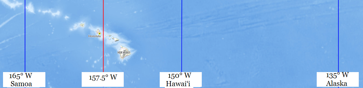
Hawai‘i Standard Time is the mean solar time of 150° west, the blue line down the middle. Samoa Standard Time is the mean solar time of 165° west, the blue line on the left. The red line between them is 157.5° west, where the boundary between them belongs. Hawai‘i does not observe daylight saving time, but if it did, Hawai‘i Daylight Saving Time would be the same as Alaska Standard Time, the blue line at the right.
Hawai‘i does not belong on Alaska Standard Time. She is simply too far west for that.
Oahu, and the Hawaiian islands to its west, actually belong on Samoa Standard Time, as they are closer to 165° west than they are to 150° west.
Actually, a half-hour time zone, 10 hours and 30 minutes behind Co-Ordinated Universal Time, would more closely approximate the mean solar time in Hawai‘i.
On Hawai‘i Standard Time, the clocks in Waimea Canyon Middle School in Waimea are 38 minutes and 42 seconds ahead of their local mean solar time. Under Hawai‘i Daylight Saving Time, which would equal Alaska Standard Time, they would be 1 hour, 38 minutes and 42 seconds ahead of their local mean solar time.
If you look closely at the HTML code of this page, you will notice that the webmaster used Unicode character 8216 to represent the okina in Hawai‘i, while most mainlanders would use an apostrophe in its place. How cool is that?
“Facts are stubborn things; and whatever may be our wishes, our inclinations, or the dictates of our passion, they cannot alter the state of facts and evidence.” — John Adams, Argument in Defense of the British Soldiers in the Boston Massacre Trials, 4 December 1770.
Supporters of year-round daylight saving time argue: Changing the clocks twice a year really stinks. Let’s keep the clocks set to the wrong time year-round. They think the government can give them more daylight by tampering with the clocks, which is like thinking you can gain or lose weight by tampering with your scale.
Supporters of year-round daylight saving time argue that folks have become habituated more to daylight saving time, observing it 8 months every year, than to standard time; but this is because lawmakers forced it onto us. If this bad habit is passed onto little children who are learning how to tell time, when will the bad habit ever be broken?
Supporters of year-round standard time argue: Changing the clocks twice a year really stinks, and forces people to observe the wrong time of day when daylight saving time is in effect. End it, don’t extend it. Let’s not kick the can down the road and burden future generations with the wrong time. Over the years, businesses will adapt, using winter hours and summer hours, same as libraries do. Let’s keep the clocks set to the time that most closely approximates their actual mean solar time. If you want a long sunlit afternoon, then work from 7:00 to 16:00 standard time, which is the same as 8:00 to 17:00 daylight saving time. Petition your employer, but don’t try to force everybody to keep their clocks set to the wrong time.
A State can exempt herself from daylight saving time without federal approval. See15 U.S. Code § 260a(a)(1) , but year-round daylight saving time requires an Act of Congress.
Earth rotates on its axis in 23 hours, 56 minutes and 4.098903691 seconds1, but moves along on its orbit during that time, so it takes a few minutes longer for your hemisphere to face the Sun again. Since the orbit is not circular, the length of a solar day varies during the year. To avoid having days of different lengths, the mean (average) day of 24 hours is used. If the Sun transits your meridian, on average, 12 hours after your clock strikes midnight, then your clock is set to the mean (average) solar time of your longitude. For more about solar (Sun) days versus sidereal (other stars) days, see https://www.universetoday.com/47181/earths-rotation/
As used on this website, a place belongs on a time that is no more than 30 minutes away from its local mean solar time. A time zone boundary belongs at the meridian where the local mean solar time is 30 minutes ahead of the standard time in the time zone to the west and 30 minutes behind the standard time in the time zone to the east. Obviously, minor adjustments are recommendable so that the actual boundaries do not run through Tampa, Florida or Oklahoma City, Oklahoma and Brownsville, Texas. The boundary between the Eastern Time Zone and the Atlantic Time Zone, running along the international boundary between Maine, U.S.A. and New Brunswick, Canada, is an example of a minor adjustment.
Yellow background indicates the correct time zone, with a difference less than 30 minutes from local mean solar time.
| Location | Co-Ordinates (Latitude, Longitude and Elevation) |
Mean solar time at noon, Samoa Standard Time | Mean solar time at noon, Hawai‘i Standard Time | Mean solar time at noon, Alaska Standard Time . |
| Āliamanu School, Honolulu County |
12:28:20 | 11:28:20 | 10:28:20 | |
| 'Aikahi Elementary School, Honolulu County |
12:29:00 | 11:29:00 | 10:29:00 | |
| Academy of the Pacific, Honolulu County |
12:28:33 | 11:28:33 | 10:28:33 | |
| Admiral Arthur Radford High School, Honolulu County |
12:28:16 | 11:28:16 | 10:28:16 | |
| Admiral Chester W Nimitz Elementary School, Honolulu County |
12:28:15 | 11:28:15 | 10:28:15 | |
| Ahuimanu Elementary School, Honolulu County |
12:28:40 | 11:28:40 | 10:28:40 | |
| Aiea Elementary School, Honolulu County |
12:28:17 | 11:28:17 | 10:28:17 | |
| Aiea High School, Honolulu County |
12:28:17 | 11:28:17 | 10:28:17 | |
| Aiea Post Office, Honolulu County |
12:28:16 | 11:28:16 | 10:28:16 | |
| Aina Haina Elementary School, Honolulu County |
12:28:57 | 11:28:57 | 10:28:57 | |
| Aina Haina Post Office, Honolulu County |
12:28:59 | 11:28:59 | 10:28:59 | |
| Ala Moana Post Office, Honolulu County |
12:28:36 | 11:28:36 | 10:28:36 | |
| Ala Wai Elementary School, Honolulu County |
12:28:40 | 11:28:40 | 10:28:40 | |
| Alae School, Hawaii County |
12:36:29 | 11:36:29 | 10:36:29 | |
| Aliiolani Elementary School, Honolulu County |
12:28:46 | 11:28:46 | 10:28:46 | |
| Alvah Scott Elementary School, Honolulu County |
12:28:15 | 11:28:15 | 10:28:15 | |
| Anahola Post Office, Kauai County |
12:22:44 | 11:22:44 | 10:22:44 | |
| Anahola School, Kauai County |
12:22:44 | 11:22:44 | 10:22:44 | |
| August Ahrens Elementary School, Honolulu County |
12:27:59 | 11:27:59 | 10:27:59 | |
| Baptist Bible School of Hawaii, Honolulu County |
12:28:42 | 11:28:42 | 10:28:42 | |
| Barbers Point Elementary School, Honolulu County |
12:27:40 | 11:27:40 | 10:27:40 | |
| Barbers Point Naval Air Station Post Office (historical), Honolulu County |
12:27:41 | 11:27:41 | 10:27:41 | |
| Barbers Point Post Office, Honolulu County |
12:27:42 | 11:27:42 | 10:27:42 | |
| Blanche Pope Elementary School, Honolulu County |
12:29:13 | 11:29:13 | 10:29:13 | |
| Brigham Young University - Hawaii, Honolulu County |
12:28:18 | 11:28:18 | 10:28:18 | |
| Calvary Preschool, Honolulu County |
12:28:47 | 11:28:47 | 10:28:47 | |
| Camp H M Smith Post Office, Honolulu County |
12:28:22 | 11:28:22 | 10:28:22 | |
| Captain Cook Post Office, Hawaii County |
12:36:22 | 11:36:22 | 10:36:22 | |
| Cathedral Catholic Academy, Honolulu County |
12:28:34 | 11:28:34 | 10:28:34 | |
| Central Middle School, Honolulu County |
12:28:34 | 11:28:34 | 10:28:34 | |
| Chaminade University of Honolulu, Honolulu County |
12:28:46 | 11:28:46 | 10:28:46 | |
| Chiefs Childrens School (historical), Honolulu County |
12:28:33 | 11:28:33 | 10:28:33 | |
| Christ the King School, Maui County |
12:34:07 | 11:34:07 | 10:34:07 | |
| Damien Memorial High School, Honolulu County |
12:28:31 | 11:28:31 | 10:28:31 | |
| Daniel K Inouye Elementary School, Honolulu County |
12:27:46 | 11:27:46 | 10:27:46 | |
| De Silva Elementary School, Hawaii County |
12:39:31 | 11:39:31 | 10:39:31 | |
| Dole Middle School, Honolulu County |
12:28:30 | 11:28:30 | 10:28:30 | |
| Doris Todd Memorial Christian School, Maui County |
12:34:30 | 11:34:30 | 10:34:30 | |
| Eleele Elementary School, Kauai County |
12:21:39 | 11:21:39 | 10:21:39 | |
| Eleele Post Office, Kauai County |
12:21:39 | 11:21:39 | 10:21:39 | |
| Emmanuel Lutheran School, Maui County |
12:34:03 | 11:34:03 | 10:34:03 | |
| Emmanuel Preschool, Honolulu County |
12:29:03 | 11:29:03 | 10:29:03 | |
| Enchanted Lake Elementary School, Honolulu County |
12:29:04 | 11:29:04 | 10:29:04 | |
| Epiphany Episcopal School, Honolulu County |
12:28:46 | 11:28:46 | 10:28:46 | |
| Ewa Beach Elementary School, Honolulu County |
12:27:55 | 11:27:55 | 10:27:55 | |
| Ewa Beach Post Office, Honolulu County |
12:27:56 | 11:27:56 | 10:27:56 | |
| Ewa Elementary School, Honolulu County |
12:27:51 | 11:27:51 | 10:27:51 | |
| Ewa Station Post Office, Honolulu County |
12:27:51 | 11:27:51 | 10:27:51 | |
| Farrington High School, Honolulu County |
12:28:28 | 11:28:28 | 10:28:28 | |
| Fern Elementary School, Honolulu County |
12:28:27 | 11:28:27 | 10:28:27 | |
| Fort Shafter Post Office, Honolulu County |
12:28:28 | 11:28:28 | 10:28:28 | |
| Fujio Matsuda Technology Training and Education Center, Honolulu County |
12:28:44 | 11:28:44 | 10:28:44 | |
| Good Samaritan Preschool, Honolulu County |
12:28:48 | 11:28:48 | 10:28:48 | |
| Governor Samuel Wilder King Intermediate School, Honolulu County |
12:28:46 | 11:28:46 | 10:28:46 | |
| Hālawa Kai School, Honolulu County |
12:28:16 | 11:28:16 | 10:28:16 | |
| Hāna High School, Maui County |
12:35:59 | 11:35:59 | 10:35:59 | |
| Haaheo Elementary School, Hawaii County |
12:39:36 | 11:39:36 | 10:39:36 | |
| Hahaione Elementary School, Honolulu County |
12:29:08 | 11:29:08 | 10:29:08 | |
| Haiku Elementary School, Maui County |
12:34:42 | 11:34:42 | 10:34:42 | |
| Haiku Post Office, Maui County |
12:34:42 | 11:34:42 | 10:34:42 | |
| Haili Christian School, Hawaii County |
12:39:37 | 11:39:37 | 10:39:37 | |
| Hakalau Post Office, Hawaii County |
12:39:29 | 11:39:29 | 10:39:29 | |
| Hakalau School, Hawaii County |
12:39:29 | 11:39:29 | 10:39:29 | |
| Halaula School (historical), Hawaii County |
12:36:52 | 11:36:52 | 10:36:52 | |
| Hale Aloha Nazarene School, Hawaii County |
12:39:33 | 11:39:33 | 10:39:33 | |
| Hale Nani Police Academy, Hawaii County |
12:39:45 | 11:39:45 | 10:39:45 | |
| Hale O Kamalii School, Hawaii County |
12:39:49 | 11:39:49 | 10:39:49 | |
| Hale O Ulu School, Honolulu County |
12:27:52 | 11:27:52 | 10:27:52 | |
| Haleiwa Elementary School, Honolulu County |
12:27:32 | 11:27:32 | 10:27:32 | |
| Haleiwa Post Office, Honolulu County |
12:27:34 | 11:27:34 | 10:27:34 | |
| Hana Post Office, Maui County |
12:36:02 | 11:36:02 | 10:36:02 | |
| Hanahauʻoli School, Honolulu County |
12:28:39 | 11:28:39 | 10:28:39 | |
| Hanalei Elementary School, Kauai County |
12:21:58 | 11:21:58 | 10:21:58 | |
| Hanalei Post Office, Kauai County |
12:22:00 | 11:22:00 | 10:22:00 | |
| Hanapepe Post Office, Kauai County |
12:21:38 | 11:21:38 | 10:21:38 | |
| Hau`ula Elementary School, Honolulu County |
12:28:22 | 11:28:22 | 10:28:22 | |
| Hauula Post Office, Honolulu County |
12:28:20 | 11:28:20 | 10:28:20 | |
| Hawaii Baptist Academy, Honolulu County |
12:28:37 | 11:28:37 | 10:28:37 | |
| Hawaii Kai Post Office, Honolulu County |
12:29:11 | 11:29:11 | 10:29:11 | |
| Hawaii Loa College, Honolulu County |
12:28:36 | 11:28:36 | 10:28:36 | |
| Hawaii National Park Post Office, Hawaii County |
12:38:54 | 11:38:54 | 10:38:54 | |
| Hawaii Pacific University Windward Hawaii Loa Campus, Honolulu County |
12:28:51 | 11:28:51 | 10:28:51 | |
| Hawaii Pacific University, Honolulu County |
12:28:32 | 11:28:32 | 10:28:32 | |
| Hawaii Preparatory Academy, Hawaii County |
12:37:11 | 11:37:11 | 10:37:11 | |
| Hawaii School for the Deaf and Blind, Honolulu County |
12:28:43 | 11:28:43 | 10:28:43 | |
| Hawaiian Baptist Academy, Honolulu County |
12:28:38 | 11:28:38 | 10:28:38 | |
| Hawaiian Mission Academy Windward Campus, Honolulu County |
12:29:02 | 11:29:02 | 10:29:02 | |
| Hawaiian Mission Academy, Honolulu County |
12:28:36 | 11:28:36 | 10:28:36 | |
| Hawaiʻi Community College, Hawaii County |
12:39:42 | 11:39:42 | 10:39:42 | |
| Hawi Post Office, Hawaii County |
12:36:40 | 11:36:40 | 10:36:40 | |
| He'eia Elementary School, Honolulu County |
12:28:45 | 11:28:45 | 10:28:45 | |
| Helemano Elementary School, Honolulu County |
12:27:54 | 11:27:54 | 10:27:54 | |
| Henry Perrine Baldwin High School, Maui County |
12:34:01 | 11:34:01 | 10:34:01 | |
| Hickam Air Force Base Post Office, Honolulu County |
12:28:11 | 11:28:11 | 10:28:11 | |
| Highlands Intermediate School, Honolulu County |
12:28:08 | 11:28:08 | 10:28:08 | |
| Hilo (Downtown) Post Office, Hawaii County |
12:39:38 | 11:39:38 | 10:39:38 | |
| Hilo High School, Hawaii County |
12:39:36 | 11:39:36 | 10:39:36 | |
| Hilo Intermediate School, Hawaii County |
12:39:36 | 11:39:36 | 10:39:36 | |
| Hilo Post Office, Hawaii County |
12:39:47 | 11:39:47 | 10:39:47 | |
| Hilo Union Elementary School, Hawaii County |
12:39:37 | 11:39:37 | 10:39:37 | |
| Hilo Union School Annex Number 1, Hawaii County |
12:39:36 | 11:39:36 | 10:39:36 | |
| Hokulani Elementary School, Honolulu County |
12:28:44 | 11:28:44 | 10:28:44 | |
| Holualoa Elementary School, Hawaii County |
12:36:11 | 11:36:11 | 10:36:11 | |
| Holualoa Post Office, Hawaii County |
12:36:12 | 11:36:12 | 10:36:12 | |
| Holy Cross School, Kauai County |
12:21:52 | 11:21:52 | 10:21:52 | |
| Holy Family Catholic Academy, Honolulu County |
12:28:16 | 11:28:16 | 10:28:16 | |
| Holy Innocents Preschool, Maui County |
12:33:16 | 11:33:16 | 10:33:16 | |
| Holy Nativity School, Honolulu County |
12:28:58 | 11:28:58 | 10:28:58 | |
| Holy Trinity School, Honolulu County |
12:29:04 | 11:29:04 | 10:29:04 | |
| Honaunau Elementary and Intermediate School, Hawaii County |
12:36:28 | 11:36:28 | 10:36:28 | |
| Honaunau Post Office, Hawaii County |
12:36:28 | 11:36:28 | 10:36:28 | |
| Hongwanji Mission School, Honolulu County |
12:28:35 | 11:28:35 | 10:28:35 | |
| Hongwanji Mission School, Honolulu County |
12:27:57 | 11:27:57 | 10:27:57 | |
| Honokaa High and Intermediate School, Hawaii County |
12:38:08 | 11:38:08 | 10:38:08 | |
| Honokaa Post Office, Hawaii County |
12:38:07 | 11:38:07 | 10:38:07 | |
| Honokohua Post Office, Maui County |
12:33:22 | 11:33:22 | 10:33:22 | |
| Honokōhau School, Hawaii County |
12:36:06 | 11:36:06 | 10:36:06 | |
| Honolulu (Downtown) Post Office, Honolulu County |
12:28:33 | 11:28:33 | 10:28:33 | |
| Honolulu Academy of Arts, Honolulu County |
12:28:35 | 11:28:35 | 10:28:35 | |
| Honolulu Community College, Honolulu County |
12:28:31 | 11:28:31 | 10:28:31 | |
| Honolulu Junior Academy, Honolulu County |
12:28:36 | 11:28:36 | 10:28:36 | |
| Honolulu Post Office, Honolulu County |
12:28:18 | 11:28:18 | 10:28:18 | |
| Honolulu Waldorf School, Honolulu County |
12:29:03 | 11:29:03 | 10:29:03 | |
| Honomu Hongwanji School, Hawaii County |
12:39:32 | 11:39:32 | 10:39:32 | |
| Honomu Post Office, Hawaii County |
12:39:33 | 11:39:33 | 10:39:33 | |
| Honowai Elementary School, Honolulu County |
12:27:53 | 11:27:53 | 10:27:53 | |
| Hookena Elementary and Intermediate School, Hawaii County |
12:36:28 | 11:36:28 | 10:36:28 | |
| Hoolehua Post Office, Maui County |
12:31:43 | 11:31:43 | 10:31:43 | |
| Iao Intermediate School, Maui County |
12:33:59 | 11:33:59 | 10:33:59 | |
| Iliahi Elementary School, Honolulu County |
12:28:00 | 11:28:00 | 10:28:00 | |
| Ilima Intermediate School, Honolulu County |
12:27:57 | 11:27:57 | 10:27:57 | |
| Immaculate Conception School, Kauai County |
12:22:30 | 11:22:30 | 10:22:30 | |
| International Baptist School, Honolulu County |
12:28:38 | 11:28:38 | 10:28:38 | |
| Iroquois Point Elementary School, Honolulu County |
12:28:03 | 11:28:03 | 10:28:03 | |
| Island Paradise School, Honolulu County |
12:28:37 | 11:28:37 | 10:28:37 | |
| Ivy School, Hawaii County |
12:39:40 | 11:39:40 | 10:39:40 | |
| James B Castle High School, Honolulu County |
12:28:49 | 11:28:49 | 10:28:49 | |
| James Campbell High School, Honolulu County |
12:27:58 | 11:27:58 | 10:27:58 | |
| Japanese School, Hawaii County |
12:39:25 | 11:39:25 | 10:39:25 | |
| Japanese School, Hawaii County |
12:39:01 | 11:39:01 | 10:39:01 | |
| Jarrett Middle School, Honolulu County |
12:28:48 | 11:28:48 | 10:28:48 | |
| Jefferson Elementary School, Honolulu County |
12:28:42 | 11:28:42 | 10:28:42 | |
| Judd Waolani Nazarene School, Honolulu County |
12:28:34 | 11:28:34 | 10:28:34 | |
| Ka'a'awa Elementary School, Honolulu County |
12:28:36 | 11:28:36 | 10:28:36 | |
| Ka'ala Elementary School, Honolulu County |
12:27:51 | 11:27:51 | 10:27:51 | |
| Kaaawa Post Office, Honolulu County |
12:28:35 | 11:28:35 | 10:28:35 | |
| Kaahumanu Elementary School, Honolulu County |
12:28:36 | 11:28:36 | 10:28:36 | |
| Kaahumanu Hou Christian School, Maui County |
12:34:06 | 11:34:06 | 10:34:06 | |
| Kaelepulu Elementary School, Honolulu County |
12:29:01 | 11:29:01 | 10:29:01 | |
| Kaewai Elementary School, Honolulu County |
12:28:30 | 11:28:30 | 10:28:30 | |
| Kahala Elementary School, Honolulu County |
12:28:51 | 11:28:51 | 10:28:51 | |
| Kahalu'u Elementary School, Honolulu County |
12:28:37 | 11:28:37 | 10:28:37 | |
| Kahuku High and Intermediate School, Honolulu County |
12:28:12 | 11:28:12 | 10:28:12 | |
| Kahuku Post Office, Honolulu County |
12:28:11 | 11:28:11 | 10:28:11 | |
| Kahului Elementary School, Maui County |
12:34:06 | 11:34:06 | 10:34:06 | |
| Kahului Post Office, Maui County |
12:34:08 | 11:34:08 | 10:34:08 | |
| Kailua Christian Academy, Honolulu County |
12:28:59 | 11:28:59 | 10:28:59 | |
| Kailua Elementary School, Honolulu County |
12:29:02 | 11:29:02 | 10:29:02 | |
| Kailua High School, Honolulu County |
12:29:00 | 11:29:00 | 10:29:00 | |
| Kailua Intermediate School, Honolulu County |
12:29:03 | 11:29:03 | 10:29:03 | |
| Kailua Kona Post Office, Hawaii County |
12:36:01 | 11:36:01 | 10:36:01 | |
| Kailua Post Office, Honolulu County |
12:29:02 | 11:29:02 | 10:29:02 | |
| Kaimiloa Elementary School, Honolulu County |
12:27:57 | 11:27:57 | 10:27:57 | |
| Kaimuki Christian School, Honolulu County |
12:28:47 | 11:28:47 | 10:28:47 | |
| Kaimuki High School, Honolulu County |
12:28:44 | 11:28:44 | 10:28:44 | |
| Kaimuki Middle School, Honolulu County |
12:28:48 | 11:28:48 | 10:28:48 | |
| Kaimuki Post Office, Honolulu County |
12:28:48 | 11:28:48 | 10:28:48 | |
| Kainalu Elementary School, Honolulu County |
12:29:00 | 11:29:00 | 10:29:00 | |
| Kaiser High School, Honolulu County |
12:29:12 | 11:29:12 | 10:29:12 | |
| Kalaheo Elementary School, Kauai County |
12:21:54 | 11:21:54 | 10:21:54 | |
| Kalaheo High School, Honolulu County |
12:28:58 | 11:28:58 | 10:28:58 | |
| Kalaheo Post Office, Kauai County |
12:21:53 | 11:21:53 | 10:21:53 | |
| Kalakaua Middle School, Honolulu County |
12:28:28 | 11:28:28 | 10:28:28 | |
| Kalani High School, Honolulu County |
12:28:53 | 11:28:53 | 10:28:53 | |
| Kalanianaole Elementary and Intermediate School, Hawaii County |
12:39:36 | 11:39:36 | 10:39:36 | |
| Kalaoa School, Hawaii County |
12:36:04 | 11:36:04 | 10:36:04 | |
| Kalaupapa Post Office, Kalawao County |
12:32:03 | 11:32:03 | 10:32:03 | |
| Kalihi Elementary School, Honolulu County |
12:28:32 | 11:28:32 | 10:28:32 | |
| Kalihi Uka Elementary School, Honolulu County |
12:28:33 | 11:28:33 | 10:28:33 | |
| Kalihi Union School, Honolulu County |
12:28:28 | 11:28:28 | 10:28:28 | |
| Kalihi-kai Elementary School, Honolulu County |
12:28:28 | 11:28:28 | 10:28:28 | |
| Kalihi-waena Elementary School, Honolulu County |
12:28:29 | 11:28:29 | 10:28:29 | |
| Kamehameha III School, Maui County |
12:33:16 | 11:33:16 | 10:33:16 | |
| Kamehameha School, Honolulu County |
12:28:33 | 11:28:33 | 10:28:33 | |
| Kamehameha V Post Office (historical), Honolulu County |
12:28:32 | 11:28:32 | 10:28:32 | |
| Kamiloiki Elementary School, Honolulu County |
12:29:14 | 11:29:14 | 10:29:14 | |
| Kamuela Post Office, Hawaii County |
12:37:19 | 11:37:19 | 10:37:19 | |
| Kaneohe Elementary School, Honolulu County |
12:28:48 | 11:28:48 | 10:28:48 | |
| Kaneohe Post Office, Honolulu County |
12:28:47 | 11:28:47 | 10:28:47 | |
| Kanoelani Elementary School, Honolulu County |
12:28:00 | 11:28:00 | 10:28:00 | |
| Kapaa High School, Kauai County |
12:22:44 | 11:22:44 | 10:22:44 | |
| Kapaa Post Office, Kauai County |
12:22:42 | 11:22:42 | 10:22:42 | |
| Kapaa Private School, Kauai County |
12:22:42 | 11:22:42 | 10:22:42 | |
| Kapaau Post Office, Hawaii County |
12:36:44 | 11:36:44 | 10:36:44 | |
| Kapalama Elementary School, Honolulu County |
12:28:30 | 11:28:30 | 10:28:30 | |
| Kapalama Post Office, Honolulu County |
12:28:31 | 11:28:31 | 10:28:31 | |
| Kapiolani Community College, Honolulu County |
12:28:47 | 11:28:47 | 10:28:47 | |
| Kapiolani Elementary School, Hawaii County |
12:39:40 | 11:39:40 | 10:39:40 | |
| Kapiʻolani Community College, Honolulu County |
12:28:35 | 11:28:35 | 10:28:35 | |
| Kapolei Post Office, Honolulu County |
12:27:40 | 11:27:40 | 10:27:40 | |
| Kapunahala Elementary School, Honolulu County |
12:28:47 | 11:28:47 | 10:28:47 | |
| Kauai Community College, Kauai County |
12:22:24 | 11:22:24 | 10:22:24 | |
| Kauai High School, Kauai County |
12:22:33 | 11:22:33 | 10:22:33 | |
| Kauai Technical School, Kauai County |
12:22:32 | 11:22:32 | 10:22:32 | |
| Kauluwela Elementary School, Honolulu County |
12:28:33 | 11:28:33 | 10:28:33 | |
| Kaumakani Post Office, Kauai County |
12:21:31 | 11:21:31 | 10:21:31 | |
| Kaumana Elementary School, Hawaii County |
12:39:27 | 11:39:27 | 10:39:27 | |
| Kaunakakai Elementary School, Maui County |
12:31:55 | 11:31:55 | 10:31:55 | |
| Kaunakakai Post Office, Maui County |
12:31:55 | 11:31:55 | 10:31:55 | |
| Kaunoa School, Maui County |
12:34:20 | 11:34:20 | 10:34:20 | |
| Kawailoa Soto School, Honolulu County |
12:27:39 | 11:27:39 | 10:27:39 | |
| Kaʻū High School, Hawaii County |
12:38:04 | 11:38:04 | 10:38:04 | |
| Ke Kula Kaiapuni ʻo Ānuenue School, Honolulu County |
12:28:50 | 11:28:50 | 10:28:50 | |
| Keaau Post Office, Hawaii County |
12:39:50 | 11:39:50 | 10:39:50 | |
| Keakealani School, Hawaii County |
12:39:02 | 11:39:02 | 10:39:02 | |
| Kealahou School, Maui County |
12:34:40 | 11:34:40 | 10:34:40 | |
| Kealakehe Elementary School, Hawaii County |
12:36:03 | 11:36:03 | 10:36:03 | |
| Kealakehe Intermediate School, Hawaii County |
12:36:03 | 11:36:03 | 10:36:03 | |
| Kealakekua Post Office, Hawaii County |
12:36:19 | 11:36:19 | 10:36:19 | |
| Kealia Post Office, Kauai County |
12:22:46 | 11:22:46 | 10:22:46 | |
| Keauhou Post Office, Hawaii County |
12:36:09 | 11:36:09 | 10:36:09 | |
| Keauhou School, Hawaii County |
12:36:13 | 11:36:13 | 10:36:13 | |
| Keaukaha Elementary School, Hawaii County |
12:39:48 | 11:39:48 | 10:39:48 | |
| Keaʻau Elementary School, Hawaii County |
12:39:50 | 11:39:50 | 10:39:50 | |
| Kekaha Elementary School, Kauai County |
12:21:07 | 11:21:07 | 10:21:07 | |
| Kekaha Post Office, Kauai County |
12:21:08 | 11:21:08 | 10:21:08 | |
| Keolu Elementary School, Honolulu County |
12:29:03 | 11:29:03 | 10:29:03 | |
| Keʻanae Elementary School, Maui County |
12:35:26 | 11:35:26 | 10:35:26 | |
| Kihei Elementary School, Maui County |
12:34:12 | 11:34:12 | 10:34:12 | |
| Kihei Post Office, Maui County |
12:34:10 | 11:34:10 | 10:34:10 | |
| Kilauea Elementary School, Kauai County |
12:22:21 | 11:22:21 | 10:22:21 | |
| Kilauea Post Office, Kauai County |
12:22:21 | 11:22:21 | 10:22:21 | |
| Kilohana Elementary School, Maui County |
12:32:38 | 11:32:38 | 10:32:38 | |
| Kinau Street School, Honolulu County |
12:28:35 | 11:28:35 | 10:28:35 | |
| Kings School, Honolulu County |
12:27:51 | 11:27:51 | 10:27:51 | |
| Kipapa Elementary School, Honolulu County |
12:27:56 | 11:27:56 | 10:27:56 | |
| Kohala Hana Hauoli School, Hawaii County |
12:36:38 | 11:36:38 | 10:36:38 | |
| Kohala Schools, Hawaii County |
12:36:42 | 11:36:42 | 10:36:42 | |
| Koko Head Elementary School, Honolulu County |
12:29:10 | 11:29:10 | 10:29:10 | |
| Koloa Elementary School, Kauai County |
12:22:07 | 11:22:07 | 10:22:07 | |
| Koloa Post Office, Kauai County |
12:22:08 | 11:22:08 | 10:22:08 | |
| Kona Branch University of Hawaii Agricultural Experiment Station, Hawaii County |
12:36:17 | 11:36:17 | 10:36:17 | |
| Konawaena High School, Hawaii County |
12:36:19 | 11:36:19 | 10:36:19 | |
| Kualapuu Post Office, Maui County |
12:31:50 | 11:31:50 | 10:31:50 | |
| Kualapuʻu Elementary School, Maui County |
12:31:49 | 11:31:49 | 10:31:49 | |
| Kuhio Elementary School, Honolulu County |
12:28:42 | 11:28:42 | 10:28:42 | |
| Kukuihaele Post Office, Hawaii County |
12:37:43 | 11:37:43 | 10:37:43 | |
| Kula Elementary School, Maui County |
12:34:40 | 11:34:40 | 10:34:40 | |
| Kula Post Office, Maui County |
12:34:41 | 11:34:41 | 10:34:41 | |
| Kunia Elementary School, Honolulu County |
12:27:43 | 11:27:43 | 10:27:43 | |
| Kunia Post Office, Honolulu County |
12:27:45 | 11:27:45 | 10:27:45 | |
| Kurtistown Post Office, Hawaii County |
12:39:46 | 11:39:46 | 10:39:46 | |
| Kurtistown School, Hawaii County |
12:39:44 | 11:39:44 | 10:39:44 | |
| Lahaina (Downtown) Post Office, Maui County |
12:33:16 | 11:33:16 | 10:33:16 | |
| Lahaina Post Office, Maui County |
12:33:15 | 11:33:15 | 10:33:15 | |
| Lahainaluna High School, Maui County |
12:33:21 | 11:33:21 | 10:33:21 | |
| Laie Elementary School, Honolulu County |
12:28:17 | 11:28:17 | 10:28:17 | |
| Laie Post Office, Honolulu County |
12:28:18 | 11:28:18 | 10:28:18 | |
| Lanakila Baptist School - Junior and Senior High Campus, Honolulu County |
12:27:51 | 11:27:51 | 10:27:51 | |
| Lanakila Elementary School, Honolulu County |
12:28:33 | 11:28:33 | 10:28:33 | |
| Lanikai Public Charter School, Honolulu County |
12:29:05 | 11:29:05 | 10:29:05 | |
| Laupahoehoe Post Office, Hawaii County |
12:39:04 | 11:39:04 | 10:39:04 | |
| Laupāhoehoe High and Elementary School, Hawaii County |
12:39:04 | 11:39:04 | 10:39:04 | |
| Lawai Post Office, Kauai County |
12:21:59 | 11:21:59 | 10:21:59 | |
| Le Jardin Academy, Honolulu County |
12:28:58 | 11:28:58 | 10:28:58 | |
| Leeward Mission Adventist School, Honolulu County |
12:27:54 | 11:27:54 | 10:27:54 | |
| Lehua Elementary School, Honolulu County |
12:28:06 | 11:28:06 | 10:28:06 | |
| Leihoku Elementary School, Honolulu County |
12:27:18 | 11:27:18 | 10:27:18 | |
| Leihoku Elementary School, Honolulu County |
12:27:17 | 11:27:17 | 10:27:17 | |
| Leilehua High School, Honolulu County |
12:27:57 | 11:27:57 | 10:27:57 | |
| Leilehua Intermediate School, Honolulu County |
12:27:56 | 11:27:56 | 10:27:56 | |
| Lieutenant Colonel Horrace Meek Hickam Elementary School, Honolulu County |
12:28:08 | 11:28:08 | 10:28:08 | |
| Lihikai Elementary School, Maui County |
12:34:03 | 11:34:03 | 10:34:03 | |
| Liholiho Elementary School, Honolulu County |
12:28:45 | 11:28:45 | 10:28:45 | |
| Lihue Post Office, Kauai County |
12:22:31 | 11:22:31 | 10:22:31 | |
| Likelike Elementary School, Honolulu County |
12:28:31 | 11:28:31 | 10:28:31 | |
| Liliuokalani Elementary School, Honolulu County |
12:28:47 | 11:28:47 | 10:28:47 | |
| Linapuni Elementary School, Honolulu County |
12:28:28 | 11:28:28 | 10:28:28 | |
| Lincoln Elementary School, Honolulu County |
12:28:37 | 11:28:37 | 10:28:37 | |
| Linekona Elementary School (historical), Honolulu County |
12:28:35 | 11:28:35 | 10:28:35 | |
| Lunalilo Elementary School, Honolulu County |
12:28:39 | 11:28:39 | 10:28:39 | |
| Lutheran High School of Hawaii, Honolulu County |
12:28:42 | 11:28:42 | 10:28:42 | |
| Lānaʻi City Post Office, Maui County |
12:32:19 | 11:32:19 | 10:32:19 | |
| Lānaʻi High School, Maui County |
12:32:17 | 11:32:17 | 10:32:17 | |
| MOU 1 Post Office, Honolulu County |
12:28:13 | 11:28:13 | 10:28:13 | |
| MOU 3 Post Office, Honolulu County |
12:28:15 | 11:28:15 | 10:28:15 | |
| Maemae Elementary School, Honolulu County |
12:28:36 | 11:28:36 | 10:28:36 | |
| Maili Elementary School, Honolulu County |
12:27:18 | 11:27:18 | 10:27:18 | |
| Makaha Elementary School, Honolulu County |
12:27:09 | 11:27:09 | 10:27:09 | |
| Makaha Elementary School, Honolulu County |
12:27:08 | 11:27:08 | 10:27:08 | |
| Makakilo Elementary School, Honolulu County |
12:27:39 | 11:27:39 | 10:27:39 | |
| Makalapa Elementary School, Honolulu County |
12:28:16 | 11:28:16 | 10:28:16 | |
| Makawao Elementary School, Maui County |
12:34:44 | 11:34:44 | 10:34:44 | |
| Makawao Post Office, Maui County |
12:34:44 | 11:34:44 | 10:34:44 | |
| Makaweli Post Office, Kauai County |
12:21:25 | 11:21:25 | 10:21:25 | |
| Makiki Japanese Language School, Honolulu County |
12:28:37 | 11:28:37 | 10:28:37 | |
| Makiki Post Office, Honolulu County |
12:28:37 | 11:28:37 | 10:28:37 | |
| Makua Lani Christian Academy Elementary Campus, Hawaii County |
12:36:05 | 11:36:05 | 10:36:05 | |
| Manana Elementary School, Honolulu County |
12:28:06 | 11:28:06 | 10:28:06 | |
| Manoa Elementary School, Honolulu County |
12:28:45 | 11:28:45 | 10:28:45 | |
| Manoa Valley School, Honolulu County |
12:28:44 | 11:28:44 | 10:28:44 | |
| Marine Corps Base Hawaii Kaneohe Bay Post Office, Honolulu County |
12:28:58 | 11:28:58 | 10:28:58 | |
| Maryknoll School, Honolulu County |
12:28:40 | 11:28:40 | 10:28:40 | |
| Maryknoll High School, Honolulu County |
12:28:38 | 11:28:38 | 10:28:38 | |
| Maui Community College - Lānaʻi Education Center, Maui County |
12:32:18 | 11:32:18 | 10:32:18 | |
| Maui Community College-Molokaʻi Education Center, Maui County |
12:31:54 | 11:31:54 | 10:31:54 | |
| Maui Community College, Maui County |
12:34:04 | 11:34:04 | 10:34:04 | |
| Maui High School (historical), Maui County |
12:34:35 | 11:34:35 | 10:34:35 | |
| Maui High School, Maui County |
12:34:05 | 11:34:05 | 10:34:05 | |
| Maui Mission School, Maui County |
12:34:08 | 11:34:08 | 10:34:08 | |
| Maui Vocational School, Maui County |
12:34:04 | 11:34:04 | 10:34:04 | |
| Mauka Lani Elementary School, Honolulu County |
12:27:39 | 11:27:39 | 10:27:39 | |
| Maunaloa Elementary School, Hawaii County |
12:39:37 | 11:39:37 | 10:39:37 | |
| Maunaloa Elementary School, Maui County |
12:31:09 | 11:31:09 | 10:31:09 | |
| Maunaloa Post Office, Maui County |
12:31:09 | 11:31:09 | 10:31:09 | |
| Maunaolu College, Maui County |
12:34:37 | 11:34:37 | 10:34:37 | |
| Maunawili Elementary School, Honolulu County |
12:28:59 | 11:28:59 | 10:28:59 | |
| McCully Japanese School, Honolulu County |
12:28:39 | 11:28:39 | 10:28:39 | |
| McKinley High School, Honolulu County |
12:28:35 | 11:28:35 | 10:28:35 | |
| Med Assist School of Hawaii, Honolulu County |
12:28:33 | 11:28:33 | 10:28:33 | |
| Mid - Pacific Institute, Honolulu County |
12:28:43 | 11:28:43 | 10:28:43 | |
| Mililani High School, Honolulu County |
12:27:57 | 11:27:57 | 10:27:57 | |
| Mililani Mauka Elementary School, Honolulu County |
12:27:59 | 11:27:59 | 10:27:59 | |
| Mililani Post Office, Honolulu County |
12:27:56 | 11:27:56 | 10:27:56 | |
| Mililani Uka Elementary School, Honolulu County |
12:27:56 | 11:27:56 | 10:27:56 | |
| Mililani Waena Elementary School, Honolulu County |
12:27:57 | 11:27:57 | 10:27:57 | |
| Moanalua High School, Honolulu County |
12:28:23 | 11:28:23 | 10:28:23 | |
| Moanalua Middle School, Honolulu County |
12:28:25 | 11:28:25 | 10:28:25 | |
| Moiliili Hongwanji Pre School, Honolulu County |
12:28:41 | 11:28:41 | 10:28:41 | |
| Moiliili Post Office, Honolulu County |
12:28:43 | 11:28:43 | 10:28:43 | |
| Mokapu Elementary School, Honolulu County |
12:29:00 | 11:29:00 | 10:29:00 | |
| Mokulele Elementary School, Honolulu County |
12:28:14 | 11:28:14 | 10:28:14 | |
| Molokaʻi High School, Maui County |
12:31:47 | 11:31:47 | 10:31:47 | |
| Momilani Elementary School, Honolulu County |
12:28:10 | 11:28:10 | 10:28:10 | |
| Mountain View Elementary School, Hawaii County |
12:39:34 | 11:39:34 | 10:39:34 | |
| Mountain View Post Office, Hawaii County |
12:39:33 | 11:39:33 | 10:39:33 | |
| Mun Lun School, Honolulu County |
12:28:32 | 11:28:32 | 10:28:32 | |
| Muriel School, Honolulu County |
12:28:33 | 11:28:33 | 10:28:33 | |
| Mānoa Japanese Language School, Honolulu County |
12:28:44 | 11:28:44 | 10:28:44 | |
| Mōʻiliʻili Japanese School, Honolulu County |
12:28:41 | 11:28:41 | 10:28:41 | |
| Naalehu Elementary and Intermediate School, Hawaii County |
12:37:40 | 11:37:40 | 10:37:40 | |
| Naalehu Post Office, Hawaii County |
12:37:39 | 11:37:39 | 10:37:39 | |
| Nanaikapono Elementary School, Honolulu County |
12:27:25 | 11:27:25 | 10:27:25 | |
| Nanakuli Elementary School, Honolulu County |
12:27:27 | 11:27:27 | 10:27:27 | |
| Nanakuli Elementary School, Honolulu County |
12:27:26 | 11:27:26 | 10:27:26 | |
| Nanakuli High School, Honolulu County |
12:27:27 | 11:27:27 | 10:27:27 | |
| Nanakuli High and Intermediate School, Honolulu County |
12:27:28 | 11:27:28 | 10:27:28 | |
| Nanakuli Post Office, Honolulu County |
12:27:23 | 11:27:23 | 10:27:23 | |
| Napoopoo School, Hawaii County |
12:36:23 | 11:36:23 | 10:36:23 | |
| Niihau School, Kauai County |
12:19:10 | 11:19:10 | 10:19:10 | |
| Ninole Post Office, Hawaii County |
12:39:19 | 11:39:19 | 10:39:19 | |
| Niu Valley Middle School, Honolulu County |
12:29:01 | 11:29:01 | 10:29:01 | |
| Noelani Elementary School, Honolulu County |
12:28:44 | 11:28:44 | 10:28:44 | |
| Noelani School, Honolulu County |
12:28:44 | 11:28:44 | 10:28:44 | |
| Nuuanu Elementary School, Honolulu County |
12:28:38 | 11:28:38 | 10:28:38 | |
| Ookala Post Office - CPO, Hawaii County |
12:38:51 | 11:38:51 | 10:38:51 | |
| Our Lady of Good Council School, Honolulu County |
12:28:07 | 11:28:07 | 10:28:07 | |
| Our Lady of Perpetual Help School, Honolulu County |
12:27:57 | 11:27:57 | 10:27:57 | |
| Our Lady of Sorrows School, Honolulu County |
12:27:55 | 11:27:55 | 10:27:55 | |
| Our Savior Lutheran School, Honolulu County |
12:28:14 | 11:28:14 | 10:28:14 | |
| Paauilo Elementary and Intermediate School, Hawaii County |
12:38:29 | 11:38:29 | 10:38:29 | |
| Paauilo Post Office, Hawaii County |
12:38:31 | 11:38:31 | 10:38:31 | |
| Pacific Buddhist Academy, Honolulu County |
12:28:35 | 11:28:35 | 10:28:35 | |
| Pahala Post Office, Hawaii County |
12:38:05 | 11:38:05 | 10:38:05 | |
| Pahoa Elementary School, Hawaii County |
12:40:12 | 11:40:12 | 10:40:12 | |
| Pahoa High and Intermediate School, Hawaii County |
12:40:13 | 11:40:13 | 10:40:13 | |
| Pahoa Post Office, Hawaii County |
12:40:12 | 11:40:12 | 10:40:12 | |
| Paia Post Office, Maui County |
12:34:29 | 11:34:29 | 10:34:29 | |
| Paia School, Maui County |
12:34:32 | 11:34:32 | 10:34:32 | |
| Palisades Elementary School, Honolulu County |
12:28:11 | 11:28:11 | 10:28:11 | |
| Palolo Elementary School, Honolulu County |
12:28:49 | 11:28:49 | 10:28:49 | |
| Palolo Japanese Language School, Honolulu County |
12:28:47 | 11:28:47 | 10:28:47 | |
| Papaaloa Post Office, Hawaii County |
12:39:07 | 11:39:07 | 10:39:07 | |
| Papaikou Post Office, Hawaii County |
12:39:37 | 11:39:37 | 10:39:37 | |
| Parker School, Hawaii County |
12:37:18 | 11:37:18 | 10:37:18 | |
| Pauoa Elementary School, Honolulu County |
12:28:36 | 11:28:36 | 10:28:36 | |
| Pearl City Elementary School, Honolulu County |
12:28:06 | 11:28:06 | 10:28:06 | |
| Pearl City High School, Honolulu County |
12:28:10 | 11:28:10 | 10:28:10 | |
| Pearl City Highlands Elementary School, Honolulu County |
12:28:07 | 11:28:07 | 10:28:07 | |
| Pearl City Post Office, Honolulu County |
12:28:06 | 11:28:06 | 10:28:06 | |
| Pearl Harbor Elementary School, Honolulu County |
12:28:16 | 11:28:16 | 10:28:16 | |
| Pearl Harbor Kai Elementary School, Honolulu County |
12:28:14 | 11:28:14 | 10:28:14 | |
| Pearl Ridge Elementary School, Honolulu County |
12:28:12 | 11:28:12 | 10:28:12 | |
| Pepeekeo Post Office, Hawaii County |
12:39:34 | 11:39:34 | 10:39:34 | |
| Pepeekeo School, Hawaii County |
12:39:36 | 11:39:36 | 10:39:36 | |
| Pohakea Elementary School, Honolulu County |
12:27:57 | 11:27:57 | 10:27:57 | |
| Pohukaina School, Honolulu County |
12:28:33 | 11:28:33 | 10:28:33 | |
| Polynesian Cultural Center, Honolulu County |
12:28:18 | 11:28:18 | 10:28:18 | |
| President Theodore Roosevelt High School, Honolulu County |
12:28:39 | 11:28:39 | 10:28:39 | |
| Prince David Kawananakoa Middle School, Honolulu County |
12:28:35 | 11:28:35 | 10:28:35 | |
| Princess Victoria Ka'iulani Elementary School, Honolulu County |
12:28:31 | 11:28:31 | 10:28:31 | |
| Princeville Post Office, Kauai County |
12:22:06 | 11:22:06 | 10:22:06 | |
| Pukalani Elementary School, Maui County |
12:34:36 | 11:34:36 | 10:34:36 | |
| Pukalani Post Office, Maui County |
12:34:37 | 11:34:37 | 10:34:37 | |
| Punahou School, Honolulu County |
12:28:40 | 11:28:40 | 10:28:40 | |
| Puohala Elementary School, Honolulu County |
12:28:50 | 11:28:50 | 10:28:50 | |
| Puuhale Elementary School, Honolulu County |
12:28:27 | 11:28:27 | 10:28:27 | |
| Puunene Post Office, Maui County |
12:34:11 | 11:34:11 | 10:34:11 | |
| Red Hill Elementary School, Honolulu County |
12:28:23 | 11:28:23 | 10:28:23 | |
| Reverend Benjamin Parker Elementary School, Honolulu County |
12:28:48 | 11:28:48 | 10:28:48 | |
| Robert Louis Stevensen Middle School, Honolulu County |
12:28:38 | 11:28:38 | 10:28:38 | |
| Ross School, Hawaii County |
12:39:21 | 11:39:21 | 10:39:21 | |
| Royal Elementary School, Honolulu County |
12:28:35 | 11:28:35 | 10:28:35 | |
| Sacred Heart Seminary, Honolulu County |
12:28:19 | 11:28:19 | 10:28:19 | |
| Sacred Hearts Academy, Honolulu County |
12:28:45 | 11:28:45 | 10:28:45 | |
| Saint Andrew's Schools, Honolulu County |
12:28:34 | 11:28:34 | 10:28:34 | |
| Saint Ann School, Honolulu County |
12:28:46 | 11:28:46 | 10:28:46 | |
| Saint Anthony School, Honolulu County |
12:29:02 | 11:29:02 | 10:29:02 | |
| Saint Anthony School, Honolulu County |
12:28:27 | 11:28:27 | 10:28:27 | |
| Saint Anthony School, Maui County |
12:33:59 | 11:33:59 | 10:33:59 | |
| Saint Anthonys Girls High School, Maui County |
12:34:00 | 11:34:00 | 10:34:00 | |
| Saint Augustine School (historical), Honolulu County |
12:28:42 | 11:28:42 | 10:28:42 | |
| Saint Catherines School, Kauai County |
12:22:43 | 11:22:43 | 10:22:43 | |
| Saint Clement's School, Honolulu County |
12:28:39 | 11:28:39 | 10:28:39 | |
| Saint Elizabeth Catholic School, Honolulu County |
12:28:16 | 11:28:16 | 10:28:16 | |
| Saint Francis Convent School, Honolulu County |
12:28:44 | 11:28:44 | 10:28:44 | |
| Saint John School, Honolulu County |
12:28:27 | 11:28:27 | 10:28:27 | |
| Saint John Vianney Parish School, Honolulu County |
12:29:04 | 11:29:04 | 10:29:04 | |
| Saint Joseph School, Maui County |
12:34:45 | 11:34:45 | 10:34:45 | |
| Saint Josephs High School, Hawaii County |
12:39:38 | 11:39:38 | 10:39:38 | |
| Saint Josephs School, Honolulu County |
12:27:57 | 11:27:57 | 10:27:57 | |
| Saint Louis School, Honolulu County |
12:28:45 | 11:28:45 | 10:28:45 | |
| Saint Lukes Preschool, Honolulu County |
12:28:35 | 11:28:35 | 10:28:35 | |
| Saint Mark Lutheran School, Honolulu County |
12:28:48 | 11:28:48 | 10:28:48 | |
| Saint Marks School, Honolulu County |
12:28:43 | 11:28:43 | 10:28:43 | |
| Saint Michael School, Honolulu County |
12:27:30 | 11:27:30 | 10:27:30 | |
| Saint Patricks School, Honolulu County |
12:28:45 | 11:28:45 | 10:28:45 | |
| Saint Stephens Seminary, Honolulu County |
12:28:52 | 11:28:52 | 10:28:52 | |
| Saint Theresa School, Honolulu County |
12:28:33 | 11:28:33 | 10:28:33 | |
| Saint Theresa School, Kauai County |
12:21:08 | 11:21:08 | 10:21:08 | |
| Saint Timothys Childrens Center, Honolulu County |
12:28:12 | 11:28:12 | 10:28:12 | |
| Salt Lake Elementary School, Honolulu County |
12:28:20 | 11:28:20 | 10:28:20 | |
| Schofield Barracks Post Office, Honolulu County |
12:27:48 | 11:27:48 | 10:27:48 | |
| Seabury Hall, Maui County |
12:34:44 | 11:34:44 | 10:34:44 | |
| Shafter Elementary School, Honolulu County |
12:28:26 | 11:28:26 | 10:28:26 | |
| Solomon Elementary School, Honolulu County |
12:27:42 | 11:27:42 | 10:27:42 | |
| Spreckelsville School, Maui County |
12:34:19 | 11:34:19 | 10:34:19 | |
| Star of the Sea High School, Honolulu County |
12:28:52 | 11:28:52 | 10:28:52 | |
| Sun Yat Sen School, Honolulu County |
12:28:32 | 11:28:32 | 10:28:32 | |
| Sunset Beach Christian School, Honolulu County |
12:27:45 | 11:27:45 | 10:27:45 | |
| Sunset Beach Elementary School, Honolulu County |
12:27:48 | 11:27:48 | 10:27:48 | |
| Tachikawa School, Honolulu County |
12:28:36 | 11:28:36 | 10:28:36 | |
| The Early School, Honolulu County |
12:28:42 | 11:28:42 | 10:28:42 | |
| Trinity Lutheran School, Honolulu County |
12:27:57 | 11:27:57 | 10:27:57 | |
| Tripler Army Medical Center Post Office, Honolulu County |
12:28:26 | 11:28:26 | 10:28:26 | |
| Twelvemile School (historical), Hawaii County |
12:39:45 | 11:39:45 | 10:39:45 | |
| Ulupalakua School, Maui County |
12:34:23 | 11:34:23 | 10:34:23 | |
| University Elementary School, Honolulu County |
12:28:41 | 11:28:41 | 10:28:41 | |
| University Laboratory School, Honolulu County |
12:28:42 | 11:28:42 | 10:28:42 | |
| University of Hawaii Experimental Station, Hawaii County |
12:40:27 | 11:40:27 | 10:40:27 | |
| University of Hawaii Experimental Station, Honolulu County |
12:27:37 | 11:27:37 | 10:27:37 | |
| University of Hawaii Leeward Community College, Honolulu County |
12:28:03 | 11:28:03 | 10:28:03 | |
| University of Hawaii Marine Laboratory, Honolulu County |
12:28:50 | 11:28:50 | 10:28:50 | |
| University of Hawaii at Manoa, Honolulu County |
12:28:43 | 11:28:43 | 10:28:43 | |
| University of Hawaiʻi Agricultural Experiment Station, Honolulu County |
12:27:52 | 11:27:52 | 10:27:52 | |
| University of Hawaiʻi Waimānalo Research, Honolulu County |
12:29:08 | 11:29:08 | 10:29:08 | |
| University of Hawaiʻi at Hilo, Hawaii County |
12:39:40 | 11:39:40 | 10:39:40 | |
| Uptown Post Office, Honolulu County |
12:28:33 | 11:28:33 | 10:28:33 | |
| Urawantadai Hawaii College, Hawaii County |
12:39:37 | 11:39:37 | 10:39:37 | |
| Volcano Post Office, Hawaii County |
12:39:03 | 11:39:03 | 10:39:03 | |
| Wahiawa Elementary School, Honolulu County |
12:27:55 | 11:27:55 | 10:27:55 | |
| Wahiawa Japanese Language School, Honolulu County |
12:27:53 | 11:27:53 | 10:27:53 | |
| Wahiawa Middle School, Honolulu County |
12:27:55 | 11:27:55 | 10:27:55 | |
| Wahiawa Post Office, Honolulu County |
12:27:53 | 11:27:53 | 10:27:53 | |
| Waiahole Elementary School, Honolulu County |
12:28:35 | 11:28:35 | 10:28:35 | |
| Waiakea High School, Hawaii County |
12:39:41 | 11:39:41 | 10:39:41 | |
| Waiakea-Kai School, Hawaii County |
12:39:40 | 11:39:40 | 10:39:40 | |
| Waiakea-Uka School, Hawaii County |
12:39:33 | 11:39:33 | 10:39:33 | |
| Waialae Elementary School, Honolulu County |
12:28:49 | 11:28:49 | 10:28:49 | |
| Waialae Kahala Post Office, Honolulu County |
12:28:51 | 11:28:51 | 10:28:51 | |
| Waialee School (historical), Honolulu County |
12:27:54 | 11:27:54 | 10:27:54 | |
| Waialee Training School for Boys (historical), Honolulu County |
12:27:53 | 11:27:53 | 10:27:53 | |
| Waialua Elementary School, Honolulu County |
12:27:30 | 11:27:30 | 10:27:30 | |
| Waialua Elementary School, Honolulu County |
12:27:30 | 11:27:30 | 10:27:30 | |
| Waialua Gakuen School, Honolulu County |
12:27:28 | 11:27:28 | 10:27:28 | |
| Waialua High School, Honolulu County |
12:27:29 | 11:27:29 | 10:27:29 | |
| Waialua Post Office, Honolulu County |
12:27:30 | 11:27:30 | 10:27:30 | |
| Waialua School, Honolulu County |
12:27:31 | 11:27:31 | 10:27:31 | |
| Waianae High School, Honolulu County |
12:27:12 | 11:27:12 | 10:27:12 | |
| Waianae Intermediate School, Honolulu County |
12:27:13 | 11:27:13 | 10:27:13 | |
| Waianae Post Office, Honolulu County |
12:27:15 | 11:27:15 | 10:27:15 | |
| Waiau Elementary School, Honolulu County |
12:28:11 | 11:28:11 | 10:28:11 | |
| Waiaula High and Intermediate School, Honolulu County |
12:27:29 | 11:27:29 | 10:27:29 | |
| Waihee Elementary School, Maui County |
12:33:55 | 11:33:55 | 10:33:55 | |
| Waikele Elementary School, Honolulu County |
12:27:56 | 11:27:56 | 10:27:56 | |
| Waikiki Elementary School, Honolulu County |
12:28:43 | 11:28:43 | 10:28:43 | |
| Waikiki Japanese Language School, Honolulu County |
12:28:44 | 11:28:44 | 10:28:44 | |
| Waikiki Post Office, Honolulu County |
12:28:40 | 11:28:40 | 10:28:40 | |
| Waikoloa Post Office, Hawaii County |
12:36:50 | 11:36:50 | 10:36:50 | |
| Wailuku Elementary School, Maui County |
12:33:57 | 11:33:57 | 10:33:57 | |
| Wailuku Post Office, Maui County |
12:34:00 | 11:34:00 | 10:34:00 | |
| Wailupe Valley Elementary School, Honolulu County |
12:28:58 | 11:28:58 | 10:28:58 | |
| Waimalu Elementary School, Honolulu County |
12:28:11 | 11:28:11 | 10:28:11 | |
| Waimanalo Elementary and Intermediate School, Honolulu County |
12:29:08 | 11:29:08 | 10:29:08 | |
| Waimanalo Post Office, Honolulu County |
12:29:12 | 11:29:12 | 10:29:12 | |
| Waimea Canyon Elementary and Intermediate School, Kauai County |
12:21:17 | 11:21:17 | 10:21:17 | |
| Waimea Elementary and Intermediate School, Hawaii County |
12:37:18 | 11:37:18 | 10:37:18 | |
| Waimea High School, Kauai County |
12:21:19 | 11:21:19 | 10:21:19 | |
| Waimea Post Office, Kauai County |
12:21:20 | 11:21:20 | 10:21:20 | |
| Waipahu Elementary School, Honolulu County |
12:27:56 | 11:27:56 | 10:27:56 | |
| Waipahu High School, Honolulu County |
12:28:01 | 11:28:01 | 10:28:01 | |
| Waipahu Intermediate School, Honolulu County |
12:27:56 | 11:27:56 | 10:27:56 | |
| Waipahu Post Office, Honolulu County |
12:27:54 | 11:27:54 | 10:27:54 | |
| Waiākea Elementrary School, Hawaii County |
12:39:41 | 11:39:41 | 10:39:41 | |
| Waiākea Intermediate School, Hawaii County |
12:39:40 | 11:39:40 | 10:39:40 | |
| Waiākeawaena Elementary School, Hawaii County |
12:39:42 | 11:39:42 | 10:39:42 | |
| Wai’anae Elementary School, Honolulu County |
12:27:15 | 11:27:15 | 10:27:15 | |
| Washington Middle School, Honolulu County |
12:28:38 | 11:28:38 | 10:28:38 | |
| Webling Elementary School, Honolulu County |
12:28:19 | 11:28:19 | 10:28:19 | |
| Wheeler Elementary School, Honolulu County |
12:27:50 | 11:27:50 | 10:27:50 | |
| Wilcox Elementary School, Kauai County |
12:22:31 | 11:22:31 | 10:22:31 | |
| Wilson Elementary School, Honolulu County |
12:28:51 | 11:28:51 | 10:28:51 | |
| Windward Community College, Honolulu County |
12:28:45 | 11:28:45 | 10:28:45 | |
| Wo Educational Center, Honolulu County |
12:28:33 | 11:28:33 | 10:28:33 | |
| ʻAiea Intermediate School, Honolulu County |
12:28:17 | 11:28:17 | 10:28:17 | |
| ʻIolani School, Honolulu County |
12:28:41 | 11:28:41 | 10:28:41 |
The times were computed by subtracting the longitude from the longitude of the meridian where the stated standard time is the local mean solar time, dividing the result by 15 (the number of degrees of longitude it takes to make a difference of one hour), to arrive at the number of hours (which may be negative), adding the result to 12 (the number of hours that 12:00:00 is), and then converting the result in hours to hours, minutes and seconds. Any decimal fraction of a second is truncated (removed), so 11:30:00.9 is closer to 12:00:00 than to 11:00 even though it appears as 11:30:00. The latitude is not involved in the calculation but is supplied for reference.
* While the source file (downloaded from here) also gives elevations in feet, and elevation is totally irrelevant to the point made here, this is the webmaster’s way of saying “in your face” to those potholes who have been preventing us from securing the blessings of the metric system to ourselves and our posterity all these years.