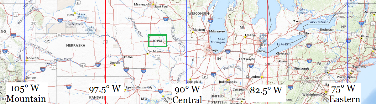
| Location |
Co-Ordinates
(Latitude, Longitude and Elevation) |
Mean solar time at noon
Mountain Standard Time |
Mean solar time at noon
Central Standard Time
(Mountain Daylight Saving Time) |
Mean solar time at noon
Eastern Standard Time
(Central Daylight Saving Time) |
ADAPT Pre - School,
Madison County
|
Elevation: 332 meters*
Latitude: 41.2107206° N
Longitude: 93.8419592° W
|
12:44:37 |
11:44:37 |
10:44:37 |
ADM 6 - 7 Middle School,
Dallas County
|
Elevation: 279 meters*
Latitude: 41.6188408° N
Longitude: 94.0223482° W
|
12:43:54 |
11:43:54 |
10:43:54 |
AGWSR Elementary School,
Hardin County
|
Elevation: 328 meters*
Latitude: 42.5499268° N
Longitude: 93.0485022° W
|
12:47:48 |
11:47:48 |
10:47:48 |
AGWSR High School,
Hardin County
|
Elevation: 327 meters*
Latitude: 42.54987° N
Longitude: 93.0494° W
|
12:47:48 |
11:47:48 |
10:47:48 |
AGWSR Wellsburg Center,
Grundy County
|
Elevation: 325 meters*
Latitude: 42.432843° N
Longitude: 92.9313709° W
|
12:48:16 |
11:48:16 |
10:48:16 |
AHSTW Community High School,
Pottawattamie County
|
Elevation: 345 meters*
Latitude: 41.4700097° N
Longitude: 95.3418152° W
|
12:38:37 |
11:38:37 |
10:38:37 |
AHSTW Elementary School,
Pottawattamie County
|
Elevation: 346 meters*
Latitude: 41.4693182° N
Longitude: 95.3418045° W
|
12:38:37 |
11:38:37 |
10:38:37 |
AIB College of Business,
Polk County
|
Elevation: 265 meters*
Latitude: 41.5619883° N
Longitude: 93.6455386° W
|
12:45:25 |
11:45:25 |
10:45:25 |
Abbe Creek School (historical),
Linn County
|
Elevation: 238 meters*
Latitude: 41.9411169° N
Longitude: 91.4537837° W
|
12:54:11 |
11:54:11 |
10:54:11 |
Abbeyville Post Office (historical),
Delaware County
|
Elevation: 318 meters*
Latitude: 42.3111036° N
Longitude: 91.4404351° W
|
12:54:14 |
11:54:14 |
10:54:14 |
Abbie Sawyer Elementary School,
Story County
|
Elevation: 307 meters*
Latitude: 42.0340835° N
Longitude: 93.6772065° W
|
12:45:17 |
11:45:17 |
10:45:17 |
Abbott Post Office (historical),
Hardin County
|
Elevation: 335 meters*
Latitude: 42.485258° N
Longitude: 93.0663117° W
|
12:47:44 |
11:47:44 |
10:47:44 |
Abingdon Post Office (historical),
Jefferson County
|
Elevation: 237 meters*
Latitude: 41.0822387° N
Longitude: 92.1390672° W
|
12:51:26 |
11:51:26 |
10:51:26 |
Abraham Lincoln High School,
Pottawattamie County
|
Elevation: 333 meters*
Latitude: 41.2576055° N
Longitude: 95.8193538° W
|
12:36:43 |
11:36:43 |
10:36:43 |
Absecom Post Office (historical),
Jefferson County
|
Elevation: 235 meters*
Latitude: 40.9583523° N
Longitude: 92.1524005° W
|
12:51:23 |
11:51:23 |
10:51:23 |
Ackley Post Office,
Hardin County
|
Elevation: 331 meters*
Latitude: 42.5530013° N
Longitude: 93.0525688° W
|
12:47:47 |
11:47:47 |
10:47:47 |
Ackworth Post Office (historical),
Warren County
|
Elevation: 275 meters*
Latitude: 41.3666596° N
Longitude: 93.4735464° W
|
12:46:06 |
11:46:06 |
10:46:06 |
Acme Post Office (historical),
Howard County
|
Elevation: 369 meters*
Latitude: 43.3188571° N
Longitude: 92.5060113° W
|
12:49:58 |
11:49:58 |
10:49:58 |
Adair - Casey / Guthrie Center High School,
Guthrie County
|
Elevation: 335 meters*
Latitude: 41.6706444° N
Longitude: 94.4947522° W
|
12:42:01 |
11:42:01 |
10:42:01 |
Adair - Casey / Guthrie Center Junior High School,
Guthrie County
|
Elevation: 400 meters*
Latitude: 41.5203071° N
Longitude: 94.5836944° W
|
12:41:39 |
11:41:39 |
10:41:39 |
Adair - Casey Elementary School,
Guthrie County
|
Elevation: 399 meters*
Latitude: 41.5205966° N
Longitude: 94.5844083° W
|
12:41:39 |
11:41:39 |
10:41:39 |
Adair Post Office,
Adair County
|
Elevation: 448 meters*
Latitude: 41.5008006° N
Longitude: 94.6421383° W
|
12:41:25 |
11:41:25 |
10:41:25 |
Adams Elementary School,
Carroll County
|
Elevation: 398 meters*
Latitude: 42.0711252° N
Longitude: 94.8654173° W
|
12:40:32 |
11:40:32 |
10:40:32 |
Adams Elementary School,
Scott County
|
Elevation: 204 meters*
Latitude: 41.5503503° N
Longitude: 90.6001312° W
|
12:57:35 |
11:57:35 |
10:57:35 |
Adams Post Office (historical),
Muscatine County
|
Elevation: 192 meters*
Latitude: 41.4828028° N
Longitude: 91.2434892° W
|
12:55:01 |
11:55:01 |
10:55:01 |
Adams School (historical),
Polk County
|
Elevation: 300 meters*
Latitude: 41.7619321° N
Longitude: 93.6377191° W
|
12:45:26 |
11:45:26 |
10:45:26 |
Adams School,
Polk County
|
Elevation: 270 meters*
Latitude: 41.6288779° N
Longitude: 93.5616049° W
|
12:45:45 |
11:45:45 |
10:45:45 |
Adamsonville Post Office (historical),
Jasper County
|
Elevation: 284 meters*
Latitude: 41.6444368° N
Longitude: 92.9779742° W
|
12:48:05 |
11:48:05 |
10:48:05 |
Adaville Post Office (historical),
Plymouth County
|
Elevation: 401 meters*
Latitude: 42.7502702° N
Longitude: 96.4050281° W
|
12:34:22 |
11:34:22 |
10:34:22 |
Adaza Post Office (historical),
Greene County
|
Elevation: 342 meters*
Latitude: 42.1952593° N
Longitude: 94.4944178° W
|
12:42:01 |
11:42:01 |
10:42:01 |
Addison Post Office (historical),
Humboldt County
|
Elevation: 342 meters*
Latitude: 42.6708042° N
Longitude: 94.2266297° W
|
12:43:05 |
11:43:05 |
10:43:05 |
Adel De Soto Minburn High School,
Dallas County
|
Elevation: 273 meters*
Latitude: 41.6097296° N
Longitude: 94.0145185° W
|
12:43:56 |
11:43:56 |
10:43:56 |
Adel De Soto Minburn Middle School,
Dallas County
|
Elevation: 274 meters*
Latitude: 41.6102146° N
Longitude: 94.0148695° W
|
12:43:56 |
11:43:56 |
10:43:56 |
Adel Elementary School,
Dallas County
|
Elevation: 289 meters*
Latitude: 41.6212213° N
Longitude: 94.0287043° W
|
12:43:53 |
11:43:53 |
10:43:53 |
Adel Post Office,
Dallas County
|
Elevation: 279 meters*
Latitude: 41.6088066° N
Longitude: 94.0165105° W
|
12:43:56 |
11:43:56 |
10:43:56 |
Adelphi Post Office (historical),
Polk County
|
Elevation: 263 meters*
Latitude: 41.5333232° N
Longitude: 93.4263227° W
|
12:46:17 |
11:46:17 |
10:46:17 |
Adena Post Office (historical),
Crawford County
|
Elevation: 441 meters*
Latitude: 42.002764° N
Longitude: 95.108604° W
|
12:39:33 |
11:39:33 |
10:39:33 |
Adrian Post Office (historical),
Crawford County
|
Elevation: 399 meters*
Latitude: 42.1833223° N
Longitude: 95.6419475° W
|
12:37:25 |
11:37:25 |
10:37:25 |
Advance Post Office (historical),
Guthrie County
|
Elevation: 325 meters*
Latitude: 41.8205411° N
Longitude: 94.3513552° W
|
12:42:35 |
11:42:35 |
10:42:35 |
Afton Post Office,
Union County
|
Elevation: 378 meters*
Latitude: 41.0286477° N
Longitude: 94.1994395° W
|
12:43:12 |
11:43:12 |
10:43:12 |
Agassiz Elementary School,
Wapello County
|
Elevation: 197 meters*
Latitude: 40.9979019° N
Longitude: 92.4165934° W
|
12:50:20 |
11:50:20 |
10:50:20 |
Agency Post Office,
Wapello County
|
Elevation: 248 meters*
Latitude: 40.9947435° N
Longitude: 92.3065268° W
|
12:50:46 |
11:50:46 |
10:50:46 |
Ainsworth Elementary School,
Washington County
|
Elevation: 226 meters*
Latitude: 41.2923267° N
Longitude: 91.5606848° W
|
12:53:45 |
11:53:45 |
10:53:45 |
Ainsworth Post Office,
Washington County
|
Elevation: 217 meters*
Latitude: 41.2888281° N
Longitude: 91.5504806° W
|
12:53:47 |
11:53:47 |
10:53:47 |
Ajax Post Office (historical),
Davis County
|
Elevation: 256 meters*
Latitude: 40.6833582° N
Longitude: 92.308517° W
|
12:50:45 |
11:50:45 |
10:50:45 |
Akron - Westfield Elementary School,
Plymouth County
|
Elevation: 372 meters*
Latitude: 42.8327889° N
Longitude: 96.5491841° W
|
12:33:48 |
11:33:48 |
10:33:48 |
Akron - Westfield High School and Middle School,
Plymouth County
|
Elevation: 372 meters*
Latitude: 42.8323718° N
Longitude: 96.5489482° W
|
12:33:48 |
11:33:48 |
10:33:48 |
Akron - Westfield Middle School,
Plymouth County
|
Elevation: 372 meters*
Latitude: 42.832681° N
Longitude: 96.5493214° W
|
12:33:48 |
11:33:48 |
10:33:48 |
Akron Post Office,
Plymouth County
|
Elevation: 350 meters*
Latitude: 42.8290064° N
Longitude: 96.5572197° W
|
12:33:46 |
11:33:46 |
10:33:46 |
Alan Shepard Elementary School,
Scott County
|
Elevation: 242 meters*
Latitude: 41.6990972° N
Longitude: 90.5852248° W
|
12:57:39 |
11:57:39 |
10:57:39 |
Albany Post Office (historical),
Davis County
|
Elevation: 284 meters*
Latitude: 40.8902923° N
Longitude: 92.6385243° W
|
12:49:26 |
11:49:26 |
10:49:26 |
Albaton Post Office (historical),
Monona County
|
Elevation: 326 meters*
Latitude: 42.1855464° N
Longitude: 96.2908592° W
|
12:34:50 |
11:34:50 |
10:34:50 |
Albert City - Truesdale Elementary School,
Buena Vista County
|
Elevation: 403 meters*
Latitude: 42.7829609° N
Longitude: 94.9504165° W
|
12:40:11 |
11:40:11 |
10:40:11 |
Albert City Post Office,
Buena Vista County
|
Elevation: 403 meters*
Latitude: 42.781849° N
Longitude: 94.947601° W
|
12:40:12 |
11:40:12 |
10:40:12 |
Albia High School,
Monroe County
|
Elevation: 292 meters*
Latitude: 41.0297027° N
Longitude: 92.8022395° W
|
12:48:47 |
11:48:47 |
10:48:47 |
Albia Junior High School,
Monroe County
|
Elevation: 292 meters*
Latitude: 41.0299714° N
Longitude: 92.8028877° W
|
12:48:47 |
11:48:47 |
10:48:47 |
Albia Post Office,
Monroe County
|
Elevation: 293 meters*
Latitude: 41.0269356° N
Longitude: 92.8099519° W
|
12:48:45 |
11:48:45 |
10:48:45 |
Albion Post Office,
Marshall County
|
Elevation: 291 meters*
Latitude: 42.1115724° N
Longitude: 92.9908367° W
|
12:48:02 |
11:48:02 |
10:48:02 |
Albion School (historical),
Howard County
|
Elevation: 398 meters*
Latitude: 43.4441334° N
Longitude: 92.1960004° W
|
12:51:12 |
11:51:12 |
10:51:12 |
Albrights Post Office (historical),
Des Moines County
|
Elevation: 166 meters*
Latitude: 40.9064265° N
Longitude: 91.0557° W
|
12:55:46 |
11:55:46 |
10:55:46 |
Alburnett Elementary School,
Linn County
|
Elevation: 273 meters*
Latitude: 42.1498304° N
Longitude: 91.6207206° W
|
12:53:31 |
11:53:31 |
10:53:31 |
Alburnett Post Office,
Linn County
|
Elevation: 271 meters*
Latitude: 42.1483912° N
Longitude: 91.6183484° W
|
12:53:31 |
11:53:31 |
10:53:31 |
Alburnett Senior High School,
Linn County
|
Elevation: 273 meters*
Latitude: 42.1503389° N
Longitude: 91.6197026° W
|
12:53:31 |
11:53:31 |
10:53:31 |
Alden Elementary School,
Hardin County
|
Elevation: 340 meters*
Latitude: 42.5173704° N
Longitude: 93.3726365° W
|
12:46:30 |
11:46:30 |
10:46:30 |
Alden Post Office,
Hardin County
|
Elevation: 339 meters*
Latitude: 42.5206834° N
Longitude: 93.3772055° W
|
12:46:29 |
11:46:29 |
10:46:29 |
Aldo Leopold Middle School,
Des Moines County
|
Elevation: 204 meters*
Latitude: 40.8319678° N
Longitude: 91.1377209° W
|
12:55:26 |
11:55:26 |
10:55:26 |
Alexander Post Office,
Franklin County
|
Elevation: 387 meters*
Latitude: 42.8062905° N
Longitude: 93.4764577° W
|
12:46:05 |
11:46:05 |
10:46:05 |
Algona High School,
Kossuth County
|
Elevation: 367 meters*
Latitude: 43.0632366° N
Longitude: 94.2232696° W
|
12:43:06 |
11:43:06 |
10:43:06 |
Algona Post Office,
Kossuth County
|
Elevation: 364 meters*
Latitude: 43.0694654° N
Longitude: 94.2314222° W
|
12:43:04 |
11:43:04 |
10:43:04 |
Alice Post Office (historical),
Grundy County
|
Elevation: 318 meters*
Latitude: 42.303595° N
Longitude: 92.913812° W
|
12:48:20 |
11:48:20 |
10:48:20 |
Alice Post Office (historical),
Linn County
|
Elevation: 264 meters*
Latitude: 42.1974931° N
Longitude: 91.69573° W
|
12:53:13 |
11:53:13 |
10:53:13 |
Alix Post Office (historical),
Montgomery County
|
Elevation: 335 meters*
Latitude: 41.0913782° N
Longitude: 94.9655401° W
|
12:40:08 |
11:40:08 |
10:40:08 |
All Saints Catholic School,
Scott County
|
Elevation: 213 meters*
Latitude: 41.5389862° N
Longitude: 90.5919047° W
|
12:57:37 |
11:57:37 |
10:57:37 |
All Saints Elementary School,
Linn County
|
Elevation: 257 meters*
Latitude: 41.9781534° N
Longitude: 91.6256911° W
|
12:53:29 |
11:53:29 |
10:53:29 |
All Saints School,
Linn County
|
Elevation: 257 meters*
Latitude: 41.9780568° N
Longitude: 91.6251787° W
|
12:53:29 |
11:53:29 |
10:53:29 |
All Saints School,
Polk County
|
Elevation: 267 meters*
Latitude: 41.6263778° N
Longitude: 93.6210513° W
|
12:45:30 |
11:45:30 |
10:45:30 |
Allamakee Learning Center,
Allamakee County
|
Elevation: 376 meters*
Latitude: 43.26945° N
Longitude: 91.47517° W
|
12:54:05 |
11:54:05 |
10:54:05 |
Allamakee Post Office (historical),
Allamakee County
|
Elevation: 187 meters*
Latitude: 43.1499814° N
Longitude: 91.1501295° W
|
12:55:23 |
11:55:23 |
10:55:23 |
Alleman Post Office,
Polk County
|
Elevation: 308 meters*
Latitude: 41.8197775° N
Longitude: 93.6107435° W
|
12:45:33 |
11:45:33 |
10:45:33 |
Allen College,
Black Hawk County
|
Elevation: 278 meters*
Latitude: 42.5303304° N
Longitude: 92.3400699° W
|
12:50:38 |
11:50:38 |
10:50:38 |
Allen Post Office (historical),
Harrison County
|
Elevation: 425 meters*
Latitude: 41.8049883° N
Longitude: 95.8186194° W
|
12:36:43 |
11:36:43 |
10:36:43 |
Allendorf Post Office (historical),
Osceola County
|
Elevation: 487 meters*
Latitude: 43.4146902° N
Longitude: 95.6433454° W
|
12:37:25 |
11:37:25 |
10:37:25 |
Allens Grove Post Office (historical),
Scott County
|
Elevation: 230 meters*
Latitude: 41.7008619° N
Longitude: 90.7079202° W
|
12:57:10 |
11:57:10 |
10:57:10 |
Allens Grove School (historical),
Scott County
|
Elevation: 228 meters*
Latitude: 41.7025285° N
Longitude: 90.7143093° W
|
12:57:08 |
11:57:08 |
10:57:08 |
Allerton Post Office,
Wayne County
|
Elevation: 336 meters*
Latitude: 40.7069874° N
Longitude: 93.3653799° W
|
12:46:32 |
11:46:32 |
10:46:32 |
Allison Post Office,
Butler County
|
Elevation: 321 meters*
Latitude: 42.7532005° N
Longitude: 92.795441° W
|
12:48:49 |
11:48:49 |
10:48:49 |
Allison School (historical),
Clinton County
|
Elevation: 207 meters*
Latitude: 41.7780836° N
Longitude: 90.6551405° W
|
12:57:22 |
11:57:22 |
10:57:22 |
Alma Post Office (historical),
Jackson County
|
Elevation: 298 meters*
Latitude: 42.2333442° N
Longitude: 90.8473585° W
|
12:56:36 |
11:56:36 |
10:56:36 |
Almira Post Office (historical),
Delaware County
|
Elevation: 299 meters*
Latitude: 42.3222162° N
Longitude: 91.3757092° W
|
12:54:29 |
11:54:29 |
10:54:29 |
Almont Post Office (historical),
Clinton County
|
Elevation: 200 meters*
Latitude: 41.9753045° N
Longitude: 90.1990171° W
|
12:59:12 |
11:59:12 |
10:59:12 |
Almoral Post Office (historical),
Delaware County
|
Elevation: 314 meters*
Latitude: 42.5355463° N
Longitude: 91.2898613° W
|
12:54:50 |
11:54:50 |
10:54:50 |
Almoral Station Post Office (historical),
Delaware County
|
Elevation: 295 meters*
Latitude: 42.5163803° N
Longitude: 91.272639° W
|
12:54:54 |
11:54:54 |
10:54:54 |
Alpha Post Office (historical),
Fayette County
|
Elevation: 318 meters*
Latitude: 42.9966431° N
Longitude: 92.0476715° W
|
12:51:48 |
11:51:48 |
10:51:48 |
Alpine Post Office (historical),
Wapello County
|
Elevation: 192 meters*
Latitude: 40.9519618° N
Longitude: 92.2940713° W
|
12:50:49 |
11:50:49 |
10:50:49 |
Alps Post Office (historical),
Mills County
|
Elevation: 289 meters*
Latitude: 40.9513887° N
Longitude: 95.8147281° W
|
12:36:44 |
11:36:44 |
10:36:44 |
Alta - Aurelia High School,
Buena Vista County
|
Elevation: 457 meters*
Latitude: 42.6647733° N
Longitude: 95.3036889° W
|
12:38:47 |
11:38:47 |
10:38:47 |
Alta - Aurelia Middle School,
Cherokee County
|
Elevation: 437 meters*
Latitude: 42.7139825° N
Longitude: 95.4289249° W
|
12:38:17 |
11:38:17 |
10:38:17 |
Alta Elementary School,
Buena Vista County
|
Elevation: 461 meters*
Latitude: 42.6698246° N
Longitude: 95.3044792° W
|
12:38:46 |
11:38:46 |
10:38:46 |
Alta High School,
Buena Vista County
|
Elevation: 457 meters*
Latitude: 42.6646465° N
Longitude: 95.3035342° W
|
12:38:47 |
11:38:47 |
10:38:47 |
Alta Post Office,
Buena Vista County
|
Elevation: 463 meters*
Latitude: 42.6743391° N
Longitude: 95.3055443° W
|
12:38:46 |
11:38:46 |
10:38:46 |
Alta Vista Campus Alternative Learning Center,
Dubuque County
|
Elevation: 269 meters*
Latitude: 42.5006942° N
Longitude: 90.6793213° W
|
12:57:16 |
11:57:16 |
10:57:16 |
Alta Vista Post Office,
Chickasaw County
|
Elevation: 354 meters*
Latitude: 43.1992148° N
Longitude: 92.4170688° W
|
12:50:19 |
11:50:19 |
10:50:19 |
Altamont Post Office (historical),
Shelby County
|
Elevation: 363 meters*
Latitude: 41.5569337° N
Longitude: 95.2794421° W
|
12:38:52 |
11:38:52 |
10:38:52 |
Alternative High School Clarinda Community School,
Page County
|
Elevation: 314 meters*
Latitude: 40.7428589° N
Longitude: 95.0330641° W
|
12:39:52 |
11:39:52 |
10:39:52 |
Alternative High School,
Polk County
|
Elevation: 250 meters*
Latitude: 41.585267° N
Longitude: 93.7063319° W
|
12:45:10 |
11:45:10 |
10:45:10 |
Alton Post Office,
Sioux County
|
Elevation: 402 meters*
Latitude: 42.9881402° N
Longitude: 96.0100702° W
|
12:35:57 |
11:35:57 |
10:35:57 |
Alton School (historical),
Dallas County
|
Elevation: 295 meters*
Latitude: 41.8260966° N
Longitude: 94.0877346° W
|
12:43:38 |
11:43:38 |
10:43:38 |
Alton School,
Dallas County
|
Elevation: 291 meters*
Latitude: 41.848874° N
Longitude: 94.1260693° W
|
12:43:29 |
11:43:29 |
10:43:29 |
Altona Post Office (historical),
Louisa County
|
Elevation: 176 meters*
Latitude: 41.2869698° N
Longitude: 91.3501552° W
|
12:54:35 |
11:54:35 |
10:54:35 |
Altoona Elementary School,
Polk County
|
Elevation: 294 meters*
Latitude: 41.6471774° N
Longitude: 93.46801° W
|
12:46:07 |
11:46:07 |
10:46:07 |
Altoona Post Office,
Polk County
|
Elevation: 293 meters*
Latitude: 41.6435095° N
Longitude: 93.4616766° W
|
12:46:09 |
11:46:09 |
10:46:09 |
Alvord Post Office,
Lyon County
|
Elevation: 404 meters*
Latitude: 43.3422051° N
Longitude: 96.3006508° W
|
12:34:47 |
11:34:47 |
10:34:47 |
Amana Elementary School,
Iowa County
|
Elevation: 225 meters*
Latitude: 41.7982654° N
Longitude: 91.897659° W
|
12:52:24 |
11:52:24 |
10:52:24 |
Amana Post Office,
Iowa County
|
Elevation: 224 meters*
Latitude: 41.8005811° N
Longitude: 91.8753819° W
|
12:52:29 |
11:52:29 |
10:52:29 |
Amaqua Center School,
Boone County
|
Elevation: 327 meters*
Latitude: 42.0777582° N
Longitude: 94.1052358° W
|
12:43:34 |
11:43:34 |
10:43:34 |
Amarill Post Office (historical),
Delaware County
|
Elevation: 313 meters*
Latitude: 42.5727643° N
Longitude: 91.4487553° W
|
12:54:12 |
11:54:12 |
10:54:12 |
Amazon Post Office (historical),
Madison County
|
Elevation: 331 meters*
Latitude: 41.3083247° N
Longitude: 93.9085583° W
|
12:44:21 |
11:44:21 |
10:44:21 |
Amber Post Office (historical),
Jones County
|
Elevation: 313 meters*
Latitude: 42.1280617° N
Longitude: 91.1801535° W
|
12:55:16 |
11:55:16 |
10:55:16 |
Amboy Post Office (historical),
Jasper County
|
Elevation: 294 meters*
Latitude: 41.7355466° N
Longitude: 92.9793619° W
|
12:48:04 |
11:48:04 |
10:48:04 |
Ambrose Post Office (historical),
Iowa County
|
Elevation: 261 meters*
Latitude: 41.5313956° N
Longitude: 92.2335151° W
|
12:51:03 |
11:51:03 |
10:51:03 |
Ambrosia Post Office (historical),
Lee County
|
Elevation: 208 meters*
Latitude: 40.5244863° N
Longitude: 91.4890452° W
|
12:54:02 |
11:54:02 |
10:54:02 |
Ames Christian School,
Story County
|
Elevation: 297 meters*
Latitude: 42.0227647° N
Longitude: 93.5404929° W
|
12:45:50 |
11:45:50 |
10:45:50 |
Ames Christian School,
Story County
|
Elevation: 272 meters*
Latitude: 42.0087855° N
Longitude: 93.6240395° W
|
12:45:30 |
11:45:30 |
10:45:30 |
Ames High School,
Story County
|
Elevation: 289 meters*
Latitude: 42.0401055° N
Longitude: 93.6345085° W
|
12:45:27 |
11:45:27 |
10:45:27 |
Ames Middle School,
Story County
|
Elevation: 306 meters*
Latitude: 42.0131415° N
Longitude: 93.6706245° W
|
12:45:19 |
11:45:19 |
10:45:19 |
Ames Post Office Welch Avenue Station,
Story County
|
Elevation: 292 meters*
Latitude: 42.0209864° N
Longitude: 93.6497011° W
|
12:45:24 |
11:45:24 |
10:45:24 |
Ames Post Office,
Story County
|
Elevation: 282 meters*
Latitude: 42.0265695° N
Longitude: 93.6140367° W
|
12:45:32 |
11:45:32 |
10:45:32 |
Amish Post Office (historical),
Johnson County
|
Elevation: 230 meters*
Latitude: 41.5358477° N
Longitude: 91.7865601° W
|
12:52:51 |
11:52:51 |
10:52:51 |
Amity Post Office (historical),
Des Moines County
|
Elevation: 214 meters*
Latitude: 40.9986468° N
Longitude: 91.0829236° W
|
12:55:40 |
11:55:40 |
10:55:40 |
Amity Post Office (historical),
Scott County
|
Elevation: 224 meters*
Latitude: 41.6489179° N
Longitude: 90.728754° W
|
12:57:05 |
11:57:05 |
10:57:05 |
Amity School,
Lucas County
|
Elevation: 307 meters*
Latitude: 40.9697227° N
Longitude: 93.3849336° W
|
12:46:27 |
11:46:27 |
10:46:27 |
Amsterdam Post Office (historical),
Marion County
|
Elevation: 217 meters*
Latitude: 41.3705533° N
Longitude: 92.9626997° W
|
12:48:08 |
11:48:08 |
10:48:08 |
Amund Post Office (historical),
Winnebago County
|
Elevation: 373 meters*
Latitude: 43.4721766° N
Longitude: 93.7918913° W
|
12:44:49 |
11:44:49 |
10:44:49 |
Anamosa High School,
Jones County
|
Elevation: 263 meters*
Latitude: 42.1102042° N
Longitude: 91.2721235° W
|
12:54:54 |
11:54:54 |
10:54:54 |
Anamosa Post Office,
Jones County
|
Elevation: 255 meters*
Latitude: 42.1075827° N
Longitude: 91.2859375° W
|
12:54:51 |
11:54:51 |
10:54:51 |
Anderson Elementary School,
Polk County
|
Elevation: 291 meters*
Latitude: 41.6972389° N
Longitude: 93.4652135° W
|
12:46:08 |
11:46:08 |
10:46:08 |
Anderson Post Office (historical),
Clayton County
|
Elevation: 363 meters*
Latitude: 42.6472155° N
Longitude: 91.0751308° W
|
12:55:41 |
11:55:41 |
10:55:41 |
Anderson Post Office (historical),
Fremont County
|
Elevation: 295 meters*
Latitude: 40.8013888° N
Longitude: 95.6041625° W
|
12:37:35 |
11:37:35 |
10:37:35 |
Anderson School,
Monroe County
|
Elevation: 262 meters*
Latitude: 41.0080634° N
Longitude: 92.8310296° W
|
12:48:40 |
11:48:40 |
10:48:40 |
Andover Post Office,
Clinton County
|
Elevation: 222 meters*
Latitude: 41.979368° N
Longitude: 90.2519652° W
|
12:58:59 |
11:58:59 |
10:58:59 |
Andrew Community School,
Jackson County
|
Elevation: 272 meters*
Latitude: 42.1526906° N
Longitude: 90.5909859° W
|
12:57:38 |
11:57:38 |
10:57:38 |
Andrew Post Office,
Jackson County
|
Elevation: 270 meters*
Latitude: 42.1541943° N
Longitude: 90.5927894° W
|
12:57:37 |
11:57:37 |
10:57:37 |
Andrews Christian Academy,
Linn County
|
Elevation: 244 meters*
Latitude: 42.0641444° N
Longitude: 91.7060301° W
|
12:53:10 |
11:53:10 |
10:53:10 |
Angus Post Office (historical),
Boone County
|
Elevation: 312 meters*
Latitude: 41.8833178° N
Longitude: 94.1574595° W
|
12:43:22 |
11:43:22 |
10:43:22 |
Anita Post Office,
Cass County
|
Elevation: 385 meters*
Latitude: 41.4435996° N
Longitude: 94.7673263° W
|
12:40:55 |
11:40:55 |
10:40:55 |
Ankeny Christian Academy,
Polk County
|
Elevation: 298 meters*
Latitude: 41.7322515° N
Longitude: 93.6231061° W
|
12:45:30 |
11:45:30 |
10:45:30 |
Ankeny High School,
Polk County
|
Elevation: 299 meters*
Latitude: 41.7195281° N
Longitude: 93.604674° W
|
12:45:34 |
11:45:34 |
10:45:34 |
Ankeny Post Office,
Polk County
|
Elevation: 290 meters*
Latitude: 41.7402145° N
Longitude: 93.5994136° W
|
12:45:36 |
11:45:36 |
10:45:36 |
Annieville Post Office (historical),
Clay County
|
Elevation: 418 meters*
Latitude: 43.0630276° N
Longitude: 95.1599945° W
|
12:39:21 |
11:39:21 |
10:39:21 |
Anson Elementary School,
Marshall County
|
Elevation: 282 meters*
Latitude: 42.0353661° N
Longitude: 92.9073414° W
|
12:48:22 |
11:48:22 |
10:48:22 |
Anson Park Junior High School,
Marshall County
|
Elevation: 273 meters*
Latitude: 42.0369324° N
Longitude: 92.9063106° W
|
12:48:22 |
11:48:22 |
10:48:22 |
Anthon - Oto - Maple Valley Middle School,
Woodbury County
|
Elevation: 342 meters*
Latitude: 42.384527° N
Longitude: 95.8699902° W
|
12:36:31 |
11:36:31 |
10:36:31 |
Anthon Elementary School,
Woodbury County
|
Elevation: 342 meters*
Latitude: 42.3849392° N
Longitude: 95.8698347° W
|
12:36:31 |
11:36:31 |
10:36:31 |
Anthon Post Office,
Woodbury County
|
Elevation: 340 meters*
Latitude: 42.3889353° N
Longitude: 95.8666911° W
|
12:36:31 |
11:36:31 |
10:36:31 |
Antioch School,
Jones County
|
Elevation: 256 meters*
Latitude: 42.0861177° N
Longitude: 91.2143235° W
|
12:55:08 |
11:55:08 |
10:55:08 |
Aplington - Parkersburg High School,
Butler County
|
Elevation: 300 meters*
Latitude: 42.5729544° N
Longitude: 92.7785789° W
|
12:48:53 |
11:48:53 |
10:48:53 |
Aplington - Parkersburg Middle School,
Butler County
|
Elevation: 310 meters*
Latitude: 42.5792443° N
Longitude: 92.8851057° W
|
12:48:27 |
11:48:27 |
10:48:27 |
Aplington Elementary School,
Butler County
|
Elevation: 310 meters*
Latitude: 42.5791723° N
Longitude: 92.8859477° W
|
12:48:27 |
11:48:27 |
10:48:27 |
Aplington Post Office,
Butler County
|
Elevation: 297 meters*
Latitude: 42.5837402° N
Longitude: 92.8843539° W
|
12:48:27 |
11:48:27 |
10:48:27 |
Apollo Central School,
Des Moines County
|
Elevation: 197 meters*
Latitude: 40.8103168° N
Longitude: 91.1137566° W
|
12:55:32 |
11:55:32 |
10:55:32 |
Apollo Post Office (historical),
Cedar County
|
Elevation: 244 meters*
Latitude: 41.7055791° N
Longitude: 91.0834883° W
|
12:55:39 |
11:55:39 |
10:55:39 |
Appanoose County Alternative High School,
Wapello County
|
Elevation: 256 meters*
Latitude: 41.1089823° N
Longitude: 92.4340051° W
|
12:50:15 |
11:50:15 |
10:50:15 |
Apple Grove Post Office (historical),
Polk County
|
Elevation: 278 meters*
Latitude: 41.6305447° N
Longitude: 93.3668761° W
|
12:46:31 |
11:46:31 |
10:46:31 |
Aquilla Grove Post Office (historical),
Winneshiek County
|
Elevation: 323 meters*
Latitude: 43.377749° N
Longitude: 91.7418175° W
|
12:53:01 |
11:53:01 |
10:53:01 |
Aquin Catholic Elementary School,
Dubuque County
|
Elevation: 252 meters*
Latitude: 42.2994143° N
Longitude: 91.0192752° W
|
12:55:55 |
11:55:55 |
10:55:55 |
Aquinas East Primary School,
Lee County
|
Elevation: 171 meters*
Latitude: 40.6322633° N
Longitude: 91.306817° W
|
12:54:46 |
11:54:46 |
10:54:46 |
Ar - We - Va Community School,
Crawford County
|
Elevation: 412 meters*
Latitude: 42.0751007° N
Longitude: 95.1011996° W
|
12:39:35 |
11:39:35 |
10:39:35 |
Arbor Hill Post Office (historical),
Adair County
|
Elevation: 377 meters*
Latitude: 41.3399887° N
Longitude: 94.2963484° W
|
12:42:48 |
11:42:48 |
10:42:48 |
Arcadia Elementary School,
Carroll County
|
Elevation: 434 meters*
Latitude: 42.0857864° N
Longitude: 95.0478536° W
|
12:39:48 |
11:39:48 |
10:39:48 |
Arcadia Post Office,
Carroll County
|
Elevation: 440 meters*
Latitude: 42.0873911° N
Longitude: 95.0462186° W
|
12:39:48 |
11:39:48 |
10:39:48 |
Archer Post Office,
O'Brien County
|
Elevation: 450 meters*
Latitude: 43.114338° N
Longitude: 95.7455515° W
|
12:37:01 |
11:37:01 |
10:37:01 |
Arcola Post Office (historical),
Monona County
|
Elevation: 430 meters*
Latitude: 42.7174901° N
Longitude: 95.9775178° W
|
12:36:05 |
11:36:05 |
10:36:05 |
Ardon Post Office (historical),
Muscatine County
|
Elevation: 228 meters*
Latitude: 41.3950269° N
Longitude: 91.1884861° W
|
12:55:14 |
11:55:14 |
10:55:14 |
Area 10 College,
Linn County
|
Elevation: 220 meters*
Latitude: 41.9352807° N
Longitude: 91.6751786° W
|
12:53:17 |
11:53:17 |
10:53:17 |
Aredale Post Office,
Butler County
|
Elevation: 311 meters*
Latitude: 42.8330278° N
Longitude: 93.0054745° W
|
12:47:58 |
11:47:58 |
10:47:58 |
Argand Post Office (historical),
Jones County
|
Elevation: 293 meters*
Latitude: 42.2816636° N
Longitude: 91.3112639° W
|
12:54:45 |
11:54:45 |
10:54:45 |
Argo Post Office (historical),
Lucas County
|
Elevation: 326 meters*
Latitude: 40.9700002° N
Longitude: 93.4988249° W
|
12:46:00 |
11:46:00 |
10:46:00 |
Argo Post Office (historical),
Scott County
|
Elevation: 234 meters*
Latitude: 41.6258658° N
Longitude: 90.4326322° W
|
12:58:16 |
11:58:16 |
10:58:16 |
Argo School (historical),
Scott County
|
Elevation: 233 meters*
Latitude: 41.6336435° N
Longitude: 90.4323545° W
|
12:58:16 |
11:58:16 |
10:58:16 |
Argyle Post Office,
Lee County
|
Elevation: 206 meters*
Latitude: 40.5318299° N
Longitude: 91.5664738° W
|
12:53:44 |
11:53:44 |
10:53:44 |
Arion Post Office (historical),
Crawford County
|
Elevation: 349 meters*
Latitude: 41.9485995° N
Longitude: 95.4641671° W
|
12:38:08 |
11:38:08 |
10:38:08 |
Arispe Post Office,
Union County
|
Elevation: 386 meters*
Latitude: 40.9494354° N
Longitude: 94.2191198° W
|
12:43:07 |
11:43:07 |
10:43:07 |
Arlington Post Office,
Fayette County
|
Elevation: 343 meters*
Latitude: 42.7494278° N
Longitude: 91.6715442° W
|
12:53:18 |
11:53:18 |
10:53:18 |
Armah Post Office (historical),
Iowa County
|
Elevation: 265 meters*
Latitude: 41.5313959° N
Longitude: 92.2093479° W
|
12:51:09 |
11:51:09 |
10:51:09 |
Armour Post Office (historical),
Pottawattamie County
|
Elevation: 363 meters*
Latitude: 41.2680519° N
Longitude: 95.6350062° W
|
12:37:27 |
11:37:27 |
10:37:27 |
Armstrong - Ringsted Elementary School,
Emmet County
|
Elevation: 387 meters*
Latitude: 43.2927714° N
Longitude: 94.5072666° W
|
12:41:58 |
11:41:58 |
10:41:58 |
Armstrong Grove Post Office (historical),
Emmet County
|
Elevation: 378 meters*
Latitude: 43.3646815° N
Longitude: 94.4694189° W
|
12:42:07 |
11:42:07 |
10:42:07 |
Armstrong Post Office,
Emmet County
|
Elevation: 380 meters*
Latitude: 43.3955001° N
Longitude: 94.4791639° W
|
12:42:05 |
11:42:05 |
10:42:05 |
Arnold Post Office (historical),
Humboldt County
|
Elevation: 345 meters*
Latitude: 42.810804° N
Longitude: 94.1985726° W
|
12:43:12 |
11:43:12 |
10:43:12 |
Arnold School,
Lucas County
|
Elevation: 299 meters*
Latitude: 41.1455528° N
Longitude: 93.4221564° W
|
12:46:18 |
11:46:18 |
10:46:18 |
Arnolds Park Post Office,
Dickinson County
|
Elevation: 442 meters*
Latitude: 43.3686027° N
Longitude: 95.1264408° W
|
12:39:29 |
11:39:29 |
10:39:29 |
Arquitt Post Office (historical),
Dubuque County
|
Elevation: 340 meters*
Latitude: 42.4624998° N
Longitude: 91.0029109° W
|
12:55:59 |
11:55:59 |
10:55:59 |
Arrow Post Office (historical),
Grundy County
|
Elevation: 300 meters*
Latitude: 42.4416493° N
Longitude: 92.7085302° W
|
12:49:09 |
11:49:09 |
10:49:09 |
Artesian Post Office (historical),
Bremer County
|
Elevation: 299 meters*
Latitude: 42.7283153° N
Longitude: 92.3371258° W
|
12:50:39 |
11:50:39 |
10:50:39 |
Arthur Elementary School,
Linn County
|
Elevation: 240 meters*
Latitude: 42.0032692° N
Longitude: 91.6384666° W
|
12:53:26 |
11:53:26 |
10:53:26 |
Arthur Post Office (historical),
Henry County
|
Elevation: 194 meters*
Latitude: 40.8744754° N
Longitude: 91.5784933° W
|
12:53:41 |
11:53:41 |
10:53:41 |
Arthur Post Office,
Ida County
|
Elevation: 396 meters*
Latitude: 42.3353712° N
Longitude: 95.3470418° W
|
12:38:36 |
11:38:36 |
10:38:36 |
Asbury Methodist Nursery School,
Hamilton County
|
Elevation: 321 meters*
Latitude: 42.4668976° N
Longitude: 93.822437° W
|
12:44:42 |
11:44:42 |
10:44:42 |
Asbury Post Office (historical),
Dubuque County
|
Elevation: 284 meters*
Latitude: 42.5144462° N
Longitude: 90.751516° W
|
12:56:59 |
11:56:59 |
10:56:59 |
Asbury School (historical),
Scott County
|
Elevation: 222 meters*
Latitude: 41.4941983° N
Longitude: 90.6837515° W
|
12:57:15 |
11:57:15 |
10:57:15 |
Ascot Post Office (historical),
Pottawattamie County
|
Elevation: 300 meters*
Latitude: 41.4136062° N
Longitude: 95.898345° W
|
12:36:24 |
11:36:24 |
10:36:24 |
Ash Creek Post Office,
Polk County
|
Elevation: 285 meters*
Latitude: 41.6254156° N
Longitude: 93.7552465° W
|
12:44:58 |
11:44:58 |
10:44:58 |
Ash Grove Post Office (historical),
Davis County
|
Elevation: 229 meters*
Latitude: 40.87085° N
Longitude: 92.5529663° W
|
12:49:47 |
11:49:47 |
10:49:47 |
Ash Post Office (historical),
Humboldt County
|
Elevation: 347 meters*
Latitude: 42.8930244° N
Longitude: 94.030232° W
|
12:43:52 |
11:43:52 |
10:43:52 |
Ashawa Post Office (historical),
Polk County
|
Elevation: 269 meters*
Latitude: 41.5722115° N
Longitude: 93.7563335° W
|
12:44:58 |
11:44:58 |
10:44:58 |
Ashford University - Clinton Campus,
Clinton County
|
Elevation: 194 meters*
Latitude: 41.8519436° N
Longitude: 90.1991274° W
|
12:59:12 |
11:59:12 |
10:59:12 |
Ashland Post Office (historical),
Wapello County
|
Elevation: 240 meters*
Latitude: 40.958629° N
Longitude: 92.2365698° W
|
12:51:03 |
11:51:03 |
10:51:03 |
Ashton Post Office,
Osceola County
|
Elevation: 443 meters*
Latitude: 43.3108253° N
Longitude: 95.7901792° W
|
12:36:50 |
11:36:50 |
10:36:50 |
Aspinwall Post Office (historical),
Crawford County
|
Elevation: 428 meters*
Latitude: 41.911931° N
Longitude: 95.135549° W
|
12:39:27 |
11:39:27 |
10:39:27 |
Aspinwall Post Office (historical),
Dubuque County
|
Elevation: 332 meters*
Latitude: 42.6255524° N
Longitude: 90.8181831° W
|
12:56:43 |
11:56:43 |
10:56:43 |
Assumption High School,
Scott County
|
Elevation: 207 meters*
Latitude: 41.5468304° N
Longitude: 90.5874222° W
|
12:57:39 |
11:57:39 |
10:57:39 |
Assumption School,
Dallas County
|
Elevation: 273 meters*
Latitude: 41.7602205° N
Longitude: 93.8247875° W
|
12:44:42 |
11:44:42 |
10:44:42 |
Assure Center Alternative School,
Washington County
|
Elevation: 226 meters*
Latitude: 41.3062552° N
Longitude: 91.713105° W
|
12:53:08 |
11:53:08 |
10:53:08 |
Astor Post Office (historical),
Crawford County
|
Elevation: 396 meters*
Latitude: 41.8699874° N
Longitude: 95.2666633° W
|
12:38:56 |
11:38:56 |
10:38:56 |
Atalissa Post Office,
Muscatine County
|
Elevation: 202 meters*
Latitude: 41.5711322° N
Longitude: 91.1657969° W
|
12:55:20 |
11:55:20 |
10:55:20 |
Athelstan Post Office (historical),
Taylor County
|
Elevation: 327 meters*
Latitude: 40.5722117° N
Longitude: 94.5374619° W
|
12:41:51 |
11:41:51 |
10:41:51 |
Athol Post Office (historical),
Sioux County
|
Elevation: 444 meters*
Latitude: 43.2297013° N
Longitude: 96.0986327° W
|
12:35:36 |
11:35:36 |
10:35:36 |
Atkins Elementary School,
Benton County
|
Elevation: 257 meters*
Latitude: 41.9943684° N
Longitude: 91.867637° W
|
12:52:31 |
11:52:31 |
10:52:31 |
Atkins Post Office,
Benton County
|
Elevation: 261 meters*
Latitude: 41.9966963° N
Longitude: 91.8622938° W
|
12:52:33 |
11:52:33 |
10:52:33 |
Atlanta Post Office (historical),
Buchanan County
|
Elevation: 275 meters*
Latitude: 42.3111011° N
Longitude: 91.6848917° W
|
12:53:15 |
11:53:15 |
10:53:15 |
Atlantic High School,
Cass County
|
Elevation: 395 meters*
Latitude: 41.3945007° N
Longitude: 94.9964442° W
|
12:40:00 |
11:40:00 |
10:40:00 |
Atlantic Middle School,
Cass County
|
Elevation: 374 meters*
Latitude: 41.3994741° N
Longitude: 95.0053778° W
|
12:39:58 |
11:39:58 |
10:39:58 |
Atlantic Post Office,
Cass County
|
Elevation: 359 meters*
Latitude: 41.4062957° N
Longitude: 95.0118602° W
|
12:39:57 |
11:39:57 |
10:39:57 |
Attica Post Office (historical),
Marion County
|
Elevation: 280 meters*
Latitude: 41.2297219° N
Longitude: 93.0160359° W
|
12:47:56 |
11:47:56 |
10:47:56 |
Atwood Post Office (historical),
Keokuk County
|
Elevation: 213 meters*
Latitude: 41.3250094° N
Longitude: 92.4060193° W
|
12:50:22 |
11:50:22 |
10:50:22 |
Auburn Post Office (historical),
Mahaska County
|
Elevation: 213 meters*
Latitude: 41.2694479° N
Longitude: 92.7960303° W
|
12:48:48 |
11:48:48 |
10:48:48 |
Auburn Post Office,
Sac County
|
Elevation: 374 meters*
Latitude: 42.2500536° N
Longitude: 94.8779066° W
|
12:40:29 |
11:40:29 |
10:40:29 |
Audubon Centre Post Office (historical),
Audubon County
|
Elevation: 388 meters*
Latitude: 41.6819312° N
Longitude: 94.884985° W
|
12:40:27 |
11:40:27 |
10:40:27 |
Audubon Elementary School,
Audubon County
|
Elevation: 406 meters*
Latitude: 41.7187599° N
Longitude: 94.9290233° W
|
12:40:17 |
11:40:17 |
10:40:17 |
Audubon Elementary School,
Dubuque County
|
Elevation: 189 meters*
Latitude: 42.5156702° N
Longitude: 90.6658483° W
|
12:57:20 |
11:57:20 |
10:57:20 |
Audubon Middle School / High School,
Audubon County
|
Elevation: 411 meters*
Latitude: 41.7127293° N
Longitude: 94.9215882° W
|
12:40:18 |
11:40:18 |
10:40:18 |
Audubon Middle School,
Audubon County
|
Elevation: 407 meters*
Latitude: 41.7188754° N
Longitude: 94.9285978° W
|
12:40:17 |
11:40:17 |
10:40:17 |
Audubon Post Office,
Audubon County
|
Elevation: 410 meters*
Latitude: 41.7202876° N
Longitude: 94.9303892° W
|
12:40:16 |
11:40:16 |
10:40:16 |
Augusta Post Office (historical),
Des Moines County
|
Elevation: 177 meters*
Latitude: 40.7580948° N
Longitude: 91.2757054° W
|
12:54:53 |
11:54:53 |
10:54:53 |
Aurelia Elementary School,
Cherokee County
|
Elevation: 437 meters*
Latitude: 42.7135701° N
Longitude: 95.4288849° W
|
12:38:17 |
11:38:17 |
10:38:17 |
Aurelia Post Office,
Cherokee County
|
Elevation: 424 meters*
Latitude: 42.7129365° N
Longitude: 95.4356227° W
|
12:38:15 |
11:38:15 |
10:38:15 |
Aurora Heights Elementary School,
Jasper County
|
Elevation: 290 meters*
Latitude: 41.6961005° N
Longitude: 93.0237757° W
|
12:47:54 |
11:47:54 |
10:47:54 |
Aurora Post Office (historical),
Keokuk County
|
Elevation: 258 meters*
Latitude: 41.4961185° N
Longitude: 92.2521264° W
|
12:50:59 |
11:50:59 |
10:50:59 |
Aurora Post Office,
Buchanan County
|
Elevation: 347 meters*
Latitude: 42.6189441° N
Longitude: 91.7283302° W
|
12:53:05 |
11:53:05 |
10:53:05 |
Austin Post Office (historical),
Dickinson County
|
Elevation: 447 meters*
Latitude: 43.4449645° N
Longitude: 95.3161113° W
|
12:38:44 |
11:38:44 |
10:38:44 |
Austinville Post Office,
Butler County
|
Elevation: 304 meters*
Latitude: 42.5858112° N
Longitude: 92.9571425° W
|
12:48:10 |
11:48:10 |
10:48:10 |
Ava Post Office (historical),
Guthrie County
|
Elevation: 316 meters*
Latitude: 41.6194315° N
Longitude: 94.4058003° W
|
12:42:22 |
11:42:22 |
10:42:22 |
Avenue B School,
Pottawattamie County
|
Elevation: 300 meters*
Latitude: 41.2641649° N
Longitude: 95.8814015° W
|
12:36:28 |
11:36:28 |
10:36:28 |
Avery Post Office (historical),
Monroe County
|
Elevation: 276 meters*
Latitude: 41.0652868° N
Longitude: 92.7143603° W
|
12:49:08 |
11:49:08 |
10:49:08 |
Avoca Post Office,
Pottawattamie County
|
Elevation: 354 meters*
Latitude: 41.4777721° N
Longitude: 95.3395765° W
|
12:38:38 |
11:38:38 |
10:38:38 |
Avon Post Office (historical),
Polk County
|
Elevation: 239 meters*
Latitude: 41.5219344° N
Longitude: 93.5010471° W
|
12:45:59 |
11:45:59 |
10:45:59 |
Avondale Post Office (historical),
Adair County
|
Elevation: 355 meters*
Latitude: 41.2083208° N
Longitude: 94.5877473° W
|
12:41:38 |
11:41:38 |
10:41:38 |
Awakenings Academy,
Dubuque County
|
Elevation: 265 meters*
Latitude: 42.5052432° N
Longitude: 90.7030503° W
|
12:57:11 |
11:57:11 |
10:57:11 |
Ayers Grove Post Office (historical),
Polk County
|
Elevation: 299 meters*
Latitude: 41.6916548° N
Longitude: 93.7641123° W
|
12:44:56 |
11:44:56 |
10:44:56 |
Ayrshire Post Office,
Palo Alto County
|
Elevation: 403 meters*
Latitude: 43.0391346° N
Longitude: 94.8327618° W
|
12:40:40 |
11:40:40 |
10:40:40 |
BCLUW Elementary School,
Grundy County
|
Elevation: 317 meters*
Latitude: 42.2287364° N
Longitude: 92.8695157° W
|
12:48:31 |
11:48:31 |
10:48:31 |
BCLUW High School,
Grundy County
|
Elevation: 314 meters*
Latitude: 42.2256964° N
Longitude: 92.8666617° W
|
12:48:32 |
11:48:32 |
10:48:32 |
BCLUW Middle School,
Hardin County
|
Elevation: 304 meters*
Latitude: 42.2438962° N
Longitude: 93.0683539° W
|
12:47:43 |
11:47:43 |
10:47:43 |
Bach Grove Post Office (historical),
Wright County
|
Elevation: 339 meters*
Latitude: 42.6169157° N
Longitude: 93.9038351° W
|
12:44:23 |
11:44:23 |
10:44:23 |
Baden Post Office (historical),
Keokuk County
|
Elevation: 240 meters*
Latitude: 41.3389008° N
Longitude: 92.0640665° W
|
12:51:44 |
11:51:44 |
10:51:44 |
Badger Hill Post Office (historical),
Tama County
|
Elevation: 295 meters*
Latitude: 42.1988754° N
Longitude: 92.7401999° W
|
12:49:02 |
11:49:02 |
10:49:02 |
Badger Post Office,
Webster County
|
Elevation: 353 meters*
Latitude: 42.6150017° N
Longitude: 94.1460571° W
|
12:43:24 |
11:43:24 |
10:43:24 |
Bagley Post Office,
Guthrie County
|
Elevation: 336 meters*
Latitude: 41.8476026° N
Longitude: 94.4293303° W
|
12:42:16 |
11:42:16 |
10:42:16 |
Bailey Park Elementary School,
Poweshiek County
|
Elevation: 311 meters*
Latitude: 41.7486306° N
Longitude: 92.734116° W
|
12:49:03 |
11:49:03 |
10:49:03 |
Bailey Post Office (historical),
Hancock County
|
Elevation: 371 meters*
Latitude: 42.9819091° N
Longitude: 93.7210489° W
|
12:45:06 |
11:45:06 |
10:45:06 |
Bailey Post Office (historical),
Mitchell County
|
Elevation: 391 meters*
Latitude: 43.4649668° N
Longitude: 92.6079582° W
|
12:49:34 |
11:49:34 |
10:49:34 |
Bailey's Ford Post Office,
Delaware County
|
Elevation: 283 meters*
Latitude: 42.4449896° N
Longitude: 91.4076479° W
|
12:54:22 |
11:54:22 |
10:54:22 |
Bais Chaya Mushka - Oholei Menachem Torah,
Allamakee County
|
Elevation: 359 meters*
Latitude: 43.08214° N
Longitude: 91.5609474° W
|
12:53:45 |
11:53:45 |
10:53:45 |
Baker Number Two School (historical),
Guthrie County
|
Elevation: 326 meters*
Latitude: 41.6727644° N
Longitude: 94.5099713° W
|
12:41:57 |
11:41:57 |
10:41:57 |
Baker Post Office (historical),
Jefferson County
|
Elevation: 238 meters*
Latitude: 41.1125174° N
Longitude: 91.967396° W
|
12:52:07 |
11:52:07 |
10:52:07 |
Balaka Post Office (historical),
Clarke County
|
Elevation: 306 meters*
Latitude: 41.1216619° N
Longitude: 93.7613311° W
|
12:44:57 |
11:44:57 |
10:44:57 |
Bald Face School (historical),
Clinton County
|
Elevation: 201 meters*
Latitude: 41.7819749° N
Longitude: 90.3548536° W
|
12:58:34 |
11:58:34 |
10:58:34 |
Baldwin Post Office,
Jackson County
|
Elevation: 221 meters*
Latitude: 42.0734893° N
Longitude: 90.8421093° W
|
12:56:37 |
11:56:37 |
10:56:37 |
Balfour Post Office (historical),
Mills County
|
Elevation: 352 meters*
Latitude: 41.0488875° N
Longitude: 95.6677813° W
|
12:37:19 |
11:37:19 |
10:37:19 |
Ballard Community High School,
Story County
|
Elevation: 313 meters*
Latitude: 41.9009768° N
Longitude: 93.6168369° W
|
12:45:31 |
11:45:31 |
10:45:31 |
Ballard East Elementary School,
Story County
|
Elevation: 268 meters*
Latitude: 41.900369° N
Longitude: 93.5450897° W
|
12:45:49 |
11:45:49 |
10:45:49 |
Ballard Middle School,
Story County
|
Elevation: 313 meters*
Latitude: 41.8975899° N
Longitude: 93.6071345° W
|
12:45:34 |
11:45:34 |
10:45:34 |
Ballard West Elementary School,
Story County
|
Elevation: 318 meters*
Latitude: 41.8835205° N
Longitude: 93.6774355° W
|
12:45:17 |
11:45:17 |
10:45:17 |
Balltown Post Office (historical),
Dubuque County
|
Elevation: 366 meters*
Latitude: 42.6380516° N
Longitude: 90.868739° W
|
12:56:31 |
11:56:31 |
10:56:31 |
Balltown Sherrill Catholic School,
Dubuque County
|
Elevation: 300 meters*
Latitude: 42.6038868° N
Longitude: 90.7845716° W
|
12:56:51 |
11:56:51 |
10:56:51 |
Balluff Post Office (historical),
Scott County
|
Elevation: 200 meters*
Latitude: 41.5566988° N
Longitude: 90.5834704° W
|
12:57:39 |
11:57:39 |
10:57:39 |
Ballyclough Post Office (historical),
Dubuque County
|
Elevation: 325 meters*
Latitude: 42.4258389° N
Longitude: 90.7181843° W
|
12:57:07 |
11:57:07 |
10:57:07 |
Bancroft Post Office,
Kossuth County
|
Elevation: 358 meters*
Latitude: 43.292694° N
Longitude: 94.2197798° W
|
12:43:07 |
11:43:07 |
10:43:07 |
Bancroft School,
Montgomery County
|
Elevation: 315 meters*
Latitude: 41.0144374° N
Longitude: 95.2297134° W
|
12:39:04 |
11:39:04 |
10:39:04 |
Bancroft School,
Woodbury County
|
Elevation: 348 meters*
Latitude: 42.5019387° N
Longitude: 96.4083626° W
|
12:34:21 |
11:34:21 |
10:34:21 |
Bangor Post Office (historical),
Marshall County
|
Elevation: 308 meters*
Latitude: 42.1733191° N
Longitude: 93.0935357° W
|
12:47:37 |
11:47:37 |
10:47:37 |
Bankston Post Office (historical),
Dubuque County
|
Elevation: 368 meters*
Latitude: 42.5186098° N
Longitude: 90.9612418° W
|
12:56:09 |
11:56:09 |
10:56:09 |
Bankston School,
Dubuque County
|
Elevation: 344 meters*
Latitude: 42.5249991° N
Longitude: 90.9192966° W
|
12:56:19 |
11:56:19 |
10:56:19 |
Banner Post Office (historical),
Madison County
|
Elevation: 307 meters*
Latitude: 41.2888806° N
Longitude: 93.8974467° W
|
12:44:24 |
11:44:24 |
10:44:24 |
Banner School,
Johnson County
|
Elevation: 203 meters*
Latitude: 41.5822396° N
Longitude: 91.5798894° W
|
12:53:40 |
11:53:40 |
10:53:40 |
Banner Valley Post Office (historical),
Linn County
|
Elevation: 231 meters*
Latitude: 41.8722296° N
Longitude: 91.5779527° W
|
12:53:41 |
11:53:41 |
10:53:41 |
Barclay Post Office (historical),
Black Hawk County
|
Elevation: 290 meters*
Latitude: 42.5230421° N
Longitude: 92.0918443° W
|
12:51:37 |
11:51:37 |
10:51:37 |
Bard Post Office (historical),
Louisa County
|
Elevation: 184 meters*
Latitude: 41.2403052° N
Longitude: 91.2876526° W
|
12:54:50 |
11:54:50 |
10:54:50 |
Barnes City Post Office,
Mahaska County
|
Elevation: 277 meters*
Latitude: 41.5079575° N
Longitude: 92.4680349° W
|
12:50:07 |
11:50:07 |
10:50:07 |
Barney Post Office (historical),
Madison County
|
Elevation: 320 meters*
Latitude: 41.1666584° N
Longitude: 94.0038379° W
|
12:43:59 |
11:43:59 |
10:43:59 |
Barnum Post Office,
Webster County
|
Elevation: 359 meters*
Latitude: 42.508803° N
Longitude: 94.3658681° W
|
12:42:32 |
11:42:32 |
10:42:32 |
Barr School,
Scott County
|
Elevation: 229 meters*
Latitude: 41.6114215° N
Longitude: 90.4759669° W
|
12:58:05 |
11:58:05 |
10:58:05 |
Barrwood Post Office (historical),
Scott County
|
Elevation: 204 meters*
Latitude: 41.7278085° N
Longitude: 90.5312476° W
|
12:57:52 |
11:57:52 |
10:57:52 |
Barryville Post Office (historical),
Delaware County
|
Elevation: 323 meters*
Latitude: 42.3916553° N
Longitude: 91.5112668° W
|
12:53:57 |
11:53:57 |
10:53:57 |
Bartlett Post Office (historical),
Fremont County
|
Elevation: 288 meters*
Latitude: 40.8850003° N
Longitude: 95.7950038° W
|
12:36:49 |
11:36:49 |
10:36:49 |
Bartlettville Post Office (historical),
Clarke County
|
Elevation: 331 meters*
Latitude: 40.9347215° N
Longitude: 93.6627179° W
|
12:45:20 |
11:45:20 |
10:45:20 |
Basics and Beyond Alternative School,
Jasper County
|
Elevation: 288 meters*
Latitude: 41.7039049° N
Longitude: 93.045051° W
|
12:47:49 |
11:47:49 |
10:47:49 |
Bassett Post Office (historical),
Chickasaw County
|
Elevation: 322 meters*
Latitude: 43.0630293° N
Longitude: 92.5154602° W
|
12:49:56 |
11:49:56 |
10:49:56 |
Batavia Post Office,
Jefferson County
|
Elevation: 227 meters*
Latitude: 40.9934466° N
Longitude: 92.167146° W
|
12:51:19 |
11:51:19 |
10:51:19 |
Bath Post Office (historical),
Cerro Gordo County
|
Elevation: 363 meters*
Latitude: 43.0582977° N
Longitude: 93.1890914° W
|
12:47:14 |
11:47:14 |
10:47:14 |
Bath School Number 9,
Cerro Gordo County
|
Elevation: 365 meters*
Latitude: 43.0991285° N
Longitude: 93.2410372° W
|
12:47:02 |
11:47:02 |
10:47:02 |
Battle Creek - Ida Grove Intermediate School,
Ida County
|
Elevation: 367 meters*
Latitude: 42.3201398° N
Longitude: 95.5928441° W
|
12:37:37 |
11:37:37 |
10:37:37 |
Battle Creek Elementary School,
Ida County
|
Elevation: 366 meters*
Latitude: 42.3177661° N
Longitude: 95.6008359° W
|
12:37:35 |
11:37:35 |
10:37:35 |
Battle Creek Ida Grove Elementary School,
Ida County
|
Elevation: 378 meters*
Latitude: 42.3418123° N
Longitude: 95.4645534° W
|
12:38:08 |
11:38:08 |
10:38:08 |
Battle Creek Post Office,
Ida County
|
Elevation: 366 meters*
Latitude: 42.3160212° N
Longitude: 95.5986019° W
|
12:37:36 |
11:37:36 |
10:37:36 |
Bauer Post Office (historical),
Marion County
|
Elevation: 288 meters*
Latitude: 41.2038855° N
Longitude: 93.3071539° W
|
12:46:46 |
11:46:46 |
10:46:46 |
Baum Post Office (historical),
Cherokee County
|
Elevation: 406 meters*
Latitude: 42.7360968° N
Longitude: 95.6836214° W
|
12:37:15 |
11:37:15 |
10:37:15 |
Baxter Elementary School,
Jasper County
|
Elevation: 303 meters*
Latitude: 41.8267598° N
Longitude: 93.1494209° W
|
12:47:24 |
11:47:24 |
10:47:24 |
Baxter High School,
Jasper County
|
Elevation: 305 meters*
Latitude: 41.8267715° N
Longitude: 93.1487847° W
|
12:47:24 |
11:47:24 |
10:47:24 |
Baxter Post Office,
Jasper County
|
Elevation: 306 meters*
Latitude: 41.8261739° N
Longitude: 93.1510577° W
|
12:47:23 |
11:47:23 |
10:47:23 |
Bay Post Office (historical),
Delaware County
|
Elevation: 299 meters*
Latitude: 42.3916588° N
Longitude: 91.3737606° W
|
12:54:30 |
11:54:30 |
10:54:30 |
Bayard Post Office,
Guthrie County
|
Elevation: 346 meters*
Latitude: 41.8508936° N
Longitude: 94.5577483° W
|
12:41:46 |
11:41:46 |
10:41:46 |
Bayfield Post Office (historical),
Muscatine County
|
Elevation: 213 meters*
Latitude: 41.4661376° N
Longitude: 91.152931° W
|
12:55:23 |
11:55:23 |
10:55:23 |
Beacon Light School,
Jasper County
|
Elevation: 284 meters*
Latitude: 41.6774916° N
Longitude: 92.9993631° W
|
12:48:00 |
11:48:00 |
10:48:00 |
Beacon Post Office,
Mahaska County
|
Elevation: 227 meters*
Latitude: 41.2760684° N
Longitude: 92.6816293° W
|
12:49:16 |
11:49:16 |
10:49:16 |
Beaconsfield Post Office,
Ringgold County
|
Elevation: 371 meters*
Latitude: 40.8077725° N
Longitude: 94.0505057° W
|
12:43:47 |
11:43:47 |
10:43:47 |
Beaman Post Office,
Grundy County
|
Elevation: 301 meters*
Latitude: 42.2204214° N
Longitude: 92.8254767° W
|
12:48:41 |
11:48:41 |
10:48:41 |
Bear Creek School,
Dallas County
|
Elevation: 337 meters*
Latitude: 41.5397105° N
Longitude: 94.1596794° W
|
12:43:21 |
11:43:21 |
10:43:21 |
Bear Creek School,
Wapello County
|
Elevation: 202 meters*
Latitude: 41.0125139° N
Longitude: 92.4665754° W
|
12:50:08 |
11:50:08 |
10:50:08 |
Bearcreek Post Office (historical),
Wapello County
|
Elevation: 217 meters*
Latitude: 41.0125136° N
Longitude: 92.4918538° W
|
12:50:01 |
11:50:01 |
10:50:01 |
Beardshear School,
Story County
|
Elevation: 283 meters*
Latitude: 42.0305417° N
Longitude: 93.6085509° W
|
12:45:33 |
11:45:33 |
10:45:33 |
Beargrove Post Office (historical),
Guthrie County
|
Elevation: 419 meters*
Latitude: 41.6455422° N
Longitude: 94.6288644° W
|
12:41:29 |
11:41:29 |
10:41:29 |
Beaver City Post Office (historical),
Chickasaw County
|
Elevation: 351 meters*
Latitude: 43.0660853° N
Longitude: 92.3585111° W
|
12:50:33 |
11:50:33 |
10:50:33 |
Beaver Creek Elementary School,
Polk County
|
Elevation: 262 meters*
Latitude: 41.6801145° N
Longitude: 93.7379455° W
|
12:45:02 |
11:45:02 |
10:45:02 |
Beaver Post Office,
Boone County
|
Elevation: 312 meters*
Latitude: 42.0366556° N
Longitude: 94.1429062° W
|
12:43:25 |
11:43:25 |
10:43:25 |
Beaverdale Post Office,
Polk County
|
Elevation: 292 meters*
Latitude: 41.6200065° N
Longitude: 93.6716226° W
|
12:45:18 |
11:45:18 |
10:45:18 |
Beckman Catholic High School,
Dubuque County
|
Elevation: 290 meters*
Latitude: 42.4733313° N
Longitude: 91.1116951° W
|
12:55:33 |
11:55:33 |
10:55:33 |
Beckwith Post Office (historical),
Jefferson County
|
Elevation: 237 meters*
Latitude: 41.0091883° N
Longitude: 91.8646146° W
|
12:52:32 |
11:52:32 |
10:52:32 |
Bedford Elementary School,
Taylor County
|
Elevation: 358 meters*
Latitude: 40.6713711° N
Longitude: 94.7232122° W
|
12:41:06 |
11:41:06 |
10:41:06 |
Bedford High School,
Taylor County
|
Elevation: 358 meters*
Latitude: 40.6709601° N
Longitude: 94.7232069° W
|
12:41:06 |
11:41:06 |
10:41:06 |
Bedford Middle School,
Taylor County
|
Elevation: 357 meters*
Latitude: 40.6706305° N
Longitude: 94.7231907° W
|
12:41:06 |
11:41:06 |
10:41:06 |
Bedford Post Office,
Taylor County
|
Elevation: 344 meters*
Latitude: 40.6676981° N
Longitude: 94.7186525° W
|
12:41:07 |
11:41:07 |
10:41:07 |
Beebeetown Post Office (historical),
Harrison County
|
Elevation: 404 meters*
Latitude: 41.5211034° N
Longitude: 95.7555644° W
|
12:36:58 |
11:36:58 |
10:36:58 |
Beech Post Office (historical),
Warren County
|
Elevation: 277 meters*
Latitude: 41.3747152° N
Longitude: 93.3521544° W
|
12:46:35 |
11:46:35 |
10:46:35 |
Beehive School,
Pottawattamie County
|
Elevation: 375 meters*
Latitude: 41.4922147° N
Longitude: 95.7088969° W
|
12:37:09 |
11:37:09 |
10:37:09 |
Beery Post Office (historical),
Henry County
|
Elevation: 178 meters*
Latitude: 40.8708665° N
Longitude: 91.4696006° W
|
12:54:07 |
11:54:07 |
10:54:07 |
Beetrace Post Office (historical),
Appanoose County
|
Elevation: 298 meters*
Latitude: 40.7339062° N
Longitude: 92.7251938° W
|
12:49:05 |
11:49:05 |
10:49:05 |
Belfast Post Office (historical),
Lee County
|
Elevation: 186 meters*
Latitude: 40.5425395° N
Longitude: 91.6184941° W
|
12:53:31 |
11:53:31 |
10:53:31 |
Belgrove Post Office (historical),
Butler County
|
Elevation: 317 meters*
Latitude: 42.8916389° N
Longitude: 92.9265844° W
|
12:48:17 |
11:48:17 |
10:48:17 |
Belinda Post Office (historical),
Lucas County
|
Elevation: 252 meters*
Latitude: 41.1408328° N
Longitude: 93.1440943° W
|
12:47:25 |
11:47:25 |
10:47:25 |
Belinda School,
Lucas County
|
Elevation: 305 meters*
Latitude: 41.1136103° N
Longitude: 93.1927067° W
|
12:47:13 |
11:47:13 |
10:47:13 |
Belknap Post Office (historical),
Davis County
|
Elevation: 263 meters*
Latitude: 40.8205753° N
Longitude: 92.4262965° W
|
12:50:17 |
11:50:17 |
10:50:17 |
Bell Post Office (historical),
Crawford County
|
Elevation: 352 meters*
Latitude: 41.9572108° N
Longitude: 95.4958344° W
|
12:38:00 |
11:38:00 |
10:38:00 |
Bell School,
Monroe County
|
Elevation: 267 meters*
Latitude: 41.0925027° N
Longitude: 93.0007571° W
|
12:47:59 |
11:47:59 |
10:47:59 |
Bellair Post Office (historical),
Appanoose County
|
Elevation: 309 meters*
Latitude: 40.6916788° N
Longitude: 92.9793694° W
|
12:48:04 |
11:48:04 |
10:48:04 |
Belle Air Post Office (historical),
Johnson County
|
Elevation: 227 meters*
Latitude: 41.5180733° N
Longitude: 91.6335002° W
|
12:53:27 |
11:53:27 |
10:53:27 |
Belle Fountain Post Office (historical),
Mahaska County
|
Elevation: 222 meters*
Latitude: 41.2802796° N
Longitude: 92.8615874° W
|
12:48:33 |
11:48:33 |
10:48:33 |
Belle Plaine High School,
Benton County
|
Elevation: 252 meters*
Latitude: 41.8896673° N
Longitude: 92.269308° W
|
12:50:55 |
11:50:55 |
10:50:55 |
Belle Plaine Post Office,
Benton County
|
Elevation: 253 meters*
Latitude: 41.897355° N
Longitude: 92.2723729° W
|
12:50:54 |
11:50:54 |
10:50:54 |
Belle Point Post Office (historical),
Boone County
|
Elevation: 324 meters*
Latitude: 41.9430407° N
Longitude: 93.8252258° W
|
12:44:41 |
11:44:41 |
10:44:41 |
Belleville Post Office (historical),
Jefferson County
|
Elevation: 248 meters*
Latitude: 41.1450153° N
Longitude: 92.1212894° W
|
12:51:30 |
11:51:30 |
10:51:30 |
Belleville Post Office (historical),
Webster County
|
Elevation: 280 meters*
Latitude: 42.3138643° N
Longitude: 93.9335609° W
|
12:44:15 |
11:44:15 |
10:44:15 |
Bellevue Elementary School,
Jackson County
|
Elevation: 189 meters*
Latitude: 42.2576791° N
Longitude: 90.4259015° W
|
12:58:17 |
11:58:17 |
10:58:17 |
Bellevue Middle School / High School,
Jackson County
|
Elevation: 195 meters*
Latitude: 42.2544873° N
Longitude: 90.4437031° W
|
12:58:13 |
11:58:13 |
10:58:13 |
Bellevue Post Office,
Jackson County
|
Elevation: 188 meters*
Latitude: 42.2614092° N
Longitude: 90.4251414° W
|
12:58:17 |
11:58:17 |
10:58:17 |
Bells Ridge Post Office (historical),
Madison County
|
Elevation: 309 meters*
Latitude: 41.3347141° N
Longitude: 93.8057779° W
|
12:44:46 |
11:44:46 |
10:44:46 |
Belmond - Klemme Junior / Senior High School,
Wright County
|
Elevation: 362 meters*
Latitude: 42.8494911° N
Longitude: 93.6042252° W
|
12:45:34 |
11:45:34 |
10:45:34 |
Belmond Klemme Middle School,
Hancock County
|
Elevation: 373 meters*
Latitude: 43.0091299° N
Longitude: 93.5979882° W
|
12:45:36 |
11:45:36 |
10:45:36 |
Belmond Post Office,
Wright County
|
Elevation: 359 meters*
Latitude: 42.846629° N
Longitude: 93.614491° W
|
12:45:32 |
11:45:32 |
10:45:32 |
Beloit Post Office (historical),
Lyon County
|
Elevation: 379 meters*
Latitude: 43.2813707° N
Longitude: 96.5747633° W
|
12:33:42 |
11:33:42 |
10:33:42 |
Belvidere Post Office (historical),
Monona County
|
Elevation: 366 meters*
Latitude: 41.9988769° N
Longitude: 95.9294544° W
|
12:36:16 |
11:36:16 |
10:36:16 |
Ben Lomond Post Office (historical),
Pocahontas County
|
Elevation: 360 meters*
Latitude: 42.7755285° N
Longitude: 94.4996974° W
|
12:42:00 |
11:42:00 |
10:42:00 |
Benan Post Office (historical),
Carroll County
|
Elevation: 324 meters*
Latitude: 42.1216507° N
Longitude: 94.670257° W
|
12:41:19 |
11:41:19 |
10:41:19 |
Bennett - North River Stone School (historical),
Madison County
|
Elevation: 270 meters*
Latitude: 41.4083232° N
Longitude: 93.991895° W
|
12:44:01 |
11:44:01 |
10:44:01 |
Bennett Community School,
Cedar County
|
Elevation: 233 meters*
Latitude: 41.7406654° N
Longitude: 90.9768963° W
|
12:56:05 |
11:56:05 |
10:56:05 |
Bennett Post Office,
Cedar County
|
Elevation: 231 meters*
Latitude: 41.7409236° N
Longitude: 90.9735513° W
|
12:56:06 |
11:56:06 |
10:56:06 |
Bennettville Post Office (historical),
Dubuque County
|
Elevation: 322 meters*
Latitude: 42.3600083° N
Longitude: 90.7281856° W
|
12:57:05 |
11:57:05 |
10:57:05 |
Bennington Post Office (historical),
Marion County
|
Elevation: 250 meters*
Latitude: 41.4952682° N
Longitude: 93.2927078° W
|
12:46:49 |
11:46:49 |
10:46:49 |
Benson Grove Post Office (historical),
Winnebago County
|
Elevation: 383 meters*
Latitude: 43.3499552° N
Longitude: 93.6213264° W
|
12:45:30 |
11:45:30 |
10:45:30 |
Benson Post Office (historical),
Black Hawk County
|
Elevation: 276 meters*
Latitude: 42.5424829° N
Longitude: 92.5421346° W
|
12:49:49 |
11:49:49 |
10:49:49 |
Bentley Post Office (historical),
Pottawattamie County
|
Elevation: 387 meters*
Latitude: 41.3769385° N
Longitude: 95.6202837° W
|
12:37:31 |
11:37:31 |
10:37:31 |
Benton Center School,
Wayne County
|
Elevation: 327 meters*
Latitude: 40.7688942° N
Longitude: 93.3754908° W
|
12:46:29 |
11:46:29 |
10:46:29 |
Benton Centre Post Office (historical),
Benton County
|
Elevation: 296 meters*
Latitude: 42.0416638° N
Longitude: 92.0865714° W
|
12:51:39 |
11:51:39 |
10:51:39 |
Benton City Post Office (historical),
Benton County
|
Elevation: 232 meters*
Latitude: 42.1583283° N
Longitude: 91.9307351° W
|
12:52:16 |
11:52:16 |
10:52:16 |
Benton Community Middle / High School,
Benton County
|
Elevation: 290 meters*
Latitude: 42.0126834° N
Longitude: 92.087661° W
|
12:51:38 |
11:51:38 |
10:51:38 |
Benton Community Middle School,
Benton County
|
Elevation: 290 meters*
Latitude: 42.0128496° N
Longitude: 92.0871855° W
|
12:51:39 |
11:51:39 |
10:51:39 |
Benton Post Office (historical),
Mills County
|
Elevation: 324 meters*
Latitude: 41.0983299° N
Longitude: 95.5130557° W
|
12:37:56 |
11:37:56 |
10:37:56 |
Benton Post Office,
Ringgold County
|
Elevation: 330 meters*
Latitude: 40.7033242° N
Longitude: 94.3582909° W
|
12:42:34 |
11:42:34 |
10:42:34 |
Bentonsport Academy (historical),
Van Buren County
|
Elevation: 171 meters*
Latitude: 40.7255856° N
Longitude: 91.85378° W
|
12:52:35 |
11:52:35 |
10:52:35 |
Bentonsport Post Office (historical),
Van Buren County
|
Elevation: 171 meters*
Latitude: 40.7255856° N
Longitude: 91.85378° W
|
12:52:35 |
11:52:35 |
10:52:35 |
Bentonville Post Office (historical),
Wayne County
|
Elevation: 333 meters*
Latitude: 40.7827828° N
Longitude: 93.3729906° W
|
12:46:30 |
11:46:30 |
10:46:30 |
Berea Post Office (historical),
Adair County
|
Elevation: 398 meters*
Latitude: 41.3741539° N
Longitude: 94.680253° W
|
12:41:16 |
11:41:16 |
10:41:16 |
Berg Elementary School,
Jasper County
|
Elevation: 291 meters*
Latitude: 41.7041915° N
Longitude: 93.027167° W
|
12:47:53 |
11:47:53 |
10:47:53 |
Berg Middle School,
Jasper County
|
Elevation: 291 meters*
Latitude: 41.7043753° N
Longitude: 93.0271337° W
|
12:47:53 |
11:47:53 |
10:47:53 |
Bergen Post Office (historical),
Allamakee County
|
Elevation: 316 meters*
Latitude: 43.4994151° N
Longitude: 91.5668097° W
|
12:53:43 |
11:53:43 |
10:53:43 |
Berkley Post Office (historical),
Boone County
|
Elevation: 301 meters*
Latitude: 41.9449834° N
Longitude: 94.1146804° W
|
12:43:32 |
11:43:32 |
10:43:32 |
Berkley School (historical),
Boone County
|
Elevation: 301 meters*
Latitude: 41.9449834° N
Longitude: 94.1146804° W
|
12:43:32 |
11:43:32 |
10:43:32 |
Berlin Post Office (historical),
Hardin County
|
Elevation: 346 meters*
Latitude: 42.4185929° N
Longitude: 93.1604802° W
|
12:47:21 |
11:47:21 |
10:47:21 |
Bernard Elementary School,
Dubuque County
|
Elevation: 283 meters*
Latitude: 42.3074829° N
Longitude: 90.8310248° W
|
12:56:40 |
11:56:40 |
10:56:40 |
Bernard Post Office,
Dubuque County
|
Elevation: 280 meters*
Latitude: 42.3117373° N
Longitude: 90.8318033° W
|
12:56:40 |
11:56:40 |
10:56:40 |
Bernhart Post Office (historical),
Jefferson County
|
Elevation: 230 meters*
Latitude: 41.0086297° N
Longitude: 92.084065° W
|
12:51:39 |
11:51:39 |
10:51:39 |
Bernina Post Office (historical),
Mahaska County
|
Elevation: 230 meters*
Latitude: 41.4077786° N
Longitude: 92.7660277° W
|
12:48:56 |
11:48:56 |
10:48:56 |
Berry Post Office (historical),
Marion County
|
Elevation: 248 meters*
Latitude: 41.2625008° N
Longitude: 92.9293671° W
|
12:48:16 |
11:48:16 |
10:48:16 |
Bertha Godfrey Elementary School,
Kossuth County
|
Elevation: 364 meters*
Latitude: 43.0697424° N
Longitude: 94.2173092° W
|
12:43:07 |
11:43:07 |
10:43:07 |
Bertram Post Office (historical),
Linn County
|
Elevation: 223 meters*
Latitude: 41.9497259° N
Longitude: 91.5354538° W
|
12:53:51 |
11:53:51 |
10:53:51 |
Berwick Post Office,
Polk County
|
Elevation: 259 meters*
Latitude: 41.6651905° N
Longitude: 93.5462756° W
|
12:45:48 |
11:45:48 |
10:45:48 |
Bethel Post Office (historical),
Fayette County
|
Elevation: 315 meters*
Latitude: 42.9896988° N
Longitude: 92.0248933° W
|
12:51:54 |
11:51:54 |
10:51:54 |
Bethel Post Office (historical),
Marion County
|
Elevation: 220 meters*
Latitude: 41.2805567° N
Longitude: 92.8949215° W
|
12:48:25 |
11:48:25 |
10:48:25 |
Bethel Post Office (historical),
Washington County
|
Elevation: 189 meters*
Latitude: 41.3736329° N
Longitude: 91.4876606° W
|
12:54:02 |
11:54:02 |
10:54:02 |
Bethesda Post Office (historical),
Page County
|
Elevation: 371 meters*
Latitude: 40.8430472° N
Longitude: 95.0997056° W
|
12:39:36 |
11:39:36 |
10:39:36 |
Bethlehem Post Office (historical),
Wayne County
|
Elevation: 324 meters*
Latitude: 40.8413932° N
Longitude: 93.2121528° W
|
12:47:09 |
11:47:09 |
10:47:09 |
Bettendorf High School,
Scott County
|
Elevation: 208 meters*
Latitude: 41.5574838° N
Longitude: 90.4968183° W
|
12:58:00 |
11:58:00 |
10:58:00 |
Bettendorf Middle School,
Scott County
|
Elevation: 199 meters*
Latitude: 41.5472315° N
Longitude: 90.5035135° W
|
12:57:59 |
11:57:59 |
10:57:59 |
Bettendorf Post Office,
Scott County
|
Elevation: 213 meters*
Latitude: 41.5668802° N
Longitude: 90.4826014° W
|
12:58:04 |
11:58:04 |
10:58:04 |
Betterton School,
Wapello County
|
Elevation: 200 meters*
Latitude: 40.931685° N
Longitude: 92.2554594° W
|
12:50:58 |
11:50:58 |
10:50:58 |
Beulah Post Office (historical),
Clayton County
|
Elevation: 284 meters*
Latitude: 43.0272062° N
Longitude: 91.3081893° W
|
12:54:46 |
11:54:46 |
10:54:46 |
Beulah School,
Dallas County
|
Elevation: 294 meters*
Latitude: 41.8208194° N
Longitude: 93.9110618° W
|
12:44:21 |
11:44:21 |
10:44:21 |
Bevington Post Office,
Madison County
|
Elevation: 258 meters*
Latitude: 41.3605472° N
Longitude: 93.7907776° W
|
12:44:50 |
11:44:50 |
10:44:50 |
Biddick Post Office (historical),
Montgomery County
|
Elevation: 390 meters*
Latitude: 41.0777685° N
Longitude: 95.0794326° W
|
12:39:40 |
11:39:40 |
10:39:40 |
Bidwell Post Office (historical),
Wapello County
|
Elevation: 219 meters*
Latitude: 41.0189017° N
Longitude: 92.5385217° W
|
12:49:50 |
11:49:50 |
10:49:50 |
Big Grove Post Office (historical),
Pottawattamie County
|
Elevation: 334 meters*
Latitude: 41.3044376° N
Longitude: 95.4244456° W
|
12:38:18 |
11:38:18 |
10:38:18 |
Big Mound Post Office (historical),
Lee County
|
Elevation: 225 meters*
Latitude: 40.7555874° N
Longitude: 91.6993299° W
|
12:53:12 |
11:53:12 |
10:53:12 |
Big Rock Post Office (historical),
Scott County
|
Elevation: 208 meters*
Latitude: 41.7703036° N
Longitude: 90.8262574° W
|
12:56:41 |
11:56:41 |
10:56:41 |
Big Spring Post Office (historical),
Wayne County
|
Elevation: 322 meters*
Latitude: 40.6833395° N
Longitude: 93.533551° W
|
12:45:51 |
11:45:51 |
10:45:51 |
Big Springs Post Office (historical),
Louisa County
|
Elevation: 197 meters*
Latitude: 41.4194668° N
Longitude: 91.4357155° W
|
12:54:15 |
11:54:15 |
10:54:15 |
Big Woods Post Office (historical),
Jones County
|
Elevation: 286 meters*
Latitude: 42.0500062° N
Longitude: 91.2779394° W
|
12:54:53 |
11:54:53 |
10:54:53 |
Biggins School,
Dubuque County
|
Elevation: 329 meters*
Latitude: 42.3163989° N
Longitude: 90.7337421° W
|
12:57:03 |
11:57:03 |
10:57:03 |
Bigler's Grove Post Office (historical),
Harrison County
|
Elevation: 406 meters*
Latitude: 41.7388772° N
Longitude: 95.9030652° W
|
12:36:23 |
11:36:23 |
10:36:23 |
Bingham Post Office (historical),
Page County
|
Elevation: 336 meters*
Latitude: 40.7341624° N
Longitude: 95.2888741° W
|
12:38:50 |
11:38:50 |
10:38:50 |
Binns Post Office (historical),
Page County
|
Elevation: 346 meters*
Latitude: 40.8999933° N
Longitude: 95.2085988° W
|
12:39:09 |
11:39:09 |
10:39:09 |
Birmingham Early Childhood Center,
Van Buren County
|
Elevation: 230 meters*
Latitude: 40.8787052° N
Longitude: 91.9432255° W
|
12:52:13 |
11:52:13 |
10:52:13 |
Birmingham Post Office,
Van Buren County
|
Elevation: 230 meters*
Latitude: 40.8788623° N
Longitude: 91.9466073° W
|
12:52:12 |
11:52:12 |
10:52:12 |
Bishop Garrigan Middle School and Junior High,
Kossuth County
|
Elevation: 364 meters*
Latitude: 43.0798442° N
Longitude: 94.213469° W
|
12:43:08 |
11:43:08 |
10:43:08 |
Bishop Heelan Catholic High School,
Woodbury County
|
Elevation: 353 meters*
Latitude: 42.5029642° N
Longitude: 96.4087213° W
|
12:34:21 |
11:34:21 |
10:34:21 |
Bismark Post Office (historical),
Clayton County
|
Elevation: 292 meters*
Latitude: 42.996651° N
Longitude: 91.3581918° W
|
12:54:34 |
11:54:34 |
10:54:34 |
Black Hawk Elementary School,
Des Moines County
|
Elevation: 212 meters*
Latitude: 40.7772134° N
Longitude: 91.1120616° W
|
12:55:33 |
11:55:33 |
10:55:33 |
Black Walnut Post Office (historical),
Palo Alto County
|
Elevation: 387 meters*
Latitude: 43.1741294° N
Longitude: 94.7205369° W
|
12:41:07 |
11:41:07 |
10:41:07 |
Blackeville Post Office (historical),
Black Hawk County
|
Elevation: 302 meters*
Latitude: 42.5827635° N
Longitude: 92.2207362° W
|
12:51:07 |
11:51:07 |
10:51:07 |
Blackhawk Post Office (historical),
Davis County
|
Elevation: 239 meters*
Latitude: 40.8322393° N
Longitude: 92.5907452° W
|
12:49:38 |
11:49:38 |
10:49:38 |
Blackhawk School,
Wapello County
|
Elevation: 206 meters*
Latitude: 41.0233472° N
Longitude: 92.4518529° W
|
12:50:11 |
11:50:11 |
10:50:11 |
Blackmore Post Office (historical),
Ringgold County
|
Elevation: 352 meters*
Latitude: 40.7916608° N
Longitude: 94.100229° W
|
12:43:35 |
11:43:35 |
10:43:35 |
Bladensburg Post Office (historical),
Wapello County
|
Elevation: 232 meters*
Latitude: 41.0461273° N
Longitude: 92.2371254° W
|
12:51:03 |
11:51:03 |
10:51:03 |
Blaine Post Office (historical),
Buena Vista County
|
Elevation: 442 meters*
Latitude: 42.576371° N
Longitude: 95.308609° W
|
12:38:45 |
11:38:45 |
10:38:45 |
Blair Post Office (historical),
Pottawattamie County
|
Elevation: 366 meters*
Latitude: 41.2599951° N
Longitude: 95.5263923° W
|
12:37:53 |
11:37:53 |
10:37:53 |
Blairsburg Post Office,
Hamilton County
|
Elevation: 375 meters*
Latitude: 42.4803014° N
Longitude: 93.6433105° W
|
12:45:25 |
11:45:25 |
10:45:25 |
Blairstown Post Office,
Benton County
|
Elevation: 257 meters*
Latitude: 41.9090767° N
Longitude: 92.0846487° W
|
12:51:39 |
11:51:39 |
10:51:39 |
Blairstown Schools,
Benton County
|
Elevation: 258 meters*
Latitude: 41.906945° N
Longitude: 92.0821263° W
|
12:51:40 |
11:51:40 |
10:51:40 |
Blakesburg Elementary School,
Wapello County
|
Elevation: 279 meters*
Latitude: 40.9582726° N
Longitude: 92.6383839° W
|
12:49:26 |
11:49:26 |
10:49:26 |
Blakesburg Post Office,
Wapello County
|
Elevation: 279 meters*
Latitude: 40.9642961° N
Longitude: 92.6367859° W
|
12:49:27 |
11:49:27 |
10:49:27 |
Blanchard Post Office,
Page County
|
Elevation: 310 meters*
Latitude: 40.5790894° N
Longitude: 95.2224441° W
|
12:39:06 |
11:39:06 |
10:39:06 |
Blanden Post Office (historical),
Pocahontas County
|
Elevation: 375 meters*
Latitude: 42.5771987° N
Longitude: 94.5613653° W
|
12:41:45 |
11:41:45 |
10:41:45 |
Blenco Post Office (historical),
Monona County
|
Elevation: 317 meters*
Latitude: 41.9369323° N
Longitude: 96.0905701° W
|
12:35:38 |
11:35:38 |
10:35:38 |
Blencoe Post Office,
Monona County
|
Elevation: 318 meters*
Latitude: 41.9301083° N
Longitude: 96.0813012° W
|
12:35:40 |
11:35:40 |
10:35:40 |
Blessed Sacrament School,
Black Hawk County
|
Elevation: 275 meters*
Latitude: 42.5041709° N
Longitude: 92.385925° W
|
12:50:27 |
11:50:27 |
10:50:27 |
Blessing Post Office (historical),
Black Hawk County
|
Elevation: 304 meters*
Latitude: 42.3116546° N
Longitude: 92.4560236° W
|
12:50:10 |
11:50:10 |
10:50:10 |
Bliedorn Post Office (historical),
Clinton County
|
Elevation: 236 meters*
Latitude: 41.9025246° N
Longitude: 90.678195° W
|
12:57:17 |
11:57:17 |
10:57:17 |
Blockly Post Office (historical),
Decatur County
|
Elevation: 306 meters*
Latitude: 40.6597249° N
Longitude: 93.7549449° W
|
12:44:58 |
11:44:58 |
10:44:58 |
Blockton Post Office,
Taylor County
|
Elevation: 331 meters*
Latitude: 40.6153392° N
Longitude: 94.4792466° W
|
12:42:04 |
11:42:04 |
10:42:04 |
Bloody Run School,
Dubuque County
|
Elevation: 273 meters*
Latitude: 42.6227752° N
Longitude: 90.7576268° W
|
12:56:58 |
11:56:58 |
10:56:58 |
Bloomer Elementary School,
Pottawattamie County
|
Elevation: 303 meters*
Latitude: 41.2586333° N
Longitude: 95.8548298° W
|
12:36:34 |
11:36:34 |
10:36:34 |
Bloomfield Post Office,
Davis County
|
Elevation: 266 meters*
Latitude: 40.7519986° N
Longitude: 92.416705° W
|
12:50:19 |
11:50:19 |
10:50:19 |
Bloomingdale Post Office (historical),
Madison County
|
Elevation: 271 meters*
Latitude: 41.4249901° N
Longitude: 93.9252264° W
|
12:44:17 |
11:44:17 |
10:44:17 |
Blue Front School,
Monroe County
|
Elevation: 301 meters*
Latitude: 40.9122316° N
Longitude: 92.8699199° W
|
12:48:31 |
11:48:31 |
10:48:31 |
Blue Grass Elementary School,
Scott County
|
Elevation: 243 meters*
Latitude: 41.5119191° N
Longitude: 90.768799° W
|
12:56:55 |
11:56:55 |
10:56:55 |
Blue Grass Post Office,
Scott County
|
Elevation: 241 meters*
Latitude: 41.5087128° N
Longitude: 90.7603694° W
|
12:56:57 |
11:56:57 |
10:56:57 |
Blue Point Post Office (historical),
Poweshiek County
|
Elevation: 296 meters*
Latitude: 41.6277749° N
Longitude: 92.6793568° W
|
12:49:16 |
11:49:16 |
10:49:16 |
Bluff Creek School,
Monroe County
|
Elevation: 263 meters*
Latitude: 41.1394509° N
Longitude: 92.772418° W
|
12:48:54 |
11:48:54 |
10:48:54 |
Bluff Elementary School,
Clinton County
|
Elevation: 181 meters*
Latitude: 41.8345603° N
Longitude: 90.2195522° W
|
12:59:07 |
11:59:07 |
10:59:07 |
Bluffton Post Office (historical),
Winneshiek County
|
Elevation: 299 meters*
Latitude: 43.4030242° N
Longitude: 91.9118249° W
|
12:52:21 |
11:52:21 |
10:52:21 |
Blythe Post Office (historical),
Mahaska County
|
Elevation: 226 meters*
Latitude: 41.3283409° N
Longitude: 92.5335225° W
|
12:49:51 |
11:49:51 |
10:49:51 |
Boardman Post Office (historical),
Story County
|
Elevation: 311 meters*
Latitude: 42.1513729° N
Longitude: 93.6335507° W
|
12:45:27 |
11:45:27 |
10:45:27 |
Bode Post Office,
Humboldt County
|
Elevation: 352 meters*
Latitude: 42.8681221° N
Longitude: 94.2872542° W
|
12:42:51 |
11:42:51 |
10:42:51 |
Bohumil Shimek Elementary School,
Johnson County
|
Elevation: 237 meters*
Latitude: 41.6800499° N
Longitude: 91.5269631° W
|
12:53:53 |
11:53:53 |
10:53:53 |
Boies Post Office (historical),
Black Hawk County
|
Elevation: 285 meters*
Latitude: 42.6144281° N
Longitude: 92.3807399° W
|
12:50:28 |
11:50:28 |
10:50:28 |
Bois D'Arc Post Office (historical),
Grundy County
|
Elevation: 296 meters*
Latitude: 42.4055408° N
Longitude: 92.5390808° W
|
12:49:50 |
11:49:50 |
10:49:50 |
Bolan Post Office (historical),
Worth County
|
Elevation: 374 meters*
Latitude: 43.3719061° N
Longitude: 93.1193681° W
|
12:47:31 |
11:47:31 |
10:47:31 |
Bolstead School (historical),
Emmet County
|
Elevation: 398 meters*
Latitude: 43.3980143° N
Longitude: 94.8210969° W
|
12:40:42 |
11:40:42 |
10:40:42 |
Boltonville Post Office (historical),
Iowa County
|
Elevation: 255 meters*
Latitude: 41.7016765° N
Longitude: 91.8710094° W
|
12:52:30 |
11:52:30 |
10:52:30 |
Bon Accord Post Office (historical),
Johnson County
|
Elevation: 215 meters*
Latitude: 41.55724° N
Longitude: 91.5848888° W
|
12:53:39 |
11:53:39 |
10:53:39 |
Bonair Post Office (historical),
Howard County
|
Elevation: 400 meters*
Latitude: 43.4219115° N
Longitude: 92.1926674° W
|
12:51:13 |
11:51:13 |
10:51:13 |
Bonaparte Post Office,
Van Buren County
|
Elevation: 169 meters*
Latitude: 40.698228° N
Longitude: 91.8028896° W
|
12:52:47 |
11:52:47 |
10:52:47 |
Bondurant - Farrar High School,
Polk County
|
Elevation: 296 meters*
Latitude: 41.7118895° N
Longitude: 93.4622083° W
|
12:46:09 |
11:46:09 |
10:46:09 |
Bondurant - Farrar Middle School,
Polk County
|
Elevation: 294 meters*
Latitude: 41.698449° N
Longitude: 93.465226° W
|
12:46:08 |
11:46:08 |
10:46:08 |
Bondurant Post Office,
Polk County
|
Elevation: 295 meters*
Latitude: 41.7031986° N
Longitude: 93.4621158° W
|
12:46:09 |
11:46:09 |
10:46:09 |
Boomer Grove Post Office (historical),
Pottawattamie County
|
Elevation: 366 meters*
Latitude: 41.4652714° N
Longitude: 95.7988985° W
|
12:36:48 |
11:36:48 |
10:36:48 |
Boomer Post Office (historical),
Pottawattamie County
|
Elevation: 368 meters*
Latitude: 41.4555496° N
Longitude: 95.8377881° W
|
12:36:38 |
11:36:38 |
10:36:38 |
Boone High School,
Boone County
|
Elevation: 344 meters*
Latitude: 42.0621743° N
Longitude: 93.8869426° W
|
12:44:27 |
11:44:27 |
10:44:27 |
Boone Middle School,
Boone County
|
Elevation: 352 meters*
Latitude: 42.0550425° N
Longitude: 93.8666234° W
|
12:44:32 |
11:44:32 |
10:44:32 |
Boone Post Office,
Boone County
|
Elevation: 346 meters*
Latitude: 42.0644995° N
Longitude: 93.8826754° W
|
12:44:28 |
11:44:28 |
10:44:28 |
Boone School,
Johnson County
|
Elevation: 233 meters*
Latitude: 41.5547388° N
Longitude: 91.6560016° W
|
12:53:22 |
11:53:22 |
10:53:22 |
Boone Valley School,
Humboldt County
|
Elevation: 351 meters*
Latitude: 42.8305253° N
Longitude: 93.9771729° W
|
12:44:05 |
11:44:05 |
10:44:05 |
Boonesboro Post Office (historical),
Boone County
|
Elevation: 339 meters*
Latitude: 42.0610932° N
Longitude: 93.9085616° W
|
12:44:21 |
11:44:21 |
10:44:21 |
Booneville Post Office,
Dallas County
|
Elevation: 260 meters*
Latitude: 41.5239876° N
Longitude: 93.8842975° W
|
12:44:27 |
11:44:27 |
10:44:27 |
Border Plains Post Office (historical),
Webster County
|
Elevation: 329 meters*
Latitude: 42.3980275° N
Longitude: 94.0480101° W
|
12:43:48 |
11:43:48 |
10:43:48 |
Botany Post Office (historical),
Shelby County
|
Elevation: 373 meters*
Latitude: 41.6874877° N
Longitude: 95.2074954° W
|
12:39:10 |
11:39:10 |
10:39:10 |
Botna Post Office (historical),
Shelby County
|
Elevation: 399 meters*
Latitude: 41.8558199° N
Longitude: 95.1313821° W
|
12:39:28 |
11:39:28 |
10:39:28 |
Boulder Post Office (historical),
Linn County
|
Elevation: 290 meters*
Latitude: 42.2527739° N
Longitude: 91.3696017° W
|
12:54:31 |
11:54:31 |
10:54:31 |
Bouska Log School (historical),
Winneshiek County
|
Elevation: 324 meters*
Latitude: 43.2049718° N
Longitude: 91.9509965° W
|
12:52:11 |
11:52:11 |
10:52:11 |
Bouton Post Office,
Dallas County
|
Elevation: 290 meters*
Latitude: 41.8525461° N
Longitude: 94.0081443° W
|
12:43:58 |
11:43:58 |
10:43:58 |
Bovina Post Office (historical),
Tama County
|
Elevation: 279 meters*
Latitude: 42.2749885° N
Longitude: 92.4571351° W
|
12:50:10 |
11:50:10 |
10:50:10 |
Bowen Post Office (historical),
Jones County
|
Elevation: 299 meters*
Latitude: 42.2819467° N
Longitude: 91.1223668° W
|
12:55:30 |
11:55:30 |
10:55:30 |
Bowman Woods Elementary School,
Linn County
|
Elevation: 251 meters*
Latitude: 42.0444412° N
Longitude: 91.6283348° W
|
12:53:29 |
11:53:29 |
10:53:29 |
Box Elder School,
Lucas County
|
Elevation: 326 meters*
Latitude: 41.0508315° N
Longitude: 93.5416035° W
|
12:45:50 |
11:45:50 |
10:45:50 |
Boxelder Post Office (historical),
Mills County
|
Elevation: 338 meters*
Latitude: 41.1597186° N
Longitude: 95.5433355° W
|
12:37:49 |
11:37:49 |
10:37:49 |
Boxelder School,
Mills County
|
Elevation: 332 meters*
Latitude: 41.1458296° N
Longitude: 95.5227791° W
|
12:37:54 |
11:37:54 |
10:37:54 |
Boxholm Post Office,
Boone County
|
Elevation: 352 meters*
Latitude: 42.1757661° N
Longitude: 94.1049576° W
|
12:43:34 |
11:43:34 |
10:43:34 |
Boyd Post Office (historical),
Chickasaw County
|
Elevation: 346 meters*
Latitude: 43.0124757° N
Longitude: 92.2579536° W
|
12:50:58 |
11:50:58 |
10:50:58 |
Boyden - Hull Junior / High School,
Sioux County
|
Elevation: 440 meters*
Latitude: 43.189115° N
Longitude: 96.1365156° W
|
12:35:27 |
11:35:27 |
10:35:27 |
Boyden Hull Elementary School,
Sioux County
|
Elevation: 435 meters*
Latitude: 43.1904252° N
Longitude: 96.0026361° W
|
12:35:59 |
11:35:59 |
10:35:59 |
Boyden Post Office,
Sioux County
|
Elevation: 435 meters*
Latitude: 43.1913873° N
Longitude: 96.0061639° W
|
12:35:58 |
11:35:58 |
10:35:58 |
Boyer (historical),
Van Buren County
|
Elevation: 184 meters*
Latitude: 40.6375339° N
Longitude: 91.7862778° W
|
12:52:51 |
11:52:51 |
10:52:51 |
Boyer Post Office (historical),
Crawford County
|
Elevation: 379 meters*
Latitude: 42.1819303° N
Longitude: 95.2352721° W
|
12:39:03 |
11:39:03 |
10:39:03 |
Boyer Post Office (historical),
Pottawattamie County
|
Elevation: 310 meters*
Latitude: 41.4333279° N
Longitude: 95.8641775° W
|
12:36:32 |
11:36:32 |
10:36:32 |
Boyer Valley Elementary School,
Crawford County
|
Elevation: 351 meters*
Latitude: 41.9272921° N
Longitude: 95.4932782° W
|
12:38:01 |
11:38:01 |
10:38:01 |
Boyer Valley Middle / High School,
Harrison County
|
Elevation: 350 meters*
Latitude: 41.8537165° N
Longitude: 95.5949781° W
|
12:37:37 |
11:37:37 |
10:37:37 |
Boylans Grove Post Office (historical),
Butler County
|
Elevation: 317 meters*
Latitude: 42.7866411° N
Longitude: 92.9076955° W
|
12:48:22 |
11:48:22 |
10:48:22 |
Boyleston Post Office (historical),
Henry County
|
Elevation: 211 meters*
Latitude: 40.826978° N
Longitude: 91.5029343° W
|
12:53:59 |
11:53:59 |
10:53:59 |
Bozzaris Post Office (historical),
Ringgold County
|
Elevation: 313 meters*
Latitude: 40.5086019° N
Longitude: 94.4519038° W
|
12:42:11 |
11:42:11 |
10:42:11 |
Bracewell Post Office (historical),
Decatur County
|
Elevation: 323 meters*
Latitude: 40.6458382° N
Longitude: 93.6377204° W
|
12:45:26 |
11:45:26 |
10:45:26 |
Braddyville Post Office,
Page County
|
Elevation: 303 meters*
Latitude: 40.5786813° N
Longitude: 95.0301904° W
|
12:39:52 |
11:39:52 |
10:39:52 |
Braden School,
Lucas County
|
Elevation: 303 meters*
Latitude: 40.9541678° N
Longitude: 93.288265° W
|
12:46:50 |
11:46:50 |
10:46:50 |
Bradford Post Office (historical),
Chickasaw County
|
Elevation: 298 meters*
Latitude: 42.9655317° N
Longitude: 92.5057389° W
|
12:49:58 |
11:49:58 |
10:49:58 |
Bradford Post Office,
Franklin County
|
Elevation: 385 meters*
Latitude: 42.6322632° N
Longitude: 93.2445223° W
|
12:47:01 |
11:47:01 |
10:47:01 |
Bradford School (historical),
Franklin County
|
Elevation: 382 meters*
Latitude: 42.6330321° N
Longitude: 93.2449247° W
|
12:47:01 |
11:47:01 |
10:47:01 |
Bradgate Post Office,
Humboldt County
|
Elevation: 342 meters*
Latitude: 42.8034211° N
Longitude: 94.4188231° W
|
12:42:19 |
11:42:19 |
10:42:19 |
Brainard Post Office (historical),
Fayette County
|
Elevation: 281 meters*
Latitude: 42.9308136° N
Longitude: 91.7051558° W
|
12:53:10 |
11:53:10 |
10:53:10 |
Brandon Post Office,
Buchanan County
|
Elevation: 253 meters*
Latitude: 42.3146513° N
Longitude: 92.0056159° W
|
12:51:58 |
11:51:58 |
10:51:58 |
Branett School (historical),
Dallas County
|
Elevation: 299 meters*
Latitude: 41.7597092° N
Longitude: 93.9132841° W
|
12:44:20 |
11:44:20 |
10:44:20 |
Brays Post Office (historical),
Jefferson County
|
Elevation: 230 meters*
Latitude: 41.1625163° N
Longitude: 91.946007° W
|
12:52:12 |
11:52:12 |
10:52:12 |
Brayton Post Office,
Audubon County
|
Elevation: 369 meters*
Latitude: 41.5444325° N
Longitude: 94.9241522° W
|
12:40:18 |
11:40:18 |
10:40:18 |
Brazil Post Office (historical),
Appanoose County
|
Elevation: 303 meters*
Latitude: 40.7580668° N
Longitude: 92.9543679° W
|
12:48:10 |
11:48:10 |
10:48:10 |
Breckenridge Post Office (historical),
Bremer County
|
Elevation: 286 meters*
Latitude: 42.6708163° N
Longitude: 92.3390713° W
|
12:50:38 |
11:50:38 |
10:50:38 |
Breda Post Office,
Carroll County
|
Elevation: 419 meters*
Latitude: 42.1817285° N
Longitude: 94.9763715° W
|
12:40:05 |
11:40:05 |
10:40:05 |
Bremer Post Office (historical),
Bremer County
|
Elevation: 314 meters*
Latitude: 42.7733139° N
Longitude: 92.3949044° W
|
12:50:25 |
11:50:25 |
10:50:25 |
Brevick Post Office (historical),
Emmet County
|
Elevation: 390 meters*
Latitude: 43.3110705° N
Longitude: 94.7010925° W
|
12:41:11 |
11:41:11 |
10:41:11 |
Briar Cliff University,
Woodbury County
|
Elevation: 376 meters*
Latitude: 42.5269938° N
Longitude: 96.4271299° W
|
12:34:17 |
11:34:17 |
10:34:17 |
Brick House Post Office (historical),
Cedar County
|
Elevation: 232 meters*
Latitude: 41.6194678° N
Longitude: 91.1848792° W
|
12:55:15 |
11:55:15 |
10:55:15 |
Bricker Post Office (historical),
Lee County
|
Elevation: 173 meters*
Latitude: 40.5755964° N
Longitude: 91.4557105° W
|
12:54:10 |
11:54:10 |
10:54:10 |
Bridgeport Post Office (historical),
Jackson County
|
Elevation: 208 meters*
Latitude: 42.0894642° N
Longitude: 90.6270788° W
|
12:57:29 |
11:57:29 |
10:57:29 |
Bridgeview Elementary School,
Scott County
|
Elevation: 213 meters*
Latitude: 41.5950331° N
Longitude: 90.3584623° W
|
12:58:33 |
11:58:33 |
10:58:33 |
Bridgeview Elementary School,
Scott County
|
Elevation: 213 meters*
Latitude: 41.5946554° N
Longitude: 90.3586626° W
|
12:58:33 |
11:58:33 |
10:58:33 |
Bridgewater Post Office (historical),
Clay County
|
Elevation: 414 meters*
Latitude: 43.1694088° N
Longitude: 94.93971° W
|
12:40:14 |
11:40:14 |
10:40:14 |
Bridgewater Post Office,
Adair County
|
Elevation: 373 meters*
Latitude: 41.2447227° N
Longitude: 94.6690843° W
|
12:41:19 |
11:41:19 |
10:41:19 |
Briggs Elementary School,
Jackson County
|
Elevation: 211 meters*
Latitude: 42.0714663° N
Longitude: 90.6695963° W
|
12:57:19 |
11:57:19 |
10:57:19 |
Brighton Post Office,
Washington County
|
Elevation: 230 meters*
Latitude: 41.1743959° N
Longitude: 91.8197681° W
|
12:52:43 |
11:52:43 |
10:52:43 |
Briscoe Post Office (historical),
Adams County
|
Elevation: 361 meters*
Latitude: 41.1583215° N
Longitude: 94.8710925° W
|
12:40:30 |
11:40:30 |
10:40:30 |
Bristol Number Seven School (historical),
Greene County
|
Elevation: 324 meters*
Latitude: 42.0138719° N
Longitude: 94.3669125° W
|
12:42:31 |
11:42:31 |
10:42:31 |
Bristol Post Office (historical),
Worth County
|
Elevation: 383 meters*
Latitude: 43.4124549° N
Longitude: 93.4696546° W
|
12:46:07 |
11:46:07 |
10:46:07 |
Bristow Post Office,
Butler County
|
Elevation: 316 meters*
Latitude: 42.7738635° N
Longitude: 92.9074177° W
|
12:48:22 |
11:48:22 |
10:48:22 |
Britt Post Office,
Hancock County
|
Elevation: 374 meters*
Latitude: 43.0961859° N
Longitude: 93.8025538° W
|
12:44:47 |
11:44:47 |
10:44:47 |
Broad Street School,
Page County
|
Elevation: 298 meters*
Latitude: 40.7683304° N
Longitude: 95.3691548° W
|
12:38:31 |
11:38:31 |
10:38:31 |
Broadway Elementary School,
Crawford County
|
Elevation: 382 meters*
Latitude: 42.01635° N
Longitude: 95.3507001° W
|
12:38:35 |
11:38:35 |
10:38:35 |
Broadway Post Office (historical),
Delaware County
|
Elevation: 303 meters*
Latitude: 42.3097165° N
Longitude: 91.3773766° W
|
12:54:29 |
11:54:29 |
10:54:29 |
Brock Post Office (historical),
Mahaska County
|
Elevation: 261 meters*
Latitude: 41.2188919° N
Longitude: 92.8696433° W
|
12:48:31 |
11:48:31 |
10:48:31 |
Brody Middle School,
Polk County
|
Elevation: 278 meters*
Latitude: 41.5565233° N
Longitude: 93.6520054° W
|
12:45:23 |
11:45:23 |
10:45:23 |
Broken Kettle Post Office (historical),
Plymouth County
|
Elevation: 340 meters*
Latitude: 42.6361053° N
Longitude: 96.5044754° W
|
12:33:58 |
11:33:58 |
10:33:58 |
Bromley Post Office (historical),
Marshall County
|
Elevation: 285 meters*
Latitude: 42.1188754° N
Longitude: 93.1296472° W
|
12:47:28 |
11:47:28 |
10:47:28 |
Brompton Post Office (historical),
Monroe County
|
Elevation: 292 meters*
Latitude: 40.9314006° N
Longitude: 92.7346381° W
|
12:49:03 |
11:49:03 |
10:49:03 |
Bronson Post Office,
Woodbury County
|
Elevation: 337 meters*
Latitude: 42.4094355° N
Longitude: 96.211593° W
|
12:35:09 |
11:35:09 |
10:35:09 |
Brooklyn - Guernsey - Malcom Community School,
Poweshiek County
|
Elevation: 274 meters*
Latitude: 41.7389455° N
Longitude: 92.4471959° W
|
12:50:12 |
11:50:12 |
10:50:12 |
Brooklyn - Guernsey - Malcom Junior / Senior High School,
Poweshiek County
|
Elevation: 274 meters*
Latitude: 41.7381947° N
Longitude: 92.4475195° W
|
12:50:12 |
11:50:12 |
10:50:12 |
Brooklyn Post Office (historical),
Madison County
|
Elevation: 342 meters*
Latitude: 41.2055479° N
Longitude: 93.9196691° W
|
12:44:19 |
11:44:19 |
10:44:19 |
Brooklyn Post Office (historical),
Poweshiek County
|
Elevation: 258 meters*
Latitude: 41.741665° N
Longitude: 92.4196293° W
|
12:50:19 |
11:50:19 |
10:50:19 |
Brooklyn Post Office,
Poweshiek County
|
Elevation: 260 meters*
Latitude: 41.7281795° N
Longitude: 92.4461939° W
|
12:50:12 |
11:50:12 |
10:50:12 |
Brooks Post Office (historical),
Adams County
|
Elevation: 347 meters*
Latitude: 40.9652647° N
Longitude: 94.8049758° W
|
12:40:46 |
11:40:46 |
10:40:46 |
Brooks School,
Polk County
|
Elevation: 247 meters*
Latitude: 41.5969336° N
Longitude: 93.5782721° W
|
12:45:41 |
11:45:41 |
10:45:41 |
Brookview Elementary School,
Dallas County
|
Elevation: 299 meters*
Latitude: 41.5736042° N
Longitude: 93.8173275° W
|
12:44:43 |
11:44:43 |
10:44:43 |
Brookville Post Office (historical),
Jefferson County
|
Elevation: 238 meters*
Latitude: 41.0555731° N
Longitude: 92.0890656° W
|
12:51:38 |
11:51:38 |
10:51:38 |
Brough Post Office (historical),
Dallas County
|
Elevation: 318 meters*
Latitude: 41.7460978° N
Longitude: 94.1946824° W
|
12:43:13 |
11:43:13 |
10:43:13 |
Brown Jug School,
Wayne County
|
Elevation: 338 meters*
Latitude: 40.8263928° N
Longitude: 93.4985486° W
|
12:46:00 |
11:46:00 |
10:46:00 |
Brown Post Office (historical),
Clinton County
|
Elevation: 214 meters*
Latitude: 42.0305794° N
Longitude: 90.4992992° W
|
12:58:00 |
11:58:00 |
10:58:00 |
Brown School,
Buchanan County
|
Elevation: 296 meters*
Latitude: 42.6122071° N
Longitude: 92.0468424° W
|
12:51:48 |
11:51:48 |
10:51:48 |
Brown School,
Monroe County
|
Elevation: 243 meters*
Latitude: 41.1241688° N
Longitude: 93.0018684° W
|
12:47:59 |
11:47:59 |
10:47:59 |
Brown School,
Warren County
|
Elevation: 302 meters*
Latitude: 41.2922163° N
Longitude: 93.5377148° W
|
12:45:50 |
11:45:50 |
10:45:50 |
Browning Post Office (historical),
Carroll County
|
Elevation: 347 meters*
Latitude: 42.1880395° N
Longitude: 94.7544266° W
|
12:40:58 |
11:40:58 |
10:40:58 |
Browns Mills Post Office (historical),
Davis County
|
Elevation: 212 meters*
Latitude: 40.8791844° N
Longitude: 92.4585194° W
|
12:50:09 |
11:50:09 |
10:50:09 |
Brownville Post Office (historical),
Mitchell County
|
Elevation: 348 meters*
Latitude: 43.3421925° N
Longitude: 92.6760199° W
|
12:49:17 |
11:49:17 |
10:49:17 |
Brubaker Elementary School,
Polk County
|
Elevation: 268 meters*
Latitude: 41.6207515° N
Longitude: 93.5330574° W
|
12:45:52 |
11:45:52 |
10:45:52 |
Bruce Post Office (historical),
Wright County
|
Elevation: 358 meters*
Latitude: 42.863024° N
Longitude: 93.7752172° W
|
12:44:53 |
11:44:53 |
10:44:53 |
Bruner Post Office (historical),
Tama County
|
Elevation: 289 meters*
Latitude: 42.0347125° N
Longitude: 92.6154723° W
|
12:49:32 |
11:49:32 |
10:49:32 |
Brunsville Post Office,
Plymouth County
|
Elevation: 384 meters*
Latitude: 42.8096181° N
Longitude: 96.2702449° W
|
12:34:55 |
11:34:55 |
10:34:55 |
Brush College School,
Des Moines County
|
Elevation: 206 meters*
Latitude: 40.7750395° N
Longitude: 91.16098° W
|
12:55:21 |
11:55:21 |
10:55:21 |
Brush College School,
Lucas County
|
Elevation: 283 meters*
Latitude: 41.1461092° N
Longitude: 93.2265965° W
|
12:47:05 |
11:47:05 |
10:47:05 |
Brush School,
Appanoose County
|
Elevation: 287 meters*
Latitude: 40.8880652° N
Longitude: 92.8888095° W
|
12:48:26 |
11:48:26 |
10:48:26 |
Brushy Post Office (historical),
Taylor County
|
Elevation: 361 meters*
Latitude: 40.6888769° N
Longitude: 94.8085832° W
|
12:40:45 |
11:40:45 |
10:40:45 |
Brushy Post Office (historical),
Webster County
|
Elevation: 334 meters*
Latitude: 42.4308043° N
Longitude: 94.0102302° W
|
12:43:57 |
11:43:57 |
10:43:57 |
Brushy Valley Post Office (historical),
Guthrie County
|
Elevation: 376 meters*
Latitude: 41.8305417° N
Longitude: 94.723869° W
|
12:41:06 |
11:41:06 |
10:41:06 |
Bryant Elementary School,
Dubuque County
|
Elevation: 260 meters*
Latitude: 42.485729° N
Longitude: 90.6772914° W
|
12:57:17 |
11:57:17 |
10:57:17 |
Bryant Elementary School,
Kossuth County
|
Elevation: 364 meters*
Latitude: 43.0713764° N
Longitude: 94.2361659° W
|
12:43:03 |
11:43:03 |
10:43:03 |
Bryant Elementary School,
Woodbury County
|
Elevation: 392 meters*
Latitude: 42.5224145° N
Longitude: 96.4003967° W
|
12:34:23 |
11:34:23 |
10:34:23 |
Bryant Post Office,
Clinton County
|
Elevation: 244 meters*
Latitude: 41.9633599° N
Longitude: 90.3301306° W
|
12:58:40 |
11:58:40 |
10:58:40 |
Bryant School,
Boone County
|
Elevation: 349 meters*
Latitude: 42.0613714° N
Longitude: 93.8718937° W
|
12:44:30 |
11:44:30 |
10:44:30 |
Bryant School,
Warren County
|
Elevation: 292 meters*
Latitude: 41.2666608° N
Longitude: 93.6143835° W
|
12:45:32 |
11:45:32 |
10:45:32 |
Bubona Post Office (historical),
Emmet County
|
Elevation: 390 meters*
Latitude: 43.3271816° N
Longitude: 94.6597025° W
|
12:41:21 |
11:41:21 |
10:41:21 |
Buchanan County Success Center,
Buchanan County
|
Elevation: 286 meters*
Latitude: 42.4498875° N
Longitude: 91.8915619° W
|
12:52:26 |
11:52:26 |
10:52:26 |
Buchanan Elementary School,
Scott County
|
Elevation: 224 meters*
Latitude: 41.5660823° N
Longitude: 90.6284819° W
|
12:57:29 |
11:57:29 |
10:57:29 |
Buchanan Post Office (historical),
Cedar County
|
Elevation: 232 meters*
Latitude: 41.7650194° N
Longitude: 91.2468285° W
|
12:55:00 |
11:55:00 |
10:55:00 |
Buchanan Post Office (historical),
Fremont County
|
Elevation: 289 meters*
Latitude: 40.8694449° N
Longitude: 95.830838° W
|
12:36:40 |
11:36:40 |
10:36:40 |
Buchman School,
Linn County
|
Elevation: 251 meters*
Latitude: 41.977501° N
Longitude: 91.6396234° W
|
12:53:26 |
11:53:26 |
10:53:26 |
Buck Grove Post Office (historical),
Crawford County
|
Elevation: 391 meters*
Latitude: 41.9185991° N
Longitude: 95.3969437° W
|
12:38:24 |
11:38:24 |
10:38:24 |
Buckcreek Post Office (historical),
Bremer County
|
Elevation: 319 meters*
Latitude: 42.7805373° N
Longitude: 92.1323984° W
|
12:51:28 |
11:51:28 |
10:51:28 |
Buckeye Post Office (historical),
Hardin County
|
Elevation: 352 meters*
Latitude: 42.4172038° N
Longitude: 93.3749287° W
|
12:46:30 |
11:46:30 |
10:46:30 |
Buckhorn Post Office (historical),
Mahaska County
|
Elevation: 245 meters*
Latitude: 41.3769497° N
Longitude: 92.578801° W
|
12:49:41 |
11:49:41 |
10:49:41 |
Buckingham Post Office (historical),
Tama County
|
Elevation: 286 meters*
Latitude: 42.2455445° N
Longitude: 92.4665801° W
|
12:50:08 |
11:50:08 |
10:50:08 |
Buckingham Post Office,
Tama County
|
Elevation: 274 meters*
Latitude: 42.2624889° N
Longitude: 92.4476906° W
|
12:50:12 |
11:50:12 |
10:50:12 |
Buckland Post Office (historical),
Allamakee County
|
Elevation: 221 meters*
Latitude: 43.125537° N
Longitude: 91.3140227° W
|
12:54:44 |
11:54:44 |
10:54:44 |
Bucknell Post Office (historical),
Monroe County
|
Elevation: 280 meters*
Latitude: 41.0661136° N
Longitude: 93.0443692° W
|
12:47:49 |
11:47:49 |
10:47:49 |
Bucyrus Post Office (historical),
Lucas County
|
Elevation: 266 meters*
Latitude: 41.0772209° N
Longitude: 93.3002093° W
|
12:46:47 |
11:46:47 |
10:46:47 |
Buda Post Office (historical),
Pocahontas County
|
Elevation: 369 meters*
Latitude: 42.6419197° N
Longitude: 94.539976° W
|
12:41:50 |
11:41:50 |
10:41:50 |
Buell School,
Clinton County
|
Elevation: 201 meters*
Latitude: 41.8819728° N
Longitude: 90.178738° W
|
12:59:17 |
11:59:17 |
10:59:17 |
Buena Vista School,
Des Moines County
|
Elevation: 203 meters*
Latitude: 40.7972613° N
Longitude: 91.1709804° W
|
12:55:18 |
11:55:18 |
10:55:18 |
Buena Vista University - Iowa Falls Campus,
Hardin County
|
Elevation: 345 meters*
Latitude: 42.5272019° N
Longitude: 93.26687° W
|
12:46:55 |
11:46:55 |
10:46:55 |
Buena Vista University - Marshalltown Campus,
Marshall County
|
Elevation: 304 meters*
Latitude: 42.0010996° N
Longitude: 92.9085325° W
|
12:48:21 |
11:48:21 |
10:48:21 |
Buena Vista University,
Buena Vista County
|
Elevation: 438 meters*
Latitude: 42.6421701° N
Longitude: 95.2084957° W
|
12:39:09 |
11:39:09 |
10:39:09 |
Buenavista Post Office (historical),
Clinton County
|
Elevation: 197 meters*
Latitude: 41.741972° N
Longitude: 90.7431994° W
|
12:57:01 |
11:57:01 |
10:57:01 |
Buffalo Center Post Office,
Winnebago County
|
Elevation: 365 meters*
Latitude: 43.3871463° N
Longitude: 93.9456253° W
|
12:44:13 |
11:44:13 |
10:44:13 |
Buffalo Elementary School,
Scott County
|
Elevation: 206 meters*
Latitude: 41.4627407° N
Longitude: 90.7249589° W
|
12:57:06 |
11:57:06 |
10:57:06 |
Buffalo Fork Post Office (historical),
Kossuth County
|
Elevation: 348 meters*
Latitude: 43.2294065° N
Longitude: 94.1369042° W
|
12:43:27 |
11:43:27 |
10:43:27 |
Buffalo Grove Post Office (historical),
Buchanan County
|
Elevation: 327 meters*
Latitude: 42.5880399° N
Longitude: 91.7287741° W
|
12:53:05 |
11:53:05 |
10:53:05 |
Buffalo Post Office,
Scott County
|
Elevation: 171 meters*
Latitude: 41.4558022° N
Longitude: 90.7211711° W
|
12:57:06 |
11:57:06 |
10:57:06 |
Buffalo School,
Madison County
|
Elevation: 282 meters*
Latitude: 41.3124906° N
Longitude: 94.0016166° W
|
12:43:59 |
11:43:59 |
10:43:59 |
Buffalo Wallow School,
Monroe County
|
Elevation: 300 meters*
Latitude: 40.9822298° N
Longitude: 92.8713086° W
|
12:48:30 |
11:48:30 |
10:48:30 |
Buford Garner Elementary School,
Johnson County
|
Elevation: 234 meters*
Latitude: 41.743214° N
Longitude: 91.5994408° W
|
12:53:36 |
11:53:36 |
10:53:36 |
Bunch Post Office (historical),
Davis County
|
Elevation: 283 meters*
Latitude: 40.7894627° N
Longitude: 92.5913007° W
|
12:49:38 |
11:49:38 |
10:49:38 |
Buncombe Post Office (historical),
Dubuque County
|
Elevation: 321 meters*
Latitude: 42.3527868° N
Longitude: 90.6862409° W
|
12:57:15 |
11:57:15 |
10:57:15 |
Buncombe School,
Dubuque County
|
Elevation: 296 meters*
Latitude: 42.3536199° N
Longitude: 90.6979077° W
|
12:57:12 |
11:57:12 |
10:57:12 |
Bunger Middle School,
Black Hawk County
|
Elevation: 255 meters*
Latitude: 42.4716421° N
Longitude: 92.2747184° W
|
12:50:54 |
11:50:54 |
10:50:54 |
Bunker Hill Post Office (historical),
Hardin County
|
Elevation: 324 meters*
Latitude: 42.3472054° N
Longitude: 93.1710363° W
|
12:47:18 |
11:47:18 |
10:47:18 |
Bunker Hill School,
Wayne County
|
Elevation: 304 meters*
Latitude: 40.8844495° N
Longitude: 93.1157608° W
|
12:47:32 |
11:47:32 |
10:47:32 |
Burchinal Post Office (historical),
Cerro Gordo County
|
Elevation: 375 meters*
Latitude: 43.0652402° N
Longitude: 93.2782599° W
|
12:46:53 |
11:46:53 |
10:46:53 |
Burdette Post Office (historical),
Franklin County
|
Elevation: 356 meters*
Latitude: 42.5719223° N
Longitude: 93.3602049° W
|
12:46:33 |
11:46:33 |
10:46:33 |
Burgess Post Office (historical),
Clinton County
|
Elevation: 243 meters*
Latitude: 42.0036296° N
Longitude: 90.8618109° W
|
12:56:33 |
11:56:33 |
10:56:33 |
Burke Post Office (historical),
Benton County
|
Elevation: 250 meters*
Latitude: 42.279159° N
Longitude: 91.9824009° W
|
12:52:04 |
11:52:04 |
10:52:04 |
Burlington Alternative High School,
Des Moines County
|
Elevation: 210 meters*
Latitude: 40.8051452° N
Longitude: 91.1367888° W
|
12:55:27 |
11:55:27 |
10:55:27 |
Burlington Christian School,
Des Moines County
|
Elevation: 213 meters*
Latitude: 40.8153166° N
Longitude: 91.135424° W
|
12:55:27 |
11:55:27 |
10:55:27 |
Burlington High School,
Des Moines County
|
Elevation: 210 meters*
Latitude: 40.8056251° N
Longitude: 91.1363408° W
|
12:55:27 |
11:55:27 |
10:55:27 |
Burlington Notre Dame Catholic Elementary School,
Des Moines County
|
Elevation: 212 meters*
Latitude: 40.8022585° N
Longitude: 91.1404153° W
|
12:55:26 |
11:55:26 |
10:55:26 |
Burlington Notre Dame Junior / Senior High School,
Des Moines County
|
Elevation: 211 meters*
Latitude: 40.8027088° N
Longitude: 91.1403828° W
|
12:55:26 |
11:55:26 |
10:55:26 |
Burlington Post Office,
Des Moines County
|
Elevation: 163 meters*
Latitude: 40.8099748° N
Longitude: 91.1009684° W
|
12:55:35 |
11:55:35 |
10:55:35 |
Burns Post Office (historical),
Calhoun County
|
Elevation: 369 meters*
Latitude: 42.4277579° N
Longitude: 94.8049833° W
|
12:40:46 |
11:40:46 |
10:40:46 |
Burnside Post Office,
Webster County
|
Elevation: 348 meters*
Latitude: 42.3456803° N
Longitude: 94.1078415° W
|
12:43:34 |
11:43:34 |
10:43:34 |
Burr Oak Post Office (historical),
Winneshiek County
|
Elevation: 378 meters*
Latitude: 43.4574681° N
Longitude: 91.8654332° W
|
12:52:32 |
11:52:32 |
10:52:32 |
Burr Oak Springs Post Office (historical),
Winneshiek County
|
Elevation: 340 meters*
Latitude: 43.2563593° N
Longitude: 91.9612737° W
|
12:52:09 |
11:52:09 |
10:52:09 |
Burrell Post Office (historical),
Decatur County
|
Elevation: 278 meters*
Latitude: 40.6874999° N
Longitude: 93.8668915° W
|
12:44:31 |
11:44:31 |
10:44:31 |
Burris City Post Office (historical),
Louisa County
|
Elevation: 164 meters*
Latitude: 41.1603105° N
Longitude: 91.040979° W
|
12:55:50 |
11:55:50 |
10:55:50 |
Burt Elementary School,
Kossuth County
|
Elevation: 359 meters*
Latitude: 43.2002409° N
Longitude: 94.2219079° W
|
12:43:06 |
11:43:06 |
10:43:06 |
Burt Post Office,
Kossuth County
|
Elevation: 360 meters*
Latitude: 43.1973648° N
Longitude: 94.2191466° W
|
12:43:07 |
11:43:07 |
10:43:07 |
Bush Post Office (historical),
Jasper County
|
Elevation: 237 meters*
Latitude: 41.6622124° N
Longitude: 93.1368681° W
|
12:47:27 |
11:47:27 |
10:47:27 |
Bussey Post Office,
Marion County
|
Elevation: 267 meters*
Latitude: 41.2051076° N
Longitude: 92.8864568° W
|
12:48:27 |
11:48:27 |
10:48:27 |
Butcher School,
Monroe County
|
Elevation: 287 meters*
Latitude: 41.08778° N
Longitude: 93.0399247° W
|
12:47:50 |
11:47:50 |
10:47:50 |
Butler Center Post Office (historical),
Butler County
|
Elevation: 318 meters*
Latitude: 42.6972002° N
Longitude: 92.7835284° W
|
12:48:51 |
11:48:51 |
10:48:51 |
Butler Elementary School,
Webster County
|
Elevation: 340 meters*
Latitude: 42.4945679° N
Longitude: 94.1726989° W
|
12:43:18 |
11:43:18 |
10:43:18 |
Butler Post Office (historical),
Keokuk County
|
Elevation: 252 meters*
Latitude: 41.184735° N
Longitude: 92.3482401° W
|
12:50:36 |
11:50:36 |
10:50:36 |
Butlerville Post Office (historical),
Tama County
|
Elevation: 266 meters*
Latitude: 42.0061006° N
Longitude: 92.7301975° W
|
12:49:04 |
11:49:04 |
10:49:04 |
Buxton Post Office (historical),
Monroe County
|
Elevation: 236 meters*
Latitude: 41.1583384° N
Longitude: 92.8213083° W
|
12:48:42 |
11:48:42 |
10:48:42 |
Byrantburg Post Office (historical),
Buchanan County
|
Elevation: 301 meters*
Latitude: 42.5747072° N
Longitude: 91.9054487° W
|
12:52:22 |
11:52:22 |
10:52:22 |
Byron Post Office (historical),
Humboldt County
|
Elevation: 343 meters*
Latitude: 42.9069135° N
Longitude: 94.1724605° W
|
12:43:18 |
11:43:18 |
10:43:18 |
C and M Elementary School,
Cass County
|
Elevation: 393 meters*
Latitude: 41.2735995° N
Longitude: 94.8683161° W
|
12:40:31 |
11:40:31 |
10:40:31 |
CAL Community Junior High School / High School,
Franklin County
|
Elevation: 381 meters*
Latitude: 42.7512824° N
Longitude: 93.3688053° W
|
12:46:31 |
11:46:31 |
10:46:31 |
CAL Elementary School,
Franklin County
|
Elevation: 381 meters*
Latitude: 42.7514519° N
Longitude: 93.3690348° W
|
12:46:31 |
11:46:31 |
10:46:31 |
Cackler School,
Lucas County
|
Elevation: 299 meters*
Latitude: 41.115831° N
Longitude: 93.4218787° W
|
12:46:18 |
11:46:18 |
10:46:18 |
Cadda Post Office (historical),
Scott County
|
Elevation: 195 meters*
Latitude: 41.7566956° N
Longitude: 90.6306956° W
|
12:57:28 |
11:57:28 |
10:57:28 |
Cairo Post Office (historical),
Louisa County
|
Elevation: 220 meters*
Latitude: 41.1836391° N
Longitude: 91.3273758° W
|
12:54:41 |
11:54:41 |
10:54:41 |
Calamus - Wheatland Elementary School,
Clinton County
|
Elevation: 214 meters*
Latitude: 41.8217347° N
Longitude: 90.7594769° W
|
12:56:57 |
11:56:57 |
10:56:57 |
Calamus - Wheatland Junior - Senior High School,
Clinton County
|
Elevation: 225 meters*
Latitude: 41.8373033° N
Longitude: 90.8386983° W
|
12:56:38 |
11:56:38 |
10:56:38 |
Calamus Post Office,
Clinton County
|
Elevation: 214 meters*
Latitude: 41.8257996° N
Longitude: 90.7586255° W
|
12:56:57 |
11:56:57 |
10:56:57 |
Caldwell Post Office (historical),
Appanoose County
|
Elevation: 298 meters*
Latitude: 40.64585° N
Longitude: 92.8474208° W
|
12:48:36 |
11:48:36 |
10:48:36 |
Caledonia Post Office (historical),
Ringgold County
|
Elevation: 352 meters*
Latitude: 40.6172168° N
Longitude: 94.1668979° W
|
12:43:19 |
11:43:19 |
10:43:19 |
Calhoun Post Office (historical),
Appanoose County
|
Elevation: 301 meters*
Latitude: 40.8736196° N
Longitude: 92.9543672° W
|
12:48:10 |
11:48:10 |
10:48:10 |
Calhoun Post Office (historical),
Calhoun County
|
Elevation: 348 meters*
Latitude: 42.2522035° N
Longitude: 94.5538644° W
|
12:41:47 |
11:41:47 |
10:41:47 |
Calhoun Post Office (historical),
Harrison County
|
Elevation: 312 meters*
Latitude: 41.6316573° N
Longitude: 95.8952879° W
|
12:36:25 |
11:36:25 |
10:36:25 |
California Post Office (historical),
Harrison County
|
Elevation: 307 meters*
Latitude: 41.5586035° N
Longitude: 95.9947339° W
|
12:36:01 |
11:36:01 |
10:36:01 |
Callanan Middle School,
Polk County
|
Elevation: 290 meters*
Latitude: 41.5909819° N
Longitude: 93.658311° W
|
12:45:22 |
11:45:22 |
10:45:22 |
Callender Post Office,
Webster County
|
Elevation: 352 meters*
Latitude: 42.3620416° N
Longitude: 94.2930068° W
|
12:42:49 |
11:42:49 |
10:42:49 |
Calliope Post Office (historical),
Sioux County
|
Elevation: 361 meters*
Latitude: 43.0077659° N
Longitude: 96.4886422° W
|
12:34:02 |
11:34:02 |
10:34:02 |
Calmar Festina Spillville Catholic School,
Winneshiek County
|
Elevation: 377 meters*
Latitude: 43.180619° N
Longitude: 91.8644365° W
|
12:52:32 |
11:52:32 |
10:52:32 |
Calmar Post Office,
Winneshiek County
|
Elevation: 381 meters*
Latitude: 43.1821078° N
Longitude: 91.8649881° W
|
12:52:32 |
11:52:32 |
10:52:32 |
Caloma Post Office (historical),
Marion County
|
Elevation: 291 meters*
Latitude: 41.2774952° N
Longitude: 93.3099316° W
|
12:46:45 |
11:46:45 |
10:46:45 |
Calumet Post Office,
O'Brien County
|
Elevation: 437 meters*
Latitude: 42.9463676° N
Longitude: 95.550007° W
|
12:37:47 |
11:37:47 |
10:37:47 |
Calvary Baptist School,
Wapello County
|
Elevation: 210 meters*
Latitude: 41.0143546° N
Longitude: 92.444954° W
|
12:50:13 |
11:50:13 |
10:50:13 |
Calvin Post Office (historical),
Black Hawk County
|
Elevation: 289 meters*
Latitude: 42.4272096° N
Longitude: 92.352964° W
|
12:50:35 |
11:50:35 |
10:50:35 |
Camanche Elementary School,
Clinton County
|
Elevation: 183 meters*
Latitude: 41.7912521° N
Longitude: 90.2558376° W
|
12:58:58 |
11:58:58 |
10:58:58 |
Camanche High School,
Clinton County
|
Elevation: 184 meters*
Latitude: 41.7884864° N
Longitude: 90.2615063° W
|
12:58:57 |
11:58:57 |
10:58:57 |
Camanche Middle School,
Clinton County
|
Elevation: 185 meters*
Latitude: 41.787033° N
Longitude: 90.2617351° W
|
12:58:57 |
11:58:57 |
10:58:57 |
Camanche Post Office,
Clinton County
|
Elevation: 182 meters*
Latitude: 41.7869032° N
Longitude: 90.2586605° W
|
12:58:57 |
11:58:57 |
10:58:57 |
Cambria Post Office (historical),
Wayne County
|
Elevation: 333 meters*
Latitude: 40.8377814° N
Longitude: 93.4024352° W
|
12:46:23 |
11:46:23 |
10:46:23 |
Cambridge Post Office,
Story County
|
Elevation: 265 meters*
Latitude: 41.8997145° N
Longitude: 93.5289706° W
|
12:45:53 |
11:45:53 |
10:45:53 |
Camden Post Office (historical),
Story County
|
Elevation: 316 meters*
Latitude: 42.0555416° N
Longitude: 93.5877166° W
|
12:45:38 |
11:45:38 |
10:45:38 |
Camp Post Office (historical),
Polk County
|
Elevation: 270 meters*
Latitude: 41.5666564° N
Longitude: 93.3863214° W
|
12:46:27 |
11:46:27 |
10:46:27 |
Campbell Post Office (historical),
Polk County
|
Elevation: 274 meters*
Latitude: 41.6105444° N
Longitude: 93.7946682° W
|
12:44:49 |
11:44:49 |
10:44:49 |
Campton Post Office (historical),
Delaware County
|
Elevation: 317 meters*
Latitude: 42.5927625° N
Longitude: 91.6079316° W
|
12:53:34 |
11:53:34 |
10:53:34 |
Cana Post Office (historical),
Buchanan County
|
Elevation: 270 meters*
Latitude: 42.3122118° N
Longitude: 91.7435058° W
|
12:53:01 |
11:53:01 |
10:53:01 |
Canby Post Office (historical),
Adair County
|
Elevation: 413 meters*
Latitude: 41.4160986° N
Longitude: 94.5205249° W
|
12:41:55 |
11:41:55 |
10:41:55 |
Canfield Post Office (historical),
Black Hawk County
|
Elevation: 300 meters*
Latitude: 42.5119313° N
Longitude: 92.1412902° W
|
12:51:26 |
11:51:26 |
10:51:26 |
Canoe Post Office (historical),
Winneshiek County
|
Elevation: 292 meters*
Latitude: 43.3569171° N
Longitude: 91.654036° W
|
12:53:23 |
11:53:23 |
10:53:23 |
Canton Post Office (historical),
Jackson County
|
Elevation: 229 meters*
Latitude: 42.1625122° N
Longitude: 90.8973625° W
|
12:56:24 |
11:56:24 |
10:56:24 |
Canton School (historical),
Jackson County
|
Elevation: 227 meters*
Latitude: 42.1616789° N
Longitude: 90.8973625° W
|
12:56:24 |
11:56:24 |
10:56:24 |
Cantril Elementary School,
Van Buren County
|
Elevation: 238 meters*
Latitude: 40.6444737° N
Longitude: 92.0657323° W
|
12:51:44 |
11:51:44 |
10:51:44 |
Cantril Post Office,
Van Buren County
|
Elevation: 237 meters*
Latitude: 40.6441959° N
Longitude: 92.069899° W
|
12:51:43 |
11:51:43 |
10:51:43 |
Capitol Square Post Office,
Polk County
|
Elevation: 246 meters*
Latitude: 41.5869415° N
Longitude: 93.6226916° W
|
12:45:30 |
11:45:30 |
10:45:30 |
Capitol View Elementary School,
Polk County
|
Elevation: 263 meters*
Latitude: 41.5928675° N
Longitude: 93.5928545° W
|
12:45:37 |
11:45:37 |
10:45:37 |
Capoli Post Office (historical),
Allamakee County
|
Elevation: 203 meters*
Latitude: 43.3430324° N
Longitude: 91.2079089° W
|
12:55:10 |
11:55:10 |
10:55:10 |
Capron Post Office (historical),
Marshall County
|
Elevation: 318 meters*
Latitude: 41.9438773° N
Longitude: 93.0590891° W
|
12:47:45 |
11:47:45 |
10:47:45 |
Carbon Hill Post Office (historical),
Davis County
|
Elevation: 213 meters*
Latitude: 40.8972397° N
Longitude: 92.421852° W
|
12:50:18 |
11:50:18 |
10:50:18 |
Carbon Junction Post Office (historical),
Webster County
|
Elevation: 340 meters*
Latitude: 42.4749699° N
Longitude: 94.1257915° W
|
12:43:29 |
11:43:29 |
10:43:29 |
Carbon Post Office (historical),
Davis County
|
Elevation: 212 meters*
Latitude: 40.8964065° N
Longitude: 92.421852° W
|
12:50:18 |
11:50:18 |
10:50:18 |
Carbon Post Office (historical),
Webster County
|
Elevation: 340 meters*
Latitude: 42.4749699° N
Longitude: 94.1257915° W
|
12:43:29 |
11:43:29 |
10:43:29 |
Carbon Post Office,
Adams County
|
Elevation: 345 meters*
Latitude: 41.0499872° N
Longitude: 94.8233111° W
|
12:40:42 |
11:40:42 |
10:40:42 |
Carbondale Post Office (historical),
Mahaska County
|
Elevation: 234 meters*
Latitude: 41.3211175° N
Longitude: 92.5974132° W
|
12:49:36 |
11:49:36 |
10:49:36 |
Carbondale Post Office (historical),
Polk County
|
Elevation: 274 meters*
Latitude: 41.5822116° N
Longitude: 93.5032695° W
|
12:45:59 |
11:45:59 |
10:45:59 |
Cardiff Post Office (historical),
Mitchell County
|
Elevation: 356 meters*
Latitude: 43.3238605° N
Longitude: 92.7326901° W
|
12:49:04 |
11:49:04 |
10:49:04 |
Cardinal Elementary School,
Jackson County
|
Elevation: 221 meters*
Latitude: 42.0756493° N
Longitude: 90.6524294° W
|
12:57:23 |
11:57:23 |
10:57:23 |
Cardinal Elementary School,
Wapello County
|
Elevation: 189 meters*
Latitude: 40.9144636° N
Longitude: 92.2165694° W
|
12:51:08 |
11:51:08 |
10:51:08 |
Cardinal Elementary School,
Wapello County
|
Elevation: 242 meters*
Latitude: 40.9636894° N
Longitude: 92.2388437° W
|
12:51:02 |
11:51:02 |
10:51:02 |
Cardinal Middle - Senior High School,
Wapello County
|
Elevation: 242 meters*
Latitude: 40.9611606° N
Longitude: 92.237712° W
|
12:51:02 |
11:51:02 |
10:51:02 |
Carl Post Office (historical),
Adams County
|
Elevation: 403 meters*
Latitude: 41.119987° N
Longitude: 94.6630273° W
|
12:41:20 |
11:41:20 |
10:41:20 |
Carleton Post Office (historical),
Polk County
|
Elevation: 262 meters*
Latitude: 41.5213789° N
Longitude: 93.4065999° W
|
12:46:22 |
11:46:22 |
10:46:22 |
Carlisle Elementary School,
Warren County
|
Elevation: 254 meters*
Latitude: 41.4977053° N
Longitude: 93.4900764° W
|
12:46:02 |
11:46:02 |
10:46:02 |
Carlisle High School,
Warren County
|
Elevation: 253 meters*
Latitude: 41.497337° N
Longitude: 93.4890929° W
|
12:46:02 |
11:46:02 |
10:46:02 |
Carlisle Middle School,
Warren County
|
Elevation: 273 meters*
Latitude: 41.4976102° N
Longitude: 93.5016312° W
|
12:45:59 |
11:45:59 |
10:45:59 |
Carlisle Post Office,
Warren County
|
Elevation: 243 meters*
Latitude: 41.4975126° N
Longitude: 93.4863966° W
|
12:46:03 |
11:46:03 |
10:46:03 |
Carmel Post Office (historical),
Sioux County
|
Elevation: 439 meters*
Latitude: 43.1277612° N
Longitude: 96.235301° W
|
12:35:03 |
11:35:03 |
10:35:03 |
Carnarvon Post Office,
Sac County
|
Elevation: 384 meters*
Latitude: 42.253595° N
Longitude: 95.0216568° W
|
12:39:54 |
11:39:54 |
10:39:54 |
Carnes Post Office (historical),
Sioux County
|
Elevation: 388 meters*
Latitude: 42.92721° N
Longitude: 96.0569637° W
|
12:35:46 |
11:35:46 |
10:35:46 |
Carney Post Office (historical),
Floyd County
|
Elevation: 325 meters*
Latitude: 43.0291376° N
Longitude: 92.8104712° W
|
12:48:45 |
11:48:45 |
10:48:45 |
Carney Post Office (historical),
Polk County
|
Elevation: 285 meters*
Latitude: 41.6883217° N
Longitude: 93.6004953° W
|
12:45:35 |
11:45:35 |
10:45:35 |
Carnforth Post Office (historical),
Poweshiek County
|
Elevation: 253 meters*
Latitude: 41.7222223° N
Longitude: 92.3496286° W
|
12:50:36 |
11:50:36 |
10:50:36 |
Carpenter Elementary School,
Jones County
|
Elevation: 258 meters*
Latitude: 42.2441873° N
Longitude: 91.1950982° W
|
12:55:13 |
11:55:13 |
10:55:13 |
Carpenter Post Office,
Mitchell County
|
Elevation: 363 meters*
Latitude: 43.4149647° N
Longitude: 93.0149196° W
|
12:47:56 |
11:47:56 |
10:47:56 |
Carpenter School,
Webster County
|
Elevation: 339 meters*
Latitude: 42.4899696° N
Longitude: 94.1649601° W
|
12:43:20 |
11:43:20 |
10:43:20 |
Carr's Point Post Office (historical),
Montgomery County
|
Elevation: 324 meters*
Latitude: 40.9819395° N
Longitude: 95.3452712° W
|
12:38:37 |
11:38:37 |
10:38:37 |
Carrie Lane High School,
Floyd County
|
Elevation: 309 meters*
Latitude: 43.0677663° N
Longitude: 92.6715781° W
|
12:49:18 |
11:49:18 |
10:49:18 |
Carrie Lee Elementary School,
Winneshiek County
|
Elevation: 268 meters*
Latitude: 43.3000219° N
Longitude: 91.7883077° W
|
12:52:50 |
11:52:50 |
10:52:50 |
Carroll Alternative School,
Carroll County
|
Elevation: 398 meters*
Latitude: 42.0714114° N
Longitude: 94.8655731° W
|
12:40:32 |
11:40:32 |
10:40:32 |
Carroll High School,
Carroll County
|
Elevation: 391 meters*
Latitude: 42.0916101° N
Longitude: 94.8622358° W
|
12:40:33 |
11:40:33 |
10:40:33 |
Carroll Middle School,
Carroll County
|
Elevation: 395 meters*
Latitude: 42.0951349° N
Longitude: 94.8611448° W
|
12:40:33 |
11:40:33 |
10:40:33 |
Carroll Post Office,
Carroll County
|
Elevation: 379 meters*
Latitude: 42.0654278° N
Longitude: 94.8634044° W
|
12:40:32 |
11:40:32 |
10:40:32 |
Carrollton Post Office (historical),
Carroll County
|
Elevation: 371 meters*
Latitude: 41.9497083° N
Longitude: 94.7480372° W
|
12:41:00 |
11:41:00 |
10:41:00 |
Carrville Post Office (historical),
Floyd County
|
Elevation: 304 meters*
Latitude: 43.0088629° N
Longitude: 92.5743521° W
|
12:49:42 |
11:49:42 |
10:49:42 |
Carson Post Office,
Pottawattamie County
|
Elevation: 336 meters*
Latitude: 41.2362412° N
Longitude: 95.4217577° W
|
12:38:18 |
11:38:18 |
10:38:18 |
Carson's Point Post Office (historical),
Boone County
|
Elevation: 351 meters*
Latitude: 42.1883108° N
Longitude: 93.9996756° W
|
12:44:00 |
11:44:00 |
10:44:00 |
Carter Lake Elementary School,
Pottawattamie County
|
Elevation: 298 meters*
Latitude: 41.2913315° N
Longitude: 95.9161743° W
|
12:36:20 |
11:36:20 |
10:36:20 |
Carter Post Office (historical),
Iowa County
|
Elevation: 216 meters*
Latitude: 41.540009° N
Longitude: 92.0335107° W
|
12:51:51 |
11:51:51 |
10:51:51 |
Cartersville Post Office (historical),
Cerro Gordo County
|
Elevation: 359 meters*
Latitude: 42.9944126° N
Longitude: 93.0829768° W
|
12:47:40 |
11:47:40 |
10:47:40 |
Carthage Post Office (historical),
Johnson County
|
Elevation: 208 meters*
Latitude: 41.6291851° N
Longitude: 91.4668324° W
|
12:54:07 |
11:54:07 |
10:54:07 |
Carthage School (historical),
Johnson County
|
Elevation: 243 meters*
Latitude: 41.6705739° N
Longitude: 91.4248878° W
|
12:54:18 |
11:54:18 |
10:54:18 |
Carver Elementary School,
Dubuque County
|
Elevation: 279 meters*
Latitude: 42.5070322° N
Longitude: 90.7542043° W
|
12:56:58 |
11:56:58 |
10:56:58 |
Carver Elementary School,
Polk County
|
Elevation: 267 meters*
Latitude: 41.5988576° N
Longitude: 93.6111904° W
|
12:45:33 |
11:45:33 |
10:45:33 |
Casady Post Office (historical),
Webster County
|
Elevation: 346 meters*
Latitude: 42.2235877° N
Longitude: 94.0168985° W
|
12:43:55 |
11:43:55 |
10:43:55 |
Cascade Elementary School,
Dubuque County
|
Elevation: 262 meters*
Latitude: 42.3002622° N
Longitude: 91.0081926° W
|
12:55:58 |
11:55:58 |
10:55:58 |
Cascade Junior - Senior High School,
Dubuque County
|
Elevation: 252 meters*
Latitude: 42.3004447° N
Longitude: 91.0190287° W
|
12:55:55 |
11:55:55 |
10:55:55 |
Cascade Post Office,
Dubuque County
|
Elevation: 249 meters*
Latitude: 42.2994303° N
Longitude: 91.0157402° W
|
12:55:56 |
11:55:56 |
10:55:56 |
Casey Post Office,
Guthrie County
|
Elevation: 385 meters*
Latitude: 41.5065766° N
Longitude: 94.5188673° W
|
12:41:55 |
11:41:55 |
10:41:55 |
Cass Centre Post Office (historical),
Cass County
|
Elevation: 386 meters*
Latitude: 41.2999891° N
Longitude: 94.9335968° W
|
12:40:15 |
11:40:15 |
10:40:15 |
Cass Centre Post Office (historical),
Jones County
|
Elevation: 273 meters*
Latitude: 42.1513905° N
Longitude: 91.3057142° W
|
12:54:46 |
11:54:46 |
10:54:46 |
Cass Number Seven School (historical),
Guthrie County
|
Elevation: 320 meters*
Latitude: 41.6877646° N
Longitude: 94.3669105° W
|
12:42:31 |
11:42:31 |
10:42:31 |
Cass Post Office (historical),
Clayton County
|
Elevation: 329 meters*
Latitude: 42.6583176° N
Longitude: 91.5973737° W
|
12:53:36 |
11:53:36 |
10:53:36 |
Cass Post Office (historical),
Jones County
|
Elevation: 291 meters*
Latitude: 42.194721° N
Longitude: 91.3457144° W
|
12:54:37 |
11:54:37 |
10:54:37 |
Castalia Post Office,
Winneshiek County
|
Elevation: 379 meters*
Latitude: 43.1099592° N
Longitude: 91.6741809° W
|
12:53:18 |
11:53:18 |
10:53:18 |
Castana Elementary School,
Monona County
|
Elevation: 358 meters*
Latitude: 42.0758221° N
Longitude: 95.9063983° W
|
12:36:22 |
11:36:22 |
10:36:22 |
Castana Post Office,
Monona County
|
Elevation: 349 meters*
Latitude: 42.0744332° N
Longitude: 95.9086206° W
|
12:36:21 |
11:36:21 |
10:36:21 |
Castle Grove Post Office (historical),
Jones County
|
Elevation: 285 meters*
Latitude: 42.243887° N
Longitude: 91.309877° W
|
12:54:45 |
11:54:45 |
10:54:45 |
Castle Hill School,
Black Hawk County
|
Elevation: 276 meters*
Latitude: 42.5076509° N
Longitude: 92.3872444° W
|
12:50:27 |
11:50:27 |
10:50:27 |
Castleville Post Office (historical),
Buchanan County
|
Elevation: 320 meters*
Latitude: 42.5702622° N
Longitude: 91.7384974° W
|
12:53:02 |
11:53:02 |
10:53:02 |
Cattell Elementary School,
Polk County
|
Elevation: 266 meters*
Latitude: 41.6236077° N
Longitude: 93.6040878° W
|
12:45:35 |
11:45:35 |
10:45:35 |
Cecelia Post Office (historical),
Howard County
|
Elevation: 360 meters*
Latitude: 43.2202477° N
Longitude: 92.4960123° W
|
12:50:00 |
11:50:00 |
10:50:00 |
Cedar Bluff Post Office (historical),
Cedar County
|
Elevation: 216 meters*
Latitude: 41.7858505° N
Longitude: 91.3082197° W
|
12:54:46 |
11:54:46 |
10:54:46 |
Cedar Center School,
Monroe County
|
Elevation: 273 meters*
Latitude: 41.1177794° N
Longitude: 93.0393693° W
|
12:47:50 |
11:47:50 |
10:47:50 |
Cedar Creek Post Office (historical),
Greene County
|
Elevation: 330 meters*
Latitude: 42.169427° N
Longitude: 94.5683092° W
|
12:41:43 |
11:41:43 |
10:41:43 |
Cedar Falls Alternative High School,
Black Hawk County
|
Elevation: 284 meters*
Latitude: 42.503656° N
Longitude: 92.4118897° W
|
12:50:21 |
11:50:21 |
10:50:21 |
Cedar Falls High School,
Black Hawk County
|
Elevation: 292 meters*
Latitude: 42.5294843° N
Longitude: 92.4612091° W
|
12:50:09 |
11:50:09 |
10:50:09 |
Cedar Falls Post Office,
Black Hawk County
|
Elevation: 267 meters*
Latitude: 42.5334553° N
Longitude: 92.4478378° W
|
12:50:12 |
11:50:12 |
10:50:12 |
Cedar Forks Post Office (historical),
Sac County
|
Elevation: 413 meters*
Latitude: 42.4666483° N
Longitude: 95.1447148° W
|
12:39:25 |
11:39:25 |
10:39:25 |
Cedar Grove Post Office (historical),
Lucas County
|
Elevation: 306 meters*
Latitude: 41.0527791° N
Longitude: 93.1335383° W
|
12:47:27 |
11:47:27 |
10:47:27 |
Cedar Grove School,
Lucas County
|
Elevation: 305 meters*
Latitude: 41.0438896° N
Longitude: 93.174095° W
|
12:47:18 |
11:47:18 |
10:47:18 |
Cedar Heights Elementary School,
Black Hawk County
|
Elevation: 290 meters*
Latitude: 42.5176953° N
Longitude: 92.4176478° W
|
12:50:19 |
11:50:19 |
10:50:19 |
Cedar Mines Post Office (historical),
Monroe County
|
Elevation: 262 meters*
Latitude: 41.0250069° N
Longitude: 92.8613084° W
|
12:48:33 |
11:48:33 |
10:48:33 |
Cedar Post Office (historical),
Cedar County
|
Elevation: 238 meters*
Latitude: 41.9350178° N
Longitude: 91.0018172° W
|
12:55:59 |
11:55:59 |
10:55:59 |
Cedar Post Office,
Mahaska County
|
Elevation: 249 meters*
Latitude: 41.2127769° N
Longitude: 92.5245485° W
|
12:49:54 |
11:49:54 |
10:49:54 |
Cedar Rapids Post Office,
Linn County
|
Elevation: 223 meters*
Latitude: 41.9768714° N
Longitude: 91.6590121° W
|
12:53:21 |
11:53:21 |
10:53:21 |
Cedar Ridge School,
Dubuque County
|
Elevation: 264 meters*
Latitude: 42.5402777° N
Longitude: 90.8217948° W
|
12:56:42 |
11:56:42 |
10:56:42 |
Cedar School,
Madison County
|
Elevation: 338 meters*
Latitude: 41.3669344° N
Longitude: 94.0293958° W
|
12:43:52 |
11:43:52 |
10:43:52 |
Cedar School,
Monroe County
|
Elevation: 255 meters*
Latitude: 41.0400066° N
Longitude: 92.8574195° W
|
12:48:34 |
11:48:34 |
10:48:34 |
Cedar Valley Christian School,
Linn County
|
Elevation: 228 meters*
Latitude: 41.9955584° N
Longitude: 91.6155351° W
|
12:53:32 |
11:53:32 |
10:53:32 |
Cedar Valley Post Office (historical),
Black Hawk County
|
Elevation: 253 meters*
Latitude: 42.3916562° N
Longitude: 92.2504615° W
|
12:50:59 |
11:50:59 |
10:50:59 |
Cedar Valley Post Office (historical),
Cedar County
|
Elevation: 241 meters*
Latitude: 41.7264094° N
Longitude: 91.2465501° W
|
12:55:00 |
11:55:00 |
10:55:00 |
Cedar Valley School (historical),
Muscatine County
|
Elevation: 196 meters*
Latitude: 41.5228042° N
Longitude: 91.1012639° W
|
12:55:35 |
11:55:35 |
10:55:35 |
Cedar Valley School,
Marion County
|
Elevation: 227 meters*
Latitude: 41.1758339° N
Longitude: 93.027147° W
|
12:47:53 |
11:47:53 |
10:47:53 |
Cedar Valley Seminary (historical),
Mitchell County
|
Elevation: 359 meters*
Latitude: 43.2860826° N
Longitude: 92.8132502° W
|
12:48:44 |
11:48:44 |
10:48:44 |
Cedarloo School,
Black Hawk County
|
Elevation: 284 meters*
Latitude: 42.499152° N
Longitude: 92.4107427° W
|
12:50:21 |
11:50:21 |
10:50:21 |
Cedarville Post Office (historical),
Muscatine County
|
Elevation: 194 meters*
Latitude: 41.5097478° N
Longitude: 91.1754324° W
|
12:55:17 |
11:55:17 |
10:55:17 |
Centennial Elementary School,
Polk County
|
Elevation: 293 meters*
Latitude: 41.6419668° N
Longitude: 93.4581184° W
|
12:46:10 |
11:46:10 |
10:46:10 |
Centennial Elementary School,
Polk County
|
Elevation: 293 meters*
Latitude: 41.6419334° N
Longitude: 93.4582681° W
|
12:46:10 |
11:46:10 |
10:46:10 |
Centennial School,
Lucas County
|
Elevation: 287 meters*
Latitude: 41.0888885° N
Longitude: 93.1929844° W
|
12:47:13 |
11:47:13 |
10:47:13 |
Center Grove Post Office (historical),
Dubuque County
|
Elevation: 240 meters*
Latitude: 42.4916696° N
Longitude: 90.7140163° W
|
12:57:08 |
11:57:08 |
10:57:08 |
Center Grove School (historical),
Muscatine County
|
Elevation: 241 meters*
Latitude: 41.5683617° N
Longitude: 90.8754247° W
|
12:56:29 |
11:56:29 |
10:56:29 |
Center Hill Post Office (historical),
Washington County
|
Elevation: 225 meters*
Latitude: 41.2930772° N
Longitude: 91.5251607° W
|
12:53:53 |
11:53:53 |
10:53:53 |
Center Junction Post Office,
Jones County
|
Elevation: 276 meters*
Latitude: 42.1161202° N
Longitude: 91.087094° W
|
12:55:39 |
11:55:39 |
10:55:39 |
Center Point - Urbana High School,
Linn County
|
Elevation: 243 meters*
Latitude: 42.1882993° N
Longitude: 91.791659° W
|
12:52:50 |
11:52:50 |
10:52:50 |
Center Point - Urbana Intermediate School,
Benton County
|
Elevation: 285 meters*
Latitude: 42.2256163° N
Longitude: 91.873996° W
|
12:52:30 |
11:52:30 |
10:52:30 |
Center Point - Urbana Middle School,
Linn County
|
Elevation: 252 meters*
Latitude: 42.1890843° N
Longitude: 91.785959° W
|
12:52:51 |
11:52:51 |
10:52:51 |
Center Point - Urbana Preschool / Primary School,
Linn County
|
Elevation: 246 meters*
Latitude: 42.1850719° N
Longitude: 91.7858544° W
|
12:52:51 |
11:52:51 |
10:52:51 |
Center Point Post Office,
Linn County
|
Elevation: 250 meters*
Latitude: 42.1903983° N
Longitude: 91.784821° W
|
12:52:51 |
11:52:51 |
10:52:51 |
Center School (historical),
Clinton County
|
Elevation: 215 meters*
Latitude: 41.8441961° N
Longitude: 90.2670736° W
|
12:58:55 |
11:58:55 |
10:58:55 |
Center School,
Boone County
|
Elevation: 304 meters*
Latitude: 41.9933159° N
Longitude: 94.107736° W
|
12:43:34 |
11:43:34 |
10:43:34 |
Center School,
Johnson County
|
Elevation: 237 meters*
Latitude: 41.6419633° N
Longitude: 91.4251648° W
|
12:54:17 |
11:54:17 |
10:54:17 |
Center School,
Lucas County
|
Elevation: 309 meters*
Latitude: 41.0361126° N
Longitude: 93.1349272° W
|
12:47:27 |
11:47:27 |
10:47:27 |
Center School,
Lucas County
|
Elevation: 298 meters*
Latitude: 41.1166649° N
Longitude: 93.2688197° W
|
12:46:55 |
11:46:55 |
10:46:55 |
Center School,
Lucas County
|
Elevation: 292 meters*
Latitude: 41.1172204° N
Longitude: 93.2690975° W
|
12:46:55 |
11:46:55 |
10:46:55 |
Center School,
Lucas County
|
Elevation: 293 meters*
Latitude: 41.1186089° N
Longitude: 93.3846555° W
|
12:46:27 |
11:46:27 |
10:46:27 |
Center School,
Lucas County
|
Elevation: 303 meters*
Latitude: 41.0288882° N
Longitude: 93.3849333° W
|
12:46:27 |
11:46:27 |
10:46:27 |
Center School,
Lucas County
|
Elevation: 307 meters*
Latitude: 41.1522191° N
Longitude: 93.4991026° W
|
12:46:00 |
11:46:00 |
10:46:00 |
Center School,
Mahaska County
|
Elevation: 253 meters*
Latitude: 41.2050045° N
Longitude: 92.8101973° W
|
12:48:45 |
11:48:45 |
10:48:45 |
Center School,
Pottawattamie County
|
Elevation: 386 meters*
Latitude: 41.2897172° N
Longitude: 95.5555598° W
|
12:37:46 |
11:37:46 |
10:37:46 |
Center Star School,
Clarke County
|
Elevation: 321 meters*
Latitude: 41.0308312° N
Longitude: 93.6152163° W
|
12:45:32 |
11:45:32 |
10:45:32 |
Centerdale Post Office (historical),
Cedar County
|
Elevation: 220 meters*
Latitude: 41.6419654° N
Longitude: 91.3071057° W
|
12:54:46 |
11:54:46 |
10:54:46 |
Centerline School,
Mills County
|
Elevation: 341 meters*
Latitude: 41.0313868° N
Longitude: 95.5816675° W
|
12:37:40 |
11:37:40 |
10:37:40 |
Centerville High School,
Appanoose County
|
Elevation: 309 meters*
Latitude: 40.7289751° N
Longitude: 92.8764421° W
|
12:48:29 |
11:48:29 |
10:48:29 |
Centerville Post Office,
Appanoose County
|
Elevation: 308 meters*
Latitude: 40.7344746° N
Longitude: 92.8769379° W
|
12:48:29 |
11:48:29 |
10:48:29 |
Centerville Preschool,
Appanoose County
|
Elevation: 301 meters*
Latitude: 40.7381836° N
Longitude: 92.8759319° W
|
12:48:29 |
11:48:29 |
10:48:29 |
Central Alternative High School,
Dubuque County
|
Elevation: 191 meters*
Latitude: 42.4936721° N
Longitude: 90.6668083° W
|
12:57:19 |
11:57:19 |
10:57:19 |
Central Avenue School,
Des Moines County
|
Elevation: 193 meters*
Latitude: 40.8205945° N
Longitude: 91.1087565° W
|
12:55:33 |
11:55:33 |
10:55:33 |
Central Campus Individual Learning Center,
Woodbury County
|
Elevation: 370 meters*
Latitude: 42.5024942° N
Longitude: 96.4022513° W
|
12:34:23 |
11:34:23 |
10:34:23 |
Central City Elementary School,
Linn County
|
Elevation: 256 meters*
Latitude: 42.2088033° N
Longitude: 91.5251341° W
|
12:53:53 |
11:53:53 |
10:53:53 |
Central City Middle / High School,
Linn County
|
Elevation: 256 meters*
Latitude: 42.2087663° N
Longitude: 91.5267291° W
|
12:53:53 |
11:53:53 |
10:53:53 |
Central City Middle School,
Linn County
|
Elevation: 256 meters*
Latitude: 42.2089351° N
Longitude: 91.5257942° W
|
12:53:53 |
11:53:53 |
10:53:53 |
Central City Post Office,
Linn County
|
Elevation: 253 meters*
Latitude: 42.2032503° N
Longitude: 91.5248201° W
|
12:53:54 |
11:53:54 |
10:53:54 |
Central College,
Marion County
|
Elevation: 268 meters*
Latitude: 41.4008375° N
Longitude: 92.9196548° W
|
12:48:19 |
11:48:19 |
10:48:19 |
Central Community Elementary School,
Clayton County
|
Elevation: 230 meters*
Latitude: 42.8568189° N
Longitude: 91.407346° W
|
12:54:22 |
11:54:22 |
10:54:22 |
Central Community Junior - Senior High School,
Clayton County
|
Elevation: 232 meters*
Latitude: 42.8566427° N
Longitude: 91.4077409° W
|
12:54:22 |
11:54:22 |
10:54:22 |
Central Dallas School,
Dallas County
|
Elevation: 308 meters*
Latitude: 41.7313759° N
Longitude: 94.107457° W
|
12:43:34 |
11:43:34 |
10:43:34 |
Central De Witt High School,
Clinton County
|
Elevation: 212 meters*
Latitude: 41.8249393° N
Longitude: 90.5245604° W
|
12:57:54 |
11:57:54 |
10:57:54 |
Central De Witt Intermediate School,
Clinton County
|
Elevation: 214 meters*
Latitude: 41.8250923° N
Longitude: 90.5268336° W
|
12:57:53 |
11:57:53 |
10:57:53 |
Central Decatur Middle School / High School,
Decatur County
|
Elevation: 342 meters*
Latitude: 40.7479731° N
Longitude: 93.740494° W
|
12:45:02 |
11:45:02 |
10:45:02 |
Central Decatur North Elementary School,
Decatur County
|
Elevation: 342 meters*
Latitude: 40.7484851° N
Longitude: 93.7406013° W
|
12:45:02 |
11:45:02 |
10:45:02 |
Central Decatur South Elementary School,
Decatur County
|
Elevation: 335 meters*
Latitude: 40.7355726° N
Longitude: 93.7459336° W
|
12:45:00 |
11:45:00 |
10:45:00 |
Central Elementary School,
Benton County
|
Elevation: 265 meters*
Latitude: 41.8997194° N
Longitude: 92.2757405° W
|
12:50:53 |
11:50:53 |
10:50:53 |
Central Elementary School,
Monona County
|
Elevation: 321 meters*
Latitude: 42.0250304° N
Longitude: 96.0980648° W
|
12:35:36 |
11:35:36 |
10:35:36 |
Central Elementary School,
Page County
|
Elevation: 316 meters*
Latitude: 40.7624971° N
Longitude: 95.3674879° W
|
12:38:31 |
11:38:31 |
10:38:31 |
Central Elementary School,
Story County
|
Elevation: 305 meters*
Latitude: 42.0199533° N
Longitude: 93.4472579° W
|
12:46:12 |
11:46:12 |
10:46:12 |
Central High School,
Scott County
|
Elevation: 219 meters*
Latitude: 41.5312939° N
Longitude: 90.5763945° W
|
12:57:41 |
11:57:41 |
10:57:41 |
Central High School,
Woodbury County
|
Elevation: 372 meters*
Latitude: 42.5036053° N
Longitude: 96.4028069° W
|
12:34:23 |
11:34:23 |
10:34:23 |
Central Intermediate School,
Cerro Gordo County
|
Elevation: 379 meters*
Latitude: 43.1402372° N
Longitude: 93.3779836° W
|
12:46:29 |
11:46:29 |
10:46:29 |
Central Iowa Christian School,
Poweshiek County
|
Elevation: 311 meters*
Latitude: 41.7463441° N
Longitude: 92.7453732° W
|
12:49:01 |
11:49:01 |
10:49:01 |
Central Junior High School,
Jasper County
|
Elevation: 290 meters*
Latitude: 41.7022128° N
Longitude: 93.0540869° W
|
12:47:47 |
11:47:47 |
10:47:47 |
Central Junior High School,
Johnson County
|
Elevation: 204 meters*
Latitude: 41.6627944° N
Longitude: 91.5276683° W
|
12:53:53 |
11:53:53 |
10:53:53 |
Central Junior High School,
Story County
|
Elevation: 281 meters*
Latitude: 42.026375° N
Longitude: 93.616329° W
|
12:45:32 |
11:45:32 |
10:45:32 |
Central Lee Elementary School,
Lee County
|
Elevation: 211 meters*
Latitude: 40.5763073° N
Longitude: 91.515098° W
|
12:53:56 |
11:53:56 |
10:53:56 |
Central Lee High School,
Lee County
|
Elevation: 212 meters*
Latitude: 40.5768207° N
Longitude: 91.5179412° W
|
12:53:55 |
11:53:55 |
10:53:55 |
Central Lee Middle School,
Lee County
|
Elevation: 211 meters*
Latitude: 40.5758716° N
Longitude: 91.5151003° W
|
12:53:56 |
11:53:56 |
10:53:56 |
Central Lutheran School,
Benton County
|
Elevation: 266 meters*
Latitude: 41.9930552° N
Longitude: 91.9737925° W
|
12:52:06 |
11:52:06 |
10:52:06 |
Central Lutheran School,
Benton County
|
Elevation: 266 meters*
Latitude: 41.9931054° N
Longitude: 91.973827° W
|
12:52:06 |
11:52:06 |
10:52:06 |
Central Lyon Elementary School,
Lyon County
|
Elevation: 421 meters*
Latitude: 43.4196063° N
Longitude: 96.1690456° W
|
12:35:19 |
11:35:19 |
10:35:19 |
Central Lyon High School,
Lyon County
|
Elevation: 419 meters*
Latitude: 43.4205924° N
Longitude: 96.1691047° W
|
12:35:19 |
11:35:19 |
10:35:19 |
Central Lyon Middle School,
Lyon County
|
Elevation: 423 meters*
Latitude: 43.4192557° N
Longitude: 96.1690455° W
|
12:35:19 |
11:35:19 |
10:35:19 |
Central Middle School,
Black Hawk County
|
Elevation: 274 meters*
Latitude: 42.4942773° N
Longitude: 92.3991518° W
|
12:50:24 |
11:50:24 |
10:50:24 |
Central Middle School,
Clinton County
|
Elevation: 214 meters*
Latitude: 41.8257333° N
Longitude: 90.5259564° W
|
12:57:53 |
11:57:53 |
10:57:53 |
Central Middle School,
Muscatine County
|
Elevation: 182 meters*
Latitude: 41.4288761° N
Longitude: 91.0489784° W
|
12:55:48 |
11:55:48 |
10:55:48 |
Central School,
Decatur County
|
Elevation: 344 meters*
Latitude: 40.7436128° N
Longitude: 93.7485549° W
|
12:45:00 |
11:45:00 |
10:45:00 |
Central School,
Dubuque County
|
Elevation: 200 meters*
Latitude: 42.5063913° N
Longitude: 90.6712385° W
|
12:57:18 |
11:57:18 |
10:57:18 |
Central School,
Hardin County
|
Elevation: 343 meters*
Latitude: 42.5227576° N
Longitude: 93.2635365° W
|
12:46:56 |
11:46:56 |
10:46:56 |
Central School,
Plymouth County
|
Elevation: 374 meters*
Latitude: 42.7891567° N
Longitude: 96.1689112° W
|
12:35:19 |
11:35:19 |
10:35:19 |
Central School,
Polk County
|
Elevation: 303 meters*
Latitude: 41.8208207° N
Longitude: 93.6335522° W
|
12:45:27 |
11:45:27 |
10:45:27 |
Central Springs Elementary School,
Floyd County
|
Elevation: 334 meters*
Latitude: 43.1472013° N
Longitude: 93.0037876° W
|
12:47:59 |
11:47:59 |
10:47:59 |
Central Springs Elementary School,
Worth County
|
Elevation: 362 meters*
Latitude: 43.2858204° N
Longitude: 93.1958338° W
|
12:47:12 |
11:47:12 |
10:47:12 |
Central Springs High School,
Worth County
|
Elevation: 362 meters*
Latitude: 43.2861367° N
Longitude: 93.1960322° W
|
12:47:12 |
11:47:12 |
10:47:12 |
Central Springs Middle School,
Floyd County
|
Elevation: 334 meters*
Latitude: 43.1479591° N
Longitude: 93.0038735° W
|
12:47:59 |
11:47:59 |
10:47:59 |
Central Ward Elementary School,
Appanoose County
|
Elevation: 308 meters*
Latitude: 40.7309081° N
Longitude: 92.8731456° W
|
12:48:30 |
11:48:30 |
10:48:30 |
Centralia Post Office (historical),
Dubuque County
|
Elevation: 346 meters*
Latitude: 42.4722244° N
Longitude: 90.8370739° W
|
12:56:39 |
11:56:39 |
10:56:39 |
Ceres Post Office (historical),
Clayton County
|
Elevation: 312 meters*
Latitude: 42.8205438° N
Longitude: 91.1862415° W
|
12:55:15 |
11:55:15 |
10:55:15 |
Cerro Gordo Post Office (historical),
Mills County
|
Elevation: 293 meters*
Latitude: 41.1222211° N
Longitude: 95.8600101° W
|
12:36:33 |
11:36:33 |
10:36:33 |
Cessford Post Office (historical),
Cedar County
|
Elevation: 251 meters*
Latitude: 41.8083542° N
Longitude: 91.0640433° W
|
12:55:44 |
11:55:44 |
10:55:44 |
Chalybeate Springs Post Office (historical),
Jasper County
|
Elevation: 256 meters*
Latitude: 41.6777666° N
Longitude: 93.2418716° W
|
12:47:01 |
11:47:01 |
10:47:01 |
Champion Hill School (historical),
Muscatine County
|
Elevation: 229 meters*
Latitude: 41.5744696° N
Longitude: 91.1198764° W
|
12:55:31 |
11:55:31 |
10:55:31 |
Chandler Post Office (historical),
Keokuk County
|
Elevation: 246 meters*
Latitude: 41.4650111° N
Longitude: 91.9715642° W
|
12:52:06 |
11:52:06 |
10:52:06 |
Channingville Post Office (historical),
Dubuque County
|
Elevation: 250 meters*
Latitude: 42.4847232° N
Longitude: 90.8834633° W
|
12:56:27 |
11:56:27 |
10:56:27 |
Chantry Elementary School,
Mills County
|
Elevation: 328 meters*
Latitude: 41.0077466° N
Longitude: 95.5797857° W
|
12:37:40 |
11:37:40 |
10:37:40 |
Chapin Post Office,
Franklin County
|
Elevation: 353 meters*
Latitude: 42.8335814° N
Longitude: 93.2221464° W
|
12:47:06 |
11:47:06 |
10:47:06 |
Chariton High School,
Lucas County
|
Elevation: 316 meters*
Latitude: 41.0199435° N
Longitude: 93.3074115° W
|
12:46:46 |
11:46:46 |
10:46:46 |
Chariton Middle School,
Lucas County
|
Elevation: 315 meters*
Latitude: 41.0299306° N
Longitude: 93.3163147° W
|
12:46:44 |
11:46:44 |
10:46:44 |
Chariton Post Office,
Lucas County
|
Elevation: 318 meters*
Latitude: 41.0135766° N
Longitude: 93.3065567° W
|
12:46:46 |
11:46:46 |
10:46:46 |
Charity Flat School,
Buchanan County
|
Elevation: 296 meters*
Latitude: 42.5994293° N
Longitude: 91.9487835° W
|
12:52:12 |
11:52:12 |
10:52:12 |
Charles City High School,
Floyd County
|
Elevation: 322 meters*
Latitude: 43.0618727° N
Longitude: 92.6571177° W
|
12:49:22 |
11:49:22 |
10:49:22 |
Charles City Middle School,
Floyd County
|
Elevation: 322 meters*
Latitude: 43.0627349° N
Longitude: 92.6561628° W
|
12:49:22 |
11:49:22 |
10:49:22 |
Charles City Post Office,
Floyd County
|
Elevation: 306 meters*
Latitude: 43.0696868° N
Longitude: 92.6763003° W
|
12:49:17 |
11:49:17 |
10:49:17 |
Charleston Post Office (historical),
Lee County
|
Elevation: 213 meters*
Latitude: 40.5908728° N
Longitude: 91.5312685° W
|
12:53:52 |
11:53:52 |
10:53:52 |
Charlotte Post Office,
Clinton County
|
Elevation: 207 meters*
Latitude: 41.9638023° N
Longitude: 90.4690104° W
|
12:58:07 |
11:58:07 |
10:58:07 |
Charlottsville Post Office (historical),
Madison County
|
Elevation: 354 meters*
Latitude: 41.3666561° N
Longitude: 94.1363435° W
|
12:43:27 |
11:43:27 |
10:43:27 |
Charter Oak - Ute Community School,
Crawford County
|
Elevation: 396 meters*
Latitude: 42.0656776° N
Longitude: 95.590779° W
|
12:37:38 |
11:37:38 |
10:37:38 |
Charter Oak - Ute Elementary School,
Monona County
|
Elevation: 388 meters*
Latitude: 42.0505862° N
Longitude: 95.7024097° W
|
12:37:11 |
11:37:11 |
10:37:11 |
Charter Oak - Ute Junior High School,
Crawford County
|
Elevation: 397 meters*
Latitude: 42.0654576° N
Longitude: 95.590796° W
|
12:37:38 |
11:37:38 |
10:37:38 |
Charter Oak Post Office,
Crawford County
|
Elevation: 382 meters*
Latitude: 42.0686766° N
Longitude: 95.591407° W
|
12:37:38 |
11:37:38 |
10:37:38 |
Chase Post Office (historical),
Johnson County
|
Elevation: 218 meters*
Latitude: 41.7752891° N
Longitude: 91.675174° W
|
12:53:17 |
11:53:17 |
10:53:17 |
Chatsworth Post Office (historical),
Sioux County
|
Elevation: 355 meters*
Latitude: 42.9161014° N
Longitude: 96.5164205° W
|
12:33:56 |
11:33:56 |
10:33:56 |
Chattanooga Post Office (historical),
Dallas County
|
Elevation: 324 meters*
Latitude: 41.5249887° N
Longitude: 94.0807878° W
|
12:43:40 |
11:43:40 |
10:43:40 |
Chelsea Elementary School,
Tama County
|
Elevation: 239 meters*
Latitude: 41.9183283° N
Longitude: 92.396854° W
|
12:50:24 |
11:50:24 |
10:50:24 |
Chelsea Post Office,
Tama County
|
Elevation: 239 meters*
Latitude: 41.9202728° N
Longitude: 92.3949095° W
|
12:50:25 |
11:50:25 |
10:50:25 |
Chequest Post Office (historical),
Davis County
|
Elevation: 246 meters*
Latitude: 40.8100213° N
Longitude: 92.2404595° W
|
12:51:02 |
11:51:02 |
10:51:02 |
Chequist Post Office (historical),
Davis County
|
Elevation: 259 meters*
Latitude: 40.8277976° N
Longitude: 92.3793512° W
|
12:50:28 |
11:50:28 |
10:50:28 |
Cherokee Middle School,
Cherokee County
|
Elevation: 404 meters*
Latitude: 42.7661134° N
Longitude: 95.5496593° W
|
12:37:48 |
11:37:48 |
10:37:48 |
Cherokee Post Office,
Cherokee County
|
Elevation: 369 meters*
Latitude: 42.7508699° N
Longitude: 95.5539317° W
|
12:37:47 |
11:37:47 |
10:37:47 |
Chester Center Post Office (historical),
Poweshiek County
|
Elevation: 304 meters*
Latitude: 41.8347147° N
Longitude: 92.7063033° W
|
12:49:10 |
11:49:10 |
10:49:10 |
Chester Post Office,
Howard County
|
Elevation: 374 meters*
Latitude: 43.491311° N
Longitude: 92.3607796° W
|
12:50:33 |
11:50:33 |
10:50:33 |
Chesterfield Post Office (historical),
Polk County
|
Elevation: 239 meters*
Latitude: 41.5833227° N
Longitude: 93.5766053° W
|
12:45:41 |
11:45:41 |
10:45:41 |
Chickasaw Post Office (historical),
Chickasaw County
|
Elevation: 325 meters*
Latitude: 43.0338635° N
Longitude: 92.4951821° W
|
12:50:01 |
11:50:01 |
10:50:01 |
Childrens Christian Academy,
Des Moines County
|
Elevation: 215 meters*
Latitude: 40.7830952° N
Longitude: 91.1115342° W
|
12:55:33 |
11:55:33 |
10:55:33 |
Chillicothe Post Office,
Wapello County
|
Elevation: 206 meters*
Latitude: 41.0866176° N
Longitude: 92.5290179° W
|
12:49:53 |
11:49:53 |
10:49:53 |
Chinquapin School,
Lucas County
|
Elevation: 295 meters*
Latitude: 41.0019435° N
Longitude: 93.53827° W
|
12:45:50 |
11:45:50 |
10:45:50 |
Chisholm Post Office (historical),
Monroe County
|
Elevation: 273 meters*
Latitude: 41.0752863° N
Longitude: 92.7301941° W
|
12:49:04 |
11:49:04 |
10:49:04 |
Christ the King School/Saint Bernard Center,
Carroll County
|
Elevation: 420 meters*
Latitude: 42.1838731° N
Longitude: 94.9774893° W
|
12:40:05 |
11:40:05 |
10:40:05 |
Christ the King School,
Polk County
|
Elevation: 281 meters*
Latitude: 41.5324598° N
Longitude: 93.6239181° W
|
12:45:30 |
11:45:30 |
10:45:30 |
Christian Family School,
Winneshiek County
|
Elevation: 377 meters*
Latitude: 43.1799737° N
Longitude: 91.8640484° W
|
12:52:32 |
11:52:32 |
10:52:32 |
Christian Heritage School,
Black Hawk County
|
Elevation: 265 meters*
Latitude: 42.52554° N
Longitude: 92.444632° W
|
12:50:13 |
11:50:13 |
10:50:13 |
Christian Opportunity Center,
Marion County
|
Elevation: 261 meters*
Latitude: 41.4247196° N
Longitude: 92.918809° W
|
12:48:19 |
11:48:19 |
10:48:19 |
Christian School,
Boone County
|
Elevation: 338 meters*
Latitude: 42.0580378° N
Longitude: 93.9052282° W
|
12:44:22 |
11:44:22 |
10:44:22 |
Christian School,
Lyon County
|
Elevation: 419 meters*
Latitude: 43.4285833° N
Longitude: 96.1775265° W
|
12:35:17 |
11:35:17 |
10:35:17 |
Christiansburgh Post Office (historical),
Wapello County
|
Elevation: 265 meters*
Latitude: 41.01529° N
Longitude: 92.5724115° W
|
12:49:42 |
11:49:42 |
10:49:42 |
Christman School,
Dubuque County
|
Elevation: 231 meters*
Latitude: 42.4258391° N
Longitude: 90.6906842° W
|
12:57:14 |
11:57:14 |
10:57:14 |
Church Post Office (historical),
Allamakee County
|
Elevation: 384 meters*
Latitude: 43.352198° N
Longitude: 91.3390238° W
|
12:54:38 |
11:54:38 |
10:54:38 |
Churchville,
Warren County
|
Elevation: 296 meters*
Latitude: 41.3966581° N
Longitude: 93.7510544° W
|
12:44:59 |
11:44:59 |
10:44:59 |
Churdan Post Office,
Greene County
|
Elevation: 342 meters*
Latitude: 42.1550981° N
Longitude: 94.4776915° W
|
12:42:05 |
11:42:05 |
10:42:05 |
Cincinnati Elementary School,
Appanoose County
|
Elevation: 315 meters*
Latitude: 40.6329166° N
Longitude: 92.9242008° W
|
12:48:18 |
11:48:18 |
10:48:18 |
Cincinnati Post Office,
Appanoose County
|
Elevation: 316 meters*
Latitude: 40.6308483° N
Longitude: 92.9246459° W
|
12:48:18 |
11:48:18 |
10:48:18 |
City View Heights School,
Black Hawk County
|
Elevation: 281 meters*
Latitude: 42.5135976° N
Longitude: 92.3026838° W
|
12:50:47 |
11:50:47 |
10:50:47 |
Clanton Post Office (historical),
Madison County
|
Elevation: 337 meters*
Latitude: 41.2291575° N
Longitude: 94.0621732° W
|
12:43:45 |
11:43:45 |
10:43:45 |
Clare Post Office,
Webster County
|
Elevation: 370 meters*
Latitude: 42.5876313° N
Longitude: 94.3453826° W
|
12:42:37 |
11:42:37 |
10:42:37 |
Clarence Post Office,
Cedar County
|
Elevation: 258 meters*
Latitude: 41.8878021° N
Longitude: 91.0566949° W
|
12:55:46 |
11:55:46 |
10:55:46 |
Clarinda Academy,
Page County
|
Elevation: 321 meters*
Latitude: 40.7584737° N
Longitude: 95.0363761° W
|
12:39:51 |
11:39:51 |
10:39:51 |
Clarinda High School,
Page County
|
Elevation: 343 meters*
Latitude: 40.7391133° N
Longitude: 95.0495299° W
|
12:39:48 |
11:39:48 |
10:39:48 |
Clarinda Lutheran School,
Page County
|
Elevation: 340 meters*
Latitude: 40.7465995° N
Longitude: 95.0465793° W
|
12:39:48 |
11:39:48 |
10:39:48 |
Clarinda Middle School,
Page County
|
Elevation: 310 meters*
Latitude: 40.7298883° N
Longitude: 95.0347221° W
|
12:39:51 |
11:39:51 |
10:39:51 |
Clarinda Post Office,
Page County
|
Elevation: 318 meters*
Latitude: 40.7380488° N
Longitude: 95.0382104° W
|
12:39:50 |
11:39:50 |
10:39:50 |
Clarion - Goldfield - Dows Elementary School,
Wright County
|
Elevation: 357 meters*
Latitude: 42.735067° N
Longitude: 93.7289762° W
|
12:45:05 |
11:45:05 |
10:45:05 |
Clarion - Goldfield - Dows High School,
Wright County
|
Elevation: 364 meters*
Latitude: 42.7370644° N
Longitude: 93.7195664° W
|
12:45:07 |
11:45:07 |
10:45:07 |
Clarion - Goldfield - Dows Middle School,
Wright County
|
Elevation: 357 meters*
Latitude: 42.7355004° N
Longitude: 93.7295014° W
|
12:45:04 |
11:45:04 |
10:45:04 |
Clarion Post Office,
Wright County
|
Elevation: 359 meters*
Latitude: 42.7321205° N
Longitude: 93.7313156° W
|
12:45:04 |
11:45:04 |
10:45:04 |
Clark Elementary School,
Henry County
|
Elevation: 231 meters*
Latitude: 40.9228705° N
Longitude: 91.4029333° W
|
12:54:23 |
11:54:23 |
10:54:23 |
Clark Elementary School,
Plymouth County
|
Elevation: 373 meters*
Latitude: 42.7958232° N
Longitude: 96.1697445° W
|
12:35:19 |
11:35:19 |
10:35:19 |
Clark Elementary School,
Plymouth County
|
Elevation: 374 meters*
Latitude: 42.7958773° N
Longitude: 96.1697752° W
|
12:35:19 |
11:35:19 |
10:35:19 |
Clark Elementary School,
Woodbury County
|
Elevation: 352 meters*
Latitude: 42.5443973° N
Longitude: 96.4083586° W
|
12:34:21 |
11:34:21 |
10:34:21 |
Clark Post Office (historical),
Mills County
|
Elevation: 305 meters*
Latitude: 40.9505539° N
Longitude: 95.5402755° W
|
12:37:50 |
11:37:50 |
10:37:50 |
Clarkdale Post Office (historical),
Appanoose County
|
Elevation: 291 meters*
Latitude: 40.7852895° N
Longitude: 92.9049216° W
|
12:48:22 |
11:48:22 |
10:48:22 |
Clarke Elementary School,
Clarke County
|
Elevation: 342 meters*
Latitude: 41.0327896° N
Longitude: 93.7595086° W
|
12:44:57 |
11:44:57 |
10:44:57 |
Clarke High School,
Clarke County
|
Elevation: 345 meters*
Latitude: 41.043782° N
Longitude: 93.7707493° W
|
12:44:55 |
11:44:55 |
10:44:55 |
Clarke Learning Center,
Clarke County
|
Elevation: 342 meters*
Latitude: 41.0449108° N
Longitude: 93.7719992° W
|
12:44:54 |
11:44:54 |
10:44:54 |
Clarke Middle School,
Clarke County
|
Elevation: 345 meters*
Latitude: 41.0445992° N
Longitude: 93.7702128° W
|
12:44:55 |
11:44:55 |
10:44:55 |
Clarke University,
Dubuque County
|
Elevation: 256 meters*
Latitude: 42.5097652° N
Longitude: 90.6901633° W
|
12:57:14 |
11:57:14 |
10:57:14 |
Clarkson Post Office (historical),
Warren County
|
Elevation: 233 meters*
Latitude: 41.5005458° N
Longitude: 93.4510456° W
|
12:46:11 |
11:46:11 |
10:46:11 |
Clarkson School,
Polk County
|
Elevation: 249 meters*
Latitude: 41.6227668° N
Longitude: 93.6252182° W
|
12:45:29 |
11:45:29 |
10:45:29 |
Clarksville Elementary School,
Butler County
|
Elevation: 286 meters*
Latitude: 42.7869686° N
Longitude: 92.6657114° W
|
12:49:20 |
11:49:20 |
10:49:20 |
Clarksville Junior / High School,
Butler County
|
Elevation: 286 meters*
Latitude: 42.7869643° N
Longitude: 92.6645687° W
|
12:49:20 |
11:49:20 |
10:49:20 |
Clarksville Post Office,
Butler County
|
Elevation: 286 meters*
Latitude: 42.7835845° N
Longitude: 92.6682361° W
|
12:49:19 |
11:49:19 |
10:49:19 |
Clay Center School,
Wayne County
|
Elevation: 333 meters*
Latitude: 40.7683387° N
Longitude: 93.497438° W
|
12:46:00 |
11:46:00 |
10:46:00 |
Clay Central - Everly Elementary School at Everly,
Clay County
|
Elevation: 414 meters*
Latitude: 43.1586084° N
Longitude: 95.323583° W
|
12:38:42 |
11:38:42 |
10:38:42 |
Clay Central - Everly Junior / Senior High School at Royal,
Clay County
|
Elevation: 431 meters*
Latitude: 43.0621303° N
Longitude: 95.28627° W
|
12:38:51 |
11:38:51 |
10:38:51 |
Clay Central Everly Elementary School,
Clay County
|
Elevation: 431 meters*
Latitude: 43.0620806° N
Longitude: 95.2862128° W
|
12:38:51 |
11:38:51 |
10:38:51 |
Clay Central Everly Junior / Senior High School,
Clay County
|
Elevation: 414 meters*
Latitude: 43.1585746° N
Longitude: 95.323761° W
|
12:38:42 |
11:38:42 |
10:38:42 |
Clay Elementary School,
Polk County
|
Elevation: 291 meters*
Latitude: 41.6226531° N
Longitude: 93.4660145° W
|
12:46:08 |
11:46:08 |
10:46:08 |
Clay Mills Post Office (historical),
Jones County
|
Elevation: 221 meters*
Latitude: 42.1841771° N
Longitude: 90.9431968° W
|
12:56:13 |
11:56:13 |
10:56:13 |
Clay Post Office (historical),
Washington County
|
Elevation: 208 meters*
Latitude: 41.1322395° N
Longitude: 91.9287841° W
|
12:52:17 |
11:52:17 |
10:52:17 |
Clay's Grove Post Office (historical),
Lee County
|
Elevation: 213 meters*
Latitude: 40.7444789° N
Longitude: 91.56488° W
|
12:53:44 |
11:53:44 |
10:53:44 |
Clayford Post Office (historical),
Jones County
|
Elevation: 231 meters*
Latitude: 42.1905646° N
Longitude: 90.9959761° W
|
12:56:00 |
11:56:00 |
10:56:00 |
Clayton Post Office (historical),
Clayton County
|
Elevation: 192 meters*
Latitude: 42.9038759° N
Longitude: 91.1473518° W
|
12:55:24 |
11:55:24 |
10:55:24 |
Clayton Ridge Elementary School,
Clayton County
|
Elevation: 319 meters*
Latitude: 42.8677002° N
Longitude: 91.2422101° W
|
12:55:01 |
11:55:01 |
10:55:01 |
Clayton Ridge High School,
Clayton County
|
Elevation: 193 meters*
Latitude: 42.7844771° N
Longitude: 91.0962227° W
|
12:55:36 |
11:55:36 |
10:55:36 |
Clayton Ridge Middle School,
Clayton County
|
Elevation: 193 meters*
Latitude: 42.7852992° N
Longitude: 91.0965281° W
|
12:55:36 |
11:55:36 |
10:55:36 |
Clear Creek Amana High School,
Johnson County
|
Elevation: 215 meters*
Latitude: 41.7063876° N
Longitude: 91.6745473° W
|
12:53:18 |
11:53:18 |
10:53:18 |
Clear Creek Amana Middle School,
Johnson County
|
Elevation: 219 meters*
Latitude: 41.7065208° N
Longitude: 91.6679659° W
|
12:53:19 |
11:53:19 |
10:53:19 |
Clear Creek Elementary School,
Cerro Gordo County
|
Elevation: 376 meters*
Latitude: 43.1290657° N
Longitude: 93.372054° W
|
12:46:30 |
11:46:30 |
10:46:30 |
Clear Creek Elementary School,
Johnson County
|
Elevation: 237 meters*
Latitude: 41.7248656° N
Longitude: 91.7928674° W
|
12:52:49 |
11:52:49 |
10:52:49 |
Clear Creek Post Office (historical),
Allamakee County
|
Elevation: 204 meters*
Latitude: 43.4388622° N
Longitude: 91.4204157° W
|
12:54:19 |
11:54:19 |
10:54:19 |
Clear Creek School,
Monroe County
|
Elevation: 248 meters*
Latitude: 41.1488899° N
Longitude: 93.0393695° W
|
12:47:50 |
11:47:50 |
10:47:50 |
Clear Lake High School,
Cerro Gordo County
|
Elevation: 382 meters*
Latitude: 43.1403083° N
Longitude: 93.366298° W
|
12:46:32 |
11:46:32 |
10:46:32 |
Clear Lake Middle School,
Cerro Gordo County
|
Elevation: 380 meters*
Latitude: 43.1398893° N
Longitude: 93.3679573° W
|
12:46:31 |
11:46:31 |
10:46:31 |
Clear Lake Post Office,
Cerro Gordo County
|
Elevation: 378 meters*
Latitude: 43.1379317° N
Longitude: 93.3811723° W
|
12:46:28 |
11:46:28 |
10:46:28 |
Clearfield Community School,
Taylor County
|
Elevation: 385 meters*
Latitude: 40.7977549° N
Longitude: 94.4784929° W
|
12:42:05 |
11:42:05 |
10:42:05 |
Clearfield Post Office,
Taylor County
|
Elevation: 385 meters*
Latitude: 40.8005112° N
Longitude: 94.4759146° W
|
12:42:05 |
11:42:05 |
10:42:05 |
Clegg Park Elementary,
Polk County
|
Elevation: 263 meters*
Latitude: 41.5866559° N
Longitude: 93.7141099° W
|
12:45:08 |
11:45:08 |
10:45:08 |
Cleghorn Post Office,
Cherokee County
|
Elevation: 447 meters*
Latitude: 42.8128283° N
Longitude: 95.7130368° W
|
12:37:08 |
11:37:08 |
10:37:08 |
Clemons Lutheran School,
Marshall County
|
Elevation: 291 meters*
Latitude: 42.1134225° N
Longitude: 93.1568911° W
|
12:47:22 |
11:47:22 |
10:47:22 |
Clemons Post Office,
Marshall County
|
Elevation: 291 meters*
Latitude: 42.1151034° N
Longitude: 93.1592616° W
|
12:47:21 |
11:47:21 |
10:47:21 |
Clermont Post Office,
Fayette County
|
Elevation: 261 meters*
Latitude: 43.0003212° N
Longitude: 91.655362° W
|
12:53:22 |
11:53:22 |
10:53:22 |
Cleveland Elementary School,
Linn County
|
Elevation: 238 meters*
Latitude: 41.9719315° N
Longitude: 91.7030799° W
|
12:53:11 |
11:53:11 |
10:53:11 |
Cleveland Post Office (historical),
Allamakee County
|
Elevation: 307 meters*
Latitude: 43.16109° N
Longitude: 91.4918077° W
|
12:54:01 |
11:54:01 |
10:54:01 |
Cleveland Post Office (historical),
Lucas County
|
Elevation: 282 meters*
Latitude: 41.0211102° N
Longitude: 93.5035469° W
|
12:45:59 |
11:45:59 |
10:45:59 |
Cleves Post Office (historical),
Hardin County
|
Elevation: 328 meters*
Latitude: 42.4727582° N
Longitude: 93.0452004° W
|
12:47:49 |
11:47:49 |
10:47:49 |
Cliffland Post Office (historical),
Wapello County
|
Elevation: 193 meters*
Latitude: 40.9666834° N
Longitude: 92.3243497° W
|
12:50:42 |
11:50:42 |
10:50:42 |
Climax Post Office (historical),
Montgomery County
|
Elevation: 313 meters*
Latitude: 40.9302736° N
Longitude: 95.3661036° W
|
12:38:32 |
11:38:32 |
10:38:32 |
Climbing Hill Post Office (historical),
Woodbury County
|
Elevation: 346 meters*
Latitude: 42.3416581° N
Longitude: 96.0777952° W
|
12:35:41 |
11:35:41 |
10:35:41 |
Clinton Center Post Office (historical),
Wayne County
|
Elevation: 325 meters*
Latitude: 40.6091748° N
Longitude: 93.3846596° W
|
12:46:27 |
11:46:27 |
10:46:27 |
Clinton Community College,
Clinton County
|
Elevation: 180 meters*
Latitude: 41.8341962° N
Longitude: 90.2112386° W
|
12:59:09 |
11:59:09 |
10:59:09 |
Clinton High School Lincoln Campus,
Clinton County
|
Elevation: 194 meters*
Latitude: 41.8325975° N
Longitude: 90.2291164° W
|
12:59:05 |
11:59:05 |
10:59:05 |
Clinton High School,
Clinton County
|
Elevation: 180 meters*
Latitude: 41.8368911° N
Longitude: 90.2061932° W
|
12:59:10 |
11:59:10 |
10:59:10 |
Clinton Post Office,
Clinton County
|
Elevation: 180 meters*
Latitude: 41.842877° N
Longitude: 90.1865921° W
|
12:59:15 |
11:59:15 |
10:59:15 |
Clinton School,
Lucas County
|
Elevation: 286 meters*
Latitude: 40.999444° N
Longitude: 93.4604905° W
|
12:46:09 |
11:46:09 |
10:46:09 |
Clio Post Office (historical),
Wayne County
|
Elevation: 340 meters*
Latitude: 40.6347298° N
Longitude: 93.4488275° W
|
12:46:12 |
11:46:12 |
10:46:12 |
Clipper Post Office (historical),
Ringgold County
|
Elevation: 330 meters*
Latitude: 40.5786033° N
Longitude: 94.3344014° W
|
12:42:39 |
11:42:39 |
10:42:39 |
Clive Elementary School,
Polk County
|
Elevation: 258 meters*
Latitude: 41.6083937° N
Longitude: 93.7186077° W
|
12:45:07 |
11:45:07 |
10:45:07 |
Clive Post Office (historical),
Polk County
|
Elevation: 254 meters*
Latitude: 41.6030446° N
Longitude: 93.7241104° W
|
12:45:06 |
11:45:06 |
10:45:06 |
Cloud Post Office (historical),
Marion County
|
Elevation: 285 meters*
Latitude: 41.1749975° N
Longitude: 93.2352078° W
|
12:47:03 |
11:47:03 |
10:47:03 |
Clover Hill School,
Warren County
|
Elevation: 272 meters*
Latitude: 41.50499° N
Longitude: 93.615773° W
|
12:45:32 |
11:45:32 |
10:45:32 |
Cloverdale Post Office (historical),
Osceola County
|
Elevation: 466 meters*
Latitude: 43.3469151° N
Longitude: 95.685847° W
|
12:37:15 |
11:37:15 |
10:37:15 |
Clutier Post Office,
Tama County
|
Elevation: 265 meters*
Latitude: 42.0791588° N
Longitude: 92.4040779° W
|
12:50:23 |
11:50:23 |
10:50:23 |
Clutterville Post Office (historical),
Butler County
|
Elevation: 305 meters*
Latitude: 42.700808° N
Longitude: 92.9960303° W
|
12:48:00 |
11:48:00 |
10:48:00 |
Clutterville School (historical),
Hardin County
|
Elevation: 333 meters*
Latitude: 42.5541451° N
Longitude: 93.0490886° W
|
12:47:48 |
11:47:48 |
10:47:48 |
Clyde Post Office (historical),
Jasper County
|
Elevation: 297 meters*
Latitude: 41.8419324° N
Longitude: 93.2652053° W
|
12:46:56 |
11:46:56 |
10:46:56 |
Coal City Post Office (historical),
Appanoose County
|
Elevation: 255 meters*
Latitude: 40.594466° N
Longitude: 92.7188057° W
|
12:49:07 |
11:49:07 |
10:49:07 |
Coal Creek Post Office (historical),
Keokuk County
|
Elevation: 261 meters*
Latitude: 41.4377845° N
Longitude: 92.3935184° W
|
12:50:25 |
11:50:25 |
10:50:25 |
Coal Glen School,
Lucas County
|
Elevation: 287 meters*
Latitude: 41.088612° N
Longitude: 93.1132601° W
|
12:47:32 |
11:47:32 |
10:47:32 |
Coal Glen,
Lucas County
|
Elevation: 246 meters*
Latitude: 41.1180559° N
Longitude: 93.1165936° W
|
12:47:32 |
11:47:32 |
10:47:32 |
Coal Ridge School,
Marion County
|
Elevation: 257 meters*
Latitude: 41.1755569° N
Longitude: 92.9882572° W
|
12:48:02 |
11:48:02 |
10:48:02 |
Coalfield Post Office (historical),
Monroe County
|
Elevation: 222 meters*
Latitude: 41.1183417° N
Longitude: 92.6974158° W
|
12:49:12 |
11:49:12 |
10:49:12 |
Coalton Post Office (historical),
Monroe County
|
Elevation: 268 meters*
Latitude: 41.1091692° N
Longitude: 92.9929792° W
|
12:48:01 |
11:48:01 |
10:48:01 |
Coalville Post Office (historical),
Webster County
|
Elevation: 341 meters*
Latitude: 42.4452485° N
Longitude: 94.1257916° W
|
12:43:29 |
11:43:29 |
10:43:29 |
Coburg Post Office (historical),
Montgomery County
|
Elevation: 306 meters*
Latitude: 40.9174941° N
Longitude: 95.2644341° W
|
12:38:56 |
11:38:56 |
10:38:56 |
Cody Elementary School,
Scott County
|
Elevation: 224 meters*
Latitude: 41.6117136° N
Longitude: 90.3707019° W
|
12:58:31 |
11:58:31 |
10:58:31 |
Coe College,
Linn County
|
Elevation: 231 meters*
Latitude: 41.98629° N
Longitude: 91.6571739° W
|
12:53:22 |
11:53:22 |
10:53:22 |
Coe's Grove Post Office (historical),
Montgomery County
|
Elevation: 331 meters*
Latitude: 41.1169361° N
Longitude: 95.1747139° W
|
12:39:18 |
11:39:18 |
10:39:18 |
Coelo Post Office (historical),
Union County
|
Elevation: 355 meters*
Latitude: 40.931378° N
Longitude: 94.4155153° W
|
12:42:20 |
11:42:20 |
10:42:20 |
Coffin's Grove Post Office (historical),
Delaware County
|
Elevation: 295 meters*
Latitude: 42.4944301° N
Longitude: 91.5334842° W
|
12:53:51 |
11:53:51 |
10:53:51 |
Coggon Elementary Center,
Linn County
|
Elevation: 283 meters*
Latitude: 42.2815252° N
Longitude: 91.5278357° W
|
12:53:53 |
11:53:53 |
10:53:53 |
Coggon Post Office,
Linn County
|
Elevation: 284 meters*
Latitude: 42.2812423° N
Longitude: 91.5313651° W
|
12:53:52 |
11:53:52 |
10:53:52 |
Coin Post Office,
Page County
|
Elevation: 310 meters*
Latitude: 40.655293° N
Longitude: 95.2329489° W
|
12:39:04 |
11:39:04 |
10:39:04 |
Colbyville Post Office (historical),
Story County
|
Elevation: 316 meters*
Latitude: 41.8916538° N
Longitude: 93.6196627° W
|
12:45:31 |
11:45:31 |
10:45:31 |
Cold Water Post Office (historical),
Delaware County
|
Elevation: 323 meters*
Latitude: 42.565264° N
Longitude: 91.461256° W
|
12:54:09 |
11:54:09 |
10:54:09 |
Coldville Post Office (historical),
Tama County
|
Elevation: 325 meters*
Latitude: 42.2708189° N
Longitude: 92.7079769° W
|
12:49:10 |
11:49:10 |
10:49:10 |
Coldwater Post Office (historical),
Cerro Gordo County
|
Elevation: 339 meters*
Latitude: 42.9360812° N
Longitude: 93.0451978° W
|
12:47:49 |
11:47:49 |
10:47:49 |
Coldwater Post Office (historical),
Franklin County
|
Elevation: 331 meters*
Latitude: 42.8916375° N
Longitude: 93.0501979° W
|
12:47:47 |
11:47:47 |
10:47:47 |
Coleman School,
Webster County
|
Elevation: 340 meters*
Latitude: 42.4813587° N
Longitude: 94.1746828° W
|
12:43:18 |
11:43:18 |
10:43:18 |
Colesburg Post Office,
Delaware County
|
Elevation: 352 meters*
Latitude: 42.6394355° N
Longitude: 91.2020781° W
|
12:55:11 |
11:55:11 |
10:55:11 |
Colfax - Mingo Elementary School,
Jasper County
|
Elevation: 249 meters*
Latitude: 41.6755409° N
Longitude: 93.245935° W
|
12:47:00 |
11:47:00 |
10:47:00 |
Colfax - Mingo Junior - Senior High School,
Jasper County
|
Elevation: 278 meters*
Latitude: 41.6784455° N
Longitude: 93.2312327° W
|
12:47:04 |
11:47:04 |
10:47:04 |
Colfax - Mingo Middle School,
Jasper County
|
Elevation: 273 meters*
Latitude: 41.7640392° N
Longitude: 93.2877264° W
|
12:46:50 |
11:46:50 |
10:46:50 |
Colfax Number Three School (historical),
Grundy County
|
Elevation: 292 meters*
Latitude: 42.3416514° N
Longitude: 92.6751971° W
|
12:49:17 |
11:49:17 |
10:49:17 |
Colfax Post Office,
Jasper County
|
Elevation: 247 meters*
Latitude: 41.6782895° N
Longitude: 93.2436389° W
|
12:47:01 |
11:47:01 |
10:47:01 |
College Springs Post Office,
Page County
|
Elevation: 351 meters*
Latitude: 40.6193223° N
Longitude: 95.1212177° W
|
12:39:30 |
11:39:30 |
10:39:30 |
Collett Post Office (historical),
Jefferson County
|
Elevation: 227 meters*
Latitude: 40.9061338° N
Longitude: 91.977673° W
|
12:52:05 |
11:52:05 |
10:52:05 |
Collins - Maxwell Elementary School,
Story County
|
Elevation: 308 meters*
Latitude: 41.9034275° N
Longitude: 93.3029036° W
|
12:46:47 |
11:46:47 |
10:46:47 |
Collins - Maxwell Middle / High School,
Story County
|
Elevation: 272 meters*
Latitude: 41.8906499° N
Longitude: 93.3973483° W
|
12:46:24 |
11:46:24 |
10:46:24 |
Collins Grove Post Office (historical),
Tama County
|
Elevation: 286 meters*
Latitude: 42.1458228° N
Longitude: 92.5335261° W
|
12:49:51 |
11:49:51 |
10:49:51 |
Collins Post Office,
Story County
|
Elevation: 307 meters*
Latitude: 41.9011255° N
Longitude: 93.3058726° W
|
12:46:46 |
11:46:46 |
10:46:46 |
Colo - NESCO Junior / Senior High School,
Story County
|
Elevation: 314 meters*
Latitude: 42.010486° N
Longitude: 93.3171986° W
|
12:46:43 |
11:46:43 |
10:46:43 |
Colo - NESCO South Learning Center,
Story County
|
Elevation: 314 meters*
Latitude: 42.0113263° N
Longitude: 93.3172279° W
|
12:46:43 |
11:46:43 |
10:46:43 |
Colo - Nesco North Learning Center,
Story County
|
Elevation: 331 meters*
Latitude: 42.1635857° N
Longitude: 93.3908999° W
|
12:46:26 |
11:46:26 |
10:46:26 |
Colo Post Office,
Story County
|
Elevation: 318 meters*
Latitude: 42.0183145° N
Longitude: 93.3153079° W
|
12:46:44 |
11:46:44 |
10:46:44 |
Colony School,
Scott County
|
Elevation: 237 meters*
Latitude: 41.4933643° N
Longitude: 90.7404203° W
|
12:57:02 |
11:57:02 |
10:57:02 |
Colorado Elementary School,
Muscatine County
|
Elevation: 192 meters*
Latitude: 41.4430806° N
Longitude: 91.0279112° W
|
12:55:53 |
11:55:53 |
10:55:53 |
Columbia Post Office,
Marion County
|
Elevation: 289 meters*
Latitude: 41.1752766° N
Longitude: 93.1499279° W
|
12:47:24 |
11:47:24 |
10:47:24 |
Columbus Catholic High School,
Black Hawk County
|
Elevation: 279 meters*
Latitude: 42.4640423° N
Longitude: 92.3418488° W
|
12:50:37 |
11:50:37 |
10:50:37 |
Columbus City Post Office,
Louisa County
|
Elevation: 222 meters*
Latitude: 41.2583585° N
Longitude: 91.3737665° W
|
12:54:30 |
11:54:30 |
10:54:30 |
Columbus Community Junior / High School,
Louisa County
|
Elevation: 220 meters*
Latitude: 41.2700294° N
Longitude: 91.3670147° W
|
12:54:31 |
11:54:31 |
10:54:31 |
Columbus Elementary School,
Lucas County
|
Elevation: 314 meters*
Latitude: 41.0137906° N
Longitude: 93.3123477° W
|
12:46:45 |
11:46:45 |
10:46:45 |
Columbus Junction Post Office,
Louisa County
|
Elevation: 189 meters*
Latitude: 41.279936° N
Longitude: 91.3620403° W
|
12:54:33 |
11:54:33 |
10:54:33 |
Columbus Secondary School,
Louisa County
|
Elevation: 220 meters*
Latitude: 41.2700115° N
Longitude: 91.3671122° W
|
12:54:31 |
11:54:31 |
10:54:31 |
Colwell Post Office (historical),
Floyd County
|
Elevation: 352 meters*
Latitude: 43.1558053° N
Longitude: 92.5940738° W
|
12:49:37 |
11:49:37 |
10:49:37 |
Comet Post Office (historical),
Mahaska County
|
Elevation: 242 meters*
Latitude: 41.3430623° N
Longitude: 92.5543563° W
|
12:49:46 |
11:49:46 |
10:49:46 |
Commerce Post Office (historical),
Polk County
|
Elevation: 271 meters*
Latitude: 41.5388785° N
Longitude: 93.7646668° W
|
12:44:56 |
11:44:56 |
10:44:56 |
Communia Post Office (historical),
Clayton County
|
Elevation: 251 meters*
Latitude: 42.7899862° N
Longitude: 91.3629139° W
|
12:54:32 |
11:54:32 |
10:54:32 |
Community Christian School,
Floyd County
|
Elevation: 314 meters*
Latitude: 43.059139° N
Longitude: 92.6829673° W
|
12:49:16 |
11:49:16 |
10:49:16 |
Community Christian School,
Webster County
|
Elevation: 340 meters*
Latitude: 42.4950944° N
Longitude: 94.165306° W
|
12:43:20 |
11:43:20 |
10:43:20 |
Community Lutheran School - Klinger,
Bremer County
|
Elevation: 308 meters*
Latitude: 42.6611953° N
Longitude: 92.2385058° W
|
12:51:02 |
11:51:02 |
10:51:02 |
Community Lutheran School,
Bremer County
|
Elevation: 316 meters*
Latitude: 42.7040935° N
Longitude: 92.226516° W
|
12:51:05 |
11:51:05 |
10:51:05 |
Como Post Office (historical),
Crawford County
|
Elevation: 393 meters*
Latitude: 42.1235999° N
Longitude: 95.5947245° W
|
12:37:37 |
11:37:37 |
10:37:37 |
Competine Post Office (historical),
Wapello County
|
Elevation: 242 meters*
Latitude: 41.1208483° N
Longitude: 92.2282367° W
|
12:51:05 |
11:51:05 |
10:51:05 |
Comstock Post Office (historical),
Wapello County
|
Elevation: 203 meters*
Latitude: 41.0961232° N
Longitude: 92.5162994° W
|
12:49:56 |
11:49:56 |
10:49:56 |
Concord Post Office (historical),
Hancock County
|
Elevation: 372 meters*
Latitude: 43.0846831° N
Longitude: 93.607156° W
|
12:45:34 |
11:45:34 |
10:45:34 |
Concordia Lutheran School,
Buena Vista County
|
Elevation: 438 meters*
Latitude: 42.6411706° N
Longitude: 95.2014004° W
|
12:39:11 |
11:39:11 |
10:39:11 |
Condit Post Office (historical),
Jones County
|
Elevation: 273 meters*
Latitude: 42.1583344° N
Longitude: 91.3140477° W
|
12:54:44 |
11:54:44 |
10:54:44 |
Conesville Post Office,
Muscatine County
|
Elevation: 187 meters*
Latitude: 41.3811894° N
Longitude: 91.3501541° W
|
12:54:35 |
11:54:35 |
10:54:35 |
Confidence Post Office (historical),
Wayne County
|
Elevation: 315 meters*
Latitude: 40.8627832° N
Longitude: 93.1254834° W
|
12:47:29 |
11:47:29 |
10:47:29 |
Conger Post Office (historical),
Warren County
|
Elevation: 260 meters*
Latitude: 41.3519364° N
Longitude: 93.7582766° W
|
12:44:58 |
11:44:58 |
10:44:58 |
Congress Post Office (historical),
Franklin County
|
Elevation: 368 meters*
Latitude: 42.6574757° N
Longitude: 93.2627027° W
|
12:46:56 |
11:46:56 |
10:46:56 |
Conkling Post Office (historical),
Audubon County
|
Elevation: 448 meters*
Latitude: 41.6313756° N
Longitude: 94.7638694° W
|
12:40:56 |
11:40:56 |
10:40:56 |
Connell Post Office (historical),
Tama County
|
Elevation: 310 meters*
Latitude: 42.2555426° N
Longitude: 92.6099181° W
|
12:49:33 |
11:49:33 |
10:49:33 |
Connor Post Office (historical),
Allamakee County
|
Elevation: 373 meters*
Latitude: 43.3152521° N
Longitude: 91.5904223° W
|
12:53:38 |
11:53:38 |
10:53:38 |
Cono Christian School,
Buchanan County
|
Elevation: 283 meters*
Latitude: 42.3165437° N
Longitude: 91.7753534° W
|
12:52:53 |
11:52:53 |
10:52:53 |
Cono Christian School,
Linn County
|
Elevation: 283 meters*
Latitude: 42.3166564° N
Longitude: 91.7751732° W
|
12:52:53 |
11:52:53 |
10:52:53 |
Conover Post Office (historical),
Winneshiek County
|
Elevation: 377 meters*
Latitude: 43.2163613° N
Longitude: 91.8973825° W
|
12:52:24 |
11:52:24 |
10:52:24 |
Conrad Post Office,
Grundy County
|
Elevation: 307 meters*
Latitude: 42.2253228° N
Longitude: 92.874245° W
|
12:48:30 |
11:48:30 |
10:48:30 |
Conroy Post Office,
Iowa County
|
Elevation: 268 meters*
Latitude: 41.7289014° N
Longitude: 91.997746° W
|
12:52:00 |
11:52:00 |
10:52:00 |
Consol Post Office (historical),
Monroe County
|
Elevation: 240 meters*
Latitude: 41.071392° N
Longitude: 93.0018681° W
|
12:47:59 |
11:47:59 |
10:47:59 |
Conway Post Office (historical),
Taylor County
|
Elevation: 371 meters*
Latitude: 40.7485991° N
Longitude: 94.6188551° W
|
12:41:31 |
11:41:31 |
10:41:31 |
Cool Post Office (historical),
Warren County
|
Elevation: 311 meters*
Latitude: 41.2233284° N
Longitude: 93.5774379° W
|
12:45:41 |
11:45:41 |
10:45:41 |
Cool School,
Warren County
|
Elevation: 297 meters*
Latitude: 41.233606° N
Longitude: 93.5782714° W
|
12:45:41 |
11:45:41 |
10:45:41 |
Coolidge Elementary School,
Linn County
|
Elevation: 257 meters*
Latitude: 41.9706993° N
Longitude: 91.7522285° W
|
12:52:59 |
11:52:59 |
10:52:59 |
Coon Grove Post Office (historical),
Crawford County
|
Elevation: 418 meters*
Latitude: 41.9444322° N
Longitude: 95.3252754° W
|
12:38:41 |
11:38:41 |
10:38:41 |
Coon Rapids - Bayard Elementary School,
Carroll County
|
Elevation: 378 meters*
Latitude: 41.8775181° N
Longitude: 94.6817506° W
|
12:41:16 |
11:41:16 |
10:41:16 |
Coon Rapids - Bayard School,
Guthrie County
|
Elevation: 346 meters*
Latitude: 41.8513745° N
Longitude: 94.5527518° W
|
12:41:47 |
11:41:47 |
10:41:47 |
Coon Rapids - Bayard Secondary School,
Carroll County
|
Elevation: 378 meters*
Latitude: 41.8786068° N
Longitude: 94.6815252° W
|
12:41:16 |
11:41:16 |
10:41:16 |
Coon Rapids Post Office,
Carroll County
|
Elevation: 358 meters*
Latitude: 41.8711586° N
Longitude: 94.6778262° W
|
12:41:17 |
11:41:17 |
10:41:17 |
Coon Valley Post Office (historical),
Sac County
|
Elevation: 368 meters*
Latitude: 42.3402601° N
Longitude: 94.9591548° W
|
12:40:09 |
11:40:09 |
10:40:09 |
Cooper Elementary School,
Webster County
|
Elevation: 339 meters*
Latitude: 42.5202473° N
Longitude: 94.1641267° W
|
12:43:20 |
11:43:20 |
10:43:20 |
Cooper Elementary School,
Webster County
|
Elevation: 339 meters*
Latitude: 42.519806° N
Longitude: 94.1646118° W
|
12:43:20 |
11:43:20 |
10:43:20 |
Cooper Post Office (historical),
Greene County
|
Elevation: 327 meters*
Latitude: 41.9208175° N
Longitude: 94.3446888° W
|
12:42:37 |
11:42:37 |
10:42:37 |
Cooper School,
Woodbury County
|
Elevation: 348 meters*
Latitude: 42.4877718° N
Longitude: 96.3741953° W
|
12:34:30 |
11:34:30 |
10:34:30 |
Cooper Springs Post Office (historical),
Marion County
|
Elevation: 245 meters*
Latitude: 41.1608335° N
Longitude: 93.0757594° W
|
12:47:41 |
11:47:41 |
10:47:41 |
Cooperville Post Office (historical),
Wapello County
|
Elevation: 264 meters*
Latitude: 40.99168° N
Longitude: 92.5346326° W
|
12:49:51 |
11:49:51 |
10:49:51 |
Cope Post Office (historical),
Polk County
|
Elevation: 252 meters*
Latitude: 41.7402659° N
Longitude: 93.4099328° W
|
12:46:21 |
11:46:21 |
10:46:21 |
Copi Post Office (historical),
Johnson County
|
Elevation: 236 meters*
Latitude: 41.7194568° N
Longitude: 91.7279513° W
|
12:53:05 |
11:53:05 |
10:53:05 |
Coppock Post Office (historical),
Henry County
|
Elevation: 193 meters*
Latitude: 41.1622416° N
Longitude: 91.7112781° W
|
12:53:09 |
11:53:09 |
10:53:09 |
Cora Darling Elementary School,
Allamakee County
|
Elevation: 362 meters*
Latitude: 43.0825772° N
Longitude: 91.571931° W
|
12:53:42 |
11:53:42 |
10:53:42 |
Cora Post Office (historical),
Decatur County
|
Elevation: 326 meters*
Latitude: 40.6091647° N
Longitude: 93.9955061° W
|
12:44:01 |
11:44:01 |
10:44:01 |
Cora Post Office (historical),
Des Moines County
|
Elevation: 215 meters*
Latitude: 40.8989262° N
Longitude: 91.124313° W
|
12:55:30 |
11:55:30 |
10:55:30 |
Coralville Central Elementary School,
Johnson County
|
Elevation: 210 meters*
Latitude: 41.6762689° N
Longitude: 91.5723198° W
|
12:53:42 |
11:53:42 |
10:53:42 |
Coralville New Post Office,
Johnson County
|
Elevation: 204 meters*
Latitude: 41.6797907° N
Longitude: 91.5962735° W
|
12:53:36 |
11:53:36 |
10:53:36 |
Coralville School (historical),
Johnson County
|
Elevation: 200 meters*
Latitude: 41.6736268° N
Longitude: 91.5710028° W
|
12:53:42 |
11:53:42 |
10:53:42 |
Cordova Post Office (historical),
Marion County
|
Elevation: 228 meters*
Latitude: 41.4244388° N
Longitude: 93.0960359° W
|
12:47:36 |
11:47:36 |
10:47:36 |
Corley Post Office (historical),
Shelby County
|
Elevation: 361 meters*
Latitude: 41.5786004° N
Longitude: 95.3302767° W
|
12:38:40 |
11:38:40 |
10:38:40 |
Corn Hill Post Office (historical),
Fayette County
|
Elevation: 335 meters*
Latitude: 42.7958154° N
Longitude: 91.7446049° W
|
12:53:01 |
11:53:01 |
10:53:01 |
Corn Valley Post Office (historical),
Sioux County
|
Elevation: 400 meters*
Latitude: 42.9827657° N
Longitude: 96.354193° W
|
12:34:34 |
11:34:34 |
10:34:34 |
Cornelia Post Office (historical),
Ida County
|
Elevation: 428 meters*
Latitude: 42.4222096° N
Longitude: 95.5947257° W
|
12:37:37 |
11:37:37 |
10:37:37 |
Cornelia Post Office (historical),
Wright County
|
Elevation: 368 meters*
Latitude: 42.7916373° N
Longitude: 93.6849348° W
|
12:45:15 |
11:45:15 |
10:45:15 |
Cornell College,
Linn County
|
Elevation: 274 meters*
Latitude: 41.9259824° N
Longitude: 91.4254351° W
|
12:54:17 |
11:54:17 |
10:54:17 |
Cornell Elementary School,
Polk County
|
Elevation: 285 meters*
Latitude: 41.6650225° N
Longitude: 93.6142569° W
|
12:45:32 |
11:45:32 |
10:45:32 |
Cornell Post Office (historical),
Clay County
|
Elevation: 425 meters*
Latitude: 42.9444193° N
Longitude: 95.1399934° W
|
12:39:26 |
11:39:26 |
10:39:26 |
Cornerstone Christian School,
Johnson County
|
Elevation: 241 meters*
Latitude: 41.6972372° N
Longitude: 91.5848926° W
|
12:53:39 |
11:53:39 |
10:53:39 |
Corning Elementary School,
Adams County
|
Elevation: 353 meters*
Latitude: 40.9939543° N
Longitude: 94.7422452° W
|
12:41:01 |
11:41:01 |
10:41:01 |
Corning Junior High School,
Adams County
|
Elevation: 368 meters*
Latitude: 40.9913992° N
Longitude: 94.7402839° W
|
12:41:02 |
11:41:02 |
10:41:02 |
Corning Post Office,
Adams County
|
Elevation: 348 meters*
Latitude: 40.9892317° N
Longitude: 94.7362593° W
|
12:41:03 |
11:41:03 |
10:41:03 |
Corpus Christi School,
Webster County
|
Elevation: 333 meters*
Latitude: 42.5091361° N
Longitude: 94.187739° W
|
12:43:14 |
11:43:14 |
10:43:14 |
Correctionville Post Office,
Woodbury County
|
Elevation: 343 meters*
Latitude: 42.4751055° N
Longitude: 95.7868495° W
|
12:36:51 |
11:36:51 |
10:36:51 |
Corse Elementary School,
Des Moines County
|
Elevation: 211 meters*
Latitude: 40.8020492° N
Longitude: 91.1222154° W
|
12:55:30 |
11:55:30 |
10:55:30 |
Corwith - Wesley High School,
Hancock County
|
Elevation: 357 meters*
Latitude: 42.9892348° N
Longitude: 93.9554962° W
|
12:44:10 |
11:44:10 |
10:44:10 |
Corwith Post Office,
Hancock County
|
Elevation: 360 meters*
Latitude: 42.9920234° N
Longitude: 93.9569625° W
|
12:44:10 |
11:44:10 |
10:44:10 |
Cory Post Office (historical),
Fremont County
|
Elevation: 332 meters*
Latitude: 40.7777762° N
Longitude: 95.441379° W
|
12:38:14 |
11:38:14 |
10:38:14 |
Cory Post Office (historical),
Keokuk County
|
Elevation: 259 meters*
Latitude: 41.4291741° N
Longitude: 92.3557399° W
|
12:50:34 |
11:50:34 |
10:50:34 |
Cory School,
Lucas County
|
Elevation: 311 meters*
Latitude: 41.0291661° N
Longitude: 93.3452102° W
|
12:46:37 |
11:46:37 |
10:46:37 |
Cory School,
Lucas County
|
Elevation: 309 meters*
Latitude: 41.0288883° N
Longitude: 93.345488° W
|
12:46:37 |
11:46:37 |
10:46:37 |
Corydon Post Office,
Wayne County
|
Elevation: 333 meters*
Latitude: 40.7580798° N
Longitude: 93.3199695° W
|
12:46:43 |
11:46:43 |
10:46:43 |
Cosgrove Post Office (historical),
Johnson County
|
Elevation: 245 meters*
Latitude: 41.6427914° N
Longitude: 91.7357277° W
|
12:53:03 |
11:53:03 |
10:53:03 |
Coster Post Office (historical),
Butler County
|
Elevation: 297 meters*
Latitude: 42.671646° N
Longitude: 92.7115827° W
|
12:49:09 |
11:49:09 |
10:49:09 |
Cottage Hill Post Office (historical),
Dubuque County
|
Elevation: 348 meters*
Latitude: 42.5852751° N
Longitude: 90.9137402° W
|
12:56:20 |
11:56:20 |
10:56:20 |
Cottage Post Office (historical),
Hardin County
|
Elevation: 339 meters*
Latitude: 42.4044265° N
Longitude: 93.310205° W
|
12:46:45 |
11:46:45 |
10:46:45 |
Cotter Elementary School,
Louisa County
|
Elevation: 220 meters*
Latitude: 41.2930786° N
Longitude: 91.4662698° W
|
12:54:08 |
11:54:08 |
10:54:08 |
Cotter Post Office (historical),
Louisa County
|
Elevation: 216 meters*
Latitude: 41.2919675° N
Longitude: 91.4615474° W
|
12:54:09 |
11:54:09 |
10:54:09 |
Cotton Grove Post Office (historical),
Henry County
|
Elevation: 219 meters*
Latitude: 41.0158637° N
Longitude: 91.4387681° W
|
12:54:14 |
11:54:14 |
10:54:14 |
Cotton Grove Post Office (historical),
Jefferson County
|
Elevation: 239 meters*
Latitude: 40.957241° N
Longitude: 92.1718456° W
|
12:51:18 |
11:51:18 |
10:51:18 |
Cottonville Post Office (historical),
Jackson County
|
Elevation: 304 meters*
Latitude: 42.2369594° N
Longitude: 90.6020747° W
|
12:57:35 |
11:57:35 |
10:57:35 |
Cottonwood Post Office (historical),
Lee County
|
Elevation: 217 meters*
Latitude: 40.7922541° N
Longitude: 91.641828° W
|
12:53:25 |
11:53:25 |
10:53:25 |
Cou Falls Post Office (historical),
Johnson County
|
Elevation: 223 meters*
Latitude: 41.8172313° N
Longitude: 91.6726752° W
|
12:53:18 |
11:53:18 |
10:53:18 |
Coulson Post Office (historical),
Cherokee County
|
Elevation: 415 meters*
Latitude: 42.6049837° N
Longitude: 95.4461132° W
|
12:38:12 |
11:38:12 |
10:38:12 |
Coulter Post Office,
Franklin County
|
Elevation: 377 meters*
Latitude: 42.7364178° N
Longitude: 93.3697131° W
|
12:46:31 |
11:46:31 |
10:46:31 |
Council Bluffs Post Office,
Pottawattamie County
|
Elevation: 307 meters*
Latitude: 41.2473779° N
Longitude: 95.8205075° W
|
12:36:43 |
11:36:43 |
10:36:43 |
Council Hill Post Office (historical),
Clayton County
|
Elevation: 330 meters*
Latitude: 43.0652611° N
Longitude: 91.2723542° W
|
12:54:54 |
11:54:54 |
10:54:54 |
County Line Post Office (historical),
Jefferson County
|
Elevation: 239 meters*
Latitude: 40.9575188° N
Longitude: 92.1682344° W
|
12:51:19 |
11:51:19 |
10:51:19 |
County Line School,
Dubuque County
|
Elevation: 233 meters*
Latitude: 42.3822308° N
Longitude: 90.5762397° W
|
12:57:41 |
11:57:41 |
10:57:41 |
Cousins Post Office (historical),
Linn County
|
Elevation: 284 meters*
Latitude: 42.1663871° N
Longitude: 91.4043298° W
|
12:54:22 |
11:54:22 |
10:54:22 |
Covenant Medical Center School of Radiologic Technology,
Black Hawk County
|
Elevation: 282 meters*
Latitude: 42.461098° N
Longitude: 92.3457413° W
|
12:50:37 |
11:50:37 |
10:50:37 |
Covington Post Office (historical),
Linn County
|
Elevation: 239 meters*
Latitude: 42.0072208° N
Longitude: 91.7624042° W
|
12:52:57 |
11:52:57 |
10:52:57 |
Cowles Elementary School,
Polk County
|
Elevation: 291 meters*
Latitude: 41.6079594° N
Longitude: 93.7053218° W
|
12:45:10 |
11:45:10 |
10:45:10 |
Cox Creek Post Office (historical),
Clayton County
|
Elevation: 247 meters*
Latitude: 42.7658181° N
Longitude: 91.4643068° W
|
12:54:08 |
11:54:08 |
10:54:08 |
Crab Apple School (historical),
Muscatine County
|
Elevation: 236 meters*
Latitude: 41.5466954° N
Longitude: 90.8832025° W
|
12:56:28 |
11:56:28 |
10:56:28 |
Crabapple Post Office (historical),
Linn County
|
Elevation: 266 meters*
Latitude: 42.1027755° N
Longitude: 91.4990601° W
|
12:54:00 |
11:54:00 |
10:54:00 |
Crabb Post Office (historical),
Jackson County
|
Elevation: 218 meters*
Latitude: 42.1755694° N
Longitude: 90.8031922° W
|
12:56:47 |
11:56:47 |
10:56:47 |
Crabb's Mills Post Office (historical),
Jackson County
|
Elevation: 218 meters*
Latitude: 42.1755694° N
Longitude: 90.8029144° W
|
12:56:47 |
11:56:47 |
10:56:47 |
Craig Post Office (historical),
Plymouth County
|
Elevation: 426 meters*
Latitude: 42.8958224° N
Longitude: 96.3097474° W
|
12:34:45 |
11:34:45 |
10:34:45 |
Craig School,
Monroe County
|
Elevation: 281 meters*
Latitude: 41.0583378° N
Longitude: 92.9490888° W
|
12:48:12 |
11:48:12 |
10:48:12 |
Crain Creek Post Office (historical),
Black Hawk County
|
Elevation: 296 meters*
Latitude: 42.6416511° N
Longitude: 92.2585141° W
|
12:50:57 |
11:50:57 |
10:50:57 |
Crandall Post Office (historical),
Calhoun County
|
Elevation: 366 meters*
Latitude: 42.4777574° N
Longitude: 94.873874° W
|
12:40:30 |
11:40:30 |
10:40:30 |
Crane Creek Post Office (historical),
Howard County
|
Elevation: 361 meters*
Latitude: 43.2630253° N
Longitude: 92.3085066° W
|
12:50:45 |
11:50:45 |
10:50:45 |
Cranston Post Office (historical),
Muscatine County
|
Elevation: 203 meters*
Latitude: 41.3791927° N
Longitude: 91.2612655° W
|
12:54:57 |
11:54:57 |
10:54:57 |
Crathorne Post Office (historical),
Plymouth County
|
Elevation: 432 meters*
Latitude: 42.8072129° N
Longitude: 96.331415° W
|
12:34:40 |
11:34:40 |
10:34:40 |
Crawford Post Office (historical),
Woodbury County
|
Elevation: 364 meters*
Latitude: 42.4666594° N
Longitude: 96.2086352° W
|
12:35:09 |
11:35:09 |
10:35:09 |
Crawford School,
Story County
|
Elevation: 293 meters*
Latitude: 42.018597° N
Longitude: 93.6491081° W
|
12:45:24 |
11:45:24 |
10:45:24 |
Crawfordsville Post Office,
Washington County
|
Elevation: 223 meters*
Latitude: 41.2151245° N
Longitude: 91.5376732° W
|
12:53:50 |
11:53:50 |
10:53:50 |
Cream Hill Post Office (historical),
Franklin County
|
Elevation: 315 meters*
Latitude: 42.7680286° N
Longitude: 93.0446419° W
|
12:47:49 |
11:47:49 |
10:47:49 |
Creamery Post Office (historical),
Cerro Gordo County
|
Elevation: 367 meters*
Latitude: 43.2207906° N
Longitude: 93.3293723° W
|
12:46:40 |
11:46:40 |
10:46:40 |
Crescent Elementary School,
Pottawattamie County
|
Elevation: 312 meters*
Latitude: 41.3642537° N
Longitude: 95.854091° W
|
12:36:35 |
11:36:35 |
10:36:35 |
Crescent Park Elementary School,
Woodbury County
|
Elevation: 342 meters*
Latitude: 42.5175366° N
Longitude: 96.4222414° W
|
12:34:18 |
11:34:18 |
10:34:18 |
Crescent Post Office,
Pottawattamie County
|
Elevation: 309 meters*
Latitude: 41.3643593° N
Longitude: 95.858588° W
|
12:36:33 |
11:36:33 |
10:36:33 |
Cresco Post Office (historical),
Kossuth County
|
Elevation: 350 meters*
Latitude: 43.0166344° N
Longitude: 94.2585753° W
|
12:42:57 |
11:42:57 |
10:42:57 |
Cresco Post Office,
Howard County
|
Elevation: 397 meters*
Latitude: 43.3739513° N
Longitude: 92.1177234° W
|
12:51:31 |
11:51:31 |
10:51:31 |
Cresthaven School,
Black Hawk County
|
Elevation: 274 meters*
Latitude: 42.4641534° N
Longitude: 92.3507414° W
|
12:50:35 |
11:50:35 |
10:50:35 |
Crestland Community School,
Sac County
|
Elevation: 401 meters*
Latitude: 42.5188694° N
Longitude: 95.0922135° W
|
12:39:37 |
11:39:37 |
10:39:37 |
Creston Early Childhood Center,
Union County
|
Elevation: 390 meters*
Latitude: 41.0671402° N
Longitude: 94.3634597° W
|
12:42:32 |
11:42:32 |
10:42:32 |
Creston Elementary School,
Union County
|
Elevation: 401 meters*
Latitude: 41.076594° N
Longitude: 94.3719824° W
|
12:42:30 |
11:42:30 |
10:42:30 |
Creston High School,
Union County
|
Elevation: 401 meters*
Latitude: 41.0723387° N
Longitude: 94.3688814° W
|
12:42:31 |
11:42:31 |
10:42:31 |
Creston Middle School,
Union County
|
Elevation: 401 meters*
Latitude: 41.0766506° N
Longitude: 94.372594° W
|
12:42:30 |
11:42:30 |
10:42:30 |
Creston Post Office,
Union County
|
Elevation: 397 meters*
Latitude: 41.0544477° N
Longitude: 94.3643574° W
|
12:42:32 |
11:42:32 |
10:42:32 |
Crestview Elementary School,
Polk County
|
Elevation: 279 meters*
Latitude: 41.6119373° N
Longitude: 93.7329372° W
|
12:45:04 |
11:45:04 |
10:45:04 |
Crestwood Alternative School,
Howard County
|
Elevation: 397 meters*
Latitude: 43.3750018° N
Longitude: 92.1181347° W
|
12:51:31 |
11:51:31 |
10:51:31 |
Crestwood Elementary / Junior High School,
Howard County
|
Elevation: 396 meters*
Latitude: 43.375845° N
Longitude: 92.102735° W
|
12:51:35 |
11:51:35 |
10:51:35 |
Crestwood Elementary School,
Howard County
|
Elevation: 396 meters*
Latitude: 43.3760639° N
Longitude: 92.1028607° W
|
12:51:35 |
11:51:35 |
10:51:35 |
Crestwood High School,
Howard County
|
Elevation: 396 meters*
Latitude: 43.3746902° N
Longitude: 92.1029434° W
|
12:51:35 |
11:51:35 |
10:51:35 |
Crestwood Secondary School,
Howard County
|
Elevation: 396 meters*
Latitude: 43.3747582° N
Longitude: 92.1030918° W
|
12:51:35 |
11:51:35 |
10:51:35 |
Creswell Post Office (historical),
Keokuk County
|
Elevation: 244 meters*
Latitude: 41.4113999° N
Longitude: 92.0368436° W
|
12:51:51 |
11:51:51 |
10:51:51 |
Cricket Post Office (historical),
Mahaska County
|
Elevation: 224 meters*
Latitude: 41.1838939° N
Longitude: 92.8071415° W
|
12:48:46 |
11:48:46 |
10:48:46 |
Crippen Post Office (historical),
Palo Alto County
|
Elevation: 386 meters*
Latitude: 43.1194089° N
Longitude: 94.7658157° W
|
12:40:56 |
11:40:56 |
10:40:56 |
Crisp Post Office (historical),
Harrison County
|
Elevation: 380 meters*
Latitude: 41.5783244° N
Longitude: 95.7086186° W
|
12:37:09 |
11:37:09 |
10:37:09 |
Criswell School (historical),
Scott County
|
Elevation: 235 meters*
Latitude: 41.6372545° N
Longitude: 90.4715226° W
|
12:58:06 |
11:58:06 |
10:58:06 |
Crocker Center School,
Polk County
|
Elevation: 292 meters*
Latitude: 41.7310991° N
Longitude: 93.6385524° W
|
12:45:26 |
11:45:26 |
10:45:26 |
Crocker Elementary School,
Polk County
|
Elevation: 288 meters*
Latitude: 41.6995827° N
Longitude: 93.6349396° W
|
12:45:27 |
11:45:27 |
10:45:27 |
Crocker Post Office (historical),
Polk County
|
Elevation: 299 meters*
Latitude: 41.7747098° N
Longitude: 93.6699425° W
|
12:45:19 |
11:45:19 |
10:45:19 |
Cromwell Center Post Office (historical),
Clay County
|
Elevation: 411 meters*
Latitude: 43.2416342° N
Longitude: 95.2586115° W
|
12:38:57 |
11:38:57 |
10:38:57 |
Cromwell Post Office,
Union County
|
Elevation: 393 meters*
Latitude: 41.0394328° N
Longitude: 94.4619067° W
|
12:42:09 |
11:42:09 |
10:42:09 |
Crona Post Office (historical),
O'Brien County
|
Elevation: 456 meters*
Latitude: 43.1083082° N
Longitude: 95.5336188° W
|
12:37:51 |
11:37:51 |
10:37:51 |
Crooks Post Office (historical),
Webster County
|
Elevation: 354 meters*
Latitude: 42.3255295° N
Longitude: 94.1738496° W
|
12:43:18 |
11:43:18 |
10:43:18 |
Cross Post Office (historical),
Ringgold County
|
Elevation: 354 meters*
Latitude: 40.6958293° N
Longitude: 94.0527286° W
|
12:43:47 |
11:43:47 |
10:43:47 |
Crossroads Park Elementary School,
Polk County
|
Elevation: 285 meters*
Latitude: 41.5866144° N
Longitude: 93.7724799° W
|
12:44:54 |
11:44:54 |
10:44:54 |
Crossroads School,
Wapello County
|
Elevation: 247 meters*
Latitude: 41.0164047° N
Longitude: 92.304627° W
|
12:50:46 |
11:50:46 |
10:50:46 |
Croton Post Office (historical),
Lee County
|
Elevation: 167 meters*
Latitude: 40.5903147° N
Longitude: 91.6907189° W
|
12:53:14 |
11:53:14 |
10:53:14 |
Crowfoot Post Office (historical),
Buchanan County
|
Elevation: 330 meters*
Latitude: 42.59304° N
Longitude: 91.7918329° W
|
12:52:49 |
11:52:49 |
10:52:49 |
Crown Post Office (historical),
Decatur County
|
Elevation: 335 meters*
Latitude: 40.7972233° N
Longitude: 93.7268873° W
|
12:45:05 |
11:45:05 |
10:45:05 |
Crozier Post Office (historical),
Buena Vista County
|
Elevation: 393 meters*
Latitude: 42.695256° N
Longitude: 95.0627694° W
|
12:39:44 |
11:39:44 |
10:39:44 |
Crusade High School,
Louisa County
|
Elevation: 231 meters*
Latitude: 41.0912588° N
Longitude: 91.2546554° W
|
12:54:58 |
11:54:58 |
10:54:58 |
Crystal Lake Post Office,
Hancock County
|
Elevation: 390 meters*
Latitude: 43.222999° N
Longitude: 93.7903506° W
|
12:44:50 |
11:44:50 |
10:44:50 |
Crystal Post Office (historical),
Tama County
|
Elevation: 287 meters*
Latitude: 42.1749887° N
Longitude: 92.5613049° W
|
12:49:45 |
11:49:45 |
10:49:45 |
Crystal Springs Golf Club Post Office (historical),
Des Moines County
|
Elevation: 205 meters*
Latitude: 40.8383718° N
Longitude: 91.1201459° W
|
12:55:31 |
11:55:31 |
10:55:31 |
Cuba Post Office (historical),
Hancock County
|
Elevation: 364 meters*
Latitude: 42.9944093° N
Longitude: 93.7918862° W
|
12:44:49 |
11:44:49 |
10:44:49 |
Cuba Post Office (historical),
Monroe County
|
Elevation: 262 meters*
Latitude: 41.0694541° N
Longitude: 92.6674145° W
|
12:49:19 |
11:49:19 |
10:49:19 |
Cumberland Anita Massena High School,
Cass County
|
Elevation: 417 meters*
Latitude: 41.4523546° N
Longitude: 94.7730293° W
|
12:40:54 |
11:40:54 |
10:40:54 |
Cumberland Anita Massena Middle School,
Cass County
|
Elevation: 402 meters*
Latitude: 41.2564207° N
Longitude: 94.7672393° W
|
12:40:55 |
11:40:55 |
10:40:55 |
Cumberland Anita Massena North Elementary School,
Cass County
|
Elevation: 421 meters*
Latitude: 41.4535826° N
Longitude: 94.7695633° W
|
12:40:55 |
11:40:55 |
10:40:55 |
Cumberland Anita Massena South Elementary School,
Cass County
|
Elevation: 402 meters*
Latitude: 41.2564287° N
Longitude: 94.7668193° W
|
12:40:55 |
11:40:55 |
10:40:55 |
Cumberland Post Office,
Cass County
|
Elevation: 395 meters*
Latitude: 41.2731337° N
Longitude: 94.8707113° W
|
12:40:31 |
11:40:31 |
10:40:31 |
Cumming Post Office,
Warren County
|
Elevation: 300 meters*
Latitude: 41.4836114° N
Longitude: 93.762827° W
|
12:44:56 |
11:44:56 |
10:44:56 |
Curlew Post Office,
Palo Alto County
|
Elevation: 378 meters*
Latitude: 42.9788578° N
Longitude: 94.7410923° W
|
12:41:02 |
11:41:02 |
10:41:02 |
Curtis Post Office (historical),
Johnson County
|
Elevation: 218 meters*
Latitude: 41.8041768° N
Longitude: 91.6496188° W
|
12:53:24 |
11:53:24 |
10:53:24 |
Curtis School,
Polk County
|
Elevation: 240 meters*
Latitude: 41.5833226° N
Longitude: 93.6071618° W
|
12:45:34 |
11:45:34 |
10:45:34 |
Cushing Post Office,
Woodbury County
|
Elevation: 395 meters*
Latitude: 42.4650003° N
Longitude: 95.6761623° W
|
12:37:17 |
11:37:17 |
10:37:17 |
Cylinder Post Office,
Palo Alto County
|
Elevation: 363 meters*
Latitude: 43.0887506° N
Longitude: 94.5510868° W
|
12:41:47 |
11:41:47 |
10:41:47 |
Daggett Post Office (historical),
Benton County
|
Elevation: 263 meters*
Latitude: 42.1374946° N
Longitude: 92.1418498° W
|
12:51:25 |
11:51:25 |
10:51:25 |
Dahlonega Post Office (historical),
Wapello County
|
Elevation: 252 meters*
Latitude: 41.0586255° N
Longitude: 92.3699066° W
|
12:50:31 |
11:50:31 |
10:50:31 |
Dairy Grove Post Office (historical),
Jasper County
|
Elevation: 266 meters*
Latitude: 41.5422179° N
Longitude: 92.8757509° W
|
12:48:29 |
11:48:29 |
10:48:29 |
Dairy Post Office (historical),
Washington County
|
Elevation: 225 meters*
Latitude: 41.4027978° N
Longitude: 91.5584965° W
|
12:53:45 |
11:53:45 |
10:53:45 |
Dairyville Post Office (historical),
Grundy County
|
Elevation: 297 meters*
Latitude: 42.4847049° N
Longitude: 92.6335273° W
|
12:49:27 |
11:49:27 |
10:49:27 |
Dakota City Post Office,
Humboldt County
|
Elevation: 344 meters*
Latitude: 42.7212181° N
Longitude: 94.201683° W
|
12:43:11 |
11:43:11 |
10:43:11 |
Dalby Post Office (historical),
Allamakee County
|
Elevation: 386 meters*
Latitude: 43.264145° N
Longitude: 91.2740211° W
|
12:54:54 |
11:54:54 |
10:54:54 |
Dale Post Office (historical),
Chickasaw County
|
Elevation: 352 meters*
Latitude: 43.1902493° N
Longitude: 92.1737818° W
|
12:51:18 |
11:51:18 |
10:51:18 |
Dale Post Office (historical),
Guthrie County
|
Elevation: 306 meters*
Latitude: 41.5958207° N
Longitude: 94.3419088° W
|
12:42:37 |
11:42:37 |
10:42:37 |
Dallas Center - Grimes High School,
Dallas County
|
Elevation: 305 meters*
Latitude: 41.6904044° N
Longitude: 93.822784° W
|
12:44:42 |
11:44:42 |
10:44:42 |
Dallas Center - Grimes Meadows School,
Dallas County
|
Elevation: 305 meters*
Latitude: 41.6904044° N
Longitude: 93.8222047° W
|
12:44:42 |
11:44:42 |
10:44:42 |
Dallas Center - Grimes Middle School,
Dallas County
|
Elevation: 324 meters*
Latitude: 41.680741° N
Longitude: 93.9616825° W
|
12:44:09 |
11:44:09 |
10:44:09 |
Dallas Center Christian School,
Dallas County
|
Elevation: 320 meters*
Latitude: 41.6996606° N
Longitude: 93.9703225° W
|
12:44:07 |
11:44:07 |
10:44:07 |
Dallas Center Elementary School,
Dallas County
|
Elevation: 319 meters*
Latitude: 41.6771196° N
Longitude: 93.9612639° W
|
12:44:09 |
11:44:09 |
10:44:09 |
Dallas Center Post Office,
Dallas County
|
Elevation: 326 meters*
Latitude: 41.6837816° N
Longitude: 93.9609575° W
|
12:44:09 |
11:44:09 |
10:44:09 |
Dallas Center School,
Marion County
|
Elevation: 281 meters*
Latitude: 41.2049967° N
Longitude: 93.2699308° W
|
12:46:55 |
11:46:55 |
10:46:55 |
Dallas Post Office (historical),
Marion County
|
Elevation: 289 meters*
Latitude: 41.2327743° N
Longitude: 93.2418747° W
|
12:47:01 |
11:47:01 |
10:47:01 |
Dalmanutha Post Office (historical),
Guthrie County
|
Elevation: 411 meters*
Latitude: 41.5902647° N
Longitude: 94.548861° W
|
12:41:48 |
11:41:48 |
10:41:48 |
Dalton Post Office (historical),
Plymouth County
|
Elevation: 369 meters*
Latitude: 42.7924901° N
Longitude: 96.2247458° W
|
12:35:06 |
11:35:06 |
10:35:06 |
Dan Post Office (historical),
Taylor County
|
Elevation: 385 meters*
Latitude: 40.8735977° N
Longitude: 94.74025° W
|
12:41:02 |
11:41:02 |
10:41:02 |
Dana Post Office,
Greene County
|
Elevation: 342 meters*
Latitude: 42.1077574° N
Longitude: 94.240519° W
|
12:43:02 |
11:43:02 |
10:43:02 |
Danbury Catholic School,
Woodbury County
|
Elevation: 360 meters*
Latitude: 42.2375143° N
Longitude: 95.718365° W
|
12:37:07 |
11:37:07 |
10:37:07 |
Danbury Post Office,
Woodbury County
|
Elevation: 354 meters*
Latitude: 42.2349136° N
Longitude: 95.7221309° W
|
12:37:06 |
11:37:06 |
10:37:06 |
Danforth Post Office (historical),
Johnson County
|
Elevation: 250 meters*
Latitude: 41.8488951° N
Longitude: 91.7721222° W
|
12:52:54 |
11:52:54 |
10:52:54 |
Danville Elementary School,
Des Moines County
|
Elevation: 219 meters*
Latitude: 40.8604144° N
Longitude: 91.3157616° W
|
12:54:44 |
11:54:44 |
10:54:44 |
Danville Junior / Senior High School,
Des Moines County
|
Elevation: 218 meters*
Latitude: 40.8609013° N
Longitude: 91.3158099° W
|
12:54:44 |
11:54:44 |
10:54:44 |
Danville Post Office,
Des Moines County
|
Elevation: 220 meters*
Latitude: 40.8660119° N
Longitude: 91.3156657° W
|
12:54:44 |
11:54:44 |
10:54:44 |
Darbyville Post Office (historical),
Appanoose County
|
Elevation: 269 meters*
Latitude: 40.8161228° N
Longitude: 92.8732538° W
|
12:48:30 |
11:48:30 |
10:48:30 |
Darlington Post Office (historical),
Sioux County
|
Elevation: 370 meters*
Latitude: 43.2255388° N
Longitude: 96.4975373° W
|
12:34:00 |
11:34:00 |
10:34:00 |
Darrow School (historical),
Howard County
|
Elevation: 382 meters*
Latitude: 43.4427447° N
Longitude: 92.0857196° W
|
12:51:39 |
11:51:39 |
10:51:39 |
Darwin Post Office (historical),
Page County
|
Elevation: 332 meters*
Latitude: 40.8138813° N
Longitude: 95.1363725° W
|
12:39:27 |
11:39:27 |
10:39:27 |
Dasie Post Office (historical),
Page County
|
Elevation: 347 meters*
Latitude: 40.7999935° N
Longitude: 95.1919291° W
|
12:39:13 |
11:39:13 |
10:39:13 |
Davenport District Number Nine School (historical),
Scott County
|
Elevation: 222 meters*
Latitude: 41.536143° N
Longitude: 90.6181938° W
|
12:57:31 |
11:57:31 |
10:57:31 |
Davenport Post Office,
Scott County
|
Elevation: 172 meters*
Latitude: 41.5207884° N
Longitude: 90.5873396° W
|
12:57:39 |
11:57:39 |
10:57:39 |
David Post Office (historical),
Mitchell County
|
Elevation: 386 meters*
Latitude: 43.4063575° N
Longitude: 92.6640733° W
|
12:49:20 |
11:49:20 |
10:49:20 |
Davis City Post Office,
Decatur County
|
Elevation: 283 meters*
Latitude: 40.634626° N
Longitude: 93.8146392° W
|
12:44:44 |
11:44:44 |
10:44:44 |
Davis Corners Post Office (historical),
Howard County
|
Elevation: 391 meters*
Latitude: 43.3708012° N
Longitude: 92.2976712° W
|
12:50:48 |
11:50:48 |
10:50:48 |
Davis County Elementary School,
Davis County
|
Elevation: 258 meters*
Latitude: 40.7552309° N
Longitude: 92.4079407° W
|
12:50:22 |
11:50:22 |
10:50:22 |
Davis County Flex - Ed High School,
Davis County
|
Elevation: 256 meters*
Latitude: 40.7442096° N
Longitude: 92.4138095° W
|
12:50:20 |
11:50:20 |
10:50:20 |
Davis County High School,
Davis County
|
Elevation: 264 meters*
Latitude: 40.7530125° N
Longitude: 92.4076185° W
|
12:50:22 |
11:50:22 |
10:50:22 |
Davis County Middle School,
Davis County
|
Elevation: 257 meters*
Latitude: 40.755237° N
Longitude: 92.4084823° W
|
12:50:21 |
11:50:21 |
10:50:21 |
Davis Creek Post Office (historical),
Washington County
|
Elevation: 208 meters*
Latitude: 41.433353° N
Longitude: 91.5654416° W
|
12:53:44 |
11:53:44 |
10:53:44 |
Davis Elementary School,
Poweshiek County
|
Elevation: 310 meters*
Latitude: 41.736683° N
Longitude: 92.7249455° W
|
12:49:06 |
11:49:06 |
10:49:06 |
Davis School,
Warren County
|
Elevation: 284 meters*
Latitude: 41.3144374° N
Longitude: 93.6674405° W
|
12:45:19 |
11:45:19 |
10:45:19 |
Dawson Post Office (historical),
Jasper County
|
Elevation: 308 meters*
Latitude: 41.8347109° N
Longitude: 93.1446458° W
|
12:47:25 |
11:47:25 |
10:47:25 |
Dawson Post Office,
Dallas County
|
Elevation: 316 meters*
Latitude: 41.8439375° N
Longitude: 94.2217254° W
|
12:43:06 |
11:43:06 |
10:43:06 |
Dawson School Number 7,
Dallas County
|
Elevation: 318 meters*
Latitude: 41.7913749° N
Longitude: 94.1827378° W
|
12:43:16 |
11:43:16 |
10:43:16 |
Dawsonburg Post Office (historical),
Fremont County
|
Elevation: 326 meters*
Latitude: 40.8694443° N
Longitude: 95.6961115° W
|
12:37:12 |
11:37:12 |
10:37:12 |
Dayton Post Office (historical),
Bremer County
|
Elevation: 322 meters*
Latitude: 42.8063699° N
Longitude: 92.1810101° W
|
12:51:16 |
11:51:16 |
10:51:16 |
Dayton Post Office (historical),
Iowa County
|
Elevation: 236 meters*
Latitude: 41.8516667° N
Longitude: 92.1860164° W
|
12:51:15 |
11:51:15 |
10:51:15 |
Dayton Post Office,
Webster County
|
Elevation: 345 meters*
Latitude: 42.2617417° N
Longitude: 94.0694504° W
|
12:43:43 |
11:43:43 |
10:43:43 |
Daytonville Post Office (historical),
Washington County
|
Elevation: 241 meters*
Latitude: 41.4761252° N
Longitude: 91.8290605° W
|
12:52:41 |
11:52:41 |
10:52:41 |
De Leon Post Office (historical),
Cherokee County
|
Elevation: 398 meters*
Latitude: 42.6333182° N
Longitude: 95.5641724° W
|
12:37:44 |
11:37:44 |
10:37:44 |
De Sales School,
Winneshiek County
|
Elevation: 384 meters*
Latitude: 43.1430313° N
Longitude: 91.7584223° W
|
12:52:57 |
11:52:57 |
10:52:57 |
De Soto Intermediate School,
Dallas County
|
Elevation: 299 meters*
Latitude: 41.5361821° N
Longitude: 94.0092298° W
|
12:43:57 |
11:43:57 |
10:43:57 |
De Soto Post Office,
Dallas County
|
Elevation: 290 meters*
Latitude: 41.5342466° N
Longitude: 94.0119705° W
|
12:43:57 |
11:43:57 |
10:43:57 |
De Witt Post Office,
Clinton County
|
Elevation: 218 meters*
Latitude: 41.82444° N
Longitude: 90.5400096° W
|
12:57:50 |
11:57:50 |
10:57:50 |
Dean Post Office (historical),
Appanoose County
|
Elevation: 253 meters*
Latitude: 40.6275207° N
Longitude: 92.7140831° W
|
12:49:08 |
11:49:08 |
10:49:08 |
Decatur Elementary School,
Decatur County
|
Elevation: 349 meters*
Latitude: 40.7419443° N
Longitude: 93.8338346° W
|
12:44:39 |
11:44:39 |
10:44:39 |
Decatur Post Office,
Decatur County
|
Elevation: 349 meters*
Latitude: 40.7419237° N
Longitude: 93.8341456° W
|
12:44:39 |
11:44:39 |
10:44:39 |
Decorah High School,
Winneshiek County
|
Elevation: 261 meters*
Latitude: 43.3066137° N
Longitude: 91.7854925° W
|
12:52:51 |
11:52:51 |
10:52:51 |
Decorah Middle School,
Winneshiek County
|
Elevation: 267 meters*
Latitude: 43.300884° N
Longitude: 91.7879262° W
|
12:52:50 |
11:52:50 |
10:52:50 |
Decorah Post Office,
Winneshiek County
|
Elevation: 262 meters*
Latitude: 43.3049581° N
Longitude: 91.7899709° W
|
12:52:50 |
11:52:50 |
10:52:50 |
Dedham Post Office,
Carroll County
|
Elevation: 395 meters*
Latitude: 41.907223° N
Longitude: 94.8229063° W
|
12:40:42 |
11:40:42 |
10:40:42 |
Deep River Post Office,
Poweshiek County
|
Elevation: 277 meters*
Latitude: 41.5798415° N
Longitude: 92.3734109° W
|
12:50:30 |
11:50:30 |
10:50:30 |
Deer Creek Post Office (historical),
Fremont County
|
Elevation: 302 meters*
Latitude: 40.8658324° N
Longitude: 95.554718° W
|
12:37:46 |
11:37:46 |
10:37:46 |
Deercreek Post Office (historical),
Worth County
|
Elevation: 368 meters*
Latitude: 43.4994046° N
Longitude: 93.1268663° W
|
12:47:29 |
11:47:29 |
10:47:29 |
Deerfield Post Office (historical),
Chickasaw County
|
Elevation: 347 meters*
Latitude: 43.1635825° N
Longitude: 92.4954577° W
|
12:50:01 |
11:50:01 |
10:50:01 |
Deering Post Office (historical),
Winnebago County
|
Elevation: 378 meters*
Latitude: 43.4082881° N
Longitude: 93.7252207° W
|
12:45:05 |
11:45:05 |
10:45:05 |
Defiance Post Office,
Shelby County
|
Elevation: 388 meters*
Latitude: 41.8237918° N
Longitude: 95.3406751° W
|
12:38:38 |
11:38:38 |
10:38:38 |
Dekalb Post Office (historical),
Decatur County
|
Elevation: 296 meters*
Latitude: 40.8397202° N
Longitude: 93.8532788° W
|
12:44:35 |
11:44:35 |
10:44:35 |
Del Norte Post Office (historical),
Davis County
|
Elevation: 269 meters*
Latitude: 40.6000277° N
Longitude: 92.3946299° W
|
12:50:25 |
11:50:25 |
10:50:25 |
Delano Post Office (historical),
Winnebago County
|
Elevation: 387 meters*
Latitude: 43.3527326° N
Longitude: 93.5168776° W
|
12:45:55 |
11:45:55 |
10:45:55 |
Delanti Post Office (historical),
Hardin County
|
Elevation: 288 meters*
Latitude: 42.3110947° N
Longitude: 93.0718688° W
|
12:47:42 |
11:47:42 |
10:47:42 |
Delaware Elementary School,
Polk County
|
Elevation: 285 meters*
Latitude: 41.6396684° N
Longitude: 93.521217° W
|
12:45:54 |
11:45:54 |
10:45:54 |
Delaware Post Office (historical),
Delaware County
|
Elevation: 329 meters*
Latitude: 42.4752682° N
Longitude: 91.3454214° W
|
12:54:37 |
11:54:37 |
10:54:37 |
Delaware Post Office (historical),
Polk County
|
Elevation: 290 meters*
Latitude: 41.6874885° N
Longitude: 93.5416043° W
|
12:45:50 |
11:45:50 |
10:45:50 |
Delhi Elementary School,
Delaware County
|
Elevation: 318 meters*
Latitude: 42.4262632° N
Longitude: 91.3297022° W
|
12:54:40 |
11:54:40 |
10:54:40 |
Delhi Post Office,
Delaware County
|
Elevation: 313 meters*
Latitude: 42.4298477° N
Longitude: 91.3309831° W
|
12:54:40 |
11:54:40 |
10:54:40 |
Delmar Post Office,
Clinton County
|
Elevation: 243 meters*
Latitude: 41.9993285° N
Longitude: 90.6056529° W
|
12:57:34 |
11:57:34 |
10:57:34 |
Deloit Post Office,
Crawford County
|
Elevation: 364 meters*
Latitude: 42.0978856° N
Longitude: 95.316696° W
|
12:38:43 |
11:38:43 |
10:38:43 |
Delphos Post Office,
Ringgold County
|
Elevation: 347 meters*
Latitude: 40.6630471° N
Longitude: 94.3391237° W
|
12:42:38 |
11:42:38 |
10:42:38 |
Delta Post Office,
Keokuk County
|
Elevation: 245 meters*
Latitude: 41.3227881° N
Longitude: 92.3301841° W
|
12:50:40 |
11:50:40 |
10:50:40 |
Delwood Elementary School,
Clinton County
|
Elevation: 254 meters*
Latitude: 42.0026057° N
Longitude: 90.605309° W
|
12:57:34 |
11:57:34 |
10:57:34 |
Denison Alternative High School,
Crawford County
|
Elevation: 394 meters*
Latitude: 42.0163236° N
Longitude: 95.3283691° W
|
12:38:41 |
11:38:41 |
10:38:41 |
Denison Elementary School,
Crawford County
|
Elevation: 377 meters*
Latitude: 42.0181963° N
Longitude: 95.3432461° W
|
12:38:37 |
11:38:37 |
10:38:37 |
Denison High School,
Crawford County
|
Elevation: 396 meters*
Latitude: 42.0275309° N
Longitude: 95.3492505° W
|
12:38:36 |
11:38:36 |
10:38:36 |
Denison Middle School,
Crawford County
|
Elevation: 388 meters*
Latitude: 42.0321619° N
Longitude: 95.3517911° W
|
12:38:35 |
11:38:35 |
10:38:35 |
Denison Post Office,
Crawford County
|
Elevation: 393 meters*
Latitude: 42.0181006° N
Longitude: 95.354919° W
|
12:38:34 |
11:38:34 |
10:38:34 |
Denmark Elementary School,
Lee County
|
Elevation: 219 meters*
Latitude: 40.7412375° N
Longitude: 91.3348099° W
|
12:54:39 |
11:54:39 |
10:54:39 |
Denmark Post Office,
Lee County
|
Elevation: 219 meters*
Latitude: 40.7413986° N
Longitude: 91.3292393° W
|
12:54:40 |
11:54:40 |
10:54:40 |
Dennis Post Office (historical),
Appanoose County
|
Elevation: 276 meters*
Latitude: 40.787235° N
Longitude: 92.8585312° W
|
12:48:33 |
11:48:33 |
10:48:33 |
Denova Post Office (historical),
Henry County
|
Elevation: 219 meters*
Latitude: 40.9083622° N
Longitude: 91.6371069° W
|
12:53:27 |
11:53:27 |
10:53:27 |
Denver Early Elementary School,
Bremer County
|
Elevation: 300 meters*
Latitude: 42.6718433° N
Longitude: 92.3323812° W
|
12:50:40 |
11:50:40 |
10:50:40 |
Denver Elementary School,
Bremer County
|
Elevation: 304 meters*
Latitude: 42.6690617° N
Longitude: 92.3302744° W
|
12:50:40 |
11:50:40 |
10:50:40 |
Denver High School,
Bremer County
|
Elevation: 301 meters*
Latitude: 42.6699176° N
Longitude: 92.3299849° W
|
12:50:40 |
11:50:40 |
10:50:40 |
Denver Middle School,
Bremer County
|
Elevation: 302 meters*
Latitude: 42.6694049° N
Longitude: 92.3299956° W
|
12:50:40 |
11:50:40 |
10:50:40 |
Denver Post Office,
Bremer County
|
Elevation: 288 meters*
Latitude: 42.6706199° N
Longitude: 92.3375477° W
|
12:50:38 |
11:50:38 |
10:50:38 |
Depew Post Office (historical),
Palo Alto County
|
Elevation: 393 meters*
Latitude: 43.1841304° N
Longitude: 94.5424767° W
|
12:41:49 |
11:41:49 |
10:41:49 |
Deputy Post Office (historical),
Harrison County
|
Elevation: 420 meters*
Latitude: 41.8352662° N
Longitude: 95.7122286° W
|
12:37:09 |
11:37:09 |
10:37:09 |
Derby Grange School,
Dubuque County
|
Elevation: 273 meters*
Latitude: 42.5336122° N
Longitude: 90.7456826° W
|
12:57:01 |
11:57:01 |
10:57:01 |
Derby Post Office,
Lucas County
|
Elevation: 333 meters*
Latitude: 40.9315826° N
Longitude: 93.4548377° W
|
12:46:10 |
11:46:10 |
10:46:10 |
Derrinane Post Office (historical),
Dubuque County
|
Elevation: 312 meters*
Latitude: 42.3972271° N
Longitude: 90.8392982° W
|
12:56:38 |
11:56:38 |
10:56:38 |
Derrough Post Office (historical),
Warren County
|
Elevation: 293 meters*
Latitude: 41.2841611° N
Longitude: 93.5196587° W
|
12:45:55 |
11:45:55 |
10:45:55 |
Des Moines Adventist School,
Polk County
|
Elevation: 287 meters*
Latitude: 41.5491232° N
Longitude: 93.6487507° W
|
12:45:24 |
11:45:24 |
10:45:24 |
Des Moines Area Community College - Ankeny Campus,
Polk County
|
Elevation: 287 meters*
Latitude: 41.7060972° N
Longitude: 93.6098458° W
|
12:45:33 |
11:45:33 |
10:45:33 |
Des Moines Area Community College - Boone Campus,
Boone County
|
Elevation: 347 meters*
Latitude: 42.0469095° N
Longitude: 93.8751984° W
|
12:44:29 |
11:44:29 |
10:44:29 |
Des Moines Area Community College - Carroll Campus,
Carroll County
|
Elevation: 376 meters*
Latitude: 42.0683184° N
Longitude: 94.8580412° W
|
12:40:34 |
11:40:34 |
10:40:34 |
Des Moines Area Community College - Newton Campus,
Jasper County
|
Elevation: 291 meters*
Latitude: 41.7011472° N
Longitude: 93.0603235° W
|
12:47:45 |
11:47:45 |
10:47:45 |
Des Moines Central Academy,
Polk County
|
Elevation: 255 meters*
Latitude: 41.5840482° N
Longitude: 93.6430137° W
|
12:45:25 |
11:45:25 |
10:45:25 |
Des Moines Central Campus High School,
Polk County
|
Elevation: 250 meters*
Latitude: 41.5838574° N
Longitude: 93.6418203° W
|
12:45:25 |
11:45:25 |
10:45:25 |
Des Moines Christian School,
Polk County
|
Elevation: 296 meters*
Latitude: 41.6289643° N
Longitude: 93.7980397° W
|
12:44:48 |
11:44:48 |
10:44:48 |
Des Moines City Post Office (historical),
Mahaska County
|
Elevation: 201 meters*
Latitude: 41.1666749° N
Longitude: 92.6640819° W
|
12:49:20 |
11:49:20 |
10:49:20 |
Des Moines Downtown School,
Polk County
|
Elevation: 251 meters*
Latitude: 41.584009° N
Longitude: 93.6416266° W
|
12:45:26 |
11:45:26 |
10:45:26 |
Des Moines Post Office,
Polk County
|
Elevation: 247 meters*
Latitude: 41.5991055° N
Longitude: 93.6185156° W
|
12:45:31 |
11:45:31 |
10:45:31 |
Des Moines Public Charter School,
Polk County
|
Elevation: 266 meters*
Latitude: 41.5976077° N
Longitude: 93.5980308° W
|
12:45:36 |
11:45:36 |
10:45:36 |
Deseret Post Office (historical),
Pottawattamie County
|
Elevation: 389 meters*
Latitude: 41.5011043° N
Longitude: 95.8675104° W
|
12:36:31 |
11:36:31 |
10:36:31 |
Devon Post Office (historical),
Chickasaw County
|
Elevation: 364 meters*
Latitude: 43.1196951° N
Longitude: 92.3576769° W
|
12:50:34 |
11:50:34 |
10:50:34 |
Dewar Post Office,
Black Hawk County
|
Elevation: 271 meters*
Latitude: 42.525238° N
Longitude: 92.2199483° W
|
12:51:07 |
11:51:07 |
10:51:07 |
Dewey Post Office (historical),
Cass County
|
Elevation: 378 meters*
Latitude: 41.1869312° N
Longitude: 94.7577544° W
|
12:40:58 |
11:40:58 |
10:40:58 |
Dexter Post Office,
Dallas County
|
Elevation: 351 meters*
Latitude: 41.5160816° N
Longitude: 94.2284544° W
|
12:43:05 |
11:43:05 |
10:43:05 |
Diagonal Elementary School,
Ringgold County
|
Elevation: 353 meters*
Latitude: 40.8079807° N
Longitude: 94.3443225° W
|
12:42:37 |
11:42:37 |
10:42:37 |
Diagonal Middle / High School,
Ringgold County
|
Elevation: 347 meters*
Latitude: 40.8071838° N
Longitude: 94.3437227° W
|
12:42:37 |
11:42:37 |
10:42:37 |
Diagonal Post Office,
Ringgold County
|
Elevation: 346 meters*
Latitude: 40.8082056° N
Longitude: 94.3392068° W
|
12:42:38 |
11:42:38 |
10:42:38 |
Diamond Post Office (historical),
Appanoose County
|
Elevation: 290 meters*
Latitude: 40.7630664° N
Longitude: 92.9657571° W
|
12:48:08 |
11:48:08 |
10:48:08 |
Diamond Post Office (historical),
Cherokee County
|
Elevation: 416 meters*
Latitude: 42.6052615° N
Longitude: 95.4461132° W
|
12:38:12 |
11:38:12 |
10:38:12 |
Dickens Post Office,
Clay County
|
Elevation: 409 meters*
Latitude: 43.1325188° N
Longitude: 95.023666° W
|
12:39:54 |
11:39:54 |
10:39:54 |
Dickey Post Office (historical),
Bremer County
|
Elevation: 328 meters*
Latitude: 42.8847004° N
Longitude: 92.3982367° W
|
12:50:24 |
11:50:24 |
10:50:24 |
Dike - New Hartford Elementary School,
Butler County
|
Elevation: 274 meters*
Latitude: 42.5697979° N
Longitude: 92.619481° W
|
12:49:31 |
11:49:31 |
10:49:31 |
Dike - New Hartford High School,
Grundy County
|
Elevation: 288 meters*
Latitude: 42.4668731° N
Longitude: 92.6269521° W
|
12:49:29 |
11:49:29 |
10:49:29 |
Dike Elementary School,
Grundy County
|
Elevation: 289 meters*
Latitude: 42.4677857° N
Longitude: 92.6275458° W
|
12:49:29 |
11:49:29 |
10:49:29 |
Dike Post Office,
Grundy County
|
Elevation: 288 meters*
Latitude: 42.4650078° N
Longitude: 92.6278995° W
|
12:49:29 |
11:49:29 |
10:49:29 |
Dillon Post Office (historical),
Marshall County
|
Elevation: 298 meters*
Latitude: 41.9769337° N
Longitude: 92.8240868° W
|
12:48:42 |
11:48:42 |
10:48:42 |
Dinsdale Post Office (historical),
Tama County
|
Elevation: 289 meters*
Latitude: 42.2591543° N
Longitude: 92.5449158° W
|
12:49:49 |
11:49:49 |
10:49:49 |
Discord Post Office (historical),
Woodbury County
|
Elevation: 336 meters*
Latitude: 42.4277674° N
Longitude: 95.8441772° W
|
12:36:37 |
11:36:37 |
10:36:37 |
District of Capoli School (historical),
Allamakee County
|
Elevation: 332 meters*
Latitude: 43.3230329° N
Longitude: 91.1917974° W
|
12:55:13 |
11:55:13 |
10:55:13 |
Divide Post Office (historical),
Keokuk County
|
Elevation: 243 meters*
Latitude: 41.2913998° N
Longitude: 92.3437957° W
|
12:50:37 |
11:50:37 |
10:50:37 |
Divine Word College,
Dubuque County
|
Elevation: 313 meters*
Latitude: 42.4416612° N
Longitude: 90.9349892° W
|
12:56:15 |
11:56:15 |
10:56:15 |
Dixie Post Office (historical),
Mitchell County
|
Elevation: 363 meters*
Latitude: 43.2696903° N
Longitude: 92.9946463° W
|
12:48:01 |
11:48:01 |
10:48:01 |
Dixon Post Office,
Scott County
|
Elevation: 205 meters*
Latitude: 41.7429019° N
Longitude: 90.7808931° W
|
12:56:52 |
11:56:52 |
10:56:52 |
Doctor Walter Cunningham School for Excellence,
Black Hawk County
|
Elevation: 267 meters*
Latitude: 42.50884° N
Longitude: 92.32143° W
|
12:50:42 |
11:50:42 |
10:50:42 |
Dodd Post Office (historical),
Johnson County
|
Elevation: 254 meters*
Latitude: 41.7430715° N
Longitude: 91.4751693° W
|
12:54:05 |
11:54:05 |
10:54:05 |
Dodds Post Office (historical),
Woodbury County
|
Elevation: 353 meters*
Latitude: 42.4888817° N
Longitude: 96.1919681° W
|
12:35:13 |
11:35:13 |
10:35:13 |
Dodge Post Office (historical),
Guthrie County
|
Elevation: 374 meters*
Latitude: 41.8166525° N
Longitude: 94.5713634° W
|
12:41:42 |
11:41:42 |
10:41:42 |
Dodgeville Post Office (historical),
Des Moines County
|
Elevation: 225 meters*
Latitude: 40.9430916° N
Longitude: 91.1807038° W
|
12:55:16 |
11:55:16 |
10:55:16 |
Dolliver Post Office,
Emmet County
|
Elevation: 394 meters*
Latitude: 43.465126° N
Longitude: 94.6130444° W
|
12:41:32 |
11:41:32 |
10:41:32 |
Don Bosco High School,
Black Hawk County
|
Elevation: 260 meters*
Latitude: 42.4184893° N
Longitude: 92.2154049° W
|
12:51:08 |
11:51:08 |
10:51:08 |
Donahue Post Office,
Scott County
|
Elevation: 215 meters*
Latitude: 41.6948395° N
Longitude: 90.6751338° W
|
12:57:17 |
11:57:17 |
10:57:17 |
Donahue School (historical),
Scott County
|
Elevation: 222 meters*
Latitude: 41.701418° N
Longitude: 90.6748635° W
|
12:57:18 |
11:57:18 |
10:57:18 |
Donahue Station Post Office (historical),
Scott County
|
Elevation: 219 meters*
Latitude: 41.6978069° N
Longitude: 90.6751412° W
|
12:57:17 |
11:57:17 |
10:57:17 |
Donelan POst Office (historical),
Dubuque County
|
Elevation: 294 meters*
Latitude: 42.3333404° N
Longitude: 90.8501336° W
|
12:56:35 |
11:56:35 |
10:56:35 |
Donley Post Office (historical),
Marion County
|
Elevation: 231 meters*
Latitude: 41.3338841° N
Longitude: 93.1752057° W
|
12:47:17 |
11:47:17 |
10:47:17 |
Donnan Post Office (historical),
Fayette County
|
Elevation: 351 meters*
Latitude: 42.8960907° N
Longitude: 91.8779435° W
|
12:52:29 |
11:52:29 |
10:52:29 |
Donnellson Post Office,
Lee County
|
Elevation: 215 meters*
Latitude: 40.6414096° N
Longitude: 91.5652952° W
|
12:53:44 |
11:53:44 |
10:53:44 |
Doon Christian School,
Lyon County
|
Elevation: 392 meters*
Latitude: 43.2723821° N
Longitude: 96.2341589° W
|
12:35:03 |
11:35:03 |
10:35:03 |
Doon Post Office,
Lyon County
|
Elevation: 394 meters*
Latitude: 43.2794648° N
Longitude: 96.2332451° W
|
12:35:04 |
11:35:04 |
10:35:04 |
Doran Post Office (historical),
Mitchell County
|
Elevation: 383 meters*
Latitude: 43.3577466° N
Longitude: 92.5974044° W
|
12:49:36 |
11:49:36 |
10:49:36 |
Dorchester Post Office (historical),
Allamakee County
|
Elevation: 228 meters*
Latitude: 43.4708053° N
Longitude: 91.5084741° W
|
12:53:57 |
11:53:57 |
10:53:57 |
Dordt College,
Sioux County
|
Elevation: 447 meters*
Latitude: 43.0822908° N
Longitude: 96.1687158° W
|
12:35:19 |
11:35:19 |
10:35:19 |
Dorrville Post Office (historical),
Warren County
|
Elevation: 330 meters*
Latitude: 41.1744388° N
Longitude: 93.768276° W
|
12:44:55 |
11:44:55 |
10:44:55 |
Douds Post Office,
Van Buren County
|
Elevation: 184 meters*
Latitude: 40.8399106° N
Longitude: 92.0865211° W
|
12:51:39 |
11:51:39 |
10:51:39 |
Dougherty Post Office,
Cerro Gordo County
|
Elevation: 335 meters*
Latitude: 42.9221925° N
Longitude: 93.0421421° W
|
12:47:49 |
11:47:49 |
10:47:49 |
Douglas Center School,
Madison County
|
Elevation: 340 meters*
Latitude: 41.367212° N
Longitude: 94.070786° W
|
12:43:43 |
11:43:43 |
10:43:43 |
Douglas Centre Post Office (historical),
Clay County
|
Elevation: 418 meters*
Latitude: 42.9458085° N
Longitude: 95.1619386° W
|
12:39:21 |
11:39:21 |
10:39:21 |
Douglas School,
Boone County
|
Elevation: 300 meters*
Latitude: 41.9147062° N
Longitude: 94.1032911° W
|
12:43:35 |
11:43:35 |
10:43:35 |
Douglas School,
Polk County
|
Elevation: 267 meters*
Latitude: 41.629989° N
Longitude: 93.541882° W
|
12:45:49 |
11:45:49 |
10:45:49 |
Douglass Post Office (historical),
Fayette County
|
Elevation: 297 meters*
Latitude: 43.0083105° N
Longitude: 91.8712746° W
|
12:52:30 |
11:52:30 |
10:52:30 |
Douma Elementary School,
Wapello County
|
Elevation: 200 meters*
Latitude: 40.9952926° N
Longitude: 92.426972° W
|
12:50:17 |
11:50:17 |
10:50:17 |
Dove Post Office (historical),
Iowa County
|
Elevation: 242 meters*
Latitude: 41.8499981° N
Longitude: 92.2918514° W
|
12:50:49 |
11:50:49 |
10:50:49 |
Dover Mills Post Office (historical),
Fayette County
|
Elevation: 263 meters*
Latitude: 43.0194227° N
Longitude: 91.7293226° W
|
12:53:04 |
11:53:04 |
10:53:04 |
Dover Post Office (historical),
Lee County
|
Elevation: 208 meters*
Latitude: 40.6975359° N
Longitude: 91.5648803° W
|
12:53:44 |
11:53:44 |
10:53:44 |
Dow City Post Office,
Crawford County
|
Elevation: 347 meters*
Latitude: 41.9290621° N
Longitude: 95.4964978° W
|
12:38:00 |
11:38:00 |
10:38:00 |
Dowling Catholic High School,
Polk County
|
Elevation: 264 meters*
Latitude: 41.5969248° N
Longitude: 93.723218° W
|
12:45:06 |
11:45:06 |
10:45:06 |
Dowling High School,
Polk County
|
Elevation: 270 meters*
Latitude: 41.6083224° N
Longitude: 93.6304961° W
|
12:45:28 |
11:45:28 |
10:45:28 |
Downersville Post Office (historical),
Jones County
|
Elevation: 293 meters*
Latitude: 42.2611093° N
Longitude: 91.2848749° W
|
12:54:51 |
11:54:51 |
10:54:51 |
Downey Post Office (historical),
Cedar County
|
Elevation: 210 meters*
Latitude: 41.6161319° N
Longitude: 91.3484952° W
|
12:54:36 |
11:54:36 |
10:54:36 |
Downsville Post Office (historical),
Pottawattamie County
|
Elevation: 320 meters*
Latitude: 41.3461067° N
Longitude: 95.7091747° W
|
12:37:09 |
11:37:09 |
10:37:09 |
Dows Elementary School,
Wright County
|
Elevation: 359 meters*
Latitude: 42.6587041° N
Longitude: 93.5073685° W
|
12:45:58 |
11:45:58 |
10:45:58 |
Dows Post Office,
Wright County
|
Elevation: 350 meters*
Latitude: 42.6563416° N
Longitude: 93.5015718° W
|
12:45:59 |
11:45:59 |
10:45:59 |
Drake University,
Polk County
|
Elevation: 294 meters*
Latitude: 41.6012205° N
Longitude: 93.6521802° W
|
12:45:23 |
11:45:23 |
10:45:23 |
Drakes Post Office (historical),
Adair County
|
Elevation: 397 meters*
Latitude: 41.2360991° N
Longitude: 94.4807987° W
|
12:42:04 |
11:42:04 |
10:42:04 |
Drakesville Post Office,
Davis County
|
Elevation: 271 meters*
Latitude: 40.7989126° N
Longitude: 92.482522° W
|
12:50:04 |
11:50:04 |
10:50:04 |
Dramen Post Office (historical),
Mitchell County
|
Elevation: 349 meters*
Latitude: 43.2471925° N
Longitude: 92.910755° W
|
12:48:21 |
11:48:21 |
10:48:21 |
Draper Post Office (historical),
Jasper County
|
Elevation: 259 meters*
Latitude: 41.5194377° N
Longitude: 93.0390886° W
|
12:47:50 |
11:47:50 |
10:47:50 |
Dreessen Post Office (historical),
Ida County
|
Elevation: 454 meters*
Latitude: 42.227765° N
Longitude: 95.3919419° W
|
12:38:25 |
11:38:25 |
10:38:25 |
Dresden Post Office (historical),
Chickasaw County
|
Elevation: 336 meters*
Latitude: 42.9805319° N
Longitude: 92.3185113° W
|
12:50:43 |
11:50:43 |
10:50:43 |
Drew Post Office (historical),
Wright County
|
Elevation: 356 meters*
Latitude: 42.8635796° N
Longitude: 93.7935515° W
|
12:44:49 |
11:44:49 |
10:44:49 |
Drexler Middle / Intermediate School,
Dubuque County
|
Elevation: 338 meters*
Latitude: 42.4443162° N
Longitude: 91.0014882° W
|
12:55:59 |
11:55:59 |
10:55:59 |
Dreyir School (historical),
Scott County
|
Elevation: 237 meters*
Latitude: 41.7280821° N
Longitude: 90.8376469° W
|
12:56:38 |
11:56:38 |
10:56:38 |
Dry Branch School,
Des Moines County
|
Elevation: 178 meters*
Latitude: 40.8580937° N
Longitude: 91.1076456° W
|
12:55:34 |
11:55:34 |
10:55:34 |
Dry Creek Post Office (historical),
Linn County
|
Elevation: 264 meters*
Latitude: 42.0611096° N
Longitude: 91.5696197° W
|
12:53:43 |
11:53:43 |
10:53:43 |
Dry Lake Post Office (historical),
Wright County
|
Elevation: 369 meters*
Latitude: 42.6110865° N
Longitude: 93.5774321° W
|
12:45:41 |
11:45:41 |
10:45:41 |
Dry Ridge School,
Monroe County
|
Elevation: 283 meters*
Latitude: 41.1505584° N
Longitude: 92.9390891° W
|
12:48:14 |
11:48:14 |
10:48:14 |
Dryden Post Office (historical),
Tama County
|
Elevation: 286 meters*
Latitude: 42.0266609° N
Longitude: 92.2996308° W
|
12:50:48 |
11:50:48 |
10:50:48 |
Duane Post Office (historical),
Jones County
|
Elevation: 322 meters*
Latitude: 42.2027776° N
Longitude: 91.3001561° W
|
12:54:47 |
11:54:47 |
10:54:47 |
Dublin Dutch Creek Post Office (historical),
Washington County
|
Elevation: 235 meters*
Latitude: 41.2911254° N
Longitude: 91.8696169° W
|
12:52:31 |
11:52:31 |
10:52:31 |
Dubuque Lutheran School,
Dubuque County
|
Elevation: 267 meters*
Latitude: 42.5094063° N
Longitude: 90.7212332° W
|
12:57:06 |
11:57:06 |
10:57:06 |
Dubuque Post Office,
Dubuque County
|
Elevation: 195 meters*
Latitude: 42.4983902° N
Longitude: 90.6678403° W
|
12:57:19 |
11:57:19 |
10:57:19 |
Dubuque Senior High School,
Dubuque County
|
Elevation: 261 meters*
Latitude: 42.5054442° N
Longitude: 90.6938973° W
|
12:57:13 |
11:57:13 |
10:57:13 |
Dudley Post Office (historical),
Wapello County
|
Elevation: 199 meters*
Latitude: 41.0889011° N
Longitude: 92.516855° W
|
12:49:55 |
11:49:55 |
10:49:55 |
Duggan Post Office (historical),
Jackson County
|
Elevation: 292 meters*
Latitude: 42.2277898° N
Longitude: 90.8056907° W
|
12:56:46 |
11:56:46 |
10:56:46 |
Duke Post Office (historical),
Dubuque County
|
Elevation: 325 meters*
Latitude: 42.3369543° N
Longitude: 90.6654076° W
|
12:57:20 |
11:57:20 |
10:57:20 |
Dumfries Post Office (historical),
Pottawattamie County
|
Elevation: 376 meters*
Latitude: 41.1869428° N
Longitude: 95.7380633° W
|
12:37:02 |
11:37:02 |
10:37:02 |
Dumont Post Office,
Butler County
|
Elevation: 299 meters*
Latitude: 42.7503163° N
Longitude: 92.9732896° W
|
12:48:06 |
11:48:06 |
10:48:06 |
Dunbar Post Office (historical),
Marshall County
|
Elevation: 286 meters*
Latitude: 41.9408233° N
Longitude: 92.7965856° W
|
12:48:48 |
11:48:48 |
10:48:48 |
Duncan Post Office (historical),
Hancock County
|
Elevation: 381 meters*
Latitude: 43.1041277° N
Longitude: 93.7093829° W
|
12:45:09 |
11:45:09 |
10:45:09 |
Duncombe Elementary School,
Webster County
|
Elevation: 341 meters*
Latitude: 42.5080605° N
Longitude: 94.1837158° W
|
12:43:15 |
11:43:15 |
10:43:15 |
Duncombe Post Office,
Webster County
|
Elevation: 338 meters*
Latitude: 42.4708786° N
Longitude: 93.9934477° W
|
12:44:01 |
11:44:01 |
10:44:01 |
Dundee Post Office,
Delaware County
|
Elevation: 305 meters*
Latitude: 42.5787583° N
Longitude: 91.546601° W
|
12:53:48 |
11:53:48 |
10:53:48 |
Dunkerton Elementary School,
Black Hawk County
|
Elevation: 301 meters*
Latitude: 42.567542° N
Longitude: 92.1598042° W
|
12:51:21 |
11:51:21 |
10:51:21 |
Dunkerton High School,
Black Hawk County
|
Elevation: 302 meters*
Latitude: 42.5671154° N
Longitude: 92.1593931° W
|
12:51:21 |
11:51:21 |
10:51:21 |
Dunkerton Post Office,
Black Hawk County
|
Elevation: 301 meters*
Latitude: 42.5658302° N
Longitude: 92.160233° W
|
12:51:21 |
11:51:21 |
10:51:21 |
Dunlap Post Office,
Harrison County
|
Elevation: 348 meters*
Latitude: 41.8545306° N
Longitude: 95.5995175° W
|
12:37:36 |
11:37:36 |
10:37:36 |
Dunlap School,
Polk County
|
Elevation: 241 meters*
Latitude: 41.5797116° N
Longitude: 93.5993839° W
|
12:45:36 |
11:45:36 |
10:45:36 |
Dunreath Post Office (historical),
Marion County
|
Elevation: 235 meters*
Latitude: 41.4499929° N
Longitude: 93.1571485° W
|
12:47:22 |
11:47:22 |
10:47:22 |
Durango Post Office (historical),
Dubuque County
|
Elevation: 197 meters*
Latitude: 42.5599997° N
Longitude: 90.7762384° W
|
12:56:53 |
11:56:53 |
10:56:53 |
Durango School,
Dubuque County
|
Elevation: 213 meters*
Latitude: 42.5616662° N
Longitude: 90.7881831° W
|
12:56:50 |
11:56:50 |
10:56:50 |
Durant Elementary School,
Bremer County
|
Elevation: 325 meters*
Latitude: 42.8511219° N
Longitude: 92.1048483° W
|
12:51:34 |
11:51:34 |
10:51:34 |
Durant Elementary School,
Cedar County
|
Elevation: 220 meters*
Latitude: 41.6039915° N
Longitude: 90.911736° W
|
12:56:21 |
11:56:21 |
10:56:21 |
Durant High School,
Cedar County
|
Elevation: 220 meters*
Latitude: 41.603847° N
Longitude: 90.9130565° W
|
12:56:20 |
11:56:20 |
10:56:20 |
Durant Middle School,
Cedar County
|
Elevation: 220 meters*
Latitude: 41.6041996° N
Longitude: 90.9126791° W
|
12:56:20 |
11:56:20 |
10:56:20 |
Durant Post Office,
Cedar County
|
Elevation: 218 meters*
Latitude: 41.6003325° N
Longitude: 90.9075513° W
|
12:56:22 |
11:56:22 |
10:56:22 |
Durham Post Office (historical),
Marion County
|
Elevation: 230 meters*
Latitude: 41.3202767° N
Longitude: 92.9557558° W
|
12:48:10 |
11:48:10 |
10:48:10 |
Dyersville Elementary School,
Dubuque County
|
Elevation: 299 meters*
Latitude: 42.4755873° N
Longitude: 91.1333382° W
|
12:55:27 |
11:55:27 |
10:55:27 |
Dyersville Post Office,
Dubuque County
|
Elevation: 291 meters*
Latitude: 42.4825092° N
Longitude: 91.1210332° W
|
12:55:30 |
11:55:30 |
10:55:30 |
Dysart - Geneseo Elementary School,
Tama County
|
Elevation: 292 meters*
Latitude: 42.1698424° N
Longitude: 92.3121979° W
|
12:50:45 |
11:50:45 |
10:50:45 |
Dysart Post Office,
Tama County
|
Elevation: 295 meters*
Latitude: 42.1712594° N
Longitude: 92.3045869° W
|
12:50:46 |
11:50:46 |
10:50:46 |
E A Kreft Primary School,
Pottawattamie County
|
Elevation: 297 meters*
Latitude: 41.2221653° N
Longitude: 95.8955544° W
|
12:36:25 |
11:36:25 |
10:36:25 |
Eads Post Office (historical),
Delaware County
|
Elevation: 304 meters*
Latitude: 42.5535986° N
Longitude: 91.4126434° W
|
12:54:20 |
11:54:20 |
10:54:20 |
Eads' Grove Post Office (historical),
Delaware County
|
Elevation: 330 meters*
Latitude: 42.57221° N
Longitude: 91.3904198° W
|
12:54:26 |
11:54:26 |
10:54:26 |
Eagle Center Post Office (historical),
Black Hawk County
|
Elevation: 291 meters*
Latitude: 42.3408222° N
Longitude: 92.3574094° W
|
12:50:34 |
11:50:34 |
10:50:34 |
Eagle City Post Office (historical),
Hardin County
|
Elevation: 305 meters*
Latitude: 42.4716475° N
Longitude: 93.1452018° W
|
12:47:25 |
11:47:25 |
10:47:25 |
Eagle Grove Elementary School,
Wright County
|
Elevation: 338 meters*
Latitude: 42.6679557° N
Longitude: 93.9152527° W
|
12:44:20 |
11:44:20 |
10:44:20 |
Eagle Grove High School,
Wright County
|
Elevation: 342 meters*
Latitude: 42.6665942° N
Longitude: 93.9068264° W
|
12:44:22 |
11:44:22 |
10:44:22 |
Eagle Grove Post Office (historical),
Wright County
|
Elevation: 342 meters*
Latitude: 42.6874711° N
Longitude: 93.9335586° W
|
12:44:15 |
11:44:15 |
10:44:15 |
Eagle Grove Post Office,
Wright County
|
Elevation: 339 meters*
Latitude: 42.6632665° N
Longitude: 93.9062834° W
|
12:44:22 |
11:44:22 |
10:44:22 |
Eagle Heights Elementary School,
Clinton County
|
Elevation: 212 meters*
Latitude: 41.8777694° N
Longitude: 90.1974651° W
|
12:59:12 |
11:59:12 |
10:59:12 |
Eagle School,
Lee County
|
Elevation: 179 meters*
Latitude: 40.4333765° N
Longitude: 91.5062677° W
|
12:53:58 |
11:53:58 |
10:53:58 |
Earle Post Office (historical),
Lucas County
|
Elevation: 334 meters*
Latitude: 40.9222237° N
Longitude: 93.4807695° W
|
12:46:04 |
11:46:04 |
10:46:04 |
Earlham Elementary School,
Madison County
|
Elevation: 334 meters*
Latitude: 41.494936° N
Longitude: 94.123599° W
|
12:43:30 |
11:43:30 |
10:43:30 |
Earlham High School,
Madison County
|
Elevation: 334 meters*
Latitude: 41.4955409° N
Longitude: 94.1238298° W
|
12:43:30 |
11:43:30 |
10:43:30 |
Earlham Middle School,
Madison County
|
Elevation: 334 meters*
Latitude: 41.4951671° N
Longitude: 94.123819° W
|
12:43:30 |
11:43:30 |
10:43:30 |
Earlham Post Office,
Madison County
|
Elevation: 337 meters*
Latitude: 41.4917536° N
Longitude: 94.1224034° W
|
12:43:30 |
11:43:30 |
10:43:30 |
Earling Post Office,
Shelby County
|
Elevation: 406 meters*
Latitude: 41.7750819° N
Longitude: 95.4173657° W
|
12:38:19 |
11:38:19 |
10:38:19 |
Earlville Elementary School,
Delaware County
|
Elevation: 308 meters*
Latitude: 42.4837623° N
Longitude: 91.2758551° W
|
12:54:53 |
11:54:53 |
10:54:53 |
Earlville Post Office (historical),
Delaware County
|
Elevation: 303 meters*
Latitude: 42.4816589° N
Longitude: 91.2726404° W
|
12:54:54 |
11:54:54 |
10:54:54 |
Early Post Office,
Sac County
|
Elevation: 408 meters*
Latitude: 42.4611131° N
Longitude: 95.1524502° W
|
12:39:23 |
11:39:23 |
10:39:23 |
Eason Elementary School,
Dallas County
|
Elevation: 309 meters*
Latitude: 41.6067189° N
Longitude: 93.8324044° W
|
12:44:40 |
11:44:40 |
10:44:40 |
East Beaver School (historical),
Dallas County
|
Elevation: 284 meters*
Latitude: 41.7999866° N
Longitude: 93.8830054° W
|
12:44:28 |
11:44:28 |
10:44:28 |
East Brooklyn Post Office (historical),
Poweshiek County
|
Elevation: 258 meters*
Latitude: 41.741665° N
Longitude: 92.4196293° W
|
12:50:19 |
11:50:19 |
10:50:19 |
East Buchanan Community School,
Buchanan County
|
Elevation: 272 meters*
Latitude: 42.3955432° N
Longitude: 91.7587812° W
|
12:52:57 |
11:52:57 |
10:52:57 |
East Buchanan Elementary School,
Buchanan County
|
Elevation: 324 meters*
Latitude: 42.4760934° N
Longitude: 91.7375497° W
|
12:53:02 |
11:53:02 |
10:53:02 |
East Buchanan Middle / High School,
Buchanan County
|
Elevation: 326 meters*
Latitude: 42.4754283° N
Longitude: 91.737335° W
|
12:53:03 |
11:53:03 |
10:53:03 |
East Buchanan Middle School,
Buchanan County
|
Elevation: 325 meters*
Latitude: 42.4757423° N
Longitude: 91.7373435° W
|
12:53:03 |
11:53:03 |
10:53:03 |
East Central Community High School,
Jackson County
|
Elevation: 250 meters*
Latitude: 42.046896° N
Longitude: 90.3102551° W
|
12:58:45 |
11:58:45 |
10:58:45 |
East Central Elementary Center,
Jackson County
|
Elevation: 180 meters*
Latitude: 42.0679569° N
Longitude: 90.1728497° W
|
12:59:18 |
11:59:18 |
10:59:18 |
East Central Middle School,
Jackson County
|
Elevation: 180 meters*
Latitude: 42.0679484° N
Longitude: 90.1728013° W
|
12:59:18 |
11:59:18 |
10:59:18 |
East Des Moines Post Office (historical),
Polk County
|
Elevation: 240 meters*
Latitude: 41.5708228° N
Longitude: 93.5524378° W
|
12:45:47 |
11:45:47 |
10:45:47 |
East Early Childhood Center,
Buena Vista County
|
Elevation: 436 meters*
Latitude: 42.644127° N
Longitude: 95.1894223° W
|
12:39:14 |
11:39:14 |
10:39:14 |
East Elementary School,
Allamakee County
|
Elevation: 390 meters*
Latitude: 43.2708318° N
Longitude: 91.4832465° W
|
12:54:04 |
11:54:04 |
10:54:04 |
East Elementary School,
Buchanan County
|
Elevation: 279 meters*
Latitude: 42.4681202° N
Longitude: 91.9065406° W
|
12:52:22 |
11:52:22 |
10:52:22 |
East Elementary School,
O'Brien County
|
Elevation: 438 meters*
Latitude: 43.1832543° N
Longitude: 95.8398966° W
|
12:36:38 |
11:36:38 |
10:36:38 |
East Elementary School,
Polk County
|
Elevation: 291 meters*
Latitude: 41.730514° N
Longitude: 93.5899865° W
|
12:45:38 |
11:45:38 |
10:45:38 |
East Elementary School,
Warren County
|
Elevation: 280 meters*
Latitude: 41.4727682° N
Longitude: 93.6774415° W
|
12:45:17 |
11:45:17 |
10:45:17 |
East Greene Elementary School,
Greene County
|
Elevation: 330 meters*
Latitude: 41.9359321° N
Longitude: 94.2061233° W
|
12:43:10 |
11:43:10 |
10:43:10 |
East Grove Post Office (historical),
Henry County
|
Elevation: 209 meters*
Latitude: 40.8250328° N
Longitude: 91.5501583° W
|
12:53:47 |
11:53:47 |
10:53:47 |
East Hampton Post Office (historical),
Cherokee County
|
Elevation: 428 meters*
Latitude: 42.59443° N
Longitude: 95.5863946° W
|
12:37:39 |
11:37:39 |
10:37:39 |
East High School,
Black Hawk County
|
Elevation: 261 meters*
Latitude: 42.5019336° N
Longitude: 92.3284058° W
|
12:50:41 |
11:50:41 |
10:50:41 |
East High School,
Polk County
|
Elevation: 275 meters*
Latitude: 41.5967704° N
Longitude: 93.6008712° W
|
12:45:35 |
11:45:35 |
10:45:35 |
East High School,
Woodbury County
|
Elevation: 374 meters*
Latitude: 42.4526446° N
Longitude: 96.3393548° W
|
12:34:38 |
11:34:38 |
10:34:38 |
East High School,
Woodbury County
|
Elevation: 383 meters*
Latitude: 42.4727716° N
Longitude: 96.3561393° W
|
12:34:34 |
11:34:34 |
10:34:34 |
East Junior High School,
Woodbury County
|
Elevation: 384 meters*
Latitude: 42.4752716° N
Longitude: 96.357806° W
|
12:34:34 |
11:34:34 |
10:34:34 |
East Lincoln School,
Johnson County
|
Elevation: 227 meters*
Latitude: 41.5555715° N
Longitude: 91.6951693° W
|
12:53:13 |
11:53:13 |
10:53:13 |
East Marshall Elementary School,
Marshall County
|
Elevation: 290 meters*
Latitude: 41.9356607° N
Longitude: 92.8667564° W
|
12:48:31 |
11:48:31 |
10:48:31 |
East Marshall Elementary School,
Marshall County
|
Elevation: 317 meters*
Latitude: 41.8807494° N
Longitude: 92.9210096° W
|
12:48:18 |
11:48:18 |
10:48:18 |
East Marshall High School,
Marshall County
|
Elevation: 285 meters*
Latitude: 42.0076864° N
Longitude: 92.7790298° W
|
12:48:53 |
11:48:53 |
10:48:53 |
East Marshall Middle School,
Marshall County
|
Elevation: 313 meters*
Latitude: 41.8777688° N
Longitude: 92.7835282° W
|
12:48:51 |
11:48:51 |
10:48:51 |
East Marshall Middle School,
Marshall County
|
Elevation: 315 meters*
Latitude: 41.8779425° N
Longitude: 92.7841338° W
|
12:48:51 |
11:48:51 |
10:48:51 |
East Middle School,
Woodbury County
|
Elevation: 377 meters*
Latitude: 42.4596102° N
Longitude: 96.3376382° W
|
12:34:38 |
11:34:38 |
10:34:38 |
East Mills Elementary School,
Mills County
|
Elevation: 333 meters*
Latitude: 41.032315° N
Longitude: 95.4637806° W
|
12:38:08 |
11:38:08 |
10:38:08 |
East Mills Jr / Sr High School,
Mills County
|
Elevation: 334 meters*
Latitude: 41.0137928° N
Longitude: 95.5836831° W
|
12:37:39 |
11:37:39 |
10:37:39 |
East Mills Junior / Senior School,
Mills County
|
Elevation: 332 meters*
Latitude: 41.0322988° N
Longitude: 95.4641883° W
|
12:38:08 |
11:38:08 |
10:38:08 |
East Monona School,
Monona County
|
Elevation: 353 meters*
Latitude: 41.9244327° N
Longitude: 95.8491753° W
|
12:36:36 |
11:36:36 |
10:36:36 |
East Peru Post Office,
Madison County
|
Elevation: 294 meters*
Latitude: 41.2269364° N
Longitude: 93.926336° W
|
12:44:17 |
11:44:17 |
10:44:17 |
East Plattsmouth Post Office (historical),
Mills County
|
Elevation: 291 meters*
Latitude: 41.0019437° N
Longitude: 95.8638973° W
|
12:36:32 |
11:36:32 |
10:36:32 |
East Pleasant Plain Post Office (historical),
Jefferson County
|
Elevation: 225 meters*
Latitude: 41.1361292° N
Longitude: 91.8501709° W
|
12:52:35 |
11:52:35 |
10:52:35 |
East Rickardsville School,
Dubuque County
|
Elevation: 246 meters*
Latitude: 42.5777761° N
Longitude: 90.8456838° W
|
12:56:37 |
11:56:37 |
10:56:37 |
East Sac County Elementary School - Sac City,
Sac County
|
Elevation: 391 meters*
Latitude: 42.4188215° N
Longitude: 95.0050231° W
|
12:39:58 |
11:39:58 |
10:39:58 |
East Sac County Elementary School - Wall Lake,
Sac County
|
Elevation: 389 meters*
Latitude: 42.2713116° N
Longitude: 95.095068° W
|
12:39:37 |
11:39:37 |
10:39:37 |
East Sac County High School,
Sac County
|
Elevation: 393 meters*
Latitude: 42.3103553° N
Longitude: 95.0562458° W
|
12:39:46 |
11:39:46 |
10:39:46 |
East Sac County Middle School,
Sac County
|
Elevation: 386 meters*
Latitude: 42.4196077° N
Longitude: 94.997602° W
|
12:40:00 |
11:40:00 |
10:40:00 |
East Saint Josephs School,
Dubuque County
|
Elevation: 298 meters*
Latitude: 42.3608415° N
Longitude: 90.7351301° W
|
12:57:03 |
11:57:03 |
10:57:03 |
East School,
Benton County
|
Elevation: 243 meters*
Latitude: 42.1661062° N
Longitude: 92.022125° W
|
12:51:54 |
11:51:54 |
10:51:54 |
East School,
Clarke County
|
Elevation: 342 meters*
Latitude: 41.0327743° N
Longitude: 93.7596641° W
|
12:44:57 |
11:44:57 |
10:44:57 |
East Side Post Office,
Polk County
|
Elevation: 254 meters*
Latitude: 41.6319025° N
Longitude: 93.5986106° W
|
12:45:36 |
11:45:36 |
10:45:36 |
East Stone Hill School,
Dubuque County
|
Elevation: 230 meters*
Latitude: 42.5405566° N
Longitude: 90.6751274° W
|
12:57:17 |
11:57:17 |
10:57:17 |
East Union Elementary School,
Union County
|
Elevation: 377 meters*
Latitude: 41.0248445° N
Longitude: 94.1798826° W
|
12:43:16 |
11:43:16 |
10:43:16 |
East Union Elementary School,
Union County
|
Elevation: 387 meters*
Latitude: 40.9488799° N
Longitude: 94.2196753° W
|
12:43:07 |
11:43:07 |
10:43:07 |
East Union Middle / High School,
Union County
|
Elevation: 376 meters*
Latitude: 41.0248767° N
Longitude: 94.1791475° W
|
12:43:17 |
11:43:17 |
10:43:17 |
East Union School,
Union County
|
Elevation: 372 meters*
Latitude: 41.0263796° N
Longitude: 94.1968972° W
|
12:43:12 |
11:43:12 |
10:43:12 |
Eastern Iowa Central College,
Muscatine County
|
Elevation: 198 meters*
Latitude: 41.4411397° N
Longitude: 91.0262605° W
|
12:55:53 |
11:55:53 |
10:55:53 |
Easton Valley Elementary School,
Jackson County
|
Elevation: 250 meters*
Latitude: 42.0465273° N
Longitude: 90.3101435° W
|
12:58:45 |
11:58:45 |
10:58:45 |
Easton Valley Junior High / High School,
Jackson County
|
Elevation: 208 meters*
Latitude: 42.0475083° N
Longitude: 90.3983314° W
|
12:58:24 |
11:58:24 |
10:58:24 |
Eastport Post Office (historical),
Fremont County
|
Elevation: 281 meters*
Latitude: 40.6788904° N
Longitude: 95.8355568° W
|
12:36:39 |
11:36:39 |
10:36:39 |
Eber Post Office (historical),
Humboldt County
|
Elevation: 337 meters*
Latitude: 42.8783028° N
Longitude: 94.1641268° W
|
12:43:20 |
11:43:20 |
10:43:20 |
Echo Post Office (historical),
Harrison County
|
Elevation: 353 meters*
Latitude: 41.7472103° N
Longitude: 95.9416768° W
|
12:36:13 |
11:36:13 |
10:36:13 |
Eddyville - Blakesburg - Fremont Junior / Senior High School,
Wapello County
|
Elevation: 230 meters*
Latitude: 41.1605799° N
Longitude: 92.615151° W
|
12:49:32 |
11:49:32 |
10:49:32 |
Eddyville Elementary School,
Wapello County
|
Elevation: 206 meters*
Latitude: 41.1612474° N
Longitude: 92.6325612° W
|
12:49:28 |
11:49:28 |
10:49:28 |
Eddyville Post Office,
Wapello County
|
Elevation: 204 meters*
Latitude: 41.1558116° N
Longitude: 92.6382609° W
|
12:49:26 |
11:49:26 |
10:49:26 |
Eden Post Office (historical),
Fayette County
|
Elevation: 308 meters*
Latitude: 43.0235871° N
Longitude: 91.9804466° W
|
12:52:04 |
11:52:04 |
10:52:04 |
Edgewood - Colesburg Elementary School,
Delaware County
|
Elevation: 356 meters*
Latitude: 42.6398942° N
Longitude: 91.1969557° W
|
12:55:12 |
11:55:12 |
10:55:12 |
Edgewood - Colesburg Junior / Senior High School,
Clayton County
|
Elevation: 358 meters*
Latitude: 42.6449097° N
Longitude: 91.4051702° W
|
12:54:22 |
11:54:22 |
10:54:22 |
Edgewood Post Office,
Clayton County
|
Elevation: 359 meters*
Latitude: 42.644699° N
Longitude: 91.3997123° W
|
12:54:24 |
11:54:24 |
10:54:24 |
Edinburgh Post Office (historical),
Jones County
|
Elevation: 317 meters*
Latitude: 42.1333405° N
Longitude: 91.13404° W
|
12:55:27 |
11:55:27 |
10:55:27 |
Edison Elementary School,
Pottawattamie County
|
Elevation: 300 meters*
Latitude: 41.2590968° N
Longitude: 95.8777663° W
|
12:36:29 |
11:36:29 |
10:36:29 |
Edison School,
Black Hawk County
|
Elevation: 262 meters*
Latitude: 42.5013747° N
Longitude: 92.372686° W
|
12:50:30 |
11:50:30 |
10:50:30 |
Edmunds Elementary School,
Polk County
|
Elevation: 280 meters*
Latitude: 41.5946414° N
Longitude: 93.6390292° W
|
12:45:26 |
11:45:26 |
10:45:26 |
Edna Post Office (historical),
Lyon County
|
Elevation: 431 meters*
Latitude: 43.384973° N
Longitude: 96.0944681° W
|
12:35:37 |
11:35:37 |
10:35:37 |
Edom Post Office (historical),
Keokuk County
|
Elevation: 251 meters*
Latitude: 41.4522325° N
Longitude: 92.0423993° W
|
12:51:49 |
11:51:49 |
10:51:49 |
Educational Opportunity Center,
Cass County
|
Elevation: 368 meters*
Latitude: 41.3996339° N
Longitude: 95.0083315° W
|
12:39:58 |
11:39:58 |
10:39:58 |
Edward White Elementary School,
Scott County
|
Elevation: 241 meters*
Latitude: 41.6536765° N
Longitude: 90.5869929° W
|
12:57:39 |
11:57:39 |
10:57:39 |
Edwards Elementary School,
Story County
|
Elevation: 307 meters*
Latitude: 42.0256164° N
Longitude: 93.6683331° W
|
12:45:19 |
11:45:19 |
10:45:19 |
Edwards Post Office (historical),
Black Hawk County
|
Elevation: 281 meters*
Latitude: 42.5702637° N
Longitude: 92.2590707° W
|
12:50:57 |
11:50:57 |
10:50:57 |
Egan Post Office (historical),
Allamakee County
|
Elevation: 347 meters*
Latitude: 43.1566475° N
Longitude: 91.2895771° W
|
12:54:50 |
11:54:50 |
10:54:50 |
Eggleston Grove School,
Clarke County
|
Elevation: 329 meters*
Latitude: 41.0019421° N
Longitude: 93.6918847° W
|
12:45:13 |
11:45:13 |
10:45:13 |
Egypt School,
Monroe County
|
Elevation: 274 meters*
Latitude: 41.1102831° N
Longitude: 92.8582534° W
|
12:48:34 |
11:48:34 |
10:48:34 |
Ehler Post Office (historical),
Delaware County
|
Elevation: 298 meters*
Latitude: 42.3102686° N
Longitude: 91.5126608° W
|
12:53:56 |
11:53:56 |
10:53:56 |
Eide Post Office (historical),
Winneshiek County
|
Elevation: 298 meters*
Latitude: 43.379139° N
Longitude: 91.6418132° W
|
12:53:25 |
11:53:25 |
10:53:25 |
Eisenhower Elementary School,
Dubuque County
|
Elevation: 256 meters*
Latitude: 42.5210262° N
Longitude: 90.7183193° W
|
12:57:07 |
11:57:07 |
10:57:07 |
Eisenhower Elementary School,
Scott County
|
Elevation: 193 meters*
Latitude: 41.548744° N
Longitude: 90.5405226° W
|
12:57:50 |
11:57:50 |
10:57:50 |
Eisenhower Elementary School,
Wapello County
|
Elevation: 253 meters*
Latitude: 41.0576441° N
Longitude: 92.4114004° W
|
12:50:21 |
11:50:21 |
10:50:21 |
Eisenhower School,
Linn County
|
Elevation: 247 meters*
Latitude: 42.0258321° N
Longitude: 91.6637904° W
|
12:53:20 |
11:53:20 |
10:53:20 |
Ekstrand Elementary School,
Clinton County
|
Elevation: 214 meters*
Latitude: 41.8311463° N
Longitude: 90.5474864° W
|
12:57:48 |
11:57:48 |
10:57:48 |
Elba Post Office (historical),
Carroll County
|
Elevation: 431 meters*
Latitude: 41.9188746° N
Longitude: 94.9185984° W
|
12:40:19 |
11:40:19 |
10:40:19 |
Elberon Post Office,
Tama County
|
Elevation: 271 meters*
Latitude: 42.0051499° N
Longitude: 92.3170553° W
|
12:50:43 |
11:50:43 |
10:50:43 |
Elcho Post Office (historical),
O'Brien County
|
Elevation: 455 meters*
Latitude: 43.0852525° N
Longitude: 95.5033402° W
|
12:37:59 |
11:37:59 |
10:37:59 |
Eldergrove Post Office (historical),
Allamakee County
|
Elevation: 341 meters*
Latitude: 43.2397013° N
Longitude: 91.2198529° W
|
12:55:07 |
11:55:07 |
10:55:07 |
Eldon Post Office,
Wapello County
|
Elevation: 191 meters*
Latitude: 40.9181254° N
Longitude: 92.2227314° W
|
12:51:06 |
11:51:06 |
10:51:06 |
Eldora - New Providence Elementary School,
Hardin County
|
Elevation: 325 meters*
Latitude: 42.3621752° N
Longitude: 93.0955301° W
|
12:47:37 |
11:47:37 |
10:47:37 |
Eldora - New Providence Middle School,
Hardin County
|
Elevation: 330 meters*
Latitude: 42.3619271° N
Longitude: 93.0974242° W
|
12:47:36 |
11:47:36 |
10:47:36 |
Eldora Junction Post Office (historical),
Hardin County
|
Elevation: 292 meters*
Latitude: 42.2972061° N
Longitude: 93.0696465° W
|
12:47:43 |
11:47:43 |
10:47:43 |
Eldora Post Office,
Hardin County
|
Elevation: 327 meters*
Latitude: 42.3608524° N
Longitude: 93.1005056° W
|
12:47:35 |
11:47:35 |
10:47:35 |
Eldorado Post Office (historical),
Fayette County
|
Elevation: 285 meters*
Latitude: 43.0502544° N
Longitude: 91.8359941° W
|
12:52:39 |
11:52:39 |
10:52:39 |
Eldorado School,
Monroe County
|
Elevation: 263 meters*
Latitude: 41.1480572° N
Longitude: 93.0018685° W
|
12:47:59 |
11:47:59 |
10:47:59 |
Eldridge Post Office,
Scott County
|
Elevation: 243 meters*
Latitude: 41.6549984° N
Longitude: 90.5839386° W
|
12:57:39 |
11:57:39 |
10:57:39 |
Eleanor Post Office (historical),
Butler County
|
Elevation: 295 meters*
Latitude: 42.6141452° N
Longitude: 92.8493635° W
|
12:48:36 |
11:48:36 |
10:48:36 |
Elgin Post Office,
Fayette County
|
Elevation: 247 meters*
Latitude: 42.9575192° N
Longitude: 91.62999° W
|
12:53:28 |
11:53:28 |
10:53:28 |
Elida Post Office (historical),
Franklin County
|
Elevation: 321 meters*
Latitude: 42.8416375° N
Longitude: 93.1418668° W
|
12:47:25 |
11:47:25 |
10:47:25 |
Eliot Post Office (historical),
Jasper County
|
Elevation: 282 meters*
Latitude: 41.5972118° N
Longitude: 93.2390943° W
|
12:47:02 |
11:47:02 |
10:47:02 |
Eliza Post Office (historical),
Black Hawk County
|
Elevation: 251 meters*
Latitude: 42.3486014° N
Longitude: 92.233517° W
|
12:51:03 |
11:51:03 |
10:51:03 |
Elizabeth Post Office (historical),
Grundy County
|
Elevation: 284 meters*
Latitude: 42.5283162° N
Longitude: 92.5613022° W
|
12:49:45 |
11:49:45 |
10:49:45 |
Elizabeth Tate High School,
Johnson County
|
Elevation: 212 meters*
Latitude: 41.6441002° N
Longitude: 91.5040825° W
|
12:53:59 |
11:53:59 |
10:53:59 |
Elk Creek Post Office (historical),
Jasper County
|
Elevation: 269 meters*
Latitude: 41.5916603° N
Longitude: 92.9479742° W
|
12:48:12 |
11:48:12 |
10:48:12 |
Elk Grove Post Office (historical),
Hancock County
|
Elevation: 365 meters*
Latitude: 43.2060678° N
Longitude: 93.5465991° W
|
12:45:48 |
11:45:48 |
10:45:48 |
Elk Horn Post Office,
Shelby County
|
Elevation: 414 meters*
Latitude: 41.5923636° N
Longitude: 95.0602252° W
|
12:39:45 |
11:39:45 |
10:39:45 |
Elk Post Office (historical),
Decatur County
|
Elevation: 302 meters*
Latitude: 40.7305534° N
Longitude: 93.9377259° W
|
12:44:14 |
11:44:14 |
10:44:14 |
Elk River Post Office (historical),
Clinton County
|
Elevation: 181 meters*
Latitude: 41.9986373° N
Longitude: 90.1973506° W
|
12:59:12 |
11:59:12 |
10:59:12 |
Elk Run Early Childhood Center,
Black Hawk County
|
Elevation: 257 meters*
Latitude: 42.4674098° N
Longitude: 92.2631523° W
|
12:50:56 |
11:50:56 |
10:50:56 |
Elk Run Post Office (historical),
Black Hawk County
|
Elevation: 255 meters*
Latitude: 42.461099° N
Longitude: 92.2668501° W
|
12:50:55 |
11:50:55 |
10:50:55 |
Elk Run Post Office (historical),
Sac County
|
Elevation: 427 meters*
Latitude: 42.4152618° N
Longitude: 95.3099966° W
|
12:38:45 |
11:38:45 |
10:38:45 |
Elkader Post Office,
Clayton County
|
Elevation: 222 meters*
Latitude: 42.8533284° N
Longitude: 91.4041812° W
|
12:54:22 |
11:54:22 |
10:54:22 |
Elkcreek Post Office (historical),
Worth County
|
Elevation: 370 meters*
Latitude: 43.3846786° N
Longitude: 93.3182619° W
|
12:46:43 |
11:46:43 |
10:46:43 |
Elkhart Center School,
Polk County
|
Elevation: 282 meters*
Latitude: 41.8008212° N
Longitude: 93.5043808° W
|
12:45:58 |
11:45:58 |
10:45:58 |
Elkhart Post Office,
Polk County
|
Elevation: 298 meters*
Latitude: 41.7931752° N
Longitude: 93.5240668° W
|
12:45:54 |
11:45:54 |
10:45:54 |
Elkport Post Office (historical),
Clayton County
|
Elevation: 199 meters*
Latitude: 42.7397104° N
Longitude: 91.2779108° W
|
12:54:53 |
11:54:53 |
10:54:53 |
Elkton Post Office (historical),
Buena Vista County
|
Elevation: 436 meters*
Latitude: 42.7974802° N
Longitude: 95.368335° W
|
12:38:31 |
11:38:31 |
10:38:31 |
Ellendale Post Office (historical),
Plymouth County
|
Elevation: 432 meters*
Latitude: 42.7127702° N
Longitude: 96.3703052° W
|
12:34:31 |
11:34:31 |
10:34:31 |
Ellenton Post Office (historical),
Palo Alto County
|
Elevation: 383 meters*
Latitude: 43.1624634° N
Longitude: 94.6780358° W
|
12:41:17 |
11:41:17 |
10:41:17 |
Ellington Post Office (historical),
Hancock County
|
Elevation: 369 meters*
Latitude: 43.2249563° N
Longitude: 93.5643779° W
|
12:45:44 |
11:45:44 |
10:45:44 |
Elliott Elementary School,
Montgomery County
|
Elevation: 327 meters*
Latitude: 41.1513214° N
Longitude: 95.1641979° W
|
12:39:20 |
11:39:20 |
10:39:20 |
Elliott Post Office,
Montgomery County
|
Elevation: 328 meters*
Latitude: 41.1490897° N
Longitude: 95.1634852° W
|
12:39:20 |
11:39:20 |
10:39:20 |
Ellis Post Office (historical),
Hardin County
|
Elevation: 357 meters*
Latitude: 42.4555368° N
Longitude: 93.2985377° W
|
12:46:48 |
11:46:48 |
10:46:48 |
Ells Post Office (historical),
Crawford County
|
Elevation: 373 meters*
Latitude: 42.1672082° N
Longitude: 95.2344389° W
|
12:39:03 |
11:39:03 |
10:39:03 |
Ellston Post Office,
Ringgold County
|
Elevation: 375 meters*
Latitude: 40.8402713° N
Longitude: 94.1085622° W
|
12:43:33 |
11:43:33 |
10:43:33 |
Ellsworth Community College,
Hardin County
|
Elevation: 345 meters*
Latitude: 42.5271912° N
Longitude: 93.2664721° W
|
12:46:56 |
11:46:56 |
10:46:56 |
Ellsworth Post Office (historical),
Madison County
|
Elevation: 301 meters*
Latitude: 41.3661023° N
Longitude: 93.8482793° W
|
12:44:36 |
11:44:36 |
10:44:36 |
Ellsworth Post Office,
Hamilton County
|
Elevation: 331 meters*
Latitude: 42.3121424° N
Longitude: 93.5790445° W
|
12:45:41 |
11:45:41 |
10:45:41 |
Elm Grove School (historical),
Jefferson County
|
Elevation: 233 meters*
Latitude: 41.0083529° N
Longitude: 91.9946179° W
|
12:52:01 |
11:52:01 |
10:52:01 |
Elm Grove School Number 3,
Wapello County
|
Elevation: 219 meters*
Latitude: 41.0389022° N
Longitude: 92.4865761° W
|
12:50:03 |
11:50:03 |
10:50:03 |
Elm Grove School,
Marion County
|
Elevation: 257 meters*
Latitude: 41.204721° N
Longitude: 93.1160382° W
|
12:47:32 |
11:47:32 |
10:47:32 |
Elm Grove School,
Polk County
|
Elevation: 283 meters*
Latitude: 41.5244343° N
Longitude: 93.576883° W
|
12:45:41 |
11:45:41 |
10:45:41 |
Elm Grove School,
Wapello County
|
Elevation: 254 meters*
Latitude: 41.1222346° N
Longitude: 92.4674094° W
|
12:50:07 |
11:50:07 |
10:50:07 |
Elm Park School,
Hamilton County
|
Elevation: 323 meters*
Latitude: 42.4652517° N
Longitude: 93.8221655° W
|
12:44:42 |
11:44:42 |
10:44:42 |
Elma Elementary School,
Howard County
|
Elevation: 360 meters*
Latitude: 43.2425998° N
Longitude: 92.4373471° W
|
12:50:15 |
11:50:15 |
10:50:15 |
Elma Post Office,
Howard County
|
Elevation: 359 meters*
Latitude: 43.2438925° N
Longitude: 92.4382873° W
|
12:50:14 |
11:50:14 |
10:50:14 |
Elmgrove Post Office (historical),
Calhoun County
|
Elevation: 357 meters*
Latitude: 42.3402595° N
Longitude: 94.804428° W
|
12:40:46 |
11:40:46 |
10:40:46 |
Elmont Post Office (historical),
Linn County
|
Elevation: 272 meters*
Latitude: 42.2333257° N
Longitude: 91.6176698° W
|
12:53:31 |
11:53:31 |
10:53:31 |
Elmora School,
Monroe County
|
Elevation: 286 meters*
Latitude: 40.9416774° N
Longitude: 92.7682503° W
|
12:48:55 |
11:48:55 |
10:48:55 |
Elmsprings Post Office (historical),
Sioux County
|
Elevation: 370 meters*
Latitude: 43.2255388° N
Longitude: 96.4975373° W
|
12:34:00 |
11:34:00 |
10:34:00 |
Elmwood School,
Polk County
|
Elevation: 293 meters*
Latitude: 41.6002669° N
Longitude: 93.6588303° W
|
12:45:21 |
11:45:21 |
10:45:21 |
Elon Post Office (historical),
Allamakee County
|
Elevation: 383 meters*
Latitude: 43.2641445° N
Longitude: 91.3240229° W
|
12:54:42 |
11:54:42 |
10:54:42 |
Elrick Post Office (historical),
Louisa County
|
Elevation: 170 meters*
Latitude: 41.0939223° N
Longitude: 91.1015358° W
|
12:55:35 |
11:55:35 |
10:55:35 |
Elvira Elementary School,
Clinton County
|
Elevation: 219 meters*
Latitude: 41.8605843° N
Longitude: 90.3570757° W
|
12:58:34 |
11:58:34 |
10:58:34 |
Elvira Post Office (historical),
Clinton County
|
Elevation: 220 meters*
Latitude: 41.8589177° N
Longitude: 90.355409° W
|
12:58:34 |
11:58:34 |
10:58:34 |
Elwell Post Office (historical),
Story County
|
Elevation: 309 meters*
Latitude: 41.8783211° N
Longitude: 93.4629903° W
|
12:46:08 |
11:46:08 |
10:46:08 |
Elwood Post Office (historical),
Clinton County
|
Elevation: 225 meters*
Latitude: 41.9916881° N
Longitude: 90.7390287° W
|
12:57:02 |
11:57:02 |
10:57:02 |
Ely Post Office,
Linn County
|
Elevation: 224 meters*
Latitude: 41.8734996° N
Longitude: 91.5849819° W
|
12:53:39 |
11:53:39 |
10:53:39 |
Emeline Post Office (historical),
Jackson County
|
Elevation: 295 meters*
Latitude: 42.1552917° N
Longitude: 90.8306938° W
|
12:56:40 |
11:56:40 |
10:56:40 |
Emerson Elementary School,
Linn County
|
Elevation: 256 meters*
Latitude: 42.036831° N
Longitude: 91.5941279° W
|
12:53:37 |
11:53:37 |
10:53:37 |
Emerson Elementary School,
Warren County
|
Elevation: 291 meters*
Latitude: 41.3648248° N
Longitude: 93.5481484° W
|
12:45:48 |
11:45:48 |
10:45:48 |
Emerson Elementary School,
Woodbury County
|
Elevation: 359 meters*
Latitude: 42.4969408° N
Longitude: 96.4409068° W
|
12:34:14 |
11:34:14 |
10:34:14 |
Emerson Hough Elementary School,
Jasper County
|
Elevation: 288 meters*
Latitude: 41.7036135° N
Longitude: 93.0451227° W
|
12:47:49 |
11:47:49 |
10:47:49 |
Emerson Post Office,
Mills County
|
Elevation: 322 meters*
Latitude: 41.0171358° N
Longitude: 95.4021541° W
|
12:38:23 |
11:38:23 |
10:38:23 |
Emerson School,
Black Hawk County
|
Elevation: 266 meters*
Latitude: 42.4924862° N
Longitude: 92.348241° W
|
12:50:36 |
11:50:36 |
10:50:36 |
Emery Post Office (historical),
Cerro Gordo County
|
Elevation: 356 meters*
Latitude: 43.1335714° N
Longitude: 93.2802045° W
|
12:46:52 |
11:46:52 |
10:46:52 |
Emmaus Bible College,
Dubuque County
|
Elevation: 269 meters*
Latitude: 42.5089752° N
Longitude: 90.7056553° W
|
12:57:10 |
11:57:10 |
10:57:10 |
Emmet Post Office (historical),
Emmet County
|
Elevation: 418 meters*
Latitude: 43.460236° N
Longitude: 94.8427649° W
|
12:40:37 |
11:40:37 |
10:40:37 |
Emmetsburg Catholic School,
Palo Alto County
|
Elevation: 378 meters*
Latitude: 43.1026993° N
Longitude: 94.679527° W
|
12:41:16 |
11:41:16 |
10:41:16 |
Emmetsburg High School,
Palo Alto County
|
Elevation: 380 meters*
Latitude: 43.1176834° N
Longitude: 94.6928784° W
|
12:41:13 |
11:41:13 |
10:41:13 |
Emmetsburg Middle School,
Palo Alto County
|
Elevation: 380 meters*
Latitude: 43.1168213° N
Longitude: 94.692619° W
|
12:41:13 |
11:41:13 |
10:41:13 |
Emmetsburg Post Office,
Palo Alto County
|
Elevation: 379 meters*
Latitude: 43.1108246° N
Longitude: 94.6797864° W
|
12:41:16 |
11:41:16 |
10:41:16 |
Emna Post Office (historical),
Dubuque County
|
Elevation: 321 meters*
Latitude: 42.2966775° N
Longitude: 90.7362425° W
|
12:57:03 |
11:57:03 |
10:57:03 |
Empire Post Office (historical),
Wright County
|
Elevation: 379 meters*
Latitude: 42.661918° N
Longitude: 93.6538232° W
|
12:45:23 |
11:45:23 |
10:45:23 |
Enarson Elementary School,
Montgomery County
|
Elevation: 329 meters*
Latitude: 40.9332123° N
Longitude: 94.9820561° W
|
12:40:04 |
11:40:04 |
10:40:04 |
Energy Post Office (historical),
Black Hawk County
|
Elevation: 259 meters*
Latitude: 42.3999893° N
Longitude: 92.0829568° W
|
12:51:40 |
11:51:40 |
10:51:40 |
English Settlement Post Office (historical),
Marion County
|
Elevation: 215 meters*
Latitude: 41.3494428° N
Longitude: 92.9488107° W
|
12:48:12 |
11:48:12 |
10:48:12 |
English Valleys Elementary School,
Iowa County
|
Elevation: 255 meters*
Latitude: 41.5132456° N
Longitude: 92.079912° W
|
12:51:40 |
11:51:40 |
10:51:40 |
English Valleys Junior - Senior High School,
Iowa County
|
Elevation: 257 meters*
Latitude: 41.5153655° N
Longitude: 92.087886° W
|
12:51:38 |
11:51:38 |
10:51:38 |
Enod Post Office (historical),
Taylor County
|
Elevation: 341 meters*
Latitude: 40.5930441° N
Longitude: 94.6613551° W
|
12:41:21 |
11:41:21 |
10:41:21 |
Enon Post Office (historical),
Monroe County
|
Elevation: 256 meters*
Latitude: 40.9136231° N
Longitude: 92.7440829° W
|
12:49:01 |
11:49:01 |
10:49:01 |
Enterprise Post Office (historical),
Black Hawk County
|
Elevation: 277 meters*
Latitude: 42.3536014° N
Longitude: 92.141848° W
|
12:51:25 |
11:51:25 |
10:51:25 |
Enterprise Post Office (historical),
Polk County
|
Elevation: 306 meters*
Latitude: 41.7319325° N
Longitude: 93.530215° W
|
12:45:52 |
11:45:52 |
10:45:52 |
Ephesus Post Office (historical),
Dallas County
|
Elevation: 303 meters*
Latitude: 41.7305425° N
Longitude: 94.1502363° W
|
12:43:23 |
11:43:23 |
10:43:23 |
Epworth Elementary School,
Dubuque County
|
Elevation: 312 meters*
Latitude: 42.4425757° N
Longitude: 90.9285185° W
|
12:56:17 |
11:56:17 |
10:56:17 |
Epworth Post Office,
Dubuque County
|
Elevation: 316 meters*
Latitude: 42.4458274° N
Longitude: 90.9321069° W
|
12:56:16 |
11:56:16 |
10:56:16 |
Erastus Post Office (historical),
Guthrie County
|
Elevation: 386 meters*
Latitude: 41.7652639° N
Longitude: 94.6477548° W
|
12:41:24 |
11:41:24 |
10:41:24 |
Erie Post Office (historical),
O'Brien County
|
Elevation: 444 meters*
Latitude: 42.9235905° N
Longitude: 95.5580628° W
|
12:37:46 |
11:37:46 |
10:37:46 |
Erin Post Office (historical),
Buchanan County
|
Elevation: 292 meters*
Latitude: 42.3694332° N
Longitude: 91.6001622° W
|
12:53:35 |
11:53:35 |
10:53:35 |
Ernest Horn Elementary School,
Johnson County
|
Elevation: 229 meters*
Latitude: 41.6507655° N
Longitude: 91.5630722° W
|
12:53:44 |
11:53:44 |
10:53:44 |
Ernest Post Office (historical),
Lyon County
|
Elevation: 411 meters*
Latitude: 43.3313639° N
Longitude: 96.085856° W
|
12:35:39 |
11:35:39 |
10:35:39 |
Ernie Post Office (historical),
Floyd County
|
Elevation: 327 meters*
Latitude: 43.0902498° N
Longitude: 92.7418588° W
|
12:49:01 |
11:49:01 |
10:49:01 |
Erskine Elementary School,
Linn County
|
Elevation: 250 meters*
Latitude: 41.9801505° N
Longitude: 91.6154433° W
|
12:53:32 |
11:53:32 |
10:53:32 |
Essex Community School,
Page County
|
Elevation: 303 meters*
Latitude: 40.8298532° N
Longitude: 95.309044° W
|
12:38:45 |
11:38:45 |
10:38:45 |
Essex Elementary School,
Page County
|
Elevation: 303 meters*
Latitude: 40.8300841° N
Longitude: 95.3092107° W
|
12:38:45 |
11:38:45 |
10:38:45 |
Essex Post Office,
Page County
|
Elevation: 303 meters*
Latitude: 40.833234° N
Longitude: 95.3047491° W
|
12:38:46 |
11:38:46 |
10:38:46 |
Estella Post Office (historical),
Ringgold County
|
Elevation: 335 meters*
Latitude: 40.7083242° N
Longitude: 94.3585686° W
|
12:42:33 |
11:42:33 |
10:42:33 |
Estherville Community Christian School,
Emmet County
|
Elevation: 442 meters*
Latitude: 43.4141258° N
Longitude: 94.8744323° W
|
12:40:30 |
11:40:30 |
10:40:30 |
Estherville Lincoln Central Demoney Elementary School,
Emmet County
|
Elevation: 397 meters*
Latitude: 43.3999862° N
Longitude: 94.8224942° W
|
12:40:42 |
11:40:42 |
10:40:42 |
Estherville Lincoln Central High School,
Emmet County
|
Elevation: 401 meters*
Latitude: 43.401165° N
Longitude: 94.8239743° W
|
12:40:42 |
11:40:42 |
10:40:42 |
Estherville Lincoln Central Middle School,
Emmet County
|
Elevation: 398 meters*
Latitude: 43.4006157° N
Longitude: 94.825195° W
|
12:40:41 |
11:40:41 |
10:40:41 |
Estherville Post Office,
Emmet County
|
Elevation: 397 meters*
Latitude: 43.404125° N
Longitude: 94.836375° W
|
12:40:39 |
11:40:39 |
10:40:39 |
Eugene Post Office (historical),
Ringgold County
|
Elevation: 380 meters*
Latitude: 40.8702691° N
Longitude: 94.2430094° W
|
12:43:01 |
11:43:01 |
10:43:01 |
Eureka Post Office (historical),
Adams County
|
Elevation: 342 meters*
Latitude: 41.0805425° N
Longitude: 94.7946991° W
|
12:40:49 |
11:40:49 |
10:40:49 |
Eureka Post Office (historical),
Tama County
|
Elevation: 266 meters*
Latitude: 41.891661° N
Longitude: 92.4787994° W
|
12:50:05 |
11:50:05 |
10:50:05 |
Eureka School Number 1,
Mills County
|
Elevation: 295 meters*
Latitude: 41.1224989° N
Longitude: 95.8480654° W
|
12:36:36 |
11:36:36 |
10:36:36 |
Eureka School,
Des Moines County
|
Elevation: 187 meters*
Latitude: 40.7392068° N
Longitude: 91.2009809° W
|
12:55:11 |
11:55:11 |
10:55:11 |
Evans Middle School,
Wapello County
|
Elevation: 199 meters*
Latitude: 41.0032696° N
Longitude: 92.434609° W
|
12:50:15 |
11:50:15 |
10:50:15 |
Evans Post Office (historical),
Mahaska County
|
Elevation: 222 meters*
Latitude: 41.3027819° N
Longitude: 92.7271392° W
|
12:49:05 |
11:49:05 |
10:49:05 |
Evansdale Branch Post Office,
Black Hawk County
|
Elevation: 256 meters*
Latitude: 42.4769318° N
Longitude: 92.2882395° W
|
12:50:50 |
11:50:50 |
10:50:50 |
Evanston Post Office (historical),
Webster County
|
Elevation: 337 meters*
Latitude: 42.4341377° N
Longitude: 94.0577326° W
|
12:43:46 |
11:43:46 |
10:43:46 |
Eveland Grove Post Office (historical),
Mahaska County
|
Elevation: 249 meters*
Latitude: 41.2169485° N
Longitude: 92.8163086° W
|
12:48:44 |
11:48:44 |
10:48:44 |
Everett School,
Woodbury County
|
Elevation: 359 meters*
Latitude: 42.4991611° N
Longitude: 96.4250296° W
|
12:34:17 |
11:34:17 |
10:34:17 |
Evergreen Post Office (historical),
Tama County
|
Elevation: 277 meters*
Latitude: 42.2455461° N
Longitude: 92.3624105° W
|
12:50:33 |
11:50:33 |
10:50:33 |
Evergreen School,
Johnson County
|
Elevation: 231 meters*
Latitude: 41.525572° N
Longitude: 91.6954464° W
|
12:53:13 |
11:53:13 |
10:53:13 |
Evergreen School,
Pottawattamie County
|
Elevation: 360 meters*
Latitude: 41.1749972° N
Longitude: 95.6316714° W
|
12:37:28 |
11:37:28 |
10:37:28 |
Everham School,
Mills County
|
Elevation: 354 meters*
Latitude: 41.0880542° N
Longitude: 95.6947271° W
|
12:37:13 |
11:37:13 |
10:37:13 |
Everist Post Office (historical),
Marion County
|
Elevation: 240 meters*
Latitude: 41.2097234° N
Longitude: 92.9613122° W
|
12:48:09 |
11:48:09 |
10:48:09 |
Everly Post Office,
Clay County
|
Elevation: 416 meters*
Latitude: 43.1596184° N
Longitude: 95.326942° W
|
12:38:41 |
11:38:41 |
10:38:41 |
Everton Post Office (historical),
Polk County
|
Elevation: 278 meters*
Latitude: 41.6930439° N
Longitude: 93.6307742° W
|
12:45:28 |
11:45:28 |
10:45:28 |
Ewart Post Office (historical),
Poweshiek County
|
Elevation: 296 meters*
Latitude: 41.641109° N
Longitude: 92.6104663° W
|
12:49:33 |
11:49:33 |
10:49:33 |
Excelsior Middle School,
Linn County
|
Elevation: 250 meters*
Latitude: 42.0585403° N
Longitude: 91.5980232° W
|
12:53:36 |
11:53:36 |
10:53:36 |
Excelsior Post Office (historical),
Mahaska County
|
Elevation: 240 meters*
Latitude: 41.2416742° N
Longitude: 92.6418597° W
|
12:49:25 |
11:49:25 |
10:49:25 |
Excelsior School,
Des Moines County
|
Elevation: 213 meters*
Latitude: 40.8775374° N
Longitude: 91.1698697° W
|
12:55:19 |
11:55:19 |
10:55:19 |
Excelsior School,
Dickinson County
|
Elevation: 459 meters*
Latitude: 43.3816326° N
Longitude: 95.3283347° W
|
12:38:41 |
11:38:41 |
10:38:41 |
Excelsior School,
Grundy County
|
Elevation: 336 meters*
Latitude: 42.5547008° N
Longitude: 92.9665875° W
|
12:48:08 |
11:48:08 |
10:48:08 |
Exira - Elk Horn - Kimballton Elementary School,
Shelby County
|
Elevation: 423 meters*
Latitude: 41.5908858° N
Longitude: 95.0565087° W
|
12:39:46 |
11:39:46 |
10:39:46 |
Exira - Elk Horn - Kimballton High School,
Shelby County
|
Elevation: 421 meters*
Latitude: 41.5908858° N
Longitude: 95.0571903° W
|
12:39:46 |
11:39:46 |
10:39:46 |
Exira - Elk Horn - Kimballton Middle School,
Audubon County
|
Elevation: 391 meters*
Latitude: 41.5852807° N
Longitude: 94.8747087° W
|
12:40:30 |
11:40:30 |
10:40:30 |
Exira Elementary School,
Audubon County
|
Elevation: 390 meters*
Latitude: 41.5916541° N
Longitude: 94.8733174° W
|
12:40:30 |
11:40:30 |
10:40:30 |
Exira Post Office,
Audubon County
|
Elevation: 382 meters*
Latitude: 41.5913346° N
Longitude: 94.8778102° W
|
12:40:29 |
11:40:29 |
10:40:29 |
Exline Post Office,
Appanoose County
|
Elevation: 312 meters*
Latitude: 40.6483687° N
Longitude: 92.8409729° W
|
12:48:38 |
11:48:38 |
10:48:38 |
Expo Alternative Learning Center,
Black Hawk County
|
Elevation: 260 meters*
Latitude: 42.4976862° N
Longitude: 92.3064755° W
|
12:50:46 |
11:50:46 |
10:50:46 |
Fair Oaks Middle School,
Webster County
|
Elevation: 333 meters*
Latitude: 42.5007418° N
Longitude: 94.1843932° W
|
12:43:15 |
11:43:15 |
10:43:15 |
Fairbank Post Office,
Buchanan County
|
Elevation: 297 meters*
Latitude: 42.6394538° N
Longitude: 92.0495534° W
|
12:51:48 |
11:51:48 |
10:51:48 |
Fairfax Post Office,
Linn County
|
Elevation: 235 meters*
Latitude: 41.9185829° N
Longitude: 91.7807319° W
|
12:52:52 |
11:52:52 |
10:52:52 |
Fairfield Christian School,
Jefferson County
|
Elevation: 234 meters*
Latitude: 40.9861318° N
Longitude: 91.9626726° W
|
12:52:08 |
11:52:08 |
10:52:08 |
Fairfield High School,
Jefferson County
|
Elevation: 233 meters*
Latitude: 41.0082323° N
Longitude: 91.9553535° W
|
12:52:10 |
11:52:10 |
10:52:10 |
Fairfield Middle School,
Jefferson County
|
Elevation: 232 meters*
Latitude: 40.9942667° N
Longitude: 91.9696128° W
|
12:52:07 |
11:52:07 |
10:52:07 |
Fairfield Post Office,
Jefferson County
|
Elevation: 237 meters*
Latitude: 41.0074155° N
Longitude: 91.9653631° W
|
12:52:08 |
11:52:08 |
10:52:08 |
Fairgrounds Elementary School,
Howard County
|
Elevation: 394 meters*
Latitude: 43.3769123° N
Longitude: 92.1296107° W
|
12:51:28 |
11:51:28 |
10:51:28 |
Fairhaven Post Office (historical),
Tama County
|
Elevation: 314 meters*
Latitude: 42.1666548° N
Longitude: 92.6293627° W
|
12:49:28 |
11:49:28 |
10:49:28 |
Fairland Post Office (historical),
Dallas County
|
Elevation: 301 meters*
Latitude: 41.7458206° N
Longitude: 93.880783° W
|
12:44:28 |
11:44:28 |
10:44:28 |
Fairmeadows Elementary School,
Polk County
|
Elevation: 279 meters*
Latitude: 41.5816621° N
Longitude: 93.7354722° W
|
12:45:03 |
11:45:03 |
10:45:03 |
Fairmont Post Office (historical),
Marion County
|
Elevation: 283 meters*
Latitude: 41.269442° N
Longitude: 93.1085379° W
|
12:47:33 |
11:47:33 |
10:47:33 |
Fairmount Post Office (historical),
Jasper County
|
Elevation: 282 meters*
Latitude: 41.5666577° N
Longitude: 93.1593698° W
|
12:47:21 |
11:47:21 |
10:47:21 |
Fairport Post Office (historical),
Muscatine County
|
Elevation: 173 meters*
Latitude: 41.4358633° N
Longitude: 90.9045905° W
|
12:56:22 |
11:56:22 |
10:56:22 |
Fairview Elementary School,
Carroll County
|
Elevation: 389 meters*
Latitude: 42.0795328° N
Longitude: 94.8579863° W
|
12:40:34 |
11:40:34 |
10:40:34 |
Fairview Elementary School,
Clay County
|
Elevation: 401 meters*
Latitude: 43.1533738° N
Longitude: 95.1379543° W
|
12:39:26 |
11:39:26 |
10:39:26 |
Fairview Elementary School,
Poweshiek County
|
Elevation: 312 meters*
Latitude: 41.7500077° N
Longitude: 92.7123112° W
|
12:49:09 |
11:49:09 |
10:49:09 |
Fairview Independent School (historical),
Scott County
|
Elevation: 223 meters*
Latitude: 41.6405844° N
Longitude: 90.7537548° W
|
12:56:59 |
11:56:59 |
10:56:59 |
Fairview Post Office (historical),
Jones County
|
Elevation: 299 meters*
Latitude: 42.0780592° N
Longitude: 91.3298854° W
|
12:54:40 |
11:54:40 |
10:54:40 |
Fairview School (historical),
Muscatine County
|
Elevation: 223 meters*
Latitude: 41.4964157° N
Longitude: 91.1023746° W
|
12:55:35 |
11:55:35 |
10:55:35 |
Fairview School (historical),
Polk County
|
Elevation: 298 meters*
Latitude: 41.8127648° N
Longitude: 93.7580013° W
|
12:44:58 |
11:44:58 |
10:44:58 |
Fairview School (historical),
Scott County
|
Elevation: 220 meters*
Latitude: 41.6114189° N
Longitude: 90.6895857° W
|
12:57:14 |
11:57:14 |
10:57:14 |
Fairview School,
Davis County
|
Elevation: 254 meters*
Latitude: 40.8889063° N
Longitude: 92.4665752° W
|
12:50:08 |
11:50:08 |
10:50:08 |
Fairview School,
Guthrie County
|
Elevation: 347 meters*
Latitude: 41.5938765° N
Longitude: 94.2896844° W
|
12:42:50 |
11:42:50 |
10:42:50 |
Fairview School,
Lucas County
|
Elevation: 315 meters*
Latitude: 41.0052777° N
Longitude: 93.2824311° W
|
12:46:52 |
11:46:52 |
10:46:52 |
Fairview School,
Lucas County
|
Elevation: 314 meters*
Latitude: 41.0049999° N
Longitude: 93.2829867° W
|
12:46:52 |
11:46:52 |
10:46:52 |
Fairview School,
Lucas County
|
Elevation: 300 meters*
Latitude: 41.1166648° N
Longitude: 93.301876° W
|
12:46:47 |
11:46:47 |
10:46:47 |
Fairview School,
Lucas County
|
Elevation: 296 meters*
Latitude: 41.116387° N
Longitude: 93.3021537° W
|
12:46:47 |
11:46:47 |
10:46:47 |
Fairview School,
Mahaska County
|
Elevation: 245 meters*
Latitude: 41.2125052° N
Longitude: 92.7721408° W
|
12:48:54 |
11:48:54 |
10:48:54 |
Fairview School,
Marion County
|
Elevation: 303 meters*
Latitude: 41.1755527° N
Longitude: 93.2921535° W
|
12:46:49 |
11:46:49 |
10:46:49 |
Fairview School,
Monroe County
|
Elevation: 303 meters*
Latitude: 40.9350094° N
Longitude: 92.8415857° W
|
12:48:38 |
11:48:38 |
10:48:38 |
Fairview School,
Wayne County
|
Elevation: 315 meters*
Latitude: 40.8269483° N
Longitude: 93.2538208° W
|
12:46:59 |
11:46:59 |
10:46:59 |
Fairview School,
Wayne County
|
Elevation: 332 meters*
Latitude: 40.7958379° N
Longitude: 93.3454899° W
|
12:46:37 |
11:46:37 |
10:46:37 |
Fairview School,
Wayne County
|
Elevation: 333 meters*
Latitude: 40.8836136° N
Longitude: 93.4616028° W
|
12:46:09 |
11:46:09 |
10:46:09 |
Fairville Post Office (historical),
Palo Alto County
|
Elevation: 396 meters*
Latitude: 43.1560758° N
Longitude: 94.4633073° W
|
12:42:08 |
11:42:08 |
10:42:08 |
Fairyview School,
Wayne County
|
Elevation: 324 meters*
Latitude: 40.768061° N
Longitude: 93.462715° W
|
12:46:08 |
11:46:08 |
10:46:08 |
Faith Academy,
Des Moines County
|
Elevation: 212 meters*
Latitude: 40.8005948° N
Longitude: 91.1295903° W
|
12:55:28 |
11:55:28 |
10:55:28 |
Faith Baptist Bible College and Theological Seminary,
Polk County
|
Elevation: 295 meters*
Latitude: 41.7370475° N
Longitude: 93.6243507° W
|
12:45:30 |
11:45:30 |
10:45:30 |
Faith Bible Academy,
Buchanan County
|
Elevation: 284 meters*
Latitude: 42.4567291° N
Longitude: 92.0564217° W
|
12:51:46 |
11:51:46 |
10:51:46 |
Fallow Post Office (historical),
Palo Alto County
|
Elevation: 410 meters*
Latitude: 43.19774° N
Longitude: 94.8022059° W
|
12:40:47 |
11:40:47 |
10:40:47 |
Falvy School,
Monroe County
|
Elevation: 287 meters*
Latitude: 41.0583356° N
Longitude: 93.0688143° W
|
12:47:43 |
11:47:43 |
10:47:43 |
Fan Post Office (historical),
Des Moines County
|
Elevation: 218 meters*
Latitude: 40.8778147° N
Longitude: 91.2529277° W
|
12:54:59 |
11:54:59 |
10:54:59 |
Fandon Post Office (historical),
Allamakee County
|
Elevation: 364 meters*
Latitude: 43.2077561° N
Longitude: 91.4306937° W
|
12:54:16 |
11:54:16 |
10:54:16 |
Fanslers Post Office (historical),
Guthrie County
|
Elevation: 328 meters*
Latitude: 41.7497085° N
Longitude: 94.4558032° W
|
12:42:10 |
11:42:10 |
10:42:10 |
Farley Post Office,
Dubuque County
|
Elevation: 340 meters*
Latitude: 42.4432903° N
Longitude: 91.0063935° W
|
12:55:58 |
11:55:58 |
10:55:58 |
Farlin Post Office (historical),
Greene County
|
Elevation: 327 meters*
Latitude: 42.0763716° N
Longitude: 94.4485823° W
|
12:42:12 |
11:42:12 |
10:42:12 |
Farmer City Post Office (historical),
Fremont County
|
Elevation: 330 meters*
Latitude: 40.8291654° N
Longitude: 95.4797147° W
|
12:38:04 |
11:38:04 |
10:38:04 |
Farmers Post Office (historical),
Sioux County
|
Elevation: 449 meters*
Latitude: 43.2433158° N
Longitude: 96.4703141° W
|
12:34:07 |
11:34:07 |
10:34:07 |
Farmersburg Post Office,
Clayton County
|
Elevation: 278 meters*
Latitude: 42.9586412° N
Longitude: 91.367814° W
|
12:54:31 |
11:54:31 |
10:54:31 |
Farmersville Post Office (historical),
Mahaska County
|
Elevation: 224 meters*
Latitude: 41.3736152° N
Longitude: 92.6418583° W
|
12:49:25 |
11:49:25 |
10:49:25 |
Farmington Post Office,
Van Buren County
|
Elevation: 167 meters*
Latitude: 40.6398814° N
Longitude: 91.7437371° W
|
12:53:01 |
11:53:01 |
10:53:01 |
Farnhamville Post Office,
Calhoun County
|
Elevation: 347 meters*
Latitude: 42.2760774° N
Longitude: 94.4041366° W
|
12:42:23 |
11:42:23 |
10:42:23 |
Farragut Elementary School,
Fremont County
|
Elevation: 291 meters*
Latitude: 40.7232551° N
Longitude: 95.4814152° W
|
12:38:04 |
11:38:04 |
10:38:04 |
Farragut Post Office,
Fremont County
|
Elevation: 293 meters*
Latitude: 40.7196197° N
Longitude: 95.4808334° W
|
12:38:04 |
11:38:04 |
10:38:04 |
Farrar Post Office (historical),
Polk County
|
Elevation: 297 meters*
Latitude: 41.8058213° N
Longitude: 93.3699313° W
|
12:46:31 |
11:46:31 |
10:46:31 |
Farson Post Office (historical),
Wapello County
|
Elevation: 243 meters*
Latitude: 41.122237° N
Longitude: 92.2551818° W
|
12:50:58 |
11:50:58 |
10:50:58 |
Faulkner Post Office (historical),
Franklin County
|
Elevation: 338 meters*
Latitude: 42.6152547° N
Longitude: 93.086033° W
|
12:47:39 |
11:47:39 |
10:47:39 |
Fayette Elementary School,
Fayette County
|
Elevation: 309 meters*
Latitude: 42.8427588° N
Longitude: 91.8057185° W
|
12:52:46 |
11:52:46 |
10:52:46 |
Fayette Post Office (historical),
Mills County
|
Elevation: 374 meters*
Latitude: 41.0388876° N
Longitude: 95.6697256° W
|
12:37:19 |
11:37:19 |
10:37:19 |
Fayette Post Office,
Fayette County
|
Elevation: 308 meters*
Latitude: 42.8448218° N
Longitude: 91.8007818° W
|
12:52:47 |
11:52:47 |
10:52:47 |
Feelhaver Elementary School,
Webster County
|
Elevation: 340 meters*
Latitude: 42.5216256° N
Longitude: 94.186058° W
|
12:43:15 |
11:43:15 |
10:43:15 |
Felix Post Office (historical),
Warren County
|
Elevation: 290 meters*
Latitude: 41.3194386° N
Longitude: 93.3557659° W
|
12:46:34 |
11:46:34 |
10:46:34 |
Fellows Elementary School,
Story County
|
Elevation: 290 meters*
Latitude: 42.0430413° N
Longitude: 93.6282738° W
|
12:45:29 |
11:45:29 |
10:45:29 |
Fellows Elementary School,
Story County
|
Elevation: 290 meters*
Latitude: 42.0428425° N
Longitude: 93.6285447° W
|
12:45:29 |
11:45:29 |
10:45:29 |
Fenton Post Office,
Kossuth County
|
Elevation: 380 meters*
Latitude: 43.2184781° N
Longitude: 94.4274968° W
|
12:42:17 |
11:42:17 |
10:42:17 |
Ferguson Elementary School,
Marshall County
|
Elevation: 289 meters*
Latitude: 41.9358229° N
Longitude: 92.866864° W
|
12:48:31 |
11:48:31 |
10:48:31 |
Ferguson Post Office,
Marshall County
|
Elevation: 280 meters*
Latitude: 41.9381554° N
Longitude: 92.8650737° W
|
12:48:32 |
11:48:32 |
10:48:32 |
Fern Post Office (historical),
Grundy County
|
Elevation: 323 meters*
Latitude: 42.4847034° N
Longitude: 92.7704756° W
|
12:48:55 |
11:48:55 |
10:48:55 |
Fern Valley Post Office (historical),
Palo Alto County
|
Elevation: 358 meters*
Latitude: 43.011913° N
Longitude: 94.5196978° W
|
12:41:55 |
11:41:55 |
10:41:55 |
Fernald Post Office (historical),
Story County
|
Elevation: 317 meters*
Latitude: 42.0708202° N
Longitude: 93.3949319° W
|
12:46:25 |
11:46:25 |
10:46:25 |
Ferry Post Office (historical),
Mahaska County
|
Elevation: 225 meters*
Latitude: 41.2466712° N
Longitude: 92.7757524° W
|
12:48:53 |
11:48:53 |
10:48:53 |
Fertile Post Office,
Worth County
|
Elevation: 357 meters*
Latitude: 43.2641829° N
Longitude: 93.4197007° W
|
12:46:19 |
11:46:19 |
10:46:19 |
Festina Post Office,
Winneshiek County
|
Elevation: 334 meters*
Latitude: 43.1194193° N
Longitude: 91.8671053° W
|
12:52:31 |
11:52:31 |
10:52:31 |
Fiedler School,
Wapello County
|
Elevation: 243 meters*
Latitude: 40.9133515° N
Longitude: 92.3126829° W
|
12:50:44 |
11:50:44 |
10:50:44 |
Fielding Post Office (historical),
Cherokee County
|
Elevation: 425 meters*
Latitude: 42.6630435° N
Longitude: 95.8002901° W
|
12:36:47 |
11:36:47 |
10:36:47 |
Fierce Post Office (historical),
Decatur County
|
Elevation: 341 meters*
Latitude: 40.8249988° N
Longitude: 93.8230004° W
|
12:44:42 |
11:44:42 |
10:44:42 |
Fifield Post Office (historical),
Marion County
|
Elevation: 229 meters*
Latitude: 41.4194397° N
Longitude: 93.0418678° W
|
12:47:49 |
11:47:49 |
10:47:49 |
Fifteen Mile Post Office (historical),
Tama County
|
Elevation: 321 meters*
Latitude: 42.2847071° N
Longitude: 92.7571448° W
|
12:48:58 |
11:48:58 |
10:48:58 |
Filkins Grove Post Office (historical),
Black Hawk County
|
Elevation: 268 meters*
Latitude: 42.4083194° N
Longitude: 92.4668563° W
|
12:50:07 |
11:50:07 |
10:50:07 |
Fillmore Elementary School,
Scott County
|
Elevation: 222 meters*
Latitude: 41.5938828° N
Longitude: 90.6041073° W
|
12:57:35 |
11:57:35 |
10:57:35 |
Fillmore Post Office (historical),
Dubuque County
|
Elevation: 254 meters*
Latitude: 42.319173° N
Longitude: 90.9168026° W
|
12:56:19 |
11:56:19 |
10:56:19 |
Fillmore Schools,
Linn County
|
Elevation: 224 meters*
Latitude: 41.9775005° N
Longitude: 91.6885134° W
|
12:53:14 |
11:53:14 |
10:53:14 |
Finchford Post Office (historical),
Black Hawk County
|
Elevation: 270 meters*
Latitude: 42.6272039° N
Longitude: 92.5437998° W
|
12:49:49 |
11:49:49 |
10:49:49 |
Findley Elementary School,
Polk County
|
Elevation: 263 meters*
Latitude: 41.6229653° N
Longitude: 93.6169131° W
|
12:45:31 |
11:45:31 |
10:45:31 |
Fine Post Office (historical),
Kossuth County
|
Elevation: 354 meters*
Latitude: 43.1666304° N
Longitude: 94.1669054° W
|
12:43:19 |
11:43:19 |
10:43:19 |
Finis Post Office (historical),
Henry County
|
Elevation: 217 meters*
Latitude: 40.9453051° N
Longitude: 91.6612748° W
|
12:53:21 |
11:53:21 |
10:53:21 |
First Methodist School,
Union County
|
Elevation: 393 meters*
Latitude: 41.0611002° N
Longitude: 94.3644032° W
|
12:42:32 |
11:42:32 |
10:42:32 |
Fiscus Post Office (historical),
Audubon County
|
Elevation: 401 meters*
Latitude: 41.7388756° N
Longitude: 95.0830473° W
|
12:39:40 |
11:39:40 |
10:39:40 |
Fisher Elementary School,
Marshall County
|
Elevation: 300 meters*
Latitude: 42.0242463° N
Longitude: 92.9201511° W
|
12:48:19 |
11:48:19 |
10:48:19 |
Fisher School,
Lucas County
|
Elevation: 332 meters*
Latitude: 40.9408343° N
Longitude: 93.4707691° W
|
12:46:07 |
11:46:07 |
10:46:07 |
Fisk Post Office (historical),
Adair County
|
Elevation: 405 meters*
Latitude: 41.2144321° N
Longitude: 94.5421898° W
|
12:41:49 |
11:41:49 |
10:41:49 |
Flagler Post Office (historical),
Marion County
|
Elevation: 228 meters*
Latitude: 41.3247198° N
Longitude: 93.0218685° W
|
12:47:54 |
11:47:54 |
10:47:54 |
Flannery School (historical),
Clinton County
|
Elevation: 231 meters*
Latitude: 41.8953059° N
Longitude: 90.1751269° W
|
12:59:17 |
11:59:17 |
10:59:17 |
Flattery School,
Monroe County
|
Elevation: 285 meters*
Latitude: 41.0338948° N
Longitude: 92.8993651° W
|
12:48:24 |
11:48:24 |
10:48:24 |
Flemingville Post Office (historical),
Linn County
|
Elevation: 270 meters*
Latitude: 42.1666622° N
Longitude: 91.4996125° W
|
12:54:00 |
11:54:00 |
10:54:00 |
Flint Post Office (historical),
Mahaska County
|
Elevation: 266 meters*
Latitude: 41.4505555° N
Longitude: 92.7543602° W
|
12:48:58 |
11:48:58 |
10:48:58 |
Flood Creek Post Office (historical),
Floyd County
|
Elevation: 343 meters*
Latitude: 43.1263594° N
Longitude: 92.8940857° W
|
12:48:25 |
11:48:25 |
10:48:25 |
Florence Post Office (historical),
Louisa County
|
Elevation: 170 meters*
Latitude: 41.1069774° N
Longitude: 91.116814° W
|
12:55:31 |
11:55:31 |
10:55:31 |
Florence Post Office (historical),
Wright County
|
Elevation: 344 meters*
Latitude: 42.7052496° N
Longitude: 93.8191078° W
|
12:44:43 |
11:44:43 |
10:44:43 |
Florenceville Post Office (historical),
Howard County
|
Elevation: 346 meters*
Latitude: 43.4991326° N
Longitude: 92.1326644° W
|
12:51:28 |
11:51:28 |
10:51:28 |
Floris Post Office,
Davis County
|
Elevation: 211 meters*
Latitude: 40.8648637° N
Longitude: 92.3328245° W
|
12:50:40 |
11:50:40 |
10:50:40 |
Flower School,
Henry County
|
Elevation: 200 meters*
Latitude: 41.1269662° N
Longitude: 91.6632206° W
|
12:53:20 |
11:53:20 |
10:53:20 |
Floyd Post Office,
Floyd County
|
Elevation: 327 meters*
Latitude: 43.1268565° N
Longitude: 92.7360375° W
|
12:49:03 |
11:49:03 |
10:49:03 |
Floyd School,
Dubuque County
|
Elevation: 357 meters*
Latitude: 42.5877746° N
Longitude: 90.9604075° W
|
12:56:09 |
11:56:09 |
10:56:09 |
Floyd School,
Woodbury County
|
Elevation: 373 meters*
Latitude: 42.5133274° N
Longitude: 96.3958623° W
|
12:34:24 |
11:34:24 |
10:34:24 |
Flugstad Post Office (historical),
Webster County
|
Elevation: 338 meters*
Latitude: 42.448583° N
Longitude: 93.9335598° W
|
12:44:15 |
11:44:15 |
10:44:15 |
Flushing Post Office (historical),
Ringgold County
|
Elevation: 349 meters*
Latitude: 40.8555461° N
Longitude: 94.3182897° W
|
12:42:43 |
11:42:43 |
10:42:43 |
Folger Post Office (historical),
Clarke County
|
Elevation: 318 meters*
Latitude: 41.1430512° N
Longitude: 93.6863293° W
|
12:45:15 |
11:45:15 |
10:45:15 |
Folletts Post Office (historical),
Clinton County
|
Elevation: 185 meters*
Latitude: 41.7505868° N
Longitude: 90.3551314° W
|
12:58:34 |
11:58:34 |
10:58:34 |
Folsom Post Office (historical),
Mills County
|
Elevation: 297 meters*
Latitude: 41.0899991° N
Longitude: 95.8175084° W
|
12:36:43 |
11:36:43 |
10:36:43 |
Fonda Post Office,
Pocahontas County
|
Elevation: 375 meters*
Latitude: 42.5821° N
Longitude: 94.8456495° W
|
12:40:37 |
11:40:37 |
10:40:37 |
Fontanelle Post Office,
Adair County
|
Elevation: 413 meters*
Latitude: 41.2893667° N
Longitude: 94.5622673° W
|
12:41:45 |
11:41:45 |
10:41:45 |
Foote Post Office (historical),
Iowa County
|
Elevation: 211 meters*
Latitude: 41.516677° N
Longitude: 91.9751757° W
|
12:52:05 |
11:52:05 |
10:52:05 |
Forbush Post Office (historical),
Appanoose County
|
Elevation: 300 meters*
Latitude: 40.7689017° N
Longitude: 92.877143° W
|
12:48:29 |
11:48:29 |
10:48:29 |
Ford Post Office (historical),
Warren County
|
Elevation: 231 meters*
Latitude: 41.4916571° N
Longitude: 93.3835437° W
|
12:46:27 |
11:46:27 |
10:46:27 |
Forest City Alternative School,
Winnebago County
|
Elevation: 387 meters*
Latitude: 43.265349° N
Longitude: 93.6492697° W
|
12:45:24 |
11:45:24 |
10:45:24 |
Forest City Christian Elementary School,
Winnebago County
|
Elevation: 379 meters*
Latitude: 43.2760669° N
Longitude: 93.6379927° W
|
12:45:26 |
11:45:26 |
10:45:26 |
Forest City Christian School,
Winnebago County
|
Elevation: 379 meters*
Latitude: 43.2760024° N
Longitude: 93.6379852° W
|
12:45:26 |
11:45:26 |
10:45:26 |
Forest City Elementary School,
Winnebago County
|
Elevation: 386 meters*
Latitude: 43.2641126° N
Longitude: 93.6541481° W
|
12:45:23 |
11:45:23 |
10:45:23 |
Forest City High School,
Winnebago County
|
Elevation: 387 meters*
Latitude: 43.2657193° N
Longitude: 93.6490214° W
|
12:45:24 |
11:45:24 |
10:45:24 |
Forest City Middle School,
Winnebago County
|
Elevation: 387 meters*
Latitude: 43.2649955° N
Longitude: 93.6494489° W
|
12:45:24 |
11:45:24 |
10:45:24 |
Forest City Post Office,
Winnebago County
|
Elevation: 392 meters*
Latitude: 43.2657355° N
Longitude: 93.6383896° W
|
12:45:26 |
11:45:26 |
10:45:26 |
Forest Grove School,
Scott County
|
Elevation: 223 meters*
Latitude: 41.5894773° N
Longitude: 90.4340207° W
|
12:58:15 |
11:58:15 |
10:58:15 |
Forest Mills Post Office (historical),
Allamakee County
|
Elevation: 289 meters*
Latitude: 43.155535° N
Longitude: 91.457084° W
|
12:54:10 |
11:54:10 |
10:54:10 |
Forest Ridge School,
Emmet County
|
Elevation: 395 meters*
Latitude: 43.3935416° N
Longitude: 94.7006706° W
|
12:41:11 |
11:41:11 |
10:41:11 |
Foresthome Post Office (historical),
Poweshiek County
|
Elevation: 264 meters*
Latitude: 41.5383338° N
Longitude: 92.6107448° W
|
12:49:33 |
11:49:33 |
10:49:33 |
Foreston Post Office (historical),
Howard County
|
Elevation: 362 meters*
Latitude: 43.4852438° N
Longitude: 92.2382233° W
|
12:51:02 |
11:51:02 |
10:51:02 |
Forestville Post Office (historical),
Delaware County
|
Elevation: 310 meters*
Latitude: 42.5966517° N
Longitude: 91.528481° W
|
12:53:53 |
11:53:53 |
10:53:53 |
Forsyth Post Office (historical),
Emmet County
|
Elevation: 380 meters*
Latitude: 43.2555176° N
Longitude: 94.4730302° W
|
12:42:06 |
11:42:06 |
10:42:06 |
Fort Atkinson Post Office,
Winneshiek County
|
Elevation: 312 meters*
Latitude: 43.1435554° N
Longitude: 91.9320122° W
|
12:52:16 |
11:52:16 |
10:52:16 |
Fort Des Moines Post Office (historical),
Polk County
|
Elevation: 289 meters*
Latitude: 41.527212° N
Longitude: 93.6157731° W
|
12:45:32 |
11:45:32 |
10:45:32 |
Fort Des Moines School,
Polk County
|
Elevation: 285 meters*
Latitude: 41.5202677° N
Longitude: 93.6157731° W
|
12:45:32 |
11:45:32 |
10:45:32 |
Fort Dodge Post Office,
Webster County
|
Elevation: 339 meters*
Latitude: 42.4995461° N
Longitude: 94.1419754° W
|
12:43:25 |
11:43:25 |
10:43:25 |
Fort Dodge Senior High School,
Webster County
|
Elevation: 338 meters*
Latitude: 42.51363° N
Longitude: 94.163063° W
|
12:43:20 |
11:43:20 |
10:43:20 |
Fort Madison High School,
Lee County
|
Elevation: 172 meters*
Latitude: 40.6364214° N
Longitude: 91.3335581° W
|
12:54:39 |
11:54:39 |
10:54:39 |
Fort Madison Middle School,
Lee County
|
Elevation: 168 meters*
Latitude: 40.6330988° N
Longitude: 91.369935° W
|
12:54:31 |
11:54:31 |
10:54:31 |
Fort Madison Post Office,
Lee County
|
Elevation: 163 meters*
Latitude: 40.6303217° N
Longitude: 91.3160715° W
|
12:54:44 |
11:54:44 |
10:54:44 |
Foster Post Office (historical),
Madison County
|
Elevation: 331 meters*
Latitude: 41.2305469° N
Longitude: 93.9946713° W
|
12:44:01 |
11:44:01 |
10:44:01 |
Foster Post Office (historical),
Monroe County
|
Elevation: 287 meters*
Latitude: 40.932789° N
Longitude: 92.7574166° W
|
12:48:58 |
11:48:58 |
10:48:58 |
Fostoria Post Office,
Clay County
|
Elevation: 443 meters*
Latitude: 43.2417565° N
Longitude: 95.1545253° W
|
12:39:22 |
11:39:22 |
10:39:22 |
Fountain Springs Post Office (historical),
Wapello County
|
Elevation: 212 meters*
Latitude: 41.1027896° N
Longitude: 92.5265776° W
|
12:49:53 |
11:49:53 |
10:49:53 |
Four Corners Post Office (historical),
Jefferson County
|
Elevation: 224 meters*
Latitude: 41.0241894° N
Longitude: 91.7660011° W
|
12:52:56 |
11:52:56 |
10:52:56 |
Four Mile Elementary School,
Polk County
|
Elevation: 284 meters*
Latitude: 41.5801015° N
Longitude: 93.4731897° W
|
12:46:06 |
11:46:06 |
10:46:06 |
Fox Landing Post Office (historical),
Des Moines County
|
Elevation: 162 meters*
Latitude: 41.0653132° N
Longitude: 90.9515318° W
|
12:56:11 |
11:56:11 |
10:56:11 |
Fox Post Office (historical),
Davis County
|
Elevation: 264 meters*
Latitude: 40.7916851° N
Longitude: 92.5835226° W
|
12:49:39 |
11:49:39 |
10:49:39 |
Fox Post Office (historical),
Iowa County
|
Elevation: 258 meters*
Latitude: 41.6888977° N
Longitude: 91.9301772° W
|
12:52:16 |
11:52:16 |
10:52:16 |
Fox School,
Clarke County
|
Elevation: 314 meters*
Latitude: 41.0577756° N
Longitude: 93.5774376° W
|
12:45:41 |
11:45:41 |
10:45:41 |
Fox Valley High School,
Van Buren County
|
Elevation: 244 meters*
Latitude: 40.6733602° N
Longitude: 92.1621242° W
|
12:51:21 |
11:51:21 |
10:51:21 |
Fraker Post Office (historical),
Monroe County
|
Elevation: 285 meters*
Latitude: 41.1111172° N
Longitude: 92.8168634° W
|
12:48:43 |
11:48:43 |
10:48:43 |
Francis Marion Intermediate School,
Linn County
|
Elevation: 262 meters*
Latitude: 42.0291661° N
Longitude: 91.5873994° W
|
12:53:39 |
11:53:39 |
10:53:39 |
Francis Marion Intermediate School,
Linn County
|
Elevation: 262 meters*
Latitude: 42.0293404° N
Longitude: 91.5874451° W
|
12:53:39 |
11:53:39 |
10:53:39 |
Francis School,
Pottawattamie County
|
Elevation: 302 meters*
Latitude: 41.2591649° N
Longitude: 95.8550119° W
|
12:36:34 |
11:36:34 |
10:36:34 |
Frank L Smart Intermediate School,
Scott County
|
Elevation: 181 meters*
Latitude: 41.5250931° N
Longitude: 90.606515° W
|
12:57:34 |
11:57:34 |
10:57:34 |
Frank Pierce Post Office (historical),
Johnson County
|
Elevation: 245 meters*
Latitude: 41.5708482° N
Longitude: 91.7335039° W
|
12:53:03 |
11:53:03 |
10:53:03 |
Frankfort Post Office (historical),
Montgomery County
|
Elevation: 393 meters*
Latitude: 41.0327693° N
Longitude: 95.1341555° W
|
12:39:27 |
11:39:27 |
10:39:27 |
Franklin Elementary School,
Boone County
|
Elevation: 349 meters*
Latitude: 42.0755765° N
Longitude: 93.8873824° W
|
12:44:27 |
11:44:27 |
10:44:27 |
Franklin Elementary School,
Marshall County
|
Elevation: 276 meters*
Latitude: 42.0494544° N
Longitude: 92.9365547° W
|
12:48:15 |
11:48:15 |
10:48:15 |
Franklin Elementary School,
Muscatine County
|
Elevation: 167 meters*
Latitude: 41.4144391° N
Longitude: 91.0625575° W
|
12:55:44 |
11:55:44 |
10:55:44 |
Franklin Elementary School,
Plymouth County
|
Elevation: 394 meters*
Latitude: 42.78749° N
Longitude: 96.1614111° W
|
12:35:21 |
11:35:21 |
10:35:21 |
Franklin Elementary School,
Plymouth County
|
Elevation: 393 meters*
Latitude: 42.7876474° N
Longitude: 96.1615213° W
|
12:35:21 |
11:35:21 |
10:35:21 |
Franklin Elementary School,
Pottawattamie County
|
Elevation: 300 meters*
Latitude: 41.2650277° N
Longitude: 95.895646° W
|
12:36:25 |
11:36:25 |
10:36:25 |
Franklin Grove Post Office (historical),
Page County
|
Elevation: 340 meters*
Latitude: 40.8869395° N
Longitude: 95.308601° W
|
12:38:45 |
11:38:45 |
10:38:45 |
Franklin Junior High School,
Polk County
|
Elevation: 294 meters*
Latitude: 41.6116557° N
Longitude: 93.6829979° W
|
12:45:16 |
11:45:16 |
10:45:16 |
Franklin Middle School,
Linn County
|
Elevation: 240 meters*
Latitude: 41.9972305° N
Longitude: 91.6424949° W
|
12:53:25 |
11:53:25 |
10:53:25 |
Franklin Mills Post Office (historical),
Des Moines County
|
Elevation: 213 meters*
Latitude: 40.9014258° N
Longitude: 91.1834814° W
|
12:55:15 |
11:55:15 |
10:55:15 |
Franklin Mills School,
Des Moines County
|
Elevation: 218 meters*
Latitude: 40.91337° N
Longitude: 91.1701477° W
|
12:55:19 |
11:55:19 |
10:55:19 |
Franklin Number Seven School (historical),
Monona County
|
Elevation: 321 meters*
Latitude: 42.0374883° N
Longitude: 96.0989044° W
|
12:35:36 |
11:35:36 |
10:35:36 |
Franklin Post Office (historical),
Decatur County
|
Elevation: 336 meters*
Latitude: 40.7963906° N
Longitude: 93.6910532° W
|
12:45:14 |
11:45:14 |
10:45:14 |
Franklin Post Office (historical),
Lee County
|
Elevation: 212 meters*
Latitude: 40.6680932° N
Longitude: 91.5112673° W
|
12:53:57 |
11:53:57 |
10:53:57 |
Franklin Prairie Post Office (historical),
Winneshiek County
|
Elevation: 360 meters*
Latitude: 43.3991363° N
Longitude: 91.8390438° W
|
12:52:38 |
11:52:38 |
10:52:38 |
Franklin School (historical),
Clinton County
|
Elevation: 180 meters*
Latitude: 41.838085° N
Longitude: 90.2095719° W
|
12:59:09 |
11:59:09 |
10:59:09 |
Franklin School (historical),
Polk County
|
Elevation: 293 meters*
Latitude: 41.7610988° N
Longitude: 93.6788317° W
|
12:45:17 |
11:45:17 |
10:45:17 |
Franklin School,
Dubuque County
|
Elevation: 313 meters*
Latitude: 42.323899° N
Longitude: 90.6937414° W
|
12:57:13 |
11:57:13 |
10:57:13 |
Franklin School,
Lucas County
|
Elevation: 311 meters*
Latitude: 41.0433331° N
Longitude: 93.2299298° W
|
12:47:04 |
11:47:04 |
10:47:04 |
Franklin School,
Union County
|
Elevation: 389 meters*
Latitude: 41.0522113° N
Longitude: 94.3655142° W
|
12:42:32 |
11:42:32 |
10:42:32 |
Franklin School,
Wapello County
|
Elevation: 221 meters*
Latitude: 41.0105705° N
Longitude: 92.3915736° W
|
12:50:26 |
11:50:26 |
10:50:26 |
Franklin School,
Woodbury County
|
Elevation: 338 meters*
Latitude: 42.4999941° N
Longitude: 96.3778064° W
|
12:34:29 |
11:34:29 |
10:34:29 |
Franklin Station Post Office (historical),
Lee County
|
Elevation: 212 meters*
Latitude: 40.6405939° N
Longitude: 91.5168233° W
|
12:53:55 |
11:53:55 |
10:53:55 |
Frankville Post Office (historical),
Winneshiek County
|
Elevation: 374 meters*
Latitude: 43.1891434° N
Longitude: 91.6173691° W
|
12:53:31 |
11:53:31 |
10:53:31 |
Frankville School (historical),
Winneshiek County
|
Elevation: 374 meters*
Latitude: 43.1891434° N
Longitude: 91.6173691° W
|
12:53:31 |
11:53:31 |
10:53:31 |
Fraser Post Office (historical),
Boone County
|
Elevation: 293 meters*
Latitude: 42.1272019° N
Longitude: 93.9649523° W
|
12:44:08 |
11:44:08 |
10:44:08 |
Fraser School (historical),
Boone County
|
Elevation: 297 meters*
Latitude: 42.1266463° N
Longitude: 93.968008° W
|
12:44:07 |
11:44:07 |
10:44:07 |
Fred Becker Elementary School,
Black Hawk County
|
Elevation: 268 meters*
Latitude: 42.4962623° N
Longitude: 92.3879628° W
|
12:50:26 |
11:50:26 |
10:50:26 |
Fredericksburg Elementary School,
Chickasaw County
|
Elevation: 335 meters*
Latitude: 42.9621505° N
Longitude: 92.19441° W
|
12:51:13 |
11:51:13 |
10:51:13 |
Fredericksburg Post Office,
Chickasaw County
|
Elevation: 329 meters*
Latitude: 42.9653512° N
Longitude: 92.1982808° W
|
12:51:12 |
11:51:12 |
10:51:12 |
Fredericksen School,
Boone County
|
Elevation: 298 meters*
Latitude: 41.9063731° N
Longitude: 94.0288438° W
|
12:43:53 |
11:43:53 |
10:43:53 |
Frederika Post Office,
Bremer County
|
Elevation: 314 meters*
Latitude: 42.8813893° N
Longitude: 92.3076248° W
|
12:50:46 |
11:50:46 |
10:50:46 |
Fredonia Post Office (historical),
Louisa County
|
Elevation: 181 meters*
Latitude: 41.2847478° N
Longitude: 91.3387659° W
|
12:54:38 |
11:54:38 |
10:54:38 |
Fredric Post Office (historical),
Monroe County
|
Elevation: 244 meters*
Latitude: 41.0908425° N
Longitude: 92.6782484° W
|
12:49:17 |
11:49:17 |
10:49:17 |
Fredsville Post Office (historical),
Grundy County
|
Elevation: 309 meters*
Latitude: 42.4841501° N
Longitude: 92.574081° W
|
12:49:42 |
11:49:42 |
10:49:42 |
Freedom Post Office (historical),
Lucas County
|
Elevation: 313 meters*
Latitude: 40.9194462° N
Longitude: 93.333544° W
|
12:46:39 |
11:46:39 |
10:46:39 |
Freedom School,
Lucas County
|
Elevation: 320 meters*
Latitude: 40.9175018° N
Longitude: 93.3410442° W
|
12:46:38 |
11:46:38 |
10:46:38 |
Freedom School,
Marion County
|
Elevation: 287 meters*
Latitude: 41.2047193° N
Longitude: 93.2299299° W
|
12:47:04 |
11:47:04 |
10:47:04 |
Freehold Post Office (historical),
Clarke County
|
Elevation: 347 meters*
Latitude: 40.9333298° N
Longitude: 93.8557782° W
|
12:44:34 |
11:44:34 |
10:44:34 |
Freel Post Office (historical),
Polk County
|
Elevation: 231 meters*
Latitude: 41.4972125° N
Longitude: 93.3757658° W
|
12:46:29 |
11:46:29 |
10:46:29 |
Freeland Post Office (historical),
Lucas County
|
Elevation: 323 meters*
Latitude: 40.9813891° N
Longitude: 93.4043784° W
|
12:46:22 |
11:46:22 |
10:46:22 |
Freeman Post Office (historical),
Cerro Gordo County
|
Elevation: 350 meters*
Latitude: 43.2130159° N
Longitude: 93.199926° W
|
12:47:12 |
11:47:12 |
10:47:12 |
Freeman Post Office (historical),
Clay County
|
Elevation: 415 meters*
Latitude: 43.1402445° N
Longitude: 95.0344352° W
|
12:39:51 |
11:39:51 |
10:39:51 |
Freeport Post Office (historical),
Winneshiek County
|
Elevation: 258 meters*
Latitude: 43.3021951° N
Longitude: 91.7434849° W
|
12:53:01 |
11:53:01 |
10:53:01 |
Fremont - Mills Elementary School,
Fremont County
|
Elevation: 376 meters*
Latitude: 40.8853494° N
Longitude: 95.6690769° W
|
12:37:19 |
11:37:19 |
10:37:19 |
Fremont - Mills Junior / Senior High School,
Fremont County
|
Elevation: 376 meters*
Latitude: 40.8848868° N
Longitude: 95.6693281° W
|
12:37:19 |
11:37:19 |
10:37:19 |
Fremont Elementary School,
Mahaska County
|
Elevation: 256 meters*
Latitude: 41.2132294° N
Longitude: 92.4314932° W
|
12:50:16 |
11:50:16 |
10:50:16 |
Fremont Middle School,
Mahaska County
|
Elevation: 256 meters*
Latitude: 41.2132698° N
Longitude: 92.431504° W
|
12:50:16 |
11:50:16 |
10:50:16 |
Fremont Post Office,
Mahaska County
|
Elevation: 256 meters*
Latitude: 41.2125115° N
Longitude: 92.4362981° W
|
12:50:15 |
11:50:15 |
10:50:15 |
French Creek Post Office (historical),
Allamakee County
|
Elevation: 206 meters*
Latitude: 43.4085852° N
Longitude: 91.4004149° W
|
12:54:23 |
11:54:23 |
10:54:23 |
French Post Office (historical),
Pottawattamie County
|
Elevation: 341 meters*
Latitude: 41.489715° N
Longitude: 95.7438976° W
|
12:37:01 |
11:37:01 |
10:37:01 |
Frendale Post Office (historical),
Johnson County
|
Elevation: 224 meters*
Latitude: 41.6097348° N
Longitude: 91.8112843° W
|
12:52:45 |
11:52:45 |
10:52:45 |
Friends Grove Post Office (historical),
Warren County
|
Elevation: 266 meters*
Latitude: 41.378326° N
Longitude: 93.4724353° W
|
12:46:06 |
11:46:06 |
10:46:06 |
Frink's Grove Post Office (historical),
Buchanan County
|
Elevation: 257 meters*
Latitude: 42.3333242° N
Longitude: 92.0487903° W
|
12:51:48 |
11:51:48 |
10:51:48 |
Frize School (historical),
Polk County
|
Elevation: 280 meters*
Latitude: 41.7313768° N
Longitude: 93.6774427° W
|
12:45:17 |
11:45:17 |
10:45:17 |
Froelich Post Office (historical),
Clayton County
|
Elevation: 310 meters*
Latitude: 43.0066511° N
Longitude: 91.3218011° W
|
12:54:42 |
11:54:42 |
10:54:42 |
Frog Pond School,
Guthrie County
|
Elevation: 311 meters*
Latitude: 41.5908206° N
Longitude: 94.3760766° W
|
12:42:29 |
11:42:29 |
10:42:29 |
Fruitland Post Office,
Muscatine County
|
Elevation: 167 meters*
Latitude: 41.356293° N
Longitude: 91.126684° W
|
12:55:29 |
11:55:29 |
10:55:29 |
Fry School,
Lucas County
|
Elevation: 268 meters*
Latitude: 41.1166646° N
Longitude: 93.3460436° W
|
12:46:36 |
11:46:36 |
10:46:36 |
Fry School,
Lucas County
|
Elevation: 270 meters*
Latitude: 41.1169423° N
Longitude: 93.3463214° W
|
12:46:36 |
11:46:36 |
10:46:36 |
Fryeburgh Post Office (historical),
Wright County
|
Elevation: 367 meters*
Latitude: 42.7288618° N
Longitude: 93.5582635° W
|
12:45:46 |
11:45:46 |
10:45:46 |
Fuller Post Office (historical),
Mitchell County
|
Elevation: 357 meters*
Latitude: 43.3202489° N
Longitude: 92.7904705° W
|
12:48:50 |
11:48:50 |
10:48:50 |
Fuller School,
Monroe County
|
Elevation: 301 meters*
Latitude: 40.9277879° N
Longitude: 92.8160294° W
|
12:48:44 |
11:48:44 |
10:48:44 |
Fuller's Mills Post Office (historical),
Jones County
|
Elevation: 248 meters*
Latitude: 42.1861196° N
Longitude: 91.0223663° W
|
12:55:54 |
11:55:54 |
10:55:54 |
Fulton Elementary School,
Dubuque County
|
Elevation: 189 meters*
Latitude: 42.5184902° N
Longitude: 90.6740913° W
|
12:57:18 |
11:57:18 |
10:57:18 |
Fulton Post Office (historical),
Jackson County
|
Elevation: 216 meters*
Latitude: 42.1536279° N
Longitude: 90.6781895° W
|
12:57:17 |
11:57:17 |
10:57:17 |
Fulton School (historical),
Scott County
|
Elevation: 239 meters*
Latitude: 41.5455854° N
Longitude: 90.784033° W
|
12:56:51 |
11:56:51 |
10:56:51 |
Funks Mills Post Office (historical),
Decatur County
|
Elevation: 324 meters*
Latitude: 40.7583299° N
Longitude: 93.9807823° W
|
12:44:04 |
11:44:04 |
10:44:04 |
Furay Post Office (historical),
Plymouth County
|
Elevation: 398 meters*
Latitude: 42.7647146° N
Longitude: 96.4280842° W
|
12:34:17 |
11:34:17 |
10:34:17 |
Futures Alternative High School,
Boone County
|
Elevation: 340 meters*
Latitude: 42.0595095° N
Longitude: 93.9026494° W
|
12:44:23 |
11:44:23 |
10:44:23 |
GMG Elementary School,
Marshall County
|
Elevation: 305 meters*
Latitude: 42.1067934° N
Longitude: 92.8242437° W
|
12:48:42 |
11:48:42 |
10:48:42 |
GMG Junior / Senior High School,
Tama County
|
Elevation: 287 meters*
Latitude: 42.0950941° N
Longitude: 92.674815° W
|
12:49:18 |
11:49:18 |
10:49:18 |
GOAL Alternative High School,
Marion County
|
Elevation: 276 meters*
Latitude: 41.3155252° N
Longitude: 93.092214° W
|
12:47:37 |
11:47:37 |
10:47:37 |
GOMACO University,
Ida County
|
Elevation: 376 meters*
Latitude: 42.3452649° N
Longitude: 95.469722° W
|
12:38:07 |
11:38:07 |
10:38:07 |
Gainesborough Post Office (historical),
Van Buren County
|
Elevation: 227 meters*
Latitude: 40.7833633° N
Longitude: 91.75711° W
|
12:52:58 |
11:52:58 |
10:52:58 |
Gainford Post Office (historical),
Mahaska County
|
Elevation: 257 meters*
Latitude: 41.2505655° N
Longitude: 92.5251896° W
|
12:49:53 |
11:49:53 |
10:49:53 |
Galbraith Post Office (historical),
Kossuth County
|
Elevation: 353 meters*
Latitude: 42.9805235° N
Longitude: 94.1591269° W
|
12:43:21 |
11:43:21 |
10:43:21 |
Galesburg Post Office (historical),
Jasper County
|
Elevation: 273 meters*
Latitude: 41.5588831° N
Longitude: 92.9463078° W
|
12:48:12 |
11:48:12 |
10:48:12 |
Galion Post Office (historical),
Cass County
|
Elevation: 366 meters*
Latitude: 41.2677677° N
Longitude: 94.985266° W
|
12:40:03 |
11:40:03 |
10:40:03 |
Galland Post Office (historical),
Lee County
|
Elevation: 163 meters*
Latitude: 40.5005988° N
Longitude: 91.3745969° W
|
12:54:30 |
11:54:30 |
10:54:30 |
Galt Post Office (historical),
Wright County
|
Elevation: 368 meters*
Latitude: 42.6935845° N
Longitude: 93.6054878° W
|
12:45:34 |
11:45:34 |
10:45:34 |
Galva - Holstein Lower Elementary School,
Ida County
|
Elevation: 439 meters*
Latitude: 42.4878277° N
Longitude: 95.5370691° W
|
12:37:51 |
11:37:51 |
10:37:51 |
Galva Holstein Upper Elementary School,
Ida County
|
Elevation: 411 meters*
Latitude: 42.5069315° N
Longitude: 95.4118267° W
|
12:38:21 |
11:38:21 |
10:38:21 |
Galva Post Office,
Ida County
|
Elevation: 394 meters*
Latitude: 42.5073167° N
Longitude: 95.4176098° W
|
12:38:19 |
11:38:19 |
10:38:19 |
Galvin Post Office (historical),
Marshall County
|
Elevation: 289 meters*
Latitude: 42.106931° N
Longitude: 93.041868° W
|
12:47:49 |
11:47:49 |
10:47:49 |
Gamble Grove Post Office (historical),
Fayette County
|
Elevation: 301 meters*
Latitude: 43.0374767° N
Longitude: 91.8557177° W
|
12:52:34 |
11:52:34 |
10:52:34 |
Gambril Post Office (historical),
Scott County
|
Elevation: 190 meters*
Latitude: 41.7519747° N
Longitude: 90.5356924° W
|
12:57:51 |
11:57:51 |
10:57:51 |
Gamet Post Office (historical),
Harrison County
|
Elevation: 392 meters*
Latitude: 41.8472104° N
Longitude: 95.8683424° W
|
12:36:31 |
11:36:31 |
10:36:31 |
Garber Post Office,
Clayton County
|
Elevation: 201 meters*
Latitude: 42.7419328° N
Longitude: 91.2620768° W
|
12:54:57 |
11:54:57 |
10:54:57 |
Garden City Post Office,
Hardin County
|
Elevation: 367 meters*
Latitude: 42.2456385° N
Longitude: 93.39624° W
|
12:46:24 |
11:46:24 |
10:46:24 |
Garden Grove Post Office,
Decatur County
|
Elevation: 338 meters*
Latitude: 40.8268497° N
Longitude: 93.6111597° W
|
12:45:33 |
11:45:33 |
10:45:33 |
Garden Post Office (historical),
Boone County
|
Elevation: 321 meters*
Latitude: 41.9363746° N
Longitude: 93.7668905° W
|
12:44:55 |
11:44:55 |
10:44:55 |
Gardiner Post Office (historical),
Dallas County
|
Elevation: 290 meters*
Latitude: 41.82443° N
Longitude: 94.0280102° W
|
12:43:53 |
11:43:53 |
10:43:53 |
Garfield Elementary School,
Appanoose County
|
Elevation: 311 meters*
Latitude: 40.7244606° N
Longitude: 92.869156° W
|
12:48:31 |
11:48:31 |
10:48:31 |
Garfield Elementary School,
Cherokee County
|
Elevation: 377 meters*
Latitude: 42.7513722° N
Longitude: 95.5552851° W
|
12:37:46 |
11:37:46 |
10:37:46 |
Garfield Elementary School,
Linn County
|
Elevation: 243 meters*
Latitude: 42.0008659° N
Longitude: 91.6575553° W
|
12:53:22 |
11:53:22 |
10:53:22 |
Garfield Elementary School,
Muscatine County
|
Elevation: 166 meters*
Latitude: 41.4011275° N
Longitude: 91.0679199° W
|
12:55:43 |
11:55:43 |
10:55:43 |
Garfield Elementary School,
Page County
|
Elevation: 313 meters*
Latitude: 40.7299237° N
Longitude: 95.0360717° W
|
12:39:51 |
11:39:51 |
10:39:51 |
Garfield Elementary School,
Scott County
|
Elevation: 198 meters*
Latitude: 41.5498963° N
Longitude: 90.561809° W
|
12:57:45 |
11:57:45 |
10:57:45 |
Garfield Post Office (historical),
Appanoose County
|
Elevation: 306 meters*
Latitude: 40.7686209° N
Longitude: 93.0018694° W
|
12:47:59 |
11:47:59 |
10:47:59 |
Garfield School,
Boone County
|
Elevation: 337 meters*
Latitude: 42.0569266° N
Longitude: 93.9088395° W
|
12:44:21 |
11:44:21 |
10:44:21 |
Garfield School,
Dallas County
|
Elevation: 305 meters*
Latitude: 41.794986° N
Longitude: 94.1446809° W
|
12:43:25 |
11:43:25 |
10:43:25 |
Garfield School,
Lee County
|
Elevation: 183 meters*
Latitude: 40.4000442° N
Longitude: 91.3798738° W
|
12:54:28 |
11:54:28 |
10:54:28 |
Garfield School,
Lucas County
|
Elevation: 314 meters*
Latitude: 41.0116665° N
Longitude: 93.3038204° W
|
12:46:47 |
11:46:47 |
10:46:47 |
Garfield School,
Mahaska County
|
Elevation: 253 meters*
Latitude: 41.2930614° N
Longitude: 92.660193° W
|
12:49:21 |
11:49:21 |
10:49:21 |
Garfield School,
Monroe County
|
Elevation: 258 meters*
Latitude: 41.1472279° N
Longitude: 92.8065857° W
|
12:48:46 |
11:48:46 |
10:48:46 |
Garlock Post Office (historical),
Pocahontas County
|
Elevation: 408 meters*
Latitude: 42.8938614° N
Longitude: 94.9035975° W
|
12:40:23 |
11:40:23 |
10:40:23 |
Garnavillo Elementary School,
Clayton County
|
Elevation: 325 meters*
Latitude: 42.8683203° N
Longitude: 91.2379089° W
|
12:55:02 |
11:55:02 |
10:55:02 |
Garnavillo Post Office,
Clayton County
|
Elevation: 322 meters*
Latitude: 42.8674369° N
Longitude: 91.235559° W
|
12:55:03 |
11:55:03 |
10:55:03 |
Garner - Hayfield - Ventura High School,
Hancock County
|
Elevation: 370 meters*
Latitude: 43.0894737° N
Longitude: 93.608017° W
|
12:45:34 |
11:45:34 |
10:45:34 |
Garner - Hayfield - Ventura Intermediate School,
Cerro Gordo County
|
Elevation: 378 meters*
Latitude: 43.1243018° N
Longitude: 93.4784394° W
|
12:46:05 |
11:46:05 |
10:46:05 |
Garner - Hayfield - Ventura Junior High School,
Cerro Gordo County
|
Elevation: 388 meters*
Latitude: 43.1254997° N
Longitude: 93.4767609° W
|
12:46:05 |
11:46:05 |
10:46:05 |
Garner - Hayfield Middle School,
Hancock County
|
Elevation: 374 meters*
Latitude: 43.0947259° N
Longitude: 93.6104873° W
|
12:45:33 |
11:45:33 |
10:45:33 |
Garner Elementary School,
Hancock County
|
Elevation: 375 meters*
Latitude: 43.0948104° N
Longitude: 93.6098557° W
|
12:45:33 |
11:45:33 |
10:45:33 |
Garner Post Office,
Hancock County
|
Elevation: 371 meters*
Latitude: 43.1025264° N
Longitude: 93.601191° W
|
12:45:35 |
11:45:35 |
10:45:35 |
Garner School,
Pottawattamie County
|
Elevation: 337 meters*
Latitude: 41.2649979° N
Longitude: 95.7800099° W
|
12:36:52 |
11:36:52 |
10:36:52 |
Garrison Post Office,
Benton County
|
Elevation: 267 meters*
Latitude: 42.1424884° N
Longitude: 92.1429499° W
|
12:51:25 |
11:51:25 |
10:51:25 |
Garry Owen Post Office (historical),
Jackson County
|
Elevation: 317 meters*
Latitude: 42.2833427° N
Longitude: 90.8318011° W
|
12:56:40 |
11:56:40 |
10:56:40 |
Garton Elementary School,
Polk County
|
Elevation: 250 meters*
Latitude: 41.6049892° N
Longitude: 93.5738275° W
|
12:45:42 |
11:45:42 |
10:45:42 |
Garton Elementary School,
Polk County
|
Elevation: 251 meters*
Latitude: 41.6214892° N
Longitude: 93.574452° W
|
12:45:42 |
11:45:42 |
10:45:42 |
Garvey School,
Black Hawk County
|
Elevation: 258 meters*
Latitude: 42.4766536° N
Longitude: 92.3190736° W
|
12:50:43 |
11:50:43 |
10:50:43 |
Garwin Post Office,
Tama County
|
Elevation: 276 meters*
Latitude: 42.092211° N
Longitude: 92.6757524° W
|
12:49:17 |
11:49:17 |
10:49:17 |
Gates College,
Black Hawk County
|
Elevation: 258 meters*
Latitude: 42.4952641° N
Longitude: 92.3412963° W
|
12:50:38 |
11:50:38 |
10:50:38 |
Gatesville Post Office (historical),
Buchanan County
|
Elevation: 295 meters*
Latitude: 42.4416537° N
Longitude: 91.832393° W
|
12:52:40 |
11:52:40 |
10:52:40 |
Gateway Secondary School,
Polk County
|
Elevation: 250 meters*
Latitude: 41.5838574° N
Longitude: 93.6418203° W
|
12:45:25 |
11:45:25 |
10:45:25 |
Gaza Post Office (historical),
O'Brien County
|
Elevation: 456 meters*
Latitude: 43.0202555° N
Longitude: 95.5800079° W
|
12:37:40 |
11:37:40 |
10:37:40 |
Gear Post Office (historical),
Madison County
|
Elevation: 343 meters*
Latitude: 41.1961024° N
Longitude: 94.0241164° W
|
12:43:54 |
11:43:54 |
10:43:54 |
Gehlen Catholic School,
Plymouth County
|
Elevation: 384 meters*
Latitude: 42.7938895° N
Longitude: 96.155994° W
|
12:35:22 |
11:35:22 |
10:35:22 |
Gem Post Office (historical),
Clayton County
|
Elevation: 308 meters*
Latitude: 42.9924829° N
Longitude: 91.5123661° W
|
12:53:57 |
11:53:57 |
10:53:57 |
Geneseo Post Office (historical),
Tama County
|
Elevation: 299 meters*
Latitude: 42.2249903° N
Longitude: 92.3946336° W
|
12:50:25 |
11:50:25 |
10:50:25 |
Geneva Ackley School,
Franklin County
|
Elevation: 336 meters*
Latitude: 42.6735864° N
Longitude: 93.1327001° W
|
12:47:28 |
11:47:28 |
10:47:28 |
Geneva Post Office (historical),
Muscatine County
|
Elevation: 170 meters*
Latitude: 41.4458624° N
Longitude: 90.9793149° W
|
12:56:04 |
11:56:04 |
10:56:04 |
Geneva Post Office,
Franklin County
|
Elevation: 335 meters*
Latitude: 42.6755308° N
Longitude: 93.1293667° W
|
12:47:28 |
11:47:28 |
10:47:28 |
Geneva School,
Muscatine County
|
Elevation: 172 meters*
Latitude: 41.4439179° N
Longitude: 90.994593° W
|
12:56:01 |
11:56:01 |
10:56:01 |
Genoa Bluff Post Office (historical),
Iowa County
|
Elevation: 272 meters*
Latitude: 41.6933377° N
Longitude: 92.1526813° W
|
12:51:23 |
11:51:23 |
10:51:23 |
Genoa Post Office (historical),
Wayne County
|
Elevation: 329 meters*
Latitude: 40.6025113° N
Longitude: 93.1132635° W
|
12:47:32 |
11:47:32 |
10:47:32 |
George - Little Rock Elementary School,
Lyon County
|
Elevation: 417 meters*
Latitude: 43.3411762° N
Longitude: 95.993398° W
|
12:36:01 |
11:36:01 |
10:36:01 |
George - Little Rock High School,
Lyon County
|
Elevation: 417 meters*
Latitude: 43.3414204° N
Longitude: 95.9939107° W
|
12:36:01 |
11:36:01 |
10:36:01 |
George - Little Rock Middle School,
Lyon County
|
Elevation: 463 meters*
Latitude: 43.4415935° N
Longitude: 95.8814163° W
|
12:36:28 |
11:36:28 |
10:36:28 |
George Post Office,
Lyon County
|
Elevation: 419 meters*
Latitude: 43.3438607° N
Longitude: 96.0012811° W
|
12:35:59 |
11:35:59 |
10:35:59 |
George Washington Carver Academy,
Black Hawk County
|
Elevation: 262 meters*
Latitude: 42.5216654° N
Longitude: 92.3402134° W
|
12:50:38 |
11:50:38 |
10:50:38 |
George Washington Elementary School,
Lee County
|
Elevation: 176 meters*
Latitude: 40.3993647° N
Longitude: 91.3844156° W
|
12:54:27 |
11:54:27 |
10:54:27 |
George Washington Middle School,
Dubuque County
|
Elevation: 266 meters*
Latitude: 42.4925163° N
Longitude: 90.6874974° W
|
12:57:15 |
11:57:15 |
10:57:15 |
Georgetown Post Office (historical),
Monroe County
|
Elevation: 300 meters*
Latitude: 41.0138941° N
Longitude: 92.9557554° W
|
12:48:10 |
11:48:10 |
10:48:10 |
Gerald W Kirn Middle School,
Pottawattamie County
|
Elevation: 335 meters*
Latitude: 41.2719362° N
Longitude: 95.8328978° W
|
12:36:40 |
11:36:40 |
10:36:40 |
Gerled Post Office (historical),
Kossuth County
|
Elevation: 353 meters*
Latitude: 43.3832918° N
Longitude: 94.1877406° W
|
12:43:14 |
11:43:14 |
10:43:14 |
German City Post Office (historical),
Woodbury County
|
Elevation: 339 meters*
Latitude: 42.2680466° N
Longitude: 96.0461259° W
|
12:35:48 |
11:35:48 |
10:35:48 |
German Post Office (historical),
Hancock County
|
Elevation: 375 meters*
Latitude: 43.0380184° N
Longitude: 93.6749363° W
|
12:45:18 |
11:45:18 |
10:45:18 |
German Valley Post Office (historical),
Kossuth County
|
Elevation: 353 meters*
Latitude: 43.2699609° N
Longitude: 94.0293995° W
|
12:43:52 |
11:43:52 |
10:43:52 |
Germantown Post Office (historical),
O'Brien County
|
Elevation: 435 meters*
Latitude: 42.953317° N
Longitude: 95.7808457° W
|
12:36:52 |
11:36:52 |
10:36:52 |
Germanville Post Office (historical),
Jefferson County
|
Elevation: 211 meters*
Latitude: 41.1036312° N
Longitude: 91.7660017° W
|
12:52:56 |
11:52:56 |
10:52:56 |
Gettinger School,
Lucas County
|
Elevation: 316 meters*
Latitude: 41.05361° N
Longitude: 93.3841° W
|
12:46:27 |
11:46:27 |
10:46:27 |
Giard Post Office (historical),
Clayton County
|
Elevation: 342 meters*
Latitude: 43.0055403° N
Longitude: 91.2892995° W
|
12:54:50 |
11:54:50 |
10:54:50 |
Gibraltar Post Office (historical),
Lyon County
|
Elevation: 415 meters*
Latitude: 43.4499765° N
Longitude: 96.584211° W
|
12:33:39 |
11:33:39 |
10:33:39 |
Gibson Post Office,
Keokuk County
|
Elevation: 273 meters*
Latitude: 41.4805675° N
Longitude: 92.3938499° W
|
12:50:25 |
11:50:25 |
10:50:25 |
Gifford Post Office (historical),
Hardin County
|
Elevation: 289 meters*
Latitude: 42.2883174° N
Longitude: 93.0904802° W
|
12:47:38 |
11:47:38 |
10:47:38 |
Gilbert Elementary School,
Story County
|
Elevation: 301 meters*
Latitude: 42.1047094° N
Longitude: 93.6450608° W
|
12:45:25 |
11:45:25 |
10:45:25 |
Gilbert High School,
Story County
|
Elevation: 304 meters*
Latitude: 42.1033975° N
Longitude: 93.6379015° W
|
12:45:26 |
11:45:26 |
10:45:26 |
Gilbert Middle School,
Story County
|
Elevation: 304 meters*
Latitude: 42.1079675° N
Longitude: 93.6361315° W
|
12:45:27 |
11:45:27 |
10:45:27 |
Gilbert Post Office (historical),
Scott County
|
Elevation: 173 meters*
Latitude: 41.5244777° N
Longitude: 90.51569° W
|
12:57:56 |
11:57:56 |
10:57:56 |
Gilbert Post Office,
Story County
|
Elevation: 302 meters*
Latitude: 42.1072895° N
Longitude: 93.6497494° W
|
12:45:24 |
11:45:24 |
10:45:24 |
Gilbertville Post Office,
Black Hawk County
|
Elevation: 256 meters*
Latitude: 42.4159736° N
Longitude: 92.214417° W
|
12:51:08 |
11:51:08 |
10:51:08 |
Gilead Post Office (historical),
Adair County
|
Elevation: 393 meters*
Latitude: 41.1724875° N
Longitude: 94.5858024° W
|
12:41:39 |
11:41:39 |
10:41:39 |
Gillespie Post Office (historical),
Benton County
|
Elevation: 287 meters*
Latitude: 42.2111042° N
Longitude: 92.1821281° W
|
12:51:16 |
11:51:16 |
10:51:16 |
Gillett Grove Post Office,
Clay County
|
Elevation: 397 meters*
Latitude: 43.0137282° N
Longitude: 95.0367999° W
|
12:39:51 |
11:39:51 |
10:39:51 |
Gilman Post Office,
Marshall County
|
Elevation: 314 meters*
Latitude: 41.8797845° N
Longitude: 92.7870668° W
|
12:48:51 |
11:48:51 |
10:48:51 |
Gilmore City - Bradgate Elementary School,
Humboldt County
|
Elevation: 375 meters*
Latitude: 42.7267252° N
Longitude: 94.43937° W
|
12:42:14 |
11:42:14 |
10:42:14 |
Gilmore City Post Office,
Pocahontas County
|
Elevation: 376 meters*
Latitude: 42.7290473° N
Longitude: 94.4433328° W
|
12:42:13 |
11:42:13 |
10:42:13 |
Gilpin Post Office (historical),
Madison County
|
Elevation: 311 meters*
Latitude: 41.4111015° N
Longitude: 93.9085591° W
|
12:44:21 |
11:44:21 |
10:44:21 |
Giltedge Post Office (historical),
Delaware County
|
Elevation: 282 meters*
Latitude: 42.4408285° N
Longitude: 91.2048624° W
|
12:55:10 |
11:55:10 |
10:55:10 |
Gladbrook - Reinbeck Junior / Senior High School,
Grundy County
|
Elevation: 297 meters*
Latitude: 42.3201312° N
Longitude: 92.5985625° W
|
12:49:36 |
11:49:36 |
10:49:36 |
Gladbrook - Reinbeck Middle School,
Tama County
|
Elevation: 304 meters*
Latitude: 42.1840116° N
Longitude: 92.7145676° W
|
12:49:08 |
11:49:08 |
10:49:08 |
Gladbrook Elementary School,
Tama County
|
Elevation: 305 meters*
Latitude: 42.1837102° N
Longitude: 92.7146135° W
|
12:49:08 |
11:49:08 |
10:49:08 |
Gladbrook Post Office,
Tama County
|
Elevation: 298 meters*
Latitude: 42.1877647° N
Longitude: 92.715199° W
|
12:49:08 |
11:49:08 |
10:49:08 |
Glade Post Office (historical),
Worth County
|
Elevation: 358 meters*
Latitude: 43.3416271° N
Longitude: 93.1613139° W
|
12:47:21 |
11:47:21 |
10:47:21 |
Gladstone Post Office (historical),
Tama County
|
Elevation: 262 meters*
Latitude: 41.9638816° N
Longitude: 92.4974124° W
|
12:50:00 |
11:50:00 |
10:50:00 |
Gladwin Post Office (historical),
Louisa County
|
Elevation: 188 meters*
Latitude: 41.3597449° N
Longitude: 91.4509926° W
|
12:54:11 |
11:54:11 |
10:54:11 |
Glasgow Post Office (historical),
Jefferson County
|
Elevation: 228 meters*
Latitude: 40.9408583° N
Longitude: 91.7804453° W
|
12:52:52 |
11:52:52 |
10:52:52 |
Glassnevin Post Office (historical),
Dubuque County
|
Elevation: 333 meters*
Latitude: 42.6083282° N
Longitude: 91.0445753° W
|
12:55:49 |
11:55:49 |
10:55:49 |
Glendale Post Office (historical),
Jefferson County
|
Elevation: 229 meters*
Latitude: 40.9958561° N
Longitude: 91.8126688° W
|
12:52:44 |
11:52:44 |
10:52:44 |
Glendale School (historical),
Muscatine County
|
Elevation: 186 meters*
Latitude: 41.4611418° N
Longitude: 90.8065328° W
|
12:56:46 |
11:56:46 |
10:56:46 |
Glendale School,
Keokuk County
|
Elevation: 241 meters*
Latitude: 41.3725088° N
Longitude: 92.3593513° W
|
12:50:33 |
11:50:33 |
10:50:33 |
Glendale School,
Pottawattamie County
|
Elevation: 312 meters*
Latitude: 41.2888863° N
Longitude: 95.8011214° W
|
12:36:47 |
11:36:47 |
10:36:47 |
Glendon Post Office (historical),
Guthrie County
|
Elevation: 318 meters*
Latitude: 41.5944316° N
Longitude: 94.4021888° W
|
12:42:23 |
11:42:23 |
10:42:23 |
Glenellen Post Office (historical),
Woodbury County
|
Elevation: 335 meters*
Latitude: 42.4186042° N
Longitude: 96.3203053° W
|
12:34:43 |
11:34:43 |
10:34:43 |
Glenwood Alternative High School,
Mills County
|
Elevation: 305 meters*
Latitude: 41.0521425° N
Longitude: 95.7347818° W
|
12:37:03 |
11:37:03 |
10:37:03 |
Glenwood Central School,
Mills County
|
Elevation: 305 meters*
Latitude: 41.0519479° N
Longitude: 95.7350328° W
|
12:37:03 |
11:37:03 |
10:37:03 |
Glenwood Community High School,
Mills County
|
Elevation: 304 meters*
Latitude: 41.0508045° N
Longitude: 95.7307278° W
|
12:37:04 |
11:37:04 |
10:37:04 |
Glenwood Community Middle School,
Mills County
|
Elevation: 305 meters*
Latitude: 41.0518574° N
Longitude: 95.7354657° W
|
12:37:03 |
11:37:03 |
10:37:03 |
Glenwood Post Office,
Mills County
|
Elevation: 306 meters*
Latitude: 41.046162° N
Longitude: 95.7415387° W
|
12:37:02 |
11:37:02 |
10:37:02 |
Glenwood State Hospital School,
Mills County
|
Elevation: 341 meters*
Latitude: 41.039166° N
Longitude: 95.735283° W
|
12:37:03 |
11:37:03 |
10:37:03 |
Glick School,
Marshall County
|
Elevation: 277 meters*
Latitude: 42.0463768° N
Longitude: 92.9174218° W
|
12:48:19 |
11:48:19 |
10:48:19 |
Glidden - Ralston Elementary School,
Carroll County
|
Elevation: 375 meters*
Latitude: 42.0617754° N
Longitude: 94.7277907° W
|
12:41:05 |
11:41:05 |
10:41:05 |
Glidden - Ralston Junior - Senior High School,
Carroll County
|
Elevation: 376 meters*
Latitude: 42.0614092° N
Longitude: 94.7279967° W
|
12:41:05 |
11:41:05 |
10:41:05 |
Glidden Post Office,
Carroll County
|
Elevation: 378 meters*
Latitude: 42.0570107° N
Longitude: 94.7296122° W
|
12:41:04 |
11:41:04 |
10:41:04 |
Goddard Post Office (historical),
Jasper County
|
Elevation: 248 meters*
Latitude: 41.717489° N
Longitude: 93.1929806° W
|
12:47:13 |
11:47:13 |
10:47:13 |
Godfrey Post Office (historical),
Wapello County
|
Elevation: 221 meters*
Latitude: 41.0758463° N
Longitude: 92.4765761° W
|
12:50:05 |
11:50:05 |
10:50:05 |
Goff School (historical),
Clinton County
|
Elevation: 210 meters*
Latitude: 41.8525277° N
Longitude: 90.5481917° W
|
12:57:48 |
11:57:48 |
10:57:48 |
Goheen School,
Mills County
|
Elevation: 350 meters*
Latitude: 41.0130552° N
Longitude: 95.7461162° W
|
12:37:00 |
11:37:00 |
10:37:00 |
Golden Hill School,
Mills County
|
Elevation: 337 meters*
Latitude: 41.0599972° N
Longitude: 95.5375001° W
|
12:37:50 |
11:37:50 |
10:37:50 |
Golden Post Office (historical),
Delaware County
|
Elevation: 314 meters*
Latitude: 42.3905453° N
Longitude: 91.4612645° W
|
12:54:09 |
11:54:09 |
10:54:09 |
Goldenrod School (historical),
Page County
|
Elevation: 312 meters*
Latitude: 40.7216575° N
Longitude: 95.0372014° W
|
12:39:51 |
11:39:51 |
10:39:51 |
Goldfield Community School,
Wright County
|
Elevation: 344 meters*
Latitude: 42.7333045° N
Longitude: 93.9249468° W
|
12:44:18 |
11:44:18 |
10:44:18 |
Goldfield Post Office,
Wright County
|
Elevation: 343 meters*
Latitude: 42.7359085° N
Longitude: 93.9202957° W
|
12:44:19 |
11:44:19 |
10:44:19 |
Gomersal Post Office (historical),
Benton County
|
Elevation: 300 meters*
Latitude: 42.1097175° N
Longitude: 92.123794° W
|
12:51:30 |
11:51:30 |
10:51:30 |
Good Shepherd Evangelical Lutheran School,
Linn County
|
Elevation: 256 meters*
Latitude: 42.0224445° N
Longitude: 91.6853755° W
|
12:53:15 |
11:53:15 |
10:53:15 |
Goodell Post Office,
Hancock County
|
Elevation: 380 meters*
Latitude: 42.9230219° N
Longitude: 93.6163218° W
|
12:45:32 |
11:45:32 |
10:45:32 |
Goodrell Middle School,
Polk County
|
Elevation: 270 meters*
Latitude: 41.6251952° N
Longitude: 93.562562° W
|
12:45:44 |
11:45:44 |
10:45:44 |
Goose Creek Number Four School (historical),
Hardin County
|
Elevation: 321 meters*
Latitude: 42.3633159° N
Longitude: 93.0877018° W
|
12:47:38 |
11:47:38 |
10:47:38 |
Goose Lake Post Office,
Clinton County
|
Elevation: 212 meters*
Latitude: 41.9683531° N
Longitude: 90.3834791° W
|
12:58:27 |
11:58:27 |
10:58:27 |
Gopher College (historical),
Kossuth County
|
Elevation: 358 meters*
Latitude: 43.0957989° N
Longitude: 94.2280189° W
|
12:43:05 |
11:43:05 |
10:43:05 |
Gopher Post Office (historical),
Osceola County
|
Elevation: 462 meters*
Latitude: 43.3305275° N
Longitude: 95.7461267° W
|
12:37:00 |
11:37:00 |
10:37:00 |
Gordon Willard Alternative Education High School,
Webster County
|
Elevation: 339 meters*
Latitude: 42.5049239° N
Longitude: 94.1752573° W
|
12:43:17 |
11:43:17 |
10:43:17 |
Gordons Ferry Post Office (historical),
Jackson County
|
Elevation: 181 meters*
Latitude: 42.3752875° N
Longitude: 90.476517° W
|
12:58:05 |
11:58:05 |
10:58:05 |
Goshen Post Office (historical),
Ringgold County
|
Elevation: 367 meters*
Latitude: 40.8019347° N
Longitude: 94.3671801° W
|
12:42:31 |
11:42:31 |
10:42:31 |
Goshen School,
Lucas County
|
Elevation: 322 meters*
Latitude: 40.9702781° N
Longitude: 93.4738244° W
|
12:46:06 |
11:46:06 |
10:46:06 |
Gospel Assembly Christian Academy,
Polk County
|
Elevation: 289 meters*
Latitude: 41.6444358° N
Longitude: 93.7163089° W
|
12:45:08 |
11:45:08 |
10:45:08 |
Gosport Post Office (historical),
Marion County
|
Elevation: 287 meters*
Latitude: 41.2047204° N
Longitude: 93.1507614° W
|
12:47:23 |
11:47:23 |
10:47:23 |
Gove School (historical),
Clinton County
|
Elevation: 211 meters*
Latitude: 41.8378067° N
Longitude: 90.4609671° W
|
12:58:09 |
11:58:09 |
10:58:09 |
Gowanda Post Office (historical),
Marshall County
|
Elevation: 294 meters*
Latitude: 42.0833211° N
Longitude: 92.8251994° W
|
12:48:41 |
11:48:41 |
10:48:41 |
Gowen School Number 1,
Mills County
|
Elevation: 334 meters*
Latitude: 41.0997212° N
Longitude: 95.7891745° W
|
12:36:50 |
11:36:50 |
10:36:50 |
Gowen School Number 3,
Mills County
|
Elevation: 358 meters*
Latitude: 41.0805547° N
Longitude: 95.7791739° W
|
12:36:52 |
11:36:52 |
10:36:52 |
Gower's Ferry Post Office (historical),
Cedar County
|
Elevation: 202 meters*
Latitude: 41.7914057° N
Longitude: 91.3140532° W
|
12:54:44 |
11:54:44 |
10:54:44 |
Gowrie Post Office,
Webster County
|
Elevation: 346 meters*
Latitude: 42.2815072° N
Longitude: 94.2882391° W
|
12:42:50 |
11:42:50 |
10:42:50 |
Grable Post Office (historical),
Pottawattamie County
|
Elevation: 305 meters*
Latitude: 41.4708273° N
Longitude: 95.8997333° W
|
12:36:24 |
11:36:24 |
10:36:24 |
Grace Baptist Academy,
Linn County
|
Elevation: 252 meters*
Latitude: 42.0180985° N
Longitude: 91.6012314° W
|
12:53:35 |
11:53:35 |
10:53:35 |
Gracehill Post Office (historical),
Washington County
|
Elevation: 229 meters*
Latitude: 41.2636259° N
Longitude: 91.8298936° W
|
12:52:40 |
11:52:40 |
10:52:40 |
Graceland College,
Union County
|
Elevation: 398 meters*
Latitude: 41.0744334° N
Longitude: 94.3807929° W
|
12:42:28 |
11:42:28 |
10:42:28 |
Graceland University,
Decatur County
|
Elevation: 346 meters*
Latitude: 40.6163722° N
Longitude: 93.9264676° W
|
12:44:17 |
11:44:17 |
10:44:17 |
Graceville Post Office (historical),
Guthrie County
|
Elevation: 384 meters*
Latitude: 41.6883197° N
Longitude: 94.6280314° W
|
12:41:29 |
11:41:29 |
10:41:29 |
Graettinger - Terril Elementary School,
Dickinson County
|
Elevation: 437 meters*
Latitude: 43.3051393° N
Longitude: 94.9741379° W
|
12:40:06 |
11:40:06 |
10:40:06 |
Graettinger - Terril High / Middle School,
Palo Alto County
|
Elevation: 391 meters*
Latitude: 43.2365001° N
Longitude: 94.7550605° W
|
12:40:58 |
11:40:58 |
10:40:58 |
Graettinger Post Office,
Palo Alto County
|
Elevation: 381 meters*
Latitude: 43.2379906° N
Longitude: 94.751399° W
|
12:40:59 |
11:40:59 |
10:40:59 |
Graf Post Office (historical),
Dubuque County
|
Elevation: 238 meters*
Latitude: 42.4930565° N
Longitude: 90.8712406° W
|
12:56:30 |
11:56:30 |
10:56:30 |
Grafton Post Office,
Worth County
|
Elevation: 375 meters*
Latitude: 43.3302649° N
Longitude: 93.0699922° W
|
12:47:43 |
11:47:43 |
10:47:43 |
Grafton Post Office,
Worth County
|
Elevation: 368 meters*
Latitude: 43.2810671° N
Longitude: 93.3782624° W
|
12:46:29 |
11:46:29 |
10:46:29 |
Graham Post Office (historical),
Clayton County
|
Elevation: 249 meters*
Latitude: 42.6680476° N
Longitude: 91.1248536° W
|
12:55:30 |
11:55:30 |
10:55:30 |
Grand Junction Post Office,
Greene County
|
Elevation: 316 meters*
Latitude: 42.0319666° N
Longitude: 94.2355173° W
|
12:43:03 |
11:43:03 |
10:43:03 |
Grand Meadow Post Office (historical),
Clayton County
|
Elevation: 358 meters*
Latitude: 43.0610925° N
Longitude: 91.5062539° W
|
12:53:58 |
11:53:58 |
10:53:58 |
Grand Meadow School,
Cherokee County
|
Elevation: 420 meters*
Latitude: 42.6038771° N
Longitude: 95.8011227° W
|
12:36:47 |
11:36:47 |
10:36:47 |
Grand Mound Elementary School,
Clinton County
|
Elevation: 219 meters*
Latitude: 41.821416° N
Longitude: 90.6451395° W
|
12:57:25 |
11:57:25 |
10:57:25 |
Grand Mound Post Office,
Clinton County
|
Elevation: 221 meters*
Latitude: 41.8232345° N
Longitude: 90.6456767° W
|
12:57:25 |
11:57:25 |
10:57:25 |
Grand River Post Office,
Decatur County
|
Elevation: 310 meters*
Latitude: 40.8191107° N
Longitude: 93.9626416° W
|
12:44:08 |
11:44:08 |
10:44:08 |
Grand View School,
Jackson County
|
Elevation: 246 meters*
Latitude: 42.1647417° N
Longitude: 90.3520739° W
|
12:58:35 |
11:58:35 |
10:58:35 |
Grand View University,
Polk County
|
Elevation: 266 meters*
Latitude: 41.6207906° N
Longitude: 93.6044691° W
|
12:45:34 |
11:45:34 |
10:45:34 |
Grandview Park Baptist School,
Polk County
|
Elevation: 279 meters*
Latitude: 41.6089246° N
Longitude: 93.5500116° W
|
12:45:47 |
11:45:47 |
10:45:47 |
Grandview Post Office,
Louisa County
|
Elevation: 217 meters*
Latitude: 41.2761191° N
Longitude: 91.1881165° W
|
12:55:14 |
11:55:14 |
10:55:14 |
Grange Post Office (historical),
Woodbury County
|
Elevation: 332 meters*
Latitude: 42.3783253° N
Longitude: 96.2155795° W
|
12:35:08 |
11:35:08 |
10:35:08 |
Granger Post Office,
Dallas County
|
Elevation: 270 meters*
Latitude: 41.7602545° N
Longitude: 93.8186155° W
|
12:44:43 |
11:44:43 |
10:44:43 |
Granite Post Office (historical),
Lyon County
|
Elevation: 399 meters*
Latitude: 43.4688648° N
Longitude: 96.5564327° W
|
12:33:46 |
11:33:46 |
10:33:46 |
Grant Center Country Schoolhouse (historical),
Ida County
|
Elevation: 376 meters*
Latitude: 42.3541536° N
Longitude: 95.4633331° W
|
12:38:08 |
11:38:08 |
10:38:08 |
Grant Center Post Office (historical),
Monona County
|
Elevation: 322 meters*
Latitude: 42.1536008° N
Longitude: 95.9997339° W
|
12:36:00 |
11:36:00 |
10:36:00 |
Grant City Post Office (historical),
Sac County
|
Elevation: 354 meters*
Latitude: 42.2674833° N
Longitude: 94.887764° W
|
12:40:26 |
11:40:26 |
10:40:26 |
Grant Elementary School,
Linn County
|
Elevation: 252 meters*
Latitude: 41.9513866° N
Longitude: 91.666737° W
|
12:53:19 |
11:53:19 |
10:53:19 |
Grant Elementary School,
Monroe County
|
Elevation: 290 meters*
Latitude: 41.0208132° N
Longitude: 92.8078084° W
|
12:48:46 |
11:48:46 |
10:48:46 |
Grant Elementary School,
Muscatine County
|
Elevation: 207 meters*
Latitude: 41.4404735° N
Longitude: 91.054177° W
|
12:55:46 |
11:55:46 |
10:55:46 |
Grant Number 5 School,
Carroll County
|
Elevation: 387 meters*
Latitude: 42.078874° N
Longitude: 94.8022059° W
|
12:40:47 |
11:40:47 |
10:40:47 |
Grant Post Office (historical),
Montgomery County
|
Elevation: 352 meters*
Latitude: 41.1463786° N
Longitude: 94.9855419° W
|
12:40:03 |
11:40:03 |
10:40:03 |
Grant School,
Cerro Gordo County
|
Elevation: 343 meters*
Latitude: 43.145795° N
Longitude: 93.2088146° W
|
12:47:09 |
11:47:09 |
10:47:09 |
Grant School,
Madison County
|
Elevation: 349 meters*
Latitude: 41.2577685° N
Longitude: 94.0427284° W
|
12:43:49 |
11:43:49 |
10:43:49 |
Grant School,
Mahaska County
|
Elevation: 253 meters*
Latitude: 41.297784° N
Longitude: 92.6363034° W
|
12:49:27 |
11:49:27 |
10:49:27 |
Grant School,
Muscatine County
|
Elevation: 196 meters*
Latitude: 41.4450281° N
Longitude: 91.0537613° W
|
12:55:47 |
11:55:47 |
10:55:47 |
Grant School,
Woodbury County
|
Elevation: 348 meters*
Latitude: 42.5083273° N
Longitude: 96.3689172° W
|
12:34:31 |
11:34:31 |
10:34:31 |
Grant Wood Elementary School,
Johnson County
|
Elevation: 215 meters*
Latitude: 41.6344643° N
Longitude: 91.5070503° W
|
12:53:58 |
11:53:58 |
10:53:58 |
Grant Wood Elementary School,
Linn County
|
Elevation: 256 meters*
Latitude: 41.9790624° N
Longitude: 91.6317891° W
|
12:53:28 |
11:53:28 |
10:53:28 |
Grant Wood Elementary School,
Scott County
|
Elevation: 199 meters*
Latitude: 41.5510139° N
Longitude: 90.5121013° W
|
12:57:57 |
11:57:57 |
10:57:57 |
Grants School,
Scott County
|
Elevation: 201 meters*
Latitude: 41.5480879° N
Longitude: 90.5756924° W
|
12:57:41 |
11:57:41 |
10:57:41 |
Granville Post Office,
Sioux County
|
Elevation: 443 meters*
Latitude: 42.985901° N
Longitude: 95.8737863° W
|
12:36:30 |
11:36:30 |
10:36:30 |
Grassy Lane School (historical),
Scott County
|
Elevation: 180 meters*
Latitude: 41.7133649° N
Longitude: 90.3542975° W
|
12:58:34 |
11:58:34 |
10:58:34 |
Graves School,
Lucas County
|
Elevation: 308 meters*
Latitude: 41.1461087° N
Longitude: 93.3046538° W
|
12:46:46 |
11:46:46 |
10:46:46 |
Gravity Post Office (historical),
Taylor County
|
Elevation: 386 meters*
Latitude: 40.7658203° N
Longitude: 94.7580271° W
|
12:40:58 |
11:40:58 |
10:40:58 |
Gray Post Office,
Audubon County
|
Elevation: 416 meters*
Latitude: 41.839329° N
Longitude: 94.9828031° W
|
12:40:04 |
11:40:04 |
10:40:04 |
Grays Creek School,
Monroe County
|
Elevation: 272 meters*
Latitude: 41.096395° N
Longitude: 92.8293637° W
|
12:48:40 |
11:48:40 |
10:48:40 |
Great Oak Post Office (historical),
Palo Alto County
|
Elevation: 371 meters*
Latitude: 43.0860767° N
Longitude: 94.7169254° W
|
12:41:07 |
11:41:07 |
10:41:07 |
Great River Christian School,
Des Moines County
|
Elevation: 214 meters*
Latitude: 40.7894894° N
Longitude: 91.1028931° W
|
12:55:35 |
11:55:35 |
10:55:35 |
Great River Christian School,
Des Moines County
|
Elevation: 188 meters*
Latitude: 40.812539° N
Longitude: 91.1032008° W
|
12:55:35 |
11:55:35 |
10:55:35 |
Greeley Post Office,
Delaware County
|
Elevation: 350 meters*
Latitude: 42.5844842° N
Longitude: 91.3405841° W
|
12:54:38 |
11:54:38 |
10:54:38 |
Green Acres School (historical),
Scott County
|
Elevation: 223 meters*
Latitude: 41.5739204° N
Longitude: 90.6098604° W
|
12:57:33 |
11:57:33 |
10:57:33 |
Green Center Post Office (historical),
Iowa County
|
Elevation: 241 meters*
Latitude: 41.5402898° N
Longitude: 91.8865627° W
|
12:52:27 |
11:52:27 |
10:52:27 |
Green Hill Post Office (historical),
Delaware County
|
Elevation: 321 meters*
Latitude: 42.3861039° N
Longitude: 91.3501488° W
|
12:54:35 |
11:54:35 |
10:54:35 |
Green Island Post Office (historical),
Jackson County
|
Elevation: 188 meters*
Latitude: 42.1536311° N
Longitude: 90.3220739° W
|
12:58:42 |
11:58:42 |
10:58:42 |
Green Mountain Post Office (historical),
Tama County
|
Elevation: 299 meters*
Latitude: 42.0922098° N
Longitude: 92.8243662° W
|
12:48:42 |
11:48:42 |
10:48:42 |
Green Mountain Post Office,
Marshall County
|
Elevation: 303 meters*
Latitude: 42.1016542° N
Longitude: 92.8204774° W
|
12:48:43 |
11:48:43 |
10:48:43 |
Green Plain School,
Warren County
|
Elevation: 300 meters*
Latitude: 41.2341623° N
Longitude: 93.4593796° W
|
12:46:09 |
11:46:09 |
10:46:09 |
Green School,
Clarke County
|
Elevation: 338 meters*
Latitude: 41.1391612° N
Longitude: 93.8021656° W
|
12:44:47 |
11:44:47 |
10:44:47 |
Green Valley Post Office (historical),
Decatur County
|
Elevation: 338 meters*
Latitude: 40.8686077° N
Longitude: 93.9024464° W
|
12:44:23 |
11:44:23 |
10:44:23 |
Greenbrier Center School,
Greene County
|
Elevation: 348 meters*
Latitude: 41.9069292° N
Longitude: 94.4555263° W
|
12:42:10 |
11:42:10 |
10:42:10 |
Greencastle Post Office (historical),
Jasper County
|
Elevation: 279 meters*
Latitude: 41.7460992° N
Longitude: 93.261594° W
|
12:46:57 |
11:46:57 |
10:46:57 |
Greene County Elementary School,
Greene County
|
Elevation: 322 meters*
Latitude: 42.0074045° N
Longitude: 94.3701324° W
|
12:42:31 |
11:42:31 |
10:42:31 |
Greene County High School,
Greene County
|
Elevation: 324 meters*
Latitude: 42.0016824° N
Longitude: 94.3754043° W
|
12:42:29 |
11:42:29 |
10:42:29 |
Greene County Intermediate School,
Greene County
|
Elevation: 315 meters*
Latitude: 42.0295412° N
Longitude: 94.2367248° W
|
12:43:03 |
11:43:03 |
10:43:03 |
Greene County Middle School,
Greene County
|
Elevation: 324 meters*
Latitude: 42.0138399° N
Longitude: 94.3767547° W
|
12:42:29 |
11:42:29 |
10:42:29 |
Greene Post Office,
Butler County
|
Elevation: 291 meters*
Latitude: 42.8951415° N
Longitude: 92.8011859° W
|
12:48:47 |
11:48:47 |
10:48:47 |
Greenfield Post Office,
Adair County
|
Elevation: 418 meters*
Latitude: 41.3043466° N
Longitude: 94.4598134° W
|
12:42:09 |
11:42:09 |
10:42:09 |
Greenside Post Office (historical),
Webster County
|
Elevation: 343 meters*
Latitude: 42.4555261° N
Longitude: 94.203851° W
|
12:43:11 |
11:43:11 |
10:43:11 |
Greentree Post Office (historical),
Scott County
|
Elevation: 226 meters*
Latitude: 41.5958646° N
Longitude: 90.6112495° W
|
12:57:33 |
11:57:33 |
10:57:33 |
Greenvale Post Office (historical),
Dallas County
|
Elevation: 322 meters*
Latitude: 41.6672094° N
Longitude: 94.2252383° W
|
12:43:05 |
11:43:05 |
10:43:05 |
Greenvale School,
Lucas County
|
Elevation: 298 meters*
Latitude: 40.942226° N
Longitude: 93.1152047° W
|
12:47:32 |
11:47:32 |
10:47:32 |
Greenville Post Office (historical),
Clay County
|
Elevation: 425 meters*
Latitude: 43.01664° N
Longitude: 95.1461046° W
|
12:39:24 |
11:39:24 |
10:39:24 |
Greenville Post Office (historical),
Lucas County
|
Elevation: 312 meters*
Latitude: 40.9422262° N
Longitude: 93.1079823° W
|
12:47:34 |
11:47:34 |
10:47:34 |
Greenwood Elementary School,
Polk County
|
Elevation: 290 meters*
Latitude: 41.5824001° N
Longitude: 93.6675442° W
|
12:45:19 |
11:45:19 |
10:45:19 |
Greenwood Hill Post Office (historical),
Grundy County
|
Elevation: 303 meters*
Latitude: 42.2105414° N
Longitude: 92.8363119° W
|
12:48:39 |
11:48:39 |
10:48:39 |
Greenwood Post Office (historical),
Polk County
|
Elevation: 270 meters*
Latitude: 41.7027661° N
Longitude: 93.5604939° W
|
12:45:45 |
11:45:45 |
10:45:45 |
Gregg Post Office (historical),
Johnson County
|
Elevation: 257 meters*
Latitude: 41.8250079° N
Longitude: 91.7348988° W
|
12:53:03 |
11:53:03 |
10:53:03 |
Gresham Post Office (historical),
Black Hawk County
|
Elevation: 308 meters*
Latitude: 42.6277626° N
Longitude: 92.2182355° W
|
12:51:07 |
11:51:07 |
10:51:07 |
Gridley Post Office (historical),
Emmet County
|
Elevation: 388 meters*
Latitude: 43.3994027° N
Longitude: 94.5733114° W
|
12:41:42 |
11:41:42 |
10:41:42 |
Griebel School (historical),
Clinton County
|
Elevation: 217 meters*
Latitude: 41.8439147° N
Longitude: 90.694863° W
|
12:57:13 |
11:57:13 |
10:57:13 |
Griffin Post Office (historical),
Boone County
|
Elevation: 314 meters*
Latitude: 42.1888697° N
Longitude: 93.7946674° W
|
12:44:49 |
11:44:49 |
10:44:49 |
Griffinsville Post Office (historical),
Appanoose County
|
Elevation: 298 meters*
Latitude: 40.8438968° N
Longitude: 93.0146469° W
|
12:47:56 |
11:47:56 |
10:47:56 |
Grimes Elementary School,
Des Moines County
|
Elevation: 211 meters*
Latitude: 40.7970601° N
Longitude: 91.1075571° W
|
12:55:34 |
11:55:34 |
10:55:34 |
Grimes Post Office,
Polk County
|
Elevation: 286 meters*
Latitude: 41.6849555° N
Longitude: 93.7794725° W
|
12:44:52 |
11:44:52 |
10:44:52 |
Grimes School,
Polk County
|
Elevation: 292 meters*
Latitude: 41.6847103° N
Longitude: 93.7916131° W
|
12:44:50 |
11:44:50 |
10:44:50 |
Grinnell - Newburg Middle School,
Poweshiek County
|
Elevation: 309 meters*
Latitude: 41.7305261° N
Longitude: 92.7164082° W
|
12:49:08 |
11:49:08 |
10:49:08 |
Grinnell College,
Poweshiek County
|
Elevation: 312 meters*
Latitude: 41.7495767° N
Longitude: 92.7198567° W
|
12:49:07 |
11:49:07 |
10:49:07 |
Grinnell Community Senior High School,
Poweshiek County
|
Elevation: 310 meters*
Latitude: 41.7504235° N
Longitude: 92.7390446° W
|
12:49:02 |
11:49:02 |
10:49:02 |
Grinnell Post Office,
Poweshiek County
|
Elevation: 311 meters*
Latitude: 41.7444685° N
Longitude: 92.7238318° W
|
12:49:06 |
11:49:06 |
10:49:06 |
Griswold Middle / High School,
Cass County
|
Elevation: 337 meters*
Latitude: 41.2395858° N
Longitude: 95.1351349° W
|
12:39:27 |
11:39:27 |
10:39:27 |
Griswold Post Office,
Cass County
|
Elevation: 335 meters*
Latitude: 41.2335567° N
Longitude: 95.1404702° W
|
12:39:26 |
11:39:26 |
10:39:26 |
Grout School,
Black Hawk County
|
Elevation: 263 meters*
Latitude: 42.4972089° N
Longitude: 92.3085175° W
|
12:50:45 |
11:50:45 |
10:50:45 |
Grove City Post Office (historical),
Cass County
|
Elevation: 367 meters*
Latitude: 41.3872114° N
Longitude: 94.962209° W
|
12:40:09 |
11:40:09 |
10:40:09 |
Grove Creek Post Office (historical),
Delaware County
|
Elevation: 276 meters*
Latitude: 42.2999962° N
Longitude: 91.3154298° W
|
12:54:44 |
11:54:44 |
10:54:44 |
Grove Hill Post Office (historical),
Bremer County
|
Elevation: 301 meters*
Latitude: 42.6933168° N
Longitude: 92.1404551° W
|
12:51:26 |
11:51:26 |
10:51:26 |
Grove Post Office (historical),
Audubon County
|
Elevation: 397 meters*
Latitude: 41.5388764° N
Longitude: 94.8274821° W
|
12:40:41 |
11:40:41 |
10:40:41 |
Grove Post Office (historical),
Marshall County
|
Elevation: 296 meters*
Latitude: 42.147764° N
Longitude: 93.1496476° W
|
12:47:24 |
11:47:24 |
10:47:24 |
Grove School,
Lucas County
|
Elevation: 316 meters*
Latitude: 41.0324994° N
Longitude: 93.3021537° W
|
12:46:47 |
11:46:47 |
10:46:47 |
Grove School,
Lucas County
|
Elevation: 316 meters*
Latitude: 41.0327772° N
Longitude: 93.3021537° W
|
12:46:47 |
11:46:47 |
10:46:47 |
Groveland Post Office (historical),
Adair County
|
Elevation: 415 meters*
Latitude: 41.3583213° N
Longitude: 94.4332985° W
|
12:42:16 |
11:42:16 |
10:42:16 |
Groveland Post Office (historical),
Clarke County
|
Elevation: 354 meters*
Latitude: 40.984441° N
Longitude: 93.7982763° W
|
12:44:48 |
11:44:48 |
10:44:48 |
Grundy Center Elementary School,
Grundy County
|
Elevation: 318 meters*
Latitude: 42.3591534° N
Longitude: 92.7757797° W
|
12:48:53 |
11:48:53 |
10:48:53 |
Grundy Center Learning Center,
Grundy County
|
Elevation: 310 meters*
Latitude: 42.3582239° N
Longitude: 92.7624068° W
|
12:48:57 |
11:48:57 |
10:48:57 |
Grundy Center Middle / High School,
Grundy County
|
Elevation: 306 meters*
Latitude: 42.355296° N
Longitude: 92.7781894° W
|
12:48:53 |
11:48:53 |
10:48:53 |
Grundy Center Middle School,
Grundy County
|
Elevation: 306 meters*
Latitude: 42.3553179° N
Longitude: 92.7777968° W
|
12:48:53 |
11:48:53 |
10:48:53 |
Grundy Center Post Office,
Grundy County
|
Elevation: 318 meters*
Latitude: 42.3610497° N
Longitude: 92.7861103° W
|
12:48:51 |
11:48:51 |
10:48:51 |
Gruver Post Office (historical),
Emmet County
|
Elevation: 397 meters*
Latitude: 43.3932914° N
Longitude: 94.7030375° W
|
12:41:11 |
11:41:11 |
10:41:11 |
Grytte Post Office (historical),
Winnebago County
|
Elevation: 385 meters*
Latitude: 43.4305102° N
Longitude: 93.6363282° W
|
12:45:27 |
11:45:27 |
10:45:27 |
Guernsey Post Office (historical),
Poweshiek County
|
Elevation: 251 meters*
Latitude: 41.6486132° N
Longitude: 92.342684° W
|
12:50:37 |
11:50:37 |
10:50:37 |
Gunder Post Office (historical),
Clayton County
|
Elevation: 339 meters*
Latitude: 42.9716497° N
Longitude: 91.5131994° W
|
12:53:56 |
11:53:56 |
10:53:56 |
Gunn Elementary School,
Pottawattamie County
|
Elevation: 323 meters*
Latitude: 41.2813866° N
Longitude: 95.8344557° W
|
12:36:39 |
11:36:39 |
10:36:39 |
Gunn Elementary School,
Pottawattamie County
|
Elevation: 323 meters*
Latitude: 41.2816796° N
Longitude: 95.8348595° W
|
12:36:39 |
11:36:39 |
10:36:39 |
Gurley Post Office (historical),
Cass County
|
Elevation: 402 meters*
Latitude: 41.501378° N
Longitude: 95.0035991° W
|
12:39:59 |
11:39:59 |
10:39:59 |
Guss Post Office (historical),
Taylor County
|
Elevation: 367 meters*
Latitude: 40.8419324° N
Longitude: 94.8580315° W
|
12:40:34 |
11:40:34 |
10:40:34 |
Guthrie Center Elementary School,
Guthrie County
|
Elevation: 356 meters*
Latitude: 41.6852648° N
Longitude: 94.5037155° W
|
12:41:59 |
11:41:59 |
10:41:59 |
Guthrie Center Junior High School,
Guthrie County
|
Elevation: 335 meters*
Latitude: 41.6703383° N
Longitude: 94.4943964° W
|
12:42:01 |
11:42:01 |
10:42:01 |
Guthrie Center Post Office,
Guthrie County
|
Elevation: 342 meters*
Latitude: 41.6776586° N
Longitude: 94.5019993° W
|
12:41:59 |
11:41:59 |
10:41:59 |
Guttenberg Post Office,
Clayton County
|
Elevation: 192 meters*
Latitude: 42.7809294° N
Longitude: 91.0960549° W
|
12:55:36 |
11:55:36 |
10:55:36 |
Gypsum Post Office (historical),
Webster County
|
Elevation: 340 meters*
Latitude: 42.4749699° N
Longitude: 94.1257915° W
|
12:43:29 |
11:43:29 |
10:43:29 |
HM Perry School,
Scott County
|
Elevation: 179 meters*
Latitude: 41.4894765° N
Longitude: 90.6493058° W
|
12:57:24 |
11:57:24 |
10:57:24 |
Hackberry Post Office (historical),
Floyd County
|
Elevation: 325 meters*
Latitude: 42.9860811° N
Longitude: 93.0063079° W
|
12:47:58 |
11:47:58 |
10:47:58 |
Hagerty Post Office (historical),
Dickinson County
|
Elevation: 427 meters*
Latitude: 43.2985786° N
Longitude: 95.3291689° W
|
12:38:40 |
11:38:40 |
10:38:40 |
Hair Tech School of Cosmetology,
Union County
|
Elevation: 396 meters*
Latitude: 41.0583224° N
Longitude: 94.3649587° W
|
12:42:32 |
11:42:32 |
10:42:32 |
Halbur Post Office,
Carroll County
|
Elevation: 412 meters*
Latitude: 42.0059092° N
Longitude: 94.9724424° W
|
12:40:06 |
11:40:06 |
10:40:06 |
Hale Post Office (historical),
Jones County
|
Elevation: 242 meters*
Latitude: 42.0125136° N
Longitude: 91.0593188° W
|
12:55:45 |
11:55:45 |
10:55:45 |
Halfa Post Office (historical),
Emmet County
|
Elevation: 388 meters*
Latitude: 43.3519039° N
Longitude: 94.5419215° W
|
12:41:49 |
11:41:49 |
10:41:49 |
Halfway Prairie Post Office (historical),
Monroe County
|
Elevation: 225 meters*
Latitude: 41.1027859° N
Longitude: 92.7274165° W
|
12:49:05 |
11:49:05 |
10:49:05 |
Halfway Prairie School,
Monroe County
|
Elevation: 275 meters*
Latitude: 41.093063° N
Longitude: 92.770751° W
|
12:48:55 |
11:48:55 |
10:48:55 |
Hall Creek Post Office (historical),
Monona County
|
Elevation: 334 meters*
Latitude: 41.8833215° N
Longitude: 95.8758425° W
|
12:36:29 |
11:36:29 |
10:36:29 |
Hamburg Middle School,
Fremont County
|
Elevation: 288 meters*
Latitude: 40.6160547° N
Longitude: 95.6526187° W
|
12:37:23 |
11:37:23 |
10:37:23 |
Hamburg Post Office,
Fremont County
|
Elevation: 280 meters*
Latitude: 40.6047498° N
Longitude: 95.6565821° W
|
12:37:22 |
11:37:22 |
10:37:22 |
Hamerville Post Office (historical),
Buchanan County
|
Elevation: 279 meters*
Latitude: 42.3124907° N
Longitude: 91.8896203° W
|
12:52:26 |
11:52:26 |
10:52:26 |
Hamilton College,
Cerro Gordo County
|
Elevation: 346 meters*
Latitude: 43.1527395° N
Longitude: 93.2027034° W
|
12:47:11 |
11:47:11 |
10:47:11 |
Hamilton Post Office,
Marion County
|
Elevation: 278 meters*
Latitude: 41.1702066° N
Longitude: 92.9046398° W
|
12:48:22 |
11:48:22 |
10:48:22 |
Hamilton Regional High School,
Hamilton County
|
Elevation: 332 meters*
Latitude: 42.4600394° N
Longitude: 93.8369328° W
|
12:44:39 |
11:44:39 |
10:44:39 |
Hamilton Technical College,
Scott County
|
Elevation: 209 meters*
Latitude: 41.5738884° N
Longitude: 90.5600884° W
|
12:57:45 |
11:57:45 |
10:57:45 |
Hamlin Post Office,
Audubon County
|
Elevation: 384 meters*
Latitude: 41.6669313° N
Longitude: 94.905819° W
|
12:40:22 |
11:40:22 |
10:40:22 |
Hammer School (historical),
Polk County
|
Elevation: 285 meters*
Latitude: 41.6716554° N
Longitude: 93.5210479° W
|
12:45:54 |
11:45:54 |
10:45:54 |
Hammondsburgh Post Office (historical),
Warren County
|
Elevation: 293 meters*
Latitude: 41.3069385° N
Longitude: 93.472991° W
|
12:46:06 |
11:46:06 |
10:46:06 |
Hampton - Dumont High School,
Franklin County
|
Elevation: 348 meters*
Latitude: 42.7532678° N
Longitude: 93.2084833° W
|
12:47:09 |
11:47:09 |
10:47:09 |
Hampton - Dumont Middle School,
Franklin County
|
Elevation: 344 meters*
Latitude: 42.7517789° N
Longitude: 93.1983229° W
|
12:47:12 |
11:47:12 |
10:47:12 |
Hampton Post Office,
Franklin County
|
Elevation: 350 meters*
Latitude: 42.7410273° N
Longitude: 93.2070616° W
|
12:47:10 |
11:47:10 |
10:47:10 |
Hampton-Dumont Elementary School,
Butler County
|
Elevation: 302 meters*
Latitude: 42.7502517° N
Longitude: 92.9710295° W
|
12:48:06 |
11:48:06 |
10:48:06 |
Hanawalt Elementary School,
Polk County
|
Elevation: 280 meters*
Latitude: 41.5796992° N
Longitude: 93.6930885° W
|
12:45:13 |
11:45:13 |
10:45:13 |
Hancock Post Office,
Pottawattamie County
|
Elevation: 341 meters*
Latitude: 41.3905679° N
Longitude: 95.3621859° W
|
12:38:33 |
11:38:33 |
10:38:33 |
Handsome View Post Office (historical),
Warren County
|
Elevation: 309 meters*
Latitude: 41.224995° N
Longitude: 93.5863271° W
|
12:45:39 |
11:45:39 |
10:45:39 |
Hanford Post Office (historical),
Cerro Gordo County
|
Elevation: 364 meters*
Latitude: 43.0741321° N
Longitude: 93.1415905° W
|
12:47:26 |
11:47:26 |
10:47:26 |
Hanley Post Office (historical),
Madison County
|
Elevation: 286 meters*
Latitude: 41.2880478° N
Longitude: 93.8341116° W
|
12:44:39 |
11:44:39 |
10:44:39 |
Hanlontown Elementary School,
Worth County
|
Elevation: 367 meters*
Latitude: 43.2777338° N
Longitude: 93.3768735° W
|
12:46:29 |
11:46:29 |
10:46:29 |
Hanlontown Post Office,
Worth County
|
Elevation: 368 meters*
Latitude: 43.2812423° N
Longitude: 93.3784714° W
|
12:46:29 |
11:46:29 |
10:46:29 |
Hanna Post Office (historical),
Kossuth County
|
Elevation: 359 meters*
Latitude: 42.9491345° N
Longitude: 94.0207878° W
|
12:43:55 |
11:43:55 |
10:43:55 |
Hanover Post Office (historical),
Allamakee County
|
Elevation: 375 meters*
Latitude: 43.3608074° N
Longitude: 91.5206969° W
|
12:53:55 |
11:53:55 |
10:53:55 |
Hanover Post Office (historical),
Buena Vista County
|
Elevation: 417 meters*
Latitude: 42.6049827° N
Longitude: 95.3683333° W
|
12:38:31 |
11:38:31 |
10:38:31 |
Hansell Post Office,
Franklin County
|
Elevation: 315 meters*
Latitude: 42.7577508° N
Longitude: 93.1040877° W
|
12:47:35 |
11:47:35 |
10:47:35 |
Hansen Elementary School,
Black Hawk County
|
Elevation: 294 meters*
Latitude: 42.5324097° N
Longitude: 92.4686711° W
|
12:50:07 |
11:50:07 |
10:50:07 |
Hansen School,
Marshall County
|
Elevation: 286 meters*
Latitude: 42.0524876° N
Longitude: 92.9432554° W
|
12:48:13 |
11:48:13 |
10:48:13 |
Hanson Post Office (historical),
Worth County
|
Elevation: 379 meters*
Latitude: 43.459122° N
Longitude: 93.418265° W
|
12:46:19 |
11:46:19 |
10:46:19 |
Happy Day School,
Scott County
|
Elevation: 209 meters*
Latitude: 41.5455875° N
Longitude: 90.614027° W
|
12:57:32 |
11:57:32 |
10:57:32 |
Happy Hollow Post Office (historical),
Wapello County
|
Elevation: 202 meters*
Latitude: 41.0633461° N
Longitude: 92.5029656° W
|
12:49:59 |
11:49:59 |
10:49:59 |
Happy Hollow School,
Monroe County
|
Elevation: 284 meters*
Latitude: 41.0011155° N
Longitude: 93.0107569° W
|
12:47:57 |
11:47:57 |
10:47:57 |
Harbor Road School (historical),
Scott County
|
Elevation: 169 meters*
Latitude: 41.4733656° N
Longitude: 90.6495833° W
|
12:57:24 |
11:57:24 |
10:57:24 |
Harbour Post Office (historical),
Davis County
|
Elevation: 264 meters*
Latitude: 40.8277972° N
Longitude: 92.4418524° W
|
12:50:13 |
11:50:13 |
10:50:13 |
Harcourt Post Office,
Webster County
|
Elevation: 357 meters*
Latitude: 42.2637292° N
Longitude: 94.1755676° W
|
12:43:17 |
11:43:17 |
10:43:17 |
Harder's Corner Post Office (historical),
Page County
|
Elevation: 297 meters*
Latitude: 40.6069346° N
Longitude: 94.9724756° W
|
12:40:06 |
11:40:06 |
10:40:06 |
Hardin City Post Office (historical),
Hardin County
|
Elevation: 301 meters*
Latitude: 42.4466479° N
Longitude: 93.1296462° W
|
12:47:28 |
11:47:28 |
10:47:28 |
Harding Elementary School,
Cerro Gordo County
|
Elevation: 338 meters*
Latitude: 43.1648587° N
Longitude: 93.1830653° W
|
12:47:16 |
11:47:16 |
10:47:16 |
Harding Middle School,
Linn County
|
Elevation: 245 meters*
Latitude: 42.0256474° N
Longitude: 91.6504631° W
|
12:53:23 |
11:53:23 |
10:53:23 |
Harding Middle School,
Polk County
|
Elevation: 269 meters*
Latitude: 41.6270883° N
Longitude: 93.615685° W
|
12:45:32 |
11:45:32 |
10:45:32 |
Harding School,
Clinton County
|
Elevation: 221 meters*
Latitude: 41.856418° N
Longitude: 90.2195723° W
|
12:59:07 |
11:59:07 |
10:59:07 |
Hardy Post Office (historical),
Humboldt County
|
Elevation: 346 meters*
Latitude: 42.8105258° N
Longitude: 94.0513432° W
|
12:43:47 |
11:43:47 |
10:43:47 |
Harkes Post Office (historical),
Appanoose County
|
Elevation: 307 meters*
Latitude: 40.7394547° N
Longitude: 93.0113143° W
|
12:47:57 |
11:47:57 |
10:47:57 |
Harlan Community High School,
Shelby County
|
Elevation: 417 meters*
Latitude: 41.6579406° N
Longitude: 95.3390941° W
|
12:38:38 |
11:38:38 |
10:38:38 |
Harlan Community Intermediate School,
Shelby County
|
Elevation: 414 meters*
Latitude: 41.6547696° N
Longitude: 95.3373101° W
|
12:38:39 |
11:38:39 |
10:38:39 |
Harlan Community Middle School,
Shelby County
|
Elevation: 417 meters*
Latitude: 41.6581876° N
Longitude: 95.3377401° W
|
12:38:38 |
11:38:38 |
10:38:38 |
Harlan Community Primary School,
Shelby County
|
Elevation: 413 meters*
Latitude: 41.6549996° N
Longitude: 95.3380351° W
|
12:38:38 |
11:38:38 |
10:38:38 |
Harlan Elementary School,
Henry County
|
Elevation: 220 meters*
Latitude: 40.9790002° N
Longitude: 91.5520867° W
|
12:53:47 |
11:53:47 |
10:53:47 |
Harlan Post Office,
Shelby County
|
Elevation: 385 meters*
Latitude: 41.6561186° N
Longitude: 95.3193131° W
|
12:38:43 |
11:38:43 |
10:38:43 |
Harlan School,
Fayette County
|
Elevation: 332 meters*
Latitude: 42.6841503° N
Longitude: 91.9173926° W
|
12:52:19 |
11:52:19 |
10:52:19 |
Harlan School,
Story County
|
Elevation: 294 meters*
Latitude: 42.0216525° N
Longitude: 93.6552194° W
|
12:45:22 |
11:45:22 |
10:45:22 |
Harmony Center School (historical),
Hamilton County
|
Elevation: 315 meters*
Latitude: 42.4594186° N
Longitude: 93.8154986° W
|
12:44:44 |
11:44:44 |
10:44:44 |
Harmony Elementary School,
Van Buren County
|
Elevation: 225 meters*
Latitude: 40.7277879° N
Longitude: 91.724514° W
|
12:53:06 |
11:53:06 |
10:53:06 |
Harmony Elementary School,
Van Buren County
|
Elevation: 201 meters*
Latitude: 40.7049766° N
Longitude: 91.8012366° W
|
12:52:47 |
11:52:47 |
10:52:47 |
Harmony Middle School,
Van Buren County
|
Elevation: 172 meters*
Latitude: 40.6447567° N
Longitude: 91.7418318° W
|
12:53:01 |
11:53:01 |
10:53:01 |
Harmony Middle School,
Van Buren County
|
Elevation: 172 meters*
Latitude: 40.6447274° N
Longitude: 91.7418402° W
|
12:53:01 |
11:53:01 |
10:53:01 |
Harmony Point School,
Cedar County
|
Elevation: 253 meters*
Latitude: 41.8305759° N
Longitude: 91.0551539° W
|
12:55:46 |
11:55:46 |
10:55:46 |
Harmony Post Office (historical),
Jefferson County
|
Elevation: 233 meters*
Latitude: 40.986133° N
Longitude: 91.8890596° W
|
12:52:26 |
11:52:26 |
10:52:26 |
Harmony Post Office (historical),
Taylor County
|
Elevation: 352 meters*
Latitude: 40.7041545° N
Longitude: 94.6766346° W
|
12:41:17 |
11:41:17 |
10:41:17 |
Harmony School,
Adair County
|
Elevation: 375 meters*
Latitude: 41.4319326° N
Longitude: 94.3374624° W
|
12:42:39 |
11:42:39 |
10:42:39 |
Harmony School,
Lucas County
|
Elevation: 320 meters*
Latitude: 40.9708339° N
Longitude: 93.3365992° W
|
12:46:39 |
11:46:39 |
10:46:39 |
Harmony School,
Lucas County
|
Elevation: 305 meters*
Latitude: 41.0844425° N
Longitude: 93.4696574° W
|
12:46:07 |
11:46:07 |
10:46:07 |
Harper Post Office,
Keokuk County
|
Elevation: 247 meters*
Latitude: 41.3625116° N
Longitude: 92.0510106° W
|
12:51:47 |
11:51:47 |
10:51:47 |
Harpers Ferry Post Office,
Allamakee County
|
Elevation: 199 meters*
Latitude: 43.2016288° N
Longitude: 91.152432° W
|
12:55:23 |
11:55:23 |
10:55:23 |
Harris - Lake Park Elementary School,
Dickinson County
|
Elevation: 452 meters*
Latitude: 43.4552478° N
Longitude: 95.3242196° W
|
12:38:42 |
11:38:42 |
10:38:42 |
Harris - Lake Park Middle / High School,
Dickinson County
|
Elevation: 446 meters*
Latitude: 43.4457224° N
Longitude: 95.3227209° W
|
12:38:42 |
11:38:42 |
10:38:42 |
Harris Grove Post Office (historical),
Harrison County
|
Elevation: 409 meters*
Latitude: 41.5861021° N
Longitude: 95.7225078° W
|
12:37:06 |
11:37:06 |
10:37:06 |
Harris Post Office,
Osceola County
|
Elevation: 474 meters*
Latitude: 43.4479063° N
Longitude: 95.433384° W
|
12:38:15 |
11:38:15 |
10:38:15 |
Harris-Lake Park School,
Osceola County
|
Elevation: 473 meters*
Latitude: 43.4485766° N
Longitude: 95.4336153° W
|
12:38:15 |
11:38:15 |
10:38:15 |
Harrisburg Post Office (historical),
Van Buren County
|
Elevation: 226 meters*
Latitude: 40.7705856° N
Longitude: 91.7771106° W
|
12:52:53 |
11:52:53 |
10:52:53 |
Harrison Elementary School,
Linn County
|
Elevation: 226 meters*
Latitude: 41.9860535° N
Longitude: 91.6876533° W
|
12:53:14 |
11:53:14 |
10:53:14 |
Harrison Elementary School,
Scott County
|
Elevation: 224 meters*
Latitude: 41.5751523° N
Longitude: 90.5877425° W
|
12:57:38 |
11:57:38 |
10:57:38 |
Harrison Post Office (historical),
Guthrie County
|
Elevation: 437 meters*
Latitude: 41.6916531° N
Longitude: 94.7155347° W
|
12:41:08 |
11:41:08 |
10:41:08 |
Harrison Post Office (historical),
Harrison County
|
Elevation: 331 meters*
Latitude: 41.8130438° N
Longitude: 95.6247267° W
|
12:37:30 |
11:37:30 |
10:37:30 |
Harrison Post Office (historical),
Louisa County
|
Elevation: 171 meters*
Latitude: 41.1958636° N
Longitude: 91.1709825° W
|
12:55:18 |
11:55:18 |
10:55:18 |
Harrison Post Office (historical),
Madison County
|
Elevation: 356 meters*
Latitude: 41.2872118° N
Longitude: 94.1852329° W
|
12:43:15 |
11:43:15 |
10:43:15 |
Harrison Post Office (historical),
Pottawattamie County
|
Elevation: 311 meters*
Latitude: 41.4249945° N
Longitude: 95.7961208° W
|
12:36:48 |
11:36:48 |
10:36:48 |
Harrison School,
Boone County
|
Elevation: 341 meters*
Latitude: 42.0780361° N
Longitude: 94.0227325° W
|
12:43:54 |
11:43:54 |
10:43:54 |
Harrison School,
Pottawattamie County
|
Elevation: 331 meters*
Latitude: 41.2744423° N
Longitude: 95.8486228° W
|
12:36:36 |
11:36:36 |
10:36:36 |
Harry S. Truman Elementary School,
Scott County
|
Elevation: 223 meters*
Latitude: 41.5771569° N
Longitude: 90.611748° W
|
12:57:33 |
11:57:33 |
10:57:33 |
Hartford Post Office,
Warren County
|
Elevation: 273 meters*
Latitude: 41.4591016° N
Longitude: 93.4031356° W
|
12:46:23 |
11:46:23 |
10:46:23 |
Hartford Upper Elementary School,
Warren County
|
Elevation: 269 meters*
Latitude: 41.4630392° N
Longitude: 93.4035013° W
|
12:46:23 |
11:46:23 |
10:46:23 |
Hartland Post Office (historical),
Marshall County
|
Elevation: 308 meters*
Latitude: 42.0791537° N
Longitude: 93.03909° W
|
12:47:50 |
11:47:50 |
10:47:50 |
Hartland Post Office (historical),
Worth County
|
Elevation: 381 meters*
Latitude: 43.4944004° N
Longitude: 93.3418743° W
|
12:46:37 |
11:46:37 |
10:46:37 |
Hartley - Melvin - Sanborn Elementary School,
O'Brien County
|
Elevation: 448 meters*
Latitude: 43.1803704° N
Longitude: 95.4732039° W
|
12:38:06 |
11:38:06 |
10:38:06 |
Hartley - Melvin - Sanborn High School,
O'Brien County
|
Elevation: 448 meters*
Latitude: 43.1858842° N
Longitude: 95.4847123° W
|
12:38:03 |
11:38:03 |
10:38:03 |
Hartley - Melvin - Sanborn Middle School,
O'Brien County
|
Elevation: 473 meters*
Latitude: 43.1848244° N
Longitude: 95.6562238° W
|
12:37:22 |
11:37:22 |
10:37:22 |
Hartley Post Office,
O'Brien County
|
Elevation: 448 meters*
Latitude: 43.1806527° N
Longitude: 95.4774089° W
|
12:38:05 |
11:38:05 |
10:38:05 |
Hartley-Melvin-Sanborn High School,
O'Brien County
|
Elevation: 449 meters*
Latitude: 43.1860836° N
Longitude: 95.4850071° W
|
12:38:03 |
11:38:03 |
10:38:03 |
Hartsock School,
Johnson County
|
Elevation: 224 meters*
Latitude: 41.5833487° N
Longitude: 91.6946143° W
|
12:53:13 |
11:53:13 |
10:53:13 |
Hartwick Ladora Victor Elementary School,
Iowa County
|
Elevation: 254 meters*
Latitude: 41.7296234° N
Longitude: 92.2953819° W
|
12:50:49 |
11:50:49 |
10:50:49 |
Hartwick Ladora Victor Middle / High School,
Iowa County
|
Elevation: 252 meters*
Latitude: 41.7296019° N
Longitude: 92.2958778° W
|
12:50:48 |
11:50:48 |
10:50:48 |
Hartwick Post Office (historical),
Delaware County
|
Elevation: 286 meters*
Latitude: 42.4111029° N
Longitude: 91.361259° W
|
12:54:33 |
11:54:33 |
10:54:33 |
Hartwick Post Office,
Poweshiek County
|
Elevation: 284 meters*
Latitude: 41.7847209° N
Longitude: 92.3435179° W
|
12:50:37 |
11:50:37 |
10:50:37 |
Harvard Post Office (historical),
Wayne County
|
Elevation: 334 meters*
Latitude: 40.6900068° N
Longitude: 93.2693781° W
|
12:46:55 |
11:46:55 |
10:46:55 |
Harvard School,
Madison County
|
Elevation: 346 meters*
Latitude: 41.2872123° N
Longitude: 94.1096751° W
|
12:43:33 |
11:43:33 |
10:43:33 |
Harvest Baptist School,
Webster County
|
Elevation: 331 meters*
Latitude: 42.5030785° N
Longitude: 94.1888656° W
|
12:43:14 |
11:43:14 |
10:43:14 |
Harvey Post Office,
Marion County
|
Elevation: 221 meters*
Latitude: 41.3156215° N
Longitude: 92.9226538° W
|
12:48:18 |
11:48:18 |
10:48:18 |
Harvey's Point Post Office (historical),
Polk County
|
Elevation: 270 meters*
Latitude: 41.6241558° N
Longitude: 93.5004917° W
|
12:45:59 |
11:45:59 |
10:45:59 |
Harveys Mills Post Office (historical),
Jefferson County
|
Elevation: 196 meters*
Latitude: 41.1027967° N
Longitude: 91.861282° W
|
12:52:33 |
11:52:33 |
10:52:33 |
Harwell Post Office (historical),
Cedar County
|
Elevation: 248 meters*
Latitude: 41.8500213° N
Longitude: 90.9643168° W
|
12:56:08 |
11:56:08 |
10:56:08 |
Haskins Post Office (historical),
Washington County
|
Elevation: 231 meters*
Latitude: 41.3280766° N
Longitude: 91.5368283° W
|
12:53:51 |
11:53:51 |
10:53:51 |
Hastie Post Office (historical),
Polk County
|
Elevation: 273 meters*
Latitude: 41.5627674° N
Longitude: 93.4896579° W
|
12:46:02 |
11:46:02 |
10:46:02 |
Hastings Post Office,
Mills County
|
Elevation: 305 meters*
Latitude: 41.0235043° N
Longitude: 95.4993523° W
|
12:38:00 |
11:38:00 |
10:38:00 |
Hatch Post Office (historical),
Kossuth County
|
Elevation: 380 meters*
Latitude: 43.0819109° N
Longitude: 94.4149715° W
|
12:42:20 |
11:42:20 |
10:42:20 |
Hatton Post Office (historical),
Polk County
|
Elevation: 298 meters*
Latitude: 41.7833204° N
Longitude: 93.8102252° W
|
12:44:45 |
11:44:45 |
10:44:45 |
Havelock Post Office,
Pocahontas County
|
Elevation: 374 meters*
Latitude: 42.8360833° N
Longitude: 94.7005363° W
|
12:41:11 |
11:41:11 |
10:41:11 |
Haven Post Office (historical),
Tama County
|
Elevation: 266 meters*
Latitude: 41.891661° N
Longitude: 92.4790772° W
|
12:50:05 |
11:50:05 |
10:50:05 |
Haverhill Post Office,
Marshall County
|
Elevation: 310 meters*
Latitude: 41.9436125° N
Longitude: 92.9610207° W
|
12:48:09 |
11:48:09 |
10:48:09 |
Havre Post Office (historical),
Washington County
|
Elevation: 228 meters*
Latitude: 41.2536305° N
Longitude: 91.6101636° W
|
12:53:33 |
11:53:33 |
10:53:33 |
Hawarden Post Office,
Sioux County
|
Elevation: 360 meters*
Latitude: 42.9957925° N
Longitude: 96.4848473° W
|
12:34:03 |
11:34:03 |
10:34:03 |
Hawkeye Community College Main Campus,
Black Hawk County
|
Elevation: 275 meters*
Latitude: 42.4304504° N
Longitude: 92.3271184° W
|
12:50:41 |
11:50:41 |
10:50:41 |
Hawkeye Elementary School,
Fayette County
|
Elevation: 356 meters*
Latitude: 42.9397787° N
Longitude: 91.9458351° W
|
12:52:12 |
11:52:12 |
10:52:12 |
Hawkeye Post Office,
Fayette County
|
Elevation: 358 meters*
Latitude: 42.9386172° N
Longitude: 91.9521719° W
|
12:52:11 |
11:52:11 |
10:52:11 |
Hawkeye School,
Warren County
|
Elevation: 314 meters*
Latitude: 41.1752743° N
Longitude: 93.5004916° W
|
12:45:59 |
11:45:59 |
10:45:59 |
Hawks School (historical),
Polk County
|
Elevation: 297 meters*
Latitude: 41.7622102° N
Longitude: 93.521048° W
|
12:45:54 |
11:45:54 |
10:45:54 |
Hawley School,
Webster County
|
Elevation: 332 meters*
Latitude: 42.5119139° N
Longitude: 94.1977396° W
|
12:43:12 |
11:43:12 |
10:43:12 |
Hawleyville Post Office (historical),
Page County
|
Elevation: 313 meters*
Latitude: 40.7766559° N
Longitude: 94.9363663° W
|
12:40:15 |
11:40:15 |
10:40:15 |
Hawthorne Elementary School,
Lee County
|
Elevation: 204 meters*
Latitude: 40.4196246° N
Longitude: 91.3962412° W
|
12:54:24 |
11:54:24 |
10:54:24 |
Hawthorne Elementary School,
Woodbury County
|
Elevation: 344 meters*
Latitude: 42.5455492° N
Longitude: 96.3619725° W
|
12:34:33 |
11:34:33 |
10:34:33 |
Hawthorne Post Office (historical),
Montgomery County
|
Elevation: 320 meters*
Latitude: 41.0016615° N
Longitude: 95.3369383° W
|
12:38:39 |
11:38:39 |
10:38:39 |
Hawthorne School (historical),
Clinton County
|
Elevation: 180 meters*
Latitude: 41.8547511° N
Longitude: 90.1879047° W
|
12:59:14 |
11:59:14 |
10:59:14 |
Hawthorne School,
Mills County
|
Elevation: 352 meters*
Latitude: 41.0022216° N
Longitude: 95.7188931° W
|
12:37:07 |
11:37:07 |
10:37:07 |
Hawthorne School,
Warren County
|
Elevation: 296 meters*
Latitude: 41.3580484° N
Longitude: 93.5593822° W
|
12:45:45 |
11:45:45 |
10:45:45 |
Haydock Post Office (historical),
Monroe County
|
Elevation: 253 meters*
Latitude: 41.0666693° N
Longitude: 93.0377024° W
|
12:47:50 |
11:47:50 |
10:47:50 |
Hayes Elementary School,
Muscatine County
|
Elevation: 219 meters*
Latitude: 41.4366947° N
Longitude: 91.0723727° W
|
12:55:42 |
11:55:42 |
10:55:42 |
Hayes Elementary School,
Scott County
|
Elevation: 176 meters*
Latitude: 41.5123804° N
Longitude: 90.6230883° W
|
12:57:30 |
11:57:30 |
10:57:30 |
Hayes Post Office (historical),
Adams County
|
Elevation: 363 meters*
Latitude: 41.1166547° N
Longitude: 94.8697029° W
|
12:40:31 |
11:40:31 |
10:40:31 |
Hayes School Number 5,
Monroe County
|
Elevation: 300 meters*
Latitude: 40.9127844° N
Longitude: 92.9985348° W
|
12:48:00 |
11:48:00 |
10:48:00 |
Hayes School,
Linn County
|
Elevation: 222 meters*
Latitude: 41.9613906° N
Longitude: 91.6599012° W
|
12:53:21 |
11:53:21 |
10:53:21 |
Hayesville Post Office,
Keokuk County
|
Elevation: 243 meters*
Latitude: 41.2644569° N
Longitude: 92.2490711° W
|
12:51:00 |
11:51:00 |
10:51:00 |
Hayesville School (historical),
Keokuk County
|
Elevation: 244 meters*
Latitude: 41.2644569° N
Longitude: 92.2504601° W
|
12:50:59 |
11:50:59 |
10:50:59 |
Hayfield Post Office (historical),
Hancock County
|
Elevation: 380 meters*
Latitude: 43.1766254° N
Longitude: 93.6952163° W
|
12:45:13 |
11:45:13 |
10:45:13 |
Haynie Post Office (historical),
Mills County
|
Elevation: 289 meters*
Latitude: 40.9444443° N
Longitude: 95.8377842° W
|
12:36:38 |
11:36:38 |
10:36:38 |
Hayward Post Office (historical),
Dickinson County
|
Elevation: 428 meters*
Latitude: 43.4035741° N
Longitude: 95.1502737° W
|
12:39:23 |
11:39:23 |
10:39:23 |
Hazel College School,
Monroe County
|
Elevation: 289 meters*
Latitude: 40.9130671° N
Longitude: 92.7690836° W
|
12:48:55 |
11:48:55 |
10:48:55 |
Hazel Dell School,
Lucas County
|
Elevation: 312 meters*
Latitude: 40.9127797° N
Longitude: 93.3857675° W
|
12:46:27 |
11:46:27 |
10:46:27 |
Hazel Dell School,
Lucas County
|
Elevation: 304 meters*
Latitude: 40.9994441° N
Longitude: 93.421323° W
|
12:46:18 |
11:46:18 |
10:46:18 |
Hazel Dell School,
Wapello County
|
Elevation: 214 meters*
Latitude: 40.953627° N
Longitude: 92.4287966° W
|
12:50:17 |
11:50:17 |
10:50:17 |
Hazel Point School,
Monroe County
|
Elevation: 297 meters*
Latitude: 40.9355602° N
Longitude: 93.079926° W
|
12:47:40 |
11:47:40 |
10:47:40 |
Hazel Post Office (historical),
Dubuque County
|
Elevation: 280 meters*
Latitude: 42.3541699° N
Longitude: 91.0098596° W
|
12:55:57 |
11:55:57 |
10:55:57 |
Hazlegreen Post Office (historical),
Delaware County
|
Elevation: 285 meters*
Latitude: 42.3619372° N
Longitude: 91.3779292° W
|
12:54:29 |
11:54:29 |
10:54:29 |
Hazleton Post Office,
Buchanan County
|
Elevation: 302 meters*
Latitude: 42.615116° N
Longitude: 91.9060141° W
|
12:52:22 |
11:52:22 |
10:52:22 |
Heartland Christian School,
Pottawattamie County
|
Elevation: 297 meters*
Latitude: 41.2185452° N
Longitude: 95.851825° W
|
12:36:35 |
11:36:35 |
10:36:35 |
Heath Post Office (historical),
Tama County
|
Elevation: 282 meters*
Latitude: 42.0416557° N
Longitude: 92.7279756° W
|
12:49:05 |
11:49:05 |
10:49:05 |
Heaton Post Office (historical),
Madison County
|
Elevation: 308 meters*
Latitude: 41.4277682° N
Longitude: 93.8571688° W
|
12:44:34 |
11:44:34 |
10:44:34 |
Hebron Post Office (historical),
Adair County
|
Elevation: 378 meters*
Latitude: 41.2547112° N
Longitude: 94.2852358° W
|
12:42:51 |
11:42:51 |
10:42:51 |
Hedge College School,
Monroe County
|
Elevation: 301 meters*
Latitude: 40.9061221° N
Longitude: 92.8024179° W
|
12:48:47 |
11:48:47 |
10:48:47 |
Hedge Post Office (historical),
Iowa County
|
Elevation: 270 meters*
Latitude: 41.5750053° N
Longitude: 92.2585158° W
|
12:50:57 |
11:50:57 |
10:50:57 |
Hedrick Post Office,
Keokuk County
|
Elevation: 250 meters*
Latitude: 41.1712995° N
Longitude: 92.308679° W
|
12:50:45 |
11:50:45 |
10:50:45 |
Hedrick School,
Wapello County
|
Elevation: 224 meters*
Latitude: 41.0297364° N
Longitude: 92.4262967° W
|
12:50:17 |
11:50:17 |
10:50:17 |
Helen Lemme Elementary School,
Johnson County
|
Elevation: 240 meters*
Latitude: 41.6619881° N
Longitude: 91.4879182° W
|
12:54:02 |
11:54:02 |
10:54:02 |
Helena Post Office (historical),
Tama County
|
Elevation: 242 meters*
Latitude: 41.9369379° N
Longitude: 92.4751892° W
|
12:50:05 |
11:50:05 |
10:50:05 |
Helgerson Post Office (historical),
Lyon County
|
Elevation: 424 meters*
Latitude: 43.2694247° N
Longitude: 96.3419743° W
|
12:34:37 |
11:34:37 |
10:34:37 |
Hempstead High School,
Dubuque County
|
Elevation: 267 meters*
Latitude: 42.5019468° N
Longitude: 90.7334605° W
|
12:57:03 |
11:57:03 |
10:57:03 |
Hempstead High School,
Dubuque County
|
Elevation: 267 meters*
Latitude: 42.5020162° N
Longitude: 90.7335643° W
|
12:57:03 |
11:57:03 |
10:57:03 |
Henderson Post Office (historical),
Mills County
|
Elevation: 322 meters*
Latitude: 41.1399951° N
Longitude: 95.4324989° W
|
12:38:16 |
11:38:16 |
10:38:16 |
Henderson Prairie Post Office (historical),
Clayton County
|
Elevation: 359 meters*
Latitude: 43.0722017° N
Longitude: 91.6001478° W
|
12:53:35 |
11:53:35 |
10:53:35 |
Henness Post Office (historical),
Mahaska County
|
Elevation: 235 meters*
Latitude: 41.205562° N
Longitude: 92.7196393° W
|
12:49:07 |
11:49:07 |
10:49:07 |
Hennessy Catholic School Saint Boniface Center,
Dubuque County
|
Elevation: 315 meters*
Latitude: 42.5506157° N
Longitude: 91.1138187° W
|
12:55:32 |
11:55:32 |
10:55:32 |
Hennessy Catholic School Saints Peter and Paul Center,
Delaware County
|
Elevation: 339 meters*
Latitude: 42.5556122° N
Longitude: 91.2141051° W
|
12:55:08 |
11:55:08 |
10:55:08 |
Henshaw Post Office (historical),
Taylor County
|
Elevation: 326 meters*
Latitude: 40.8577662° N
Longitude: 94.8919219° W
|
12:40:25 |
11:40:25 |
10:40:25 |
Hepburn Post Office (historical),
Page County
|
Elevation: 312 meters*
Latitude: 40.8491568° N
Longitude: 95.0172036° W
|
12:39:55 |
11:39:55 |
10:39:55 |
Herbert Hoover Elementary School,
Johnson County
|
Elevation: 226 meters*
Latitude: 41.6575454° N
Longitude: 91.5036179° W
|
12:53:59 |
11:53:59 |
10:53:59 |
Herbert Hoover Elementary School,
Scott County
|
Elevation: 208 meters*
Latitude: 41.5567522° N
Longitude: 90.502939° W
|
12:57:59 |
11:57:59 |
10:57:59 |
Herbert Hoover High School,
Tama County
|
Elevation: 277 meters*
Latitude: 41.9891581° N
Longitude: 92.5760262° W
|
12:49:41 |
11:49:41 |
10:49:41 |
Herbert Hoover Middle School,
Woodbury County
|
Elevation: 353 meters*
Latitude: 42.5327719° N
Longitude: 96.4136403° W
|
12:34:20 |
11:34:20 |
10:34:20 |
Herbert Quick School (historical),
Grundy County
|
Elevation: 311 meters*
Latitude: 42.3624834° N
Longitude: 92.7807551° W
|
12:48:52 |
11:48:52 |
10:48:52 |
Herdland Post Office (historical),
Clay County
|
Elevation: 412 meters*
Latitude: 42.968584° N
Longitude: 95.0627687° W
|
12:39:44 |
11:39:44 |
10:39:44 |
Heritage Christian School,
Appanoose County
|
Elevation: 300 meters*
Latitude: 40.743069° N
Longitude: 92.8779766° W
|
12:48:29 |
11:48:29 |
10:48:29 |
Heritage Christian School,
Johnson County
|
Elevation: 235 meters*
Latitude: 41.7399944° N
Longitude: 91.5935351° W
|
12:53:37 |
11:53:37 |
10:53:37 |
Heritage Christian School,
Scott County
|
Elevation: 239 meters*
Latitude: 41.6930378° N
Longitude: 90.5450275° W
|
12:57:49 |
11:57:49 |
10:57:49 |
Hermitage Post Office (historical),
Clinton County
|
Elevation: 214 meters*
Latitude: 41.8722452° N
Longitude: 90.8212557° W
|
12:56:42 |
11:56:42 |
10:56:42 |
Herndon Post Office (historical),
Guthrie County
|
Elevation: 323 meters*
Latitude: 41.8455408° N
Longitude: 94.3494109° W
|
12:42:36 |
11:42:36 |
10:42:36 |
Herring Post Office (historical),
Sac County
|
Elevation: 394 meters*
Latitude: 42.2333183° N
Longitude: 95.1641594° W
|
12:39:20 |
11:39:20 |
10:39:20 |
Herrold Post Office (historical),
Polk County
|
Elevation: 260 meters*
Latitude: 41.7205435° N
Longitude: 93.7368894° W
|
12:45:03 |
11:45:03 |
10:45:03 |
Hesper Post Office (historical),
Winneshiek County
|
Elevation: 409 meters*
Latitude: 43.4863573° N
Longitude: 91.7684842° W
|
12:52:55 |
11:52:55 |
10:52:55 |
Hesperia Post Office (historical),
Webster County
|
Elevation: 335 meters*
Latitude: 42.3596951° N
Longitude: 94.0460657° W
|
12:43:48 |
11:43:48 |
10:43:48 |
Hess School (historical),
Clinton County
|
Elevation: 219 meters*
Latitude: 41.8594734° N
Longitude: 90.2237391° W
|
12:59:06 |
11:59:06 |
10:59:06 |
Hewitt School,
Black Hawk County
|
Elevation: 266 meters*
Latitude: 42.5038761° N
Longitude: 92.258516° W
|
12:50:57 |
11:50:57 |
10:50:57 |
Hiatt Middle School,
Polk County
|
Elevation: 262 meters*
Latitude: 41.6015964° N
Longitude: 93.5985478° W
|
12:45:36 |
11:45:36 |
10:45:36 |
Hiattsville Post Office (historical),
Appanoose County
|
Elevation: 302 meters*
Latitude: 40.827235° N
Longitude: 92.810474° W
|
12:48:45 |
11:48:45 |
10:48:45 |
Hiawatha Elementary School,
Linn County
|
Elevation: 252 meters*
Latitude: 42.0381737° N
Longitude: 91.6799857° W
|
12:53:16 |
11:53:16 |
10:53:16 |
Hiawatha Post Office (historical),
Monona County
|
Elevation: 421 meters*
Latitude: 41.9694325° N
Longitude: 95.9169542° W
|
12:36:19 |
11:36:19 |
10:36:19 |
Hiawatha Post Office,
Linn County
|
Elevation: 257 meters*
Latitude: 42.0374524° N
Longitude: 91.6708911° W
|
12:53:18 |
11:53:18 |
10:53:18 |
Hibbsville Post Office (historical),
Appanoose County
|
Elevation: 307 meters*
Latitude: 40.6597347° N
Longitude: 92.9918702° W
|
12:48:01 |
11:48:01 |
10:48:01 |
Hickory Flat School,
Wapello County
|
Elevation: 256 meters*
Latitude: 40.9189058° N
Longitude: 92.4290744° W
|
12:50:17 |
11:50:17 |
10:50:17 |
Hickory Grove Post Office (historical),
Jackson County
|
Elevation: 273 meters*
Latitude: 42.2166835° N
Longitude: 90.5251293° W
|
12:57:53 |
11:57:53 |
10:57:53 |
Hickory Grove Post Office (historical),
Scott County
|
Elevation: 228 meters*
Latitude: 41.666696° N
Longitude: 90.6945862° W
|
12:57:13 |
11:57:13 |
10:57:13 |
Hickory Grove School,
Buchanan County
|
Elevation: 290 meters*
Latitude: 42.5697075° N
Longitude: 91.9443392° W
|
12:52:13 |
11:52:13 |
10:52:13 |
Hickory Grove School,
Lucas County
|
Elevation: 311 meters*
Latitude: 41.0572211° N
Longitude: 93.3443769° W
|
12:46:37 |
11:46:37 |
10:46:37 |
Hickory Knoll School,
Davis County
|
Elevation: 266 meters*
Latitude: 40.7625214° N
Longitude: 92.4201853° W
|
12:50:19 |
11:50:19 |
10:50:19 |
Hickory Point School,
Monroe County
|
Elevation: 299 meters*
Latitude: 41.0886126° N
Longitude: 93.0788147° W
|
12:47:41 |
11:47:41 |
10:47:41 |
Hicks Post Office (historical),
Black Hawk County
|
Elevation: 276 meters*
Latitude: 42.366097° N
Longitude: 92.534081° W
|
12:49:51 |
11:49:51 |
10:49:51 |
Higginsport Post Office (historical),
Jackson County
|
Elevation: 230 meters*
Latitude: 42.1166876° N
Longitude: 90.4590194° W
|
12:58:09 |
11:58:09 |
10:58:09 |
High Creek Post Office (historical),
Fremont County
|
Elevation: 323 meters*
Latitude: 40.5988897° N
Longitude: 95.4752639° W
|
12:38:05 |
11:38:05 |
10:38:05 |
High Grove Post Office (historical),
Clayton County
|
Elevation: 360 meters*
Latitude: 42.8694278° N
Longitude: 91.520977° W
|
12:53:54 |
11:53:54 |
10:53:54 |
High Lake Post Office (historical),
Emmet County
|
Elevation: 385 meters*
Latitude: 43.2916262° N
Longitude: 94.7669277° W
|
12:40:55 |
11:40:55 |
10:40:55 |
High Point School,
Wapello County
|
Elevation: 255 meters*
Latitude: 40.9875142° N
Longitude: 92.4865758° W
|
12:50:03 |
11:50:03 |
10:50:03 |
High Post Office (historical),
Iowa County
|
Elevation: 229 meters*
Latitude: 41.8038948° N
Longitude: 91.9404568° W
|
12:52:14 |
11:52:14 |
10:52:14 |
High Prairie School,
Lucas County
|
Elevation: 328 meters*
Latitude: 40.9113907° N
Longitude: 93.4227127° W
|
12:46:18 |
11:46:18 |
10:46:18 |
Highbrier Post Office (historical),
Decatur County
|
Elevation: 321 meters*
Latitude: 40.6444479° N
Longitude: 93.7196666° W
|
12:45:07 |
11:45:07 |
10:45:07 |
Highlake Post Office (historical),
Emmet County
|
Elevation: 393 meters*
Latitude: 43.3416258° N
Longitude: 94.7866509° W
|
12:40:51 |
11:40:51 |
10:40:51 |
Highland Center Post Office (historical),
Wapello County
|
Elevation: 236 meters*
Latitude: 41.1258469° N
Longitude: 92.3537955° W
|
12:50:35 |
11:50:35 |
10:50:35 |
Highland Elementary School,
Black Hawk County
|
Elevation: 259 meters*
Latitude: 42.4959173° N
Longitude: 92.3061486° W
|
12:50:46 |
11:50:46 |
10:50:46 |
Highland Grove Post Office (historical),
Jones County
|
Elevation: 289 meters*
Latitude: 42.036674° N
Longitude: 91.2565499° W
|
12:54:58 |
11:54:58 |
10:54:58 |
Highland High School,
Washington County
|
Elevation: 234 meters*
Latitude: 41.4079473° N
Longitude: 91.5416991° W
|
12:53:49 |
11:53:49 |
10:53:49 |
Highland Middle School,
Washington County
|
Elevation: 234 meters*
Latitude: 41.4074814° N
Longitude: 91.5415429° W
|
12:53:50 |
11:53:50 |
10:53:50 |
Highland Park School,
Webster County
|
Elevation: 339 meters*
Latitude: 42.4963583° N
Longitude: 94.1632934° W
|
12:43:20 |
11:43:20 |
10:43:20 |
Highland Post Office (historical),
Clayton County
|
Elevation: 358 meters*
Latitude: 42.8938712° N
Longitude: 91.5970934° W
|
12:53:36 |
11:53:36 |
10:53:36 |
Highland School,
Lucas County
|
Elevation: 310 meters*
Latitude: 41.0069446° N
Longitude: 93.2396523° W
|
12:47:02 |
11:47:02 |
10:47:02 |
Highland School,
Lucas County
|
Elevation: 293 meters*
Latitude: 41.1469411° N
Longitude: 93.5377146° W
|
12:45:50 |
11:45:50 |
10:45:50 |
Highland School,
Monroe County
|
Elevation: 283 meters*
Latitude: 41.1469486° N
Longitude: 92.8776986° W
|
12:48:29 |
11:48:29 |
10:48:29 |
Highland School,
Muscatine County
|
Elevation: 219 meters*
Latitude: 41.458918° N
Longitude: 90.9590368° W
|
12:56:09 |
11:56:09 |
10:56:09 |
Highlandville Post Office (historical),
Winneshiek County
|
Elevation: 290 meters*
Latitude: 43.4421928° N
Longitude: 91.6684805° W
|
12:53:19 |
11:53:19 |
10:53:19 |
Highpoint Post Office (historical),
Decatur County
|
Elevation: 335 meters*
Latitude: 40.7611151° N
Longitude: 93.5943848° W
|
12:45:37 |
11:45:37 |
10:45:37 |
Highview Post Office (historical),
Hamilton County
|
Elevation: 346 meters*
Latitude: 42.4716385° N
Longitude: 93.9127253° W
|
12:44:20 |
11:44:20 |
10:44:20 |
Hill School,
Clarke County
|
Elevation: 305 meters*
Latitude: 41.1183301° N
Longitude: 93.5774377° W
|
12:45:41 |
11:45:41 |
10:45:41 |
Hillcrest Elementary School,
Webster County
|
Elevation: 322 meters*
Latitude: 42.5208028° N
Longitude: 94.202462° W
|
12:43:11 |
11:43:11 |
10:43:11 |
Hillcrest School,
Jackson County
|
Elevation: 215 meters*
Latitude: 42.0694643° N
Longitude: 90.6645802° W
|
12:57:20 |
11:57:20 |
10:57:20 |
Hillis Elementary School,
Polk County
|
Elevation: 295 meters*
Latitude: 41.6161086° N
Longitude: 93.6937322° W
|
12:45:13 |
11:45:13 |
10:45:13 |
Hills Elementary School,
Johnson County
|
Elevation: 194 meters*
Latitude: 41.5536314° N
Longitude: 91.5398912° W
|
12:53:50 |
11:53:50 |
10:53:50 |
Hills Post Office,
Johnson County
|
Elevation: 193 meters*
Latitude: 41.5538774° N
Longitude: 91.5340702° W
|
12:53:51 |
11:53:51 |
10:53:51 |
Hillsboro Post Office,
Henry County
|
Elevation: 224 meters*
Latitude: 40.8355609° N
Longitude: 91.7142749° W
|
12:53:08 |
11:53:08 |
10:53:08 |
Hillsdale Post Office (historical),
Mills County
|
Elevation: 373 meters*
Latitude: 41.0074989° N
Longitude: 95.6708363° W
|
12:37:18 |
11:37:18 |
10:37:18 |
Hillside Christian School,
Johnson County
|
Elevation: 240 meters*
Latitude: 41.691227° N
Longitude: 91.5829018° W
|
12:53:40 |
11:53:40 |
10:53:40 |
Hillside Elementary School,
Polk County
|
Elevation: 267 meters*
Latitude: 41.5802256° N
Longitude: 93.7116728° W
|
12:45:09 |
11:45:09 |
10:45:09 |
Hilltop School,
Hamilton County
|
Elevation: 327 meters*
Latitude: 42.4671964° N
Longitude: 93.8057759° W
|
12:44:46 |
11:44:46 |
10:44:46 |
Hilltop View School,
Buchanan County
|
Elevation: 306 meters*
Latitude: 42.5855407° N
Longitude: 91.9543395° W
|
12:52:10 |
11:52:10 |
10:52:10 |
Hilton Post Office (historical),
Monroe County
|
Elevation: 295 meters*
Latitude: 40.9616763° N
Longitude: 92.7968621° W
|
12:48:48 |
11:48:48 |
10:48:48 |
Hilton School,
Monroe County
|
Elevation: 299 meters*
Latitude: 40.9583425° N
Longitude: 92.8226962° W
|
12:48:42 |
11:48:42 |
10:48:42 |
Hinkleville Foot Post Office (historical),
Keokuk County
|
Elevation: 231 meters*
Latitude: 41.511957° N
Longitude: 91.8826732° W
|
12:52:28 |
11:52:28 |
10:52:28 |
Hinsdale Post Office (historical),
Lee County
|
Elevation: 172 meters*
Latitude: 40.5083739° N
Longitude: 91.6084939° W
|
12:53:33 |
11:53:33 |
10:53:33 |
Hinton Elementary School,
Plymouth County
|
Elevation: 366 meters*
Latitude: 42.6228498° N
Longitude: 96.2958615° W
|
12:34:48 |
11:34:48 |
10:34:48 |
Hinton High School,
Plymouth County
|
Elevation: 371 meters*
Latitude: 42.6250156° N
Longitude: 96.2960643° W
|
12:34:48 |
11:34:48 |
10:34:48 |
Hinton Middle School,
Plymouth County
|
Elevation: 372 meters*
Latitude: 42.6254688° N
Longitude: 96.2962247° W
|
12:34:48 |
11:34:48 |
10:34:48 |
Hinton Post Office,
Plymouth County
|
Elevation: 352 meters*
Latitude: 42.6268006° N
Longitude: 96.2931437° W
|
12:34:49 |
11:34:49 |
10:34:49 |
Hirondelle Post Office (historical),
Worth County
|
Elevation: 364 meters*
Latitude: 43.2777339° N
Longitude: 93.3599286° W
|
12:46:33 |
11:46:33 |
10:46:33 |
Hiteman Post Office (historical),
Monroe County
|
Elevation: 237 meters*
Latitude: 41.0588945° N
Longitude: 92.8921428° W
|
12:48:25 |
11:48:25 |
10:48:25 |
Hitesville Post Office (historical),
Butler County
|
Elevation: 308 meters*
Latitude: 42.672199° N
Longitude: 92.8988076° W
|
12:48:24 |
11:48:24 |
10:48:24 |
Hoak School,
Polk County
|
Elevation: 290 meters*
Latitude: 41.5416564° N
Longitude: 93.6410517° W
|
12:45:26 |
11:45:26 |
10:45:26 |
Hobart Post Office (historical),
Kossuth County
|
Elevation: 371 meters*
Latitude: 43.070522° N
Longitude: 94.2821877° W
|
12:42:52 |
11:42:52 |
10:42:52 |
Hobarton Post Office (historical),
Kossuth County
|
Elevation: 371 meters*
Latitude: 43.070522° N
Longitude: 94.2821877° W
|
12:42:52 |
11:42:52 |
10:42:52 |
Hocking Post Office (historical),
Monroe County
|
Elevation: 261 meters*
Latitude: 40.9908417° N
Longitude: 92.8204738° W
|
12:48:43 |
11:48:43 |
10:48:43 |
Hodge Post Office (historical),
Wayne County
|
Elevation: 336 meters*
Latitude: 40.681118° N
Longitude: 93.4038258° W
|
12:46:23 |
11:46:23 |
10:46:23 |
Hoglan Elementary School,
Marshall County
|
Elevation: 292 meters*
Latitude: 42.0186387° N
Longitude: 92.904404° W
|
12:48:22 |
11:48:22 |
10:48:22 |
Holadays Post Office (historical),
Adair County
|
Elevation: 357 meters*
Latitude: 41.4372101° N
Longitude: 94.402465° W
|
12:42:23 |
11:42:23 |
10:42:23 |
Holbrook Post Office (historical),
Iowa County
|
Elevation: 247 meters*
Latitude: 41.590844° N
Longitude: 91.912953° W
|
12:52:20 |
11:52:20 |
10:52:20 |
Holland Post Office,
Grundy County
|
Elevation: 305 meters*
Latitude: 42.3990324° N
Longitude: 92.8003547° W
|
12:48:47 |
11:48:47 |
10:48:47 |
Hollandale Post Office (historical),
Winnebago County
|
Elevation: 368 meters*
Latitude: 43.2916249° N
Longitude: 93.8668922° W
|
12:44:31 |
11:44:31 |
10:44:31 |
Holley Post Office (historical),
Plymouth County
|
Elevation: 433 meters*
Latitude: 42.7777691° N
Longitude: 96.341971° W
|
12:34:37 |
11:34:37 |
10:34:37 |
Holly Springs Post Office (historical),
Woodbury County
|
Elevation: 328 meters*
Latitude: 42.2705466° N
Longitude: 96.0777942° W
|
12:35:41 |
11:35:41 |
10:35:41 |
Holman Post Office (historical),
Osceola County
|
Elevation: 487 meters*
Latitude: 43.4138569° N
Longitude: 95.6447342° W
|
12:37:25 |
11:37:25 |
10:37:25 |
Holmes Junior High School,
Black Hawk County
|
Elevation: 295 meters*
Latitude: 42.5335007° N
Longitude: 92.4709724° W
|
12:50:06 |
11:50:06 |
10:50:06 |
Holmes Post Office (historical),
Wright County
|
Elevation: 350 meters*
Latitude: 42.7383048° N
Longitude: 93.8341084° W
|
12:44:39 |
11:44:39 |
10:44:39 |
Holstein Post Office,
Ida County
|
Elevation: 443 meters*
Latitude: 42.4890435° N
Longitude: 95.5437066° W
|
12:37:49 |
11:37:49 |
10:37:49 |
Holt Post Office (historical),
Taylor County
|
Elevation: 378 meters*
Latitude: 40.8277648° N
Longitude: 94.774695° W
|
12:40:54 |
11:40:54 |
10:40:54 |
Holy Cross Post Office (historical),
Dubuque County
|
Elevation: 372 meters*
Latitude: 42.6013849° N
Longitude: 90.9948521° W
|
12:56:01 |
11:56:01 |
10:56:01 |
Holy Cross Post Office,
Dubuque County
|
Elevation: 368 meters*
Latitude: 42.6003342° N
Longitude: 90.9955222° W
|
12:56:01 |
11:56:01 |
10:56:01 |
Holy Cross School - Blessed Sacrament Center,
Woodbury County
|
Elevation: 392 meters*
Latitude: 42.5224859° N
Longitude: 96.4017496° W
|
12:34:23 |
11:34:23 |
10:34:23 |
Holy Cross School - Saint Michael Center,
Woodbury County
|
Elevation: 339 meters*
Latitude: 42.5411409° N
Longitude: 96.3630549° W
|
12:34:32 |
11:34:32 |
10:34:32 |
Holy Cross School,
Crawford County
|
Elevation: 383 meters*
Latitude: 42.061931° N
Longitude: 95.1999944° W
|
12:39:12 |
11:39:12 |
10:39:12 |
Holy Family School (historical),
Scott County
|
Elevation: 222 meters*
Latitude: 41.5361433° N
Longitude: 90.5945818° W
|
12:57:37 |
11:57:37 |
10:57:37 |
Holy Family School Epiphany Center,
Woodbury County
|
Elevation: 350 meters*
Latitude: 42.5008276° N
Longitude: 96.4061403° W
|
12:34:22 |
11:34:22 |
10:34:22 |
Holy Family School Saint Boniface Center,
Woodbury County
|
Elevation: 343 meters*
Latitude: 42.50055° N
Longitude: 96.4175294° W
|
12:34:19 |
11:34:19 |
10:34:19 |
Holy Family School,
Polk County
|
Elevation: 267 meters*
Latitude: 41.6021575° N
Longitude: 93.6061032° W
|
12:45:34 |
11:45:34 |
10:45:34 |
Holy Family School,
Pottawattamie County
|
Elevation: 300 meters*
Latitude: 41.2633315° N
Longitude: 95.8786237° W
|
12:36:29 |
11:36:29 |
10:36:29 |
Holy Family School,
Scott County
|
Elevation: 198 meters*
Latitude: 41.5472543° N
Longitude: 90.5909706° W
|
12:57:38 |
11:57:38 |
10:57:38 |
Holy Ghost Elementary School,
Dubuque County
|
Elevation: 192 meters*
Latitude: 42.5248905° N
Longitude: 90.6810544° W
|
12:57:16 |
11:57:16 |
10:57:16 |
Holy Rosary Montessori School,
Mills County
|
Elevation: 333 meters*
Latitude: 41.0516658° N
Longitude: 95.7255608° W
|
12:37:05 |
11:37:05 |
10:37:05 |
Holy Rosary School,
Webster County
|
Elevation: 340 meters*
Latitude: 42.4952472° N
Longitude: 94.1652379° W
|
12:43:20 |
11:43:20 |
10:43:20 |
Holy Spirit Elementary School,
Carroll County
|
Elevation: 397 meters*
Latitude: 42.0583879° N
Longitude: 94.8667677° W
|
12:40:31 |
11:40:31 |
10:40:31 |
Holy Trinity Catholic School,
Lee County
|
Elevation: 175 meters*
Latitude: 40.6367685° N
Longitude: 91.3431787° W
|
12:54:37 |
11:54:37 |
10:54:37 |
Holy Trinity Catholic School,
Polk County
|
Elevation: 293 meters*
Latitude: 41.6221081° N
Longitude: 93.6744466° W
|
12:45:18 |
11:45:18 |
10:45:18 |
Holy Trinity Early Childhood Center,
Lee County
|
Elevation: 163 meters*
Latitude: 40.628594° N
Longitude: 91.3378474° W
|
12:54:38 |
11:54:38 |
10:54:38 |
Holy Trinity Elementary School,
Lee County
|
Elevation: 236 meters*
Latitude: 40.7149503° N
Longitude: 91.4530896° W
|
12:54:11 |
11:54:11 |
10:54:11 |
Holy Trinity School,
Carroll County
|
Elevation: 440 meters*
Latitude: 41.918319° N
Longitude: 94.942766° W
|
12:40:13 |
11:40:13 |
10:40:13 |
Holy Trinity School,
Dubuque County
|
Elevation: 192 meters*
Latitude: 42.525835° N
Longitude: 90.6554053° W
|
12:57:22 |
11:57:22 |
10:57:22 |
Holy Trinity School,
Scott County
|
Elevation: 183 meters*
Latitude: 41.5258657° N
Longitude: 90.5893038° W
|
12:57:38 |
11:57:38 |
10:57:38 |
Home Post Office (historical),
Van Buren County
|
Elevation: 232 meters*
Latitude: 40.6716955° N
Longitude: 92.0304532° W
|
12:51:52 |
11:51:52 |
10:51:52 |
Homer Post Office (historical),
Hamilton County
|
Elevation: 336 meters*
Latitude: 42.373863° N
Longitude: 93.92356° W
|
12:44:18 |
11:44:18 |
10:44:18 |
Homestead Post Office,
Iowa County
|
Elevation: 265 meters*
Latitude: 41.7594532° N
Longitude: 91.8671215° W
|
12:52:31 |
11:52:31 |
10:52:31 |
Honey Creek Post Office (historical),
Clayton County
|
Elevation: 376 meters*
Latitude: 42.6958194° N
Longitude: 91.4168063° W
|
12:54:19 |
11:54:19 |
10:54:19 |
Honey Creek Post Office (historical),
Pottawattamie County
|
Elevation: 309 meters*
Latitude: 41.4305503° N
Longitude: 95.8663998° W
|
12:36:32 |
11:36:32 |
10:36:32 |
Hook's Point Post Office (historical),
Hamilton County
|
Elevation: 331 meters*
Latitude: 42.2902541° N
Longitude: 93.9155049° W
|
12:44:20 |
11:44:20 |
10:44:20 |
Hoosier Grove Post Office (historical),
Linn County
|
Elevation: 231 meters*
Latitude: 41.8722296° N
Longitude: 91.5779527° W
|
12:53:41 |
11:53:41 |
10:53:41 |
Hoosier Row School,
Warren County
|
Elevation: 277 meters*
Latitude: 41.3041602° N
Longitude: 93.6160502° W
|
12:45:32 |
11:45:32 |
10:45:32 |
Hooten School,
Madison County
|
Elevation: 347 meters*
Latitude: 41.3094344° N
Longitude: 94.0966194° W
|
12:43:36 |
11:43:36 |
10:43:36 |
Hoover Elementary School,
Cedar County
|
Elevation: 231 meters*
Latitude: 41.6739006° N
Longitude: 91.3493737° W
|
12:54:36 |
11:54:36 |
10:54:36 |
Hoover Elementary School,
Cerro Gordo County
|
Elevation: 342 meters*
Latitude: 43.1585349° N
Longitude: 93.2194139° W
|
12:47:07 |
11:47:07 |
10:47:07 |
Hoover Elementary School,
Dubuque County
|
Elevation: 251 meters*
Latitude: 42.5031452° N
Longitude: 90.7195103° W
|
12:57:07 |
11:57:07 |
10:57:07 |
Hoover Elementary School,
Linn County
|
Elevation: 253 meters*
Latitude: 41.9708748° N
Longitude: 91.7247855° W
|
12:53:06 |
11:53:06 |
10:53:06 |
Hoover Elementary School,
Pottawattamie County
|
Elevation: 317 meters*
Latitude: 41.2723247° N
Longitude: 95.8358097° W
|
12:36:39 |
11:36:39 |
10:36:39 |
Hoover High School,
Polk County
|
Elevation: 282 meters*
Latitude: 41.6358743° N
Longitude: 93.6834893° W
|
12:45:15 |
11:45:15 |
10:45:15 |
Hoover Middle School,
Black Hawk County
|
Elevation: 289 meters*
Latitude: 42.4647341° N
Longitude: 92.3622888° W
|
12:50:33 |
11:50:33 |
10:50:33 |
Hoover School,
Monroe County
|
Elevation: 258 meters*
Latitude: 41.1380605° N
Longitude: 92.8493645° W
|
12:48:36 |
11:48:36 |
10:48:36 |
Hoover School,
Scott County
|
Elevation: 182 meters*
Latitude: 41.5303106° N
Longitude: 90.5495801° W
|
12:57:48 |
11:57:48 |
10:57:48 |
Hope Haven School,
Des Moines County
|
Elevation: 208 meters*
Latitude: 40.8308718° N
Longitude: 91.1465355° W
|
12:55:24 |
11:55:24 |
10:55:24 |
Hopeville Post Office (historical),
Clarke County
|
Elevation: 363 meters*
Latitude: 40.9427717° N
Longitude: 93.996615° W
|
12:44:00 |
11:44:00 |
10:44:00 |
Hopewell Post Office (historical),
Mahaska County
|
Elevation: 216 meters*
Latitude: 41.3522305° N
Longitude: 92.4379644° W
|
12:50:14 |
11:50:14 |
10:50:14 |
Hopewell School (historical),
Louisa County
|
Elevation: 166 meters*
Latitude: 41.3091958° N
Longitude: 91.1093158° W
|
12:55:33 |
11:55:33 |
10:55:33 |
Hopkins Grove,
Polk County
|
Elevation: 277 meters*
Latitude: 41.8205423° N
Longitude: 93.7932803° W
|
12:44:49 |
11:44:49 |
10:44:49 |
Hopkins School,
Woodbury County
|
Elevation: 341 meters*
Latitude: 42.504161° N
Longitude: 96.4183628° W
|
12:34:19 |
11:34:19 |
10:34:19 |
Hopkins' Grove Post Office (historical),
Polk County
|
Elevation: 283 meters*
Latitude: 41.8133202° N
Longitude: 93.778002° W
|
12:44:53 |
11:44:53 |
10:44:53 |
Hopkinton Post Office,
Delaware County
|
Elevation: 262 meters*
Latitude: 42.3438857° N
Longitude: 91.2484799° W
|
12:55:00 |
11:55:00 |
10:55:00 |
Hoprig Post Office (historical),
Emmet County
|
Elevation: 382 meters*
Latitude: 43.2699607° N
Longitude: 94.6194235° W
|
12:41:31 |
11:41:31 |
10:41:31 |
Horace Mann Elementary School,
Johnson County
|
Elevation: 212 meters*
Latitude: 41.667389° N
Longitude: 91.5262154° W
|
12:53:53 |
11:53:53 |
10:53:53 |
Horace Mann Elementary School,
Wapello County
|
Elevation: 255 meters*
Latitude: 41.0366256° N
Longitude: 92.406869° W
|
12:50:22 |
11:50:22 |
10:50:22 |
Horace Mann School,
Clinton County
|
Elevation: 180 meters*
Latitude: 41.868362° N
Longitude: 90.182349° W
|
12:59:16 |
11:59:16 |
10:59:16 |
Horace Post Office (historical),
Audubon County
|
Elevation: 387 meters*
Latitude: 41.6627645° N
Longitude: 94.8208161° W
|
12:40:43 |
11:40:43 |
10:40:43 |
Horan School,
Wapello County
|
Elevation: 216 meters*
Latitude: 40.9136285° N
Longitude: 92.391018° W
|
12:50:26 |
11:50:26 |
10:50:26 |
Horizon Elementary School,
Polk County
|
Elevation: 298 meters*
Latitude: 41.6667597° N
Longitude: 93.7542718° W
|
12:44:58 |
11:44:58 |
10:44:58 |
Horn Post Office (historical),
Jasper County
|
Elevation: 278 meters*
Latitude: 41.8138785° N
Longitude: 93.0390867° W
|
12:47:50 |
11:47:50 |
10:47:50 |
Hornick Post Office,
Woodbury County
|
Elevation: 325 meters*
Latitude: 42.2301256° N
Longitude: 96.0974958° W
|
12:35:36 |
11:35:36 |
10:35:36 |
Horstman School,
Marion County
|
Elevation: 243 meters*
Latitude: 41.2313851° N
Longitude: 93.3068762° W
|
12:46:46 |
11:46:46 |
10:46:46 |
Horton Post Office (historical),
Bremer County
|
Elevation: 291 meters*
Latitude: 42.8474786° N
Longitude: 92.4754613° W
|
12:50:05 |
11:50:05 |
10:50:05 |
Hoskins Post Office (historical),
Woodbury County
|
Elevation: 358 meters*
Latitude: 42.4755488° N
Longitude: 96.2808598° W
|
12:34:52 |
11:34:52 |
10:34:52 |
Hospers Christian School,
Sioux County
|
Elevation: 415 meters*
Latitude: 43.0708158° N
Longitude: 95.9002938° W
|
12:36:23 |
11:36:23 |
10:36:23 |
Hospers Elementary School,
Sioux County
|
Elevation: 413 meters*
Latitude: 43.0698345° N
Longitude: 95.9045182° W
|
12:36:22 |
11:36:22 |
10:36:22 |
Hospers Post Office,
Sioux County
|
Elevation: 410 meters*
Latitude: 43.0722085° N
Longitude: 95.9058374° W
|
12:36:22 |
11:36:22 |
10:36:22 |
Houghton Post Office,
Lee County
|
Elevation: 220 meters*
Latitude: 40.7842554° N
Longitude: 91.6129498° W
|
12:53:32 |
11:53:32 |
10:53:32 |
Howar Junior High School,
Appanoose County
|
Elevation: 304 meters*
Latitude: 40.7252919° N
Longitude: 92.8767909° W
|
12:48:29 |
11:48:29 |
10:48:29 |
Howard Center Post Office (historical),
Howard County
|
Elevation: 373 meters*
Latitude: 43.3713569° N
Longitude: 92.2198912° W
|
12:51:07 |
11:51:07 |
10:51:07 |
Howard District School (historical),
Allamakee County
|
Elevation: 393 meters*
Latitude: 43.3183089° N
Longitude: 91.4520831° W
|
12:54:11 |
11:54:11 |
10:54:11 |
Howard Post Office (historical),
Tama County
|
Elevation: 309 meters*
Latitude: 42.1166563° N
Longitude: 92.5613046° W
|
12:49:45 |
11:49:45 |
10:49:45 |
Howardville Post Office (historical),
Floyd County
|
Elevation: 346 meters*
Latitude: 43.190806° N
Longitude: 92.7085241° W
|
12:49:09 |
11:49:09 |
10:49:09 |
Howe Elementary School,
Polk County
|
Elevation: 288 meters*
Latitude: 41.5585589° N
Longitude: 93.6039858° W
|
12:45:35 |
11:45:35 |
10:45:35 |
Howe Post Office (historical),
Adair County
|
Elevation: 365 meters*
Latitude: 41.4030437° N
Longitude: 94.3760746° W
|
12:42:29 |
11:42:29 |
10:42:29 |
Howell Post Office (historical),
Marion County
|
Elevation: 247 meters*
Latitude: 41.3755531° N
Longitude: 92.9668664° W
|
12:48:07 |
11:48:07 |
10:48:07 |
Hoyt Middle School,
Polk County
|
Elevation: 268 meters*
Latitude: 41.6196772° N
Longitude: 93.5330518° W
|
12:45:52 |
11:45:52 |
10:45:52 |
Hoyt Post Office (historical),
Adams County
|
Elevation: 377 meters*
Latitude: 41.0013766° N
Longitude: 94.8697011° W
|
12:40:31 |
11:40:31 |
10:40:31 |
Hubbard - Radcliffe Elementary School,
Hardin County
|
Elevation: 363 meters*
Latitude: 42.316853° N
Longitude: 93.4348724° W
|
12:46:15 |
11:46:15 |
10:46:15 |
Hubbard Post Office,
Hardin County
|
Elevation: 335 meters*
Latitude: 42.3058014° N
Longitude: 93.2976606° W
|
12:46:48 |
11:46:48 |
10:46:48 |
Hubbell Elementary School,
Polk County
|
Elevation: 295 meters*
Latitude: 41.5922819° N
Longitude: 93.6749193° W
|
12:45:18 |
11:45:18 |
10:45:18 |
Hubler School,
Wapello County
|
Elevation: 243 meters*
Latitude: 40.9533499° N
Longitude: 92.3668508° W
|
12:50:31 |
11:50:31 |
10:50:31 |
Hudson Elementary School,
Black Hawk County
|
Elevation: 290 meters*
Latitude: 42.4006593° N
Longitude: 92.4532978° W
|
12:50:11 |
11:50:11 |
10:50:11 |
Hudson High School,
Black Hawk County
|
Elevation: 288 meters*
Latitude: 42.3998723° N
Longitude: 92.4545938° W
|
12:50:10 |
11:50:10 |
10:50:10 |
Hudson Middle School,
Black Hawk County
|
Elevation: 289 meters*
Latitude: 42.4009093° N
Longitude: 92.4533238° W
|
12:50:11 |
11:50:11 |
10:50:11 |
Hudson Post Office,
Black Hawk County
|
Elevation: 277 meters*
Latitude: 42.4059003° N
Longitude: 92.4556338° W
|
12:50:10 |
11:50:10 |
10:50:10 |
Hughes Post Office (historical),
Hardin County
|
Elevation: 336 meters*
Latitude: 42.3974821° N
Longitude: 93.1377022° W
|
12:47:26 |
11:47:26 |
10:47:26 |
Hugo Post Office (historical),
Jackson County
|
Elevation: 266 meters*
Latitude: 42.2722307° N
Longitude: 90.8901365° W
|
12:56:26 |
11:56:26 |
10:56:26 |
Hull Christian School,
Sioux County
|
Elevation: 439 meters*
Latitude: 43.1932107° N
Longitude: 96.1294701° W
|
12:35:28 |
11:35:28 |
10:35:28 |
Hull Post Office (historical),
Boone County
|
Elevation: 336 meters*
Latitude: 41.9910959° N
Longitude: 93.796058° W
|
12:44:48 |
11:44:48 |
10:44:48 |
Hull Post Office,
Sioux County
|
Elevation: 438 meters*
Latitude: 43.1898385° N
Longitude: 96.1333993° W
|
12:35:27 |
11:35:27 |
10:35:27 |
Hull Protestant Reformed Christian School,
Sioux County
|
Elevation: 442 meters*
Latitude: 43.188759° N
Longitude: 96.1462039° W
|
12:35:24 |
11:35:24 |
10:35:24 |
Humbert School,
Black Hawk County
|
Elevation: 282 meters*
Latitude: 42.5374841° N
Longitude: 92.45741° W
|
12:50:10 |
11:50:10 |
10:50:10 |
Humboldt College (historical),
Humboldt County
|
Elevation: 332 meters*
Latitude: 42.7208047° N
Longitude: 94.2152402° W
|
12:43:08 |
11:43:08 |
10:43:08 |
Humboldt High School,
Humboldt County
|
Elevation: 349 meters*
Latitude: 42.7153473° N
Longitude: 94.2292937° W
|
12:43:04 |
11:43:04 |
10:43:04 |
Humboldt Middle School,
Humboldt County
|
Elevation: 332 meters*
Latitude: 42.7149468° N
Longitude: 94.2285308° W
|
12:43:05 |
11:43:05 |
10:43:05 |
Humboldt Post Office,
Humboldt County
|
Elevation: 331 meters*
Latitude: 42.72135° N
Longitude: 94.2163236° W
|
12:43:08 |
11:43:08 |
10:43:08 |
Humbolt Junior High School,
Humboldt County
|
Elevation: 332 meters*
Latitude: 42.7241381° N
Longitude: 94.2188514° W
|
12:43:07 |
11:43:07 |
10:43:07 |
Humeston Post Office,
Wayne County
|
Elevation: 338 meters*
Latitude: 40.8590627° N
Longitude: 93.4987087° W
|
12:46:00 |
11:46:00 |
10:46:00 |
Humility of Mary School,
Scott County
|
Elevation: 203 meters*
Latitude: 41.5469766° N
Longitude: 90.5834703° W
|
12:57:39 |
11:57:39 |
10:57:39 |
Humke School (historical),
Dubuque County
|
Elevation: 198 meters*
Latitude: 42.5311126° N
Longitude: 90.6504053° W
|
12:57:23 |
11:57:23 |
10:57:23 |
Hummaconna Post Office (historical),
Monroe County
|
Elevation: 287 meters*
Latitude: 40.9347346° N
Longitude: 92.6876924° W
|
12:49:14 |
11:49:14 |
10:49:14 |
Hunt Elementary School,
Woodbury County
|
Elevation: 375 meters*
Latitude: 42.5115004° N
Longitude: 96.4030617° W
|
12:34:23 |
11:34:23 |
10:34:23 |
Hunters Post Office (historical),
Dickinson County
|
Elevation: 429 meters*
Latitude: 43.4985724° N
Longitude: 95.1141619° W
|
12:39:32 |
11:39:32 |
10:39:32 |
Huntington Post Office (historical),
Emmet County
|
Elevation: 409 meters*
Latitude: 43.4916239° N
Longitude: 94.79193° W
|
12:40:49 |
11:40:49 |
10:40:49 |
Huron Post Office (historical),
Des Moines County
|
Elevation: 163 meters*
Latitude: 41.0328133° N
Longitude: 91.0293112° W
|
12:55:52 |
11:55:52 |
10:55:52 |
Hurstville Post Office (historical),
Jackson County
|
Elevation: 204 meters*
Latitude: 42.0975187° N
Longitude: 90.6831911° W
|
12:57:16 |
11:57:16 |
10:57:16 |
Husam Post Office (historical),
Scott County
|
Elevation: 214 meters*
Latitude: 41.5458641° N
Longitude: 90.6973634° W
|
12:57:12 |
11:57:12 |
10:57:12 |
Hustad Post Office (historical),
Mitchell County
|
Elevation: 357 meters*
Latitude: 43.4877424° N
Longitude: 92.9418591° W
|
12:48:13 |
11:48:13 |
10:48:13 |
Hutchins Post Office (historical),
Hancock County
|
Elevation: 367 meters*
Latitude: 43.09163° N
Longitude: 93.8810585° W
|
12:44:28 |
11:44:28 |
10:44:28 |
Huxley Post Office,
Story County
|
Elevation: 310 meters*
Latitude: 41.8993865° N
Longitude: 93.6029365° W
|
12:45:35 |
11:45:35 |
10:45:35 |
Hyde Post Office (historical),
Winneshiek County
|
Elevation: 372 meters*
Latitude: 43.2041419° N
Longitude: 91.7237631° W
|
12:53:06 |
11:53:06 |
10:53:06 |
Hynes Post Office (historical),
Monroe County
|
Elevation: 266 meters*
Latitude: 41.0522317° N
Longitude: 92.7001931° W
|
12:49:11 |
11:49:11 |
10:49:11 |
IKM - Irwin Elementary School,
Shelby County
|
Elevation: 410 meters*
Latitude: 41.7958207° N
Longitude: 95.2058862° W
|
12:39:10 |
11:39:10 |
10:39:10 |
IKM - Manning High School,
Carroll County
|
Elevation: 409 meters*
Latitude: 41.9042056° N
Longitude: 95.0568091° W
|
12:39:46 |
11:39:46 |
10:39:46 |
IKM - Manning Middle School,
Carroll County
|
Elevation: 409 meters*
Latitude: 41.9039805° N
Longitude: 95.0559614° W
|
12:39:46 |
11:39:46 |
10:39:46 |
Iconium Post Office (historical),
Appanoose County
|
Elevation: 303 meters*
Latitude: 40.8913969° N
Longitude: 92.9552004° W
|
12:48:10 |
11:48:10 |
10:48:10 |
Ida Grove Post Office,
Ida County
|
Elevation: 382 meters*
Latitude: 42.343609° N
Longitude: 95.4715725° W
|
12:38:06 |
11:38:06 |
10:38:06 |
Idaho Post Office (historical),
Hardin County
|
Elevation: 339 meters*
Latitude: 42.2694291° N
Longitude: 93.329651° W
|
12:46:40 |
11:46:40 |
10:46:40 |
Idlewild Post Office (historical),
Buchanan County
|
Elevation: 288 meters*
Latitude: 42.4124889° N
Longitude: 92.0265662° W
|
12:51:53 |
11:51:53 |
10:51:53 |
Illinois Grove Post Office (historical),
Marshall County
|
Elevation: 322 meters*
Latitude: 42.1910968° N
Longitude: 93.2118708° W
|
12:47:09 |
11:47:09 |
10:47:09 |
Illyria Post Office (historical),
Fayette County
|
Elevation: 356 meters*
Latitude: 42.9027589° N
Longitude: 91.6737651° W
|
12:53:18 |
11:53:18 |
10:53:18 |
Immaculate Conception - Saint Joseph School,
Black Hawk County
|
Elevation: 261 meters*
Latitude: 42.4178553° N
Longitude: 92.2163749° W
|
12:51:08 |
11:51:08 |
10:51:08 |
Immaculate Conception Academy (historical),
Scott County
|
Elevation: 204 meters*
Latitude: 41.5289214° N
Longitude: 90.5756922° W
|
12:57:41 |
11:57:41 |
10:57:41 |
Immaculate Conception School,
Floyd County
|
Elevation: 304 meters*
Latitude: 43.064914° N
Longitude: 92.6729802° W
|
12:49:18 |
11:49:18 |
10:49:18 |
Immanuel Lutheran School,
Black Hawk County
|
Elevation: 259 meters*
Latitude: 42.5040187° N
Longitude: 92.3369096° W
|
12:50:39 |
11:50:39 |
10:50:39 |
Immanuel School,
Carroll County
|
Elevation: 377 meters*
Latitude: 42.1277624° N
Longitude: 94.7819275° W
|
12:40:52 |
11:40:52 |
10:40:52 |
Immanuel School,
Page County
|
Elevation: 368 meters*
Latitude: 40.8108246° N
Longitude: 95.0794266° W
|
12:39:40 |
11:39:40 |
10:39:40 |
Imogene Post Office,
Fremont County
|
Elevation: 333 meters*
Latitude: 40.8794417° N
Longitude: 95.4269371° W
|
12:38:17 |
11:38:17 |
10:38:17 |
Incline Post Office (historical),
Boone County
|
Elevation: 325 meters*
Latitude: 42.0694259° N
Longitude: 93.9405073° W
|
12:44:14 |
11:44:14 |
10:44:14 |
Independence Christian Academy,
Buchanan County
|
Elevation: 285 meters*
Latitude: 42.481842° N
Longitude: 91.8862779° W
|
12:52:27 |
11:52:27 |
10:52:27 |
Independence Junior / Senior High School,
Buchanan County
|
Elevation: 281 meters*
Latitude: 42.4631859° N
Longitude: 91.9167747° W
|
12:52:19 |
11:52:19 |
10:52:19 |
Independence Middle School,
Buchanan County
|
Elevation: 280 meters*
Latitude: 42.4669427° N
Longitude: 91.9093867° W
|
12:52:21 |
11:52:21 |
10:52:21 |
Independence Post Office,
Buchanan County
|
Elevation: 279 meters*
Latitude: 42.4700198° N
Longitude: 91.8929967° W
|
12:52:25 |
11:52:25 |
10:52:25 |
Independent District Pleasant Prairie School (historical),
Fayette County
|
Elevation: 354 meters*
Latitude: 42.7202617° N
Longitude: 91.61154° W
|
12:53:33 |
11:53:33 |
10:53:33 |
Independent District of Center School (historical),
Fayette County
|
Elevation: 339 meters*
Latitude: 42.6860949° N
Longitude: 91.6665452° W
|
12:53:20 |
11:53:20 |
10:53:20 |
Independent School,
Lee County
|
Elevation: 167 meters*
Latitude: 40.4992078° N
Longitude: 91.5962713° W
|
12:53:36 |
11:53:36 |
10:53:36 |
Indian Creek Elementary School,
Linn County
|
Elevation: 243 meters*
Latitude: 42.0514564° N
Longitude: 91.592942° W
|
12:53:37 |
11:53:37 |
10:53:37 |
Indian Creek Post Office (historical),
Mills County
|
Elevation: 331 meters*
Latitude: 41.0063854° N
Longitude: 95.4427743° W
|
12:38:13 |
11:38:13 |
10:38:13 |
Indian Hills Community College - Centerville Campus,
Appanoose County
|
Elevation: 288 meters*
Latitude: 40.7402426° N
Longitude: 92.8876349° W
|
12:48:26 |
11:48:26 |
10:48:26 |
Indian Hills Community College,
Lucas County
|
Elevation: 315 meters*
Latitude: 41.0055555° N
Longitude: 93.2918758° W
|
12:46:49 |
11:46:49 |
10:46:49 |
Indian Hills Community College,
Wapello County
|
Elevation: 251 meters*
Latitude: 41.0448725° N
Longitude: 92.3946234° W
|
12:50:25 |
11:50:25 |
10:50:25 |
Indian Hills Junior High School,
Polk County
|
Elevation: 264 meters*
Latitude: 41.6034905° N
Longitude: 93.74816° W
|
12:45:00 |
11:45:00 |
10:45:00 |
Indian Prairie District School (historical),
Allamakee County
|
Elevation: 277 meters*
Latitude: 43.2749783° N
Longitude: 91.2459646° W
|
12:55:00 |
11:55:00 |
10:55:00 |
Indian Valley School,
Warren County
|
Elevation: 275 meters*
Latitude: 41.2049954° N
Longitude: 93.578549° W
|
12:45:41 |
11:45:41 |
10:45:41 |
Indiana School,
Scott County
|
Elevation: 229 meters*
Latitude: 41.604755° N
Longitude: 90.4320763° W
|
12:58:16 |
11:58:16 |
10:58:16 |
Indianapolis Post Office (historical),
Mahaska County
|
Elevation: 242 meters*
Latitude: 41.3969516° N
Longitude: 92.4335195° W
|
12:50:15 |
11:50:15 |
10:50:15 |
Indianola High School,
Warren County
|
Elevation: 288 meters*
Latitude: 41.3598029° N
Longitude: 93.5439394° W
|
12:45:49 |
11:45:49 |
10:45:49 |
Indianola Middle School,
Warren County
|
Elevation: 289 meters*
Latitude: 41.3556637° N
Longitude: 93.5421472° W
|
12:45:49 |
11:45:49 |
10:45:49 |
Indianola Post Office,
Warren County
|
Elevation: 293 meters*
Latitude: 41.3591116° N
Longitude: 93.5625546° W
|
12:45:44 |
11:45:44 |
10:45:44 |
Industry Post Office (historical),
Webster County
|
Elevation: 343 meters*
Latitude: 42.5571919° N
Longitude: 94.0899561° W
|
12:43:38 |
11:43:38 |
10:43:38 |
Ingart Post Office (historical),
Ringgold County
|
Elevation: 324 meters*
Latitude: 40.6238812° N
Longitude: 94.3049562° W
|
12:42:46 |
11:42:46 |
10:42:46 |
Ingersoll Post Office (historical),
Dallas County
|
Elevation: 259 meters*
Latitude: 41.731932° N
Longitude: 93.8210588° W
|
12:44:42 |
11:44:42 |
10:44:42 |
Ingham Post Office (historical),
Butler County
|
Elevation: 320 meters*
Latitude: 42.8735815° N
Longitude: 93.1038103° W
|
12:47:35 |
11:47:35 |
10:47:35 |
Ingham Post Office (historical),
Franklin County
|
Elevation: 331 meters*
Latitude: 42.8916375° N
Longitude: 93.0501979° W
|
12:47:47 |
11:47:47 |
10:47:47 |
Ingleville Post Office (historical),
Clay County
|
Elevation: 432 meters*
Latitude: 43.071085° N
Longitude: 95.3327784° W
|
12:38:40 |
11:38:40 |
10:38:40 |
Ingraham Center School,
Mills County
|
Elevation: 344 meters*
Latitude: 41.1166642° N
Longitude: 95.6133366° W
|
12:37:32 |
11:37:32 |
10:37:32 |
Inland Post Office (historical),
Cedar County
|
Elevation: 224 meters*
Latitude: 41.7541919° N
Longitude: 90.9070937° W
|
12:56:22 |
11:56:22 |
10:56:22 |
Inman Primary School,
Montgomery County
|
Elevation: 327 meters*
Latitude: 41.0195545° N
Longitude: 95.2225645° W
|
12:39:06 |
11:39:06 |
10:39:06 |
Interstate 35 Elementary School,
Madison County
|
Elevation: 332 meters*
Latitude: 41.2107246° N
Longitude: 93.8422136° W
|
12:44:37 |
11:44:37 |
10:44:37 |
Interstate 35 Middle School,
Madison County
|
Elevation: 332 meters*
Latitude: 41.2109622° N
Longitude: 93.8417483° W
|
12:44:37 |
11:44:37 |
10:44:37 |
Interstate 35 Secondary School,
Madison County
|
Elevation: 332 meters*
Latitude: 41.21078° N
Longitude: 93.8428174° W
|
12:44:37 |
11:44:37 |
10:44:37 |
Interstate Thirty-Five School,
Warren County
|
Elevation: 328 meters*
Latitude: 41.1799947° N
Longitude: 93.7254971° W
|
12:45:05 |
11:45:05 |
10:45:05 |
Inwood Christian School,
Lyon County
|
Elevation: 448 meters*
Latitude: 43.3054652° N
Longitude: 96.4282723° W
|
12:34:17 |
11:34:17 |
10:34:17 |
Inwood Post Office,
Lyon County
|
Elevation: 447 meters*
Latitude: 43.3081297° N
Longitude: 96.4321969° W
|
12:34:16 |
11:34:16 |
10:34:16 |
Ioka Post Office (historical),
Keokuk County
|
Elevation: 241 meters*
Latitude: 41.1825145° N
Longitude: 92.1290677° W
|
12:51:29 |
11:51:29 |
10:51:29 |
Iola Post Office (historical),
Marion County
|
Elevation: 245 meters*
Latitude: 41.3402759° N
Longitude: 92.973256° W
|
12:48:06 |
11:48:06 |
10:48:06 |
Ion Post Office (historical),
Allamakee County
|
Elevation: 207 meters*
Latitude: 43.11276° N
Longitude: 91.2620759° W
|
12:54:57 |
11:54:57 |
10:54:57 |
Ione Post Office (historical),
Iowa County
|
Elevation: 245 meters*
Latitude: 41.5905663° N
Longitude: 91.9126752° W
|
12:52:20 |
11:52:20 |
10:52:20 |
Ionia Post Office,
Chickasaw County
|
Elevation: 351 meters*
Latitude: 43.034252° N
Longitude: 92.4574131° W
|
12:50:10 |
11:50:10 |
10:50:10 |
Iowa Braille School,
Benton County
|
Elevation: 250 meters*
Latitude: 42.1620331° N
Longitude: 92.0340597° W
|
12:51:51 |
11:51:51 |
10:51:51 |
Iowa Center Post Office (historical),
Story County
|
Elevation: 288 meters*
Latitude: 41.9285989° N
Longitude: 93.4052104° W
|
12:46:22 |
11:46:22 |
10:46:22 |
Iowa Central Charter High School,
Webster County
|
Elevation: 347 meters*
Latitude: 42.3423491° N
Longitude: 94.1059875° W
|
12:43:34 |
11:43:34 |
10:43:34 |
Iowa Central Community College - Webster City Campus,
Hamilton County
|
Elevation: 332 meters*
Latitude: 42.4596714° N
Longitude: 93.8369644° W
|
12:44:39 |
11:44:39 |
10:44:39 |
Iowa Central Community College,
Buena Vista County
|
Elevation: 446 meters*
Latitude: 42.5980364° N
Longitude: 95.2111065° W
|
12:39:09 |
11:39:09 |
10:39:09 |
Iowa Central Community College,
Webster County
|
Elevation: 341 meters*
Latitude: 42.4901047° N
Longitude: 94.2029723° W
|
12:43:11 |
11:43:11 |
10:43:11 |
Iowa Central Community College,
Wright County
|
Elevation: 341 meters*
Latitude: 42.6671935° N
Longitude: 93.904946° W
|
12:44:22 |
11:44:22 |
10:44:22 |
Iowa Christian Academy,
Polk County
|
Elevation: 272 meters*
Latitude: 41.5802855° N
Longitude: 93.7389942° W
|
12:45:02 |
11:45:02 |
10:45:02 |
Iowa City High School,
Johnson County
|
Elevation: 233 meters*
Latitude: 41.6595154° N
Longitude: 91.5063956° W
|
12:53:58 |
11:53:58 |
10:53:58 |
Iowa City Post Office,
Johnson County
|
Elevation: 209 meters*
Latitude: 41.6397248° N
Longitude: 91.5224617° W
|
12:53:54 |
11:53:54 |
10:53:54 |
Iowa Falls - Alden High School,
Hardin County
|
Elevation: 346 meters*
Latitude: 42.5350151° N
Longitude: 93.2734301° W
|
12:46:54 |
11:46:54 |
10:46:54 |
Iowa Falls Post Office,
Hardin County
|
Elevation: 340 meters*
Latitude: 42.5207744° N
Longitude: 93.2657546° W
|
12:46:56 |
11:46:56 |
10:46:56 |
Iowa Great Lakes Lutheran School,
Clay County
|
Elevation: 402 meters*
Latitude: 43.1328731° N
Longitude: 95.1496693° W
|
12:39:24 |
11:39:24 |
10:39:24 |
Iowa Lake Post Office (historical),
Emmet County
|
Elevation: 377 meters*
Latitude: 43.4771787° N
Longitude: 94.452196° W
|
12:42:11 |
11:42:11 |
10:42:11 |
Iowa Lakes Community College - Emmetsburg Campus,
Palo Alto County
|
Elevation: 381 meters*
Latitude: 43.1249962° N
Longitude: 94.6918637° W
|
12:41:13 |
11:41:13 |
10:41:13 |
Iowa Lakes Community College - Estherville Campus,
Emmet County
|
Elevation: 401 meters*
Latitude: 43.3971176° N
Longitude: 94.8173291° W
|
12:40:43 |
11:40:43 |
10:40:43 |
Iowa Lakes Community College - Spirit Lake Campus,
Dickinson County
|
Elevation: 450 meters*
Latitude: 43.4202387° N
Longitude: 95.1028764° W
|
12:39:35 |
11:39:35 |
10:39:35 |
Iowa Mennonite School,
Johnson County
|
Elevation: 236 meters*
Latitude: 41.5401652° N
Longitude: 91.7890747° W
|
12:52:50 |
11:52:50 |
10:52:50 |
Iowa Mental Health Institute,
Henry County
|
Elevation: 220 meters*
Latitude: 40.9564188° N
Longitude: 91.5351596° W
|
12:53:51 |
11:53:51 |
10:53:51 |
Iowa School for the Deaf,
Pottawattamie County
|
Elevation: 308 meters*
Latitude: 41.2254867° N
Longitude: 95.819436° W
|
12:36:43 |
11:36:43 |
10:36:43 |
Iowa State Reformatory (historical),
Jones County
|
Elevation: 250 meters*
Latitude: 42.1111146° N
Longitude: 91.2898818° W
|
12:54:50 |
11:54:50 |
10:54:50 |
Iowa State Training School for Boys,
Hardin County
|
Elevation: 320 meters*
Latitude: 42.3583161° N
Longitude: 93.1068688° W
|
12:47:34 |
11:47:34 |
10:47:34 |
Iowa State Univ Experimental Farm Number 1,
Boone County
|
Elevation: 314 meters*
Latitude: 41.9869303° N
Longitude: 93.6941099° W
|
12:45:13 |
11:45:13 |
10:45:13 |
Iowa State Univ Experimental Farms Number 2,
Story County
|
Elevation: 307 meters*
Latitude: 41.9897084° N
Longitude: 93.6568864° W
|
12:45:22 |
11:45:22 |
10:45:22 |
Iowa State University,
Story County
|
Elevation: 290 meters*
Latitude: 42.0251022° N
Longitude: 93.6491498° W
|
12:45:24 |
11:45:24 |
10:45:24 |
Iowa Valley Elementary School,
Iowa County
|
Elevation: 224 meters*
Latitude: 41.802515° N
Longitude: 92.0690275° W
|
12:51:43 |
11:51:43 |
10:51:43 |
Iowa Valley Junior - Senior High School,
Iowa County
|
Elevation: 225 meters*
Latitude: 41.7989599° N
Longitude: 92.0666455° W
|
12:51:44 |
11:51:44 |
10:51:44 |
Iowa Wesleyan College,
Henry County
|
Elevation: 224 meters*
Latitude: 40.9740401° N
Longitude: 91.5532194° W
|
12:53:47 |
11:53:47 |
10:53:47 |
Iowa Western Community College - Clarinda Center,
Page County
|
Elevation: 306 meters*
Latitude: 40.7389149° N
Longitude: 95.0266418° W
|
12:39:53 |
11:39:53 |
10:39:53 |
Iowa Western Community College - Shelby County Center,
Shelby County
|
Elevation: 393 meters*
Latitude: 41.6383686° N
Longitude: 95.3360871° W
|
12:38:39 |
11:38:39 |
10:38:39 |
Iowa Western Community College,
Pottawattamie County
|
Elevation: 324 meters*
Latitude: 41.2726026° N
Longitude: 95.8016909° W
|
12:36:47 |
11:36:47 |
10:36:47 |
Iowana School,
Pottawattamie County
|
Elevation: 338 meters*
Latitude: 41.2997195° N
Longitude: 95.837789° W
|
12:36:38 |
11:36:38 |
10:36:38 |
Iowaville Post Office (historical),
Van Buren County
|
Elevation: 186 meters*
Latitude: 40.8791873° N
Longitude: 92.1771238° W
|
12:51:17 |
11:51:17 |
10:51:17 |
Ira Post Office (historical),
Jasper County
|
Elevation: 261 meters*
Latitude: 41.7777662° N
Longitude: 93.2057587° W
|
12:47:10 |
11:47:10 |
10:47:10 |
Iranistan Post Office (historical),
Cass County
|
Elevation: 339 meters*
Latitude: 41.3083239° N
Longitude: 95.1280485° W
|
12:39:29 |
11:39:29 |
10:39:29 |
Irene Post Office (historical),
Sioux County
|
Elevation: 373 meters*
Latitude: 43.1710944° N
Longitude: 96.3686406° W
|
12:34:31 |
11:34:31 |
10:34:31 |
Ireton Christian School,
Sioux County
|
Elevation: 434 meters*
Latitude: 42.9740445° N
Longitude: 96.3131124° W
|
12:34:44 |
11:34:44 |
10:34:44 |
Ireton Post Office,
Sioux County
|
Elevation: 433 meters*
Latitude: 42.9749872° N
Longitude: 96.3186257° W
|
12:34:43 |
11:34:43 |
10:34:43 |
Irish Grove Post Office (historical),
Lucas County
|
Elevation: 298 meters*
Latitude: 41.0333346° N
Longitude: 93.1529833° W
|
12:47:23 |
11:47:23 |
10:47:23 |
Iron Hills Post Office (historical),
Jackson County
|
Elevation: 288 meters*
Latitude: 42.1416824° N
Longitude: 90.7698587° W
|
12:56:55 |
11:56:55 |
10:56:55 |
Irving Elementary School,
Black Hawk County
|
Elevation: 263 meters*
Latitude: 42.4868388° N
Longitude: 92.3480299° W
|
12:50:36 |
11:50:36 |
10:50:36 |
Irving Elementary School,
Dubuque County
|
Elevation: 255 meters*
Latitude: 42.4992382° N
Longitude: 90.7023853° W
|
12:57:11 |
11:57:11 |
10:57:11 |
Irving Elementary School,
Warren County
|
Elevation: 289 meters*
Latitude: 41.3637327° N
Longitude: 93.5668089° W
|
12:45:43 |
11:45:43 |
10:45:43 |
Irving Elementary School,
Woodbury County
|
Elevation: 350 meters*
Latitude: 42.50013° N
Longitude: 96.3947955° W
|
12:34:25 |
11:34:25 |
10:34:25 |
Irving Junior High School,
Polk County
|
Elevation: 282 meters*
Latitude: 41.6030447° N
Longitude: 93.6382741° W
|
12:45:26 |
11:45:26 |
10:45:26 |
Irving Post Office (historical),
Tama County
|
Elevation: 254 meters*
Latitude: 41.9466625° N
Longitude: 92.3001858° W
|
12:50:47 |
11:50:47 |
10:50:47 |
Irving Preschool,
Woodbury County
|
Elevation: 350 meters*
Latitude: 42.4979835° N
Longitude: 96.3946214° W
|
12:34:25 |
11:34:25 |
10:34:25 |
Irving School (historical),
Clinton County
|
Elevation: 181 meters*
Latitude: 41.8294739° N
Longitude: 90.1965159° W
|
12:59:12 |
11:59:12 |
10:59:12 |
Irving School,
Linn County
|
Elevation: 251 meters*
Latitude: 42.0363879° N
Longitude: 91.6026773° W
|
12:53:35 |
11:53:35 |
10:53:35 |
Irving School,
Wapello County
|
Elevation: 197 meters*
Latitude: 41.0050145° N
Longitude: 92.4257411° W
|
12:50:17 |
11:50:17 |
10:50:17 |
Irvington Post Office (historical),
Kossuth County
|
Elevation: 351 meters*
Latitude: 43.0074676° N
Longitude: 94.1955173° W
|
12:43:13 |
11:43:13 |
10:43:13 |
Irwin Post Office (historical),
Audubon County
|
Elevation: 409 meters*
Latitude: 41.7610973° N
Longitude: 94.8691516° W
|
12:40:31 |
11:40:31 |
10:40:31 |
Irwin Post Office,
Shelby County
|
Elevation: 390 meters*
Latitude: 41.7897837° N
Longitude: 95.2064893° W
|
12:39:10 |
11:39:10 |
10:39:10 |
Isaac Newton Christian Academy,
Linn County
|
Elevation: 257 meters*
Latitude: 42.0064904° N
Longitude: 91.6723881° W
|
12:53:18 |
11:53:18 |
10:53:18 |
Isabell Post Office (historical),
Jones County
|
Elevation: 271 meters*
Latitude: 42.0777865° N
Longitude: 91.151543° W
|
12:55:23 |
11:55:23 |
10:55:23 |
Island Grove Post Office (historical),
Butler County
|
Elevation: 304 meters*
Latitude: 42.6666433° N
Longitude: 92.9168634° W
|
12:48:19 |
11:48:19 |
10:48:19 |
Island Grove Post Office (historical),
Emmet County
|
Elevation: 392 meters*
Latitude: 43.3216258° N
Longitude: 94.7169264° W
|
12:41:07 |
11:41:07 |
10:41:07 |
Islandpark Post Office (historical),
Pottawattamie County
|
Elevation: 297 meters*
Latitude: 41.1747209° N
Longitude: 95.8138986° W
|
12:36:44 |
11:36:44 |
10:36:44 |
Isted Post Office (historical),
Winneshiek County
|
Elevation: 291 meters*
Latitude: 43.3746947° N
Longitude: 91.6307016° W
|
12:53:28 |
11:53:28 |
10:53:28 |
Ivanhoe POst Office (historical),
Linn County
|
Elevation: 213 meters*
Latitude: 41.883342° N
Longitude: 91.462394° W
|
12:54:09 |
11:54:09 |
10:54:09 |
Ives Post Office (historical),
Johnson County
|
Elevation: 227 meters*
Latitude: 41.7277949° N
Longitude: 91.4265561° W
|
12:54:17 |
11:54:17 |
10:54:17 |
Ives School (historical),
Polk County
|
Elevation: 303 meters*
Latitude: 41.8188761° N
Longitude: 93.6793873° W
|
12:45:16 |
11:45:16 |
10:45:16 |
Ivester Post Office (historical),
Grundy County
|
Elevation: 341 meters*
Latitude: 42.3397053° N
Longitude: 92.9440896° W
|
12:48:13 |
11:48:13 |
10:48:13 |
Iveyville Post Office (historical),
Adams County
|
Elevation: 393 meters*
Latitude: 40.9008203° N
Longitude: 94.795808° W
|
12:40:49 |
11:40:49 |
10:40:49 |
Ivy Post Office (historical),
Polk County
|
Elevation: 272 meters*
Latitude: 41.6005449° N
Longitude: 93.4171556° W
|
12:46:19 |
11:46:19 |
10:46:19 |
J.B. Young Intermediate School,
Scott County
|
Elevation: 216 meters*
Latitude: 41.5372961° N
Longitude: 90.576401° W
|
12:57:41 |
11:57:41 |
10:57:41 |
Jack Creek Post Office (historical),
Clarke County
|
Elevation: 324 meters*
Latitude: 40.9666647° N
Longitude: 93.725219° W
|
12:45:05 |
11:45:05 |
10:45:05 |
Jackoak School,
Cherokee County
|
Elevation: 268 meters*
Latitude: 40.9786161° N
Longitude: 93.0032568° W
|
12:47:59 |
11:47:59 |
10:47:59 |
Jackson Centre Post Office (historical),
Webster County
|
Elevation: 347 meters*
Latitude: 42.4944139° N
Longitude: 94.2474644° W
|
12:43:00 |
11:43:00 |
10:43:00 |
Jackson Elementary School,
Linn County
|
Elevation: 260 meters*
Latitude: 41.9861221° N
Longitude: 91.7219627° W
|
12:53:06 |
11:53:06 |
10:53:06 |
Jackson Elementary School,
Polk County
|
Elevation: 282 meters*
Latitude: 41.5492992° N
Longitude: 93.5914171° W
|
12:45:38 |
11:45:38 |
10:45:38 |
Jackson Elementary School,
Scott County
|
Elevation: 226 meters*
Latitude: 41.5324171° N
Longitude: 90.6481575° W
|
12:57:24 |
11:57:24 |
10:57:24 |
Jackson Junction Post Office,
Winneshiek County
|
Elevation: 353 meters*
Latitude: 43.1149734° N
Longitude: 92.0323907° W
|
12:51:52 |
11:51:52 |
10:51:52 |
Jackson Number Seven School (historical),
Sac County
|
Elevation: 388 meters*
Latitude: 42.4224812° N
Longitude: 94.9997112° W
|
12:40:00 |
11:40:00 |
10:40:00 |
Jackson Point Post Office (historical),
Bremer County
|
Elevation: 310 meters*
Latitude: 42.8791444° N
Longitude: 92.5126843° W
|
12:49:56 |
11:49:56 |
10:49:56 |
Jackson Post Office (historical),
Adair County
|
Elevation: 405 meters*
Latitude: 41.3238761° N
Longitude: 94.669141° W
|
12:41:19 |
11:41:19 |
10:41:19 |
Jackson School Post Office (historical),
Emmet County
|
Elevation: 390 meters*
Latitude: 43.3916256° N
Longitude: 94.8294305° W
|
12:40:40 |
11:40:40 |
10:40:40 |
Jackson School,
Cass County
|
Elevation: 374 meters*
Latitude: 41.4024896° N
Longitude: 95.0166555° W
|
12:39:56 |
11:39:56 |
10:39:56 |
Jackson School,
Dubuque County
|
Elevation: 205 meters*
Latitude: 42.509169° N
Longitude: 90.6801274° W
|
12:57:16 |
11:57:16 |
10:57:16 |
Jackson School,
Lee County
|
Elevation: 171 meters*
Latitude: 40.6322633° N
Longitude: 91.302928° W
|
12:54:47 |
11:54:47 |
10:54:47 |
Jackson School,
Linn County
|
Elevation: 230 meters*
Latitude: 41.9822228° N
Longitude: 91.6557351° W
|
12:53:22 |
11:53:22 |
10:53:22 |
Jackson School,
Scott County
|
Elevation: 206 meters*
Latitude: 41.5311446° N
Longitude: 90.4873555° W
|
12:58:03 |
11:58:03 |
10:58:03 |
Jacksonville Post Office (historical),
Chickasaw County
|
Elevation: 359 meters*
Latitude: 43.1194176° N
Longitude: 92.2090618° W
|
12:51:09 |
11:51:09 |
10:51:09 |
Jacksonville Post Office (historical),
Shelby County
|
Elevation: 389 meters*
Latitude: 41.6452658° N
Longitude: 95.1499935° W
|
12:39:24 |
11:39:24 |
10:39:24 |
Jacobs Post Office (historical),
Poweshiek County
|
Elevation: 299 meters*
Latitude: 41.6649964° N
Longitude: 92.6688007° W
|
12:49:19 |
11:49:19 |
10:49:19 |
Jacoby School,
Warren County
|
Elevation: 296 meters*
Latitude: 41.356937° N
Longitude: 93.6046611° W
|
12:45:34 |
11:45:34 |
10:45:34 |
Jamaica Post Office,
Guthrie County
|
Elevation: 318 meters*
Latitude: 41.8456996° N
Longitude: 94.3077774° W
|
12:42:46 |
11:42:46 |
10:42:46 |
James Elementary School,
Wapello County
|
Elevation: 240 meters*
Latitude: 41.0321996° N
Longitude: 92.420586° W
|
12:50:19 |
11:50:19 |
10:50:19 |
James Madison Middle School,
Des Moines County
|
Elevation: 214 meters*
Latitude: 40.7856115° N
Longitude: 91.1065511° W
|
12:55:34 |
11:55:34 |
10:55:34 |
James Post Office (historical),
Plymouth County
|
Elevation: 345 meters*
Latitude: 42.5769374° N
Longitude: 96.3175269° W
|
12:34:43 |
11:34:43 |
10:34:43 |
James Van Allen Elementary School,
Johnson County
|
Elevation: 227 meters*
Latitude: 41.7277355° N
Longitude: 91.5956198° W
|
12:53:37 |
11:53:37 |
10:53:37 |
Jamestown Post Office (historical),
Scott County
|
Elevation: 229 meters*
Latitude: 41.4944757° N
Longitude: 90.7081969° W
|
12:57:10 |
11:57:10 |
10:57:10 |
Jamestown Post Office (historical),
Winneshiek County
|
Elevation: 368 meters*
Latitude: 43.234698° N
Longitude: 91.6057012° W
|
12:53:34 |
11:53:34 |
10:53:34 |
Jamison Post Office (historical),
Clarke County
|
Elevation: 294 meters*
Latitude: 41.1216623° N
Longitude: 93.7249413° W
|
12:45:06 |
11:45:06 |
10:45:06 |
Janesville Elementary School,
Bremer County
|
Elevation: 284 meters*
Latitude: 42.6498773° N
Longitude: 92.4592832° W
|
12:50:09 |
11:50:09 |
10:50:09 |
Janesville Junior - Senior High School,
Bremer County
|
Elevation: 284 meters*
Latitude: 42.6498813° N
Longitude: 92.4586288° W
|
12:50:09 |
11:50:09 |
10:50:09 |
Janesville Post Office,
Bremer County
|
Elevation: 275 meters*
Latitude: 42.6461601° N
Longitude: 92.4628071° W
|
12:50:08 |
11:50:08 |
10:50:08 |
Jasper Post Office (historical),
Carroll County
|
Elevation: 330 meters*
Latitude: 42.1677616° N
Longitude: 94.7105362° W
|
12:41:09 |
11:41:09 |
10:41:09 |
Jay Post Office (historical),
Clarke County
|
Elevation: 323 meters*
Latitude: 41.1066636° N
Longitude: 93.5866046° W
|
12:45:39 |
11:45:39 |
10:45:39 |
Jeddo City Post Office (historical),
Harrison County
|
Elevation: 347 meters*
Latitude: 41.6749894° N
Longitude: 95.6752841° W
|
12:37:17 |
11:37:17 |
10:37:17 |
Jefferson - Scranton Alternative High School,
Greene County
|
Elevation: 323 meters*
Latitude: 42.0197275° N
Longitude: 94.3717854° W
|
12:42:30 |
11:42:30 |
10:42:30 |
Jefferson Elementary School,
Cerro Gordo County
|
Elevation: 333 meters*
Latitude: 43.147129° N
Longitude: 93.1738435° W
|
12:47:18 |
11:47:18 |
10:47:18 |
Jefferson Elementary School,
Clay County
|
Elevation: 402 meters*
Latitude: 43.1485796° N
Longitude: 95.1386057° W
|
12:39:26 |
11:39:26 |
10:39:26 |
Jefferson Elementary School,
Clinton County
|
Elevation: 180 meters*
Latitude: 41.8429488° N
Longitude: 90.2029049° W
|
12:59:11 |
11:59:11 |
10:59:11 |
Jefferson Elementary School,
Muscatine County
|
Elevation: 183 meters*
Latitude: 41.4289402° N
Longitude: 91.0485333° W
|
12:55:48 |
11:55:48 |
10:55:48 |
Jefferson Elementary School,
Polk County
|
Elevation: 284 meters*
Latitude: 41.5489329° N
Longitude: 93.6505114° W
|
12:45:23 |
11:45:23 |
10:45:23 |
Jefferson Elementary School,
Scott County
|
Elevation: 218 meters*
Latitude: 41.5307512° N
Longitude: 90.5902828° W
|
12:57:38 |
11:57:38 |
10:57:38 |
Jefferson High School,
Linn County
|
Elevation: 252 meters*
Latitude: 41.9650421° N
Longitude: 91.6986625° W
|
12:53:12 |
11:53:12 |
10:53:12 |
Jefferson Intermediate School,
Marion County
|
Elevation: 260 meters*
Latitude: 41.4065205° N
Longitude: 92.9004598° W
|
12:48:23 |
11:48:23 |
10:48:23 |
Jefferson Post Office (historical),
Davis County
|
Elevation: 293 meters*
Latitude: 40.6539119° N
Longitude: 92.5871343° W
|
12:49:39 |
11:49:39 |
10:49:39 |
Jefferson Post Office,
Greene County
|
Elevation: 325 meters*
Latitude: 42.014548° N
Longitude: 94.3756615° W
|
12:42:29 |
11:42:29 |
10:42:29 |
Jefferson School (historical),
Madison County
|
Elevation: 317 meters*
Latitude: 41.4666561° N
Longitude: 94.0168963° W
|
12:43:55 |
11:43:55 |
10:43:55 |
Jefferson School,
Floyd County
|
Elevation: 317 meters*
Latitude: 43.0560833° N
Longitude: 92.6838006° W
|
12:49:15 |
11:49:15 |
10:49:15 |
Jefferson School,
Lee County
|
Elevation: 166 meters*
Latitude: 40.6317074° N
Longitude: 91.3384846° W
|
12:54:38 |
11:54:38 |
10:54:38 |
Jefferson School,
Lee County
|
Elevation: 197 meters*
Latitude: 40.4080996° N
Longitude: 91.4001525° W
|
12:54:23 |
11:54:23 |
10:54:23 |
Jefferson School,
Mahaska County
|
Elevation: 255 meters*
Latitude: 41.2905618° N
Longitude: 92.6471371° W
|
12:49:24 |
11:49:24 |
10:49:24 |
Jefferson School,
Monroe County
|
Elevation: 289 meters*
Latitude: 41.0277855° N
Longitude: 92.8160294° W
|
12:48:44 |
11:48:44 |
10:48:44 |
Jefferson School,
Polk County
|
Elevation: 263 meters*
Latitude: 41.5561006° N
Longitude: 93.6571634° W
|
12:45:22 |
11:45:22 |
10:45:22 |
Jefferson School,
Union County
|
Elevation: 398 meters*
Latitude: 41.0624892° N
Longitude: 94.3560695° W
|
12:42:34 |
11:42:34 |
10:42:34 |
Jefferson School,
Wapello County
|
Elevation: 202 meters*
Latitude: 40.9944591° N
Longitude: 92.4299077° W
|
12:50:16 |
11:50:16 |
10:50:16 |
Jehu Post Office (historical),
Boone County
|
Elevation: 317 meters*
Latitude: 41.9360954° N
Longitude: 93.9327294° W
|
12:44:16 |
11:44:16 |
10:44:16 |
Jensen Elementary School,
Polk County
|
Elevation: 292 meters*
Latitude: 41.6372922° N
Longitude: 93.7041214° W
|
12:45:11 |
11:45:11 |
10:45:11 |
Jerico Post Office (historical),
Chickasaw County
|
Elevation: 348 meters*
Latitude: 43.1846939° N
Longitude: 92.2585065° W
|
12:50:57 |
11:50:57 |
10:50:57 |
Jerome Post Office (historical),
Appanoose County
|
Elevation: 316 meters*
Latitude: 40.7188993° N
Longitude: 93.0282596° W
|
12:47:53 |
11:47:53 |
10:47:53 |
Jerry Rabiner Boys Home,
Webster County
|
Elevation: 338 meters*
Latitude: 42.5352477° N
Longitude: 94.2549646° W
|
12:42:58 |
11:42:58 |
10:42:58 |
Jesse Franklin Taylor Education Center,
Polk County
|
Elevation: 274 meters*
Latitude: 41.6111033° N
Longitude: 93.6386344° W
|
12:45:26 |
11:45:26 |
10:45:26 |
Jesup Elementary School,
Buchanan County
|
Elevation: 303 meters*
Latitude: 42.4807699° N
Longitude: 92.0643175° W
|
12:51:44 |
11:51:44 |
10:51:44 |
Jesup High School,
Buchanan County
|
Elevation: 303 meters*
Latitude: 42.4803505° N
Longitude: 92.065176° W
|
12:51:44 |
11:51:44 |
10:51:44 |
Jesup Middle School,
Buchanan County
|
Elevation: 304 meters*
Latitude: 42.4804732° N
Longitude: 92.0645857° W
|
12:51:44 |
11:51:44 |
10:51:44 |
Jesup Post Office,
Buchanan County
|
Elevation: 299 meters*
Latitude: 42.4752044° N
Longitude: 92.0609365° W
|
12:51:45 |
11:51:45 |
10:51:45 |
Jewell Post Office (historical),
Mills County
|
Elevation: 345 meters*
Latitude: 41.0527757° N
Longitude: 95.6002795° W
|
12:37:35 |
11:37:35 |
10:37:35 |
Jewell Post Office,
Hamilton County
|
Elevation: 322 meters*
Latitude: 42.3067374° N
Longitude: 93.6403295° W
|
12:45:26 |
11:45:26 |
10:45:26 |
Jewett Elementary School,
Black Hawk County
|
Elevation: 256 meters*
Latitude: 42.4674876° N
Longitude: 92.2843505° W
|
12:50:51 |
11:50:51 |
10:50:51 |
Jobes Post Office (historical),
Guthrie County
|
Elevation: 449 meters*
Latitude: 41.5902646° N
Longitude: 94.7002557° W
|
12:41:11 |
11:41:11 |
10:41:11 |
John Adams Middle School,
Cerro Gordo County
|
Elevation: 331 meters*
Latitude: 43.1499557° N
Longitude: 93.1694643° W
|
12:47:19 |
11:47:19 |
10:47:19 |
John Cline Elementary School,
Winneshiek County
|
Elevation: 261 meters*
Latitude: 43.3054617° N
Longitude: 91.785584° W
|
12:52:51 |
11:52:51 |
10:52:51 |
John F. Kennedy Catholic School,
Scott County
|
Elevation: 215 meters*
Latitude: 41.5628264° N
Longitude: 90.5985645° W
|
12:57:36 |
11:57:36 |
10:57:36 |
John Glenn Elementary School,
Scott County
|
Elevation: 220 meters*
Latitude: 41.6986205° N
Longitude: 90.6761793° W
|
12:57:17 |
11:57:17 |
10:57:17 |
John Mott Middle School / High School,
Allamakee County
|
Elevation: 360 meters*
Latitude: 43.0825822° N
Longitude: 91.573538° W
|
12:53:42 |
11:53:42 |
10:53:42 |
Johnson Elementary School,
Clay County
|
Elevation: 402 meters*
Latitude: 43.146136° N
Longitude: 95.1568368° W
|
12:39:22 |
11:39:22 |
10:39:22 |
Johnson Post Office (historical),
Jones County
|
Elevation: 262 meters*
Latitude: 42.1491762° N
Longitude: 91.0329237° W
|
12:55:52 |
11:55:52 |
10:55:52 |
Johnson STEAM Academy,
Linn County
|
Elevation: 230 meters*
Latitude: 41.9861526° N
Longitude: 91.6450279° W
|
12:53:25 |
11:53:25 |
10:53:25 |
Johnson School,
Scott County
|
Elevation: 218 meters*
Latitude: 41.5378099° N
Longitude: 90.6043044° W
|
12:57:34 |
11:57:34 |
10:57:34 |
Johnson's Settlement Post Office (historical),
Kossuth County
|
Elevation: 361 meters*
Latitude: 43.1430202° N
Longitude: 94.2641317° W
|
12:42:56 |
11:42:56 |
10:42:56 |
Johnsons Grove Post Office (historical),
Story County
|
Elevation: 316 meters*
Latitude: 42.0916534° N
Longitude: 93.372431° W
|
12:46:30 |
11:46:30 |
10:46:30 |
Johnsonville Post Office (historical),
Crawford County
|
Elevation: 428 meters*
Latitude: 42.1527646° N
Longitude: 95.304996° W
|
12:38:46 |
11:38:46 |
10:38:46 |
Johnston Elementary School,
Delaware County
|
Elevation: 271 meters*
Latitude: 42.3476263° N
Longitude: 91.2491087° W
|
12:55:00 |
11:55:00 |
10:55:00 |
Johnston Middle School,
Polk County
|
Elevation: 253 meters*
Latitude: 41.6740964° N
Longitude: 93.7018925° W
|
12:45:11 |
11:45:11 |
10:45:11 |
Johnston Middle School,
Polk County
|
Elevation: 254 meters*
Latitude: 41.6741068° N
Longitude: 93.7059252° W
|
12:45:10 |
11:45:10 |
10:45:10 |
Johnston Post Office,
Polk County
|
Elevation: 253 meters*
Latitude: 41.6674275° N
Longitude: 93.6989065° W
|
12:45:12 |
11:45:12 |
10:45:12 |
Johnstown Post Office (historical),
Appanoose County
|
Elevation: 315 meters*
Latitude: 40.7394534° N
Longitude: 93.077983° W
|
12:47:41 |
11:47:41 |
10:47:41 |
Joice Post Office,
Worth County
|
Elevation: 386 meters*
Latitude: 43.3625335° N
Longitude: 93.4534836° W
|
12:46:11 |
11:46:11 |
10:46:11 |
Jolley Post Office,
Calhoun County
|
Elevation: 376 meters*
Latitude: 42.4789524° N
Longitude: 94.7184046° W
|
12:41:07 |
11:41:07 |
10:41:07 |
Jollyville Post Office (historical),
Lee County
|
Elevation: 201 meters*
Latitude: 40.6869853° N
Longitude: 91.2495933° W
|
12:55:00 |
11:55:00 |
10:55:00 |
Jones School,
Clarke County
|
Elevation: 334 meters*
Latitude: 41.1449938° N
Longitude: 93.845778° W
|
12:44:37 |
11:44:37 |
10:44:37 |
Jordan Creek Elementary School,
Polk County
|
Elevation: 291 meters*
Latitude: 41.5601375° N
Longitude: 93.7596949° W
|
12:44:57 |
11:44:57 |
10:44:57 |
Jordan Post Office (historical),
Boone County
|
Elevation: 336 meters*
Latitude: 42.0491506° N
Longitude: 93.7841128° W
|
12:44:51 |
11:44:51 |
10:44:51 |
Joy Elementary School,
Woodbury County
|
Elevation: 377 meters*
Latitude: 42.4822457° N
Longitude: 96.3639182° W
|
12:34:32 |
11:34:32 |
10:34:32 |
Jubilee Post Office (historical),
Black Hawk County
|
Elevation: 271 meters*
Latitude: 42.3841563° N
Longitude: 92.103791° W
|
12:51:35 |
11:51:35 |
10:51:35 |
Judd Post Office (historical),
Webster County
|
Elevation: 339 meters*
Latitude: 42.4721921° N
Longitude: 94.0496764° W
|
12:43:48 |
11:43:48 |
10:43:48 |
Judge School,
Monroe County
|
Elevation: 258 meters*
Latitude: 41.0291706° N
Longitude: 93.0065902° W
|
12:47:58 |
11:47:58 |
10:47:58 |
Julian Post Office (historical),
Dubuque County
|
Elevation: 271 meters*
Latitude: 42.4819471° N
Longitude: 90.7792948° W
|
12:56:52 |
11:56:52 |
10:56:52 |
Julien Post Office (historical),
Dubuque County
|
Elevation: 275 meters*
Latitude: 42.4811138° N
Longitude: 90.7795725° W
|
12:56:52 |
11:56:52 |
10:56:52 |
Junction City Post Office (historical),
Mills County
|
Elevation: 291 meters*
Latitude: 41.0019437° N
Longitude: 95.8638973° W
|
12:36:32 |
11:36:32 |
10:36:32 |
Junction School,
Boone County
|
Elevation: 317 meters*
Latitude: 41.9363726° N
Longitude: 94.0282884° W
|
12:43:53 |
11:43:53 |
10:43:53 |
Juniata Post Office (historical),
Buena Vista County
|
Elevation: 422 meters*
Latitude: 42.5802581° N
Longitude: 95.148049° W
|
12:39:24 |
11:39:24 |
10:39:24 |
Kalo Post Office (historical),
Webster County
|
Elevation: 298 meters*
Latitude: 42.4310822° N
Longitude: 94.131903° W
|
12:43:28 |
11:43:28 |
10:43:28 |
Kalona Post Office,
Washington County
|
Elevation: 201 meters*
Latitude: 41.484152° N
Longitude: 91.7058498° W
|
12:53:10 |
11:53:10 |
10:53:10 |
Kalorama School (historical),
Muscatine County
|
Elevation: 225 meters*
Latitude: 41.4647498° N
Longitude: 91.0743178° W
|
12:55:42 |
11:55:42 |
10:55:42 |
Kamrar Post Office,
Hamilton County
|
Elevation: 339 meters*
Latitude: 42.3946381° N
Longitude: 93.7279206° W
|
12:45:05 |
11:45:05 |
10:45:05 |
Kanawha Christian School,
Hancock County
|
Elevation: 362 meters*
Latitude: 42.9382973° N
Longitude: 93.7863112° W
|
12:44:51 |
11:44:51 |
10:44:51 |
Kanawha Post Office,
Hancock County
|
Elevation: 362 meters*
Latitude: 42.9361114° N
Longitude: 93.7929077° W
|
12:44:49 |
11:44:49 |
10:44:49 |
Kanesville Alternative Learning Center,
Pottawattamie County
|
Elevation: 301 meters*
Latitude: 41.2676862° N
Longitude: 95.8565729° W
|
12:36:34 |
11:36:34 |
10:36:34 |
Kaplan University - Cedar Falls Campus,
Black Hawk County
|
Elevation: 287 meters*
Latitude: 42.4745344° N
Longitude: 92.4482982° W
|
12:50:12 |
11:50:12 |
10:50:12 |
Kaplan University - Cedar Rapids Campus,
Linn County
|
Elevation: 238 meters*
Latitude: 41.9495971° N
Longitude: 91.713507° W
|
12:53:08 |
11:53:08 |
10:53:08 |
Kaplan University - Council Bluffs Campus,
Pottawattamie County
|
Elevation: 311 meters*
Latitude: 41.2444147° N
Longitude: 95.8259313° W
|
12:36:41 |
11:36:41 |
10:36:41 |
Kaplan University - Davenport,
Scott County
|
Elevation: 197 meters*
Latitude: 41.5551462° N
Longitude: 90.5504076° W
|
12:57:47 |
11:57:47 |
10:57:47 |
Kaplan University - Des Moines Campus,
Polk County
|
Elevation: 302 meters*
Latitude: 41.6451213° N
Longitude: 93.7797491° W
|
12:44:52 |
11:44:52 |
10:44:52 |
Karen Acres Elementary School,
Polk County
|
Elevation: 279 meters*
Latitude: 41.6265111° N
Longitude: 93.7212584° W
|
12:45:06 |
11:45:06 |
10:45:06 |
Kars Post Office (historical),
Tama County
|
Elevation: 313 meters*
Latitude: 42.0583225° N
Longitude: 92.68353° W
|
12:49:15 |
11:49:15 |
10:49:15 |
Kasson Post Office (historical),
Madison County
|
Elevation: 357 meters*
Latitude: 41.1791577° N
Longitude: 94.0830068° W
|
12:43:40 |
11:43:40 |
10:43:40 |
Kate Mitchell Elementary School,
Story County
|
Elevation: 272 meters*
Latitude: 41.9903027° N
Longitude: 93.6009146° W
|
12:45:35 |
11:45:35 |
10:45:35 |
Keb Post Office (historical),
Wapello County
|
Elevation: 239 meters*
Latitude: 41.0833464° N
Longitude: 92.4585201° W
|
12:50:09 |
11:50:09 |
10:50:09 |
Kee High School,
Allamakee County
|
Elevation: 208 meters*
Latitude: 43.3604124° N
Longitude: 91.2224394° W
|
12:55:06 |
11:55:06 |
10:55:06 |
Keen Post Office (historical),
Polk County
|
Elevation: 272 meters*
Latitude: 41.6783218° N
Longitude: 93.6293852° W
|
12:45:28 |
11:45:28 |
10:45:28 |
Keg Creek Post Office (historical),
Pottawattamie County
|
Elevation: 328 meters*
Latitude: 41.1894422° N
Longitude: 95.6891732° W
|
12:37:14 |
11:37:14 |
10:37:14 |
Kellerton Post Office,
Ringgold County
|
Elevation: 367 meters*
Latitude: 40.7107791° N
Longitude: 94.049916° W
|
12:43:48 |
11:43:48 |
10:43:48 |
Kelley Post Office,
Story County
|
Elevation: 314 meters*
Latitude: 41.950542° N
Longitude: 93.66522° W
|
12:45:20 |
11:45:20 |
10:45:20 |
Kellogg Post Office,
Jasper County
|
Elevation: 274 meters*
Latitude: 41.7173825° N
Longitude: 92.9070088° W
|
12:48:22 |
11:48:22 |
10:48:22 |
Kelly School,
Boone County
|
Elevation: 315 meters*
Latitude: 42.0233152° N
Longitude: 94.1052359° W
|
12:43:34 |
11:43:34 |
10:43:34 |
Kemigala Post Office (historical),
Appanoose County
|
Elevation: 254 meters*
Latitude: 40.594466° N
Longitude: 92.7182502° W
|
12:49:07 |
11:49:07 |
10:49:07 |
Kemling Post Office (historical),
Pottawattamie County
|
Elevation: 390 meters*
Latitude: 41.1772149° N
Longitude: 95.2886073° W
|
12:38:50 |
11:38:50 |
10:38:50 |
Kemp School,
Dubuque County
|
Elevation: 234 meters*
Latitude: 42.4302837° N
Longitude: 90.6451284° W
|
12:57:25 |
11:57:25 |
10:57:25 |
Kendall Elementary School,
Monroe County
|
Elevation: 292 meters*
Latitude: 41.0264862° N
Longitude: 92.8004018° W
|
12:48:47 |
11:48:47 |
10:48:47 |
Kendallville Post Office (historical),
Winneshiek County
|
Elevation: 324 meters*
Latitude: 43.4394114° N
Longitude: 92.0362737° W
|
12:51:51 |
11:51:51 |
10:51:51 |
Kennebec Post Office (historical),
Monona County
|
Elevation: 321 meters*
Latitude: 42.097489° N
Longitude: 96.0127899° W
|
12:35:56 |
11:35:56 |
10:35:56 |
Kennedy Elementary School,
Dubuque County
|
Elevation: 266 meters*
Latitude: 42.5091752° N
Longitude: 90.7229763° W
|
12:57:06 |
11:57:06 |
10:57:06 |
Kennedy High School,
Linn County
|
Elevation: 254 meters*
Latitude: 42.0245944° N
Longitude: 91.6809681° W
|
12:53:16 |
11:53:16 |
10:53:16 |
Kennedy Post Office (historical),
Dallas County
|
Elevation: 290 meters*
Latitude: 41.6066546° N
Longitude: 94.1249566° W
|
12:43:30 |
11:43:30 |
10:43:30 |
Kennedy School,
Muscatine County
|
Elevation: 213 meters*
Latitude: 41.4222505° N
Longitude: 91.0640389° W
|
12:55:44 |
11:55:44 |
10:55:44 |
Kenney School,
Lucas County
|
Elevation: 291 meters*
Latitude: 41.0872206° N
Longitude: 93.3452103° W
|
12:46:37 |
11:46:37 |
10:46:37 |
Kensett Post Office,
Worth County
|
Elevation: 371 meters*
Latitude: 43.3535696° N
Longitude: 93.2104815° W
|
12:47:09 |
11:47:09 |
10:47:09 |
Kent Post Office,
Union County
|
Elevation: 368 meters*
Latitude: 40.9524887° N
Longitude: 94.4544057° W
|
12:42:10 |
11:42:10 |
10:42:10 |
Kentner Post Office (historical),
Carroll County
|
Elevation: 379 meters*
Latitude: 42.1666509° N
Longitude: 94.8224843° W
|
12:40:42 |
11:40:42 |
10:40:42 |
Kenwood Leadership Academy Elementary School,
Linn County
|
Elevation: 249 meters*
Latitude: 42.0158804° N
Longitude: 91.6414001° W
|
12:53:26 |
11:53:26 |
10:53:26 |
Kenwood Park Post Office (historical),
Linn County
|
Elevation: 241 meters*
Latitude: 42.0180548° N
Longitude: 91.6446235° W
|
12:53:25 |
11:53:25 |
10:53:25 |
Kenwood Post Office (historical),
Crawford County
|
Elevation: 381 meters*
Latitude: 42.0085999° N
Longitude: 95.510001° W
|
12:37:57 |
11:37:57 |
10:37:57 |
Kenwood School,
Linn County
|
Elevation: 249 meters*
Latitude: 42.0163882° N
Longitude: 91.6407347° W
|
12:53:26 |
11:53:26 |
10:53:26 |
Keokuk Catholic School,
Lee County
|
Elevation: 203 meters*
Latitude: 40.4201243° N
Longitude: 91.4031153° W
|
12:54:23 |
11:54:23 |
10:54:23 |
Keokuk Christian Academy,
Lee County
|
Elevation: 186 meters*
Latitude: 40.3970507° N
Longitude: 91.4132333° W
|
12:54:20 |
11:54:20 |
10:54:20 |
Keokuk High School,
Lee County
|
Elevation: 202 meters*
Latitude: 40.4131014° N
Longitude: 91.3916712° W
|
12:54:25 |
11:54:25 |
10:54:25 |
Keokuk Middle School,
Lee County
|
Elevation: 200 meters*
Latitude: 40.4122546° N
Longitude: 91.3896036° W
|
12:54:26 |
11:54:26 |
10:54:26 |
Keokuk Post Office,
Lee County
|
Elevation: 170 meters*
Latitude: 40.3921435° N
Longitude: 91.3838358° W
|
12:54:27 |
11:54:27 |
10:54:27 |
Keosauqua Post Office,
Van Buren County
|
Elevation: 180 meters*
Latitude: 40.7319946° N
Longitude: 91.9624411° W
|
12:52:09 |
11:52:09 |
10:52:09 |
Keota Elementary School,
Keokuk County
|
Elevation: 242 meters*
Latitude: 41.3690665° N
Longitude: 91.9526071° W
|
12:52:11 |
11:52:11 |
10:52:11 |
Keota Junior High / High School,
Keokuk County
|
Elevation: 240 meters*
Latitude: 41.3701348° N
Longitude: 91.9534673° W
|
12:52:11 |
11:52:11 |
10:52:11 |
Keota Post Office,
Keokuk County
|
Elevation: 244 meters*
Latitude: 41.3640585° N
Longitude: 91.9515761° W
|
12:52:11 |
11:52:11 |
10:52:11 |
Keown Post Office (historical),
Pottawattamie County
|
Elevation: 386 meters*
Latitude: 41.3611053° N
Longitude: 95.6052834° W
|
12:37:34 |
11:37:34 |
10:37:34 |
Kerr Post Office (historical),
Scott County
|
Elevation: 224 meters*
Latitude: 41.7041983° N
Longitude: 90.4306887° W
|
12:58:16 |
11:58:16 |
10:58:16 |
Kesley Post Office,
Butler County
|
Elevation: 306 meters*
Latitude: 42.6624768° N
Longitude: 92.9101967° W
|
12:48:21 |
11:48:21 |
10:48:21 |
Keswick Post Office,
Keokuk County
|
Elevation: 266 meters*
Latitude: 41.4541775° N
Longitude: 92.239595° W
|
12:51:02 |
11:51:02 |
10:51:02 |
Kew Post Office (historical),
Ringgold County
|
Elevation: 375 meters*
Latitude: 40.8405466° N
Longitude: 94.281344° W
|
12:42:52 |
11:42:52 |
10:42:52 |
Key Post Office (historical),
Bremer County
|
Elevation: 307 meters*
Latitude: 42.6735949° N
Longitude: 92.1796228° W
|
12:51:16 |
11:51:16 |
10:51:16 |
Keystone Academy,
Scott County
|
Elevation: 216 meters*
Latitude: 41.5622374° N
Longitude: 90.5868766° W
|
12:57:39 |
11:57:39 |
10:57:39 |
Keystone Elementary School,
Benton County
|
Elevation: 275 meters*
Latitude: 42.0028374° N
Longitude: 92.1991809° W
|
12:51:12 |
11:51:12 |
10:51:12 |
Keystone Post Office,
Benton County
|
Elevation: 271 meters*
Latitude: 41.9985199° N
Longitude: 92.1982809° W
|
12:51:12 |
11:51:12 |
10:51:12 |
Keywest Post Office (historical),
Dubuque County
|
Elevation: 250 meters*
Latitude: 42.448616° N
Longitude: 90.6848504° W
|
12:57:15 |
11:57:15 |
10:57:15 |
Kiene Post Office (historical),
Buchanan County
|
Elevation: 317 meters*
Latitude: 42.3838771° N
Longitude: 91.6612761° W
|
12:53:21 |
11:53:21 |
10:53:21 |
Kier Post Office (historical),
Buchanan County
|
Elevation: 307 meters*
Latitude: 42.5980407° N
Longitude: 92.0032302° W
|
12:51:59 |
11:51:59 |
10:51:59 |
Kilbourn Post Office (historical),
Van Buren County
|
Elevation: 195 meters*
Latitude: 40.8061367° N
Longitude: 91.9698951° W
|
12:52:07 |
11:52:07 |
10:52:07 |
Killduff Post Office,
Jasper County
|
Elevation: 282 meters*
Latitude: 41.6082595° N
Longitude: 92.9061408° W
|
12:48:22 |
11:48:22 |
10:48:22 |
Kimballton Post Office,
Audubon County
|
Elevation: 392 meters*
Latitude: 41.6292736° N
Longitude: 95.0729122° W
|
12:39:42 |
11:39:42 |
10:39:42 |
King Elementary School,
Polk County
|
Elevation: 285 meters*
Latitude: 41.6048534° N
Longitude: 93.6420209° W
|
12:45:25 |
11:45:25 |
10:45:25 |
King Post Office (historical),
Dubuque County
|
Elevation: 337 meters*
Latitude: 42.4052852° N
Longitude: 90.5917952° W
|
12:57:37 |
11:57:37 |
10:57:37 |
King School,
Monroe County
|
Elevation: 280 meters*
Latitude: 41.0538964° N
Longitude: 92.8024181° W
|
12:48:47 |
11:48:47 |
10:48:47 |
Kings Post Office (historical),
Union County
|
Elevation: 368 meters*
Latitude: 41.0166589° N
Longitude: 94.0705054° W
|
12:43:43 |
11:43:43 |
10:43:43 |
Kingsbury Post Office (historical),
Grundy County
|
Elevation: 295 meters*
Latitude: 42.4263731° N
Longitude: 92.59186° W
|
12:49:37 |
11:49:37 |
10:49:37 |
Kingsley - Pierson Elementary School,
Plymouth County
|
Elevation: 374 meters*
Latitude: 42.5861635° N
Longitude: 95.9799877° W
|
12:36:04 |
11:36:04 |
10:36:04 |
Kingsley - Pierson High School,
Plymouth County
|
Elevation: 375 meters*
Latitude: 42.5861705° N
Longitude: 95.9791328° W
|
12:36:05 |
11:36:05 |
10:36:05 |
Kingsley - Pierson Middle School,
Woodbury County
|
Elevation: 403 meters*
Latitude: 42.5479925° N
Longitude: 95.8690328° W
|
12:36:31 |
11:36:31 |
10:36:31 |
Kingsley Elementary School,
Black Hawk County
|
Elevation: 273 meters*
Latitude: 42.4794993° N
Longitude: 92.3620738° W
|
12:50:33 |
11:50:33 |
10:50:33 |
Kingsley Post Office,
Plymouth County
|
Elevation: 385 meters*
Latitude: 42.5886195° N
Longitude: 95.9675138° W
|
12:36:07 |
11:36:07 |
10:36:07 |
Kingston City Post Office (historical),
Linn County
|
Elevation: 221 meters*
Latitude: 41.9722233° N
Longitude: 91.6640683° W
|
12:53:20 |
11:53:20 |
10:53:20 |
Kingston Post Office (historical),
Des Moines County
|
Elevation: 167 meters*
Latitude: 40.9775364° N
Longitude: 91.0404222° W
|
12:55:50 |
11:55:50 |
10:55:50 |
Kinisaw Post Office (historical),
Tama County
|
Elevation: 238 meters*
Latitude: 41.904162° N
Longitude: 92.3946315° W
|
12:50:25 |
11:50:25 |
10:50:25 |
Kinross Post Office (historical),
Keokuk County
|
Elevation: 251 meters*
Latitude: 41.4608441° N
Longitude: 91.9868424° W
|
12:52:03 |
11:52:03 |
10:52:03 |
Kinsey Elementary School,
Sioux County
|
Elevation: 437 meters*
Latitude: 43.0686045° N
Longitude: 96.1694637° W
|
12:35:19 |
11:35:19 |
10:35:19 |
Kirkman Post Office (historical),
Shelby County
|
Elevation: 381 meters*
Latitude: 41.7285986° N
Longitude: 95.2652747° W
|
12:38:56 |
11:38:56 |
10:38:56 |
Kirkville Post Office,
Wapello County
|
Elevation: 259 meters*
Latitude: 41.1452846° N
Longitude: 92.5037839° W
|
12:49:59 |
11:49:59 |
10:49:59 |
Kirkwood Community College - Iowa City Campus,
Johnson County
|
Elevation: 211 meters*
Latitude: 41.6447395° N
Longitude: 91.5093341° W
|
12:53:57 |
11:53:57 |
10:53:57 |
Kirkwood Community College,
Linn County
|
Elevation: 259 meters*
Latitude: 42.0355548° N
Longitude: 91.5810101° W
|
12:53:40 |
11:53:40 |
10:53:40 |
Kirkwood Community College,
Linn County
|
Elevation: 265 meters*
Latitude: 41.9104654° N
Longitude: 91.6514221° W
|
12:53:23 |
11:53:23 |
10:53:23 |
Kirkwood Elementary School,
Johnson County
|
Elevation: 221 meters*
Latitude: 41.6859894° N
Longitude: 91.5838094° W
|
12:53:39 |
11:53:39 |
10:53:39 |
Kirkwood Post Office (historical),
Appanoose County
|
Elevation: 260 meters*
Latitude: 40.7391825° N
Longitude: 92.7829734° W
|
12:48:52 |
11:48:52 |
10:48:52 |
Kirkwood Post Office (historical),
Polk County
|
Elevation: 253 meters*
Latitude: 41.6735995° N
Longitude: 93.6807759° W
|
12:45:16 |
11:45:16 |
10:45:16 |
Kirkwood School,
Clinton County
|
Elevation: 180 meters*
Latitude: 41.8503068° N
Longitude: 90.1920714° W
|
12:59:13 |
11:59:13 |
10:59:13 |
Kiron Post Office,
Crawford County
|
Elevation: 408 meters*
Latitude: 42.1949086° N
Longitude: 95.327057° W
|
12:38:41 |
11:38:41 |
10:38:41 |
Kissinger Elementary School,
Plymouth County
|
Elevation: 367 meters*
Latitude: 42.7192118° N
Longitude: 96.2555037° W
|
12:34:58 |
11:34:58 |
10:34:58 |
Kittrell Elementary School,
Black Hawk County
|
Elevation: 274 meters*
Latitude: 42.4719309° N
Longitude: 92.3332142° W
|
12:50:40 |
11:50:40 |
10:50:40 |
Klemme Post Office,
Hancock County
|
Elevation: 374 meters*
Latitude: 43.0070058° N
Longitude: 93.6024089° W
|
12:45:35 |
11:45:35 |
10:45:35 |
Kline Post Office (historical),
Des Moines County
|
Elevation: 220 meters*
Latitude: 40.9222584° N
Longitude: 91.2090378° W
|
12:55:09 |
11:55:09 |
10:55:09 |
Klinger Post Office (historical),
Bremer County
|
Elevation: 311 meters*
Latitude: 42.6566509° N
Longitude: 92.2193463° W
|
12:51:07 |
11:51:07 |
10:51:07 |
Klondike Post Office (historical),
Lyon County
|
Elevation: 394 meters*
Latitude: 43.3877561° N
Longitude: 96.5208746° W
|
12:33:54 |
11:33:54 |
10:33:54 |
Kluckhohn Elementary School,
Plymouth County
|
Elevation: 398 meters*
Latitude: 42.7761898° N
Longitude: 96.1653788° W
|
12:35:20 |
11:35:20 |
10:35:20 |
Knierim Post Office,
Calhoun County
|
Elevation: 360 meters*
Latitude: 42.4554025° N
Longitude: 94.457321° W
|
12:42:10 |
11:42:10 |
10:42:10 |
Kniffin Post Office (historical),
Wayne County
|
Elevation: 328 meters*
Latitude: 40.6833412° N
Longitude: 93.2002095° W
|
12:47:11 |
11:47:11 |
10:47:11 |
Knittel Post Office (historical),
Bremer County
|
Elevation: 308 meters*
Latitude: 42.7152607° N
Longitude: 92.258513° W
|
12:50:57 |
11:50:57 |
10:50:57 |
Knoke Post Office (historical),
Calhoun County
|
Elevation: 375 meters*
Latitude: 42.5169227° N
Longitude: 94.7630376° W
|
12:40:56 |
11:40:56 |
10:40:56 |
Knollville School,
Dubuque County
|
Elevation: 284 meters*
Latitude: 42.5827769° N
Longitude: 90.7548491° W
|
12:56:58 |
11:56:58 |
10:56:58 |
Knott Post Office (historical),
Bremer County
|
Elevation: 322 meters*
Latitude: 42.8777561° N
Longitude: 92.4129594° W
|
12:50:20 |
11:50:20 |
10:50:20 |
Knowlton Post Office (historical),
Ringgold County
|
Elevation: 348 meters*
Latitude: 40.8263794° N
Longitude: 94.332179° W
|
12:42:40 |
11:42:40 |
10:42:40 |
Knox Post Office (historical),
Fremont County
|
Elevation: 315 meters*
Latitude: 40.7291674° N
Longitude: 95.7036086° W
|
12:37:11 |
11:37:11 |
10:37:11 |
Knoxville High School,
Marion County
|
Elevation: 278 meters*
Latitude: 41.3146441° N
Longitude: 93.1164936° W
|
12:47:32 |
11:47:32 |
10:47:32 |
Knoxville Middle School,
Marion County
|
Elevation: 275 meters*
Latitude: 41.318947° N
Longitude: 93.1102146° W
|
12:47:33 |
11:47:33 |
10:47:33 |
Knoxville Post Office,
Marion County
|
Elevation: 277 meters*
Latitude: 41.320122° N
Longitude: 93.0973362° W
|
12:47:36 |
11:47:36 |
10:47:36 |
Kossuth Center Post Office (historical),
Kossuth County
|
Elevation: 350 meters*
Latitude: 43.1544084° N
Longitude: 94.1674609° W
|
12:43:19 |
11:43:19 |
10:43:19 |
Kossuth Post Office (historical),
Des Moines County
|
Elevation: 230 meters*
Latitude: 41.0105906° N
Longitude: 91.1345917° W
|
12:55:27 |
11:55:27 |
10:55:27 |
Koszta Post Office (historical),
Iowa County
|
Elevation: 231 meters*
Latitude: 41.8272224° N
Longitude: 92.205461° W
|
12:51:10 |
11:51:10 |
10:51:10 |
Krieg School,
Black Hawk County
|
Elevation: 267 meters*
Latitude: 42.5347078° N
Longitude: 92.3346288° W
|
12:50:39 |
11:50:39 |
10:50:39 |
Krogness Post Office (historical),
Lyon County
|
Elevation: 428 meters*
Latitude: 43.3199791° N
Longitude: 96.3961449° W
|
12:34:24 |
11:34:24 |
10:34:24 |
Krum Post Office (historical),
Jefferson County
|
Elevation: 228 meters*
Latitude: 40.9911305° N
Longitude: 92.0473972° W
|
12:51:48 |
11:51:48 |
10:51:48 |
Kuemper Catholic High School,
Carroll County
|
Elevation: 395 meters*
Latitude: 42.0594141° N
Longitude: 94.8662489° W
|
12:40:32 |
11:40:32 |
10:40:32 |
Kuemper Catholic Middle School / Saint Lawrence Center,
Carroll County
|
Elevation: 400 meters*
Latitude: 42.0752565° N
Longitude: 94.8692625° W
|
12:40:31 |
11:40:31 |
10:40:31 |
Kuemper Catholic School / Saint Angela Center,
Carroll County
|
Elevation: 398 meters*
Latitude: 42.0589983° N
Longitude: 94.8658369° W
|
12:40:32 |
11:40:32 |
10:40:32 |
L D F Community School,
Marshall County
|
Elevation: 279 meters*
Latitude: 41.9416567° N
Longitude: 92.7982524° W
|
12:48:48 |
11:48:48 |
10:48:48 |
La Crew Post Office (historical),
Lee County
|
Elevation: 218 meters*
Latitude: 40.7250344° N
Longitude: 91.6029372° W
|
12:53:35 |
11:53:35 |
10:53:35 |
La Fayette Post Office (historical),
Linn County
|
Elevation: 261 meters*
Latitude: 42.1422172° N
Longitude: 91.6671196° W
|
12:53:19 |
11:53:19 |
10:53:19 |
La Grange Post Office (historical),
Lucas County
|
Elevation: 310 meters*
Latitude: 41.0013916° N
Longitude: 93.1024261° W
|
12:47:35 |
11:47:35 |
10:47:35 |
La James International College - Fort Dodge Campus,
Webster County
|
Elevation: 339 meters*
Latitude: 42.5004998° N
Longitude: 94.1638565° W
|
12:43:20 |
11:43:20 |
10:43:20 |
La James International College,
Black Hawk County
|
Elevation: 283 meters*
Latitude: 42.5137813° N
Longitude: 92.4285548° W
|
12:50:17 |
11:50:17 |
10:50:17 |
La James International College,
Johnson County
|
Elevation: 210 meters*
Latitude: 41.6634026° N
Longitude: 91.5321205° W
|
12:53:52 |
11:53:52 |
10:53:52 |
La James International College,
Scott County
|
Elevation: 218 meters*
Latitude: 41.572876° N
Longitude: 90.5682689° W
|
12:57:43 |
11:57:43 |
10:57:43 |
La Mar School,
Monroe County
|
Elevation: 298 meters*
Latitude: 40.9533399° N
Longitude: 92.9554778° W
|
12:48:10 |
11:48:10 |
10:48:10 |
La Moille Post Office (historical),
Marshall County
|
Elevation: 295 meters*
Latitude: 42.0305432° N
Longitude: 93.0385341° W
|
12:47:50 |
11:47:50 |
10:47:50 |
La Motte Post Office,
Jackson County
|
Elevation: 281 meters*
Latitude: 42.2945102° N
Longitude: 90.6212163° W
|
12:57:30 |
11:57:30 |
10:57:30 |
La Porte City Elementary School,
Black Hawk County
|
Elevation: 250 meters*
Latitude: 42.3084293° N
Longitude: 92.1899559° W
|
12:51:14 |
11:51:14 |
10:51:14 |
La Porte City Post Office,
Black Hawk County
|
Elevation: 252 meters*
Latitude: 42.3136823° N
Longitude: 92.1913149° W
|
12:51:14 |
11:51:14 |
10:51:14 |
La Salle Catholic School - Holy Cross Center,
Dubuque County
|
Elevation: 370 meters*
Latitude: 42.6001867° N
Longitude: 90.9971151° W
|
12:56:00 |
11:56:00 |
10:56:00 |
La Salle Catholic School - Luxemburg Center,
Dubuque County
|
Elevation: 358 meters*
Latitude: 42.6021772° N
Longitude: 91.0750142° W
|
12:55:41 |
11:55:41 |
10:55:41 |
La Yerba Post Office (historical),
Hardin County
|
Elevation: 327 meters*
Latitude: 42.4724804° N
Longitude: 93.0452004° W
|
12:47:49 |
11:47:49 |
10:47:49 |
La' James International College,
Polk County
|
Elevation: 292 meters*
Latitude: 41.6610023° N
Longitude: 93.7386557° W
|
12:45:02 |
11:45:02 |
10:45:02 |
LaGrange School,
Lucas County
|
Elevation: 303 meters*
Latitude: 41.0000025° N
Longitude: 93.1157599° W
|
12:47:32 |
11:47:32 |
10:47:32 |
LaSalle Middle School,
Linn County
|
Elevation: 255 meters*
Latitude: 41.9685249° N
Longitude: 91.7190482° W
|
12:53:07 |
11:53:07 |
10:53:07 |
Lacelle Post Office (historical),
Clarke County
|
Elevation: 345 meters*
Latitude: 40.9511071° N
Longitude: 93.8657783° W
|
12:44:32 |
11:44:32 |
10:44:32 |
Lacey Post Office (historical),
Mahaska County
|
Elevation: 259 meters*
Latitude: 41.4008368° N
Longitude: 92.6401913° W
|
12:49:26 |
11:49:26 |
10:49:26 |
Lacey Post Office (historical),
Muscatine County
|
Elevation: 183 meters*
Latitude: 41.4514138° N
Longitude: 91.2712672° W
|
12:54:54 |
11:54:54 |
10:54:54 |
Lacona Post Office,
Warren County
|
Elevation: 266 meters*
Latitude: 41.1892086° N
Longitude: 93.3843307° W
|
12:46:27 |
11:46:27 |
10:46:27 |
Lactin Post Office (historical),
Cedar County
|
Elevation: 232 meters*
Latitude: 41.6253034° N
Longitude: 91.0334855° W
|
12:55:51 |
11:55:51 |
10:55:51 |
Laddsdale Post Office (historical),
Davis County
|
Elevation: 194 meters*
Latitude: 40.8994633° N
Longitude: 92.2768489° W
|
12:50:53 |
11:50:53 |
10:50:53 |
Ladoga Post Office (historical),
Taylor County
|
Elevation: 372 meters*
Latitude: 40.7416543° N
Longitude: 94.7952502° W
|
12:40:49 |
11:40:49 |
10:40:49 |
Ladora Post Office,
Iowa County
|
Elevation: 238 meters*
Latitude: 41.7544944° N
Longitude: 92.186004° W
|
12:51:15 |
11:51:15 |
10:51:15 |
Lafayette School,
Black Hawk County
|
Elevation: 257 meters*
Latitude: 42.4891535° N
Longitude: 92.3118511° W
|
12:50:45 |
11:50:45 |
10:50:45 |
Lahey School,
Dubuque County
|
Elevation: 278 meters*
Latitude: 42.5216666° N
Longitude: 90.871518° W
|
12:56:30 |
11:56:30 |
10:56:30 |
Lahoyt Post Office (historical),
Henry County
|
Elevation: 218 meters*
Latitude: 40.9778053° N
Longitude: 91.6168293° W
|
12:53:31 |
11:53:31 |
10:53:31 |
Lake Center Post Office (historical),
Hamilton County
|
Elevation: 341 meters*
Latitude: 42.2958126° N
Longitude: 93.7516089° W
|
12:44:59 |
11:44:59 |
10:44:59 |
Lake City Post Office,
Calhoun County
|
Elevation: 379 meters*
Latitude: 42.266697° N
Longitude: 94.7323855° W
|
12:41:04 |
11:41:04 |
10:41:04 |
Lake District School (historical),
Fayette County
|
Elevation: 336 meters*
Latitude: 42.7174837° N
Longitude: 91.6470984° W
|
12:53:24 |
11:53:24 |
10:53:24 |
Lake Manawa Post Office (historical),
Pottawattamie County
|
Elevation: 298 meters*
Latitude: 41.2194429° N
Longitude: 95.8475113° W
|
12:36:36 |
11:36:36 |
10:36:36 |
Lake Mills Community Elementary School,
Winnebago County
|
Elevation: 392 meters*
Latitude: 43.4150355° N
Longitude: 93.5311768° W
|
12:45:52 |
11:45:52 |
10:45:52 |
Lake Mills Community High School,
Winnebago County
|
Elevation: 393 meters*
Latitude: 43.4153532° N
Longitude: 93.5321427° W
|
12:45:52 |
11:45:52 |
10:45:52 |
Lake Mills Community Middle School,
Winnebago County
|
Elevation: 393 meters*
Latitude: 43.415283° N
Longitude: 93.53159° W
|
12:45:52 |
11:45:52 |
10:45:52 |
Lake Mills Post Office,
Winnebago County
|
Elevation: 392 meters*
Latitude: 43.4206466° N
Longitude: 93.5346985° W
|
12:45:51 |
11:45:51 |
10:45:51 |
Lake Park Post Office,
Dickinson County
|
Elevation: 456 meters*
Latitude: 43.4548187° N
Longitude: 95.3210063° W
|
12:38:42 |
11:38:42 |
10:38:42 |
Lake Post Office (historical),
Washington County
|
Elevation: 217 meters*
Latitude: 41.2416858° N
Longitude: 91.6307199° W
|
12:53:28 |
11:53:28 |
10:53:28 |
Lake View Post Office (historical),
Palo Alto County
|
Elevation: 406 meters*
Latitude: 43.0249688° N
Longitude: 94.8697072° W
|
12:40:31 |
11:40:31 |
10:40:31 |
Lake View Post Office,
Sac County
|
Elevation: 380 meters*
Latitude: 42.3056986° N
Longitude: 95.0507886° W
|
12:39:47 |
11:39:47 |
10:39:47 |
Lakeport Post Office (historical),
Woodbury County
|
Elevation: 324 meters*
Latitude: 42.2541585° N
Longitude: 96.3086385° W
|
12:34:45 |
11:34:45 |
10:34:45 |
Laker High School,
Emmet County
|
Elevation: 401 meters*
Latitude: 43.3946809° N
Longitude: 94.8169301° W
|
12:40:43 |
11:40:43 |
10:40:43 |
Lakes Country Academy,
Union County
|
Elevation: 386 meters*
Latitude: 41.0662581° N
Longitude: 94.3633592° W
|
12:42:32 |
11:42:32 |
10:42:32 |
Lakeside Post Office (historical),
Emmet County
|
Elevation: 418 meters*
Latitude: 43.4944024° N
Longitude: 94.8572102° W
|
12:40:34 |
11:40:34 |
10:40:34 |
Lakeview Elementary School,
Appanoose County
|
Elevation: 305 meters*
Latitude: 40.7170629° N
Longitude: 92.8763831° W
|
12:48:29 |
11:48:29 |
10:48:29 |
Lakeview Elementary School,
Johnson County
|
Elevation: 225 meters*
Latitude: 41.8080114° N
Longitude: 91.5019641° W
|
12:53:59 |
11:53:59 |
10:53:59 |
Lakeview Elementary School,
Pottawattamie County
|
Elevation: 297 meters*
Latitude: 41.2183318° N
Longitude: 95.8516781° W
|
12:36:35 |
11:36:35 |
10:36:35 |
Lakeville Post Office (historical),
Dickinson County
|
Elevation: 453 meters*
Latitude: 43.3485764° N
Longitude: 95.2411099° W
|
12:39:02 |
11:39:02 |
10:39:02 |
Lakewood Elementary School,
Warren County
|
Elevation: 288 meters*
Latitude: 41.4988396° N
Longitude: 93.6856429° W
|
12:45:15 |
11:45:15 |
10:45:15 |
Lakewood Post Office (historical),
Lyon County
|
Elevation: 400 meters*
Latitude: 43.3471975° N
Longitude: 96.1628024° W
|
12:35:20 |
11:35:20 |
10:35:20 |
Lakin's Grove Post Office (historical),
Hamilton County
|
Elevation: 336 meters*
Latitude: 42.3333144° N
Longitude: 93.6002141° W
|
12:45:35 |
11:45:35 |
10:45:35 |
Lakota Post Office,
Kossuth County
|
Elevation: 349 meters*
Latitude: 43.3780593° N
Longitude: 94.0938033° W
|
12:43:37 |
11:43:37 |
10:43:37 |
Lambert Elementary School,
Delaware County
|
Elevation: 289 meters*
Latitude: 42.4939473° N
Longitude: 91.4503121° W
|
12:54:11 |
11:54:11 |
10:54:11 |
Lamoni Elementary School,
Decatur County
|
Elevation: 347 meters*
Latitude: 40.6253871° N
Longitude: 93.9359198° W
|
12:44:15 |
11:44:15 |
10:44:15 |
Lamoni High School,
Decatur County
|
Elevation: 346 meters*
Latitude: 40.6245239° N
Longitude: 93.9361987° W
|
12:44:15 |
11:44:15 |
10:44:15 |
Lamoni Middle School,
Decatur County
|
Elevation: 346 meters*
Latitude: 40.6251266° N
Longitude: 93.9362631° W
|
12:44:15 |
11:44:15 |
10:44:15 |
Lamoni Post Office,
Decatur County
|
Elevation: 348 meters*
Latitude: 40.6242867° N
Longitude: 93.9323866° W
|
12:44:16 |
11:44:16 |
10:44:16 |
Lamont Post Office,
Buchanan County
|
Elevation: 318 meters*
Latitude: 42.5990793° N
Longitude: 91.641651° W
|
12:53:26 |
11:53:26 |
10:53:26 |
Lancaster Post Office (historical),
Keokuk County
|
Elevation: 235 meters*
Latitude: 41.2755682° N
Longitude: 92.1649023° W
|
12:51:20 |
11:51:20 |
10:51:20 |
Landis Post Office (historical),
Taylor County
|
Elevation: 361 meters*
Latitude: 40.620822° N
Longitude: 94.833583° W
|
12:40:39 |
11:40:39 |
10:40:39 |
Lanesboro Post Office,
Carroll County
|
Elevation: 347 meters*
Latitude: 42.1833879° N
Longitude: 94.692047° W
|
12:41:13 |
11:41:13 |
10:41:13 |
Langbehn School (historical),
Clinton County
|
Elevation: 228 meters*
Latitude: 41.844471° N
Longitude: 90.63625° W
|
12:57:27 |
11:57:27 |
10:57:27 |
Langdon Post Office (historical),
Clay County
|
Elevation: 417 meters*
Latitude: 43.2157984° N
Longitude: 95.0880489° W
|
12:39:38 |
11:39:38 |
10:39:38 |
Langfitt Post Office (historical),
Dallas County
|
Elevation: 301 meters*
Latitude: 41.6888761° N
Longitude: 94.1627364° W
|
12:43:20 |
11:43:20 |
10:43:20 |
Langworthy Post Office (historical),
Jones County
|
Elevation: 262 meters*
Latitude: 42.1911136° N
Longitude: 91.2240418° W
|
12:55:06 |
11:55:06 |
10:55:06 |
Lansing Middle School,
Allamakee County
|
Elevation: 208 meters*
Latitude: 43.3604151° N
Longitude: 91.222077° W
|
12:55:06 |
11:55:06 |
10:55:06 |
Lansing Post Office,
Allamakee County
|
Elevation: 204 meters*
Latitude: 43.3616597° N
Longitude: 91.218415° W
|
12:55:07 |
11:55:07 |
10:55:07 |
Lansrud Post Office (historical),
Worth County
|
Elevation: 395 meters*
Latitude: 43.4518992° N
Longitude: 93.4688218° W
|
12:46:07 |
11:46:07 |
10:46:07 |
Lanyon Post Office (historical),
Webster County
|
Elevation: 358 meters*
Latitude: 42.2224766° N
Longitude: 94.1952395° W
|
12:43:13 |
11:43:13 |
10:43:13 |
Laporte Post Office (historical),
Clarke County
|
Elevation: 355 meters*
Latitude: 41.1491594° N
Longitude: 93.9307803° W
|
12:44:16 |
11:44:16 |
10:44:16 |
Larchwood Post Office,
Lyon County
|
Elevation: 451 meters*
Latitude: 43.4536019° N
Longitude: 96.4344398° W
|
12:34:15 |
11:34:15 |
10:34:15 |
Lark Post Office (historical),
Allamakee County
|
Elevation: 212 meters*
Latitude: 43.1708141° N
Longitude: 91.2495755° W
|
12:55:00 |
11:55:00 |
10:55:00 |
Lark Post Office (historical),
Worth County
|
Elevation: 381 meters*
Latitude: 43.3135662° N
Longitude: 93.4677089° W
|
12:46:07 |
11:46:07 |
10:46:07 |
Larland Post Office (historical),
Audubon County
|
Elevation: 418 meters*
Latitude: 41.731653° N
Longitude: 94.7630367° W
|
12:40:56 |
11:40:56 |
10:40:56 |
Larrabee Post Office,
Cherokee County
|
Elevation: 417 meters*
Latitude: 42.8614694° N
Longitude: 95.545402° W
|
12:37:49 |
11:37:49 |
10:37:49 |
Last Chance Post Office (historical),
Lucas County
|
Elevation: 327 meters*
Latitude: 40.9563889° N
Longitude: 93.5535485° W
|
12:45:47 |
11:45:47 |
10:45:47 |
Latham Post Office (historical),
Webster County
|
Elevation: 315 meters*
Latitude: 42.5999703° N
Longitude: 94.2307968° W
|
12:43:04 |
11:43:04 |
10:43:04 |
Latimer Post Office (historical),
Warren County
|
Elevation: 262 meters*
Latitude: 41.2777714° N
Longitude: 93.664107° W
|
12:45:20 |
11:45:20 |
10:45:20 |
Latimer Post Office,
Franklin County
|
Elevation: 378 meters*
Latitude: 42.7636184° N
Longitude: 93.3680269° W
|
12:46:31 |
11:46:31 |
10:46:31 |
Lattner Post Office (historical),
Dubuque County
|
Elevation: 257 meters*
Latitude: 42.486112° N
Longitude: 90.8834633° W
|
12:56:27 |
11:56:27 |
10:56:27 |
Latty Post Office (historical),
Des Moines County
|
Elevation: 212 meters*
Latitude: 40.9033705° N
Longitude: 91.121813° W
|
12:55:30 |
11:55:30 |
10:55:30 |
Laurel Hill School (historical),
Muscatine County
|
Elevation: 225 meters*
Latitude: 41.5453053° N
Longitude: 90.9970945° W
|
12:56:00 |
11:56:00 |
10:56:00 |
Laurel Post Office,
Marshall County
|
Elevation: 317 meters*
Latitude: 41.8836215° N
Longitude: 92.9229067° W
|
12:48:18 |
11:48:18 |
10:48:18 |
Laurel School,
Shelby County
|
Elevation: 380 meters*
Latitude: 41.6516551° N
Longitude: 95.3197206° W
|
12:38:43 |
11:38:43 |
10:38:43 |
Laurens - Marathon Elementary School,
Pocahontas County
|
Elevation: 402 meters*
Latitude: 42.8524769° N
Longitude: 94.8510998° W
|
12:40:35 |
11:40:35 |
10:40:35 |
Laurens - Marathon High School,
Pocahontas County
|
Elevation: 403 meters*
Latitude: 42.8524133° N
Longitude: 94.8508581° W
|
12:40:35 |
11:40:35 |
10:40:35 |
Laurens - Marathon Middle School,
Pocahontas County
|
Elevation: 402 meters*
Latitude: 42.8524691° N
Longitude: 94.8509576° W
|
12:40:35 |
11:40:35 |
10:40:35 |
Laurens Post Office,
Pocahontas County
|
Elevation: 399 meters*
Latitude: 42.8470078° N
Longitude: 94.852226° W
|
12:40:35 |
11:40:35 |
10:40:35 |
Lavinia Post Office (historical),
Calhoun County
|
Elevation: 371 meters*
Latitude: 42.407758° N
Longitude: 94.7466484° W
|
12:41:00 |
11:41:00 |
10:41:00 |
Law Enforcement Academy,
Polk County
|
Elevation: 288 meters*
Latitude: 41.6999881° N
Longitude: 93.7085548° W
|
12:45:09 |
11:45:09 |
10:45:09 |
Lawler Post Office,
Chickasaw County
|
Elevation: 331 meters*
Latitude: 43.0693739° N
Longitude: 92.1510396° W
|
12:51:23 |
11:51:23 |
10:51:23 |
Lawn Hill School,
Hamilton County
|
Elevation: 330 meters*
Latitude: 42.4683069° N
Longitude: 93.836055° W
|
12:44:39 |
11:44:39 |
10:44:39 |
Lawnhill Post Office (historical),
Hardin County
|
Elevation: 332 meters*
Latitude: 42.2977619° N
Longitude: 93.17187° W
|
12:47:18 |
11:47:18 |
10:47:18 |
Lawrenceburg Post Office (historical),
Warren County
|
Elevation: 271 meters*
Latitude: 41.226662° N
Longitude: 93.5466039° W
|
12:45:48 |
11:45:48 |
10:45:48 |
Lawson Elementary School,
Polk County
|
Elevation: 255 meters*
Latitude: 41.6725745° N
Longitude: 93.6936663° W
|
12:45:13 |
11:45:13 |
10:45:13 |
Lawton - Bronson Elementary School,
Woodbury County
|
Elevation: 339 meters*
Latitude: 42.4098176° N
Longitude: 96.214648° W
|
12:35:08 |
11:35:08 |
10:35:08 |
Lawton - Bronson Junior / Senior High School,
Woodbury County
|
Elevation: 380 meters*
Latitude: 42.4762678° N
Longitude: 96.1748715° W
|
12:35:18 |
11:35:18 |
10:35:18 |
Lawton Post Office,
Woodbury County
|
Elevation: 362 meters*
Latitude: 42.4793166° N
Longitude: 96.1835778° W
|
12:35:15 |
11:35:15 |
10:35:15 |
Le Claire Post Office,
Scott County
|
Elevation: 192 meters*
Latitude: 41.5984198° N
Longitude: 90.3467128° W
|
12:58:36 |
11:58:36 |
10:58:36 |
Le Grand Post Office,
Marshall County
|
Elevation: 284 meters*
Latitude: 42.0068932° N
Longitude: 92.7761616° W
|
12:48:53 |
11:48:53 |
10:48:53 |
Le Mars Beauty College,
Plymouth County
|
Elevation: 374 meters*
Latitude: 42.7941567° N
Longitude: 96.1655778° W
|
12:35:20 |
11:35:20 |
10:35:20 |
Le Mars Community High School,
Plymouth County
|
Elevation: 378 meters*
Latitude: 42.7822305° N
Longitude: 96.1716455° W
|
12:35:18 |
11:35:18 |
10:35:18 |
Le Mars Middle School,
Plymouth County
|
Elevation: 379 meters*
Latitude: 42.7807726° N
Longitude: 96.1719332° W
|
12:35:18 |
11:35:18 |
10:35:18 |
Le Mars Post Office,
Plymouth County
|
Elevation: 372 meters*
Latitude: 42.7940637° N
Longitude: 96.1704171° W
|
12:35:19 |
11:35:19 |
10:35:19 |
Le Roy Post Office (historical),
Decatur County
|
Elevation: 340 meters*
Latitude: 40.8777792° N
Longitude: 93.5927169° W
|
12:45:37 |
11:45:37 |
10:45:37 |
Leando Post Office (historical),
Van Buren County
|
Elevation: 194 meters*
Latitude: 40.8336341° N
Longitude: 92.0887878° W
|
12:51:38 |
11:51:38 |
10:51:38 |
Lear Post Office (historical),
Grundy County
|
Elevation: 322 meters*
Latitude: 42.5138699° N
Longitude: 92.7321411° W
|
12:49:04 |
11:49:04 |
10:49:04 |
Learned Post Office (historical),
Pocahontas County
|
Elevation: 377 meters*
Latitude: 42.6583089° N
Longitude: 94.6835913° W
|
12:41:15 |
11:41:15 |
10:41:15 |
Lebanon Post Office (historical),
Van Buren County
|
Elevation: 239 meters*
Latitude: 40.7258595° N
Longitude: 92.082399° W
|
12:51:40 |
11:51:40 |
10:51:40 |
Ledyard Post Office,
Kossuth County
|
Elevation: 353 meters*
Latitude: 43.4218749° N
Longitude: 94.1615904° W
|
12:43:21 |
11:43:21 |
10:43:21 |
Lee Number Five School (historical),
Franklin County
|
Elevation: 373 meters*
Latitude: 42.6013661° N
Longitude: 93.3293708° W
|
12:46:40 |
11:46:40 |
10:46:40 |
Lee Post Office (historical),
Ringgold County
|
Elevation: 344 meters*
Latitude: 40.5877738° N
Longitude: 94.110786° W
|
12:43:33 |
11:43:33 |
10:43:33 |
Lee Post Office (historical),
Union County
|
Elevation: 377 meters*
Latitude: 41.1433229° N
Longitude: 94.2599557° W
|
12:42:57 |
11:42:57 |
10:42:57 |
Leeds Elementary School,
Woodbury County
|
Elevation: 344 meters*
Latitude: 42.5382604° N
Longitude: 96.3692884° W
|
12:34:31 |
11:34:31 |
10:34:31 |
Leeds Post Office (historical),
Woodbury County
|
Elevation: 338 meters*
Latitude: 42.5411047° N
Longitude: 96.360028° W
|
12:34:33 |
11:34:33 |
10:34:33 |
Lefever Post Office (historical),
Madison County
|
Elevation: 368 meters*
Latitude: 41.158323° N
Longitude: 94.2391219° W
|
12:43:02 |
11:43:02 |
10:43:02 |
Lehigh Post Office,
Webster County
|
Elevation: 290 meters*
Latitude: 42.3602815° N
Longitude: 94.0518441° W
|
12:43:47 |
11:43:47 |
10:43:47 |
Leighton Elementary School,
Mahaska County
|
Elevation: 239 meters*
Latitude: 41.3380577° N
Longitude: 92.7840847° W
|
12:48:51 |
11:48:51 |
10:48:51 |
Leighton Post Office,
Mahaska County
|
Elevation: 238 meters*
Latitude: 41.3375162° N
Longitude: 92.7877136° W
|
12:48:50 |
11:48:50 |
10:48:50 |
Lela Howland Elementary School,
Wright County
|
Elevation: 341 meters*
Latitude: 42.6660825° N
Longitude: 93.8960566° W
|
12:44:24 |
11:44:24 |
10:44:24 |
Leland Post Office,
Winnebago County
|
Elevation: 372 meters*
Latitude: 43.337284° N
Longitude: 93.6373672° W
|
12:45:27 |
11:45:27 |
10:45:27 |
Lelia Post Office (historical),
Benton County
|
Elevation: 270 meters*
Latitude: 42.2388806° N
Longitude: 92.2890751° W
|
12:50:50 |
11:50:50 |
10:50:50 |
Lena Post Office (historical),
Van Buren County
|
Elevation: 189 meters*
Latitude: 40.6272554° N
Longitude: 91.8487801° W
|
12:52:36 |
11:52:36 |
10:52:36 |
Lena Post Office (historical),
Webster County
|
Elevation: 344 meters*
Latitude: 42.220533° N
Longitude: 94.2877433° W
|
12:42:50 |
11:42:50 |
10:42:50 |
Leni Post Office (historical),
Worth County
|
Elevation: 347 meters*
Latitude: 43.2596849° N
Longitude: 93.1246478° W
|
12:47:30 |
11:47:30 |
10:47:30 |
Lenihan Intermediate School,
Marshall County
|
Elevation: 286 meters*
Latitude: 42.0315552° N
Longitude: 92.9170536° W
|
12:48:19 |
11:48:19 |
10:48:19 |
Lenox Elementary School,
Taylor County
|
Elevation: 395 meters*
Latitude: 40.8765647° N
Longitude: 94.5567224° W
|
12:41:46 |
11:41:46 |
10:41:46 |
Lenox Junior - Senior High School,
Taylor County
|
Elevation: 396 meters*
Latitude: 40.8759637° N
Longitude: 94.5569045° W
|
12:41:46 |
11:41:46 |
10:41:46 |
Lenox Post Office,
Taylor County
|
Elevation: 396 meters*
Latitude: 40.8817823° N
Longitude: 94.560015° W
|
12:41:45 |
11:41:45 |
10:41:45 |
Leo Post Office (historical),
Fayette County
|
Elevation: 348 meters*
Latitude: 42.8944261° N
Longitude: 91.6418187° W
|
12:53:25 |
11:53:25 |
10:53:25 |
Leon Post Office,
Decatur County
|
Elevation: 340 meters*
Latitude: 40.7401467° N
Longitude: 93.7461626° W
|
12:45:00 |
11:45:00 |
10:45:00 |
Leonard Post Office (historical),
Taylor County
|
Elevation: 385 meters*
Latitude: 40.8735977° N
Longitude: 94.7385832° W
|
12:41:02 |
11:41:02 |
10:41:02 |
Leota Post Office (historical),
Sac County
|
Elevation: 401 meters*
Latitude: 42.5194249° N
Longitude: 95.0905469° W
|
12:39:38 |
11:39:38 |
10:39:38 |
Leoti Post Office (historical),
Mitchell County
|
Elevation: 341 meters*
Latitude: 43.2338625° N
Longitude: 92.7529712° W
|
12:48:59 |
11:48:59 |
10:48:59 |
Leroy Post Office (historical),
Bremer County
|
Elevation: 325 meters*
Latitude: 42.8638684° N
Longitude: 92.20851° W
|
12:51:09 |
11:51:09 |
10:51:09 |
Leroyville Post Office (historical),
Audubon County
|
Elevation: 389 meters*
Latitude: 41.730542° N
Longitude: 94.8785961° W
|
12:40:29 |
11:40:29 |
10:40:29 |
Lesan Post Office (historical),
Ringgold County
|
Elevation: 345 meters*
Latitude: 40.7152719° N
Longitude: 94.1482859° W
|
12:43:24 |
11:43:24 |
10:43:24 |
Leslie Post Office (historical),
Clarke County
|
Elevation: 358 meters*
Latitude: 40.9427752° N
Longitude: 93.7979988° W
|
12:44:48 |
11:44:48 |
10:44:48 |
Lester Post Office (historical),
Black Hawk County
|
Elevation: 299 meters*
Latitude: 42.602763° N
Longitude: 92.1604565° W
|
12:51:21 |
11:51:21 |
10:51:21 |
Lester Post Office,
Lyon County
|
Elevation: 422 meters*
Latitude: 43.4378175° N
Longitude: 96.3321124° W
|
12:34:40 |
11:34:40 |
10:34:40 |
Letal School,
Mills County
|
Elevation: 337 meters*
Latitude: 41.1377764° N
Longitude: 95.7319513° W
|
12:37:04 |
11:37:04 |
10:37:04 |
Letts Post Office,
Louisa County
|
Elevation: 208 meters*
Latitude: 41.3280776° N
Longitude: 91.2367398° W
|
12:55:03 |
11:55:03 |
10:55:03 |
Leverett Post Office (historical),
Buena Vista County
|
Elevation: 415 meters*
Latitude: 42.9066396° N
Longitude: 94.9735995° W
|
12:40:06 |
11:40:06 |
10:40:06 |
Levey Post Office (historical),
Polk County
|
Elevation: 238 meters*
Latitude: 41.5463786° N
Longitude: 93.5218812° W
|
12:45:54 |
11:45:54 |
10:45:54 |
Lewis Central High School,
Pottawattamie County
|
Elevation: 300 meters*
Latitude: 41.2243735° N
Longitude: 95.8249005° W
|
12:36:42 |
11:36:42 |
10:36:42 |
Lewis Central Middle School,
Pottawattamie County
|
Elevation: 300 meters*
Latitude: 41.2211382° N
Longitude: 95.8203169° W
|
12:36:43 |
11:36:43 |
10:36:43 |
Lewis Elementary School,
Cass County
|
Elevation: 368 meters*
Latitude: 41.3037947° N
Longitude: 95.0841072° W
|
12:39:39 |
11:39:39 |
10:39:39 |
Lewis Post Office,
Cass County
|
Elevation: 359 meters*
Latitude: 41.3061015° N
Longitude: 95.0899916° W
|
12:39:38 |
11:39:38 |
10:39:38 |
Lewis and Clark Elementary School,
Pottawattamie County
|
Elevation: 354 meters*
Latitude: 41.2828907° N
Longitude: 95.845642° W
|
12:36:37 |
11:36:37 |
10:36:37 |
Lewisburg Post Office (historical),
Wayne County
|
Elevation: 333 meters*
Latitude: 40.7611162° N
Longitude: 93.5279944° W
|
12:45:53 |
11:45:53 |
10:45:53 |
Lewiston Post Office (historical),
Davis County
|
Elevation: 264 meters*
Latitude: 40.7839096° N
Longitude: 92.4287966° W
|
12:50:17 |
11:50:17 |
10:50:17 |
Lexington Post Office (historical),
Taylor County
|
Elevation: 356 meters*
Latitude: 40.7333209° N
Longitude: 94.6821906° W
|
12:41:16 |
11:41:16 |
10:41:16 |
Lexington Post Office (historical),
Washington County
|
Elevation: 241 meters*
Latitude: 41.3977925° N
Longitude: 91.8071153° W
|
12:52:46 |
11:52:46 |
10:52:46 |
Liberty Center Post Office,
Warren County
|
Elevation: 314 meters*
Latitude: 41.2033293° N
Longitude: 93.4996582° W
|
12:46:00 |
11:46:00 |
10:46:00 |
Liberty Center School,
Clarke County
|
Elevation: 279 meters*
Latitude: 41.1174965° N
Longitude: 93.6141053° W
|
12:45:32 |
11:45:32 |
10:45:32 |
Liberty Center School,
Wayne County
|
Elevation: 325 meters*
Latitude: 40.7822271° N
Longitude: 93.2696548° W
|
12:46:55 |
11:46:55 |
10:46:55 |
Liberty Elementary School,
Woodbury County
|
Elevation: 358 meters*
Latitude: 42.5078285° N
Longitude: 96.4267741° W
|
12:34:17 |
11:34:17 |
10:34:17 |
Liberty Post Office (historical),
Clarke County
|
Elevation: 323 meters*
Latitude: 41.1452736° N
Longitude: 93.6541064° W
|
12:45:23 |
11:45:23 |
10:45:23 |
Liberty School (historical),
Clinton County
|
Elevation: 187 meters*
Latitude: 41.8003077° N
Longitude: 90.4092995° W
|
12:58:21 |
11:58:21 |
10:58:21 |
Liberty School (historical),
Howard County
|
Elevation: 394 meters*
Latitude: 43.4502445° N
Longitude: 92.1857223° W
|
12:51:15 |
11:51:15 |
10:51:15 |
Liberty School,
Marion County
|
Elevation: 257 meters*
Latitude: 41.1752756° N
Longitude: 93.2124294° W
|
12:47:09 |
11:47:09 |
10:47:09 |
Liberty School,
Monroe County
|
Elevation: 259 meters*
Latitude: 41.1172232° N
Longitude: 93.0777036° W
|
12:47:41 |
11:47:41 |
10:47:41 |
Liberty School,
Plymouth County
|
Elevation: 396 meters*
Latitude: 42.6927703° N
Longitude: 96.3686386° W
|
12:34:31 |
11:34:31 |
10:34:31 |
Liberty School,
Wapello County
|
Elevation: 247 meters*
Latitude: 40.9361278° N
Longitude: 92.3943514° W
|
12:50:25 |
11:50:25 |
10:50:25 |
Liberty Union School,
Mahaska County
|
Elevation: 247 meters*
Latitude: 41.1750048° N
Longitude: 92.8204751° W
|
12:48:43 |
11:48:43 |
10:48:43 |
Libertyville Elementary School,
Jefferson County
|
Elevation: 232 meters*
Latitude: 40.9582068° N
Longitude: 92.0488563° W
|
12:51:48 |
11:51:48 |
10:51:48 |
Libertyville Post Office,
Jefferson County
|
Elevation: 232 meters*
Latitude: 40.9579208° N
Longitude: 92.0510188° W
|
12:51:47 |
11:51:47 |
10:51:47 |
Lick Creek Post Office (historical),
Van Buren County
|
Elevation: 221 meters*
Latitude: 40.8472458° N
Longitude: 92.0243413° W
|
12:51:54 |
11:51:54 |
10:51:54 |
Lida Post Office (historical),
Warren County
|
Elevation: 253 meters*
Latitude: 41.4291577° N
Longitude: 93.7418877° W
|
12:45:01 |
11:45:01 |
10:45:01 |
Lidderdale Post Office,
Carroll County
|
Elevation: 377 meters*
Latitude: 42.1239253° N
Longitude: 94.7838171° W
|
12:40:51 |
11:40:51 |
10:40:51 |
Likins Post Office (historical),
Benton County
|
Elevation: 280 meters*
Latitude: 42.2638809° N
Longitude: 91.9057331° W
|
12:52:22 |
11:52:22 |
10:52:22 |
Lilly Post Office (historical),
Pocahontas County
|
Elevation: 391 meters*
Latitude: 42.7083091° N
Longitude: 94.8335959° W
|
12:40:39 |
11:40:39 |
10:40:39 |
Lima Post Office (historical),
Fayette County
|
Elevation: 284 meters*
Latitude: 42.8683141° N
Longitude: 91.742937° W
|
12:53:01 |
11:53:01 |
10:53:01 |
Lime City Post Office (historical),
Cedar County
|
Elevation: 237 meters*
Latitude: 41.6478023° N
Longitude: 91.0773761° W
|
12:55:41 |
11:55:41 |
10:55:41 |
Lime City School (historical),
Cedar County
|
Elevation: 232 meters*
Latitude: 41.6444691° N
Longitude: 91.0726537° W
|
12:55:42 |
11:55:42 |
10:55:42 |
Lime Creek Post Office (historical),
Cerro Gordo County
|
Elevation: 341 meters*
Latitude: 43.1916268° N
Longitude: 93.2196482° W
|
12:47:07 |
11:47:07 |
10:47:07 |
Lime Spring Post Office (historical),
Howard County
|
Elevation: 363 meters*
Latitude: 43.4655218° N
Longitude: 92.2779469° W
|
12:50:53 |
11:50:53 |
10:50:53 |
Lime Springs / Chester Elementary School,
Howard County
|
Elevation: 381 meters*
Latitude: 43.4507588° N
Longitude: 92.2817482° W
|
12:50:52 |
11:50:52 |
10:50:52 |
Lime Springs Post Office,
Howard County
|
Elevation: 379 meters*
Latitude: 43.4490377° N
Longitude: 92.2808194° W
|
12:50:52 |
11:50:52 |
10:50:52 |
Limestone Post Office (historical),
Des Moines County
|
Elevation: 168 meters*
Latitude: 41.009758° N
Longitude: 91.0404224° W
|
12:55:50 |
11:55:50 |
10:55:50 |
Lincoln Academy of Integrated Arts,
Scott County
|
Elevation: 206 meters*
Latitude: 41.5272789° N
Longitude: 90.5703975° W
|
12:57:43 |
11:57:43 |
10:57:43 |
Lincoln Center School,
Dallas County
|
Elevation: 319 meters*
Latitude: 41.732209° N
Longitude: 94.2213499° W
|
12:43:06 |
11:43:06 |
10:43:06 |
Lincoln Center,
Monroe County
|
Elevation: 293 meters*
Latitude: 41.0293806° N
Longitude: 92.8054849° W
|
12:48:46 |
11:48:46 |
10:48:46 |
Lincoln Centre Post Office (historical),
Grundy County
|
Elevation: 301 meters*
Latitude: 42.4594268° N
Longitude: 92.6913072° W
|
12:49:14 |
11:49:14 |
10:49:14 |
Lincoln Centre Post Office (historical),
Mitchell County
|
Elevation: 356 meters*
Latitude: 43.2646943° N
Longitude: 92.6737996° W
|
12:49:18 |
11:49:18 |
10:49:18 |
Lincoln Elementary School (historical),
Jefferson County
|
Elevation: 235 meters*
Latitude: 41.0144643° N
Longitude: 91.9693396° W
|
12:52:07 |
11:52:07 |
10:52:07 |
Lincoln Elementary School,
Benton County
|
Elevation: 243 meters*
Latitude: 42.1661062° N
Longitude: 92.022125° W
|
12:51:54 |
11:51:54 |
10:51:54 |
Lincoln Elementary School,
Black Hawk County
|
Elevation: 261 meters*
Latitude: 42.5192367° N
Longitude: 92.3631365° W
|
12:50:32 |
11:50:32 |
10:50:32 |
Lincoln Elementary School,
Black Hawk County
|
Elevation: 269 meters*
Latitude: 42.5318404° N
Longitude: 92.4492412° W
|
12:50:12 |
11:50:12 |
10:50:12 |
Lincoln Elementary School,
Boone County
|
Elevation: 341 meters*
Latitude: 42.0599599° N
Longitude: 93.9017268° W
|
12:44:23 |
11:44:23 |
10:44:23 |
Lincoln Elementary School,
Cerro Gordo County
|
Elevation: 376 meters*
Latitude: 43.1338485° N
Longitude: 93.3785391° W
|
12:46:29 |
11:46:29 |
10:46:29 |
Lincoln Elementary School,
Clay County
|
Elevation: 402 meters*
Latitude: 43.131437° N
Longitude: 95.1520575° W
|
12:39:23 |
11:39:23 |
10:39:23 |
Lincoln Elementary School,
Dubuque County
|
Elevation: 273 meters*
Latitude: 42.4974987° N
Longitude: 90.6812368° W
|
12:57:16 |
11:57:16 |
10:57:16 |
Lincoln Elementary School,
Emmet County
|
Elevation: 405 meters*
Latitude: 43.4119031° N
Longitude: 94.8319308° W
|
12:40:40 |
11:40:40 |
10:40:40 |
Lincoln Elementary School,
Floyd County
|
Elevation: 309 meters*
Latitude: 43.0669637° N
Longitude: 92.6638876° W
|
12:49:20 |
11:49:20 |
10:49:20 |
Lincoln Elementary School,
Henry County
|
Elevation: 220 meters*
Latitude: 40.9613954° N
Longitude: 91.5483941° W
|
12:53:48 |
11:53:48 |
10:53:48 |
Lincoln Elementary School,
Johnson County
|
Elevation: 217 meters*
Latitude: 41.6671974° N
Longitude: 91.5525912° W
|
12:53:47 |
11:53:47 |
10:53:47 |
Lincoln Elementary School,
Lee County
|
Elevation: 167 meters*
Latitude: 40.6327593° N
Longitude: 91.3223505° W
|
12:54:42 |
11:54:42 |
10:54:42 |
Lincoln Elementary School,
Marion County
|
Elevation: 265 meters*
Latitude: 41.4113845° N
Longitude: 92.9173058° W
|
12:48:19 |
11:48:19 |
10:48:19 |
Lincoln Elementary School,
Mitchell County
|
Elevation: 359 meters*
Latitude: 43.2855038° N
Longitude: 92.8138731° W
|
12:48:44 |
11:48:44 |
10:48:44 |
Lincoln Elementary School,
Washington County
|
Elevation: 231 meters*
Latitude: 41.2942773° N
Longitude: 91.6875618° W
|
12:53:14 |
11:53:14 |
10:53:14 |
Lincoln Elementary School,
Woodbury County
|
Elevation: 347 meters*
Latitude: 42.5259112° N
Longitude: 96.4102161° W
|
12:34:21 |
11:34:21 |
10:34:21 |
Lincoln Elementary School,
Wright County
|
Elevation: 338 meters*
Latitude: 42.6655268° N
Longitude: 93.9121686° W
|
12:44:21 |
11:44:21 |
10:44:21 |
Lincoln High School,
Polk County
|
Elevation: 283 meters*
Latitude: 41.5620342° N
Longitude: 93.6269363° W
|
12:45:29 |
11:45:29 |
10:45:29 |
Lincoln Intermediate School,
Cerro Gordo County
|
Elevation: 353 meters*
Latitude: 43.1353644° N
Longitude: 93.1976854° W
|
12:47:12 |
11:47:12 |
10:47:12 |
Lincoln Number One School (historical),
Calhoun County
|
Elevation: 377 meters*
Latitude: 42.538866° N
Longitude: 94.5346976° W
|
12:41:51 |
11:41:51 |
10:41:51 |
Lincoln Post Office (historical),
Grundy County
|
Elevation: 322 meters*
Latitude: 42.468037° N
Longitude: 92.7779759° W
|
12:48:53 |
11:48:53 |
10:48:53 |
Lincoln Post Office (historical),
Polk County
|
Elevation: 280 meters*
Latitude: 41.7533209° N
Longitude: 93.7563346° W
|
12:44:58 |
11:44:58 |
10:44:58 |
Lincoln Post Office,
Tama County
|
Elevation: 324 meters*
Latitude: 42.2632334° N
Longitude: 92.6912538° W
|
12:49:14 |
11:49:14 |
10:49:14 |
Lincoln School (historical),
Clinton County
|
Elevation: 190 meters*
Latitude: 41.7861401° N
Longitude: 90.5679153° W
|
12:57:43 |
11:57:43 |
10:57:43 |
Lincoln School (historical),
Howard County
|
Elevation: 403 meters*
Latitude: 43.4794106° N
Longitude: 92.1804439° W
|
12:51:16 |
11:51:16 |
10:51:16 |
Lincoln School (historical),
Muscatine County
|
Elevation: 187 meters*
Latitude: 41.4341953° N
Longitude: 91.0309826° W
|
12:55:52 |
11:55:52 |
10:55:52 |
Lincoln School,
Benton County
|
Elevation: 262 meters*
Latitude: 41.900275° N
Longitude: 92.2743516° W
|
12:50:54 |
11:50:54 |
10:50:54 |
Lincoln School,
Boone County
|
Elevation: 306 meters*
Latitude: 41.8783179° N
Longitude: 94.1060687° W
|
12:43:34 |
11:43:34 |
10:43:34 |
Lincoln School,
Bremer County
|
Elevation: 281 meters*
Latitude: 42.7252588° N
Longitude: 92.4662956° W
|
12:50:08 |
11:50:08 |
10:50:08 |
Lincoln School,
Calhoun County
|
Elevation: 376 meters*
Latitude: 42.2710937° N
Longitude: 94.7280369° W
|
12:41:05 |
11:41:05 |
10:41:05 |
Lincoln School,
Cass County
|
Elevation: 380 meters*
Latitude: 41.4033229° N
Longitude: 95.008322° W
|
12:39:58 |
11:39:58 |
10:39:58 |
Lincoln School,
Cerro Gordo County
|
Elevation: 345 meters*
Latitude: 43.1535729° N
Longitude: 93.198259° W
|
12:47:12 |
11:47:12 |
10:47:12 |
Lincoln School,
Cherokee County
|
Elevation: 358 meters*
Latitude: 42.7466499° N
Longitude: 95.5441737° W
|
12:37:49 |
11:37:49 |
10:37:49 |
Lincoln School,
Dallas County
|
Elevation: 295 meters*
Latitude: 41.8369297° N
Longitude: 94.1002351° W
|
12:43:35 |
11:43:35 |
10:43:35 |
Lincoln School,
Delaware County
|
Elevation: 287 meters*
Latitude: 42.4777651° N
Longitude: 91.4626481° W
|
12:54:08 |
11:54:08 |
10:54:08 |
Lincoln School,
Jasper County
|
Elevation: 289 meters*
Latitude: 41.6961019° N
Longitude: 93.0449199° W
|
12:47:49 |
11:47:49 |
10:47:49 |
Lincoln School,
Lee County
|
Elevation: 192 meters*
Latitude: 40.391433° N
Longitude: 91.4009856° W
|
12:54:23 |
11:54:23 |
10:54:23 |
Lincoln School,
Linn County
|
Elevation: 255 meters*
Latitude: 42.0311103° N
Longitude: 91.5957329° W
|
12:53:37 |
11:53:37 |
10:53:37 |
Lincoln School,
Linn County
|
Elevation: 239 meters*
Latitude: 41.9611126° N
Longitude: 91.6815684° W
|
12:53:16 |
11:53:16 |
10:53:16 |
Lincoln School,
Madison County
|
Elevation: 350 meters*
Latitude: 41.3233235° N
Longitude: 94.0571739° W
|
12:43:46 |
11:43:46 |
10:43:46 |
Lincoln School,
Mahaska County
|
Elevation: 258 meters*
Latitude: 41.2977836° N
Longitude: 92.6546372° W
|
12:49:22 |
11:49:22 |
10:49:22 |
Lincoln School,
Mills County
|
Elevation: 293 meters*
Latitude: 41.0486103° N
Longitude: 95.8408418° W
|
12:36:38 |
11:36:38 |
10:36:38 |
Lincoln School,
Polk County
|
Elevation: 306 meters*
Latitude: 41.8216543° N
Longitude: 93.5885505° W
|
12:45:38 |
11:45:38 |
10:45:38 |
Lincoln School,
Scott County
|
Elevation: 203 meters*
Latitude: 41.5311446° N
Longitude: 90.4956893° W
|
12:58:01 |
11:58:01 |
10:58:01 |
Lincoln School,
Story County
|
Elevation: 276 meters*
Latitude: 42.0219306° N
Longitude: 93.6129956° W
|
12:45:32 |
11:45:32 |
10:45:32 |
Lincoln School,
Union County
|
Elevation: 399 meters*
Latitude: 41.0566557° N
Longitude: 94.3744035° W
|
12:42:30 |
11:42:30 |
10:42:30 |
Lincoln School,
Wapello County
|
Elevation: 247 meters*
Latitude: 41.0233478° N
Longitude: 92.4082407° W
|
12:50:22 |
11:50:22 |
10:50:22 |
Lincoln School,
Wayne County
|
Elevation: 316 meters*
Latitude: 40.8838916° N
Longitude: 93.2690985° W
|
12:46:55 |
11:46:55 |
10:46:55 |
Lindby Post Office (historical),
Jefferson County
|
Elevation: 248 meters*
Latitude: 41.1505707° N
Longitude: 92.14129° W
|
12:51:26 |
11:51:26 |
10:51:26 |
Linden Post Office,
Dallas County
|
Elevation: 345 meters*
Latitude: 41.6426396° N
Longitude: 94.2694554° W
|
12:42:55 |
11:42:55 |
10:42:55 |
Lineville Post Office,
Wayne County
|
Elevation: 334 meters*
Latitude: 40.5813449° N
Longitude: 93.5236591° W
|
12:45:54 |
11:45:54 |
10:45:54 |
Lineville-Clio Junior-Senior High School,
Wayne County
|
Elevation: 331 meters*
Latitude: 40.583341° N
Longitude: 93.5254967° W
|
12:45:53 |
11:45:53 |
10:45:53 |
Link Post Office (historical),
Hardin County
|
Elevation: 346 meters*
Latitude: 42.4185929° N
Longitude: 93.1604802° W
|
12:47:21 |
11:47:21 |
10:47:21 |
Linn - Mar High School,
Linn County
|
Elevation: 255 meters*
Latitude: 42.0534744° N
Longitude: 91.5982368° W
|
12:53:36 |
11:53:36 |
10:53:36 |
Linn Grove Elementary School,
Linn County
|
Elevation: 252 meters*
Latitude: 42.0456593° N
Longitude: 91.5552181° W
|
12:53:46 |
11:53:46 |
10:53:46 |
Linn Grove Independent School (historical),
Scott County
|
Elevation: 218 meters*
Latitude: 41.6689175° N
Longitude: 90.7437546° W
|
12:57:01 |
11:57:01 |
10:57:01 |
Linn Grove Post Office,
Buena Vista County
|
Elevation: 390 meters*
Latitude: 42.8913448° N
Longitude: 95.2466755° W
|
12:39:00 |
11:39:00 |
10:39:00 |
Linn Grove School (historical),
Scott County
|
Elevation: 227 meters*
Latitude: 41.6703071° N
Longitude: 90.6912528° W
|
12:57:14 |
11:57:14 |
10:57:14 |
Linn Junction Post Office (historical),
Linn County
|
Elevation: 229 meters*
Latitude: 42.0188874° N
Longitude: 91.7207365° W
|
12:53:07 |
11:53:07 |
10:53:07 |
Linn Post Office (historical),
Dallas County
|
Elevation: 342 meters*
Latitude: 41.6444317° N
Longitude: 94.2757956° W
|
12:42:53 |
11:42:53 |
10:42:53 |
Linnburg Post Office (historical),
Webster County
|
Elevation: 282 meters*
Latitude: 42.2610866° N
Longitude: 94.0043978° W
|
12:43:58 |
11:43:58 |
10:43:58 |
Linndale Post Office (historical),
Woodbury County
|
Elevation: 330 meters*
Latitude: 42.3222146° N
Longitude: 96.3141942° W
|
12:34:44 |
11:34:44 |
10:34:44 |
Linton Post Office (historical),
Des Moines County
|
Elevation: 225 meters*
Latitude: 41.0722553° N
Longitude: 91.1820933° W
|
12:55:16 |
11:55:16 |
10:55:16 |
Linwood Post Office (historical),
Adair County
|
Elevation: 406 meters*
Latitude: 41.4222095° N
Longitude: 94.6241402° W
|
12:41:30 |
11:41:30 |
10:41:30 |
Linwood Post Office (historical),
Benton County
|
Elevation: 252 meters*
Latitude: 41.8722261° N
Longitude: 91.9099019° W
|
12:52:21 |
11:52:21 |
10:52:21 |
Lipsett Number Eight School (historical),
Clarke County
|
Elevation: 327 meters*
Latitude: 41.0241633° N
Longitude: 93.7657754° W
|
12:44:56 |
11:44:56 |
10:44:56 |
Lisbon Elementary School,
Linn County
|
Elevation: 266 meters*
Latitude: 41.9188767° N
Longitude: 91.3874876° W
|
12:54:27 |
11:54:27 |
10:54:27 |
Lisbon Middle / High School,
Linn County
|
Elevation: 264 meters*
Latitude: 41.9188767° N
Longitude: 91.3886264° W
|
12:54:26 |
11:54:26 |
10:54:26 |
Lisbon Middle School,
Linn County
|
Elevation: 264 meters*
Latitude: 41.9187465° N
Longitude: 91.3885577° W
|
12:54:26 |
11:54:26 |
10:54:26 |
Lisbon Post Office,
Linn County
|
Elevation: 262 meters*
Latitude: 41.9210815° N
Longitude: 91.3862694° W
|
12:54:27 |
11:54:27 |
10:54:27 |
Liscomb Post Office,
Marshall County
|
Elevation: 307 meters*
Latitude: 42.1891976° N
Longitude: 93.0044711° W
|
12:47:58 |
11:47:58 |
10:47:58 |
Litchfield Post Office (historical),
Taylor County
|
Elevation: 379 meters*
Latitude: 40.7638773° N
Longitude: 94.5585751° W
|
12:41:45 |
11:41:45 |
10:41:45 |
Lithgow Post Office (historical),
Cedar County
|
Elevation: 247 meters*
Latitude: 41.8083562° N
Longitude: 90.9459833° W
|
12:56:12 |
11:56:12 |
10:56:12 |
Little Brick School,
Mills County
|
Elevation: 370 meters*
Latitude: 41.0019437° N
Longitude: 95.7022259° W
|
12:37:11 |
11:37:11 |
10:37:11 |
Little Cedar Post Office (historical),
Mitchell County
|
Elevation: 359 meters*
Latitude: 43.3869142° N
Longitude: 92.7224099° W
|
12:49:06 |
11:49:06 |
10:49:06 |
Little River Post Office (historical),
Decatur County
|
Elevation: 290 meters*
Latitude: 40.6230594° N
Longitude: 93.7196668° W
|
12:45:07 |
11:45:07 |
10:45:07 |
Little Rock Elementary School,
Lyon County
|
Elevation: 463 meters*
Latitude: 43.4418749° N
Longitude: 95.8810794° W
|
12:36:28 |
11:36:28 |
10:36:28 |
Little Rock Post Office,
Lyon County
|
Elevation: 455 meters*
Latitude: 43.4437558° N
Longitude: 95.8834631° W
|
12:36:27 |
11:36:27 |
10:36:27 |
Little Sioux Post Office (historical),
Harrison County
|
Elevation: 316 meters*
Latitude: 41.8083212° N
Longitude: 96.0225117° W
|
12:35:54 |
11:35:54 |
10:35:54 |
Little Turkey Post Office (historical),
Chickasaw County
|
Elevation: 336 meters*
Latitude: 43.1269175° N
Longitude: 92.1010033° W
|
12:51:35 |
11:51:35 |
10:51:35 |
Littleport Post Office (historical),
Clayton County
|
Elevation: 216 meters*
Latitude: 42.7547086° N
Longitude: 91.369303° W
|
12:54:31 |
11:54:31 |
10:54:31 |
Littleton Post Office (historical),
Buchanan County
|
Elevation: 283 meters*
Latitude: 42.532764° N
Longitude: 92.0237866° W
|
12:51:54 |
11:51:54 |
10:51:54 |
Livermore Elementary School,
Humboldt County
|
Elevation: 348 meters*
Latitude: 42.8688586° N
Longitude: 94.1807942° W
|
12:43:16 |
11:43:16 |
10:43:16 |
Livermore Post Office,
Humboldt County
|
Elevation: 348 meters*
Latitude: 42.8682556° N
Longitude: 94.18544° W
|
12:43:15 |
11:43:15 |
10:43:15 |
Living Lake School (historical),
Washington County
|
Elevation: 222 meters*
Latitude: 41.2941832° N
Longitude: 91.7135012° W
|
12:53:08 |
11:53:08 |
10:53:08 |
Living Spring Post Office (historical),
Pottawattamie County
|
Elevation: 332 meters*
Latitude: 41.1786078° N
Longitude: 95.5891704° W
|
12:37:38 |
11:37:38 |
10:37:38 |
Living Word Academy,
Page County
|
Elevation: 300 meters*
Latitude: 40.7563863° N
Longitude: 95.381377° W
|
12:38:28 |
11:38:28 |
10:38:28 |
Livingston Post Office (historical),
Appanoose County
|
Elevation: 321 meters*
Latitude: 40.6230648° N
Longitude: 93.2002102° W
|
12:47:11 |
11:47:11 |
10:47:11 |
Livingston School,
Davis County
|
Elevation: 218 meters*
Latitude: 40.878629° N
Longitude: 92.4379635° W
|
12:50:14 |
11:50:14 |
10:50:14 |
Lockman Post Office (historical),
Monroe County
|
Elevation: 233 meters*
Latitude: 41.0833415° N
Longitude: 92.7393611° W
|
12:49:02 |
11:49:02 |
10:49:02 |
Lockridge Elementary School,
Jefferson County
|
Elevation: 223 meters*
Latitude: 40.9928018° N
Longitude: 91.7473892° W
|
12:53:00 |
11:53:00 |
10:53:00 |
Lockridge Post Office,
Jefferson County
|
Elevation: 224 meters*
Latitude: 40.9928155° N
Longitude: 91.7471792° W
|
12:53:00 |
11:53:00 |
10:53:00 |
Locust Grove School,
Muscatine County
|
Elevation: 194 meters*
Latitude: 41.4572505° N
Longitude: 91.0329276° W
|
12:55:52 |
11:55:52 |
10:55:52 |
Locust Grove School,
Wayne County
|
Elevation: 332 meters*
Latitude: 40.7680609° N
Longitude: 93.4232697° W
|
12:46:18 |
11:46:18 |
10:46:18 |
Locust Hill Post Office (historical),
Clayton County
|
Elevation: 339 meters*
Latitude: 42.9860949° N
Longitude: 91.4279174° W
|
12:54:17 |
11:54:17 |
10:54:17 |
Locust Post Office (historical),
Winneshiek County
|
Elevation: 382 meters*
Latitude: 43.4216371° N
Longitude: 91.7223718° W
|
12:53:06 |
11:53:06 |
10:53:06 |
Lodomillo Post Office (historical),
Clayton County
|
Elevation: 360 meters*
Latitude: 42.6555421° N
Longitude: 91.4140295° W
|
12:54:20 |
11:54:20 |
10:54:20 |
Loeck School,
Buchanan County
|
Elevation: 279 meters*
Latitude: 42.4688757° N
Longitude: 91.9068392° W
|
12:52:22 |
11:52:22 |
10:52:22 |
Logan - Magnolia Elementary School,
Harrison County
|
Elevation: 324 meters*
Latitude: 41.6558886° N
Longitude: 95.7881991° W
|
12:36:50 |
11:36:50 |
10:36:50 |
Logan - Magnolia Junior - Senior High School,
Harrison County
|
Elevation: 324 meters*
Latitude: 41.6552955° N
Longitude: 95.7881454° W
|
12:36:50 |
11:36:50 |
10:36:50 |
Logan Post Office,
Harrison County
|
Elevation: 335 meters*
Latitude: 41.6443083° N
Longitude: 95.7869279° W
|
12:36:51 |
11:36:51 |
10:36:51 |
Logan School,
Page County
|
Elevation: 309 meters*
Latitude: 40.7566639° N
Longitude: 95.3691545° W
|
12:38:31 |
11:38:31 |
10:38:31 |
Logan School,
Polk County
|
Elevation: 254 meters*
Latitude: 41.6036003° N
Longitude: 93.5896613° W
|
12:45:38 |
11:45:38 |
10:45:38 |
Lohrville Post Office,
Calhoun County
|
Elevation: 352 meters*
Latitude: 42.2704011° N
Longitude: 94.548767° W
|
12:41:48 |
11:41:48 |
10:41:48 |
Lone Office Post Office (historical),
Taylor County
|
Elevation: 383 meters*
Latitude: 40.8527665° N
Longitude: 94.4877397° W
|
12:42:02 |
11:42:02 |
10:42:02 |
Lone Rock Post Office,
Kossuth County
|
Elevation: 370 meters*
Latitude: 43.2199628° N
Longitude: 94.3269126° W
|
12:42:41 |
11:42:41 |
10:42:41 |
Lone Star School,
Louisa County
|
Elevation: 163 meters*
Latitude: 41.1389225° N
Longitude: 90.9990333° W
|
12:56:00 |
11:56:00 |
10:56:00 |
Lone Tree Elementary School,
Johnson County
|
Elevation: 220 meters*
Latitude: 41.484217° N
Longitude: 91.4266709° W
|
12:54:17 |
11:54:17 |
10:54:17 |
Lone Tree Junior - Senior High School,
Johnson County
|
Elevation: 220 meters*
Latitude: 41.4844863° N
Longitude: 91.4269285° W
|
12:54:17 |
11:54:17 |
10:54:17 |
Lone Tree Post Office,
Johnson County
|
Elevation: 223 meters*
Latitude: 41.4875372° N
Longitude: 91.4254124° W
|
12:54:17 |
11:54:17 |
10:54:17 |
Lone Tree School (historical),
Cass County
|
Elevation: 360 meters*
Latitude: 41.3986008° N
Longitude: 95.0269337° W
|
12:39:53 |
11:39:53 |
10:39:53 |
Lone Tree School (historical),
Muscatine County
|
Elevation: 167 meters*
Latitude: 41.3775286° N
Longitude: 91.0843164° W
|
12:55:39 |
11:55:39 |
10:55:39 |
Lone Tree School (historical),
Scott County
|
Elevation: 240 meters*
Latitude: 41.640309° N
Longitude: 90.5687483° W
|
12:57:43 |
11:57:43 |
10:57:43 |
Long Grove Post Office,
Scott County
|
Elevation: 242 meters*
Latitude: 41.6966367° N
Longitude: 90.5826723° W
|
12:57:40 |
11:57:40 |
10:57:40 |
Long Point Post Office (historical),
Tama County
|
Elevation: 245 meters*
Latitude: 41.945271° N
Longitude: 92.4838006° W
|
12:50:03 |
11:50:03 |
10:50:03 |
Longfellow Elementary School,
Benton County
|
Elevation: 243 meters*
Latitude: 41.8908854° N
Longitude: 92.2766305° W
|
12:50:53 |
11:50:53 |
10:50:53 |
Longfellow Elementary School,
Johnson County
|
Elevation: 214 meters*
Latitude: 41.6539375° N
Longitude: 91.5183264° W
|
12:53:55 |
11:53:55 |
10:53:55 |
Longfellow Elementary School,
Pottawattamie County
|
Elevation: 299 meters*
Latitude: 41.2423119° N
Longitude: 95.8585078° W
|
12:36:33 |
11:36:33 |
10:36:33 |
Longfellow Elementary School,
Woodbury County
|
Elevation: 381 meters*
Latitude: 42.4721236° N
Longitude: 96.3618769° W
|
12:34:33 |
11:34:33 |
10:34:33 |
Longfellow School,
Black Hawk County
|
Elevation: 260 meters*
Latitude: 42.5097082° N
Longitude: 92.3410183° W
|
12:50:38 |
11:50:38 |
10:50:38 |
Longfellow School,
Clinton County
|
Elevation: 198 meters*
Latitude: 41.8289184° N
Longitude: 90.2095718° W
|
12:59:09 |
11:59:09 |
10:59:09 |
Longfellow School,
Linn County
|
Elevation: 260 meters*
Latitude: 42.0358325° N
Longitude: 91.5807323° W
|
12:53:40 |
11:53:40 |
10:53:40 |
Longview Post Office (historical),
Van Buren County
|
Elevation: 230 meters*
Latitude: 40.8666923° N
Longitude: 91.8718365° W
|
12:52:30 |
11:52:30 |
10:52:30 |
Looney School (historical),
Scott County
|
Elevation: 211 meters*
Latitude: 41.7428072° N
Longitude: 90.6076392° W
|
12:57:34 |
11:57:34 |
10:57:34 |
Lorah Post Office (historical),
Cass County
|
Elevation: 373 meters*
Latitude: 41.4702667° N
Longitude: 94.9552642° W
|
12:40:10 |
11:40:10 |
10:40:10 |
Loras College,
Dubuque County
|
Elevation: 266 meters*
Latitude: 42.5030862° N
Longitude: 90.6810613° W
|
12:57:16 |
11:57:16 |
10:57:16 |
Lore Post Office (historical),
Dubuque County
|
Elevation: 324 meters*
Latitude: 42.5180566° N
Longitude: 90.7998501° W
|
12:56:48 |
11:56:48 |
10:56:48 |
Loretto Post Office (historical),
Warren County
|
Elevation: 258 meters*
Latitude: 41.4286021° N
Longitude: 93.7418877° W
|
12:45:01 |
11:45:01 |
10:45:01 |
Lorimor Post Office,
Union County
|
Elevation: 376 meters*
Latitude: 41.1268864° N
Longitude: 94.055895° W
|
12:43:46 |
11:43:46 |
10:43:46 |
Loring Post Office (historical),
Polk County
|
Elevation: 277 meters*
Latitude: 41.8347101° N
Longitude: 93.4352115° W
|
12:46:15 |
11:46:15 |
10:46:15 |
Lossing Post Office (historical),
Monona County
|
Elevation: 326 meters*
Latitude: 42.1555454° N
Longitude: 96.2336341° W
|
12:35:03 |
11:35:03 |
10:35:03 |
Lost Grove School (historical),
Scott County
|
Elevation: 222 meters*
Latitude: 41.6697542° N
Longitude: 90.4240213° W
|
12:58:18 |
11:58:18 |
10:58:18 |
Lost Island Post Office (historical),
Palo Alto County
|
Elevation: 409 meters*
Latitude: 43.1844084° N
Longitude: 94.9444325° W
|
12:40:13 |
11:40:13 |
10:40:13 |
Lost Nation Post Office,
Clinton County
|
Elevation: 231 meters*
Latitude: 41.9639283° N
Longitude: 90.8184903° W
|
12:56:43 |
11:56:43 |
10:56:43 |
Lostcreek Post Office (historical),
Mahaska County
|
Elevation: 235 meters*
Latitude: 41.1902868° N
Longitude: 92.6057471° W
|
12:49:34 |
11:49:34 |
10:49:34 |
Lothrop Post Office (historical),
Warren County
|
Elevation: 251 meters*
Latitude: 41.3891584° N
Longitude: 93.7043864° W
|
12:45:10 |
11:45:10 |
10:45:10 |
Lotts Creek Post Office (historical),
Humboldt County
|
Elevation: 342 meters*
Latitude: 42.869692° N
Longitude: 94.2082955° W
|
12:43:10 |
11:43:10 |
10:43:10 |
Lotts Creek Post Office (historical),
Kossuth County
|
Elevation: 370 meters*
Latitude: 43.1566312° N
Longitude: 94.3663585° W
|
12:42:32 |
11:42:32 |
10:42:32 |
Lou Henry Elementary School,
Black Hawk County
|
Elevation: 288 meters*
Latitude: 42.4634871° N
Longitude: 92.3624525° W
|
12:50:33 |
11:50:33 |
10:50:33 |
Louisa - Muscatine Elementary School,
Louisa County
|
Elevation: 215 meters*
Latitude: 41.3066883° N
Longitude: 91.2077173° W
|
12:55:10 |
11:55:10 |
10:55:10 |
Louisa - Muscatine Junior / Senior High School,
Louisa County
|
Elevation: 215 meters*
Latitude: 41.3062166° N
Longitude: 91.2032563° W
|
12:55:11 |
11:55:11 |
10:55:11 |
Louisa Centre Post Office (historical),
Louisa County
|
Elevation: 210 meters*
Latitude: 41.2333604° N
Longitude: 91.3084865° W
|
12:54:45 |
11:54:45 |
10:54:45 |
Louisa Post Office (historical),
Linn County
|
Elevation: 250 meters*
Latitude: 42.0313875° N
Longitude: 91.6674014° W
|
12:53:19 |
11:53:19 |
10:53:19 |
Louise Post Office (historical),
Black Hawk County
|
Elevation: 276 meters*
Latitude: 42.3277678° N
Longitude: 92.2987968° W
|
12:50:48 |
11:50:48 |
10:50:48 |
Louisville Post Office (historical),
Audubon County
|
Elevation: 385 meters*
Latitude: 41.5549879° N
Longitude: 94.9016515° W
|
12:40:23 |
11:40:23 |
10:40:23 |
Lourdes Catholic School,
Scott County
|
Elevation: 179 meters*
Latitude: 41.52784° N
Longitude: 90.5114279° W
|
12:57:57 |
11:57:57 |
10:57:57 |
Lourdes Post Office (historical),
Howard County
|
Elevation: 375 meters*
Latitude: 43.262192° N
Longitude: 92.2987841° W
|
12:50:48 |
11:50:48 |
10:50:48 |
Lovejoy Elementary School,
Polk County
|
Elevation: 286 meters*
Latitude: 41.5348779° N
Longitude: 93.6021136° W
|
12:45:35 |
11:45:35 |
10:45:35 |
Loveland Post Office (historical),
Pottawattamie County
|
Elevation: 310 meters*
Latitude: 41.4972156° N
Longitude: 95.8900107° W
|
12:36:26 |
11:36:26 |
10:36:26 |
Lovilia Post Office,
Monroe County
|
Elevation: 285 meters*
Latitude: 41.1349696° N
Longitude: 92.9075178° W
|
12:48:22 |
11:48:22 |
10:48:22 |
Low Moor Post Office,
Clinton County
|
Elevation: 197 meters*
Latitude: 41.8016967° N
Longitude: 90.3548535° W
|
12:58:34 |
11:58:34 |
10:58:34 |
Lowden Post Office,
Cedar County
|
Elevation: 223 meters*
Latitude: 41.8580398° N
Longitude: 90.9264765° W
|
12:56:17 |
11:56:17 |
10:56:17 |
Lowell Avenue Elementary School,
Page County
|
Elevation: 296 meters*
Latitude: 40.7669417° N
Longitude: 95.3808217° W
|
12:38:28 |
11:38:28 |
10:38:28 |
Lowell Elementary School,
Black Hawk County
|
Elevation: 267 meters*
Latitude: 42.4846468° N
Longitude: 92.3319693° W
|
12:50:40 |
11:50:40 |
10:50:40 |
Lowell Post Office (historical),
Henry County
|
Elevation: 178 meters*
Latitude: 40.833368° N
Longitude: 91.4365437° W
|
12:54:15 |
11:54:15 |
10:54:15 |
Lowell School,
Boone County
|
Elevation: 345 meters*
Latitude: 42.0705379° N
Longitude: 93.8741159° W
|
12:44:30 |
11:44:30 |
10:44:30 |
Lowell School,
Woodbury County
|
Elevation: 348 meters*
Latitude: 42.5180496° N
Longitude: 96.3866954° W
|
12:34:27 |
11:34:27 |
10:34:27 |
Lozier Post Office (historical),
Woodbury County
|
Elevation: 405 meters*
Latitude: 42.5472121° N
Longitude: 95.9002918° W
|
12:36:23 |
11:36:23 |
10:36:23 |
Lu Verne Elementary School,
Kossuth County
|
Elevation: 355 meters*
Latitude: 42.9124527° N
Longitude: 94.0855706° W
|
12:43:39 |
11:43:39 |
10:43:39 |
Lu Verne Post Office,
Kossuth County
|
Elevation: 355 meters*
Latitude: 42.9095383° N
Longitude: 94.084175° W
|
12:43:39 |
11:43:39 |
10:43:39 |
Luana Elementary School,
Clayton County
|
Elevation: 349 meters*
Latitude: 43.0602596° N
Longitude: 91.4604185° W
|
12:54:09 |
11:54:09 |
10:54:09 |
Luana Post Office,
Clayton County
|
Elevation: 346 meters*
Latitude: 43.0599821° N
Longitude: 91.4526679° W
|
12:54:11 |
11:54:11 |
10:54:11 |
Lucas Elementary School,
Johnson County
|
Elevation: 234 meters*
Latitude: 41.6508508° N
Longitude: 91.4918338° W
|
12:54:01 |
11:54:01 |
10:54:01 |
Lucas Elementary School,
Lucas County
|
Elevation: 298 meters*
Latitude: 41.0322212° N
Longitude: 93.4593794° W
|
12:46:09 |
11:46:09 |
10:46:09 |
Lucas Grove Post Office (historical),
Marion County
|
Elevation: 252 meters*
Latitude: 41.3780498° N
Longitude: 93.1779832° W
|
12:47:17 |
11:47:17 |
10:47:17 |
Lucas Post Office,
Lucas County
|
Elevation: 273 meters*
Latitude: 41.0283986° N
Longitude: 93.4604447° W
|
12:46:09 |
11:46:09 |
10:46:09 |
Lucerne Post Office (historical),
Wayne County
|
Elevation: 322 meters*
Latitude: 40.8277817° N
Longitude: 93.4446584° W
|
12:46:13 |
11:46:13 |
10:46:13 |
Lucerne School,
Wayne County
|
Elevation: 325 meters*
Latitude: 40.8255595° N
Longitude: 93.46077° W
|
12:46:09 |
11:46:09 |
10:46:09 |
Lucia Wallace Elementary School,
Kossuth County
|
Elevation: 366 meters*
Latitude: 43.0652864° N
Longitude: 94.2278442° W
|
12:43:05 |
11:43:05 |
10:43:05 |
Luckyvalley Post Office (historical),
Woodbury County
|
Elevation: 372 meters*
Latitude: 42.3849906° N
Longitude: 95.9308459° W
|
12:36:16 |
11:36:16 |
10:36:16 |
Ludlow Post Office (historical),
Allamakee County
|
Elevation: 371 meters*
Latitude: 43.2263653° N
Longitude: 91.5668106° W
|
12:53:43 |
11:53:43 |
10:53:43 |
Luella Post Office (historical),
Pocahontas County
|
Elevation: 384 meters*
Latitude: 42.820806° N
Longitude: 94.7499822° W
|
12:41:00 |
11:41:00 |
10:41:00 |
Lundgren Post Office (historical),
Webster County
|
Elevation: 349 meters*
Latitude: 42.3685839° N
Longitude: 94.1746829° W
|
12:43:18 |
11:43:18 |
10:43:18 |
Lunni Post Office (historical),
Wright County
|
Elevation: 339 meters*
Latitude: 42.8641357° N
Longitude: 93.9432826° W
|
12:44:13 |
11:44:13 |
10:44:13 |
Lunsford Post Office (historical),
Davis County
|
Elevation: 274 meters*
Latitude: 40.6028052° N
Longitude: 92.435464° W
|
12:50:15 |
11:50:15 |
10:50:15 |
Luray Post Office (historical),
Marshall County
|
Elevation: 285 meters*
Latitude: 41.990266° N
Longitude: 92.999644° W
|
12:48:00 |
11:48:00 |
10:48:00 |
Luther College,
Winneshiek County
|
Elevation: 284 meters*
Latitude: 43.3123129° N
Longitude: 91.80613° W
|
12:52:46 |
11:52:46 |
10:52:46 |
Luther Post Office (historical),
Boone County
|
Elevation: 335 meters*
Latitude: 41.9677627° N
Longitude: 93.8188366° W
|
12:44:43 |
11:44:43 |
10:44:43 |
Lutheran Interparish School,
Iowa County
|
Elevation: 254 meters*
Latitude: 41.6579464° N
Longitude: 92.009356° W
|
12:51:57 |
11:51:57 |
10:51:57 |
Luton Post Office (historical),
Woodbury County
|
Elevation: 329 meters*
Latitude: 42.339714° N
Longitude: 96.2264131° W
|
12:35:05 |
11:35:05 |
10:35:05 |
Luxemburg Post Office,
Dubuque County
|
Elevation: 359 meters*
Latitude: 42.6024092° N
Longitude: 91.0739902° W
|
12:55:42 |
11:55:42 |
10:55:42 |
Luzerne Post Office (historical),
Benton County
|
Elevation: 273 meters*
Latitude: 41.9055544° N
Longitude: 92.1799056° W
|
12:51:16 |
11:51:16 |
10:51:16 |
Lycurgus Post Office (historical),
Allamakee County
|
Elevation: 384 meters*
Latitude: 43.3305312° N
Longitude: 91.4240266° W
|
12:54:18 |
11:54:18 |
10:54:18 |
Lycurgus School (historical),
Allamakee County
|
Elevation: 310 meters*
Latitude: 42.3322147° N
Longitude: 91.4204329° W
|
12:54:19 |
11:54:19 |
10:54:19 |
Lyman Post Office (historical),
Cass County
|
Elevation: 392 meters*
Latitude: 41.231101° N
Longitude: 94.9844323° W
|
12:40:03 |
11:40:03 |
10:40:03 |
Lyndale Post Office (historical),
Allamakee County
|
Elevation: 216 meters*
Latitude: 43.2988663° N
Longitude: 91.283466° W
|
12:54:51 |
11:54:51 |
10:54:51 |
Lynn Post Office (historical),
Warren County
|
Elevation: 296 meters*
Latitude: 41.4119357° N
Longitude: 93.7279983° W
|
12:45:05 |
11:45:05 |
10:45:05 |
Lynnville - Sully Elementary School,
Jasper County
|
Elevation: 279 meters*
Latitude: 41.5817856° N
Longitude: 92.8427052° W
|
12:48:37 |
11:48:37 |
10:48:37 |
Lynnville - Sully High School,
Jasper County
|
Elevation: 279 meters*
Latitude: 41.5817936° N
Longitude: 92.842292° W
|
12:48:37 |
11:48:37 |
10:48:37 |
Lynnville - Sully Middle School,
Jasper County
|
Elevation: 279 meters*
Latitude: 41.5817816° N
Longitude: 92.8424825° W
|
12:48:37 |
11:48:37 |
10:48:37 |
Lynnville Post Office,
Jasper County
|
Elevation: 248 meters*
Latitude: 41.5781515° N
Longitude: 92.7824508° W
|
12:48:52 |
11:48:52 |
10:48:52 |
Lyons Middle School,
Clinton County
|
Elevation: 212 meters*
Latitude: 41.8801742° N
Longitude: 90.1858889° W
|
12:59:15 |
11:59:15 |
10:59:15 |
Lyons Post Office (historical),
Clinton County
|
Elevation: 198 meters*
Latitude: 41.8672509° N
Longitude: 90.1862381° W
|
12:59:15 |
11:59:15 |
10:59:15 |
Lytle City Post Office (historical),
Iowa County
|
Elevation: 248 meters*
Latitude: 41.5916764° N
Longitude: 91.9557319° W
|
12:52:10 |
11:52:10 |
10:52:10 |
Lytton Post Office,
Sac County
|
Elevation: 373 meters*
Latitude: 42.4237825° N
Longitude: 94.8593595° W
|
12:40:33 |
11:40:33 |
10:40:33 |
MFL MarMac Elementary School,
Clayton County
|
Elevation: 367 meters*
Latitude: 43.0471822° N
Longitude: 91.391898° W
|
12:54:25 |
11:54:25 |
10:54:25 |
MFL MarMac High School,
Clayton County
|
Elevation: 366 meters*
Latitude: 43.0464206° N
Longitude: 91.3919951° W
|
12:54:25 |
11:54:25 |
10:54:25 |
MFL MarMac Intermediate School,
Clayton County
|
Elevation: 213 meters*
Latitude: 43.0195174° N
Longitude: 91.1867734° W
|
12:55:15 |
11:55:15 |
10:55:15 |
MFL MarMac Middle School,
Clayton County
|
Elevation: 212 meters*
Latitude: 43.0194062° N
Longitude: 91.1863181° W
|
12:55:15 |
11:55:15 |
10:55:15 |
MMCRU High School,
Cherokee County
|
Elevation: 449 meters*
Latitude: 42.8184872° N
Longitude: 95.8032193° W
|
12:36:47 |
11:36:47 |
10:36:47 |
MMCRU Marcus Elementary School,
Cherokee County
|
Elevation: 448 meters*
Latitude: 42.8185785° N
Longitude: 95.8019368° W
|
12:36:47 |
11:36:47 |
10:36:47 |
MMCRU Middle School,
Plymouth County
|
Elevation: 415 meters*
Latitude: 42.8091985° N
Longitude: 95.9652488° W
|
12:36:08 |
11:36:08 |
10:36:08 |
MMCRU Remsen Elementary School,
Plymouth County
|
Elevation: 415 meters*
Latitude: 42.8093458° N
Longitude: 95.9648785° W
|
12:36:08 |
11:36:08 |
10:36:08 |
MOC - Floyd Valley High School,
Sioux County
|
Elevation: 433 meters*
Latitude: 42.9985505° N
Longitude: 96.0505365° W
|
12:35:47 |
11:35:47 |
10:35:47 |
MOC - Floyd Valley Middle School,
Sioux County
|
Elevation: 412 meters*
Latitude: 42.9899904° N
Longitude: 96.0129007° W
|
12:35:56 |
11:35:56 |
10:35:56 |
Macedonia Post Office (historical),
Pottawattamie County
|
Elevation: 330 meters*
Latitude: 41.1941614° N
Longitude: 95.4419447° W
|
12:38:13 |
11:38:13 |
10:38:13 |
Macedonia Post Office,
Pottawattamie County
|
Elevation: 344 meters*
Latitude: 41.1927041° N
Longitude: 95.4251922° W
|
12:38:17 |
11:38:17 |
10:38:17 |
Maceville Post Office (historical),
Lucas County
|
Elevation: 269 meters*
Latitude: 41.0591674° N
Longitude: 93.158539° W
|
12:47:21 |
11:47:21 |
10:47:21 |
Mackey Post Office (historical),
Boone County
|
Elevation: 307 meters*
Latitude: 42.1663708° N
Longitude: 93.7568884° W
|
12:44:58 |
11:44:58 |
10:44:58 |
Mackey School (historical),
Boone County
|
Elevation: 307 meters*
Latitude: 42.1663708° N
Longitude: 93.7568884° W
|
12:44:58 |
11:44:58 |
10:44:58 |
Macks Post Office (historical),
Carroll County
|
Elevation: 370 meters*
Latitude: 42.0069302° N
Longitude: 94.8058172° W
|
12:40:46 |
11:40:46 |
10:40:46 |
Macksburg Post Office,
Madison County
|
Elevation: 385 meters*
Latitude: 41.2148186° N
Longitude: 94.1847275° W
|
12:43:15 |
11:43:15 |
10:43:15 |
Macy Post Office (historical),
Hardin County
|
Elevation: 353 meters*
Latitude: 42.5394235° N
Longitude: 93.1479791° W
|
12:47:24 |
11:47:24 |
10:47:24 |
Mada Post Office (historical),
Guthrie County
|
Elevation: 349 meters*
Latitude: 41.7360973° N
Longitude: 94.6113644° W
|
12:41:33 |
11:41:33 |
10:41:33 |
Madison Elementary School,
Linn County
|
Elevation: 260 meters*
Latitude: 41.9863205° N
Longitude: 91.710633° W
|
12:53:09 |
11:53:09 |
10:53:09 |
Madison Elementary School,
Marion County
|
Elevation: 265 meters*
Latitude: 41.4009245° N
Longitude: 92.8949738° W
|
12:48:25 |
11:48:25 |
10:48:25 |
Madison Elementary School,
Muscatine County
|
Elevation: 184 meters*
Latitude: 41.4449428° N
Longitude: 91.0350517° W
|
12:55:51 |
11:55:51 |
10:55:51 |
Madison Elementary School,
Polk County
|
Elevation: 256 meters*
Latitude: 41.632377° N
Longitude: 93.6075853° W
|
12:45:34 |
11:45:34 |
10:45:34 |
Madison Elementary School,
Scott County
|
Elevation: 214 meters*
Latitude: 41.5388102° N
Longitude: 90.5733493° W
|
12:57:42 |
11:57:42 |
10:57:42 |
Madison Post Office (historical),
Jones County
|
Elevation: 276 meters*
Latitude: 42.0638996° N
Longitude: 91.0987632° W
|
12:55:36 |
11:55:36 |
10:55:36 |
Madison School,
Cerro Gordo County
|
Elevation: 364 meters*
Latitude: 43.1269066° N
Longitude: 93.2077034° W
|
12:47:10 |
11:47:10 |
10:47:10 |
Madison School,
Pottawattamie County
|
Elevation: 348 meters*
Latitude: 41.2572204° N
Longitude: 95.836956° W
|
12:36:39 |
11:36:39 |
10:36:39 |
Madrid Elementary School,
Boone County
|
Elevation: 309 meters*
Latitude: 41.8772981° N
Longitude: 93.8222819° W
|
12:44:42 |
11:44:42 |
10:44:42 |
Madrid Junior / Senior High School,
Boone County
|
Elevation: 315 meters*
Latitude: 41.8835992° N
Longitude: 93.8139457° W
|
12:44:44 |
11:44:44 |
10:44:44 |
Madrid Junior High School,
Boone County
|
Elevation: 314 meters*
Latitude: 41.8833216° N
Longitude: 93.8136467° W
|
12:44:44 |
11:44:44 |
10:44:44 |
Madrid Post Office,
Boone County
|
Elevation: 310 meters*
Latitude: 41.8750575° N
Longitude: 93.8232275° W
|
12:44:42 |
11:44:42 |
10:44:42 |
Magnolia Post Office (historical),
Harrison County
|
Elevation: 408 meters*
Latitude: 41.6958226° N
Longitude: 95.8766762° W
|
12:36:29 |
11:36:29 |
10:36:29 |
Maharishi International University,
Jefferson County
|
Elevation: 228 meters*
Latitude: 41.0166866° N
Longitude: 91.9646172° W
|
12:52:08 |
11:52:08 |
10:52:08 |
Main Street School,
Black Hawk County
|
Elevation: 267 meters*
Latitude: 42.5269288° N
Longitude: 92.4449098° W
|
12:50:13 |
11:50:13 |
10:50:13 |
Makee Post Office (historical),
Allamakee County
|
Elevation: 389 meters*
Latitude: 43.2999757° N
Longitude: 91.4779174° W
|
12:54:05 |
11:54:05 |
10:54:05 |
Malcolm Number Six School (historical),
Poweshiek County
|
Elevation: 308 meters*
Latitude: 41.7263831° N
Longitude: 92.7196347° W
|
12:49:07 |
11:49:07 |
10:49:07 |
Malcom Post Office,
Poweshiek County
|
Elevation: 286 meters*
Latitude: 41.7065315° N
Longitude: 92.5564129° W
|
12:49:46 |
11:49:46 |
10:49:46 |
Mallard Post Office,
Palo Alto County
|
Elevation: 375 meters*
Latitude: 42.93747° N
Longitude: 94.6852578° W
|
12:41:15 |
11:41:15 |
10:41:15 |
Mallory Post Office (historical),
Shelby County
|
Elevation: 390 meters*
Latitude: 41.8583209° N
Longitude: 95.3155533° W
|
12:38:44 |
11:38:44 |
10:38:44 |
Malone Post Office (historical),
Clinton County
|
Elevation: 202 meters*
Latitude: 41.8133628° N
Longitude: 90.4418002° W
|
12:58:13 |
11:58:13 |
10:58:13 |
Maloy Post Office (historical),
Ringgold County
|
Elevation: 337 meters*
Latitude: 40.6744348° N
Longitude: 94.4121811° W
|
12:42:21 |
11:42:21 |
10:42:21 |
Malta Post Office (historical),
Marshall County
|
Elevation: 322 meters*
Latitude: 41.9708214° N
Longitude: 93.1168686° W
|
12:47:31 |
11:47:31 |
10:47:31 |
Malton Post Office (historical),
Plymouth County
|
Elevation: 370 meters*
Latitude: 42.7047175° N
Longitude: 96.5892001° W
|
12:33:38 |
11:33:38 |
10:33:38 |
Malvern Post Office,
Mills County
|
Elevation: 305 meters*
Latitude: 41.0025677° N
Longitude: 95.5865668° W
|
12:37:39 |
11:37:39 |
10:37:39 |
Mammen Post Office (historical),
Plymouth County
|
Elevation: 427 meters*
Latitude: 42.8508229° N
Longitude: 96.2922471° W
|
12:34:49 |
11:34:49 |
10:34:49 |
Manchester Post Office,
Delaware County
|
Elevation: 287 meters*
Latitude: 42.4832653° N
Longitude: 91.4569561° W
|
12:54:10 |
11:54:10 |
10:54:10 |
Mangoldville Post Office (historical),
Delaware County
|
Elevation: 317 meters*
Latitude: 42.3066593° N
Longitude: 91.4418243° W
|
12:54:13 |
11:54:13 |
10:54:13 |
Manhattan Post Office (historical),
Dickinson County
|
Elevation: 432 meters*
Latitude: 43.393019° N
Longitude: 95.1669409° W
|
12:39:19 |
11:39:19 |
10:39:19 |
Manhatten Post Office (historical),
Keokuk County
|
Elevation: 213 meters*
Latitude: 41.2416801° N
Longitude: 92.1082342° W
|
12:51:34 |
11:51:34 |
10:51:34 |
Manilla Post Office,
Crawford County
|
Elevation: 409 meters*
Latitude: 41.8899996° N
Longitude: 95.2334061° W
|
12:39:03 |
11:39:03 |
10:39:03 |
Manly Post Office,
Worth County
|
Elevation: 367 meters*
Latitude: 43.2870352° N
Longitude: 93.2030089° W
|
12:47:11 |
11:47:11 |
10:47:11 |
Mann Preschool,
Polk County
|
Elevation: 287 meters*
Latitude: 41.5197154° N
Longitude: 93.6274173° W
|
12:45:29 |
11:45:29 |
10:45:29 |
Mann School,
Des Moines County
|
Elevation: 210 meters*
Latitude: 40.7992059° N
Longitude: 91.1159788° W
|
12:55:32 |
11:55:32 |
10:55:32 |
Manning Elementary School,
Carroll County
|
Elevation: 409 meters*
Latitude: 41.9036592° N
Longitude: 95.0556836° W
|
12:39:46 |
11:39:46 |
10:39:46 |
Manning Post Office,
Carroll County
|
Elevation: 413 meters*
Latitude: 41.9096519° N
Longitude: 95.0648077° W
|
12:39:44 |
11:39:44 |
10:39:44 |
Manning School,
Henry County
|
Elevation: 220 meters*
Latitude: 40.9614182° N
Longitude: 91.5573826° W
|
12:53:46 |
11:53:46 |
10:53:46 |
Manson Northwest Webster Elementary School,
Webster County
|
Elevation: 358 meters*
Latitude: 42.5050605° N
Longitude: 94.3625223° W
|
12:42:32 |
11:42:32 |
10:42:32 |
Manson Northwest Webster Junior / Senior High School,
Calhoun County
|
Elevation: 378 meters*
Latitude: 42.5356085° N
Longitude: 94.52876° W
|
12:41:53 |
11:41:53 |
10:41:53 |
Manson Post Office,
Calhoun County
|
Elevation: 378 meters*
Latitude: 42.5294447° N
Longitude: 94.535783° W
|
12:41:51 |
11:41:51 |
10:41:51 |
Manti Post Office (historical),
Fremont County
|
Elevation: 299 meters*
Latitude: 40.7283314° N
Longitude: 95.4030434° W
|
12:38:23 |
11:38:23 |
10:38:23 |
Manual Arts School,
Black Hawk County
|
Elevation: 265 meters*
Latitude: 42.5274844° N
Longitude: 92.4443543° W
|
12:50:13 |
11:50:13 |
10:50:13 |
Maple Glenn School (historical),
Scott County
|
Elevation: 182 meters*
Latitude: 41.7080872° N
Longitude: 90.3815205° W
|
12:58:28 |
11:58:28 |
10:58:28 |
Maple Grove Elementary School,
Dallas County
|
Elevation: 316 meters*
Latitude: 41.5899303° N
Longitude: 93.8395773° W
|
12:44:38 |
11:44:38 |
10:44:38 |
Maple Grove Post Office (historical),
Madison County
|
Elevation: 364 meters*
Latitude: 41.3294339° N
Longitude: 94.1632884° W
|
12:43:20 |
11:43:20 |
10:43:20 |
Maple Grove School (historical),
Clinton County
|
Elevation: 197 meters*
Latitude: 41.7528088° N
Longitude: 90.3940215° W
|
12:58:25 |
11:58:25 |
10:58:25 |
Maple Grove School (historical),
Muscatine County
|
Elevation: 241 meters*
Latitude: 41.5244739° N
Longitude: 90.8412567° W
|
12:56:38 |
11:56:38 |
10:56:38 |
Maple Grove School,
Polk County
|
Elevation: 292 meters*
Latitude: 41.527212° N
Longitude: 93.6260512° W
|
12:45:29 |
11:45:29 |
10:45:29 |
Maple Grove School,
Wayne County
|
Elevation: 332 meters*
Latitude: 40.796949° N
Longitude: 93.4718817° W
|
12:46:06 |
11:46:06 |
10:46:06 |
Maple Hill Post Office (historical),
Emmet County
|
Elevation: 393 meters*
Latitude: 43.3916251° N
Longitude: 94.5947008° W
|
12:41:37 |
11:41:37 |
10:41:37 |
Maple Landing Post Office (historical),
Monona County
|
Elevation: 324 meters*
Latitude: 42.0922112° N
Longitude: 96.2280775° W
|
12:35:05 |
11:35:05 |
10:35:05 |
Maple Number Five School (historical),
Ida County
|
Elevation: 366 meters*
Latitude: 42.3180439° N
Longitude: 95.5938913° W
|
12:37:37 |
11:37:37 |
10:37:37 |
Maple River Post Office (historical),
Carroll County
|
Elevation: 394 meters*
Latitude: 42.0980404° N
Longitude: 94.9366549° W
|
12:40:15 |
11:40:15 |
10:40:15 |
Maple Valley - Anthon Oto High School,
Monona County
|
Elevation: 355 meters*
Latitude: 42.160382° N
Longitude: 95.7895401° W
|
12:36:50 |
11:36:50 |
10:36:50 |
Maple Valley Elementary School,
Woodbury County
|
Elevation: 354 meters*
Latitude: 42.2361006° N
Longitude: 95.7186153° W
|
12:37:07 |
11:37:07 |
10:37:07 |
Mapleleaf Post Office (historical),
Howard County
|
Elevation: 372 meters*
Latitude: 43.3208018° N
Longitude: 92.3790632° W
|
12:50:29 |
11:50:29 |
10:50:29 |
Maplesville Post Office (historical),
Chickasaw County
|
Elevation: 325 meters*
Latitude: 43.0513639° N
Longitude: 92.1223942° W
|
12:51:30 |
11:51:30 |
10:51:30 |
Mapleton Elementary School,
Monona County
|
Elevation: 355 meters*
Latitude: 42.1614076° N
Longitude: 95.7896529° W
|
12:36:50 |
11:36:50 |
10:36:50 |
Mapleton Post Office,
Monona County
|
Elevation: 349 meters*
Latitude: 42.1653326° N
Longitude: 95.7914499° W
|
12:36:50 |
11:36:50 |
10:36:50 |
Maquoketa High School,
Jackson County
|
Elevation: 228 meters*
Latitude: 42.0593143° N
Longitude: 90.6727003° W
|
12:57:18 |
11:57:18 |
10:57:18 |
Maquoketa Middle School,
Jackson County
|
Elevation: 233 meters*
Latitude: 42.0641703° N
Longitude: 90.6643253° W
|
12:57:20 |
11:57:20 |
10:57:20 |
Maquoketa Post Office,
Jackson County
|
Elevation: 213 meters*
Latitude: 42.0706173° N
Longitude: 90.6657953° W
|
12:57:20 |
11:57:20 |
10:57:20 |
Maquoketa Valley High School,
Delaware County
|
Elevation: 317 meters*
Latitude: 42.4262727° N
Longitude: 91.3290811° W
|
12:54:41 |
11:54:41 |
10:54:41 |
Maquoketa Valley Middle School,
Delaware County
|
Elevation: 318 meters*
Latitude: 42.4262326° N
Longitude: 91.3298536° W
|
12:54:40 |
11:54:40 |
10:54:40 |
Marathon Post Office,
Buena Vista County
|
Elevation: 426 meters*
Latitude: 42.8611369° N
Longitude: 94.9817911° W
|
12:40:04 |
11:40:04 |
10:40:04 |
Marble Rock Post Office,
Floyd County
|
Elevation: 304 meters*
Latitude: 42.9647063° N
Longitude: 92.868706° W
|
12:48:31 |
11:48:31 |
10:48:31 |
Marcellus Post Office (historical),
Washington County
|
Elevation: 224 meters*
Latitude: 41.2216841° N
Longitude: 91.7112785° W
|
12:53:09 |
11:53:09 |
10:53:09 |
Marcus - Meriden - Cleghorn Elementary School,
Cherokee County
|
Elevation: 447 meters*
Latitude: 42.8133902° N
Longitude: 95.7149107° W
|
12:37:08 |
11:37:08 |
10:37:08 |
Marcus Meriden Cleghorn School,
Cherokee County
|
Elevation: 433 meters*
Latitude: 42.7933171° N
Longitude: 95.6347314° W
|
12:37:27 |
11:37:27 |
10:37:27 |
Marcus Post Office,
Cherokee County
|
Elevation: 449 meters*
Latitude: 42.8247568° N
Longitude: 95.8069224° W
|
12:36:46 |
11:36:46 |
10:36:46 |
Marcy Post Office (historical),
Boone County
|
Elevation: 330 meters*
Latitude: 41.9994276° N
Longitude: 93.9432855° W
|
12:44:13 |
11:44:13 |
10:44:13 |
Marena Post Office (historical),
Ringgold County
|
Elevation: 355 meters*
Latitude: 40.8499896° N
Longitude: 94.4088482° W
|
12:42:21 |
11:42:21 |
10:42:21 |
Marengo Post Office,
Iowa County
|
Elevation: 225 meters*
Latitude: 41.7999034° N
Longitude: 92.071145° W
|
12:51:42 |
11:51:42 |
10:51:42 |
Marian Health Center School of Medical Technology,
Woodbury County
|
Elevation: 362 meters*
Latitude: 42.4969386° N
Longitude: 96.4003069° W
|
12:34:23 |
11:34:23 |
10:34:23 |
Marian Health Center School of Radiologic Technology,
Woodbury County
|
Elevation: 362 meters*
Latitude: 42.4969386° N
Longitude: 96.4003069° W
|
12:34:23 |
11:34:23 |
10:34:23 |
Marietta Post Office (historical),
Marshall County
|
Elevation: 272 meters*
Latitude: 42.0830425° N
Longitude: 93.0004783° W
|
12:47:59 |
11:47:59 |
10:47:59 |
Marion City Number Four School (historical),
Hamilton County
|
Elevation: 289 meters*
Latitude: 42.3405312° N
Longitude: 93.8899477° W
|
12:44:26 |
11:44:26 |
10:44:26 |
Marion High School,
Linn County
|
Elevation: 260 meters*
Latitude: 42.0233104° N
Longitude: 91.5930681° W
|
12:53:37 |
11:53:37 |
10:53:37 |
Marion Post Office,
Linn County
|
Elevation: 255 meters*
Latitude: 42.0368503° N
Longitude: 91.5695811° W
|
12:53:43 |
11:53:43 |
10:53:43 |
Marion School,
Marion County
|
Elevation: 286 meters*
Latitude: 41.1755529° N
Longitude: 93.2529861° W
|
12:46:59 |
11:46:59 |
10:46:59 |
Mark Post Office (historical),
Davis County
|
Elevation: 280 meters*
Latitude: 40.6603023° N
Longitude: 92.5115763° W
|
12:49:57 |
11:49:57 |
10:49:57 |
Mark Twain Elementary School,
Johnson County
|
Elevation: 222 meters*
Latitude: 41.6432801° N
Longitude: 91.5156105° W
|
12:53:56 |
11:53:56 |
10:53:56 |
Mark Twain Elementary School,
Scott County
|
Elevation: 197 meters*
Latitude: 41.5377492° N
Longitude: 90.508306° W
|
12:57:58 |
11:57:58 |
10:57:58 |
Marne Post Office,
Cass County
|
Elevation: 378 meters*
Latitude: 41.4492457° N
Longitude: 95.1115122° W
|
12:39:33 |
11:39:33 |
10:39:33 |
Marnie Simons Elementary School,
Fremont County
|
Elevation: 288 meters*
Latitude: 40.6164293° N
Longitude: 95.6525008° W
|
12:37:23 |
11:37:23 |
10:37:23 |
Marquette Academy,
Scott County
|
Elevation: 183 meters*
Latitude: 41.5260018° N
Longitude: 90.5897798° W
|
12:57:38 |
11:57:38 |
10:57:38 |
Marquette High School,
Jackson County
|
Elevation: 197 meters*
Latitude: 42.2595327° N
Longitude: 90.42912° W
|
12:58:17 |
11:58:17 |
10:58:17 |
Marquette Intermediate School,
Lee County
|
Elevation: 219 meters*
Latitude: 40.7692014° N
Longitude: 91.517934° W
|
12:53:55 |
11:53:55 |
10:53:55 |
Marquette Post Office,
Clayton County
|
Elevation: 193 meters*
Latitude: 43.0453299° N
Longitude: 91.1789575° W
|
12:55:17 |
11:55:17 |
10:55:17 |
Marquette School,
Lee County
|
Elevation: 218 meters*
Latitude: 40.7836439° N
Longitude: 91.6029375° W
|
12:53:35 |
11:53:35 |
10:53:35 |
Marquisville Post Office (historical),
Polk County
|
Elevation: 284 meters*
Latitude: 41.6566554° N
Longitude: 93.600773° W
|
12:45:35 |
11:45:35 |
10:45:35 |
Marsdenville Post Office (historical),
Appanoose County
|
Elevation: 302 meters*
Latitude: 40.7375104° N
Longitude: 93.006592° W
|
12:47:58 |
11:47:58 |
10:47:58 |
Marsh Post Office (historical),
Louisa County
|
Elevation: 225 meters*
Latitude: 41.1016964° N
Longitude: 91.3523764° W
|
12:54:35 |
11:54:35 |
10:54:35 |
Marshall Elementary School,
Dubuque County
|
Elevation: 193 meters*
Latitude: 42.5226251° N
Longitude: 90.6568502° W
|
12:57:22 |
11:57:22 |
10:57:22 |
Marshalltown Area Catholic School,
Marshall County
|
Elevation: 281 meters*
Latitude: 42.0463818° N
Longitude: 92.9134182° W
|
12:48:20 |
11:48:20 |
10:48:20 |
Marshalltown Community College,
Marshall County
|
Elevation: 304 meters*
Latitude: 42.001278° N
Longitude: 92.9088062° W
|
12:48:21 |
11:48:21 |
10:48:21 |
Marshalltown High School,
Marshall County
|
Elevation: 288 meters*
Latitude: 42.0299302° N
Longitude: 92.9083027° W
|
12:48:22 |
11:48:22 |
10:48:22 |
Marshalltown Post Office,
Marshall County
|
Elevation: 282 meters*
Latitude: 42.0464097° N
Longitude: 92.9067844° W
|
12:48:22 |
11:48:22 |
10:48:22 |
Martelle Post Office,
Jones County
|
Elevation: 276 meters*
Latitude: 42.0214538° N
Longitude: 91.3597267° W
|
12:54:33 |
11:54:33 |
10:54:33 |
Martensdale - Saint Marys Elementary School,
Warren County
|
Elevation: 263 meters*
Latitude: 41.3752554° N
Longitude: 93.738316° W
|
12:45:02 |
11:45:02 |
10:45:02 |
Martensdale - Saint Marys Junior / Senior High School,
Warren County
|
Elevation: 263 meters*
Latitude: 41.3753762° N
Longitude: 93.7391744° W
|
12:45:02 |
11:45:02 |
10:45:02 |
Martensdale Post Office,
Warren County
|
Elevation: 261 meters*
Latitude: 41.3736036° N
Longitude: 93.7393816° W
|
12:45:02 |
11:45:02 |
10:45:02 |
Martinsburg Post Office,
Keokuk County
|
Elevation: 245 meters*
Latitude: 41.1789028° N
Longitude: 92.2518487° W
|
12:50:59 |
11:50:59 |
10:50:59 |
Mary Welsh Elementary School,
Iowa County
|
Elevation: 257 meters*
Latitude: 41.6610744° N
Longitude: 92.028301° W
|
12:51:53 |
11:51:53 |
10:51:53 |
Marybell Post Office (historical),
Polk County
|
Elevation: 268 meters*
Latitude: 41.5802674° N
Longitude: 93.3613205° W
|
12:46:33 |
11:46:33 |
10:46:33 |
Marycrest College,
Scott County
|
Elevation: 218 meters*
Latitude: 41.5305878° N
Longitude: 90.5984708° W
|
12:57:36 |
11:57:36 |
10:57:36 |
Marysville Post Office,
Marion County
|
Elevation: 220 meters*
Latitude: 41.1805576° N
Longitude: 92.9490895° W
|
12:48:12 |
11:48:12 |
10:48:12 |
Mason City Alternative School,
Cerro Gordo County
|
Elevation: 330 meters*
Latitude: 43.1514031° N
Longitude: 93.1690761° W
|
12:47:19 |
11:47:19 |
10:47:19 |
Mason City High School,
Cerro Gordo County
|
Elevation: 330 meters*
Latitude: 43.149742° N
Longitude: 93.1674882° W
|
12:47:19 |
11:47:19 |
10:47:19 |
Mason City Post Office,
Cerro Gordo County
|
Elevation: 344 meters*
Latitude: 43.1540336° N
Longitude: 93.1992647° W
|
12:47:12 |
11:47:12 |
10:47:12 |
Masonville Post Office,
Delaware County
|
Elevation: 311 meters*
Latitude: 42.4800262° N
Longitude: 91.5911262° W
|
12:53:38 |
11:53:38 |
10:53:38 |
Massena Post Office,
Cass County
|
Elevation: 381 meters*
Latitude: 41.2517737° N
Longitude: 94.7690433° W
|
12:40:55 |
11:40:55 |
10:40:55 |
Massey School,
Dubuque County
|
Elevation: 207 meters*
Latitude: 42.4275063° N
Longitude: 90.6023505° W
|
12:57:35 |
11:57:35 |
10:57:35 |
Massillon Post Office (historical),
Cedar County
|
Elevation: 223 meters*
Latitude: 41.9152978° N
Longitude: 90.9232034° W
|
12:56:18 |
11:56:18 |
10:56:18 |
Mater Dei High School,
Clinton County
|
Elevation: 189 meters*
Latitude: 41.8372515° N
Longitude: 90.1956826° W
|
12:59:13 |
11:59:13 |
10:59:13 |
Mater Dei School - Immaculate Conception Center,
Woodbury County
|
Elevation: 381 meters*
Latitude: 42.4783212° N
Longitude: 96.359477° W
|
12:34:33 |
11:34:33 |
10:34:33 |
Mater Dei School - Nativity Center,
Woodbury County
|
Elevation: 383 meters*
Latitude: 42.4520884° N
Longitude: 96.3532109° W
|
12:34:35 |
11:34:35 |
10:34:35 |
Matlock Post Office (historical),
Sioux County
|
Elevation: 427 meters*
Latitude: 43.2438658° N
Longitude: 95.9352966° W
|
12:36:15 |
11:36:15 |
10:36:15 |
Maud Post Office (historical),
Allamakee County
|
Elevation: 287 meters*
Latitude: 43.2263672° N
Longitude: 91.3704135° W
|
12:54:31 |
11:54:31 |
10:54:31 |
Maudville Post Office (historical),
Butler County
|
Elevation: 319 meters*
Latitude: 42.7541432° N
Longitude: 92.8224169° W
|
12:48:42 |
11:48:42 |
10:48:42 |
Mauk School,
Lucas County
|
Elevation: 311 meters*
Latitude: 41.0097219° N
Longitude: 93.3440991° W
|
12:46:37 |
11:46:37 |
10:46:37 |
Maulsby Post Office (historical),
Marshall County
|
Elevation: 301 meters*
Latitude: 42.1447086° N
Longitude: 92.9232561° W
|
12:48:18 |
11:48:18 |
10:48:18 |
Maurice Post Office,
Sioux County
|
Elevation: 402 meters*
Latitude: 42.9658137° N
Longitude: 96.1796209° W
|
12:35:16 |
11:35:16 |
10:35:16 |
Max Post Office (historical),
O'Brien County
|
Elevation: 474 meters*
Latitude: 43.18053° N
Longitude: 95.595288° W
|
12:37:37 |
11:37:37 |
10:37:37 |
Maxfield Post Office (historical),
Bremer County
|
Elevation: 309 meters*
Latitude: 42.686372° N
Longitude: 92.29907° W
|
12:50:48 |
11:50:48 |
10:50:48 |
Maxon School,
Monroe County
|
Elevation: 284 meters*
Latitude: 41.0572303° N
Longitude: 92.7671394° W
|
12:48:55 |
11:48:55 |
10:48:55 |
Maxwell Post Office,
Story County
|
Elevation: 267 meters*
Latitude: 41.8872805° N
Longitude: 93.3993876° W
|
12:46:24 |
11:46:24 |
10:46:24 |
May Bell Post Office (historical),
Sioux County
|
Elevation: 446 meters*
Latitude: 43.1855368° N
Longitude: 96.1780782° W
|
12:35:17 |
11:35:17 |
10:35:17 |
May City Post Office (historical),
Osceola County
|
Elevation: 435 meters*
Latitude: 43.3208025° N
Longitude: 95.4744512° W
|
12:38:06 |
11:38:06 |
10:38:06 |
May School,
Lucas County
|
Elevation: 327 meters*
Latitude: 40.9702782° N
Longitude: 93.4221566° W
|
12:46:18 |
11:46:18 |
10:46:18 |
Mayfield School (historical),
Polk County
|
Elevation: 289 meters*
Latitude: 41.8194314° N
Longitude: 93.7355005° W
|
12:45:03 |
11:45:03 |
10:45:03 |
Mayflower Heritage Christian School,
Union County
|
Elevation: 401 meters*
Latitude: 41.0704377° N
Longitude: 94.3548554° W
|
12:42:34 |
11:42:34 |
10:42:34 |
Mayflower School,
Wayne County
|
Elevation: 315 meters*
Latitude: 40.8850026° N
Longitude: 93.3079882° W
|
12:46:46 |
11:46:46 |
10:46:46 |
Maynard Elementary School,
Fayette County
|
Elevation: 340 meters*
Latitude: 42.7702839° N
Longitude: 91.8805058° W
|
12:52:28 |
11:52:28 |
10:52:28 |
Maynard Post Office,
Fayette County
|
Elevation: 335 meters*
Latitude: 42.7736815° N
Longitude: 91.8799978° W
|
12:52:28 |
11:52:28 |
10:52:28 |
Maysville School (historical),
Franklin County
|
Elevation: 357 meters*
Latitude: 42.6677532° N
Longitude: 93.1940902° W
|
12:47:13 |
11:47:13 |
10:47:13 |
Maywood School,
Black Hawk County
|
Elevation: 267 meters*
Latitude: 42.4905427° N
Longitude: 92.2887948° W
|
12:50:50 |
11:50:50 |
10:50:50 |
Mazzuchelli Catholic Middle School,
Dubuque County
|
Elevation: 264 meters*
Latitude: 42.5185549° N
Longitude: 90.7068551° W
|
12:57:10 |
11:57:10 |
10:57:10 |
McBride Post Office (historical),
Madison County
|
Elevation: 309 meters*
Latitude: 41.4319344° N
Longitude: 93.9357824° W
|
12:44:15 |
11:44:15 |
10:44:15 |
McCallsburg Post Office,
Story County
|
Elevation: 332 meters*
Latitude: 42.1650582° N
Longitude: 93.3900835° W
|
12:46:26 |
11:46:26 |
10:46:26 |
McCants Post Office (historical),
Dubuque County
|
Elevation: 348 meters*
Latitude: 42.440282° N
Longitude: 90.7848514° W
|
12:56:51 |
11:56:51 |
10:56:51 |
McCausland Post Office,
Scott County
|
Elevation: 186 meters*
Latitude: 41.745388° N
Longitude: 90.4451° W
|
12:58:13 |
11:58:13 |
10:58:13 |
McClelland Post Office,
Pottawattamie County
|
Elevation: 379 meters*
Latitude: 41.3294401° N
Longitude: 95.6838963° W
|
12:37:15 |
11:37:15 |
10:37:15 |
McCombs Middle School,
Polk County
|
Elevation: 292 meters*
Latitude: 41.5143365° N
Longitude: 93.6182357° W
|
12:45:31 |
11:45:31 |
10:45:31 |
McDevitt Post Office (historical),
Polk County
|
Elevation: 289 meters*
Latitude: 41.644433° N
Longitude: 93.7166104° W
|
12:45:08 |
11:45:08 |
10:45:08 |
McGregor Post Office,
Clayton County
|
Elevation: 193 meters*
Latitude: 43.0241202° N
Longitude: 91.1755761° W
|
12:55:17 |
11:55:17 |
10:55:17 |
McGuire Post Office (historical),
Webster County
|
Elevation: 310 meters*
Latitude: 42.3430293° N
Longitude: 93.9835629° W
|
12:44:03 |
11:44:03 |
10:44:03 |
McIntire Post Office,
Mitchell County
|
Elevation: 387 meters*
Latitude: 43.4358006° N
Longitude: 92.5937915° W
|
12:49:37 |
11:49:37 |
10:49:37 |
McKee Education Center,
Polk County
|
Elevation: 252 meters*
Latitude: 41.6143266° N
Longitude: 93.5392907° W
|
12:45:50 |
11:45:50 |
10:45:50 |
McKinley Elementary School,
Emmet County
|
Elevation: 388 meters*
Latitude: 43.40357° N
Longitude: 94.8427644° W
|
12:40:37 |
11:40:37 |
10:40:37 |
McKinley Elementary School,
Muscatine County
|
Elevation: 219 meters*
Latitude: 41.4293126° N
Longitude: 91.0705626° W
|
12:55:43 |
11:55:43 |
10:55:43 |
McKinley Elementary School,
Polk County
|
Elevation: 242 meters*
Latitude: 41.5734349° N
Longitude: 93.6060349° W
|
12:45:34 |
11:45:34 |
10:45:34 |
McKinley Elementary School,
Scott County
|
Elevation: 213 meters*
Latitude: 41.5369911° N
Longitude: 90.536523° W
|
12:57:51 |
11:57:51 |
10:57:51 |
McKinley Middle School,
Linn County
|
Elevation: 231 meters*
Latitude: 41.9793384° N
Longitude: 91.6538003° W
|
12:53:23 |
11:53:23 |
10:53:23 |
McKinley Post Office (historical),
Adair County
|
Elevation: 370 meters*
Latitude: 41.4319326° N
Longitude: 94.3349623° W
|
12:42:39 |
11:42:39 |
10:42:39 |
McKinley School,
Cerro Gordo County
|
Elevation: 342 meters*
Latitude: 43.1666281° N
Longitude: 93.2018702° W
|
12:47:11 |
11:47:11 |
10:47:11 |
McKinley School,
Emmet County
|
Elevation: 395 meters*
Latitude: 43.4077367° N
Longitude: 94.8469313° W
|
12:40:36 |
11:40:36 |
10:40:36 |
McKinley School,
Woodbury County
|
Elevation: 369 meters*
Latitude: 42.492494° N
Longitude: 96.3650283° W
|
12:34:32 |
11:34:32 |
10:34:32 |
McKissacks Grove Post Office (historical),
Fremont County
|
Elevation: 299 meters*
Latitude: 40.5861126° N
Longitude: 95.6058242° W
|
12:37:34 |
11:37:34 |
10:37:34 |
McKnight Post Office (historical),
Humboldt County
|
Elevation: 352 meters*
Latitude: 42.8902484° N
Longitude: 94.4355278° W
|
12:42:15 |
11:42:15 |
10:42:15 |
McLaughlin's Grove Post Office (historical),
Webster County
|
Elevation: 349 meters*
Latitude: 42.4944154° N
Longitude: 94.2960774° W
|
12:42:48 |
11:42:48 |
10:42:48 |
McNally Post Office (historical),
Sioux County
|
Elevation: 405 meters*
Latitude: 42.9405444° N
Longitude: 96.390861° W
|
12:34:26 |
11:34:26 |
10:34:26 |
McPaul Post Office (historical),
Fremont County
|
Elevation: 286 meters*
Latitude: 40.8219452° N
Longitude: 95.8027805° W
|
12:36:47 |
11:36:47 |
10:36:47 |
McPherson Post Office (historical),
Madison County
|
Elevation: 365 meters*
Latitude: 41.2444347° N
Longitude: 94.1185638° W
|
12:43:31 |
11:43:31 |
10:43:31 |
McPherson Post Office (historical),
Montgomery County
|
Elevation: 339 meters*
Latitude: 41.0113836° N
Longitude: 95.3366607° W
|
12:38:39 |
11:38:39 |
10:38:39 |
McVeigh Post Office (historical),
Van Buren County
|
Elevation: 229 meters*
Latitude: 40.8430832° N
Longitude: 91.7940562° W
|
12:52:49 |
11:52:49 |
10:52:49 |
Mead Post Office (historical),
Clinton County
|
Elevation: 179 meters*
Latitude: 41.9500271° N
Longitude: 90.1856833° W
|
12:59:15 |
11:59:15 |
10:59:15 |
Meade Post Office (historical),
Page County
|
Elevation: 368 meters*
Latitude: 40.8652683° N
Longitude: 95.0419269° W
|
12:39:49 |
11:39:49 |
10:39:49 |
Mease Elementary School,
Humboldt County
|
Elevation: 344 meters*
Latitude: 42.7217255° N
Longitude: 94.2037429° W
|
12:43:11 |
11:43:11 |
10:43:11 |
Mechanicsburgh Post Office (historical),
Van Buren County
|
Elevation: 240 meters*
Latitude: 40.7258595° N
Longitude: 92.0821212° W
|
12:51:40 |
11:51:40 |
10:51:40 |
Mechanicsville Post Office,
Cedar County
|
Elevation: 280 meters*
Latitude: 41.9047088° N
Longitude: 91.2541665° W
|
12:54:59 |
11:54:59 |
10:54:59 |
Mederville Post Office (historical),
Clayton County
|
Elevation: 242 meters*
Latitude: 42.7630411° N
Longitude: 91.4229163° W
|
12:54:18 |
11:54:18 |
10:54:18 |
Medford Post Office (historical),
Warren County
|
Elevation: 294 meters*
Latitude: 41.2505497° N
Longitude: 93.6543844° W
|
12:45:22 |
11:45:22 |
10:45:22 |
Mediapolis Elementary School,
Des Moines County
|
Elevation: 233 meters*
Latitude: 41.013716° N
Longitude: 91.1609365° W
|
12:55:21 |
11:55:21 |
10:55:21 |
Mediapolis High School,
Des Moines County
|
Elevation: 233 meters*
Latitude: 41.01422° N
Longitude: 91.1612503° W
|
12:55:21 |
11:55:21 |
10:55:21 |
Mediapolis Middle School,
Des Moines County
|
Elevation: 233 meters*
Latitude: 41.0146905° N
Longitude: 91.1613533° W
|
12:55:21 |
11:55:21 |
10:55:21 |
Mediapolis Post Office,
Des Moines County
|
Elevation: 235 meters*
Latitude: 41.0077191° N
Longitude: 91.1624929° W
|
12:55:21 |
11:55:21 |
10:55:21 |
Medora Post Office (historical),
Warren County
|
Elevation: 269 meters*
Latitude: 41.1869399° N
Longitude: 93.6027163° W
|
12:45:35 |
11:45:35 |
10:45:35 |
Meeker Elementary School,
Story County
|
Elevation: 293 meters*
Latitude: 42.0412434° N
Longitude: 93.6143919° W
|
12:45:32 |
11:45:32 |
10:45:32 |
Meints School (historical),
Clinton County
|
Elevation: 203 meters*
Latitude: 41.8072495° N
Longitude: 90.6559734° W
|
12:57:22 |
11:57:22 |
10:57:22 |
Melbourne Post Office (historical),
Plymouth County
|
Elevation: 379 meters*
Latitude: 42.6499918° N
Longitude: 96.2533584° W
|
12:34:59 |
11:34:59 |
10:34:59 |
Melbourne Post Office,
Marshall County
|
Elevation: 319 meters*
Latitude: 41.9436675° N
Longitude: 93.1030897° W
|
12:47:35 |
11:47:35 |
10:47:35 |
Melcher - Dallas Junior High School,
Marion County
|
Elevation: 291 meters*
Latitude: 41.22139° N
Longitude: 93.2415501° W
|
12:47:02 |
11:47:02 |
10:47:02 |
Melcher Dallas Elementary School,
Marion County
|
Elevation: 289 meters*
Latitude: 41.2348826° N
Longitude: 93.2368507° W
|
12:47:03 |
11:47:03 |
10:47:03 |
Melcher Dallas Junior / Senior High School,
Marion County
|
Elevation: 291 meters*
Latitude: 41.2216486° N
Longitude: 93.2414427° W
|
12:47:02 |
11:47:02 |
10:47:02 |
Melcher Post Office,
Marion County
|
Elevation: 290 meters*
Latitude: 41.2227416° N
Longitude: 93.2420447° W
|
12:47:01 |
11:47:01 |
10:47:01 |
Melleray Post Office (historical),
Dubuque County
|
Elevation: 283 meters*
Latitude: 42.3166748° N
Longitude: 90.8334669° W
|
12:56:39 |
11:56:39 |
10:56:39 |
Melpine Post Office (historical),
Muscatine County
|
Elevation: 212 meters*
Latitude: 41.5080845° N
Longitude: 90.9223699° W
|
12:56:18 |
11:56:18 |
10:56:18 |
Melpine School (historical),
Muscatine County
|
Elevation: 214 meters*
Latitude: 41.5078067° N
Longitude: 90.9207032° W
|
12:56:19 |
11:56:19 |
10:56:19 |
Melrose Post Office (historical),
Grundy County
|
Elevation: 338 meters*
Latitude: 42.3527606° N
Longitude: 92.9585339° W
|
12:48:09 |
11:48:09 |
10:48:09 |
Melrose Post Office (historical),
Harrison County
|
Elevation: 315 meters*
Latitude: 41.6736008° N
Longitude: 95.9336215° W
|
12:36:15 |
11:36:15 |
10:36:15 |
Melrose Post Office,
Monroe County
|
Elevation: 267 meters*
Latitude: 40.9752536° N
Longitude: 93.0480948° W
|
12:47:48 |
11:47:48 |
10:47:48 |
Meltonville Post Office (historical),
Worth County
|
Elevation: 366 meters*
Latitude: 43.4471859° N
Longitude: 93.0263079° W
|
12:47:53 |
11:47:53 |
10:47:53 |
Melville Post Office (historical),
Audubon County
|
Elevation: 422 meters*
Latitude: 41.7333196° N
Longitude: 94.804427° W
|
12:40:46 |
11:40:46 |
10:40:46 |
Melvin Post Office,
Osceola County
|
Elevation: 482 meters*
Latitude: 43.2873536° N
Longitude: 95.6086649° W
|
12:37:33 |
11:37:33 |
10:37:33 |
Memorial Union Post Office,
Story County
|
Elevation: 283 meters*
Latitude: 42.0237123° N
Longitude: 93.6462099° W
|
12:45:24 |
11:45:24 |
10:45:24 |
Memory Post Office (historical),
Taylor County
|
Elevation: 338 meters*
Latitude: 40.7288781° N
Longitude: 94.9266429° W
|
12:40:17 |
11:40:17 |
10:40:17 |
Memphis Post Office (historical),
Appanoose County
|
Elevation: 304 meters*
Latitude: 40.7819537° N
Longitude: 93.0127029° W
|
12:47:56 |
11:47:56 |
10:47:56 |
Menlo Elementary School,
Guthrie County
|
Elevation: 386 meters*
Latitude: 41.5210987° N
Longitude: 94.4082996° W
|
12:42:22 |
11:42:22 |
10:42:22 |
Menlo Post Office,
Guthrie County
|
Elevation: 386 meters*
Latitude: 41.5201916° N
Longitude: 94.4043344° W
|
12:42:22 |
11:42:22 |
10:42:22 |
Menoti Post Office (historical),
Buena Vista County
|
Elevation: 393 meters*
Latitude: 42.8233097° N
Longitude: 95.0877701° W
|
12:39:38 |
11:39:38 |
10:39:38 |
Mentor Post Office (historical),
Bremer County
|
Elevation: 331 meters*
Latitude: 42.8916455° N
Longitude: 92.2085096° W
|
12:51:09 |
11:51:09 |
10:51:09 |
Menzie Post Office (historical),
Franklin County
|
Elevation: 333 meters*
Latitude: 42.7821947° N
Longitude: 93.0910319° W
|
12:47:38 |
11:47:38 |
10:47:38 |
Mercer Post Office (historical),
Adams County
|
Elevation: 383 meters*
Latitude: 40.9433204° N
Longitude: 94.6491358° W
|
12:41:24 |
11:41:24 |
10:41:24 |
Mercer Post Office (historical),
Sac County
|
Elevation: 382 meters*
Latitude: 42.2583172° N
Longitude: 95.0308237° W
|
12:39:52 |
11:39:52 |
10:39:52 |
Mercy College of Health Sciences,
Polk County
|
Elevation: 269 meters*
Latitude: 41.5941632° N
Longitude: 93.6260014° W
|
12:45:29 |
11:45:29 |
10:45:29 |
Meredith Middle School,
Polk County
|
Elevation: 283 meters*
Latitude: 41.6339219° N
Longitude: 93.6830314° W
|
12:45:16 |
11:45:16 |
10:45:16 |
Meriden Post Office,
Cherokee County
|
Elevation: 429 meters*
Latitude: 42.7954104° N
Longitude: 95.6342063° W
|
12:37:27 |
11:37:27 |
10:37:27 |
Meroa Post Office (historical),
Mitchell County
|
Elevation: 345 meters*
Latitude: 43.2338589° N
Longitude: 92.9238107° W
|
12:48:18 |
11:48:18 |
10:48:18 |
Merrill Middle School,
Polk County
|
Elevation: 289 meters*
Latitude: 41.5837996° N
Longitude: 93.6896286° W
|
12:45:14 |
11:45:14 |
10:45:14 |
Merrill Post Office,
Plymouth County
|
Elevation: 359 meters*
Latitude: 42.7196543° N
Longitude: 96.2477182° W
|
12:35:00 |
11:35:00 |
10:35:00 |
Merrimack Post Office (historical),
Jefferson County
|
Elevation: 181 meters*
Latitude: 41.0875216° N
Longitude: 91.7173889° W
|
12:53:07 |
11:53:07 |
10:53:07 |
Meservey Post Office,
Cerro Gordo County
|
Elevation: 383 meters*
Latitude: 42.9121513° N
Longitude: 93.4784928° W
|
12:46:05 |
11:46:05 |
10:46:05 |
Meservey-Thornton Community School,
Cerro Gordo County
|
Elevation: 363 meters*
Latitude: 42.9441324° N
Longitude: 93.384927° W
|
12:46:27 |
11:46:27 |
10:46:27 |
Meskwaki Settlement School - Elementary School,
Tama County
|
Elevation: 303 meters*
Latitude: 41.9919864° N
Longitude: 92.6466888° W
|
12:49:24 |
11:49:24 |
10:49:24 |
Meskwaki Settlement School - Middle / High School,
Tama County
|
Elevation: 302 meters*
Latitude: 41.9926084° N
Longitude: 92.6478808° W
|
12:49:24 |
11:49:24 |
10:49:24 |
Methodist Camp Post Office (historical),
Dickinson County
|
Elevation: 444 meters*
Latitude: 43.4244073° N
Longitude: 95.1619406° W
|
12:39:21 |
11:39:21 |
10:39:21 |
Metro High School,
Linn County
|
Elevation: 224 meters*
Latitude: 41.9728434° N
Longitude: 91.6531911° W
|
12:53:23 |
11:53:23 |
10:53:23 |
Metro West Learning Academy,
Polk County
|
Elevation: 296 meters*
Latitude: 41.6574884° N
Longitude: 93.7774458° W
|
12:44:53 |
11:44:53 |
10:44:53 |
Metz Post Office (historical),
Jasper County
|
Elevation: 247 meters*
Latitude: 41.6663791° N
Longitude: 93.1357569° W
|
12:47:27 |
11:47:27 |
10:47:27 |
Meyer Post Office (historical),
Mitchell County
|
Elevation: 388 meters*
Latitude: 43.4577455° N
Longitude: 92.6926844° W
|
12:49:13 |
11:49:13 |
10:49:13 |
Mid - Prairie High School,
Washington County
|
Elevation: 233 meters*
Latitude: 41.4683534° N
Longitude: 91.824024° W
|
12:52:42 |
11:52:42 |
10:52:42 |
Mid - Prairie Middle School,
Washington County
|
Elevation: 205 meters*
Latitude: 41.4883361° N
Longitude: 91.7010715° W
|
12:53:11 |
11:53:11 |
10:53:11 |
Mid Prairie Post Office (historical),
Louisa County
|
Elevation: 221 meters*
Latitude: 41.116696° N
Longitude: 91.3529321° W
|
12:54:35 |
11:54:35 |
10:54:35 |
Mid ‐ Prairie East Elementary School,
Washington County
|
Elevation: 204 meters*
Latitude: 41.4884325° N
Longitude: 91.7036411° W
|
12:53:11 |
11:53:11 |
10:53:11 |
Middle Amana Post Office,
Iowa County
|
Elevation: 233 meters*
Latitude: 41.7941084° N
Longitude: 91.903206° W
|
12:52:23 |
11:52:23 |
10:52:23 |
Middle River Post Office (historical),
Madison County
|
Elevation: 336 meters*
Latitude: 41.3291558° N
Longitude: 94.2327349° W
|
12:43:04 |
11:43:04 |
10:43:04 |
Middleburg Post Office (historical),
Sioux County
|
Elevation: 427 meters*
Latitude: 43.1135939° N
Longitude: 96.0689089° W
|
12:35:43 |
11:35:43 |
10:35:43 |
Middleburg Post Office (historical),
Washington County
|
Elevation: 225 meters*
Latitude: 41.4905732° N
Longitude: 91.6585003° W
|
12:53:21 |
11:53:21 |
10:53:21 |
Middleburg School,
Washington County
|
Elevation: 216 meters*
Latitude: 41.4905732° N
Longitude: 91.6571114° W
|
12:53:22 |
11:53:22 |
10:53:22 |
Middlefield Post Office (historical),
Buchanan County
|
Elevation: 317 meters*
Latitude: 42.4055431° N
Longitude: 91.6918326° W
|
12:53:13 |
11:53:13 |
10:53:13 |
Middleport Post Office (historical),
Clarke County
|
Elevation: 322 meters*
Latitude: 41.099997° N
Longitude: 93.5863268° W
|
12:45:39 |
11:45:39 |
10:45:39 |
Middletown Post Office,
Des Moines County
|
Elevation: 222 meters*
Latitude: 40.8273695° N
Longitude: 91.2614433° W
|
12:54:57 |
11:54:57 |
10:54:57 |
Midland Elementary School,
Jones County
|
Elevation: 229 meters*
Latitude: 41.9883527° N
Longitude: 90.9535347° W
|
12:56:11 |
11:56:11 |
10:56:11 |
Midland Intermediate School,
Jones County
|
Elevation: 231 meters*
Latitude: 41.9861282° N
Longitude: 90.9540369° W
|
12:56:11 |
11:56:11 |
10:56:11 |
Midland Middle / High School,
Jones County
|
Elevation: 250 meters*
Latitude: 42.0610673° N
Longitude: 91.0068523° W
|
12:55:58 |
11:55:58 |
10:55:58 |
Midland Middle School,
Clinton County
|
Elevation: 226 meters*
Latitude: 41.9605763° N
Longitude: 90.8154209° W
|
12:56:44 |
11:56:44 |
10:56:44 |
Midland Post Office (historical),
Hardin County
|
Elevation: 297 meters*
Latitude: 42.2513739° N
Longitude: 93.1663147° W
|
12:47:20 |
11:47:20 |
10:47:20 |
Midland Post Office (historical),
Tama County
|
Elevation: 304 meters*
Latitude: 42.2916558° N
Longitude: 92.400189° W
|
12:50:23 |
11:50:23 |
10:50:23 |
Midland School,
Jackson County
|
Elevation: 242 meters*
Latitude: 42.0789044° N
Longitude: 90.8784757° W
|
12:56:29 |
11:56:29 |
10:56:29 |
Midway Post Office (historical),
Polk County
|
Elevation: 282 meters*
Latitude: 41.5722118° N
Longitude: 93.4168779° W
|
12:46:19 |
11:46:19 |
10:46:19 |
Midway Post Office (historical),
Woodbury County
|
Elevation: 442 meters*
Latitude: 42.370822° N
Longitude: 95.728895° W
|
12:37:05 |
11:37:05 |
10:37:05 |
Mifford Consolidated School,
Story County
|
Elevation: 304 meters*
Latitude: 42.0788754° N
Longitude: 93.5210472° W
|
12:45:54 |
11:45:54 |
10:45:54 |
Mikesville Post Office (historical),
Hancock County
|
Elevation: 356 meters*
Latitude: 42.9227449° N
Longitude: 93.8335545° W
|
12:44:39 |
11:44:39 |
10:44:39 |
Milan Post Office (historical),
Keokuk County
|
Elevation: 256 meters*
Latitude: 41.4236186° N
Longitude: 92.3604622° W
|
12:50:33 |
11:50:33 |
10:50:33 |
Milan Post Office (historical),
Lucas County
|
Elevation: 319 meters*
Latitude: 40.9055578° N
Longitude: 93.2738206° W
|
12:46:54 |
11:46:54 |
10:46:54 |
Miles Post Office,
Jackson County
|
Elevation: 241 meters*
Latitude: 42.0453223° N
Longitude: 90.3155075° W
|
12:58:44 |
11:58:44 |
10:58:44 |
Milford Post Office (historical),
Clarke County
|
Elevation: 328 meters*
Latitude: 41.0333262° N
Longitude: 93.9960593° W
|
12:44:00 |
11:44:00 |
10:44:00 |
Milford Post Office,
Dickinson County
|
Elevation: 438 meters*
Latitude: 43.3240252° N
Longitude: 95.1510805° W
|
12:39:23 |
11:39:23 |
10:39:23 |
Mill Grove Post Office (historical),
Fayette County
|
Elevation: 273 meters*
Latitude: 42.8110936° N
Longitude: 91.6662655° W
|
12:53:20 |
11:53:20 |
10:53:20 |
Mill Grove Post Office (historical),
Poweshiek County
|
Elevation: 241 meters*
Latitude: 41.5227776° N
Longitude: 92.671024° W
|
12:49:18 |
11:49:18 |
10:49:18 |
Mill Post Office (historical),
Fayette County
|
Elevation: 335 meters*
Latitude: 42.7727599° N
Longitude: 92.0229518° W
|
12:51:54 |
11:51:54 |
10:51:54 |
Milledgeville Post Office (historical),
Appanoose County
|
Elevation: 301 meters*
Latitude: 40.8627847° N
Longitude: 93.0449255° W
|
12:47:49 |
11:47:49 |
10:47:49 |
Miller Middle School,
Marshall County
|
Elevation: 279 meters*
Latitude: 42.0464144° N
Longitude: 92.9313697° W
|
12:48:16 |
11:48:16 |
10:48:16 |
Miller Post Office (historical),
Hancock County
|
Elevation: 373 meters*
Latitude: 43.1838467° N
Longitude: 93.6002123° W
|
12:45:35 |
11:45:35 |
10:45:35 |
Miller School,
Monroe County
|
Elevation: 282 meters*
Latitude: 41.0866718° N
Longitude: 92.8915874° W
|
12:48:26 |
11:48:26 |
10:48:26 |
Millers Creek Post Office (historical),
Black Hawk County
|
Elevation: 279 meters*
Latitude: 42.3155452° N
Longitude: 92.3374091° W
|
12:50:39 |
11:50:39 |
10:50:39 |
Millersburg Elementary School,
Iowa County
|
Elevation: 265 meters*
Latitude: 41.5716735° N
Longitude: 92.1607361° W
|
12:51:21 |
11:51:21 |
10:51:21 |
Millersburg Post Office,
Iowa County
|
Elevation: 266 meters*
Latitude: 41.5729265° N
Longitude: 92.159897° W
|
12:51:21 |
11:51:21 |
10:51:21 |
Millerton Post Office (historical),
Wayne County
|
Elevation: 327 meters*
Latitude: 40.8494478° N
Longitude: 93.3054885° W
|
12:46:46 |
11:46:46 |
10:46:46 |
Millnerville Post Office (historical),
Plymouth County
|
Elevation: 359 meters*
Latitude: 42.6986047° N
Longitude: 96.4883636° W
|
12:34:02 |
11:34:02 |
10:34:02 |
Millville Post Office (historical),
Clayton County
|
Elevation: 193 meters*
Latitude: 42.6999921° N
Longitude: 91.0742964° W
|
12:55:42 |
11:55:42 |
10:55:42 |
Milo Number Seven School (historical),
Delaware County
|
Elevation: 261 meters*
Latitude: 42.3374972° N
Longitude: 91.2418134° W
|
12:55:01 |
11:55:01 |
10:55:01 |
Milo Post Office (historical),
Delaware County
|
Elevation: 314 meters*
Latitude: 42.3944345° N
Longitude: 91.441819° W
|
12:54:13 |
11:54:13 |
10:54:13 |
Milo Post Office,
Warren County
|
Elevation: 295 meters*
Latitude: 41.2873854° N
Longitude: 93.4385085° W
|
12:46:14 |
11:46:14 |
10:46:14 |
Milton Post Office,
Van Buren County
|
Elevation: 245 meters*
Latitude: 40.6736136° N
Longitude: 92.1620711° W
|
12:51:21 |
11:51:21 |
10:51:21 |
Minburn Elementary School,
Dallas County
|
Elevation: 318 meters*
Latitude: 41.7588756° N
Longitude: 94.029399° W
|
12:43:52 |
11:43:52 |
10:43:52 |
Minburn Post Office,
Dallas County
|
Elevation: 318 meters*
Latitude: 41.7552605° N
Longitude: 94.0297434° W
|
12:43:52 |
11:43:52 |
10:43:52 |
Minden Post Office,
Pottawattamie County
|
Elevation: 371 meters*
Latitude: 41.4666647° N
Longitude: 95.5431811° W
|
12:37:49 |
11:37:49 |
10:37:49 |
Mineola Post Office,
Mills County
|
Elevation: 314 meters*
Latitude: 41.1434558° N
Longitude: 95.6951501° W
|
12:37:13 |
11:37:13 |
10:37:13 |
Mineral Ridge Post Office (historical),
Boone County
|
Elevation: 364 meters*
Latitude: 42.176368° N
Longitude: 93.9171723° W
|
12:44:19 |
11:44:19 |
10:44:19 |
Minerva Post Office (historical),
Marshall County
|
Elevation: 289 meters*
Latitude: 42.1172087° N
Longitude: 93.145203° W
|
12:47:25 |
11:47:25 |
10:47:25 |
Mingo Post Office,
Jasper County
|
Elevation: 253 meters*
Latitude: 41.7674827° N
Longitude: 93.2831752° W
|
12:46:52 |
11:46:52 |
10:46:52 |
Missouri Valley Elementary School,
Harrison County
|
Elevation: 347 meters*
Latitude: 41.5619057° N
Longitude: 95.882899° W
|
12:36:28 |
11:36:28 |
10:36:28 |
Missouri Valley High School,
Harrison County
|
Elevation: 331 meters*
Latitude: 41.5629337° N
Longitude: 95.879859° W
|
12:36:28 |
11:36:28 |
10:36:28 |
Missouri Valley Middle School,
Harrison County
|
Elevation: 331 meters*
Latitude: 41.5627217° N
Longitude: 95.879773° W
|
12:36:28 |
11:36:28 |
10:36:28 |
Missouri Valley Post Office,
Harrison County
|
Elevation: 311 meters*
Latitude: 41.5569927° N
Longitude: 95.888716° W
|
12:36:26 |
11:36:26 |
10:36:26 |
Mitchell Elementary School,
Polk County
|
Elevation: 282 meters*
Latitude: 41.5341565° N
Longitude: 93.617162° W
|
12:45:31 |
11:45:31 |
10:45:31 |
Mitchell Post Office (historical),
Mitchell County
|
Elevation: 365 meters*
Latitude: 43.321914° N
Longitude: 92.8676954° W
|
12:48:31 |
11:48:31 |
10:48:31 |
Mitchellville Elementary School,
Polk County
|
Elevation: 296 meters*
Latitude: 41.6705522° N
Longitude: 93.363794° W
|
12:46:32 |
11:46:32 |
10:46:32 |
Mitchellville Post Office,
Polk County
|
Elevation: 297 meters*
Latitude: 41.6651685° N
Longitude: 93.3575426° W
|
12:46:34 |
11:46:34 |
10:46:34 |
Modale Post Office,
Harrison County
|
Elevation: 309 meters*
Latitude: 41.6214298° N
Longitude: 96.0117412° W
|
12:35:57 |
11:35:57 |
10:35:57 |
Moffit Post Office (historical),
Guthrie County
|
Elevation: 368 meters*
Latitude: 41.7680417° N
Longitude: 94.4558033° W
|
12:42:10 |
11:42:10 |
10:42:10 |
Mofordsville Post Office (historical),
Johnson County
|
Elevation: 193 meters*
Latitude: 41.5516861° N
Longitude: 91.50072° W
|
12:53:59 |
11:53:59 |
10:53:59 |
Moingona Post Office (historical),
Boone County
|
Elevation: 280 meters*
Latitude: 42.0169273° N
Longitude: 93.9324517° W
|
12:44:16 |
11:44:16 |
10:44:16 |
Mondamin Post Office,
Harrison County
|
Elevation: 312 meters*
Latitude: 41.7102217° N
Longitude: 96.0225789° W
|
12:35:54 |
11:35:54 |
10:35:54 |
Moneek Post Office (historical),
Winneshiek County
|
Elevation: 328 meters*
Latitude: 43.1602551° N
Longitude: 91.6243144° W
|
12:53:30 |
11:53:30 |
10:53:30 |
Moneta Post Office (historical),
O'Brien County
|
Elevation: 441 meters*
Latitude: 43.1291394° N
Longitude: 95.3905589° W
|
12:38:26 |
11:38:26 |
10:38:26 |
Monette Post Office (historical),
Union County
|
Elevation: 377 meters*
Latitude: 41.0847139° N
Longitude: 94.0721725° W
|
12:43:42 |
11:43:42 |
10:43:42 |
Monmouth Post Office,
Jackson County
|
Elevation: 227 meters*
Latitude: 42.0757823° N
Longitude: 90.8801053° W
|
12:56:28 |
11:56:28 |
10:56:28 |
Monona Post Office,
Clayton County
|
Elevation: 371 meters*
Latitude: 43.0521963° N
Longitude: 91.3895881° W
|
12:54:26 |
11:54:26 |
10:54:26 |
Monroe Elementary School,
Jasper County
|
Elevation: 277 meters*
Latitude: 41.5239417° N
Longitude: 93.1061571° W
|
12:47:34 |
11:47:34 |
10:47:34 |
Monroe Elementary School,
Linn County
|
Elevation: 277 meters*
Latitude: 41.9701712° N
Longitude: 91.6203353° W
|
12:53:31 |
11:53:31 |
10:53:31 |
Monroe Elementary School,
Polk County
|
Elevation: 281 meters*
Latitude: 41.6143119° N
Longitude: 93.6591695° W
|
12:45:21 |
11:45:21 |
10:45:21 |
Monroe Elementary School,
Scott County
|
Elevation: 179 meters*
Latitude: 41.5236806° N
Longitude: 90.6062699° W
|
12:57:34 |
11:57:34 |
10:57:34 |
Monroe Junior School,
Cerro Gordo County
|
Elevation: 343 meters*
Latitude: 43.1619057° N
Longitude: 93.2082592° W
|
12:47:10 |
11:47:10 |
10:47:10 |
Monroe Post Office,
Jasper County
|
Elevation: 281 meters*
Latitude: 41.5217355° N
Longitude: 93.1039107° W
|
12:47:35 |
11:47:35 |
10:47:35 |
Monteith Post Office (historical),
Guthrie County
|
Elevation: 323 meters*
Latitude: 41.6313758° N
Longitude: 94.428579° W
|
12:42:17 |
11:42:17 |
10:42:17 |
Monterey Post Office (historical),
Davis County
|
Elevation: 291 meters*
Latitude: 40.6522452° N
Longitude: 92.5879677° W
|
12:49:38 |
11:49:38 |
10:49:38 |
Montezuma Elementary School,
Poweshiek County
|
Elevation: 293 meters*
Latitude: 41.5903039° N
Longitude: 92.5250888° W
|
12:49:53 |
11:49:53 |
10:49:53 |
Montezuma Junior / Senior High School,
Poweshiek County
|
Elevation: 293 meters*
Latitude: 41.5910742° N
Longitude: 92.5247562° W
|
12:49:54 |
11:49:54 |
10:49:54 |
Montezuma Junior High School,
Poweshiek County
|
Elevation: 293 meters*
Latitude: 41.5903078° N
Longitude: 92.5246087° W
|
12:49:54 |
11:49:54 |
10:49:54 |
Montezuma Post Office,
Poweshiek County
|
Elevation: 292 meters*
Latitude: 41.5846765° N
Longitude: 92.5255809° W
|
12:49:53 |
11:49:53 |
10:49:53 |
Montgomery Post Office (historical),
Dickinson County
|
Elevation: 444 meters*
Latitude: 43.4407966° N
Longitude: 95.2027748° W
|
12:39:11 |
11:39:11 |
10:39:11 |
Montgomery Post Office (historical),
Wright County
|
Elevation: 343 meters*
Latitude: 42.7610821° N
Longitude: 93.9280026° W
|
12:44:17 |
11:44:17 |
10:44:17 |
Monti Post Office (historical),
Buchanan County
|
Elevation: 307 meters*
Latitude: 42.3769329° N
Longitude: 91.6373861° W
|
12:53:27 |
11:53:27 |
10:53:27 |
Monticello High School,
Jones County
|
Elevation: 251 meters*
Latitude: 42.2304534° N
Longitude: 91.177636° W
|
12:55:17 |
11:55:17 |
10:55:17 |
Monticello Middle School,
Jones County
|
Elevation: 250 meters*
Latitude: 42.2366123° N
Longitude: 91.1858652° W
|
12:55:15 |
11:55:15 |
10:55:15 |
Monticello Post Office,
Jones County
|
Elevation: 253 meters*
Latitude: 42.2387363° N
Longitude: 91.1900472° W
|
12:55:14 |
11:55:14 |
10:55:14 |
Montour Elementary School,
Tama County
|
Elevation: 257 meters*
Latitude: 41.9824901° N
Longitude: 92.7104742° W
|
12:49:09 |
11:49:09 |
10:49:09 |
Montour Post Office,
Tama County
|
Elevation: 259 meters*
Latitude: 41.9809603° N
Longitude: 92.7146113° W
|
12:49:08 |
11:49:08 |
10:49:08 |
Montpelier Post Office (historical),
Muscatine County
|
Elevation: 173 meters*
Latitude: 41.4591974° N
Longitude: 90.8070883° W
|
12:56:46 |
11:56:46 |
10:56:46 |
Montpelier Post Office (historical),
Warren County
|
Elevation: 303 meters*
Latitude: 41.3908247° N
Longitude: 93.7702216° W
|
12:44:55 |
11:44:55 |
10:44:55 |
Montrose Post Office,
Lee County
|
Elevation: 164 meters*
Latitude: 40.5299914° N
Longitude: 91.4178247° W
|
12:54:19 |
11:54:19 |
10:54:19 |
Mooar Post Office (historical),
Lee County
|
Elevation: 204 meters*
Latitude: 40.4436545° N
Longitude: 91.4523769° W
|
12:54:11 |
11:54:11 |
10:54:11 |
Moore School,
Polk County
|
Elevation: 287 meters*
Latitude: 41.6291555° N
Longitude: 93.6891093° W
|
12:45:14 |
11:45:14 |
10:45:14 |
Moorehead School (historical),
Ida County
|
Elevation: 366 meters*
Latitude: 42.3180439° N
Longitude: 95.5938913° W
|
12:37:37 |
11:37:37 |
10:37:37 |
Mooreville Post Office (historical),
Tama County
|
Elevation: 260 meters*
Latitude: 42.2455471° N
Longitude: 92.3004644° W
|
12:50:47 |
11:50:47 |
10:50:47 |
Moorhead Post Office (historical),
Monona County
|
Elevation: 342 meters*
Latitude: 41.9210993° N
Longitude: 95.8575087° W
|
12:36:34 |
11:36:34 |
10:36:34 |
Moorland Post Office,
Webster County
|
Elevation: 351 meters*
Latitude: 42.4413987° N
Longitude: 94.2920989° W
|
12:42:49 |
11:42:49 |
10:42:49 |
Moran Post Office (historical),
Dallas County
|
Elevation: 285 meters*
Latitude: 41.8108196° N
Longitude: 93.9077284° W
|
12:44:22 |
11:44:22 |
10:44:22 |
Moravia Elementary School,
Appanoose County
|
Elevation: 305 meters*
Latitude: 40.8956819° N
Longitude: 92.8197161° W
|
12:48:43 |
11:48:43 |
10:48:43 |
Moravia High School,
Appanoose County
|
Elevation: 305 meters*
Latitude: 40.8960854° N
Longitude: 92.8187559° W
|
12:48:43 |
11:48:43 |
10:48:43 |
Moravia Junior High School,
Appanoose County
|
Elevation: 305 meters*
Latitude: 40.8960007° N
Longitude: 92.8187128° W
|
12:48:43 |
11:48:43 |
10:48:43 |
Moravia Post Office,
Appanoose County
|
Elevation: 305 meters*
Latitude: 40.8917906° N
Longitude: 92.8142519° W
|
12:48:44 |
11:48:44 |
10:48:44 |
Morgan Post Office (historical),
Crawford County
|
Elevation: 440 meters*
Latitude: 42.1383212° N
Longitude: 95.4205541° W
|
12:38:19 |
11:38:19 |
10:38:19 |
Morgan Post Office (historical),
Decatur County
|
Elevation: 297 meters*
Latitude: 40.6200056° N
Longitude: 93.6224426° W
|
12:45:30 |
11:45:30 |
10:45:30 |
Morgan Post Office (historical),
Winneshiek County
|
Elevation: 356 meters*
Latitude: 43.3924677° N
Longitude: 92.0493304° W
|
12:51:48 |
11:51:48 |
10:51:48 |
Morgan School,
Lucas County
|
Elevation: 308 meters*
Latitude: 41.0319436° N
Longitude: 93.4118784° W
|
12:46:21 |
11:46:21 |
10:46:21 |
Morgan Valley Post Office (historical),
Marion County
|
Elevation: 229 meters*
Latitude: 41.4899905° N
Longitude: 93.2918745° W
|
12:46:49 |
11:46:49 |
10:46:49 |
Morhain Post Office (historical),
Wright County
|
Elevation: 368 meters*
Latitude: 42.6346959° N
Longitude: 93.6932694° W
|
12:45:13 |
11:45:13 |
10:45:13 |
Moriah Post Office (historical),
Iowa County
|
Elevation: 275 meters*
Latitude: 41.7944437° N
Longitude: 92.2990731° W
|
12:50:48 |
11:50:48 |
10:50:48 |
Morley Post Office (historical),
Jones County
|
Elevation: 243 meters*
Latitude: 42.0061198° N
Longitude: 91.2462728° W
|
12:55:00 |
11:55:00 |
10:55:00 |
Mormon Hill Post Office (historical),
Hardin County
|
Elevation: 306 meters*
Latitude: 42.2458181° N
Longitude: 93.0293687° W
|
12:47:52 |
11:47:52 |
10:47:52 |
Mormon Trail Elementary School,
Wayne County
|
Elevation: 338 meters*
Latitude: 40.8551197° N
Longitude: 93.5000393° W
|
12:45:59 |
11:45:59 |
10:45:59 |
Mormon Trail Junior / Senior High School,
Decatur County
|
Elevation: 340 meters*
Latitude: 40.8265591° N
Longitude: 93.6051418° W
|
12:45:34 |
11:45:34 |
10:45:34 |
Morning Star School (historical),
Page County
|
Elevation: 294 meters*
Latitude: 40.7722194° N
Longitude: 95.3747105° W
|
12:38:30 |
11:38:30 |
10:38:30 |
Morning Sun Elementary School,
Louisa County
|
Elevation: 229 meters*
Latitude: 41.0953851° N
Longitude: 91.2496211° W
|
12:55:00 |
11:55:00 |
10:55:00 |
Morning Sun Post Office,
Louisa County
|
Elevation: 230 meters*
Latitude: 41.0966392° N
Longitude: 91.2557499° W
|
12:54:58 |
11:54:58 |
10:54:58 |
Morningside College,
Woodbury County
|
Elevation: 384 meters*
Latitude: 42.4746058° N
Longitude: 96.3596948° W
|
12:34:33 |
11:34:33 |
10:34:33 |
Morningside Elementary School,
Woodbury County
|
Elevation: 382 meters*
Latitude: 42.4646189° N
Longitude: 96.3600915° W
|
12:34:33 |
11:34:33 |
10:34:33 |
Morris Elementary School,
Polk County
|
Elevation: 291 meters*
Latitude: 41.525377° N
Longitude: 93.6364399° W
|
12:45:27 |
11:45:27 |
10:45:27 |
Morris Post Office (historical),
Woodbury County
|
Elevation: 356 meters*
Latitude: 42.2594337° N
Longitude: 95.6880592° W
|
12:37:14 |
11:37:14 |
10:37:14 |
Morris School,
Monroe County
|
Elevation: 277 meters*
Latitude: 41.004729° N
Longitude: 92.8860311° W
|
12:48:27 |
11:48:27 |
10:48:27 |
Morrison Post Office,
Grundy County
|
Elevation: 290 meters*
Latitude: 42.3441514° N
Longitude: 92.6738081° W
|
12:49:18 |
11:49:18 |
10:49:18 |
Morristown Post Office (historical),
Jasper County
|
Elevation: 269 meters*
Latitude: 41.774988° N
Longitude: 93.3099291° W
|
12:46:45 |
11:46:45 |
10:46:45 |
Morse Post Office (historical),
Johnson County
|
Elevation: 234 meters*
Latitude: 41.7494609° N
Longitude: 91.4346125° W
|
12:54:15 |
11:54:15 |
10:54:15 |
Morsman Post Office (historical),
Page County
|
Elevation: 319 meters*
Latitude: 40.5858236° N
Longitude: 94.9719197° W
|
12:40:06 |
11:40:06 |
10:40:06 |
Mortimer Post Office (historical),
Ringgold County
|
Elevation: 379 meters*
Latitude: 40.8844345° N
Longitude: 94.3396792° W
|
12:42:38 |
11:42:38 |
10:42:38 |
Morton Mills Post Office (historical),
Montgomery County
|
Elevation: 332 meters*
Latitude: 41.0797117° N
Longitude: 94.9847073° W
|
12:40:03 |
11:40:03 |
10:40:03 |
Morton Post Office (historical),
Pottawattamie County
|
Elevation: 383 meters*
Latitude: 41.375546° N
Longitude: 95.1736054° W
|
12:39:18 |
11:39:18 |
10:39:18 |
Moscow Post Office,
Muscatine County
|
Elevation: 199 meters*
Latitude: 41.573012° N
Longitude: 91.0819796° W
|
12:55:40 |
11:55:40 |
10:55:40 |
Motor Post Office (historical),
Warren County
|
Elevation: 295 meters*
Latitude: 41.3205498° N
Longitude: 93.3474323° W
|
12:46:36 |
11:46:36 |
10:46:36 |
Moulton - Udell Elementary School,
Appanoose County
|
Elevation: 302 meters*
Latitude: 40.6893297° N
Longitude: 92.6743264° W
|
12:49:18 |
11:49:18 |
10:49:18 |
Moulton - Udell Junior / Senior High School,
Appanoose County
|
Elevation: 302 meters*
Latitude: 40.6890756° N
Longitude: 92.6740641° W
|
12:49:18 |
11:49:18 |
10:49:18 |
Moulton Extended Learning Center,
Polk County
|
Elevation: 265 meters*
Latitude: 41.6072339° N
Longitude: 93.6274397° W
|
12:45:29 |
11:45:29 |
10:45:29 |
Moulton Post Office,
Appanoose County
|
Elevation: 303 meters*
Latitude: 40.6849816° N
Longitude: 92.6766299° W
|
12:49:17 |
11:49:17 |
10:49:17 |
Mound School,
Lucas County
|
Elevation: 296 meters*
Latitude: 40.9722253° N
Longitude: 93.1177046° W
|
12:47:31 |
11:47:31 |
10:47:31 |
Mount Algor Post Office (historical),
Jackson County
|
Elevation: 268 meters*
Latitude: 42.0680789° N
Longitude: 90.3112411° W
|
12:58:45 |
11:58:45 |
10:58:45 |
Mount Auburn Post Office,
Benton County
|
Elevation: 268 meters*
Latitude: 42.2551117° N
Longitude: 92.092774° W
|
12:51:37 |
11:51:37 |
10:51:37 |
Mount Ayr Elementary School,
Ringgold County
|
Elevation: 376 meters*
Latitude: 40.7161543° N
Longitude: 94.2310982° W
|
12:43:04 |
11:43:04 |
10:43:04 |
Mount Ayr Middle / High School,
Ringgold County
|
Elevation: 375 meters*
Latitude: 40.7172697° N
Longitude: 94.2273808° W
|
12:43:05 |
11:43:05 |
10:43:05 |
Mount Ayr Post Office,
Ringgold County
|
Elevation: 375 meters*
Latitude: 40.715031° N
Longitude: 94.2391053° W
|
12:43:02 |
11:43:02 |
10:43:02 |
Mount Calvary Post Office (historical),
Davis County
|
Elevation: 288 meters*
Latitude: 40.7583519° N
Longitude: 92.6224127° W
|
12:49:30 |
11:49:30 |
10:49:30 |
Mount Carmel Post Office (historical),
Carroll County
|
Elevation: 413 meters*
Latitude: 42.1524844° N
Longitude: 94.9085982° W
|
12:40:21 |
11:40:21 |
10:40:21 |
Mount Carmel School,
Mahaska County
|
Elevation: 253 meters*
Latitude: 41.2447251° N
Longitude: 92.8482541° W
|
12:48:36 |
11:48:36 |
10:48:36 |
Mount Clara Post Office (historical),
Lee County
|
Elevation: 196 meters*
Latitude: 40.5230978° N
Longitude: 91.4520994° W
|
12:54:11 |
11:54:11 |
10:54:11 |
Mount Etna Post Office (historical),
Adams County
|
Elevation: 346 meters*
Latitude: 41.1205421° N
Longitude: 94.7352526° W
|
12:41:03 |
11:41:03 |
10:41:03 |
Mount Hamill Post Office (historical),
Lee County
|
Elevation: 219 meters*
Latitude: 40.7505891° N
Longitude: 91.6132153° W
|
12:53:32 |
11:53:32 |
10:53:32 |
Mount Hope Post Office (historical),
Black Hawk County
|
Elevation: 258 meters*
Latitude: 42.5291516° N
Longitude: 92.3974084° W
|
12:50:24 |
11:50:24 |
10:50:24 |
Mount Hope Post Office (historical),
Delaware County
|
Elevation: 293 meters*
Latitude: 42.5583185° N
Longitude: 91.5195924° W
|
12:53:55 |
11:53:55 |
10:53:55 |
Mount Hope Post Office (historical),
Sac County
|
Elevation: 434 meters*
Latitude: 42.5177608° N
Longitude: 95.3280534° W
|
12:38:41 |
11:38:41 |
10:38:41 |
Mount Hope School (historical),
Warren County
|
Elevation: 294 meters*
Latitude: 41.3572149° N
Longitude: 93.5771604° W
|
12:45:41 |
11:45:41 |
10:45:41 |
Mount Joy Post Office (historical),
Scott County
|
Elevation: 225 meters*
Latitude: 41.611976° N
Longitude: 90.5665258° W
|
12:57:44 |
11:57:44 |
10:57:44 |
Mount Mercy University,
Linn County
|
Elevation: 265 meters*
Latitude: 42.0022888° N
Longitude: 91.6519782° W
|
12:53:23 |
11:53:23 |
10:53:23 |
Mount Moriah School,
Warren County
|
Elevation: 276 meters*
Latitude: 41.2624947° N
Longitude: 93.5379926° W
|
12:45:50 |
11:45:50 |
10:45:50 |
Mount Norris Post Office (historical),
Harrison County
|
Elevation: 365 meters*
Latitude: 41.5666579° N
Longitude: 95.687785° W
|
12:37:14 |
11:37:14 |
10:37:14 |
Mount Olive Lutheran School,
Polk County
|
Elevation: 298 meters*
Latitude: 41.6117515° N
Longitude: 93.6957945° W
|
12:45:13 |
11:45:13 |
10:45:13 |
Mount Olive Post Office (historical),
Mills County
|
Elevation: 374 meters*
Latitude: 41.0388876° N
Longitude: 95.6697256° W
|
12:37:19 |
11:37:19 |
10:37:19 |
Mount Olive School,
Warren County
|
Elevation: 306 meters*
Latitude: 41.2047183° N
Longitude: 93.4607685° W
|
12:46:09 |
11:46:09 |
10:46:09 |
Mount Pleasant Christian School,
Henry County
|
Elevation: 218 meters*
Latitude: 40.9646188° N
Longitude: 91.531762° W
|
12:53:52 |
11:53:52 |
10:53:52 |
Mount Pleasant High School,
Henry County
|
Elevation: 222 meters*
Latitude: 40.9430708° N
Longitude: 91.5371925° W
|
12:53:51 |
11:53:51 |
10:53:51 |
Mount Pleasant Middle School,
Henry County
|
Elevation: 222 meters*
Latitude: 40.969803° N
Longitude: 91.5503014° W
|
12:53:47 |
11:53:47 |
10:53:47 |
Mount Pleasant Post Office,
Henry County
|
Elevation: 225 meters*
Latitude: 40.9679147° N
Longitude: 91.5541161° W
|
12:53:47 |
11:53:47 |
10:53:47 |
Mount Saint Bernard Seminary,
Dubuque County
|
Elevation: 275 meters*
Latitude: 42.5130576° N
Longitude: 90.7098495° W
|
12:57:09 |
11:57:09 |
10:57:09 |
Mount Sterling Post Office (historical),
Van Buren County
|
Elevation: 206 meters*
Latitude: 40.6178099° N
Longitude: 91.9321165° W
|
12:52:16 |
11:52:16 |
10:52:16 |
Mount Tabor School,
Warren County
|
Elevation: 318 meters*
Latitude: 41.1977728° N
Longitude: 93.6535509° W
|
12:45:23 |
11:45:23 |
10:45:23 |
Mount Union Post Office,
Henry County
|
Elevation: 223 meters*
Latitude: 41.0571668° N
Longitude: 91.3919978° W
|
12:54:25 |
11:54:25 |
10:54:25 |
Mount Valley Post Office (historical),
Winnebago County
|
Elevation: 376 meters*
Latitude: 43.3066217° N
Longitude: 93.5182659° W
|
12:45:55 |
11:45:55 |
10:45:55 |
Mount Vernon High School,
Linn County
|
Elevation: 248 meters*
Latitude: 41.9203554° N
Longitude: 91.4301691° W
|
12:54:16 |
11:54:16 |
10:54:16 |
Mount Vernon Middle School,
Linn County
|
Elevation: 254 meters*
Latitude: 41.9202794° N
Longitude: 91.4274651° W
|
12:54:17 |
11:54:17 |
10:54:17 |
Mount Vernon Post Office,
Linn County
|
Elevation: 264 meters*
Latitude: 41.9217911° N
Longitude: 91.4187782° W
|
12:54:19 |
11:54:19 |
10:54:19 |
Mount Vernon School,
Adair County
|
Elevation: 364 meters*
Latitude: 41.4602662° N
Longitude: 94.2599597° W
|
12:42:57 |
11:42:57 |
10:42:57 |
Mount Washington Post Office (historical),
Adams County
|
Elevation: 380 meters*
Latitude: 41.0972088° N
Longitude: 94.7169182° W
|
12:41:07 |
11:41:07 |
10:41:07 |
Mount Zion Post Office (historical),
Van Buren County
|
Elevation: 216 meters*
Latitude: 40.7886379° N
Longitude: 91.9337828° W
|
12:52:15 |
11:52:15 |
10:52:15 |
Mountain View School,
Monroe County
|
Elevation: 263 meters*
Latitude: 41.0916705° N
Longitude: 92.9463111° W
|
12:48:12 |
11:48:12 |
10:48:12 |
Moville Post Office,
Woodbury County
|
Elevation: 359 meters*
Latitude: 42.4890866° N
Longitude: 96.0717688° W
|
12:35:42 |
11:35:42 |
10:35:42 |
Muchakinock Post Office (historical),
Mahaska County
|
Elevation: 244 meters*
Latitude: 41.2305633° N
Longitude: 92.6404706° W
|
12:49:26 |
11:49:26 |
10:49:26 |
Muddy Post Office (historical),
Calhoun County
|
Elevation: 352 meters*
Latitude: 42.3691448° N
Longitude: 94.45525° W
|
12:42:10 |
11:42:10 |
10:42:10 |
Mulberry Elementary School,
Muscatine County
|
Elevation: 219 meters*
Latitude: 41.4450184° N
Longitude: 91.0742701° W
|
12:55:42 |
11:55:42 |
10:55:42 |
Mumford School,
Lucas County
|
Elevation: 283 meters*
Latitude: 41.1455529° N
Longitude: 93.3841001° W
|
12:46:27 |
11:46:27 |
10:46:27 |
Munchuk Post Office (historical),
Mahaska County
|
Elevation: 250 meters*
Latitude: 41.3905621° N
Longitude: 92.5046322° W
|
12:49:58 |
11:49:58 |
10:49:58 |
Munterville Post Office (historical),
Wapello County
|
Elevation: 262 meters*
Latitude: 41.0369556° N
Longitude: 92.6171351° W
|
12:49:31 |
11:49:31 |
10:49:31 |
Murphy Post Office (historical),
Jasper County
|
Elevation: 252 meters*
Latitude: 41.6597144° N
Longitude: 92.9738072° W
|
12:48:06 |
11:48:06 |
10:48:06 |
Murray Elementary School,
Clarke County
|
Elevation: 372 meters*
Latitude: 41.038773° N
Longitude: 93.9541694° W
|
12:44:10 |
11:44:10 |
10:44:10 |
Murray Post Office,
Clarke County
|
Elevation: 372 meters*
Latitude: 41.0416487° N
Longitude: 93.9510535° W
|
12:44:11 |
11:44:11 |
10:44:11 |
Murray Secondary School,
Clarke County
|
Elevation: 373 meters*
Latitude: 41.0393157° N
Longitude: 93.9541065° W
|
12:44:11 |
11:44:11 |
10:44:11 |
Muscatine Community College,
Muscatine County
|
Elevation: 197 meters*
Latitude: 41.440094° N
Longitude: 91.0274286° W
|
12:55:53 |
11:55:53 |
10:55:53 |
Muscatine High School,
Muscatine County
|
Elevation: 219 meters*
Latitude: 41.4391444° N
Longitude: 91.075529° W
|
12:55:41 |
11:55:41 |
10:55:41 |
Muscatine Post Office,
Muscatine County
|
Elevation: 215 meters*
Latitude: 41.4355039° N
Longitude: 91.0801144° W
|
12:55:40 |
11:55:40 |
10:55:40 |
Myers Post Office (historical),
Union County
|
Elevation: 397 meters*
Latitude: 41.0361006° N
Longitude: 94.3191234° W
|
12:42:43 |
11:42:43 |
10:42:43 |
Myers School,
Lucas County
|
Elevation: 319 meters*
Latitude: 40.9230574° N
Longitude: 93.2596534° W
|
12:46:57 |
11:46:57 |
10:46:57 |
Myron Post Office (historical),
Allamakee County
|
Elevation: 271 meters*
Latitude: 43.1616452° N
Longitude: 91.5279206° W
|
12:53:53 |
11:53:53 |
10:53:53 |
Myrtle Post Office (historical),
Muscatine County
|
Elevation: 192 meters*
Latitude: 41.4083588° N
Longitude: 91.2682107° W
|
12:54:55 |
11:54:55 |
10:54:55 |
Mystic Elementary School,
Appanoose County
|
Elevation: 300 meters*
Latitude: 40.7862987° N
Longitude: 92.9385747° W
|
12:48:14 |
11:48:14 |
10:48:14 |
Mystic Post Office,
Appanoose County
|
Elevation: 274 meters*
Latitude: 40.777511° N
Longitude: 92.9438118° W
|
12:48:13 |
11:48:13 |
10:48:13 |
Nanito Post Office (historical),
Adair County
|
Elevation: 360 meters*
Latitude: 41.3097108° N
Longitude: 94.3294049° W
|
12:42:40 |
11:42:40 |
10:42:40 |
Nansen Post Office (historical),
Chickasaw County
|
Elevation: 349 meters*
Latitude: 43.1499725° N
Longitude: 92.2473956° W
|
12:51:00 |
11:51:00 |
10:51:00 |
Nasby School,
Wapello County
|
Elevation: 235 meters*
Latitude: 41.0761261° N
Longitude: 92.2960159° W
|
12:50:48 |
11:50:48 |
10:50:48 |
Nasheim Post Office (historical),
Winnebago County
|
Elevation: 385 meters*
Latitude: 43.4732875° N
Longitude: 93.6768862° W
|
12:45:17 |
11:45:17 |
10:45:17 |
Nashua - Plainfield Elementary School,
Chickasaw County
|
Elevation: 307 meters*
Latitude: 42.9496066° N
Longitude: 92.5438803° W
|
12:49:49 |
11:49:49 |
10:49:49 |
Nashua - Plainfield Middle School / High School,
Chickasaw County
|
Elevation: 303 meters*
Latitude: 42.9493081° N
Longitude: 92.5406509° W
|
12:49:50 |
11:49:50 |
10:49:50 |
Nashua - Plainfield Middle School,
Bremer County
|
Elevation: 287 meters*
Latitude: 42.8441654° N
Longitude: 92.5374381° W
|
12:49:51 |
11:49:51 |
10:49:51 |
Nashua Post Office,
Chickasaw County
|
Elevation: 297 meters*
Latitude: 42.9531933° N
Longitude: 92.5365607° W
|
12:49:51 |
11:49:51 |
10:49:51 |
Nashville Post Office (historical),
Jackson County
|
Elevation: 219 meters*
Latitude: 42.0625181° N
Longitude: 90.7837505° W
|
12:56:51 |
11:56:51 |
10:56:51 |
Nashville Post Office (historical),
Lee County
|
Elevation: 164 meters*
Latitude: 40.500321° N
Longitude: 91.3748747° W
|
12:54:30 |
11:54:30 |
10:54:30 |
Nasset Post Office (historical),
Winneshiek County
|
Elevation: 291 meters*
Latitude: 43.2844185° N
Longitude: 91.6668149° W
|
12:53:19 |
11:53:19 |
10:53:19 |
National Post Office (historical),
Clayton County
|
Elevation: 331 meters*
Latitude: 42.9505411° N
Longitude: 91.2892996° W
|
12:54:50 |
11:54:50 |
10:54:50 |
Nativity School,
Dubuque County
|
Elevation: 265 meters*
Latitude: 42.5000027° N
Longitude: 90.6809607° W
|
12:57:16 |
11:57:16 |
10:57:16 |
Nautrille Post Office (historical),
Black Hawk County
|
Elevation: 291 meters*
Latitude: 42.6349835° N
Longitude: 92.3576834° W
|
12:50:34 |
11:50:34 |
10:50:34 |
Navan Post Office (historical),
Winneshiek County
|
Elevation: 350 meters*
Latitude: 43.0977516° N
Longitude: 92.0418358° W
|
12:51:49 |
11:51:49 |
10:51:49 |
Necot Post Office (historical),
Linn County
|
Elevation: 276 meters*
Latitude: 42.1472219° N
Longitude: 91.3765515° W
|
12:54:29 |
11:54:29 |
10:54:29 |
Needmore Post Office (historical),
Harrison County
|
Elevation: 367 meters*
Latitude: 41.6513785° N
Longitude: 95.644728° W
|
12:37:25 |
11:37:25 |
10:37:25 |
Neil Armstrong Elementary School,
Scott County
|
Elevation: 203 meters*
Latitude: 41.5296478° N
Longitude: 90.5019313° W
|
12:57:59 |
11:57:59 |
10:57:59 |
Neil Armstrong Elementary School,
Scott County
|
Elevation: 242 meters*
Latitude: 41.6907493° N
Longitude: 90.5428057° W
|
12:57:49 |
11:57:49 |
10:57:49 |
Neils Post Office (historical),
Winnebago County
|
Elevation: 394 meters*
Latitude: 43.3269001° N
Longitude: 93.7002184° W
|
12:45:11 |
11:45:11 |
10:45:11 |
Nelson Post Office (historical),
Guthrie County
|
Elevation: 438 meters*
Latitude: 41.6891531° N
Longitude: 94.7066455° W
|
12:41:10 |
11:41:10 |
10:41:10 |
Nelson Post Office (historical),
Mitchell County
|
Elevation: 364 meters*
Latitude: 43.31247° N
Longitude: 92.6126839° W
|
12:49:32 |
11:49:32 |
10:49:32 |
Nelson School,
Johnson County
|
Elevation: 216 meters*
Latitude: 41.6536281° N
Longitude: 91.5193345° W
|
12:53:55 |
11:53:55 |
10:53:55 |
Nem Con Post Office (historical),
Madison County
|
Elevation: 272 meters*
Latitude: 41.3347134° N
Longitude: 93.898836° W
|
12:44:24 |
11:44:24 |
10:44:24 |
Nemaha Post Office,
Sac County
|
Elevation: 403 meters*
Latitude: 42.5157655° N
Longitude: 95.0885966° W
|
12:39:38 |
11:39:38 |
10:39:38 |
Neoga Post Office (historical),
Pottawattamie County
|
Elevation: 311 meters*
Latitude: 41.2149984° N
Longitude: 95.7836205° W
|
12:36:51 |
11:36:51 |
10:36:51 |
Neola Post Office,
Pottawattamie County
|
Elevation: 335 meters*
Latitude: 41.4487324° N
Longitude: 95.6167591° W
|
12:37:31 |
11:37:31 |
10:37:31 |
Neptune Post Office (historical),
Plymouth County
|
Elevation: 418 meters*
Latitude: 42.6633246° N
Longitude: 96.1544668° W
|
12:35:22 |
11:35:22 |
10:35:22 |
Netherlands Reformed Christian School,
Sioux County
|
Elevation: 413 meters*
Latitude: 43.1955094° N
Longitude: 96.2877549° W
|
12:34:50 |
11:34:50 |
10:34:50 |
Nevada High School,
Story County
|
Elevation: 305 meters*
Latitude: 42.0206719° N
Longitude: 93.4389269° W
|
12:46:14 |
11:46:14 |
10:46:14 |
Nevada Middle School,
Story County
|
Elevation: 303 meters*
Latitude: 42.021324° N
Longitude: 93.4388809° W
|
12:46:14 |
11:46:14 |
10:46:14 |
Nevada Post Office,
Story County
|
Elevation: 305 meters*
Latitude: 42.0219175° N
Longitude: 93.4540105° W
|
12:46:11 |
11:46:11 |
10:46:11 |
Nevada Seventh-day Adventist School,
Story County
|
Elevation: 302 meters*
Latitude: 42.0092072° N
Longitude: 93.4540094° W
|
12:46:11 |
11:46:11 |
10:46:11 |
Nevinville Post Office (historical),
Adams County
|
Elevation: 401 meters*
Latitude: 41.1472101° N
Longitude: 94.5007984° W
|
12:41:59 |
11:41:59 |
10:41:59 |
New Alba Post Office (historical),
Winneshiek County
|
Elevation: 348 meters*
Latitude: 43.1221954° N
Longitude: 92.0543356° W
|
12:51:46 |
11:51:46 |
10:51:46 |
New Albany School,
Marion County
|
Elevation: 280 meters*
Latitude: 41.2311091° N
Longitude: 93.1352054° W
|
12:47:27 |
11:47:27 |
10:47:27 |
New Albin Elementary School,
Allamakee County
|
Elevation: 199 meters*
Latitude: 43.4932887° N
Longitude: 91.2880434° W
|
12:54:50 |
11:54:50 |
10:54:50 |
New Albin Post Office,
Allamakee County
|
Elevation: 200 meters*
Latitude: 43.4967191° N
Longitude: 91.2881476° W
|
12:54:50 |
11:54:50 |
10:54:50 |
New Bergen Post Office (historical),
Emmet County
|
Elevation: 387 meters*
Latitude: 43.3285703° N
Longitude: 94.7813728° W
|
12:40:52 |
11:40:52 |
10:40:52 |
New Boston Post Office (historical),
Lee County
|
Elevation: 212 meters*
Latitude: 40.5605963° N
Longitude: 91.5054344° W
|
12:53:58 |
11:53:58 |
10:53:58 |
New Buda Post Office (historical),
Decatur County
|
Elevation: 283 meters*
Latitude: 40.6016689° N
Longitude: 93.8105023° W
|
12:44:45 |
11:44:45 |
10:44:45 |
New Castle Post Office (historical),
Jackson County
|
Elevation: 234 meters*
Latitude: 42.1569608° N
Longitude: 90.6959675° W
|
12:57:12 |
11:57:12 |
10:57:12 |
New Chicago Post Office (historical),
Marion County
|
Elevation: 242 meters*
Latitude: 41.219163° N
Longitude: 93.3190986° W
|
12:46:43 |
11:46:43 |
10:46:43 |
New Directions Learning Center,
Keokuk County
|
Elevation: 230 meters*
Latitude: 41.3366187° N
Longitude: 92.1986441° W
|
12:51:12 |
11:51:12 |
10:51:12 |
New Galena Post Office (historical),
Allamakee County
|
Elevation: 271 meters*
Latitude: 43.431917° N
Longitude: 91.5273638° W
|
12:53:53 |
11:53:53 |
10:53:53 |
New Hamburgh Post Office (historical),
Scott County
|
Elevation: 221 meters*
Latitude: 41.6625284° N
Longitude: 90.767922° W
|
12:56:55 |
11:56:55 |
10:56:55 |
New Hampton Elementary School,
Chickasaw County
|
Elevation: 352 meters*
Latitude: 43.0583922° N
Longitude: 92.3184729° W
|
12:50:43 |
11:50:43 |
10:50:43 |
New Hampton High School,
Chickasaw County
|
Elevation: 351 meters*
Latitude: 43.0588468° N
Longitude: 92.3289764° W
|
12:50:41 |
11:50:41 |
10:50:41 |
New Hampton Middle School,
Chickasaw County
|
Elevation: 353 meters*
Latitude: 43.0587528° N
Longitude: 92.3184836° W
|
12:50:43 |
11:50:43 |
10:50:43 |
New Hampton Post Office,
Chickasaw County
|
Elevation: 356 meters*
Latitude: 43.0604781° N
Longitude: 92.3156437° W
|
12:50:44 |
11:50:44 |
10:50:44 |
New Hartford Elementary / Junior High School,
Butler County
|
Elevation: 273 meters*
Latitude: 42.5698292° N
Longitude: 92.6196646° W
|
12:49:31 |
11:49:31 |
10:49:31 |
New Hartford Post Office,
Butler County
|
Elevation: 272 meters*
Latitude: 42.5676053° N
Longitude: 92.6218697° W
|
12:49:30 |
11:49:30 |
10:49:30 |
New Haven Post Office (historical),
Mitchell County
|
Elevation: 341 meters*
Latitude: 43.2846932° N
Longitude: 92.6418529° W
|
12:49:25 |
11:49:25 |
10:49:25 |
New Haven Post Office (historical),
Washington County
|
Elevation: 234 meters*
Latitude: 41.2930702° N
Longitude: 91.8354494° W
|
12:52:39 |
11:52:39 |
10:52:39 |
New Hope Post Office (historical),
Union County
|
Elevation: 375 meters*
Latitude: 41.0999916° N
Longitude: 94.0724504° W
|
12:43:42 |
11:43:42 |
10:43:42 |
New Horizon Academy,
Polk County
|
Elevation: 293 meters*
Latitude: 41.611587° N
Longitude: 93.7030092° W
|
12:45:11 |
11:45:11 |
10:45:11 |
New Horizons Alternative High School,
Hancock County
|
Elevation: 371 meters*
Latitude: 43.102489° N
Longitude: 93.6017862° W
|
12:45:35 |
11:45:35 |
10:45:35 |
New Liberty Post Office,
Scott County
|
Elevation: 244 meters*
Latitude: 41.7178039° N
Longitude: 90.8790371° W
|
12:56:29 |
11:56:29 |
10:56:29 |
New London Junior - Senior High School,
Henry County
|
Elevation: 231 meters*
Latitude: 40.9243119° N
Longitude: 91.4019625° W
|
12:54:23 |
11:54:23 |
10:54:23 |
New London Post Office,
Henry County
|
Elevation: 234 meters*
Latitude: 40.9252891° N
Longitude: 91.4028983° W
|
12:54:23 |
11:54:23 |
10:54:23 |
New Market Elementary School,
Taylor County
|
Elevation: 376 meters*
Latitude: 40.7324889° N
Longitude: 94.9024755° W
|
12:40:23 |
11:40:23 |
10:40:23 |
New Market Post Office (historical),
Van Buren County
|
Elevation: 185 meters*
Latitude: 40.8744652° N
Longitude: 92.1737904° W
|
12:51:18 |
11:51:18 |
10:51:18 |
New Market Post Office,
Taylor County
|
Elevation: 377 meters*
Latitude: 40.7305395° N
Longitude: 94.899574° W
|
12:40:24 |
11:40:24 |
10:40:24 |
New Oregon Post Office (historical),
Howard County
|
Elevation: 370 meters*
Latitude: 43.3410796° N
Longitude: 92.119611° W
|
12:51:31 |
11:51:31 |
10:51:31 |
New Park School,
Shelby County
|
Elevation: 391 meters*
Latitude: 41.6619327° N
Longitude: 95.3236096° W
|
12:38:42 |
11:38:42 |
10:38:42 |
New Providence Post Office,
Hardin County
|
Elevation: 345 meters*
Latitude: 42.2815934° N
Longitude: 93.1722036° W
|
12:47:18 |
11:47:18 |
10:47:18 |
New Sharon Post Office,
Mahaska County
|
Elevation: 266 meters*
Latitude: 41.4691869° N
Longitude: 92.652464° W
|
12:49:23 |
11:49:23 |
10:49:23 |
New Town Post Office (historical),
Pottawattamie County
|
Elevation: 356 meters*
Latitude: 41.4536018° N
Longitude: 95.3363881° W
|
12:38:39 |
11:38:39 |
10:38:39 |
New Vienna Post Office,
Dubuque County
|
Elevation: 304 meters*
Latitude: 42.5484582° N
Longitude: 91.1176232° W
|
12:55:31 |
11:55:31 |
10:55:31 |
New Virginia Post Office,
Warren County
|
Elevation: 329 meters*
Latitude: 41.1809996° N
Longitude: 93.7304186° W
|
12:45:04 |
11:45:04 |
10:45:04 |
New York Post Office (historical),
Wayne County
|
Elevation: 322 meters*
Latitude: 40.8516701° N
Longitude: 93.2599318° W
|
12:46:57 |
11:46:57 |
10:46:57 |
Newbern Post Office (historical),
Marion County
|
Elevation: 304 meters*
Latitude: 41.1608306° N
Longitude: 93.3085428° W
|
12:46:45 |
11:46:45 |
10:46:45 |
Newburg Post Office (historical),
Jasper County
|
Elevation: 313 meters*
Latitude: 41.8186031° N
Longitude: 92.7743598° W
|
12:48:54 |
11:48:54 |
10:48:54 |
Newburgh Post Office (historical),
Mitchell County
|
Elevation: 352 meters*
Latitude: 43.3896888° N
Longitude: 92.9432514° W
|
12:48:13 |
11:48:13 |
10:48:13 |
Newell - Fonda Community Schools,
Buena Vista County
|
Elevation: 385 meters*
Latitude: 42.6054306° N
Longitude: 94.9975966° W
|
12:40:00 |
11:40:00 |
10:40:00 |
Newell - Fonda Elementary School,
Buena Vista County
|
Elevation: 385 meters*
Latitude: 42.6051418° N
Longitude: 94.9982221° W
|
12:40:00 |
11:40:00 |
10:40:00 |
Newell - Fonda High School,
Buena Vista County
|
Elevation: 385 meters*
Latitude: 42.6057351° N
Longitude: 94.9974865° W
|
12:40:00 |
11:40:00 |
10:40:00 |
Newell Fonda Community School,
Pocahontas County
|
Elevation: 376 meters*
Latitude: 42.5827556° N
Longitude: 94.8480403° W
|
12:40:36 |
11:40:36 |
10:40:36 |
Newell Post Office,
Buena Vista County
|
Elevation: 386 meters*
Latitude: 42.6057321° N
Longitude: 95.0021207° W
|
12:39:59 |
11:39:59 |
10:39:59 |
Newhall Post Office,
Benton County
|
Elevation: 268 meters*
Latitude: 41.9953384° N
Longitude: 91.967637° W
|
12:52:07 |
11:52:07 |
10:52:07 |
Newkirk Post Office (historical),
Sioux County
|
Elevation: 436 meters*
Latitude: 43.0699837° N
Longitude: 95.9780734° W
|
12:36:05 |
11:36:05 |
10:36:05 |
Newkirk School,
Keokuk County
|
Elevation: 235 meters*
Latitude: 41.2972338° N
Longitude: 92.2665715° W
|
12:50:56 |
11:50:56 |
10:50:56 |
Newlons Grove Post Office (historical),
Cass County
|
Elevation: 368 meters*
Latitude: 41.2436003° N
Longitude: 94.9288743° W
|
12:40:17 |
11:40:17 |
10:40:17 |
Newman Catholic Elementary School,
Cerro Gordo County
|
Elevation: 348 meters*
Latitude: 43.1474621° N
Longitude: 93.1946477° W
|
12:47:13 |
11:47:13 |
10:47:13 |
Newman Catholic School,
Cerro Gordo County
|
Elevation: 359 meters*
Latitude: 43.1327481° N
Longitude: 93.2375475° W
|
12:47:02 |
11:47:02 |
10:47:02 |
Newport Centre Post Office (historical),
Johnson County
|
Elevation: 257 meters*
Latitude: 41.7430713° N
Longitude: 91.4821139° W
|
12:54:04 |
11:54:04 |
10:54:04 |
Newport Post Office (historical),
Johnson County
|
Elevation: 257 meters*
Latitude: 41.7386271° N
Longitude: 91.474058° W
|
12:54:06 |
11:54:06 |
10:54:06 |
Newport Post Office (historical),
Louisa County
|
Elevation: 220 meters*
Latitude: 41.0889216° N
Longitude: 91.1829268° W
|
12:55:16 |
11:55:16 |
10:55:16 |
Newton Christian School,
Jasper County
|
Elevation: 294 meters*
Latitude: 41.7103955° N
Longitude: 93.0307817° W
|
12:47:52 |
11:47:52 |
10:47:52 |
Newton High School,
Jasper County
|
Elevation: 284 meters*
Latitude: 41.6909335° N
Longitude: 93.0493097° W
|
12:47:48 |
11:47:48 |
10:47:48 |
Newton Post Office,
Jasper County
|
Elevation: 291 meters*
Latitude: 41.6981975° N
Longitude: 93.0515717° W
|
12:47:47 |
11:47:47 |
10:47:47 |
Newtonville Post Office (historical),
Buchanan County
|
Elevation: 298 meters*
Latitude: 42.3472113° N
Longitude: 91.6751674° W
|
12:53:17 |
11:53:17 |
10:53:17 |
Nezeka Post Office (historical),
Allamakee County
|
Elevation: 192 meters*
Latitude: 43.0847052° N
Longitude: 91.1806855° W
|
12:55:16 |
11:55:16 |
10:55:16 |
Nichols Post Office,
Muscatine County
|
Elevation: 194 meters*
Latitude: 41.4809733° N
Longitude: 91.3083784° W
|
12:54:45 |
11:54:45 |
10:54:45 |
Nichols School (historical),
Howard County
|
Elevation: 391 meters*
Latitude: 43.476633° N
Longitude: 92.1296091° W
|
12:51:28 |
11:51:28 |
10:51:28 |
Niles Post Office (historical),
Appanoose County
|
Elevation: 286 meters*
Latitude: 40.8250071° N
Longitude: 93.0779823° W
|
12:47:41 |
11:47:41 |
10:47:41 |
Niles Post Office (historical),
Van Buren County
|
Elevation: 236 meters*
Latitude: 40.6264192° N
Longitude: 92.03212° W
|
12:51:52 |
11:51:52 |
10:51:52 |
Nilesville Post Office (historical),
Floyd County
|
Elevation: 321 meters*
Latitude: 43.134139° N
Longitude: 92.6335203° W
|
12:49:27 |
11:49:27 |
10:49:27 |
Nira Post Office (historical),
Washington County
|
Elevation: 238 meters*
Latitude: 41.4541787° N
Longitude: 91.9323965° W
|
12:52:16 |
11:52:16 |
10:52:16 |
Nishna Post Office (historical),
Pottawattamie County
|
Elevation: 342 meters*
Latitude: 41.419158° N
Longitude: 95.3652777° W
|
12:38:32 |
11:38:32 |
10:38:32 |
Nishnabotna High School,
Fremont County
|
Elevation: 291 meters*
Latitude: 40.7227788° N
Longitude: 95.4816124° W
|
12:38:04 |
11:38:04 |
10:38:04 |
Nixon Elementary School,
Linn County
|
Elevation: 255 meters*
Latitude: 42.0447394° N
Longitude: 91.6689851° W
|
12:53:19 |
11:53:19 |
10:53:19 |
Noah Webster Christian Academy,
Ida County
|
Elevation: 396 meters*
Latitude: 42.3338744° N
Longitude: 95.3430524° W
|
12:38:37 |
11:38:37 |
10:38:37 |
Noble Post Office (historical),
Washington County
|
Elevation: 210 meters*
Latitude: 41.1664106° N
Longitude: 91.619608° W
|
12:53:31 |
11:53:31 |
10:53:31 |
Nobleton Post Office (historical),
Polk County
|
Elevation: 296 meters*
Latitude: 41.6513778° N
Longitude: 93.3604869° W
|
12:46:33 |
11:46:33 |
10:46:33 |
Nodaway Mills Post Office (historical),
Page County
|
Elevation: 298 meters*
Latitude: 40.6538799° N
Longitude: 95.0327556° W
|
12:39:52 |
11:39:52 |
10:39:52 |
Nodaway Post Office,
Adams County
|
Elevation: 330 meters*
Latitude: 40.9372104° N
Longitude: 94.8949788° W
|
12:40:25 |
11:40:25 |
10:40:25 |
Nodaway Valley East Elementary School,
Adair County
|
Elevation: 415 meters*
Latitude: 41.3097266° N
Longitude: 94.4640364° W
|
12:42:08 |
11:42:08 |
10:42:08 |
Nodaway Valley High School,
Adair County
|
Elevation: 416 meters*
Latitude: 41.3118037° N
Longitude: 94.4648727° W
|
12:42:08 |
11:42:08 |
10:42:08 |
Nodaway Valley Middle School,
Adair County
|
Elevation: 411 meters*
Latitude: 41.2883405° N
Longitude: 94.5667965° W
|
12:41:43 |
11:41:43 |
10:41:43 |
Nodaway Valley West Elementary School,
Adair County
|
Elevation: 393 meters*
Latitude: 41.2506192° N
Longitude: 94.6692881° W
|
12:41:19 |
11:41:19 |
10:41:19 |
Nodland Elementary School,
Woodbury County
|
Elevation: 383 meters*
Latitude: 42.450577° N
Longitude: 96.3399804° W
|
12:34:38 |
11:34:38 |
10:34:38 |
Noebla Post Office (historical),
Kossuth County
|
Elevation: 345 meters*
Latitude: 43.2416288° N
Longitude: 94.2057962° W
|
12:43:10 |
11:43:10 |
10:43:10 |
Noel Post Office (historical),
Scott County
|
Elevation: 192 meters*
Latitude: 41.7505852° N
Longitude: 90.5920831° W
|
12:57:37 |
11:57:37 |
10:57:37 |
Nolo School (historical),
Muscatine County
|
Elevation: 230 meters*
Latitude: 41.5455847° N
Longitude: 90.8429236° W
|
12:56:37 |
11:56:37 |
10:56:37 |
Nora Post Office (historical),
Humboldt County
|
Elevation: 350 meters*
Latitude: 42.8499706° N
Longitude: 94.3085777° W
|
12:42:45 |
11:42:45 |
10:42:45 |
Nora Springs Post Office,
Floyd County
|
Elevation: 331 meters*
Latitude: 43.1424559° N
Longitude: 93.0052492° W
|
12:47:58 |
11:47:58 |
10:47:58 |
Nora Springs-Rock Falls School,
Cerro Gordo County
|
Elevation: 338 meters*
Latitude: 43.2069096° N
Longitude: 93.0829804° W
|
12:47:40 |
11:47:40 |
10:47:40 |
Nordland Post Office (historical),
Worth County
|
Elevation: 394 meters*
Latitude: 43.3471778° N
Longitude: 93.4057636° W
|
12:46:22 |
11:46:22 |
10:46:22 |
Nordness Post Office (historical),
Winneshiek County
|
Elevation: 319 meters*
Latitude: 43.2344184° N
Longitude: 91.7718205° W
|
12:52:54 |
11:52:54 |
10:52:54 |
Nordyke Post Office (historical),
Dallas County
|
Elevation: 291 meters*
Latitude: 41.5461004° N
Longitude: 93.8182797° W
|
12:44:43 |
11:44:43 |
10:44:43 |
Norman Post Office (historical),
Winnebago County
|
Elevation: 392 meters*
Latitude: 43.49301° N
Longitude: 93.499101° W
|
12:46:00 |
11:46:00 |
10:46:00 |
North Bend Elementary School,
Johnson County
|
Elevation: 236 meters*
Latitude: 41.7389013° N
Longitude: 91.633545° W
|
12:53:27 |
11:53:27 |
10:53:27 |
North Bend Post Office (historical),
Mitchell County
|
Elevation: 373 meters*
Latitude: 43.3874681° N
Longitude: 92.5849031° W
|
12:49:39 |
11:49:39 |
10:49:39 |
North Branch Post Office (historical),
Guthrie County
|
Elevation: 428 meters*
Latitude: 41.6458199° N
Longitude: 94.7152566° W
|
12:41:08 |
11:41:08 |
10:41:08 |
North Branch Post Office (historical),
Madison County
|
Elevation: 322 meters*
Latitude: 41.4388784° N
Longitude: 94.0418969° W
|
12:43:49 |
11:43:49 |
10:43:49 |
North Buena Vista Post Office (historical),
Clayton County
|
Elevation: 196 meters*
Latitude: 42.6797163° N
Longitude: 90.9565172° W
|
12:56:10 |
11:56:10 |
10:56:10 |
North Butler Elementary School,
Butler County
|
Elevation: 321 meters*
Latitude: 42.7551506° N
Longitude: 92.8010772° W
|
12:48:47 |
11:48:47 |
10:48:47 |
North Butler Greene Elementary School,
Butler County
|
Elevation: 311 meters*
Latitude: 42.8927927° N
Longitude: 92.8122647° W
|
12:48:45 |
11:48:45 |
10:48:45 |
North Butler Junior / Senior High School,
Butler County
|
Elevation: 302 meters*
Latitude: 42.8992325° N
Longitude: 92.7996824° W
|
12:48:48 |
11:48:48 |
10:48:48 |
North Butler Middle School,
Butler County
|
Elevation: 321 meters*
Latitude: 42.7548735° N
Longitude: 92.8011031° W
|
12:48:47 |
11:48:47 |
10:48:47 |
North Cascade School,
Dubuque County
|
Elevation: 262 meters*
Latitude: 42.4658372° N
Longitude: 90.7298501° W
|
12:57:04 |
11:57:04 |
10:57:04 |
North Cedar Elementary School,
Black Hawk County
|
Elevation: 267 meters*
Latitude: 42.5581621° N
Longitude: 92.4537312° W
|
12:50:11 |
11:50:11 |
10:50:11 |
North Cedar Elementary School,
Cedar County
|
Elevation: 223 meters*
Latitude: 41.8605771° N
Longitude: 90.9293154° W
|
12:56:16 |
11:56:16 |
10:56:16 |
North Cedar High School,
Cedar County
|
Elevation: 254 meters*
Latitude: 41.8952296° N
Longitude: 91.1510209° W
|
12:55:23 |
11:55:23 |
10:55:23 |
North Cedar Junior and Senior High School,
Cedar County
|
Elevation: 260 meters*
Latitude: 41.8843318° N
Longitude: 91.0595249° W
|
12:55:45 |
11:55:45 |
10:55:45 |
North Cedar Lowden Elementary School,
Cedar County
|
Elevation: 223 meters*
Latitude: 41.8603887° N
Longitude: 90.9292553° W
|
12:56:16 |
11:56:16 |
10:56:16 |
North Cedar Mechanicsville Elementary School,
Cedar County
|
Elevation: 270 meters*
Latitude: 41.9114997° N
Longitude: 91.2479392° W
|
12:55:00 |
11:55:00 |
10:55:00 |
North Central Junior High School,
Johnson County
|
Elevation: 231 meters*
Latitude: 41.7237846° N
Longitude: 91.5956232° W
|
12:53:37 |
11:53:37 |
10:53:37 |
North Des Moines Post Office (historical),
Polk County
|
Elevation: 279 meters*
Latitude: 41.6008224° N
Longitude: 93.6377185° W
|
12:45:26 |
11:45:26 |
10:45:26 |
North English Post Office,
Iowa County
|
Elevation: 255 meters*
Latitude: 41.5151908° N
Longitude: 92.0766775° W
|
12:51:41 |
11:51:41 |
10:51:41 |
North Fayette Elementary School,
Fayette County
|
Elevation: 308 meters*
Latitude: 42.842296° N
Longitude: 91.8056399° W
|
12:52:46 |
11:52:46 |
10:52:46 |
North Fayette High School,
Fayette County
|
Elevation: 356 meters*
Latitude: 42.9685732° N
Longitude: 91.8010239° W
|
12:52:47 |
11:52:47 |
10:52:47 |
North Fayette Middle School,
Fayette County
|
Elevation: 257 meters*
Latitude: 42.9722505° N
Longitude: 91.6540952° W
|
12:53:23 |
11:53:23 |
10:53:23 |
North Grove Post Office (historical),
Page County
|
Elevation: 371 meters*
Latitude: 40.8499921° N
Longitude: 95.1308177° W
|
12:39:28 |
11:39:28 |
10:39:28 |
North High School,
Polk County
|
Elevation: 246 meters*
Latitude: 41.617638° N
Longitude: 93.6230403° W
|
12:45:30 |
11:45:30 |
10:45:30 |
North High School,
Scott County
|
Elevation: 222 meters*
Latitude: 41.5767113° N
Longitude: 90.5795957° W
|
12:57:40 |
11:57:40 |
10:57:40 |
North High School,
Woodbury County
|
Elevation: 414 meters*
Latitude: 42.5433962° N
Longitude: 96.3911813° W
|
12:34:26 |
11:34:26 |
10:34:26 |
North Hill Elementary School,
Des Moines County
|
Elevation: 195 meters*
Latitude: 40.8168586° N
Longitude: 91.1080533° W
|
12:55:34 |
11:55:34 |
10:55:34 |
North Iowa Alternative High School,
Winnebago County
|
Elevation: 388 meters*
Latitude: 43.3710667° N
Longitude: 93.7710555° W
|
12:44:54 |
11:44:54 |
10:44:54 |
North Iowa Area Community College,
Cerro Gordo County
|
Elevation: 345 meters*
Latitude: 43.1576346° N
Longitude: 93.1330721° W
|
12:47:28 |
11:47:28 |
10:47:28 |
North Iowa Christian School,
Cerro Gordo County
|
Elevation: 342 meters*
Latitude: 43.1465012° N
Longitude: 93.1884631° W
|
12:47:14 |
11:47:14 |
10:47:14 |
North Iowa Christian School,
Cerro Gordo County
|
Elevation: 373 meters*
Latitude: 43.1555147° N
Longitude: 93.3599279° W
|
12:46:33 |
11:46:33 |
10:46:33 |
North Iowa Community School,
Winnebago County
|
Elevation: 364 meters*
Latitude: 43.3890313° N
Longitude: 93.948043° W
|
12:44:12 |
11:44:12 |
10:44:12 |
North Iowa High School,
Winnebago County
|
Elevation: 364 meters*
Latitude: 43.3887311° N
Longitude: 93.9481664° W
|
12:44:12 |
11:44:12 |
10:44:12 |
North Iowa Middle School,
Winnebago County
|
Elevation: 364 meters*
Latitude: 43.3883363° N
Longitude: 93.9480723° W
|
12:44:12 |
11:44:12 |
10:44:12 |
North Junior High School,
Woodbury County
|
Elevation: 387 meters*
Latitude: 42.5166608° N
Longitude: 96.4044736° W
|
12:34:22 |
11:34:22 |
10:34:22 |
North Kossuth Elementary and North Union Middle School,
Kossuth County
|
Elevation: 360 meters*
Latitude: 43.3838658° N
Longitude: 94.3128448° W
|
12:42:44 |
11:42:44 |
10:42:44 |
North Kossuth Middle School,
Kossuth County
|
Elevation: 357 meters*
Latitude: 43.2907942° N
Longitude: 94.2157969° W
|
12:43:08 |
11:43:08 |
10:43:08 |
North Liberty Post Office,
Johnson County
|
Elevation: 233 meters*
Latitude: 41.7460874° N
Longitude: 91.6071001° W
|
12:53:34 |
11:53:34 |
10:53:34 |
North Liberty School,
Warren County
|
Elevation: 305 meters*
Latitude: 41.2344399° N
Longitude: 93.4993805° W
|
12:46:00 |
11:46:00 |
10:46:00 |
North Linn Elementary School,
Linn County
|
Elevation: 282 meters*
Latitude: 42.2914853° N
Longitude: 91.661415° W
|
12:53:21 |
11:53:21 |
10:53:21 |
North Linn High School,
Linn County
|
Elevation: 282 meters*
Latitude: 42.2909363° N
Longitude: 91.661035° W
|
12:53:21 |
11:53:21 |
10:53:21 |
North Linn Middle School,
Linn County
|
Elevation: 282 meters*
Latitude: 42.2912513° N
Longitude: 91.661069° W
|
12:53:21 |
11:53:21 |
10:53:21 |
North Mahaska Elementary School,
Mahaska County
|
Elevation: 263 meters*
Latitude: 41.4597324° N
Longitude: 92.6477111° W
|
12:49:24 |
11:49:24 |
10:49:24 |
North Mahaska Secondary School,
Mahaska County
|
Elevation: 263 meters*
Latitude: 41.4597511° N
Longitude: 92.6487187° W
|
12:49:24 |
11:49:24 |
10:49:24 |
North Middle School,
Woodbury County
|
Elevation: 377 meters*
Latitude: 42.5433123° N
Longitude: 96.3828958° W
|
12:34:28 |
11:34:28 |
10:34:28 |
North Mills Post Office (historical),
Page County
|
Elevation: 307 meters*
Latitude: 40.7999897° N
Longitude: 94.9852572° W
|
12:40:03 |
11:40:03 |
10:40:03 |
North Mount Carmel School,
Monroe County
|
Elevation: 290 meters*
Latitude: 40.9605631° N
Longitude: 92.9010317° W
|
12:48:23 |
11:48:23 |
10:48:23 |
North Pilot School,
Iowa County
|
Elevation: 266 meters*
Latitude: 41.6744497° N
Longitude: 92.1243474° W
|
12:51:30 |
11:51:30 |
10:51:30 |
North Polk Central Elementary School,
Polk County
|
Elevation: 304 meters*
Latitude: 41.8172099° N
Longitude: 93.6158273° W
|
12:45:32 |
11:45:32 |
10:45:32 |
North Polk High School,
Polk County
|
Elevation: 305 meters*
Latitude: 41.8154815° N
Longitude: 93.6136253° W
|
12:45:32 |
11:45:32 |
10:45:32 |
North Polk West Elementary School,
Polk County
|
Elevation: 296 meters*
Latitude: 41.7777404° N
Longitude: 93.7258313° W
|
12:45:05 |
11:45:05 |
10:45:05 |
North Post Office (historical),
Madison County
|
Elevation: 315 meters*
Latitude: 41.4305448° N
Longitude: 94.1002319° W
|
12:43:35 |
11:43:35 |
10:43:35 |
North Ridge Elementary School,
Polk County
|
Elevation: 284 meters*
Latitude: 41.7093787° N
Longitude: 93.7984087° W
|
12:44:48 |
11:44:48 |
10:44:48 |
North River Post Office (historical),
Madison County
|
Elevation: 341 meters*
Latitude: 41.4155443° N
Longitude: 94.223569° W
|
12:43:06 |
11:43:06 |
10:43:06 |
North School,
Buena Vista County
|
Elevation: 438 meters*
Latitude: 42.6472024° N
Longitude: 95.198051° W
|
12:39:12 |
11:39:12 |
10:39:12 |
North School,
Clarke County
|
Elevation: 347 meters*
Latitude: 41.0383297° N
Longitude: 93.766331° W
|
12:44:56 |
11:44:56 |
10:44:56 |
North School,
Clay County
|
Elevation: 403 meters*
Latitude: 43.1488575° N
Longitude: 95.1466616° W
|
12:39:24 |
11:39:24 |
10:39:24 |
North School,
Greene County
|
Elevation: 324 meters*
Latitude: 42.0188719° N
Longitude: 94.3755239° W
|
12:42:29 |
11:42:29 |
10:42:29 |
North Scott High School,
Scott County
|
Elevation: 242 meters*
Latitude: 41.6527173° N
Longitude: 90.5839251° W
|
12:57:39 |
11:57:39 |
10:57:39 |
North Scott Junior High School,
Scott County
|
Elevation: 240 meters*
Latitude: 41.6504286° N
Longitude: 90.5891336° W
|
12:57:38 |
11:57:38 |
10:57:38 |
North Sentral Kossuth High School,
Kossuth County
|
Elevation: 360 meters*
Latitude: 43.3836924° N
Longitude: 94.3129762° W
|
12:42:44 |
11:42:44 |
10:42:44 |
North Sentral Kossuth Middle School,
Kossuth County
|
Elevation: 373 meters*
Latitude: 43.2109722° N
Longitude: 94.3869541° W
|
12:42:27 |
11:42:27 |
10:42:27 |
North Side Elementary School,
Franklin County
|
Elevation: 348 meters*
Latitude: 42.7520546° N
Longitude: 93.2053074° W
|
12:47:10 |
11:47:10 |
10:47:10 |
North Skunk River Post Office (historical),
Jasper County
|
Elevation: 249 meters*
Latitude: 41.6777714° N
Longitude: 92.8432488° W
|
12:48:37 |
11:48:37 |
10:48:37 |
North Star School,
Clarke County
|
Elevation: 307 meters*
Latitude: 41.0588864° N
Longitude: 93.6146607° W
|
12:45:32 |
11:45:32 |
10:45:32 |
North Tama Elementary School,
Tama County
|
Elevation: 293 meters*
Latitude: 42.1884573° N
Longitude: 92.4668151° W
|
12:50:07 |
11:50:07 |
10:50:07 |
North Tama Junior - Senior High School,
Tama County
|
Elevation: 294 meters*
Latitude: 42.1884295° N
Longitude: 92.4663591° W
|
12:50:08 |
11:50:08 |
10:50:08 |
North Union Elementary School Fenton Campus,
Kossuth County
|
Elevation: 373 meters*
Latitude: 43.2110957° N
Longitude: 94.3872761° W
|
12:42:27 |
11:42:27 |
10:42:27 |
North Union High School,
Emmet County
|
Elevation: 384 meters*
Latitude: 43.3987024° N
Longitude: 94.4793884° W
|
12:42:04 |
11:42:04 |
10:42:04 |
North Washington Post Office (historical),
Chickasaw County
|
Elevation: 350 meters*
Latitude: 43.1180284° N
Longitude: 92.4168452° W
|
12:50:19 |
11:50:19 |
10:50:19 |
North White Oak School,
Mahaska County
|
Elevation: 249 meters*
Latitude: 41.3236199° N
Longitude: 92.4615762° W
|
12:50:09 |
11:50:09 |
10:50:09 |
North Winneshiek Elementary School,
Winneshiek County
|
Elevation: 387 meters*
Latitude: 43.4423879° N
Longitude: 91.810881° W
|
12:52:45 |
11:52:45 |
10:52:45 |
North Winneshiek Middle School,
Winneshiek County
|
Elevation: 388 meters*
Latitude: 43.4424151° N
Longitude: 91.8104034° W
|
12:52:45 |
11:52:45 |
10:52:45 |
Northboro Post Office (historical),
Page County
|
Elevation: 331 meters*
Latitude: 40.6077742° N
Longitude: 95.2916488° W
|
12:38:50 |
11:38:50 |
10:38:50 |
Northeast Alternative High School,
Clinton County
|
Elevation: 215 meters*
Latitude: 41.9679984° N
Longitude: 90.3808986° W
|
12:58:28 |
11:58:28 |
10:58:28 |
Northeast Elementary School,
Clinton County
|
Elevation: 225 meters*
Latitude: 41.9687995° N
Longitude: 90.3762676° W
|
12:58:29 |
11:58:29 |
10:58:29 |
Northeast Elementary School,
Mills County
|
Elevation: 316 meters*
Latitude: 41.0544628° N
Longitude: 95.7409054° W
|
12:37:02 |
11:37:02 |
10:37:02 |
Northeast Elementary School,
Polk County
|
Elevation: 282 meters*
Latitude: 41.7454726° N
Longitude: 93.5888591° W
|
12:45:38 |
11:45:38 |
10:45:38 |
Northeast Hamilton Elementary School,
Hamilton County
|
Elevation: 375 meters*
Latitude: 42.4791083° N
Longitude: 93.6396212° W
|
12:45:26 |
11:45:26 |
10:45:26 |
Northeast Hamilton High School,
Hamilton County
|
Elevation: 374 meters*
Latitude: 42.479239° N
Longitude: 93.6395157° W
|
12:45:26 |
11:45:26 |
10:45:26 |
Northeast Hamilton Middle School,
Hamilton County
|
Elevation: 376 meters*
Latitude: 42.4792532° N
Longitude: 93.6399753° W
|
12:45:26 |
11:45:26 |
10:45:26 |
Northeast Iowa Community College - Calmar Campus,
Winneshiek County
|
Elevation: 382 meters*
Latitude: 43.1758793° N
Longitude: 91.8671277° W
|
12:52:31 |
11:52:31 |
10:52:31 |
Northeast Iowa Community College Peosta Campus,
Dubuque County
|
Elevation: 321 meters*
Latitude: 42.4445992° N
Longitude: 90.8451883° W
|
12:56:37 |
11:56:37 |
10:56:37 |
Northeast Middle / High School,
Clinton County
|
Elevation: 227 meters*
Latitude: 41.9663581° N
Longitude: 90.3746043° W
|
12:58:30 |
11:58:30 |
10:58:30 |
Northeast Station Post Office,
Linn County
|
Elevation: 250 meters*
Latitude: 42.0386964° N
Longitude: 91.6569781° W
|
12:53:22 |
11:53:22 |
10:53:22 |
Northern Light School (historical),
Polk County
|
Elevation: 295 meters*
Latitude: 41.7794316° N
Longitude: 93.7913357° W
|
12:44:50 |
11:44:50 |
10:44:50 |
Northfield Post Office (historical),
Des Moines County
|
Elevation: 220 meters*
Latitude: 41.0589229° N
Longitude: 91.1218139° W
|
12:55:30 |
11:55:30 |
10:55:30 |
Northstar Elementary School,
Marion County
|
Elevation: 276 meters*
Latitude: 41.3290255° N
Longitude: 93.1022724° W
|
12:47:35 |
11:47:35 |
10:47:35 |
Northville Post Office (historical),
Greene County
|
Elevation: 339 meters*
Latitude: 42.1352608° N
Longitude: 94.5710869° W
|
12:41:42 |
11:41:42 |
10:41:42 |
Northwest Education Center,
Scott County
|
Elevation: 206 meters*
Latitude: 41.5441989° N
Longitude: 90.5912484° W
|
12:57:38 |
11:57:38 |
10:57:38 |
Northwest Elementary School,
Polk County
|
Elevation: 302 meters*
Latitude: 41.7323625° N
Longitude: 93.6155125° W
|
12:45:32 |
11:45:32 |
10:45:32 |
Northwest Iowa Community College,
Sioux County
|
Elevation: 432 meters*
Latitude: 43.1847688° N
Longitude: 95.8791498° W
|
12:36:29 |
11:36:29 |
10:36:29 |
Northwest Iowa Protestant Reformed School,
Lyon County
|
Elevation: 394 meters*
Latitude: 43.2822455° N
Longitude: 96.2324637° W
|
12:35:04 |
11:35:04 |
10:35:04 |
Northwest Junior High School,
Johnson County
|
Elevation: 214 meters*
Latitude: 41.6828808° N
Longitude: 91.5838966° W
|
12:53:39 |
11:53:39 |
10:53:39 |
Northwest Post Office,
Scott County
|
Elevation: 206 meters*
Latitude: 41.5623512° N
Longitude: 90.5916453° W
|
12:57:38 |
11:57:38 |
10:57:38 |
Northwestern College,
Sioux County
|
Elevation: 438 meters*
Latitude: 42.9979402° N
Longitude: 96.0583185° W
|
12:35:46 |
11:35:46 |
10:35:46 |
Northwood - Kensett Elementary School,
Worth County
|
Elevation: 375 meters*
Latitude: 43.4454259° N
Longitude: 93.2156231° W
|
12:47:08 |
11:47:08 |
10:47:08 |
Northwood - Kensett Junior / Senior High School,
Worth County
|
Elevation: 376 meters*
Latitude: 43.4523037° N
Longitude: 93.2238468° W
|
12:47:06 |
11:47:06 |
10:47:06 |
Northwood Post Office,
Worth County
|
Elevation: 375 meters*
Latitude: 43.4433745° N
Longitude: 93.2199326° W
|
12:47:07 |
11:47:07 |
10:47:07 |
Northwood Preschool Center,
Story County
|
Elevation: 294 meters*
Latitude: 42.0502635° N
Longitude: 93.6185515° W
|
12:45:31 |
11:45:31 |
10:45:31 |
Nortonville Post Office (historical),
Clarke County
|
Elevation: 329 meters*
Latitude: 41.1222182° N
Longitude: 93.6766068° W
|
12:45:17 |
11:45:17 |
10:45:17 |
Nortonville School,
Clarke County
|
Elevation: 331 meters*
Latitude: 41.1163848° N
Longitude: 93.6932739° W
|
12:45:13 |
11:45:13 |
10:45:13 |
Norwalk Eastview 8 / 9 School,
Warren County
|
Elevation: 284 meters*
Latitude: 41.4733089° N
Longitude: 93.6699053° W
|
12:45:19 |
11:45:19 |
10:45:19 |
Norwalk High School,
Warren County
|
Elevation: 287 meters*
Latitude: 41.4744724° N
Longitude: 93.6705915° W
|
12:45:19 |
11:45:19 |
10:45:19 |
Norwalk Middle School,
Warren County
|
Elevation: 276 meters*
Latitude: 41.4720186° N
Longitude: 93.6707799° W
|
12:45:19 |
11:45:19 |
10:45:19 |
Norwalk Post Office,
Warren County
|
Elevation: 294 meters*
Latitude: 41.4830216° N
Longitude: 93.6746626° W
|
12:45:18 |
11:45:18 |
10:45:18 |
Norway Intermediate School,
Benton County
|
Elevation: 252 meters*
Latitude: 41.9038964° N
Longitude: 91.928378° W
|
12:52:17 |
11:52:17 |
10:52:17 |
Norway Post Office,
Benton County
|
Elevation: 244 meters*
Latitude: 41.9024277° N
Longitude: 91.9225852° W
|
12:52:18 |
11:52:18 |
10:52:18 |
Norwich Post Office (historical),
Page County
|
Elevation: 355 meters*
Latitude: 40.7424949° N
Longitude: 95.2505401° W
|
12:38:59 |
11:38:59 |
10:38:59 |
Norwood Post Office (historical),
Lucas County
|
Elevation: 318 meters*
Latitude: 41.1166642° N
Longitude: 93.4810466° W
|
12:46:04 |
11:46:04 |
10:46:04 |
Norwoodville Elementary School,
Polk County
|
Elevation: 283 meters*
Latitude: 41.6434691° N
Longitude: 93.5595472° W
|
12:45:45 |
11:45:45 |
10:45:45 |
Norwoodville Post Office (historical),
Polk County
|
Elevation: 280 meters*
Latitude: 41.6438778° N
Longitude: 93.5610493° W
|
12:45:45 |
11:45:45 |
10:45:45 |
Notre Dame Catholic School,
Howard County
|
Elevation: 394 meters*
Latitude: 43.3727769° N
Longitude: 92.1138685° W
|
12:51:32 |
11:51:32 |
10:51:32 |
Nottingham Post Office (historical),
Davis County
|
Elevation: 267 meters*
Latitude: 40.8333501° N
Longitude: 92.6057456° W
|
12:49:34 |
11:49:34 |
10:49:34 |
Novak Elementary School,
Linn County
|
Elevation: 254 meters*
Latitude: 42.0500335° N
Longitude: 91.6053855° W
|
12:53:34 |
11:53:34 |
10:53:34 |
Nugent Post Office (historical),
Keokuk County
|
Elevation: 238 meters*
Latitude: 41.2061249° N
Longitude: 92.1899027° W
|
12:51:14 |
11:51:14 |
10:51:14 |
Numa Post Office (historical),
Appanoose County
|
Elevation: 315 meters*
Latitude: 40.6880678° N
Longitude: 92.9779805° W
|
12:48:05 |
11:48:05 |
10:48:05 |
Nunda Post Office (historical),
Fremont County
|
Elevation: 312 meters*
Latitude: 40.8288865° N
Longitude: 95.4183244° W
|
12:38:19 |
11:38:19 |
10:38:19 |
Nyman Post Office (historical),
Page County
|
Elevation: 375 meters*
Latitude: 40.8808266° N
Longitude: 95.2038759° W
|
12:39:11 |
11:39:11 |
10:39:11 |
O'Brien Post Office (historical),
O'Brien County
|
Elevation: 423 meters*
Latitude: 42.9166446° N
Longitude: 95.405836° W
|
12:38:22 |
11:38:22 |
10:38:22 |
O'Connor School,
Wapello County
|
Elevation: 193 meters*
Latitude: 40.9708496° N
Longitude: 92.3529615° W
|
12:50:35 |
11:50:35 |
10:50:35 |
O'Leary Post Office (historical),
Plymouth County
|
Elevation: 435 meters*
Latitude: 42.7066574° N
Longitude: 96.0586309° W
|
12:35:45 |
11:35:45 |
10:35:45 |
O'Neill Post Office (historical),
Dubuque County
|
Elevation: 262 meters*
Latitude: 42.6088857° N
Longitude: 90.8867952° W
|
12:56:27 |
11:56:27 |
10:56:27 |
OABCIG Elementary School - Odebolt,
Sac County
|
Elevation: 422 meters*
Latitude: 42.3081815° N
Longitude: 95.2525029° W
|
12:38:59 |
11:38:59 |
10:38:59 |
OABCIG Middle School,
Sac County
|
Elevation: 421 meters*
Latitude: 42.3080188° N
Longitude: 95.2524976° W
|
12:38:59 |
11:38:59 |
10:38:59 |
Oak Grove Post Office (historical),
Linn County
|
Elevation: 252 meters*
Latitude: 42.1194399° N
Longitude: 91.815457° W
|
12:52:44 |
11:52:44 |
10:52:44 |
Oak Hill School (historical),
Muscatine County
|
Elevation: 205 meters*
Latitude: 41.5489151° N
Longitude: 91.0793193° W
|
12:55:40 |
11:55:40 |
10:55:40 |
Oak Hill School (historical),
Scott County
|
Elevation: 210 meters*
Latitude: 41.4689199° N
Longitude: 90.7640318° W
|
12:56:56 |
11:56:56 |
10:56:56 |
Oak Park Academy,
Story County
|
Elevation: 305 meters*
Latitude: 42.0097097° N
Longitude: 93.4507676° W
|
12:46:11 |
11:46:11 |
10:46:11 |
Oak Park Elementary School,
Polk County
|
Elevation: 265 meters*
Latitude: 41.6324315° N
Longitude: 93.6253023° W
|
12:45:29 |
11:45:29 |
10:45:29 |
Oak Point Post Office (historical),
Van Buren County
|
Elevation: 241 meters*
Latitude: 40.7247475° N
Longitude: 92.1418455° W
|
12:51:25 |
11:51:25 |
10:51:25 |
Oak Post Office (historical),
Marion County
|
Elevation: 247 meters*
Latitude: 41.4797139° N
Longitude: 93.1910382° W
|
12:47:14 |
11:47:14 |
10:47:14 |
Oak Ridge Middle School,
Linn County
|
Elevation: 258 meters*
Latitude: 42.0702095° N
Longitude: 91.6151664° W
|
12:53:32 |
11:53:32 |
10:53:32 |
Oak Street Junior High School,
Des Moines County
|
Elevation: 197 meters*
Latitude: 40.8233721° N
Longitude: 91.1073676° W
|
12:55:34 |
11:55:34 |
10:55:34 |
Oakdale Post Office (historical),
Howard County
|
Elevation: 368 meters*
Latitude: 43.241637° N
Longitude: 92.2404495° W
|
12:51:02 |
11:51:02 |
10:51:02 |
Oakdale Post Office,
Johnson County
|
Elevation: 248 meters*
Latitude: 41.7064034° N
Longitude: 91.6029487° W
|
12:53:35 |
11:53:35 |
10:53:35 |
Oakdale School 8,
Wayne County
|
Elevation: 301 meters*
Latitude: 40.7891715° N
Longitude: 93.3121558° W
|
12:46:45 |
11:46:45 |
10:46:45 |
Oakdale School,
Monroe County
|
Elevation: 254 meters*
Latitude: 41.1486115° N
Longitude: 93.0777038° W
|
12:47:41 |
11:47:41 |
10:47:41 |
Oakfield Post Office (historical),
Audubon County
|
Elevation: 390 meters*
Latitude: 41.5333214° N
Longitude: 94.9077627° W
|
12:40:22 |
11:40:22 |
10:40:22 |
Oakgrove Post Office (historical),
Poweshiek County
|
Elevation: 299 meters*
Latitude: 41.6666621° N
Longitude: 92.7279687° W
|
12:49:05 |
11:49:05 |
10:49:05 |
Oakland Mills Post Office (historical),
Henry County
|
Elevation: 173 meters*
Latitude: 40.9361397° N
Longitude: 91.616551° W
|
12:53:32 |
11:53:32 |
10:53:32 |
Oakland Post Office (historical),
Dubuque County
|
Elevation: 340 meters*
Latitude: 42.5444414° N
Longitude: 91.0195758° W
|
12:55:55 |
11:55:55 |
10:55:55 |
Oakland Post Office (historical),
Wright County
|
Elevation: 350 meters*
Latitude: 42.6227538° N
Longitude: 93.4865957° W
|
12:46:03 |
11:46:03 |
10:46:03 |
Oakland Post Office,
Pottawattamie County
|
Elevation: 333 meters*
Latitude: 41.3016857° N
Longitude: 95.4011621° W
|
12:38:23 |
11:38:23 |
10:38:23 |
Oakland School,
Monroe County
|
Elevation: 300 meters*
Latitude: 40.9638974° N
Longitude: 92.8474191° W
|
12:48:36 |
11:48:36 |
10:48:36 |
Oakland Valley Post Office (historical),
Franklin County
|
Elevation: 343 meters*
Latitude: 42.5810884° N
Longitude: 93.443262° W
|
12:46:13 |
11:46:13 |
10:46:13 |
Oakley Post Office (historical),
Lucas County
|
Elevation: 298 meters*
Latitude: 41.1011092° N
Longitude: 93.3652107° W
|
12:46:32 |
11:46:32 |
10:46:32 |
Oakspring Post Office (historical),
Davis County
|
Elevation: 234 meters*
Latitude: 40.8500172° N
Longitude: 92.5551886° W
|
12:49:46 |
11:49:46 |
10:49:46 |
Oakville Post Office,
Louisa County
|
Elevation: 166 meters*
Latitude: 41.0991114° N
Longitude: 91.044624° W
|
12:55:49 |
11:55:49 |
10:55:49 |
Oakwood Post Office (historical),
Polk County
|
Elevation: 258 meters*
Latitude: 41.604156° N
Longitude: 93.5057696° W
|
12:45:58 |
11:45:58 |
10:45:58 |
Oakwood Post Office (historical),
Tama County
|
Elevation: 319 meters*
Latitude: 42.2333198° N
Longitude: 92.6904764° W
|
12:49:14 |
11:49:14 |
10:49:14 |
Oakwood Station Post Office (historical),
Polk County
|
Elevation: 258 meters*
Latitude: 41.604156° N
Longitude: 93.5057696° W
|
12:45:58 |
11:45:58 |
10:45:58 |
Oasis Post Office (historical),
Johnson County
|
Elevation: 244 meters*
Latitude: 41.7061294° N
Longitude: 91.3854431° W
|
12:54:27 |
11:54:27 |
10:54:27 |
Ocheyedan Christian School,
Osceola County
|
Elevation: 472 meters*
Latitude: 43.4158005° N
Longitude: 95.5397304° W
|
12:37:50 |
11:37:50 |
10:37:50 |
Ocheyedan Community School,
Osceola County
|
Elevation: 478 meters*
Latitude: 43.4124673° N
Longitude: 95.5338969° W
|
12:37:51 |
11:37:51 |
10:37:51 |
Ocheyedan Post Office (historical),
Osceola County
|
Elevation: 475 meters*
Latitude: 43.4308002° N
Longitude: 95.5494529° W
|
12:37:48 |
11:37:48 |
10:37:48 |
Ocheyedan Post Office,
Osceola County
|
Elevation: 480 meters*
Latitude: 43.4158173° N
Longitude: 95.5351404° W
|
12:37:51 |
11:37:51 |
10:37:51 |
Odd Post Office (historical),
Woodbury County
|
Elevation: 394 meters*
Latitude: 42.3577694° N
Longitude: 96.1280755° W
|
12:35:29 |
11:35:29 |
10:35:29 |
Odebolt - Arthur - Battle Creek - Ida Grove High School,
Ida County
|
Elevation: 398 meters*
Latitude: 42.3347628° N
Longitude: 95.4632107° W
|
12:38:08 |
11:38:08 |
10:38:08 |
Odebolt Post Office,
Sac County
|
Elevation: 415 meters*
Latitude: 42.310425° N
Longitude: 95.2503735° W
|
12:38:59 |
11:38:59 |
10:38:59 |
Odebolt-Arthur Middle School,
Ida County
|
Elevation: 400 meters*
Latitude: 42.3372077° N
Longitude: 95.3469414° W
|
12:38:36 |
11:38:36 |
10:38:36 |
Oehlman School,
Wayne County
|
Elevation: 335 meters*
Latitude: 40.9127795° N
Longitude: 93.4710471° W
|
12:46:06 |
11:46:06 |
10:46:06 |
Oelwein High School,
Fayette County
|
Elevation: 340 meters*
Latitude: 42.6727083° N
Longitude: 91.9018199° W
|
12:52:23 |
11:52:23 |
10:52:23 |
Oelwein Middle School,
Fayette County
|
Elevation: 345 meters*
Latitude: 42.6737133° N
Longitude: 91.8978069° W
|
12:52:24 |
11:52:24 |
10:52:24 |
Oelwein Post Office,
Fayette County
|
Elevation: 319 meters*
Latitude: 42.6796573° N
Longitude: 91.9122319° W
|
12:52:21 |
11:52:21 |
10:52:21 |
Ogden Elementary School,
Boone County
|
Elevation: 333 meters*
Latitude: 42.0358115° N
Longitude: 94.0252234° W
|
12:43:53 |
11:43:53 |
10:43:53 |
Ogden High School,
Boone County
|
Elevation: 331 meters*
Latitude: 42.0327495° N
Longitude: 94.0361864° W
|
12:43:51 |
11:43:51 |
10:43:51 |
Ogden Middle School,
Boone County
|
Elevation: 333 meters*
Latitude: 42.0414805° N
Longitude: 94.0314194° W
|
12:43:52 |
11:43:52 |
10:43:52 |
Ogden Post Office,
Boone County
|
Elevation: 332 meters*
Latitude: 42.0378229° N
Longitude: 94.0322647° W
|
12:43:52 |
11:43:52 |
10:43:52 |
Ogden School,
Warren County
|
Elevation: 287 meters*
Latitude: 41.3583262° N
Longitude: 93.5199366° W
|
12:45:55 |
11:45:55 |
10:45:55 |
Ogg School,
Wapello County
|
Elevation: 198 meters*
Latitude: 40.9711269° N
Longitude: 92.3876845° W
|
12:50:26 |
11:50:26 |
10:50:26 |
Ohio Post Office (historical),
Madison County
|
Elevation: 343 meters*
Latitude: 41.1999925° N
Longitude: 93.9077243° W
|
12:44:22 |
11:44:22 |
10:44:22 |
Ojedo Post Office (historical),
Harrison County
|
Elevation: 389 meters*
Latitude: 41.6655451° N
Longitude: 95.6508392° W
|
12:37:23 |
11:37:23 |
10:37:23 |
Okoboji Elementary School,
Dickinson County
|
Elevation: 438 meters*
Latitude: 43.3225626° N
Longitude: 95.1518355° W
|
12:39:23 |
11:39:23 |
10:39:23 |
Okoboji High School,
Dickinson County
|
Elevation: 437 meters*
Latitude: 43.3237873° N
Longitude: 95.1593562° W
|
12:39:21 |
11:39:21 |
10:39:21 |
Okoboji Middle School,
Dickinson County
|
Elevation: 442 meters*
Latitude: 43.3683923° N
Longitude: 95.1293781° W
|
12:39:28 |
11:39:28 |
10:39:28 |
Okoboji Post Office,
Dickinson County
|
Elevation: 430 meters*
Latitude: 43.3812675° N
Longitude: 95.129066° W
|
12:39:29 |
11:39:29 |
10:39:29 |
Ola Post Office (historical),
Lucas County
|
Elevation: 305 meters*
Latitude: 41.0527789° N
Longitude: 93.1432608° W
|
12:47:25 |
11:47:25 |
10:47:25 |
Ola Post Office (historical),
Tama County
|
Elevation: 246 meters*
Latitude: 41.9458257° N
Longitude: 92.5501912° W
|
12:49:47 |
11:49:47 |
10:49:47 |
Olaf Post Office (historical),
Wright County
|
Elevation: 376 meters*
Latitude: 42.8866343° N
Longitude: 93.7246593° W
|
12:45:06 |
11:45:06 |
10:45:06 |
Old Pleasant Hill School,
Scott County
|
Elevation: 190 meters*
Latitude: 41.6122551° N
Longitude: 90.3548514° W
|
12:58:34 |
11:58:34 |
10:58:34 |
Old Rose Hill School,
Mahaska County
|
Elevation: 237 meters*
Latitude: 41.3219529° N
Longitude: 92.4926881° W
|
12:50:01 |
11:50:01 |
10:50:01 |
Old Sutton School (historical),
Jones County
|
Elevation: 315 meters*
Latitude: 42.1347292° N
Longitude: 91.1365401° W
|
12:55:27 |
11:55:27 |
10:55:27 |
Oldfield Post Office (historical),
Polk County
|
Elevation: 256 meters*
Latitude: 41.8047102° N
Longitude: 93.4243778° W
|
12:46:18 |
11:46:18 |
10:46:18 |
Olds Post Office,
Henry County
|
Elevation: 223 meters*
Latitude: 41.1331546° N
Longitude: 91.544681° W
|
12:53:49 |
11:53:49 |
10:53:49 |
Olin Elementary School,
Jones County
|
Elevation: 236 meters*
Latitude: 41.9937674° N
Longitude: 91.139554° W
|
12:55:26 |
11:55:26 |
10:55:26 |
Olin Middle / High School,
Jones County
|
Elevation: 235 meters*
Latitude: 41.9933225° N
Longitude: 91.1395184° W
|
12:55:26 |
11:55:26 |
10:55:26 |
Olin Post Office (historical),
Mitchell County
|
Elevation: 362 meters*
Latitude: 43.3583015° N
Longitude: 92.8960285° W
|
12:48:24 |
11:48:24 |
10:48:24 |
Olin Post Office,
Jones County
|
Elevation: 231 meters*
Latitude: 41.9989933° N
Longitude: 91.1425482° W
|
12:55:25 |
11:55:25 |
10:55:25 |
Olio Post Office (historical),
Union County
|
Elevation: 312 meters*
Latitude: 40.9541597° N
Longitude: 94.0530051° W
|
12:43:47 |
11:43:47 |
10:43:47 |
Olive Branch School (historical),
Muscatine County
|
Elevation: 166 meters*
Latitude: 41.3778059° N
Longitude: 91.1184839° W
|
12:55:31 |
11:55:31 |
10:55:31 |
Oliver Post Office (historical),
Sac County
|
Elevation: 394 meters*
Latitude: 42.2930401° N
Longitude: 95.1952711° W
|
12:39:13 |
11:39:13 |
10:39:13 |
Olivet Post Office (historical),
Mahaska County
|
Elevation: 244 meters*
Latitude: 41.3136128° N
Longitude: 92.8301973° W
|
12:48:40 |
11:48:40 |
10:48:40 |
Olivet Post Office (historical),
Union County
|
Elevation: 386 meters*
Latitude: 40.9402689° N
Longitude: 94.2141197° W
|
12:43:08 |
11:43:08 |
10:43:08 |
Ollie Post Office,
Keokuk County
|
Elevation: 238 meters*
Latitude: 41.1997815° N
Longitude: 92.095502° W
|
12:51:37 |
11:51:37 |
10:51:37 |
Ollin Post Office (historical),
Franklin County
|
Elevation: 351 meters*
Latitude: 42.5938658° N
Longitude: 93.4446507° W
|
12:46:13 |
11:46:13 |
10:46:13 |
Olmitz Post Office (historical),
Lucas County
|
Elevation: 253 meters*
Latitude: 41.0816668° N
Longitude: 93.1693727° W
|
12:47:19 |
11:47:19 |
10:47:19 |
Olmsted Elementary School,
Polk County
|
Elevation: 294 meters*
Latitude: 41.6344306° N
Longitude: 93.7158158° W
|
12:45:08 |
11:45:08 |
10:45:08 |
Olympus Post Office (historical),
Harrison County
|
Elevation: 427 meters*
Latitude: 41.8474885° N
Longitude: 95.7711186° W
|
12:36:54 |
11:36:54 |
10:36:54 |
Onawa Post Office,
Monona County
|
Elevation: 321 meters*
Latitude: 42.0263906° N
Longitude: 96.0982888° W
|
12:35:36 |
11:35:36 |
10:35:36 |
Oneida Post Office (historical),
Delaware County
|
Elevation: 321 meters*
Latitude: 42.5427669° N
Longitude: 91.3534747° W
|
12:54:35 |
11:54:35 |
10:54:35 |
Oneska Post Office (historical),
Mahaska County
|
Elevation: 248 meters*
Latitude: 41.4319504° N
Longitude: 92.4543531° W
|
12:50:10 |
11:50:10 |
10:50:10 |
Onslow Elementary School,
Jones County
|
Elevation: 287 meters*
Latitude: 42.1052893° N
Longitude: 91.0187579° W
|
12:55:55 |
11:55:55 |
10:55:55 |
Onslow Post Office,
Jones County
|
Elevation: 281 meters*
Latitude: 42.1069453° N
Longitude: 91.0145652° W
|
12:55:56 |
11:55:56 |
10:55:56 |
Ontario Post Office (historical),
Story County
|
Elevation: 311 meters*
Latitude: 42.0358182° N
Longitude: 93.7149437° W
|
12:45:08 |
11:45:08 |
10:45:08 |
Open Bible College,
Polk County
|
Elevation: 266 meters*
Latitude: 41.5619339° N
Longitude: 93.6454964° W
|
12:45:25 |
11:45:25 |
10:45:25 |
Opposition School,
Mahaska County
|
Elevation: 250 meters*
Latitude: 41.2452814° N
Longitude: 92.8154755° W
|
12:48:44 |
11:48:44 |
10:48:44 |
Oran Post Office (historical),
Fayette County
|
Elevation: 326 meters*
Latitude: 42.6738728° N
Longitude: 91.983229° W
|
12:52:04 |
11:52:04 |
10:52:04 |
Orange City Christian School,
Sioux County
|
Elevation: 439 meters*
Latitude: 43.0034448° N
Longitude: 96.0651086° W
|
12:35:44 |
11:35:44 |
10:35:44 |
Orange City Elementary School,
Sioux County
|
Elevation: 438 meters*
Latitude: 43.005726° N
Longitude: 96.0618661° W
|
12:35:45 |
11:35:45 |
10:35:45 |
Orange City Post Office,
Sioux County
|
Elevation: 439 meters*
Latitude: 43.0058595° N
Longitude: 96.0570443° W
|
12:35:46 |
11:35:46 |
10:35:46 |
Orange Elementary School,
Black Hawk County
|
Elevation: 291 meters*
Latitude: 42.4313773° N
Longitude: 92.3554498° W
|
12:50:34 |
11:50:34 |
10:50:34 |
Orange Grove Post Office (historical),
Guthrie County
|
Elevation: 363 meters*
Latitude: 41.8152639° N
Longitude: 94.7197021° W
|
12:41:07 |
11:41:07 |
10:41:07 |
Orange Post Office (historical),
Clinton County
|
Elevation: 209 meters*
Latitude: 41.771417° N
Longitude: 90.658474° W
|
12:57:21 |
11:57:21 |
10:57:21 |
Orchard Heights School,
Pottawattamie County
|
Elevation: 329 meters*
Latitude: 41.3361078° N
Longitude: 95.8697339° W
|
12:36:31 |
11:36:31 |
10:36:31 |
Orchard Hill Elementary School,
Black Hawk County
|
Elevation: 289 meters*
Latitude: 42.5029233° N
Longitude: 92.4218018° W
|
12:50:18 |
11:50:18 |
10:50:18 |
Orchard Place Campus School,
Polk County
|
Elevation: 284 meters*
Latitude: 41.5347003° N
Longitude: 93.6263822° W
|
12:45:29 |
11:45:29 |
10:45:29 |
Orchard Post Office,
Mitchell County
|
Elevation: 336 meters*
Latitude: 43.2276038° N
Longitude: 92.773041° W
|
12:48:54 |
11:48:54 |
10:48:54 |
Orchard School,
Wapello County
|
Elevation: 195 meters*
Latitude: 41.0058481° N
Longitude: 92.3985181° W
|
12:50:24 |
11:50:24 |
10:50:24 |
Ord Post Office (historical),
Madison County
|
Elevation: 361 meters*
Latitude: 41.2511017° N
Longitude: 94.0710625° W
|
12:43:42 |
11:43:42 |
10:43:42 |
Orient - Macksburg Community Schools,
Adair County
|
Elevation: 410 meters*
Latitude: 41.2005449° N
Longitude: 94.413643° W
|
12:42:20 |
11:42:20 |
10:42:20 |
Orient - Macksburg Senior High School,
Adair County
|
Elevation: 409 meters*
Latitude: 41.2008147° N
Longitude: 94.4135614° W
|
12:42:20 |
11:42:20 |
10:42:20 |
Orient Post Office,
Adair County
|
Elevation: 412 meters*
Latitude: 41.2039217° N
Longitude: 94.4169184° W
|
12:42:19 |
11:42:19 |
10:42:19 |
Orillia Post Office (historical),
Warren County
|
Elevation: 293 meters*
Latitude: 41.5097121° N
Longitude: 93.7288322° W
|
12:45:05 |
11:45:05 |
10:45:05 |
Orion Post Office (historical),
Fayette County
|
Elevation: 341 meters*
Latitude: 42.8958134° N
Longitude: 91.7848832° W
|
12:52:51 |
11:52:51 |
10:52:51 |
Orlando Post Office (historical),
Wayne County
|
Elevation: 329 meters*
Latitude: 40.7538946° N
Longitude: 93.4232699° W
|
12:46:18 |
11:46:18 |
10:46:18 |
Orlean Post Office (historical),
Winneshiek County
|
Elevation: 395 meters*
Latitude: 43.3563572° N
Longitude: 92.0668315° W
|
12:51:43 |
11:51:43 |
10:51:43 |
Orleans Post Office (historical),
Appanoose County
|
Elevation: 299 meters*
Latitude: 40.7264078° N
Longitude: 92.6585251° W
|
12:49:21 |
11:49:21 |
10:49:21 |
Orleans Post Office (historical),
Dickinson County
|
Elevation: 429 meters*
Latitude: 43.4471838° N
Longitude: 95.0924946° W
|
12:39:37 |
11:39:37 |
10:39:37 |
Ormanville Post Office (historical),
Wapello County
|
Elevation: 226 meters*
Latitude: 40.9086277° N
Longitude: 92.4832423° W
|
12:50:04 |
11:50:04 |
10:50:04 |
Orson Post Office (historical),
Harrison County
|
Elevation: 321 meters*
Latitude: 41.7794323° N
Longitude: 95.9833441° W
|
12:36:03 |
11:36:03 |
10:36:03 |
Ortho Post Office (historical),
Webster County
|
Elevation: 342 meters*
Latitude: 42.411916° N
Longitude: 94.1069018° W
|
12:43:34 |
11:43:34 |
10:43:34 |
Ortonville Post Office (historical),
Dallas County
|
Elevation: 316 meters*
Latitude: 41.6149883° N
Longitude: 93.9596734° W
|
12:44:09 |
11:44:09 |
10:44:09 |
Osage High School,
Mitchell County
|
Elevation: 356 meters*
Latitude: 43.2777306° N
Longitude: 92.8088764° W
|
12:48:45 |
11:48:45 |
10:48:45 |
Osage Middle School,
Mitchell County
|
Elevation: 356 meters*
Latitude: 43.2771934° N
Longitude: 92.8097674° W
|
12:48:45 |
11:48:45 |
10:48:45 |
Osage Post Office (historical),
Fremont County
|
Elevation: 289 meters*
Latitude: 40.8861114° N
Longitude: 95.8072264° W
|
12:36:46 |
11:36:46 |
10:36:46 |
Osage Post Office,
Mitchell County
|
Elevation: 359 meters*
Latitude: 43.2848784° N
Longitude: 92.8097105° W
|
12:48:45 |
11:48:45 |
10:48:45 |
Osborne Post Office (historical),
Clayton County
|
Elevation: 237 meters*
Latitude: 42.7919293° N
Longitude: 91.4454173° W
|
12:54:13 |
11:54:13 |
10:54:13 |
Osceola Post Office,
Clarke County
|
Elevation: 347 meters*
Latitude: 41.0346176° N
Longitude: 93.7677506° W
|
12:44:55 |
11:44:55 |
10:44:55 |
Osgood Post Office (historical),
Palo Alto County
|
Elevation: 374 meters*
Latitude: 43.1932955° N
Longitude: 94.7013698° W
|
12:41:11 |
11:41:11 |
10:41:11 |
Oshdosh Post Office (historical),
Sioux County
|
Elevation: 399 meters*
Latitude: 42.9499877° N
Longitude: 96.203911° W
|
12:35:11 |
11:35:11 |
10:35:11 |
Oskaloosa Christian School,
Mahaska County
|
Elevation: 256 meters*
Latitude: 41.3021131° N
Longitude: 92.6501654° W
|
12:49:23 |
11:49:23 |
10:49:23 |
Oskaloosa Elementary School,
Mahaska County
|
Elevation: 257 meters*
Latitude: 41.3070299° N
Longitude: 92.6652074° W
|
12:49:20 |
11:49:20 |
10:49:20 |
Oskaloosa High School,
Mahaska County
|
Elevation: 247 meters*
Latitude: 41.3097765° N
Longitude: 92.6401754° W
|
12:49:26 |
11:49:26 |
10:49:26 |
Oskaloosa Middle School,
Mahaska County
|
Elevation: 242 meters*
Latitude: 41.3083269° N
Longitude: 92.6396718° W
|
12:49:26 |
11:49:26 |
10:49:26 |
Oskaloosa Post Office,
Mahaska County
|
Elevation: 255 meters*
Latitude: 41.290352° N
Longitude: 92.6443105° W
|
12:49:25 |
11:49:25 |
10:49:25 |
Osprey Post Office (historical),
Dallas County
|
Elevation: 304 meters*
Latitude: 41.6805437° N
Longitude: 93.8146693° W
|
12:44:44 |
11:44:44 |
10:44:44 |
Osprey Post Office (historical),
Monroe County
|
Elevation: 306 meters*
Latitude: 40.9111165° N
Longitude: 93.0690925° W
|
12:47:43 |
11:47:43 |
10:47:43 |
Osprey School,
Monroe County
|
Elevation: 307 meters*
Latitude: 40.9141718° N
Longitude: 93.0802039° W
|
12:47:40 |
11:47:40 |
10:47:40 |
Ossian Post Office,
Winneshiek County
|
Elevation: 383 meters*
Latitude: 43.1447382° N
Longitude: 91.7630373° W
|
12:52:56 |
11:52:56 |
10:52:56 |
Osterdock Post Office (historical),
Clayton County
|
Elevation: 195 meters*
Latitude: 42.7291569° N
Longitude: 91.1598528° W
|
12:55:21 |
11:55:21 |
10:55:21 |
Oswalt Post Office (historical),
Jasper County
|
Elevation: 257 meters*
Latitude: 41.6958219° N
Longitude: 93.2977067° W
|
12:46:48 |
11:46:48 |
10:46:48 |
Oswego Post Office (historical),
Warren County
|
Elevation: 298 meters*
Latitude: 41.3438813° N
Longitude: 93.6918858° W
|
12:45:13 |
11:45:13 |
10:45:13 |
Otho Elementary School,
Webster County
|
Elevation: 339 meters*
Latitude: 42.4252491° N
Longitude: 94.1460703° W
|
12:43:24 |
11:43:24 |
10:43:24 |
Otho Post Office (historical),
Webster County
|
Elevation: 342 meters*
Latitude: 42.4246935° N
Longitude: 94.1502372° W
|
12:43:23 |
11:43:23 |
10:43:23 |
Otisville Post Office (historical),
Wright County
|
Elevation: 358 meters*
Latitude: 42.6602528° N
Longitude: 93.5043734° W
|
12:45:58 |
11:45:58 |
10:45:58 |
Otisville Post Office (historical),
Wright County
|
Elevation: 351 meters*
Latitude: 42.6605302° N
Longitude: 93.5413192° W
|
12:45:50 |
11:45:50 |
10:45:50 |
Otley Post Office,
Marion County
|
Elevation: 270 meters*
Latitude: 41.4671465° N
Longitude: 93.0375867° W
|
12:47:50 |
11:47:50 |
10:47:50 |
Oto Post Office,
Woodbury County
|
Elevation: 332 meters*
Latitude: 42.2866022° N
Longitude: 95.8935237° W
|
12:36:25 |
11:36:25 |
10:36:25 |
Otranto Post Office (historical),
Mitchell County
|
Elevation: 350 meters*
Latitude: 43.4585755° N
Longitude: 92.9918618° W
|
12:48:01 |
11:48:01 |
10:48:01 |
Otranto Post Office (historical),
Mitchell County
|
Elevation: 352 meters*
Latitude: 43.4938524° N
Longitude: 93.00575° W
|
12:47:58 |
11:47:58 |
10:47:58 |
Ottawa School,
Clarke County
|
Elevation: 330 meters*
Latitude: 41.0308316° N
Longitude: 93.5768821° W
|
12:45:41 |
11:45:41 |
10:45:41 |
Ottercreek Post Office (historical),
Jackson County
|
Elevation: 311 meters*
Latitude: 42.2405694° N
Longitude: 90.6826317° W
|
12:57:16 |
11:57:16 |
10:57:16 |
Otterville Post Office (historical),
Buchanan County
|
Elevation: 281 meters*
Latitude: 42.5085972° N
Longitude: 91.9465619° W
|
12:52:12 |
11:52:12 |
10:52:12 |
Otto B Laing Middle School,
Kossuth County
|
Elevation: 368 meters*
Latitude: 43.0674664° N
Longitude: 94.2335745° W
|
12:43:03 |
11:43:03 |
10:43:03 |
Ottosen Post Office,
Humboldt County
|
Elevation: 354 meters*
Latitude: 42.8958855° N
Longitude: 94.3778914° W
|
12:42:29 |
11:42:29 |
10:42:29 |
Ottosen Post Office,
Humboldt County
|
Elevation: 353 meters*
Latitude: 42.8949702° N
Longitude: 94.3799697° W
|
12:42:28 |
11:42:28 |
10:42:28 |
Ottumwa Christian School,
Wapello County
|
Elevation: 248 meters*
Latitude: 41.0230174° N
Longitude: 92.408393° W
|
12:50:21 |
11:50:21 |
10:50:21 |
Ottumwa High School,
Wapello County
|
Elevation: 221 meters*
Latitude: 41.0151486° N
Longitude: 92.406029° W
|
12:50:22 |
11:50:22 |
10:50:22 |
Ottumwa Post Office,
Wapello County
|
Elevation: 199 meters*
Latitude: 41.0231596° N
Longitude: 92.418725° W
|
12:50:19 |
11:50:19 |
10:50:19 |
Our Lady of Angels Seminary,
Clinton County
|
Elevation: 178 meters*
Latitude: 41.8700286° N
Longitude: 90.1845713° W
|
12:59:15 |
11:59:15 |
10:59:15 |
Our Lady of Good Counsel School,
Pocahontas County
|
Elevation: 375 meters*
Latitude: 42.5847° N
Longitude: 94.8466514° W
|
12:40:36 |
11:40:36 |
10:40:36 |
Our Lady of Mount Carmel School,
Carroll County
|
Elevation: 412 meters*
Latitude: 42.1535955° N
Longitude: 94.9080427° W
|
12:40:22 |
11:40:22 |
10:40:22 |
Our Lady of Victory School,
Black Hawk County
|
Elevation: 259 meters*
Latitude: 42.5019306° N
Longitude: 92.3368517° W
|
12:50:39 |
11:50:39 |
10:50:39 |
Oviatt Elementary School,
Warren County
|
Elevation: 273 meters*
Latitude: 41.4727546° N
Longitude: 93.6806399° W
|
12:45:16 |
11:45:16 |
10:45:16 |
Ovid Post Office (historical),
Taylor County
|
Elevation: 324 meters*
Latitude: 40.6013769° N
Longitude: 94.7641364° W
|
12:40:56 |
11:40:56 |
10:40:56 |
Ovid Post Office (historical),
Wayne County
|
Elevation: 323 meters*
Latitude: 40.8527811° N
Longitude: 93.3224332° W
|
12:46:42 |
11:46:42 |
10:46:42 |
Owasa Post Office (historical),
Hardin County
|
Elevation: 331 meters*
Latitude: 42.4335928° N
Longitude: 93.2071473° W
|
12:47:10 |
11:47:10 |
10:47:10 |
Owego Post Office (historical),
Woodbury County
|
Elevation: 326 meters*
Latitude: 42.2794356° N
Longitude: 96.1544649° W
|
12:35:22 |
11:35:22 |
10:35:22 |
Owen Centre Post Office (historical),
Cerro Gordo County
|
Elevation: 351 meters*
Latitude: 43.0230229° N
Longitude: 93.1027° W
|
12:47:35 |
11:47:35 |
10:47:35 |
Owen Post Office (historical),
Cerro Gordo County
|
Elevation: 344 meters*
Latitude: 43.037468° N
Longitude: 93.066866° W
|
12:47:43 |
11:47:43 |
10:47:43 |
Owens Grove Post Office (historical),
Cerro Gordo County
|
Elevation: 360 meters*
Latitude: 43.067466° N
Longitude: 93.1243678° W
|
12:47:30 |
11:47:30 |
10:47:30 |
Owlake Post Office (historical),
Humboldt County
|
Elevation: 342 meters*
Latitude: 42.7513599° N
Longitude: 94.0099515° W
|
12:43:57 |
11:43:57 |
10:43:57 |
Oxford Junction Post Office,
Jones County
|
Elevation: 222 meters*
Latitude: 41.9835133° N
Longitude: 90.9547353° W
|
12:56:10 |
11:56:10 |
10:56:10 |
Oxford Mills Post Office (historical),
Jones County
|
Elevation: 224 meters*
Latitude: 41.9702953° N
Longitude: 90.9598706° W
|
12:56:09 |
11:56:09 |
10:56:09 |
Oxford Post Office,
Johnson County
|
Elevation: 227 meters*
Latitude: 41.7232399° N
Longitude: 91.7904164° W
|
12:52:50 |
11:52:50 |
10:52:50 |
Oxford School,
Lucas County
|
Elevation: 305 meters*
Latitude: 41.0499993° N
Longitude: 93.2496526° W
|
12:47:00 |
11:47:00 |
10:47:00 |
Oyens Post Office,
Plymouth County
|
Elevation: 391 meters*
Latitude: 42.8202672° N
Longitude: 96.0577975° W
|
12:35:46 |
11:35:46 |
10:35:46 |
Ozark Post Office (historical),
Jackson County
|
Elevation: 268 meters*
Latitude: 42.1575129° N
Longitude: 90.8743064° W
|
12:56:30 |
11:56:30 |
10:56:30 |
P L Post Office (historical),
Story County
|
Elevation: 297 meters*
Latitude: 42.0241524° N
Longitude: 93.6560527° W
|
12:45:22 |
11:45:22 |
10:45:22 |
PCM High School,
Jasper County
|
Elevation: 277 meters*
Latitude: 41.5150854° N
Longitude: 93.0983518° W
|
12:47:36 |
11:47:36 |
10:47:36 |
PCM Middle School,
Jasper County
|
Elevation: 281 meters*
Latitude: 41.5943555° N
Longitude: 93.2314547° W
|
12:47:04 |
11:47:04 |
10:47:04 |
Pacific City Post Office (historical),
Mills County
|
Elevation: 294 meters*
Latitude: 41.0477771° N
Longitude: 95.800285° W
|
12:36:47 |
11:36:47 |
10:36:47 |
Pacific Junction Post Office,
Mills County
|
Elevation: 291 meters*
Latitude: 41.0187306° N
Longitude: 95.7999341° W
|
12:36:48 |
11:36:48 |
10:36:48 |
Packard Post Office (historical),
Butler County
|
Elevation: 291 meters*
Latitude: 42.8508086° N
Longitude: 92.732137° W
|
12:49:04 |
11:49:04 |
10:49:04 |
Packwood Post Office,
Jefferson County
|
Elevation: 248 meters*
Latitude: 41.1331515° N
Longitude: 92.084624° W
|
12:51:39 |
11:51:39 |
10:51:39 |
Page Elementary School,
Boone County
|
Elevation: 343 meters*
Latitude: 42.0560566° N
Longitude: 93.8811489° W
|
12:44:28 |
11:44:28 |
10:44:28 |
Page Post Office (historical),
Page County
|
Elevation: 366 meters*
Latitude: 40.7122149° N
Longitude: 95.1297032° W
|
12:39:28 |
11:39:28 |
10:39:28 |
Paintville Post Office (historical),
Allamakee County
|
Elevation: 287 meters*
Latitude: 43.2166454° N
Longitude: 91.3529129° W
|
12:54:35 |
11:54:35 |
10:54:35 |
Palermo Post Office (historical),
Grundy County
|
Elevation: 333 meters*
Latitude: 42.3458165° N
Longitude: 92.8860336° W
|
12:48:27 |
11:48:27 |
10:48:27 |
Palestine Post Office (historical),
Johnson County
|
Elevation: 195 meters*
Latitude: 41.475021° N
Longitude: 91.4834953° W
|
12:54:03 |
11:54:03 |
10:54:03 |
Palestine Post Office (historical),
Story County
|
Elevation: 296 meters*
Latitude: 41.9122092° N
Longitude: 93.6163293° W
|
12:45:32 |
11:45:32 |
10:45:32 |
Palestine School,
Lucas County
|
Elevation: 321 meters*
Latitude: 41.0536095° N
Longitude: 93.5143806° W
|
12:45:56 |
11:45:56 |
10:45:56 |
Palmer College of Chiropractic,
Scott County
|
Elevation: 214 meters*
Latitude: 41.529021° N
Longitude: 90.5746068° W
|
12:57:42 |
11:57:42 |
10:57:42 |
Palmer Post Office (historical),
Polk County
|
Elevation: 302 meters*
Latitude: 41.8083207° N
Longitude: 93.6396635° W
|
12:45:26 |
11:45:26 |
10:45:26 |
Palmer Post Office,
Pocahontas County
|
Elevation: 378 meters*
Latitude: 42.6318208° N
Longitude: 94.5990065° W
|
12:41:36 |
11:41:36 |
10:41:36 |
Palmer School,
Lucas County
|
Elevation: 309 meters*
Latitude: 40.9061132° N
Longitude: 93.29771° W
|
12:46:48 |
11:46:48 |
10:46:48 |
Palmer School,
Marshall County
|
Elevation: 282 meters*
Latitude: 42.0530434° N
Longitude: 92.9104774° W
|
12:48:21 |
11:48:21 |
10:48:21 |
Palmer-Pomeroy Middle School,
Pocahontas County
|
Elevation: 378 meters*
Latitude: 42.6283091° N
Longitude: 94.5980332° W
|
12:41:36 |
11:41:36 |
10:41:36 |
Palmgrove Post Office (historical),
Webster County
|
Elevation: 354 meters*
Latitude: 42.3255295° N
Longitude: 94.1738496° W
|
12:43:18 |
11:43:18 |
10:43:18 |
Palmyra Post Office (historical),
Warren County
|
Elevation: 282 meters*
Latitude: 41.4361026° N
Longitude: 93.4382677° W
|
12:46:14 |
11:46:14 |
10:46:14 |
Palo Alto Post Office (historical),
Louisa County
|
Elevation: 164 meters*
Latitude: 41.1028117° N
Longitude: 91.0390341° W
|
12:55:50 |
11:55:50 |
10:55:50 |
Palo Post Office,
Linn County
|
Elevation: 227 meters*
Latitude: 42.0656144° N
Longitude: 91.795368° W
|
12:52:49 |
11:52:49 |
10:52:49 |
Palsville Post Office (historical),
Wright County
|
Elevation: 378 meters*
Latitude: 42.8791344° N
Longitude: 93.5399296° W
|
12:45:50 |
11:45:50 |
10:45:50 |
Panama Post Office,
Shelby County
|
Elevation: 387 meters*
Latitude: 41.7263756° N
Longitude: 95.473137° W
|
12:38:06 |
11:38:06 |
10:38:06 |
Panora Post Office,
Guthrie County
|
Elevation: 326 meters*
Latitude: 41.6908836° N
Longitude: 94.3630604° W
|
12:42:32 |
11:42:32 |
10:42:32 |
Panorama Charter High School,
Guthrie County
|
Elevation: 328 meters*
Latitude: 41.6922244° N
Longitude: 94.375236° W
|
12:42:29 |
11:42:29 |
10:42:29 |
Panorama Elementary School,
Guthrie County
|
Elevation: 319 meters*
Latitude: 41.8455407° N
Longitude: 94.3049647° W
|
12:42:46 |
11:42:46 |
10:42:46 |
Panorama Elementary School,
Guthrie County
|
Elevation: 335 meters*
Latitude: 41.6959498° N
Longitude: 94.3752517° W
|
12:42:29 |
11:42:29 |
10:42:29 |
Panorama Middle School / High School,
Guthrie County
|
Elevation: 328 meters*
Latitude: 41.6925416° N
Longitude: 94.3752584° W
|
12:42:29 |
11:42:29 |
10:42:29 |
Panorama Middle School,
Guthrie County
|
Elevation: 328 meters*
Latitude: 41.6929102° N
Longitude: 94.3752491° W
|
12:42:29 |
11:42:29 |
10:42:29 |
Panther Creek Post Office (historical),
Clayton County
|
Elevation: 282 meters*
Latitude: 42.819988° N
Longitude: 91.2104086° W
|
12:55:09 |
11:55:09 |
10:55:09 |
Panther Post Office (historical),
Dallas County
|
Elevation: 309 meters*
Latitude: 41.6883206° N
Longitude: 94.1063455° W
|
12:43:34 |
11:43:34 |
10:43:34 |
Paoli Post Office (historical),
Palo Alto County
|
Elevation: 376 meters*
Latitude: 43.082466° N
Longitude: 94.6669241° W
|
12:41:19 |
11:41:19 |
10:41:19 |
Paradise Post Office (historical),
Crawford County
|
Elevation: 382 meters*
Latitude: 41.944433° N
Longitude: 95.533613° W
|
12:37:51 |
11:37:51 |
10:37:51 |
Paralta Post Office (historical),
Linn County
|
Elevation: 257 meters*
Latitude: 42.0313908° N
Longitude: 91.4426716° W
|
12:54:13 |
11:54:13 |
10:54:13 |
Paran City Post Office (historical),
Marion County
|
Elevation: 227 meters*
Latitude: 41.4472144° N
Longitude: 93.2057612° W
|
12:47:10 |
11:47:10 |
10:47:10 |
Paris Post Office (historical),
Linn County
|
Elevation: 259 meters*
Latitude: 42.2388814° N
Longitude: 91.5779457° W
|
12:53:41 |
11:53:41 |
10:53:41 |
Park Avenue Elementary School,
Polk County
|
Elevation: 286 meters*
Latitude: 41.5562604° N
Longitude: 93.6249552° W
|
12:45:30 |
11:45:30 |
10:45:30 |
Park Grove Post Office (historical),
Humboldt County
|
Elevation: 365 meters*
Latitude: 42.7944166° N
Longitude: 94.438028° W
|
12:42:14 |
11:42:14 |
10:42:14 |
Park Post Office (historical),
Cerro Gordo County
|
Elevation: 387 meters*
Latitude: 43.1138488° N
Longitude: 93.4196506° W
|
12:46:19 |
11:46:19 |
10:46:19 |
Park School,
Franklin County
|
Elevation: 352 meters*
Latitude: 42.7408065° N
Longitude: 93.2140903° W
|
12:47:08 |
11:47:08 |
10:47:08 |
Park School,
Lucas County
|
Elevation: 283 meters*
Latitude: 41.0883342° N
Longitude: 93.1132601° W
|
12:47:32 |
11:47:32 |
10:47:32 |
Parker Elementary School,
Wright County
|
Elevation: 363 meters*
Latitude: 42.8499688° N
Longitude: 93.6096545° W
|
12:45:33 |
11:45:33 |
10:45:33 |
Parker School (historical),
Scott County
|
Elevation: 228 meters*
Latitude: 41.7575254° N
Longitude: 90.8790372° W
|
12:56:29 |
11:56:29 |
10:56:29 |
Parkersburg Elementary School,
Butler County
|
Elevation: 303 meters*
Latitude: 42.5737393° N
Longitude: 92.7836447° W
|
12:48:51 |
11:48:51 |
10:48:51 |
Parkersburg Post Office,
Butler County
|
Elevation: 296 meters*
Latitude: 42.5770033° N
Longitude: 92.7869797° W
|
12:48:51 |
11:48:51 |
10:48:51 |
Parkersburgh Post Office (historical),
Jasper County
|
Elevation: 240 meters*
Latitude: 41.6847116° N
Longitude: 93.1835361° W
|
12:47:15 |
11:47:15 |
10:47:15 |
Parkside Elementary School,
Fayette County
|
Elevation: 315 meters*
Latitude: 42.674552° N
Longitude: 91.9230081° W
|
12:52:18 |
11:52:18 |
10:52:18 |
Parkview Middle School,
Polk County
|
Elevation: 300 meters*
Latitude: 41.7327533° N
Longitude: 93.6040472° W
|
12:45:35 |
11:45:35 |
10:45:35 |
Parna Post Office (historical),
Pottawattamie County
|
Elevation: 358 meters*
Latitude: 41.3291592° N
Longitude: 95.3861113° W
|
12:38:27 |
11:38:27 |
10:38:27 |
Parnell Post Office,
Iowa County
|
Elevation: 262 meters*
Latitude: 41.5832354° N
Longitude: 92.0031808° W
|
12:51:59 |
11:51:59 |
10:51:59 |
Parrish Post Office (historical),
Des Moines County
|
Elevation: 214 meters*
Latitude: 40.812815° N
Longitude: 91.3195957° W
|
12:54:43 |
11:54:43 |
10:54:43 |
Parsons College,
Jefferson County
|
Elevation: 234 meters*
Latitude: 41.0166865° N
Longitude: 91.9668395° W
|
12:52:07 |
11:52:07 |
10:52:07 |
Parsonville Post Office (historical),
Jefferson County
|
Elevation: 237 meters*
Latitude: 41.0094659° N
Longitude: 91.8746148° W
|
12:52:30 |
11:52:30 |
10:52:30 |
Parvin Post Office (historical),
Pocahontas County
|
Elevation: 361 meters*
Latitude: 42.8402494° N
Longitude: 94.4716406° W
|
12:42:06 |
11:42:06 |
10:42:06 |
Pathway Christian School,
Johnson County
|
Elevation: 233 meters*
Latitude: 41.5152741° N
Longitude: 91.7127821° W
|
12:53:08 |
11:53:08 |
10:53:08 |
Paton - Churdan Community School,
Greene County
|
Elevation: 336 meters*
Latitude: 42.159678° N
Longitude: 94.4768673° W
|
12:42:05 |
11:42:05 |
10:42:05 |
Paton - Churdan Elementary School,
Greene County
|
Elevation: 336 meters*
Latitude: 42.1597408° N
Longitude: 94.4763021° W
|
12:42:05 |
11:42:05 |
10:42:05 |
Paton Post Office,
Greene County
|
Elevation: 337 meters*
Latitude: 42.1651384° N
Longitude: 94.2545089° W
|
12:42:58 |
11:42:58 |
10:42:58 |
Patriot Post Office (historical),
Decatur County
|
Elevation: 354 meters*
Latitude: 40.8705548° N
Longitude: 93.7668876° W
|
12:44:55 |
11:44:55 |
10:44:55 |
Patriot Post Office (historical),
Union County
|
Elevation: 361 meters*
Latitude: 41.0194366° N
Longitude: 94.0613385° W
|
12:43:45 |
11:43:45 |
10:43:45 |
Patterson Post Office,
Madison County
|
Elevation: 271 meters*
Latitude: 41.3483245° N
Longitude: 93.8805023° W
|
12:44:28 |
11:44:28 |
10:44:28 |
Patterson School (historical),
Muscatine County
|
Elevation: 221 meters*
Latitude: 41.4950296° N
Longitude: 90.8720906° W
|
12:56:30 |
11:56:30 |
10:56:30 |
Paul Norton Elementary School,
Scott County
|
Elevation: 215 meters*
Latitude: 41.5669102° N
Longitude: 90.5049155° W
|
12:57:58 |
11:57:58 |
10:57:58 |
Paul Post Office (historical),
Benton County
|
Elevation: 285 meters*
Latitude: 42.1097154° N
Longitude: 92.2965753° W
|
12:50:48 |
11:50:48 |
10:50:48 |
Paullina Post Office,
O'Brien County
|
Elevation: 430 meters*
Latitude: 42.9785216° N
Longitude: 95.6874029° W
|
12:37:15 |
11:37:15 |
10:37:15 |
Payne Post Office (historical),
Fremont County
|
Elevation: 281 meters*
Latitude: 40.6697234° N
Longitude: 95.7602763° W
|
12:36:57 |
11:36:57 |
10:36:57 |
Peach Post Office (historical),
Buena Vista County
|
Elevation: 391 meters*
Latitude: 42.6624786° N
Longitude: 95.066936° W
|
12:39:43 |
11:39:43 |
10:39:43 |
Pearl City Post Office (historical),
Appanoose County
|
Elevation: 303 meters*
Latitude: 40.5958494° N
Longitude: 92.9140904° W
|
12:48:20 |
11:48:20 |
10:48:20 |
Pearl Rock Post Office (historical),
Chickasaw County
|
Elevation: 294 meters*
Latitude: 42.9105321° N
Longitude: 92.5451852° W
|
12:49:49 |
11:49:49 |
10:49:49 |
Pecks Ferry Post Office (historical),
Clayton County
|
Elevation: 194 meters*
Latitude: 42.7319347° N
Longitude: 91.1501304° W
|
12:55:23 |
11:55:23 |
10:55:23 |
Pecks Post Office (historical),
Keokuk County
|
Elevation: 244 meters*
Latitude: 41.4416745° N
Longitude: 92.3085166° W
|
12:50:45 |
11:50:45 |
10:50:45 |
Pedee POst Office (historical),
Cedar County
|
Elevation: 235 meters*
Latitude: 41.6705777° N
Longitude: 91.2090476° W
|
12:55:09 |
11:55:09 |
10:55:09 |
Peet Junior High School,
Black Hawk County
|
Elevation: 267 meters*
Latitude: 42.5149349° N
Longitude: 92.4394619° W
|
12:50:14 |
11:50:14 |
10:50:14 |
Pekay Post Office (historical),
Mahaska County
|
Elevation: 240 meters*
Latitude: 41.2027863° N
Longitude: 92.6196364° W
|
12:49:31 |
11:49:31 |
10:49:31 |
Pekin Alternative High School,
Keokuk County
|
Elevation: 251 meters*
Latitude: 41.173042° N
Longitude: 92.31683° W
|
12:50:43 |
11:50:43 |
10:50:43 |
Pekin Elementary School,
Jefferson County
|
Elevation: 248 meters*
Latitude: 41.1556686° N
Longitude: 92.1617462° W
|
12:51:21 |
11:51:21 |
10:51:21 |
Pekin High School,
Jefferson County
|
Elevation: 249 meters*
Latitude: 41.1549405° N
Longitude: 92.160788° W
|
12:51:21 |
11:51:21 |
10:51:21 |
Pekin Middle School,
Jefferson County
|
Elevation: 248 meters*
Latitude: 41.1553778° N
Longitude: 92.1617194° W
|
12:51:21 |
11:51:21 |
10:51:21 |
Pekin Post Office (historical),
Jefferson County
|
Elevation: 248 meters*
Latitude: 41.1627925° N
Longitude: 92.1596238° W
|
12:51:21 |
11:51:21 |
10:51:21 |
Pella Christian Grade School,
Marion County
|
Elevation: 264 meters*
Latitude: 41.4054145° N
Longitude: 92.9090658° W
|
12:48:21 |
11:48:21 |
10:48:21 |
Pella Christian High School,
Marion County
|
Elevation: 264 meters*
Latitude: 41.3924755° N
Longitude: 92.8892898° W
|
12:48:26 |
11:48:26 |
10:48:26 |
Pella Community School,
Marion County
|
Elevation: 271 meters*
Latitude: 41.4663832° N
Longitude: 93.0379782° W
|
12:47:50 |
11:47:50 |
10:47:50 |
Pella High School,
Marion County
|
Elevation: 260 meters*
Latitude: 41.4011093° N
Longitude: 92.9026978° W
|
12:48:23 |
11:48:23 |
10:48:23 |
Pella High School,
Marion County
|
Elevation: 262 meters*
Latitude: 41.4009554° N
Longitude: 92.9032978° W
|
12:48:23 |
11:48:23 |
10:48:23 |
Pella Middle School,
Marion County
|
Elevation: 264 meters*
Latitude: 41.4054295° N
Longitude: 92.8998188° W
|
12:48:24 |
11:48:24 |
10:48:24 |
Pella Post Office,
Marion County
|
Elevation: 270 meters*
Latitude: 41.4064025° N
Longitude: 92.9186938° W
|
12:48:19 |
11:48:19 |
10:48:19 |
Pence Elementary School,
Jefferson County
|
Elevation: 234 meters*
Latitude: 40.9971048° N
Longitude: 91.9710548° W
|
12:52:06 |
11:52:06 |
10:52:06 |
Penn Center School (historical),
Madison County
|
Elevation: 348 meters*
Latitude: 41.4602665° N
Longitude: 94.1849572° W
|
12:43:15 |
11:43:15 |
10:43:15 |
Penn Elementary School,
Johnson County
|
Elevation: 239 meters*
Latitude: 41.7478817° N
Longitude: 91.5953973° W
|
12:53:37 |
11:53:37 |
10:53:37 |
Penn Post Office (historical),
Fayette County
|
Elevation: 314 meters*
Latitude: 42.7008167° N
Longitude: 92.042675° W
|
12:51:49 |
11:51:49 |
10:51:49 |
Peoria Christian School,
Mahaska County
|
Elevation: 257 meters*
Latitude: 41.4657647° N
Longitude: 92.8019571° W
|
12:48:47 |
11:48:47 |
10:48:47 |
Peoria City Post Office (historical),
Polk County
|
Elevation: 283 meters*
Latitude: 41.861099° N
Longitude: 93.3668757° W
|
12:46:31 |
11:46:31 |
10:46:31 |
Peoria Post Office (historical),
Mahaska County
|
Elevation: 240 meters*
Latitude: 41.4619432° N
Longitude: 92.8013056° W
|
12:48:47 |
11:48:47 |
10:48:47 |
Peosta Elementary School,
Dubuque County
|
Elevation: 322 meters*
Latitude: 42.4463722° N
Longitude: 90.8413833° W
|
12:56:38 |
11:56:38 |
10:56:38 |
Peosta Post Office,
Dubuque County
|
Elevation: 317 meters*
Latitude: 42.4452412° N
Longitude: 90.8512963° W
|
12:56:35 |
11:56:35 |
10:56:35 |
Percival Post Office,
Fremont County
|
Elevation: 284 meters*
Latitude: 40.7488903° N
Longitude: 95.8136126° W
|
12:36:44 |
11:36:44 |
10:36:44 |
Percy Post Office (historical),
Marion County
|
Elevation: 228 meters*
Latitude: 41.4816575° N
Longitude: 93.2504845° W
|
12:46:59 |
11:46:59 |
10:46:59 |
Perkins Elementary School,
Polk County
|
Elevation: 296 meters*
Latitude: 41.6080184° N
Longitude: 93.6770083° W
|
12:45:17 |
11:45:17 |
10:45:17 |
Perkins Post Office (historical),
Sioux County
|
Elevation: 446 meters*
Latitude: 43.1880368° N
Longitude: 96.1855784° W
|
12:35:15 |
11:35:15 |
10:35:15 |
Perkins School,
Des Moines County
|
Elevation: 214 meters*
Latitude: 40.7936504° N
Longitude: 91.1159788° W
|
12:55:32 |
11:55:32 |
10:55:32 |
Perlee Post Office (historical),
Jefferson County
|
Elevation: 213 meters*
Latitude: 41.0839078° N
Longitude: 91.9035052° W
|
12:52:23 |
11:52:23 |
10:52:23 |
Perry Elementary School,
Dallas County
|
Elevation: 300 meters*
Latitude: 41.8437921° N
Longitude: 94.0951723° W
|
12:43:37 |
11:43:37 |
10:43:37 |
Perry Elementary School,
Scott County
|
Elevation: 179 meters*
Latitude: 41.4897543° N
Longitude: 90.6484723° W
|
12:57:24 |
11:57:24 |
10:57:24 |
Perry High School,
Dallas County
|
Elevation: 298 meters*
Latitude: 41.8412481° N
Longitude: 94.0807344° W
|
12:43:40 |
11:43:40 |
10:43:40 |
Perry Middle School,
Dallas County
|
Elevation: 298 meters*
Latitude: 41.840457° N
Longitude: 94.0807986° W
|
12:43:40 |
11:43:40 |
10:43:40 |
Perry Number 1 Elementary School,
Buchanan County
|
Elevation: 300 meters*
Latitude: 42.5369174° N
Longitude: 91.9790122° W
|
12:52:05 |
11:52:05 |
10:52:05 |
Perry Number One School,
Buchanan County
|
Elevation: 300 meters*
Latitude: 42.5369303° N
Longitude: 91.9790629° W
|
12:52:05 |
11:52:05 |
10:52:05 |
Perry Post Office,
Dallas County
|
Elevation: 294 meters*
Latitude: 41.8421468° N
Longitude: 94.1047664° W
|
12:43:34 |
11:43:34 |
10:43:34 |
Pershing Post Office (historical),
Marion County
|
Elevation: 274 meters*
Latitude: 41.2666658° N
Longitude: 93.0063133° W
|
12:47:58 |
11:47:58 |
10:47:58 |
Pershing School,
Lucas County
|
Elevation: 306 meters*
Latitude: 41.0583347° N
Longitude: 93.1204824° W
|
12:47:31 |
11:47:31 |
10:47:31 |
Persia Post Office,
Harrison County
|
Elevation: 360 meters*
Latitude: 41.5797733° N
Longitude: 95.5685421° W
|
12:37:43 |
11:37:43 |
10:37:43 |
Peru Post Office (historical),
Dubuque County
|
Elevation: 187 meters*
Latitude: 42.5736107° N
Longitude: 90.6890161° W
|
12:57:14 |
11:57:14 |
10:57:14 |
Peru Post Office (historical),
Madison County
|
Elevation: 341 meters*
Latitude: 41.2358251° N
Longitude: 93.9452255° W
|
12:44:13 |
11:44:13 |
10:44:13 |
Petersburg Post Office (historical),
Delaware County
|
Elevation: 339 meters*
Latitude: 42.5549923° N
Longitude: 91.2131917° W
|
12:55:08 |
11:55:08 |
10:55:08 |
Peterson Post Office,
Clay County
|
Elevation: 383 meters*
Latitude: 42.9186669° N
Longitude: 95.3435131° W
|
12:38:37 |
11:38:37 |
10:38:37 |
Petersville Post Office (historical),
Clinton County
|
Elevation: 230 meters*
Latitude: 41.9675251° N
Longitude: 90.5337455° W
|
12:57:51 |
11:57:51 |
10:57:51 |
Petersville Post Office (historical),
Union County
|
Elevation: 345 meters*
Latitude: 41.0055473° N
Longitude: 94.1168952° W
|
12:43:31 |
11:43:31 |
10:43:31 |
Pettis Post Office (historical),
Sac County
|
Elevation: 372 meters*
Latitude: 42.3685929° N
Longitude: 94.9544324° W
|
12:40:10 |
11:40:10 |
10:40:10 |
Pharis School,
Monroe County
|
Elevation: 248 meters*
Latitude: 41.0161183° N
Longitude: 92.8529748° W
|
12:48:35 |
11:48:35 |
10:48:35 |
Phenix Elementary Early Childhood Center,
Polk County
|
Elevation: 249 meters*
Latitude: 41.5746946° N
Longitude: 93.7111505° W
|
12:45:09 |
11:45:09 |
10:45:09 |
Philby Post Office (historical),
O'Brien County
|
Elevation: 429 meters*
Latitude: 43.0697033° N
Longitude: 95.8016804° W
|
12:36:47 |
11:36:47 |
10:36:47 |
Phillips Elementary School,
Polk County
|
Elevation: 253 meters*
Latitude: 41.6083474° N
Longitude: 93.5718283° W
|
12:45:42 |
11:45:42 |
10:45:42 |
Phillips Middle School,
Webster County
|
Elevation: 340 meters*
Latitude: 42.5099752° N
Longitude: 94.1850947° W
|
12:43:15 |
11:43:15 |
10:43:15 |
Phillipston Post Office (historical),
Bremer County
|
Elevation: 322 meters*
Latitude: 42.8416462° N
Longitude: 92.3251797° W
|
12:50:41 |
11:50:41 |
10:50:41 |
Philo Post Office (historical),
Sac County
|
Elevation: 407 meters*
Latitude: 42.3277614° N
Longitude: 95.1447146° W
|
12:39:25 |
11:39:25 |
10:39:25 |
Philo Post Office (historical),
Union County
|
Elevation: 397 meters*
Latitude: 41.0205456° N
Longitude: 94.2724547° W
|
12:42:54 |
11:42:54 |
10:42:54 |
Pickaway Post Office (historical),
Benton County
|
Elevation: 271 meters*
Latitude: 41.9633311° N
Longitude: 92.1529612° W
|
12:51:23 |
11:51:23 |
10:51:23 |
Pickering Post Office (historical),
Marshall County
|
Elevation: 309 meters*
Latitude: 41.9408232° N
Longitude: 92.8165858° W
|
12:48:44 |
11:48:44 |
10:48:44 |
Pickway Post Office (historical),
Marion County
|
Elevation: 227 meters*
Latitude: 41.4472144° N
Longitude: 93.2057612° W
|
12:47:10 |
11:47:10 |
10:47:10 |
Pickwick Elementary School,
Wapello County
|
Elevation: 209 meters*
Latitude: 40.9981683° N
Longitude: 92.4415232° W
|
12:50:14 |
11:50:14 |
10:50:14 |
Pierce Elementary School,
Linn County
|
Elevation: 253 meters*
Latitude: 42.0232054° N
Longitude: 91.6767781° W
|
12:53:17 |
11:53:17 |
10:53:17 |
Pierce Post Office (historical),
Jones County
|
Elevation: 279 meters*
Latitude: 42.0736254° N
Longitude: 90.9445894° W
|
12:56:13 |
11:56:13 |
10:56:13 |
Pierceville Post Office (historical),
Van Buren County
|
Elevation: 226 meters*
Latitude: 40.7839176° N
Longitude: 91.8332238° W
|
12:52:40 |
11:52:40 |
10:52:40 |
Piero Post Office (historical),
Woodbury County
|
Elevation: 347 meters*
Latitude: 42.324991° N
Longitude: 95.9822352° W
|
12:36:04 |
11:36:04 |
10:36:04 |
Pierson Post Office,
Woodbury County
|
Elevation: 389 meters*
Latitude: 42.5451435° N
Longitude: 95.8704828° W
|
12:36:31 |
11:36:31 |
10:36:31 |
Pigeon Post Office (historical),
Pottawattamie County
|
Elevation: 340 meters*
Latitude: 41.4588826° N
Longitude: 95.7841761° W
|
12:36:51 |
11:36:51 |
10:36:51 |
Pike Post Office (historical),
Muscatine County
|
Elevation: 183 meters*
Latitude: 41.4514138° N
Longitude: 91.2718228° W
|
12:54:54 |
11:54:54 |
10:54:54 |
Pilot Grove Post Office,
Lee County
|
Elevation: 198 meters*
Latitude: 40.7639234° N
Longitude: 91.5351568° W
|
12:53:51 |
11:53:51 |
10:53:51 |
Pilot Mound Post Office,
Boone County
|
Elevation: 337 meters*
Latitude: 42.1620294° N
Longitude: 94.0175553° W
|
12:43:55 |
11:43:55 |
10:43:55 |
Pilot Rock Post Office (historical),
Cherokee County
|
Elevation: 352 meters*
Latitude: 42.657207° N
Longitude: 95.5827844° W
|
12:37:40 |
11:37:40 |
10:37:40 |
Pilotburg Post Office (historical),
Washington County
|
Elevation: 243 meters*
Latitude: 41.4361263° N
Longitude: 91.777948° W
|
12:52:53 |
11:52:53 |
10:52:53 |
Pine Bluff School,
Muscatine County
|
Elevation: 234 meters*
Latitude: 41.4680851° N
Longitude: 90.9115357° W
|
12:56:21 |
11:56:21 |
10:56:21 |
Pine Grove School,
Decatur County
|
Elevation: 280 meters*
Latitude: 41.5252676° N
Longitude: 93.6752194° W
|
12:45:17 |
11:45:17 |
10:45:17 |
Pine Mills Post Office (historical),
Muscatine County
|
Elevation: 180 meters*
Latitude: 41.4694743° N
Longitude: 90.8745902° W
|
12:56:30 |
11:56:30 |
10:56:30 |
Pineview Elementary School,
Hardin County
|
Elevation: 334 meters*
Latitude: 42.5203704° N
Longitude: 93.2775976° W
|
12:46:53 |
11:46:53 |
10:46:53 |
Pioneer Post Office (historical),
Humboldt County
|
Elevation: 362 meters*
Latitude: 42.6538621° N
Longitude: 94.3924703° W
|
12:42:25 |
11:42:25 |
10:42:25 |
Pioneer School,
Guthrie County
|
Elevation: 298 meters*
Latitude: 41.5599879° N
Longitude: 94.264961° W
|
12:42:56 |
11:42:56 |
10:42:56 |
Pisgah Post Office,
Harrison County
|
Elevation: 323 meters*
Latitude: 41.8317149° N
Longitude: 95.9267726° W
|
12:36:17 |
11:36:17 |
10:36:17 |
Pittsburg Post Office (historical),
Van Buren County
|
Elevation: 179 meters*
Latitude: 40.7464158° N
Longitude: 91.9918404° W
|
12:52:01 |
11:52:01 |
10:52:01 |
Pittsburg School (historical),
Montgomery County
|
Elevation: 315 meters*
Latitude: 41.0222151° N
Longitude: 95.2288803° W
|
12:39:05 |
11:39:05 |
10:39:05 |
Pittsford School Number Three (historical),
Butler County
|
Elevation: 325 meters*
Latitude: 42.7563658° N
Longitude: 92.7951944° W
|
12:48:49 |
11:48:49 |
10:48:49 |
Pitzer Post Office (historical),
Madison County
|
Elevation: 365 meters*
Latitude: 41.373878° N
Longitude: 94.1857896° W
|
12:43:15 |
11:43:15 |
10:43:15 |
Placid Post Office (historical),
Dubuque County
|
Elevation: 293 meters*
Latitude: 42.389448° N
Longitude: 90.9279117° W
|
12:56:17 |
11:56:17 |
10:56:17 |
Plain View Post Office (historical),
Scott County
|
Elevation: 227 meters*
Latitude: 41.6497505° N
Longitude: 90.7829224° W
|
12:56:52 |
11:56:52 |
10:56:52 |
Plainfield Post Office,
Bremer County
|
Elevation: 288 meters*
Latitude: 42.8472632° N
Longitude: 92.536919° W
|
12:49:51 |
11:49:51 |
10:49:51 |
Plainview School,
Van Buren County
|
Elevation: 246 meters*
Latitude: 40.6744711° N
Longitude: 92.1746246° W
|
12:51:18 |
11:51:18 |
10:51:18 |
Planeville Post Office (historical),
Warren County
|
Elevation: 246 meters*
Latitude: 41.3555488° N
Longitude: 93.4266009° W
|
12:46:17 |
11:46:17 |
10:46:17 |
Plano Post Office,
Appanoose County
|
Elevation: 315 meters*
Latitude: 40.7563115° N
Longitude: 93.0464239° W
|
12:47:48 |
11:47:48 |
10:47:48 |
Plato Post Office (historical),
Cedar County
|
Elevation: 216 meters*
Latitude: 41.7380747° N
Longitude: 91.3084969° W
|
12:54:45 |
11:54:45 |
10:54:45 |
Platt Post Office (historical),
Clay County
|
Elevation: 435 meters*
Latitude: 42.9796935° N
Longitude: 94.9822105° W
|
12:40:04 |
11:40:04 |
10:40:04 |
Platt Post Office (historical),
Union County
|
Elevation: 364 meters*
Latitude: 41.0055441° N
Longitude: 94.4599617° W
|
12:42:09 |
11:42:09 |
10:42:09 |
Platteville Post Office (historical),
Taylor County
|
Elevation: 374 meters*
Latitude: 40.639989° N
Longitude: 94.5566297° W
|
12:41:46 |
11:41:46 |
10:41:46 |
Pleasant Grove Post Office (historical),
Jefferson County
|
Elevation: 232 meters*
Latitude: 41.1083511° N
Longitude: 91.936284° W
|
12:52:15 |
11:52:15 |
10:52:15 |
Pleasant Grove School,
Davis County
|
Elevation: 215 meters*
Latitude: 40.8900186° N
Longitude: 92.3254611° W
|
12:50:41 |
11:50:41 |
10:50:41 |
Pleasant Grove School,
Lucas County
|
Elevation: 298 meters*
Latitude: 40.9213931° N
Longitude: 93.1227051° W
|
12:47:30 |
11:47:30 |
10:47:30 |
Pleasant Grove School,
Mills County
|
Elevation: 338 meters*
Latitude: 41.0313874° N
Longitude: 95.6486138° W
|
12:37:24 |
11:37:24 |
10:37:24 |
Pleasant Grove School,
Monroe County
|
Elevation: 295 meters*
Latitude: 40.9127878° N
Longitude: 92.8401968° W
|
12:48:38 |
11:48:38 |
10:48:38 |
Pleasant Hill Elementary School,
Polk County
|
Elevation: 268 meters*
Latitude: 41.5872866° N
Longitude: 93.5192868° W
|
12:45:55 |
11:45:55 |
10:45:55 |
Pleasant Hill Post Office (historical),
Cedar County
|
Elevation: 238 meters*
Latitude: 41.6511355° N
Longitude: 91.0845986° W
|
12:55:39 |
11:55:39 |
10:55:39 |
Pleasant Hill Post Office (historical),
Van Buren County
|
Elevation: 191 meters*
Latitude: 40.7269726° N
Longitude: 91.9579504° W
|
12:52:10 |
11:52:10 |
10:52:10 |
Pleasant Hill Post Office,
Polk County
|
Elevation: 261 meters*
Latitude: 41.6027715° N
Longitude: 93.5041166° W
|
12:45:59 |
11:45:59 |
10:45:59 |
Pleasant Hill School (historical),
Scott County
|
Elevation: 213 meters*
Latitude: 41.6705877° N
Longitude: 90.3834644° W
|
12:58:27 |
11:58:27 |
10:58:27 |
Pleasant Hill School,
Appanoose County
|
Elevation: 303 meters*
Latitude: 40.8897289° N
Longitude: 93.0224246° W
|
12:47:54 |
11:47:54 |
10:47:54 |
Pleasant Hill School,
Boone County
|
Elevation: 307 meters*
Latitude: 41.8772068° N
Longitude: 94.1460702° W
|
12:43:24 |
11:43:24 |
10:43:24 |
Pleasant Hill School,
Cedar County
|
Elevation: 234 meters*
Latitude: 41.6700242° N
Longitude: 91.0737652° W
|
12:55:42 |
11:55:42 |
10:55:42 |
Pleasant Hill School,
Davis County
|
Elevation: 225 meters*
Latitude: 40.8819629° N
Longitude: 92.3618508° W
|
12:50:33 |
11:50:33 |
10:50:33 |
Pleasant Hill School,
Lucas County
|
Elevation: 286 meters*
Latitude: 41.1461103° N
Longitude: 93.1543724° W
|
12:47:22 |
11:47:22 |
10:47:22 |
Pleasant Hill School,
Marshall County
|
Elevation: 272 meters*
Latitude: 42.0444325° N
Longitude: 92.8835327° W
|
12:48:27 |
11:48:27 |
10:48:27 |
Pleasant Hill School,
Mills County
|
Elevation: 360 meters*
Latitude: 41.0883314° N
Longitude: 95.6519483° W
|
12:37:23 |
11:37:23 |
10:37:23 |
Pleasant Lawn School,
Henry County
|
Elevation: 219 meters*
Latitude: 41.0172515° N
Longitude: 91.4954367° W
|
12:54:01 |
11:54:01 |
10:54:01 |
Pleasant Plain Post Office (historical),
Jefferson County
|
Elevation: 231 meters*
Latitude: 41.1472398° N
Longitude: 91.8590602° W
|
12:52:33 |
11:52:33 |
10:52:33 |
Pleasant Plain School (historical),
Polk County
|
Elevation: 302 meters*
Latitude: 41.6452663° N
Longitude: 93.791335° W
|
12:44:50 |
11:44:50 |
10:44:50 |
Pleasant Point School,
Monroe County
|
Elevation: 269 meters*
Latitude: 41.1244504° N
Longitude: 92.8113078° W
|
12:48:45 |
11:48:45 |
10:48:45 |
Pleasant Point School,
Monroe County
|
Elevation: 271 meters*
Latitude: 41.1247282° N
Longitude: 92.8113078° W
|
12:48:45 |
11:48:45 |
10:48:45 |
Pleasant Prairie Post Office (historical),
Muscatine County
|
Elevation: 230 meters*
Latitude: 41.5244735° N
Longitude: 90.8720908° W
|
12:56:30 |
11:56:30 |
10:56:30 |
Pleasant Prairie School,
Lucas County
|
Elevation: 300 meters*
Latitude: 41.1463876° N
Longitude: 93.1888177° W
|
12:47:14 |
11:47:14 |
10:47:14 |
Pleasant Prairie School,
Polk County
|
Elevation: 300 meters*
Latitude: 41.7910989° N
Longitude: 93.5585494° W
|
12:45:45 |
11:45:45 |
10:45:45 |
Pleasant Ridge Post Office (historical),
Lee County
|
Elevation: 197 meters*
Latitude: 40.7992023° N
Longitude: 91.4301542° W
|
12:54:16 |
11:54:16 |
10:54:16 |
Pleasant Ridge School (historical),
Scott County
|
Elevation: 229 meters*
Latitude: 41.6880873° N
Longitude: 90.4523558° W
|
12:58:11 |
11:58:11 |
10:58:11 |
Pleasant Ridge School,
Adair County
|
Elevation: 351 meters*
Latitude: 41.489155° N
Longitude: 94.2605157° W
|
12:42:57 |
11:42:57 |
10:42:57 |
Pleasant Ridge School,
Davis County
|
Elevation: 210 meters*
Latitude: 40.8858514° N
Longitude: 92.3999071° W
|
12:50:24 |
11:50:24 |
10:50:24 |
Pleasant Ridge School,
Lucas County
|
Elevation: 323 meters*
Latitude: 40.9408344° N
Longitude: 93.4218791° W
|
12:46:18 |
11:46:18 |
10:46:18 |
Pleasant Ridge School,
Lucas County
|
Elevation: 305 meters*
Latitude: 41.1202749° N
Longitude: 93.5324367° W
|
12:45:52 |
11:45:52 |
10:45:52 |
Pleasant Ridge School,
Madison County
|
Elevation: 341 meters*
Latitude: 41.1780475° N
Longitude: 93.9802262° W
|
12:44:04 |
11:44:04 |
10:44:04 |
Pleasant Ridge School,
Marion County
|
Elevation: 260 meters*
Latitude: 41.1758326° N
Longitude: 93.1157604° W
|
12:47:32 |
11:47:32 |
10:47:32 |
Pleasant Valley High School,
Scott County
|
Elevation: 208 meters*
Latitude: 41.5530729° N
Longitude: 90.4705668° W
|
12:58:07 |
11:58:07 |
10:58:07 |
Pleasant Valley Junior High School,
Scott County
|
Elevation: 224 meters*
Latitude: 41.6002083° N
Longitude: 90.3920604° W
|
12:58:25 |
11:58:25 |
10:58:25 |
Pleasant Valley Post Office,
Scott County
|
Elevation: 179 meters*
Latitude: 41.5694903° N
Longitude: 90.4223912° W
|
12:58:18 |
11:58:18 |
10:58:18 |
Pleasant Valley School (historical),
Scott County
|
Elevation: 195 meters*
Latitude: 41.5680888° N
Longitude: 90.4317982° W
|
12:58:16 |
11:58:16 |
10:58:16 |
Pleasant Valley School Number 3,
Pottawattamie County
|
Elevation: 352 meters*
Latitude: 41.4922139° N
Longitude: 95.5936166° W
|
12:37:37 |
11:37:37 |
10:37:37 |
Pleasant Valley School,
Mills County
|
Elevation: 344 meters*
Latitude: 41.0605533° N
Longitude: 95.5852792° W
|
12:37:39 |
11:37:39 |
10:37:39 |
Pleasant Valley School,
Monroe County
|
Elevation: 243 meters*
Latitude: 41.1463887° N
Longitude: 93.1165937° W
|
12:47:32 |
11:47:32 |
10:47:32 |
Pleasant View Elementary School,
Hamilton County
|
Elevation: 323 meters*
Latitude: 42.4590265° N
Longitude: 93.8203432° W
|
12:44:43 |
11:44:43 |
10:44:43 |
Pleasant View Elementary School,
Scott County
|
Elevation: 210 meters*
Latitude: 41.5654674° N
Longitude: 90.4421507° W
|
12:58:13 |
11:58:13 |
10:58:13 |
Pleasant View Post Office (historical),
Humboldt County
|
Elevation: 341 meters*
Latitude: 42.786083° N
Longitude: 94.3641359° W
|
12:42:32 |
11:42:32 |
10:42:32 |
Pleasant View Post Office (historical),
Jasper County
|
Elevation: 283 meters*
Latitude: 41.6888814° N
Longitude: 92.9168612° W
|
12:48:19 |
11:48:19 |
10:48:19 |
Pleasant View Post Office (historical),
Madison County
|
Elevation: 346 meters*
Latitude: 41.2788787° N
Longitude: 94.1580098° W
|
12:43:22 |
11:43:22 |
10:43:22 |
Pleasant View School,
Dallas County
|
Elevation: 322 meters*
Latitude: 41.9347074° N
Longitude: 93.8302259° W
|
12:44:40 |
11:44:40 |
10:44:40 |
Pleasant View School,
Warren County
|
Elevation: 288 meters*
Latitude: 41.1758287° N
Longitude: 93.6457729° W
|
12:45:25 |
11:45:25 |
10:45:25 |
Pleasant View country School (historical),
Louisa County
|
Elevation: 178 meters*
Latitude: 41.1814193° N
Longitude: 91.1854273° W
|
12:55:15 |
11:55:15 |
10:55:15 |
Pleasantgrove Post Office (historical),
Des Moines County
|
Elevation: 220 meters*
Latitude: 40.9675343° N
Longitude: 91.2879294° W
|
12:54:50 |
11:54:50 |
10:54:50 |
Pleasanton Post Office (historical),
Decatur County
|
Elevation: 333 meters*
Latitude: 40.5805596° N
Longitude: 93.7438345° W
|
12:45:01 |
11:45:01 |
10:45:01 |
Pleasantville Elementary School,
Marion County
|
Elevation: 282 meters*
Latitude: 41.3893836° N
Longitude: 93.2734427° W
|
12:46:54 |
11:46:54 |
10:46:54 |
Pleasantville High School,
Marion County
|
Elevation: 282 meters*
Latitude: 41.3877256° N
Longitude: 93.2731137° W
|
12:46:54 |
11:46:54 |
10:46:54 |
Pleasantville Middle School,
Marion County
|
Elevation: 282 meters*
Latitude: 41.3879987° N
Longitude: 93.2723951° W
|
12:46:54 |
11:46:54 |
10:46:54 |
Pleasantville Post Office,
Marion County
|
Elevation: 281 meters*
Latitude: 41.386916° N
Longitude: 93.2684234° W
|
12:46:55 |
11:46:55 |
10:46:55 |
Plessis Posot Office (historical),
O'Brien County
|
Elevation: 463 meters*
Latitude: 43.2335836° N
Longitude: 95.548065° W
|
12:37:48 |
11:37:48 |
10:37:48 |
Plover Post Office,
Pocahontas County
|
Elevation: 372 meters*
Latitude: 42.8780365° N
Longitude: 94.6231153° W
|
12:41:30 |
11:41:30 |
10:41:30 |
Plum Creek Post Office (historical),
Kossuth County
|
Elevation: 359 meters*
Latitude: 43.1091319° N
Longitude: 94.1969066° W
|
12:43:12 |
11:43:12 |
10:43:12 |
Plum Creek School,
Dubuque County
|
Elevation: 345 meters*
Latitude: 42.6261069° N
Longitude: 90.9362399° W
|
12:56:15 |
11:56:15 |
10:56:15 |
Plum Post Office (historical),
Buena Vista County
|
Elevation: 427 meters*
Latitude: 42.7110906° N
Longitude: 95.1919402° W
|
12:39:13 |
11:39:13 |
10:39:13 |
Plymouth Centre Post Office (historical),
Plymouth County
|
Elevation: 364 meters*
Latitude: 42.7322131° N
Longitude: 96.2086347° W
|
12:35:09 |
11:35:09 |
10:35:09 |
Plymouth Post Office,
Cerro Gordo County
|
Elevation: 345 meters*
Latitude: 43.2457351° N
Longitude: 93.1229555° W
|
12:47:30 |
11:47:30 |
10:47:30 |
Plymouth Road Christian Academy,
Cerro Gordo County
|
Elevation: 345 meters*
Latitude: 43.2469693° N
Longitude: 93.1235646° W
|
12:47:30 |
11:47:30 |
10:47:30 |
Plymouth Rock Post Office (historical),
Winneshiek County
|
Elevation: 317 meters*
Latitude: 43.4341339° N
Longitude: 91.9990505° W
|
12:52:00 |
11:52:00 |
10:52:00 |
Plymton School,
Lucas County
|
Elevation: 276 meters*
Latitude: 41.058332° N
Longitude: 93.4229897° W
|
12:46:18 |
11:46:18 |
10:46:18 |
Pocahontas Area Community Middle / High School,
Pocahontas County
|
Elevation: 373 meters*
Latitude: 42.7336407° N
Longitude: 94.6741061° W
|
12:41:18 |
11:41:18 |
10:41:18 |
Pocahontas Area Elementary School,
Pocahontas County
|
Elevation: 376 meters*
Latitude: 42.7319188° N
Longitude: 94.6729366° W
|
12:41:18 |
11:41:18 |
10:41:18 |
Pocahontas Area Regional Learning Center,
Pocahontas County
|
Elevation: 376 meters*
Latitude: 42.7319267° N
Longitude: 94.6724326° W
|
12:41:18 |
11:41:18 |
10:41:18 |
Pocahontas Area School,
Pocahontas County
|
Elevation: 361 meters*
Latitude: 42.8160834° N
Longitude: 94.529976° W
|
12:41:52 |
11:41:52 |
10:41:52 |
Pocahontas Catholic School,
Pocahontas County
|
Elevation: 378 meters*
Latitude: 42.728798° N
Longitude: 94.674723° W
|
12:41:18 |
11:41:18 |
10:41:18 |
Pocahontas Post Office,
Pocahontas County
|
Elevation: 375 meters*
Latitude: 42.7362586° N
Longitude: 94.6697127° W
|
12:41:19 |
11:41:19 |
10:41:19 |
Point Isabelle Post Office (historical),
Wapello County
|
Elevation: 260 meters*
Latitude: 40.9222386° N
Longitude: 92.4621307° W
|
12:50:09 |
11:50:09 |
10:50:09 |
Point Palestine Post Office (historical),
Story County
|
Elevation: 307 meters*
Latitude: 41.9069315° N
Longitude: 93.6093846° W
|
12:45:33 |
11:45:33 |
10:45:33 |
Point Pleasant Post Office (historical),
Hardin County
|
Elevation: 336 meters*
Latitude: 42.3499833° N
Longitude: 93.2321481° W
|
12:47:04 |
11:47:04 |
10:47:04 |
Point Pleasant Post Office (historical),
Scott County
|
Elevation: 190 meters*
Latitude: 41.7630844° N
Longitude: 90.6262508° W
|
12:57:29 |
11:57:29 |
10:57:29 |
Polands Grove Post Office (historical),
Hamilton County
|
Elevation: 347 meters*
Latitude: 42.4055328° N
Longitude: 93.7279955° W
|
12:45:05 |
11:45:05 |
10:45:05 |
Polen Post Office (historical),
Ringgold County
|
Elevation: 380 meters*
Latitude: 40.8849895° N
Longitude: 94.39607° W
|
12:42:24 |
11:42:24 |
10:42:24 |
Polk Alternative Educational Center,
Linn County
|
Elevation: 227 meters*
Latitude: 41.9908905° N
Longitude: 91.6539695° W
|
12:53:23 |
11:53:23 |
10:53:23 |
Polk City Post Office,
Polk County
|
Elevation: 262 meters*
Latitude: 41.7733966° N
Longitude: 93.7126311° W
|
12:45:08 |
11:45:08 |
10:45:08 |
Pomeroy Elementary School,
Calhoun County
|
Elevation: 378 meters*
Latitude: 42.5460795° N
Longitude: 94.6818952° W
|
12:41:16 |
11:41:16 |
10:41:16 |
Pomeroy Post Office,
Calhoun County
|
Elevation: 378 meters*
Latitude: 42.5505862° N
Longitude: 94.6855019° W
|
12:41:15 |
11:41:15 |
10:41:15 |
Pomo Post Office (historical),
Shelby County
|
Elevation: 396 meters*
Latitude: 41.7866544° N
Longitude: 95.4530566° W
|
12:38:11 |
11:38:11 |
10:38:11 |
Pond Valley Post Office (historical),
Howard County
|
Elevation: 365 meters*
Latitude: 43.2569144° N
Longitude: 92.2079484° W
|
12:51:10 |
11:51:10 |
10:51:10 |
Ponona Post Office (historical),
Plymouth County
|
Elevation: 424 meters*
Latitude: 42.7936025° N
Longitude: 96.3808608° W
|
12:34:28 |
11:34:28 |
10:34:28 |
Pony Post Office (historical),
Bremer County
|
Elevation: 328 meters*
Latitude: 42.8827561° N
Longitude: 92.3968478° W
|
12:50:24 |
11:50:24 |
10:50:24 |
Popejoy Post Office,
Franklin County
|
Elevation: 352 meters*
Latitude: 42.5938659° N
Longitude: 93.4260393° W
|
12:46:17 |
11:46:17 |
10:46:17 |
Poplar Grove Post Office (historical),
Hamilton County
|
Elevation: 338 meters*
Latitude: 42.4138634° N
Longitude: 93.8543898° W
|
12:44:34 |
11:44:34 |
10:44:34 |
Poplar Grove Post Office (historical),
Palo Alto County
|
Elevation: 357 meters*
Latitude: 42.9652473° N
Longitude: 94.5558099° W
|
12:41:46 |
11:41:46 |
10:41:46 |
Poplar Post Office (historical),
Audubon County
|
Elevation: 442 meters*
Latitude: 41.6888762° N
Longitude: 95.0924918° W
|
12:39:37 |
11:39:37 |
10:39:37 |
Port Allen Post Office (historical),
Muscatine County
|
Elevation: 185 meters*
Latitude: 41.3378026° N
Longitude: 91.3532118° W
|
12:54:35 |
11:54:35 |
10:54:35 |
Port Louisa Post Office (historical),
Louisa County
|
Elevation: 168 meters*
Latitude: 41.2391965° N
Longitude: 91.1312596° W
|
12:55:28 |
11:55:28 |
10:55:28 |
Port Richmond Post Office (historical),
Wapello County
|
Elevation: 199 meters*
Latitude: 41.0075144° N
Longitude: 92.43213° W
|
12:50:16 |
11:50:16 |
10:50:16 |
Porter School,
Pottawattamie County
|
Elevation: 350 meters*
Latitude: 41.4633264° N
Longitude: 95.7077858° W
|
12:37:10 |
11:37:10 |
10:37:10 |
Portland Post Office (historical),
Cerro Gordo County
|
Elevation: 329 meters*
Latitude: 43.1285761° N
Longitude: 93.1235352° W
|
12:47:30 |
11:47:30 |
10:47:30 |
Portland Post Office (historical),
Van Buren County
|
Elevation: 189 meters*
Latitude: 40.8339119° N
Longitude: 92.08851° W
|
12:51:38 |
11:51:38 |
10:51:38 |
Portsmouth Post Office,
Shelby County
|
Elevation: 373 meters*
Latitude: 41.6502269° N
Longitude: 95.5192029° W
|
12:37:55 |
11:37:55 |
10:37:55 |
Postville Post Office,
Allamakee County
|
Elevation: 360 meters*
Latitude: 43.0843046° N
Longitude: 91.5697388° W
|
12:53:43 |
11:53:43 |
10:53:43 |
Potosia Post Office (historical),
Plymouth County
|
Elevation: 386 meters*
Latitude: 42.6636039° N
Longitude: 96.3719722° W
|
12:34:30 |
11:34:30 |
10:34:30 |
Potter Post Office (historical),
Tama County
|
Elevation: 262 meters*
Latitude: 41.9599908° N
Longitude: 92.6751948° W
|
12:49:17 |
11:49:17 |
10:49:17 |
Pottsville Post Office (historical),
Washington County
|
Elevation: 225 meters*
Latitude: 41.2722432° N
Longitude: 91.5529393° W
|
12:53:47 |
11:53:47 |
10:53:47 |
Poultney Post Office (historical),
Delaware County
|
Elevation: 324 meters*
Latitude: 42.5833263° N
Longitude: 91.1584674° W
|
12:55:21 |
11:55:21 |
10:55:21 |
Powell School,
Clarke County
|
Elevation: 319 meters*
Latitude: 41.0852751° N
Longitude: 93.5785488° W
|
12:45:41 |
11:45:41 |
10:45:41 |
Powersville Post Office (historical),
Floyd County
|
Elevation: 315 meters*
Latitude: 42.9363626° N
Longitude: 92.6871346° W
|
12:49:15 |
11:49:15 |
10:49:15 |
Poyneer Post Office (historical),
Ringgold County
|
Elevation: 346 meters*
Latitude: 40.6041602° N
Longitude: 94.2349546° W
|
12:43:03 |
11:43:03 |
10:43:03 |
Poyner Elementary School,
Black Hawk County
|
Elevation: 256 meters*
Latitude: 42.4684649° N
Longitude: 92.2761876° W
|
12:50:53 |
11:50:53 |
10:50:53 |
Prairie Center School,
Monroe County
|
Elevation: 305 meters*
Latitude: 40.9130614° N
Longitude: 93.0421472° W
|
12:47:49 |
11:47:49 |
10:47:49 |
Prairie City Elementary School,
Jasper County
|
Elevation: 280 meters*
Latitude: 41.5945044° N
Longitude: 93.2329772° W
|
12:47:04 |
11:47:04 |
10:47:04 |
Prairie City Post Office,
Jasper County
|
Elevation: 282 meters*
Latitude: 41.5990515° N
Longitude: 93.2365507° W
|
12:47:03 |
11:47:03 |
10:47:03 |
Prairie College School,
Marion County
|
Elevation: 282 meters*
Latitude: 41.2188882° N
Longitude: 93.0590925° W
|
12:47:45 |
11:47:45 |
10:47:45 |
Prairie Creek Intermediate School,
Linn County
|
Elevation: 254 meters*
Latitude: 41.9012704° N
Longitude: 91.6686091° W
|
12:53:19 |
11:53:19 |
10:53:19 |
Prairie Creek Post Office (historical),
Dubuque County
|
Elevation: 285 meters*
Latitude: 42.308342° N
Longitude: 90.8209667° W
|
12:56:42 |
11:56:42 |
10:56:42 |
Prairie Creek School,
Mills County
|
Elevation: 349 meters*
Latitude: 41.1124971° N
Longitude: 95.5752799° W
|
12:37:41 |
11:37:41 |
10:37:41 |
Prairie Crest Elementary School,
Linn County
|
Elevation: 255 meters*
Latitude: 41.9041485° N
Longitude: 91.6652531° W
|
12:53:20 |
11:53:20 |
10:53:20 |
Prairie Dale School,
Johnson County
|
Elevation: 212 meters*
Latitude: 41.643907° N
Longitude: 91.4634993° W
|
12:54:08 |
11:54:08 |
10:54:08 |
Prairie Edge Elementary School,
Linn County
|
Elevation: 233 meters*
Latitude: 41.9219644° N
Longitude: 91.6585301° W
|
12:53:21 |
11:53:21 |
10:53:21 |
Prairie Flower Post Office (historical),
Pottawattamie County
|
Elevation: 333 meters*
Latitude: 41.2349912° N
Longitude: 95.1641605° W
|
12:39:20 |
11:39:20 |
10:39:20 |
Prairie Flower School,
Washington County
|
Elevation: 240 meters*
Latitude: 41.3805716° N
Longitude: 91.7343356° W
|
12:53:03 |
11:53:03 |
10:53:03 |
Prairie Green School (historical),
Polk County
|
Elevation: 281 meters*
Latitude: 41.7016551° N
Longitude: 93.5213258° W
|
12:45:54 |
11:45:54 |
10:45:54 |
Prairie Grove Elementary School,
Buchanan County
|
Elevation: 308 meters*
Latitude: 42.5696944° N
Longitude: 91.983491° W
|
12:52:03 |
11:52:03 |
10:52:03 |
Prairie Grove Post Office (historical),
Clarke County
|
Elevation: 317 meters*
Latitude: 41.1499935° N
Longitude: 93.8696675° W
|
12:44:31 |
11:44:31 |
10:44:31 |
Prairie Grove School (historical),
Muscatine County
|
Elevation: 235 meters*
Latitude: 41.5614179° N
Longitude: 90.8326456° W
|
12:56:40 |
11:56:40 |
10:56:40 |
Prairie Grove School,
Clarke County
|
Elevation: 321 meters*
Latitude: 41.1424934° N
Longitude: 93.8849457° W
|
12:44:27 |
11:44:27 |
10:44:27 |
Prairie Heights Elementary School,
Linn County
|
Elevation: 256 meters*
Latitude: 41.9061574° N
Longitude: 91.6602131° W
|
12:53:21 |
11:53:21 |
10:53:21 |
Prairie High School,
Linn County
|
Elevation: 253 meters*
Latitude: 41.9035151° N
Longitude: 91.6698729° W
|
12:53:19 |
11:53:19 |
10:53:19 |
Prairie Hill Post Office (historical),
Boone County
|
Elevation: 329 meters*
Latitude: 41.9222065° N
Longitude: 93.95023° W
|
12:44:11 |
11:44:11 |
10:44:11 |
Prairie Hill School,
Lucas County
|
Elevation: 298 meters*
Latitude: 41.1172207° N
Longitude: 93.2293743° W
|
12:47:04 |
11:47:04 |
10:47:04 |
Prairie Point 9th Grade Academy,
Linn County
|
Elevation: 243 meters*
Latitude: 41.9012884° N
Longitude: 91.6543901° W
|
12:53:22 |
11:53:22 |
10:53:22 |
Prairie Point Middle School,
Linn County
|
Elevation: 243 meters*
Latitude: 41.9010724° N
Longitude: 91.6549771° W
|
12:53:22 |
11:53:22 |
10:53:22 |
Prairie Ridge Elementary School,
Linn County
|
Elevation: 247 meters*
Latitude: 41.901239° N
Longitude: 91.6653485° W
|
12:53:20 |
11:53:20 |
10:53:20 |
Prairie Ridge Middle School,
Polk County
|
Elevation: 299 meters*
Latitude: 41.7384647° N
Longitude: 93.6140188° W
|
12:45:32 |
11:45:32 |
10:45:32 |
Prairie Rose Post Office (historical),
Shelby County
|
Elevation: 407 meters*
Latitude: 41.5833221° N
Longitude: 95.2086065° W
|
12:39:09 |
11:39:09 |
10:39:09 |
Prairie School (historical),
Muscatine County
|
Elevation: 229 meters*
Latitude: 41.5353058° N
Longitude: 90.95876° W
|
12:56:09 |
11:56:09 |
10:56:09 |
Prairie Springs Post Office (historical),
Jackson County
|
Elevation: 322 meters*
Latitude: 42.3763971° N
Longitude: 90.6556848° W
|
12:57:22 |
11:57:22 |
10:57:22 |
Prairie Valley Elementary School,
Calhoun County
|
Elevation: 352 meters*
Latitude: 42.3377674° N
Longitude: 94.4156939° W
|
12:42:20 |
11:42:20 |
10:42:20 |
Prairie Valley Elementary West School,
Calhoun County
|
Elevation: 351 meters*
Latitude: 42.3763663° N
Longitude: 94.4333048° W
|
12:42:16 |
11:42:16 |
10:42:16 |
Prairie Valley Middle School,
Calhoun County
|
Elevation: 350 meters*
Latitude: 42.3333111° N
Longitude: 94.4169152° W
|
12:42:19 |
11:42:19 |
10:42:19 |
Prairie View Elementary School,
Linn County
|
Elevation: 252 meters*
Latitude: 41.9026454° N
Longitude: 91.6641346° W
|
12:53:20 |
11:53:20 |
10:53:20 |
Prairie View Post Office (historical),
Ringgold County
|
Elevation: 369 meters*
Latitude: 40.781103° N
Longitude: 94.243843° W
|
12:43:01 |
11:43:01 |
10:43:01 |
Prairie View School,
Boone County
|
Elevation: 312 meters*
Latitude: 41.9644275° N
Longitude: 94.136348° W
|
12:43:27 |
11:43:27 |
10:43:27 |
Prairie View School,
Lucas County
|
Elevation: 316 meters*
Latitude: 41.0588874° N
Longitude: 93.4704908° W
|
12:46:07 |
11:46:07 |
10:46:07 |
Prairiebell Post Office (historical),
Jasper County
|
Elevation: 279 meters*
Latitude: 41.6144337° N
Longitude: 93.3099298° W
|
12:46:45 |
11:46:45 |
10:46:45 |
Prairieburg Post Office (historical),
Linn County
|
Elevation: 304 meters*
Latitude: 42.2383284° N
Longitude: 91.4223828° W
|
12:54:18 |
11:54:18 |
10:54:18 |
Prairieview School,
Dallas County
|
Elevation: 316 meters*
Latitude: 41.6014923° N
Longitude: 93.8594519° W
|
12:44:33 |
11:44:33 |
10:44:33 |
Prairieville Post Office (historical),
Decatur County
|
Elevation: 350 meters*
Latitude: 40.8736097° N
Longitude: 93.7946659° W
|
12:44:49 |
11:44:49 |
10:44:49 |
Preparation Post Office (historical),
Monona County
|
Elevation: 333 meters*
Latitude: 41.8874881° N
Longitude: 95.8919538° W
|
12:36:25 |
11:36:25 |
10:36:25 |
Prescott Elementary School,
Adams County
|
Elevation: 359 meters*
Latitude: 41.0260129° N
Longitude: 94.6081252° W
|
12:41:34 |
11:41:34 |
10:41:34 |
Prescott Elementary School,
Dubuque County
|
Elevation: 189 meters*
Latitude: 42.5046392° N
Longitude: 90.6661233° W
|
12:57:20 |
11:57:20 |
10:57:20 |
Prescott Post Office,
Adams County
|
Elevation: 354 meters*
Latitude: 41.0231987° N
Longitude: 94.6097494° W
|
12:41:33 |
11:41:33 |
10:41:33 |
Preston Elementary School,
Jackson County
|
Elevation: 207 meters*
Latitude: 42.0484234° N
Longitude: 90.3978169° W
|
12:58:24 |
11:58:24 |
10:58:24 |
Preston Post Office (historical),
Dubuque County
|
Elevation: 299 meters*
Latitude: 42.375557° N
Longitude: 91.050138° W
|
12:55:47 |
11:55:47 |
10:55:47 |
Preston Post Office,
Jackson County
|
Elevation: 201 meters*
Latitude: 42.0503843° N
Longitude: 90.3960424° W
|
12:58:24 |
11:58:24 |
10:58:24 |
Price Laboratory School,
Black Hawk County
|
Elevation: 273 meters*
Latitude: 42.5208176° N
Longitude: 92.4621326° W
|
12:50:09 |
11:50:09 |
10:50:09 |
Price Post Office (historical),
Audubon County
|
Elevation: 423 meters*
Latitude: 41.7324863° N
Longitude: 94.7624811° W
|
12:40:57 |
11:40:57 |
10:40:57 |
Price Post Office (historical),
Madison County
|
Elevation: 347 meters*
Latitude: 41.2749908° N
Longitude: 94.0185612° W
|
12:43:55 |
11:43:55 |
10:43:55 |
Primghar Post Office,
O'Brien County
|
Elevation: 465 meters*
Latitude: 43.085579° N
Longitude: 95.6281352° W
|
12:37:29 |
11:37:29 |
10:37:29 |
Primrose Post Office (historical),
Lee County
|
Elevation: 217 meters*
Latitude: 40.6755909° N
Longitude: 91.6382166° W
|
12:53:26 |
11:53:26 |
10:53:26 |
Primrose School,
Warren County
|
Elevation: 295 meters*
Latitude: 41.1749966° N
Longitude: 93.4596573° W
|
12:46:09 |
11:46:09 |
10:46:09 |
Prince of Peace Catholic School,
Clinton County
|
Elevation: 180 meters*
Latitude: 41.8430903° N
Longitude: 90.1936425° W
|
12:59:13 |
11:59:13 |
10:59:13 |
Princeton Post Office,
Scott County
|
Elevation: 181 meters*
Latitude: 41.6716833° N
Longitude: 90.3414745° W
|
12:58:38 |
11:58:38 |
10:58:38 |
Probstei School (historical),
Scott County
|
Elevation: 227 meters*
Latitude: 41.5744754° N
Longitude: 90.6506953° W
|
12:57:23 |
11:57:23 |
10:57:23 |
Prole Post Office,
Warren County
|
Elevation: 298 meters*
Latitude: 41.4098236° N
Longitude: 93.7266586° W
|
12:45:05 |
11:45:05 |
10:45:05 |
Promise City Post Office,
Wayne County
|
Elevation: 322 meters*
Latitude: 40.7469607° N
Longitude: 93.1499358° W
|
12:47:24 |
11:47:24 |
10:47:24 |
Prospect Hill Post Office (historical),
Linn County
|
Elevation: 285 meters*
Latitude: 42.0083382° N
Longitude: 91.371002° W
|
12:54:30 |
11:54:30 |
10:54:30 |
Prospect Hill School (historical),
Muscatine County
|
Elevation: 237 meters*
Latitude: 41.5811387° N
Longitude: 90.9290374° W
|
12:56:17 |
11:56:17 |
10:56:17 |
Prospect Post Office (historical),
Clay County
|
Elevation: 443 meters*
Latitude: 43.2421869° N
Longitude: 95.1155502° W
|
12:39:32 |
11:39:32 |
10:39:32 |
Prospect School,
Muscatine County
|
Elevation: 216 meters*
Latitude: 41.4286385° N
Longitude: 91.123485° W
|
12:55:30 |
11:55:30 |
10:55:30 |
Prosper Post Office (historical),
Butler County
|
Elevation: 306 meters*
Latitude: 42.8888651° N
Longitude: 92.6029653° W
|
12:49:35 |
11:49:35 |
10:49:35 |
Protivin Post Office,
Howard County
|
Elevation: 351 meters*
Latitude: 43.2152402° N
Longitude: 92.0905308° W
|
12:51:38 |
11:51:38 |
10:51:38 |
Prussia Centre Post Office (historical),
Adair County
|
Elevation: 413 meters*
Latitude: 41.3527654° N
Longitude: 94.5266354° W
|
12:41:53 |
11:41:53 |
10:41:53 |
Prussia Post Office (historical),
Adair County
|
Elevation: 410 meters*
Latitude: 41.3805432° N
Longitude: 94.4905232° W
|
12:42:02 |
11:42:02 |
10:42:02 |
Pulaski Post Office,
Davis County
|
Elevation: 255 meters*
Latitude: 40.6966466° N
Longitude: 92.2744505° W
|
12:50:54 |
11:50:54 |
10:50:54 |
Purdue University Global - Mason City,
Cerro Gordo County
|
Elevation: 354 meters*
Latitude: 43.1495894° N
Longitude: 93.2388307° W
|
12:47:02 |
11:47:02 |
10:47:02 |
Purdy Post Office (historical),
Lucas County
|
Elevation: 276 meters*
Latitude: 41.1605534° N
Longitude: 93.2332634° W
|
12:47:04 |
11:47:04 |
10:47:04 |
Pusey Elementary School,
Pottawattamie County
|
Elevation: 316 meters*
Latitude: 41.2469235° N
Longitude: 95.8446099° W
|
12:36:37 |
11:36:37 |
10:36:37 |
Putnam Post Office (historical),
Fayette County
|
Elevation: 339 meters*
Latitude: 42.6599839° N
Longitude: 91.704882° W
|
12:53:10 |
11:53:10 |
10:53:10 |
Pymosa Post Office (historical),
Cass County
|
Elevation: 388 meters*
Latitude: 41.4833221° N
Longitude: 94.9558198° W
|
12:40:10 |
11:40:10 |
10:40:10 |
Quad City Seventh-Day Adventist Junior Academy,
Scott County
|
Elevation: 224 meters*
Latitude: 41.5688387° N
Longitude: 90.638237° W
|
12:57:26 |
11:57:26 |
10:57:26 |
Quakerdale School,
Hardin County
|
Elevation: 323 meters*
Latitude: 42.3124838° N
Longitude: 93.1707588° W
|
12:47:19 |
11:47:19 |
10:47:19 |
Quandahl Post Office (historical),
Allamakee County
|
Elevation: 251 meters*
Latitude: 43.4499712° N
Longitude: 91.6065336° W
|
12:53:34 |
11:53:34 |
10:53:34 |
Quarry Post Office (historical),
Marshall County
|
Elevation: 271 meters*
Latitude: 42.0172111° N
Longitude: 92.8051986° W
|
12:48:46 |
11:48:46 |
10:48:46 |
Quasqueton Post Office,
Buchanan County
|
Elevation: 270 meters*
Latitude: 42.3945693° N
Longitude: 91.760316° W
|
12:52:57 |
11:52:57 |
10:52:57 |
Quebec Post Office (historical),
Hardin County
|
Elevation: 354 meters*
Latitude: 42.2958175° N
Longitude: 93.2052037° W
|
12:47:10 |
11:47:10 |
10:47:10 |
Queen City Post Office (historical),
Adams County
|
Elevation: 389 meters*
Latitude: 40.9916533° N
Longitude: 94.6821932° W
|
12:41:16 |
11:41:16 |
10:41:16 |
Queens Point Post Office (historical),
Madison County
|
Elevation: 277 meters*
Latitude: 41.2874917° N
Longitude: 93.8963356° W
|
12:44:24 |
11:44:24 |
10:44:24 |
Quick Post Office (historical),
Pottawattamie County
|
Elevation: 343 meters*
Latitude: 41.2899963° N
Longitude: 95.6702849° W
|
12:37:19 |
11:37:19 |
10:37:19 |
Quiet Dell School,
Clarke County
|
Elevation: 289 meters*
Latitude: 41.1188851° N
Longitude: 93.6546618° W
|
12:45:22 |
11:45:22 |
10:45:22 |
Quimby Post Office,
Cherokee County
|
Elevation: 360 meters*
Latitude: 42.6305335° N
Longitude: 95.6432241° W
|
12:37:25 |
11:37:25 |
10:37:25 |
Quincy Post Office (historical),
Adams County
|
Elevation: 393 meters*
Latitude: 41.0402645° N
Longitude: 94.790254° W
|
12:40:50 |
11:40:50 |
10:40:50 |
Quinn School (historical),
Clinton County
|
Elevation: 216 meters*
Latitude: 41.859195° N
Longitude: 90.4706895° W
|
12:58:07 |
11:58:07 |
10:58:07 |
Quint City School,
Scott County
|
Elevation: 200 meters*
Latitude: 41.5703104° N
Longitude: 90.5343021° W
|
12:57:51 |
11:57:51 |
10:57:51 |
Rabbit Ridge School,
Lucas County
|
Elevation: 305 meters*
Latitude: 40.9991664° N
Longitude: 93.4216008° W
|
12:46:18 |
11:46:18 |
10:46:18 |
Racine Post Office (historical),
Buena Vista County
|
Elevation: 389 meters*
Latitude: 42.7341448° N
Longitude: 95.0922149° W
|
12:39:37 |
11:39:37 |
10:39:37 |
Radcliffe Post Office,
Hardin County
|
Elevation: 364 meters*
Latitude: 42.3137094° N
Longitude: 93.4346005° W
|
12:46:15 |
11:46:15 |
10:46:15 |
Raglan Post Office (historical),
Harrison County
|
Elevation: 388 meters*
Latitude: 41.7111° N
Longitude: 95.9169545° W
|
12:36:19 |
11:36:19 |
10:36:19 |
Rahm Post Office (historical),
Kossuth County
|
Elevation: 386 meters*
Latitude: 43.0416329° N
Longitude: 94.0641233° W
|
12:43:44 |
11:43:44 |
10:43:44 |
Railroad School,
Johnson County
|
Elevation: 241 meters*
Latitude: 41.6705732° N
Longitude: 91.4618335° W
|
12:54:09 |
11:54:09 |
10:54:09 |
Rainbow Drive School,
Black Hawk County
|
Elevation: 265 meters*
Latitude: 42.5130409° N
Longitude: 92.3899085° W
|
12:50:26 |
11:50:26 |
10:50:26 |
Rainbow School,
Pottawattamie County
|
Elevation: 319 meters*
Latitude: 41.2936086° N
Longitude: 95.8544562° W
|
12:36:34 |
11:36:34 |
10:36:34 |
Rake Post Office,
Winnebago County
|
Elevation: 354 meters*
Latitude: 43.4851912° N
Longitude: 93.9183883° W
|
12:44:19 |
11:44:19 |
10:44:19 |
Raleigh Post Office (historical),
Emmet County
|
Elevation: 444 meters*
Latitude: 43.3394043° N
Longitude: 94.8688758° W
|
12:40:31 |
11:40:31 |
10:40:31 |
Ralston Post Office (historical),
Carroll County
|
Elevation: 344 meters*
Latitude: 42.0416514° N
Longitude: 94.6330333° W
|
12:41:28 |
11:41:28 |
10:41:28 |
Ramona Post Office (historical),
Tama County
|
Elevation: 291 meters*
Latitude: 41.8772157° N
Longitude: 92.561301° W
|
12:49:45 |
11:49:45 |
10:49:45 |
Ramsay Elementary School,
Wright County
|
Elevation: 362 meters*
Latitude: 42.8499688° N
Longitude: 93.6110434° W
|
12:45:33 |
11:45:33 |
10:45:33 |
Ramsay Post Office (historical),
Kossuth County
|
Elevation: 359 meters*
Latitude: 43.3130156° N
Longitude: 94.0988474° W
|
12:43:36 |
11:43:36 |
10:43:36 |
Randalia Post Office (historical),
Fayette County
|
Elevation: 338 meters*
Latitude: 42.8622025° N
Longitude: 91.8848887° W
|
12:52:27 |
11:52:27 |
10:52:27 |
Randall Post Office,
Hamilton County
|
Elevation: 313 meters*
Latitude: 42.2365344° N
Longitude: 93.6024705° W
|
12:45:35 |
11:45:35 |
10:45:35 |
Randolph Post Office (historical),
Humboldt County
|
Elevation: 348 meters*
Latitude: 42.7919153° N
Longitude: 94.199406° W
|
12:43:12 |
11:43:12 |
10:43:12 |
Randolph Post Office,
Fremont County
|
Elevation: 298 meters*
Latitude: 40.8728774° N
Longitude: 95.5658172° W
|
12:37:44 |
11:37:44 |
10:37:44 |
Randolph School (historical),
Polk County
|
Elevation: 291 meters*
Latitude: 41.7302659° N
Longitude: 93.5596605° W
|
12:45:45 |
11:45:45 |
10:45:45 |
Rands Post Office (historical),
Calhoun County
|
Elevation: 360 meters*
Latitude: 42.3249805° N
Longitude: 94.5788653° W
|
12:41:41 |
11:41:41 |
10:41:41 |
Ransom School,
Pottawattamie County
|
Elevation: 361 meters*
Latitude: 41.4913809° N
Longitude: 95.6294508° W
|
12:37:28 |
11:37:28 |
10:37:28 |
Rater Post Office (historical),
Davis County
|
Elevation: 210 meters*
Latitude: 40.8964065° N
Longitude: 92.4224076° W
|
12:50:18 |
11:50:18 |
10:50:18 |
Rathbun Post Office (historical),
Appanoose County
|
Elevation: 286 meters*
Latitude: 40.8011228° N
Longitude: 92.8888099° W
|
12:48:26 |
11:48:26 |
10:48:26 |
Rathon Post Office (historical),
Hardin County
|
Elevation: 353 meters*
Latitude: 42.5394235° N
Longitude: 93.1479791° W
|
12:47:24 |
11:47:24 |
10:47:24 |
Ratna Post Office (historical),
Winnebago County
|
Elevation: 379 meters*
Latitude: 43.3277328° N
Longitude: 93.5557678° W
|
12:45:46 |
11:45:46 |
10:45:46 |
Ray Post Office (historical),
Appanoose County
|
Elevation: 301 meters*
Latitude: 40.8555665° N
Longitude: 92.8640867° W
|
12:48:32 |
11:48:32 |
10:48:32 |
Raymond Post Office,
Black Hawk County
|
Elevation: 272 meters*
Latitude: 42.4665223° N
Longitude: 92.2189719° W
|
12:51:07 |
11:51:07 |
10:51:07 |
Read Post Office (historical),
Clayton County
|
Elevation: 301 meters*
Latitude: 42.8869301° N
Longitude: 91.3293015° W
|
12:54:40 |
11:54:40 |
10:54:40 |
Readlyn Elementary School,
Bremer County
|
Elevation: 317 meters*
Latitude: 42.7041762° N
Longitude: 92.2241932° W
|
12:51:06 |
11:51:06 |
10:51:06 |
Readlyn Post Office,
Bremer County
|
Elevation: 316 meters*
Latitude: 42.7020759° N
Longitude: 92.2251134° W
|
12:51:05 |
11:51:05 |
10:51:05 |
Reasnor Post Office,
Jasper County
|
Elevation: 232 meters*
Latitude: 41.57937° N
Longitude: 93.0232947° W
|
12:47:54 |
11:47:54 |
10:47:54 |
Reasoner School,
Mills County
|
Elevation: 334 meters*
Latitude: 41.0280546° N
Longitude: 95.7000041° W
|
12:37:11 |
11:37:11 |
10:37:11 |
Red Brick School (historical),
Polk County
|
Elevation: 289 meters*
Latitude: 41.7088771° N
Longitude: 93.6007732° W
|
12:45:35 |
11:45:35 |
10:45:35 |
Red Cedar Mills Post Office (historical),
Marion County
|
Elevation: 235 meters*
Latitude: 41.2333349° N
Longitude: 92.9182558° W
|
12:48:19 |
11:48:19 |
10:48:19 |
Red Oak Early Childhood Center,
Montgomery County
|
Elevation: 346 meters*
Latitude: 41.0126919° N
Longitude: 95.221588° W
|
12:39:06 |
11:39:06 |
10:39:06 |
Red Oak High School,
Montgomery County
|
Elevation: 319 meters*
Latitude: 41.0232051° N
Longitude: 95.2250498° W
|
12:39:05 |
11:39:05 |
10:39:05 |
Red Oak Middle School,
Montgomery County
|
Elevation: 316 meters*
Latitude: 41.0110409° N
Longitude: 95.2286731° W
|
12:39:05 |
11:39:05 |
10:39:05 |
Red Oak Number One School (historical),
Cedar County
|
Elevation: 247 meters*
Latitude: 41.7750207° N
Longitude: 91.1432134° W
|
12:55:25 |
11:55:25 |
10:55:25 |
Red Oak Post Office (historical),
Cedar County
|
Elevation: 261 meters*
Latitude: 41.8464065° N
Longitude: 91.1584914° W
|
12:55:21 |
11:55:21 |
10:55:21 |
Red Oak Post Office,
Montgomery County
|
Elevation: 320 meters*
Latitude: 41.0091413° N
Longitude: 95.226554° W
|
12:39:05 |
11:39:05 |
10:39:05 |
Red Oak School (historical),
Clinton County
|
Elevation: 249 meters*
Latitude: 41.7858579° N
Longitude: 90.8812591° W
|
12:56:28 |
11:56:28 |
10:56:28 |
Red Rock Post Office (historical),
Marion County
|
Elevation: 228 meters*
Latitude: 41.4263829° N
Longitude: 93.114092° W
|
12:47:32 |
11:47:32 |
10:47:32 |
Redding Post Office,
Ringgold County
|
Elevation: 351 meters*
Latitude: 40.6040033° N
Longitude: 94.3882817° W
|
12:42:26 |
11:42:26 |
10:42:26 |
Reddish School,
Warren County
|
Elevation: 297 meters*
Latitude: 41.3522145° N
Longitude: 93.6921636° W
|
12:45:13 |
11:45:13 |
10:45:13 |
Redfield Post Office,
Dallas County
|
Elevation: 295 meters*
Latitude: 41.5904466° N
Longitude: 94.1969524° W
|
12:43:12 |
11:43:12 |
10:43:12 |
Redline Post Office (historical),
Shelby County
|
Elevation: 386 meters*
Latitude: 41.7172094° N
Longitude: 95.1511048° W
|
12:39:23 |
11:39:23 |
10:39:23 |
Redman Post Office (historical),
Tama County
|
Elevation: 259 meters*
Latitude: 41.969162° N
Longitude: 92.2993527° W
|
12:50:48 |
11:50:48 |
10:50:48 |
Reeder Mills Post Office (historical),
Harrison County
|
Elevation: 372 meters*
Latitude: 41.6138795° N
Longitude: 95.7141742° W
|
12:37:08 |
11:37:08 |
10:37:08 |
Reeds Ridge Post Office (historical),
Allamakee County
|
Elevation: 329 meters*
Latitude: 43.3694183° N
Longitude: 91.5251415° W
|
12:53:53 |
11:53:53 |
10:53:53 |
Reedsville Post Office (historical),
Marshall County
|
Elevation: 297 meters*
Latitude: 42.0638771° N
Longitude: 92.7918657° W
|
12:48:49 |
11:48:49 |
10:48:49 |
Reels Post Office (historical),
Pottawattamie County
|
Elevation: 315 meters*
Latitude: 41.4119393° N
Longitude: 95.8380661° W
|
12:36:38 |
11:36:38 |
10:36:38 |
Reeve Post Office (historical),
Franklin County
|
Elevation: 362 meters*
Latitude: 42.6874748° N
Longitude: 93.232702° W
|
12:47:04 |
11:47:04 |
10:47:04 |
Regina Catholic Education Center,
Johnson County
|
Elevation: 236 meters*
Latitude: 41.6668053° N
Longitude: 91.504319° W
|
12:53:58 |
11:53:58 |
10:53:58 |
Regis Middle School,
Linn County
|
Elevation: 246 meters*
Latitude: 42.0018043° N
Longitude: 91.6477973° W
|
12:53:24 |
11:53:24 |
10:53:24 |
Reinbeck Elementary School,
Grundy County
|
Elevation: 301 meters*
Latitude: 42.3173606° N
Longitude: 92.5954698° W
|
12:49:37 |
11:49:37 |
10:49:37 |
Reinbeck Post Office (historical),
Black Hawk County
|
Elevation: 283 meters*
Latitude: 42.3347082° N
Longitude: 92.5751938° W
|
12:49:41 |
11:49:41 |
10:49:41 |
Reinbeck Post Office,
Grundy County
|
Elevation: 289 meters*
Latitude: 42.3239514° N
Longitude: 92.6003118° W
|
12:49:35 |
11:49:35 |
10:49:35 |
Reitzel School,
Monroe County
|
Elevation: 291 meters*
Latitude: 41.0738951° N
Longitude: 92.8485306° W
|
12:48:36 |
11:48:36 |
10:48:36 |
Rembrandt Post Office,
Buena Vista County
|
Elevation: 407 meters*
Latitude: 42.8257218° N
Longitude: 95.1657635° W
|
12:39:20 |
11:39:20 |
10:39:20 |
Remsen - Union High School,
Plymouth County
|
Elevation: 415 meters*
Latitude: 42.809259° N
Longitude: 95.9654642° W
|
12:36:08 |
11:36:08 |
10:36:08 |
Remsen Post Office,
Plymouth County
|
Elevation: 406 meters*
Latitude: 42.8148843° N
Longitude: 95.9721903° W
|
12:36:06 |
11:36:06 |
10:36:06 |
Reno Post Office (historical),
Cass County
|
Elevation: 374 meters*
Latitude: 41.1977664° N
Longitude: 94.8919274° W
|
12:40:25 |
11:40:25 |
10:40:25 |
Renwick Post Office,
Humboldt County
|
Elevation: 354 meters*
Latitude: 42.8277206° N
Longitude: 93.9789505° W
|
12:44:05 |
11:44:05 |
10:44:05 |
Republic Post Office (historical),
Chickasaw County
|
Elevation: 334 meters*
Latitude: 42.9510879° N
Longitude: 92.3974026° W
|
12:50:24 |
11:50:24 |
10:50:24 |
Resurrection School,
Dubuque County
|
Elevation: 282 meters*
Latitude: 42.5168644° N
Longitude: 90.7366781° W
|
12:57:03 |
11:57:03 |
10:57:03 |
Reveal School,
Wapello County
|
Elevation: 211 meters*
Latitude: 41.0597355° N
Longitude: 92.4676868° W
|
12:50:07 |
11:50:07 |
10:50:07 |
Rex Mathes School,
Polk County
|
Elevation: 265 meters*
Latitude: 41.5783226° N
Longitude: 93.7232769° W
|
12:45:06 |
11:45:06 |
10:45:06 |
Rex Post Office (historical),
Allamakee County
|
Elevation: 326 meters*
Latitude: 43.3999741° N
Longitude: 91.4306937° W
|
12:54:16 |
11:54:16 |
10:54:16 |
Rex Post Office (historical),
Mahaska County
|
Elevation: 233 meters*
Latitude: 41.1958369° N
Longitude: 92.8613096° W
|
12:48:33 |
11:48:33 |
10:48:33 |
Rexfield Post Office (historical),
Monroe County
|
Elevation: 266 meters*
Latitude: 41.0816705° N
Longitude: 92.9585336° W
|
12:48:09 |
11:48:09 |
10:48:09 |
Reynolds Elementary School,
Clay County
|
Elevation: 402 meters*
Latitude: 43.1405243° N
Longitude: 95.13555° W
|
12:39:27 |
11:39:27 |
10:39:27 |
Rhodes Post Office,
Marshall County
|
Elevation: 312 meters*
Latitude: 41.9249265° N
Longitude: 93.1866577° W
|
12:47:15 |
11:47:15 |
10:47:15 |
Rice School,
Polk County
|
Elevation: 288 meters*
Latitude: 41.6227667° N
Longitude: 93.6729976° W
|
12:45:18 |
11:45:18 |
10:45:18 |
Riceville Elementary School,
Howard County
|
Elevation: 374 meters*
Latitude: 43.3547666° N
Longitude: 92.5529193° W
|
12:49:47 |
11:49:47 |
10:49:47 |
Riceville High School,
Howard County
|
Elevation: 374 meters*
Latitude: 43.355266° N
Longitude: 92.55293° W
|
12:49:47 |
11:49:47 |
10:49:47 |
Riceville Post Office,
Mitchell County
|
Elevation: 374 meters*
Latitude: 43.3636211° N
Longitude: 92.5567258° W
|
12:49:46 |
11:49:46 |
10:49:46 |
Richard O Jacobson Elementary School,
Wright County
|
Elevation: 363 meters*
Latitude: 42.851799° N
Longitude: 93.6046448° W
|
12:45:34 |
11:45:34 |
10:45:34 |
Richards Post Office (historical),
Calhoun County
|
Elevation: 361 meters*
Latitude: 42.4277565° N
Longitude: 94.5296972° W
|
12:41:52 |
11:41:52 |
10:41:52 |
Richardson Elementary School,
Lee County
|
Elevation: 171 meters*
Latitude: 40.6271555° N
Longitude: 91.3547525° W
|
12:54:34 |
11:54:34 |
10:54:34 |
Richfield Post Office (historical),
Fayette County
|
Elevation: 357 meters*
Latitude: 42.9502554° N
Longitude: 92.0626724° W
|
12:51:44 |
11:51:44 |
10:51:44 |
Richland Post Office,
Keokuk County
|
Elevation: 237 meters*
Latitude: 41.1849185° N
Longitude: 91.9947091° W
|
12:52:01 |
11:52:01 |
10:52:01 |
Richmond Post Office (historical),
Washington County
|
Elevation: 230 meters*
Latitude: 41.4497391° N
Longitude: 91.6973901° W
|
12:53:12 |
11:53:12 |
10:53:12 |
Rickardsville Post Office (historical),
Dubuque County
|
Elevation: 314 meters*
Latitude: 42.583331° N
Longitude: 90.8840176° W
|
12:56:27 |
11:56:27 |
10:56:27 |
Ricketts Post Office,
Crawford County
|
Elevation: 402 meters*
Latitude: 42.1275866° N
Longitude: 95.57447° W
|
12:37:42 |
11:37:42 |
10:37:42 |
Rickord Post Office (historical),
Hardin County
|
Elevation: 301 meters*
Latitude: 42.4466479° N
Longitude: 93.1296462° W
|
12:47:28 |
11:47:28 |
10:47:28 |
Rider Post Office (historical),
Polk County
|
Elevation: 298 meters*
Latitude: 41.6441553° N
Longitude: 93.7696676° W
|
12:44:55 |
11:44:55 |
10:44:55 |
Ridge View High School,
Ida County
|
Elevation: 440 meters*
Latitude: 42.4873372° N
Longitude: 95.536833° W
|
12:37:51 |
11:37:51 |
10:37:51 |
Ridge View Middle School,
Sac County
|
Elevation: 413 meters*
Latitude: 42.4639495° N
Longitude: 95.155935° W
|
12:39:22 |
11:39:22 |
10:39:22 |
Ridgedale Post Office (historical),
Polk County
|
Elevation: 305 meters*
Latitude: 41.7027659° N
Longitude: 93.705777° W
|
12:45:10 |
11:45:10 |
10:45:10 |
Ridgeway Elementary School,
Winneshiek County
|
Elevation: 372 meters*
Latitude: 43.2944138° N
Longitude: 91.9876633° W
|
12:52:02 |
11:52:02 |
10:52:02 |
Ridgeway Post Office (historical),
Guthrie County
|
Elevation: 385 meters*
Latitude: 41.5194319° N
Longitude: 94.4285781° W
|
12:42:17 |
11:42:17 |
10:42:17 |
Ridgeway Post Office,
Winneshiek County
|
Elevation: 372 meters*
Latitude: 43.2964822° N
Longitude: 91.9894108° W
|
12:52:02 |
11:52:02 |
10:52:02 |
Riggs Post Office (historical),
Clinton County
|
Elevation: 228 meters*
Latitude: 42.0050242° N
Longitude: 90.5301338° W
|
12:57:52 |
11:57:52 |
10:57:52 |
Riley Post Office (historical),
Clarke County
|
Elevation: 322 meters*
Latitude: 40.9458284° N
Longitude: 93.9252243° W
|
12:44:17 |
11:44:17 |
10:44:17 |
Riley School,
Polk County
|
Elevation: 295 meters*
Latitude: 41.6213778° N
Longitude: 93.6904982° W
|
12:45:14 |
11:45:14 |
10:45:14 |
Rinard Post Office (historical),
Calhoun County
|
Elevation: 355 meters*
Latitude: 42.3397016° N
Longitude: 94.4885846° W
|
12:42:02 |
11:42:02 |
10:42:02 |
Ringgold Post Office (historical),
Ringgold County
|
Elevation: 357 meters*
Latitude: 40.5838834° N
Longitude: 94.1918985° W
|
12:43:13 |
11:43:13 |
10:43:13 |
Ringsted Post Office,
Emmet County
|
Elevation: 390 meters*
Latitude: 43.2949104° N
Longitude: 94.5098874° W
|
12:41:57 |
11:41:57 |
10:41:57 |
Rippey Post Office,
Greene County
|
Elevation: 326 meters*
Latitude: 41.9342729° N
Longitude: 94.1998978° W
|
12:43:12 |
11:43:12 |
10:43:12 |
Rising Sun Post Office (historical),
Polk County
|
Elevation: 292 meters*
Latitude: 41.5933227° N
Longitude: 93.4816021° W
|
12:46:04 |
11:46:04 |
10:46:04 |
Ritchie School,
Webster County
|
Elevation: 345 meters*
Latitude: 42.2244209° N
Longitude: 94.0032868° W
|
12:43:59 |
11:43:59 |
10:43:59 |
River Junction Post Office (historical),
Johnson County
|
Elevation: 198 meters*
Latitude: 41.4905763° N
Longitude: 91.4968293° W
|
12:54:00 |
11:54:00 |
10:54:00 |
River Side Post Office (historical),
Boone County
|
Elevation: 325 meters*
Latitude: 42.0694259° N
Longitude: 93.9405073° W
|
12:44:14 |
11:44:14 |
10:44:14 |
River Side Post Office (historical),
Dubuque County
|
Elevation: 192 meters*
Latitude: 42.5611112° N
Longitude: 90.6806829° W
|
12:57:16 |
11:57:16 |
10:57:16 |
River Sioux Post Office (historical),
Harrison County
|
Elevation: 317 meters*
Latitude: 41.8058213° N
Longitude: 96.0464013° W
|
12:35:48 |
11:35:48 |
10:35:48 |
River Valley Alternative High School,
Woodbury County
|
Elevation: 346 meters*
Latitude: 42.4801458° N
Longitude: 95.7802265° W
|
12:36:52 |
11:36:52 |
10:36:52 |
River Valley Community School,
Woodbury County
|
Elevation: 407 meters*
Latitude: 42.4622099° N
Longitude: 95.6752839° W
|
12:37:17 |
11:37:17 |
10:37:17 |
River Valley Elementary School,
Cherokee County
|
Elevation: 351 meters*
Latitude: 42.5744775° N
Longitude: 95.7206309° W
|
12:37:07 |
11:37:07 |
10:37:07 |
River Valley Junior / Senior High School,
Woodbury County
|
Elevation: 346 meters*
Latitude: 42.4800422° N
Longitude: 95.7795623° W
|
12:36:52 |
11:36:52 |
10:36:52 |
River Valley School,
Sioux County
|
Elevation: 382 meters*
Latitude: 43.2097038° N
Longitude: 96.2914151° W
|
12:34:50 |
11:34:50 |
10:34:50 |
River Woods Elementary School,
Polk County
|
Elevation: 259 meters*
Latitude: 41.5580886° N
Longitude: 93.5765291° W
|
12:45:41 |
11:45:41 |
10:45:41 |
Riverbend Middle School,
Hardin County
|
Elevation: 329 meters*
Latitude: 42.5247383° N
Longitude: 93.2713701° W
|
12:46:54 |
11:46:54 |
10:46:54 |
Riverdale Heights Elementary School,
Scott County
|
Elevation: 197 meters*
Latitude: 41.5452576° N
Longitude: 90.4829036° W
|
12:58:04 |
11:58:04 |
10:58:04 |
Riverdale Post Office (historical),
Iowa County
|
Elevation: 235 meters*
Latitude: 41.8619422° N
Longitude: 92.2960181° W
|
12:50:48 |
11:50:48 |
10:50:48 |
Riverdale School,
Scott County
|
Elevation: 181 meters*
Latitude: 41.5403112° N
Longitude: 90.4640214° W
|
12:58:08 |
11:58:08 |
10:58:08 |
Riverdale School,
Union County
|
Elevation: 326 meters*
Latitude: 41.0563804° N
Longitude: 94.1096732° W
|
12:43:33 |
11:43:33 |
10:43:33 |
Rivermont Collegiate School,
Scott County
|
Elevation: 203 meters*
Latitude: 41.5292814° N
Longitude: 90.5058295° W
|
12:57:58 |
11:57:58 |
10:57:58 |
Riverside Community South Elementary School,
Pottawattamie County
|
Elevation: 339 meters*
Latitude: 41.1924946° N
Longitude: 95.4294444° W
|
12:38:16 |
11:38:16 |
10:38:16 |
Riverside Elementary School,
Pottawattamie County
|
Elevation: 377 meters*
Latitude: 41.3033167° N
Longitude: 95.3913441° W
|
12:38:26 |
11:38:26 |
10:38:26 |
Riverside Elementary School,
Washington County
|
Elevation: 204 meters*
Latitude: 41.4875971° N
Longitude: 91.5722421° W
|
12:53:42 |
11:53:42 |
10:53:42 |
Riverside Elementary School,
Webster County
|
Elevation: 336 meters*
Latitude: 42.4965045° N
Longitude: 94.1977498° W
|
12:43:12 |
11:43:12 |
10:43:12 |
Riverside Elementary School,
Woodbury County
|
Elevation: 336 meters*
Latitude: 42.517689° N
Longitude: 96.476043° W
|
12:34:05 |
11:34:05 |
10:34:05 |
Riverside Intermediate School,
Pottawattamie County
|
Elevation: 348 meters*
Latitude: 41.2381287° N
Longitude: 95.4189371° W
|
12:38:19 |
11:38:19 |
10:38:19 |
Riverside Junior / Senior High School,
Pottawattamie County
|
Elevation: 341 meters*
Latitude: 41.2879093° N
Longitude: 95.3988711° W
|
12:38:24 |
11:38:24 |
10:38:24 |
Riverside Post Office (historical),
Boone County
|
Elevation: 339 meters*
Latitude: 42.0999806° N
Longitude: 93.9460628° W
|
12:44:12 |
11:44:12 |
10:44:12 |
Riverside Post Office,
Washington County
|
Elevation: 198 meters*
Latitude: 41.4801696° N
Longitude: 91.5797353° W
|
12:53:40 |
11:53:40 |
10:53:40 |
Riverside School,
Dubuque County
|
Elevation: 273 meters*
Latitude: 42.608887° N
Longitude: 90.7304047° W
|
12:57:04 |
11:57:04 |
10:57:04 |
Riverton Post Office (historical),
Floyd County
|
Elevation: 322 meters*
Latitude: 42.9916402° N
Longitude: 92.6168539° W
|
12:49:31 |
11:49:31 |
10:49:31 |
Riverton Post Office,
Fremont County
|
Elevation: 292 meters*
Latitude: 40.6874609° N
Longitude: 95.5686316° W
|
12:37:43 |
11:37:43 |
10:37:43 |
Riverview Elementary School,
Woodbury County
|
Elevation: 337 meters*
Latitude: 42.5166614° N
Longitude: 96.4794752° W
|
12:34:04 |
11:34:04 |
10:34:04 |
Riverview Post Office (historical),
Lyon County
|
Elevation: 450 meters*
Latitude: 43.4277472° N
Longitude: 95.8997415° W
|
12:36:24 |
11:36:24 |
10:36:24 |
Riverview School,
Dubuque County
|
Elevation: 322 meters*
Latitude: 42.3952861° N
Longitude: 90.5445727° W
|
12:57:49 |
11:57:49 |
10:57:49 |
Riverview School,
Hamilton County
|
Elevation: 323 meters*
Latitude: 42.4749737° N
Longitude: 93.8221653° W
|
12:44:42 |
11:44:42 |
10:44:42 |
Rizors Post Office (historical),
Marion County
|
Elevation: 271 meters*
Latitude: 41.2841654° N
Longitude: 93.0052019° W
|
12:47:58 |
11:47:58 |
10:47:58 |
Roach Post Office (historical),
Shelby County
|
Elevation: 368 meters*
Latitude: 41.6749887° N
Longitude: 95.4988915° W
|
12:38:00 |
11:38:00 |
10:38:00 |
Robert Blue Middle School,
Wright County
|
Elevation: 339 meters*
Latitude: 42.6668152° N
Longitude: 93.9150821° W
|
12:44:20 |
11:44:20 |
10:44:20 |
Robert Deal Elementary School,
Carroll County
|
Elevation: 370 meters*
Latitude: 41.8760454° N
Longitude: 94.6728339° W
|
12:41:18 |
11:41:18 |
10:41:18 |
Robert Lucas Elementary School,
Johnson County
|
Elevation: 234 meters*
Latitude: 41.6508294° N
Longitude: 91.4921044° W
|
12:54:01 |
11:54:01 |
10:54:01 |
Robertson Post Office (historical),
Hardin County
|
Elevation: 359 meters*
Latitude: 42.5063689° N
Longitude: 93.1274235° W
|
12:47:29 |
11:47:29 |
10:47:29 |
Robin Post Office (historical),
Benton County
|
Elevation: 267 meters*
Latitude: 41.9655561° N
Longitude: 91.8662923° W
|
12:52:32 |
11:52:32 |
10:52:32 |
Robins Post Office,
Linn County
|
Elevation: 260 meters*
Latitude: 42.0711084° N
Longitude: 91.6668444° W
|
12:53:19 |
11:53:19 |
10:53:19 |
Robinson Post Office (historical),
Delaware County
|
Elevation: 286 meters*
Latitude: 42.341934° N
Longitude: 91.5787735° W
|
12:53:41 |
11:53:41 |
10:53:41 |
Rochester Post Office (historical),
Cedar County
|
Elevation: 202 meters*
Latitude: 41.6739117° N
Longitude: 91.1584904° W
|
12:55:21 |
11:55:21 |
10:55:21 |
Rock Creek Number Seven School (historical),
Jasper County
|
Elevation: 267 meters*
Latitude: 41.7166588° N
Longitude: 92.9043607° W
|
12:48:22 |
11:48:22 |
10:48:22 |
Rock Creek Post Office (historical),
Mitchell County
|
Elevation: 358 meters*
Latitude: 43.2980239° N
Longitude: 92.9588107° W
|
12:48:09 |
11:48:09 |
10:48:09 |
Rock Falls Post Office (historical),
Cerro Gordo County
|
Elevation: 338 meters*
Latitude: 43.2074652° N
Longitude: 93.084647° W
|
12:47:39 |
11:47:39 |
10:47:39 |
Rock Forest School (historical),
Clay County
|
Elevation: 381 meters*
Latitude: 42.9180333° N
Longitude: 95.3438893° W
|
12:38:37 |
11:38:37 |
10:38:37 |
Rock Grove City Post Office (historical),
Floyd County
|
Elevation: 338 meters*
Latitude: 43.1258026° N
Longitude: 92.9840882° W
|
12:48:03 |
11:48:03 |
10:48:03 |
Rock Post Office (historical),
Cerro Gordo County
|
Elevation: 351 meters*
Latitude: 43.2532895° N
Longitude: 93.3613174° W
|
12:46:33 |
11:46:33 |
10:46:33 |
Rock Post Office (historical),
Hancock County
|
Elevation: 374 meters*
Latitude: 43.2382899° N
Longitude: 93.350206° W
|
12:46:35 |
11:46:35 |
10:46:35 |
Rock Rapids Post Office,
Lyon County
|
Elevation: 410 meters*
Latitude: 43.4332399° N
Longitude: 96.1676256° W
|
12:35:19 |
11:35:19 |
10:35:19 |
Rock Run Elementary School,
Hardin County
|
Elevation: 344 meters*
Latitude: 42.5292194° N
Longitude: 93.2659316° W
|
12:46:56 |
11:46:56 |
10:46:56 |
Rock Run Post Office (historical),
Shelby County
|
Elevation: 363 meters*
Latitude: 41.6138785° N
Longitude: 95.5247257° W
|
12:37:54 |
11:37:54 |
10:37:54 |
Rock Spring School (historical),
Scott County
|
Elevation: 228 meters*
Latitude: 41.6983648° N
Longitude: 90.491246° W
|
12:58:02 |
11:58:02 |
10:58:02 |
Rock Valley Christian School,
Sioux County
|
Elevation: 380 meters*
Latitude: 43.2076722° N
Longitude: 96.2968209° W
|
12:34:48 |
11:34:48 |
10:34:48 |
Rock Valley Elementary School,
Sioux County
|
Elevation: 381 meters*
Latitude: 43.2089219° N
Longitude: 96.2873472° W
|
12:34:51 |
11:34:51 |
10:34:51 |
Rock Valley Middle / High School,
Sioux County
|
Elevation: 381 meters*
Latitude: 43.2085075° N
Longitude: 96.2877549° W
|
12:34:50 |
11:34:50 |
10:34:50 |
Rock Valley Post Office,
Sioux County
|
Elevation: 380 meters*
Latitude: 43.2053681° N
Longitude: 96.2952187° W
|
12:34:49 |
11:34:49 |
10:34:49 |
Rockbranch Post Office (historical),
Woodbury County
|
Elevation: 436 meters*
Latitude: 42.4749904° N
Longitude: 95.9180693° W
|
12:36:19 |
11:36:19 |
10:36:19 |
Rockdale Post Office (historical),
Dubuque County
|
Elevation: 214 meters*
Latitude: 42.4641709° N
Longitude: 90.6784613° W
|
12:57:17 |
11:57:17 |
10:57:17 |
Rockford Post Office,
Floyd County
|
Elevation: 306 meters*
Latitude: 43.0524978° N
Longitude: 92.9472735° W
|
12:48:12 |
11:48:12 |
10:48:12 |
Rockingham Post Office (historical),
Scott County
|
Elevation: 168 meters*
Latitude: 41.4825324° N
Longitude: 90.6334717° W
|
12:57:27 |
11:57:27 |
10:57:27 |
Rockton Post Office (historical),
Marshall County
|
Elevation: 269 meters*
Latitude: 42.0680435° N
Longitude: 92.8404771° W
|
12:48:38 |
11:48:38 |
10:48:38 |
Rockville Post Office (historical),
Delaware County
|
Elevation: 282 meters*
Latitude: 42.4186086° N
Longitude: 91.1420837° W
|
12:55:25 |
11:55:25 |
10:55:25 |
Rockwell City Post Office,
Calhoun County
|
Elevation: 376 meters*
Latitude: 42.3938142° N
Longitude: 94.6337507° W
|
12:41:27 |
11:41:27 |
10:41:27 |
Rockwell Post Office,
Cerro Gordo County
|
Elevation: 343 meters*
Latitude: 42.9854163° N
Longitude: 93.1887666° W
|
12:47:14 |
11:47:14 |
10:47:14 |
Rode Post Office (historical),
Harrison County
|
Elevation: 308 meters*
Latitude: 41.5444367° N
Longitude: 95.86001° W
|
12:36:33 |
11:36:33 |
10:36:33 |
Rodman Post Office (historical),
Palo Alto County
|
Elevation: 364 meters*
Latitude: 43.0285792° N
Longitude: 94.531087° W
|
12:41:52 |
11:41:52 |
10:41:52 |
Rodney Post Office,
Monona County
|
Elevation: 333 meters*
Latitude: 42.2043459° N
Longitude: 95.9502711° W
|
12:36:11 |
11:36:11 |
10:36:11 |
Roelyn Post Office (historical),
Webster County
|
Elevation: 354 meters*
Latitude: 42.4135858° N
Longitude: 94.3574685° W
|
12:42:34 |
11:42:34 |
10:42:34 |
Rogers Elementary School,
Marshall County
|
Elevation: 284 meters*
Latitude: 42.0525024° N
Longitude: 92.9199797° W
|
12:48:19 |
11:48:19 |
10:48:19 |
Rogers Post Office (historical),
Linn County
|
Elevation: 283 meters*
Latitude: 42.1966606° N
Longitude: 91.5787808° W
|
12:53:41 |
11:53:41 |
10:53:41 |
Rogerville Post Office (historical),
Benton County
|
Elevation: 283 meters*
Latitude: 42.1097162° N
Longitude: 92.2404628° W
|
12:51:02 |
11:51:02 |
10:51:02 |
Roland - Story Elementary School,
Story County
|
Elevation: 303 meters*
Latitude: 42.1914885° N
Longitude: 93.5876525° W
|
12:45:38 |
11:45:38 |
10:45:38 |
Roland - Story High School,
Story County
|
Elevation: 302 meters*
Latitude: 42.1886365° N
Longitude: 93.5887395° W
|
12:45:38 |
11:45:38 |
10:45:38 |
Roland - Story Middle School,
Story County
|
Elevation: 315 meters*
Latitude: 42.1646014° N
Longitude: 93.4998325° W
|
12:46:00 |
11:46:00 |
10:46:00 |
Roland Post Office (historical),
Story County
|
Elevation: 308 meters*
Latitude: 42.1660964° N
Longitude: 93.5318802° W
|
12:45:52 |
11:45:52 |
10:45:52 |
Roland Post Office,
Story County
|
Elevation: 314 meters*
Latitude: 42.1685494° N
Longitude: 93.5008115° W
|
12:45:59 |
11:45:59 |
10:45:59 |
Rolfe Post Office,
Pocahontas County
|
Elevation: 362 meters*
Latitude: 42.812397° N
Longitude: 94.528137° W
|
12:41:53 |
11:41:53 |
10:41:53 |
Rolling Green Elementary School,
Polk County
|
Elevation: 289 meters*
Latitude: 41.632385° N
Longitude: 93.7298828° W
|
12:45:04 |
11:45:04 |
10:45:04 |
Romano Post Office (historical),
O'Brien County
|
Elevation: 431 meters*
Latitude: 42.9583132° N
Longitude: 95.6141752° W
|
12:37:32 |
11:37:32 |
10:37:32 |
Rome Post Office (historical),
Henry County
|
Elevation: 182 meters*
Latitude: 40.9814147° N
Longitude: 91.682387° W
|
12:53:16 |
11:53:16 |
10:53:16 |
Roosevelt Elementary School,
Cerro Gordo County
|
Elevation: 352 meters*
Latitude: 43.1368027° N
Longitude: 93.1947968° W
|
12:47:13 |
11:47:13 |
10:47:13 |
Roosevelt Elementary School,
Cherokee County
|
Elevation: 379 meters*
Latitude: 42.7606088° N
Longitude: 95.5455012° W
|
12:37:49 |
11:37:49 |
10:37:49 |
Roosevelt Elementary School,
Emmet County
|
Elevation: 396 meters*
Latitude: 43.4053662° N
Longitude: 94.8373593° W
|
12:40:39 |
11:40:39 |
10:40:39 |
Roosevelt Elementary School,
Pottawattamie County
|
Elevation: 300 meters*
Latitude: 41.2665334° N
Longitude: 95.8686519° W
|
12:36:31 |
11:36:31 |
10:36:31 |
Roosevelt Elementary School,
Woodbury County
|
Elevation: 375 meters*
Latitude: 42.5032445° N
Longitude: 96.4351039° W
|
12:34:15 |
11:34:15 |
10:34:15 |
Roosevelt High School,
Polk County
|
Elevation: 297 meters*
Latitude: 41.5926996° N
Longitude: 93.6783316° W
|
12:45:17 |
11:45:17 |
10:45:17 |
Roosevelt Middle School,
Dubuque County
|
Elevation: 278 meters*
Latitude: 42.5056612° N
Longitude: 90.7530883° W
|
12:56:59 |
11:56:59 |
10:56:59 |
Roosevelt Middle School,
Linn County
|
Elevation: 230 meters*
Latitude: 41.9760742° N
Longitude: 91.6905296° W
|
12:53:14 |
11:53:14 |
10:53:14 |
Roosevelt School,
Black Hawk County
|
Elevation: 261 meters*
Latitude: 42.5188748° N
Longitude: 92.336018° W
|
12:50:39 |
11:50:39 |
10:50:39 |
Roosevelt School,
Dallas County
|
Elevation: 291 meters*
Latitude: 41.8388742° N
Longitude: 94.1169024° W
|
12:43:31 |
11:43:31 |
10:43:31 |
Roosevelt School,
Jefferson County
|
Elevation: 228 meters*
Latitude: 41.0061311° N
Longitude: 91.9773952° W
|
12:52:05 |
11:52:05 |
10:52:05 |
Roosevelt School,
Johnson County
|
Elevation: 229 meters*
Latitude: 41.6511276° N
Longitude: 91.548224° W
|
12:53:48 |
11:53:48 |
10:53:48 |
Roosevelt School,
Scott County
|
Elevation: 173 meters*
Latitude: 41.5061433° N
Longitude: 90.6248605° W
|
12:57:30 |
11:57:30 |
10:57:30 |
Roosevelt School,
Story County
|
Elevation: 284 meters*
Latitude: 42.0305416° N
Longitude: 93.6232737° W
|
12:45:30 |
11:45:30 |
10:45:30 |
Roots Siding Post Office (historical),
Butler County
|
Elevation: 292 meters*
Latitude: 42.8499755° N
Longitude: 92.7224144° W
|
12:49:06 |
11:49:06 |
10:49:06 |
Rorbeck Post Office (historical),
Shelby County
|
Elevation: 391 meters*
Latitude: 41.5480446° N
Longitude: 95.1336039° W
|
12:39:27 |
11:39:27 |
10:39:27 |
Rosbach Post Office (historical),
Plymouth County
|
Elevation: 421 meters*
Latitude: 42.7366589° N
Longitude: 96.3708607° W
|
12:34:30 |
11:34:30 |
10:34:30 |
Roscoe Post Office (historical),
Des Moines County
|
Elevation: 236 meters*
Latitude: 41.0236446° N
Longitude: 91.2598731° W
|
12:54:57 |
11:54:57 |
10:54:57 |
Rose Grove Post Office (historical),
Hamilton County
|
Elevation: 358 meters*
Latitude: 42.3980357° N
Longitude: 93.5779903° W
|
12:45:41 |
11:45:41 |
10:45:41 |
Rose Hill Post Office,
Mahaska County
|
Elevation: 249 meters*
Latitude: 41.3211258° N
Longitude: 92.4640589° W
|
12:50:08 |
11:50:08 |
10:50:08 |
Rosedale Post Office (historical),
Wright County
|
Elevation: 337 meters*
Latitude: 42.6299709° N
Longitude: 93.9349478° W
|
12:44:15 |
11:44:15 |
10:44:15 |
Roselle Post Office (historical),
Carroll County
|
Elevation: 419 meters*
Latitude: 42.0002633° N
Longitude: 94.9177655° W
|
12:40:19 |
11:40:19 |
10:40:19 |
Rosemont Post Office (historical),
Warren County
|
Elevation: 265 meters*
Latitude: 41.2411069° N
Longitude: 93.3665997° W
|
12:46:32 |
11:46:32 |
10:46:32 |
Rosendale Post Office (historical),
Boone County
|
Elevation: 333 meters*
Latitude: 42.208315° N
Longitude: 93.7168865° W
|
12:45:07 |
11:45:07 |
10:45:07 |
Rosette Post Office (historical),
Cedar County
|
Elevation: 255 meters*
Latitude: 41.8083556° N
Longitude: 90.9862625° W
|
12:56:03 |
11:56:03 |
10:56:03 |
Roseville Post Office (historical),
Floyd County
|
Elevation: 314 meters*
Latitude: 43.0091375° N
Longitude: 92.8099154° W
|
12:48:45 |
11:48:45 |
10:48:45 |
Roslea Post Office (historical),
Emmet County
|
Elevation: 380 meters*
Latitude: 43.4721791° N
Longitude: 94.658592° W
|
12:41:21 |
11:41:21 |
10:41:21 |
Ross Grove Post Office (historical),
Montgomery County
|
Elevation: 325 meters*
Latitude: 40.9222112° N
Longitude: 94.9502585° W
|
12:40:11 |
11:40:11 |
10:40:11 |
Ross Post Office (historical),
Audubon County
|
Elevation: 425 meters*
Latitude: 41.7741529° N
Longitude: 94.9188756° W
|
12:40:19 |
11:40:19 |
10:40:19 |
Rossie Post Office (historical),
Clay County
|
Elevation: 430 meters*
Latitude: 43.0133076° N
Longitude: 95.188606° W
|
12:39:14 |
11:39:14 |
10:39:14 |
Rossin School (historical),
Polk County
|
Elevation: 254 meters*
Latitude: 41.6124891° N
Longitude: 93.5621604° W
|
12:45:45 |
11:45:45 |
10:45:45 |
Rossville Post Office (historical),
Allamakee County
|
Elevation: 358 meters*
Latitude: 43.1894236° N
Longitude: 91.3756917° W
|
12:54:29 |
11:54:29 |
10:54:29 |
Round Grove Post Office (historical),
Scott County
|
Elevation: 237 meters*
Latitude: 41.7014159° N
Longitude: 90.8320909° W
|
12:56:40 |
11:56:40 |
10:56:40 |
Round Grove School (historical),
Scott County
|
Elevation: 226 meters*
Latitude: 41.6894716° N
Longitude: 90.8315353° W
|
12:56:40 |
11:56:40 |
10:56:40 |
Round Grove School,
Marion County
|
Elevation: 276 meters*
Latitude: 41.1969439° N
Longitude: 93.0785373° W
|
12:47:41 |
11:47:41 |
10:47:41 |
Round Grove School,
Warren County
|
Elevation: 298 meters*
Latitude: 41.3074936° N
Longitude: 93.5779937° W
|
12:45:41 |
11:45:41 |
10:45:41 |
Round Point School,
Wapello County
|
Elevation: 249 meters*
Latitude: 41.0183488° N
Longitude: 92.3268498° W
|
12:50:41 |
11:50:41 |
10:50:41 |
Roundtop School,
Monroe County
|
Elevation: 295 meters*
Latitude: 41.0302806° N
Longitude: 93.0679808° W
|
12:47:43 |
11:47:43 |
10:47:43 |
Roundy Elementary School,
Louisa County
|
Elevation: 219 meters*
Latitude: 41.2688105° N
Longitude: 91.3715522° W
|
12:54:30 |
11:54:30 |
10:54:30 |
Rousseau Post Office (historical),
Marion County
|
Elevation: 226 meters*
Latitude: 41.4027732° N
Longitude: 93.0568685° W
|
12:47:46 |
11:47:46 |
10:47:46 |
Rowan Post Office,
Wright County
|
Elevation: 370 meters*
Latitude: 42.7408791° N
Longitude: 93.5519486° W
|
12:45:47 |
11:45:47 |
10:45:47 |
Rowley Post Office,
Buchanan County
|
Elevation: 300 meters*
Latitude: 42.3700828° N
Longitude: 91.8435904° W
|
12:52:37 |
11:52:37 |
10:52:37 |
Rowley School,
Buchanan County
|
Elevation: 297 meters*
Latitude: 42.3708222° N
Longitude: 91.8473955° W
|
12:52:36 |
11:52:36 |
10:52:36 |
Roxie Post Office (historical),
Bremer County
|
Elevation: 322 meters*
Latitude: 42.8480345° N
Longitude: 92.417682° W
|
12:50:19 |
11:50:19 |
10:50:19 |
Royal Post Office,
Clay County
|
Elevation: 432 meters*
Latitude: 43.0646961° N
Longitude: 95.284721° W
|
12:38:51 |
11:38:51 |
10:38:51 |
Royal Ridge Post Office (historical),
Sioux County
|
Elevation: 444 meters*
Latitude: 43.2074809° N
Longitude: 96.2161345° W
|
12:35:08 |
11:35:08 |
10:35:08 |
Rubens Post Office (historical),
Pocahontas County
|
Elevation: 362 meters*
Latitude: 42.8180279° N
Longitude: 94.5724772° W
|
12:41:42 |
11:41:42 |
10:41:42 |
Rubio Post Office (historical),
Washington County
|
Elevation: 195 meters*
Latitude: 41.2211259° N
Longitude: 91.937674° W
|
12:52:14 |
11:52:14 |
10:52:14 |
Ruble Post Office (historical),
Plymouth County
|
Elevation: 397 meters*
Latitude: 42.808047° N
Longitude: 96.4097504° W
|
12:34:21 |
11:34:21 |
10:34:21 |
Ruby Van Meter School,
Polk County
|
Elevation: 283 meters*
Latitude: 41.5903394° N
Longitude: 93.6560954° W
|
12:45:22 |
11:45:22 |
10:45:22 |
Rudd - Rockford - Marble Rock Elementary School,
Floyd County
|
Elevation: 314 meters*
Latitude: 43.0510466° N
Longitude: 92.9334925° W
|
12:48:15 |
11:48:15 |
10:48:15 |
Rudd Post Office,
Floyd County
|
Elevation: 342 meters*
Latitude: 43.1284179° N
Longitude: 92.9050448° W
|
12:48:22 |
11:48:22 |
10:48:22 |
Rudd Rockford Marble - Rock Senior / Junior High School,
Floyd County
|
Elevation: 314 meters*
Latitude: 43.0512653° N
Longitude: 92.9329346° W
|
12:48:16 |
11:48:16 |
10:48:16 |
Rue Elementary School,
Pottawattamie County
|
Elevation: 300 meters*
Latitude: 41.2567075° N
Longitude: 95.8986134° W
|
12:36:24 |
11:36:24 |
10:36:24 |
Runnells Elementary School,
Polk County
|
Elevation: 273 meters*
Latitude: 41.5211907° N
Longitude: 93.3568844° W
|
12:46:34 |
11:46:34 |
10:46:34 |
Runnells Post Office,
Polk County
|
Elevation: 247 meters*
Latitude: 41.5108731° N
Longitude: 93.3579111° W
|
12:46:34 |
11:46:34 |
10:46:34 |
Runyan Post Office (historical),
Osceola County
|
Elevation: 454 meters*
Latitude: 43.3421915° N
Longitude: 95.5280639° W
|
12:37:53 |
11:37:53 |
10:37:53 |
Rural Elementary School Number 2,
Buchanan County
|
Elevation: 313 meters*
Latitude: 42.6133208° N
Longitude: 91.9829742° W
|
12:52:04 |
11:52:04 |
10:52:04 |
Rural Home School (historical),
Clinton County
|
Elevation: 201 meters*
Latitude: 41.7969736° N
Longitude: 90.5387475° W
|
12:57:50 |
11:57:50 |
10:57:50 |
Rural Post Office (historical),
Henry County
|
Elevation: 207 meters*
Latitude: 40.8778091° N
Longitude: 91.5584926° W
|
12:53:45 |
11:53:45 |
10:53:45 |
Rural Post Office (historical),
Linn County
|
Elevation: 273 meters*
Latitude: 42.1083304° N
Longitude: 91.5421168° W
|
12:53:49 |
11:53:49 |
10:53:49 |
Rush Lake Post Office (historical),
Palo Alto County
|
Elevation: 415 meters*
Latitude: 42.9605265° N
Longitude: 94.9063751° W
|
12:40:22 |
11:40:22 |
10:40:22 |
Russell Community School,
Lucas County
|
Elevation: 315 meters*
Latitude: 40.9813904° N
Longitude: 93.1938178° W
|
12:47:13 |
11:47:13 |
10:47:13 |
Russell Independent District School (historical),
Allamakee County
|
Elevation: 306 meters*
Latitude: 43.2916447° N
Longitude: 91.1376297° W
|
12:55:26 |
11:55:26 |
10:55:26 |
Russell Post Office,
Lucas County
|
Elevation: 314 meters*
Latitude: 40.9834406° N
Longitude: 93.1993378° W
|
12:47:12 |
11:47:12 |
10:47:12 |
Russell's Grove Post Office (historical),
Hamilton County
|
Elevation: 340 meters*
Latitude: 42.4708049° N
Longitude: 93.9252259° W
|
12:44:17 |
11:44:17 |
10:44:17 |
Rust Post Office (historical),
Pocahontas County
|
Elevation: 385 meters*
Latitude: 42.6666424° N
Longitude: 94.7366485° W
|
12:41:03 |
11:41:03 |
10:41:03 |
Ruthven - Ayrshire Community School,
Palo Alto County
|
Elevation: 437 meters*
Latitude: 43.1316594° N
Longitude: 94.90208° W
|
12:40:23 |
11:40:23 |
10:40:23 |
Ruthven - Ayrshire Community School,
Palo Alto County
|
Elevation: 437 meters*
Latitude: 43.1316866° N
Longitude: 94.9021292° W
|
12:40:23 |
11:40:23 |
10:40:23 |
Ruthven Post Office,
Palo Alto County
|
Elevation: 437 meters*
Latitude: 43.1285248° N
Longitude: 94.8987576° W
|
12:40:24 |
11:40:24 |
10:40:24 |
Rutland Post Office,
Humboldt County
|
Elevation: 343 meters*
Latitude: 42.7609597° N
Longitude: 94.291603° W
|
12:42:50 |
11:42:50 |
10:42:50 |
Rutledge Post Office (historical),
Wapello County
|
Elevation: 255 meters*
Latitude: 41.0611249° N
Longitude: 92.4212968° W
|
12:50:18 |
11:50:18 |
10:50:18 |
Rutledge School,
Wapello County
|
Elevation: 255 meters*
Latitude: 41.0527916° N
Longitude: 92.4265747° W
|
12:50:17 |
11:50:17 |
10:50:17 |
Ryan Post Office,
Delaware County
|
Elevation: 312 meters*
Latitude: 42.3515553° N
Longitude: 91.4817821° W
|
12:54:04 |
11:54:04 |
10:54:04 |
Ryan School,
Monroe County
|
Elevation: 292 meters*
Latitude: 41.0372268° N
Longitude: 92.9610334° W
|
12:48:09 |
11:48:09 |
10:48:09 |
Sabin School,
Johnson County
|
Elevation: 210 meters*
Latitude: 41.6550167° N
Longitude: 91.5335015° W
|
12:53:51 |
11:53:51 |
10:53:51 |
Sabin School,
Polk County
|
Elevation: 259 meters*
Latitude: 41.6072113° N
Longitude: 93.6243848° W
|
12:45:30 |
11:45:30 |
10:45:30 |
Sabula Post Office,
Jackson County
|
Elevation: 182 meters*
Latitude: 42.0717257° N
Longitude: 90.1737497° W
|
12:59:18 |
11:59:18 |
10:59:18 |
Sac City Post Office,
Sac County
|
Elevation: 371 meters*
Latitude: 42.4209024° N
Longitude: 94.990524° W
|
12:40:02 |
11:40:02 |
10:40:02 |
Sac and Fox Day School,
Tama County
|
Elevation: 273 meters*
Latitude: 41.9824909° N
Longitude: 92.6385277° W
|
12:49:26 |
11:49:26 |
10:49:26 |
Sacred Heart Catholic School,
Clay County
|
Elevation: 402 meters*
Latitude: 43.149814° N
Longitude: 95.1544976° W
|
12:39:22 |
11:39:22 |
10:39:22 |
Sacred Heart Elementary School,
Fayette County
|
Elevation: 314 meters*
Latitude: 42.6699013° N
Longitude: 91.9144679° W
|
12:52:20 |
11:52:20 |
10:52:20 |
Sacred Heart School,
Black Hawk County
|
Elevation: 260 meters*
Latitude: 42.4909445° N
Longitude: 92.3434388° W
|
12:50:37 |
11:50:37 |
10:50:37 |
Sacred Heart School,
Boone County
|
Elevation: 348 meters*
Latitude: 42.0673258° N
Longitude: 93.8787192° W
|
12:44:29 |
11:44:29 |
10:44:29 |
Sacred Heart School,
Dubuque County
|
Elevation: 192 meters*
Latitude: 42.5169464° N
Longitude: 90.6665163° W
|
12:57:20 |
11:57:20 |
10:57:20 |
Sacred Heart School,
Dubuque County
|
Elevation: 311 meters*
Latitude: 42.3341733° N
Longitude: 90.872912° W
|
12:56:30 |
11:56:30 |
10:56:30 |
Sacred Heart School,
Jackson County
|
Elevation: 214 meters*
Latitude: 42.0664033° N
Longitude: 90.6746093° W
|
12:57:18 |
11:57:18 |
10:57:18 |
Sacred Heart School,
Jones County
|
Elevation: 252 meters*
Latitude: 42.2403723° N
Longitude: 91.1885942° W
|
12:55:14 |
11:55:14 |
10:55:14 |
Sacred Heart School,
Mitchell County
|
Elevation: 360 meters*
Latitude: 43.2824908° N
Longitude: 92.8020726° W
|
12:48:47 |
11:48:47 |
10:48:47 |
Sacred Heart School,
Polk County
|
Elevation: 270 meters*
Latitude: 41.5797627° N
Longitude: 93.7260612° W
|
12:45:05 |
11:45:05 |
10:45:05 |
Sacred Heart School,
Sac County
|
Elevation: 408 meters*
Latitude: 42.4633149° N
Longitude: 95.1449926° W
|
12:39:25 |
11:39:25 |
10:39:25 |
Sacred Heart School,
Scott County
|
Elevation: 214 meters*
Latitude: 41.5311437° N
Longitude: 90.5690253° W
|
12:57:43 |
11:57:43 |
10:57:43 |
Sacred Heart School,
Wapello County
|
Elevation: 213 meters*
Latitude: 41.0119591° N
Longitude: 92.3993516° W
|
12:50:24 |
11:50:24 |
10:50:24 |
Sacred Heart School,
Webster County
|
Elevation: 340 meters*
Latitude: 42.5035805° N
Longitude: 94.181072° W
|
12:43:16 |
11:43:16 |
10:43:16 |
Sacred Heart School,
Woodbury County
|
Elevation: 347 meters*
Latitude: 42.5193556° N
Longitude: 96.4727947° W
|
12:34:06 |
11:34:06 |
10:34:06 |
Sacred Heart School,
Wright County
|
Elevation: 339 meters*
Latitude: 42.6624714° N
Longitude: 93.8966123° W
|
12:44:24 |
11:44:24 |
10:44:24 |
Safeside Post Office (historical),
Guthrie County
|
Elevation: 416 meters*
Latitude: 41.5930425° N
Longitude: 94.5835846° W
|
12:41:39 |
11:41:39 |
10:41:39 |
Sageville Elementary School,
Dubuque County
|
Elevation: 196 meters*
Latitude: 42.5685292° N
Longitude: 90.7204953° W
|
12:57:07 |
11:57:07 |
10:57:07 |
Sageville Post Office (historical),
Dubuque County
|
Elevation: 203 meters*
Latitude: 42.5680554° N
Longitude: 90.7223493° W
|
12:57:06 |
11:57:06 |
10:57:06 |
Saint Albert Catholic Elementary School,
Pottawattamie County
|
Elevation: 367 meters*
Latitude: 41.2624458° N
Longitude: 95.8216618° W
|
12:36:42 |
11:36:42 |
10:36:42 |
Saint Albert Catholic Junior / Senior High School,
Pottawattamie County
|
Elevation: 367 meters*
Latitude: 41.2621795° N
Longitude: 95.8221879° W
|
12:36:42 |
11:36:42 |
10:36:42 |
Saint Alphonsus School,
Scott County
|
Elevation: 176 meters*
Latitude: 41.5139211° N
Longitude: 90.6170825° W
|
12:57:31 |
11:57:31 |
10:57:31 |
Saint Ambrose University,
Scott County
|
Elevation: 214 meters*
Latitude: 41.5390164° N
Longitude: 90.5807914° W
|
12:57:40 |
11:57:40 |
10:57:40 |
Saint Ansgar Elementary School,
Mitchell County
|
Elevation: 355 meters*
Latitude: 43.3772062° N
Longitude: 92.9232636° W
|
12:48:18 |
11:48:18 |
10:48:18 |
Saint Ansgar High School,
Mitchell County
|
Elevation: 358 meters*
Latitude: 43.3736424° N
Longitude: 92.91697° W
|
12:48:19 |
11:48:19 |
10:48:19 |
Saint Ansgar Middle School,
Mitchell County
|
Elevation: 358 meters*
Latitude: 43.3741767° N
Longitude: 92.9170665° W
|
12:48:19 |
11:48:19 |
10:48:19 |
Saint Ansgar Post Office,
Mitchell County
|
Elevation: 363 meters*
Latitude: 43.3781928° N
Longitude: 92.9106523° W
|
12:48:21 |
11:48:21 |
10:48:21 |
Saint Anthony Catholic School,
Polk County
|
Elevation: 244 meters*
Latitude: 41.5726363° N
Longitude: 93.6166404° W
|
12:45:32 |
11:45:32 |
10:45:32 |
Saint Anthony Post Office,
Marshall County
|
Elevation: 306 meters*
Latitude: 42.1252175° N
Longitude: 93.1974795° W
|
12:47:12 |
11:47:12 |
10:47:12 |
Saint Anthony School,
Dubuque County
|
Elevation: 266 meters*
Latitude: 42.5043033° N
Longitude: 90.6968741° W
|
12:57:12 |
11:57:12 |
10:57:12 |
Saint Anthony School,
Marion County
|
Elevation: 279 meters*
Latitude: 41.3205521° N
Longitude: 93.1060373° W
|
12:47:34 |
11:47:34 |
10:47:34 |
Saint Anthonys School,
Scott County
|
Elevation: 185 meters*
Latitude: 41.5253104° N
Longitude: 90.574581° W
|
12:57:42 |
11:57:42 |
10:57:42 |
Saint Anthonys School,
Scott County
|
Elevation: 194 meters*
Latitude: 41.5269768° N
Longitude: 90.5879149° W
|
12:57:38 |
11:57:38 |
10:57:38 |
Saint Athanasius School,
Buchanan County
|
Elevation: 299 meters*
Latitude: 42.4734266° N
Longitude: 92.0623595° W
|
12:51:45 |
11:51:45 |
10:51:45 |
Saint Augustin Catholic School,
Polk County
|
Elevation: 289 meters*
Latitude: 41.5824993° N
Longitude: 93.6769004° W
|
12:45:17 |
11:45:17 |
10:45:17 |
Saint Augustine School,
Carroll County
|
Elevation: 411 meters*
Latitude: 42.0060964° N
Longitude: 94.9730452° W
|
12:40:06 |
11:40:06 |
10:40:06 |
Saint Augustine's School,
Carroll County
|
Elevation: 412 meters*
Latitude: 42.0058186° N
Longitude: 94.9738785° W
|
12:40:06 |
11:40:06 |
10:40:06 |
Saint Benedict Post Office (historical),
Kossuth County
|
Elevation: 383 meters*
Latitude: 43.0380219° N
Longitude: 94.0644012° W
|
12:43:44 |
11:43:44 |
10:43:44 |
Saint Benedict School,
Winneshiek County
|
Elevation: 286 meters*
Latitude: 43.2973901° N
Longitude: 91.7819131° W
|
12:52:52 |
11:52:52 |
10:52:52 |
Saint Bernard Grade School,
Carroll County
|
Elevation: 424 meters*
Latitude: 42.1833175° N
Longitude: 94.9788782° W
|
12:40:05 |
11:40:05 |
10:40:05 |
Saint Bernard High School,
Carroll County
|
Elevation: 420 meters*
Latitude: 42.1838731° N
Longitude: 94.9774893° W
|
12:40:05 |
11:40:05 |
10:40:05 |
Saint Bridget School,
Winneshiek County
|
Elevation: 348 meters*
Latitude: 43.3841358° N
Longitude: 91.8987689° W
|
12:52:24 |
11:52:24 |
10:52:24 |
Saint Catherine Center,
Plymouth County
|
Elevation: 395 meters*
Latitude: 42.8217175° N
Longitude: 96.0575858° W
|
12:35:46 |
11:35:46 |
10:35:46 |
Saint Cecilia Elementary School,
Story County
|
Elevation: 290 meters*
Latitude: 42.0497065° N
Longitude: 93.6293775° W
|
12:45:28 |
11:45:28 |
10:45:28 |
Saint Cecilia School,
Story County
|
Elevation: 279 meters*
Latitude: 42.0235972° N
Longitude: 93.622996° W
|
12:45:30 |
11:45:30 |
10:45:30 |
Saint Charles Elementary School,
Madison County
|
Elevation: 325 meters*
Latitude: 41.2883257° N
Longitude: 93.8085553° W
|
12:44:45 |
11:44:45 |
10:44:45 |
Saint Charles Post Office,
Madison County
|
Elevation: 325 meters*
Latitude: 41.2886666° N
Longitude: 93.8067236° W
|
12:44:46 |
11:44:46 |
10:44:46 |
Saint Clair Post Office (historical),
Monona County
|
Elevation: 365 meters*
Latitude: 42.0244331° N
Longitude: 95.7302838° W
|
12:37:04 |
11:37:04 |
10:37:04 |
Saint Columbkille Elementary School,
Dubuque County
|
Elevation: 250 meters*
Latitude: 42.4864072° N
Longitude: 90.6745313° W
|
12:57:18 |
11:57:18 |
10:57:18 |
Saint Donatus Post Office,
Jackson County
|
Elevation: 203 meters*
Latitude: 42.3608433° N
Longitude: 90.5392951° W
|
12:57:50 |
11:57:50 |
10:57:50 |
Saint Edmond Catholic School,
Webster County
|
Elevation: 339 meters*
Latitude: 42.5113793° N
Longitude: 94.1671142° W
|
12:43:19 |
11:43:19 |
10:43:19 |
Saint Edmond Elementary School,
Webster County
|
Elevation: 340 meters*
Latitude: 42.5117341° N
Longitude: 94.1669422° W
|
12:43:19 |
11:43:19 |
10:43:19 |
Saint Edward School,
Black Hawk County
|
Elevation: 282 meters*
Latitude: 42.4772092° N
Longitude: 92.3550685° W
|
12:50:34 |
11:50:34 |
10:50:34 |
Saint Elizabeth School,
Keokuk County
|
Elevation: 246 meters*
Latitude: 41.3586228° N
Longitude: 92.0523995° W
|
12:51:47 |
11:51:47 |
10:51:47 |
Saint Francis School,
Woodbury County
|
Elevation: 369 meters*
Latitude: 42.482494° N
Longitude: 96.3766953° W
|
12:34:29 |
11:34:29 |
10:34:29 |
Saint Francis Xavier School,
Dubuque County
|
Elevation: 285 meters*
Latitude: 42.4831707° N
Longitude: 91.1263095° W
|
12:55:29 |
11:55:29 |
10:55:29 |
Saint Francis of Assisi Catholic School,
Dallas County
|
Elevation: 302 meters*
Latitude: 41.58417° N
Longitude: 93.8034051° W
|
12:44:47 |
11:44:47 |
10:44:47 |
Saint Irenaeus School,
Clinton County
|
Elevation: 190 meters*
Latitude: 41.8780841° N
Longitude: 90.1770712° W
|
12:59:17 |
11:59:17 |
10:59:17 |
Saint James School,
Washington County
|
Elevation: 230 meters*
Latitude: 41.3008805° N
Longitude: 91.6988533° W
|
12:53:12 |
11:53:12 |
10:53:12 |
Saint John Catholic School,
Kossuth County
|
Elevation: 357 meters*
Latitude: 43.2908098° N
Longitude: 94.2159848° W
|
12:43:08 |
11:43:08 |
10:43:08 |
Saint John Post Office (historical),
Harrison County
|
Elevation: 314 meters*
Latitude: 41.5277705° N
Longitude: 95.878066° W
|
12:36:29 |
11:36:29 |
10:36:29 |
Saint John School of Religion,
Chickasaw County
|
Elevation: 353 meters*
Latitude: 43.0599744° N
Longitude: 92.3279548° W
|
12:50:41 |
11:50:41 |
10:50:41 |
Saint John School,
Buena Vista County
|
Elevation: 426 meters*
Latitude: 42.6052605° N
Longitude: 95.3744446° W
|
12:38:30 |
11:38:30 |
10:38:30 |
Saint John School,
Sioux County
|
Elevation: 427 meters*
Latitude: 43.2438666° N
Longitude: 96.0133536° W
|
12:35:56 |
11:35:56 |
10:35:56 |
Saint John Vianney School,
Scott County
|
Elevation: 208 meters*
Latitude: 41.5630887° N
Longitude: 90.4951339° W
|
12:58:01 |
11:58:01 |
10:58:01 |
Saint John's Catholic School,
Carroll County
|
Elevation: 434 meters*
Latitude: 42.0835963° N
Longitude: 95.0472135° W
|
12:39:48 |
11:39:48 |
10:39:48 |
Saint Johns Rectory School,
Dubuque County
|
Elevation: 287 meters*
Latitude: 42.3900036° N
Longitude: 90.9268006° W
|
12:56:17 |
11:56:17 |
10:56:17 |
Saint Johns School,
Black Hawk County
|
Elevation: 257 meters*
Latitude: 42.4947088° N
Longitude: 92.3204624° W
|
12:50:43 |
11:50:43 |
10:50:43 |
Saint Johns School,
Bremer County
|
Elevation: 308 meters*
Latitude: 42.7547045° N
Longitude: 92.1407323° W
|
12:51:26 |
11:51:26 |
10:51:26 |
Saint Johns School,
Buchanan County
|
Elevation: 283 meters*
Latitude: 42.4712566° N
Longitude: 91.8908406° W
|
12:52:26 |
11:52:26 |
10:52:26 |
Saint Johns School,
Des Moines County
|
Elevation: 199 meters*
Latitude: 40.8078169° N
Longitude: 91.1090343° W
|
12:55:33 |
11:55:33 |
10:55:33 |
Saint Johns School,
Dubuque County
|
Elevation: 318 meters*
Latitude: 42.4447252° N
Longitude: 90.8512416° W
|
12:56:35 |
11:56:35 |
10:56:35 |
Saint Johns School,
Iowa County
|
Elevation: 263 meters*
Latitude: 41.6227821° N
Longitude: 92.2529605° W
|
12:50:59 |
11:50:59 |
10:50:59 |
Saint Johns School,
Lee County
|
Elevation: 219 meters*
Latitude: 40.7858661° N
Longitude: 91.600993° W
|
12:53:35 |
11:53:35 |
10:53:35 |
Saint Johns School,
Polk County
|
Elevation: 287 meters*
Latitude: 41.6008224° N
Longitude: 93.6429965° W
|
12:45:25 |
11:45:25 |
10:45:25 |
Saint Joseph Academy,
Polk County
|
Elevation: 287 meters*
Latitude: 41.5838782° N
Longitude: 93.6613303° W
|
12:45:21 |
11:45:21 |
10:45:21 |
Saint Joseph Catholic School,
Clinton County
|
Elevation: 214 meters*
Latitude: 41.8198733° N
Longitude: 90.5398034° W
|
12:57:50 |
11:57:50 |
10:57:50 |
Saint Joseph Catholic School,
Linn County
|
Elevation: 246 meters*
Latitude: 42.0406434° N
Longitude: 91.5955141° W
|
12:53:37 |
11:53:37 |
10:53:37 |
Saint Joseph Catholic School,
Polk County
|
Elevation: 277 meters*
Latitude: 41.6133022° N
Longitude: 93.5511313° W
|
12:45:47 |
11:45:47 |
10:45:47 |
Saint Joseph Community School,
Chickasaw County
|
Elevation: 353 meters*
Latitude: 43.061857° N
Longitude: 92.3196905° W
|
12:50:43 |
11:50:43 |
10:50:43 |
Saint Joseph Elementary School,
Delaware County
|
Elevation: 303 meters*
Latitude: 42.4833256° N
Longitude: 91.2684734° W
|
12:54:55 |
11:54:55 |
10:54:55 |
Saint Joseph Posot Office (historical),
Kossuth County
|
Elevation: 336 meters*
Latitude: 42.9133025° N
Longitude: 94.2271851° W
|
12:43:05 |
11:43:05 |
10:43:05 |
Saint Joseph School,
Dubuque County
|
Elevation: 257 meters*
Latitude: 42.4441718° N
Longitude: 90.6854061° W
|
12:57:15 |
11:57:15 |
10:57:15 |
Saint Joseph School,
Dubuque County
|
Elevation: 254 meters*
Latitude: 42.4911141° N
Longitude: 90.6934608° W
|
12:57:13 |
11:57:13 |
10:57:13 |
Saint Joseph School,
Howard County
|
Elevation: 394 meters*
Latitude: 43.3727458° N
Longitude: 92.113777° W
|
12:51:32 |
11:51:32 |
10:51:32 |
Saint Joseph School,
Shelby County
|
Elevation: 421 meters*
Latitude: 41.7766543° N
Longitude: 95.4175002° W
|
12:38:19 |
11:38:19 |
10:38:19 |
Saint Joseph School,
Woodbury County
|
Elevation: 330 meters*
Latitude: 42.304992° N
Longitude: 96.28836° W
|
12:34:50 |
11:34:50 |
10:34:50 |
Saint Joseph's Elementary School,
Jackson County
|
Elevation: 195 meters*
Latitude: 42.2596439° N
Longitude: 90.4282349° W
|
12:58:17 |
11:58:17 |
10:58:17 |
Saint Joseph's School,
Tama County
|
Elevation: 239 meters*
Latitude: 41.916384° N
Longitude: 92.3935205° W
|
12:50:25 |
11:50:25 |
10:50:25 |
Saint Josephs School,
Black Hawk County
|
Elevation: 281 meters*
Latitude: 42.4769322° N
Longitude: 92.2154596° W
|
12:51:08 |
11:51:08 |
10:51:08 |
Saint Jude Center - Holy Family School System,
Linn County
|
Elevation: 253 meters*
Latitude: 41.9688634° N
Longitude: 91.7173071° W
|
12:53:07 |
11:53:07 |
10:53:07 |
Saint Julian Post Office (historical),
Linn County
|
Elevation: 245 meters*
Latitude: 41.9250072° N
Longitude: 91.4348935° W
|
12:54:15 |
11:54:15 |
10:54:15 |
Saint Katharine School,
Scott County
|
Elevation: 203 meters*
Latitude: 41.5286438° N
Longitude: 90.5601361° W
|
12:57:45 |
11:57:45 |
10:57:45 |
Saint Lucas Post Office,
Fayette County
|
Elevation: 324 meters*
Latitude: 43.0659636° N
Longitude: 91.933106° W
|
12:52:16 |
11:52:16 |
10:52:16 |
Saint Ludmila Center,
Linn County
|
Elevation: 232 meters*
Latitude: 41.9574486° N
Longitude: 91.6658011° W
|
12:53:20 |
11:53:20 |
10:53:20 |
Saint Luke's College,
Woodbury County
|
Elevation: 391 meters*
Latitude: 42.5201471° N
Longitude: 96.4046239° W
|
12:34:22 |
11:34:22 |
10:34:22 |
Saint Malachy School,
Union County
|
Elevation: 398 meters*
Latitude: 41.0552551° N
Longitude: 94.3647297° W
|
12:42:32 |
11:42:32 |
10:42:32 |
Saint Mary Catholic School,
Humboldt County
|
Elevation: 330 meters*
Latitude: 42.7253814° N
Longitude: 94.2122513° W
|
12:43:09 |
11:43:09 |
10:43:09 |
Saint Mary Elementary School,
Delaware County
|
Elevation: 287 meters*
Latitude: 42.4855223° N
Longitude: 91.4601141° W
|
12:54:09 |
11:54:09 |
10:54:09 |
Saint Mary Grade School,
Plymouth County
|
Elevation: 412 meters*
Latitude: 42.8128757° N
Longitude: 95.9716192° W
|
12:36:06 |
11:36:06 |
10:36:06 |
Saint Mary Immaculate Conception School,
Clayton County
|
Elevation: 191 meters*
Latitude: 42.7812441° N
Longitude: 91.097655° W
|
12:55:36 |
11:55:36 |
10:55:36 |
Saint Mary School,
Black Hawk County
|
Elevation: 282 meters*
Latitude: 42.3411004° N
Longitude: 92.328242° W
|
12:50:41 |
11:50:41 |
10:50:41 |
Saint Mary School,
Des Moines County
|
Elevation: 213 meters*
Latitude: 40.8267052° N
Longitude: 91.1620914° W
|
12:55:21 |
11:55:21 |
10:55:21 |
Saint Mary School,
Jefferson County
|
Elevation: 236 meters*
Latitude: 41.0108533° N
Longitude: 91.9668395° W
|
12:52:07 |
11:52:07 |
10:52:07 |
Saint Mary's Catholic School,
Appanoose County
|
Elevation: 309 meters*
Latitude: 40.7264855° N
Longitude: 92.8683206° W
|
12:48:31 |
11:48:31 |
10:48:31 |
Saint Mary's High School,
Plymouth County
|
Elevation: 415 meters*
Latitude: 42.8101802° N
Longitude: 95.9683091° W
|
12:36:07 |
11:36:07 |
10:36:07 |
Saint Mary's Post Office (historical),
Linn County
|
Elevation: 228 meters*
Latitude: 41.9069522° N
Longitude: 91.4487828° W
|
12:54:12 |
11:54:12 |
10:54:12 |
Saint Marys Catholic School,
Shelby County
|
Elevation: 385 meters*
Latitude: 41.7274879° N
Longitude: 95.4741684° W
|
12:38:06 |
11:38:06 |
10:38:06 |
Saint Marys Post Office,
Warren County
|
Elevation: 314 meters*
Latitude: 41.3079166° N
Longitude: 93.7318146° W
|
12:45:04 |
11:45:04 |
10:45:04 |
Saint Marys School (historical),
Muscatine County
|
Elevation: 215 meters*
Latitude: 41.4180841° N
Longitude: 91.0565386° W
|
12:55:46 |
11:55:46 |
10:55:46 |
Saint Marys School - Martensdale,
Warren County
|
Elevation: 315 meters*
Latitude: 41.3083261° N
Longitude: 93.7304978° W
|
12:45:04 |
11:45:04 |
10:45:04 |
Saint Marys Schools,
Buena Vista County
|
Elevation: 439 meters*
Latitude: 42.6396774° N
Longitude: 95.1973513° W
|
12:39:12 |
11:39:12 |
10:39:12 |
Saint Marys School,
Black Hawk County
|
Elevation: 261 meters*
Latitude: 42.5172082° N
Longitude: 92.3335179° W
|
12:50:39 |
11:50:39 |
10:50:39 |
Saint Marys School,
Dubuque County
|
Elevation: 187 meters*
Latitude: 42.5083357° N
Longitude: 90.6676274° W
|
12:57:19 |
11:57:19 |
10:57:19 |
Saint Marys School,
Floyd County
|
Elevation: 306 meters*
Latitude: 42.965249° N
Longitude: 92.8685276° W
|
12:48:31 |
11:48:31 |
10:48:31 |
Saint Marys School,
Humboldt County
|
Elevation: 330 meters*
Latitude: 42.7246936° N
Longitude: 94.2119067° W
|
12:43:09 |
11:43:09 |
10:43:09 |
Saint Marys School,
Keokuk County
|
Elevation: 237 meters*
Latitude: 41.3286224° N
Longitude: 92.2007366° W
|
12:51:11 |
11:51:11 |
10:51:11 |
Saint Marys School,
Lee County
|
Elevation: 168 meters*
Latitude: 40.6330965° N
Longitude: 91.3173728° W
|
12:54:43 |
11:54:43 |
10:54:43 |
Saint Marys School,
Sac County
|
Elevation: 378 meters*
Latitude: 42.2522057° N
Longitude: 94.8738748° W
|
12:40:30 |
11:40:30 |
10:40:30 |
Saint Marys School,
Scott County
|
Elevation: 180 meters*
Latitude: 41.5253102° N
Longitude: 90.5940262° W
|
12:57:37 |
11:57:37 |
10:57:37 |
Saint Marys School,
Winneshiek County
|
Elevation: 336 meters*
Latitude: 43.1196971° N
Longitude: 91.8654386° W
|
12:52:32 |
11:52:32 |
10:52:32 |
Saint Mathias School (historical),
Muscatine County
|
Elevation: 202 meters*
Latitude: 41.425584° N
Longitude: 91.0520942° W
|
12:55:47 |
11:55:47 |
10:55:47 |
Saint Matthew Catholic School,
Linn County
|
Elevation: 242 meters*
Latitude: 42.0000572° N
Longitude: 91.6372001° W
|
12:53:27 |
11:53:27 |
10:53:27 |
Saint Matthew School,
Linn County
|
Elevation: 242 meters*
Latitude: 41.9999999° N
Longitude: 91.637124° W
|
12:53:27 |
11:53:27 |
10:53:27 |
Saint Nickolis School,
Black Hawk County
|
Elevation: 255 meters*
Latitude: 42.4688766° N
Longitude: 92.2757392° W
|
12:50:53 |
11:50:53 |
10:50:53 |
Saint Olaf Post Office,
Clayton County
|
Elevation: 259 meters*
Latitude: 42.9277682° N
Longitude: 91.386696° W
|
12:54:27 |
11:54:27 |
10:54:27 |
Saint Patrick Middle School,
Linn County
|
Elevation: 221 meters*
Latitude: 41.9750008° N
Longitude: 91.6793466° W
|
12:53:16 |
11:53:16 |
10:53:16 |
Saint Patrick School,
Allamakee County
|
Elevation: 383 meters*
Latitude: 43.2673156° N
Longitude: 91.4783837° W
|
12:54:05 |
11:54:05 |
10:54:05 |
Saint Patrick School,
Black Hawk County
|
Elevation: 267 meters*
Latitude: 42.5325323° N
Longitude: 92.4471168° W
|
12:50:12 |
11:50:12 |
10:50:12 |
Saint Patrick School,
Jackson County
|
Elevation: 309 meters*
Latitude: 42.2847312° N
Longitude: 90.8462459° W
|
12:56:36 |
11:56:36 |
10:56:36 |
Saint Patrick School,
Johnson County
|
Elevation: 202 meters*
Latitude: 41.6561278° N
Longitude: 91.5315571° W
|
12:53:52 |
11:53:52 |
10:53:52 |
Saint Patrick School,
Jones County
|
Elevation: 256 meters*
Latitude: 42.1107452° N
Longitude: 91.2872831° W
|
12:54:51 |
11:54:51 |
10:54:51 |
Saint Patrick Upper Grade School,
Allamakee County
|
Elevation: 385 meters*
Latitude: 43.2677542° N
Longitude: 91.4781951° W
|
12:54:05 |
11:54:05 |
10:54:05 |
Saint Patrick's Catholic School,
Dallas County
|
Elevation: 298 meters*
Latitude: 41.8410363° N
Longitude: 94.1007145° W
|
12:43:35 |
11:43:35 |
10:43:35 |
Saint Patrick's Catholic School,
O'Brien County
|
Elevation: 433 meters*
Latitude: 43.1787709° N
Longitude: 95.854664° W
|
12:36:34 |
11:36:34 |
10:36:34 |
Saint Patricks School,
Cerro Gordo County
|
Elevation: 337 meters*
Latitude: 42.9221927° N
Longitude: 93.030753° W
|
12:47:52 |
11:47:52 |
10:47:52 |
Saint Patricks School,
Dubuque County
|
Elevation: 194 meters*
Latitude: 42.5063913° N
Longitude: 90.6695718° W
|
12:57:19 |
11:57:19 |
10:57:19 |
Saint Patricks School,
Tama County
|
Elevation: 268 meters*
Latitude: 41.9683251° N
Longitude: 92.5710256° W
|
12:49:42 |
11:49:42 |
10:49:42 |
Saint Patricks School,
Wapello County
|
Elevation: 197 meters*
Latitude: 41.0058478° N
Longitude: 92.4226854° W
|
12:50:18 |
11:50:18 |
10:50:18 |
Saint Paul Lutheran School,
Webster County
|
Elevation: 341 meters*
Latitude: 42.501636° N
Longitude: 94.1816276° W
|
12:43:16 |
11:43:16 |
10:43:16 |
Saint Paul Post Office,
Lee County
|
Elevation: 219 meters*
Latitude: 40.7694791° N
Longitude: 91.5168229° W
|
12:53:55 |
11:53:55 |
10:53:55 |
Saint Paul School of Religion,
Delaware County
|
Elevation: 288 meters*
Latitude: 42.4922811° N
Longitude: 91.4504309° W
|
12:54:11 |
11:54:11 |
10:54:11 |
Saint Paul School,
Black Hawk County
|
Elevation: 256 meters*
Latitude: 42.4702653° N
Longitude: 92.2865728° W
|
12:50:51 |
11:50:51 |
10:50:51 |
Saint Paul School,
Boone County
|
Elevation: 344 meters*
Latitude: 42.1697032° N
Longitude: 93.8071681° W
|
12:44:46 |
11:44:46 |
10:44:46 |
Saint Paul School,
Dubuque County
|
Elevation: 280 meters*
Latitude: 42.3945384° N
Longitude: 91.1210308° W
|
12:55:30 |
11:55:30 |
10:55:30 |
Saint Paul the Apostle Catholic School,
Scott County
|
Elevation: 208 meters*
Latitude: 41.542527° N
Longitude: 90.5613174° W
|
12:57:45 |
11:57:45 |
10:57:45 |
Saint Paul's Lutheran School,
Bremer County
|
Elevation: 278 meters*
Latitude: 42.7269993° N
Longitude: 92.4729588° W
|
12:50:06 |
11:50:06 |
10:50:06 |
Saint Paul's Lutheran School,
Franklin County
|
Elevation: 378 meters*
Latitude: 42.7647608° N
Longitude: 93.3718216° W
|
12:46:30 |
11:46:30 |
10:46:30 |
Saint Pauls Lutheran School,
Woodbury County
|
Elevation: 363 meters*
Latitude: 42.4969968° N
Longitude: 96.3986802° W
|
12:34:24 |
11:34:24 |
10:34:24 |
Saint Peter and Paul School,
Palo Alto County
|
Elevation: 365 meters*
Latitude: 42.9624694° N
Longitude: 94.445806° W
|
12:42:13 |
11:42:13 |
10:42:13 |
Saint Peters School,
Lee County
|
Elevation: 186 meters*
Latitude: 40.3961552° N
Longitude: 91.3904298° W
|
12:54:26 |
11:54:26 |
10:54:26 |
Saint Peters School,
Pottawattamie County
|
Elevation: 316 meters*
Latitude: 41.2608315° N
Longitude: 95.8475117° W
|
12:36:36 |
11:36:36 |
10:36:36 |
Saint Pius X Elementary School,
Linn County
|
Elevation: 248 meters*
Latitude: 42.027482° N
Longitude: 91.659371° W
|
12:53:21 |
11:53:21 |
10:53:21 |
Saint Pius X School,
Polk County
|
Elevation: 291 meters*
Latitude: 41.6279004° N
Longitude: 93.7067062° W
|
12:45:10 |
11:45:10 |
10:45:10 |
Saint Rose of Lima Catholic School,
Crawford County
|
Elevation: 384 meters*
Latitude: 42.0148071° N
Longitude: 95.3591234° W
|
12:38:33 |
11:38:33 |
10:38:33 |
Saint Sebald Post Office (historical),
Clayton County
|
Elevation: 346 meters*
Latitude: 42.7383174° N
Longitude: 91.5459787° W
|
12:53:48 |
11:53:48 |
10:53:48 |
Saint Theresa Catholic School,
Polk County
|
Elevation: 285 meters*
Latitude: 41.6018326° N
Longitude: 93.6988505° W
|
12:45:12 |
11:45:12 |
10:45:12 |
Saint Thomas Aquinas School,
Hamilton County
|
Elevation: 321 meters*
Latitude: 42.4661381° N
Longitude: 93.8209976° W
|
12:44:42 |
11:44:42 |
10:44:42 |
Saint Vincents School,
Lee County
|
Elevation: 186 meters*
Latitude: 40.3939331° N
Longitude: 91.3890408° W
|
12:54:26 |
11:54:26 |
10:54:26 |
Saint Wenceslaus School,
Winneshiek County
|
Elevation: 324 meters*
Latitude: 43.2046939° N
Longitude: 91.9551634° W
|
12:52:10 |
11:52:10 |
10:52:10 |
Saints Mary and Mathias Catholic School,
Muscatine County
|
Elevation: 220 meters*
Latitude: 41.4372894° N
Longitude: 91.0727971° W
|
12:55:42 |
11:55:42 |
10:55:42 |
Saints Peter and Paul School,
Keokuk County
|
Elevation: 233 meters*
Latitude: 41.3050128° N
Longitude: 92.0060095° W
|
12:51:58 |
11:51:58 |
10:51:58 |
Salem Elementary School,
Henry County
|
Elevation: 218 meters*
Latitude: 40.8523159° N
Longitude: 91.6162602° W
|
12:53:32 |
11:53:32 |
10:53:32 |
Salem Post Office,
Henry County
|
Elevation: 221 meters*
Latitude: 40.8545064° N
Longitude: 91.6216473° W
|
12:53:30 |
11:53:30 |
10:53:30 |
Salem School,
Dubuque County
|
Elevation: 336 meters*
Latitude: 42.3819522° N
Longitude: 90.6751292° W
|
12:57:17 |
11:57:17 |
10:57:17 |
Salem School,
Lucas County
|
Elevation: 317 meters*
Latitude: 40.9816672° N
Longitude: 93.2654865° W
|
12:46:56 |
11:46:56 |
10:46:56 |
Salina Post Office (historical),
Jefferson County
|
Elevation: 230 meters*
Latitude: 41.0458543° N
Longitude: 91.8332253° W
|
12:52:40 |
11:52:40 |
10:52:40 |
Salix Post Office,
Woodbury County
|
Elevation: 330 meters*
Latitude: 42.3079986° N
Longitude: 96.2879688° W
|
12:34:50 |
11:34:50 |
10:34:50 |
Salt Creek Post Office (historical),
Davis County
|
Elevation: 200 meters*
Latitude: 40.8639087° N
Longitude: 92.264071° W
|
12:50:56 |
11:50:56 |
10:50:56 |
Salt Creek School,
Davis County
|
Elevation: 232 meters*
Latitude: 40.8814082° N
Longitude: 92.2743489° W
|
12:50:54 |
11:50:54 |
10:50:54 |
Salter School,
Des Moines County
|
Elevation: 208 meters*
Latitude: 40.8044836° N
Longitude: 91.1084786° W
|
12:55:33 |
11:55:33 |
10:55:33 |
Sampson Post Office (historical),
Shelby County
|
Elevation: 358 meters*
Latitude: 41.6138786° N
Longitude: 95.5363926° W
|
12:37:51 |
11:37:51 |
10:37:51 |
Sampson Post Office (historical),
Winneshiek County
|
Elevation: 355 meters*
Latitude: 43.395805° N
Longitude: 91.6626473° W
|
12:53:20 |
11:53:20 |
10:53:20 |
Samuelson Elementary School,
Polk County
|
Elevation: 270 meters*
Latitude: 41.6409222° N
Longitude: 93.6712493° W
|
12:45:18 |
11:45:18 |
10:45:18 |
Sanborn Christian School,
O'Brien County
|
Elevation: 469 meters*
Latitude: 43.181206° N
Longitude: 95.6608584° W
|
12:37:21 |
11:37:21 |
10:37:21 |
Sanborn Post Office,
O'Brien County
|
Elevation: 473 meters*
Latitude: 43.1828995° N
Longitude: 95.6555018° W
|
12:37:22 |
11:37:22 |
10:37:22 |
Sand Hill School (historical),
Scott County
|
Elevation: 218 meters*
Latitude: 41.7278065° N
Longitude: 90.6745858° W
|
12:57:18 |
11:57:18 |
10:57:18 |
Sand Hollow School,
Mills County
|
Elevation: 341 meters*
Latitude: 41.1172205° N
Longitude: 95.6894498° W
|
12:37:14 |
11:37:14 |
10:37:14 |
Sand Springs Post Office (historical),
Delaware County
|
Elevation: 281 meters*
Latitude: 42.3174993° N
Longitude: 91.1893124° W
|
12:55:14 |
11:55:14 |
10:55:14 |
Sandusky Post Office (historical),
Lee County
|
Elevation: 165 meters*
Latitude: 40.4644879° N
Longitude: 91.3873747° W
|
12:54:27 |
11:54:27 |
10:54:27 |
Sandyville Post Office (historical),
Warren County
|
Elevation: 286 meters*
Latitude: 41.3708263° N
Longitude: 93.386322° W
|
12:46:27 |
11:46:27 |
10:46:27 |
Santiago Post Office (historical),
Polk County
|
Elevation: 263 meters*
Latitude: 41.7099884° N
Longitude: 93.3749316° W
|
12:46:30 |
11:46:30 |
10:46:30 |
Saratoga Post Office (historical),
Hamilton County
|
Elevation: 332 meters*
Latitude: 42.5227509° N
Longitude: 93.8149423° W
|
12:44:44 |
11:44:44 |
10:44:44 |
Saratoga Post Office (historical),
Howard County
|
Elevation: 379 meters*
Latitude: 43.3713565° N
Longitude: 92.4060076° W
|
12:50:22 |
11:50:22 |
10:50:22 |
Sarney Post Office (historical),
Greene County
|
Elevation: 362 meters*
Latitude: 42.1874827° N
Longitude: 94.6108107° W
|
12:41:33 |
11:41:33 |
10:41:33 |
Sattre Post Office (historical),
Winneshiek County
|
Elevation: 336 meters*
Latitude: 43.3921943° N
Longitude: 91.6395907° W
|
12:53:26 |
11:53:26 |
10:53:26 |
Saude Lutheran School,
Chickasaw County
|
Elevation: 350 meters*
Latitude: 43.1946936° N
Longitude: 92.1598925° W
|
12:51:21 |
11:51:21 |
10:51:21 |
Saude Post Office (historical),
Chickasaw County
|
Elevation: 349 meters*
Latitude: 43.1980269° N
Longitude: 92.1612814° W
|
12:51:21 |
11:51:21 |
10:51:21 |
Saunders School,
Henry County
|
Elevation: 219 meters*
Latitude: 40.9683624° N
Longitude: 91.5579383° W
|
12:53:46 |
11:53:46 |
10:53:46 |
Savannah Post Office (historical),
Davis County
|
Elevation: 277 meters*
Latitude: 40.6241931° N
Longitude: 92.4543531° W
|
12:50:10 |
11:50:10 |
10:50:10 |
Sawyer Post Office (historical),
Lee County
|
Elevation: 217 meters*
Latitude: 40.696428° N
Longitude: 91.3551517° W
|
12:54:34 |
11:54:34 |
10:54:34 |
Saxon Post Office (historical),
Wayne County
|
Elevation: 333 meters*
Latitude: 40.7530613° N
Longitude: 93.4571595° W
|
12:46:10 |
11:46:10 |
10:46:10 |
Saydel High School,
Polk County
|
Elevation: 285 meters*
Latitude: 41.6611465° N
Longitude: 93.6073561° W
|
12:45:34 |
11:45:34 |
10:45:34 |
Saylor Center School,
Polk County
|
Elevation: 257 meters*
Latitude: 41.6430444° N
Longitude: 93.6277183° W
|
12:45:29 |
11:45:29 |
10:45:29 |
Saylorville Post Office (historical),
Polk County
|
Elevation: 271 meters*
Latitude: 41.6785996° N
Longitude: 93.6296629° W
|
12:45:28 |
11:45:28 |
10:45:28 |
Sayre Post Office (historical),
Buena Vista County
|
Elevation: 391 meters*
Latitude: 42.6838658° N
Longitude: 94.9169316° W
|
12:40:19 |
11:40:19 |
10:40:19 |
Scarville Lutheran School,
Winnebago County
|
Elevation: 388 meters*
Latitude: 43.4731345° N
Longitude: 93.6186893° W
|
12:45:31 |
11:45:31 |
10:45:31 |
Scarville Post Office,
Winnebago County
|
Elevation: 386 meters*
Latitude: 43.4731856° N
Longitude: 93.6174956° W
|
12:45:31 |
11:45:31 |
10:45:31 |
Scattergood Friends School,
Cedar County
|
Elevation: 237 meters*
Latitude: 41.6643126° N
Longitude: 91.3086997° W
|
12:54:45 |
11:54:45 |
10:54:45 |
Scavo High School,
Polk County
|
Elevation: 252 meters*
Latitude: 41.5841712° N
Longitude: 93.6418397° W
|
12:45:25 |
11:45:25 |
10:45:25 |
Schaller - Crestland Elementary School,
Sac County
|
Elevation: 436 meters*
Latitude: 42.4976115° N
Longitude: 95.297139° W
|
12:38:48 |
11:38:48 |
10:38:48 |
Schaller Post Office,
Sac County
|
Elevation: 429 meters*
Latitude: 42.4991189° N
Longitude: 95.2929989° W
|
12:38:49 |
11:38:49 |
10:38:49 |
Scharff School (historical),
Scott County
|
Elevation: 220 meters*
Latitude: 41.6419769° N
Longitude: 90.3623521° W
|
12:58:33 |
11:58:33 |
10:58:33 |
Schleswig Elementary School,
Crawford County
|
Elevation: 456 meters*
Latitude: 42.1643276° N
Longitude: 95.428268° W
|
12:38:17 |
11:38:17 |
10:38:17 |
Schleswig Middle School,
Crawford County
|
Elevation: 455 meters*
Latitude: 42.1640206° N
Longitude: 95.428291° W
|
12:38:17 |
11:38:17 |
10:38:17 |
Schleswig Post Office,
Crawford County
|
Elevation: 460 meters*
Latitude: 42.1655566° N
Longitude: 95.436422° W
|
12:38:15 |
11:38:15 |
10:38:15 |
Schley Post Office (historical),
Howard County
|
Elevation: 387 meters*
Latitude: 43.3033025° N
Longitude: 92.2182257° W
|
12:51:07 |
11:51:07 |
10:51:07 |
Schoharie Post Office (historical),
Sac County
|
Elevation: 388 meters*
Latitude: 42.4930356° N
Longitude: 94.9919329° W
|
12:40:01 |
11:40:01 |
10:40:01 |
Schonberg Post Office (historical),
Warren County
|
Elevation: 293 meters*
Latitude: 41.2902725° N
Longitude: 93.4043783° W
|
12:46:22 |
11:46:22 |
10:46:22 |
School Number 3,
Dallas County
|
Elevation: 295 meters*
Latitude: 41.7666536° N
Longitude: 93.9118952° W
|
12:44:21 |
11:44:21 |
10:44:21 |
School Number 3,
Pottawattamie County
|
Elevation: 345 meters*
Latitude: 41.3194405° N
Longitude: 95.7030635° W
|
12:37:11 |
11:37:11 |
10:37:11 |
School Number 4 (historical),
Scott County
|
Elevation: 216 meters*
Latitude: 41.6408605° N
Longitude: 90.888759° W
|
12:56:26 |
11:56:26 |
10:56:26 |
School Number 4,
Polk County
|
Elevation: 283 meters*
Latitude: 41.7949873° N
Longitude: 93.7168887° W
|
12:45:07 |
11:45:07 |
10:45:07 |
School Number 6,
Madison County
|
Elevation: 356 meters*
Latitude: 41.1997134° N
Longitude: 94.0330056° W
|
12:43:52 |
11:43:52 |
10:43:52 |
School Number 6,
Warren County
|
Elevation: 245 meters*
Latitude: 41.2036076° N
Longitude: 93.3452103° W
|
12:46:37 |
11:46:37 |
10:46:37 |
School Number 7,
Polk County
|
Elevation: 285 meters*
Latitude: 41.7922102° N
Longitude: 93.5016029° W
|
12:45:59 |
11:45:59 |
10:45:59 |
School Number Eight (historical),
Pottawattamie County
|
Elevation: 376 meters*
Latitude: 41.2608288° N
Longitude: 95.5566709° W
|
12:37:46 |
11:37:46 |
10:37:46 |
School Number Four (historical),
Pottawattamie County
|
Elevation: 359 meters*
Latitude: 41.2891621° N
Longitude: 95.5950052° W
|
12:37:37 |
11:37:37 |
10:37:37 |
School Number One (historical),
Pottawattamie County
|
Elevation: 370 meters*
Latitude: 41.3180497° N
Longitude: 95.5169479° W
|
12:37:55 |
11:37:55 |
10:37:55 |
School Number Seven (historical),
Pottawattamie County
|
Elevation: 353 meters*
Latitude: 41.2605507° N
Longitude: 95.5219478° W
|
12:37:54 |
11:37:54 |
10:37:54 |
School Number Seven,
Pottawattamie County
|
Elevation: 380 meters*
Latitude: 41.3472158° N
Longitude: 95.516948° W
|
12:37:55 |
11:37:55 |
10:37:55 |
School Number Six (historical),
Pottawattamie County
|
Elevation: 342 meters*
Latitude: 41.2938834° N
Longitude: 95.5169478° W
|
12:37:55 |
11:37:55 |
10:37:55 |
School Number Three (historical),
Pottawattamie County
|
Elevation: 384 meters*
Latitude: 41.3188838° N
Longitude: 95.5933386° W
|
12:37:37 |
11:37:37 |
10:37:37 |
School Number Two,
Pottawattamie County
|
Elevation: 376 meters*
Latitude: 41.3183278° N
Longitude: 95.5558377° W
|
12:37:46 |
11:37:46 |
10:37:46 |
Schuler Elementary School,
Cass County
|
Elevation: 373 meters*
Latitude: 41.3995567° N
Longitude: 95.0065072° W
|
12:39:58 |
11:39:58 |
10:39:58 |
Sciola Post Office (historical),
Montgomery County
|
Elevation: 324 meters*
Latitude: 41.0327673° N
Longitude: 94.9960958° W
|
12:40:00 |
11:40:00 |
10:40:00 |
Scotch Grove Post Office (historical),
Jones County
|
Elevation: 265 meters*
Latitude: 42.1727843° N
Longitude: 91.1076484° W
|
12:55:34 |
11:55:34 |
10:55:34 |
Scott Center Post Office (historical),
Fayette County
|
Elevation: 361 meters*
Latitude: 42.6905391° N
Longitude: 91.8246105° W
|
12:52:42 |
11:52:42 |
10:52:42 |
Scott Community College,
Scott County
|
Elevation: 202 meters*
Latitude: 41.5476074° N
Longitude: 90.4683238° W
|
12:58:07 |
11:58:07 |
10:58:07 |
Scott County Community College,
Scott County
|
Elevation: 172 meters*
Latitude: 41.5208659° N
Longitude: 90.5826368° W
|
12:57:40 |
11:57:40 |
10:57:40 |
Scott Post Office (historical),
Fayette County
|
Elevation: 352 meters*
Latitude: 42.7013722° N
Longitude: 91.7640521° W
|
12:52:56 |
11:52:56 |
10:52:56 |
Scott Post Office (historical),
Floyd County
|
Elevation: 313 meters*
Latitude: 42.9499711° N
Longitude: 92.9363067° W
|
12:48:15 |
11:48:15 |
10:48:15 |
Scott School,
Madison County
|
Elevation: 341 meters*
Latitude: 41.287769° N
Longitude: 93.9549484° W
|
12:44:10 |
11:44:10 |
10:44:10 |
Scott School,
Polk County
|
Elevation: 242 meters*
Latitude: 41.5802672° N
Longitude: 93.5707718° W
|
12:45:43 |
11:45:43 |
10:45:43 |
Scottswood Post Office (historical),
Pottawattamie County
|
Elevation: 371 meters*
Latitude: 41.2666645° N
Longitude: 95.7661206° W
|
12:36:56 |
11:36:56 |
10:36:56 |
Scranton Consolidated School,
Greene County
|
Elevation: 359 meters*
Latitude: 42.0222065° N
Longitude: 94.5435856° W
|
12:41:49 |
11:41:49 |
10:41:49 |
Scranton Post Office,
Greene County
|
Elevation: 360 meters*
Latitude: 42.0210649° N
Longitude: 94.5456008° W
|
12:41:49 |
11:41:49 |
10:41:49 |
Searsboro Post Office,
Poweshiek County
|
Elevation: 258 meters*
Latitude: 41.5805534° N
Longitude: 92.7035243° W
|
12:49:11 |
11:49:11 |
10:49:11 |
Searsboro Sully Lynville School,
Poweshiek County
|
Elevation: 277 meters*
Latitude: 41.58222° N
Longitude: 92.6999131° W
|
12:49:12 |
11:49:12 |
10:49:12 |
Seaton Post Office (historical),
Fayette County
|
Elevation: 345 meters*
Latitude: 42.7458162° N
Longitude: 91.8198873° W
|
12:52:43 |
11:52:43 |
10:52:43 |
Secor Post Office (historical),
Hardin County
|
Elevation: 288 meters*
Latitude: 42.3110947° N
Longitude: 93.0718688° W
|
12:47:42 |
11:47:42 |
10:47:42 |
Sedan Post Office (historical),
Appanoose County
|
Elevation: 288 meters*
Latitude: 40.6569612° N
Longitude: 92.8335314° W
|
12:48:39 |
11:48:39 |
10:48:39 |
Sedgewick Post Office (historical),
Decatur County
|
Elevation: 342 meters*
Latitude: 40.6044436° N
Longitude: 93.9413383° W
|
12:44:14 |
11:44:14 |
10:44:14 |
Seevers Post Office (historical),
Jasper County
|
Elevation: 260 meters*
Latitude: 41.6516561° N
Longitude: 93.2132597° W
|
12:47:08 |
11:47:08 |
10:47:08 |
Seigel Post Office (historical),
Bremer County
|
Elevation: 316 meters*
Latitude: 42.8399794° N
Longitude: 92.3560138° W
|
12:50:34 |
11:50:34 |
10:50:34 |
Selection Post Office (historical),
Monroe County
|
Elevation: 289 meters*
Latitude: 40.9638987° N
Longitude: 92.7832506° W
|
12:48:52 |
11:48:52 |
10:48:52 |
Selma Post Office (historical),
Wayne County
|
Elevation: 336 meters*
Latitude: 40.8950021° N
Longitude: 93.5024369° W
|
12:45:59 |
11:45:59 |
10:45:59 |
Selma Post Office,
Van Buren County
|
Elevation: 187 meters*
Latitude: 40.8722433° N
Longitude: 92.1532342° W
|
12:51:23 |
11:51:23 |
10:51:23 |
Seneca Post Office (historical),
Kossuth County
|
Elevation: 369 meters*
Latitude: 43.3319045° N
Longitude: 94.433584° W
|
12:42:15 |
11:42:15 |
10:42:15 |
Seney Post Office (historical),
Plymouth County
|
Elevation: 379 meters*
Latitude: 42.8527668° N
Longitude: 96.1308545° W
|
12:35:28 |
11:35:28 |
10:35:28 |
Sergeant Bluff - Luton Elementary School,
Woodbury County
|
Elevation: 333 meters*
Latitude: 42.3974206° N
Longitude: 96.3564477° W
|
12:34:34 |
11:34:34 |
10:34:34 |
Sergeant Bluff - Luton High School,
Woodbury County
|
Elevation: 333 meters*
Latitude: 42.3943046° N
Longitude: 96.3540397° W
|
12:34:35 |
11:34:35 |
10:34:35 |
Sergeant Bluff - Luton Middle School,
Woodbury County
|
Elevation: 333 meters*
Latitude: 42.3953296° N
Longitude: 96.3541077° W
|
12:34:35 |
11:34:35 |
10:34:35 |
Sergeant Bluff - Luton Primary School,
Woodbury County
|
Elevation: 333 meters*
Latitude: 42.3988986° N
Longitude: 96.3594256° W
|
12:34:33 |
11:34:33 |
10:34:33 |
Sergeant Bluff Post Office,
Woodbury County
|
Elevation: 333 meters*
Latitude: 42.4036603° N
Longitude: 96.359512° W
|
12:34:33 |
11:34:33 |
10:34:33 |
Seton Catholic Elementary School,
Wapello County
|
Elevation: 210 meters*
Latitude: 41.0196476° N
Longitude: 92.410123° W
|
12:50:21 |
11:50:21 |
10:50:21 |
Seton Catholic School Farley Center,
Dubuque County
|
Elevation: 342 meters*
Latitude: 42.4411352° N
Longitude: 91.0036322° W
|
12:55:59 |
11:55:59 |
10:55:59 |
Seton Catholic School,
Dubuque County
|
Elevation: 334 meters*
Latitude: 42.4499507° N
Longitude: 90.8326154° W
|
12:56:40 |
11:56:40 |
10:56:40 |
Seton Catholic School,
Dubuque County
|
Elevation: 318 meters*
Latitude: 42.4438904° N
Longitude: 90.9310416° W
|
12:56:16 |
11:56:16 |
10:56:16 |
Seton Grade School,
Kossuth County
|
Elevation: 368 meters*
Latitude: 43.0715645° N
Longitude: 94.2277491° W
|
12:43:05 |
11:43:05 |
10:43:05 |
Sevastapol Post Office (historical),
Polk County
|
Elevation: 246 meters*
Latitude: 41.5680451° N
Longitude: 93.5963281° W
|
12:45:36 |
11:45:36 |
10:45:36 |
Seventh Day Adventist School,
Muscatine County
|
Elevation: 211 meters*
Latitude: 41.4250282° N
Longitude: 91.0684835° W
|
12:55:43 |
11:55:43 |
10:55:43 |
Seventy Eight Post Office (historical),
Johnson County
|
Elevation: 204 meters*
Latitude: 41.5369631° N
Longitude: 91.5598877° W
|
12:53:45 |
11:53:45 |
10:53:45 |
Seventy Six Centre Post Office (historical),
Washington County
|
Elevation: 242 meters*
Latitude: 41.3833466° N
Longitude: 91.8973955° W
|
12:52:24 |
11:52:24 |
10:52:24 |
Sewal Post Office (historical),
Wayne County
|
Elevation: 338 meters*
Latitude: 40.6441744° N
Longitude: 93.2588228° W
|
12:46:57 |
11:46:57 |
10:46:57 |
Sexauer School (historical),
Polk County
|
Elevation: 279 meters*
Latitude: 41.7624878° N
Longitude: 93.593273° W
|
12:45:37 |
11:45:37 |
10:45:37 |
Sexton Post Office (historical),
Kossuth County
|
Elevation: 372 meters*
Latitude: 43.0827432° N
Longitude: 94.0891243° W
|
12:43:38 |
11:43:38 |
10:43:38 |
Seymour Elementary School,
Wayne County
|
Elevation: 327 meters*
Latitude: 40.6811784° N
Longitude: 93.1157636° W
|
12:47:32 |
11:47:32 |
10:47:32 |
Seymour High School,
Wayne County
|
Elevation: 327 meters*
Latitude: 40.6810417° N
Longitude: 93.1159528° W
|
12:47:32 |
11:47:32 |
10:47:32 |
Seymour Post Office,
Wayne County
|
Elevation: 327 meters*
Latitude: 40.6830797° N
Longitude: 93.1194608° W
|
12:47:31 |
11:47:31 |
10:47:31 |
Seymour School (historical),
Clinton County
|
Elevation: 187 meters*
Latitude: 41.8286409° N
Longitude: 90.2479065° W
|
12:59:00 |
11:59:00 |
10:59:00 |
Shabbona Post Office (historical),
O'Brien County
|
Elevation: 443 meters*
Latitude: 42.9416512° N
Longitude: 95.8169578° W
|
12:36:43 |
11:36:43 |
10:36:43 |
Shady Grove Post Office (historical),
Buchanan County
|
Elevation: 282 meters*
Latitude: 42.3805453° N
Longitude: 92.0549008° W
|
12:51:46 |
11:51:46 |
10:51:46 |
Shady Oak Post Office (historical),
Webster County
|
Elevation: 298 meters*
Latitude: 42.461637° N
Longitude: 94.1569042° W
|
12:43:22 |
11:43:22 |
10:43:22 |
Shambaugh Post Office,
Page County
|
Elevation: 306 meters*
Latitude: 40.6580499° N
Longitude: 95.0338273° W
|
12:39:51 |
11:39:51 |
10:39:51 |
Shank School,
Wapello County
|
Elevation: 238 meters*
Latitude: 40.9130734° N
Longitude: 92.3518505° W
|
12:50:35 |
11:50:35 |
10:50:35 |
Shannon City Post Office,
Union County
|
Elevation: 373 meters*
Latitude: 40.9016575° N
Longitude: 94.2632877° W
|
12:42:56 |
11:42:56 |
10:42:56 |
Shannon Elementary School,
Jones County
|
Elevation: 254 meters*
Latitude: 42.2320556° N
Longitude: 91.192582° W
|
12:55:13 |
11:55:13 |
10:55:13 |
Sharon Center Post Office (historical),
Johnson County
|
Elevation: 231 meters*
Latitude: 41.5691829° N
Longitude: 91.6612799° W
|
12:53:21 |
11:53:21 |
10:53:21 |
Sharon Independent School (historical),
Cedar County
|
Elevation: 234 meters*
Latitude: 41.6283588° N
Longitude: 91.0357079° W
|
12:55:51 |
11:55:51 |
10:55:51 |
Sharon Post Office (historical),
Appanoose County
|
Elevation: 274 meters*
Latitude: 40.7375151° N
Longitude: 92.8140856° W
|
12:48:44 |
11:48:44 |
10:48:44 |
Sharon Post Office (historical),
Warren County
|
Elevation: 299 meters*
Latitude: 41.249439° N
Longitude: 93.5827159° W
|
12:45:40 |
11:45:40 |
10:45:40 |
Sharpsburg Post Office,
Taylor County
|
Elevation: 387 meters*
Latitude: 40.8024876° N
Longitude: 94.6424676° W
|
12:41:25 |
11:41:25 |
10:41:25 |
Sharpsburgh Post Office (historical),
Mills County
|
Elevation: 291 meters*
Latitude: 41.0019437° N
Longitude: 95.8638973° W
|
12:36:32 |
11:36:32 |
10:36:32 |
Sheffield Post Office (historical),
Story County
|
Elevation: 303 meters*
Latitude: 42.1374853° N
Longitude: 93.5549368° W
|
12:45:46 |
11:45:46 |
10:45:46 |
Sheffield Post Office,
Franklin County
|
Elevation: 329 meters*
Latitude: 42.89402° N
Longitude: 93.2144243° W
|
12:47:08 |
11:47:08 |
10:47:08 |
Shelby County Catholic School,
Shelby County
|
Elevation: 401 meters*
Latitude: 41.6494756° N
Longitude: 95.3324321° W
|
12:38:40 |
11:38:40 |
10:38:40 |
Shelby Post Office (historical),
Clarke County
|
Elevation: 335 meters*
Latitude: 40.9333321° N
Longitude: 93.7154969° W
|
12:45:08 |
11:45:08 |
10:45:08 |
Shelby Post Office (historical),
Shelby County
|
Elevation: 447 meters*
Latitude: 41.7999879° N
Longitude: 95.4802793° W
|
12:38:04 |
11:38:04 |
10:38:04 |
Shelby Post Office,
Shelby County
|
Elevation: 399 meters*
Latitude: 41.5155474° N
Longitude: 95.4500987° W
|
12:38:11 |
11:38:11 |
10:38:11 |
Shelbyville Post Office (historical),
Shelby County
|
Elevation: 425 meters*
Latitude: 41.7910989° N
Longitude: 95.4808349° W
|
12:38:04 |
11:38:04 |
10:38:04 |
Sheldahl Post Office,
Polk County
|
Elevation: 317 meters*
Latitude: 41.8631475° N
Longitude: 93.6938945° W
|
12:45:13 |
11:45:13 |
10:45:13 |
Sheldon Christian School,
O'Brien County
|
Elevation: 440 meters*
Latitude: 43.1791116° N
Longitude: 95.8408807° W
|
12:36:38 |
11:36:38 |
10:36:38 |
Sheldon High School,
O'Brien County
|
Elevation: 432 meters*
Latitude: 43.1843644° N
Longitude: 95.8350824° W
|
12:36:39 |
11:36:39 |
10:36:39 |
Sheldon Middle School,
O'Brien County
|
Elevation: 436 meters*
Latitude: 43.1837121° N
Longitude: 95.8287271° W
|
12:36:41 |
11:36:41 |
10:36:41 |
Sheldon Post Office,
O'Brien County
|
Elevation: 432 meters*
Latitude: 43.178299° N
Longitude: 95.8553384° W
|
12:36:34 |
11:36:34 |
10:36:34 |
Shell Rock Elementary School,
Butler County
|
Elevation: 279 meters*
Latitude: 42.7122353° N
Longitude: 92.5795717° W
|
12:49:40 |
11:49:40 |
10:49:40 |
Shell Rock Post Office,
Butler County
|
Elevation: 279 meters*
Latitude: 42.7115593° N
Longitude: 92.5839697° W
|
12:49:39 |
11:49:39 |
10:49:39 |
Shellsburg Elementary School,
Benton County
|
Elevation: 250 meters*
Latitude: 42.0966783° N
Longitude: 91.8723803° W
|
12:52:30 |
11:52:30 |
10:52:30 |
Shellsburg Post Office,
Benton County
|
Elevation: 241 meters*
Latitude: 42.0942884° N
Longitude: 91.869064° W
|
12:52:31 |
11:52:31 |
10:52:31 |
Shenandoah Community School,
Page County
|
Elevation: 299 meters*
Latitude: 40.7655528° N
Longitude: 95.3735992° W
|
12:38:30 |
11:38:30 |
10:38:30 |
Shenandoah Elementary School,
Page County
|
Elevation: 322 meters*
Latitude: 40.7492411° N
Longitude: 95.3591959° W
|
12:38:33 |
11:38:33 |
10:38:33 |
Shenandoah High School,
Page County
|
Elevation: 321 meters*
Latitude: 40.7524685° N
Longitude: 95.3620833° W
|
12:38:33 |
11:38:33 |
10:38:33 |
Shenandoah Middle School,
Page County
|
Elevation: 322 meters*
Latitude: 40.7495093° N
Longitude: 95.3594749° W
|
12:38:33 |
11:38:33 |
10:38:33 |
Shenandoah Post Office,
Page County
|
Elevation: 297 meters*
Latitude: 40.7671208° N
Longitude: 95.3715361° W
|
12:38:30 |
11:38:30 |
10:38:30 |
Shepard Post Office (historical),
Union County
|
Elevation: 355 meters*
Latitude: 40.9958248° N
Longitude: 94.1446735° W
|
12:43:25 |
11:43:25 |
10:43:25 |
Sheridan Post Office (historical),
Poweshiek County
|
Elevation: 300 meters*
Latitude: 41.8338828° N
Longitude: 92.5913006° W
|
12:49:38 |
11:49:38 |
10:49:38 |
Sheridan Post Office (historical),
Sioux County
|
Elevation: 435 meters*
Latitude: 43.1910907° N
Longitude: 96.005853° W
|
12:35:58 |
11:35:58 |
10:35:58 |
Sheridan Post Office (historical),
Van Buren County
|
Elevation: 225 meters*
Latitude: 40.8361387° N
Longitude: 91.808501° W
|
12:52:45 |
11:52:45 |
10:52:45 |
Sherlock Post Office (historical),
Palo Alto County
|
Elevation: 403 meters*
Latitude: 43.0555227° N
Longitude: 94.8072055° W
|
12:40:46 |
11:40:46 |
10:40:46 |
Sherman Centre Post Office (historical),
Montgomery County
|
Elevation: 365 meters*
Latitude: 41.1311034° N
Longitude: 95.2330494° W
|
12:39:04 |
11:39:04 |
10:39:04 |
Sherman Post Office (historical),
Hardin County
|
Elevation: 347 meters*
Latitude: 42.3538718° N
Longitude: 93.3738181° W
|
12:46:30 |
11:46:30 |
10:46:30 |
Sherman Post Office (historical),
Poweshiek County
|
Elevation: 261 meters*
Latitude: 41.5119464° N
Longitude: 92.5646327° W
|
12:49:44 |
11:49:44 |
10:49:44 |
Sherman School,
Calhoun County
|
Elevation: 375 meters*
Latitude: 42.5177555° N
Longitude: 94.6191445° W
|
12:41:31 |
11:41:31 |
10:41:31 |
Sherrill Post Office,
Dubuque County
|
Elevation: 302 meters*
Latitude: 42.5984915° N
Longitude: 90.7757196° W
|
12:56:53 |
11:56:53 |
10:56:53 |
Sherwood Post Office (historical),
Calhoun County
|
Elevation: 375 meters*
Latitude: 42.3597032° N
Longitude: 94.7269256° W
|
12:41:05 |
11:41:05 |
10:41:05 |
Shiloh School,
Marion County
|
Elevation: 253 meters*
Latitude: 41.2113901° N
Longitude: 92.9585344° W
|
12:48:09 |
11:48:09 |
10:48:09 |
Shiloh School,
Muscatine County
|
Elevation: 213 meters*
Latitude: 41.4939161° N
Longitude: 91.0729294° W
|
12:55:42 |
11:55:42 |
10:55:42 |
Shipley Post Office (historical),
Story County
|
Elevation: 292 meters*
Latitude: 41.9799876° N
Longitude: 93.5116032° W
|
12:45:57 |
11:45:57 |
10:45:57 |
Shirley Post Office (historical),
Pocahontas County
|
Elevation: 385 meters*
Latitude: 42.6458095° N
Longitude: 94.7572045° W
|
12:40:58 |
11:40:58 |
10:40:58 |
Shocks Post Office (historical),
Wapello County
|
Elevation: 196 meters*
Latitude: 41.0655684° N
Longitude: 92.5018544° W
|
12:49:59 |
11:49:59 |
10:49:59 |
Shoo Fly Post Office (historical),
Johnson County
|
Elevation: 199 meters*
Latitude: 41.4352998° N
Longitude: 91.4501605° W
|
12:54:11 |
11:54:11 |
10:54:11 |
Showman Post Office (historical),
Keokuk County
|
Elevation: 205 meters*
Latitude: 41.2250127° N
Longitude: 92.2974056° W
|
12:50:48 |
11:50:48 |
10:50:48 |
Shueyville Post Office (historical),
Johnson County
|
Elevation: 259 meters*
Latitude: 41.84723° N
Longitude: 91.6493423° W
|
12:53:24 |
11:53:24 |
10:53:24 |
Shuler Elementary School,
Dallas County
|
Elevation: 301 meters*
Latitude: 41.6275487° N
Longitude: 93.8441447° W
|
12:44:37 |
11:44:37 |
10:44:37 |
Siam Post Office (historical),
Taylor County
|
Elevation: 356 meters*
Latitude: 40.6272113° N
Longitude: 94.8771954° W
|
12:40:29 |
11:40:29 |
10:40:29 |
Sibley - Ocheyedan Elementary School,
Osceola County
|
Elevation: 470 meters*
Latitude: 43.4049464° N
Longitude: 95.7412655° W
|
12:37:02 |
11:37:02 |
10:37:02 |
Sibley - Ocheyedan High School,
Osceola County
|
Elevation: 465 meters*
Latitude: 43.4057882° N
Longitude: 95.735563° W
|
12:37:03 |
11:37:03 |
10:37:03 |
Sibley - Ocheyedan Middle School,
Osceola County
|
Elevation: 464 meters*
Latitude: 43.4049152° N
Longitude: 95.7355846° W
|
12:37:03 |
11:37:03 |
10:37:03 |
Sibley Post Office,
Osceola County
|
Elevation: 462 meters*
Latitude: 43.399376° N
Longitude: 95.7484354° W
|
12:37:00 |
11:37:00 |
10:37:00 |
Side Hill Post Office (historical),
Cedar County
|
Elevation: 244 meters*
Latitude: 41.7702948° N
Longitude: 91.3557213° W
|
12:54:34 |
11:54:34 |
10:54:34 |
Sidney Elementary School,
Fremont County
|
Elevation: 355 meters*
Latitude: 40.7507652° N
Longitude: 95.6478703° W
|
12:37:24 |
11:37:24 |
10:37:24 |
Sidney Junior / Senior High School,
Fremont County
|
Elevation: 362 meters*
Latitude: 40.7424608° N
Longitude: 95.6604561° W
|
12:37:21 |
11:37:21 |
10:37:21 |
Sidney Post Office,
Fremont County
|
Elevation: 356 meters*
Latitude: 40.7485218° N
Longitude: 95.6466853° W
|
12:37:24 |
11:37:24 |
10:37:24 |
Sigel Post Office (historical),
Clayton County
|
Elevation: 306 meters*
Latitude: 42.8924852° N
Longitude: 91.3687476° W
|
12:54:31 |
11:54:31 |
10:54:31 |
Sigourney Elementary School,
Keokuk County
|
Elevation: 241 meters*
Latitude: 41.3295633° N
Longitude: 92.2033316° W
|
12:51:11 |
11:51:11 |
10:51:11 |
Sigourney Junior - Senior High School,
Keokuk County
|
Elevation: 239 meters*
Latitude: 41.3289796° N
Longitude: 92.1940619° W
|
12:51:13 |
11:51:13 |
10:51:13 |
Sigourney Post Office,
Keokuk County
|
Elevation: 238 meters*
Latitude: 41.3335005° N
Longitude: 92.20604° W
|
12:51:10 |
11:51:10 |
10:51:10 |
Silver City Post Office,
Mills County
|
Elevation: 319 meters*
Latitude: 41.1129497° N
Longitude: 95.6371609° W
|
12:37:27 |
11:37:27 |
10:37:27 |
Silver Creek Post Office (historical),
Ida County
|
Elevation: 381 meters*
Latitude: 42.4366522° N
Longitude: 95.4322219° W
|
12:38:16 |
11:38:16 |
10:38:16 |
Silver Lake Post Office (historical),
Worth County
|
Elevation: 391 meters*
Latitude: 43.4527331° N
Longitude: 93.4165982° W
|
12:46:20 |
11:46:20 |
10:46:20 |
Silver Street Post Office (historical),
Ringgold County
|
Elevation: 364 meters*
Latitude: 40.8841597° N
Longitude: 94.1096732° W
|
12:43:33 |
11:43:33 |
10:43:33 |
Silvercreek Post Office (historical),
Delaware County
|
Elevation: 303 meters*
Latitude: 42.3611002° N
Longitude: 91.5779391° W
|
12:53:41 |
11:53:41 |
10:53:41 |
Simmons School,
Marion County
|
Elevation: 263 meters*
Latitude: 41.1722221° N
Longitude: 93.0779817° W
|
12:47:41 |
11:47:41 |
10:47:41 |
Simpson College,
Warren County
|
Elevation: 296 meters*
Latitude: 41.364977° N
Longitude: 93.5636563° W
|
12:45:44 |
11:45:44 |
10:45:44 |
Sinclair Post Office (historical),
Butler County
|
Elevation: 280 meters*
Latitude: 42.5749803° N
Longitude: 92.7307514° W
|
12:49:04 |
11:49:04 |
10:49:04 |
Sioux Center Christian School,
Sioux County
|
Elevation: 438 meters*
Latitude: 43.0717214° N
Longitude: 96.1730636° W
|
12:35:18 |
11:35:18 |
10:35:18 |
Sioux Center High School,
Sioux County
|
Elevation: 444 meters*
Latitude: 43.0871552° N
Longitude: 96.166637° W
|
12:35:20 |
11:35:20 |
10:35:20 |
Sioux Center Middle School,
Sioux County
|
Elevation: 444 meters*
Latitude: 43.0876527° N
Longitude: 96.1681927° W
|
12:35:19 |
11:35:19 |
10:35:19 |
Sioux Center Post Office,
Sioux County
|
Elevation: 444 meters*
Latitude: 43.0776063° N
Longitude: 96.1747353° W
|
12:35:18 |
11:35:18 |
10:35:18 |
Sioux Central Elementary School,
Buena Vista County
|
Elevation: 418 meters*
Latitude: 42.8745044° N
Longitude: 95.14925° W
|
12:39:24 |
11:39:24 |
10:39:24 |
Sioux Central High School,
Buena Vista County
|
Elevation: 418 meters*
Latitude: 42.8745044° N
Longitude: 95.149452° W
|
12:39:24 |
11:39:24 |
10:39:24 |
Sioux Central Middle School,
Buena Vista County
|
Elevation: 418 meters*
Latitude: 42.8743254° N
Longitude: 95.149118° W
|
12:39:24 |
11:39:24 |
10:39:24 |
Sioux City Post Office,
Woodbury County
|
Elevation: 336 meters*
Latitude: 42.4927866° N
Longitude: 96.4004277° W
|
12:34:23 |
11:34:23 |
10:34:23 |
Sioux Empire College,
Sioux County
|
Elevation: 389 meters*
Latitude: 43.0116546° N
Longitude: 96.477253° W
|
12:34:05 |
11:34:05 |
10:34:05 |
Sioux Rapids Post Office,
Buena Vista County
|
Elevation: 386 meters*
Latitude: 42.8924768° N
Longitude: 95.1501935° W
|
12:39:23 |
11:39:23 |
10:39:23 |
Siouxland Community Christian School,
Woodbury County
|
Elevation: 387 meters*
Latitude: 42.4747278° N
Longitude: 96.3287957° W
|
12:34:41 |
11:34:41 |
10:34:41 |
Sisley's Grove Post Office (historical),
Linn County
|
Elevation: 241 meters*
Latitude: 41.9652783° N
Longitude: 91.802959° W
|
12:52:47 |
11:52:47 |
10:52:47 |
Slagle Post Office (historical),
Keokuk County
|
Elevation: 237 meters*
Latitude: 41.2583451° N
Longitude: 92.3376846° W
|
12:50:38 |
11:50:38 |
10:50:38 |
Slater Post Office,
Story County
|
Elevation: 319 meters*
Latitude: 41.8825555° N
Longitude: 93.6831925° W
|
12:45:16 |
11:45:16 |
10:45:16 |
Slifer Post Office (historical),
Webster County
|
Elevation: 348 meters*
Latitude: 42.3413656° N
Longitude: 94.3785803° W
|
12:42:29 |
11:42:29 |
10:42:29 |
Sloan Post Office,
Woodbury County
|
Elevation: 328 meters*
Latitude: 42.2327766° N
Longitude: 96.2275838° W
|
12:35:05 |
11:35:05 |
10:35:05 |
Sloan School,
Woodbury County
|
Elevation: 377 meters*
Latitude: 42.4613827° N
Longitude: 96.3714176° W
|
12:34:30 |
11:34:30 |
10:34:30 |
Smead Post Office (historical),
Lyon County
|
Elevation: 396 meters*
Latitude: 43.3471978° N
Longitude: 96.1919698° W
|
12:35:13 |
11:35:13 |
10:35:13 |
Smith Creek School (historical),
Washington County
|
Elevation: 230 meters*
Latitude: 41.4672361° N
Longitude: 91.8362829° W
|
12:52:39 |
11:52:39 |
10:52:39 |
Smith Creek School,
Jackson County
|
Elevation: 251 meters*
Latitude: 42.1275212° N
Longitude: 90.2670738° W
|
12:58:55 |
11:58:55 |
10:58:55 |
Smith School,
Dubuque County
|
Elevation: 256 meters*
Latitude: 42.4447275° N
Longitude: 90.6365171° W
|
12:57:27 |
11:57:27 |
10:57:27 |
Smith's Ferry Post Office (historical),
Jackson County
|
Elevation: 198 meters*
Latitude: 42.3236235° N
Longitude: 90.4334615° W
|
12:58:15 |
11:58:15 |
10:58:15 |
Smithland Post Office,
Woodbury County
|
Elevation: 331 meters*
Latitude: 42.2276046° N
Longitude: 95.9309229° W
|
12:36:16 |
11:36:16 |
10:36:16 |
Smouse Opportunity School,
Polk County
|
Elevation: 282 meters*
Latitude: 41.5911232° N
Longitude: 93.6550038° W
|
12:45:22 |
11:45:22 |
10:45:22 |
Smouse School,
Polk County
|
Elevation: 247 meters*
Latitude: 41.6022114° N
Longitude: 93.5641049° W
|
12:45:44 |
11:45:44 |
10:45:44 |
Smyrna Post Office (historical),
Clarke County
|
Elevation: 333 meters*
Latitude: 40.9422219° N
Longitude: 93.609661° W
|
12:45:33 |
11:45:33 |
10:45:33 |
Snake Hollow School,
Washington County
|
Elevation: 206 meters*
Latitude: 41.4972383° N
Longitude: 91.734058° W
|
12:53:03 |
11:53:03 |
10:53:03 |
Snider School (historical),
Decatur County
|
Elevation: 306 meters*
Latitude: 41.7977646° N
Longitude: 93.8432819° W
|
12:44:37 |
11:44:37 |
10:44:37 |
Snyder Post Office (historical),
Dallas County
|
Elevation: 308 meters*
Latitude: 41.8055423° N
Longitude: 93.8460597° W
|
12:44:36 |
11:44:36 |
10:44:36 |
Snyder School,
Clarke County
|
Elevation: 315 meters*
Latitude: 41.147496° N
Longitude: 93.6160498° W
|
12:45:32 |
11:45:32 |
10:45:32 |
Snyder's Grove Post Office (historical),
Woodbury County
|
Elevation: 348 meters*
Latitude: 42.2999912° N
Longitude: 96.1183522° W
|
12:35:31 |
11:35:31 |
10:35:31 |
Social Plains School,
Warren County
|
Elevation: 300 meters*
Latitude: 41.26305° N
Longitude: 93.5766047° W
|
12:45:41 |
11:45:41 |
10:45:41 |
Soda Bar Post Office (historical),
Palo Alto County
|
Elevation: 361 meters*
Latitude: 43.0096906° N
Longitude: 94.6391453° W
|
12:41:26 |
11:41:26 |
10:41:26 |
Sodus School (historical),
Clinton County
|
Elevation: 182 meters*
Latitude: 41.75642° N
Longitude: 90.3359642° W
|
12:58:39 |
11:58:39 |
10:58:39 |
Soldier Post Office (historical),
Monona County
|
Elevation: 358 meters*
Latitude: 41.9788774° N
Longitude: 95.767507° W
|
12:36:55 |
11:36:55 |
10:36:55 |
Soldier Post Office,
Monona County
|
Elevation: 357 meters*
Latitude: 41.9838679° N
Longitude: 95.7808376° W
|
12:36:52 |
11:36:52 |
10:36:52 |
Soldier Valley Post Office (historical),
Harrison County
|
Elevation: 321 meters*
Latitude: 41.7902658° N
Longitude: 95.9525103° W
|
12:36:11 |
11:36:11 |
10:36:11 |
Solomon Post Office (historical),
Mills County
|
Elevation: 347 meters*
Latitude: 40.9052751° N
Longitude: 95.4419382° W
|
12:38:13 |
11:38:13 |
10:38:13 |
Solon High School,
Johnson County
|
Elevation: 235 meters*
Latitude: 41.8034307° N
Longitude: 91.502867° W
|
12:53:59 |
11:53:59 |
10:53:59 |
Solon Middle School,
Johnson County
|
Elevation: 240 meters*
Latitude: 41.8053784° N
Longitude: 91.4957449° W
|
12:54:01 |
11:54:01 |
10:54:01 |
Solon Post Office,
Johnson County
|
Elevation: 242 meters*
Latitude: 41.7980955° N
Longitude: 91.4899347° W
|
12:54:02 |
11:54:02 |
10:54:02 |
Somber Post Office (historical),
Worth County
|
Elevation: 392 meters*
Latitude: 43.4224555° N
Longitude: 93.3990974° W
|
12:46:24 |
11:46:24 |
10:46:24 |
Somers Post Office,
Calhoun County
|
Elevation: 353 meters*
Latitude: 42.3778726° N
Longitude: 94.4300383° W
|
12:42:16 |
11:42:16 |
10:42:16 |
Somida Post Office (historical),
Shelby County
|
Elevation: 382 meters*
Latitude: 41.653044° N
Longitude: 95.3255541° W
|
12:38:41 |
11:38:41 |
10:38:41 |
Sonora Post Office (historical),
Poweshiek County
|
Elevation: 276 meters*
Latitude: 41.8605482° N
Longitude: 92.6593585° W
|
12:49:21 |
11:49:21 |
10:49:21 |
South Amana Post Office,
Iowa County
|
Elevation: 234 meters*
Latitude: 41.7763953° N
Longitude: 91.9668458° W
|
12:52:07 |
11:52:07 |
10:52:07 |
South Central Calhoun Elementary School - Lohrville,
Calhoun County
|
Elevation: 352 meters*
Latitude: 42.2686963° N
Longitude: 94.5519739° W
|
12:41:47 |
11:41:47 |
10:41:47 |
South Central Calhoun Elementary School,
Calhoun County
|
Elevation: 371 meters*
Latitude: 42.3962938° N
Longitude: 94.6248091° W
|
12:41:30 |
11:41:30 |
10:41:30 |
South Central Calhoun High School,
Calhoun County
|
Elevation: 374 meters*
Latitude: 42.266884° N
Longitude: 94.7415693° W
|
12:41:02 |
11:41:02 |
10:41:02 |
South Central Calhoun Middle School,
Calhoun County
|
Elevation: 372 meters*
Latitude: 42.3922425° N
Longitude: 94.6453322° W
|
12:41:25 |
11:41:25 |
10:41:25 |
South Clay Elementary School,
Clay County
|
Elevation: 399 meters*
Latitude: 43.0158045° N
Longitude: 95.03749° W
|
12:39:51 |
11:39:51 |
10:39:51 |
South Des Moines Alternative School,
Polk County
|
Elevation: 277 meters*
Latitude: 41.5347119° N
Longitude: 93.6349404° W
|
12:45:27 |
11:45:27 |
10:45:27 |
South Des Moines Post Office,
Polk County
|
Elevation: 270 meters*
Latitude: 41.5415846° N
Longitude: 93.6072436° W
|
12:45:34 |
11:45:34 |
10:45:34 |
South English Post Office,
Keokuk County
|
Elevation: 258 meters*
Latitude: 41.4518555° N
Longitude: 92.090546° W
|
12:51:38 |
11:51:38 |
10:51:38 |
South Grade School,
Greene County
|
Elevation: 323 meters*
Latitude: 42.0127609° N
Longitude: 94.376635° W
|
12:42:29 |
11:42:29 |
10:42:29 |
South Hamilton Elementary School,
Hamilton County
|
Elevation: 323 meters*
Latitude: 42.3040684° N
Longitude: 93.6471125° W
|
12:45:24 |
11:45:24 |
10:45:24 |
South Hamilton Middle / High School,
Hamilton County
|
Elevation: 323 meters*
Latitude: 42.3013614° N
Longitude: 93.6460855° W
|
12:45:24 |
11:45:24 |
10:45:24 |
South Hardin High School,
Hardin County
|
Elevation: 317 meters*
Latitude: 42.3557274° N
Longitude: 93.1149116° W
|
12:47:32 |
11:47:32 |
10:47:32 |
South Hardin Middle School,
Hardin County
|
Elevation: 335 meters*
Latitude: 42.3037736° N
Longitude: 93.2978919° W
|
12:46:48 |
11:46:48 |
10:46:48 |
South Mount Carmel School,
Monroe County
|
Elevation: 300 meters*
Latitude: 40.9383414° N
Longitude: 92.8976984° W
|
12:48:24 |
11:48:24 |
10:48:24 |
South O'Brien Elementary School,
O'Brien County
|
Elevation: 465 meters*
Latitude: 43.0887814° N
Longitude: 95.6277008° W
|
12:37:29 |
11:37:29 |
10:37:29 |
South O'Brien Junior High and High School,
O'Brien County
|
Elevation: 426 meters*
Latitude: 42.9774904° N
Longitude: 95.6903574° W
|
12:37:14 |
11:37:14 |
10:37:14 |
South O'Brien Middle School,
O'Brien County
|
Elevation: 447 meters*
Latitude: 42.9688659° N
Longitude: 95.501117° W
|
12:37:59 |
11:37:59 |
10:37:59 |
South Page Community School,
Page County
|
Elevation: 353 meters*
Latitude: 40.6211119° N
Longitude: 95.1197338° W
|
12:39:31 |
11:39:31 |
10:39:31 |
South Page Community School,
Page County
|
Elevation: 353 meters*
Latitude: 40.621196° N
Longitude: 95.1197472° W
|
12:39:31 |
11:39:31 |
10:39:31 |
South Prairie Area School,
Wapello County
|
Elevation: 254 meters*
Latitude: 41.0611251° N
Longitude: 92.4071297° W
|
12:50:22 |
11:50:22 |
10:50:22 |
South Prairie Elementary School,
Polk County
|
Elevation: 297 meters*
Latitude: 41.6846804° N
Longitude: 93.7962245° W
|
12:44:48 |
11:44:48 |
10:44:48 |
South Prairie School (historical),
Washington County
|
Elevation: 222 meters*
Latitude: 41.2941832° N
Longitude: 91.7135012° W
|
12:53:08 |
11:53:08 |
10:53:08 |
South River School,
Warren County
|
Elevation: 254 meters*
Latitude: 41.3213825° N
Longitude: 93.5379926° W
|
12:45:50 |
11:45:50 |
10:45:50 |
South School (historical),
Clinton County
|
Elevation: 190 meters*
Latitude: 41.8647509° N
Longitude: 90.1859602° W
|
12:59:15 |
11:59:15 |
10:59:15 |
South School,
Buena Vista County
|
Elevation: 438 meters*
Latitude: 42.6399803° N
Longitude: 95.1988843° W
|
12:39:12 |
11:39:12 |
10:39:12 |
South School,
Hamilton County
|
Elevation: 323 meters*
Latitude: 42.4655295° N
Longitude: 93.8232767° W
|
12:44:42 |
11:44:42 |
10:44:42 |
South Side Elementary School,
Franklin County
|
Elevation: 345 meters*
Latitude: 42.7375053° N
Longitude: 93.2009126° W
|
12:47:11 |
11:47:11 |
10:47:11 |
South Tama County Elementary School,
Tama County
|
Elevation: 260 meters*
Latitude: 41.9751714° N
Longitude: 92.5873388° W
|
12:49:39 |
11:49:39 |
10:49:39 |
South Tama County High School,
Tama County
|
Elevation: 274 meters*
Latitude: 41.9766254° N
Longitude: 92.5832248° W
|
12:49:40 |
11:49:40 |
10:49:40 |
South Tama County Middle School,
Tama County
|
Elevation: 282 meters*
Latitude: 41.9939654° N
Longitude: 92.5747358° W
|
12:49:42 |
11:49:42 |
10:49:42 |
South Tama County Partnership Center High School,
Tama County
|
Elevation: 259 meters*
Latitude: 41.9679504° N
Longitude: 92.5795618° W
|
12:49:40 |
11:49:40 |
10:49:40 |
South Union Elementary School,
Polk County
|
Elevation: 285 meters*
Latitude: 41.5455726° N
Longitude: 93.6144709° W
|
12:45:32 |
11:45:32 |
10:45:32 |
South Winneshiek Elementary School,
Winneshiek County
|
Elevation: 384 meters*
Latitude: 43.1427122° N
Longitude: 91.7629839° W
|
12:52:56 |
11:52:56 |
10:52:56 |
South Winneshiek High School,
Winneshiek County
|
Elevation: 382 meters*
Latitude: 43.1806378° N
Longitude: 91.8669852° W
|
12:52:31 |
11:52:31 |
10:52:31 |
South Winneshiek Middle School,
Winneshiek County
|
Elevation: 382 meters*
Latitude: 43.1428591° N
Longitude: 91.7625529° W
|
12:52:56 |
11:52:56 |
10:52:56 |
Southdale Elementary School,
Black Hawk County
|
Elevation: 278 meters*
Latitude: 42.5052353° N
Longitude: 92.4386108° W
|
12:50:14 |
11:50:14 |
10:50:14 |
Southeast Elementary School,
Polk County
|
Elevation: 298 meters*
Latitude: 41.7200383° N
Longitude: 93.5897174° W
|
12:45:38 |
11:45:38 |
10:45:38 |
Southeast Junior High School,
Johnson County
|
Elevation: 216 meters*
Latitude: 41.6452713° N
Longitude: 91.4996956° W
|
12:54:00 |
11:54:00 |
10:54:00 |
Southeast Polk High School,
Polk County
|
Elevation: 276 meters*
Latitude: 41.5981698° N
Longitude: 93.4459215° W
|
12:46:12 |
11:46:12 |
10:46:12 |
Southeast Polk Junior High School,
Polk County
|
Elevation: 283 meters*
Latitude: 41.5990448° N
Longitude: 93.4380339° W
|
12:46:14 |
11:46:14 |
10:46:14 |
Southeast Valley High School,
Webster County
|
Elevation: 351 meters*
Latitude: 42.2792857° N
Longitude: 94.2957324° W
|
12:42:49 |
11:42:49 |
10:42:49 |
Southeast Valley Middle School,
Webster County
|
Elevation: 348 meters*
Latitude: 42.342167° N
Longitude: 94.1059287° W
|
12:43:34 |
11:43:34 |
10:43:34 |
Southeast Warren Intermediate Center,
Warren County
|
Elevation: 279 meters*
Latitude: 41.1943024° N
Longitude: 93.3834116° W
|
12:46:27 |
11:46:27 |
10:46:27 |
Southeast Warren Junior - Senior High School,
Warren County
|
Elevation: 313 meters*
Latitude: 41.2056121° N
Longitude: 93.4964238° W
|
12:46:00 |
11:46:00 |
10:46:00 |
Southeast Warren Primary Center,
Warren County
|
Elevation: 296 meters*
Latitude: 41.2906662° N
Longitude: 93.4445927° W
|
12:46:13 |
11:46:13 |
10:46:13 |
Southeast Webster - Grand Elementary School,
Webster County
|
Elevation: 343 meters*
Latitude: 42.2630584° N
Longitude: 94.0706951° W
|
12:43:43 |
11:43:43 |
10:43:43 |
Southeast Webster - Grand High School,
Webster County
|
Elevation: 347 meters*
Latitude: 42.3420781° N
Longitude: 94.1058062° W
|
12:43:34 |
11:43:34 |
10:43:34 |
Southeast Webster - Grand Middle School,
Boone County
|
Elevation: 348 meters*
Latitude: 42.1730006° N
Longitude: 94.1081506° W
|
12:43:34 |
11:43:34 |
10:43:34 |
Southeastern Community College - Keokuk Campus,
Lee County
|
Elevation: 196 meters*
Latitude: 40.4203646° N
Longitude: 91.4009943° W
|
12:54:23 |
11:54:23 |
10:54:23 |
Southeastern Community College,
Des Moines County
|
Elevation: 215 meters*
Latitude: 40.8145715° N
Longitude: 91.1717844° W
|
12:55:18 |
11:55:18 |
10:55:18 |
Southside School,
Fayette County
|
Elevation: 313 meters*
Latitude: 42.666095° N
Longitude: 91.9151705° W
|
12:52:20 |
11:52:20 |
10:52:20 |
Southwest Valley High School,
Adams County
|
Elevation: 366 meters*
Latitude: 40.9905653° N
Longitude: 94.7400618° W
|
12:41:02 |
11:41:02 |
10:41:02 |
Southwest Valley Middle School,
Montgomery County
|
Elevation: 327 meters*
Latitude: 40.9300674° N
Longitude: 94.9753828° W
|
12:40:05 |
11:40:05 |
10:40:05 |
Southwestern Community College - Creston Campus,
Union County
|
Elevation: 400 meters*
Latitude: 41.0732697° N
Longitude: 94.3808514° W
|
12:42:28 |
11:42:28 |
10:42:28 |
Southwestern Community College - Red Oak Center,
Montgomery County
|
Elevation: 319 meters*
Latitude: 41.0270777° N
Longitude: 95.2278579° W
|
12:39:05 |
11:39:05 |
10:39:05 |
Spalding Catholic Junior High School,
Sioux County
|
Elevation: 442 meters*
Latitude: 42.9838736° N
Longitude: 95.8736257° W
|
12:36:30 |
11:36:30 |
10:36:30 |
Spalding Catholic School - Alton Center,
Sioux County
|
Elevation: 416 meters*
Latitude: 42.9881746° N
Longitude: 96.0148267° W
|
12:35:56 |
11:35:56 |
10:35:56 |
Spalding Catholic School - Hospers Center,
Sioux County
|
Elevation: 416 meters*
Latitude: 43.0683834° N
Longitude: 95.9040317° W
|
12:36:23 |
11:36:23 |
10:36:23 |
Spalding Catholic Schools - Granville Center,
Sioux County
|
Elevation: 444 meters*
Latitude: 42.982526° N
Longitude: 95.873827° W
|
12:36:30 |
11:36:30 |
10:36:30 |
Spaulding Post Office (historical),
Union County
|
Elevation: 410 meters*
Latitude: 41.1444332° N
Longitude: 94.371071° W
|
12:42:30 |
11:42:30 |
10:42:30 |
Spechts Ferry Post Office (historical),
Dubuque County
|
Elevation: 184 meters*
Latitude: 42.6416635° N
Longitude: 90.7334601° W
|
12:57:03 |
11:57:03 |
10:57:03 |
Spencer High School,
Clay County
|
Elevation: 401 meters*
Latitude: 43.1405144° N
Longitude: 95.1332033° W
|
12:39:28 |
11:39:28 |
10:39:28 |
Spencer Middle School,
Clay County
|
Elevation: 401 meters*
Latitude: 43.1523896° N
Longitude: 95.1294704° W
|
12:39:28 |
11:39:28 |
10:39:28 |
Spencer Post Office,
Clay County
|
Elevation: 403 meters*
Latitude: 43.1565094° N
Longitude: 95.1450878° W
|
12:39:25 |
11:39:25 |
10:39:25 |
Spencer School,
Monroe County
|
Elevation: 287 meters*
Latitude: 41.0491735° N
Longitude: 92.8429748° W
|
12:48:37 |
11:48:37 |
10:48:37 |
Spencer School,
Pottawattamie County
|
Elevation: 376 meters*
Latitude: 41.4336048° N
Longitude: 95.7077858° W
|
12:37:10 |
11:37:10 |
10:37:10 |
Spencers Grove Post Office (historical),
Benton County
|
Elevation: 282 meters*
Latitude: 42.2849912° N
Longitude: 91.864065° W
|
12:52:32 |
11:52:32 |
10:52:32 |
Sperry Post Office,
Des Moines County
|
Elevation: 229 meters*
Latitude: 40.9569803° N
Longitude: 91.1565365° W
|
12:55:22 |
11:55:22 |
10:55:22 |
Spillville Post Office,
Winneshiek County
|
Elevation: 324 meters*
Latitude: 43.2032892° N
Longitude: 91.9513859° W
|
12:52:11 |
11:52:11 |
10:52:11 |
Spirit Lake Elementary School,
Dickinson County
|
Elevation: 450 meters*
Latitude: 43.4138101° N
Longitude: 95.101119° W
|
12:39:35 |
11:39:35 |
10:39:35 |
Spirit Lake High School,
Dickinson County
|
Elevation: 452 meters*
Latitude: 43.4157884° N
Longitude: 95.1012604° W
|
12:39:35 |
11:39:35 |
10:39:35 |
Spirit Lake High School,
Dickinson County
|
Elevation: 426 meters*
Latitude: 43.4346841° N
Longitude: 95.1013836° W
|
12:39:35 |
11:39:35 |
10:39:35 |
Spirit Lake Middle School,
Dickinson County
|
Elevation: 449 meters*
Latitude: 43.4138716° N
Longitude: 95.0997754° W
|
12:39:36 |
11:39:36 |
10:39:36 |
Spirit Lake Post Office,
Dickinson County
|
Elevation: 444 meters*
Latitude: 43.4247023° N
Longitude: 95.1019789° W
|
12:39:35 |
11:39:35 |
10:39:35 |
Spragueville Post Office (historical),
Jackson County
|
Elevation: 201 meters*
Latitude: 42.0725226° N
Longitude: 90.4351311° W
|
12:58:15 |
11:58:15 |
10:58:15 |
Spring Branch Post Office (historical),
Delaware County
|
Elevation: 311 meters*
Latitude: 42.4666557° N
Longitude: 91.4084799° W
|
12:54:21 |
11:54:21 |
10:54:21 |
Spring Creek Post Office (historical),
Tama County
|
Elevation: 298 meters*
Latitude: 42.1377653° N
Longitude: 92.7285322° W
|
12:49:05 |
11:49:05 |
10:49:05 |
Spring Grove Post Office (historical),
Linn County
|
Elevation: 299 meters*
Latitude: 42.2677693° N
Longitude: 91.6085011° W
|
12:53:33 |
11:53:33 |
10:53:33 |
Spring Hill Post Office (historical),
Warren County
|
Elevation: 250 meters*
Latitude: 41.4113804° N
Longitude: 93.6449402° W
|
12:45:25 |
11:45:25 |
10:45:25 |
Spring Hill School,
Lucas County
|
Elevation: 280 meters*
Latitude: 41.0219433° N
Longitude: 93.5179918° W
|
12:45:55 |
11:45:55 |
10:45:55 |
Spring Hill School,
Warren County
|
Elevation: 274 meters*
Latitude: 41.4152692° N
Longitude: 93.6510515° W
|
12:45:23 |
11:45:23 |
10:45:23 |
Spring Lake Post Office (historical),
Bremer County
|
Elevation: 288 meters*
Latitude: 42.7738686° N
Longitude: 92.5149074° W
|
12:49:56 |
11:49:56 |
10:49:56 |
Spring Rock Post Office (historical),
Clinton County
|
Elevation: 207 meters*
Latitude: 41.7889144° N
Longitude: 90.8140345° W
|
12:56:44 |
11:56:44 |
10:56:44 |
Spring Run Post Office (historical),
Louisa County
|
Elevation: 215 meters*
Latitude: 41.1930825° N
Longitude: 91.3723773° W
|
12:54:30 |
11:54:30 |
10:54:30 |
Spring Valley Post Office (historical),
Decatur County
|
Elevation: 276 meters*
Latitude: 40.5977827° N
Longitude: 93.6752218° W
|
12:45:17 |
11:45:17 |
10:45:17 |
Spring Valley School,
Mills County
|
Elevation: 303 meters*
Latitude: 40.9191656° N
Longitude: 95.5941652° W
|
12:37:37 |
11:37:37 |
10:37:37 |
Springbrook Post Office,
Jackson County
|
Elevation: 261 meters*
Latitude: 42.1641858° N
Longitude: 90.4765187° W
|
12:58:05 |
11:58:05 |
10:58:05 |
Springdale Post Office (historical),
Cedar County
|
Elevation: 238 meters*
Latitude: 41.6705769° N
Longitude: 91.2590493° W
|
12:54:57 |
11:54:57 |
10:54:57 |
Springfield Post Office (historical),
Keokuk County
|
Elevation: 236 meters*
Latitude: 41.3505647° N
Longitude: 92.3737962° W
|
12:50:30 |
11:50:30 |
10:50:30 |
Springfield School,
Marion County
|
Elevation: 282 meters*
Latitude: 41.1972221° N
Longitude: 93.0502033° W
|
12:47:47 |
11:47:47 |
10:47:47 |
Springville Elementary School,
Linn County
|
Elevation: 260 meters*
Latitude: 42.0543683° N
Longitude: 91.4475061° W
|
12:54:12 |
11:54:12 |
10:54:12 |
Springville Middle / High School,
Linn County
|
Elevation: 257 meters*
Latitude: 42.0553883° N
Longitude: 91.4448461° W
|
12:54:13 |
11:54:13 |
10:54:13 |
Springville Post Office,
Linn County
|
Elevation: 256 meters*
Latitude: 42.0598413° N
Longitude: 91.4431851° W
|
12:54:13 |
11:54:13 |
10:54:13 |
Springwater Post Office (historical),
Winneshiek County
|
Elevation: 343 meters*
Latitude: 43.3796933° N
Longitude: 91.7429286° W
|
12:53:01 |
11:53:01 |
10:53:01 |
Spruce Mills Post Office (historical),
Jackson County
|
Elevation: 191 meters*
Latitude: 42.3014024° N
Longitude: 90.4412393° W
|
12:58:14 |
11:58:14 |
10:58:14 |
Squaw Center School,
Warren County
|
Elevation: 306 meters*
Latitude: 41.204995° N
Longitude: 93.6266058° W
|
12:45:29 |
11:45:29 |
10:45:29 |
Squaw Valley School,
Warren County
|
Elevation: 265 meters*
Latitude: 41.2349946° N
Longitude: 93.6157723° W
|
12:45:32 |
11:45:32 |
10:45:32 |
Stacyville Post Office,
Mitchell County
|
Elevation: 365 meters*
Latitude: 43.4365462° N
Longitude: 92.7824785° W
|
12:48:52 |
11:48:52 |
10:48:52 |
Stanford Post Office (historical),
Marshall County
|
Elevation: 303 meters*
Latitude: 42.1991522° N
Longitude: 93.0690911° W
|
12:47:43 |
11:47:43 |
10:47:43 |
Stanhope Post Office,
Hamilton County
|
Elevation: 340 meters*
Latitude: 42.2898224° N
Longitude: 93.7962854° W
|
12:44:48 |
11:44:48 |
10:44:48 |
Stanley Post Office (historical),
Buchanan County
|
Elevation: 339 meters*
Latitude: 42.6427617° N
Longitude: 91.8126663° W
|
12:52:44 |
11:52:44 |
10:52:44 |
Stanley School,
Fayette County
|
Elevation: 342 meters*
Latitude: 42.6452617° N
Longitude: 91.8134996° W
|
12:52:44 |
11:52:44 |
10:52:44 |
Stanley School,
Lucas County
|
Elevation: 303 meters*
Latitude: 41.0569434° N
Longitude: 93.3038205° W
|
12:46:47 |
11:46:47 |
10:46:47 |
Stanton Elementary School,
Montgomery County
|
Elevation: 358 meters*
Latitude: 40.9845641° N
Longitude: 95.1003467° W
|
12:39:35 |
11:39:35 |
10:39:35 |
Stanton Middle / High School,
Montgomery County
|
Elevation: 355 meters*
Latitude: 40.984795° N
Longitude: 95.1006901° W
|
12:39:35 |
11:39:35 |
10:39:35 |
Stanton Post Office,
Montgomery County
|
Elevation: 351 meters*
Latitude: 40.9807547° N
Longitude: 95.1037782° W
|
12:39:35 |
11:39:35 |
10:39:35 |
Stanwood Post Office,
Cedar County
|
Elevation: 258 meters*
Latitude: 41.8930473° N
Longitude: 91.1503991° W
|
12:55:23 |
11:55:23 |
10:55:23 |
Stanzel Post Office (historical),
Adair County
|
Elevation: 367 meters*
Latitude: 41.3158223° N
Longitude: 94.2610689° W
|
12:42:57 |
11:42:57 |
10:42:57 |
Stapleton Post Office (historical),
Chickasaw County
|
Elevation: 323 meters*
Latitude: 43.0077539° N
Longitude: 92.0912833° W
|
12:51:38 |
11:51:38 |
10:51:38 |
Star Post Office (historical),
Marion County
|
Elevation: 268 meters*
Latitude: 41.2952728° N
Longitude: 93.2515968° W
|
12:46:59 |
11:46:59 |
10:46:59 |
Starmont Elementary School,
Fayette County
|
Elevation: 351 meters*
Latitude: 42.6890982° N
Longitude: 91.6473624° W
|
12:53:24 |
11:53:24 |
10:53:24 |
Starmont High School,
Fayette County
|
Elevation: 351 meters*
Latitude: 42.6894568° N
Longitude: 91.649224° W
|
12:53:24 |
11:53:24 |
10:53:24 |
Starmont Middle School,
Fayette County
|
Elevation: 352 meters*
Latitude: 42.6890753° N
Longitude: 91.6485907° W
|
12:53:24 |
11:53:24 |
10:53:24 |
Starry Elementary School,
Linn County
|
Elevation: 258 meters*
Latitude: 42.0237714° N
Longitude: 91.5945701° W
|
12:53:37 |
11:53:37 |
10:53:37 |
State Center Post Office,
Marshall County
|
Elevation: 326 meters*
Latitude: 42.0165492° N
Longitude: 93.1629261° W
|
12:47:20 |
11:47:20 |
10:47:20 |
Steamboat Rock Post Office,
Hardin County
|
Elevation: 308 meters*
Latitude: 42.4080194° N
Longitude: 93.0659326° W
|
12:47:44 |
11:47:44 |
10:47:44 |
Steamboat Rock School,
Hardin County
|
Elevation: 308 meters*
Latitude: 42.4080373° N
Longitude: 93.065479° W
|
12:47:44 |
11:47:44 |
10:47:44 |
Steen Post Office (historical),
Winnebago County
|
Elevation: 360 meters*
Latitude: 43.3069034° N
Longitude: 93.9335621° W
|
12:44:15 |
11:44:15 |
10:44:15 |
Stella Post Office (historical),
Allamakee County
|
Elevation: 338 meters*
Latitude: 43.1888668° N
Longitude: 91.5195864° W
|
12:53:55 |
11:53:55 |
10:53:55 |
Stemple School (historical),
Clinton County
|
Elevation: 229 meters*
Latitude: 41.8450262° N
Longitude: 90.6654177° W
|
12:57:20 |
11:57:20 |
10:57:20 |
Stennett Post Office (historical),
Montgomery County
|
Elevation: 348 meters*
Latitude: 41.0897143° N
Longitude: 95.1944362° W
|
12:39:13 |
11:39:13 |
10:39:13 |
Sterling Post Office (historical),
Jackson County
|
Elevation: 263 meters*
Latitude: 42.0772454° N
Longitude: 90.255685° W
|
12:58:58 |
11:58:58 |
10:58:58 |
Stewart Elementary School,
Washington County
|
Elevation: 232 meters*
Latitude: 41.3067781° N
Longitude: 91.6887444° W
|
12:53:14 |
11:53:14 |
10:53:14 |
Stewart School,
Lucas County
|
Elevation: 279 meters*
Latitude: 41.0880539° N
Longitude: 93.3841° W
|
12:46:27 |
11:46:27 |
10:46:27 |
Stiles Post Office (historical),
Davis County
|
Elevation: 257 meters*
Latitude: 40.6372487° N
Longitude: 92.3521291° W
|
12:50:35 |
11:50:35 |
10:50:35 |
Stillwater Post Office (historical),
Mitchell County
|
Elevation: 338 meters*
Latitude: 43.2277497° N
Longitude: 92.6390758° W
|
12:49:26 |
11:49:26 |
10:49:26 |
Stilson Post Office (historical),
Hancock County
|
Elevation: 367 meters*
Latitude: 43.038298° N
Longitude: 93.8852253° W
|
12:44:27 |
11:44:27 |
10:44:27 |
Stilwell Junior High School,
Polk County
|
Elevation: 267 meters*
Latitude: 41.5779109° N
Longitude: 93.7251907° W
|
12:45:05 |
11:45:05 |
10:45:05 |
Stilwell Post Office (historical),
Poweshiek County
|
Elevation: 239 meters*
Latitude: 41.5238887° N
Longitude: 92.6685239° W
|
12:49:19 |
11:49:19 |
10:49:19 |
Stockport Post Office,
Van Buren County
|
Elevation: 230 meters*
Latitude: 40.8563631° N
Longitude: 91.8337692° W
|
12:52:39 |
11:52:39 |
10:52:39 |
Stockton Consolidated School (historical),
Muscatine County
|
Elevation: 228 meters*
Latitude: 41.5897506° N
Longitude: 90.8523686° W
|
12:56:35 |
11:56:35 |
10:56:35 |
Stockton Post Office,
Muscatine County
|
Elevation: 226 meters*
Latitude: 41.591071° N
Longitude: 90.8543279° W
|
12:56:34 |
11:56:34 |
10:56:34 |
Stoddard School,
Hardin County
|
Elevation: 343 meters*
Latitude: 42.529424° N
Longitude: 93.2657588° W
|
12:46:56 |
11:46:56 |
10:46:56 |
Stone Academy (historical),
Johnson County
|
Elevation: 241 meters*
Latitude: 41.8363993° N
Longitude: 91.4998946° W
|
12:54:00 |
11:54:00 |
10:54:00 |
Stone City Post Office (historical),
Jones County
|
Elevation: 248 meters*
Latitude: 42.1138906° N
Longitude: 91.3493293° W
|
12:54:36 |
11:54:36 |
10:54:36 |
Stone School (historical),
Allamakee County
|
Elevation: 208 meters*
Latitude: 43.3616431° N
Longitude: 91.2215203° W
|
12:55:06 |
11:55:06 |
10:55:06 |
Stone School (historical),
Scott County
|
Elevation: 226 meters*
Latitude: 41.6119772° N
Longitude: 90.3987419° W
|
12:58:24 |
11:58:24 |
10:58:24 |
Stoneridge Post Office (historical),
Mahaska County
|
Elevation: 228 meters*
Latitude: 41.3916738° N
Longitude: 92.4585201° W
|
12:50:09 |
11:50:09 |
10:50:09 |
Storm Lake Charter School,
Buena Vista County
|
Elevation: 439 meters*
Latitude: 42.6483308° N
Longitude: 95.19268° W
|
12:39:13 |
11:39:13 |
10:39:13 |
Storm Lake Elementary School,
Buena Vista County
|
Elevation: 433 meters*
Latitude: 42.6469194° N
Longitude: 95.2274319° W
|
12:39:05 |
11:39:05 |
10:39:05 |
Storm Lake High School,
Buena Vista County
|
Elevation: 439 meters*
Latitude: 42.6484834° N
Longitude: 95.192062° W
|
12:39:13 |
11:39:13 |
10:39:13 |
Storm Lake Middle School,
Buena Vista County
|
Elevation: 436 meters*
Latitude: 42.6488038° N
Longitude: 95.2270733° W
|
12:39:05 |
11:39:05 |
10:39:05 |
Storm Lake Post Office,
Buena Vista County
|
Elevation: 438 meters*
Latitude: 42.6430398° N
Longitude: 95.1978375° W
|
12:39:12 |
11:39:12 |
10:39:12 |
Story City Post Office,
Story County
|
Elevation: 307 meters*
Latitude: 42.1873365° N
Longitude: 93.5952115° W
|
12:45:37 |
11:45:37 |
10:45:37 |
Stout Post Office,
Grundy County
|
Elevation: 312 meters*
Latitude: 42.5261001° N
Longitude: 92.711388° W
|
12:49:09 |
11:49:09 |
10:49:09 |
Stowe Elementary School,
Polk County
|
Elevation: 276 meters*
Latitude: 41.6055496° N
Longitude: 93.5503589° W
|
12:45:47 |
11:45:47 |
10:45:47 |
Straham School,
Lucas County
|
Elevation: 267 meters*
Latitude: 41.1494418° N
Longitude: 93.3424324° W
|
12:46:37 |
11:46:37 |
10:46:37 |
Strahan Post Office (historical),
Mills County
|
Elevation: 349 meters*
Latitude: 40.9497202° N
Longitude: 95.4997186° W
|
12:38:00 |
11:38:00 |
10:38:00 |
Strand Post Office (historical),
Adams County
|
Elevation: 371 meters*
Latitude: 41.0722105° N
Longitude: 94.9019259° W
|
12:40:23 |
11:40:23 |
10:40:23 |
Stratford Elementary School,
Hamilton County
|
Elevation: 339 meters*
Latitude: 42.2733225° N
Longitude: 93.9262244° W
|
12:44:17 |
11:44:17 |
10:44:17 |
Stratford Post Office,
Hamilton County
|
Elevation: 339 meters*
Latitude: 42.2701685° N
Longitude: 93.9268064° W
|
12:44:17 |
11:44:17 |
10:44:17 |
Strawberry Hill Elementary School,
Jones County
|
Elevation: 252 meters*
Latitude: 42.106182° N
Longitude: 91.271531° W
|
12:54:54 |
11:54:54 |
10:54:54 |
Strawberry Hill Post Office (historical),
Muscatine County
|
Elevation: 210 meters*
Latitude: 41.3394706° N
Longitude: 91.2782097° W
|
12:54:53 |
11:54:53 |
10:54:53 |
Strawberry Point Post Office,
Clayton County
|
Elevation: 369 meters*
Latitude: 42.6836203° N
Longitude: 91.5363776° W
|
12:53:51 |
11:53:51 |
10:53:51 |
String Prairie Post Office (historical),
Lee County
|
Elevation: 204 meters*
Latitude: 40.518097° N
Longitude: 91.5362691° W
|
12:53:51 |
11:53:51 |
10:53:51 |
Stringtown Post Office (historical),
Davis County
|
Elevation: 222 meters*
Latitude: 40.7311351° N
Longitude: 92.2071254° W
|
12:51:10 |
11:51:10 |
10:51:10 |
Struble Post Office (historical),
Plymouth County
|
Elevation: 387 meters*
Latitude: 42.8952663° N
Longitude: 96.1953° W
|
12:35:13 |
11:35:13 |
10:35:13 |
Stuart Elementary School,
Guthrie County
|
Elevation: 364 meters*
Latitude: 41.5056694° N
Longitude: 94.314787° W
|
12:42:44 |
11:42:44 |
10:42:44 |
Stuart Middle School,
Guthrie County
|
Elevation: 367 meters*
Latitude: 41.5063769° N
Longitude: 94.3174626° W
|
12:42:43 |
11:42:43 |
10:42:43 |
Stuart Post Office,
Guthrie County
|
Elevation: 367 meters*
Latitude: 41.5046656° N
Longitude: 94.3164854° W
|
12:42:44 |
11:42:44 |
10:42:44 |
Stuart School,
Wapello County
|
Elevation: 198 meters*
Latitude: 41.0002924° N
Longitude: 92.4226854° W
|
12:50:18 |
11:50:18 |
10:50:18 |
Studebaker Elementary School,
Polk County
|
Elevation: 289 meters*
Latitude: 41.5124865° N
Longitude: 93.6107501° W
|
12:45:33 |
11:45:33 |
10:45:33 |
Sturgis Post Office (historical),
Howard County
|
Elevation: 356 meters*
Latitude: 43.230526° N
Longitude: 92.3001736° W
|
12:50:47 |
11:50:47 |
10:50:47 |
Suburban Heights Baptist Church School,
Jefferson County
|
Elevation: 229 meters*
Latitude: 41.0041863° N
Longitude: 92.0012847° W
|
12:51:59 |
11:51:59 |
10:51:59 |
Sudlow Intermediate School,
Scott County
|
Elevation: 206 meters*
Latitude: 41.5388489° N
Longitude: 90.5549327° W
|
12:57:46 |
11:57:46 |
10:57:46 |
Sugar Creek Post Office (historical),
Cedar County
|
Elevation: 204 meters*
Latitude: 41.6111364° N
Longitude: 91.0723754° W
|
12:55:42 |
11:55:42 |
10:55:42 |
Sugar Creek Post Office (historical),
Jasper County
|
Elevation: 272 meters*
Latitude: 41.6236068° N
Longitude: 92.7751923° W
|
12:48:53 |
11:48:53 |
10:48:53 |
Sullivan Post Office (historical),
Jackson County
|
Elevation: 291 meters*
Latitude: 42.3027895° N
Longitude: 90.6390189° W
|
12:57:26 |
11:57:26 |
10:57:26 |
Sully Christian School,
Jasper County
|
Elevation: 279 meters*
Latitude: 41.5733144° N
Longitude: 92.8384137° W
|
12:48:38 |
11:48:38 |
10:48:38 |
Sully Post Office,
Jasper County
|
Elevation: 281 meters*
Latitude: 41.5780365° N
Longitude: 92.8462718° W
|
12:48:36 |
11:48:36 |
10:48:36 |
Sulphur Springs Post Office (historical),
Buena Vista County
|
Elevation: 400 meters*
Latitude: 42.6219238° N
Longitude: 95.0972144° W
|
12:39:36 |
11:39:36 |
10:39:36 |
Summers Post Office (historical),
Benton County
|
Elevation: 269 meters*
Latitude: 42.0069434° N
Longitude: 91.9168483° W
|
12:52:19 |
11:52:19 |
10:52:19 |
Summerset Post Office (historical),
Warren County
|
Elevation: 246 meters*
Latitude: 41.4313803° N
Longitude: 93.5449373° W
|
12:45:49 |
11:45:49 |
10:45:49 |
Summit District School (historical),
Fayette County
|
Elevation: 346 meters*
Latitude: 42.6591509° N
Longitude: 91.628765° W
|
12:53:29 |
11:53:29 |
10:53:29 |
Summit Middle School,
Polk County
|
Elevation: 295 meters*
Latitude: 41.6668106° N
Longitude: 93.7492565° W
|
12:45:00 |
11:45:00 |
10:45:00 |
Summit Post Office (historical),
Clay County
|
Elevation: 419 meters*
Latitude: 43.2110776° N
Longitude: 95.1508291° W
|
12:39:23 |
11:39:23 |
10:39:23 |
Summit Post Office (historical),
Muscatine County
|
Elevation: 218 meters*
Latitude: 41.5069722° N
Longitude: 91.0182059° W
|
12:55:55 |
11:55:55 |
10:55:55 |
Summit Post Office (historical),
Story County
|
Elevation: 317 meters*
Latitude: 42.1527616° N
Longitude: 93.6418843° W
|
12:45:25 |
11:45:25 |
10:45:25 |
Summit Ridge Post Office (historical),
Muscatine County
|
Elevation: 219 meters*
Latitude: 41.5083611° N
Longitude: 91.0209837° W
|
12:55:54 |
11:55:54 |
10:55:54 |
Summit School (historical),
Washington County
|
Elevation: 201 meters*
Latitude: 41.4855724° N
Longitude: 91.7015571° W
|
12:53:11 |
11:53:11 |
10:53:11 |
Summit Schools,
Linn County
|
Elevation: 252 meters*
Latitude: 42.0246314° N
Longitude: 91.6483091° W
|
12:53:24 |
11:53:24 |
10:53:24 |
Summitville Post Office (historical),
Lee County
|
Elevation: 206 meters*
Latitude: 40.4728209° N
Longitude: 91.4487659° W
|
12:54:12 |
11:54:12 |
10:54:12 |
Sumner - Fredericksburg High School,
Bremer County
|
Elevation: 330 meters*
Latitude: 42.8531463° N
Longitude: 92.1074368° W
|
12:51:34 |
11:51:34 |
10:51:34 |
Sumner - Fredericksburg Middle School,
Chickasaw County
|
Elevation: 329 meters*
Latitude: 42.9659422° N
Longitude: 92.1955468° W
|
12:51:13 |
11:51:13 |
10:51:13 |
Sumner Junior High School,
Bremer County
|
Elevation: 324 meters*
Latitude: 42.8508133° N
Longitude: 92.1007302° W
|
12:51:35 |
11:51:35 |
10:51:35 |
Sumner Post Office,
Bremer County
|
Elevation: 322 meters*
Latitude: 42.8468512° N
Longitude: 92.0980992° W
|
12:51:36 |
11:51:36 |
10:51:36 |
Sunbury Post Office (historical),
Cedar County
|
Elevation: 236 meters*
Latitude: 41.6700262° N
Longitude: 90.9309827° W
|
12:56:16 |
11:56:16 |
10:56:16 |
Sunbury School (historical),
Cedar County
|
Elevation: 236 meters*
Latitude: 41.6697486° N
Longitude: 90.9187601° W
|
12:56:19 |
11:56:19 |
10:56:19 |
Sunny Brooks School (historical),
Clay County
|
Elevation: 416 meters*
Latitude: 43.1610823° N
Longitude: 95.3277794° W
|
12:38:41 |
11:38:41 |
10:38:41 |
Sunny Side Post Office (historical),
Buchanan County
|
Elevation: 246 meters*
Latitude: 42.3027695° N
Longitude: 92.0335127° W
|
12:51:51 |
11:51:51 |
10:51:51 |
Sunnydale School,
Pottawattamie County
|
Elevation: 315 meters*
Latitude: 41.2694422° N
Longitude: 95.78501° W
|
12:36:51 |
11:36:51 |
10:36:51 |
Sunnyside Elementary School,
Des Moines County
|
Elevation: 205 meters*
Latitude: 40.8324323° N
Longitude: 91.1182942° W
|
12:55:31 |
11:55:31 |
10:55:31 |
Sunnyside Elementary School,
Woodbury County
|
Elevation: 383 meters*
Latitude: 42.4617045° N
Longitude: 96.3397439° W
|
12:34:38 |
11:34:38 |
10:34:38 |
Sunnyside School,
Johnson County
|
Elevation: 207 meters*
Latitude: 41.5841846° N
Longitude: 91.5462775° W
|
12:53:48 |
11:53:48 |
10:53:48 |
Sunnyside School,
Lucas County
|
Elevation: 295 meters*
Latitude: 41.0883323° N
Longitude: 93.2304855° W
|
12:47:04 |
11:47:04 |
10:47:04 |
Sunnyside School,
Muscatine County
|
Elevation: 232 meters*
Latitude: 41.5519726° N
Longitude: 90.920148° W
|
12:56:19 |
11:56:19 |
10:56:19 |
Sunnyside School,
Plymouth County
|
Elevation: 354 meters*
Latitude: 42.6855494° N
Longitude: 96.4980861° W
|
12:34:00 |
11:34:00 |
10:34:00 |
Sunnyside School,
Pottawattamie County
|
Elevation: 366 meters*
Latitude: 41.211109° N
Longitude: 95.7080629° W
|
12:37:10 |
11:37:10 |
10:37:10 |
Sunrise School,
Sioux County
|
Elevation: 452 meters*
Latitude: 43.2510937° N
Longitude: 96.510594° W
|
12:33:57 |
11:33:57 |
10:33:57 |
Sunset Heights Elementary School,
Hamilton County
|
Elevation: 329 meters*
Latitude: 42.4631604° N
Longitude: 93.8312704° W
|
12:44:40 |
11:44:40 |
10:44:40 |
Sunset Post Office (historical),
Story County
|
Elevation: 326 meters*
Latitude: 42.1666526° N
Longitude: 93.3418742° W
|
12:46:37 |
11:46:37 |
10:46:37 |
Sunset School,
Cerro Gordo County
|
Elevation: 375 meters*
Latitude: 43.1410704° N
Longitude: 93.3932617° W
|
12:46:25 |
11:46:25 |
10:46:25 |
Superior Post Office,
Dickinson County
|
Elevation: 456 meters*
Latitude: 43.4312698° N
Longitude: 94.947388° W
|
12:40:12 |
11:40:12 |
10:40:12 |
Surry Post Office (historical),
Greene County
|
Elevation: 312 meters*
Latitude: 41.8833177° N
Longitude: 94.1919053° W
|
12:43:13 |
11:43:13 |
10:43:13 |
Sutherland Post Office,
O'Brien County
|
Elevation: 435 meters*
Latitude: 42.9745026° N
Longitude: 95.4976954° W
|
12:38:00 |
11:38:00 |
10:38:00 |
Sutton Post Office (historical),
Warren County
|
Elevation: 288 meters*
Latitude: 41.4005478° N
Longitude: 93.4918803° W
|
12:46:01 |
11:46:01 |
10:46:01 |
Swaledale Post Office,
Cerro Gordo County
|
Elevation: 352 meters*
Latitude: 42.9779247° N
Longitude: 93.3153615° W
|
12:46:44 |
11:46:44 |
10:46:44 |
Swan Post Office,
Marion County
|
Elevation: 237 meters*
Latitude: 41.4652689° N
Longitude: 93.3113196° W
|
12:46:45 |
11:46:45 |
10:46:45 |
Swanlake Post Office (historical),
Emmet County
|
Elevation: 398 meters*
Latitude: 43.3638475° N
Longitude: 94.6863702° W
|
12:41:15 |
11:41:15 |
10:41:15 |
Swanton Post Office (historical),
Butler County
|
Elevation: 279 meters*
Latitude: 42.6430352° N
Longitude: 92.7126942° W
|
12:49:08 |
11:49:08 |
10:49:08 |
Swea City Post Office,
Kossuth County
|
Elevation: 360 meters*
Latitude: 43.3838195° N
Longitude: 94.3088224° W
|
12:42:45 |
11:42:45 |
10:42:45 |
Swea Post Office (historical),
Kossuth County
|
Elevation: 365 meters*
Latitude: 43.4241244° N
Longitude: 94.3710816° W
|
12:42:30 |
11:42:30 |
10:42:30 |
Swedesburg Post Office,
Henry County
|
Elevation: 223 meters*
Latitude: 41.1050735° N
Longitude: 91.5449661° W
|
12:53:49 |
11:53:49 |
10:53:49 |
Sweetland Centre Post Office (historical),
Muscatine County
|
Elevation: 230 meters*
Latitude: 41.4930842° N
Longitude: 90.9707044° W
|
12:56:07 |
11:56:07 |
10:56:07 |
Sweetland Post Office (historical),
Muscatine County
|
Elevation: 229 meters*
Latitude: 41.4933619° N
Longitude: 90.968482° W
|
12:56:07 |
11:56:07 |
10:56:07 |
Swisher Post Office,
Johnson County
|
Elevation: 240 meters*
Latitude: 41.8470784° N
Longitude: 91.7007461° W
|
12:53:11 |
11:53:11 |
10:53:11 |
Sylvan Post Office (historical),
Clayton County
|
Elevation: 355 meters*
Latitude: 42.6805404° N
Longitude: 91.4918097° W
|
12:54:01 |
11:54:01 |
10:54:01 |
Sylvan Retreat Post Office (historical),
Humboldt County
|
Elevation: 345 meters*
Latitude: 42.6741376° N
Longitude: 94.1849608° W
|
12:43:15 |
11:43:15 |
10:43:15 |
Table Mound Elementary School,
Dubuque County
|
Elevation: 242 meters*
Latitude: 42.4601692° N
Longitude: 90.6803573° W
|
12:57:16 |
11:57:16 |
10:57:16 |
Tabor College (historical),
Fremont County
|
Elevation: 382 meters*
Latitude: 40.8983329° N
Longitude: 95.6713892° W
|
12:37:18 |
11:37:18 |
10:37:18 |
Tabor Post Office,
Fremont County
|
Elevation: 381 meters*
Latitude: 40.8981091° N
Longitude: 95.6706884° W
|
12:37:19 |
11:37:19 |
10:37:19 |
Taft Alternative School,
Linn County
|
Elevation: 257 meters*
Latitude: 41.9806519° N
Longitude: 91.7380963° W
|
12:53:02 |
11:53:02 |
10:53:02 |
Taft Elementary School,
Humboldt County
|
Elevation: 331 meters*
Latitude: 42.7237778° N
Longitude: 94.2170028° W
|
12:43:07 |
11:43:07 |
10:43:07 |
Taft Middle School,
Linn County
|
Elevation: 256 meters*
Latitude: 41.9798546° N
Longitude: 91.7385718° W
|
12:53:02 |
11:53:02 |
10:53:02 |
Taintor Post Office (historical),
Mahaska County
|
Elevation: 269 meters*
Latitude: 41.5011101° N
Longitude: 92.7385257° W
|
12:49:02 |
11:49:02 |
10:49:02 |
Tallahoma Post Office (historical),
Lucas County
|
Elevation: 311 meters*
Latitude: 41.0888869° N
Longitude: 93.4713241° W
|
12:46:06 |
11:46:06 |
10:46:06 |
Talleyrand Post Office (historical),
Keokuk County
|
Elevation: 235 meters*
Latitude: 41.2950133° N
Longitude: 91.9651751° W
|
12:52:08 |
11:52:08 |
10:52:08 |
Talmage Post Office (historical),
Union County
|
Elevation: 327 meters*
Latitude: 41.026936° N
Longitude: 94.1118953° W
|
12:43:33 |
11:43:33 |
10:43:33 |
Tama Post Office,
Tama County
|
Elevation: 250 meters*
Latitude: 41.9630395° N
Longitude: 92.576508° W
|
12:49:41 |
11:49:41 |
10:49:41 |
Tama Primary School,
Tama County
|
Elevation: 260 meters*
Latitude: 41.9669362° N
Longitude: 92.5760257° W
|
12:49:41 |
11:49:41 |
10:49:41 |
Tama School,
Des Moines County
|
Elevation: 159 meters*
Latitude: 40.8767048° N
Longitude: 91.0562554° W
|
12:55:46 |
11:55:46 |
10:55:46 |
Tamaville Post Office (historical),
Tama County
|
Elevation: 266 meters*
Latitude: 41.9777705° N
Longitude: 92.4738011° W
|
12:50:06 |
11:50:06 |
10:50:06 |
Tara Post Office (historical),
Webster County
|
Elevation: 354 meters*
Latitude: 42.4827503° N
Longitude: 94.3330233° W
|
12:42:40 |
11:42:40 |
10:42:40 |
Tarkio Post Office (historical),
Page County
|
Elevation: 342 meters*
Latitude: 40.7430498° N
Longitude: 95.2141503° W
|
12:39:08 |
11:39:08 |
10:39:08 |
Tater Hill School,
Appanoose County
|
Elevation: 303 meters*
Latitude: 40.8913949° N
Longitude: 93.0602035° W
|
12:47:45 |
11:47:45 |
10:47:45 |
Taylor Elementary School,
Linn County
|
Elevation: 223 meters*
Latitude: 41.969944° N
Longitude: 91.6789634° W
|
12:53:17 |
11:53:17 |
10:53:17 |
Taylor Hill Post Office (historical),
Grundy County
|
Elevation: 304 meters*
Latitude: 42.5424817° N
Longitude: 92.6501936° W
|
12:49:23 |
11:49:23 |
10:49:23 |
Taylor Post Office (historical),
Davis County
|
Elevation: 232 meters*
Latitude: 40.7333563° N
Longitude: 92.2921275° W
|
12:50:49 |
11:50:49 |
10:50:49 |
Taylor Post Office (historical),
Pottawattamie County
|
Elevation: 338 meters*
Latitude: 41.2713838° N
Longitude: 95.5200033° W
|
12:37:55 |
11:37:55 |
10:37:55 |
Taylor School,
Scott County
|
Elevation: 220 meters*
Latitude: 41.5347545° N
Longitude: 90.5862482° W
|
12:57:39 |
11:57:39 |
10:57:39 |
Taylor Station Post Office (historical),
Pottawattamie County
|
Elevation: 361 meters*
Latitude: 41.274995° N
Longitude: 95.5372259° W
|
12:37:51 |
11:37:51 |
10:37:51 |
Taylor's Grove Post Office (historical),
Benton County
|
Elevation: 266 meters*
Latitude: 41.8650032° N
Longitude: 92.0057361° W
|
12:51:58 |
11:51:58 |
10:51:58 |
Taylorsville Post Office (historical),
Fayette County
|
Elevation: 370 meters*
Latitude: 42.7672055° N
Longitude: 91.6468199° W
|
12:53:24 |
11:53:24 |
10:53:24 |
Teeds Grove Post Office (historical),
Clinton County
|
Elevation: 211 meters*
Latitude: 42.0116924° N
Longitude: 90.2476294° W
|
12:59:00 |
11:59:00 |
10:59:00 |
Temple Hill Post Office (historical),
Jones County
|
Elevation: 298 meters*
Latitude: 42.2250088° N
Longitude: 90.9520845° W
|
12:56:11 |
11:56:11 |
10:56:11 |
Templeton Post Office,
Carroll County
|
Elevation: 440 meters*
Latitude: 41.9183581° N
Longitude: 94.942848° W
|
12:40:13 |
11:40:13 |
10:40:13 |
Tennant Post Office (historical),
Shelby County
|
Elevation: 421 meters*
Latitude: 41.5936006° N
Longitude: 95.4411127° W
|
12:38:14 |
11:38:14 |
10:38:14 |
Tenold Post Office (historical),
Worth County
|
Elevation: 372 meters*
Latitude: 43.3888449° N
Longitude: 93.3599295° W
|
12:46:33 |
11:46:33 |
10:46:33 |
Tenville Post Office (historical),
Montgomery County
|
Elevation: 325 meters*
Latitude: 41.0086005° N
Longitude: 94.9922063° W
|
12:40:01 |
11:40:01 |
10:40:01 |
Terrace Elementary School,
Polk County
|
Elevation: 299 meters*
Latitude: 41.7346349° N
Longitude: 93.6044117° W
|
12:45:34 |
11:45:34 |
10:45:34 |
Terre Haute Post Office (historical),
Decatur County
|
Elevation: 283 meters*
Latitude: 40.6833333° N
Longitude: 93.8666138° W
|
12:44:32 |
11:44:32 |
10:44:32 |
Terril Post Office,
Dickinson County
|
Elevation: 437 meters*
Latitude: 43.3057137° N
Longitude: 94.9714428° W
|
12:40:06 |
11:40:06 |
10:40:06 |
Tete De Mort Post Office (historical),
Jackson County
|
Elevation: 203 meters*
Latitude: 42.3608433° N
Longitude: 90.5392951° W
|
12:57:50 |
11:57:50 |
10:57:50 |
Thayer Post Office,
Union County
|
Elevation: 337 meters*
Latitude: 41.0280479° N
Longitude: 94.0507828° W
|
12:43:47 |
11:43:47 |
10:43:47 |
The Inn Post Office (historical),
Dickinson County
|
Elevation: 435 meters*
Latitude: 43.3874633° N
Longitude: 95.1508293° W
|
12:39:23 |
11:39:23 |
10:39:23 |
The Other Hand Alternative School,
Lucas County
|
Elevation: 301 meters*
Latitude: 41.0143153° N
Longitude: 93.3169179° W
|
12:46:43 |
11:46:43 |
10:46:43 |
The Willow Patch Post Office (historical),
Des Moines County
|
Elevation: 160 meters*
Latitude: 40.82115° N
Longitude: 91.1001452° W
|
12:55:35 |
11:55:35 |
10:55:35 |
Thomas Edison Educational Center,
Scott County
|
Elevation: 176 meters*
Latitude: 41.5264223° N
Longitude: 90.5101342° W
|
12:57:57 |
11:57:57 |
10:57:57 |
Thomas Jefferson Elementary School,
Jasper County
|
Elevation: 280 meters*
Latitude: 41.7006845° N
Longitude: 93.0764697° W
|
12:47:41 |
11:47:41 |
10:47:41 |
Thomas Jefferson Elementary School,
Scott County
|
Elevation: 178 meters*
Latitude: 41.5287684° N
Longitude: 90.5235149° W
|
12:57:54 |
11:57:54 |
10:57:54 |
Thomas Jefferson High School,
Pottawattamie County
|
Elevation: 300 meters*
Latitude: 41.2612981° N
Longitude: 95.8829603° W
|
12:36:28 |
11:36:28 |
10:36:28 |
Thomas Jefferson Middle School,
Dubuque County
|
Elevation: 230 meters*
Latitude: 42.5213132° N
Longitude: 90.6642653° W
|
12:57:20 |
11:57:20 |
10:57:20 |
Thomas Post Office (historical),
Ringgold County
|
Elevation: 331 meters*
Latitude: 40.6102714° N
Longitude: 94.2241211° W
|
12:43:06 |
11:43:06 |
10:43:06 |
Thompson Post Office (historical),
Audubon County
|
Elevation: 449 meters*
Latitude: 41.8305416° N
Longitude: 94.9169314° W
|
12:40:19 |
11:40:19 |
10:40:19 |
Thompson Post Office,
Winnebago County
|
Elevation: 387 meters*
Latitude: 43.3718203° N
Longitude: 93.7712803° W
|
12:44:54 |
11:44:54 |
10:44:54 |
Thompsonville Post Office (historical),
Monroe County
|
Elevation: 279 meters*
Latitude: 41.1533346° N
Longitude: 93.0113132° W
|
12:47:57 |
11:47:57 |
10:47:57 |
Thor Post Office,
Humboldt County
|
Elevation: 350 meters*
Latitude: 42.6900292° N
Longitude: 94.0498809° W
|
12:43:48 |
11:43:48 |
10:43:48 |
Thorn School,
Warren County
|
Elevation: 309 meters*
Latitude: 41.1766626° N
Longitude: 93.5779935° W
|
12:45:41 |
11:45:41 |
10:45:41 |
Thornburg Post Office,
Keokuk County
|
Elevation: 268 meters*
Latitude: 41.4557125° N
Longitude: 92.3338529° W
|
12:50:39 |
11:50:39 |
10:50:39 |
Thornton Post Office,
Cerro Gordo County
|
Elevation: 363 meters*
Latitude: 42.9433441° N
Longitude: 93.3826219° W
|
12:46:28 |
11:46:28 |
10:46:28 |
Thorpe Post Office (historical),
Delaware County
|
Elevation: 313 meters*
Latitude: 42.5660976° N
Longitude: 91.4493111° W
|
12:54:12 |
11:54:12 |
10:54:12 |
Thoten Post Office (historical),
Winneshiek County
|
Elevation: 370 meters*
Latitude: 43.3096961° N
Longitude: 91.639869° W
|
12:53:26 |
11:53:26 |
10:53:26 |
Thrall Post Office (historical),
Wright County
|
Elevation: 344 meters*
Latitude: 42.7613599° N
Longitude: 93.9257803° W
|
12:44:17 |
11:44:17 |
10:44:17 |
Thurman Post Office,
Fremont County
|
Elevation: 297 meters*
Latitude: 40.8200005° N
Longitude: 95.7477788° W
|
12:37:00 |
11:37:00 |
10:37:00 |
Tibbitt Post Office (historical),
Polk County
|
Elevation: 249 meters*
Latitude: 41.7916547° N
Longitude: 93.4252111° W
|
12:46:17 |
11:46:17 |
10:46:17 |
Tick Ridge School,
Monroe County
|
Elevation: 296 meters*
Latitude: 40.9427836° N
Longitude: 93.0032571° W
|
12:47:59 |
11:47:59 |
10:47:59 |
Ticonic Post Office (historical),
Monona County
|
Elevation: 327 meters*
Latitude: 42.1536007° N
Longitude: 95.9580663° W
|
12:36:10 |
11:36:10 |
10:36:10 |
Tieville Post Office (historical),
Monona County
|
Elevation: 324 meters*
Latitude: 42.0999891° N
Longitude: 96.2336333° W
|
12:35:03 |
11:35:03 |
10:35:03 |
Tiffin Post Office,
Johnson County
|
Elevation: 220 meters*
Latitude: 41.7079778° N
Longitude: 91.6596636° W
|
12:53:21 |
11:53:21 |
10:53:21 |
Tilford Elementary School,
Benton County
|
Elevation: 241 meters*
Latitude: 42.1584034° N
Longitude: 92.019869° W
|
12:51:55 |
11:51:55 |
10:51:55 |
Tilton Post Office (historical),
Poweshiek County
|
Elevation: 257 meters*
Latitude: 41.5097277° N
Longitude: 92.3524062° W
|
12:50:35 |
11:50:35 |
10:50:35 |
Tilton Post Office (historical),
Poweshiek County
|
Elevation: 275 meters*
Latitude: 41.5166713° N
Longitude: 92.4029627° W
|
12:50:23 |
11:50:23 |
10:50:23 |
Timber Creek Post Office (historical),
Marshall County
|
Elevation: 304 meters*
Latitude: 41.9458227° N
Longitude: 92.8843644° W
|
12:48:27 |
11:48:27 |
10:48:27 |
Timber Ridge Elementary School,
Polk County
|
Elevation: 260 meters*
Latitude: 41.6561207° N
Longitude: 93.7194835° W
|
12:45:07 |
11:45:07 |
10:45:07 |
Timothy Christian School,
Grundy County
|
Elevation: 337 meters*
Latitude: 42.434148° N
Longitude: 92.9249218° W
|
12:48:18 |
11:48:18 |
10:48:18 |
Timothy Christian School,
Grundy County
|
Elevation: 329 meters*
Latitude: 42.4334234° N
Longitude: 92.9638227° W
|
12:48:08 |
11:48:08 |
10:48:08 |
Tindell School,
Wapello County
|
Elevation: 254 meters*
Latitude: 41.0902907° N
Longitude: 92.4624091° W
|
12:50:09 |
11:50:09 |
10:50:09 |
Tingley Post Office,
Ringgold County
|
Elevation: 384 meters*
Latitude: 40.8526017° N
Longitude: 94.1953755° W
|
12:43:13 |
11:43:13 |
10:43:13 |
Tinley School,
Pottawattamie County
|
Elevation: 301 meters*
Latitude: 41.2677759° N
Longitude: 95.8566786° W
|
12:36:34 |
11:36:34 |
10:36:34 |
Tioga Post Office (historical),
Mahaska County
|
Elevation: 243 meters*
Latitude: 41.2969544° N
Longitude: 92.4224087° W
|
12:50:18 |
11:50:18 |
10:50:18 |
Tipperary Post Office (historical),
Lucas County
|
Elevation: 294 meters*
Latitude: 41.111111° N
Longitude: 93.1543724° W
|
12:47:22 |
11:47:22 |
10:47:22 |
Tipton Elementary School,
Cedar County
|
Elevation: 244 meters*
Latitude: 41.770936° N
Longitude: 91.1382262° W
|
12:55:26 |
11:55:26 |
10:55:26 |
Tipton Grove Post Office (historical),
Hardin County
|
Elevation: 317 meters*
Latitude: 42.3188728° N
Longitude: 93.2585376° W
|
12:46:57 |
11:46:57 |
10:46:57 |
Tipton High School,
Cedar County
|
Elevation: 251 meters*
Latitude: 41.771032° N
Longitude: 91.1236028° W
|
12:55:30 |
11:55:30 |
10:55:30 |
Tipton Middle School,
Cedar County
|
Elevation: 243 meters*
Latitude: 41.7709654° N
Longitude: 91.1394702° W
|
12:55:26 |
11:55:26 |
10:55:26 |
Tipton Post Office,
Cedar County
|
Elevation: 249 meters*
Latitude: 41.7708192° N
Longitude: 91.1294812° W
|
12:55:28 |
11:55:28 |
10:55:28 |
Titan Hill Intermediate School,
Pottawattamie County
|
Elevation: 322 meters*
Latitude: 41.2195677° N
Longitude: 95.811943° W
|
12:36:45 |
11:36:45 |
10:36:45 |
Titonka Elementary School,
Kossuth County
|
Elevation: 355 meters*
Latitude: 43.2404139° N
Longitude: 94.0396623° W
|
12:43:50 |
11:43:50 |
10:43:50 |
Titonka Post Office,
Kossuth County
|
Elevation: 354 meters*
Latitude: 43.2374278° N
Longitude: 94.041606° W
|
12:43:50 |
11:43:50 |
10:43:50 |
Titus Post Office (historical),
Washington County
|
Elevation: 234 meters*
Latitude: 41.2772373° N
Longitude: 91.7918371° W
|
12:52:49 |
11:52:49 |
10:52:49 |
Tivoli Post Office (historical),
Dubuque County
|
Elevation: 364 meters*
Latitude: 42.5188872° N
Longitude: 90.9906868° W
|
12:56:02 |
11:56:02 |
10:56:02 |
Tivoli School (historical),
Dubuque County
|
Elevation: 364 meters*
Latitude: 42.5188872° N
Longitude: 90.9881868° W
|
12:56:02 |
11:56:02 |
10:56:02 |
Toddville Elementary School,
Linn County
|
Elevation: 245 meters*
Latitude: 42.0994404° N
Longitude: 91.7187895° W
|
12:53:07 |
11:53:07 |
10:53:07 |
Toddville Post Office (historical),
Linn County
|
Elevation: 234 meters*
Latitude: 42.0958294° N
Longitude: 91.7204563° W
|
12:53:07 |
11:53:07 |
10:53:07 |
Toeterville Post Office (historical),
Mitchell County
|
Elevation: 363 meters*
Latitude: 43.4421886° N
Longitude: 92.89047° W
|
12:48:26 |
11:48:26 |
10:48:26 |
Toledo Post Office,
Tama County
|
Elevation: 270 meters*
Latitude: 41.9958344° N
Longitude: 92.5800938° W
|
12:49:40 |
11:49:40 |
10:49:40 |
Toosesboro Post Office (historical),
Louisa County
|
Elevation: 208 meters*
Latitude: 41.1419772° N
Longitude: 91.0620905° W
|
12:55:45 |
11:55:45 |
10:55:45 |
Torah Post Office (historical),
Linn County
|
Elevation: 289 meters*
Latitude: 42.2380484° N
Longitude: 91.5198876° W
|
12:53:55 |
11:53:55 |
10:53:55 |
Toronto Post Office (historical),
Clinton County
|
Elevation: 220 meters*
Latitude: 41.9050213° N
Longitude: 90.8640346° W
|
12:56:32 |
11:56:32 |
10:56:32 |
Torrence School,
Lee County
|
Elevation: 193 meters*
Latitude: 40.4089329° N
Longitude: 91.3882076° W
|
12:54:26 |
11:54:26 |
10:54:26 |
Towell Avenue School,
Page County
|
Elevation: 297 meters*
Latitude: 40.7672195° N
Longitude: 95.3802661° W
|
12:38:28 |
11:38:28 |
10:38:28 |
Towner Post Office (historical),
Polk County
|
Elevation: 256 meters*
Latitude: 41.7235989° N
Longitude: 93.7807797° W
|
12:44:52 |
11:44:52 |
10:44:52 |
Tracy Post Office,
Marion County
|
Elevation: 225 meters*
Latitude: 41.2744256° N
Longitude: 92.8767578° W
|
12:48:29 |
11:48:29 |
10:48:29 |
Traer Post Office,
Tama County
|
Elevation: 276 meters*
Latitude: 42.1945464° N
Longitude: 92.4651448° W
|
12:50:08 |
11:50:08 |
10:50:08 |
Traxler Post Office (historical),
Henry County
|
Elevation: 201 meters*
Latitude: 41.0278047° N
Longitude: 91.5807174° W
|
12:53:40 |
11:53:40 |
10:53:40 |
Trent Post Office (historical),
Polk County
|
Elevation: 284 meters*
Latitude: 41.6897106° N
Longitude: 93.590495° W
|
12:45:38 |
11:45:38 |
10:45:38 |
Trenton Post Office (historical),
Henry County
|
Elevation: 222 meters*
Latitude: 41.0616912° N
Longitude: 91.637386° W
|
12:53:27 |
11:53:27 |
10:53:27 |
Treynor Elementary School,
Pottawattamie County
|
Elevation: 379 meters*
Latitude: 41.2311517° N
Longitude: 95.6038501° W
|
12:37:35 |
11:37:35 |
10:37:35 |
Treynor High School,
Pottawattamie County
|
Elevation: 376 meters*
Latitude: 41.2316064° N
Longitude: 95.6082659° W
|
12:37:34 |
11:37:34 |
10:37:34 |
Treynor Post Office,
Pottawattamie County
|
Elevation: 369 meters*
Latitude: 41.2328337° N
Longitude: 95.6132201° W
|
12:37:32 |
11:37:32 |
10:37:32 |
Tri - Center Elementary School,
Pottawattamie County
|
Elevation: 352 meters*
Latitude: 41.5033406° N
Longitude: 95.5948543° W
|
12:37:37 |
11:37:37 |
10:37:37 |
Tri - Center High School,
Pottawattamie County
|
Elevation: 352 meters*
Latitude: 41.5049041° N
Longitude: 95.594986° W
|
12:37:37 |
11:37:37 |
10:37:37 |
Tri - Center Middle School,
Pottawattamie County
|
Elevation: 352 meters*
Latitude: 41.504347° N
Longitude: 95.595206° W
|
12:37:37 |
11:37:37 |
10:37:37 |
Tri - County Community School,
Keokuk County
|
Elevation: 268 meters*
Latitude: 41.4530045° N
Longitude: 92.3347969° W
|
12:50:39 |
11:50:39 |
10:50:39 |
Tri - County Elementary School,
Keokuk County
|
Elevation: 268 meters*
Latitude: 41.4531823° N
Longitude: 92.3347501° W
|
12:50:39 |
11:50:39 |
10:50:39 |
Tri - County Junior High School,
Keokuk County
|
Elevation: 268 meters*
Latitude: 41.4528648° N
Longitude: 92.3349313° W
|
12:50:39 |
11:50:39 |
10:50:39 |
Trimello Post Office (historical),
Clay County
|
Elevation: 428 meters*
Latitude: 43.0688631° N
Longitude: 95.3700019° W
|
12:38:31 |
11:38:31 |
10:38:31 |
Trinity Catholic School,
Howard County
|
Elevation: 360 meters*
Latitude: 43.218332° N
Longitude: 92.0917512° W
|
12:51:37 |
11:51:37 |
10:51:37 |
Trinity College,
Woodbury County
|
Elevation: 364 meters*
Latitude: 42.5274939° N
Longitude: 96.3772506° W
|
12:34:29 |
11:34:29 |
10:34:29 |
Trinity Lutheran Interparish School,
Pottawattamie County
|
Elevation: 300 meters*
Latitude: 41.2754995° N
Longitude: 95.8681179° W
|
12:36:31 |
11:36:31 |
10:36:31 |
Trinity Lutheran School,
Boone County
|
Elevation: 347 meters*
Latitude: 42.0676666° N
Longitude: 93.8824335° W
|
12:44:28 |
11:44:28 |
10:44:28 |
Trinity Lutheran School,
Linn County
|
Elevation: 240 meters*
Latitude: 41.9696579° N
Longitude: 91.6899803° W
|
12:53:14 |
11:53:14 |
10:53:14 |
Trinity Lutheran School,
Scott County
|
Elevation: 210 meters*
Latitude: 41.5463074° N
Longitude: 90.5898141° W
|
12:57:38 |
11:57:38 |
10:57:38 |
Trinity Lutheran School,
Union County
|
Elevation: 390 meters*
Latitude: 41.0666557° N
Longitude: 94.3727369° W
|
12:42:30 |
11:42:30 |
10:42:30 |
Trinity Luthrean School,
Webster County
|
Elevation: 358 meters*
Latitude: 42.5805259° N
Longitude: 94.2549646° W
|
12:42:58 |
11:42:58 |
10:42:58 |
Trinity Primary School,
Clinton County
|
Elevation: 179 meters*
Latitude: 41.8483624° N
Longitude: 90.1881824° W
|
12:59:14 |
11:59:14 |
10:59:14 |
Trinity School,
Clinton County
|
Elevation: 180 meters*
Latitude: 41.842807° N
Longitude: 90.1923491° W
|
12:59:13 |
11:59:13 |
10:59:13 |
Tripoli Elementary School,
Bremer County
|
Elevation: 323 meters*
Latitude: 42.7998503° N
Longitude: 92.2615348° W
|
12:50:57 |
11:50:57 |
10:50:57 |
Tripoli Middle / High School,
Bremer County
|
Elevation: 323 meters*
Latitude: 42.8009823° N
Longitude: 92.2604083° W
|
12:50:57 |
11:50:57 |
10:50:57 |
Tripoli Post Office,
Bremer County
|
Elevation: 311 meters*
Latitude: 42.8089253° N
Longitude: 92.2584048° W
|
12:50:57 |
11:50:57 |
10:50:57 |
Triumph Elementary School,
Buchanan County
|
Elevation: 304 meters*
Latitude: 42.5762589° N
Longitude: 92.0137686° W
|
12:51:56 |
11:51:56 |
10:51:56 |
Trout River Post Office (historical),
Winneshiek County
|
Elevation: 355 meters*
Latitude: 43.2277531° N
Longitude: 91.6751492° W
|
12:53:17 |
11:53:17 |
10:53:17 |
Troy Academy (historical),
Davis County
|
Elevation: 245 meters*
Latitude: 40.7486345° N
Longitude: 92.2026807° W
|
12:51:11 |
11:51:11 |
10:51:11 |
Troy Mills Post Office,
Linn County
|
Elevation: 262 meters*
Latitude: 42.2912773° N
Longitude: 91.6821° W
|
12:53:16 |
11:53:16 |
10:53:16 |
Troy Post Office (historical),
Davis County
|
Elevation: 245 meters*
Latitude: 40.7486345° N
Longitude: 92.2026807° W
|
12:51:11 |
11:51:11 |
10:51:11 |
Truax Post Office (historical),
Mahaska County
|
Elevation: 223 meters*
Latitude: 41.1933397° N
Longitude: 92.7307507° W
|
12:49:04 |
11:49:04 |
10:49:04 |
Truesdale Post Office,
Buena Vista County
|
Elevation: 418 meters*
Latitude: 42.7290383° N
Longitude: 95.1833492° W
|
12:39:15 |
11:39:15 |
10:39:15 |
Truman Elementary School,
Linn County
|
Elevation: 260 meters*
Latitude: 41.9774132° N
Longitude: 91.739556° W
|
12:53:02 |
11:53:02 |
10:53:02 |
Truro Post Office,
Madison County
|
Elevation: 329 meters*
Latitude: 41.2095536° N
Longitude: 93.8445196° W
|
12:44:37 |
11:44:37 |
10:44:37 |
Tucker Career and College Center,
Pottawattamie County
|
Elevation: 300 meters*
Latitude: 41.2696279° N
Longitude: 95.87047° W
|
12:36:31 |
11:36:31 |
10:36:31 |
Tunis Post Office (historical),
Wapello County
|
Elevation: 237 meters*
Latitude: 41.0172381° N
Longitude: 92.2960156° W
|
12:50:48 |
11:50:48 |
10:50:48 |
Tunnel Post Office (historical),
Hamilton County
|
Elevation: 297 meters*
Latitude: 42.3499763° N
Longitude: 93.840501° W
|
12:44:38 |
11:44:38 |
10:44:38 |
Turin Post Office,
Monona County
|
Elevation: 320 meters*
Latitude: 42.0194325° N
Longitude: 95.9663995° W
|
12:36:08 |
11:36:08 |
10:36:08 |
Turkey River Post Office (historical),
Clayton County
|
Elevation: 192 meters*
Latitude: 42.7061039° N
Longitude: 91.025962° W
|
12:55:53 |
11:55:53 |
10:55:53 |
Turkey Valley Elementary School,
Winneshiek County
|
Elevation: 355 meters*
Latitude: 43.1097532° N
Longitude: 92.0351558° W
|
12:51:51 |
11:51:51 |
10:51:51 |
Turkey Valley Junior - Senior High School,
Winneshiek County
|
Elevation: 355 meters*
Latitude: 43.1103452° N
Longitude: 92.0353208° W
|
12:51:51 |
11:51:51 |
10:51:51 |
Turner Post Office (historical),
Jasper County
|
Elevation: 272 meters*
Latitude: 41.7022157° N
Longitude: 92.8179702° W
|
12:48:43 |
11:48:43 |
10:48:43 |
Turner School (historical),
Clinton County
|
Elevation: 210 meters*
Latitude: 41.8236403° N
Longitude: 90.4706898° W
|
12:58:07 |
11:58:07 |
10:58:07 |
Tusha Country School (historical),
Madison County
|
Elevation: 336 meters*
Latitude: 41.3283237° N
Longitude: 94.0141171° W
|
12:43:56 |
11:43:56 |
10:43:56 |
Tuskeega Post Office (historical),
Decatur County
|
Elevation: 358 meters*
Latitude: 40.6672198° N
Longitude: 93.9838386° W
|
12:44:03 |
11:44:03 |
10:44:03 |
Tuttle Grove Post Office (historical),
Guthrie County
|
Elevation: 389 meters*
Latitude: 41.8208194° N
Longitude: 94.7197021° W
|
12:41:07 |
11:41:07 |
10:41:07 |
Twelve Mile Grove Post Office (historical),
Harrison County
|
Elevation: 356 meters*
Latitude: 41.7111° N
Longitude: 95.6836174° W
|
12:37:15 |
11:37:15 |
10:37:15 |
Twelve Mile Lake Post Office (historical),
Emmet County
|
Elevation: 444 meters*
Latitude: 43.2916272° N
Longitude: 94.8669308° W
|
12:40:31 |
11:40:31 |
10:40:31 |
Tweten Post Office (historical),
Winnebago County
|
Elevation: 383 meters*
Latitude: 43.4013437° N
Longitude: 93.6543842° W
|
12:45:22 |
11:45:22 |
10:45:22 |
Twin Cedars Elementary School,
Marion County
|
Elevation: 226 meters*
Latitude: 41.2180981° N
Longitude: 92.9253923° W
|
12:48:17 |
11:48:17 |
10:48:17 |
Twin Cedars Junior - Senior High School,
Marion County
|
Elevation: 226 meters*
Latitude: 41.2179285° N
Longitude: 92.9270125° W
|
12:48:17 |
11:48:17 |
10:48:17 |
Twin Lakes Post Office (historical),
Calhoun County
|
Elevation: 369 meters*
Latitude: 42.4805341° N
Longitude: 94.6669237° W
|
12:41:19 |
11:41:19 |
10:41:19 |
Twin Oak Post Office (historical),
Louisa County
|
Elevation: 199 meters*
Latitude: 41.3675223° N
Longitude: 91.4659932° W
|
12:54:08 |
11:54:08 |
10:54:08 |
Twin River Valley High School,
Humboldt County
|
Elevation: 356 meters*
Latitude: 42.867209° N
Longitude: 94.2900375° W
|
12:42:50 |
11:42:50 |
10:42:50 |
Twin River Valley Middle School,
Humboldt County
|
Elevation: 375 meters*
Latitude: 42.7267563° N
Longitude: 94.4392364° W
|
12:42:14 |
11:42:14 |
10:42:14 |
Twin Rivers Elementary School,
Humboldt County
|
Elevation: 356 meters*
Latitude: 42.8673013° N
Longitude: 94.2899388° W
|
12:42:50 |
11:42:50 |
10:42:50 |
Tyner Post Office (historical),
Polk County
|
Elevation: 298 meters*
Latitude: 41.8208211° N
Longitude: 93.5404932° W
|
12:45:50 |
11:45:50 |
10:45:50 |
Tyro Post Office (historical),
Poweshiek County
|
Elevation: 280 meters*
Latitude: 41.6094411° N
Longitude: 92.7288025° W
|
12:49:05 |
11:49:05 |
10:49:05 |
Tyrone Post Office (historical),
Monroe County
|
Elevation: 259 meters*
Latitude: 40.977784° N
Longitude: 92.9465885° W
|
12:48:12 |
11:48:12 |
10:48:12 |
Udell Post Office,
Appanoose County
|
Elevation: 304 meters*
Latitude: 40.7808489° N
Longitude: 92.7421385° W
|
12:49:01 |
11:49:01 |
10:49:01 |
Ulmer Post Office (historical),
Sac County
|
Elevation: 389 meters*
Latitude: 42.2677612° N
Longitude: 94.9499882° W
|
12:40:12 |
11:40:12 |
10:40:12 |
Ulster Post Office (historical),
Floyd County
|
Elevation: 328 meters*
Latitude: 43.0652487° N
Longitude: 92.8418612° W
|
12:48:37 |
11:48:37 |
10:48:37 |
Una Post Office (historical),
Wayne County
|
Elevation: 317 meters*
Latitude: 40.8333376° N
Longitude: 93.2224309° W
|
12:47:06 |
11:47:06 |
10:47:06 |
Uncle Abe Post Office (historical),
Davis County
|
Elevation: 263 meters*
Latitude: 40.7583538° N
Longitude: 92.5307433° W
|
12:49:52 |
11:49:52 |
10:49:52 |
Underwood Elementary School,
Pottawattamie County
|
Elevation: 329 meters*
Latitude: 41.3860477° N
Longitude: 95.68283° W
|
12:37:16 |
11:37:16 |
10:37:16 |
Underwood High School,
Pottawattamie County
|
Elevation: 351 meters*
Latitude: 41.3895887° N
Longitude: 95.686651° W
|
12:37:15 |
11:37:15 |
10:37:15 |
Underwood Middle School,
Pottawattamie County
|
Elevation: 329 meters*
Latitude: 41.3853187° N
Longitude: 95.682685° W
|
12:37:16 |
11:37:16 |
10:37:16 |
Underwood Post Office,
Pottawattamie County
|
Elevation: 329 meters*
Latitude: 41.3868831° N
Longitude: 95.6788022° W
|
12:37:17 |
11:37:17 |
10:37:17 |
Union Center Post Office (historical),
Jackson County
|
Elevation: 269 meters*
Latitude: 42.0569668° N
Longitude: 90.5304105° W
|
12:57:52 |
11:57:52 |
10:57:52 |
Union City Post Office (historical),
Union County
|
Elevation: 387 meters*
Latitude: 40.9416556° N
Longitude: 94.4335715° W
|
12:42:15 |
11:42:15 |
10:42:15 |
Union Grove Post Office (historical),
Page County
|
Elevation: 330 meters*
Latitude: 40.5997195° N
Longitude: 95.329705° W
|
12:38:40 |
11:38:40 |
10:38:40 |
Union High School,
Black Hawk County
|
Elevation: 252 meters*
Latitude: 42.3144563° N
Longitude: 92.1987039° W
|
12:51:12 |
11:51:12 |
10:51:12 |
Union Hill Post Office (historical),
Ringgold County
|
Elevation: 350 meters*
Latitude: 40.8547162° N
Longitude: 94.0641169° W
|
12:43:44 |
11:43:44 |
10:43:44 |
Union Middle School,
Tama County
|
Elevation: 289 meters*
Latitude: 42.1692264° N
Longitude: 92.3152169° W
|
12:50:44 |
11:50:44 |
10:50:44 |
Union Mills Post Office (historical),
Mahaska County
|
Elevation: 233 meters*
Latitude: 41.4525035° N
Longitude: 92.5707445° W
|
12:49:43 |
11:49:43 |
10:49:43 |
Union Post Office (historical),
Van Buren County
|
Elevation: 224 meters*
Latitude: 40.8222489° N
Longitude: 91.8835034° W
|
12:52:27 |
11:52:27 |
10:52:27 |
Union Post Office,
Hardin County
|
Elevation: 285 meters*
Latitude: 42.2454454° N
Longitude: 93.0635527° W
|
12:47:44 |
11:47:44 |
10:47:44 |
Union Prairie Post Office (historical),
Allamakee County
|
Elevation: 373 meters*
Latitude: 43.2833089° N
Longitude: 91.5265305° W
|
12:53:53 |
11:53:53 |
10:53:53 |
Union Ridge Post Office (historical),
Butler County
|
Elevation: 349 meters*
Latitude: 42.7666377° N
Longitude: 93.8382754° W
|
12:44:38 |
11:44:38 |
10:44:38 |
Union School Number 1,
Mahaska County
|
Elevation: 216 meters*
Latitude: 41.2402822° N
Longitude: 92.7824191° W
|
12:48:52 |
11:48:52 |
10:48:52 |
Union School,
Lucas County
|
Elevation: 317 meters*
Latitude: 40.9491678° N
Longitude: 93.3277103° W
|
12:46:41 |
11:46:41 |
10:46:41 |
Union School,
Lucas County
|
Elevation: 301 meters*
Latitude: 41.1458304° N
Longitude: 93.4591017° W
|
12:46:09 |
11:46:09 |
10:46:09 |
Union School,
Marion County
|
Elevation: 264 meters*
Latitude: 41.2041643° N
Longitude: 93.1938179° W
|
12:47:13 |
11:47:13 |
10:47:13 |
Union School,
Monroe County
|
Elevation: 284 meters*
Latitude: 41.0880624° N
Longitude: 92.8026962° W
|
12:48:47 |
11:48:47 |
10:48:47 |
Union School,
Muscatine County
|
Elevation: 211 meters*
Latitude: 41.4750285° N
Longitude: 90.9993159° W
|
12:56:00 |
11:56:00 |
10:56:00 |
Union School,
Polk County
|
Elevation: 293 meters*
Latitude: 41.7647098° N
Longitude: 93.6774428° W
|
12:45:17 |
11:45:17 |
10:45:17 |
Union School,
Wapello County
|
Elevation: 237 meters*
Latitude: 40.9547376° N
Longitude: 92.4671308° W
|
12:50:07 |
11:50:07 |
10:50:07 |
Unionburgh Post Office (historical),
Harrison County
|
Elevation: 380 meters*
Latitude: 41.539158° N
Longitude: 95.641673° W
|
12:37:25 |
11:37:25 |
10:37:25 |
Uniontown Post Office (historical),
Delaware County
|
Elevation: 327 meters*
Latitude: 42.3499951° N
Longitude: 91.3043155° W
|
12:54:46 |
11:54:46 |
10:54:46 |
Unionville Post Office,
Appanoose County
|
Elevation: 295 meters*
Latitude: 40.8194256° N
Longitude: 92.6965649° W
|
12:49:12 |
11:49:12 |
10:49:12 |
Unique Post Office (historical),
Humboldt County
|
Elevation: 350 meters*
Latitude: 42.7166391° N
Longitude: 94.3452461° W
|
12:42:37 |
11:42:37 |
10:42:37 |
United Community Elementary School,
Boone County
|
Elevation: 338 meters*
Latitude: 42.0265333° N
Longitude: 93.775391° W
|
12:44:53 |
11:44:53 |
10:44:53 |
Unity Christian High School,
Sioux County
|
Elevation: 433 meters*
Latitude: 43.0033838° N
Longitude: 96.0726388° W
|
12:35:42 |
11:35:42 |
10:35:42 |
Unity Hospital,
Muscatine County
|
Elevation: 219 meters*
Latitude: 41.4389168° N
Longitude: 91.0757062° W
|
12:55:41 |
11:55:41 |
10:55:41 |
Unity Post Office (historical),
Benton County
|
Elevation: 282 meters*
Latitude: 42.1624948° N
Longitude: 91.9057348° W
|
12:52:22 |
11:52:22 |
10:52:22 |
Unity Post Office (historical),
Johnson County
|
Elevation: 221 meters*
Latitude: 41.6572368° N
Longitude: 91.6585041° W
|
12:53:21 |
11:53:21 |
10:53:21 |
Unity School (historical),
Clinton County
|
Elevation: 211 meters*
Latitude: 41.8258611° N
Longitude: 90.587082° W
|
12:57:39 |
11:57:39 |
10:57:39 |
University Park Post Office,
Mahaska County
|
Elevation: 249 meters*
Latitude: 41.2864992° N
Longitude: 92.6185994° W
|
12:49:31 |
11:49:31 |
10:49:31 |
University Place Post Office (historical),
Polk County
|
Elevation: 287 meters*
Latitude: 41.6008224° N
Longitude: 93.6427187° W
|
12:45:25 |
11:45:25 |
10:45:25 |
University Station Post Office,
Polk County
|
Elevation: 290 meters*
Latitude: 41.6047315° N
Longitude: 93.6489716° W
|
12:45:24 |
11:45:24 |
10:45:24 |
University of Dubuque,
Dubuque County
|
Elevation: 268 meters*
Latitude: 42.4963722° N
Longitude: 90.6933073° W
|
12:57:13 |
11:57:13 |
10:57:13 |
University of Iowa Medical Center,
Johnson County
|
Elevation: 217 meters*
Latitude: 41.6625163° N
Longitude: 91.5462797° W
|
12:53:48 |
11:53:48 |
10:53:48 |
University of Iowa,
Johnson County
|
Elevation: 208 meters*
Latitude: 41.6608696° N
Longitude: 91.5440071° W
|
12:53:49 |
11:53:49 |
10:53:49 |
University of Northern Iowa,
Black Hawk County
|
Elevation: 284 meters*
Latitude: 42.5137634° N
Longitude: 92.463448° W
|
12:50:08 |
11:50:08 |
10:50:08 |
University of Phoenix - Des Moines Campus,
Dallas County
|
Elevation: 297 meters*
Latitude: 41.5930271° N
Longitude: 93.7986249° W
|
12:44:48 |
11:44:48 |
10:44:48 |
Updegraff Post Office (historical),
Clayton County
|
Elevation: 346 meters*
Latitude: 42.6838786° N
Longitude: 91.2370776° W
|
12:55:03 |
11:55:03 |
10:55:03 |
Upland Post Office (historical),
Lyon County
|
Elevation: 387 meters*
Latitude: 43.3910893° N
Longitude: 96.507263° W
|
12:33:58 |
11:33:58 |
10:33:58 |
Upper Elementary School,
Grundy County
|
Elevation: 313 meters*
Latitude: 42.3583168° N
Longitude: 92.7743662° W
|
12:48:54 |
11:48:54 |
10:48:54 |
Upper Iowa University,
Fayette County
|
Elevation: 308 meters*
Latitude: 42.8383036° N
Longitude: 91.7996372° W
|
12:52:48 |
11:52:48 |
10:52:48 |
Upton Post Office (historical),
Van Buren County
|
Elevation: 228 meters*
Latitude: 40.6889171° N
Longitude: 92.0335087° W
|
12:51:51 |
11:51:51 |
10:51:51 |
Urbana Post Office,
Benton County
|
Elevation: 287 meters*
Latitude: 42.2240943° N
Longitude: 91.874967° W
|
12:52:30 |
11:52:30 |
10:52:30 |
Urbandale High School,
Polk County
|
Elevation: 292 meters*
Latitude: 41.6376581° N
Longitude: 93.7147449° W
|
12:45:08 |
11:45:08 |
10:45:08 |
Urbandale Middle School,
Polk County
|
Elevation: 286 meters*
Latitude: 41.6381561° N
Longitude: 93.7241037° W
|
12:45:06 |
11:45:06 |
10:45:06 |
Urbandale Post Office,
Polk County
|
Elevation: 274 meters*
Latitude: 41.629711° N
Longitude: 93.7252217° W
|
12:45:05 |
11:45:05 |
10:45:05 |
Urbanna City Post Office (historical),
Monroe County
|
Elevation: 285 meters*
Latitude: 40.9041806° N
Longitude: 92.6488024° W
|
12:49:24 |
11:49:24 |
10:49:24 |
Ute Post Office,
Monona County
|
Elevation: 379 meters*
Latitude: 42.0500056° N
Longitude: 95.7064829° W
|
12:37:10 |
11:37:10 |
10:37:10 |
Utica Post Office (historical),
Van Buren County
|
Elevation: 226 meters*
Latitude: 40.8147499° N
Longitude: 91.8348906° W
|
12:52:39 |
11:52:39 |
10:52:39 |
Utica Ridge School (historical),
Scott County
|
Elevation: 218 meters*
Latitude: 41.5755884° N
Longitude: 90.513468° W
|
12:57:56 |
11:57:56 |
10:57:56 |
Vail Elementary School,
Crawford County
|
Elevation: 385 meters*
Latitude: 42.058286° N
Longitude: 95.204488° W
|
12:39:10 |
11:39:10 |
10:39:10 |
Vail Post Office,
Crawford County
|
Elevation: 383 meters*
Latitude: 42.060055° N
Longitude: 95.1997907° W
|
12:39:12 |
11:39:12 |
10:39:12 |
Valeria Post Office (historical),
Jasper County
|
Elevation: 266 meters*
Latitude: 41.7299883° N
Longitude: 93.3252075° W
|
12:46:41 |
11:46:41 |
10:46:41 |
Valerius Elementary School,
Polk County
|
Elevation: 272 meters*
Latitude: 41.6251277° N
Longitude: 93.7431924° W
|
12:45:01 |
11:45:01 |
10:45:01 |
Valley Annex School,
Polk County
|
Elevation: 285 meters*
Latitude: 41.6038778° N
Longitude: 93.775501° W
|
12:44:53 |
11:44:53 |
10:44:53 |
Valley Elementary School,
Fayette County
|
Elevation: 257 meters*
Latitude: 42.9716186° N
Longitude: 91.6540576° W
|
12:53:23 |
11:53:23 |
10:53:23 |
Valley Farm Post Office (historical),
Linn County
|
Elevation: 260 meters*
Latitude: 42.2541587° N
Longitude: 91.575167° W
|
12:53:41 |
11:53:41 |
10:53:41 |
Valley Grove School,
Dallas County
|
Elevation: 314 meters*
Latitude: 41.6452659° N
Longitude: 93.9085609° W
|
12:44:21 |
11:44:21 |
10:44:21 |
Valley High School,
Fayette County
|
Elevation: 257 meters*
Latitude: 42.9721893° N
Longitude: 91.6541167° W
|
12:53:23 |
11:53:23 |
10:53:23 |
Valley High School,
Polk County
|
Elevation: 267 meters*
Latitude: 41.5797115° N
Longitude: 93.7121653° W
|
12:45:09 |
11:45:09 |
10:45:09 |
Valley High School,
Polk County
|
Elevation: 299 meters*
Latitude: 41.5878599° N
Longitude: 93.7548251° W
|
12:44:58 |
11:44:58 |
10:44:58 |
Valley Lutheran School,
Black Hawk County
|
Elevation: 283 meters*
Latitude: 42.4969253° N
Longitude: 92.4197608° W
|
12:50:19 |
11:50:19 |
10:50:19 |
Valley Park School,
Black Hawk County
|
Elevation: 273 meters*
Latitude: 42.5163736° N
Longitude: 92.4326874° W
|
12:50:16 |
11:50:16 |
10:50:16 |
Valley Post Office (historical),
Washington County
|
Elevation: 212 meters*
Latitude: 41.2683475° N
Longitude: 91.8910064° W
|
12:52:26 |
11:52:26 |
10:52:26 |
Valley School,
Van Buren County
|
Elevation: 208 meters*
Latitude: 40.7678019° N
Longitude: 92.1304561° W
|
12:51:28 |
11:51:28 |
10:51:28 |
Valley Shelter School,
Scott County
|
Elevation: 176 meters*
Latitude: 41.5264223° N
Longitude: 90.5101342° W
|
12:57:57 |
11:57:57 |
10:57:57 |
Valley Southwoods Freshman High School,
Polk County
|
Elevation: 291 meters*
Latitude: 41.5624693° N
Longitude: 93.7552857° W
|
12:44:58 |
11:44:58 |
10:44:58 |
Valley View Post Office (historical),
Harrison County
|
Elevation: 361 meters*
Latitude: 41.583324° N
Longitude: 95.6419506° W
|
12:37:25 |
11:37:25 |
10:37:25 |
Van Allen Elementary School,
Henry County
|
Elevation: 222 meters*
Latitude: 40.9679147° N
Longitude: 91.541932° W
|
12:53:49 |
11:53:49 |
10:53:49 |
Van Allen Elementary School,
Lucas County
|
Elevation: 313 meters*
Latitude: 41.0236016° N
Longitude: 93.3112267° W
|
12:46:45 |
11:46:45 |
10:46:45 |
Van Buren Elementary School,
Linn County
|
Elevation: 252 meters*
Latitude: 41.9534655° N
Longitude: 91.7095292° W
|
12:53:09 |
11:53:09 |
10:53:09 |
Van Buren Elementary School,
Van Buren County
|
Elevation: 229 meters*
Latitude: 40.8553043° N
Longitude: 91.8354465° W
|
12:52:39 |
11:52:39 |
10:52:39 |
Van Buren Elementary School,
Van Buren County
|
Elevation: 193 meters*
Latitude: 40.8332106° N
Longitude: 92.0897821° W
|
12:51:38 |
11:51:38 |
10:51:38 |
Van Buren High School,
Van Buren County
|
Elevation: 192 meters*
Latitude: 40.7306506° N
Longitude: 91.9678971° W
|
12:52:07 |
11:52:07 |
10:52:07 |
Van Buren Middle School,
Van Buren County
|
Elevation: 193 meters*
Latitude: 40.7310096° N
Longitude: 91.9674791° W
|
12:52:07 |
11:52:07 |
10:52:07 |
Van Dyke Post Office (historical),
Des Moines County
|
Elevation: 202 meters*
Latitude: 40.7917056° N
Longitude: 91.2334822° W
|
12:55:03 |
11:55:03 |
10:55:03 |
Van Horne Elementary School,
Benton County
|
Elevation: 290 meters*
Latitude: 42.0098753° N
Longitude: 92.0862813° W
|
12:51:39 |
11:51:39 |
10:51:39 |
Van Horne Post Office,
Benton County
|
Elevation: 289 meters*
Latitude: 42.0082169° N
Longitude: 92.0913855° W
|
12:51:38 |
11:51:38 |
10:51:38 |
Van Meter Elementary School,
Dallas County
|
Elevation: 270 meters*
Latitude: 41.5288586° N
Longitude: 93.9533975° W
|
12:44:11 |
11:44:11 |
10:44:11 |
Van Meter Junior - Senior High School,
Dallas County
|
Elevation: 270 meters*
Latitude: 41.5290262° N
Longitude: 93.9529785° W
|
12:44:11 |
11:44:11 |
10:44:11 |
Van Meter Post Office,
Dallas County
|
Elevation: 267 meters*
Latitude: 41.5332666° N
Longitude: 93.9555335° W
|
12:44:10 |
11:44:10 |
10:44:10 |
Van Wert Post Office,
Decatur County
|
Elevation: 355 meters*
Latitude: 40.8698437° N
Longitude: 93.7985936° W
|
12:44:48 |
11:44:48 |
10:44:48 |
Vanburen Post Office (historical),
Jackson County
|
Elevation: 208 meters*
Latitude: 42.0844668° N
Longitude: 90.3648525° W
|
12:58:32 |
11:58:32 |
10:58:32 |
Vance School,
Monroe County
|
Elevation: 287 meters*
Latitude: 40.9972284° N
Longitude: 92.9251989° W
|
12:48:17 |
11:48:17 |
10:48:17 |
Vancleve Post Office (historical),
Marshall County
|
Elevation: 320 meters*
Latitude: 41.9313776° N
Longitude: 93.019088° W
|
12:47:55 |
11:47:55 |
10:47:55 |
Vandalia Post Office (historical),
Jasper County
|
Elevation: 276 meters*
Latitude: 41.5394344° N
Longitude: 93.3060413° W
|
12:46:46 |
11:46:46 |
10:46:46 |
Vanderveer Conservatory,
Scott County
|
Elevation: 204 meters*
Latitude: 41.5453102° N
Longitude: 90.5740256° W
|
12:57:42 |
11:57:42 |
10:57:42 |
Varina Post Office,
Pocahontas County
|
Elevation: 384 meters*
Latitude: 42.6580327° N
Longitude: 94.8977642° W
|
12:40:24 |
11:40:24 |
10:40:24 |
Vatterott College - Des Moines,
Polk County
|
Elevation: 286 meters*
Latitude: 41.5198589° N
Longitude: 93.6459814° W
|
12:45:24 |
11:45:24 |
10:45:24 |
Vaughn Post Office (historical),
Fremont County
|
Elevation: 292 meters*
Latitude: 40.7994435° N
Longitude: 95.484714° W
|
12:38:03 |
11:38:03 |
10:38:03 |
Vawter School,
Lucas County
|
Elevation: 306 meters*
Latitude: 41.087776° N
Longitude: 93.4216008° W
|
12:46:18 |
11:46:18 |
10:46:18 |
Vega Post Office (historical),
Henry County
|
Elevation: 197 meters*
Latitude: 40.9875249° N
Longitude: 91.7168327° W
|
12:53:07 |
11:53:07 |
10:53:07 |
Vega Post Office (historical),
Jefferson County
|
Elevation: 215 meters*
Latitude: 40.9153042° N
Longitude: 91.7423884° W
|
12:53:01 |
11:53:01 |
10:53:01 |
Vennard College,
Mahaska County
|
Elevation: 253 meters*
Latitude: 41.2894512° N
Longitude: 92.618803° W
|
12:49:31 |
11:49:31 |
10:49:31 |
Ventura Post Office,
Cerro Gordo County
|
Elevation: 385 meters*
Latitude: 43.1277927° N
Longitude: 93.4787351° W
|
12:46:05 |
11:46:05 |
10:46:05 |
Veo Post Office (historical),
Jefferson County
|
Elevation: 227 meters*
Latitude: 41.1541836° N
Longitude: 91.9079504° W
|
12:52:22 |
11:52:22 |
10:52:22 |
Verdi Post Office (historical),
Washington County
|
Elevation: 205 meters*
Latitude: 41.2361267° N
Longitude: 91.7793366° W
|
12:52:52 |
11:52:52 |
10:52:52 |
Vernon Middle School,
Linn County
|
Elevation: 254 meters*
Latitude: 42.0309869° N
Longitude: 91.5960719° W
|
12:53:36 |
11:53:36 |
10:53:36 |
Vernon Number Five Country School (historical),
Wright County
|
Elevation: 351 meters*
Latitude: 42.6594194° N
Longitude: 93.5004844° W
|
12:45:59 |
11:45:59 |
10:45:59 |
Vernon Post Office (historical),
Van Buren County
|
Elevation: 177 meters*
Latitude: 40.7222523° N
Longitude: 91.8557246° W
|
12:52:34 |
11:52:34 |
10:52:34 |
Vernon School (historical),
Van Buren County
|
Elevation: 177 meters*
Latitude: 40.7222523° N
Longitude: 91.8557246° W
|
12:52:34 |
11:52:34 |
10:52:34 |
Vernon School,
Humboldt County
|
Elevation: 346 meters*
Latitude: 42.8630249° N
Longitude: 94.0271759° W
|
12:43:53 |
11:43:53 |
10:43:53 |
Vernon Springs Post Office (historical),
Howard County
|
Elevation: 359 meters*
Latitude: 43.3499684° N
Longitude: 92.1382226° W
|
12:51:26 |
11:51:26 |
10:51:26 |
Victor Post Office,
Iowa County
|
Elevation: 247 meters*
Latitude: 41.7319024° N
Longitude: 92.2976809° W
|
12:50:48 |
11:50:48 |
10:50:48 |
Victor School,
Clarke County
|
Elevation: 294 meters*
Latitude: 41.0883303° N
Longitude: 93.6143831° W
|
12:45:32 |
11:45:32 |
10:45:32 |
Victory Christian Academy,
Warren County
|
Elevation: 288 meters*
Latitude: 41.3680333° N
Longitude: 93.5601584° W
|
12:45:45 |
11:45:45 |
10:45:45 |
Victory School,
Jefferson County
|
Elevation: 216 meters*
Latitude: 41.0253012° N
Longitude: 91.7296111° W
|
12:53:04 |
11:53:04 |
10:53:04 |
Victory School,
Lucas County
|
Elevation: 312 meters*
Latitude: 41.0008351° N
Longitude: 93.1549276° W
|
12:47:22 |
11:47:22 |
10:47:22 |
Viele Post Office (historical),
Lee County
|
Elevation: 165 meters*
Latitude: 40.6130957° N
Longitude: 91.4337652° W
|
12:54:15 |
11:54:15 |
10:54:15 |
Vienna Post Office (historical),
Madison County
|
Elevation: 315 meters*
Latitude: 42.1824863° N
Longitude: 92.8252004° W
|
12:48:41 |
11:48:41 |
10:48:41 |
Vienna Post Office (historical),
Marshall County
|
Elevation: 322 meters*
Latitude: 42.1669309° N
Longitude: 92.8252003° W
|
12:48:41 |
11:48:41 |
10:48:41 |
Village Creek Post Office (historical),
Allamakee County
|
Elevation: 221 meters*
Latitude: 43.3249772° N
Longitude: 91.2201312° W
|
12:55:07 |
11:55:07 |
10:55:07 |
Villanova Post Office (historical),
Clinton County
|
Elevation: 238 meters*
Latitude: 41.9000274° N
Longitude: 90.4593° W
|
12:58:09 |
11:58:09 |
10:58:09 |
Villisca Post Office,
Montgomery County
|
Elevation: 325 meters*
Latitude: 40.9275437° N
Longitude: 94.9775213° W
|
12:40:05 |
11:40:05 |
10:40:05 |
Vilmar Post Office (historical),
Butler County
|
Elevation: 321 meters*
Latitude: 42.8180305° N
Longitude: 92.8293612° W
|
12:48:40 |
11:48:40 |
10:48:40 |
Vincennes Post Office (historical),
Lee County
|
Elevation: 169 meters*
Latitude: 40.4964304° N
Longitude: 91.5698815° W
|
12:53:43 |
11:53:43 |
10:53:43 |
Vincent Post Office,
Webster County
|
Elevation: 346 meters*
Latitude: 42.5919929° N
Longitude: 94.0206682° W
|
12:43:55 |
11:43:55 |
10:43:55 |
Vineyard Post Office (historical),
Tama County
|
Elevation: 300 meters*
Latitude: 42.0599887° N
Longitude: 92.7293648° W
|
12:49:04 |
11:49:04 |
10:49:04 |
Vining Post Office,
Tama County
|
Elevation: 274 meters*
Latitude: 41.9899938° N
Longitude: 92.3799103° W
|
12:50:28 |
11:50:28 |
10:50:28 |
Vinje Post Office (historical),
Winnebago County
|
Elevation: 385 meters*
Latitude: 43.4732875° N
Longitude: 93.6768862° W
|
12:45:17 |
11:45:17 |
10:45:17 |
Vinland School,
Pottawattamie County
|
Elevation: 323 meters*
Latitude: 41.3180526° N
Longitude: 95.8702897° W
|
12:36:31 |
11:36:31 |
10:36:31 |
Vino Post Office (historical),
Adair County
|
Elevation: 399 meters*
Latitude: 41.200266° N
Longitude: 94.4577418° W
|
12:42:10 |
11:42:10 |
10:42:10 |
Vinton - Shellsburg High School,
Benton County
|
Elevation: 255 meters*
Latitude: 42.1499557° N
Longitude: 92.0246664° W
|
12:51:54 |
11:51:54 |
10:51:54 |
Vinton - Shellsburg Middle School,
Benton County
|
Elevation: 247 meters*
Latitude: 42.15662° N
Longitude: 92.0268942° W
|
12:51:53 |
11:51:53 |
10:51:53 |
Vinton Post Office,
Benton County
|
Elevation: 243 meters*
Latitude: 42.1659734° N
Longitude: 92.023995° W
|
12:51:54 |
11:51:54 |
10:51:54 |
Viola Center Post Office (historical),
Audubon County
|
Elevation: 440 meters*
Latitude: 41.8058194° N
Longitude: 94.802205° W
|
12:40:47 |
11:40:47 |
10:40:47 |
Viola Gibson Elementary School,
Linn County
|
Elevation: 249 meters*
Latitude: 42.0393214° N
Longitude: 91.7143291° W
|
12:53:08 |
11:53:08 |
10:53:08 |
Viola Post Office (historical),
Delaware County
|
Elevation: 240 meters*
Latitude: 42.6430477° N
Longitude: 91.1459657° W
|
12:55:24 |
11:55:24 |
10:55:24 |
Viola Post Office,
Linn County
|
Elevation: 269 meters*
Latitude: 42.0908347° N
Longitude: 91.3862768° W
|
12:54:27 |
11:54:27 |
10:54:27 |
Viona Post Office (historical),
Humboldt County
|
Elevation: 354 meters*
Latitude: 42.8227477° N
Longitude: 94.0285644° W
|
12:43:53 |
11:43:53 |
10:43:53 |
Virgil Grissom Elementary School,
Scott County
|
Elevation: 189 meters*
Latitude: 41.6766957° N
Longitude: 90.3463586° W
|
12:58:36 |
11:58:36 |
10:58:36 |
Virginia Grove Post Office (historical),
Louisa County
|
Elevation: 235 meters*
Latitude: 41.141696° N
Longitude: 91.3195977° W
|
12:54:43 |
11:54:43 |
10:54:43 |
Visitation Elementary School,
Mitchell County
|
Elevation: 370 meters*
Latitude: 43.441357° N
Longitude: 92.7826886° W
|
12:48:52 |
11:48:52 |
10:48:52 |
Vista Post Office (historical),
Buchanan County
|
Elevation: 278 meters*
Latitude: 42.4133221° N
Longitude: 91.9871206° W
|
12:52:03 |
11:52:03 |
10:52:03 |
Volga Central Community School,
Clayton County
|
Elevation: 241 meters*
Latitude: 42.8044281° N
Longitude: 91.5365335° W
|
12:53:51 |
11:53:51 |
10:53:51 |
Volga Post Office,
Clayton County
|
Elevation: 242 meters*
Latitude: 42.8030352° N
Longitude: 91.540848° W
|
12:53:50 |
11:53:50 |
10:53:50 |
Volney Post Office (historical),
Allamakee County
|
Elevation: 242 meters*
Latitude: 43.1305364° N
Longitude: 91.3737474° W
|
12:54:30 |
11:54:30 |
10:54:30 |
Von Post Office (historical),
Humboldt County
|
Elevation: 351 meters*
Latitude: 42.833859° N
Longitude: 94.1488481° W
|
12:43:24 |
11:43:24 |
10:43:24 |
Voorhies Post Office (historical),
Black Hawk County
|
Elevation: 305 meters*
Latitude: 42.3358204° N
Longitude: 92.4826908° W
|
12:50:04 |
11:50:04 |
10:50:04 |
Vosburg School,
Monroe County
|
Elevation: 294 meters*
Latitude: 40.9197296° N
Longitude: 92.9540891° W
|
12:48:11 |
11:48:11 |
10:48:11 |
Voss Post Office (historical),
Emmet County
|
Elevation: 389 meters*
Latitude: 43.3416258° N
Longitude: 94.6585914° W
|
12:41:21 |
11:41:21 |
10:41:21 |
WACO Junior / Senior High School,
Henry County
|
Elevation: 225 meters*
Latitude: 41.1534107° N
Longitude: 91.6600607° W
|
12:53:21 |
11:53:21 |
10:53:21 |
Wabasha Post Office (historical),
Clayton County
|
Elevation: 328 meters*
Latitude: 42.8777633° N
Longitude: 91.3501357° W
|
12:54:35 |
11:54:35 |
10:54:35 |
Waco Elementary School,
Washington County
|
Elevation: 223 meters*
Latitude: 41.2125465° N
Longitude: 91.5382382° W
|
12:53:50 |
11:53:50 |
10:53:50 |
Waco School,
Henry County
|
Elevation: 223 meters*
Latitude: 41.1305804° N
Longitude: 91.5454385° W
|
12:53:49 |
11:53:49 |
10:53:49 |
Wacousta Post Office (historical),
Humboldt County
|
Elevation: 353 meters*
Latitude: 42.8199714° N
Longitude: 94.3799698° W
|
12:42:28 |
11:42:28 |
10:42:28 |
Wadaloup Post Office (historical),
Grundy County
|
Elevation: 319 meters*
Latitude: 42.2277634° N
Longitude: 92.8252009° W
|
12:48:41 |
11:48:41 |
10:48:41 |
Wadena Christian Academy,
Fayette County
|
Elevation: 267 meters*
Latitude: 42.839149° N
Longitude: 91.6551533° W
|
12:53:22 |
11:53:22 |
10:53:22 |
Wadena Post Office,
Fayette County
|
Elevation: 266 meters*
Latitude: 42.8399563° N
Longitude: 91.655886° W
|
12:53:22 |
11:53:22 |
10:53:22 |
Wagner Post Office (historical),
Clayton County
|
Elevation: 324 meters*
Latitude: 42.9749836° N
Longitude: 91.4584743° W
|
12:54:09 |
11:54:09 |
10:54:09 |
Wah-Ta-Wah Post Office (historical),
Adair County
|
Elevation: 360 meters*
Latitude: 41.375266° N
Longitude: 94.374963° W
|
12:42:30 |
11:42:30 |
10:42:30 |
Wahaghbonsy Post Office (historical),
Mills County
|
Elevation: 366 meters*
Latitude: 40.947222° N
Longitude: 95.7286143° W
|
12:37:05 |
11:37:05 |
10:37:05 |
Wahkonsa School,
Webster County
|
Elevation: 310 meters*
Latitude: 42.5066361° N
Longitude: 94.1924615° W
|
12:43:13 |
11:43:13 |
10:43:13 |
Wahlert Catholic High School,
Dubuque County
|
Elevation: 266 meters*
Latitude: 42.5185052° N
Longitude: 90.7065143° W
|
12:57:10 |
11:57:10 |
10:57:10 |
Walcott Elementary / Intermediate School,
Scott County
|
Elevation: 223 meters*
Latitude: 41.586848° N
Longitude: 90.7665805° W
|
12:56:56 |
11:56:56 |
10:56:56 |
Walcott Intermediate School,
Scott County
|
Elevation: 223 meters*
Latitude: 41.5869154° N
Longitude: 90.7675594° W
|
12:56:55 |
11:56:55 |
10:56:55 |
Walcott Post Office,
Scott County
|
Elevation: 224 meters*
Latitude: 41.5846159° N
Longitude: 90.7743909° W
|
12:56:54 |
11:56:54 |
10:56:54 |
Wald Post Office (historical),
Cedar County
|
Elevation: 252 meters*
Latitude: 41.8111304° N
Longitude: 91.1418243° W
|
12:55:25 |
11:55:25 |
10:55:25 |
Walden Post Office (historical),
Keokuk County
|
Elevation: 242 meters*
Latitude: 41.2127915° N
Longitude: 92.179347° W
|
12:51:16 |
11:51:16 |
10:51:16 |
Waldorf College,
Winnebago County
|
Elevation: 391 meters*
Latitude: 43.2622668° N
Longitude: 93.6400021° W
|
12:45:26 |
11:45:26 |
10:45:26 |
Wales Post Office (historical),
Montgomery County
|
Elevation: 367 meters*
Latitude: 41.1169381° N
Longitude: 95.3272181° W
|
12:38:41 |
11:38:41 |
10:38:41 |
Wales Post Office (historical),
Worth County
|
Elevation: 366 meters*
Latitude: 43.2846871° N
Longitude: 93.0654801° W
|
12:47:44 |
11:47:44 |
10:47:44 |
Walford Post Office,
Benton County
|
Elevation: 246 meters*
Latitude: 41.8793964° N
Longitude: 91.832498° W
|
12:52:40 |
11:52:40 |
10:52:40 |
Walker Post Office,
Linn County
|
Elevation: 272 meters*
Latitude: 42.2859813° N
Longitude: 91.780595° W
|
12:52:52 |
11:52:52 |
10:52:52 |
Walkerville Post Office (historical),
Page County
|
Elevation: 301 meters*
Latitude: 40.5958318° N
Longitude: 95.377206° W
|
12:38:29 |
11:38:29 |
10:38:29 |
Wall Lake Post Office,
Sac County
|
Elevation: 382 meters*
Latitude: 42.2702867° N
Longitude: 95.0935666° W
|
12:39:37 |
11:39:37 |
10:39:37 |
Wallace Elementary School,
Polk County
|
Elevation: 260 meters*
Latitude: 41.6054378° N
Longitude: 93.6041495° W
|
12:45:35 |
11:45:35 |
10:45:35 |
Wallace Elementary School,
Polk County
|
Elevation: 254 meters*
Latitude: 41.6740103° N
Longitude: 93.7021722° W
|
12:45:11 |
11:45:11 |
10:45:11 |
Wallace Post Office (historical),
Dickinson County
|
Elevation: 435 meters*
Latitude: 43.2694125° N
Longitude: 95.3280581° W
|
12:38:41 |
11:38:41 |
10:38:41 |
Wallace Post Office (historical),
Montgomery County
|
Elevation: 333 meters*
Latitude: 41.0797117° N
Longitude: 94.9835961° W
|
12:40:03 |
11:40:03 |
10:40:03 |
Wallin Post Office (historical),
Montgomery County
|
Elevation: 392 meters*
Latitude: 41.0599904° N
Longitude: 95.0560981° W
|
12:39:46 |
11:39:46 |
10:39:46 |
Wallingford Post Office,
Emmet County
|
Elevation: 391 meters*
Latitude: 43.3195801° N
Longitude: 94.7959897° W
|
12:40:48 |
11:40:48 |
10:40:48 |
Walnut City Post Office (historical),
Appanoose County
|
Elevation: 304 meters*
Latitude: 40.8122323° N
Longitude: 92.9449227° W
|
12:48:13 |
11:48:13 |
10:48:13 |
Walnut Creek Campus School,
Polk County
|
Elevation: 268 meters*
Latitude: 41.581567° N
Longitude: 93.7125561° W
|
12:45:08 |
11:45:08 |
10:45:08 |
Walnut Creek Post Office (historical),
Fremont County
|
Elevation: 336 meters*
Latitude: 40.7783317° N
Longitude: 95.4411012° W
|
12:38:14 |
11:38:14 |
10:38:14 |
Walnut Elementary School,
Pottawattamie County
|
Elevation: 411 meters*
Latitude: 41.4800473° N
Longitude: 95.2216324° W
|
12:39:06 |
11:39:06 |
10:39:06 |
Walnut Grove Elementary School,
Pottawattamie County
|
Elevation: 300 meters*
Latitude: 41.2711772° N
Longitude: 95.8915436° W
|
12:36:26 |
11:36:26 |
10:36:26 |
Walnut Grove Post Office (historical),
Scott County
|
Elevation: 212 meters*
Latitude: 41.7278084° N
Longitude: 90.5390257° W
|
12:57:50 |
11:57:50 |
10:57:50 |
Walnut Grove School,
Mills County
|
Elevation: 371 meters*
Latitude: 40.9230556° N
Longitude: 95.7525034° W
|
12:36:59 |
11:36:59 |
10:36:59 |
Walnut Grove School,
Scott County
|
Elevation: 207 meters*
Latitude: 41.7275307° N
Longitude: 90.5318032° W
|
12:57:52 |
11:57:52 |
10:57:52 |
Walnut High School,
Pottawattamie County
|
Elevation: 410 meters*
Latitude: 41.4797775° N
Longitude: 95.2216495° W
|
12:39:06 |
11:39:06 |
10:39:06 |
Walnut Hill School (historical),
Scott County
|
Elevation: 189 meters*
Latitude: 41.5086431° N
Longitude: 90.6401389° W
|
12:57:26 |
11:57:26 |
10:57:26 |
Walnut Hills Elementary School,
Dallas County
|
Elevation: 297 meters*
Latitude: 41.6382982° N
Longitude: 93.8355159° W
|
12:44:39 |
11:44:39 |
10:44:39 |
Walnut Middle School,
Pottawattamie County
|
Elevation: 410 meters*
Latitude: 41.4797452° N
Longitude: 95.2214424° W
|
12:39:06 |
11:39:06 |
10:39:06 |
Walnut Post Office (historical),
Jefferson County
|
Elevation: 207 meters*
Latitude: 41.0889076° N
Longitude: 91.9085053° W
|
12:52:21 |
11:52:21 |
10:52:21 |
Walnut Post Office,
Pottawattamie County
|
Elevation: 404 meters*
Latitude: 41.4766858° N
Longitude: 95.2218668° W
|
12:39:06 |
11:39:06 |
10:39:06 |
Walnut School,
Washington County
|
Elevation: 219 meters*
Latitude: 41.2344602° N
Longitude: 91.7701696° W
|
12:52:55 |
11:52:55 |
10:52:55 |
Walnut Street School,
Polk County
|
Elevation: 248 meters*
Latitude: 41.5853649° N
Longitude: 93.6286029° W
|
12:45:29 |
11:45:29 |
10:45:29 |
Walsh High School,
Wapello County
|
Elevation: 197 meters*
Latitude: 41.0036256° N
Longitude: 92.4271299° W
|
12:50:17 |
11:50:17 |
10:50:17 |
Walsh Post Office (historical),
Appanoose County
|
Elevation: 319 meters*
Latitude: 40.6625103° N
Longitude: 93.0968734° W
|
12:47:36 |
11:47:36 |
10:47:36 |
Walters Mill Post Office (historical),
Jones County
|
Elevation: 276 meters*
Latitude: 42.1827884° N
Longitude: 90.9379188° W
|
12:56:14 |
11:56:14 |
10:56:14 |
Waltham Post Office (historical),
Tama County
|
Elevation: 255 meters*
Latitude: 42.0277714° N
Longitude: 92.3474097° W
|
12:50:36 |
11:50:36 |
10:50:36 |
Wanamaker Post Office (historical),
Ringgold County
|
Elevation: 328 meters*
Latitude: 40.6458287° N
Longitude: 94.1096744° W
|
12:43:33 |
11:43:33 |
10:43:33 |
Waneta Post Office (historical),
Davis County
|
Elevation: 251 meters*
Latitude: 40.6300272° N
Longitude: 92.2696277° W
|
12:50:55 |
11:50:55 |
10:50:55 |
Wanetta School,
Davis County
|
Elevation: 255 meters*
Latitude: 40.6278051° N
Longitude: 92.2690722° W
|
12:50:55 |
11:50:55 |
10:50:55 |
Wanlock Post Office (historical),
Monroe County
|
Elevation: 255 meters*
Latitude: 41.1244468° N
Longitude: 92.9835345° W
|
12:48:03 |
11:48:03 |
10:48:03 |
Wapello Elementary School,
Louisa County
|
Elevation: 177 meters*
Latitude: 41.1842795° N
Longitude: 91.1918373° W
|
12:55:13 |
11:55:13 |
10:55:13 |
Wapello Junior / Senior High School,
Louisa County
|
Elevation: 177 meters*
Latitude: 41.1796237° N
Longitude: 91.1890015° W
|
12:55:14 |
11:55:14 |
10:55:14 |
Wapello Junior High School,
Louisa County
|
Elevation: 177 meters*
Latitude: 41.1796821° N
Longitude: 91.1891416° W
|
12:55:14 |
11:55:14 |
10:55:14 |
Wapello Post Office,
Louisa County
|
Elevation: 177 meters*
Latitude: 41.1805668° N
Longitude: 91.1859291° W
|
12:55:15 |
11:55:15 |
10:55:15 |
Wapsa Post Office (historical),
Linn County
|
Elevation: 248 meters*
Latitude: 42.174995° N
Longitude: 91.5210018° W
|
12:53:54 |
11:53:54 |
10:53:54 |
Wapsie Post Office (historical),
Bremer County
|
Elevation: 314 meters*
Latitude: 42.714983° N
Longitude: 92.1993451° W
|
12:51:12 |
11:51:12 |
10:51:12 |
Wapsie Post Office (historical),
Mitchell County
|
Elevation: 399 meters*
Latitude: 43.4716333° N
Longitude: 92.5946241° W
|
12:49:37 |
11:49:37 |
10:49:37 |
Wapsie Valley Fairbank Elementary School,
Buchanan County
|
Elevation: 301 meters*
Latitude: 42.6415911° N
Longitude: 92.0449305° W
|
12:51:49 |
11:51:49 |
10:51:49 |
Wapsie Valley High School,
Buchanan County
|
Elevation: 300 meters*
Latitude: 42.6391512° N
Longitude: 92.0471199° W
|
12:51:48 |
11:51:48 |
10:51:48 |
Wapsie Valley Junior / Senior High School,
Bremer County
|
Elevation: 297 meters*
Latitude: 42.6807813° N
Longitude: 92.1396639° W
|
12:51:26 |
11:51:26 |
10:51:26 |
Wapsie Valley Junior High School,
Fayette County
|
Elevation: 318 meters*
Latitude: 42.7016501° N
Longitude: 92.0779536° W
|
12:51:41 |
11:51:41 |
10:51:41 |
Wapsie Valley Number Three School,
Buchanan County
|
Elevation: 308 meters*
Latitude: 42.5983183° N
Longitude: 91.9829516° W
|
12:52:04 |
11:52:04 |
10:52:04 |
Wapsie Valley Rural Elementary School Number 1,
Buchanan County
|
Elevation: 316 meters*
Latitude: 42.6277625° N
Longitude: 91.9837064° W
|
12:52:03 |
11:52:03 |
10:52:03 |
Wapsie Valley Rural Elementary School Number 4,
Buchanan County
|
Elevation: 306 meters*
Latitude: 42.6197121° N
Longitude: 92.0183096° W
|
12:51:55 |
11:51:55 |
10:51:55 |
Wapsie Valley Rural School Number 3,
Buchanan County
|
Elevation: 308 meters*
Latitude: 42.5982398° N
Longitude: 91.9832023° W
|
12:52:04 |
11:52:04 |
10:52:04 |
Wapsie View School (historical),
Scott County
|
Elevation: 198 meters*
Latitude: 41.7139203° N
Longitude: 90.4520783° W
|
12:58:11 |
11:58:11 |
10:58:11 |
Ward Post Office (historical),
Mills County
|
Elevation: 319 meters*
Latitude: 41.1133311° N
Longitude: 95.637226° W
|
12:37:27 |
11:37:27 |
10:37:27 |
Ward Post Office (historical),
Monroe County
|
Elevation: 282 meters*
Latitude: 41.0294507° N
Longitude: 92.8865869° W
|
12:48:27 |
11:48:27 |
10:48:27 |
Wards Corners Post Office (historical),
Buchanan County
|
Elevation: 325 meters*
Latitude: 42.6152622° N
Longitude: 91.6457118° W
|
12:53:25 |
11:53:25 |
10:53:25 |
Ware Post Office (historical),
Pocahontas County
|
Elevation: 393 meters*
Latitude: 42.7902513° N
Longitude: 94.7591493° W
|
12:40:57 |
11:40:57 |
10:40:57 |
Warner's Mill Post Office (historical),
Keokuk County
|
Elevation: 209 meters*
Latitude: 41.2694575° N
Longitude: 92.055733° W
|
12:51:46 |
11:51:46 |
10:51:46 |
Warren Center School,
Lucas County
|
Elevation: 322 meters*
Latitude: 40.9413901° N
Longitude: 93.3854894° W
|
12:46:27 |
11:46:27 |
10:46:27 |
Warren Centre Post Office (historical),
Lucas County
|
Elevation: 326 meters*
Latitude: 40.9408345° N
Longitude: 93.3849338° W
|
12:46:27 |
11:46:27 |
10:46:27 |
Warren County Christian School,
Warren County
|
Elevation: 285 meters*
Latitude: 41.3513819° N
Longitude: 93.5404927° W
|
12:45:50 |
11:45:50 |
10:45:50 |
Warren Grove Post Office (historical),
Jasper County
|
Elevation: 260 meters*
Latitude: 41.5805472° N
Longitude: 93.100201° W
|
12:47:35 |
11:47:35 |
10:47:35 |
Warren Grove School,
Jasper County
|
Elevation: 259 meters*
Latitude: 41.6008245° N
Longitude: 93.1157569° W
|
12:47:32 |
11:47:32 |
10:47:32 |
Warren Post Office (historical),
Lee County
|
Elevation: 215 meters*
Latitude: 40.6430921° N
Longitude: 91.6196048° W
|
12:53:31 |
11:53:31 |
10:53:31 |
Warsaw Post Office (historical),
Wayne County
|
Elevation: 329 meters*
Latitude: 40.6219525° N
Longitude: 93.3082687° W
|
12:46:46 |
11:46:46 |
10:46:46 |
Wartburg College (historical),
Clinton County
|
Elevation: 211 meters*
Latitude: 41.8350295° N
Longitude: 90.2309614° W
|
12:59:04 |
11:59:04 |
10:59:04 |
Wartburg College,
Bremer County
|
Elevation: 283 meters*
Latitude: 42.7286224° N
Longitude: 92.4811558° W
|
12:50:04 |
11:50:04 |
10:50:04 |
Wartburg Theological Seminary,
Dubuque County
|
Elevation: 254 meters*
Latitude: 42.4852612° N
Longitude: 90.6915393° W
|
12:57:14 |
11:57:14 |
10:57:14 |
Washburn Elementary School,
Black Hawk County
|
Elevation: 254 meters*
Latitude: 42.4141555° N
Longitude: 92.2726841° W
|
12:50:54 |
11:50:54 |
10:50:54 |
Washburn Post Office (historical),
Black Hawk County
|
Elevation: 254 meters*
Latitude: 42.4124888° N
Longitude: 92.2682396° W
|
12:50:55 |
11:50:55 |
10:50:55 |
Washburn Post Office (historical),
Franklin County
|
Elevation: 323 meters*
Latitude: 42.8416373° N
Longitude: 93.1613117° W
|
12:47:21 |
11:47:21 |
10:47:21 |
Washington Elementary School,
Cass County
|
Elevation: 384 meters*
Latitude: 41.3973514° N
Longitude: 95.0058633° W
|
12:39:58 |
11:39:58 |
10:39:58 |
Washington Elementary School,
Cerro Gordo County
|
Elevation: 343 meters*
Latitude: 43.1585726° N
Longitude: 93.2029813° W
|
12:47:11 |
11:47:11 |
10:47:11 |
Washington Elementary School,
Floyd County
|
Elevation: 309 meters*
Latitude: 43.0791119° N
Longitude: 92.6715114° W
|
12:49:18 |
11:49:18 |
10:49:18 |
Washington Elementary School,
Jefferson County
|
Elevation: 236 meters*
Latitude: 41.0023653° N
Longitude: 91.9575126° W
|
12:52:10 |
11:52:10 |
10:52:10 |
Washington Elementary School,
Linn County
|
Elevation: 255 meters*
Latitude: 41.9193914° N
Longitude: 91.4255211° W
|
12:54:17 |
11:54:17 |
10:54:17 |
Washington Elementary School,
Linn County
|
Elevation: 254 meters*
Latitude: 41.9194521° N
Longitude: 91.4257264° W
|
12:54:17 |
11:54:17 |
10:54:17 |
Washington Elementary School,
Mitchell County
|
Elevation: 358 meters*
Latitude: 43.2816384° N
Longitude: 92.8104724° W
|
12:48:45 |
11:48:45 |
10:48:45 |
Washington Elementary School,
Muscatine County
|
Elevation: 209 meters*
Latitude: 41.4238368° N
Longitude: 91.0573085° W
|
12:55:46 |
11:55:46 |
10:55:46 |
Washington Elementary School,
Pottawattamie County
|
Elevation: 308 meters*
Latitude: 41.2634724° N
Longitude: 95.8499401° W
|
12:36:36 |
11:36:36 |
10:36:36 |
Washington Elementary School,
Scott County
|
Elevation: 207 meters*
Latitude: 41.5387955° N
Longitude: 90.5521938° W
|
12:57:47 |
11:57:47 |
10:57:47 |
Washington High School,
Cherokee County
|
Elevation: 373 meters*
Latitude: 42.7563897° N
Longitude: 95.5560298° W
|
12:37:46 |
11:37:46 |
10:37:46 |
Washington High School,
Linn County
|
Elevation: 254 meters*
Latitude: 41.9969635° N
Longitude: 91.6317527° W
|
12:53:28 |
11:53:28 |
10:53:28 |
Washington High School,
Washington County
|
Elevation: 228 meters*
Latitude: 41.2876817° N
Longitude: 91.6956719° W
|
12:53:13 |
11:53:13 |
10:53:13 |
Washington Intermediate School,
Montgomery County
|
Elevation: 316 meters*
Latitude: 41.0085102° N
Longitude: 95.2336101° W
|
12:39:03 |
11:39:03 |
10:39:03 |
Washington Irving School,
Bremer County
|
Elevation: 278 meters*
Latitude: 42.7244253° N
Longitude: 92.477407° W
|
12:50:05 |
11:50:05 |
10:50:05 |
Washington Junior High School,
Wapello County
|
Elevation: 230 meters*
Latitude: 41.0241811° N
Longitude: 92.4160186° W
|
12:50:20 |
11:50:20 |
10:50:20 |
Washington Middle School,
Clinton County
|
Elevation: 180 meters*
Latitude: 41.8439627° N
Longitude: 90.2042147° W
|
12:59:10 |
11:59:10 |
10:59:10 |
Washington Middle School,
Washington County
|
Elevation: 231 meters*
Latitude: 41.2968827° N
Longitude: 91.6886223° W
|
12:53:14 |
11:53:14 |
10:53:14 |
Washington Mills Post Office (historical),
Dubuque County
|
Elevation: 249 meters*
Latitude: 42.3005654° N
Longitude: 90.7823547° W
|
12:56:52 |
11:56:52 |
10:56:52 |
Washington Post Office,
Washington County
|
Elevation: 231 meters*
Latitude: 41.3001977° N
Longitude: 91.6933296° W
|
12:53:13 |
11:53:13 |
10:53:13 |
Washington Prairie Post Office (historical),
Winneshiek County
|
Elevation: 276 meters*
Latitude: 43.2680302° N
Longitude: 91.6626481° W
|
12:53:20 |
11:53:20 |
10:53:20 |
Washington School,
Dallas County
|
Elevation: 308 meters*
Latitude: 41.7313759° N
Longitude: 94.1080126° W
|
12:43:34 |
11:43:34 |
10:43:34 |
Washington School,
Jasper County
|
Elevation: 287 meters*
Latitude: 41.6988795° N
Longitude: 93.0615872° W
|
12:47:45 |
11:47:45 |
10:47:45 |
Washington School,
Lucas County
|
Elevation: 319 meters*
Latitude: 40.9302794° N
Longitude: 93.3074322° W
|
12:46:46 |
11:46:46 |
10:46:46 |
Washington School,
Marion County
|
Elevation: 282 meters*
Latitude: 41.2333304° N
Longitude: 93.1935401° W
|
12:47:13 |
11:47:13 |
10:47:13 |
Washington School,
Muscatine County
|
Elevation: 216 meters*
Latitude: 41.4236395° N
Longitude: 91.0584832° W
|
12:55:45 |
11:55:45 |
10:55:45 |
Washington School,
Polk County
|
Elevation: 262 meters*
Latitude: 41.5702672° N
Longitude: 93.6154955° W
|
12:45:32 |
11:45:32 |
10:45:32 |
Washington Township Elementary School,
Johnson County
|
Elevation: 240 meters*
Latitude: 41.5470188° N
Longitude: 91.7715063° W
|
12:52:54 |
11:52:54 |
10:52:54 |
Washington Township Elementary School,
Washington County
|
Elevation: 201 meters*
Latitude: 41.4830723° N
Longitude: 91.7060016° W
|
12:53:10 |
11:53:10 |
10:53:10 |
Washta Post Office,
Cherokee County
|
Elevation: 351 meters*
Latitude: 42.5757562° N
Longitude: 95.7176738° W
|
12:37:07 |
11:37:07 |
10:37:07 |
Waterford Post Office (historical),
Jackson County
|
Elevation: 217 meters*
Latitude: 42.0639075° N
Longitude: 90.7584717° W
|
12:56:57 |
11:56:57 |
10:56:57 |
Waterloo Christian School,
Black Hawk County
|
Elevation: 280 meters*
Latitude: 42.4685913° N
Longitude: 92.3771595° W
|
12:50:29 |
11:50:29 |
10:50:29 |
Waterloo Post Office,
Black Hawk County
|
Elevation: 258 meters*
Latitude: 42.4999733° N
Longitude: 92.3393868° W
|
12:50:38 |
11:50:38 |
10:50:38 |
Waterman Post Office (historical),
O'Brien County
|
Elevation: 405 meters*
Latitude: 42.9558105° N
Longitude: 95.4447261° W
|
12:38:13 |
11:38:13 |
10:38:13 |
Waterman Post Office (historical),
Wright County
|
Elevation: 362 meters*
Latitude: 42.582752° N
Longitude: 93.712715° W
|
12:45:08 |
11:45:08 |
10:45:08 |
Watertown Post Office (historical),
Floyd County
|
Elevation: 339 meters*
Latitude: 43.1958047° N
Longitude: 92.8501964° W
|
12:48:35 |
11:48:35 |
10:48:35 |
Waterville Elementary School,
Allamakee County
|
Elevation: 308 meters*
Latitude: 43.2127759° N
Longitude: 91.2975617° W
|
12:54:48 |
11:54:48 |
10:54:48 |
Waterville Post Office,
Allamakee County
|
Elevation: 268 meters*
Latitude: 43.2077573° N
Longitude: 91.297633° W
|
12:54:48 |
11:54:48 |
10:54:48 |
Watkins Post Office,
Benton County
|
Elevation: 254 meters*
Latitude: 41.8912506° N
Longitude: 91.9858634° W
|
12:52:03 |
11:52:03 |
10:52:03 |
Watkyns Glen Post Office (historical),
Clinton County
|
Elevation: 202 meters*
Latitude: 41.9833598° N
Longitude: 90.2084618° W
|
12:59:09 |
11:59:09 |
10:59:09 |
Watson School,
Monroe County
|
Elevation: 292 meters*
Latitude: 41.0022313° N
Longitude: 92.7715835° W
|
12:48:54 |
11:48:54 |
10:48:54 |
Watson Station Post Office (historical),
Jasper County
|
Elevation: 241 meters*
Latitude: 41.6744339° N
Longitude: 93.1871474° W
|
12:47:15 |
11:47:15 |
10:47:15 |
Watterson Post Office (historical),
Ringgold County
|
Elevation: 327 meters*
Latitude: 40.6019379° N
Longitude: 94.2335657° W
|
12:43:03 |
11:43:03 |
10:43:03 |
Waubeek Post Office (historical),
Linn County
|
Elevation: 255 meters*
Latitude: 42.1658298° N
Longitude: 91.4651663° W
|
12:54:08 |
11:54:08 |
10:54:08 |
Waucoma Post Office,
Fayette County
|
Elevation: 319 meters*
Latitude: 43.0558508° N
Longitude: 92.0352788° W
|
12:51:51 |
11:51:51 |
10:51:51 |
Waukee Elementary School,
Dallas County
|
Elevation: 313 meters*
Latitude: 41.6062257° N
Longitude: 93.887691° W
|
12:44:26 |
11:44:26 |
10:44:26 |
Waukee High School,
Dallas County
|
Elevation: 315 meters*
Latitude: 41.6021908° N
Longitude: 93.8636694° W
|
12:44:32 |
11:44:32 |
10:44:32 |
Waukee Middle School,
Dallas County
|
Elevation: 316 meters*
Latitude: 41.6051705° N
Longitude: 93.8704221° W
|
12:44:31 |
11:44:31 |
10:44:31 |
Waukee Post Office,
Dallas County
|
Elevation: 313 meters*
Latitude: 41.6143796° N
Longitude: 93.8844865° W
|
12:44:27 |
11:44:27 |
10:44:27 |
Waukon High School,
Allamakee County
|
Elevation: 395 meters*
Latitude: 43.2727926° N
Longitude: 91.4923712° W
|
12:54:01 |
11:54:01 |
10:54:01 |
Waukon Junction Post Office (historical),
Allamakee County
|
Elevation: 194 meters*
Latitude: 43.1533146° N
Longitude: 91.1881857° W
|
12:55:14 |
11:55:14 |
10:55:14 |
Waukon Middle School,
Allamakee County
|
Elevation: 395 meters*
Latitude: 43.2724264° N
Longitude: 91.490769° W
|
12:54:02 |
11:54:02 |
10:54:02 |
Waukon Post Office,
Allamakee County
|
Elevation: 381 meters*
Latitude: 43.2694636° N
Longitude: 91.4785152° W
|
12:54:05 |
11:54:05 |
10:54:05 |
Waupeton Post Office (historical),
Dubuque County
|
Elevation: 192 meters*
Latitude: 42.6694393° N
Longitude: 90.8826278° W
|
12:56:28 |
11:56:28 |
10:56:28 |
Waveland Post Office (historical),
Pottawattamie County
|
Elevation: 332 meters*
Latitude: 41.1749916° N
Longitude: 95.1849932° W
|
12:39:15 |
11:39:15 |
10:39:15 |
Waverly - Shell Rock High School,
Bremer County
|
Elevation: 286 meters*
Latitude: 42.721012° N
Longitude: 92.4876713° W
|
12:50:02 |
11:50:02 |
10:50:02 |
Waverly - Shell Rock Junior High School,
Bremer County
|
Elevation: 280 meters*
Latitude: 42.7272031° N
Longitude: 92.4749069° W
|
12:50:06 |
11:50:06 |
10:50:06 |
Waverly - Shell Rock Margaretta Carey Elementary School,
Bremer County
|
Elevation: 287 meters*
Latitude: 42.7348203° N
Longitude: 92.4745608° W
|
12:50:06 |
11:50:06 |
10:50:06 |
Waverly - Shell Rock Middle School,
Bremer County
|
Elevation: 285 meters*
Latitude: 42.7204893° N
Longitude: 92.4931698° W
|
12:50:01 |
11:50:01 |
10:50:01 |
Waverly - Shell Rock Residential / Lied Center,
Bremer County
|
Elevation: 291 meters*
Latitude: 42.7238203° N
Longitude: 92.4923508° W
|
12:50:01 |
11:50:01 |
10:50:01 |
Waverly - Shell Rock Southeast Elementary School,
Bremer County
|
Elevation: 278 meters*
Latitude: 42.7181023° N
Longitude: 92.4650868° W
|
12:50:08 |
11:50:08 |
10:50:08 |
Waverly - Shell Rock West Cedar Elementary School,
Bremer County
|
Elevation: 287 meters*
Latitude: 42.7272523° N
Longitude: 92.4893208° W
|
12:50:02 |
11:50:02 |
10:50:02 |
Waverly Junction Post Office (historical),
Bremer County
|
Elevation: 275 meters*
Latitude: 42.6677591° N
Longitude: 92.528243° W
|
12:49:53 |
11:49:53 |
10:49:53 |
Waverly Post Office,
Bremer County
|
Elevation: 277 meters*
Latitude: 42.7250103° N
Longitude: 92.4684068° W
|
12:50:07 |
11:50:07 |
10:50:07 |
Wax Post Office (historical),
Cass County
|
Elevation: 339 meters*
Latitude: 41.1749902° N
Longitude: 95.0252661° W
|
12:39:53 |
11:39:53 |
10:39:53 |
Wayland Post Office,
Henry County
|
Elevation: 225 meters*
Latitude: 41.1469019° N
Longitude: 91.6612359° W
|
12:53:21 |
11:53:21 |
10:53:21 |
Wayne Center School,
Monroe County
|
Elevation: 301 meters*
Latitude: 41.0297255° N
Longitude: 93.0385355° W
|
12:47:50 |
11:47:50 |
10:47:50 |
Wayne Elementary School,
Wayne County
|
Elevation: 332 meters*
Latitude: 40.7516793° N
Longitude: 93.3210503° W
|
12:46:42 |
11:46:42 |
10:46:42 |
Wayne Junior / Senior High School,
Wayne County
|
Elevation: 334 meters*
Latitude: 40.7579207° N
Longitude: 93.3211097° W
|
12:46:42 |
11:46:42 |
10:46:42 |
Wayne Junior High School,
Wayne County
|
Elevation: 334 meters*
Latitude: 40.7580843° N
Longitude: 93.3211305° W
|
12:46:42 |
11:46:42 |
10:46:42 |
Wayne Post Office (historical),
Henry County
|
Elevation: 220 meters*
Latitude: 41.1561353° N
Longitude: 91.5409939° W
|
12:53:50 |
11:53:50 |
10:53:50 |
Wayne School,
Monroe County
|
Elevation: 308 meters*
Latitude: 41.0008367° N
Longitude: 93.0688141° W
|
12:47:43 |
11:47:43 |
10:47:43 |
Wearin School,
Mills County
|
Elevation: 325 meters*
Latitude: 41.0311086° N
Longitude: 95.5377773° W
|
12:37:50 |
11:37:50 |
10:37:50 |
Webb Post Office,
Clay County
|
Elevation: 419 meters*
Latitude: 42.951046° N
Longitude: 95.0126645° W
|
12:39:56 |
11:39:56 |
10:39:56 |
Weber Elementary School,
Johnson County
|
Elevation: 240 meters*
Latitude: 41.6450135° N
Longitude: 91.5973215° W
|
12:53:36 |
11:53:36 |
10:53:36 |
Webster Alternative School,
Montgomery County
|
Elevation: 347 meters*
Latitude: 41.0126059° N
Longitude: 95.2215557° W
|
12:39:06 |
11:39:06 |
10:39:06 |
Webster Center School (historical),
Madison County
|
Elevation: 365 meters*
Latitude: 41.2874896° N
Longitude: 94.1835662° W
|
12:43:15 |
11:43:15 |
10:43:15 |
Webster City High School,
Hamilton County
|
Elevation: 335 meters*
Latitude: 42.4663849° N
Longitude: 93.8401032° W
|
12:44:38 |
11:44:38 |
10:44:38 |
Webster City Middle School,
Hamilton County
|
Elevation: 324 meters*
Latitude: 42.4655924° N
Longitude: 93.8226244° W
|
12:44:42 |
11:44:42 |
10:44:42 |
Webster City Post Office,
Hamilton County
|
Elevation: 318 meters*
Latitude: 42.4682124° N
Longitude: 93.8176724° W
|
12:44:43 |
11:44:43 |
10:44:43 |
Webster Elementary School,
Cherokee County
|
Elevation: 368 meters*
Latitude: 42.753872° N
Longitude: 95.5441738° W
|
12:37:49 |
11:37:49 |
10:37:49 |
Webster Elementary School,
Marion County
|
Elevation: 266 meters*
Latitude: 41.4016646° N
Longitude: 92.9176982° W
|
12:48:19 |
11:48:19 |
10:48:19 |
Webster Elementary School,
Polk County
|
Elevation: 304 meters*
Latitude: 41.6378656° N
Longitude: 93.7968382° W
|
12:44:48 |
11:44:48 |
10:44:48 |
Webster Post Office,
Keokuk County
|
Elevation: 261 meters*
Latitude: 41.4383427° N
Longitude: 92.169069° W
|
12:51:19 |
11:51:19 |
10:51:19 |
Webster School,
Dallas County
|
Elevation: 298 meters*
Latitude: 41.8463741° N
Longitude: 94.1032908° W
|
12:43:35 |
11:43:35 |
10:43:35 |
Webster School,
Mahaska County
|
Elevation: 257 meters*
Latitude: 41.2913953° N
Longitude: 92.635748° W
|
12:49:27 |
11:49:27 |
10:49:27 |
Webster School,
Woodbury County
|
Elevation: 342 meters*
Latitude: 42.4983276° N
Longitude: 96.4144739° W
|
12:34:20 |
11:34:20 |
10:34:20 |
Weeks Middle School,
Polk County
|
Elevation: 285 meters*
Latitude: 41.5546387° N
Longitude: 93.6000964° W
|
12:45:35 |
11:45:35 |
10:45:35 |
Weldon Post Office,
Decatur County
|
Elevation: 351 meters*
Latitude: 40.8989806° N
Longitude: 93.7333143° W
|
12:45:04 |
11:45:04 |
10:45:04 |
Well's Mills Post Office (historical),
Appanoose County
|
Elevation: 249 meters*
Latitude: 40.5977993° N
Longitude: 92.7188057° W
|
12:49:07 |
11:49:07 |
10:49:07 |
Welland Post Office (historical),
Appanoose County
|
Elevation: 317 meters*
Latitude: 40.5944581° N
Longitude: 93.0013157° W
|
12:47:59 |
11:47:59 |
10:47:59 |
Weller Post Office (historical),
Monroe County
|
Elevation: 294 meters*
Latitude: 41.1075016° N
Longitude: 93.0502029° W
|
12:47:47 |
11:47:47 |
10:47:47 |
Wellman Elementary School,
Washington County
|
Elevation: 230 meters*
Latitude: 41.4698285° N
Longitude: 91.834726° W
|
12:52:39 |
11:52:39 |
10:52:39 |
Wellman Post Office,
Washington County
|
Elevation: 218 meters*
Latitude: 41.4655296° N
Longitude: 91.8388463° W
|
12:52:38 |
11:52:38 |
10:52:38 |
Wells - Carey Elementary School,
Lee County
|
Elevation: 189 meters*
Latitude: 40.3966087° N
Longitude: 91.3914716° W
|
12:54:26 |
11:54:26 |
10:54:26 |
Wells Post Office (historical),
Madison County
|
Elevation: 363 meters*
Latitude: 41.2411007° N
Longitude: 94.2163444° W
|
12:43:08 |
11:43:08 |
10:43:08 |
Wellsburg Post Office,
Grundy County
|
Elevation: 335 meters*
Latitude: 42.4348184° N
Longitude: 92.9260337° W
|
12:48:17 |
11:48:17 |
10:48:17 |
Wellston Post Office (historical),
Washington County
|
Elevation: 229 meters*
Latitude: 41.2569591° N
Longitude: 91.8446162° W
|
12:52:37 |
11:52:37 |
10:52:37 |
Welton Elementary School,
Clinton County
|
Elevation: 213 meters*
Latitude: 41.9080812° N
Longitude: 90.5954147° W
|
12:57:37 |
11:57:37 |
10:57:37 |
Welton Post Office,
Clinton County
|
Elevation: 213 meters*
Latitude: 41.9098486° N
Longitude: 90.5961837° W
|
12:57:36 |
11:57:36 |
10:57:36 |
Wendell Post Office (historical),
Cherokee County
|
Elevation: 348 meters*
Latitude: 42.6110977° N
Longitude: 95.6836195° W
|
12:37:15 |
11:37:15 |
10:37:15 |
Wentworth Post Office (historical),
Mitchell County
|
Elevation: 397 meters*
Latitude: 43.4388559° N
Longitude: 92.5735127° W
|
12:49:42 |
11:49:42 |
10:49:42 |
Wesley Elementary School,
Kossuth County
|
Elevation: 382 meters*
Latitude: 43.0841316° N
Longitude: 93.9941204° W
|
12:44:01 |
11:44:01 |
10:44:01 |
Wesley Post Office,
Kossuth County
|
Elevation: 384 meters*
Latitude: 43.0880317° N
Longitude: 93.991722° W
|
12:44:01 |
11:44:01 |
10:44:01 |
West Albany Post Office (historical),
Fayette County
|
Elevation: 311 meters*
Latitude: 42.8652585° N
Longitude: 91.7640493° W
|
12:52:56 |
11:52:56 |
10:52:56 |
West Alexander Post Office (historical),
Lucas County
|
Elevation: 316 meters*
Latitude: 41.0008342° N
Longitude: 93.2085403° W
|
12:47:09 |
11:47:09 |
10:47:09 |
West Beaver School (historical),
Dallas County
|
Elevation: 270 meters*
Latitude: 41.7877644° N
Longitude: 93.9093951° W
|
12:44:21 |
11:44:21 |
10:44:21 |
West Bend - Mallard Elementary School,
Palo Alto County
|
Elevation: 372 meters*
Latitude: 42.9343088° N
Longitude: 94.6822841° W
|
12:41:16 |
11:41:16 |
10:41:16 |
West Bend - Mallard Middle / High School,
Palo Alto County
|
Elevation: 360 meters*
Latitude: 42.9579° N
Longitude: 94.4495847° W
|
12:42:12 |
11:42:12 |
10:42:12 |
West Bend - Mallard Middle and High School,
Palo Alto County
|
Elevation: 360 meters*
Latitude: 42.9579724° N
Longitude: 94.4495575° W
|
12:42:12 |
11:42:12 |
10:42:12 |
West Bend Post Office,
Palo Alto County
|
Elevation: 367 meters*
Latitude: 42.9574776° N
Longitude: 94.4453962° W
|
12:42:13 |
11:42:13 |
10:42:13 |
West Boyer Valley School (historical),
Harrison County
|
Elevation: 322 meters*
Latitude: 41.5833248° N
Longitude: 95.8475097° W
|
12:36:36 |
11:36:36 |
10:36:36 |
West Branch High School,
Cedar County
|
Elevation: 234 meters*
Latitude: 41.6697763° N
Longitude: 91.3643622° W
|
12:54:32 |
11:54:32 |
10:54:32 |
West Branch Middle School,
Cedar County
|
Elevation: 234 meters*
Latitude: 41.6729126° N
Longitude: 91.3492974° W
|
12:54:36 |
11:54:36 |
10:54:36 |
West Branch Post Office,
Cedar County
|
Elevation: 217 meters*
Latitude: 41.671182° N
Longitude: 91.3457863° W
|
12:54:37 |
11:54:37 |
10:54:37 |
West Burlington Arnold Junior / Senior High School,
Des Moines County
|
Elevation: 214 meters*
Latitude: 40.8183765° N
Longitude: 91.1612203° W
|
12:55:21 |
11:55:21 |
10:55:21 |
West Burlington Elementary School,
Des Moines County
|
Elevation: 215 meters*
Latitude: 40.8207574° N
Longitude: 91.1599518° W
|
12:55:21 |
11:55:21 |
10:55:21 |
West Burlington Junior / Senior High School,
Des Moines County
|
Elevation: 214 meters*
Latitude: 40.8181426° N
Longitude: 91.1609587° W
|
12:55:21 |
11:55:21 |
10:55:21 |
West Burlington Middle School,
Des Moines County
|
Elevation: 212 meters*
Latitude: 40.8247607° N
Longitude: 91.1593136° W
|
12:55:21 |
11:55:21 |
10:55:21 |
West Burlington Post Office,
Des Moines County
|
Elevation: 213 meters*
Latitude: 40.8248573° N
Longitude: 91.1568775° W
|
12:55:22 |
11:55:22 |
10:55:22 |
West Central Charter High School,
Fayette County
|
Elevation: 341 meters*
Latitude: 42.7703075° N
Longitude: 91.8812518° W
|
12:52:28 |
11:52:28 |
10:52:28 |
West Central Junior - Senior High School,
Fayette County
|
Elevation: 341 meters*
Latitude: 42.7702937° N
Longitude: 91.8808465° W
|
12:52:28 |
11:52:28 |
10:52:28 |
West Central Valley Dexter Elementary School,
Dallas County
|
Elevation: 350 meters*
Latitude: 41.5199214° N
Longitude: 94.2279585° W
|
12:43:05 |
11:43:05 |
10:43:05 |
West Central Valley High School,
Guthrie County
|
Elevation: 365 meters*
Latitude: 41.5046886° N
Longitude: 94.3014464° W
|
12:42:47 |
11:42:47 |
10:42:47 |
West Central Valley Middle School,
Dallas County
|
Elevation: 303 meters*
Latitude: 41.5928042° N
Longitude: 94.1933365° W
|
12:43:13 |
11:43:13 |
10:43:13 |
West Chester Post Office,
Washington County
|
Elevation: 236 meters*
Latitude: 41.3389036° N
Longitude: 91.8176711° W
|
12:52:43 |
11:52:43 |
10:52:43 |
West Delaware High School,
Delaware County
|
Elevation: 288 meters*
Latitude: 42.4892783° N
Longitude: 91.4524431° W
|
12:54:11 |
11:54:11 |
10:54:11 |
West Delaware Middle School,
Delaware County
|
Elevation: 289 meters*
Latitude: 42.4954623° N
Longitude: 91.4504441° W
|
12:54:11 |
11:54:11 |
10:54:11 |
West Des Moines Post Office (historical),
Polk County
|
Elevation: 247 meters*
Latitude: 41.571656° N
Longitude: 93.7091097° W
|
12:45:09 |
11:45:09 |
10:45:09 |
West Des Moines Post Office,
Polk County
|
Elevation: 247 meters*
Latitude: 41.5750756° N
Longitude: 93.7092105° W
|
12:45:09 |
11:45:09 |
10:45:09 |
West Elementary School,
Allamakee County
|
Elevation: 394 meters*
Latitude: 43.2723463° N
Longitude: 91.489556° W
|
12:54:02 |
11:54:02 |
10:54:02 |
West Elementary School,
Buchanan County
|
Elevation: 280 meters*
Latitude: 42.4667868° N
Longitude: 91.9092268° W
|
12:52:21 |
11:52:21 |
10:52:21 |
West Elementary School,
Marion County
|
Elevation: 278 meters*
Latitude: 41.3163759° N
Longitude: 93.1153339° W
|
12:47:32 |
11:47:32 |
10:47:32 |
West Elementary School,
Mills County
|
Elevation: 323 meters*
Latitude: 41.0458035° N
Longitude: 95.7473294° W
|
12:37:00 |
11:37:00 |
10:37:00 |
West Elementary School,
Palo Alto County
|
Elevation: 377 meters*
Latitude: 43.114151° N
Longitude: 94.6847837° W
|
12:41:15 |
11:41:15 |
10:41:15 |
West Fork Elementary School - Rockwell,
Cerro Gordo County
|
Elevation: 340 meters*
Latitude: 42.9833163° N
Longitude: 93.1915025° W
|
12:47:14 |
11:47:14 |
10:47:14 |
West Fork Elementary School - Sheffield,
Franklin County
|
Elevation: 330 meters*
Latitude: 42.896521° N
Longitude: 93.2181488° W
|
12:47:07 |
11:47:07 |
10:47:07 |
West Fork High School,
Franklin County
|
Elevation: 330 meters*
Latitude: 42.8967567° N
Longitude: 93.2181498° W
|
12:47:07 |
11:47:07 |
10:47:07 |
West Fork Middle School,
Cerro Gordo County
|
Elevation: 341 meters*
Latitude: 42.9837503° N
Longitude: 93.1914215° W
|
12:47:14 |
11:47:14 |
10:47:14 |
West Grove Post Office (historical),
Davis County
|
Elevation: 287 meters*
Latitude: 40.7247432° N
Longitude: 92.5601887° W
|
12:49:45 |
11:49:45 |
10:49:45 |
West Hancock Elementary School,
Hancock County
|
Elevation: 368 meters*
Latitude: 43.0920149° N
Longitude: 93.8133637° W
|
12:44:44 |
11:44:44 |
10:44:44 |
West Hancock High School,
Hancock County
|
Elevation: 368 meters*
Latitude: 43.0930941° N
Longitude: 93.8136746° W
|
12:44:44 |
11:44:44 |
10:44:44 |
West Hancock Middle School,
Hancock County
|
Elevation: 362 meters*
Latitude: 42.9371593° N
Longitude: 93.7867419° W
|
12:44:51 |
11:44:51 |
10:44:51 |
West Harrison Community School,
Harrison County
|
Elevation: 312 meters*
Latitude: 41.708881° N
Longitude: 96.0178982° W
|
12:35:55 |
11:35:55 |
10:35:55 |
West Harrison Elementary school,
Harrison County
|
Elevation: 312 meters*
Latitude: 41.7088429° N
Longitude: 96.0186655° W
|
12:35:55 |
11:35:55 |
10:35:55 |
West High School,
Black Hawk County
|
Elevation: 282 meters*
Latitude: 42.4708886° N
Longitude: 92.3514098° W
|
12:50:35 |
11:50:35 |
10:50:35 |
West High School,
Johnson County
|
Elevation: 231 meters*
Latitude: 41.6540748° N
Longitude: 91.5815323° W
|
12:53:40 |
11:53:40 |
10:53:40 |
West High School,
Scott County
|
Elevation: 219 meters*
Latitude: 41.536657° N
Longitude: 90.6273594° W
|
12:57:29 |
11:57:29 |
10:57:29 |
West High School,
Woodbury County
|
Elevation: 390 meters*
Latitude: 42.5106706° N
Longitude: 96.4472214° W
|
12:34:12 |
11:34:12 |
10:34:12 |
West Junior High School,
Black Hawk County
|
Elevation: 262 meters*
Latitude: 42.4866531° N
Longitude: 92.3485188° W
|
12:50:36 |
11:50:36 |
10:50:36 |
West Junior High School,
Woodbury County
|
Elevation: 367 meters*
Latitude: 42.5022166° N
Longitude: 96.423363° W
|
12:34:18 |
11:34:18 |
10:34:18 |
West Liberty Elementary School,
Muscatine County
|
Elevation: 205 meters*
Latitude: 41.5764237° N
Longitude: 91.257821° W
|
12:54:58 |
11:54:58 |
10:54:58 |
West Liberty High School,
Muscatine County
|
Elevation: 207 meters*
Latitude: 41.5782395° N
Longitude: 91.2696465° W
|
12:54:55 |
11:54:55 |
10:54:55 |
West Liberty Middle School,
Muscatine County
|
Elevation: 212 meters*
Latitude: 41.5746498° N
Longitude: 91.2618341° W
|
12:54:57 |
11:54:57 |
10:54:57 |
West Liberty Post Office,
Muscatine County
|
Elevation: 208 meters*
Latitude: 41.5692025° N
Longitude: 91.2610864° W
|
12:54:57 |
11:54:57 |
10:54:57 |
West Liberty School Number 1,
Mills County
|
Elevation: 326 meters*
Latitude: 41.0988878° N
Longitude: 95.7386174° W
|
12:37:02 |
11:37:02 |
10:37:02 |
West Liberty School Number 2,
Mills County
|
Elevation: 365 meters*
Latitude: 41.083888° N
Longitude: 95.742784° W
|
12:37:01 |
11:37:01 |
10:37:01 |
West Liberty School Number 3,
Mills County
|
Elevation: 393 meters*
Latitude: 41.0955547° N
Longitude: 95.7658404° W
|
12:36:56 |
11:36:56 |
10:36:56 |
West Lyon Elementary School,
Lyon County
|
Elevation: 442 meters*
Latitude: 43.3923804° N
Longitude: 96.4299697° W
|
12:34:16 |
11:34:16 |
10:34:16 |
West Lyon High School,
Lyon County
|
Elevation: 442 meters*
Latitude: 43.391418° N
Longitude: 96.4300726° W
|
12:34:16 |
11:34:16 |
10:34:16 |
West Lyon Junior High School,
Lyon County
|
Elevation: 442 meters*
Latitude: 43.3919243° N
Longitude: 96.430441° W
|
12:34:16 |
11:34:16 |
10:34:16 |
West Marshall Elementary School,
Marshall County
|
Elevation: 326 meters*
Latitude: 42.0153052° N
Longitude: 93.1656323° W
|
12:47:20 |
11:47:20 |
10:47:20 |
West Marshall High School,
Marshall County
|
Elevation: 325 meters*
Latitude: 42.0196075° N
Longitude: 93.1704116° W
|
12:47:19 |
11:47:19 |
10:47:19 |
West Marshall Middle School,
Marshall County
|
Elevation: 326 meters*
Latitude: 42.0194835° N
Longitude: 93.1718666° W
|
12:47:18 |
11:47:18 |
10:47:18 |
West Maysville Independent School (historical),
Scott County
|
Elevation: 221 meters*
Latitude: 41.6491958° N
Longitude: 90.7240316° W
|
12:57:06 |
11:57:06 |
10:57:06 |
West Middle School,
Jones County
|
Elevation: 264 meters*
Latitude: 42.1058913° N
Longitude: 91.2874846° W
|
12:54:51 |
11:54:51 |
10:54:51 |
West Middle School,
Muscatine County
|
Elevation: 220 meters*
Latitude: 41.4278059° N
Longitude: 91.0723725° W
|
12:55:42 |
11:55:42 |
10:55:42 |
West Middle School,
Muscatine County
|
Elevation: 220 meters*
Latitude: 41.4276169° N
Longitude: 91.0724424° W
|
12:55:42 |
11:55:42 |
10:55:42 |
West Middle School,
Woodbury County
|
Elevation: 394 meters*
Latitude: 42.5103813° N
Longitude: 96.4514094° W
|
12:34:11 |
11:34:11 |
10:34:11 |
West Milton Post Office (historical),
Guthrie County
|
Elevation: 304 meters*
Latitude: 41.5610989° N
Longitude: 94.2835728° W
|
12:42:51 |
11:42:51 |
10:42:51 |
West Mitchell Post Office (historical),
Mitchell County
|
Elevation: 361 meters*
Latitude: 43.3208028° N
Longitude: 92.8746401° W
|
12:48:30 |
11:48:30 |
10:48:30 |
West Monona Community School,
Monona County
|
Elevation: 317 meters*
Latitude: 41.9308212° N
Longitude: 96.077514° W
|
12:35:41 |
11:35:41 |
10:35:41 |
West Monona Elementary School,
Monona County
|
Elevation: 319 meters*
Latitude: 42.0306704° N
Longitude: 96.0884318° W
|
12:35:38 |
11:35:38 |
10:35:38 |
West Monona High School,
Monona County
|
Elevation: 321 meters*
Latitude: 42.0222438° N
Longitude: 96.1045527° W
|
12:35:34 |
11:35:34 |
10:35:34 |
West Monona Middle School,
Monona County
|
Elevation: 321 meters*
Latitude: 42.0221331° N
Longitude: 96.1050181° W
|
12:35:34 |
11:35:34 |
10:35:34 |
West Pilot Post Office (historical),
Iowa County
|
Elevation: 276 meters*
Latitude: 41.6486169° N
Longitude: 92.1224026° W
|
12:51:30 |
11:51:30 |
10:51:30 |
West Point Post Office,
Lee County
|
Elevation: 236 meters*
Latitude: 40.7175579° N
Longitude: 91.4540285° W
|
12:54:11 |
11:54:11 |
10:54:11 |
West Point School,
Monroe County
|
Elevation: 291 meters*
Latitude: 40.9136196° N
Longitude: 92.9082545° W
|
12:48:22 |
11:48:22 |
10:48:22 |
West Post Office,
Iowa County
|
Elevation: 238 meters*
Latitude: 41.808061° N
Longitude: 91.9637905° W
|
12:52:08 |
11:52:08 |
10:52:08 |
West Prairie Post Office (historical),
Linn County
|
Elevation: 288 meters*
Latitude: 42.2344367° N
Longitude: 91.637115° W
|
12:53:27 |
11:53:27 |
10:53:27 |
West School,
Benton County
|
Elevation: 246 meters*
Latitude: 42.1627729° N
Longitude: 92.0296252° W
|
12:51:52 |
11:51:52 |
10:51:52 |
West School,
Buena Vista County
|
Elevation: 437 meters*
Latitude: 42.6458137° N
Longitude: 95.2149959° W
|
12:39:08 |
11:39:08 |
10:39:08 |
West School,
Hardin County
|
Elevation: 334 meters*
Latitude: 42.5202576° N
Longitude: 93.2771479° W
|
12:46:53 |
11:46:53 |
10:46:53 |
West Scott Post Office (historical),
Buena Vista County
|
Elevation: 434 meters*
Latitude: 42.7833129° N
Longitude: 95.269165° W
|
12:38:55 |
11:38:55 |
10:38:55 |
West Side Early Childhood Center,
Winneshiek County
|
Elevation: 267 meters*
Latitude: 43.3073018° N
Longitude: 91.7999875° W
|
12:52:48 |
11:52:48 |
10:52:48 |
West Sioux Elementary School,
Sioux County
|
Elevation: 432 meters*
Latitude: 42.9752063° N
Longitude: 96.3147056° W
|
12:34:44 |
11:34:44 |
10:34:44 |
West Sioux Elementary School,
Sioux County
|
Elevation: 360 meters*
Latitude: 43.0003595° N
Longitude: 96.4833629° W
|
12:34:03 |
11:34:03 |
10:34:03 |
West Sioux Middle / High School,
Sioux County
|
Elevation: 372 meters*
Latitude: 43.0008616° N
Longitude: 96.4730955° W
|
12:34:06 |
11:34:06 |
10:34:06 |
West Sioux Middle School,
Sioux County
|
Elevation: 372 meters*
Latitude: 43.0007372° N
Longitude: 96.4728942° W
|
12:34:06 |
11:34:06 |
10:34:06 |
West Station Post Office,
Linn County
|
Elevation: 258 meters*
Latitude: 41.9609261° N
Longitude: 91.726705° W
|
12:53:05 |
11:53:05 |
10:53:05 |
West Stone Hill School,
Dubuque County
|
Elevation: 190 meters*
Latitude: 42.5444452° N
Longitude: 90.6937384° W
|
12:57:13 |
11:57:13 |
10:57:13 |
West Suburban Post Office,
Polk County
|
Elevation: 264 meters*
Latitude: 41.6121866° N
Longitude: 93.7653124° W
|
12:44:56 |
11:44:56 |
10:44:56 |
West Troy Post Office (historical),
Iowa County
|
Elevation: 267 meters*
Latitude: 41.637507° N
Longitude: 92.0660125° W
|
12:51:44 |
11:51:44 |
10:51:44 |
West Union Elementary School,
Fayette County
|
Elevation: 351 meters*
Latitude: 42.9651732° N
Longitude: 91.8035747° W
|
12:52:47 |
11:52:47 |
10:52:47 |
West Union Post Office,
Fayette County
|
Elevation: 360 meters*
Latitude: 42.9635752° N
Longitude: 91.8085609° W
|
12:52:45 |
11:52:45 |
10:52:45 |
West View School (historical),
Scott County
|
Elevation: 229 meters*
Latitude: 41.6694763° N
Longitude: 90.4704118° W
|
12:58:07 |
11:58:07 |
10:58:07 |
West Ward Elementary School,
Howard County
|
Elevation: 399 meters*
Latitude: 43.3771901° N
Longitude: 92.1193327° W
|
12:51:31 |
11:51:31 |
10:51:31 |
Westcastle School,
Monroe County
|
Elevation: 288 meters*
Latitude: 41.0225087° N
Longitude: 92.7715837° W
|
12:48:54 |
11:48:54 |
10:48:54 |
Western Christian High School,
Sioux County
|
Elevation: 432 meters*
Latitude: 43.1932031° N
Longitude: 96.1333459° W
|
12:35:27 |
11:35:27 |
10:35:27 |
Western College Post Office (historical),
Linn County
|
Elevation: 248 meters*
Latitude: 41.8652848° N
Longitude: 91.6362869° W
|
12:53:27 |
11:53:27 |
10:53:27 |
Western Dubuque High School,
Dubuque County
|
Elevation: 310 meters*
Latitude: 42.4420352° N
Longitude: 90.9434362° W
|
12:56:13 |
11:56:13 |
10:56:13 |
Western Hills Elementary School,
Polk County
|
Elevation: 285 meters*
Latitude: 41.5780675° N
Longitude: 93.757334° W
|
12:44:58 |
11:44:58 |
10:44:58 |
Western Iowa Tech Community College - Cherokee Campus,
Cherokee County
|
Elevation: 408 meters*
Latitude: 42.7689477° N
Longitude: 95.5566707° W
|
12:37:46 |
11:37:46 |
10:37:46 |
Western Iowa Tech Community College - Denison Campus,
Crawford County
|
Elevation: 363 meters*
Latitude: 42.0179176° N
Longitude: 95.3222121° W
|
12:38:42 |
11:38:42 |
10:38:42 |
Western Iowa Tech Community College,
Woodbury County
|
Elevation: 390 meters*
Latitude: 42.4829531° N
Longitude: 96.3488736° W
|
12:34:36 |
11:34:36 |
10:34:36 |
Westerville Post Office (historical),
Decatur County
|
Elevation: 302 meters*
Latitude: 40.8463846° N
Longitude: 93.9668926° W
|
12:44:07 |
11:44:07 |
10:44:07 |
Westfield Elementary School,
Linn County
|
Elevation: 270 meters*
Latitude: 42.0637932° N
Longitude: 91.6495368° W
|
12:53:24 |
11:53:24 |
10:53:24 |
Westfield Post Office (historical),
Worth County
|
Elevation: 355 meters*
Latitude: 43.3063508° N
Longitude: 93.1307583° W
|
12:47:28 |
11:47:28 |
10:47:28 |
Westfield Post Office,
Plymouth County
|
Elevation: 348 meters*
Latitude: 42.7561974° N
Longitude: 96.6035698° W
|
12:33:35 |
11:33:35 |
10:33:35 |
Westgate Post Office,
Fayette County
|
Elevation: 333 meters*
Latitude: 42.7699822° N
Longitude: 91.9962845° W
|
12:52:00 |
11:52:00 |
10:52:00 |
Westlake Post Office (historical),
Hancock County
|
Elevation: 375 meters*
Latitude: 42.9513546° N
Longitude: 93.7341048° W
|
12:45:03 |
11:45:03 |
10:45:03 |
Westmar College (historical),
Plymouth County
|
Elevation: 397 meters*
Latitude: 42.7805457° N
Longitude: 96.1625222° W
|
12:35:20 |
11:35:20 |
10:35:20 |
Weston Post Office (historical),
Marion County
|
Elevation: 283 meters*
Latitude: 41.3491606° N
Longitude: 93.243263° W
|
12:47:01 |
11:47:01 |
10:47:01 |
Weston Post Office (historical),
Pottawattamie County
|
Elevation: 333 meters*
Latitude: 41.3408293° N
Longitude: 95.7411199° W
|
12:37:02 |
11:37:02 |
10:37:02 |
Weston School,
Pottawattamie County
|
Elevation: 329 meters*
Latitude: 41.3474959° N
Longitude: 95.7436199° W
|
12:37:01 |
11:37:01 |
10:37:01 |
Westphalia Post Office,
Shelby County
|
Elevation: 441 meters*
Latitude: 41.7193076° N
Longitude: 95.3964131° W
|
12:38:24 |
11:38:24 |
10:38:24 |
Westridge Elementary School,
Polk County
|
Elevation: 281 meters*
Latitude: 41.5730126° N
Longitude: 93.7826166° W
|
12:44:52 |
11:44:52 |
10:44:52 |
Westside Post Office,
Crawford County
|
Elevation: 407 meters*
Latitude: 42.074856° N
Longitude: 95.0985105° W
|
12:39:36 |
11:39:36 |
10:39:36 |
Westwood Elementary School,
Polk County
|
Elevation: 290 meters*
Latitude: 41.7384084° N
Longitude: 93.6381728° W
|
12:45:26 |
11:45:26 |
10:45:26 |
Westwood Elementary School,
Woodbury County
|
Elevation: 327 meters*
Latitude: 42.2299598° N
Longitude: 96.2179853° W
|
12:35:07 |
11:35:07 |
10:35:07 |
Westwood Secondary School,
Woodbury County
|
Elevation: 327 meters*
Latitude: 42.2300949° N
Longitude: 96.2169391° W
|
12:35:07 |
11:35:07 |
10:35:07 |
Wever Post Office,
Lee County
|
Elevation: 172 meters*
Latitude: 40.7109128° N
Longitude: 91.2298856° W
|
12:55:04 |
11:55:04 |
10:55:04 |
Wexford District School (historical),
Allamakee County
|
Elevation: 245 meters*
Latitude: 43.2763673° N
Longitude: 91.1306851° W
|
12:55:28 |
11:55:28 |
10:55:28 |
What Cheer Post Office,
Keokuk County
|
Elevation: 234 meters*
Latitude: 41.4008848° N
Longitude: 92.3544524° W
|
12:50:34 |
11:50:34 |
10:50:34 |
Wheatland Post Office,
Clinton County
|
Elevation: 210 meters*
Latitude: 41.832352° N
Longitude: 90.8388237° W
|
12:56:38 |
11:56:38 |
10:56:38 |
Wheeland District School (historical),
Fayette County
|
Elevation: 356 meters*
Latitude: 42.7155391° N
Longitude: 91.6846015° W
|
12:53:15 |
11:53:15 |
10:53:15 |
Wheeler Grove Post Office (historical),
Pottawattamie County
|
Elevation: 357 meters*
Latitude: 41.1758266° N
Longitude: 95.330275° W
|
12:38:40 |
11:38:40 |
10:38:40 |
Wheeler Post Office (historical),
Pottawattamie County
|
Elevation: 342 meters*
Latitude: 41.1777712° N
Longitude: 95.3369419° W
|
12:38:39 |
11:38:39 |
10:38:39 |
Wheelers Ranch Post Office (historical),
Sac County
|
Elevation: 423 meters*
Latitude: 42.2610963° N
Longitude: 95.2349938° W
|
12:39:03 |
11:39:03 |
10:39:03 |
Wheelerwood Post Office (historical),
Cerro Gordo County
|
Elevation: 352 meters*
Latitude: 43.2346794° N
Longitude: 93.2918717° W
|
12:46:49 |
11:46:49 |
10:46:49 |
Wheeling Post Office (historical),
Marion County
|
Elevation: 286 meters*
Latitude: 41.4208254° N
Longitude: 93.2974306° W
|
12:46:48 |
11:46:48 |
10:46:48 |
Whipple Post Office (historical),
Pottawattamie County
|
Elevation: 357 meters*
Latitude: 41.2833245° N
Longitude: 95.2086066° W
|
12:39:09 |
11:39:09 |
10:39:09 |
White Ash Post Office (historical),
Washington County
|
Elevation: 210 meters*
Latitude: 41.4316879° N
Longitude: 91.495995° W
|
12:54:00 |
11:54:00 |
10:54:00 |
White Breast Post Office (historical),
Clarke County
|
Elevation: 353 meters*
Latitude: 40.94722° N
Longitude: 93.7696647° W
|
12:44:55 |
11:44:55 |
10:44:55 |
White Elm Post Office (historical),
Davis County
|
Elevation: 247 meters*
Latitude: 40.835577° N
Longitude: 92.1974024° W
|
12:51:12 |
11:51:12 |
10:51:12 |
White Lane Post Office (historical),
Lee County
|
Elevation: 216 meters*
Latitude: 40.7850324° N
Longitude: 91.6218272° W
|
12:53:30 |
11:53:30 |
10:53:30 |
White Oak Point Post Office (historical),
Warren County
|
Elevation: 261 meters*
Latitude: 41.2916601° N
Longitude: 93.6668849° W
|
12:45:19 |
11:45:19 |
10:45:19 |
White Oak Post Office (historical),
Mahaska County
|
Elevation: 253 meters*
Latitude: 41.2794541° N
Longitude: 92.4965775° W
|
12:50:00 |
11:50:00 |
10:50:00 |
White Oak School,
Keokuk County
|
Elevation: 236 meters*
Latitude: 41.3497328° N
Longitude: 92.2496265° W
|
12:51:00 |
11:51:00 |
10:51:00 |
White Oak School,
Warren County
|
Elevation: 304 meters*
Latitude: 41.2744381° N
Longitude: 93.6543845° W
|
12:45:22 |
11:45:22 |
10:45:22 |
White Pigeon Post Office (historical),
Keokuk County
|
Elevation: 263 meters*
Latitude: 41.4963971° N
Longitude: 92.1710134° W
|
12:51:18 |
11:51:18 |
10:51:18 |
White Post Office (historical),
Monroe County
|
Elevation: 243 meters*
Latitude: 41.1527827° N
Longitude: 92.8368643° W
|
12:48:39 |
11:48:39 |
10:48:39 |
White Prairie School (historical),
Muscatine County
|
Elevation: 214 meters*
Latitude: 41.5594708° N
Longitude: 91.0582077° W
|
12:55:46 |
11:55:46 |
10:55:46 |
White School,
Lucas County
|
Elevation: 314 meters*
Latitude: 40.9997234° N
Longitude: 93.1927065° W
|
12:47:13 |
11:47:13 |
10:47:13 |
White School,
Monroe County
|
Elevation: 291 meters*
Latitude: 40.9947308° N
Longitude: 92.8063067° W
|
12:48:46 |
11:48:46 |
10:48:46 |
White School,
Wapello County
|
Elevation: 257 meters*
Latitude: 41.0969576° N
Longitude: 92.429075° W
|
12:50:17 |
11:50:17 |
10:50:17 |
White Sulphur Post Office (historical),
Scott County
|
Elevation: 174 meters*
Latitude: 41.465032° N
Longitude: 90.6779177° W
|
12:57:17 |
11:57:17 |
10:57:17 |
Whitebreast School,
Lucas County
|
Elevation: 263 meters*
Latitude: 41.0883318° N
Longitude: 93.3077094° W
|
12:46:46 |
11:46:46 |
10:46:46 |
Whitebreast School,
Lucas County
|
Elevation: 264 meters*
Latitude: 41.0883318° N
Longitude: 93.3079873° W
|
12:46:46 |
11:46:46 |
10:46:46 |
Whiteburg Post Office (historical),
Monroe County
|
Elevation: 240 meters*
Latitude: 41.1416718° N
Longitude: 92.8404754° W
|
12:48:38 |
11:48:38 |
10:48:38 |
Whitecloud Post Office (historical),
Mills County
|
Elevation: 302 meters*
Latitude: 40.9841645° N
Longitude: 95.5230537° W
|
12:37:54 |
11:37:54 |
10:37:54 |
Whiteoak School,
Lucas County
|
Elevation: 289 meters*
Latitude: 40.9969439° N
Longitude: 93.4991024° W
|
12:46:00 |
11:46:00 |
10:46:00 |
Whitesboro Post Office (historical),
Harrison County
|
Elevation: 326 meters*
Latitude: 41.6755452° N
Longitude: 95.7308409° W
|
12:37:04 |
11:37:04 |
10:37:04 |
Whitfield Post Office (historical),
Jefferson County
|
Elevation: 228 meters*
Latitude: 40.9911305° N
Longitude: 92.0473972° W
|
12:51:48 |
11:51:48 |
10:51:48 |
Whiting Elementary School,
Monona County
|
Elevation: 324 meters*
Latitude: 42.1266604° N
Longitude: 96.156332° W
|
12:35:22 |
11:35:22 |
10:35:22 |
Whiting Post Office,
Monona County
|
Elevation: 324 meters*
Latitude: 42.1272906° N
Longitude: 96.1523128° W
|
12:35:23 |
11:35:23 |
10:35:23 |
Whiting Secondary School,
Monona County
|
Elevation: 324 meters*
Latitude: 42.1268753° N
Longitude: 96.1563052° W
|
12:35:22 |
11:35:22 |
10:35:22 |
Whitman School,
Warren County
|
Elevation: 289 meters*
Latitude: 41.3513814° N
Longitude: 93.6435511° W
|
12:45:25 |
11:45:25 |
10:45:25 |
Whittemore Post Office,
Kossuth County
|
Elevation: 367 meters*
Latitude: 43.0634308° N
Longitude: 94.4232786° W
|
12:42:18 |
11:42:18 |
10:42:18 |
Whittemore Schools,
Kossuth County
|
Elevation: 366 meters*
Latitude: 43.0608004° N
Longitude: 94.4221939° W
|
12:42:18 |
11:42:18 |
10:42:18 |
Whitten Post Office,
Hardin County
|
Elevation: 316 meters*
Latitude: 42.2606354° N
Longitude: 93.0048907° W
|
12:47:58 |
11:47:58 |
10:47:58 |
Whittier Elementary School,
Clinton County
|
Elevation: 215 meters*
Latitude: 41.845684° N
Longitude: 90.216943° W
|
12:59:07 |
11:59:07 |
10:59:07 |
Whittier Elementary School,
Warren County
|
Elevation: 291 meters*
Latitude: 41.3613098° N
Longitude: 93.5788641° W
|
12:45:41 |
11:45:41 |
10:45:41 |
Whittier Elementary School,
Woodbury County
|
Elevation: 388 meters*
Latitude: 42.4685243° N
Longitude: 96.3442595° W
|
12:34:37 |
11:34:37 |
10:34:37 |
Whittier Post Office (historical),
Linn County
|
Elevation: 279 meters*
Latitude: 42.0947212° N
Longitude: 91.4626697° W
|
12:54:08 |
11:54:08 |
10:54:08 |
Whittier School,
Black Hawk County
|
Elevation: 268 meters*
Latitude: 42.4872084° N
Longitude: 92.3568524° W
|
12:50:34 |
11:50:34 |
10:50:34 |
Whittier School,
Boone County
|
Elevation: 276 meters*
Latitude: 42.0219305° N
Longitude: 93.6263294° W
|
12:45:29 |
11:45:29 |
10:45:29 |
Whittier School,
Mahaska County
|
Elevation: 253 meters*
Latitude: 41.3005615° N
Longitude: 92.6465815° W
|
12:49:24 |
11:49:24 |
10:49:24 |
Whittier School,
Polk County
|
Elevation: 254 meters*
Latitude: 41.6080447° N
Longitude: 93.6010506° W
|
12:45:35 |
11:45:35 |
10:45:35 |
Wichita Post Office (historical),
Guthrie County
|
Elevation: 355 meters*
Latitude: 41.7333196° N
Longitude: 94.6041419° W
|
12:41:35 |
11:41:35 |
10:41:35 |
Wick Post Office (historical),
Warren County
|
Elevation: 271 meters*
Latitude: 41.3447144° N
Longitude: 93.7388315° W
|
12:45:02 |
11:45:02 |
10:45:02 |
Wickham Elementary School,
Johnson County
|
Elevation: 219 meters*
Latitude: 41.7065269° N
Longitude: 91.5761823° W
|
12:53:41 |
11:53:41 |
10:53:41 |
Wightman Post Office (historical),
Calhoun County
|
Elevation: 355 meters*
Latitude: 42.2324821° N
Longitude: 94.6096995° W
|
12:41:33 |
11:41:33 |
10:41:33 |
Wilder Elementary School,
Warren County
|
Elevation: 293 meters*
Latitude: 41.3646908° N
Longitude: 93.5925903° W
|
12:45:37 |
11:45:37 |
10:45:37 |
Wildwood Elementary School,
Wapello County
|
Elevation: 206 meters*
Latitude: 41.0069241° N
Longitude: 92.4427682° W
|
12:50:13 |
11:50:13 |
10:50:13 |
Wilke Post Office (historical),
Hardin County
|
Elevation: 350 meters*
Latitude: 42.4966461° N
Longitude: 93.4693744° W
|
12:46:07 |
11:46:07 |
10:46:07 |
Wilkins Elementary School,
Linn County
|
Elevation: 260 meters*
Latitude: 42.0441083° N
Longitude: 91.5824951° W
|
12:53:40 |
11:53:40 |
10:53:40 |
Willard Elementary School,
Polk County
|
Elevation: 243 meters*
Latitude: 41.5908739° N
Longitude: 93.5589951° W
|
12:45:45 |
11:45:45 |
10:45:45 |
Willard Post Office (historical),
Wapello County
|
Elevation: 247 meters*
Latitude: 41.0061232° N
Longitude: 92.5896341° W
|
12:49:38 |
11:49:38 |
10:49:38 |
Willey Post Office (historical),
Carroll County
|
Elevation: 411 meters*
Latitude: 41.9791526° N
Longitude: 94.8222065° W
|
12:40:42 |
11:40:42 |
10:40:42 |
William Penn University,
Mahaska County
|
Elevation: 253 meters*
Latitude: 41.3083193° N
Longitude: 92.6462636° W
|
12:49:24 |
11:49:24 |
10:49:24 |
Williams Intermediate School,
Scott County
|
Elevation: 202 meters*
Latitude: 41.5507889° N
Longitude: 90.6020137° W
|
12:57:35 |
11:57:35 |
10:57:35 |
Williams Post Office (historical),
Benton County
|
Elevation: 275 meters*
Latitude: 41.9633327° N
Longitude: 92.064071° W
|
12:51:44 |
11:51:44 |
10:51:44 |
Williams Post Office,
Hamilton County
|
Elevation: 370 meters*
Latitude: 42.4876464° N
Longitude: 93.5444495° W
|
12:45:49 |
11:45:49 |
10:45:49 |
Williamsburg Elementary School,
Iowa County
|
Elevation: 243 meters*
Latitude: 41.6611187° N
Longitude: 92.0068451° W
|
12:51:58 |
11:51:58 |
10:51:58 |
Williamsburg Junior / Senior High School,
Iowa County
|
Elevation: 248 meters*
Latitude: 41.6631014° N
Longitude: 92.01938° W
|
12:51:55 |
11:51:55 |
10:51:55 |
Williamsburg Post Office,
Iowa County
|
Elevation: 248 meters*
Latitude: 41.6605274° N
Longitude: 92.008589° W
|
12:51:57 |
11:51:57 |
10:51:57 |
Williamson Post Office (historical),
Adams County
|
Elevation: 400 meters*
Latitude: 41.1435987° N
Longitude: 94.5660789° W
|
12:41:44 |
11:41:44 |
10:41:44 |
Williamson Post Office,
Lucas County
|
Elevation: 313 meters*
Latitude: 41.0883621° N
Longitude: 93.2565792° W
|
12:46:58 |
11:46:58 |
10:46:58 |
Williamston Post Office (historical),
Appanoose County
|
Elevation: 294 meters*
Latitude: 40.7258522° N
Longitude: 92.6610251° W
|
12:49:21 |
11:49:21 |
10:49:21 |
Williamstown Post Office (historical),
Chickasaw County
|
Elevation: 327 meters*
Latitude: 42.9652545° N
Longitude: 92.3179559° W
|
12:50:43 |
11:50:43 |
10:50:43 |
Williamsville Post Office (historical),
Jasper County
|
Elevation: 281 meters*
Latitude: 41.6444334° N
Longitude: 93.3224301° W
|
12:46:42 |
11:46:42 |
10:46:42 |
Willida Post Office (historical),
Lyon County
|
Elevation: 443 meters*
Latitude: 43.3810823° N
Longitude: 95.9022413° W
|
12:36:23 |
11:36:23 |
10:36:23 |
Willimantic Post Office (historical),
Winneshiek County
|
Elevation: 367 meters*
Latitude: 43.4652445° N
Longitude: 92.0084947° W
|
12:51:57 |
11:51:57 |
10:51:57 |
Willits Post Office (historical),
Van Buren County
|
Elevation: 189 meters*
Latitude: 40.6272554° N
Longitude: 91.8487801° W
|
12:52:36 |
11:52:36 |
10:52:36 |
Willoughby Post Office (historical),
Butler County
|
Elevation: 273 meters*
Latitude: 42.6249808° N
Longitude: 92.6254693° W
|
12:49:29 |
11:49:29 |
10:49:29 |
Willow Creek Post Office (historical),
Clay County
|
Elevation: 419 meters*
Latitude: 43.007198° N
Longitude: 95.2724976° W
|
12:38:54 |
11:38:54 |
10:38:54 |
Willow Dale Post Office (historical),
Ida County
|
Elevation: 417 meters*
Latitude: 42.4285984° N
Longitude: 95.5930592° W
|
12:37:37 |
11:37:37 |
10:37:37 |
Willow Glen Post Office (historical),
Humboldt County
|
Elevation: 340 meters*
Latitude: 42.7944164° N
Longitude: 94.403582° W
|
12:42:23 |
11:42:23 |
10:42:23 |
Willow Grove Post Office (historical),
Story County
|
Elevation: 303 meters*
Latitude: 42.1388735° N
Longitude: 93.6013274° W
|
12:45:35 |
11:45:35 |
10:45:35 |
Willow Grove School,
Johnson County
|
Elevation: 233 meters*
Latitude: 41.5841828° N
Longitude: 91.6501689° W
|
12:53:23 |
11:53:23 |
10:53:23 |
Willow Grove School,
Marion County
|
Elevation: 279 meters*
Latitude: 41.2330541° N
Longitude: 93.0940934° W
|
12:47:37 |
11:47:37 |
10:47:37 |
Willow Grove School,
Wayne County
|
Elevation: 334 meters*
Latitude: 40.7966713° N
Longitude: 93.4227138° W
|
12:46:18 |
11:46:18 |
10:46:18 |
Willow Post Office (historical),
Pottawattamie County
|
Elevation: 317 meters*
Latitude: 41.472216° N
Longitude: 95.8786218° W
|
12:36:29 |
11:36:29 |
10:36:29 |
Willowbrook Elementary School,
Polk County
|
Elevation: 291 meters*
Latitude: 41.6492061° N
Longitude: 93.484877° W
|
12:46:03 |
11:46:03 |
10:46:03 |
Willowwind School,
Johnson County
|
Elevation: 229 meters*
Latitude: 41.6511307° N
Longitude: 91.4941414° W
|
12:54:01 |
11:54:01 |
10:54:01 |
Willsons Ford Post Office (historical),
Allamakee County
|
Elevation: 278 meters*
Latitude: 43.1874804° N
Longitude: 91.2459644° W
|
12:55:00 |
11:55:00 |
10:55:00 |
Wilmington Post Office (historical),
Warren County
|
Elevation: 263 meters*
Latitude: 41.4644353° N
Longitude: 93.457157° W
|
12:46:10 |
11:46:10 |
10:46:10 |
Wilson Elementary School,
Linn County
|
Elevation: 241 meters*
Latitude: 41.9554031° N
Longitude: 91.6667567° W
|
12:53:19 |
11:53:19 |
10:53:19 |
Wilson Elementary School,
Scott County
|
Elevation: 217 meters*
Latitude: 41.5399659° N
Longitude: 90.6238155° W
|
12:57:30 |
11:57:30 |
10:57:30 |
Wilson Elementary School,
Wapello County
|
Elevation: 221 meters*
Latitude: 41.0147974° N
Longitude: 92.3998648° W
|
12:50:24 |
11:50:24 |
10:50:24 |
Wilson Grove Post Office (historical),
Butler County
|
Elevation: 328 meters*
Latitude: 42.8694166° N
Longitude: 92.9585293° W
|
12:48:09 |
11:48:09 |
10:48:09 |
Wilson Grove Post Office (historical),
Fayette County
|
Elevation: 342 meters*
Latitude: 42.8769238° N
Longitude: 92.0723958° W
|
12:51:42 |
11:51:42 |
10:51:42 |
Wilson Junior High School,
Polk County
|
Elevation: 248 meters*
Latitude: 41.6013781° N
Longitude: 93.5724385° W
|
12:45:42 |
11:45:42 |
10:45:42 |
Wilson Middle School,
Cherokee County
|
Elevation: 365 meters*
Latitude: 42.7510943° N
Longitude: 95.5508406° W
|
12:37:47 |
11:37:47 |
10:37:47 |
Wilson Middle School,
Linn County
|
Elevation: 241 meters*
Latitude: 41.9550304° N
Longitude: 91.6665991° W
|
12:53:20 |
11:53:20 |
10:53:20 |
Wilson School,
Cerro Gordo County
|
Elevation: 347 meters*
Latitude: 43.1496835° N
Longitude: 93.2160369° W
|
12:47:08 |
11:47:08 |
10:47:08 |
Wilson School,
Story County
|
Elevation: 278 meters*
Latitude: 42.0210973° N
Longitude: 93.6171624° W
|
12:45:31 |
11:45:31 |
10:45:31 |
Wilsonville Post Office (historical),
Van Buren County
|
Elevation: 226 meters*
Latitude: 40.8722491° N
Longitude: 91.7840561° W
|
12:52:51 |
11:52:51 |
10:52:51 |
Wilton Elementary School,
Muscatine County
|
Elevation: 215 meters*
Latitude: 41.5912607° N
Longitude: 91.0147457° W
|
12:55:56 |
11:55:56 |
10:55:56 |
Wilton Junior - Senior High School,
Muscatine County
|
Elevation: 217 meters*
Latitude: 41.5949546° N
Longitude: 91.0107339° W
|
12:55:57 |
11:55:57 |
10:55:57 |
Wilton Post Office,
Muscatine County
|
Elevation: 208 meters*
Latitude: 41.5885446° N
Longitude: 91.0157345° W
|
12:55:56 |
11:55:56 |
10:55:56 |
Wilton School,
Dubuque County
|
Elevation: 283 meters*
Latitude: 42.50028° N
Longitude: 90.7640163° W
|
12:56:56 |
11:56:56 |
10:56:56 |
Wimer's Mills Post Office (historical),
Keokuk County
|
Elevation: 213 meters*
Latitude: 41.2416801° N
Longitude: 92.1082342° W
|
12:51:34 |
11:51:34 |
10:51:34 |
Winchester Post Office (historical),
Van Buren County
|
Elevation: 229 meters*
Latitude: 40.8503034° N
Longitude: 91.8998929° W
|
12:52:24 |
11:52:24 |
10:52:24 |
Windham Post Office (historical),
Johnson County
|
Elevation: 217 meters*
Latitude: 41.6089026° N
Longitude: 91.7621164° W
|
12:52:57 |
11:52:57 |
10:52:57 |
Windsor Day School,
Polk County
|
Elevation: 289 meters*
Latitude: 41.5883225° N
Longitude: 93.6713307° W
|
12:45:18 |
11:45:18 |
10:45:18 |
Windsor Post Office (historical),
Fayette County
|
Elevation: 345 meters*
Latitude: 42.9833106° N
Longitude: 91.9293337° W
|
12:52:16 |
11:52:16 |
10:52:16 |
Windsor School,
Polk County
|
Elevation: 283 meters*
Latitude: 41.5997113° N
Longitude: 93.6991095° W
|
12:45:12 |
11:45:12 |
10:45:12 |
Winfield - Mount Union Middle / High School,
Henry County
|
Elevation: 219 meters*
Latitude: 41.1264641° N
Longitude: 91.440039° W
|
12:54:14 |
11:54:14 |
10:54:14 |
Winfield Elementary School,
Henry County
|
Elevation: 219 meters*
Latitude: 41.1268945° N
Longitude: 91.4400338° W
|
12:54:14 |
11:54:14 |
10:54:14 |
Winfield Post Office,
Henry County
|
Elevation: 221 meters*
Latitude: 41.1274622° N
Longitude: 91.4388784° W
|
12:54:14 |
11:54:14 |
10:54:14 |
Wings Park Elementary School,
Fayette County
|
Elevation: 323 meters*
Latitude: 42.6810623° N
Longitude: 91.9019299° W
|
12:52:23 |
11:52:23 |
10:52:23 |
Winneshiek Post Office (historical),
Winneshiek County
|
Elevation: 361 meters*
Latitude: 43.105534° N
Longitude: 91.6237597° W
|
12:53:30 |
11:53:30 |
10:53:30 |
Winona Post Office (historical),
Henry County
|
Elevation: 222 meters*
Latitude: 41.1208595° N
Longitude: 91.5046036° W
|
12:53:58 |
11:53:58 |
10:53:58 |
Winslow Post Office (historical),
Black Hawk County
|
Elevation: 289 meters*
Latitude: 42.6291487° N
Longitude: 92.5112987° W
|
12:49:57 |
11:49:57 |
10:49:57 |
Winterset Bridges Alternative High School,
Madison County
|
Elevation: 344 meters*
Latitude: 41.3258526° N
Longitude: 94.0213105° W
|
12:43:54 |
11:43:54 |
10:43:54 |
Winterset Elementary School,
Madison County
|
Elevation: 340 meters*
Latitude: 41.3316453° N
Longitude: 94.0163322° W
|
12:43:56 |
11:43:56 |
10:43:56 |
Winterset High School,
Madison County
|
Elevation: 344 meters*
Latitude: 41.3254819° N
Longitude: 94.0213964° W
|
12:43:54 |
11:43:54 |
10:43:54 |
Winterset Junior High School,
Madison County
|
Elevation: 344 meters*
Latitude: 41.3255947° N
Longitude: 94.0222761° W
|
12:43:54 |
11:43:54 |
10:43:54 |
Winterset Middle School,
Madison County
|
Elevation: 341 meters*
Latitude: 41.3213325° N
Longitude: 94.0219113° W
|
12:43:54 |
11:43:54 |
10:43:54 |
Winterset Post Office,
Madison County
|
Elevation: 344 meters*
Latitude: 41.3352306° N
Longitude: 94.0159865° W
|
12:43:56 |
11:43:56 |
10:43:56 |
Winthrop Post Office,
Buchanan County
|
Elevation: 322 meters*
Latitude: 42.4732322° N
Longitude: 91.7338263° W
|
12:53:03 |
11:53:03 |
10:53:03 |
Wiota Post Office,
Cass County
|
Elevation: 387 meters*
Latitude: 41.4038577° N
Longitude: 94.8907892° W
|
12:40:26 |
11:40:26 |
10:40:26 |
Wisconsin Post Office (historical),
Warren County
|
Elevation: 295 meters*
Latitude: 41.2847169° N
Longitude: 93.4293789° W
|
12:46:16 |
11:46:16 |
10:46:16 |
WisdomQuest Alternative High School,
Henry County
|
Elevation: 218 meters*
Latitude: 40.9664003° N
Longitude: 91.5486153° W
|
12:53:48 |
11:53:48 |
10:53:48 |
Wisner Number Five School (historical),
Franklin County
|
Elevation: 388 meters*
Latitude: 42.8633018° N
Longitude: 93.439094° W
|
12:46:14 |
11:46:14 |
10:46:14 |
Woden - Crystal Lake Elementary School,
Hancock County
|
Elevation: 397 meters*
Latitude: 43.2193969° N
Longitude: 93.7915798° W
|
12:44:50 |
11:44:50 |
10:44:50 |
Woden Post Office,
Hancock County
|
Elevation: 374 meters*
Latitude: 43.2320078° N
Longitude: 93.9098317° W
|
12:44:21 |
11:44:21 |
10:44:21 |
Woden-Crystal Junior-Senior High School,
Hancock County
|
Elevation: 398 meters*
Latitude: 43.2194029° N
Longitude: 93.7918878° W
|
12:44:49 |
11:44:49 |
10:44:49 |
Wolfdale Post Office (historical),
Woodbury County
|
Elevation: 417 meters*
Latitude: 42.4819358° N
Longitude: 95.9877939° W
|
12:36:02 |
11:36:02 |
10:36:02 |
Wood Intermediate School,
Scott County
|
Elevation: 224 meters*
Latitude: 41.5799828° N
Longitude: 90.5987712° W
|
12:57:36 |
11:57:36 |
10:57:36 |
Wood Post Office (historical),
Clayton County
|
Elevation: 358 meters*
Latitude: 42.6574882° N
Longitude: 91.3326374° W
|
12:54:40 |
11:54:40 |
10:54:40 |
Woodbine Elementary School,
Harrison County
|
Elevation: 336 meters*
Latitude: 41.7377886° N
Longitude: 95.7074432° W
|
12:37:10 |
11:37:10 |
10:37:10 |
Woodbine High School,
Harrison County
|
Elevation: 336 meters*
Latitude: 41.7374903° N
Longitude: 95.7070971° W
|
12:37:10 |
11:37:10 |
10:37:10 |
Woodbine Post Office,
Harrison County
|
Elevation: 332 meters*
Latitude: 41.7365153° N
Longitude: 95.7035442° W
|
12:37:11 |
11:37:11 |
10:37:11 |
Woodbridge Post Office (historical),
Cedar County
|
Elevation: 234 meters*
Latitude: 41.7722439° N
Longitude: 91.0946003° W
|
12:55:37 |
11:55:37 |
10:55:37 |
Woodburn Post Office,
Clarke County
|
Elevation: 295 meters*
Latitude: 41.0119428° N
Longitude: 93.5991047° W
|
12:45:36 |
11:45:36 |
10:45:36 |
Woodbury Central Elementary School,
Woodbury County
|
Elevation: 362 meters*
Latitude: 42.4841026° N
Longitude: 96.0676858° W
|
12:35:43 |
11:35:43 |
10:35:43 |
Woodbury Central High School,
Woodbury County
|
Elevation: 362 meters*
Latitude: 42.4836977° N
Longitude: 96.0678996° W
|
12:35:43 |
11:35:43 |
10:35:43 |
Woodbury Central Middle School,
Woodbury County
|
Elevation: 362 meters*
Latitude: 42.4839666° N
Longitude: 96.0684328° W
|
12:35:43 |
11:35:43 |
10:35:43 |
Woodbury Elementary School,
Marshall County
|
Elevation: 274 meters*
Latitude: 42.0498164° N
Longitude: 92.9020877° W
|
12:48:23 |
11:48:23 |
10:48:23 |
Woodland Post Office (historical),
Decatur County
|
Elevation: 331 meters*
Latitude: 40.696116° N
Longitude: 93.5979968° W
|
12:45:36 |
11:45:36 |
10:45:36 |
Woodland School,
Pottawattamie County
|
Elevation: 356 meters*
Latitude: 41.318608° N
Longitude: 95.8452891° W
|
12:36:37 |
11:36:37 |
10:36:37 |
Woodlawn Education Center,
Polk County
|
Elevation: 283 meters*
Latitude: 41.6335699° N
Longitude: 93.6653158° W
|
12:45:20 |
11:45:20 |
10:45:20 |
Woodrow Wilson Elementary School,
Jasper County
|
Elevation: 287 meters*
Latitude: 41.6922155° N
Longitude: 93.0620517° W
|
12:47:45 |
11:47:45 |
10:47:45 |
Woodrow Wilson Middle School,
Pottawattamie County
|
Elevation: 300 meters*
Latitude: 41.2693654° N
Longitude: 95.8735946° W
|
12:36:30 |
11:36:30 |
10:36:30 |
Woodrow Wilson Middle School,
Woodbury County
|
Elevation: 351 meters*
Latitude: 42.5011053° N
Longitude: 96.3939178° W
|
12:34:25 |
11:34:25 |
10:34:25 |
Woods Post Office (historical),
Benton County
|
Elevation: 294 meters*
Latitude: 42.1677711° N
Longitude: 92.2335181° W
|
12:51:03 |
11:51:03 |
10:51:03 |
Woodside Middle School,
Polk County
|
Elevation: 289 meters*
Latitude: 41.6657348° N
Longitude: 93.6017693° W
|
12:45:35 |
11:45:35 |
10:45:35 |
Woodside Post Office (historical),
Winneshiek County
|
Elevation: 341 meters*
Latitude: 43.2333083° N
Longitude: 91.6918166° W
|
12:53:13 |
11:53:13 |
10:53:13 |
Woodville Post Office (historical),
Winneshiek County
|
Elevation: 340 meters*
Latitude: 43.2777523° N
Longitude: 91.6423692° W
|
12:53:25 |
11:53:25 |
10:53:25 |
Woodward - Granger Elementary School,
Dallas County
|
Elevation: 271 meters*
Latitude: 41.7615457° N
Longitude: 93.8207525° W
|
12:44:43 |
11:44:43 |
10:44:43 |
Woodward - Granger Grandwood Special Education Center,
Boone County
|
Elevation: 323 meters*
Latitude: 41.8721539° N
Longitude: 93.9147355° W
|
12:44:20 |
11:44:20 |
10:44:20 |
Woodward - Granger High School,
Dallas County
|
Elevation: 322 meters*
Latitude: 41.8551787° N
Longitude: 93.9264864° W
|
12:44:17 |
11:44:17 |
10:44:17 |
Woodward - Granger Middle School,
Dallas County
|
Elevation: 324 meters*
Latitude: 41.8560414° N
Longitude: 93.9259815° W
|
12:44:17 |
11:44:17 |
10:44:17 |
Woodward Academy,
Boone County
|
Elevation: 323 meters*
Latitude: 41.8721378° N
Longitude: 93.9152346° W
|
12:44:20 |
11:44:20 |
10:44:20 |
Woodward Post Office,
Dallas County
|
Elevation: 325 meters*
Latitude: 41.8562433° N
Longitude: 93.9223176° W
|
12:44:18 |
11:44:18 |
10:44:18 |
Wool Stock Post Office (historical),
Wright County
|
Elevation: 341 meters*
Latitude: 42.5730284° N
Longitude: 93.8104973° W
|
12:44:45 |
11:44:45 |
10:44:45 |
Woolson Post Office (historical),
Jefferson County
|
Elevation: 228 meters*
Latitude: 41.1633491° N
Longitude: 91.9932306° W
|
12:52:01 |
11:52:01 |
10:52:01 |
Woolstock Post Office,
Wright County
|
Elevation: 337 meters*
Latitude: 42.5662708° N
Longitude: 93.8445157° W
|
12:44:37 |
11:44:37 |
10:44:37 |
Wooster Post Office (historical),
Jefferson County
|
Elevation: 231 meters*
Latitude: 40.9528013° N
Longitude: 91.8518363° W
|
12:52:35 |
11:52:35 |
10:52:35 |
Wooster School (historical),
Jefferson County
|
Elevation: 207 meters*
Latitude: 40.9125253° N
Longitude: 91.8112793° W
|
12:52:45 |
11:52:45 |
10:52:45 |
Worth Post Office (historical),
Boone County
|
Elevation: 328 meters*
Latitude: 41.9644292° N
Longitude: 93.8338372° W
|
12:44:39 |
11:44:39 |
10:44:39 |
Worthington Post Office,
Dubuque County
|
Elevation: 280 meters*
Latitude: 42.3967403° N
Longitude: 91.1186912° W
|
12:55:31 |
11:55:31 |
10:55:31 |
Wren School,
Lucas County
|
Elevation: 316 meters*
Latitude: 41.0886088° N
Longitude: 93.5257699° W
|
12:45:53 |
11:45:53 |
10:45:53 |
Wright Elementary School,
Linn County
|
Elevation: 244 meters*
Latitude: 42.0175854° N
Longitude: 91.6592041° W
|
12:53:21 |
11:53:21 |
10:53:21 |
Wright Elementary School,
Polk County
|
Elevation: 280 meters*
Latitude: 41.539579° N
Longitude: 93.634434° W
|
12:45:27 |
11:45:27 |
10:45:27 |
Wright Post Office (historical),
Mahaska County
|
Elevation: 257 meters*
Latitude: 41.2491766° N
Longitude: 92.5260229° W
|
12:49:53 |
11:49:53 |
10:49:53 |
Wyman Post Office (historical),
Louisa County
|
Elevation: 222 meters*
Latitude: 41.192247° N
Longitude: 91.4740471° W
|
12:54:06 |
11:54:06 |
10:54:06 |
Wyoming Post Office,
Jones County
|
Elevation: 250 meters*
Latitude: 42.0591123° N
Longitude: 91.0054173° W
|
12:55:58 |
11:55:58 |
10:55:58 |
Xavier High School,
Linn County
|
Elevation: 234 meters*
Latitude: 42.0247624° N
Longitude: 91.7249001° W
|
12:53:06 |
11:53:06 |
10:53:06 |
Xenia Post Office (historical),
Hardin County
|
Elevation: 288 meters*
Latitude: 42.3110947° N
Longitude: 93.0718688° W
|
12:47:42 |
11:47:42 |
10:47:42 |
Yale Post Office,
Guthrie County
|
Elevation: 344 meters*
Latitude: 41.7754086° N
Longitude: 94.3551963° W
|
12:42:34 |
11:42:34 |
10:42:34 |
Yale School,
Madison County
|
Elevation: 357 meters*
Latitude: 41.2658236° N
Longitude: 94.0899521° W
|
12:43:38 |
11:43:38 |
10:43:38 |
Yampa Post Office (historical),
Wapello County
|
Elevation: 238 meters*
Latitude: 41.0027947° N
Longitude: 92.2376808° W
|
12:51:02 |
11:51:02 |
10:51:02 |
Yankee Grove Post Office (historical),
Cedar County
|
Elevation: 235 meters*
Latitude: 41.8819562° N
Longitude: 91.3423885° W
|
12:54:37 |
11:54:37 |
10:54:37 |
Yankee Post Office (historical),
Clay County
|
Elevation: 430 meters*
Latitude: 43.0099758° N
Longitude: 95.3280553° W
|
12:38:41 |
11:38:41 |
10:38:41 |
Yarmouth Post Office,
Des Moines County
|
Elevation: 247 meters*
Latitude: 41.0264211° N
Longitude: 91.3234864° W
|
12:54:42 |
11:54:42 |
10:54:42 |
Yatton Post Office (historical),
Washington County
|
Elevation: 194 meters*
Latitude: 41.4680748° N
Longitude: 91.5807203° W
|
12:53:40 |
11:53:40 |
10:53:40 |
Yazoo Post Office (historical),
Harrison County
|
Elevation: 307 meters*
Latitude: 41.5586035° N
Longitude: 96.0005674° W
|
12:35:59 |
11:35:59 |
10:35:59 |
Yetter Post Office (historical),
Calhoun County
|
Elevation: 374 meters*
Latitude: 42.3160934° N
Longitude: 94.8460959° W
|
12:40:36 |
11:40:36 |
10:40:36 |
Yoemans Post Office (historical),
Plymouth County
|
Elevation: 412 meters*
Latitude: 42.5847159° N
Longitude: 96.415029° W
|
12:34:20 |
11:34:20 |
10:34:20 |
York Center Post Office (historical),
Iowa County
|
Elevation: 251 meters*
Latitude: 41.6666763° N
Longitude: 91.9085096° W
|
12:52:21 |
11:52:21 |
10:52:21 |
York Post Office (historical),
Delaware County
|
Elevation: 338 meters*
Latitude: 42.6344305° N
Longitude: 91.4431979° W
|
12:54:13 |
11:54:13 |
10:54:13 |
York Prairie Post Office (historical),
Cedar County
|
Elevation: 241 meters*
Latitude: 41.7711341° N
Longitude: 91.016264° W
|
12:55:56 |
11:55:56 |
10:55:56 |
Yorkshire Post Office (historical),
Harrison County
|
Elevation: 358 meters*
Latitude: 41.5205468° N
Longitude: 95.5800051° W
|
12:37:40 |
11:37:40 |
10:37:40 |
Yorktown Post Office,
Page County
|
Elevation: 329 meters*
Latitude: 40.7345594° N
Longitude: 95.154338° W
|
12:39:22 |
11:39:22 |
10:39:22 |
Youth Center School,
Jackson County
|
Elevation: 231 meters*
Latitude: 42.0630758° N
Longitude: 90.6634692° W
|
12:57:20 |
11:57:20 |
10:57:20 |
Zaneta Post Office (historical),
Grundy County
|
Elevation: 277 meters*
Latitude: 42.3935963° N
Longitude: 92.5521368° W
|
12:49:47 |
11:49:47 |
10:49:47 |
Zearing Elementary School,
Story County
|
Elevation: 334 meters*
Latitude: 42.1655274° N
Longitude: 93.2977984° W
|
12:46:48 |
11:46:48 |
10:46:48 |
Zearing Post Office,
Story County
|
Elevation: 323 meters*
Latitude: 42.1612204° N
Longitude: 93.2977446° W
|
12:46:48 |
11:46:48 |
10:46:48 |
Zenorsville Post Office (historical),
Boone County
|
Elevation: 301 meters*
Latitude: 42.0999838° N
Longitude: 93.7085539° W
|
12:45:09 |
11:45:09 |
10:45:09 |
Zero Post Office (historical),
Lucas County
|
Elevation: 287 meters*
Latitude: 40.983336° N
Longitude: 93.1271492° W
|
12:47:29 |
11:47:29 |
10:47:29 |
Zillo Post Office (historical),
Chickasaw County
|
Elevation: 345 meters*
Latitude: 43.1188622° N
Longitude: 92.176561° W
|
12:51:17 |
11:51:17 |
10:51:17 |
Zion - Saint John Lutheran School,
O'Brien County
|
Elevation: 427 meters*
Latitude: 42.9738305° N
Longitude: 95.6878226° W
|
12:37:14 |
11:37:14 |
10:37:14 |
Zion Lutheran School,
Crawford County
|
Elevation: 388 meters*
Latitude: 42.0159828° N
Longitude: 95.3590886° W
|
12:38:33 |
11:38:33 |
10:38:33 |
Zion Lutheran School,
Muscatine County
|
Elevation: 218 meters*
Latitude: 41.5953811° N
Longitude: 91.0156549° W
|
12:55:56 |
11:55:56 |
10:55:56 |
Zion Lutheran School,
Muscatine County
|
Elevation: 218 meters*
Latitude: 41.5953042° N
Longitude: 91.0157069° W
|
12:55:56 |
11:55:56 |
10:55:56 |
Zion School,
Lucas County
|
Elevation: 247 meters*
Latitude: 41.0880559° N
Longitude: 93.1554834° W
|
12:47:22 |
11:47:22 |
10:47:22 |
Zion School,
Lucas County
|
Elevation: 306 meters*
Latitude: 41.1463866° N
Longitude: 93.2693753° W
|
12:46:55 |
11:46:55 |
10:46:55 |
Zion School,
Osceola County
|
Elevation: 485 meters*
Latitude: 43.4602438° N
Longitude: 95.5450081° W
|
12:37:49 |
11:37:49 |
10:37:49 |
Zoar Post Office (historical),
Cedar County
|
Elevation: 233 meters*
Latitude: 41.7297406° N
Longitude: 91.3557205° W
|
12:54:34 |
11:54:34 |
10:54:34 |
Zurich Post Office (historical),
Jones County
|
Elevation: 298 meters*
Latitude: 42.2861144° N
Longitude: 91.0820872° W
|
12:55:40 |
11:55:40 |
10:55:40 |
Zwingle Post Office,
Dubuque County
|
Elevation: 272 meters*
Latitude: 42.2972413° N
Longitude: 90.6874323° W
|
12:57:15 |
11:57:15 |
10:57:15 |