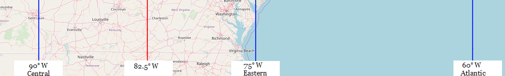
| Location |
Co-Ordinates
(Latitude, Longitude and Elevation) |
Mean solar time at noon
Central Standard Time
(Mountain Daylight Saving Time) |
Mean solar time at noon
Eastern Standard Time
(Central Daylight Saving Time) |
Mean solar time at noon
Atlantic Standard Time
(Eastern Daylight Saving Time) |
4th Street Post Office,
Jefferson County
|
Elevation: 142 meters*
Latitude: 38.252345° N
Longitude: 85.7570621° W
|
12:16:58 |
11:16:58 |
10:16:58 |
A B Combs Elementary School,
Perry County
|
Elevation: 308 meters*
Latitude: 37.2684046° N
Longitude: 83.2111347° W
|
12:27:09 |
11:27:09 |
10:27:09 |
A J Jolly Memorial School (historical),
Campbell County
|
Elevation: 153 meters*
Latitude: 38.9133989° N
Longitude: 84.2632694° W
|
12:22:56 |
11:22:56 |
10:22:56 |
A M Yealey Elementary School,
Boone County
|
Elevation: 270 meters*
Latitude: 38.9880556° N
Longitude: 84.6594444° W
|
12:21:21 |
11:21:21 |
10:21:21 |
Aaron Post Office (historical),
Clinton County
|
Elevation: 323 meters*
Latitude: 36.81347° N
Longitude: 85.18037° W
|
12:19:16 |
11:19:16 |
10:19:16 |
Aarons Run Post Office (historical),
Montgomery County
|
Elevation: 256 meters*
Latitude: 38.1275884° N
Longitude: 84.0018534° W
|
12:23:59 |
11:23:59 |
10:23:59 |
Abb Creek School,
Lawrence County
|
Elevation: 227 meters*
Latitude: 38.0989754° N
Longitude: 82.8879423° W
|
12:28:26 |
11:28:26 |
10:28:26 |
Abbott School (historical),
Campbell County
|
Elevation: 258 meters*
Latitude: 38.85984° N
Longitude: 84.433° W
|
12:22:16 |
11:22:16 |
10:22:16 |
Abel Post Office (historical),
Knox County
|
Elevation: 285 meters*
Latitude: 36.987356° N
Longitude: 83.7748916° W
|
12:24:54 |
11:24:54 |
10:24:54 |
Aberdeen Post Office,
Butler County
|
Elevation: 153 meters*
Latitude: 37.2501049° N
Longitude: 86.6837979° W
|
12:13:15 |
11:13:15 |
10:13:15 |
Abigail Post Office (historical),
Robertson County
|
Elevation: 271 meters*
Latitude: 38.57694° N
Longitude: 83.98211° W
|
12:24:04 |
11:24:04 |
10:24:04 |
Abner Post Office (historical),
Nicholas County
|
Elevation: 180 meters*
Latitude: 38.43038° N
Longitude: 83.97837° W
|
12:24:05 |
11:24:05 |
10:24:05 |
Abner School (historical),
Floyd County
|
Elevation: 388 meters*
Latitude: 37.3537138° N
Longitude: 82.6662672° W
|
12:29:20 |
11:29:20 |
10:29:20 |
Ackerly-Bingham Guidance Special Education High School,
Jefferson County
|
Elevation: 140 meters*
Latitude: 38.2481681° N
Longitude: 85.751412° W
|
12:16:59 |
11:16:59 |
10:16:59 |
Ackerly-Bingham Guidance Special Education School,
Jefferson County
|
Elevation: 140 meters*
Latitude: 38.2481681° N
Longitude: 85.751412° W
|
12:16:59 |
11:16:59 |
10:16:59 |
Acme Post Office (historical),
Fleming County
|
Elevation: 293 meters*
Latitude: 38.4735562° N
Longitude: 83.717793° W
|
12:25:07 |
11:25:07 |
10:25:07 |
Acorn School,
Pulaski County
|
Elevation: 355 meters*
Latitude: 37.1225822° N
Longitude: 84.3796597° W
|
12:22:28 |
11:22:28 |
10:22:28 |
Acup School (historical),
Perry County
|
Elevation: 297 meters*
Latitude: 37.2128738° N
Longitude: 83.1079462° W
|
12:27:34 |
11:27:34 |
10:27:34 |
Adair School,
Adair County
|
Elevation: 247 meters*
Latitude: 37.1056186° N
Longitude: 85.3185729° W
|
12:18:43 |
11:18:43 |
10:18:43 |
Adair Youth Development Center School,
Adair County
|
Elevation: 242 meters*
Latitude: 37.0850518° N
Longitude: 85.3042718° W
|
12:18:46 |
11:18:46 |
10:18:46 |
Adairville Post Office,
Logan County
|
Elevation: 182 meters*
Latitude: 36.6654351° N
Longitude: 86.8508799° W
|
12:12:35 |
11:12:35 |
10:12:35 |
Adams Davis School (historical),
Rowan County
|
Elevation: 297 meters*
Latitude: 38.3548314° N
Longitude: 83.409994° W
|
12:26:21 |
11:26:21 |
10:26:21 |
Adams Post Office (historical),
Lawrence County
|
Elevation: 196 meters*
Latitude: 38.0544444° N
Longitude: 82.7081967° W
|
12:29:10 |
11:29:10 |
10:29:10 |
Adams Post Office (historical),
Letcher County
|
Elevation: 380 meters*
Latitude: 37.1339238° N
Longitude: 82.7624155° W
|
12:28:57 |
11:28:57 |
10:28:57 |
Adams School (historical),
Elliott County
|
Elevation: 317 meters*
Latitude: 38.0633333° N
Longitude: 83.2333333° W
|
12:27:04 |
11:27:04 |
10:27:04 |
Adams School (historical),
Henry County
|
Elevation: 240 meters*
Latitude: 38.44458° N
Longitude: 85.00792° W
|
12:19:58 |
11:19:58 |
10:19:58 |
Adams School (historical),
Lawrence County
|
Elevation: 202 meters*
Latitude: 38.0469444° N
Longitude: 82.7114754° W
|
12:29:09 |
11:29:09 |
10:29:09 |
Adcock Post Office (historical),
Carroll County
|
Elevation: 209 meters*
Latitude: 38.61241° N
Longitude: 85.19606° W
|
12:19:12 |
11:19:12 |
10:19:12 |
Add Post Office (historical),
Clay County
|
Elevation: 261 meters*
Latitude: 37.1268075° N
Longitude: 83.7680331° W
|
12:24:55 |
11:24:55 |
10:24:55 |
Add School,
Clay County
|
Elevation: 264 meters*
Latitude: 37.1262006° N
Longitude: 83.7679756° W
|
12:24:55 |
11:24:55 |
10:24:55 |
Addie-Litcar Post Office (historical),
Knott County
|
Elevation: 313 meters*
Latitude: 37.2405683° N
Longitude: 82.9480234° W
|
12:28:12 |
11:28:12 |
10:28:12 |
Adele School (historical),
Morgan County
|
Elevation: 305 meters*
Latitude: 37.7567055° N
Longitude: 83.301096° W
|
12:26:47 |
11:26:47 |
10:26:47 |
Aden School (historical),
Carter County
|
Elevation: 193 meters*
Latitude: 38.2843667° N
Longitude: 83.0475167° W
|
12:27:48 |
11:27:48 |
10:27:48 |
Adkins School (historical),
Jackson County
|
Elevation: 402 meters*
Latitude: 37.3825575° N
Longitude: 83.9599903° W
|
12:24:09 |
11:24:09 |
10:24:09 |
Adolphus Post Office,
Allen County
|
Elevation: 189 meters*
Latitude: 36.687224° N
Longitude: 86.2528221° W
|
12:14:59 |
11:14:59 |
10:14:59 |
Advance School,
Greenup County
|
Elevation: 208 meters*
Latitude: 38.5164695° N
Longitude: 82.7232194° W
|
12:29:06 |
11:29:06 |
10:29:06 |
Aflex Post Office (historical),
Pike County
|
Elevation: 224 meters*
Latitude: 37.6583831° N
Longitude: 82.245497° W
|
12:31:01 |
11:31:01 |
10:31:01 |
Aflex School (historical),
Pike County
|
Elevation: 227 meters*
Latitude: 37.6586403° N
Longitude: 82.2451979° W
|
12:31:01 |
11:31:01 |
10:31:01 |
Ages Post Office (historical),
Harlan County
|
Elevation: 378 meters*
Latitude: 36.8581097° N
Longitude: 83.249399° W
|
12:27:00 |
11:27:00 |
10:27:00 |
Ahrens Educational Resource Center,
Jefferson County
|
Elevation: 139 meters*
Latitude: 38.2488057° N
Longitude: 85.7531791° W
|
12:16:59 |
11:16:59 |
10:16:59 |
Air Mail Facility Post Office,
Jefferson County
|
Elevation: 144 meters*
Latitude: 38.1891292° N
Longitude: 85.7527875° W
|
12:16:59 |
11:16:59 |
10:16:59 |
Airport Gardens Post Office (historical),
Perry County
|
Elevation: 258 meters*
Latitude: 37.2877908° N
Longitude: 83.2089423° W
|
12:27:09 |
11:27:09 |
10:27:09 |
Albany Post Office,
Clinton County
|
Elevation: 290 meters*
Latitude: 36.6931323° N
Longitude: 85.1358683° W
|
12:19:27 |
11:19:27 |
10:19:27 |
Albert Post Office (historical),
Elliott County
|
Elevation: 217 meters*
Latitude: 38.0502778° N
Longitude: 83.0569444° W
|
12:27:46 |
11:27:46 |
10:27:46 |
Alberta Post Office (historical),
Harrison County
|
Elevation: 297 meters*
Latitude: 38.4003056° N
Longitude: 84.4738423° W
|
12:22:06 |
11:22:06 |
10:22:06 |
Albright Post Office (historical),
Lincoln County
|
Elevation: 393 meters*
Latitude: 37.40833° N
Longitude: 84.5066° W
|
12:21:58 |
11:21:58 |
10:21:58 |
Alburn Post Office (historical),
Lewis County
|
Elevation: 218 meters*
Latitude: 38.668352° N
Longitude: 83.5497912° W
|
12:25:48 |
11:25:48 |
10:25:48 |
Alcorn Post Office,
Jackson County
|
Elevation: 354 meters*
Latitude: 37.5525843° N
Longitude: 84.0299274° W
|
12:23:52 |
11:23:52 |
10:23:52 |
Aldridge Rock School,
Clay County
|
Elevation: 241 meters*
Latitude: 37.3192565° N
Longitude: 83.6599151° W
|
12:25:21 |
11:25:21 |
10:25:21 |
Alex Post Office (historical),
Wayne County
|
Elevation: 308 meters*
Latitude: 36.7919378° N
Longitude: 84.9294251° W
|
12:20:16 |
11:20:16 |
10:20:16 |
Alex School,
Knox County
|
Elevation: 397 meters*
Latitude: 36.9098096° N
Longitude: 83.6065817° W
|
12:25:34 |
11:25:34 |
10:25:34 |
Alexander School,
Estill County
|
Elevation: 262 meters*
Latitude: 37.7742474° N
Longitude: 84.0793707° W
|
12:23:40 |
11:23:40 |
10:23:40 |
Alexander School,
Monroe County
|
Elevation: 251 meters*
Latitude: 36.6786659° N
Longitude: 85.844422° W
|
12:16:37 |
11:16:37 |
10:16:37 |
Alexandria Post Office,
Campbell County
|
Elevation: 245 meters*
Latitude: 38.9860005° N
Longitude: 84.3990975° W
|
12:22:24 |
11:22:24 |
10:22:24 |
Alford Post Office (historical),
Mercer County
|
Elevation: 243 meters*
Latitude: 37.92023° N
Longitude: 84.97157° W
|
12:20:06 |
11:20:06 |
10:20:06 |
Alfred Binet Education School,
Jefferson County
|
Elevation: 150 meters*
Latitude: 38.2089718° N
Longitude: 85.6577682° W
|
12:17:22 |
11:17:22 |
10:17:22 |
Alger Post Office (historical),
Clay County
|
Elevation: 235 meters*
Latitude: 37.31446° N
Longitude: 83.7301917° W
|
12:25:04 |
11:25:04 |
10:25:04 |
Alger Post Office (historical),
Estill County
|
Elevation: 251 meters*
Latitude: 37.6702633° N
Longitude: 84.0792727° W
|
12:23:40 |
11:23:40 |
10:23:40 |
Alhambra Post Office (historical),
Robertson County
|
Elevation: 276 meters*
Latitude: 38.49009° N
Longitude: 83.94505° W
|
12:24:13 |
11:24:13 |
10:24:13 |
Alice Lloyd College,
Knott County
|
Elevation: 365 meters*
Latitude: 37.3353776° N
Longitude: 82.8712719° W
|
12:28:30 |
11:28:30 |
10:28:30 |
Alice Lloyd Junior College,
Knott County
|
Elevation: 311 meters*
Latitude: 37.3353776° N
Longitude: 82.8754387° W
|
12:28:29 |
11:28:29 |
10:28:29 |
Alice Post Office (historical),
Letcher County
|
Elevation: 327 meters*
Latitude: 37.1137914° N
Longitude: 82.9070176° W
|
12:28:22 |
11:28:22 |
10:28:22 |
Alice Post Office (historical),
Morgan County
|
Elevation: 245 meters*
Latitude: 37.9519828° N
Longitude: 83.1625307° W
|
12:27:20 |
11:27:20 |
10:27:20 |
Aliceton Post Office (historical),
Boyle County
|
Elevation: 294 meters*
Latitude: 37.59137° N
Longitude: 85.0315° W
|
12:19:52 |
11:19:52 |
10:19:52 |
Alka Post Office (historical),
Pike County
|
Elevation: 267 meters*
Latitude: 37.3799447° N
Longitude: 82.4755616° W
|
12:30:05 |
11:30:05 |
10:30:05 |
Alka Post Office (historical),
Pike County
|
Elevation: 295 meters*
Latitude: 37.3694444° N
Longitude: 82.4911111° W
|
12:30:02 |
11:30:02 |
10:30:02 |
Allais Post Office (historical),
Perry County
|
Elevation: 272 meters*
Latitude: 37.2658667° N
Longitude: 83.1837142° W
|
12:27:15 |
11:27:15 |
10:27:15 |
Allcorn School,
Greenup County
|
Elevation: 181 meters*
Latitude: 38.5364682° N
Longitude: 82.9032252° W
|
12:28:23 |
11:28:23 |
10:28:23 |
Allen Central High School,
Floyd County
|
Elevation: 215 meters*
Latitude: 37.5175988° N
Longitude: 82.808494° W
|
12:28:45 |
11:28:45 |
10:28:45 |
Allen Post Office (historical),
Magoffin County
|
Elevation: 299 meters*
Latitude: 37.6270566° N
Longitude: 82.9388725° W
|
12:28:14 |
11:28:14 |
10:28:14 |
Allen Post Office,
Floyd County
|
Elevation: 203 meters*
Latitude: 37.6143847° N
Longitude: 82.7205131° W
|
12:29:07 |
11:29:07 |
10:29:07 |
Allen School,
Casey County
|
Elevation: 324 meters*
Latitude: 37.3628486° N
Longitude: 85.0566239° W
|
12:19:46 |
11:19:46 |
10:19:46 |
Allen School,
Magoffin County
|
Elevation: 319 meters*
Latitude: 37.6128737° N
Longitude: 82.9376652° W
|
12:28:14 |
11:28:14 |
10:28:14 |
Allens Store Post Office (historical),
Casey County
|
Elevation: 229 meters*
Latitude: 37.23962° N
Longitude: 84.97234° W
|
12:20:06 |
11:20:06 |
10:20:06 |
Allensville Post Office,
Todd County
|
Elevation: 180 meters*
Latitude: 36.7180484° N
Longitude: 87.0688098° W
|
12:11:43 |
11:11:43 |
10:11:43 |
Alley Post Office,
Boyd County
|
Elevation: 193 meters*
Latitude: 38.3011167° N
Longitude: 82.709586° W
|
12:29:09 |
11:29:09 |
10:29:09 |
Alliance School (historical),
Jessamine County
|
Elevation: 274 meters*
Latitude: 37.8215075° N
Longitude: 84.6335928° W
|
12:21:27 |
11:21:27 |
10:21:27 |
Allock Post Office (historical),
Perry County
|
Elevation: 339 meters*
Latitude: 37.2283845° N
Longitude: 83.0732043° W
|
12:27:42 |
11:27:42 |
10:27:42 |
Alpha Post Office (historical),
Clinton County
|
Elevation: 298 meters*
Latitude: 36.76358° N
Longitude: 85.01191° W
|
12:19:57 |
11:19:57 |
10:19:57 |
Alpha Post Office,
Wayne County
|
Elevation: 301 meters*
Latitude: 36.768607° N
Longitude: 84.9989644° W
|
12:20:00 |
11:20:00 |
10:20:00 |
Alton Post Office (historical),
Anderson County
|
Elevation: 252 meters*
Latitude: 38.08968° N
Longitude: 84.93436° W
|
12:20:15 |
11:20:15 |
10:20:15 |
Alton School (historical),
Anderson County
|
Elevation: 251 meters*
Latitude: 38.09296° N
Longitude: 84.93234° W
|
12:20:16 |
11:20:16 |
10:20:16 |
Alton Station Post Office (historical),
Anderson County
|
Elevation: 244 meters*
Latitude: 38.07806° N
Longitude: 84.94148° W
|
12:20:14 |
11:20:14 |
10:20:14 |
Altro School,
Breathitt County
|
Elevation: 242 meters*
Latitude: 37.3753695° N
Longitude: 83.3899034° W
|
12:26:26 |
11:26:26 |
10:26:26 |
Alum Lick School,
Floyd County
|
Elevation: 223 meters*
Latitude: 37.5792642° N
Longitude: 82.8448842° W
|
12:28:37 |
11:28:37 |
10:28:37 |
Alum Spring School,
Butler County
|
Elevation: 188 meters*
Latitude: 37.124767° N
Longitude: 86.7544372° W
|
12:12:58 |
11:12:58 |
10:12:58 |
Alum Springs Post Office (historical),
Boyle County
|
Elevation: 350 meters*
Latitude: 37.59606° N
Longitude: 84.84097° W
|
12:20:38 |
11:20:38 |
10:20:38 |
Alumbaugh Post Office (historical),
Estill County
|
Elevation: 195 meters*
Latitude: 37.6014399° N
Longitude: 83.9225509° W
|
12:24:18 |
11:24:18 |
10:24:18 |
Alva Post Office (historical),
Harlan County
|
Elevation: 440 meters*
Latitude: 36.7348309° N
Longitude: 83.4242095° W
|
12:26:18 |
11:26:18 |
10:26:18 |
Alvan Drew School (historical),
Wolfe County
|
Elevation: 387 meters*
Latitude: 37.762306° N
Longitude: 83.6111389° W
|
12:25:33 |
11:25:33 |
10:25:33 |
Alvaton Post Office,
Warren County
|
Elevation: 199 meters*
Latitude: 36.8696214° N
Longitude: 86.3502274° W
|
12:14:35 |
11:14:35 |
10:14:35 |
Alvaton School,
Warren County
|
Elevation: 199 meters*
Latitude: 36.8775421° N
Longitude: 86.3522122° W
|
12:14:35 |
11:14:35 |
10:14:35 |
Amanda Post Office,
Boyd County
|
Elevation: 209 meters*
Latitude: 38.4983333° N
Longitude: 82.708333° W
|
12:29:10 |
11:29:10 |
10:29:10 |
Amazon Post Office (historical),
Knott County
|
Elevation: 374 meters*
Latitude: 37.2739175° N
Longitude: 82.8438208° W
|
12:28:37 |
11:28:37 |
10:28:37 |
Ambrose Post Office (historical),
Jessamine County
|
Elevation: 258 meters*
Latitude: 37.8371629° N
Longitude: 84.5504306° W
|
12:21:47 |
11:21:47 |
10:21:47 |
Amburgey Post Office (historical),
Knott County
|
Elevation: 340 meters*
Latitude: 37.270591° N
Longitude: 82.9806859° W
|
12:28:04 |
11:28:04 |
10:28:04 |
Amburgey Post Office (historical),
Knott County
|
Elevation: 337 meters*
Latitude: 37.2484249° N
Longitude: 82.995109° W
|
12:28:01 |
11:28:01 |
10:28:01 |
America School (historical),
Johnson County
|
Elevation: 194 meters*
Latitude: 37.7841667° N
Longitude: 82.827222° W
|
12:28:41 |
11:28:41 |
10:28:41 |
Amerina School,
Estill County
|
Elevation: 281 meters*
Latitude: 37.7220257° N
Longitude: 84.0777045° W
|
12:23:41 |
11:23:41 |
10:23:41 |
Ammy Post Office (historical),
Clay County
|
Elevation: 241 meters*
Latitude: 37.2780756° N
Longitude: 83.6796848° W
|
12:25:16 |
11:25:16 |
10:25:16 |
Amster Post Office (historical),
Madison County
|
Elevation: 192 meters*
Latitude: 37.8757863° N
Longitude: 84.2833692° W
|
12:22:51 |
11:22:51 |
10:22:51 |
Amyx School (historical),
Wolfe County
|
Elevation: 292 meters*
Latitude: 37.7877136° N
Longitude: 83.354397° W
|
12:26:34 |
11:26:34 |
10:26:34 |
Anchor Post Office (historical),
Knox County
|
Elevation: 413 meters*
Latitude: 36.7476619° N
Longitude: 83.8819354° W
|
12:24:28 |
11:24:28 |
10:24:28 |
Anchorage Post Office,
Jefferson County
|
Elevation: 215 meters*
Latitude: 38.2660127° N
Longitude: 85.5409512° W
|
12:17:50 |
11:17:50 |
10:17:50 |
Anco Post Office (historical),
Knott County
|
Elevation: 395 meters*
Latitude: 37.2489725° N
Longitude: 83.0550806° W
|
12:27:46 |
11:27:46 |
10:27:46 |
Anderson D Owens Elementary School,
Campbell County
|
Elevation: 162 meters*
Latitude: 39.0845047° N
Longitude: 84.4896644° W
|
12:22:02 |
11:22:02 |
10:22:02 |
Anderson School (historical),
Todd County
|
Elevation: 188 meters*
Latitude: 36.7050431° N
Longitude: 87.1605577° W
|
12:11:21 |
11:11:21 |
10:11:21 |
Andrew Jackson School,
McCracken County
|
Elevation: 104 meters*
Latitude: 37.0825557° N
Longitude: 88.6261599° W
|
12:05:29 |
11:05:29 |
10:05:29 |
Angela Merici High School,
Jefferson County
|
Elevation: 137 meters*
Latitude: 38.1725699° N
Longitude: 85.8321856° W
|
12:16:40 |
11:16:40 |
10:16:40 |
Anglin Falls School,
Rockcastle County
|
Elevation: 422 meters*
Latitude: 37.4923069° N
Longitude: 84.2227107° W
|
12:23:06 |
11:23:06 |
10:23:06 |
Anglin School (historical),
Carter County
|
Elevation: 173 meters*
Latitude: 38.3838056° N
Longitude: 82.9307972° W
|
12:28:16 |
11:28:16 |
10:28:16 |
Anglin School,
Owsley County
|
Elevation: 223 meters*
Latitude: 37.3481448° N
Longitude: 83.7065835° W
|
12:25:10 |
11:25:10 |
10:25:10 |
Annshire Annex Post Office,
Jefferson County
|
Elevation: 146 meters*
Latitude: 38.1933902° N
Longitude: 85.7003201° W
|
12:17:11 |
11:17:11 |
10:17:11 |
Annville Post Office (historical),
Jackson County
|
Elevation: 337 meters*
Latitude: 37.318995° N
Longitude: 83.9684618° W
|
12:24:07 |
11:24:07 |
10:24:07 |
Annville Post Office,
Jackson County
|
Elevation: 337 meters*
Latitude: 37.3227958° N
Longitude: 83.9559817° W
|
12:24:10 |
11:24:10 |
10:24:10 |
Antepast Post Office (historical),
Clay County
|
Elevation: 258 meters*
Latitude: 37.241783° N
Longitude: 83.6351902° W
|
12:25:27 |
11:25:27 |
10:25:27 |
Antepast School,
Clay County
|
Elevation: 257 meters*
Latitude: 37.2414795° N
Longitude: 83.6357481° W
|
12:25:27 |
11:25:27 |
10:25:27 |
Antioch Post Office (historical),
Washington County
|
Elevation: 246 meters*
Latitude: 37.88671° N
Longitude: 85.08564° W
|
12:19:39 |
11:19:39 |
10:19:39 |
Antioch School (historical),
Carter County
|
Elevation: 199 meters*
Latitude: 38.1864194° N
Longitude: 82.95° W
|
12:28:12 |
11:28:12 |
10:28:11 |
Antioch School (historical),
Garrard County
|
Elevation: 283 meters*
Latitude: 37.66645° N
Longitude: 84.53145° W
|
12:21:52 |
11:21:52 |
10:21:52 |
Antioch School (historical),
Montgomery County
|
Elevation: 257 meters*
Latitude: 38.0155103° N
Longitude: 83.8272363° W
|
12:24:41 |
11:24:41 |
10:24:41 |
Antioch School (historical),
Pendleton County
|
Elevation: 270 meters*
Latitude: 38.69791° N
Longitude: 84.27993° W
|
12:22:52 |
11:22:52 |
10:22:52 |
Antioch School,
Barren County
|
Elevation: 238 meters*
Latitude: 36.7792197° N
Longitude: 85.9063669° W
|
12:16:22 |
11:16:22 |
10:16:22 |
Antioch School,
Clay County
|
Elevation: 276 meters*
Latitude: 37.0356451° N
Longitude: 83.8138108° W
|
12:24:44 |
11:24:44 |
10:24:44 |
Antioch School,
Floyd County
|
Elevation: 241 meters*
Latitude: 37.43899° N
Longitude: 82.6543225° W
|
12:29:22 |
11:29:22 |
10:29:22 |
Antioch School,
Monroe County
|
Elevation: 187 meters*
Latitude: 36.7350596° N
Longitude: 85.5488569° W
|
12:17:48 |
11:17:48 |
10:17:48 |
Apperson Post Office (historical),
Menifee County
|
Elevation: 238 meters*
Latitude: 37.8982756° N
Longitude: 83.6400702° W
|
12:25:26 |
11:25:26 |
10:25:26 |
Apple Post Office (historical),
Morgan County
|
Elevation: 299 meters*
Latitude: 37.894389° N
Longitude: 83.4171529° W
|
12:26:19 |
11:26:19 |
10:26:19 |
Aquinas Academy,
Jefferson County
|
Elevation: 161 meters*
Latitude: 38.2364596° N
Longitude: 85.6282941° W
|
12:17:29 |
11:17:29 |
10:17:29 |
Arabia Post Office (historical),
Lincoln County
|
Elevation: 298 meters*
Latitude: 37.40901° N
Longitude: 84.7371° W
|
12:21:03 |
11:21:03 |
10:21:03 |
Ararat School,
Boyd County
|
Elevation: 226 meters*
Latitude: 38.2933833° N
Longitude: 82.671386° W
|
12:29:18 |
11:29:18 |
10:29:18 |
Arat School,
Knox County
|
Elevation: 317 meters*
Latitude: 37.0203678° N
Longitude: 83.8988143° W
|
12:24:24 |
11:24:24 |
10:24:24 |
Arcadia Post Office (historical),
Madison County
|
Elevation: 311 meters*
Latitude: 37.68358° N
Longitude: 84.25948° W
|
12:22:57 |
11:22:57 |
10:22:57 |
Arch Post Office (historical),
Letcher County
|
Elevation: 423 meters*
Latitude: 37.1896396° N
Longitude: 82.7844528° W
|
12:28:51 |
11:28:51 |
10:28:51 |
Ardery Post Office (historical),
Jackson County
|
Elevation: 279 meters*
Latitude: 37.3359124° N
Longitude: 84.0930545° W
|
12:23:37 |
11:23:37 |
10:23:37 |
Argillite Post Office,
Greenup County
|
Elevation: 172 meters*
Latitude: 38.4957505° N
Longitude: 82.8314759° W
|
12:28:40 |
11:28:40 |
10:28:40 |
Argo Post Office (historical),
Pike County
|
Elevation: 274 meters*
Latitude: 37.4940094° N
Longitude: 82.0539799° W
|
12:31:47 |
11:31:47 |
10:31:47 |
Argyle Post Office (historical),
Casey County
|
Elevation: 369 meters*
Latitude: 37.22659° N
Longitude: 84.80681° W
|
12:20:46 |
11:20:46 |
10:20:46 |
Ariadne Post Office (historical),
Clinton County
|
Elevation: 294 meters*
Latitude: 36.84437° N
Longitude: 85.18226° W
|
12:19:16 |
11:19:16 |
10:19:16 |
Ariel Academy (historical),
Jessamine County
|
Elevation: 278 meters*
Latitude: 37.7850237° N
Longitude: 84.6145169° W
|
12:21:32 |
11:21:32 |
10:21:32 |
Arjay Post Office,
Bell County
|
Elevation: 319 meters*
Latitude: 36.8040269° N
Longitude: 83.6489088° W
|
12:25:24 |
11:25:24 |
10:25:24 |
Arlen Post Office (historical),
Clark County
|
Elevation: 200 meters*
Latitude: 37.8754154° N
Longitude: 84.1192409° W
|
12:23:31 |
11:23:31 |
10:23:31 |
Arlington Elementary School,
Fayette County
|
Elevation: 300 meters*
Latitude: 38.0591136° N
Longitude: 84.4778125° W
|
12:22:05 |
11:22:05 |
10:22:05 |
Arlington Post Office,
Carlisle County
|
Elevation: 108 meters*
Latitude: 36.7904551° N
Longitude: 89.0121633° W
|
12:03:57 |
11:03:57 |
10:03:57 |
Arminta Post Office (historical),
Letcher County
|
Elevation: 571 meters*
Latitude: 37.1585729° N
Longitude: 82.0242845° W
|
12:31:54 |
11:31:54 |
10:31:54 |
Armstrong Post Office (historical),
Carter County
|
Elevation: 272 meters*
Latitude: 38.3305556° N
Longitude: 83.2091694° W
|
12:27:09 |
11:27:09 |
10:27:09 |
Armstrong School,
Lewis County
|
Elevation: 197 meters*
Latitude: 38.5248° N
Longitude: 83.2426809° W
|
12:27:01 |
11:27:01 |
10:27:01 |
Arnett Elementary School,
Kenton County
|
Elevation: 265 meters*
Latitude: 39.0058333° N
Longitude: 84.5927778° W
|
12:21:37 |
11:21:37 |
10:21:37 |
Arnett Post Office (historical),
Owsley County
|
Elevation: 255 meters*
Latitude: 37.4109649° N
Longitude: 83.5678413° W
|
12:25:43 |
11:25:43 |
10:25:43 |
Arnett School (historical),
Magoffin County
|
Elevation: 287 meters*
Latitude: 37.6832127° N
Longitude: 83.0546208° W
|
12:27:46 |
11:27:46 |
10:27:46 |
Arnette Post Office (historical),
Morgan County
|
Elevation: 220 meters*
Latitude: 37.9734684° N
Longitude: 83.3939276° W
|
12:26:25 |
11:26:25 |
10:26:25 |
Arnold Elementary School (historical),
Campbell County
|
Elevation: 153 meters*
Latitude: 39.0902778° N
Longitude: 84.4969444° W
|
12:22:00 |
11:22:00 |
10:22:00 |
Arnold School,
Meade County
|
Elevation: 255 meters*
Latitude: 37.9531218° N
Longitude: 86.3152518° W
|
12:14:44 |
11:14:44 |
10:14:44 |
Arrowood School,
Breathitt County
|
Elevation: 241 meters*
Latitude: 37.4400905° N
Longitude: 83.43296° W
|
12:26:16 |
11:26:16 |
10:26:16 |
Artemus High School (historical),
Knox County
|
Elevation: 307 meters*
Latitude: 36.831409° N
Longitude: 83.8368961° W
|
12:24:39 |
11:24:39 |
10:24:39 |
Artemus Post Office,
Knox County
|
Elevation: 305 meters*
Latitude: 36.8292579° N
Longitude: 83.8392318° W
|
12:24:38 |
11:24:38 |
10:24:38 |
Arthur Post Office (historical),
Letcher County
|
Elevation: 438 meters*
Latitude: 36.9885764° N
Longitude: 83.0566324° W
|
12:27:46 |
11:27:46 |
10:27:46 |
Artville Post Office (historical),
Menifee County
|
Elevation: 298 meters*
Latitude: 37.9239307° N
Longitude: 83.4632126° W
|
12:26:08 |
11:26:08 |
10:26:08 |
Ary Post Office (historical),
Perry County
|
Elevation: 267 meters*
Latitude: 37.3669296° N
Longitude: 83.1518937° W
|
12:27:23 |
11:27:23 |
10:27:23 |
Ary Post Office,
Perry County
|
Elevation: 261 meters*
Latitude: 37.3780827° N
Longitude: 83.1469991° W
|
12:27:24 |
11:27:24 |
10:27:24 |
Asbury Post Office (historical),
Madison County
|
Elevation: 322 meters*
Latitude: 37.54488° N
Longitude: 84.32629° W
|
12:22:41 |
11:22:41 |
10:22:41 |
Ash Post Office (historical),
Owsley County
|
Elevation: 242 meters*
Latitude: 37.437919° N
Longitude: 83.5815473° W
|
12:25:40 |
11:25:40 |
10:25:40 |
Ashcamp Post Office,
Pike County
|
Elevation: 326 meters*
Latitude: 37.2661251° N
Longitude: 82.4335975° W
|
12:30:15 |
11:30:15 |
10:30:15 |
Asher Fork Post Office (historical),
Clay County
|
Elevation: 419 meters*
Latitude: 37.0081251° N
Longitude: 83.5954385° W
|
12:25:37 |
11:25:37 |
10:25:37 |
Asher Post Office (historical),
Leslie County
|
Elevation: 292 meters*
Latitude: 37.0449264° N
Longitude: 83.4041414° W
|
12:26:23 |
11:26:23 |
10:26:23 |
Ashers Fork School,
Clay County
|
Elevation: 301 meters*
Latitude: 37.0031442° N
Longitude: 83.6363044° W
|
12:25:27 |
11:25:27 |
10:25:27 |
Ashland Elementary School,
Fayette County
|
Elevation: 304 meters*
Latitude: 38.0379885° N
Longitude: 84.4809574° W
|
12:22:04 |
11:22:04 |
10:22:04 |
Ashland Post Office,
Boyd County
|
Elevation: 170 meters*
Latitude: 38.479706° N
Longitude: 82.6457175° W
|
12:29:25 |
11:29:25 |
10:29:25 |
Ashland School (historical),
Shelby County
|
Elevation: 264 meters*
Latitude: 38.22577° N
Longitude: 85.11083° W
|
12:19:33 |
11:19:33 |
10:19:33 |
Ashland State Vocational/Technical School,
Boyd County
|
Elevation: 193 meters*
Latitude: 38.4459147° N
Longitude: 82.6884954° W
|
12:29:14 |
11:29:14 |
10:29:14 |
Ashland Vocational School,
Boyd County
|
Elevation: 167 meters*
Latitude: 38.4514704° N
Longitude: 82.6126599° W
|
12:29:32 |
11:29:32 |
10:29:32 |
Aspen Grove Post Office (historical),
Pendleton County
|
Elevation: 278 meters*
Latitude: 38.8400456° N
Longitude: 84.2901015° W
|
12:22:50 |
11:22:50 |
10:22:50 |
Aspen Grove School (historical),
Campbell County
|
Elevation: 221 meters*
Latitude: 38.8969444° N
Longitude: 84.3880556° W
|
12:22:26 |
11:22:26 |
10:22:26 |
Aspen Grove Seminary (historical),
Pendleton County
|
Elevation: 271 meters*
Latitude: 38.8406197° N
Longitude: 84.289998° W
|
12:22:50 |
11:22:50 |
10:22:50 |
Assumption High School,
Jefferson County
|
Elevation: 161 meters*
Latitude: 38.2170147° N
Longitude: 85.6769054° W
|
12:17:17 |
11:17:17 |
10:17:17 |
Athens Elementary School,
Fayette County
|
Elevation: 293 meters*
Latitude: 37.949523° N
Longitude: 84.3677117° W
|
12:22:31 |
11:22:31 |
10:22:31 |
Atherton High School,
Jefferson County
|
Elevation: 165 meters*
Latitude: 38.2128481° N
Longitude: 85.6880167° W
|
12:17:14 |
11:17:14 |
10:17:14 |
Atkinson School,
Jefferson County
|
Elevation: 137 meters*
Latitude: 38.2645145° N
Longitude: 85.7982969° W
|
12:16:48 |
11:16:48 |
10:16:48 |
Atoka Post Office (historical),
Boyle County
|
Elevation: 271 meters*
Latitude: 37.64968° N
Longitude: 84.86355° W
|
12:20:32 |
11:20:32 |
10:20:32 |
Atterson Post Office (historical),
Casey County
|
Elevation: 254 meters*
Latitude: 37.33874° N
Longitude: 85.07873° W
|
12:19:41 |
11:19:41 |
10:19:41 |
Atterson School (historical),
Casey County
|
Elevation: 248 meters*
Latitude: 37.33328° N
Longitude: 85.08235° W
|
12:19:40 |
11:19:40 |
10:19:40 |
Attilla Post Office (historical),
Larue County
|
Elevation: 283 meters*
Latitude: 37.50373° N
Longitude: 85.50638° W
|
12:17:58 |
11:17:58 |
10:17:58 |
Atwood Post Office (historical),
Kenton County
|
Elevation: 269 meters*
Latitude: 38.87279° N
Longitude: 84.53756° W
|
12:21:50 |
11:21:50 |
10:21:50 |
Atwood School,
Casey County
|
Elevation: 376 meters*
Latitude: 37.4034053° N
Longitude: 85.016068° W
|
12:19:56 |
11:19:56 |
10:19:56 |
Auburn Post Office,
Logan County
|
Elevation: 197 meters*
Latitude: 36.862438° N
Longitude: 86.7117909° W
|
12:13:09 |
11:13:09 |
10:13:09 |
Auburndale Elementary School,
Jefferson County
|
Elevation: 147 meters*
Latitude: 38.1351404° N
Longitude: 85.7729013° W
|
12:16:54 |
11:16:54 |
10:16:54 |
Audubon School,
Henderson County
|
Elevation: 122 meters*
Latitude: 37.8253205° N
Longitude: 87.5789016° W
|
12:09:41 |
11:09:41 |
10:09:41 |
Audubon School,
Jefferson County
|
Elevation: 153 meters*
Latitude: 38.2084037° N
Longitude: 85.7310728° W
|
12:17:04 |
11:17:04 |
10:17:04 |
Audubon Youth Development Center,
Jefferson County
|
Elevation: 187 meters*
Latitude: 38.267246° N
Longitude: 85.5896594° W
|
12:17:38 |
11:17:38 |
10:17:38 |
Augusta Post Office,
Bracken County
|
Elevation: 160 meters*
Latitude: 38.7710573° N
Longitude: 84.0076479° W
|
12:23:58 |
11:23:58 |
10:23:58 |
Aulick Post Office (historical),
Pendleton County
|
Elevation: 198 meters*
Latitude: 38.60091° N
Longitude: 84.2156723° W
|
12:23:08 |
11:23:08 |
10:23:08 |
Ault Post Office (historical),
Elliott County
|
Elevation: 322 meters*
Latitude: 38.1975° N
Longitude: 83.2130556° W
|
12:27:08 |
11:27:08 |
10:27:08 |
Aurora School,
Marshall County
|
Elevation: 152 meters*
Latitude: 36.7792205° N
Longitude: 88.1597527° W
|
12:07:21 |
11:07:21 |
10:07:21 |
Austin Post Office,
Barren County
|
Elevation: 234 meters*
Latitude: 36.8258902° N
Longitude: 86.0162229° W
|
12:15:56 |
11:15:56 |
10:15:56 |
Austin School,
Calloway County
|
Elevation: 162 meters*
Latitude: 36.6097778° N
Longitude: 88.3100386° W
|
12:06:45 |
11:06:45 |
10:06:45 |
Austin-Tracy School,
Barren County
|
Elevation: 228 meters*
Latitude: 36.8303275° N
Longitude: 86.0319258° W
|
12:15:52 |
11:15:52 |
10:15:52 |
Auxier Post Office,
Floyd County
|
Elevation: 187 meters*
Latitude: 37.7384617° N
Longitude: 82.760783° W
|
12:28:57 |
11:28:57 |
10:28:57 |
Avawam Post Office,
Perry County
|
Elevation: 306 meters*
Latitude: 37.2210354° N
Longitude: 83.2799642° W
|
12:26:52 |
11:26:52 |
10:26:52 |
Avawam School,
Perry County
|
Elevation: 291 meters*
Latitude: 37.2284277° N
Longitude: 83.2735103° W
|
12:26:54 |
11:26:54 |
10:26:54 |
Avena Post Office (historical),
Harrison County
|
Elevation: 287 meters*
Latitude: 38.4974399° N
Longitude: 84.2546069° W
|
12:22:58 |
11:22:58 |
10:22:58 |
Avena School (historical),
Harrison County
|
Elevation: 242 meters*
Latitude: 38.5174906° N
Longitude: 84.2548279° W
|
12:22:58 |
11:22:58 |
10:22:58 |
Avery Post Office (historical),
Owen County
|
Elevation: 138 meters*
Latitude: 38.5238389° N
Longitude: 85.0238404° W
|
12:19:54 |
11:19:54 |
10:19:54 |
Avondale Post Office (historical),
Harlan County
|
Elevation: 506 meters*
Latitude: 36.6996208° N
Longitude: 83.3973842° W
|
12:26:24 |
11:26:24 |
10:26:24 |
Avondale Post Office,
McCracken County
|
Elevation: 107 meters*
Latitude: 37.0720527° N
Longitude: 88.6351796° W
|
12:05:27 |
11:05:27 |
10:05:27 |
Avondale School (historical),
Harlan County
|
Elevation: 504 meters*
Latitude: 36.7005677° N
Longitude: 83.3976607° W
|
12:26:24 |
11:26:24 |
10:26:24 |
Avoy Post Office (historical),
Lincoln County
|
Elevation: 387 meters*
Latitude: 37.3822° N
Longitude: 84.50937° W
|
12:21:57 |
11:21:57 |
10:21:57 |
Awe Post Office (historical),
Lewis County
|
Elevation: 281 meters*
Latitude: 38.4216318° N
Longitude: 83.344523° W
|
12:26:37 |
11:26:37 |
10:26:37 |
Ayersville Post Office (historical),
Lawrence County
|
Elevation: 240 meters*
Latitude: 37.9941667° N
Longitude: 82.9040984° W
|
12:28:23 |
11:28:23 |
10:28:23 |
Bac Post Office (historical),
Mercer County
|
Elevation: 287 meters*
Latitude: 37.70637° N
Longitude: 84.94835° W
|
12:20:12 |
11:20:12 |
10:20:12 |
Back School (historical),
Menifee County
|
Elevation: 349 meters*
Latitude: 37.9264228° N
Longitude: 83.4891413° W
|
12:26:02 |
11:26:02 |
10:26:02 |
Back School,
Magoffin County
|
Elevation: 282 meters*
Latitude: 37.6828696° N
Longitude: 83.1779518° W
|
12:27:17 |
11:27:17 |
10:27:17 |
Backbone School (historical),
Wayne County
|
Elevation: 292 meters*
Latitude: 36.8434769° N
Longitude: 84.9904954° W
|
12:20:02 |
11:20:02 |
10:20:02 |
Bad Creek School,
Leslie County
|
Elevation: 301 meters*
Latitude: 37.0378678° N
Longitude: 83.4124063° W
|
12:26:21 |
11:26:21 |
10:26:21 |
Bagdad Post Office,
Shelby County
|
Elevation: 274 meters*
Latitude: 38.2602577° N
Longitude: 85.0590623° W
|
12:19:45 |
11:19:45 |
10:19:45 |
Bagdad School (historical),
Shelby County
|
Elevation: 269 meters*
Latitude: 38.25805° N
Longitude: 85.05991° W
|
12:19:45 |
11:19:45 |
10:19:45 |
Bailey Branch School,
Leslie County
|
Elevation: 302 meters*
Latitude: 37.1637047° N
Longitude: 83.2743437° W
|
12:26:54 |
11:26:54 |
10:26:54 |
Bailey Fork School,
Knott County
|
Elevation: 354 meters*
Latitude: 37.3645432° N
Longitude: 82.9209958° W
|
12:28:18 |
11:28:18 |
10:28:18 |
Bailey Post Office (historical),
Harlan County
|
Elevation: 399 meters*
Latitude: 36.8704901° N
Longitude: 83.1870799° W
|
12:27:15 |
11:27:15 |
10:27:15 |
Bailey School (historical),
Knox County
|
Elevation: 303 meters*
Latitude: 36.910046° N
Longitude: 83.9057733° W
|
12:24:22 |
11:24:22 |
10:24:22 |
Bailey School,
Allen County
|
Elevation: 217 meters*
Latitude: 36.8458761° N
Longitude: 86.2630439° W
|
12:14:56 |
11:14:56 |
10:14:56 |
Baileyfield School (historical),
Wolfe County
|
Elevation: 255 meters*
Latitude: 37.6817334° N
Longitude: 83.4640606° W
|
12:26:08 |
11:26:08 |
10:26:08 |
Baileys Store Post Office (historical),
Shelby County
|
Elevation: 262 meters*
Latitude: 38.32745° N
Longitude: 84.96526° W
|
12:20:08 |
11:20:08 |
10:20:08 |
Baileys Switch Post Office (historical),
Knox County
|
Elevation: 297 meters*
Latitude: 36.9120857° N
Longitude: 83.8998834° W
|
12:24:24 |
11:24:24 |
10:24:24 |
Baker Fork School,
Leslie County
|
Elevation: 446 meters*
Latitude: 37.0550923° N
Longitude: 83.2773995° W
|
12:26:53 |
11:26:53 |
10:26:53 |
Baker Gap School,
Lawrence County
|
Elevation: 216 meters*
Latitude: 37.9789808° N
Longitude: 82.4934852° W
|
12:30:01 |
11:30:01 |
10:30:01 |
Baker Post Office (historical),
Knott County
|
Elevation: 304 meters*
Latitude: 37.4502979° N
Longitude: 83.022421° W
|
12:27:54 |
11:27:54 |
10:27:54 |
Baker Post Office (historical),
Letcher County
|
Elevation: 423 meters*
Latitude: 37.2105526° N
Longitude: 82.7202448° W
|
12:29:07 |
11:29:07 |
10:29:07 |
Baker Post Office (historical),
Perry County
|
Elevation: 263 meters*
Latitude: 37.2743432° N
Longitude: 83.2884322° W
|
12:26:50 |
11:26:50 |
10:26:50 |
Baker School (historical),
Campbell County
|
Elevation: 164 meters*
Latitude: 38.8442° N
Longitude: 84.45403° W
|
12:22:11 |
11:22:11 |
10:22:11 |
Baker School (historical),
Garrard County
|
Elevation: 293 meters*
Latitude: 37.54965° N
Longitude: 84.36726° W
|
12:22:31 |
11:22:31 |
10:22:31 |
Baker School (historical),
Knott County
|
Elevation: 315 meters*
Latitude: 37.4525967° N
Longitude: 83.0273892° W
|
12:27:53 |
11:27:53 |
10:27:53 |
Baker School (historical),
Knox County
|
Elevation: 317 meters*
Latitude: 36.9632384° N
Longitude: 83.9420332° W
|
12:24:13 |
11:24:13 |
10:24:13 |
Baker School,
Jackson County
|
Elevation: 414 meters*
Latitude: 37.5495283° N
Longitude: 84.1357634° W
|
12:23:27 |
11:23:27 |
10:23:27 |
Baker School,
Lawrence County
|
Elevation: 204 meters*
Latitude: 38.185085° N
Longitude: 82.7804399° W
|
12:28:52 |
11:28:52 |
10:28:52 |
Bakerton School,
Cumberland County
|
Elevation: 195 meters*
Latitude: 36.8536733° N
Longitude: 85.341629° W
|
12:18:38 |
11:18:38 |
10:18:38 |
Bald Eagle Post Office (historical),
Bath County
|
Elevation: 243 meters*
Latitude: 38.2037301° N
Longitude: 83.8562193° W
|
12:24:34 |
11:24:34 |
10:24:34 |
Bald Knob High School,
Franklin County
|
Elevation: 269 meters*
Latitude: 38.2725707° N
Longitude: 84.9391182° W
|
12:20:14 |
11:20:14 |
10:20:14 |
Bald Knob Post Office (historical),
Franklin County
|
Elevation: 253 meters*
Latitude: 38.3169869° N
Longitude: 84.9468382° W
|
12:20:12 |
11:20:12 |
10:20:12 |
Bald Knob School,
McCreary County
|
Elevation: 422 meters*
Latitude: 36.6536877° N
Longitude: 84.5791062° W
|
12:21:41 |
11:21:41 |
10:21:41 |
Bald Point School (historical),
Lewis County
|
Elevation: 269 meters*
Latitude: 38.3446149° N
Longitude: 83.3417328° W
|
12:26:37 |
11:26:37 |
10:26:37 |
Baldock Post Office (historical),
Casey County
|
Elevation: 258 meters*
Latitude: 37.16514° N
Longitude: 84.88029° W
|
12:20:28 |
11:20:28 |
10:20:28 |
Baldwin Post Office (historical),
Madison County
|
Elevation: 297 meters*
Latitude: 37.7958728° N
Longitude: 84.4256486° W
|
12:22:17 |
11:22:17 |
10:22:17 |
Ball Branch School,
Knott County
|
Elevation: 243 meters*
Latitude: 37.417599° N
Longitude: 82.8782174° W
|
12:28:29 |
11:28:29 |
10:28:29 |
Ball Fork School (historical),
Pike County
|
Elevation: 277 meters*
Latitude: 37.5590784° N
Longitude: 82.2537237° W
|
12:30:59 |
11:30:59 |
10:30:59 |
Ball School,
McCreary County
|
Elevation: 409 meters*
Latitude: 36.6803579° N
Longitude: 84.3738259° W
|
12:22:30 |
11:22:30 |
10:22:30 |
Ball School,
Perry County
|
Elevation: 268 meters*
Latitude: 37.3834287° N
Longitude: 83.1318371° W
|
12:27:28 |
11:27:28 |
10:27:28 |
Ballard Memorial High School,
Jefferson County
|
Elevation: 183 meters*
Latitude: 38.2836811° N
Longitude: 85.6244056° W
|
12:17:30 |
11:17:30 |
10:17:30 |
Ballard Memorial School,
Ballard County
|
Elevation: 116 meters*
Latitude: 37.0672754° N
Longitude: 88.9875657° W
|
12:04:02 |
11:04:02 |
10:04:02 |
Ballard Post Office (historical),
Anderson County
|
Elevation: 271 meters*
Latitude: 37.93025° N
Longitude: 84.9894° W
|
12:20:02 |
11:20:02 |
10:20:02 |
Balls Branch School,
Clay County
|
Elevation: 300 meters*
Latitude: 37.0559227° N
Longitude: 83.7865875° W
|
12:24:51 |
11:24:51 |
10:24:51 |
Balls Fork School,
Perry County
|
Elevation: 260 meters*
Latitude: 37.3796552° N
Longitude: 83.1450501° W
|
12:27:25 |
11:27:25 |
10:27:25 |
Balm Post Office (historical),
Fleming County
|
Elevation: 255 meters*
Latitude: 38.3149717° N
Longitude: 83.7812696° W
|
12:24:52 |
11:24:52 |
10:24:52 |
Bandana Post Office,
Ballard County
|
Elevation: 110 meters*
Latitude: 37.1448601° N
Longitude: 88.9463293° W
|
12:04:12 |
11:04:12 |
10:04:12 |
Bangor Post Office (historical),
Morgan County
|
Elevation: 223 meters*
Latitude: 38.0358932° N
Longitude: 83.431988° W
|
12:26:16 |
11:26:16 |
10:26:16 |
Bank Lick Post Office (historical),
Kenton County
|
Elevation: 252 meters*
Latitude: 38.9087° N
Longitude: 84.5802° W
|
12:21:40 |
11:21:40 |
10:21:40 |
Banneker School,
Harrison County
|
Elevation: 217 meters*
Latitude: 38.3936858° N
Longitude: 84.2993792° W
|
12:22:48 |
11:22:48 |
10:22:48 |
Banner Post Office,
Floyd County
|
Elevation: 203 meters*
Latitude: 37.6044187° N
Longitude: 82.7016211° W
|
12:29:11 |
11:29:11 |
10:29:11 |
Banta School (historical),
Nicholas County
|
Elevation: 265 meters*
Latitude: 38.34756° N
Longitude: 84.04727° W
|
12:23:48 |
11:23:48 |
10:23:48 |
Banyan School (historical),
Pike County
|
Elevation: 203 meters*
Latitude: 37.657598° N
Longitude: 82.5845975° W
|
12:29:39 |
11:29:39 |
10:29:39 |
Baptist Fork School (historical),
Wolfe County
|
Elevation: 286 meters*
Latitude: 37.728607° N
Longitude: 83.4839325° W
|
12:26:03 |
11:26:03 |
10:26:03 |
Baptist Post Office (historical),
Harrison County
|
Elevation: 232 meters*
Latitude: 38.4774174° N
Longitude: 84.1857287° W
|
12:23:15 |
11:23:15 |
10:23:15 |
Baptist Post Office (historical),
Wolfe County
|
Elevation: 284 meters*
Latitude: 37.7316184° N
Longitude: 83.4793365° W
|
12:26:04 |
11:26:04 |
10:26:04 |
Bar Creek Post Office (historical),
Clay County
|
Elevation: 242 meters*
Latitude: 37.214289° N
Longitude: 83.6351554° W
|
12:25:27 |
11:25:27 |
10:25:27 |
Bar Post Office (historical),
Henry County
|
Elevation: 143 meters*
Latitude: 38.48662° N
Longitude: 84.98987° W
|
12:20:02 |
11:20:02 |
10:20:02 |
Barbees View School (historical),
Fleming County
|
Elevation: 251 meters*
Latitude: 38.3682156° N
Longitude: 83.9036705° W
|
12:24:23 |
11:24:23 |
10:24:23 |
Barbie View School (historical),
Nicholas County
|
Elevation: 187 meters*
Latitude: 38.36984° N
Longitude: 83.94457° W
|
12:24:13 |
11:24:13 |
10:24:13 |
Barbourville Post Office,
Knox County
|
Elevation: 296 meters*
Latitude: 36.8696069° N
Longitude: 83.8826588° W
|
12:24:28 |
11:24:28 |
10:24:28 |
Bardo Post Office (historical),
Harlan County
|
Elevation: 439 meters*
Latitude: 36.7603165° N
Longitude: 83.3432979° W
|
12:26:37 |
11:26:37 |
10:26:37 |
Bardstown Junction Post Office (historical),
Bullitt County
|
Elevation: 135 meters*
Latitude: 37.9403426° N
Longitude: 85.6991255° W
|
12:17:12 |
11:17:12 |
10:17:12 |
Bardstown Post Office,
Nelson County
|
Elevation: 195 meters*
Latitude: 37.8111648° N
Longitude: 85.4759852° W
|
12:18:05 |
11:18:05 |
10:18:05 |
Bardwell Post Office,
Carlisle County
|
Elevation: 110 meters*
Latitude: 36.8721251° N
Longitude: 89.0105893° W
|
12:03:57 |
11:03:57 |
10:03:57 |
Barefoot Post Office (historical),
Nicholas County
|
Elevation: 221 meters*
Latitude: 38.42368° N
Longitude: 84.11688° W
|
12:23:31 |
11:23:31 |
10:23:31 |
Barefoot School (historical),
Nicholas County
|
Elevation: 240 meters*
Latitude: 38.42467° N
Longitude: 84.11866° W
|
12:23:31 |
11:23:31 |
10:23:31 |
Barger Post Office (historical),
Clay County
|
Elevation: 251 meters*
Latitude: 37.2590041° N
Longitude: 83.6298625° W
|
12:25:28 |
11:25:28 |
10:25:28 |
Bargo School,
Knox County
|
Elevation: 334 meters*
Latitude: 36.9550881° N
Longitude: 83.681306° W
|
12:25:16 |
11:25:16 |
10:25:16 |
Bark Road School,
Madison County
|
Elevation: 281 meters*
Latitude: 37.6209159° N
Longitude: 84.139096° W
|
12:23:26 |
11:23:26 |
10:23:26 |
Barker School (historical),
Powell County
|
Elevation: 238 meters*
Latitude: 37.7576936° N
Longitude: 83.7183882° W
|
12:25:07 |
11:25:07 |
10:25:07 |
Barking School,
Letcher County
|
Elevation: 321 meters*
Latitude: 37.1112077° N
Longitude: 82.9082166° W
|
12:28:22 |
11:28:22 |
10:28:22 |
Barlow Post Office,
Ballard County
|
Elevation: 113 meters*
Latitude: 37.0515861° N
Longitude: 89.0473033° W
|
12:03:48 |
11:03:48 |
10:03:48 |
Barnes Normal School (historical),
Wayne County
|
Elevation: 313 meters*
Latitude: 36.8153403° N
Longitude: 84.9587438° W
|
12:20:09 |
11:20:09 |
10:20:09 |
Barnes School,
Pulaski County
|
Elevation: 343 meters*
Latitude: 37.1436944° N
Longitude: 84.3274365° W
|
12:22:41 |
11:22:41 |
10:22:41 |
Barnes School,
Simpson County
|
Elevation: 217 meters*
Latitude: 36.76737° N
Longitude: 86.44773° W
|
12:14:12 |
11:14:12 |
10:14:12 |
Barney School (historical),
Taylor County
|
Elevation: 261 meters*
Latitude: 37.42625° N
Longitude: 85.21025° W
|
12:19:09 |
11:19:09 |
10:19:09 |
Barnyard Post Office (historical),
Knox County
|
Elevation: 307 meters*
Latitude: 36.9131092° N
Longitude: 83.7407986° W
|
12:25:02 |
11:25:02 |
10:25:02 |
Barret Junior High School,
Jefferson County
|
Elevation: 146 meters*
Latitude: 38.2495156° N
Longitude: 85.6949617° W
|
12:17:13 |
11:17:13 |
10:17:13 |
Barrett School,
Perry County
|
Elevation: 453 meters*
Latitude: 37.1362056° N
Longitude: 83.1135018° W
|
12:27:32 |
11:27:32 |
10:27:32 |
Barridge Post Office (historical),
Perry County
|
Elevation: 319 meters*
Latitude: 37.2046276° N
Longitude: 83.0393724° W
|
12:27:50 |
11:27:50 |
10:27:50 |
Barrier Post Office (historical),
Wayne County
|
Elevation: 295 meters*
Latitude: 36.7689453° N
Longitude: 84.7659719° W
|
12:20:56 |
11:20:56 |
10:20:56 |
Barry Post Office (historical),
Kenton County
|
Elevation: 265 meters*
Latitude: 38.96046° N
Longitude: 84.46272° W
|
12:22:08 |
11:22:08 |
10:22:08 |
Barterville Post Office (historical),
Nicholas County
|
Elevation: 303 meters*
Latitude: 38.3783° N
Longitude: 84.06955° W
|
12:23:43 |
11:23:43 |
10:23:43 |
Barterville School (historical),
Nicholas County
|
Elevation: 304 meters*
Latitude: 38.37863° N
Longitude: 84.0692° W
|
12:23:43 |
11:23:43 |
10:23:43 |
Barton School Number 1,
Whitley County
|
Elevation: 360 meters*
Latitude: 36.9361976° N
Longitude: 84.1346547° W
|
12:23:27 |
11:23:27 |
10:23:27 |
Barton School Number 2,
Whitley County
|
Elevation: 356 meters*
Latitude: 36.9331414° N
Longitude: 84.1610442° W
|
12:23:21 |
11:23:21 |
10:23:21 |
Bascom Post Office (historical),
Elliott County
|
Elevation: 231 meters*
Latitude: 38.0397222° N
Longitude: 83.1611111° W
|
12:27:21 |
11:27:21 |
10:27:21 |
Bashford Manor School,
Jefferson County
|
Elevation: 146 meters*
Latitude: 38.1978476° N
Longitude: 85.6727385° W
|
12:17:18 |
11:17:18 |
10:17:18 |
Baskett Post Office,
Henderson County
|
Elevation: 121 meters*
Latitude: 37.8708556° N
Longitude: 87.462134° W
|
12:10:09 |
11:10:09 |
10:10:09 |
Bass Post Office (historical),
Pike County
|
Elevation: 245 meters*
Latitude: 37.4322041° N
Longitude: 82.418255° W
|
12:30:19 |
11:30:19 |
10:30:19 |
Bates School,
Jefferson County
|
Elevation: 216 meters*
Latitude: 38.1375669° N
Longitude: 85.5782909° W
|
12:17:41 |
11:17:41 |
10:17:41 |
Bath Post Office (historical),
Knott County
|
Elevation: 341 meters*
Latitude: 37.2416376° N
Longitude: 82.91018° W
|
12:28:21 |
11:28:21 |
10:28:21 |
Battle Post Office (historical),
Washington County
|
Elevation: 277 meters*
Latitude: 37.7793° N
Longitude: 85.02821° W
|
12:19:53 |
11:19:53 |
10:19:53 |
Battle Run Post Office (historical),
Fleming County
|
Elevation: 200 meters*
Latitude: 38.3504252° N
Longitude: 83.8441584° W
|
12:24:37 |
11:24:37 |
10:24:37 |
Battletown Post Office,
Meade County
|
Elevation: 211 meters*
Latitude: 38.0641708° N
Longitude: 86.293605° W
|
12:14:49 |
11:14:49 |
10:14:49 |
Baxter Post Office,
Harlan County
|
Elevation: 356 meters*
Latitude: 36.8589269° N
Longitude: 83.3306249° W
|
12:26:40 |
11:26:40 |
10:26:40 |
Baxter Post Office,
Jefferson County
|
Elevation: 150 meters*
Latitude: 38.2402107° N
Longitude: 85.7246871° W
|
12:17:06 |
11:17:06 |
10:17:06 |
Bayard Post Office (historical),
Shelby County
|
Elevation: 256 meters*
Latitude: 38.33996° N
Longitude: 85.1911° W
|
12:19:14 |
11:19:14 |
10:19:14 |
Bayless School,
Boyd County
|
Elevation: 171 meters*
Latitude: 38.4792478° N
Longitude: 82.6484945° W
|
12:29:24 |
11:29:24 |
10:29:24 |
Beach Grove School,
Rockcastle County
|
Elevation: 273 meters*
Latitude: 37.2236959° N
Longitude: 84.2688243° W
|
12:22:55 |
11:22:55 |
10:22:55 |
Beachdale School,
Livingston County
|
Elevation: 115 meters*
Latitude: 37.2375541° N
Longitude: 88.2766981° W
|
12:06:53 |
11:06:53 |
10:06:53 |
Beagle School (historical),
Harrison County
|
Elevation: 276 meters*
Latitude: 38.5137309° N
Longitude: 84.4503381° W
|
12:22:11 |
11:22:11 |
10:22:11 |
Bean Post Office (historical),
Montgomery County
|
Elevation: 271 meters*
Latitude: 37.9449504° N
Longitude: 83.836308° W
|
12:24:39 |
11:24:39 |
10:24:39 |
Beans Fork School,
Bell County
|
Elevation: 381 meters*
Latitude: 36.6223043° N
Longitude: 83.7604728° W
|
12:24:57 |
11:24:57 |
10:24:57 |
Bear Branch Post Office (historical),
Letcher County
|
Elevation: 552 meters*
Latitude: 36.9741106° N
Longitude: 82.1116184° W
|
12:31:33 |
11:31:33 |
10:31:33 |
Bear Branch Post Office,
Leslie County
|
Elevation: 262 meters*
Latitude: 37.1635439° N
Longitude: 83.5493152° W
|
12:25:48 |
11:25:48 |
10:25:48 |
Bear Branch School,
Leslie County
|
Elevation: 264 meters*
Latitude: 37.1667569° N
Longitude: 83.5421338° W
|
12:25:49 |
11:25:49 |
10:25:49 |
Bear Branch School,
Letcher County
|
Elevation: 472 meters*
Latitude: 36.9750916° N
Longitude: 83.1071127° W
|
12:27:34 |
11:27:34 |
10:27:34 |
Bear Creek School,
Cumberland County
|
Elevation: 179 meters*
Latitude: 36.7628411° N
Longitude: 85.2999612° W
|
12:18:48 |
11:18:48 |
10:18:48 |
Bear Fork School (historical),
Pike County
|
Elevation: 342 meters*
Latitude: 37.2506614° N
Longitude: 82.6187664° W
|
12:29:31 |
11:29:31 |
10:29:31 |
Bear Track Mission School,
Lee County
|
Elevation: 341 meters*
Latitude: 37.6239741° N
Longitude: 83.770473° W
|
12:24:55 |
11:24:55 |
10:24:55 |
Bear Wallow School,
McCreary County
|
Elevation: 370 meters*
Latitude: 36.7456364° N
Longitude: 84.3471596° W
|
12:22:36 |
11:22:36 |
10:22:36 |
Beartown School,
Elliott County
|
Elevation: 354 meters*
Latitude: 38.1811939° N
Longitude: 83.1940651° W
|
12:27:13 |
11:27:13 |
10:27:13 |
Beartree School,
Magoffin County
|
Elevation: 291 meters*
Latitude: 37.7484266° N
Longitude: 82.9712781° W
|
12:28:06 |
11:28:06 |
10:28:06 |
Bearville Post Office (historical),
Knott County
|
Elevation: 372 meters*
Latitude: 37.3686359° N
Longitude: 83.0674697° W
|
12:27:43 |
11:27:43 |
10:27:43 |
Bearwallow School,
Cumberland County
|
Elevation: 284 meters*
Latitude: 36.6964504° N
Longitude: 85.4269094° W
|
12:18:17 |
11:18:17 |
10:18:17 |
Beasley School (historical),
Garrard County
|
Elevation: 301 meters*
Latitude: 37.56832° N
Longitude: 84.54594° W
|
12:21:48 |
11:21:48 |
10:21:48 |
Beatrice Post Office (historical),
Pike County
|
Elevation: 284 meters*
Latitude: 37.3161796° N
Longitude: 82.5830459° W
|
12:29:40 |
11:29:40 |
10:29:40 |
Beatty School (historical),
Clinton County
|
Elevation: 293 meters*
Latitude: 36.66008° N
Longitude: 85.09098° W
|
12:19:38 |
11:19:38 |
10:19:38 |
Beattyville Post Office,
Lee County
|
Elevation: 202 meters*
Latitude: 37.5734438° N
Longitude: 83.7110028° W
|
12:25:09 |
11:25:09 |
10:25:09 |
Beaumont Middle School,
Fayette County
|
Elevation: 297 meters*
Latitude: 38.0286883° N
Longitude: 84.5577183° W
|
12:21:46 |
11:21:46 |
10:21:46 |
Beaumont Post Office,
Fayette County
|
Elevation: 306 meters*
Latitude: 38.0236782° N
Longitude: 84.5575593° W
|
12:21:46 |
11:21:46 |
10:21:46 |
Beauty Post Office,
Martin County
|
Elevation: 196 meters*
Latitude: 37.8384845° N
Longitude: 82.4402973° W
|
12:30:14 |
11:30:14 |
10:30:14 |
Beaver Creek Elementary School,
Knott County
|
Elevation: 249 meters*
Latitude: 37.3512118° N
Longitude: 82.8104372° W
|
12:28:45 |
11:28:45 |
10:28:45 |
Beaver Creek Post Office (historical),
Anderson County
|
Elevation: 226 meters*
Latitude: 37.95992° N
Longitude: 85.02427° W
|
12:19:54 |
11:19:54 |
10:19:54 |
Beaver Creek School (historical),
Wayne County
|
Elevation: 288 meters*
Latitude: 36.7114899° N
Longitude: 84.8419747° W
|
12:20:37 |
11:20:37 |
10:20:37 |
Beaver Creek School,
Pike County
|
Elevation: 326 meters*
Latitude: 37.3245524° N
Longitude: 82.3237559° W
|
12:30:42 |
11:30:42 |
10:30:42 |
Beaver Dam Post Office,
Ohio County
|
Elevation: 131 meters*
Latitude: 37.3964739° N
Longitude: 86.8758379° W
|
12:12:29 |
11:12:29 |
10:12:29 |
Beaverdam School (historical),
Letcher County
|
Elevation: 367 meters*
Latitude: 37.2314899° N
Longitude: 82.830159° W
|
12:28:40 |
11:28:40 |
10:28:40 |
Beaverlick Post Office (historical),
Boone County
|
Elevation: 223 meters*
Latitude: 38.87809° N
Longitude: 84.6953° W
|
12:21:13 |
11:21:13 |
10:21:13 |
Beckboro Post Office (historical),
Harrison County
|
Elevation: 269 meters*
Latitude: 38.3757828° N
Longitude: 84.2440801° W
|
12:23:01 |
11:23:01 |
10:23:01 |
Beckham Combs School,
Knott County
|
Elevation: 325 meters*
Latitude: 37.3992639° N
Longitude: 83.0132212° W
|
12:27:56 |
11:27:56 |
10:27:56 |
Becknerville Post Office (historical),
Clark County
|
Elevation: 294 meters*
Latitude: 37.9657951° N
Longitude: 84.2787403° W
|
12:22:53 |
11:22:53 |
10:22:53 |
Becknerville School (historical),
Clark County
|
Elevation: 301 meters*
Latitude: 37.967654° N
Longitude: 84.2836584° W
|
12:22:51 |
11:22:51 |
10:22:51 |
Beckwith Branch School (historical),
Carter County
|
Elevation: 184 meters*
Latitude: 38.3500944° N
Longitude: 82.9078028° W
|
12:28:22 |
11:28:22 |
10:28:22 |
Bedford Post Office,
Trimble County
|
Elevation: 279 meters*
Latitude: 38.5948906° N
Longitude: 85.3164472° W
|
12:18:44 |
11:18:44 |
10:18:44 |
Bee Branch School,
Owsley County
|
Elevation: 230 meters*
Latitude: 37.3600895° N
Longitude: 83.6313025° W
|
12:25:28 |
11:25:28 |
10:25:28 |
Bee Spring Post Office,
Edmonson County
|
Elevation: 220 meters*
Latitude: 37.2837629° N
Longitude: 86.2759168° W
|
12:14:53 |
11:14:53 |
10:14:53 |
Beech Bottom School (historical),
Clinton County
|
Elevation: 268 meters*
Latitude: 36.65788° N
Longitude: 85.04573° W
|
12:19:49 |
11:19:49 |
10:19:49 |
Beech Bottom School,
Whitley County
|
Elevation: 328 meters*
Latitude: 36.6953619° N
Longitude: 83.9288142° W
|
12:24:17 |
11:24:17 |
10:24:17 |
Beech Corner School (historical),
Clinton County
|
Elevation: 321 meters*
Latitude: 36.80779° N
Longitude: 85.181° W
|
12:19:16 |
11:19:16 |
10:19:16 |
Beech Fork Post Office (historical),
Washington County
|
Elevation: 165 meters*
Latitude: 37.82189° N
Longitude: 85.29871° W
|
12:18:48 |
11:18:48 |
10:18:48 |
Beech Fork School,
Martin County
|
Elevation: 232 meters*
Latitude: 37.7684297° N
Longitude: 82.6015425° W
|
12:29:35 |
11:29:35 |
10:29:35 |
Beech Fork School,
Perry County
|
Elevation: 365 meters*
Latitude: 37.0750933° N
Longitude: 83.1390588° W
|
12:27:26 |
11:27:26 |
10:27:26 |
Beech Fork Settlement School (historical),
Leslie County
|
Elevation: 369 meters*
Latitude: 36.9556448° N
Longitude: 83.3954617° W
|
12:26:25 |
11:26:25 |
10:26:25 |
Beech Grove Post Office,
McLean County
|
Elevation: 122 meters*
Latitude: 37.6151779° N
Longitude: 87.3978757° W
|
12:10:24 |
11:10:24 |
10:10:24 |
Beech Grove School (historical),
Boone County
|
Elevation: 223 meters*
Latitude: 38.95931° N
Longitude: 84.78323° W
|
12:20:52 |
11:20:52 |
10:20:52 |
Beech Grove School (historical),
Casey County
|
Elevation: 239 meters*
Latitude: 37.32557° N
Longitude: 85.13147° W
|
12:19:28 |
11:19:28 |
10:19:28 |
Beech Grove School (historical),
Estill County
|
Elevation: 272 meters*
Latitude: 37.7095012° N
Longitude: 83.753405° W
|
12:24:59 |
11:24:59 |
10:24:59 |
Beech Grove School (historical),
Garrard County
|
Elevation: 204 meters*
Latitude: 37.70493° N
Longitude: 84.47285° W
|
12:22:06 |
11:22:06 |
10:22:06 |
Beech Grove School (historical),
Magoffin County
|
Elevation: 262 meters*
Latitude: 37.7589804° N
Longitude: 83.1215613° W
|
12:27:30 |
11:27:30 |
10:27:30 |
Beech Grove School,
Adair County
|
Elevation: 284 meters*
Latitude: 36.9808969° N
Longitude: 85.2455156° W
|
12:19:01 |
11:19:01 |
10:19:01 |
Beech Grove School,
Breathitt County
|
Elevation: 219 meters*
Latitude: 37.4642565° N
Longitude: 83.4690721° W
|
12:26:07 |
11:26:07 |
10:26:07 |
Beech Grove School,
Butler County
|
Elevation: 144 meters*
Latitude: 37.1411559° N
Longitude: 86.8047155° W
|
12:12:46 |
11:12:46 |
10:12:46 |
Beech Grove School,
Cumberland County
|
Elevation: 196 meters*
Latitude: 36.8000606° N
Longitude: 85.4582984° W
|
12:18:10 |
11:18:10 |
10:18:10 |
Beech Grove School,
Harlan County
|
Elevation: 426 meters*
Latitude: 36.7873097° N
Longitude: 83.3299046° W
|
12:26:40 |
11:26:40 |
10:26:40 |
Beech Grove School,
Monroe County
|
Elevation: 176 meters*
Latitude: 36.6936707° N
Longitude: 85.5580245° W
|
12:17:46 |
11:17:46 |
10:17:46 |
Beech Grove Seminary (historical),
Campbell County
|
Elevation: 183 meters*
Latitude: 38.88704° N
Longitude: 84.25557° W
|
12:22:58 |
11:22:58 |
10:22:58 |
Beech Ridge School (historical),
Shelby County
|
Elevation: 264 meters*
Latitude: 38.22067° N
Longitude: 85.02° W
|
12:19:55 |
11:19:55 |
10:19:55 |
Beech Springs School (historical),
Knox County
|
Elevation: 315 meters*
Latitude: 36.9144345° N
Longitude: 83.8192142° W
|
12:24:43 |
11:24:43 |
10:24:43 |
Beechbry Post Office (historical),
Fleming County
|
Elevation: 273 meters*
Latitude: 38.4467394° N
Longitude: 83.6404923° W
|
12:25:26 |
11:25:26 |
10:25:26 |
Beechgrove Elementary School,
Kenton County
|
Elevation: 278 meters*
Latitude: 38.9647222° N
Longitude: 84.5986111° W
|
12:21:36 |
11:21:36 |
10:21:36 |
Beechland Post Office (historical),
Washington County
|
Elevation: 208 meters*
Latitude: 37.77044° N
Longitude: 85.15799° W
|
12:19:22 |
11:19:22 |
10:19:22 |
Beechmont Post Office (historical),
Jefferson County
|
Elevation: 142 meters*
Latitude: 38.18222° N
Longitude: 85.7672° W
|
12:16:55 |
11:16:55 |
10:16:55 |
Beechmont Post Office,
Muhlenberg County
|
Elevation: 146 meters*
Latitude: 37.171837° N
Longitude: 87.0343378° W
|
12:11:51 |
11:11:51 |
10:11:51 |
Beechmont School,
Jefferson County
|
Elevation: 143 meters*
Latitude: 38.1842368° N
Longitude: 85.7644065° W
|
12:16:56 |
11:16:56 |
10:16:56 |
Beechwood Post Office (historical),
Owen County
|
Elevation: 280 meters*
Latitude: 38.4080222° N
Longitude: 84.7377829° W
|
12:21:02 |
11:21:02 |
10:21:02 |
Beechwood School (historical),
Shelby County
|
Elevation: 243 meters*
Latitude: 38.21701° N
Longitude: 85.28154° W
|
12:18:52 |
11:18:52 |
10:18:52 |
Beechy School,
Greenup County
|
Elevation: 188 meters*
Latitude: 38.6178558° N
Longitude: 82.9562831° W
|
12:28:10 |
11:28:10 |
10:28:10 |
Beefhide Post Office (historical),
Letcher County
|
Elevation: 388 meters*
Latitude: 37.2367436° N
Longitude: 82.635773° W
|
12:29:27 |
11:29:27 |
10:29:27 |
Beefork Post Office (historical),
Letcher County
|
Elevation: 354 meters*
Latitude: 37.1380486° N
Longitude: 82.8882467° W
|
12:28:26 |
11:28:26 |
10:28:26 |
Beehive School,
Perry County
|
Elevation: 310 meters*
Latitude: 37.0781491° N
Longitude: 83.1048902° W
|
12:27:34 |
11:27:34 |
10:27:34 |
Beelick Post Office (historical),
Pulaski County
|
Elevation: 327 meters*
Latitude: 37.3280102° N
Longitude: 84.5032522° W
|
12:21:59 |
11:21:59 |
10:21:59 |
Beetle Post Office (historical),
Carter County
|
Elevation: 204 meters*
Latitude: 38.1952972° N
Longitude: 82.9442639° W
|
12:28:13 |
11:28:13 |
10:28:13 |
Begley's Post Office (historical),
Leslie County
|
Elevation: 338 meters*
Latitude: 37.2191543° N
Longitude: 83.3936248° W
|
12:26:25 |
11:26:25 |
10:26:25 |
Belcher Post Office (historical),
Pike County
|
Elevation: 231 meters*
Latitude: 37.3418978° N
Longitude: 82.3741602° W
|
12:30:30 |
11:30:30 |
10:30:30 |
Belcher Post Office,
Pike County
|
Elevation: 223 meters*
Latitude: 37.3409537° N
Longitude: 82.3779628° W
|
12:30:29 |
11:30:29 |
10:30:29 |
Belcher School (historical),
Pike County
|
Elevation: 264 meters*
Latitude: 37.3353889° N
Longitude: 82.3808333° W
|
12:30:28 |
11:30:28 |
10:30:28 |
Belcourt Post Office (historical),
Bracken County
|
Elevation: 279 meters*
Latitude: 38.618814° N
Longitude: 84.0112593° W
|
12:23:57 |
11:23:57 |
10:23:57 |
Belfry Elementary School,
Pike County
|
Elevation: 224 meters*
Latitude: 37.6224349° N
Longitude: 82.2689782° W
|
12:30:55 |
11:30:55 |
10:30:55 |
Belfry High School,
Pike County
|
Elevation: 217 meters*
Latitude: 37.6220544° N
Longitude: 82.268753° W
|
12:30:55 |
11:30:55 |
10:30:55 |
Belfry Post Office,
Pike County
|
Elevation: 211 meters*
Latitude: 37.6229427° N
Longitude: 82.2671192° W
|
12:30:55 |
11:30:55 |
10:30:55 |
Belknap Post Office (historical),
Wolfe County
|
Elevation: 301 meters*
Latitude: 37.7214001° N
Longitude: 83.2994468° W
|
12:26:48 |
11:26:48 |
10:26:48 |
Belknap School,
Jefferson County
|
Elevation: 166 meters*
Latitude: 38.2220149° N
Longitude: 85.6885724° W
|
12:17:14 |
11:17:14 |
10:17:14 |
Bell Farm Post Office (historical),
McCreary County
|
Elevation: 294 meters*
Latitude: 36.6712705° N
Longitude: 84.6730778° W
|
12:21:18 |
11:21:18 |
10:21:18 |
Bell Hill School,
Wayne County
|
Elevation: 293 meters*
Latitude: 36.7239629° N
Longitude: 84.6993855° W
|
12:21:12 |
11:21:12 |
10:21:12 |
Bell Point School (historical),
Wayne County
|
Elevation: 453 meters*
Latitude: 36.7029135° N
Longitude: 84.7870826° W
|
12:20:51 |
11:20:51 |
10:20:51 |
Bell School (historical),
Nicholas County
|
Elevation: 272 meters*
Latitude: 38.23982° N
Longitude: 83.97897° W
|
12:24:05 |
11:24:05 |
10:24:05 |
Bellarmine University,
Jefferson County
|
Elevation: 158 meters*
Latitude: 38.2197927° N
Longitude: 85.703017° W
|
12:17:11 |
11:17:11 |
10:17:11 |
Bellefonte School,
Greenup County
|
Elevation: 200 meters*
Latitude: 38.4931365° N
Longitude: 82.6832179° W
|
12:29:16 |
11:29:16 |
10:29:16 |
Belleview Graded School (historical),
Boone County
|
Elevation: 155 meters*
Latitude: 38.98433° N
Longitude: 84.82632° W
|
12:20:41 |
11:20:41 |
10:20:41 |
Bellevue Grade School (historical),
Campbell County
|
Elevation: 169 meters*
Latitude: 39.1033333° N
Longitude: 84.4794444° W
|
12:22:04 |
11:22:04 |
10:22:04 |
Bellevue High School,
Campbell County
|
Elevation: 168 meters*
Latitude: 39.1022222° N
Longitude: 84.4822222° W
|
12:22:04 |
11:22:04 |
10:22:04 |
Bellevue Post Office,
Campbell County
|
Elevation: 167 meters*
Latitude: 39.1029588° N
Longitude: 84.4806854° W
|
12:22:04 |
11:22:04 |
10:22:04 |
Bellevue School,
Madison County
|
Elevation: 290 meters*
Latitude: 37.7570238° N
Longitude: 84.299654° W
|
12:22:48 |
11:22:48 |
10:22:48 |
Bellewood Presbyterian Home for Children,
Jefferson County
|
Elevation: 215 meters*
Latitude: 38.26924° N
Longitude: 85.54593° W
|
12:17:48 |
11:17:48 |
10:17:48 |
Bells School,
Breckinridge County
|
Elevation: 217 meters*
Latitude: 37.8147823° N
Longitude: 86.4516445° W
|
12:14:11 |
11:14:11 |
10:14:11 |
Bells Trace School,
Lawrence County
|
Elevation: 207 meters*
Latitude: 38.1923065° N
Longitude: 82.8465531° W
|
12:28:36 |
11:28:36 |
10:28:36 |
Belmont School (historical),
Bracken County
|
Elevation: 229 meters*
Latitude: 38.6003616° N
Longitude: 84.1167043° W
|
12:23:31 |
11:23:31 |
10:23:31 |
Ben Johnson Elementary School,
Breckinridge County
|
Elevation: 220 meters*
Latitude: 37.59634° N
Longitude: 86.38302° W
|
12:14:28 |
11:14:28 |
10:14:28 |
Bend Branch School (historical),
Magoffin County
|
Elevation: 246 meters*
Latitude: 37.834589° N
Longitude: 83.1283494° W
|
12:27:29 |
11:27:29 |
10:27:29 |
Bend Gate Elementary School,
Henderson County
|
Elevation: 128 meters*
Latitude: 37.8663515° N
Longitude: 87.5584228° W
|
12:09:45 |
11:09:45 |
10:09:45 |
Benge Post Office (historical),
Clay County
|
Elevation: 315 meters*
Latitude: 37.228404° N
Longitude: 83.9229372° W
|
12:24:18 |
11:24:18 |
10:24:18 |
Benham Post Office,
Harlan County
|
Elevation: 482 meters*
Latitude: 36.9643268° N
Longitude: 82.950716° W
|
12:28:11 |
11:28:11 |
10:28:11 |
Benito Post Office (historical),
Harlan County
|
Elevation: 425 meters*
Latitude: 36.9011029° N
Longitude: 83.1292741° W
|
12:27:28 |
11:27:28 |
10:27:28 |
Bennets Branch School,
Laurel County
|
Elevation: 388 meters*
Latitude: 37.0720343° N
Longitude: 83.8999254° W
|
12:24:24 |
11:24:24 |
10:24:24 |
Bens Run School (historical),
Carter County
|
Elevation: 309 meters*
Latitude: 38.2796° N
Longitude: 83.1558361° W
|
12:27:22 |
11:27:22 |
10:27:22 |
Benson Post Office (historical),
Franklin County
|
Elevation: 182 meters*
Latitude: 38.2071731° N
Longitude: 84.9597453° W
|
12:20:09 |
11:20:09 |
10:20:09 |
Benson School (historical),
Franklin County
|
Elevation: 185 meters*
Latitude: 38.2067754° N
Longitude: 84.958843° W
|
12:20:09 |
11:20:09 |
10:20:09 |
Bent Branch Post Office (historical),
Pike County
|
Elevation: 231 meters*
Latitude: 37.5716376° N
Longitude: 82.438254° W
|
12:30:14 |
11:30:14 |
10:30:14 |
Bent Branch School (historical),
Pike County
|
Elevation: 266 meters*
Latitude: 37.5788667° N
Longitude: 82.4093389° W
|
12:30:21 |
11:30:21 |
10:30:21 |
Bent Branch School,
Pike County
|
Elevation: 204 meters*
Latitude: 37.7225995° N
Longitude: 82.3620884° W
|
12:30:33 |
11:30:33 |
10:30:33 |
Bent School Number Nine (historical),
Pike County
|
Elevation: 216 meters*
Latitude: 37.4589488° N
Longitude: 82.52016° W
|
12:29:55 |
11:29:55 |
10:29:55 |
Bentley Post Office (historical),
Letcher County
|
Elevation: 570 meters*
Latitude: 37.1582959° N
Longitude: 82.6514081° W
|
12:29:23 |
11:29:23 |
10:29:23 |
Benton Post Office,
Marshall County
|
Elevation: 122 meters*
Latitude: 36.8657272° N
Longitude: 88.3579962° W
|
12:06:34 |
11:06:34 |
10:06:34 |
Berea College,
Madison County
|
Elevation: 309 meters*
Latitude: 37.5733336° N
Longitude: 84.2893322° W
|
12:22:50 |
11:22:50 |
10:22:50 |
Berea Post Office,
Madison County
|
Elevation: 295 meters*
Latitude: 37.5856288° N
Longitude: 84.2918886° W
|
12:22:49 |
11:22:49 |
10:22:49 |
Berea School (historical),
Henry County
|
Elevation: 259 meters*
Latitude: 38.43473° N
Longitude: 85.0495° W
|
12:19:48 |
11:19:48 |
10:19:48 |
Berkshire Post Office (historical),
Boone County
|
Elevation: 152 meters*
Latitude: 38.83351° N
Longitude: 84.75137° W
|
12:20:59 |
11:20:59 |
10:20:59 |
Berlin Post Office (historical),
Bracken County
|
Elevation: 296 meters*
Latitude: 38.694286° N
Longitude: 84.1624273° W
|
12:23:21 |
11:23:21 |
10:23:21 |
Bernard Post Office (historical),
Mason County
|
Elevation: 172 meters*
Latitude: 38.6220178° N
Longitude: 83.702669° W
|
12:25:11 |
11:25:11 |
10:25:11 |
Bernheim Middle School,
Bullitt County
|
Elevation: 141 meters*
Latitude: 37.9233° N
Longitude: 85.68556° W
|
12:17:15 |
11:17:15 |
10:17:15 |
Bernice Post Office (historical),
Clay County
|
Elevation: 249 meters*
Latitude: 37.2049369° N
Longitude: 83.7377829° W
|
12:25:02 |
11:25:02 |
10:25:02 |
Bernice Post Office (historical),
Clay County
|
Elevation: 274 meters*
Latitude: 37.2074334° N
Longitude: 83.753433° W
|
12:24:59 |
11:24:59 |
10:24:59 |
Berry Post Office,
Harrison County
|
Elevation: 204 meters*
Latitude: 38.5211008° N
Longitude: 84.3839594° W
|
12:22:27 |
11:22:27 |
10:22:27 |
Berry School,
Whitley County
|
Elevation: 312 meters*
Latitude: 36.7961972° N
Longitude: 84.0277082° W
|
12:23:53 |
11:23:53 |
10:23:53 |
Bertha Post Office (historical),
Knox County
|
Elevation: 342 meters*
Latitude: 36.9239356° N
Longitude: 83.9988554° W
|
12:24:00 |
11:24:00 |
10:24:00 |
Bertis Post Office (historical),
Menifee County
|
Elevation: 220 meters*
Latitude: 38.0255338° N
Longitude: 83.4625262° W
|
12:26:08 |
11:26:08 |
10:26:08 |
Bestonia Post Office (historical),
Mercer County
|
Elevation: 228 meters*
Latitude: 37.74103° N
Longitude: 84.99388° W
|
12:20:01 |
11:20:01 |
10:20:01 |
Bet Post Office (historical),
Carter County
|
Elevation: 259 meters*
Latitude: 38.2214389° N
Longitude: 83.0696639° W
|
12:27:43 |
11:27:43 |
10:27:43 |
Beth Haven Christian School,
Jefferson County
|
Elevation: 137 meters*
Latitude: 38.121979° N
Longitude: 85.8711598° W
|
12:16:30 |
11:16:30 |
10:16:30 |
Bethana Post Office (historical),
Magoffin County
|
Elevation: 260 meters*
Latitude: 37.7746685° N
Longitude: 83.185396° W
|
12:27:15 |
11:27:15 |
10:27:15 |
Bethany Post Office (historical),
Owen County
|
Elevation: 284 meters*
Latitude: 38.4067978° N
Longitude: 84.7382368° W
|
12:21:02 |
11:21:02 |
10:21:02 |
Bethany Post Office,
Wolfe County
|
Elevation: 247 meters*
Latitude: 37.6506723° N
Longitude: 83.4732959° W
|
12:26:06 |
11:26:06 |
10:26:06 |
Bethany School (historical),
Casey County
|
Elevation: 332 meters*
Latitude: 37.11731° N
Longitude: 84.94768° W
|
12:20:12 |
11:20:12 |
10:20:12 |
Bethel College,
Christian County
|
Elevation: 164 meters*
Latitude: 36.8628232° N
Longitude: 87.4961188° W
|
12:10:00 |
11:10:00 |
10:10:00 |
Bethel Post Office (historical),
Bath County
|
Elevation: 285 meters*
Latitude: 38.2449889° N
Longitude: 83.8681936° W
|
12:24:31 |
11:24:31 |
10:24:31 |
Bethel School (historical),
Bath County
|
Elevation: 287 meters*
Latitude: 38.2416131° N
Longitude: 83.871411° W
|
12:24:30 |
11:24:30 |
10:24:30 |
Bethel School (historical),
Fleming County
|
Elevation: 263 meters*
Latitude: 38.4234266° N
Longitude: 83.8248446° W
|
12:24:42 |
11:24:42 |
10:24:42 |
Bethel School (historical),
Wolfe County
|
Elevation: 303 meters*
Latitude: 37.7911305° N
Longitude: 83.4875573° W
|
12:26:02 |
11:26:02 |
10:26:02 |
Bethel School,
Garrard County
|
Elevation: 300 meters*
Latitude: 37.5036943° N
Longitude: 84.4279915° W
|
12:22:17 |
11:22:17 |
10:22:17 |
Bethel School,
Jackson County
|
Elevation: 303 meters*
Latitude: 37.4164746° N
Longitude: 84.1118751° W
|
12:23:33 |
11:23:33 |
10:23:33 |
Bethelridge School (historical),
Casey County
|
Elevation: 350 meters*
Latitude: 37.23364° N
Longitude: 84.75944° W
|
12:20:57 |
11:20:57 |
10:20:57 |
Bethesda Post Office (historical),
Wayne County
|
Elevation: 298 meters*
Latitude: 36.7911954° N
Longitude: 84.906468° W
|
12:20:22 |
11:20:22 |
10:20:22 |
Bethesda School (historical),
Wayne County
|
Elevation: 305 meters*
Latitude: 36.7901104° N
Longitude: 84.9090378° W
|
12:20:21 |
11:20:21 |
10:20:21 |
Bethlehem High School,
Nelson County
|
Elevation: 193 meters*
Latitude: 37.8092279° N
Longitude: 85.471347° W
|
12:18:06 |
11:18:06 |
10:18:06 |
Bethlehem Post Office,
Henry County
|
Elevation: 266 meters*
Latitude: 38.4029006° N
Longitude: 85.0707503° W
|
12:19:43 |
11:19:43 |
10:19:43 |
Bethlehem School (historical),
Henry County
|
Elevation: 269 meters*
Latitude: 38.40017° N
Longitude: 85.06969° W
|
12:19:43 |
11:19:43 |
10:19:43 |
Bethlehem School,
Monroe County
|
Elevation: 242 meters*
Latitude: 36.761444° N
Longitude: 85.8069198° W
|
12:16:46 |
11:16:46 |
10:16:46 |
Bethlehem School,
Owsley County
|
Elevation: 292 meters*
Latitude: 37.4006436° N
Longitude: 83.802976° W
|
12:24:47 |
11:24:47 |
10:24:47 |
Betsey Post Office (historical),
Wayne County
|
Elevation: 301 meters*
Latitude: 36.9046766° N
Longitude: 84.7434561° W
|
12:21:01 |
11:21:01 |
10:21:01 |
Betsy Layne Post Office,
Floyd County
|
Elevation: 204 meters*
Latitude: 37.550053° N
Longitude: 82.6318397° W
|
12:29:28 |
11:29:28 |
10:29:28 |
Bettice Post Office (historical),
Garrard County
|
Elevation: 299 meters*
Latitude: 37.62641° N
Longitude: 84.61099° W
|
12:21:33 |
11:21:33 |
10:21:33 |
Betty Gap School,
Menifee County
|
Elevation: 373 meters*
Latitude: 37.9450837° N
Longitude: 83.5340756° W
|
12:25:51 |
11:25:51 |
10:25:51 |
Betty Post Office (historical),
Knott County
|
Elevation: 230 meters*
Latitude: 37.4503317° N
Longitude: 82.8396199° W
|
12:28:38 |
11:28:38 |
10:28:38 |
Betze Post Office (historical),
Letcher County
|
Elevation: 341 meters*
Latitude: 37.2028043° N
Longitude: 82.8845479° W
|
12:28:27 |
11:28:27 |
10:28:27 |
Beverly Post Office (historical),
Bell County
|
Elevation: 412 meters*
Latitude: 36.9318613° N
Longitude: 83.5331712° W
|
12:25:52 |
11:25:52 |
10:25:52 |
Beverly Post Office,
Bell County
|
Elevation: 436 meters*
Latitude: 36.923925° N
Longitude: 83.5581288° W
|
12:25:46 |
11:25:46 |
10:25:46 |
Bevins School,
Pike County
|
Elevation: 224 meters*
Latitude: 37.6209344° N
Longitude: 82.3534774° W
|
12:30:35 |
11:30:35 |
10:30:35 |
Bevinsville Post Office,
Floyd County
|
Elevation: 275 meters*
Latitude: 37.3649407° N
Longitude: 82.7317161° W
|
12:29:04 |
11:29:04 |
10:29:04 |
Bible Mission School (historical),
Clinton County
|
Elevation: 316 meters*
Latitude: 36.73803° N
Longitude: 85.21027° W
|
12:19:09 |
11:19:09 |
10:19:09 |
Bicknell School,
Estill County
|
Elevation: 232 meters*
Latitude: 37.5831577° N
Longitude: 84.0594516° W
|
12:23:45 |
11:23:45 |
10:23:45 |
Big Andy School,
Wolfe County
|
Elevation: 307 meters*
Latitude: 37.6747122° N
Longitude: 83.612852° W
|
12:25:32 |
11:25:32 |
10:25:32 |
Big Branch Of Ball Elementary School (historical),
Knott County
|
Elevation: 330 meters*
Latitude: 37.3686446° N
Longitude: 83.0678496° W
|
12:27:43 |
11:27:43 |
10:27:43 |
Big Branch Post Office (historical),
Pike County
|
Elevation: 325 meters*
Latitude: 37.3058333° N
Longitude: 82.4763889° W
|
12:30:05 |
11:30:05 |
10:30:05 |
Big Branch School (historical),
Letcher County
|
Elevation: 374 meters*
Latitude: 37.2356296° N
Longitude: 82.8018969° W
|
12:28:47 |
11:28:47 |
10:28:47 |
Big Branch School (historical),
Perry County
|
Elevation: 335 meters*
Latitude: 37.1739845° N
Longitude: 83.0621103° W
|
12:27:45 |
11:27:45 |
10:27:45 |
Big Branch School (historical),
Pike County
|
Elevation: 387 meters*
Latitude: 37.3014955° N
Longitude: 82.5001532° W
|
12:29:59 |
11:29:59 |
10:29:59 |
Big Branch School (historical),
Wolfe County
|
Elevation: 309 meters*
Latitude: 37.8445969° N
Longitude: 83.4950643° W
|
12:26:01 |
11:26:01 |
10:26:01 |
Big Branch School Number Eight (historical),
Knott County
|
Elevation: 312 meters*
Latitude: 37.3684146° N
Longitude: 83.0691615° W
|
12:27:43 |
11:27:43 |
10:27:43 |
Big Branch School,
Leslie County
|
Elevation: 297 meters*
Latitude: 37.1267594° N
Longitude: 83.3051786° W
|
12:26:46 |
11:26:46 |
10:26:46 |
Big Branch School,
Letcher County
|
Elevation: 340 meters*
Latitude: 37.0767608° N
Longitude: 82.9818286° W
|
12:28:04 |
11:28:04 |
10:28:04 |
Big Branch School,
Pike County
|
Elevation: 215 meters*
Latitude: 37.6670424° N
Longitude: 82.5654302° W
|
12:29:44 |
11:29:44 |
10:29:44 |
Big Branch of Troublesome School,
Knott County
|
Elevation: 313 meters*
Latitude: 37.3148198° N
Longitude: 83.0082197° W
|
12:27:58 |
11:27:58 |
10:27:58 |
Big Caney School,
Breathitt County
|
Elevation: 284 meters*
Latitude: 37.6014826° N
Longitude: 83.1068376° W
|
12:27:34 |
11:27:34 |
10:27:34 |
Big Clifty Post Office,
Grayson County
|
Elevation: 233 meters*
Latitude: 37.5422542° N
Longitude: 86.1585702° W
|
12:15:21 |
11:15:21 |
10:15:21 |
Big Creek Elementary School,
Leslie County
|
Elevation: 274 meters*
Latitude: 37.1639791° N
Longitude: 83.5154662° W
|
12:25:56 |
11:25:56 |
10:25:56 |
Big Creek Elementary School,
Perry County
|
Elevation: 276 meters*
Latitude: 37.2348169° N
Longitude: 83.2587874° W
|
12:26:57 |
11:26:57 |
10:26:57 |
Big Creek Institute (historical),
Clay County
|
Elevation: 259 meters*
Latitude: 37.1615524° N
Longitude: 83.5694313° W
|
12:25:43 |
11:25:43 |
10:25:43 |
Big Creek Post Office,
Clay County
|
Elevation: 258 meters*
Latitude: 37.1620558° N
Longitude: 83.5713218° W
|
12:25:42 |
11:25:42 |
10:25:42 |
Big Creek School,
Clay County
|
Elevation: 265 meters*
Latitude: 37.1698123° N
Longitude: 83.5840798° W
|
12:25:39 |
11:25:39 |
10:25:39 |
Big Doubles School,
Knott County
|
Elevation: 363 meters*
Latitude: 37.2378775° N
Longitude: 82.9026606° W
|
12:28:23 |
11:28:23 |
10:28:23 |
Big Fork Post Office (historical),
Leslie County
|
Elevation: 448 meters*
Latitude: 37.0504906° N
Longitude: 83.2493117° W
|
12:27:00 |
11:27:00 |
10:27:00 |
Big Fork Post Office (historical),
Leslie County
|
Elevation: 450 meters*
Latitude: 37.0524972° N
Longitude: 83.2526319° W
|
12:26:59 |
11:26:59 |
10:26:59 |
Big Hill School (historical),
Madison County
|
Elevation: 247 meters*
Latitude: 37.55815° N
Longitude: 84.2087° W
|
12:23:09 |
11:23:09 |
10:23:09 |
Big Laurel Post Office,
Harlan County
|
Elevation: 404 meters*
Latitude: 36.9784168° N
Longitude: 83.2188539° W
|
12:27:07 |
11:27:07 |
10:27:07 |
Big Laurel School (historical),
Lawrence County
|
Elevation: 204 meters*
Latitude: 37.9775917° N
Longitude: 82.5459867° W
|
12:29:48 |
11:29:48 |
10:29:48 |
Big Laurel School (historical),
Martin County
|
Elevation: 185 meters*
Latitude: 37.9470368° N
Longitude: 82.5415419° W
|
12:29:50 |
11:29:50 |
10:29:50 |
Big Lick School (historical),
Magoffin County
|
Elevation: 340 meters*
Latitude: 37.6884948° N
Longitude: 82.9895153° W
|
12:28:02 |
11:28:02 |
10:28:02 |
Big Lick School (historical),
Morgan County
|
Elevation: 291 meters*
Latitude: 38.0204133° N
Longitude: 83.3157578° W
|
12:26:44 |
11:26:44 |
10:26:44 |
Big Rock Post Office (historical),
Harlan County
|
Elevation: 452 meters*
Latitude: 36.8836143° N
Longitude: 83.261466° W
|
12:26:57 |
11:26:57 |
10:26:57 |
Big Rock Post Office (historical),
Leslie County
|
Elevation: 452 meters*
Latitude: 37.0347524° N
Longitude: 83.2140413° W
|
12:27:08 |
11:27:08 |
10:27:08 |
Big Rock School,
Breathitt County
|
Elevation: 232 meters*
Latitude: 37.528701° N
Longitude: 83.4146255° W
|
12:26:20 |
11:26:20 |
10:26:20 |
Big Rock School,
Leslie County
|
Elevation: 447 meters*
Latitude: 37.0339815° N
Longitude: 83.2143406° W
|
12:27:08 |
11:27:08 |
10:27:08 |
Big Run School,
Fleming County
|
Elevation: 217 meters*
Latitude: 38.3603563° N
Longitude: 83.5624123° W
|
12:25:45 |
11:25:45 |
10:25:45 |
Big Shoal Post Office (historical),
Pike County
|
Elevation: 202 meters*
Latitude: 37.511604° N
Longitude: 82.5633043° W
|
12:29:44 |
11:29:44 |
10:29:44 |
Big Shoal School,
Pike County
|
Elevation: 261 meters*
Latitude: 37.5098219° N
Longitude: 82.569042° W
|
12:29:43 |
11:29:43 |
10:29:43 |
Big Sinking School,
Wayne County
|
Elevation: 286 meters*
Latitude: 36.8011851° N
Longitude: 84.7129973° W
|
12:21:08 |
11:21:08 |
10:21:08 |
Big South Fork Post Office (historical),
McCreary County
|
Elevation: 229 meters*
Latitude: 36.7167438° N
Longitude: 84.5443838° W
|
12:21:49 |
11:21:49 |
10:21:49 |
Big Spring School,
Butler County
|
Elevation: 130 meters*
Latitude: 37.1053222° N
Longitude: 86.8216608° W
|
12:12:42 |
11:12:42 |
10:12:42 |
Big Spring School,
Wayne County
|
Elevation: 360 meters*
Latitude: 36.7336833° N
Longitude: 84.7882764° W
|
12:20:50 |
11:20:50 |
10:20:50 |
Big Springs School (historical),
Estill County
|
Elevation: 385 meters*
Latitude: 37.6064422° N
Longitude: 83.8886424° W
|
12:24:26 |
11:24:26 |
10:24:26 |
Big Springs School,
Jackson County
|
Elevation: 297 meters*
Latitude: 37.433143° N
Longitude: 83.8260322° W
|
12:24:41 |
11:24:41 |
10:24:41 |
Big Willard School,
Perry County
|
Elevation: 308 meters*
Latitude: 37.2484274° N
Longitude: 83.3071229° W
|
12:26:46 |
11:26:46 |
10:26:46 |
Big Woods Post Office (historical),
Menifee County
|
Elevation: 373 meters*
Latitude: 37.9898276° N
Longitude: 83.476524° W
|
12:26:05 |
11:26:05 |
10:26:05 |
Big Woods School (historical),
Menifee County
|
Elevation: 391 meters*
Latitude: 37.8737463° N
Longitude: 83.6272197° W
|
12:25:29 |
11:25:29 |
10:25:29 |
Bigbone Post Office (historical),
Boone County
|
Elevation: 152 meters*
Latitude: 38.8889° N
Longitude: 84.75126° W
|
12:20:59 |
11:20:59 |
10:20:59 |
Biggs Post Office (historical),
Pike County
|
Elevation: 251 meters*
Latitude: 37.4128351° N
Longitude: 82.2570418° W
|
12:30:58 |
11:30:58 |
10:30:58 |
Biggs Post Office (historical),
Pike County
|
Elevation: 279 meters*
Latitude: 37.4388851° N
Longitude: 82.2673136° W
|
12:30:55 |
11:30:55 |
10:30:55 |
Bighill Post Office,
Madison County
|
Elevation: 248 meters*
Latitude: 37.5562956° N
Longitude: 84.2087872° W
|
12:23:09 |
11:23:09 |
10:23:09 |
Bighill School,
Jackson County
|
Elevation: 461 meters*
Latitude: 37.5148066° N
Longitude: 84.1813205° W
|
12:23:16 |
11:23:16 |
10:23:16 |
Bigstone Post Office (historical),
Elliott County
|
Elevation: 261 meters*
Latitude: 38.1047222° N
Longitude: 83.1705556° W
|
12:27:19 |
11:27:19 |
10:27:19 |
Bill Dees Branch School (historical),
Knott County
|
Elevation: 318 meters*
Latitude: 37.3109344° N
Longitude: 82.8146035° W
|
12:28:44 |
11:28:44 |
10:28:44 |
Billows Post Office (historical),
Rockcastle County
|
Elevation: 263 meters*
Latitude: 37.1722375° N
Longitude: 84.2966216° W
|
12:22:48 |
11:22:48 |
10:22:48 |
Billys Branch School,
Clay County
|
Elevation: 301 meters*
Latitude: 37.0962005° N
Longitude: 83.6688053° W
|
12:25:19 |
11:25:19 |
10:25:19 |
Bilvia Post Office (historical),
Letcher County
|
Elevation: 455 meters*
Latitude: 37.1370162° N
Longitude: 82.7232143° W
|
12:29:06 |
11:29:06 |
10:29:06 |
Bimble Post Office (historical),
Knox County
|
Elevation: 309 meters*
Latitude: 36.8745663° N
Longitude: 83.8316418° W
|
12:24:40 |
11:24:40 |
10:24:40 |
Birch Lick School (historical),
Jackson County
|
Elevation: 319 meters*
Latitude: 37.4603097° N
Longitude: 84.0332898° W
|
12:23:52 |
11:23:52 |
10:23:52 |
Bird School,
Adair County
|
Elevation: 337 meters*
Latitude: 36.9953385° N
Longitude: 85.3838521° W
|
12:18:27 |
11:18:27 |
10:18:27 |
Bird Wood Post Office (historical),
Campbell County
|
Elevation: 219 meters*
Latitude: 38.89626° N
Longitude: 84.38528° W
|
12:22:27 |
11:22:27 |
10:22:27 |
Birdie Post Office (historical),
Anderson County
|
Elevation: 267 meters*
Latitude: 38.03743° N
Longitude: 85.01525° W
|
12:19:56 |
11:19:56 |
10:19:56 |
Birdseye Post Office (historical),
Knox County
|
Elevation: 306 meters*
Latitude: 36.7433787° N
Longitude: 83.9323245° W
|
12:24:16 |
11:24:16 |
10:24:16 |
Biscuit Post Office (historical),
Pike County
|
Elevation: 334 meters*
Latitude: 37.3739739° N
Longitude: 82.6384455° W
|
12:29:26 |
11:29:26 |
10:29:26 |
Bishop David High School,
Jefferson County
|
Elevation: 137 meters*
Latitude: 38.1654° N
Longitude: 85.8322° W
|
12:16:40 |
11:16:40 |
10:16:40 |
Bishop Howard School,
Kenton County
|
Elevation: 162 meters*
Latitude: 39.0783935° N
Longitude: 84.5068869° W
|
12:21:58 |
11:21:58 |
10:21:58 |
Bishop Road School,
Clay County
|
Elevation: 224 meters*
Latitude: 37.3409228° N
Longitude: 83.6738044° W
|
12:25:18 |
11:25:18 |
10:25:18 |
Black Lick School (historical),
Casey County
|
Elevation: 257 meters*
Latitude: 37.5292° N
Longitude: 85.00579° W
|
12:19:58 |
11:19:58 |
10:19:58 |
Black Lick School,
Jackson County
|
Elevation: 329 meters*
Latitude: 37.3203647° N
Longitude: 84.0902087° W
|
12:23:38 |
11:23:38 |
10:23:38 |
Black Oak School,
Whitley County
|
Elevation: 319 meters*
Latitude: 36.5973037° N
Longitude: 84.1357634° W
|
12:23:27 |
11:23:27 |
10:23:27 |
Black School,
Mercer County
|
Elevation: 281 meters*
Latitude: 37.7228498° N
Longitude: 84.9844033° W
|
12:20:03 |
11:20:03 |
10:20:03 |
Black Star Elementary School (historical),
Harlan County
|
Elevation: 434 meters*
Latitude: 36.7396607° N
Longitude: 83.4281255° W
|
12:26:17 |
11:26:17 |
10:26:17 |
Blackberry Post Office (historical),
Pike County
|
Elevation: 225 meters*
Latitude: 37.5799833° N
Longitude: 82.1788794° W
|
12:31:17 |
11:31:17 |
10:31:17 |
Blackberry School,
Pike County
|
Elevation: 262 meters*
Latitude: 37.5573275° N
Longitude: 82.1909692° W
|
12:31:14 |
11:31:14 |
10:31:14 |
Blackburn Correctional Institution,
Fayette County
|
Elevation: 299 meters*
Latitude: 38.1111872° N
Longitude: 84.5363295° W
|
12:21:51 |
11:21:51 |
10:21:51 |
Blackburn School (historical),
Lawrence County
|
Elevation: 201 meters*
Latitude: 38.034766° N
Longitude: 82.68435° W
|
12:29:15 |
11:29:15 |
10:29:15 |
Blackburn School (historical),
Pendleton County
|
Elevation: 192 meters*
Latitude: 38.72682° N
Longitude: 84.42065° W
|
12:22:19 |
11:22:19 |
10:22:19 |
Blackey Post Office (historical),
Letcher County
|
Elevation: 305 meters*
Latitude: 37.1383203° N
Longitude: 82.9881501° W
|
12:28:02 |
11:28:02 |
10:28:02 |
Blackey Post Office,
Letcher County
|
Elevation: 305 meters*
Latitude: 37.1375317° N
Longitude: 82.9874762° W
|
12:28:03 |
11:28:03 |
10:28:03 |
Blackey School,
Letcher County
|
Elevation: 308 meters*
Latitude: 37.1388382° N
Longitude: 82.9801821° W
|
12:28:04 |
11:28:04 |
10:28:04 |
Blackhawk Post Office (historical),
Nicholas County
|
Elevation: 188 meters*
Latitude: 38.35093° N
Longitude: 83.94129° W
|
12:24:14 |
11:24:14 |
10:24:14 |
Blackjoe Post Office (historical),
Harlan County
|
Elevation: 390 meters*
Latitude: 36.8614207° N
Longitude: 83.2816784° W
|
12:26:52 |
11:26:52 |
10:26:52 |
Blacklick School,
Butler County
|
Elevation: 139 meters*
Latitude: 37.3106044° N
Longitude: 86.537761° W
|
12:13:50 |
11:13:50 |
10:13:50 |
Blackmont School,
Bell County
|
Elevation: 347 meters*
Latitude: 36.7931417° N
Longitude: 83.5318585° W
|
12:25:52 |
11:25:52 |
10:25:52 |
Blacksnake Post Office (historical),
Bell County
|
Elevation: 340 meters*
Latitude: 36.7685379° N
Longitude: 83.5030768° W
|
12:25:59 |
11:25:59 |
10:25:59 |
Blackwater School (historical),
Jackson County
|
Elevation: 304 meters*
Latitude: 37.3945125° N
Longitude: 83.8674702° W
|
12:24:31 |
11:24:31 |
10:24:31 |
Blackwell Post Office (historical),
Henry County
|
Elevation: 158 meters*
Latitude: 38.38231° N
Longitude: 85.00842° W
|
12:19:57 |
11:19:57 |
10:19:57 |
Bladeston Post Office (historical),
Bracken County
|
Elevation: 264 meters*
Latitude: 38.7210758° N
Longitude: 84.0965646° W
|
12:23:36 |
11:23:36 |
10:23:36 |
Blaine Post Office (historical),
Lawrence County
|
Elevation: 201 meters*
Latitude: 38.0280556° N
Longitude: 82.8430556° W
|
12:28:37 |
11:28:37 |
10:28:37 |
Blaine Post Office,
Lawrence County
|
Elevation: 201 meters*
Latitude: 38.0275936° N
Longitude: 82.843233° W
|
12:28:37 |
11:28:37 |
10:28:37 |
Blaine School (historical),
Lawrence County
|
Elevation: 209 meters*
Latitude: 38.0311111° N
Longitude: 82.8360656° W
|
12:28:39 |
11:28:39 |
10:28:39 |
Blair Branch School,
Letcher County
|
Elevation: 339 meters*
Latitude: 37.16982° N
Longitude: 82.9129388° W
|
12:28:20 |
11:28:20 |
10:28:20 |
Blair Post Office (historical),
Harlan County
|
Elevation: 449 meters*
Latitude: 36.9891683° N
Longitude: 82.9541145° W
|
12:28:11 |
11:28:11 |
10:28:11 |
Blair School (historical),
Harlan County
|
Elevation: 449 meters*
Latitude: 36.9906389° N
Longitude: 82.9531793° W
|
12:28:11 |
11:28:11 |
10:28:11 |
Blairs Mill Post Office (historical),
Morgan County
|
Elevation: 255 meters*
Latitude: 38.0908951° N
Longitude: 83.3030675° W
|
12:26:47 |
11:26:47 |
10:26:47 |
Blairs Mill School (historical),
Morgan County
|
Elevation: 328 meters*
Latitude: 38.0883313° N
Longitude: 83.2827013° W
|
12:26:52 |
11:26:52 |
10:26:52 |
Blake Elementary School,
Jefferson County
|
Elevation: 142 meters*
Latitude: 38.12333° N
Longitude: 85.694167° W
|
12:17:13 |
11:17:13 |
10:17:13 |
Blake Post Office (historical),
Owsley County
|
Elevation: 254 meters*
Latitude: 37.3872272° N
Longitude: 83.7388269° W
|
12:25:02 |
11:25:02 |
10:25:02 |
Blankenship School,
Lewis County
|
Elevation: 191 meters*
Latitude: 38.480356° N
Longitude: 83.2649035° W
|
12:26:56 |
11:26:56 |
10:26:56 |
Blankenship School,
Russell County
|
Elevation: 300 meters*
Latitude: 36.9464541° N
Longitude: 85.1777356° W
|
12:19:17 |
11:19:17 |
10:19:17 |
Blaze Post Office (historical),
Morgan County
|
Elevation: 280 meters*
Latitude: 38.0217188° N
Longitude: 83.3332875° W
|
12:26:40 |
11:26:40 |
10:26:40 |
Blaze School (historical),
Morgan County
|
Elevation: 280 meters*
Latitude: 38.0216834° N
Longitude: 83.3336072° W
|
12:26:39 |
11:26:39 |
10:26:39 |
Blazer High School,
Boyd County
|
Elevation: 209 meters*
Latitude: 38.4553592° N
Longitude: 82.6640504° W
|
12:29:20 |
11:29:20 |
10:29:20 |
Bledsoe Post Office (historical),
Harlan County
|
Elevation: 441 meters*
Latitude: 36.9242774° N
Longitude: 83.366665° W
|
12:26:32 |
11:26:32 |
10:26:32 |
Bledsoe Post Office,
Harlan County
|
Elevation: 601 meters*
Latitude: 36.9003339° N
Longitude: 83.3459629° W
|
12:26:36 |
11:26:36 |
10:26:36 |
Blessed Sacrament School,
Kenton County
|
Elevation: 268 meters*
Latitude: 39.0392273° N
Longitude: 84.5560544° W
|
12:21:46 |
11:21:46 |
10:21:46 |
Blevins Post Office (historical),
Elliott County
|
Elevation: 230 meters*
Latitude: 38.1111111° N
Longitude: 82.9102778° W
|
12:28:21 |
11:28:21 |
10:28:21 |
Blevins Post Office (historical),
Lawrence County
|
Elevation: 219 meters*
Latitude: 38.0744444° N
Longitude: 82.9043716° W
|
12:28:22 |
11:28:22 |
10:28:22 |
Blevins School (historical),
Bath County
|
Elevation: 233 meters*
Latitude: 38.0746683° N
Longitude: 83.7344056° W
|
12:25:03 |
11:25:03 |
10:25:03 |
Bloody Creek School,
Wolfe County
|
Elevation: 254 meters*
Latitude: 37.6459206° N
Longitude: 83.5124074° W
|
12:25:57 |
11:25:57 |
10:25:57 |
Bloom School,
Jefferson County
|
Elevation: 156 meters*
Latitude: 38.2367376° N
Longitude: 85.7196841° W
|
12:17:07 |
11:17:07 |
10:17:07 |
Bloomfield Post Office,
Nelson County
|
Elevation: 210 meters*
Latitude: 37.9134028° N
Longitude: 85.3179583° W
|
12:18:43 |
11:18:43 |
10:18:43 |
Blooming Grove School,
Jackson County
|
Elevation: 404 meters*
Latitude: 37.3617541° N
Longitude: 83.9707606° W
|
12:24:07 |
11:24:07 |
10:24:07 |
Blooming Rose School,
Crittenden County
|
Elevation: 129 meters*
Latitude: 37.3500526° N
Longitude: 88.2772552° W
|
12:06:53 |
11:06:53 |
10:06:53 |
Bloomingdale Post Office (historical),
Clark County
|
Elevation: 183 meters*
Latitude: 37.8879406° N
Longitude: 84.124159° W
|
12:23:30 |
11:23:30 |
10:23:30 |
Bloomington Post Office (historical),
Clark County
|
Elevation: 186 meters*
Latitude: 37.8872237° N
Longitude: 84.1260659° W
|
12:23:29 |
11:23:29 |
10:23:29 |
Blue Bank Post Office (historical),
Estill County
|
Elevation: 186 meters*
Latitude: 37.6695937° N
Longitude: 84.009055° W
|
12:23:57 |
11:23:57 |
10:23:57 |
Blue Bank School (historical),
Rowan County
|
Elevation: 220 meters*
Latitude: 38.180146° N
Longitude: 83.5724691° W
|
12:25:42 |
11:25:42 |
10:25:42 |
Blue Bell School (historical),
Fleming County
|
Elevation: 244 meters*
Latitude: 38.3734147° N
Longitude: 83.7339668° W
|
12:25:03 |
11:25:03 |
10:25:03 |
Blue Diamond Post Office (historical),
Perry County
|
Elevation: 309 meters*
Latitude: 37.3075226° N
Longitude: 83.2134418° W
|
12:27:08 |
11:27:08 |
10:27:08 |
Blue Lick School,
Jefferson County
|
Elevation: 155 meters*
Latitude: 38.1061788° N
Longitude: 85.6902374° W
|
12:17:14 |
11:17:14 |
10:17:14 |
Blue River Post Office,
Floyd County
|
Elevation: 202 meters*
Latitude: 37.6160025° N
Longitude: 82.8436424° W
|
12:28:37 |
11:28:37 |
10:28:37 |
Blue Rock Post Office (historical),
Carter County
|
Elevation: 306 meters*
Latitude: 38.2722917° N
Longitude: 83.3161833° W
|
12:26:44 |
11:26:44 |
10:26:44 |
Blue Springs School,
Rockcastle County
|
Elevation: 306 meters*
Latitude: 37.2689722° N
Longitude: 84.3591043° W
|
12:22:33 |
11:22:33 |
10:22:33 |
Bluefield Post Office (historical),
Letcher County
|
Elevation: 301 meters*
Latitude: 37.1382339° N
Longitude: 83.0276763° W
|
12:27:53 |
11:27:53 |
10:27:53 |
Bluefield School (historical),
Letcher County
|
Elevation: 303 meters*
Latitude: 37.1381507° N
Longitude: 83.0282194° W
|
12:27:53 |
11:27:53 |
10:27:53 |
Bluegrass Post Office,
Fayette County
|
Elevation: 301 meters*
Latitude: 37.9880717° N
Longitude: 84.5165895° W
|
12:21:56 |
11:21:56 |
10:21:56 |
Bluehole Post Office (historical),
Clay County
|
Elevation: 264 meters*
Latitude: 37.070747° N
Longitude: 83.7443318° W
|
12:25:01 |
11:25:01 |
10:25:01 |
Bluehole Post Office (historical),
Clay County
|
Elevation: 266 meters*
Latitude: 37.1008273° N
Longitude: 83.7563185° W
|
12:24:58 |
11:24:58 |
10:24:58 |
Bluster Post Office (historical),
Casey County
|
Elevation: 305 meters*
Latitude: 37.25267° N
Longitude: 84.99335° W
|
12:20:01 |
11:20:01 |
10:20:01 |
Boat Post Office (historical),
Perry County
|
Elevation: 243 meters*
Latitude: 37.3567356° N
Longitude: 83.3211177° W
|
12:26:42 |
11:26:42 |
10:26:42 |
Boaz Post Office,
Graves County
|
Elevation: 148 meters*
Latitude: 36.8853611° N
Longitude: 88.6279394° W
|
12:05:29 |
11:05:29 |
10:05:29 |
Boaz School,
Crittenden County
|
Elevation: 144 meters*
Latitude: 37.1936644° N
Longitude: 88.1725266° W
|
12:07:18 |
11:07:18 |
10:07:18 |
Bob Post Office,
Floyd County
|
Elevation: 205 meters*
Latitude: 37.6023729° N
Longitude: 82.863471° W
|
12:28:32 |
11:28:32 |
10:28:32 |
Bobs Creek Post Office (historical),
Harlan County
|
Elevation: 386 meters*
Latitude: 36.7906377° N
Longitude: 83.2472284° W
|
12:27:00 |
11:27:00 |
10:27:00 |
Bobs Fork School,
Leslie County
|
Elevation: 291 meters*
Latitude: 37.1712014° N
Longitude: 83.5029657° W
|
12:25:59 |
11:25:59 |
10:25:59 |
Bobtown School (historical),
Madison County
|
Elevation: 321 meters*
Latitude: 37.61606° N
Longitude: 84.22789° W
|
12:23:05 |
11:23:05 |
10:23:05 |
Bobtown School,
Whitley County
|
Elevation: 344 meters*
Latitude: 36.9053631° N
Longitude: 84.1718779° W
|
12:23:18 |
11:23:18 |
10:23:18 |
Boggs Post Office (historical),
Lewis County
|
Elevation: 178 meters*
Latitude: 38.5970154° N
Longitude: 83.57852° W
|
12:25:41 |
11:25:41 |
10:25:41 |
Boggs School,
Lawrence County
|
Elevation: 238 meters*
Latitude: 38.0709205° N
Longitude: 82.8962756° W
|
12:28:24 |
11:28:24 |
10:28:24 |
Bogie School,
Estill County
|
Elevation: 244 meters*
Latitude: 37.7789698° N
Longitude: 84.0510367° W
|
12:23:47 |
11:23:47 |
10:23:47 |
Bohon Post Office (historical),
Mercer County
|
Elevation: 271 meters*
Latitude: 37.81178° N
Longitude: 84.91904° W
|
12:20:19 |
11:20:19 |
10:20:19 |
Boldman School (historical),
Pike County
|
Elevation: 218 meters*
Latitude: 37.5294569° N
Longitude: 82.6158999° W
|
12:29:32 |
11:29:32 |
10:29:32 |
Bolton Post Office (historical),
Lawrence County
|
Elevation: 198 meters*
Latitude: 38.2619444° N
Longitude: 82.6991803° W
|
12:29:12 |
11:29:12 |
10:29:12 |
Bolton Post Office,
Boyd County
|
Elevation: 198 meters*
Latitude: 38.2625472° N
Longitude: 82.698586° W
|
12:29:12 |
11:29:12 |
10:29:12 |
Bolyn Post Office (historical),
Knott County
|
Elevation: 241 meters*
Latitude: 37.4442036° N
Longitude: 82.5128794° W
|
12:29:56 |
11:29:56 |
10:29:56 |
Bomors School (historical),
Pendleton County
|
Elevation: 266 meters*
Latitude: 38.739° N
Longitude: 84.26666° W
|
12:22:56 |
11:22:56 |
10:22:56 |
Bond Post Office (historical),
Jackson County
|
Elevation: 338 meters*
Latitude: 37.317274° N
Longitude: 83.9857028° W
|
12:24:03 |
11:24:03 |
10:24:03 |
Bondurant Middle School,
Franklin County
|
Elevation: 247 meters*
Latitude: 38.1642392° N
Longitude: 84.9068953° W
|
12:20:22 |
11:20:22 |
10:20:22 |
Bondville Post Office (historical),
Mercer County
|
Elevation: 240 meters*
Latitude: 37.92193° N
Longitude: 84.87129° W
|
12:20:30 |
11:20:30 |
10:20:30 |
Boneyville School (historical),
Lincoln County
|
Elevation: 326 meters*
Latitude: 37.50677° N
Longitude: 84.69314° W
|
12:21:13 |
11:21:13 |
10:21:13 |
Bonnieville Post Office,
Hart County
|
Elevation: 199 meters*
Latitude: 37.3784189° N
Longitude: 85.9026061° W
|
12:16:23 |
11:16:23 |
10:16:23 |
Bonny Post Office (historical),
Morgan County
|
Elevation: 255 meters*
Latitude: 37.9179297° N
Longitude: 83.361508° W
|
12:26:33 |
11:26:33 |
10:26:33 |
Bonny School (historical),
Morgan County
|
Elevation: 258 meters*
Latitude: 37.9000827° N
Longitude: 83.3791376° W
|
12:26:29 |
11:26:29 |
10:26:29 |
Bonnyman Post Office,
Perry County
|
Elevation: 331 meters*
Latitude: 37.2959599° N
Longitude: 83.2412069° W
|
12:27:02 |
11:27:02 |
10:27:02 |
Booker Fork School (historical),
Pike County
|
Elevation: 380 meters*
Latitude: 37.3126051° N
Longitude: 82.5704321° W
|
12:29:43 |
11:29:43 |
10:29:43 |
Booker Post Office (historical),
Washington County
|
Elevation: 208 meters*
Latitude: 37.78235° N
Longitude: 85.30201° W
|
12:18:47 |
11:18:47 |
10:18:47 |
Booker T Washington Montessori Magnet School,
Fayette County
|
Elevation: 294 meters*
Latitude: 38.0622992° N
Longitude: 84.5018834° W
|
12:21:59 |
11:21:59 |
10:21:59 |
Booker T Washington School,
Boyd County
|
Elevation: 170 meters*
Latitude: 38.48147° N
Longitude: 82.6507168° W
|
12:29:23 |
11:29:23 |
10:29:23 |
Boone County High School,
Boone County
|
Elevation: 287 meters*
Latitude: 39.0061719° N
Longitude: 84.6313334° W
|
12:21:28 |
11:21:28 |
10:21:28 |
Boone County Vocational School,
Boone County
|
Elevation: 274 meters*
Latitude: 39.0602778° N
Longitude: 84.6955556° W
|
12:21:13 |
11:21:13 |
10:21:13 |
Boone Creek School (historical),
Garrard County
|
Elevation: 255 meters*
Latitude: 37.64204° N
Longitude: 84.62696° W
|
12:21:29 |
11:21:29 |
10:21:29 |
Boone Furnace School (historical),
Carter County
|
Elevation: 221 meters*
Latitude: 38.4679667° N
Longitude: 83.1282972° W
|
12:27:29 |
11:27:29 |
10:27:29 |
Boone Post Office (historical),
Menifee County
|
Elevation: 255 meters*
Latitude: 37.9470307° N
Longitude: 83.7707803° W
|
12:24:55 |
11:24:55 |
10:24:55 |
Boones Post Office (historical),
Boone County
|
Elevation: 180 meters*
Latitude: 38.99342° N
Longitude: 84.78613° W
|
12:20:51 |
11:20:51 |
10:20:51 |
Boonesboro Post Office (historical),
Clark County
|
Elevation: 176 meters*
Latitude: 37.9054326° N
Longitude: 84.2710556° W
|
12:22:54 |
11:22:54 |
10:22:54 |
Booneville Post Office,
Owsley County
|
Elevation: 239 meters*
Latitude: 37.4792838° N
Longitude: 83.6904028° W
|
12:25:14 |
11:25:14 |
10:25:14 |
Boons Camp Post Office,
Johnson County
|
Elevation: 191 meters*
Latitude: 37.8314182° N
Longitude: 82.6977355° W
|
12:29:12 |
11:29:12 |
10:29:12 |
Boons Knob Post Office (historical),
Jessamine County
|
Elevation: 183 meters*
Latitude: 37.7702294° N
Longitude: 84.6160271° W
|
12:21:32 |
11:21:32 |
10:21:32 |
Booth Post Office (historical),
Wolfe County
|
Elevation: 339 meters*
Latitude: 37.6954751° N
Longitude: 83.6323237° W
|
12:25:28 |
11:25:28 |
10:25:28 |
Borderland School (historical),
Pike County
|
Elevation: 217 meters*
Latitude: 37.7176185° N
Longitude: 82.3142167° W
|
12:30:44 |
11:30:44 |
10:30:44 |
Borders Store Post Office (historical),
Lawrence County
|
Elevation: 189 meters*
Latitude: 37.9258333° N
Longitude: 82.6680328° W
|
12:29:19 |
11:29:19 |
10:29:19 |
Bosco School,
Floyd County
|
Elevation: 220 meters*
Latitude: 37.4989876° N
Longitude: 82.840995° W
|
12:28:38 |
11:28:38 |
10:28:38 |
Boston Post Office,
Nelson County
|
Elevation: 139 meters*
Latitude: 37.7874878° N
Longitude: 85.6719462° W
|
12:17:18 |
11:17:18 |
10:17:18 |
Boston School,
Whitley County
|
Elevation: 313 meters*
Latitude: 36.6056373° N
Longitude: 84.0921511° W
|
12:23:37 |
11:23:37 |
10:23:37 |
Boston Station Post Office (historical),
Pendleton County
|
Elevation: 171 meters*
Latitude: 38.7632815° N
Longitude: 84.34773° W
|
12:22:36 |
11:22:36 |
10:22:36 |
Bosworth Post Office (historical),
Bell County
|
Elevation: 425 meters*
Latitude: 36.583968° N
Longitude: 83.7837903° W
|
12:24:51 |
11:24:51 |
10:24:51 |
Bosworth School,
Bell County
|
Elevation: 426 meters*
Latitude: 36.589248° N
Longitude: 83.7729728° W
|
12:24:54 |
11:24:54 |
10:24:54 |
Botner Post Office (historical),
Owsley County
|
Elevation: 300 meters*
Latitude: 37.4481179° N
Longitude: 83.8498132° W
|
12:24:36 |
11:24:36 |
10:24:36 |
Botto Post Office (historical),
Clay County
|
Elevation: 284 meters*
Latitude: 37.0872112° N
Longitude: 83.677754° W
|
12:25:17 |
11:25:17 |
10:25:17 |
Bottom Fork School (historical),
Letcher County
|
Elevation: 393 meters*
Latitude: 37.1387118° N
Longitude: 82.7421028° W
|
12:29:01 |
11:29:01 |
10:29:01 |
Botts Elementary School,
Menifee County
|
Elevation: 339 meters*
Latitude: 37.9170284° N
Longitude: 83.537409° W
|
12:25:51 |
11:25:51 |
10:25:51 |
Botts Post Office (historical),
Montgomery County
|
Elevation: 327 meters*
Latitude: 38.0308415° N
Longitude: 84.0259908° W
|
12:23:53 |
11:23:53 |
10:23:53 |
Boughcamp School (historical),
Knott County
|
Elevation: 304 meters*
Latitude: 37.4229164° N
Longitude: 83.080255° W
|
12:27:40 |
11:27:40 |
10:27:40 |
Boulware Post Office (historical),
Shelby County
|
Elevation: 270 meters*
Latitude: 38.30643° N
Longitude: 85.10229° W
|
12:19:35 |
11:19:35 |
10:19:35 |
Bourne Post Office (historical),
Garrard County
|
Elevation: 279 meters*
Latitude: 37.70913° N
Longitude: 84.61243° W
|
12:21:33 |
11:21:33 |
10:21:33 |
Bourne School (historical),
Garrard County
|
Elevation: 283 meters*
Latitude: 37.71011° N
Longitude: 84.61443° W
|
12:21:32 |
11:21:32 |
10:21:32 |
Bow School,
Cumberland County
|
Elevation: 308 meters*
Latitude: 36.7086743° N
Longitude: 85.3094061° W
|
12:18:45 |
11:18:45 |
10:18:45 |
Bowen Elementary School,
Jefferson County
|
Elevation: 195 meters*
Latitude: 38.26988° N
Longitude: 85.58146° W
|
12:17:40 |
11:17:40 |
10:17:40 |
Bowen Elementary School,
Powell County
|
Elevation: 209 meters*
Latitude: 37.8317491° N
Longitude: 83.7840834° W
|
12:24:51 |
11:24:51 |
10:24:51 |
Bowling Creek School,
Breathitt County
|
Elevation: 257 meters*
Latitude: 37.3748132° N
Longitude: 83.4432388° W
|
12:26:13 |
11:26:13 |
10:26:13 |
Bowling Green Post Office,
Warren County
|
Elevation: 154 meters*
Latitude: 36.9925467° N
Longitude: 86.4449794° W
|
12:14:13 |
11:14:13 |
10:14:13 |
Bowling Green Vocational School,
Warren County
|
Elevation: 147 meters*
Latitude: 36.9850419° N
Longitude: 86.4758247° W
|
12:14:05 |
11:14:05 |
10:14:05 |
Bowlingtown Post Office (historical),
Perry County
|
Elevation: 232 meters*
Latitude: 37.3064808° N
Longitude: 83.4600983° W
|
12:26:09 |
11:26:09 |
10:26:09 |
Bowlingtown School (historical),
Perry County
|
Elevation: 232 meters*
Latitude: 37.3079523° N
Longitude: 83.4493258° W
|
12:26:12 |
11:26:12 |
10:26:12 |
Bowman School,
Monroe County
|
Elevation: 293 meters*
Latitude: 36.7900566° N
Longitude: 85.7060834° W
|
12:17:10 |
11:17:10 |
10:17:10 |
Boyd City High School,
Boyd County
|
Elevation: 214 meters*
Latitude: 38.3764528° N
Longitude: 82.700911° W
|
12:29:11 |
11:29:11 |
10:29:11 |
Boyd Post Office (historical),
Harrison County
|
Elevation: 209 meters*
Latitude: 38.5510685° N
Longitude: 84.3935951° W
|
12:22:25 |
11:22:25 |
10:22:25 |
Boyd Regional Juvenile Detention Center School,
Boyd County
|
Elevation: 172 meters*
Latitude: 38.4745379° N
Longitude: 82.6671836° W
|
12:29:19 |
11:29:19 |
10:29:19 |
Boyd School,
Monroe County
|
Elevation: 228 meters*
Latitude: 36.7689428° N
Longitude: 85.8616435° W
|
12:16:33 |
11:16:33 |
10:16:33 |
Boyle Post Office (historical),
Casey County
|
Elevation: 248 meters*
Latitude: 37.25667° N
Longitude: 84.9667° W
|
12:20:07 |
11:20:07 |
10:20:07 |
Boyles School,
Casey County
|
Elevation: 251 meters*
Latitude: 37.256739° N
Longitude: 84.9663428° W
|
12:20:08 |
11:20:08 |
10:20:08 |
Boys Haven Alternative School,
Jefferson County
|
Elevation: 146 meters*
Latitude: 38.210833° N
Longitude: 85.6675° W
|
12:17:19 |
11:17:19 |
10:17:19 |
Brack Adkins School (historical),
Elliott County
|
Elevation: 239 meters*
Latitude: 38.0241667° N
Longitude: 83.0516667° W
|
12:27:47 |
11:27:47 |
10:27:47 |
Bradel Post Office (historical),
Knox County
|
Elevation: 308 meters*
Latitude: 36.7780767° N
Longitude: 83.8176512° W
|
12:24:43 |
11:24:43 |
10:24:43 |
Bradford Post Office (historical),
Bracken County
|
Elevation: 147 meters*
Latitude: 38.7864234° N
Longitude: 84.1444827° W
|
12:23:25 |
11:23:25 |
10:23:25 |
Bradfordsville Post Office,
Marion County
|
Elevation: 211 meters*
Latitude: 37.4932938° N
Longitude: 85.1487223° W
|
12:19:24 |
11:19:24 |
10:19:24 |
Bradley Post Office (historical),
Magoffin County
|
Elevation: 271 meters*
Latitude: 37.7102622° N
Longitude: 83.0072355° W
|
12:27:58 |
11:27:58 |
10:27:58 |
Bradley School,
Pulaski County
|
Elevation: 367 meters*
Latitude: 37.1336844° N
Longitude: 84.86106° W
|
12:20:33 |
11:20:33 |
10:20:33 |
Bradley School,
Russell County
|
Elevation: 299 meters*
Latitude: 36.9900661° N
Longitude: 85.1377345° W
|
12:19:26 |
11:19:26 |
10:19:26 |
Bradley Springs School,
Monroe County
|
Elevation: 297 meters*
Latitude: 36.6442257° N
Longitude: 85.6166381° W
|
12:17:32 |
11:17:32 |
10:17:32 |
Bradshaw Post Office (historical),
Jackson County
|
Elevation: 384 meters*
Latitude: 37.424763° N
Longitude: 83.9632837° W
|
12:24:08 |
11:24:08 |
10:24:08 |
Bradshaw School (historical),
Garrard County
|
Elevation: 288 meters*
Latitude: 37.66674° N
Longitude: 84.49335° W
|
12:22:01 |
11:22:01 |
10:22:01 |
Bradshaw School,
Owsley County
|
Elevation: 323 meters*
Latitude: 37.4889753° N
Longitude: 83.8652001° W
|
12:24:32 |
11:24:32 |
10:24:32 |
Bradshawmill Post Office (historical),
Madison County
|
Elevation: 201 meters*
Latitude: 37.7113003° N
Longitude: 84.4846998° W
|
12:22:03 |
11:22:03 |
10:22:03 |
Bragg Post Office (historical),
Powell County
|
Elevation: 208 meters*
Latitude: 37.8486534° N
Longitude: 83.688896° W
|
12:25:14 |
11:25:14 |
10:25:14 |
Brammer Gap School,
Lawrence County
|
Elevation: 269 meters*
Latitude: 38.1692519° N
Longitude: 82.8168296° W
|
12:28:43 |
11:28:43 |
10:28:43 |
Brammer Hill School,
Wayne County
|
Elevation: 393 meters*
Latitude: 36.8378532° N
Longitude: 84.6529966° W
|
12:21:23 |
11:21:23 |
10:21:23 |
Branch Post Office (historical),
Harrison County
|
Elevation: 209 meters*
Latitude: 38.5514342° N
Longitude: 84.4191135° W
|
12:22:19 |
11:22:19 |
10:22:19 |
Branch School,
Hopkins County
|
Elevation: 135 meters*
Latitude: 37.3306005° N
Longitude: 87.4899993° W
|
12:10:02 |
11:10:02 |
10:10:02 |
Brandeis School,
Jefferson County
|
Elevation: 138 meters*
Latitude: 38.2428484° N
Longitude: 85.7946855° W
|
12:16:49 |
11:16:49 |
10:16:49 |
Brandenburg Post Office,
Meade County
|
Elevation: 163 meters*
Latitude: 38.0001188° N
Longitude: 86.173457° W
|
12:15:18 |
11:15:18 |
10:15:18 |
Branhams Branch School,
Knott County
|
Elevation: 334 meters*
Latitude: 37.2784331° N
Longitude: 82.9007164° W
|
12:28:23 |
11:28:23 |
10:28:23 |
Brannon Post Office (historical),
Jessamine County
|
Elevation: 319 meters*
Latitude: 37.958821° N
Longitude: 84.5454353° W
|
12:21:49 |
11:21:49 |
10:21:49 |
Brashearville Post Office (historical),
Perry County
|
Elevation: 281 meters*
Latitude: 37.1280385° N
Longitude: 83.0854145° W
|
12:27:39 |
11:27:39 |
10:27:39 |
Brassfield Post Office (historical),
Madison County
|
Elevation: 287 meters*
Latitude: 37.67374° N
Longitude: 84.1428° W
|
12:23:25 |
11:23:25 |
10:23:25 |
Brassfield School,
Madison County
|
Elevation: 288 meters*
Latitude: 37.6825815° N
Longitude: 84.1365952° W
|
12:23:27 |
11:23:27 |
10:23:27 |
Braswell School (historical),
Clinton County
|
Elevation: 299 meters*
Latitude: 36.65087° N
Longitude: 85.0143° W
|
12:19:56 |
11:19:56 |
10:19:56 |
Bratton Post Office (historical),
Robertson County
|
Elevation: 207 meters*
Latitude: 38.56867° N
Longitude: 84.09472° W
|
12:23:37 |
11:23:37 |
10:23:37 |
Braxton Post Office (historical),
Mercer County
|
Elevation: 271 meters*
Latitude: 37.84163° N
Longitude: 84.80626° W
|
12:20:46 |
11:20:46 |
10:20:46 |
Bray School,
Monroe County
|
Elevation: 301 meters*
Latitude: 36.7670011° N
Longitude: 85.7119171° W
|
12:17:09 |
11:17:09 |
10:17:09 |
Brayville Post Office (historical),
Campbell County
|
Elevation: 265 meters*
Latitude: 38.83747° N
Longitude: 84.33708° W
|
12:22:39 |
11:22:39 |
10:22:39 |
Brazelton School,
McCracken County
|
Elevation: 117 meters*
Latitude: 37.0661668° N
Longitude: 88.6381049° W
|
12:05:26 |
11:05:26 |
10:05:26 |
Brazil Post Office (historical),
Jackson County
|
Elevation: 429 meters*
Latitude: 37.5244109° N
Longitude: 84.0414782° W
|
12:23:50 |
11:23:50 |
10:23:50 |
Breck Post Office (historical),
Owen County
|
Elevation: 275 meters*
Latitude: 38.4948976° N
Longitude: 84.7358493° W
|
12:21:03 |
11:21:03 |
10:21:03 |
Breckenridge Post Office (historical),
Harrison County
|
Elevation: 258 meters*
Latitude: 38.4408642° N
Longitude: 84.3820845° W
|
12:22:28 |
11:22:28 |
10:22:28 |
Breckenridge Post Office (historical),
Pike County
|
Elevation: 228 meters*
Latitude: 37.5704481° N
Longitude: 82.4370271° W
|
12:30:15 |
11:30:15 |
10:30:15 |
Breckinridge Elementary School,
Fayette County
|
Elevation: 311 meters*
Latitude: 38.023411° N
Longitude: 84.4613262° W
|
12:22:09 |
11:22:09 |
10:22:09 |
Breckinridge Metropolitan High School,
Jefferson County
|
Elevation: 143 meters*
Latitude: 38.2441408° N
Longitude: 85.7329305° W
|
12:17:04 |
11:17:04 |
10:17:04 |
Breckinridge School (historical),
Carter County
|
Elevation: 196 meters*
Latitude: 38.3840333° N
Longitude: 82.9836417° W
|
12:28:03 |
11:28:03 |
10:28:03 |
Breckinridge-Franklin Elementary School,
Jefferson County
|
Elevation: 140 meters*
Latitude: 38.2505292° N
Longitude: 85.7212531° W
|
12:17:06 |
11:17:06 |
10:17:06 |
Breed School Number Fifteen (historical),
Knott County
|
Elevation: 407 meters*
Latitude: 37.2192602° N
Longitude: 82.9523188° W
|
12:28:11 |
11:28:11 |
10:28:11 |
Breeding Creek School Number Eight (historical),
Knott County
|
Elevation: 326 meters*
Latitude: 37.2192602° N
Longitude: 82.9668128° W
|
12:28:07 |
11:28:07 |
10:28:07 |
Breeding Post Office,
Adair County
|
Elevation: 299 meters*
Latitude: 36.9577189° N
Longitude: 85.4364593° W
|
12:18:15 |
11:18:15 |
10:18:15 |
Bremen Post Office,
Muhlenberg County
|
Elevation: 139 meters*
Latitude: 37.3609535° N
Longitude: 87.217396° W
|
12:11:07 |
11:11:07 |
10:11:07 |
Brent Post Office (historical),
Campbell County
|
Elevation: 155 meters*
Latitude: 39.05302° N
Longitude: 84.43178° W
|
12:22:16 |
11:22:16 |
10:22:16 |
Brents Post Office (historical),
Henry County
|
Elevation: 171 meters*
Latitude: 38.58561° N
Longitude: 85.15203° W
|
12:19:23 |
11:19:23 |
10:19:23 |
Brescia University,
Daviess County
|
Elevation: 122 meters*
Latitude: 37.7689374° N
Longitude: 87.1113859° W
|
12:11:33 |
11:11:33 |
10:11:33 |
Brewer Post Office (historical),
Owsley County
|
Elevation: 271 meters*
Latitude: 37.4291204° N
Longitude: 83.7867807° W
|
12:24:51 |
11:24:51 |
10:24:51 |
Briar Crook School (historical),
Henry County
|
Elevation: 238 meters*
Latitude: 38.49632° N
Longitude: 85.27734° W
|
12:18:53 |
11:18:53 |
10:18:53 |
Briar Fork School,
Perry County
|
Elevation: 279 meters*
Latitude: 37.2545175° N
Longitude: 83.3019015° W
|
12:26:47 |
11:26:47 |
10:26:47 |
Briar Hill School,
Fayette County
|
Elevation: 304 meters*
Latitude: 38.0667442° N
Longitude: 84.3560452° W
|
12:22:34 |
11:22:34 |
10:22:34 |
Briar Ridge Church Post Office (historical),
Spencer County
|
Elevation: 227 meters*
Latitude: 38.01312° N
Longitude: 85.24839° W
|
12:19:00 |
11:19:00 |
10:19:00 |
Bridge Rock School,
Laurel County
|
Elevation: 379 meters*
Latitude: 37.1375843° N
Longitude: 84.2771576° W
|
12:22:53 |
11:22:53 |
10:22:53 |
Bridge School,
Whitley County
|
Elevation: 299 meters*
Latitude: 36.6739707° N
Longitude: 84.267991° W
|
12:22:55 |
11:22:55 |
10:22:55 |
Bridgeport High School (historical),
Franklin County
|
Elevation: 216 meters*
Latitude: 38.1605311° N
Longitude: 84.9481398° W
|
12:20:12 |
11:20:12 |
10:20:12 |
Bridgeport Post Office (historical),
Franklin County
|
Elevation: 214 meters*
Latitude: 38.1616678° N
Longitude: 84.9485538° W
|
12:20:12 |
11:20:12 |
10:20:12 |
Bridgeville Post Office (historical),
Bracken County
|
Elevation: 199 meters*
Latitude: 38.5952713° N
Longitude: 84.0196933° W
|
12:23:55 |
11:23:55 |
10:23:55 |
Bridgeville School (historical),
Robertson County
|
Elevation: 204 meters*
Latitude: 38.59313° N
Longitude: 84.02035° W
|
12:23:55 |
11:23:55 |
10:23:55 |
Brier Creek School,
Muhlenberg County
|
Elevation: 144 meters*
Latitude: 37.332822° N
Longitude: 87.2872194° W
|
12:10:51 |
11:10:51 |
10:10:51 |
Brig Post Office (historical),
Lawrence County
|
Elevation: 303 meters*
Latitude: 37.9652778° N
Longitude: 82.99536° W
|
12:28:01 |
11:28:01 |
10:28:01 |
Bright Post Office (historical),
Casey County
|
Elevation: 294 meters*
Latitude: 37.22951° N
Longitude: 84.77084° W
|
12:20:54 |
11:20:54 |
10:20:54 |
Bright Post Office (historical),
Lincoln County
|
Elevation: 305 meters*
Latitude: 37.59251° N
Longitude: 84.66282° W
|
12:21:20 |
11:21:20 |
10:21:20 |
Bright School (historical),
Lincoln County
|
Elevation: 299 meters*
Latitude: 37.59688° N
Longitude: 84.66046° W
|
12:21:21 |
11:21:21 |
10:21:21 |
Bright Shade Post Office (historical),
Clay County
|
Elevation: 273 meters*
Latitude: 37.0534788° N
Longitude: 83.6756414° W
|
12:25:17 |
11:25:17 |
10:25:17 |
Brinergar Post Office (historical),
Carter County
|
Elevation: 298 meters*
Latitude: 38.2212083° N
Longitude: 83.2901139° W
|
12:26:50 |
11:26:50 |
10:26:50 |
Brinergar School (historical),
Carter County
|
Elevation: 294 meters*
Latitude: 38.2245528° N
Longitude: 83.2882806° W
|
12:26:50 |
11:26:50 |
10:26:50 |
Brinkley Post Office (historical),
Knott County
|
Elevation: 329 meters*
Latitude: 37.30902° N
Longitude: 82.9494473° W
|
12:28:12 |
11:28:12 |
10:28:12 |
Briscoe School,
Hardin County
|
Elevation: 226 meters*
Latitude: 37.8914582° N
Longitude: 85.9552412° W
|
12:16:10 |
11:16:10 |
10:16:10 |
Bristow Elementary School,
Warren County
|
Elevation: 166 meters*
Latitude: 37.03068° N
Longitude: 86.35084° W
|
12:14:35 |
11:14:35 |
10:14:35 |
Broadway School,
Perry County
|
Elevation: 290 meters*
Latitude: 37.2523178° N
Longitude: 83.1929507° W
|
12:27:13 |
11:27:13 |
10:27:13 |
Broadwell Post Office (historical),
Harrison County
|
Elevation: 280 meters*
Latitude: 38.3286842° N
Longitude: 84.3591304° W
|
12:22:33 |
11:22:33 |
10:22:33 |
Broadwell School (historical),
Harrison County
|
Elevation: 277 meters*
Latitude: 38.3154377° N
Longitude: 84.374588° W
|
12:22:30 |
11:22:30 |
10:22:30 |
Brocade Post Office (historical),
Wayne County
|
Elevation: 366 meters*
Latitude: 36.8431643° N
Longitude: 84.6237407° W
|
12:21:30 |
11:21:30 |
10:21:30 |
Brodhead Post Office,
Rockcastle County
|
Elevation: 292 meters*
Latitude: 37.4038627° N
Longitude: 84.4175944° W
|
12:22:19 |
11:22:19 |
10:22:19 |
Bromel Post Office (historical),
Mason County
|
Elevation: 283 meters*
Latitude: 38.5101527° N
Longitude: 83.8987584° W
|
12:24:24 |
11:24:24 |
10:24:24 |
Bromley Elementary School,
Kenton County
|
Elevation: 156 meters*
Latitude: 39.0822222° N
Longitude: 84.5608333° W
|
12:21:45 |
11:21:45 |
10:21:45 |
Bromley Post Office (historical),
Owen County
|
Elevation: 277 meters*
Latitude: 38.640489° N
Longitude: 84.8479843° W
|
12:20:36 |
11:20:36 |
10:20:36 |
Bronston Post Office,
Pulaski County
|
Elevation: 257 meters*
Latitude: 36.9856609° N
Longitude: 84.6334795° W
|
12:21:27 |
11:21:27 |
10:21:27 |
Bronston School,
Pulaski County
|
Elevation: 256 meters*
Latitude: 36.9811876° N
Longitude: 84.6368855° W
|
12:21:27 |
11:21:27 |
10:21:27 |
Brooklawn Youth Services Alternative School,
Jefferson County
|
Elevation: 147 meters*
Latitude: 38.2074426° N
Longitude: 85.6707332° W
|
12:17:19 |
11:17:19 |
10:17:19 |
Brooklyn School,
Butler County
|
Elevation: 149 meters*
Latitude: 37.2936593° N
Longitude: 86.6005409° W
|
12:13:35 |
11:13:35 |
10:13:35 |
Brooks Post Office,
Bullitt County
|
Elevation: 157 meters*
Latitude: 38.0564047° N
Longitude: 85.7110831° W
|
12:17:09 |
11:17:09 |
10:17:09 |
Brooks School (historical),
Larue County
|
Elevation: 250 meters*
Latitude: 37.44703° N
Longitude: 85.79451° W
|
12:16:49 |
11:16:49 |
10:16:49 |
Brooks School,
Bullitt County
|
Elevation: 176 meters*
Latitude: 38.0642342° N
Longitude: 85.72246° W
|
12:17:06 |
11:17:06 |
10:17:06 |
Brookside Post Office (historical),
Harlan County
|
Elevation: 374 meters*
Latitude: 36.8597331° N
Longitude: 83.2527634° W
|
12:26:59 |
11:26:59 |
10:26:59 |
Brookside School,
Owsley County
|
Elevation: 217 meters*
Latitude: 37.3769896° N
Longitude: 83.6962892° W
|
12:25:12 |
11:25:12 |
10:25:12 |
Brookstown Institute (historical),
Madison County
|
Elevation: 275 meters*
Latitude: 37.84341° N
Longitude: 84.21876° W
|
12:23:07 |
11:23:07 |
10:23:07 |
Brooksville Post Office,
Bracken County
|
Elevation: 288 meters*
Latitude: 38.6828001° N
Longitude: 84.0676062° W
|
12:23:43 |
11:23:43 |
10:23:43 |
Broughton School,
Knox County
|
Elevation: 316 meters*
Latitude: 36.9648106° N
Longitude: 83.7243628° W
|
12:25:06 |
11:25:06 |
10:25:06 |
Brown Crossroads Post Office (historical),
Clinton County
|
Elevation: 289 meters*
Latitude: 36.71553° N
Longitude: 85.19068° W
|
12:19:14 |
11:19:14 |
10:19:14 |
Brown Junior High School,
Nelson County
|
Elevation: 232 meters*
Latitude: 37.9061735° N
Longitude: 85.3235665° W
|
12:18:42 |
11:18:42 |
10:18:42 |
Brown Mission School,
Clay County
|
Elevation: 272 meters*
Latitude: 37.2348122° N
Longitude: 83.7515859° W
|
12:24:59 |
11:24:59 |
10:24:59 |
Brown School (historical),
Casey County
|
Elevation: 351 meters*
Latitude: 37.25827° N
Longitude: 84.74188° W
|
12:21:01 |
11:21:01 |
10:21:01 |
Brown School,
Clay County
|
Elevation: 280 meters*
Latitude: 37.1084229° N
Longitude: 83.8199221° W
|
12:24:43 |
11:24:43 |
10:24:43 |
Brown School,
Jefferson County
|
Elevation: 139 meters*
Latitude: 38.2488057° N
Longitude: 85.7531791° W
|
12:16:59 |
11:16:59 |
10:16:59 |
Brown School,
Pulaski County
|
Elevation: 345 meters*
Latitude: 37.2925811° N
Longitude: 84.4916071° W
|
12:22:02 |
11:22:02 |
10:22:02 |
Brownies Creek School (historical),
Harlan County
|
Elevation: 491 meters*
Latitude: 36.6978552° N
Longitude: 83.4411899° W
|
12:26:14 |
11:26:14 |
10:26:14 |
Browning School,
Leslie County
|
Elevation: 331 meters*
Latitude: 37.1631496° N
Longitude: 83.2504537° W
|
12:26:59 |
11:26:59 |
10:26:59 |
Browningville Post Office (historical),
Bracken County
|
Elevation: 229 meters*
Latitude: 38.6257578° N
Longitude: 84.2071219° W
|
12:23:10 |
11:23:10 |
10:23:10 |
Browns Fork Post Office (historical),
Perry County
|
Elevation: 280 meters*
Latitude: 37.2371833° N
Longitude: 83.2335806° W
|
12:27:03 |
11:27:03 |
10:27:03 |
Browns Fork School,
Perry County
|
Elevation: 292 meters*
Latitude: 37.2303727° N
Longitude: 83.2343417° W
|
12:27:03 |
11:27:03 |
10:27:03 |
Browns Run School (historical),
Lewis County
|
Elevation: 166 meters*
Latitude: 38.6036246° N
Longitude: 83.6053356° W
|
12:25:34 |
11:25:34 |
10:25:34 |
Browns School,
Crittenden County
|
Elevation: 158 meters*
Latitude: 37.4064389° N
Longitude: 88.0919705° W
|
12:07:37 |
11:07:37 |
10:07:37 |
Brownsville Post Office,
Edmonson County
|
Elevation: 168 meters*
Latitude: 37.1906709° N
Longitude: 86.261149° W
|
12:14:57 |
11:14:57 |
10:14:57 |
Bruce Junior High School,
Jefferson County
|
Elevation: 141 meters*
Latitude: 38.1711805° N
Longitude: 85.6999607° W
|
12:17:12 |
11:17:12 |
10:17:12 |
Bruin Post Office (historical),
Elliott County
|
Elevation: 218 meters*
Latitude: 38.175° N
Longitude: 83.0261111° W
|
12:27:53 |
11:27:53 |
10:27:53 |
Bruin School (historical),
Elliott County
|
Elevation: 224 meters*
Latitude: 38.1561111° N
Longitude: 83.0238889° W
|
12:27:54 |
11:27:54 |
10:27:54 |
Brumfield Post Office (historical),
Boyle County
|
Elevation: 323 meters*
Latitude: 37.60393° N
Longitude: 84.98232° W
|
12:20:04 |
11:20:04 |
10:20:04 |
Brumfield Post Office (historical),
Jessamine County
|
Elevation: 167 meters*
Latitude: 37.771175° N
Longitude: 84.5245176° W
|
12:21:54 |
11:21:54 |
10:21:54 |
Brummett School,
Whitley County
|
Elevation: 314 meters*
Latitude: 36.8573079° N
Longitude: 84.1179881° W
|
12:23:31 |
11:23:31 |
10:23:31 |
Brush Creek School,
Casey County
|
Elevation: 270 meters*
Latitude: 37.3447951° N
Longitude: 84.9563433° W
|
12:20:10 |
11:20:10 |
10:20:10 |
Brush Creek School,
Floyd County
|
Elevation: 226 meters*
Latitude: 37.5303758° N
Longitude: 82.8621069° W
|
12:28:33 |
11:28:33 |
10:28:33 |
Brush Grove School (historical),
Washington County
|
Elevation: 246 meters*
Latitude: 37.84234° N
Longitude: 85.17998° W
|
12:19:16 |
11:19:16 |
10:19:16 |
Brush School (historical),
Knox County
|
Elevation: 317 meters*
Latitude: 36.7959359° N
Longitude: 83.8584362° W
|
12:24:33 |
11:24:33 |
10:24:33 |
Brushy Fork School (historical),
Magoffin County
|
Elevation: 279 meters*
Latitude: 37.7964803° N
Longitude: 83.0579478° W
|
12:27:46 |
11:27:46 |
10:27:46 |
Brushy Fork School (historical),
Pike County
|
Elevation: 317 meters*
Latitude: 37.2653834° N
Longitude: 82.6132107° W
|
12:29:32 |
11:29:32 |
10:29:32 |
Brushy Fork School,
Magoffin County
|
Elevation: 312 meters*
Latitude: 37.5503751° N
Longitude: 82.9012749° W
|
12:28:23 |
11:28:23 |
10:28:23 |
Brushy Ridge School,
Rockcastle County
|
Elevation: 429 meters*
Latitude: 37.4348072° N
Longitude: 84.2127108° W
|
12:23:08 |
11:23:08 |
10:23:08 |
Brushy School (historical),
Carter County
|
Elevation: 246 meters*
Latitude: 38.4342972° N
Longitude: 83.1728944° W
|
12:27:18 |
11:27:18 |
10:27:18 |
Brushy School (historical),
Elliott County
|
Elevation: 268 meters*
Latitude: 38.15° N
Longitude: 82.9536111° W
|
12:28:11 |
11:28:11 |
10:28:11 |
Brushy School,
Pike County
|
Elevation: 229 meters*
Latitude: 37.6639876° N
Longitude: 82.4693154° W
|
12:30:07 |
11:30:07 |
10:30:07 |
Brutus Post Office (historical),
Clay County
|
Elevation: 272 meters*
Latitude: 37.244902° N
Longitude: 83.5822419° W
|
12:25:40 |
11:25:40 |
10:25:40 |
Bryan Station High School,
Fayette County
|
Elevation: 314 meters*
Latitude: 38.0686882° N
Longitude: 84.4546597° W
|
12:22:10 |
11:22:10 |
10:22:10 |
Bryan Station Traditional Magnet Middle School,
Fayette County
|
Elevation: 312 meters*
Latitude: 38.0670215° N
Longitude: 84.4566042° W
|
12:22:10 |
11:22:10 |
10:22:10 |
Bryant Branch School,
Floyd County
|
Elevation: 243 meters*
Latitude: 37.3923234° N
Longitude: 82.7423801° W
|
12:29:01 |
11:29:01 |
10:29:01 |
Bryant School (historical),
Franklin County
|
Elevation: 275 meters*
Latitude: 38.2395184° N
Longitude: 84.9523896° W
|
12:20:11 |
11:20:11 |
10:20:11 |
Bryant School,
Butler County
|
Elevation: 208 meters*
Latitude: 37.3478275° N
Longitude: 86.5230383° W
|
12:13:54 |
11:13:54 |
10:13:54 |
Bryants Store Post Office,
Knox County
|
Elevation: 298 meters*
Latitude: 36.7744169° N
Longitude: 83.9208918° W
|
12:24:18 |
11:24:18 |
10:24:18 |
Bryantsville Post Office,
Garrard County
|
Elevation: 299 meters*
Latitude: 37.7148849° N
Longitude: 84.6474757° W
|
12:21:24 |
11:21:24 |
10:21:24 |
Bryantsville School (historical),
Garrard County
|
Elevation: 296 meters*
Latitude: 37.7135° N
Longitude: 84.65047° W
|
12:21:23 |
11:21:23 |
10:21:23 |
Buchanan School (historical),
Lawrence County
|
Elevation: 175 meters*
Latitude: 38.2444444° N
Longitude: 82.6120219° W
|
12:29:33 |
11:29:33 |
10:29:33 |
Buchanan School (historical),
Wolfe County
|
Elevation: 296 meters*
Latitude: 37.7475132° N
Longitude: 83.4554237° W
|
12:26:10 |
11:26:10 |
10:26:10 |
Buchel Post Office (historical),
Jefferson County
|
Elevation: 147 meters*
Latitude: 38.20081° N
Longitude: 85.65796° W
|
12:17:22 |
11:17:22 |
10:17:22 |
Buck Branch School (historical),
Floyd County
|
Elevation: 218 meters*
Latitude: 37.5764871° N
Longitude: 82.7821044° W
|
12:28:52 |
11:28:52 |
10:28:52 |
Buck Creek Post Office (historical),
Owsley County
|
Elevation: 285 meters*
Latitude: 37.4631164° N
Longitude: 83.740233° W
|
12:25:02 |
11:25:02 |
10:25:02 |
Buck Creek School,
Estill County
|
Elevation: 194 meters*
Latitude: 37.6398063° N
Longitude: 83.8832547° W
|
12:24:28 |
11:24:28 |
10:24:28 |
Buck Creek School,
Shelby County
|
Elevation: 209 meters*
Latitude: 38.1345116° N
Longitude: 85.3260663° W
|
12:18:41 |
11:18:41 |
10:18:41 |
Buck Lick School (historical),
Pike County
|
Elevation: 377 meters*
Latitude: 37.2534379° N
Longitude: 82.6776561° W
|
12:29:17 |
11:29:17 |
10:29:17 |
Buck Post Office (historical),
Knott County
|
Elevation: 268 meters*
Latitude: 37.4519343° N
Longitude: 83.1259556° W
|
12:27:29 |
11:27:29 |
10:27:29 |
Buck Run School (historical),
Franklin County
|
Elevation: 236 meters*
Latitude: 38.2117205° N
Longitude: 84.7535455° W
|
12:20:59 |
11:20:59 |
10:20:59 |
Buck School (historical),
Magoffin County
|
Elevation: 292 meters*
Latitude: 37.6084287° N
Longitude: 82.9876668° W
|
12:28:02 |
11:28:02 |
10:28:02 |
Buckberry College (historical),
Anderson County
|
Elevation: 258 meters*
Latitude: 38.08303° N
Longitude: 84.87921° W
|
12:20:28 |
11:20:28 |
10:20:28 |
Buckeye Post Office (historical),
Garrard County
|
Elevation: 291 meters*
Latitude: 37.71564° N
Longitude: 84.50549° W
|
12:21:58 |
11:21:58 |
10:21:58 |
Buckeye School (historical),
Carter County
|
Elevation: 173 meters*
Latitude: 38.3638° N
Longitude: 82.9270333° W
|
12:28:17 |
11:28:17 |
10:28:17 |
Buckeye School (historical),
Casey County
|
Elevation: 243 meters*
Latitude: 37.28826° N
Longitude: 85.09583° W
|
12:19:37 |
11:19:37 |
10:19:37 |
Buckeye School (historical),
Floyd County
|
Elevation: 208 meters*
Latitude: 37.6170412° N
Longitude: 82.855718° W
|
12:28:34 |
11:28:34 |
10:28:34 |
Buckeye School,
Bell County
|
Elevation: 316 meters*
Latitude: 36.7314739° N
Longitude: 83.7971426° W
|
12:24:48 |
11:24:48 |
10:24:48 |
Buckeye School,
Garrard County
|
Elevation: 294 meters*
Latitude: 37.7123024° N
Longitude: 84.5068819° W
|
12:21:58 |
11:21:58 |
10:21:58 |
Buckfield School (historical),
Pike County
|
Elevation: 214 meters*
Latitude: 37.4037307° N
Longitude: 82.5187743° W
|
12:29:55 |
11:29:55 |
10:29:55 |
Buckhorn Post Office (historical),
Knott County
|
Elevation: 338 meters*
Latitude: 37.4574467° N
Longitude: 83.345744° W
|
12:26:37 |
11:26:37 |
10:26:37 |
Buckhorn Post Office,
Perry County
|
Elevation: 228 meters*
Latitude: 37.3466066° N
Longitude: 83.4767938° W
|
12:26:05 |
11:26:05 |
10:26:05 |
Buckner Post Office,
Oldham County
|
Elevation: 250 meters*
Latitude: 38.3731464° N
Longitude: 85.4436216° W
|
12:18:13 |
11:18:13 |
10:18:13 |
Buechel Metropolitan High School,
Jefferson County
|
Elevation: 147 meters*
Latitude: 38.1983406° N
Longitude: 85.6726839° W
|
12:17:18 |
11:17:18 |
10:17:18 |
Buechel Post Office (historical),
Jefferson County
|
Elevation: 147 meters*
Latitude: 38.2000774° N
Longitude: 85.6584062° W
|
12:17:21 |
11:17:21 |
10:17:21 |
Buena Vista Elementary School (historical),
Harrison County
|
Elevation: 269 meters*
Latitude: 38.436078° N
Longitude: 84.1662977° W
|
12:23:20 |
11:23:20 |
10:23:20 |
Buena Vista Post Office (historical),
Garrard County
|
Elevation: 292 meters*
Latitude: 37.76576° N
Longitude: 84.67125° W
|
12:21:18 |
11:21:18 |
10:21:18 |
Buena Vista Post Office (historical),
Harrison County
|
Elevation: 243 meters*
Latitude: 38.4639639° N
Longitude: 84.1678128° W
|
12:23:19 |
11:23:19 |
10:23:19 |
Buena Vista School,
Boyd County
|
Elevation: 183 meters*
Latitude: 38.3963833° N
Longitude: 82.768088° W
|
12:28:55 |
11:28:55 |
10:28:55 |
Buena Vista School,
Garrard County
|
Elevation: 290 meters*
Latitude: 37.7667454° N
Longitude: 84.6718886° W
|
12:21:18 |
11:21:18 |
10:21:18 |
Buffalo Creek School,
Whitley County
|
Elevation: 297 meters*
Latitude: 36.7434186° N
Longitude: 83.9746506° W
|
12:24:06 |
11:24:06 |
10:24:06 |
Buffalo Elementary School,
Larue County
|
Elevation: 246 meters*
Latitude: 37.50918° N
Longitude: 85.69752° W
|
12:17:12 |
11:17:12 |
10:17:12 |
Buffalo Horn School (historical),
Martin County
|
Elevation: 179 meters*
Latitude: 37.95787° N
Longitude: 82.5304306° W
|
12:29:52 |
11:29:52 |
10:29:52 |
Buffalo Post Office,
Larue County
|
Elevation: 228 meters*
Latitude: 37.5101781° N
Longitude: 85.7005567° W
|
12:17:11 |
11:17:11 |
10:17:11 |
Buffalo School (historical),
Carroll County
|
Elevation: 151 meters*
Latitude: 38.62562° N
Longitude: 85.04169° W
|
12:19:49 |
11:19:49 |
10:19:49 |
Buffalo School,
Johnson County
|
Elevation: 185 meters*
Latitude: 37.7950952° N
Longitude: 82.7496033° W
|
12:29:00 |
11:29:00 |
10:29:00 |
Buffalo School,
Knott County
|
Elevation: 361 meters*
Latitude: 37.2451001° N
Longitude: 82.8932159° W
|
12:28:25 |
11:28:25 |
10:28:25 |
Buffalo School,
Pike County
|
Elevation: 229 meters*
Latitude: 37.6192651° N
Longitude: 82.5923757° W
|
12:29:37 |
11:29:37 |
10:29:37 |
Buffalo School,
Rockcastle County
|
Elevation: 319 meters*
Latitude: 37.2070282° N
Longitude: 84.3196588° W
|
12:22:43 |
11:22:43 |
10:22:43 |
Buffington Post Office (historical),
Kenton County
|
Elevation: 277 meters*
Latitude: 38.98482° N
Longitude: 84.60698° W
|
12:21:34 |
11:21:34 |
10:21:34 |
Bug Post Office (historical),
Clinton County
|
Elevation: 244 meters*
Latitude: 36.65467° N
Longitude: 85.10985° W
|
12:19:33 |
11:19:33 |
10:19:33 |
Bulan Post Office,
Perry County
|
Elevation: 264 meters*
Latitude: 37.2888684° N
Longitude: 83.1790121° W
|
12:27:17 |
11:27:17 |
10:27:17 |
Bull Branch School (historical),
Magoffin County
|
Elevation: 269 meters*
Latitude: 37.706674° N
Longitude: 83.051696° W
|
12:27:47 |
11:27:47 |
10:27:47 |
Bull Creek School,
Letcher County
|
Elevation: 390 meters*
Latitude: 37.1614846° N
Longitude: 83.0215525° W
|
12:27:54 |
11:27:54 |
10:27:54 |
Bullitt Central High School,
Bullitt County
|
Elevation: 136 meters*
Latitude: 37.9990473° N
Longitude: 85.7371284° W
|
12:17:03 |
11:17:03 |
10:17:03 |
Bullittsburg Post Office (historical),
Boone County
|
Elevation: 142 meters*
Latitude: 39.1275° N
Longitude: 84.7707° W
|
12:20:55 |
11:20:55 |
10:20:55 |
Bullittsville Post Office (historical),
Boone County
|
Elevation: 237 meters*
Latitude: 39.07576° N
Longitude: 84.73841° W
|
12:21:02 |
11:21:02 |
10:21:02 |
Bullock School,
Pulaski County
|
Elevation: 367 meters*
Latitude: 37.1984162° N
Longitude: 84.3646598° W
|
12:22:32 |
11:22:32 |
10:22:32 |
Bunche High School,
Barren County
|
Elevation: 217 meters*
Latitude: 36.9878285° N
Longitude: 85.9119215° W
|
12:16:21 |
11:16:21 |
10:16:21 |
Buncomb School,
Jackson County
|
Elevation: 278 meters*
Latitude: 37.3345332° N
Longitude: 83.8029764° W
|
12:24:47 |
11:24:47 |
10:24:47 |
Buncombe Post Office (historical),
Knott County
|
Elevation: 323 meters*
Latitude: 37.2427707° N
Longitude: 82.9373994° W
|
12:28:15 |
11:28:15 |
10:28:15 |
Bunker Hill (historical),
Pendleton County
|
Elevation: 222 meters*
Latitude: 38.62677° N
Longitude: 84.30785° W
|
12:22:46 |
11:22:46 |
10:22:46 |
Bunker Hill School,
Elliott County
|
Elevation: 347 meters*
Latitude: 38.1745274° N
Longitude: 83.1540635° W
|
12:27:23 |
11:27:23 |
10:27:23 |
Bunker Hill School,
Meade County
|
Elevation: 190 meters*
Latitude: 37.9770103° N
Longitude: 86.3535859° W
|
12:14:35 |
11:14:35 |
10:14:35 |
Buntain School (historical),
Anderson County
|
Elevation: 265 meters*
Latitude: 37.98074° N
Longitude: 85.03319° W
|
12:19:52 |
11:19:52 |
10:19:52 |
Burchett Flat School (historical),
Morgan County
|
Elevation: 246 meters*
Latitude: 37.9125897° N
Longitude: 82.9962784° W
|
12:28:00 |
11:28:00 |
10:28:00 |
Burdine Post Office (historical),
Letcher County
|
Elevation: 440 meters*
Latitude: 37.1890607° N
Longitude: 82.6029517° W
|
12:29:35 |
11:29:35 |
10:29:35 |
Burdine Post Office,
Letcher County
|
Elevation: 444 meters*
Latitude: 37.1897549° N
Longitude: 82.5994834° W
|
12:29:36 |
11:29:36 |
10:29:36 |
Burdine School Number 1,
Pulaski County
|
Elevation: 271 meters*
Latitude: 37.1503599° N
Longitude: 84.3941047° W
|
12:22:25 |
11:22:25 |
10:22:25 |
Burdine School Number 2,
Pulaski County
|
Elevation: 275 meters*
Latitude: 37.1609152° N
Longitude: 84.4043827° W
|
12:22:22 |
11:22:22 |
10:22:22 |
Burfield Post Office (historical),
Wayne County
|
Elevation: 325 meters*
Latitude: 36.7269623° N
Longitude: 84.7919095° W
|
12:20:49 |
11:20:49 |
10:20:49 |
Burg Post Office (historical),
Morgan County
|
Elevation: 300 meters*
Latitude: 37.7275512° N
Longitude: 83.2671171° W
|
12:26:55 |
11:26:55 |
10:26:55 |
Burgette Community Church,
Magoffin County
|
Elevation: 262 meters*
Latitude: 37.7031475° N
Longitude: 83.1501732° W
|
12:27:23 |
11:27:23 |
10:27:23 |
Burgin Independent Schools,
Mercer County
|
Elevation: 268 meters*
Latitude: 37.7522497° N
Longitude: 84.7622895° W
|
12:20:57 |
11:20:57 |
10:20:57 |
Burgin Post Office,
Mercer County
|
Elevation: 272 meters*
Latitude: 37.7537848° N
Longitude: 84.7663834° W
|
12:20:56 |
11:20:56 |
10:20:56 |
Burika Post Office (historical),
Robertson County
|
Elevation: 258 meters*
Latitude: 38.46673° N
Longitude: 83.98705° W
|
12:24:03 |
11:24:03 |
10:24:03 |
Burika School (historical),
Robertson County
|
Elevation: 260 meters*
Latitude: 38.46678° N
Longitude: 83.98678° W
|
12:24:03 |
11:24:03 |
10:24:03 |
Burkesville Post Office,
Cumberland County
|
Elevation: 176 meters*
Latitude: 36.790951° N
Longitude: 85.3694483° W
|
12:18:31 |
11:18:31 |
10:18:31 |
Burkhart Post Office (historical),
Wolfe County
|
Elevation: 309 meters*
Latitude: 37.70724° N
Longitude: 83.2756196° W
|
12:26:53 |
11:26:53 |
10:26:53 |
Burkhead School,
Hardin County
|
Elevation: 224 meters*
Latitude: 37.6883964° N
Longitude: 85.8863512° W
|
12:16:27 |
11:16:27 |
10:16:27 |
Burks Branch School (historical),
Shelby County
|
Elevation: 237 meters*
Latitude: 38.27776° N
Longitude: 85.22284° W
|
12:19:06 |
11:19:06 |
10:19:06 |
Burlington Elementary School,
Boone County
|
Elevation: 255 meters*
Latitude: 39.0294444° N
Longitude: 84.7202778° W
|
12:21:07 |
11:21:07 |
10:21:07 |
Burlington Post Office,
Boone County
|
Elevation: 253 meters*
Latitude: 39.0271608° N
Longitude: 84.7153121° W
|
12:21:08 |
11:21:08 |
10:21:08 |
Burna Post Office,
Livingston County
|
Elevation: 167 meters*
Latitude: 37.2442656° N
Longitude: 88.3623127° W
|
12:06:33 |
11:06:33 |
10:06:33 |
Burning Fork School (historical),
Pike County
|
Elevation: 263 meters*
Latitude: 37.5135077° N
Longitude: 82.4741134° W
|
12:30:06 |
11:30:06 |
10:30:06 |
Burning Springs School,
Clay County
|
Elevation: 272 meters*
Latitude: 37.2659228° N
Longitude: 83.8188107° W
|
12:24:43 |
11:24:43 |
10:24:43 |
Burns Post Office (historical),
Clay County
|
Elevation: 291 meters*
Latitude: 37.1536347° N
Longitude: 83.6540782° W
|
12:25:23 |
11:25:23 |
10:25:23 |
Burns Post Office (historical),
Pike County
|
Elevation: 225 meters*
Latitude: 37.3911552° N
Longitude: 82.5242533° W
|
12:29:54 |
11:29:54 |
10:29:54 |
Burns School (historical),
Harrison County
|
Elevation: 237 meters*
Latitude: 38.4399623° N
Longitude: 84.3540245° W
|
12:22:35 |
11:22:35 |
10:22:35 |
Burnside Post Office,
Pulaski County
|
Elevation: 262 meters*
Latitude: 36.9877298° N
Longitude: 84.5963663° W
|
12:21:36 |
11:21:36 |
10:21:36 |
Burnwell Post Office (historical),
Pike County
|
Elevation: 227 meters*
Latitude: 37.6303417° N
Longitude: 82.2207665° W
|
12:31:07 |
11:31:07 |
10:31:07 |
Burris Post Office (historical),
Pike County
|
Elevation: 230 meters*
Latitude: 37.6537104° N
Longitude: 82.3050099° W
|
12:30:46 |
11:30:46 |
10:30:46 |
Burton School,
Pulaski County
|
Elevation: 317 meters*
Latitude: 37.2786928° N
Longitude: 84.4513286° W
|
12:22:11 |
11:22:11 |
10:22:11 |
Burtonville Post Office (historical),
Lewis County
|
Elevation: 242 meters*
Latitude: 38.4961111° N
Longitude: 83.5733333° W
|
12:25:42 |
11:25:42 |
10:25:42 |
Bush School,
Clark County
|
Elevation: 302 meters*
Latitude: 37.9989678° N
Longitude: 84.1743724° W
|
12:23:18 |
11:23:18 |
10:23:18 |
Bush School,
Laurel County
|
Elevation: 376 meters*
Latitude: 37.0859232° N
Longitude: 83.9218707° W
|
12:24:18 |
11:24:18 |
10:24:18 |
Buskirk Post Office,
Morgan County
|
Elevation: 274 meters*
Latitude: 37.8120323° N
Longitude: 83.3335131° W
|
12:26:39 |
11:26:39 |
10:26:39 |
Busseyville Post Office (historical),
Lawrence County
|
Elevation: 199 meters*
Latitude: 38.0702778° N
Longitude: 82.6715847° W
|
12:29:18 |
11:29:18 |
10:29:18 |
Busseyville School (historical),
Lawrence County
|
Elevation: 200 meters*
Latitude: 38.0702778° N
Longitude: 82.6713115° W
|
12:29:18 |
11:29:18 |
10:29:18 |
Busy Post Office (historical),
Perry County
|
Elevation: 248 meters*
Latitude: 37.27706° N
Longitude: 83.2917327° W
|
12:26:49 |
11:26:49 |
10:26:49 |
Butcher Hollow School,
Johnson County
|
Elevation: 216 meters*
Latitude: 37.7789846° N
Longitude: 82.715991° W
|
12:29:08 |
11:29:08 |
10:29:08 |
Butchertown School (historical),
Casey County
|
Elevation: 306 meters*
Latitude: 37.51078° N
Longitude: 84.88955° W
|
12:20:26 |
11:20:26 |
10:20:26 |
Butler Post Office,
Pendleton County
|
Elevation: 166 meters*
Latitude: 38.7868615° N
Longitude: 84.3689685° W
|
12:22:31 |
11:22:31 |
10:22:31 |
Butterfly Post Office (historical),
Perry County
|
Elevation: 251 meters*
Latitude: 37.2879461° N
Longitude: 83.2720677° W
|
12:26:54 |
11:26:54 |
10:26:54 |
Butterfly School (historical),
Perry County
|
Elevation: 270 meters*
Latitude: 37.2797041° N
Longitude: 83.2771198° W
|
12:26:53 |
11:26:53 |
10:26:53 |
Bybee Post Office (historical),
Madison County
|
Elevation: 274 meters*
Latitude: 37.73382° N
Longitude: 84.12564° W
|
12:23:29 |
11:23:29 |
10:23:29 |
Byck Elementary School,
Jefferson County
|
Elevation: 140 meters*
Latitude: 38.2560903° N
Longitude: 85.7898758° W
|
12:16:50 |
11:16:50 |
10:16:50 |
Bypro Post Office (historical),
Floyd County
|
Elevation: 289 meters*
Latitude: 37.3593923° N
Longitude: 82.721073° W
|
12:29:06 |
11:29:06 |
10:29:06 |
Byron Post Office (historical),
Clay County
|
Elevation: 338 meters*
Latitude: 37.1707052° N
Longitude: 83.8922425° W
|
12:24:25 |
11:24:25 |
10:24:25 |
Byron School,
Clay County
|
Elevation: 344 meters*
Latitude: 37.1681452° N
Longitude: 83.888536° W
|
12:24:26 |
11:24:26 |
10:24:26 |
Cabell Grove Post Office (historical),
Wayne County
|
Elevation: 308 meters*
Latitude: 36.8355987° N
Longitude: 85.0223139° W
|
12:19:54 |
11:19:54 |
10:19:54 |
Cabin Creek Post Office (historical),
Lewis County
|
Elevation: 163 meters*
Latitude: 38.6041414° N
Longitude: 83.606112° W
|
12:25:34 |
11:25:34 |
10:25:34 |
Caddo Post Office (historical),
Pendleton County
|
Elevation: 275 meters*
Latitude: 38.7462567° N
Longitude: 84.2448883° W
|
12:23:01 |
11:23:01 |
10:23:01 |
Cadiz Post Office,
Trigg County
|
Elevation: 153 meters*
Latitude: 36.8663151° N
Longitude: 87.8115946° W
|
12:08:45 |
11:08:45 |
10:08:45 |
Cadmus Post Office (historical),
Lawrence County
|
Elevation: 177 meters*
Latitude: 38.1705556° N
Longitude: 82.7270492° W
|
12:29:05 |
11:29:05 |
10:29:05 |
Calaboose Post Office (historical),
Wolfe County
|
Elevation: 355 meters*
Latitude: 37.7830574° N
Longitude: 83.5383968° W
|
12:25:50 |
11:25:50 |
10:25:50 |
Calaboose School,
Wolfe County
|
Elevation: 358 meters*
Latitude: 37.7834188° N
Longitude: 83.5376866° W
|
12:25:50 |
11:25:50 |
10:25:50 |
Caldwell School (historical),
Boyle County
|
Elevation: 298 meters*
Latitude: 37.61352° N
Longitude: 84.85205° W
|
12:20:35 |
11:20:35 |
10:20:35 |
Caleast Post Office (historical),
Madison County
|
Elevation: 302 meters*
Latitude: 37.69026° N
Longitude: 84.33257° W
|
12:22:40 |
11:22:40 |
10:22:40 |
Calf Creek School,
Martin County
|
Elevation: 181 meters*
Latitude: 37.9181489° N
Longitude: 82.5018182° W
|
12:29:59 |
11:29:59 |
10:29:59 |
Calhoun Creek School,
Casey County
|
Elevation: 286 meters*
Latitude: 37.2945178° N
Longitude: 84.9160636° W
|
12:20:20 |
11:20:20 |
10:20:20 |
Calhoun Post Office,
McLean County
|
Elevation: 120 meters*
Latitude: 37.5371249° N
Longitude: 87.2599357° W
|
12:10:57 |
11:10:57 |
10:10:57 |
California Post Office (historical),
Campbell County
|
Elevation: 150 meters*
Latitude: 38.91862° N
Longitude: 84.26394° W
|
12:22:56 |
11:22:56 |
10:22:56 |
California Post Office,
Campbell County
|
Elevation: 151 meters*
Latitude: 38.9189639° N
Longitude: 84.2634909° W
|
12:22:56 |
11:22:56 |
10:22:56 |
Callebs Creek School (historical),
Knox County
|
Elevation: 317 meters*
Latitude: 36.9493495° N
Longitude: 83.8054486° W
|
12:24:46 |
11:24:46 |
10:24:46 |
Callensville Post Office (historical),
Pendleton County
|
Elevation: 195 meters*
Latitude: 38.6139289° N
Longitude: 84.4087728° W
|
12:22:21 |
11:22:21 |
10:22:21 |
Callihan School (historical),
Knox County
|
Elevation: 305 meters*
Latitude: 36.9481904° N
Longitude: 83.8918701° W
|
12:24:25 |
11:24:25 |
10:24:25 |
Calvary Christian School,
Kenton County
|
Elevation: 265 meters*
Latitude: 38.9769444° N
Longitude: 84.5055556° W
|
12:21:58 |
11:21:58 |
10:21:58 |
Calvary College,
Letcher County
|
Elevation: 319 meters*
Latitude: 37.1456519° N
Longitude: 82.9579396° W
|
12:28:10 |
11:28:10 |
10:28:10 |
Calvary Elementary School,
Marion County
|
Elevation: 212 meters*
Latitude: 37.5149328° N
Longitude: 85.2678612° W
|
12:18:55 |
11:18:55 |
10:18:55 |
Calvary Post Office (historical),
Marion County
|
Elevation: 194 meters*
Latitude: 37.51541° N
Longitude: 85.26232° W
|
12:18:57 |
11:18:57 |
10:18:57 |
Calvary School,
Casey County
|
Elevation: 350 meters*
Latitude: 37.300909° N
Longitude: 84.7941148° W
|
12:20:49 |
11:20:49 |
10:20:49 |
Calvert City Post Office,
Marshall County
|
Elevation: 107 meters*
Latitude: 37.0263031° N
Longitude: 88.3496955° W
|
12:06:36 |
11:06:36 |
10:06:36 |
Calvin Post Office (historical),
Bell County
|
Elevation: 320 meters*
Latitude: 36.7232253° N
Longitude: 83.6197984° W
|
12:25:31 |
11:25:31 |
10:25:31 |
Camargo Post Office (historical),
Montgomery County
|
Elevation: 282 meters*
Latitude: 37.9970913° N
Longitude: 83.8938229° W
|
12:24:25 |
11:24:25 |
10:24:25 |
Camden Post Office (historical),
Wayne County
|
Elevation: 318 meters*
Latitude: 36.8273819° N
Longitude: 85.0011581° W
|
12:19:59 |
11:19:59 |
10:19:59 |
Camden School (historical),
Shelby County
|
Elevation: 217 meters*
Latitude: 38.11818° N
Longitude: 85.28296° W
|
12:18:52 |
11:18:52 |
10:18:52 |
Camp Branch School (historical),
Letcher County
|
Elevation: 384 meters*
Latitude: 37.2039896° N
Longitude: 82.8173812° W
|
12:28:43 |
11:28:43 |
10:28:43 |
Camp Branch School,
Martin County
|
Elevation: 202 meters*
Latitude: 37.8425951° N
Longitude: 82.5162623° W
|
12:29:56 |
11:29:56 |
10:29:56 |
Camp Creek Post Office (historical),
Leslie County
|
Elevation: 268 meters*
Latitude: 37.1177087° N
Longitude: 83.3514434° W
|
12:26:35 |
11:26:35 |
10:26:35 |
Camp Creek School,
Pike County
|
Elevation: 312 meters*
Latitude: 37.4739974° N
Longitude: 82.0859624° W
|
12:31:39 |
11:31:39 |
10:31:39 |
Camp Dix Post Office (historical),
Lewis County
|
Elevation: 202 meters*
Latitude: 38.4860174° N
Longitude: 83.2873479° W
|
12:26:51 |
11:26:51 |
10:26:51 |
Camp Ground School,
Laurel County
|
Elevation: 374 meters*
Latitude: 37.0370349° N
Longitude: 83.9971516° W
|
12:24:00 |
11:24:00 |
10:24:00 |
Camp Ground School,
Laurel County
|
Elevation: 377 meters*
Latitude: 37.0381461° N
Longitude: 84.001874° W
|
12:23:59 |
11:23:59 |
10:23:59 |
Camp Ground School,
Pulaski County
|
Elevation: 332 meters*
Latitude: 37.1375778° N
Longitude: 84.6227203° W
|
12:21:30 |
11:21:30 |
10:21:30 |
Camp Nelson Post Office (historical),
Jessamine County
|
Elevation: 184 meters*
Latitude: 37.7697652° N
Longitude: 84.616848° W
|
12:21:31 |
11:21:31 |
10:21:31 |
Camp Springs School (historical),
Campbell County
|
Elevation: 152 meters*
Latitude: 39.0233333° N
Longitude: 84.3811111° W
|
12:22:28 |
11:22:28 |
10:22:28 |
Camp Taylor Elementary School,
Jefferson County
|
Elevation: 159 meters*
Latitude: 38.19643° N
Longitude: 85.71912° W
|
12:17:07 |
11:17:07 |
10:17:07 |
Campbell Bend School (historical),
Perry County
|
Elevation: 243 meters*
Latitude: 37.310516° N
Longitude: 83.2945807° W
|
12:26:49 |
11:26:49 |
10:26:49 |
Campbell Branch School,
Letcher County
|
Elevation: 304 meters*
Latitude: 37.1120389° N
Longitude: 83.0257192° W
|
12:27:53 |
11:27:53 |
10:27:53 |
Campbell County Regional Juvenile Detention Center School,
Campbell County
|
Elevation: 154 meters*
Latitude: 39.0893179° N
Longitude: 84.4960138° W
|
12:22:00 |
11:22:00 |
10:22:00 |
Campbell Creek School,
Perry County
|
Elevation: 282 meters*
Latitude: 37.2962043° N
Longitude: 83.3418464° W
|
12:26:37 |
11:26:37 |
10:26:37 |
Campbell School (historical),
Knox County
|
Elevation: 306 meters*
Latitude: 36.9366694° N
Longitude: 83.9371839° W
|
12:24:15 |
11:24:15 |
10:24:15 |
Campbell School,
Casey County
|
Elevation: 244 meters*
Latitude: 37.2414606° N
Longitude: 84.9885656° W
|
12:20:02 |
11:20:02 |
10:20:02 |
Campbellsburg Post Office,
Henry County
|
Elevation: 276 meters*
Latitude: 38.5239489° N
Longitude: 85.201396° W
|
12:19:11 |
11:19:11 |
10:19:11 |
Campbellsville Post Office,
Taylor County
|
Elevation: 261 meters*
Latitude: 37.3530659° N
Longitude: 85.3283573° W
|
12:18:41 |
11:18:41 |
10:18:41 |
Campbellsville University,
Taylor County
|
Elevation: 250 meters*
Latitude: 37.3433972° N
Longitude: 85.352185° W
|
12:18:35 |
11:18:35 |
10:18:35 |
Campton Post Office,
Wolfe County
|
Elevation: 312 meters*
Latitude: 37.7326647° N
Longitude: 83.5543918° W
|
12:25:46 |
11:25:46 |
10:25:46 |
Canaan School,
Lewis County
|
Elevation: 244 meters*
Latitude: 38.5056321° N
Longitude: 83.58047° W
|
12:25:40 |
11:25:40 |
10:25:40 |
Canada Post Office (historical),
Pike County
|
Elevation: 250 meters*
Latitude: 37.6070591° N
Longitude: 82.3256752° W
|
12:30:41 |
11:30:41 |
10:30:41 |
Canada Post Office,
Pike County
|
Elevation: 255 meters*
Latitude: 37.6084547° N
Longitude: 82.3252072° W
|
12:30:41 |
11:30:41 |
10:30:41 |
Canby Post Office (historical),
Owen County
|
Elevation: 275 meters*
Latitude: 38.5174194° N
Longitude: 84.6608696° W
|
12:21:21 |
11:21:21 |
10:21:21 |
Cando School,
Lawrence County
|
Elevation: 236 meters*
Latitude: 38.0078681° N
Longitude: 82.7568257° W
|
12:28:58 |
11:28:58 |
10:28:58 |
Cane Creek School,
Laurel County
|
Elevation: 358 meters*
Latitude: 37.0531457° N
Longitude: 83.9321489° W
|
12:24:16 |
11:24:16 |
10:24:16 |
Cane Fork School,
Owsley County
|
Elevation: 244 meters*
Latitude: 37.4157667° N
Longitude: 83.5920601° W
|
12:25:37 |
11:25:37 |
10:25:37 |
Cane Run Post Office (historical),
Mercer County
|
Elevation: 264 meters*
Latitude: 37.7525° N
Longitude: 84.76154° W
|
12:20:57 |
11:20:57 |
10:20:57 |
Cane Run School,
Jefferson County
|
Elevation: 139 meters*
Latitude: 38.2092368° N
Longitude: 85.8224636° W
|
12:16:42 |
11:16:42 |
10:16:42 |
Cane Valley Post Office,
Adair County
|
Elevation: 237 meters*
Latitude: 37.1804109° N
Longitude: 85.3203473° W
|
12:18:43 |
11:18:43 |
10:18:43 |
Caney Creek School,
Knott County
|
Elevation: 275 meters*
Latitude: 37.3484331° N
Longitude: 82.8665497° W
|
12:28:32 |
11:28:32 |
10:28:32 |
Caney Falls School (historical),
Lawrence County
|
Elevation: 217 meters*
Latitude: 38.1622222° N
Longitude: 82.8445355° W
|
12:28:37 |
11:28:37 |
10:28:37 |
Caney Fork School,
Butler County
|
Elevation: 181 meters*
Latitude: 37.0483769° N
Longitude: 86.7608277° W
|
12:12:57 |
11:12:57 |
10:12:57 |
Caney Fork School,
Casey County
|
Elevation: 324 meters*
Latitude: 37.3561833° N
Longitude: 84.9960671° W
|
12:20:00 |
11:20:00 |
10:20:00 |
Caney Gap Post Office (historical),
Clinton County
|
Elevation: 305 meters*
Latitude: 36.74497° N
Longitude: 85.11826° W
|
12:19:31 |
11:19:31 |
10:19:31 |
Caney Gap School (historical),
Clinton County
|
Elevation: 305 meters*
Latitude: 36.74494° N
Longitude: 85.1173° W
|
12:19:31 |
11:19:31 |
10:19:31 |
Caney High School (historical),
Knott County
|
Elevation: 309 meters*
Latitude: 37.3342664° N
Longitude: 82.8787721° W
|
12:28:29 |
11:28:29 |
10:28:29 |
Caney School (historical),
Morgan County
|
Elevation: 264 meters*
Latitude: 37.8011227° N
Longitude: 83.2588921° W
|
12:26:57 |
11:26:57 |
10:26:57 |
Caney School,
Breathitt County
|
Elevation: 241 meters*
Latitude: 37.4573148° N
Longitude: 83.2640649° W
|
12:26:56 |
11:26:56 |
10:26:56 |
Caneyville Post Office,
Grayson County
|
Elevation: 148 meters*
Latitude: 37.4247682° N
Longitude: 86.4877576° W
|
12:14:02 |
11:14:02 |
10:14:02 |
Cannel City Elementary School,
Morgan County
|
Elevation: 272 meters*
Latitude: 37.7903663° N
Longitude: 83.2734343° W
|
12:26:54 |
11:26:54 |
10:26:54 |
Cannel City Post Office (historical),
Morgan County
|
Elevation: 273 meters*
Latitude: 37.7901558° N
Longitude: 83.2747636° W
|
12:26:54 |
11:26:54 |
10:26:54 |
Cannel City Post Office,
Morgan County
|
Elevation: 271 meters*
Latitude: 37.7900267° N
Longitude: 83.2734289° W
|
12:26:54 |
11:26:54 |
10:26:54 |
Cannon Post Office (historical),
Knox County
|
Elevation: 301 meters*
Latitude: 36.9186366° N
Longitude: 83.8576483° W
|
12:24:34 |
11:24:34 |
10:24:34 |
Cannon Post Office,
Knox County
|
Elevation: 301 meters*
Latitude: 36.9159249° N
Longitude: 83.8587908° W
|
12:24:33 |
11:24:33 |
10:24:33 |
Cannons Mill Post Office (historical),
Clinton County
|
Elevation: 272 meters*
Latitude: 36.68771° N
Longitude: 85.09018° W
|
12:19:38 |
11:19:38 |
10:19:38 |
Cannonsburg School,
Boyd County
|
Elevation: 202 meters*
Latitude: 38.3784154° N
Longitude: 82.7034952° W
|
12:29:11 |
11:29:11 |
10:29:11 |
Canoe Creek School,
Casey County
|
Elevation: 247 meters*
Latitude: 37.2972942° N
Longitude: 84.9910663° W
|
12:20:02 |
11:20:02 |
10:20:02 |
Canterbury Post Office (historical),
Lawrence County
|
Elevation: 162 meters*
Latitude: 38.2433333° N
Longitude: 82.6092896° W
|
12:29:33 |
11:29:33 |
10:29:33 |
Canton Heights School,
Christian County
|
Elevation: 172 meters*
Latitude: 36.8600454° N
Longitude: 87.4994523° W
|
12:10:00 |
11:10:00 |
10:10:00 |
Cap Post Office (historical),
Letcher County
|
Elevation: 407 meters*
Latitude: 37.1700526° N
Longitude: 82.8519468° W
|
12:28:35 |
11:28:35 |
10:28:35 |
Cap Post Office (historical),
Letcher County
|
Elevation: 407 meters*
Latitude: 37.1700526° N
Longitude: 82.8519468° W
|
12:28:35 |
11:28:35 |
10:28:35 |
Cape Post Office (historical),
Letcher County
|
Elevation: 364 meters*
Latitude: 37.0775215° N
Longitude: 82.9220958° W
|
12:28:18 |
11:28:18 |
10:28:18 |
Capito Post Office (historical),
Bell County
|
Elevation: 537 meters*
Latitude: 36.6147974° N
Longitude: 83.831046° W
|
12:24:40 |
11:24:40 |
10:24:40 |
Carbon Glow School (historical),
Letcher County
|
Elevation: 364 meters*
Latitude: 37.1720622° N
Longitude: 82.9489068° W
|
12:28:12 |
11:28:12 |
10:28:12 |
Cardinal Valley Elementary School,
Fayette County
|
Elevation: 288 meters*
Latitude: 38.0542436° N
Longitude: 84.5427181° W
|
12:21:49 |
11:21:49 |
10:21:49 |
Cardome Academy,
Scott County
|
Elevation: 262 meters*
Latitude: 38.222852° N
Longitude: 84.5666093° W
|
12:21:44 |
11:21:44 |
10:21:44 |
Cardwell Post Office (historical),
Washington County
|
Elevation: 260 meters*
Latitude: 37.82429° N
Longitude: 85.03482° W
|
12:19:51 |
11:19:51 |
10:19:51 |
Cardwell School (historical),
Washington County
|
Elevation: 265 meters*
Latitude: 37.82401° N
Longitude: 85.03433° W
|
12:19:51 |
11:19:51 |
10:19:51 |
Careassone Post Office (historical),
Letcher County
|
Elevation: 535 meters*
Latitude: 37.1711186° N
Longitude: 82.9931219° W
|
12:28:01 |
11:28:01 |
10:28:01 |
Cargo Post Office (historical),
Harlan County
|
Elevation: 345 meters*
Latitude: 36.8410774° N
Longitude: 83.3974614° W
|
12:26:24 |
11:26:24 |
10:26:24 |
Carko Post Office (historical),
Jackson County
|
Elevation: 298 meters*
Latitude: 37.3316033° N
Longitude: 84.0987086° W
|
12:23:36 |
11:23:36 |
10:23:36 |
Carlisle Post Office,
Nicholas County
|
Elevation: 255 meters*
Latitude: 38.313043° N
Longitude: 84.0307019° W
|
12:23:52 |
11:23:52 |
10:23:52 |
Carmen Post Office (historical),
Pike County
|
Elevation: 249 meters*
Latitude: 37.3302778° N
Longitude: 82.4327778° W
|
12:30:16 |
11:30:16 |
10:30:16 |
Carmichael School,
Jefferson County
|
Elevation: 141 meters*
Latitude: 38.2489601° N
Longitude: 85.7430178° W
|
12:17:01 |
11:17:01 |
10:17:01 |
Carnes School,
Knox County
|
Elevation: 309 meters*
Latitude: 36.8823094° N
Longitude: 83.6974176° W
|
12:25:12 |
11:25:12 |
10:25:12 |
Carpenter School,
Jackson County
|
Elevation: 303 meters*
Latitude: 37.3720305° N
Longitude: 84.1129866° W
|
12:23:32 |
11:23:32 |
10:23:32 |
Carr Creek School (historical),
Knott County
|
Elevation: 330 meters*
Latitude: 37.2318499° N
Longitude: 82.9682631° W
|
12:28:07 |
11:28:07 |
10:28:07 |
Carr Creek School,
Knott County
|
Elevation: 351 meters*
Latitude: 37.2425988° N
Longitude: 82.9487727° W
|
12:28:12 |
11:28:12 |
10:28:12 |
Carr Institute,
Fulton County
|
Elevation: 113 meters*
Latitude: 36.5031166° N
Longitude: 88.8828374° W
|
12:04:28 |
11:04:28 |
10:04:28 |
Carrie Post Office,
Knott County
|
Elevation: 301 meters*
Latitude: 37.3313958° N
Longitude: 83.0336445° W
|
12:27:51 |
11:27:51 |
10:27:51 |
Carrithers Middle School,
Jefferson County
|
Elevation: 222 meters*
Latitude: 38.1809205° N
Longitude: 85.5711844° W
|
12:17:42 |
11:17:42 |
10:17:42 |
Carroll Post Office (historical),
Henry County
|
Elevation: 150 meters*
Latitude: 38.43265° N
Longitude: 85.00427° W
|
12:19:58 |
11:19:58 |
10:19:58 |
Carroll School Number 2,
Whitley County
|
Elevation: 319 meters*
Latitude: 36.7442507° N
Longitude: 84.1263219° W
|
12:23:29 |
11:23:29 |
10:23:29 |
Carrollton Post Office,
Carroll County
|
Elevation: 148 meters*
Latitude: 38.680939° N
Longitude: 85.1788206° W
|
12:19:17 |
11:19:17 |
10:19:17 |
Carrs Post Office (historical),
Lewis County
|
Elevation: 159 meters*
Latitude: 38.6548702° N
Longitude: 83.3862004° W
|
12:26:27 |
11:26:27 |
10:26:27 |
Carrs School (historical),
Lewis County
|
Elevation: 160 meters*
Latitude: 38.6617665° N
Longitude: 83.4239166° W
|
12:26:18 |
11:26:18 |
10:26:18 |
Carson Post Office (historical),
Knott County
|
Elevation: 507 meters*
Latitude: 37.2682736° N
Longitude: 82.8036542° W
|
12:28:47 |
11:28:47 |
10:28:47 |
Carter School (historical),
Morgan County
|
Elevation: 260 meters*
Latitude: 37.9055163° N
Longitude: 83.3559785° W
|
12:26:34 |
11:26:34 |
10:26:34 |
Carter School,
Calloway County
|
Elevation: 161 meters*
Latitude: 36.6072778° N
Longitude: 88.3167056° W
|
12:06:43 |
11:06:43 |
10:06:43 |
Carter School,
Elliott County
|
Elevation: 279 meters*
Latitude: 38.1078619° N
Longitude: 83.1921198° W
|
12:27:13 |
11:27:13 |
10:27:13 |
Carter Traditional Elementary School,
Jefferson County
|
Elevation: 138 meters*
Latitude: 38.228463° N
Longitude: 85.8151157° W
|
12:16:44 |
11:16:44 |
10:16:44 |
Carter-Dowling School,
Hart County
|
Elevation: 193 meters*
Latitude: 37.2817198° N
Longitude: 85.8963594° W
|
12:16:24 |
11:16:24 |
10:16:24 |
Carters Store Post Office (historical),
Nicholas County
|
Elevation: 294 meters*
Latitude: 38.22242° N
Longitude: 83.9552° W
|
12:24:10 |
11:24:10 |
10:24:10 |
Cartersville Post Office (historical),
Garrard County
|
Elevation: 308 meters*
Latitude: 37.5386° N
Longitude: 84.40635° W
|
12:22:22 |
11:22:22 |
10:22:22 |
Carthage Elementary School (historical),
Campbell County
|
Elevation: 262 meters*
Latitude: 38.9344444° N
Longitude: 84.3055556° W
|
12:22:46 |
11:22:46 |
10:22:46 |
Carthage Post Office (historical),
Campbell County
|
Elevation: 260 meters*
Latitude: 38.935° N
Longitude: 84.3075° W
|
12:22:46 |
11:22:46 |
10:22:46 |
Cartwright Post Office (historical),
Clinton County
|
Elevation: 282 meters*
Latitude: 36.7513° N
Longitude: 85.08089° W
|
12:19:40 |
11:19:40 |
10:19:40 |
Carver School,
Fayette County
|
Elevation: 291 meters*
Latitude: 38.0461883° N
Longitude: 84.507439° W
|
12:21:58 |
11:21:58 |
10:21:58 |
Carvers Ferry Post Office (historical),
Jessamine County
|
Elevation: 179 meters*
Latitude: 37.8243842° N
Longitude: 84.4779956° W
|
12:22:05 |
11:22:05 |
10:22:05 |
Casey Amish Elementary School (historical),
Casey County
|
Elevation: 303 meters*
Latitude: 37.30367° N
Longitude: 85.11158° W
|
12:19:33 |
11:19:33 |
10:19:33 |
Casey Creek School,
Casey County
|
Elevation: 249 meters*
Latitude: 37.3281261° N
Longitude: 85.0599569° W
|
12:19:45 |
11:19:45 |
10:19:45 |
Casey Fork School,
Cumberland County
|
Elevation: 197 meters*
Latitude: 36.8578372° N
Longitude: 85.4996883° W
|
12:18:00 |
11:18:00 |
10:18:00 |
Casey School,
Adair County
|
Elevation: 239 meters*
Latitude: 37.1056185° N
Longitude: 85.3224619° W
|
12:18:42 |
11:18:42 |
10:18:42 |
Casey School,
Butler County
|
Elevation: 190 meters*
Latitude: 37.320882° N
Longitude: 86.6102633° W
|
12:13:33 |
11:13:33 |
10:13:33 |
Cash Knob Post Office (historical),
Montgomery County
|
Elevation: 261 meters*
Latitude: 37.9500789° N
Longitude: 83.7747027° W
|
12:24:54 |
11:24:54 |
10:24:54 |
Caskey Fork School (historical),
Morgan County
|
Elevation: 286 meters*
Latitude: 37.8260118° N
Longitude: 83.379073° W
|
12:26:29 |
11:26:29 |
10:26:29 |
Casper Post Office (historical),
Lawrence County
|
Elevation: 170 meters*
Latitude: 38.2386111° N
Longitude: 82.6394444° W
|
12:29:26 |
11:29:26 |
10:29:26 |
Cassia Post Office (historical),
Jackson County
|
Elevation: 343 meters*
Latitude: 37.2578924° N
Longitude: 83.9859853° W
|
12:24:03 |
11:24:03 |
10:24:03 |
Cassidy Elementary School,
Fayette County
|
Elevation: 309 meters*
Latitude: 38.0250217° N
Longitude: 84.4902005° W
|
12:22:02 |
11:22:02 |
10:22:02 |
Cassidy School,
Pike County
|
Elevation: 209 meters*
Latitude: 37.5039887° N
Longitude: 82.5395966° W
|
12:29:50 |
11:29:50 |
10:29:50 |
Cassidys Crick Post Office (historical),
Nicholas County
|
Elevation: 190 meters*
Latitude: 38.35033° N
Longitude: 83.94164° W
|
12:24:14 |
11:24:14 |
10:24:14 |
Castle School,
Martin County
|
Elevation: 187 meters*
Latitude: 37.8962047° N
Longitude: 82.5545973° W
|
12:29:46 |
11:29:46 |
10:29:46 |
Cat Ridge School (historical),
Shelby County
|
Elevation: 264 meters*
Latitude: 38.06803° N
Longitude: 85.07418° W
|
12:19:42 |
11:19:42 |
10:19:42 |
Catalpa Post Office (historical),
Lawrence County
|
Elevation: 173 meters*
Latitude: 38.1755556° N
Longitude: 82.615° W
|
12:29:32 |
11:29:32 |
10:29:32 |
Catawba Post Office (historical),
Pendleton County
|
Elevation: 172 meters*
Latitude: 38.72064° N
Longitude: 84.32392° W
|
12:22:42 |
11:22:42 |
10:22:42 |
Catlettsburg Post Office,
Boyd County
|
Elevation: 172 meters*
Latitude: 38.4039881° N
Longitude: 82.6012991° W
|
12:29:35 |
11:29:35 |
10:29:35 |
Cattle Post Office (historical),
Morgan County
|
Elevation: 243 meters*
Latitude: 37.888669° N
Longitude: 83.2038053° W
|
12:27:11 |
11:27:11 |
10:27:11 |
Cattle School (historical),
Morgan County
|
Elevation: 301 meters*
Latitude: 37.988794° N
Longitude: 83.370573° W
|
12:26:31 |
11:26:31 |
10:26:31 |
Caudill Post Office (historical),
Knox County
|
Elevation: 324 meters*
Latitude: 36.9797343° N
Longitude: 83.7125418° W
|
12:25:08 |
11:25:08 |
10:25:08 |
Causey Post Office (historical),
Leslie County
|
Elevation: 436 meters*
Latitude: 37.0580407° N
Longitude: 83.2789591° W
|
12:26:53 |
11:26:53 |
10:26:53 |
Caution Post Office (historical),
Clay County
|
Elevation: 275 meters*
Latitude: 37.2300711° N
Longitude: 83.783076° W
|
12:24:52 |
11:24:52 |
10:24:52 |
Cavanaugh School,
Jackson County
|
Elevation: 355 meters*
Latitude: 37.497863° N
Longitude: 84.0035385° W
|
12:23:59 |
11:23:59 |
10:23:59 |
Cave Branch School (historical),
Menifee County
|
Elevation: 220 meters*
Latitude: 38.0300429° N
Longitude: 83.449688° W
|
12:26:12 |
11:26:12 |
10:26:12 |
Cave Branch School (historical),
Wolfe County
|
Elevation: 267 meters*
Latitude: 37.6567177° N
Longitude: 83.4924278° W
|
12:26:01 |
11:26:01 |
10:26:01 |
Cave Branch School,
Lee County
|
Elevation: 323 meters*
Latitude: 37.5617526° N
Longitude: 83.7990858° W
|
12:24:48 |
11:24:48 |
10:24:48 |
Cave City Post Office,
Barren County
|
Elevation: 192 meters*
Latitude: 37.1365744° N
Longitude: 85.9564694° W
|
12:16:10 |
11:16:10 |
10:16:10 |
Cave Ridge School,
Rockcastle County
|
Elevation: 423 meters*
Latitude: 37.3714744° N
Longitude: 84.1818771° W
|
12:23:16 |
11:23:16 |
10:23:16 |
Cave Rock Post Office (historical),
Knox County
|
Elevation: 346 meters*
Latitude: 36.9175724° N
Longitude: 83.659685° W
|
12:25:21 |
11:25:21 |
10:25:21 |
Cave Run Post Office (historical),
Bath County
|
Elevation: 220 meters*
Latitude: 38.0709972° N
Longitude: 83.5149809° W
|
12:25:56 |
11:25:56 |
10:25:56 |
Cave School,
Grayson County
|
Elevation: 202 meters*
Latitude: 37.5495009° N
Longitude: 86.2694182° W
|
12:14:55 |
11:14:55 |
10:14:55 |
Cave Spring School (historical),
Clinton County
|
Elevation: 318 meters*
Latitude: 36.77458° N
Longitude: 85.21932° W
|
12:19:07 |
11:19:07 |
10:19:07 |
Cave Spring School (historical),
Jackson County
|
Elevation: 376 meters*
Latitude: 37.4976107° N
Longitude: 84.1687664° W
|
12:23:19 |
11:23:19 |
10:23:19 |
Cave Spring School,
Monroe County
|
Elevation: 300 meters*
Latitude: 36.7028358° N
Longitude: 85.6627498° W
|
12:17:20 |
11:17:20 |
10:17:20 |
Caverna High School,
Hart County
|
Elevation: 196 meters*
Latitude: 37.1522732° N
Longitude: 85.9313631° W
|
12:16:16 |
11:16:16 |
10:16:16 |
Caves Post Office (historical),
Carter County
|
Elevation: 231 meters*
Latitude: 38.3704667° N
Longitude: 83.1102472° W
|
12:27:33 |
11:27:33 |
10:27:33 |
Caves Post Office (historical),
Carter County
|
Elevation: 323 meters*
Latitude: 38.3675417° N
Longitude: 83.1934222° W
|
12:27:13 |
11:27:13 |
10:27:13 |
Cawood Post Office (historical),
Harlan County
|
Elevation: 385 meters*
Latitude: 36.7840084° N
Longitude: 83.2380619° W
|
12:27:02 |
11:27:02 |
10:27:02 |
Cawood Post Office,
Harlan County
|
Elevation: 385 meters*
Latitude: 36.7844514° N
Longitude: 83.2345017° W
|
12:27:03 |
11:27:03 |
10:27:03 |
Cecilia Post Office,
Hardin County
|
Elevation: 223 meters*
Latitude: 37.6653438° N
Longitude: 85.9542461° W
|
12:16:10 |
11:16:10 |
10:16:10 |
Cedar Chapel School (historical),
Harlan County
|
Elevation: 412 meters*
Latitude: 36.979899° N
Longitude: 83.2188944° W
|
12:27:07 |
11:27:07 |
10:27:07 |
Cedar Creek School,
Cumberland County
|
Elevation: 170 meters*
Latitude: 36.7653403° N
Longitude: 85.3532958° W
|
12:18:35 |
11:18:35 |
10:18:35 |
Cedar Crest Post Office (historical),
Wayne County
|
Elevation: 300 meters*
Latitude: 36.9567703° N
Longitude: 84.8803776° W
|
12:20:28 |
11:20:28 |
10:20:28 |
Cedar Gap School,
Whitley County
|
Elevation: 365 meters*
Latitude: 36.8589754° N
Longitude: 84.0727092° W
|
12:23:42 |
11:23:42 |
10:23:42 |
Cedar Grove Elementary School,
Bullitt County
|
Elevation: 140 meters*
Latitude: 37.9787571° N
Longitude: 85.6860886° W
|
12:17:15 |
11:17:15 |
10:17:15 |
Cedar Grove Post Office (historical),
Estill County
|
Elevation: 201 meters*
Latitude: 37.652537° N
Longitude: 83.8711991° W
|
12:24:30 |
11:24:30 |
10:24:30 |
Cedar Grove Post Office (historical),
Menifee County
|
Elevation: 262 meters*
Latitude: 37.9625316° N
Longitude: 83.7591° W
|
12:24:57 |
11:24:57 |
10:24:57 |
Cedar Grove School (historical),
Campbell County
|
Elevation: 272 meters*
Latitude: 38.86262° N
Longitude: 84.29393° W
|
12:22:49 |
11:22:49 |
10:22:49 |
Cedar Grove School (historical),
Carter County
|
Elevation: 246 meters*
Latitude: 38.2635139° N
Longitude: 83.2265111° W
|
12:27:05 |
11:27:05 |
10:27:05 |
Cedar Grove School,
Butler County
|
Elevation: 185 meters*
Latitude: 37.2394916° N
Longitude: 86.5663735° W
|
12:13:44 |
11:13:44 |
10:13:44 |
Cedar Grove School,
Letcher County
|
Elevation: 314 meters*
Latitude: 37.0998165° N
Longitude: 83.0043291° W
|
12:27:58 |
11:27:58 |
10:27:58 |
Cedar Grove School,
Logan County
|
Elevation: 174 meters*
Latitude: 36.7375402° N
Longitude: 86.9736083° W
|
12:12:06 |
11:12:06 |
10:12:06 |
Cedar Grove School,
Russell County
|
Elevation: 285 meters*
Latitude: 36.9547866° N
Longitude: 85.2113478° W
|
12:19:09 |
11:19:09 |
10:19:09 |
Cedar Hill School (historical),
Owen County
|
Elevation: 269 meters*
Latitude: 38.4897937° N
Longitude: 84.8608721° W
|
12:20:33 |
11:20:33 |
10:20:33 |
Cedar Hill School,
Monroe County
|
Elevation: 276 meters*
Latitude: 36.7817221° N
Longitude: 85.7794189° W
|
12:16:52 |
11:16:52 |
10:16:52 |
Cedar Hill School,
Wayne County
|
Elevation: 277 meters*
Latitude: 36.8528528° N
Longitude: 84.6782747° W
|
12:21:17 |
11:21:17 |
10:21:17 |
Cedar Knob Post Office (historical),
Clinton County
|
Elevation: 305 meters*
Latitude: 36.62871° N
Longitude: 85.08499° W
|
12:19:39 |
11:19:39 |
10:19:39 |
Cedar Point Post Office (historical),
Clinton County
|
Elevation: 267 meters*
Latitude: 36.65759° N
Longitude: 85.11065° W
|
12:19:33 |
11:19:33 |
10:19:33 |
Cedar Point School (historical),
Carter County
|
Elevation: 258 meters*
Latitude: 38.3412056° N
Longitude: 83.1029528° W
|
12:27:35 |
11:27:35 |
10:27:35 |
Cedar Post Office (historical),
Pike County
|
Elevation: 212 meters*
Latitude: 37.3661111° N
Longitude: 82.4102778° W
|
12:30:21 |
11:30:21 |
10:30:21 |
Cedar Street High School,
Webster County
|
Elevation: 119 meters*
Latitude: 37.3967118° N
Longitude: 87.7661232° W
|
12:08:56 |
11:08:56 |
10:08:56 |
Cedartop School,
Green County
|
Elevation: 228 meters*
Latitude: 37.1795067° N
Longitude: 85.3794076° W
|
12:18:28 |
11:18:28 |
10:18:28 |
Cedarvale School,
Greenup County
|
Elevation: 201 meters*
Latitude: 38.5864674° N
Longitude: 82.9346155° W
|
12:28:15 |
11:28:15 |
10:28:15 |
Cedral Post Office (historical),
Clay County
|
Elevation: 249 meters*
Latitude: 37.2049369° N
Longitude: 83.7377829° W
|
12:25:02 |
11:25:02 |
10:25:02 |
Celeste Post Office (historical),
Casey County
|
Elevation: 268 meters*
Latitude: 37.37144° N
Longitude: 84.9344° W
|
12:20:15 |
11:20:15 |
10:20:15 |
Cello Post Office (historical),
Harlan County
|
Elevation: 378 meters*
Latitude: 36.8180615° N
Longitude: 83.3403169° W
|
12:26:38 |
11:26:38 |
10:26:38 |
Centennial Rock School (historical),
Bracken County
|
Elevation: 237 meters*
Latitude: 38.756023° N
Longitude: 84.0526725° W
|
12:23:47 |
11:23:47 |
10:23:47 |
Centennial School,
Casey County
|
Elevation: 245 meters*
Latitude: 37.2286844° N
Longitude: 84.903007° W
|
12:20:23 |
11:20:23 |
10:20:23 |
Center Hill School,
Bourbon County
|
Elevation: 267 meters*
Latitude: 38.2478531° N
Longitude: 84.3771584° W
|
12:22:29 |
11:22:29 |
10:22:29 |
Center Post Office,
Metcalfe County
|
Elevation: 245 meters*
Latitude: 37.1415949° N
Longitude: 85.6943232° W
|
12:17:13 |
11:17:13 |
10:17:13 |
Center View School,
Greenup County
|
Elevation: 299 meters*
Latitude: 38.4389687° N
Longitude: 82.997116° W
|
12:28:00 |
11:28:00 |
10:28:00 |
Center at Riverport School,
Jefferson County
|
Elevation: 135 meters*
Latitude: 38.1691868° N
Longitude: 85.890066° W
|
12:16:26 |
11:16:26 |
10:16:26 |
Centerfield Elementary School,
Oldham County
|
Elevation: 241 meters*
Latitude: 38.368284° N
Longitude: 85.422413° W
|
12:18:18 |
11:18:18 |
10:18:18 |
Centertown Post Office,
Ohio County
|
Elevation: 135 meters*
Latitude: 37.4178589° N
Longitude: 87.0003308° W
|
12:11:59 |
11:11:59 |
10:11:59 |
Centerville School (historical),
Clark County
|
Elevation: 292 meters*
Latitude: 38.0072573° N
Longitude: 84.0738291° W
|
12:23:42 |
11:23:42 |
10:23:42 |
Centerville School (historical),
Morgan County
|
Elevation: 282 meters*
Latitude: 37.8470542° N
Longitude: 83.3015101° W
|
12:26:47 |
11:26:47 |
10:26:47 |
Centhro School,
Butler County
|
Elevation: 185 meters*
Latitude: 37.2567144° N
Longitude: 86.5210939° W
|
12:13:54 |
11:13:54 |
10:13:54 |
Central City Post Office,
Muhlenberg County
|
Elevation: 126 meters*
Latitude: 37.292615° N
Longitude: 87.1264478° W
|
12:11:29 |
11:11:29 |
10:11:29 |
Central High School,
Jefferson County
|
Elevation: 140 meters*
Latitude: 38.250071° N
Longitude: 85.7702406° W
|
12:16:55 |
11:16:55 |
10:16:55 |
Central High School,
Muhlenberg County
|
Elevation: 132 meters*
Latitude: 37.2294871° N
Longitude: 87.1649962° W
|
12:11:20 |
11:11:20 |
10:11:20 |
Central Kentucky Area Vocational School,
Fayette County
|
Elevation: 285 meters*
Latitude: 38.0681324° N
Longitude: 84.5360513° W
|
12:21:51 |
11:21:51 |
10:21:51 |
Central School,
Clark County
|
Elevation: 296 meters*
Latitude: 38.0045233° N
Longitude: 84.1677056° W
|
12:23:19 |
11:23:19 |
10:23:19 |
Central School,
Hickman County
|
Elevation: 117 meters*
Latitude: 36.6681146° N
Longitude: 88.9883963° W
|
12:04:02 |
11:04:02 |
10:04:02 |
Central School,
Whitley County
|
Elevation: 338 meters*
Latitude: 36.941754° N
Longitude: 84.1027096° W
|
12:23:35 |
11:23:35 |
10:23:35 |
Centre College,
Boyle County
|
Elevation: 300 meters*
Latitude: 37.6436882° N
Longitude: 84.7807817° W
|
12:20:52 |
11:20:52 |
10:20:52 |
Cerulean Post Office,
Trigg County
|
Elevation: 154 meters*
Latitude: 36.961972° N
Longitude: 87.7085996° W
|
12:09:09 |
11:09:09 |
10:09:09 |
Chad Post Office (historical),
Harlan County
|
Elevation: 442 meters*
Latitude: 36.9696857° N
Longitude: 83.0231912° W
|
12:27:54 |
11:27:54 |
10:27:54 |
Chadwell Post Office (historical),
Jackson County
|
Elevation: 280 meters*
Latitude: 37.4159347° N
Longitude: 83.8650449° W
|
12:24:32 |
11:24:32 |
10:24:32 |
Chadwell School,
Casey County
|
Elevation: 304 meters*
Latitude: 37.2025725° N
Longitude: 84.9316188° W
|
12:20:16 |
11:20:16 |
10:20:16 |
Chalk Ridge School (historical),
Lewis County
|
Elevation: 250 meters*
Latitude: 38.633559° N
Longitude: 83.5603614° W
|
12:25:45 |
11:25:45 |
10:25:45 |
Chalybeate School,
Edmonson County
|
Elevation: 192 meters*
Latitude: 37.1169° N
Longitude: 86.25794° W
|
12:14:58 |
11:14:58 |
10:14:58 |
Chapel Gap School,
Lincoln County
|
Elevation: 313 meters*
Latitude: 37.4209145° N
Longitude: 84.5404952° W
|
12:21:50 |
11:21:50 |
10:21:50 |
Chapel Post Office (historical),
Nicholas County
|
Elevation: 251 meters*
Latitude: 38.44766° N
Longitude: 84.08377° W
|
12:23:39 |
11:23:39 |
10:23:39 |
Chapel Post Office,
Leslie County
|
Elevation: 314 meters*
Latitude: 37.0069223° N
Longitude: 83.3527762° W
|
12:26:35 |
11:26:35 |
10:26:35 |
Chaplin Post Office,
Nelson County
|
Elevation: 251 meters*
Latitude: 37.8975448° N
Longitude: 85.2222623° W
|
12:19:06 |
11:19:06 |
10:19:06 |
Charity Post Office (historical),
Elliott County
|
Elevation: 239 meters*
Latitude: 38.1236111° N
Longitude: 83.0066667° W
|
12:27:58 |
11:27:58 |
10:27:58 |
Charley Post Office (historical),
Lawrence County
|
Elevation: 184 meters*
Latitude: 37.9755556° N
Longitude: 82.707377° W
|
12:29:10 |
11:29:10 |
10:29:10 |
Charley School (historical),
Lawrence County
|
Elevation: 182 meters*
Latitude: 37.9733333° N
Longitude: 82.7054645° W
|
12:29:10 |
11:29:10 |
10:29:10 |
Charlton Post Office (historical),
Knox County
|
Elevation: 347 meters*
Latitude: 36.9192906° N
Longitude: 83.9765558° W
|
12:24:05 |
11:24:05 |
10:24:05 |
Charters Post Office (historical),
Lewis County
|
Elevation: 178 meters*
Latitude: 38.5739011° N
Longitude: 83.4332024° W
|
12:26:16 |
11:26:16 |
10:26:16 |
Chatham Post Office (historical),
Bracken County
|
Elevation: 284 meters*
Latitude: 38.715509° N
Longitude: 84.0183839° W
|
12:23:55 |
11:23:55 |
10:23:55 |
Chavies Elementary School,
Perry County
|
Elevation: 247 meters*
Latitude: 37.3553705° N
Longitude: 83.3351792° W
|
12:26:39 |
11:26:39 |
10:26:39 |
Chavies Post Office,
Perry County
|
Elevation: 243 meters*
Latitude: 37.3462378° N
Longitude: 83.3543119° W
|
12:26:34 |
11:26:34 |
10:26:34 |
Chelf School,
Casey County
|
Elevation: 343 meters*
Latitude: 37.377574° N
Longitude: 84.9049526° W
|
12:20:22 |
11:20:22 |
10:20:22 |
Chenaultt School,
Breckinridge County
|
Elevation: 169 meters*
Latitude: 38.012285° N
Longitude: 86.5066452° W
|
12:13:58 |
11:13:58 |
10:13:58 |
Chenoweth School,
Jefferson County
|
Elevation: 173 meters*
Latitude: 38.2628485° N
Longitude: 85.6696838° W
|
12:17:19 |
11:17:19 |
10:17:19 |
Cheroke School,
McCreary County
|
Elevation: 416 meters*
Latitude: 36.7189647° N
Longitude: 84.6077179° W
|
12:21:34 |
11:21:34 |
10:21:34 |
Cherokee Post Office (historical),
Lawrence County
|
Elevation: 199 meters*
Latitude: 38.0777778° N
Longitude: 82.8379781° W
|
12:28:38 |
11:28:38 |
10:28:38 |
Cherokee Post Office,
Jefferson County
|
Elevation: 168 meters*
Latitude: 38.2231906° N
Longitude: 85.6828183° W
|
12:17:16 |
11:17:16 |
10:17:16 |
Cherry Creek School (historical),
Grant County
|
Elevation: 268 meters*
Latitude: 38.60162° N
Longitude: 84.57782° W
|
12:21:41 |
11:21:41 |
10:21:41 |
Cherry Grove School Number Fourteen (historical),
Bracken County
|
Elevation: 160 meters*
Latitude: 38.7510755° N
Longitude: 84.1156646° W
|
12:23:32 |
11:23:32 |
10:23:32 |
Cherry Grove School,
Russell County
|
Elevation: 300 meters*
Latitude: 36.9278425° N
Longitude: 85.198014° W
|
12:19:12 |
11:19:12 |
10:19:12 |
Cherry School,
Warren County
|
Elevation: 158 meters*
Latitude: 36.9758753° N
Longitude: 86.4444353° W
|
12:14:13 |
11:14:13 |
10:14:13 |
Cherry Tree Ridge School (historical),
Cumberland County
|
Elevation: 285 meters*
Latitude: 36.640896° N
Longitude: 85.347741° W
|
12:18:36 |
11:18:36 |
10:18:36 |
Cherryville School (historical),
Lawrence County
|
Elevation: 195 meters*
Latitude: 37.9877778° N
Longitude: 82.5942623° W
|
12:29:37 |
11:29:37 |
10:29:37 |
Chester Post Office (historical),
Mason County
|
Elevation: 165 meters*
Latitude: 38.6402973° N
Longitude: 83.7416125° W
|
12:25:02 |
11:25:02 |
10:25:02 |
Chestnut Flat School,
Jackson County
|
Elevation: 434 meters*
Latitude: 37.5253624° N
Longitude: 84.050206° W
|
12:23:47 |
11:23:47 |
10:23:47 |
Chestnut Gap School,
Owsley County
|
Elevation: 276 meters*
Latitude: 37.450736° N
Longitude: 83.6606642° W
|
12:25:21 |
11:25:21 |
10:25:21 |
Chestnut Grove Post Office (historical),
Shelby County
|
Elevation: 233 meters*
Latitude: 38.30132° N
Longitude: 85.26476° W
|
12:18:56 |
11:18:56 |
10:18:56 |
Chestnut Grove School (historical),
Bath County
|
Elevation: 256 meters*
Latitude: 38.0444031° N
Longitude: 83.7577959° W
|
12:24:58 |
11:24:58 |
10:24:58 |
Chestnut Grove School (historical),
Boyle County
|
Elevation: 397 meters*
Latitude: 37.57618° N
Longitude: 84.90582° W
|
12:20:22 |
11:20:22 |
10:20:22 |
Chestnut Grove School (historical),
Lawrence County
|
Elevation: 217 meters*
Latitude: 38.1056425° N
Longitude: 82.8212735° W
|
12:28:42 |
11:28:42 |
10:28:42 |
Chestnut Grove School,
Cumberland County
|
Elevation: 313 meters*
Latitude: 36.6658966° N
Longitude: 85.3010728° W
|
12:18:47 |
11:18:47 |
10:18:47 |
Chestnut Grove School,
Monroe County
|
Elevation: 300 meters*
Latitude: 36.6445027° N
Longitude: 85.6610839° W
|
12:17:21 |
11:17:21 |
10:17:21 |
Chestnut Grove School,
Taylor County
|
Elevation: 258 meters*
Latitude: 37.3928415° N
Longitude: 85.3735744° W
|
12:18:30 |
11:18:30 |
10:18:30 |
Chestnut Grove School,
Wayne County
|
Elevation: 361 meters*
Latitude: 36.635624° N
Longitude: 84.9855043° W
|
12:20:03 |
11:20:03 |
10:20:03 |
Chestnut Hill Post Office (historical),
Letcher County
|
Elevation: 322 meters*
Latitude: 37.0858734° N
Longitude: 82.993033° W
|
12:28:01 |
11:28:01 |
10:28:01 |
Chestnut Level School,
Casey County
|
Elevation: 343 meters*
Latitude: 37.2209072° N
Longitude: 84.8705058° W
|
12:20:31 |
11:20:31 |
10:20:31 |
Chestnut Point School,
Allen County
|
Elevation: 240 meters*
Latitude: 36.7517134° N
Longitude: 86.1355406° W
|
12:15:27 |
11:15:27 |
10:15:27 |
Chestnut Point School,
Perry County
|
Elevation: 296 meters*
Latitude: 37.1696413° N
Longitude: 83.1454276° W
|
12:27:25 |
11:27:25 |
10:27:25 |
Chestnut Ridge School,
Lincoln County
|
Elevation: 370 meters*
Latitude: 37.3739686° N
Longitude: 84.5993864° W
|
12:21:36 |
11:21:36 |
10:21:36 |
Chestnut Stand School,
Estill County
|
Elevation: 426 meters*
Latitude: 37.7261934° N
Longitude: 83.9449227° W
|
12:24:13 |
11:24:13 |
10:24:13 |
Chestnutburg Post Office (historical),
Clay County
|
Elevation: 257 meters*
Latitude: 37.2884353° N
Longitude: 83.7967023° W
|
12:24:48 |
11:24:48 |
10:24:48 |
Chestnutburg School,
Clay County
|
Elevation: 263 meters*
Latitude: 37.2867107° N
Longitude: 83.7957378° W
|
12:24:49 |
11:24:49 |
10:24:49 |
Chevrolet Post Office (historical),
Harlan County
|
Elevation: 376 meters*
Latitude: 36.8151457° N
Longitude: 83.2753265° W
|
12:26:53 |
11:26:53 |
10:26:53 |
Childers School (historical),
Grant County
|
Elevation: 269 meters*
Latitude: 38.66046° N
Longitude: 84.69839° W
|
12:21:12 |
11:21:12 |
10:21:12 |
Chilton Post Office (historical),
Casey County
|
Elevation: 257 meters*
Latitude: 37.45428° N
Longitude: 84.98839° W
|
12:20:02 |
11:20:02 |
10:20:02 |
Chilton Post Office (historical),
Clark County
|
Elevation: 247 meters*
Latitude: 37.9055605° N
Longitude: 84.0157722° W
|
12:23:56 |
11:23:56 |
10:23:56 |
Chinquapin Post Office (historical),
Jackson County
|
Elevation: 363 meters*
Latitude: 37.3350889° N
Longitude: 83.9975362° W
|
12:24:00 |
11:24:00 |
10:24:00 |
Chip Post Office (historical),
Letcher County
|
Elevation: 409 meters*
Latitude: 37.1866724° N
Longitude: 82.7162087° W
|
12:29:08 |
11:29:08 |
10:29:08 |
Choatville School (historical),
Franklin County
|
Elevation: 237 meters*
Latitude: 38.2041709° N
Longitude: 84.921665° W
|
12:20:18 |
11:20:18 |
10:20:18 |
Chop Bottom School,
Clay County
|
Elevation: 268 meters*
Latitude: 37.1059227° N
Longitude: 83.7285296° W
|
12:25:05 |
11:25:05 |
10:25:05 |
Chrestley School (historical),
Lawrence County
|
Elevation: 182 meters*
Latitude: 37.9422222° N
Longitude: 82.6777778° W
|
12:29:17 |
11:29:17 |
10:29:17 |
Christ Central School,
Pike County
|
Elevation: 228 meters*
Latitude: 37.5105435° N
Longitude: 82.5195057° W
|
12:29:55 |
11:29:55 |
10:29:55 |
Christ Church Preschool,
Jefferson County
|
Elevation: 176 meters*
Latitude: 38.274167° N
Longitude: 85.643889° W
|
12:17:25 |
11:17:25 |
10:17:25 |
Christ the King School,
Fayette County
|
Elevation: 317 meters*
Latitude: 38.0224403° N
Longitude: 84.4871088° W
|
12:22:03 |
11:22:03 |
10:22:03 |
Christian Chapel School,
Cumberland County
|
Elevation: 302 meters*
Latitude: 36.6978403° N
Longitude: 85.3602409° W
|
12:18:33 |
11:18:33 |
10:18:33 |
Christiansburgh Post Office (historical),
Shelby County
|
Elevation: 275 meters*
Latitude: 38.27865° N
Longitude: 85.09967° W
|
12:19:36 |
11:19:36 |
10:19:36 |
Christopher Post Office (historical),
Perry County
|
Elevation: 272 meters*
Latitude: 37.2341936° N
Longitude: 83.1710134° W
|
12:27:18 |
11:27:18 |
10:27:18 |
Chrutcher School (historical),
Franklin County
|
Elevation: 244 meters*
Latitude: 38.1902776° N
Longitude: 84.9148848° W
|
12:20:20 |
11:20:20 |
10:20:20 |
Chuck Post Office (historical),
Casey County
|
Elevation: 270 meters*
Latitude: 37.20258° N
Longitude: 84.86368° W
|
12:20:32 |
11:20:32 |
10:20:32 |
Chuckuluck School,
Casey County
|
Elevation: 269 meters*
Latitude: 37.2025739° N
Longitude: 84.8635609° W
|
12:20:32 |
11:20:32 |
10:20:32 |
Churches Schoolhouse (historical),
Franklin County
|
Elevation: 232 meters*
Latitude: 38.2273494° N
Longitude: 84.8514303° W
|
12:20:35 |
11:20:35 |
10:20:35 |
Churchill Park School,
Jefferson County
|
Elevation: 146 meters*
Latitude: 38.205521° N
Longitude: 85.7525722° W
|
12:16:59 |
11:16:59 |
10:16:59 |
Churntop School (historical),
Clinton County
|
Elevation: 265 meters*
Latitude: 36.66288° N
Longitude: 85.13571° W
|
12:19:27 |
11:19:27 |
10:19:27 |
Cicero Post Office (historical),
Woodford County
|
Elevation: 166 meters*
Latitude: 38.08412° N
Longitude: 84.82247° W
|
12:20:42 |
11:20:42 |
10:20:42 |
Cincinnati Airport Retail Post Office,
Boone County
|
Elevation: 261 meters*
Latitude: 39.0630571° N
Longitude: 84.6648818° W
|
12:21:20 |
11:21:20 |
10:21:20 |
Cinda Post Office (historical),
Leslie County
|
Elevation: 300 meters*
Latitude: 37.1073156° N
Longitude: 83.2942121° W
|
12:26:49 |
11:26:49 |
10:26:49 |
Cinda School (historical),
Leslie County
|
Elevation: 445 meters*
Latitude: 37.1083984° N
Longitude: 83.3135574° W
|
12:26:44 |
11:26:44 |
10:26:44 |
Cisco Post Office (historical),
Magoffin County
|
Elevation: 255 meters*
Latitude: 37.8521253° N
Longitude: 83.1352009° W
|
12:27:27 |
11:27:27 |
10:27:27 |
Clark Branch School (historical),
Floyd County
|
Elevation: 215 meters*
Latitude: 37.6334315° N
Longitude: 82.6043205° W
|
12:29:34 |
11:29:34 |
10:29:34 |
Clark Hill School (historical),
Carter County
|
Elevation: 270 meters*
Latitude: 38.2964722° N
Longitude: 83.1912° W
|
12:27:14 |
11:27:14 |
10:27:14 |
Clark School (historical),
Rowan County
|
Elevation: 254 meters*
Latitude: 38.3179152° N
Longitude: 83.3912947° W
|
12:26:26 |
11:26:26 |
10:26:26 |
Clark School (historical),
Rowan County
|
Elevation: 254 meters*
Latitude: 38.3179152° N
Longitude: 83.3912947° W
|
12:26:26 |
11:26:26 |
10:26:26 |
Clark School,
Floyd County
|
Elevation: 194 meters*
Latitude: 37.6525967° N
Longitude: 82.8215503° W
|
12:28:42 |
11:28:42 |
10:28:42 |
Clark School,
McCracken County
|
Elevation: 127 meters*
Latitude: 37.0689446° N
Longitude: 88.6419938° W
|
12:05:25 |
11:05:25 |
10:05:25 |
Clarkson Post Office,
Grayson County
|
Elevation: 219 meters*
Latitude: 37.4947209° N
Longitude: 86.220614° W
|
12:15:07 |
11:15:07 |
10:15:07 |
Claryville Post Office (historical),
Campbell County
|
Elevation: 211 meters*
Latitude: 38.91967° N
Longitude: 84.39551° W
|
12:22:25 |
11:22:25 |
10:22:25 |
Claryville School (historical),
Campbell County
|
Elevation: 204 meters*
Latitude: 38.9313889° N
Longitude: 84.4027778° W
|
12:22:23 |
11:22:23 |
10:22:23 |
Clate Post Office (historical),
Knox County
|
Elevation: 292 meters*
Latitude: 36.7971762° N
Longitude: 83.9704151° W
|
12:24:07 |
11:24:07 |
10:24:07 |
Clate School (historical),
Knox County
|
Elevation: 318 meters*
Latitude: 36.7933348° N
Longitude: 83.9749826° W
|
12:24:06 |
11:24:06 |
10:24:06 |
Claxton School (historical),
Owen County
|
Elevation: 213 meters*
Latitude: 38.3973742° N
Longitude: 84.8074175° W
|
12:20:46 |
11:20:46 |
10:20:46 |
Clay City Post Office,
Powell County
|
Elevation: 190 meters*
Latitude: 37.8640067° N
Longitude: 83.9344667° W
|
12:24:15 |
11:24:15 |
10:24:15 |
Clay County High School,
Clay County
|
Elevation: 282 meters*
Latitude: 37.1798098° N
Longitude: 83.772071° W
|
12:24:54 |
11:24:54 |
10:24:54 |
Clay County Vocational School,
Clay County
|
Elevation: 270 meters*
Latitude: 37.2325899° N
Longitude: 83.7640864° W
|
12:24:56 |
11:24:56 |
10:24:56 |
Clay Fork School (historical),
Elliott County
|
Elevation: 244 meters*
Latitude: 38.2297222° N
Longitude: 83.1841667° W
|
12:27:15 |
11:27:15 |
10:27:15 |
Clay Hill School,
Estill County
|
Elevation: 239 meters*
Latitude: 37.5878623° N
Longitude: 83.9207566° W
|
12:24:19 |
11:24:19 |
10:24:19 |
Clay Post Office,
Webster County
|
Elevation: 116 meters*
Latitude: 37.4753536° N
Longitude: 87.819979° W
|
12:08:43 |
11:08:43 |
10:08:43 |
Clay Ridge School (historical),
Campbell County
|
Elevation: 222 meters*
Latitude: 38.84048° N
Longitude: 84.41774° W
|
12:22:19 |
11:22:19 |
10:22:19 |
Clay School,
Boyd County
|
Elevation: 172 meters*
Latitude: 38.4436927° N
Longitude: 82.612382° W
|
12:29:33 |
11:29:33 |
10:29:33 |
Clay Village Post Office (historical),
Shelby County
|
Elevation: 282 meters*
Latitude: 38.1932° N
Longitude: 85.10752° W
|
12:19:34 |
11:19:34 |
10:19:34 |
Clayhole Post Office,
Breathitt County
|
Elevation: 238 meters*
Latitude: 37.4650201° N
Longitude: 83.2884919° W
|
12:26:50 |
11:26:50 |
10:26:50 |
Claylick School,
Greenup County
|
Elevation: 199 meters*
Latitude: 38.4834133° N
Longitude: 82.8890576° W
|
12:28:26 |
11:28:26 |
10:28:26 |
Clays Mill Elementary School,
Fayette County
|
Elevation: 299 meters*
Latitude: 38.0181331° N
Longitude: 84.5371619° W
|
12:21:51 |
11:21:51 |
10:21:51 |
Clayton Post Office (historical),
Elliott County
|
Elevation: 251 meters*
Latitude: 38.1319444° N
Longitude: 83.2225° W
|
12:27:06 |
11:27:06 |
10:27:06 |
Clear Creek Baptist Bible College,
Bell County
|
Elevation: 344 meters*
Latitude: 36.7252339° N
Longitude: 83.7278523° W
|
12:25:05 |
11:25:05 |
10:25:05 |
Clear Creek School (historical),
Bell County
|
Elevation: 344 meters*
Latitude: 36.7252339° N
Longitude: 83.7278523° W
|
12:25:05 |
11:25:05 |
10:25:05 |
Clear Creek School,
Floyd County
|
Elevation: 267 meters*
Latitude: 37.3862126° N
Longitude: 82.7251575° W
|
12:29:05 |
11:29:05 |
10:29:05 |
Clear Creek School,
Rowan County
|
Elevation: 273 meters*
Latitude: 38.2944444° N
Longitude: 83.4641667° W
|
12:26:08 |
11:26:08 |
10:26:08 |
Clear Fork School (historical),
Perry County
|
Elevation: 291 meters*
Latitude: 37.3458225° N
Longitude: 83.2789421° W
|
12:26:53 |
11:26:53 |
10:26:53 |
Clear Fork School (historical),
Rowan County
|
Elevation: 275 meters*
Latitude: 38.2947895° N
Longitude: 83.464264° W
|
12:26:08 |
11:26:08 |
10:26:08 |
Clear Fork School (historical),
Rowan County
|
Elevation: 275 meters*
Latitude: 38.2947895° N
Longitude: 83.464264° W
|
12:26:08 |
11:26:08 |
10:26:08 |
Clearfield Post Office,
Rowan County
|
Elevation: 218 meters*
Latitude: 38.1657026° N
Longitude: 83.4333018° W
|
12:26:16 |
11:26:16 |
10:26:16 |
Clearfork School (historical),
Clinton County
|
Elevation: 298 meters*
Latitude: 36.67623° N
Longitude: 85.11672° W
|
12:19:31 |
11:19:31 |
10:19:31 |
Cleaton Post Office,
Muhlenberg County
|
Elevation: 132 meters*
Latitude: 37.2526952° N
Longitude: 87.092448° W
|
12:11:37 |
11:11:37 |
10:11:37 |
Clements School,
Casey County
|
Elevation: 311 meters*
Latitude: 37.314236° N
Longitude: 85.1074577° W
|
12:19:34 |
11:19:34 |
10:19:34 |
Clementsville Post Office (historical),
Casey County
|
Elevation: 234 meters*
Latitude: 37.29002° N
Longitude: 85.096° W
|
12:19:36 |
11:19:36 |
10:19:36 |
Clemons Post Office (historical),
Perry County
|
Elevation: 285 meters*
Latitude: 37.2964009° N
Longitude: 83.2320168° W
|
12:27:04 |
11:27:04 |
10:27:04 |
Clermont Post Office,
Bullitt County
|
Elevation: 147 meters*
Latitude: 37.9258648° N
Longitude: 85.6537732° W
|
12:17:23 |
11:17:23 |
10:17:23 |
Clida Post Office (historical),
Powell County
|
Elevation: 208 meters*
Latitude: 37.8101227° N
Longitude: 83.7438697° W
|
12:25:01 |
11:25:01 |
10:25:01 |
Cliff School (historical),
Pendleton County
|
Elevation: 225 meters*
Latitude: 38.61623° N
Longitude: 84.25266° W
|
12:22:59 |
11:22:59 |
10:22:59 |
Cliffdale School (historical),
Carter County
|
Elevation: 254 meters*
Latitude: 38.3693972° N
Longitude: 83.0697444° W
|
12:27:43 |
11:27:43 |
10:27:43 |
Clifford Post Office (historical),
Lawrence County
|
Elevation: 187 meters*
Latitude: 38.0002778° N
Longitude: 82.523224° W
|
12:29:54 |
11:29:54 |
10:29:54 |
Clifford School,
Lawrence County
|
Elevation: 184 meters*
Latitude: 38.0008333° N
Longitude: 82.5235° W
|
12:29:54 |
11:29:54 |
10:29:54 |
Cliffside School (historical),
Elliott County
|
Elevation: 212 meters*
Latitude: 38.1447222° N
Longitude: 83.0677778° W
|
12:27:43 |
11:27:43 |
10:27:43 |
Clifton School (historical),
Boyle County
|
Elevation: 276 meters*
Latitude: 37.64737° N
Longitude: 84.69133° W
|
12:21:14 |
11:21:14 |
10:21:14 |
Clifton School,
Greenup County
|
Elevation: 193 meters*
Latitude: 38.5428566° N
Longitude: 82.9754498° W
|
12:28:05 |
11:28:05 |
10:28:05 |
Clifton School,
Menifee County
|
Elevation: 240 meters*
Latitude: 37.9717497° N
Longitude: 83.5735213° W
|
12:25:42 |
11:25:42 |
10:25:42 |
Clifty Post Office,
Todd County
|
Elevation: 246 meters*
Latitude: 36.990766° N
Longitude: 87.1512678° W
|
12:11:23 |
11:11:23 |
10:11:23 |
Clifty School (historical),
Carter County
|
Elevation: 235 meters*
Latitude: 38.2194444° N
Longitude: 83.0536611° W
|
12:27:47 |
11:27:47 |
10:27:47 |
Clifty School (historical),
Wolfe County
|
Elevation: 333 meters*
Latitude: 37.8248927° N
Longitude: 83.5148599° W
|
12:25:56 |
11:25:56 |
10:25:56 |
Clifty School,
Pulaski County
|
Elevation: 236 meters*
Latitude: 37.1339658° N
Longitude: 84.6724434° W
|
12:21:18 |
11:21:18 |
10:21:18 |
Clinton Post Office,
Hickman County
|
Elevation: 120 meters*
Latitude: 36.6650242° N
Longitude: 88.9939593° W
|
12:04:01 |
11:04:01 |
10:04:01 |
Clio Post Office (historical),
Wayne County
|
Elevation: 268 meters*
Latitude: 36.9746598° N
Longitude: 84.6767764° W
|
12:21:17 |
11:21:17 |
10:21:17 |
Closplint Post Office,
Harlan County
|
Elevation: 471 meters*
Latitude: 36.9059229° N
Longitude: 83.073517° W
|
12:27:42 |
11:27:42 |
10:27:42 |
Clover Bottom Post Office (historical),
Jackson County
|
Elevation: 451 meters*
Latitude: 37.4956963° N
Longitude: 84.1502496° W
|
12:23:23 |
11:23:23 |
10:23:23 |
Clover Bottom School (historical),
Jackson County
|
Elevation: 407 meters*
Latitude: 37.496218° N
Longitude: 84.1423979° W
|
12:23:25 |
11:23:25 |
10:23:25 |
Clover Post Office (historical),
Harlan County
|
Elevation: 561 meters*
Latitude: 36.9291346° N
Longitude: 82.967162° W
|
12:28:07 |
11:28:07 |
10:28:07 |
Cloverfork Post Office (historical),
Harlan County
|
Elevation: 632 meters*
Latitude: 36.8752074° N
Longitude: 82.9355625° W
|
12:28:15 |
11:28:15 |
10:28:15 |
Cloverport Post Office,
Breckinridge County
|
Elevation: 125 meters*
Latitude: 37.8362546° N
Longitude: 86.6327235° W
|
12:13:28 |
11:13:28 |
10:13:28 |
Co-operative Post Office (historical),
McCreary County
|
Elevation: 287 meters*
Latitude: 36.6885837° N
Longitude: 84.6263623° W
|
12:21:29 |
11:21:29 |
10:21:29 |
Coal Branch School,
Lee County
|
Elevation: 235 meters*
Latitude: 37.5595319° N
Longitude: 83.6138002° W
|
12:25:32 |
11:25:32 |
10:25:32 |
Coal Good Post Office (historical),
Harlan County
|
Elevation: 434 meters*
Latitude: 36.8140861° N
Longitude: 83.254331° W
|
12:26:58 |
11:26:58 |
10:26:58 |
Coal Run Post Office,
Pike County
|
Elevation: 207 meters*
Latitude: 37.5075997° N
Longitude: 82.5490414° W
|
12:29:48 |
11:29:48 |
10:29:48 |
Coal Run School (historical),
Pike County
|
Elevation: 203 meters*
Latitude: 37.5156862° N
Longitude: 82.5618897° W
|
12:29:45 |
11:29:45 |
10:29:45 |
Coalgood Post Office,
Harlan County
|
Elevation: 414 meters*
Latitude: 36.8128664° N
Longitude: 83.2549004° W
|
12:26:58 |
11:26:58 |
10:26:58 |
Coalport Post Office (historical),
Knox County
|
Elevation: 302 meters*
Latitude: 36.8093146° N
Longitude: 83.8232374° W
|
12:24:42 |
11:24:42 |
10:24:42 |
Coalstone School,
Whitley County
|
Elevation: 310 meters*
Latitude: 36.6950841° N
Longitude: 83.9632601° W
|
12:24:08 |
11:24:08 |
10:24:08 |
Coalton Post Office (historical),
Boyd County
|
Elevation: 199 meters*
Latitude: 38.3711722° N
Longitude: 82.765141° W
|
12:28:56 |
11:28:56 |
10:28:56 |
Coalton School,
Boyd County
|
Elevation: 188 meters*
Latitude: 38.3694889° N
Longitude: 82.761086° W
|
12:28:57 |
11:28:57 |
10:28:57 |
Cobb Hill Post Office (historical),
Estill County
|
Elevation: 353 meters*
Latitude: 37.7138098° N
Longitude: 83.8245937° W
|
12:24:42 |
11:24:42 |
10:24:42 |
Coburn Forks School (historical),
Pike County
|
Elevation: 229 meters*
Latitude: 37.5951587° N
Longitude: 82.2746672° W
|
12:30:54 |
11:30:54 |
10:30:54 |
Coburn School (historical),
Pike County
|
Elevation: 254 meters*
Latitude: 37.5961815° N
Longitude: 82.283946° W
|
12:30:51 |
11:30:51 |
10:30:51 |
Cochran Elementary School,
Jefferson County
|
Elevation: 140 meters*
Latitude: 38.2247443° N
Longitude: 85.763996° W
|
12:16:56 |
11:16:56 |
10:16:56 |
Cochran School,
Casey County
|
Elevation: 330 meters*
Latitude: 37.3945178° N
Longitude: 84.942732° W
|
12:20:13 |
11:20:13 |
10:20:13 |
Cochrane School,
Jefferson County
|
Elevation: 208 meters*
Latitude: 38.2100696° N
Longitude: 85.5735705° W
|
12:17:42 |
11:17:42 |
10:17:42 |
Cockerell Fork School,
Perry County
|
Elevation: 280 meters*
Latitude: 37.4045378° N
Longitude: 83.2443419° W
|
12:27:01 |
11:27:01 |
10:27:01 |
Cody Post Office (historical),
Knott County
|
Elevation: 308 meters*
Latitude: 37.222385° N
Longitude: 82.9793985° W
|
12:28:04 |
11:28:04 |
10:28:04 |
Coe School,
Cumberland County
|
Elevation: 302 meters*
Latitude: 36.6761721° N
Longitude: 85.4671886° W
|
12:18:07 |
11:18:07 |
10:18:07 |
Coffee School,
Whitley County
|
Elevation: 325 meters*
Latitude: 36.8181414° N
Longitude: 84.074376° W
|
12:23:42 |
11:23:42 |
10:23:42 |
Coffey Grove School,
Russell County
|
Elevation: 280 meters*
Latitude: 36.9442327° N
Longitude: 85.139401° W
|
12:19:26 |
11:19:26 |
10:19:26 |
Coffey Post Office (historical),
Casey County
|
Elevation: 241 meters*
Latitude: 37.22319° N
Longitude: 84.92449° W
|
12:20:18 |
11:20:18 |
10:20:18 |
Coffey School (historical),
Lincoln County
|
Elevation: 313 meters*
Latitude: 37.49755° N
Longitude: 84.70111° W
|
12:21:11 |
11:21:11 |
10:21:11 |
Coffey School,
Russell County
|
Elevation: 284 meters*
Latitude: 36.9789538° N
Longitude: 85.1899583° W
|
12:19:14 |
11:19:14 |
10:19:14 |
Coffey Springs Post Office (historical),
Wayne County
|
Elevation: 312 meters*
Latitude: 36.8469322° N
Longitude: 85.0260112° W
|
12:19:53 |
11:19:53 |
10:19:53 |
Cogars Landing Post Office (historical),
Jessamine County
|
Elevation: 165 meters*
Latitude: 37.8617137° N
Longitude: 84.7044709° W
|
12:21:10 |
11:21:10 |
10:21:10 |
Colbyville Post Office (historical),
Clark County
|
Elevation: 311 meters*
Latitude: 37.9959833° N
Longitude: 84.2639099° W
|
12:22:56 |
11:22:56 |
10:22:56 |
Cold Cave School,
Menifee County
|
Elevation: 220 meters*
Latitude: 37.9923058° N
Longitude: 83.5018523° W
|
12:25:59 |
11:25:59 |
10:25:59 |
Cold Hill School,
Laurel County
|
Elevation: 374 meters*
Latitude: 37.0534198° N
Longitude: 84.1646551° W
|
12:23:20 |
11:23:20 |
10:23:20 |
Cold Spring School (historical),
Fleming County
|
Elevation: 283 meters*
Latitude: 38.4133347° N
Longitude: 83.6748931° W
|
12:25:18 |
11:25:18 |
10:25:18 |
Cold Springs - Highland Heights Post Office,
Campbell County
|
Elevation: 261 meters*
Latitude: 39.0342915° N
Longitude: 84.4528394° W
|
12:22:11 |
11:22:11 |
10:22:11 |
Cold Springs School,
Floyd County
|
Elevation: 236 meters*
Latitude: 37.5703756° N
Longitude: 82.8257169° W
|
12:28:41 |
11:28:41 |
10:28:41 |
Coldiron Post Office,
Harlan County
|
Elevation: 350 meters*
Latitude: 36.8257689° N
Longitude: 83.4521169° W
|
12:26:11 |
11:26:11 |
10:26:11 |
Coldiron School,
Harlan County
|
Elevation: 454 meters*
Latitude: 36.9934267° N
Longitude: 82.9279394° W
|
12:28:17 |
11:28:17 |
10:28:17 |
Cole School (historical),
Clinton County
|
Elevation: 312 meters*
Latitude: 36.64712° N
Longitude: 85.18268° W
|
12:19:16 |
11:19:16 |
10:19:16 |
Cole and Watson School,
Mason County
|
Elevation: 280 meters*
Latitude: 38.5483306° N
Longitude: 83.8918422° W
|
12:24:25 |
11:24:25 |
10:24:25 |
Coleman Post Office (historical),
Pike County
|
Elevation: 587 meters*
Latitude: 37.4869538° N
Longitude: 82.1572392° W
|
12:31:22 |
11:31:22 |
10:31:22 |
Coleman School (historical),
Pike County
|
Elevation: 314 meters*
Latitude: 37.4872682° N
Longitude: 82.1868813° W
|
12:31:15 |
11:31:15 |
10:31:15 |
Colemansville Post Office (historical),
Harrison County
|
Elevation: 246 meters*
Latitude: 38.5277637° N
Longitude: 84.4083285° W
|
12:22:22 |
11:22:22 |
10:22:22 |
Coleridge Taylor Elementary School,
Jefferson County
|
Elevation: 140 meters*
Latitude: 38.2504° N
Longitude: 85.7699547° W
|
12:16:55 |
11:16:55 |
10:16:55 |
Colfax Post Office (historical),
Fleming County
|
Elevation: 244 meters*
Latitude: 38.2127075° N
Longitude: 83.6343956° W
|
12:25:27 |
11:25:27 |
10:25:27 |
College Hill Post Office (historical),
Madison County
|
Elevation: 279 meters*
Latitude: 37.75027° N
Longitude: 84.12475° W
|
12:23:30 |
11:23:30 |
10:23:30 |
College Hill Seminary (historical),
Madison County
|
Elevation: 269 meters*
Latitude: 37.78533° N
Longitude: 84.12412° W
|
12:23:30 |
11:23:30 |
10:23:30 |
College Street School,
Graves County
|
Elevation: 136 meters*
Latitude: 36.7339458° N
Longitude: 88.6236594° W
|
12:05:30 |
11:05:30 |
10:05:30 |
Collie Post Office (historical),
Letcher County
|
Elevation: 398 meters*
Latitude: 37.1470914° N
Longitude: 82.7936422° W
|
12:28:49 |
11:28:49 |
10:28:49 |
Collier Post Office (historical),
Jackson County
|
Elevation: 348 meters*
Latitude: 37.4477711° N
Longitude: 84.1025933° W
|
12:23:35 |
11:23:35 |
10:23:35 |
Collier School,
Jackson County
|
Elevation: 340 meters*
Latitude: 37.3089773° N
Longitude: 83.9257592° W
|
12:24:17 |
11:24:17 |
10:24:17 |
Colliers Creek School,
Letcher County
|
Elevation: 518 meters*
Latitude: 37.0045394° N
Longitude: 82.8634944° W
|
12:28:32 |
11:28:32 |
10:28:32 |
Collingsworth Post Office (historical),
Jackson County
|
Elevation: 355 meters*
Latitude: 37.4858396° N
Longitude: 84.115549° W
|
12:23:32 |
11:23:32 |
10:23:32 |
Collins Lane Elementary School,
Franklin County
|
Elevation: 233 meters*
Latitude: 38.1772222° N
Longitude: 84.8877778° W
|
12:20:26 |
11:20:26 |
10:20:26 |
Collins School (historical),
Henry County
|
Elevation: 145 meters*
Latitude: 38.49515° N
Longitude: 85.08971° W
|
12:19:38 |
11:19:38 |
10:19:38 |
Colly Post Office (historical),
Letcher County
|
Elevation: 358 meters*
Latitude: 37.1244495° N
Longitude: 82.7963184° W
|
12:28:48 |
11:28:48 |
10:28:48 |
Colo School,
Pulaski County
|
Elevation: 382 meters*
Latitude: 37.0542463° N
Longitude: 84.4899392° W
|
12:22:02 |
11:22:02 |
10:22:02 |
Colony Elementary School,
Laurel County
|
Elevation: 385 meters*
Latitude: 37.1545305° N
Longitude: 84.1874335° W
|
12:23:15 |
11:23:15 |
10:23:15 |
Colross Post Office (historical),
Spencer County
|
Elevation: 228 meters*
Latitude: 37.96788° N
Longitude: 85.24494° W
|
12:19:01 |
11:19:01 |
10:19:01 |
Colson Post Office (historical),
Letcher County
|
Elevation: 366 meters*
Latitude: 37.2288114° N
Longitude: 82.8627877° W
|
12:28:32 |
11:28:32 |
10:28:32 |
Colson School (historical),
Letcher County
|
Elevation: 367 meters*
Latitude: 37.2181558° N
Longitude: 82.855993° W
|
12:28:34 |
11:28:34 |
10:28:34 |
Colsons School (historical),
Letcher County
|
Elevation: 359 meters*
Latitude: 37.2280477° N
Longitude: 82.8351103° W
|
12:28:39 |
11:28:39 |
10:28:39 |
Columbia Post Office,
Adair County
|
Elevation: 242 meters*
Latitude: 37.0979119° N
Longitude: 85.3151653° W
|
12:18:44 |
11:18:44 |
10:18:44 |
Columbus Post Office,
Hickman County
|
Elevation: 140 meters*
Latitude: 36.7582702° N
Longitude: 89.1038833° W
|
12:03:35 |
11:03:35 |
10:03:35 |
Colville Post Office (historical),
Harrison County
|
Elevation: 270 meters*
Latitude: 38.3657673° N
Longitude: 84.2106126° W
|
12:23:09 |
11:23:09 |
10:23:09 |
Colyer Post Office (historical),
Madison County
|
Elevation: 289 meters*
Latitude: 37.70315° N
Longitude: 84.20793° W
|
12:23:10 |
11:23:10 |
10:23:10 |
Comargo Post Office (historical),
McCreary County
|
Elevation: 230 meters*
Latitude: 36.6793026° N
Longitude: 84.5440966° W
|
12:21:49 |
11:21:49 |
10:21:49 |
Combs Branch School (historical),
Knott County
|
Elevation: 362 meters*
Latitude: 37.3764873° N
Longitude: 82.9401631° W
|
12:28:14 |
11:28:14 |
10:28:14 |
Combs Post Office (historical),
Madison County
|
Elevation: 290 meters*
Latitude: 37.620031° N
Longitude: 84.11898° W
|
12:23:31 |
11:23:31 |
10:23:31 |
Combs Post Office,
Perry County
|
Elevation: 268 meters*
Latitude: 37.2650013° N
Longitude: 83.2125994° W
|
12:27:08 |
11:27:08 |
10:27:08 |
Compton School (historical),
Lawrence County
|
Elevation: 200 meters*
Latitude: 38.14° N
Longitude: 82.7554645° W
|
12:28:58 |
11:28:58 |
10:28:58 |
Concord College (historical),
Owen County
|
Elevation: 269 meters*
Latitude: 38.6144752° N
Longitude: 84.9048253° W
|
12:20:22 |
11:20:22 |
10:20:22 |
Concord Post Office (historical),
Lewis County
|
Elevation: 161 meters*
Latitude: 38.6868105° N
Longitude: 83.4915437° W
|
12:26:02 |
11:26:02 |
10:26:02 |
Concord School (historical),
Clinton County
|
Elevation: 297 meters*
Latitude: 36.66914° N
Longitude: 85.09148° W
|
12:19:38 |
11:19:38 |
10:19:38 |
Concord School (historical),
Pendleton County
|
Elevation: 160 meters*
Latitude: 38.72475° N
Longitude: 84.31384° W
|
12:22:44 |
11:22:44 |
10:22:44 |
Concord School,
Elliott County
|
Elevation: 273 meters*
Latitude: 38.1442503° N
Longitude: 83.1640636° W
|
12:27:20 |
11:27:20 |
10:27:20 |
Concord School,
Logan County
|
Elevation: 166 meters*
Latitude: 36.8894871° N
Longitude: 86.8713856° W
|
12:12:30 |
11:12:30 |
10:12:30 |
Concord School,
Madison County
|
Elevation: 282 meters*
Latitude: 37.7428576° N
Longitude: 84.2035405° W
|
12:23:11 |
11:23:11 |
10:23:11 |
Concord School,
McCracken County
|
Elevation: 123 meters*
Latitude: 37.0728329° N
Longitude: 88.6942181° W
|
12:05:13 |
11:05:13 |
10:05:13 |
Conder Post Office (historical),
Pike County
|
Elevation: 210 meters*
Latitude: 37.6744849° N
Longitude: 82.3771856° W
|
12:30:29 |
11:30:29 |
10:30:29 |
Condit School,
Boyd County
|
Elevation: 202 meters*
Latitude: 38.4598035° N
Longitude: 82.6404386° W
|
12:29:26 |
11:29:26 |
10:29:26 |
Confluence Post Office (historical),
Leslie County
|
Elevation: 257 meters*
Latitude: 37.2680454° N
Longitude: 83.3739816° W
|
12:26:30 |
11:26:30 |
10:26:30 |
Confluence Post Office (historical),
Leslie County
|
Elevation: 282 meters*
Latitude: 37.2692942° N
Longitude: 83.3841914° W
|
12:26:27 |
11:26:27 |
10:26:27 |
Conklin School,
Grayson County
|
Elevation: 221 meters*
Latitude: 37.567001° N
Longitude: 86.3016414° W
|
12:14:47 |
11:14:47 |
10:14:47 |
Conkling Post Office,
Owsley County
|
Elevation: 212 meters*
Latitude: 37.3916419° N
Longitude: 83.6844063° W
|
12:25:15 |
11:25:15 |
10:25:15 |
Conley Post Office (historical),
Magoffin County
|
Elevation: 288 meters*
Latitude: 37.7450409° N
Longitude: 82.9897858° W
|
12:28:02 |
11:28:02 |
10:28:02 |
Conley School,
Floyd County
|
Elevation: 205 meters*
Latitude: 37.6114863° N
Longitude: 82.8093275° W
|
12:28:45 |
11:28:45 |
10:28:45 |
Conn Post Office (historical),
Elliott County
|
Elevation: 227 meters*
Latitude: 38.2305556° N
Longitude: 83.1566667° W
|
12:27:22 |
11:27:22 |
10:27:22 |
Conner High School,
Boone County
|
Elevation: 276 meters*
Latitude: 39.0611707° N
Longitude: 84.696613° W
|
12:21:12 |
11:21:12 |
10:21:12 |
Conner Middle School,
Boone County
|
Elevation: 273 meters*
Latitude: 39.0602778° N
Longitude: 84.6997222° W
|
12:21:12 |
11:21:12 |
10:21:12 |
Connersville Post Office (historical),
Harrison County
|
Elevation: 250 meters*
Latitude: 38.3800674° N
Longitude: 84.4136456° W
|
12:22:20 |
11:22:20 |
10:22:20 |
Connersville School (historical),
Harrison County
|
Elevation: 247 meters*
Latitude: 38.378934° N
Longitude: 84.4137692° W
|
12:22:20 |
11:22:20 |
10:22:20 |
Connetts Post Office (historical),
Letcher County
|
Elevation: 351 meters*
Latitude: 37.0268341° N
Longitude: 82.9608297° W
|
12:28:09 |
11:28:09 |
10:28:09 |
Conroy School (historical),
Harrison County
|
Elevation: 275 meters*
Latitude: 38.5619004° N
Longitude: 84.3260532° W
|
12:22:41 |
11:22:41 |
10:22:41 |
Consolation Post Office (historical),
Shelby County
|
Elevation: 274 meters*
Latitude: 38.25734° N
Longitude: 85.04259° W
|
12:19:49 |
11:19:49 |
10:19:49 |
Consolation School,
Christian County
|
Elevation: 201 meters*
Latitude: 37.0300452° N
Longitude: 87.5813942° W
|
12:09:40 |
11:09:40 |
10:09:40 |
Consolidated High School,
Henry County
|
Elevation: 267 meters*
Latitude: 38.3514577° N
Longitude: 85.111065° W
|
12:19:33 |
11:19:33 |
10:19:33 |
Consolidated School,
McLean County
|
Elevation: 149 meters*
Latitude: 37.4117117° N
Longitude: 87.2633308° W
|
12:10:56 |
11:10:56 |
10:10:56 |
Consolidated School,
Muhlenberg County
|
Elevation: 140 meters*
Latitude: 37.3608777° N
Longitude: 87.2233301° W
|
12:11:06 |
11:11:06 |
10:11:06 |
Constitution School,
Fayette County
|
Elevation: 299 meters*
Latitude: 38.0425774° N
Longitude: 84.4877161° W
|
12:22:02 |
11:22:02 |
10:22:02 |
Contown School (historical),
Casey County
|
Elevation: 343 meters*
Latitude: 37.26126° N
Longitude: 84.91191° W
|
12:20:21 |
11:20:21 |
10:20:21 |
Conway Middle School,
Jefferson County
|
Elevation: 136 meters*
Latitude: 38.1600648° N
Longitude: 85.8671089° W
|
12:16:31 |
11:16:31 |
10:16:31 |
Conway School (historical),
Harrison County
|
Elevation: 244 meters*
Latitude: 38.5280122° N
Longitude: 84.4075712° W
|
12:22:22 |
11:22:22 |
10:22:22 |
Cook School (historical),
Spencer County
|
Elevation: 238 meters*
Latitude: 38.00861° N
Longitude: 85.14323° W
|
12:19:25 |
11:19:25 |
10:19:25 |
Cool Spring School,
Clay County
|
Elevation: 245 meters*
Latitude: 37.3139783° N
Longitude: 83.7301958° W
|
12:25:04 |
11:25:04 |
10:25:04 |
Coon Creek Post Office (historical),
Leslie County
|
Elevation: 274 meters*
Latitude: 37.1463258° N
Longitude: 83.2934831° W
|
12:26:49 |
11:26:49 |
10:26:49 |
Cooper School (historical),
Wayne County
|
Elevation: 277 meters*
Latitude: 36.7737315° N
Longitude: 84.8657957° W
|
12:20:32 |
11:20:32 |
10:20:32 |
Cooper School,
Boyd County
|
Elevation: 196 meters*
Latitude: 38.3889711° N
Longitude: 82.601548° W
|
12:29:35 |
11:29:35 |
10:29:35 |
Cooper School,
Pulaski County
|
Elevation: 269 meters*
Latitude: 37.1667504° N
Longitude: 84.3124363° W
|
12:22:45 |
11:22:45 |
10:22:45 |
Coopersville Post Office (historical),
Wayne County
|
Elevation: 265 meters*
Latitude: 36.7605492° N
Longitude: 84.7384427° W
|
12:21:02 |
11:21:02 |
10:21:02 |
Copper Creek School (historical),
Garrard County
|
Elevation: 307 meters*
Latitude: 37.48242° N
Longitude: 84.38366° W
|
12:22:27 |
11:22:27 |
10:22:27 |
Cora Wilson Stewart Moonlight School,
Rowan County
|
Elevation: 224 meters*
Latitude: 38.1836111° N
Longitude: 83.4325° W
|
12:26:16 |
11:26:16 |
10:26:16 |
Coral Ridge Elementary School,
Jefferson County
|
Elevation: 155 meters*
Latitude: 38.0957943° N
Longitude: 85.7372945° W
|
12:17:03 |
11:17:03 |
10:17:03 |
Coralee Post Office (historical),
Letcher County
|
Elevation: 327 meters*
Latitude: 37.1538259° N
Longitude: 84.7310936° W
|
12:21:04 |
11:21:04 |
10:21:04 |
Corbin Post Office,
Whitley County
|
Elevation: 327 meters*
Latitude: 36.949214° N
Longitude: 84.0942121° W
|
12:23:37 |
11:23:37 |
10:23:37 |
Cordell Post Office (historical),
Lawrence County
|
Elevation: 208 meters*
Latitude: 38.005° N
Longitude: 82.7928962° W
|
12:28:49 |
11:28:49 |
10:28:49 |
Cordell School (historical),
Lawrence County
|
Elevation: 217 meters*
Latitude: 38.01° N
Longitude: 82.797541° W
|
12:28:48 |
11:28:48 |
10:28:48 |
Cordia Post Office (historical),
Knott County
|
Elevation: 312 meters*
Latitude: 37.2788825° N
Longitude: 83.1106286° W
|
12:27:33 |
11:27:33 |
10:27:33 |
Corey School (historical),
Carter County
|
Elevation: 260 meters*
Latitude: 38.2848694° N
Longitude: 83.1114111° W
|
12:27:33 |
11:27:33 |
10:27:33 |
Coreys Branch School (historical),
Carter County
|
Elevation: 263 meters*
Latitude: 38.2823361° N
Longitude: 83.1522111° W
|
12:27:23 |
11:27:23 |
10:27:23 |
Corinth Post Office,
Grant County
|
Elevation: 291 meters*
Latitude: 38.49451° N
Longitude: 84.5630505° W
|
12:21:44 |
11:21:44 |
10:21:44 |
Corinth School,
Whitley County
|
Elevation: 363 meters*
Latitude: 36.9064746° N
Longitude: 84.151322° W
|
12:23:23 |
11:23:23 |
10:23:23 |
Cornelius Post Office (historical),
Jackson County
|
Elevation: 308 meters*
Latitude: 37.3141987° N
Longitude: 84.0081509° W
|
12:23:58 |
11:23:58 |
10:23:58 |
Cornerstone Academy,
Jefferson County
|
Elevation: 221 meters*
Latitude: 38.1533489° N
Longitude: 85.5589213° W
|
12:17:45 |
11:17:45 |
10:17:45 |
Cornett School (historical),
Perry County
|
Elevation: 279 meters*
Latitude: 37.2746979° N
Longitude: 83.1701338° W
|
12:27:19 |
11:27:19 |
10:27:19 |
Cornette Post Office (historical),
Knott County
|
Elevation: 292 meters*
Latitude: 37.2339784° N
Longitude: 83.035483° W
|
12:27:51 |
11:27:51 |
10:27:51 |
Cornettsville Post Office,
Perry County
|
Elevation: 293 meters*
Latitude: 37.1299328° N
Longitude: 83.081775° W
|
12:27:40 |
11:27:40 |
10:27:40 |
Cornishville Post Office (historical),
Mercer County
|
Elevation: 216 meters*
Latitude: 37.79992° N
Longitude: 84.99225° W
|
12:20:01 |
11:20:01 |
10:20:01 |
Cornishville School (historical),
Mercer County
|
Elevation: 220 meters*
Latitude: 37.80093° N
Longitude: 84.99268° W
|
12:20:01 |
11:20:01 |
10:20:01 |
Cornwell Post Office (historical),
Menifee County
|
Elevation: 279 meters*
Latitude: 37.9566568° N
Longitude: 83.7111889° W
|
12:25:09 |
11:25:09 |
10:25:09 |
Corpus Christi School (historical),
Campbell County
|
Elevation: 154 meters*
Latitude: 39.0844444° N
Longitude: 84.4947222° W
|
12:22:01 |
11:22:01 |
10:22:01 |
Correll Post Office (historical),
Wayne County
|
Elevation: 240 meters*
Latitude: 36.8711585° N
Longitude: 84.6372851° W
|
12:21:27 |
11:21:27 |
10:21:27 |
Cortland Post Office,
Owsley County
|
Elevation: 281 meters*
Latitude: 37.3474468° N
Longitude: 83.5639752° W
|
12:25:44 |
11:25:44 |
10:25:44 |
Cortland School,
Owsley County
|
Elevation: 367 meters*
Latitude: 37.3498124° N
Longitude: 83.5460212° W
|
12:25:48 |
11:25:48 |
10:25:48 |
Corydon Post Office,
Henderson County
|
Elevation: 140 meters*
Latitude: 37.7438093° N
Longitude: 87.7035239° W
|
12:09:11 |
11:09:11 |
10:09:11 |
Costigan Post Office (historical),
Bath County
|
Elevation: 220 meters*
Latitude: 38.0675179° N
Longitude: 83.6015535° W
|
12:25:35 |
11:25:35 |
10:25:35 |
Coswell School (historical),
Rowan County
|
Elevation: 236 meters*
Latitude: 38.0920298° N
Longitude: 83.4915839° W
|
12:26:02 |
11:26:02 |
10:26:02 |
Cottage Furnace Post Office (historical),
Estill County
|
Elevation: 370 meters*
Latitude: 37.7569788° N
Longitude: 83.9144519° W
|
12:24:20 |
11:24:20 |
10:24:20 |
Cotter-DuValle School,
Jefferson County
|
Elevation: 138 meters*
Latitude: 38.2275703° N
Longitude: 85.8149636° W
|
12:16:44 |
11:16:44 |
10:16:44 |
Cottonsburg Post Office (historical),
Madison County
|
Elevation: 296 meters*
Latitude: 37.7308839° N
Longitude: 84.4617796° W
|
12:22:09 |
11:22:09 |
10:22:09 |
Counter Post Office (historical),
Mercer County
|
Elevation: 258 meters*
Latitude: 37.77943° N
Longitude: 84.90204° W
|
12:20:23 |
11:20:23 |
10:20:23 |
Country Day School,
Jefferson County
|
Elevation: 166 meters*
Latitude: 38.2422932° N
Longitude: 85.6688503° W
|
12:17:19 |
11:17:19 |
10:17:19 |
Country High School,
Leslie County
|
Elevation: 272 meters*
Latitude: 37.1461111° N
Longitude: 83.3788889° W
|
12:26:29 |
11:26:29 |
10:26:29 |
Counts Crossroads Post Office (historical),
Carter County
|
Elevation: 251 meters*
Latitude: 38.3183° N
Longitude: 83.1193° W
|
12:27:31 |
11:27:31 |
10:27:31 |
County High School,
Mason County
|
Elevation: 263 meters*
Latitude: 38.6345186° N
Longitude: 83.7901996° W
|
12:24:50 |
11:24:50 |
10:24:50 |
County School Number 1,
Wayne County
|
Elevation: 280 meters*
Latitude: 36.8250711° N
Longitude: 84.865502° W
|
12:20:32 |
11:20:32 |
10:20:32 |
County School Number 2,
Wayne County
|
Elevation: 281 meters*
Latitude: 36.8284045° N
Longitude: 84.8649464° W
|
12:20:32 |
11:20:32 |
10:20:32 |
County School Number 3,
Wayne County
|
Elevation: 281 meters*
Latitude: 36.8309045° N
Longitude: 84.8638353° W
|
12:20:32 |
11:20:32 |
10:20:32 |
Cove School,
Rockcastle County
|
Elevation: 337 meters*
Latitude: 37.4042515° N
Longitude: 84.2518785° W
|
12:22:59 |
11:22:59 |
10:22:59 |
Covedale Post Office (historical),
Lewis County
|
Elevation: 281 meters*
Latitude: 38.659867° N
Longitude: 83.5206794° W
|
12:25:55 |
11:25:55 |
10:25:55 |
Covedale School,
Lewis County
|
Elevation: 281 meters*
Latitude: 38.6593754° N
Longitude: 83.5222019° W
|
12:25:54 |
11:25:54 |
10:25:54 |
Covington Catholic High School,
Kenton County
|
Elevation: 247 meters*
Latitude: 39.0663889° N
Longitude: 84.5327778° W
|
12:21:52 |
11:21:52 |
10:21:52 |
Covington Latin School,
Kenton County
|
Elevation: 162 meters*
Latitude: 39.0786111° N
Longitude: 84.5077778° W
|
12:21:58 |
11:21:58 |
10:21:58 |
Covington Post Office,
Kenton County
|
Elevation: 156 meters*
Latitude: 39.083378° N
Longitude: 84.5079987° W
|
12:21:58 |
11:21:58 |
10:21:58 |
Cow Branch School (historical),
Letcher County
|
Elevation: 374 meters*
Latitude: 37.1803769° N
Longitude: 82.8654379° W
|
12:28:32 |
11:28:32 |
10:28:32 |
Cow Creek School,
Estill County
|
Elevation: 208 meters*
Latitude: 37.7011939° N
Longitude: 83.9268668° W
|
12:24:17 |
11:24:17 |
10:24:17 |
Cowan Elementary School (historical),
Letcher County
|
Elevation: 351 meters*
Latitude: 37.0915491° N
Longitude: 82.8404822° W
|
12:28:38 |
11:28:38 |
10:28:38 |
Cowan Post Office (historical),
Fleming County
|
Elevation: 281 meters*
Latitude: 38.4069969° N
Longitude: 83.892141° W
|
12:24:25 |
11:24:25 |
10:24:25 |
Cowan School (historical),
Clinton County
|
Elevation: 275 meters*
Latitude: 36.70918° N
Longitude: 85.0898° W
|
12:19:38 |
11:19:38 |
10:19:38 |
Cowan School (historical),
Fleming County
|
Elevation: 240 meters*
Latitude: 38.4071474° N
Longitude: 83.5911296° W
|
12:25:38 |
11:25:38 |
10:25:38 |
Cowcreek Post Office,
Owsley County
|
Elevation: 222 meters*
Latitude: 37.4383173° N
Longitude: 83.6103104° W
|
12:25:33 |
11:25:33 |
10:25:33 |
Cowpen School,
Pike County
|
Elevation: 222 meters*
Latitude: 37.5456549° N
Longitude: 82.5598749° W
|
12:29:45 |
11:29:45 |
10:29:45 |
Cox Creek School,
Nelson County
|
Elevation: 206 meters*
Latitude: 37.9047827° N
Longitude: 85.4680104° W
|
12:18:07 |
11:18:07 |
10:18:07 |
Cox Elementary School (historical),
Casey County
|
Elevation: 263 meters*
Latitude: 37.46481° N
Longitude: 84.97011° W
|
12:20:07 |
11:20:07 |
10:20:07 |
Cox Post Office (historical),
Carter County
|
Elevation: 260 meters*
Latitude: 38.3392194° N
Longitude: 83.1022333° W
|
12:27:35 |
11:27:35 |
10:27:35 |
Cox School (historical),
Carroll County
|
Elevation: 149 meters*
Latitude: 38.67228° N
Longitude: 85.12327° W
|
12:19:30 |
11:19:30 |
10:19:30 |
Coxs Creek Post Office,
Nelson County
|
Elevation: 209 meters*
Latitude: 37.8955665° N
Longitude: 85.473392° W
|
12:18:06 |
11:18:06 |
10:18:06 |
Coxton Post Office (historical),
Harlan County
|
Elevation: 370 meters*
Latitude: 36.8571123° N
Longitude: 83.2706264° W
|
12:26:55 |
11:26:55 |
10:26:55 |
Coy Post Office (historical),
Garrard County
|
Elevation: 165 meters*
Latitude: 37.73248° N
Longitude: 84.55701° W
|
12:21:46 |
11:21:46 |
10:21:46 |
Coyle Post Office (historical),
Madison County
|
Elevation: 247 meters*
Latitude: 37.5839° N
Longitude: 84.19405° W
|
12:23:13 |
11:23:13 |
10:23:13 |
Crab Orchard Post Office,
Lincoln County
|
Elevation: 288 meters*
Latitude: 37.4625207° N
Longitude: 84.5059597° W
|
12:21:58 |
11:21:58 |
10:21:58 |
Crabbe School,
Boyd County
|
Elevation: 170 meters*
Latitude: 38.4756368° N
Longitude: 82.6393275° W
|
12:29:26 |
11:29:26 |
10:29:26 |
Crafts Fork School,
Magoffin County
|
Elevation: 293 meters*
Latitude: 37.628982° N
Longitude: 83.1276719° W
|
12:27:29 |
11:27:29 |
10:27:29 |
Craftsville Post Office (historical),
Letcher County
|
Elevation: 415 meters*
Latitude: 37.2031413° N
Longitude: 82.7447913° W
|
12:29:01 |
11:29:01 |
10:29:01 |
Craig's Post Office (historical),
Bath County
|
Elevation: 265 meters*
Latitude: 38.1560591° N
Longitude: 83.6983771° W
|
12:25:12 |
11:25:12 |
10:25:12 |
Crains Post Office (historical),
Fleming County
|
Elevation: 246 meters*
Latitude: 38.3881609° N
Longitude: 83.7859668° W
|
12:24:51 |
11:24:51 |
10:24:51 |
Cram Creek School,
Letcher County
|
Elevation: 393 meters*
Latitude: 37.1195442° N
Longitude: 82.7654368° W
|
12:28:56 |
11:28:56 |
10:28:56 |
Cram School (historical),
Pendleton County
|
Elevation: 255 meters*
Latitude: 38.63188° N
Longitude: 84.44004° W
|
12:22:14 |
11:22:14 |
10:22:14 |
Crane Creek School,
Greenup County
|
Elevation: 212 meters*
Latitude: 38.4073025° N
Longitude: 82.9698926° W
|
12:28:07 |
11:28:07 |
10:28:07 |
Crane Nest Post Office (historical),
Knox County
|
Elevation: 311 meters*
Latitude: 36.9895985° N
Longitude: 83.8793764° W
|
12:24:28 |
11:24:28 |
10:24:28 |
Crane School (historical),
Boyle County
|
Elevation: 288 meters*
Latitude: 37.6266° N
Longitude: 85.01671° W
|
12:19:55 |
11:19:55 |
10:19:55 |
Cranks Post Office (historical),
Harlan County
|
Elevation: 456 meters*
Latitude: 36.7648377° N
Longitude: 83.1758181° W
|
12:27:17 |
11:27:17 |
10:27:17 |
Cranks Post Office,
Harlan County
|
Elevation: 448 meters*
Latitude: 36.7649429° N
Longitude: 83.172133° W
|
12:27:18 |
11:27:18 |
10:27:18 |
Cranston School (historical),
Rowan County
|
Elevation: 231 meters*
Latitude: 38.2627184° N
Longitude: 83.4338976° W
|
12:26:15 |
11:26:15 |
10:26:15 |
Cranston School (historical),
Rowan County
|
Elevation: 231 meters*
Latitude: 38.2627184° N
Longitude: 83.4338976° W
|
12:26:15 |
11:26:15 |
10:26:15 |
Cravens School,
Daviess County
|
Elevation: 122 meters*
Latitude: 37.7683813° N
Longitude: 87.1449978° W
|
12:11:25 |
11:11:25 |
10:11:25 |
Crawford Middle School,
Fayette County
|
Elevation: 297 meters*
Latitude: 38.0516299° N
Longitude: 84.431474° W
|
12:22:16 |
11:22:16 |
10:22:16 |
Crayne Post Office,
Crittenden County
|
Elevation: 195 meters*
Latitude: 37.26927° N
Longitude: 88.0827555° W
|
12:07:40 |
11:07:40 |
10:07:40 |
Crayton Post Office (historical),
Nicholas County
|
Elevation: 206 meters*
Latitude: 38.44446° N
Longitude: 84.07328° W
|
12:23:42 |
11:23:42 |
10:23:42 |
Crayton School (historical),
Robertson County
|
Elevation: 208 meters*
Latitude: 38.44391° N
Longitude: 84.07299° W
|
12:23:42 |
11:23:42 |
10:23:42 |
Creech Post Office (historical),
Harlan County
|
Elevation: 419 meters*
Latitude: 36.9592473° N
Longitude: 83.0658709° W
|
12:27:44 |
11:27:44 |
10:27:44 |
Creekville Post Office (historical),
Clay County
|
Elevation: 297 meters*
Latitude: 37.0777205° N
Longitude: 83.5500827° W
|
12:25:47 |
11:25:47 |
10:25:47 |
Crenshaw Post Office (historical),
Spencer County
|
Elevation: 148 meters*
Latitude: 38.04028° N
Longitude: 85.48936° W
|
12:18:02 |
11:18:02 |
10:18:02 |
Crescent Springs Post Office (historical),
Kenton County
|
Elevation: 241 meters*
Latitude: 39.0500427° N
Longitude: 84.5760518° W
|
12:21:41 |
11:21:41 |
10:21:41 |
Cressmont Post Office (historical),
Lee County
|
Elevation: 297 meters*
Latitude: 37.5025866° N
Longitude: 83.8132535° W
|
12:24:44 |
11:24:44 |
10:24:44 |
Cressmont School,
Lee County
|
Elevation: 221 meters*
Latitude: 37.5348085° N
Longitude: 83.8018639° W
|
12:24:47 |
11:24:47 |
10:24:47 |
Creston Post Office (historical),
Casey County
|
Elevation: 325 meters*
Latitude: 37.2678° N
Longitude: 85.04467° W
|
12:19:49 |
11:19:49 |
10:19:49 |
Creston School (historical),
Casey County
|
Elevation: 325 meters*
Latitude: 37.26695° N
Longitude: 85.04907° W
|
12:19:48 |
11:19:48 |
10:19:48 |
Crestwood Post Office,
Oldham County
|
Elevation: 232 meters*
Latitude: 38.326115° N
Longitude: 85.4726591° W
|
12:18:06 |
11:18:06 |
10:18:06 |
Crick Post Office (historical),
Boyd County
|
Elevation: 189 meters*
Latitude: 38.3456917° N
Longitude: 82.698788° W
|
12:29:12 |
11:29:12 |
10:29:12 |
Crigger Post Office (historical),
Pike County
|
Elevation: 291 meters*
Latitude: 37.5727993° N
Longitude: 82.3531662° W
|
12:30:35 |
11:30:35 |
10:30:35 |
Crisco Post Office (historical),
Carter County
|
Elevation: 196 meters*
Latitude: 38.2144444° N
Longitude: 83.0024861° W
|
12:27:59 |
11:27:59 |
10:27:59 |
Crisman Mill School,
Jessamine County
|
Elevation: 263 meters*
Latitude: 37.8420235° N
Longitude: 84.5041046° W
|
12:21:59 |
11:21:59 |
10:21:59 |
Critic Post Office (historical),
Knott County
|
Elevation: 324 meters*
Latitude: 37.2413728° N
Longitude: 82.948014° W
|
12:28:12 |
11:28:12 |
10:28:12 |
Crittenberger School,
Hardin County
|
Elevation: 214 meters*
Latitude: 37.8942364° N
Longitude: 85.9727415° W
|
12:16:06 |
11:16:06 |
10:16:06 |
Crittenden County High School,
Crittenden County
|
Elevation: 169 meters*
Latitude: 37.3308842° N
Longitude: 88.091691° W
|
12:07:37 |
11:07:37 |
10:07:37 |
Crittenden Post Office,
Grant County
|
Elevation: 280 meters*
Latitude: 38.7803807° N
Longitude: 84.6059656° W
|
12:21:34 |
11:21:34 |
10:21:34 |
Crittenden Spring School,
Crittenden County
|
Elevation: 164 meters*
Latitude: 37.3483847° N
Longitude: 88.1422491° W
|
12:07:25 |
11:07:25 |
10:07:25 |
Croakville Post Office (historical),
Washington County
|
Elevation: 171 meters*
Latitude: 37.77621° N
Longitude: 85.33261° W
|
12:18:40 |
11:18:40 |
10:18:40 |
Crockett Post Office,
Morgan County
|
Elevation: 264 meters*
Latitude: 37.9853116° N
Longitude: 83.0927719° W
|
12:27:37 |
11:27:37 |
10:27:37 |
Crockett School,
Morgan County
|
Elevation: 288 meters*
Latitude: 37.9845641° N
Longitude: 83.0896148° W
|
12:27:38 |
11:27:38 |
10:27:38 |
Crofton Post Office,
Christian County
|
Elevation: 185 meters*
Latitude: 37.047219° N
Longitude: 87.4866433° W
|
12:10:03 |
11:10:03 |
10:10:03 |
Cromona Post Office,
Letcher County
|
Elevation: 425 meters*
Latitude: 37.1835058° N
Longitude: 82.6898984° W
|
12:29:14 |
11:29:14 |
10:29:14 |
Cromwell Post Office,
Ohio County
|
Elevation: 141 meters*
Latitude: 37.338655° N
Longitude: 86.7848685° W
|
12:12:51 |
11:12:51 |
10:12:51 |
Crooked Creek School,
Estill County
|
Elevation: 206 meters*
Latitude: 37.6523048° N
Longitude: 84.0449267° W
|
12:23:49 |
11:23:49 |
10:23:49 |
Cropper Post Office (historical),
Shelby County
|
Elevation: 276 meters*
Latitude: 38.31174° N
Longitude: 85.11362° W
|
12:19:32 |
11:19:32 |
10:19:32 |
Cross Post Office (historical),
Casey County
|
Elevation: 251 meters*
Latitude: 37.23935° N
Longitude: 84.90084° W
|
12:20:23 |
11:20:23 |
10:20:23 |
Crow Post Office (historical),
Perry County
|
Elevation: 392 meters*
Latitude: 37.176795° N
Longitude: 83.0377208° W
|
12:27:50 |
11:27:50 |
10:27:50 |
Crown Post Office (historical),
Letcher County
|
Elevation: 362 meters*
Latitude: 37.1426211° N
Longitude: 82.856096° W
|
12:28:34 |
11:28:34 |
10:28:34 |
Crum Branch School,
Martin County
|
Elevation: 202 meters*
Latitude: 37.8273175° N
Longitude: 82.5540412° W
|
12:29:47 |
11:29:47 |
10:29:47 |
Crum Post Office (historical),
Lewis County
|
Elevation: 242 meters*
Latitude: 38.4600318° N
Longitude: 83.4502729° W
|
12:26:11 |
11:26:11 |
10:26:11 |
Crummies Post Office (historical),
Harlan County
|
Elevation: 461 meters*
Latitude: 36.7742984° N
Longitude: 83.2038994° W
|
12:27:11 |
11:27:11 |
10:27:11 |
Crums Lane School,
Jefferson County
|
Elevation: 135 meters*
Latitude: 38.1931256° N
Longitude: 85.8391305° W
|
12:16:38 |
11:16:38 |
10:16:38 |
Crusade School (historical),
Magoffin County
|
Elevation: 286 meters*
Latitude: 37.6450948° N
Longitude: 82.9843335° W
|
12:28:03 |
11:28:03 |
10:28:03 |
Cruse Ridge School,
Rockcastle County
|
Elevation: 472 meters*
Latitude: 37.5014735° N
Longitude: 84.2088214° W
|
12:23:09 |
11:23:09 |
10:23:09 |
Cub Run Post Office,
Hart County
|
Elevation: 233 meters*
Latitude: 37.3052639° N
Longitude: 86.0603741° W
|
12:15:45 |
11:15:45 |
10:15:45 |
Cuba Elementary School,
Graves County
|
Elevation: 166 meters*
Latitude: 36.58391° N
Longitude: 88.6244° W
|
12:05:30 |
11:05:30 |
10:05:30 |
Cuba School,
Johnson County
|
Elevation: 245 meters*
Latitude: 37.891202° N
Longitude: 82.9348875° W
|
12:28:15 |
11:28:15 |
10:28:15 |
Cubbage School,
Bell County
|
Elevation: 378 meters*
Latitude: 36.7042519° N
Longitude: 83.5501915° W
|
12:25:47 |
11:25:47 |
10:25:47 |
Culbertson Post Office (historical),
Boyd County
|
Elevation: 191 meters*
Latitude: 38.2966° N
Longitude: 82.671386° W
|
12:29:18 |
11:29:18 |
10:29:18 |
Cull Post Office (historical),
Owen County
|
Elevation: 189 meters*
Latitude: 38.5722673° N
Longitude: 84.9070716° W
|
12:20:22 |
11:20:22 |
10:20:22 |
Culpepper School (historical),
Spencer County
|
Elevation: 225 meters*
Latitude: 38.04116° N
Longitude: 85.2927° W
|
12:18:49 |
11:18:49 |
10:18:49 |
Culton Post Office (historical),
Clay County
|
Elevation: 275 meters*
Latitude: 37.1400511° N
Longitude: 83.6112621° W
|
12:25:33 |
11:25:33 |
10:25:33 |
Culver Post Office (historical),
Elliott County
|
Elevation: 224 meters*
Latitude: 38.0838889° N
Longitude: 82.9911111° W
|
12:28:02 |
11:28:02 |
10:28:02 |
Cumberland City Post Office (historical),
Clinton County
|
Elevation: 319 meters*
Latitude: 36.8050672° N
Longitude: 85.0682869° W
|
12:19:43 |
11:19:43 |
10:19:43 |
Cumberland City School (historical),
Clinton County
|
Elevation: 314 meters*
Latitude: 36.79538° N
Longitude: 85.08043° W
|
12:19:40 |
11:19:40 |
10:19:40 |
Cumberland College,
Whitley County
|
Elevation: 298 meters*
Latitude: 36.7384168° N
Longitude: 84.1618783° W
|
12:23:21 |
11:23:21 |
10:23:21 |
Cumberland Falls Post Office (historical),
McCreary County
|
Elevation: 324 meters*
Latitude: 36.8403594° N
Longitude: 84.3327147° W
|
12:22:40 |
11:22:40 |
10:22:40 |
Cumberland Post Office,
Harlan County
|
Elevation: 444 meters*
Latitude: 36.9757608° N
Longitude: 82.984423° W
|
12:28:03 |
11:28:03 |
10:28:03 |
Cumming Post Office (historical),
Letcher County
|
Elevation: 410 meters*
Latitude: 37.1498871° N
Longitude: 82.6983466° W
|
12:29:12 |
11:29:12 |
10:29:12 |
Cunningham Post Office,
Carlisle County
|
Elevation: 121 meters*
Latitude: 36.9084394° N
Longitude: 88.8898709° W
|
12:04:26 |
11:04:26 |
10:04:26 |
Cureton School (historical),
Henry County
|
Elevation: 239 meters*
Latitude: 38.4234° N
Longitude: 85.09362° W
|
12:19:37 |
11:19:37 |
10:19:37 |
Curry Branch School,
Clay County
|
Elevation: 312 meters*
Latitude: 37.0925895° N
Longitude: 83.8057548° W
|
12:24:46 |
11:24:46 |
10:24:46 |
Curry School,
Warren County
|
Elevation: 152 meters*
Latitude: 36.9944865° N
Longitude: 86.4563798° W
|
12:14:10 |
11:14:10 |
10:14:10 |
Currys Run Post Office (historical),
Harrison County
|
Elevation: 240 meters*
Latitude: 38.4953785° N
Longitude: 84.3216876° W
|
12:22:42 |
11:22:42 |
10:22:42 |
Custer Post Office,
Breckinridge County
|
Elevation: 249 meters*
Latitude: 37.7380239° N
Longitude: 86.2548695° W
|
12:14:58 |
11:14:58 |
10:14:58 |
Cutshin Post Office (historical),
Leslie County
|
Elevation: 306 meters*
Latitude: 37.0901659° N
Longitude: 83.2550536° W
|
12:26:58 |
11:26:58 |
10:26:58 |
Cutshin Post Office (historical),
Leslie County
|
Elevation: 260 meters*
Latitude: 37.1926363° N
Longitude: 83.321382° W
|
12:26:42 |
11:26:42 |
10:26:42 |
Cuzick Post Office (historical),
Madison County
|
Elevation: 259 meters*
Latitude: 37.8354126° N
Longitude: 84.4560607° W
|
12:22:10 |
11:22:10 |
10:22:10 |
Cynthiana Post Office,
Harrison County
|
Elevation: 219 meters*
Latitude: 38.3802035° N
Longitude: 84.3058274° W
|
12:22:46 |
11:22:46 |
10:22:46 |
Dabolt Seven Pines School,
Jackson County
|
Elevation: 409 meters*
Latitude: 37.3361985° N
Longitude: 84.0243736° W
|
12:23:54 |
11:23:54 |
10:23:54 |
Daisy Post Office (historical),
Perry County
|
Elevation: 287 meters*
Latitude: 37.1164284° N
Longitude: 83.0934657° W
|
12:27:37 |
11:27:37 |
10:27:37 |
Daisy School,
Perry County
|
Elevation: 306 meters*
Latitude: 37.119261° N
Longitude: 83.0910006° W
|
12:27:38 |
11:27:38 |
10:27:38 |
Dakota Post Office (historical),
Perry County
|
Elevation: 283 meters*
Latitude: 37.1902571° N
Longitude: 83.1205962° W
|
12:27:31 |
11:27:31 |
10:27:31 |
Dale Post Office (historical),
Campbell County
|
Elevation: 253 meters*
Latitude: 39.06205° N
Longitude: 84.44892° W
|
12:22:12 |
11:22:12 |
10:22:12 |
Dale Post Office (historical),
Magoffin County
|
Elevation: 283 meters*
Latitude: 37.6915718° N
Longitude: 83.2340696° W
|
12:27:03 |
11:27:03 |
10:27:03 |
Dale School (historical),
Magoffin County
|
Elevation: 291 meters*
Latitude: 37.6911127° N
Longitude: 83.2350414° W
|
12:27:03 |
11:27:03 |
10:27:03 |
Dale School (historical),
Magoffin County
|
Elevation: 284 meters*
Latitude: 37.6906839° N
Longitude: 83.2355593° W
|
12:27:03 |
11:27:03 |
10:27:03 |
Dale School,
Campbell County
|
Elevation: 256 meters*
Latitude: 39.0447833° N
Longitude: 84.4529967° W
|
12:22:11 |
11:22:11 |
10:22:11 |
Dalesburg Post Office (historical),
Fleming County
|
Elevation: 264 meters*
Latitude: 38.4636083° N
Longitude: 83.6782661° W
|
12:25:17 |
11:25:17 |
10:25:17 |
Daley Post Office (historical),
Leslie County
|
Elevation: 326 meters*
Latitude: 37.1361093° N
Longitude: 83.2324915° W
|
12:27:04 |
11:27:04 |
10:27:04 |
Dalton School (historical),
Shelby County
|
Elevation: 267 meters*
Latitude: 38.18779° N
Longitude: 85.01699° W
|
12:19:55 |
11:19:55 |
10:19:55 |
Dameron Post Office (historical),
Pike County
|
Elevation: 298 meters*
Latitude: 37.3680922° N
Longitude: 82.611671° W
|
12:29:33 |
11:29:33 |
10:29:33 |
Dan Bowling School,
Clay County
|
Elevation: 312 meters*
Latitude: 37.1703677° N
Longitude: 83.6671383° W
|
12:25:19 |
11:25:19 |
10:25:19 |
Dan Post Office (historical),
Menifee County
|
Elevation: 309 meters*
Latitude: 37.9470604° N
Longitude: 83.4486693° W
|
12:26:12 |
11:26:12 |
10:26:12 |
Dango Post Office (historical),
Jackson County
|
Elevation: 284 meters*
Latitude: 37.3695305° N
Longitude: 84.1146533° W
|
12:23:32 |
11:23:32 |
10:23:32 |
Daniel Boone School,
Madison County
|
Elevation: 288 meters*
Latitude: 37.7578572° N
Longitude: 84.2915983° W
|
12:22:50 |
11:22:50 |
10:22:50 |
Daniels Creek School (historical),
Lawrence County
|
Elevation: 190 meters*
Latitude: 38.0895322° N
Longitude: 82.7726606° W
|
12:28:54 |
11:28:54 |
10:28:54 |
Daniels Creek School (historical),
Pike County
|
Elevation: 214 meters*
Latitude: 37.3800262° N
Longitude: 82.4339158° W
|
12:30:15 |
11:30:15 |
10:30:15 |
Daniels Creek School,
Floyd County
|
Elevation: 226 meters*
Latitude: 37.6137094° N
Longitude: 82.6732118° W
|
12:29:18 |
11:29:18 |
10:29:18 |
Danleyton School,
Greenup County
|
Elevation: 175 meters*
Latitude: 38.4775809° N
Longitude: 82.7651648° W
|
12:28:56 |
11:28:56 |
10:28:56 |
Dant Post Office (historical),
Marion County
|
Elevation: 182 meters*
Latitude: 37.63497° N
Longitude: 85.45621° W
|
12:18:10 |
11:18:10 |
10:18:10 |
Danville Post Office,
Boyle County
|
Elevation: 290 meters*
Latitude: 37.6452298° N
Longitude: 84.7675125° W
|
12:20:55 |
11:20:55 |
10:20:55 |
Darbys Branch School,
Clay County
|
Elevation: 385 meters*
Latitude: 36.9639769° N
Longitude: 83.6071369° W
|
12:25:34 |
11:25:34 |
10:25:34 |
Darfork Post Office,
Perry County
|
Elevation: 266 meters*
Latitude: 37.2880343° N
Longitude: 83.1827595° W
|
12:27:16 |
11:27:16 |
10:27:16 |
Dark Hollow School (historical),
Knott County
|
Elevation: 243 meters*
Latitude: 37.3812119° N
Longitude: 82.785159° W
|
12:28:51 |
11:28:51 |
10:28:51 |
Darl Jones School,
Laurel County
|
Elevation: 365 meters*
Latitude: 37.1323119° N
Longitude: 83.9379825° W
|
12:24:14 |
11:24:14 |
10:24:14 |
Datha Post Office (historical),
Jackson County
|
Elevation: 329 meters*
Latitude: 37.2603047° N
Longitude: 83.9157773° W
|
12:24:20 |
11:24:20 |
10:24:20 |
Daulton School,
Fleming County
|
Elevation: 326 meters*
Latitude: 38.2709129° N
Longitude: 83.5718562° W
|
12:25:42 |
11:25:42 |
10:25:42 |
Dave Conley School,
Knott County
|
Elevation: 360 meters*
Latitude: 37.405376° N
Longitude: 82.9376635° W
|
12:28:14 |
11:28:14 |
10:28:14 |
Dave Jude School (historical),
Martin County
|
Elevation: 204 meters*
Latitude: 37.7589865° N
Longitude: 82.4634815° W
|
12:30:08 |
11:30:08 |
10:30:08 |
David Post Office (historical),
Letcher County
|
Elevation: 376 meters*
Latitude: 37.1701954° N
Longitude: 82.9503022° W
|
12:28:11 |
11:28:11 |
10:28:11 |
David Post Office,
Floyd County
|
Elevation: 217 meters*
Latitude: 37.5996857° N
Longitude: 82.892025° W
|
12:28:25 |
11:28:25 |
10:28:25 |
Davidson School (historical),
Perry County
|
Elevation: 254 meters*
Latitude: 37.3496337° N
Longitude: 83.3125492° W
|
12:26:44 |
11:26:44 |
10:26:44 |
Davis Bend School (historical),
Knox County
|
Elevation: 306 meters*
Latitude: 36.8293618° N
Longitude: 83.8647165° W
|
12:24:32 |
11:24:32 |
10:24:32 |
Davisburg School,
Bell County
|
Elevation: 386 meters*
Latitude: 36.6814726° N
Longitude: 83.8376991° W
|
12:24:38 |
11:24:38 |
10:24:38 |
Davisport School,
Martin County
|
Elevation: 219 meters*
Latitude: 37.8234285° N
Longitude: 82.5987649° W
|
12:29:36 |
11:29:36 |
10:29:36 |
Davisville Post Office (historical),
Lawrence County
|
Elevation: 236 meters*
Latitude: 37.9697222° N
Longitude: 82.8300546° W
|
12:28:40 |
11:28:40 |
10:28:40 |
Davy Run School (historical),
Carter County
|
Elevation: 194 meters*
Latitude: 38.2556° N
Longitude: 82.8941944° W
|
12:28:25 |
11:28:25 |
10:28:25 |
Davys School (historical),
Carter County
|
Elevation: 200 meters*
Latitude: 38.2468778° N
Longitude: 82.8854889° W
|
12:28:27 |
11:28:27 |
10:28:27 |
Dawson Orman Education Center,
Jefferson County
|
Elevation: 141 meters*
Latitude: 38.2410729° N
Longitude: 85.7508209° W
|
12:16:59 |
11:16:59 |
10:16:59 |
Dawson Springs Post Office,
Hopkins County
|
Elevation: 126 meters*
Latitude: 37.1661838° N
Longitude: 87.6912832° W
|
12:09:14 |
11:09:14 |
10:09:14 |
Day Post Office (historical),
Harlan County
|
Elevation: 351 meters*
Latitude: 36.845658° N
Longitude: 83.4033825° W
|
12:26:23 |
11:26:23 |
10:26:23 |
Day Post Office (historical),
Letcher County
|
Elevation: 393 meters*
Latitude: 37.0716108° N
Longitude: 82.8468875° W
|
12:28:36 |
11:28:36 |
10:28:36 |
Day Ridge School,
McCreary County
|
Elevation: 405 meters*
Latitude: 36.8409112° N
Longitude: 84.5207725° W
|
12:21:55 |
11:21:55 |
10:21:55 |
Day School,
Letcher County
|
Elevation: 365 meters*
Latitude: 37.0684286° N
Longitude: 82.9198835° W
|
12:28:19 |
11:28:19 |
10:28:19 |
Dayhoit Post Office,
Harlan County
|
Elevation: 353 meters*
Latitude: 36.8398101° N
Longitude: 83.3768509° W
|
12:26:29 |
11:26:29 |
10:26:29 |
Dayhoit School (historical),
Harlan County
|
Elevation: 353 meters*
Latitude: 36.8399561° N
Longitude: 83.3743871° W
|
12:26:30 |
11:26:30 |
10:26:30 |
Daymar College,
Jefferson County
|
Elevation: 177 meters*
Latitude: 38.1821° N
Longitude: 85.6274° W
|
12:17:29 |
11:17:29 |
10:17:29 |
Daysboro Post Office (historical),
Wolfe County
|
Elevation: 272 meters*
Latitude: 37.7933237° N
Longitude: 83.4321139° W
|
12:26:16 |
11:26:16 |
10:26:16 |
Dayton High School,
Campbell County
|
Elevation: 149 meters*
Latitude: 39.1166667° N
Longitude: 84.4708333° W
|
12:22:07 |
11:22:07 |
10:22:07 |
DeBolle School (historical),
Fleming County
|
Elevation: 250 meters*
Latitude: 38.4594169° N
Longitude: 83.6794046° W
|
12:25:16 |
11:25:16 |
10:25:16 |
DeMossville Post Office,
Pendleton County
|
Elevation: 164 meters*
Latitude: 38.7923055° N
Longitude: 84.4354125° W
|
12:22:15 |
11:22:15 |
10:22:15 |
DeSales High School,
Jefferson County
|
Elevation: 150 meters*
Latitude: 38.162292° N
Longitude: 85.7744065° W
|
12:16:54 |
11:16:54 |
10:16:54 |
DeShon School (historical),
Franklin County
|
Elevation: 192 meters*
Latitude: 38.2466506° N
Longitude: 84.8290002° W
|
12:20:41 |
11:20:41 |
10:20:41 |
Deane Post Office,
Letcher County
|
Elevation: 385 meters*
Latitude: 37.2390484° N
Longitude: 82.7741202° W
|
12:28:54 |
11:28:54 |
10:28:54 |
Deane School Number Five (historical),
Letcher County
|
Elevation: 386 meters*
Latitude: 37.2411257° N
Longitude: 82.773134° W
|
12:28:54 |
11:28:54 |
10:28:54 |
Debolt Post Office (historical),
Jackson County
|
Elevation: 410 meters*
Latitude: 37.3494328° N
Longitude: 84.0038059° W
|
12:23:59 |
11:23:59 |
10:23:59 |
Decide Post Office (historical),
Clinton County
|
Elevation: 263 meters*
Latitude: 36.75562° N
Longitude: 85.21164° W
|
12:19:09 |
11:19:09 |
10:19:09 |
Decker School,
Grayson County
|
Elevation: 215 meters*
Latitude: 37.3478287° N
Longitude: 86.2858077° W
|
12:14:51 |
11:14:51 |
10:14:51 |
Decoy Post Office (historical),
Knott County
|
Elevation: 276 meters*
Latitude: 37.506718° N
Longitude: 83.0867679° W
|
12:27:39 |
11:27:39 |
10:27:39 |
Decoy School,
Breathitt County
|
Elevation: 276 meters*
Latitude: 37.4995397° N
Longitude: 83.0915588° W
|
12:27:38 |
11:27:38 |
10:27:38 |
Dedman Post Office (historical),
Perry County
|
Elevation: 362 meters*
Latitude: 37.3138349° N
Longitude: 83.2075332° W
|
12:27:10 |
11:27:10 |
10:27:10 |
Deep Springs Elementary School,
Fayette County
|
Elevation: 305 meters*
Latitude: 38.0613209° N
Longitude: 84.4464179° W
|
12:22:12 |
11:22:12 |
10:22:12 |
Deephole School (historical),
Lawrence County
|
Elevation: 292 meters*
Latitude: 38.1205556° N
Longitude: 84.013889° W
|
12:23:56 |
11:23:56 |
10:23:56 |
Deer Creek Post Office (historical),
Carter County
|
Elevation: 257 meters*
Latitude: 38.2336583° N
Longitude: 82.9818528° W
|
12:28:04 |
11:28:04 |
10:28:04 |
Deer Creek School (historical),
Carter County
|
Elevation: 216 meters*
Latitude: 38.2277167° N
Longitude: 82.9755861° W
|
12:28:05 |
11:28:05 |
10:28:05 |
Deer Lick Post Office (historical),
Clay County
|
Elevation: 342 meters*
Latitude: 37.1465546° N
Longitude: 83.94362° W
|
12:24:13 |
11:24:13 |
10:24:13 |
Deer Lick School (historical),
Fleming County
|
Elevation: 282 meters*
Latitude: 38.4493045° N
Longitude: 83.9081543° W
|
12:24:22 |
11:24:22 |
10:24:22 |
Deese Post Office (historical),
Jackson County
|
Elevation: 405 meters*
Latitude: 37.3360414° N
Longitude: 84.0236063° W
|
12:23:54 |
11:23:54 |
10:23:54 |
Defeated Creek Post Office (historical),
Letcher County
|
Elevation: 338 meters*
Latitude: 37.05256° N
Longitude: 82.9873205° W
|
12:28:03 |
11:28:03 |
10:28:03 |
Defeated Creek School,
Knott County
|
Elevation: 375 meters*
Latitude: 37.195375° N
Longitude: 82.9746065° W
|
12:28:06 |
11:28:06 |
10:28:06 |
Defeated Creek School,
Letcher County
|
Elevation: 353 meters*
Latitude: 37.0456487° N
Longitude: 82.996551° W
|
12:28:00 |
11:28:00 |
10:28:00 |
Defoe Post Office (historical),
Henry County
|
Elevation: 266 meters*
Latitude: 38.341° N
Longitude: 85.05469° W
|
12:19:46 |
11:19:46 |
10:19:46 |
Deker College,
Jefferson County
|
Elevation: 142 meters*
Latitude: 38.2397° N
Longitude: 85.7554° W
|
12:16:58 |
11:16:58 |
10:16:58 |
Delk School,
Casey County
|
Elevation: 286 meters*
Latitude: 37.3650764° N
Longitude: 84.7641137° W
|
12:20:56 |
11:20:56 |
10:20:56 |
Della Post Office (historical),
Leslie County
|
Elevation: 388 meters*
Latitude: 36.9893279° N
Longitude: 83.3134717° W
|
12:26:44 |
11:26:44 |
10:26:44 |
Delmont School,
Trigg County
|
Elevation: 181 meters*
Latitude: 36.7286602° N
Longitude: 87.7711287° W
|
12:08:54 |
11:08:54 |
10:08:54 |
Delpha Post Office (historical),
Madison County
|
Elevation: 174 meters*
Latitude: 37.8029647° N
Longitude: 84.460707° W
|
12:22:09 |
11:22:09 |
10:22:09 |
Delphia Post Office,
Perry County
|
Elevation: 439 meters*
Latitude: 37.0294087° N
Longitude: 83.0862427° W
|
12:27:39 |
11:27:39 |
10:27:39 |
Delphia School (historical),
Perry County
|
Elevation: 455 meters*
Latitude: 37.0299363° N
Longitude: 83.0861667° W
|
12:27:39 |
11:27:39 |
10:27:39 |
Delta Post Office (historical),
Wayne County
|
Elevation: 239 meters*
Latitude: 36.8644521° N
Longitude: 84.6585555° W
|
12:21:21 |
11:21:21 |
10:21:21 |
Delta Theta Tau School,
Knott County
|
Elevation: 422 meters*
Latitude: 37.2931545° N
Longitude: 82.9393286° W
|
12:28:14 |
11:28:14 |
10:28:14 |
Delvinta School,
Lee County
|
Elevation: 316 meters*
Latitude: 37.5067535° N
Longitude: 83.785197° W
|
12:24:51 |
11:24:51 |
10:24:51 |
Democracy Post Office (historical),
Pike County
|
Elevation: 435 meters*
Latitude: 37.2135091° N
Longitude: 82.5561319° W
|
12:29:46 |
11:29:46 |
10:29:46 |
Demund Post Office (historical),
Morgan County
|
Elevation: 253 meters*
Latitude: 37.83176° N
Longitude: 83.3365108° W
|
12:26:39 |
11:26:39 |
10:26:39 |
Denmark School,
Russell County
|
Elevation: 299 meters*
Latitude: 36.9617323° N
Longitude: 85.159124° W
|
12:19:21 |
11:19:21 |
10:19:21 |
Denney Hollow School,
Wayne County
|
Elevation: 278 meters*
Latitude: 36.7025685° N
Longitude: 84.9791161° W
|
12:20:05 |
11:20:05 |
10:20:05 |
Denney Post Office (historical),
Wayne County
|
Elevation: 288 meters*
Latitude: 36.8135672° N
Longitude: 84.6566148° W
|
12:21:22 |
11:21:22 |
10:21:22 |
Dennis Post Office (historical),
Lawrence County
|
Elevation: 189 meters*
Latitude: 38.1563889° N
Longitude: 82.7458333° W
|
12:29:01 |
11:29:01 |
10:29:01 |
Dennis Post Office (historical),
Lawrence County
|
Elevation: 194 meters*
Latitude: 38.1575° N
Longitude: 82.7469444° W
|
12:29:00 |
11:29:00 |
10:29:00 |
Dennis School (historical),
Lawrence County
|
Elevation: 187 meters*
Latitude: 38.1563889° N
Longitude: 82.7456284° W
|
12:29:01 |
11:29:01 |
10:29:01 |
Denniston Post Office,
Menifee County
|
Elevation: 340 meters*
Latitude: 37.9152287° N
Longitude: 83.5366948° W
|
12:25:51 |
11:25:51 |
10:25:51 |
Denton School (historical),
Carter County
|
Elevation: 197 meters*
Latitude: 38.2663278° N
Longitude: 82.87095° W
|
12:28:30 |
11:28:30 |
10:28:30 |
Derossett School (historical),
Floyd County
|
Elevation: 236 meters*
Latitude: 37.6048202° N
Longitude: 82.765715° W
|
12:28:56 |
11:28:56 |
10:28:56 |
Desda Post Office (historical),
Clinton County
|
Elevation: 302 meters*
Latitude: 36.83386° N
Longitude: 85.19808° W
|
12:19:12 |
11:19:12 |
10:19:12 |
Deskins Post Office (historical),
Pike County
|
Elevation: 255 meters*
Latitude: 37.5319073° N
Longitude: 82.3683691° W
|
12:30:31 |
11:30:31 |
10:30:31 |
Devall Post Office (historical),
Harlan County
|
Elevation: 464 meters*
Latitude: 36.909318° N
Longitude: 83.112667° W
|
12:27:32 |
11:27:32 |
10:27:32 |
Devon Post Office (historical),
Boone County
|
Elevation: 288 meters*
Latitude: 38.9696° N
Longitude: 84.61586° W
|
12:21:32 |
11:21:32 |
10:21:32 |
Dew Drop Post Office (historical),
Elliott County
|
Elevation: 316 meters*
Latitude: 38.1455556° N
Longitude: 83.1402778° W
|
12:27:26 |
11:27:26 |
10:27:26 |
Dewitt Elementary School,
Knox County
|
Elevation: 302 meters*
Latitude: 36.875617° N
Longitude: 83.735772° W
|
12:25:03 |
11:25:03 |
10:25:03 |
Dewitt Post Office,
Knox County
|
Elevation: 305 meters*
Latitude: 36.8665319° N
Longitude: 83.7469338° W
|
12:25:00 |
11:25:00 |
10:25:00 |
Dexter Post Office,
Calloway County
|
Elevation: 138 meters*
Latitude: 36.7413721° N
Longitude: 88.2966175° W
|
12:06:48 |
11:06:48 |
10:06:48 |
Diablock Post Office (historical),
Perry County
|
Elevation: 320 meters*
Latitude: 37.2271432° N
Longitude: 83.1682145° W
|
12:27:19 |
11:27:19 |
10:27:19 |
Diaz Post Office (historical),
Pike County
|
Elevation: 280 meters*
Latitude: 37.552868° N
Longitude: 82.5094255° W
|
12:29:57 |
11:29:57 |
10:29:57 |
Dice Post Office,
Perry County
|
Elevation: 286 meters*
Latitude: 37.3622168° N
Longitude: 83.2275188° W
|
12:27:05 |
11:27:05 |
10:27:05 |
Dick Post Office (historical),
Pike County
|
Elevation: 243 meters*
Latitude: 37.5404224° N
Longitude: 82.1629442° W
|
12:31:20 |
11:31:20 |
10:31:20 |
Dicks Fork School,
Pike County
|
Elevation: 237 meters*
Latitude: 37.6097609° N
Longitude: 82.3447274° W
|
12:30:37 |
11:30:37 |
10:30:37 |
Dilce Combs High School,
Perry County
|
Elevation: 283 meters*
Latitude: 37.2073178° N
Longitude: 83.1343364° W
|
12:27:27 |
11:27:27 |
10:27:27 |
Dillon Post Office (historical),
Harlan County
|
Elevation: 383 meters*
Latitude: 36.9098926° N
Longitude: 83.2139578° W
|
12:27:08 |
11:27:08 |
10:27:08 |
Dillon Post Office (historical),
Knott County
|
Elevation: 326 meters*
Latitude: 37.265192° N
Longitude: 82.9096861° W
|
12:28:21 |
11:28:21 |
10:28:21 |
Dingus Post Office (historical),
Morgan County
|
Elevation: 267 meters*
Latitude: 37.9083031° N
Longitude: 83.1025295° W
|
12:27:35 |
11:27:35 |
10:27:35 |
Dione Post Office (historical),
Harlan County
|
Elevation: 427 meters*
Latitude: 36.9513188° N
Longitude: 83.0845726° W
|
12:27:39 |
11:27:39 |
10:27:39 |
Dirk Post Office (historical),
Knott County
|
Elevation: 318 meters*
Latitude: 37.2310587° N
Longitude: 82.9698912° W
|
12:28:07 |
11:28:07 |
10:28:07 |
Dishman Post Office (historical),
Knox County
|
Elevation: 318 meters*
Latitude: 36.7916947° N
Longitude: 83.9694332° W
|
12:24:07 |
11:24:07 |
10:24:07 |
Dishman-McGinnis School,
Warren County
|
Elevation: 152 meters*
Latitude: 36.9869864° N
Longitude: 86.4627689° W
|
12:14:08 |
11:14:08 |
10:14:08 |
District School Number 14 (historical),
Campbell County
|
Elevation: 157 meters*
Latitude: 39.0883333° N
Longitude: 84.4777778° W
|
12:22:05 |
11:22:05 |
10:22:05 |
Ditney School (historical),
Morgan County
|
Elevation: 344 meters*
Latitude: 38.0402855° N
Longitude: 83.335092° W
|
12:26:39 |
11:26:39 |
10:26:39 |
Ditto School (historical),
Henry County
|
Elevation: 255 meters*
Latitude: 38.38528° N
Longitude: 85.08098° W
|
12:19:40 |
11:19:40 |
10:19:40 |
Dividing Ridge Post Office (historical),
Pendleton County
|
Elevation: 270 meters*
Latitude: 38.72173° N
Longitude: 84.45628° W
|
12:22:10 |
11:22:10 |
10:22:10 |
Dix Fork School,
Knott County
|
Elevation: 363 meters*
Latitude: 37.2881525° N
Longitude: 83.0721114° W
|
12:27:42 |
11:27:42 |
10:27:42 |
Dix River Post Office (historical),
Mercer County
|
Elevation: 252 meters*
Latitude: 37.74861° N
Longitude: 84.70869° W
|
12:21:09 |
11:21:09 |
10:21:09 |
Dixie Elementary School,
Jefferson County
|
Elevation: 137 meters*
Latitude: 38.1060585° N
Longitude: 85.8677768° W
|
12:16:31 |
11:16:31 |
10:16:31 |
Dixie Heights High School,
Kenton County
|
Elevation: 260 meters*
Latitude: 39.023394° N
Longitude: 84.5857771° W
|
12:21:39 |
11:21:39 |
10:21:39 |
Dixie Magnet Elementary School,
Fayette County
|
Elevation: 301 meters*
Latitude: 38.05348° N
Longitude: 84.437321° W
|
12:22:15 |
11:22:15 |
10:22:15 |
Dixie Post Office,
Kenton County
|
Elevation: 265 meters*
Latitude: 39.0402235° N
Longitude: 84.5674114° W
|
12:21:43 |
11:21:43 |
10:21:43 |
Dixie School (historical),
Perry County
|
Elevation: 394 meters*
Latitude: 37.2267632° N
Longitude: 83.0860005° W
|
12:27:39 |
11:27:39 |
10:27:39 |
Dixie School (historical),
Shelby County
|
Elevation: 254 meters*
Latitude: 38.15815° N
Longitude: 85.21387° W
|
12:19:08 |
11:19:08 |
10:19:08 |
Dixie School,
Pulaski County
|
Elevation: 313 meters*
Latitude: 36.9689672° N
Longitude: 84.5341061° W
|
12:21:51 |
11:21:51 |
10:21:51 |
Dixon Branch School,
Leslie County
|
Elevation: 274 meters*
Latitude: 37.1473153° N
Longitude: 83.2982338° W
|
12:26:48 |
11:26:48 |
10:26:48 |
Dixon Post Office,
Webster County
|
Elevation: 165 meters*
Latitude: 37.5168539° N
Longitude: 87.6912101° W
|
12:09:14 |
11:09:14 |
10:09:14 |
Dixon School (historical),
Letcher County
|
Elevation: 297 meters*
Latitude: 37.1283869° N
Longitude: 83.0035298° W
|
12:27:59 |
11:27:59 |
10:27:59 |
Dizney Post Office (historical),
Harlan County
|
Elevation: 514 meters*
Latitude: 36.8480246° N
Longitude: 83.1048977° W
|
12:27:34 |
11:27:34 |
10:27:34 |
Do Creek School,
Owsley County
|
Elevation: 240 meters*
Latitude: 37.3931445° N
Longitude: 83.6965696° W
|
12:25:12 |
11:25:12 |
10:25:12 |
Dobbins Post Office (historical),
Elliott County
|
Elevation: 206 meters*
Latitude: 38.1572222° N
Longitude: 82.9297222° W
|
12:28:16 |
11:28:16 |
10:28:16 |
Dobbs School (historical),
Wayne County
|
Elevation: 309 meters*
Latitude: 36.7079166° N
Longitude: 84.7320385° W
|
12:21:04 |
11:21:04 |
10:21:04 |
Dobson School (historical),
Knott County
|
Elevation: 321 meters*
Latitude: 37.4009298° N
Longitude: 83.0507228° W
|
12:27:47 |
11:27:47 |
10:27:47 |
Dock Post Office,
Floyd County
|
Elevation: 205 meters*
Latitude: 37.6209746° N
Longitude: 82.804634° W
|
12:28:46 |
11:28:46 |
10:28:46 |
Dockery School,
Butler County
|
Elevation: 182 meters*
Latitude: 37.3164377° N
Longitude: 86.5699842° W
|
12:13:43 |
11:13:43 |
10:13:43 |
Doddy School,
Allen County
|
Elevation: 265 meters*
Latitude: 36.6686582° N
Longitude: 86.1324854° W
|
12:15:28 |
11:15:28 |
10:15:28 |
Dodge Post Office (historical),
Clark County
|
Elevation: 282 meters*
Latitude: 38.0018967° N
Longitude: 84.0652607° W
|
12:23:44 |
11:23:44 |
10:23:44 |
Doe Creek School,
Estill County
|
Elevation: 205 meters*
Latitude: 37.6714721° N
Longitude: 83.9302006° W
|
12:24:16 |
11:24:16 |
10:24:16 |
Does Post Office (historical),
Knott County
|
Elevation: 350 meters*
Latitude: 37.227362° N
Longitude: 82.9178669° W
|
12:28:19 |
11:28:19 |
10:28:19 |
Dog Trot School (historical),
Menifee County
|
Elevation: 292 meters*
Latitude: 37.9708526° N
Longitude: 83.6969928° W
|
12:25:12 |
11:25:12 |
10:25:12 |
Dogwood Gap School (historical),
Casey County
|
Elevation: 373 meters*
Latitude: 37.4297° N
Longitude: 84.94504° W
|
12:20:13 |
11:20:13 |
10:20:13 |
Dolen School,
McCreary County
|
Elevation: 306 meters*
Latitude: 36.6678524° N
Longitude: 84.6788294° W
|
12:21:17 |
11:21:17 |
10:21:17 |
Dolfinger School,
Jefferson County
|
Elevation: 140 meters*
Latitude: 38.2717367° N
Longitude: 85.7888524° W
|
12:16:50 |
11:16:50 |
10:16:50 |
Domino Post Office (historical),
Perry County
|
Elevation: 268 meters*
Latitude: 37.2678116° N
Longitude: 83.2167075° W
|
12:27:07 |
11:27:07 |
10:27:07 |
Donahue School (historical),
Menifee County
|
Elevation: 220 meters*
Latitude: 38.0301963° N
Longitude: 83.4550357° W
|
12:26:10 |
11:26:10 |
10:26:10 |
Donathon Post Office (historical),
Lawrence County
|
Elevation: 173 meters*
Latitude: 38.0266667° N
Longitude: 82.5494536° W
|
12:29:48 |
11:29:48 |
10:29:48 |
Donathon School (historical),
Lawrence County
|
Elevation: 194 meters*
Latitude: 38.0080556° N
Longitude: 82.5650273° W
|
12:29:44 |
11:29:44 |
10:29:44 |
Dongola Post Office (historical),
Letcher County
|
Elevation: 344 meters*
Latitude: 37.0956783° N
Longitude: 82.8432621° W
|
12:28:37 |
11:28:37 |
10:28:37 |
Doole School (historical),
Pendleton County
|
Elevation: 220 meters*
Latitude: 38.69649° N
Longitude: 84.30746° W
|
12:22:46 |
11:22:46 |
10:22:46 |
Doolin School,
Pulaski County
|
Elevation: 318 meters*
Latitude: 37.2064688° N
Longitude: 84.5257747° W
|
12:21:53 |
11:21:53 |
10:21:53 |
Doorway Post Office (historical),
Owsley County
|
Elevation: 389 meters*
Latitude: 37.284874° N
Longitude: 83.5498361° W
|
12:25:48 |
11:25:48 |
10:25:48 |
Doorway Post Office (historical),
Perry County
|
Elevation: 319 meters*
Latitude: 37.295919° N
Longitude: 83.5393193° W
|
12:25:50 |
11:25:50 |
10:25:50 |
Dorsey Post Office (historical),
Woodford County
|
Elevation: 259 meters*
Latitude: 38.12734° N
Longitude: 84.78063° W
|
12:20:52 |
11:20:52 |
10:20:52 |
Dorton Branch School,
Bell County
|
Elevation: 339 meters*
Latitude: 36.778697° N
Longitude: 83.6799173° W
|
12:25:16 |
11:25:16 |
10:25:16 |
Dorton Post Office,
Pike County
|
Elevation: 322 meters*
Latitude: 37.2791638° N
Longitude: 82.5769309° W
|
12:29:41 |
11:29:41 |
10:29:41 |
Dorton School (historical),
Pike County
|
Elevation: 320 meters*
Latitude: 37.2782612° N
Longitude: 82.5785459° W
|
12:29:41 |
11:29:41 |
10:29:41 |
Dory Post Office (historical),
Clay County
|
Elevation: 249 meters*
Latitude: 37.2962544° N
Longitude: 83.7931708° W
|
12:24:49 |
11:24:49 |
10:24:49 |
Doss High School Magnet Career Academy,
Jefferson County
|
Elevation: 152 meters*
Latitude: 38.1544301° N
Longitude: 85.8118327° W
|
12:16:45 |
11:16:45 |
10:16:45 |
Doss High School,
Jefferson County
|
Elevation: 150 meters*
Latitude: 38.1528476° N
Longitude: 85.8127406° W
|
12:16:44 |
11:16:44 |
10:16:44 |
Doty School,
Letcher County
|
Elevation: 336 meters*
Latitude: 37.1789865° N
Longitude: 82.9337724° W
|
12:28:15 |
11:28:15 |
10:28:15 |
Double Creek School,
Clay County
|
Elevation: 304 meters*
Latitude: 37.1095339° N
Longitude: 83.6029696° W
|
12:25:35 |
11:25:35 |
10:25:35 |
Doudton Post Office (historical),
Pendleton County
|
Elevation: 287 meters*
Latitude: 38.64421° N
Longitude: 84.49922° W
|
12:22:00 |
11:22:00 |
10:22:00 |
Douglas Elementary School (historical),
Casey County
|
Elevation: 376 meters*
Latitude: 37.39706° N
Longitude: 84.99308° W
|
12:20:01 |
11:20:01 |
10:20:01 |
Douglas High School,
Fayette County
|
Elevation: 301 meters*
Latitude: 38.0700769° N
Longitude: 84.5060503° W
|
12:21:58 |
11:21:58 |
10:21:58 |
Douglas Post Office (historical),
Casey County
|
Elevation: 378 meters*
Latitude: 37.32229° N
Longitude: 84.73184° W
|
12:21:04 |
11:21:04 |
10:21:04 |
Dove Post Office (historical),
Casey County
|
Elevation: 272 meters*
Latitude: 37.34063° N
Longitude: 84.99268° W
|
12:20:01 |
11:20:01 |
10:20:01 |
Dover Post Office,
Mason County
|
Elevation: 158 meters*
Latitude: 38.7583423° N
Longitude: 83.8844093° W
|
12:24:27 |
11:24:27 |
10:24:27 |
Dow Post Office (historical),
Perry County
|
Elevation: 314 meters*
Latitude: 37.1564616° N
Longitude: 83.162384° W
|
12:27:21 |
11:27:21 |
10:27:21 |
Dowis School,
Knox County
|
Elevation: 350 meters*
Latitude: 36.8711983° N
Longitude: 84.0482641° W
|
12:23:48 |
11:23:48 |
10:23:48 |
Downing School Number Twenty-nine (historical),
Mason County
|
Elevation: 288 meters*
Latitude: 38.6442475° N
Longitude: 83.8474296° W
|
12:24:36 |
11:24:36 |
10:24:36 |
Doylesville Post Office (historical),
Madison County
|
Elevation: 176 meters*
Latitude: 37.84895° N
Longitude: 84.16483° W
|
12:23:20 |
11:23:20 |
10:23:20 |
Dozier School (historical),
Knox County
|
Elevation: 317 meters*
Latitude: 36.8915159° N
Longitude: 83.8241277° W
|
12:24:42 |
11:24:42 |
10:24:42 |
Dr Martin Luther King Jr Post Office,
Jefferson County
|
Elevation: 137 meters*
Latitude: 38.2500907° N
Longitude: 85.7974561° W
|
12:16:48 |
11:16:48 |
10:16:48 |
Drafin Post Office (historical),
Pike County
|
Elevation: 278 meters*
Latitude: 37.3216667° N
Longitude: 82.4061111° W
|
12:30:22 |
11:30:22 |
10:30:22 |
Drake Post Office - CPO,
Warren County
|
Elevation: 197 meters*
Latitude: 36.8220159° N
Longitude: 86.4173009° W
|
12:14:19 |
11:14:19 |
10:14:19 |
Drakesboro Post Office,
Muhlenberg County
|
Elevation: 127 meters*
Latitude: 37.2186262° N
Longitude: 87.0471724° W
|
12:11:48 |
11:11:48 |
10:11:48 |
Draper Post Office (historical),
Harlan County
|
Elevation: 399 meters*
Latitude: 36.860084° N
Longitude: 83.2035085° W
|
12:27:11 |
11:27:11 |
10:27:11 |
Drennon Post Office (historical),
Henry County
|
Elevation: 158 meters*
Latitude: 38.50559° N
Longitude: 85.02853° W
|
12:19:53 |
11:19:53 |
10:19:53 |
Drennon Springs Post Office (historical),
Henry County
|
Elevation: 186 meters*
Latitude: 38.50536° N
Longitude: 85.05968° W
|
12:19:45 |
11:19:45 |
10:19:45 |
Drew Post Office (historical),
Knott County
|
Elevation: 403 meters*
Latitude: 37.2926921° N
Longitude: 82.8511119° W
|
12:28:35 |
11:28:35 |
10:28:35 |
Dreyfus Post Office (historical),
Madison County
|
Elevation: 301 meters*
Latitude: 37.61796° N
Longitude: 84.17794° W
|
12:23:17 |
11:23:17 |
10:23:17 |
Drip Rick Post Office (historical),
Jackson County
|
Elevation: 415 meters*
Latitude: 37.5740961° N
Longitude: 83.9750523° W
|
12:24:05 |
11:24:05 |
10:24:05 |
Drip Rock Post Office,
Estill County
|
Elevation: 418 meters*
Latitude: 37.5856398° N
Longitude: 83.9685363° W
|
12:24:07 |
11:24:07 |
10:24:07 |
Drip Rock School,
Jackson County
|
Elevation: 394 meters*
Latitude: 37.5703621° N
Longitude: 83.9729811° W
|
12:24:06 |
11:24:06 |
10:24:06 |
Dripping Spring Post Office (historical),
Garrard County
|
Elevation: 273 meters*
Latitude: 37.49755° N
Longitude: 84.46843° W
|
12:22:07 |
11:22:07 |
10:22:07 |
Dripping Spring School,
Estill County
|
Elevation: 353 meters*
Latitude: 37.7020283° N
Longitude: 83.7971397° W
|
12:24:48 |
11:24:48 |
10:24:48 |
Dripping Springs School,
Clay County
|
Elevation: 309 meters*
Latitude: 37.2012005° N
Longitude: 83.9313155° W
|
12:24:16 |
11:24:16 |
10:24:16 |
Drop Post Office (historical),
Clinton County
|
Elevation: 296 meters*
Latitude: 36.66408° N
Longitude: 85.16149° W
|
12:19:21 |
11:19:21 |
10:19:21 |
Drownville Post Office (historical),
Madison County
|
Elevation: 195 meters*
Latitude: 37.7869° N
Longitude: 84.10002° W
|
12:23:35 |
11:23:35 |
10:23:35 |
Dry Branch School (historical),
Carter County
|
Elevation: 300 meters*
Latitude: 38.2740028° N
Longitude: 83.2804944° W
|
12:26:52 |
11:26:52 |
10:26:52 |
Dry Bread School (historical),
Magoffin County
|
Elevation: 293 meters*
Latitude: 37.7226851° N
Longitude: 82.9651486° W
|
12:28:08 |
11:28:08 |
10:28:08 |
Dry Creek Post Office (historical),
Knott County
|
Elevation: 325 meters*
Latitude: 37.32442° N
Longitude: 82.7679042° W
|
12:28:55 |
11:28:55 |
10:28:55 |
Dry Fork Post Office (historical),
Carter County
|
Elevation: 189 meters*
Latitude: 38.2131778° N
Longitude: 82.9071972° W
|
12:28:22 |
11:28:22 |
10:28:22 |
Dry Fork School,
Casey County
|
Elevation: 255 meters*
Latitude: 37.1728501° N
Longitude: 84.9293961° W
|
12:20:16 |
11:20:16 |
10:20:16 |
Dry Fork School,
Jackson County
|
Elevation: 413 meters*
Latitude: 37.5031406° N
Longitude: 84.0515952° W
|
12:23:47 |
11:23:47 |
10:23:47 |
Dry Fork School,
Jackson County
|
Elevation: 308 meters*
Latitude: 37.3878636° N
Longitude: 84.1374315° W
|
12:23:27 |
11:23:27 |
10:23:27 |
Dry Fork School,
Wayne County
|
Elevation: 279 meters*
Latitude: 36.832852° N
Longitude: 84.7099417° W
|
12:21:09 |
11:21:09 |
10:21:09 |
Dry Hill Post Office (historical),
Leslie County
|
Elevation: 259 meters*
Latitude: 37.2213622° N
Longitude: 83.3774892° W
|
12:26:29 |
11:26:29 |
10:26:29 |
Dry Hollow School,
Wayne County
|
Elevation: 293 meters*
Latitude: 36.6611804° N
Longitude: 84.9416143° W
|
12:20:14 |
11:20:14 |
10:20:14 |
Dry Ridge Post Office,
Grant County
|
Elevation: 286 meters*
Latitude: 38.6780665° N
Longitude: 84.585109° W
|
12:21:39 |
11:21:39 |
10:21:39 |
Dry Ridge School (historical),
Campbell County
|
Elevation: 264 meters*
Latitude: 38.84166° N
Longitude: 84.35144° W
|
12:22:35 |
11:22:35 |
10:22:35 |
Dry Ridge School (historical),
Lawrence County
|
Elevation: 233 meters*
Latitude: 38.0716667° N
Longitude: 82.7270492° W
|
12:29:05 |
11:29:05 |
10:29:05 |
Dry Ridge School (historical),
Lawrence County
|
Elevation: 199 meters*
Latitude: 38.1894444° N
Longitude: 82.8879781° W
|
12:28:26 |
11:28:26 |
10:28:26 |
Dry Valley School,
Wayne County
|
Elevation: 265 meters*
Latitude: 36.8945204° N
Longitude: 84.6352187° W
|
12:21:27 |
11:21:27 |
10:21:27 |
Dryden Post Office (historical),
Wayne County
|
Elevation: 220 meters*
Latitude: 36.8493505° N
Longitude: 85.0456642° W
|
12:19:49 |
11:19:49 |
10:19:49 |
Du Pont Manual High School,
Jefferson County
|
Elevation: 139 meters*
Latitude: 38.2220151° N
Longitude: 85.7580179° W
|
12:16:58 |
11:16:58 |
10:16:58 |
DuValle Education Center,
Jefferson County
|
Elevation: 137 meters*
Latitude: 38.2284759° N
Longitude: 85.8152257° W
|
12:16:44 |
11:16:44 |
10:16:44 |
Duckers Post Office (historical),
Woodford County
|
Elevation: 254 meters*
Latitude: 38.16349° N
Longitude: 84.78469° W
|
12:20:51 |
11:20:51 |
10:20:51 |
Duco School,
Magoffin County
|
Elevation: 307 meters*
Latitude: 37.6092614° N
Longitude: 83.0301683° W
|
12:27:52 |
11:27:52 |
10:27:52 |
Dugansville Post Office (historical),
Mercer County
|
Elevation: 264 meters*
Latitude: 37.87882° N
Longitude: 84.98459° W
|
12:20:03 |
11:20:03 |
10:20:03 |
Duluth Post Office (historical),
Madison County
|
Elevation: 239 meters*
Latitude: 37.58054° N
Longitude: 84.16735° W
|
12:23:19 |
11:23:19 |
10:23:19 |
Dunaway Post Office (historical),
Clark County
|
Elevation: 254 meters*
Latitude: 37.8790363° N
Longitude: 84.0628813° W
|
12:23:44 |
11:23:44 |
10:23:44 |
Dunaway Post Office (historical),
Harrison County
|
Elevation: 271 meters*
Latitude: 38.5113997° N
Longitude: 84.4676558° W
|
12:22:07 |
11:22:07 |
10:22:07 |
Dunbar High School,
Floyd County
|
Elevation: 394 meters*
Latitude: 37.3323247° N
Longitude: 82.7168236° W
|
12:29:07 |
11:29:07 |
10:29:07 |
Dunbar School,
McCracken County
|
Elevation: 104 meters*
Latitude: 37.0608898° N
Longitude: 88.5742136° W
|
12:05:42 |
11:05:42 |
10:05:42 |
Duncan Post Office (historical),
Mercer County
|
Elevation: 258 meters*
Latitude: 37.84958° N
Longitude: 84.99011° W
|
12:20:02 |
11:20:02 |
10:20:02 |
Duncan Ridge School,
Logan County
|
Elevation: 219 meters*
Latitude: 36.9833781° N
Longitude: 87.0433314° W
|
12:11:49 |
11:11:49 |
10:11:49 |
Duncan School (historical),
Casey County
|
Elevation: 407 meters*
Latitude: 37.35696° N
Longitude: 84.72712° W
|
12:21:05 |
11:21:05 |
10:21:05 |
Duncan Valley School,
Wayne County
|
Elevation: 330 meters*
Latitude: 36.743959° N
Longitude: 84.8957803° W
|
12:20:25 |
11:20:25 |
10:20:25 |
Dunham Post Office (historical),
Letcher County
|
Elevation: 489 meters*
Latitude: 37.1906634° N
Longitude: 82.6476411° W
|
12:29:24 |
11:29:24 |
10:29:24 |
Dunlap Post Office (historical),
Pike County
|
Elevation: 298 meters*
Latitude: 37.4270802° N
Longitude: 82.2426124° W
|
12:31:01 |
11:31:01 |
10:31:01 |
Dunleary Post Office (historical),
Pike County
|
Elevation: 241 meters*
Latitude: 37.317686° N
Longitude: 82.3671151° W
|
12:30:31 |
11:30:31 |
10:30:31 |
Dunmor Post Office,
Muhlenberg County
|
Elevation: 180 meters*
Latitude: 37.073878° N
Longitude: 86.9962648° W
|
12:12:00 |
11:12:00 |
10:12:00 |
Dunn Elementary School,
Jefferson County
|
Elevation: 179 meters*
Latitude: 38.28396° N
Longitude: 85.64385° W
|
12:17:25 |
11:17:25 |
10:17:25 |
Dunnville Post Office,
Casey County
|
Elevation: 230 meters*
Latitude: 37.1986929° N
Longitude: 85.0085934° W
|
12:19:57 |
11:19:57 |
10:19:57 |
Dunnville School (historical),
Casey County
|
Elevation: 227 meters*
Latitude: 37.19801° N
Longitude: 85.01553° W
|
12:19:56 |
11:19:56 |
10:19:56 |
Dunraven Post Office (historical),
Perry County
|
Elevation: 255 meters*
Latitude: 37.3054538° N
Longitude: 83.3032237° W
|
12:26:47 |
11:26:47 |
10:26:47 |
Dunraven School (historical),
Perry County
|
Elevation: 254 meters*
Latitude: 37.3076536° N
Longitude: 83.2988813° W
|
12:26:48 |
11:26:48 |
10:26:48 |
Dupont Alternative School,
Jefferson County
|
Elevation: 161 meters*
Latitude: 38.2362696° N
Longitude: 85.6293491° W
|
12:17:28 |
11:17:28 |
10:17:28 |
Durbin School,
Boyd County
|
Elevation: 181 meters*
Latitude: 38.2838083° N
Longitude: 82.595552° W
|
12:29:37 |
11:29:37 |
10:29:37 |
Durbin School,
Estill County
|
Elevation: 209 meters*
Latitude: 37.6698062° N
Longitude: 83.8413084° W
|
12:24:38 |
11:24:38 |
10:24:38 |
Durham School,
Taylor County
|
Elevation: 257 meters*
Latitude: 37.3489533° N
Longitude: 85.3302401° W
|
12:18:40 |
11:18:40 |
10:18:40 |
Durney Post Office (historical),
Lawrence County
|
Elevation: 171 meters*
Latitude: 38.1747222° N
Longitude: 82.61148° W
|
12:29:33 |
11:29:33 |
10:29:33 |
Durrett High School,
Jefferson County
|
Elevation: 153 meters*
Latitude: 38.1853477° N
Longitude: 85.7202391° W
|
12:17:07 |
11:17:07 |
10:17:07 |
Dutch House School (historical),
Bracken County
|
Elevation: 275 meters*
Latitude: 38.7229976° N
Longitude: 84.1315433° W
|
12:23:28 |
11:23:28 |
10:23:28 |
Dwale Post Office,
Floyd County
|
Elevation: 203 meters*
Latitude: 37.6241247° N
Longitude: 82.7264651° W
|
12:29:05 |
11:29:05 |
10:29:05 |
Dwarf Post Office,
Perry County
|
Elevation: 277 meters*
Latitude: 37.3365025° N
Longitude: 83.1282384° W
|
12:27:29 |
11:27:29 |
10:27:29 |
Dycusburg Post Office,
Crittenden County
|
Elevation: 110 meters*
Latitude: 37.159234° N
Longitude: 88.1855105° W
|
12:07:15 |
11:07:15 |
10:07:15 |
Dye Post Office (historical),
Casey County
|
Elevation: 254 meters*
Latitude: 37.34034° N
Longitude: 84.87175° W
|
12:20:30 |
11:20:30 |
10:20:30 |
E.K. Mines School (historical),
Carter County
|
Elevation: 198 meters*
Latitude: 38.2183778° N
Longitude: 82.8846944° W
|
12:28:27 |
11:28:27 |
10:28:27 |
ESL Newcomer Academy,
Jefferson County
|
Elevation: 134 meters*
Latitude: 38.2625943° N
Longitude: 85.8158767° W
|
12:16:44 |
11:16:44 |
10:16:44 |
Eadson School,
Boyd County
|
Elevation: 180 meters*
Latitude: 38.4214707° N
Longitude: 82.6387715° W
|
12:29:26 |
11:29:26 |
10:29:26 |
Eagle Hill Post Office (historical),
Owen County
|
Elevation: 269 meters*
Latitude: 38.7032047° N
Longitude: 84.7881552° W
|
12:20:50 |
11:20:50 |
10:20:50 |
Eagle School,
McCreary County
|
Elevation: 383 meters*
Latitude: 36.8595249° N
Longitude: 84.3938265° W
|
12:22:25 |
11:22:25 |
10:22:25 |
Eagle Station Post Office (historical),
Carroll County
|
Elevation: 146 meters*
Latitude: 38.63685° N
Longitude: 85.00343° W
|
12:19:59 |
11:19:59 |
10:19:59 |
Earlington Post Office,
Hopkins County
|
Elevation: 138 meters*
Latitude: 37.2761198° N
Longitude: 87.509745° W
|
12:09:57 |
11:09:57 |
10:09:57 |
Earnestville Post Office (historical),
Owsley County
|
Elevation: 226 meters*
Latitude: 37.4870138° N
Longitude: 83.8243847° W
|
12:24:42 |
11:24:42 |
10:24:42 |
East Bend Post Office (historical),
Boone County
|
Elevation: 156 meters*
Latitude: 38.92964° N
Longitude: 84.86121° W
|
12:20:33 |
11:20:33 |
10:20:33 |
East Bernstadt Post Office,
Laurel County
|
Elevation: 360 meters*
Latitude: 37.1879158° N
Longitude: 84.1178627° W
|
12:23:31 |
11:23:31 |
10:23:31 |
East Eagle Post Office (historical),
Owen County
|
Elevation: 291 meters*
Latitude: 38.4498208° N
Longitude: 84.7577517° W
|
12:20:58 |
11:20:58 |
10:20:58 |
East Fork Post Office (historical),
Boyd County
|
Elevation: 177 meters*
Latitude: 38.3981389° N
Longitude: 82.71323° W
|
12:29:08 |
11:29:08 |
10:29:08 |
East Fork School (historical),
Menifee County
|
Elevation: 272 meters*
Latitude: 37.9815301° N
Longitude: 83.72887° W
|
12:25:05 |
11:25:05 |
10:25:05 |
East Hardin High School,
Hardin County
|
Elevation: 222 meters*
Latitude: 37.5992277° N
Longitude: 85.9077411° W
|
12:16:22 |
11:16:22 |
10:16:22 |
East Heights Elementary School,
Henderson County
|
Elevation: 122 meters*
Latitude: 37.8239317° N
Longitude: 87.5477892° W
|
12:09:48 |
11:09:48 |
10:09:48 |
East Lair School (historical),
Harrison County
|
Elevation: 235 meters*
Latitude: 38.3485872° N
Longitude: 84.2743881° W
|
12:22:54 |
11:22:54 |
10:22:54 |
East Manchester Post Office (historical),
Clay County
|
Elevation: 263 meters*
Latitude: 37.1524854° N
Longitude: 83.7585304° W
|
12:24:57 |
11:24:57 |
10:24:57 |
East School,
Franklin County
|
Elevation: 238 meters*
Latitude: 38.2070167° N
Longitude: 84.8346717° W
|
12:20:39 |
11:20:39 |
10:20:39 |
East Union Post Office (historical),
Nicholas County
|
Elevation: 262 meters*
Latitude: 38.24012° N
Longitude: 83.97976° W
|
12:24:04 |
11:24:04 |
10:24:04 |
East Ward School,
Knox County
|
Elevation: 325 meters*
Latitude: 36.9520321° N
Longitude: 84.0882648° W
|
12:23:38 |
11:23:38 |
10:23:38 |
Easterday Post Office (historical),
Carroll County
|
Elevation: 206 meters*
Latitude: 38.67484° N
Longitude: 85.07388° W
|
12:19:42 |
11:19:42 |
10:19:42 |
Eastern Grade School (historical),
Henry County
|
Elevation: 267 meters*
Latitude: 38.42525° N
Longitude: 85.0392° W
|
12:19:50 |
11:19:50 |
10:19:50 |
Eastern High School,
Jefferson County
|
Elevation: 222 meters*
Latitude: 38.2431264° N
Longitude: 85.524682° W
|
12:17:54 |
11:17:54 |
10:17:54 |
Eastern Junior High School,
Daviess County
|
Elevation: 141 meters*
Latitude: 37.7642155° N
Longitude: 87.0847185° W
|
12:11:39 |
11:11:39 |
10:11:39 |
Eastern Kentucky University,
Madison County
|
Elevation: 301 meters*
Latitude: 37.739356° N
Longitude: 84.3003442° W
|
12:22:47 |
11:22:47 |
10:22:47 |
Eastern School,
Barren County
|
Elevation: 245 meters*
Latitude: 36.9817189° N
Longitude: 85.8319187° W
|
12:16:40 |
11:16:40 |
10:16:40 |
Eastern Village Post Office,
Floyd County
|
Elevation: 206 meters*
Latitude: 37.5167087° N
Longitude: 82.806804° W
|
12:28:46 |
11:28:46 |
10:28:46 |
Eastside School,
Caldwell County
|
Elevation: 144 meters*
Latitude: 37.1075494° N
Longitude: 87.8786261° W
|
12:08:29 |
11:08:29 |
10:08:29 |
Eastside Technical Center,
Fayette County
|
Elevation: 318 meters*
Latitude: 38.0292444° N
Longitude: 84.452437° W
|
12:22:11 |
11:22:11 |
10:22:11 |
Eastview Post Office,
Hardin County
|
Elevation: 252 meters*
Latitude: 37.5886119° N
Longitude: 86.0566431° W
|
12:15:46 |
11:15:46 |
10:15:46 |
Eastville Post Office (historical),
Bath County
|
Elevation: 241 meters*
Latitude: 38.2394224° N
Longitude: 83.7885673° W
|
12:24:50 |
11:24:50 |
10:24:50 |
Eastwood Post Office,
Jefferson County
|
Elevation: 223 meters*
Latitude: 38.2322238° N
Longitude: 85.452342° W
|
12:18:11 |
11:18:11 |
10:18:11 |
Eatontown School,
Whitley County
|
Elevation: 391 meters*
Latitude: 36.8948079° N
Longitude: 84.1471552° W
|
12:23:24 |
11:23:24 |
10:23:24 |
Ebenezer Post Office (historical),
Mercer County
|
Elevation: 243 meters*
Latitude: 37.87899° N
Longitude: 84.8158° W
|
12:20:44 |
11:20:44 |
10:20:44 |
Ebenezer School,
Green County
|
Elevation: 268 meters*
Latitude: 37.2106168° N
Longitude: 85.441909° W
|
12:18:13 |
11:18:13 |
10:18:13 |
Ebenezer School,
Monroe County
|
Elevation: 264 meters*
Latitude: 36.6808901° N
Longitude: 85.7502529° W
|
12:16:59 |
11:16:59 |
10:16:59 |
Eberele Post Office (historical),
Jackson County
|
Elevation: 306 meters*
Latitude: 37.2988895° N
Longitude: 84.0801728° W
|
12:23:40 |
11:23:40 |
10:23:40 |
Ebon Post Office (historical),
Morgan County
|
Elevation: 301 meters*
Latitude: 37.9310448° N
Longitude: 83.4175786° W
|
12:26:19 |
11:26:19 |
10:26:19 |
Ed Post Office (historical),
Casey County
|
Elevation: 361 meters*
Latitude: 37.37329° N
Longitude: 85.04266° W
|
12:19:49 |
11:19:49 |
10:19:49 |
Eddyville Post Office,
Lyon County
|
Elevation: 143 meters*
Latitude: 37.090163° N
Longitude: 88.0843165° W
|
12:07:39 |
11:07:39 |
10:07:39 |
Eden Chapel School (historical),
Fleming County
|
Elevation: 254 meters*
Latitude: 38.2699365° N
Longitude: 83.6897013° W
|
12:25:14 |
11:25:14 |
10:25:14 |
Eden School (historical),
Bracken County
|
Elevation: 271 meters*
Latitude: 38.7520176° N
Longitude: 84.2021487° W
|
12:23:11 |
11:23:11 |
10:23:11 |
Eden School (historical),
Pulaski County
|
Elevation: 297 meters*
Latitude: 37.1798016° N
Longitude: 84.5421637° W
|
12:21:49 |
11:21:49 |
10:21:49 |
Edenton Post Office (historical),
Madison County
|
Elevation: 290 meters*
Latitude: 37.7654015° N
Longitude: 84.4856777° W
|
12:22:03 |
11:22:03 |
10:22:03 |
Edgerton Post Office (historical),
Pike County
|
Elevation: 377 meters*
Latitude: 37.596737° N
Longitude: 82.1469118° W
|
12:31:24 |
11:31:24 |
10:31:24 |
Edinboro Post Office (historical),
Garrard County
|
Elevation: 168 meters*
Latitude: 37.73516° N
Longitude: 84.56214° W
|
12:21:45 |
11:21:45 |
10:21:45 |
Edmonton Post Office,
Metcalfe County
|
Elevation: 262 meters*
Latitude: 36.9786949° N
Longitude: 85.6104932° W
|
12:17:33 |
11:17:33 |
10:17:33 |
Edna Post Office (historical),
Magoffin County
|
Elevation: 255 meters*
Latitude: 37.7932326° N
Longitude: 83.150619° W
|
12:27:23 |
11:27:23 |
10:27:23 |
Edna School (historical),
Magoffin County
|
Elevation: 255 meters*
Latitude: 37.7942716° N
Longitude: 83.1601449° W
|
12:27:21 |
11:27:21 |
10:27:21 |
Edo Post Office (historical),
Pike County
|
Elevation: 344 meters*
Latitude: 37.4874625° N
Longitude: 82.2808477° W
|
12:30:52 |
11:30:52 |
10:30:52 |
Edsel Post Office (historical),
Elliott County
|
Elevation: 240 meters*
Latitude: 38.1177778° N
Longitude: 82.9094444° W
|
12:28:21 |
11:28:21 |
10:28:21 |
Edythe J Hayes Middle School,
Fayette County
|
Elevation: 310 meters*
Latitude: 37.994245° N
Longitude: 84.3788232° W
|
12:22:29 |
11:22:29 |
10:22:29 |
Effie Post Office (historical),
Letcher County
|
Elevation: 367 meters*
Latitude: 37.2032834° N
Longitude: 82.8299023° W
|
12:28:40 |
11:28:40 |
10:28:40 |
Eglon Post Office (historical),
Jackson County
|
Elevation: 448 meters*
Latitude: 37.4570424° N
Longitude: 84.1303906° W
|
12:23:28 |
11:23:28 |
10:23:28 |
Egypt Post Office (historical),
Jackson County
|
Elevation: 359 meters*
Latitude: 37.3119839° N
Longitude: 83.8975721° W
|
12:24:24 |
11:24:24 |
10:24:24 |
Egypt School,
Jackson County
|
Elevation: 383 meters*
Latitude: 37.3181442° N
Longitude: 83.8768683° W
|
12:24:29 |
11:24:29 |
10:24:29 |
Eighth District School,
Kenton County
|
Elevation: 162 meters*
Latitude: 39.0461111° N
Longitude: 84.5027778° W
|
12:21:59 |
11:21:59 |
10:21:59 |
Eisenhower Elementary School,
Jefferson County
|
Elevation: 137 meters*
Latitude: 38.13748° N
Longitude: 85.85505° W
|
12:16:34 |
11:16:34 |
10:16:34 |
Ekron Post Office,
Meade County
|
Elevation: 201 meters*
Latitude: 37.9289098° N
Longitude: 86.177975° W
|
12:15:17 |
11:15:17 |
10:15:17 |
Elamton Post Office (historical),
Morgan County
|
Elevation: 255 meters*
Latitude: 37.9273287° N
Longitude: 83.1471419° W
|
12:27:24 |
11:27:24 |
10:27:24 |
Elamton Post Office (historical),
Morgan County
|
Elevation: 256 meters*
Latitude: 37.9043126° N
Longitude: 83.1831718° W
|
12:27:16 |
11:27:16 |
10:27:16 |
Elbow School,
Monroe County
|
Elevation: 194 meters*
Latitude: 36.7231161° N
Longitude: 85.4941332° W
|
12:18:01 |
11:18:01 |
10:18:01 |
Elcomb Post Office (historical),
Harlan County
|
Elevation: 364 meters*
Latitude: 36.8226502° N
Longitude: 83.3341191° W
|
12:26:39 |
11:26:39 |
10:26:39 |
Elder Post Office (historical),
Morgan County
|
Elevation: 286 meters*
Latitude: 37.9620145° N
Longitude: 83.3917096° W
|
12:26:25 |
11:26:25 |
10:26:25 |
Eldridge Post Office (historical),
Elliott County
|
Elevation: 219 meters*
Latitude: 38.0363889° N
Longitude: 83.0580556° W
|
12:27:46 |
11:27:46 |
10:27:46 |
Eleventh District School,
Kenton County
|
Elevation: 195 meters*
Latitude: 39.0900599° N
Longitude: 84.5354988° W
|
12:21:51 |
11:21:51 |
10:21:51 |
Elfie School,
Butler County
|
Elevation: 194 meters*
Latitude: 37.3744943° N
Longitude: 86.58054° W
|
12:13:40 |
11:13:40 |
10:13:40 |
Elias Post Office (historical),
Jackson County
|
Elevation: 313 meters*
Latitude: 37.3896252° N
Longitude: 83.8308657° W
|
12:24:40 |
11:24:40 |
10:24:40 |
Elic Post Office (historical),
Knott County
|
Elevation: 326 meters*
Latitude: 37.267591° N
Longitude: 83.0679045° W
|
12:27:43 |
11:27:43 |
10:27:43 |
Elisha Creek School,
Leslie County
|
Elevation: 303 meters*
Latitude: 37.0831448° N
Longitude: 83.5201889° W
|
12:25:55 |
11:25:55 |
10:25:55 |
Elizabeth Post Office (historical),
Pendleton County
|
Elevation: 277 meters*
Latitude: 38.68766° N
Longitude: 84.39798° W
|
12:22:24 |
11:22:24 |
10:22:24 |
Elizabethtown Community College,
Hardin County
|
Elevation: 229 meters*
Latitude: 37.6925632° N
Longitude: 85.8810733° W
|
12:16:28 |
11:16:28 |
10:16:28 |
Elizabethtown Post Office,
Hardin County
|
Elevation: 233 meters*
Latitude: 37.7133221° N
Longitude: 85.8364743° W
|
12:16:39 |
11:16:39 |
10:16:39 |
Elizabethtown State Vocational Technical School,
Hardin County
|
Elevation: 214 meters*
Latitude: 37.692841° N
Longitude: 85.8769065° W
|
12:16:29 |
11:16:29 |
10:16:29 |
Elizaville Post Office (historical),
Fleming County
|
Elevation: 271 meters*
Latitude: 38.4197544° N
Longitude: 83.8252906° W
|
12:24:41 |
11:24:41 |
10:24:41 |
Elk Creek Post Office (historical),
Spencer County
|
Elevation: 205 meters*
Latitude: 38.1004° N
Longitude: 85.37076° W
|
12:18:31 |
11:18:31 |
10:18:31 |
Elk Creek School (historical),
Letcher County
|
Elevation: 368 meters*
Latitude: 37.1595703° N
Longitude: 82.9757658° W
|
12:28:05 |
11:28:05 |
10:28:05 |
Elk Creek Seminary (historical),
Spencer County
|
Elevation: 202 meters*
Latitude: 38.09737° N
Longitude: 85.37104° W
|
12:18:30 |
11:18:30 |
10:18:30 |
Elk Foot Creek School (historical),
Pike County
|
Elevation: 233 meters*
Latitude: 37.4126995° N
Longitude: 82.2880067° W
|
12:30:50 |
11:30:50 |
10:30:50 |
Elk Fork Post Office (historical),
Morgan County
|
Elevation: 315 meters*
Latitude: 38.0045889° N
Longitude: 83.0673368° W
|
12:27:43 |
11:27:43 |
10:27:43 |
Elk Hill School (historical),
Spencer County
|
Elevation: 228 meters*
Latitude: 38.07539° N
Longitude: 85.20468° W
|
12:19:10 |
11:19:10 |
10:19:10 |
Elk Ridge Post Office (historical),
Owen County
|
Elevation: 275 meters*
Latitude: 38.5131187° N
Longitude: 84.7630212° W
|
12:20:56 |
11:20:56 |
10:20:56 |
Elk School,
Leslie County
|
Elevation: 327 meters*
Latitude: 37.0050905° N
Longitude: 83.3571258° W
|
12:26:34 |
11:26:34 |
10:26:34 |
Elkhorn City Post Office,
Pike County
|
Elevation: 240 meters*
Latitude: 37.3030747° N
Longitude: 82.3516962° W
|
12:30:35 |
11:30:35 |
10:30:35 |
Elkhorn City School,
Pike County
|
Elevation: 243 meters*
Latitude: 37.2998304° N
Longitude: 82.355702° W
|
12:30:34 |
11:30:34 |
10:30:34 |
Elkhorn Elementary School,
Franklin County
|
Elevation: 212 meters*
Latitude: 38.1602778° N
Longitude: 84.9525° W
|
12:20:11 |
11:20:11 |
10:20:11 |
Elkhorn Middle School,
Franklin County
|
Elevation: 229 meters*
Latitude: 38.2089612° N
Longitude: 84.8355052° W
|
12:20:39 |
11:20:39 |
10:20:39 |
Elkhorn Post Office (historical),
Franklin County
|
Elevation: 145 meters*
Latitude: 38.3131993° N
Longitude: 84.844925° W
|
12:20:37 |
11:20:37 |
10:20:37 |
Elkhorn School,
Pike County
|
Elevation: 438 meters*
Latitude: 37.2178842° N
Longitude: 82.5607101° W
|
12:29:45 |
11:29:45 |
10:29:45 |
Elkins Fork School (historical),
Pike County
|
Elevation: 215 meters*
Latitude: 37.6559928° N
Longitude: 82.3889341° W
|
12:30:26 |
11:30:26 |
10:30:26 |
Elkins Post Office (historical),
Clark County
|
Elevation: 222 meters*
Latitude: 37.9119021° N
Longitude: 84.2223034° W
|
12:23:06 |
11:23:06 |
10:23:06 |
Elksam Post Office (historical),
Pike County
|
Elevation: 219 meters*
Latitude: 37.4018506° N
Longitude: 82.5207451° W
|
12:29:55 |
11:29:55 |
10:29:55 |
Elkton Post Office,
Todd County
|
Elevation: 190 meters*
Latitude: 36.8098966° N
Longitude: 87.1549811° W
|
12:11:22 |
11:11:22 |
10:11:22 |
Ellen Post Office (historical),
Lawrence County
|
Elevation: 202 meters*
Latitude: 38.0511111° N
Longitude: 82.7456284° W
|
12:29:01 |
11:29:01 |
10:29:01 |
Elliott School,
Cumberland County
|
Elevation: 194 meters*
Latitude: 36.8920068° N
Longitude: 85.3246841° W
|
12:18:42 |
11:18:42 |
10:18:42 |
Elliottville Post Office,
Rowan County
|
Elevation: 300 meters*
Latitude: 38.1826136° N
Longitude: 83.2760198° W
|
12:26:53 |
11:26:53 |
10:26:53 |
Ellisburg Post Office (historical),
Casey County
|
Elevation: 284 meters*
Latitude: 37.46621° N
Longitude: 84.92045° W
|
12:20:19 |
11:20:19 |
10:20:19 |
Ellisburg School (historical),
Casey County
|
Elevation: 281 meters*
Latitude: 37.46488° N
Longitude: 84.91934° W
|
12:20:19 |
11:20:19 |
10:20:19 |
Elliston Post Office (historical),
Madison County
|
Elevation: 245 meters*
Latitude: 37.74111° N
Longitude: 84.15489° W
|
12:23:22 |
11:23:22 |
10:23:22 |
Ellisville Post Office (historical),
Robertson County
|
Elevation: 231 meters*
Latitude: 38.39089° N
Longitude: 84.021° W
|
12:23:54 |
11:23:54 |
10:23:54 |
Ells Branch School,
Clay County
|
Elevation: 241 meters*
Latitude: 37.2942561° N
Longitude: 83.7688085° W
|
12:24:55 |
11:24:55 |
10:24:55 |
Elm Grove School (historical),
Boyle County
|
Elevation: 276 meters*
Latitude: 37.61056° N
Longitude: 84.72781° W
|
12:21:05 |
11:21:05 |
10:21:05 |
Elm Grove School,
Lawrence County
|
Elevation: 193 meters*
Latitude: 38.0592552° N
Longitude: 82.7862718° W
|
12:28:51 |
11:28:51 |
10:28:51 |
Elm Post Office (historical),
Magoffin County
|
Elevation: 288 meters*
Latitude: 37.7450709° N
Longitude: 82.9897858° W
|
12:28:02 |
11:28:02 |
10:28:02 |
Elmburg Post Office (historical),
Shelby County
|
Elevation: 269 meters*
Latitude: 38.32122° N
Longitude: 85.07145° W
|
12:19:42 |
11:19:42 |
10:19:42 |
Elmburg School (historical),
Shelby County
|
Elevation: 268 meters*
Latitude: 38.32075° N
Longitude: 85.07285° W
|
12:19:42 |
11:19:42 |
10:19:42 |
Elmgrove Post Office (historical),
Bracken County
|
Elevation: 156 meters*
Latitude: 38.7690201° N
Longitude: 84.1053158° W
|
12:23:34 |
11:23:34 |
10:23:34 |
Elmoro Post Office (historical),
Franklin County
|
Elevation: 179 meters*
Latitude: 38.155563° N
Longitude: 84.8812855° W
|
12:20:28 |
11:20:28 |
10:20:28 |
Elmrock Post Office (historical),
Knott County
|
Elevation: 317 meters*
Latitude: 37.4551485° N
Longitude: 82.9924717° W
|
12:28:01 |
11:28:01 |
10:28:01 |
Elmrock Post Office (historical),
Knott County
|
Elevation: 309 meters*
Latitude: 37.4523287° N
Longitude: 83.0269236° W
|
12:27:53 |
11:27:53 |
10:27:53 |
Elmville Post Office (historical),
Franklin County
|
Elevation: 218 meters*
Latitude: 38.3417235° N
Longitude: 84.7611919° W
|
12:20:57 |
11:20:57 |
10:20:57 |
Elmwood School (historical),
Lawrence County
|
Elevation: 169 meters*
Latitude: 37.9763889° N
Longitude: 82.6636612° W
|
12:29:20 |
11:29:20 |
10:29:20 |
Elna Post Office (historical),
Morgan County
|
Elevation: 268 meters*
Latitude: 37.9085603° N
Longitude: 82.9617868° W
|
12:28:09 |
11:28:09 |
10:28:09 |
Elon Post Office (historical),
Knox County
|
Elevation: 307 meters*
Latitude: 36.8359771° N
Longitude: 83.8081729° W
|
12:24:46 |
11:24:46 |
10:24:46 |
Elsie Post Office (historical),
Magoffin County
|
Elevation: 259 meters*
Latitude: 37.7784403° N
Longitude: 83.1363632° W
|
12:27:27 |
11:27:27 |
10:27:27 |
Elswick School,
Pike County
|
Elevation: 265 meters*
Latitude: 37.3149372° N
Longitude: 82.5852531° W
|
12:29:39 |
11:29:39 |
10:29:39 |
Elva School,
Marshall County
|
Elevation: 125 meters*
Latitude: 36.9250573° N
Longitude: 88.4786544° W
|
12:06:05 |
11:06:05 |
10:06:05 |
Elvira Post Office (historical),
Clay County
|
Elevation: 317 meters*
Latitude: 37.2415136° N
Longitude: 83.9407168° W
|
12:24:14 |
11:24:14 |
10:24:14 |
Elys Branch School (historical),
Knox County
|
Elevation: 320 meters*
Latitude: 36.8152974° N
Longitude: 83.7448483° W
|
12:25:01 |
11:25:01 |
10:25:01 |
Elys Post Office (historical),
Knox County
|
Elevation: 304 meters*
Latitude: 36.8160385° N
Longitude: 83.7570212° W
|
12:24:58 |
11:24:58 |
10:24:58 |
Emanuel Post Office (historical),
Knox County
|
Elevation: 304 meters*
Latitude: 36.9064809° N
Longitude: 83.9311227° W
|
12:24:16 |
11:24:16 |
10:24:16 |
Emanuel School (historical),
Knox County
|
Elevation: 305 meters*
Latitude: 36.8998968° N
Longitude: 83.9346654° W
|
12:24:15 |
11:24:15 |
10:24:15 |
Emby King School,
McCreary County
|
Elevation: 429 meters*
Latitude: 36.6089675° N
Longitude: 84.4849384° W
|
12:22:03 |
11:22:03 |
10:22:03 |
Emerson Post Office (historical),
Lewis County
|
Elevation: 294 meters*
Latitude: 38.3540019° N
Longitude: 83.2330172° W
|
12:27:04 |
11:27:04 |
10:27:04 |
Emerson School,
Jefferson County
|
Elevation: 143 meters*
Latitude: 38.2217374° N
Longitude: 85.7396842° W
|
12:17:02 |
11:17:02 |
10:17:02 |
Emery Post Office (historical),
Pendleton County
|
Elevation: 276 meters*
Latitude: 38.72164° N
Longitude: 84.37591° W
|
12:22:29 |
11:22:29 |
10:22:29 |
Eminence Post Office,
Henry County
|
Elevation: 285 meters*
Latitude: 38.3711377° N
Longitude: 85.1800943° W
|
12:19:16 |
11:19:16 |
10:19:16 |
Emlyn Post Office,
Whitley County
|
Elevation: 286 meters*
Latitude: 36.7066824° N
Longitude: 84.1475122° W
|
12:23:24 |
11:23:24 |
10:23:24 |
Emma Morgan School,
McCracken County
|
Elevation: 105 meters*
Latitude: 37.0622782° N
Longitude: 88.6189374° W
|
12:05:31 |
11:05:31 |
10:05:31 |
Emma Post Office (historical),
Magoffin County
|
Elevation: 294 meters*
Latitude: 37.8137022° N
Longitude: 83.0560032° W
|
12:27:46 |
11:27:46 |
10:27:46 |
Emmalena Elementary (historical),
Knott County
|
Elevation: 294 meters*
Latitude: 37.3360427° N
Longitude: 83.0772761° W
|
12:27:41 |
11:27:41 |
10:27:41 |
Emmalena Post Office (historical),
Knott County
|
Elevation: 293 meters*
Latitude: 37.3360427° N
Longitude: 83.0774621° W
|
12:27:41 |
11:27:41 |
10:27:41 |
Emmalena Post Office,
Knott County
|
Elevation: 299 meters*
Latitude: 37.3365994° N
Longitude: 83.0762541° W
|
12:27:41 |
11:27:41 |
10:27:41 |
Emmons School,
Fleming County
|
Elevation: 239 meters*
Latitude: 38.3220604° N
Longitude: 83.602987° W
|
12:25:35 |
11:25:35 |
10:25:35 |
Endee Post Office (historical),
Owsley County
|
Elevation: 286 meters*
Latitude: 37.4305832° N
Longitude: 83.7541872° W
|
12:24:58 |
11:24:58 |
10:24:58 |
Engelhard Elementary School,
Jefferson County
|
Elevation: 142 meters*
Latitude: 38.2383758° N
Longitude: 85.7549101° W
|
12:16:58 |
11:16:58 |
10:16:58 |
England Hill School (historical),
Boyd County
|
Elevation: 177 meters*
Latitude: 38.3913333° N
Longitude: 82.605133° W
|
12:29:34 |
11:29:34 |
10:29:34 |
Engle Post Office (historical),
Estill County
|
Elevation: 189 meters*
Latitude: 37.8171403° N
Longitude: 84.1143827° W
|
12:23:32 |
11:23:32 |
10:23:32 |
Engle Post Office (historical),
Perry County
|
Elevation: 314 meters*
Latitude: 37.3788702° N
Longitude: 83.2622606° W
|
12:26:57 |
11:26:57 |
10:26:57 |
Engle School (historical),
Knox County
|
Elevation: 294 meters*
Latitude: 36.8349214° N
Longitude: 83.9649577° W
|
12:24:08 |
11:24:08 |
10:24:08 |
Engle School (historical),
Perry County
|
Elevation: 282 meters*
Latitude: 37.3486705° N
Longitude: 83.1367155° W
|
12:27:27 |
11:27:27 |
10:27:27 |
Englemans Post Office (historical),
Lincoln County
|
Elevation: 287 meters*
Latitude: 37.61321° N
Longitude: 84.67772° W
|
12:21:17 |
11:21:17 |
10:21:17 |
English Post Office (historical),
Carroll County
|
Elevation: 143 meters*
Latitude: 38.62874° N
Longitude: 85.12671° W
|
12:19:29 |
11:19:29 |
10:19:29 |
Enido Post Office (historical),
Boyle County
|
Elevation: 261 meters*
Latitude: 37.64723° N
Longitude: 85.00083° W
|
12:19:59 |
11:19:59 |
10:19:59 |
Enterprise Post Office (historical),
Pike County
|
Elevation: 215 meters*
Latitude: 37.408469° N
Longitude: 82.4371957° W
|
12:30:15 |
11:30:15 |
10:30:15 |
Enterprise School (historical),
Carter County
|
Elevation: 271 meters*
Latitude: 38.2612528° N
Longitude: 83.2560139° W
|
12:26:58 |
11:26:58 |
10:26:58 |
Eolia Post Office,
Letcher County
|
Elevation: 529 meters*
Latitude: 37.0418821° N
Longitude: 82.797774° W
|
12:28:48 |
11:28:48 |
10:28:48 |
Eolia School (historical),
Letcher County
|
Elevation: 520 meters*
Latitude: 37.0542367° N
Longitude: 82.796323° W
|
12:28:48 |
11:28:48 |
10:28:48 |
Ep Post Office (historical),
Owen County
|
Elevation: 264 meters*
Latitude: 38.4650437° N
Longitude: 84.8410686° W
|
12:20:38 |
11:20:38 |
10:20:38 |
Ephesos School (historical),
Lincoln County
|
Elevation: 395 meters*
Latitude: 37.4106° N
Longitude: 84.55436° W
|
12:21:46 |
11:21:46 |
10:21:46 |
Epson Post Office (historical),
Magoffin County
|
Elevation: 260 meters*
Latitude: 37.744409° N
Longitude: 83.217339° W
|
12:27:07 |
11:27:07 |
10:27:07 |
Epworth Post Office (historical),
Lewis County
|
Elevation: 253 meters*
Latitude: 38.5115594° N
Longitude: 83.5929642° W
|
12:25:37 |
11:25:37 |
10:25:37 |
Erlanger Post Office,
Kenton County
|
Elevation: 266 meters*
Latitude: 39.0187913° N
Longitude: 84.5909225° W
|
12:21:38 |
11:21:38 |
10:21:38 |
Erline Post Office (historical),
Clay County
|
Elevation: 255 meters*
Latitude: 37.1880241° N
Longitude: 83.593444° W
|
12:25:37 |
11:25:37 |
10:25:37 |
Ermine Post Office,
Letcher County
|
Elevation: 368 meters*
Latitude: 37.120688° N
Longitude: 82.7922736° W
|
12:28:49 |
11:28:49 |
10:28:49 |
Ernst Post Office (historical),
Pendleton County
|
Elevation: 175 meters*
Latitude: 38.5867743° N
Longitude: 84.209104° W
|
12:23:09 |
11:23:09 |
10:23:09 |
Eros Post Office (historical),
Clay County
|
Elevation: 488 meters*
Latitude: 36.9554073° N
Longitude: 83.6011669° W
|
12:25:35 |
11:25:35 |
10:25:35 |
Erose School,
Knox County
|
Elevation: 388 meters*
Latitude: 36.9345321° N
Longitude: 83.5990813° W
|
12:25:36 |
11:25:36 |
10:25:36 |
Esco Post Office (historical),
Pike County
|
Elevation: 243 meters*
Latitude: 37.3674391° N
Longitude: 82.5521096° W
|
12:29:47 |
11:29:47 |
10:29:47 |
Esco School (historical),
Pike County
|
Elevation: 235 meters*
Latitude: 37.3684371° N
Longitude: 82.5487646° W
|
12:29:48 |
11:29:48 |
10:29:48 |
Essau School,
Owsley County
|
Elevation: 235 meters*
Latitude: 37.4121466° N
Longitude: 83.6332816° W
|
12:25:28 |
11:25:28 |
10:25:28 |
Essex Post Office (historical),
Morgan County
|
Elevation: 253 meters*
Latitude: 37.8239591° N
Longitude: 83.1920126° W
|
12:27:13 |
11:27:13 |
10:27:13 |
Essie Post Office,
Leslie County
|
Elevation: 439 meters*
Latitude: 37.0617737° N
Longitude: 83.454483° W
|
12:26:10 |
11:26:10 |
10:26:10 |
Essie School,
Leslie County
|
Elevation: 397 meters*
Latitude: 37.0795342° N
Longitude: 83.456575° W
|
12:26:10 |
11:26:10 |
10:26:10 |
Est Post Office (historical),
Harlan County
|
Elevation: 456 meters*
Latitude: 36.9976455° N
Longitude: 82.9200403° W
|
12:28:19 |
11:28:19 |
10:28:19 |
Estep Post Office (historical),
Lawrence County
|
Elevation: 206 meters*
Latitude: 38.2361111° N
Longitude: 82.7040984° W
|
12:29:11 |
11:29:11 |
10:29:11 |
Estes School,
Pulaski County
|
Elevation: 336 meters*
Latitude: 37.2950801° N
Longitude: 84.5479973° W
|
12:21:48 |
11:21:48 |
10:21:48 |
Estilco Post Office (historical),
Estill County
|
Elevation: 216 meters*
Latitude: 37.609558° N
Longitude: 83.9797657° W
|
12:24:04 |
11:24:04 |
10:24:04 |
Estill County High School,
Estill County
|
Elevation: 215 meters*
Latitude: 37.7359151° N
Longitude: 83.9893687° W
|
12:24:02 |
11:24:02 |
10:24:02 |
Estill County Middle School,
Estill County
|
Elevation: 188 meters*
Latitude: 37.7017491° N
Longitude: 83.9782575° W
|
12:24:05 |
11:24:05 |
10:24:05 |
Estill Post Office (historical),
Madison County
|
Elevation: 302 meters*
Latitude: 37.71031° N
Longitude: 84.26517° W
|
12:22:56 |
11:22:56 |
10:22:56 |
Ethel Post Office (historical),
Clay County
|
Elevation: 260 meters*
Latitude: 37.3206758° N
Longitude: 83.8090494° W
|
12:24:45 |
11:24:45 |
10:24:45 |
Ethel School,
Butler County
|
Elevation: 167 meters*
Latitude: 37.2556031° N
Longitude: 86.5641509° W
|
12:13:44 |
11:13:44 |
10:13:44 |
Ethel School,
Clay County
|
Elevation: 261 meters*
Latitude: 37.3187° N
Longitude: 83.8113101° W
|
12:24:45 |
11:24:45 |
10:24:45 |
Etty Post Office (historical),
Pike County
|
Elevation: 323 meters*
Latitude: 37.2756794° N
Longitude: 82.6588648° W
|
12:29:21 |
11:29:21 |
10:29:21 |
Etty Post Office (historical),
Pike County
|
Elevation: 462 meters*
Latitude: 37.2695711° N
Longitude: 82.6950476° W
|
12:29:13 |
11:29:13 |
10:29:13 |
Eubank Elementary School,
Pulaski County
|
Elevation: 347 meters*
Latitude: 37.2755322° N
Longitude: 84.6489594° W
|
12:21:24 |
11:21:24 |
10:21:24 |
Eubank Post Office,
Pulaski County
|
Elevation: 361 meters*
Latitude: 37.2793344° N
Longitude: 84.6579927° W
|
12:21:22 |
11:21:22 |
10:21:22 |
Eugene Post Office (historical),
Magoffin County
|
Elevation: 638 meters*
Latitude: 37.022355° N
Longitude: 83.1670743° W
|
12:27:19 |
11:27:19 |
10:27:19 |
Eureka School,
Greenup County
|
Elevation: 189 meters*
Latitude: 38.5689673° N
Longitude: 82.9879504° W
|
12:28:02 |
11:28:02 |
10:28:02 |
Evana Post Office (historical),
Casey County
|
Elevation: 257 meters*
Latitude: 37.19372° N
Longitude: 84.91144° W
|
12:20:21 |
11:20:21 |
10:20:21 |
Evans School (historical),
Clinton County
|
Elevation: 294 meters*
Latitude: 36.73284° N
Longitude: 85.24745° W
|
12:19:00 |
11:19:00 |
10:19:00 |
Evarts Post Office,
Harlan County
|
Elevation: 392 meters*
Latitude: 36.8646245° N
Longitude: 83.1945455° W
|
12:27:13 |
11:27:13 |
10:27:13 |
Evelyn Post Office (historical),
Lee County
|
Elevation: 198 meters*
Latitude: 37.6116619° N
Longitude: 83.858163° W
|
12:24:34 |
11:24:34 |
10:24:34 |
Everetts House Post Office (historical),
Lewis County
|
Elevation: 212 meters*
Latitude: 38.5944862° N
Longitude: 83.5239093° W
|
12:25:54 |
11:25:54 |
10:25:54 |
Evergreen Post Office (historical),
Jackson County
|
Elevation: 447 meters*
Latitude: 37.4475332° N
Longitude: 84.1480722° W
|
12:23:24 |
11:23:24 |
10:23:24 |
Evergreen School (historical),
Franklin County
|
Elevation: 259 meters*
Latitude: 38.1352516° N
Longitude: 84.9253219° W
|
12:20:17 |
11:20:17 |
10:20:17 |
Evergreen School (historical),
Lawrence County
|
Elevation: 206 meters*
Latitude: 38.0625° N
Longitude: 82.6868852° W
|
12:29:15 |
11:29:15 |
10:29:15 |
Everman Post Office (historical),
Carter County
|
Elevation: 195 meters*
Latitude: 38.3824444° N
Longitude: 82.9781917° W
|
12:28:05 |
11:28:05 |
10:28:05 |
Eversole Post Office,
Owsley County
|
Elevation: 225 meters*
Latitude: 37.4343265° N
Longitude: 83.6523148° W
|
12:25:23 |
11:25:23 |
10:25:23 |
Eversole School Number Eleven (historical),
Perry County
|
Elevation: 315 meters*
Latitude: 37.1985263° N
Longitude: 83.2206503° W
|
12:27:07 |
11:27:07 |
10:27:07 |
Eversole School,
Perry County
|
Elevation: 293 meters*
Latitude: 37.2534289° N
Longitude: 83.1915617° W
|
12:27:14 |
11:27:14 |
10:27:14 |
Ewell Post Office (historical),
Lincoln County
|
Elevation: 416 meters*
Latitude: 37.45541° N
Longitude: 84.63543° W
|
12:21:27 |
11:21:27 |
10:21:27 |
Ewing Post Office,
Fleming County
|
Elevation: 284 meters*
Latitude: 38.4268416° N
Longitude: 83.8622567° W
|
12:24:33 |
11:24:33 |
10:24:33 |
Ewing School (historical),
Clinton County
|
Elevation: 304 meters*
Latitude: 36.67199° N
Longitude: 85.14893° W
|
12:19:24 |
11:19:24 |
10:19:24 |
Ewington Post Office (historical),
Montgomery County
|
Elevation: 304 meters*
Latitude: 38.0828688° N
Longitude: 83.900994° W
|
12:24:23 |
11:24:23 |
10:24:23 |
Excelsior Institute (historical),
Franklin County
|
Elevation: 251 meters*
Latitude: 38.1671771° N
Longitude: 84.8064411° W
|
12:20:46 |
11:20:46 |
10:20:46 |
Extra Post Office (historical),
Letcher County
|
Elevation: 313 meters*
Latitude: 37.1225059° N
Longitude: 82.9711523° W
|
12:28:06 |
11:28:06 |
10:28:06 |
Ezel Post Office,
Morgan County
|
Elevation: 280 meters*
Latitude: 37.8892177° N
Longitude: 83.4440678° W
|
12:26:13 |
11:26:13 |
10:26:13 |
Ezel School,
Morgan County
|
Elevation: 300 meters*
Latitude: 37.8909412° N
Longitude: 83.446891° W
|
12:26:12 |
11:26:12 |
10:26:12 |
Ezra Post Office (historical),
Pendleton County
|
Elevation: 274 meters*
Latitude: 38.6182283° N
Longitude: 84.4881501° W
|
12:22:02 |
11:22:02 |
10:22:02 |
Fagan Post Office (historical),
Menifee County
|
Elevation: 338 meters*
Latitude: 37.9156247° N
Longitude: 83.7129724° W
|
12:25:08 |
11:25:08 |
10:25:08 |
Fainville Post Office (historical),
Estill County
|
Elevation: 274 meters*
Latitude: 37.7031523° N
Longitude: 84.0641215° W
|
12:23:44 |
11:23:44 |
10:23:44 |
Fairbanks Post Office (historical),
Owen County
|
Elevation: 276 meters*
Latitude: 38.4331809° N
Longitude: 84.7324077° W
|
12:21:04 |
11:21:04 |
10:21:04 |
Fairdale Elementary School,
Jefferson County
|
Elevation: 145 meters*
Latitude: 38.1041804° N
Longitude: 85.7605021° W
|
12:16:57 |
11:16:57 |
10:16:57 |
Fairdale High School Magnet Career Academy,
Jefferson County
|
Elevation: 140 meters*
Latitude: 38.1122037° N
Longitude: 85.7489142° W
|
12:17:00 |
11:17:00 |
10:17:00 |
Fairdale High School,
Jefferson County
|
Elevation: 142 meters*
Latitude: 38.1120133° N
Longitude: 85.7516279° W
|
12:16:59 |
11:16:59 |
10:16:59 |
Fairdale Post Office,
Jefferson County
|
Elevation: 146 meters*
Latitude: 38.1041697° N
Longitude: 85.7572601° W
|
12:16:58 |
11:16:58 |
10:16:58 |
Fairfield Post Office,
Nelson County
|
Elevation: 220 meters*
Latitude: 37.9342698° N
Longitude: 85.3837792° W
|
12:18:27 |
11:18:27 |
10:18:27 |
Fairland Post Office (historical),
Clinton County
|
Elevation: 281 meters*
Latitude: 36.79493° N
Longitude: 85.12316° W
|
12:19:30 |
11:19:30 |
10:19:30 |
Fairland School,
Clinton County
|
Elevation: 312 meters*
Latitude: 36.7986771° N
Longitude: 85.1313447° W
|
12:19:28 |
11:19:28 |
10:19:28 |
Fairmount College (historical),
Henry County
|
Elevation: 220 meters*
Latitude: 38.49476° N
Longitude: 85.27266° W
|
12:18:54 |
11:18:54 |
10:18:54 |
Fairmount School,
Meade County
|
Elevation: 194 meters*
Latitude: 37.9622896° N
Longitude: 86.2708062° W
|
12:14:55 |
11:14:55 |
10:14:55 |
Fairview High School,
Boyd County
|
Elevation: 204 meters*
Latitude: 38.4798033° N
Longitude: 82.6734953° W
|
12:29:18 |
11:29:18 |
10:29:18 |
Fairview Post Office,
Todd County
|
Elevation: 187 meters*
Latitude: 36.8433751° N
Longitude: 87.2990268° W
|
12:10:48 |
11:10:48 |
10:10:48 |
Fairview School (historical),
Elliott County
|
Elevation: 272 meters*
Latitude: 38.0988889° N
Longitude: 83.0533333° W
|
12:27:47 |
11:27:47 |
10:27:47 |
Fairview School (historical),
Fleming County
|
Elevation: 277 meters*
Latitude: 38.4601265° N
Longitude: 83.9281005° W
|
12:24:17 |
11:24:17 |
10:24:17 |
Fairview School (historical),
Franklin County
|
Elevation: 225 meters*
Latitude: 38.1730474° N
Longitude: 84.9875475° W
|
12:20:02 |
11:20:02 |
10:20:02 |
Fairview School (historical),
Mercer County
|
Elevation: 269 meters*
Latitude: 37.87634° N
Longitude: 84.97185° W
|
12:20:06 |
11:20:06 |
10:20:06 |
Fairview School (historical),
Spencer County
|
Elevation: 228 meters*
Latitude: 37.9804° N
Longitude: 85.24283° W
|
12:19:01 |
11:19:01 |
10:19:01 |
Fairview School,
Bath County
|
Elevation: 293 meters*
Latitude: 38.1632283° N
Longitude: 83.9093281° W
|
12:24:21 |
11:24:21 |
10:24:21 |
Fairview School,
Casey County
|
Elevation: 405 meters*
Latitude: 37.1984079° N
Longitude: 84.8246706° W
|
12:20:42 |
11:20:42 |
10:20:42 |
Fairview School,
Clay County
|
Elevation: 281 meters*
Latitude: 37.2456466° N
Longitude: 83.5593563° W
|
12:25:45 |
11:25:45 |
10:25:45 |
Fairview School,
Jackson County
|
Elevation: 406 meters*
Latitude: 37.5603619° N
Longitude: 84.0327052° W
|
12:23:52 |
11:23:52 |
10:23:52 |
Fairview School,
Johnson County
|
Elevation: 210 meters*
Latitude: 37.8070376° N
Longitude: 82.8890528° W
|
12:28:26 |
11:28:26 |
10:28:26 |
Fairview School,
Whitley County
|
Elevation: 390 meters*
Latitude: 36.7020266° N
Longitude: 84.2568801° W
|
12:22:58 |
11:22:58 |
10:22:58 |
Falcon Post Office,
Magoffin County
|
Elevation: 284 meters*
Latitude: 37.7824528° N
Longitude: 83.0130988° W
|
12:27:56 |
11:27:56 |
10:27:56 |
Fall Post Office (historical),
Letcher County
|
Elevation: 374 meters*
Latitude: 37.1976408° N
Longitude: 82.8267398° W
|
12:28:41 |
11:28:41 |
10:28:41 |
Fall Rock Post Office,
Clay County
|
Elevation: 315 meters*
Latitude: 37.2146708° N
Longitude: 83.7868748° W
|
12:24:51 |
11:24:51 |
10:24:51 |
Fallen Rock School,
Grayson County
|
Elevation: 167 meters*
Latitude: 37.5375523° N
Longitude: 86.6369298° W
|
12:13:27 |
11:13:27 |
10:13:27 |
Falling Rock School (historical),
Shelby County
|
Elevation: 201 meters*
Latitude: 38.32018° N
Longitude: 84.99315° W
|
12:20:01 |
11:20:01 |
10:20:01 |
Falling Timber School,
Clay County
|
Elevation: 303 meters*
Latitude: 37.3117555° N
Longitude: 83.8390891° W
|
12:24:38 |
11:24:38 |
10:24:38 |
Fallis Post Office (historical),
Henry County
|
Elevation: 140 meters*
Latitude: 38.42774° N
Longitude: 84.93801° W
|
12:20:14 |
11:20:14 |
10:20:14 |
Fallsburg Post Office (historical),
Lawrence County
|
Elevation: 177 meters*
Latitude: 38.1747222° N
Longitude: 82.6738889° W
|
12:29:18 |
11:29:18 |
10:29:18 |
Fallsburg School (historical),
Lawrence County
|
Elevation: 178 meters*
Latitude: 38.18° N
Longitude: 82.679235° W
|
12:29:16 |
11:29:16 |
10:29:16 |
Falmouth Post Office,
Pendleton County
|
Elevation: 169 meters*
Latitude: 38.6770896° N
Longitude: 84.3315535° W
|
12:22:40 |
11:22:40 |
10:22:40 |
Fancy Farm Post Office,
Graves County
|
Elevation: 132 meters*
Latitude: 36.7984241° N
Longitude: 88.7918954° W
|
12:04:49 |
11:04:49 |
10:04:49 |
Fannin Post Office (historical),
Elliott County
|
Elevation: 216 meters*
Latitude: 38.0680556° N
Longitude: 83.0905556° W
|
12:27:38 |
11:27:38 |
10:27:38 |
Fannin School (historical),
Elliott County
|
Elevation: 268 meters*
Latitude: 38.1105556° N
Longitude: 83.1394444° W
|
12:27:26 |
11:27:26 |
10:27:26 |
Farler Post Office (historical),
Perry County
|
Elevation: 356 meters*
Latitude: 37.1541686° N
Longitude: 83.1947959° W
|
12:27:13 |
11:27:13 |
10:27:13 |
Farley School,
McCracken County
|
Elevation: 103 meters*
Latitude: 37.0461678° N
Longitude: 88.5689356° W
|
12:05:43 |
11:05:43 |
10:05:43 |
Farmdale Post Office (historical),
Franklin County
|
Elevation: 254 meters*
Latitude: 38.1201645° N
Longitude: 84.9139165° W
|
12:20:20 |
11:20:20 |
10:20:20 |
Farmdale School (historical),
Franklin County
|
Elevation: 260 meters*
Latitude: 38.1330408° N
Longitude: 84.9076602° W
|
12:20:22 |
11:20:22 |
10:20:22 |
Farmers Elementary School (historical),
Rowan County
|
Elevation: 204 meters*
Latitude: 38.14251° N
Longitude: 83.54259° W
|
12:25:49 |
11:25:49 |
10:25:49 |
Farmington Post Office,
Graves County
|
Elevation: 171 meters*
Latitude: 36.6697641° N
Longitude: 88.5256324° W
|
12:05:53 |
11:05:53 |
10:05:53 |
Farnsley Middle School,
Jefferson County
|
Elevation: 137 meters*
Latitude: 38.1850843° N
Longitude: 85.8573535° W
|
12:16:34 |
11:16:34 |
10:16:34 |
Farrows Mill Post Office (historical),
Mason County
|
Elevation: 236 meters*
Latitude: 38.5524707° N
Longitude: 83.6394009° W
|
12:25:26 |
11:25:26 |
10:25:26 |
Faulconer Post Office (historical),
Boyle County
|
Elevation: 270 meters*
Latitude: 37.70708° N
Longitude: 84.77679° W
|
12:20:53 |
11:20:53 |
10:20:53 |
Faxon School,
Calloway County
|
Elevation: 158 meters*
Latitude: 36.6675543° N
Longitude: 88.1936447° W
|
12:07:13 |
11:07:13 |
10:07:13 |
Fay Post Office (historical),
Carter County
|
Elevation: 215 meters*
Latitude: 38.30865° N
Longitude: 83.0686556° W
|
12:27:43 |
11:27:43 |
10:27:43 |
Faye Post Office (historical),
Elliott County
|
Elevation: 230 meters*
Latitude: 38.0686111° N
Longitude: 83.1619444° W
|
12:27:21 |
11:27:21 |
10:27:21 |
Faywood Post Office (historical),
Woodford County
|
Elevation: 249 meters*
Latitude: 38.10293° N
Longitude: 84.64142° W
|
12:21:26 |
11:21:26 |
10:21:26 |
Faywood School (historical),
Woodford County
|
Elevation: 249 meters*
Latitude: 38.103° N
Longitude: 84.63706° W
|
12:21:27 |
11:21:27 |
10:21:27 |
Fearsville Post Office (historical),
Lewis County
|
Elevation: 184 meters*
Latitude: 38.6266768° N
Longitude: 83.5951645° W
|
12:25:37 |
11:25:37 |
10:25:37 |
Feds Creek High School,
Pike County
|
Elevation: 251 meters*
Latitude: 37.4012788° N
Longitude: 82.2451663° W
|
12:31:01 |
11:31:01 |
10:31:01 |
Feds Creek Post Office (historical),
Pike County
|
Elevation: 249 meters*
Latitude: 37.4021053° N
Longitude: 82.2451663° W
|
12:31:01 |
11:31:01 |
10:31:01 |
Fedscreek Post Office,
Pike County
|
Elevation: 263 meters*
Latitude: 37.4014361° N
Longitude: 82.2402715° W
|
12:31:02 |
11:31:02 |
10:31:02 |
Felts Chapel School,
Laurel County
|
Elevation: 379 meters*
Latitude: 36.9661989° N
Longitude: 84.0952094° W
|
12:23:37 |
11:23:37 |
10:23:37 |
Felty Post Office (historical),
Clay County
|
Elevation: 308 meters*
Latitude: 37.3030046° N
Longitude: 83.7100647° W
|
12:25:09 |
11:25:09 |
10:25:09 |
Fenwick Post Office (historical),
Washington County
|
Elevation: 265 meters*
Latitude: 37.72786° N
Longitude: 85.13673° W
|
12:19:27 |
11:19:27 |
10:19:27 |
Ferguson Post Office,
Pulaski County
|
Elevation: 274 meters*
Latitude: 37.0674365° N
Longitude: 84.6033212° W
|
12:21:35 |
11:21:35 |
10:21:35 |
Ferguson School,
Pulaski County
|
Elevation: 268 meters*
Latitude: 37.0586887° N
Longitude: 84.6018856° W
|
12:21:35 |
11:21:35 |
10:21:35 |
Fern Creek Elementary School,
Jefferson County
|
Elevation: 217 meters*
Latitude: 38.1556667° N
Longitude: 85.595° W
|
12:17:37 |
11:17:37 |
10:17:37 |
Fern Creek Post Office,
Jefferson County
|
Elevation: 218 meters*
Latitude: 38.1554989° N
Longitude: 85.5915479° W
|
12:17:38 |
11:17:38 |
10:17:38 |
Fern Creek Traditional High School,
Jefferson County
|
Elevation: 218 meters*
Latitude: 38.156111° N
Longitude: 85.59222° W
|
12:17:37 |
11:17:37 |
10:17:37 |
Ferndale School,
Casey County
|
Elevation: 362 meters*
Latitude: 37.2059085° N
Longitude: 84.7963364° W
|
12:20:48 |
11:20:48 |
10:20:48 |
Ferrell Creek School (historical),
Pike County
|
Elevation: 286 meters*
Latitude: 37.3512664° N
Longitude: 82.3452249° W
|
12:30:37 |
11:30:37 |
10:30:37 |
Ferrell Post Office (historical),
Pike County
|
Elevation: 249 meters*
Latitude: 37.3460851° N
Longitude: 82.3633153° W
|
12:30:32 |
11:30:32 |
10:30:32 |
Field Post Office (historical),
Letcher County
|
Elevation: 330 meters*
Latitude: 37.1190364° N
Longitude: 82.8762757° W
|
12:28:29 |
11:28:29 |
10:28:29 |
Field School,
Jefferson County
|
Elevation: 169 meters*
Latitude: 38.2522933° N
Longitude: 85.6782949° W
|
12:17:17 |
11:17:17 |
10:17:17 |
Fielding Post Office (historical),
Elliott County
|
Elevation: 216 meters*
Latitude: 38.0991667° N
Longitude: 82.9738889° W
|
12:28:06 |
11:28:06 |
10:28:06 |
Fifth District School (historical),
Kenton County
|
Elevation: 158 meters*
Latitude: 39.0683333° N
Longitude: 84.5119444° W
|
12:21:57 |
11:21:57 |
10:21:57 |
Fifth District School,
Butler County
|
Elevation: 179 meters*
Latitude: 37.3086594° N
Longitude: 86.6266527° W
|
12:13:29 |
11:13:29 |
10:13:29 |
Figgs Post Office (historical),
Shelby County
|
Elevation: 227 meters*
Latitude: 38.11494° N
Longitude: 85.27287° W
|
12:18:54 |
11:18:54 |
10:18:54 |
Filson School,
Jefferson County
|
Elevation: 165 meters*
Latitude: 38.1220122° N
Longitude: 85.6713483° W
|
12:17:18 |
11:17:18 |
10:17:18 |
Finchville Post Office,
Shelby County
|
Elevation: 233 meters*
Latitude: 38.1482517° N
Longitude: 85.3180672° W
|
12:18:43 |
11:18:43 |
10:18:43 |
Finchville School (historical),
Shelby County
|
Elevation: 233 meters*
Latitude: 38.14909° N
Longitude: 85.31839° W
|
12:18:43 |
11:18:43 |
10:18:43 |
Firebrick Post Office (historical),
Lewis County
|
Elevation: 176 meters*
Latitude: 38.687526° N
Longitude: 83.047884° W
|
12:27:48 |
11:27:48 |
10:27:48 |
Firkin School,
Adair County
|
Elevation: 306 meters*
Latitude: 36.983949° N
Longitude: 85.4146861° W
|
12:18:20 |
11:18:20 |
10:18:20 |
First Creek School (historical),
Perry County
|
Elevation: 291 meters*
Latitude: 37.2983364° N
Longitude: 83.2295251° W
|
12:27:04 |
11:27:04 |
10:27:04 |
Fish Creek School,
Owsley County
|
Elevation: 285 meters*
Latitude: 37.49981° N
Longitude: 83.672692° W
|
12:25:18 |
11:25:18 |
10:25:18 |
Fish Trap Post Office (historical),
Pike County
|
Elevation: 220 meters*
Latitude: 37.42695° N
Longitude: 82.3688775° W
|
12:30:31 |
11:30:31 |
10:30:31 |
Fishback Post Office (historical),
Clark County
|
Elevation: 288 meters*
Latitude: 37.9995685° N
Longitude: 84.3187591° W
|
12:22:43 |
11:22:43 |
10:22:43 |
Fisher School (historical),
Pendleton County
|
Elevation: 275 meters*
Latitude: 38.7739791° N
Longitude: 84.259297° W
|
12:22:57 |
11:22:57 |
10:22:57 |
Fisherville Post Office,
Jefferson County
|
Elevation: 170 meters*
Latitude: 38.1897097° N
Longitude: 85.4611392° W
|
12:18:09 |
11:18:09 |
10:18:09 |
Fishpond Post Office (historical),
Letcher County
|
Elevation: 439 meters*
Latitude: 37.1554175° N
Longitude: 82.6791265° W
|
12:29:17 |
11:29:17 |
10:29:17 |
Fishpond School (historical),
Letcher County
|
Elevation: 406 meters*
Latitude: 37.1514907° N
Longitude: 82.7059908° W
|
12:29:10 |
11:29:10 |
10:29:10 |
Fishtrap Post Office (historical),
Pike County
|
Elevation: 220 meters*
Latitude: 37.4357033° N
Longitude: 82.4039952° W
|
12:30:23 |
11:30:23 |
10:30:23 |
Fiskburgh Post Office (historical),
Kenton County
|
Elevation: 271 meters*
Latitude: 38.81049° N
Longitude: 84.50546° W
|
12:21:58 |
11:21:58 |
10:21:58 |
Fisty Post Office (historical),
Knott County
|
Elevation: 277 meters*
Latitude: 37.3346011° N
Longitude: 83.1015423° W
|
12:27:35 |
11:27:35 |
10:27:35 |
Fisty Post Office,
Knott County
|
Elevation: 278 meters*
Latitude: 37.3425104° N
Longitude: 83.1113054° W
|
12:27:33 |
11:27:33 |
10:27:33 |
Fitchburg Post Office (historical),
Estill County
|
Elevation: 220 meters*
Latitude: 37.7322642° N
Longitude: 83.8512405° W
|
12:24:35 |
11:24:35 |
10:24:35 |
Fitchburg School (historical),
Estill County
|
Elevation: 220 meters*
Latitude: 37.7318197° N
Longitude: 83.851775° W
|
12:24:35 |
11:24:35 |
10:24:35 |
Fitchport Post Office (historical),
Garrard County
|
Elevation: 166 meters*
Latitude: 37.76772° N
Longitude: 84.61599° W
|
12:21:32 |
11:21:32 |
10:21:32 |
Fitzpatrick Post Office,
Floyd County
|
Elevation: 194 meters*
Latitude: 37.6515232° N
Longitude: 82.819624° W
|
12:28:43 |
11:28:43 |
10:28:43 |
Flackey School,
Leslie County
|
Elevation: 292 meters*
Latitude: 37.1714817° N
Longitude: 83.3335132° W
|
12:26:39 |
11:26:39 |
10:26:39 |
Flag Fork Post Office (historical),
Franklin County
|
Elevation: 203 meters*
Latitude: 38.3217171° N
Longitude: 84.9471453° W
|
12:20:12 |
11:20:12 |
10:20:12 |
Flaget High School,
Jefferson County
|
Elevation: 137 meters*
Latitude: 38.2561812° N
Longitude: 85.8249641° W
|
12:16:42 |
11:16:42 |
10:16:42 |
Flaggspring Post Office (historical),
Campbell County
|
Elevation: 178 meters*
Latitude: 38.88542° N
Longitude: 84.2643° W
|
12:22:56 |
11:22:56 |
10:22:56 |
Flaherty School,
Meade County
|
Elevation: 233 meters*
Latitude: 37.8331228° N
Longitude: 86.0735775° W
|
12:15:42 |
11:15:42 |
10:15:42 |
Flanagan Post Office (historical),
Clark County
|
Elevation: 268 meters*
Latitude: 37.9336556° N
Longitude: 84.2107918° W
|
12:23:09 |
11:23:09 |
10:23:09 |
Flat Creek Post Office (historical),
Franklin County
|
Elevation: 147 meters*
Latitude: 38.3517074° N
Longitude: 84.8854157° W
|
12:20:27 |
11:20:27 |
10:20:27 |
Flat Creek School (historical),
Franklin County
|
Elevation: 162 meters*
Latitude: 38.3280522° N
Longitude: 84.8976115° W
|
12:20:24 |
11:20:24 |
10:20:24 |
Flat Fork School (historical),
Carter County
|
Elevation: 292 meters*
Latitude: 38.3139028° N
Longitude: 83.3147444° W
|
12:26:44 |
11:26:44 |
10:26:44 |
Flat Gap School (historical),
Perry County
|
Elevation: 283 meters*
Latitude: 37.2902778° N
Longitude: 83.2596288° W
|
12:26:57 |
11:26:57 |
10:26:57 |
Flat Lick Post Office,
Knox County
|
Elevation: 313 meters*
Latitude: 36.8308072° N
Longitude: 83.7693986° W
|
12:24:55 |
11:24:55 |
10:24:55 |
Flat Lick School (historical),
Knox County
|
Elevation: 297 meters*
Latitude: 36.8193472° N
Longitude: 83.995126° W
|
12:24:01 |
11:24:01 |
10:24:01 |
Flat Post Office (historical),
Wolfe County
|
Elevation: 266 meters*
Latitude: 37.6539046° N
Longitude: 83.5459022° W
|
12:25:48 |
11:25:48 |
10:25:48 |
Flat Rock School (historical),
Carter County
|
Elevation: 235 meters*
Latitude: 38.2038417° N
Longitude: 83.0627083° W
|
12:27:44 |
11:27:44 |
10:27:44 |
Flat Rock School,
Metcalfe County
|
Elevation: 319 meters*
Latitude: 36.9628368° N
Longitude: 85.4791321° W
|
12:18:05 |
11:18:05 |
10:18:05 |
Flat Rock School,
Todd County
|
Elevation: 217 meters*
Latitude: 36.9239321° N
Longitude: 87.275557° W
|
12:10:53 |
11:10:53 |
10:10:53 |
Flat Springs Post Office (historical),
Wayne County
|
Elevation: 272 meters*
Latitude: 36.8050724° N
Longitude: 84.8877597° W
|
12:20:26 |
11:20:26 |
10:20:26 |
Flat Top School (historical),
Jackson County
|
Elevation: 282 meters*
Latitude: 37.3440093° N
Longitude: 84.0763818° W
|
12:23:41 |
11:23:41 |
10:23:41 |
Flat Woods School,
Laurel County
|
Elevation: 366 meters*
Latitude: 36.9650855° N
Longitude: 84.1888225° W
|
12:23:14 |
11:23:14 |
10:23:14 |
Flatgap Post Office,
Johnson County
|
Elevation: 253 meters*
Latitude: 37.9321515° N
Longitude: 82.8861447° W
|
12:28:27 |
11:28:27 |
10:28:27 |
Flatwood Post Office (historical),
Garrard County
|
Elevation: 327 meters*
Latitude: 37.56137° N
Longitude: 84.48449° W
|
12:22:03 |
11:22:03 |
10:22:03 |
Flatwood School (historical),
Garrard County
|
Elevation: 327 meters*
Latitude: 37.56119° N
Longitude: 84.48607° W
|
12:22:03 |
11:22:03 |
10:22:03 |
Flatwoods Post Office,
Greenup County
|
Elevation: 202 meters*
Latitude: 38.5215494° N
Longitude: 82.7219122° W
|
12:29:06 |
11:29:06 |
10:29:06 |
Flatwoods School (historical),
Pike County
|
Elevation: 744 meters*
Latitude: 37.2805543° N
Longitude: 82.5207063° W
|
12:29:55 |
11:29:55 |
10:29:55 |
Flatwoods School,
Allen County
|
Elevation: 244 meters*
Latitude: 36.703385° N
Longitude: 85.9966478° W
|
12:16:00 |
11:16:00 |
10:16:00 |
Flax Patch School,
Knott County
|
Elevation: 364 meters*
Latitude: 37.2467652° N
Longitude: 82.9723844° W
|
12:28:06 |
11:28:06 |
10:28:06 |
Fleming County High School,
Fleming County
|
Elevation: 287 meters*
Latitude: 38.4220764° N
Longitude: 83.7638156° W
|
12:24:56 |
11:24:56 |
10:24:56 |
Fleming Post Office (historical),
Letcher County
|
Elevation: 406 meters*
Latitude: 37.1963362° N
Longitude: 82.698009° W
|
12:29:12 |
11:29:12 |
10:29:12 |
Flemingsburg Post Office,
Fleming County
|
Elevation: 248 meters*
Latitude: 38.4215546° N
Longitude: 83.7325128° W
|
12:25:04 |
11:25:04 |
10:25:04 |
Flint Post Office (historical),
Letcher County
|
Elevation: 414 meters*
Latitude: 37.0510205° N
Longitude: 82.9335404° W
|
12:28:15 |
11:28:15 |
10:28:15 |
Flippin School,
Monroe County
|
Elevation: 229 meters*
Latitude: 36.7150541° N
Longitude: 85.8694221° W
|
12:16:31 |
11:16:31 |
10:16:31 |
Flora Post Office (historical),
Nicholas County
|
Elevation: 235 meters*
Latitude: 38.38498° N
Longitude: 83.9722° W
|
12:24:06 |
11:24:06 |
10:24:06 |
Flora School (historical),
Kenton County
|
Elevation: 262 meters*
Latitude: 39.0088889° N
Longitude: 84.5655556° W
|
12:21:44 |
11:21:44 |
10:21:44 |
Florence Elementary School,
Boone County
|
Elevation: 285 meters*
Latitude: 39.0013889° N
Longitude: 84.6297222° W
|
12:21:28 |
11:21:28 |
10:21:28 |
Florence Post Office,
Boone County
|
Elevation: 281 meters*
Latitude: 39.0047225° N
Longitude: 84.6225004° W
|
12:21:30 |
11:21:30 |
10:21:30 |
Flores Post Office (historical),
Morgan County
|
Elevation: 245 meters*
Latitude: 37.8847999° N
Longitude: 83.1777502° W
|
12:27:17 |
11:27:17 |
10:27:17 |
Flosie Post Office (historical),
Wayne County
|
Elevation: 362 meters*
Latitude: 36.866363° N
Longitude: 84.5937471° W
|
12:21:37 |
11:21:37 |
10:21:37 |
Flour School (historical),
Pendleton County
|
Elevation: 165 meters*
Latitude: 38.7957999° N
Longitude: 84.3548255° W
|
12:22:34 |
11:22:34 |
10:22:34 |
Flower Creek Post Office (historical),
Pendleton County
|
Elevation: 159 meters*
Latitude: 38.7926914° N
Longitude: 84.3452972° W
|
12:22:37 |
11:22:37 |
10:22:37 |
Floyd County Vocational School,
Floyd County
|
Elevation: 227 meters*
Latitude: 37.5603766° N
Longitude: 82.7512701° W
|
12:28:59 |
11:28:59 |
10:28:59 |
Floyd Post Office (historical),
Mercer County
|
Elevation: 253 meters*
Latitude: 37.92888° N
Longitude: 84.91097° W
|
12:20:21 |
11:20:21 |
10:20:21 |
Floyds Fork Post Office (historical),
Shelby County
|
Elevation: 199 meters*
Latitude: 38.22567° N
Longitude: 85.40827° W
|
12:18:22 |
11:18:22 |
10:18:22 |
Flutylick School (historical),
Martin County
|
Elevation: 223 meters*
Latitude: 37.931204° N
Longitude: 82.5029296° W
|
12:29:59 |
11:29:59 |
10:29:59 |
Fly Branch School,
Lewis County
|
Elevation: 158 meters*
Latitude: 38.601465° N
Longitude: 83.3440739° W
|
12:26:37 |
11:26:37 |
10:26:37 |
Fogerton Post Office (historical),
Clay County
|
Elevation: 329 meters*
Latitude: 37.2194271° N
Longitude: 83.9006275° W
|
12:24:23 |
11:24:23 |
10:24:23 |
Fogertown School,
Clay County
|
Elevation: 316 meters*
Latitude: 37.2248116° N
Longitude: 83.913537° W
|
12:24:20 |
11:24:20 |
10:24:20 |
Foley Middle School,
Madison County
|
Elevation: 294 meters*
Latitude: 37.586647° N
Longitude: 84.28776° W
|
12:22:50 |
11:22:50 |
10:22:50 |
Fontana Post Office (historical),
Carter County
|
Elevation: 198 meters*
Latitude: 38.3268194° N
Longitude: 83.0221167° W
|
12:27:54 |
11:27:54 |
10:27:54 |
Foote Post Office (historical),
Larue County
|
Elevation: 250 meters*
Latitude: 37.49107° N
Longitude: 85.6804° W
|
12:17:16 |
11:17:16 |
10:17:16 |
Foraker School (historical),
Magoffin County
|
Elevation: 283 meters*
Latitude: 37.6638409° N
Longitude: 83.1334577° W
|
12:27:27 |
11:27:27 |
10:27:27 |
Ford Post Office (historical),
Clark County
|
Elevation: 238 meters*
Latitude: 37.8818191° N
Longitude: 84.2584858° W
|
12:22:57 |
11:22:57 |
10:22:57 |
Fords Branch Post Office,
Pike County
|
Elevation: 215 meters*
Latitude: 37.4346786° N
Longitude: 82.5121994° W
|
12:29:57 |
11:29:57 |
10:29:57 |
Fordsville Post Office,
Ohio County
|
Elevation: 155 meters*
Latitude: 37.6356249° N
Longitude: 86.7157849° W
|
12:13:08 |
11:13:08 |
10:13:08 |
Forest Grove School (historical),
Bracken County
|
Elevation: 206 meters*
Latitude: 38.6003616° N
Longitude: 84.173746° W
|
12:23:18 |
11:23:18 |
10:23:18 |
Forest Grove School (historical),
Campbell County
|
Elevation: 208 meters*
Latitude: 38.84999° N
Longitude: 84.43783° W
|
12:22:14 |
11:22:14 |
10:22:14 |
Forest Grove School,
Crittenden County
|
Elevation: 157 meters*
Latitude: 37.3958838° N
Longitude: 88.1208603° W
|
12:07:30 |
11:07:30 |
10:07:30 |
Forest Hill School (historical),
Madison County
|
Elevation: 282 meters*
Latitude: 37.8379483° N
Longitude: 84.3927007° W
|
12:22:25 |
11:22:25 |
10:22:25 |
Forest Hills Post Office,
Pike County
|
Elevation: 231 meters*
Latitude: 37.6406424° N
Longitude: 82.2877948° W
|
12:30:50 |
11:30:50 |
10:30:50 |
Forest Oak School,
Muhlenberg County
|
Elevation: 141 meters*
Latitude: 37.17548° N
Longitude: 86.94516° W
|
12:12:13 |
11:12:13 |
10:12:13 |
Forest Post Office (historical),
Morgan County
|
Elevation: 252 meters*
Latitude: 37.876558° N
Longitude: 83.219513° W
|
12:27:07 |
11:27:07 |
10:27:07 |
Forest Retreat Post Office (historical),
Nicholas County
|
Elevation: 267 meters*
Latitude: 38.3379° N
Longitude: 84.05894° W
|
12:23:45 |
11:23:45 |
10:23:45 |
Forest Rose School,
Green County
|
Elevation: 247 meters*
Latitude: 37.2128371° N
Longitude: 85.5327443° W
|
12:17:52 |
11:17:52 |
10:17:52 |
Forest Springs Post Office (historical),
Allen County
|
Elevation: 230 meters*
Latitude: 36.6589351° N
Longitude: 86.1610974° W
|
12:15:21 |
11:15:21 |
10:15:21 |
Forestdale School,
McCracken County
|
Elevation: 130 meters*
Latitude: 37.0881096° N
Longitude: 88.8447808° W
|
12:04:37 |
11:04:37 |
10:04:37 |
Forge Hill Post Office (historical),
Bath County
|
Elevation: 234 meters*
Latitude: 38.1740366° N
Longitude: 83.711492° W
|
12:25:09 |
11:25:09 |
10:25:09 |
Forge Hill School (historical),
Bath County
|
Elevation: 259 meters*
Latitude: 38.179213° N
Longitude: 83.7018729° W
|
12:25:11 |
11:25:11 |
10:25:11 |
Forked Mouth School (historical),
Perry County
|
Elevation: 262 meters*
Latitude: 37.2788767° N
Longitude: 83.3128239° W
|
12:26:44 |
11:26:44 |
10:26:44 |
Forkland Post Office (historical),
Boyle County
|
Elevation: 244 meters*
Latitude: 37.5549° N
Longitude: 84.96225° W
|
12:20:09 |
11:20:09 |
10:20:09 |
Forkland School (historical),
Boyle County
|
Elevation: 240 meters*
Latitude: 37.55154° N
Longitude: 84.98513° W
|
12:20:03 |
11:20:03 |
10:20:03 |
Forks of Brushy School (historical),
Pike County
|
Elevation: 227 meters*
Latitude: 37.6673206° N
Longitude: 82.4845938° W
|
12:30:03 |
11:30:03 |
10:30:03 |
Forks of Brushy School (historical),
Pike County
|
Elevation: 215 meters*
Latitude: 37.6570426° N
Longitude: 82.521262° W
|
12:29:54 |
11:29:54 |
10:29:54 |
Forks of Elkhorn Post Office (historical),
Franklin County
|
Elevation: 203 meters*
Latitude: 38.2201064° N
Longitude: 84.7969865° W
|
12:20:48 |
11:20:48 |
10:20:48 |
Forks of Trace School (historical),
Magoffin County
|
Elevation: 291 meters*
Latitude: 37.5709294° N
Longitude: 82.9776663° W
|
12:28:05 |
11:28:05 |
10:28:05 |
Forks of Tygarts Post Office (historical),
Carter County
|
Elevation: 248 meters*
Latitude: 38.2412306° N
Longitude: 83.2397778° W
|
12:27:02 |
11:27:02 |
10:27:02 |
Forman School (historical),
Spencer County
|
Elevation: 197 meters*
Latitude: 38.03126° N
Longitude: 85.40338° W
|
12:18:23 |
11:18:23 |
10:18:23 |
Forsee Post Office (historical),
Franklin County
|
Elevation: 184 meters*
Latitude: 38.260765° N
Longitude: 84.8070523° W
|
12:20:46 |
11:20:46 |
10:20:46 |
Fort Branch Post Office (historical),
Perry County
|
Elevation: 289 meters*
Latitude: 37.1718812° N
Longitude: 83.0908215° W
|
12:27:38 |
11:27:38 |
10:27:38 |
Fort Branch School,
Perry County
|
Elevation: 293 meters*
Latitude: 37.158984° N
Longitude: 83.0829447° W
|
12:27:40 |
11:27:40 |
10:27:40 |
Fort Campbell Post Office,
Christian County
|
Elevation: 167 meters*
Latitude: 36.6410501° N
Longitude: 87.4485187° W
|
12:10:12 |
11:10:12 |
10:10:12 |
Fort Garrett Post Office (historical),
Woodford County
|
Elevation: 272 meters*
Latitude: 37.99055° N
Longitude: 84.68458° W
|
12:21:15 |
11:21:15 |
10:21:15 |
Fort Knox Post Office,
Hardin County
|
Elevation: 223 meters*
Latitude: 37.8970528° N
Longitude: 85.9565361° W
|
12:16:10 |
11:16:10 |
10:16:10 |
Fort Thomas Post Office,
Campbell County
|
Elevation: 262 meters*
Latitude: 39.0780793° N
Longitude: 84.4476959° W
|
12:22:12 |
11:22:12 |
10:22:12 |
Foster Post Office,
Bracken County
|
Elevation: 160 meters*
Latitude: 38.8001717° N
Longitude: 84.2138349° W
|
12:23:08 |
11:23:08 |
10:23:08 |
Foster School,
Casey County
|
Elevation: 324 meters*
Latitude: 37.2864602° N
Longitude: 85.0207891° W
|
12:19:55 |
11:19:55 |
10:19:55 |
Foster School,
McCreary County
|
Elevation: 304 meters*
Latitude: 36.7895205° N
Longitude: 84.5974402° W
|
12:21:36 |
11:21:36 |
10:21:36 |
Fount Elementary School (historical),
Knox County
|
Elevation: 276 meters*
Latitude: 36.9875903° N
Longitude: 83.8287729° W
|
12:24:41 |
11:24:41 |
10:24:41 |
Fount Junior High School (historical),
Knox County
|
Elevation: 275 meters*
Latitude: 36.9874994° N
Longitude: 83.8284549° W
|
12:24:41 |
11:24:41 |
10:24:41 |
Fount Post Office (historical),
Knox County
|
Elevation: 273 meters*
Latitude: 36.9869132° N
Longitude: 83.828235° W
|
12:24:41 |
11:24:41 |
10:24:41 |
Fountain Run Post Office,
Monroe County
|
Elevation: 238 meters*
Latitude: 36.721097° N
Longitude: 85.9669372° W
|
12:16:07 |
11:16:07 |
10:16:07 |
Fountain Run School,
Monroe County
|
Elevation: 239 meters*
Latitude: 36.7175523° N
Longitude: 85.9605356° W
|
12:16:09 |
11:16:09 |
10:16:09 |
Four Mile School (historical),
Carter County
|
Elevation: 178 meters*
Latitude: 38.2883139° N
Longitude: 82.9930556° W
|
12:28:01 |
11:28:01 |
10:28:01 |
Four Mile School,
Knott County
|
Elevation: 231 meters*
Latitude: 37.432599° N
Longitude: 82.8721063° W
|
12:28:30 |
11:28:30 |
10:28:30 |
Four Oaks Post Office (historical),
Pendleton County
|
Elevation: 197 meters*
Latitude: 38.63477° N
Longitude: 84.31769° W
|
12:22:43 |
11:22:43 |
10:22:43 |
Fourmile Post Office,
Bell County
|
Elevation: 314 meters*
Latitude: 36.7743909° N
Longitude: 83.7353288° W
|
12:25:03 |
11:25:03 |
10:25:03 |
Fourmile School,
Harlan County
|
Elevation: 361 meters*
Latitude: 36.8528659° N
Longitude: 83.3682392° W
|
12:26:31 |
11:26:31 |
10:26:31 |
Fourteenth District School (historical),
Campbell County
|
Elevation: 155 meters*
Latitude: 39.0883936° N
Longitude: 84.4774419° W
|
12:22:05 |
11:22:05 |
10:22:05 |
Fourth Street Elementary School,
Campbell County
|
Elevation: 156 meters*
Latitude: 39.0936712° N
Longitude: 84.4943868° W
|
12:22:01 |
11:22:01 |
10:22:01 |
Foust Junior High School,
Daviess County
|
Elevation: 122 meters*
Latitude: 37.7694926° N
Longitude: 87.1311086° W
|
12:11:28 |
11:11:28 |
10:11:28 |
Fox Creek Post Office (historical),
Anderson County
|
Elevation: 225 meters*
Latitude: 37.98767° N
Longitude: 84.968° W
|
12:20:07 |
11:20:07 |
10:20:07 |
Fox Creek School (historical),
Anderson County
|
Elevation: 237 meters*
Latitude: 37.98916° N
Longitude: 84.96747° W
|
12:20:07 |
11:20:07 |
10:20:07 |
Fox Gap School (historical),
Franklin County
|
Elevation: 182 meters*
Latitude: 38.1544656° N
Longitude: 84.8814331° W
|
12:20:28 |
11:20:28 |
10:20:28 |
Fox Hill School,
Monroe County
|
Elevation: 263 meters*
Latitude: 36.7095009° N
Longitude: 85.754697° W
|
12:16:58 |
11:16:58 |
10:16:58 |
Fox Post Office (historical),
Estill County
|
Elevation: 265 meters*
Latitude: 37.7725154° N
Longitude: 84.081042° W
|
12:23:40 |
11:23:40 |
10:23:40 |
Foxtown Post Office (historical),
Jackson County
|
Elevation: 326 meters*
Latitude: 37.504414° N
Longitude: 83.9932207° W
|
12:24:01 |
11:24:01 |
10:24:01 |
Frakes Post Office,
Bell County
|
Elevation: 450 meters*
Latitude: 36.638962° N
Longitude: 83.9325251° W
|
12:24:16 |
11:24:16 |
10:24:16 |
Fraley School (historical),
Elliott County
|
Elevation: 285 meters*
Latitude: 38.0961111° N
Longitude: 83.2636111° W
|
12:26:56 |
11:26:56 |
10:26:56 |
Frame School (historical),
Owen County
|
Elevation: 276 meters*
Latitude: 38.4355286° N
Longitude: 84.7283149° W
|
12:21:05 |
11:21:05 |
10:21:05 |
Frankford School Number 1,
Whitley County
|
Elevation: 377 meters*
Latitude: 36.8945284° N
Longitude: 84.2302127° W
|
12:23:04 |
11:23:04 |
10:23:04 |
Frankfort County High School,
Franklin County
|
Elevation: 219 meters*
Latitude: 38.1989612° N
Longitude: 84.85995° W
|
12:20:33 |
11:20:33 |
10:20:33 |
Frankfort Post Office,
Franklin County
|
Elevation: 157 meters*
Latitude: 38.2154047° N
Longitude: 84.8643444° W
|
12:20:32 |
11:20:32 |
10:20:32 |
Frankfort State School,
Franklin County
|
Elevation: 224 meters*
Latitude: 38.1945168° N
Longitude: 84.8632834° W
|
12:20:32 |
11:20:32 |
10:20:32 |
Franklin Post Office,
Simpson County
|
Elevation: 209 meters*
Latitude: 36.7304999° N
Longitude: 86.57886° W
|
12:13:41 |
11:13:41 |
10:13:41 |
Franklin School (historical),
Boyle County
|
Elevation: 253 meters*
Latitude: 37.6925° N
Longitude: 84.76551° W
|
12:20:56 |
11:20:56 |
10:20:56 |
Franklin School Number 2,
Whitley County
|
Elevation: 379 meters*
Latitude: 36.9206394° N
Longitude: 84.2510463° W
|
12:22:59 |
11:22:59 |
10:22:59 |
Franklin School,
Daviess County
|
Elevation: 121 meters*
Latitude: 37.7697708° N
Longitude: 87.1024968° W
|
12:11:35 |
11:11:35 |
10:11:35 |
Franklin School,
McCracken County
|
Elevation: 105 meters*
Latitude: 37.0717229° N
Longitude: 88.5908808° W
|
12:05:38 |
11:05:38 |
10:05:38 |
Franklin-Simpson High School,
Simpson County
|
Elevation: 226 meters*
Latitude: 36.7158742° N
Longitude: 86.5797177° W
|
12:13:40 |
11:13:40 |
10:13:40 |
Franklins Mill Post Office (historical),
Fleming County
|
Elevation: 214 meters*
Latitude: 38.3261413° N
Longitude: 83.5895933° W
|
12:25:38 |
11:25:38 |
10:25:38 |
Franklins Mill School (historical),
Fleming County
|
Elevation: 214 meters*
Latitude: 38.3261722° N
Longitude: 83.5895933° W
|
12:25:38 |
11:25:38 |
10:25:38 |
Franks Creek School,
Letcher County
|
Elevation: 565 meters*
Latitude: 37.0298191° N
Longitude: 82.8015493° W
|
12:28:47 |
11:28:47 |
10:28:47 |
Frasure Branch School,
Floyd County
|
Elevation: 214 meters*
Latitude: 37.4759336° N
Longitude: 82.6559892° W
|
12:29:22 |
11:29:22 |
10:29:22 |
Frayser School,
Jefferson County
|
Elevation: 140 meters*
Latitude: 38.2086814° N
Longitude: 85.7796848° W
|
12:16:52 |
11:16:52 |
10:16:52 |
Frazer Post Office (historical),
Wayne County
|
Elevation: 274 meters*
Latitude: 36.9565202° N
Longitude: 84.7044693° W
|
12:21:10 |
11:21:10 |
10:21:10 |
Frazer School,
Wayne County
|
Elevation: 281 meters*
Latitude: 36.9522972° N
Longitude: 84.7091089° W
|
12:21:09 |
11:21:09 |
10:21:09 |
Fredericktown Elementary School (historical),
Washington County
|
Elevation: 159 meters*
Latitude: 37.75942° N
Longitude: 85.34137° W
|
12:18:38 |
11:18:38 |
10:18:38 |
Fredericktown High School (historical),
Washington County
|
Elevation: 161 meters*
Latitude: 37.7604° N
Longitude: 85.33907° W
|
12:18:38 |
11:18:38 |
10:18:38 |
Fredericktown Post Office (historical),
Washington County
|
Elevation: 158 meters*
Latitude: 37.75928° N
Longitude: 85.34416° W
|
12:18:37 |
11:18:37 |
10:18:37 |
Fredonia Post Office,
Caldwell County
|
Elevation: 124 meters*
Latitude: 37.205004° N
Longitude: 88.0595125° W
|
12:07:45 |
11:07:45 |
10:07:45 |
Fredrick Post Office (historical),
Madison County
|
Elevation: 293 meters*
Latitude: 37.6316° N
Longitude: 84.18337° W
|
12:23:15 |
11:23:15 |
10:23:15 |
Fredricksburg School (historical),
Pendleton County
|
Elevation: 246 meters*
Latitude: 38.64219° N
Longitude: 84.33586° W
|
12:22:39 |
11:22:39 |
10:22:39 |
Fredville Post Office (historical),
Magoffin County
|
Elevation: 402 meters*
Latitude: 37.6103676° N
Longitude: 82.785232° W
|
12:28:51 |
11:28:51 |
10:28:51 |
Free Will School,
Monroe County
|
Elevation: 295 meters*
Latitude: 36.7206107° N
Longitude: 85.8202541° W
|
12:16:43 |
11:16:43 |
10:16:43 |
Freeburn Post Office,
Pike County
|
Elevation: 225 meters*
Latitude: 37.5635837° N
Longitude: 82.1377682° W
|
12:31:26 |
11:31:26 |
10:31:26 |
Freedom Elementary School,
Bullitt County
|
Elevation: 159 meters*
Latitude: 38.0470321° N
Longitude: 85.6787694° W
|
12:17:17 |
11:17:17 |
10:17:17 |
Freedom School (historical),
Garrard County
|
Elevation: 297 meters*
Latitude: 37.6519° N
Longitude: 84.47444° W
|
12:22:06 |
11:22:06 |
10:22:06 |
Freedom School,
Breckinridge County
|
Elevation: 241 meters*
Latitude: 37.8011722° N
Longitude: 86.3871983° W
|
12:14:27 |
11:14:27 |
10:14:27 |
Freedom School,
Casey County
|
Elevation: 354 meters*
Latitude: 37.284797° N
Longitude: 84.8391163° W
|
12:20:38 |
11:20:38 |
10:20:38 |
Freedom School,
Crittenden County
|
Elevation: 177 meters*
Latitude: 37.3533842° N
Longitude: 88.1103034° W
|
12:07:33 |
11:07:33 |
10:07:33 |
Freedom School,
Rockcastle County
|
Elevation: 340 meters*
Latitude: 37.3373051° N
Longitude: 84.3935486° W
|
12:22:25 |
11:22:25 |
10:22:25 |
Freedom School,
Wayne County
|
Elevation: 338 meters*
Latitude: 36.8164651° N
Longitude: 84.6024403° W
|
12:21:35 |
11:21:35 |
10:21:35 |
Freemont School,
McCracken County
|
Elevation: 129 meters*
Latitude: 36.9622789° N
Longitude: 88.6086593° W
|
12:05:33 |
11:05:33 |
10:05:33 |
Frenchburg Post Office,
Menifee County
|
Elevation: 270 meters*
Latitude: 37.9502037° N
Longitude: 83.6398388° W
|
12:25:26 |
11:25:26 |
10:25:26 |
Frew Post Office (historical),
Leslie County
|
Elevation: 322 meters*
Latitude: 37.1828618° N
Longitude: 83.2457358° W
|
12:27:01 |
11:27:01 |
10:27:01 |
Frey Creek School,
Casey County
|
Elevation: 287 meters*
Latitude: 37.4239634° N
Longitude: 84.8874522° W
|
12:20:27 |
11:20:27 |
10:20:27 |
Friendship Post Office (historical),
Harlan County
|
Elevation: 390 meters*
Latitude: 36.7400722° N
Longitude: 83.2639836° W
|
12:26:56 |
11:26:56 |
10:26:56 |
Frisby Post Office (historical),
Wayne County
|
Elevation: 312 meters*
Latitude: 36.8486109° N
Longitude: 84.9098145° W
|
12:20:21 |
11:20:21 |
10:20:21 |
Fritz Post Office (historical),
Magoffin County
|
Elevation: 307 meters*
Latitude: 37.7032965° N
Longitude: 83.151124° W
|
12:27:23 |
11:27:23 |
10:27:23 |
Frontier School of Midwifery and Family Nursing,
Leslie County
|
Elevation: 273 meters*
Latitude: 37.1267586° N
Longitude: 83.364117° W
|
12:26:32 |
11:26:32 |
10:26:32 |
Frost Junior High School,
Jefferson County
|
Elevation: 136 meters*
Latitude: 38.0564595° N
Longitude: 85.9030191° W
|
12:16:23 |
11:16:23 |
10:16:23 |
Frozen Creek School (historical),
Pike County
|
Elevation: 256 meters*
Latitude: 37.5031038° N
Longitude: 82.4534229° W
|
12:30:11 |
11:30:11 |
10:30:11 |
Fruit Hill Post Office (historical),
Lewis County
|
Elevation: 306 meters*
Latitude: 38.464509° N
Longitude: 83.5243659° W
|
12:25:54 |
11:25:54 |
10:25:54 |
Fryer School (historical),
Lewis County
|
Elevation: 197 meters*
Latitude: 38.6673811° N
Longitude: 83.5638118° W
|
12:25:44 |
11:25:44 |
10:25:44 |
Frymire School,
Breckinridge County
|
Elevation: 228 meters*
Latitude: 37.9556198° N
Longitude: 86.4058094° W
|
12:14:22 |
11:14:22 |
10:14:22 |
Fryville Post Office (historical),
Clark County
|
Elevation: 282 meters*
Latitude: 38.0088399° N
Longitude: 84.0731443° W
|
12:23:42 |
11:23:42 |
10:23:42 |
Fugate Fork School,
Breathitt County
|
Elevation: 306 meters*
Latitude: 37.4700933° N
Longitude: 83.2162853° W
|
12:27:08 |
11:27:08 |
10:27:08 |
Fugate School,
Breathitt County
|
Elevation: 259 meters*
Latitude: 37.5170371° N
Longitude: 83.22073° W
|
12:27:07 |
11:27:07 |
10:27:07 |
Fulkerson Post Office (historical),
Harlan County
|
Elevation: 475 meters*
Latitude: 36.6999186° N
Longitude: 83.3866873° W
|
12:26:27 |
11:26:27 |
10:26:27 |
Fuller Post Office (historical),
Lawrence County
|
Elevation: 168 meters*
Latitude: 38.1691667° N
Longitude: 82.6434426° W
|
12:29:25 |
11:29:25 |
10:29:25 |
Fullerton School,
Greenup County
|
Elevation: 172 meters*
Latitude: 38.71841° N
Longitude: 82.9682287° W
|
12:28:07 |
11:28:07 |
10:28:07 |
Fulton County High School,
Fulton County
|
Elevation: 110 meters*
Latitude: 36.5681166° N
Longitude: 89.156734° W
|
12:03:22 |
11:03:22 |
10:03:22 |
Fulton Post Office,
Fulton County
|
Elevation: 111 meters*
Latitude: 36.5043352° N
Longitude: 88.8733083° W
|
12:04:30 |
11:04:30 |
10:04:30 |
Fultz Post Office (historical),
Carter County
|
Elevation: 189 meters*
Latitude: 38.2821861° N
Longitude: 83.0107889° W
|
12:27:57 |
11:27:57 |
10:27:57 |
Fultz School (historical),
Carter County
|
Elevation: 189 meters*
Latitude: 38.2821861° N
Longitude: 83.0107889° W
|
12:27:57 |
11:27:57 |
10:27:57 |
Funston Post Office (historical),
McCreary County
|
Elevation: 374 meters*
Latitude: 36.8979447° N
Longitude: 84.4056127° W
|
12:22:22 |
11:22:22 |
10:22:22 |
Furnace Post Office (historical),
Estill County
|
Elevation: 194 meters*
Latitude: 37.6728318° N
Longitude: 83.8810232° W
|
12:24:28 |
11:24:28 |
10:24:28 |
Fusonia Post Office (historical),
Perry County
|
Elevation: 289 meters*
Latitude: 37.1727746° N
Longitude: 83.0899657° W
|
12:27:38 |
11:27:38 |
10:27:38 |
Fyffe Post Office (historical),
Morgan County
|
Elevation: 252 meters*
Latitude: 37.9684008° N
Longitude: 83.0800804° W
|
12:27:40 |
11:27:40 |
10:27:40 |
GMF Bowling Green Post Office,
Warren County
|
Elevation: 176 meters*
Latitude: 36.9247557° N
Longitude: 86.4092968° W
|
12:14:21 |
11:14:21 |
10:14:21 |
Gabbard Post Office,
Owsley County
|
Elevation: 239 meters*
Latitude: 37.3610438° N
Longitude: 83.6209807° W
|
12:25:30 |
11:25:30 |
10:25:30 |
Gabbard School (historical),
Garrard County
|
Elevation: 349 meters*
Latitude: 37.50998° N
Longitude: 84.37793° W
|
12:22:29 |
11:22:29 |
10:22:29 |
Gabriel Branch School (historical),
Pike County
|
Elevation: 292 meters*
Latitude: 37.4967663° N
Longitude: 82.3259667° W
|
12:30:41 |
11:30:41 |
10:30:41 |
Gaines Hill School,
Cumberland County
|
Elevation: 260 meters*
Latitude: 36.7431176° N
Longitude: 85.3880191° W
|
12:18:26 |
11:18:26 |
10:18:26 |
Gaines Post Office (historical),
Boone County
|
Elevation: 281 meters*
Latitude: 38.86219° N
Longitude: 84.60983° W
|
12:21:33 |
11:21:33 |
10:21:33 |
Gainsville Highland School,
Christian County
|
Elevation: 191 meters*
Latitude: 36.8703228° N
Longitude: 87.4591733° W
|
12:10:09 |
11:10:09 |
10:10:09 |
Galdia Post Office (historical),
Magoffin County
|
Elevation: 292 meters*
Latitude: 37.6337042° N
Longitude: 82.9882391° W
|
12:28:02 |
11:28:02 |
10:28:02 |
Galen College of Nursing,
Jefferson County
|
Elevation: 134 meters*
Latitude: 38.2778° N
Longitude: 85.6972° W
|
12:17:12 |
11:17:12 |
10:17:12 |
Gallop School (historical),
Lawrence County
|
Elevation: 179 meters*
Latitude: 38.0144444° N
Longitude: 82.6210383° W
|
12:29:30 |
11:29:30 |
10:29:30 |
Galloway School (historical),
Pendleton County
|
Elevation: 179 meters*
Latitude: 38.6494° N
Longitude: 84.26376° W
|
12:22:56 |
11:22:56 |
10:22:56 |
Gallup Post Office,
Lawrence County
|
Elevation: 178 meters*
Latitude: 38.0141667° N
Longitude: 82.6210383° W
|
12:29:30 |
11:29:30 |
10:29:30 |
Galveston Post Office (historical),
Floyd County
|
Elevation: 277 meters*
Latitude: 37.4401012° N
Longitude: 82.6287663° W
|
12:29:29 |
11:29:29 |
10:29:29 |
Gamaliel Post Office,
Monroe County
|
Elevation: 255 meters*
Latitude: 36.6404815° N
Longitude: 85.7923978° W
|
12:16:49 |
11:16:49 |
10:16:49 |
Gander Post Office (historical),
Letcher County
|
Elevation: 511 meters*
Latitude: 37.1777775° N
Longitude: 83.0014377° W
|
12:27:59 |
11:27:59 |
10:27:59 |
Gano Post Office (historical),
Boyle County
|
Elevation: 275 meters*
Latitude: 37.54955° N
Longitude: 84.90385° W
|
12:20:23 |
11:20:23 |
10:20:23 |
Gap Creek School (historical),
Wayne County
|
Elevation: 273 meters*
Latitude: 36.7422429° N
Longitude: 84.9972748° W
|
12:20:00 |
11:20:00 |
10:20:00 |
Gapcreek Post Office (historical),
Wayne County
|
Elevation: 269 meters*
Latitude: 36.744381° N
Longitude: 84.9953743° W
|
12:20:01 |
11:20:01 |
10:20:01 |
Gapville Post Office (historical),
Magoffin County
|
Elevation: 309 meters*
Latitude: 37.6899° N
Longitude: 82.9586743° W
|
12:28:09 |
11:28:09 |
10:28:09 |
Gapville School (historical),
Magoffin County
|
Elevation: 301 meters*
Latitude: 37.6400954° N
Longitude: 82.9407209° W
|
12:28:14 |
11:28:14 |
10:28:14 |
Gar Post Office (historical),
Wayne County
|
Elevation: 220 meters*
Latitude: 36.864518° N
Longitude: 85.0225028° W
|
12:19:54 |
11:19:54 |
10:19:54 |
Garden Springs Elementary School,
Fayette County
|
Elevation: 296 meters*
Latitude: 38.0264662° N
Longitude: 84.5482735° W
|
12:21:48 |
11:21:48 |
10:21:48 |
Gardenside Post Office,
Fayette County
|
Elevation: 293 meters*
Latitude: 38.0397104° N
Longitude: 84.5530566° W
|
12:21:47 |
11:21:47 |
10:21:47 |
Gardner Post Office (historical),
Clay County
|
Elevation: 341 meters*
Latitude: 36.9686566° N
Longitude: 83.5386731° W
|
12:25:50 |
11:25:50 |
10:25:50 |
Gardnersville Post Office (historical),
Pendleton County
|
Elevation: 264 meters*
Latitude: 38.767462° N
Longitude: 84.5047034° W
|
12:21:58 |
11:21:58 |
10:21:58 |
Gardnersville School (historical),
Pendleton County
|
Elevation: 224 meters*
Latitude: 38.7620298° N
Longitude: 84.4499342° W
|
12:22:12 |
11:22:12 |
10:22:12 |
Garfield Post Office,
Breckinridge County
|
Elevation: 245 meters*
Latitude: 37.7828068° N
Longitude: 86.356975° W
|
12:14:34 |
11:14:34 |
10:14:34 |
Garland School,
Pulaski County
|
Elevation: 288 meters*
Latitude: 36.9195209° N
Longitude: 84.615774° W
|
12:21:32 |
11:21:32 |
10:21:32 |
Garner Post Office (historical),
Boyd County
|
Elevation: 194 meters*
Latitude: 38.2941806° N
Longitude: 82.734447° W
|
12:29:03 |
11:29:03 |
10:29:03 |
Garner Post Office (historical),
Knott County
|
Elevation: 353 meters*
Latitude: 37.3580176° N
Longitude: 82.9260214° W
|
12:28:17 |
11:28:17 |
10:28:17 |
Garner School,
Boyd County
|
Elevation: 218 meters*
Latitude: 38.3114717° N
Longitude: 82.7129393° W
|
12:29:08 |
11:29:08 |
10:29:08 |
Garnett Station Post Office (historical),
Harrison County
|
Elevation: 218 meters*
Latitude: 38.4588834° N
Longitude: 84.3272698° W
|
12:22:41 |
11:22:41 |
10:22:41 |
Garrard Post Office,
Clay County
|
Elevation: 260 meters*
Latitude: 37.1242098° N
Longitude: 83.7484738° W
|
12:25:00 |
11:25:00 |
10:25:00 |
Garrett Post Office,
Floyd County
|
Elevation: 213 meters*
Latitude: 37.4784607° N
Longitude: 82.834045° W
|
12:28:39 |
11:28:39 |
10:28:39 |
Garrett School,
Estill County
|
Elevation: 226 meters*
Latitude: 37.60925° N
Longitude: 84.0415938° W
|
12:23:50 |
11:23:50 |
10:23:50 |
Garrich Post Office (historical),
Knox County
|
Elevation: 318 meters*
Latitude: 36.9318162° N
Longitude: 83.9165939° W
|
12:24:20 |
11:24:20 |
10:24:20 |
Garrison Post Office,
Lewis County
|
Elevation: 167 meters*
Latitude: 38.6036188° N
Longitude: 83.1755101° W
|
12:27:17 |
11:27:17 |
10:27:17 |
Garrison School (historical),
Lewis County
|
Elevation: 167 meters*
Latitude: 38.6034506° N
Longitude: 83.1719506° W
|
12:27:18 |
11:27:18 |
10:27:18 |
Garth School,
Scott County
|
Elevation: 256 meters*
Latitude: 38.2056301° N
Longitude: 84.5585533° W
|
12:21:45 |
11:21:45 |
10:21:45 |
Gary School (historical),
Butler County
|
Elevation: 170 meters*
Latitude: 37.227547° N
Longitude: 86.5174835° W
|
12:13:55 |
11:13:55 |
10:13:55 |
Gatton Post Office (historical),
Larue County
|
Elevation: 267 meters*
Latitude: 37.48821° N
Longitude: 85.65529° W
|
12:17:22 |
11:17:22 |
10:17:22 |
Gay Post Office (historical),
Leslie County
|
Elevation: 232 meters*
Latitude: 37.2912157° N
Longitude: 83.4615898° W
|
12:26:09 |
11:26:09 |
10:26:09 |
Gays Creek Post Office (historical),
Perry County
|
Elevation: 251 meters*
Latitude: 37.3285308° N
Longitude: 83.4376088° W
|
12:26:14 |
11:26:14 |
10:26:14 |
Gearhart School,
Floyd County
|
Elevation: 233 meters*
Latitude: 37.4126009° N
Longitude: 82.7490471° W
|
12:29:00 |
11:29:00 |
10:29:00 |
Gee Post Office (historical),
Anderson County
|
Elevation: 217 meters*
Latitude: 38.0449° N
Longitude: 85.06169° W
|
12:19:45 |
11:19:45 |
10:19:45 |
Geigersville School (historical),
Carter County
|
Elevation: 266 meters*
Latitude: 38.3380306° N
Longitude: 82.7721361° W
|
12:28:54 |
11:28:54 |
10:28:54 |
George F Johnson School,
Pike County
|
Elevation: 264 meters*
Latitude: 37.3231597° N
Longitude: 82.6143217° W
|
12:29:32 |
11:29:32 |
10:29:32 |
George Post Office (historical),
Harlan County
|
Elevation: 378 meters*
Latitude: 36.8056246° N
Longitude: 83.2684152° W
|
12:26:55 |
11:26:55 |
10:26:55 |
George Rogers Clark High School,
Clark County
|
Elevation: 293 meters*
Latitude: 37.9789678° N
Longitude: 84.1921507° W
|
12:23:13 |
11:23:13 |
10:23:13 |
Georges Branch School (historical),
Perry County
|
Elevation: 338 meters*
Latitude: 37.192596° N
Longitude: 83.0582212° W
|
12:27:46 |
11:27:46 |
10:27:46 |
Georges Creek Post Office (historical),
Lawrence County
|
Elevation: 183 meters*
Latitude: 37.9780556° N
Longitude: 82.6563889° W
|
12:29:22 |
11:29:22 |
10:29:22 |
Georges Creek School (historical),
Lawrence County
|
Elevation: 185 meters*
Latitude: 37.9794444° N
Longitude: 82.6491803° W
|
12:29:24 |
11:29:24 |
10:29:24 |
Georgetown College,
Scott County
|
Elevation: 265 meters*
Latitude: 38.2070125° N
Longitude: 84.554744° W
|
12:21:46 |
11:21:46 |
10:21:46 |
Georgetown Post Office,
Scott County
|
Elevation: 273 meters*
Latitude: 38.1936229° N
Longitude: 84.5636322° W
|
12:21:44 |
11:21:44 |
10:21:44 |
Germantown Post Office,
Bracken County
|
Elevation: 296 meters*
Latitude: 38.6546225° N
Longitude: 83.9633666° W
|
12:24:08 |
11:24:08 |
10:24:08 |
Germantown School (historical),
Boyle County
|
Elevation: 386 meters*
Latitude: 37.54932° N
Longitude: 84.85975° W
|
12:20:33 |
11:20:33 |
10:20:33 |
Gertrude Post Office (historical),
Bracken County
|
Elevation: 277 meters*
Latitude: 38.7394969° N
Longitude: 84.0554809° W
|
12:23:46 |
11:23:46 |
10:23:46 |
Gest Post Office (historical),
Henry County
|
Elevation: 156 meters*
Latitude: 38.41712° N
Longitude: 84.88398° W
|
12:20:27 |
11:20:27 |
10:20:27 |
Gibbs Post Office (historical),
Knox County
|
Elevation: 317 meters*
Latitude: 37.0205498° N
Longitude: 83.9010715° W
|
12:24:23 |
11:24:23 |
10:24:23 |
Gilbert Creek School,
Clay County
|
Elevation: 287 meters*
Latitude: 37.0967561° N
Longitude: 83.5551901° W
|
12:25:46 |
11:25:46 |
10:25:46 |
Gilberts Creek Post Office (historical),
Lincoln County
|
Elevation: 261 meters*
Latitude: 37.57377° N
Longitude: 84.5949° W
|
12:21:37 |
11:21:37 |
10:21:37 |
Gilbertsville Post Office,
Marshall County
|
Elevation: 122 meters*
Latitude: 36.9986694° N
Longitude: 88.2905523° W
|
12:06:50 |
11:06:50 |
10:06:50 |
Gilbertsville School,
Marshall County
|
Elevation: 123 meters*
Latitude: 36.9970004° N
Longitude: 88.2900331° W
|
12:06:50 |
11:06:50 |
10:06:50 |
Giles Post Office (historical),
Garrard County
|
Elevation: 187 meters*
Latitude: 37.76507° N
Longitude: 84.52237° W
|
12:21:54 |
11:21:54 |
10:21:54 |
Gilgal School (historical),
Henry County
|
Elevation: 253 meters*
Latitude: 38.43951° N
Longitude: 85.09973° W
|
12:19:36 |
11:19:36 |
10:19:36 |
Gilley Post Office (historical),
Letcher County
|
Elevation: 563 meters*
Latitude: 36.9837424° N
Longitude: 82.0944973° W
|
12:31:37 |
11:31:37 |
10:31:37 |
Gilmore Lane School,
Jefferson County
|
Elevation: 144 meters*
Latitude: 38.1797918° N
Longitude: 85.7060721° W
|
12:17:10 |
11:17:10 |
10:17:10 |
Gilmore Post Office (historical),
Wolfe County
|
Elevation: 298 meters*
Latitude: 37.7510257° N
Longitude: 83.3703606° W
|
12:26:31 |
11:26:31 |
10:26:31 |
Gilmore School,
Pulaski County
|
Elevation: 299 meters*
Latitude: 37.1261897° N
Longitude: 84.5721637° W
|
12:21:42 |
11:21:42 |
10:21:42 |
Gilpin Post Office (historical),
Casey County
|
Elevation: 257 meters*
Latitude: 37.2566° N
Longitude: 84.88185° W
|
12:20:28 |
11:20:28 |
10:20:28 |
Gilpin School (historical),
Casey County
|
Elevation: 256 meters*
Latitude: 37.25602° N
Longitude: 84.88183° W
|
12:20:28 |
11:20:28 |
10:20:28 |
Gimlet Post Office,
Elliott County
|
Elevation: 332 meters*
Latitude: 38.2184155° N
Longitude: 83.1490637° W
|
12:27:24 |
11:27:24 |
10:27:24 |
Ginseng Post Office (historical),
Larue County
|
Elevation: 166 meters*
Latitude: 37.50489° N
Longitude: 85.58139° W
|
12:17:40 |
11:17:40 |
10:17:40 |
Girdler Post Office (historical),
Knox County
|
Elevation: 314 meters*
Latitude: 36.9379837° N
Longitude: 83.8406534° W
|
12:24:38 |
11:24:38 |
10:24:38 |
Girdler Post Office,
Knox County
|
Elevation: 317 meters*
Latitude: 36.9413989° N
Longitude: 83.8452338° W
|
12:24:37 |
11:24:37 |
10:24:37 |
Gladys Post Office (historical),
Lawrence County
|
Elevation: 194 meters*
Latitude: 38.1438889° N
Longitude: 82.75847° W
|
12:28:57 |
11:28:57 |
10:28:57 |
Glancy School (historical),
Carter County
|
Elevation: 211 meters*
Latitude: 38.2693917° N
Longitude: 82.8160417° W
|
12:28:44 |
11:28:44 |
10:28:44 |
Glasgow Post Office,
Barren County
|
Elevation: 226 meters*
Latitude: 36.997971° N
Longitude: 85.9076872° W
|
12:16:22 |
11:16:22 |
10:16:22 |
Glasscock Elementary School,
Marion County
|
Elevation: 271 meters*
Latitude: 37.5788616° N
Longitude: 85.2226593° W
|
12:19:06 |
11:19:06 |
10:19:06 |
Gleanings Post Office (historical),
Larue County
|
Elevation: 171 meters*
Latitude: 37.55948° N
Longitude: 85.53281° W
|
12:17:52 |
11:17:52 |
10:17:52 |
Glen O Swing Elementary School,
Kenton County
|
Elevation: 156 meters*
Latitude: 39.0647222° N
Longitude: 84.5130556° W
|
12:21:56 |
11:21:56 |
10:21:56 |
Glen Springs Post Office (historical),
Lewis County
|
Elevation: 203 meters*
Latitude: 38.5104181° N
Longitude: 83.4859364° W
|
12:26:03 |
11:26:03 |
10:26:03 |
Glencairn Post Office (historical),
Wolfe County
|
Elevation: 244 meters*
Latitude: 37.763811° N
Longitude: 83.6694528° W
|
12:25:19 |
11:25:19 |
10:25:19 |
Glencairn School (historical),
Powell County
|
Elevation: 239 meters*
Latitude: 37.7648614° N
Longitude: 83.676667° W
|
12:25:17 |
11:25:17 |
10:25:17 |
Glencoe Post Office,
Gallatin County
|
Elevation: 165 meters*
Latitude: 38.7149012° N
Longitude: 84.8232604° W
|
12:20:42 |
11:20:42 |
10:20:42 |
Glendale Post Office,
Hardin County
|
Elevation: 213 meters*
Latitude: 37.6018358° N
Longitude: 85.9029801° W
|
12:16:23 |
11:16:23 |
10:16:23 |
Glendive Post Office (historical),
Menifee County
|
Elevation: 218 meters*
Latitude: 37.8362506° N
Longitude: 83.609208° W
|
12:25:33 |
11:25:33 |
10:25:33 |
Glendora Post Office (historical),
Boyd County
|
Elevation: 218 meters*
Latitude: 38.2450889° N
Longitude: 82.763536° W
|
12:28:56 |
11:28:56 |
10:28:56 |
Glendora Post Office,
Boyd County
|
Elevation: 215 meters*
Latitude: 38.2495611° N
Longitude: 82.759633° W
|
12:28:57 |
11:28:57 |
10:28:57 |
Glendover Elementary School,
Fayette County
|
Elevation: 315 meters*
Latitude: 38.0077094° N
Longitude: 84.5022764° W
|
12:21:59 |
11:21:59 |
10:21:59 |
Gleneyrie School,
Shelby County
|
Elevation: 246 meters*
Latitude: 38.2895143° N
Longitude: 85.2652342° W
|
12:18:56 |
11:18:56 |
10:18:56 |
Glenmary Post Office (historical),
Henry County
|
Elevation: 136 meters*
Latitude: 38.50339° N
Longitude: 85.01833° W
|
12:19:55 |
11:19:55 |
10:19:55 |
Glenn Post Office (historical),
Perry County
|
Elevation: 239 meters*
Latitude: 37.3148625° N
Longitude: 83.3543516° W
|
12:26:34 |
11:26:34 |
10:26:34 |
Glenns Creek School (historical),
Woodford County
|
Elevation: 263 meters*
Latitude: 38.10047° N
Longitude: 84.76112° W
|
12:20:57 |
11:20:57 |
10:20:57 |
Glensboro Post Office (historical),
Anderson County
|
Elevation: 189 meters*
Latitude: 38.00448° N
Longitude: 85.05675° W
|
12:19:46 |
11:19:46 |
10:19:46 |
Glensboro School (historical),
Anderson County
|
Elevation: 183 meters*
Latitude: 38.00489° N
Longitude: 85.06836° W
|
12:19:43 |
11:19:43 |
10:19:43 |
Glenview Post Office,
Jefferson County
|
Elevation: 136 meters*
Latitude: 38.3089187° N
Longitude: 85.6509471° W
|
12:17:23 |
11:17:23 |
10:17:23 |
Glenview School,
Green County
|
Elevation: 220 meters*
Latitude: 37.2811698° N
Longitude: 85.6024671° W
|
12:17:35 |
11:17:35 |
10:17:35 |
Glenwild School (historical),
Woodford County
|
Elevation: 233 meters*
Latitude: 38.01013° N
Longitude: 84.79054° W
|
12:20:50 |
11:20:50 |
10:20:50 |
Glenwood Post Office (historical),
Lawrence County
|
Elevation: 225 meters*
Latitude: 38.2216667° N
Longitude: 82.78579° W
|
12:28:51 |
11:28:51 |
10:28:51 |
Glenwood School (historical),
Lawrence County
|
Elevation: 225 meters*
Latitude: 38.2205556° N
Longitude: 82.7838798° W
|
12:28:51 |
11:28:51 |
10:28:51 |
Glidewell School,
Clinton County
|
Elevation: 269 meters*
Latitude: 36.6881196° N
Longitude: 85.2560714° W
|
12:18:58 |
11:18:58 |
10:18:58 |
Globe Post Office (historical),
Carter County
|
Elevation: 248 meters*
Latitude: 38.2867417° N
Longitude: 83.2439861° W
|
12:27:01 |
11:27:01 |
10:27:01 |
Globe School (historical),
Carter County
|
Elevation: 247 meters*
Latitude: 38.2865556° N
Longitude: 83.2435472° W
|
12:27:01 |
11:27:01 |
10:27:01 |
Glomawr Post Office (historical),
Perry County
|
Elevation: 272 meters*
Latitude: 37.2268922° N
Longitude: 83.1596842° W
|
12:27:21 |
11:27:21 |
10:27:21 |
Glore School (historical),
Franklin County
|
Elevation: 276 meters*
Latitude: 38.2181172° N
Longitude: 84.9095837° W
|
12:20:21 |
11:20:21 |
10:20:21 |
Goad Ride School (historical),
Morgan County
|
Elevation: 314 meters*
Latitude: 37.9231913° N
Longitude: 83.4313739° W
|
12:26:16 |
11:26:16 |
10:26:16 |
Goble Branch School (historical),
Floyd County
|
Elevation: 798 meters*
Latitude: 37.111082° N
Longitude: 82.742965° W
|
12:29:01 |
11:29:01 |
10:29:01 |
Goforth Post Office (historical),
Pendleton County
|
Elevation: 280 meters*
Latitude: 38.6648° N
Longitude: 84.45343° W
|
12:22:11 |
11:22:11 |
10:22:11 |
Goforth School,
Pendleton County
|
Elevation: 282 meters*
Latitude: 38.6725696° N
Longitude: 84.4452168° W
|
12:22:13 |
11:22:13 |
10:22:13 |
Golden Gate School,
Boyd County
|
Elevation: 298 meters*
Latitude: 38.3050389° N
Longitude: 82.640141° W
|
12:29:26 |
11:29:26 |
10:29:26 |
Goldens Creek School,
Knox County
|
Elevation: 315 meters*
Latitude: 36.7217515° N
Longitude: 83.9268703° W
|
12:24:17 |
11:24:17 |
10:24:17 |
Goldie Post Office (historical),
Lawrence County
|
Elevation: 184 meters*
Latitude: 38.1919444° N
Longitude: 82.6874317° W
|
12:29:15 |
11:29:15 |
10:29:15 |
Goldsmith Lane Elementary School,
Jefferson County
|
Elevation: 149 meters*
Latitude: 38.2090038° N
Longitude: 85.6535711° W
|
12:17:23 |
11:17:23 |
10:17:23 |
Goldsmith School,
Jefferson County
|
Elevation: 148 meters*
Latitude: 38.2086811° N
Longitude: 85.6535717° W
|
12:17:23 |
11:17:23 |
10:17:23 |
Gollihue Post Office (historical),
Carter County
|
Elevation: 200 meters*
Latitude: 38.2469861° N
Longitude: 82.8852917° W
|
12:28:27 |
11:28:27 |
10:28:27 |
Gooch School,
Pulaski County
|
Elevation: 355 meters*
Latitude: 37.3203575° N
Longitude: 84.5832755° W
|
12:21:40 |
11:21:40 |
10:21:40 |
Good Hope School (historical),
Casey County
|
Elevation: 255 meters*
Latitude: 37.32442° N
Longitude: 84.96569° W
|
12:20:08 |
11:20:08 |
10:20:08 |
Goodes Precinct Post Office (historical),
Clark County
|
Elevation: 238 meters*
Latitude: 37.8653345° N
Longitude: 84.0306556° W
|
12:23:52 |
11:23:52 |
10:23:52 |
Goodin School (historical),
Knox County
|
Elevation: 297 meters*
Latitude: 36.7675587° N
Longitude: 83.9623055° W
|
12:24:09 |
11:24:09 |
10:24:09 |
Goodman School,
Grayson County
|
Elevation: 238 meters*
Latitude: 37.54087° N
Longitude: 86.15827° W
|
12:15:22 |
11:15:22 |
10:15:22 |
Goodridge Elementary School,
Boone County
|
Elevation: 276 meters*
Latitude: 39.0622818° N
Longitude: 84.6921685° W
|
12:21:13 |
11:21:13 |
10:21:13 |
Goodsey Post Office (historical),
Morgan County
|
Elevation: 244 meters*
Latitude: 37.949496° N
Longitude: 83.2158801° W
|
12:27:08 |
11:27:08 |
10:27:08 |
Goodson Post Office (historical),
Clinton County
|
Elevation: 261 meters*
Latitude: 36.77138° N
Longitude: 85.14171° W
|
12:19:25 |
11:19:25 |
10:19:25 |
Goodson School,
Metcalfe County
|
Elevation: 313 meters*
Latitude: 36.8550562° N
Longitude: 85.6852489° W
|
12:17:15 |
11:17:15 |
10:17:15 |
Goody Post Office (historical),
Pike County
|
Elevation: 205 meters*
Latitude: 37.6584401° N
Longitude: 82.2720082° W
|
12:30:54 |
11:30:54 |
10:30:54 |
Goose Creek School (historical),
Casey County
|
Elevation: 233 meters*
Latitude: 37.16526° N
Longitude: 84.99421° W
|
12:20:01 |
11:20:01 |
10:20:01 |
Goose Creek School (historical),
Magoffin County
|
Elevation: 290 meters*
Latitude: 37.7817853° N
Longitude: 82.9656104° W
|
12:28:08 |
11:28:08 |
10:28:08 |
Goose Creek School,
Cumberland County
|
Elevation: 191 meters*
Latitude: 36.8092292° N
Longitude: 85.3382955° W
|
12:18:38 |
11:18:38 |
10:18:38 |
Goose Rock Post Office,
Clay County
|
Elevation: 269 meters*
Latitude: 37.0902978° N
Longitude: 83.6963965° W
|
12:25:12 |
11:25:12 |
10:25:12 |
Gooserock School,
Clay County
|
Elevation: 283 meters*
Latitude: 37.0800893° N
Longitude: 83.6932506° W
|
12:25:13 |
11:25:13 |
10:25:13 |
Goosetown School (historical),
Menifee County
|
Elevation: 261 meters*
Latitude: 37.9256872° N
Longitude: 83.6707365° W
|
12:25:19 |
11:25:19 |
10:25:19 |
Gophertown School (historical),
Wayne County
|
Elevation: 357 meters*
Latitude: 36.6676413° N
Longitude: 84.8671083° W
|
12:20:31 |
11:20:31 |
10:20:31 |
Gordon Ford Post Office (historical),
Morgan County
|
Elevation: 231 meters*
Latitude: 37.8837343° N
Longitude: 83.2382227° W
|
12:27:02 |
11:27:02 |
10:27:02 |
Gordon Post Office (historical),
Letcher County
|
Elevation: 412 meters*
Latitude: 36.9991113° N
Longitude: 83.0319741° W
|
12:27:52 |
11:27:52 |
10:27:52 |
Gorn School,
Crittenden County
|
Elevation: 166 meters*
Latitude: 37.3272749° N
Longitude: 88.2339195° W
|
12:07:03 |
11:07:03 |
10:07:03 |
Goshen Post Office,
Oldham County
|
Elevation: 208 meters*
Latitude: 38.3920517° N
Longitude: 85.5810502° W
|
12:17:40 |
11:17:40 |
10:17:40 |
Goshen School (historical),
Kenton County
|
Elevation: 276 meters*
Latitude: 38.82965° N
Longitude: 84.541° W
|
12:21:50 |
11:21:50 |
10:21:50 |
Goshen School (historical),
Lincoln County
|
Elevation: 268 meters*
Latitude: 37.55354° N
Longitude: 84.57855° W
|
12:21:41 |
11:21:41 |
10:21:41 |
Gourd Post Office (historical),
Letcher County
|
Elevation: 358 meters*
Latitude: 37.1396745° N
Longitude: 83.0156461° W
|
12:27:56 |
11:27:56 |
10:27:56 |
Grace Post Office (historical),
Clay County
|
Elevation: 348 meters*
Latitude: 37.2186232° N
Longitude: 83.8652802° W
|
12:24:32 |
11:24:32 |
10:24:32 |
Gracey Post Office,
Christian County
|
Elevation: 154 meters*
Latitude: 36.8764921° N
Longitude: 87.6632677° W
|
12:09:20 |
11:09:20 |
10:09:20 |
Gradyville Post Office,
Adair County
|
Elevation: 213 meters*
Latitude: 37.0640539° N
Longitude: 85.4264143° W
|
12:18:17 |
11:18:17 |
10:18:17 |
Grafton Post Office (historical),
Anderson County
|
Elevation: 209 meters*
Latitude: 38.01679° N
Longitude: 84.96667° W
|
12:20:07 |
11:20:07 |
10:20:07 |
Graham Post Office,
Muhlenberg County
|
Elevation: 141 meters*
Latitude: 37.2457303° N
Longitude: 87.2785665° W
|
12:10:53 |
11:10:53 |
10:10:53 |
Grahn Post Office,
Carter County
|
Elevation: 210 meters*
Latitude: 38.2836221° N
Longitude: 83.0748486° W
|
12:27:42 |
11:27:42 |
10:27:42 |
Grahn School (historical),
Carter County
|
Elevation: 213 meters*
Latitude: 38.2843° N
Longitude: 83.0753° W
|
12:27:41 |
11:27:41 |
10:27:41 |
Grand Rivers Post Office,
Livingston County
|
Elevation: 120 meters*
Latitude: 37.0023544° N
Longitude: 88.2343509° W
|
12:07:03 |
11:07:03 |
10:07:03 |
Grandview Elementary School,
Campbell County
|
Elevation: 184 meters*
Latitude: 39.1019444° N
Longitude: 84.4761111° W
|
12:22:05 |
11:22:05 |
10:22:05 |
Grandview School,
Campbell County
|
Elevation: 223 meters*
Latitude: 39.0764493° N
Longitude: 84.4904977° W
|
12:22:02 |
11:22:02 |
10:22:02 |
Grange City Post Office (historical),
Fleming County
|
Elevation: 249 meters*
Latitude: 38.2453874° N
Longitude: 83.6654325° W
|
12:25:20 |
11:25:20 |
10:25:20 |
Grange Store Post Office (historical),
Pike County
|
Elevation: 220 meters*
Latitude: 37.4218723° N
Longitude: 82.3635684° W
|
12:30:32 |
11:30:32 |
10:30:32 |
Grannie Post Office (historical),
Wolfe County
|
Elevation: 307 meters*
Latitude: 37.696429° N
Longitude: 83.5828455° W
|
12:25:40 |
11:25:40 |
10:25:40 |
Granny Richardson Springs School,
Estill County
|
Elevation: 294 meters*
Latitude: 37.5750849° N
Longitude: 83.8979782° W
|
12:24:24 |
11:24:24 |
10:24:24 |
Grant Post Office (historical),
Boone County
|
Elevation: 154 meters*
Latitude: 38.98515° N
Longitude: 84.82458° W
|
12:20:42 |
11:20:42 |
10:20:42 |
Grant School,
Adair County
|
Elevation: 318 meters*
Latitude: 37.2636803° N
Longitude: 85.1071796° W
|
12:19:34 |
11:19:34 |
10:19:34 |
Grants Bend Post Office (historical),
Kenton County
|
Elevation: 172 meters*
Latitude: 38.96516° N
Longitude: 84.44993° W
|
12:22:12 |
11:22:12 |
10:22:12 |
Grants Lick Post Office (historical),
Campbell County
|
Elevation: 203 meters*
Latitude: 38.86023° N
Longitude: 84.39507° W
|
12:22:25 |
11:22:25 |
10:22:25 |
Grants Lick School (historical),
Campbell County
|
Elevation: 216 meters*
Latitude: 38.85968° N
Longitude: 84.39764° W
|
12:22:24 |
11:22:24 |
10:22:24 |
Grapevine Post Office (historical),
Perry County
|
Elevation: 250 meters*
Latitude: 37.319813° N
Longitude: 83.3082341° W
|
12:26:46 |
11:26:46 |
10:26:46 |
Grapevine School (historical),
Pike County
|
Elevation: 332 meters*
Latitude: 37.4310134° N
Longitude: 82.4612628° W
|
12:30:09 |
11:30:09 |
10:30:09 |
Grapevine School,
Hopkins County
|
Elevation: 151 meters*
Latitude: 37.3097671° N
Longitude: 87.487499° W
|
12:10:03 |
11:10:03 |
10:10:03 |
Grapevine School,
Madison County
|
Elevation: 228 meters*
Latitude: 37.7884127° N
Longitude: 84.39299° W
|
12:22:25 |
11:22:25 |
10:22:25 |
Grapevine School,
Pike County
|
Elevation: 302 meters*
Latitude: 37.451216° N
Longitude: 82.3201436° W
|
12:30:43 |
11:30:43 |
10:30:43 |
Grass Hills Post Office (historical),
Carroll County
|
Elevation: 256 meters*
Latitude: 38.68573° N
Longitude: 85.00549° W
|
12:19:58 |
11:19:58 |
10:19:58 |
Grassland Post Office (historical),
Boyd County
|
Elevation: 192 meters*
Latitude: 38.3034389° N
Longitude: 82.713219° W
|
12:29:08 |
11:29:08 |
10:29:08 |
Grassland Post Office (historical),
Boyd County
|
Elevation: 191 meters*
Latitude: 38.3024417° N
Longitude: 82.721038° W
|
12:29:06 |
11:29:06 |
10:29:06 |
Grassland School,
Boyd County
|
Elevation: 202 meters*
Latitude: 38.3177861° N
Longitude: 82.684638° W
|
12:29:15 |
11:29:15 |
10:29:15 |
Grassy Branch School (historical),
Pike County
|
Elevation: 271 meters*
Latitude: 37.5204922° N
Longitude: 82.4299046° W
|
12:30:16 |
11:30:16 |
10:30:16 |
Grassy Branch School,
Owsley County
|
Elevation: 292 meters*
Latitude: 37.3837008° N
Longitude: 83.5903713° W
|
12:25:38 |
11:25:38 |
10:25:38 |
Grassy Creek Post Office (historical),
Morgan County
|
Elevation: 238 meters*
Latitude: 37.8669369° N
Longitude: 83.3455443° W
|
12:26:37 |
11:26:37 |
10:26:37 |
Grassy Creek Post Office (historical),
Pendleton County
|
Elevation: 157 meters*
Latitude: 38.7932158° N
Longitude: 84.427359° W
|
12:22:17 |
11:22:17 |
10:22:17 |
Grassy Creek School (historical),
Magoffin County
|
Elevation: 327 meters*
Latitude: 37.5300974° N
Longitude: 82.9190532° W
|
12:28:19 |
11:28:19 |
10:28:19 |
Grassy Lick School (historical),
Morgan County
|
Elevation: 253 meters*
Latitude: 37.8522212° N
Longitude: 83.3395133° W
|
12:26:38 |
11:26:38 |
10:26:38 |
Grassy School,
Martin County
|
Elevation: 196 meters*
Latitude: 37.9325928° N
Longitude: 82.5407083° W
|
12:29:50 |
11:29:50 |
10:29:50 |
Grassy Spring School (historical),
Woodford County
|
Elevation: 248 meters*
Latitude: 38.1332° N
Longitude: 84.79271° W
|
12:20:49 |
11:20:49 |
10:20:49 |
Gratz Post Office (historical),
Owen County
|
Elevation: 142 meters*
Latitude: 38.4729451° N
Longitude: 84.9546511° W
|
12:20:10 |
11:20:10 |
10:20:10 |
Gravel Lick School (historical),
Carter County
|
Elevation: 224 meters*
Latitude: 38.3697556° N
Longitude: 82.8396778° W
|
12:28:38 |
11:28:38 |
10:28:38 |
Gravel Lick School,
Jackson County
|
Elevation: 337 meters*
Latitude: 37.4520298° N
Longitude: 84.0968745° W
|
12:23:36 |
11:23:36 |
10:23:36 |
Gravel Switch Post Office,
Marion County
|
Elevation: 277 meters*
Latitude: 37.5783128° N
Longitude: 85.0521274° W
|
12:19:47 |
11:19:47 |
10:19:47 |
Graves School (historical),
Shelby County
|
Elevation: 268 meters*
Latitude: 38.29206° N
Longitude: 85.0221° W
|
12:19:54 |
11:19:54 |
10:19:54 |
Gray Hawk Post Office (historical),
Jackson County
|
Elevation: 388 meters*
Latitude: 37.3958343° N
Longitude: 83.9398899° W
|
12:24:14 |
11:24:14 |
10:24:14 |
Gray Hill School (historical),
Campbell County
|
Elevation: 216 meters*
Latitude: 38.9919444° N
Longitude: 84.4377778° W
|
12:22:14 |
11:22:14 |
10:22:14 |
Gray Post Office,
Knox County
|
Elevation: 337 meters*
Latitude: 36.9419829° N
Longitude: 84.0047187° W
|
12:23:58 |
11:23:58 |
10:23:58 |
Gray School (historical),
Knox County
|
Elevation: 340 meters*
Latitude: 36.9436615° N
Longitude: 84.0103936° W
|
12:23:57 |
11:23:57 |
10:23:57 |
Gray School (historical),
Spencer County
|
Elevation: 203 meters*
Latitude: 38.03432° N
Longitude: 85.1564° W
|
12:19:22 |
11:19:22 |
10:19:22 |
Grays Branch School,
Greenup County
|
Elevation: 165 meters*
Latitude: 38.6325783° N
Longitude: 82.8698917° W
|
12:28:31 |
11:28:31 |
10:28:31 |
Grays Knob Post Office (historical),
Harlan County
|
Elevation: 372 meters*
Latitude: 36.8086036° N
Longitude: 83.2948427° W
|
12:26:49 |
11:26:49 |
10:26:49 |
Grays Knob Post Office,
Harlan County
|
Elevation: 376 meters*
Latitude: 36.8105729° N
Longitude: 83.3112439° W
|
12:26:45 |
11:26:45 |
10:26:45 |
Grayson Post Office,
Carter County
|
Elevation: 179 meters*
Latitude: 38.3247146° N
Longitude: 82.9473319° W
|
12:28:12 |
11:28:12 |
10:28:12 |
Greasy Creek School (historical),
Pike County
|
Elevation: 275 meters*
Latitude: 37.3781678° N
Longitude: 82.476374° W
|
12:30:05 |
11:30:05 |
10:30:05 |
Greasy Creek School,
Leslie County
|
Elevation: 342 meters*
Latitude: 36.9903688° N
Longitude: 83.3121237° W
|
12:26:45 |
11:26:45 |
10:26:45 |
Greasy Post Office (historical),
Pike County
|
Elevation: 278 meters*
Latitude: 37.3762127° N
Longitude: 82.4753062° W
|
12:30:05 |
11:30:05 |
10:30:05 |
Greasy School,
Morgan County
|
Elevation: 283 meters*
Latitude: 37.9684752° N
Longitude: 83.3490137° W
|
12:26:36 |
11:26:36 |
10:26:36 |
Great Creek School (historical),
Magoffin County
|
Elevation: 263 meters*
Latitude: 37.7749235° N
Longitude: 83.186546° W
|
12:27:15 |
11:27:15 |
10:27:15 |
Greathouse School,
Jefferson County
|
Elevation: 167 meters*
Latitude: 38.2492378° N
Longitude: 85.649128° W
|
12:17:24 |
11:17:24 |
10:17:24 |
Greear Post Office (historical),
Morgan County
|
Elevation: 243 meters*
Latitude: 37.8761478° N
Longitude: 83.2981702° W
|
12:26:48 |
11:26:48 |
10:26:48 |
Green Hall Post Office (historical),
Jackson County
|
Elevation: 311 meters*
Latitude: 37.4043475° N
Longitude: 83.8262759° W
|
12:24:41 |
11:24:41 |
10:24:41 |
Green Hill School (historical),
Jackson County
|
Elevation: 347 meters*
Latitude: 37.2958743° N
Longitude: 83.9660599° W
|
12:24:08 |
11:24:08 |
10:24:08 |
Green Hills Elementary School,
Harlan County
|
Elevation: 595 meters*
Latitude: 36.8998° N
Longitude: 83.34759° W
|
12:26:36 |
11:26:36 |
10:26:36 |
Green Pond School,
Casey County
|
Elevation: 286 meters*
Latitude: 37.2642413° N
Longitude: 84.8474499° W
|
12:20:36 |
11:20:36 |
10:20:36 |
Green Post Office (historical),
Elliott County
|
Elevation: 232 meters*
Latitude: 38.1405556° N
Longitude: 83.0752778° W
|
12:27:41 |
11:27:41 |
10:27:41 |
Green Road School (historical),
Knox County
|
Elevation: 280 meters*
Latitude: 36.9692687° N
Longitude: 83.8328707° W
|
12:24:40 |
11:24:40 |
10:24:40 |
Green Valley School (historical),
Lawrence County
|
Elevation: 176 meters*
Latitude: 38.1705556° N
Longitude: 82.7272222° W
|
12:29:05 |
11:29:05 |
10:29:05 |
Green Valley School,
Johnson County
|
Elevation: 244 meters*
Latitude: 37.7928712° N
Longitude: 82.8948863° W
|
12:28:25 |
11:28:25 |
10:28:25 |
Greenbriar School,
Clay County
|
Elevation: 312 meters*
Latitude: 37.1812008° N
Longitude: 83.7976989° W
|
12:24:48 |
11:24:48 |
10:24:48 |
Greenbriar School,
Estill County
|
Elevation: 204 meters*
Latitude: 37.6109171° N
Longitude: 83.9640914° W
|
12:24:08 |
11:24:08 |
10:24:08 |
Greenbrier School (historical),
Carter County
|
Elevation: 290 meters*
Latitude: 38.2181278° N
Longitude: 83.2655333° W
|
12:26:56 |
11:26:56 |
10:26:56 |
Greenbrier School (historical),
Clinton County
|
Elevation: 196 meters*
Latitude: 36.65294° N
Longitude: 85.26652° W
|
12:18:56 |
11:18:56 |
10:18:56 |
Greenbrier School,
Adair County
|
Elevation: 312 meters*
Latitude: 36.9350616° N
Longitude: 85.3560737° W
|
12:18:34 |
11:18:34 |
10:18:34 |
Greenhill Post Office,
Owsley County
|
Elevation: 302 meters*
Latitude: 37.4068134° N
Longitude: 83.8256179° W
|
12:24:41 |
11:24:41 |
10:24:41 |
Greenhill School (historical),
Carroll County
|
Elevation: 138 meters*
Latitude: 38.62235° N
Longitude: 85.09091° W
|
12:19:38 |
11:19:38 |
10:19:38 |
Greenridge School,
Logan County
|
Elevation: 217 meters*
Latitude: 36.8730983° N
Longitude: 87.0402759° W
|
12:11:50 |
11:11:50 |
10:11:50 |
Greens Fork School (historical),
Henry County
|
Elevation: 159 meters*
Latitude: 38.487° N
Longitude: 85.02341° W
|
12:19:54 |
11:19:54 |
10:19:54 |
Greensburg Post Office,
Green County
|
Elevation: 180 meters*
Latitude: 37.2591062° N
Longitude: 85.5028715° W
|
12:17:59 |
11:17:59 |
10:17:59 |
Greenup Fork Post Office (historical),
Owen County
|
Elevation: 265 meters*
Latitude: 38.4523967° N
Longitude: 84.8257826° W
|
12:20:41 |
11:20:41 |
10:20:41 |
Greenup Post Office,
Greenup County
|
Elevation: 170 meters*
Latitude: 38.5668413° N
Longitude: 82.8297231° W
|
12:28:40 |
11:28:40 |
10:28:40 |
Greenup School (historical),
Owen County
|
Elevation: 267 meters*
Latitude: 38.4525665° N
Longitude: 84.8259337° W
|
12:20:41 |
11:20:41 |
10:20:41 |
Greenville Post Office,
Muhlenberg County
|
Elevation: 161 meters*
Latitude: 37.2009191° N
Longitude: 87.177297° W
|
12:11:17 |
11:11:17 |
10:11:17 |
Greenwood Elementary School,
Jefferson County
|
Elevation: 139 meters*
Latitude: 38.1447124° N
Longitude: 85.8616766° W
|
12:16:33 |
11:16:33 |
10:16:33 |
Greenwood Hill Post Office (historical),
Pendleton County
|
Elevation: 270 meters*
Latitude: 38.7507218° N
Longitude: 84.3900416° W
|
12:22:26 |
11:22:26 |
10:22:26 |
Greenwood School (historical),
Pendleton County
|
Elevation: 271 meters*
Latitude: 38.750962° N
Longitude: 84.3893325° W
|
12:22:26 |
11:22:26 |
10:22:26 |
Greenwood School,
Butler County
|
Elevation: 195 meters*
Latitude: 37.2075466° N
Longitude: 86.5349848° W
|
12:13:51 |
11:13:51 |
10:13:51 |
Greenwood School,
Jefferson County
|
Elevation: 139 meters*
Latitude: 38.1450699° N
Longitude: 85.8613526° W
|
12:16:33 |
11:16:33 |
10:16:33 |
Gregg School,
Marshall County
|
Elevation: 129 meters*
Latitude: 36.9347789° N
Longitude: 88.4019838° W
|
12:06:23 |
11:06:23 |
10:06:23 |
Gregory Post Office (historical),
McCreary County
|
Elevation: 282 meters*
Latitude: 36.6611721° N
Longitude: 84.6362991° W
|
12:21:27 |
11:21:27 |
10:21:27 |
Gregory Post Office (historical),
Wayne County
|
Elevation: 268 meters*
Latitude: 36.8300496° N
Longitude: 84.7017983° W
|
12:21:11 |
11:21:11 |
10:21:11 |
Gregoryville Post Office (historical),
Carter County
|
Elevation: 213 meters*
Latitude: 38.3365083° N
Longitude: 83.0393111° W
|
12:27:50 |
11:27:50 |
10:27:50 |
Gregoryville School (historical),
Carter County
|
Elevation: 198 meters*
Latitude: 38.3268639° N
Longitude: 83.0212639° W
|
12:27:54 |
11:27:54 |
10:27:54 |
Grethel Post Office,
Floyd County
|
Elevation: 217 meters*
Latitude: 37.4777377° N
Longitude: 82.6567271° W
|
12:29:22 |
11:29:22 |
10:29:22 |
Grier School (historical),
Woodford County
|
Elevation: 267 meters*
Latitude: 38.03512° N
Longitude: 84.79355° W
|
12:20:49 |
11:20:49 |
10:20:49 |
Griffin Post Office (historical),
Wayne County
|
Elevation: 295 meters*
Latitude: 36.7056864° N
Longitude: 84.7287258° W
|
12:21:05 |
11:21:05 |
10:21:05 |
Griffin School Number 2 (historical),
Wayne County
|
Elevation: 306 meters*
Latitude: 36.7080442° N
Longitude: 84.730691° W
|
12:21:04 |
11:21:04 |
10:21:04 |
Griffith School,
Casey County
|
Elevation: 349 meters*
Latitude: 37.3792388° N
Longitude: 85.0066232° W
|
12:19:58 |
11:19:58 |
10:19:58 |
Griffytown School (historical),
Jefferson County
|
Elevation: 221 meters*
Latitude: 38.25405° N
Longitude: 85.54461° W
|
12:17:49 |
11:17:49 |
10:17:49 |
Grigsby Post Office (historical),
Perry County
|
Elevation: 286 meters*
Latitude: 37.2862028° N
Longitude: 83.136986° W
|
12:27:27 |
11:27:27 |
10:27:27 |
Grigsby School (historical),
Perry County
|
Elevation: 301 meters*
Latitude: 37.2853663° N
Longitude: 83.1383559° W
|
12:27:26 |
11:27:26 |
10:27:26 |
Gross Post Office (historical),
Harlan County
|
Elevation: 383 meters*
Latitude: 36.8636353° N
Longitude: 83.4599783° W
|
12:26:09 |
11:26:09 |
10:26:09 |
Grouse Post Office (historical),
Letcher County
|
Elevation: 527 meters*
Latitude: 37.1592724° N
Longitude: 82.9948293° W
|
12:28:01 |
11:28:01 |
10:28:01 |
Grove Post Office (historical),
Casey County
|
Elevation: 373 meters*
Latitude: 37.34154° N
Longitude: 84.75763° W
|
12:20:58 |
11:20:58 |
10:20:58 |
Grove School (historical),
Knox County
|
Elevation: 305 meters*
Latitude: 36.9306679° N
Longitude: 83.8318098° W
|
12:24:40 |
11:24:40 |
10:24:40 |
Grove School,
Casey County
|
Elevation: 367 meters*
Latitude: 37.3420208° N
Longitude: 84.7632803° W
|
12:20:56 |
11:20:56 |
10:20:56 |
Groves Chapel School,
Livingston County
|
Elevation: 104 meters*
Latitude: 37.1647762° N
Longitude: 88.2100285° W
|
12:07:09 |
11:07:09 |
10:07:09 |
Grubb Post Office (historical),
Boone County
|
Elevation: 293 meters*
Latitude: 38.95797° N
Longitude: 84.61915° W
|
12:21:31 |
11:21:31 |
10:21:31 |
Grubridge Post Office (historical),
Henry County
|
Elevation: 176 meters*
Latitude: 38.37154° N
Longitude: 84.99678° W
|
12:20:00 |
11:20:00 |
10:20:00 |
Grundy School (historical),
Elliott County
|
Elevation: 326 meters*
Latitude: 38.1963889° N
Longitude: 83.1086111° W
|
12:27:33 |
11:27:33 |
10:27:33 |
Grundy School,
Marion County
|
Elevation: 221 meters*
Latitude: 37.4675669° N
Longitude: 85.2194046° W
|
12:19:07 |
11:19:07 |
10:19:07 |
Guad Post Office (historical),
Magoffin County
|
Elevation: 280 meters*
Latitude: 37.8487016° N
Longitude: 83.0435026° W
|
12:27:49 |
11:27:49 |
10:27:49 |
Guardian Angels School,
Jefferson County
|
Elevation: 140 meters*
Latitude: 38.1625692° N
Longitude: 85.7019051° W
|
12:17:11 |
11:17:11 |
10:17:11 |
Gubser Mill Post Office (historical),
Campbell County
|
Elevation: 193 meters*
Latitude: 38.88782° N
Longitude: 84.30867° W
|
12:22:45 |
11:22:45 |
10:22:45 |
Gudgel Post Office (historical),
Anderson County
|
Elevation: 212 meters*
Latitude: 38.01199° N
Longitude: 84.99491° W
|
12:20:01 |
11:20:01 |
10:20:01 |
Gullet Post Office (historical),
Magoffin County
|
Elevation: 260 meters*
Latitude: 37.7371788° N
Longitude: 83.1268135° W
|
12:27:29 |
11:27:29 |
10:27:29 |
Gulnare Post Office (historical),
Pike County
|
Elevation: 212 meters*
Latitude: 37.6291875° N
Longitude: 82.5508358° W
|
12:29:47 |
11:29:47 |
10:29:47 |
Gulnare School (historical),
Pike County
|
Elevation: 211 meters*
Latitude: 37.6303714° N
Longitude: 82.5523922° W
|
12:29:47 |
11:29:47 |
10:29:47 |
Gulston Post Office (historical),
Harlan County
|
Elevation: 416 meters*
Latitude: 36.7750873° N
Longitude: 83.3287936° W
|
12:26:41 |
11:26:41 |
10:26:41 |
Gum Grove School,
Rockcastle County
|
Elevation: 286 meters*
Latitude: 37.4642501° N
Longitude: 84.3907692° W
|
12:22:26 |
11:22:26 |
10:22:26 |
Gum Springs School,
Estill County
|
Elevation: 401 meters*
Latitude: 37.7420271° N
Longitude: 83.8699198° W
|
12:24:31 |
11:24:31 |
10:24:31 |
Gum Springs School,
Rockcastle County
|
Elevation: 370 meters*
Latitude: 37.232861° N
Longitude: 84.3588266° W
|
12:22:33 |
11:22:33 |
10:22:33 |
Gum Sulpher Post Office (historical),
Rockcastle County
|
Elevation: 274 meters*
Latitude: 37.4275706° N
Longitude: 84.4537153° W
|
12:22:11 |
11:22:11 |
10:22:11 |
Gun Creek School (historical),
Magoffin County
|
Elevation: 285 meters*
Latitude: 37.6764831° N
Longitude: 82.9923896° W
|
12:28:01 |
11:28:01 |
10:28:01 |
Gunns Chapel School (historical),
Garrard County
|
Elevation: 281 meters*
Latitude: 37.74439° N
Longitude: 84.51853° W
|
12:21:55 |
11:21:55 |
10:21:55 |
Gunpowder Post Office (historical),
Boone County
|
Elevation: 243 meters*
Latitude: 38.97234° N
Longitude: 84.66231° W
|
12:21:21 |
11:21:21 |
10:21:21 |
Guss Post Office (historical),
Elliott County
|
Elevation: 234 meters*
Latitude: 38.0616667° N
Longitude: 83.1869444° W
|
12:27:15 |
11:27:15 |
10:27:15 |
Guston Post Office,
Meade County
|
Elevation: 216 meters*
Latitude: 37.8926248° N
Longitude: 86.222094° W
|
12:15:06 |
11:15:06 |
10:15:06 |
Gutermuth Elementary School,
Jefferson County
|
Elevation: 141 meters*
Latitude: 38.1785299° N
Longitude: 85.8073582° W
|
12:16:46 |
11:16:46 |
10:16:46 |
Guthrie Post Office,
Todd County
|
Elevation: 166 meters*
Latitude: 36.649202° N
Longitude: 87.1680851° W
|
12:11:19 |
11:11:19 |
10:11:19 |
Guthries School,
Cumberland County
|
Elevation: 293 meters*
Latitude: 36.7211732° N
Longitude: 85.3827413° W
|
12:18:28 |
11:18:28 |
10:18:28 |
Gypsy Post Office (historical),
Magoffin County
|
Elevation: 391 meters*
Latitude: 37.612057° N
Longitude: 82.9631551° W
|
12:28:08 |
11:28:08 |
10:28:08 |
Gypsy School,
Magoffin County
|
Elevation: 288 meters*
Latitude: 37.6620391° N
Longitude: 82.9690554° W
|
12:28:07 |
11:28:07 |
10:28:07 |
HRCOE Post Office,
Hardin County
|
Elevation: 203 meters*
Latitude: 37.9017878° N
Longitude: 85.9290921° W
|
12:16:17 |
11:16:17 |
10:16:17 |
Hacker School,
Clay County
|
Elevation: 260 meters*
Latitude: 37.0937005° N
Longitude: 83.7585307° W
|
12:24:57 |
11:24:57 |
10:24:57 |
Hacker School,
Clay County
|
Elevation: 265 meters*
Latitude: 37.1698118° N
Longitude: 83.8379784° W
|
12:24:38 |
11:24:38 |
10:24:38 |
Hackers Branch School,
Monroe County
|
Elevation: 263 meters*
Latitude: 36.8197772° N
Longitude: 85.7785852° W
|
12:16:53 |
11:16:53 |
10:16:53 |
Hackley Post Office (historical),
Garrard County
|
Elevation: 300 meters*
Latitude: 37.63315° N
Longitude: 84.47142° W
|
12:22:06 |
11:22:06 |
10:22:06 |
Hagar Post Office (historical),
Magoffin County
|
Elevation: 271 meters*
Latitude: 37.7208925° N
Longitude: 83.226553° W
|
12:27:05 |
11:27:05 |
10:27:05 |
Hager School,
Boyd County
|
Elevation: 205 meters*
Latitude: 38.4628591° N
Longitude: 82.6571057° W
|
12:29:22 |
11:29:22 |
10:29:22 |
Hagerhill Post Office,
Johnson County
|
Elevation: 190 meters*
Latitude: 37.7857617° N
Longitude: 82.793968° W
|
12:28:49 |
11:28:49 |
10:28:49 |
Halbert Post Office (historical),
Lewis County
|
Elevation: 148 meters*
Latitude: 38.6440158° N
Longitude: 83.350543° W
|
12:26:35 |
11:26:35 |
10:26:35 |
Halcome Post Office (historical),
Elliott County
|
Elevation: 230 meters*
Latitude: 38.0761111° N
Longitude: 82.9663889° W
|
12:28:08 |
11:28:08 |
10:28:08 |
Halfway School,
Allen County
|
Elevation: 241 meters*
Latitude: 36.7836535° N
Longitude: 86.2849893° W
|
12:14:51 |
11:14:51 |
10:14:51 |
Hall High School,
Harlan County
|
Elevation: 375 meters*
Latitude: 36.8048102° N
Longitude: 83.3043475° W
|
12:26:46 |
11:26:46 |
10:26:46 |
Hall Post Office (historical),
Knott County
|
Elevation: 300 meters*
Latitude: 37.2994588° N
Longitude: 82.77135° W
|
12:28:54 |
11:28:54 |
10:28:54 |
Hall School (historical),
Knott County
|
Elevation: 247 meters*
Latitude: 37.3576009° N
Longitude: 82.7954368° W
|
12:28:49 |
11:28:49 |
10:28:49 |
Hall School,
Floyd County
|
Elevation: 258 meters*
Latitude: 37.4342675° N
Longitude: 82.7137685° W
|
12:29:08 |
11:29:08 |
10:29:08 |
Hall School,
Hopkins County
|
Elevation: 143 meters*
Latitude: 37.323656° N
Longitude: 87.4924992° W
|
12:10:01 |
11:10:01 |
10:10:01 |
Hall School,
Owsley County
|
Elevation: 257 meters*
Latitude: 37.436157° N
Longitude: 83.5718622° W
|
12:25:42 |
11:25:42 |
10:25:42 |
Hall School,
Powell County
|
Elevation: 311 meters*
Latitude: 37.7492503° N
Longitude: 83.7518598° W
|
12:24:59 |
11:24:59 |
10:24:59 |
Hall Valley School (historical),
Wayne County
|
Elevation: 312 meters*
Latitude: 36.7957069° N
Longitude: 84.9316522° W
|
12:20:16 |
11:20:16 |
10:20:16 |
Hallam Post Office (historical),
Owen County
|
Elevation: 280 meters*
Latitude: 38.5023961° N
Longitude: 84.7896556° W
|
12:20:50 |
11:20:50 |
10:20:50 |
Hallie Post Office,
Letcher County
|
Elevation: 307 meters*
Latitude: 37.1022228° N
Longitude: 83.022144° W
|
12:27:54 |
11:27:54 |
10:27:54 |
Halls Gap Post Office (historical),
Lincoln County
|
Elevation: 426 meters*
Latitude: 37.46079° N
Longitude: 84.63208° W
|
12:21:28 |
11:21:28 |
10:21:28 |
Hals Fork School (historical),
Leslie County
|
Elevation: 339 meters*
Latitude: 37.1526915° N
Longitude: 83.4829528° W
|
12:26:04 |
11:26:04 |
10:26:04 |
Halsey School (historical),
Morgan County
|
Elevation: 270 meters*
Latitude: 37.8341815° N
Longitude: 83.3464697° W
|
12:26:36 |
11:26:36 |
10:26:36 |
Hamack Post Office (historical),
Garrard County
|
Elevation: 332 meters*
Latitude: 37.55618° N
Longitude: 84.46652° W
|
12:22:08 |
11:22:08 |
10:22:08 |
Hamilton School,
Boone County
|
Elevation: 149 meters*
Latitude: 38.9008951° N
Longitude: 84.7957811° W
|
12:20:49 |
11:20:49 |
10:20:49 |
Hamilton School,
Monroe County
|
Elevation: 268 meters*
Latitude: 36.8314448° N
Longitude: 85.7219167° W
|
12:17:06 |
11:17:06 |
10:17:06 |
Hamitons Store Post Office (historical),
Pike County
|
Elevation: 213 meters*
Latitude: 37.4100951° N
Longitude: 82.4328468° W
|
12:30:16 |
11:30:16 |
10:30:16 |
Hammond School (historical),
Owen County
|
Elevation: 270 meters*
Latitude: 38.4912243° N
Longitude: 84.7115905° W
|
12:21:09 |
11:21:09 |
10:21:09 |
Hammond School,
Casey County
|
Elevation: 275 meters*
Latitude: 37.1659066° N
Longitude: 84.8757831° W
|
12:20:29 |
11:20:29 |
10:20:29 |
Hammons Hill School,
Clay County
|
Elevation: 351 meters*
Latitude: 37.167034° N
Longitude: 83.9374269° W
|
12:24:15 |
11:24:15 |
10:24:15 |
Hammons Hill School,
Clay County
|
Elevation: 359 meters*
Latitude: 37.1675896° N
Longitude: 83.9388158° W
|
12:24:14 |
11:24:14 |
10:24:14 |
Hampshire School,
Greenup County
|
Elevation: 210 meters*
Latitude: 38.5964668° N
Longitude: 83.012118° W
|
12:27:57 |
11:27:57 |
10:27:57 |
Hampton Post Office,
Livingston County
|
Elevation: 165 meters*
Latitude: 37.28213° N
Longitude: 88.3720784° W
|
12:06:30 |
11:06:30 |
10:06:30 |
Hampton School,
Knox County
|
Elevation: 304 meters*
Latitude: 36.849254° N
Longitude: 83.8865915° W
|
12:24:27 |
11:24:27 |
10:24:27 |
Hamptons Mill Post Office (historical),
Morgan County
|
Elevation: 230 meters*
Latitude: 37.9513355° N
Longitude: 83.3389624° W
|
12:26:38 |
11:26:38 |
10:26:38 |
Hancock School,
Wayne County
|
Elevation: 361 meters*
Latitude: 36.6872908° N
Longitude: 84.9782825° W
|
12:20:05 |
11:20:05 |
10:20:05 |
Handshoe Post Office (historical),
Knott County
|
Elevation: 271 meters*
Latitude: 37.4699399° N
Longitude: 82.919728° W
|
12:28:19 |
11:28:19 |
10:28:19 |
Haney School,
Boyd County
|
Elevation: 169 meters*
Latitude: 38.4384149° N
Longitude: 82.6093263° W
|
12:29:33 |
11:29:33 |
10:29:33 |
Hanifan School,
McCracken County
|
Elevation: 104 meters*
Latitude: 37.0653339° N
Longitude: 88.6033813° W
|
12:05:35 |
11:05:35 |
10:05:35 |
Hankla Post Office (historical),
Boyle County
|
Elevation: 279 meters*
Latitude: 37.55536° N
Longitude: 84.89071° W
|
12:20:26 |
11:20:26 |
10:20:26 |
Hanly Post Office (historical),
Jessamine County
|
Elevation: 288 meters*
Latitude: 37.8377872° N
Longitude: 84.5903978° W
|
12:21:38 |
11:21:38 |
10:21:38 |
Hannah Post Office (historical),
Lawrence County
|
Elevation: 207 meters*
Latitude: 38.0475° N
Longitude: 82.8724044° W
|
12:28:30 |
11:28:30 |
10:28:30 |
Hanson Post Office,
Hopkins County
|
Elevation: 132 meters*
Latitude: 37.417405° N
Longitude: 87.4822107° W
|
12:10:04 |
11:10:04 |
10:10:04 |
Happy Hollow School (historical),
Lewis County
|
Elevation: 215 meters*
Latitude: 38.5448361° N
Longitude: 83.5187303° W
|
12:25:55 |
11:25:55 |
10:25:55 |
Happy Post Office,
Perry County
|
Elevation: 282 meters*
Latitude: 37.2052536° N
Longitude: 83.0909152° W
|
12:27:38 |
11:27:38 |
10:27:38 |
Happy Top Post Office (historical),
Estill County
|
Elevation: 419 meters*
Latitude: 37.5777207° N
Longitude: 84.0243897° W
|
12:23:54 |
11:23:54 |
10:23:54 |
Happy Valley School,
Barren County
|
Elevation: 247 meters*
Latitude: 37.0069949° N
Longitude: 85.9177549° W
|
12:16:19 |
11:16:19 |
10:16:19 |
Harbor Post Office (historical),
Magoffin County
|
Elevation: 323 meters*
Latitude: 37.836288° N
Longitude: 83.1568218° W
|
12:27:22 |
11:27:22 |
10:27:22 |
Harcourt Post Office (historical),
Marion County
|
Elevation: 203 meters*
Latitude: 37.5211° N
Longitude: 85.4581° W
|
12:18:10 |
11:18:10 |
10:18:10 |
Hardburly Post Office,
Perry County
|
Elevation: 323 meters*
Latitude: 37.3014845° N
Longitude: 83.1302763° W
|
12:27:28 |
11:27:28 |
10:27:28 |
Hardeman Post Office (historical),
Wolfe County
|
Elevation: 343 meters*
Latitude: 37.7795628° N
Longitude: 83.5275502° W
|
12:25:53 |
11:25:53 |
10:25:53 |
Hardin Central Middle School,
Hardin County
|
Elevation: 226 meters*
Latitude: 37.6758963° N
Longitude: 85.9063516° W
|
12:16:22 |
11:16:22 |
10:16:22 |
Hardin Post Office,
Marshall County
|
Elevation: 126 meters*
Latitude: 36.7617292° N
Longitude: 88.2961158° W
|
12:06:48 |
11:06:48 |
10:06:48 |
Hardinsburg Post Office,
Breckinridge County
|
Elevation: 217 meters*
Latitude: 37.7801668° N
Longitude: 86.4611919° W
|
12:14:09 |
11:14:09 |
10:14:09 |
Hardwick Post Office (historical),
Wayne County
|
Elevation: 304 meters*
Latitude: 36.9300765° N
Longitude: 84.6894435° W
|
12:21:14 |
11:21:14 |
10:21:14 |
Hardy Post Office,
Pike County
|
Elevation: 226 meters*
Latitude: 37.6168217° N
Longitude: 82.2422292° W
|
12:31:01 |
11:31:01 |
10:31:01 |
Hardyville Post Office,
Hart County
|
Elevation: 215 meters*
Latitude: 37.2547689° N
Longitude: 85.7857772° W
|
12:16:51 |
11:16:51 |
10:16:51 |
Hargett Elementary School,
Estill County
|
Elevation: 253 meters*
Latitude: 37.7845255° N
Longitude: 84.0177026° W
|
12:23:55 |
11:23:55 |
10:23:55 |
Hargett Post Office (historical),
Estill County
|
Elevation: 213 meters*
Latitude: 37.7847266° N
Longitude: 84.013666° W
|
12:23:56 |
11:23:56 |
10:23:56 |
Harlan Post Office,
Harlan County
|
Elevation: 365 meters*
Latitude: 36.8475874° N
Longitude: 83.3220251° W
|
12:26:42 |
11:26:42 |
10:26:42 |
Harless Creek School,
Pike County
|
Elevation: 231 meters*
Latitude: 37.3678835° N
Longitude: 82.4037592° W
|
12:30:23 |
11:30:23 |
10:30:23 |
Harmon Manor School (historical),
Pike County
|
Elevation: 240 meters*
Latitude: 37.64479° N
Longitude: 82.4671203° W
|
12:30:07 |
11:30:07 |
10:30:07 |
Harmony Elementary School,
Bell County
|
Elevation: 393 meters*
Latitude: 36.722307° N
Longitude: 83.72964° W
|
12:25:04 |
11:25:04 |
10:25:04 |
Harmony Post Office (historical),
Owen County
|
Elevation: 224 meters*
Latitude: 38.3680285° N
Longitude: 84.7383656° W
|
12:21:02 |
11:21:02 |
10:21:02 |
Harmony School,
Allen County
|
Elevation: 237 meters*
Latitude: 36.7530971° N
Longitude: 86.3491579° W
|
12:14:36 |
11:14:36 |
10:14:36 |
Harned Post Office,
Breckinridge County
|
Elevation: 231 meters*
Latitude: 37.7508283° N
Longitude: 86.4097545° W
|
12:14:21 |
11:14:21 |
10:14:21 |
Harold Post Office,
Floyd County
|
Elevation: 195 meters*
Latitude: 37.5299497° N
Longitude: 82.6271041° W
|
12:29:29 |
11:29:29 |
10:29:29 |
Harold School,
Floyd County
|
Elevation: 200 meters*
Latitude: 37.5381097° N
Longitude: 82.629495° W
|
12:29:28 |
11:29:28 |
10:29:28 |
Harold School,
Floyd County
|
Elevation: 200 meters*
Latitude: 37.5381097° N
Longitude: 82.629495° W
|
12:29:28 |
11:29:28 |
10:29:28 |
Harp Post Office (historical),
Franklin County
|
Elevation: 203 meters*
Latitude: 38.3012458° N
Longitude: 84.91864° W
|
12:20:19 |
11:20:19 |
10:20:19 |
Harper Post Office (historical),
Magoffin County
|
Elevation: 263 meters*
Latitude: 37.8013184° N
Longitude: 83.1959487° W
|
12:27:12 |
11:27:12 |
10:27:12 |
Harpers Schoolhouse (historical),
Bath County
|
Elevation: 253 meters*
Latitude: 38.1718627° N
Longitude: 83.7890496° W
|
12:24:50 |
11:24:50 |
10:24:50 |
Harpes Creek School,
Knox County
|
Elevation: 354 meters*
Latitude: 36.7078622° N
Longitude: 83.8829793° W
|
12:24:28 |
11:24:28 |
10:24:28 |
Harris Post Office (historical),
Madison County
|
Elevation: 305 meters*
Latitude: 37.70644° N
Longitude: 84.26684° W
|
12:22:55 |
11:22:55 |
10:22:55 |
Harris School,
Estill County
|
Elevation: 378 meters*
Latitude: 37.6417504° N
Longitude: 83.9238118° W
|
12:24:18 |
11:24:18 |
10:24:18 |
Harrisburg College (historical),
Owen County
|
Elevation: 289 meters*
Latitude: 38.5831168° N
Longitude: 84.8200212° W
|
12:20:43 |
11:20:43 |
10:20:43 |
Harrison County High School,
Harrison County
|
Elevation: 253 meters*
Latitude: 38.3816317° N
Longitude: 84.2935374° W
|
12:22:49 |
11:22:49 |
10:22:49 |
Harrison Elementary School,
Fayette County
|
Elevation: 296 meters*
Latitude: 38.0525201° N
Longitude: 84.5005997° W
|
12:21:59 |
11:21:59 |
10:21:59 |
Harrison School,
Allen County
|
Elevation: 236 meters*
Latitude: 36.7967119° N
Longitude: 86.1783194° W
|
12:15:17 |
11:15:17 |
10:15:17 |
Harrison School,
Logan County
|
Elevation: 204 meters*
Latitude: 36.888654° N
Longitude: 86.9580528° W
|
12:12:10 |
11:12:10 |
10:12:10 |
Harrisonville Post Office (historical),
Shelby County
|
Elevation: 271 meters*
Latitude: 38.08897° N
Longitude: 85.06894° W
|
12:19:43 |
11:19:43 |
10:19:43 |
Harrods Creek Post Office,
Jefferson County
|
Elevation: 137 meters*
Latitude: 38.3276581° N
Longitude: 85.6345605° W
|
12:17:27 |
11:17:27 |
10:17:27 |
Harrodsburg Post Office,
Mercer County
|
Elevation: 258 meters*
Latitude: 37.7625318° N
Longitude: 84.8429674° W
|
12:20:37 |
11:20:37 |
10:20:37 |
Harrolds Branch School (historical),
Pike County
|
Elevation: 221 meters*
Latitude: 37.4693721° N
Longitude: 82.516129° W
|
12:29:56 |
11:29:56 |
10:29:56 |
Hart School,
Whitley County
|
Elevation: 320 meters*
Latitude: 36.8284197° N
Longitude: 84.0479865° W
|
12:23:48 |
11:23:48 |
10:23:48 |
Hartford Post Office,
Ohio County
|
Elevation: 121 meters*
Latitude: 37.4447619° N
Longitude: 86.8990008° W
|
12:12:24 |
11:12:24 |
10:12:24 |
Hartley Post Office (historical),
Pike County
|
Elevation: 282 meters*
Latitude: 37.3104801° N
Longitude: 82.6329562° W
|
12:29:28 |
11:29:28 |
10:29:28 |
Hartley Post Office (historical),
Pike County
|
Elevation: 287 meters*
Latitude: 37.303617° N
Longitude: 82.6451105° W
|
12:29:25 |
11:29:25 |
10:29:25 |
Hartley School (historical),
Pike County
|
Elevation: 304 meters*
Latitude: 37.3039929° N
Longitude: 82.6490446° W
|
12:29:24 |
11:29:24 |
10:29:24 |
Hartstern School,
Jefferson County
|
Elevation: 149 meters*
Latitude: 38.1417349° N
Longitude: 85.6660707° W
|
12:17:20 |
11:17:20 |
10:17:20 |
Hartwell Post Office (historical),
Casey County
|
Elevation: 261 meters*
Latitude: 37.36033° N
Longitude: 84.86711° W
|
12:20:31 |
11:20:31 |
10:20:31 |
Harvey Browne Preschool,
Jefferson County
|
Elevation: 165 meters*
Latitude: 38.2495095° N
Longitude: 85.6449177° W
|
12:17:25 |
11:17:25 |
10:17:25 |
Harveyton Post Office (historical),
Casey County
|
Elevation: 276 meters*
Latitude: 37.50081° N
Longitude: 84.95386° W
|
12:20:11 |
11:20:11 |
10:20:11 |
Harveyton Post Office (historical),
Perry County
|
Elevation: 339 meters*
Latitude: 37.312837° N
Longitude: 83.2021231° W
|
12:27:11 |
11:27:11 |
10:27:11 |
Harvieland Post Office (historical),
Franklin County
|
Elevation: 189 meters*
Latitude: 38.2540231° N
Longitude: 84.9125255° W
|
12:20:20 |
11:20:20 |
10:20:20 |
Harvieland School (historical),
Franklin County
|
Elevation: 171 meters*
Latitude: 38.2467913° N
Longitude: 84.9095595° W
|
12:20:21 |
11:20:21 |
10:20:21 |
Hatcher School,
Boyd County
|
Elevation: 202 meters*
Latitude: 38.4773033° N
Longitude: 82.6559947° W
|
12:29:22 |
11:29:22 |
10:29:22 |
Hatfield Post Office (historical),
Pike County
|
Elevation: 213 meters*
Latitude: 37.6209314° N
Longitude: 82.168707° W
|
12:31:19 |
11:31:19 |
10:31:19 |
Hatfield Post Office (historical),
Pike County
|
Elevation: 355 meters*
Latitude: 37.5288781° N
Longitude: 82.2270669° W
|
12:31:05 |
11:31:05 |
10:31:05 |
Hatfield Post Office (historical),
Pike County
|
Elevation: 211 meters*
Latitude: 37.7243947° N
Longitude: 82.3679875° W
|
12:30:31 |
11:30:31 |
10:30:31 |
Hatfield School (historical),
Pike County
|
Elevation: 270 meters*
Latitude: 37.5821642° N
Longitude: 82.1804873° W
|
12:31:16 |
11:31:16 |
10:31:16 |
Hathaway Post Office (historical),
Boone County
|
Elevation: 269 meters*
Latitude: 38.93399° N
Longitude: 84.72255° W
|
12:21:06 |
11:21:06 |
10:21:06 |
Hatter Creek School,
Casey County
|
Elevation: 286 meters*
Latitude: 37.2884087° N
Longitude: 84.8107819° W
|
12:20:45 |
11:20:45 |
10:20:45 |
Hatton Post Office (historical),
Shelby County
|
Elevation: 213 meters*
Latitude: 38.22604° N
Longitude: 85.00577° W
|
12:19:58 |
11:19:58 |
10:19:58 |
Haunted Cave School,
Pulaski County
|
Elevation: 328 meters*
Latitude: 37.0825799° N
Longitude: 84.4829949° W
|
12:22:04 |
11:22:04 |
10:22:04 |
Haven School,
Knox County
|
Elevation: 283 meters*
Latitude: 37.0150894° N
Longitude: 83.8079773° W
|
12:24:46 |
11:24:46 |
10:24:46 |
Hawes Fork School,
Breathitt County
|
Elevation: 280 meters*
Latitude: 37.5695394° N
Longitude: 83.0543356° W
|
12:27:46 |
11:27:46 |
10:27:46 |
Hawesville Post Office,
Hancock County
|
Elevation: 120 meters*
Latitude: 37.9023671° N
Longitude: 86.7485987° W
|
12:13:00 |
11:13:00 |
10:13:00 |
Hawk Post Office (historical),
Owsley County
|
Elevation: 222 meters*
Latitude: 37.5185088° N
Longitude: 83.6571662° W
|
12:25:22 |
11:25:22 |
10:25:22 |
Hawkins Branch School,
Menifee County
|
Elevation: 281 meters*
Latitude: 37.9239706° N
Longitude: 83.7401934° W
|
12:25:02 |
11:25:02 |
10:25:02 |
Hawkins Branch School,
Menifee County
|
Elevation: 274 meters*
Latitude: 37.923415° N
Longitude: 83.743249° W
|
12:25:01 |
11:25:01 |
10:25:01 |
Hawkins School (historical),
Owen County
|
Elevation: 281 meters*
Latitude: 38.4156905° N
Longitude: 84.7497921° W
|
12:21:00 |
11:21:00 |
10:21:00 |
Hawthorne Post Office (historical),
Campbell County
|
Elevation: 162 meters*
Latitude: 38.98126° N
Longitude: 84.42066° W
|
12:22:19 |
11:22:19 |
10:22:19 |
Hawthorne School (historical),
Campbell County
|
Elevation: 235 meters*
Latitude: 38.94763° N
Longitude: 84.42684° W
|
12:22:17 |
11:22:17 |
10:22:17 |
Hawthorne School,
Jefferson County
|
Elevation: 158 meters*
Latitude: 38.2184036° N
Longitude: 85.6710721° W
|
12:17:18 |
11:17:18 |
10:17:18 |
Haydons Post Office (historical),
Owen County
|
Elevation: 287 meters*
Latitude: 38.429339° N
Longitude: 84.752321° W
|
12:20:59 |
11:20:59 |
10:20:59 |
Hayes Creek School,
McCreary County
|
Elevation: 341 meters*
Latitude: 36.6214691° N
Longitude: 84.3604918° W
|
12:22:33 |
11:22:33 |
10:22:33 |
Hayes Lewis School (historical),
Leslie County
|
Elevation: 325 meters*
Latitude: 37.0790856° N
Longitude: 83.2352282° W
|
12:27:03 |
11:27:03 |
10:27:03 |
Hayes School (historical),
Lawrence County
|
Elevation: 196 meters*
Latitude: 37.965° N
Longitude: 82.7375° W
|
12:29:03 |
11:29:03 |
10:29:03 |
Hayfield Post Office (historical),
Campbell County
|
Elevation: 167 meters*
Latitude: 38.99776° N
Longitude: 84.36281° W
|
12:22:32 |
11:22:32 |
10:22:32 |
Haymond School (historical),
Letcher County
|
Elevation: 437 meters*
Latitude: 37.1805547° N
Longitude: 82.6847872° W
|
12:29:15 |
11:29:15 |
10:29:15 |
Haymond School,
Letcher County
|
Elevation: 424 meters*
Latitude: 37.1801029° N
Longitude: 82.6843234° W
|
12:29:15 |
11:29:15 |
10:29:15 |
Hays School,
Bullitt County
|
Elevation: 137 meters*
Latitude: 37.8767328° N
Longitude: 85.8038498° W
|
12:16:47 |
11:16:47 |
10:16:47 |
Hays School,
Grayson County
|
Elevation: 243 meters*
Latitude: 37.3647729° N
Longitude: 86.4180347° W
|
12:14:19 |
11:14:19 |
10:14:19 |
Haysburg Post Office (historical),
Madison County
|
Elevation: 272 meters*
Latitude: 37.7890006° N
Longitude: 84.4590734° W
|
12:22:09 |
11:22:09 |
10:22:09 |
Haystack Post Office (historical),
Menifee County
|
Elevation: 215 meters*
Latitude: 37.8612916° N
Longitude: 83.6779853° W
|
12:25:17 |
11:25:17 |
10:25:17 |
Haystack Post Office (historical),
Powell County
|
Elevation: 212 meters*
Latitude: 37.8465724° N
Longitude: 83.6841551° W
|
12:25:15 |
11:25:15 |
10:25:15 |
Haywood Post Office (historical),
Leslie County
|
Elevation: 292 meters*
Latitude: 37.0544705° N
Longitude: 83.3686295° W
|
12:26:31 |
11:26:31 |
10:26:31 |
Hazard (Downtown) Post Office,
Perry County
|
Elevation: 265 meters*
Latitude: 37.2494778° N
Longitude: 83.1958654° W
|
12:27:12 |
11:27:12 |
10:27:12 |
Hazard Christian Academy,
Perry County
|
Elevation: 271 meters*
Latitude: 37.25047° N
Longitude: 83.19388° W
|
12:27:13 |
11:27:13 |
10:27:13 |
Hazard Community College,
Perry County
|
Elevation: 289 meters*
Latitude: 37.2350956° N
Longitude: 83.1760053° W
|
12:27:17 |
11:27:17 |
10:27:17 |
Hazard High School,
Perry County
|
Elevation: 298 meters*
Latitude: 37.2406512° N
Longitude: 83.1865615° W
|
12:27:15 |
11:27:15 |
10:27:15 |
Hazard Post Office,
Perry County
|
Elevation: 324 meters*
Latitude: 37.2546887° N
Longitude: 83.2014882° W
|
12:27:11 |
11:27:11 |
10:27:11 |
Hazel Green Academy,
Wolfe County
|
Elevation: 294 meters*
Latitude: 37.795087° N
Longitude: 83.4140714° W
|
12:26:20 |
11:26:20 |
10:26:20 |
Hazel Green Post Office,
Wolfe County
|
Elevation: 288 meters*
Latitude: 37.7969287° N
Longitude: 83.4149018° W
|
12:26:20 |
11:26:20 |
10:26:20 |
Hazel Green School,
Laurel County
|
Elevation: 355 meters*
Latitude: 37.2209208° N
Longitude: 84.1021539° W
|
12:23:35 |
11:23:35 |
10:23:35 |
Hazel Patch Post Office (historical),
Laurel County
|
Elevation: 270 meters*
Latitude: 37.2333573° N
Longitude: 84.1962682° W
|
12:23:12 |
11:23:12 |
10:23:12 |
Hazel Post Office,
Calloway County
|
Elevation: 171 meters*
Latitude: 36.5025341° N
Longitude: 88.3261378° W
|
12:06:41 |
11:06:41 |
10:06:41 |
Hazeldale School,
Boyd County
|
Elevation: 196 meters*
Latitude: 38.2820944° N
Longitude: 82.70335° W
|
12:29:11 |
11:29:11 |
10:29:11 |
Hazeldell School,
Pulaski County
|
Elevation: 325 meters*
Latitude: 37.2434139° N
Longitude: 84.4971634° W
|
12:22:00 |
11:22:00 |
10:22:00 |
Hazelton Post Office (historical),
Lewis County
|
Elevation: 192 meters*
Latitude: 38.5283308° N
Longitude: 83.4722004° W
|
12:26:06 |
11:26:06 |
10:26:06 |
Hazelwood Elementary School,
Jefferson County
|
Elevation: 146 meters*
Latitude: 38.1797278° N
Longitude: 85.7840901° W
|
12:16:51 |
11:16:51 |
10:16:51 |
Hazelwood School,
Jefferson County
|
Elevation: 146 meters*
Latitude: 38.1806256° N
Longitude: 85.7846847° W
|
12:16:51 |
11:16:51 |
10:16:51 |
Head of Ball Branch School (historical),
Knott County
|
Elevation: 303 meters*
Latitude: 37.4075987° N
Longitude: 82.9029403° W
|
12:28:23 |
11:28:23 |
10:28:23 |
Head of Bullskin School (historical),
Clay County
|
Elevation: 308 meters*
Latitude: 37.2338613° N
Longitude: 83.5308162° W
|
12:25:52 |
11:25:52 |
10:25:52 |
Head of Caney Fork School (historical),
Martin County
|
Elevation: 259 meters*
Latitude: 37.7192655° N
Longitude: 82.4162574° W
|
12:30:20 |
11:30:20 |
10:30:20 |
Head of Caney School,
Knott County
|
Elevation: 376 meters*
Latitude: 37.3212107° N
Longitude: 82.8901611° W
|
12:28:26 |
11:28:26 |
10:28:26 |
Head of Carr School (historical),
Knott County
|
Elevation: 405 meters*
Latitude: 37.2781568° N
Longitude: 82.8273813° W
|
12:28:41 |
11:28:41 |
10:28:41 |
Head of Elk Creek School (historical),
Martin County
|
Elevation: 209 meters*
Latitude: 37.8592618° N
Longitude: 82.4712607° W
|
12:30:06 |
11:30:06 |
10:30:06 |
Head of Frasure Creek School,
Floyd County
|
Elevation: 344 meters*
Latitude: 37.4051015° N
Longitude: 82.6934901° W
|
12:29:13 |
11:29:13 |
10:29:13 |
Head of Grapevine School (historical),
Pike County
|
Elevation: 341 meters*
Latitude: 37.4513066° N
Longitude: 82.3037443° W
|
12:30:47 |
11:30:47 |
10:30:47 |
Head of Grassy Post Office (historical),
Lewis County
|
Elevation: 223 meters*
Latitude: 38.3906957° N
Longitude: 83.2635357° W
|
12:26:56 |
11:26:56 |
10:26:56 |
Head of Greasy School,
Johnson County
|
Elevation: 218 meters*
Latitude: 37.7978732° N
Longitude: 82.676823° W
|
12:29:17 |
11:29:17 |
10:29:17 |
Head of Hollybush School,
Knott County
|
Elevation: 456 meters*
Latitude: 37.3042668° N
Longitude: 82.8715494° W
|
12:28:30 |
11:28:30 |
10:28:30 |
Head of Irishman School,
Knott County
|
Elevation: 334 meters*
Latitude: 37.2709315° N
Longitude: 82.9829405° W
|
12:28:04 |
11:28:04 |
10:28:04 |
Head of Johnson Creek School (historical),
Pike County
|
Elevation: 355 meters*
Latitude: 37.4851901° N
Longitude: 82.2719722° W
|
12:30:54 |
11:30:54 |
10:30:54 |
Head of Licking School (historical),
Magoffin County
|
Elevation: 312 meters*
Latitude: 37.5167641° N
Longitude: 82.9312757° W
|
12:28:16 |
11:28:16 |
10:28:16 |
Head of Little Mud School,
Floyd County
|
Elevation: 241 meters*
Latitude: 37.4873222° N
Longitude: 82.6890458° W
|
12:29:14 |
11:29:14 |
10:29:14 |
Head of Long Branch School,
Martin County
|
Elevation: 235 meters*
Latitude: 37.7756541° N
Longitude: 82.3612552° W
|
12:30:33 |
11:30:33 |
10:30:33 |
Head of Meathouse Creek School (historical),
Martin County
|
Elevation: 248 meters*
Latitude: 37.7048201° N
Longitude: 82.4979276° W
|
12:30:00 |
11:30:00 |
10:30:00 |
Head of Montgomery School,
Knott County
|
Elevation: 347 meters*
Latitude: 37.3578752° N
Longitude: 83.0109983° W
|
12:27:57 |
11:27:57 |
10:27:57 |
Head of Mudlick School (historical),
Johnson County
|
Elevation: 292 meters*
Latitude: 37.9137013° N
Longitude: 82.9515547° W
|
12:28:11 |
11:28:11 |
10:28:11 |
Head of Petercave Fork School (historical),
Martin County
|
Elevation: 259 meters*
Latitude: 37.7167647° N
Longitude: 82.481538° W
|
12:30:04 |
11:30:04 |
10:30:04 |
Head of Right Oakley School,
Magoffin County
|
Elevation: 298 meters*
Latitude: 37.6509268° N
Longitude: 83.0746146° W
|
12:27:42 |
11:27:42 |
10:27:42 |
Head of Robinson Creek School (historical),
Pike County
|
Elevation: 335 meters*
Latitude: 37.3739915° N
Longitude: 82.6387666° W
|
12:29:26 |
11:29:26 |
10:29:26 |
Head of Rockhouse School,
Martin County
|
Elevation: 243 meters*
Latitude: 37.8062065° N
Longitude: 82.6304326° W
|
12:29:28 |
11:29:28 |
10:29:28 |
Head of Spring Creek School,
Clay County
|
Elevation: 454 meters*
Latitude: 37.0314776° N
Longitude: 83.5993585° W
|
12:25:36 |
11:25:36 |
10:25:36 |
Head of Trace School (historical),
Magoffin County
|
Elevation: 315 meters*
Latitude: 37.5356521° N
Longitude: 82.9873887° W
|
12:28:03 |
11:28:03 |
10:28:03 |
Head of Trace School,
Knott County
|
Elevation: 340 meters*
Latitude: 37.2645423° N
Longitude: 82.9987741° W
|
12:28:00 |
11:28:00 |
10:28:00 |
Head of Wolf Creek School (historical),
Martin County
|
Elevation: 239 meters*
Latitude: 37.7256529° N
Longitude: 82.5615409° W
|
12:29:45 |
11:29:45 |
10:29:45 |
Headquarters Post Office (historical),
Nicholas County
|
Elevation: 290 meters*
Latitude: 38.35928° N
Longitude: 84.11402° W
|
12:23:32 |
11:23:32 |
10:23:32 |
Heath High School,
McCracken County
|
Elevation: 116 meters*
Latitude: 37.0786654° N
Longitude: 88.7933892° W
|
12:04:49 |
11:04:49 |
10:04:49 |
Hebbardsville School,
Henderson County
|
Elevation: 127 meters*
Latitude: 37.7844889° N
Longitude: 87.4063944° W
|
12:10:22 |
11:10:22 |
10:10:22 |
Hebron Elementary School (historical),
Boone County
|
Elevation: 280 meters*
Latitude: 39.06985° N
Longitude: 84.70156° W
|
12:21:11 |
11:21:11 |
10:21:11 |
Hebron Post Office,
Boone County
|
Elevation: 274 meters*
Latitude: 39.067196° N
Longitude: 84.6917755° W
|
12:21:13 |
11:21:13 |
10:21:13 |
Hebron School (historical),
Anderson County
|
Elevation: 229 meters*
Latitude: 37.96304° N
Longitude: 84.87512° W
|
12:20:29 |
11:20:29 |
10:20:29 |
Hebron School,
Crittenden County
|
Elevation: 138 meters*
Latitude: 37.4364392° N
Longitude: 88.1439178° W
|
12:07:25 |
11:07:25 |
10:07:25 |
Hebron School,
Lyon County
|
Elevation: 110 meters*
Latitude: 37.1300531° N
Longitude: 88.1236359° W
|
12:07:30 |
11:07:30 |
10:07:30 |
Hector Post Office (historical),
Clay County
|
Elevation: 293 meters*
Latitude: 37.1528428° N
Longitude: 83.6546009° W
|
12:25:22 |
11:25:22 |
10:25:22 |
Hedges Post Office (historical),
Clark County
|
Elevation: 289 meters*
Latitude: 37.9935034° N
Longitude: 84.0461916° W
|
12:23:48 |
11:23:48 |
10:23:48 |
Hedgeville Post Office (historical),
Boyle County
|
Elevation: 283 meters*
Latitude: 37.63361° N
Longitude: 84.68382° W
|
12:21:15 |
11:21:15 |
10:21:15 |
Hedgeville School (historical),
Boyle County
|
Elevation: 285 meters*
Latitude: 37.63299° N
Longitude: 84.69227° W
|
12:21:13 |
11:21:13 |
10:21:13 |
Heenon Post Office (historical),
Pike County
|
Elevation: 218 meters*
Latitude: 37.6712857° N
Longitude: 82.4906157° W
|
12:30:02 |
11:30:02 |
10:30:02 |
Heidrick Post Office,
Knox County
|
Elevation: 300 meters*
Latitude: 36.8798872° N
Longitude: 83.8794284° W
|
12:24:28 |
11:24:28 |
10:24:28 |
Heidrick School (historical),
Knox County
|
Elevation: 303 meters*
Latitude: 36.8799812° N
Longitude: 83.8789052° W
|
12:24:29 |
11:24:29 |
10:24:29 |
Heiner Post Office (historical),
Perry County
|
Elevation: 361 meters*
Latitude: 37.3146917° N
Longitude: 83.1724231° W
|
12:27:18 |
11:27:18 |
10:27:18 |
Heiner School (historical),
Perry County
|
Elevation: 316 meters*
Latitude: 37.3145517° N
Longitude: 83.1660857° W
|
12:27:20 |
11:27:20 |
10:27:20 |
Helechawa Post Office (historical),
Wolfe County
|
Elevation: 292 meters*
Latitude: 37.7658208° N
Longitude: 83.3403849° W
|
12:26:38 |
11:26:38 |
10:26:38 |
Hellier Post Office,
Pike County
|
Elevation: 354 meters*
Latitude: 37.2908758° N
Longitude: 82.4711382° W
|
12:30:06 |
11:30:06 |
10:30:06 |
Hellier School (historical),
Pike County
|
Elevation: 359 meters*
Latitude: 37.2905556° N
Longitude: 82.4680556° W
|
12:30:07 |
11:30:07 |
10:30:07 |
Helm School (historical),
Marion County
|
Elevation: 265 meters*
Latitude: 37.55125° N
Longitude: 85.19121° W
|
12:19:14 |
11:19:14 |
10:19:14 |
Helmsville Post Office (historical),
Shelby County
|
Elevation: 246 meters*
Latitude: 38.21195° N
Longitude: 85.1722° W
|
12:19:18 |
11:19:18 |
10:19:18 |
Helmwood Heights School,
Hardin County
|
Elevation: 236 meters*
Latitude: 37.7083969° N
Longitude: 85.8819065° W
|
12:16:28 |
11:16:28 |
10:16:28 |
Helsey Post Office (historical),
Pike County
|
Elevation: 210 meters*
Latitude: 37.6650285° N
Longitude: 82.3859603° W
|
12:30:27 |
11:30:27 |
10:30:27 |
Helton Post Office (historical),
Leslie County
|
Elevation: 369 meters*
Latitude: 36.9554738° N
Longitude: 83.3908865° W
|
12:26:26 |
11:26:26 |
10:26:26 |
Helton School (historical),
Knox County
|
Elevation: 304 meters*
Latitude: 36.8757979° N
Longitude: 83.9489768° W
|
12:24:12 |
11:24:12 |
10:24:12 |
Hemelock Post Office (historical),
Knott County
|
Elevation: 326 meters*
Latitude: 37.2348978° N
Longitude: 82.956022° W
|
12:28:10 |
11:28:10 |
10:28:10 |
Hempridge Post Office (historical),
Shelby County
|
Elevation: 244 meters*
Latitude: 38.15093° N
Longitude: 85.12053° W
|
12:19:31 |
11:19:31 |
10:19:31 |
Henderson Branch School (historical),
Carter County
|
Elevation: 256 meters*
Latitude: 38.3101528° N
Longitude: 83.1882611° W
|
12:27:14 |
11:27:14 |
10:27:14 |
Henderson Post Office,
Henderson County
|
Elevation: 118 meters*
Latitude: 37.8396306° N
Longitude: 87.5939125° W
|
12:09:37 |
11:09:37 |
10:09:37 |
Henderson School (historical),
Owen County
|
Elevation: 286 meters*
Latitude: 38.4590102° N
Longitude: 84.7470068° W
|
12:21:00 |
11:21:00 |
10:21:00 |
Henderson Settlement School,
Bell County
|
Elevation: 439 meters*
Latitude: 36.640916° N
Longitude: 83.9290908° W
|
12:24:17 |
11:24:17 |
10:24:17 |
Hendrick School (historical),
Bath County
|
Elevation: 205 meters*
Latitude: 38.1600413° N
Longitude: 83.6268038° W
|
12:25:29 |
11:25:29 |
10:25:29 |
Hendricks Post Office (historical),
Magoffin County
|
Elevation: 273 meters*
Latitude: 37.6885903° N
Longitude: 83.124535° W
|
12:27:30 |
11:27:30 |
10:27:30 |
Hendricks School,
Magoffin County
|
Elevation: 265 meters*
Latitude: 37.7112034° N
Longitude: 83.1101718° W
|
12:27:33 |
11:27:33 |
10:27:33 |
Hendrix School (historical),
Leslie County
|
Elevation: 301 meters*
Latitude: 37.1810042° N
Longitude: 83.2637367° W
|
12:26:56 |
11:26:56 |
10:26:56 |
Henry Clay High School,
Fayette County
|
Elevation: 317 meters*
Latitude: 38.0159111° N
Longitude: 84.4691041° W
|
12:22:07 |
11:22:07 |
10:22:07 |
Henry Clay Post Office,
Fayette County
|
Elevation: 312 meters*
Latitude: 38.0193139° N
Longitude: 84.4877824° W
|
12:22:02 |
11:22:02 |
10:22:02 |
Henry Clay School,
Jefferson County
|
Elevation: 139 meters*
Latitude: 38.2539593° N
Longitude: 85.8069081° W
|
12:16:46 |
11:16:46 |
10:16:46 |
Henry Clay School,
McCracken County
|
Elevation: 104 meters*
Latitude: 37.0714448° N
Longitude: 88.6144928° W
|
12:05:32 |
11:05:32 |
10:05:32 |
Henry Post Office,
Morgan County
|
Elevation: 256 meters*
Latitude: 37.9086407° N
Longitude: 83.3187581° W
|
12:26:43 |
11:26:43 |
10:26:43 |
Hensley Post Office (historical),
Clay County
|
Elevation: 248 meters*
Latitude: 37.2370719° N
Longitude: 83.6740319° W
|
12:25:18 |
11:25:18 |
10:25:18 |
Hensley School,
Magoffin County
|
Elevation: 253 meters*
Latitude: 37.8103679° N
Longitude: 83.1587847° W
|
12:27:21 |
11:27:21 |
10:27:21 |
Herald Whitaker Middle School,
Magoffin County
|
Elevation: 282 meters*
Latitude: 37.7391129° N
Longitude: 83.0729611° W
|
12:27:42 |
11:27:42 |
10:27:42 |
Herd Post Office (historical),
Boyd County
|
Elevation: 188 meters*
Latitude: 38.4183833° N
Longitude: 82.707461° W
|
12:29:10 |
11:29:10 |
10:29:10 |
Herd Post Office (historical),
Jackson County
|
Elevation: 335 meters*
Latitude: 37.3638671° N
Longitude: 83.8751422° W
|
12:24:29 |
11:24:29 |
10:24:29 |
Heritage Academy,
Boone County
|
Elevation: 277 meters*
Latitude: 38.9983333° N
Longitude: 84.6280556° W
|
12:21:29 |
11:21:29 |
10:21:29 |
Heritage Elementary School,
Shelby County
|
Elevation: 279 meters*
Latitude: 38.1911817° N
Longitude: 85.0999539° W
|
12:19:36 |
11:19:36 |
10:19:36 |
Herndon Post Office,
Christian County
|
Elevation: 159 meters*
Latitude: 36.7332021° N
Longitude: 87.5668687° W
|
12:09:43 |
11:09:43 |
10:09:43 |
Herring School (historical),
Garrard County
|
Elevation: 300 meters*
Latitude: 37.62943° N
Longitude: 84.61481° W
|
12:21:32 |
11:21:32 |
10:21:32 |
Heselton School,
Lewis County
|
Elevation: 198 meters*
Latitude: 38.5289652° N
Longitude: 83.4710222° W
|
12:26:06 |
11:26:06 |
10:26:06 |
Hesler Post Office (historical),
Owen County
|
Elevation: 286 meters*
Latitude: 38.4641224° N
Longitude: 84.7768648° W
|
12:20:53 |
11:20:53 |
10:20:53 |
Hestand School,
Monroe County
|
Elevation: 297 meters*
Latitude: 36.6381153° N
Longitude: 85.5724701° W
|
12:17:42 |
11:17:42 |
10:17:42 |
Hettie Post Office (historical),
Anderson County
|
Elevation: 236 meters*
Latitude: 37.94719° N
Longitude: 84.99736° W
|
12:20:00 |
11:20:00 |
10:20:00 |
Hewitt Post Office (historical),
Pike County
|
Elevation: 337 meters*
Latitude: 37.5281713° N
Longitude: 82.2514205° W
|
12:30:59 |
11:30:59 |
10:30:59 |
Hi Hat Post Office,
Floyd County
|
Elevation: 248 meters*
Latitude: 37.3890086° N
Longitude: 82.7303834° W
|
12:29:04 |
11:29:04 |
10:29:04 |
Hibernia Post Office (historical),
Larue County
|
Elevation: 294 meters*
Latitude: 37.45912° N
Longitude: 85.55882° W
|
12:17:45 |
11:17:45 |
10:17:45 |
Hickman Post Office,
Fulton County
|
Elevation: 97 meters*
Latitude: 36.5729082° N
Longitude: 89.1937193° W
|
12:03:13 |
11:03:13 |
10:03:13 |
Hickman Street School,
Clark County
|
Elevation: 304 meters*
Latitude: 37.9903568° N
Longitude: 84.1765947° W
|
12:23:17 |
11:23:17 |
10:23:17 |
Hickory Flat School,
Jackson County
|
Elevation: 366 meters*
Latitude: 37.3981433° N
Longitude: 83.8407552° W
|
12:24:38 |
11:24:38 |
10:24:38 |
Hickory Grove School,
Casey County
|
Elevation: 335 meters*
Latitude: 37.3559068° N
Longitude: 84.9249532° W
|
12:20:18 |
11:20:18 |
10:20:18 |
Hickory Grove School,
Monroe County
|
Elevation: 269 meters*
Latitude: 36.6664462° N
Longitude: 85.7235856° W
|
12:17:06 |
11:17:06 |
10:17:06 |
Hickory Post Office,
Graves County
|
Elevation: 131 meters*
Latitude: 36.8204141° N
Longitude: 88.6470734° W
|
12:05:24 |
11:05:24 |
10:05:24 |
Hickory Ridge School (historical),
Spencer County
|
Elevation: 226 meters*
Latitude: 38.03177° N
Longitude: 85.23391° W
|
12:19:03 |
11:19:03 |
10:19:03 |
Hickory Ridge School,
Cumberland County
|
Elevation: 281 meters*
Latitude: 36.7728369° N
Longitude: 85.5630237° W
|
12:17:44 |
11:17:44 |
10:17:44 |
Hickory Ridge School,
Todd County
|
Elevation: 209 meters*
Latitude: 36.9742109° N
Longitude: 87.0924985° W
|
12:11:37 |
11:11:37 |
10:11:37 |
Hickory School (historical),
Morgan County
|
Elevation: 317 meters*
Latitude: 38.0157203° N
Longitude: 83.3648056° W
|
12:26:32 |
11:26:32 |
10:26:32 |
Hickory Stand School,
Butler County
|
Elevation: 175 meters*
Latitude: 37.1550453° N
Longitude: 86.7533255° W
|
12:12:59 |
11:12:59 |
10:12:59 |
Hicksville Post Office (historical),
Lawrence County
|
Elevation: 208 meters*
Latitude: 38.1566667° N
Longitude: 82.7969945° W
|
12:28:48 |
11:28:48 |
10:28:48 |
Hicksville School,
Lawrence County
|
Elevation: 247 meters*
Latitude: 38.1423082° N
Longitude: 82.8037734° W
|
12:28:47 |
11:28:47 |
10:28:47 |
Hidalgo Post Office (historical),
Wayne County
|
Elevation: 298 meters*
Latitude: 36.7347914° N
Longitude: 84.950047° W
|
12:20:11 |
11:20:11 |
10:20:11 |
Hidalgo School (historical),
Wayne County
|
Elevation: 300 meters*
Latitude: 36.7348389° N
Longitude: 84.9495561° W
|
12:20:12 |
11:20:12 |
10:20:12 |
High Bank School,
Harlan County
|
Elevation: 358 meters*
Latitude: 36.8662° N
Longitude: 83.3174031° W
|
12:26:43 |
11:26:43 |
10:26:43 |
High Bridge Post Office (historical),
Jessamine County
|
Elevation: 233 meters*
Latitude: 37.819494° N
Longitude: 84.7193322° W
|
12:21:07 |
11:21:07 |
10:21:07 |
High Falls Post Office (historical),
Wolfe County
|
Elevation: 309 meters*
Latitude: 37.7293439° N
Longitude: 83.5839207° W
|
12:25:39 |
11:25:39 |
10:25:39 |
High Knob Post Office (historical),
Clay County
|
Elevation: 410 meters*
Latitude: 37.2795462° N
Longitude: 83.8872152° W
|
12:24:27 |
11:24:27 |
10:24:27 |
High Knob Post Office (historical),
Jackson County
|
Elevation: 308 meters*
Latitude: 37.2867346° N
Longitude: 83.9067791° W
|
12:24:22 |
11:24:22 |
10:24:22 |
High Rock Post Office (historical),
Knott County
|
Elevation: 316 meters*
Latitude: 37.3276641° N
Longitude: 82.8821994° W
|
12:28:28 |
11:28:28 |
10:28:28 |
High School,
Hardin County
|
Elevation: 220 meters*
Latitude: 37.8853467° N
Longitude: 85.9424631° W
|
12:16:13 |
11:16:13 |
10:16:13 |
Highgrove School,
Nelson County
|
Elevation: 172 meters*
Latitude: 37.953671° N
Longitude: 85.4860641° W
|
12:18:03 |
11:18:03 |
10:18:03 |
Highland Elementary School,
Lincoln County
|
Elevation: 429 meters*
Latitude: 37.42841° N
Longitude: 84.6446397° W
|
12:21:25 |
11:21:25 |
10:21:25 |
Highland Junior High School,
Jefferson County
|
Elevation: 165 meters*
Latitude: 38.2234039° N
Longitude: 85.7057948° W
|
12:17:10 |
11:17:10 |
10:17:10 |
Highland Middle School,
Jefferson County
|
Elevation: 163 meters*
Latitude: 38.2251952° N
Longitude: 85.7070307° W
|
12:17:10 |
11:17:10 |
10:17:10 |
Highland Post Office (historical),
Lincoln County
|
Elevation: 433 meters*
Latitude: 37.42794° N
Longitude: 84.65487° W
|
12:21:22 |
11:21:22 |
10:21:22 |
Highland School,
Breathitt County
|
Elevation: 212 meters*
Latitude: 37.506478° N
Longitude: 83.494628° W
|
12:26:01 |
11:26:01 |
10:26:01 |
Highland School,
Daviess County
|
Elevation: 138 meters*
Latitude: 37.7583824° N
Longitude: 87.0661069° W
|
12:11:44 |
11:11:44 |
10:11:44 |
Highland School,
Owsley County
|
Elevation: 251 meters*
Latitude: 37.328979° N
Longitude: 83.5974125° W
|
12:25:36 |
11:25:36 |
10:25:36 |
Highlands High School,
Campbell County
|
Elevation: 254 meters*
Latitude: 39.0839494° N
Longitude: 84.4499412° W
|
12:22:12 |
11:22:12 |
10:22:12 |
Highsplint Post Office (historical),
Harlan County
|
Elevation: 445 meters*
Latitude: 36.8940616° N
Longitude: 83.116144° W
|
12:27:32 |
11:27:32 |
10:27:32 |
Hightop School,
Laurel County
|
Elevation: 384 meters*
Latitude: 37.0356412° N
Longitude: 84.2038226° W
|
12:23:11 |
11:23:11 |
10:23:11 |
Hightop School,
Whitley County
|
Elevation: 365 meters*
Latitude: 36.9336962° N
Longitude: 84.1927116° W
|
12:23:13 |
11:23:13 |
10:23:13 |
Hightower Post Office (historical),
Pendleton County
|
Elevation: 282 meters*
Latitude: 38.58123° N
Longitude: 84.35176° W
|
12:22:35 |
11:22:35 |
10:22:35 |
Hightower School (historical),
Pendleton County
|
Elevation: 280 meters*
Latitude: 38.58156° N
Longitude: 84.35179° W
|
12:22:35 |
11:22:35 |
10:22:35 |
Highview School,
Marion County
|
Elevation: 189 meters*
Latitude: 37.5533956° N
Longitude: 85.4952428° W
|
12:18:01 |
11:18:01 |
10:18:01 |
Highway Post Office (historical),
Clinton County
|
Elevation: 299 meters*
Latitude: 36.73622° N
Longitude: 85.21684° W
|
12:19:07 |
11:19:07 |
10:19:07 |
Highway School (historical),
Clinton County
|
Elevation: 299 meters*
Latitude: 36.73628° N
Longitude: 85.21684° W
|
12:19:07 |
11:19:07 |
10:19:07 |
Hikes Point Post Office,
Jefferson County
|
Elevation: 173 meters*
Latitude: 38.2161367° N
Longitude: 85.6239602° W
|
12:17:30 |
11:17:30 |
10:17:30 |
Hikes School,
Jefferson County
|
Elevation: 151 meters*
Latitude: 38.1964585° N
Longitude: 85.6535715° W
|
12:17:23 |
11:17:23 |
10:17:23 |
Hilda Post Office (historical),
Rowan County
|
Elevation: 262 meters*
Latitude: 38.2387515° N
Longitude: 83.5077284° W
|
12:25:58 |
11:25:58 |
10:25:58 |
Hilda School (historical),
Rowan County
|
Elevation: 261 meters*
Latitude: 38.2370109° N
Longitude: 83.5062138° W
|
12:25:58 |
11:25:58 |
10:25:58 |
Hildason Post Office (historical),
Pike County
|
Elevation: 241 meters*
Latitude: 37.3792186° N
Longitude: 82.542141° W
|
12:29:49 |
11:29:49 |
10:29:49 |
Hildreth School (historical),
Robertson County
|
Elevation: 191 meters*
Latitude: 38.40178° N
Longitude: 83.9677° W
|
12:24:07 |
11:24:07 |
10:24:07 |
Hill Chapel School,
Monroe County
|
Elevation: 179 meters*
Latitude: 36.6722828° N
Longitude: 85.500523° W
|
12:17:59 |
11:17:59 |
10:17:59 |
Hill Spring Post Office (historical),
Henry County
|
Elevation: 265 meters*
Latitude: 38.35707° N
Longitude: 85.14357° W
|
12:19:25 |
11:19:25 |
10:19:25 |
Hill Top Post Office (historical),
Fleming County
|
Elevation: 275 meters*
Latitude: 38.360601° N
Longitude: 83.8389022° W
|
12:24:38 |
11:24:38 |
10:24:38 |
Hill Top Post Office (historical),
McCreary County
|
Elevation: 373 meters*
Latitude: 36.7218871° N
Longitude: 84.5338227° W
|
12:21:51 |
11:21:51 |
10:21:51 |
Hillird Post Office (historical),
Letcher County
|
Elevation: 425 meters*
Latitude: 37.1709536° N
Longitude: 82.80817° W
|
12:28:46 |
11:28:46 |
10:28:46 |
Hills Chapel School,
Taylor County
|
Elevation: 286 meters*
Latitude: 37.3875656° N
Longitude: 85.2721832° W
|
12:18:54 |
11:18:54 |
10:18:54 |
Hillsboro Post Office,
Fleming County
|
Elevation: 262 meters*
Latitude: 38.2945179° N
Longitude: 83.6591757° W
|
12:25:21 |
11:25:21 |
10:25:21 |
Hillsboro School (historical),
Henry County
|
Elevation: 242 meters*
Latitude: 38.48027° N
Longitude: 85.22408° W
|
12:19:06 |
11:19:06 |
10:19:06 |
Hillsdale Post Office (historical),
Bracken County
|
Elevation: 271 meters*
Latitude: 38.6758865° N
Longitude: 83.992021° W
|
12:24:01 |
11:24:01 |
10:24:01 |
Hillsdale School (historical),
Pendleton County
|
Elevation: 187 meters*
Latitude: 38.65799° N
Longitude: 84.29155° W
|
12:22:50 |
11:22:50 |
10:22:50 |
Hillside School (historical),
Lawrence County
|
Elevation: 225 meters*
Latitude: 38.0666667° N
Longitude: 82.8918033° W
|
12:28:25 |
11:28:25 |
10:28:25 |
Hilltop Center School,
Caldwell County
|
Elevation: 162 meters*
Latitude: 37.1153274° N
Longitude: 87.8902931° W
|
12:08:26 |
11:08:26 |
10:08:26 |
Hillview Post Office,
Bullitt County
|
Elevation: 170 meters*
Latitude: 38.0712856° N
Longitude: 85.6723127° W
|
12:17:18 |
11:17:18 |
10:17:18 |
Hilton Post Office (historical),
Leslie County
|
Elevation: 323 meters*
Latitude: 37.0780211° N
Longitude: 83.234639° W
|
12:27:03 |
11:27:03 |
10:27:03 |
Hiltonian Post Office (historical),
Perry County
|
Elevation: 276 meters*
Latitude: 37.28129° N
Longitude: 83.1915456° W
|
12:27:14 |
11:27:14 |
10:27:14 |
Hima Post Office,
Clay County
|
Elevation: 264 meters*
Latitude: 37.1206908° N
Longitude: 83.7791458° W
|
12:24:53 |
11:24:53 |
10:24:53 |
Himyar Post Office (historical),
Knox County
|
Elevation: 312 meters*
Latitude: 36.8328022° N
Longitude: 83.7983603° W
|
12:24:48 |
11:24:48 |
10:24:48 |
Hindman Post Office,
Knott County
|
Elevation: 312 meters*
Latitude: 37.3360027° N
Longitude: 82.9812658° W
|
12:28:04 |
11:28:04 |
10:28:04 |
Hindman Settlement School,
Knott County
|
Elevation: 312 meters*
Latitude: 37.3343958° N
Longitude: 82.9759339° W
|
12:28:05 |
11:28:05 |
10:28:05 |
Hindsfield School,
Pulaski County
|
Elevation: 337 meters*
Latitude: 37.0186936° N
Longitude: 84.3396584° W
|
12:22:38 |
11:22:38 |
10:22:38 |
Hinkle Post Office (historical),
Knox County
|
Elevation: 309 meters*
Latitude: 36.9126123° N
Longitude: 83.8177059° W
|
12:24:43 |
11:24:43 |
10:24:43 |
Hinkle Post Office,
Knox County
|
Elevation: 313 meters*
Latitude: 36.9142309° N
Longitude: 83.8170481° W
|
12:24:43 |
11:24:43 |
10:24:43 |
Hiram Post Office (historical),
Harlan County
|
Elevation: 430 meters*
Latitude: 36.9668452° N
Longitude: 83.0481102° W
|
12:27:48 |
11:27:48 |
10:27:48 |
Hisel Elementary School,
Jackson County
|
Elevation: 439 meters*
Latitude: 37.5525841° N
Longitude: 84.0843732° W
|
12:23:39 |
11:23:39 |
10:23:39 |
Hiseville Post Office,
Barren County
|
Elevation: 219 meters*
Latitude: 37.1007522° N
Longitude: 85.8150732° W
|
12:16:44 |
11:16:44 |
10:16:44 |
Hitchins Post Office,
Carter County
|
Elevation: 183 meters*
Latitude: 38.2813886° N
Longitude: 82.9195019° W
|
12:28:19 |
11:28:19 |
10:28:19 |
Hite School,
Jefferson County
|
Elevation: 216 meters*
Latitude: 38.2384039° N
Longitude: 85.5230152° W
|
12:17:54 |
11:17:54 |
10:17:54 |
Hitts Post Office (historical),
Robertson County
|
Elevation: 270 meters*
Latitude: 38.58406° N
Longitude: 84.06527° W
|
12:23:44 |
11:23:44 |
10:23:44 |
Hitts School (historical),
Robertson County
|
Elevation: 270 meters*
Latitude: 38.58313° N
Longitude: 84.06489° W
|
12:23:44 |
11:23:44 |
10:23:44 |
Hobart Post Office (historical),
Clinton County
|
Elevation: 312 meters*
Latitude: 36.685579° N
Longitude: 85.26363° W
|
12:18:56 |
11:18:56 |
10:18:56 |
Hockaday Post Office (historical),
Madison County
|
Elevation: 288 meters*
Latitude: 37.8322042° N
Longitude: 84.3866277° W
|
12:22:27 |
11:22:27 |
10:22:27 |
Hodgenville Post Office,
Larue County
|
Elevation: 222 meters*
Latitude: 37.5735208° N
Longitude: 85.7415872° W
|
12:17:02 |
11:17:02 |
10:17:02 |
Hogback Post Office (historical),
Garrard County
|
Elevation: 199 meters*
Latitude: 37.69029° N
Longitude: 84.57648° W
|
12:21:41 |
11:21:41 |
10:21:41 |
Hogsett Elementary School,
Boyle County
|
Elevation: 296 meters*
Latitude: 37.6273975° N
Longitude: 84.7709416° W
|
12:20:54 |
11:20:54 |
10:20:54 |
Hogskin School,
Clay County
|
Elevation: 283 meters*
Latitude: 37.2370221° N
Longitude: 83.7944171° W
|
12:24:49 |
11:24:49 |
10:24:49 |
Hogue School,
Pulaski County
|
Elevation: 251 meters*
Latitude: 37.1775765° N
Longitude: 84.7152226° W
|
12:21:08 |
11:21:08 |
10:21:08 |
Holbrook Post Office (historical),
Letcher County
|
Elevation: 377 meters*
Latitude: 37.1806381° N
Longitude: 82.7535233° W
|
12:28:59 |
11:28:59 |
10:28:59 |
Holcomb School,
Perry County
|
Elevation: 365 meters*
Latitude: 37.0720378° N
Longitude: 83.0718327° W
|
12:27:42 |
11:27:42 |
10:27:42 |
Holden Post Office (historical),
Knox County
|
Elevation: 301 meters*
Latitude: 36.8676335° N
Longitude: 83.8465837° W
|
12:24:36 |
11:24:36 |
10:24:36 |
Holiday Post Office (historical),
Perry County
|
Elevation: 280 meters*
Latitude: 37.3032773° N
Longitude: 83.1650426° W
|
12:27:20 |
11:27:20 |
10:27:20 |
Holiday School,
Christian County
|
Elevation: 171 meters*
Latitude: 36.8250458° N
Longitude: 87.501398° W
|
12:09:59 |
11:09:59 |
10:09:59 |
Holland Post Office,
Allen County
|
Elevation: 231 meters*
Latitude: 36.6997544° N
Longitude: 86.0693877° W
|
12:15:43 |
11:15:43 |
10:15:43 |
Holley Marsh School,
Whitley County
|
Elevation: 361 meters*
Latitude: 36.8803623° N
Longitude: 84.199101° W
|
12:23:12 |
11:23:12 |
10:23:12 |
Holliday Post Office (historical),
Morgan County
|
Elevation: 277 meters*
Latitude: 37.8111358° N
Longitude: 83.2235514° W
|
12:27:06 |
11:27:06 |
10:27:06 |
Hollingsworth Post Office (historical),
Clay County
|
Elevation: 278 meters*
Latitude: 37.1918969° N
Longitude: 83.7791995° W
|
12:24:52 |
11:24:52 |
10:24:52 |
Holly Bush Post Office (historical),
Knott County
|
Elevation: 279 meters*
Latitude: 37.35909° N
Longitude: 82.8577087° W
|
12:28:34 |
11:28:34 |
10:28:34 |
Holly Bush School (historical),
Knott County
|
Elevation: 291 meters*
Latitude: 37.3529756° N
Longitude: 82.8585603° W
|
12:28:33 |
11:28:33 |
10:28:33 |
Holly Grove School (historical),
Elliott County
|
Elevation: 221 meters*
Latitude: 38.1072222° N
Longitude: 83.0613889° W
|
12:27:45 |
11:27:45 |
10:27:45 |
Holly Grove School,
Cumberland County
|
Elevation: 179 meters*
Latitude: 36.8506179° N
Longitude: 85.3360732° W
|
12:18:39 |
11:18:39 |
10:18:39 |
Holly School,
Lewis County
|
Elevation: 247 meters*
Latitude: 38.5217435° N
Longitude: 83.4040754° W
|
12:26:23 |
11:26:23 |
10:26:23 |
Holmes High School,
Kenton County
|
Elevation: 166 meters*
Latitude: 39.0611716° N
Longitude: 84.5010534° W
|
12:21:59 |
11:21:59 |
10:21:59 |
Holmes Mill Elementary School,
Harlan County
|
Elevation: 532 meters*
Latitude: 36.8853682° N
Longitude: 83.0126644° W
|
12:27:56 |
11:27:56 |
10:27:56 |
Holmes Saint School,
Franklin County
|
Elevation: 155 meters*
Latitude: 38.2017389° N
Longitude: 84.8682835° W
|
12:20:31 |
11:20:31 |
10:20:31 |
Holt School,
Casey County
|
Elevation: 323 meters*
Latitude: 37.1653493° N
Longitude: 84.963564° W
|
12:20:08 |
11:20:08 |
10:20:08 |
Holy Cross Elementary School (historical),
Marion County
|
Elevation: 206 meters*
Latitude: 37.67293° N
Longitude: 85.44676° W
|
12:18:12 |
11:18:12 |
10:18:12 |
Holy Cross Parochial High School,
Kenton County
|
Elevation: 162 meters*
Latitude: 39.0480556° N
Longitude: 84.5022222° W
|
12:21:59 |
11:21:59 |
10:21:59 |
Holy Cross Post Office (historical),
Marion County
|
Elevation: 209 meters*
Latitude: 37.6745° N
Longitude: 85.44534° W
|
12:18:13 |
11:18:13 |
10:18:13 |
Holy Cross School,
Jefferson County
|
Elevation: 139 meters*
Latitude: 38.249515° N
Longitude: 85.8041303° W
|
12:16:47 |
11:16:47 |
10:16:47 |
Holy Cross School,
Kenton County
|
Elevation: 162 meters*
Latitude: 39.0491667° N
Longitude: 84.5013889° W
|
12:21:59 |
11:21:59 |
10:21:59 |
Holy Family School,
Boyd County
|
Elevation: 169 meters*
Latitude: 38.4823033° N
Longitude: 82.6468278° W
|
12:29:24 |
11:29:24 |
10:29:24 |
Holy Family School,
Jefferson County
|
Elevation: 162 meters*
Latitude: 38.2017368° N
Longitude: 85.7102391° W
|
12:17:09 |
11:17:09 |
10:17:09 |
Holy Name School,
Henderson County
|
Elevation: 119 meters*
Latitude: 37.8372649° N
Longitude: 87.5839021° W
|
12:09:39 |
11:09:39 |
10:09:39 |
Holy Rosary Academy,
Jefferson County
|
Elevation: 142 meters*
Latitude: 38.1786811° N
Longitude: 85.7638509° W
|
12:16:56 |
11:16:56 |
10:16:56 |
Holy Trinity School,
Jefferson County
|
Elevation: 168 meters*
Latitude: 38.2534043° N
Longitude: 85.6513502° W
|
12:17:23 |
11:17:23 |
10:17:23 |
Home Branch School (historical),
Floyd County
|
Elevation: 210 meters*
Latitude: 37.6606534° N
Longitude: 82.6504332° W
|
12:29:23 |
11:29:23 |
10:29:23 |
Home of the Innocents Elementary School,
Jefferson County
|
Elevation: 140 meters*
Latitude: 38.252692° N
Longitude: 85.7329846° W
|
12:17:04 |
11:17:04 |
10:17:04 |
Home of the Innocents High School,
Jefferson County
|
Elevation: 140 meters*
Latitude: 38.252692° N
Longitude: 85.7329846° W
|
12:17:04 |
11:17:04 |
10:17:04 |
Honaker Academy,
Pike County
|
Elevation: 208 meters*
Latitude: 37.5062109° N
Longitude: 82.532652° W
|
12:29:52 |
11:29:52 |
10:29:52 |
Honeysuckle Post Office (historical),
Franklin County
|
Elevation: 199 meters*
Latitude: 38.2475865° N
Longitude: 84.9281855° W
|
12:20:17 |
11:20:17 |
10:20:17 |
Hoods Run School,
Greenup County
|
Elevation: 188 meters*
Latitude: 38.5206347° N
Longitude: 82.9671159° W
|
12:28:07 |
11:28:07 |
10:28:07 |
Hooker Post Office (historical),
Clay County
|
Elevation: 300 meters*
Latitude: 37.1362944° N
Longitude: 83.8352706° W
|
12:24:39 |
11:24:39 |
10:24:39 |
Hooker School,
Clay County
|
Elevation: 285 meters*
Latitude: 37.147034° N
Longitude: 83.8315893° W
|
12:24:40 |
11:24:40 |
10:24:40 |
Hooktown Post Office (historical),
Robertson County
|
Elevation: 242 meters*
Latitude: 38.35429° N
Longitude: 84.15213° W
|
12:23:23 |
11:23:23 |
10:23:23 |
Hoop School (historical),
Lewis County
|
Elevation: 178 meters*
Latitude: 38.6608498° N
Longitude: 83.6035328° W
|
12:25:35 |
11:25:35 |
10:25:35 |
Hooppole Post Office (historical),
Anderson County
|
Elevation: 269 meters*
Latitude: 37.91395° N
Longitude: 85.02034° W
|
12:19:55 |
11:19:55 |
10:19:55 |
Hope Post Office,
Montgomery County
|
Elevation: 247 meters*
Latitude: 38.0162228° N
Longitude: 83.7734965° W
|
12:24:54 |
11:24:54 |
10:24:54 |
Hope School (historical),
Montgomery County
|
Elevation: 247 meters*
Latitude: 38.0166029° N
Longitude: 83.7735368° W
|
12:24:54 |
11:24:54 |
10:24:54 |
Hopeful School (historical),
Campbell County
|
Elevation: 261 meters*
Latitude: 38.81774° N
Longitude: 84.39603° W
|
12:22:24 |
11:22:24 |
10:22:24 |
Hopewell School,
Casey County
|
Elevation: 329 meters*
Latitude: 37.3486837° N
Longitude: 84.9760662° W
|
12:20:05 |
11:20:05 |
10:20:05 |
Hopkins Creek School (historical),
Pike County
|
Elevation: 217 meters*
Latitude: 37.4027372° N
Longitude: 82.4481703° W
|
12:30:12 |
11:30:12 |
10:30:12 |
Hopkins School,
Pulaski County
|
Elevation: 303 meters*
Latitude: 37.096189° N
Longitude: 84.5999416° W
|
12:21:36 |
11:21:36 |
10:21:36 |
Hopkinsville Post Office,
Christian County
|
Elevation: 165 meters*
Latitude: 36.8698051° N
Longitude: 87.4864983° W
|
12:10:03 |
11:10:03 |
10:10:03 |
Horn Branch School (historical),
Knox County
|
Elevation: 279 meters*
Latitude: 36.9922037° N
Longitude: 83.7961236° W
|
12:24:48 |
11:24:48 |
10:24:48 |
Horn Post Office (historical),
Letcher County
|
Elevation: 415 meters*
Latitude: 37.1986166° N
Longitude: 82.7343221° W
|
12:29:03 |
11:29:03 |
10:29:03 |
Horn School,
Greenup County
|
Elevation: 248 meters*
Latitude: 38.6195221° N
Longitude: 83.0007289° W
|
12:27:59 |
11:27:59 |
10:27:59 |
Horse Cave Post Office,
Hart County
|
Elevation: 193 meters*
Latitude: 37.1800619° N
Longitude: 85.9063671° W
|
12:16:22 |
11:16:22 |
10:16:22 |
Horse Lick School (historical),
Jackson County
|
Elevation: 326 meters*
Latitude: 37.4437175° N
Longitude: 84.1549747° W
|
12:23:22 |
11:23:22 |
10:23:22 |
Horseford School (historical),
Lawrence County
|
Elevation: 205 meters*
Latitude: 38.1825° N
Longitude: 82.6311475° W
|
12:29:28 |
11:29:28 |
10:29:28 |
Hosea Post Office (historical),
Leslie County
|
Elevation: 323 meters*
Latitude: 37.1539301° N
Longitude: 83.48742° W
|
12:26:03 |
11:26:03 |
10:26:03 |
Hoskinston Post Office,
Leslie County
|
Elevation: 286 meters*
Latitude: 37.0712096° N
Longitude: 83.4031833° W
|
12:26:23 |
11:26:23 |
10:26:23 |
Hot Spot Premium Post Office,
Letcher County
|
Elevation: 338 meters*
Latitude: 37.1225966° N
Longitude: 82.9173834° W
|
12:28:19 |
11:28:19 |
10:28:19 |
Hot Spot School (historical),
Letcher County
|
Elevation: 332 meters*
Latitude: 37.1293461° N
Longitude: 82.9173367° W
|
12:28:19 |
11:28:19 |
10:28:19 |
Houchell Bend School,
Clay County
|
Elevation: 254 meters*
Latitude: 37.2223124° N
Longitude: 83.6893613° W
|
12:25:14 |
11:25:14 |
10:25:14 |
Houckville Post Office (historical),
Lawrence County
|
Elevation: 277 meters*
Latitude: 38.0986111° N
Longitude: 84.197222° W
|
12:23:12 |
11:23:12 |
10:23:12 |
House's Store Post Office (historical),
Clay County
|
Elevation: 312 meters*
Latitude: 37.203974° N
Longitude: 83.9356521° W
|
12:24:15 |
11:24:15 |
10:24:15 |
Houston Mission School,
Breathitt County
|
Elevation: 255 meters*
Latitude: 37.4425895° N
Longitude: 83.5132407° W
|
12:25:56 |
11:25:56 |
10:25:56 |
Howard Branch School,
Magoffin County
|
Elevation: 315 meters*
Latitude: 37.5900964° N
Longitude: 82.9223868° W
|
12:28:18 |
11:28:18 |
10:28:18 |
Howard Post Office (historical),
Mason County
|
Elevation: 171 meters*
Latitude: 38.7399798° N
Longitude: 83.8536232° W
|
12:24:35 |
11:24:35 |
10:24:35 |
Howard School,
Breathitt County
|
Elevation: 251 meters*
Latitude: 37.5698156° N
Longitude: 83.1476723° W
|
12:27:24 |
11:27:24 |
10:27:24 |
Howard School,
Green County
|
Elevation: 282 meters*
Latitude: 37.1364483° N
Longitude: 85.4985769° W
|
12:18:00 |
11:18:00 |
10:18:00 |
Howard School,
Monroe County
|
Elevation: 233 meters*
Latitude: 36.6839423° N
Longitude: 85.9155349° W
|
12:16:20 |
11:16:20 |
10:16:20 |
Howards Bottom School,
Cumberland County
|
Elevation: 182 meters*
Latitude: 36.8431184° N
Longitude: 85.3130172° W
|
12:18:44 |
11:18:44 |
10:18:44 |
Howell Elementary School,
Kenton County
|
Elevation: 271 meters*
Latitude: 39.005° N
Longitude: 84.6011111° W
|
12:21:35 |
11:21:35 |
10:21:35 |
Howster Post Office (historical),
Spencer County
|
Elevation: 165 meters*
Latitude: 37.97617° N
Longitude: 85.20786° W
|
12:19:10 |
11:19:10 |
10:19:10 |
Hoys Fork School,
Estill County
|
Elevation: 231 meters*
Latitude: 37.6834155° N
Longitude: 84.0396484° W
|
12:23:50 |
11:23:50 |
10:23:50 |
Hubble Post Office (historical),
Lincoln County
|
Elevation: 295 meters*
Latitude: 37.59645° N
Longitude: 84.65906° W
|
12:21:21 |
11:21:21 |
10:21:21 |
Hubble School,
Lincoln County
|
Elevation: 292 meters*
Latitude: 37.6023013° N
Longitude: 84.6549431° W
|
12:21:22 |
11:21:22 |
10:21:22 |
Hubble School,
Pulaski County
|
Elevation: 319 meters*
Latitude: 37.1934135° N
Longitude: 84.5002186° W
|
12:21:59 |
11:21:59 |
10:21:59 |
Hubbs Creek School (historical),
Knox County
|
Elevation: 307 meters*
Latitude: 36.7784794° N
Longitude: 83.8880051° W
|
12:24:26 |
11:24:26 |
10:24:26 |
Hubbs Post Office (historical),
Knox County
|
Elevation: 308 meters*
Latitude: 36.7793103° N
Longitude: 83.8871556° W
|
12:24:27 |
11:24:27 |
10:24:27 |
Huddy Post Office (historical),
Pike County
|
Elevation: 238 meters*
Latitude: 37.5986915° N
Longitude: 82.2764288° W
|
12:30:53 |
11:30:53 |
10:30:53 |
Hueysville Post Office (historical),
Floyd County
|
Elevation: 207 meters*
Latitude: 37.4940505° N
Longitude: 82.84201° W
|
12:28:37 |
11:28:37 |
10:28:37 |
Hueysville Post Office,
Floyd County
|
Elevation: 213 meters*
Latitude: 37.4978751° N
Longitude: 82.8399973° W
|
12:28:38 |
11:28:38 |
10:28:38 |
Huff Run School (historical),
Carter County
|
Elevation: 194 meters*
Latitude: 38.2550444° N
Longitude: 82.9335472° W
|
12:28:15 |
11:28:15 |
10:28:15 |
Huff School (historical),
Jackson County
|
Elevation: 333 meters*
Latitude: 37.4176004° N
Longitude: 83.9157304° W
|
12:24:20 |
11:24:20 |
10:24:20 |
Huff School,
Harlan County
|
Elevation: 534 meters*
Latitude: 36.8756458° N
Longitude: 83.0115534° W
|
12:27:57 |
11:27:57 |
10:27:57 |
Huff School,
Perry County
|
Elevation: 325 meters*
Latitude: 37.1075942° N
Longitude: 83.0632213° W
|
12:27:44 |
11:27:44 |
10:27:44 |
Huffaker School,
Wayne County
|
Elevation: 318 meters*
Latitude: 36.7111824° N
Longitude: 84.8393891° W
|
12:20:38 |
11:20:38 |
10:20:38 |
Hugh Post Office (historical),
Jackson County
|
Elevation: 253 meters*
Latitude: 37.5435252° N
Longitude: 84.1792486° W
|
12:23:16 |
11:23:16 |
10:23:16 |
Hugh School,
Jackson County
|
Elevation: 253 meters*
Latitude: 37.543695° N
Longitude: 84.1782645° W
|
12:23:17 |
11:23:17 |
10:23:17 |
Hugo Post Office (historical),
Spencer County
|
Elevation: 252 meters*
Latitude: 38.01711° N
Longitude: 85.1375° W
|
12:19:27 |
11:19:27 |
10:19:27 |
Hulen Post Office,
Bell County
|
Elevation: 339 meters*
Latitude: 36.7917528° N
Longitude: 83.524914° W
|
12:25:54 |
11:25:54 |
10:25:54 |
Hull School (historical),
Perry County
|
Elevation: 316 meters*
Latitude: 37.3117499° N
Longitude: 83.2460582° W
|
12:27:00 |
11:27:00 |
10:27:00 |
Hulletts School (historical),
Garrard County
|
Elevation: 313 meters*
Latitude: 37.52672° N
Longitude: 84.4514° W
|
12:22:11 |
11:22:11 |
10:22:11 |
Hume Post Office (historical),
Boone County
|
Elevation: 155 meters*
Latitude: 38.84297° N
Longitude: 84.72555° W
|
12:21:05 |
11:21:05 |
10:21:05 |
Humphrey Post Office (historical),
Casey County
|
Elevation: 394 meters*
Latitude: 37.27993° N
Longitude: 84.76583° W
|
12:20:56 |
11:20:56 |
10:20:56 |
Hunt Post Office (historical),
Clark County
|
Elevation: 230 meters*
Latitude: 37.9112025° N
Longitude: 84.1605478° W
|
12:23:21 |
11:23:21 |
10:23:21 |
Hunt School (historical),
Clark County
|
Elevation: 241 meters*
Latitude: 37.9218309° N
Longitude: 84.1634793° W
|
12:23:20 |
11:23:20 |
10:23:20 |
Huntersville Post Office (historical),
Clinton County
|
Elevation: 275 meters*
Latitude: 36.62527° N
Longitude: 85.13565° W
|
12:19:27 |
11:19:27 |
10:19:27 |
Hurley Post Office (historical),
Jackson County
|
Elevation: 301 meters*
Latitude: 37.4142322° N
Longitude: 84.0363341° W
|
12:23:51 |
11:23:51 |
10:23:51 |
Hurley School,
Pike County
|
Elevation: 258 meters*
Latitude: 37.5042752° N
Longitude: 82.0640159° W
|
12:31:44 |
11:31:44 |
10:31:44 |
Hurley School,
Pike County
|
Elevation: 314 meters*
Latitude: 37.4962193° N
Longitude: 82.0884621° W
|
12:31:38 |
11:31:38 |
10:31:38 |
Hurricane Gap School,
Letcher County
|
Elevation: 403 meters*
Latitude: 36.9981475° N
Longitude: 83.0307192° W
|
12:27:52 |
11:27:52 |
10:27:52 |
Hurricane Greasy School,
Johnson County
|
Elevation: 188 meters*
Latitude: 37.8337056° N
Longitude: 82.7034907° W
|
12:29:11 |
11:29:11 |
10:29:11 |
Hurricane School (historical),
Pike County
|
Elevation: 288 meters*
Latitude: 37.4941449° N
Longitude: 82.0748379° W
|
12:31:42 |
11:31:42 |
10:31:42 |
Hurricane School,
Leslie County
|
Elevation: 331 meters*
Latitude: 37.1337034° N
Longitude: 83.3396247° W
|
12:26:38 |
11:26:38 |
10:26:38 |
Hurricane on Brushy School (historical),
Pike County
|
Elevation: 263 meters*
Latitude: 37.6450995° N
Longitude: 82.4340363° W
|
12:30:15 |
11:30:15 |
10:30:15 |
Hurricane on Levisa School (historical),
Pike County
|
Elevation: 220 meters*
Latitude: 37.4329293° N
Longitude: 82.3828711° W
|
12:30:28 |
11:30:28 |
10:30:28 |
Hurst School (historical),
Harlan County
|
Elevation: 425 meters*
Latitude: 36.7230782° N
Longitude: 83.3131205° W
|
12:26:44 |
11:26:44 |
10:26:44 |
Hurst School,
Jackson County
|
Elevation: 370 meters*
Latitude: 37.4753629° N
Longitude: 84.1190971° W
|
12:23:31 |
11:23:31 |
10:23:31 |
Hustonville Post Office,
Lincoln County
|
Elevation: 297 meters*
Latitude: 37.4727218° N
Longitude: 84.8171494° W
|
12:20:43 |
11:20:43 |
10:20:43 |
Hutchinson School (historical),
Morgan County
|
Elevation: 321 meters*
Latitude: 37.9463071° N
Longitude: 83.148612° W
|
12:27:24 |
11:27:24 |
10:27:24 |
Hyattsville Post Office (historical),
Garrard County
|
Elevation: 316 meters*
Latitude: 37.60533° N
Longitude: 84.52181° W
|
12:21:54 |
11:21:54 |
10:21:54 |
Hyden Post Office,
Leslie County
|
Elevation: 264 meters*
Latitude: 37.1549188° N
Longitude: 83.3685689° W
|
12:26:31 |
11:26:31 |
10:26:31 |
Hylton School,
Pike County
|
Elevation: 376 meters*
Latitude: 37.2359409° N
Longitude: 82.5223763° W
|
12:29:54 |
11:29:54 |
10:29:54 |
Hyton Post Office (historical),
Pike County
|
Elevation: 450 meters*
Latitude: 37.2248991° N
Longitude: 82.5234965° W
|
12:29:54 |
11:29:54 |
10:29:54 |
Ice Cliff Post Office (historical),
Clay County
|
Elevation: 418 meters*
Latitude: 36.9998997° N
Longitude: 83.5784606° W
|
12:25:41 |
11:25:41 |
10:25:41 |
Ice Post Office (historical),
Letcher County
|
Elevation: 344 meters*
Latitude: 37.1071652° N
Longitude: 82.860581° W
|
12:28:33 |
11:28:33 |
10:28:33 |
Ida Post Office (historical),
Clinton County
|
Elevation: 283 meters*
Latitude: 36.76722° N
Longitude: 85.16775° W
|
12:19:19 |
11:19:19 |
10:19:19 |
Ida School (historical),
Clinton County
|
Elevation: 287 meters*
Latitude: 36.768333° N
Longitude: 85.16921° W
|
12:19:19 |
11:19:19 |
10:19:19 |
Idalia Post Office (historical),
Madison County
|
Elevation: 244 meters*
Latitude: 37.7878705° N
Longitude: 84.4814188° W
|
12:22:04 |
11:22:04 |
10:22:04 |
Idlewild Post Office (historical),
Boone County
|
Elevation: 200 meters*
Latitude: 39.07676° N
Longitude: 84.79572° W
|
12:20:49 |
11:20:49 |
10:20:49 |
Igo School (historical),
Menifee County
|
Elevation: 370 meters*
Latitude: 37.9544004° N
Longitude: 83.4914159° W
|
12:26:02 |
11:26:02 |
10:26:02 |
Illwill Post Office (historical),
Clinton County
|
Elevation: 196 meters*
Latitude: 36.62983° N
Longitude: 85.25537° W
|
12:18:58 |
11:18:58 |
10:18:58 |
Imlay Post Office (historical),
Leslie County
|
Elevation: 377 meters*
Latitude: 36.9571849° N
Longitude: 83.395992° W
|
12:26:24 |
11:26:24 |
10:26:24 |
Immaculate Conception Catholic School (historical),
Pendleton County
|
Elevation: 184 meters*
Latitude: 38.8411198° N
Longitude: 84.2644852° W
|
12:22:56 |
11:22:56 |
10:22:56 |
Immaculate Conception School (historical),
Campbell County
|
Elevation: 149 meters*
Latitude: 39.09° N
Longitude: 84.4980556° W
|
12:22:00 |
11:22:00 |
10:22:00 |
Immaculate Heart of Mary School,
Boone County
|
Elevation: 270 meters*
Latitude: 39.0514486° N
Longitude: 84.6985574° W
|
12:21:12 |
11:21:12 |
10:21:12 |
Incline Post Office (historical),
Harlan County
|
Elevation: 487 meters*
Latitude: 36.9112917° N
Longitude: 83.2990673° W
|
12:26:48 |
11:26:48 |
10:26:48 |
Incline School,
Harlan County
|
Elevation: 499 meters*
Latitude: 36.9175903° N
Longitude: 83.275456° W
|
12:26:53 |
11:26:53 |
10:26:53 |
Independence Post Office,
Kenton County
|
Elevation: 271 meters*
Latitude: 38.9533855° N
Longitude: 84.5409264° W
|
12:21:50 |
11:21:50 |
10:21:50 |
Independence School (historical),
Washington County
|
Elevation: 245 meters*
Latitude: 37.87739° N
Longitude: 85.18078° W
|
12:19:16 |
11:19:16 |
10:19:16 |
Independence School,
Adair County
|
Elevation: 319 meters*
Latitude: 36.9603388° N
Longitude: 85.3777409° W
|
12:18:29 |
11:18:29 |
10:18:29 |
Independence School,
Calloway County
|
Elevation: 156 meters*
Latitude: 36.7067215° N
Longitude: 88.2469791° W
|
12:07:00 |
11:07:00 |
10:07:00 |
Independence School,
Edmonson County
|
Elevation: 143 meters*
Latitude: 37.3011602° N
Longitude: 86.4313685° W
|
12:14:16 |
11:14:16 |
10:14:16 |
Index Post Office (historical),
Morgan County
|
Elevation: 237 meters*
Latitude: 37.8974925° N
Longitude: 83.2846832° W
|
12:26:51 |
11:26:51 |
10:26:51 |
Indian Bottom Post Office (historical),
Letcher County
|
Elevation: 316 meters*
Latitude: 37.132034° N
Longitude: 82.9728174° W
|
12:28:06 |
11:28:06 |
10:28:06 |
Indian Camp School,
Butler County
|
Elevation: 207 meters*
Latitude: 37.3653277° N
Longitude: 86.555817° W
|
12:13:46 |
11:13:46 |
10:13:46 |
Indian Creek Post Office (historical),
Knox County
|
Elevation: 297 meters*
Latitude: 36.8730138° N
Longitude: 83.9802603° W
|
12:24:04 |
11:24:04 |
10:24:04 |
Indian Creek School,
Casey County
|
Elevation: 271 meters*
Latitude: 37.3756318° N
Longitude: 84.7805033° W
|
12:20:52 |
11:20:52 |
10:20:52 |
Indian Creek School,
Owsley County
|
Elevation: 245 meters*
Latitude: 37.3923114° N
Longitude: 83.624913° W
|
12:25:30 |
11:25:30 |
10:25:30 |
Indian Fields Post Office (historical),
Clark County
|
Elevation: 226 meters*
Latitude: 37.9394753° N
Longitude: 83.9970365° W
|
12:24:00 |
11:24:00 |
10:24:00 |
Indian Grave School,
Clay County
|
Elevation: 344 meters*
Latitude: 36.9800883° N
Longitude: 83.6196372° W
|
12:25:31 |
11:25:31 |
10:25:31 |
Indian Hills School,
Christian County
|
Elevation: 172 meters*
Latitude: 36.8547679° N
Longitude: 87.5161196° W
|
12:09:56 |
11:09:56 |
10:09:56 |
Indian Springs School,
Jackson County
|
Elevation: 417 meters*
Latitude: 37.5550841° N
Longitude: 84.0646505° W
|
12:23:44 |
11:23:44 |
10:23:44 |
Indian Trail School,
Jefferson County
|
Elevation: 141 meters*
Latitude: 38.1711804° N
Longitude: 85.6905162° W
|
12:17:14 |
11:17:14 |
10:17:14 |
Indiana Wesleyan University at Louisville,
Jefferson County
|
Elevation: 196 meters*
Latitude: 38.2445° N
Longitude: 85.5792° W
|
12:17:40 |
11:17:40 |
10:17:40 |
Inez Middle School,
Martin County
|
Elevation: 188 meters*
Latitude: 37.8659277° N
Longitude: 82.5368187° W
|
12:29:51 |
11:29:51 |
10:29:51 |
Inez Post Office,
Martin County
|
Elevation: 190 meters*
Latitude: 37.8679766° N
Longitude: 82.5466671° W
|
12:29:48 |
11:29:48 |
10:29:48 |
Ingram Creek School,
Letcher County
|
Elevation: 384 meters*
Latitude: 37.0537054° N
Longitude: 82.9498838° W
|
12:28:12 |
11:28:12 |
10:28:12 |
Ingram Post Office,
Bell County
|
Elevation: 311 meters*
Latitude: 36.7563289° N
Longitude: 83.7814494° W
|
12:24:52 |
11:24:52 |
10:24:52 |
Insko Post Office (historical),
Morgan County
|
Elevation: 308 meters*
Latitude: 37.7572041° N
Longitude: 83.3009896° W
|
12:26:47 |
11:26:47 |
10:26:47 |
Insko Post Office,
Morgan County
|
Elevation: 308 meters*
Latitude: 37.7573116° N
Longitude: 83.3010121° W
|
12:26:47 |
11:26:47 |
10:26:47 |
Insull Post Office (historical),
Harlan County
|
Elevation: 355 meters*
Latitude: 36.7639129° N
Longitude: 83.4894024° W
|
12:26:02 |
11:26:02 |
10:26:02 |
Ira Post Office (historical),
Carter County
|
Elevation: 309 meters*
Latitude: 38.2612667° N
Longitude: 83.1526° W
|
12:27:23 |
11:27:23 |
10:27:23 |
Irad Post Office (historical),
Lawrence County
|
Elevation: 193 meters*
Latitude: 38.0911111° N
Longitude: 82.7396175° W
|
12:29:02 |
11:29:02 |
10:29:02 |
Irene Post Office (historical),
Casey County
|
Elevation: 283 meters*
Latitude: 37.52511° N
Longitude: 84.89728° W
|
12:20:24 |
11:20:24 |
10:20:24 |
Irish Bottom School,
Cumberland County
|
Elevation: 186 meters*
Latitude: 36.8539527° N
Longitude: 85.2546823° W
|
12:18:58 |
11:18:58 |
10:18:58 |
Iron Mound Post Office (historical),
Estill County
|
Elevation: 246 meters*
Latitude: 37.8148688° N
Longitude: 84.0437447° W
|
12:23:49 |
11:23:49 |
10:23:49 |
Ironia Post Office (historical),
Pike County
|
Elevation: 220 meters*
Latitude: 37.4258458° N
Longitude: 82.3692653° W
|
12:30:31 |
11:30:31 |
10:30:31 |
Ironville School (historical),
Boyd County
|
Elevation: 212 meters*
Latitude: 38.456475° N
Longitude: 82.698108° W
|
12:29:12 |
11:29:12 |
10:29:12 |
Iroquois High School,
Jefferson County
|
Elevation: 145 meters*
Latitude: 38.17343° N
Longitude: 85.78123° W
|
12:16:52 |
11:16:52 |
10:16:52 |
Iroquois Middle School Magnet Career Academy,
Jefferson County
|
Elevation: 144 meters*
Latitude: 38.1724° N
Longitude: 85.77895° W
|
12:16:53 |
11:16:53 |
10:16:53 |
Iroquois Post Office,
Jefferson County
|
Elevation: 145 meters*
Latitude: 38.1758541° N
Longitude: 85.7578305° W
|
12:16:58 |
11:16:58 |
10:16:58 |
Irvin Hill School,
Clay County
|
Elevation: 288 meters*
Latitude: 37.2500906° N
Longitude: 83.6454708° W
|
12:25:25 |
11:25:25 |
10:25:25 |
Irvin School,
Clinton County
|
Elevation: 279 meters*
Latitude: 36.670067° N
Longitude: 85.0674525° W
|
12:19:43 |
11:19:43 |
10:19:43 |
Irvine Post Office,
Estill County
|
Elevation: 208 meters*
Latitude: 37.7016377° N
Longitude: 83.9750397° W
|
12:24:05 |
11:24:05 |
10:24:05 |
Irvington Post Office,
Breckinridge County
|
Elevation: 188 meters*
Latitude: 37.8810488° N
Longitude: 86.283715° W
|
12:14:51 |
11:14:51 |
10:14:51 |
Irvins Elementary School (historical),
Clinton County
|
Elevation: 274 meters*
Latitude: 36.67031° N
Longitude: 85.06993° W
|
12:19:43 |
11:19:43 |
10:19:43 |
Isaac Shelby Campus University of Louisville,
Jefferson County
|
Elevation: 187 meters*
Latitude: 38.2536821° N
Longitude: 85.5827384° W
|
12:17:40 |
11:17:40 |
10:17:40 |
Island Creek School (historical),
Pike County
|
Elevation: 235 meters*
Latitude: 37.4222222° N
Longitude: 82.3055556° W
|
12:30:46 |
11:30:46 |
10:30:46 |
Island Creek School,
Clay County
|
Elevation: 292 meters*
Latitude: 37.1870341° N
Longitude: 83.775198° W
|
12:24:53 |
11:24:53 |
10:24:53 |
Island Fork School (historical),
Rowan County
|
Elevation: 280 meters*
Latitude: 38.3390877° N
Longitude: 83.4459811° W
|
12:26:12 |
11:26:12 |
10:26:12 |
Island Post Office,
McLean County
|
Elevation: 136 meters*
Latitude: 37.4456179° N
Longitude: 87.1452208° W
|
12:11:25 |
11:11:25 |
10:11:25 |
Isles Mills Post Office (historical),
Bath County
|
Elevation: 203 meters*
Latitude: 38.1586852° N
Longitude: 83.6223858° W
|
12:25:30 |
11:25:30 |
10:25:30 |
Isom Post Office,
Letcher County
|
Elevation: 341 meters*
Latitude: 37.1887135° N
Longitude: 82.8960913° W
|
12:28:24 |
11:28:24 |
10:28:24 |
Ison-Johnson School (historical),
Elliott County
|
Elevation: 263 meters*
Latitude: 38.1297222° N
Longitude: 82.9833333° W
|
12:28:04 |
11:28:04 |
10:28:04 |
Isonville Post Office (historical),
Elliott County
|
Elevation: 212 meters*
Latitude: 38.0644444° N
Longitude: 83.0525° W
|
12:27:47 |
11:27:47 |
10:27:47 |
Isonville School (historical),
Elliott County
|
Elevation: 220 meters*
Latitude: 38.0594444° N
Longitude: 83.055° W
|
12:27:46 |
11:27:46 |
10:27:46 |
Isonville School,
Elliott County
|
Elevation: 216 meters*
Latitude: 38.0603639° N
Longitude: 83.0471139° W
|
12:27:48 |
11:27:48 |
10:27:48 |
Ivan Post Office (historical),
Knott County
|
Elevation: 395 meters*
Latitude: 37.286747° N
Longitude: 82.8115155° W
|
12:28:45 |
11:28:45 |
10:28:45 |
Ivel Post Office,
Floyd County
|
Elevation: 202 meters*
Latitude: 37.5925557° N
Longitude: 82.6622591° W
|
12:29:21 |
11:29:21 |
10:29:21 |
Ivis Bible School,
Knott County
|
Elevation: 350 meters*
Latitude: 37.3167653° N
Longitude: 82.9487736° W
|
12:28:12 |
11:28:12 |
10:28:12 |
Ivis Post Office (historical),
Knott County
|
Elevation: 329 meters*
Latitude: 37.3146949° N
Longitude: 82.9434287° W
|
12:28:13 |
11:28:13 |
10:28:13 |
Ivor Post Office (historical),
Pendleton County
|
Elevation: 177 meters*
Latitude: 38.86027° N
Longitude: 84.24387° W
|
12:23:01 |
11:23:01 |
10:23:01 |
Ivory Hill School (historical),
Estill County
|
Elevation: 209 meters*
Latitude: 37.7957182° N
Longitude: 84.0038355° W
|
12:23:59 |
11:23:59 |
10:23:59 |
Ivory Post Office (historical),
Lawrence County
|
Elevation: 213 meters*
Latitude: 38.0369444° N
Longitude: 82.6827869° W
|
12:29:16 |
11:29:16 |
10:29:16 |
Ivy Gap School (historical),
Perry County
|
Elevation: 336 meters*
Latitude: 37.2608086° N
Longitude: 83.3301654° W
|
12:26:40 |
11:26:40 |
10:26:40 |
Ivy Hill School,
Monroe County
|
Elevation: 304 meters*
Latitude: 36.797835° N
Longitude: 85.6627487° W
|
12:17:20 |
11:17:20 |
10:17:20 |
Ivyton Post Office (historical),
Magoffin County
|
Elevation: 294 meters*
Latitude: 37.708723° N
Longitude: 82.9791166° W
|
12:28:05 |
11:28:05 |
10:28:05 |
Ivyton School (historical),
Magoffin County
|
Elevation: 279 meters*
Latitude: 37.7127963° N
Longitude: 82.9742187° W
|
12:28:06 |
11:28:06 |
10:28:06 |
J B School (historical),
Pike County
|
Elevation: 273 meters*
Latitude: 37.3786034° N
Longitude: 82.5394043° W
|
12:29:50 |
11:29:50 |
10:29:50 |
Jackhorn Post Office,
Letcher County
|
Elevation: 415 meters*
Latitude: 37.2121357° N
Longitude: 82.7052955° W
|
12:29:10 |
11:29:10 |
10:29:10 |
Jacks Creek Post Office (historical),
Clay County
|
Elevation: 298 meters*
Latitude: 37.2075452° N
Longitude: 83.5575514° W
|
12:25:46 |
11:25:46 |
10:25:46 |
Jacks Creek School,
Clay County
|
Elevation: 279 meters*
Latitude: 37.2073127° N
Longitude: 83.5671346° W
|
12:25:43 |
11:25:43 |
10:25:43 |
Jacks Fork School,
Whitley County
|
Elevation: 296 meters*
Latitude: 36.8084183° N
Longitude: 84.1196549° W
|
12:23:31 |
11:23:31 |
10:23:31 |
Jackson Branch School,
Clay County
|
Elevation: 253 meters*
Latitude: 37.2045343° N
Longitude: 83.738252° W
|
12:25:02 |
11:25:02 |
10:25:02 |
Jackson Branch School,
Pike County
|
Elevation: 402 meters*
Latitude: 37.2839967° N
Longitude: 82.4351504° W
|
12:30:15 |
11:30:15 |
10:30:15 |
Jackson County High School (historical),
Jackson County
|
Elevation: 411 meters*
Latitude: 37.4220638° N
Longitude: 83.9472614° W
|
12:24:12 |
11:24:12 |
10:24:12 |
Jackson Creek School,
Leslie County
|
Elevation: 304 meters*
Latitude: 37.0236995° N
Longitude: 83.516578° W
|
12:25:56 |
11:25:56 |
10:25:56 |
Jackson Post Office,
Breathitt County
|
Elevation: 257 meters*
Latitude: 37.5603461° N
Longitude: 83.3954504° W
|
12:26:25 |
11:26:25 |
10:26:25 |
Jackson Rowe Elementary School (historical),
Pike County
|
Elevation: 342 meters*
Latitude: 37.4056459° N
Longitude: 82.1956982° W
|
12:31:13 |
11:31:13 |
10:31:13 |
Jackson Schoolhouse,
Bath County
|
Elevation: 274 meters*
Latitude: 38.1179456° N
Longitude: 83.7221259° W
|
12:25:06 |
11:25:06 |
10:25:06 |
Jackson School,
Knox County
|
Elevation: 312 meters*
Latitude: 36.9398103° N
Longitude: 83.7396411° W
|
12:25:02 |
11:25:02 |
10:25:02 |
Jacktown Post Office (historical),
Lewis County
|
Elevation: 202 meters*
Latitude: 38.627529° N
Longitude: 83.493262° W
|
12:26:01 |
11:26:01 |
10:26:01 |
Jacob Elementary School,
Jefferson County
|
Elevation: 139 meters*
Latitude: 38.1921412° N
Longitude: 85.7971806° W
|
12:16:48 |
11:16:48 |
10:16:48 |
Jacob School,
Jefferson County
|
Elevation: 139 meters*
Latitude: 38.1922923° N
Longitude: 85.7888516° W
|
12:16:50 |
11:16:50 |
10:16:50 |
Jacobs Post Office (historical),
Carter County
|
Elevation: 258 meters*
Latitude: 38.2313222° N
Longitude: 83.2413639° W
|
12:27:02 |
11:27:02 |
10:27:02 |
Jaeger Preschool,
Jefferson County
|
Elevation: 176 meters*
Latitude: 38.256252° N
Longitude: 85.6042369° W
|
12:17:34 |
11:17:34 |
10:17:34 |
Jake Post Office (historical),
Pike County
|
Elevation: 246 meters*
Latitude: 37.5371661° N
Longitude: 82.5963399° W
|
12:29:36 |
11:29:36 |
10:29:36 |
Jamboree Post Office (historical),
Pike County
|
Elevation: 290 meters*
Latitude: 37.4853246° N
Longitude: 82.13411° W
|
12:31:27 |
11:31:27 |
10:31:27 |
Jamboree Post Office (historical),
Pike County
|
Elevation: 279 meters*
Latitude: 37.4993689° N
Longitude: 82.136971° W
|
12:31:27 |
11:31:27 |
10:31:27 |
Jamboree School (historical),
Pike County
|
Elevation: 297 meters*
Latitude: 37.4822777° N
Longitude: 82.137493° W
|
12:31:27 |
11:31:27 |
10:31:27 |
James A Cawood Elementary School,
Kenton County
|
Elevation: 260 meters*
Latitude: 39.025° N
Longitude: 84.5872222° W
|
12:21:39 |
11:21:39 |
10:21:39 |
James Chapel School (historical),
Carter County
|
Elevation: 290 meters*
Latitude: 38.339° N
Longitude: 83.1511528° W
|
12:27:23 |
11:27:23 |
10:27:23 |
James D Patton Vocational School,
Kenton County
|
Elevation: 275 meters*
Latitude: 39.0116667° N
Longitude: 84.5816667° W
|
12:21:40 |
11:21:40 |
10:21:40 |
James Lane Allen Elementary School,
Fayette County
|
Elevation: 293 meters*
Latitude: 38.0375771° N
Longitude: 84.5488292° W
|
12:21:48 |
11:21:48 |
10:21:48 |
Jamestown Post Office,
Russell County
|
Elevation: 299 meters*
Latitude: 36.9936849° N
Longitude: 85.0690624° W
|
12:19:43 |
11:19:43 |
10:19:43 |
Jarad Post Office (historical),
Pike County
|
Elevation: 225 meters*
Latitude: 37.6639326° N
Longitude: 82.4817694° W
|
12:30:04 |
11:30:04 |
10:30:04 |
Jarvis Post Office (historical),
Knox County
|
Elevation: 303 meters*
Latitude: 36.9558646° N
Longitude: 83.8916295° W
|
12:24:26 |
11:24:26 |
10:24:26 |
Jason Post Office (historical),
Leslie County
|
Elevation: 321 meters*
Latitude: 37.1785935° N
Longitude: 83.4834806° W
|
12:26:03 |
11:26:03 |
10:26:03 |
Jasper Post Office (historical),
Casey County
|
Elevation: 348 meters*
Latitude: 37.28618° N
Longitude: 84.83952° W
|
12:20:38 |
11:20:38 |
10:20:38 |
Jasper Post Office (historical),
Clark County
|
Elevation: 302 meters*
Latitude: 38.0488657° N
Longitude: 84.2715171° W
|
12:22:54 |
11:22:54 |
10:22:54 |
Jattie Post Office (historical),
Lawrence County
|
Elevation: 298 meters*
Latitude: 38.1727778° N
Longitude: 82.818306° W
|
12:28:43 |
11:28:43 |
10:28:43 |
Jean Post Office (historical),
Lawrence County
|
Elevation: 208 meters*
Latitude: 38.1455556° N
Longitude: 82.8576503° W
|
12:28:34 |
11:28:34 |
10:28:34 |
Jeff Creek School,
Knox County
|
Elevation: 334 meters*
Latitude: 36.9653661° N
Longitude: 83.6949175° W
|
12:25:13 |
11:25:13 |
10:25:13 |
Jeff Post Office,
Perry County
|
Elevation: 275 meters*
Latitude: 37.2080769° N
Longitude: 83.1332967° W
|
12:27:28 |
11:27:28 |
10:27:28 |
Jefferson Community College Preschool,
Jefferson County
|
Elevation: 139 meters*
Latitude: 38.2458738° N
Longitude: 85.7531921° W
|
12:16:59 |
11:16:59 |
10:16:59 |
Jefferson Community College,
Jefferson County
|
Elevation: 140 meters*
Latitude: 38.2467378° N
Longitude: 85.7521846° W
|
12:16:59 |
11:16:59 |
10:16:59 |
Jefferson County High School,
Jefferson County
|
Elevation: 141 meters*
Latitude: 38.2410729° N
Longitude: 85.7508209° W
|
12:16:59 |
11:16:59 |
10:16:59 |
Jefferson County Traditional Middle School,
Jefferson County
|
Elevation: 148 meters*
Latitude: 38.239938° N
Longitude: 85.728061° W
|
12:17:05 |
11:17:05 |
10:17:05 |
Jefferson County Youth Center Alternative School,
Jefferson County
|
Elevation: 140 meters*
Latitude: 38.2544165° N
Longitude: 85.7624774° W
|
12:16:57 |
11:16:57 |
10:16:57 |
Jefferson Davis School,
Fayette County
|
Elevation: 302 meters*
Latitude: 38.0334107° N
Longitude: 84.5079945° W
|
12:21:58 |
11:21:58 |
10:21:58 |
Jefferson School,
Henderson County
|
Elevation: 124 meters*
Latitude: 37.8303205° N
Longitude: 87.5972358° W
|
12:09:36 |
11:09:36 |
10:09:36 |
Jefferson State Technical College,
Jefferson County
|
Elevation: 139 meters*
Latitude: 38.2502° N
Longitude: 85.7636° W
|
12:16:56 |
11:16:56 |
10:16:56 |
Jefferson Vocational School,
Jefferson County
|
Elevation: 213 meters*
Latitude: 38.281° N
Longitude: 85.5548° W
|
12:17:46 |
11:17:46 |
10:17:46 |
Jeffersontown Elementary School,
Jefferson County
|
Elevation: 214 meters*
Latitude: 38.191946° N
Longitude: 85.5834437° W
|
12:17:39 |
11:17:39 |
10:17:39 |
Jeffersontown High School Magnet Career Academy,
Jefferson County
|
Elevation: 208 meters*
Latitude: 38.20067° N
Longitude: 85.58134° W
|
12:17:40 |
11:17:40 |
10:17:40 |
Jeffersontown Post Office,
Jefferson County
|
Elevation: 210 meters*
Latitude: 38.1892877° N
Longitude: 85.5681482° W
|
12:17:43 |
11:17:43 |
10:17:43 |
Jeffersonville Post Office,
Montgomery County
|
Elevation: 257 meters*
Latitude: 37.9764637° N
Longitude: 83.8496507° W
|
12:24:36 |
11:24:36 |
10:24:36 |
Jellico Creek Elementary School,
Whitley County
|
Elevation: 341 meters*
Latitude: 36.6820263° N
Longitude: 84.2641022° W
|
12:22:56 |
11:22:56 |
10:22:56 |
Jenkins Post Office,
Letcher County
|
Elevation: 473 meters*
Latitude: 37.1705212° N
Longitude: 82.6353187° W
|
12:29:27 |
11:29:27 |
10:29:27 |
Jenkins School,
Magoffin County
|
Elevation: 264 meters*
Latitude: 37.8620343° N
Longitude: 83.0810039° W
|
12:27:40 |
11:27:40 |
10:27:40 |
Jenkinsville Post Office (historical),
Washington County
|
Elevation: 235 meters*
Latitude: 37.7322° N
Longitude: 85.03937° W
|
12:19:50 |
11:19:50 |
10:19:50 |
Jennie Rogers Elementary School,
Boyle County
|
Elevation: 295 meters*
Latitude: 37.6450445° N
Longitude: 84.7646562° W
|
12:20:56 |
11:20:56 |
10:20:56 |
Jennings Hollow School,
Wayne County
|
Elevation: 267 meters*
Latitude: 36.7209019° N
Longitude: 84.9738384° W
|
12:20:06 |
11:20:06 |
10:20:06 |
Jensonton Post Office (historical),
Washington County
|
Elevation: 254 meters*
Latitude: 37.64835° N
Longitude: 85.0674° W
|
12:19:43 |
11:19:43 |
10:19:43 |
Jent Post Office (historical),
Knott County
|
Elevation: 341 meters*
Latitude: 37.2108049° N
Longitude: 82.995776° W
|
12:28:01 |
11:28:01 |
10:28:01 |
Jep Hill (historical),
Rockcastle County
|
Elevation: 421 meters*
Latitude: 37.3533625° N
Longitude: 84.1811533° W
|
12:23:16 |
11:23:16 |
10:23:16 |
Jeptha Post Office (historical),
Morgan County
|
Elevation: 260 meters*
Latitude: 37.94257° N
Longitude: 83.1004235° W
|
12:27:35 |
11:27:35 |
10:27:35 |
Jeptha School (historical),
Morgan County
|
Elevation: 259 meters*
Latitude: 37.9453281° N
Longitude: 83.1046013° W
|
12:27:34 |
11:27:34 |
10:27:34 |
Jeremiah Post Office,
Letcher County
|
Elevation: 326 meters*
Latitude: 37.1674084° N
Longitude: 82.9290274° W
|
12:28:17 |
11:28:17 |
10:28:17 |
Jeremiah School,
Letcher County
|
Elevation: 329 meters*
Latitude: 37.1623194° N
Longitude: 82.9332168° W
|
12:28:16 |
11:28:16 |
10:28:16 |
Jericho Post Office (historical),
Henry County
|
Elevation: 272 meters*
Latitude: 38.40536° N
Longitude: 85.28974° W
|
12:18:50 |
11:18:50 |
10:18:50 |
Jericho School (historical),
Larue County
|
Elevation: 269 meters*
Latitude: 37.5181° N
Longitude: 85.64795° W
|
12:17:24 |
11:17:24 |
10:17:24 |
Jericho School,
Taylor County
|
Elevation: 325 meters*
Latitude: 37.4095111° N
Longitude: 85.2230157° W
|
12:19:06 |
11:19:06 |
10:19:06 |
Jeriel Post Office (historical),
Carter County
|
Elevation: 197 meters*
Latitude: 38.2184861° N
Longitude: 82.8763083° W
|
12:28:29 |
11:28:29 |
10:28:29 |
Jersey Ridge School (historical),
Mason County
|
Elevation: 265 meters*
Latitude: 38.6718529° N
Longitude: 83.790441° W
|
12:24:50 |
11:24:50 |
10:24:50 |
Jessamine Post Office (historical),
Jessamine County
|
Elevation: 268 meters*
Latitude: 37.8754187° N
Longitude: 84.6205338° W
|
12:21:31 |
11:21:31 |
10:21:31 |
Jesse Post Office (historical),
Perry County
|
Elevation: 316 meters*
Latitude: 37.0675338° N
Longitude: 83.122418° W
|
12:27:30 |
11:27:30 |
10:27:30 |
Jessie M Clark Middle School,
Fayette County
|
Elevation: 305 meters*
Latitude: 37.9986888° N
Longitude: 84.5474399° W
|
12:21:48 |
11:21:48 |
10:21:48 |
Jessie Post Office (historical),
Perry County
|
Elevation: 301 meters*
Latitude: 37.113398° N
Longitude: 83.0918002° W
|
12:27:37 |
11:27:37 |
10:27:37 |
Jeston Post Office (historical),
Morgan County
|
Elevation: 303 meters*
Latitude: 37.9886645° N
Longitude: 83.3708615° W
|
12:26:30 |
11:26:30 |
10:26:30 |
Jetson Post Office,
Butler County
|
Elevation: 187 meters*
Latitude: 37.2517234° N
Longitude: 86.5210867° W
|
12:13:54 |
11:13:54 |
10:13:54 |
Jett Post Office (historical),
Franklin County
|
Elevation: 244 meters*
Latitude: 38.1800612° N
Longitude: 84.8136487° W
|
12:20:44 |
11:20:44 |
10:20:44 |
Jettie Post Office (historical),
Pike County
|
Elevation: 215 meters*
Latitude: 37.4318637° N
Longitude: 82.4823557° W
|
12:30:04 |
11:30:04 |
10:30:04 |
Jetton Junior High School,
McCracken County
|
Elevation: 104 meters*
Latitude: 37.0797782° N
Longitude: 88.603659° W
|
12:05:35 |
11:05:35 |
10:05:35 |
Jewell Post Office (historical),
Pike County
|
Elevation: 440 meters*
Latitude: 37.2066319° N
Longitude: 82.5738214° W
|
12:29:42 |
11:29:42 |
10:29:42 |
Jim Wood Post Office (historical),
Boyd County
|
Elevation: 171 meters*
Latitude: 38.2808972° N
Longitude: 82.596519° W
|
12:29:36 |
11:29:36 |
10:29:36 |
Jinks Post Office (historical),
Estill County
|
Elevation: 202 meters*
Latitude: 37.6064101° N
Longitude: 84.0317189° W
|
12:23:52 |
11:23:52 |
10:23:52 |
Joe Post Office (historical),
Pike County
|
Elevation: 213 meters*
Latitude: 37.5973866° N
Longitude: 82.5067802° W
|
12:29:58 |
11:29:58 |
10:29:58 |
Joes Creek School,
Pike County
|
Elevation: 261 meters*
Latitude: 37.556766° N
Longitude: 82.500984° W
|
12:29:59 |
11:29:59 |
10:29:59 |
John Arnett School,
Magoffin County
|
Elevation: 316 meters*
Latitude: 37.5948183° N
Longitude: 82.9434986° W
|
12:28:13 |
11:28:13 |
10:28:13 |
John C School,
Clay County
|
Elevation: 271 meters*
Latitude: 37.068145° N
Longitude: 83.7985324° W
|
12:24:48 |
11:24:48 |
10:24:48 |
John Coff School (historical),
Pike County
|
Elevation: 391 meters*
Latitude: 37.4819928° N
Longitude: 82.4129886° W
|
12:30:20 |
11:30:20 |
10:30:20 |
John F Kennedy Montessori Elementary School,
Jefferson County
|
Elevation: 134 meters*
Latitude: 38.2324364° N
Longitude: 85.8186227° W
|
12:16:43 |
11:16:43 |
10:16:43 |
John G Carlisle Elementary School,
Kenton County
|
Elevation: 164 meters*
Latitude: 39.0797824° N
Longitude: 84.5141094° W
|
12:21:56 |
11:21:56 |
10:21:56 |
John Post Office (historical),
Pike County
|
Elevation: 215 meters*
Latitude: 37.6096658° N
Longitude: 82.5327301° W
|
12:29:52 |
11:29:52 |
10:29:52 |
John W Miles Elementary School,
Kenton County
|
Elevation: 275 meters*
Latitude: 39.0130556° N
Longitude: 84.6105556° W
|
12:21:33 |
11:21:33 |
10:21:33 |
John Wilson School,
Clay County
|
Elevation: 250 meters*
Latitude: 37.2234237° N
Longitude: 83.6457485° W
|
12:25:25 |
11:25:25 |
10:25:25 |
Johnetta School,
Rockcastle County
|
Elevation: 296 meters*
Latitude: 37.4217515° N
Longitude: 84.2502118° W
|
12:22:59 |
11:22:59 |
10:22:59 |
Johns Creek High School (historical),
Pike County
|
Elevation: 223 meters*
Latitude: 37.5869202° N
Longitude: 82.485418° W
|
12:30:03 |
11:30:03 |
10:30:03 |
Johns Creek High School,
Pike County
|
Elevation: 227 meters*
Latitude: 37.5648223° N
Longitude: 82.4543153° W
|
12:30:10 |
11:30:10 |
10:30:10 |
Johns Fork School,
Letcher County
|
Elevation: 364 meters*
Latitude: 37.2398277° N
Longitude: 82.6234887° W
|
12:29:30 |
11:29:30 |
10:29:30 |
Johns Hill Post Office (historical),
Campbell County
|
Elevation: 155 meters*
Latitude: 39.05119° N
Longitude: 84.48628° W
|
12:22:03 |
11:22:03 |
10:22:03 |
Johns Post Office (historical),
Pike County
|
Elevation: 213 meters*
Latitude: 37.5945183° N
Longitude: 82.5242264° W
|
12:29:54 |
11:29:54 |
10:29:54 |
Johns Run Post Office (historical),
Carter County
|
Elevation: 189 meters*
Latitude: 38.2382667° N
Longitude: 82.9126611° W
|
12:28:20 |
11:28:20 |
10:28:20 |
Johnson Chapel School (historical),
Casey County
|
Elevation: 258 meters*
Latitude: 37.50249° N
Longitude: 84.99073° W
|
12:20:02 |
11:20:02 |
10:20:02 |
Johnson Chapel School,
Greenup County
|
Elevation: 171 meters*
Latitude: 38.5114691° N
Longitude: 82.8187779° W
|
12:28:43 |
11:28:43 |
10:28:43 |
Johnson County Central High School,
Johnson County
|
Elevation: 191 meters*
Latitude: 37.8217604° N
Longitude: 82.8165502° W
|
12:28:44 |
11:28:44 |
10:28:44 |
Johnson County School,
Johnson County
|
Elevation: 186 meters*
Latitude: 37.755929° N
Longitude: 82.7779378° W
|
12:28:53 |
11:28:53 |
10:28:53 |
Johnson Junction Post Office (historical),
Fleming County
|
Elevation: 268 meters*
Latitude: 38.4586272° N
Longitude: 83.8072588° W
|
12:24:46 |
11:24:46 |
10:24:46 |
Johnson Post Office (historical),
Pendleton County
|
Elevation: 179 meters*
Latitude: 38.6085225° N
Longitude: 84.4044363° W
|
12:22:22 |
11:22:22 |
10:22:22 |
Johnson Ridge School,
Laurel County
|
Elevation: 380 meters*
Latitude: 37.2039756° N
Longitude: 84.1571551° W
|
12:23:22 |
11:23:22 |
10:23:22 |
Johnson School (historical),
Fleming County
|
Elevation: 249 meters*
Latitude: 38.2187022° N
Longitude: 83.6623338° W
|
12:25:21 |
11:25:21 |
10:25:21 |
Johnson School (historical),
Floyd County
|
Elevation: 214 meters*
Latitude: 37.6037082° N
Longitude: 82.8437731° W
|
12:28:37 |
11:28:37 |
10:28:37 |
Johnson School (historical),
Pike County
|
Elevation: 340 meters*
Latitude: 37.2637159° N
Longitude: 82.6571002° W
|
12:29:22 |
11:29:22 |
10:29:22 |
Johnson School,
Campbell County
|
Elevation: 249 meters*
Latitude: 39.0911715° N
Longitude: 84.4468856° W
|
12:22:12 |
11:22:12 |
10:22:12 |
Johnson School,
Jackson County
|
Elevation: 465 meters*
Latitude: 37.4698071° N
Longitude: 84.1832654° W
|
12:23:16 |
11:23:16 |
10:23:16 |
Johnson School,
Laurel County
|
Elevation: 367 meters*
Latitude: 37.1595331° N
Longitude: 84.0507639° W
|
12:23:47 |
11:23:47 |
10:23:47 |
Johnson Traditional Middle School,
Jefferson County
|
Elevation: 140 meters*
Latitude: 38.234636° N
Longitude: 85.7963647° W
|
12:16:48 |
11:16:48 |
10:16:48 |
Johnsons Shop Post Office (historical),
Madison County
|
Elevation: 280 meters*
Latitude: 37.57969° N
Longitude: 84.27306° W
|
12:22:54 |
11:22:54 |
10:22:54 |
Johnsontown Road School,
Jefferson County
|
Elevation: 137 meters*
Latitude: 38.1172924° N
Longitude: 85.8927418° W
|
12:16:25 |
11:16:25 |
10:16:25 |
Johnville Post Office (historical),
Bracken County
|
Elevation: 202 meters*
Latitude: 38.7497411° N
Longitude: 84.1315142° W
|
12:23:28 |
11:23:28 |
10:23:28 |
Jonancy Post Office (historical),
Pike County
|
Elevation: 293 meters*
Latitude: 37.3167308° N
Longitude: 82.5827896° W
|
12:29:40 |
11:29:40 |
10:29:40 |
Jonancy Post Office,
Pike County
|
Elevation: 270 meters*
Latitude: 37.3153767° N
Longitude: 82.5844764° W
|
12:29:39 |
11:29:39 |
10:29:39 |
Jonathan Elementary School,
Marshall County
|
Elevation: 149 meters*
Latitude: 36.84653° N
Longitude: 88.221° W
|
12:07:06 |
11:07:06 |
10:07:06 |
Jonathan School,
Casey County
|
Elevation: 276 meters*
Latitude: 37.2414634° N
Longitude: 84.8466164° W
|
12:20:36 |
11:20:36 |
10:20:36 |
Jones Chapel School,
Cumberland County
|
Elevation: 204 meters*
Latitude: 36.8889495° N
Longitude: 85.4202419° W
|
12:18:19 |
11:18:19 |
10:18:19 |
Jones Creek School,
Harlan County
|
Elevation: 419 meters*
Latitude: 36.8398115° N
Longitude: 83.2101756° W
|
12:27:09 |
11:27:09 |
10:27:09 |
Jones Fork School,
Knott County
|
Elevation: 243 meters*
Latitude: 37.4187101° N
Longitude: 82.8784952° W
|
12:28:29 |
11:28:29 |
10:28:29 |
Jones Nursery Post Office (historical),
Clark County
|
Elevation: 266 meters*
Latitude: 37.9304944° N
Longitude: 84.3060344° W
|
12:22:46 |
11:22:46 |
10:22:46 |
Jones Ridge School,
Cumberland County
|
Elevation: 276 meters*
Latitude: 36.8761727° N
Longitude: 85.3716297° W
|
12:18:30 |
11:18:30 |
10:18:30 |
Jones School (historical),
Owen County
|
Elevation: 262 meters*
Latitude: 38.4426012° N
Longitude: 84.6916083° W
|
12:21:14 |
11:21:14 |
10:21:14 |
Jones School (historical),
Perry County
|
Elevation: 289 meters*
Latitude: 37.363559° N
Longitude: 83.2287874° W
|
12:27:05 |
11:27:05 |
10:27:05 |
Jones School,
Jefferson County
|
Elevation: 140 meters*
Latitude: 38.2234038° N
Longitude: 85.7766294° W
|
12:16:53 |
11:16:53 |
10:16:53 |
Jones School,
McCreary County
|
Elevation: 287 meters*
Latitude: 36.7636864° N
Longitude: 84.6310516° W
|
12:21:28 |
11:21:28 |
10:21:28 |
Jones School,
Pulaski County
|
Elevation: 351 meters*
Latitude: 37.0195242° N
Longitude: 84.4702163° W
|
12:22:07 |
11:22:07 |
10:22:07 |
Jonesburg Post Office (historical),
Harlan County
|
Elevation: 525 meters*
Latitude: 36.9273157° N
Longitude: 83.2425864° W
|
12:27:01 |
11:27:01 |
10:27:01 |
Jonesburg Post Office (historical),
Harlan County
|
Elevation: 446 meters*
Latitude: 36.882056° N
Longitude: 83.2821829° W
|
12:26:52 |
11:26:52 |
10:26:52 |
Jonesville Post Office,
Grant County
|
Elevation: 280 meters*
Latitude: 38.6376118° N
Longitude: 84.7763155° W
|
12:20:53 |
11:20:53 |
10:20:53 |
Jonesville School,
Wayne County
|
Elevation: 348 meters*
Latitude: 36.868132° N
Longitude: 84.6060515° W
|
12:21:34 |
11:21:34 |
10:21:34 |
Jonkan School (historical),
Pike County
|
Elevation: 267 meters*
Latitude: 37.449802° N
Longitude: 82.3916167° W
|
12:30:26 |
11:30:26 |
10:30:26 |
Jordan Fork School (historical),
Carter County
|
Elevation: 252 meters*
Latitude: 38.3920778° N
Longitude: 83.2072167° W
|
12:27:10 |
11:27:10 |
10:27:10 |
Joseph Post Office (historical),
Letcher County
|
Elevation: 348 meters*
Latitude: 37.2004314° N
Longitude: 82.8869042° W
|
12:28:27 |
11:28:27 |
10:28:27 |
Joshua Post Office (historical),
Clay County
|
Elevation: 235 meters*
Latitude: 37.3346781° N
Longitude: 83.6706824° W
|
12:25:19 |
11:25:19 |
10:25:19 |
Joshua Post Office (historical),
Franklin County
|
Elevation: 217 meters*
Latitude: 38.2826289° N
Longitude: 84.9428448° W
|
12:20:13 |
11:20:13 |
10:20:13 |
Joshua Post Office (historical),
Owsley County
|
Elevation: 227 meters*
Latitude: 37.3588878° N
Longitude: 83.6330536° W
|
12:25:28 |
11:25:28 |
10:25:28 |
Joshua School (historical),
Knott County
|
Elevation: 330 meters*
Latitude: 37.4587085° N
Longitude: 82.979332° W
|
12:28:04 |
11:28:04 |
10:28:04 |
Josie Post Office (historical),
Letcher County
|
Elevation: 363 meters*
Latitude: 37.0564302° N
Longitude: 83.0260725° W
|
12:27:53 |
11:27:53 |
10:27:53 |
Joy School,
Livingston County
|
Elevation: 143 meters*
Latitude: 37.3511637° N
Longitude: 88.3894825° W
|
12:06:26 |
11:06:26 |
10:06:26 |
Joyce Post Office (historical),
Casey County
|
Elevation: 334 meters*
Latitude: 37.24936° N
Longitude: 84.78561° W
|
12:20:51 |
11:20:51 |
10:20:51 |
Jubilee Early Childhood Preschool Center,
Jefferson County
|
Elevation: 139 meters*
Latitude: 38.1948257° N
Longitude: 85.7947744° W
|
12:16:49 |
11:16:49 |
10:16:49 |
Judd Post Office (historical),
Casey County
|
Elevation: 350 meters*
Latitude: 37.28568° N
Longitude: 84.83932° W
|
12:20:38 |
11:20:38 |
10:20:38 |
Judson Post Office (historical),
Garrard County
|
Elevation: 204 meters*
Latitude: 37.68646° N
Longitude: 84.56895° W
|
12:21:43 |
11:21:43 |
10:21:43 |
Judy Post Office (historical),
Montgomery County
|
Elevation: 305 meters*
Latitude: 38.1299935° N
Longitude: 83.9575883° W
|
12:24:10 |
11:24:10 |
10:24:10 |
Julia R Ewan Elementary School (historical),
Fayette County
|
Elevation: 320 meters*
Latitude: 38.0317443° N
Longitude: 84.4710488° W
|
12:22:06 |
11:22:06 |
10:22:06 |
Julius Marks Elementary School,
Fayette County
|
Elevation: 305 meters*
Latitude: 37.9985201° N
Longitude: 84.4912015° W
|
12:22:02 |
11:22:02 |
10:22:02 |
Jumbo Post Office (historical),
Lincoln County
|
Elevation: 305 meters*
Latitude: 37.45754° N
Longitude: 84.69152° W
|
12:21:14 |
11:21:14 |
10:21:14 |
Junction City Post Office,
Boyle County
|
Elevation: 300 meters*
Latitude: 37.5864152° N
Longitude: 84.7946324° W
|
12:20:49 |
11:20:49 |
10:20:49 |
Kammerer Middle School,
Jefferson County
|
Elevation: 186 meters*
Latitude: 38.2821951° N
Longitude: 85.6207839° W
|
12:17:31 |
11:17:31 |
10:17:31 |
Kate Post Office (historical),
Leslie County
|
Elevation: 461 meters*
Latitude: 37.0226471° N
Longitude: 83.2101418° W
|
12:27:09 |
11:27:09 |
10:27:09 |
Kavanaugh Life Enrichment Center,
Oldham County
|
Elevation: 234 meters*
Latitude: 38.3145135° N
Longitude: 85.4694037° W
|
12:18:07 |
11:18:07 |
10:18:07 |
Kavanaugh School,
Boyd County
|
Elevation: 179 meters*
Latitude: 38.2527972° N
Longitude: 82.58815° W
|
12:29:38 |
11:29:38 |
10:29:38 |
Kayjay Post Office (historical),
Knox County
|
Elevation: 322 meters*
Latitude: 36.7436433° N
Longitude: 83.8493665° W
|
12:24:36 |
11:24:36 |
10:24:36 |
Keavy Post Office,
Laurel County
|
Elevation: 380 meters*
Latitude: 37.0011329° N
Longitude: 84.1658357° W
|
12:23:20 |
11:23:20 |
10:23:20 |
Keck School (historical),
Knox County
|
Elevation: 411 meters*
Latitude: 36.9595466° N
Longitude: 83.9631082° W
|
12:24:08 |
11:24:08 |
10:24:08 |
Keene Post Office,
Jessamine County
|
Elevation: 272 meters*
Latitude: 37.9434614° N
Longitude: 84.6388006° W
|
12:21:26 |
11:21:26 |
10:21:26 |
Keith Post Office (historical),
Harlan County
|
Elevation: 416 meters*
Latitude: 36.8739155° N
Longitude: 83.1884765° W
|
12:27:14 |
11:27:14 |
10:27:14 |
Keith Post Office (historical),
Harlan County
|
Elevation: 351 meters*
Latitude: 36.852524° N
Longitude: 83.371563° W
|
12:26:30 |
11:26:30 |
10:26:30 |
Keith Post Office (historical),
Wayne County
|
Elevation: 235 meters*
Latitude: 36.8895249° N
Longitude: 84.6187007° W
|
12:21:31 |
11:21:31 |
10:21:31 |
Keith School (historical),
Larue County
|
Elevation: 235 meters*
Latitude: 37.49778° N
Longitude: 85.76134° W
|
12:16:57 |
11:16:57 |
10:16:57 |
Keith School,
Breathitt County
|
Elevation: 255 meters*
Latitude: 37.5462051° N
Longitude: 83.1290604° W
|
12:27:29 |
11:27:29 |
10:27:29 |
Kelat Post Office (historical),
Harrison County
|
Elevation: 286 meters*
Latitude: 38.5264737° N
Longitude: 84.3118171° W
|
12:22:45 |
11:22:45 |
10:22:45 |
Kellancey Post Office (historical),
Morgan County
|
Elevation: 221 meters*
Latitude: 37.9731464° N
Longitude: 83.3933557° W
|
12:26:25 |
11:26:25 |
10:26:25 |
Keller Day Treatment Center Alternative School,
Jefferson County
|
Elevation: 142 meters*
Latitude: 38.240556° N
Longitude: 85.7522222° W
|
12:16:59 |
11:16:59 |
10:16:59 |
Kellioka Post Office (historical),
Harlan County
|
Elevation: 397 meters*
Latitude: 36.9044271° N
Longitude: 83.2354848° W
|
12:27:03 |
11:27:03 |
10:27:03 |
Kelly Fork School,
Knott County
|
Elevation: 452 meters*
Latitude: 37.2659308° N
Longitude: 83.0323869° W
|
12:27:52 |
11:27:52 |
10:27:52 |
Kelly School (historical),
Henry County
|
Elevation: 210 meters*
Latitude: 38.41327° N
Longitude: 84.93588° W
|
12:20:15 |
11:20:15 |
10:20:15 |
Kendall School (historical),
Robertson County
|
Elevation: 229 meters*
Latitude: 38.41627° N
Longitude: 84.09994° W
|
12:23:36 |
11:23:36 |
10:23:36 |
Kendrick Ridge School,
Menifee County
|
Elevation: 384 meters*
Latitude: 37.9448056° N
Longitude: 83.5665766° W
|
12:25:44 |
11:25:44 |
10:25:44 |
Kennard Post Office (historical),
Mason County
|
Elevation: 210 meters*
Latitude: 38.5911231° N
Longitude: 83.9383716° W
|
12:24:14 |
11:24:14 |
10:24:14 |
Kennedy School (historical),
Larue County
|
Elevation: 251 meters*
Latitude: 37.61076° N
Longitude: 85.7243° W
|
12:17:06 |
11:17:06 |
10:17:06 |
Kennedy School,
Jefferson County
|
Elevation: 197 meters*
Latitude: 38.2203479° N
Longitude: 85.5966267° W
|
12:17:36 |
11:17:36 |
10:17:36 |
Kennedy School,
Jefferson County
|
Elevation: 134 meters*
Latitude: 38.231737° N
Longitude: 85.818297° W
|
12:16:43 |
11:16:43 |
10:16:43 |
Kennedys Ferry Post Office (historical),
Campbell County
|
Elevation: 149 meters*
Latitude: 38.89085° N
Longitude: 84.24083° W
|
12:23:02 |
11:23:02 |
10:23:02 |
Kentenia Post Office (historical),
Harlan County
|
Elevation: 376 meters*
Latitude: 36.7967631° N
Longitude: 83.401743° W
|
12:26:23 |
11:26:23 |
10:26:23 |
Kenton Elementary School,
Kenton County
|
Elevation: 283 meters*
Latitude: 38.9219444° N
Longitude: 84.5436111° W
|
12:21:49 |
11:21:49 |
10:21:49 |
Kenton Post Office (historical),
Kenton County
|
Elevation: 160 meters*
Latitude: 38.86888° N
Longitude: 84.45581° W
|
12:22:10 |
11:22:10 |
10:22:10 |
Kenton-Furnace School,
Greenup County
|
Elevation: 236 meters*
Latitude: 38.5675781° N
Longitude: 83.0462856° W
|
12:27:48 |
11:27:48 |
10:27:48 |
Kentontown Post Office (historical),
Robertson County
|
Elevation: 224 meters*
Latitude: 38.49316° N
Longitude: 84.12047° W
|
12:23:31 |
11:23:31 |
10:23:31 |
Kentontown School (historical),
Robertson County
|
Elevation: 221 meters*
Latitude: 38.49251° N
Longitude: 84.11798° W
|
12:23:31 |
11:23:31 |
10:23:31 |
Kentucky Christian College,
Carter County
|
Elevation: 186 meters*
Latitude: 38.3384145° N
Longitude: 82.9473912° W
|
12:28:12 |
11:28:12 |
10:28:12 |
Kentucky Country Day School,
Jefferson County
|
Elevation: 202 meters*
Latitude: 38.3056° N
Longitude: 85.5828° W
|
12:17:40 |
11:17:40 |
10:17:40 |
Kentucky Health Care Training Institute,
Jefferson County
|
Elevation: 166 meters*
Latitude: 38.2523° N
Longitude: 85.6143° W
|
12:17:32 |
11:17:32 |
10:17:32 |
Kentucky Military Institute,
Jefferson County
|
Elevation: 184 meters*
Latitude: 38.2722926° N
Longitude: 85.5960719° W
|
12:17:36 |
11:17:36 |
10:17:36 |
Kentucky Mountain Bible Institute,
Breathitt County
|
Elevation: 230 meters*
Latitude: 37.6034221° N
Longitude: 83.4382379° W
|
12:26:14 |
11:26:14 |
10:26:14 |
Kentucky State University,
Franklin County
|
Elevation: 229 meters*
Latitude: 38.2000901° N
Longitude: 84.8582543° W
|
12:20:34 |
11:20:34 |
10:20:34 |
Kentucky Wesleyan College,
Daviess County
|
Elevation: 122 meters*
Latitude: 37.7446839° N
Longitude: 87.1209332° W
|
12:11:30 |
11:11:30 |
10:11:30 |
Kentucky Youth Ranch,
Whitley County
|
Elevation: 323 meters*
Latitude: 36.9345926° N
Longitude: 84.2805241° W
|
12:22:52 |
11:22:52 |
10:22:52 |
Kenvir Post Office,
Harlan County
|
Elevation: 430 meters*
Latitude: 36.8527605° N
Longitude: 83.1580078° W
|
12:27:22 |
11:27:22 |
10:27:22 |
Kenwood School,
Jefferson County
|
Elevation: 144 meters*
Latitude: 38.1456252° N
Longitude: 85.7869066° W
|
12:16:51 |
11:16:51 |
10:16:51 |
Kernie Post Office (historical),
Magoffin County
|
Elevation: 262 meters*
Latitude: 37.7676106° N
Longitude: 83.157775° W
|
12:27:22 |
11:27:22 |
10:27:22 |
Kerrick School,
Jefferson County
|
Elevation: 137 meters*
Latitude: 38.1656255° N
Longitude: 85.8369078° W
|
12:16:39 |
11:16:39 |
10:16:39 |
Kessler Ridge School (historical),
Metcalfe County
|
Elevation: 275 meters*
Latitude: 36.8306136° N
Longitude: 85.5980245° W
|
12:17:36 |
11:17:36 |
10:17:36 |
Ketchen School (historical),
Knox County
|
Elevation: 294 meters*
Latitude: 36.7787508° N
Longitude: 83.9273395° W
|
12:24:17 |
11:24:17 |
10:24:17 |
Kettle Creek School,
Cumberland County
|
Elevation: 178 meters*
Latitude: 36.6536725° N
Longitude: 85.4460771° W
|
12:18:12 |
11:18:12 |
10:18:12 |
Kettle Creek School,
Monroe County
|
Elevation: 169 meters*
Latitude: 36.6308945° N
Longitude: 85.4694114° W
|
12:18:07 |
11:18:07 |
10:18:07 |
Kettlecamp School (historical),
Pike County
|
Elevation: 588 meters*
Latitude: 37.2761111° N
Longitude: 82.47° W
|
12:30:07 |
11:30:07 |
10:30:07 |
Kevil Post Office,
Ballard County
|
Elevation: 128 meters*
Latitude: 37.0838821° N
Longitude: 88.8872553° W
|
12:04:27 |
11:04:27 |
10:04:27 |
Kewnee Post Office (historical),
Pike County
|
Elevation: 215 meters*
Latitude: 37.4436613° N
Longitude: 82.5153118° W
|
12:29:56 |
11:29:56 |
10:29:56 |
Key West Post Office (historical),
Kenton County
|
Elevation: 283 meters*
Latitude: 38.81831° N
Longitude: 84.58857° W
|
12:21:38 |
11:21:38 |
10:21:38 |
Keyho School (historical),
Harrison County
|
Elevation: 238 meters*
Latitude: 38.405818° N
Longitude: 84.3171083° W
|
12:22:43 |
11:22:43 |
10:22:43 |
Keyser Post Office (historical),
Pike County
|
Elevation: 203 meters*
Latitude: 37.5195208° N
Longitude: 82.5721639° W
|
12:29:42 |
11:29:42 |
10:29:42 |
Kidd School,
McCreary County
|
Elevation: 380 meters*
Latitude: 36.7031364° N
Longitude: 84.3379924° W
|
12:22:38 |
11:22:38 |
10:22:38 |
Kidder Post Office (historical),
Wayne County
|
Elevation: 247 meters*
Latitude: 36.915134° N
Longitude: 84.6511304° W
|
12:21:23 |
11:21:23 |
10:21:23 |
Kidder School (historical),
Wayne County
|
Elevation: 261 meters*
Latitude: 36.9136397° N
Longitude: 84.6511946° W
|
12:21:23 |
11:21:23 |
10:21:23 |
Kidds Store Post Office (historical),
Casey County
|
Elevation: 284 meters*
Latitude: 37.4154° N
Longitude: 84.85166° W
|
12:20:35 |
11:20:35 |
10:20:35 |
Kidds Store School,
Casey County
|
Elevation: 273 meters*
Latitude: 37.4225751° N
Longitude: 84.8521729° W
|
12:20:35 |
11:20:35 |
10:20:35 |
Kiddville Post Office (historical),
Clark County
|
Elevation: 247 meters*
Latitude: 37.9602182° N
Longitude: 83.9934039° W
|
12:24:01 |
11:24:01 |
10:24:01 |
Kildav Post Office (historical),
Harlan County
|
Elevation: 390 meters*
Latitude: 36.8581143° N
Longitude: 83.2123653° W
|
12:27:09 |
11:27:09 |
10:27:09 |
Kimber Post Office (historical),
Pike County
|
Elevation: 280 meters*
Latitude: 37.4975696° N
Longitude: 82.3514516° W
|
12:30:35 |
11:30:35 |
10:30:35 |
Kimbler Post Office (historical),
Boyd County
|
Elevation: 177 meters*
Latitude: 38.4318139° N
Longitude: 82.754505° W
|
12:28:58 |
11:28:58 |
10:28:58 |
Kimbrell Post Office (historical),
Estill County
|
Elevation: 218 meters*
Latitude: 37.802977° N
Longitude: 83.9914321° W
|
12:24:02 |
11:24:02 |
10:24:02 |
Kimper Post Office,
Pike County
|
Elevation: 267 meters*
Latitude: 37.5020597° N
Longitude: 82.3558759° W
|
12:30:34 |
11:30:34 |
10:30:34 |
Kimper School,
Pike County
|
Elevation: 263 meters*
Latitude: 37.5162137° N
Longitude: 82.3618116° W
|
12:30:33 |
11:30:33 |
10:30:33 |
Kindness School,
Taylor County
|
Elevation: 310 meters*
Latitude: 37.4406201° N
Longitude: 85.3396848° W
|
12:18:38 |
11:18:38 |
10:18:38 |
King Creek Post Office (historical),
Letcher County
|
Elevation: 407 meters*
Latitude: 37.0401641° N
Longitude: 82.9157559° W
|
12:28:20 |
11:28:20 |
10:28:20 |
King Elementary School,
Jefferson County
|
Elevation: 137 meters*
Latitude: 38.2577129° N
Longitude: 85.8226158° W
|
12:16:42 |
11:16:42 |
10:16:42 |
King Post Office (historical),
Knox County
|
Elevation: 302 meters*
Latitude: 36.7993313° N
Longitude: 83.9423426° W
|
12:24:13 |
11:24:13 |
10:24:13 |
King Post Office (historical),
Pike County
|
Elevation: 326 meters*
Latitude: 37.4858843° N
Longitude: 82.2911636° W
|
12:30:50 |
11:30:50 |
10:30:50 |
King School (historical),
Knox County
|
Elevation: 318 meters*
Latitude: 36.7958795° N
Longitude: 83.9424534° W
|
12:24:13 |
11:24:13 |
10:24:13 |
King Station Post Office (historical),
Estill County
|
Elevation: 223 meters*
Latitude: 37.6883625° N
Longitude: 84.052721° W
|
12:23:47 |
11:23:47 |
10:23:47 |
Kingdom Come Creek School,
Letcher County
|
Elevation: 375 meters*
Latitude: 37.0823187° N
Longitude: 82.879883° W
|
12:28:28 |
11:28:28 |
10:28:28 |
Kingdom Come School,
Letcher County
|
Elevation: 359 meters*
Latitude: 37.0189821° N
Longitude: 82.9621061° W
|
12:28:09 |
11:28:09 |
10:28:09 |
Kings Chapel Post Office (historical),
Carter County
|
Elevation: 215 meters*
Latitude: 38.30865° N
Longitude: 83.0686556° W
|
12:27:43 |
11:27:43 |
10:27:43 |
Kings Chapel School (historical),
Carter County
|
Elevation: 215 meters*
Latitude: 38.30865° N
Longitude: 83.0686556° W
|
12:27:43 |
11:27:43 |
10:27:43 |
Kings Mountain Elementary School (historical),
Lincoln County
|
Elevation: 371 meters*
Latitude: 37.32351° N
Longitude: 84.65503° W
|
12:21:22 |
11:21:22 |
10:21:22 |
Kings Mountain Post Office,
Lincoln County
|
Elevation: 377 meters*
Latitude: 37.37404° N
Longitude: 84.70116° W
|
12:21:11 |
11:21:11 |
10:21:11 |
Kings Mountain School (historical),
Lincoln County
|
Elevation: 378 meters*
Latitude: 37.37529° N
Longitude: 84.68596° W
|
12:21:15 |
11:21:15 |
10:21:15 |
Kingsolver School,
Hardin County
|
Elevation: 220 meters*
Latitude: 37.9014584° N
Longitude: 85.9494077° W
|
12:16:12 |
11:16:12 |
10:16:12 |
Kingston Post Office (historical),
Madison County
|
Elevation: 281 meters*
Latitude: 37.65181° N
Longitude: 84.24351° W
|
12:23:01 |
11:23:01 |
10:23:01 |
Kinkead Post Office (historical),
Pendleton County
|
Elevation: 276 meters*
Latitude: 38.668675° N
Longitude: 84.2337944° W
|
12:23:03 |
11:23:03 |
10:23:03 |
Kinniconick Post Office (historical),
Lewis County
|
Elevation: 209 meters*
Latitude: 38.5211883° N
Longitude: 83.337962° W
|
12:26:38 |
11:26:38 |
10:26:38 |
Kinniconick School,
Lewis County
|
Elevation: 239 meters*
Latitude: 38.4664663° N
Longitude: 83.4360203° W
|
12:26:15 |
11:26:15 |
10:26:15 |
Kinnicunick Post Office (historical),
Lewis County
|
Elevation: 151 meters*
Latitude: 38.6159449° N
Longitude: 83.1566244° W
|
12:27:22 |
11:27:22 |
10:27:22 |
Kinny Mills Post Office (historical),
Lewis County
|
Elevation: 256 meters*
Latitude: 38.5213603° N
Longitude: 83.2107461° W
|
12:27:09 |
11:27:09 |
10:27:09 |
Kirby Flats School,
Boyd County
|
Elevation: 182 meters*
Latitude: 38.4288083° N
Longitude: 82.754505° W
|
12:28:58 |
11:28:58 |
10:28:58 |
Kirby Knob Post Office (historical),
Jackson County
|
Elevation: 453 meters*
Latitude: 37.5219942° N
Longitude: 84.1126953° W
|
12:23:32 |
11:23:32 |
10:23:32 |
Kirby Knob School (historical),
Jackson County
|
Elevation: 432 meters*
Latitude: 37.5252132° N
Longitude: 84.1169655° W
|
12:23:31 |
11:23:31 |
10:23:31 |
Kirby Post Office (historical),
Perry County
|
Elevation: 386 meters*
Latitude: 37.12815° N
Longitude: 83.1327155° W
|
12:27:28 |
11:27:28 |
10:27:28 |
Kirkland Post Office (historical),
Washington County
|
Elevation: 258 meters*
Latitude: 37.88518° N
Longitude: 85.06439° W
|
12:19:44 |
11:19:44 |
10:19:44 |
Kirkland School (historical),
Washington County
|
Elevation: 262 meters*
Latitude: 37.88227° N
Longitude: 85.05611° W
|
12:19:46 |
11:19:46 |
10:19:46 |
Kirksey Post Office,
Calloway County
|
Elevation: 169 meters*
Latitude: 36.6983031° N
Longitude: 88.3965795° W
|
12:06:24 |
11:06:24 |
10:06:24 |
Kirksville Elementary School,
Madison County
|
Elevation: 300 meters*
Latitude: 37.6703586° N
Longitude: 84.4124352° W
|
12:22:21 |
11:22:21 |
10:22:21 |
Kirksville Post Office (historical),
Madison County
|
Elevation: 298 meters*
Latitude: 37.6654788° N
Longitude: 84.4084681° W
|
12:22:21 |
11:22:21 |
10:22:21 |
Kirkwood Post Office (historical),
Mercer County
|
Elevation: 260 meters*
Latitude: 37.91698° N
Longitude: 84.9235° W
|
12:20:18 |
11:20:18 |
10:20:18 |
Kit Carson School,
Madison County
|
Elevation: 278 meters*
Latitude: 37.7553572° N
Longitude: 84.3132655° W
|
12:22:44 |
11:22:44 |
10:22:44 |
Kite Post Office,
Knott County
|
Elevation: 262 meters*
Latitude: 37.3365559° N
Longitude: 82.8122748° W
|
12:28:45 |
11:28:45 |
10:28:45 |
Kite School (historical),
Knott County
|
Elevation: 263 meters*
Latitude: 37.3345453° N
Longitude: 82.8115482° W
|
12:28:45 |
11:28:45 |
10:28:45 |
Kitts Post Office (historical),
Harlan County
|
Elevation: 379 meters*
Latitude: 36.855658° N
Longitude: 83.2952955° W
|
12:26:49 |
11:26:49 |
10:26:49 |
Klein Post Office (historical),
Elliott County
|
Elevation: 267 meters*
Latitude: 38.2197222° N
Longitude: 83.0216667° W
|
12:27:54 |
11:27:54 |
10:27:54 |
Klenco School,
Perry County
|
Elevation: 311 meters*
Latitude: 37.1325947° N
Longitude: 83.0682216° W
|
12:27:43 |
11:27:43 |
10:27:43 |
Klondike Post Office (historical),
Harlan County
|
Elevation: 488 meters*
Latitude: 36.8881415° N
Longitude: 83.0544931° W
|
12:27:46 |
11:27:46 |
10:27:46 |
Klondike School,
Jefferson County
|
Elevation: 153 meters*
Latitude: 38.2089588° N
Longitude: 85.6374603° W
|
12:17:27 |
11:17:27 |
10:17:27 |
Knight Middle School,
Jefferson County
|
Elevation: 153 meters*
Latitude: 38.105944° N
Longitude: 85.6924209° W
|
12:17:13 |
11:17:13 |
10:17:13 |
Knob Lick Post Office,
Metcalfe County
|
Elevation: 239 meters*
Latitude: 37.0792509° N
Longitude: 85.6942852° W
|
12:17:13 |
11:17:13 |
10:17:13 |
Knob Lick School,
Casey County
|
Elevation: 280 meters*
Latitude: 37.3209092° N
Longitude: 84.7880035° W
|
12:20:50 |
11:20:50 |
10:20:50 |
Knob Lick School,
Estill County
|
Elevation: 274 meters*
Latitude: 37.6300826° N
Longitude: 84.1079841° W
|
12:23:34 |
11:23:34 |
10:23:34 |
Knob School (historical),
Larue County
|
Elevation: 260 meters*
Latitude: 37.49604° N
Longitude: 85.84356° W
|
12:16:37 |
11:16:37 |
10:16:37 |
Knoops School,
Taylor County
|
Elevation: 298 meters*
Latitude: 37.4672864° N
Longitude: 85.3696855° W
|
12:18:31 |
11:18:31 |
10:18:31 |
Knopps School (historical),
Marion County
|
Elevation: 298 meters*
Latitude: 37.46651° N
Longitude: 85.36991° W
|
12:18:31 |
11:18:31 |
10:18:31 |
Knott County Central High School,
Knott County
|
Elevation: 350 meters*
Latitude: 37.323102° N
Longitude: 82.96353° W
|
12:28:08 |
11:28:08 |
10:28:08 |
Knott County Voter School,
Knott County
|
Elevation: 364 meters*
Latitude: 37.3197992° N
Longitude: 82.9566694° W
|
12:28:10 |
11:28:10 |
10:28:10 |
Knox Fork Post Office (historical),
Knox County
|
Elevation: 326 meters*
Latitude: 36.9929256° N
Longitude: 83.9241043° W
|
12:24:18 |
11:24:18 |
10:24:18 |
Knox Fork School (historical),
Knox County
|
Elevation: 317 meters*
Latitude: 36.9828634° N
Longitude: 83.9295427° W
|
12:24:16 |
11:24:16 |
10:24:16 |
Knoxville Post Office (historical),
Pendleton County
|
Elevation: 280 meters*
Latitude: 38.701558° N
Longitude: 84.5060357° W
|
12:21:58 |
11:21:58 |
10:21:58 |
Kodak Post Office (historical),
Perry County
|
Elevation: 327 meters*
Latitude: 37.2038071° N
Longitude: 83.0302715° W
|
12:27:52 |
11:27:52 |
10:27:52 |
Kohler Post Office (historical),
Campbell County
|
Elevation: 210 meters*
Latitude: 38.87049° N
Longitude: 84.32979° W
|
12:22:40 |
11:22:40 |
10:22:40 |
Kona Post Office (historical),
Letcher County
|
Elevation: 399 meters*
Latitude: 37.158269° N
Longitude: 82.739883° W
|
12:29:02 |
11:29:02 |
10:29:02 |
Korea Post Office (historical),
Menifee County
|
Elevation: 347 meters*
Latitude: 37.9421414° N
Longitude: 83.4790399° W
|
12:26:05 |
11:26:05 |
10:26:05 |
Kriger Post Office (historical),
Lincoln County
|
Elevation: 294 meters*
Latitude: 37.42662° N
Longitude: 84.53778° W
|
12:21:50 |
11:21:50 |
10:21:50 |
Krypton Post Office,
Perry County
|
Elevation: 246 meters*
Latitude: 37.3117489° N
Longitude: 83.3395726° W
|
12:26:38 |
11:26:38 |
10:26:38 |
Kuebler School,
Livingston County
|
Elevation: 144 meters*
Latitude: 37.3136644° N
Longitude: 88.470597° W
|
12:06:07 |
11:06:07 |
10:06:07 |
Kuttawa Post Office,
Lyon County
|
Elevation: 138 meters*
Latitude: 37.061887° N
Longitude: 88.1368635° W
|
12:07:27 |
11:07:27 |
10:07:27 |
Kyrock Elementary School,
Edmonson County
|
Elevation: 229 meters*
Latitude: 37.2600485° N
Longitude: 86.2838631° W
|
12:14:51 |
11:14:51 |
10:14:51 |
La Center Post Office,
Ballard County
|
Elevation: 113 meters*
Latitude: 37.0764661° N
Longitude: 88.9732223° W
|
12:04:06 |
11:04:06 |
10:04:06 |
La Grange Elementary School,
Oldham County
|
Elevation: 258 meters*
Latitude: 38.404809° N
Longitude: 85.386559° W
|
12:18:27 |
11:18:27 |
10:18:27 |
La Grange Post Office,
Oldham County
|
Elevation: 235 meters*
Latitude: 38.4005817° N
Longitude: 85.3774977° W
|
12:18:29 |
11:18:29 |
10:18:29 |
La Salette Academy,
Kenton County
|
Elevation: 155 meters*
Latitude: 39.0836713° N
Longitude: 84.5063315° W
|
12:21:58 |
11:21:58 |
10:21:58 |
Labascus Post Office (historical),
Casey County
|
Elevation: 255 meters*
Latitude: 37.22643° N
Longitude: 84.91839° W
|
12:20:19 |
11:20:19 |
10:20:19 |
Lacey Post Office (historical),
Wolfe County
|
Elevation: 299 meters*
Latitude: 37.7472476° N
Longitude: 83.4002313° W
|
12:26:23 |
11:26:23 |
10:26:23 |
Lacie Post Office (historical),
Henry County
|
Elevation: 266 meters*
Latitude: 38.52762° N
Longitude: 85.12977° W
|
12:19:28 |
11:19:28 |
10:19:28 |
Lackey Post Office (historical),
Knott County
|
Elevation: 220 meters*
Latitude: 37.4628154° N
Longitude: 82.835031° W
|
12:28:39 |
11:28:39 |
10:28:39 |
Lackey Post Office,
Floyd County
|
Elevation: 218 meters*
Latitude: 37.4676985° N
Longitude: 82.8263098° W
|
12:28:41 |
11:28:41 |
10:28:41 |
Lacy Elementary School,
Christian County
|
Elevation: 175 meters*
Latitude: 36.98466° N
Longitude: 87.35945° W
|
12:10:33 |
11:10:33 |
10:10:33 |
Laden Post Office (historical),
Harlan County
|
Elevation: 389 meters*
Latitude: 36.9159067° N
Longitude: 83.1927028° W
|
12:27:13 |
11:27:13 |
10:27:13 |
Lafayette High School,
Fayette County
|
Elevation: 297 meters*
Latitude: 38.0267441° N
Longitude: 84.525495° W
|
12:21:53 |
11:21:53 |
10:21:53 |
Lafferty School,
Floyd County
|
Elevation: 218 meters*
Latitude: 37.6131535° N
Longitude: 82.7615482° W
|
12:28:57 |
11:28:57 |
10:28:57 |
Lafontain Post Office (historical),
Bell County
|
Elevation: 319 meters*
Latitude: 36.7216257° N
Longitude: 83.6319396° W
|
12:25:28 |
11:25:28 |
10:25:28 |
Lair Post Office (historical),
Harrison County
|
Elevation: 226 meters*
Latitude: 38.3423858° N
Longitude: 84.3075939° W
|
12:22:46 |
11:22:46 |
10:22:46 |
Lake School (historical),
Knox County
|
Elevation: 320 meters*
Latitude: 36.8291675° N
Longitude: 83.9318463° W
|
12:24:16 |
11:24:16 |
10:24:16 |
Lake School,
Laurel County
|
Elevation: 376 meters*
Latitude: 37.0923119° N
Longitude: 83.8724243° W
|
12:24:30 |
11:24:30 |
10:24:30 |
Lakeside School,
Elliott County
|
Elevation: 252 meters*
Latitude: 38.1325842° N
Longitude: 83.0929498° W
|
12:27:37 |
11:27:37 |
10:27:37 |
Lamar Post Office (historical),
Morgan County
|
Elevation: 261 meters*
Latitude: 37.8256112° N
Longitude: 83.2114176° W
|
12:27:09 |
11:27:09 |
10:27:09 |
Lambert School,
Floyd County
|
Elevation: 300 meters*
Latitude: 37.3809352° N
Longitude: 82.6968234° W
|
12:29:12 |
11:29:12 |
10:29:12 |
Lamero Post Office (historical),
Rockcastle County
|
Elevation: 272 meters*
Latitude: 37.3106416° N
Longitude: 84.1740996° W
|
12:23:18 |
11:23:18 |
10:23:18 |
Lamont Post Office (historical),
Perry County
|
Elevation: 254 meters*
Latitude: 37.349524° N
Longitude: 83.312117° W
|
12:26:45 |
11:26:45 |
10:26:45 |
Lancaster Post Office,
Garrard County
|
Elevation: 310 meters*
Latitude: 37.6193084° N
Longitude: 84.5800477° W
|
12:21:40 |
11:21:40 |
10:21:40 |
Landmark Christian Academy,
Jefferson County
|
Elevation: 136 meters*
Latitude: 38.11537° N
Longitude: 85.88733° W
|
12:16:27 |
11:16:27 |
10:16:27 |
Landrum Academic Center,
Campbell County
|
Elevation: 259 meters*
Latitude: 39.0325° N
Longitude: 84.4647222° W
|
12:22:08 |
11:22:08 |
10:22:08 |
Landsaw Post Office (historical),
Wolfe County
|
Elevation: 287 meters*
Latitude: 37.7351028° N
Longitude: 83.4573695° W
|
12:26:10 |
11:26:10 |
10:26:10 |
Landsaw School,
Wolfe County
|
Elevation: 292 meters*
Latitude: 37.735902° N
Longitude: 83.4409493° W
|
12:26:14 |
11:26:14 |
10:26:14 |
Lane Post Office (historical),
Wolfe County
|
Elevation: 248 meters*
Latitude: 37.6650989° N
Longitude: 83.4818529° W
|
12:26:04 |
11:26:04 |
10:26:04 |
Lane Seminary School (historical),
Bracken County
|
Elevation: 255 meters*
Latitude: 38.7818859° N
Longitude: 84.200232° W
|
12:23:11 |
11:23:11 |
10:23:11 |
Lanes Landing Post Office (historical),
Henry County
|
Elevation: 142 meters*
Latitude: 38.56519° N
Longitude: 85.0657° W
|
12:19:44 |
11:19:44 |
10:19:44 |
Langham School,
Wayne County
|
Elevation: 286 meters*
Latitude: 36.621739° N
Longitude: 84.8038315° W
|
12:20:47 |
11:20:47 |
10:20:47 |
Langnau School,
Laurel County
|
Elevation: 340 meters*
Latitude: 37.1664785° N
Longitude: 83.9938181° W
|
12:24:01 |
11:24:01 |
10:24:01 |
Lanhamtown School (historical),
Casey County
|
Elevation: 264 meters*
Latitude: 37.33572° N
Longitude: 84.87887° W
|
12:20:29 |
11:20:29 |
10:20:29 |
Lansdowne Elementary School,
Fayette County
|
Elevation: 302 meters*
Latitude: 37.9895224° N
Longitude: 84.5110497° W
|
12:21:57 |
11:21:57 |
10:21:57 |
Lantana Post Office (historical),
Jackson County
|
Elevation: 284 meters*
Latitude: 37.3694016° N
Longitude: 84.1140866° W
|
12:23:32 |
11:23:32 |
10:23:32 |
Laputa Post Office (historical),
Franklin County
|
Elevation: 278 meters*
Latitude: 38.2746368° N
Longitude: 84.9974027° W
|
12:20:00 |
11:20:00 |
10:20:00 |
Larkin Lewis School,
Leslie County
|
Elevation: 295 meters*
Latitude: 37.1164819° N
Longitude: 83.2768439° W
|
12:26:53 |
11:26:53 |
10:26:53 |
Lassiter Middle School,
Jefferson County
|
Elevation: 138 meters*
Latitude: 38.1296485° N
Longitude: 85.7862331° W
|
12:16:51 |
11:16:51 |
10:16:51 |
Latonia Elementary School,
Kenton County
|
Elevation: 161 meters*
Latitude: 39.0441667° N
Longitude: 84.4983333° W
|
12:22:00 |
11:22:00 |
10:22:00 |
Latonia Station Post Office,
Kenton County
|
Elevation: 162 meters*
Latitude: 39.0472265° N
Longitude: 84.5008114° W
|
12:21:59 |
11:21:59 |
10:21:59 |
Laukhuf Elementary School,
Jefferson County
|
Elevation: 177 meters*
Latitude: 38.10016° N
Longitude: 85.66466° W
|
12:17:20 |
11:17:20 |
10:17:20 |
Laura Post Office (historical),
Jackson County
|
Elevation: 287 meters*
Latitude: 37.5070332° N
Longitude: 83.9653895° W
|
12:24:08 |
11:24:08 |
10:24:08 |
Laurel County High School,
Laurel County
|
Elevation: 357 meters*
Latitude: 37.1039774° N
Longitude: 84.072431° W
|
12:23:42 |
11:23:42 |
10:23:42 |
Laurel Creek School,
Clay County
|
Elevation: 270 meters*
Latitude: 37.2328677° N
Longitude: 83.7626974° W
|
12:24:56 |
11:24:56 |
10:24:56 |
Laurel Fork School,
Bell County
|
Elevation: 514 meters*
Latitude: 36.6478606° N
Longitude: 83.8740888° W
|
12:24:30 |
11:24:30 |
10:24:30 |
Laurel Fork School,
Bell County
|
Elevation: 514 meters*
Latitude: 36.6431383° N
Longitude: 83.8840891° W
|
12:24:27 |
11:24:27 |
10:24:27 |
Laurel Hill School (historical),
Bell County
|
Elevation: 487 meters*
Latitude: 36.7485747° N
Longitude: 83.6267323° W
|
12:25:29 |
11:25:29 |
10:25:29 |
Laurel River School,
Laurel County
|
Elevation: 349 meters*
Latitude: 37.0678681° N
Longitude: 83.9971516° W
|
12:24:00 |
11:24:00 |
10:24:00 |
Laurel School,
Elliott County
|
Elevation: 312 meters*
Latitude: 38.1275836° N
Longitude: 83.2254547° W
|
12:27:05 |
11:27:05 |
10:27:05 |
Laurel School,
Leslie County
|
Elevation: 611 meters*
Latitude: 36.9362021° N
Longitude: 83.214897° W
|
12:27:08 |
11:27:08 |
10:27:08 |
Laurel School,
Lewis County
|
Elevation: 204 meters*
Latitude: 38.4317456° N
Longitude: 83.2712922° W
|
12:26:54 |
11:26:54 |
10:26:54 |
Law School,
Knox County
|
Elevation: 297 meters*
Latitude: 36.8709209° N
Longitude: 83.8821468° W
|
12:24:28 |
11:24:28 |
10:24:28 |
Lawhorn Hill School (historical),
Casey County
|
Elevation: 327 meters*
Latitude: 37.29923° N
Longitude: 84.8545° W
|
12:20:34 |
11:20:34 |
10:20:34 |
Lawrence Post Office (historical),
Shelby County
|
Elevation: 276 meters*
Latitude: 38.22564° N
Longitude: 85.06577° W
|
12:19:44 |
11:19:44 |
10:19:44 |
Lawrenceburg Post Office,
Anderson County
|
Elevation: 252 meters*
Latitude: 38.0187725° N
Longitude: 84.9109222° W
|
12:20:21 |
11:20:21 |
10:20:21 |
Lawson School (historical),
Garrard County
|
Elevation: 286 meters*
Latitude: 37.55233° N
Longitude: 84.50536° W
|
12:21:58 |
11:21:58 |
10:21:58 |
Lawson School,
Pike County
|
Elevation: 233 meters*
Latitude: 37.5500921° N
Longitude: 82.4104419° W
|
12:30:21 |
11:30:21 |
10:30:21 |
Lawton School (historical),
Carter County
|
Elevation: 257 meters*
Latitude: 38.2689111° N
Longitude: 83.2211861° W
|
12:27:06 |
11:27:06 |
10:27:06 |
Lay Post Office (historical),
Knox County
|
Elevation: 298 meters*
Latitude: 36.8020791° N
Longitude: 83.8424637° W
|
12:24:37 |
11:24:37 |
10:24:37 |
Lay School (historical),
Knox County
|
Elevation: 305 meters*
Latitude: 36.7508702° N
Longitude: 83.9347824° W
|
12:24:15 |
11:24:15 |
10:24:15 |
Layman Post Office (historical),
Harlan County
|
Elevation: 344 meters*
Latitude: 36.828851° N
Longitude: 83.4634337° W
|
12:26:08 |
11:26:08 |
10:26:08 |
Layne Elementary School,
Jefferson County
|
Elevation: 148 meters*
Latitude: 38.11059° N
Longitude: 85.84765° W
|
12:16:36 |
11:16:36 |
10:16:36 |
Laytonsville School,
Christian County
|
Elevation: 212 meters*
Latitude: 36.9044882° N
Longitude: 87.3444476° W
|
12:10:37 |
11:10:37 |
10:10:37 |
Lead Mines Post Office (historical),
Henry County
|
Elevation: 153 meters*
Latitude: 38.47096° N
Longitude: 84.96474° W
|
12:20:08 |
11:20:08 |
10:20:08 |
Leadford Post Office (historical),
Harlan County
|
Elevation: 463 meters*
Latitude: 36.7883276° N
Longitude: 83.1530709° W
|
12:27:23 |
11:27:23 |
10:27:23 |
Leadingham Post Office (historical),
Elliott County
|
Elevation: 283 meters*
Latitude: 38.1858333° N
Longitude: 83.1886111° W
|
12:27:14 |
11:27:14 |
10:27:14 |
Leafdale Post Office (historical),
Larue County
|
Elevation: 282 meters*
Latitude: 37.56349° N
Longitude: 85.66435° W
|
12:17:20 |
11:17:20 |
10:17:20 |
Leasure Post Office (historical),
Morgan County
|
Elevation: 244 meters*
Latitude: 38.0447315° N
Longitude: 83.3035894° W
|
12:26:47 |
11:26:47 |
10:26:47 |
Leathers Store Post Office (historical),
Anderson County
|
Elevation: 255 meters*
Latitude: 37.92881° N
Longitude: 85.07056° W
|
12:19:43 |
11:19:43 |
10:19:43 |
Leatherwood Post Office (historical),
Perry County
|
Elevation: 491 meters*
Latitude: 37.0401873° N
Longitude: 83.1709311° W
|
12:27:18 |
11:27:18 |
10:27:18 |
Leatherwood School (historical),
Menifee County
|
Elevation: 221 meters*
Latitude: 38.0298182° N
Longitude: 83.5010954° W
|
12:25:59 |
11:25:59 |
10:25:59 |
Leatherwood School (historical),
Menifee County
|
Elevation: 301 meters*
Latitude: 37.9116443° N
Longitude: 83.6983944° W
|
12:25:12 |
11:25:12 |
10:25:12 |
Leatherwood School,
Cumberland County
|
Elevation: 205 meters*
Latitude: 36.8295031° N
Longitude: 85.5571899° W
|
12:17:46 |
11:17:46 |
10:17:46 |
Leatherwood School,
Greenup County
|
Elevation: 224 meters*
Latitude: 38.5114676° N
Longitude: 83.0746194° W
|
12:27:42 |
11:27:42 |
10:27:42 |
Leatherwood School,
Perry County
|
Elevation: 337 meters*
Latitude: 37.0475929° N
Longitude: 83.1296137° W
|
12:27:28 |
11:27:28 |
10:27:28 |
Leatherwood School,
Perry County
|
Elevation: 306 meters*
Latitude: 37.272869° N
Longitude: 83.4946313° W
|
12:26:01 |
11:26:01 |
10:26:01 |
Leatherwood School,
Perry County
|
Elevation: 340 meters*
Latitude: 37.2634245° N
Longitude: 83.5026874° W
|
12:25:59 |
11:25:59 |
10:25:59 |
Leavitson School (historical),
Kenton County
|
Elevation: 259 meters*
Latitude: 39.0625° N
Longitude: 84.5933333° W
|
12:21:37 |
11:21:37 |
10:21:37 |
Lebanon Junction Post Office,
Bullitt County
|
Elevation: 151 meters*
Latitude: 37.8372498° N
Longitude: 85.7284572° W
|
12:17:05 |
11:17:05 |
10:17:05 |
Lebanon Post Office,
Marion County
|
Elevation: 241 meters*
Latitude: 37.5701108° N
Longitude: 85.2524973° W
|
12:18:59 |
11:18:59 |
10:18:59 |
Lebanon School,
Clay County
|
Elevation: 347 meters*
Latitude: 37.1462008° N
Longitude: 83.913537° W
|
12:24:20 |
11:24:20 |
10:24:20 |
Lebum Post Office (historical),
Knott County
|
Elevation: 321 meters*
Latitude: 37.3478515° N
Longitude: 82.9555036° W
|
12:28:10 |
11:28:10 |
10:28:10 |
Leburn Post Office,
Knott County
|
Elevation: 320 meters*
Latitude: 37.3478203° N
Longitude: 82.956633° W
|
12:28:10 |
11:28:10 |
10:28:10 |
Lecompte Bottom School (historical),
Henry County
|
Elevation: 167 meters*
Latitude: 38.36922° N
Longitude: 84.88859° W
|
12:20:26 |
11:20:26 |
10:20:26 |
Ledbetter Elementary School,
Livingston County
|
Elevation: 138 meters*
Latitude: 37.06268° N
Longitude: 88.43616° W
|
12:06:15 |
11:06:15 |
10:06:15 |
Ledbetter Post Office,
Livingston County
|
Elevation: 106 meters*
Latitude: 37.0470918° N
Longitude: 88.4750304° W
|
12:06:05 |
11:06:05 |
10:06:05 |
Ledocio Post Office (historical),
Lawrence County
|
Elevation: 205 meters*
Latitude: 38.0286111° N
Longitude: 82.7136612° W
|
12:29:08 |
11:29:08 |
10:29:08 |
Ledocio Public Bee Hive School (historical),
Lawrence County
|
Elevation: 210 meters*
Latitude: 38.0288889° N
Longitude: 82.715847° W
|
12:29:08 |
11:29:08 |
10:29:08 |
Lee Alley School,
Floyd County
|
Elevation: 231 meters*
Latitude: 37.4689894° N
Longitude: 82.6345997° W
|
12:29:27 |
11:29:27 |
10:29:27 |
Lee School,
Butler County
|
Elevation: 212 meters*
Latitude: 37.302271° N
Longitude: 86.5010932° W
|
12:13:59 |
11:13:59 |
10:13:59 |
Lee School,
Daviess County
|
Elevation: 122 meters*
Latitude: 37.772826° N
Longitude: 87.1308308° W
|
12:11:28 |
11:11:28 |
10:11:28 |
Lee School,
Graves County
|
Elevation: 141 meters*
Latitude: 36.7456124° N
Longitude: 88.6322707° W
|
12:05:28 |
11:05:28 |
10:05:28 |
Lees Mill Post Office (historical),
Owen County
|
Elevation: 218 meters*
Latitude: 38.4463628° N
Longitude: 84.662066° W
|
12:21:21 |
11:21:21 |
10:21:21 |
Leesburg Post Office (historical),
Harrison County
|
Elevation: 277 meters*
Latitude: 38.2949094° N
Longitude: 84.4178899° W
|
12:22:19 |
11:22:19 |
10:22:19 |
Leeslick Post Office (historical),
Harrison County
|
Elevation: 247 meters*
Latitude: 38.3358382° N
Longitude: 84.4178816° W
|
12:22:19 |
11:22:19 |
10:22:19 |
Leestown Middle School,
Fayette County
|
Elevation: 286 meters*
Latitude: 38.0720211° N
Longitude: 84.5341069° W
|
12:21:51 |
11:21:51 |
10:21:51 |
Left Dry Creek School,
Knox County
|
Elevation: 307 meters*
Latitude: 37.3448236° N
Longitude: 82.7740473° W
|
12:28:54 |
11:28:54 |
10:28:54 |
Left Fork of Blackberry School (historical),
Pike County
|
Elevation: 318 meters*
Latitude: 37.5261021° N
Longitude: 82.2043783° W
|
12:31:10 |
11:31:10 |
10:31:10 |
Left Fork of Buck Creek School (historical),
Martin County
|
Elevation: 217 meters*
Latitude: 37.8281518° N
Longitude: 82.4423703° W
|
12:30:13 |
11:30:13 |
10:30:13 |
Legal Post Office (historical),
Whitley County
|
Elevation: 305 meters*
Latitude: 36.9410849° N
Longitude: 84.2357808° W
|
12:23:03 |
11:23:03 |
10:23:03 |
Legibson Post Office (historical),
Clark County
|
Elevation: 238 meters*
Latitude: 37.862462° N
Longitude: 84.06619° W
|
12:23:44 |
11:23:44 |
10:23:44 |
Lego Post Office (historical),
Carter County
|
Elevation: 203 meters*
Latitude: 38.2432917° N
Longitude: 82.9828972° W
|
12:28:04 |
11:28:04 |
10:28:04 |
Leighton Post Office (historical),
Estill County
|
Elevation: 237 meters*
Latitude: 37.6035945° N
Longitude: 83.955238° W
|
12:24:10 |
11:24:10 |
10:24:10 |
Leitchfield Post Office,
Grayson County
|
Elevation: 223 meters*
Latitude: 37.4781347° N
Longitude: 86.2942989° W
|
12:14:49 |
11:14:49 |
10:14:49 |
Lejunior Post Office,
Harlan County
|
Elevation: 424 meters*
Latitude: 36.8994579° N
Longitude: 83.136272° W
|
12:27:27 |
11:27:27 |
10:27:27 |
Lelafield School,
Warren County
|
Elevation: 144 meters*
Latitude: 37.0069867° N
Longitude: 86.4549905° W
|
12:14:10 |
11:14:10 |
10:14:10 |
Lemon Post Office (historical),
Morgan County
|
Elevation: 231 meters*
Latitude: 37.9113434° N
Longitude: 83.2991181° W
|
12:26:48 |
11:26:48 |
10:26:48 |
Lenarue Post Office (historical),
Harlan County
|
Elevation: 397 meters*
Latitude: 36.8058171° N
Longitude: 83.2665844° W
|
12:26:56 |
11:26:56 |
10:26:56 |
Lennox Post Office (historical),
Morgan County
|
Elevation: 243 meters*
Latitude: 37.957236° N
Longitude: 83.2014955° W
|
12:27:11 |
11:27:11 |
10:27:11 |
Lennox School,
Morgan County
|
Elevation: 244 meters*
Latitude: 37.9598562° N
Longitude: 83.19012° W
|
12:27:14 |
11:27:14 |
10:27:14 |
Lennut Post Office (historical),
Perry County
|
Elevation: 270 meters*
Latitude: 37.267446° N
Longitude: 83.2045937° W
|
12:27:10 |
11:27:10 |
10:27:10 |
Lenoxburg Post Office (historical),
Bracken County
|
Elevation: 278 meters*
Latitude: 38.7429546° N
Longitude: 84.2251851° W
|
12:23:05 |
11:23:05 |
10:23:05 |
Leonard Oak School,
Butler County
|
Elevation: 196 meters*
Latitude: 37.2114354° N
Longitude: 86.6138759° W
|
12:13:32 |
11:13:32 |
10:13:32 |
Leonard Post Office (historical),
Harlan County
|
Elevation: 459 meters*
Latitude: 36.9119105° N
Longitude: 83.086642° W
|
12:27:39 |
11:27:39 |
10:27:39 |
Leotonia Post Office (historical),
Lawrence County
|
Elevation: 176 meters*
Latitude: 38.1438889° N
Longitude: 82.6387978° W
|
12:29:26 |
11:29:26 |
10:29:26 |
Lerose Post Office (historical),
Owsley County
|
Elevation: 224 meters*
Latitude: 37.4832957° N
Longitude: 83.6155305° W
|
12:25:32 |
11:25:32 |
10:25:32 |
Lerose School,
Owsley County
|
Elevation: 226 meters*
Latitude: 37.4836995° N
Longitude: 83.6099114° W
|
12:25:33 |
11:25:33 |
10:25:33 |
Leroy School,
Owsley County
|
Elevation: 327 meters*
Latitude: 37.4850873° N
Longitude: 83.760474° W
|
12:24:57 |
11:24:57 |
10:24:57 |
Leroys School,
Pulaski County
|
Elevation: 317 meters*
Latitude: 37.223137° N
Longitude: 84.4466065° W
|
12:22:12 |
11:22:12 |
10:22:12 |
Leslie School (historical),
Pike County
|
Elevation: 223 meters*
Latitude: 37.5641577° N
Longitude: 82.4452019° W
|
12:30:13 |
11:30:13 |
10:30:13 |
Leslie School,
Cumberland County
|
Elevation: 174 meters*
Latitude: 36.7853387° N
Longitude: 85.4413536° W
|
12:18:14 |
11:18:14 |
10:18:14 |
Lester Post Office (historical),
Letcher County
|
Elevation: 419 meters*
Latitude: 37.211293° N
Longitude: 82.8032066° W
|
12:28:47 |
11:28:47 |
10:28:47 |
Letcher County High School,
Letcher County
|
Elevation: 330 meters*
Latitude: 37.1553748° N
Longitude: 82.9348836° W
|
12:28:15 |
11:28:15 |
10:28:15 |
Letcher Post Office (historical),
Letcher County
|
Elevation: 308 meters*
Latitude: 37.1522677° N
Longitude: 82.9509191° W
|
12:28:11 |
11:28:11 |
10:28:11 |
Letter Box School (historical),
Jackson County
|
Elevation: 392 meters*
Latitude: 37.3189844° N
Longitude: 84.0577784° W
|
12:23:46 |
11:23:46 |
10:23:46 |
Lettered Oak School (historical),
Clinton County
|
Elevation: 310 meters*
Latitude: 36.65365° N
Longitude: 85.22986° W
|
12:19:04 |
11:19:04 |
10:19:04 |
Levee Post Office (historical),
Montgomery County
|
Elevation: 242 meters*
Latitude: 37.971076° N
Longitude: 83.9349806° W
|
12:24:15 |
11:24:15 |
10:24:15 |
Levee School (historical),
Montgomery County
|
Elevation: 244 meters*
Latitude: 37.9648969° N
Longitude: 83.9399747° W
|
12:24:14 |
11:24:14 |
10:24:14 |
Level Green School,
Rockcastle County
|
Elevation: 351 meters*
Latitude: 37.2853601° N
Longitude: 84.4213278° W
|
12:22:18 |
11:22:18 |
10:22:18 |
Levelwood School,
Larue County
|
Elevation: 259 meters*
Latitude: 37.5058952° N
Longitude: 85.5488541° W
|
12:17:48 |
11:17:48 |
10:17:48 |
Levi Post Office (historical),
Owsley County
|
Elevation: 268 meters*
Latitude: 37.480318° N
Longitude: 83.7178488° W
|
12:25:07 |
11:25:07 |
10:25:07 |
Levingood Post Office (historical),
Pendleton County
|
Elevation: 194 meters*
Latitude: 38.64806° N
Longitude: 84.36619° W
|
12:22:32 |
11:22:32 |
10:22:32 |
Levingood School (historical),
Pendleton County
|
Elevation: 248 meters*
Latitude: 38.65039° N
Longitude: 84.34131° W
|
12:22:38 |
11:22:38 |
10:22:38 |
Lewis Creek Post Office (historical),
Leslie County
|
Elevation: 341 meters*
Latitude: 36.9908731° N
Longitude: 83.3134717° W
|
12:26:44 |
11:26:44 |
10:26:44 |
Lewis Creek Post Office (historical),
Letcher County
|
Elevation: 462 meters*
Latitude: 37.0045196° N
Longitude: 82.9009838° W
|
12:28:23 |
11:28:23 |
10:28:23 |
Lewis Creek School,
Leslie County
|
Elevation: 369 meters*
Latitude: 37.0017582° N
Longitude: 83.2890669° W
|
12:26:50 |
11:26:50 |
10:26:50 |
Lewis Creek School,
Letcher County
|
Elevation: 469 meters*
Latitude: 37.0037053° N
Longitude: 82.8996057° W
|
12:28:24 |
11:28:24 |
10:28:24 |
Lewis Post Office (historical),
Harlan County
|
Elevation: 380 meters*
Latitude: 36.9051251° N
Longitude: 83.2255589° W
|
12:27:05 |
11:27:05 |
10:27:05 |
Lewis School,
Elliott County
|
Elevation: 232 meters*
Latitude: 38.0273083° N
Longitude: 83.1315613° W
|
12:27:28 |
11:27:28 |
10:27:28 |
Lewisburg High School,
Mason County
|
Elevation: 256 meters*
Latitude: 38.5567423° N
Longitude: 83.7729762° W
|
12:24:54 |
11:24:54 |
10:24:54 |
Lewisburg Post Office,
Logan County
|
Elevation: 153 meters*
Latitude: 36.985125° N
Longitude: 86.9508179° W
|
12:12:11 |
11:12:11 |
10:12:11 |
Lewisport Post Office,
Hancock County
|
Elevation: 122 meters*
Latitude: 37.9348302° N
Longitude: 86.9005075° W
|
12:12:23 |
11:12:23 |
10:12:23 |
Lexie Post Office (historical),
Wolfe County
|
Elevation: 297 meters*
Latitude: 37.7362491° N
Longitude: 83.4035829° W
|
12:26:23 |
11:26:23 |
10:26:23 |
Lexington Post Office Post Rider Station,
Fayette County
|
Elevation: 295 meters*
Latitude: 38.0428165° N
Longitude: 84.4966538° W
|
12:22:00 |
11:22:00 |
10:22:00 |
Lexington Post Office,
Fayette County
|
Elevation: 299 meters*
Latitude: 38.0769389° N
Longitude: 84.5042756° W
|
12:21:58 |
11:21:58 |
10:21:58 |
Lexington School,
Fayette County
|
Elevation: 293 meters*
Latitude: 38.0336883° N
Longitude: 84.5552183° W
|
12:21:46 |
11:21:46 |
10:21:46 |
Lexington Theological Seminary,
Fayette County
|
Elevation: 299 meters*
Latitude: 38.0372995° N
Longitude: 84.5093834° W
|
12:21:57 |
11:21:57 |
10:21:57 |
Lexington Traditional Magnet School,
Fayette County
|
Elevation: 302 meters*
Latitude: 38.0499768° N
Longitude: 84.4908047° W
|
12:22:02 |
11:22:02 |
10:22:02 |
Libbie Post Office (historical),
Lewis County
|
Elevation: 223 meters*
Latitude: 38.411281° N
Longitude: 83.2987884° W
|
12:26:48 |
11:26:48 |
10:26:48 |
Liberty Elementary School,
Oldham County
|
Elevation: 226 meters*
Latitude: 38.425229° N
Longitude: 85.5356204° W
|
12:17:51 |
11:17:51 |
10:17:51 |
Liberty High School,
Jefferson County
|
Elevation: 140 meters*
Latitude: 38.1688134° N
Longitude: 85.7027305° W
|
12:17:11 |
11:17:11 |
10:17:11 |
Liberty Post Office,
Casey County
|
Elevation: 248 meters*
Latitude: 37.3184171° N
Longitude: 84.9391281° W
|
12:20:14 |
11:20:14 |
10:20:14 |
Liberty Road Post Office (historical),
Morgan County
|
Elevation: 237 meters*
Latitude: 37.9052023° N
Longitude: 83.2926425° W
|
12:26:49 |
11:26:49 |
10:26:49 |
Liberty Road Post Office,
Fayette County
|
Elevation: 314 meters*
Latitude: 38.0285757° N
Longitude: 84.4546855° W
|
12:22:10 |
11:22:10 |
10:22:10 |
Liberty School (historical),
Knox County
|
Elevation: 372 meters*
Latitude: 36.9104331° N
Longitude: 84.0526112° W
|
12:23:47 |
11:23:47 |
10:23:47 |
Liberty School,
McLean County
|
Elevation: 127 meters*
Latitude: 37.5461586° N
Longitude: 87.1108296° W
|
12:11:33 |
11:11:33 |
10:11:33 |
Liberty School,
Monroe County
|
Elevation: 258 meters*
Latitude: 36.6761688° N
Longitude: 85.6874732° W
|
12:17:15 |
11:17:15 |
10:17:15 |
Liberty School,
Oldham County
|
Elevation: 233 meters*
Latitude: 38.4325653° N
Longitude: 85.5094042° W
|
12:17:57 |
11:17:57 |
10:17:57 |
Liberty Street School,
Barren County
|
Elevation: 246 meters*
Latitude: 36.9947728° N
Longitude: 85.9163661° W
|
12:16:20 |
11:16:20 |
10:16:20 |
Lick Branch School (historical),
Knott County
|
Elevation: 338 meters*
Latitude: 37.3981512° N
Longitude: 83.1132253° W
|
12:27:32 |
11:27:32 |
10:27:32 |
Lick Branch School (historical),
Morgan County
|
Elevation: 245 meters*
Latitude: 37.9508667° N
Longitude: 83.2185604° W
|
12:27:07 |
11:27:07 |
10:27:07 |
Lick Branch School,
Breathitt County
|
Elevation: 243 meters*
Latitude: 37.4378689° N
Longitude: 83.3899028° W
|
12:26:26 |
11:26:26 |
10:26:26 |
Lick Branch School,
Martin County
|
Elevation: 188 meters*
Latitude: 37.918982° N
Longitude: 82.546264° W
|
12:29:48 |
11:29:48 |
10:29:48 |
Lick Creek Post Office (historical),
Pike County
|
Elevation: 220 meters*
Latitude: 37.4077589° N
Longitude: 82.3191931° W
|
12:30:43 |
11:30:43 |
10:30:43 |
Lick Creek Post Office,
Pike County
|
Elevation: 255 meters*
Latitude: 37.3944477° N
Longitude: 82.3009834° W
|
12:30:47 |
11:30:47 |
10:30:47 |
Lick Creek School (historical),
Lawrence County
|
Elevation: 207 meters*
Latitude: 38.1766667° N
Longitude: 82.8969945° W
|
12:28:24 |
11:28:24 |
10:28:24 |
Lick Creek School (historical),
Pike County
|
Elevation: 268 meters*
Latitude: 37.3861054° N
Longitude: 82.3002065° W
|
12:30:47 |
11:30:47 |
10:30:47 |
Lick Falls Post Office (historical),
Carter County
|
Elevation: 227 meters*
Latitude: 38.2047861° N
Longitude: 83.0263056° W
|
12:27:53 |
11:27:53 |
10:27:53 |
Lick Fork School (historical),
Floyd County
|
Elevation: 218 meters*
Latitude: 37.6114854° N
Longitude: 82.8840523° W
|
12:28:27 |
11:28:27 |
10:28:27 |
Lick Fork School (historical),
Floyd County
|
Elevation: 256 meters*
Latitude: 37.4831538° N
Longitude: 82.8973855° W
|
12:28:24 |
11:28:24 |
10:28:24 |
Lick Fork School,
Pike County
|
Elevation: 392 meters*
Latitude: 37.2481617° N
Longitude: 82.6051552° W
|
12:29:34 |
11:29:34 |
10:29:34 |
Lick Log School (historical),
Lawrence County
|
Elevation: 186 meters*
Latitude: 37.9291667° N
Longitude: 82.6920765° W
|
12:29:13 |
11:29:13 |
10:29:13 |
Lick Run School,
Greenup County
|
Elevation: 180 meters*
Latitude: 38.5645231° N
Longitude: 82.9468379° W
|
12:28:12 |
11:28:12 |
10:28:12 |
Licking Post Office (historical),
Bath County
|
Elevation: 202 meters*
Latitude: 38.1236849° N
Longitude: 83.6061384° W
|
12:25:34 |
11:25:34 |
10:25:34 |
Licking Post Office (historical),
Campbell County
|
Elevation: 176 meters*
Latitude: 39.01258° N
Longitude: 84.47272° W
|
12:22:06 |
11:22:06 |
10:22:06 |
Licking Post Office (historical),
Nicholas County
|
Elevation: 213 meters*
Latitude: 38.40699° N
Longitude: 83.95409° W
|
12:24:11 |
11:24:11 |
10:24:11 |
Licking Post Office (historical),
Rowan County
|
Elevation: 201 meters*
Latitude: 38.1542817° N
Longitude: 83.5223679° W
|
12:25:54 |
11:25:54 |
10:25:54 |
Licking River Post Office (historical),
Morgan County
|
Elevation: 244 meters*
Latitude: 37.9377106° N
Longitude: 83.3063468° W
|
12:26:46 |
11:26:46 |
10:26:46 |
Licking River School (historical),
Morgan County
|
Elevation: 253 meters*
Latitude: 37.9388872° N
Longitude: 83.302304° W
|
12:26:47 |
11:26:47 |
10:26:47 |
Licking River School,
Morgan County
|
Elevation: 253 meters*
Latitude: 38.0270283° N
Longitude: 83.4037934° W
|
12:26:23 |
11:26:23 |
10:26:23 |
Liggett Post Office (historical),
Harlan County
|
Elevation: 450 meters*
Latitude: 36.7534015° N
Longitude: 83.344743° W
|
12:26:37 |
11:26:37 |
10:26:37 |
Lightfoot Fork School (historical),
Pendleton County
|
Elevation: 217 meters*
Latitude: 38.71181° N
Longitude: 84.39573° W
|
12:22:25 |
11:22:25 |
10:22:25 |
Lily Post Office,
Laurel County
|
Elevation: 346 meters*
Latitude: 37.0242029° N
Longitude: 84.0756607° W
|
12:23:41 |
11:23:41 |
10:23:41 |
Lima Post Office (historical),
Letcher County
|
Elevation: 445 meters*
Latitude: 37.1283875° N
Longitude: 82.7377086° W
|
12:29:02 |
11:29:02 |
10:29:02 |
Limaburg Post Office (historical),
Boone County
|
Elevation: 247 meters*
Latitude: 39.01968° N
Longitude: 84.68418° W
|
12:21:15 |
11:21:15 |
10:21:15 |
Limestone Post Office (historical),
Carter County
|
Elevation: 238 meters*
Latitude: 38.2663694° N
Longitude: 83.2064139° W
|
12:27:10 |
11:27:10 |
10:27:10 |
Limestone School (historical),
Carter County
|
Elevation: 239 meters*
Latitude: 38.2671083° N
Longitude: 83.2014167° W
|
12:27:11 |
11:27:11 |
10:27:11 |
Lincoln Elementary School,
Campbell County
|
Elevation: 153 meters*
Latitude: 39.1147821° N
Longitude: 84.4707752° W
|
12:22:07 |
11:22:07 |
10:22:07 |
Lincoln Elementary School,
Jefferson County
|
Elevation: 140 meters*
Latitude: 38.2543307° N
Longitude: 85.7350763° W
|
12:17:03 |
11:17:03 |
10:17:03 |
Lincoln High School,
McCracken County
|
Elevation: 103 meters*
Latitude: 37.077556° N
Longitude: 88.5989366° W
|
12:05:36 |
11:05:36 |
10:05:36 |
Lincoln Park School (historical),
Washington County
|
Elevation: 231 meters*
Latitude: 37.75954° N
Longitude: 85.21423° W
|
12:19:08 |
11:19:08 |
10:19:08 |
Lincoln Post Office (historical),
Clay County
|
Elevation: 275 meters*
Latitude: 37.0574026° N
Longitude: 83.7393413° W
|
12:25:02 |
11:25:02 |
10:25:02 |
Lincoln Ridge Post Office (historical),
Shelby County
|
Elevation: 233 meters*
Latitude: 38.20333° N
Longitude: 85.37542° W
|
12:18:29 |
11:18:29 |
10:18:29 |
Lincoln School,
Daviess County
|
Elevation: 124 meters*
Latitude: 37.7611597° N
Longitude: 87.0986077° W
|
12:11:36 |
11:11:36 |
10:11:36 |
Lincoln School,
Edmonson County
|
Elevation: 263 meters*
Latitude: 37.2567159° N
Longitude: 86.1533061° W
|
12:15:23 |
11:15:23 |
10:15:23 |
Lincoln School,
Fayette County
|
Elevation: 283 meters*
Latitude: 38.0506327° N
Longitude: 84.5118836° W
|
12:21:57 |
11:21:57 |
10:21:57 |
Lincoln Trail School,
Hardin County
|
Elevation: 256 meters*
Latitude: 37.7225633° N
Longitude: 85.8152388° W
|
12:16:44 |
11:16:44 |
10:16:44 |
Lincoln-Grant School (historical),
Kenton County
|
Elevation: 155 meters*
Latitude: 39.0822824° N
Longitude: 84.5060536° W
|
12:21:58 |
11:21:58 |
10:21:58 |
Lindsay Post Office (historical),
Knox County
|
Elevation: 298 meters*
Latitude: 36.8228422° N
Longitude: 83.9649134° W
|
12:24:08 |
11:24:08 |
10:24:08 |
Lindsey Wilson College,
Adair County
|
Elevation: 242 meters*
Latitude: 37.1025633° N
Longitude: 85.3002392° W
|
12:18:47 |
11:18:47 |
10:18:47 |
Line Fork Post Office,
Letcher County
|
Elevation: 450 meters*
Latitude: 37.0198971° N
Longitude: 82.9499633° W
|
12:28:12 |
11:28:12 |
10:28:12 |
Line Fork School,
Letcher County
|
Elevation: 435 meters*
Latitude: 36.9856473° N
Longitude: 83.0776665° W
|
12:27:41 |
11:27:41 |
10:27:41 |
Line School,
Monroe County
|
Elevation: 237 meters*
Latitude: 36.7520042° N
Longitude: 85.5291339° W
|
12:17:53 |
11:17:53 |
10:17:53 |
Linnie Post Office (historical),
Casey County
|
Elevation: 237 meters*
Latitude: 37.2843° N
Longitude: 84.99154° W
|
12:20:02 |
11:20:02 |
10:20:02 |
Linwood Post Office (historical),
Floyd County
|
Elevation: 201 meters*
Latitude: 37.5062907° N
Longitude: 82.632107° W
|
12:29:28 |
11:29:28 |
10:29:28 |
Lionille Post Office (historical),
Pike County
|
Elevation: 322 meters*
Latitude: 37.260506° N
Longitude: 82.6110108° W
|
12:29:33 |
11:29:33 |
10:29:33 |
Lipps Post Office (historical),
Clay County
|
Elevation: 278 meters*
Latitude: 37.0494818° N
Longitude: 83.6584025° W
|
12:25:21 |
11:25:21 |
10:25:21 |
Lisle Post Office (historical),
Harlan County
|
Elevation: 403 meters*
Latitude: 36.7823611° N
Longitude: 83.3986853° W
|
12:26:24 |
11:26:24 |
10:26:24 |
Liss Post Office (historical),
Pike County
|
Elevation: 220 meters*
Latitude: 37.5548399° N
Longitude: 82.1511767° W
|
12:31:23 |
11:31:23 |
10:31:23 |
Liss-Freeburn School (historical),
Pike County
|
Elevation: 222 meters*
Latitude: 37.5641482° N
Longitude: 82.1382781° W
|
12:31:26 |
11:31:26 |
10:31:26 |
Lite School (historical),
Jackson County
|
Elevation: 311 meters*
Latitude: 37.2818714° N
Longitude: 84.005689° W
|
12:23:58 |
11:23:58 |
10:23:58 |
Litsey Post Office (historical),
Washington County
|
Elevation: 195 meters*
Latitude: 37.76997° N
Longitude: 85.19159° W
|
12:19:14 |
11:19:14 |
10:19:14 |
Littcarr Post Office,
Knott County
|
Elevation: 324 meters*
Latitude: 37.25528° N
Longitude: 82.9432409° W
|
12:28:13 |
11:28:13 |
10:28:13 |
Little Barren School,
Green County
|
Elevation: 236 meters*
Latitude: 37.132835° N
Longitude: 85.6146902° W
|
12:17:32 |
11:17:32 |
10:17:32 |
Little Benson School (historical),
Shelby County
|
Elevation: 224 meters*
Latitude: 38.14937° N
Longitude: 85.03731° W
|
12:19:51 |
11:19:51 |
10:19:51 |
Little Bullskin School,
Clay County
|
Elevation: 247 meters*
Latitude: 37.2762016° N
Longitude: 83.617136° W
|
12:25:31 |
11:25:31 |
10:25:31 |
Little Carr Bible School,
Knott County
|
Elevation: 326 meters*
Latitude: 37.2437104° N
Longitude: 82.9296056° W
|
12:28:16 |
11:28:16 |
10:28:16 |
Little Creek School (historical),
Letcher County
|
Elevation: 430 meters*
Latitude: 37.2139917° N
Longitude: 82.7248793° W
|
12:29:06 |
11:29:06 |
10:29:06 |
Little Creek School,
Harlan County
|
Elevation: 427 meters*
Latitude: 36.7978664° N
Longitude: 83.2076759° W
|
12:27:10 |
11:27:10 |
10:27:10 |
Little Flat Schoolhouse (historical),
Bath County
|
Elevation: 198 meters*
Latitude: 38.2871643° N
Longitude: 83.8508685° W
|
12:24:35 |
11:24:35 |
10:24:35 |
Little Fork School (historical),
Pike County
|
Elevation: 299 meters*
Latitude: 37.3673254° N
Longitude: 82.600988° W
|
12:29:35 |
11:29:35 |
10:29:35 |
Little Hardwick Creek School (historical),
Powell County
|
Elevation: 224 meters*
Latitude: 37.785069° N
Longitude: 83.9303065° W
|
12:24:16 |
11:24:16 |
10:24:16 |
Little Hickman Post Office (historical),
Jessamine County
|
Elevation: 217 meters*
Latitude: 37.7730544° N
Longitude: 84.5698123° W
|
12:21:43 |
11:21:43 |
10:21:43 |
Little Hickman School,
Jessamine County
|
Elevation: 251 meters*
Latitude: 37.7803571° N
Longitude: 84.5493838° W
|
12:21:48 |
11:21:48 |
10:21:48 |
Little John Post Office (historical),
Carter County
|
Elevation: 200 meters*
Latitude: 38.213375° N
Longitude: 82.9476861° W
|
12:28:12 |
11:28:12 |
10:28:12 |
Little Leatherwood School,
Letcher County
|
Elevation: 343 meters*
Latitude: 37.0848159° N
Longitude: 83.0629435° W
|
12:27:44 |
11:27:44 |
10:27:44 |
Little Mine Fork School,
Johnson County
|
Elevation: 255 meters*
Latitude: 37.8545354° N
Longitude: 82.9904451° W
|
12:28:02 |
11:28:02 |
10:28:02 |
Little Mount Post Office (historical),
Spencer County
|
Elevation: 234 meters*
Latitude: 38.0621° N
Longitude: 85.25182° W
|
12:18:59 |
11:18:59 |
10:18:59 |
Little Mount School (historical),
Spencer County
|
Elevation: 223 meters*
Latitude: 38.08333° N
Longitude: 85.26644° W
|
12:18:56 |
11:18:56 |
10:18:56 |
Little Paint School,
Johnson County
|
Elevation: 233 meters*
Latitude: 37.8750907° N
Longitude: 82.9737778° W
|
12:28:06 |
11:28:06 |
10:28:06 |
Little Renox School,
Cumberland County
|
Elevation: 185 meters*
Latitude: 36.848117° N
Longitude: 85.3921857° W
|
12:18:25 |
11:18:25 |
10:18:25 |
Little Rock Railroad Station (historical),
Estill County
|
Elevation: 251 meters*
Latitude: 37.6693311° N
Longitude: 84.0813993° W
|
12:23:40 |
11:23:40 |
10:23:40 |
Little Sandy Post Office (historical),
Elliott County
|
Elevation: 243 meters*
Latitude: 38.0613889° N
Longitude: 83.1819444° W
|
12:27:16 |
11:27:16 |
10:27:16 |
Little Sandy Post Office (historical),
Elliott County
|
Elevation: 236 meters*
Latitude: 38.0616667° N
Longitude: 83.1894444° W
|
12:27:14 |
11:27:14 |
10:27:14 |
Little Star School (historical),
Carter County
|
Elevation: 193 meters*
Latitude: 38.3620861° N
Longitude: 82.9748944° W
|
12:28:06 |
11:28:06 |
10:28:06 |
Little Union School,
Todd County
|
Elevation: 240 meters*
Latitude: 36.8678209° N
Longitude: 87.2288905° W
|
12:11:05 |
11:11:05 |
10:11:05 |
Little Willard School (historical),
Perry County
|
Elevation: 265 meters*
Latitude: 37.2761396° N
Longitude: 83.2818886° W
|
12:26:52 |
11:26:52 |
10:26:52 |
Livermore Post Office,
McLean County
|
Elevation: 120 meters*
Latitude: 37.4877539° N
Longitude: 87.1346998° W
|
12:11:27 |
11:11:27 |
10:11:27 |
Livingston Central High School,
Livingston County
|
Elevation: 105 meters*
Latitude: 37.13969° N
Longitude: 88.404279° W
|
12:06:22 |
11:06:22 |
10:06:22 |
Livingston Post Office,
Rockcastle County
|
Elevation: 286 meters*
Latitude: 37.2990797° N
Longitude: 84.2163054° W
|
12:23:08 |
11:23:08 |
10:23:08 |
Livingston School,
Perry County
|
Elevation: 498 meters*
Latitude: 37.0278703° N
Longitude: 83.1740607° W
|
12:27:18 |
11:27:18 |
10:27:18 |
Lizzie Lane Post Office (historical),
Morgan County
|
Elevation: 313 meters*
Latitude: 37.7914636° N
Longitude: 83.3608993° W
|
12:26:33 |
11:26:33 |
10:26:33 |
Lizzie Post Office (historical),
Lawrence County
|
Elevation: 217 meters*
Latitude: 38.2241667° N
Longitude: 82.7606557° W
|
12:28:57 |
11:28:57 |
10:28:57 |
Lloyd High School,
Kenton County
|
Elevation: 278 meters*
Latitude: 39.0203385° N
Longitude: 84.6082775° W
|
12:21:34 |
11:21:34 |
10:21:34 |
Lloyd Post Office (historical),
Garrard County
|
Elevation: 282 meters*
Latitude: 37.687° N
Longitude: 84.53057° W
|
12:21:52 |
11:21:52 |
10:21:52 |
Load Post Office,
Greenup County
|
Elevation: 176 meters*
Latitude: 38.5673008° N
Longitude: 82.9598939° W
|
12:28:09 |
11:28:09 |
10:28:09 |
Loam Post Office (historical),
Jackson County
|
Elevation: 324 meters*
Latitude: 37.4078657° N
Longitude: 84.1293859° W
|
12:23:28 |
11:23:28 |
10:23:28 |
Lock Number One Post Office (historical),
Carroll County
|
Elevation: 143 meters*
Latitude: 38.65876° N
Longitude: 85.14567° W
|
12:19:25 |
11:19:25 |
10:19:25 |
Lockards Creek School,
Clay County
|
Elevation: 273 meters*
Latitude: 37.1181451° N
Longitude: 83.7026953° W
|
12:25:11 |
11:25:11 |
10:25:11 |
Lockards Post Office (historical),
Clay County
|
Elevation: 267 meters*
Latitude: 37.1171437° N
Longitude: 83.7294557° W
|
12:25:04 |
11:25:04 |
10:25:04 |
Locknane Post Office (historical),
Clark County
|
Elevation: 284 meters*
Latitude: 37.9659041° N
Longitude: 84.1253166° W
|
12:23:29 |
11:23:29 |
10:23:29 |
Lockport Post Office (historical),
Henry County
|
Elevation: 142 meters*
Latitude: 38.43564° N
Longitude: 84.96783° W
|
12:20:07 |
11:20:07 |
10:20:07 |
Locust Branch Post Office (historical),
Estill County
|
Elevation: 208 meters*
Latitude: 37.5944015° N
Longitude: 84.0798639° W
|
12:23:40 |
11:23:40 |
10:23:40 |
Locust Branch School,
Estill County
|
Elevation: 217 meters*
Latitude: 37.5920278° N
Longitude: 84.0818727° W
|
12:23:40 |
11:23:40 |
10:23:40 |
Locust Gove School (historical),
Spencer County
|
Elevation: 223 meters*
Latitude: 38.0636° N
Longitude: 85.40518° W
|
12:18:22 |
11:18:22 |
10:18:22 |
Locust Grove School (historical),
Boone County
|
Elevation: 257 meters*
Latitude: 38.97437° N
Longitude: 84.77182° W
|
12:20:54 |
11:20:54 |
10:20:54 |
Locust Grove School (historical),
Clinton County
|
Elevation: 273 meters*
Latitude: 36.63191° N
Longitude: 85.13922° W
|
12:19:26 |
11:19:26 |
10:19:26 |
Locust Grove School (historical),
Knox County
|
Elevation: 303 meters*
Latitude: 36.9439065° N
Longitude: 83.8505966° W
|
12:24:35 |
11:24:35 |
10:24:35 |
Locust Grove School (historical),
Nicholas County
|
Elevation: 303 meters*
Latitude: 38.29825° N
Longitude: 83.97135° W
|
12:24:06 |
11:24:06 |
10:24:06 |
Locust Grove School (historical),
Pendleton County
|
Elevation: 277 meters*
Latitude: 38.63049° N
Longitude: 84.48477° W
|
12:22:03 |
11:22:03 |
10:22:03 |
Locust Grove School (historical),
Shelby County
|
Elevation: 235 meters*
Latitude: 38.13685° N
Longitude: 85.24897° W
|
12:19:00 |
11:19:00 |
10:19:00 |
Locust Post Office (historical),
Carroll County
|
Elevation: 140 meters*
Latitude: 38.7014° N
Longitude: 85.26135° W
|
12:18:57 |
11:18:57 |
10:18:57 |
Locust School (historical),
Carroll County
|
Elevation: 143 meters*
Latitude: 38.70288° N
Longitude: 85.26075° W
|
12:18:57 |
11:18:57 |
10:18:57 |
Locust School (historical),
Carter County
|
Elevation: 185 meters*
Latitude: 38.3364778° N
Longitude: 82.9840889° W
|
12:28:03 |
11:28:03 |
10:28:03 |
Locust School (historical),
Fleming County
|
Elevation: 274 meters*
Latitude: 38.3001563° N
Longitude: 83.7997802° W
|
12:24:48 |
11:24:48 |
10:24:48 |
Lodge Hall School,
Clay County
|
Elevation: 275 meters*
Latitude: 37.2981454° N
Longitude: 83.701028° W
|
12:25:11 |
11:25:11 |
10:25:11 |
Log Cabin School,
Madison County
|
Elevation: 257 meters*
Latitude: 37.5956384° N
Longitude: 84.1957643° W
|
12:23:13 |
11:23:13 |
10:23:13 |
Log Lick Post Office (historical),
Clark County
|
Elevation: 228 meters*
Latitude: 37.8594648° N
Longitude: 84.0290881° W
|
12:23:53 |
11:23:53 |
10:23:53 |
Logan Chapel School (historical),
Garrard County
|
Elevation: 296 meters*
Latitude: 37.62451° N
Longitude: 84.4402° W
|
12:22:14 |
11:22:14 |
10:22:14 |
Logan Post Office (historical),
Boyd County
|
Elevation: 198 meters*
Latitude: 38.3569222° N
Longitude: 82.699719° W
|
12:29:12 |
11:29:12 |
10:29:12 |
Logan School,
Greenup County
|
Elevation: 236 meters*
Latitude: 38.5298008° N
Longitude: 83.0301737° W
|
12:27:52 |
11:27:52 |
10:27:52 |
Logana Post Office (historical),
Jessamine County
|
Elevation: 272 meters*
Latitude: 37.8658137° N
Longitude: 84.485629° W
|
12:22:03 |
11:22:03 |
10:22:03 |
Logantown School (historical),
Lincoln County
|
Elevation: 293 meters*
Latitude: 37.55968° N
Longitude: 84.63045° W
|
12:21:28 |
11:21:28 |
10:21:28 |
Logville Post Office (historical),
Morgan County
|
Elevation: 246 meters*
Latitude: 37.8654611° N
Longitude: 83.115137° W
|
12:27:32 |
11:27:32 |
10:27:32 |
Logville School (historical),
Magoffin County
|
Elevation: 258 meters*
Latitude: 37.8720339° N
Longitude: 83.0998935° W
|
12:27:36 |
11:27:36 |
10:27:36 |
Lola School,
Livingston County
|
Elevation: 122 meters*
Latitude: 37.3208864° N
Longitude: 88.3097562° W
|
12:06:45 |
11:06:45 |
10:06:45 |
London Post Office,
Laurel County
|
Elevation: 368 meters*
Latitude: 37.1096779° N
Longitude: 84.0923447° W
|
12:23:37 |
11:23:37 |
10:23:37 |
Lone Jack School,
Bell County
|
Elevation: 303 meters*
Latitude: 36.790086° N
Longitude: 83.7432519° W
|
12:25:01 |
11:25:01 |
10:25:01 |
Lone Oak Post Office (historical),
Owen County
|
Elevation: 281 meters*
Latitude: 38.6205712° N
Longitude: 84.851124° W
|
12:20:35 |
11:20:35 |
10:20:35 |
Lone Oak School Number Fourteen (historical),
Shelby County
|
Elevation: 274 meters*
Latitude: 38.13469° N
Longitude: 85.06435° W
|
12:19:44 |
11:19:44 |
10:19:44 |
Lone Oak School,
Green County
|
Elevation: 247 meters*
Latitude: 37.1589474° N
Longitude: 85.5546891° W
|
12:17:46 |
11:17:46 |
10:17:46 |
Lone Oak School,
Powell County
|
Elevation: 230 meters*
Latitude: 37.8613822° N
Longitude: 83.9929507° W
|
12:24:01 |
11:24:01 |
10:24:01 |
Lone Star School,
Crittenden County
|
Elevation: 201 meters*
Latitude: 37.2747732° N
Longitude: 88.0377981° W
|
12:07:50 |
11:07:50 |
10:07:50 |
Lonerock Post Office (historical),
Wayne County
|
Elevation: 301 meters*
Latitude: 36.6878329° N
Longitude: 84.9883265° W
|
12:20:02 |
11:20:02 |
10:20:02 |
Long Branch School (historical),
Lawrence County
|
Elevation: 184 meters*
Latitude: 38.195° N
Longitude: 82.6918033° W
|
12:29:13 |
11:29:13 |
10:29:13 |
Long Branch School,
Boyd County
|
Elevation: 216 meters*
Latitude: 38.277875° N
Longitude: 82.766786° W
|
12:28:55 |
11:28:55 |
10:28:55 |
Long Branch School,
Laurel County
|
Elevation: 315 meters*
Latitude: 37.2114782° N
Longitude: 83.9796508° W
|
12:24:04 |
11:24:04 |
10:24:04 |
Long Fork Post Office (historical),
Pike County
|
Elevation: 312 meters*
Latitude: 37.2861359° N
Longitude: 82.6634425° W
|
12:29:20 |
11:29:20 |
10:29:20 |
Long Fork School (historical),
Johnson County
|
Elevation: 245 meters*
Latitude: 37.7203724° N
Longitude: 82.9062756° W
|
12:28:22 |
11:28:22 |
10:28:22 |
Long Fork School (historical),
Pike County
|
Elevation: 409 meters*
Latitude: 37.4672622° N
Longitude: 82.2555633° W
|
12:30:58 |
11:30:58 |
10:30:58 |
Long Knob School (historical),
Fleming County
|
Elevation: 253 meters*
Latitude: 38.4864245° N
Longitude: 83.6258299° W
|
12:25:29 |
11:25:29 |
10:25:29 |
Long Ridge Post Office (historical),
Owen County
|
Elevation: 283 meters*
Latitude: 38.5858396° N
Longitude: 84.823312° W
|
12:20:42 |
11:20:42 |
10:20:42 |
Longdon School,
Clay County
|
Elevation: 245 meters*
Latitude: 37.211757° N
Longitude: 83.6313036° W
|
12:25:28 |
11:25:28 |
10:25:28 |
Longfellow School,
Daviess County
|
Elevation: 128 meters*
Latitude: 37.7589373° N
Longitude: 87.1133302° W
|
12:11:32 |
11:11:32 |
10:11:32 |
Longfellow School,
Graves County
|
Elevation: 153 meters*
Latitude: 36.7247792° N
Longitude: 88.6422713° W
|
12:05:25 |
11:05:25 |
10:05:25 |
Longfellow School,
Jefferson County
|
Elevation: 166 meters*
Latitude: 38.2295151° N
Longitude: 85.7049616° W
|
12:17:10 |
11:17:10 |
10:17:10 |
Longfellow School,
McCracken County
|
Elevation: 104 meters*
Latitude: 37.077556° N
Longitude: 88.6047702° W
|
12:05:34 |
11:05:34 |
10:05:34 |
Longway Post Office (historical),
Rowan County
|
Elevation: 356 meters*
Latitude: 38.168344° N
Longitude: 83.2256362° W
|
12:27:05 |
11:27:05 |
10:27:05 |
Lookout Elementary School (historical),
Pike County
|
Elevation: 300 meters*
Latitude: 37.3133333° N
Longitude: 82.4708333° W
|
12:30:07 |
11:30:07 |
10:30:07 |
Lookout Post Office (historical),
Pike County
|
Elevation: 297 meters*
Latitude: 37.3141667° N
Longitude: 82.4675° W
|
12:30:07 |
11:30:07 |
10:30:07 |
Loper School,
Greenup County
|
Elevation: 292 meters*
Latitude: 38.6189663° N
Longitude: 83.0596198° W
|
12:27:45 |
11:27:45 |
10:27:45 |
Loretto High School,
Jefferson County
|
Elevation: 136 meters*
Latitude: 38.249237° N
Longitude: 85.8252418° W
|
12:16:41 |
11:16:41 |
10:16:41 |
Loretto Post Office,
Marion County
|
Elevation: 226 meters*
Latitude: 37.6351288° N
Longitude: 85.3989363° W
|
12:18:24 |
11:18:24 |
10:18:24 |
Lost Creek Post Office,
Breathitt County
|
Elevation: 229 meters*
Latitude: 37.4765318° N
Longitude: 83.3221119° W
|
12:26:42 |
11:26:42 |
10:26:42 |
Lost Creek School (historical),
Lawrence County
|
Elevation: 199 meters*
Latitude: 37.9077778° N
Longitude: 82.6836066° W
|
12:29:15 |
11:29:15 |
10:29:15 |
Lost Creek School,
Carter County
|
Elevation: 206 meters*
Latitude: 38.2189725° N
Longitude: 82.8443311° W
|
12:28:37 |
11:28:37 |
10:28:37 |
Lost Creek School,
Greenup County
|
Elevation: 222 meters*
Latitude: 38.4206358° N
Longitude: 82.9662816° W
|
12:28:08 |
11:28:08 |
10:28:08 |
Lost Creek School,
Greenup County
|
Elevation: 196 meters*
Latitude: 38.5161901° N
Longitude: 82.9937834° W
|
12:28:01 |
11:28:01 |
10:28:01 |
Lost Creek School,
Perry County
|
Elevation: 304 meters*
Latitude: 37.3484277° N
Longitude: 83.2207299° W
|
12:27:07 |
11:27:07 |
10:27:07 |
Lotts Creek Community School,
Knott County
|
Elevation: 310 meters*
Latitude: 37.2759298° N
Longitude: 83.107113° W
|
12:27:34 |
11:27:34 |
10:27:34 |
Louellen Post Office (historical),
Harlan County
|
Elevation: 460 meters*
Latitude: 36.9127564° N
Longitude: 83.0906651° W
|
12:27:38 |
11:27:38 |
10:27:38 |
Louisa Post Office,
Lawrence County
|
Elevation: 178 meters*
Latitude: 38.1142966° N
Longitude: 82.6031101° W
|
12:29:35 |
11:29:35 |
10:29:35 |
Louisville (Downtown) Post Office,
Jefferson County
|
Elevation: 139 meters*
Latitude: 38.2437328° N
Longitude: 85.7633084° W
|
12:16:56 |
11:16:56 |
10:16:56 |
Louisville Christian School,
Jefferson County
|
Elevation: 144 meters*
Latitude: 38.1223119° N
Longitude: 85.6895632° W
|
12:17:14 |
11:17:14 |
10:17:14 |
Louisville Collegiate School,
Jefferson County
|
Elevation: 159 meters*
Latitude: 38.2411821° N
Longitude: 85.7113507° W
|
12:17:09 |
11:17:09 |
10:17:09 |
Louisville Day Treatment Center Alternative School,
Jefferson County
|
Elevation: 188 meters*
Latitude: 38.267778° N
Longitude: 85.58833° W
|
12:17:38 |
11:17:38 |
10:17:38 |
Louisville Deaf Oral School,
Jefferson County
|
Elevation: 143 meters*
Latitude: 38.2385792° N
Longitude: 85.7545268° W
|
12:16:58 |
11:16:58 |
10:16:58 |
Louisville Junior Academy,
Jefferson County
|
Elevation: 142 meters*
Latitude: 38.147014° N
Longitude: 85.7705175° W
|
12:16:55 |
11:16:55 |
10:16:55 |
Louisville Male High School,
Jefferson County
|
Elevation: 155 meters*
Latitude: 38.1861362° N
Longitude: 85.7239189° W
|
12:17:06 |
11:17:06 |
10:17:06 |
Louisville Post Office,
Jefferson County
|
Elevation: 145 meters*
Latitude: 38.1958583° N
Longitude: 85.6956586° W
|
12:17:13 |
11:17:13 |
10:17:13 |
Louisville Technical Institute,
Jefferson County
|
Elevation: 149 meters*
Latitude: 38.2004° N
Longitude: 85.6884° W
|
12:17:14 |
11:17:14 |
10:17:14 |
Lovelaceville Post Office,
Ballard County
|
Elevation: 111 meters*
Latitude: 36.9699351° N
Longitude: 88.8295363° W
|
12:04:40 |
11:04:40 |
10:04:40 |
Loveland Post Office (historical),
Morgan County
|
Elevation: 279 meters*
Latitude: 38.0159815° N
Longitude: 83.2271198° W
|
12:27:05 |
11:27:05 |
10:27:05 |
Lovely Post Office,
Martin County
|
Elevation: 192 meters*
Latitude: 37.830164° N
Longitude: 82.4020166° W
|
12:30:23 |
11:30:23 |
10:30:23 |
Loveville Post Office (historical),
Spencer County
|
Elevation: 165 meters*
Latitude: 38.00489° N
Longitude: 85.21408° W
|
12:19:08 |
11:19:08 |
10:19:08 |
Lovvorn School,
Jefferson County
|
Elevation: 204 meters*
Latitude: 38.1036773° N
Longitude: 85.6141244° W
|
12:17:32 |
11:17:32 |
10:17:32 |
Low Gap School (historical),
Magoffin County
|
Elevation: 256 meters*
Latitude: 37.7785184° N
Longitude: 83.137809° W
|
12:27:26 |
11:27:26 |
10:27:26 |
Low Gap School,
Johnson County
|
Elevation: 283 meters*
Latitude: 37.8687023° N
Longitude: 82.9434989° W
|
12:28:13 |
11:28:13 |
10:28:13 |
Lowe Elementary School,
Jefferson County
|
Elevation: 183 meters*
Latitude: 38.245278° N
Longitude: 85.592222° W
|
12:17:37 |
11:17:37 |
10:17:37 |
Lowe School (historical),
Pike County
|
Elevation: 196 meters*
Latitude: 37.6947355° N
Longitude: 82.358977° W
|
12:30:33 |
11:30:33 |
10:30:33 |
Lowell Post Office (historical),
Garrard County
|
Elevation: 258 meters*
Latitude: 37.60928° N
Longitude: 84.42754° W
|
12:22:17 |
11:22:17 |
10:22:17 |
Lowell School (historical),
Garrard County
|
Elevation: 258 meters*
Latitude: 37.60946° N
Longitude: 84.42637° W
|
12:22:17 |
11:22:17 |
10:22:17 |
Lowell School,
Jefferson County
|
Elevation: 144 meters*
Latitude: 38.187848° N
Longitude: 85.7491285° W
|
12:17:00 |
11:17:00 |
10:17:00 |
Lowell School,
Jefferson County
|
Elevation: 140 meters*
Latitude: 38.2572928° N
Longitude: 85.7760741° W
|
12:16:53 |
11:16:53 |
10:16:53 |
Lower Balls Fork School,
Knott County
|
Elevation: 299 meters*
Latitude: 37.3723182° N
Longitude: 83.0993356° W
|
12:27:36 |
11:27:36 |
10:27:36 |
Lower Beech Creek School,
Clay County
|
Elevation: 259 meters*
Latitude: 37.1956455° N
Longitude: 83.709362° W
|
12:25:09 |
11:25:09 |
10:25:09 |
Lower Bend School,
Estill County
|
Elevation: 233 meters*
Latitude: 37.7556368° N
Longitude: 84.0349253° W
|
12:23:51 |
11:23:51 |
10:23:51 |
Lower Blaine Trace School (historical),
Elliott County
|
Elevation: 207 meters*
Latitude: 38.1430556° N
Longitude: 82.9272222° W
|
12:28:17 |
11:28:17 |
10:28:17 |
Lower Bluehole School,
Clay County
|
Elevation: 304 meters*
Latitude: 37.0125883° N
Longitude: 83.5310229° W
|
12:25:52 |
11:25:52 |
10:25:52 |
Lower Bowen Creek School,
Leslie County
|
Elevation: 304 meters*
Latitude: 37.0509221° N
Longitude: 83.5188001° W
|
12:25:55 |
11:25:55 |
10:25:55 |
Lower Brushey Creek School (historical),
Lawrence County
|
Elevation: 221 meters*
Latitude: 38.0391667° N
Longitude: 82.8041667° W
|
12:28:46 |
11:28:46 |
10:28:46 |
Lower Buzzard School,
Clay County
|
Elevation: 262 meters*
Latitude: 37.0709225° N
Longitude: 83.7446413° W
|
12:25:01 |
11:25:01 |
10:25:01 |
Lower Cains Creek School,
Lawrence County
|
Elevation: 206 meters*
Latitude: 38.0456437° N
Longitude: 82.8729412° W
|
12:28:30 |
11:28:30 |
10:28:30 |
Lower Camp Creek School,
Leslie County
|
Elevation: 295 meters*
Latitude: 37.1134252° N
Longitude: 83.3468473° W
|
12:26:36 |
11:26:36 |
10:26:36 |
Lower Caney School (historical),
Knott County
|
Elevation: 240 meters*
Latitude: 37.4042669° N
Longitude: 82.8037708° W
|
12:28:47 |
11:28:47 |
10:28:47 |
Lower Caney School (historical),
Pike County
|
Elevation: 264 meters*
Latitude: 37.3439935° N
Longitude: 82.5426536° W
|
12:29:49 |
11:29:49 |
10:29:49 |
Lower Chloe Creek School (historical),
Pike County
|
Elevation: 220 meters*
Latitude: 37.4768964° N
Longitude: 82.4971524° W
|
12:30:00 |
11:30:00 |
10:30:00 |
Lower Chloe School,
Pike County
|
Elevation: 216 meters*
Latitude: 37.4781297° N
Longitude: 82.5123331° W
|
12:29:57 |
11:29:57 |
10:29:57 |
Lower Clear Creek School,
Knott County
|
Elevation: 286 meters*
Latitude: 37.3248185° N
Longitude: 83.1015576° W
|
12:27:35 |
11:27:35 |
10:27:35 |
Lower Coalport School (historical),
Knox County
|
Elevation: 310 meters*
Latitude: 36.8097409° N
Longitude: 83.822893° W
|
12:24:42 |
11:24:42 |
10:24:42 |
Lower Concord School,
Wayne County
|
Elevation: 276 meters*
Latitude: 36.7672968° N
Longitude: 84.6702188° W
|
12:21:19 |
11:21:19 |
10:21:19 |
Lower Crafts Colly School (historical),
Letcher County
|
Elevation: 362 meters*
Latitude: 37.1381928° N
Longitude: 82.7938755° W
|
12:28:49 |
11:28:49 |
10:28:49 |
Lower Crane School,
Clay County
|
Elevation: 249 meters*
Latitude: 37.2706457° N
Longitude: 83.6876944° W
|
12:25:14 |
11:25:14 |
10:25:14 |
Lower Elk School,
Pike County
|
Elevation: 299 meters*
Latitude: 37.5114979° N
Longitude: 82.0304025° W
|
12:31:52 |
11:31:52 |
10:31:52 |
Lower Flat Creek School,
Clay County
|
Elevation: 276 meters*
Latitude: 37.0767558° N
Longitude: 83.5590792° W
|
12:25:45 |
11:25:45 |
10:25:45 |
Lower Foxtown School,
Jackson County
|
Elevation: 290 meters*
Latitude: 37.5039742° N
Longitude: 83.9690928° W
|
12:24:07 |
11:24:07 |
10:24:07 |
Lower Gilmore School (historical),
Wolfe County
|
Elevation: 291 meters*
Latitude: 37.7636484° N
Longitude: 83.3695345° W
|
12:26:31 |
11:26:31 |
10:26:31 |
Lower Grassy School,
Leslie County
|
Elevation: 312 meters*
Latitude: 37.2503712° N
Longitude: 83.3562919° W
|
12:26:34 |
11:26:34 |
10:26:34 |
Lower Greasy Creek School (historical),
Pike County
|
Elevation: 213 meters*
Latitude: 37.4168484° N
Longitude: 82.4572512° W
|
12:30:10 |
11:30:10 |
10:30:10 |
Lower Greasy Post Office (historical),
Johnson County
|
Elevation: 195 meters*
Latitude: 37.7830556° N
Longitude: 82.825277° W
|
12:28:41 |
11:28:41 |
10:28:41 |
Lower Hendrix School,
Leslie County
|
Elevation: 294 meters*
Latitude: 37.1742605° N
Longitude: 83.2682323° W
|
12:26:55 |
11:26:55 |
10:26:55 |
Lower Hurricane School,
Pike County
|
Elevation: 216 meters*
Latitude: 37.5159329° N
Longitude: 82.61321° W
|
12:29:32 |
11:29:32 |
10:29:32 |
Lower Jacks Creek School,
Floyd County
|
Elevation: 315 meters*
Latitude: 37.3406576° N
Longitude: 82.7429354° W
|
12:29:01 |
11:29:01 |
10:29:01 |
Lower Kings Creek School,
Letcher County
|
Elevation: 341 meters*
Latitude: 37.0892624° N
Longitude: 82.9215502° W
|
12:28:18 |
11:28:18 |
10:28:18 |
Lower Laurel Creek School,
Leslie County
|
Elevation: 344 meters*
Latitude: 36.9700905° N
Longitude: 83.3196243° W
|
12:26:43 |
11:26:43 |
10:26:43 |
Lower Laurel School,
Clay County
|
Elevation: 251 meters*
Latitude: 37.2245344° N
Longitude: 83.7299184° W
|
12:25:04 |
11:25:04 |
10:25:04 |
Lower Laurel School,
Greenup County
|
Elevation: 194 meters*
Latitude: 38.4470244° N
Longitude: 82.9498925° W
|
12:28:12 |
11:28:12 |
10:28:12 |
Lower Lick Creek School (historical),
Lawrence County
|
Elevation: 181 meters*
Latitude: 38.0855556° N
Longitude: 82.6155738° W
|
12:29:32 |
11:29:32 |
10:29:32 |
Lower Little Creek School (historical),
Pike County
|
Elevation: 245 meters*
Latitude: 37.3884941° N
Longitude: 82.5149962° W
|
12:29:56 |
11:29:56 |
10:29:56 |
Lower Long Fork School (historical),
Pike County
|
Elevation: 270 meters*
Latitude: 37.3212013° N
Longitude: 82.6199265° W
|
12:29:31 |
11:29:31 |
10:29:31 |
Lower Long Fork School,
Pike County
|
Elevation: 274 meters*
Latitude: 37.3217708° N
Longitude: 82.6207107° W
|
12:29:31 |
11:29:31 |
10:29:31 |
Lower MacIntosh School,
Leslie County
|
Elevation: 263 meters*
Latitude: 37.2062043° N
Longitude: 83.3337909° W
|
12:26:39 |
11:26:39 |
10:26:39 |
Lower Mill Creek School,
Clay County
|
Elevation: 288 meters*
Latitude: 37.0181444° N
Longitude: 83.6590829° W
|
12:25:21 |
11:25:21 |
10:25:21 |
Lower Mill Creek School,
Knott County
|
Elevation: 334 meters*
Latitude: 37.3081529° N
Longitude: 83.0332208° W
|
12:27:52 |
11:27:52 |
10:27:52 |
Lower Millstone School (historical),
Letcher County
|
Elevation: 396 meters*
Latitude: 37.1687123° N
Longitude: 82.7526582° W
|
12:28:59 |
11:28:59 |
10:28:59 |
Lower Montgomery Creek School,
Knott County
|
Elevation: 326 meters*
Latitude: 37.3562081° N
Longitude: 83.0357215° W
|
12:27:51 |
11:27:51 |
10:27:51 |
Lower Oak Grove School (historical),
Clinton County
|
Elevation: 313 meters*
Latitude: 36.69151° N
Longitude: 85.04391° W
|
12:19:49 |
11:19:49 |
10:19:49 |
Lower Otter School,
Clay County
|
Elevation: 276 meters*
Latitude: 37.0389779° N
Longitude: 83.6868615° W
|
12:25:15 |
11:25:15 |
10:25:15 |
Lower Polls Creek School,
Leslie County
|
Elevation: 301 meters*
Latitude: 37.1334268° N
Longitude: 83.2576763° W
|
12:26:58 |
11:26:58 |
10:26:58 |
Lower Pompey Post Office (historical),
Pike County
|
Elevation: 332 meters*
Latitude: 37.4552782° N
Longitude: 82.4264983° W
|
12:30:17 |
11:30:17 |
10:30:17 |
Lower Pompey School (historical),
Pike County
|
Elevation: 255 meters*
Latitude: 37.4357503° N
Longitude: 82.4264983° W
|
12:30:17 |
11:30:17 |
10:30:17 |
Lower Rader School,
Clay County
|
Elevation: 296 meters*
Latitude: 37.1911559° N
Longitude: 83.820844° W
|
12:24:42 |
11:24:42 |
10:24:42 |
Lower Rock Fork School,
Knott County
|
Elevation: 243 meters*
Latitude: 37.4673209° N
Longitude: 82.8693288° W
|
12:28:31 |
11:28:31 |
10:28:31 |
Lower Rush School,
Boyd County
|
Elevation: 200 meters*
Latitude: 38.3333833° N
Longitude: 82.779388° W
|
12:28:52 |
11:28:52 |
10:28:52 |
Lower Salt Lick School (historical),
Bath County
|
Elevation: 212 meters*
Latitude: 38.0940891° N
Longitude: 83.6172937° W
|
12:25:31 |
11:25:31 |
10:25:31 |
Lower Spring Creek School,
Clay County
|
Elevation: 290 meters*
Latitude: 37.0609222° N
Longitude: 83.543801° W
|
12:25:49 |
11:25:49 |
10:25:49 |
Lower Stark School (historical),
Elliott County
|
Elevation: 311 meters*
Latitude: 38.1630556° N
Longitude: 83.1147222° W
|
12:27:32 |
11:27:32 |
10:27:32 |
Lower Stinnett School (historical),
Leslie County
|
Elevation: 293 meters*
Latitude: 37.0933333° N
Longitude: 83.4096104° W
|
12:26:21 |
11:26:21 |
10:26:21 |
Lower Trace Fork School,
Leslie County
|
Elevation: 341 meters*
Latitude: 37.0706486° N
Longitude: 83.2190632° W
|
12:27:07 |
11:27:07 |
10:27:07 |
Lower Turkey Creek School,
Wayne County
|
Elevation: 280 meters*
Latitude: 36.8361872° N
Longitude: 84.6132738° W
|
12:21:32 |
11:21:32 |
10:21:32 |
Lower Twin Branch School (historical),
Lawrence County
|
Elevation: 190 meters*
Latitude: 38.1111985° N
Longitude: 82.7221038° W
|
12:29:06 |
11:29:06 |
10:29:06 |
Lower Wales School,
Pike County
|
Elevation: 352 meters*
Latitude: 37.3256593° N
Longitude: 82.6409889° W
|
12:29:26 |
11:29:26 |
10:29:26 |
Lower Whetstone School,
Whitley County
|
Elevation: 294 meters*
Latitude: 36.7559186° N
Longitude: 84.0288194° W
|
12:23:53 |
11:23:53 |
10:23:53 |
Lower White Oak School (historical),
Bath County
|
Elevation: 217 meters*
Latitude: 38.2198331° N
Longitude: 83.7458373° W
|
12:25:00 |
11:25:00 |
10:25:00 |
Lower White Oak School,
Estill County
|
Elevation: 212 meters*
Latitude: 37.7328598° N
Longitude: 83.9643678° W
|
12:24:08 |
11:24:08 |
10:24:08 |
Lower Wilson School (historical),
Carter County
|
Elevation: 176 meters*
Latitude: 38.3704° N
Longitude: 82.8796083° W
|
12:28:28 |
11:28:28 |
10:28:28 |
Lower Wooton School,
Leslie County
|
Elevation: 263 meters*
Latitude: 37.1920376° N
Longitude: 83.3237905° W
|
12:26:42 |
11:26:42 |
10:26:42 |
Lowes Post Office,
Graves County
|
Elevation: 142 meters*
Latitude: 36.8848931° N
Longitude: 88.7736683° W
|
12:04:54 |
11:04:54 |
10:04:54 |
Lowmansville Post Office,
Lawrence County
|
Elevation: 201 meters*
Latitude: 37.9176126° N
Longitude: 82.732048° W
|
12:29:04 |
11:29:04 |
10:29:04 |
Lowmansville School (historical),
Lawrence County
|
Elevation: 196 meters*
Latitude: 37.92° N
Longitude: 82.726776° W
|
12:29:05 |
11:29:05 |
10:29:05 |
Loyall Post Office,
Harlan County
|
Elevation: 357 meters*
Latitude: 36.8526219° N
Longitude: 83.3533959° W
|
12:26:35 |
11:26:35 |
10:26:35 |
Lucas Post Office (historical),
Letcher County
|
Elevation: 426 meters*
Latitude: 37.2069239° N
Longitude: 82.7969249° W
|
12:28:48 |
11:28:48 |
10:28:48 |
Lucille Post Office (historical),
Elliott County
|
Elevation: 222 meters*
Latitude: 38.045° N
Longitude: 83.1183333° W
|
12:27:31 |
11:27:31 |
10:27:31 |
Lucinda Post Office (historical),
Casey County
|
Elevation: 233 meters*
Latitude: 37.31987° N
Longitude: 85.13241° W
|
12:19:28 |
11:19:28 |
10:19:28 |
Luck Fork Post Office (historical),
Owsley County
|
Elevation: 278 meters*
Latitude: 37.3671788° N
Longitude: 83.5697987° W
|
12:25:43 |
11:25:43 |
10:25:43 |
Lucky Fork School,
Owsley County
|
Elevation: 286 meters*
Latitude: 37.3675899° N
Longitude: 83.5649107° W
|
12:25:44 |
11:25:44 |
10:25:44 |
Ludlow High School,
Kenton County
|
Elevation: 155 meters*
Latitude: 39.0913889° N
Longitude: 84.5533333° W
|
12:21:47 |
11:21:47 |
10:21:47 |
Ludlow Post Office,
Kenton County
|
Elevation: 150 meters*
Latitude: 39.0896112° N
Longitude: 84.5558883° W
|
12:21:46 |
11:21:46 |
10:21:46 |
Luhr School,
Jefferson County
|
Elevation: 200 meters*
Latitude: 38.1495124° N
Longitude: 85.6294034° W
|
12:17:28 |
11:17:28 |
10:17:28 |
Lumbustown School,
Butler County
|
Elevation: 195 meters*
Latitude: 37.2814371° N
Longitude: 86.5272051° W
|
12:13:53 |
11:13:53 |
10:13:53 |
Lusby Post Office (historical),
Owen County
|
Elevation: 223 meters*
Latitude: 38.5306244° N
Longitude: 84.7144395° W
|
12:21:08 |
11:21:08 |
10:21:08 |
Lusbys Mill School,
Owen County
|
Elevation: 257 meters*
Latitude: 38.5256241° N
Longitude: 84.718557° W
|
12:21:07 |
11:21:07 |
10:21:07 |
Lusk Post Office (historical),
Letcher County
|
Elevation: 498 meters*
Latitude: 36.970501° N
Longitude: 82.10701° W
|
12:31:34 |
11:31:34 |
10:31:34 |
Luttrell School,
Casey County
|
Elevation: 312 meters*
Latitude: 37.1495154° N
Longitude: 84.9832867° W
|
12:20:04 |
11:20:04 |
10:20:04 |
Lynam Creek School,
Lee County
|
Elevation: 233 meters*
Latitude: 37.5289768° N
Longitude: 83.6043553° W
|
12:25:34 |
11:25:34 |
10:25:34 |
Lynch Colored Public High School (historical),
Harlan County
|
Elevation: 506 meters*
Latitude: 36.96662° N
Longitude: 82.933621° W
|
12:28:15 |
11:28:15 |
10:28:15 |
Lynch High School (historical),
Harlan County
|
Elevation: 548 meters*
Latitude: 36.9628714° N
Longitude: 82.9068283° W
|
12:28:22 |
11:28:22 |
10:28:22 |
Lynch Post Office (historical),
Jackson County
|
Elevation: 276 meters*
Latitude: 37.4363949° N
Longitude: 83.8628519° W
|
12:24:32 |
11:24:32 |
10:24:32 |
Lynch Post Office,
Harlan County
|
Elevation: 536 meters*
Latitude: 36.9645198° N
Longitude: 82.913936° W
|
12:28:20 |
11:28:20 |
10:28:20 |
Lynch Town School,
Estill County
|
Elevation: 380 meters*
Latitude: 37.590362° N
Longitude: 83.9546468° W
|
12:24:10 |
11:24:10 |
10:24:10 |
Lyndon Post Office,
Jefferson County
|
Elevation: 174 meters*
Latitude: 38.263718° N
Longitude: 85.6038083° W
|
12:17:35 |
11:17:35 |
10:17:35 |
Lynn Bark School,
Martin County
|
Elevation: 223 meters*
Latitude: 37.7837075° N
Longitude: 82.523762° W
|
12:29:54 |
11:29:54 |
10:29:54 |
Lynn Camp School,
Knox County
|
Elevation: 365 meters*
Latitude: 36.9498104° N
Longitude: 84.0652088° W
|
12:23:44 |
11:23:44 |
10:23:44 |
Lynnvale School,
Hardin County
|
Elevation: 192 meters*
Latitude: 37.552837° N
Longitude: 86.0324666° W
|
12:15:52 |
11:15:52 |
10:15:52 |
Lyon School,
Elliott County
|
Elevation: 313 meters*
Latitude: 38.2309153° N
Longitude: 83.1301743° W
|
12:27:28 |
11:27:28 |
10:27:28 |
Lyon School,
Monroe County
|
Elevation: 286 meters*
Latitude: 36.7314457° N
Longitude: 85.7266403° W
|
12:17:05 |
11:17:05 |
10:17:05 |
Lyons School (historical),
Jessamine County
|
Elevation: 317 meters*
Latitude: 37.9109892° N
Longitude: 84.5608761° W
|
12:21:45 |
11:21:45 |
10:21:45 |
Lyons School,
Barren County
|
Elevation: 268 meters*
Latitude: 36.8297755° N
Longitude: 85.8621986° W
|
12:16:33 |
11:16:33 |
10:16:33 |
Lytle Post Office (historical),
Lincoln County
|
Elevation: 262 meters*
Latitude: 37.57336° N
Longitude: 84.70064° W
|
12:21:11 |
11:21:11 |
10:21:11 |
Lytten Post Office (historical),
Elliott County
|
Elevation: 357 meters*
Latitude: 38.1041667° N
Longitude: 83.2211111° W
|
12:27:06 |
11:27:06 |
10:27:06 |
Lytten Post Office (historical),
Elliott County
|
Elevation: 295 meters*
Latitude: 38.0866667° N
Longitude: 83.2277778° W
|
12:27:05 |
11:27:05 |
10:27:05 |
Lytten School (historical),
Elliott County
|
Elevation: 321 meters*
Latitude: 38.0866667° N
Longitude: 83.2247222° W
|
12:27:06 |
11:27:06 |
10:27:06 |
MacDonald Junior High School,
Hardin County
|
Elevation: 214 meters*
Latitude: 37.8809021° N
Longitude: 85.9469076° W
|
12:16:12 |
11:16:12 |
10:16:12 |
Macedonia School,
Greenup County
|
Elevation: 177 meters*
Latitude: 38.5945225° N
Longitude: 82.9757279° W
|
12:28:05 |
11:28:05 |
10:28:05 |
Maceo Post Office,
Daviess County
|
Elevation: 120 meters*
Latitude: 37.8642621° N
Longitude: 86.9940973° W
|
12:12:01 |
11:12:01 |
10:12:01 |
Mackey Bend School (historical),
Knox County
|
Elevation: 306 meters*
Latitude: 36.8099664° N
Longitude: 83.9614885° W
|
12:24:09 |
11:24:09 |
10:24:09 |
Mackville High School (historical),
Washington County
|
Elevation: 275 meters*
Latitude: 37.73502° N
Longitude: 85.06993° W
|
12:19:43 |
11:19:43 |
10:19:43 |
Mackville Post Office,
Washington County
|
Elevation: 273 meters*
Latitude: 37.7362068° N
Longitude: 85.0695814° W
|
12:19:43 |
11:19:43 |
10:19:43 |
Macroe School,
Knox County
|
Elevation: 318 meters*
Latitude: 36.9217544° N
Longitude: 83.6985287° W
|
12:25:12 |
11:25:12 |
10:25:12 |
Mad Dog Post Office (historical),
Leslie County
|
Elevation: 260 meters*
Latitude: 37.2058282° N
Longitude: 83.3388608° W
|
12:26:38 |
11:26:38 |
10:26:38 |
Maddle School,
Estill County
|
Elevation: 269 meters*
Latitude: 37.7236925° N
Longitude: 84.0552039° W
|
12:23:46 |
11:23:46 |
10:23:46 |
Maddox Post Office (historical),
Carter County
|
Elevation: 257 meters*
Latitude: 38.2401222° N
Longitude: 83.0067889° W
|
12:27:58 |
11:27:58 |
10:27:58 |
Maddox School (historical),
Carter County
|
Elevation: 251 meters*
Latitude: 38.2485083° N
Longitude: 83.0067889° W
|
12:27:58 |
11:27:58 |
10:27:58 |
Madison High School,
Madison County
|
Elevation: 287 meters*
Latitude: 37.7559127° N
Longitude: 84.2907649° W
|
12:22:50 |
11:22:50 |
10:22:50 |
Madison School,
Madison County
|
Elevation: 293 meters*
Latitude: 37.7450795° N
Longitude: 84.2949317° W
|
12:22:49 |
11:22:49 |
10:22:49 |
Madison Street School,
Jefferson County
|
Elevation: 140 meters*
Latitude: 38.2525708° N
Longitude: 85.779963° W
|
12:16:52 |
11:16:52 |
10:16:52 |
Madisonville Post Office,
Hopkins County
|
Elevation: 143 meters*
Latitude: 37.3286864° N
Longitude: 87.5007195° W
|
12:09:59 |
11:09:59 |
10:09:59 |
Maggard Branch School,
Leslie County
|
Elevation: 307 meters*
Latitude: 37.0912042° N
Longitude: 83.2568429° W
|
12:26:58 |
11:26:58 |
10:26:58 |
Maggard Post Office (historical),
Letcher County
|
Elevation: 474 meters*
Latitude: 37.0218835° N
Longitude: 82.870757° W
|
12:28:31 |
11:28:31 |
10:28:31 |
Maggard Post Office (historical),
Letcher County
|
Elevation: 473 meters*
Latitude: 37.0154669° N
Longitude: 82.8828791° W
|
12:28:28 |
11:28:28 |
10:28:28 |
Maggard School,
Letcher County
|
Elevation: 479 meters*
Latitude: 37.0239842° N
Longitude: 82.8709943° W
|
12:28:30 |
11:28:30 |
10:28:30 |
Magnolia High School (historical),
Larue County
|
Elevation: 263 meters*
Latitude: 37.44427° N
Longitude: 85.74404° W
|
12:17:01 |
11:17:01 |
10:17:01 |
Magnolia Post Office,
Larue County
|
Elevation: 263 meters*
Latitude: 37.4453679° N
Longitude: 85.7418623° W
|
12:17:01 |
11:17:01 |
10:17:01 |
Magoffin Institute,
Breathitt County
|
Elevation: 278 meters*
Latitude: 37.6617574° N
Longitude: 83.2746217° W
|
12:26:54 |
11:26:54 |
10:26:54 |
Mahan School (historical),
Pendleton County
|
Elevation: 181 meters*
Latitude: 38.7985545° N
Longitude: 84.3122525° W
|
12:22:45 |
11:22:45 |
10:22:45 |
Main Street Post Office,
Pike County
|
Elevation: 208 meters*
Latitude: 37.4777527° N
Longitude: 82.5182991° W
|
12:29:55 |
11:29:55 |
10:29:55 |
Mains Post Office (historical),
Pendleton County
|
Elevation: 286 meters*
Latitude: 38.6445191° N
Longitude: 84.2349868° W
|
12:23:03 |
11:23:03 |
10:23:03 |
Majestic Post Office,
Pike County
|
Elevation: 278 meters*
Latitude: 37.5334195° N
Longitude: 82.099992° W
|
12:31:36 |
11:31:36 |
10:31:36 |
Major Post Office,
Owsley County
|
Elevation: 253 meters*
Latitude: 37.4093447° N
Longitude: 83.7165938° W
|
12:25:08 |
11:25:08 |
10:25:08 |
Malaga School,
Wolfe County
|
Elevation: 298 meters*
Latitude: 37.7078657° N
Longitude: 83.424627° W
|
12:26:18 |
11:26:18 |
10:26:18 |
Malcolm B Chancey Junior Elementary School,
Jefferson County
|
Elevation: 220 meters*
Latitude: 38.3066589° N
Longitude: 85.5358098° W
|
12:17:51 |
11:17:51 |
10:17:51 |
Malcolm Post Office (historical),
Clay County
|
Elevation: 262 meters*
Latitude: 37.277213° N
Longitude: 83.8375462° W
|
12:24:38 |
11:24:38 |
10:24:38 |
Male High School,
Jefferson County
|
Elevation: 142 meters*
Latitude: 38.2403488° N
Longitude: 85.7521845° W
|
12:16:59 |
11:16:59 |
10:16:59 |
Mallet Branch School Number Thirteen (historical),
Knott County
|
Elevation: 340 meters*
Latitude: 37.2743495° N
Longitude: 82.8881756° W
|
12:28:26 |
11:28:26 |
10:28:26 |
Mallet Post Office,
Knott County
|
Elevation: 363 meters*
Latitude: 37.29998° N
Longitude: 82.9122296° W
|
12:28:21 |
11:28:21 |
10:28:21 |
Mallie Post Office,
Knott County
|
Elevation: 349 meters*
Latitude: 37.3026089° N
Longitude: 82.9169501° W
|
12:28:19 |
11:28:19 |
10:28:19 |
Mallie School (historical),
Knott County
|
Elevation: 348 meters*
Latitude: 37.3022222° N
Longitude: 82.9158333° W
|
12:28:20 |
11:28:20 |
10:28:20 |
Mallorys Mill Post Office (historical),
Owen County
|
Elevation: 262 meters*
Latitude: 38.4325528° N
Longitude: 84.6244394° W
|
12:21:30 |
11:21:30 |
10:21:30 |
Malone Post Office,
Morgan County
|
Elevation: 244 meters*
Latitude: 37.8714356° N
Longitude: 83.2579764° W
|
12:26:58 |
11:26:58 |
10:26:58 |
Malt Post Office (historical),
Larue County
|
Elevation: 230 meters*
Latitude: 37.48582° N
Longitude: 85.61281° W
|
12:17:32 |
11:17:32 |
10:17:32 |
Mammoth Cave Post Office,
Edmonson County
|
Elevation: 233 meters*
Latitude: 37.1834799° N
Longitude: 86.0981167° W
|
12:15:36 |
11:15:36 |
10:15:36 |
Manchester Post Office,
Clay County
|
Elevation: 287 meters*
Latitude: 37.1423988° N
Longitude: 83.7657548° W
|
12:24:56 |
11:24:56 |
10:24:56 |
Manchester School,
Clay County
|
Elevation: 290 meters*
Latitude: 37.1773119° N
Longitude: 83.7707533° W
|
12:24:55 |
11:24:55 |
10:24:55 |
Mancho Post Office (historical),
Pike County
|
Elevation: 395 meters*
Latitude: 37.2780556° N
Longitude: 82.4794444° W
|
12:30:04 |
11:30:04 |
10:30:04 |
Mandrake Post Office (historical),
Letcher County
|
Elevation: 400 meters*
Latitude: 37.0696905° N
Longitude: 82.850277° W
|
12:28:35 |
11:28:35 |
10:28:35 |
Manila Post Office,
Johnson County
|
Elevation: 249 meters*
Latitude: 37.8428699° N
Longitude: 82.9171092° W
|
12:28:19 |
11:28:19 |
10:28:19 |
Manitou Post Office,
Hopkins County
|
Elevation: 124 meters*
Latitude: 37.37214° N
Longitude: 87.5808887° W
|
12:09:40 |
11:09:40 |
10:09:40 |
Manker Post Office (historical),
Morgan County
|
Elevation: 313 meters*
Latitude: 37.9592427° N
Longitude: 83.1479963° W
|
12:27:24 |
11:27:24 |
10:27:24 |
Manly Junior High School,
Jefferson County
|
Elevation: 140 meters*
Latitude: 38.233682° N
Longitude: 85.7532956° W
|
12:16:59 |
11:16:59 |
10:16:59 |
Mannsville Post Office,
Taylor County
|
Elevation: 225 meters*
Latitude: 37.3721509° N
Longitude: 85.1979013° W
|
12:19:12 |
11:19:12 |
10:19:12 |
Manse Post Office (historical),
Garrard County
|
Elevation: 305 meters*
Latitude: 37.587° N
Longitude: 84.44016° W
|
12:22:14 |
11:22:14 |
10:22:14 |
Manse School (historical),
Garrard County
|
Elevation: 301 meters*
Latitude: 37.58638° N
Longitude: 84.43944° W
|
12:22:14 |
11:22:14 |
10:22:14 |
Manton Post Office (historical),
Washington County
|
Elevation: 157 meters*
Latitude: 37.7137° N
Longitude: 85.3866° W
|
12:18:27 |
11:18:27 |
10:18:27 |
Manton School (historical),
Washington County
|
Elevation: 159 meters*
Latitude: 37.71387° N
Longitude: 85.386° W
|
12:18:27 |
11:18:27 |
10:18:27 |
Manuel Post Office (historical),
Perry County
|
Elevation: 266 meters*
Latitude: 37.3507298° N
Longitude: 83.3040958° W
|
12:26:47 |
11:26:47 |
10:26:47 |
Maple Creek School,
Whitley County
|
Elevation: 314 meters*
Latitude: 36.7653629° N
Longitude: 84.0627092° W
|
12:23:44 |
11:23:44 |
10:23:44 |
Maple Grove School (historical),
Boyle County
|
Elevation: 395 meters*
Latitude: 37.57635° N
Longitude: 84.88445° W
|
12:20:27 |
11:20:27 |
10:20:27 |
Maple Grove School,
Laurel County
|
Elevation: 373 meters*
Latitude: 37.0598096° N
Longitude: 84.1265988° W
|
12:23:29 |
11:23:29 |
10:23:29 |
Maple Grove School,
Rockcastle County
|
Elevation: 397 meters*
Latitude: 37.3623069° N
Longitude: 84.2663236° W
|
12:22:56 |
11:22:56 |
10:22:56 |
Maple Hill Post Office (historical),
Washington County
|
Elevation: 233 meters*
Latitude: 37.85545° N
Longitude: 85.23709° W
|
12:19:03 |
11:19:03 |
10:19:03 |
Maple Mount Post Office,
Daviess County
|
Elevation: 137 meters*
Latitude: 37.6929639° N
Longitude: 87.3247307° W
|
12:10:42 |
11:10:42 |
10:10:42 |
Maple Valley School (historical),
Campbell County
|
Elevation: 207 meters*
Latitude: 38.9225° N
Longitude: 84.3647222° W
|
12:22:32 |
11:22:32 |
10:22:32 |
Mapleton School,
Montgomery County
|
Elevation: 314 meters*
Latitude: 38.0598011° N
Longitude: 83.9535337° W
|
12:24:11 |
11:24:11 |
10:24:11 |
Marbone School (historical),
Leslie County
|
Elevation: 397 meters*
Latitude: 36.9446795° N
Longitude: 83.4576204° W
|
12:26:10 |
11:26:10 |
10:26:10 |
Marcellus Post Office (historical),
Garrard County
|
Elevation: 280 meters*
Latitude: 37.68529° N
Longitude: 84.67607° W
|
12:21:17 |
11:21:17 |
10:21:17 |
Marcum Post Office (historical),
Clay County
|
Elevation: 278 meters*
Latitude: 37.1100335° N
Longitude: 83.5602856° W
|
12:25:45 |
11:25:45 |
10:25:45 |
Marcus Post Office (historical),
Pendleton County
|
Elevation: 252 meters*
Latitude: 38.5681461° N
Longitude: 84.4637361° W
|
12:22:08 |
11:22:08 |
10:22:08 |
Mare Creek School,
Pike County
|
Elevation: 211 meters*
Latitude: 37.5681546° N
Longitude: 82.6159878° W
|
12:29:32 |
11:29:32 |
10:29:32 |
Marengo Post Office (historical),
Nicholas County
|
Elevation: 203 meters*
Latitude: 38.34198° N
Longitude: 83.9219° W
|
12:24:18 |
11:24:18 |
10:24:18 |
Maretburg School,
Rockcastle County
|
Elevation: 346 meters*
Latitude: 37.3650831° N
Longitude: 84.3902149° W
|
12:22:26 |
11:22:26 |
10:22:26 |
Margaret Hall,
Woodford County
|
Elevation: 278 meters*
Latitude: 38.0572981° N
Longitude: 84.7313354° W
|
12:21:04 |
11:21:04 |
10:21:04 |
Margaret Post Office (historical),
Owen County
|
Elevation: 265 meters*
Latitude: 38.525263° N
Longitude: 84.6821776° W
|
12:21:16 |
11:21:16 |
10:21:16 |
Mariba Post Office (historical),
Menifee County
|
Elevation: 360 meters*
Latitude: 37.9167285° N
Longitude: 83.5800507° W
|
12:25:40 |
11:25:40 |
10:25:40 |
Marietta School,
Monroe County
|
Elevation: 302 meters*
Latitude: 36.8353347° N
Longitude: 85.6599706° W
|
12:17:21 |
11:17:21 |
10:17:21 |
Marion Post Office,
Crittenden County
|
Elevation: 180 meters*
Latitude: 37.331987° N
Longitude: 88.0800825° W
|
12:07:40 |
11:07:40 |
10:07:40 |
Marksbury Post Office (historical),
Garrard County
|
Elevation: 298 meters*
Latitude: 37.67385° N
Longitude: 84.63787° W
|
12:21:26 |
11:21:26 |
10:21:26 |
Marlon Branch School (historical),
Leslie County
|
Elevation: 349 meters*
Latitude: 36.9980915° N
Longitude: 83.3905754° W
|
12:26:26 |
11:26:26 |
10:26:26 |
Marlow Post Office (historical),
Clinton County
|
Elevation: 245 meters*
Latitude: 36.77709° N
Longitude: 85.09282° W
|
12:19:37 |
11:19:37 |
10:19:37 |
Marlowe School (historical),
Letcher County
|
Elevation: 350 meters*
Latitude: 37.1312952° N
Longitude: 82.8315566° W
|
12:28:40 |
11:28:40 |
10:28:40 |
Marlowe School,
Anderson County
|
Elevation: 276 meters*
Latitude: 38.0495171° N
Longitude: 85.0157862° W
|
12:19:56 |
11:19:56 |
10:19:56 |
Marr Post Office (historical),
Campbell County
|
Elevation: 159 meters*
Latitude: 38.96466° N
Longitude: 84.32217° W
|
12:22:42 |
11:22:42 |
10:22:42 |
Marrowbone - Regina Post Office,
Pike County
|
Elevation: 230 meters*
Latitude: 37.365939° N
Longitude: 82.4137597° W
|
12:30:20 |
11:30:20 |
10:30:20 |
Marrowbone Post Office,
Cumberland County
|
Elevation: 194 meters*
Latitude: 36.8279652° N
Longitude: 85.504672° W
|
12:17:58 |
11:17:58 |
10:17:58 |
Marrowbone School,
Pike County
|
Elevation: 283 meters*
Latitude: 37.3292732° N
Longitude: 82.4320942° W
|
12:30:16 |
11:30:16 |
10:30:16 |
Marshal Branch School (historical),
Letcher County
|
Elevation: 426 meters*
Latitude: 37.2056265° N
Longitude: 82.5767271° W
|
12:29:41 |
11:29:41 |
10:29:41 |
Marshall Branch School,
Pike County
|
Elevation: 310 meters*
Latitude: 37.2959372° N
Longitude: 82.667656° W
|
12:29:19 |
11:29:19 |
10:29:19 |
Marshall Post Office (historical),
Bath County
|
Elevation: 215 meters*
Latitude: 38.1381609° N
Longitude: 83.654626° W
|
12:25:22 |
11:25:22 |
10:25:22 |
Marshall School,
Harrison County
|
Elevation: 218 meters*
Latitude: 38.390908° N
Longitude: 84.2993792° W
|
12:22:48 |
11:22:48 |
10:22:48 |
Marshallville Post Office (historical),
Magoffin County
|
Elevation: 288 meters*
Latitude: 37.6786818° N
Longitude: 82.9895153° W
|
12:28:02 |
11:28:02 |
10:28:02 |
Marshes Siding Post Office,
McCreary County
|
Elevation: 403 meters*
Latitude: 36.7431823° N
Longitude: 84.4812298° W
|
12:22:04 |
11:22:04 |
10:22:04 |
Martha Mills Post Office (historical),
Fleming County
|
Elevation: 229 meters*
Latitude: 38.363754° N
Longitude: 83.7663513° W
|
12:24:56 |
11:24:56 |
10:24:56 |
Martha Post Office,
Lawrence County
|
Elevation: 209 meters*
Latitude: 38.0060966° N
Longitude: 82.915874° W
|
12:28:20 |
11:28:20 |
10:28:20 |
Martha School (historical),
Elliott County
|
Elevation: 346 meters*
Latitude: 38.2197222° N
Longitude: 83.2088889° W
|
12:27:09 |
11:27:09 |
10:27:09 |
Martha School,
Lawrence County
|
Elevation: 217 meters*
Latitude: 38.0091667° N
Longitude: 82.9123° W
|
12:28:21 |
11:28:21 |
10:28:21 |
Martin County Vocational School,
Martin County
|
Elevation: 194 meters*
Latitude: 37.8556503° N
Longitude: 82.5182069° W
|
12:29:55 |
11:29:55 |
10:29:55 |
Martin Creek School,
Casey County
|
Elevation: 269 meters*
Latitude: 37.4125728° N
Longitude: 84.9821782° W
|
12:20:04 |
11:20:04 |
10:20:04 |
Martin Luther King Junior Academy for Excellence,
Fayette County
|
Elevation: 308 meters*
Latitude: 38.0292444° N
Longitude: 84.4463257° W
|
12:22:12 |
11:22:12 |
10:22:12 |
Martin Luther School,
Jefferson County
|
Elevation: 165 meters*
Latitude: 38.19757° N
Longitude: 85.7030168° W
|
12:17:11 |
11:17:11 |
10:17:11 |
Martin Post Office,
Floyd County
|
Elevation: 202 meters*
Latitude: 37.5738654° N
Longitude: 82.7520074° W
|
12:28:59 |
11:28:59 |
10:28:59 |
Martin School (historical),
Lewis County
|
Elevation: 174 meters*
Latitude: 38.6328429° N
Longitude: 83.4410444° W
|
12:26:14 |
11:26:14 |
10:26:14 |
Martin School (historical),
Spencer County
|
Elevation: 244 meters*
Latitude: 38.04532° N
Longitude: 85.19194° W
|
12:19:13 |
11:19:13 |
10:19:13 |
Martins Creek School,
Clay County
|
Elevation: 280 meters*
Latitude: 37.0759225° N
Longitude: 83.6532492° W
|
12:25:23 |
11:25:23 |
10:25:23 |
Martins Fork Post Office (historical),
Harlan County
|
Elevation: 449 meters*
Latitude: 36.7162464° N
Longitude: 83.322684° W
|
12:26:42 |
11:26:42 |
10:26:42 |
Martins Fork Post Office (historical),
Lewis County
|
Elevation: 170 meters*
Latitude: 38.633565° N
Longitude: 83.4381863° W
|
12:26:14 |
11:26:14 |
10:26:14 |
Mary Jane Potter School,
Letcher County
|
Elevation: 383 meters*
Latitude: 37.1573234° N
Longitude: 82.7401581° W
|
12:29:02 |
11:29:02 |
10:29:02 |
Mary Moore School (historical),
Boyd County
|
Elevation: 172 meters*
Latitude: 38.3247778° N
Longitude: 82.578772° W
|
12:29:41 |
11:29:41 |
10:29:41 |
Mary Post Office (historical),
Magoffin County
|
Elevation: 278 meters*
Latitude: 37.8617566° N
Longitude: 83.0790595° W
|
12:27:41 |
11:27:41 |
10:27:41 |
Mary Post Office (historical),
Wolfe County
|
Elevation: 280 meters*
Latitude: 37.6687269° N
Longitude: 83.5360214° W
|
12:25:51 |
11:25:51 |
10:25:51 |
Mary Queen of Heaven School,
Boone County
|
Elevation: 275 meters*
Latitude: 39.0358333° N
Longitude: 84.6275° W
|
12:21:29 |
11:21:29 |
10:21:29 |
Mary Queen of the Holy Rosary School,
Fayette County
|
Elevation: 302 meters*
Latitude: 38.0161886° N
Longitude: 84.5371619° W
|
12:21:51 |
11:21:51 |
10:21:51 |
Mary Ryan Academy Special Education School,
Jefferson County
|
Elevation: 140 meters*
Latitude: 38.221143° N
Longitude: 85.7763086° W
|
12:16:53 |
11:16:53 |
10:16:53 |
Mary School (historical),
Wolfe County
|
Elevation: 265 meters*
Latitude: 37.668658° N
Longitude: 83.5355853° W
|
12:25:51 |
11:25:51 |
10:25:51 |
Mary Todd Elementary School,
Fayette County
|
Elevation: 295 meters*
Latitude: 38.082942° N
Longitude: 84.4531672° W
|
12:22:11 |
11:22:11 |
10:22:11 |
Maryhurst Alternative School,
Jefferson County
|
Elevation: 205 meters*
Latitude: 38.26482° N
Longitude: 85.56121° W
|
12:17:45 |
11:17:45 |
10:17:45 |
Mashfork Post Office (historical),
Magoffin County
|
Elevation: 303 meters*
Latitude: 37.7592596° N
Longitude: 82.9873897° W
|
12:28:03 |
11:28:03 |
10:28:03 |
Mason Gap School (historical),
Lincoln County
|
Elevation: 391 meters*
Latitude: 37.48126° N
Longitude: 84.67852° W
|
12:21:17 |
11:21:17 |
10:21:17 |
Mason School (historical),
Garrard County
|
Elevation: 301 meters*
Latitude: 37.66043° N
Longitude: 84.61699° W
|
12:21:31 |
11:21:31 |
10:21:31 |
Mason School,
Grant County
|
Elevation: 292 meters*
Latitude: 38.5570141° N
Longitude: 84.5932767° W
|
12:21:37 |
11:21:37 |
10:21:37 |
Masonic Home Post Office,
Jefferson County
|
Elevation: 170 meters*
Latitude: 38.2574314° N
Longitude: 85.6632794° W
|
12:17:20 |
11:17:20 |
10:17:20 |
Masonville School,
Daviess County
|
Elevation: 137 meters*
Latitude: 37.6894932° N
Longitude: 87.0541622° W
|
12:11:47 |
11:11:47 |
10:11:47 |
Math, Science and Technology Center,
Fayette County
|
Elevation: 283 meters*
Latitude: 38.0172995° N
Longitude: 84.5752188° W
|
12:21:41 |
11:21:41 |
10:21:41 |
Matthew Post Office (historical),
Morgan County
|
Elevation: 251 meters*
Latitude: 37.8603164° N
Longitude: 83.1624632° W
|
12:27:21 |
11:27:21 |
10:27:21 |
Mattie Post Office (historical),
Lawrence County
|
Elevation: 229 meters*
Latitude: 38.0141667° N
Longitude: 82.7505464° W
|
12:28:59 |
11:28:59 |
10:28:59 |
Maud Consolidated School (historical),
Washington County
|
Elevation: 240 meters*
Latitude: 37.79943° N
Longitude: 85.27682° W
|
12:18:53 |
11:18:53 |
10:18:53 |
Maud Post Office (historical),
Washington County
|
Elevation: 173 meters*
Latitude: 37.82087° N
Longitude: 85.29465° W
|
12:18:49 |
11:18:49 |
10:18:49 |
Mauk School,
Elliott County
|
Elevation: 339 meters*
Latitude: 38.2192489° N
Longitude: 83.1404523° W
|
12:27:26 |
11:27:26 |
10:27:26 |
Maulden School,
Jackson County
|
Elevation: 347 meters*
Latitude: 37.3348107° N
Longitude: 83.8579786° W
|
12:24:34 |
11:24:34 |
10:24:34 |
Maupin Elementary School,
Jefferson County
|
Elevation: 138 meters*
Latitude: 38.236389° N
Longitude: 85.801389° W
|
12:16:47 |
11:16:47 |
10:16:47 |
Maupin Post Office (historical),
Clinton County
|
Elevation: 295 meters*
Latitude: 36.63537° N
Longitude: 85.08528° W
|
12:19:39 |
11:19:39 |
10:19:39 |
Maupin School (historical),
Clinton County
|
Elevation: 293 meters*
Latitude: 36.64041° N
Longitude: 85.08762° W
|
12:19:38 |
11:19:38 |
10:19:38 |
Mavity Post Office (historical),
Boyd County
|
Elevation: 189 meters*
Latitude: 38.3456917° N
Longitude: 82.698788° W
|
12:29:12 |
11:29:12 |
10:29:12 |
Maxey Valley School,
Casey County
|
Elevation: 332 meters*
Latitude: 37.4867417° N
Longitude: 84.8721741° W
|
12:20:30 |
11:20:30 |
10:20:30 |
Maxine Post Office (historical),
Larue County
|
Elevation: 252 meters*
Latitude: 37.46498° N
Longitude: 85.79614° W
|
12:16:48 |
11:16:48 |
10:16:48 |
Maxwell Spanish Immersion Elementary School,
Fayette County
|
Elevation: 302 meters*
Latitude: 38.0362711° N
Longitude: 84.4941413° W
|
12:22:01 |
11:22:01 |
10:22:01 |
May Flower Post Office (historical),
Pike County
|
Elevation: 215 meters*
Latitude: 37.6008307° N
Longitude: 82.5127254° W
|
12:29:56 |
11:29:56 |
10:29:56 |
May Post Office (historical),
Knott County
|
Elevation: 349 meters*
Latitude: 37.2738406° N
Longitude: 82.8682282° W
|
12:28:31 |
11:28:31 |
10:28:31 |
May Post Office (historical),
Knott County
|
Elevation: 356 meters*
Latitude: 37.2712384° N
Longitude: 82.8781128° W
|
12:28:29 |
11:28:29 |
10:28:29 |
Mayfield Post Office,
Graves County
|
Elevation: 146 meters*
Latitude: 36.7418301° N
Longitude: 88.6383234° W
|
12:05:26 |
11:05:26 |
10:05:26 |
Mayfield School,
Madison County
|
Elevation: 292 meters*
Latitude: 37.7378574° N
Longitude: 84.2854871° W
|
12:22:51 |
11:22:51 |
10:22:51 |
Mayfield School,
Pulaski County
|
Elevation: 324 meters*
Latitude: 37.2236897° N
Longitude: 84.6102211° W
|
12:21:33 |
11:21:33 |
10:21:33 |
Mayflower School,
Pike County
|
Elevation: 223 meters*
Latitude: 37.6017655° N
Longitude: 82.5240402° W
|
12:29:54 |
11:29:54 |
10:29:54 |
Mayhew Post Office (historical),
Boyd County
|
Elevation: 215 meters*
Latitude: 38.2495611° N
Longitude: 82.759633° W
|
12:28:57 |
11:28:57 |
10:28:57 |
Mayhurst School,
Jefferson County
|
Elevation: 140 meters*
Latitude: 38.2670146° N
Longitude: 85.7866301° W
|
12:16:51 |
11:16:51 |
10:16:51 |
Mayking Post Office (historical),
Letcher County
|
Elevation: 386 meters*
Latitude: 37.1359046° N
Longitude: 82.7635258° W
|
12:28:56 |
11:28:56 |
10:28:56 |
Mayking Post Office,
Letcher County
|
Elevation: 376 meters*
Latitude: 37.1389584° N
Longitude: 82.7628516° W
|
12:28:56 |
11:28:56 |
10:28:56 |
Mayking School (historical),
Letcher County
|
Elevation: 381 meters*
Latitude: 37.1310711° N
Longitude: 82.7655627° W
|
12:28:56 |
11:28:56 |
10:28:56 |
Maynard Post Office (historical),
Lawrence County
|
Elevation: 192 meters*
Latitude: 38.0147222° N
Longitude: 82.5505464° W
|
12:29:47 |
11:29:47 |
10:29:47 |
Mayo Post Office (historical),
Mercer County
|
Elevation: 276 meters*
Latitude: 37.87177° N
Longitude: 84.92582° W
|
12:20:17 |
11:20:17 |
10:20:17 |
Mayse School,
Lee County
|
Elevation: 308 meters*
Latitude: 37.583141° N
Longitude: 83.8174195° W
|
12:24:43 |
11:24:43 |
10:24:43 |
Mayslick Post Office,
Mason County
|
Elevation: 270 meters*
Latitude: 38.5229316° N
Longitude: 83.8363717° W
|
12:24:39 |
11:24:39 |
10:24:39 |
Maysville Community and Technical College,
Mason County
|
Elevation: 275 meters*
Latitude: 38.631978° N
Longitude: 83.7986911° W
|
12:24:48 |
11:24:48 |
10:24:48 |
Maysville Post Office,
Mason County
|
Elevation: 158 meters*
Latitude: 38.6453401° N
Longitude: 83.7614627° W
|
12:24:57 |
11:24:57 |
10:24:57 |
Maywood Post Office (historical),
Lincoln County
|
Elevation: 310 meters*
Latitude: 37.47922° N
Longitude: 84.61593° W
|
12:21:32 |
11:21:32 |
10:21:32 |
Mazie Post Office (historical),
Lawrence County
|
Elevation: 230 meters*
Latitude: 38.0272222° N
Longitude: 82.9724044° W
|
12:28:06 |
11:28:06 |
10:28:06 |
McAfee Post Office (historical),
Mercer County
|
Elevation: 269 meters*
Latitude: 37.85046° N
Longitude: 84.85048° W
|
12:20:35 |
11:20:35 |
10:20:35 |
McAfee School,
Mercer County
|
Elevation: 269 meters*
Latitude: 37.8550755° N
Longitude: 84.8535623° W
|
12:20:35 |
11:20:35 |
10:20:35 |
McAndrews Post Office,
Pike County
|
Elevation: 272 meters*
Latitude: 37.5725667° N
Longitude: 82.2683973° W
|
12:30:55 |
11:30:55 |
10:30:55 |
McAndrews School (historical),
Pike County
|
Elevation: 264 meters*
Latitude: 37.5657893° N
Longitude: 82.2649721° W
|
12:30:56 |
11:30:56 |
10:30:56 |
McBeth Elementary School (historical),
Casey County
|
Elevation: 240 meters*
Latitude: 37.19294° N
Longitude: 84.95178° W
|
12:20:11 |
11:20:11 |
10:20:11 |
McBrayer Post Office (historical),
Anderson County
|
Elevation: 252 meters*
Latitude: 37.97561° N
Longitude: 84.88608° W
|
12:20:27 |
11:20:27 |
10:20:27 |
McCarr Post Office,
Pike County
|
Elevation: 237 meters*
Latitude: 37.5805667° N
Longitude: 82.1803627° W
|
12:31:16 |
11:31:16 |
10:31:16 |
McCausey Post Office (historical),
Menifee County
|
Elevation: 384 meters*
Latitude: 37.9330104° N
Longitude: 83.6170992° W
|
12:25:31 |
11:25:31 |
10:25:31 |
McCausey Ridge School,
Menifee County
|
Elevation: 396 meters*
Latitude: 37.9292497° N
Longitude: 83.6165783° W
|
12:25:32 |
11:25:32 |
10:25:32 |
McClain School (historical),
Morgan County
|
Elevation: 250 meters*
Latitude: 37.9536863° N
Longitude: 83.2024201° W
|
12:27:11 |
11:27:11 |
10:27:11 |
McClellan School (historical),
Knox County
|
Elevation: 298 meters*
Latitude: 36.9155912° N
Longitude: 83.9039073° W
|
12:24:23 |
11:24:23 |
10:24:23 |
McClure Post Office (historical),
Perry County
|
Elevation: 237 meters*
Latitude: 37.3469629° N
Longitude: 83.3532554° W
|
12:26:35 |
11:26:35 |
10:26:35 |
McClure School,
Clark County
|
Elevation: 306 meters*
Latitude: 37.9898011° N
Longitude: 84.1877062° W
|
12:23:14 |
11:23:14 |
10:23:14 |
McCombs Post Office (historical),
Pike County
|
Elevation: 213 meters*
Latitude: 37.6483052° N
Longitude: 82.570511° W
|
12:29:43 |
11:29:43 |
10:29:43 |
McCombs Post Office (historical),
Pike County
|
Elevation: 217 meters*
Latitude: 37.654211° N
Longitude: 82.5846145° W
|
12:29:39 |
11:29:39 |
10:29:39 |
McCormack School (historical),
Lincoln County
|
Elevation: 272 meters*
Latitude: 37.52719° N
Longitude: 84.74356° W
|
12:21:01 |
11:21:01 |
10:21:01 |
McCormick Vocational School,
Campbell County
|
Elevation: 261 meters*
Latitude: 38.9647222° N
Longitude: 84.3908333° W
|
12:22:26 |
11:22:26 |
10:22:26 |
McCoy School (historical),
Pike County
|
Elevation: 238 meters*
Latitude: 37.5376061° N
Longitude: 82.1634673° W
|
12:31:20 |
11:31:20 |
10:31:20 |
McCracken Regional Juvenile Detention Center Alternative School,
McCracken County
|
Elevation: 110 meters*
Latitude: 37.0898006° N
Longitude: 88.6717107° W
|
12:05:18 |
11:05:18 |
10:05:18 |
McCreary Post Office (historical),
Garrard County
|
Elevation: 299 meters*
Latitude: 37.67032° N
Longitude: 84.5149° W
|
12:21:56 |
11:21:56 |
10:21:56 |
McDaniel School,
Casey County
|
Elevation: 349 meters*
Latitude: 37.3803505° N
Longitude: 84.9746776° W
|
12:20:06 |
11:20:06 |
10:20:06 |
McDaniels Post Office,
Breckinridge County
|
Elevation: 175 meters*
Latitude: 37.6244639° N
Longitude: 86.439754° W
|
12:14:14 |
11:14:14 |
10:14:14 |
McDavid Post Office (historical),
Carter County
|
Elevation: 205 meters*
Latitude: 38.2482639° N
Longitude: 82.9817194° W
|
12:28:04 |
11:28:04 |
10:28:04 |
McDavid School (historical),
Carter County
|
Elevation: 197 meters*
Latitude: 38.2075806° N
Longitude: 82.9362028° W
|
12:28:15 |
11:28:15 |
10:28:15 |
McDowell Post Office,
Floyd County
|
Elevation: 211 meters*
Latitude: 37.4589467° N
Longitude: 82.7505831° W
|
12:28:59 |
11:28:59 |
10:28:59 |
McDowell School,
Greenup County
|
Elevation: 209 meters*
Latitude: 38.5173028° N
Longitude: 82.7115524° W
|
12:29:09 |
11:29:09 |
10:29:09 |
McFarland School,
Casey County
|
Elevation: 371 meters*
Latitude: 37.3906273° N
Longitude: 85.0266236° W
|
12:19:53 |
11:19:53 |
10:19:53 |
McFerran School,
Jefferson County
|
Elevation: 140 meters*
Latitude: 38.2297926° N
Longitude: 85.7974632° W
|
12:16:48 |
11:16:48 |
10:16:48 |
McGee School (historical),
Spencer County
|
Elevation: 245 meters*
Latitude: 38.01552° N
Longitude: 85.18408° W
|
12:19:15 |
11:19:15 |
10:19:15 |
McGill Post Office (historical),
Kenton County
|
Elevation: 170 meters*
Latitude: 38.98822° N
Longitude: 84.4883° W
|
12:22:02 |
11:22:02 |
10:22:02 |
McGlome Post Office (historical),
Carter County
|
Elevation: 250 meters*
Latitude: 38.2838361° N
Longitude: 83.1132639° W
|
12:27:32 |
11:27:32 |
10:27:32 |
McGlone Fork School (historical),
Carter County
|
Elevation: 253 meters*
Latitude: 38.4115778° N
Longitude: 83.2091333° W
|
12:27:09 |
11:27:09 |
10:27:09 |
McHenry Post Office,
Ohio County
|
Elevation: 128 meters*
Latitude: 37.3803439° N
Longitude: 86.9234048° W
|
12:12:18 |
11:12:18 |
10:12:18 |
McIntyre Post Office (historical),
Washington County
|
Elevation: 218 meters*
Latitude: 37.70165° N
Longitude: 85.30008° W
|
12:18:47 |
11:18:47 |
10:18:47 |
McKee Post Office,
Jackson County
|
Elevation: 314 meters*
Latitude: 37.4305458° N
Longitude: 84.0000037° W
|
12:23:59 |
11:23:59 |
10:23:59 |
McKee School,
Jackson County
|
Elevation: 328 meters*
Latitude: 37.4423083° N
Longitude: 83.9921497° W
|
12:24:01 |
11:24:01 |
10:24:01 |
McKell High School,
Greenup County
|
Elevation: 173 meters*
Latitude: 38.722299° N
Longitude: 82.947117° W
|
12:28:12 |
11:28:12 |
10:28:12 |
McKell School,
Greenup County
|
Elevation: 164 meters*
Latitude: 38.7242434° N
Longitude: 82.9482281° W
|
12:28:12 |
11:28:12 |
10:28:12 |
McKendree College,
Hardin County
|
Elevation: 232 meters*
Latitude: 37.8317345° N
Longitude: 85.9660744° W
|
12:16:08 |
11:16:08 |
10:16:08 |
McKenzie Post Office (historical),
Lewis County
|
Elevation: 208 meters*
Latitude: 38.6222073° N
Longitude: 83.5486175° W
|
12:25:48 |
11:25:48 |
10:25:48 |
McKinley School,
McCracken County
|
Elevation: 102 meters*
Latitude: 37.0611674° N
Longitude: 88.5842139° W
|
12:05:39 |
11:05:39 |
10:05:39 |
McKinney Post Office,
Lincoln County
|
Elevation: 312 meters*
Latitude: 37.453457° N
Longitude: 84.7580739° W
|
12:20:58 |
11:20:58 |
10:20:58 |
McKinney School,
Pulaski County
|
Elevation: 345 meters*
Latitude: 37.1870233° N
Longitude: 84.5768866° W
|
12:21:41 |
11:21:41 |
10:21:41 |
McKinneysburg Post Office (historical),
Pendleton County
|
Elevation: 170 meters*
Latitude: 38.59849° N
Longitude: 84.26542° W
|
12:22:56 |
11:22:56 |
10:22:56 |
McKinnies Post Office (historical),
Lewis County
|
Elevation: 187 meters*
Latitude: 38.552303° N
Longitude: 83.2461102° W
|
12:27:00 |
11:27:00 |
10:27:00 |
McKinnneysburg School,
Pendleton County
|
Elevation: 187 meters*
Latitude: 38.6050724° N
Longitude: 84.2591015° W
|
12:22:57 |
11:22:57 |
10:22:57 |
McKinsey School (historical),
Rowan County
|
Elevation: 221 meters*
Latitude: 38.0779643° N
Longitude: 83.4617131° W
|
12:26:09 |
11:26:09 |
10:26:09 |
McMillan School (historical),
Pendleton County
|
Elevation: 269 meters*
Latitude: 38.73339° N
Longitude: 84.48673° W
|
12:22:03 |
11:22:03 |
10:22:03 |
McNeal Post Office (historical),
Boyd County
|
Elevation: 180 meters*
Latitude: 38.4133667° N
Longitude: 82.713366° W
|
12:29:08 |
11:29:08 |
10:29:08 |
McNeill School,
Warren County
|
Elevation: 147 meters*
Latitude: 36.9805975° N
Longitude: 86.4613801° W
|
12:14:09 |
11:14:09 |
10:14:09 |
McPeak School,
Monroe County
|
Elevation: 267 meters*
Latitude: 36.6339438° N
Longitude: 85.8555341° W
|
12:16:34 |
11:16:34 |
10:16:34 |
McPherson Post Office (historical),
Knott County
|
Elevation: 327 meters*
Latitude: 37.3356218° N
Longitude: 82.9797027° W
|
12:28:04 |
11:28:04 |
10:28:04 |
McQuady Post Office,
Breckinridge County
|
Elevation: 206 meters*
Latitude: 37.7081648° N
Longitude: 86.5190209° W
|
12:13:55 |
11:13:55 |
10:13:55 |
McRoberts Post Office,
Letcher County
|
Elevation: 490 meters*
Latitude: 37.2049597° N
Longitude: 82.6775464° W
|
12:29:17 |
11:29:17 |
10:29:17 |
McUpton School,
Trigg County
|
Elevation: 143 meters*
Latitude: 36.874494° N
Longitude: 87.8344613° W
|
12:08:39 |
11:08:39 |
10:08:39 |
McVean Post Office (historical),
Kenton County
|
Elevation: 157 meters*
Latitude: 38.99652° N
Longitude: 84.46049° W
|
12:22:09 |
11:22:09 |
10:22:09 |
McVeigh Post Office (historical),
Pike County
|
Elevation: 312 meters*
Latitude: 37.5376839° N
Longitude: 82.2529741° W
|
12:30:59 |
11:30:59 |
10:30:59 |
Meadd School (historical),
Lawrence County
|
Elevation: 175 meters*
Latitude: 37.9938889° N
Longitude: 82.6576503° W
|
12:29:22 |
11:29:22 |
10:29:22 |
Meade Memorial High School,
Johnson County
|
Elevation: 189 meters*
Latitude: 37.8364833° N
Longitude: 82.7215469° W
|
12:29:06 |
11:29:06 |
10:29:06 |
Meade Post Office (historical),
Letcher County
|
Elevation: 428 meters*
Latitude: 37.2158572° N
Longitude: 82.7500448° W
|
12:28:59 |
11:28:59 |
10:28:59 |
Meade School (historical),
Lawrence County
|
Elevation: 176 meters*
Latitude: 37.9945354° N
Longitude: 82.65765° W
|
12:29:22 |
11:29:22 |
10:29:22 |
Meades Branch School (historical),
Lawrence County
|
Elevation: 181 meters*
Latitude: 37.9855556° N
Longitude: 82.6748634° W
|
12:29:18 |
11:29:18 |
10:29:18 |
Meadow Branch School (historical),
Perry County
|
Elevation: 297 meters*
Latitude: 37.3039135° N
Longitude: 83.3099021° W
|
12:26:45 |
11:26:45 |
10:26:45 |
Meadow Creek School,
Wayne County
|
Elevation: 291 meters*
Latitude: 36.9034075° N
Longitude: 84.7393869° W
|
12:21:02 |
11:21:02 |
10:21:02 |
Meadow View School,
Hardin County
|
Elevation: 230 meters*
Latitude: 37.8270119° N
Longitude: 85.9563521° W
|
12:16:10 |
11:16:10 |
10:16:10 |
Meadowthorpe Elementary School,
Fayette County
|
Elevation: 297 meters*
Latitude: 38.0731323° N
Longitude: 84.52744° W
|
12:21:53 |
11:21:53 |
10:21:53 |
Meads School (historical),
Boyd County
|
Elevation: 182 meters*
Latitude: 38.4133667° N
Longitude: 82.709863° W
|
12:29:09 |
11:29:09 |
10:29:09 |
Meally Post Office,
Johnson County
|
Elevation: 183 meters*
Latitude: 37.794719° N
Longitude: 82.752796° W
|
12:28:59 |
11:28:59 |
10:28:59 |
Means Post Office,
Menifee County
|
Elevation: 258 meters*
Latitude: 37.9492207° N
Longitude: 83.7681867° W
|
12:24:55 |
11:24:55 |
10:24:55 |
Meathouse Fork School,
Pike County
|
Elevation: 287 meters*
Latitude: 37.5800628° N
Longitude: 82.3224244° W
|
12:30:42 |
11:30:42 |
10:30:42 |
Meathouse School (historical),
Pike County
|
Elevation: 277 meters*
Latitude: 37.5287804° N
Longitude: 82.3494018° W
|
12:30:36 |
11:30:36 |
10:30:36 |
Medical College,
Jefferson County
|
Elevation: 140 meters*
Latitude: 38.24896° N
Longitude: 85.7527402° W
|
12:16:59 |
11:16:59 |
10:16:59 |
Medora School,
Jefferson County
|
Elevation: 138 meters*
Latitude: 38.0903479° N
Longitude: 85.875519° W
|
12:16:29 |
11:16:29 |
10:16:29 |
Meece School,
Pulaski County
|
Elevation: 307 meters*
Latitude: 37.0236904° N
Longitude: 84.494939° W
|
12:22:01 |
11:22:01 |
10:22:01 |
Melber Post Office,
McCracken County
|
Elevation: 113 meters*
Latitude: 36.9465981° N
Longitude: 88.7251304° W
|
12:05:05 |
11:05:05 |
10:05:05 |
Melbourne Heights School,
Jefferson County
|
Elevation: 165 meters*
Latitude: 38.2181257° N
Longitude: 85.6316271° W
|
12:17:28 |
11:17:28 |
10:17:28 |
Melbourne Post Office,
Campbell County
|
Elevation: 154 meters*
Latitude: 39.0296747° N
Longitude: 84.3669617° W
|
12:22:31 |
11:22:31 |
10:22:31 |
Melson Ridge School,
Adair County
|
Elevation: 304 meters*
Latitude: 36.9461748° N
Longitude: 85.24496° W
|
12:19:01 |
11:19:01 |
10:19:01 |
Melvin Post Office,
Floyd County
|
Elevation: 310 meters*
Latitude: 37.3505478° N
Longitude: 82.6947591° W
|
12:29:13 |
11:29:13 |
10:29:13 |
Memorial Elementary School,
Hart County
|
Elevation: 195 meters*
Latitude: 37.2719999° N
Longitude: 85.7735805° W
|
12:16:54 |
11:16:54 |
10:16:54 |
Memorial High School,
Lincoln County
|
Elevation: 391 meters*
Latitude: 37.3964676° N
Longitude: 84.6538324° W
|
12:21:23 |
11:21:23 |
10:21:23 |
Memorial School,
Pulaski County
|
Elevation: 294 meters*
Latitude: 37.0853554° N
Longitude: 84.6143862° W
|
12:21:32 |
11:21:32 |
10:21:32 |
Menifee County High School,
Menifee County
|
Elevation: 277 meters*
Latitude: 37.9511935° N
Longitude: 83.6460237° W
|
12:25:24 |
11:25:24 |
10:25:24 |
Mentor Post Office (historical),
Campbell County
|
Elevation: 153 meters*
Latitude: 38.88926° N
Longitude: 84.24415° W
|
12:23:01 |
11:23:01 |
10:23:01 |
Meridian Post Office (historical),
Pendleton County
|
Elevation: 174 meters*
Latitude: 38.775917° N
Longitude: 84.3537344° W
|
12:22:35 |
11:22:35 |
10:22:35 |
Merker School,
Jefferson County
|
Elevation: 140 meters*
Latitude: 38.2531267° N
Longitude: 85.7344066° W
|
12:17:03 |
11:17:03 |
10:17:03 |
Merrimac School,
Laurel County
|
Elevation: 361 meters*
Latitude: 37.0084238° N
Longitude: 83.9696505° W
|
12:24:07 |
11:24:07 |
10:24:07 |
Merritt Post Office (historical),
Clark County
|
Elevation: 178 meters*
Latitude: 37.8531989° N
Longitude: 84.079249° W
|
12:23:40 |
11:23:40 |
10:23:40 |
Merryville School,
Monroe County
|
Elevation: 302 meters*
Latitude: 36.7900569° N
Longitude: 85.6846938° W
|
12:17:15 |
11:17:15 |
10:17:15 |
Mershons School,
Laurel County
|
Elevation: 379 meters*
Latitude: 37.2825869° N
Longitude: 84.1193763° W
|
12:23:31 |
11:23:31 |
10:23:31 |
Messer School,
Knox County
|
Elevation: 324 meters*
Latitude: 36.9123098° N
Longitude: 83.6760281° W
|
12:25:17 |
11:25:17 |
10:25:17 |
Meta Post Office (historical),
Pike County
|
Elevation: 228 meters*
Latitude: 37.5705656° N
Longitude: 82.4375772° W
|
12:30:14 |
11:30:14 |
10:30:14 |
Metcalfe County School,
Metcalfe County
|
Elevation: 237 meters*
Latitude: 36.9820004° N
Longitude: 85.6249686° W
|
12:17:30 |
11:17:30 |
10:17:30 |
Mexico School,
Crittenden County
|
Elevation: 158 meters*
Latitude: 37.2350521° N
Longitude: 88.0964116° W
|
12:07:36 |
11:07:36 |
10:07:36 |
Meyzeek Middle School,
Jefferson County
|
Elevation: 139 meters*
Latitude: 38.2417358° N
Longitude: 85.7464477° W
|
12:17:00 |
11:17:00 |
10:17:00 |
Micah Christian School,
Bullitt County
|
Elevation: 158 meters*
Latitude: 38.0778306° N
Longitude: 85.6876451° W
|
12:17:14 |
11:17:14 |
10:17:14 |
Mid Post Office (historical),
Magoffin County
|
Elevation: 295 meters*
Latitude: 37.5703393° N
Longitude: 82.925698° W
|
12:28:17 |
11:28:17 |
10:28:17 |
Middle Colly School (historical),
Letcher County
|
Elevation: 377 meters*
Latitude: 37.1537111° N
Longitude: 82.7943257° W
|
12:28:49 |
11:28:49 |
10:28:49 |
Middle Cowan Creek School,
Letcher County
|
Elevation: 378 meters*
Latitude: 37.0823197° N
Longitude: 82.8315491° W
|
12:28:40 |
11:28:40 |
10:28:40 |
Middle Dry Fork School (historical),
Letcher County
|
Elevation: 390 meters*
Latitude: 37.1434317° N
Longitude: 82.8559934° W
|
12:28:34 |
11:28:34 |
10:28:34 |
Middle Flat Creek School,
Clay County
|
Elevation: 317 meters*
Latitude: 37.0642557° N
Longitude: 83.5913026° W
|
12:25:38 |
11:25:38 |
10:25:38 |
Middle Fork Post Office (historical),
Jackson County
|
Elevation: 278 meters*
Latitude: 37.3435333° N
Longitude: 84.0810252° W
|
12:23:40 |
11:23:40 |
10:23:40 |
Middle Fork School (historical),
Jackson County
|
Elevation: 292 meters*
Latitude: 37.369768° N
Longitude: 84.0500978° W
|
12:23:47 |
11:23:47 |
10:23:47 |
Middle Fork School (historical),
Perry County
|
Elevation: 319 meters*
Latitude: 37.1498134° N
Longitude: 83.1569837° W
|
12:27:22 |
11:27:22 |
10:27:22 |
Middle Hector School,
Clay County
|
Elevation: 275 meters*
Latitude: 37.1698122° N
Longitude: 83.6329705° W
|
12:25:28 |
11:25:28 |
10:25:28 |
Middle Hollybush School,
Knott County
|
Elevation: 293 meters*
Latitude: 37.3362112° N
Longitude: 82.8573826° W
|
12:28:34 |
11:28:34 |
10:28:34 |
Middle Hurricane School,
Pike County
|
Elevation: 216 meters*
Latitude: 37.5156552° N
Longitude: 82.5920983° W
|
12:29:37 |
11:29:37 |
10:29:37 |
Middle Indian School,
Lewis County
|
Elevation: 266 meters*
Latitude: 38.4289669° N
Longitude: 83.4304642° W
|
12:26:16 |
11:26:16 |
10:26:16 |
Middle Mill Creek School,
Clay County
|
Elevation: 345 meters*
Latitude: 37.0011998° N
Longitude: 83.6640831° W
|
12:25:20 |
11:25:20 |
10:25:20 |
Middle Millstone School (historical),
Letcher County
|
Elevation: 377 meters*
Latitude: 37.1795458° N
Longitude: 82.7529358° W
|
12:28:59 |
11:28:59 |
10:28:59 |
Middle Poll Creek School (historical),
Leslie County
|
Elevation: 341 meters*
Latitude: 37.1257701° N
Longitude: 83.2250855° W
|
12:27:05 |
11:27:05 |
10:27:05 |
Middle School,
Harlan County
|
Elevation: 407 meters*
Latitude: 36.8425893° N
Longitude: 83.2154536° W
|
12:27:08 |
11:27:08 |
10:27:08 |
Middle Squabble School,
Perry County
|
Elevation: 270 meters*
Latitude: 37.3234239° N
Longitude: 83.5185204° W
|
12:25:55 |
11:25:55 |
10:25:55 |
Middle Wilson School (historical),
Carter County
|
Elevation: 190 meters*
Latitude: 38.3576667° N
Longitude: 82.8601222° W
|
12:28:33 |
11:28:33 |
10:28:33 |
Middleburg Post Office,
Casey County
|
Elevation: 264 meters*
Latitude: 37.3566628° N
Longitude: 84.8210865° W
|
12:20:42 |
11:20:42 |
10:20:42 |
Middleburg School (historical),
Casey County
|
Elevation: 263 meters*
Latitude: 37.35576° N
Longitude: 84.8202° W
|
12:20:43 |
11:20:43 |
10:20:43 |
Middlepoint Post Office (historical),
Knox County
|
Elevation: 322 meters*
Latitude: 36.7425121° N
Longitude: 83.9147979° W
|
12:24:20 |
11:24:20 |
10:24:20 |
Middlesboro Post Office,
Bell County
|
Elevation: 347 meters*
Latitude: 36.6088079° N
Longitude: 83.7147128° W
|
12:25:08 |
11:25:08 |
10:25:08 |
Middletown Elementary School,
Jefferson County
|
Elevation: 220 meters*
Latitude: 38.248687° N
Longitude: 85.541841° W
|
12:17:49 |
11:17:49 |
10:17:49 |
Middletown Post Office,
Jefferson County
|
Elevation: 228 meters*
Latitude: 38.2463197° N
Longitude: 85.5296802° W
|
12:17:52 |
11:17:52 |
10:17:52 |
Midsprings School,
Whitley County
|
Elevation: 374 meters*
Latitude: 36.8136937° N
Longitude: 84.2768807° W
|
12:22:53 |
11:22:53 |
10:22:53 |
Midway Post Office,
Woodford County
|
Elevation: 257 meters*
Latitude: 38.1495697° N
Longitude: 84.6846024° W
|
12:21:15 |
11:21:15 |
10:21:15 |
Midway School,
Allen County
|
Elevation: 237 meters*
Latitude: 36.651441° N
Longitude: 85.9824815° W
|
12:16:04 |
11:16:04 |
10:16:04 |
Mikes School (historical),
Pike County
|
Elevation: 226 meters*
Latitude: 37.5731932° N
Longitude: 82.4787134° W
|
12:30:05 |
11:30:05 |
10:30:05 |
Mildred Dean Elementary School,
Campbell County
|
Elevation: 244 meters*
Latitude: 39.0803383° N
Longitude: 84.4691084° W
|
12:22:07 |
11:22:07 |
10:22:07 |
Mildred Post Office (historical),
Jackson County
|
Elevation: 343 meters*
Latitude: 37.3539347° N
Longitude: 83.9269867° W
|
12:24:17 |
11:24:17 |
10:24:17 |
Milford Post Office (historical),
Bracken County
|
Elevation: 184 meters*
Latitude: 38.5830279° N
Longitude: 84.1566172° W
|
12:23:22 |
11:23:22 |
10:23:22 |
Milford School (historical),
Bracken County
|
Elevation: 193 meters*
Latitude: 38.581181° N
Longitude: 84.1609223° W
|
12:23:21 |
11:23:21 |
10:23:21 |
Military Institute Post Office (historical),
Franklin County
|
Elevation: 267 meters*
Latitude: 38.1268305° N
Longitude: 84.9069798° W
|
12:20:22 |
11:20:22 |
10:20:22 |
Mill Branch School,
Letcher County
|
Elevation: 324 meters*
Latitude: 37.1181515° N
Longitude: 82.9479394° W
|
12:28:12 |
11:28:12 |
10:28:12 |
Mill Creek Elementary School,
Jefferson County
|
Elevation: 139 meters*
Latitude: 38.1963931° N
Longitude: 85.8057271° W
|
12:16:46 |
11:16:46 |
10:16:46 |
Mill Creek Post Office (historical),
Carroll County
|
Elevation: 151 meters*
Latitude: 38.63075° N
Longitude: 85.13928° W
|
12:19:26 |
11:19:26 |
10:19:26 |
Mill Creek Post Office (historical),
Mason County
|
Elevation: 243 meters*
Latitude: 38.5130685° N
Longitude: 83.7579858° W
|
12:24:58 |
11:24:58 |
10:24:58 |
Mill Creek School (historical),
Bath County
|
Elevation: 280 meters*
Latitude: 38.023265° N
Longitude: 83.7199893° W
|
12:25:07 |
11:25:07 |
10:25:07 |
Mill Creek School,
Harlan County
|
Elevation: 462 meters*
Latitude: 36.7650882° N
Longitude: 83.1440619° W
|
12:27:25 |
11:27:25 |
10:27:25 |
Mill Creek School,
Jefferson County
|
Elevation: 139 meters*
Latitude: 38.1867367° N
Longitude: 85.8107964° W
|
12:16:45 |
11:16:45 |
10:16:45 |
Mill Creek School,
Lee County
|
Elevation: 225 meters*
Latitude: 37.5267548° N
Longitude: 83.5812987° W
|
12:25:40 |
11:25:40 |
10:25:40 |
Mill Pond Post Office (historical),
Clay County
|
Elevation: 280 meters*
Latitude: 37.2266218° N
Longitude: 83.7247188° W
|
12:25:06 |
11:25:06 |
10:25:06 |
Millard Area Vocational School,
Pike County
|
Elevation: 212 meters*
Latitude: 37.3876047° N
Longitude: 82.4370938° W
|
12:30:15 |
11:30:15 |
10:30:15 |
Millard High School,
Pike County
|
Elevation: 212 meters*
Latitude: 37.387049° N
Longitude: 82.4384828° W
|
12:30:14 |
11:30:14 |
10:30:14 |
Millard Post Office (historical),
Pike County
|
Elevation: 210 meters*
Latitude: 37.4168984° N
Longitude: 82.4233808° W
|
12:30:18 |
11:30:18 |
10:30:18 |
Millbrooke School,
Christian County
|
Elevation: 164 meters*
Latitude: 36.8489348° N
Longitude: 87.5277867° W
|
12:09:53 |
11:09:53 |
10:09:53 |
Millcreek Elementary School,
Fayette County
|
Elevation: 288 meters*
Latitude: 37.9750781° N
Longitude: 84.48716° W
|
12:22:03 |
11:22:03 |
10:22:03 |
Milldale Post Office (historical),
Kenton County
|
Elevation: 162 meters*
Latitude: 39.04467° N
Longitude: 84.51126° W
|
12:21:57 |
11:21:57 |
10:21:57 |
Milledgeville Post Office (historical),
Lincoln County
|
Elevation: 322 meters*
Latitude: 37.52018° N
Longitude: 84.81428° W
|
12:20:44 |
11:20:44 |
10:20:44 |
Miller Branch School,
Breathitt County
|
Elevation: 243 meters*
Latitude: 37.3598143° N
Longitude: 83.3776809° W
|
12:26:29 |
11:26:29 |
10:26:29 |
Miller Creek School (historical),
Pike County
|
Elevation: 222 meters*
Latitude: 37.4174022° N
Longitude: 82.334509° W
|
12:30:39 |
11:30:39 |
10:30:39 |
Miller Creek School,
Pike County
|
Elevation: 237 meters*
Latitude: 37.5709324° N
Longitude: 82.5223736° W
|
12:29:54 |
11:29:54 |
10:29:54 |
Miller School (historical),
Wolfe County
|
Elevation: 324 meters*
Latitude: 37.6932566° N
Longitude: 83.2629892° W
|
12:26:56 |
11:26:56 |
10:26:56 |
Miller School,
Madison County
|
Elevation: 175 meters*
Latitude: 37.8331348° N
Longitude: 84.4196575° W
|
12:22:19 |
11:22:19 |
10:22:19 |
Miller School,
Perry County
|
Elevation: 270 meters*
Latitude: 37.3867603° N
Longitude: 83.2432308° W
|
12:27:01 |
11:27:01 |
10:27:01 |
Miller School,
Pulaski County
|
Elevation: 398 meters*
Latitude: 37.1245244° N
Longitude: 84.4918843° W
|
12:22:01 |
11:22:01 |
10:22:01 |
Millersburg Military Academy (historical),
Bourbon County
|
Elevation: 263 meters*
Latitude: 38.3053534° N
Longitude: 84.1435408° W
|
12:23:25 |
11:23:25 |
10:23:25 |
Millersburg Post Office,
Bourbon County
|
Elevation: 240 meters*
Latitude: 38.3012311° N
Longitude: 84.1501411° W
|
12:23:23 |
11:23:23 |
10:23:23 |
Million Post Office (historical),
Madison County
|
Elevation: 221 meters*
Latitude: 37.780587° N
Longitude: 84.3879679° W
|
12:22:26 |
11:22:26 |
10:22:26 |
Mills Creek School,
Knox County
|
Elevation: 315 meters*
Latitude: 36.9753664° N
Longitude: 83.73853° W
|
12:25:02 |
11:25:02 |
10:25:02 |
Mills Post Office (historical),
Knox County
|
Elevation: 343 meters*
Latitude: 36.9233457° N
Longitude: 83.6433002° W
|
12:25:25 |
11:25:25 |
10:25:25 |
Millseat School,
Boyd County
|
Elevation: 199 meters*
Latitude: 38.4856366° N
Longitude: 82.6751621° W
|
12:29:17 |
11:29:17 |
10:29:17 |
Millstone Post Office (historical),
Letcher County
|
Elevation: 375 meters*
Latitude: 37.167488° N
Longitude: 82.7523851° W
|
12:28:59 |
11:28:59 |
10:28:59 |
Millville Post Office (historical),
Woodford County
|
Elevation: 172 meters*
Latitude: 38.13751° N
Longitude: 84.82313° W
|
12:20:42 |
11:20:42 |
10:20:42 |
Millville School,
Woodford County
|
Elevation: 191 meters*
Latitude: 38.1206295° N
Longitude: 84.8268935° W
|
12:20:41 |
11:20:41 |
10:20:41 |
Millwood Post Office,
Grayson County
|
Elevation: 201 meters*
Latitude: 37.4473863° N
Longitude: 86.3925419° W
|
12:14:25 |
11:14:25 |
10:14:25 |
Milton Post Office,
Trimble County
|
Elevation: 140 meters*
Latitude: 38.7243082° N
Longitude: 85.3696699° W
|
12:18:31 |
11:18:31 |
10:18:31 |
Mima Post Office (historical),
Morgan County
|
Elevation: 246 meters*
Latitude: 37.9214456° N
Longitude: 83.0388979° W
|
12:27:50 |
11:27:50 |
10:27:50 |
Mine Fork Post Office (historical),
Magoffin County
|
Elevation: 224 meters*
Latitude: 37.4837° N
Longitude: 83.615732° W
|
12:25:32 |
11:25:32 |
10:25:32 |
Mineral Spring School,
Todd County
|
Elevation: 233 meters*
Latitude: 36.952266° N
Longitude: 87.109721° W
|
12:11:33 |
11:11:33 |
10:11:33 |
Miniard School (historical),
Perry County
|
Elevation: 364 meters*
Latitude: 37.0303215° N
Longitude: 83.1163239° W
|
12:27:32 |
11:27:32 |
10:27:32 |
Mink Branch School,
Floyd County
|
Elevation: 269 meters*
Latitude: 37.4384343° N
Longitude: 82.6676562° W
|
12:29:19 |
11:29:19 |
10:29:19 |
Mink Post Office (historical),
Knott County
|
Elevation: 295 meters*
Latitude: 37.3356125° N
Longitude: 83.0435208° W
|
12:27:49 |
11:27:49 |
10:27:49 |
Mink Post Office (historical),
Knox County
|
Elevation: 330 meters*
Latitude: 37.0033837° N
Longitude: 83.9119607° W
|
12:24:21 |
11:24:21 |
10:24:21 |
Minors Lane School,
Jefferson County
|
Elevation: 140 meters*
Latitude: 38.1259019° N
Longitude: 85.713016° W
|
12:17:08 |
11:17:08 |
10:17:08 |
Mintonville Post Office (historical),
Casey County
|
Elevation: 362 meters*
Latitude: 37.17749° N
Longitude: 84.81217° W
|
12:20:45 |
11:20:45 |
10:20:45 |
Mintonville School (historical),
Casey County
|
Elevation: 366 meters*
Latitude: 37.17979° N
Longitude: 84.81458° W
|
12:20:44 |
11:20:44 |
10:20:44 |
Miracle Post Office,
Bell County
|
Elevation: 338 meters*
Latitude: 36.7228109° N
Longitude: 83.5582139° W
|
12:25:46 |
11:25:46 |
10:25:46 |
Miracle School (historical),
Lincoln County
|
Elevation: 316 meters*
Latitude: 37.46384° N
Longitude: 84.68502° W
|
12:21:15 |
11:21:15 |
10:21:15 |
Miranda Post Office (historical),
Nicholas County
|
Elevation: 301 meters*
Latitude: 38.29801° N
Longitude: 83.97176° W
|
12:24:06 |
11:24:06 |
10:24:06 |
Mirty Post Office (historical),
Lawrence County
|
Elevation: 186 meters*
Latitude: 37.9836111° N
Longitude: 82.5363388° W
|
12:29:51 |
11:29:51 |
10:29:51 |
Mission School,
Knox County
|
Elevation: 306 meters*
Latitude: 36.8856429° N
Longitude: 83.6876951° W
|
12:25:14 |
11:25:14 |
10:25:14 |
Mistletoe Post Office,
Owsley County
|
Elevation: 263 meters*
Latitude: 37.3126305° N
Longitude: 83.5919059° W
|
12:25:37 |
11:25:37 |
10:25:37 |
Mitchell Post Office (historical),
Shelby County
|
Elevation: 208 meters*
Latitude: 38.30258° N
Longitude: 85.04388° W
|
12:19:49 |
11:19:49 |
10:19:49 |
Mitchell School,
Daviess County
|
Elevation: 122 meters*
Latitude: 37.7447704° N
Longitude: 87.1244415° W
|
12:11:30 |
11:11:30 |
10:11:30 |
Mize Post Office (historical),
Morgan County
|
Elevation: 249 meters*
Latitude: 37.8595303° N
Longitude: 83.3736° W
|
12:26:30 |
11:26:30 |
10:26:30 |
Mize Post Office,
Morgan County
|
Elevation: 247 meters*
Latitude: 37.8595867° N
Longitude: 83.3729308° W
|
12:26:30 |
11:26:30 |
10:26:30 |
Moberly Post Office (historical),
Madison County
|
Elevation: 267 meters*
Latitude: 37.74172° N
Longitude: 84.1801° W
|
12:23:16 |
11:23:16 |
10:23:16 |
Mobley Post Office (historical),
Larue County
|
Elevation: 168 meters*
Latitude: 37.52361° N
Longitude: 85.58822° W
|
12:17:38 |
11:17:38 |
10:17:38 |
Mocabee School (historical),
Carter County
|
Elevation: 279 meters*
Latitude: 38.2336556° N
Longitude: 83.2831528° W
|
12:26:52 |
11:26:52 |
10:26:52 |
Moccasin School,
Lincoln County
|
Elevation: 283 meters*
Latitude: 37.3925765° N
Longitude: 84.7635581° W
|
12:20:56 |
11:20:56 |
10:20:56 |
Mock Post Office (historical),
Boyd County
|
Elevation: 240 meters*
Latitude: 38.4288083° N
Longitude: 82.725311° W
|
12:29:05 |
11:29:05 |
10:29:05 |
Modock School (historical),
Pendleton County
|
Elevation: 283 meters*
Latitude: 38.69218° N
Longitude: 84.39404° W
|
12:22:25 |
11:22:25 |
10:22:25 |
Molly Branch School,
Magoffin County
|
Elevation: 303 meters*
Latitude: 37.5812075° N
Longitude: 82.9354428° W
|
12:28:15 |
11:28:15 |
10:28:15 |
Molus Post Office (historical),
Harlan County
|
Elevation: 340 meters*
Latitude: 36.8129667° N
Longitude: 83.4903836° W
|
12:26:02 |
11:26:02 |
10:26:02 |
Mona's Post Office (historical),
Perry County
|
Elevation: 279 meters*
Latitude: 37.2764058° N
Longitude: 83.1643299° W
|
12:27:20 |
11:27:20 |
10:27:20 |
Monterey Post Office (historical),
Owen County
|
Elevation: 149 meters*
Latitude: 38.4218332° N
Longitude: 84.8716252° W
|
12:20:30 |
11:20:30 |
10:20:30 |
Monterey School (historical),
Owen County
|
Elevation: 178 meters*
Latitude: 38.4312762° N
Longitude: 84.8713489° W
|
12:20:30 |
11:20:30 |
10:20:30 |
Montgomery County High School,
Montgomery County
|
Elevation: 309 meters*
Latitude: 38.0447126° N
Longitude: 83.9411392° W
|
12:24:14 |
11:24:14 |
10:24:14 |
Monticello Post Office,
Wayne County
|
Elevation: 292 meters*
Latitude: 36.8554809° N
Longitude: 84.8451645° W
|
12:20:37 |
11:20:37 |
10:20:37 |
Moon Post Office (historical),
Morgan County
|
Elevation: 237 meters*
Latitude: 37.9737034° N
Longitude: 83.0492214° W
|
12:27:48 |
11:27:48 |
10:27:48 |
Moore Creek School (historical),
Knox County
|
Elevation: 310 meters*
Latitude: 36.8444175° N
Longitude: 83.7275003° W
|
12:25:05 |
11:25:05 |
10:25:05 |
Moore High School,
Jefferson County
|
Elevation: 194 meters*
Latitude: 38.1395122° N
Longitude: 85.637459° W
|
12:17:27 |
11:17:27 |
10:17:27 |
Moore School (historical),
Rowan County
|
Elevation: 205 meters*
Latitude: 38.1602041° N
Longitude: 83.599325° W
|
12:25:36 |
11:25:36 |
10:25:36 |
Moore School,
Barren County
|
Elevation: 244 meters*
Latitude: 36.8650505° N
Longitude: 85.988869° W
|
12:16:02 |
11:16:02 |
10:16:02 |
Moorefield Post Office (historical),
Nicholas County
|
Elevation: 299 meters*
Latitude: 38.27418° N
Longitude: 83.93022° W
|
12:24:16 |
11:24:16 |
10:24:16 |
Moorefield School (historical),
Nicholas County
|
Elevation: 305 meters*
Latitude: 38.27481° N
Longitude: 83.92927° W
|
12:24:16 |
11:24:16 |
10:24:16 |
Moores Creek Post Office (historical),
Jackson County
|
Elevation: 317 meters*
Latitude: 37.2826741° N
Longitude: 83.9952651° W
|
12:24:01 |
11:24:01 |
10:24:01 |
Moores Creek School (historical),
Jackson County
|
Elevation: 296 meters*
Latitude: 37.2730473° N
Longitude: 84.0325549° W
|
12:23:52 |
11:23:52 |
10:23:52 |
Moores Ferry Post Office (historical),
Bath County
|
Elevation: 209 meters*
Latitude: 38.1683807° N
Longitude: 83.618482° W
|
12:25:31 |
11:25:31 |
10:25:31 |
Moores School (historical),
Mercer County
|
Elevation: 272 meters*
Latitude: 37.77454° N
Longitude: 84.82178° W
|
12:20:42 |
11:20:42 |
10:20:42 |
Moores School,
Owsley County
|
Elevation: 238 meters*
Latitude: 37.4748092° N
Longitude: 83.8065869° W
|
12:24:46 |
11:24:46 |
10:24:46 |
Moores School,
Russell County
|
Elevation: 264 meters*
Latitude: 36.9781221° N
Longitude: 85.1185672° W
|
12:19:31 |
11:19:31 |
10:19:31 |
Mooresville Post Office (historical),
Washington County
|
Elevation: 233 meters*
Latitude: 37.79709° N
Longitude: 85.26605° W
|
12:18:56 |
11:18:56 |
10:18:56 |
Mordica School (historical),
Morgan County
|
Elevation: 233 meters*
Latitude: 37.9607765° N
Longitude: 83.2385981° W
|
12:27:02 |
11:27:02 |
10:27:02 |
Morehead Post Office,
Rowan County
|
Elevation: 219 meters*
Latitude: 38.1748507° N
Longitude: 83.4376255° W
|
12:26:14 |
11:26:14 |
10:26:14 |
Morehead State University,
Rowan County
|
Elevation: 232 meters*
Latitude: 38.1867483° N
Longitude: 83.4332396° W
|
12:26:16 |
11:26:16 |
10:26:16 |
Moreland Post Office (historical),
Lincoln County
|
Elevation: 333 meters*
Latitude: 37.5052° N
Longitude: 84.81231° W
|
12:20:45 |
11:20:45 |
10:20:45 |
Morgadore Post Office (historical),
Owen County
|
Elevation: 206 meters*
Latitude: 38.3739995° N
Longitude: 84.8627588° W
|
12:20:32 |
11:20:32 |
10:20:32 |
Morgan Academy (historical),
Boone County
|
Elevation: 253 meters*
Latitude: 39.02902° N
Longitude: 84.71382° W
|
12:21:08 |
11:21:08 |
10:21:08 |
Morgan County Vocational School,
Morgan County
|
Elevation: 245 meters*
Latitude: 37.8945316° N
Longitude: 83.2815669° W
|
12:26:52 |
11:26:52 |
10:26:52 |
Morgan Post Office (historical),
Morgan County
|
Elevation: 285 meters*
Latitude: 37.849234° N
Longitude: 83.4726995° W
|
12:26:06 |
11:26:06 |
10:26:06 |
Morgan Post Office (historical),
Pendleton County
|
Elevation: 196 meters*
Latitude: 38.6027755° N
Longitude: 84.3986561° W
|
12:22:24 |
11:22:24 |
10:22:24 |
Morgan School,
Cumberland County
|
Elevation: 202 meters*
Latitude: 36.9211742° N
Longitude: 85.2785719° W
|
12:18:53 |
11:18:53 |
10:18:53 |
Morganfield Post Office,
Union County
|
Elevation: 132 meters*
Latitude: 37.6849905° N
Longitude: 87.9181998° W
|
12:08:19 |
11:08:19 |
10:08:19 |
Morgans Creek School,
Lawrence County
|
Elevation: 195 meters*
Latitude: 38.1436976° N
Longitude: 82.7187709° W
|
12:29:07 |
11:29:07 |
10:29:07 |
Morgantown Post Office,
Butler County
|
Elevation: 168 meters*
Latitude: 37.224135° N
Longitude: 86.6854709° W
|
12:13:15 |
11:13:15 |
10:13:15 |
Moringside School,
Christian County
|
Elevation: 170 meters*
Latitude: 36.8475455° N
Longitude: 87.491397° W
|
12:10:02 |
11:10:02 |
10:10:02 |
Morning Glory Post Office (historical),
Nicholas County
|
Elevation: 243 meters*
Latitude: 38.40035° N
Longitude: 84.14401° W
|
12:23:25 |
11:23:25 |
10:23:25 |
Morning View Post Office,
Kenton County
|
Elevation: 171 meters*
Latitude: 38.8308975° N
Longitude: 84.4583095° W
|
12:22:10 |
11:22:10 |
10:22:10 |
Morningside School,
Hardin County
|
Elevation: 233 meters*
Latitude: 37.7031189° N
Longitude: 85.8607951° W
|
12:16:33 |
11:16:33 |
10:16:33 |
Morrill Post Office (historical),
Jackson County
|
Elevation: 450 meters*
Latitude: 37.5183351° N
Longitude: 84.1956228° W
|
12:23:13 |
11:23:13 |
10:23:13 |
Morris Creek School,
Powell County
|
Elevation: 219 meters*
Latitude: 37.884248° N
Longitude: 83.8632527° W
|
12:24:32 |
11:24:32 |
10:24:32 |
Morris Post Office (historical),
Bracken County
|
Elevation: 282 meters*
Latitude: 38.7260949° N
Longitude: 84.1839591° W
|
12:23:15 |
11:23:15 |
10:23:15 |
Morton Middle School,
Fayette County
|
Elevation: 310 meters*
Latitude: 38.0238466° N
Longitude: 84.4905226° W
|
12:22:02 |
11:22:02 |
10:22:02 |
Morton School,
Whitley County
|
Elevation: 371 meters*
Latitude: 36.7878602° N
Longitude: 84.2777143° W
|
12:22:53 |
11:22:53 |
10:22:53 |
Mortons Gap Post Office,
Hopkins County
|
Elevation: 133 meters*
Latitude: 37.23744° N
Longitude: 87.4723397° W
|
12:10:06 |
11:10:06 |
10:10:06 |
Mortonsville Elementary School (historical),
Woodford County
|
Elevation: 245 meters*
Latitude: 37.97182° N
Longitude: 84.75631° W
|
12:20:58 |
11:20:58 |
10:20:58 |
Mortonsville Post Office (historical),
Woodford County
|
Elevation: 244 meters*
Latitude: 37.97453° N
Longitude: 84.75699° W
|
12:20:58 |
11:20:58 |
10:20:58 |
Mosby School,
Lewis County
|
Elevation: 213 meters*
Latitude: 38.4636893° N
Longitude: 83.3035158° W
|
12:26:47 |
11:26:47 |
10:26:47 |
Mosley Cove School,
Clay County
|
Elevation: 365 meters*
Latitude: 36.9731435° N
Longitude: 83.5221341° W
|
12:25:54 |
11:25:54 |
10:25:54 |
Moss Post Office (historical),
Letcher County
|
Elevation: 501 meters*
Latitude: 37.1644421° N
Longitude: 82.6488582° W
|
12:29:24 |
11:29:24 |
10:29:24 |
Mossy Bottom School (historical),
Pike County
|
Elevation: 197 meters*
Latitude: 37.5295615° N
Longitude: 82.578306° W
|
12:29:41 |
11:29:41 |
10:29:41 |
Mother of Good Counsel School,
Jefferson County
|
Elevation: 189 meters*
Latitude: 38.281459° N
Longitude: 85.5952386° W
|
12:17:37 |
11:17:37 |
10:17:37 |
Mount Auburn Post Office (historical),
Pendleton County
|
Elevation: 270 meters*
Latitude: 38.7893545° N
Longitude: 84.2715418° W
|
12:22:54 |
11:22:54 |
10:22:54 |
Mount Auburn School (historical),
Pendleton County
|
Elevation: 275 meters*
Latitude: 38.7884136° N
Longitude: 84.2730005° W
|
12:22:54 |
11:22:54 |
10:22:54 |
Mount Carmel Post Office (historical),
Fleming County
|
Elevation: 268 meters*
Latitude: 38.4847239° N
Longitude: 83.636134° W
|
12:25:27 |
11:25:27 |
10:25:27 |
Mount Carmel School (historical),
Fleming County
|
Elevation: 269 meters*
Latitude: 38.4856636° N
Longitude: 83.6337214° W
|
12:25:27 |
11:25:27 |
10:25:27 |
Mount Carmel School (historical),
Knox County
|
Elevation: 302 meters*
Latitude: 36.9183835° N
Longitude: 83.8589445° W
|
12:24:33 |
11:24:33 |
10:24:33 |
Mount Carmel School,
Breathitt County
|
Elevation: 256 meters*
Latitude: 37.6011996° N
Longitude: 83.4574052° W
|
12:26:10 |
11:26:10 |
10:26:10 |
Mount Carmel School,
Monroe County
|
Elevation: 333 meters*
Latitude: 36.7211696° N
Longitude: 85.6238594° W
|
12:17:30 |
11:17:30 |
10:17:30 |
Mount Eagle School,
Lee County
|
Elevation: 325 meters*
Latitude: 37.5020309° N
Longitude: 83.8279764° W
|
12:24:41 |
11:24:41 |
10:24:41 |
Mount Eden School,
Shelby County
|
Elevation: 253 meters*
Latitude: 38.0692354° N
Longitude: 85.1610648° W
|
12:19:21 |
11:19:21 |
10:19:21 |
Mount Freedom Post Office (historical),
Jessamine County
|
Elevation: 288 meters*
Latitude: 37.8366376° N
Longitude: 84.6801233° W
|
12:21:16 |
11:21:16 |
10:21:16 |
Mount Gilead Post Office (historical),
Mason County
|
Elevation: 231 meters*
Latitude: 38.566988° N
Longitude: 83.6886834° W
|
12:25:14 |
11:25:14 |
10:25:14 |
Mount Gilead School (historical),
Henry County
|
Elevation: 258 meters*
Latitude: 38.46562° N
Longitude: 85.13027° W
|
12:19:28 |
11:19:28 |
10:19:28 |
Mount Gilead School,
Logan County
|
Elevation: 190 meters*
Latitude: 36.7814297° N
Longitude: 87.0372203° W
|
12:11:51 |
11:11:51 |
10:11:51 |
Mount Gillard School,
Breckinridge County
|
Elevation: 205 meters*
Latitude: 37.6078353° N
Longitude: 86.3166417° W
|
12:14:44 |
11:14:44 |
10:14:44 |
Mount Hebron High School (historical),
Garrard County
|
Elevation: 276 meters*
Latitude: 37.71287° N
Longitude: 84.61069° W
|
12:21:33 |
11:21:33 |
10:21:33 |
Mount Hope Post Office (historical),
Bracken County
|
Elevation: 260 meters*
Latitude: 38.5975757° N
Longitude: 84.1224007° W
|
12:23:30 |
11:23:30 |
10:23:30 |
Mount Hope School (historical),
Pendleton County
|
Elevation: 158 meters*
Latitude: 38.7738459° N
Longitude: 84.339318° W
|
12:22:38 |
11:22:38 |
10:22:38 |
Mount Hope School (historical),
Rowan County
|
Elevation: 294 meters*
Latitude: 38.0493546° N
Longitude: 83.4456263° W
|
12:26:13 |
11:26:13 |
10:26:13 |
Mount Hope School,
Rowan County
|
Elevation: 288 meters*
Latitude: 38.0495277° N
Longitude: 83.4451839° W
|
12:26:13 |
11:26:13 |
10:26:13 |
Mount Ida Post Office (historical),
Montgomery County
|
Elevation: 278 meters*
Latitude: 38.0822236° N
Longitude: 84.0300196° W
|
12:23:52 |
11:23:52 |
10:23:52 |
Mount Lebanon Post Office (historical),
Jessamine County
|
Elevation: 288 meters*
Latitude: 37.8264972° N
Longitude: 84.5067476° W
|
12:21:58 |
11:21:58 |
10:21:58 |
Mount Lebanon School,
Butler County
|
Elevation: 191 meters*
Latitude: 37.2425475° N
Longitude: 86.4660923° W
|
12:14:08 |
11:14:08 |
10:14:08 |
Mount Moriah School (historical),
Lincoln County
|
Elevation: 434 meters*
Latitude: 37.43379° N
Longitude: 84.64226° W
|
12:21:25 |
11:21:25 |
10:21:25 |
Mount Moriah School (historical),
Pendleton County
|
Elevation: 281 meters*
Latitude: 38.72689° N
Longitude: 84.38327° W
|
12:22:28 |
11:22:28 |
10:22:28 |
Mount Nebo School (historical),
Madison County
|
Elevation: 266 meters*
Latitude: 37.7908944° N
Longitude: 84.3629888° W
|
12:22:32 |
11:22:32 |
10:22:32 |
Mount Olive School (historical),
Casey County
|
Elevation: 392 meters*
Latitude: 37.27904° N
Longitude: 84.76394° W
|
12:20:56 |
11:20:56 |
10:20:56 |
Mount Olive School (historical),
Lawrence County
|
Elevation: 238 meters*
Latitude: 37.9608333° N
Longitude: 82.7860656° W
|
12:28:51 |
11:28:51 |
10:28:51 |
Mount Olive School,
Laurel County
|
Elevation: 367 meters*
Latitude: 37.2695322° N
Longitude: 84.063264° W
|
12:23:44 |
11:23:44 |
10:23:44 |
Mount Olivet School,
Knox County
|
Elevation: 372 meters*
Latitude: 37.0098125° N
Longitude: 83.93076° W
|
12:24:16 |
11:24:16 |
10:24:16 |
Mount Olivet Village Post Office,
Robertson County
|
Elevation: 290 meters*
Latitude: 38.5319445° N
Longitude: 84.0373186° W
|
12:23:51 |
11:23:51 |
10:23:51 |
Mount Paran School,
Lee County
|
Elevation: 290 meters*
Latitude: 37.6867513° N
Longitude: 83.7410267° W
|
12:25:02 |
11:25:02 |
10:25:02 |
Mount Pisgah Post Office (historical),
Wayne County
|
Elevation: 284 meters*
Latitude: 36.6590588° N
Longitude: 84.815452° W
|
12:20:44 |
11:20:44 |
10:20:44 |
Mount Pisgah School (historical),
Wayne County
|
Elevation: 290 meters*
Latitude: 36.6565703° N
Longitude: 84.8062736° W
|
12:20:46 |
11:20:46 |
10:20:46 |
Mount Pleasant School (historical),
Campbell County
|
Elevation: 257 meters*
Latitude: 39.09723° N
Longitude: 84.4506° W
|
12:22:11 |
11:22:11 |
10:22:11 |
Mount Pleasant School (historical),
Pendleton County
|
Elevation: 246 meters*
Latitude: 38.5765477° N
Longitude: 84.4470364° W
|
12:22:12 |
11:22:12 |
10:22:12 |
Mount Pleasant School,
Jessamine County
|
Elevation: 292 meters*
Latitude: 37.9472999° N
Longitude: 84.6310538° W
|
12:21:28 |
11:21:28 |
10:21:28 |
Mount Pleasant School,
Warren County
|
Elevation: 202 meters*
Latitude: 36.8572645° N
Longitude: 86.3186005° W
|
12:14:43 |
11:14:43 |
10:14:43 |
Mount Saint Joseph Academy (historical),
Daviess County
|
Elevation: 138 meters*
Latitude: 37.69313° N
Longitude: 87.32483° W
|
12:10:42 |
11:10:42 |
10:10:42 |
Mount Saint Martin's Young Women's Institute (historical),
Campbell County
|
Elevation: 189 meters*
Latitude: 39.0852778° N
Longitude: 84.485° W
|
12:22:03 |
11:22:03 |
10:22:03 |
Mount Savage Post Office (historical),
Carter County
|
Elevation: 185 meters*
Latitude: 38.2658306° N
Longitude: 82.8951056° W
|
12:28:25 |
11:28:25 |
10:28:25 |
Mount Sherman Post Office,
Larue County
|
Elevation: 277 meters*
Latitude: 37.4528999° N
Longitude: 85.6691082° W
|
12:17:19 |
11:17:19 |
10:17:19 |
Mount Sterling Post Office,
Montgomery County
|
Elevation: 288 meters*
Latitude: 38.0543445° N
Longitude: 83.943645° W
|
12:24:13 |
11:24:13 |
10:24:13 |
Mount Union School,
Allen County
|
Elevation: 274 meters*
Latitude: 36.6478247° N
Longitude: 86.1422081° W
|
12:15:25 |
11:15:25 |
10:15:25 |
Mount Union School,
Pulaski County
|
Elevation: 374 meters*
Latitude: 36.9017439° N
Longitude: 84.57244° W
|
12:21:42 |
11:21:42 |
10:21:42 |
Mount Vernon Post Office,
Rockcastle County
|
Elevation: 353 meters*
Latitude: 37.3578688° N
Longitude: 84.3386876° W
|
12:22:38 |
11:22:38 |
10:22:38 |
Mount Vernon School (historical),
Campbell County
|
Elevation: 255 meters*
Latitude: 39.07654° N
Longitude: 84.45388° W
|
12:22:11 |
11:22:11 |
10:22:11 |
Mount Vernon School (historical),
Franklin County
|
Elevation: 259 meters*
Latitude: 38.2780264° N
Longitude: 84.777305° W
|
12:20:53 |
11:20:53 |
10:20:53 |
Mount Vernon School (historical),
Harrison County
|
Elevation: 261 meters*
Latitude: 38.3548817° N
Longitude: 84.3714559° W
|
12:22:30 |
11:22:30 |
10:22:30 |
Mount Vernon School (historical),
Pendleton County
|
Elevation: 242 meters*
Latitude: 38.5992° N
Longitude: 84.29184° W
|
12:22:49 |
11:22:49 |
10:22:49 |
Mount Vernon School (historical),
Woodford County
|
Elevation: 274 meters*
Latitude: 38.10441° N
Longitude: 84.65148° W
|
12:21:23 |
11:21:23 |
10:21:23 |
Mount Washington Post Office,
Bullitt County
|
Elevation: 213 meters*
Latitude: 38.0535057° N
Longitude: 85.5484802° W
|
12:17:48 |
11:17:48 |
10:17:48 |
Mount Washington School,
Marion County
|
Elevation: 297 meters*
Latitude: 37.501452° N
Longitude: 85.4527431° W
|
12:18:11 |
11:18:11 |
10:18:11 |
Mount Welcome Post Office (historical),
Clay County
|
Elevation: 239 meters*
Latitude: 37.2127491° N
Longitude: 83.7052391° W
|
12:25:10 |
11:25:10 |
10:25:10 |
Mount Zion School,
Allen County
|
Elevation: 245 meters*
Latitude: 36.6914384° N
Longitude: 86.060261° W
|
12:15:45 |
11:15:45 |
10:15:45 |
Mount Zion School,
Butler County
|
Elevation: 178 meters*
Latitude: 37.1100443° N
Longitude: 86.8677725° W
|
12:12:31 |
11:12:31 |
10:12:31 |
Mount Zion School,
Laurel County
|
Elevation: 307 meters*
Latitude: 37.2873094° N
Longitude: 84.0885422° W
|
12:23:38 |
11:23:38 |
10:23:38 |
Mount Zion School,
Lewis County
|
Elevation: 358 meters*
Latitude: 38.4984099° N
Longitude: 83.5182457° W
|
12:25:55 |
11:25:55 |
10:25:55 |
Mount Zion School,
Livingston County
|
Elevation: 141 meters*
Latitude: 37.1317218° N
Longitude: 88.3100335° W
|
12:06:45 |
11:06:45 |
10:06:45 |
Mount Zion School,
Monroe County
|
Elevation: 293 meters*
Latitude: 36.7239465° N
Longitude: 85.6788611° W
|
12:17:17 |
11:17:17 |
10:17:17 |
Mountain Christian Academy,
Floyd County
|
Elevation: 211 meters*
Latitude: 37.5553764° N
Longitude: 82.772104° W
|
12:28:54 |
11:28:54 |
10:28:54 |
Mountain Island Post Office (historical),
Owen County
|
Elevation: 236 meters*
Latitude: 38.4719131° N
Longitude: 84.6863185° W
|
12:21:15 |
11:21:15 |
10:21:15 |
Mountain Post Office (historical),
Magoffin County
|
Elevation: 303 meters*
Latitude: 37.829191° N
Longitude: 83.1709846° W
|
12:27:18 |
11:27:18 |
10:27:18 |
Mountain Spring Post Office (historical),
Estill County
|
Elevation: 337 meters*
Latitude: 37.7383904° N
Longitude: 83.8065089° W
|
12:24:46 |
11:24:46 |
10:24:46 |
Mountain Spring School,
Estill County
|
Elevation: 353 meters*
Latitude: 37.7384166° N
Longitude: 83.8049174° W
|
12:24:46 |
11:24:46 |
10:24:46 |
Mountain View School,
McCreary County
|
Elevation: 383 meters*
Latitude: 36.7192432° N
Longitude: 84.5738286° W
|
12:21:42 |
11:21:42 |
10:21:42 |
Mountaview Post Office (historical),
Montgomery County
|
Elevation: 250 meters*
Latitude: 37.9544058° N
Longitude: 83.7851873° W
|
12:24:51 |
11:24:51 |
10:24:51 |
Mousie Post Office,
Knott County
|
Elevation: 243 meters*
Latitude: 37.4131016° N
Longitude: 82.8789175° W
|
12:28:29 |
11:28:29 |
10:28:29 |
Mouth Of Elkhorn Post Office (historical),
Franklin County
|
Elevation: 148 meters*
Latitude: 38.3175017° N
Longitude: 84.8540897° W
|
12:20:35 |
11:20:35 |
10:20:35 |
Mouth Of Salt Lick School (historical),
Magoffin County
|
Elevation: 290 meters*
Latitude: 37.6230642° N
Longitude: 82.9836716° W
|
12:28:03 |
11:28:03 |
10:28:03 |
Mouth of Beaver School (historical),
Pike County
|
Elevation: 231 meters*
Latitude: 37.3144075° N
Longitude: 82.3583648° W
|
12:30:33 |
11:30:33 |
10:30:33 |
Mouth of Big Creek School (historical),
Pike County
|
Elevation: 243 meters*
Latitude: 37.427069° N
Longitude: 82.2630908° W
|
12:30:56 |
11:30:56 |
10:30:56 |
Mouth of Blacklog School,
Martin County
|
Elevation: 198 meters*
Latitude: 37.8537059° N
Longitude: 82.5098733° W
|
12:29:57 |
11:29:57 |
10:29:57 |
Mouth of Blaine Post Office (historical),
Lawrence County
|
Elevation: 159 meters*
Latitude: 38.1758333° N
Longitude: 82.6101093° W
|
12:29:33 |
11:29:33 |
10:29:33 |
Mouth of Branham Creek School,
Floyd County
|
Elevation: 208 meters*
Latitude: 37.493711° N
Longitude: 82.6537669° W
|
12:29:23 |
11:29:23 |
10:29:23 |
Mouth of Buffalo School (historical),
Magoffin County
|
Elevation: 257 meters*
Latitude: 37.7959244° N
Longitude: 83.0932268° W
|
12:27:37 |
11:27:37 |
10:27:37 |
Mouth of Caney Fork School (historical),
Martin County
|
Elevation: 210 meters*
Latitude: 37.7253762° N
Longitude: 82.4429252° W
|
12:30:13 |
11:30:13 |
10:30:13 |
Mouth of Card Post Office (historical),
Pike County
|
Elevation: 259 meters*
Latitude: 37.3822736° N
Longitude: 82.2557479° W
|
12:30:58 |
11:30:58 |
10:30:58 |
Mouth of Card School (historical),
Pike County
|
Elevation: 255 meters*
Latitude: 37.3854705° N
Longitude: 82.256278° W
|
12:30:58 |
11:30:58 |
10:30:58 |
Mouth of Cedar Creek Post Office (historical),
Owen County
|
Elevation: 140 meters*
Latitude: 38.4212112° N
Longitude: 84.8832912° W
|
12:20:28 |
11:20:28 |
10:20:28 |
Mouth of Daniel School (historical),
Letcher County
|
Elevation: 347 meters*
Latitude: 37.2059327° N
Longitude: 82.8815492° W
|
12:28:28 |
11:28:28 |
10:28:28 |
Mouth of Hollybush School (historical),
Knott County
|
Elevation: 272 meters*
Latitude: 37.3528777° N
Longitude: 82.8576606° W
|
12:28:34 |
11:28:34 |
10:28:34 |
Mouth of Lacey School (historical),
Magoffin County
|
Elevation: 249 meters*
Latitude: 37.852313° N
Longitude: 83.0065568° W
|
12:27:58 |
11:27:58 |
10:27:58 |
Mouth of Laurel Post Office (historical),
Lewis County
|
Elevation: 190 meters*
Latitude: 38.4784601° N
Longitude: 83.255998° W
|
12:26:58 |
11:26:58 |
10:26:58 |
Mouth of Long Branch School,
Martin County
|
Elevation: 192 meters*
Latitude: 37.8014866° N
Longitude: 82.3734782° W
|
12:30:30 |
11:30:30 |
10:30:30 |
Mouth of Meathouse Creek School (historical),
Martin County
|
Elevation: 208 meters*
Latitude: 37.7398197° N
Longitude: 82.502372° W
|
12:29:59 |
11:29:59 |
10:29:59 |
Mouth of Millers Creek Post Office (historical),
Estill County
|
Elevation: 190 meters*
Latitude: 37.6648714° N
Longitude: 83.8865921° W
|
12:24:27 |
11:24:27 |
10:24:27 |
Mouth of Peter Fork School (historical),
Pike County
|
Elevation: 229 meters*
Latitude: 37.4776113° N
Longitude: 82.4921328° W
|
12:30:01 |
11:30:01 |
10:30:01 |
Mouth of Pond Post Office (historical),
Pike County
|
Elevation: 198 meters*
Latitude: 37.6635173° N
Longitude: 82.2715884° W
|
12:30:54 |
11:30:54 |
10:30:54 |
Mouth of Popular School (historical),
Pike County
|
Elevation: 221 meters*
Latitude: 37.552253° N
Longitude: 82.1017908° W
|
12:31:35 |
11:31:35 |
10:31:35 |
Mouth of Raven Post Office (historical),
Harrison County
|
Elevation: 197 meters*
Latitude: 38.5129483° N
Longitude: 84.391879° W
|
12:22:25 |
11:22:25 |
10:22:25 |
Mouth of Sims Creek School (historical),
Pike County
|
Elevation: 232 meters*
Latitude: 37.4069746° N
Longitude: 82.3348647° W
|
12:30:39 |
11:30:39 |
10:30:39 |
Mouth of Terry School (historical),
Knott County
|
Elevation: 340 meters*
Latitude: 37.3953755° N
Longitude: 82.9754422° W
|
12:28:05 |
11:28:05 |
10:28:05 |
Mouth of Trace School (historical),
Knott County
|
Elevation: 354 meters*
Latitude: 37.2494492° N
Longitude: 82.9962531° W
|
12:28:00 |
11:28:00 |
10:28:00 |
Mouth of Trace School (historical),
Magoffin County
|
Elevation: 281 meters*
Latitude: 37.6021949° N
Longitude: 82.9598945° W
|
12:28:09 |
11:28:09 |
10:28:09 |
Mouth of Wiley School,
Knott County
|
Elevation: 341 meters*
Latitude: 37.3981538° N
Longitude: 82.9459969° W
|
12:28:12 |
11:28:12 |
10:28:12 |
Mouthcard Post Office,
Pike County
|
Elevation: 257 meters*
Latitude: 37.3775078° N
Longitude: 82.2530846° W
|
12:30:59 |
11:30:59 |
10:30:59 |
Mouthcard School (historical),
Pike County
|
Elevation: 313 meters*
Latitude: 37.3858333° N
Longitude: 82.2580556° W
|
12:30:58 |
11:30:58 |
10:30:58 |
Movell Post Office (historical),
Pike County
|
Elevation: 213 meters*
Latitude: 37.6575744° N
Longitude: 82.522044° W
|
12:29:54 |
11:29:54 |
10:29:54 |
Moxley Post Office (historical),
Owen County
|
Elevation: 156 meters*
Latitude: 38.5622912° N
Longitude: 85.0081219° W
|
12:19:58 |
11:19:58 |
10:19:58 |
Moyer Elementary School,
Campbell County
|
Elevation: 257 meters*
Latitude: 39.077005° N
Longitude: 84.4535524° W
|
12:22:11 |
11:22:11 |
10:22:11 |
Mozelle Post Office (historical),
Leslie County
|
Elevation: 326 meters*
Latitude: 36.9998083° N
Longitude: 83.4007854° W
|
12:26:23 |
11:26:23 |
10:26:23 |
Mud Lick School,
Clay County
|
Elevation: 274 meters*
Latitude: 37.0487001° N
Longitude: 83.658805° W
|
12:25:21 |
11:25:21 |
10:25:21 |
Mud River Mine School,
Muhlenberg County
|
Elevation: 152 meters*
Latitude: 37.13471° N
Longitude: 86.94041° W
|
12:12:14 |
11:12:14 |
10:12:14 |
Mud River Union School,
Muhlenberg County
|
Elevation: 147 meters*
Latitude: 37.16194° N
Longitude: 86.98028° W
|
12:12:04 |
11:12:04 |
10:12:04 |
Mud River Valley School,
Logan County
|
Elevation: 170 meters*
Latitude: 36.8675424° N
Longitude: 86.8324965° W
|
12:12:40 |
11:12:40 |
10:12:40 |
Mud Slash School (historical),
Monroe County
|
Elevation: 232 meters*
Latitude: 36.7486658° N
Longitude: 85.8338651° W
|
12:16:39 |
11:16:39 |
10:16:39 |
Muddy Branch School,
Martin County
|
Elevation: 212 meters*
Latitude: 37.8206512° N
Longitude: 82.5062618° W
|
12:29:58 |
11:29:58 |
10:29:58 |
Mudge School,
Meade County
|
Elevation: 217 meters*
Latitude: 37.8961812° N
Longitude: 85.9916307° W
|
12:16:02 |
11:16:02 |
10:16:02 |
Mudlick School (historical),
Perry County
|
Elevation: 318 meters*
Latitude: 37.3365652° N
Longitude: 83.2529808° W
|
12:26:59 |
11:26:59 |
10:26:59 |
Mudlick School (historical),
Pike County
|
Elevation: 249 meters*
Latitude: 37.605937° N
Longitude: 82.2268048° W
|
12:31:05 |
11:31:05 |
10:31:05 |
Mudlick School,
Leslie County
|
Elevation: 308 meters*
Latitude: 37.2181474° N
Longitude: 83.4410182° W
|
12:26:14 |
11:26:14 |
10:26:14 |
Mulberry School,
Shelby County
|
Elevation: 259 meters*
Latitude: 38.2675704° N
Longitude: 85.1438436° W
|
12:19:25 |
11:19:25 |
10:19:25 |
Muldraugh Post Office,
Meade County
|
Elevation: 221 meters*
Latitude: 37.9384658° N
Longitude: 85.9922661° W
|
12:16:01 |
11:16:01 |
10:16:01 |
Mullins Point School,
Wolfe County
|
Elevation: 320 meters*
Latitude: 37.6821326° N
Longitude: 83.5656752° W
|
12:25:44 |
11:25:44 |
10:25:44 |
Mullins School,
Pike County
|
Elevation: 202 meters*
Latitude: 37.5375994° N
Longitude: 82.5809867° W
|
12:29:40 |
11:29:40 |
10:29:40 |
Mummie Post Office (historical),
Jackson County
|
Elevation: 308 meters*
Latitude: 37.3934788° N
Longitude: 83.8699172° W
|
12:24:31 |
11:24:31 |
10:24:31 |
Muncey Post Office (historical),
Jackson County
|
Elevation: 378 meters*
Latitude: 37.4773213° N
Longitude: 83.8957983° W
|
12:24:25 |
11:24:25 |
10:24:25 |
Muncy Creek School,
Leslie County
|
Elevation: 386 meters*
Latitude: 37.1109243° N
Longitude: 83.4040723° W
|
12:26:23 |
11:26:23 |
10:26:23 |
Muncy School,
Clay County
|
Elevation: 323 meters*
Latitude: 37.2475895° N
Longitude: 83.8718685° W
|
12:24:30 |
11:24:30 |
10:24:30 |
Muncy School,
Leslie County
|
Elevation: 282 meters*
Latitude: 37.183149° N
Longitude: 83.3032339° W
|
12:26:47 |
11:26:47 |
10:26:47 |
Mundys Landing Post Office (historical),
Woodford County
|
Elevation: 163 meters*
Latitude: 37.84868° N
Longitude: 84.76387° W
|
12:20:56 |
11:20:56 |
10:20:56 |
Munfordville Post Office,
Hart County
|
Elevation: 184 meters*
Latitude: 37.2706499° N
Longitude: 85.8913911° W
|
12:16:26 |
11:16:26 |
10:16:26 |
Munson Post Office (historical),
Rowan County
|
Elevation: 248 meters*
Latitude: 38.2602157° N
Longitude: 83.4372332° W
|
12:26:15 |
11:26:15 |
10:26:15 |
Murl Post Office (historical),
Wayne County
|
Elevation: 312 meters*
Latitude: 36.8148834° N
Longitude: 84.9579443° W
|
12:20:10 |
11:20:10 |
10:20:10 |
Murl School (historical),
Wayne County
|
Elevation: 311 meters*
Latitude: 36.8165395° N
Longitude: 84.9591436° W
|
12:20:09 |
11:20:09 |
10:20:09 |
Murphy Fork Post Office (historical),
Morgan County
|
Elevation: 280 meters*
Latitude: 37.8295732° N
Longitude: 83.4193859° W
|
12:26:19 |
11:26:19 |
10:26:19 |
Murphy Post Office (historical),
Anderson County
|
Elevation: 217 meters*
Latitude: 38.08546° N
Longitude: 84.83492° W
|
12:20:39 |
11:20:39 |
10:20:39 |
Murphy Post Office (historical),
Morgan County
|
Elevation: 267 meters*
Latitude: 37.8860889° N
Longitude: 83.4410725° W
|
12:26:14 |
11:26:14 |
10:26:14 |
Murphy School,
Casey County
|
Elevation: 313 meters*
Latitude: 37.2767397° N
Longitude: 84.9330085° W
|
12:20:16 |
11:20:16 |
10:20:16 |
Murphy School,
Pike County
|
Elevation: 234 meters*
Latitude: 37.5314974° N
Longitude: 82.0423478° W
|
12:31:49 |
11:31:49 |
10:31:49 |
Murray Post Office,
Calloway County
|
Elevation: 163 meters*
Latitude: 36.6165721° N
Longitude: 88.3132235° W
|
12:06:44 |
11:06:44 |
10:06:44 |
Murray School,
Clay County
|
Elevation: 317 meters*
Latitude: 37.2317562° N
Longitude: 83.8696462° W
|
12:24:31 |
11:24:31 |
10:24:31 |
Murray State University,
Calloway County
|
Elevation: 164 meters*
Latitude: 36.6155296° N
Longitude: 88.3213503° W
|
12:06:42 |
11:06:42 |
10:06:42 |
Murray Street School,
Franklin County
|
Elevation: 161 meters*
Latitude: 38.1914613° N
Longitude: 84.8710613° W
|
12:20:30 |
11:20:30 |
10:20:30 |
Murrey School,
Barren County
|
Elevation: 246 meters*
Latitude: 36.8014421° N
Longitude: 85.8808104° W
|
12:16:28 |
11:16:28 |
10:16:28 |
Muses Mill Post Office (historical),
Fleming County
|
Elevation: 220 meters*
Latitude: 38.3504047° N
Longitude: 83.5270326° W
|
12:25:53 |
11:25:53 |
10:25:53 |
Music Post Office (historical),
Carter County
|
Elevation: 213 meters*
Latitude: 38.3084278° N
Longitude: 82.8237028° W
|
12:28:42 |
11:28:42 |
10:28:42 |
Music School (historical),
Carter County
|
Elevation: 213 meters*
Latitude: 38.3085028° N
Longitude: 82.8238222° W
|
12:28:42 |
11:28:42 |
10:28:42 |
Mussel Shoals School,
Morgan County
|
Elevation: 314 meters*
Latitude: 37.9425491° N
Longitude: 83.336095° W
|
12:26:39 |
11:26:39 |
10:26:39 |
Myers Fork School,
Menifee County
|
Elevation: 232 meters*
Latitude: 37.9706391° N
Longitude: 83.5268531° W
|
12:25:53 |
11:25:53 |
10:25:53 |
Myers Middle School,
Jefferson County
|
Elevation: 155 meters*
Latitude: 38.2024923° N
Longitude: 85.6428595° W
|
12:17:25 |
11:17:25 |
10:17:25 |
Myers School (historical),
Nicholas County
|
Elevation: 192 meters*
Latitude: 38.35122° N
Longitude: 83.95172° W
|
12:24:11 |
11:24:11 |
10:24:11 |
Myers School,
Lewis County
|
Elevation: 271 meters*
Latitude: 38.6027824° N
Longitude: 83.5299378° W
|
12:25:52 |
11:25:52 |
10:25:52 |
Myersville Post Office (historical),
Nicholas County
|
Elevation: 227 meters*
Latitude: 38.35032° N
Longitude: 83.95034° W
|
12:24:11 |
11:24:11 |
10:24:11 |
Myra School (historical),
Pike County
|
Elevation: 290 meters*
Latitude: 37.2931979° N
Longitude: 82.5999722° W
|
12:29:36 |
11:29:36 |
10:29:36 |
Myrick School (historical),
Knox County
|
Elevation: 312 meters*
Latitude: 36.8055097° N
Longitude: 83.8474702° W
|
12:24:36 |
11:24:36 |
10:24:36 |
Nada Lombard Post Office,
Powell County
|
Elevation: 210 meters*
Latitude: 37.8150832° N
Longitude: 83.7193589° W
|
12:25:07 |
11:25:07 |
10:25:07 |
Nancy Grave School,
McCreary County
|
Elevation: 322 meters*
Latitude: 36.6847994° N
Longitude: 84.546606° W
|
12:21:48 |
11:21:48 |
10:21:48 |
Nancy Post Office,
Pulaski County
|
Elevation: 330 meters*
Latitude: 37.0688899° N
Longitude: 84.7399625° W
|
12:21:02 |
11:21:02 |
10:21:02 |
Nantz Post Office (historical),
Leslie County
|
Elevation: 344 meters*
Latitude: 36.987146° N
Longitude: 83.3937138° W
|
12:26:25 |
11:26:25 |
10:26:25 |
Napfor Post Office (historical),
Perry County
|
Elevation: 250 meters*
Latitude: 37.3139247° N
Longitude: 83.3114864° W
|
12:26:45 |
11:26:45 |
10:26:45 |
Napfor School (historical),
Perry County
|
Elevation: 260 meters*
Latitude: 37.3220153° N
Longitude: 83.3088631° W
|
12:26:45 |
11:26:45 |
10:26:45 |
Napier High School,
Perry County
|
Elevation: 266 meters*
Latitude: 37.2823175° N
Longitude: 83.1948953° W
|
12:27:13 |
11:27:13 |
10:27:13 |
Napier Post Office (historical),
Leslie County
|
Elevation: 348 meters*
Latitude: 36.9848984° N
Longitude: 83.2859429° W
|
12:26:51 |
11:26:51 |
10:26:51 |
Napier School (historical),
Perry County
|
Elevation: 243 meters*
Latitude: 37.318782° N
Longitude: 83.3100526° W
|
12:26:45 |
11:26:45 |
10:26:45 |
Napier School,
Leslie County
|
Elevation: 362 meters*
Latitude: 36.9739801° N
Longitude: 83.2807333° W
|
12:26:52 |
11:26:52 |
10:26:52 |
Naples Post Office (historical),
Boyd County
|
Elevation: 170 meters*
Latitude: 38.4323861° N
Longitude: 82.768852° W
|
12:28:55 |
11:28:55 |
10:28:55 |
Narrows Branch School (historical),
Pike County
|
Elevation: 288 meters*
Latitude: 37.5912146° N
Longitude: 82.2479175° W
|
12:31:00 |
11:31:00 |
10:31:00 |
Narrows Post Office (historical),
Clay County
|
Elevation: 235 meters*
Latitude: 37.3071183° N
Longitude: 83.668837° W
|
12:25:19 |
11:25:19 |
10:25:19 |
Narrows School,
Clay County
|
Elevation: 241 meters*
Latitude: 37.2964789° N
Longitude: 83.6688046° W
|
12:25:19 |
11:25:19 |
10:25:19 |
Narvel Post Office (historical),
Clinton County
|
Elevation: 284 meters*
Latitude: 36.78597° N
Longitude: 85.04646° W
|
12:19:48 |
11:19:48 |
10:19:48 |
Nashtown Post Office (historical),
Lewis County
|
Elevation: 254 meters*
Latitude: 38.5093175° N
Longitude: 83.5323082° W
|
12:25:52 |
11:25:52 |
10:25:52 |
Nathanton Post Office (historical),
Jackson County
|
Elevation: 308 meters*
Latitude: 37.3631112° N
Longitude: 83.8243754° W
|
12:24:42 |
11:24:42 |
10:24:42 |
Natlee Post Office (historical),
Owen County
|
Elevation: 216 meters*
Latitude: 38.4463414° N
Longitude: 84.66241° W
|
12:21:21 |
11:21:21 |
10:21:21 |
Natural Bridge Post Office (historical),
Powell County
|
Elevation: 265 meters*
Latitude: 37.7745285° N
Longitude: 83.6782464° W
|
12:25:17 |
11:25:17 |
10:25:17 |
Naylor School (historical),
Bath County
|
Elevation: 208 meters*
Latitude: 38.1811262° N
Longitude: 83.7336985° W
|
12:25:03 |
11:25:03 |
10:25:03 |
Nazareth College and Academy,
Nelson County
|
Elevation: 214 meters*
Latitude: 37.851172° N
Longitude: 85.4730123° W
|
12:18:06 |
11:18:06 |
10:18:06 |
Nazareth Post Office,
Nelson County
|
Elevation: 214 meters*
Latitude: 37.8515658° N
Longitude: 85.4746151° W
|
12:18:06 |
11:18:06 |
10:18:06 |
Neal Post Office (historical),
Casey County
|
Elevation: 236 meters*
Latitude: 37.28087° N
Longitude: 84.98433° W
|
12:20:03 |
11:20:03 |
10:20:03 |
Neal School (historical),
Jessamine County
|
Elevation: 300 meters*
Latitude: 37.9312903° N
Longitude: 84.6106191° W
|
12:21:33 |
11:21:33 |
10:21:33 |
Nealton Post Office (historical),
Jessamine County
|
Elevation: 299 meters*
Latitude: 37.9311953° N
Longitude: 84.6066868° W
|
12:21:34 |
11:21:34 |
10:21:34 |
Nealy Branch School (historical),
Knott County
|
Elevation: 344 meters*
Latitude: 37.2737116° N
Longitude: 82.8687711° W
|
12:28:31 |
11:28:31 |
10:28:31 |
Nealy Post Office (historical),
Knott County
|
Elevation: 341 meters*
Latitude: 37.2732942° N
Longitude: 82.8681924° W
|
12:28:31 |
11:28:31 |
10:28:31 |
Neave Post Office (historical),
Bracken County
|
Elevation: 288 meters*
Latitude: 38.647509° N
Longitude: 84.2017529° W
|
12:23:11 |
11:23:11 |
10:23:11 |
Neck Branch School,
Floyd County
|
Elevation: 276 meters*
Latitude: 37.4426011° N
Longitude: 82.6276551° W
|
12:29:29 |
11:29:29 |
10:29:29 |
Ned Fork School,
Floyd County
|
Elevation: 285 meters*
Latitude: 37.4256566° N
Longitude: 82.6996014° W
|
12:29:12 |
11:29:12 |
10:29:12 |
Neds Fork School,
Leslie County
|
Elevation: 322 meters*
Latitude: 37.2470366° N
Longitude: 83.4418514° W
|
12:26:13 |
11:26:13 |
10:26:13 |
Needmore Post Office (historical),
Mason County
|
Elevation: 246 meters*
Latitude: 38.5289358° N
Longitude: 83.9033959° W
|
12:24:23 |
11:24:23 |
10:24:23 |
Needmore School,
Floyd County
|
Elevation: 262 meters*
Latitude: 37.6956502° N
Longitude: 82.9368321° W
|
12:28:15 |
11:28:15 |
10:28:15 |
Needmore School,
Owsley County
|
Elevation: 312 meters*
Latitude: 37.4696419° N
Longitude: 83.7771937° W
|
12:24:53 |
11:24:53 |
10:24:53 |
Neely Gap School,
Casey County
|
Elevation: 332 meters*
Latitude: 37.4497967° N
Longitude: 84.8891191° W
|
12:20:26 |
11:20:26 |
10:20:26 |
Negro Creek School,
Rockcastle County
|
Elevation: 314 meters*
Latitude: 37.3934157° N
Longitude: 84.4488267° W
|
12:22:12 |
11:22:12 |
10:22:12 |
Neon Post Office (historical),
Letcher County
|
Elevation: 393 meters*
Latitude: 37.1910188° N
Longitude: 82.7137509° W
|
12:29:08 |
11:29:08 |
10:29:08 |
Neon Post Office,
Letcher County
|
Elevation: 393 meters*
Latitude: 37.1923322° N
Longitude: 82.7131696° W
|
12:29:08 |
11:29:08 |
10:29:08 |
Nepton Post Office (historical),
Fleming County
|
Elevation: 258 meters*
Latitude: 38.4347991° N
Longitude: 83.837006° W
|
12:24:39 |
11:24:39 |
10:24:39 |
Nerinx Post Office,
Marion County
|
Elevation: 217 meters*
Latitude: 37.6646771° N
Longitude: 85.3980005° W
|
12:18:24 |
11:18:24 |
10:18:24 |
Netty Post Office (historical),
Magoffin County
|
Elevation: 265 meters*
Latitude: 37.7468519° N
Longitude: 83.2381823° W
|
12:27:02 |
11:27:02 |
10:27:02 |
Nevada Post Office (historical),
Mercer County
|
Elevation: 255 meters*
Latitude: 37.69559° N
Longitude: 84.90921° W
|
12:20:21 |
11:20:21 |
10:20:21 |
Nevin Post Office (historical),
Anderson County
|
Elevation: 247 meters*
Latitude: 37.94487° N
Longitude: 84.88487° W
|
12:20:27 |
11:20:27 |
10:20:27 |
Nevisdale Elementary School,
Whitley County
|
Elevation: 295 meters*
Latitude: 36.6995282° N
Longitude: 84.0579857° W
|
12:23:46 |
11:23:46 |
10:23:46 |
New Berry School,
Clay County
|
Elevation: 279 meters*
Latitude: 37.1881458° N
Longitude: 83.6074139° W
|
12:25:34 |
11:25:34 |
10:25:34 |
New Bethel School (historical),
Knox County
|
Elevation: 326 meters*
Latitude: 36.9814689° N
Longitude: 83.8808339° W
|
12:24:28 |
11:24:28 |
10:24:28 |
New Bethel School,
Livingston County
|
Elevation: 141 meters*
Latitude: 37.1319988° N
Longitude: 88.2272516° W
|
12:07:05 |
11:07:05 |
10:07:05 |
New Canton Post Office (historical),
Kenton County
|
Elevation: 159 meters*
Latitude: 38.92159° N
Longitude: 84.45214° W
|
12:22:11 |
11:22:11 |
10:22:11 |
New Castle Post Office,
Henry County
|
Elevation: 255 meters*
Latitude: 38.4340106° N
Longitude: 85.1689333° W
|
12:19:19 |
11:19:19 |
10:19:19 |
New Cedar Grove School,
Adair County
|
Elevation: 255 meters*
Latitude: 37.1442281° N
Longitude: 85.4060749° W
|
12:18:22 |
11:18:22 |
10:18:22 |
New Columbus Post Office (historical),
Owen County
|
Elevation: 265 meters*
Latitude: 38.456618° N
Longitude: 84.6446685° W
|
12:21:25 |
11:21:25 |
10:21:25 |
New Columbus School (historical),
Owen County
|
Elevation: 270 meters*
Latitude: 38.4598024° N
Longitude: 84.6436833° W
|
12:21:25 |
11:21:25 |
10:21:25 |
New Concord Post Office,
Calloway County
|
Elevation: 129 meters*
Latitude: 36.5486144° N
Longitude: 88.1553509° W
|
12:07:22 |
11:07:22 |
10:07:22 |
New Cummer Post Office (historical),
Morgan County
|
Elevation: 257 meters*
Latitude: 37.8891742° N
Longitude: 83.3539524° W
|
12:26:35 |
11:26:35 |
10:26:35 |
New Fairview School (historical),
Elliott County
|
Elevation: 347 meters*
Latitude: 38.1961111° N
Longitude: 83.1994444° W
|
12:27:12 |
11:27:12 |
10:27:12 |
New Harmony School,
Marshall County
|
Elevation: 153 meters*
Latitude: 36.889779° N
Longitude: 88.4422636° W
|
12:06:13 |
11:06:13 |
10:06:13 |
New Haven Elementary School,
Boone County
|
Elevation: 268 meters*
Latitude: 38.9170068° N
Longitude: 84.6802232° W
|
12:21:16 |
11:21:16 |
10:21:16 |
New Haven Post Office,
Nelson County
|
Elevation: 143 meters*
Latitude: 37.6585548° N
Longitude: 85.5924942° W
|
12:17:37 |
11:17:37 |
10:17:37 |
New Highlands School,
Hardin County
|
Elevation: 259 meters*
Latitude: 37.758676° N
Longitude: 85.8991288° W
|
12:16:24 |
11:16:24 |
10:16:24 |
New Home School,
Breathitt County
|
Elevation: 349 meters*
Latitude: 38.1492498° N
Longitude: 83.2360108° W
|
12:27:03 |
11:27:03 |
10:27:03 |
New Hope Post Office,
Nelson County
|
Elevation: 168 meters*
Latitude: 37.6304975° N
Longitude: 85.508427° W
|
12:17:57 |
11:17:57 |
10:17:57 |
New Hope School (historical),
Clinton County
|
Elevation: 315 meters*
Latitude: 36.74515° N
Longitude: 85.20024° W
|
12:19:11 |
11:19:11 |
10:19:11 |
New Hope School (historical),
Pendleton County
|
Elevation: 263 meters*
Latitude: 38.8020527° N
Longitude: 84.2517389° W
|
12:22:59 |
11:22:59 |
10:22:59 |
New Hope School,
Clay County
|
Elevation: 260 meters*
Latitude: 37.2520352° N
Longitude: 83.6038025° W
|
12:25:35 |
11:25:35 |
10:25:35 |
New Hope School,
Rockcastle County
|
Elevation: 452 meters*
Latitude: 37.4081407° N
Longitude: 84.2171555° W
|
12:23:07 |
11:23:07 |
10:23:07 |
New Ida School (historical),
Clinton County
|
Elevation: 305 meters*
Latitude: 36.78258° N
Longitude: 85.17558° W
|
12:19:17 |
11:19:17 |
10:19:17 |
New Lancaster Post Office (historical),
Boone County
|
Elevation: 290 meters*
Latitude: 38.95807° N
Longitude: 84.62005° W
|
12:21:31 |
11:21:31 |
10:21:31 |
New Liberty Post Office,
Owen County
|
Elevation: 268 meters*
Latitude: 38.6153656° N
Longitude: 84.9060893° W
|
12:20:22 |
11:20:22 |
10:20:22 |
New Liberty School (historical),
Owen County
|
Elevation: 272 meters*
Latitude: 38.6146137° N
Longitude: 84.9101218° W
|
12:20:21 |
11:20:21 |
10:20:21 |
New Market Post Office (historical),
Marion County
|
Elevation: 200 meters*
Latitude: 37.50142° N
Longitude: 85.31229° W
|
12:18:45 |
11:18:45 |
10:18:45 |
New Post Office (historical),
Owen County
|
Elevation: 231 meters*
Latitude: 38.2476966° N
Longitude: 84.8108671° W
|
12:20:45 |
11:20:45 |
10:20:45 |
New Salem School,
Elliott County
|
Elevation: 352 meters*
Latitude: 38.1984157° N
Longitude: 83.2048989° W
|
12:27:10 |
11:27:10 |
10:27:10 |
New Salem School,
Green County
|
Elevation: 216 meters*
Latitude: 37.2592245° N
Longitude: 85.6396902° W
|
12:17:26 |
11:17:26 |
10:17:26 |
New Salem School,
Laurel County
|
Elevation: 326 meters*
Latitude: 37.159534° N
Longitude: 83.9713172° W
|
12:24:06 |
11:24:06 |
10:24:06 |
New Tribes Mission Institute,
Perry County
|
Elevation: 480 meters*
Latitude: 37.139817° N
Longitude: 83.0773888° W
|
12:27:41 |
11:27:41 |
10:27:41 |
New Union School (historical),
Garrard County
|
Elevation: 328 meters*
Latitude: 37.56642° N
Longitude: 84.47796° W
|
12:22:05 |
11:22:05 |
10:22:05 |
New Walnut Grove School,
Monroe County
|
Elevation: 170 meters*
Latitude: 36.6695042° N
Longitude: 85.5521912° W
|
12:17:47 |
11:17:47 |
10:17:47 |
New Zion Post Office (historical),
Jackson County
|
Elevation: 344 meters*
Latitude: 37.4720045° N
Longitude: 83.8967671° W
|
12:24:24 |
11:24:24 |
10:24:24 |
New Zion School (historical),
Jackson County
|
Elevation: 377 meters*
Latitude: 37.475498° N
Longitude: 83.9009214° W
|
12:24:23 |
11:24:23 |
10:24:23 |
Newburg Middle School,
Jefferson County
|
Elevation: 147 meters*
Latitude: 38.1796287° N
Longitude: 85.6678269° W
|
12:17:19 |
11:17:19 |
10:17:19 |
Newburg School,
Jefferson County
|
Elevation: 148 meters*
Latitude: 38.1825693° N
Longitude: 85.6660714° W
|
12:17:20 |
11:17:20 |
10:17:20 |
Newby Post Office (historical),
Madison County
|
Elevation: 293 meters*
Latitude: 37.7633965° N
Longitude: 84.4145659° W
|
12:22:20 |
11:22:20 |
10:22:20 |
Newby School,
Madison County
|
Elevation: 295 meters*
Latitude: 37.7667463° N
Longitude: 84.4068792° W
|
12:22:22 |
11:22:22 |
10:22:22 |
Newcombe Post Office (historical),
Elliott County
|
Elevation: 209 meters*
Latitude: 38.0841667° N
Longitude: 83.0547222° W
|
12:27:46 |
11:27:46 |
10:27:46 |
Newfound Post Office (historical),
Clay County
|
Elevation: 265 meters*
Latitude: 37.3111527° N
Longitude: 83.6318847° W
|
12:25:28 |
11:25:28 |
10:25:28 |
Newfound School,
Clay County
|
Elevation: 281 meters*
Latitude: 37.3117567° N
Longitude: 83.6329697° W
|
12:25:28 |
11:25:28 |
10:25:28 |
Newfoundland Post Office (historical),
Elliott County
|
Elevation: 245 meters*
Latitude: 38.1313889° N
Longitude: 83.0994444° W
|
12:27:36 |
11:27:36 |
10:27:36 |
Newport Academy (historical),
Campbell County
|
Elevation: 156 meters*
Latitude: 39.0936111° N
Longitude: 84.4944444° W
|
12:22:01 |
11:22:01 |
10:22:01 |
Newport Central Catholic High School,
Campbell County
|
Elevation: 208 meters*
Latitude: 39.0872222° N
Longitude: 84.4825° W
|
12:22:04 |
11:22:04 |
10:22:04 |
Newport High School,
Campbell County
|
Elevation: 154 meters*
Latitude: 39.0958333° N
Longitude: 84.4838889° W
|
12:22:03 |
11:22:03 |
10:22:03 |
Newport Middle School,
Campbell County
|
Elevation: 159 meters*
Latitude: 39.0877778° N
Longitude: 84.4936111° W
|
12:22:01 |
11:22:01 |
10:22:01 |
Newport Post Office,
Campbell County
|
Elevation: 152 meters*
Latitude: 39.0910684° N
Longitude: 84.4977447° W
|
12:22:00 |
11:22:00 |
10:22:00 |
Newton Parrish School,
Daviess County
|
Elevation: 122 meters*
Latitude: 37.7408817° N
Longitude: 87.1138857° W
|
12:11:32 |
11:11:32 |
10:11:32 |
Niagara School,
Henderson County
|
Elevation: 128 meters*
Latitude: 37.7344878° N
Longitude: 87.5094521° W
|
12:09:57 |
11:09:57 |
10:09:57 |
Nicholasville Post Office,
Jessamine County
|
Elevation: 290 meters*
Latitude: 37.8754545° N
Longitude: 84.5740575° W
|
12:21:42 |
11:21:42 |
10:21:42 |
Nichols Elementary School,
Bullitt County
|
Elevation: 134 meters*
Latitude: 38.01354° N
Longitude: 85.88382° W
|
12:16:27 |
11:16:27 |
10:16:27 |
Nicholson Post Office (historical),
Kenton County
|
Elevation: 282 meters*
Latitude: 38.9058° N
Longitude: 84.54312° W
|
12:21:49 |
11:21:49 |
10:21:49 |
Nickell Post Office (historical),
Morgan County
|
Elevation: 256 meters*
Latitude: 37.833482° N
Longitude: 83.3259829° W
|
12:26:41 |
11:26:41 |
10:26:41 |
Nickell Post Office (historical),
Morgan County
|
Elevation: 244 meters*
Latitude: 37.8547763° N
Longitude: 83.3405544° W
|
12:26:38 |
11:26:38 |
10:26:38 |
Nina Post Office (historical),
Garrard County
|
Elevation: 287 meters*
Latitude: 37.66354° N
Longitude: 84.46719° W
|
12:22:07 |
11:22:07 |
10:22:07 |
Nineveh Post Office (historical),
Anderson County
|
Elevation: 258 meters*
Latitude: 38.08296° N
Longitude: 84.87857° W
|
12:20:29 |
11:20:29 |
10:20:29 |
Ninth District Elementary School,
Kenton County
|
Elevation: 154 meters*
Latitude: 39.0522247° N
Longitude: 84.5093314° W
|
12:21:57 |
11:21:57 |
10:21:57 |
Ninth Street Public School (historical),
Campbell County
|
Elevation: 155 meters*
Latitude: 39.0872222° N
Longitude: 84.4930556° W
|
12:22:01 |
11:22:01 |
10:22:01 |
Noah Post Office (historical),
Lewis County
|
Elevation: 342 meters*
Latitude: 38.468966° N
Longitude: 83.496335° W
|
12:26:00 |
11:26:00 |
10:26:00 |
Noe Middle School,
Jefferson County
|
Elevation: 139 meters*
Latitude: 38.2229521° N
Longitude: 85.7577312° W
|
12:16:58 |
11:16:58 |
10:16:58 |
Noe Post Office (historical),
Henry County
|
Elevation: 278 meters*
Latitude: 38.46043° N
Longitude: 84.98785° W
|
12:20:02 |
11:20:02 |
10:20:02 |
Noel Chapel School,
Casey County
|
Elevation: 316 meters*
Latitude: 37.3520143° N
Longitude: 85.0921799° W
|
12:19:37 |
11:19:37 |
10:19:37 |
Noland Post Office (historical),
Estill County
|
Elevation: 215 meters*
Latitude: 37.6479113° N
Longitude: 84.0546997° W
|
12:23:46 |
11:23:46 |
10:23:46 |
Nolansburg School,
Harlan County
|
Elevation: 403 meters*
Latitude: 36.9267575° N
Longitude: 83.1698946° W
|
12:27:19 |
11:27:19 |
10:27:19 |
Nonchalanta School,
Greenup County
|
Elevation: 190 meters*
Latitude: 38.5098018° N
Longitude: 82.9068362° W
|
12:28:22 |
11:28:22 |
10:28:22 |
Nonesuch Post Office (historical),
Woodford County
|
Elevation: 245 meters*
Latitude: 37.9065° N
Longitude: 84.75478° W
|
12:20:58 |
11:20:58 |
10:20:58 |
Nonesuch School,
Woodford County
|
Elevation: 257 meters*
Latitude: 37.9106329° N
Longitude: 84.7563361° W
|
12:20:58 |
11:20:58 |
10:20:58 |
Nora Post Office (historical),
Clinton County
|
Elevation: 322 meters*
Latitude: 36.76061° N
Longitude: 85.04263° W
|
12:19:49 |
11:19:49 |
10:19:49 |
Noris Post Office (historical),
Lawrence County
|
Elevation: 256 meters*
Latitude: 37.9975° N
Longitude: 82.7202186° W
|
12:29:07 |
11:29:07 |
10:29:07 |
Noris School (historical),
Lawrence County
|
Elevation: 242 meters*
Latitude: 37.9986111° N
Longitude: 82.7150273° W
|
12:29:08 |
11:29:08 |
10:29:08 |
Normandy Post Office (historical),
Spencer County
|
Elevation: 230 meters*
Latitude: 38.09824° N
Longitude: 85.34285° W
|
12:18:37 |
11:18:37 |
10:18:37 |
North Fork School,
Greenup County
|
Elevation: 189 meters*
Latitude: 38.477302° N
Longitude: 82.9268365° W
|
12:28:17 |
11:28:17 |
10:28:17 |
North Frazer School (historical),
Wayne County
|
Elevation: 274 meters*
Latitude: 36.9564976° N
Longitude: 84.7044697° W
|
12:21:10 |
11:21:10 |
10:21:10 |
North Hardin High School,
Hardin County
|
Elevation: 233 meters*
Latitude: 37.8234006° N
Longitude: 85.9491297° W
|
12:16:12 |
11:16:12 |
10:16:12 |
North Logan School,
Logan County
|
Elevation: 172 meters*
Latitude: 37.0639333° N
Longitude: 86.9236072° W
|
12:12:18 |
11:12:18 |
10:12:18 |
North Marshall High School,
Marshall County
|
Elevation: 144 meters*
Latitude: 36.95901° N
Longitude: 88.36265° W
|
12:06:32 |
11:06:32 |
10:06:32 |
North Metcalfe Elementary School,
Metcalfe County
|
Elevation: 240 meters*
Latitude: 37.10588° N
Longitude: 85.66744° W
|
12:17:19 |
11:17:19 |
10:17:19 |
North Middletown Post Office,
Bourbon County
|
Elevation: 278 meters*
Latitude: 38.1447987° N
Longitude: 84.1085846° W
|
12:23:33 |
11:23:33 |
10:23:33 |
North Pleasureville Post Office (historical),
Henry County
|
Elevation: 275 meters*
Latitude: 38.35946° N
Longitude: 85.10726° W
|
12:19:34 |
11:19:34 |
10:19:34 |
North School,
Simpson County
|
Elevation: 214 meters*
Latitude: 36.7292074° N
Longitude: 86.5763844° W
|
12:13:41 |
11:13:41 |
10:13:41 |
North School,
Simpson County
|
Elevation: 218 meters*
Latitude: 36.728374° N
Longitude: 86.5836066° W
|
12:13:39 |
11:13:39 |
10:13:39 |
Northern Center University of Kentucky,
Kenton County
|
Elevation: 243 meters*
Latitude: 39.0703381° N
Longitude: 84.5254985° W
|
12:21:53 |
11:21:53 |
10:21:53 |
Northern Elementary School,
Fayette County
|
Elevation: 305 meters*
Latitude: 38.0639661° N
Longitude: 84.4627155° W
|
12:22:08 |
11:22:08 |
10:22:08 |
Northern Kentucky State College (historical),
Boone County
|
Elevation: 273 meters*
Latitude: 39.00741° N
Longitude: 84.64277° W
|
12:21:25 |
11:21:25 |
10:21:25 |
Northern Kentucky Technical College,
Kenton County
|
Elevation: 241 meters*
Latitude: 39.0733935° N
Longitude: 84.5254985° W
|
12:21:53 |
11:21:53 |
10:21:53 |
Northern Kentucky University Chase Law School,
Kenton County
|
Elevation: 243 meters*
Latitude: 39.0706159° N
Longitude: 84.5254985° W
|
12:21:53 |
11:21:53 |
10:21:53 |
Northern Kentucky University,
Campbell County
|
Elevation: 262 meters*
Latitude: 39.0311111° N
Longitude: 84.4644444° W
|
12:22:08 |
11:22:08 |
10:22:08 |
Northern School (historical),
Pendleton County
|
Elevation: 165 meters*
Latitude: 38.7939598° N
Longitude: 84.353201° W
|
12:22:35 |
11:22:35 |
10:22:35 |
Northpoint Education Center,
Boyle County
|
Elevation: 269 meters*
Latitude: 37.70893° N
Longitude: 84.74546° W
|
12:21:01 |
11:21:01 |
10:21:01 |
Northside School,
McCracken County
|
Elevation: 104 meters*
Latitude: 37.0914446° N
Longitude: 88.6161595° W
|
12:05:32 |
11:05:32 |
10:05:32 |
Northwood University,
Jefferson County
|
Elevation: 190 meters*
Latitude: 38.2417° N
Longitude: 85.5784° W
|
12:17:41 |
11:17:41 |
10:17:41 |
Norton Branch School (historical),
Carter County
|
Elevation: 201 meters*
Latitude: 38.3301111° N
Longitude: 82.8068° W
|
12:28:46 |
11:28:46 |
10:28:46 |
Norton Post Office (historical),
Carter County
|
Elevation: 201 meters*
Latitude: 38.3299361° N
Longitude: 82.8068° W
|
12:28:46 |
11:28:46 |
10:28:46 |
Norton School,
Jefferson County
|
Elevation: 194 meters*
Latitude: 38.2975696° N
Longitude: 85.5994053° W
|
12:17:36 |
11:17:36 |
10:17:36 |
Norton School,
Rockcastle County
|
Elevation: 326 meters*
Latitude: 37.3070274° N
Longitude: 84.3804932° W
|
12:22:28 |
11:22:28 |
10:22:28 |
Norton Valley School,
Breckinridge County
|
Elevation: 164 meters*
Latitude: 37.8375616° N
Longitude: 86.4010875° W
|
12:14:23 |
11:14:23 |
10:14:23 |
Nortonville Post Office,
Hopkins County
|
Elevation: 123 meters*
Latitude: 37.1873518° N
Longitude: 87.4524025° W
|
12:10:11 |
11:10:11 |
10:10:11 |
Notre Dame Academy,
Kenton County
|
Elevation: 254 meters*
Latitude: 39.0620048° N
Longitude: 84.5313318° W
|
12:21:52 |
11:21:52 |
10:21:52 |
Notre Dame School (historical),
Campbell County
|
Elevation: 159 meters*
Latitude: 39.0961712° N
Longitude: 84.4860533° W
|
12:22:03 |
11:22:03 |
10:22:03 |
Nuby Post Office (historical),
Casey County
|
Elevation: 373 meters*
Latitude: 37.39722° N
Longitude: 84.99118° W
|
12:20:02 |
11:20:02 |
10:20:02 |
Nugent Post Office (historical),
Shelby County
|
Elevation: 237 meters*
Latitude: 38.33245° N
Longitude: 85.24313° W
|
12:19:01 |
11:19:01 |
10:19:01 |
Nugent Post Office (historical),
Woodford County
|
Elevation: 259 meters*
Latitude: 38.12423° N
Longitude: 84.69958° W
|
12:21:12 |
11:21:12 |
10:21:12 |
Number One School (historical),
Clinton County
|
Elevation: 320 meters*
Latitude: 36.7601° N
Longitude: 85.04298° W
|
12:19:49 |
11:19:49 |
10:19:49 |
Number One School (historical),
Wayne County
|
Elevation: 287 meters*
Latitude: 36.8104885° N
Longitude: 84.8716463° W
|
12:20:30 |
11:20:30 |
10:20:30 |
O K Post Office (historical),
Lincoln County
|
Elevation: 302 meters*
Latitude: 37.34727° N
Longitude: 84.59001° W
|
12:21:38 |
11:21:38 |
10:21:38 |
OK School,
Lincoln County
|
Elevation: 384 meters*
Latitude: 37.357857° N
Longitude: 84.6179983° W
|
12:21:31 |
11:21:31 |
10:21:31 |
Oak Grove Post Office,
Christian County
|
Elevation: 165 meters*
Latitude: 36.6618164° N
Longitude: 87.4416833° W
|
12:10:13 |
11:10:13 |
10:10:13 |
Oak Grove School (historical),
Jackson County
|
Elevation: 389 meters*
Latitude: 37.3743545° N
Longitude: 83.9036971° W
|
12:24:23 |
11:24:23 |
10:24:23 |
Oak Grove School (historical),
Spencer County
|
Elevation: 224 meters*
Latitude: 38.07916° N
Longitude: 85.4608° W
|
12:18:09 |
11:18:09 |
10:18:09 |
Oak Grove School,
Butler County
|
Elevation: 203 meters*
Latitude: 37.1514335° N
Longitude: 86.8436048° W
|
12:12:37 |
11:12:37 |
10:12:37 |
Oak Grove School,
Carlisle County
|
Elevation: 132 meters*
Latitude: 36.7878346° N
Longitude: 89.042565° W
|
12:03:49 |
11:03:49 |
10:03:49 |
Oak Grove School,
Crittenden County
|
Elevation: 186 meters*
Latitude: 37.3297735° N
Longitude: 88.1183587° W
|
12:07:31 |
11:07:31 |
10:07:31 |
Oak Grove School,
Green County
|
Elevation: 227 meters*
Latitude: 37.3283917° N
Longitude: 85.6538556° W
|
12:17:23 |
11:17:23 |
10:17:23 |
Oak Grove School,
Livingston County
|
Elevation: 164 meters*
Latitude: 37.3442194° N
Longitude: 88.3494806° W
|
12:06:36 |
11:06:36 |
10:06:36 |
Oak Grove School,
Whitley County
|
Elevation: 355 meters*
Latitude: 36.9041667° N
Longitude: 84.1625° W
|
12:23:20 |
11:23:20 |
10:23:21 |
Oak Hill Post Office (historical),
Larue County
|
Elevation: 246 meters*
Latitude: 37.4707° N
Longitude: 85.8085° W
|
12:16:45 |
11:16:45 |
10:16:45 |
Oak Hill School (historical),
Larue County
|
Elevation: 245 meters*
Latitude: 37.47101° N
Longitude: 85.80786° W
|
12:16:46 |
11:16:46 |
10:16:46 |
Oak Hill School (historical),
Lewis County
|
Elevation: 256 meters*
Latitude: 38.6133376° N
Longitude: 83.5849741° W
|
12:25:39 |
11:25:39 |
10:25:39 |
Oak Hill School (historical),
Morgan County
|
Elevation: 348 meters*
Latitude: 38.0695346° N
Longitude: 83.2937882° W
|
12:26:49 |
11:26:49 |
10:26:49 |
Oak Hill School,
Casey County
|
Elevation: 354 meters*
Latitude: 37.2167424° N
Longitude: 84.7741135° W
|
12:20:54 |
11:20:54 |
10:20:54 |
Oak Hill School,
Lawrence County
|
Elevation: 291 meters*
Latitude: 38.1011984° N
Longitude: 82.7948837° W
|
12:28:49 |
11:28:49 |
10:28:49 |
Oak Hill School,
Monroe County
|
Elevation: 329 meters*
Latitude: 36.818391° N
Longitude: 85.6202474° W
|
12:17:31 |
11:17:31 |
10:17:31 |
Oak Ridge School,
Barren County
|
Elevation: 210 meters*
Latitude: 37.1369978° N
Longitude: 85.8130275° W
|
12:16:44 |
11:16:44 |
10:16:44 |
Oak Ridge School,
Butler County
|
Elevation: 180 meters*
Latitude: 37.3494936° N
Longitude: 86.6155412° W
|
12:13:32 |
11:13:32 |
10:13:32 |
Oak Ridge School,
Laurel County
|
Elevation: 374 meters*
Latitude: 37.0353651° N
Longitude: 84.1324322° W
|
12:23:28 |
11:23:28 |
10:23:28 |
Oak Ridge School,
Lewis County
|
Elevation: 350 meters*
Latitude: 38.4709103° N
Longitude: 83.5051895° W
|
12:25:58 |
11:25:58 |
10:25:58 |
Oakdale School (historical),
Carter County
|
Elevation: 287 meters*
Latitude: 38.2787667° N
Longitude: 83.3048417° W
|
12:26:46 |
11:26:46 |
10:26:46 |
Oakdale School,
Garrard County
|
Elevation: 330 meters*
Latitude: 37.5631377° N
Longitude: 84.4857701° W
|
12:22:03 |
11:22:03 |
10:22:03 |
Oakland Mills Post Office (historical),
Nicholas County
|
Elevation: 244 meters*
Latitude: 38.36857° N
Longitude: 84.03689° W
|
12:23:51 |
11:23:51 |
10:23:51 |
Oakland Post Office,
Warren County
|
Elevation: 179 meters*
Latitude: 37.0418893° N
Longitude: 86.249025° W
|
12:15:00 |
11:15:00 |
10:15:00 |
Oakland School (historical),
Campbell County
|
Elevation: 189 meters*
Latitude: 38.84183° N
Longitude: 84.44888° W
|
12:22:12 |
11:22:12 |
10:22:12 |
Oakland School (historical),
Carter County
|
Elevation: 325 meters*
Latitude: 38.3986111° N
Longitude: 83.1377389° W
|
12:27:26 |
11:27:26 |
10:27:26 |
Oakland School (historical),
Franklin County
|
Elevation: 224 meters*
Latitude: 38.3363924° N
Longitude: 84.7588664° W
|
12:20:57 |
11:20:57 |
10:20:57 |
Oakley Post Office (historical),
Franklin County
|
Elevation: 241 meters*
Latitude: 38.2486072° N
Longitude: 84.8514178° W
|
12:20:35 |
11:20:35 |
10:20:35 |
Oaks Post Office (historical),
Clinton County
|
Elevation: 213 meters*
Latitude: 36.63444° N
Longitude: 85.14471° W
|
12:19:25 |
11:19:25 |
10:19:25 |
Oakview School,
Boyd County
|
Elevation: 208 meters*
Latitude: 38.4553592° N
Longitude: 82.6437719° W
|
12:29:25 |
11:29:25 |
10:29:25 |
Oakwood Post Office (historical),
Fleming County
|
Elevation: 283 meters*
Latitude: 38.459537° N
Longitude: 83.93045° W
|
12:24:16 |
11:24:16 |
10:24:16 |
Obed Post Office (historical),
Leslie County
|
Elevation: 381 meters*
Latitude: 37.1759436° N
Longitude: 83.4734221° W
|
12:26:06 |
11:26:06 |
10:26:06 |
Ockerman Elementary School,
Boone County
|
Elevation: 269 meters*
Latitude: 38.9822222° N
Longitude: 84.6538889° W
|
12:21:23 |
11:21:23 |
10:21:23 |
Ockerman Middle School,
Boone County
|
Elevation: 269 meters*
Latitude: 38.9825° N
Longitude: 84.6558333° W
|
12:21:22 |
11:21:22 |
10:21:22 |
Octavia School (historical),
Pike County
|
Elevation: 300 meters*
Latitude: 37.5487575° N
Longitude: 82.2873849° W
|
12:30:51 |
11:30:51 |
10:30:51 |
Oddville Post Office (historical),
Harrison County
|
Elevation: 253 meters*
Latitude: 38.4558046° N
Longitude: 84.2386345° W
|
12:23:02 |
11:23:02 |
10:23:02 |
Ode Everage School,
Knott County
|
Elevation: 311 meters*
Latitude: 37.3089856° N
Longitude: 83.0748895° W
|
12:27:42 |
11:27:42 |
10:27:42 |
Odessa Post Office (historical),
Bath County
|
Elevation: 217 meters*
Latitude: 38.2199844° N
Longitude: 83.7508339° W
|
12:24:59 |
11:24:59 |
10:24:59 |
Ody Post Office (historical),
Magoffin County
|
Elevation: 316 meters*
Latitude: 37.6278388° N
Longitude: 82.9108225° W
|
12:28:21 |
11:28:21 |
10:28:21 |
Ogden Gap School,
Knott County
|
Elevation: 427 meters*
Latitude: 37.3628755° N
Longitude: 82.9912754° W
|
12:28:02 |
11:28:02 |
10:28:02 |
Ogle Post Office (historical),
Clay County
|
Elevation: 288 meters*
Latitude: 37.0324363° N
Longitude: 83.697674° W
|
12:25:12 |
11:25:12 |
10:25:12 |
Ohio Valley School Number Five (historical),
Bracken County
|
Elevation: 156 meters*
Latitude: 38.7692213° N
Longitude: 84.0996633° W
|
12:23:36 |
11:23:36 |
10:23:36 |
Oil Springs Post Office,
Johnson County
|
Elevation: 268 meters*
Latitude: 37.8029627° N
Longitude: 82.959907° W
|
12:28:09 |
11:28:09 |
10:28:09 |
Oil Valley Post Office (historical),
Wayne County
|
Elevation: 296 meters*
Latitude: 36.7732431° N
Longitude: 84.7987585° W
|
12:20:48 |
11:20:48 |
10:20:48 |
Oilton Post Office (historical),
Wayne County
|
Elevation: 270 meters*
Latitude: 36.780288° N
Longitude: 84.8785427° W
|
12:20:29 |
11:20:29 |
10:20:29 |
Oklahoma School (historical),
Menifee County
|
Elevation: 386 meters*
Latitude: 37.990761° N
Longitude: 83.4727945° W
|
12:26:06 |
11:26:06 |
10:26:06 |
Okolona Elementary School,
Jefferson County
|
Elevation: 142 meters*
Latitude: 38.140833° N
Longitude: 85.69° W
|
12:17:14 |
11:17:14 |
10:17:14 |
Okolona Post Office,
Jefferson County
|
Elevation: 143 meters*
Latitude: 38.1432308° N
Longitude: 85.675723° W
|
12:17:17 |
11:17:17 |
10:17:17 |
Old Bend School (historical),
Jackson County
|
Elevation: 382 meters*
Latitude: 37.3400753° N
Longitude: 84.0009859° W
|
12:23:59 |
11:23:59 |
10:23:59 |
Old Buck School,
Breathitt County
|
Elevation: 240 meters*
Latitude: 37.4814787° N
Longitude: 83.4554603° W
|
12:26:10 |
11:26:10 |
10:26:10 |
Old Cane Springs School (historical),
Madison County
|
Elevation: 272 meters*
Latitude: 37.8271° N
Longitude: 84.1308° W
|
12:23:28 |
11:23:28 |
10:23:28 |
Old Flat Lick Post Office,
Knox County
|
Elevation: 311 meters*
Latitude: 36.838607° N
Longitude: 83.7707461° W
|
12:24:55 |
11:24:55 |
10:24:55 |
Old Kentucky Home School,
Lawrence County
|
Elevation: 211 meters*
Latitude: 38.1456411° N
Longitude: 82.8573862° W
|
12:28:34 |
11:28:34 |
10:28:34 |
Old Mill Elementary School,
Bullitt County
|
Elevation: 211 meters*
Latitude: 38.056389° N
Longitude: 85.531944° W
|
12:17:52 |
11:17:52 |
10:17:52 |
Old Mount Hermon School,
Monroe County
|
Elevation: 317 meters*
Latitude: 36.7453358° N
Longitude: 85.6458042° W
|
12:17:25 |
11:17:25 |
10:17:25 |
Old Orchard School,
Lee County
|
Elevation: 371 meters*
Latitude: 37.5228635° N
Longitude: 83.8877006° W
|
12:24:26 |
11:24:26 |
10:24:26 |
Old Rocky Hill School (historical),
Monroe County
|
Elevation: 255 meters*
Latitude: 36.64463° N
Longitude: 85.88935° W
|
12:16:26 |
11:16:26 |
10:16:26 |
Old Rocky Hill School,
Monroe County
|
Elevation: 284 meters*
Latitude: 36.6803333° N
Longitude: 85.8121989° W
|
12:16:45 |
11:16:45 |
10:16:45 |
Old Virginia School (historical),
Bath County
|
Elevation: 255 meters*
Latitude: 38.1688668° N
Longitude: 83.6972773° W
|
12:25:12 |
11:25:12 |
10:25:12 |
Old Walnut Grove School (historical),
Monroe County
|
Elevation: 245 meters*
Latitude: 36.67348° N
Longitude: 85.88079° W
|
12:16:28 |
11:16:28 |
10:16:28 |
Old Way School,
Laurel County
|
Elevation: 374 meters*
Latitude: 37.1370342° N
Longitude: 83.992707° W
|
12:24:01 |
11:24:01 |
10:24:01 |
Olin Post Office (historical),
Jackson County
|
Elevation: 404 meters*
Latitude: 37.3522429° N
Longitude: 83.9663066° W
|
12:24:08 |
11:24:08 |
10:24:08 |
Olioville Post Office (historical),
Lawrence County
|
Elevation: 193 meters*
Latitude: 38.1625° N
Longitude: 82.7650273° W
|
12:28:56 |
11:28:56 |
10:28:56 |
Olioville School,
Lawrence County
|
Elevation: 197 meters*
Latitude: 38.1686966° N
Longitude: 82.7729394° W
|
12:28:54 |
11:28:54 |
10:28:54 |
Olive Branch School (historical),
Fleming County
|
Elevation: 277 meters*
Latitude: 38.3228784° N
Longitude: 83.8222088° W
|
12:24:42 |
11:24:42 |
10:24:42 |
Olive Hill Post Office,
Carter County
|
Elevation: 231 meters*
Latitude: 38.2999806° N
Longitude: 83.1762019° W
|
12:27:17 |
11:27:17 |
10:27:17 |
Oliver Street School,
Clark County
|
Elevation: 295 meters*
Latitude: 37.9956345° N
Longitude: 84.1796503° W
|
12:23:16 |
11:23:16 |
10:23:16 |
Olympia Post Office,
Bath County
|
Elevation: 234 meters*
Latitude: 38.0995176° N
Longitude: 83.6955597° W
|
12:25:13 |
11:25:13 |
10:25:13 |
Olympia School (historical),
Bath County
|
Elevation: 243 meters*
Latitude: 38.1018438° N
Longitude: 83.6977367° W
|
12:25:12 |
11:25:12 |
10:25:12 |
Olympian Springs Post Office (historical),
Bath County
|
Elevation: 220 meters*
Latitude: 38.0615984° N
Longitude: 83.6698694° W
|
12:25:19 |
11:25:19 |
10:25:19 |
Olympian Springs School (historical),
Bath County
|
Elevation: 214 meters*
Latitude: 38.0658504° N
Longitude: 83.6671885° W
|
12:25:19 |
11:25:19 |
10:25:19 |
Omer Post Office (historical),
Morgan County
|
Elevation: 276 meters*
Latitude: 37.9294082° N
Longitude: 83.3915874° W
|
12:26:26 |
11:26:26 |
10:26:26 |
On Fire Christian Academy,
Jefferson County
|
Elevation: 150 meters*
Latitude: 38.1404546° N
Longitude: 85.7739103° W
|
12:16:54 |
11:16:54 |
10:16:54 |
Oneida Baptist Institute,
Clay County
|
Elevation: 235 meters*
Latitude: 37.2684237° N
Longitude: 83.6507485° W
|
12:25:23 |
11:25:23 |
10:25:23 |
Oneida Grade School,
Clay County
|
Elevation: 242 meters*
Latitude: 37.2712014° N
Longitude: 83.6515819° W
|
12:25:23 |
11:25:23 |
10:25:23 |
Oneida Post Office,
Clay County
|
Elevation: 233 meters*
Latitude: 37.2698378° N
Longitude: 83.6494678° W
|
12:25:24 |
11:25:24 |
10:25:24 |
Oneonta Post Office (historical),
Campbell County
|
Elevation: 151 meters*
Latitude: 38.97489° N
Longitude: 84.30222° W
|
12:22:47 |
11:22:47 |
10:22:47 |
Open Fork School (historical),
Elliott County
|
Elevation: 261 meters*
Latitude: 38.2138889° N
Longitude: 83.09° W
|
12:27:38 |
11:27:38 |
10:27:38 |
Open Fork School,
Floyd County
|
Elevation: 210 meters*
Latitude: 37.5831528° N
Longitude: 82.8615515° W
|
12:28:33 |
11:28:33 |
10:28:33 |
Ophir Post Office (historical),
Morgan County
|
Elevation: 229 meters*
Latitude: 37.9074493° N
Longitude: 83.0138207° W
|
12:27:56 |
11:27:56 |
10:27:56 |
Opportunity Center School,
Daviess County
|
Elevation: 127 meters*
Latitude: 37.7692154° N
Longitude: 87.0963855° W
|
12:11:36 |
11:11:36 |
10:11:36 |
Ora Post Office (historical),
Magoffin County
|
Elevation: 271 meters*
Latitude: 37.7257467° N
Longitude: 83.1740973° W
|
12:27:18 |
11:27:18 |
10:27:18 |
Orange Post Office (historical),
Fleming County
|
Elevation: 204 meters*
Latitude: 38.2732006° N
Longitude: 83.5880684° W
|
12:25:38 |
11:25:38 |
10:25:38 |
Orchard Post Office (historical),
Leslie County
|
Elevation: 291 meters*
Latitude: 37.1751789° N
Longitude: 83.2700644° W
|
12:26:55 |
11:26:55 |
10:26:55 |
Orchard Post Office (historical),
Magoffin County
|
Elevation: 299 meters*
Latitude: 37.5639595° N
Longitude: 82.9226773° W
|
12:28:18 |
11:28:18 |
10:28:18 |
Ordinary Post Office (historical),
Elliott County
|
Elevation: 339 meters*
Latitude: 38.1547222° N
Longitude: 83.1944444° W
|
12:27:13 |
11:27:13 |
10:27:13 |
Ordway Post Office (historical),
Magoffin County
|
Elevation: 341 meters*
Latitude: 37.6078986° N
Longitude: 82.9604076° W
|
12:28:09 |
11:28:09 |
10:28:09 |
Ore Knob Post Office (historical),
Pike County
|
Elevation: 508 meters*
Latitude: 37.2489368° N
Longitude: 82.506845° W
|
12:29:58 |
11:29:58 |
10:29:58 |
Orford Railroad Station (historical),
Clay County
|
Elevation: 262 meters*
Latitude: 37.121912° N
Longitude: 83.7829592° W
|
12:24:52 |
11:24:52 |
10:24:52 |
Orient Post Office (historical),
Magoffin County
|
Elevation: 280 meters*
Latitude: 37.8503676° N
Longitude: 83.1082272° W
|
12:27:34 |
11:27:34 |
10:27:34 |
Oriska Post Office (historical),
Larue County
|
Elevation: 269 meters*
Latitude: 37.59696° N
Longitude: 85.66718° W
|
12:17:19 |
11:17:19 |
10:17:19 |
Orpha Post Office (historical),
Jackson County
|
Elevation: 378 meters*
Latitude: 37.4745349° N
Longitude: 83.9002285° W
|
12:24:23 |
11:24:23 |
10:24:23 |
Orphans School,
Woodford County
|
Elevation: 250 meters*
Latitude: 38.1450746° N
Longitude: 84.6791121° W
|
12:21:17 |
11:21:17 |
10:21:17 |
Orr Post Office (historical),
Lawrence County
|
Elevation: 217 meters*
Latitude: 38.1355556° N
Longitude: 82.8918033° W
|
12:28:25 |
11:28:25 |
10:28:25 |
Osco Post Office (historical),
Clinton County
|
Elevation: 220 meters*
Latitude: 36.82477° N
Longitude: 85.115° W
|
12:19:32 |
11:19:32 |
10:19:32 |
Osco School (historical),
Clinton County
|
Elevation: 220 meters*
Latitude: 36.82529° N
Longitude: 85.11584° W
|
12:19:32 |
11:19:32 |
10:19:32 |
Ottawa School,
Rockcastle County
|
Elevation: 369 meters*
Latitude: 37.3611931° N
Longitude: 84.4649387° W
|
12:22:08 |
11:22:08 |
10:22:08 |
Ottenheim Post Office (historical),
Lincoln County
|
Elevation: 391 meters*
Latitude: 37.42258° N
Longitude: 84.59604° W
|
12:21:36 |
11:21:36 |
10:21:36 |
Ottenheim School,
Lincoln County
|
Elevation: 393 meters*
Latitude: 37.4267468° N
Longitude: 84.5974414° W
|
12:21:36 |
11:21:36 |
10:21:36 |
Otter Creek School,
McCreary County
|
Elevation: 388 meters*
Latitude: 36.6389671° N
Longitude: 84.5035499° W
|
12:21:59 |
11:21:59 |
10:21:59 |
Otter Creek School,
Perry County
|
Elevation: 275 meters*
Latitude: 37.3089798° N
Longitude: 83.4979643° W
|
12:26:00 |
11:26:00 |
10:26:00 |
Otter Post Office (historical),
Larue County
|
Elevation: 264 meters*
Latitude: 37.50578° N
Longitude: 85.6489° W
|
12:17:24 |
11:17:24 |
10:17:24 |
Ottusville Post Office (historical),
Franklin County
|
Elevation: 161 meters*
Latitude: 38.3237217° N
Longitude: 84.8957481° W
|
12:20:25 |
11:20:25 |
10:20:25 |
Our Lady School,
Jefferson County
|
Elevation: 135 meters*
Latitude: 38.2761807° N
Longitude: 85.8060751° W
|
12:16:46 |
11:16:46 |
10:16:46 |
Our Lady of Consolation School,
Jefferson County
|
Elevation: 141 meters*
Latitude: 38.097409° N
Longitude: 85.8608846° W
|
12:16:33 |
11:16:33 |
10:16:33 |
Our Lady of Lourdes School,
Daviess County
|
Elevation: 121 meters*
Latitude: 37.7317149° N
Longitude: 87.1188858° W
|
12:11:31 |
11:11:31 |
10:11:31 |
Our Lady of Lourdes School,
Jefferson County
|
Elevation: 166 meters*
Latitude: 38.24399° N
Longitude: 85.64952° W
|
12:17:24 |
11:17:24 |
10:17:24 |
Our Lady of Mount Carmel School,
Jefferson County
|
Elevation: 142 meters*
Latitude: 38.1461807° N
Longitude: 85.7738508° W
|
12:16:54 |
11:16:54 |
10:16:54 |
Our Lady of the Highlands School for Girls (historical),
Campbell County
|
Elevation: 240 meters*
Latitude: 39.0708333° N
Longitude: 84.465° W
|
12:22:08 |
11:22:08 |
10:22:08 |
Oven Fork Post Office (historical),
Letcher County
|
Elevation: 500 meters*
Latitude: 37.0593755° N
Longitude: 82.808714° W
|
12:28:45 |
11:28:45 |
10:28:45 |
Oven Fork School,
Letcher County
|
Elevation: 486 meters*
Latitude: 37.0417632° N
Longitude: 82.8326606° W
|
12:28:40 |
11:28:40 |
10:28:40 |
Overda Post Office (historical),
Lawrence County
|
Elevation: 303 meters*
Latitude: 38.12° N
Longitude: 82.8005464° W
|
12:28:47 |
11:28:47 |
10:28:47 |
Overdale Elementary School,
Bullitt County
|
Elevation: 171 meters*
Latitude: 38.0813121° N
Longitude: 85.677754° W
|
12:17:17 |
11:17:17 |
10:17:17 |
Owen Allen School,
Rockcastle County
|
Elevation: 298 meters*
Latitude: 37.4125852° N
Longitude: 84.1940994° W
|
12:23:13 |
11:23:13 |
10:23:13 |
Owens Branch School,
Knott County
|
Elevation: 351 meters*
Latitude: 37.3448202° N
Longitude: 82.9732191° W
|
12:28:06 |
11:28:06 |
10:28:06 |
Owens Branch School,
Perry County
|
Elevation: 365 meters*
Latitude: 37.0903714° N
Longitude: 83.1396143° W
|
12:27:26 |
11:27:26 |
10:27:26 |
Owens School (historical),
Clinton County
|
Elevation: 293 meters*
Latitude: 36.78151° N
Longitude: 85.04891° W
|
12:19:48 |
11:19:48 |
10:19:48 |
Owens School,
Crittenden County
|
Elevation: 129 meters*
Latitude: 37.2406086° N
Longitude: 88.1711374° W
|
12:07:18 |
11:07:18 |
10:07:18 |
Owens School,
Rockcastle County
|
Elevation: 348 meters*
Latitude: 37.3275815° N
Longitude: 84.4810506° W
|
12:22:04 |
11:22:04 |
10:22:04 |
Owensboro Post Office,
Daviess County
|
Elevation: 125 meters*
Latitude: 37.776505° N
Longitude: 87.1675897° W
|
12:11:19 |
11:11:19 |
10:11:19 |
Owenton Post Office,
Owen County
|
Elevation: 292 meters*
Latitude: 38.5495913° N
Longitude: 84.842517° W
|
12:20:37 |
11:20:37 |
10:20:37 |
Owingsville Post Office,
Bath County
|
Elevation: 301 meters*
Latitude: 38.145786° N
Longitude: 83.7631936° W
|
12:24:56 |
11:24:56 |
10:24:56 |
Owsely County High School,
Owsley County
|
Elevation: 216 meters*
Latitude: 37.4747181° N
Longitude: 83.6694567° W
|
12:25:19 |
11:25:19 |
10:25:19 |
Owsley Post Office (historical),
Pike County
|
Elevation: 230 meters*
Latitude: 37.5017467° N
Longitude: 82.5883883° W
|
12:29:38 |
11:29:38 |
10:29:38 |
Paces Creek Elementary School,
Clay County
|
Elevation: 264 meters*
Latitude: 37.1334228° N
Longitude: 83.7563084° W
|
12:24:58 |
11:24:58 |
10:24:58 |
Paces Creek School,
Clay County
|
Elevation: 266 meters*
Latitude: 37.1312006° N
Longitude: 83.739641° W
|
12:25:02 |
11:25:02 |
10:25:02 |
Paducah Post Office,
McCracken County
|
Elevation: 103 meters*
Latitude: 37.0844581° N
Longitude: 88.596079° W
|
12:05:36 |
11:05:36 |
10:05:36 |
Paducah Tilghman High School,
McCracken County
|
Elevation: 104 meters*
Latitude: 37.0728336° N
Longitude: 88.6236598° W
|
12:05:30 |
11:05:30 |
10:05:30 |
Page School,
Bell County
|
Elevation: 316 meters*
Latitude: 36.7289741° N
Longitude: 83.6399161° W
|
12:25:26 |
11:25:26 |
10:25:26 |
Paint Lick Post Office,
Garrard County
|
Elevation: 246 meters*
Latitude: 37.6174808° N
Longitude: 84.4078486° W
|
12:22:22 |
11:22:22 |
10:22:22 |
Paint Lick School,
Garrard County
|
Elevation: 280 meters*
Latitude: 37.610915° N
Longitude: 84.4121576° W
|
12:22:21 |
11:22:21 |
10:22:21 |
Painters Lick School,
Magoffin County
|
Elevation: 285 meters*
Latitude: 37.7887036° N
Longitude: 82.9715558° W
|
12:28:06 |
11:28:06 |
10:28:06 |
Paintsville Post Office,
Johnson County
|
Elevation: 200 meters*
Latitude: 37.8186837° N
Longitude: 82.817441° W
|
12:28:43 |
11:28:43 |
10:28:43 |
Paisley Post Office (historical),
Wayne County
|
Elevation: 266 meters*
Latitude: 36.8119253° N
Longitude: 84.8755503° W
|
12:20:29 |
11:20:29 |
10:20:29 |
Palestine School,
Taylor County
|
Elevation: 281 meters*
Latitude: 37.3961759° N
Longitude: 85.314962° W
|
12:18:44 |
11:18:44 |
10:18:44 |
Palmer Post Office (historical),
Estill County
|
Elevation: 255 meters*
Latitude: 37.8131077° N
Longitude: 84.0664448° W
|
12:23:44 |
11:23:44 |
10:23:44 |
Panama Post Office (historical),
Morgan County
|
Elevation: 279 meters*
Latitude: 37.8495534° N
Longitude: 83.3014334° W
|
12:26:47 |
11:26:47 |
10:26:47 |
Panama School,
Clay County
|
Elevation: 253 meters*
Latitude: 37.1850898° N
Longitude: 83.7404744° W
|
12:25:02 |
11:25:02 |
10:25:02 |
Panco Post Office (historical),
Clay County
|
Elevation: 290 meters*
Latitude: 37.2441735° N
Longitude: 83.5326946° W
|
12:25:52 |
11:25:52 |
10:25:52 |
Pancone Post Office (historical),
Clay County
|
Elevation: 251 meters*
Latitude: 37.272504° N
Longitude: 83.6257966° W
|
12:25:29 |
11:25:29 |
10:25:29 |
Panola Post Office (historical),
Madison County
|
Elevation: 240 meters*
Latitude: 37.66064° N
Longitude: 84.1151° W
|
12:23:32 |
11:23:32 |
10:23:32 |
Paoli Post Office (historical),
Clinton County
|
Elevation: 263 meters*
Latitude: 36.67833° N
Longitude: 85.1317° W
|
12:19:28 |
11:19:28 |
10:19:28 |
Paragon School (historical),
Morgan County
|
Elevation: 220 meters*
Latitude: 38.0486361° N
Longitude: 83.3905642° W
|
12:26:26 |
11:26:26 |
10:26:26 |
Paragon School (historical),
Rowan County
|
Elevation: 220 meters*
Latitude: 38.0481063° N
Longitude: 83.3997606° W
|
12:26:24 |
11:26:24 |
10:26:24 |
Pardridhe Post Office (historical),
Letcher County
|
Elevation: 485 meters*
Latitude: 37.0346531° N
Longitude: 82.8501351° W
|
12:28:35 |
11:28:35 |
10:28:35 |
Parina Post Office (historical),
Bracken County
|
Elevation: 269 meters*
Latitude: 38.6314432° N
Longitude: 84.0454632° W
|
12:23:49 |
11:23:49 |
10:23:49 |
Paris High School,
Bourbon County
|
Elevation: 254 meters*
Latitude: 38.2125765° N
Longitude: 84.2549314° W
|
12:22:58 |
11:22:58 |
10:22:58 |
Paris Post Office,
Bourbon County
|
Elevation: 259 meters*
Latitude: 38.2101329° N
Longitude: 84.2553056° W
|
12:22:58 |
11:22:58 |
10:22:58 |
Park Avenue School,
Campbell County
|
Elevation: 162 meters*
Latitude: 39.0928379° N
Longitude: 84.4866089° W
|
12:22:03 |
11:22:03 |
10:22:03 |
Park City Post Office,
Barren County
|
Elevation: 196 meters*
Latitude: 37.0935329° N
Longitude: 86.0482361° W
|
12:15:48 |
11:15:48 |
10:15:48 |
Parker Bennet School,
Warren County
|
Elevation: 149 meters*
Latitude: 37.0028201° N
Longitude: 86.4391571° W
|
12:14:14 |
11:14:14 |
10:14:14 |
Parker School,
Pulaski County
|
Elevation: 287 meters*
Latitude: 37.0825778° N
Longitude: 84.6021637° W
|
12:21:35 |
11:21:35 |
10:21:35 |
Parkers Grove Post Office (historical),
Larue County
|
Elevation: 260 meters*
Latitude: 37.4815° N
Longitude: 85.76807° W
|
12:16:55 |
11:16:55 |
10:16:55 |
Parkers Lake Post Office,
McCreary County
|
Elevation: 390 meters*
Latitude: 36.8428204° N
Longitude: 84.4817955° W
|
12:22:04 |
11:22:04 |
10:22:04 |
Parkland Junior High School,
Jefferson County
|
Elevation: 140 meters*
Latitude: 38.2356261° N
Longitude: 85.7949632° W
|
12:16:49 |
11:16:49 |
10:16:49 |
Parkland School,
Jefferson County
|
Elevation: 139 meters*
Latitude: 38.2356261° N
Longitude: 85.8005189° W
|
12:16:47 |
11:16:47 |
10:16:47 |
Parks School,
Estill County
|
Elevation: 203 meters*
Latitude: 37.6159166° N
Longitude: 84.0271489° W
|
12:23:53 |
11:23:53 |
10:23:53 |
Parks School,
Nicholas County
|
Elevation: 281 meters*
Latitude: 38.2778533° N
Longitude: 84.0588166° W
|
12:23:45 |
11:23:45 |
10:23:45 |
Parksville High School (historical),
Boyle County
|
Elevation: 343 meters*
Latitude: 37.59553° N
Longitude: 84.89885° W
|
12:20:24 |
11:20:24 |
10:20:24 |
Parksville Post Office,
Boyle County
|
Elevation: 327 meters*
Latitude: 37.5976496° N
Longitude: 84.8944481° W
|
12:20:25 |
11:20:25 |
10:20:25 |
Parkway School,
Hardin County
|
Elevation: 236 meters*
Latitude: 37.8214561° N
Longitude: 85.9441297° W
|
12:16:13 |
11:16:13 |
10:16:13 |
Parmelysville Post Office (historical),
Wayne County
|
Elevation: 277 meters*
Latitude: 36.6845305° N
Longitude: 84.754379° W
|
12:20:58 |
11:20:58 |
10:20:58 |
Parmley School,
Wayne County
|
Elevation: 347 meters*
Latitude: 36.6359046° N
Longitude: 84.8504999° W
|
12:20:35 |
11:20:35 |
10:20:35 |
Parmleysville School,
Wayne County
|
Elevation: 288 meters*
Latitude: 36.674795° N
Longitude: 84.7682752° W
|
12:20:55 |
11:20:55 |
10:20:55 |
Parnell Post Office (historical),
Wayne County
|
Elevation: 318 meters*
Latitude: 36.867005° N
Longitude: 84.9432107° W
|
12:20:13 |
11:20:13 |
10:20:13 |
Parnell School (historical),
Wayne County
|
Elevation: 314 meters*
Latitude: 36.8666053° N
Longitude: 84.9405838° W
|
12:20:14 |
11:20:14 |
10:20:14 |
Parrot Post Office (historical),
Jackson County
|
Elevation: 393 meters*
Latitude: 37.3195126° N
Longitude: 84.058792° W
|
12:23:45 |
11:23:45 |
10:23:45 |
Parsons School,
Letcher County
|
Elevation: 537 meters*
Latitude: 37.0692654° N
Longitude: 82.7618262° W
|
12:28:57 |
11:28:57 |
10:28:57 |
Partlow Post Office (historical),
Carter County
|
Elevation: 198 meters*
Latitude: 38.2183556° N
Longitude: 82.8847361° W
|
12:28:27 |
11:28:27 |
10:28:27 |
Partridge Post Office,
Letcher County
|
Elevation: 474 meters*
Latitude: 37.0063961° N
Longitude: 82.8998131° W
|
12:28:24 |
11:28:24 |
10:28:24 |
Parvin Post Office (historical),
Estill County
|
Elevation: 219 meters*
Latitude: 37.8256167° N
Longitude: 84.0398723° W
|
12:23:50 |
11:23:50 |
10:23:50 |
Pass Post Office (historical),
Bell County
|
Elevation: 348 meters*
Latitude: 36.8443085° N
Longitude: 83.492911° W
|
12:26:01 |
11:26:01 |
10:26:01 |
Pathfork Post Office,
Harlan County
|
Elevation: 376 meters*
Latitude: 36.7552265° N
Longitude: 83.4638359° W
|
12:26:08 |
11:26:08 |
10:26:08 |
Patrick Post Office (historical),
Lawrence County
|
Elevation: 184 meters*
Latitude: 37.9238889° N
Longitude: 82.6447222° W
|
12:29:25 |
11:29:25 |
10:29:25 |
Patsey Post Office (historical),
Estill County
|
Elevation: 344 meters*
Latitude: 37.7104104° N
Longitude: 83.7924954° W
|
12:24:49 |
11:24:49 |
10:24:49 |
Patsy Riffe School (historical),
Casey County
|
Elevation: 369 meters*
Latitude: 37.38905° N
Longitude: 84.8396° W
|
12:20:38 |
11:20:38 |
10:20:38 |
Patten Fork School (historical),
Knott County
|
Elevation: 341 meters*
Latitude: 37.4284306° N
Longitude: 82.9984988° W
|
12:28:00 |
11:28:00 |
10:28:00 |
Patten Moore School,
Rockcastle County
|
Elevation: 334 meters*
Latitude: 37.2659158° N
Longitude: 84.3996608° W
|
12:22:24 |
11:22:24 |
10:22:24 |
Patton Post Office (historical),
Magoffin County
|
Elevation: 259 meters*
Latitude: 37.7779843° N
Longitude: 83.1568904° W
|
12:27:22 |
11:27:22 |
10:27:22 |
Patton School (historical),
Knott County
|
Elevation: 259 meters*
Latitude: 37.3506563° N
Longitude: 82.811826° W
|
12:28:45 |
11:28:45 |
10:28:45 |
Paul Laurence Dunbar High School,
Fayette County
|
Elevation: 283 meters*
Latitude: 38.0172995° N
Longitude: 84.5752188° W
|
12:21:41 |
11:21:41 |
10:21:41 |
Pauley Post Office (historical),
Pike County
|
Elevation: 201 meters*
Latitude: 37.4950648° N
Longitude: 82.5351989° W
|
12:29:51 |
11:29:51 |
10:29:51 |
Pauley School (historical),
Pike County
|
Elevation: 255 meters*
Latitude: 37.6287117° N
Longitude: 82.3762562° W
|
12:30:29 |
11:30:29 |
10:30:29 |
Paw Paw Post Office (historical),
Pike County
|
Elevation: 337 meters*
Latitude: 37.4376814° N
Longitude: 82.1107636° W
|
12:31:33 |
11:31:33 |
10:31:33 |
Paw Paw School,
Pike County
|
Elevation: 376 meters*
Latitude: 37.4289973° N
Longitude: 82.1337441° W
|
12:31:27 |
11:31:27 |
10:31:27 |
Paws Creek School (historical),
Morgan County
|
Elevation: 244 meters*
Latitude: 37.9163511° N
Longitude: 83.2288293° W
|
12:27:05 |
11:27:05 |
10:27:05 |
Payne Gap Post Office (historical),
Letcher County
|
Elevation: 551 meters*
Latitude: 37.1552272° N
Longitude: 82.6584193° W
|
12:29:21 |
11:29:21 |
10:29:21 |
Payne Gap School (historical),
Letcher County
|
Elevation: 484 meters*
Latitude: 37.1541842° N
Longitude: 82.6671946° W
|
12:29:19 |
11:29:19 |
10:29:19 |
Payneville Post Office,
Meade County
|
Elevation: 246 meters*
Latitude: 37.9894988° N
Longitude: 86.311694° W
|
12:14:45 |
11:14:45 |
10:14:45 |
Paynter Post Office (historical),
Robertson County
|
Elevation: 177 meters*
Latitude: 38.45155° N
Longitude: 84.05568° W
|
12:23:46 |
11:23:46 |
10:23:46 |
Payton Post Office (historical),
Morgan County
|
Elevation: 288 meters*
Latitude: 37.7950963° N
Longitude: 83.2995001° W
|
12:26:48 |
11:26:48 |
10:26:48 |
Payton School,
Grayson County
|
Elevation: 163 meters*
Latitude: 37.506163° N
Longitude: 86.6330411° W
|
12:13:28 |
11:13:28 |
10:13:28 |
Pea Ridge School (historical),
Fleming County
|
Elevation: 352 meters*
Latitude: 38.3910052° N
Longitude: 83.577395° W
|
12:25:41 |
11:25:41 |
10:25:41 |
Pea Ridge School (historical),
Shelby County
|
Elevation: 253 meters*
Latitude: 38.09367° N
Longitude: 85.12413° W
|
12:19:30 |
11:19:30 |
10:19:30 |
Pea Ridge School,
Estill County
|
Elevation: 254 meters*
Latitude: 37.6856379° N
Longitude: 84.0213146° W
|
12:23:54 |
11:23:54 |
10:23:54 |
Peabody School,
Clay County
|
Elevation: 258 meters*
Latitude: 37.1425898° N
Longitude: 83.5926913° W
|
12:25:37 |
11:25:37 |
10:25:37 |
Peace Academy School,
Jefferson County
|
Elevation: 148 meters*
Latitude: 38.2185885° N
Longitude: 85.7088918° W
|
12:17:09 |
11:17:09 |
10:17:09 |
Peach Grove Post Office (historical),
Pendleton County
|
Elevation: 192 meters*
Latitude: 38.8304489° N
Longitude: 84.2714274° W
|
12:22:54 |
11:22:54 |
10:22:54 |
Peach Orchard Post Office (historical),
Lawrence County
|
Elevation: 184 meters*
Latitude: 37.9416667° N
Longitude: 82.6153005° W
|
12:29:32 |
11:29:32 |
10:29:32 |
Peach Orchard School (historical),
Lawrence County
|
Elevation: 183 meters*
Latitude: 37.9433333° N
Longitude: 82.6125683° W
|
12:29:32 |
11:29:32 |
10:29:32 |
Peaks Mill Post Office (historical),
Franklin County
|
Elevation: 160 meters*
Latitude: 38.2981107° N
Longitude: 84.8119968° W
|
12:20:45 |
11:20:45 |
10:20:45 |
Pearl Post Office (historical),
Bracken County
|
Elevation: 295 meters*
Latitude: 38.6659147° N
Longitude: 84.1527593° W
|
12:23:23 |
11:23:23 |
10:23:23 |
Peasticks School (historical),
Bath County
|
Elevation: 263 meters*
Latitude: 38.1563843° N
Longitude: 83.6990049° W
|
12:25:12 |
11:25:12 |
10:25:12 |
Pebworth Post Office,
Owsley County
|
Elevation: 282 meters*
Latitude: 37.5046213° N
Longitude: 83.730875° W
|
12:25:04 |
11:25:04 |
10:25:04 |
Peck Post Office (historical),
Casey County
|
Elevation: 283 meters*
Latitude: 37.39014° N
Longitude: 85.08636° W
|
12:19:39 |
11:19:39 |
10:19:39 |
Pecks Ridge Post Office (historical),
Fleming County
|
Elevation: 285 meters*
Latitude: 38.3466996° N
Longitude: 83.8058488° W
|
12:24:46 |
11:24:46 |
10:24:46 |
Pecks Ridge School (historical),
Fleming County
|
Elevation: 287 meters*
Latitude: 38.34694° N
Longitude: 83.8053696° W
|
12:24:46 |
11:24:46 |
10:24:46 |
Peddler Gap School (historical),
Morgan County
|
Elevation: 262 meters*
Latitude: 37.9020339° N
Longitude: 83.0418357° W
|
12:27:49 |
11:27:49 |
10:27:49 |
Pee Vee Post Office (historical),
Harlan County
|
Elevation: 464 meters*
Latitude: 36.9731254° N
Longitude: 82.9701535° W
|
12:28:07 |
11:28:07 |
10:28:07 |
Peeble Post Office (historical),
Bath County
|
Elevation: 231 meters*
Latitude: 38.2687927° N
Longitude: 83.7571198° W
|
12:24:58 |
11:24:58 |
10:24:58 |
Peeled Oak Post Office (historical),
Bath County
|
Elevation: 269 meters*
Latitude: 38.0578842° N
Longitude: 83.7981074° W
|
12:24:48 |
11:24:48 |
10:24:48 |
Pekin Post Office (historical),
Jessamine County
|
Elevation: 252 meters*
Latitude: 37.8736739° N
Longitude: 84.6860217° W
|
12:21:15 |
11:21:15 |
10:21:15 |
Pekin Post Office (historical),
Morgan County
|
Elevation: 267 meters*
Latitude: 37.8797457° N
Longitude: 83.3894518° W
|
12:26:26 |
11:26:26 |
10:26:26 |
Pekin School (historical),
Morgan County
|
Elevation: 259 meters*
Latitude: 37.8809201° N
Longitude: 83.3820358° W
|
12:26:28 |
11:26:28 |
10:26:28 |
Pembroke Post Office,
Christian County
|
Elevation: 179 meters*
Latitude: 36.7765871° N
Longitude: 87.3553288° W
|
12:10:34 |
11:10:34 |
10:10:34 |
Pence Post Office (historical),
Wolfe County
|
Elevation: 230 meters*
Latitude: 37.6341307° N
Longitude: 83.4762024° W
|
12:26:05 |
11:26:05 |
10:26:05 |
Pence School (historical),
Wolfe County
|
Elevation: 249 meters*
Latitude: 37.6356385° N
Longitude: 83.4703387° W
|
12:26:07 |
11:26:07 |
10:26:07 |
Pence School,
Lewis County
|
Elevation: 167 meters*
Latitude: 38.6901189° N
Longitude: 83.5329084° W
|
12:25:52 |
11:25:52 |
10:25:52 |
Pence School,
Pulaski County
|
Elevation: 316 meters*
Latitude: 37.266469° N
Longitude: 84.538553° W
|
12:21:50 |
11:21:50 |
10:21:50 |
Pendleton Post Office,
Henry County
|
Elevation: 259 meters*
Latitude: 38.4636576° N
Longitude: 85.3055302° W
|
12:18:46 |
11:18:46 |
10:18:46 |
Pendleton School (historical),
Henry County
|
Elevation: 268 meters*
Latitude: 38.45229° N
Longitude: 85.29417° W
|
12:18:49 |
11:18:49 |
10:18:49 |
Penick Post Office (historical),
Marion County
|
Elevation: 289 meters*
Latitude: 37.56894° N
Longitude: 85.14977° W
|
12:19:24 |
11:19:24 |
10:19:24 |
Pennebaker School (historical),
Carter County
|
Elevation: 303 meters*
Latitude: 38.2972139° N
Longitude: 83.3184472° W
|
12:26:43 |
11:26:43 |
10:26:43 |
Pennington Post Office (historical),
Leslie County
|
Elevation: 443 meters*
Latitude: 37.0979619° N
Longitude: 83.3135574° W
|
12:26:44 |
11:26:44 |
10:26:44 |
Pennington School,
Casey County
|
Elevation: 319 meters*
Latitude: 37.3442374° N
Longitude: 85.0580126° W
|
12:19:46 |
11:19:46 |
10:19:46 |
Penny Post Office (historical),
Pike County
|
Elevation: 341 meters*
Latitude: 37.3595514° N
Longitude: 82.5521096° W
|
12:29:47 |
11:29:47 |
10:29:47 |
Penny School (historical),
Pike County
|
Elevation: 244 meters*
Latitude: 37.3601636° N
Longitude: 82.5666967° W
|
12:29:43 |
11:29:43 |
10:29:43 |
Penobscot School,
Pulaski County
|
Elevation: 337 meters*
Latitude: 37.281468° N
Longitude: 84.6016098° W
|
12:21:35 |
11:21:35 |
10:21:35 |
Penshurst Post Office (historical),
Pendleton County
|
Elevation: 167 meters*
Latitude: 38.72311° N
Longitude: 84.30121° W
|
12:22:47 |
11:22:47 |
10:22:47 |
Peoples Post Office (historical),
Jackson County
|
Elevation: 297 meters*
Latitude: 37.2894677° N
Longitude: 84.0509488° W
|
12:23:47 |
11:23:47 |
10:23:47 |
Pepper School (historical),
Woodford County
|
Elevation: 225 meters*
Latitude: 38.11439° N
Longitude: 84.80176° W
|
12:20:47 |
11:20:47 |
10:20:47 |
Periwinkle School (historical),
Henry County
|
Elevation: 254 meters*
Latitude: 38.49357° N
Longitude: 85.0528° W
|
12:19:47 |
11:19:47 |
10:19:47 |
Perkins Post Office (historical),
Madison County
|
Elevation: 179 meters*
Latitude: 37.8336712° N
Longitude: 84.4178829° W
|
12:22:19 |
11:22:19 |
10:22:19 |
Perlie Post Office (historical),
Magoffin County
|
Elevation: 279 meters*
Latitude: 37.795647° N
Longitude: 83.0648924° W
|
12:27:44 |
11:27:44 |
10:27:44 |
Permon Post Office (historical),
Knox County
|
Elevation: 300 meters*
Latitude: 36.8101473° N
Longitude: 83.9819919° W
|
12:24:04 |
11:24:04 |
10:24:04 |
Permon School,
Knox County
|
Elevation: 297 meters*
Latitude: 36.809503° N
Longitude: 83.9820071° W
|
12:24:04 |
11:24:04 |
10:24:04 |
Perry Branch School (historical),
Carter County
|
Elevation: 258 meters*
Latitude: 38.309325° N
Longitude: 83.2020889° W
|
12:27:11 |
11:27:11 |
10:27:11 |
Perry Park Post Office,
Owen County
|
Elevation: 145 meters*
Latitude: 38.5480273° N
Longitude: 84.9992019° W
|
12:20:00 |
11:20:00 |
10:20:00 |
Perry Post Office (historical),
Jessamine County
|
Elevation: 265 meters*
Latitude: 37.8850468° N
Longitude: 84.5206799° W
|
12:21:55 |
11:21:55 |
10:21:55 |
Perry School,
Christian County
|
Elevation: 188 meters*
Latitude: 36.8822663° N
Longitude: 87.3641709° W
|
12:10:32 |
11:10:32 |
10:10:32 |
Perry School,
Jefferson County
|
Elevation: 139 meters*
Latitude: 38.2495153° N
Longitude: 85.7785741° W
|
12:16:53 |
11:16:53 |
10:16:53 |
Perryville Post Office,
Boyle County
|
Elevation: 263 meters*
Latitude: 37.6498506° N
Longitude: 84.9486555° W
|
12:20:12 |
11:20:12 |
10:20:12 |
Persimmon Fork School,
Leslie County
|
Elevation: 462 meters*
Latitude: 37.0225924° N
Longitude: 83.2107293° W
|
12:27:09 |
11:27:09 |
10:27:09 |
Pert Creek School,
Letcher County
|
Elevation: 472 meters*
Latitude: 37.0992656° N
Longitude: 82.785715° W
|
12:28:51 |
11:28:51 |
10:28:51 |
Pet Ex School,
Magoffin County
|
Elevation: 316 meters*
Latitude: 37.7945365° N
Longitude: 82.9971122° W
|
12:28:00 |
11:28:00 |
10:28:00 |
Pete Post Office (historical),
Pike County
|
Elevation: 262 meters*
Latitude: 37.531954° N
Longitude: 82.1590598° W
|
12:31:21 |
11:31:21 |
10:31:21 |
Peter Post Office (historical),
Pike County
|
Elevation: 253 meters*
Latitude: 37.5148703° N
Longitude: 82.1530333° W
|
12:31:23 |
11:31:23 |
10:31:23 |
Peter Trace School (historical),
Menifee County
|
Elevation: 274 meters*
Latitude: 37.9437605° N
Longitude: 83.72154° W
|
12:25:06 |
11:25:06 |
10:25:06 |
Peters School,
Clay County
|
Elevation: 343 meters*
Latitude: 37.1189787° N
Longitude: 83.9071479° W
|
12:24:22 |
11:24:22 |
10:24:22 |
Petersburg Post Office,
Boone County
|
Elevation: 155 meters*
Latitude: 39.0694963° N
Longitude: 84.8667632° W
|
12:20:31 |
11:20:31 |
10:20:31 |
Petersville Post Office (historical),
Lewis County
|
Elevation: 254 meters*
Latitude: 38.4440002° N
Longitude: 83.4911047° W
|
12:26:02 |
11:26:02 |
10:26:02 |
Petra Post Office (historical),
Bracken County
|
Elevation: 283 meters*
Latitude: 38.6258871° N
Longitude: 84.1323096° W
|
12:23:28 |
11:23:28 |
10:23:28 |
Petty Post Office (historical),
Anderson County
|
Elevation: 197 meters*
Latitude: 38.00911° N
Longitude: 85.02522° W
|
12:19:53 |
11:19:53 |
10:19:53 |
Pewee Valley Post Office,
Oldham County
|
Elevation: 240 meters*
Latitude: 38.3113987° N
Longitude: 85.4862662° W
|
12:18:03 |
11:18:03 |
10:18:03 |
Peyton School (historical),
Morgan County
|
Elevation: 279 meters*
Latitude: 37.963195° N
Longitude: 83.3818588° W
|
12:26:28 |
11:26:28 |
10:26:28 |
Peytona Post Office (historical),
Shelby County
|
Elevation: 279 meters*
Latitude: 38.18119° N
Longitude: 85.06572° W
|
12:19:44 |
11:19:44 |
10:19:44 |
Peytontown Post Office (historical),
Madison County
|
Elevation: 287 meters*
Latitude: 37.66982° N
Longitude: 84.3317° W
|
12:22:40 |
11:22:40 |
10:22:40 |
Phelps Elementary School (historical),
Casey County
|
Elevation: 336 meters*
Latitude: 37.14338° N
Longitude: 84.93058° W
|
12:20:16 |
11:20:16 |
10:20:16 |
Phelps High School,
Pike County
|
Elevation: 257 meters*
Latitude: 37.5124989° N
Longitude: 82.1491221° W
|
12:31:24 |
11:31:24 |
10:31:24 |
Phelps High School,
Pike County
|
Elevation: 296 meters*
Latitude: 37.5023287° N
Longitude: 82.1809686° W
|
12:31:16 |
11:31:16 |
10:31:16 |
Phelps Post Office,
Pike County
|
Elevation: 265 meters*
Latitude: 37.5096517° N
Longitude: 82.1447332° W
|
12:31:25 |
11:31:25 |
10:31:25 |
Phil Post Office (historical),
Casey County
|
Elevation: 242 meters*
Latitude: 37.21526° N
Longitude: 84.9529° W
|
12:20:11 |
11:20:11 |
10:20:11 |
Phil School (historical),
Casey County
|
Elevation: 238 meters*
Latitude: 37.21427° N
Longitude: 84.94723° W
|
12:20:12 |
11:20:12 |
10:20:12 |
Phillipsburg Post Office (historical),
Marion County
|
Elevation: 218 meters*
Latitude: 37.45539° N
Longitude: 85.25938° W
|
12:18:57 |
11:18:57 |
10:18:57 |
Philpot Post Office,
Daviess County
|
Elevation: 132 meters*
Latitude: 37.7337269° N
Longitude: 86.9890088° W
|
12:12:02 |
11:12:02 |
10:12:02 |
Phipps School (historical),
Magoffin County
|
Elevation: 289 meters*
Latitude: 37.8520347° N
Longitude: 83.0610032° W
|
12:27:45 |
11:27:45 |
10:27:45 |
Phyllis Post Office,
Pike County
|
Elevation: 270 meters*
Latitude: 37.4428867° N
Longitude: 82.3353615° W
|
12:30:39 |
11:30:39 |
10:30:39 |
Piatts Landing Post Office (historical),
Boone County
|
Elevation: 142 meters*
Latitude: 38.90468° N
Longitude: 84.86743° W
|
12:20:31 |
11:20:31 |
10:20:31 |
Picadome Elementary School,
Fayette County
|
Elevation: 296 meters*
Latitude: 38.0289663° N
Longitude: 84.5304952° W
|
12:21:52 |
11:21:52 |
10:21:52 |
Piedmont Post Office,
Morgan County
|
Elevation: 301 meters*
Latitude: 37.7951425° N
Longitude: 83.2374101° W
|
12:27:03 |
11:27:03 |
10:27:03 |
Pierce School,
Hardin County
|
Elevation: 220 meters*
Latitude: 37.8859022° N
Longitude: 85.9446854° W
|
12:16:13 |
11:16:13 |
10:16:13 |
Pigeon Roost Post Office (historical),
Clay County
|
Elevation: 277 meters*
Latitude: 37.0989391° N
Longitude: 83.847018° W
|
12:24:36 |
11:24:36 |
10:24:36 |
Pigeon Roost School,
Clay County
|
Elevation: 277 meters*
Latitude: 37.1067563° N
Longitude: 83.8485344° W
|
12:24:36 |
11:24:36 |
10:24:36 |
Pigeon Roost School,
Jackson County
|
Elevation: 330 meters*
Latitude: 37.302588° N
Longitude: 84.0115959° W
|
12:23:57 |
11:23:57 |
10:23:57 |
Pigeon Roost School,
Martin County
|
Elevation: 191 meters*
Latitude: 37.7856528° N
Longitude: 82.4432032° W
|
12:30:13 |
11:30:13 |
10:30:13 |
Pigeon School,
Johnson County
|
Elevation: 257 meters*
Latitude: 37.8345361° N
Longitude: 82.9587774° W
|
12:28:09 |
11:28:09 |
10:28:09 |
Pigeonroost School (historical),
Perry County
|
Elevation: 336 meters*
Latitude: 37.3407761° N
Longitude: 83.1617328° W
|
12:27:21 |
11:27:21 |
10:27:21 |
Pigeonroost School (historical),
Perry County
|
Elevation: 303 meters*
Latitude: 37.3542231° N
Longitude: 83.1620308° W
|
12:27:21 |
11:27:21 |
10:27:21 |
Pigeonroost School,
Johnson County
|
Elevation: 224 meters*
Latitude: 37.8073173° N
Longitude: 82.7015462° W
|
12:29:11 |
11:29:11 |
10:29:11 |
Pike-Floyd School,
Pike County
|
Elevation: 258 meters*
Latitude: 37.5559324° N
Longitude: 82.6059875° W
|
12:29:34 |
11:29:34 |
10:29:34 |
Pikeview School (historical),
Clinton County
|
Elevation: 304 meters*
Latitude: 36.69129° N
Longitude: 85.10882° W
|
12:19:33 |
11:19:33 |
10:19:33 |
Pikeville College,
Pike County
|
Elevation: 232 meters*
Latitude: 37.4799281° N
Longitude: 82.5208952° W
|
12:29:54 |
11:29:54 |
10:29:54 |
Pikeville Elementary School,
Pike County
|
Elevation: 216 meters*
Latitude: 37.4766953° N
Longitude: 82.5084115° W
|
12:29:57 |
11:29:57 |
10:29:57 |
Pikeville High School,
Pike County
|
Elevation: 198 meters*
Latitude: 37.4881833° N
Longitude: 82.5429743° W
|
12:29:49 |
11:29:49 |
10:29:49 |
Pikeville Post Office,
Pike County
|
Elevation: 204 meters*
Latitude: 37.5066341° N
Longitude: 82.5440101° W
|
12:29:49 |
11:29:49 |
10:29:49 |
Pikeville School of Osteopathic Medicine,
Pike County
|
Elevation: 228 meters*
Latitude: 37.4803269° N
Longitude: 82.5210837° W
|
12:29:54 |
11:29:54 |
10:29:54 |
Pilgrim Post Office,
Martin County
|
Elevation: 186 meters*
Latitude: 37.7977526° N
Longitude: 82.4195361° W
|
12:30:19 |
11:30:19 |
10:30:19 |
Pilot Post Office (historical),
Estill County
|
Elevation: 337 meters*
Latitude: 37.7495075° N
Longitude: 83.7799839° W
|
12:24:52 |
11:24:52 |
10:24:52 |
Pilot View Post Office (historical),
Clark County
|
Elevation: 317 meters*
Latitude: 37.9688633° N
Longitude: 84.0632872° W
|
12:23:44 |
11:23:44 |
10:23:44 |
Pilot View School,
Clark County
|
Elevation: 328 meters*
Latitude: 37.9684611° N
Longitude: 84.0671483° W
|
12:23:43 |
11:23:43 |
10:23:43 |
Pinckard Post Office (historical),
Woodford County
|
Elevation: 255 meters*
Latitude: 37.97724° N
Longitude: 84.68015° W
|
12:21:16 |
11:21:16 |
10:21:16 |
Pindell Post Office (historical),
Pendleton County
|
Elevation: 265 meters*
Latitude: 38.7719856° N
Longitude: 84.3057321° W
|
12:22:46 |
11:22:46 |
10:22:46 |
Pine Branch School (historical),
Harlan County
|
Elevation: 372 meters*
Latitude: 36.8143487° N
Longitude: 83.2895891° W
|
12:26:50 |
11:26:50 |
10:26:50 |
Pine Creek School (historical),
Letcher County
|
Elevation: 436 meters*
Latitude: 37.1265414° N
Longitude: 82.7412072° W
|
12:29:02 |
11:29:02 |
10:29:02 |
Pine Creek School (historical),
Letcher County
|
Elevation: 393 meters*
Latitude: 37.1387118° N
Longitude: 82.7421028° W
|
12:29:01 |
11:29:01 |
10:29:01 |
Pine Flat School (historical),
Harlan County
|
Elevation: 385 meters*
Latitude: 36.8433965° N
Longitude: 83.3954309° W
|
12:26:25 |
11:26:25 |
10:26:25 |
Pine Flat School,
Jackson County
|
Elevation: 410 meters*
Latitude: 37.3492541° N
Longitude: 84.0035397° W
|
12:23:59 |
11:23:59 |
10:23:59 |
Pine Grove Post Office (historical),
Clark County
|
Elevation: 304 meters*
Latitude: 38.0263582° N
Longitude: 84.2713944° W
|
12:22:54 |
11:22:54 |
10:22:54 |
Pine Grove School (historical),
Bath County
|
Elevation: 239 meters*
Latitude: 38.0316° N
Longitude: 83.66655° W
|
12:25:20 |
11:25:20 |
10:25:20 |
Pine Grove School (historical),
Clinton County
|
Elevation: 304 meters*
Latitude: 36.82108° N
Longitude: 85.06538° W
|
12:19:44 |
11:19:44 |
10:19:44 |
Pine Grove School (historical),
Lawrence County
|
Elevation: 238 meters*
Latitude: 38.135° N
Longitude: 82.8734973° W
|
12:28:30 |
11:28:30 |
10:28:30 |
Pine Grove School (historical),
Letcher County
|
Elevation: 448 meters*
Latitude: 37.1668608° N
Longitude: 82.9980834° W
|
12:28:00 |
11:28:00 |
10:28:00 |
Pine Grove School,
Bell County
|
Elevation: 405 meters*
Latitude: 36.687306° N
Longitude: 83.7671407° W
|
12:24:55 |
11:24:55 |
10:24:55 |
Pine Grove School,
Casey County
|
Elevation: 271 meters*
Latitude: 37.3270196° N
Longitude: 84.8263382° W
|
12:20:41 |
11:20:41 |
10:20:41 |
Pine Grove School,
Casey County
|
Elevation: 289 meters*
Latitude: 37.3853483° N
Longitude: 85.0702354° W
|
12:19:43 |
11:19:43 |
10:19:43 |
Pine Grove School,
Elliott County
|
Elevation: 260 meters*
Latitude: 38.0970289° N
Longitude: 83.1651743° W
|
12:27:20 |
11:27:20 |
10:27:20 |
Pine Grove School,
Jackson County
|
Elevation: 440 meters*
Latitude: 37.4575852° N
Longitude: 84.1313198° W
|
12:23:28 |
11:23:28 |
10:23:28 |
Pine Grove School,
Lincoln County
|
Elevation: 302 meters*
Latitude: 37.4520248° N
Longitude: 84.5874408° W
|
12:21:39 |
11:21:39 |
10:21:39 |
Pine Hill School,
Casey County
|
Elevation: 344 meters*
Latitude: 37.1509061° N
Longitude: 84.8971726° W
|
12:20:24 |
11:20:24 |
10:20:24 |
Pine Hill School,
Montgomery County
|
Elevation: 269 meters*
Latitude: 37.946192° N
Longitude: 83.8363074° W
|
12:24:39 |
11:24:39 |
10:24:39 |
Pine Knot Post Office,
McCreary County
|
Elevation: 425 meters*
Latitude: 36.669099° N
Longitude: 84.4318876° W
|
12:22:16 |
11:22:16 |
10:22:16 |
Pine Mountain Post Office (historical),
Harlan County
|
Elevation: 537 meters*
Latitude: 36.9494639° N
Longitude: 83.1850643° W
|
12:27:15 |
11:27:15 |
10:27:15 |
Pine Mountain Settlement School (historical),
Harlan County
|
Elevation: 533 meters*
Latitude: 36.9487259° N
Longitude: 83.1812439° W
|
12:27:16 |
11:27:16 |
10:27:16 |
Pine Post Office (historical),
Knox County
|
Elevation: 306 meters*
Latitude: 36.7726334° N
Longitude: 83.8837853° W
|
12:24:27 |
11:24:27 |
10:24:27 |
Pine Ridge Post Office (historical),
Wolfe County
|
Elevation: 390 meters*
Latitude: 37.7644738° N
Longitude: 83.614231° W
|
12:25:32 |
11:25:32 |
10:25:32 |
Pine Spring Post Office (historical),
Rowan County
|
Elevation: 273 meters*
Latitude: 38.3179089° N
Longitude: 83.4450756° W
|
12:26:13 |
11:26:13 |
10:26:13 |
Pine Top Post Office (historical),
Knott County
|
Elevation: 333 meters*
Latitude: 37.274319° N
Longitude: 82.8990749° W
|
12:28:24 |
11:28:24 |
10:28:24 |
Pine Top Post Office,
Knott County
|
Elevation: 334 meters*
Latitude: 37.275597° N
Longitude: 82.8960608° W
|
12:28:24 |
11:28:24 |
10:28:24 |
Pine Valley School (historical),
Lewis County
|
Elevation: 232 meters*
Latitude: 38.5310063° N
Longitude: 83.5565427° W
|
12:25:46 |
11:25:46 |
10:25:46 |
Pineacres School,
Boyd County
|
Elevation: 208 meters*
Latitude: 38.4686923° N
Longitude: 82.6801621° W
|
12:29:16 |
11:29:16 |
10:29:16 |
Piner Post Office (historical),
Kenton County
|
Elevation: 274 meters*
Latitude: 38.83184° N
Longitude: 84.53576° W
|
12:21:51 |
11:21:51 |
10:21:51 |
Pines Springs School (historical),
Carter County
|
Elevation: 252 meters*
Latitude: 38.2342778° N
Longitude: 83.0711778° W
|
12:27:42 |
11:27:42 |
10:27:42 |
Pineville Post Office,
Bell County
|
Elevation: 312 meters*
Latitude: 36.7619679° N
Longitude: 83.6963048° W
|
12:25:12 |
11:25:12 |
10:25:12 |
Piney Grove School,
Leslie County
|
Elevation: 346 meters*
Latitude: 37.1834241° N
Longitude: 83.4762978° W
|
12:26:05 |
11:26:05 |
10:26:05 |
Pinhook School,
Clay County
|
Elevation: 318 meters*
Latitude: 37.2175898° N
Longitude: 83.7890874° W
|
12:24:50 |
11:24:50 |
10:24:50 |
Pink Post Office (historical),
Jessamine County
|
Elevation: 250 meters*
Latitude: 37.7797159° N
Longitude: 84.54798° W
|
12:21:48 |
11:21:48 |
10:21:48 |
Pinkston School,
Washington County
|
Elevation: 204 meters*
Latitude: 37.8561824° N
Longitude: 85.0296791° W
|
12:19:52 |
11:19:52 |
10:19:52 |
Pinnacle School,
Lee County
|
Elevation: 333 meters*
Latitude: 37.6250848° N
Longitude: 83.8160302° W
|
12:24:44 |
11:24:44 |
10:24:44 |
Pinson Fork Post Office (historical),
Pike County
|
Elevation: 275 meters*
Latitude: 37.5530309° N
Longitude: 82.2636511° W
|
12:30:56 |
11:30:56 |
10:30:56 |
Pinson Post Office (historical),
Pike County
|
Elevation: 255 meters*
Latitude: 37.567625° N
Longitude: 82.2687281° W
|
12:30:55 |
11:30:55 |
10:30:55 |
Pinson School (historical),
Pike County
|
Elevation: 276 meters*
Latitude: 37.5911586° N
Longitude: 82.370721° W
|
12:30:31 |
11:30:31 |
10:30:31 |
Pinsonfork Post Office,
Pike County
|
Elevation: 275 meters*
Latitude: 37.5535785° N
Longitude: 82.2630568° W
|
12:30:56 |
11:30:56 |
10:30:56 |
Pippa Passes Post Office,
Knott County
|
Elevation: 312 meters*
Latitude: 37.3304957° N
Longitude: 82.8814078° W
|
12:28:28 |
11:28:28 |
10:28:28 |
Piqua Post Office (historical),
Robertson County
|
Elevation: 207 meters*
Latitude: 38.46667° N
Longitude: 84.04625° W
|
12:23:48 |
11:23:48 |
10:23:48 |
Pisgah Post Office (historical),
Woodford County
|
Elevation: 279 meters*
Latitude: 38.05644° N
Longitude: 84.6648° W
|
12:21:20 |
11:21:20 |
10:21:20 |
Pisgah School,
Butler County
|
Elevation: 183 meters*
Latitude: 37.2786591° N
Longitude: 86.5624841° W
|
12:13:45 |
11:13:45 |
10:13:45 |
Pisgah School,
Woodford County
|
Elevation: 292 meters*
Latitude: 38.0489653° N
Longitude: 84.653555° W
|
12:21:23 |
11:21:23 |
10:21:23 |
Piso Post Office (historical),
Pike County
|
Elevation: 261 meters*
Latitude: 37.6362366° N
Longitude: 82.4649322° W
|
12:30:08 |
11:30:08 |
10:30:08 |
Piso School (historical),
Pike County
|
Elevation: 240 meters*
Latitude: 37.6395434° N
Longitude: 82.4679267° W
|
12:30:07 |
11:30:07 |
10:30:07 |
Pitcock School,
Barren County
|
Elevation: 234 meters*
Latitude: 36.8417183° N
Longitude: 85.9438677° W
|
12:16:13 |
11:16:13 |
10:16:13 |
Pitman School,
Cumberland County
|
Elevation: 196 meters*
Latitude: 36.8439473° N
Longitude: 85.5658012° W
|
12:17:44 |
11:17:44 |
10:17:44 |
Pitman Valley School,
Taylor County
|
Elevation: 295 meters*
Latitude: 37.4320096° N
Longitude: 85.2999617° W
|
12:18:48 |
11:18:48 |
10:18:48 |
Pitts Fork School (historical),
Floyd County
|
Elevation: 219 meters*
Latitude: 37.5631531° N
Longitude: 82.8671071° W
|
12:28:31 |
11:28:31 |
10:28:31 |
Pitts Post Office (historical),
Estill County
|
Elevation: 390 meters*
Latitude: 37.7097658° N
Longitude: 83.8842957° W
|
12:24:27 |
11:24:27 |
10:24:27 |
Pitts School,
Estill County
|
Elevation: 223 meters*
Latitude: 37.7231384° N
Longitude: 83.8907541° W
|
12:24:26 |
11:24:26 |
10:24:26 |
Pitts School,
Floyd County
|
Elevation: 251 meters*
Latitude: 37.58732° N
Longitude: 82.8046051° W
|
12:28:46 |
11:28:46 |
10:28:46 |
Pittsburg Post Office,
Laurel County
|
Elevation: 359 meters*
Latitude: 37.1537138° N
Longitude: 84.1045417° W
|
12:23:34 |
11:23:34 |
10:23:34 |
Pittsburgh Post Office (historical),
Bath County
|
Elevation: 247 meters*
Latitude: 38.2000757° N
Longitude: 83.7766829° W
|
12:24:53 |
11:24:53 |
10:24:53 |
Place Post Office (historical),
Knox County
|
Elevation: 339 meters*
Latitude: 36.9412564° N
Longitude: 84.0398576° W
|
12:23:50 |
11:23:50 |
10:23:50 |
Plainview Post Office (historical),
Jefferson County
|
Elevation: 205 meters*
Latitude: 38.228056° N
Longitude: 85.57444° W
|
12:17:42 |
11:17:42 |
10:17:42 |
Plank Post Office (historical),
Clay County
|
Elevation: 308 meters*
Latitude: 37.0760831° N
Longitude: 83.6464608° W
|
12:25:24 |
11:25:24 |
10:25:24 |
Plato School,
Pulaski County
|
Elevation: 323 meters*
Latitude: 37.2448042° N
Longitude: 84.4243838° W
|
12:22:18 |
11:22:18 |
10:22:18 |
Pleasant Field School,
Allen County
|
Elevation: 252 meters*
Latitude: 36.7244907° N
Longitude: 86.1502634° W
|
12:15:23 |
11:15:23 |
10:15:23 |
Pleasant Flat School,
Lee County
|
Elevation: 328 meters*
Latitude: 37.6136972° N
Longitude: 83.6854697° W
|
12:25:15 |
11:25:15 |
10:25:15 |
Pleasant Green School (historical),
Harrison County
|
Elevation: 283 meters*
Latitude: 38.4314291° N
Longitude: 84.4365655° W
|
12:22:15 |
11:22:15 |
10:22:15 |
Pleasant Grove Academy (historical),
Washington County
|
Elevation: 246 meters*
Latitude: 37.75446° N
Longitude: 85.17391° W
|
12:19:18 |
11:19:18 |
10:19:18 |
Pleasant Grove Elementary School,
Bullitt County
|
Elevation: 201 meters*
Latitude: 38.039167° N
Longitude: 85.563333° W
|
12:17:44 |
11:17:44 |
10:17:44 |
Pleasant Grove Mills Post Office (historical),
Fleming County
|
Elevation: 195 meters*
Latitude: 38.28257° N
Longitude: 83.730347° W
|
12:25:04 |
11:25:04 |
10:25:04 |
Pleasant Grove School (historical),
Anderson County
|
Elevation: 251 meters*
Latitude: 38.00698° N
Longitude: 85.10793° W
|
12:19:34 |
11:19:34 |
10:19:34 |
Pleasant Grove School,
Owsley County
|
Elevation: 276 meters*
Latitude: 37.4924861° N
Longitude: 83.7236041° W
|
12:25:06 |
11:25:06 |
10:25:06 |
Pleasant Hill Post Office (historical),
Mercer County
|
Elevation: 285 meters*
Latitude: 37.81945° N
Longitude: 84.73972° W
|
12:21:02 |
11:21:02 |
10:21:02 |
Pleasant Hill School (historical),
Pendleton County
|
Elevation: 243 meters*
Latitude: 38.7628622° N
Longitude: 84.2986863° W
|
12:22:48 |
11:22:48 |
10:22:48 |
Pleasant Hill School,
Cumberland County
|
Elevation: 256 meters*
Latitude: 36.7542282° N
Longitude: 85.4155197° W
|
12:18:20 |
11:18:20 |
10:18:20 |
Pleasant Hill School,
Green County
|
Elevation: 209 meters*
Latitude: 37.2031173° N
Longitude: 85.4141307° W
|
12:18:20 |
11:18:20 |
10:18:20 |
Pleasant Hill School,
Taylor County
|
Elevation: 299 meters*
Latitude: 37.4283973° N
Longitude: 85.3694077° W
|
12:18:31 |
11:18:31 |
10:18:31 |
Pleasant Home Post Office (historical),
Owen County
|
Elevation: 266 meters*
Latitude: 38.5011575° N
Longitude: 84.9134344° W
|
12:20:20 |
11:20:20 |
10:20:20 |
Pleasant Ridge School (historical),
Campbell County
|
Elevation: 227 meters*
Latitude: 38.8925° N
Longitude: 84.4222222° W
|
12:22:18 |
11:22:18 |
10:22:18 |
Pleasant Ridge School (historical),
Clinton County
|
Elevation: 310 meters*
Latitude: 36.76255° N
Longitude: 85.02185° W
|
12:19:54 |
11:19:54 |
10:19:54 |
Pleasant Ridge School (historical),
Lawrence County
|
Elevation: 217 meters*
Latitude: 38.0930556° N
Longitude: 82.6918033° W
|
12:29:13 |
11:29:13 |
10:29:13 |
Pleasant Ridge School (historical),
Pendleton County
|
Elevation: 274 meters*
Latitude: 38.71566° N
Longitude: 84.46432° W
|
12:22:08 |
11:22:08 |
10:22:08 |
Pleasant Run School,
McCreary County
|
Elevation: 365 meters*
Latitude: 36.6653586° N
Longitude: 84.3288251° W
|
12:22:41 |
11:22:41 |
10:22:41 |
Pleasant Valley Post Office (historical),
Robertson County
|
Elevation: 220 meters*
Latitude: 38.37934° N
Longitude: 83.93781° W
|
12:24:14 |
11:24:14 |
10:24:14 |
Pleasant Valley School (historical),
Campbell County
|
Elevation: 161 meters*
Latitude: 39.01475° N
Longitude: 84.32734° W
|
12:22:41 |
11:22:41 |
10:22:41 |
Pleasant Valley School (historical),
Carter County
|
Elevation: 252 meters*
Latitude: 38.3179778° N
Longitude: 83.1187222° W
|
12:27:31 |
11:27:31 |
10:27:31 |
Pleasant Valley School (historical),
Spencer County
|
Elevation: 142 meters*
Latitude: 38.03538° N
Longitude: 85.49376° W
|
12:18:01 |
11:18:01 |
10:18:01 |
Pleasant Valley School,
Bracken County
|
Elevation: 177 meters*
Latitude: 38.7323738° N
Longitude: 84.0960983° W
|
12:23:36 |
11:23:36 |
10:23:36 |
Pleasant View School (historical),
Bracken County
|
Elevation: 276 meters*
Latitude: 38.6347634° N
Longitude: 84.0410724° W
|
12:23:50 |
11:23:50 |
10:23:50 |
Pleasant View School (historical),
Casey County
|
Elevation: 384 meters*
Latitude: 37.32297° N
Longitude: 84.73279° W
|
12:21:04 |
11:21:04 |
10:21:04 |
Pleasure Ridge Park High School Magnet Career Academy,
Jefferson County
|
Elevation: 137 meters*
Latitude: 38.1447478° N
Longitude: 85.8628091° W
|
12:16:32 |
11:16:32 |
10:16:32 |
Pleasure Ridge Park Post Office,
Jefferson County
|
Elevation: 137 meters*
Latitude: 38.1453098° N
Longitude: 85.8660229° W
|
12:16:32 |
11:16:32 |
10:16:32 |
Pleasureville Post Office,
Henry County
|
Elevation: 270 meters*
Latitude: 38.3470477° N
Longitude: 85.1145153° W
|
12:19:32 |
11:19:32 |
10:19:32 |
Plummers Landing Post Office (historical),
Fleming County
|
Elevation: 201 meters*
Latitude: 38.3190236° N
Longitude: 83.5609944° W
|
12:25:45 |
11:25:45 |
10:25:45 |
Plummers Landing School (historical),
Fleming County
|
Elevation: 201 meters*
Latitude: 38.3184057° N
Longitude: 83.5610128° W
|
12:25:45 |
11:25:45 |
10:25:45 |
Plummers Mill Post Office (historical),
Fleming County
|
Elevation: 202 meters*
Latitude: 38.3194685° N
Longitude: 83.5587953° W
|
12:25:45 |
11:25:45 |
10:25:45 |
Plumville Post Office (historical),
Mason County
|
Elevation: 279 meters*
Latitude: 38.6016981° N
Longitude: 83.678474° W
|
12:25:17 |
11:25:17 |
10:25:17 |
Poage School,
Boyd County
|
Elevation: 206 meters*
Latitude: 38.4539703° N
Longitude: 82.6548834° W
|
12:29:22 |
11:29:22 |
10:29:22 |
Pogue School,
Logan County
|
Elevation: 174 meters*
Latitude: 37.0578224° N
Longitude: 86.969719° W
|
12:12:07 |
11:12:07 |
10:12:07 |
Poiema Bible Institute,
Jefferson County
|
Elevation: 162 meters*
Latitude: 38.2540149° N
Longitude: 85.6974317° W
|
12:17:12 |
11:17:12 |
10:17:12 |
Poindexter Post Office (historical),
Harrison County
|
Elevation: 220 meters*
Latitude: 38.4352709° N
Longitude: 84.3059933° W
|
12:22:46 |
11:22:46 |
10:22:46 |
Point Leavell Post Office (historical),
Garrard County
|
Elevation: 283 meters*
Latitude: 37.59331° N
Longitude: 84.50079° W
|
12:21:59 |
11:21:59 |
10:21:59 |
Point Leavell School (historical),
Garrard County
|
Elevation: 307 meters*
Latitude: 37.59056° N
Longitude: 84.48508° W
|
12:22:03 |
11:22:03 |
10:22:03 |
Pole Bridge School,
Pulaski County
|
Elevation: 291 meters*
Latitude: 36.9989639° N
Longitude: 84.7263316° W
|
12:21:05 |
11:21:05 |
10:21:05 |
Polin Post Office (historical),
Washington County
|
Elevation: 191 meters*
Latitude: 37.81967° N
Longitude: 85.20818° W
|
12:19:10 |
11:19:10 |
10:19:10 |
Polksville School (historical),
Bath County
|
Elevation: 214 meters*
Latitude: 38.137859° N
Longitude: 83.6553244° W
|
12:25:22 |
11:25:22 |
10:25:22 |
Pollys Chapel School,
Lawrence County
|
Elevation: 219 meters*
Latitude: 38.1345308° N
Longitude: 82.7893283° W
|
12:28:50 |
11:28:50 |
10:28:50 |
Polsgrove Post Office (historical),
Franklin County
|
Elevation: 148 meters*
Latitude: 38.349189° N
Longitude: 84.8830524° W
|
12:20:28 |
11:20:28 |
10:20:28 |
Pomeroyton Post Office (historical),
Menifee County
|
Elevation: 324 meters*
Latitude: 37.8715166° N
Longitude: 83.5223911° W
|
12:25:54 |
11:25:54 |
10:25:54 |
Pomp Post Office (historical),
Morgan County
|
Elevation: 238 meters*
Latitude: 37.9595749° N
Longitude: 83.2816989° W
|
12:26:52 |
11:26:52 |
10:26:52 |
Pond Creek Post Office (historical),
Jackson County
|
Elevation: 340 meters*
Latitude: 37.3198432° N
Longitude: 83.9621761° W
|
12:24:09 |
11:24:09 |
10:24:09 |
Pond Creek School (historical),
Campbell County
|
Elevation: 159 meters*
Latitude: 38.9263889° N
Longitude: 84.4375° W
|
12:22:15 |
11:22:15 |
10:22:15 |
Pond Creek School (historical),
Jackson County
|
Elevation: 294 meters*
Latitude: 37.2886711° N
Longitude: 84.052973° W
|
12:23:47 |
11:23:47 |
10:23:47 |
Pond Post Office (historical),
Pike County
|
Elevation: 229 meters*
Latitude: 37.3397222° N
Longitude: 82.3966667° W
|
12:30:24 |
11:30:24 |
10:30:24 |
Pond School,
Jackson County
|
Elevation: 411 meters*
Latitude: 37.5536957° N
Longitude: 83.9746479° W
|
12:24:06 |
11:24:06 |
10:24:06 |
Pond School,
Laurel County
|
Elevation: 344 meters*
Latitude: 36.9592491° N
Longitude: 84.3274361° W
|
12:22:41 |
11:22:41 |
10:22:41 |
Pond School,
Lincoln County
|
Elevation: 387 meters*
Latitude: 37.3370219° N
Longitude: 84.7043896° W
|
12:21:10 |
11:21:10 |
10:21:10 |
Ponder Post Office (historical),
Clay County
|
Elevation: 292 meters*
Latitude: 37.1900011° N
Longitude: 83.8236905° W
|
12:24:42 |
11:24:42 |
10:24:42 |
Poole Post Office,
Webster County
|
Elevation: 149 meters*
Latitude: 37.6393934° N
Longitude: 87.6447776° W
|
12:09:25 |
11:09:25 |
10:09:25 |
Poor Bottom School (historical),
Pike County
|
Elevation: 299 meters*
Latitude: 37.3161111° N
Longitude: 82.4686111° W
|
12:30:07 |
11:30:07 |
10:30:07 |
Poortown School (historical),
Washington County
|
Elevation: 227 meters*
Latitude: 37.77619° N
Longitude: 85.19814° W
|
12:19:12 |
11:19:12 |
10:19:12 |
Pope Hollow School (historical),
Carter County
|
Elevation: 182 meters*
Latitude: 38.3110444° N
Longitude: 82.9602861° W
|
12:28:09 |
11:28:09 |
10:28:09 |
Poplar Creek School,
Whitley County
|
Elevation: 313 meters*
Latitude: 36.7256405° N
Longitude: 83.9760392° W
|
12:24:05 |
11:24:05 |
10:24:05 |
Poplar Gap School,
Rockcastle County
|
Elevation: 361 meters*
Latitude: 37.3834184° N
Longitude: 84.2221558° W
|
12:23:06 |
11:23:06 |
10:23:06 |
Poplar Grove Post Office (historical),
Owen County
|
Elevation: 267 meters*
Latitude: 38.6618608° N
Longitude: 84.832881° W
|
12:20:40 |
11:20:40 |
10:20:40 |
Poplar Grove School,
Rockcastle County
|
Elevation: 347 meters*
Latitude: 37.2945261° N
Longitude: 84.4552173° W
|
12:22:10 |
11:22:10 |
10:22:10 |
Poplar Hill Post Office (historical),
Casey County
|
Elevation: 373 meters*
Latitude: 37.26623° N
Longitude: 84.81106° W
|
12:20:45 |
11:20:45 |
10:20:45 |
Poplar Hill School,
Casey County
|
Elevation: 373 meters*
Latitude: 37.266742° N
Longitude: 84.8102264° W
|
12:20:45 |
11:20:45 |
10:20:45 |
Poplar Log School,
Monroe County
|
Elevation: 304 meters*
Latitude: 36.7092238° N
Longitude: 85.7185848° W
|
12:17:07 |
11:17:07 |
10:17:07 |
Poplar Plains Post Office (historical),
Fleming County
|
Elevation: 267 meters*
Latitude: 38.355706° N
Longitude: 83.6700614° W
|
12:25:19 |
11:25:19 |
10:25:19 |
Poplar Ridge School (historical),
Campbell County
|
Elevation: 264 meters*
Latitude: 38.97504° N
Longitude: 84.38384° W
|
12:22:27 |
11:22:27 |
10:22:27 |
Poplar Run School,
Fleming County
|
Elevation: 208 meters*
Latitude: 38.4002081° N
Longitude: 83.8564344° W
|
12:24:34 |
11:24:34 |
10:24:34 |
Poplar Springs School,
Casey County
|
Elevation: 357 meters*
Latitude: 37.2906295° N
Longitude: 84.8871736° W
|
12:20:27 |
11:20:27 |
10:20:27 |
Popping Post Office (historical),
Morgan County
|
Elevation: 220 meters*
Latitude: 38.0490185° N
Longitude: 83.3910527° W
|
12:26:26 |
11:26:26 |
10:26:26 |
Port Royal Post Office,
Henry County
|
Elevation: 257 meters*
Latitude: 38.5559809° N
Longitude: 85.0794402° W
|
12:19:40 |
11:19:40 |
10:19:40 |
Porter School (historical),
Knott County
|
Elevation: 219 meters*
Latitude: 37.4500992° N
Longitude: 82.8418278° W
|
12:28:37 |
11:28:37 |
10:28:37 |
Porter School,
Johnson County
|
Elevation: 191 meters*
Latitude: 37.7550957° N
Longitude: 82.7759932° W
|
12:28:53 |
11:28:53 |
10:28:53 |
Portersburg Post Office (historical),
Clay County
|
Elevation: 337 meters*
Latitude: 37.1698367° N
Longitude: 83.9105423° W
|
12:24:21 |
11:24:21 |
10:24:21 |
Portland Ridge Post Office (historical),
Pendleton County
|
Elevation: 270 meters*
Latitude: 38.72254° N
Longitude: 84.4559° W
|
12:22:10 |
11:22:10 |
10:22:10 |
Portland School,
Jefferson County
|
Elevation: 140 meters*
Latitude: 38.2742364° N
Longitude: 85.8032972° W
|
12:16:47 |
11:16:47 |
10:16:47 |
Portland School,
Pendleton County
|
Elevation: 275 meters*
Latitude: 38.7361795° N
Longitude: 84.4593831° W
|
12:22:09 |
11:22:09 |
10:22:09 |
Portwood Post Office (historical),
Estill County
|
Elevation: 201 meters*
Latitude: 37.7164851° N
Longitude: 84.110526° W
|
12:23:33 |
11:23:33 |
10:23:33 |
Posey Post Office (historical),
Owsley County
|
Elevation: 262 meters*
Latitude: 37.4535832° N
Longitude: 83.7196816° W
|
12:25:07 |
11:25:07 |
10:25:07 |
Posey School,
Casey County
|
Elevation: 243 meters*
Latitude: 37.3114588° N
Longitude: 85.0835684° W
|
12:19:39 |
11:19:39 |
10:19:39 |
Postal Store Post Office,
Barren County
|
Elevation: 231 meters*
Latitude: 36.998128° N
Longitude: 85.9162092° W
|
12:16:20 |
11:16:20 |
10:16:20 |
Postal Store Post Office,
Daviess County
|
Elevation: 121 meters*
Latitude: 37.7723088° N
Longitude: 87.1116357° W
|
12:11:33 |
11:11:33 |
10:11:33 |
Poston School,
Fleming County
|
Elevation: 337 meters*
Latitude: 38.4164666° N
Longitude: 83.5513014° W
|
12:25:47 |
11:25:47 |
10:25:47 |
Poteet School (historical),
Larue County
|
Elevation: 275 meters*
Latitude: 37.46845° N
Longitude: 85.55865° W
|
12:17:45 |
11:17:45 |
10:17:45 |
Potomac Post Office (historical),
Boyd County
|
Elevation: 186 meters*
Latitude: 38.3235333° N
Longitude: 82.61395° W
|
12:29:32 |
11:29:32 |
10:29:32 |
Potter Post Office (historical),
Lawrence County
|
Elevation: 184 meters*
Latitude: 38.1572222° N
Longitude: 82.6427778° W
|
12:29:25 |
11:29:25 |
10:29:25 |
Potter School,
Warren County
|
Elevation: 164 meters*
Latitude: 36.9644862° N
Longitude: 86.4649914° W
|
12:14:08 |
11:14:08 |
10:14:08 |
Potter-Gray School,
Warren County
|
Elevation: 155 meters*
Latitude: 36.9836534° N
Longitude: 86.4163791° W
|
12:14:20 |
11:14:20 |
10:14:20 |
Potters Fork Post Office (historical),
Letcher County
|
Elevation: 567 meters*
Latitude: 37.183926° N
Longitude: 82.6796209° W
|
12:29:16 |
11:29:16 |
10:29:16 |
Potters Fork School (historical),
Letcher County
|
Elevation: 491 meters*
Latitude: 37.186325° N
Longitude: 82.6610209° W
|
12:29:21 |
11:29:21 |
10:29:21 |
Potters School (historical),
Lawrence County
|
Elevation: 178 meters*
Latitude: 38.1608333° N
Longitude: 82.6439891° W
|
12:29:25 |
11:29:25 |
10:29:25 |
Potts Mill Post Office (historical),
Jessamine County
|
Elevation: 187 meters*
Latitude: 37.789045° N
Longitude: 84.5836468° W
|
12:21:39 |
11:21:39 |
10:21:39 |
Powderly Post Office,
Muhlenberg County
|
Elevation: 133 meters*
Latitude: 37.232293° N
Longitude: 87.1603268° W
|
12:11:21 |
11:11:21 |
10:11:21 |
Powell Post Office (historical),
Estill County
|
Elevation: 201 meters*
Latitude: 37.6139602° N
Longitude: 83.9319923° W
|
12:24:16 |
11:24:16 |
10:24:16 |
Powell Post Office (historical),
Jackson County
|
Elevation: 262 meters*
Latitude: 37.4365571° N
Longitude: 83.8500337° W
|
12:24:35 |
11:24:35 |
10:24:35 |
Powell School,
Jackson County
|
Elevation: 417 meters*
Latitude: 37.5156403° N
Longitude: 84.0863181° W
|
12:23:39 |
11:23:39 |
10:23:39 |
Powell's Mill Post Office (historical),
Pike County
|
Elevation: 210 meters*
Latitude: 37.4003338° N
Longitude: 82.4330021° W
|
12:30:16 |
11:30:16 |
10:30:16 |
Power Post Office (historical),
Magoffin County
|
Elevation: 261 meters*
Latitude: 37.7196072° N
Longitude: 83.070834° W
|
12:27:42 |
11:27:42 |
10:27:42 |
Powers Post Office (historical),
Casey County
|
Elevation: 262 meters*
Latitude: 37.46195° N
Longitude: 84.97216° W
|
12:20:06 |
11:20:06 |
10:20:06 |
Powersburg Elementary School (historical),
Wayne County
|
Elevation: 256 meters*
Latitude: 36.7074081° N
Longitude: 84.9595654° W
|
12:20:09 |
11:20:09 |
10:20:09 |
Powersburg Post Office (historical),
Wayne County
|
Elevation: 283 meters*
Latitude: 36.7069647° N
Longitude: 84.9643801° W
|
12:20:08 |
11:20:08 |
10:20:08 |
Powersville Post Office (historical),
Bracken County
|
Elevation: 290 meters*
Latitude: 38.6565926° N
Longitude: 84.1117025° W
|
12:23:33 |
11:23:33 |
10:23:33 |
Poynters School,
Laurel County
|
Elevation: 334 meters*
Latitude: 36.9864722° N
Longitude: 84.2943798° W
|
12:22:49 |
11:22:49 |
10:22:49 |
Prater Creek School,
Floyd County
|
Elevation: 218 meters*
Latitude: 37.552599° N
Longitude: 82.6907125° W
|
12:29:14 |
11:29:14 |
10:29:14 |
Prater Fork School,
Floyd County
|
Elevation: 212 meters*
Latitude: 37.5220428° N
Longitude: 82.8415507° W
|
12:28:38 |
11:28:38 |
10:28:38 |
Prater Post Office (historical),
Carter County
|
Elevation: 291 meters*
Latitude: 38.339° N
Longitude: 83.1514111° W
|
12:27:23 |
11:27:23 |
10:27:23 |
Prater Post Office (historical),
Carter County
|
Elevation: 246 meters*
Latitude: 38.3537472° N
Longitude: 83.1710222° W
|
12:27:18 |
11:27:18 |
10:27:18 |
Prater School (historical),
Carter County
|
Elevation: 252 meters*
Latitude: 38.3567139° N
Longitude: 83.1741139° W
|
12:27:18 |
11:27:18 |
10:27:18 |
Prater-Borders School,
Magoffin County
|
Elevation: 272 meters*
Latitude: 37.8117582° N
Longitude: 83.0185018° W
|
12:27:55 |
11:27:55 |
10:27:55 |
Preachersville Post Office (historical),
Lincoln County
|
Elevation: 301 meters*
Latitude: 37.52816° N
Longitude: 84.53432° W
|
12:21:51 |
11:21:51 |
10:21:51 |
Preachersville School (historical),
Lincoln County
|
Elevation: 302 meters*
Latitude: 37.52851° N
Longitude: 84.53381° W
|
12:21:51 |
11:21:51 |
10:21:51 |
Precious Blood School,
Daviess County
|
Elevation: 122 meters*
Latitude: 37.7678257° N
Longitude: 87.1519423° W
|
12:11:23 |
11:11:23 |
10:11:23 |
Preece Post Office (historical),
Martin County
|
Elevation: 223 meters*
Latitude: 37.7817632° N
Longitude: 82.5279288° W
|
12:29:53 |
11:29:53 |
10:29:53 |
Premium Post Office,
Letcher County
|
Elevation: 324 meters*
Latitude: 37.1238522° N
Longitude: 82.9188345° W
|
12:28:19 |
11:28:19 |
10:28:19 |
Press Howard Fork School,
Breathitt County
|
Elevation: 251 meters*
Latitude: 37.5450922° N
Longitude: 83.2393419° W
|
12:27:02 |
11:27:02 |
10:27:02 |
Preston Gap School (historical),
Lawrence County
|
Elevation: 213 meters*
Latitude: 37.9127778° N
Longitude: 82.6494536° W
|
12:29:24 |
11:29:24 |
10:29:24 |
Preston Post Office,
Bath County
|
Elevation: 230 meters*
Latitude: 38.0852752° N
Longitude: 83.7524456° W
|
12:24:59 |
11:24:59 |
10:24:59 |
Preston School (historical),
Bath County
|
Elevation: 250 meters*
Latitude: 38.1095316° N
Longitude: 83.7371871° W
|
12:25:03 |
11:25:03 |
10:25:03 |
Prestonburg Community College,
Floyd County
|
Elevation: 366 meters*
Latitude: 37.68675° N
Longitude: 82.77° W
|
12:28:55 |
11:28:55 |
10:28:55 |
Prestonia School,
Jefferson County
|
Elevation: 151 meters*
Latitude: 38.1834031° N
Longitude: 85.7205169° W
|
12:17:07 |
11:17:07 |
10:17:07 |
Prestonsburg Post Office,
Floyd County
|
Elevation: 185 meters*
Latitude: 37.6603467° N
Longitude: 82.785252° W
|
12:28:51 |
11:28:51 |
10:28:51 |
Prestonville Post Office (historical),
Carroll County
|
Elevation: 141 meters*
Latitude: 38.68022° N
Longitude: 85.19387° W
|
12:19:13 |
11:19:13 |
10:19:13 |
Price School,
Jefferson County
|
Elevation: 148 meters*
Latitude: 38.1772914° N
Longitude: 85.665238° W
|
12:17:20 |
11:17:20 |
10:17:20 |
Price Valley School,
Pulaski County
|
Elevation: 311 meters*
Latitude: 37.1636939° N
Longitude: 84.3582706° W
|
12:22:34 |
11:22:34 |
10:22:34 |
Pricetown Post Office (historical),
Casey County
|
Elevation: 307 meters*
Latitude: 37.28411° N
Longitude: 84.95539° W
|
12:20:10 |
11:20:10 |
10:20:10 |
Prince of Peace Catholic School,
Kenton County
|
Elevation: 156 meters*
Latitude: 39.0766667° N
Longitude: 84.5213889° W
|
12:21:54 |
11:21:54 |
10:21:54 |
Princess Post Office (historical),
Boyd County
|
Elevation: 186 meters*
Latitude: 38.3822944° N
Longitude: 82.745605° W
|
12:29:01 |
11:29:01 |
10:29:01 |
Princeton Post Office,
Caldwell County
|
Elevation: 147 meters*
Latitude: 37.108407° N
Longitude: 87.8842256° W
|
12:08:27 |
11:08:27 |
10:08:27 |
Printer Post Office,
Floyd County
|
Elevation: 205 meters*
Latitude: 37.5314047° N
Longitude: 82.7461461° W
|
12:29:00 |
11:29:00 |
10:29:00 |
Privette Post Office (historical),
Jackson County
|
Elevation: 391 meters*
Latitude: 37.4013097° N
Longitude: 83.9000787° W
|
12:24:23 |
11:24:23 |
10:24:23 |
Privette School (historical),
Jackson County
|
Elevation: 366 meters*
Latitude: 37.390908° N
Longitude: 83.8956233° W
|
12:24:25 |
11:24:25 |
10:24:25 |
Prospect Hill School,
Simpson County
|
Elevation: 211 meters*
Latitude: 36.7958744° N
Longitude: 86.6277733° W
|
12:13:29 |
11:13:29 |
10:13:29 |
Prospect Post Office,
Jefferson County
|
Elevation: 141 meters*
Latitude: 38.3442187° N
Longitude: 85.6179841° W
|
12:17:31 |
11:17:31 |
10:17:31 |
Prosperity Post Office (historical),
Lawrence County
|
Elevation: 198 meters*
Latitude: 38.0527778° N
Longitude: 82.7795082° W
|
12:28:52 |
11:28:52 |
10:28:52 |
Proverb Post Office (historical),
Owen County
|
Elevation: 141 meters*
Latitude: 38.4479398° N
Longitude: 84.9101298° W
|
12:20:21 |
11:20:21 |
10:20:21 |
Providence Post Office,
Webster County
|
Elevation: 135 meters*
Latitude: 37.397736° N
Longitude: 87.7624206° W
|
12:08:57 |
11:08:57 |
10:08:57 |
Providence School (historical),
Boyle County
|
Elevation: 272 meters*
Latitude: 37.67927° N
Longitude: 84.96968° W
|
12:20:07 |
11:20:07 |
10:20:07 |
Providence School (historical),
Carter County
|
Elevation: 293 meters*
Latitude: 38.2464361° N
Longitude: 83.1091806° W
|
12:27:33 |
11:27:33 |
10:27:33 |
Providence School,
Clark County
|
Elevation: 298 meters*
Latitude: 37.9184122° N
Longitude: 84.24493° W
|
12:23:01 |
11:23:01 |
10:23:01 |
Providence School,
Pulaski County
|
Elevation: 317 meters*
Latitude: 37.0503589° N
Longitude: 84.4138266° W
|
12:22:20 |
11:22:20 |
10:22:20 |
Providing Community Transition Alternative School,
Jefferson County
|
Elevation: 139 meters*
Latitude: 38.2189316° N
Longitude: 85.7588634° W
|
12:16:57 |
11:16:57 |
10:16:57 |
Pruett Post Office (historical),
Kenton County
|
Elevation: 255 meters*
Latitude: 38.94442° N
Longitude: 84.47817° W
|
12:22:05 |
11:22:05 |
10:22:05 |
Pruitt Branch School,
Clay County
|
Elevation: 221 meters*
Latitude: 37.3423117° N
Longitude: 83.6596371° W
|
12:25:21 |
11:25:21 |
10:25:21 |
Pryse Post Office (historical),
Estill County
|
Elevation: 202 meters*
Latitude: 37.6583966° N
Longitude: 83.875314° W
|
12:24:29 |
11:24:29 |
10:24:29 |
Pryse School,
Estill County
|
Elevation: 206 meters*
Latitude: 37.6456398° N
Longitude: 83.8560314° W
|
12:24:34 |
11:24:34 |
10:24:34 |
Puckett Post Office (historical),
Clark County
|
Elevation: 184 meters*
Latitude: 37.8357756° N
Longitude: 84.0378209° W
|
12:23:50 |
11:23:50 |
10:23:50 |
Pueblo Post Office (historical),
Wayne County
|
Elevation: 265 meters*
Latitude: 36.8090306° N
Longitude: 84.7077521° W
|
12:21:10 |
11:21:10 |
10:21:10 |
Pugh Post Office (historical),
Lewis County
|
Elevation: 166 meters*
Latitude: 38.6522186° N
Longitude: 83.3839996° W
|
12:26:27 |
11:26:27 |
10:26:27 |
Pulaski School,
Pulaski County
|
Elevation: 308 meters*
Latitude: 37.1072999° N
Longitude: 84.6166088° W
|
12:21:32 |
11:21:32 |
10:21:32 |
Pulliam Post Office (historical),
Washington County
|
Elevation: 252 meters*
Latitude: 37.846° N
Longitude: 85.14994° W
|
12:19:24 |
11:19:24 |
10:19:24 |
Pumpkin Chapel Post Office (historical),
Casey County
|
Elevation: 325 meters*
Latitude: 37.14937° N
Longitude: 84.95414° W
|
12:20:11 |
11:20:11 |
10:20:11 |
Pumpkin Chapel School,
Casey County
|
Elevation: 324 meters*
Latitude: 37.1436827° N
Longitude: 84.9507855° W
|
12:20:11 |
11:20:11 |
10:20:11 |
Punchean Post Office (historical),
Knott County
|
Elevation: 301 meters*
Latitude: 37.3016299° N
Longitude: 82.7887912° W
|
12:28:50 |
11:28:50 |
10:28:50 |
Puncheon Post Office (historical),
Magoffin County
|
Elevation: 284 meters*
Latitude: 37.6917995° N
Longitude: 83.194466° W
|
12:27:13 |
11:27:13 |
10:27:13 |
Puncheon School (historical),
Knott County
|
Elevation: 342 meters*
Latitude: 37.2967685° N
Longitude: 82.7862694° W
|
12:28:51 |
11:28:51 |
10:28:51 |
Puncheon School (historical),
Knott County
|
Elevation: 304 meters*
Latitude: 37.3945407° N
Longitude: 83.0682234° W
|
12:27:43 |
11:27:43 |
10:27:43 |
Puncheon School,
Magoffin County
|
Elevation: 281 meters*
Latitude: 37.6914804° N
Longitude: 83.1946191° W
|
12:27:13 |
11:27:13 |
10:27:13 |
Purple Post Office (historical),
Elliott County
|
Elevation: 328 meters*
Latitude: 38.0672222° N
Longitude: 83.2666667° W
|
12:26:55 |
11:26:55 |
10:26:55 |
Putnam Junior High School,
Boyd County
|
Elevation: 208 meters*
Latitude: 38.4564703° N
Longitude: 82.6498832° W
|
12:29:24 |
11:29:24 |
10:29:24 |
Putney Post Office,
Harlan County
|
Elevation: 409 meters*
Latitude: 36.9084359° N
Longitude: 83.223519° W
|
12:27:06 |
11:27:06 |
10:27:06 |
Quicksand School (historical),
Knott County
|
Elevation: 433 meters*
Latitude: 37.461135° N
Longitude: 82.976323° W
|
12:28:05 |
11:28:05 |
10:28:05 |
Quillins Chapel School,
Wolfe County
|
Elevation: 373 meters*
Latitude: 37.7470299° N
Longitude: 83.572132° W
|
12:25:42 |
11:25:42 |
10:25:42 |
Quincy Post Office,
Lewis County
|
Elevation: 168 meters*
Latitude: 38.6251674° N
Longitude: 83.1319224° W
|
12:27:28 |
11:27:28 |
10:27:28 |
R A Jones Middle School,
Boone County
|
Elevation: 270 meters*
Latitude: 38.9888889° N
Longitude: 84.6163889° W
|
12:21:32 |
11:21:32 |
10:21:32 |
R C Hinsdale Elementary School,
Kenton County
|
Elevation: 267 meters*
Latitude: 39.0077778° N
Longitude: 84.5605556° W
|
12:21:45 |
11:21:45 |
10:21:45 |
Rabbit Hash Post Office (historical),
Boone County
|
Elevation: 145 meters*
Latitude: 38.94189° N
Longitude: 84.8473° W
|
12:20:36 |
11:20:36 |
10:20:36 |
Raccoon Post Office (historical),
Pike County
|
Elevation: 276 meters*
Latitude: 37.4850435° N
Longitude: 82.4300293° W
|
12:30:16 |
11:30:16 |
10:30:16 |
Raccoon Post Office,
Pike County
|
Elevation: 243 meters*
Latitude: 37.5123797° N
Longitude: 82.4476281° W
|
12:30:12 |
11:30:12 |
10:30:12 |
Raccoon School (historical),
Floyd County
|
Elevation: 222 meters*
Latitude: 37.4945427° N
Longitude: 82.8793294° W
|
12:28:28 |
11:28:28 |
10:28:28 |
Raccoon School,
Leslie County
|
Elevation: 376 meters*
Latitude: 37.0692588° N
Longitude: 83.3037897° W
|
12:26:47 |
11:26:47 |
10:26:47 |
Raccoon School,
Lewis County
|
Elevation: 223 meters*
Latitude: 38.3878573° N
Longitude: 83.2687917° W
|
12:26:55 |
11:26:55 |
10:26:55 |
Radcliff Post Office,
Hardin County
|
Elevation: 232 meters*
Latitude: 37.8363995° N
Longitude: 85.9468716° W
|
12:16:12 |
11:16:12 |
10:16:12 |
Radcliff School,
Hardin County
|
Elevation: 230 meters*
Latitude: 37.8267338° N
Longitude: 85.9294072° W
|
12:16:16 |
11:16:16 |
10:16:16 |
Radical Post Office (historical),
Estill County
|
Elevation: 282 meters*
Latitude: 37.709512° N
Longitude: 83.7540371° W
|
12:24:59 |
11:24:59 |
10:24:59 |
Rafferty School (historical),
Robertson County
|
Elevation: 247 meters*
Latitude: 38.42083° N
Longitude: 84.00955° W
|
12:23:57 |
11:23:57 |
10:23:57 |
Ragland School,
McCracken County
|
Elevation: 110 meters*
Latitude: 37.1611645° N
Longitude: 88.8820059° W
|
12:04:28 |
11:04:28 |
10:04:28 |
Rakeshill School,
Taylor County
|
Elevation: 350 meters*
Latitude: 37.3814578° N
Longitude: 85.1330142° W
|
12:19:28 |
11:19:28 |
10:19:28 |
Raleigh Creek School,
Wayne County
|
Elevation: 315 meters*
Latitude: 36.8567406° N
Longitude: 84.7354978° W
|
12:21:03 |
11:21:03 |
10:21:03 |
Ramey Post Office (historical),
Rowan County
|
Elevation: 195 meters*
Latitude: 38.187194° N
Longitude: 83.602265° W
|
12:25:35 |
11:25:35 |
10:25:35 |
Randville Post Office (historical),
Lewis County
|
Elevation: 219 meters*
Latitude: 38.5066443° N
Longitude: 83.3522753° W
|
12:26:35 |
11:26:35 |
10:26:35 |
Rangeland School,
Jefferson County
|
Elevation: 146 meters*
Latitude: 38.1659022° N
Longitude: 85.668849° W
|
12:17:19 |
11:17:19 |
10:17:19 |
Rankin-Mize School (historical),
Morgan County
|
Elevation: 255 meters*
Latitude: 37.8594611° N
Longitude: 83.3859233° W
|
12:26:27 |
11:26:27 |
10:26:27 |
Ransom Post Office (historical),
Pike County
|
Elevation: 237 meters*
Latitude: 37.5682107° N
Longitude: 82.1836421° W
|
12:31:15 |
11:31:15 |
10:31:15 |
Ratcliff Post Office (historical),
Lawrence County
|
Elevation: 205 meters*
Latitude: 38.1930556° N
Longitude: 82.8494536° W
|
12:28:36 |
11:28:36 |
10:28:36 |
Ratliff School (historical),
Knott County
|
Elevation: 373 meters*
Latitude: 37.3884319° N
Longitude: 82.9190516° W
|
12:28:19 |
11:28:19 |
10:28:19 |
Ratliff School (historical),
Menifee County
|
Elevation: 253 meters*
Latitude: 37.996068° N
Longitude: 83.5752978° W
|
12:25:41 |
11:25:41 |
10:25:41 |
Rattlesnake School (historical),
Carter County
|
Elevation: 257 meters*
Latitude: 38.2520917° N
Longitude: 83.0481° W
|
12:27:48 |
11:27:48 |
10:27:48 |
Raven Post Office (historical),
Knott County
|
Elevation: 225 meters*
Latitude: 37.4088543° N
Longitude: 82.8026141° W
|
12:28:47 |
11:28:47 |
10:28:47 |
Ravenna Post Office,
Estill County
|
Elevation: 197 meters*
Latitude: 37.6855° N
Longitude: 83.9551° W
|
12:24:10 |
11:24:10 |
10:24:10 |
Raystore Post Office (historical),
Pike County
|
Elevation: 214 meters*
Latitude: 37.425518° N
Longitude: 82.4129323° W
|
12:30:20 |
11:30:20 |
10:30:20 |
Raywick Elementary School (historical),
Marion County
|
Elevation: 183 meters*
Latitude: 37.5615° N
Longitude: 85.43074° W
|
12:18:16 |
11:18:16 |
10:18:16 |
Raywick Post Office,
Marion County
|
Elevation: 185 meters*
Latitude: 37.5607609° N
Longitude: 85.4292965° W
|
12:18:16 |
11:18:16 |
10:18:16 |
Razor Blade Post Office (historical),
Letcher County
|
Elevation: 389 meters*
Latitude: 37.2402042° N
Longitude: 82.7790223° W
|
12:28:53 |
11:28:53 |
10:28:53 |
Read School (historical),
Carter County
|
Elevation: 263 meters*
Latitude: 38.3018194° N
Longitude: 83.2798889° W
|
12:26:52 |
11:26:52 |
10:26:52 |
Records Post Office (historical),
Lewis County
|
Elevation: 176 meters*
Latitude: 38.5645934° N
Longitude: 83.2069531° W
|
12:27:10 |
11:27:10 |
10:27:10 |
Rectorville Elementary School,
Mason County
|
Elevation: 271 meters*
Latitude: 38.5779279° N
Longitude: 83.6488508° W
|
12:25:24 |
11:25:24 |
10:25:24 |
Rectorville Post Office (historical),
Mason County
|
Elevation: 259 meters*
Latitude: 38.5761142° N
Longitude: 83.6462468° W
|
12:25:24 |
11:25:24 |
10:25:24 |
Red Bird Settlement School,
Knox County
|
Elevation: 401 meters*
Latitude: 36.9292542° N
Longitude: 83.5304682° W
|
12:25:52 |
11:25:52 |
10:25:52 |
Red Brush School,
Lewis County
|
Elevation: 165 meters*
Latitude: 38.5720217° N
Longitude: 83.199902° W
|
12:27:12 |
11:27:12 |
10:27:12 |
Red Bud Post Office (historical),
Pike County
|
Elevation: 479 meters*
Latitude: 37.497901° N
Longitude: 82.2651515° W
|
12:30:56 |
11:30:56 |
10:30:56 |
Red Bush School (historical),
Lewis County
|
Elevation: 166 meters*
Latitude: 38.570736° N
Longitude: 83.2005664° W
|
12:27:11 |
11:27:11 |
10:27:11 |
Red Creek School (historical),
Pike County
|
Elevation: 238 meters*
Latitude: 37.4404818° N
Longitude: 82.4672803° W
|
12:30:07 |
11:30:07 |
10:30:07 |
Red Cross School,
Barren County
|
Elevation: 235 meters*
Latitude: 36.9783808° N
Longitude: 86.0738711° W
|
12:15:42 |
11:15:42 |
10:15:42 |
Red Hill School (historical),
Casey County
|
Elevation: 289 meters*
Latitude: 37.22662° N
Longitude: 85.00435° W
|
12:19:58 |
11:19:58 |
10:19:58 |
Red Hill School,
Monroe County
|
Elevation: 283 meters*
Latitude: 36.6364467° N
Longitude: 85.698863° W
|
12:17:12 |
11:17:12 |
10:17:12 |
Red Hill School,
Rockcastle County
|
Elevation: 409 meters*
Latitude: 37.34203° N
Longitude: 84.1918775° W
|
12:23:13 |
11:23:13 |
10:23:13 |
Red Lick School,
Adair County
|
Elevation: 320 meters*
Latitude: 36.9795037° N
Longitude: 85.456076° W
|
12:18:10 |
11:18:10 |
10:18:10 |
Red Oak School (historical),
Jessamine County
|
Elevation: 281 meters*
Latitude: 37.8916474° N
Longitude: 84.5310823° W
|
12:21:52 |
11:21:52 |
10:21:52 |
Red River Valley Elementary School,
Wolfe County
|
Elevation: 290 meters*
Latitude: 37.7959205° N
Longitude: 83.4026822° W
|
12:26:23 |
11:26:23 |
10:26:23 |
Redbud Post Office (historical),
Harlan County
|
Elevation: 418 meters*
Latitude: 36.8576677° N
Longitude: 83.1687241° W
|
12:27:19 |
11:27:19 |
10:27:19 |
Redbud School (historical),
Harlan County
|
Elevation: 416 meters*
Latitude: 36.8586497° N
Longitude: 83.1696406° W
|
12:27:19 |
11:27:19 |
10:27:19 |
Redfox Post Office,
Knott County
|
Elevation: 336 meters*
Latitude: 37.2147679° N
Longitude: 82.9483374° W
|
12:28:12 |
11:28:12 |
10:28:12 |
Redhouse Elementary School (historical),
Madison County
|
Elevation: 230 meters*
Latitude: 37.8312616° N
Longitude: 84.2712263° W
|
12:22:54 |
11:22:54 |
10:22:54 |
Redhouse High School (historical),
Madison County
|
Elevation: 225 meters*
Latitude: 37.8317243° N
Longitude: 84.2715571° W
|
12:22:54 |
11:22:54 |
10:22:54 |
Redhouse Post Office (historical),
Madison County
|
Elevation: 215 meters*
Latitude: 37.8300271° N
Longitude: 84.271727° W
|
12:22:54 |
11:22:54 |
10:22:54 |
Redoak School (historical),
Knott County
|
Elevation: 377 meters*
Latitude: 37.2235092° N
Longitude: 83.0325539° W
|
12:27:52 |
11:27:52 |
10:27:52 |
Redway Post Office (historical),
Magoffin County
|
Elevation: 244 meters*
Latitude: 37.8183844° N
Longitude: 83.1470689° W
|
12:27:24 |
11:27:24 |
10:27:24 |
Redwine Post Office (historical),
Morgan County
|
Elevation: 279 meters*
Latitude: 38.0417569° N
Longitude: 83.2438447° W
|
12:27:01 |
11:27:01 |
10:27:01 |
Redwing Post Office (historical),
Garrard County
|
Elevation: 277 meters*
Latitude: 37.7823° N
Longitude: 84.64881° W
|
12:21:24 |
11:21:24 |
10:21:24 |
Redwood School,
Kenton County
|
Elevation: 260 meters*
Latitude: 39.0322222° N
Longitude: 84.5572222° W
|
12:21:46 |
11:21:46 |
10:21:46 |
Reed Post Office,
Henderson County
|
Elevation: 115 meters*
Latitude: 37.8512959° N
Longitude: 87.3563257° W
|
12:10:34 |
11:10:34 |
10:10:34 |
Reed School (historical),
Fleming County
|
Elevation: 257 meters*
Latitude: 38.3786268° N
Longitude: 83.4751949° W
|
12:26:05 |
11:26:05 |
10:26:05 |
Reed School,
Taylor County
|
Elevation: 238 meters*
Latitude: 37.3870124° N
Longitude: 85.170237° W
|
12:19:19 |
11:19:19 |
10:19:19 |
Reeder Post Office (historical),
Carter County
|
Elevation: 296 meters*
Latitude: 38.3267556° N
Longitude: 83.2422194° W
|
12:27:01 |
11:27:01 |
10:27:01 |
Reeder School (historical),
Carter County
|
Elevation: 296 meters*
Latitude: 38.3267556° N
Longitude: 83.2422194° W
|
12:27:01 |
11:27:01 |
10:27:01 |
Reedville Post Office (historical),
Carter County
|
Elevation: 186 meters*
Latitude: 38.2536972° N
Longitude: 82.9136167° W
|
12:28:20 |
11:28:20 |
10:28:20 |
Reedville Post Office (historical),
Carter County
|
Elevation: 189 meters*
Latitude: 38.2483333° N
Longitude: 82.9159833° W
|
12:28:20 |
11:28:20 |
10:28:20 |
Reedville School (historical),
Carter County
|
Elevation: 186 meters*
Latitude: 38.2536972° N
Longitude: 82.9136167° W
|
12:28:20 |
11:28:20 |
10:28:20 |
Reese School (historical),
Knox County
|
Elevation: 297 meters*
Latitude: 36.8656886° N
Longitude: 83.9784971° W
|
12:24:05 |
11:24:05 |
10:24:05 |
Reeves School,
Estill County
|
Elevation: 205 meters*
Latitude: 37.6523052° N
Longitude: 83.9857584° W
|
12:24:03 |
11:24:03 |
10:24:03 |
Reges Post Office (historical),
Estill County
|
Elevation: 251 meters*
Latitude: 37.6790968° N
Longitude: 84.070492° W
|
12:23:43 |
11:23:43 |
10:23:43 |
Regina Post Office,
Pike County
|
Elevation: 213 meters*
Latitude: 37.3679775° N
Longitude: 82.4143181° W
|
12:30:20 |
11:30:20 |
10:30:20 |
Regina School (historical),
Pike County
|
Elevation: 230 meters*
Latitude: 37.3566667° N
Longitude: 82.4072222° W
|
12:30:22 |
11:30:22 |
10:30:22 |
Reids Mill Post Office (historical),
Larue County
|
Elevation: 221 meters*
Latitude: 37.52093° N
Longitude: 85.74851° W
|
12:17:00 |
11:17:00 |
10:17:00 |
Relief Post Office (historical),
Morgan County
|
Elevation: 222 meters*
Latitude: 37.9449913° N
Longitude: 82.9949584° W
|
12:28:01 |
11:28:01 |
10:28:01 |
Relief Post Office (historical),
Morgan County
|
Elevation: 227 meters*
Latitude: 37.9489629° N
Longitude: 83.0068428° W
|
12:27:58 |
11:27:58 |
10:27:58 |
Renaker Post Office (historical),
Harrison County
|
Elevation: 255 meters*
Latitude: 38.4626659° N
Longitude: 84.4247696° W
|
12:22:18 |
11:22:18 |
10:22:18 |
Renaker School (historical),
Harrison County
|
Elevation: 269 meters*
Latitude: 38.4619408° N
Longitude: 84.4215354° W
|
12:22:18 |
11:22:18 |
10:22:18 |
Renfrow School,
Butler County
|
Elevation: 160 meters*
Latitude: 37.2600479° N
Longitude: 86.4872038° W
|
12:14:03 |
11:14:03 |
10:14:03 |
Republican Post Office (historical),
Knott County
|
Elevation: 250 meters*
Latitude: 37.3573441° N
Longitude: 82.7951188° W
|
12:28:49 |
11:28:49 |
10:28:49 |
Republican School,
Adair County
|
Elevation: 195 meters*
Latitude: 36.9478407° N
Longitude: 85.2824609° W
|
12:18:52 |
11:18:52 |
10:18:52 |
Resurrection School,
Jefferson County
|
Elevation: 144 meters*
Latitude: 38.1828474° N
Longitude: 85.6974609° W
|
12:17:12 |
11:17:12 |
10:17:12 |
Reuben Branch School,
Harlan County
|
Elevation: 482 meters*
Latitude: 36.9173111° N
Longitude: 83.3751833° W
|
12:26:29 |
11:26:29 |
10:26:29 |
Revelo Post Office,
McCreary County
|
Elevation: 426 meters*
Latitude: 36.683476° N
Longitude: 84.4705396° W
|
12:22:07 |
11:22:07 |
10:22:07 |
Revena School,
Metcalfe County
|
Elevation: 254 meters*
Latitude: 36.94482° N
Longitude: 85.49485° W
|
12:18:01 |
11:18:01 |
10:18:01 |
Rexton Post Office (historical),
Lewis County
|
Elevation: 203 meters*
Latitude: 38.568208° N
Longitude: 83.1219326° W
|
12:27:30 |
11:27:30 |
10:27:30 |
Rexville Post Office (historical),
Morgan County
|
Elevation: 266 meters*
Latitude: 37.8234105° N
Longitude: 83.37056° W
|
12:26:31 |
11:26:31 |
10:26:31 |
Reynold Creek School,
Casey County
|
Elevation: 291 meters*
Latitude: 37.3909063° N
Longitude: 84.9643995° W
|
12:20:08 |
11:20:08 |
10:20:08 |
Reynoldsville Post Office (historical),
Bath County
|
Elevation: 310 meters*
Latitude: 38.1905788° N
Longitude: 83.8242147° W
|
12:24:42 |
11:24:42 |
10:24:42 |
Reynoldsville School (historical),
Bath County
|
Elevation: 315 meters*
Latitude: 38.1905328° N
Longitude: 83.8229388° W
|
12:24:42 |
11:24:42 |
10:24:42 |
Rheber Post Office (historical),
Casey County
|
Elevation: 323 meters*
Latitude: 37.25947° N
Longitude: 85.02139° W
|
12:19:54 |
11:19:54 |
10:19:54 |
Rheber School (historical),
Casey County
|
Elevation: 324 meters*
Latitude: 37.26063° N
Longitude: 85.02191° W
|
12:19:54 |
11:19:54 |
10:19:54 |
Rhodelia Post Office,
Meade County
|
Elevation: 197 meters*
Latitude: 38.0070486° N
Longitude: 86.4204314° W
|
12:14:19 |
11:14:19 |
10:14:19 |
Ribbon Post Office (historical),
Laurel County
|
Elevation: 356 meters*
Latitude: 37.0898771° N
Longitude: 83.8649011° W
|
12:24:32 |
11:24:32 |
10:24:32 |
Ribolt Post Office (historical),
Lewis County
|
Elevation: 214 meters*
Latitude: 38.5752395° N
Longitude: 83.519226° W
|
12:25:55 |
11:25:55 |
10:25:55 |
Rice Academy (historical),
Garrard County
|
Elevation: 309 meters*
Latitude: 37.67586° N
Longitude: 84.64503° W
|
12:21:25 |
11:21:25 |
10:21:25 |
Rice Hill School,
Jackson County
|
Elevation: 434 meters*
Latitude: 37.4973069° N
Longitude: 84.189932° W
|
12:23:14 |
11:23:14 |
10:23:14 |
Rice Hollow School,
Wayne County
|
Elevation: 293 meters*
Latitude: 36.7236817° N
Longitude: 84.8716126° W
|
12:20:30 |
11:20:30 |
10:20:30 |
Rice Station Post Office (historical),
Estill County
|
Elevation: 277 meters*
Latitude: 37.7031844° N
Longitude: 84.0481723° W
|
12:23:48 |
11:23:48 |
10:23:48 |
Ricetown Post Office (historical),
Owsley County
|
Elevation: 246 meters*
Latitude: 37.3907221° N
Longitude: 83.6219814° W
|
12:25:30 |
11:25:30 |
10:25:30 |
Richam Post Office (historical),
Pike County
|
Elevation: 217 meters*
Latitude: 37.4113232° N
Longitude: 82.5069067° W
|
12:29:58 |
11:29:58 |
10:29:58 |
Richards School,
Lincoln County
|
Elevation: 274 meters*
Latitude: 37.4011873° N
Longitude: 84.7855035° W
|
12:20:51 |
11:20:51 |
10:20:51 |
Richardson Post Office (historical),
Lawrence County
|
Elevation: 186 meters*
Latitude: 37.9525° N
Longitude: 82.6327869° W
|
12:29:28 |
11:29:28 |
10:29:28 |
Richardson School (historical),
Lawrence County
|
Elevation: 166 meters*
Latitude: 37.94° N
Longitude: 82.6398907° W
|
12:29:26 |
11:29:26 |
10:29:26 |
Richie School,
Breathitt County
|
Elevation: 262 meters*
Latitude: 37.6117592° N
Longitude: 83.177118° W
|
12:27:17 |
11:27:17 |
10:27:17 |
Richland Post Office (historical),
Harrison County
|
Elevation: 218 meters*
Latitude: 38.5375798° N
Longitude: 84.2810477° W
|
12:22:52 |
11:22:52 |
10:22:52 |
Richland School (historical),
Harrison County
|
Elevation: 213 meters*
Latitude: 38.536526° N
Longitude: 84.2811299° W
|
12:22:52 |
11:22:52 |
10:22:52 |
Richland School (historical),
Lewis County
|
Elevation: 258 meters*
Latitude: 38.5320678° N
Longitude: 83.6196194° W
|
12:25:31 |
11:25:31 |
10:25:31 |
Richmond Junction Post Office (historical),
Lincoln County
|
Elevation: 266 meters*
Latitude: 37.52938° N
Longitude: 84.63734° W
|
12:21:27 |
11:21:27 |
10:21:27 |
Richmond Post Office,
Madison County
|
Elevation: 284 meters*
Latitude: 37.7475732° N
Longitude: 84.2929662° W
|
12:22:49 |
11:22:49 |
10:22:49 |
Richwood Post Office (historical),
Boone County
|
Elevation: 283 meters*
Latitude: 38.91984° N
Longitude: 84.62545° W
|
12:21:29 |
11:21:29 |
10:21:29 |
Riddle Post Office (historical),
Elliott County
|
Elevation: 230 meters*
Latitude: 38.0413889° N
Longitude: 83.0247222° W
|
12:27:54 |
11:27:54 |
10:27:54 |
Riddle School (historical),
Boone County
|
Elevation: 252 meters*
Latitude: 39.0708333° N
Longitude: 84.6625° W
|
12:21:20 |
11:21:20 |
10:21:20 |
Ridge Post Office (historical),
Casey County
|
Elevation: 323 meters*
Latitude: 37.34758° N
Longitude: 85.0038° W
|
12:19:59 |
11:19:59 |
10:19:59 |
Ridge School,
Casey County
|
Elevation: 321 meters*
Latitude: 37.3214602° N
Longitude: 85.0280119° W
|
12:19:53 |
11:19:53 |
10:19:53 |
Rife Creek Post Office (historical),
Casey County
|
Elevation: 226 meters*
Latitude: 37.21323° N
Longitude: 85.03472° W
|
12:19:51 |
11:19:51 |
10:19:51 |
Riffe Creek School (historical),
Casey County
|
Elevation: 237 meters*
Latitude: 37.21601° N
Longitude: 85.0362° W
|
12:19:51 |
11:19:51 |
10:19:51 |
Riggs School,
Robertson County
|
Elevation: 293 meters*
Latitude: 38.5445183° N
Longitude: 84.068262° W
|
12:23:43 |
11:23:43 |
10:23:43 |
Right Dry Creek School (historical),
Knott County
|
Elevation: 325 meters*
Latitude: 37.3264906° N
Longitude: 82.7701581° W
|
12:28:55 |
11:28:55 |
10:28:55 |
Right Fork School Center,
Bell County
|
Elevation: 325 meters*
Latitude: 36.793975° N
Longitude: 83.5854709° W
|
12:25:39 |
11:25:39 |
10:25:39 |
Right Fork of Buck Creek School (historical),
Martin County
|
Elevation: 196 meters*
Latitude: 37.8450958° N
Longitude: 82.4429261° W
|
12:30:13 |
11:30:13 |
10:30:13 |
Right Fork of Long Fork School (historical),
Pike County
|
Elevation: 353 meters*
Latitude: 37.2770483° N
Longitude: 82.6909897° W
|
12:29:14 |
11:29:14 |
10:29:14 |
Rightangle Post Office (historical),
Clark County
|
Elevation: 239 meters*
Latitude: 37.8949977° N
Longitude: 84.0285745° W
|
12:23:53 |
11:23:53 |
10:23:53 |
Riley Branch School (historical),
Floyd County
|
Elevation: 297 meters*
Latitude: 37.3664907° N
Longitude: 82.7232128° W
|
12:29:06 |
11:29:06 |
10:29:06 |
Rileys Post Office (historical),
Marion County
|
Elevation: 282 meters*
Latitude: 37.55938° N
Longitude: 85.10033° W
|
12:19:35 |
11:19:35 |
10:19:35 |
Rineyville Post Office,
Hardin County
|
Elevation: 240 meters*
Latitude: 37.7507098° N
Longitude: 85.9728881° W
|
12:16:06 |
11:16:06 |
10:16:06 |
Ripyville Post Office (historical),
Anderson County
|
Elevation: 252 meters*
Latitude: 37.99115° N
Longitude: 84.87665° W
|
12:20:29 |
11:20:29 |
10:20:29 |
Ripyville School (historical),
Anderson County
|
Elevation: 247 meters*
Latitude: 37.99082° N
Longitude: 84.87754° W
|
12:20:29 |
11:20:29 |
10:20:29 |
Rising School (historical),
Mason County
|
Elevation: 215 meters*
Latitude: 38.5600087° N
Longitude: 83.9463802° W
|
12:24:12 |
11:24:12 |
10:24:12 |
Ritchie Post Office (historical),
Knott County
|
Elevation: 300 meters*
Latitude: 37.3156256° N
Longitude: 83.0906553° W
|
12:27:38 |
11:27:38 |
10:27:38 |
Ritner Post Office (historical),
Wayne County
|
Elevation: 259 meters*
Latitude: 36.7927465° N
Longitude: 84.6296644° W
|
12:21:28 |
11:21:28 |
10:21:28 |
Rivals Post Office (historical),
Spencer County
|
Elevation: 171 meters*
Latitude: 38.09735° N
Longitude: 85.30435° W
|
12:18:46 |
11:18:46 |
10:18:46 |
River Hill School,
Laurel County
|
Elevation: 393 meters*
Latitude: 37.3106422° N
Longitude: 84.1243762° W
|
12:23:30 |
11:23:30 |
10:23:30 |
Riverside Christian Training School,
Breathitt County
|
Elevation: 224 meters*
Latitude: 37.4798138° N
Longitude: 83.3257335° W
|
12:26:41 |
11:26:41 |
10:26:41 |
Riverside School (historical),
Spencer County
|
Elevation: 165 meters*
Latitude: 38.01757° N
Longitude: 85.28871° W
|
12:18:50 |
11:18:50 |
10:18:50 |
Riverside School,
Owsley County
|
Elevation: 216 meters*
Latitude: 37.3667558° N
Longitude: 83.6813045° W
|
12:25:16 |
11:25:16 |
10:25:16 |
Road Fork School,
Pike County
|
Elevation: 260 meters*
Latitude: 37.6314908° N
Longitude: 82.2954194° W
|
12:30:49 |
11:30:49 |
10:30:49 |
Road Fork,
Perry County
|
Elevation: 312 meters*
Latitude: 37.2384447° N
Longitude: 83.3136382° W
|
12:26:44 |
11:26:44 |
10:26:44 |
Road Post Office (historical),
Carter County
|
Elevation: 270 meters*
Latitude: 38.39065° N
Longitude: 83.2174444° W
|
12:27:07 |
11:27:07 |
10:27:07 |
Road Run Post Office (historical),
Clay County
|
Elevation: 235 meters*
Latitude: 37.3262169° N
Longitude: 83.6967706° W
|
12:25:12 |
11:25:12 |
10:25:12 |
Road Run School,
Clay County
|
Elevation: 250 meters*
Latitude: 37.3228673° N
Longitude: 83.6938054° W
|
12:25:13 |
11:25:13 |
10:25:13 |
Roan Gap School,
Leslie County
|
Elevation: 431 meters*
Latitude: 37.0531482° N
Longitude: 83.2576764° W
|
12:26:58 |
11:26:58 |
10:26:58 |
Roanoke School (historical),
Pendleton County
|
Elevation: 258 meters*
Latitude: 38.6082721° N
Longitude: 84.4580801° W
|
12:22:10 |
11:22:10 |
10:22:10 |
Roark Post Office,
Leslie County
|
Elevation: 317 meters*
Latitude: 37.0257274° N
Longitude: 83.5202188° W
|
12:25:55 |
11:25:55 |
10:25:55 |
Robards Post Office,
Henderson County
|
Elevation: 132 meters*
Latitude: 37.6738401° N
Longitude: 87.5465111° W
|
12:09:48 |
11:09:48 |
10:09:48 |
Robert Clark School,
Clay County
|
Elevation: 244 meters*
Latitude: 37.3203669° N
Longitude: 83.7707529° W
|
12:24:55 |
11:24:55 |
10:24:55 |
Robert E Lee School,
McCracken County
|
Elevation: 104 meters*
Latitude: 37.0806116° N
Longitude: 88.594492° W
|
12:05:37 |
11:05:37 |
10:05:37 |
Robert Frost Middle School,
Jefferson County
|
Elevation: 136 meters*
Latitude: 38.0561° N
Longitude: 85.90388° W
|
12:16:23 |
11:16:23 |
10:16:23 |
Robert W Combs School,
Perry County
|
Elevation: 290 meters*
Latitude: 37.2020402° N
Longitude: 83.1048904° W
|
12:27:34 |
11:27:34 |
10:27:34 |
Roberta Tully Elementary School,
Jefferson County
|
Elevation: 208 meters*
Latitude: 38.1969367° N
Longitude: 85.5704099° W
|
12:17:43 |
11:17:43 |
10:17:43 |
Roberts School (historical),
Franklin County
|
Elevation: 263 meters*
Latitude: 38.193132° N
Longitude: 84.9990578° W
|
12:20:00 |
11:20:00 |
10:20:00 |
Robertson School,
Calloway County
|
Elevation: 167 meters*
Latitude: 36.6072779° N
Longitude: 88.3261503° W
|
12:06:41 |
11:06:41 |
10:06:41 |
Robinet Post Office (historical),
Jackson County
|
Elevation: 457 meters*
Latitude: 37.4091818° N
Longitude: 84.1634334° W
|
12:23:20 |
11:23:20 |
10:23:20 |
Robinson Creek Post Office,
Pike County
|
Elevation: 238 meters*
Latitude: 37.3901295° N
Longitude: 82.5584907° W
|
12:29:45 |
11:29:45 |
10:29:45 |
Robinson Creek School,
Laurel County
|
Elevation: 363 meters*
Latitude: 37.0264793° N
Longitude: 83.9574278° W
|
12:24:10 |
11:24:10 |
10:24:10 |
Robinson Creek School,
Pike County
|
Elevation: 234 meters*
Latitude: 37.3859365° N
Longitude: 82.5476534° W
|
12:29:48 |
11:29:48 |
10:29:48 |
Robinson Post Office (historical),
Harrison County
|
Elevation: 205 meters*
Latitude: 38.4898249° N
Longitude: 84.3474014° W
|
12:22:36 |
11:22:36 |
10:22:36 |
Robinson School (historical),
Clay County
|
Elevation: 302 meters*
Latitude: 37.2670913° N
Longitude: 83.8837669° W
|
12:24:27 |
11:24:27 |
10:24:27 |
Robinson School,
Perry County
|
Elevation: 267 meters*
Latitude: 37.3673174° N
Longitude: 83.1498934° W
|
12:27:24 |
11:27:24 |
10:27:24 |
Roby School,
Bullitt County
|
Elevation: 142 meters*
Latitude: 37.9975655° N
Longitude: 85.6999585° W
|
12:17:12 |
11:17:12 |
10:17:12 |
Rochester Post Office,
Butler County
|
Elevation: 123 meters*
Latitude: 37.212209° N
Longitude: 86.8938099° W
|
12:12:25 |
11:12:25 |
10:12:25 |
Rock Branch School,
McCreary County
|
Elevation: 366 meters*
Latitude: 36.8717483° N
Longitude: 84.3432701° W
|
12:22:37 |
11:22:37 |
10:22:37 |
Rock Fork School (historical),
Perry County
|
Elevation: 322 meters*
Latitude: 37.3555557° N
Longitude: 83.1908048° W
|
12:27:14 |
11:27:14 |
10:27:14 |
Rock Gap School,
Clay County
|
Elevation: 286 meters*
Latitude: 37.1512007° N
Longitude: 83.8665907° W
|
12:24:32 |
11:24:32 |
10:24:32 |
Rock Lick School (historical),
Fleming County
|
Elevation: 205 meters*
Latitude: 38.2473899° N
Longitude: 83.5937927° W
|
12:25:37 |
11:25:37 |
10:25:37 |
Rock Lick School,
Breathitt County
|
Elevation: 231 meters*
Latitude: 37.5986988° N
Longitude: 83.5268521° W
|
12:25:53 |
11:25:53 |
10:25:53 |
Rock Run School,
Lewis County
|
Elevation: 224 meters*
Latitude: 38.5489661° N
Longitude: 83.284627° W
|
12:26:51 |
11:26:51 |
10:26:51 |
Rock Spring School (historical),
Knox County
|
Elevation: 291 meters*
Latitude: 36.9999453° N
Longitude: 83.7645832° W
|
12:24:56 |
11:24:56 |
10:24:56 |
Rock Spring School,
Rockcastle County
|
Elevation: 346 meters*
Latitude: 37.3109157° N
Longitude: 84.417994° W
|
12:22:19 |
11:22:19 |
10:22:19 |
Rock Springs School,
Butler County
|
Elevation: 176 meters*
Latitude: 37.071711° N
Longitude: 86.8963846° W
|
12:12:24 |
11:12:24 |
10:12:24 |
Rock Springs School,
Carter County
|
Elevation: 273 meters*
Latitude: 38.20536° N
Longitude: 83.2449005° W
|
12:27:01 |
11:27:01 |
10:27:01 |
Rockbridge School (historical),
Shelby County
|
Elevation: 247 meters*
Latitude: 38.1301° N
Longitude: 85.1437° W
|
12:19:25 |
11:19:25 |
10:19:25 |
Rockbridge School,
Monroe County
|
Elevation: 307 meters*
Latitude: 36.7772797° N
Longitude: 85.6571931° W
|
12:17:22 |
11:17:22 |
10:17:22 |
Rockcastle Spring Post Office (historical),
Laurel County
|
Elevation: 264 meters*
Latitude: 37.0054353° N
Longitude: 84.3107535° W
|
12:22:45 |
11:22:45 |
10:22:45 |
Rockdale Post Office (historical),
Owen County
|
Elevation: 237 meters*
Latitude: 38.4092517° N
Longitude: 84.6846271° W
|
12:21:15 |
11:21:15 |
10:21:15 |
Rockfield Post Office,
Warren County
|
Elevation: 180 meters*
Latitude: 36.914041° N
Longitude: 86.5681783° W
|
12:13:43 |
11:13:43 |
10:13:43 |
Rockfield School,
Warren County
|
Elevation: 187 meters*
Latitude: 36.9278192° N
Longitude: 86.5444376° W
|
12:13:49 |
11:13:49 |
10:13:49 |
Rockford Lane School,
Jefferson County
|
Elevation: 137 meters*
Latitude: 38.1778477° N
Longitude: 85.8424637° W
|
12:16:37 |
11:16:37 |
10:16:37 |
Rockholds Post Office,
Whitley County
|
Elevation: 300 meters*
Latitude: 36.8282249° N
Longitude: 84.1163287° W
|
12:23:32 |
11:23:32 |
10:23:32 |
Rockhouse Creek School (historical),
Martin County
|
Elevation: 203 meters*
Latitude: 37.7425981° N
Longitude: 82.4457029° W
|
12:30:13 |
11:30:13 |
10:30:13 |
Rockhouse Post Office (historical),
Letcher County
|
Elevation: 383 meters*
Latitude: 37.2138489° N
Longitude: 82.8540293° W
|
12:28:35 |
11:28:35 |
10:28:35 |
Rockhouse Post Office,
Pike County
|
Elevation: 272 meters*
Latitude: 37.3293455° N
Longitude: 82.4518766° W
|
12:30:11 |
11:30:11 |
10:30:11 |
Rockhouse School (historical),
Lawrence County
|
Elevation: 195 meters*
Latitude: 38.0711988° N
Longitude: 82.8398848° W
|
12:28:38 |
11:28:38 |
10:28:38 |
Rockhouse School (historical),
Morgan County
|
Elevation: 272 meters*
Latitude: 37.8383124° N
Longitude: 83.1611029° W
|
12:27:21 |
11:27:21 |
10:27:21 |
Rockhouse School,
Owsley County
|
Elevation: 276 meters*
Latitude: 37.3073125° N
Longitude: 83.5926903° W
|
12:25:37 |
11:25:37 |
10:25:37 |
Rockport Post Office (historical),
Lewis County
|
Elevation: 150 meters*
Latitude: 38.6173165° N
Longitude: 83.217991° W
|
12:27:07 |
11:27:07 |
10:27:07 |
Rockport Post Office,
Ohio County
|
Elevation: 144 meters*
Latitude: 37.3384461° N
Longitude: 86.9955613° W
|
12:12:01 |
11:12:01 |
10:12:01 |
Rockville Post Office (historical),
Lawrence County
|
Elevation: 212 meters*
Latitude: 38.1130556° N
Longitude: 82.8560109° W
|
12:28:34 |
11:28:34 |
10:28:34 |
Rocky Branch School (historical),
Elliott County
|
Elevation: 223 meters*
Latitude: 38.1063889° N
Longitude: 83.0411111° W
|
12:27:50 |
11:27:50 |
10:27:50 |
Rocky Branch School,
Wayne County
|
Elevation: 271 meters*
Latitude: 36.7472959° N
Longitude: 84.7121636° W
|
12:21:09 |
11:21:09 |
10:21:09 |
Rocky Branch School,
Wolfe County
|
Elevation: 340 meters*
Latitude: 37.771197° N
Longitude: 83.5126858° W
|
12:25:56 |
11:25:56 |
10:25:56 |
Rocky Ford Post Office (historical),
Casey County
|
Elevation: 262 meters*
Latitude: 37.4583° N
Longitude: 84.98219° W
|
12:20:04 |
11:20:04 |
10:20:04 |
Rocky Ford School,
Casey County
|
Elevation: 250 meters*
Latitude: 37.4528507° N
Longitude: 84.9874566° W
|
12:20:03 |
11:20:03 |
10:20:03 |
Rocky Hill Post Office,
Edmonson County
|
Elevation: 189 meters*
Latitude: 37.069485° N
Longitude: 86.1379341° W
|
12:15:26 |
11:15:26 |
10:15:26 |
Rocky Hill School,
Wayne County
|
Elevation: 263 meters*
Latitude: 36.8725759° N
Longitude: 84.6371631° W
|
12:21:27 |
11:21:27 |
10:21:27 |
Rocky Point School (historical),
Lawrence County
|
Elevation: 224 meters*
Latitude: 37.9780556° N
Longitude: 82.8319672° W
|
12:28:40 |
11:28:40 |
10:28:40 |
Rocky Point School,
Monroe County
|
Elevation: 244 meters*
Latitude: 36.7125556° N
Longitude: 85.7952536° W
|
12:16:49 |
11:16:49 |
10:16:49 |
Rocky Point School,
Whitley County
|
Elevation: 345 meters*
Latitude: 36.7317487° N
Longitude: 84.2818809° W
|
12:22:52 |
11:22:52 |
10:22:52 |
Rocky Springs School,
Warren County
|
Elevation: 193 meters*
Latitude: 36.9161542° N
Longitude: 86.2619321° W
|
12:14:57 |
11:14:57 |
10:14:57 |
Rockybranch Post Office (historical),
Wayne County
|
Elevation: 283 meters*
Latitude: 36.7342967° N
Longitude: 84.7331615° W
|
12:21:04 |
11:21:04 |
10:21:04 |
Rodgers School (historical),
Perry County
|
Elevation: 376 meters*
Latitude: 37.1322155° N
Longitude: 83.1293402° W
|
12:27:28 |
11:27:28 |
10:27:28 |
Rogers Elementary School,
Wolfe County
|
Elevation: 374 meters*
Latitude: 37.7436111° N
Longitude: 83.6358333° W
|
12:25:27 |
11:25:27 |
10:25:27 |
Rogers Post Office,
Wolfe County
|
Elevation: 371 meters*
Latitude: 37.7436117° N
Longitude: 83.6340618° W
|
12:25:27 |
11:25:27 |
10:25:27 |
Rolan Post Office (historical),
Clinton County
|
Elevation: 290 meters*
Latitude: 36.65372° N
Longitude: 85.03331° W
|
12:19:52 |
11:19:52 |
10:19:52 |
Rollings Post Office (historical),
Casey County
|
Elevation: 232 meters*
Latitude: 37.55012° N
Longitude: 85.01457° W
|
12:19:56 |
11:19:56 |
10:19:56 |
Roop Post Office (historical),
Pike County
|
Elevation: 202 meters*
Latitude: 37.6493675° N
Longitude: 82.5726576° W
|
12:29:42 |
11:29:42 |
10:29:42 |
Roosevelt School,
Jefferson County
|
Elevation: 140 meters*
Latitude: 38.2614594° N
Longitude: 85.7777409° W
|
12:16:53 |
11:16:53 |
10:16:53 |
Roost Branch School (historical),
Martin County
|
Elevation: 208 meters*
Latitude: 37.7873199° N
Longitude: 82.4007014° W
|
12:30:23 |
11:30:23 |
10:30:23 |
Roots Branch School,
Clay County
|
Elevation: 298 meters*
Latitude: 37.0856452° N
Longitude: 83.8279781° W
|
12:24:41 |
11:24:41 |
10:24:41 |
Rosa Parks Elementary School,
Fayette County
|
Elevation: 302 meters*
Latitude: 38.0225773° N
Longitude: 84.5668852° W
|
12:21:43 |
11:21:43 |
10:21:43 |
Roscoe Post Office (historical),
Elliott County
|
Elevation: 225 meters*
Latitude: 38.035° N
Longitude: 83.0947222° W
|
12:27:37 |
11:27:37 |
10:27:37 |
Roscoe Post Office (historical),
Elliott County
|
Elevation: 278 meters*
Latitude: 38.0077778° N
Longitude: 83.1230556° W
|
12:27:30 |
11:27:30 |
10:27:30 |
Roscoe School,
Elliott County
|
Elevation: 235 meters*
Latitude: 38.0236976° N
Longitude: 83.1023935° W
|
12:27:35 |
11:27:35 |
10:27:35 |
Rose Chapel School (historical),
Wolfe County
|
Elevation: 293 meters*
Latitude: 37.7486551° N
Longitude: 83.401448° W
|
12:26:23 |
11:26:23 |
10:26:23 |
Rose Fork Post Office (historical),
Wolfe County
|
Elevation: 304 meters*
Latitude: 37.6998377° N
Longitude: 83.3347175° W
|
12:26:39 |
11:26:39 |
10:26:39 |
Rose Fork School (historical),
Wolfe County
|
Elevation: 305 meters*
Latitude: 37.7023654° N
Longitude: 83.3340315° W
|
12:26:39 |
11:26:39 |
10:26:39 |
Rose Hill High School,
Mercer County
|
Elevation: 288 meters*
Latitude: 37.7497959° N
Longitude: 84.9202337° W
|
12:20:19 |
11:20:19 |
10:20:19 |
Rose Hill Post Office (historical),
Mercer County
|
Elevation: 287 meters*
Latitude: 37.74814° N
Longitude: 84.91616° W
|
12:20:20 |
11:20:20 |
10:20:20 |
Rose Hill School (historical),
Nicholas County
|
Elevation: 283 meters*
Latitude: 38.41391° N
Longitude: 84.07006° W
|
12:23:43 |
11:23:43 |
10:23:43 |
Rosedale Post Office (historical),
Carter County
|
Elevation: 205 meters*
Latitude: 38.2342583° N
Longitude: 82.9887861° W
|
12:28:02 |
11:28:02 |
10:28:02 |
Rosenwald School,
Webster County
|
Elevation: 135 meters*
Latitude: 37.4025448° N
Longitude: 87.7552895° W
|
12:08:58 |
11:08:58 |
10:08:58 |
Rosine Post Office,
Ohio County
|
Elevation: 171 meters*
Latitude: 37.4499139° N
Longitude: 86.7405419° W
|
12:13:02 |
11:13:02 |
10:13:02 |
Ross Chapel School (historical),
Carter County
|
Elevation: 295 meters*
Latitude: 38.2591139° N
Longitude: 83.1474556° W
|
12:27:24 |
11:27:24 |
10:27:24 |
Ross Creek School,
Lee County
|
Elevation: 202 meters*
Latitude: 37.6103625° N
Longitude: 83.8535317° W
|
12:24:35 |
11:24:35 |
10:24:35 |
Ross Post Office (historical),
Campbell County
|
Elevation: 150 meters*
Latitude: 39.02042° N
Longitude: 84.33281° W
|
12:22:40 |
11:22:40 |
10:22:40 |
Rossland Post Office (historical),
Knox County
|
Elevation: 341 meters*
Latitude: 36.9259338° N
Longitude: 83.9885812° W
|
12:24:02 |
11:24:02 |
10:24:02 |
Rosslyn Post Office (historical),
Powell County
|
Elevation: 383 meters*
Latitude: 37.8133702° N
Longitude: 83.8408267° W
|
12:24:38 |
11:24:38 |
10:24:38 |
Rosspoint Post Office (historical),
Harlan County
|
Elevation: 365 meters*
Latitude: 36.8845882° N
Longitude: 83.2900862° W
|
12:26:50 |
11:26:50 |
10:26:50 |
Rosspoint School,
Harlan County
|
Elevation: 377 meters*
Latitude: 36.8878674° N
Longitude: 83.2854568° W
|
12:26:51 |
11:26:51 |
10:26:51 |
Rothwell Post Office (historical),
Menifee County
|
Elevation: 293 meters*
Latitude: 37.9589695° N
Longitude: 83.6967294° W
|
12:25:12 |
11:25:12 |
10:25:12 |
Rough Creek School,
Laurel County
|
Elevation: 366 meters*
Latitude: 37.0962012° N
Longitude: 83.9899291° W
|
12:24:02 |
11:24:02 |
10:24:02 |
Rough and Tough School (historical),
Floyd County
|
Elevation: 205 meters*
Latitude: 37.6453739° N
Longitude: 82.8757187° W
|
12:28:29 |
11:28:29 |
10:28:29 |
Round Hill School (historical),
Madison County
|
Elevation: 298 meters*
Latitude: 37.6790896° N
Longitude: 84.4165638° W
|
12:22:20 |
11:22:20 |
10:22:20 |
Round Pond Elementary School,
Simpson County
|
Elevation: 233 meters*
Latitude: 36.6880963° N
Longitude: 86.4863833° W
|
12:14:03 |
11:14:03 |
10:14:03 |
Rouse Post Office (historical),
Campbell County
|
Elevation: 271 meters*
Latitude: 38.85597° N
Longitude: 84.28565° W
|
12:22:51 |
11:22:51 |
10:22:51 |
Rowan County High School,
Rowan County
|
Elevation: 251 meters*
Latitude: 38.2053589° N
Longitude: 83.4790746° W
|
12:26:05 |
11:26:05 |
10:26:05 |
Rowdy Post Office,
Perry County
|
Elevation: 253 meters*
Latitude: 37.4031496° N
Longitude: 83.2101739° W
|
12:27:09 |
11:27:09 |
10:27:09 |
Rowe Creek School (historical),
Lawrence County
|
Elevation: 186 meters*
Latitude: 38.2144444° N
Longitude: 82.6262295° W
|
12:29:29 |
11:29:29 |
10:29:29 |
Rowetown School,
Adair County
|
Elevation: 323 meters*
Latitude: 37.0003372° N
Longitude: 85.4427424° W
|
12:18:13 |
11:18:13 |
10:18:13 |
Rowland Post Office (historical),
Lincoln County
|
Elevation: 283 meters*
Latitude: 37.52446° N
Longitude: 84.62996° W
|
12:21:28 |
11:21:28 |
10:21:28 |
Rowland School (historical),
Lincoln County
|
Elevation: 281 meters*
Latitude: 37.52278° N
Longitude: 84.63024° W
|
12:21:28 |
11:21:28 |
10:21:28 |
Rowton Post Office (historical),
Pike County
|
Elevation: 301 meters*
Latitude: 37.4512596° N
Longitude: 82.3192337° W
|
12:30:43 |
11:30:43 |
10:30:43 |
Roxana Post Office,
Letcher County
|
Elevation: 318 meters*
Latitude: 37.1096005° N
Longitude: 82.9501684° W
|
12:28:11 |
11:28:11 |
10:28:11 |
Royal Oak School,
Owsley County
|
Elevation: 280 meters*
Latitude: 37.4131436° N
Longitude: 83.7813084° W
|
12:24:52 |
11:24:52 |
10:24:52 |
Royal School,
Leslie County
|
Elevation: 301 meters*
Latitude: 37.0362018° N
Longitude: 83.367404° W
|
12:26:31 |
11:26:31 |
10:26:31 |
Royrader Post Office (historical),
Jackson County
|
Elevation: 318 meters*
Latitude: 37.2650061° N
Longitude: 83.9437994° W
|
12:24:13 |
11:24:13 |
10:24:13 |
Rubel Avenue School,
Jefferson County
|
Elevation: 148 meters*
Latitude: 38.2450711° N
Longitude: 85.7305177° W
|
12:17:04 |
11:17:04 |
10:17:04 |
Ruckerville Post Office (historical),
Clark County
|
Elevation: 249 meters*
Latitude: 37.9336185° N
Longitude: 84.0956773° W
|
12:23:37 |
11:23:37 |
10:23:37 |
Rudd School (historical),
Magoffin County
|
Elevation: 282 meters*
Latitude: 37.7173871° N
Longitude: 83.2330926° W
|
12:27:04 |
11:27:04 |
10:27:04 |
Rudicil Post Office (historical),
Jessamine County
|
Elevation: 290 meters*
Latitude: 37.8423436° N
Longitude: 84.6776646° W
|
12:21:17 |
11:21:17 |
10:21:17 |
Ruggles School,
Greenup County
|
Elevation: 242 meters*
Latitude: 38.5598003° N
Longitude: 83.0710086° W
|
12:27:42 |
11:27:42 |
10:27:42 |
Rugless Post Office (historical),
Lewis County
|
Elevation: 214 meters*
Latitude: 38.4899195° N
Longitude: 83.2107461° W
|
12:27:09 |
11:27:09 |
10:27:09 |
Ruin Post Office (historical),
Elliott County
|
Elevation: 280 meters*
Latitude: 38.1077778° N
Longitude: 83.1913889° W
|
12:27:14 |
11:27:14 |
10:27:14 |
Ruin Post Office (historical),
Elliott County
|
Elevation: 279 meters*
Latitude: 38.1069444° N
Longitude: 83.1994444° W
|
12:27:12 |
11:27:12 |
10:27:12 |
Rulo School,
Pulaski County
|
Elevation: 340 meters*
Latitude: 37.1259168° N
Longitude: 84.3132694° W
|
12:22:44 |
11:22:44 |
10:22:44 |
Runyon Post Office (historical),
Pike County
|
Elevation: 203 meters*
Latitude: 37.6359155° N
Longitude: 82.2562242° W
|
12:30:58 |
11:30:58 |
10:30:58 |
Runyon School,
Pike County
|
Elevation: 279 meters*
Latitude: 37.5503818° N
Longitude: 82.265974° W
|
12:30:56 |
11:30:56 |
10:30:56 |
Rural Post Office (historical),
Pike County
|
Elevation: 201 meters*
Latitude: 37.7040562° N
Longitude: 82.3580053° W
|
12:30:34 |
11:30:34 |
10:30:34 |
Rush Branch Post Office (historical),
Marion County
|
Elevation: 227 meters*
Latitude: 37.44563° N
Longitude: 85.066° W
|
12:19:44 |
11:19:44 |
10:19:44 |
Rush Point School,
Monroe County
|
Elevation: 305 meters*
Latitude: 36.6670029° N
Longitude: 85.6416386° W
|
12:17:26 |
11:17:26 |
10:17:26 |
Rush Post Office,
Boyd County
|
Elevation: 195 meters*
Latitude: 38.3395265° N
Longitude: 82.7802938° W
|
12:28:52 |
11:28:52 |
10:28:52 |
Russell Cave Elementary School,
Fayette County
|
Elevation: 290 meters*
Latitude: 38.1209098° N
Longitude: 84.4449376° W
|
12:22:13 |
11:22:13 |
10:22:13 |
Russell Creek School,
Green County
|
Elevation: 238 meters*
Latitude: 37.2247806° N
Longitude: 85.5888563° W
|
12:17:38 |
11:17:38 |
10:17:38 |
Russell High School,
Greenup County
|
Elevation: 203 meters*
Latitude: 38.510914° N
Longitude: 82.7046076° W
|
12:29:10 |
11:29:10 |
10:29:10 |
Russell Post Office,
Greenup County
|
Elevation: 168 meters*
Latitude: 38.5318491° N
Longitude: 82.6957586° W
|
12:29:13 |
11:29:13 |
10:29:13 |
Russell School (historical),
Henry County
|
Elevation: 240 meters*
Latitude: 38.40394° N
Longitude: 85.13535° W
|
12:19:27 |
11:19:27 |
10:19:27 |
Russell School,
Boyd County
|
Elevation: 207 meters*
Latitude: 38.4500815° N
Longitude: 82.622938° W
|
12:29:30 |
11:29:30 |
10:29:30 |
Russell Springs Post Office,
Russell County
|
Elevation: 332 meters*
Latitude: 37.0577129° N
Longitude: 85.0852004° W
|
12:19:39 |
11:19:39 |
10:19:39 |
Russellville Post Office,
Logan County
|
Elevation: 180 meters*
Latitude: 36.844582° N
Longitude: 86.8894729° W
|
12:12:26 |
11:12:26 |
10:12:26 |
Rutherford School,
Anderson County
|
Elevation: 260 meters*
Latitude: 37.9114602° N
Longitude: 85.043011° W
|
12:19:49 |
11:19:49 |
10:19:49 |
Rutherford School,
Jefferson County
|
Elevation: 142 meters*
Latitude: 38.1722921° N
Longitude: 85.768851° W
|
12:16:55 |
11:16:55 |
10:16:55 |
Ruthton Post Office (historical),
Madison County
|
Elevation: 211 meters*
Latitude: 37.7333918° N
Longitude: 84.4342706° W
|
12:22:15 |
11:22:15 |
10:22:15 |
Rutland Post Office (historical),
Harrison County
|
Elevation: 242 meters*
Latitude: 38.4445552° N
Longitude: 84.4508626° W
|
12:22:11 |
11:22:11 |
10:22:11 |
Ryan Post Office (historical),
Fleming County
|
Elevation: 243 meters*
Latitude: 38.369532° N
Longitude: 83.4828124° W
|
12:26:04 |
11:26:04 |
10:26:04 |
Ryans Creek School,
Whitley County
|
Elevation: 334 meters*
Latitude: 36.6361925° N
Longitude: 84.2729905° W
|
12:22:54 |
11:22:54 |
10:22:54 |
Rydners Branch School,
Leslie County
|
Elevation: 321 meters*
Latitude: 37.0078671° N
Longitude: 83.4307406° W
|
12:26:16 |
11:26:16 |
10:26:16 |
Rye Cove School (historical),
Leslie County
|
Elevation: 374 meters*
Latitude: 36.9704901° N
Longitude: 83.4523375° W
|
12:26:11 |
11:26:11 |
10:26:11 |
Ryland Heights School,
Kenton County
|
Elevation: 256 meters*
Latitude: 38.9564517° N
Longitude: 84.4724408° W
|
12:22:06 |
11:22:06 |
10:22:06 |
Ryland Post Office (historical),
Kenton County
|
Elevation: 161 meters*
Latitude: 38.9386° N
Longitude: 84.4662° W
|
12:22:08 |
11:22:08 |
10:22:08 |
STEAM Academy,
Fayette County
|
Elevation: 303 meters*
Latitude: 38.0535479° N
Longitude: 84.4848803° W
|
12:22:03 |
11:22:03 |
10:22:03 |
Sacker Gap Post Office (historical),
Clay County
|
Elevation: 319 meters*
Latitude: 37.2446893° N
Longitude: 83.7828158° W
|
12:24:52 |
11:24:52 |
10:24:52 |
Sacker School,
Clay County
|
Elevation: 283 meters*
Latitude: 37.2659229° N
Longitude: 83.7982543° W
|
12:24:48 |
11:24:48 |
10:24:48 |
Sacramento Post Office,
McLean County
|
Elevation: 151 meters*
Latitude: 37.4158099° N
Longitude: 87.2662147° W
|
12:10:56 |
11:10:56 |
10:10:56 |
Sacred Heart Catholic School (historical),
Campbell County
|
Elevation: 166 meters*
Latitude: 39.1036111° N
Longitude: 84.4819444° W
|
12:22:04 |
11:22:04 |
10:22:04 |
Sacred Heart Passionist Seminary,
Jefferson County
|
Elevation: 163 meters*
Latitude: 38.2209202° N
Longitude: 85.7101709° W
|
12:17:09 |
11:17:09 |
10:17:09 |
Sacred Heart School,
Campbell County
|
Elevation: 167 meters*
Latitude: 39.1033933° N
Longitude: 84.4818865° W
|
12:22:04 |
11:22:04 |
10:22:04 |
Sacred Wind Post Office (historical),
Lawrence County
|
Elevation: 213 meters*
Latitude: 38.0636111° N
Longitude: 82.8860656° W
|
12:28:27 |
11:28:27 |
10:28:27 |
Sadieville Post Office,
Scott County
|
Elevation: 263 meters*
Latitude: 38.390628° N
Longitude: 84.5365074° W
|
12:21:51 |
11:21:51 |
10:21:51 |
Safe Post Office (historical),
Clay County
|
Elevation: 262 meters*
Latitude: 37.1055075° N
Longitude: 83.7518171° W
|
12:24:59 |
11:24:59 |
10:24:59 |
Saffle Post Office (historical),
Franklin County
|
Elevation: 253 meters*
Latitude: 38.2722025° N
Longitude: 84.9438067° W
|
12:20:13 |
11:20:13 |
10:20:13 |
Saint Agnes School,
Jefferson County
|
Elevation: 160 meters*
Latitude: 38.2228484° N
Longitude: 85.7105172° W
|
12:17:09 |
11:17:09 |
10:17:09 |
Saint Agnes School,
Kenton County
|
Elevation: 258 meters*
Latitude: 39.0647825° N
Longitude: 84.5374431° W
|
12:21:51 |
11:21:51 |
10:21:51 |
Saint Albert the Greats School,
Jefferson County
|
Elevation: 177 meters*
Latitude: 38.2711815° N
Longitude: 85.6199611° W
|
12:17:31 |
11:17:31 |
10:17:31 |
Saint Aloysius School,
Kenton County
|
Elevation: 159 meters*
Latitude: 39.0817268° N
Longitude: 84.5182761° W
|
12:21:55 |
11:21:55 |
10:21:55 |
Saint Aloysius School,
Oldham County
|
Elevation: 241 meters*
Latitude: 38.3084026° N
Longitude: 85.4913485° W
|
12:18:02 |
11:18:02 |
10:18:02 |
Saint Ambrose School,
Hardin County
|
Elevation: 225 meters*
Latitude: 37.6625628° N
Longitude: 85.953297° W
|
12:16:11 |
11:16:11 |
10:16:11 |
Saint Ann School,
Jefferson County
|
Elevation: 140 meters*
Latitude: 38.2222927° N
Longitude: 85.7805184° W
|
12:16:52 |
11:16:52 |
10:16:52 |
Saint Ann School,
Kenton County
|
Elevation: 186 meters*
Latitude: 39.0895043° N
Longitude: 84.5346654° W
|
12:21:51 |
11:21:51 |
10:21:51 |
Saint Ann School,
Union County
|
Elevation: 141 meters*
Latitude: 37.6822666° N
Longitude: 87.921414° W
|
12:08:18 |
11:08:18 |
10:08:18 |
Saint Anthonys School (historical),
Campbell County
|
Elevation: 165 meters*
Latitude: 39.1047222° N
Longitude: 84.4811111° W
|
12:22:04 |
11:22:04 |
10:22:04 |
Saint Anthonys School,
Breckinridge County
|
Elevation: 205 meters*
Latitude: 37.6342229° N
Longitude: 86.4622015° W
|
12:14:09 |
11:14:09 |
10:14:09 |
Saint Anthonys School,
Daviess County
|
Elevation: 137 meters*
Latitude: 37.6444923° N
Longitude: 87.1152744° W
|
12:11:32 |
11:11:32 |
10:11:32 |
Saint Anthonys School,
Kenton County
|
Elevation: 159 meters*
Latitude: 39.0350609° N
Longitude: 84.50522° W
|
12:21:58 |
11:21:58 |
10:21:58 |
Saint Athanasius School,
Jefferson County
|
Elevation: 173 meters*
Latitude: 38.1395124° N
Longitude: 85.6510704° W
|
12:17:23 |
11:17:23 |
10:17:23 |
Saint Augustines School,
Kenton County
|
Elevation: 158 meters*
Latitude: 39.0658937° N
Longitude: 84.5127204° W
|
12:21:56 |
11:21:56 |
10:21:56 |
Saint Barnabas School,
Jefferson County
|
Elevation: 156 meters*
Latitude: 38.2131256° N
Longitude: 85.6357937° W
|
12:17:27 |
11:17:27 |
10:17:27 |
Saint Bartholomeys School,
Jefferson County
|
Elevation: 156 meters*
Latitude: 38.1847914° N
Longitude: 85.6469044° W
|
12:17:24 |
11:17:24 |
10:17:24 |
Saint Basil School,
Jefferson County
|
Elevation: 138 meters*
Latitude: 38.2114591° N
Longitude: 85.8174635° W
|
12:16:43 |
11:16:43 |
10:16:43 |
Saint Benedict School,
Kenton County
|
Elevation: 155 meters*
Latitude: 39.0725° N
Longitude: 84.5005556° W
|
12:21:59 |
11:21:59 |
10:21:59 |
Saint Bernard School,
Campbell County
|
Elevation: 155 meters*
Latitude: 39.1150599° N
Longitude: 84.4721642° W
|
12:22:06 |
11:22:06 |
10:22:06 |
Saint Bernards School,
Jefferson County
|
Elevation: 202 meters*
Latitude: 38.14729° N
Longitude: 85.6213477° W
|
12:17:30 |
11:17:30 |
10:17:30 |
Saint Boniface School,
Jefferson County
|
Elevation: 143 meters*
Latitude: 38.25146° N
Longitude: 85.7438512° W
|
12:17:01 |
11:17:01 |
10:17:01 |
Saint Brigids School,
Hardin County
|
Elevation: 223 meters*
Latitude: 37.8084006° N
Longitude: 85.9771856° W
|
12:16:05 |
11:16:05 |
10:16:05 |
Saint Brigids School,
Jefferson County
|
Elevation: 152 meters*
Latitude: 38.2386821° N
Longitude: 85.723573° W
|
12:17:06 |
11:17:06 |
10:17:06 |
Saint Camillus Academy,
Knox County
|
Elevation: 338 meters*
Latitude: 36.9514767° N
Longitude: 84.0846536° W
|
12:23:39 |
11:23:39 |
10:23:39 |
Saint Catharine College,
Washington County
|
Elevation: 240 meters*
Latitude: 37.7081176° N
Longitude: 85.2605153° W
|
12:18:57 |
11:18:57 |
10:18:57 |
Saint Catharine Post Office,
Washington County
|
Elevation: 236 meters*
Latitude: 37.7098845° N
Longitude: 85.2617659° W
|
12:18:57 |
11:18:57 |
10:18:57 |
Saint Catherine Siena School,
Campbell County
|
Elevation: 260 meters*
Latitude: 39.0978381° N
Longitude: 84.4510524° W
|
12:22:11 |
11:22:11 |
10:22:11 |
Saint Cecilia School,
Kenton County
|
Elevation: 275 meters*
Latitude: 38.9397222° N
Longitude: 84.5458333° W
|
12:21:49 |
11:21:49 |
10:21:49 |
Saint Cecilias School,
Jefferson County
|
Elevation: 140 meters*
Latitude: 38.265348° N
Longitude: 85.7919079° W
|
12:16:49 |
11:16:49 |
10:16:49 |
Saint Charles Borromeos School,
Jefferson County
|
Elevation: 138 meters*
Latitude: 38.2528484° N
Longitude: 85.7966301° W
|
12:16:48 |
11:16:48 |
10:16:48 |
Saint Charles Middle School,
Marion County
|
Elevation: 239 meters*
Latitude: 37.5881216° N
Longitude: 85.3452332° W
|
12:18:37 |
11:18:37 |
10:18:37 |
Saint Charles Post Office,
Hopkins County
|
Elevation: 132 meters*
Latitude: 37.1827679° N
Longitude: 87.5554508° W
|
12:09:46 |
11:09:46 |
10:09:46 |
Saint Charles School,
Marion County
|
Elevation: 232 meters*
Latitude: 37.5928413° N
Longitude: 85.3452395° W
|
12:18:37 |
11:18:37 |
10:18:37 |
Saint Cloud Post Office (historical),
Knott County
|
Elevation: 349 meters*
Latitude: 37.2789225° N
Longitude: 82.974016° W
|
12:28:06 |
11:28:06 |
10:28:06 |
Saint Columba School,
Jefferson County
|
Elevation: 140 meters*
Latitude: 38.2609034° N
Longitude: 85.8091305° W
|
12:16:45 |
11:16:45 |
10:16:45 |
Saint Edward Roman Catholic Preschool,
Jefferson County
|
Elevation: 210 meters*
Latitude: 38.1947855° N
Longitude: 85.5808252° W
|
12:17:40 |
11:17:40 |
10:17:40 |
Saint Edwards School,
Jefferson County
|
Elevation: 213 meters*
Latitude: 38.1939579° N
Longitude: 85.5799591° W
|
12:17:40 |
11:17:40 |
10:17:40 |
Saint Elizabeth School,
Jefferson County
|
Elevation: 143 meters*
Latitude: 38.2225707° N
Longitude: 85.7405176° W
|
12:17:02 |
11:17:02 |
10:17:02 |
Saint Frances of Rome School,
Jefferson County
|
Elevation: 155 meters*
Latitude: 38.2525711° N
Longitude: 85.7066286° W
|
12:17:10 |
11:17:10 |
10:17:10 |
Saint Francis And Holy Trinity Junior High School,
Campbell County
|
Elevation: 174 meters*
Latitude: 39.0875603° N
Longitude: 84.476053° W
|
12:22:05 |
11:22:05 |
10:22:05 |
Saint Francis High School,
Marion County
|
Elevation: 226 meters*
Latitude: 37.6361737° N
Longitude: 85.403573° W
|
12:18:23 |
11:18:23 |
10:18:23 |
Saint Francis of Assisi School,
Jefferson County
|
Elevation: 164 meters*
Latitude: 38.2256262° N
Longitude: 85.6969058° W
|
12:17:12 |
11:17:12 |
10:17:12 |
Saint Gabriels School,
Jefferson County
|
Elevation: 211 meters*
Latitude: 38.1667349° N
Longitude: 85.5994032° W
|
12:17:36 |
11:17:36 |
10:17:36 |
Saint George School (historical),
Letcher County
|
Elevation: 464 meters*
Latitude: 37.1731223° N
Longitude: 82.6328936° W
|
12:29:28 |
11:29:28 |
10:29:28 |
Saint Gregorys School,
Nelson County
|
Elevation: 209 meters*
Latitude: 37.8803388° N
Longitude: 85.532734° W
|
12:17:52 |
11:17:52 |
10:17:52 |
Saint Helens Post Office,
Lee County
|
Elevation: 206 meters*
Latitude: 37.5814647° N
Longitude: 83.6487638° W
|
12:25:24 |
11:25:24 |
10:25:24 |
Saint Henry School,
Kenton County
|
Elevation: 278 meters*
Latitude: 39.0136719° N
Longitude: 84.6041107° W
|
12:21:35 |
11:21:35 |
10:21:35 |
Saint Ignatius Martyr School,
Jefferson County
|
Elevation: 146 meters*
Latitude: 38.1636799° N
Longitude: 85.663571° W
|
12:17:20 |
11:17:20 |
10:17:20 |
Saint James Academy,
Jefferson County
|
Elevation: 140 meters*
Latitude: 38.1951358° N
Longitude: 85.7683009° W
|
12:16:55 |
11:16:55 |
10:16:55 |
Saint James High School,
Hardin County
|
Elevation: 226 meters*
Latitude: 37.6970076° N
Longitude: 85.8624619° W
|
12:16:33 |
11:16:33 |
10:16:33 |
Saint James School,
Hardin County
|
Elevation: 226 meters*
Latitude: 37.697841° N
Longitude: 85.8616286° W
|
12:16:33 |
11:16:33 |
10:16:33 |
Saint James School,
Jefferson County
|
Elevation: 165 meters*
Latitude: 38.2320152° N
Longitude: 85.710795° W
|
12:17:09 |
11:17:09 |
10:17:09 |
Saint James School,
Kenton County
|
Elevation: 161 meters*
Latitude: 39.0928376° N
Longitude: 84.5488324° W
|
12:21:48 |
11:21:48 |
10:21:48 |
Saint Johns Asylum Post Office (historical),
Kenton County
|
Elevation: 264 meters*
Latitude: 39.0363588° N
Longitude: 84.560651° W
|
12:21:45 |
11:21:45 |
10:21:45 |
Saint Johns Roman Catholic School,
Kenton County
|
Elevation: 156 meters*
Latitude: 39.0766667° N
Longitude: 84.5213889° W
|
12:21:54 |
11:21:54 |
10:21:54 |
Saint Johns School,
Carroll County
|
Elevation: 146 meters*
Latitude: 38.6767293° N
Longitude: 85.1785646° W
|
12:19:17 |
11:19:17 |
10:19:17 |
Saint Johns School,
Edmonson County
|
Elevation: 159 meters*
Latitude: 37.274493° N
Longitude: 86.3694217° W
|
12:14:31 |
11:14:31 |
10:14:31 |
Saint Johns School,
Jefferson County
|
Elevation: 140 meters*
Latitude: 38.2486823° N
Longitude: 85.7399622° W
|
12:17:02 |
11:17:02 |
10:17:02 |
Saint Joseph Heights School,
Kenton County
|
Elevation: 262 meters*
Latitude: 39.0639492° N
Longitude: 84.5318873° W
|
12:21:52 |
11:21:52 |
10:21:52 |
Saint Joseph Preparatory School (historical),
Nelson County
|
Elevation: 195 meters*
Latitude: 37.8122834° N
Longitude: 85.4705136° W
|
12:18:07 |
11:18:07 |
10:18:07 |
Saint Joseph School (historical),
Boyle County
|
Elevation: 398 meters*
Latitude: 37.58971° N
Longitude: 84.84253° W
|
12:20:37 |
11:20:37 |
10:20:37 |
Saint Joseph School (historical),
Marion County
|
Elevation: 196 meters*
Latitude: 37.52215° N
Longitude: 85.38868° W
|
12:18:26 |
11:18:26 |
10:18:26 |
Saint Joseph School,
Kenton County
|
Elevation: 257 meters*
Latitude: 39.0536111° N
Longitude: 84.5816667° W
|
12:21:40 |
11:21:40 |
10:21:40 |
Saint Josephs School,
Campbell County
|
Elevation: 260 meters*
Latitude: 39.0242283° N
Longitude: 84.4396628° W
|
12:22:14 |
11:22:14 |
10:22:14 |
Saint Josephs School,
Graves County
|
Elevation: 151 meters*
Latitude: 36.741168° N
Longitude: 88.6436601° W
|
12:05:25 |
11:05:25 |
10:05:25 |
Saint Josephs School,
Warren County
|
Elevation: 150 meters*
Latitude: 37.0017089° N
Longitude: 86.446935° W
|
12:14:12 |
11:14:12 |
10:14:12 |
Saint Julians School,
Bell County
|
Elevation: 355 meters*
Latitude: 36.6050822° N
Longitude: 83.7129711° W
|
12:25:08 |
11:25:08 |
10:25:08 |
Saint Lawrence School,
Daviess County
|
Elevation: 176 meters*
Latitude: 37.765052° N
Longitude: 86.8699909° W
|
12:12:31 |
11:12:31 |
10:12:31 |
Saint Lawrence School,
Jefferson County
|
Elevation: 139 meters*
Latitude: 38.1742366° N
Longitude: 85.830519° W
|
12:16:40 |
11:16:40 |
10:16:40 |
Saint Leonards School,
Jefferson County
|
Elevation: 168 meters*
Latitude: 38.2636818° N
Longitude: 85.689684° W
|
12:17:14 |
11:17:14 |
10:17:14 |
Saint Margaret Marys School,
Jefferson County
|
Elevation: 169 meters*
Latitude: 38.2503489° N
Longitude: 85.6082942° W
|
12:17:34 |
11:17:34 |
10:17:34 |
Saint Marthas School,
Jefferson County
|
Elevation: 156 meters*
Latitude: 38.2036809° N
Longitude: 85.6419047° W
|
12:17:25 |
11:17:25 |
10:17:25 |
Saint Martin School,
Daviess County
|
Elevation: 120 meters*
Latitude: 37.70188° N
Longitude: 87.18897° W
|
12:11:14 |
11:11:14 |
10:11:14 |
Saint Martins Catholic School,
Meade County
|
Elevation: 238 meters*
Latitude: 37.8334° N
Longitude: 86.07265° W
|
12:15:42 |
11:15:42 |
10:15:42 |
Saint Mary Post Office,
Marion County
|
Elevation: 235 meters*
Latitude: 37.5808418° N
Longitude: 85.3454693° W
|
12:18:37 |
11:18:37 |
10:18:37 |
Saint Mary School,
Campbell County
|
Elevation: 265 meters*
Latitude: 38.9558333° N
Longitude: 84.3886111° W
|
12:22:26 |
11:22:26 |
10:22:26 |
Saint Marys Academy,
McCracken County
|
Elevation: 104 meters*
Latitude: 37.0883892° N
Longitude: 88.6000478° W
|
12:05:35 |
11:05:35 |
10:05:35 |
Saint Marys College,
Marion County
|
Elevation: 216 meters*
Latitude: 37.5700638° N
Longitude: 85.344962° W
|
12:18:37 |
11:18:37 |
10:18:37 |
Saint Marys of the Woods School,
Breckinridge County
|
Elevation: 204 meters*
Latitude: 37.7117235° N
Longitude: 86.520536° W
|
12:13:55 |
11:13:55 |
10:13:55 |
Saint Matthews Post Office,
Jefferson County
|
Elevation: 159 meters*
Latitude: 38.2494701° N
Longitude: 85.6309156° W
|
12:17:28 |
11:17:28 |
10:17:28 |
Saint Matthews School,
Jefferson County
|
Elevation: 161 meters*
Latitude: 38.2459043° N
Longitude: 85.63885° W
|
12:17:26 |
11:17:26 |
10:17:26 |
Saint Matthews School,
Kenton County
|
Elevation: 160 meters*
Latitude: 38.8761761° N
Longitude: 84.4529952° W
|
12:22:11 |
11:22:11 |
10:22:11 |
Saint Maur School,
Logan County
|
Elevation: 185 meters*
Latitude: 36.8842085° N
Longitude: 86.6444392° W
|
12:13:25 |
11:13:25 |
10:13:25 |
Saint Mildreds School,
Pulaski County
|
Elevation: 295 meters*
Latitude: 37.088689° N
Longitude: 84.5988304° W
|
12:21:36 |
11:21:36 |
10:21:36 |
Saint Monica School,
Nelson County
|
Elevation: 192 meters*
Latitude: 37.8025612° N
Longitude: 85.4682917° W
|
12:18:07 |
11:18:07 |
10:18:07 |
Saint Paul Elementary School,
Boone County
|
Elevation: 281 meters*
Latitude: 38.9975° N
Longitude: 84.6252778° W
|
12:21:29 |
11:21:29 |
10:21:29 |
Saint Pauls Episcopal Church Preschool,
Jefferson County
|
Elevation: 183 meters*
Latitude: 38.223342° N
Longitude: 85.609148° W
|
12:17:33 |
11:17:33 |
10:17:33 |
Saint Pauls Post Office (historical),
Lewis County
|
Elevation: 165 meters*
Latitude: 38.6707466° N
Longitude: 83.08722° W
|
12:27:39 |
11:27:39 |
10:27:39 |
Saint Pauls School,
Caldwell County
|
Elevation: 142 meters*
Latitude: 37.0950497° N
Longitude: 87.8889044° W
|
12:08:26 |
11:08:26 |
10:08:26 |
Saint Peters School,
Daviess County
|
Elevation: 119 meters*
Latitude: 37.8183799° N
Longitude: 87.2461121° W
|
12:11:00 |
11:11:00 |
10:11:00 |
Saint Peters School,
Henderson County
|
Elevation: 116 meters*
Latitude: 37.8561561° N
Longitude: 87.3502829° W
|
12:10:35 |
11:10:35 |
10:10:35 |
Saint Pius School,
Jefferson County
|
Elevation: 148 meters*
Latitude: 38.2095144° N
Longitude: 85.6516273° W
|
12:17:23 |
11:17:23 |
10:17:23 |
Saint Pius X School,
Kenton County
|
Elevation: 269 meters*
Latitude: 39.010061° N
Longitude: 84.5674433° W
|
12:21:43 |
11:21:43 |
10:21:43 |
Saint Raphaels School,
Jefferson County
|
Elevation: 159 meters*
Latitude: 38.2159036° N
Longitude: 85.6763499° W
|
12:17:17 |
11:17:17 |
10:17:17 |
Saint Ritas School,
Jefferson County
|
Elevation: 155 meters*
Latitude: 38.1256236° N
Longitude: 85.6791264° W
|
12:17:17 |
11:17:17 |
10:17:17 |
Saint Romuald School,
Breckinridge County
|
Elevation: 213 meters*
Latitude: 37.7875593° N
Longitude: 86.462756° W
|
12:14:08 |
11:14:08 |
10:14:08 |
Saint Sebastian School,
McLean County
|
Elevation: 132 meters*
Latitude: 37.5489351° N
Longitude: 87.2627763° W
|
12:10:56 |
11:10:56 |
10:10:56 |
Saint Stephen Martyr School,
Jefferson County
|
Elevation: 155 meters*
Latitude: 38.2089593° N
Longitude: 85.7291284° W
|
12:17:05 |
11:17:05 |
10:17:05 |
Saint Stephen School,
Campbell County
|
Elevation: 161 meters*
Latitude: 39.0897824° N
Longitude: 84.4879978° W
|
12:22:02 |
11:22:02 |
10:22:02 |
Saint Theresa Academy,
Meade County
|
Elevation: 189 meters*
Latitude: 38.0297864° N
Longitude: 86.4388661° W
|
12:14:14 |
11:14:14 |
10:14:14 |
Saint Theresa School,
Jefferson County
|
Elevation: 139 meters*
Latitude: 38.2359042° N
Longitude: 85.7321842° W
|
12:17:04 |
11:17:04 |
10:17:04 |
Saint Therese School,
Campbell County
|
Elevation: 212 meters*
Latitude: 39.0716667° N
Longitude: 84.4716667° W
|
12:22:06 |
11:22:06 |
10:22:06 |
Saint Thomas Aquinas College (historical),
Washington County
|
Elevation: 229 meters*
Latitude: 37.69479° N
Longitude: 85.26283° W
|
12:18:56 |
11:18:56 |
10:18:56 |
Saint Thomas More School,
Jefferson County
|
Elevation: 144 meters*
Latitude: 38.1667365° N
Longitude: 85.7669064° W
|
12:16:55 |
11:16:55 |
10:16:55 |
Saint Thomas School,
Campbell County
|
Elevation: 264 meters*
Latitude: 39.0731163° N
Longitude: 84.4457744° W
|
12:22:13 |
11:22:13 |
10:22:13 |
Saint Thomas Seminary,
Jefferson County
|
Elevation: 187 meters*
Latitude: 38.2925697° N
Longitude: 85.6213501° W
|
12:17:30 |
11:17:30 |
10:17:30 |
Saint Vincent Academy,
Union County
|
Elevation: 131 meters*
Latitude: 37.7064323° N
Longitude: 87.8450222° W
|
12:08:37 |
11:08:37 |
10:08:37 |
Saint Vincent De Paul School (historical),
Campbell County
|
Elevation: 194 meters*
Latitude: 39.0803381° N
Longitude: 84.4871643° W
|
12:22:03 |
11:22:03 |
10:22:03 |
Saint Xaviers School,
Jefferson County
|
Elevation: 151 meters*
Latitude: 38.2189595° N
Longitude: 85.7255173° W
|
12:17:05 |
11:17:05 |
10:17:05 |
Saints Peter And Paul School,
Campbell County
|
Elevation: 222 meters*
Latitude: 38.876455° N
Longitude: 84.3166036° W
|
12:22:44 |
11:22:44 |
10:22:44 |
Salem Post Office,
Livingston County
|
Elevation: 137 meters*
Latitude: 37.264013° N
Longitude: 88.2428515° W
|
12:07:01 |
11:07:01 |
10:07:01 |
Salem School (historical),
Boyle County
|
Elevation: 276 meters*
Latitude: 37.57715° N
Longitude: 84.97955° W
|
12:20:04 |
11:20:04 |
10:20:04 |
Salem School (historical),
Henry County
|
Elevation: 148 meters*
Latitude: 38.40716° N
Longitude: 85.01285° W
|
12:19:56 |
11:19:56 |
10:19:56 |
Salem School,
Cumberland County
|
Elevation: 183 meters*
Latitude: 36.8350618° N
Longitude: 85.3691296° W
|
12:18:31 |
11:18:31 |
10:18:31 |
Salem School,
Morgan County
|
Elevation: 270 meters*
Latitude: 37.8036991° N
Longitude: 83.3412912° W
|
12:26:38 |
11:26:38 |
10:26:38 |
Salisbury School (historical),
Knott County
|
Elevation: 240 meters*
Latitude: 37.404545° N
Longitude: 82.7743255° W
|
12:28:54 |
11:28:54 |
10:28:54 |
Salisbury School,
Jefferson County
|
Elevation: 138 meters*
Latitude: 38.250904° N
Longitude: 85.7882965° W
|
12:16:50 |
11:16:50 |
10:16:50 |
Salt Creek Post Office (historical),
Letcher County
|
Elevation: 429 meters*
Latitude: 37.188036° N
Longitude: 83.052829° W
|
12:27:47 |
11:27:47 |
10:27:47 |
Salt Gum Post Office (historical),
Knox County
|
Elevation: 327 meters*
Latitude: 36.9473906° N
Longitude: 83.7046347° W
|
12:25:10 |
11:25:10 |
10:25:10 |
Salt Lick Post Office (historical),
Marion County
|
Elevation: 161 meters*
Latitude: 37.55628° N
Longitude: 85.51402° W
|
12:17:56 |
11:17:56 |
10:17:56 |
Salt Lick Post Office,
Bath County
|
Elevation: 204 meters*
Latitude: 38.1203206° N
Longitude: 83.6153318° W
|
12:25:32 |
11:25:32 |
10:25:32 |
Salt Lick School (historical),
Magoffin County
|
Elevation: 302 meters*
Latitude: 37.6255177° N
Longitude: 82.9306093° W
|
12:28:16 |
11:28:16 |
10:28:16 |
Salt Lick School (historical),
Menifee County
|
Elevation: 237 meters*
Latitude: 38.0007713° N
Longitude: 83.6508244° W
|
12:25:23 |
11:25:23 |
10:25:23 |
Salt River School (historical),
Boyle County
|
Elevation: 277 meters*
Latitude: 37.68424° N
Longitude: 84.87606° W
|
12:20:29 |
11:20:29 |
10:20:29 |
Salt Rock School,
Jackson County
|
Elevation: 392 meters*
Latitude: 37.5406406° N
Longitude: 83.9518694° W
|
12:24:11 |
11:24:11 |
10:24:11 |
Salt Trace School (historical),
Harlan County
|
Elevation: 560 meters*
Latitude: 36.8815795° N
Longitude: 83.4720109° W
|
12:26:06 |
11:26:06 |
10:26:06 |
Salt Well Post Office (historical),
Nicholas County
|
Elevation: 243 meters*
Latitude: 38.39511° N
Longitude: 84.10909° W
|
12:23:33 |
11:23:33 |
10:23:33 |
Salter Branch School (historical),
Pike County
|
Elevation: 200 meters*
Latitude: 37.692328° N
Longitude: 82.3035785° W
|
12:30:47 |
11:30:47 |
10:30:47 |
Saltlick School (historical),
Knott County
|
Elevation: 249 meters*
Latitude: 37.4683868° N
Longitude: 82.512879° W
|
12:29:56 |
11:29:56 |
10:29:56 |
Saltlick School,
Knott County
|
Elevation: 255 meters*
Latitude: 37.4684314° N
Longitude: 82.9121079° W
|
12:28:21 |
11:28:21 |
10:28:21 |
Salts Post Office (historical),
Harlan County
|
Elevation: 524 meters*
Latitude: 36.8742242° N
Longitude: 83.4671508° W
|
12:26:07 |
11:26:07 |
10:26:07 |
Salvisa Post Office,
Mercer County
|
Elevation: 251 meters*
Latitude: 37.9157179° N
Longitude: 84.8573692° W
|
12:20:34 |
11:20:34 |
10:20:34 |
Salvisa School,
Mercer County
|
Elevation: 244 meters*
Latitude: 37.915631° N
Longitude: 84.863284° W
|
12:20:32 |
11:20:32 |
10:20:32 |
Salyers Branch School,
Floyd County
|
Elevation: 218 meters*
Latitude: 37.4978763° N
Longitude: 82.8607178° W
|
12:28:33 |
11:28:33 |
10:28:33 |
Salyersville Post Office (historical),
Magoffin County
|
Elevation: 262 meters*
Latitude: 37.7530758° N
Longitude: 83.064469° W
|
12:27:44 |
11:27:44 |
10:27:44 |
Salyersville Post Office,
Magoffin County
|
Elevation: 258 meters*
Latitude: 37.7523857° N
Longitude: 83.0672359° W
|
12:27:43 |
11:27:43 |
10:27:43 |
Sampson Post Office (historical),
Harlan County
|
Elevation: 421 meters*
Latitude: 36.7268571° N
Longitude: 83.2793865° W
|
12:26:52 |
11:26:52 |
10:26:52 |
Sand Bank School,
Simpson County
|
Elevation: 202 meters*
Latitude: 36.7692088° N
Longitude: 86.7388856° W
|
12:13:02 |
11:13:02 |
10:13:02 |
Sand Bluff Post Office (historical),
Jackson County
|
Elevation: 386 meters*
Latitude: 37.4737237° N
Longitude: 84.1939163° W
|
12:23:13 |
11:23:13 |
10:23:13 |
Sand Fork Post Office (historical),
Leslie County
|
Elevation: 468 meters*
Latitude: 36.9400274° N
Longitude: 83.5039937° W
|
12:25:59 |
11:25:59 |
10:25:59 |
Sand Hill School,
Clay County
|
Elevation: 413 meters*
Latitude: 37.0545334° N
Longitude: 83.6126923° W
|
12:25:32 |
11:25:32 |
10:25:32 |
Sand Hill School,
Estill County
|
Elevation: 264 meters*
Latitude: 37.7231373° N
Longitude: 84.0263143° W
|
12:23:53 |
11:23:53 |
10:23:53 |
Sand Hill School,
Lawrence County
|
Elevation: 275 meters*
Latitude: 38.2095284° N
Longitude: 82.8148856° W
|
12:28:44 |
11:28:44 |
10:28:44 |
Sand Hill School,
Whitley County
|
Elevation: 301 meters*
Latitude: 36.7600821° N
Longitude: 84.2857701° W
|
12:22:51 |
11:22:51 |
10:22:51 |
Sand Lick School,
Jackson County
|
Elevation: 330 meters*
Latitude: 37.4611968° N
Longitude: 84.0171502° W
|
12:23:55 |
11:23:55 |
10:23:55 |
Sand Lick School,
Monroe County
|
Elevation: 245 meters*
Latitude: 36.7475563° N
Longitude: 85.747474° W
|
12:17:00 |
11:17:00 |
10:17:00 |
Sand Spring School,
Anderson County
|
Elevation: 260 meters*
Latitude: 38.0014642° N
Longitude: 84.8766165° W
|
12:20:29 |
11:20:29 |
10:20:29 |
Sand Springs Post Office (historical),
Jackson County
|
Elevation: 427 meters*
Latitude: 37.5277882° N
Longitude: 83.9961173° W
|
12:24:00 |
11:24:00 |
10:24:00 |
Sand Springs School,
Jackson County
|
Elevation: 428 meters*
Latitude: 37.5275848° N
Longitude: 83.9965935° W
|
12:24:00 |
11:24:00 |
10:24:00 |
Sandclift Post Office (historical),
Wayne County
|
Elevation: 398 meters*
Latitude: 36.624716° N
Longitude: 84.9881661° W
|
12:20:02 |
11:20:02 |
10:20:02 |
Sandefers Store Post Office (historical),
Carroll County
|
Elevation: 256 meters*
Latitude: 38.59604° N
Longitude: 85.19687° W
|
12:19:12 |
11:19:12 |
10:19:12 |
Sanderfur Training School,
Henderson County
|
Elevation: 128 meters*
Latitude: 37.8297649° N
Longitude: 87.5875132° W
|
12:09:38 |
11:09:38 |
10:09:38 |
Sanders Elementary School,
Jefferson County
|
Elevation: 137 meters*
Latitude: 38.1321922° N
Longitude: 85.8743313° W
|
12:16:30 |
11:16:30 |
10:16:30 |
Sanders Post Office,
Carroll County
|
Elevation: 149 meters*
Latitude: 38.6549456° N
Longitude: 84.9475051° W
|
12:20:12 |
11:20:12 |
10:20:12 |
Sanders School,
Hancock County
|
Elevation: 193 meters*
Latitude: 37.7436653° N
Longitude: 86.7099865° W
|
12:13:09 |
11:13:09 |
10:13:09 |
Sandfield School (historical),
Wolfe County
|
Elevation: 269 meters*
Latitude: 37.8142578° N
Longitude: 83.4602174° W
|
12:26:09 |
11:26:09 |
10:26:09 |
Sandfield School,
Lee County
|
Elevation: 260 meters*
Latitude: 37.6370293° N
Longitude: 83.783251° W
|
12:24:52 |
11:24:52 |
10:24:52 |
Sandfordtown Post Office (historical),
Kenton County
|
Elevation: 149 meters*
Latitude: 39.0343773° N
Longitude: 84.5323923° W
|
12:21:52 |
11:21:52 |
10:21:52 |
Sandgap Post Office,
Jackson County
|
Elevation: 449 meters*
Latitude: 37.4851213° N
Longitude: 84.0899169° W
|
12:23:38 |
11:23:38 |
10:23:38 |
Sandlick Post Office (historical),
Letcher County
|
Elevation: 411 meters*
Latitude: 37.1702689° N
Longitude: 82.8247801° W
|
12:28:42 |
11:28:42 |
10:28:42 |
Sandlick School,
Martin County
|
Elevation: 219 meters*
Latitude: 37.7934292° N
Longitude: 82.5873754° W
|
12:29:39 |
11:29:39 |
10:29:39 |
Sandlin School,
Breathitt County
|
Elevation: 296 meters*
Latitude: 37.3478681° N
Longitude: 83.5246314° W
|
12:25:54 |
11:25:54 |
10:25:54 |
Sandrun Post Office (historical),
Boone County
|
Elevation: 248 meters*
Latitude: 39.10492° N
Longitude: 84.72425° W
|
12:21:06 |
11:21:06 |
10:21:06 |
Sandusky School (historical),
Shelby County
|
Elevation: 245 meters*
Latitude: 38.32358° N
Longitude: 85.30369° W
|
12:18:47 |
11:18:47 |
10:18:47 |
Sandvale Post Office (historical),
Harlan County
|
Elevation: 400 meters*
Latitude: 36.9378842° N
Longitude: 83.1355417° W
|
12:27:27 |
11:27:27 |
10:27:27 |
Sandy Fork School (historical),
Leslie County
|
Elevation: 468 meters*
Latitude: 36.9377147° N
Longitude: 83.5054577° W
|
12:25:58 |
11:25:58 |
10:25:58 |
Sandy Furnace Post Office (historical),
Boyd County
|
Elevation: 218 meters*
Latitude: 38.2450889° N
Longitude: 82.763536° W
|
12:28:56 |
11:28:56 |
10:28:56 |
Sandy Hook Post Office,
Elliott County
|
Elevation: 238 meters*
Latitude: 38.0855616° N
Longitude: 83.1264719° W
|
12:27:29 |
11:27:29 |
10:27:29 |
Sandy Valley School,
Wayne County
|
Elevation: 328 meters*
Latitude: 36.66507° N
Longitude: 84.9099466° W
|
12:20:21 |
11:20:21 |
10:20:21 |
Sanford School (historical),
Henry County
|
Elevation: 258 meters*
Latitude: 38.48373° N
Longitude: 85.15396° W
|
12:19:23 |
11:19:23 |
10:19:23 |
Sanger Post Office (historical),
Clark County
|
Elevation: 184 meters*
Latitude: 37.9183728° N
Longitude: 84.2716913° W
|
12:22:54 |
11:22:54 |
10:22:54 |
Sansilk Post Office (historical),
Elliott County
|
Elevation: 204 meters*
Latitude: 38.1669444° N
Longitude: 82.9430556° W
|
12:28:13 |
11:28:13 |
10:28:13 |
Santafe Post Office (historical),
Robertson County
|
Elevation: 189 meters*
Latitude: 38.56997° N
Longitude: 84.12171° W
|
12:23:30 |
11:23:30 |
10:23:30 |
Sante Fe Post Office (historical),
Bracken County
|
Elevation: 188 meters*
Latitude: 38.5708288° N
Longitude: 84.1211389° W
|
12:23:30 |
11:23:30 |
10:23:30 |
Sante Fe School (historical),
Bracken County
|
Elevation: 194 meters*
Latitude: 38.5693393° N
Longitude: 84.1252987° W
|
12:23:29 |
11:23:29 |
10:23:29 |
Sarah Post Office (historical),
Elliott County
|
Elevation: 229 meters*
Latitude: 38.0619444° N
Longitude: 82.9611111° W
|
12:28:09 |
11:28:09 |
10:28:09 |
Sardis Post Office (historical),
Mason County
|
Elevation: 288 meters*
Latitude: 38.531192° N
Longitude: 83.9551221° W
|
12:24:10 |
11:24:10 |
10:24:10 |
Sassafras Elementary School (historical),
Knott County
|
Elevation: 293 meters*
Latitude: 37.2253222° N
Longitude: 83.0545625° W
|
12:27:46 |
11:27:46 |
10:27:46 |
Sassafras Post Office (historical),
Knott County
|
Elevation: 290 meters*
Latitude: 37.2230055° N
Longitude: 83.0542069° W
|
12:27:46 |
11:27:46 |
10:27:46 |
Sassafras Post Office,
Perry County
|
Elevation: 288 meters*
Latitude: 37.2204904° N
Longitude: 83.0559848° W
|
12:27:46 |
11:27:46 |
10:27:46 |
Sassafras School (historical),
Knott County
|
Elevation: 329 meters*
Latitude: 37.2450975° N
Longitude: 83.031831° W
|
12:27:52 |
11:27:52 |
10:27:52 |
Saufley Post Office (historical),
Lincoln County
|
Elevation: 294 meters*
Latitude: 37.48049° N
Longitude: 84.63152° W
|
12:21:28 |
11:21:28 |
10:21:28 |
Saufley School (historical),
Lincoln County
|
Elevation: 290 meters*
Latitude: 37.48211° N
Longitude: 84.63213° W
|
12:21:28 |
11:21:28 |
10:21:28 |
Saul Post Office (historical),
Perry County
|
Elevation: 294 meters*
Latitude: 37.278437° N
Longitude: 83.4945964° W
|
12:26:01 |
11:26:01 |
10:26:01 |
Saunders Ferry Post Office (historical),
Garrard County
|
Elevation: 169 meters*
Latitude: 37.7682° N
Longitude: 84.52559° W
|
12:21:53 |
11:21:53 |
10:21:53 |
Savage Post Office (historical),
Clinton County
|
Elevation: 305 meters*
Latitude: 36.69111° N
Longitude: 85.04637° W
|
12:19:48 |
11:19:48 |
10:19:48 |
Sawyer School,
McCreary County
|
Elevation: 357 meters*
Latitude: 36.9142487° N
Longitude: 84.3346587° W
|
12:22:39 |
11:22:39 |
10:22:39 |
Sayantum Post Office (historical),
Boyd County
|
Elevation: 201 meters*
Latitude: 38.3638639° N
Longitude: 82.673722° W
|
12:29:18 |
11:29:18 |
10:29:18 |
Sayler School (historical),
Magoffin County
|
Elevation: 274 meters*
Latitude: 37.6833997° N
Longitude: 83.0362855° W
|
12:27:51 |
11:27:51 |
10:27:51 |
Saylor Post Office (historical),
Harlan County
|
Elevation: 490 meters*
Latitude: 36.6978842° N
Longitude: 83.441523° W
|
12:26:14 |
11:26:14 |
10:26:14 |
Saylor Post Office (historical),
Leslie County
|
Elevation: 491 meters*
Latitude: 36.8994134° N
Longitude: 83.4619164° W
|
12:26:09 |
11:26:09 |
10:26:09 |
Saylor School (historical),
Leslie County
|
Elevation: 497 meters*
Latitude: 36.8986891° N
Longitude: 83.4622418° W
|
12:26:09 |
11:26:09 |
10:26:09 |
Saylor School,
Bell County
|
Elevation: 529 meters*
Latitude: 36.8909204° N
Longitude: 83.5668584° W
|
12:25:43 |
11:25:43 |
10:25:43 |
Scalf Post Office,
Knox County
|
Elevation: 312 meters*
Latitude: 36.902001° N
Longitude: 83.7006025° W
|
12:25:11 |
11:25:11 |
10:25:11 |
Schafer Memorial Camp,
Hancock County
|
Elevation: 176 meters*
Latitude: 37.7908865° N
Longitude: 86.8108227° W
|
12:12:45 |
11:12:45 |
10:12:45 |
Schaffner Traditional Elementary School,
Jefferson County
|
Elevation: 139 meters*
Latitude: 38.196° N
Longitude: 85.82436° W
|
12:16:42 |
11:16:42 |
10:16:42 |
School 24 (historical),
Pike County
|
Elevation: 275 meters*
Latitude: 37.3152691° N
Longitude: 82.6277425° W
|
12:29:29 |
11:29:29 |
10:29:29 |
School Number 13 (historical),
Kenton County
|
Elevation: 156 meters*
Latitude: 39.0344444° N
Longitude: 84.5327778° W
|
12:21:52 |
11:21:52 |
10:21:52 |
School Number 130 (historical),
Pike County
|
Elevation: 273 meters*
Latitude: 37.3321336° N
Longitude: 82.5583429° W
|
12:29:45 |
11:29:45 |
10:29:45 |
School Number 136,
Pulaski County
|
Elevation: 305 meters*
Latitude: 37.1786933° N
Longitude: 84.3929938° W
|
12:22:25 |
11:22:25 |
10:22:25 |
School Number 14 (historical),
Lawrence County
|
Elevation: 289 meters*
Latitude: 37.9766667° N
Longitude: 82.5172131° W
|
12:29:55 |
11:29:55 |
10:29:55 |
School Number 143 (historical),
Pike County
|
Elevation: 316 meters*
Latitude: 37.283315° N
Longitude: 82.657646° W
|
12:29:22 |
11:29:22 |
10:29:22 |
School Number 151 (historical),
Pike County
|
Elevation: 250 meters*
Latitude: 37.3427577° N
Longitude: 82.593158° W
|
12:29:37 |
11:29:37 |
10:29:37 |
School Number 1,
Jackson County
|
Elevation: 446 meters*
Latitude: 37.4834184° N
Longitude: 84.0835406° W
|
12:23:39 |
11:23:39 |
10:23:39 |
School Number 2,
Jackson County
|
Elevation: 417 meters*
Latitude: 37.469252° N
Longitude: 84.0721515° W
|
12:23:42 |
11:23:42 |
10:23:42 |
School Number Eight (historical),
Carroll County
|
Elevation: 209 meters*
Latitude: 38.67606° N
Longitude: 85.08121° W
|
12:19:40 |
11:19:40 |
10:19:40 |
School Number Eight (historical),
Henry County
|
Elevation: 156 meters*
Latitude: 38.39583° N
Longitude: 84.90882° W
|
12:20:21 |
11:20:21 |
10:20:21 |
School Number Eighty-Nine (historical),
Owen County
|
Elevation: 270 meters*
Latitude: 38.5139805° N
Longitude: 84.7594106° W
|
12:20:57 |
11:20:57 |
10:20:57 |
School Number Eighty-One (historical),
Owen County
|
Elevation: 270 meters*
Latitude: 38.4828883° N
Longitude: 84.8336134° W
|
12:20:39 |
11:20:39 |
10:20:39 |
School Number Eleven (historical),
Franklin County
|
Elevation: 227 meters*
Latitude: 38.2246588° N
Longitude: 84.8195318° W
|
12:20:43 |
11:20:43 |
10:20:43 |
School Number Eleven (historical),
Knott County
|
Elevation: 313 meters*
Latitude: 37.330466° N
Longitude: 82.8815223° W
|
12:28:28 |
11:28:28 |
10:28:28 |
School Number Eleven (historical),
Larue County
|
Elevation: 242 meters*
Latitude: 37.4909° N
Longitude: 85.5235° W
|
12:17:54 |
11:17:54 |
10:17:54 |
School Number Fifteen (historical),
Boone County
|
Elevation: 142 meters*
Latitude: 39.10113° N
Longitude: 84.80716° W
|
12:20:46 |
11:20:46 |
10:20:46 |
School Number Fifteen (historical),
Knott County
|
Elevation: 301 meters*
Latitude: 37.3324082° N
Longitude: 82.7762951° W
|
12:28:53 |
11:28:53 |
10:28:53 |
School Number Fifteen (historical),
Spencer County
|
Elevation: 209 meters*
Latitude: 37.98658° N
Longitude: 85.42253° W
|
12:18:18 |
11:18:18 |
10:18:18 |
School Number Fifty (historical),
Campbell County
|
Elevation: 172 meters*
Latitude: 38.97532° N
Longitude: 84.42334° W
|
12:22:18 |
11:22:18 |
10:22:18 |
School Number Fifty-Eight (historical),
Henry County
|
Elevation: 146 meters*
Latitude: 38.50067° N
Longitude: 85.08426° W
|
12:19:39 |
11:19:39 |
10:19:39 |
School Number Fifty-Nine (historical),
Shelby County
|
Elevation: 245 meters*
Latitude: 38.05823° N
Longitude: 85.09392° W
|
12:19:37 |
11:19:37 |
10:19:37 |
School Number Fifty-Seven (historical),
Owen County
|
Elevation: 243 meters*
Latitude: 38.5834725° N
Longitude: 84.9090424° W
|
12:20:21 |
11:20:21 |
10:20:21 |
School Number Five (historical),
Knott County
|
Elevation: 401 meters*
Latitude: 37.2891188° N
Longitude: 82.9365698° W
|
12:28:15 |
11:28:15 |
10:28:15 |
School Number Five (historical),
Letcher County
|
Elevation: 373 meters*
Latitude: 37.1496927° N
Longitude: 82.8218693° W
|
12:28:42 |
11:28:42 |
10:28:42 |
School Number Five (historical),
Perry County
|
Elevation: 280 meters*
Latitude: 37.2141574° N
Longitude: 83.1121442° W
|
12:27:33 |
11:27:33 |
10:27:33 |
School Number Five (historical),
Shelby County
|
Elevation: 276 meters*
Latitude: 38.27388° N
Longitude: 85.01165° W
|
12:19:57 |
11:19:57 |
10:19:57 |
School Number Five (historical),
Spencer County
|
Elevation: 222 meters*
Latitude: 38.08916° N
Longitude: 85.3121° W
|
12:18:45 |
11:18:45 |
10:18:45 |
School Number Forty (historical),
Franklin County
|
Elevation: 181 meters*
Latitude: 38.3091227° N
Longitude: 84.895298° W
|
12:20:25 |
11:20:25 |
10:20:25 |
School Number Forty (historical),
Henry County
|
Elevation: 204 meters*
Latitude: 38.3589° N
Longitude: 84.98631° W
|
12:20:03 |
11:20:03 |
10:20:03 |
School Number Forty-Four (historical),
Bath County
|
Elevation: 276 meters*
Latitude: 38.2687129° N
Longitude: 83.8257527° W
|
12:24:41 |
11:24:41 |
10:24:41 |
School Number Forty-Four (historical),
Owen County
|
Elevation: 270 meters*
Latitude: 38.6863573° N
Longitude: 84.8225858° W
|
12:20:42 |
11:20:42 |
10:20:42 |
School Number Forty-One (historical),
Bath County
|
Elevation: 281 meters*
Latitude: 38.2530083° N
Longitude: 83.8582659° W
|
12:24:34 |
11:24:34 |
10:24:34 |
School Number Forty-One (historical),
Franklin County
|
Elevation: 259 meters*
Latitude: 38.2919864° N
Longitude: 84.9860416° W
|
12:20:03 |
11:20:03 |
10:20:03 |
School Number Forty-Two (historical),
Henry County
|
Elevation: 214 meters*
Latitude: 38.41069° N
Longitude: 84.97706° W
|
12:20:05 |
11:20:05 |
10:20:05 |
School Number Forty-Two (historical),
Owen County
|
Elevation: 254 meters*
Latitude: 38.5423096° N
Longitude: 84.9684° W
|
12:20:07 |
11:20:07 |
10:20:07 |
School Number Four (historical),
Boone County
|
Elevation: 242 meters*
Latitude: 39.07999° N
Longitude: 84.77765° W
|
12:20:53 |
11:20:53 |
10:20:53 |
School Number Four (historical),
Bracken County
|
Elevation: 172 meters*
Latitude: 38.7588775° N
Longitude: 84.0662097° W
|
12:23:44 |
11:23:44 |
10:23:44 |
School Number Four (historical),
Harlan County
|
Elevation: 389 meters*
Latitude: 36.8640068° N
Longitude: 83.4602782° W
|
12:26:09 |
11:26:09 |
10:26:09 |
School Number Four (historical),
Knott County
|
Elevation: 271 meters*
Latitude: 37.3301732° N
Longitude: 82.802914° W
|
12:28:47 |
11:28:47 |
10:28:47 |
School Number Four (historical),
Knott County
|
Elevation: 321 meters*
Latitude: 37.2589663° N
Longitude: 82.9210136° W
|
12:28:18 |
11:28:18 |
10:28:18 |
School Number Four (historical),
Letcher County
|
Elevation: 410 meters*
Latitude: 37.0679297° N
Longitude: 82.8572202° W
|
12:28:34 |
11:28:34 |
10:28:34 |
School Number Four (historical),
Perry County
|
Elevation: 293 meters*
Latitude: 37.2257063° N
Longitude: 83.1687821° W
|
12:27:19 |
11:27:19 |
10:27:19 |
School Number Fourteen (historical),
Henry County
|
Elevation: 268 meters*
Latitude: 38.52755° N
Longitude: 85.12928° W
|
12:19:28 |
11:19:28 |
10:19:28 |
School Number Fourteen (historical),
Jessamine County
|
Elevation: 282 meters*
Latitude: 37.9219988° N
Longitude: 84.6582351° W
|
12:21:22 |
11:21:22 |
10:21:22 |
School Number Fourteen (historical),
Knott County
|
Elevation: 478 meters*
Latitude: 37.3094929° N
Longitude: 82.9395269° W
|
12:28:14 |
11:28:14 |
10:28:14 |
School Number Nine (historical),
Franklin County
|
Elevation: 198 meters*
Latitude: 38.2164399° N
Longitude: 84.7979654° W
|
12:20:48 |
11:20:48 |
10:20:48 |
School Number Nine (historical),
Knott County
|
Elevation: 307 meters*
Latitude: 37.3379788° N
Longitude: 83.0690623° W
|
12:27:43 |
11:27:43 |
10:27:43 |
School Number Nine (historical),
Larue County
|
Elevation: 164 meters*
Latitude: 37.54658° N
Longitude: 85.54449° W
|
12:17:49 |
11:17:49 |
10:17:49 |
School Number Nine (historical),
Letcher County
|
Elevation: 350 meters*
Latitude: 37.1073547° N
Longitude: 82.8621382° W
|
12:28:33 |
11:28:33 |
10:28:33 |
School Number Nine (historical),
Letcher County
|
Elevation: 349 meters*
Latitude: 37.0859261° N
Longitude: 82.9214617° W
|
12:28:18 |
11:28:18 |
10:28:18 |
School Number Nineteen (historical),
Boone County
|
Elevation: 235 meters*
Latitude: 38.94653° N
Longitude: 84.82572° W
|
12:20:41 |
11:20:41 |
10:20:41 |
School Number Nineteen (historical),
Bracken County
|
Elevation: 234 meters*
Latitude: 38.6951521° N
Longitude: 84.0343439° W
|
12:23:51 |
11:23:51 |
10:23:51 |
School Number Nineteen (historical),
Carroll County
|
Elevation: 145 meters*
Latitude: 38.69943° N
Longitude: 85.25854° W
|
12:18:57 |
11:18:57 |
10:18:57 |
School Number Ninety-Eight (historical),
Owen County
|
Elevation: 282 meters*
Latitude: 38.4474272° N
Longitude: 84.759653° W
|
12:20:57 |
11:20:57 |
10:20:57 |
School Number One (historical),
Bracken County
|
Elevation: 169 meters*
Latitude: 38.765169° N
Longitude: 83.9227063° W
|
12:24:18 |
11:24:18 |
10:24:18 |
School Number One (historical),
Letcher County
|
Elevation: 368 meters*
Latitude: 37.1810934° N
Longitude: 82.8666768° W
|
12:28:31 |
11:28:31 |
10:28:31 |
School Number One (historical),
Letcher County
|
Elevation: 314 meters*
Latitude: 37.1417492° N
Longitude: 82.9725113° W
|
12:28:06 |
11:28:06 |
10:28:06 |
School Number Seven (historical),
Letcher County
|
Elevation: 330 meters*
Latitude: 37.1280482° N
Longitude: 82.9163924° W
|
12:28:20 |
11:28:20 |
10:28:20 |
School Number Seven (historical),
Letcher County
|
Elevation: 331 meters*
Latitude: 37.1622641° N
Longitude: 82.94944° W
|
12:28:12 |
11:28:12 |
10:28:12 |
School Number Seven (historical),
Spencer County
|
Elevation: 227 meters*
Latitude: 37.95932° N
Longitude: 85.27348° W
|
12:18:54 |
11:18:54 |
10:18:54 |
School Number Seventeen (historical),
Franklin County
|
Elevation: 160 meters*
Latitude: 38.3392303° N
Longitude: 84.849241° W
|
12:20:36 |
11:20:36 |
10:20:36 |
School Number Seventeen (historical),
Henry County
|
Elevation: 242 meters*
Latitude: 38.54551° N
Longitude: 85.19282° W
|
12:19:13 |
11:19:13 |
10:19:13 |
School Number Seventeen (historical),
Spencer County
|
Elevation: 170 meters*
Latitude: 37.99498° N
Longitude: 85.29006° W
|
12:18:50 |
11:18:50 |
10:18:50 |
School Number Six (historical),
Knott County
|
Elevation: 234 meters*
Latitude: 37.3941533° N
Longitude: 82.7830008° W
|
12:28:52 |
11:28:52 |
10:28:52 |
School Number Six (historical),
Knott County
|
Elevation: 337 meters*
Latitude: 37.2416903° N
Longitude: 82.9179466° W
|
12:28:19 |
11:28:19 |
10:28:19 |
School Number Six (historical),
Knott County
|
Elevation: 308 meters*
Latitude: 37.3223497° N
Longitude: 83.0120289° W
|
12:27:57 |
11:27:57 |
10:27:57 |
School Number Six (historical),
Letcher County
|
Elevation: 376 meters*
Latitude: 37.1512012° N
Longitude: 82.8731933° W
|
12:28:30 |
11:28:30 |
10:28:30 |
School Number Six (historical),
Perry County
|
Elevation: 290 meters*
Latitude: 37.206163° N
Longitude: 83.0707041° W
|
12:27:43 |
11:27:43 |
10:27:43 |
School Number Sixteen (historical),
Carroll County
|
Elevation: 223 meters*
Latitude: 38.60683° N
Longitude: 85.19153° W
|
12:19:14 |
11:19:14 |
10:19:14 |
School Number Sixteen (historical),
Larue County
|
Elevation: 270 meters*
Latitude: 37.5971° N
Longitude: 85.66748° W
|
12:17:19 |
11:17:19 |
10:17:19 |
School Number Sixteen (historical),
Spencer County
|
Elevation: 221 meters*
Latitude: 38.00962° N
Longitude: 85.33763° W
|
12:18:38 |
11:18:38 |
10:18:38 |
School Number Sixty (historical),
Pendleton County
|
Elevation: 276 meters*
Latitude: 38.68872° N
Longitude: 84.39067° W
|
12:22:26 |
11:22:26 |
10:22:26 |
School Number Sixty-Eight (historical),
Owen County
|
Elevation: 263 meters*
Latitude: 38.5832429° N
Longitude: 84.9717153° W
|
12:20:06 |
11:20:06 |
10:20:06 |
School Number Sixty-Four (historical),
Owen County
|
Elevation: 288 meters*
Latitude: 38.5521714° N
Longitude: 84.7773142° W
|
12:20:53 |
11:20:53 |
10:20:53 |
School Number Sixty-Six (historical),
Pendleton County
|
Elevation: 232 meters*
Latitude: 38.73689° N
Longitude: 84.34528° W
|
12:22:37 |
11:22:37 |
10:22:37 |
School Number Ten (historical),
Knott County
|
Elevation: 290 meters*
Latitude: 37.326293° N
Longitude: 83.1003176° W
|
12:27:35 |
11:27:35 |
10:27:35 |
School Number Ten (historical),
Owen County
|
Elevation: 273 meters*
Latitude: 38.541451° N
Longitude: 84.8857392° W
|
12:20:27 |
11:20:27 |
10:20:27 |
School Number Thirteen (historical),
Bracken County
|
Elevation: 268 meters*
Latitude: 38.7322007° N
Longitude: 84.0544381° W
|
12:23:46 |
11:23:46 |
10:23:46 |
School Number Thirteen (historical),
Knott County
|
Elevation: 341 meters*
Latitude: 37.4031548° N
Longitude: 82.9394661° W
|
12:28:14 |
11:28:14 |
10:28:14 |
School Number Thirteen (historical),
Leslie County
|
Elevation: 338 meters*
Latitude: 37.0778738° N
Longitude: 83.2463954° W
|
12:27:00 |
11:27:00 |
10:27:00 |
School Number Thirty (historical),
Franklin County
|
Elevation: 250 meters*
Latitude: 38.2386798° N
Longitude: 84.8578634° W
|
12:20:34 |
11:20:34 |
10:20:34 |
School Number Thirty-Eight (historical),
Franklin County
|
Elevation: 159 meters*
Latitude: 38.3010516° N
Longitude: 84.8147508° W
|
12:20:44 |
11:20:44 |
10:20:44 |
School Number Thirty-Five (historical),
Henry County
|
Elevation: 163 meters*
Latitude: 38.37987° N
Longitude: 85.01198° W
|
12:19:57 |
11:19:57 |
10:19:57 |
School Number Thirty-Nine (historical),
Franklin County
|
Elevation: 263 meters*
Latitude: 38.3409674° N
Longitude: 84.9747004° W
|
12:20:06 |
11:20:06 |
10:20:06 |
School Number Thirty-Nine (historical),
Henry County
|
Elevation: 187 meters*
Latitude: 38.58108° N
Longitude: 85.14048° W
|
12:19:26 |
11:19:26 |
10:19:26 |
School Number Thirty-Seven (historical),
Shelby County
|
Elevation: 206 meters*
Latitude: 38.31957° N
Longitude: 84.99375° W
|
12:20:01 |
11:20:01 |
10:20:01 |
School Number Thirty-Six (historical),
Bath County
|
Elevation: 289 meters*
Latitude: 38.2164594° N
Longitude: 83.8745122° W
|
12:24:30 |
11:24:30 |
10:24:30 |
School Number Thirty-Six (historical),
Franklin County
|
Elevation: 229 meters*
Latitude: 38.3046866° N
Longitude: 84.841475° W
|
12:20:38 |
11:20:38 |
10:20:38 |
School Number Thirty-Three (historical),
Boone County
|
Elevation: 159 meters*
Latitude: 39.09215° N
Longitude: 84.68405° W
|
12:21:15 |
11:21:15 |
10:21:15 |
School Number Thirty-Three (historical),
Carroll County
|
Elevation: 256 meters*
Latitude: 38.70403° N
Longitude: 85.29343° W
|
12:18:49 |
11:18:49 |
10:18:49 |
School Number Thirty-Three (historical),
Franklin County
|
Elevation: 220 meters*
Latitude: 38.3388319° N
Longitude: 84.8298041° W
|
12:20:40 |
11:20:40 |
10:20:40 |
School Number Thirty-Two (historical),
Shelby County
|
Elevation: 256 meters*
Latitude: 38.34329° N
Longitude: 85.22781° W
|
12:19:05 |
11:19:05 |
10:19:05 |
School Number Thirty-Two (historical),
Spencer County
|
Elevation: 233 meters*
Latitude: 38.06073° N
Longitude: 85.24811° W
|
12:19:00 |
11:19:00 |
10:19:00 |
School Number Thirty-five (historical),
Fleming County
|
Elevation: 248 meters*
Latitude: 38.3904454° N
Longitude: 83.7868669° W
|
12:24:51 |
11:24:51 |
10:24:51 |
School Number Thirty-five (historical),
Franklin County
|
Elevation: 241 meters*
Latitude: 38.2298514° N
Longitude: 84.9533029° W
|
12:20:11 |
11:20:11 |
10:20:11 |
School Number Thirty-four (historical),
Franklin County
|
Elevation: 229 meters*
Latitude: 38.1258135° N
Longitude: 84.9758239° W
|
12:20:05 |
11:20:05 |
10:20:05 |
School Number Thirty-one (historical),
Mason County
|
Elevation: 162 meters*
Latitude: 38.6919683° N
Longitude: 83.8114671° W
|
12:24:45 |
11:24:45 |
10:24:45 |
School Number Thirty-three (historical),
Mason County
|
Elevation: 263 meters*
Latitude: 38.5959084° N
Longitude: 83.9104117° W
|
12:24:21 |
11:24:21 |
10:24:21 |
School Number Thirty-two (historical),
Bath County
|
Elevation: 208 meters*
Latitude: 38.2240128° N
Longitude: 83.7026448° W
|
12:25:11 |
11:25:11 |
10:25:11 |
School Number Three (historical),
Boone County
|
Elevation: 176 meters*
Latitude: 39.01153° N
Longitude: 84.83449° W
|
12:20:39 |
11:20:39 |
10:20:39 |
School Number Three (historical),
Henry County
|
Elevation: 244 meters*
Latitude: 38.5456° N
Longitude: 85.0246° W
|
12:19:54 |
11:19:54 |
10:19:54 |
School Number Three (historical),
Letcher County
|
Elevation: 465 meters*
Latitude: 37.1677556° N
Longitude: 82.9985474° W
|
12:28:00 |
11:28:00 |
10:28:00 |
School Number Three (historical),
Spencer County
|
Elevation: 146 meters*
Latitude: 38.03587° N
Longitude: 85.44243° W
|
12:18:13 |
11:18:13 |
10:18:13 |
School Number Twelve (historical),
Franklin County
|
Elevation: 206 meters*
Latitude: 38.322027° N
Longitude: 84.9473702° W
|
12:20:12 |
11:20:12 |
10:20:12 |
School Number Twelve (historical),
Henry County
|
Elevation: 266 meters*
Latitude: 38.50138° N
Longitude: 85.18039° W
|
12:19:16 |
11:19:16 |
10:19:16 |
School Number Twelve (historical),
Jessamine County
|
Elevation: 263 meters*
Latitude: 37.8663512° N
Longitude: 84.6122971° W
|
12:21:33 |
11:21:33 |
10:21:33 |
School Number Twelve (historical),
Knott County
|
Elevation: 320 meters*
Latitude: 37.4457232° N
Longitude: 82.561666° W
|
12:29:45 |
11:29:45 |
10:29:45 |
School Number Twenty (historical),
Fleming County
|
Elevation: 277 meters*
Latitude: 38.3612626° N
Longitude: 83.838325° W
|
12:24:38 |
11:24:38 |
10:24:38 |
School Number Twenty (historical),
Franklin County
|
Elevation: 258 meters*
Latitude: 38.2847907° N
Longitude: 84.8992648° W
|
12:20:24 |
11:20:24 |
10:20:24 |
School Number Twenty-Eight (historical),
Jessamine County
|
Elevation: 262 meters*
Latitude: 37.862659° N
Longitude: 84.6440001° W
|
12:21:25 |
11:21:25 |
10:21:25 |
School Number Twenty-Five (historical),
Owen County
|
Elevation: 283 meters*
Latitude: 38.5668098° N
Longitude: 84.7693626° W
|
12:20:55 |
11:20:55 |
10:20:55 |
School Number Twenty-Five (historical),
Shelby County
|
Elevation: 275 meters*
Latitude: 38.08985° N
Longitude: 85.06941° W
|
12:19:43 |
11:19:43 |
10:19:43 |
School Number Twenty-Four (historical),
Franklin County
|
Elevation: 178 meters*
Latitude: 38.2912054° N
Longitude: 84.815866° W
|
12:20:44 |
11:20:44 |
10:20:44 |
School Number Twenty-Four (historical),
Owen County
|
Elevation: 271 meters*
Latitude: 38.4415523° N
Longitude: 84.681472° W
|
12:21:16 |
11:21:16 |
10:21:16 |
School Number Twenty-Four (historical),
Owen County
|
Elevation: 208 meters*
Latitude: 38.5198729° N
Longitude: 84.9808068° W
|
12:20:04 |
11:20:04 |
10:20:04 |
School Number Twenty-Nine (historical),
Larue County
|
Elevation: 257 meters*
Latitude: 37.44633° N
Longitude: 85.71458° W
|
12:17:08 |
11:17:08 |
10:17:08 |
School Number Twenty-One (historical),
Henry County
|
Elevation: 158 meters*
Latitude: 38.4426° N
Longitude: 84.93148° W
|
12:20:16 |
11:20:16 |
10:20:16 |
School Number Twenty-One (historical),
Shelby County
|
Elevation: 238 meters*
Latitude: 38.18956° N
Longitude: 85.34883° W
|
12:18:36 |
11:18:36 |
10:18:36 |
School Number Twenty-Six (historical),
Henry County
|
Elevation: 246 meters*
Latitude: 38.42693° N
Longitude: 85.05611° W
|
12:19:46 |
11:19:46 |
10:19:46 |
School Number Twenty-Six (historical),
Larue County
|
Elevation: 264 meters*
Latitude: 37.488° N
Longitude: 85.65568° W
|
12:17:22 |
11:17:22 |
10:17:22 |
School Number Twenty-Six (historical),
Spencer County
|
Elevation: 210 meters*
Latitude: 38.03278° N
Longitude: 85.14874° W
|
12:19:24 |
11:19:24 |
10:19:24 |
School Number Twenty-Three (historical),
Owen County
|
Elevation: 150 meters*
Latitude: 38.4753364° N
Longitude: 84.9515217° W
|
12:20:11 |
11:20:11 |
10:20:11 |
School Number Twenty-seven (historical),
Bracken County
|
Elevation: 273 meters*
Latitude: 38.6566136° N
Longitude: 84.0834987° W
|
12:23:39 |
11:23:39 |
10:23:39 |
School Number Twenty-six (historical),
Bracken County
|
Elevation: 288 meters*
Latitude: 38.658324° N
Longitude: 84.0469417° W
|
12:23:48 |
11:23:48 |
10:23:48 |
School Number Two (historical),
Knott County
|
Elevation: 586 meters*
Latitude: 37.272798° N
Longitude: 82.272798° W
|
12:30:54 |
11:30:54 |
10:30:54 |
School Number Two (historical),
Letcher County
|
Elevation: 361 meters*
Latitude: 37.115889° N
Longitude: 82.7967195° W
|
12:28:48 |
11:28:48 |
10:28:48 |
School for the Creative and Performing Arts at Bluegrass,
Fayette County
|
Elevation: 299 meters*
Latitude: 38.0255556° N
Longitude: 84.5244444° W
|
12:21:54 |
11:21:54 |
10:21:54 |
School for the Creative and Performing Arts at Lafayette,
Fayette County
|
Elevation: 296 meters*
Latitude: 38.0275774° N
Longitude: 84.5257728° W
|
12:21:53 |
11:21:53 |
10:21:53 |
Schoolfield Post Office (historical),
Campbell County
|
Elevation: 256 meters*
Latitude: 38.89943° N
Longitude: 84.34384° W
|
12:22:37 |
11:22:37 |
10:22:37 |
Schuler Post Office (historical),
Pendleton County
|
Elevation: 264 meters*
Latitude: 38.7534633° N
Longitude: 84.4452375° W
|
12:22:13 |
11:22:13 |
10:22:13 |
Science Hill Post Office,
Pulaski County
|
Elevation: 344 meters*
Latitude: 37.1764528° N
Longitude: 84.635607° W
|
12:21:27 |
11:21:27 |
10:21:27 |
Scott Branch School (historical),
Lewis County
|
Elevation: 202 meters*
Latitude: 38.4595357° N
Longitude: 83.249447° W
|
12:27:00 |
11:27:00 |
10:27:00 |
Scott High School,
Kenton County
|
Elevation: 266 meters*
Latitude: 38.9963889° N
Longitude: 84.5072222° W
|
12:21:58 |
11:21:58 |
10:21:58 |
Scott Junior High School,
Hardin County
|
Elevation: 220 meters*
Latitude: 37.8875689° N
Longitude: 85.9410742° W
|
12:16:14 |
11:16:14 |
10:16:14 |
Scott Post Office (historical),
Kenton County
|
Elevation: 179 meters*
Latitude: 38.97906° N
Longitude: 84.54035° W
|
12:21:50 |
11:21:50 |
10:21:50 |
Scotts Chapel School,
Casey County
|
Elevation: 318 meters*
Latitude: 37.365627° N
Longitude: 85.0332901° W
|
12:19:52 |
11:19:52 |
10:19:52 |
Scotts Station Post Office (historical),
Shelby County
|
Elevation: 231 meters*
Latitude: 38.2342° N
Longitude: 85.28528° W
|
12:18:51 |
11:18:51 |
10:18:51 |
Scottsville Post Office,
Allen County
|
Elevation: 224 meters*
Latitude: 36.7532899° N
Longitude: 86.1865698° W
|
12:15:15 |
11:15:15 |
10:15:15 |
Scoville High School (historical),
Owsley County
|
Elevation: 266 meters*
Latitude: 37.4536165° N
Longitude: 83.7193225° W
|
12:25:07 |
11:25:07 |
10:25:07 |
Scoville Post Office (historical),
Owsley County
|
Elevation: 263 meters*
Latitude: 37.4534921° N
Longitude: 83.7196089° W
|
12:25:07 |
11:25:07 |
10:25:07 |
Scrabble Post Office (historical),
Franklin County
|
Elevation: 265 meters*
Latitude: 38.3067749° N
Longitude: 84.9722237° W
|
12:20:06 |
11:20:06 |
10:20:06 |
Scrabble Post Office (historical),
Shelby County
|
Elevation: 215 meters*
Latitude: 38.31008° N
Longitude: 84.99671° W
|
12:20:00 |
11:20:00 |
10:20:00 |
Scranton Post Office (historical),
Menifee County
|
Elevation: 239 meters*
Latitude: 37.9908965° N
Longitude: 83.5259979° W
|
12:25:53 |
11:25:53 |
10:25:53 |
Scuddy Post Office (historical),
Perry County
|
Elevation: 288 meters*
Latitude: 37.2042178° N
Longitude: 83.0832017° W
|
12:27:40 |
11:27:40 |
10:27:40 |
Scuddy School (historical),
Perry County
|
Elevation: 358 meters*
Latitude: 37.1898179° N
Longitude: 83.0871116° W
|
12:27:39 |
11:27:39 |
10:27:39 |
Searcy School (historical),
Anderson County
|
Elevation: 257 meters*
Latitude: 37.92848° N
Longitude: 85.07044° W
|
12:19:43 |
11:19:43 |
10:19:43 |
Sears School,
Pulaski County
|
Elevation: 271 meters*
Latitude: 37.0759141° N
Longitude: 84.4374384° W
|
12:22:15 |
11:22:15 |
10:22:15 |
Seaville Post Office (historical),
Washington County
|
Elevation: 257 meters*
Latitude: 37.88403° N
Longitude: 85.04203° W
|
12:19:49 |
11:19:49 |
10:19:49 |
Sebastian Post Office (historical),
Owsley County
|
Elevation: 237 meters*
Latitude: 37.3607984° N
Longitude: 83.6213026° W
|
12:25:30 |
11:25:30 |
10:25:30 |
Sebree Post Office,
Webster County
|
Elevation: 121 meters*
Latitude: 37.6074033° N
Longitude: 87.5324654° W
|
12:09:52 |
11:09:52 |
10:09:52 |
Seco Post Office,
Letcher County
|
Elevation: 387 meters*
Latitude: 37.1726574° N
Longitude: 82.7318458° W
|
12:29:04 |
11:29:04 |
10:29:04 |
Sedalia Post Office,
Graves County
|
Elevation: 155 meters*
Latitude: 36.6411338° N
Longitude: 88.6050509° W
|
12:05:34 |
11:05:34 |
10:05:34 |
See Post Office (historical),
Powell County
|
Elevation: 216 meters*
Latitude: 37.7981438° N
Longitude: 83.7415566° W
|
12:25:02 |
11:25:02 |
10:25:02 |
Seeley Post Office (historical),
Clay County
|
Elevation: 293 meters*
Latitude: 37.1436922° N
Longitude: 83.8965928° W
|
12:24:24 |
11:24:24 |
10:24:24 |
Seitz Post Office (historical),
Magoffin County
|
Elevation: 270 meters*
Latitude: 37.6961198° N
Longitude: 83.169573° W
|
12:27:19 |
11:27:19 |
10:27:19 |
Sellers Post Office (historical),
Morgan County
|
Elevation: 285 meters*
Latitude: 37.7920208° N
Longitude: 83.3383395° W
|
12:26:38 |
11:26:38 |
10:26:38 |
Selma Post Office (historical),
Harrison County
|
Elevation: 263 meters*
Latitude: 38.4147364° N
Longitude: 84.4080179° W
|
12:22:22 |
11:22:22 |
10:22:22 |
Seminary Post Office (historical),
Clinton County
|
Elevation: 311 meters*
Latitude: 36.76879° N
Longitude: 85.21635° W
|
12:19:08 |
11:19:08 |
10:19:08 |
Seminary School,
Cumberland County
|
Elevation: 302 meters*
Latitude: 36.7681197° N
Longitude: 85.2510711° W
|
12:18:59 |
11:18:59 |
10:18:59 |
Seminary School,
Hopkins County
|
Elevation: 150 meters*
Latitude: 37.3233783° N
Longitude: 87.5019438° W
|
12:09:59 |
11:09:59 |
10:09:59 |
Semple School,
Jefferson County
|
Elevation: 140 meters*
Latitude: 38.1950702° N
Longitude: 85.7721845° W
|
12:16:54 |
11:16:54 |
10:16:54 |
Sendie Post Office (historical),
Wayne County
|
Elevation: 297 meters*
Latitude: 36.8716746° N
Longitude: 84.7451781° W
|
12:21:01 |
11:21:01 |
10:21:01 |
Seneca High School Magnet Career Academy,
Jefferson County
|
Elevation: 149 meters*
Latitude: 38.2092281° N
Longitude: 85.6537505° W
|
12:17:23 |
11:17:23 |
10:17:23 |
Seney Post Office (historical),
Carter County
|
Elevation: 198 meters*
Latitude: 38.3446° N
Longitude: 82.8474139° W
|
12:28:36 |
11:28:36 |
10:28:36 |
Sergeant Post Office (historical),
Letcher County
|
Elevation: 371 meters*
Latitude: 37.1516695° N
Longitude: 82.7642041° W
|
12:28:56 |
11:28:56 |
10:28:56 |
Sergeant School (historical),
Letcher County
|
Elevation: 381 meters*
Latitude: 37.1482882° N
Longitude: 82.7701243° W
|
12:28:55 |
11:28:55 |
10:28:55 |
Seth Post Office (historical),
Clay County
|
Elevation: 254 meters*
Latitude: 37.2564989° N
Longitude: 83.6230159° W
|
12:25:30 |
11:25:30 |
10:25:30 |
Seven Hills School,
Daviess County
|
Elevation: 138 meters*
Latitude: 37.7544932° N
Longitude: 87.0869406° W
|
12:11:39 |
11:11:39 |
10:11:39 |
Seventh District School,
Kenton County
|
Elevation: 164 meters*
Latitude: 39.0625605° N
Longitude: 84.5091092° W
|
12:21:57 |
11:21:57 |
10:21:57 |
Seventh Street School,
Henderson County
|
Elevation: 124 meters*
Latitude: 37.8455982° N
Longitude: 87.5839023° W
|
12:09:39 |
11:09:39 |
10:09:39 |
Seventy Six Post Office (historical),
Clinton County
|
Elevation: 300 meters*
Latitude: 36.78749° N
Longitude: 85.14439° W
|
12:19:25 |
11:19:25 |
10:19:25 |
Severn Creek Post Office (historical),
Owen County
|
Elevation: 150 meters*
Latitude: 38.4718673° N
Longitude: 84.9019057° W
|
12:20:23 |
11:20:23 |
10:20:23 |
Sewell School (historical),
Henry County
|
Elevation: 257 meters*
Latitude: 38.39172° N
Longitude: 85.03719° W
|
12:19:51 |
11:19:51 |
10:19:51 |
Sextons Creek Post Office,
Clay County
|
Elevation: 249 meters*
Latitude: 37.3152637° N
Longitude: 83.7834021° W
|
12:24:51 |
11:24:51 |
10:24:51 |
Sextons Creek Post Office,
Clay County
|
Elevation: 256 meters*
Latitude: 37.3138258° N
Longitude: 83.7857828° W
|
12:24:51 |
11:24:51 |
10:24:51 |
Shacklette Elementary School,
Jefferson County
|
Elevation: 139 meters*
Latitude: 38.1585389° N
Longitude: 85.8535342° W
|
12:16:35 |
11:16:35 |
10:16:35 |
Shade Post Office (historical),
Estill County
|
Elevation: 191 meters*
Latitude: 37.6417676° N
Longitude: 83.8369536° W
|
12:24:39 |
11:24:39 |
10:24:39 |
Shady Grove School (historical),
Elliott County
|
Elevation: 266 meters*
Latitude: 38.2452778° N
Longitude: 83.1783333° W
|
12:27:17 |
11:27:17 |
10:27:17 |
Shady Grove School,
Allen County
|
Elevation: 237 meters*
Latitude: 36.7014335° N
Longitude: 86.2010984° W
|
12:15:11 |
11:15:11 |
10:15:11 |
Shady Grove School,
Pulaski County
|
Elevation: 341 meters*
Latitude: 37.1739643° N
Longitude: 84.7763353° W
|
12:20:53 |
11:20:53 |
10:20:53 |
Shady School,
Knox County
|
Elevation: 333 meters*
Latitude: 36.9192543° N
Longitude: 83.6479718° W
|
12:25:24 |
11:25:24 |
10:25:24 |
Shakertown School,
Mercer County
|
Elevation: 287 meters*
Latitude: 37.8123003° N
Longitude: 84.7405024° W
|
12:21:02 |
11:21:02 |
10:21:02 |
Shannon Post Office (historical),
Mason County
|
Elevation: 286 meters*
Latitude: 38.5387652° N
Longitude: 83.9023514° W
|
12:24:23 |
11:24:23 |
10:24:23 |
Sharkey Post Office (historical),
Fleming County
|
Elevation: 302 meters*
Latitude: 38.2327651° N
Longitude: 83.560485° W
|
12:25:45 |
11:25:45 |
10:25:45 |
Sharkey School (historical),
Rowan County
|
Elevation: 310 meters*
Latitude: 38.2325462° N
Longitude: 83.5574743° W
|
12:25:46 |
11:25:46 |
10:25:46 |
Sharondale Post Office (historical),
Pike County
|
Elevation: 223 meters*
Latitude: 37.610394° N
Longitude: 82.268807° W
|
12:30:55 |
11:30:55 |
10:30:55 |
Sharondale School (historical),
Pike County
|
Elevation: 219 meters*
Latitude: 37.6106742° N
Longitude: 82.268385° W
|
12:30:55 |
11:30:55 |
10:30:55 |
Sharpe School,
Marshall County
|
Elevation: 123 meters*
Latitude: 36.9742243° N
Longitude: 88.4675428° W
|
12:06:07 |
11:06:07 |
10:06:07 |
Sharpsburg Post Office,
Bath County
|
Elevation: 308 meters*
Latitude: 38.2014046° N
Longitude: 83.9295387° W
|
12:24:16 |
11:24:16 |
10:24:16 |
Sharpsville Post Office (historical),
Washington County
|
Elevation: 203 meters*
Latitude: 37.85605° N
Longitude: 85.06727° W
|
12:19:43 |
11:19:43 |
10:19:43 |
Shawnee Baptist College,
Jefferson County
|
Elevation: 140 meters*
Latitude: 38.266981° N
Longitude: 85.7849642° W
|
12:16:51 |
11:16:51 |
10:16:51 |
Shawnee High School Magnet Career Academy,
Jefferson County
|
Elevation: 134 meters*
Latitude: 38.2625943° N
Longitude: 85.8158767° W
|
12:16:44 |
11:16:44 |
10:16:44 |
Shawnee High School,
Jefferson County
|
Elevation: 137 meters*
Latitude: 38.2609034° N
Longitude: 85.814964° W
|
12:16:44 |
11:16:44 |
10:16:44 |
Shawnee School,
Jefferson County
|
Elevation: 137 meters*
Latitude: 38.2620144° N
Longitude: 85.8182973° W
|
12:16:43 |
11:16:43 |
10:16:43 |
Shearer Post Office (historical),
Madison County
|
Elevation: 195 meters*
Latitude: 37.8767459° N
Longitude: 84.2716601° W
|
12:22:54 |
11:22:54 |
10:22:54 |
Shearer Valley Post Office (historical),
Wayne County
|
Elevation: 336 meters*
Latitude: 36.7502496° N
Longitude: 84.9198882° W
|
12:20:19 |
11:20:19 |
10:20:19 |
Shearer Valley School (historical),
Wayne County
|
Elevation: 323 meters*
Latitude: 36.7581304° N
Longitude: 84.9215443° W
|
12:20:18 |
11:20:18 |
10:20:18 |
Sheets School Number Fifteen (historical),
Franklin County
|
Elevation: 206 meters*
Latitude: 38.2979628° N
Longitude: 84.7845667° W
|
12:20:51 |
11:20:51 |
10:20:51 |
Shelbiana Post Office (historical),
Pike County
|
Elevation: 226 meters*
Latitude: 37.4296667° N
Longitude: 82.4966219° W
|
12:30:00 |
11:30:00 |
10:30:00 |
Shelbiana Post Office,
Pike County
|
Elevation: 242 meters*
Latitude: 37.4266018° N
Longitude: 82.5175819° W
|
12:29:55 |
11:29:55 |
10:29:55 |
Shelbiana School (historical),
Pike County
|
Elevation: 256 meters*
Latitude: 37.4249864° N
Longitude: 82.4923661° W
|
12:30:01 |
11:30:01 |
10:30:01 |
Shelby Academy (historical),
Shelby County
|
Elevation: 231 meters*
Latitude: 38.15052° N
Longitude: 85.31682° W
|
12:18:43 |
11:18:43 |
10:18:43 |
Shelby City Post Office (historical),
Boyle County
|
Elevation: 303 meters*
Latitude: 37.58079° N
Longitude: 84.78177° W
|
12:20:52 |
11:20:52 |
10:20:52 |
Shelby Elementary School,
Jefferson County
|
Elevation: 142 meters*
Latitude: 38.2223022° N
Longitude: 85.7440192° W
|
12:17:01 |
11:17:01 |
10:17:01 |
Shelby Gap Post Office (historical),
Pike County
|
Elevation: 412 meters*
Latitude: 37.2120085° N
Longitude: 82.5557665° W
|
12:29:46 |
11:29:46 |
10:29:46 |
Shelby Post Office,
Jefferson County
|
Elevation: 146 meters*
Latitude: 38.2137427° N
Longitude: 85.7428541° W
|
12:17:01 |
11:17:01 |
10:17:01 |
Shelby School (historical),
Fayette County
|
Elevation: 308 meters*
Latitude: 37.9250786° N
Longitude: 84.4132686° W
|
12:22:20 |
11:22:20 |
10:22:20 |
Shelby Valley High School,
Pike County
|
Elevation: 282 meters*
Latitude: 37.3795475° N
Longitude: 82.5782096° W
|
12:29:41 |
11:29:41 |
10:29:41 |
Shelbyville Post Office,
Shelby County
|
Elevation: 226 meters*
Latitude: 38.2112167° N
Longitude: 85.2138393° W
|
12:19:08 |
11:19:08 |
10:19:08 |
Sheldon Clark High School,
Martin County
|
Elevation: 196 meters*
Latitude: 37.8562058° N
Longitude: 82.5162625° W
|
12:29:56 |
11:29:56 |
10:29:56 |
Shell Post Office (historical),
Leslie County
|
Elevation: 360 meters*
Latitude: 36.9610359° N
Longitude: 83.3176771° W
|
12:26:43 |
11:26:43 |
10:26:43 |
Shell Rock School (historical),
Carter County
|
Elevation: 212 meters*
Latitude: 38.2557556° N
Longitude: 82.97° W
|
12:28:07 |
11:28:07 |
10:28:07 |
Shephard School,
Owsley County
|
Elevation: 247 meters*
Latitude: 37.3723222° N
Longitude: 83.729229° W
|
12:25:04 |
11:25:04 |
10:25:04 |
Shepherd School,
Adair County
|
Elevation: 312 meters*
Latitude: 37.1483995° N
Longitude: 85.1930145° W
|
12:19:13 |
11:19:13 |
10:19:13 |
Shepherd School,
Floyd County
|
Elevation: 268 meters*
Latitude: 37.5092649° N
Longitude: 82.8757183° W
|
12:28:29 |
11:28:29 |
10:28:29 |
Shepherdsville Post Office,
Bullitt County
|
Elevation: 137 meters*
Latitude: 38.0018928° N
Longitude: 85.7110161° W
|
12:17:09 |
11:17:09 |
10:17:09 |
Sherburne Milles Post Office (historical),
Fleming County
|
Elevation: 199 meters*
Latitude: 38.2823438° N
Longitude: 83.8019279° W
|
12:24:47 |
11:24:47 |
10:24:47 |
Sherburne School (historical),
Fleming County
|
Elevation: 195 meters*
Latitude: 38.2819097° N
Longitude: 83.8011572° W
|
12:24:47 |
11:24:47 |
10:24:47 |
Shields Elementary School (historical),
Harlan County
|
Elevation: 440 meters*
Latitude: 36.9012709° N
Longitude: 83.1364123° W
|
12:27:27 |
11:27:27 |
10:27:27 |
Shiflet Post Office (historical),
Madison County
|
Elevation: 284 meters*
Latitude: 37.74438° N
Longitude: 84.20513° W
|
12:23:10 |
11:23:10 |
10:23:10 |
Shiloh School,
Christian County
|
Elevation: 185 meters*
Latitude: 36.9419879° N
Longitude: 87.3355577° W
|
12:10:39 |
11:10:39 |
10:10:39 |
Shipley Post Office (historical),
Clinton County
|
Elevation: 305 meters*
Latitude: 36.66703° N
Longitude: 85.21763° W
|
12:19:07 |
11:19:07 |
10:19:07 |
Shirley Post Office (historical),
Jackson County
|
Elevation: 350 meters*
Latitude: 37.5659563° N
Longitude: 84.1432971° W
|
12:23:25 |
11:23:25 |
10:23:25 |
Shively Post Office,
Jefferson County
|
Elevation: 137 meters*
Latitude: 38.1987387° N
Longitude: 85.8342851° W
|
12:16:39 |
11:16:39 |
10:16:39 |
Shoal Post Office (historical),
Leslie County
|
Elevation: 253 meters*
Latitude: 37.2678591° N
Longitude: 83.4354314° W
|
12:26:15 |
11:26:15 |
10:26:15 |
Shoal School (historical),
Leslie County
|
Elevation: 256 meters*
Latitude: 37.2672269° N
Longitude: 83.4352544° W
|
12:26:15 |
11:26:15 |
10:26:15 |
Shock Post Office (historical),
Pike County
|
Elevation: 351 meters*
Latitude: 37.5363705° N
Longitude: 82.2953152° W
|
12:30:49 |
11:30:49 |
10:30:49 |
Shockey Post Office (historical),
Wolfe County
|
Elevation: 309 meters*
Latitude: 37.6916094° N
Longitude: 83.3310626° W
|
12:26:40 |
11:26:40 |
10:26:40 |
Shoehammer School,
Casey County
|
Elevation: 283 meters*
Latitude: 37.5036849° N
Longitude: 84.9438441° W
|
12:20:13 |
11:20:13 |
10:20:13 |
Shoemaker Post Office (historical),
Wayne County
|
Elevation: 292 meters*
Latitude: 36.7809088° N
Longitude: 84.8235149° W
|
12:20:42 |
11:20:42 |
10:20:42 |
Shop Branch Post Office (historical),
Jackson County
|
Elevation: 294 meters*
Latitude: 37.3856294° N
Longitude: 84.0354677° W
|
12:23:51 |
11:23:51 |
10:23:51 |
Short Creek School,
Leslie County
|
Elevation: 298 meters*
Latitude: 37.1353691° N
Longitude: 83.40435° W
|
12:26:22 |
11:26:22 |
10:26:22 |
Short Creek School,
Pulaski County
|
Elevation: 278 meters*
Latitude: 37.1459147° N
Longitude: 84.4274387° W
|
12:22:17 |
11:22:17 |
10:22:17 |
Short Fork School (historical),
Magoffin County
|
Elevation: 321 meters*
Latitude: 37.7298157° N
Longitude: 82.9810005° W
|
12:28:04 |
11:28:04 |
10:28:04 |
Short Town Post Office (historical),
Harlan County
|
Elevation: 414 meters*
Latitude: 36.8775109° N
Longitude: 83.1602028° W
|
12:27:21 |
11:27:21 |
10:27:21 |
Shrouts School (historical),
Bath County
|
Elevation: 232 meters*
Latitude: 38.1359253° N
Longitude: 83.6787502° W
|
12:25:17 |
11:25:17 |
10:25:17 |
Shryock School,
Jefferson County
|
Elevation: 169 meters*
Latitude: 38.2267371° N
Longitude: 85.6221827° W
|
12:17:30 |
11:17:30 |
10:17:30 |
Shuck Creek School,
Casey County
|
Elevation: 405 meters*
Latitude: 37.4350735° N
Longitude: 84.9452325° W
|
12:20:13 |
11:20:13 |
10:20:13 |
Sibert Post Office (historical),
Clay County
|
Elevation: 271 meters*
Latitude: 37.1233831° N
Longitude: 83.787048° W
|
12:24:51 |
11:24:51 |
10:24:51 |
Sidell Post Office (historical),
Clay County
|
Elevation: 301 meters*
Latitude: 37.192218° N
Longitude: 83.8245096° W
|
12:24:42 |
11:24:42 |
10:24:42 |
Sideview Post Office (historical),
Montgomery County
|
Elevation: 274 meters*
Latitude: 38.1138491° N
Longitude: 84.0368551° W
|
12:23:51 |
11:23:51 |
10:23:51 |
Sideway Post Office (historical),
Elliott County
|
Elevation: 355 meters*
Latitude: 38.1844444° N
Longitude: 83.2255556° W
|
12:27:05 |
11:27:05 |
10:27:05 |
Sidney Post Office (historical),
Anderson County
|
Elevation: 231 meters*
Latitude: 37.97305° N
Longitude: 84.89796° W
|
12:20:24 |
11:20:24 |
10:20:24 |
Sidney Post Office (historical),
Pike County
|
Elevation: 303 meters*
Latitude: 37.6223669° N
Longitude: 82.4149813° W
|
12:30:20 |
11:30:20 |
10:30:20 |
Siler Post Office,
Whitley County
|
Elevation: 302 meters*
Latitude: 36.7014679° N
Longitude: 83.9646877° W
|
12:24:08 |
11:24:08 |
10:24:08 |
Siloem School,
Crittenden County
|
Elevation: 137 meters*
Latitude: 37.3333852° N
Longitude: 88.1747503° W
|
12:07:18 |
11:07:18 |
10:07:18 |
Silvandale School (historical),
Campbell County
|
Elevation: 173 meters*
Latitude: 38.98817° N
Longitude: 84.32098° W
|
12:22:42 |
11:22:42 |
10:22:42 |
Silvendell Post Office (historical),
Harrison County
|
Elevation: 226 meters*
Latitude: 38.447863° N
Longitude: 84.1589046° W
|
12:23:21 |
11:23:21 |
10:23:21 |
Silver Creek Post Office (historical),
Madison County
|
Elevation: 251 meters*
Latitude: 37.65821° N
Longitude: 84.36276° W
|
12:22:32 |
11:22:32 |
10:22:32 |
Silver Creek School,
Madison County
|
Elevation: 283 meters*
Latitude: 37.5903604° N
Longitude: 84.2665994° W
|
12:22:56 |
11:22:56 |
10:22:56 |
Silver Grove Post Office (historical),
Campbell County
|
Elevation: 151 meters*
Latitude: 39.0338889° N
Longitude: 84.39° W
|
12:22:26 |
11:22:26 |
10:22:26 |
Silver Grove Post Office,
Campbell County
|
Elevation: 150 meters*
Latitude: 39.035316° N
Longitude: 84.3909399° W
|
12:22:26 |
11:22:26 |
10:22:26 |
Silver Star School,
Pulaski County
|
Elevation: 320 meters*
Latitude: 37.2298029° N
Longitude: 84.4874408° W
|
12:22:03 |
11:22:03 |
10:22:03 |
Silverhill Post Office (historical),
Morgan County
|
Elevation: 304 meters*
Latitude: 37.8820736° N
Longitude: 83.0489445° W
|
12:27:48 |
11:27:48 |
10:27:48 |
Silverhill School (historical),
Morgan County
|
Elevation: 291 meters*
Latitude: 37.8818543° N
Longitude: 83.053168° W
|
12:27:47 |
11:27:47 |
10:27:47 |
Silvermine School,
Clay County
|
Elevation: 262 meters*
Latitude: 37.2773115° N
Longitude: 83.8377003° W
|
12:24:38 |
11:24:38 |
10:24:38 |
Sim Langdon School,
Clay County
|
Elevation: 265 meters*
Latitude: 37.1164785° N
Longitude: 83.5626903° W
|
12:25:44 |
11:25:44 |
10:25:44 |
Simers Post Office (historical),
Pike County
|
Elevation: 396 meters*
Latitude: 37.4644064° N
Longitude: 82.2613398° W
|
12:30:57 |
11:30:57 |
10:30:57 |
Simmons College of Kentucky,
Jefferson County
|
Elevation: 138 meters*
Latitude: 38.23684° N
Longitude: 85.78799° W
|
12:16:50 |
11:16:50 |
10:16:50 |
Simmons High School,
Woodford County
|
Elevation: 273 meters*
Latitude: 38.0481316° N
Longitude: 84.7449469° W
|
12:21:01 |
11:21:01 |
10:21:01 |
Simms Post Office (historical),
Washington County
|
Elevation: 248 meters*
Latitude: 37.6344° N
Longitude: 85.17887° W
|
12:19:17 |
11:19:17 |
10:19:17 |
Simon Kenton High School,
Kenton County
|
Elevation: 283 meters*
Latitude: 38.9242298° N
Longitude: 84.5446643° W
|
12:21:49 |
11:21:49 |
10:21:49 |
Simpson Branch School,
Floyd County
|
Elevation: 230 meters*
Latitude: 37.4720445° N
Longitude: 82.7307136° W
|
12:29:04 |
11:29:04 |
10:29:04 |
Simpsonville Post Office,
Shelby County
|
Elevation: 246 meters*
Latitude: 38.2219165° N
Longitude: 85.3522825° W
|
12:18:35 |
11:18:35 |
10:18:35 |
Sims Creek School (historical),
Pike County
|
Elevation: 223 meters*
Latitude: 37.3995555° N
Longitude: 82.3273358° W
|
12:30:41 |
11:30:41 |
10:30:41 |
Sinai Post Office (historical),
Anderson County
|
Elevation: 250 meters*
Latitude: 37.95435° N
Longitude: 85.02583° W
|
12:19:53 |
11:19:53 |
10:19:53 |
Sinda Post Office (historical),
Leslie County
|
Elevation: 330 meters*
Latitude: 37.0895025° N
Longitude: 83.305267° W
|
12:26:46 |
11:26:46 |
10:26:46 |
Singleton School,
Pulaski County
|
Elevation: 345 meters*
Latitude: 37.3014679° N
Longitude: 84.6127209° W
|
12:21:32 |
11:21:32 |
10:21:32 |
Sinking Spring School,
Allen County
|
Elevation: 232 meters*
Latitude: 36.844767° N
Longitude: 86.1883194° W
|
12:15:14 |
11:15:14 |
10:15:14 |
Sinking Valley School (historical),
Knox County
|
Elevation: 302 meters*
Latitude: 36.9189552° N
Longitude: 83.8585127° W
|
12:24:33 |
11:24:33 |
10:24:33 |
Sinking Valley School,
Jackson County
|
Elevation: 448 meters*
Latitude: 37.5459174° N
Longitude: 84.1010404° W
|
12:23:35 |
11:23:35 |
10:23:35 |
Sinks School,
Rockcastle County
|
Elevation: 268 meters*
Latitude: 37.2353616° N
Longitude: 84.3279925° W
|
12:22:41 |
11:22:41 |
10:22:41 |
Sixteen School (historical),
Perry County
|
Elevation: 319 meters*
Latitude: 37.339002° N
Longitude: 83.2183112° W
|
12:27:07 |
11:27:07 |
10:27:07 |
Sixth District Elementary School,
Kenton County
|
Elevation: 155 meters*
Latitude: 39.0692271° N
Longitude: 84.5004979° W
|
12:21:59 |
11:21:59 |
10:21:59 |
Sizemore School,
Floyd County
|
Elevation: 231 meters*
Latitude: 37.4662111° N
Longitude: 82.7657146° W
|
12:28:56 |
11:28:56 |
10:28:56 |
Sizerock Post Office (historical),
Leslie County
|
Elevation: 324 meters*
Latitude: 37.2191908° N
Longitude: 83.4954607° W
|
12:26:01 |
11:26:01 |
10:26:01 |
Sizerock Post Office (historical),
Leslie County
|
Elevation: 312 meters*
Latitude: 37.2225374° N
Longitude: 83.5051559° W
|
12:25:58 |
11:25:58 |
10:25:58 |
Sizerock School,
Leslie County
|
Elevation: 311 meters*
Latitude: 37.2220354° N
Longitude: 83.5043544° W
|
12:25:58 |
11:25:58 |
10:25:58 |
Skaggs Post Office (historical),
Lawrence County
|
Elevation: 219 meters*
Latitude: 38.0058333° N
Longitude: 82.9483607° W
|
12:28:12 |
11:28:12 |
10:28:12 |
Skidmore Post Office (historical),
Clay County
|
Elevation: 307 meters*
Latitude: 37.0039603° N
Longitude: 83.5270096° W
|
12:25:53 |
11:25:53 |
10:25:53 |
Skidmore Post Office (historical),
Leslie County
|
Elevation: 312 meters*
Latitude: 36.9977309° N
Longitude: 83.5221844° W
|
12:25:54 |
11:25:54 |
10:25:54 |
Skyline Post Office (historical),
Letcher County
|
Elevation: 334 meters*
Latitude: 37.0755798° N
Longitude: 82.9816838° W
|
12:28:04 |
11:28:04 |
10:28:04 |
Slab Lick School (historical),
Owen County
|
Elevation: 204 meters*
Latitude: 38.6656317° N
Longitude: 84.7910265° W
|
12:20:50 |
11:20:50 |
10:20:50 |
Slack Post Office (historical),
Mason County
|
Elevation: 262 meters*
Latitude: 38.6575165° N
Longitude: 83.8603021° W
|
12:24:33 |
11:24:33 |
10:24:33 |
Slade Post Office,
Powell County
|
Elevation: 222 meters*
Latitude: 37.7983859° N
Longitude: 83.7031841° W
|
12:25:11 |
11:25:11 |
10:25:11 |
Slat Post Office (historical),
Wayne County
|
Elevation: 306 meters*
Latitude: 36.8034734° N
Longitude: 84.9182892° W
|
12:20:19 |
11:20:19 |
10:20:19 |
Slate Creek Iron Works Post Office (historical),
Bath County
|
Elevation: 228 meters*
Latitude: 38.1139346° N
Longitude: 83.7465814° W
|
12:25:00 |
11:25:00 |
10:25:00 |
Slatey School (historical),
Rowan County
|
Elevation: 253 meters*
Latitude: 38.1524779° N
Longitude: 83.5717144° W
|
12:25:42 |
11:25:42 |
10:25:42 |
Slaughter School,
Jefferson County
|
Elevation: 140 meters*
Latitude: 38.1586801° N
Longitude: 85.6916271° W
|
12:17:14 |
11:17:14 |
10:17:14 |
Slaughters Post Office,
Webster County
|
Elevation: 129 meters*
Latitude: 37.4885389° N
Longitude: 87.5025707° W
|
12:09:59 |
11:09:59 |
10:09:59 |
Slavans School,
McCreary County
|
Elevation: 265 meters*
Latitude: 36.7486857° N
Longitude: 84.6646631° W
|
12:21:20 |
11:21:20 |
10:21:20 |
Slayton Post Office (historical),
Owen County
|
Elevation: 213 meters*
Latitude: 38.4721068° N
Longitude: 84.6914951° W
|
12:21:14 |
11:21:14 |
10:21:14 |
Sleadd School (historical),
Shelby County
|
Elevation: 263 meters*
Latitude: 38.19247° N
Longitude: 85.14578° W
|
12:19:25 |
11:19:25 |
10:19:25 |
Slemp Post Office (historical),
Perry County
|
Elevation: 314 meters*
Latitude: 37.0790129° N
Longitude: 83.1119498° W
|
12:27:33 |
11:27:33 |
10:27:33 |
Slemp Post Office,
Perry County
|
Elevation: 313 meters*
Latitude: 37.079896° N
Longitude: 83.111737° W
|
12:27:33 |
11:27:33 |
10:27:33 |
Slick Fork School,
Estill County
|
Elevation: 194 meters*
Latitude: 37.613973° N
Longitude: 83.9313124° W
|
12:24:16 |
11:24:16 |
10:24:16 |
Slick Rock School,
Boyd County
|
Elevation: 221 meters*
Latitude: 38.2448055° N
Longitude: 82.769329° W
|
12:28:55 |
11:28:55 |
10:28:55 |
Slick Rock School,
Clay County
|
Elevation: 296 meters*
Latitude: 37.1612007° N
Longitude: 83.7993656° W
|
12:24:48 |
11:24:48 |
10:24:48 |
Slick Rock School,
Monroe County
|
Elevation: 282 meters*
Latitude: 36.76086° N
Longitude: 85.60268° W
|
12:17:35 |
11:17:35 |
10:17:35 |
Slickford Post Office (historical),
Wayne County
|
Elevation: 289 meters*
Latitude: 36.6753528° N
Longitude: 84.912306° W
|
12:20:21 |
11:20:21 |
10:20:21 |
Slickford School,
Wayne County
|
Elevation: 270 meters*
Latitude: 36.6925696° N
Longitude: 84.9280031° W
|
12:20:17 |
11:20:17 |
10:20:17 |
Sligo Post Office (historical),
Henry County
|
Elevation: 271 meters*
Latitude: 38.48959° N
Longitude: 85.31394° W
|
12:18:44 |
11:18:44 |
10:18:44 |
Slip-up School (historical),
Mason County
|
Elevation: 278 meters*
Latitude: 38.5477729° N
Longitude: 83.8920973° W
|
12:24:25 |
11:24:25 |
10:24:25 |
Slone School (historical),
Knott County
|
Elevation: 243 meters*
Latitude: 37.3914889° N
Longitude: 82.8301603° W
|
12:28:40 |
11:28:40 |
10:28:40 |
Slusher School,
Bell County
|
Elevation: 426 meters*
Latitude: 36.8931428° N
Longitude: 83.5921369° W
|
12:25:37 |
11:25:37 |
10:25:37 |
Small School (historical),
Nicholas County
|
Elevation: 196 meters*
Latitude: 38.4462° N
Longitude: 84.10209° W
|
12:23:35 |
11:23:35 |
10:23:35 |
Smallwood Post Office (historical),
Clay County
|
Elevation: 318 meters*
Latitude: 36.990629° N
Longitude: 83.6334589° W
|
12:25:27 |
11:25:27 |
10:25:27 |
Smilax Post Office,
Leslie County
|
Elevation: 295 meters*
Latitude: 37.1295433° N
Longitude: 83.2860539° W
|
12:26:51 |
11:26:51 |
10:26:51 |
Smilax School,
Leslie County
|
Elevation: 278 meters*
Latitude: 37.1323153° N
Longitude: 83.2823997° W
|
12:26:52 |
11:26:52 |
10:26:52 |
Smile Post Office (historical),
Rowan County
|
Elevation: 264 meters*
Latitude: 38.2568577° N
Longitude: 83.4913384° W
|
12:26:02 |
11:26:02 |
10:26:02 |
Smileytown Post Office (historical),
Spencer County
|
Elevation: 228 meters*
Latitude: 37.96415° N
Longitude: 85.30285° W
|
12:18:47 |
11:18:47 |
10:18:47 |
Smith Branch School (historical),
Carter County
|
Elevation: 230 meters*
Latitude: 38.3509389° N
Longitude: 83.0422333° W
|
12:27:49 |
11:27:49 |
10:27:49 |
Smith Branch School,
Greenup County
|
Elevation: 192 meters*
Latitude: 38.5986896° N
Longitude: 82.8987812° W
|
12:28:24 |
11:28:24 |
10:28:24 |
Smith Creek School (historical),
Carter County
|
Elevation: 257 meters*
Latitude: 38.4513528° N
Longitude: 83.1769° W
|
12:27:17 |
11:27:17 |
10:27:17 |
Smith Creek School,
Morgan County
|
Elevation: 240 meters*
Latitude: 37.9242558° N
Longitude: 83.0362799° W
|
12:27:51 |
11:27:51 |
10:27:51 |
Smith Fork School,
Pike County
|
Elevation: 348 meters*
Latitude: 37.4734401° N
Longitude: 82.1909696° W
|
12:31:14 |
11:31:14 |
10:31:14 |
Smith Grove School,
Cumberland County
|
Elevation: 288 meters*
Latitude: 36.8197854° N
Longitude: 85.2919054° W
|
12:18:49 |
11:18:49 |
10:18:49 |
Smith Mills Post Office,
Henderson County
|
Elevation: 125 meters*
Latitude: 37.7987371° N
Longitude: 87.7617057° W
|
12:08:57 |
11:08:57 |
10:08:57 |
Smith Post Office (historical),
Harlan County
|
Elevation: 433 meters*
Latitude: 36.7322484° N
Longitude: 83.2665685° W
|
12:26:56 |
11:26:56 |
10:26:56 |
Smith School (historical),
Washington County
|
Elevation: 248 meters*
Latitude: 37.64411° N
Longitude: 85.26927° W
|
12:18:55 |
11:18:55 |
10:18:55 |
Smith School (historical),
Wolfe County
|
Elevation: 336 meters*
Latitude: 37.6981285° N
Longitude: 83.58724° W
|
12:25:39 |
11:25:39 |
10:25:39 |
Smith School,
Butler County
|
Elevation: 173 meters*
Latitude: 37.2719921° N
Longitude: 86.6105413° W
|
12:13:33 |
11:13:33 |
10:13:33 |
Smith School,
Jackson County
|
Elevation: 401 meters*
Latitude: 37.4245311° N
Longitude: 83.9404812° W
|
12:24:14 |
11:24:14 |
10:24:14 |
Smithboro Post Office (historical),
Knott County
|
Elevation: 308 meters*
Latitude: 37.2351752° N
Longitude: 83.0029893° W
|
12:27:59 |
11:27:59 |
10:27:59 |
Smithfield College (historical),
Henry County
|
Elevation: 275 meters*
Latitude: 38.38629° N
Longitude: 85.25504° W
|
12:18:58 |
11:18:58 |
10:18:58 |
Smithfield Post Office,
Henry County
|
Elevation: 272 meters*
Latitude: 38.3854986° N
Longitude: 85.2564442° W
|
12:18:58 |
11:18:58 |
10:18:58 |
Smithland Post Office,
Livingston County
|
Elevation: 104 meters*
Latitude: 37.140263° N
Longitude: 88.4041464° W
|
12:06:23 |
11:06:23 |
10:06:23 |
Smiths Creek Post Office (historical),
Carter County
|
Elevation: 270 meters*
Latitude: 38.4593556° N
Longitude: 83.1863583° W
|
12:27:15 |
11:27:15 |
10:27:15 |
Smiths Grove Post Office,
Warren County
|
Elevation: 194 meters*
Latitude: 37.052502° N
Longitude: 86.2092241° W
|
12:15:09 |
11:15:09 |
10:15:09 |
Smiths Post Office (historical),
Knott County
|
Elevation: 309 meters*
Latitude: 37.230288° N
Longitude: 82.9984046° W
|
12:28:00 |
11:28:00 |
10:28:00 |
Smithsboro School Number Seven (historical),
Knott County
|
Elevation: 308 meters*
Latitude: 37.2279482° N
Longitude: 82.9948806° W
|
12:28:01 |
11:28:01 |
10:28:01 |
Smithsboro post office (historical),
Knott County
|
Elevation: 308 meters*
Latitude: 37.2290834° N
Longitude: 82.9940509° W
|
12:28:01 |
11:28:01 |
10:28:01 |
Smithville Post Office (historical),
Harlan County
|
Elevation: 398 meters*
Latitude: 36.8702396° N
Longitude: 83.1872644° W
|
12:27:15 |
11:27:15 |
10:27:15 |
Smitsonville Post Office (historical),
Harrison County
|
Elevation: 212 meters*
Latitude: 38.4829461° N
Longitude: 84.2153808° W
|
12:23:08 |
11:23:08 |
10:23:08 |
Smoky Valley Post Office (historical),
Carter County
|
Elevation: 260 meters*
Latitude: 38.3585667° N
Longitude: 83.2045778° W
|
12:27:10 |
11:27:10 |
10:27:10 |
Smoky Valley School (historical),
Carter County
|
Elevation: 262 meters*
Latitude: 38.3585194° N
Longitude: 83.2064194° W
|
12:27:10 |
11:27:10 |
10:27:10 |
Smoot Creek Post Office (historical),
Letcher County
|
Elevation: 351 meters*
Latitude: 37.134389° N
Longitude: 82.8921956° W
|
12:28:25 |
11:28:25 |
10:28:25 |
Smoot Creek School (historical),
Letcher County
|
Elevation: 382 meters*
Latitude: 37.153978° N
Longitude: 82.8738002° W
|
12:28:30 |
11:28:30 |
10:28:30 |
Smyrna School,
Jefferson County
|
Elevation: 194 meters*
Latitude: 38.1386789° N
Longitude: 85.6405146° W
|
12:17:26 |
11:17:26 |
10:17:26 |
Snag Valley School (historical),
Bracken County
|
Elevation: 158 meters*
Latitude: 38.7808406° N
Longitude: 84.1403049° W
|
12:23:26 |
11:23:26 |
10:23:26 |
Snider Post Office (historical),
Spencer County
|
Elevation: 238 meters*
Latitude: 38.01307° N
Longitude: 85.23292° W
|
12:19:04 |
11:19:04 |
10:19:04 |
Snow Hill School (historical),
Fleming County
|
Elevation: 283 meters*
Latitude: 38.4525027° N
Longitude: 83.9645293° W
|
12:24:08 |
11:24:08 |
10:24:08 |
Snow Post Office (historical),
Clinton County
|
Elevation: 303 meters*
Latitude: 36.74938° N
Longitude: 85.13716° W
|
12:19:27 |
11:19:27 |
10:19:27 |
Snow School (historical),
Clinton County
|
Elevation: 309 meters*
Latitude: 36.74992° N
Longitude: 85.1563° W
|
12:19:22 |
11:19:22 |
10:19:22 |
Snyder Consolidated School,
Daviess County
|
Elevation: 129 meters*
Latitude: 37.6467137° N
Longitude: 87.1966648° W
|
12:11:12 |
11:11:12 |
10:11:12 |
Soft Shell Post Office (historical),
Knott County
|
Elevation: 348 meters*
Latitude: 37.4013169° N
Longitude: 82.9424416° W
|
12:28:13 |
11:28:13 |
10:28:13 |
Soldier Post Office,
Carter County
|
Elevation: 295 meters*
Latitude: 38.2592006° N
Longitude: 83.3005208° W
|
12:26:47 |
11:26:47 |
10:26:47 |
Soldier School (historical),
Carter County
|
Elevation: 301 meters*
Latitude: 38.2594389° N
Longitude: 83.2961333° W
|
12:26:48 |
11:26:48 |
10:26:48 |
Somerset Post Office,
Pulaski County
|
Elevation: 299 meters*
Latitude: 37.0934933° N
Longitude: 84.6035305° W
|
12:21:35 |
11:21:35 |
10:21:35 |
Sonia School,
Perry County
|
Elevation: 263 meters*
Latitude: 37.2879404° N
Longitude: 83.2646131° W
|
12:26:56 |
11:26:56 |
10:26:56 |
Sonora Post Office,
Hardin County
|
Elevation: 221 meters*
Latitude: 37.5238454° N
Longitude: 85.8922135° W
|
12:16:25 |
11:16:25 |
10:16:25 |
Sookeys Creek School (historical),
Pike County
|
Elevation: 230 meters*
Latitude: 37.4065853° N
Longitude: 82.5398666° W
|
12:29:50 |
11:29:50 |
10:29:50 |
Sopers School,
Lincoln County
|
Elevation: 377 meters*
Latitude: 37.3642471° N
Longitude: 84.5616078° W
|
12:21:45 |
11:21:45 |
10:21:45 |
Sophie Post Office (historical),
Carter County
|
Elevation: 207 meters*
Latitude: 38.22695° N
Longitude: 83.0203361° W
|
12:27:55 |
11:27:55 |
10:27:55 |
Sophie Post Office (historical),
Carter County
|
Elevation: 218 meters*
Latitude: 38.23105° N
Longitude: 83.0224417° W
|
12:27:54 |
11:27:54 |
10:27:54 |
Sorgho School,
Daviess County
|
Elevation: 120 meters*
Latitude: 37.755325° N
Longitude: 87.2061102° W
|
12:11:10 |
11:11:10 |
10:11:10 |
Sourwood Post Office (historical),
Clay County
|
Elevation: 329 meters*
Latitude: 37.2194419° N
Longitude: 83.7996687° W
|
12:24:48 |
11:24:48 |
10:24:48 |
South Broadway School,
Webster County
|
Elevation: 120 meters*
Latitude: 37.3931006° N
Longitude: 87.7594562° W
|
12:08:57 |
11:08:57 |
10:08:57 |
South Carrollton Post Office,
Muhlenberg County
|
Elevation: 141 meters*
Latitude: 37.3371025° N
Longitude: 87.1402933° W
|
12:11:26 |
11:11:26 |
10:11:26 |
South Christian Elementary School,
Christian County
|
Elevation: 163 meters*
Latitude: 36.72652° N
Longitude: 87.5584° W
|
12:09:45 |
11:09:45 |
10:09:45 |
South Fork Elementary School (historical),
Casey County
|
Elevation: 326 meters*
Latitude: 37.21034° N
Longitude: 84.905° W
|
12:20:22 |
11:20:22 |
10:20:22 |
South Fork School (historical),
Lincoln County
|
Elevation: 280 meters*
Latitude: 37.40736° N
Longitude: 84.74195° W
|
12:21:01 |
11:21:01 |
10:21:01 |
South Fork School,
Jackson County
|
Elevation: 345 meters*
Latitude: 37.569529° N
Longitude: 83.9463134° W
|
12:24:12 |
11:24:12 |
10:24:12 |
South Heights School,
Henderson County
|
Elevation: 127 meters*
Latitude: 37.8219871° N
Longitude: 87.587513° W
|
12:09:38 |
11:09:38 |
10:09:38 |
South Hopkins High School,
Hopkins County
|
Elevation: 138 meters*
Latitude: 37.2161557° N
Longitude: 87.4661098° W
|
12:10:08 |
11:10:08 |
10:10:08 |
South Liberty School (historical),
Morgan County
|
Elevation: 238 meters*
Latitude: 37.873766° N
Longitude: 83.259669° W
|
12:26:57 |
11:26:57 |
10:26:57 |
South Mill Creek School,
McCreary County
|
Elevation: 381 meters*
Latitude: 36.8845255° N
Longitude: 84.3713261° W
|
12:22:30 |
11:22:30 |
10:22:30 |
South Park Alternative High School,
Jefferson County
|
Elevation: 141 meters*
Latitude: 38.1152736° N
Longitude: 85.7482583° W
|
12:17:00 |
11:17:00 |
10:17:00 |
South Park School,
Jefferson County
|
Elevation: 140 meters*
Latitude: 38.1161801° N
Longitude: 85.7491279° W
|
12:17:00 |
11:17:00 |
10:17:00 |
South Portsmouth Post Office,
Greenup County
|
Elevation: 171 meters*
Latitude: 38.7084543° N
Longitude: 83.0284688° W
|
12:27:53 |
11:27:53 |
10:27:53 |
South Portsmouth School,
Greenup County
|
Elevation: 177 meters*
Latitude: 38.7217431° N
Longitude: 83.012119° W
|
12:27:57 |
11:27:57 |
10:27:57 |
South Shore Post Office,
Greenup County
|
Elevation: 176 meters*
Latitude: 38.7205316° N
Longitude: 82.9558065° W
|
12:28:10 |
11:28:10 |
10:28:10 |
South Side Elementary School,
Lee County
|
Elevation: 325 meters*
Latitude: 37.5381422° N
Longitude: 83.7499175° W
|
12:25:00 |
11:25:00 |
10:25:00 |
South Side School,
Bourbon County
|
Elevation: 261 meters*
Latitude: 38.2042432° N
Longitude: 84.2599315° W
|
12:22:57 |
11:22:57 |
10:22:57 |
South Side School,
Shelby County
|
Elevation: 228 meters*
Latitude: 38.2070143° N
Longitude: 85.2207887° W
|
12:19:07 |
11:19:07 |
10:19:07 |
South Ward School,
Whitley County
|
Elevation: 343 meters*
Latitude: 36.9336984° N
Longitude: 84.0965984° W
|
12:23:36 |
11:23:36 |
10:23:36 |
South Williams School,
Pike County
|
Elevation: 202 meters*
Latitude: 37.6717741° N
Longitude: 82.2846887° W
|
12:30:51 |
11:30:51 |
10:30:51 |
Southdown Post Office (historical),
Letcher County
|
Elevation: 375 meters*
Latitude: 37.1595695° N
Longitude: 82.798002° W
|
12:28:48 |
11:28:48 |
10:28:48 |
Southeastern Christian College,
Clark County
|
Elevation: 308 meters*
Latitude: 37.9917456° N
Longitude: 84.186595° W
|
12:23:15 |
11:23:15 |
10:23:15 |
Southern Elementary School,
Ohio County
|
Elevation: 162 meters*
Latitude: 37.34954° N
Longitude: 86.82098° W
|
12:12:42 |
11:12:42 |
10:12:42 |
Southern High School Magnet Career Academy,
Jefferson County
|
Elevation: 150 meters*
Latitude: 38.12659° N
Longitude: 85.68115° W
|
12:17:16 |
11:17:16 |
10:17:16 |
Southern High School,
Jefferson County
|
Elevation: 150 meters*
Latitude: 38.1267348° N
Longitude: 85.6810708° W
|
12:17:16 |
11:17:16 |
10:17:16 |
Southern Junior High School,
Daviess County
|
Elevation: 122 meters*
Latitude: 37.7486594° N
Longitude: 87.1241638° W
|
12:11:30 |
11:11:30 |
10:11:30 |
Southern Junior High School,
Daviess County
|
Elevation: 122 meters*
Latitude: 37.7486593° N
Longitude: 87.1249971° W
|
12:11:30 |
11:11:30 |
10:11:30 |
Southern Junior High School,
Jessamine County
|
Elevation: 303 meters*
Latitude: 37.9789669° N
Longitude: 84.5116053° W
|
12:21:57 |
11:21:57 |
10:21:57 |
Southern Leadership Academy,
Jefferson County
|
Elevation: 145 meters*
Latitude: 38.18779° N
Longitude: 85.773614° W
|
12:16:54 |
11:16:54 |
10:16:54 |
Southern Middle School,
Fayette County
|
Elevation: 298 meters*
Latitude: 37.980078° N
Longitude: 84.5138276° W
|
12:21:56 |
11:21:56 |
10:21:56 |
Southfork Post Office,
Owsley County
|
Elevation: 215 meters*
Latitude: 37.4141782° N
Longitude: 83.6616905° W
|
12:25:21 |
11:25:21 |
10:25:21 |
Southgate Public School (historical),
Campbell County
|
Elevation: 203 meters*
Latitude: 39.0727778° N
Longitude: 84.4738889° W
|
12:22:06 |
11:22:06 |
10:22:06 |
Southside Post Office,
McCracken County
|
Elevation: 105 meters*
Latitude: 37.0558441° N
Longitude: 88.5699254° W
|
12:05:43 |
11:05:43 |
10:05:43 |
Southside School,
Daviess County
|
Elevation: 125 meters*
Latitude: 37.741993° N
Longitude: 87.0947186° W
|
12:11:37 |
11:11:37 |
10:11:37 |
Southside Technical Center,
Fayette County
|
Elevation: 296 meters*
Latitude: 38.0292441° N
Longitude: 84.5302174° W
|
12:21:52 |
11:21:52 |
10:21:52 |
Southwick School,
Jefferson County
|
Elevation: 136 meters*
Latitude: 38.2322925° N
Longitude: 85.8149636° W
|
12:16:44 |
11:16:44 |
10:16:44 |
Spaas Creek Post Office (historical),
Powell County
|
Elevation: 219 meters*
Latitude: 37.8601259° N
Longitude: 83.7127576° W
|
12:25:08 |
11:25:08 |
10:25:08 |
Spalding University,
Jefferson County
|
Elevation: 139 meters*
Latitude: 38.242571° N
Longitude: 85.7585736° W
|
12:16:57 |
11:16:57 |
10:16:57 |
Spanglin Post Office (historical),
Elliott County
|
Elevation: 273 meters*
Latitude: 38.0663889° N
Longitude: 83.2319444° W
|
12:27:04 |
11:27:04 |
10:27:04 |
Spann Hill School (historical),
Wayne County
|
Elevation: 426 meters*
Latitude: 36.8498762° N
Longitude: 84.772761° W
|
12:20:54 |
11:20:54 |
10:20:54 |
Spann Post Office (historical),
Wayne County
|
Elevation: 434 meters*
Latitude: 36.8522837° N
Longitude: 84.7698085° W
|
12:20:55 |
11:20:55 |
10:20:55 |
Sparks School (historical),
Estill County
|
Elevation: 359 meters*
Latitude: 37.5764869° N
Longitude: 83.9480845° W
|
12:24:12 |
11:24:12 |
10:24:12 |
Sparks School (historical),
Jackson County
|
Elevation: 304 meters*
Latitude: 37.5732011° N
Longitude: 83.940469° W
|
12:24:14 |
11:24:14 |
10:24:14 |
Sparks School,
Estill County
|
Elevation: 320 meters*
Latitude: 37.7200838° N
Longitude: 83.7715831° W
|
12:24:54 |
11:24:54 |
10:24:54 |
Sparks School,
Jackson County
|
Elevation: 411 meters*
Latitude: 37.4548083° N
Longitude: 83.9610373° W
|
12:24:09 |
11:24:09 |
10:24:09 |
Sparks Vocational School,
Rockcastle County
|
Elevation: 357 meters*
Latitude: 37.3578613° N
Longitude: 84.3574365° W
|
12:22:34 |
11:22:34 |
10:22:34 |
Sparrow Post Office (historical),
Anderson County
|
Elevation: 251 meters*
Latitude: 37.92297° N
Longitude: 85.15121° W
|
12:19:23 |
11:19:23 |
10:19:23 |
Sparta Post Office,
Gallatin County
|
Elevation: 155 meters*
Latitude: 38.6768229° N
Longitude: 84.9068328° W
|
12:20:22 |
11:20:22 |
10:20:22 |
Spastic School,
Daviess County
|
Elevation: 126 meters*
Latitude: 37.7681042° N
Longitude: 87.1030524° W
|
12:11:35 |
11:11:35 |
10:11:35 |
Spears Elementary School (historical),
Jessamine County
|
Elevation: 299 meters*
Latitude: 37.8690432° N
Longitude: 84.4411218° W
|
12:22:14 |
11:22:14 |
10:22:14 |
Spears Post Office (historical),
Jessamine County
|
Elevation: 300 meters*
Latitude: 37.8716804° N
Longitude: 84.4386513° W
|
12:22:14 |
11:22:14 |
10:22:14 |
Spears School (historical),
Floyd County
|
Elevation: 218 meters*
Latitude: 37.6506536° N
Longitude: 82.6198766° W
|
12:29:31 |
11:29:31 |
10:29:31 |
Spears School,
Cumberland County
|
Elevation: 286 meters*
Latitude: 36.6500623° N
Longitude: 85.3769084° W
|
12:18:29 |
11:18:29 |
10:18:29 |
Specks School (historical),
Clinton County
|
Elevation: 291 meters*
Latitude: 36.64811° N
Longitude: 85.15811° W
|
12:19:22 |
11:19:22 |
10:19:22 |
Speed Scientific School,
Jefferson County
|
Elevation: 140 meters*
Latitude: 38.2131° N
Longitude: 85.7608° W
|
12:16:57 |
11:16:57 |
10:16:57 |
Speedwell Post Office (historical),
Madison County
|
Elevation: 287 meters*
Latitude: 37.6742° N
Longitude: 84.17367° W
|
12:23:18 |
11:23:18 |
10:23:18 |
Speedwell School,
Madison County
|
Elevation: 296 meters*
Latitude: 37.6728592° N
Longitude: 84.1818742° W
|
12:23:16 |
11:23:16 |
10:23:16 |
Speight Post Office (historical),
Pike County
|
Elevation: 328 meters*
Latitude: 37.2779675° N
Longitude: 82.6742304° W
|
12:29:18 |
11:29:18 |
10:29:18 |
Speight Post Office (historical),
Pike County
|
Elevation: 369 meters*
Latitude: 37.2751585° N
Longitude: 82.7002126° W
|
12:29:11 |
11:29:11 |
10:29:11 |
Spencer Post Office (historical),
Montgomery County
|
Elevation: 235 meters*
Latitude: 38.0306413° N
Longitude: 83.8434706° W
|
12:24:37 |
11:24:37 |
10:24:37 |
Spencerian College,
Jefferson County
|
Elevation: 139 meters*
Latitude: 38.176° N
Longitude: 85.8196° W
|
12:16:43 |
11:16:43 |
10:16:43 |
Spewing Camp School,
Floyd County
|
Elevation: 299 meters*
Latitude: 37.4131566° N
Longitude: 82.7282132° W
|
12:29:05 |
11:29:05 |
10:29:05 |
Spicy School (historical),
Carter County
|
Elevation: 215 meters*
Latitude: 38.3687139° N
Longitude: 83.0056944° W
|
12:27:58 |
11:27:58 |
10:27:58 |
Spider Post Office (historical),
Knott County
|
Elevation: 322 meters*
Latitude: 37.25836° N
Longitude: 82.90915° W
|
12:28:21 |
11:28:21 |
10:28:21 |
Spivey School,
Jackson County
|
Elevation: 315 meters*
Latitude: 37.3467555° N
Longitude: 83.7640859° W
|
12:24:56 |
11:24:56 |
10:24:56 |
Splint Post Office (historical),
Harlan County
|
Elevation: 393 meters*
Latitude: 36.9256464° N
Longitude: 83.1637832° W
|
12:27:20 |
11:27:20 |
10:27:20 |
Splint School,
Harlan County
|
Elevation: 396 meters*
Latitude: 36.9298131° N
Longitude: 83.1504491° W
|
12:27:23 |
11:27:23 |
10:27:23 |
Spoonville Post Office (historical),
Garrard County
|
Elevation: 285 meters*
Latitude: 37.65356° N
Longitude: 84.47497° W
|
12:22:06 |
11:22:06 |
10:22:06 |
Spottsville Post Office,
Henderson County
|
Elevation: 130 meters*
Latitude: 37.8603657° N
Longitude: 87.4142375° W
|
12:10:20 |
11:10:20 |
10:10:20 |
Spout Springs Post Office (historical),
Powell County
|
Elevation: 208 meters*
Latitude: 37.8283508° N
Longitude: 83.9616869° W
|
12:24:09 |
11:24:09 |
10:24:09 |
Spradlin Branch School,
Floyd County
|
Elevation: 192 meters*
Latitude: 37.6939856° N
Longitude: 82.7690485° W
|
12:28:55 |
11:28:55 |
10:28:55 |
Spradling Post Office (historical),
Wolfe County
|
Elevation: 301 meters*
Latitude: 37.7906597° N
Longitude: 83.4878722° W
|
12:26:02 |
11:26:02 |
10:26:02 |
Spragens Post Office (historical),
Boyle County
|
Elevation: 234 meters*
Latitude: 37.55118° N
Longitude: 85.02457° W
|
12:19:54 |
11:19:54 |
10:19:54 |
Spraggen School,
Casey County
|
Elevation: 273 meters*
Latitude: 37.4717404° N
Longitude: 84.9441216° W
|
12:20:13 |
11:20:13 |
10:20:13 |
Spring Branch School (historical),
Wolfe County
|
Elevation: 257 meters*
Latitude: 37.6636937° N
Longitude: 83.451297° W
|
12:26:11 |
11:26:11 |
10:26:11 |
Spring Creek Post Office (historical),
Clay County
|
Elevation: 280 meters*
Latitude: 37.0621726° N
Longitude: 83.5430367° W
|
12:25:49 |
11:25:49 |
10:25:49 |
Spring Fork School,
Breathitt County
|
Elevation: 286 meters*
Latitude: 37.5370402° N
Longitude: 83.0346125° W
|
12:27:51 |
11:27:51 |
10:27:51 |
Spring Hill School (historical),
Fleming County
|
Elevation: 241 meters*
Latitude: 38.2174855° N
Longitude: 83.635384° W
|
12:25:27 |
11:25:27 |
10:25:27 |
Spring Lake School,
Kenton County
|
Elevation: 173 meters*
Latitude: 39.0022838° N
Longitude: 84.4746635° W
|
12:22:06 |
11:22:06 |
10:22:06 |
Spring Ridge School,
Muhlenberg County
|
Elevation: 153 meters*
Latitude: 37.313377° N
Longitude: 87.1213848° W
|
12:11:30 |
11:11:30 |
10:11:30 |
Spring Station Post Office (historical),
Woodford County
|
Elevation: 250 meters*
Latitude: 38.154436° N
Longitude: 84.74458° W
|
12:21:01 |
11:21:01 |
10:21:01 |
Spring Town School (historical),
Larue County
|
Elevation: 271 meters*
Latitude: 37.44338° N
Longitude: 85.67858° W
|
12:17:17 |
11:17:17 |
10:17:17 |
Springdale Post Office (historical),
Mason County
|
Elevation: 162 meters*
Latitude: 38.622442° N
Longitude: 83.6688345° W
|
12:25:19 |
11:25:19 |
10:25:19 |
Springdale School,
Lawrence County
|
Elevation: 206 meters*
Latitude: 38.0537001° N
Longitude: 82.7526595° W
|
12:28:59 |
11:28:59 |
10:28:59 |
Springfield Post Office,
Washington County
|
Elevation: 233 meters*
Latitude: 37.6844148° N
Longitude: 85.2205073° W
|
12:19:07 |
11:19:07 |
10:19:07 |
Springport Post Office (historical),
Henry County
|
Elevation: 142 meters*
Latitude: 38.5245° N
Longitude: 85.0267° W
|
12:19:53 |
11:19:53 |
10:19:53 |
Sprout Post Office (historical),
Nicholas County
|
Elevation: 232 meters*
Latitude: 38.30244° N
Longitude: 83.88669° W
|
12:24:27 |
11:24:27 |
10:24:27 |
Sproutsprings Post Office (historical),
Estill County
|
Elevation: 219 meters*
Latitude: 37.8272502° N
Longitude: 83.9751691° W
|
12:24:05 |
11:24:05 |
10:24:05 |
Sprowls School (historical),
Clinton County
|
Elevation: 287 meters*
Latitude: 36.76836° N
Longitude: 85.16918° W
|
12:19:19 |
11:19:19 |
10:19:19 |
Spruce Pine School (historical),
Leslie County
|
Elevation: 419 meters*
Latitude: 36.9228066° N
Longitude: 83.4452455° W
|
12:26:13 |
11:26:13 |
10:26:13 |
Spruce Pine School,
Floyd County
|
Elevation: 216 meters*
Latitude: 37.5159328° N
Longitude: 82.6762676° W
|
12:29:17 |
11:29:17 |
10:29:17 |
Spruce School,
Montgomery County
|
Elevation: 279 meters*
Latitude: 37.9195254° N
Longitude: 83.861586° W
|
12:24:33 |
11:24:33 |
10:24:33 |
Sprucy School,
Lawrence County
|
Elevation: 206 meters*
Latitude: 38.0039781° N
Longitude: 82.8718295° W
|
12:28:30 |
11:28:30 |
10:28:30 |
Sprule School,
Knox County
|
Elevation: 292 meters*
Latitude: 37.0150896° N
Longitude: 83.8393674° W
|
12:24:38 |
11:24:38 |
10:24:38 |
Spurlock Post Office (historical),
Clay County
|
Elevation: 244 meters*
Latitude: 37.211981° N
Longitude: 83.6293977° W
|
12:25:28 |
11:25:28 |
10:25:28 |
Spy Run School,
Lewis County
|
Elevation: 164 meters*
Latitude: 38.591466° N
Longitude: 83.2015689° W
|
12:27:11 |
11:27:11 |
10:27:11 |
Squires Elementary School,
Fayette County
|
Elevation: 309 meters*
Latitude: 37.970356° N
Longitude: 84.4591036° W
|
12:22:09 |
11:22:09 |
10:22:09 |
Squiresville Post Office (historical),
Owen County
|
Elevation: 263 meters*
Latitude: 38.5419152° N
Longitude: 84.9546258° W
|
12:20:10 |
11:20:10 |
10:20:10 |
Stacey Post Office (historical),
Owsley County
|
Elevation: 236 meters*
Latitude: 37.510166° N
Longitude: 83.6528023° W
|
12:25:23 |
11:25:23 |
10:25:23 |
Stacy Post Office (historical),
Perry County
|
Elevation: 255 meters*
Latitude: 37.4032789° N
Longitude: 83.2108531° W
|
12:27:09 |
11:27:09 |
10:27:09 |
Stacy School (historical),
Perry County
|
Elevation: 267 meters*
Latitude: 37.4054026° N
Longitude: 83.2078451° W
|
12:27:10 |
11:27:10 |
10:27:10 |
Stafford Hill School,
Carter County
|
Elevation: 350 meters*
Latitude: 38.4431346° N
Longitude: 83.209068° W
|
12:27:09 |
11:27:09 |
10:27:09 |
Staffordsburg Post Office (historical),
Kenton County
|
Elevation: 264 meters*
Latitude: 38.91446° N
Longitude: 84.5019° W
|
12:21:59 |
11:21:59 |
10:21:59 |
Staffordsville Post Office (historical),
Johnson County
|
Elevation: 186 meters*
Latitude: 37.8330556° N
Longitude: 82.858611° W
|
12:28:33 |
11:28:33 |
10:28:33 |
Staffordsville Post Office,
Johnson County
|
Elevation: 192 meters*
Latitude: 37.8285747° N
Longitude: 82.842931° W
|
12:28:37 |
11:28:37 |
10:28:37 |
Stamper School,
Breathitt County
|
Elevation: 262 meters*
Latitude: 37.3567571° N
Longitude: 83.5051861° W
|
12:25:58 |
11:25:58 |
10:25:58 |
Stamping Ground Post Office,
Scott County
|
Elevation: 256 meters*
Latitude: 38.2699967° N
Longitude: 84.6831464° W
|
12:21:16 |
11:21:16 |
10:21:16 |
Stanford Post Office,
Lincoln County
|
Elevation: 310 meters*
Latitude: 37.5475708° N
Longitude: 84.6734745° W
|
12:21:18 |
11:21:18 |
10:21:18 |
Stanfordburg School (historical),
Kenton County
|
Elevation: 267 meters*
Latitude: 38.9116667° N
Longitude: 84.4963889° W
|
12:22:00 |
11:22:00 |
10:22:00 |
Stanton Post Office (historical),
Powell County
|
Elevation: 195 meters*
Latitude: 37.848898° N
Longitude: 83.8898° W
|
12:24:26 |
11:24:26 |
10:24:26 |
Stanton Post Office,
Powell County
|
Elevation: 209 meters*
Latitude: 37.8431627° N
Longitude: 83.8594697° W
|
12:24:33 |
11:24:33 |
10:24:33 |
Stanville Post Office,
Floyd County
|
Elevation: 205 meters*
Latitude: 37.5652177° N
Longitude: 82.6424001° W
|
12:29:25 |
11:29:25 |
10:29:25 |
Stapp School,
Casey County
|
Elevation: 269 meters*
Latitude: 37.3767413° N
Longitude: 84.8699512° W
|
12:20:31 |
11:20:31 |
10:20:31 |
Star School,
Carter County
|
Elevation: 200 meters*
Latitude: 38.3528598° N
Longitude: 82.7912754° W
|
12:28:50 |
11:28:50 |
10:28:50 |
Stark Post Office,
Elliott County
|
Elevation: 337 meters*
Latitude: 38.1770273° N
Longitude: 83.1660084° W
|
12:27:20 |
11:27:20 |
10:27:20 |
Station Camp School,
Estill County
|
Elevation: 191 meters*
Latitude: 37.6431388° N
Longitude: 83.987703° W
|
12:24:02 |
11:24:02 |
10:24:02 |
Station Landing Post Office (historical),
Lewis County
|
Elevation: 148 meters*
Latitude: 38.6642616° N
Longitude: 83.4264878° W
|
12:26:17 |
11:26:17 |
10:26:17 |
Steadmanville Post Office (historical),
Franklin County
|
Elevation: 212 meters*
Latitude: 38.2300689° N
Longitude: 84.8172614° W
|
12:20:43 |
11:20:43 |
10:20:43 |
Stearns Post Office,
McCreary County
|
Elevation: 404 meters*
Latitude: 36.696251° N
Longitude: 84.4789816° W
|
12:22:05 |
11:22:05 |
10:22:05 |
Steel Post Office (historical),
Knox County
|
Elevation: 406 meters*
Latitude: 36.9065211° N
Longitude: 84.0394346° W
|
12:23:50 |
11:23:50 |
10:23:50 |
Steele Post Office (historical),
Morgan County
|
Elevation: 246 meters*
Latitude: 37.9807555° N
Longitude: 83.1673005° W
|
12:27:19 |
11:27:19 |
10:27:19 |
Steele Post Office (historical),
Pike County
|
Elevation: 353 meters*
Latitude: 37.4116499° N
Longitude: 82.1899216° W
|
12:31:14 |
11:31:14 |
10:31:14 |
Steele Post Office (historical),
Pike County
|
Elevation: 297 meters*
Latitude: 37.3928842° N
Longitude: 82.2107725° W
|
12:31:09 |
11:31:09 |
10:31:09 |
Steele Post Office,
Pike County
|
Elevation: 299 meters*
Latitude: 37.3919086° N
Longitude: 82.2129534° W
|
12:31:08 |
11:31:08 |
10:31:08 |
Stella Post Office (historical),
Magoffin County
|
Elevation: 264 meters*
Latitude: 37.7380553° N
Longitude: 83.166367° W
|
12:27:20 |
11:27:20 |
10:27:20 |
Stella School (historical),
Magoffin County
|
Elevation: 258 meters*
Latitude: 37.7547395° N
Longitude: 83.1680723° W
|
12:27:19 |
11:27:19 |
10:27:19 |
Stephen Foster School,
Jefferson County
|
Elevation: 137 meters*
Latitude: 38.2467371° N
Longitude: 85.8180194° W
|
12:16:43 |
11:16:43 |
10:16:43 |
Stephens Branch School,
Floyd County
|
Elevation: 210 meters*
Latitude: 37.5542651° N
Longitude: 82.7921047° W
|
12:28:49 |
11:28:49 |
10:28:49 |
Stephens Post Office (historical),
Elliott County
|
Elevation: 209 meters*
Latitude: 38.1352778° N
Longitude: 82.9591667° W
|
12:28:09 |
11:28:09 |
10:28:09 |
Stephensport Post Office,
Breckinridge County
|
Elevation: 129 meters*
Latitude: 37.9122358° N
Longitude: 86.5287119° W
|
12:13:53 |
11:13:53 |
10:13:53 |
Stepstone Post Office (historical),
Montgomery County
|
Elevation: 241 meters*
Latitude: 38.0876044° N
Longitude: 83.8284858° W
|
12:24:41 |
11:24:41 |
10:24:41 |
Stevens School,
Hardin County
|
Elevation: 217 meters*
Latitude: 37.8892363° N
Longitude: 85.9738526° W
|
12:16:06 |
11:16:06 |
10:16:06 |
Stevens School,
Jefferson County
|
Elevation: 138 meters*
Latitude: 38.2506267° N
Longitude: 85.7605182° W
|
12:16:57 |
11:16:57 |
10:16:57 |
Stevens School,
Magoffin County
|
Elevation: 272 meters*
Latitude: 37.7253691° N
Longitude: 83.1823967° W
|
12:27:16 |
11:27:16 |
10:27:16 |
Stewart Post Office (historical),
Mercer County
|
Elevation: 293 meters*
Latitude: 37.69073° N
Longitude: 85.00845° W
|
12:19:57 |
11:19:57 |
10:19:57 |
Stewart Post Office (historical),
Pike County
|
Elevation: 338 meters*
Latitude: 37.3189037° N
Longitude: 82.5338117° W
|
12:29:51 |
11:29:51 |
10:29:51 |
Stidham Post Office,
Martin County
|
Elevation: 197 meters*
Latitude: 37.8962046° N
Longitude: 82.5807092° W
|
12:29:40 |
11:29:40 |
10:29:40 |
Still Post Office (historical),
Wolfe County
|
Elevation: 280 meters*
Latitude: 37.7559635° N
Longitude: 83.4842461° W
|
12:26:03 |
11:26:03 |
10:26:03 |
Stinking Branch School (historical),
Pike County
|
Elevation: 286 meters*
Latitude: 37.5148216° N
Longitude: 82.3774388° W
|
12:30:29 |
11:30:29 |
10:30:29 |
Stinnett Elementary School,
Leslie County
|
Elevation: 284 meters*
Latitude: 37.0673126° N
Longitude: 83.4079616° W
|
12:26:22 |
11:26:22 |
10:26:22 |
Stinnett High School,
Leslie County
|
Elevation: 274 meters*
Latitude: 37.077313° N
Longitude: 83.392683° W
|
12:26:25 |
11:26:25 |
10:26:25 |
Stinnett Post Office (historical),
Anderson County
|
Elevation: 252 meters*
Latitude: 37.93404° N
Longitude: 85.10587° W
|
12:19:34 |
11:19:34 |
10:19:34 |
Stinnett Post Office,
Leslie County
|
Elevation: 275 meters*
Latitude: 37.0907778° N
Longitude: 83.3962509° W
|
12:26:24 |
11:26:24 |
10:26:24 |
Stinson Creek School (historical),
Magoffin County
|
Elevation: 273 meters*
Latitude: 37.6893677° N
Longitude: 83.0810807° W
|
12:27:40 |
11:27:40 |
10:27:40 |
Stinson School (historical),
Carter County
|
Elevation: 193 meters*
Latitude: 38.3089833° N
Longitude: 82.8753722° W
|
12:28:29 |
11:28:29 |
10:28:29 |
Stivers School,
Jefferson County
|
Elevation: 169 meters*
Latitude: 38.2614597° N
Longitude: 85.6380168° W
|
12:17:26 |
11:17:26 |
10:17:26 |
Stoll Post Office (historical),
Menifee County
|
Elevation: 299 meters*
Latitude: 37.8622945° N
Longitude: 83.4964263° W
|
12:26:00 |
11:26:00 |
10:26:00 |
Stone Fork School,
Knott County
|
Elevation: 398 meters*
Latitude: 37.3487104° N
Longitude: 82.8968282° W
|
12:28:24 |
11:28:24 |
10:28:24 |
Stone Lick School (historical),
Fleming County
|
Elevation: 206 meters*
Latitude: 38.2727623° N
Longitude: 83.6223612° W
|
12:25:30 |
11:25:30 |
10:25:30 |
Stone Post Office (historical),
Garrard County
|
Elevation: 166 meters*
Latitude: 37.73869° N
Longitude: 84.56031° W
|
12:21:45 |
11:21:45 |
10:21:45 |
Stone Post Office (historical),
Pike County
|
Elevation: 240 meters*
Latitude: 37.5862441° N
Longitude: 82.2713294° W
|
12:30:54 |
11:30:54 |
10:30:54 |
Stonecoal School (historical),
Floyd County
|
Elevation: 262 meters*
Latitude: 37.4762104° N
Longitude: 82.8104383° W
|
12:28:45 |
11:28:45 |
10:28:45 |
Stonecoal School,
Pike County
|
Elevation: 229 meters*
Latitude: 37.5348217° N
Longitude: 82.524596° W
|
12:29:54 |
11:29:54 |
10:29:54 |
Stonehouse School (historical),
Larue County
|
Elevation: 239 meters*
Latitude: 37.5838° N
Longitude: 85.69061° W
|
12:17:14 |
11:17:14 |
10:17:14 |
Stonequarry School (historical),
Menifee County
|
Elevation: 251 meters*
Latitude: 37.994866° N
Longitude: 83.6288061° W
|
12:25:29 |
11:25:29 |
10:25:29 |
Stoner Post Office (historical),
Clark County
|
Elevation: 278 meters*
Latitude: 38.0288666° N
Longitude: 84.0554475° W
|
12:23:46 |
11:23:46 |
10:23:46 |
Stonestreet School,
Jefferson County
|
Elevation: 145 meters*
Latitude: 38.1095141° N
Longitude: 85.8332961° W
|
12:16:40 |
11:16:40 |
10:16:40 |
Stonewall Elementary School,
Fayette County
|
Elevation: 300 meters*
Latitude: 38.0006333° N
Longitude: 84.5546624° W
|
12:21:46 |
11:21:46 |
10:21:46 |
Stoney Fork Post Office,
Bell County
|
Elevation: 341 meters*
Latitude: 36.8321599° N
Longitude: 83.5354989° W
|
12:25:51 |
11:25:51 |
10:25:51 |
Stoney Point School (historical),
Garrard County
|
Elevation: 262 meters*
Latitude: 37.60685° N
Longitude: 84.47732° W
|
12:22:05 |
11:22:05 |
10:22:05 |
Stony Creek School (historical),
Franklin County
|
Elevation: 212 meters*
Latitude: 38.2515069° N
Longitude: 84.9311941° W
|
12:20:16 |
11:20:16 |
10:20:16 |
Stony Fork School,
Perry County
|
Elevation: 399 meters*
Latitude: 37.0220368° N
Longitude: 83.1168352° W
|
12:27:31 |
11:27:31 |
10:27:31 |
Stony Point School,
Cumberland County
|
Elevation: 295 meters*
Latitude: 36.7161738° N
Longitude: 85.3471848° W
|
12:18:36 |
11:18:36 |
10:18:36 |
Stony School (historical),
Knox County
|
Elevation: 320 meters*
Latitude: 36.7997437° N
Longitude: 83.8983104° W
|
12:24:24 |
11:24:24 |
10:24:24 |
Stoops Post Office (historical),
Montgomery County
|
Elevation: 295 meters*
Latitude: 38.1279667° N
Longitude: 83.9135111° W
|
12:24:20 |
11:24:20 |
10:24:20 |
Stop Post Office (historical),
Wayne County
|
Elevation: 303 meters*
Latitude: 36.8133415° N
Longitude: 84.9802732° W
|
12:20:04 |
11:20:04 |
10:20:04 |
Stopover Post Office,
Pike County
|
Elevation: 330 meters*
Latitude: 37.5157127° N
Longitude: 82.0927162° W
|
12:31:37 |
11:31:37 |
10:31:37 |
Storm King Post Office (historical),
Perry County
|
Elevation: 290 meters*
Latitude: 37.2166141° N
Longitude: 83.1509728° W
|
12:27:23 |
11:27:23 |
10:27:23 |
Story School (historical),
Clinton County
|
Elevation: 257 meters*
Latitude: 36.76265° N
Longitude: 85.13246° W
|
12:19:28 |
11:19:28 |
10:19:28 |
Stouts Landing Post Office (historical),
Lewis County
|
Elevation: 148 meters*
Latitude: 38.6642881° N
Longitude: 83.4257594° W
|
12:26:17 |
11:26:17 |
10:26:17 |
Straight Creek School (historical),
Harlan County
|
Elevation: 477 meters*
Latitude: 36.8926918° N
Longitude: 83.3664066° W
|
12:26:32 |
11:26:32 |
10:26:32 |
Straight Fork School (historical),
Magoffin County
|
Elevation: 311 meters*
Latitude: 37.5201582° N
Longitude: 82.9300515° W
|
12:28:16 |
11:28:16 |
10:28:16 |
Stratton Fork School,
Pike County
|
Elevation: 292 meters*
Latitude: 37.5874873° N
Longitude: 82.3349578° W
|
12:30:39 |
11:30:39 |
10:30:39 |
Stratton Post Office (historical),
Pike County
|
Elevation: 267 meters*
Latitude: 37.5947965° N
Longitude: 82.3268133° W
|
12:30:41 |
11:30:41 |
10:30:41 |
Stratton School,
Perry County
|
Elevation: 413 meters*
Latitude: 37.1209272° N
Longitude: 83.1793387° W
|
12:27:16 |
11:27:16 |
10:27:16 |
Strawberry School (historical),
Wayne County
|
Elevation: 288 meters*
Latitude: 36.9483471° N
Longitude: 84.6923359° W
|
12:21:13 |
11:21:13 |
10:21:13 |
Stray Branch School,
Breathitt County
|
Elevation: 238 meters*
Latitude: 37.5173127° N
Longitude: 83.3762908° W
|
12:26:29 |
11:26:29 |
10:26:29 |
Stringtown School (historical),
Pike County
|
Elevation: 204 meters*
Latitude: 37.6332638° N
Longitude: 82.2205796° W
|
12:31:07 |
11:31:07 |
10:31:07 |
Strong Branch School,
Breathitt County
|
Elevation: 254 meters*
Latitude: 37.3520366° N
Longitude: 83.3754586° W
|
12:26:29 |
11:26:29 |
10:26:29 |
Strunk Post Office,
McCreary County
|
Elevation: 430 meters*
Latitude: 36.625616° N
Longitude: 84.4348196° W
|
12:22:15 |
11:22:15 |
10:22:15 |
Stuart High School,
Jefferson County
|
Elevation: 148 meters*
Latitude: 38.1081253° N
Longitude: 85.8435741° W
|
12:16:37 |
11:16:37 |
10:16:37 |
Stuart Middle School,
Jefferson County
|
Elevation: 148 meters*
Latitude: 38.1076635° N
Longitude: 85.8416049° W
|
12:16:38 |
11:16:38 |
10:16:38 |
Stump Post Office (historical),
Estill County
|
Elevation: 194 meters*
Latitude: 37.7241913° N
Longitude: 84.0059472° W
|
12:23:58 |
11:23:58 |
10:23:58 |
Stump School,
Estill County
|
Elevation: 221 meters*
Latitude: 37.7248041° N
Longitude: 83.9960358° W
|
12:24:00 |
11:24:00 |
10:24:00 |
Sturgeon Consolidate School,
Owsley County
|
Elevation: 296 meters*
Latitude: 37.4091339° N
Longitude: 83.7709416° W
|
12:24:54 |
11:24:54 |
10:24:54 |
Sturgeon Post Office (historical),
Owsley County
|
Elevation: 280 meters*
Latitude: 37.418146° N
Longitude: 83.7848254° W
|
12:24:51 |
11:24:51 |
10:24:51 |
Sturgis Post Office,
Union County
|
Elevation: 113 meters*
Latitude: 37.5449034° N
Longitude: 87.9844306° W
|
12:08:03 |
11:08:03 |
10:08:03 |
Sublette Post Office (historical),
Magoffin County
|
Elevation: 269 meters*
Latitude: 37.6776748° N
Longitude: 83.0378419° W
|
12:27:50 |
11:27:50 |
10:27:50 |
Sublimity School,
Laurel County
|
Elevation: 366 meters*
Latitude: 37.090644° N
Longitude: 84.0813201° W
|
12:23:40 |
11:23:40 |
10:23:40 |
Subtle Post Office (historical),
Metcalfe County
|
Elevation: 317 meters*
Latitude: 36.9075589° N
Longitude: 85.5066329° W
|
12:17:58 |
11:17:58 |
10:17:58 |
Suburban Christian Church Preschool and Kindergarten,
Jefferson County
|
Elevation: 178 meters*
Latitude: 38.2718656° N
Longitude: 85.6133201° W
|
12:17:32 |
11:17:32 |
10:17:32 |
Suda E Butler Traditional High School,
Jefferson County
|
Elevation: 139 meters*
Latitude: 38.1931256° N
Longitude: 85.8155189° W
|
12:16:44 |
11:16:44 |
10:16:44 |
Suddith Post Office (historical),
Clark County
|
Elevation: 302 meters*
Latitude: 38.0348599° N
Longitude: 84.1362203° W
|
12:23:27 |
11:23:27 |
10:23:27 |
Sudith Post Office (historical),
Menifee County
|
Elevation: 236 meters*
Latitude: 38.0051087° N
Longitude: 83.6300791° W
|
12:25:28 |
11:25:28 |
10:25:28 |
Sue Bennett College (historical),
Laurel County
|
Elevation: 385 meters*
Latitude: 37.1245325° N
Longitude: 84.0882647° W
|
12:23:38 |
11:23:38 |
10:23:38 |
Sugar Camp School (historical),
Campbell County
|
Elevation: 244 meters*
Latitude: 38.82231° N
Longitude: 84.40538° W
|
12:22:22 |
11:22:22 |
10:22:22 |
Sugar Camp School (historical),
Pike County
|
Elevation: 242 meters*
Latitude: 37.392209° N
Longitude: 82.566285° W
|
12:29:44 |
11:29:44 |
10:29:44 |
Sugar Camp School,
Owsley County
|
Elevation: 245 meters*
Latitude: 37.4701545° N
Longitude: 83.6389002° W
|
12:25:26 |
11:25:26 |
10:25:26 |
Sugar Grove School (historical),
Lincoln County
|
Elevation: 283 meters*
Latitude: 37.45929° N
Longitude: 84.56657° W
|
12:21:44 |
11:21:44 |
10:21:44 |
Sugar Grove School,
Cumberland County
|
Elevation: 193 meters*
Latitude: 36.8597831° N
Longitude: 85.4155196° W
|
12:18:20 |
11:18:20 |
10:18:20 |
Sugar Grove School,
Monroe County
|
Elevation: 265 meters*
Latitude: 36.6392239° N
Longitude: 85.7374753° W
|
12:17:03 |
11:17:03 |
10:17:03 |
Sugar Grove School,
Ohio County
|
Elevation: 186 meters*
Latitude: 37.5983844° N
Longitude: 86.7997119° W
|
12:12:48 |
11:12:48 |
10:12:48 |
Sugar Tree Run School (historical),
Fleming County
|
Elevation: 230 meters*
Latitude: 38.3687478° N
Longitude: 83.5022477° W
|
12:25:59 |
11:25:59 |
10:25:59 |
Sulfur Spring School (historical),
Carter County
|
Elevation: 276 meters*
Latitude: 38.2631139° N
Longitude: 83.0866222° W
|
12:27:39 |
11:27:39 |
10:27:39 |
Sullinger School,
Crittenden County
|
Elevation: 151 meters*
Latitude: 37.3653301° N
Longitude: 88.2405872° W
|
12:07:02 |
11:07:02 |
10:07:02 |
Sullivan Post Office,
Union County
|
Elevation: 115 meters*
Latitude: 37.4968382° N
Longitude: 87.9447806° W
|
12:08:13 |
11:08:13 |
10:08:13 |
Sullivan School (historical),
Spencer County
|
Elevation: 239 meters*
Latitude: 38.00533° N
Longitude: 85.17565° W
|
12:19:17 |
11:19:17 |
10:19:17 |
Sulpher School (historical),
Menifee County
|
Elevation: 339 meters*
Latitude: 37.848006° N
Longitude: 83.5464852° W
|
12:25:48 |
11:25:48 |
10:25:48 |
Sulphur Post Office,
Henry County
|
Elevation: 209 meters*
Latitude: 38.4951656° N
Longitude: 85.2736422° W
|
12:18:54 |
11:18:54 |
10:18:54 |
Sulphur Ridge School,
Monroe County
|
Elevation: 183 meters*
Latitude: 36.7072813° N
Longitude: 85.5877474° W
|
12:17:38 |
11:17:38 |
10:17:38 |
Sulphur Run School,
Casey County
|
Elevation: 263 meters*
Latitude: 37.3661808° N
Longitude: 85.0988468° W
|
12:19:36 |
11:19:36 |
10:19:36 |
Sulphur Springs School (historical),
Shelby County
|
Elevation: 256 meters*
Latitude: 38.23552° N
Longitude: 85.0671° W
|
12:19:43 |
11:19:43 |
10:19:43 |
Sulphur Springs School,
Perry County
|
Elevation: 330 meters*
Latitude: 37.2170394° N
Longitude: 83.2137851° W
|
12:27:08 |
11:27:08 |
10:27:08 |
Sulphur Well School,
Jessamine County
|
Elevation: 285 meters*
Latitude: 37.8328567° N
Longitude: 84.5568842° W
|
12:21:46 |
11:21:46 |
10:21:46 |
Sulton Post Office (historical),
Pike County
|
Elevation: 220 meters*
Latitude: 37.4159297° N
Longitude: 82.4573971° W
|
12:30:10 |
11:30:10 |
10:30:10 |
Summer Shade Post Office,
Metcalfe County
|
Elevation: 277 meters*
Latitude: 36.883534° N
Longitude: 85.7003812° W
|
12:17:11 |
11:17:11 |
10:17:11 |
Summershade School,
Green County
|
Elevation: 226 meters*
Latitude: 37.155616° N
Longitude: 85.4566316° W
|
12:18:10 |
11:18:10 |
10:18:10 |
Summersville Post Office,
Green County
|
Elevation: 246 meters*
Latitude: 37.3269123° N
Longitude: 85.5447093° W
|
12:17:49 |
11:17:49 |
10:17:49 |
Summit Elementary (historical),
Boyd County
|
Elevation: 218 meters*
Latitude: 38.4351417° N
Longitude: 82.697555° W
|
12:29:12 |
11:29:12 |
10:29:12 |
Summit Middle School,
Boyd County
|
Elevation: 258 meters*
Latitude: 38.4576944° N
Longitude: 82.723941° W
|
12:29:06 |
11:29:06 |
10:29:06 |
Summit School (historical),
Lawrence County
|
Elevation: 218 meters*
Latitude: 38.0375° N
Longitude: 82.5904372° W
|
12:29:38 |
11:29:38 |
10:29:38 |
Sumpter Post Office (historical),
Wayne County
|
Elevation: 289 meters*
Latitude: 36.7606313° N
Longitude: 84.8461708° W
|
12:20:36 |
11:20:36 |
10:20:36 |
Sumpter School (historical),
Wayne County
|
Elevation: 285 meters*
Latitude: 36.7601226° N
Longitude: 84.8466159° W
|
12:20:36 |
11:20:36 |
10:20:36 |
Sunfish School,
Edmonson County
|
Elevation: 155 meters*
Latitude: 37.2836599° N
Longitude: 86.3819222° W
|
12:14:28 |
11:14:28 |
10:14:28 |
Sunny Point School,
Edmonson County
|
Elevation: 162 meters*
Latitude: 37.3153274° N
Longitude: 86.3858112° W
|
12:14:27 |
11:14:27 |
10:14:27 |
Sunnybrook Post Office (historical),
Wayne County
|
Elevation: 420 meters*
Latitude: 36.6497593° N
Longitude: 84.9776203° W
|
12:20:05 |
11:20:05 |
10:20:05 |
Sunnybrook School,
Wayne County
|
Elevation: 281 meters*
Latitude: 36.6628465° N
Longitude: 84.9741154° W
|
12:20:06 |
11:20:06 |
10:20:06 |
Sunrise School (historical),
Mason County
|
Elevation: 276 meters*
Latitude: 38.5525476° N
Longitude: 83.9392589° W
|
12:24:14 |
11:24:14 |
10:24:14 |
Sunset Post Office (historical),
Fleming County
|
Elevation: 273 meters*
Latitude: 38.2844129° N
Longitude: 83.6903368° W
|
12:25:14 |
11:25:14 |
10:25:14 |
Sunset School (historical),
Fleming County
|
Elevation: 254 meters*
Latitude: 38.2888945° N
Longitude: 83.6909273° W
|
12:25:14 |
11:25:14 |
10:25:14 |
Sunshine Post Office (historical),
Harlan County
|
Elevation: 363 meters*
Latitude: 36.8367594° N
Longitude: 83.3287897° W
|
12:26:41 |
11:26:41 |
10:26:41 |
Susie Post Office (historical),
Wayne County
|
Elevation: 318 meters*
Latitude: 36.7759364° N
Longitude: 84.9583441° W
|
12:20:09 |
11:20:09 |
10:20:09 |
Sutherland Consolidated School,
Daviess County
|
Elevation: 124 meters*
Latitude: 37.6667146° N
Longitude: 87.1272191° W
|
12:11:29 |
11:11:29 |
10:11:29 |
Sutterville Post Office (historical),
Scott County
|
Elevation: 292 meters*
Latitude: 38.3685127° N
Longitude: 84.7032177° W
|
12:21:11 |
11:21:11 |
10:21:11 |
Sutton Post Office (historical),
Fleming County
|
Elevation: 287 meters*
Latitude: 38.4146878° N
Longitude: 83.6748931° W
|
12:25:18 |
11:25:18 |
10:25:18 |
Sutton School (historical),
Fleming County
|
Elevation: 283 meters*
Latitude: 38.4133349° N
Longitude: 83.6748931° W
|
12:25:18 |
11:25:18 |
10:25:18 |
Swallowfield Post Office (historical),
Franklin County
|
Elevation: 160 meters*
Latitude: 38.3387176° N
Longitude: 84.8500376° W
|
12:20:35 |
11:20:35 |
10:20:35 |
Swampton School (historical),
Magoffin County
|
Elevation: 279 meters*
Latitude: 37.6387058° N
Longitude: 82.9998896° W
|
12:28:00 |
11:28:00 |
10:28:00 |
Swan Lake Post Office (historical),
Knox County
|
Elevation: 304 meters*
Latitude: 36.8299067° N
Longitude: 83.9230124° W
|
12:24:18 |
11:24:18 |
10:24:18 |
Swanpond Post Office (historical),
Knox County
|
Elevation: 293 meters*
Latitude: 36.8334742° N
Longitude: 83.9114321° W
|
12:24:21 |
11:24:21 |
10:24:21 |
Sweeden Post Office,
Edmonson County
|
Elevation: 232 meters*
Latitude: 37.2507899° N
Longitude: 86.277117° W
|
12:14:53 |
11:14:53 |
10:14:53 |
Sweeney Post Office (historical),
Garrard County
|
Elevation: 319 meters*
Latitude: 37.56727° N
Longitude: 84.547° W
|
12:21:48 |
11:21:48 |
10:21:48 |
Sweet Home School (historical),
Jessamine County
|
Elevation: 175 meters*
Latitude: 37.7443922° N
Longitude: 84.6062283° W
|
12:21:34 |
11:21:34 |
10:21:34 |
Sweet Owen Post Office (historical),
Owen County
|
Elevation: 280 meters*
Latitude: 38.5562646° N
Longitude: 84.7593653° W
|
12:20:57 |
11:20:57 |
10:20:57 |
Swetnam Post Office (historical),
Morgan County
|
Elevation: 322 meters*
Latitude: 37.9052023° N
Longitude: 83.3953316° W
|
12:26:25 |
11:26:25 |
10:26:25 |
Swifton Post Office (historical),
Wayne County
|
Elevation: 319 meters*
Latitude: 36.8686269° N
Longitude: 84.9061596° W
|
12:20:22 |
11:20:22 |
10:20:22 |
Switzer Post Office (historical),
Franklin County
|
Elevation: 227 meters*
Latitude: 38.2541667° N
Longitude: 84.7544444° W
|
12:20:58 |
11:20:58 |
10:20:58 |
Sword Post Office (historical),
Pike County
|
Elevation: 210 meters*
Latitude: 37.425281° N
Longitude: 82.4984405° W
|
12:30:00 |
11:30:00 |
10:30:00 |
Sycamore School (historical),
Boyle County
|
Elevation: 242 meters*
Latitude: 37.55034° N
Longitude: 84.98371° W
|
12:20:03 |
11:20:03 |
10:20:03 |
Sycamore School (historical),
Garrard County
|
Elevation: 255 meters*
Latitude: 37.64874° N
Longitude: 84.56834° W
|
12:21:43 |
11:21:43 |
10:21:43 |
Sycamore School,
Pike County
|
Elevation: 351 meters*
Latitude: 37.2542751° N
Longitude: 82.4804306° W
|
12:30:04 |
11:30:04 |
10:30:04 |
Sycamore School,
Pike County
|
Elevation: 233 meters*
Latitude: 37.6225986° N
Longitude: 82.5104285° W
|
12:29:57 |
11:29:57 |
10:29:57 |
Syfax Post Office (historical),
Boyle County
|
Elevation: 244 meters*
Latitude: 37.67265° N
Longitude: 84.69223° W
|
12:21:13 |
11:21:13 |
10:21:13 |
Sylvan Dell School (historical),
Campbell County
|
Elevation: 175 meters*
Latitude: 38.9888889° N
Longitude: 84.3213889° W
|
12:22:42 |
11:22:42 |
10:22:42 |
Symsonia Post Office,
Graves County
|
Elevation: 124 meters*
Latitude: 36.9205961° N
Longitude: 88.5197604° W
|
12:05:55 |
11:05:55 |
10:05:55 |
Tabor Post Office (historical),
Menifee County
|
Elevation: 256 meters*
Latitude: 37.9194322° N
Longitude: 83.6764681° W
|
12:25:17 |
11:25:17 |
10:25:17 |
Tackett Fork School,
Floyd County
|
Elevation: 335 meters*
Latitude: 37.3898243° N
Longitude: 82.6512669° W
|
12:29:23 |
11:29:23 |
10:29:23 |
Tackett Post Office (historical),
Pike County
|
Elevation: 291 meters*
Latitude: 37.3031353° N
Longitude: 82.6553268° W
|
12:29:22 |
11:29:22 |
10:29:22 |
Tacketts Mill Post Office (historical),
Owen County
|
Elevation: 194 meters*
Latitude: 38.3673728° N
Longitude: 84.7907136° W
|
12:20:50 |
11:20:50 |
10:20:50 |
Taft Post Office (historical),
Clay County
|
Elevation: 222 meters*
Latitude: 37.3331927° N
Longitude: 83.7157166° W
|
12:25:08 |
11:25:08 |
10:25:08 |
Taft Post Office (historical),
Owsley County
|
Elevation: 214 meters*
Latitude: 37.3616566° N
Longitude: 83.6899065° W
|
12:25:14 |
11:25:14 |
10:25:14 |
Talbert School,
Jefferson County
|
Elevation: 140 meters*
Latitude: 38.2400709° N
Longitude: 85.7652404° W
|
12:16:56 |
11:16:56 |
10:16:56 |
Talcom Post Office (historical),
Knott County
|
Elevation: 276 meters*
Latitude: 37.3721205° N
Longitude: 83.1158518° W
|
12:27:32 |
11:27:32 |
10:27:32 |
Talcum Post Office (historical),
Knott County
|
Elevation: 292 meters*
Latitude: 37.3892873° N
Longitude: 83.0812705° W
|
12:27:40 |
11:27:40 |
10:27:40 |
Tallega Mission School,
Lee County
|
Elevation: 215 meters*
Latitude: 37.5520321° N
Longitude: 83.5932437° W
|
12:25:37 |
11:25:37 |
10:25:37 |
Talley School (historical),
Larue County
|
Elevation: 240 meters*
Latitude: 37.45066° N
Longitude: 85.84371° W
|
12:16:37 |
11:16:37 |
10:16:37 |
Tallow Creek School,
Taylor County
|
Elevation: 241 meters*
Latitude: 37.4211793° N
Longitude: 85.166626° W
|
12:19:20 |
11:19:20 |
10:19:20 |
Talmage Post Office (historical),
Mercer County
|
Elevation: 248 meters*
Latitude: 37.85167° N
Longitude: 84.8692° W
|
12:20:31 |
11:20:31 |
10:20:31 |
Tamarack School,
Daviess County
|
Elevation: 121 meters*
Latitude: 37.7358814° N
Longitude: 87.1319416° W
|
12:11:28 |
11:11:28 |
10:11:28 |
Tana Post Office (historical),
Knott County
|
Elevation: 348 meters*
Latitude: 37.2205368° N
Longitude: 82.9988955° W
|
12:28:00 |
11:28:00 |
10:28:00 |
Tana Post Office (historical),
Knott County
|
Elevation: 444 meters*
Latitude: 37.2244373° N
Longitude: 83.2244373° W
|
12:27:06 |
11:27:06 |
10:27:06 |
Tandy Post Office (historical),
Carroll County
|
Elevation: 173 meters*
Latitude: 38.69948° N
Longitude: 85.03603° W
|
12:19:51 |
11:19:51 |
10:19:51 |
Tanksley Post Office (historical),
Clay County
|
Elevation: 330 meters*
Latitude: 37.2247261° N
Longitude: 83.6951566° W
|
12:25:13 |
11:25:13 |
10:25:13 |
Tannery Post Office (historical),
Lewis County
|
Elevation: 168 meters*
Latitude: 38.5442753° N
Longitude: 83.216455° W
|
12:27:08 |
11:27:08 |
10:27:08 |
Tannery School,
Lewis County
|
Elevation: 171 meters*
Latitude: 38.5517441° N
Longitude: 83.2349031° W
|
12:27:03 |
11:27:03 |
10:27:03 |
Tanyard School,
Clay County
|
Elevation: 297 meters*
Latitude: 37.199534° N
Longitude: 83.8746465° W
|
12:24:30 |
11:24:30 |
10:24:30 |
Tar Fork School,
Lewis County
|
Elevation: 250 meters*
Latitude: 38.3778571° N
Longitude: 83.3304604° W
|
12:26:40 |
11:26:40 |
10:26:40 |
Tar Ridge School,
Wolfe County
|
Elevation: 347 meters*
Latitude: 37.7250853° N
Longitude: 83.6179669° W
|
12:25:31 |
11:25:31 |
10:25:31 |
Tarkiln Post Office (historical),
Lawrence County
|
Elevation: 266 meters*
Latitude: 37.9922222° N
Longitude: 82.8584699° W
|
12:28:33 |
11:28:33 |
10:28:33 |
Tarkiln School (historical),
Lawrence County
|
Elevation: 251 meters*
Latitude: 37.9991667° N
Longitude: 82.8371585° W
|
12:28:39 |
11:28:39 |
10:28:39 |
Tarr Ridge School,
Menifee County
|
Elevation: 391 meters*
Latitude: 37.9006391° N
Longitude: 83.602411° W
|
12:25:35 |
11:25:35 |
10:25:35 |
Tate School,
Casey County
|
Elevation: 255 meters*
Latitude: 37.1934061° N
Longitude: 84.9107846° W
|
12:20:21 |
11:20:21 |
10:20:21 |
Tates Creek Elementary School,
Fayette County
|
Elevation: 296 meters*
Latitude: 37.9848003° N
Longitude: 84.4821599° W
|
12:22:04 |
11:22:04 |
10:22:04 |
Tates Creek High School,
Fayette County
|
Elevation: 300 meters*
Latitude: 37.9848003° N
Longitude: 84.4785487° W
|
12:22:05 |
11:22:05 |
10:22:05 |
Tates Creek Middle School,
Fayette County
|
Elevation: 302 meters*
Latitude: 37.9859114° N
Longitude: 84.4813265° W
|
12:22:04 |
11:22:04 |
10:22:04 |
Tatham Post Office (historical),
Washington County
|
Elevation: 192 meters*
Latitude: 37.86074° N
Longitude: 85.12851° W
|
12:19:29 |
11:19:29 |
10:19:29 |
Taylor County High School,
Taylor County
|
Elevation: 263 meters*
Latitude: 37.3514532° N
Longitude: 85.3357957° W
|
12:18:39 |
11:18:39 |
10:18:39 |
Taylor County School,
Taylor County
|
Elevation: 245 meters*
Latitude: 37.3556198° N
Longitude: 85.3424626° W
|
12:18:37 |
11:18:37 |
10:18:37 |
Taylor Mill Elementary School,
Kenton County
|
Elevation: 266 meters*
Latitude: 38.9789509° N
Longitude: 84.5024417° W
|
12:21:59 |
11:21:59 |
10:21:59 |
Taylor School,
Knox County
|
Elevation: 370 meters*
Latitude: 36.9228654° N
Longitude: 83.6238043° W
|
12:25:30 |
11:25:30 |
10:25:30 |
Taylor School,
Martin County
|
Elevation: 185 meters*
Latitude: 37.7520439° N
Longitude: 82.3218088° W
|
12:30:42 |
11:30:42 |
10:30:42 |
Taylors Chapel School,
Todd County
|
Elevation: 254 meters*
Latitude: 36.8461542° N
Longitude: 87.2152795° W
|
12:11:08 |
11:11:08 |
10:11:08 |
Taylors Creek School (historical),
Nicholas County
|
Elevation: 249 meters*
Latitude: 38.25269° N
Longitude: 84.03191° W
|
12:23:52 |
11:23:52 |
10:23:52 |
Taylorsport Post Office (historical),
Boone County
|
Elevation: 167 meters*
Latitude: 39.10056° N
Longitude: 84.69742° W
|
12:21:12 |
11:21:12 |
10:21:12 |
Taylorsville Post Office,
Spencer County
|
Elevation: 163 meters*
Latitude: 38.0429457° N
Longitude: 85.3387023° W
|
12:18:38 |
11:18:38 |
10:18:38 |
Tea Run School (historical),
Fleming County
|
Elevation: 274 meters*
Latitude: 38.366963° N
Longitude: 83.8746661° W
|
12:24:30 |
11:24:30 |
10:24:30 |
Teaberry Post Office,
Floyd County
|
Elevation: 256 meters*
Latitude: 37.4280956° N
Longitude: 82.6436354° W
|
12:29:25 |
11:29:25 |
10:29:25 |
Teaberry School,
Floyd County
|
Elevation: 264 meters*
Latitude: 37.4159349° N
Longitude: 82.6476557° W
|
12:29:24 |
11:29:24 |
10:29:24 |
Tearcoat Post Office (historical),
Clinton County
|
Elevation: 182 meters*
Latitude: 36.85836° N
Longitude: 85.21144° W
|
12:19:09 |
11:19:09 |
10:19:09 |
Teatersville Post Office (historical),
Garrard County
|
Elevation: 294 meters*
Latitude: 37.68907° N
Longitude: 84.50661° W
|
12:21:58 |
11:21:58 |
10:21:58 |
Tedders Post Office (historical),
Knox County
|
Elevation: 326 meters*
Latitude: 37.0292941° N
Longitude: 83.8760404° W
|
12:24:29 |
11:24:29 |
10:24:29 |
Tedders School,
Knox County
|
Elevation: 325 meters*
Latitude: 37.029812° N
Longitude: 83.8754801° W
|
12:24:29 |
11:24:29 |
10:24:29 |
Teddy Post Office (historical),
Casey County
|
Elevation: 248 meters*
Latitude: 37.17965° N
Longitude: 84.93992° W
|
12:20:14 |
11:20:14 |
10:20:14 |
Teges Post Office (historical),
Clay County
|
Elevation: 238 meters*
Latitude: 37.2890693° N
Longitude: 83.6733801° W
|
12:25:18 |
11:25:18 |
10:25:18 |
Templeton Post Office (historical),
Leslie County
|
Elevation: 357 meters*
Latitude: 36.9998419° N
Longitude: 83.3188904° W
|
12:26:43 |
11:26:43 |
10:26:43 |
Tenmile Post Office (historical),
Campbell County
|
Elevation: 179 meters*
Latitude: 38.99516° N
Longitude: 84.39732° W
|
12:22:24 |
11:22:24 |
10:22:24 |
Tenmile School (historical),
Perry County
|
Elevation: 273 meters*
Latitude: 37.3867527° N
Longitude: 83.2707547° W
|
12:26:55 |
11:26:55 |
10:26:55 |
Tenth District School,
Kenton County
|
Elevation: 161 meters*
Latitude: 39.0364498° N
Longitude: 84.4957753° W
|
12:22:01 |
11:22:01 |
10:22:01 |
Teresita Post Office (historical),
Owen County
|
Elevation: 212 meters*
Latitude: 38.3925576° N
Longitude: 84.7764048° W
|
12:20:53 |
11:20:53 |
10:20:53 |
Terrell Creek School,
Laurel County
|
Elevation: 299 meters*
Latitude: 37.2387003° N
Longitude: 83.9554832° W
|
12:24:10 |
11:24:10 |
10:24:10 |
Terrell School,
Green County
|
Elevation: 217 meters*
Latitude: 37.4297823° N
Longitude: 85.628298° W
|
12:17:29 |
11:17:29 |
10:17:29 |
Terrill Post Office (historical),
Madison County
|
Elevation: 309 meters*
Latitude: 37.68566° N
Longitude: 84.25919° W
|
12:22:57 |
11:22:57 |
10:22:57 |
Terry School,
Barren County
|
Elevation: 236 meters*
Latitude: 37.0000507° N
Longitude: 85.9049768° W
|
12:16:22 |
11:16:22 |
10:16:22 |
Terryville Post Office (historical),
Lawrence County
|
Elevation: 224 meters*
Latitude: 37.9894444° N
Longitude: 82.9874317° W
|
12:28:03 |
11:28:03 |
10:28:03 |
Terryville School (historical),
Lawrence County
|
Elevation: 232 meters*
Latitude: 37.9894444° N
Longitude: 82.9855191° W
|
12:28:03 |
11:28:03 |
10:28:03 |
Tester Post Office (historical),
Knott County
|
Elevation: 304 meters*
Latitude: 37.451868° N
Longitude: 83.020202° W
|
12:27:55 |
11:27:55 |
10:27:55 |
Tettersville Post Office (historical),
Harlan County
|
Elevation: 373 meters*
Latitude: 36.8130456° N
Longitude: 83.3395178° W
|
12:26:38 |
11:26:38 |
10:26:38 |
Texas Post Office (historical),
Washington County
|
Elevation: 270 meters*
Latitude: 37.65648° N
Longitude: 85.11057° W
|
12:19:33 |
11:19:33 |
10:19:33 |
Texas School (historical),
Washington County
|
Elevation: 272 meters*
Latitude: 37.65614° N
Longitude: 85.10559° W
|
12:19:34 |
11:19:34 |
10:19:34 |
Texas School,
Pulaski County
|
Elevation: 331 meters*
Latitude: 37.2323016° N
Longitude: 84.5624424° W
|
12:21:45 |
11:21:45 |
10:21:45 |
Thad Drew School,
Rockcastle County
|
Elevation: 454 meters*
Latitude: 37.4184187° N
Longitude: 84.1602096° W
|
12:23:21 |
11:23:21 |
10:23:21 |
The Academy at Lexington,
Fayette County
|
Elevation: 301 meters*
Latitude: 38.0700769° N
Longitude: 84.5032725° W
|
12:21:59 |
11:21:59 |
10:21:59 |
The Bend School,
Madison County
|
Elevation: 264 meters*
Latitude: 37.800636° N
Longitude: 84.0957599° W
|
12:23:37 |
11:23:37 |
10:23:37 |
The Chance School,
Jefferson County
|
Elevation: 142 meters*
Latitude: 38.3125691° N
Longitude: 85.6457949° W
|
12:17:25 |
11:17:25 |
10:17:25 |
The Head of Coon School (historical),
Pike County
|
Elevation: 326 meters*
Latitude: 37.479256° N
Longitude: 82.4068369° W
|
12:30:22 |
11:30:22 |
10:30:22 |
The Immaculate School,
Daviess County
|
Elevation: 122 meters*
Latitude: 37.7458814° N
Longitude: 87.134164° W
|
12:11:27 |
11:11:27 |
10:11:27 |
The Learning Center at Linlee,
Fayette County
|
Elevation: 293 meters*
Latitude: 38.1039212° N
Longitude: 84.5173935° W
|
12:21:55 |
11:21:55 |
10:21:55 |
The Ridge Post Office (historical),
Elliott County
|
Elevation: 275 meters*
Latitude: 38.0933333° N
Longitude: 83.1988889° W
|
12:27:12 |
11:27:12 |
10:27:12 |
Thelma Post Office,
Johnson County
|
Elevation: 194 meters*
Latitude: 37.8193987° N
Longitude: 82.7654882° W
|
12:28:56 |
11:28:56 |
10:28:56 |
Theodore Post Office (historical),
Knott County
|
Elevation: 422 meters*
Latitude: 37.1937448° N
Longitude: 82.9610774° W
|
12:28:09 |
11:28:09 |
10:28:09 |
Third District School,
Kenton County
|
Elevation: 156 meters*
Latitude: 39.085° N
Longitude: 84.5194444° W
|
12:21:55 |
11:21:55 |
10:21:55 |
Thomas Edison Elementary School,
Kenton County
|
Elevation: 160 meters*
Latitude: 39.0733333° N
Longitude: 84.5052778° W
|
12:21:58 |
11:21:58 |
10:21:58 |
Thomas Jefferson High School,
Jefferson County
|
Elevation: 143 meters*
Latitude: 38.168958° N
Longitude: 85.679127° W
|
12:17:17 |
11:17:17 |
10:17:17 |
Thomas Jefferson Middle School,
Jefferson County
|
Elevation: 143 meters*
Latitude: 38.1674015° N
Longitude: 85.6816553° W
|
12:17:16 |
11:17:16 |
10:17:16 |
Thomas More College,
Kenton County
|
Elevation: 272 meters*
Latitude: 39.0231164° N
Longitude: 84.5685545° W
|
12:21:43 |
11:21:43 |
10:21:43 |
Thomas Point on Postal Route,
Estill County
|
Elevation: 266 meters*
Latitude: 37.661537° N
Longitude: 84.0769427° W
|
12:23:41 |
11:23:41 |
10:23:41 |
Thomas Post Office,
Floyd County
|
Elevation: 209 meters*
Latitude: 37.6862087° N
Longitude: 82.5954312° W
|
12:29:37 |
11:29:37 |
10:29:37 |
Thomas Ridge School (historical),
Casey County
|
Elevation: 305 meters*
Latitude: 37.18832° N
Longitude: 84.96685° W
|
12:20:07 |
11:20:07 |
10:20:07 |
Thomas School,
Estill County
|
Elevation: 264 meters*
Latitude: 37.6614712° N
Longitude: 84.076594° W
|
12:23:41 |
11:23:41 |
10:23:41 |
Thomas School,
Letcher County
|
Elevation: 415 meters*
Latitude: 37.0906538° N
Longitude: 82.8071043° W
|
12:28:46 |
11:28:46 |
10:28:46 |
Thomas School,
Robertson County
|
Elevation: 251 meters*
Latitude: 38.4778524° N
Longitude: 84.0782619° W
|
12:23:41 |
11:23:41 |
10:23:41 |
Thompson School (historical),
Pendleton County
|
Elevation: 246 meters*
Latitude: 38.5505509° N
Longitude: 84.4389748° W
|
12:22:14 |
11:22:14 |
10:22:14 |
Thompson School,
Greenup County
|
Elevation: 205 meters*
Latitude: 38.5581339° N
Longitude: 83.0193401° W
|
12:27:55 |
11:27:55 |
10:27:55 |
Thompson School,
Logan County
|
Elevation: 160 meters*
Latitude: 36.9414325° N
Longitude: 86.907219° W
|
12:12:22 |
11:12:22 |
10:12:22 |
Thompson School,
Pulaski County
|
Elevation: 351 meters*
Latitude: 37.3256365° N
Longitude: 84.5193849° W
|
12:21:55 |
11:21:55 |
10:21:55 |
Thomson Post Office (historical),
Clark County
|
Elevation: 320 meters*
Latitude: 38.0054795° N
Longitude: 84.0250591° W
|
12:23:53 |
11:23:53 |
10:23:53 |
Thor Post Office (historical),
Lewis County
|
Elevation: 200 meters*
Latitude: 38.4674964° N
Longitude: 83.25313° W
|
12:26:59 |
11:26:59 |
10:26:59 |
Thorn Hill School (historical),
Boyle County
|
Elevation: 301 meters*
Latitude: 37.61178° N
Longitude: 84.85199° W
|
12:20:35 |
11:20:35 |
10:20:35 |
Thorn Hill School,
Franklin County
|
Elevation: 183 meters*
Latitude: 38.2117388° N
Longitude: 84.8585611° W
|
12:20:33 |
11:20:33 |
10:20:33 |
Thornton Gap School (historical),
Letcher County
|
Elevation: 468 meters*
Latitude: 37.2030576° N
Longitude: 82.7926918° W
|
12:28:49 |
11:28:49 |
10:28:49 |
Thornton Post Office (historical),
Letcher County
|
Elevation: 390 meters*
Latitude: 37.1734284° N
Longitude: 82.7782069° W
|
12:28:53 |
11:28:53 |
10:28:53 |
Thornton School (historical),
Letcher County
|
Elevation: 390 meters*
Latitude: 37.1738239° N
Longitude: 82.7785475° W
|
12:28:53 |
11:28:53 |
10:28:53 |
Thorton Gap School (historical),
Letcher County
|
Elevation: 473 meters*
Latitude: 37.2026012° N
Longitude: 82.7923807° W
|
12:28:49 |
11:28:49 |
10:28:49 |
Three Forks Greasy School,
Johnson County
|
Elevation: 202 meters*
Latitude: 37.8242615° N
Longitude: 82.691268° W
|
12:29:14 |
11:29:14 |
10:29:14 |
Three Links Post Office (historical),
Jackson County
|
Elevation: 443 meters*
Latitude: 37.4636946° N
Longitude: 84.1900103° W
|
12:23:14 |
11:23:14 |
10:23:14 |
Three Point Post Office (historical),
Harlan County
|
Elevation: 413 meters*
Latitude: 36.7638265° N
Longitude: 83.2581612° W
|
12:26:58 |
11:26:58 |
10:26:58 |
Threeforks School (historical),
Martin County
|
Elevation: 213 meters*
Latitude: 37.7414867° N
Longitude: 82.4687595° W
|
12:30:07 |
11:30:07 |
10:30:07 |
Threemile School,
Pike County
|
Elevation: 380 meters*
Latitude: 37.2526071° N
Longitude: 82.5576545° W
|
12:29:46 |
11:29:46 |
10:29:46 |
Threlkeld School,
Livingston County
|
Elevation: 168 meters*
Latitude: 37.253943° N
Longitude: 88.3464237° W
|
12:06:36 |
11:06:36 |
10:06:36 |
Throne Grove School (historical),
Franklin County
|
Elevation: 225 meters*
Latitude: 38.2691253° N
Longitude: 84.8503888° W
|
12:20:35 |
11:20:35 |
10:20:35 |
Throp Post Office (historical),
Lewis County
|
Elevation: 343 meters*
Latitude: 38.4286956° N
Longitude: 83.5355588° W
|
12:25:51 |
11:25:51 |
10:25:51 |
Tibbatts Crossroads Post Office (historical),
Campbell County
|
Elevation: 275 meters*
Latitude: 38.85141° N
Longitude: 84.36597° W
|
12:22:32 |
11:22:32 |
10:22:32 |
Tichenor Middle School,
Kenton County
|
Elevation: 278 meters*
Latitude: 39.0186718° N
Longitude: 84.6071664° W
|
12:21:34 |
11:21:34 |
10:21:34 |
Tick Lick School,
Magoffin County
|
Elevation: 276 meters*
Latitude: 37.8317581° N
Longitude: 82.9962787° W
|
12:28:00 |
11:28:00 |
10:28:00 |
Tick Ridge School (historical),
Carter County
|
Elevation: 316 meters*
Latitude: 38.2834889° N
Longitude: 83.1825611° W
|
12:27:16 |
11:27:16 |
10:27:16 |
Tickey Fork School,
Estill County
|
Elevation: 212 meters*
Latitude: 37.7270269° N
Longitude: 83.914366° W
|
12:24:20 |
11:24:20 |
10:24:20 |
Tietzville Post Office (historical),
Bracken County
|
Elevation: 156 meters*
Latitude: 38.7681338° N
Longitude: 84.0921157° W
|
12:23:37 |
11:23:37 |
10:23:37 |
Tilden-Hogge School,
Rowan County
|
Elevation: 246 meters*
Latitude: 38.2734137° N
Longitude: 83.4265734° W
|
12:26:17 |
11:26:17 |
10:26:17 |
Tiline Post Office,
Livingston County
|
Elevation: 129 meters*
Latitude: 37.156467° N
Longitude: 88.2844955° W
|
12:06:51 |
11:06:51 |
10:06:51 |
Tillie Post Office (historical),
Letcher County
|
Elevation: 381 meters*
Latitude: 37.1841113° N
Longitude: 82.8549715° W
|
12:28:34 |
11:28:34 |
10:28:34 |
Tillie Post Office (historical),
Letcher County
|
Elevation: 381 meters*
Latitude: 37.1841113° N
Longitude: 82.8549715° W
|
12:28:34 |
11:28:34 |
10:28:34 |
Tim Branch School (historical),
Magoffin County
|
Elevation: 268 meters*
Latitude: 37.7478175° N
Longitude: 83.2271768° W
|
12:27:05 |
11:27:05 |
10:27:05 |
Timberlake Post Office (historical),
Kenton County
|
Elevation: 277 meters*
Latitude: 39.0171593° N
Longitude: 84.5992631° W
|
12:21:36 |
11:21:36 |
10:21:36 |
Tina Post Office (historical),
Knott County
|
Elevation: 317 meters*
Latitude: 37.3554304° N
Longitude: 83.0362836° W
|
12:27:51 |
11:27:51 |
10:27:51 |
Tingley School,
Jefferson County
|
Elevation: 140 meters*
Latitude: 38.2306265° N
Longitude: 85.7496844° W
|
12:17:00 |
11:17:00 |
10:17:00 |
Tinker Fork School,
Floyd County
|
Elevation: 312 meters*
Latitude: 37.3995465° N
Longitude: 82.6309886° W
|
12:29:28 |
11:29:28 |
10:29:28 |
Tinker Post Office (historical),
Clay County
|
Elevation: 299 meters*
Latitude: 37.1860948° N
Longitude: 83.845009° W
|
12:24:37 |
11:24:37 |
10:24:37 |
Tinsley Hill School,
Monroe County
|
Elevation: 293 meters*
Latitude: 36.625892° N
Longitude: 85.6435836° W
|
12:17:25 |
11:17:25 |
10:17:25 |
Tioga Post Office (historical),
Franklin County
|
Elevation: 253 meters*
Latitude: 38.227829° N
Longitude: 84.993381° W
|
12:20:01 |
11:20:01 |
10:20:01 |
Tipton Ridge School,
Estill County
|
Elevation: 401 meters*
Latitude: 37.7114719° N
Longitude: 83.8832539° W
|
12:24:28 |
11:24:28 |
10:24:28 |
Tipton School (historical),
Woodford County
|
Elevation: 233 meters*
Latitude: 38.07576° N
Longitude: 84.80867° W
|
12:20:45 |
11:20:45 |
10:20:45 |
Tipton School,
Estill County
|
Elevation: 199 meters*
Latitude: 37.6786948° N
Longitude: 83.8646425° W
|
12:24:32 |
11:24:32 |
10:24:32 |
Tocsin Post Office (historical),
Letcher County
|
Elevation: 361 meters*
Latitude: 37.2277004° N
Longitude: 82.8306841° W
|
12:28:40 |
11:28:40 |
10:28:40 |
Todd School,
Martin County
|
Elevation: 341 meters*
Latitude: 37.3031351° N
Longitude: 84.5877203° W
|
12:21:38 |
11:21:38 |
10:21:38 |
Todds Point Post Office (historical),
Shelby County
|
Elevation: 248 meters*
Latitude: 38.28472° N
Longitude: 85.34798° W
|
12:18:36 |
11:18:36 |
10:18:36 |
Toddville Post Office (historical),
Garrard County
|
Elevation: 292 meters*
Latitude: 37.7323° N
Longitude: 84.63626° W
|
12:21:27 |
11:21:27 |
10:21:27 |
Toliver Post Office (historical),
Wolfe County
|
Elevation: 273 meters*
Latitude: 37.8138722° N
Longitude: 83.457584° W
|
12:26:10 |
11:26:10 |
10:26:10 |
Tollesboro Post Office,
Lewis County
|
Elevation: 251 meters*
Latitude: 38.5621305° N
Longitude: 83.5823927° W
|
12:25:40 |
11:25:40 |
10:25:40 |
Tolliver School (historical),
Letcher County
|
Elevation: 530 meters*
Latitude: 37.1862965° N
Longitude: 82.7088651° W
|
12:29:09 |
11:29:09 |
10:29:09 |
Tolson School,
Letcher County
|
Elevation: 346 meters*
Latitude: 37.1014841° N
Longitude: 82.9618284° W
|
12:28:09 |
11:28:09 |
10:28:09 |
Tom Price School (historical),
Pike County
|
Elevation: 264 meters*
Latitude: 37.61162° N
Longitude: 82.446888° W
|
12:30:12 |
11:30:12 |
10:30:12 |
Tom Ray School (historical),
Pike County
|
Elevation: 291 meters*
Latitude: 37.6220749° N
Longitude: 82.4154641° W
|
12:30:20 |
11:30:20 |
10:30:20 |
Tomahawk Post Office (historical),
Martin County
|
Elevation: 202 meters*
Latitude: 37.8683333° N
Longitude: 82.5972222° W
|
12:29:36 |
11:29:36 |
10:29:36 |
Tomahawk School (historical),
Martin County
|
Elevation: 203 meters*
Latitude: 37.8686111° N
Longitude: 82.5972222° W
|
12:29:36 |
11:29:36 |
10:29:36 |
Tompkinsville Post Office,
Monroe County
|
Elevation: 286 meters*
Latitude: 36.709782° N
Longitude: 85.6903182° W
|
12:17:14 |
11:17:14 |
10:17:14 |
Toms Branch School,
Perry County
|
Elevation: 255 meters*
Latitude: 37.3814835° N
Longitude: 83.1868395° W
|
12:27:15 |
11:27:15 |
10:27:15 |
Topmost Post Office,
Knott County
|
Elevation: 247 meters*
Latitude: 37.3617825° N
Longitude: 82.7891196° W
|
12:28:50 |
11:28:50 |
10:28:50 |
Torrent Post Office (historical),
Wolfe County
|
Elevation: 286 meters*
Latitude: 37.7156849° N
Longitude: 83.6634063° W
|
12:25:20 |
11:25:20 |
10:25:20 |
Totz Post Office,
Harlan County
|
Elevation: 413 meters*
Latitude: 36.944659° N
Longitude: 83.1174689° W
|
12:27:31 |
11:27:31 |
10:27:31 |
Toulouse Post Office (historical),
Leslie County
|
Elevation: 313 meters*
Latitude: 37.2487026° N
Longitude: 83.3540139° W
|
12:26:35 |
11:26:35 |
10:26:35 |
Tourch Light School (historical),
Lawrence County
|
Elevation: 193 meters*
Latitude: 38.0516667° N
Longitude: 82.6224044° W
|
12:29:30 |
11:29:30 |
10:29:30 |
Touseytown Post Office (historical),
Boone County
|
Elevation: 140 meters*
Latitude: 39.08581° N
Longitude: 84.84454° W
|
12:20:37 |
11:20:37 |
10:20:37 |
Tower Post Office (historical),
Kenton County
|
Elevation: 283 meters*
Latitude: 38.92399° N
Longitude: 84.51327° W
|
12:21:56 |
11:21:56 |
10:21:56 |
Town Branch School,
Lewis County
|
Elevation: 239 meters*
Latitude: 38.5747991° N
Longitude: 83.2793492° W
|
12:26:52 |
11:26:52 |
10:26:52 |
Town Mountain School,
Perry County
|
Elevation: 400 meters*
Latitude: 37.2428731° N
Longitude: 83.2182297° W
|
12:27:07 |
11:27:07 |
10:27:07 |
Townsend School,
Logan County
|
Elevation: 181 meters*
Latitude: 36.7239307° N
Longitude: 86.8205526° W
|
12:12:43 |
11:12:43 |
10:12:43 |
Toy Spring School,
Butler County
|
Elevation: 166 meters*
Latitude: 37.0650441° N
Longitude: 86.8124947° W
|
12:12:45 |
11:12:45 |
10:12:45 |
Trace Branch Post Office (historical),
Knox County
|
Elevation: 302 meters*
Latitude: 36.8962897° N
Longitude: 83.8682245° W
|
12:24:31 |
11:24:31 |
10:24:31 |
Trace Branch School (historical),
Knox County
|
Elevation: 298 meters*
Latitude: 36.9029908° N
Longitude: 83.8625947° W
|
12:24:32 |
11:24:32 |
10:24:32 |
Trace Branch School (historical),
Magoffin County
|
Elevation: 250 meters*
Latitude: 37.813771° N
Longitude: 83.1538976° W
|
12:27:23 |
11:27:23 |
10:27:23 |
Trace Branch School,
Whitley County
|
Elevation: 303 meters*
Latitude: 36.6748058° N
Longitude: 83.9585372° W
|
12:24:09 |
11:24:09 |
10:24:09 |
Trace Fork Post Office (historical),
Leslie County
|
Elevation: 344 meters*
Latitude: 37.0702852° N
Longitude: 83.2197113° W
|
12:27:07 |
11:27:07 |
10:27:07 |
Trace Fork School (historical),
Leslie County
|
Elevation: 372 meters*
Latitude: 37.0831303° N
Longitude: 83.2115874° W
|
12:27:09 |
11:27:09 |
10:27:09 |
Trace Fork School (historical),
Morgan County
|
Elevation: 271 meters*
Latitude: 37.8695457° N
Longitude: 83.1225527° W
|
12:27:30 |
11:27:30 |
10:27:30 |
Trace Post Office (historical),
Campbell County
|
Elevation: 163 meters*
Latitude: 38.94663° N
Longitude: 84.34908° W
|
12:22:36 |
11:22:36 |
10:22:36 |
Trace School,
Boyd County
|
Elevation: 193 meters*
Latitude: 38.3276667° N
Longitude: 82.725091° W
|
12:29:05 |
11:29:05 |
10:29:05 |
Trace School,
Martin County
|
Elevation: 215 meters*
Latitude: 37.8320393° N
Longitude: 82.6137655° W
|
12:29:32 |
11:29:32 |
10:29:32 |
Tram Post Office,
Floyd County
|
Elevation: 199 meters*
Latitude: 37.5728873° N
Longitude: 82.648742° W
|
12:29:24 |
11:29:24 |
10:29:24 |
Transylvania University,
Fayette County
|
Elevation: 303 meters*
Latitude: 38.0522743° N
Longitude: 84.4926481° W
|
12:22:01 |
11:22:01 |
10:22:01 |
Trapp Elementary School (historical),
Clark County
|
Elevation: 254 meters*
Latitude: 37.8817713° N
Longitude: 84.0561238° W
|
12:23:46 |
11:23:46 |
10:23:46 |
Trapp Post Office (historical),
Clark County
|
Elevation: 249 meters*
Latitude: 37.8832968° N
Longitude: 84.0544092° W
|
12:23:46 |
11:23:46 |
10:23:46 |
Travelers Rest Post Office (historical),
Lincoln County
|
Elevation: 305 meters*
Latitude: 37.56985° N
Longitude: 84.77858° W
|
12:20:53 |
11:20:53 |
10:20:53 |
Travelers Rest Post Office (historical),
Owsley County
|
Elevation: 259 meters*
Latitude: 37.4487259° N
Longitude: 83.7873861° W
|
12:24:51 |
11:24:51 |
10:24:51 |
Travelers Rest Post Office (historical),
Pendleton County
|
Elevation: 184 meters*
Latitude: 38.5810063° N
Longitude: 84.2348349° W
|
12:23:03 |
11:23:03 |
10:23:03 |
Travis School,
Jackson County
|
Elevation: 377 meters*
Latitude: 37.4306428° N
Longitude: 83.8596447° W
|
12:24:33 |
11:24:33 |
10:24:33 |
Tremont Post Office (historical),
Harlan County
|
Elevation: 392 meters*
Latitude: 36.8438759° N
Longitude: 83.3954584° W
|
12:26:25 |
11:26:25 |
10:26:25 |
Trench Post Office (historical),
Elliott County
|
Elevation: 219 meters*
Latitude: 38.1627778° N
Longitude: 83.0225° W
|
12:27:54 |
11:27:54 |
10:27:54 |
Trent Fork School (historical),
Wolfe County
|
Elevation: 315 meters*
Latitude: 37.694197° N
Longitude: 83.3100954° W
|
12:26:45 |
11:26:45 |
10:26:45 |
Trent Post Office (historical),
Wolfe County
|
Elevation: 312 meters*
Latitude: 37.772214° N
Longitude: 83.4613971° W
|
12:26:09 |
11:26:09 |
10:26:09 |
Trenton Post Office,
Todd County
|
Elevation: 178 meters*
Latitude: 36.7238091° N
Longitude: 87.2631758° W
|
12:10:56 |
11:10:56 |
10:10:56 |
Tribbey Post Office (historical),
Perry County
|
Elevation: 301 meters*
Latitude: 37.3031134° N
Longitude: 83.1441142° W
|
12:27:25 |
11:27:25 |
10:27:25 |
Tricum School (historical),
Harrison County
|
Elevation: 265 meters*
Latitude: 38.4401676° N
Longitude: 84.3991022° W
|
12:22:24 |
11:22:24 |
10:22:24 |
Trimble Bend School,
Menifee County
|
Elevation: 346 meters*
Latitude: 37.8859176° N
Longitude: 83.5446313° W
|
12:25:49 |
11:25:49 |
10:25:49 |
Trinity Christian Academy,
Fayette County
|
Elevation: 307 meters*
Latitude: 37.9642449° N
Longitude: 84.4816043° W
|
12:22:04 |
11:22:04 |
10:22:04 |
Trinity Post Office (historical),
Lewis County
|
Elevation: 177 meters*
Latitude: 38.667304° N
Longitude: 83.6168843° W
|
12:25:31 |
11:25:31 |
10:25:31 |
Trinity School (historical),
Lawrence County
|
Elevation: 287 meters*
Latitude: 38.2175° N
Longitude: 84.116667° W
|
12:23:31 |
11:23:31 |
10:23:31 |
Trinity School,
Lewis County
|
Elevation: 260 meters*
Latitude: 38.6434077° N
Longitude: 83.6010272° W
|
12:25:35 |
11:25:35 |
10:25:35 |
Triplett Post Office (historical),
Rowan County
|
Elevation: 250 meters*
Latitude: 38.2930556° N
Longitude: 83.3963889° W
|
12:26:24 |
11:26:24 |
10:26:24 |
Triumph School (historical),
Bracken County
|
Elevation: 275 meters*
Latitude: 38.6437417° N
Longitude: 84.0370749° W
|
12:23:51 |
11:23:51 |
10:23:51 |
Trixie Post Office (historical),
Clay County
|
Elevation: 239 meters*
Latitude: 37.3345° N
Longitude: 83.670079° W
|
12:25:19 |
11:25:19 |
10:25:19 |
Trosper Post Office (historical),
Knox County
|
Elevation: 305 meters*
Latitude: 36.7879518° N
Longitude: 83.8188044° W
|
12:24:43 |
11:24:43 |
10:24:43 |
Trosper Post Office,
Knox County
|
Elevation: 307 meters*
Latitude: 36.7873853° N
Longitude: 83.8162434° W
|
12:24:44 |
11:24:44 |
10:24:44 |
Trosper School (historical),
Knox County
|
Elevation: 306 meters*
Latitude: 36.7868613° N
Longitude: 83.8150362° W
|
12:24:44 |
11:24:44 |
10:24:44 |
Troublesome Post Office (historical),
Perry County
|
Elevation: 260 meters*
Latitude: 37.3851196° N
Longitude: 83.1581986° W
|
12:27:22 |
11:27:22 |
10:27:22 |
Trunnell School,
Jefferson County
|
Elevation: 150 meters*
Latitude: 38.1525698° N
Longitude: 85.8144072° W
|
12:16:44 |
11:16:44 |
10:16:44 |
Tub Post Office (historical),
Perry County
|
Elevation: 315 meters*
Latitude: 37.330644° N
Longitude: 83.1411094° W
|
12:27:26 |
11:27:26 |
10:27:26 |
Tuckahoe Post Office (historical),
Mason County
|
Elevation: 279 meters*
Latitude: 38.6923486° N
Longitude: 83.8629283° W
|
12:24:32 |
11:24:32 |
10:24:32 |
Tulip Post Office (historical),
Clark County
|
Elevation: 247 meters*
Latitude: 37.9256907° N
Longitude: 84.1619744° W
|
12:23:21 |
11:23:21 |
10:23:21 |
Tunnel Hill School (historical),
Fleming County
|
Elevation: 281 meters*
Latitude: 38.3915577° N
Longitude: 83.9189334° W
|
12:24:19 |
11:24:19 |
10:24:19 |
Tunstill School,
Logan County
|
Elevation: 175 meters*
Latitude: 36.9411551° N
Longitude: 87.043887° W
|
12:11:49 |
11:11:49 |
10:11:49 |
Tur Post Office (historical),
Pendleton County
|
Elevation: 198 meters*
Latitude: 38.72746° N
Longitude: 84.42407° W
|
12:22:18 |
11:22:18 |
10:22:18 |
Turin Post Office,
Owsley County
|
Elevation: 213 meters*
Latitude: 37.4658402° N
Longitude: 83.6832743° W
|
12:25:16 |
11:25:16 |
10:25:16 |
Turkey Branch School (historical),
Magoffin County
|
Elevation: 261 meters*
Latitude: 37.7429181° N
Longitude: 83.2002778° W
|
12:27:11 |
11:27:11 |
10:27:11 |
Turkey Branch School (historical),
Pike County
|
Elevation: 217 meters*
Latitude: 37.6597277° N
Longitude: 82.3046396° W
|
12:30:46 |
11:30:46 |
10:30:46 |
Turkey Creek Consolidated School,
Pike County
|
Elevation: 228 meters*
Latitude: 37.6541202° N
Longitude: 82.3054449° W
|
12:30:46 |
11:30:46 |
10:30:46 |
Turkey Creek Elementary School (historical),
Casey County
|
Elevation: 250 meters*
Latitude: 37.18593° N
Longitude: 84.89509° W
|
12:20:25 |
11:20:25 |
10:20:25 |
Turkey Creek Post Office (historical),
Pike County
|
Elevation: 198 meters*
Latitude: 37.6753218° N
Longitude: 82.3009629° W
|
12:30:47 |
11:30:47 |
10:30:47 |
Turkey Creek School (historical),
Floyd County
|
Elevation: 257 meters*
Latitude: 37.4759329° N
Longitude: 82.7832152° W
|
12:28:52 |
11:28:52 |
10:28:52 |
Turkey Creek School (historical),
Knox County
|
Elevation: 310 meters*
Latitude: 36.8655315° N
Longitude: 83.7947647° W
|
12:24:49 |
11:24:49 |
10:24:49 |
Turkey Creek School,
Letcher County
|
Elevation: 347 meters*
Latitude: 37.0698157° N
Longitude: 83.0209966° W
|
12:27:54 |
11:27:54 |
10:27:54 |
Turkey Creek School,
Martin County
|
Elevation: 176 meters*
Latitude: 37.914538° N
Longitude: 82.4859842° W
|
12:30:03 |
11:30:03 |
10:30:03 |
Turkey Creek School,
Pike County
|
Elevation: 228 meters*
Latitude: 37.6542681° N
Longitude: 82.3054197° W
|
12:30:46 |
11:30:46 |
10:30:46 |
Turkey Foot Junior High School,
Kenton County
|
Elevation: 275 meters*
Latitude: 39.0125° N
Longitude: 84.5813889° W
|
12:21:40 |
11:21:40 |
10:21:40 |
Turkey Fork School,
Pike County
|
Elevation: 333 meters*
Latitude: 37.5159411° N
Longitude: 82.0940181° W
|
12:31:37 |
11:31:37 |
10:31:37 |
Turkey Knob School (historical),
Casey County
|
Elevation: 275 meters*
Latitude: 37.37821° N
Longitude: 84.80332° W
|
12:20:47 |
11:20:47 |
10:20:47 |
Turkey Ridge Post Office (historical),
Wayne County
|
Elevation: 377 meters*
Latitude: 36.7672675° N
Longitude: 84.930967° W
|
12:20:16 |
11:20:16 |
10:20:16 |
Turkey Ridge School (historical),
Wayne County
|
Elevation: 317 meters*
Latitude: 36.7195081° N
Longitude: 84.8845586° W
|
12:20:27 |
11:20:27 |
10:20:27 |
Turkeytown School (historical),
Lincoln County
|
Elevation: 290 meters*
Latitude: 37.41983° N
Longitude: 84.48662° W
|
12:22:03 |
11:22:03 |
10:22:03 |
Turner School (historical),
Fleming County
|
Elevation: 290 meters*
Latitude: 38.4869518° N
Longitude: 83.6898533° W
|
12:25:14 |
11:25:14 |
10:25:14 |
Turner School,
Breathitt County
|
Elevation: 226 meters*
Latitude: 37.4209236° N
Longitude: 83.4668503° W
|
12:26:07 |
11:26:07 |
10:26:07 |
Turners Station Post Office (historical),
Henry County
|
Elevation: 225 meters*
Latitude: 38.55677° N
Longitude: 85.16773° W
|
12:19:19 |
11:19:19 |
10:19:19 |
Turnersville Post Office (historical),
Lincoln County
|
Elevation: 290 meters*
Latitude: 37.48947° N
Longitude: 84.73884° W
|
12:21:02 |
11:21:02 |
10:21:02 |
Turpin School,
Wayne County
|
Elevation: 316 meters*
Latitude: 36.9222974° N
Longitude: 84.6891085° W
|
12:21:14 |
11:21:14 |
10:21:14 |
Tuttle School,
Wayne County
|
Elevation: 286 meters*
Latitude: 36.8931307° N
Longitude: 84.6835527° W
|
12:21:15 |
11:21:15 |
10:21:15 |
Tway Post Office (historical),
Harlan County
|
Elevation: 369 meters*
Latitude: 36.8261466° N
Longitude: 83.3211127° W
|
12:26:42 |
11:26:42 |
10:26:42 |
Twelvemile School (historical),
Campbell County
|
Elevation: 159 meters*
Latitude: 38.9622222° N
Longitude: 84.3313889° W
|
12:22:40 |
11:22:40 |
10:22:40 |
Twenhofel Middle School,
Kenton County
|
Elevation: 276 meters*
Latitude: 38.91638° N
Longitude: 84.52377° W
|
12:21:54 |
11:21:54 |
10:21:54 |
Twenhofel Middle School,
Kenton County
|
Elevation: 278 meters*
Latitude: 38.9161111° N
Longitude: 84.5241667° W
|
12:21:54 |
11:21:54 |
10:21:54 |
Twenty Six Post Office (historical),
Morgan County
|
Elevation: 281 meters*
Latitude: 37.9448361° N
Longitude: 83.3611317° W
|
12:26:33 |
11:26:33 |
10:26:33 |
Twila Post Office (historical),
Harlan County
|
Elevation: 425 meters*
Latitude: 36.7715461° N
Longitude: 83.3942089° W
|
12:26:25 |
11:26:25 |
10:26:25 |
Twin Creek School,
Estill County
|
Elevation: 218 meters*
Latitude: 37.8295252° N
Longitude: 84.0102021° W
|
12:23:57 |
11:23:57 |
10:23:57 |
Two Lick School (historical),
Harrison County
|
Elevation: 226 meters*
Latitude: 38.4492627° N
Longitude: 84.2837252° W
|
12:22:51 |
11:22:51 |
10:22:51 |
Two Notch School (historical),
Perry County
|
Elevation: 303 meters*
Latitude: 37.3390237° N
Longitude: 83.2632276° W
|
12:26:56 |
11:26:56 |
10:26:56 |
Two Rivers Middle School,
Kenton County
|
Elevation: 155 meters*
Latitude: 39.0852778° N
Longitude: 84.5094444° W
|
12:21:57 |
11:21:57 |
10:21:57 |
Tye Town School,
Whitley County
|
Elevation: 365 meters*
Latitude: 36.8789739° N
Longitude: 84.1702114° W
|
12:23:19 |
11:23:19 |
10:23:19 |
Tyner Elementary School,
Jackson County
|
Elevation: 385 meters*
Latitude: 37.3453657° N
Longitude: 83.9290925° W
|
12:24:17 |
11:24:17 |
10:24:17 |
Tyner High School,
Jackson County
|
Elevation: 389 meters*
Latitude: 37.3542546° N
Longitude: 83.9060359° W
|
12:24:22 |
11:24:22 |
10:24:22 |
Tyner Post Office,
Jackson County
|
Elevation: 363 meters*
Latitude: 37.3454378° N
Longitude: 83.9047377° W
|
12:24:22 |
11:24:22 |
10:24:22 |
Typo Post Office (historical),
Perry County
|
Elevation: 258 meters*
Latitude: 37.2769862° N
Longitude: 83.2546577° W
|
12:26:58 |
11:26:58 |
10:26:58 |
Typo School (historical),
Perry County
|
Elevation: 269 meters*
Latitude: 37.2750734° N
Longitude: 83.2556773° W
|
12:26:58 |
11:26:58 |
10:26:58 |
Tyra Post Office (historical),
Letcher County
|
Elevation: 430 meters*
Latitude: 37.1563053° N
Longitude: 82.8524126° W
|
12:28:35 |
11:28:35 |
10:28:35 |
Tyrone Post Office (historical),
Anderson County
|
Elevation: 166 meters*
Latitude: 38.03087° N
Longitude: 84.8354° W
|
12:20:39 |
11:20:39 |
10:20:39 |
UZ Post Office (historical),
Letcher County
|
Elevation: 343 meters*
Latitude: 37.119205° N
Longitude: 82.8851566° W
|
12:28:27 |
11:28:27 |
10:28:27 |
Ulvah Post Office (historical),
Letcher County
|
Elevation: 291 meters*
Latitude: 37.1336214° N
Longitude: 83.0099998° W
|
12:27:57 |
11:27:57 |
10:27:57 |
Ulvah Post Office (historical),
Letcher County
|
Elevation: 297 meters*
Latitude: 37.1282253° N
Longitude: 83.053374° W
|
12:27:47 |
11:27:47 |
10:27:47 |
Ulvah School Number Nine (historical),
Letcher County
|
Elevation: 293 meters*
Latitude: 37.1340633° N
Longitude: 83.0099998° W
|
12:27:57 |
11:27:57 |
10:27:57 |
Ulysses Creek School,
Leslie County
|
Elevation: 322 meters*
Latitude: 37.1887016° N
Longitude: 83.5249109° W
|
12:25:54 |
11:25:54 |
10:25:54 |
Ulysses Post Office (historical),
Lawrence County
|
Elevation: 184 meters*
Latitude: 37.9458333° N
Longitude: 82.6745902° W
|
12:29:18 |
11:29:18 |
10:29:18 |
Union Chapel School,
Allen County
|
Elevation: 247 meters*
Latitude: 36.6769898° N
Longitude: 86.1813757° W
|
12:15:16 |
11:15:16 |
10:15:16 |
Union Chapel School,
Russell County
|
Elevation: 295 meters*
Latitude: 36.9222878° N
Longitude: 85.158846° W
|
12:19:21 |
11:19:21 |
10:19:21 |
Union City Post Office (historical),
Madison County
|
Elevation: 272 meters*
Latitude: 37.79745° N
Longitude: 84.19836° W
|
12:23:12 |
11:23:12 |
10:23:12 |
Union City School (historical),
Madison County
|
Elevation: 272 meters*
Latitude: 37.79848° N
Longitude: 84.19836° W
|
12:23:12 |
11:23:12 |
10:23:12 |
Union College Environmental Education Center,
Bell County
|
Elevation: 359 meters*
Latitude: 36.5989712° N
Longitude: 83.6926926° W
|
12:25:13 |
11:25:13 |
10:25:13 |
Union College,
Knox County
|
Elevation: 299 meters*
Latitude: 36.8706433° N
Longitude: 83.8890916° W
|
12:24:26 |
11:24:26 |
10:24:26 |
Union Grove School,
Logan County
|
Elevation: 209 meters*
Latitude: 37.0017102° N
Longitude: 86.8152736° W
|
12:12:44 |
11:12:44 |
10:12:44 |
Union Hall Post Office (historical),
Estill County
|
Elevation: 416 meters*
Latitude: 37.7581771° N
Longitude: 83.9044295° W
|
12:24:22 |
11:24:22 |
10:24:22 |
Union Hill School,
Monroe County
|
Elevation: 292 meters*
Latitude: 36.8220008° N
Longitude: 85.6952495° W
|
12:17:13 |
11:17:13 |
10:17:13 |
Union Mills Post Office (historical),
Jessamine County
|
Elevation: 272 meters*
Latitude: 37.8901505° N
Longitude: 84.5113171° W
|
12:21:57 |
11:21:57 |
10:21:57 |
Union Post Office,
Boone County
|
Elevation: 277 meters*
Latitude: 38.9357035° N
Longitude: 84.6660094° W
|
12:21:20 |
11:21:20 |
10:21:20 |
Union Ridge School,
Taylor County
|
Elevation: 309 meters*
Latitude: 37.4089546° N
Longitude: 85.2696832° W
|
12:18:55 |
11:18:55 |
10:18:55 |
Union School (historical),
Carter County
|
Elevation: 251 meters*
Latitude: 38.2389528° N
Longitude: 83.2416833° W
|
12:27:01 |
11:27:01 |
10:27:01 |
Union School,
Bell County
|
Elevation: 535 meters*
Latitude: 36.613693° N
Longitude: 83.8315865° W
|
12:24:40 |
11:24:40 |
10:24:40 |
Union School,
Butler County
|
Elevation: 178 meters*
Latitude: 37.1103223° N
Longitude: 86.7847157° W
|
12:12:51 |
11:12:51 |
10:12:51 |
Union School,
Butler County
|
Elevation: 142 meters*
Latitude: 37.1422664° N
Longitude: 86.8952725° W
|
12:12:25 |
11:12:25 |
10:12:25 |
Union School,
Crittenden County
|
Elevation: 164 meters*
Latitude: 37.303108° N
Longitude: 88.1778054° W
|
12:07:17 |
11:07:17 |
10:07:17 |
Union School,
Jackson County
|
Elevation: 315 meters*
Latitude: 37.3625883° N
Longitude: 83.8221436° W
|
12:24:42 |
11:24:42 |
10:24:42 |
Union School,
Laurel County
|
Elevation: 365 meters*
Latitude: 37.0542569° N
Longitude: 83.9621502° W
|
12:24:09 |
11:24:09 |
10:24:09 |
Union School,
Logan County
|
Elevation: 175 meters*
Latitude: 36.80893° N
Longitude: 87.008053° W
|
12:11:58 |
11:11:58 |
10:11:58 |
Union Station School (historical),
McCracken County
|
Elevation: 101 meters*
Latitude: 37.039223° N
Longitude: 88.6053259° W
|
12:05:34 |
11:05:34 |
10:05:34 |
Union Zion School,
Logan County
|
Elevation: 166 meters*
Latitude: 37.0339328° N
Longitude: 86.8302732° W
|
12:12:40 |
11:12:40 |
10:12:40 |
Uniontown Post Office,
Union County
|
Elevation: 110 meters*
Latitude: 37.772286° N
Longitude: 87.9355032° W
|
12:08:15 |
11:08:15 |
10:08:15 |
Unity School,
Marshall County
|
Elevation: 153 meters*
Latitude: 36.7650544° N
Longitude: 88.2122548° W
|
12:07:09 |
11:07:09 |
10:07:09 |
University High School,
Calloway County
|
Elevation: 168 meters*
Latitude: 36.6136668° N
Longitude: 88.3233723° W
|
12:06:42 |
11:06:42 |
10:06:42 |
University of Kentucky 4-H Camp,
Hopkins County
|
Elevation: 138 meters*
Latitude: 37.1861573° N
Longitude: 87.7005631° W
|
12:09:11 |
11:09:11 |
10:09:11 |
University of Kentucky Agricultural Experimental Station,
Fayette County
|
Elevation: 286 meters*
Latitude: 38.1081321° N
Longitude: 84.4846611° W
|
12:22:03 |
11:22:03 |
10:22:03 |
University of Kentucky Agricultural Experimental Station,
Fayette County
|
Elevation: 291 meters*
Latitude: 38.0934099° N
Longitude: 84.4916057° W
|
12:22:02 |
11:22:02 |
10:22:02 |
University of Kentucky Agricultural Experimental Station,
Fayette County
|
Elevation: 280 meters*
Latitude: 38.1222984° N
Longitude: 84.5049397° W
|
12:21:58 |
11:21:58 |
10:21:58 |
University of Kentucky Agricultural Experimental Station,
Fayette County
|
Elevation: 271 meters*
Latitude: 38.1314649° N
Longitude: 84.5049398° W
|
12:21:58 |
11:21:58 |
10:21:58 |
University of Kentucky Agricultural Experimental Station,
Fayette County
|
Elevation: 281 meters*
Latitude: 38.0753544° N
Longitude: 84.5457739° W
|
12:21:49 |
11:21:49 |
10:21:49 |
University of Kentucky Community College,
Christian County
|
Elevation: 169 meters*
Latitude: 36.8822673° N
Longitude: 87.4875069° W
|
12:10:02 |
11:10:02 |
10:10:02 |
University of Kentucky Community College,
Pulaski County
|
Elevation: 281 meters*
Latitude: 37.0603552° N
Longitude: 84.6152193° W
|
12:21:32 |
11:21:32 |
10:21:32 |
University of Kentucky Extension Center,
Boyd County
|
Elevation: 171 meters*
Latitude: 38.4773034° N
Longitude: 82.6429388° W
|
12:29:25 |
11:29:25 |
10:29:25 |
University of Kentucky,
Fayette County
|
Elevation: 302 meters*
Latitude: 38.0303553° N
Longitude: 84.499383° W
|
12:22:00 |
11:22:00 |
10:22:00 |
University of Louisville Potamological Institution,
Jefferson County
|
Elevation: 138 meters*
Latitude: 38.2803479° N
Longitude: 85.7016288° W
|
12:17:11 |
11:17:11 |
10:17:11 |
University of Louisville School of Music,
Jefferson County
|
Elevation: 139 meters*
Latitude: 38.2196048° N
Longitude: 85.7587838° W
|
12:16:57 |
11:16:57 |
10:16:57 |
University of Louisville,
Jefferson County
|
Elevation: 140 meters*
Latitude: 38.2150706° N
Longitude: 85.7591289° W
|
12:16:57 |
11:16:57 |
10:16:57 |
Upchurch Post Office (historical),
Clinton County
|
Elevation: 286 meters*
Latitude: 36.74557° N
Longitude: 85.11027° W
|
12:19:33 |
11:19:33 |
10:19:33 |
Upchurch School (historical),
Clinton County
|
Elevation: 320 meters*
Latitude: 36.75638° N
Longitude: 85.09403° W
|
12:19:37 |
11:19:37 |
10:19:37 |
Upper Abner Branch School,
Leslie County
|
Elevation: 376 meters*
Latitude: 36.9825918° N
Longitude: 83.2482316° W
|
12:27:00 |
11:27:00 |
10:27:00 |
Upper Arnold Fork School,
Floyd County
|
Elevation: 351 meters*
Latitude: 37.2951026° N
Longitude: 82.7432128° W
|
12:29:01 |
11:29:01 |
10:29:01 |
Upper Bear Creek School,
Clay County
|
Elevation: 390 meters*
Latitude: 37.0042551° N
Longitude: 83.5732466° W
|
12:25:42 |
11:25:42 |
10:25:42 |
Upper Beaver School,
Knox County
|
Elevation: 302 meters*
Latitude: 37.2973244° N
Longitude: 82.7671022° W
|
12:28:55 |
11:28:55 |
10:28:55 |
Upper Beech Creek School,
Clay County
|
Elevation: 307 meters*
Latitude: 37.1656453° N
Longitude: 83.7201959° W
|
12:25:07 |
11:25:07 |
10:25:07 |
Upper Blaine Trace School,
Elliott County
|
Elevation: 214 meters*
Latitude: 38.1242523° N
Longitude: 82.9154435° W
|
12:28:20 |
11:28:20 |
10:28:20 |
Upper Blue Hole School,
Clay County
|
Elevation: 436 meters*
Latitude: 36.981477° N
Longitude: 83.5790804° W
|
12:25:41 |
11:25:41 |
10:25:41 |
Upper Bowens Creek School,
Leslie County
|
Elevation: 375 meters*
Latitude: 37.0398113° N
Longitude: 83.467409° W
|
12:26:07 |
11:26:07 |
10:26:07 |
Upper Bruce Post Office (historical),
Lewis County
|
Elevation: 168 meters*
Latitude: 38.571246° N
Longitude: 83.2010507° W
|
12:27:11 |
11:27:11 |
10:27:11 |
Upper Burks Branch School (historical),
Shelby County
|
Elevation: 258 meters*
Latitude: 38.31584° N
Longitude: 85.19377° W
|
12:19:13 |
11:19:13 |
10:19:13 |
Upper Buzzard School,
Clay County
|
Elevation: 280 meters*
Latitude: 37.0450892° N
Longitude: 83.7513083° W
|
12:24:59 |
11:24:59 |
10:24:59 |
Upper Cains Creek School,
Lawrence County
|
Elevation: 244 meters*
Latitude: 38.057865° N
Longitude: 82.9279432° W
|
12:28:17 |
11:28:17 |
10:28:17 |
Upper Camp Creek School,
Leslie County
|
Elevation: 354 meters*
Latitude: 37.0953698° N
Longitude: 83.331291° W
|
12:26:40 |
11:26:40 |
10:26:40 |
Upper Caney School (historical),
Pike County
|
Elevation: 342 meters*
Latitude: 37.3192719° N
Longitude: 82.5507094° W
|
12:29:47 |
11:29:47 |
10:29:47 |
Upper Card Creek School,
Pike County
|
Elevation: 342 meters*
Latitude: 37.3559413° N
Longitude: 82.2673642° W
|
12:30:55 |
11:30:55 |
10:30:55 |
Upper Chloe Creek School (historical),
Pike County
|
Elevation: 266 meters*
Latitude: 37.461908° N
Longitude: 82.4612416° W
|
12:30:09 |
11:30:09 |
10:30:09 |
Upper Clear Creek School,
Knott County
|
Elevation: 347 meters*
Latitude: 37.2959303° N
Longitude: 83.062111° W
|
12:27:45 |
11:27:45 |
10:27:45 |
Upper Coalport School (historical),
Knox County
|
Elevation: 343 meters*
Latitude: 36.7996383° N
Longitude: 83.796741° W
|
12:24:48 |
11:24:48 |
10:24:48 |
Upper Colly School (historical),
Letcher County
|
Elevation: 395 meters*
Latitude: 37.1676001° N
Longitude: 82.8048813° W
|
12:28:46 |
11:28:46 |
10:28:46 |
Upper Concord School (historical),
Wayne County
|
Elevation: 253 meters*
Latitude: 36.755011° N
Longitude: 84.6828031° W
|
12:21:16 |
11:21:16 |
10:21:16 |
Upper Crane School,
Clay County
|
Elevation: 286 meters*
Latitude: 37.2631456° N
Longitude: 83.7235291° W
|
12:25:06 |
11:25:06 |
10:25:06 |
Upper Cranks Creek School,
Harlan County
|
Elevation: 484 meters*
Latitude: 36.799811° N
Longitude: 83.1426725° W
|
12:27:25 |
11:27:25 |
10:27:25 |
Upper Cumberland School,
Letcher County
|
Elevation: 628 meters*
Latitude: 37.0717661° N
Longitude: 82.7346035° W
|
12:29:03 |
11:29:03 |
10:29:03 |
Upper Daniels Creek School,
Johnson County
|
Elevation: 204 meters*
Latitude: 37.7587074° N
Longitude: 82.6871011° W
|
12:29:15 |
11:29:15 |
10:29:15 |
Upper Dry Fork School,
Letcher County
|
Elevation: 399 meters*
Latitude: 37.1578769° N
Longitude: 82.8401598° W
|
12:28:38 |
11:28:38 |
10:28:38 |
Upper Elk School,
Clay County
|
Elevation: 330 meters*
Latitude: 37.1167562° N
Longitude: 83.6399153° W
|
12:25:26 |
11:25:26 |
10:25:26 |
Upper Elkhorn Creek School (historical),
Pike County
|
Elevation: 399 meters*
Latitude: 37.2211047° N
Longitude: 82.5409156° W
|
12:29:50 |
11:29:50 |
10:29:50 |
Upper Feds Creek School (historical),
Pike County
|
Elevation: 352 meters*
Latitude: 37.4112413° N
Longitude: 82.1899411° W
|
12:31:14 |
11:31:14 |
10:31:14 |
Upper Gilmore School (historical),
Wolfe County
|
Elevation: 302 meters*
Latitude: 37.7266151° N
Longitude: 83.3660278° W
|
12:26:32 |
11:26:32 |
10:26:32 |
Upper Grassy Branch School,
Leslie County
|
Elevation: 390 meters*
Latitude: 37.0795346° N
Longitude: 83.4340739° W
|
12:26:15 |
11:26:15 |
10:26:15 |
Upper Grassy School,
Carter County
|
Elevation: 261 meters*
Latitude: 38.4745231° N
Longitude: 83.170178° W
|
12:27:19 |
11:27:19 |
10:27:19 |
Upper Greasy School,
Pike County
|
Elevation: 321 meters*
Latitude: 37.3598268° N
Longitude: 82.4990414° W
|
12:30:00 |
11:30:00 |
10:30:00 |
Upper Hector School,
Clay County
|
Elevation: 301 meters*
Latitude: 37.1464786° N
Longitude: 83.6574159° W
|
12:25:22 |
11:25:22 |
10:25:22 |
Upper Hell for Certain School,
Leslie County
|
Elevation: 274 meters*
Latitude: 37.2312036° N
Longitude: 83.4074054° W
|
12:26:22 |
11:26:22 |
10:26:22 |
Upper Horse Creek School,
Clay County
|
Elevation: 300 meters*
Latitude: 37.075923° N
Longitude: 83.8585348° W
|
12:24:33 |
11:24:33 |
10:24:33 |
Upper Indian Creek School,
Jackson County
|
Elevation: 316 meters*
Latitude: 37.4156418° N
Longitude: 84.0329844° W
|
12:23:52 |
11:23:52 |
10:23:52 |
Upper Indian School,
Lewis County
|
Elevation: 288 meters*
Latitude: 38.4086894° N
Longitude: 83.4418532° W
|
12:26:13 |
11:26:13 |
10:26:13 |
Upper Island Creek School (historical),
Pike County
|
Elevation: 269 meters*
Latitude: 37.4329056° N
Longitude: 82.5552884° W
|
12:29:46 |
11:29:46 |
10:29:46 |
Upper Jacks Creek School,
Floyd County
|
Elevation: 350 meters*
Latitude: 37.3223244° N
Longitude: 82.7426574° W
|
12:29:01 |
11:29:01 |
10:29:01 |
Upper Jacks Creek School,
Leslie County
|
Elevation: 396 meters*
Latitude: 37.0214775° N
Longitude: 83.4815765° W
|
12:26:04 |
11:26:04 |
10:26:04 |
Upper Jones Fork School (historical),
Knott County
|
Elevation: 267 meters*
Latitude: 37.3864881° N
Longitude: 82.8818283° W
|
12:28:28 |
11:28:28 |
10:28:28 |
Upper Kings Creek School,
Letcher County
|
Elevation: 390 meters*
Latitude: 37.0498172° N
Longitude: 82.9129391° W
|
12:28:20 |
11:28:20 |
10:28:20 |
Upper Laurel School,
Greenup County
|
Elevation: 225 meters*
Latitude: 38.4692463° N
Longitude: 82.9718378° W
|
12:28:06 |
11:28:06 |
10:28:06 |
Upper Lick Fork School,
Rowan County
|
Elevation: 262 meters*
Latitude: 38.1045274° N
Longitude: 83.3771263° W
|
12:26:29 |
11:26:29 |
10:26:29 |
Upper Little Creek School (historical),
Pike County
|
Elevation: 270 meters*
Latitude: 37.3779945° N
Longitude: 82.5180282° W
|
12:29:55 |
11:29:55 |
10:29:55 |
Upper MacIntosh School,
Leslie County
|
Elevation: 308 meters*
Latitude: 37.2059271° N
Longitude: 83.296567° W
|
12:26:48 |
11:26:48 |
10:26:48 |
Upper Marsh Creek School,
McCreary County
|
Elevation: 334 meters*
Latitude: 36.6139686° N
Longitude: 84.3963257° W
|
12:22:24 |
11:22:24 |
10:22:24 |
Upper Martins Fork School (historical),
Harlan County
|
Elevation: 486 meters*
Latitude: 36.6970397° N
Longitude: 83.3927894° W
|
12:26:25 |
11:26:25 |
10:26:25 |
Upper McVeigh School (historical),
Pike County
|
Elevation: 353 meters*
Latitude: 37.5245205° N
Longitude: 82.2500812° W
|
12:30:59 |
11:30:59 |
10:30:59 |
Upper Mill Creek School,
Clay County
|
Elevation: 433 meters*
Latitude: 36.9914776° N
Longitude: 83.6976954° W
|
12:25:12 |
11:25:12 |
10:25:12 |
Upper Mill Creek School,
Knott County
|
Elevation: 328 meters*
Latitude: 37.3464874° N
Longitude: 82.9454407° W
|
12:28:13 |
11:28:13 |
10:28:13 |
Upper Millstone School (historical),
Letcher County
|
Elevation: 411 meters*
Latitude: 37.2031578° N
Longitude: 82.744602° W
|
12:29:01 |
11:29:01 |
10:29:01 |
Upper Oak Grove School (historical),
Clinton County
|
Elevation: 333 meters*
Latitude: 36.70737° N
Longitude: 85.03404° W
|
12:19:51 |
11:19:51 |
10:19:51 |
Upper Otter School,
Clay County
|
Elevation: 326 meters*
Latitude: 37.0189778° N
Longitude: 83.7185294° W
|
12:25:07 |
11:25:07 |
10:25:07 |
Upper Pleasant Run School (historical),
Morgan County
|
Elevation: 266 meters*
Latitude: 37.9976391° N
Longitude: 83.3055327° W
|
12:26:46 |
11:26:46 |
10:26:46 |
Upper Polls Creek School,
Leslie County
|
Elevation: 402 meters*
Latitude: 37.1181493° N
Longitude: 83.2079515° W
|
12:27:10 |
11:27:10 |
10:27:10 |
Upper Pompey School (historical),
Pike County
|
Elevation: 220 meters*
Latitude: 37.4361812° N
Longitude: 82.4142246° W
|
12:30:20 |
11:30:20 |
10:30:20 |
Upper Pond School,
Pike County
|
Elevation: 315 meters*
Latitude: 37.3128851° N
Longitude: 82.4076488° W
|
12:30:22 |
11:30:22 |
10:30:22 |
Upper Quicksand School,
Knott County
|
Elevation: 381 meters*
Latitude: 37.4520424° N
Longitude: 82.9365529° W
|
12:28:15 |
11:28:15 |
10:28:15 |
Upper Rader School,
Clay County
|
Elevation: 306 meters*
Latitude: 37.2023118° N
Longitude: 83.834367° W
|
12:24:39 |
11:24:39 |
10:24:39 |
Upper Rock Creek School,
McCreary County
|
Elevation: 405 meters*
Latitude: 36.6050806° N
Longitude: 84.3168796° W
|
12:22:43 |
11:22:43 |
10:22:43 |
Upper Rock Fork School (historical),
Knott County
|
Elevation: 305 meters*
Latitude: 37.4434317° N
Longitude: 82.910441° W
|
12:28:21 |
11:28:21 |
10:28:21 |
Upper Rockhouse School (historical),
Pike County
|
Elevation: 330 meters*
Latitude: 37.3338889° N
Longitude: 82.4733333° W
|
12:30:06 |
11:30:06 |
10:30:06 |
Upper Salt Lick School (historical),
Bath County
|
Elevation: 219 meters*
Latitude: 38.0411519° N
Longitude: 83.6282028° W
|
12:25:29 |
11:25:29 |
10:25:29 |
Upper Second Creek School (historical),
Perry County
|
Elevation: 302 meters*
Latitude: 37.2685893° N
Longitude: 83.150479° W
|
12:27:23 |
11:27:23 |
10:27:23 |
Upper Silver Creek School,
Madison County
|
Elevation: 293 meters*
Latitude: 37.565361° N
Longitude: 84.2552106° W
|
12:22:58 |
11:22:58 |
10:22:58 |
Upper Smith Branch School,
Knott County
|
Elevation: 339 meters*
Latitude: 37.2109304° N
Longitude: 82.9959959° W
|
12:28:00 |
11:28:00 |
10:28:00 |
Upper Stinnett School,
Leslie County
|
Elevation: 329 meters*
Latitude: 37.0887016° N
Longitude: 83.4199065° W
|
12:26:19 |
11:26:19 |
10:26:19 |
Upper Terrell Creek School (historical),
Jackson County
|
Elevation: 323 meters*
Latitude: 37.2620315° N
Longitude: 83.9212984° W
|
12:24:18 |
11:24:18 |
10:24:18 |
Upper Thousandsticks School,
Leslie County
|
Elevation: 315 meters*
Latitude: 37.1737024° N
Longitude: 83.4379627° W
|
12:26:14 |
11:26:14 |
10:26:14 |
Upper Three Prong School,
Greenup County
|
Elevation: 226 meters*
Latitude: 38.5036897° N
Longitude: 83.1151764° W
|
12:27:32 |
11:27:32 |
10:27:32 |
Upper Trace Branch School,
Leslie County
|
Elevation: 380 meters*
Latitude: 37.0612011° N
Longitude: 83.4279626° W
|
12:26:17 |
11:26:17 |
10:26:17 |
Upper Trace Fork School,
Leslie County
|
Elevation: 402 meters*
Latitude: 37.0884266° N
Longitude: 83.1985064° W
|
12:27:12 |
11:27:12 |
10:27:12 |
Upper Tug School (historical),
Lawrence County
|
Elevation: 178 meters*
Latitude: 37.9497222° N
Longitude: 82.4819672° W
|
12:30:04 |
11:30:04 |
10:30:04 |
Upper Turkey Creek School,
Wayne County
|
Elevation: 285 meters*
Latitude: 36.8167419° N
Longitude: 84.6535521° W
|
12:21:23 |
11:21:23 |
10:21:23 |
Upper Twin Branch School,
Lawrence County
|
Elevation: 245 meters*
Latitude: 38.1098095° N
Longitude: 82.7651606° W
|
12:28:56 |
11:28:56 |
10:28:56 |
Upper Tygart Post Office (historical),
Carter County
|
Elevation: 261 meters*
Latitude: 38.2959028° N
Longitude: 83.2790639° W
|
12:26:53 |
11:26:53 |
10:26:53 |
Upper Tygart School,
Carter County
|
Elevation: 269 meters*
Latitude: 38.2950807° N
Longitude: 83.2807357° W
|
12:26:52 |
11:26:52 |
10:26:52 |
Upper Wales School,
Pike County
|
Elevation: 372 meters*
Latitude: 37.342881° N
Longitude: 82.6498779° W
|
12:29:24 |
11:29:24 |
10:29:24 |
Upper Whetstone School,
Whitley County
|
Elevation: 310 meters*
Latitude: 36.7734187° N
Longitude: 84.0465977° W
|
12:23:48 |
11:23:48 |
10:23:48 |
Upper White Oak School,
Estill County
|
Elevation: 231 meters*
Latitude: 37.7467487° N
Longitude: 83.9513117° W
|
12:24:11 |
11:24:11 |
10:24:11 |
Upper White Oak School,
Leslie County
|
Elevation: 424 meters*
Latitude: 37.0284253° N
Longitude: 83.2798997° W
|
12:26:52 |
11:26:52 |
10:26:52 |
Upper Wilson Creek School (historical),
Carter County
|
Elevation: 198 meters*
Latitude: 38.3451444° N
Longitude: 82.8480611° W
|
12:28:36 |
11:28:36 |
10:28:36 |
Upper Wolf Creek School,
Owsley County
|
Elevation: 218 meters*
Latitude: 37.3937178° N
Longitude: 83.6724816° W
|
12:25:18 |
11:25:18 |
10:25:18 |
Upper Wolfpit School,
Pike County
|
Elevation: 346 meters*
Latitude: 37.3576054° N
Longitude: 82.446539° W
|
12:30:12 |
11:30:12 |
10:30:12 |
Upton Post Office,
Hardin County
|
Elevation: 227 meters*
Latitude: 37.4653559° N
Longitude: 85.8938851° W
|
12:16:25 |
11:16:25 |
10:16:25 |
Urban Post Office (historical),
Clay County
|
Elevation: 272 meters*
Latitude: 37.1575804° N
Longitude: 83.8467999° W
|
12:24:36 |
11:24:36 |
10:24:36 |
Urban School,
Clay County
|
Elevation: 307 meters*
Latitude: 37.1264786° N
Longitude: 83.8718686° W
|
12:24:30 |
11:24:30 |
10:24:30 |
Ursuline College,
Jefferson County
|
Elevation: 164 meters*
Latitude: 38.2497934° N
Longitude: 85.6757949° W
|
12:17:17 |
11:17:17 |
10:17:17 |
Utica Post Office,
Daviess County
|
Elevation: 134 meters*
Latitude: 37.6035659° N
Longitude: 87.1061808° W
|
12:11:34 |
11:11:34 |
10:11:34 |
Uz School,
Letcher County
|
Elevation: 353 meters*
Latitude: 37.1181529° N
Longitude: 82.879605° W
|
12:28:28 |
11:28:28 |
10:28:28 |
Valeria Post Office (historical),
Wolfe County
|
Elevation: 315 meters*
Latitude: 37.830469° N
Longitude: 83.5163012° W
|
12:25:56 |
11:25:56 |
10:25:56 |
Valley High School,
Jefferson County
|
Elevation: 138 meters*
Latitude: 38.1078478° N
Longitude: 85.8674634° W
|
12:16:31 |
11:16:31 |
10:16:31 |
Valley Hill Post Office (historical),
Washington County
|
Elevation: 186 meters*
Latitude: 37.75126° N
Longitude: 85.26193° W
|
12:18:57 |
11:18:57 |
10:18:57 |
Valley Hill School,
Washington County
|
Elevation: 197 meters*
Latitude: 37.7245061° N
Longitude: 85.2502374° W
|
12:18:59 |
11:18:59 |
10:18:59 |
Valley Oak School (historical),
Casey County
|
Elevation: 377 meters*
Latitude: 37.22886° N
Longitude: 84.80531° W
|
12:20:46 |
11:20:46 |
10:20:46 |
Valley School (historical),
Lewis County
|
Elevation: 169 meters*
Latitude: 38.5838634° N
Longitude: 83.4195867° W
|
12:26:19 |
11:26:19 |
10:26:19 |
Valley School,
Jefferson County
|
Elevation: 141 meters*
Latitude: 38.1042366° N
Longitude: 85.8607966° W
|
12:16:33 |
11:16:33 |
10:16:33 |
Valley Station Post Office,
Jefferson County
|
Elevation: 139 meters*
Latitude: 38.0996701° N
Longitude: 85.8723272° W
|
12:16:30 |
11:16:30 |
10:16:30 |
Valley View School,
Hardin County
|
Elevation: 231 meters*
Latitude: 37.6853407° N
Longitude: 85.8491284° W
|
12:16:36 |
11:16:36 |
10:16:36 |
Van Buren Post Office (historical),
Anderson County
|
Elevation: 165 meters*
Latitude: 37.9745° N
Longitude: 85.16593° W
|
12:19:20 |
11:19:20 |
10:19:20 |
Van Buren School (historical),
Anderson County
|
Elevation: 165 meters*
Latitude: 37.97448° N
Longitude: 85.16692° W
|
12:19:19 |
11:19:19 |
10:19:19 |
Van Camp Post Office (historical),
Clay County
|
Elevation: 296 meters*
Latitude: 37.0641984° N
Longitude: 83.572857° W
|
12:25:42 |
11:25:42 |
10:25:42 |
Van Lear Post Office,
Johnson County
|
Elevation: 188 meters*
Latitude: 37.7707067° N
Longitude: 82.758298° W
|
12:28:58 |
11:28:58 |
10:28:58 |
Van Post Office (historical),
Letcher County
|
Elevation: 442 meters*
Latitude: 37.1706706° N
Longitude: 82.8753988° W
|
12:28:29 |
11:28:29 |
10:28:29 |
VanVoorhis School,
Meade County
|
Elevation: 219 meters*
Latitude: 37.9020146° N
Longitude: 85.983575° W
|
12:16:03 |
11:16:03 |
10:16:03 |
Vanarsdell Post Office (historical),
Mercer County
|
Elevation: 238 meters*
Latitude: 37.89426° N
Longitude: 84.87634° W
|
12:20:29 |
11:20:29 |
10:20:29 |
Vance Fork School (historical),
Morgan County
|
Elevation: 254 meters*
Latitude: 37.8394695° N
Longitude: 83.2139086° W
|
12:27:08 |
11:27:08 |
10:27:08 |
Vance Post Office (historical),
Henry County
|
Elevation: 276 meters*
Latitude: 38.57919° N
Longitude: 85.10548° W
|
12:19:34 |
11:19:34 |
10:19:34 |
Vanceburg Post Office,
Lewis County
|
Elevation: 161 meters*
Latitude: 38.6001131° N
Longitude: 83.317165° W
|
12:26:43 |
11:26:43 |
10:26:43 |
Vancleve School,
Breathitt County
|
Elevation: 218 meters*
Latitude: 37.6234222° N
Longitude: 83.4154595° W
|
12:26:20 |
11:26:20 |
10:26:20 |
Vandyke Post Office (historical),
Anderson County
|
Elevation: 173 meters*
Latitude: 37.97751° N
Longitude: 85.1199° W
|
12:19:31 |
11:19:31 |
10:19:31 |
Varney Post Office (historical),
Pike County
|
Elevation: 289 meters*
Latitude: 37.6392297° N
Longitude: 82.421409° W
|
12:30:18 |
11:30:18 |
10:30:18 |
Varney School (historical),
Pike County
|
Elevation: 344 meters*
Latitude: 37.6340344° N
Longitude: 82.2448334° W
|
12:31:01 |
11:31:01 |
10:31:01 |
Varney School,
Pike County
|
Elevation: 206 meters*
Latitude: 37.6392692° N
Longitude: 82.2540287° W
|
12:30:59 |
11:30:59 |
10:30:59 |
Vaughn Mill Post Office (historical),
Powell County
|
Elevation: 197 meters*
Latitude: 37.822813° N
Longitude: 83.9334358° W
|
12:24:15 |
11:24:15 |
10:24:15 |
Vaughn Mill School,
Powell County
|
Elevation: 205 meters*
Latitude: 37.8177078° N
Longitude: 83.9204954° W
|
12:24:19 |
11:24:19 |
10:24:19 |
Vaughn School,
Pulaski County
|
Elevation: 286 meters*
Latitude: 36.9522986° N
Longitude: 84.6335521° W
|
12:21:27 |
11:21:27 |
10:21:27 |
Vaught School,
Pulaski County
|
Elevation: 321 meters*
Latitude: 37.1548008° N
Longitude: 84.5835531° W
|
12:21:39 |
11:21:39 |
10:21:39 |
Vaught School,
Pulaski County
|
Elevation: 345 meters*
Latitude: 37.1878532° N
Longitude: 84.7799467° W
|
12:20:52 |
11:20:52 |
10:20:52 |
Veachland Post Office (historical),
Shelby County
|
Elevation: 241 meters*
Latitude: 38.21192° N
Longitude: 85.18893° W
|
12:19:14 |
11:19:14 |
10:19:14 |
Veechdale Post Office (historical),
Shelby County
|
Elevation: 232 meters*
Latitude: 38.21151° N
Longitude: 85.34922° W
|
12:18:36 |
11:18:36 |
10:18:36 |
Veen Post Office (historical),
Letcher County
|
Elevation: 406 meters*
Latitude: 37.1622714° N
Longitude: 82.877102° W
|
12:28:29 |
11:28:29 |
10:28:29 |
Vegaburg Post Office (historical),
Wayne County
|
Elevation: 286 meters*
Latitude: 36.7111379° N
Longitude: 84.8424524° W
|
12:20:37 |
11:20:37 |
10:20:37 |
Vencil School (historical),
Elliott County
|
Elevation: 246 meters*
Latitude: 38.0602778° N
Longitude: 83.2013889° W
|
12:27:11 |
11:27:11 |
10:27:11 |
Venters Branch School,
Martin County
|
Elevation: 206 meters*
Latitude: 37.8106512° N
Longitude: 82.564597° W
|
12:29:44 |
11:29:44 |
10:29:44 |
Venus Post Office (historical),
Harrison County
|
Elevation: 260 meters*
Latitude: 38.4411776° N
Longitude: 84.1908374° W
|
12:23:14 |
11:23:14 |
10:23:14 |
Verda Post Office (historical),
Harlan County
|
Elevation: 412 meters*
Latitude: 36.8487005° N
Longitude: 83.2190648° W
|
12:27:07 |
11:27:07 |
10:27:07 |
Verona Elementary School (historical),
Boone County
|
Elevation: 274 meters*
Latitude: 38.81895° N
Longitude: 84.65745° W
|
12:21:22 |
11:21:22 |
10:21:22 |
Verona Post Office,
Boone County
|
Elevation: 273 meters*
Latitude: 38.8183121° N
Longitude: 84.656976° W
|
12:21:22 |
11:21:22 |
10:21:22 |
Versailles Post Office,
Woodford County
|
Elevation: 274 meters*
Latitude: 38.0633467° N
Longitude: 84.7163044° W
|
12:21:08 |
11:21:08 |
10:21:08 |
Vessie Post Office (historical),
Lawrence County
|
Elevation: 196 meters*
Latitude: 38.1991667° N
Longitude: 82.7344262° W
|
12:29:03 |
11:29:03 |
10:29:03 |
Vest Post Office (historical),
Knott County
|
Elevation: 330 meters*
Latitude: 37.3967286° N
Longitude: 83.006426° W
|
12:27:58 |
11:27:58 |
10:27:58 |
Vest Post Office,
Knott County
|
Elevation: 320 meters*
Latitude: 37.3967788° N
Longitude: 83.007191° W
|
12:27:58 |
11:27:58 |
10:27:58 |
Vest School (historical),
Knott County
|
Elevation: 349 meters*
Latitude: 37.3972915° N
Longitude: 83.0066594° W
|
12:27:58 |
11:27:58 |
10:27:58 |
Veterans Park Elementary School,
Fayette County
|
Elevation: 283 meters*
Latitude: 37.9592449° N
Longitude: 84.500216° W
|
12:21:59 |
11:21:59 |
10:21:59 |
Vicco Post Office,
Perry County
|
Elevation: 288 meters*
Latitude: 37.2157063° N
Longitude: 83.061199° W
|
12:27:45 |
11:27:45 |
10:27:45 |
Victory Christian Academy,
Jefferson County
|
Elevation: 207 meters*
Latitude: 38.1352207° N
Longitude: 85.6137395° W
|
12:17:32 |
11:17:32 |
10:17:32 |
Victory Heights School,
Clark County
|
Elevation: 305 meters*
Latitude: 38.0014677° N
Longitude: 84.1938174° W
|
12:23:13 |
11:23:13 |
10:23:13 |
Vilas Post Office (historical),
Letcher County
|
Elevation: 387 meters*
Latitude: 37.1536451° N
Longitude: 82.7319732° W
|
12:29:04 |
11:29:04 |
10:29:04 |
Villa Madonna Academy,
Kenton County
|
Elevation: 266 meters*
Latitude: 39.06756° N
Longitude: 84.5949443° W
|
12:21:37 |
11:21:37 |
10:21:37 |
Vina Post Office (historical),
Wolfe County
|
Elevation: 329 meters*
Latitude: 37.6872555° N
Longitude: 83.2604213° W
|
12:26:57 |
11:26:57 |
10:26:57 |
Vincent Post Office,
Owsley County
|
Elevation: 311 meters*
Latitude: 37.4675308° N
Longitude: 83.7738478° W
|
12:24:54 |
11:24:54 |
10:24:54 |
Vincent School,
Cumberland County
|
Elevation: 307 meters*
Latitude: 36.7328414° N
Longitude: 85.2835719° W
|
12:18:51 |
11:18:51 |
10:18:51 |
Vine Grove Post Office,
Hardin County
|
Elevation: 215 meters*
Latitude: 37.8128819° N
Longitude: 85.9744442° W
|
12:16:06 |
11:16:06 |
10:16:06 |
Vine Post Office (historical),
Clay County
|
Elevation: 287 meters*
Latitude: 37.3146433° N
Longitude: 83.8462246° W
|
12:24:36 |
11:24:36 |
10:24:36 |
Vinewood Post Office (historical),
Clark County
|
Elevation: 310 meters*
Latitude: 38.0354172° N
Longitude: 84.1288635° W
|
12:23:29 |
11:23:29 |
10:23:29 |
Vineyard School,
Green County
|
Elevation: 249 meters*
Latitude: 37.1950581° N
Longitude: 85.5888563° W
|
12:17:38 |
11:17:38 |
10:17:38 |
Vinson Post Office (historical),
Casey County
|
Elevation: 333 meters*
Latitude: 37.29944° N
Longitude: 84.85406° W
|
12:20:35 |
11:20:35 |
10:20:35 |
Vinson Post Office (historical),
Lawrence County
|
Elevation: 170 meters*
Latitude: 38.0388889° N
Longitude: 82.5393443° W
|
12:29:50 |
11:29:50 |
10:29:50 |
Vinton Post Office (historical),
Powell County
|
Elevation: 224 meters*
Latitude: 37.7963041° N
Longitude: 83.8108221° W
|
12:24:45 |
11:24:45 |
10:24:45 |
Viper Post Office (historical),
Perry County
|
Elevation: 270 meters*
Latitude: 37.1835661° N
Longitude: 83.1477238° W
|
12:27:24 |
11:27:24 |
10:27:24 |
Viper School,
Perry County
|
Elevation: 319 meters*
Latitude: 37.1617615° N
Longitude: 83.1318362° W
|
12:27:28 |
11:27:28 |
10:27:28 |
Virden Post Office (historical),
Powell County
|
Elevation: 206 meters*
Latitude: 37.8825235° N
Longitude: 83.954564° W
|
12:24:10 |
11:24:10 |
10:24:10 |
Virgie Post Office,
Pike County
|
Elevation: 251 meters*
Latitude: 37.337685° N
Longitude: 82.5854682° W
|
12:29:39 |
11:29:39 |
10:29:39 |
Virgie School,
Pike County
|
Elevation: 249 meters*
Latitude: 37.3354487° N
Longitude: 82.5825761° W
|
12:29:40 |
11:29:40 |
10:29:40 |
Virginia Avenue School,
Jefferson County
|
Elevation: 137 meters*
Latitude: 38.2389593° N
Longitude: 85.8141304° W
|
12:16:44 |
11:16:44 |
10:16:44 |
Visalia Elementary School (historical),
Kenton County
|
Elevation: 172 meters*
Latitude: 38.9133333° N
Longitude: 84.4502778° W
|
12:22:11 |
11:22:11 |
10:22:11 |
Visalia Hill School (historical),
Kenton County
|
Elevation: 270 meters*
Latitude: 38.90591° N
Longitude: 84.46437° W
|
12:22:08 |
11:22:08 |
10:22:08 |
Visalia Hill School (historical),
Kenton County
|
Elevation: 270 meters*
Latitude: 38.9058333° N
Longitude: 84.4644444° W
|
12:22:08 |
11:22:08 |
10:22:08 |
Visalia Post Office (historical),
Kenton County
|
Elevation: 159 meters*
Latitude: 38.91556° N
Longitude: 84.44972° W
|
12:22:12 |
11:22:12 |
10:22:12 |
Visalia School (historical),
Kenton County
|
Elevation: 204 meters*
Latitude: 38.8908333° N
Longitude: 84.4658333° W
|
12:22:08 |
11:22:08 |
10:22:08 |
Viva School,
Laurel County
|
Elevation: 338 meters*
Latitude: 37.1978657° N
Longitude: 84.0846535° W
|
12:23:39 |
11:23:39 |
10:23:39 |
Vogel Post Office (historical),
Estill County
|
Elevation: 272 meters*
Latitude: 37.630256° N
Longitude: 84.1087458° W
|
12:23:33 |
11:23:33 |
10:23:33 |
Vortex Post Office (historical),
Wolfe County
|
Elevation: 269 meters*
Latitude: 37.6969847° N
Longitude: 83.5267829° W
|
12:25:53 |
11:25:53 |
10:25:53 |
W R Castle Memorial School,
Johnson County
|
Elevation: 196 meters*
Latitude: 37.8634265° N
Longitude: 82.7893269° W
|
12:28:50 |
11:28:50 |
10:28:50 |
Waco Elementary School,
Madison County
|
Elevation: 265 meters*
Latitude: 37.7417472° N
Longitude: 84.13465° W
|
12:23:27 |
11:23:27 |
10:23:27 |
Waco Post Office,
Madison County
|
Elevation: 278 meters*
Latitude: 37.7346267° N
Longitude: 84.1288026° W
|
12:23:29 |
11:23:29 |
10:23:29 |
Waddell School (historical),
Elliott County
|
Elevation: 239 meters*
Latitude: 38.1741667° N
Longitude: 83.0747222° W
|
12:27:42 |
11:27:42 |
10:27:42 |
Waddill School,
Hopkins County
|
Elevation: 140 meters*
Latitude: 37.3342116° N
Longitude: 87.4949994° W
|
12:10:01 |
11:10:01 |
10:10:01 |
Waddy High School (historical),
Shelby County
|
Elevation: 274 meters*
Latitude: 38.13753° N
Longitude: 85.07705° W
|
12:19:41 |
11:19:41 |
10:19:41 |
Waddy Post Office,
Shelby County
|
Elevation: 277 meters*
Latitude: 38.1356617° N
Longitude: 85.0748583° W
|
12:19:42 |
11:19:42 |
10:19:42 |
Waddy School (historical),
Shelby County
|
Elevation: 272 meters*
Latitude: 38.1382° N
Longitude: 85.07469° W
|
12:19:42 |
11:19:42 |
10:19:42 |
Wades Mill Post Office (historical),
Clark County
|
Elevation: 291 meters*
Latitude: 38.0676408° N
Longitude: 84.0990304° W
|
12:23:36 |
11:23:36 |
10:23:36 |
Wagers School,
Magoffin County
|
Elevation: 289 meters*
Latitude: 37.6623138° N
Longitude: 83.2035081° W
|
12:27:11 |
11:27:11 |
10:27:11 |
Wagersville Post Office (historical),
Estill County
|
Elevation: 198 meters*
Latitude: 37.6269526° N
Longitude: 83.9538466° W
|
12:24:11 |
11:24:11 |
10:24:11 |
Wages Post Office (historical),
Clay County
|
Elevation: 313 meters*
Latitude: 37.0756881° N
Longitude: 83.6301735° W
|
12:25:28 |
11:25:28 |
10:25:28 |
Waggener Traditional High School,
Jefferson County
|
Elevation: 161 meters*
Latitude: 38.2442377° N
Longitude: 85.637461° W
|
12:17:27 |
11:17:27 |
10:17:27 |
Wago Post Office (historical),
Clinton County
|
Elevation: 305 meters*
Latitude: 36.73688° N
Longitude: 85.17272° W
|
12:19:18 |
11:19:18 |
10:19:18 |
Wait Post Office (historical),
Wayne County
|
Elevation: 305 meters*
Latitude: 36.7669249° N
Longitude: 84.9956693° W
|
12:20:01 |
11:20:01 |
10:20:01 |
Wait School (historical),
Wayne County
|
Elevation: 309 meters*
Latitude: 36.7694605° N
Longitude: 84.986989° W
|
12:20:03 |
11:20:03 |
10:20:03 |
Wakefield Post Office (historical),
Spencer County
|
Elevation: 217 meters*
Latitude: 37.97127° N
Longitude: 85.30897° W
|
12:18:45 |
11:18:45 |
10:18:45 |
Wakefield School (historical),
Spencer County
|
Elevation: 208 meters*
Latitude: 37.97922° N
Longitude: 85.31894° W
|
12:18:43 |
11:18:43 |
10:18:43 |
Walbridge Post Office (historical),
Lawrence County
|
Elevation: 182 meters*
Latitude: 38.0780556° N
Longitude: 82.602459° W
|
12:29:35 |
11:29:35 |
10:29:35 |
Walbridge School (historical),
Lawrence County
|
Elevation: 182 meters*
Latitude: 38.0747222° N
Longitude: 82.589071° W
|
12:29:38 |
11:29:38 |
10:29:38 |
Waldo Post Office (historical),
Magoffin County
|
Elevation: 287 meters*
Latitude: 37.5769145° N
Longitude: 82.9779855° W
|
12:28:05 |
11:28:05 |
10:28:05 |
Waldrop School (historical),
Owen County
|
Elevation: 263 meters*
Latitude: 38.5868889° N
Longitude: 84.7250305° W
|
12:21:05 |
11:21:05 |
10:21:05 |
Wales Post Office (historical),
Pike County
|
Elevation: 325 meters*
Latitude: 37.336312° N
Longitude: 82.6391187° W
|
12:29:26 |
11:29:26 |
10:29:26 |
Walker Branch School (historical),
Perry County
|
Elevation: 293 meters*
Latitude: 37.2612301° N
Longitude: 83.174684° W
|
12:27:18 |
11:27:18 |
10:27:18 |
Walker Post Office,
Knox County
|
Elevation: 320 meters*
Latitude: 36.8833487° N
Longitude: 83.7155566° W
|
12:25:08 |
11:25:08 |
10:25:08 |
Walker School,
Spencer County
|
Elevation: 234 meters*
Latitude: 38.0131211° N
Longitude: 85.2338425° W
|
12:19:03 |
11:19:03 |
10:19:03 |
Walkers Chapel School,
Allen County
|
Elevation: 231 meters*
Latitude: 36.7080977° N
Longitude: 86.3224905° W
|
12:14:42 |
11:14:42 |
10:14:42 |
Walkers School (historical),
Garrard County
|
Elevation: 275 meters*
Latitude: 37.64268° N
Longitude: 84.4625° W
|
12:22:08 |
11:22:08 |
10:22:08 |
Walkertown School (historical),
Perry County
|
Elevation: 277 meters*
Latitude: 37.2634648° N
Longitude: 83.1927615° W
|
12:27:13 |
11:27:13 |
10:27:13 |
Wallace Hatfield School,
Pike County
|
Elevation: 219 meters*
Latitude: 37.6476038° N
Longitude: 82.1768014° W
|
12:31:17 |
11:31:17 |
10:31:17 |
Wallace Post Office (historical),
Woodford County
|
Elevation: 250 meters*
Latitude: 38.12184° N
Longitude: 84.69376° W
|
12:21:13 |
11:21:13 |
10:21:13 |
Wallaceton Post Office (historical),
Madison County
|
Elevation: 271 meters*
Latitude: 37.56829° N
Longitude: 84.36222° W
|
12:22:33 |
11:22:33 |
10:22:33 |
Waller-Williams Environmental School,
Jefferson County
|
Elevation: 137 meters*
Latitude: 38.1767399° N
Longitude: 85.8416414° W
|
12:16:38 |
11:16:38 |
10:16:38 |
Wallingford Post Office (historical),
Fleming County
|
Elevation: 226 meters*
Latitude: 38.28243° N
Longitude: 83.6126791° W
|
12:25:32 |
11:25:32 |
10:25:32 |
Wallingford Post Office,
Fleming County
|
Elevation: 240 meters*
Latitude: 38.4040746° N
Longitude: 83.6099717° W
|
12:25:33 |
11:25:33 |
10:25:33 |
Wallins Creek Post Office (historical),
Harlan County
|
Elevation: 350 meters*
Latitude: 36.8308546° N
Longitude: 83.4163878° W
|
12:26:20 |
11:26:20 |
10:26:20 |
Wallins Creek Post Office,
Harlan County
|
Elevation: 347 meters*
Latitude: 36.8241599° N
Longitude: 83.4133509° W
|
12:26:20 |
11:26:20 |
10:26:20 |
Wallow Hole School,
Elliott County
|
Elevation: 233 meters*
Latitude: 38.0723087° N
Longitude: 82.9609999° W
|
12:28:09 |
11:28:09 |
10:28:09 |
Wallsend Post Office (historical),
Bell County
|
Elevation: 310 meters*
Latitude: 36.7656765° N
Longitude: 83.7099369° W
|
12:25:09 |
11:25:09 |
10:25:09 |
Walmart Supercenter Post Office,
Christian County
|
Elevation: 165 meters*
Latitude: 36.6679542° N
Longitude: 87.4400735° W
|
12:10:14 |
11:10:14 |
10:10:14 |
Walnut Flat Post Office (historical),
Lincoln County
|
Elevation: 289 meters*
Latitude: 37.49512° N
Longitude: 84.57966° W
|
12:21:40 |
11:21:40 |
10:21:40 |
Walnut Flat School (historical),
Lincoln County
|
Elevation: 290 meters*
Latitude: 37.49471° N
Longitude: 84.57992° W
|
12:21:40 |
11:21:40 |
10:21:40 |
Walnut Gap School,
Estill County
|
Elevation: 389 meters*
Latitude: 37.6206398° N
Longitude: 83.9060335° W
|
12:24:22 |
11:24:22 |
10:24:22 |
Walnut Grove School (historical),
Clinton County
|
Elevation: 286 meters*
Latitude: 36.78694° N
Longitude: 85.04263° W
|
12:19:49 |
11:19:49 |
10:19:49 |
Walnut Grove School (historical),
Lawrence County
|
Elevation: 190 meters*
Latitude: 37.9277778° N
Longitude: 82.7027322° W
|
12:29:11 |
11:29:11 |
10:29:11 |
Walnut Grove School (historical),
Shelby County
|
Elevation: 254 meters*
Latitude: 38.24964° N
Longitude: 85.03152° W
|
12:19:52 |
11:19:52 |
10:19:52 |
Walnut Grove School,
Adair County
|
Elevation: 301 meters*
Latitude: 36.9936734° N
Longitude: 85.3071837° W
|
12:18:46 |
11:18:46 |
10:18:46 |
Walnut Grove School,
Owsley County
|
Elevation: 276 meters*
Latitude: 37.3925884° N
Longitude: 83.750474° W
|
12:24:59 |
11:24:59 |
10:24:59 |
Walnut Hill Elementary School,
Casey County
|
Elevation: 307 meters*
Latitude: 37.28145° N
Longitude: 84.9601907° W
|
12:20:09 |
11:20:09 |
10:20:09 |
Walnut Hill School (historical),
Boyle County
|
Elevation: 233 meters*
Latitude: 37.67319° N
Longitude: 84.71566° W
|
12:21:08 |
11:21:08 |
10:21:08 |
Walnut Hill School,
Greenup County
|
Elevation: 176 meters*
Latitude: 38.5303573° N
Longitude: 82.8757243° W
|
12:28:29 |
11:28:29 |
10:28:29 |
Walnut Hills Academy (historical),
Campbell County
|
Elevation: 264 meters*
Latitude: 39.01795° N
Longitude: 84.43463° W
|
12:22:15 |
11:22:15 |
10:22:15 |
Walnut School (historical),
Harrison County
|
Elevation: 247 meters*
Latitude: 38.3754914° N
Longitude: 84.3317539° W
|
12:22:40 |
11:22:40 |
10:22:40 |
Walnut Valley Post Office (historical),
Madison County
|
Elevation: 242 meters*
Latitude: 37.57231° N
Longitude: 84.20698° W
|
12:23:10 |
11:23:10 |
10:23:10 |
Walters School (historical),
Larue County
|
Elevation: 244 meters*
Latitude: 37.47843° N
Longitude: 85.7149° W
|
12:17:08 |
11:17:08 |
10:17:08 |
Waltersville Post Office (historical),
Powell County
|
Elevation: 190 meters*
Latitude: 37.8645331° N
Longitude: 83.9342434° W
|
12:24:15 |
11:24:15 |
10:24:15 |
Walton Post Office,
Boone County
|
Elevation: 281 meters*
Latitude: 38.8625675° N
Longitude: 84.6098064° W
|
12:21:33 |
11:21:33 |
10:21:33 |
Waltz Post Office (historical),
Rowan County
|
Elevation: 267 meters*
Latitude: 38.3173779° N
Longitude: 83.4446697° W
|
12:26:13 |
11:26:13 |
10:26:13 |
Waltz School (historical),
Rowan County
|
Elevation: 266 meters*
Latitude: 38.3173815° N
Longitude: 83.445756° W
|
12:26:13 |
11:26:13 |
10:26:13 |
Wampum Post Office (historical),
Pendleton County
|
Elevation: 192 meters*
Latitude: 38.71366° N
Longitude: 84.26502° W
|
12:22:56 |
11:22:56 |
10:22:56 |
Waneta Post Office,
Jackson County
|
Elevation: 329 meters*
Latitude: 37.4681294° N
Longitude: 84.0376543° W
|
12:23:50 |
11:23:50 |
10:23:50 |
War Branch Post Office,
Leslie County
|
Elevation: 334 meters*
Latitude: 36.993647° N
Longitude: 83.4483473° W
|
12:26:12 |
11:26:12 |
10:26:12 |
War Creek School (historical),
Morgan County
|
Elevation: 248 meters*
Latitude: 37.9005088° N
Longitude: 83.1893727° W
|
12:27:14 |
11:27:14 |
10:27:14 |
Ward Chapel School,
Bell County
|
Elevation: 380 meters*
Latitude: 36.673695° N
Longitude: 83.6835271° W
|
12:25:15 |
11:25:15 |
10:25:15 |
Ware Post Office (historical),
Casey County
|
Elevation: 342 meters*
Latitude: 37.2076° N
Longitude: 84.76894° W
|
12:20:55 |
11:20:55 |
10:20:55 |
Warfield Post Office,
Martin County
|
Elevation: 191 meters*
Latitude: 37.8438056° N
Longitude: 82.4191291° W
|
12:30:19 |
11:30:19 |
10:30:19 |
Warren Post Office (historical),
Knox County
|
Elevation: 327 meters*
Latitude: 36.7530381° N
Longitude: 83.8446166° W
|
12:24:37 |
11:24:37 |
10:24:37 |
Warren Regional Juvenile Detention Center Alternative School,
Warren County
|
Elevation: 152 meters*
Latitude: 36.99472° N
Longitude: 86.44519° W
|
12:14:13 |
11:14:13 |
10:14:13 |
Warsaw Post Office,
Gallatin County
|
Elevation: 150 meters*
Latitude: 38.7851183° N
Longitude: 84.8994857° W
|
12:20:24 |
11:20:24 |
10:20:24 |
Warwick Post Office (historical),
Woodford County
|
Elevation: 194 meters*
Latitude: 37.91421° N
Longitude: 84.81971° W
|
12:20:43 |
11:20:43 |
10:20:43 |
Washington Post Office,
Mason County
|
Elevation: 276 meters*
Latitude: 38.613723° N
Longitude: 83.8087034° W
|
12:24:45 |
11:24:45 |
10:24:45 |
Washington School (historical),
Bath County
|
Elevation: 321 meters*
Latitude: 38.1878115° N
Longitude: 83.7793641° W
|
12:24:52 |
11:24:52 |
10:24:52 |
Washington School,
Allen County
|
Elevation: 264 meters*
Latitude: 36.7836576° N
Longitude: 86.138596° W
|
12:15:26 |
11:15:26 |
10:15:26 |
Washington School,
Daviess County
|
Elevation: 122 meters*
Latitude: 37.7494926° N
Longitude: 87.1319417° W
|
12:11:28 |
11:11:28 |
10:11:28 |
Washington School,
Graves County
|
Elevation: 154 meters*
Latitude: 36.7425569° N
Longitude: 88.6514382° W
|
12:05:23 |
11:05:23 |
10:05:23 |
Washington School,
Jefferson County
|
Elevation: 139 meters*
Latitude: 38.2561821° N
Longitude: 85.7282955° W
|
12:17:05 |
11:17:05 |
10:17:05 |
Watauga Post Office (historical),
Clinton County
|
Elevation: 330 meters*
Latitude: 36.84522° N
Longitude: 85.08108° W
|
12:19:40 |
11:19:40 |
10:19:40 |
Watch Post Office (historical),
Knox County
|
Elevation: 355 meters*
Latitude: 36.9550134° N
Longitude: 84.0461668° W
|
12:23:48 |
11:23:48 |
10:23:48 |
Water Valley Post Office,
Graves County
|
Elevation: 117 meters*
Latitude: 36.5643738° N
Longitude: 88.8119374° W
|
12:04:45 |
11:04:45 |
10:04:45 |
Waterford Post Office (historical),
Spencer County
|
Elevation: 133 meters*
Latitude: 38.0238° N
Longitude: 85.43074° W
|
12:18:16 |
11:18:16 |
10:18:16 |
Waterson Post Office (historical),
Lawrence County
|
Elevation: 198 meters*
Latitude: 38.0802778° N
Longitude: 82.8125683° W
|
12:28:44 |
11:28:44 |
10:28:44 |
Waterview School (historical),
Clinton County
|
Elevation: 225 meters*
Latitude: 36.83436° N
Longitude: 85.14623° W
|
12:19:24 |
11:19:24 |
10:19:24 |
Watson Lane School,
Jefferson County
|
Elevation: 136 meters*
Latitude: 38.06122° N
Longitude: 85.8972° W
|
12:16:24 |
11:16:24 |
10:16:24 |
Watson School,
Estill County
|
Elevation: 386 meters*
Latitude: 37.7350831° N
Longitude: 83.8335296° W
|
12:24:39 |
11:24:39 |
10:24:39 |
Watterson School (historical),
Lawrence County
|
Elevation: 197 meters*
Latitude: 38.0800877° N
Longitude: 82.8126618° W
|
12:28:44 |
11:28:44 |
10:28:44 |
Watterson School,
Jefferson County
|
Elevation: 167 meters*
Latitude: 38.1911804° N
Longitude: 85.6274598° W
|
12:17:29 |
11:17:29 |
10:17:29 |
Watts Chapel School (historical),
Lincoln County
|
Elevation: 287 meters*
Latitude: 37.44819° N
Longitude: 84.4819° W
|
12:22:04 |
11:22:04 |
10:22:04 |
Watts Fork School,
Knott County
|
Elevation: 360 meters*
Latitude: 37.3492656° N
Longitude: 82.9207178° W
|
12:28:19 |
11:28:19 |
10:28:19 |
Waverly Post Office,
Union County
|
Elevation: 128 meters*
Latitude: 37.7106558° N
Longitude: 87.8122046° W
|
12:08:45 |
11:08:45 |
10:08:45 |
Waverly School,
Butler County
|
Elevation: 174 meters*
Latitude: 37.2019908° N
Longitude: 86.579153° W
|
12:13:41 |
11:13:41 |
10:13:41 |
Wayland Post Office,
Floyd County
|
Elevation: 219 meters*
Latitude: 37.4459156° N
Longitude: 82.8067358° W
|
12:28:46 |
11:28:46 |
10:28:46 |
Waynesburg Post Office,
Lincoln County
|
Elevation: 369 meters*
Latitude: 37.3322315° N
Longitude: 84.670481° W
|
12:21:19 |
11:21:19 |
10:21:19 |
Wayside Post Office (historical),
Anderson County
|
Elevation: 208 meters*
Latitude: 38.0247° N
Longitude: 85.10709° W
|
12:19:34 |
11:19:34 |
10:19:34 |
Wayside School (historical),
Fleming County
|
Elevation: 276 meters*
Latitude: 38.55567° N
Longitude: 83.9041494° W
|
12:24:23 |
11:24:23 |
10:24:23 |
Wayside School (historical),
Spencer County
|
Elevation: 254 meters*
Latitude: 38.04001° N
Longitude: 85.11563° W
|
12:19:32 |
11:19:32 |
10:19:32 |
Weave School,
Laurel County
|
Elevation: 369 meters*
Latitude: 37.1200899° N
Longitude: 83.967706° W
|
12:24:07 |
11:24:07 |
10:24:07 |
Weaver Negro School (historical),
Wayne County
|
Elevation: 289 meters*
Latitude: 36.9610398° N
Longitude: 84.708577° W
|
12:21:09 |
11:21:09 |
10:21:09 |
Weaver School (historical),
Wayne County
|
Elevation: 282 meters*
Latitude: 36.9589238° N
Longitude: 84.6897592° W
|
12:21:14 |
11:21:14 |
10:21:14 |
Weavers Mill Post Office (historical),
Kenton County
|
Elevation: 152 meters*
Latitude: 39.0133315° N
Longitude: 84.532029° W
|
12:21:52 |
11:21:52 |
10:21:52 |
Weaverton Post Office (historical),
Wayne County
|
Elevation: 269 meters*
Latitude: 36.9369908° N
Longitude: 84.7436328° W
|
12:21:01 |
11:21:01 |
10:21:01 |
Weaverton School,
Henderson County
|
Elevation: 119 meters*
Latitude: 37.8180983° N
Longitude: 87.5819571° W
|
12:09:40 |
11:09:40 |
10:09:40 |
Webbville High School,
Lawrence County
|
Elevation: 198 meters*
Latitude: 38.1797222° N
Longitude: 82.87131° W
|
12:28:30 |
11:28:30 |
10:28:30 |
Webbville Post Office,
Lawrence County
|
Elevation: 197 meters*
Latitude: 38.1802778° N
Longitude: 82.8713115° W
|
12:28:30 |
11:28:30 |
10:28:30 |
Webster Post Office,
Breckinridge County
|
Elevation: 179 meters*
Latitude: 37.8890198° N
Longitude: 86.338855° W
|
12:14:38 |
11:14:38 |
10:14:38 |
Webster School (historical),
Boyle County
|
Elevation: 297 meters*
Latitude: 37.63079° N
Longitude: 84.8926° W
|
12:20:25 |
11:20:25 |
10:20:25 |
Weeden Post Office (historical),
Estill County
|
Elevation: 238 meters*
Latitude: 37.7114634° N
Longitude: 84.0125078° W
|
12:23:56 |
11:23:56 |
10:23:56 |
Weeksbury Post Office,
Floyd County
|
Elevation: 337 meters*
Latitude: 37.3277401° N
Longitude: 82.6924891° W
|
12:29:13 |
11:29:13 |
10:29:13 |
Weissert Post Office (historical),
Knott County
|
Elevation: 280 meters*
Latitude: 37.3500133° N
Longitude: 82.8656225° W
|
12:28:32 |
11:28:32 |
10:28:32 |
Welchburg Post Office (historical),
Jackson County
|
Elevation: 346 meters*
Latitude: 37.3203667° N
Longitude: 83.9294052° W
|
12:24:16 |
11:24:16 |
10:24:16 |
Welchburg School,
Jackson County
|
Elevation: 341 meters*
Latitude: 37.3309213° N
Longitude: 83.9443709° W
|
12:24:13 |
11:24:13 |
10:24:13 |
Wellford Post Office (historical),
Morgan County
|
Elevation: 310 meters*
Latitude: 38.0089519° N
Longitude: 83.3887844° W
|
12:26:26 |
11:26:26 |
10:26:26 |
Wellhope School,
Rockcastle County
|
Elevation: 302 meters*
Latitude: 37.292862° N
Longitude: 84.3071583° W
|
12:22:46 |
11:22:46 |
10:22:46 |
Wellington Elementary School,
Jefferson County
|
Elevation: 136 meters*
Latitude: 38.1821352° N
Longitude: 85.8610739° W
|
12:16:33 |
11:16:33 |
10:16:33 |
Wellington Post Office,
Menifee County
|
Elevation: 366 meters*
Latitude: 37.9146137° N
Longitude: 83.5125298° W
|
12:25:56 |
11:25:56 |
10:25:56 |
Wells Bottom School (historical),
Clinton County
|
Elevation: 218 meters*
Latitude: 36.87046° N
Longitude: 85.20367° W
|
12:19:11 |
11:19:11 |
10:19:11 |
Wells Creek School (historical),
Elliott County
|
Elevation: 242 meters*
Latitude: 38.0336111° N
Longitude: 83.1702778° W
|
12:27:19 |
11:27:19 |
10:27:19 |
Wells Hill School,
Morgan County
|
Elevation: 256 meters*
Latitude: 37.9240302° N
Longitude: 83.2720279° W
|
12:26:54 |
11:26:54 |
10:26:54 |
Wells Post Office (historical),
Morgan County
|
Elevation: 252 meters*
Latitude: 37.8544236° N
Longitude: 83.2503199° W
|
12:26:59 |
11:26:59 |
10:26:59 |
Wells School,
Knox County
|
Elevation: 331 meters*
Latitude: 36.8517543° N
Longitude: 84.0054854° W
|
12:23:58 |
11:23:58 |
10:23:58 |
Wells School,
Menifee County
|
Elevation: 351 meters*
Latitude: 37.9059178° N
Longitude: 83.5068523° W
|
12:25:58 |
11:25:58 |
10:25:58 |
Wendle Post Office (historical),
Martin County
|
Elevation: 207 meters*
Latitude: 37.8166667° N
Longitude: 82.5047222° W
|
12:29:58 |
11:29:58 |
10:29:58 |
Wendover Post Office,
Leslie County
|
Elevation: 284 meters*
Latitude: 37.1269421° N
Longitude: 83.363298° W
|
12:26:32 |
11:26:32 |
10:26:32 |
Weneeda Post Office (historical),
Boone County
|
Elevation: 153 meters*
Latitude: 39.13148° N
Longitude: 84.76388° W
|
12:20:56 |
11:20:56 |
10:20:56 |
Wentz Post Office (historical),
Perry County
|
Elevation: 351 meters*
Latitude: 37.0823807° N
Longitude: 83.0640368° W
|
12:27:44 |
11:27:44 |
10:27:44 |
Wesleyville School (historical),
Carter County
|
Elevation: 229 meters*
Latitude: 38.394525° N
Longitude: 83.1722722° W
|
12:27:18 |
11:27:18 |
10:27:18 |
Wess Post Office (historical),
Casey County
|
Elevation: 376 meters*
Latitude: 37.40228° N
Longitude: 85.01867° W
|
12:19:55 |
11:19:55 |
10:19:55 |
Wess School,
Casey County
|
Elevation: 375 meters*
Latitude: 37.3978504° N
Longitude: 84.9907895° W
|
12:20:02 |
11:20:02 |
10:20:02 |
West End School,
Bell County
|
Elevation: 347 meters*
Latitude: 36.606193° N
Longitude: 83.7360273° W
|
12:25:03 |
11:25:03 |
10:25:03 |
West Hardin High School,
Hardin County
|
Elevation: 212 meters*
Latitude: 37.6161725° N
Longitude: 86.0177433° W
|
12:15:55 |
11:15:55 |
10:15:55 |
West Kentucky School,
McCracken County
|
Elevation: 105 meters*
Latitude: 37.0903334° N
Longitude: 88.6317157° W
|
12:05:28 |
11:05:28 |
10:05:28 |
West Liberty Post Office,
Morgan County
|
Elevation: 238 meters*
Latitude: 37.9196777° N
Longitude: 83.2574579° W
|
12:26:58 |
11:26:58 |
10:26:58 |
West Louisville Post Office,
Daviess County
|
Elevation: 139 meters*
Latitude: 37.697008° N
Longitude: 87.2868001° W
|
12:10:51 |
11:10:51 |
10:10:51 |
West Paducah Post Office,
McCracken County
|
Elevation: 117 meters*
Latitude: 37.0681651° N
Longitude: 88.7578833° W
|
12:04:58 |
11:04:58 |
10:04:58 |
West Paducah School,
McCracken County
|
Elevation: 102 meters*
Latitude: 37.0886658° N
Longitude: 88.7356088° W
|
12:05:03 |
11:05:03 |
10:05:03 |
West Point Post Office,
Hardin County
|
Elevation: 132 meters*
Latitude: 37.9990088° N
Longitude: 85.9481611° W
|
12:16:12 |
11:16:12 |
10:16:12 |
West Point School,
Garrard County
|
Elevation: 320 meters*
Latitude: 37.6125812° N
Longitude: 84.5146599° W
|
12:21:56 |
11:21:56 |
10:21:56 |
West Prestonsburg Post Office,
Floyd County
|
Elevation: 188 meters*
Latitude: 37.6719113° N
Longitude: 82.781608° W
|
12:28:52 |
11:28:52 |
10:28:52 |
West School,
Larue County
|
Elevation: 287 meters*
Latitude: 37.58132° N
Longitude: 85.64006° W
|
12:17:26 |
11:17:26 |
10:17:26 |
West Somerset Post Office,
Pulaski County
|
Elevation: 285 meters*
Latitude: 37.0680893° N
Longitude: 84.625133° W
|
12:21:29 |
11:21:29 |
10:21:29 |
West Union Post Office (historical),
Owen County
|
Elevation: 278 meters*
Latitude: 38.6061449° N
Longitude: 84.7891819° W
|
12:20:50 |
11:20:50 |
10:20:50 |
West Van Lear Post Office,
Johnson County
|
Elevation: 188 meters*
Latitude: 37.7839172° N
Longitude: 82.7794143° W
|
12:28:52 |
11:28:52 |
10:28:52 |
Westbend Post Office (historical),
Powell County
|
Elevation: 225 meters*
Latitude: 37.9067297° N
Longitude: 83.969396° W
|
12:24:07 |
11:24:07 |
10:24:07 |
Western Consolidated School,
Hardin County
|
Elevation: 245 meters*
Latitude: 37.6175597° N
Longitude: 86.1619145° W
|
12:15:21 |
11:15:21 |
10:15:21 |
Western High School,
Bourbon County
|
Elevation: 257 meters*
Latitude: 38.2134097° N
Longitude: 84.2590982° W
|
12:22:57 |
11:22:57 |
10:22:57 |
Western High School,
Jefferson County
|
Elevation: 138 meters*
Latitude: 38.1775699° N
Longitude: 85.8438526° W
|
12:16:37 |
11:16:37 |
10:16:37 |
Western Hills School,
Bracken County
|
Elevation: 282 meters*
Latitude: 38.727015° N
Longitude: 84.1832665° W
|
12:23:16 |
11:23:16 |
10:23:16 |
Western Junior High School,
Jefferson County
|
Elevation: 140 meters*
Latitude: 38.260626° N
Longitude: 85.78663° W
|
12:16:51 |
11:16:51 |
10:16:51 |
Western Kentucky University Agricultural Center,
Warren County
|
Elevation: 174 meters*
Latitude: 36.9350414° N
Longitude: 86.48527° W
|
12:14:03 |
11:14:03 |
10:14:03 |
Western Kentucky University,
Warren County
|
Elevation: 195 meters*
Latitude: 36.9875421° N
Longitude: 86.4516576° W
|
12:14:11 |
11:14:11 |
10:14:11 |
Western School,
Anderson County
|
Elevation: 252 meters*
Latitude: 37.9411806° N
Longitude: 85.0991213° W
|
12:19:36 |
11:19:36 |
10:19:36 |
Western School,
Daviess County
|
Elevation: 119 meters*
Latitude: 37.7728262° N
Longitude: 87.1197194° W
|
12:11:31 |
11:11:31 |
10:11:31 |
Western School,
Fulton County
|
Elevation: 91 meters*
Latitude: 36.557839° N
Longitude: 89.3289605° W
|
12:02:41 |
11:02:41 |
10:02:41 |
Weston Post Office (historical),
Nicholas County
|
Elevation: 305 meters*
Latitude: 38.29796° N
Longitude: 83.96424° W
|
12:24:08 |
11:24:08 |
10:24:08 |
Westport Alternative High School,
Jefferson County
|
Elevation: 191 meters*
Latitude: 38.2811674° N
Longitude: 85.5884652° W
|
12:17:38 |
11:17:38 |
10:17:38 |
Westport Post Office,
Oldham County
|
Elevation: 147 meters*
Latitude: 38.4783617° N
Longitude: 85.4739412° W
|
12:18:06 |
11:18:06 |
10:18:06 |
Westport Road High School,
Jefferson County
|
Elevation: 182 meters*
Latitude: 38.2756259° N
Longitude: 85.5999609° W
|
12:17:36 |
11:17:36 |
10:17:36 |
Westport Traditional Middle School and Fine Arts Academy,
Jefferson County
|
Elevation: 170 meters*
Latitude: 38.2752779° N
Longitude: 85.6061188° W
|
12:17:34 |
11:17:34 |
10:17:34 |
Westside Post Office,
Franklin County
|
Elevation: 244 meters*
Latitude: 38.1686517° N
Longitude: 84.8972044° W
|
12:20:24 |
11:20:24 |
10:20:24 |
Westside School,
Caldwell County
|
Elevation: 165 meters*
Latitude: 37.1164385° N
Longitude: 87.8908486° W
|
12:08:26 |
11:08:26 |
10:08:26 |
Wharton Post Office (historical),
Perry County
|
Elevation: 226 meters*
Latitude: 37.3667117° N
Longitude: 83.4650519° W
|
12:26:08 |
11:26:08 |
10:26:08 |
Wheatcroft Post Office,
Webster County
|
Elevation: 113 meters*
Latitude: 37.4892737° N
Longitude: 87.86352° W
|
12:08:32 |
11:08:32 |
10:08:32 |
Wheatley Post Office (historical),
Owen County
|
Elevation: 270 meters*
Latitude: 38.6129467° N
Longitude: 84.9769977° W
|
12:20:05 |
11:20:05 |
10:20:05 |
Wheatley School (historical),
Owen County
|
Elevation: 268 meters*
Latitude: 38.6133812° N
Longitude: 84.9765213° W
|
12:20:05 |
11:20:05 |
10:20:05 |
Wheatley School,
Jefferson County
|
Elevation: 138 meters*
Latitude: 38.2392374° N
Longitude: 85.782463° W
|
12:16:52 |
11:16:52 |
10:16:52 |
Wheel Rim School (historical),
Morgan County
|
Elevation: 289 meters*
Latitude: 37.7281213° N
Longitude: 83.2668751° W
|
12:26:55 |
11:26:55 |
10:26:55 |
Wheeler Elementary School,
Jefferson County
|
Elevation: 221 meters*
Latitude: 38.1675018° N
Longitude: 85.5752132° W
|
12:17:41 |
11:17:41 |
10:17:41 |
Wheeler Post Office (historical),
Knox County
|
Elevation: 340 meters*
Latitude: 36.7252481° N
Longitude: 83.843536° W
|
12:24:37 |
11:24:37 |
10:24:37 |
Wheeler School,
Jefferson County
|
Elevation: 224 meters*
Latitude: 38.1664568° N
Longitude: 85.574125° W
|
12:17:42 |
11:17:42 |
10:17:42 |
Wheelersburg Post Office (historical),
Magoffin County
|
Elevation: 299 meters*
Latitude: 37.8113289° N
Longitude: 82.9912684° W
|
12:28:02 |
11:28:02 |
10:28:02 |
Wheelersburg Post Office (historical),
Magoffin County
|
Elevation: 299 meters*
Latitude: 37.8113289° N
Longitude: 82.9912684° W
|
12:28:02 |
11:28:02 |
10:28:02 |
Wheelwright Post Office,
Floyd County
|
Elevation: 340 meters*
Latitude: 37.3327908° N
Longitude: 82.7202571° W
|
12:29:07 |
11:29:07 |
10:29:07 |
Whetstone School,
Greenup County
|
Elevation: 189 meters*
Latitude: 38.5656346° N
Longitude: 82.8851694° W
|
12:28:27 |
11:28:27 |
10:28:27 |
Whetstone School,
Pulaski County
|
Elevation: 281 meters*
Latitude: 37.0978593° N
Longitude: 84.4102158° W
|
12:22:21 |
11:22:21 |
10:22:21 |
Whickliffe Forge Post Office (historical),
Bath County
|
Elevation: 214 meters*
Latitude: 38.170629° N
Longitude: 83.7238742° W
|
12:25:06 |
11:25:06 |
10:25:06 |
Whipporwill Post Office (historical),
Laurel County
|
Elevation: 346 meters*
Latitude: 36.9643878° N
Longitude: 84.1047503° W
|
12:23:34 |
11:23:34 |
10:23:34 |
Whisman Post Office (historical),
Wolfe County
|
Elevation: 252 meters*
Latitude: 37.694276° N
Longitude: 83.6152508° W
|
12:25:32 |
11:25:32 |
10:25:32 |
Whitaker School (historical),
Perry County
|
Elevation: 285 meters*
Latitude: 37.2138012° N
Longitude: 83.2496467° W
|
12:27:00 |
11:27:00 |
10:27:00 |
Whitaker School,
Letcher County
|
Elevation: 393 meters*
Latitude: 37.0728723° N
Longitude: 82.9590506° W
|
12:28:09 |
11:28:09 |
10:28:09 |
Whitaker School,
Rockcastle County
|
Elevation: 266 meters*
Latitude: 37.2345288° N
Longitude: 84.2921582° W
|
12:22:49 |
11:22:49 |
10:22:49 |
Whitco Post Office (historical),
Letcher County
|
Elevation: 343 meters*
Latitude: 37.1203232° N
Longitude: 82.8418601° W
|
12:28:37 |
11:28:37 |
10:28:37 |
Whitco Post Office (historical),
Letcher County
|
Elevation: 341 meters*
Latitude: 37.1203232° N
Longitude: 82.8515601° W
|
12:28:35 |
11:28:35 |
10:28:35 |
White Chapel School,
Owen County
|
Elevation: 155 meters*
Latitude: 38.5592326° N
Longitude: 84.948561° W
|
12:20:12 |
11:20:12 |
10:20:12 |
White Hall Post Office (historical),
Madison County
|
Elevation: 290 meters*
Latitude: 37.8257193° N
Longitude: 84.3248281° W
|
12:22:42 |
11:22:42 |
10:22:42 |
White Hall School,
Clay County
|
Elevation: 266 meters*
Latitude: 37.1053672° N
Longitude: 83.7101956° W
|
12:25:09 |
11:25:09 |
10:25:09 |
White Hall School,
Madison County
|
Elevation: 288 meters*
Latitude: 37.7775793° N
Longitude: 84.3213213° W
|
12:22:42 |
11:22:42 |
10:22:42 |
White House Post Office (historical),
Johnson County
|
Elevation: 186 meters*
Latitude: 37.8330556° N
Longitude: 82.858611° W
|
12:28:33 |
11:28:33 |
10:28:33 |
White House Post Office (historical),
Kenton County
|
Elevation: 161 meters*
Latitude: 39.04314° N
Longitude: 84.51207° W
|
12:21:57 |
11:21:57 |
10:21:57 |
White Lily School,
Pulaski County
|
Elevation: 369 meters*
Latitude: 37.0698024° N
Longitude: 84.4657722° W
|
12:22:08 |
11:22:08 |
10:22:08 |
White Mills Post Office,
Hardin County
|
Elevation: 190 meters*
Latitude: 37.5553006° N
Longitude: 86.0323052° W
|
12:15:52 |
11:15:52 |
10:15:52 |
White Oak Hill Post Office (historical),
Fleming County
|
Elevation: 302 meters*
Latitude: 38.2550255° N
Longitude: 83.5247064° W
|
12:25:54 |
11:25:54 |
10:25:54 |
White Oak Post Office (historical),
Morgan County
|
Elevation: 254 meters*
Latitude: 37.8889119° N
Longitude: 83.2024368° W
|
12:27:11 |
11:27:11 |
10:27:11 |
White Oak School (historical),
Garrard County
|
Elevation: 285 meters*
Latitude: 37.7379° N
Longitude: 84.64311° W
|
12:21:25 |
11:21:25 |
10:21:25 |
White Oak School (historical),
Harrison County
|
Elevation: 264 meters*
Latitude: 38.4053805° N
Longitude: 84.3872265° W
|
12:22:27 |
11:22:27 |
10:22:27 |
White Oak School (historical),
Leslie County
|
Elevation: 400 meters*
Latitude: 36.9857726° N
Longitude: 83.468992° W
|
12:26:07 |
11:26:07 |
10:26:07 |
White Oak School (historical),
Morgan County
|
Elevation: 263 meters*
Latitude: 37.9081445° N
Longitude: 83.0901709° W
|
12:27:38 |
11:27:38 |
10:27:38 |
White Oak School (historical),
Morgan County
|
Elevation: 245 meters*
Latitude: 37.8585156° N
Longitude: 83.2027864° W
|
12:27:11 |
11:27:11 |
10:27:11 |
White Oak School,
Casey County
|
Elevation: 320 meters*
Latitude: 37.3375713° N
Longitude: 85.0294009° W
|
12:19:52 |
11:19:52 |
10:19:52 |
White Oak School,
Owsley County
|
Elevation: 218 meters*
Latitude: 37.4122132° N
Longitude: 83.6794971° W
|
12:25:16 |
11:25:16 |
10:25:16 |
White Oak School,
Whitley County
|
Elevation: 280 meters*
Latitude: 36.7695271° N
Longitude: 84.2560475° W
|
12:22:58 |
11:22:58 |
10:22:58 |
White Plains Post Office,
Hopkins County
|
Elevation: 127 meters*
Latitude: 37.185567° N
Longitude: 87.3840657° W
|
12:10:27 |
11:10:27 |
10:10:27 |
White Plains School,
Allen County
|
Elevation: 250 meters*
Latitude: 36.7383773° N
Longitude: 86.2138765° W
|
12:15:08 |
11:15:08 |
10:15:08 |
White Post Office (historical),
Pike County
|
Elevation: 198 meters*
Latitude: 37.7394636° N
Longitude: 82.3332181° W
|
12:30:40 |
11:30:40 |
10:30:40 |
White School (historical),
Franklin County
|
Elevation: 242 meters*
Latitude: 38.1701246° N
Longitude: 84.8111799° W
|
12:20:45 |
11:20:45 |
10:20:45 |
White School (historical),
Monroe County
|
Elevation: 300 meters*
Latitude: 36.7908893° N
Longitude: 85.7380288° W
|
12:17:02 |
11:17:02 |
10:17:02 |
White School,
Powell County
|
Elevation: 228 meters*
Latitude: 37.8645147° N
Longitude: 83.9070517° W
|
12:24:22 |
11:24:22 |
10:24:22 |
White Star Post Office (historical),
Harlan County
|
Elevation: 389 meters*
Latitude: 36.8276223° N
Longitude: 83.3667821° W
|
12:26:31 |
11:26:31 |
10:26:31 |
White Sulpher School (historical),
Bath County
|
Elevation: 222 meters*
Latitude: 38.0689349° N
Longitude: 83.5973353° W
|
12:25:36 |
11:25:36 |
10:25:36 |
White Sulphur School (historical),
Henry County
|
Elevation: 246 meters*
Latitude: 38.4315° N
Longitude: 85.2344° W
|
12:19:03 |
11:19:03 |
10:19:03 |
Whitehead School (historical),
Casey County
|
Elevation: 245 meters*
Latitude: 37.31533° N
Longitude: 84.96916° W
|
12:20:07 |
11:20:07 |
10:20:07 |
Whitepost School,
Pike County
|
Elevation: 195 meters*
Latitude: 37.7331552° N
Longitude: 82.3393096° W
|
12:30:38 |
11:30:38 |
10:30:38 |
Whites Branch School (historical),
Morgan County
|
Elevation: 322 meters*
Latitude: 37.962767° N
Longitude: 83.4274946° W
|
12:26:17 |
11:26:17 |
10:26:17 |
Whites Branch School,
Clay County
|
Elevation: 281 meters*
Latitude: 37.0628674° N
Longitude: 83.8271447° W
|
12:24:41 |
11:24:41 |
10:24:41 |
Whites Creek School,
Elliott County
|
Elevation: 219 meters*
Latitude: 38.0898081° N
Longitude: 82.9843341° W
|
12:28:03 |
11:28:03 |
10:28:03 |
Whites Post Office (historical),
Madison County
|
Elevation: 280 meters*
Latitude: 37.63058° N
Longitude: 84.29903° W
|
12:22:48 |
11:22:48 |
10:22:48 |
Whites Run School (historical),
Carroll County
|
Elevation: 205 meters*
Latitude: 38.652° N
Longitude: 85.07782° W
|
12:19:41 |
11:19:41 |
10:19:41 |
Whites School (historical),
Nicholas County
|
Elevation: 207 meters*
Latitude: 38.3418° N
Longitude: 83.92073° W
|
12:24:19 |
11:24:19 |
10:24:19 |
Whites Tower Elementary School,
Kenton County
|
Elevation: 280 meters*
Latitude: 38.9213889° N
Longitude: 84.5188889° W
|
12:21:55 |
11:21:55 |
10:21:55 |
Whitesburg Post Office,
Letcher County
|
Elevation: 362 meters*
Latitude: 37.1099324° N
Longitude: 82.8023261° W
|
12:28:47 |
11:28:47 |
10:28:47 |
Whitesville Post Office,
Daviess County
|
Elevation: 151 meters*
Latitude: 37.6828699° N
Longitude: 86.8717138° W
|
12:12:30 |
11:12:30 |
10:12:30 |
Whiting Post Office (historical),
Leslie County
|
Elevation: 422 meters*
Latitude: 37.0270156° N
Longitude: 83.2805545° W
|
12:26:52 |
11:26:52 |
10:26:52 |
Whitley City Post Office,
McCreary County
|
Elevation: 404 meters*
Latitude: 36.7417739° N
Longitude: 84.4733046° W
|
12:22:06 |
11:22:06 |
10:22:06 |
Whitley County High School,
Whitley County
|
Elevation: 312 meters*
Latitude: 36.7789731° N
Longitude: 84.1524337° W
|
12:23:23 |
11:23:23 |
10:23:23 |
Whitlock Post Office (historical),
Madison County
|
Elevation: 207 meters*
Latitude: 37.7974879° N
Longitude: 84.3998452° W
|
12:22:24 |
11:22:24 |
10:22:24 |
Whitney M. Young Jr. Residential Manpower Center,
Shelby County
|
Elevation: 237 meters*
Latitude: 38.215903° N
Longitude: 85.3755128° W
|
12:18:29 |
11:18:29 |
10:18:29 |
Whitney Young Elementary School,
Jefferson County
|
Elevation: 137 meters*
Latitude: 38.256389° N
Longitude: 85.810278° W
|
12:16:45 |
11:16:45 |
10:16:45 |
Whitson School,
Laurel County
|
Elevation: 368 meters*
Latitude: 37.1153643° N
Longitude: 84.1668774° W
|
12:23:19 |
11:23:19 |
10:23:19 |
Whitt Post Office (historical),
Carter County
|
Elevation: 235 meters*
Latitude: 38.2038417° N
Longitude: 83.0627083° W
|
12:27:44 |
11:27:44 |
10:27:44 |
Whittier School,
McCracken County
|
Elevation: 105 meters*
Latitude: 37.090889° N
Longitude: 88.6208819° W
|
12:05:30 |
11:05:30 |
10:05:30 |
Whoopflarea Post Office,
Owsley County
|
Elevation: 310 meters*
Latitude: 37.2813625° N
Longitude: 83.5592899° W
|
12:25:45 |
11:25:45 |
10:25:45 |
Wickliffe Forge Post Office (historical),
Bath County
|
Elevation: 220 meters*
Latitude: 38.0941386° N
Longitude: 83.5638356° W
|
12:25:44 |
11:25:44 |
10:25:44 |
Wickliffe Post Office,
Ballard County
|
Elevation: 108 meters*
Latitude: 36.9650151° N
Longitude: 89.0899393° W
|
12:03:38 |
11:03:38 |
10:03:38 |
Wilbur Post Office (historical),
Lawrence County
|
Elevation: 212 meters*
Latitude: 37.9861111° N
Longitude: 82.7852459° W
|
12:28:51 |
11:28:51 |
10:28:51 |
Wilbur School (historical),
Lawrence County
|
Elevation: 217 meters*
Latitude: 37.9855556° N
Longitude: 82.7833333° W
|
12:28:52 |
11:28:52 |
10:28:52 |
Wild Cat School,
Clay County
|
Elevation: 243 meters*
Latitude: 37.2348124° N
Longitude: 83.6968615° W
|
12:25:12 |
11:25:12 |
10:25:12 |
Wild Kitchen School (historical),
Wayne County
|
Elevation: 311 meters*
Latitude: 36.8443349° N
Longitude: 85.0281695° W
|
12:19:53 |
11:19:53 |
10:19:53 |
Wildcat Post Office (historical),
Clay County
|
Elevation: 239 meters*
Latitude: 37.2339611° N
Longitude: 83.6906532° W
|
12:25:14 |
11:25:14 |
10:25:14 |
Wilder Branch School,
Leslie County
|
Elevation: 258 meters*
Latitude: 37.271027° N
Longitude: 83.3792199° W
|
12:26:28 |
11:26:28 |
10:26:28 |
Wilder School,
Estill County
|
Elevation: 197 meters*
Latitude: 37.6614725° N
Longitude: 83.8963105° W
|
12:24:24 |
11:24:24 |
10:24:24 |
Wilder School,
Jefferson County
|
Elevation: 184 meters*
Latitude: 38.2789591° N
Longitude: 85.6216278° W
|
12:17:30 |
11:17:30 |
10:17:30 |
Wildie Post Office,
Rockcastle County
|
Elevation: 285 meters*
Latitude: 37.4228428° N
Longitude: 84.3025196° W
|
12:22:47 |
11:22:47 |
10:22:47 |
Wilkerson School,
Jefferson County
|
Elevation: 137 meters*
Latitude: 38.1231256° N
Longitude: 85.8735748° W
|
12:16:30 |
11:16:30 |
10:16:30 |
Wilkins Post Office (historical),
Larue County
|
Elevation: 276 meters*
Latitude: 37.61885° N
Longitude: 85.68439° W
|
12:17:15 |
11:17:15 |
10:17:15 |
Wilkins School,
Larue County
|
Elevation: 276 meters*
Latitude: 37.6186726° N
Longitude: 85.68385° W
|
12:17:15 |
11:17:15 |
10:17:15 |
Wilkinson Street School,
Franklin County
|
Elevation: 160 meters*
Latitude: 38.211461° N
Longitude: 84.8685613° W
|
12:20:31 |
11:20:31 |
10:20:31 |
Will Hamilton School,
Floyd County
|
Elevation: 299 meters*
Latitude: 37.4489896° N
Longitude: 82.6809899° W
|
12:29:16 |
11:29:16 |
10:29:16 |
Willard Elementary School,
Perry County
|
Elevation: 254 meters*
Latitude: 37.2684275° N
Longitude: 83.2937889° W
|
12:26:49 |
11:26:49 |
10:26:49 |
Willard Post Office,
Carter County
|
Elevation: 195 meters*
Latitude: 38.2155206° N
Longitude: 82.90537° W
|
12:28:22 |
11:28:22 |
10:28:22 |
Willba Post Office (historical),
Lee County
|
Elevation: 246 meters*
Latitude: 37.622° N
Longitude: 83.568° W
|
12:25:43 |
11:25:43 |
10:25:43 |
Williams Branch School,
Perry County
|
Elevation: 264 meters*
Latitude: 37.3900949° N
Longitude: 83.159894° W
|
12:27:21 |
11:27:21 |
10:27:21 |
Williams Creek Station (historical),
Carter County
|
Elevation: 237 meters*
Latitude: 38.2886028° N
Longitude: 82.8319444° W
|
12:28:40 |
11:28:40 |
10:28:40 |
Williams Creek,
Boyd County
|
Elevation: 181 meters*
Latitude: 38.4067972° N
Longitude: 82.758394° W
|
12:28:57 |
11:28:57 |
10:28:57 |
Williams Post Office (historical),
Morgan County
|
Elevation: 273 meters*
Latitude: 37.8325192° N
Longitude: 83.1903218° W
|
12:27:14 |
11:27:14 |
10:27:14 |
Williams School (historical),
Clinton County
|
Elevation: 288 meters*
Latitude: 36.77251° N
Longitude: 85.10015° W
|
12:19:35 |
11:19:35 |
10:19:35 |
Williams School,
Monroe County
|
Elevation: 171 meters*
Latitude: 36.6842257° N
Longitude: 85.6038593° W
|
12:17:35 |
11:17:35 |
10:17:35 |
Williamsburg Post Office,
Whitley County
|
Elevation: 310 meters*
Latitude: 36.7565209° N
Longitude: 84.1560997° W
|
12:23:22 |
11:23:22 |
10:23:22 |
Williamsport Post Office (historical),
Johnson County
|
Elevation: 203 meters*
Latitude: 37.8211111° N
Longitude: 82.729166° W
|
12:29:05 |
11:29:05 |
10:29:05 |
Williamsport Post Office,
Johnson County
|
Elevation: 194 meters*
Latitude: 37.8250437° N
Longitude: 82.729003° W
|
12:29:05 |
11:29:05 |
10:29:05 |
Williamstown Post Office,
Grant County
|
Elevation: 295 meters*
Latitude: 38.6386378° N
Longitude: 84.5607025° W
|
12:21:45 |
11:21:45 |
10:21:45 |
Willis Creek Post Office (historical),
Clinton County
|
Elevation: 182 meters*
Latitude: 36.81541° N
Longitude: 85.22417° W
|
12:19:06 |
11:19:06 |
10:19:06 |
Willis Creek School (historical),
Clinton County
|
Elevation: 314 meters*
Latitude: 36.82004° N
Longitude: 85.2099° W
|
12:19:09 |
11:19:09 |
10:19:09 |
Willis School (historical),
Henry County
|
Elevation: 245 meters*
Latitude: 38.3815° N
Longitude: 85.10825° W
|
12:19:34 |
11:19:34 |
10:19:34 |
Willis School,
Grayson County
|
Elevation: 207 meters*
Latitude: 37.3389388° N
Longitude: 86.4441467° W
|
12:14:13 |
11:14:13 |
10:14:13 |
Willisburg Post Office,
Washington County
|
Elevation: 262 meters*
Latitude: 37.8071868° N
Longitude: 85.1230803° W
|
12:19:30 |
11:19:30 |
10:19:30 |
Willoughby School,
Montgomery County
|
Elevation: 264 meters*
Latitude: 37.9442474° N
Longitude: 83.8735308° W
|
12:24:30 |
11:24:30 |
10:24:30 |
Willow Grave Post Office (historical),
Bracken County
|
Elevation: 154 meters*
Latitude: 38.7896292° N
Longitude: 84.1700895° W
|
12:23:19 |
11:23:19 |
10:23:19 |
Willow Grove School (historical),
Clinton County
|
Elevation: 281 meters*
Latitude: 36.76465° N
Longitude: 85.2075° W
|
12:19:10 |
11:19:10 |
10:19:10 |
Willow Grove School (historical),
Elliott County
|
Elevation: 246 meters*
Latitude: 38.0275° N
Longitude: 83.18° W
|
12:27:16 |
11:27:16 |
10:27:16 |
Willow Grove School,
Clay County
|
Elevation: 286 meters*
Latitude: 37.2553678° N
Longitude: 83.751308° W
|
12:24:59 |
11:24:59 |
10:24:59 |
Willow Springs School,
Monroe County
|
Elevation: 324 meters*
Latitude: 36.7989465° N
Longitude: 85.6369146° W
|
12:17:27 |
11:17:27 |
10:17:27 |
Willowdale Post Office (historical),
Clay County
|
Elevation: 262 meters*
Latitude: 37.080292° N
Longitude: 83.7410004° W
|
12:25:02 |
11:25:02 |
10:25:02 |
Wills School (historical),
Menifee County
|
Elevation: 259 meters*
Latitude: 37.9500891° N
Longitude: 83.7638154° W
|
12:24:56 |
11:24:56 |
10:24:56 |
Wilma Post Office (historical),
Jackson County
|
Elevation: 391 meters*
Latitude: 37.3757986° N
Longitude: 83.9021789° W
|
12:24:23 |
11:24:23 |
10:24:23 |
Wilmore Post Office,
Jessamine County
|
Elevation: 272 meters*
Latitude: 37.859358° N
Longitude: 84.6600625° W
|
12:21:21 |
11:21:21 |
10:21:21 |
Wilson School,
Russell County
|
Elevation: 323 meters*
Latitude: 37.1414588° N
Longitude: 85.0291214° W
|
12:19:53 |
11:19:53 |
10:19:53 |
Wilsonville Post Office (historical),
Spencer County
|
Elevation: 195 meters*
Latitude: 38.12591° N
Longitude: 85.40632° W
|
12:18:22 |
11:18:22 |
10:18:22 |
Wilt School,
Jefferson County
|
Elevation: 193 meters*
Latitude: 38.1022888° N
Longitude: 85.637736° W
|
12:17:26 |
11:17:26 |
10:17:26 |
Wilton Post Office (historical),
Knox County
|
Elevation: 356 meters*
Latitude: 36.8906423° N
Longitude: 84.0470089° W
|
12:23:48 |
11:23:48 |
10:23:48 |
Wimberly School (historical),
Elliott County
|
Elevation: 300 meters*
Latitude: 38.1625° N
Longitude: 83.1341667° W
|
12:27:27 |
11:27:27 |
10:27:27 |
Wimsatt School,
Nelson County
|
Elevation: 196 meters*
Latitude: 37.739506° N
Longitude: 85.4444047° W
|
12:18:13 |
11:18:13 |
10:18:13 |
Win Post Office (historical),
Johnson County
|
Elevation: 265 meters*
Latitude: 37.8784239° N
Longitude: 82.9807224° W
|
12:28:04 |
11:28:04 |
10:28:04 |
Winburn Middle School,
Fayette County
|
Elevation: 301 meters*
Latitude: 38.087299° N
Longitude: 84.4777162° W
|
12:22:05 |
11:22:05 |
10:22:05 |
Winchester Post Office,
Clark County
|
Elevation: 293 meters*
Latitude: 37.9960101° N
Longitude: 84.1763338° W
|
12:23:17 |
11:23:17 |
10:23:17 |
Winco Block School,
Martin County
|
Elevation: 186 meters*
Latitude: 37.7862096° N
Longitude: 82.3434768° W
|
12:30:37 |
11:30:37 |
10:30:37 |
Wind Cave Post Office (historical),
Jackson County
|
Elevation: 315 meters*
Latitude: 37.5129907° N
Longitude: 83.9288765° W
|
12:24:17 |
11:24:17 |
10:24:17 |
Windsor Post Office,
Casey County
|
Elevation: 334 meters*
Latitude: 37.1181649° N
Longitude: 84.9428974° W
|
12:20:13 |
11:20:13 |
10:20:13 |
Windy High School (historical),
Wayne County
|
Elevation: 313 meters*
Latitude: 36.7447136° N
Longitude: 84.9767968° W
|
12:20:05 |
11:20:05 |
10:20:05 |
Windy Post Office (historical),
Wayne County
|
Elevation: 314 meters*
Latitude: 36.7460915° N
Longitude: 84.9806453° W
|
12:20:04 |
11:20:04 |
10:20:04 |
Wingo Post Office,
Graves County
|
Elevation: 145 meters*
Latitude: 36.6416332° N
Longitude: 88.7359584° W
|
12:05:03 |
11:05:03 |
10:05:03 |
Winkler Post Office (historical),
Elliott County
|
Elevation: 274 meters*
Latitude: 38.2058333° N
Longitude: 83.2091667° W
|
12:27:09 |
11:27:09 |
10:27:09 |
Winona Post Office (historical),
Bell County
|
Elevation: 369 meters*
Latitude: 36.5990373° N
Longitude: 83.757372° W
|
12:24:58 |
11:24:58 |
10:24:58 |
Winslow Post Office (historical),
Boyd County
|
Elevation: 215 meters*
Latitude: 38.4531083° N
Longitude: 82.679702° W
|
12:29:16 |
11:29:16 |
10:29:16 |
Winsome Hill School (historical),
Kenton County
|
Elevation: 257 meters*
Latitude: 39.02° N
Longitude: 84.5097222° W
|
12:21:57 |
11:21:57 |
10:21:57 |
Winston Post Office (historical),
Estill County
|
Elevation: 268 meters*
Latitude: 37.7055492° N
Longitude: 84.0841678° W
|
12:23:39 |
11:23:39 |
10:23:39 |
Wireman Post Office,
Magoffin County
|
Elevation: 289 meters*
Latitude: 37.6290145° N
Longitude: 82.9829886° W
|
12:28:04 |
11:28:04 |
10:28:04 |
Wiscoal Post Office (historical),
Knott County
|
Elevation: 335 meters*
Latitude: 37.236785° N
Longitude: 83.656095° W
|
12:25:22 |
11:25:22 |
10:25:22 |
Wisemantown Post Office (historical),
Estill County
|
Elevation: 206 meters*
Latitude: 37.6792592° N
Longitude: 84.0061956° W
|
12:23:58 |
11:23:58 |
10:23:58 |
Witch Post Office (historical),
Knott County
|
Elevation: 400 meters*
Latitude: 37.2074573° N
Longitude: 82.917602° W
|
12:28:19 |
11:28:19 |
10:28:19 |
Witt Post Office (historical),
Estill County
|
Elevation: 206 meters*
Latitude: 37.6733787° N
Longitude: 84.0254615° W
|
12:23:53 |
11:23:53 |
10:23:53 |
Witt Springs Post Office (historical),
Estill County
|
Elevation: 251 meters*
Latitude: 37.7297305° N
Longitude: 84.0277475° W
|
12:23:53 |
11:23:53 |
10:23:53 |
Witt Springs School,
Estill County
|
Elevation: 264 meters*
Latitude: 37.7375814° N
Longitude: 84.030481° W
|
12:23:52 |
11:23:52 |
10:23:52 |
Wittensville Post Office,
Johnson County
|
Elevation: 206 meters*
Latitude: 37.8618367° N
Longitude: 82.8051849° W
|
12:28:46 |
11:28:46 |
10:28:46 |
Woerner Junior High School,
Jefferson County
|
Elevation: 148 meters*
Latitude: 38.2403488° N
Longitude: 85.7271842° W
|
12:17:05 |
11:17:05 |
10:17:05 |
Wolf Creek School (historical),
Carter County
|
Elevation: 187 meters*
Latitude: 38.2743972° N
Longitude: 82.9742944° W
|
12:28:06 |
11:28:06 |
10:28:06 |
Wolf Creek School,
Leslie County
|
Elevation: 356 meters*
Latitude: 37.0834258° N
Longitude: 83.2871222° W
|
12:26:51 |
11:26:51 |
10:26:51 |
Wolf Creek School,
McCreary County
|
Elevation: 269 meters*
Latitude: 36.7328546° N
Longitude: 84.5577174° W
|
12:21:46 |
11:21:46 |
10:21:46 |
Wolf Pen School (historical),
Wolfe County
|
Elevation: 311 meters*
Latitude: 37.6971124° N
Longitude: 83.286641° W
|
12:26:51 |
11:26:51 |
10:26:51 |
Wolf Pit Post Office (historical),
Pike County
|
Elevation: 228 meters*
Latitude: 37.3533333° N
Longitude: 82.4258333° W
|
12:30:17 |
11:30:17 |
10:30:17 |
Wolf Post Office,
Carter County
|
Elevation: 286 meters*
Latitude: 38.39008° N
Longitude: 83.1093417° W
|
12:27:33 |
11:27:33 |
10:27:33 |
Wolf Ridge School,
McCreary County
|
Elevation: 373 meters*
Latitude: 36.7472987° N
Longitude: 84.5682731° W
|
12:21:43 |
11:21:43 |
10:21:43 |
Wolf Run School (historical),
Shelby County
|
Elevation: 260 meters*
Latitude: 38.1597° N
Longitude: 85.1234° W
|
12:19:30 |
11:19:30 |
10:19:30 |
Wolf School,
McCreary County
|
Elevation: 436 meters*
Latitude: 36.7020191° N
Longitude: 84.6688295° W
|
12:21:19 |
11:21:19 |
10:21:19 |
Wolfe County High School,
Wolfe County
|
Elevation: 304 meters*
Latitude: 37.736197° N
Longitude: 83.551298° W
|
12:25:47 |
11:25:47 |
10:25:47 |
Wolfpen School,
Knott County
|
Elevation: 363 meters*
Latitude: 37.2214879° N
Longitude: 82.9151609° W
|
12:28:20 |
11:28:20 |
10:28:20 |
Wonnie Post Office (historical),
Magoffin County
|
Elevation: 256 meters*
Latitude: 37.7930577° N
Longitude: 83.1505672° W
|
12:27:23 |
11:27:23 |
10:27:23 |
Woodbine Post Office,
Whitley County
|
Elevation: 338 meters*
Latitude: 36.9043129° N
Longitude: 84.0879477° W
|
12:23:38 |
11:23:38 |
10:23:38 |
Woodburn Post Office,
Warren County
|
Elevation: 192 meters*
Latitude: 36.840644° N
Longitude: 86.529637° W
|
12:13:52 |
11:13:52 |
10:13:52 |
Woodburn School (historical),
Woodford County
|
Elevation: 257 meters*
Latitude: 38.14391° N
Longitude: 84.76247° W
|
12:20:57 |
11:20:57 |
10:20:57 |
Woodburn School,
Warren County
|
Elevation: 201 meters*
Latitude: 36.8464297° N
Longitude: 86.5399941° W
|
12:13:50 |
11:13:50 |
10:13:50 |
Woodbury Post Office,
Butler County
|
Elevation: 131 meters*
Latitude: 37.1818511° N
Longitude: 86.6343725° W
|
12:13:27 |
11:13:27 |
10:13:27 |
Woodfill Elementary School,
Campbell County
|
Elevation: 256 meters*
Latitude: 39.058672° N
Longitude: 84.4518855° W
|
12:22:11 |
11:22:11 |
10:22:11 |
Woodlake Post Office (historical),
Franklin County
|
Elevation: 226 meters*
Latitude: 38.2108585° N
Longitude: 84.7533243° W
|
12:20:59 |
11:20:59 |
10:20:59 |
Woodland School (historical),
Perry County
|
Elevation: 262 meters*
Latitude: 37.2548056° N
Longitude: 83.2553998° W
|
12:26:58 |
11:26:58 |
10:26:58 |
Woodlawn School (historical),
Shelby County
|
Elevation: 245 meters*
Latitude: 38.16051° N
Longitude: 85.16541° W
|
12:19:20 |
11:19:20 |
10:19:20 |
Woodrum School,
Casey County
|
Elevation: 322 meters*
Latitude: 37.3303497° N
Longitude: 85.0071782° W
|
12:19:58 |
11:19:58 |
10:19:58 |
Woods Creek School,
Casey County
|
Elevation: 307 meters*
Latitude: 37.3009037° N
Longitude: 85.0630124° W
|
12:19:44 |
11:19:44 |
10:19:44 |
Woods School,
Casey County
|
Elevation: 343 meters*
Latitude: 37.2495202° N
Longitude: 84.7816142° W
|
12:20:52 |
11:20:52 |
10:20:52 |
Woodsbend Post Office (historical),
Morgan County
|
Elevation: 250 meters*
Latitude: 37.9139886° N
Longitude: 83.3414231° W
|
12:26:38 |
11:26:38 |
10:26:38 |
Woodsbend School,
Morgan County
|
Elevation: 241 meters*
Latitude: 37.9127916° N
Longitude: 83.3364981° W
|
12:26:39 |
11:26:39 |
10:26:39 |
Woodview School (historical),
Garrard County
|
Elevation: 285 meters*
Latitude: 37.55099° N
Longitude: 84.42411° W
|
12:22:18 |
11:22:18 |
10:22:18 |
Wooten Post Office (historical),
Leslie County
|
Elevation: 274 meters*
Latitude: 37.1788902° N
Longitude: 83.301118° W
|
12:26:47 |
11:26:47 |
10:26:47 |
Wooton Post Office,
Leslie County
|
Elevation: 275 meters*
Latitude: 37.1665278° N
Longitude: 83.3078339° W
|
12:26:46 |
11:26:46 |
10:26:46 |
Wooton School,
Perry County
|
Elevation: 260 meters*
Latitude: 37.2875951° N
Longitude: 83.2062847° W
|
12:27:10 |
11:27:10 |
10:27:10 |
Worldridge School,
Russell County
|
Elevation: 315 meters*
Latitude: 36.9461781° N
Longitude: 85.0907884° W
|
12:19:38 |
11:19:38 |
10:19:38 |
Worthington Post Office,
Greenup County
|
Elevation: 170 meters*
Latitude: 38.5489236° N
Longitude: 82.7279165° W
|
12:29:05 |
11:29:05 |
10:29:05 |
Worthville Post Office,
Carroll County
|
Elevation: 148 meters*
Latitude: 38.6098635° N
Longitude: 85.0690337° W
|
12:19:43 |
11:19:43 |
10:19:43 |
Wrenview School,
Garrard County
|
Elevation: 323 meters*
Latitude: 37.5375829° N
Longitude: 84.4024354° W
|
12:22:23 |
11:22:23 |
10:22:23 |
Wright Post Office (historical),
Letcher County
|
Elevation: 420 meters*
Latitude: 37.1499159° N
Longitude: 82.6910798° W
|
12:29:14 |
11:29:14 |
10:29:14 |
Wright Watson School,
Elliott County
|
Elevation: 220 meters*
Latitude: 38.0531414° N
Longitude: 83.1029494° W
|
12:27:35 |
11:27:35 |
10:27:35 |
Wrights Station Post Office (historical),
Pendleton County
|
Elevation: 175 meters*
Latitude: 38.73983° N
Longitude: 84.33907° W
|
12:22:38 |
11:22:38 |
10:22:38 |
Wrigley Post Office,
Morgan County
|
Elevation: 249 meters*
Latitude: 38.0184318° N
Longitude: 83.271488° W
|
12:26:54 |
11:26:54 |
10:26:54 |
Wrigley School (historical),
Morgan County
|
Elevation: 314 meters*
Latitude: 38.0178847° N
Longitude: 83.2587225° W
|
12:26:57 |
11:26:57 |
10:26:57 |
Wurtland Post Office,
Greenup County
|
Elevation: 168 meters*
Latitude: 38.5503351° N
Longitude: 82.7796743° W
|
12:28:52 |
11:28:52 |
10:28:52 |
Wyan School,
Laurel County
|
Elevation: 383 meters*
Latitude: 37.0839763° N
Longitude: 84.1271544° W
|
12:23:29 |
11:23:29 |
10:23:29 |
Wyatts Chapel School,
Laurel County
|
Elevation: 328 meters*
Latitude: 37.1837006° N
Longitude: 83.9740951° W
|
12:24:06 |
11:24:06 |
10:24:06 |
Wyett Post Office (historical),
Elliott County
|
Elevation: 318 meters*
Latitude: 38.11° N
Longitude: 83.2533333° W
|
12:26:59 |
11:26:59 |
10:26:59 |
Wylie School,
Boyd County
|
Elevation: 179 meters*
Latitude: 38.4653591° N
Longitude: 82.6240492° W
|
12:29:30 |
11:29:30 |
10:29:30 |
Wyoming Post Office (historical),
Bath County
|
Elevation: 195 meters*
Latitude: 38.2197088° N
Longitude: 83.6994713° W
|
12:25:12 |
11:25:12 |
10:25:12 |
Wyoming School (historical),
Bath County
|
Elevation: 196 meters*
Latitude: 38.2190642° N
Longitude: 83.6997549° W
|
12:25:12 |
11:25:12 |
10:25:12 |
Xena Post Office (historical),
Powell County
|
Elevation: 307 meters*
Latitude: 37.771751° N
Longitude: 83.7835378° W
|
12:24:51 |
11:24:51 |
10:24:51 |
Xerxes School,
Cumberland County
|
Elevation: 306 meters*
Latitude: 36.6311732° N
Longitude: 85.3969092° W
|
12:18:24 |
11:18:24 |
10:18:24 |
Yale Post Office (historical),
Bath County
|
Elevation: 220 meters*
Latitude: 38.0528145° N
Longitude: 83.5007947° W
|
12:25:59 |
11:25:59 |
10:25:59 |
Yale Post Office (historical),
Menifee County
|
Elevation: 220 meters*
Latitude: 38.0489854° N
Longitude: 83.4971804° W
|
12:26:00 |
11:26:00 |
10:26:00 |
Yamacraw Post Office (historical),
McCreary County
|
Elevation: 243 meters*
Latitude: 36.7167517° N
Longitude: 84.5388246° W
|
12:21:50 |
11:21:50 |
10:21:50 |
Yancey Post Office (historical),
Harlan County
|
Elevation: 452 meters*
Latitude: 36.7665844° N
Longitude: 83.3206407° W
|
12:26:43 |
11:26:43 |
10:26:43 |
Yancey Post Office (historical),
Washington County
|
Elevation: 247 meters*
Latitude: 37.84929° N
Longitude: 85.14969° W
|
12:19:24 |
11:19:24 |
10:19:24 |
Yates Elementary School,
Fayette County
|
Elevation: 301 meters*
Latitude: 38.0487985° N
Longitude: 84.4532115° W
|
12:22:11 |
11:22:11 |
10:22:11 |
Yatesville Post Office (historical),
Lawrence County
|
Elevation: 180 meters*
Latitude: 38.1466667° N
Longitude: 82.6861111° W
|
12:29:15 |
11:29:15 |
10:29:15 |
Yatesville School,
Lawrence County
|
Elevation: 177 meters*
Latitude: 38.1480556° N
Longitude: 82.68634° W
|
12:29:15 |
11:29:15 |
10:29:15 |
Yeaddiss Post Office,
Leslie County
|
Elevation: 339 meters*
Latitude: 37.0699998° N
Longitude: 83.2186539° W
|
12:27:07 |
11:27:07 |
10:27:07 |
Yeager Post Office (historical),
Pike County
|
Elevation: 230 meters*
Latitude: 37.391646° N
Longitude: 82.5214366° W
|
12:29:54 |
11:29:54 |
10:29:54 |
Yellow Creek Post Office (historical),
Bell County
|
Elevation: 342 meters*
Latitude: 36.6271417° N
Longitude: 83.7105511° W
|
12:25:09 |
11:25:09 |
10:25:09 |
Yellow Creek Post Office (historical),
Knott County
|
Elevation: 414 meters*
Latitude: 37.2560594° N
Longitude: 83.052862° W
|
12:27:47 |
11:27:47 |
10:27:47 |
Yellow Mountain Post Office (historical),
Knott County
|
Elevation: 341 meters*
Latitude: 37.40799° N
Longitude: 82.9649347° W
|
12:28:08 |
11:28:08 |
10:28:08 |
Yellow Rock School,
Lee County
|
Elevation: 310 meters*
Latitude: 37.5778635° N
Longitude: 83.79853° W
|
12:24:48 |
11:24:48 |
10:24:48 |
Yerkes Post Office (historical),
Perry County
|
Elevation: 248 meters*
Latitude: 37.2793394° N
Longitude: 83.3057371° W
|
12:26:46 |
11:26:46 |
10:26:46 |
Yerkes Post Office,
Perry County
|
Elevation: 251 meters*
Latitude: 37.2781225° N
Longitude: 83.3019029° W
|
12:26:47 |
11:26:47 |
10:26:47 |
Yocum Post Office (historical),
Morgan County
|
Elevation: 285 meters*
Latitude: 38.0213411° N
Longitude: 83.333299° W
|
12:26:40 |
11:26:40 |
10:26:40 |
Yocum School (historical),
Lincoln County
|
Elevation: 279 meters*
Latitude: 37.43043° N
Longitude: 84.73665° W
|
12:21:03 |
11:21:03 |
10:21:03 |
York Chapel School (historical),
Clinton County
|
Elevation: 296 meters*
Latitude: 36.79579° N
Longitude: 85.03755° W
|
12:19:50 |
11:19:50 |
10:19:50 |
Yosemite School (historical),
Casey County
|
Elevation: 255 meters*
Latitude: 37.34618° N
Longitude: 84.82428° W
|
12:20:42 |
11:20:42 |
10:20:42 |
Yost School,
Boyd County
|
Elevation: 169 meters*
Latitude: 38.4184152° N
Longitude: 82.6007147° W
|
12:29:35 |
11:29:35 |
10:29:35 |
Young Post Office (historical),
Bath County
|
Elevation: 219 meters*
Latitude: 38.0669471° N
Longitude: 83.6018684° W
|
12:25:35 |
11:25:35 |
10:25:35 |
Young School (historical),
Anderson County
|
Elevation: 272 meters*
Latitude: 37.92802° N
Longitude: 84.99107° W
|
12:20:02 |
11:20:02 |
10:20:02 |
Young School,
Lawrence County
|
Elevation: 201 meters*
Latitude: 38.0953647° N
Longitude: 82.8509966° W
|
12:28:35 |
11:28:35 |
10:28:35 |
Young Springs Post Office (historical),
Bath County
|
Elevation: 243 meters*
Latitude: 38.0727156° N
Longitude: 83.5899646° W
|
12:25:38 |
11:25:38 |
10:25:38 |
Youngs Mill Post Office (historical),
Lincoln County
|
Elevation: 417 meters*
Latitude: 37.46209° N
Longitude: 84.63513° W
|
12:21:27 |
11:21:27 |
10:21:27 |
Youngs School,
Cumberland County
|
Elevation: 188 meters*
Latitude: 36.7645049° N
Longitude: 85.4757989° W
|
12:18:05 |
11:18:05 |
10:18:05 |
Zacata Post Office (historical),
Laurel County
|
Elevation: 432 meters*
Latitude: 37.1323332° N
Longitude: 83.981073° W
|
12:24:04 |
11:24:04 |
10:24:04 |
Zachariah Post Office (historical),
Wolfe County
|
Elevation: 378 meters*
Latitude: 37.7048598° N
Longitude: 83.683977° W
|
12:25:15 |
11:25:15 |
10:25:15 |
Zachary Taylor Elementary School,
Jefferson County
|
Elevation: 204 meters*
Latitude: 38.2871423° N
Longitude: 85.5731349° W
|
12:17:42 |
11:17:42 |
10:17:42 |
Zachary Taylor School,
Jefferson County
|
Elevation: 205 meters*
Latitude: 38.2864588° N
Longitude: 85.5724606° W
|
12:17:42 |
11:17:42 |
10:17:42 |
Zag Post Office (historical),
Morgan County
|
Elevation: 293 meters*
Latitude: 37.986681° N
Longitude: 83.3641011° W
|
12:26:32 |
11:26:32 |
10:26:32 |
Zebulon Post Office (historical),
Pike County
|
Elevation: 264 meters*
Latitude: 37.514716° N
Longitude: 82.4754485° W
|
12:30:05 |
11:30:05 |
10:30:05 |
Zelda Post Office (historical),
Lawrence County
|
Elevation: 172 meters*
Latitude: 38.1952778° N
Longitude: 82.604918° W
|
12:29:34 |
11:29:34 |
10:29:34 |
Zelda School (historical),
Lawrence County
|
Elevation: 183 meters*
Latitude: 38.206944° N
Longitude: 82.6010929° W
|
12:29:35 |
11:29:35 |
10:29:35 |
Zenobia Post Office (historical),
Clinton County
|
Elevation: 245 meters*
Latitude: 36.80647° N
Longitude: 85.02801° W
|
12:19:53 |
11:19:53 |
10:19:53 |
Zilpa Post Office (historical),
Shelby County
|
Elevation: 274 meters*
Latitude: 38.27441° N
Longitude: 85.01259° W
|
12:19:56 |
11:19:56 |
10:19:56 |
Zilpo Post Office (historical),
Bath County
|
Elevation: 235 meters*
Latitude: 38.0718554° N
Longitude: 83.4909284° W
|
12:26:02 |
11:26:02 |
10:26:02 |
Zion Hill School,
Greenup County
|
Elevation: 347 meters*
Latitude: 38.5420226° N
Longitude: 83.0976761° W
|
12:27:36 |
11:27:36 |
10:27:36 |
Zion Hill School,
Whitley County
|
Elevation: 315 meters*
Latitude: 36.6095259° N
Longitude: 84.236878° W
|
12:23:03 |
11:23:03 |
10:23:03 |
Zoe Post Office,
Lee County
|
Elevation: 363 meters*
Latitude: 37.6742457° N
Longitude: 83.6790048° W
|
12:25:17 |
11:25:17 |
10:25:17 |
Zoneton Middle School,
Bullitt County
|
Elevation: 137 meters*
Latitude: 37.9761006° N
Longitude: 85.7108072° W
|
12:17:09 |
11:17:09 |
10:17:09 |
Zula Mill (historical),
Wayne County
|
Elevation: 224 meters*
Latitude: 36.77243° N
Longitude: 84.9801361° W
|
12:20:04 |
11:20:04 |
10:20:04 |
Zula Post Office (historical),
Wayne County
|
Elevation: 287 meters*
Latitude: 36.7678615° N
Longitude: 84.9791082° W
|
12:20:05 |
11:20:05 |
10:20:05 |