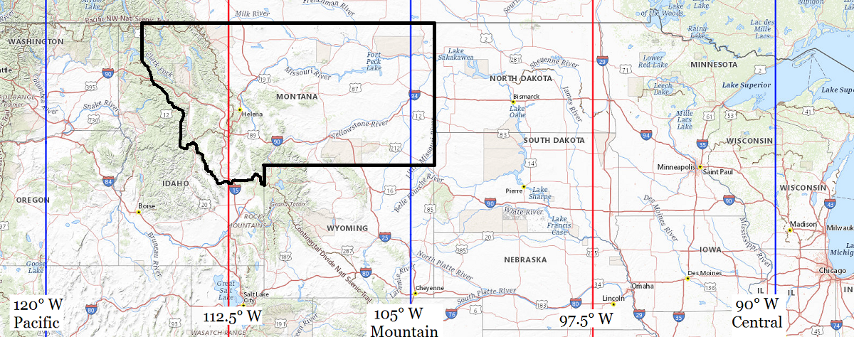
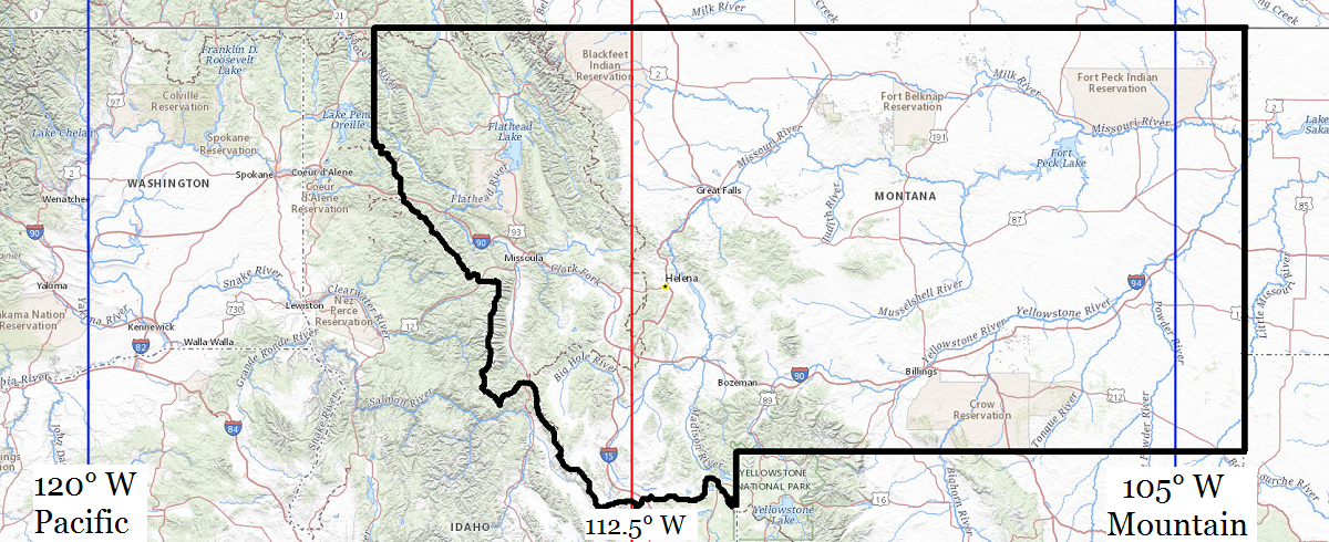
| Location |
Co-Ordinates
(Latitude, Longitude and Elevation) |
Mean solar time at noon
Pacific Standard Time |
Mean solar time at noon
Mountain Standard Time
Pacific Daylight Saving Time) |
Mean solar time at noon
Central Standard Time
(Mountain Daylight Saving Time) |
4 D School (historical),
Rosebud County
|
Elevation: 995 meters*
Latitude: 45.2644293° N
Longitude: 106.6450481° W
|
12:53:25 |
11:53:25 |
10:53:25 |
Abbott Lake School (historical),
Pondera County
|
Elevation: 1110 meters*
Latitude: 48.4097015° N
Longitude: 112.229206° W
|
12:31:04 |
11:31:04 |
10:31:04 |
Abe Post Office (historical),
Madison County
|
Elevation: 1750 meters*
Latitude: 45.0432595° N
Longitude: 111.6841369° W
|
12:33:15 |
11:33:15 |
10:33:15 |
Abe School (historical),
Madison County
|
Elevation: 1750 meters*
Latitude: 45.0432595° N
Longitude: 111.6841369° W
|
12:33:15 |
11:33:15 |
10:33:15 |
Abel School (historical),
Phillips County
|
Elevation: 672 meters*
Latitude: 48.3408346° N
Longitude: 107.2948089° W
|
12:50:49 |
11:50:49 |
10:50:49 |
Aberdeen School (historical),
Big Horn County
|
Elevation: 1212 meters*
Latitude: 45.0508007° N
Longitude: 107.3534211° W
|
12:50:35 |
11:50:35 |
10:50:35 |
Absarokee Post Office,
Stillwater County
|
Elevation: 1231 meters*
Latitude: 45.5202644° N
Longitude: 109.4400081° W
|
12:42:14 |
11:42:14 |
10:42:14 |
Absarokee School,
Stillwater County
|
Elevation: 1240 meters*
Latitude: 45.5136636° N
Longitude: 109.4473088° W
|
12:42:12 |
11:42:12 |
10:42:12 |
Absher Post Office (historical),
Musselshell County
|
Elevation: 897 meters*
Latitude: 46.5583116° N
Longitude: 107.9839981° W
|
12:48:03 |
11:48:03 |
10:48:03 |
Accord School (historical),
Valley County
|
Elevation: 638 meters*
Latitude: 48.1611318° N
Longitude: 106.4264238° W
|
12:54:17 |
11:54:17 |
10:54:17 |
Ackerley School (historical),
Fergus County
|
Elevation: 1055 meters*
Latitude: 47.2516431° N
Longitude: 109.7151901° W
|
12:41:08 |
11:41:08 |
10:41:08 |
Acorn Post Office (historical),
Rosebud County
|
Elevation: 934 meters*
Latitude: 46.8166597° N
Longitude: 107.2748002° W
|
12:50:54 |
11:50:54 |
10:50:54 |
Ada Post Office (historical),
Blaine County
|
Elevation: 987 meters*
Latitude: 48.4022178° N
Longitude: 109.4321308° W
|
12:42:16 |
11:42:16 |
10:42:16 |
Ada Post Office (historical),
Rosebud County
|
Elevation: 778 meters*
Latitude: 46.2941586° N
Longitude: 106.8597664° W
|
12:52:33 |
11:52:33 |
10:52:33 |
Ada School (historical),
Blaine County
|
Elevation: 980 meters*
Latitude: 48.3938843° N
Longitude: 109.4418536° W
|
12:42:13 |
11:42:13 |
10:42:13 |
Adams School (historical),
Treasure County
|
Elevation: 1044 meters*
Latitude: 45.9780441° N
Longitude: 107.2278371° W
|
12:51:05 |
11:51:05 |
10:51:05 |
Adaskavich Seventh Day Adventist School,
Toole County
|
Elevation: 1005 meters*
Latitude: 48.5052631° N
Longitude: 111.8569667° W
|
12:32:34 |
11:32:34 |
10:32:34 |
Addison School (historical),
Fergus County
|
Elevation: 1141 meters*
Latitude: 47.3010887° N
Longitude: 109.6174104° W
|
12:41:31 |
11:41:31 |
10:41:31 |
Adel Post Office (historical),
Cascade County
|
Elevation: 1508 meters*
Latitude: 47.0277236° N
Longitude: 111.6238645° W
|
12:33:30 |
11:33:30 |
10:33:30 |
Adobetown Post Office (historical),
Madison County
|
Elevation: 1691 meters*
Latitude: 45.3179807° N
Longitude: 111.9830368° W
|
12:32:04 |
11:32:04 |
10:32:04 |
Adobetown School (historical),
Madison County
|
Elevation: 1691 meters*
Latitude: 45.3179807° N
Longitude: 111.9830368° W
|
12:32:04 |
11:32:04 |
10:32:04 |
Agate Post Office (historical),
Rosebud County
|
Elevation: 790 meters*
Latitude: 46.2366592° N
Longitude: 106.8117073° W
|
12:52:45 |
11:52:45 |
10:52:45 |
Agawam Post Office (historical),
Teton County
|
Elevation: 1159 meters*
Latitude: 47.9971793° N
Longitude: 112.1675231° W
|
12:31:19 |
11:31:19 |
10:31:19 |
Agawam School (historical),
Teton County
|
Elevation: 1159 meters*
Latitude: 47.9980127° N
Longitude: 112.1675232° W
|
12:31:19 |
11:31:19 |
10:31:19 |
Agency Post Office (historical),
Lake County
|
Elevation: 1025 meters*
Latitude: 47.139094° N
Longitude: 114.0176071° W
|
12:23:55 |
11:23:55 |
10:23:55 |
Ahles Post Office (historical),
Rosebud County
|
Elevation: 874 meters*
Latitude: 46.4774883° N
Longitude: 107.1645097° W
|
12:51:20 |
11:51:20 |
10:51:20 |
Ahles School (historical),
Rosebud County
|
Elevation: 874 meters*
Latitude: 46.4777661° N
Longitude: 107.1653431° W
|
12:51:20 |
11:51:20 |
10:51:20 |
Ainslie Post Office (historical),
Custer County
|
Elevation: 696 meters*
Latitude: 46.5916713° N
Longitude: 105.5783286° W
|
12:57:41 |
11:57:41 |
10:57:41 |
Ajerton Post Office (historical),
Valley County
|
Elevation: 822 meters*
Latitude: 48.5558579° N
Longitude: 105.8908441° W
|
12:56:26 |
11:56:26 |
10:56:26 |
Akins School (historical),
Phillips County
|
Elevation: 685 meters*
Latitude: 48.511387° N
Longitude: 107.4539795° W
|
12:50:11 |
11:50:11 |
10:50:11 |
Alamo Post Office (historical),
Beaverhead County
|
Elevation: 1985 meters*
Latitude: 45.3746458° N
Longitude: 113.4097772° W
|
12:26:21 |
11:26:21 |
10:26:21 |
Alaska Bench (historical),
Fergus County
|
Elevation: 1654 meters*
Latitude: 46.8605237° N
Longitude: 109.1937821° W
|
12:43:13 |
11:43:13 |
10:43:13 |
Alberton Post Office,
Mineral County
|
Elevation: 932 meters*
Latitude: 47.0041364° N
Longitude: 114.4835758° W
|
12:22:03 |
11:22:03 |
10:22:03 |
Alberton Public Schools,
Mineral County
|
Elevation: 935 meters*
Latitude: 47.0046425° N
Longitude: 114.4815106° W
|
12:22:04 |
11:22:04 |
10:22:04 |
Albion Post Office (historical),
Carter County
|
Elevation: 1029 meters*
Latitude: 45.1872104° N
Longitude: 104.276336° W
|
13:02:53 |
12:02:53 |
11:02:53 |
Albion School,
Carter County
|
Elevation: 1033 meters*
Latitude: 45.1863771° N
Longitude: 104.2766138° W
|
13:02:53 |
12:02:53 |
11:02:53 |
Albright Post Office (historical),
Cascade County
|
Elevation: 1260 meters*
Latitude: 47.1477389° N
Longitude: 110.9502269° W
|
12:36:11 |
11:36:11 |
10:36:11 |
Albright Post Office (historical),
Rosebud County
|
Elevation: 757 meters*
Latitude: 46.284442° N
Longitude: 106.4880814° W
|
12:54:02 |
11:54:02 |
10:54:02 |
Albright School (historical),
Big Horn County
|
Elevation: 1131 meters*
Latitude: 45.2563532° N
Longitude: 107.4873197° W
|
12:50:03 |
11:50:03 |
10:50:03 |
Alder Post Office,
Madison County
|
Elevation: 1561 meters*
Latitude: 45.3242313° N
Longitude: 112.1076406° W
|
12:31:34 |
11:31:34 |
10:31:34 |
Alder School,
Madison County
|
Elevation: 1563 meters*
Latitude: 45.3194901° N
Longitude: 112.1096404° W
|
12:31:33 |
11:31:33 |
10:31:33 |
Aldridge Post Office (historical),
Park County
|
Elevation: 1959 meters*
Latitude: 45.0868789° N
Longitude: 110.8216042° W
|
12:36:42 |
11:36:42 |
10:36:42 |
Aldridge School (historical),
Park County
|
Elevation: 1959 meters*
Latitude: 45.0868789° N
Longitude: 110.8216042° W
|
12:36:42 |
11:36:42 |
10:36:42 |
Alger Post Office (historical),
Fergus County
|
Elevation: 1347 meters*
Latitude: 46.967193° N
Longitude: 109.2890645° W
|
12:42:50 |
11:42:50 |
10:42:50 |
Alger Post Office (historical),
Sanders County
|
Elevation: 762 meters*
Latitude: 47.7902122° N
Longitude: 115.52878° W
|
12:17:53 |
11:17:53 |
10:17:53 |
Alhambra Post Office (historical),
Jefferson County
|
Elevation: 1305 meters*
Latitude: 46.4513204° N
Longitude: 111.988327° W
|
12:32:02 |
11:32:02 |
10:32:02 |
Alice Post Office (historical),
Beaverhead County
|
Elevation: 1741 meters*
Latitude: 44.9943667° N
Longitude: 112.9966971° W
|
12:28:00 |
11:28:00 |
10:28:00 |
Alice Post Office (historical),
Garfield County
|
Elevation: 950 meters*
Latitude: 46.947215° N
Longitude: 107.5789857° W
|
12:49:41 |
11:49:41 |
10:49:41 |
Alkali Creek School (historical),
Treasure County
|
Elevation: 863 meters*
Latitude: 46.2935966° N
Longitude: 107.4872966° W
|
12:50:03 |
11:50:03 |
10:50:03 |
Alkali Post Office (historical),
Phillips County
|
Elevation: 753 meters*
Latitude: 48.2066636° N
Longitude: 108.050681° W
|
12:47:47 |
11:47:47 |
10:47:47 |
Alkali School (historical),
Phillips County
|
Elevation: 717 meters*
Latitude: 48.2130524° N
Longitude: 107.9256763° W
|
12:48:17 |
11:48:17 |
10:48:17 |
Allard Post Office (historical),
Dawson County
|
Elevation: 688 meters*
Latitude: 47.038901° N
Longitude: 104.5671754° W
|
13:01:43 |
12:01:43 |
11:01:43 |
Allard School (historical),
Dawson County
|
Elevation: 683 meters*
Latitude: 47.0408454° N
Longitude: 104.5693977° W
|
13:01:43 |
12:01:43 |
11:01:43 |
Allen Post Office (historical),
Garfield County
|
Elevation: 812 meters*
Latitude: 47.0722211° N
Longitude: 106.4850389° W
|
12:54:03 |
11:54:03 |
10:54:03 |
Allen School (historical),
Custer County
|
Elevation: 944 meters*
Latitude: 45.9044457° N
Longitude: 105.7949943° W
|
12:56:49 |
11:56:49 |
10:56:49 |
Alma Post Office (historical),
Liberty County
|
Elevation: 1006 meters*
Latitude: 48.8211099° N
Longitude: 110.8188556° W
|
12:36:43 |
11:36:43 |
10:36:43 |
Alma School (historical),
Liberty County
|
Elevation: 1006 meters*
Latitude: 48.8211099° N
Longitude: 110.8188556° W
|
12:36:43 |
11:36:43 |
10:36:43 |
Almond School (historical),
Treasure County
|
Elevation: 989 meters*
Latitude: 46.1902652° N
Longitude: 107.321454° W
|
12:50:42 |
11:50:42 |
10:50:42 |
Aloe Post Office (historical),
Toole County
|
Elevation: 1003 meters*
Latitude: 48.6572098° N
Longitude: 112.0058701° W
|
12:31:58 |
11:31:58 |
10:31:58 |
Aloe School (historical),
Toole County
|
Elevation: 1019 meters*
Latitude: 48.6535988° N
Longitude: 111.993925° W
|
12:32:01 |
11:32:01 |
10:32:01 |
Alpine Post Office (historical),
Carbon County
|
Elevation: 1898 meters*
Latitude: 45.2013322° N
Longitude: 109.6412814° W
|
12:41:26 |
11:41:26 |
10:41:26 |
Alpine Post Office (historical),
Fergus County
|
Elevation: 1148 meters*
Latitude: 47.1352526° N
Longitude: 109.0137711° W
|
12:43:56 |
11:43:56 |
10:43:56 |
Alpine School (historical),
Fergus County
|
Elevation: 1135 meters*
Latitude: 47.1430309° N
Longitude: 108.9715463° W
|
12:44:06 |
11:44:06 |
10:44:06 |
Alta Post Office (historical),
Jefferson County
|
Elevation: 1490 meters*
Latitude: 46.3799302° N
Longitude: 112.073054° W
|
12:31:42 |
11:31:42 |
10:31:42 |
Alta Post Office (historical),
Ravalli County
|
Elevation: 1520 meters*
Latitude: 45.6188062° N
Longitude: 114.299808° W
|
12:22:48 |
11:22:48 |
10:22:48 |
Alton Post Office (historical),
Fergus County
|
Elevation: 1115 meters*
Latitude: 47.4694222° N
Longitude: 109.8310255° W
|
12:40:40 |
11:40:40 |
10:40:40 |
Alton School (historical),
Fergus County
|
Elevation: 1100 meters*
Latitude: 47.3885871° N
Longitude: 109.8604711° W
|
12:40:33 |
11:40:33 |
10:40:33 |
Altyn Post Office (historical),
Glacier County
|
Elevation: 1461 meters*
Latitude: 48.7999791° N
Longitude: 113.6245519° W
|
12:25:30 |
11:25:30 |
10:25:30 |
Alzada Post Office,
Carter County
|
Elevation: 1049 meters*
Latitude: 45.0211941° N
Longitude: 104.4067569° W
|
13:02:22 |
12:02:22 |
11:02:22 |
Alzada School,
Carter County
|
Elevation: 1050 meters*
Latitude: 45.0208521° N
Longitude: 104.4129553° W
|
13:02:20 |
12:02:20 |
11:02:20 |
Amador School (historical),
Mineral County
|
Elevation: 845 meters*
Latitude: 47.1760376° N
Longitude: 114.8698527° W
|
12:20:31 |
11:20:31 |
10:20:31 |
Amazon Post Office (historical),
Jefferson County
|
Elevation: 1663 meters*
Latitude: 46.320207° N
Longitude: 112.1072224° W
|
12:31:34 |
11:31:34 |
10:31:34 |
Amesville Post Office (historical),
Beaverhead County
|
Elevation: 1797 meters*
Latitude: 45.0099238° N
Longitude: 113.1111467° W
|
12:27:33 |
11:27:33 |
10:27:33 |
Amo School (historical),
Dawson County
|
Elevation: 777 meters*
Latitude: 46.9491761° N
Longitude: 105.0269182° W
|
12:59:53 |
11:59:53 |
10:59:53 |
Amos Post Office (historical),
Hill County
|
Elevation: 905 meters*
Latitude: 48.8063929° N
Longitude: 109.8674243° W
|
12:40:31 |
11:40:31 |
10:40:31 |
Amos School (historical),
Hill County
|
Elevation: 905 meters*
Latitude: 48.8063929° N
Longitude: 109.8674243° W
|
12:40:31 |
11:40:31 |
10:40:31 |
Amsterdam Elementary School,
Gallatin County
|
Elevation: 1354 meters*
Latitude: 45.756873° N
Longitude: 111.3202366° W
|
12:34:43 |
11:34:43 |
10:34:43 |
Anaconda Junior High School,
Deer Lodge County
|
Elevation: 1610 meters*
Latitude: 46.127148° N
Longitude: 112.9547645° W
|
12:28:10 |
11:28:10 |
10:28:10 |
Anaconda Post Office,
Deer Lodge County
|
Elevation: 1609 meters*
Latitude: 46.1286151° N
Longitude: 112.9535367° W
|
12:28:11 |
11:28:11 |
10:28:11 |
Anaconda Senior High School,
Deer Lodge County
|
Elevation: 1613 meters*
Latitude: 46.1257591° N
Longitude: 112.9536534° W
|
12:28:11 |
11:28:11 |
10:28:11 |
Anad Post Office (historical),
Garfield County
|
Elevation: 905 meters*
Latitude: 47.2275° N
Longitude: 107.3328653° W
|
12:50:40 |
11:50:40 |
10:50:40 |
Anad School (historical),
Garfield County
|
Elevation: 904 meters*
Latitude: 47.2277778° N
Longitude: 107.3328653° W
|
12:50:40 |
11:50:40 |
10:50:40 |
Anceney School (historical),
Gallatin County
|
Elevation: 1453 meters*
Latitude: 45.6485396° N
Longitude: 111.3546821° W
|
12:34:34 |
11:34:34 |
10:34:34 |
Andersen School (historical),
Rosebud County
|
Elevation: 801 meters*
Latitude: 46.2533257° N
Longitude: 106.8186524° W
|
12:52:43 |
11:52:43 |
10:52:43 |
Anderson Post Office (historical),
Silver Bow County
|
Elevation: 1694 meters*
Latitude: 46.02076° N
Longitude: 112.500021° W
|
12:29:59 |
11:29:59 |
10:29:59 |
Anderson School (historical),
Cascade County
|
Elevation: 1038 meters*
Latitude: 47.2666178° N
Longitude: 111.5902525° W
|
12:33:38 |
11:33:38 |
10:33:38 |
Anderson School (historical),
Phillips County
|
Elevation: 816 meters*
Latitude: 47.8438859° N
Longitude: 108.0231765° W
|
12:47:54 |
11:47:54 |
10:47:54 |
Anderson School (historical),
Roosevelt County
|
Elevation: 678 meters*
Latitude: 48.3466881° N
Longitude: 104.9308047° W
|
13:00:16 |
12:00:16 |
11:00:16 |
Anderson School (historical),
Roosevelt County
|
Elevation: 775 meters*
Latitude: 48.2408536° N
Longitude: 105.6422231° W
|
12:57:25 |
11:57:25 |
10:57:25 |
Anderson School (historical),
Valley County
|
Elevation: 660 meters*
Latitude: 48.4669518° N
Longitude: 107.1395167° W
|
12:51:26 |
11:51:26 |
10:51:26 |
Anderson School,
Gallatin County
|
Elevation: 1602 meters*
Latitude: 45.5979855° N
Longitude: 111.1049492° W
|
12:35:34 |
11:35:34 |
10:35:34 |
Andersonville Post Office (historical),
Fergus County
|
Elevation: 1346 meters*
Latitude: 47.1869204° N
Longitude: 109.2846201° W
|
12:42:51 |
11:42:51 |
10:42:51 |
Andes Post Office (historical),
Richland County
|
Elevation: 652 meters*
Latitude: 47.9555738° N
Longitude: 104.5488444° W
|
13:01:48 |
12:01:48 |
11:01:48 |
Andes School (historical),
Richland County
|
Elevation: 652 meters*
Latitude: 47.9555738° N
Longitude: 104.5488444° W
|
13:01:48 |
12:01:48 |
11:01:48 |
Andeville Post Office (historical),
Fergus County
|
Elevation: 940 meters*
Latitude: 47.7130404° N
Longitude: 109.0243334° W
|
12:43:54 |
11:43:54 |
10:43:54 |
Angela Post Office,
Rosebud County
|
Elevation: 888 meters*
Latitude: 46.7292327° N
Longitude: 106.2001778° W
|
12:55:11 |
11:55:11 |
10:55:11 |
Angela School (historical),
Rosebud County
|
Elevation: 898 meters*
Latitude: 46.7438909° N
Longitude: 106.2055792° W
|
12:55:10 |
11:55:10 |
10:55:10 |
Anna Jeffries Elementary School,
Glacier County
|
Elevation: 1146 meters*
Latitude: 48.6405396° N
Longitude: 112.3297733° W
|
12:30:40 |
11:30:40 |
10:30:40 |
Annis Post Office (historical),
Lewis and Clark County
|
Elevation: 1595 meters*
Latitude: 46.8754949° N
Longitude: 112.567533° W
|
12:29:43 |
11:29:43 |
10:29:43 |
Antelope Coulee School (historical),
Cascade County
|
Elevation: 1109 meters*
Latitude: 47.4216297° N
Longitude: 111.0960787° W
|
12:35:36 |
11:35:36 |
10:35:36 |
Antelope Point School (historical),
Stillwater County
|
Elevation: 1355 meters*
Latitude: 45.8135517° N
Longitude: 109.4587837° W
|
12:42:09 |
11:42:09 |
10:42:09 |
Antelope Post Office (historical),
Rosebud County
|
Elevation: 823 meters*
Latitude: 46.5263788° N
Longitude: 107.0425595° W
|
12:51:49 |
11:51:49 |
10:51:49 |
Antelope Post Office,
Sheridan County
|
Elevation: 623 meters*
Latitude: 48.6894837° N
Longitude: 104.4575691° W
|
13:02:10 |
12:02:10 |
11:02:10 |
Antelope School (historical),
Chouteau County
|
Elevation: 988 meters*
Latitude: 47.7846868° N
Longitude: 111.1138457° W
|
12:35:32 |
11:35:32 |
10:35:32 |
Antelope School (historical),
Fergus County
|
Elevation: 911 meters*
Latitude: 47.4244307° N
Longitude: 108.664035° W
|
12:45:20 |
11:45:20 |
10:45:20 |
Antelope School (historical),
Rosebud County
|
Elevation: 1040 meters*
Latitude: 46.7133209° N
Longitude: 107.5453689° W
|
12:49:49 |
11:49:49 |
10:49:49 |
Antelope School (historical),
Sheridan County
|
Elevation: 623 meters*
Latitude: 48.6894716° N
Longitude: 104.4574529° W
|
13:02:10 |
12:02:10 |
11:02:10 |
Antler School (historical),
Big Horn County
|
Elevation: 1215 meters*
Latitude: 45.1821853° N
Longitude: 107.6526001° W
|
12:49:23 |
11:49:23 |
10:49:23 |
Antrim Post Office (historical),
Garfield County
|
Elevation: 975 meters*
Latitude: 47.4916689° N
Longitude: 107.4606518° W
|
12:50:09 |
11:50:09 |
10:50:09 |
Apex Post Office (historical),
Beaverhead County
|
Elevation: 1657 meters*
Latitude: 45.3818692° N
Longitude: 112.7072462° W
|
12:29:10 |
11:29:10 |
10:29:10 |
Apex School (historical),
Beaverhead County
|
Elevation: 1657 meters*
Latitude: 45.3818692° N
Longitude: 112.7072462° W
|
12:29:10 |
11:29:10 |
10:29:10 |
Apgar Post Office (historical),
Flathead County
|
Elevation: 966 meters*
Latitude: 48.527745° N
Longitude: 113.9931745° W
|
12:24:01 |
11:24:01 |
10:24:01 |
Apgar School (historical),
Flathead County
|
Elevation: 966 meters*
Latitude: 48.527745° N
Longitude: 113.9931745° W
|
12:24:01 |
11:24:01 |
10:24:01 |
Apple School (historical),
Chouteau County
|
Elevation: 958 meters*
Latitude: 47.9299679° N
Longitude: 110.9766192° W
|
12:36:05 |
11:36:05 |
10:36:05 |
Archer Post Office (historical),
Sheridan County
|
Elevation: 629 meters*
Latitude: 48.7928047° N
Longitude: 104.8108007° W
|
13:00:45 |
12:00:45 |
11:00:45 |
Archer School (historical),
Sheridan County
|
Elevation: 631 meters*
Latitude: 48.7933602° N
Longitude: 104.814412° W
|
13:00:44 |
12:00:44 |
11:00:44 |
Ardrum Post Office (historical),
Missoula County
|
Elevation: 1015 meters*
Latitude: 46.9949228° N
Longitude: 114.1253916° W
|
12:23:29 |
11:23:29 |
10:23:29 |
Argenbright School (historical),
Dawson County
|
Elevation: 762 meters*
Latitude: 47.0786246° N
Longitude: 104.3499429° W
|
13:02:36 |
12:02:36 |
11:02:36 |
Argenta Post Office (historical),
Beaverhead County
|
Elevation: 1871 meters*
Latitude: 45.2796455° N
Longitude: 112.861976° W
|
12:28:33 |
11:28:33 |
10:28:33 |
Argenta School (historical),
Beaverhead County
|
Elevation: 1871 meters*
Latitude: 45.2796455° N
Longitude: 112.861976° W
|
12:28:33 |
11:28:33 |
10:28:33 |
Argo Post Office (historical),
Broadwater County
|
Elevation: 1655 meters*
Latitude: 46.6860496° N
Longitude: 111.5813609° W
|
12:33:40 |
11:33:40 |
10:33:40 |
Arlee Post Office,
Lake County
|
Elevation: 942 meters*
Latitude: 47.162404° N
Longitude: 114.0857287° W
|
12:23:39 |
11:23:39 |
10:23:39 |
Arlee Public Schools,
Lake County
|
Elevation: 945 meters*
Latitude: 47.1638162° N
Longitude: 114.0839981° W
|
12:23:39 |
11:23:39 |
10:23:39 |
Armada School (historical),
Mineral County
|
Elevation: 952 meters*
Latitude: 47.36243° N
Longitude: 115.3287582° W
|
12:18:41 |
11:18:41 |
10:18:41 |
Armells Post Office (historical),
Fergus County
|
Elevation: 1155 meters*
Latitude: 47.3155342° N
Longitude: 109.1840594° W
|
12:43:15 |
11:43:15 |
10:43:15 |
Armells School (historical),
Fergus County
|
Elevation: 1253 meters*
Latitude: 47.3047005° N
Longitude: 109.2290618° W
|
12:43:05 |
11:43:05 |
10:43:05 |
Armington Post Office (historical),
Cascade County
|
Elevation: 1086 meters*
Latitude: 47.3663543° N
Longitude: 110.9035659° W
|
12:36:23 |
11:36:23 |
10:36:23 |
Armstead Post Office (historical),
Beaverhead County
|
Elevation: 1690 meters*
Latitude: 44.9724206° N
Longitude: 112.8641913° W
|
12:28:32 |
11:28:32 |
10:28:32 |
Armstead School (historical),
Beaverhead County
|
Elevation: 1690 meters*
Latitude: 44.9724206° N
Longitude: 112.8641913° W
|
12:28:32 |
11:28:32 |
10:28:32 |
Armstrong School (historical),
Richland County
|
Elevation: 660 meters*
Latitude: 47.990574° N
Longitude: 104.8930246° W
|
13:00:25 |
12:00:25 |
11:00:25 |
Arp Post Office (historical),
Carter County
|
Elevation: 1126 meters*
Latitude: 45.5138829° N
Longitude: 104.265778° W
|
13:02:56 |
12:02:56 |
11:02:56 |
Arrow Creek Post Office (historical),
Judith Basin County
|
Elevation: 1166 meters*
Latitude: 47.3444156° N
Longitude: 110.1752033° W
|
12:39:17 |
11:39:17 |
10:39:17 |
Arrow Post Office (historical),
Judith Basin County
|
Elevation: 1289 meters*
Latitude: 47.3221888° N
Longitude: 110.5341026° W
|
12:37:51 |
11:37:51 |
10:37:51 |
Arrowhead School,
Park County
|
Elevation: 1514 meters*
Latitude: 45.3950552° N
Longitude: 110.6721624° W
|
12:37:18 |
11:37:18 |
10:37:18 |
Arthur Post Office (historical),
Richland County
|
Elevation: 602 meters*
Latitude: 48.0611294° N
Longitude: 105.1727582° W
|
12:59:18 |
11:59:18 |
10:59:18 |
Arthur School (historical),
Richland County
|
Elevation: 602 meters*
Latitude: 48.0602961° N
Longitude: 105.1727582° W
|
12:59:18 |
11:59:18 |
10:59:18 |
Ash Coulee School (historical),
Fallon County
|
Elevation: 973 meters*
Latitude: 46.6272321° N
Longitude: 104.2699389° W
|
13:02:55 |
12:02:55 |
11:02:55 |
Ash Coulee School (historical),
Treasure County
|
Elevation: 821 meters*
Latitude: 46.2108197° N
Longitude: 107.444515° W
|
12:50:13 |
11:50:13 |
10:50:13 |
Ash Creek School (historical),
Custer County
|
Elevation: 971 meters*
Latitude: 45.9655574° N
Longitude: 105.7455485° W
|
12:57:01 |
11:57:01 |
10:57:01 |
Ash Creek School (historical),
Prairie County
|
Elevation: 835 meters*
Latitude: 46.7577872° N
Longitude: 104.6444001° W
|
13:01:25 |
12:01:25 |
11:01:25 |
Ash Creek School (historical),
Rosebud County
|
Elevation: 863 meters*
Latitude: 46.1511108° N
Longitude: 106.2583463° W
|
12:54:57 |
11:54:57 |
10:54:57 |
Ash Grove School (historical),
Rosebud County
|
Elevation: 840 meters*
Latitude: 46.2138794° N
Longitude: 106.9450467° W
|
12:52:13 |
11:52:13 |
10:52:13 |
Ashdale Post Office (historical),
Sheridan County
|
Elevation: 835 meters*
Latitude: 48.710581° N
Longitude: 104.9694176° W
|
13:00:07 |
12:00:07 |
11:00:07 |
Ashfield Post Office (historical),
Phillips County
|
Elevation: 681 meters*
Latitude: 48.4619413° N
Longitude: 107.4739828° W
|
12:50:06 |
11:50:06 |
10:50:06 |
Ashland Post Office,
Rosebud County
|
Elevation: 891 meters*
Latitude: 45.5912107° N
Longitude: 106.265075° W
|
12:54:56 |
11:54:56 |
10:54:56 |
Ashland Public School,
Rosebud County
|
Elevation: 890 meters*
Latitude: 45.5951006° N
Longitude: 106.2715454° W
|
12:54:54 |
11:54:54 |
10:54:54 |
Ashley Creek School (historical),
Flathead County
|
Elevation: 1013 meters*
Latitude: 48.1021762° N
Longitude: 114.5720788° W
|
12:21:42 |
11:21:42 |
10:21:42 |
Ashley Post Office (historical),
Flathead County
|
Elevation: 898 meters*
Latitude: 48.1916257° N
Longitude: 114.3329089° W
|
12:22:40 |
11:22:40 |
10:22:40 |
Ashley Post Office (historical),
Petroleum County
|
Elevation: 880 meters*
Latitude: 47.1505433° N
Longitude: 108.1545645° W
|
12:47:22 |
11:47:22 |
10:47:22 |
Ashley School (historical),
Petroleum County
|
Elevation: 875 meters*
Latitude: 47.1527655° N
Longitude: 108.1595646° W
|
12:47:21 |
11:47:21 |
10:47:21 |
Ashmoor Post Office (historical),
Chouteau County
|
Elevation: 1016 meters*
Latitude: 48.0633023° N
Longitude: 111.3258133° W
|
12:34:41 |
11:34:41 |
10:34:41 |
Ashmoor School (historical),
Chouteau County
|
Elevation: 1016 meters*
Latitude: 48.0633023° N
Longitude: 111.3258133° W
|
12:34:41 |
11:34:41 |
10:34:41 |
Ashmore School (historical),
Mineral County
|
Elevation: 812 meters*
Latitude: 47.238262° N
Longitude: 114.999579° W
|
12:20:00 |
11:20:00 |
10:20:00 |
Assiniboine School (historical),
Phillips County
|
Elevation: 730 meters*
Latitude: 48.4661092° N
Longitude: 107.865947° W
|
12:48:32 |
11:48:32 |
10:48:32 |
Athearn School (historical),
Petroleum County
|
Elevation: 831 meters*
Latitude: 47.560551° N
Longitude: 108.2917925° W
|
12:46:49 |
11:46:49 |
10:46:49 |
Atlanta Post Office (historical),
Lincoln County
|
Elevation: 967 meters*
Latitude: 48.2796807° N
Longitude: 115.0515408° W
|
12:19:47 |
11:19:47 |
10:19:47 |
Auburn Post Office (historical),
Fergus County
|
Elevation: 1002 meters*
Latitude: 47.2735911° N
Longitude: 108.8187618° W
|
12:44:43 |
11:44:43 |
10:44:43 |
Auchard Creek Elementary School,
Lewis and Clark County
|
Elevation: 1286 meters*
Latitude: 47.3296688° N
Longitude: 112.2097343° W
|
12:31:09 |
11:31:09 |
10:31:09 |
Augusta Post Office,
Lewis and Clark County
|
Elevation: 1239 meters*
Latitude: 47.4953255° N
Longitude: 112.388968° W
|
12:30:26 |
11:30:26 |
10:30:26 |
Augusta Public Schools,
Lewis and Clark County
|
Elevation: 1245 meters*
Latitude: 47.491614° N
Longitude: 112.3980794° W
|
12:30:24 |
11:30:24 |
10:30:24 |
Aurora Post Office (historical),
Beaverhead County
|
Elevation: 2169 meters*
Latitude: 45.45548° N
Longitude: 113.1097644° W
|
12:27:33 |
11:27:33 |
10:27:33 |
Austin Post Office (historical),
Lewis and Clark County
|
Elevation: 1450 meters*
Latitude: 46.6391017° N
Longitude: 112.2452892° W
|
12:31:01 |
11:31:01 |
10:31:01 |
Austin School (historical),
Lewis and Clark County
|
Elevation: 1450 meters*
Latitude: 46.6391017° N
Longitude: 112.2452892° W
|
12:31:01 |
11:31:01 |
10:31:01 |
Austin School (historical),
Phillips County
|
Elevation: 771 meters*
Latitude: 48.7213942° N
Longitude: 107.6825964° W
|
12:49:16 |
11:49:16 |
10:49:16 |
Avery Post Office (historical),
Blaine County
|
Elevation: 953 meters*
Latitude: 48.9277857° N
Longitude: 108.6582001° W
|
12:45:22 |
11:45:22 |
10:45:22 |
Avon Elementary School,
Powell County
|
Elevation: 1435 meters*
Latitude: 46.5982658° N
Longitude: 112.5908652° W
|
12:29:38 |
11:29:38 |
10:29:38 |
Avon Post Office,
Powell County
|
Elevation: 1431 meters*
Latitude: 46.5983918° N
Longitude: 112.5985187° W
|
12:29:36 |
11:29:36 |
10:29:36 |
Avondale Post Office (historical),
Valley County
|
Elevation: 878 meters*
Latitude: 48.6650258° N
Longitude: 106.1852992° W
|
12:55:15 |
11:55:15 |
10:55:15 |
Avondale School (historical),
Valley County
|
Elevation: 878 meters*
Latitude: 48.6650258° N
Longitude: 106.1844659° W
|
12:55:15 |
11:55:15 |
10:55:15 |
Avy L Short School (historical),
Phillips County
|
Elevation: 921 meters*
Latitude: 48.7961167° N
Longitude: 108.2387364° W
|
12:47:02 |
11:47:02 |
10:47:02 |
Axtell Post Office (historical),
Dawson County
|
Elevation: 676 meters*
Latitude: 47.7077918° N
Longitude: 105.2783183° W
|
12:58:53 |
11:58:53 |
10:58:53 |
Axtell School (historical),
Dawson County
|
Elevation: 674 meters*
Latitude: 47.6902916° N
Longitude: 105.2860965° W
|
12:58:51 |
11:58:51 |
10:58:51 |
Ayers School,
Fergus County
|
Elevation: 1107 meters*
Latitude: 47.0499729° N
Longitude: 108.9493219° W
|
12:44:12 |
11:44:12 |
10:44:12 |
Aznoe Post Office (historical),
Chouteau County
|
Elevation: 1017 meters*
Latitude: 47.958298° N
Longitude: 111.3238645° W
|
12:34:42 |
11:34:42 |
10:34:42 |
Aznoe School (historical),
Chouteau County
|
Elevation: 1019 meters*
Latitude: 47.9594091° N
Longitude: 111.3433099° W
|
12:34:37 |
11:34:37 |
10:34:37 |
B A Winans School,
Park County
|
Elevation: 1377 meters*
Latitude: 45.6529363° N
Longitude: 110.5683044° W
|
12:37:43 |
11:37:43 |
10:37:43 |
Baack School (historical),
Chouteau County
|
Elevation: 917 meters*
Latitude: 47.87219° N
Longitude: 110.8913361° W
|
12:36:26 |
11:36:26 |
10:36:26 |
Babb Post Office,
Glacier County
|
Elevation: 1370 meters*
Latitude: 48.8637324° N
Longitude: 113.4354952° W
|
12:26:15 |
11:26:15 |
10:26:15 |
Babb School,
Glacier County
|
Elevation: 1376 meters*
Latitude: 48.8671707° N
Longitude: 113.4376033° W
|
12:26:14 |
11:26:14 |
10:26:14 |
Babbitt School (historical),
Fergus County
|
Elevation: 1085 meters*
Latitude: 47.3841406° N
Longitude: 109.9857525° W
|
12:40:03 |
11:40:03 |
10:40:03 |
Bache School (historical),
Phillips County
|
Elevation: 668 meters*
Latitude: 48.5397213° N
Longitude: 107.4534227° W
|
12:50:11 |
11:50:11 |
10:50:11 |
Bachman School (historical),
Petroleum County
|
Elevation: 920 meters*
Latitude: 46.9033135° N
Longitude: 108.2790131° W
|
12:46:53 |
11:46:53 |
10:46:53 |
Bacon School (historical),
Prairie County
|
Elevation: 875 meters*
Latitude: 46.5783388° N
Longitude: 105.1744231° W
|
12:59:18 |
11:59:18 |
10:59:18 |
Bad Rock School (historical),
Flathead County
|
Elevation: 937 meters*
Latitude: 48.3305191° N
Longitude: 114.1704027° W
|
12:23:19 |
11:23:19 |
10:23:19 |
Bad Route School (historical),
Dawson County
|
Elevation: 781 meters*
Latitude: 47.0013981° N
Longitude: 105.1769257° W
|
12:59:17 |
11:59:17 |
10:59:17 |
Badger School (historical),
Valley County
|
Elevation: 836 meters*
Latitude: 48.8997461° N
Longitude: 106.6186514° W
|
12:53:31 |
11:53:31 |
10:53:31 |
Badger School (historical),
Valley County
|
Elevation: 718 meters*
Latitude: 48.3214094° N
Longitude: 106.6511564° W
|
12:53:23 |
11:53:23 |
10:53:23 |
Badlands School (historical),
Wibaux County
|
Elevation: 958 meters*
Latitude: 46.6855662° N
Longitude: 104.2910507° W
|
13:02:50 |
12:02:50 |
11:02:50 |
Baggs School (historical),
Dawson County
|
Elevation: 900 meters*
Latitude: 47.2444548° N
Longitude: 105.2422067° W
|
12:59:01 |
11:59:01 |
10:59:01 |
Bagley School (historical),
Beaverhead County
|
Elevation: 1555 meters*
Latitude: 45.2149217° N
Longitude: 112.6380755° W
|
12:29:26 |
11:29:26 |
10:29:26 |
Bailey School (historical),
Carbon County
|
Elevation: 1242 meters*
Latitude: 45.450501° N
Longitude: 109.1004311° W
|
12:43:35 |
11:43:35 |
10:43:35 |
Bain School (historical),
Sheridan County
|
Elevation: 760 meters*
Latitude: 48.8597491° N
Longitude: 104.308835° W
|
13:02:45 |
12:02:45 |
11:02:45 |
Bainville Post Office,
Roosevelt County
|
Elevation: 599 meters*
Latitude: 48.1407687° N
Longitude: 104.2214743° W
|
13:03:06 |
12:03:06 |
11:03:06 |
Bainville Public School,
Roosevelt County
|
Elevation: 609 meters*
Latitude: 48.1394658° N
Longitude: 104.2259799° W
|
13:03:05 |
12:03:05 |
11:03:05 |
Baird Post Office (historical),
Granite County
|
Elevation: 1181 meters*
Latitude: 46.716595° N
Longitude: 113.5175861° W
|
12:25:55 |
11:25:55 |
10:25:55 |
Baird Post Office (historical),
Granite County
|
Elevation: 1115 meters*
Latitude: 46.7193726° N
Longitude: 113.5384205° W
|
12:25:50 |
11:25:50 |
10:25:50 |
Baker Creek School (historical),
Gallatin County
|
Elevation: 1345 meters*
Latitude: 45.7729842° N
Longitude: 111.2735679° W
|
12:34:54 |
11:34:54 |
10:34:54 |
Baker Creek School (historical),
Phillips County
|
Elevation: 983 meters*
Latitude: 47.9383302° N
Longitude: 108.3918057° W
|
12:46:25 |
11:46:25 |
10:46:25 |
Baker High School,
Fallon County
|
Elevation: 915 meters*
Latitude: 46.3562609° N
Longitude: 104.2807801° W
|
13:02:52 |
12:02:52 |
11:02:52 |
Baker Post Office,
Fallon County
|
Elevation: 894 meters*
Latitude: 46.366748° N
Longitude: 104.2766063° W
|
13:02:53 |
12:02:53 |
11:02:53 |
Baker School (historical),
Valley County
|
Elevation: 806 meters*
Latitude: 48.3205774° N
Longitude: 105.8866773° W
|
12:56:27 |
11:56:27 |
10:56:27 |
Baker Spring School (historical),
Fergus County
|
Elevation: 915 meters*
Latitude: 47.5833165° N
Longitude: 109.038221° W
|
12:43:50 |
11:43:50 |
10:43:50 |
Bakken School (historical),
Wibaux County
|
Elevation: 866 meters*
Latitude: 46.805567° N
Longitude: 104.3749433° W
|
13:02:30 |
12:02:30 |
11:02:30 |
Bald Butte School (historical),
Lewis and Clark County
|
Elevation: 1990 meters*
Latitude: 46.7241033° N
Longitude: 112.3464071° W
|
12:30:36 |
11:30:36 |
10:30:36 |
Bald Rock School (historical),
Flathead County
|
Elevation: 959 meters*
Latitude: 48.2621844° N
Longitude: 114.4393043° W
|
12:22:14 |
11:22:14 |
10:22:14 |
Baldbutte Post Office (historical),
Lewis and Clark County
|
Elevation: 1990 meters*
Latitude: 46.7241033° N
Longitude: 112.3464071° W
|
12:30:36 |
11:30:36 |
10:30:36 |
Baldwin Post Office (historical),
Musselshell County
|
Elevation: 891 meters*
Latitude: 46.5749794° N
Longitude: 107.94233° W
|
12:48:13 |
11:48:13 |
10:48:13 |
Balky Horse School (historical),
Fergus County
|
Elevation: 1022 meters*
Latitude: 47.4499795° N
Longitude: 109.5474085° W
|
12:41:48 |
11:41:48 |
10:41:48 |
Ballantine Post Office,
Yellowstone County
|
Elevation: 909 meters*
Latitude: 45.9472052° N
Longitude: 108.1507069° W
|
12:47:23 |
11:47:23 |
10:47:23 |
Ballenski School (historical),
Rosebud County
|
Elevation: 938 meters*
Latitude: 46.8397223° N
Longitude: 106.4103106° W
|
12:54:21 |
11:54:21 |
10:54:21 |
Bannack Post Office (historical),
Beaverhead County
|
Elevation: 1758 meters*
Latitude: 45.1610337° N
Longitude: 112.9955907° W
|
12:28:01 |
11:28:01 |
10:28:01 |
Bannack School (historical),
Beaverhead County
|
Elevation: 1758 meters*
Latitude: 45.1610337° N
Longitude: 112.9955907° W
|
12:28:01 |
11:28:01 |
10:28:01 |
Bar-G School (historical),
Prairie County
|
Elevation: 768 meters*
Latitude: 46.6511175° N
Longitude: 105.0646963° W
|
12:59:44 |
11:59:44 |
10:59:44 |
Barber Post Office (historical),
Golden Valley County
|
Elevation: 1138 meters*
Latitude: 46.3132908° N
Longitude: 109.3851769° W
|
12:42:27 |
11:42:27 |
10:42:27 |
Barber School (historical),
Golden Valley County
|
Elevation: 1138 meters*
Latitude: 46.3132908° N
Longitude: 109.3851769° W
|
12:42:27 |
11:42:27 |
10:42:27 |
Barker Post Office (historical),
Judith Basin County
|
Elevation: 1747 meters*
Latitude: 47.0713528° N
Longitude: 110.6404937° W
|
12:37:26 |
11:37:26 |
10:37:26 |
Barker School (historical),
Judith Basin County
|
Elevation: 1747 meters*
Latitude: 47.0713528° N
Longitude: 110.6404937° W
|
12:37:26 |
11:37:26 |
10:37:26 |
Barley Post Office (historical),
Stillwater County
|
Elevation: 1234 meters*
Latitude: 46.0360595° N
Longitude: 109.1757219° W
|
12:43:17 |
11:43:17 |
10:43:17 |
Barnard Post Office (historical),
Valley County
|
Elevation: 814 meters*
Latitude: 48.9339119° N
Longitude: 106.7728249° W
|
12:52:54 |
11:52:54 |
10:52:54 |
Barnard School (historical),
Valley County
|
Elevation: 808 meters*
Latitude: 48.9339121° N
Longitude: 106.7533796° W
|
12:52:59 |
11:52:59 |
10:52:59 |
Barnhart School (historical),
Gallatin County
|
Elevation: 1394 meters*
Latitude: 45.7360397° N
Longitude: 111.306347° W
|
12:34:46 |
11:34:46 |
10:34:46 |
Barott Post Office (historical),
Musselshell County
|
Elevation: 1007 meters*
Latitude: 46.3207932° N
Longitude: 108.7257003° W
|
12:45:05 |
11:45:05 |
10:45:05 |
Barr Post Office (historical),
Valley County
|
Elevation: 762 meters*
Latitude: 48.7333501° N
Longitude: 106.983946° W
|
12:52:03 |
11:52:03 |
10:52:03 |
Barr Post Office (historical),
Valley County
|
Elevation: 757 meters*
Latitude: 48.737793° N
Longitude: 107.0539495° W
|
12:51:47 |
11:51:47 |
10:51:47 |
Barr School (historical),
Valley County
|
Elevation: 757 meters*
Latitude: 48.7430709° N
Longitude: 107.0561718° W
|
12:51:46 |
11:51:46 |
10:51:46 |
Barratts School (historical),
Beaverhead County
|
Elevation: 1600 meters*
Latitude: 45.1313103° N
Longitude: 112.7405791° W
|
12:29:02 |
11:29:02 |
10:29:02 |
Barrial Post Office (historical),
Prairie County
|
Elevation: 867 meters*
Latitude: 46.5952834° N
Longitude: 105.1966465° W
|
12:59:12 |
11:59:12 |
10:59:12 |
Barton School (historical),
Phillips County
|
Elevation: 802 meters*
Latitude: 48.201386° N
Longitude: 108.256245° W
|
12:46:58 |
11:46:58 |
10:46:58 |
Barzee Post Office (historical),
Meagher County
|
Elevation: 1788 meters*
Latitude: 46.7688487° N
Longitude: 110.8091028° W
|
12:36:45 |
11:36:45 |
10:36:45 |
Barzee School (historical),
Meagher County
|
Elevation: 1788 meters*
Latitude: 46.7688487° N
Longitude: 110.8091028° W
|
12:36:45 |
11:36:45 |
10:36:45 |
Bascom Post Office (historical),
Rosebud County
|
Elevation: 894 meters*
Latitude: 46.6255395° N
Longitude: 107.7512114° W
|
12:48:59 |
11:48:59 |
10:48:59 |
Bascom School (historical),
Rosebud County
|
Elevation: 893 meters*
Latitude: 46.6274839° N
Longitude: 107.7542671° W
|
12:48:58 |
11:48:58 |
10:48:58 |
Base Line School (historical),
Yellowstone County
|
Elevation: 1019 meters*
Latitude: 45.7841175° N
Longitude: 108.6765305° W
|
12:45:17 |
11:45:17 |
10:45:17 |
Basin Post Office,
Jefferson County
|
Elevation: 1635 meters*
Latitude: 46.2710728° N
Longitude: 112.2639865° W
|
12:30:56 |
11:30:56 |
10:30:56 |
Basin School,
Jefferson County
|
Elevation: 1639 meters*
Latitude: 46.27323° N
Longitude: 112.2655° W
|
12:30:56 |
11:30:56 |
10:30:56 |
Basin-Grayling School (historical),
Gallatin County
|
Elevation: 1996 meters*
Latitude: 44.7971491° N
Longitude: 111.1907811° W
|
12:35:14 |
11:35:14 |
10:35:14 |
Basinski Post Office (historical),
Rosebud County
|
Elevation: 823 meters*
Latitude: 46.1222199° N
Longitude: 106.4422428° W
|
12:54:13 |
11:54:13 |
10:54:13 |
Bass School (historical),
Ravalli County
|
Elevation: 997 meters*
Latitude: 46.5560338° N
Longitude: 114.0698266° W
|
12:23:43 |
11:23:43 |
10:23:43 |
Batavia School (historical),
Flathead County
|
Elevation: 958 meters*
Latitude: 48.1741248° N
Longitude: 114.4234677° W
|
12:22:18 |
11:22:18 |
10:22:18 |
Battle Butte School (historical),
Flathead County
|
Elevation: 891 meters*
Latitude: 47.8407756° N
Longitude: 114.5629072° W
|
12:21:44 |
11:21:44 |
10:21:44 |
Battle Butte School (historical),
Stillwater County
|
Elevation: 1329 meters*
Latitude: 45.8704977° N
Longitude: 109.2404425° W
|
12:43:02 |
11:43:02 |
10:43:02 |
Battrick Post Office (historical),
Fergus County
|
Elevation: 1276 meters*
Latitude: 46.9033043° N
Longitude: 108.7373639° W
|
12:45:03 |
11:45:03 |
10:45:03 |
Battrick School (historical),
Fergus County
|
Elevation: 1246 meters*
Latitude: 46.909694° N
Longitude: 108.6959732° W
|
12:45:12 |
11:45:12 |
10:45:12 |
Batzel Post Office (historical),
Carter County
|
Elevation: 1043 meters*
Latitude: 45.505826° N
Longitude: 104.6944053° W
|
13:01:13 |
12:01:13 |
11:01:13 |
Baxendale Post Office (historical),
Lewis and Clark County
|
Elevation: 1384 meters*
Latitude: 46.582156° N
Longitude: 112.2141757° W
|
12:31:08 |
11:31:08 |
10:31:08 |
Baxendale School (historical),
Lewis and Clark County
|
Elevation: 1338 meters*
Latitude: 46.5760448° N
Longitude: 112.198897° W
|
12:31:12 |
11:31:12 |
10:31:12 |
Baylor Post Office (historical),
Valley County
|
Elevation: 900 meters*
Latitude: 48.6630808° N
Longitude: 106.4769774° W
|
12:54:05 |
11:54:05 |
10:54:05 |
Baylor School (historical),
Valley County
|
Elevation: 901 meters*
Latitude: 48.6633585° N
Longitude: 106.4794775° W
|
12:54:04 |
11:54:04 |
10:54:04 |
Bean Post Office (historical),
Carbon County
|
Elevation: 1383 meters*
Latitude: 45.0593944° N
Longitude: 108.6965202° W
|
12:45:12 |
11:45:12 |
10:45:12 |
Bear Creek School (historical),
Fergus County
|
Elevation: 994 meters*
Latitude: 47.197756° N
Longitude: 108.7832028° W
|
12:44:52 |
11:44:52 |
10:44:52 |
Bear Creek School (historical),
Powder River County
|
Elevation: 1141 meters*
Latitude: 45.11388° N
Longitude: 106.2050255° W
|
12:55:10 |
11:55:10 |
10:55:10 |
Bear Creek School (historical),
Treasure County
|
Elevation: 1053 meters*
Latitude: 46.0722123° N
Longitude: 106.960323° W
|
12:52:09 |
11:52:09 |
10:52:09 |
Bear Gulch School (historical),
Liberty County
|
Elevation: 1219 meters*
Latitude: 48.9433409° N
Longitude: 111.1769148° W
|
12:35:17 |
11:35:17 |
10:35:17 |
Bear Paw School (historical),
Fergus County
|
Elevation: 1499 meters*
Latitude: 46.9094135° N
Longitude: 109.3540666° W
|
12:42:35 |
11:42:35 |
10:42:35 |
Bear Paw School,
Blaine County
|
Elevation: 1262 meters*
Latitude: 48.1997121° N
Longitude: 109.4904667° W
|
12:42:02 |
11:42:02 |
10:42:02 |
Bear Spring Post Office (historical),
Fergus County
|
Elevation: 1036 meters*
Latitude: 47.4344232° N
Longitude: 109.6599106° W
|
12:41:21 |
11:41:21 |
10:41:21 |
Bear Spring School (historical),
Fergus County
|
Elevation: 1013 meters*
Latitude: 47.4708126° N
Longitude: 109.6346322° W
|
12:41:27 |
11:41:27 |
10:41:27 |
Bearcreek Post Office,
Carbon County
|
Elevation: 1394 meters*
Latitude: 45.1609977° N
Longitude: 109.1589128° W
|
12:43:21 |
11:43:21 |
10:43:21 |
Bearcreek School (historical),
Carbon County
|
Elevation: 1389 meters*
Latitude: 45.1607791° N
Longitude: 109.1570949° W
|
12:43:22 |
11:43:22 |
10:43:22 |
Bearmouth Post Office (historical),
Granite County
|
Elevation: 1159 meters*
Latitude: 46.7102076° N
Longitude: 113.3314641° W
|
12:26:40 |
11:26:40 |
10:26:40 |
Bearmouth School (historical),
Granite County
|
Elevation: 1159 meters*
Latitude: 46.7102076° N
Longitude: 113.3314641° W
|
12:26:40 |
11:26:40 |
10:26:40 |
Bearpaw Post Office (historical),
Blaine County
|
Elevation: 1395 meters*
Latitude: 48.2277683° N
Longitude: 109.5229686° W
|
12:41:54 |
11:41:54 |
10:41:54 |
Bearpaw Spring School (historical),
Blaine County
|
Elevation: 1081 meters*
Latitude: 47.9499848° N
Longitude: 109.2846215° W
|
12:42:51 |
11:42:51 |
10:42:51 |
Beartown Post Office (historical),
Granite County
|
Elevation: 1399 meters*
Latitude: 46.7932646° N
Longitude: 113.3400759° W
|
12:26:38 |
11:26:38 |
10:26:38 |
Beatrice Post Office (historical),
Toole County
|
Elevation: 910 meters*
Latitude: 48.3485938° N
Longitude: 111.2966532° W
|
12:34:48 |
11:34:48 |
10:34:48 |
Beaver Creek School (historical),
Broadwater County
|
Elevation: 1158 meters*
Latitude: 46.5163233° N
Longitude: 111.5680267° W
|
12:33:43 |
11:33:43 |
10:33:43 |
Beaver Creek School (historical),
Fergus County
|
Elevation: 1289 meters*
Latitude: 46.9721922° N
Longitude: 109.5468519° W
|
12:41:48 |
11:41:48 |
10:41:48 |
Beaver Creek School (historical),
Park County
|
Elevation: 1595 meters*
Latitude: 45.6404916° N
Longitude: 110.4074217° W
|
12:38:22 |
11:38:22 |
10:38:22 |
Beaver Creek School (historical),
Phillips County
|
Elevation: 696 meters*
Latitude: 48.2649955° N
Longitude: 107.606775° W
|
12:49:34 |
11:49:34 |
10:49:34 |
Beaver Creek School (historical),
Powder River County
|
Elevation: 952 meters*
Latitude: 45.727779° N
Longitude: 106.0888918° W
|
12:55:38 |
11:55:38 |
10:55:38 |
Beaver Creek School (historical),
Sheridan County
|
Elevation: 710 meters*
Latitude: 48.9344696° N
Longitude: 104.9899752° W
|
13:00:02 |
12:00:02 |
11:00:02 |
Beaver Creek School (historical),
Stillwater County
|
Elevation: 1204 meters*
Latitude: 45.5399424° N
Longitude: 109.4182217° W
|
12:42:19 |
11:42:19 |
10:42:19 |
Beaver Creek School (historical),
Treasure County
|
Elevation: 898 meters*
Latitude: 46.051378° N
Longitude: 107.1144978° W
|
12:51:32 |
11:51:32 |
10:51:32 |
Beaver Head Rock Post Office (historical),
Madison County
|
Elevation: 1469 meters*
Latitude: 45.3796457° N
Longitude: 112.4558421° W
|
12:30:10 |
11:30:10 |
10:30:10 |
Beaver Hill School (historical),
Wibaux County
|
Elevation: 874 meters*
Latitude: 46.9825134° N
Longitude: 104.2643833° W
|
13:02:56 |
12:02:56 |
11:02:56 |
Beaverhead County High School,
Beaverhead County
|
Elevation: 1553 meters*
Latitude: 45.2166446° N
Longitude: 112.6330725° W
|
12:29:28 |
11:29:28 |
10:29:28 |
Beaverton Post Office (historical),
Valley County
|
Elevation: 669 meters*
Latitude: 48.4258363° N
Longitude: 107.2584147° W
|
12:50:57 |
11:50:57 |
10:50:57 |
Beaverton School (historical),
Valley County
|
Elevation: 662 meters*
Latitude: 48.4236142° N
Longitude: 107.25397° W
|
12:50:59 |
11:50:59 |
10:50:59 |
Becker School (historical),
Prairie County
|
Elevation: 950 meters*
Latitude: 47.0783406° N
Longitude: 105.5580544° W
|
12:57:46 |
11:57:46 |
10:57:46 |
Becker School (historical),
Roosevelt County
|
Elevation: 600 meters*
Latitude: 48.0689086° N
Longitude: 104.3143907° W
|
13:02:44 |
12:02:44 |
11:02:44 |
Becket Post Office (historical),
Fergus County
|
Elevation: 1140 meters*
Latitude: 46.9919159° N
Longitude: 108.9234864° W
|
12:44:18 |
11:44:18 |
10:44:18 |
Bedford Post Office (historical),
Broadwater County
|
Elevation: 1167 meters*
Latitude: 46.3629872° N
Longitude: 111.5505259° W
|
12:33:47 |
11:33:47 |
10:33:47 |
Bedford School (historical),
Broadwater County
|
Elevation: 1167 meters*
Latitude: 46.3629872° N
Longitude: 111.5505259° W
|
12:33:47 |
11:33:47 |
10:33:47 |
Bedford School (historical),
Stillwater County
|
Elevation: 1605 meters*
Latitude: 45.3729984° N
Longitude: 109.6393376° W
|
12:41:26 |
11:41:26 |
10:41:26 |
Beebe Post Office (historical),
Custer County
|
Elevation: 829 meters*
Latitude: 46.0552799° N
Longitude: 105.5694326° W
|
12:57:43 |
11:57:43 |
10:57:43 |
Beedie School (historical),
Petroleum County
|
Elevation: 957 meters*
Latitude: 47.1422028° N
Longitude: 108.5676364° W
|
12:45:43 |
11:45:43 |
10:45:43 |
Beehive Post Office (historical),
Stillwater County
|
Elevation: 1411 meters*
Latitude: 45.479109° N
Longitude: 109.7207294° W
|
12:41:07 |
11:41:07 |
10:41:07 |
Beehive School (historical),
Stillwater County
|
Elevation: 1383 meters*
Latitude: 45.4893867° N
Longitude: 109.6804505° W
|
12:41:16 |
11:41:16 |
10:41:16 |
Been Post Office (historical),
Wibaux County
|
Elevation: 762 meters*
Latitude: 47.209737° N
Longitude: 104.1724351° W
|
13:03:18 |
12:03:18 |
11:03:18 |
Been School,
Wibaux County
|
Elevation: 762 meters*
Latitude: 47.209737° N
Longitude: 104.1724351° W
|
13:03:18 |
12:03:18 |
11:03:18 |
Belfry Post Office,
Carbon County
|
Elevation: 1178 meters*
Latitude: 45.1422158° N
Longitude: 109.0067112° W
|
12:43:58 |
11:43:58 |
10:43:58 |
Belfry School,
Carbon County
|
Elevation: 1176 meters*
Latitude: 45.1423747° N
Longitude: 109.0053593° W
|
12:43:58 |
11:43:58 |
10:43:58 |
Belgian School (historical),
Pondera County
|
Elevation: 1104 meters*
Latitude: 48.3188686° N
Longitude: 112.0075265° W
|
12:31:58 |
11:31:58 |
10:31:58 |
Belgrade High School,
Gallatin County
|
Elevation: 1354 meters*
Latitude: 45.7820483° N
Longitude: 111.1783127° W
|
12:35:17 |
11:35:17 |
10:35:17 |
Belgrade Intermediate School,
Gallatin County
|
Elevation: 1353 meters*
Latitude: 45.7843735° N
Longitude: 111.181342° W
|
12:35:16 |
11:35:16 |
10:35:16 |
Belgrade Middle School,
Gallatin County
|
Elevation: 1353 meters*
Latitude: 45.7844277° N
Longitude: 111.1833661° W
|
12:35:15 |
11:35:15 |
10:35:15 |
Belgrade Post Office,
Gallatin County
|
Elevation: 1358 meters*
Latitude: 45.7773256° N
Longitude: 111.1771671° W
|
12:35:17 |
11:35:17 |
10:35:17 |
Belknap Post Office (historical),
Blaine County
|
Elevation: 737 meters*
Latitude: 48.5805554° N
Longitude: 109.263231° W
|
12:42:56 |
11:42:56 |
10:42:56 |
Belknap Post Office (historical),
Sanders County
|
Elevation: 736 meters*
Latitude: 47.6621568° N
Longitude: 115.4087694° W
|
12:18:21 |
11:18:21 |
10:18:21 |
Belknap School (historical),
Blaine County
|
Elevation: 740 meters*
Latitude: 48.579722° N
Longitude: 109.2651755° W
|
12:42:56 |
11:42:56 |
10:42:56 |
Belknap School (historical),
Sanders County
|
Elevation: 736 meters*
Latitude: 47.6621568° N
Longitude: 115.4087694° W
|
12:18:21 |
11:18:21 |
10:18:21 |
Belle Prairie School (historical),
Dawson County
|
Elevation: 736 meters*
Latitude: 47.1811243° N
Longitude: 104.5602306° W
|
13:01:45 |
12:01:45 |
11:01:45 |
Bellealta Post Office (historical),
Phillips County
|
Elevation: 825 meters*
Latitude: 47.6611084° N
Longitude: 108.023452° W
|
12:47:54 |
11:47:54 |
10:47:54 |
Belleview Post Office (historical),
Teton County
|
Elevation: 1324 meters*
Latitude: 47.8082835° N
Longitude: 112.4730871° W
|
12:30:06 |
11:30:06 |
10:30:06 |
Bellman School (historical),
Phillips County
|
Elevation: 739 meters*
Latitude: 48.5994475° N
Longitude: 107.382305° W
|
12:50:28 |
11:50:28 |
10:50:28 |
Belltower Post Office (historical),
Carter County
|
Elevation: 991 meters*
Latitude: 45.6383292° N
Longitude: 104.3771698° W
|
13:02:29 |
12:02:29 |
11:02:29 |
Belltower School (historical),
Carter County
|
Elevation: 976 meters*
Latitude: 45.6866635° N
Longitude: 104.3624465° W
|
13:02:33 |
12:02:33 |
11:02:33 |
Bellview School (historical),
Teton County
|
Elevation: 1393 meters*
Latitude: 47.8049495° N
Longitude: 112.5417011° W
|
12:29:49 |
11:29:49 |
10:29:49 |
Belmont Post Office (historical),
Golden Valley County
|
Elevation: 1124 meters*
Latitude: 46.2313455° N
Longitude: 108.9887716° W
|
12:44:02 |
11:44:02 |
10:44:02 |
Belmont Post Office (historical),
Lewis and Clark County
|
Elevation: 1819 meters*
Latitude: 46.6624353° N
Longitude: 112.3155714° W
|
12:30:44 |
11:30:44 |
10:30:44 |
Belmont Post Office (historical),
Phillips County
|
Elevation: 1015 meters*
Latitude: 47.9883301° N
Longitude: 108.3895842° W
|
12:46:26 |
11:46:26 |
10:46:26 |
Belmont School (historical),
Golden Valley County
|
Elevation: 1124 meters*
Latitude: 46.2313455° N
Longitude: 108.9887716° W
|
12:44:02 |
11:44:02 |
10:44:02 |
Belt Park School (historical),
Cascade County
|
Elevation: 1675 meters*
Latitude: 47.0227393° N
Longitude: 110.8135525° W
|
12:36:44 |
11:36:44 |
10:36:44 |
Belt Post Office,
Cascade County
|
Elevation: 1073 meters*
Latitude: 47.386106° N
Longitude: 110.9235101° W
|
12:36:18 |
11:36:18 |
10:36:18 |
Belt School,
Cascade County
|
Elevation: 1068 meters*
Latitude: 47.3899546° N
Longitude: 110.9279778° W
|
12:36:17 |
11:36:17 |
10:36:17 |
Beltane Post Office (historical),
Cascade County
|
Elevation: 1093 meters*
Latitude: 47.3755212° N
Longitude: 110.9257903° W
|
12:36:17 |
11:36:17 |
10:36:17 |
Bench School (historical),
Phillips County
|
Elevation: 700 meters*
Latitude: 48.5450031° N
Longitude: 107.3178587° W
|
12:50:43 |
11:50:43 |
10:50:43 |
Benchland Post Office (historical),
Judith Basin County
|
Elevation: 1322 meters*
Latitude: 47.0794111° N
Longitude: 110.0182543° W
|
12:39:55 |
11:39:55 |
10:39:55 |
Benchland School (historical),
Judith Basin County
|
Elevation: 1322 meters*
Latitude: 47.0794111° N
Longitude: 110.0182543° W
|
12:39:55 |
11:39:55 |
10:39:55 |
Benrud Post Office (historical),
Roosevelt County
|
Elevation: 838 meters*
Latitude: 48.4525224° N
Longitude: 105.5347189° W
|
12:57:51 |
11:57:51 |
10:57:51 |
Bensons Landing Post Office (historical),
Park County
|
Elevation: 1359 meters*
Latitude: 45.6902133° N
Longitude: 110.5299271° W
|
12:37:52 |
11:37:52 |
10:37:52 |
Benton Home School (historical),
Blaine County
|
Elevation: 820 meters*
Latitude: 48.6911135° N
Longitude: 109.1223901° W
|
12:43:30 |
11:43:30 |
10:43:30 |
Benton Lake Elementary School,
Chouteau County
|
Elevation: 988 meters*
Latitude: 47.7291322° N
Longitude: 111.0299533° W
|
12:35:52 |
11:35:52 |
10:35:52 |
Benzien Post Office (historical),
Garfield County
|
Elevation: 836 meters*
Latitude: 47.2566649° N
Longitude: 107.6795474° W
|
12:49:16 |
11:49:16 |
10:49:16 |
Benzien School,
Garfield County
|
Elevation: 846 meters*
Latitude: 47.2541649° N
Longitude: 107.6798252° W
|
12:49:16 |
11:49:16 |
10:49:16 |
Bercail Post Office (historical),
Wheatland County
|
Elevation: 1525 meters*
Latitude: 46.6460737° N
Longitude: 109.4546222° W
|
12:42:10 |
11:42:10 |
10:42:10 |
Bercail School (historical),
Fergus County
|
Elevation: 1821 meters*
Latitude: 46.7230193° N
Longitude: 109.4626775° W
|
12:42:08 |
11:42:08 |
10:42:08 |
Berg School (historical),
Phillips County
|
Elevation: 850 meters*
Latitude: 48.5388886° N
Longitude: 107.9973408° W
|
12:48:00 |
11:48:00 |
10:48:00 |
Berger School (historical),
Blaine County
|
Elevation: 963 meters*
Latitude: 48.7272239° N
Longitude: 108.8265452° W
|
12:44:41 |
11:44:41 |
10:44:41 |
Bergman School (historical),
Cascade County
|
Elevation: 1131 meters*
Latitude: 47.6763487° N
Longitude: 111.4833053° W
|
12:34:04 |
11:34:04 |
10:34:04 |
Bergsland School (historical),
Sheridan County
|
Elevation: 615 meters*
Latitude: 48.437524° N
Longitude: 104.4252293° W
|
13:02:17 |
12:02:17 |
11:02:17 |
Bergstrom School (historical),
Roosevelt County
|
Elevation: 690 meters*
Latitude: 48.2875222° N
Longitude: 104.3685603° W
|
13:02:31 |
12:02:31 |
11:02:31 |
Berkebile School (historical),
Blaine County
|
Elevation: 896 meters*
Latitude: 48.7202805° N
Longitude: 108.3290211° W
|
12:46:41 |
11:46:41 |
10:46:41 |
Bernice Post Office (historical),
Jefferson County
|
Elevation: 1692 meters*
Latitude: 46.2577065° N
Longitude: 112.3372362° W
|
12:30:39 |
11:30:39 |
10:30:39 |
Berry School (historical),
McCone County
|
Elevation: 837 meters*
Latitude: 47.1497257° N
Longitude: 105.9189064° W
|
12:56:19 |
11:56:19 |
10:56:19 |
Berthelote School (historical),
Toole County
|
Elevation: 1117 meters*
Latitude: 48.8369486° N
Longitude: 111.5561109° W
|
12:33:46 |
11:33:46 |
10:33:46 |
Bervie Post Office (historical),
Petroleum County
|
Elevation: 685 meters*
Latitude: 47.508332° N
Longitude: 107.9090022° W
|
12:48:21 |
11:48:21 |
10:48:21 |
Betts School (historical),
Cascade County
|
Elevation: 1342 meters*
Latitude: 47.238846° N
Longitude: 111.1780117° W
|
12:35:17 |
11:35:17 |
10:35:17 |
Betz School (historical),
Blaine County
|
Elevation: 950 meters*
Latitude: 48.9430638° N
Longitude: 108.676534° W
|
12:45:17 |
11:45:17 |
10:45:17 |
Beverly School,
Sheridan County
|
Elevation: 667 meters*
Latitude: 48.3897457° N
Longitude: 104.3038352° W
|
13:02:47 |
12:02:47 |
11:02:47 |
Bickel School (historical),
Rosebud County
|
Elevation: 929 meters*
Latitude: 46.8227776° N
Longitude: 106.4572564° W
|
12:54:10 |
11:54:10 |
10:54:10 |
Bickness School (historical),
Dawson County
|
Elevation: 886 meters*
Latitude: 47.3464003° N
Longitude: 105.1999822° W
|
12:59:12 |
11:59:12 |
10:59:12 |
Biddle Post Office,
Powder River County
|
Elevation: 1017 meters*
Latitude: 45.0993582° N
Longitude: 105.3387052° W
|
12:58:38 |
11:58:38 |
10:58:38 |
Bidwell School (historical),
Dawson County
|
Elevation: 917 meters*
Latitude: 47.1511205° N
Longitude: 105.3041539° W
|
12:58:47 |
11:58:47 |
10:58:47 |
Biem Post Office (historical),
Roosevelt County
|
Elevation: 717 meters*
Latitude: 48.4833563° N
Longitude: 104.9421938° W
|
13:00:13 |
12:00:13 |
11:00:13 |
Biem School (historical),
Roosevelt County
|
Elevation: 746 meters*
Latitude: 48.4655783° N
Longitude: 104.9746951° W
|
13:00:06 |
12:00:06 |
11:00:06 |
Big Arm Post Office,
Lake County
|
Elevation: 897 meters*
Latitude: 47.7980422° N
Longitude: 114.292188° W
|
12:22:49 |
11:22:49 |
10:22:49 |
Big Arm School (historical),
Lake County
|
Elevation: 884 meters*
Latitude: 47.7996636° N
Longitude: 114.2954009° W
|
12:22:49 |
11:22:49 |
10:22:49 |
Big Bend School (historical),
Chouteau County
|
Elevation: 854 meters*
Latitude: 47.973585° N
Longitude: 110.2240951° W
|
12:39:06 |
11:39:06 |
10:39:06 |
Big Bend School (historical),
Phillips County
|
Elevation: 713 meters*
Latitude: 48.5399992° N
Longitude: 107.715104° W
|
12:49:08 |
11:49:08 |
10:49:08 |
Big Bend School,
Big Horn County
|
Elevation: 1290 meters*
Latitude: 45.2188642° N
Longitude: 106.9484015° W
|
12:52:12 |
11:52:12 |
10:52:12 |
Big Creek School (historical),
Park County
|
Elevation: 1509 meters*
Latitude: 45.3016019° N
Longitude: 110.8307725° W
|
12:36:40 |
11:36:40 |
10:36:40 |
Big Dry Post Office (historical),
Garfield County
|
Elevation: 685 meters*
Latitude: 47.9639052° N
Longitude: 106.4561496° W
|
12:54:10 |
11:54:10 |
10:54:10 |
Big Dry School,
Garfield County
|
Elevation: 923 meters*
Latitude: 47.1952776° N
Longitude: 107.2111924° W
|
12:51:09 |
11:51:09 |
10:51:09 |
Big Elk Post Office (historical),
Wheatland County
|
Elevation: 1488 meters*
Latitude: 46.329954° N
Longitude: 110.050741° W
|
12:39:47 |
11:39:47 |
10:39:47 |
Big Four School (historical),
Valley County
|
Elevation: 715 meters*
Latitude: 48.2194662° N
Longitude: 106.3455858° W
|
12:54:37 |
11:54:37 |
10:54:37 |
Big Horn School (historical),
Treasure County
|
Elevation: 824 meters*
Latitude: 46.1630424° N
Longitude: 107.4456255° W
|
12:50:13 |
11:50:13 |
10:50:13 |
Big Sag School (historical),
Chouteau County
|
Elevation: 1055 meters*
Latitude: 47.5977462° N
Longitude: 110.7135513° W
|
12:37:08 |
11:37:08 |
10:37:08 |
Big Sandy High School,
Chouteau County
|
Elevation: 824 meters*
Latitude: 48.179147° N
Longitude: 110.1165968° W
|
12:39:32 |
11:39:32 |
10:39:32 |
Big Sandy Post Office,
Chouteau County
|
Elevation: 823 meters*
Latitude: 48.1781919° N
Longitude: 110.1107722° W
|
12:39:33 |
11:39:33 |
10:39:33 |
Big Seven Mine School (historical),
Cascade County
|
Elevation: 2174 meters*
Latitude: 46.9485735° N
Longitude: 110.707715° W
|
12:37:10 |
11:37:10 |
10:37:10 |
Big Sheep Mountain School (historical),
Prairie County
|
Elevation: 915 meters*
Latitude: 47.0788942° N
Longitude: 105.7905658° W
|
12:56:50 |
11:56:50 |
10:56:50 |
Big Sky College of Barber Styling,
Missoula County
|
Elevation: 974 meters*
Latitude: 46.8535347° N
Longitude: 114.0087209° W
|
12:23:57 |
11:23:57 |
10:23:57 |
Big Sky High School,
Missoula County
|
Elevation: 962 meters*
Latitude: 46.8499234° N
Longitude: 114.0564998° W
|
12:23:46 |
11:23:46 |
10:23:46 |
Big Sky Post Office,
Gallatin County
|
Elevation: 1890 meters*
Latitude: 45.2669994° N
Longitude: 111.291751° W
|
12:34:49 |
11:34:49 |
10:34:49 |
Big Sky School,
Glacier County
|
Elevation: 1299 meters*
Latitude: 48.8480402° N
Longitude: 112.7842462° W
|
12:28:51 |
11:28:51 |
10:28:51 |
Big Stone School,
Cascade County
|
Elevation: 1148 meters*
Latitude: 47.3999579° N
Longitude: 111.2174679° W
|
12:35:07 |
11:35:07 |
10:35:07 |
Big Timber Post Office,
Sweet Grass County
|
Elevation: 1246 meters*
Latitude: 45.8363398° N
Longitude: 109.9446284° W
|
12:40:13 |
11:40:13 |
10:40:13 |
Big Timber School,
Sweet Grass County
|
Elevation: 1251 meters*
Latitude: 45.8327172° N
Longitude: 109.9496313° W
|
12:40:12 |
11:40:12 |
10:40:12 |
Big Warm School (historical),
Blaine County
|
Elevation: 976 meters*
Latitude: 48.0199964° N
Longitude: 108.4498659° W
|
12:46:12 |
11:46:12 |
10:46:12 |
Big Willow School (historical),
Cascade County
|
Elevation: 1330 meters*
Latitude: 47.4166332° N
Longitude: 110.7446656° W
|
12:37:01 |
11:37:01 |
10:37:01 |
Bigfork Elementary,
Flathead County
|
Elevation: 909 meters*
Latitude: 48.0646329° N
Longitude: 114.0784375° W
|
12:23:41 |
11:23:41 |
10:23:41 |
Bigfork Post Office,
Flathead County
|
Elevation: 898 meters*
Latitude: 48.0667636° N
Longitude: 114.0885363° W
|
12:23:38 |
11:23:38 |
10:23:38 |
Bighorn Post Office,
Treasure County
|
Elevation: 824 meters*
Latitude: 46.1615471° N
Longitude: 107.4484624° W
|
12:50:12 |
11:50:12 |
10:50:12 |
Billings Bench School,
Yellowstone County
|
Elevation: 970 meters*
Latitude: 45.8155086° N
Longitude: 108.4737454° W
|
12:46:06 |
11:46:06 |
10:46:06 |
Billings Central Catholic High School,
Yellowstone County
|
Elevation: 956 meters*
Latitude: 45.7777299° N
Longitude: 108.515691° W
|
12:45:56 |
11:45:56 |
10:45:56 |
Billings Downtown Post Office,
Yellowstone County
|
Elevation: 953 meters*
Latitude: 45.7829292° N
Longitude: 108.5034519° W
|
12:45:59 |
11:45:59 |
10:45:59 |
Billings Post Office Pioneer Station,
Yellowstone County
|
Elevation: 978 meters*
Latitude: 45.7776077° N
Longitude: 108.5540577° W
|
12:45:47 |
11:45:47 |
10:45:47 |
Billings Post Office,
Yellowstone County
|
Elevation: 950 meters*
Latitude: 45.7745674° N
Longitude: 108.4931523° W
|
12:46:01 |
11:46:01 |
10:46:01 |
Billingsley School (historical),
Valley County
|
Elevation: 683 meters*
Latitude: 48.2622381° N
Longitude: 106.8236674° W
|
12:52:42 |
11:52:42 |
10:52:42 |
Billup School,
Powder River County
|
Elevation: 1196 meters*
Latitude: 45.1305451° N
Longitude: 106.0450158° W
|
12:55:49 |
11:55:49 |
10:55:49 |
Birch Creek Colony School,
Pondera County
|
Elevation: 1209 meters*
Latitude: 48.2480291° N
Longitude: 112.4703233° W
|
12:30:07 |
11:30:07 |
10:30:07 |
Birch Creek School (historical),
Beaverhead County
|
Elevation: 1710 meters*
Latitude: 45.3843695° N
Longitude: 112.7333588° W
|
12:29:03 |
11:29:03 |
10:29:03 |
Birch Creek School (historical),
Pondera County
|
Elevation: 1165 meters*
Latitude: 48.3130307° N
Longitude: 112.4881042° W
|
12:30:02 |
11:30:02 |
10:30:02 |
Birch Grove School (historical),
Flathead County
|
Elevation: 901 meters*
Latitude: 48.2905183° N
Longitude: 114.2704079° W
|
12:22:55 |
11:22:55 |
10:22:55 |
Birchfield School (historical),
Pondera County
|
Elevation: 1139 meters*
Latitude: 48.3663665° N
Longitude: 112.2967082° W
|
12:30:48 |
11:30:48 |
10:30:48 |
Bird Creek School (historical),
Cascade County
|
Elevation: 1209 meters*
Latitude: 47.1596712° N
Longitude: 111.5841403° W
|
12:33:39 |
11:33:39 |
10:33:39 |
Bird Post Office (historical),
Cascade County
|
Elevation: 1322 meters*
Latitude: 47.1443927° N
Longitude: 111.6202537° W
|
12:33:31 |
11:33:31 |
10:33:31 |
Bird Tail Post Office (historical),
Cascade County
|
Elevation: 1300 meters*
Latitude: 47.3555036° N
Longitude: 111.9813867° W
|
12:32:04 |
11:32:04 |
10:32:04 |
Birdseye Post Office (historical),
Lewis and Clark County
|
Elevation: 1294 meters*
Latitude: 46.6654914° N
Longitude: 112.1502835° W
|
12:31:23 |
11:31:23 |
10:31:23 |
Birdseye School (historical),
Lewis and Clark County
|
Elevation: 1330 meters*
Latitude: 46.6752138° N
Longitude: 112.1600065° W
|
12:31:21 |
11:31:21 |
10:31:21 |
Birdtail Divide School (historical),
Cascade County
|
Elevation: 1307 meters*
Latitude: 47.3138363° N
Longitude: 112.0169446° W
|
12:31:55 |
11:31:55 |
10:31:55 |
Birney Day School (historical),
Rosebud County
|
Elevation: 940 meters*
Latitude: 45.4161047° N
Longitude: 106.4644743° W
|
12:54:08 |
11:54:08 |
10:54:08 |
Birney Post Office,
Rosebud County
|
Elevation: 952 meters*
Latitude: 45.3218286° N
Longitude: 106.5156234° W
|
12:53:56 |
11:53:56 |
10:53:56 |
Birney School,
Rosebud County
|
Elevation: 952 meters*
Latitude: 45.321964° N
Longitude: 106.5144144° W
|
12:53:56 |
11:53:56 |
10:53:56 |
Bish School (historical),
Phillips County
|
Elevation: 817 meters*
Latitude: 48.4122202° N
Longitude: 107.9540078° W
|
12:48:11 |
11:48:11 |
10:48:11 |
Bisher Post Office (historical),
Fallon County
|
Elevation: 989 meters*
Latitude: 46.0272231° N
Longitude: 104.177161° W
|
13:03:17 |
12:03:17 |
11:03:17 |
Bison Post Office (historical),
Liberty County
|
Elevation: 1043 meters*
Latitude: 48.5597123° N
Longitude: 110.8371869° W
|
12:36:39 |
11:36:39 |
10:36:39 |
Bison School (historical),
Liberty County
|
Elevation: 1043 meters*
Latitude: 48.5597123° N
Longitude: 110.8371869° W
|
12:36:39 |
11:36:39 |
10:36:39 |
Bitter Root Post Office (historical),
Ravalli County
|
Elevation: 1023 meters*
Latitude: 46.5729783° N
Longitude: 114.0467711° W
|
12:23:48 |
11:23:48 |
10:23:48 |
Bitterroot Elementary School,
Toole County
|
Elevation: 1001 meters*
Latitude: 48.5094299° N
Longitude: 111.8525223° W
|
12:32:35 |
11:32:35 |
10:32:35 |
Bitterroot Valley Special Education Cooperative,
Ravalli County
|
Elevation: 1013 meters*
Latitude: 46.5099225° N
Longitude: 114.0931588° W
|
12:23:37 |
11:23:37 |
10:23:37 |
Bjorkland School (historical),
Valley County
|
Elevation: 841 meters*
Latitude: 48.2922451° N
Longitude: 106.2697481° W
|
12:54:55 |
11:54:55 |
10:54:55 |
Black Butte School (historical),
Cascade County
|
Elevation: 1441 meters*
Latitude: 47.1749547° N
Longitude: 111.2299559° W
|
12:35:04 |
11:35:04 |
10:35:04 |
Black Butte School (historical),
Fergus County
|
Elevation: 1147 meters*
Latitude: 47.2527559° N
Longitude: 108.9848813° W
|
12:44:03 |
11:44:03 |
10:44:03 |
Black Coulee School (historical),
Blaine County
|
Elevation: 1030 meters*
Latitude: 47.9358173° N
Longitude: 109.4346278° W
|
12:42:15 |
11:42:15 |
10:42:15 |
Black Coulee School (historical),
Phillips County
|
Elevation: 748 meters*
Latitude: 48.2972192° N
Longitude: 107.7862256° W
|
12:48:51 |
11:48:51 |
10:48:51 |
Black Eagle Post Office (historical),
Cascade County
|
Elevation: 1030 meters*
Latitude: 47.5246802° N
Longitude: 111.2783075° W
|
12:34:53 |
11:34:53 |
10:34:53 |
Black Eagle Post Office,
Cascade County
|
Elevation: 1031 meters*
Latitude: 47.5250145° N
Longitude: 111.2834354° W
|
12:34:51 |
11:34:51 |
10:34:51 |
Black Eagle School (historical),
Valley County
|
Elevation: 995 meters*
Latitude: 48.8847468° N
Longitude: 106.5283695° W
|
12:53:53 |
11:53:53 |
10:53:53 |
Black Hank School (historical),
Rosebud County
|
Elevation: 1048 meters*
Latitude: 45.8980463° N
Longitude: 106.876983° W
|
12:52:29 |
11:52:29 |
10:52:29 |
Black Pine School (historical),
Granite County
|
Elevation: 1952 meters*
Latitude: 46.4471479° N
Longitude: 113.3675716° W
|
12:26:31 |
11:26:31 |
10:26:31 |
Blackfeet Community College,
Glacier County
|
Elevation: 1331 meters*
Latitude: 48.55312° N
Longitude: 113.0095° W
|
12:27:57 |
11:27:57 |
10:27:57 |
Blackfoot Coulee School (historical),
Cascade County
|
Elevation: 1135 meters*
Latitude: 47.5518969° N
Longitude: 111.8186° W
|
12:32:43 |
11:32:43 |
10:32:43 |
Blackfoot Post Office (historical),
Glacier County
|
Elevation: 1269 meters*
Latitude: 48.5752534° N
Longitude: 112.8767441° W
|
12:28:29 |
11:28:29 |
10:28:29 |
Blackfoot School (historical),
Glacier County
|
Elevation: 1269 meters*
Latitude: 48.5774756° N
Longitude: 112.8778554° W
|
12:28:29 |
11:28:29 |
10:28:29 |
Blackfoot School,
Garfield County
|
Elevation: 962 meters*
Latitude: 47.4383351° N
Longitude: 107.4420393° W
|
12:50:13 |
11:50:13 |
10:50:13 |
Blackhawk Post Office (historical),
Meagher County
|
Elevation: 2079 meters*
Latitude: 46.4624443° N
Longitude: 110.6507554° W
|
12:37:23 |
11:37:23 |
10:37:23 |
Blackleaf Post Office (historical),
Teton County
|
Elevation: 1435 meters*
Latitude: 48.0124539° N
Longitude: 112.6061537° W
|
12:29:34 |
11:29:34 |
10:29:34 |
Blackleaf School (historical),
Teton County
|
Elevation: 1441 meters*
Latitude: 47.9660633° N
Longitude: 112.6192085° W
|
12:29:31 |
11:29:31 |
10:29:31 |
Blackmon Post Office (historical),
McCone County
|
Elevation: 612 meters*
Latitude: 48.0002945° N
Longitude: 106.0233511° W
|
12:55:54 |
11:55:54 |
10:55:54 |
Blacktail School (historical),
Beaverhead County
|
Elevation: 1589 meters*
Latitude: 45.1560323° N
Longitude: 112.6827988° W
|
12:29:16 |
11:29:16 |
10:29:16 |
Blacktail School (historical),
Rosebud County
|
Elevation: 918 meters*
Latitude: 46.7144341° N
Longitude: 107.378693° W
|
12:50:29 |
11:50:29 |
10:50:29 |
Blaine Post Office (historical),
Madison County
|
Elevation: 1469 meters*
Latitude: 45.3796457° N
Longitude: 112.4558421° W
|
12:30:10 |
11:30:10 |
10:30:10 |
Blaine School (historical),
Madison County
|
Elevation: 1469 meters*
Latitude: 45.3796457° N
Longitude: 112.4558421° W
|
12:30:10 |
11:30:10 |
10:30:10 |
Blakeslee Post Office (historical),
Petroleum County
|
Elevation: 994 meters*
Latitude: 47.1949799° N
Longitude: 108.6729196° W
|
12:45:18 |
11:45:18 |
10:45:18 |
Blakeslee School (historical),
Petroleum County
|
Elevation: 995 meters*
Latitude: 47.1930355° N
Longitude: 108.6720863° W
|
12:45:18 |
11:45:18 |
10:45:18 |
Blinky Springs School (historical),
Valley County
|
Elevation: 852 meters*
Latitude: 48.5236364° N
Longitude: 106.1305752° W
|
12:55:28 |
11:55:28 |
10:55:28 |
Blodgett Post Office (historical),
Flathead County
|
Elevation: 959 meters*
Latitude: 48.4660763° N
Longitude: 114.400969° W
|
12:22:23 |
11:22:23 |
10:22:23 |
Blodgett View Christian School,
Ravalli County
|
Elevation: 1113 meters*
Latitude: 46.2471437° N
Longitude: 114.1864834° W
|
12:23:15 |
11:23:15 |
10:23:15 |
Blood Creek School (historical),
Petroleum County
|
Elevation: 795 meters*
Latitude: 47.2455455° N
Longitude: 108.1859539° W
|
12:47:15 |
11:47:15 |
10:47:15 |
Bloomfield Post Office,
Dawson County
|
Elevation: 798 meters*
Latitude: 47.4130725° N
Longitude: 104.9171725° W
|
13:00:19 |
12:00:19 |
11:00:19 |
Bloomfield School,
Dawson County
|
Elevation: 799 meters*
Latitude: 47.4133467° N
Longitude: 104.9199693° W
|
13:00:19 |
12:00:19 |
11:00:19 |
Blossburg Post Office (historical),
Powell County
|
Elevation: 1696 meters*
Latitude: 46.6327124° N
Longitude: 112.3219605° W
|
12:30:42 |
11:30:42 |
10:30:42 |
Blossburg School (historical),
Powell County
|
Elevation: 1696 meters*
Latitude: 46.6327124° N
Longitude: 112.3219605° W
|
12:30:42 |
11:30:42 |
10:30:42 |
Blowers School (historical),
Roosevelt County
|
Elevation: 663 meters*
Latitude: 48.2839109° N
Longitude: 104.4060619° W
|
13:02:22 |
12:02:22 |
11:02:22 |
Blue Creek School,
Yellowstone County
|
Elevation: 1018 meters*
Latitude: 45.7010631° N
Longitude: 108.5062453° W
|
12:45:58 |
11:45:58 |
10:45:58 |
Blue Sky Public Schools,
Hill County
|
Elevation: 949 meters*
Latitude: 48.5624906° N
Longitude: 110.5521722° W
|
12:37:47 |
11:37:47 |
10:37:47 |
Blue Valley School (historical),
Sheridan County
|
Elevation: 653 meters*
Latitude: 48.6755825° N
Longitude: 104.405784° W
|
13:02:22 |
12:02:22 |
11:02:22 |
Bluewater School (historical),
Carbon County
|
Elevation: 1257 meters*
Latitude: 45.3305043° N
Longitude: 108.7859721° W
|
12:44:51 |
11:44:51 |
10:44:51 |
Bluff Creek School (historical),
Dawson County
|
Elevation: 788 meters*
Latitude: 47.4658453° N
Longitude: 105.235817° W
|
12:59:03 |
11:59:03 |
10:59:03 |
Bluff Creek School (historical),
Valley County
|
Elevation: 811 meters*
Latitude: 48.9489096° N
Longitude: 107.0370035° W
|
12:51:51 |
11:51:51 |
10:51:51 |
Bluffer Post Office (historical),
Big Horn County
|
Elevation: 1241 meters*
Latitude: 45.1605297° N
Longitude: 106.9728478° W
|
12:52:06 |
11:52:06 |
10:52:06 |
Blyth School (historical),
Cascade County
|
Elevation: 1162 meters*
Latitude: 47.3013531° N
Longitude: 110.8285584° W
|
12:36:41 |
11:36:41 |
10:36:41 |
Bo Peep Elementary School,
McCone County
|
Elevation: 745 meters*
Latitude: 47.4169527° N
Longitude: 105.5913888° W
|
12:57:38 |
11:57:38 |
10:57:38 |
Bog Coulee School (historical),
Valley County
|
Elevation: 955 meters*
Latitude: 48.8019699° N
Longitude: 106.3375277° W
|
12:54:38 |
11:54:38 |
10:54:38 |
Bogut Post Office (historical),
McCone County
|
Elevation: 690 meters*
Latitude: 47.9302938° N
Longitude: 105.3794338° W
|
12:58:28 |
11:58:28 |
10:58:28 |
Bohemian Corner School (historical),
Fergus County
|
Elevation: 1002 meters*
Latitude: 47.3505376° N
Longitude: 108.804596° W
|
12:44:46 |
11:44:46 |
10:44:46 |
Boldt School (historical),
Blaine County
|
Elevation: 790 meters*
Latitude: 48.7555605° N
Longitude: 109.3551789° W
|
12:42:34 |
11:42:34 |
10:42:34 |
Bole Post Office (historical),
Teton County
|
Elevation: 1162 meters*
Latitude: 47.7107855° N
Longitude: 112.0108395° W
|
12:31:57 |
11:31:57 |
10:31:57 |
Bole School (historical),
Teton County
|
Elevation: 1162 meters*
Latitude: 47.7107855° N
Longitude: 112.0108395° W
|
12:31:57 |
11:31:57 |
10:31:57 |
Bolin Elementary School,
Prairie County
|
Elevation: 687 meters*
Latitude: 46.7919514° N
Longitude: 105.3094307° W
|
12:58:45 |
11:58:45 |
10:58:45 |
Bonaccord Post Office (historical),
Beaverhead County
|
Elevation: 1736 meters*
Latitude: 45.1424224° N
Longitude: 112.9591997° W
|
12:28:09 |
11:28:09 |
10:28:09 |
Bone Coulee (historical),
Treasure County
|
Elevation: 944 meters*
Latitude: 46.3955401° N
Longitude: 107.5167463° W
|
12:49:55 |
11:49:55 |
10:49:55 |
Bonin Post Office (historical),
McCone County
|
Elevation: 709 meters*
Latitude: 47.7505638° N
Longitude: 106.2036349° W
|
12:55:11 |
11:55:11 |
10:55:11 |
Bonin School (historical),
McCone County
|
Elevation: 709 meters*
Latitude: 47.7505638° N
Longitude: 106.2036349° W
|
12:55:11 |
11:55:11 |
10:55:11 |
Bonita Post Office (historical),
Missoula County
|
Elevation: 1093 meters*
Latitude: 46.7240943° N
Longitude: 113.6050906° W
|
12:25:34 |
11:25:34 |
10:25:34 |
Bonita School (historical),
Missoula County
|
Elevation: 1093 meters*
Latitude: 46.7240943° N
Longitude: 113.6050906° W
|
12:25:34 |
11:25:34 |
10:25:34 |
Bonner Elementary School,
Missoula County
|
Elevation: 1008 meters*
Latitude: 46.8693701° N
Longitude: 113.8726037° W
|
12:24:30 |
11:24:30 |
10:24:30 |
Bonner Post Office,
Missoula County
|
Elevation: 1011 meters*
Latitude: 46.8727198° N
Longitude: 113.8646113° W
|
12:24:32 |
11:24:32 |
10:24:32 |
Boots Post Office (historical),
Fallon County
|
Elevation: 987 meters*
Latitude: 46.1550016° N
Longitude: 104.3760561° W
|
13:02:29 |
12:02:29 |
11:02:29 |
Borax School (historical),
Mineral County
|
Elevation: 1249 meters*
Latitude: 47.4329856° N
Longitude: 115.6693225° W
|
12:17:19 |
11:17:19 |
10:17:19 |
Bos School (historical),
Gallatin County
|
Elevation: 1392 meters*
Latitude: 45.7332619° N
Longitude: 111.3091248° W
|
12:34:45 |
11:34:45 |
10:34:45 |
Bossert School (historical),
Prairie County
|
Elevation: 754 meters*
Latitude: 46.8000087° N
Longitude: 104.8577434° W
|
13:00:34 |
12:00:34 |
11:00:34 |
Bostic School (historical),
Carbon County
|
Elevation: 1125 meters*
Latitude: 45.2582807° N
Longitude: 108.9076422° W
|
12:44:22 |
11:44:22 |
10:44:22 |
Boston Coulee School (historical),
Cascade County
|
Elevation: 1270 meters*
Latitude: 47.218565° N
Longitude: 111.3141264° W
|
12:34:44 |
11:34:44 |
10:34:44 |
Bottens School (historical),
Richland County
|
Elevation: 699 meters*
Latitude: 47.8814063° N
Longitude: 104.849967° W
|
13:00:36 |
12:00:36 |
11:00:36 |
Bottles School (historical),
Powder River County
|
Elevation: 1075 meters*
Latitude: 45.3886051° N
Longitude: 105.9902827° W
|
12:56:02 |
11:56:02 |
10:56:02 |
Boulder Elementary School,
Jefferson County
|
Elevation: 1496 meters*
Latitude: 46.2354532° N
Longitude: 112.122228° W
|
12:31:30 |
11:31:30 |
10:31:30 |
Boulder Post Office,
Jefferson County
|
Elevation: 1495 meters*
Latitude: 46.2356045° N
Longitude: 112.1192101° W
|
12:31:31 |
11:31:31 |
10:31:31 |
Boulevard School (historical),
Fergus County
|
Elevation: 987 meters*
Latitude: 47.342482° N
Longitude: 108.7837615° W
|
12:44:51 |
11:44:51 |
10:44:51 |
Boundary Post Office (historical),
Valley County
|
Elevation: 762 meters*
Latitude: 48.9125215° N
Longitude: 106.8928303° W
|
12:52:25 |
11:52:25 |
10:52:25 |
Bowdoin Post Office (historical),
Phillips County
|
Elevation: 676 meters*
Latitude: 48.3927741° N
Longitude: 107.6062147° W
|
12:49:34 |
11:49:34 |
10:49:34 |
Bowdoin School (historical),
Phillips County
|
Elevation: 676 meters*
Latitude: 48.3927741° N
Longitude: 107.6062147° W
|
12:49:34 |
11:49:34 |
10:49:34 |
Bowen Post Office (historical),
Beaverhead County
|
Elevation: 1831 meters*
Latitude: 45.7582564° N
Longitude: 113.4592275° W
|
12:26:09 |
11:26:09 |
10:26:09 |
Bowen School (historical),
Beaverhead County
|
Elevation: 1868 meters*
Latitude: 45.7857566° N
Longitude: 113.4272819° W
|
12:26:17 |
11:26:17 |
10:26:17 |
Bowerman School (historical),
Blaine County
|
Elevation: 795 meters*
Latitude: 48.5177762° N
Longitude: 108.4226408° W
|
12:46:18 |
11:46:18 |
10:46:18 |
Bowler Post Office (historical),
Carbon County
|
Elevation: 1432 meters*
Latitude: 45.2049494° N
Longitude: 108.719023° W
|
12:45:07 |
11:45:07 |
10:45:07 |
Bowler School (historical),
Carbon County
|
Elevation: 1425 meters*
Latitude: 45.1943938° N
Longitude: 108.720134° W
|
12:45:07 |
11:45:07 |
10:45:07 |
Bowman Lake Post Office (historical),
Flathead County
|
Elevation: 1234 meters*
Latitude: 48.8305281° N
Longitude: 114.2023566° W
|
12:23:11 |
11:23:11 |
10:23:11 |
Bowman School (historical),
Cascade County
|
Elevation: 1001 meters*
Latitude: 47.5555239° N
Longitude: 110.9688525° W
|
12:36:07 |
11:36:07 |
10:36:07 |
Bowman School (historical),
Fergus County
|
Elevation: 1396 meters*
Latitude: 46.961915° N
Longitude: 109.3440668° W
|
12:42:37 |
11:42:37 |
10:42:37 |
Box Elder Post Office,
Hill County
|
Elevation: 817 meters*
Latitude: 48.3174719° N
Longitude: 110.0150322° W
|
12:39:56 |
11:39:56 |
10:39:56 |
Box Elder School (historical),
Cascade County
|
Elevation: 1060 meters*
Latitude: 47.4577419° N
Longitude: 111.0891366° W
|
12:35:38 |
11:35:38 |
10:35:38 |
Box Elder School (historical),
Dawson County
|
Elevation: 775 meters*
Latitude: 47.1361252° N
Longitude: 104.3068854° W
|
13:02:46 |
12:02:46 |
11:02:46 |
Box Elder School (historical),
Dawson County
|
Elevation: 636 meters*
Latitude: 47.2319582° N
Longitude: 104.5068949° W
|
13:01:58 |
12:01:58 |
11:01:58 |
Box Elder School (historical),
Fergus County
|
Elevation: 966 meters*
Latitude: 47.3341491° N
Longitude: 108.7384813° W
|
12:45:02 |
11:45:02 |
10:45:02 |
Box Elder School (historical),
Fergus County
|
Elevation: 1129 meters*
Latitude: 47.3633123° N
Longitude: 109.4699066° W
|
12:42:07 |
11:42:07 |
10:42:07 |
Box Elder School (historical),
Petroleum County
|
Elevation: 868 meters*
Latitude: 46.9458157° N
Longitude: 108.1809545° W
|
12:47:16 |
11:47:16 |
10:47:16 |
Box Elder School (historical),
Petroleum County
|
Elevation: 918 meters*
Latitude: 47.1569281° N
Longitude: 108.4340198° W
|
12:46:15 |
11:46:15 |
10:46:15 |
Box Elder School (historical),
Phillips County
|
Elevation: 720 meters*
Latitude: 47.8849981° N
Longitude: 107.6839996° W
|
12:49:15 |
11:49:15 |
10:49:15 |
Box Elder School (historical),
Roosevelt County
|
Elevation: 785 meters*
Latitude: 48.3680769° N
Longitude: 105.4413816° W
|
12:58:14 |
11:58:14 |
10:58:14 |
Box Elder School,
Hill County
|
Elevation: 819 meters*
Latitude: 48.3165293° N
Longitude: 110.0098571° W
|
12:39:57 |
11:39:57 |
10:39:57 |
Boxelder School (historical),
Carter County
|
Elevation: 1085 meters*
Latitude: 45.3124883° N
Longitude: 104.8135796° W
|
13:00:44 |
12:00:44 |
11:00:44 |
Boyd Creek School (historical),
Fergus County
|
Elevation: 1256 meters*
Latitude: 47.0710845° N
Longitude: 109.3560123° W
|
12:42:34 |
11:42:34 |
10:42:34 |
Boyd Post Office (historical),
Carbon County
|
Elevation: 1230 meters*
Latitude: 45.4577234° N
Longitude: 109.066541° W
|
12:43:44 |
11:43:44 |
10:43:44 |
Boyd Post Office (historical),
Roosevelt County
|
Elevation: 586 meters*
Latitude: 48.2083538° N
Longitude: 104.664961° W
|
13:01:20 |
12:01:20 |
11:01:20 |
Boyd Post Office,
Carbon County
|
Elevation: 1231 meters*
Latitude: 45.4569651° N
Longitude: 109.0657445° W
|
12:43:44 |
11:43:44 |
10:43:44 |
Boyd School (historical),
Roosevelt County
|
Elevation: 620 meters*
Latitude: 48.3097435° N
Longitude: 104.8130224° W
|
13:00:44 |
12:00:44 |
11:00:44 |
Boyd School (historical),
Roosevelt County
|
Elevation: 786 meters*
Latitude: 48.2897427° N
Longitude: 105.4486043° W
|
12:58:12 |
11:58:12 |
10:58:12 |
Boyd School,
Carbon County
|
Elevation: 1236 meters*
Latitude: 45.4557789° N
Longitude: 109.0654298° W
|
12:43:44 |
11:43:44 |
10:43:44 |
Boyes Post Office,
Carter County
|
Elevation: 1013 meters*
Latitude: 45.2692129° N
Longitude: 105.0309271° W
|
12:59:52 |
11:59:52 |
10:59:52 |
Boyes School (historical),
Carter County
|
Elevation: 1014 meters*
Latitude: 45.268042° N
Longitude: 105.0310901° W
|
12:59:52 |
11:59:52 |
10:59:52 |
Boyle Post Office (historical),
Custer County
|
Elevation: 916 meters*
Latitude: 46.3830587° N
Longitude: 105.5727691° W
|
12:57:42 |
11:57:42 |
10:57:42 |
Bozeman Christian School,
Gallatin County
|
Elevation: 1436 meters*
Latitude: 45.7040968° N
Longitude: 111.074393° W
|
12:35:42 |
11:35:42 |
10:35:42 |
Bozeman High School,
Gallatin County
|
Elevation: 1468 meters*
Latitude: 45.6804159° N
Longitude: 111.0527427° W
|
12:35:47 |
11:35:47 |
10:35:47 |
Bozeman Post Office,
Gallatin County
|
Elevation: 1469 meters*
Latitude: 45.6779861° N
Longitude: 111.0363359° W
|
12:35:51 |
11:35:51 |
10:35:51 |
Bozeman Post Office,
Gallatin County
|
Elevation: 1441 meters*
Latitude: 45.7009536° N
Longitude: 111.0684857° W
|
12:35:43 |
11:35:43 |
10:35:43 |
Brackett Creek School (historical),
Park County
|
Elevation: 1596 meters*
Latitude: 45.8765991° N
Longitude: 110.7471586° W
|
12:37:00 |
11:37:00 |
10:37:00 |
Brackett Post Office (historical),
Gallatin County
|
Elevation: 1658 meters*
Latitude: 45.8796542° N
Longitude: 110.7868823° W
|
12:36:51 |
11:36:51 |
10:36:51 |
Bradbury School (historical),
Dawson County
|
Elevation: 829 meters*
Latitude: 47.3705676° N
Longitude: 105.1294234° W
|
12:59:28 |
11:59:28 |
10:59:28 |
Bradley School (historical),
Powell County
|
Elevation: 1396 meters*
Latitude: 46.5702089° N
Longitude: 112.6697585° W
|
12:29:19 |
11:29:19 |
10:29:19 |
Bradley School (historical),
Richland County
|
Elevation: 726 meters*
Latitude: 47.8344615° N
Longitude: 104.6419028° W
|
13:01:25 |
12:01:25 |
11:01:25 |
Bradley-Shoup School (historical),
Rosebud County
|
Elevation: 924 meters*
Latitude: 46.8199928° N
Longitude: 107.3006351° W
|
12:50:47 |
11:50:47 |
10:50:47 |
Bradshaw School (historical),
Carter County
|
Elevation: 1097 meters*
Latitude: 45.6958292° N
Longitude: 104.7032923° W
|
13:01:11 |
12:01:11 |
11:01:11 |
Brady Post Office,
Pondera County
|
Elevation: 1077 meters*
Latitude: 48.0357262° N
Longitude: 111.841122° W
|
12:32:38 |
11:32:38 |
10:32:38 |
Brady Public Schools,
Pondera County
|
Elevation: 1074 meters*
Latitude: 48.0380194° N
Longitude: 111.8366745° W
|
12:32:39 |
11:32:39 |
10:32:39 |
Brady School (historical),
Petroleum County
|
Elevation: 875 meters*
Latitude: 47.2069319° N
Longitude: 108.3054031° W
|
12:46:46 |
11:46:46 |
10:46:46 |
Bragg School (historical),
Garfield County
|
Elevation: 847 meters*
Latitude: 47.3305569° N
Longitude: 107.1839704° W
|
12:51:15 |
11:51:15 |
10:51:15 |
Brandenberg Post Office (historical),
Rosebud County
|
Elevation: 849 meters*
Latitude: 45.8161126° N
Longitude: 106.2325081° W
|
12:55:04 |
11:55:04 |
10:55:04 |
Brandenburg School (historical),
Rosebud County
|
Elevation: 861 meters*
Latitude: 45.7888903° N
Longitude: 106.2741762° W
|
12:54:54 |
11:54:54 |
10:54:54 |
Brandon School (historical),
Madison County
|
Elevation: 1719 meters*
Latitude: 45.4682588° N
Longitude: 112.1397127° W
|
12:31:26 |
11:31:26 |
10:31:26 |
Brassey Post Office (historical),
Fergus County
|
Elevation: 1283 meters*
Latitude: 46.9730253° N
Longitude: 109.5660189° W
|
12:41:44 |
11:41:44 |
10:41:44 |
Bratten School (historical),
Petroleum County
|
Elevation: 905 meters*
Latitude: 46.9285909° N
Longitude: 108.3256815° W
|
12:46:41 |
11:46:41 |
10:46:41 |
Brazil Creek School (historical),
Valley County
|
Elevation: 676 meters*
Latitude: 48.1764038° N
Longitude: 106.8361694° W
|
12:52:39 |
11:52:39 |
10:52:39 |
Bredette Post Office (historical),
Roosevelt County
|
Elevation: 698 meters*
Latitude: 48.505578° N
Longitude: 105.2997092° W
|
12:58:48 |
11:58:48 |
10:58:48 |
Bredette School (historical),
Roosevelt County
|
Elevation: 729 meters*
Latitude: 48.5347449° N
Longitude: 105.3010983° W
|
12:58:47 |
11:58:47 |
10:58:47 |
Breeston Post Office (historical),
Chouteau County
|
Elevation: 1130 meters*
Latitude: 47.8207956° N
Longitude: 111.4083058° W
|
12:34:22 |
11:34:22 |
10:34:22 |
Breitenfeldt School (historical),
Wibaux County
|
Elevation: 839 meters*
Latitude: 46.9852914° N
Longitude: 104.1068769° W
|
13:03:34 |
12:03:34 |
11:03:34 |
Bremer Post Office (historical),
Hill County
|
Elevation: 815 meters*
Latitude: 48.3110971° N
Longitude: 110.0202078° W
|
12:39:55 |
11:39:55 |
10:39:55 |
Brenden School (historical),
Sheridan County
|
Elevation: 623 meters*
Latitude: 48.4186349° N
Longitude: 104.417729° W
|
13:02:19 |
12:02:19 |
11:02:19 |
Brenizer Post Office (historical),
Wibaux County
|
Elevation: 836 meters*
Latitude: 47.0744586° N
Longitude: 104.0665975° W
|
13:03:44 |
12:03:44 |
11:03:44 |
Brenizer School (historical),
Wibaux County
|
Elevation: 812 meters*
Latitude: 47.063903° N
Longitude: 104.0721533° W
|
13:03:42 |
12:03:42 |
11:03:42 |
Brenner Post Office (historical),
Beaverhead County
|
Elevation: 1894 meters*
Latitude: 44.9777034° N
Longitude: 113.2480954° W
|
12:27:00 |
11:27:00 |
10:27:00 |
Brenner School (historical),
Beaverhead County
|
Elevation: 1894 meters*
Latitude: 44.9777034° N
Longitude: 113.2480954° W
|
12:27:00 |
11:27:00 |
10:27:00 |
Brezina School (historical),
Phillips County
|
Elevation: 823 meters*
Latitude: 48.4305538° N
Longitude: 108.0073433° W
|
12:47:58 |
11:47:58 |
10:47:58 |
Bridge School,
Sweet Grass County
|
Elevation: 1258 meters*
Latitude: 45.7910482° N
Longitude: 110.0674119° W
|
12:39:43 |
11:39:43 |
10:39:43 |
Bridger Alternative High School,
Gallatin County
|
Elevation: 1472 meters*
Latitude: 45.6771526° N
Longitude: 111.0416138° W
|
12:35:50 |
11:35:50 |
10:35:50 |
Bridger Elementary School,
Carbon County
|
Elevation: 1128 meters*
Latitude: 45.2962574° N
Longitude: 108.9197537° W
|
12:44:19 |
11:44:19 |
10:44:19 |
Bridger Post Office,
Carbon County
|
Elevation: 1117 meters*
Latitude: 45.2963482° N
Longitude: 108.9137552° W
|
12:44:20 |
11:44:20 |
10:44:20 |
Briggs Post Office (historical),
Liberty County
|
Elevation: 1009 meters*
Latitude: 48.506932° N
Longitude: 111.1397028° W
|
12:35:26 |
11:35:26 |
10:35:26 |
Brightview Post Office (historical),
Garfield County
|
Elevation: 984 meters*
Latitude: 47.2058325° N
Longitude: 107.4606488° W
|
12:50:09 |
11:50:09 |
10:50:09 |
Brightview School (historical),
Garfield County
|
Elevation: 984 meters*
Latitude: 47.2058325° N
Longitude: 107.4606488° W
|
12:50:09 |
11:50:09 |
10:50:09 |
Brigman Coulee School (historical),
Cascade County
|
Elevation: 1173 meters*
Latitude: 47.2896862° N
Longitude: 110.8227243° W
|
12:36:42 |
11:36:42 |
10:36:42 |
Briley Post Office (historical),
Sweet Grass County
|
Elevation: 1417 meters*
Latitude: 46.1924558° N
Longitude: 109.7851814° W
|
12:40:51 |
11:40:51 |
10:40:51 |
Brinkman Post Office (historical),
Hill County
|
Elevation: 881 meters*
Latitude: 48.2916472° N
Longitude: 110.62717° W
|
12:37:29 |
11:37:29 |
10:37:29 |
Brinkman School (historical),
Blaine County
|
Elevation: 819 meters*
Latitude: 48.8777859° N
Longitude: 109.1923892° W
|
12:43:13 |
11:43:13 |
10:43:13 |
Brinkman School (historical),
Hill County
|
Elevation: 881 meters*
Latitude: 48.2916472° N
Longitude: 110.62717° W
|
12:37:29 |
11:37:29 |
10:37:29 |
Briston Post Office (historical),
Beaverhead County
|
Elevation: 1935 meters*
Latitude: 45.5143666° N
Longitude: 113.5856193° W
|
12:25:39 |
11:25:39 |
10:25:39 |
Briston School (historical),
Beaverhead County
|
Elevation: 1935 meters*
Latitude: 45.5143666° N
Longitude: 113.5856193° W
|
12:25:39 |
11:25:39 |
10:25:39 |
Britzman School (historical),
Valley County
|
Elevation: 831 meters*
Latitude: 48.5269682° N
Longitude: 106.5722608° W
|
12:53:42 |
11:53:42 |
10:53:42 |
Broadus Post Office,
Powder River County
|
Elevation: 923 meters*
Latitude: 45.4440673° N
Longitude: 105.4063668° W
|
12:58:22 |
11:58:22 |
10:58:22 |
Broadview Post Office,
Yellowstone County
|
Elevation: 1184 meters*
Latitude: 46.1015135° N
Longitude: 108.8755479° W
|
12:44:29 |
11:44:29 |
10:44:29 |
Broadview School (historical),
Prairie County
|
Elevation: 777 meters*
Latitude: 46.7736182° N
Longitude: 105.217482° W
|
12:59:07 |
11:59:07 |
10:59:07 |
Broadwater Elementary School,
Lewis and Clark County
|
Elevation: 1213 meters*
Latitude: 46.6029902° N
Longitude: 112.0455541° W
|
12:31:49 |
11:31:49 |
10:31:49 |
Broadwater High School,
Broadwater County
|
Elevation: 1172 meters*
Latitude: 46.3221532° N
Longitude: 111.5188578° W
|
12:33:55 |
11:33:55 |
10:33:55 |
Broadwater School,
Yellowstone County
|
Elevation: 957 meters*
Latitude: 45.7777298° N
Longitude: 108.5265247° W
|
12:45:53 |
11:45:53 |
10:45:53 |
Brockton Post Office,
Roosevelt County
|
Elevation: 602 meters*
Latitude: 48.1496292° N
Longitude: 104.9177236° W
|
13:00:19 |
12:00:19 |
11:00:19 |
Brockton School,
Roosevelt County
|
Elevation: 610 meters*
Latitude: 48.151964° N
Longitude: 104.9146928° W
|
13:00:20 |
12:00:20 |
11:00:20 |
Brockway Post Office,
McCone County
|
Elevation: 786 meters*
Latitude: 47.3000612° N
Longitude: 105.7640833° W
|
12:56:56 |
11:56:56 |
10:56:56 |
Brockway School (historical),
McCone County
|
Elevation: 789 meters*
Latitude: 47.2963945° N
Longitude: 105.7636199° W
|
12:56:56 |
11:56:56 |
10:56:56 |
Broderson School (historical),
Phillips County
|
Elevation: 844 meters*
Latitude: 48.7505622° N
Longitude: 107.7751015° W
|
12:48:53 |
11:48:53 |
10:48:53 |
Brooks Post Office (historical),
Fergus County
|
Elevation: 1211 meters*
Latitude: 47.2060878° N
Longitude: 109.4210157° W
|
12:42:18 |
11:42:18 |
10:42:18 |
Brooks School (historical),
Fergus County
|
Elevation: 1211 meters*
Latitude: 47.2055323° N
Longitude: 109.4201823° W
|
12:42:19 |
11:42:19 |
10:42:19 |
Brooks School (historical),
Rosebud County
|
Elevation: 889 meters*
Latitude: 46.54082° N
Longitude: 107.3567433° W
|
12:50:34 |
11:50:34 |
10:50:34 |
Brookside Post Office (historical),
Phillips County
|
Elevation: 859 meters*
Latitude: 48.0883303° N
Longitude: 108.3245811° W
|
12:46:42 |
11:46:42 |
10:46:42 |
Brophy School (historical),
Wibaux County
|
Elevation: 848 meters*
Latitude: 46.9041797° N
Longitude: 104.1588232° W
|
13:03:21 |
12:03:21 |
11:03:21 |
Brorson Post Office (historical),
Richland County
|
Elevation: 697 meters*
Latitude: 47.7758502° N
Longitude: 104.2949429° W
|
13:02:49 |
12:02:49 |
11:02:49 |
Brorson School,
Richland County
|
Elevation: 702 meters*
Latitude: 47.7791836° N
Longitude: 104.2932763° W
|
13:02:49 |
12:02:49 |
11:02:49 |
Brost School (historical),
Prairie County
|
Elevation: 756 meters*
Latitude: 46.8005643° N
Longitude: 104.8691328° W
|
13:00:31 |
12:00:31 |
11:00:31 |
Brown School (historical),
Big Horn County
|
Elevation: 1105 meters*
Latitude: 45.1810782° N
Longitude: 107.2853665° W
|
12:50:51 |
11:50:51 |
10:50:51 |
Brown School (historical),
Petroleum County
|
Elevation: 800 meters*
Latitude: 47.0610992° N
Longitude: 107.9348351° W
|
12:48:15 |
11:48:15 |
10:48:15 |
Brownell School (historical),
Pondera County
|
Elevation: 1257 meters*
Latitude: 48.1602464° N
Longitude: 112.1994752° W
|
12:31:12 |
11:31:12 |
10:31:12 |
Browning High School,
Glacier County
|
Elevation: 1356 meters*
Latitude: 48.5521684° N
Longitude: 113.0398967° W
|
12:27:50 |
11:27:50 |
10:27:50 |
Browning Middle School,
Glacier County
|
Elevation: 1334 meters*
Latitude: 48.5569174° N
Longitude: 113.0134175° W
|
12:27:56 |
11:27:56 |
10:27:56 |
Browning Post Office,
Glacier County
|
Elevation: 1332 meters*
Latitude: 48.5589293° N
Longitude: 113.0135901° W
|
12:27:56 |
11:27:56 |
10:27:56 |
Browns School (historical),
Phillips County
|
Elevation: 829 meters*
Latitude: 48.5380546° N
Longitude: 108.3423586° W
|
12:46:37 |
11:46:37 |
10:46:37 |
Bruce Post Office (historical),
Garfield County
|
Elevation: 922 meters*
Latitude: 47.2494445° N
Longitude: 107.4159249° W
|
12:50:20 |
11:50:20 |
10:50:20 |
Bruffey School (historical),
Park County
|
Elevation: 1902 meters*
Latitude: 45.6210471° N
Longitude: 110.3454745° W
|
12:38:37 |
11:38:37 |
10:38:37 |
Bruffeys Post Office (historical),
Park County
|
Elevation: 1891 meters*
Latitude: 45.6207693° N
Longitude: 110.3451967° W
|
12:38:37 |
11:38:37 |
10:38:37 |
Brunelda Post Office (historical),
Garfield County
|
Elevation: 962 meters*
Latitude: 46.9022171° N
Longitude: 107.2700796° W
|
12:50:55 |
11:50:55 |
10:50:55 |
Brunelda School (historical),
Garfield County
|
Elevation: 962 meters*
Latitude: 46.9022171° N
Longitude: 107.2700796° W
|
12:50:55 |
11:50:55 |
10:50:55 |
Bruno School (historical),
Meagher County
|
Elevation: 1677 meters*
Latitude: 46.3721645° N
Longitude: 110.6279776° W
|
12:37:29 |
11:37:29 |
10:37:29 |
Brusett Post Office,
Garfield County
|
Elevation: 924 meters*
Latitude: 47.4272224° N
Longitude: 107.3198194° W
|
12:50:43 |
11:50:43 |
10:50:43 |
Brusett School (historical),
Garfield County
|
Elevation: 886 meters*
Latitude: 47.4255578° N
Longitude: 107.2673093° W
|
12:50:55 |
11:50:55 |
10:50:55 |
Brush Creek School (historical),
Fergus County
|
Elevation: 1038 meters*
Latitude: 47.4966478° N
Longitude: 109.2473967° W
|
12:43:00 |
11:43:00 |
10:43:00 |
Brush Creek School (historical),
Petroleum County
|
Elevation: 891 meters*
Latitude: 47.0772072° N
Longitude: 108.2626238° W
|
12:46:56 |
11:46:56 |
10:46:56 |
Bryan Plains School (historical),
Dawson County
|
Elevation: 839 meters*
Latitude: 46.8805666° N
Longitude: 104.5132835° W
|
13:01:56 |
12:01:56 |
11:01:56 |
Bryan Post Office (historical),
Park County
|
Elevation: 1445 meters*
Latitude: 45.8388237° N
Longitude: 110.5688176° W
|
12:37:43 |
11:37:43 |
10:37:43 |
Bryant Elementary School,
Lewis and Clark County
|
Elevation: 1214 meters*
Latitude: 46.5963234° N
Longitude: 112.0141632° W
|
12:31:56 |
11:31:56 |
10:31:56 |
Buchanan School (historical),
Roosevelt County
|
Elevation: 768 meters*
Latitude: 48.406133° N
Longitude: 105.0160858° W
|
12:59:56 |
11:59:56 |
10:59:56 |
Buckey Post Office (historical),
Musselshell County
|
Elevation: 1070 meters*
Latitude: 46.1930175° N
Longitude: 108.4517977° W
|
12:46:11 |
11:46:11 |
10:46:11 |
Buckley School (historical),
Prairie County
|
Elevation: 738 meters*
Latitude: 46.7716753° N
Longitude: 104.8180193° W
|
13:00:43 |
12:00:43 |
11:00:43 |
Buechler School (historical),
Prairie County
|
Elevation: 777 meters*
Latitude: 46.7569524° N
Longitude: 104.9013563° W
|
13:00:23 |
12:00:23 |
11:00:23 |
Buell Post Office (historical),
Rosebud County
|
Elevation: 781 meters*
Latitude: 46.2944444° N
Longitude: 106.2644608° W
|
12:54:56 |
11:54:56 |
10:54:56 |
Buena Vista School (historical),
Pondera County
|
Elevation: 1133 meters*
Latitude: 48.3485893° N
Longitude: 112.1855913° W
|
12:31:15 |
11:31:15 |
10:31:15 |
Buffalo Post Office,
Fergus County
|
Elevation: 1316 meters*
Latitude: 46.8222549° N
Longitude: 109.8281076° W
|
12:40:41 |
11:40:41 |
10:40:41 |
Buffalo School (historical),
Fergus County
|
Elevation: 1319 meters*
Latitude: 46.8207919° N
Longitude: 109.8312989° W
|
12:40:40 |
11:40:40 |
10:40:40 |
Buford School (historical),
Mineral County
|
Elevation: 816 meters*
Latitude: 47.2943738° N
Longitude: 115.1454179° W
|
12:19:25 |
11:19:25 |
10:19:25 |
Buggy Creek School (historical),
Valley County
|
Elevation: 715 meters*
Latitude: 48.3577968° N
Longitude: 106.7475499° W
|
12:53:00 |
11:53:00 |
10:53:00 |
Buhrer School (historical),
Madison County
|
Elevation: 1516 meters*
Latitude: 45.4668702° N
Longitude: 112.6436308° W
|
12:29:25 |
11:29:25 |
10:29:25 |
Buldhaupt School (historical),
Wibaux County
|
Elevation: 848 meters*
Latitude: 46.8602906° N
Longitude: 104.115766° W
|
13:03:32 |
12:03:32 |
11:03:32 |
Bullard School (historical),
Cascade County
|
Elevation: 1141 meters*
Latitude: 47.5316185° N
Longitude: 111.8474902° W
|
12:32:36 |
11:32:36 |
10:32:36 |
Bullhead School (historical),
Pondera County
|
Elevation: 1103 meters*
Latitude: 48.3808128° N
Longitude: 112.1433677° W
|
12:31:25 |
11:31:25 |
10:31:25 |
Bundane Post Office (historical),
Fergus County
|
Elevation: 927 meters*
Latitude: 47.552765° N
Longitude: 108.7626543° W
|
12:44:56 |
11:44:56 |
10:44:56 |
Bundane School (historical),
Fergus County
|
Elevation: 915 meters*
Latitude: 47.5241539° N
Longitude: 108.7404303° W
|
12:45:02 |
11:45:02 |
10:45:02 |
Bundy Post Office (historical),
Musselshell County
|
Elevation: 1019 meters*
Latitude: 46.2927366° N
Longitude: 108.7787591° W
|
12:44:53 |
11:44:53 |
10:44:53 |
Bundy School (historical),
Musselshell County
|
Elevation: 1019 meters*
Latitude: 46.2927366° N
Longitude: 108.7787591° W
|
12:44:53 |
11:44:53 |
10:44:53 |
Burch Post Office (historical),
McCone County
|
Elevation: 681 meters*
Latitude: 47.9902941° N
Longitude: 105.4816607° W
|
12:58:04 |
11:58:04 |
10:58:04 |
Burch School (historical),
Treasure County
|
Elevation: 1004 meters*
Latitude: 46.4616504° N
Longitude: 107.5806414° W
|
12:49:40 |
11:49:40 |
10:49:40 |
Burgeton Post Office (historical),
Petroleum County
|
Elevation: 953 meters*
Latitude: 46.8605357° N
Longitude: 108.2140106° W
|
12:47:08 |
11:47:08 |
10:47:08 |
Burgett School (historical),
Roosevelt County
|
Elevation: 668 meters*
Latitude: 48.2583555° N
Longitude: 104.23661° W
|
13:03:03 |
12:03:03 |
11:03:03 |
Burgoyne Post Office (historical),
Golden Valley County
|
Elevation: 1078 meters*
Latitude: 46.2991245° N
Longitude: 109.0998888° W
|
12:43:36 |
11:43:36 |
10:43:36 |
Burlingame School (historical),
Cascade County
|
Elevation: 1320 meters*
Latitude: 47.3744102° N
Longitude: 110.7502209° W
|
12:36:59 |
11:36:59 |
10:36:59 |
Burlington Post Office (historical),
Silver Bow County
|
Elevation: 1696 meters*
Latitude: 46.0124261° N
Longitude: 112.5925255° W
|
12:29:37 |
11:29:37 |
10:29:37 |
Burlington School (historical),
Silver Bow County
|
Elevation: 1696 meters*
Latitude: 46.0124261° N
Longitude: 112.5925255° W
|
12:29:37 |
11:29:37 |
10:29:37 |
Burnham Post Office (historical),
Hill County
|
Elevation: 802 meters*
Latitude: 48.5608303° N
Longitude: 109.8865951° W
|
12:40:27 |
11:40:27 |
10:40:27 |
Burnham School (historical),
Hill County
|
Elevation: 802 meters*
Latitude: 48.5608303° N
Longitude: 109.8865951° W
|
12:40:27 |
11:40:27 |
10:40:27 |
Burns Creek School (historical),
Dawson County
|
Elevation: 675 meters*
Latitude: 47.4214035° N
Longitude: 104.5666201° W
|
13:01:44 |
12:01:44 |
11:01:44 |
Burns Post Office (historical),
Richland County
|
Elevation: 605 meters*
Latitude: 47.3780705° N
Longitude: 104.4052237° W
|
13:02:22 |
12:02:22 |
11:02:22 |
Burns School (historical),
Richland County
|
Elevation: 605 meters*
Latitude: 47.3780705° N
Longitude: 104.4052237° W
|
13:02:22 |
12:02:22 |
11:02:22 |
Burnt Creek School (historical),
Treasure County
|
Elevation: 1041 meters*
Latitude: 46.0252666° N
Longitude: 107.2395046° W
|
12:51:02 |
11:51:02 |
10:51:02 |
Burnt Fork School (historical),
Ravalli County
|
Elevation: 1295 meters*
Latitude: 46.460478° N
Longitude: 113.942598° W
|
12:24:13 |
11:24:13 |
10:24:13 |
Burnt Pine Post Office (historical),
Beaverhead County
|
Elevation: 2119 meters*
Latitude: 45.647148° N
Longitude: 112.9064227° W
|
12:28:22 |
11:28:22 |
10:28:22 |
Burshia School (historical),
Roosevelt County
|
Elevation: 637 meters*
Latitude: 48.1880746° N
Longitude: 105.292208° W
|
12:58:49 |
11:58:49 |
10:58:49 |
Burt School (historical),
Custer County
|
Elevation: 775 meters*
Latitude: 46.5005611° N
Longitude: 104.7921835° W
|
13:00:49 |
12:00:49 |
11:00:49 |
Burton Post Office (historical),
Teton County
|
Elevation: 1162 meters*
Latitude: 47.8855112° N
Longitude: 112.1119617° W
|
12:31:33 |
11:31:33 |
10:31:33 |
Busby Post Office,
Big Horn County
|
Elevation: 1049 meters*
Latitude: 45.5393241° N
Longitude: 106.9491041° W
|
12:52:12 |
11:52:12 |
10:52:12 |
Buskirk School (historical),
Dawson County
|
Elevation: 859 meters*
Latitude: 47.377233° N
Longitude: 105.3108206° W
|
12:58:45 |
11:58:45 |
10:58:45 |
Busteed Post Office (historical),
Stillwater County
|
Elevation: 1271 meters*
Latitude: 45.9416111° N
Longitude: 109.3490594° W
|
12:42:36 |
11:42:36 |
10:42:36 |
Busy Bee School (historical),
Phillips County
|
Elevation: 775 meters*
Latitude: 48.1616634° N
Longitude: 107.7978939° W
|
12:48:48 |
11:48:48 |
10:48:48 |
Butcher Creek School (historical),
Carbon County
|
Elevation: 1629 meters*
Latitude: 45.3013324° N
Longitude: 109.4993324° W
|
12:42:00 |
11:42:00 |
10:42:00 |
Butler School (historical),
Dawson County
|
Elevation: 837 meters*
Latitude: 47.514737° N
Longitude: 104.7019042° W
|
13:01:11 |
12:01:11 |
11:01:11 |
Butler Table School (historical),
Dawson County
|
Elevation: 830 meters*
Latitude: 47.5297372° N
Longitude: 104.6696806° W
|
13:01:19 |
12:01:19 |
11:01:19 |
Butte Central High School,
Silver Bow County
|
Elevation: 1743 meters*
Latitude: 46.0121148° N
Longitude: 112.5409342° W
|
12:29:50 |
11:29:50 |
10:29:50 |
Butte Christian School,
Silver Bow County
|
Elevation: 1665 meters*
Latitude: 45.9899263° N
Longitude: 112.5364112° W
|
12:29:51 |
11:29:51 |
10:29:51 |
Butte Creek Post Office (historical),
Garfield County
|
Elevation: 892 meters*
Latitude: 47.4777806° N
Longitude: 107.2542539° W
|
12:50:58 |
11:50:58 |
10:50:58 |
Butte Creek School (historical),
Daniels County
|
Elevation: 819 meters*
Latitude: 48.8819694° N
Longitude: 105.8483452° W
|
12:56:36 |
11:56:36 |
10:56:36 |
Butte Creek School (historical),
Powder River County
|
Elevation: 1056 meters*
Latitude: 45.1910983° N
Longitude: 105.5716658° W
|
12:57:42 |
11:57:42 |
10:57:42 |
Butte Creek School (historical),
Rosebud County
|
Elevation: 783 meters*
Latitude: 46.2749981° N
Longitude: 106.4344678° W
|
12:54:15 |
11:54:15 |
10:54:15 |
Butte High School,
Silver Bow County
|
Elevation: 1712 meters*
Latitude: 46.0087605° N
Longitude: 112.5337186° W
|
12:29:51 |
11:29:51 |
10:29:51 |
Butte Post Office,
Silver Bow County
|
Elevation: 1668 meters*
Latitude: 45.9839808° N
Longitude: 112.5264784° W
|
12:29:53 |
11:29:53 |
10:29:53 |
Butte View School (historical),
Fergus County
|
Elevation: 997 meters*
Latitude: 47.2991473° N
Longitude: 108.815151° W
|
12:44:44 |
11:44:44 |
10:44:44 |
Butts School (historical),
Rosebud County
|
Elevation: 864 meters*
Latitude: 46.6549834° N
Longitude: 107.7939917° W
|
12:48:49 |
11:48:49 |
10:48:49 |
Byford Post Office (historical),
Fergus County
|
Elevation: 865 meters*
Latitude: 47.4658213° N
Longitude: 108.6326453° W
|
12:45:28 |
11:45:28 |
10:45:28 |
Byford School,
Fergus County
|
Elevation: 917 meters*
Latitude: 47.5022116° N
Longitude: 108.6109782° W
|
12:45:33 |
11:45:33 |
10:45:33 |
Bynum Elementary School,
Teton County
|
Elevation: 1214 meters*
Latitude: 47.9771766° N
Longitude: 112.3155845° W
|
12:30:44 |
11:30:44 |
10:30:44 |
Bynum Post Office,
Teton County
|
Elevation: 1213 meters*
Latitude: 47.9783409° N
Longitude: 112.31278° W
|
12:30:44 |
11:30:44 |
10:30:44 |
C M Russell High School,
Cascade County
|
Elevation: 1020 meters*
Latitude: 47.5201368° N
Longitude: 111.3190909° W
|
12:34:43 |
11:34:43 |
10:34:43 |
C R Anderson Middle School,
Lewis and Clark County
|
Elevation: 1239 meters*
Latitude: 46.5999345° N
Longitude: 112.0544435° W
|
12:31:46 |
11:31:46 |
10:31:46 |
C S Creek School (historical),
Wibaux County
|
Elevation: 736 meters*
Latitude: 47.2664041° N
Longitude: 104.0857651° W
|
13:03:39 |
12:03:39 |
11:03:39 |
C and C Beauty College,
Flathead County
|
Elevation: 901 meters*
Latitude: 48.1971815° N
Longitude: 114.3162417° W
|
12:22:44 |
11:22:44 |
10:22:44 |
Cabin Creek Post Office (historical),
Fallon County
|
Elevation: 817 meters*
Latitude: 46.6133419° N
Longitude: 104.4216121° W
|
13:02:18 |
12:02:18 |
11:02:18 |
Cabinet Post Office (historical),
Lincoln County
|
Elevation: 1110 meters*
Latitude: 48.0416102° N
Longitude: 115.5037877° W
|
12:17:59 |
11:17:59 |
10:17:59 |
Cable Post Office (historical),
Deer Lodge County
|
Elevation: 2008 meters*
Latitude: 46.1952031° N
Longitude: 113.2092221° W
|
12:27:09 |
11:27:09 |
10:27:09 |
Cable School (historical),
Deer Lodge County
|
Elevation: 2008 meters*
Latitude: 46.1952031° N
Longitude: 113.2092221° W
|
12:27:09 |
11:27:09 |
10:27:09 |
Cactus Ridge (historical),
Richland County
|
Elevation: 696 meters*
Latitude: 47.8827951° N
Longitude: 105.0213629° W
|
12:59:54 |
11:59:54 |
10:59:54 |
Cadmus Post Office (historical),
Glacier County
|
Elevation: 1199 meters*
Latitude: 48.6372048° N
Longitude: 112.4620025° W
|
12:30:09 |
11:30:09 |
10:30:09 |
Cady Post Office (historical),
Park County
|
Elevation: 1306 meters*
Latitude: 45.6957685° N
Longitude: 110.3079741° W
|
12:38:46 |
11:38:46 |
10:38:46 |
Cain School (historical),
Valley County
|
Elevation: 664 meters*
Latitude: 48.3577942° N
Longitude: 106.8339441° W
|
12:52:39 |
11:52:39 |
10:52:39 |
Calabar School (historical),
Custer County
|
Elevation: 736 meters*
Latitude: 46.332779° N
Longitude: 106.1394569° W
|
12:55:26 |
11:55:26 |
10:55:26 |
Caldwell Post Office (historical),
Phillips County
|
Elevation: 868 meters*
Latitude: 48.9850146° N
Longitude: 108.0814985° W
|
12:47:40 |
11:47:40 |
10:47:40 |
Caldwell School (historical),
Phillips County
|
Elevation: 873 meters*
Latitude: 48.985292° N
Longitude: 108.1251122° W
|
12:47:29 |
11:47:29 |
10:47:29 |
Calf Creek School (historical),
Garfield County
|
Elevation: 879 meters*
Latitude: 47.033049° N
Longitude: 107.6873251° W
|
12:49:15 |
11:49:15 |
10:49:15 |
Calkins Post Office (historical),
Meagher County
|
Elevation: 1547 meters*
Latitude: 46.4416054° N
Longitude: 110.9210456° W
|
12:36:18 |
11:36:18 |
10:36:18 |
Calkins School (historical),
Meagher County
|
Elevation: 1547 meters*
Latitude: 46.4416054° N
Longitude: 110.9210456° W
|
12:36:18 |
11:36:18 |
10:36:18 |
Callahan School (historical),
Phillips County
|
Elevation: 707 meters*
Latitude: 48.5480582° N
Longitude: 107.3398044° W
|
12:50:38 |
11:50:38 |
10:50:38 |
Calumet Post Office (historical),
Fallon County
|
Elevation: 997 meters*
Latitude: 46.1680567° N
Longitude: 104.5093941° W
|
13:01:57 |
12:01:57 |
11:01:57 |
Calvert Post Office (historical),
Cascade County
|
Elevation: 1462 meters*
Latitude: 47.165235° N
Longitude: 111.1343985° W
|
12:35:27 |
11:35:27 |
10:35:27 |
Calvert School (historical),
Cascade County
|
Elevation: 1533 meters*
Latitude: 47.1360679° N
Longitude: 111.1332868° W
|
12:35:28 |
11:35:28 |
10:35:28 |
Calypso School (historical),
Prairie County
|
Elevation: 687 meters*
Latitude: 46.7455618° N
Longitude: 105.4588812° W
|
12:58:09 |
11:58:09 |
10:58:09 |
Camas Post Office (historical),
Sanders County
|
Elevation: 866 meters*
Latitude: 47.6179931° N
Longitude: 114.6579078° W
|
12:21:22 |
11:21:22 |
10:21:22 |
Camas Prairie Elementary School,
Sanders County
|
Elevation: 865 meters*
Latitude: 47.4799355° N
Longitude: 114.6065177° W
|
12:21:34 |
11:21:34 |
10:21:34 |
Camas Prairie Post Office (historical),
Sanders County
|
Elevation: 861 meters*
Latitude: 47.4627127° N
Longitude: 114.6070729° W
|
12:21:34 |
11:21:34 |
10:21:34 |
Cameron Post Office,
Madison County
|
Elevation: 1640 meters*
Latitude: 45.2022596° N
Longitude: 111.679216° W
|
12:33:16 |
11:33:16 |
10:33:16 |
Cameron School (historical),
Cascade County
|
Elevation: 1553 meters*
Latitude: 47.2035668° N
Longitude: 111.2091226° W
|
12:35:09 |
11:35:09 |
10:35:09 |
Cameron School (historical),
Gallatin County
|
Elevation: 1385 meters*
Latitude: 45.7290956° N
Longitude: 111.2260656° W
|
12:35:05 |
11:35:05 |
10:35:05 |
Cameron School (historical),
Madison County
|
Elevation: 1639 meters*
Latitude: 45.2032607° N
Longitude: 111.6785824° W
|
12:33:17 |
11:33:17 |
10:33:17 |
Camp Five School (historical),
Big Horn County
|
Elevation: 949 meters*
Latitude: 45.4105176° N
Longitude: 107.7520485° W
|
12:48:59 |
11:48:59 |
10:48:59 |
Camps Pass School (historical),
Powder River County
|
Elevation: 1047 meters*
Latitude: 45.5405517° N
Longitude: 105.8252751° W
|
12:56:41 |
11:56:41 |
10:56:41 |
Campsite Post Office (historical),
Cascade County
|
Elevation: 1304 meters*
Latitude: 47.1341277° N
Longitude: 110.9424485° W
|
12:36:13 |
11:36:13 |
10:36:13 |
Cantigny School (historical),
Chouteau County
|
Elevation: 929 meters*
Latitude: 47.8291462° N
Longitude: 109.9221407° W
|
12:40:18 |
11:40:18 |
10:40:18 |
Canton Post Office (historical),
Broadwater County
|
Elevation: 1155 meters*
Latitude: 46.4138217° N
Longitude: 111.5033014° W
|
12:33:59 |
11:33:59 |
10:33:59 |
Canton School (historical),
Broadwater County
|
Elevation: 1158 meters*
Latitude: 46.4140996° N
Longitude: 111.4833004° W
|
12:34:04 |
11:34:04 |
10:34:04 |
Canyon Community School,
Flathead County
|
Elevation: 946 meters*
Latitude: 48.3805201° N
Longitude: 114.0587306° W
|
12:23:45 |
11:23:45 |
10:23:45 |
Canyon Creek Post Office,
Lewis and Clark County
|
Elevation: 1317 meters*
Latitude: 46.8059815° N
Longitude: 112.2593165° W
|
12:30:57 |
11:30:57 |
10:30:57 |
Canyon Creek School (historical),
Rosebud County
|
Elevation: 999 meters*
Latitude: 45.2397058° N
Longitude: 106.6656062° W
|
12:53:20 |
11:53:20 |
10:53:20 |
Canyon Creek School,
Lewis and Clark County
|
Elevation: 1299 meters*
Latitude: 46.8054941° N
Longitude: 112.2452904° W
|
12:31:01 |
11:31:01 |
10:31:01 |
Canyon Ferry Post Office (historical),
Lewis and Clark County
|
Elevation: 1175 meters*
Latitude: 46.6554923° N
Longitude: 111.7183129° W
|
12:33:07 |
11:33:07 |
10:33:07 |
Canyon Ferry School (historical),
Lewis and Clark County
|
Elevation: 1175 meters*
Latitude: 46.6554923° N
Longitude: 111.7183129° W
|
12:33:07 |
11:33:07 |
10:33:07 |
Cap Rock School (historical),
Custer County
|
Elevation: 885 meters*
Latitude: 46.7600045° N
Longitude: 105.8283422° W
|
12:56:41 |
11:56:41 |
10:56:41 |
Capital High School,
Lewis and Clark County
|
Elevation: 1184 meters*
Latitude: 46.6143792° N
Longitude: 112.0480544° W
|
12:31:48 |
11:31:48 |
10:31:48 |
Capitol Post Office (historical),
Carter County
|
Elevation: 970 meters*
Latitude: 45.4363817° N
Longitude: 104.0649376° W
|
13:03:44 |
12:03:44 |
11:03:44 |
Capitol School (historical),
Carter County
|
Elevation: 973 meters*
Latitude: 45.4030477° N
Longitude: 104.0779939° W
|
13:03:41 |
12:03:41 |
11:03:41 |
Carasco Post Office (historical),
Blaine County
|
Elevation: 1113 meters*
Latitude: 48.3122154° N
Longitude: 109.4918564° W
|
12:42:01 |
11:42:01 |
10:42:01 |
Carbella Post Office (historical),
Park County
|
Elevation: 1544 meters*
Latitude: 45.2077115° N
Longitude: 110.9046634° W
|
12:36:22 |
11:36:22 |
10:36:22 |
Carbella School (historical),
Park County
|
Elevation: 1544 meters*
Latitude: 45.2077115° N
Longitude: 110.9046634° W
|
12:36:22 |
11:36:22 |
10:36:22 |
Carbert Post Office (historical),
Daniels County
|
Elevation: 810 meters*
Latitude: 48.9758577° N
Longitude: 105.8105672° W
|
12:56:45 |
11:56:45 |
10:56:45 |
Carbert School (historical),
Daniels County
|
Elevation: 810 meters*
Latitude: 48.9758577° N
Longitude: 105.8105672° W
|
12:56:45 |
11:56:45 |
10:56:45 |
Carbonado Post Office (historical),
Carbon County
|
Elevation: 1197 meters*
Latitude: 45.4621681° N
Longitude: 109.0234839° W
|
12:43:54 |
11:43:54 |
10:43:54 |
Carbonado School (historical),
Carbon County
|
Elevation: 1203 meters*
Latitude: 45.4616126° N
Longitude: 109.0237617° W
|
12:43:54 |
11:43:54 |
10:43:54 |
Cardwell Post Office,
Jefferson County
|
Elevation: 1306 meters*
Latitude: 45.8603413° N
Longitude: 111.9529214° W
|
12:32:11 |
11:32:11 |
10:32:11 |
Cardwell School (historical),
Stillwater County
|
Elevation: 1116 meters*
Latitude: 45.6774398° N
Longitude: 109.3573882° W
|
12:42:34 |
11:42:34 |
10:42:34 |
Cardwell School,
Jefferson County
|
Elevation: 1306 meters*
Latitude: 45.8568632° N
Longitude: 111.9520792° W
|
12:32:11 |
11:32:11 |
10:32:11 |
Carey-Malone School (historical),
Custer County
|
Elevation: 928 meters*
Latitude: 45.8947234° N
Longitude: 105.8227729° W
|
12:56:42 |
11:56:42 |
10:56:42 |
Carlton Post Office (historical),
Missoula County
|
Elevation: 983 meters*
Latitude: 46.6757564° N
Longitude: 114.0787195° W
|
12:23:41 |
11:23:41 |
10:23:41 |
Carlton School (historical),
Missoula County
|
Elevation: 983 meters*
Latitude: 46.6757564° N
Longitude: 114.0787195° W
|
12:23:41 |
11:23:41 |
10:23:41 |
Carlyle Post Office (historical),
Wibaux County
|
Elevation: 971 meters*
Latitude: 46.6572331° N
Longitude: 104.0760428° W
|
13:03:41 |
12:03:41 |
11:03:41 |
Carlyle School (historical),
Wibaux County
|
Elevation: 969 meters*
Latitude: 46.6550109° N
Longitude: 104.0721537° W
|
13:03:42 |
12:03:42 |
11:03:42 |
Carmichael School (historical),
Petroleum County
|
Elevation: 1075 meters*
Latitude: 46.8888619° N
Longitude: 108.5998584° W
|
12:45:36 |
11:45:36 |
10:45:36 |
Carney School (historical),
Sweet Grass County
|
Elevation: 1299 meters*
Latitude: 45.7552134° N
Longitude: 110.1190799° W
|
12:39:31 |
11:39:31 |
10:39:31 |
Carpenter Creek Post Office (historical),
Musselshell County
|
Elevation: 905 meters*
Latitude: 46.5499785° N
Longitude: 107.9728864° W
|
12:48:06 |
11:48:06 |
10:48:06 |
Carpenters Bar Post Office (historical),
Powell County
|
Elevation: 1741 meters*
Latitude: 46.6763239° N
Longitude: 112.501416° W
|
12:29:59 |
11:29:59 |
10:29:59 |
Carperville Post Office (historical),
Big Horn County
|
Elevation: 867 meters*
Latitude: 45.8547042° N
Longitude: 107.6117493° W
|
12:49:33 |
11:49:33 |
10:49:33 |
Carrell School (historical),
Petroleum County
|
Elevation: 848 meters*
Latitude: 47.3372141° N
Longitude: 108.2123437° W
|
12:47:09 |
11:47:09 |
10:47:09 |
Carrol College,
Lewis and Clark County
|
Elevation: 1234 meters*
Latitude: 46.6004901° N
Longitude: 112.0383314° W
|
12:31:50 |
11:31:50 |
10:31:50 |
Carroll Post Office (historical),
Deer Lodge County
|
Elevation: 1574 meters*
Latitude: 46.1299258° N
Longitude: 112.9119854° W
|
12:28:21 |
11:28:21 |
10:28:21 |
Carroll Post Office (historical),
Fergus County
|
Elevation: 686 meters*
Latitude: 47.5736056° N
Longitude: 108.373465° W
|
12:46:30 |
11:46:30 |
10:46:30 |
Carson School (historical),
Wibaux County
|
Elevation: 694 meters*
Latitude: 47.3261264° N
Longitude: 104.1921585° W
|
13:03:13 |
12:03:13 |
11:03:13 |
Carter County High School,
Carter County
|
Elevation: 1043 meters*
Latitude: 45.8905689° N
Longitude: 104.5518163° W
|
13:01:47 |
12:01:47 |
11:01:47 |
Carter Post Office (historical),
Mineral County
|
Elevation: 1029 meters*
Latitude: 47.2682629° N
Longitude: 114.9356888° W
|
12:20:15 |
11:20:15 |
10:20:15 |
Carter Post Office,
Chouteau County
|
Elevation: 954 meters*
Latitude: 47.7814037° N
Longitude: 110.9564725° W
|
12:36:10 |
11:36:10 |
10:36:10 |
Carter School (historical),
Carter County
|
Elevation: 1022 meters*
Latitude: 45.6530525° N
Longitude: 104.0896594° W
|
13:03:38 |
12:03:38 |
11:03:38 |
Carter School (historical),
Cascade County
|
Elevation: 1135 meters*
Latitude: 47.1243938° N
Longitude: 111.4841336° W
|
12:34:03 |
11:34:03 |
10:34:03 |
Carter School (historical),
Jefferson County
|
Elevation: 1244 meters*
Latitude: 46.5391001° N
Longitude: 111.9347135° W
|
12:32:15 |
11:32:15 |
10:32:15 |
Carter School (historical),
Mineral County
|
Elevation: 1030 meters*
Latitude: 47.2682629° N
Longitude: 114.9367999° W
|
12:20:15 |
11:20:15 |
10:20:15 |
Carter School,
Chouteau County
|
Elevation: 964 meters*
Latitude: 47.7827443° N
Longitude: 110.9585598° W
|
12:36:09 |
11:36:09 |
10:36:09 |
Cartersville Post Office (historical),
Rosebud County
|
Elevation: 762 meters*
Latitude: 46.2986091° N
Longitude: 106.467803° W
|
12:54:07 |
11:54:07 |
10:54:07 |
Casady Post Office (historical),
Blaine County
|
Elevation: 762 meters*
Latitude: 48.6477801° N
Longitude: 109.4718538° W
|
12:42:06 |
11:42:06 |
10:42:06 |
Casady School (historical),
Blaine County
|
Elevation: 799 meters*
Latitude: 48.6619471° N
Longitude: 109.4840766° W
|
12:42:03 |
11:42:03 |
10:42:03 |
Cascade Colony School,
Cascade County
|
Elevation: 1125 meters*
Latitude: 47.4391695° N
Longitude: 111.8202299° W
|
12:32:43 |
11:32:43 |
10:32:43 |
Cascade Muddy School (historical),
Cascade County
|
Elevation: 1057 meters*
Latitude: 47.3935628° N
Longitude: 111.7105377° W
|
12:33:09 |
11:33:09 |
10:33:09 |
Cascade Post Office,
Cascade County
|
Elevation: 1034 meters*
Latitude: 47.267492° N
Longitude: 111.7030143° W
|
12:33:11 |
11:33:11 |
10:33:11 |
Cascade School,
Cascade County
|
Elevation: 1050 meters*
Latitude: 47.2722408° N
Longitude: 111.7053285° W
|
12:33:10 |
11:33:10 |
10:33:10 |
Casino Creek School (historical),
Fergus County
|
Elevation: 1339 meters*
Latitude: 46.9985828° N
Longitude: 109.4596282° W
|
12:42:09 |
11:42:09 |
10:42:09 |
Caskey School (historical),
Teton County
|
Elevation: 1137 meters*
Latitude: 47.9405146° N
Longitude: 111.9733454° W
|
12:32:06 |
11:32:06 |
10:32:06 |
Cassidy School (historical),
Wibaux County
|
Elevation: 874 meters*
Latitude: 46.832512° N
Longitude: 104.3096627° W
|
13:02:45 |
12:02:45 |
11:02:45 |
Castagne Post Office (historical),
Carbon County
|
Elevation: 1404 meters*
Latitude: 45.3441108° N
Longitude: 109.3176598° W
|
12:42:43 |
11:42:43 |
10:42:43 |
Castle Butte School (historical),
Fergus County
|
Elevation: 1409 meters*
Latitude: 46.9930271° N
Longitude: 109.4068478° W
|
12:42:22 |
11:42:22 |
10:42:22 |
Castle Creek School (historical),
Fergus County
|
Elevation: 1517 meters*
Latitude: 46.945248° N
Longitude: 109.3690676° W
|
12:42:31 |
11:42:31 |
10:42:31 |
Castle Post Office (historical),
Meagher County
|
Elevation: 1822 meters*
Latitude: 46.4413323° N
Longitude: 110.6718674° W
|
12:37:18 |
11:37:18 |
10:37:18 |
Castle Rock Post Office (historical),
Rosebud County
|
Elevation: 1080 meters*
Latitude: 45.8624919° N
Longitude: 106.7942008° W
|
12:52:49 |
11:52:49 |
10:52:49 |
Castle Rock School (historical),
Petroleum County
|
Elevation: 966 meters*
Latitude: 46.7660886° N
Longitude: 108.241511° W
|
12:47:02 |
11:47:02 |
10:47:02 |
Castle Rock School (historical),
Rosebud County
|
Elevation: 1024 meters*
Latitude: 45.8888805° N
Longitude: 106.8172578° W
|
12:52:43 |
11:52:43 |
10:52:43 |
Castle School (historical),
Meagher County
|
Elevation: 1822 meters*
Latitude: 46.4413323° N
Longitude: 110.6718674° W
|
12:37:18 |
11:37:18 |
10:37:18 |
Castner Falls School (historical),
Cascade County
|
Elevation: 1087 meters*
Latitude: 47.30662° N
Longitude: 111.4955248° W
|
12:34:01 |
11:34:01 |
10:34:01 |
Castner Post Office (historical),
Cascade County
|
Elevation: 1094 meters*
Latitude: 47.3866326° N
Longitude: 110.9174569° W
|
12:36:19 |
11:36:19 |
10:36:19 |
Cat Creek Post Office (historical),
Petroleum County
|
Elevation: 887 meters*
Latitude: 47.0647085° N
Longitude: 108.0062267° W
|
12:47:58 |
11:47:58 |
10:47:58 |
Cat Creek School (historical),
Garfield County
|
Elevation: 782 meters*
Latitude: 47.6950073° N
Longitude: 106.4861525° W
|
12:54:03 |
11:54:03 |
10:54:03 |
Cat Creek School (historical),
Petroleum County
|
Elevation: 883 meters*
Latitude: 47.0660974° N
Longitude: 108.0062267° W
|
12:47:58 |
11:47:58 |
10:47:58 |
Cataract Post Office (historical),
Jefferson County
|
Elevation: 1605 meters*
Latitude: 46.2707621° N
Longitude: 112.2411191° W
|
12:31:02 |
11:31:02 |
10:31:02 |
Cavanaugh School (historical),
Fergus County
|
Elevation: 1062 meters*
Latitude: 47.4319209° N
Longitude: 109.8807493° W
|
12:40:28 |
11:40:28 |
10:40:28 |
Cavendish Post Office (historical),
Beaverhead County
|
Elevation: 1750 meters*
Latitude: 45.1554781° N
Longitude: 112.9786454° W
|
12:28:05 |
11:28:05 |
10:28:05 |
Cavern Post Office (historical),
Jefferson County
|
Elevation: 1657 meters*
Latitude: 45.8707606° N
Longitude: 111.8669285° W
|
12:32:31 |
11:32:31 |
10:32:31 |
Cavetown Post Office (historical),
Lewis and Clark County
|
Elevation: 1168 meters*
Latitude: 46.6541035° N
Longitude: 111.7008119° W
|
12:33:11 |
11:33:11 |
10:33:11 |
Cayuse Prairie School,
Flathead County
|
Elevation: 935 meters*
Latitude: 48.2261851° N
Longitude: 114.1225086° W
|
12:23:30 |
11:23:30 |
10:23:30 |
Cecil Post Office (historical),
Lewis and Clark County
|
Elevation: 1339 meters*
Latitude: 47.4324455° N
Longitude: 112.5453086° W
|
12:29:49 |
11:29:49 |
10:29:49 |
Cedar Creek School (historical),
Stillwater County
|
Elevation: 1524 meters*
Latitude: 45.9402224° N
Longitude: 109.4640635° W
|
12:42:08 |
11:42:08 |
10:42:08 |
Cedar Junction Post Office (historical),
Mineral County
|
Elevation: 1086 meters*
Latitude: 47.1277027° N
Longitude: 115.012078° W
|
12:19:57 |
11:19:57 |
10:19:57 |
Cedar Post Office (historical),
Wibaux County
|
Elevation: 863 meters*
Latitude: 46.797511° N
Longitude: 104.4202232° W
|
13:02:19 |
12:02:19 |
11:02:19 |
Cedarview Post Office (historical),
Gallatin County
|
Elevation: 1299 meters*
Latitude: 45.8721508° N
Longitude: 111.2188438° W
|
12:35:07 |
11:35:07 |
10:35:07 |
CeeKay School (historical),
Phillips County
|
Elevation: 715 meters*
Latitude: 47.5972189° N
Longitude: 108.1951221° W
|
12:47:13 |
11:47:13 |
10:47:13 |
Ceekay Post Office (historical),
Phillips County
|
Elevation: 685 meters*
Latitude: 47.5994414° N
Longitude: 108.1123424° W
|
12:47:33 |
11:47:33 |
10:47:33 |
Centennial Post Office (historical),
Beaverhead County
|
Elevation: 2032 meters*
Latitude: 44.5990802° N
Longitude: 112.131379° W
|
12:31:28 |
11:31:28 |
10:31:28 |
Centennial Post Office,
Yellowstone County
|
Elevation: 972 meters*
Latitude: 45.752816° N
Longitude: 108.5703159° W
|
12:45:43 |
11:45:43 |
10:45:43 |
Center Bell School (historical),
Valley County
|
Elevation: 891 meters*
Latitude: 48.4511349° N
Longitude: 105.946124° W
|
12:56:12 |
11:56:12 |
10:56:12 |
Center Consolidated School (historical),
Valley County
|
Elevation: 653 meters*
Latitude: 48.0889081° N
Longitude: 106.4247579° W
|
12:54:18 |
11:54:18 |
10:54:18 |
Centerville School (historical),
Dawson County
|
Elevation: 835 meters*
Latitude: 47.3191783° N
Longitude: 105.1280345° W
|
12:59:29 |
11:59:29 |
10:59:29 |
Centerville School (historical),
Madison County
|
Elevation: 1448 meters*
Latitude: 45.445758° N
Longitude: 112.4216726° W
|
12:30:18 |
11:30:18 |
10:30:18 |
Centerville School,
Cascade County
|
Elevation: 1058 meters*
Latitude: 47.3888897° N
Longitude: 111.1415825° W
|
12:35:26 |
11:35:26 |
10:35:26 |
Central Consolidated School (historical),
Sheridan County
|
Elevation: 637 meters*
Latitude: 48.4194682° N
Longitude: 104.454675° W
|
13:02:10 |
12:02:10 |
11:02:10 |
Central Elementary School,
Lewis and Clark County
|
Elevation: 1255 meters*
Latitude: 46.5893787° N
Longitude: 112.0355533° W
|
12:31:51 |
11:31:51 |
10:31:51 |
Central Elementary School,
Musselshell County
|
Elevation: 986 meters*
Latitude: 46.4474642° N
Longitude: 108.5437445° W
|
12:45:49 |
11:45:49 |
10:45:49 |
Central Elementary School,
Richland County
|
Elevation: 591 meters*
Latitude: 47.7130725° N
Longitude: 104.1546587° W
|
13:03:22 |
12:03:22 |
11:03:22 |
Central Junior High School,
Silver Bow County
|
Elevation: 1743 meters*
Latitude: 46.0121486° N
Longitude: 112.541134° W
|
12:29:50 |
11:29:50 |
10:29:50 |
Central Montana Christian School,
Fergus County
|
Elevation: 1207 meters*
Latitude: 47.0638622° N
Longitude: 109.4310159° W
|
12:42:16 |
11:42:16 |
10:42:16 |
Central Park Post Office (historical),
Gallatin County
|
Elevation: 1317 meters*
Latitude: 45.8235396° N
Longitude: 111.2682901° W
|
12:34:55 |
11:34:55 |
10:34:55 |
Central Park School (historical),
Gallatin County
|
Elevation: 1317 meters*
Latitude: 45.8235396° N
Longitude: 111.2682901° W
|
12:34:55 |
11:34:55 |
10:34:55 |
Central School (historical),
Blaine County
|
Elevation: 896 meters*
Latitude: 48.4605521° N
Longitude: 109.1937845° W
|
12:43:13 |
11:43:13 |
10:43:13 |
Central School (historical),
Carbon County
|
Elevation: 1702 meters*
Latitude: 45.1832782° N
Longitude: 109.2498768° W
|
12:43:00 |
11:43:00 |
10:43:00 |
Central School (historical),
Missoula County
|
Elevation: 979 meters*
Latitude: 46.8704794° N
Longitude: 113.9895535° W
|
12:24:02 |
11:24:02 |
10:24:02 |
Central School (historical),
Phillips County
|
Elevation: 866 meters*
Latitude: 48.7505638° N
Longitude: 107.3700761° W
|
12:50:31 |
11:50:31 |
10:50:31 |
Central School (historical),
Toole County
|
Elevation: 1058 meters*
Latitude: 48.2630345° N
Longitude: 111.6005581° W
|
12:33:35 |
11:33:35 |
10:33:35 |
Central School,
Flathead County
|
Elevation: 924 meters*
Latitude: 48.4113535° N
Longitude: 114.3337443° W
|
12:22:39 |
11:22:39 |
10:22:39 |
Central School,
Silver Bow County
|
Elevation: 1675 meters*
Latitude: 46.0007597° N
Longitude: 112.5316889° W
|
12:29:52 |
11:29:52 |
10:29:52 |
Centreville Post Office (historical),
Broadwater County
|
Elevation: 1162 meters*
Latitude: 46.3402092° N
Longitude: 111.511913° W
|
12:33:57 |
11:33:57 |
10:33:57 |
Certral School (historical),
Dawson County
|
Elevation: 829 meters*
Latitude: 47.0213977° N
Longitude: 105.2716524° W
|
12:58:54 |
11:58:54 |
10:58:54 |
Chadbourn Post Office (historical),
Park County
|
Elevation: 1411 meters*
Latitude: 45.8116018° N
Longitude: 110.5385386° W
|
12:37:50 |
11:37:50 |
10:37:50 |
Chaldia Post Office (historical),
Garfield County
|
Elevation: 896 meters*
Latitude: 47.0016649° N
Longitude: 106.8828381° W
|
12:52:28 |
11:52:28 |
10:52:28 |
Chalk Buttes Post Office (historical),
Carter County
|
Elevation: 1068 meters*
Latitude: 45.660273° N
Longitude: 104.7421831° W
|
13:01:01 |
12:01:01 |
11:01:01 |
Champion Post Office (historical),
Deer Lodge County
|
Elevation: 1946 meters*
Latitude: 46.2338161° N
Longitude: 112.6133637° W
|
12:29:32 |
11:29:32 |
10:29:32 |
Champion School (historical),
Deer Lodge County
|
Elevation: 1946 meters*
Latitude: 46.2338161° N
Longitude: 112.6133637° W
|
12:29:32 |
11:29:32 |
10:29:32 |
Chance Post Office (historical),
Carbon County
|
Elevation: 1218 meters*
Latitude: 45.0118918° N
Longitude: 109.0631996° W
|
12:43:44 |
11:43:44 |
10:43:44 |
Chance School (historical),
Carbon County
|
Elevation: 1211 meters*
Latitude: 45.0277251° N
Longitude: 109.0626443° W
|
12:43:44 |
11:43:44 |
10:43:44 |
Chapman Post Office (historical),
Phillips County
|
Elevation: 823 meters*
Latitude: 48.8686204° N
Longitude: 108.1331724° W
|
12:47:28 |
11:47:28 |
10:47:28 |
Charles M Russell Post Office,
Cascade County
|
Elevation: 1068 meters*
Latitude: 47.4948021° N
Longitude: 111.2478479° W
|
12:35:00 |
11:35:00 |
10:35:00 |
Charles Russell School (historical),
Cascade County
|
Elevation: 1097 meters*
Latitude: 47.4938441° N
Longitude: 111.6230331° W
|
12:33:30 |
11:33:30 |
10:33:30 |
Charlesburg Post Office (historical),
Powell County
|
Elevation: 1938 meters*
Latitude: 46.4249305° N
Longitude: 112.4008527° W
|
12:30:23 |
11:30:23 |
10:30:23 |
Charlo High School,
Lake County
|
Elevation: 895 meters*
Latitude: 47.4404147° N
Longitude: 114.1742268° W
|
12:23:18 |
11:23:18 |
10:23:18 |
Charlo Post Office,
Lake County
|
Elevation: 895 meters*
Latitude: 47.4373806° N
Longitude: 114.1726247° W
|
12:23:18 |
11:23:18 |
10:23:18 |
Charlos Heights School (historical),
Ravalli County
|
Elevation: 1142 meters*
Latitude: 46.1285321° N
Longitude: 114.1773128° W
|
12:23:17 |
11:23:17 |
10:23:17 |
Chausse Post Office (historical),
Carter County
|
Elevation: 933 meters*
Latitude: 46.061666° N
Longitude: 104.7491263° W
|
13:01:00 |
12:01:00 |
11:01:00 |
Chautauqua Post Office (historical),
Flathead County
|
Elevation: 884 meters*
Latitude: 48.020506° N
Longitude: 114.2231775° W
|
12:23:06 |
11:23:06 |
10:23:06 |
Cheadle Post Office (historical),
Fergus County
|
Elevation: 1240 meters*
Latitude: 47.0610841° N
Longitude: 109.1523903° W
|
12:43:23 |
11:43:23 |
10:43:23 |
Cheadle School (historical),
Fergus County
|
Elevation: 1236 meters*
Latitude: 47.0602508° N
Longitude: 109.1518346° W
|
12:43:23 |
11:43:23 |
10:43:23 |
Checkerboard School (historical),
Meagher County
|
Elevation: 1599 meters*
Latitude: 46.57245° N
Longitude: 110.5468655° W
|
12:37:48 |
11:37:48 |
10:37:48 |
Chelsea School (historical),
Roosevelt County
|
Elevation: 602 meters*
Latitude: 48.1214072° N
Longitude: 105.3988794° W
|
12:58:24 |
11:58:24 |
10:58:24 |
Chelt Post Office (historical),
Valley County
|
Elevation: 812 meters*
Latitude: 48.940857° N
Longitude: 106.6744874° W
|
12:53:18 |
11:53:18 |
10:53:18 |
Cherry Creek School (historical),
Madison County
|
Elevation: 1353 meters*
Latitude: 45.6224283° N
Longitude: 111.5460797° W
|
12:33:48 |
11:33:48 |
10:33:48 |
Cherry Creek School (historical),
Rosebud County
|
Elevation: 905 meters*
Latitude: 46.8363857° N
Longitude: 106.8561672° W
|
12:52:34 |
11:52:34 |
10:52:34 |
Cherry Creek School (historical),
Valley County
|
Elevation: 704 meters*
Latitude: 48.2630773° N
Longitude: 106.5567075° W
|
12:53:46 |
11:53:46 |
10:53:46 |
Cherry Creek School,
Richland County
|
Elevation: 659 meters*
Latitude: 47.9972409° N
Longitude: 104.429951° W
|
13:02:16 |
12:02:16 |
11:02:16 |
Cherry Patch Post Office (historical),
Blaine County
|
Elevation: 949 meters*
Latitude: 48.7652809° N
Longitude: 108.5101411° W
|
12:45:57 |
11:45:57 |
10:45:57 |
Cherry Patch School (historical),
Blaine County
|
Elevation: 951 meters*
Latitude: 48.7133351° N
Longitude: 108.5206983° W
|
12:45:55 |
11:45:55 |
10:45:55 |
Cherry Ridge Post Office (historical),
Blaine County
|
Elevation: 918 meters*
Latitude: 48.9147307° N
Longitude: 109.0065449° W
|
12:43:58 |
11:43:58 |
10:43:58 |
Cherry Springs School (historical),
Carbon County
|
Elevation: 1177 meters*
Latitude: 45.3052244° N
Longitude: 108.9898686° W
|
12:44:02 |
11:44:02 |
10:44:02 |
Cherry Valley School,
Lake County
|
Elevation: 895 meters*
Latitude: 47.6879133° N
Longitude: 114.1658914° W
|
12:23:20 |
11:23:20 |
10:23:20 |
Chesnut Post Office (historical),
Gallatin County
|
Elevation: 1610 meters*
Latitude: 45.6477097° N
Longitude: 110.8888309° W
|
12:36:26 |
11:36:26 |
10:36:26 |
Chester Post Office,
Liberty County
|
Elevation: 956 meters*
Latitude: 48.5132052° N
Longitude: 110.9657494° W
|
12:36:08 |
11:36:08 |
10:36:08 |
Chester Public Schools,
Liberty County
|
Elevation: 954 meters*
Latitude: 48.5088774° N
Longitude: 110.9646934° W
|
12:36:08 |
11:36:08 |
10:36:08 |
Chestnut Post Office (historical),
Cascade County
|
Elevation: 1025 meters*
Latitude: 47.2346715° N
Longitude: 111.6869253° W
|
12:33:15 |
11:33:15 |
10:33:15 |
Chestnut School (historical),
Gallatin County
|
Elevation: 1610 meters*
Latitude: 45.6477097° N
Longitude: 110.8888309° W
|
12:36:26 |
11:36:26 |
10:36:26 |
Chestnut Valley School (historical),
Cascade County
|
Elevation: 1028 meters*
Latitude: 47.2155044° N
Longitude: 111.6974815° W
|
12:33:12 |
11:33:12 |
10:33:12 |
Chico Post Office (historical),
Park County
|
Elevation: 1652 meters*
Latitude: 45.3210479° N
Longitude: 110.7052121° W
|
12:37:10 |
11:37:10 |
10:37:10 |
Chico School (historical),
Park County
|
Elevation: 1652 meters*
Latitude: 45.3210479° N
Longitude: 110.7052121° W
|
12:37:10 |
11:37:10 |
10:37:10 |
Chief Charlo Elementary School,
Missoula County
|
Elevation: 1076 meters*
Latitude: 46.8179791° N
Longitude: 114.0337214° W
|
12:23:51 |
11:23:51 |
10:23:51 |
Chief Dull Knife College,
Rosebud County
|
Elevation: 1022 meters*
Latitude: 45.625559° N
Longitude: 106.66459° W
|
12:53:20 |
11:53:20 |
10:53:20 |
Chief Joseph Middle School,
Gallatin County
|
Elevation: 1434 meters*
Latitude: 45.7057084° N
Longitude: 111.0944888° W
|
12:35:37 |
11:35:37 |
10:35:37 |
Chief Joseph School,
Cascade County
|
Elevation: 1056 meters*
Latitude: 47.5025134° N
Longitude: 111.219353° W
|
12:35:07 |
11:35:07 |
10:35:07 |
Childrens House School,
Gallatin County
|
Elevation: 1471 meters*
Latitude: 45.6777082° N
Longitude: 111.0405027° W
|
12:35:50 |
11:35:50 |
10:35:50 |
Childrens School,
Gallatin County
|
Elevation: 1494 meters*
Latitude: 45.6610416° N
Longitude: 111.0299467° W
|
12:35:52 |
11:35:52 |
10:35:52 |
Chimney Creek School (historical),
Fallon County
|
Elevation: 983 meters*
Latitude: 46.056668° N
Longitude: 104.1832721° W
|
13:03:16 |
12:03:16 |
11:03:16 |
Chimney Rock School (historical),
Park County
|
Elevation: 1672 meters*
Latitude: 45.5499345° N
Longitude: 110.7388253° W
|
12:37:02 |
11:37:02 |
10:37:02 |
Chimneyrock Post Office (historical),
Park County
|
Elevation: 1672 meters*
Latitude: 45.5499345° N
Longitude: 110.7388253° W
|
12:37:02 |
11:37:02 |
10:37:02 |
Chinook High School,
Blaine County
|
Elevation: 742 meters*
Latitude: 48.5902778° N
Longitude: 109.2290625° W
|
12:43:05 |
11:43:05 |
10:43:05 |
Chinook Post Office,
Blaine County
|
Elevation: 740 meters*
Latitude: 48.5927509° N
Longitude: 109.2317224° W
|
12:43:04 |
11:43:04 |
10:43:04 |
Chippewa School (historical),
Fergus County
|
Elevation: 1131 meters*
Latitude: 47.0908074° N
Longitude: 108.936266° W
|
12:44:15 |
11:44:15 |
10:44:15 |
Choteau Elementary School,
Teton County
|
Elevation: 1165 meters*
Latitude: 47.8102308° N
Longitude: 112.1897415° W
|
12:31:14 |
11:31:14 |
10:31:14 |
Choteau High School,
Teton County
|
Elevation: 1165 meters*
Latitude: 47.8110641° N
Longitude: 112.1897415° W
|
12:31:14 |
11:31:14 |
10:31:14 |
Choteau Post Office,
Teton County
|
Elevation: 1164 meters*
Latitude: 47.8118769° N
Longitude: 112.1853319° W
|
12:31:15 |
11:31:15 |
10:31:15 |
Christensen Post Office (historical),
Fergus County
|
Elevation: 1019 meters*
Latitude: 47.2563692° N
Longitude: 108.7395907° W
|
12:45:02 |
11:45:02 |
10:45:02 |
Christensen School (historical),
Fergus County
|
Elevation: 998 meters*
Latitude: 47.2563689° N
Longitude: 108.7626473° W
|
12:44:56 |
11:44:56 |
10:44:56 |
Christenson School (historical),
Pondera County
|
Elevation: 1044 meters*
Latitude: 48.1760852° N
Longitude: 111.6019439° W
|
12:33:35 |
11:33:35 |
10:33:35 |
Christenson School (historical),
Valley County
|
Elevation: 873 meters*
Latitude: 48.3772275° N
Longitude: 107.1803553° W
|
12:51:16 |
11:51:16 |
10:51:16 |
Christian Assembly Foursquare Church Academy,
Missoula County
|
Elevation: 973 meters*
Latitude: 46.8582569° N
Longitude: 114.0153877° W
|
12:23:56 |
11:23:56 |
10:23:56 |
Christina Post Office (historical),
Fergus County
|
Elevation: 1090 meters*
Latitude: 47.3838683° N
Longitude: 109.3251777° W
|
12:42:41 |
11:42:41 |
10:42:41 |
Chronister School (historical),
Fergus County
|
Elevation: 1270 meters*
Latitude: 46.8083019° N
Longitude: 108.7768118° W
|
12:44:53 |
11:44:53 |
10:44:53 |
Church School (historical),
Valley County
|
Elevation: 867 meters*
Latitude: 48.4066901° N
Longitude: 105.9869591° W
|
12:56:03 |
11:56:03 |
10:56:03 |
Cimrhaki School (historical),
Fergus County
|
Elevation: 951 meters*
Latitude: 47.4160942° N
Longitude: 108.8465436° W
|
12:44:36 |
11:44:36 |
10:44:36 |
Cinnabar Post Office (historical),
Park County
|
Elevation: 1577 meters*
Latitude: 45.0538243° N
Longitude: 110.7613242° W
|
12:36:57 |
11:36:57 |
10:36:57 |
Cinnabar School (historical),
Park County
|
Elevation: 1878 meters*
Latitude: 45.1157671° N
Longitude: 110.8654948° W
|
12:36:32 |
11:36:32 |
10:36:32 |
Circle Bar School (historical),
Petroleum County
|
Elevation: 852 meters*
Latitude: 46.9602609° N
Longitude: 108.1195637° W
|
12:47:31 |
11:47:31 |
10:47:31 |
Circle Diamond School (historical),
Phillips County
|
Elevation: 685 meters*
Latitude: 48.4305534° N
Longitude: 107.8281683° W
|
12:48:41 |
11:48:41 |
10:48:41 |
Circle High School,
McCone County
|
Elevation: 748 meters*
Latitude: 47.4161194° N
Longitude: 105.5919444° W
|
12:57:37 |
11:57:37 |
10:57:37 |
Circle Post Office,
McCone County
|
Elevation: 741 meters*
Latitude: 47.4185607° N
Longitude: 105.5886726° W
|
12:57:38 |
11:57:38 |
10:57:38 |
Clagett Post Office (historical),
Jefferson County
|
Elevation: 1391 meters*
Latitude: 46.1068718° N
Longitude: 111.9258217° W
|
12:32:17 |
11:32:17 |
10:32:17 |
Clancy Elementary School,
Jefferson County
|
Elevation: 1296 meters*
Latitude: 46.4818765° N
Longitude: 111.9905496° W
|
12:32:02 |
11:32:02 |
10:32:02 |
Clancy Post Office,
Jefferson County
|
Elevation: 1293 meters*
Latitude: 46.4651151° N
Longitude: 111.9861191° W
|
12:32:03 |
11:32:03 |
10:32:03 |
Clara Post Office (historical),
Golden Valley County
|
Elevation: 1427 meters*
Latitude: 46.664409° N
Longitude: 109.0954432° W
|
12:43:37 |
11:43:37 |
10:43:37 |
Clara School (historical),
Golden Valley County
|
Elevation: 1427 meters*
Latitude: 46.664409° N
Longitude: 109.0954432° W
|
12:43:37 |
11:43:37 |
10:43:37 |
Clarence Post Office (historical),
Wheatland County
|
Elevation: 1356 meters*
Latitude: 46.4218975° N
Longitude: 110.059075° W
|
12:39:45 |
11:39:45 |
10:39:45 |
Clark Fork School,
Missoula County
|
Elevation: 1022 meters*
Latitude: 46.8832575° N
Longitude: 113.9662192° W
|
12:24:08 |
11:24:08 |
10:24:08 |
Clark Post Office (historical),
Richland County
|
Elevation: 696 meters*
Latitude: 47.4416826° N
Longitude: 104.0457639° W
|
13:03:49 |
12:03:49 |
11:03:49 |
Clark School (historical),
Treasure County
|
Elevation: 974 meters*
Latitude: 46.0122117° N
Longitude: 107.0200474° W
|
12:51:55 |
11:51:55 |
10:51:55 |
Clark School,
Richland County
|
Elevation: 680 meters*
Latitude: 47.4677936° N
Longitude: 104.1532684° W
|
13:03:23 |
12:03:23 |
11:03:23 |
Clarkston Post Office (historical),
Gallatin County
|
Elevation: 1214 meters*
Latitude: 46.0299283° N
Longitude: 111.4135753° W
|
12:34:20 |
11:34:20 |
10:34:20 |
Clarkston Post Office (historical),
Lewis and Clark County
|
Elevation: 1529 meters*
Latitude: 46.5138211° N
Longitude: 112.2633449° W
|
12:30:56 |
11:30:56 |
10:30:56 |
Clarkston School (historical),
Gallatin County
|
Elevation: 1214 meters*
Latitude: 46.0299283° N
Longitude: 111.4135753° W
|
12:34:20 |
11:34:20 |
10:34:20 |
Clasoil Post Office (historical),
Jefferson County
|
Elevation: 1259 meters*
Latitude: 46.5629897° N
Longitude: 111.7935943° W
|
12:32:49 |
11:32:49 |
10:32:49 |
Clear Creek School (historical),
Blaine County
|
Elevation: 1045 meters*
Latitude: 48.3674947° N
Longitude: 109.4757444° W
|
12:42:05 |
11:42:05 |
10:42:05 |
Clear Creek School (historical),
Carbon County
|
Elevation: 1630 meters*
Latitude: 45.2416117° N
Longitude: 109.2073762° W
|
12:43:10 |
11:43:10 |
10:43:10 |
Clear Creek School (historical),
Dawson County
|
Elevation: 870 meters*
Latitude: 47.1752875° N
Longitude: 105.2724858° W
|
12:58:54 |
11:58:54 |
10:58:54 |
Clear Lake Post Office (historical),
Chouteau County
|
Elevation: 994 meters*
Latitude: 47.7916411° N
Longitude: 110.2785365° W
|
12:38:53 |
11:38:53 |
10:38:53 |
Clear Lake School (historical),
Chouteau County
|
Elevation: 999 meters*
Latitude: 47.7833077° N
Longitude: 110.2840919° W
|
12:38:51 |
11:38:51 |
10:38:51 |
Clear View School (historical),
Prairie County
|
Elevation: 781 meters*
Latitude: 46.66195° N
Longitude: 105.4172118° W
|
12:58:19 |
11:58:19 |
10:58:19 |
Clearcreek Post Office (historical),
Blaine County
|
Elevation: 1127 meters*
Latitude: 48.3063819° N
Longitude: 109.4854671° W
|
12:42:03 |
11:42:03 |
10:42:03 |
Clearwater Post Office (historical),
Missoula County
|
Elevation: 1167 meters*
Latitude: 47.0002126° N
Longitude: 113.3767421° W
|
12:26:29 |
11:26:29 |
10:26:29 |
Cleiv Post Office (historical),
Teton County
|
Elevation: 1159 meters*
Latitude: 47.6941203° N
Longitude: 111.896942° W
|
12:32:24 |
11:32:24 |
10:32:24 |
Clemons Post Office (historical),
Lewis and Clark County
|
Elevation: 1410 meters*
Latitude: 47.3068897° N
Longitude: 112.4105789° W
|
12:30:21 |
11:30:21 |
10:30:21 |
Clemons School (historical),
Lewis and Clark County
|
Elevation: 1410 meters*
Latitude: 47.3068897° N
Longitude: 112.4105789° W
|
12:30:21 |
11:30:21 |
10:30:21 |
Clendennin School (historical),
Meagher County
|
Elevation: 1458 meters*
Latitude: 46.4888374° N
Longitude: 110.3007449° W
|
12:38:47 |
11:38:47 |
10:38:47 |
Cleora Post Office (historical),
Park County
|
Elevation: 1651 meters*
Latitude: 46.1902134° N
Longitude: 110.7354846° W
|
12:37:03 |
11:37:03 |
10:37:03 |
Cleveland Post Office (historical),
Blaine County
|
Elevation: 1068 meters*
Latitude: 48.2694368° N
Longitude: 109.1526725° W
|
12:43:23 |
11:43:23 |
10:43:23 |
Cleveland School,
Blaine County
|
Elevation: 1072 meters*
Latitude: 48.2699924° N
Longitude: 109.1518391° W
|
12:43:23 |
11:43:23 |
10:43:23 |
Cliff Lake Post Office (historical),
Madison County
|
Elevation: 1853 meters*
Latitude: 44.8296461° N
Longitude: 111.5196844° W
|
12:33:55 |
11:33:55 |
10:33:55 |
Cliff Lake School (historical),
Madison County
|
Elevation: 1853 meters*
Latitude: 44.8296461° N
Longitude: 111.5196844° W
|
12:33:55 |
11:33:55 |
10:33:55 |
Cliff Post Office (historical),
Missoula County
|
Elevation: 1521 meters*
Latitude: 46.8088193° N
Longitude: 113.4548048° W
|
12:26:10 |
11:26:10 |
10:26:10 |
Climax Post Office (historical),
Carter County
|
Elevation: 1044 meters*
Latitude: 45.36999° N
Longitude: 104.6769063° W
|
13:01:17 |
12:01:17 |
11:01:17 |
Climax School (historical),
Carter County
|
Elevation: 1044 meters*
Latitude: 45.36999° N
Longitude: 104.6769063° W
|
13:01:17 |
12:01:17 |
11:01:17 |
Clinton Elementary School,
Missoula County
|
Elevation: 1057 meters*
Latitude: 46.772705° N
Longitude: 113.714263° W
|
12:25:08 |
11:25:08 |
10:25:08 |
Clinton Post Office,
Missoula County
|
Elevation: 1057 meters*
Latitude: 46.7694832° N
Longitude: 113.7127087° W
|
12:25:08 |
11:25:08 |
10:25:08 |
Clipper Post Office (historical),
Madison County
|
Elevation: 2426 meters*
Latitude: 45.6610376° N
Longitude: 111.9619301° W
|
12:32:09 |
11:32:09 |
10:32:09 |
Clyde Park Post Office,
Park County
|
Elevation: 1480 meters*
Latitude: 45.8833952° N
Longitude: 110.6045775° W
|
12:37:34 |
11:37:34 |
10:37:34 |
Coal Creek School,
Carter County
|
Elevation: 947 meters*
Latitude: 45.8530549° N
Longitude: 104.2163295° W
|
13:03:08 |
12:03:08 |
11:03:08 |
Coal Hill School (historical),
Fergus County
|
Elevation: 958 meters*
Latitude: 47.3872049° N
Longitude: 108.8257088° W
|
12:44:41 |
11:44:41 |
10:44:41 |
Coal Springs School (historical),
Fallon County
|
Elevation: 886 meters*
Latitude: 46.5255627° N
Longitude: 104.4607805° W
|
13:02:09 |
12:02:09 |
11:02:09 |
Coalcreek Post Office (historical),
Daniels County
|
Elevation: 859 meters*
Latitude: 48.972247° N
Longitude: 105.8658472° W
|
12:56:32 |
11:56:32 |
10:56:32 |
Coalridge Post Office (historical),
Sheridan County
|
Elevation: 664 meters*
Latitude: 48.6983602° N
Longitude: 104.1891077° W
|
13:03:14 |
12:03:14 |
11:03:14 |
Coalridge School (historical),
Sheridan County
|
Elevation: 663 meters*
Latitude: 48.6972491° N
Longitude: 104.1871632° W
|
13:03:15 |
12:03:15 |
11:03:15 |
Coalville Post Office (historical),
Carbon County
|
Elevation: 1131 meters*
Latitude: 45.3999472° N
Longitude: 108.9229232° W
|
12:44:18 |
11:44:18 |
10:44:18 |
Cobden School (historical),
Mineral County
|
Elevation: 860 meters*
Latitude: 47.1165912° N
Longitude: 114.7792942° W
|
12:20:52 |
11:20:52 |
10:20:52 |
Coburg Post Office (historical),
Blaine County
|
Elevation: 703 meters*
Latitude: 48.4513866° N
Longitude: 108.439309° W
|
12:46:14 |
11:46:14 |
10:46:14 |
Coburg School (historical),
Blaine County
|
Elevation: 724 meters*
Latitude: 48.4605533° N
Longitude: 108.4437537° W
|
12:46:13 |
11:46:13 |
10:46:13 |
Coffee Creek Post Office,
Fergus County
|
Elevation: 1100 meters*
Latitude: 47.3476948° N
Longitude: 110.0817289° W
|
12:39:40 |
11:39:40 |
10:39:40 |
Cohagen High School (historical),
Garfield County
|
Elevation: 830 meters*
Latitude: 47.0555545° N
Longitude: 106.6158791° W
|
12:53:32 |
11:53:32 |
10:53:32 |
Cohagen Post Office,
Garfield County
|
Elevation: 831 meters*
Latitude: 47.0544727° N
Longitude: 106.6174204° W
|
12:53:31 |
11:53:31 |
10:53:31 |
Cohagen School,
Garfield County
|
Elevation: 830 meters*
Latitude: 47.0557499° N
Longitude: 106.6144603° W
|
12:53:32 |
11:53:32 |
10:53:32 |
Cokedale Post Office (historical),
Park County
|
Elevation: 1574 meters*
Latitude: 45.6371563° N
Longitude: 110.7010462° W
|
12:37:11 |
11:37:11 |
10:37:11 |
Cokedale School (historical),
Park County
|
Elevation: 1631 meters*
Latitude: 45.6399337° N
Longitude: 110.7307699° W
|
12:37:04 |
11:37:04 |
10:37:04 |
Cold Spring Post Office (historical),
Jefferson County
|
Elevation: 1345 meters*
Latitude: 45.9665938° N
Longitude: 111.8994307° W
|
12:32:24 |
11:32:24 |
10:32:24 |
Cold Springs School (historical),
Jefferson County
|
Elevation: 1345 meters*
Latitude: 45.9665938° N
Longitude: 111.8994307° W
|
12:32:24 |
11:32:24 |
10:32:24 |
Cold Springs School,
Missoula County
|
Elevation: 961 meters*
Latitude: 46.8302012° N
Longitude: 114.0456661° W
|
12:23:49 |
11:23:49 |
10:23:49 |
Cole Creek School (historical),
Carbon County
|
Elevation: 1123 meters*
Latitude: 45.5624457° N
Longitude: 108.9923732° W
|
12:44:01 |
11:44:01 |
10:44:01 |
Cole Post Office (historical),
Phillips County
|
Elevation: 668 meters*
Latitude: 48.5411098° N
Longitude: 107.4687014° W
|
12:50:07 |
11:50:07 |
10:50:07 |
Cole School (historical),
Blaine County
|
Elevation: 958 meters*
Latitude: 48.4669412° N
Longitude: 109.2596206° W
|
12:42:57 |
11:42:57 |
10:42:57 |
Cole School (historical),
Phillips County
|
Elevation: 673 meters*
Latitude: 48.5538875° N
Longitude: 107.4912022° W
|
12:50:02 |
11:50:02 |
10:50:02 |
College Place School (historical),
Lewis and Clark County
|
Elevation: 1132 meters*
Latitude: 46.6602137° N
Longitude: 112.0083301° W
|
12:31:58 |
11:31:58 |
10:31:58 |
College of Montana (historical),
Powell County
|
Elevation: 1392 meters*
Latitude: 46.3957608° N
Longitude: 112.7300383° W
|
12:29:04 |
11:29:04 |
10:29:04 |
College of Technology of the University of Montana - Missoula,
Missoula County
|
Elevation: 972 meters*
Latitude: 46.8477014° N
Longitude: 114.0120543° W
|
12:23:57 |
11:23:57 |
10:23:57 |
Collegedale Post Office (historical),
Lewis and Clark County
|
Elevation: 1132 meters*
Latitude: 46.6602137° N
Longitude: 112.0083301° W
|
12:31:58 |
11:31:58 |
10:31:58 |
Collier School,
Rosebud County
|
Elevation: 869 meters*
Latitude: 46.7719291° N
Longitude: 107.8131616° W
|
12:48:44 |
11:48:44 |
10:48:44 |
Collins Post Office (historical),
Teton County
|
Elevation: 1072 meters*
Latitude: 47.928293° N
Longitude: 111.8102792° W
|
12:32:45 |
11:32:45 |
10:32:45 |
Collins School (historical),
Cascade County
|
Elevation: 1036 meters*
Latitude: 47.5244024° N
Longitude: 111.2730298° W
|
12:34:54 |
11:34:54 |
10:34:54 |
Collins School (historical),
Chouteau County
|
Elevation: 797 meters*
Latitude: 47.9177495° N
Longitude: 110.5266012° W
|
12:37:53 |
11:37:53 |
10:37:53 |
Collins School (historical),
Sheridan County
|
Elevation: 733 meters*
Latitude: 48.9616953° N
Longitude: 104.633295° W
|
13:01:28 |
12:01:28 |
11:01:28 |
Collins School (historical),
Teton County
|
Elevation: 1072 meters*
Latitude: 47.928293° N
Longitude: 111.8102792° W
|
12:32:45 |
11:32:45 |
10:32:45 |
Colmen School (historical),
Phillips County
|
Elevation: 692 meters*
Latitude: 48.3566644° N
Longitude: 108.1348503° W
|
12:47:27 |
11:47:27 |
10:47:27 |
Coloma Post Office (historical),
Missoula County
|
Elevation: 1807 meters*
Latitude: 46.8429874° N
Longitude: 113.3806332° W
|
12:26:28 |
11:26:28 |
10:26:28 |
Colony Bay Post Office (historical),
Chouteau County
|
Elevation: 916 meters*
Latitude: 48.0305273° N
Longitude: 110.6124399° W
|
12:37:33 |
11:37:33 |
10:37:33 |
Colstrip High School,
Rosebud County
|
Elevation: 972 meters*
Latitude: 45.9143704° N
Longitude: 106.6342775° W
|
12:53:27 |
11:53:27 |
10:53:27 |
Colstrip Post Office,
Rosebud County
|
Elevation: 994 meters*
Latitude: 45.882244° N
Longitude: 106.6284862° W
|
12:53:29 |
11:53:29 |
10:53:29 |
Columbia Falls High School,
Flathead County
|
Elevation: 934 meters*
Latitude: 48.3665221° N
Longitude: 114.1913878° W
|
12:23:14 |
11:23:14 |
10:23:14 |
Columbia Falls Junior High School,
Flathead County
|
Elevation: 934 meters*
Latitude: 48.3644529° N
Longitude: 114.2067319° W
|
12:23:10 |
11:23:10 |
10:23:10 |
Columbia Falls Main Elementary School,
Flathead County
|
Elevation: 939 meters*
Latitude: 48.3738531° N
Longitude: 114.1870708° W
|
12:23:15 |
11:23:15 |
10:23:15 |
Columbia Falls Post Office,
Flathead County
|
Elevation: 941 meters*
Latitude: 48.378098° N
Longitude: 114.1806852° W
|
12:23:16 |
11:23:16 |
10:23:16 |
Columbia Falls West Annex School,
Flathead County
|
Elevation: 939 meters*
Latitude: 48.3738531° N
Longitude: 114.1856818° W
|
12:23:15 |
11:23:15 |
10:23:15 |
Columbia School (historical),
Prairie County
|
Elevation: 942 meters*
Latitude: 47.0572288° N
Longitude: 105.6511143° W
|
12:57:23 |
11:57:23 |
10:57:23 |
Columbus Elementary School,
Stillwater County
|
Elevation: 1098 meters*
Latitude: 45.6395555° N
Longitude: 109.2569294° W
|
12:42:58 |
11:42:58 |
10:42:58 |
Columbus High School,
Stillwater County
|
Elevation: 1102 meters*
Latitude: 45.642946° N
Longitude: 109.2554056° W
|
12:42:58 |
11:42:58 |
10:42:58 |
Columbus Post Office,
Stillwater County
|
Elevation: 1096 meters*
Latitude: 45.6387174° N
Longitude: 109.252096° W
|
12:42:59 |
11:42:59 |
10:42:59 |
Comb Creek School (historical),
Meagher County
|
Elevation: 1589 meters*
Latitude: 46.4105007° N
Longitude: 110.5215848° W
|
12:37:54 |
11:37:54 |
10:37:54 |
Combination Post Office (historical),
Granite County
|
Elevation: 1947 meters*
Latitude: 46.4471479° N
Longitude: 113.3647937° W
|
12:26:32 |
11:26:32 |
10:26:32 |
Comer School (historical),
Cascade County
|
Elevation: 1051 meters*
Latitude: 47.4332899° N
Longitude: 111.3674709° W
|
12:34:31 |
11:34:31 |
10:34:31 |
Comertown Post Office (historical),
Sheridan County
|
Elevation: 692 meters*
Latitude: 48.8969706° N
Longitude: 104.248832° W
|
13:03:00 |
12:03:00 |
11:03:00 |
Comertown School (historical),
Sheridan County
|
Elevation: 699 meters*
Latitude: 48.8989151° N
Longitude: 104.2518877° W
|
13:02:59 |
12:02:59 |
11:02:59 |
Comet Post Office (historical),
Jefferson County
|
Elevation: 1947 meters*
Latitude: 46.3107625° N
Longitude: 112.170004° W
|
12:31:19 |
11:31:19 |
10:31:19 |
Community Christian School,
Ravalli County
|
Elevation: 1185 meters*
Latitude: 46.0224204° N
Longitude: 114.179254° W
|
12:23:16 |
11:23:16 |
10:23:16 |
Community School (historical),
Phillips County
|
Elevation: 842 meters*
Latitude: 48.7286171° N
Longitude: 107.7523232° W
|
12:48:59 |
11:48:59 |
10:48:59 |
Community School,
Big Horn County
|
Elevation: 866 meters*
Latitude: 45.8766494° N
Longitude: 107.6131376° W
|
12:49:32 |
11:49:32 |
10:49:32 |
Como Post Office (historical),
Ravalli County
|
Elevation: 1159 meters*
Latitude: 46.089643° N
Longitude: 114.1753671° W
|
12:23:17 |
11:23:17 |
10:23:17 |
Como School (historical),
Ravalli County
|
Elevation: 1160 meters*
Latitude: 46.0907541° N
Longitude: 114.1756449° W
|
12:23:17 |
11:23:17 |
10:23:17 |
Condon Post Office,
Missoula County
|
Elevation: 1090 meters*
Latitude: 47.5697279° N
Longitude: 113.7488008° W
|
12:25:00 |
11:25:00 |
10:25:00 |
Conley Post Office (historical),
Chouteau County
|
Elevation: 764 meters*
Latitude: 47.9174769° N
Longitude: 110.0543678° W
|
12:39:46 |
11:39:46 |
10:39:46 |
Conlin Post Office (historical),
Dawson County
|
Elevation: 668 meters*
Latitude: 46.8661198° N
Longitude: 104.9894162° W
|
13:00:02 |
12:00:02 |
11:00:02 |
Conner Post Office,
Ravalli County
|
Elevation: 1228 meters*
Latitude: 45.9302576° N
Longitude: 114.12459° W
|
12:23:30 |
11:23:30 |
10:23:30 |
Conolly School (historical),
Petroleum County
|
Elevation: 877 meters*
Latitude: 47.3588799° N
Longitude: 108.3148483° W
|
12:46:44 |
11:46:44 |
10:46:44 |
Conrad Christian School,
Pondera County
|
Elevation: 1082 meters*
Latitude: 48.1713617° N
Longitude: 111.9897437° W
|
12:32:02 |
11:32:02 |
10:32:02 |
Conrad High School,
Pondera County
|
Elevation: 1073 meters*
Latitude: 48.172195° N
Longitude: 111.9541861° W
|
12:32:10 |
11:32:10 |
10:32:10 |
Conrad Post Office (historical),
Toole County
|
Elevation: 927 meters*
Latitude: 48.3730375° N
Longitude: 111.757792° W
|
12:32:58 |
11:32:58 |
10:32:58 |
Conrad Post Office,
Pondera County
|
Elevation: 1071 meters*
Latitude: 48.1672572° N
Longitude: 111.9469389° W
|
12:32:12 |
11:32:12 |
10:32:12 |
Conrad School (historical),
Cascade County
|
Elevation: 1101 meters*
Latitude: 47.3938384° N
Longitude: 111.8805474° W
|
12:32:28 |
11:32:28 |
10:32:28 |
Contact Post Office (historical),
Park County
|
Elevation: 1584 meters*
Latitude: 45.5082703° N
Longitude: 110.2260235° W
|
12:39:05 |
11:39:05 |
10:39:05 |
Contact School (historical),
Park County
|
Elevation: 1584 meters*
Latitude: 45.5082703° N
Longitude: 110.2260235° W
|
12:39:05 |
11:39:05 |
10:39:05 |
Content Post Office (historical),
Phillips County
|
Elevation: 711 meters*
Latitude: 48.0205532° N
Longitude: 107.5603863° W
|
12:49:45 |
11:49:45 |
10:49:45 |
Cook School (historical),
Teton County
|
Elevation: 1178 meters*
Latitude: 47.6555105° N
Longitude: 111.7744326° W
|
12:32:54 |
11:32:54 |
10:32:54 |
Cook School (historical),
Wibaux County
|
Elevation: 777 meters*
Latitude: 47.0644584° N
Longitude: 104.1568789° W
|
13:03:22 |
12:03:22 |
11:03:22 |
Cooke City Elementary School,
Park County
|
Elevation: 2308 meters*
Latitude: 45.0166071° N
Longitude: 109.934071° W
|
12:40:15 |
11:40:15 |
10:40:15 |
Cooke City Post Office,
Park County
|
Elevation: 2311 meters*
Latitude: 45.0198385° N
Longitude: 109.9320649° W
|
12:40:16 |
11:40:16 |
10:40:16 |
Coolidge Post Office (historical),
Beaverhead County
|
Elevation: 2277 meters*
Latitude: 45.4893692° N
Longitude: 113.0364274° W
|
12:27:51 |
11:27:51 |
10:27:51 |
Coolidge School (historical),
Beaverhead County
|
Elevation: 2277 meters*
Latitude: 45.4893692° N
Longitude: 113.0364274° W
|
12:27:51 |
11:27:51 |
10:27:51 |
Coolidge School (historical),
Sheridan County
|
Elevation: 693 meters*
Latitude: 48.8028045° N
Longitude: 104.2466098° W
|
13:03:00 |
12:03:00 |
11:03:00 |
Cooney School (historical),
Cascade County
|
Elevation: 1327 meters*
Latitude: 47.2910705° N
Longitude: 111.1252364° W
|
12:35:29 |
11:35:29 |
10:35:29 |
Copeland School (historical),
Valley County
|
Elevation: 694 meters*
Latitude: 48.1900212° N
Longitude: 106.4042002° W
|
12:54:22 |
11:54:22 |
10:54:22 |
Coppedge School (historical),
Fergus County
|
Elevation: 844 meters*
Latitude: 47.5897014° N
Longitude: 109.8424148° W
|
12:40:37 |
11:40:37 |
10:40:37 |
Copper Hill Post Office,
Silver Bow County
|
Elevation: 1735 meters*
Latitude: 46.0117424° N
Longitude: 112.537743° W
|
12:29:50 |
11:29:50 |
10:29:50 |
Copper Post Office (historical),
Meagher County
|
Elevation: 1755 meters*
Latitude: 46.6166189° N
Longitude: 110.6674263° W
|
12:37:19 |
11:37:19 |
10:37:19 |
Copper School (historical),
Meagher County
|
Elevation: 1755 meters*
Latitude: 46.6166189° N
Longitude: 110.6674263° W
|
12:37:19 |
11:37:19 |
10:37:19 |
Copperopolis Post Office (historical),
Meagher County
|
Elevation: 1755 meters*
Latitude: 46.6166189° N
Longitude: 110.6674263° W
|
12:37:19 |
11:37:19 |
10:37:19 |
Cora Post Office (historical),
Cascade County
|
Elevation: 1178 meters*
Latitude: 47.3449651° N
Longitude: 110.8091137° W
|
12:36:45 |
11:36:45 |
10:36:45 |
Coram Post Office (historical),
Flathead County
|
Elevation: 959 meters*
Latitude: 48.4116317° N
Longitude: 114.0509529° W
|
12:23:47 |
11:23:47 |
10:23:47 |
Coram School (historical),
Flathead County
|
Elevation: 965 meters*
Latitude: 48.4169095° N
Longitude: 114.049564° W
|
12:23:48 |
11:23:48 |
10:23:48 |
Corbin Post Office (historical),
Jefferson County
|
Elevation: 1453 meters*
Latitude: 46.3804858° N
Longitude: 112.0619422° W
|
12:31:45 |
11:31:45 |
10:31:45 |
Corbley School (historical),
Fergus County
|
Elevation: 1270 meters*
Latitude: 47.0785847° N
Longitude: 109.3554567° W
|
12:42:34 |
11:42:34 |
10:42:34 |
Cordova Post Office (historical),
Teton County
|
Elevation: 1123 meters*
Latitude: 47.7216225° N
Longitude: 111.7836012° W
|
12:32:51 |
11:32:51 |
10:32:51 |
Corinth Post Office (historical),
Big Horn County
|
Elevation: 942 meters*
Latitude: 45.8555218° N
Longitude: 107.9589998° W
|
12:48:09 |
11:48:09 |
10:48:09 |
Corinth School (historical),
Big Horn County
|
Elevation: 940 meters*
Latitude: 45.8569107° N
Longitude: 107.9576108° W
|
12:48:10 |
11:48:10 |
10:48:10 |
Corkery School (historical),
Sheridan County
|
Elevation: 741 meters*
Latitude: 48.9255841° N
Longitude: 104.5952375° W
|
13:01:37 |
12:01:37 |
11:01:37 |
Cornelius Hedges School,
Flathead County
|
Elevation: 900 meters*
Latitude: 48.1915906° N
Longitude: 114.3041369° W
|
12:22:47 |
11:22:47 |
10:22:47 |
Cornerstone Christian Academy,
Lewis and Clark County
|
Elevation: 1241 meters*
Latitude: 46.5902121° N
Longitude: 112.0363868° W
|
12:31:51 |
11:31:51 |
10:31:51 |
Cornigh School (historical),
Carter County
|
Elevation: 1015 meters*
Latitude: 45.7949979° N
Longitude: 104.4121698° W
|
13:02:21 |
12:02:21 |
11:02:21 |
Corral Coulee Post Office (historical),
Blaine County
|
Elevation: 832 meters*
Latitude: 48.8972307° N
Longitude: 109.1409971° W
|
12:43:26 |
11:43:26 |
10:43:26 |
Corral Coulee School (historical),
Phillips County
|
Elevation: 842 meters*
Latitude: 48.8739034° N
Longitude: 107.3186835° W
|
12:50:43 |
11:50:43 |
10:50:43 |
Corral Creek School (historical),
Big Horn County
|
Elevation: 1334 meters*
Latitude: 45.3416393° N
Longitude: 107.1450765° W
|
12:51:25 |
11:51:25 |
10:51:25 |
Corvallis High School,
Ravalli County
|
Elevation: 1061 meters*
Latitude: 46.3165885° N
Longitude: 114.109818° W
|
12:23:33 |
11:23:33 |
10:23:33 |
Corvallis Post Office,
Ravalli County
|
Elevation: 1061 meters*
Latitude: 46.3145649° N
Longitude: 114.1158357° W
|
12:23:32 |
11:23:32 |
10:23:32 |
Corwin School (historical),
Park County
|
Elevation: 1565 meters*
Latitude: 45.112991° N
Longitude: 110.7899367° W
|
12:36:50 |
11:36:50 |
10:36:50 |
Corwin Springs Post Office (historical),
Park County
|
Elevation: 1565 meters*
Latitude: 45.112991° N
Longitude: 110.7899367° W
|
12:36:50 |
11:36:50 |
10:36:50 |
Corwine Center Post Office (historical),
Phillips County
|
Elevation: 801 meters*
Latitude: 48.9555713° N
Longitude: 107.5111919° W
|
12:49:57 |
11:49:57 |
10:49:57 |
Cosier Post Office (historical),
Roosevelt County
|
Elevation: 708 meters*
Latitude: 48.291687° N
Longitude: 105.3727674° W
|
12:58:30 |
11:58:30 |
10:58:30 |
Cossit School (historical),
Big Horn County
|
Elevation: 1140 meters*
Latitude: 45.0224884° N
Longitude: 106.2922557° W
|
12:54:49 |
11:54:49 |
10:54:49 |
Cottonwood Post Office (historical),
Fergus County
|
Elevation: 1289 meters*
Latitude: 47.005805° N
Longitude: 109.5135192° W
|
12:41:56 |
11:41:56 |
10:41:56 |
Cottonwood Post Office (historical),
Hill County
|
Elevation: 852 meters*
Latitude: 48.775836° N
Longitude: 109.9854837° W
|
12:40:03 |
11:40:03 |
10:40:03 |
Cottonwood School (historical),
Broadwater County
|
Elevation: 1557 meters*
Latitude: 46.3668777° N
Longitude: 111.2846797° W
|
12:34:51 |
11:34:51 |
10:34:51 |
Cottonwood School (historical),
Cascade County
|
Elevation: 1230 meters*
Latitude: 47.3194037° N
Longitude: 111.1452387° W
|
12:35:25 |
11:35:25 |
10:35:25 |
Cottonwood School (historical),
Park County
|
Elevation: 1783 meters*
Latitude: 45.9502141° N
Longitude: 110.4888136° W
|
12:38:02 |
11:38:02 |
10:38:02 |
Cottonwood School (historical),
Phillips County
|
Elevation: 848 meters*
Latitude: 48.7050046° N
Longitude: 107.8726079° W
|
12:48:30 |
11:48:30 |
10:48:30 |
Cottonwood School (historical),
Prairie County
|
Elevation: 789 meters*
Latitude: 46.935286° N
Longitude: 105.2599849° W
|
12:58:57 |
11:58:57 |
10:58:57 |
Cottonwood School (historical),
Rosebud County
|
Elevation: 830 meters*
Latitude: 46.5416636° N
Longitude: 106.6394829° W
|
12:53:26 |
11:53:26 |
10:53:26 |
Cottonwood School (historical),
Stillwater County
|
Elevation: 1297 meters*
Latitude: 45.7813283° N
Longitude: 109.3993361° W
|
12:42:24 |
11:42:24 |
10:42:24 |
Cottonwood School (historical),
Valley County
|
Elevation: 827 meters*
Latitude: 48.5311357° N
Longitude: 105.9236231° W
|
12:56:18 |
11:56:18 |
10:56:18 |
Cottonwood School,
Custer County
|
Elevation: 939 meters*
Latitude: 46.4150039° N
Longitude: 104.9680242° W
|
13:00:07 |
12:00:07 |
11:00:07 |
Cottonwood School,
Fergus County
|
Elevation: 1409 meters*
Latitude: 46.9438589° N
Longitude: 109.4557377° W
|
12:42:10 |
11:42:10 |
10:42:10 |
Cottonwood School,
Gallatin County
|
Elevation: 1642 meters*
Latitude: 45.5696519° N
Longitude: 111.1257832° W
|
12:35:29 |
11:35:29 |
10:35:29 |
Cottonwood School,
Hill County
|
Elevation: 862 meters*
Latitude: 48.7797251° N
Longitude: 109.9882615° W
|
12:40:02 |
11:40:02 |
10:40:02 |
Countryman Creek School (historical),
Stillwater County
|
Elevation: 1186 meters*
Latitude: 45.6424405° N
Longitude: 109.3973893° W
|
12:42:24 |
11:42:24 |
10:42:24 |
Courtney School (historical),
Sheridan County
|
Elevation: 751 meters*
Latitude: 48.6644703° N
Longitude: 104.7544091° W
|
13:00:58 |
12:00:58 |
11:00:58 |
Courts Post Office (historical),
Gallatin County
|
Elevation: 1403 meters*
Latitude: 45.8707627° N
Longitude: 111.0841161° W
|
12:35:39 |
11:35:39 |
10:35:39 |
Cow Creek Post Office (historical),
McCone County
|
Elevation: 777 meters*
Latitude: 47.6827887° N
Longitude: 105.6311116° W
|
12:57:28 |
11:57:28 |
10:57:28 |
Cow Creek School (historical),
Blaine County
|
Elevation: 879 meters*
Latitude: 47.9424869° N
Longitude: 109.0396138° W
|
12:43:50 |
11:43:50 |
10:43:50 |
Cow Creek School (historical),
Carbon County
|
Elevation: 1167 meters*
Latitude: 45.5610556° N
Longitude: 109.0982105° W
|
12:43:36 |
11:43:36 |
10:43:36 |
Cow Creek School (historical),
Granite County
|
Elevation: 1374 meters*
Latitude: 46.6290954° N
Longitude: 113.2953492° W
|
12:26:49 |
11:26:49 |
10:26:49 |
Cow Island Trail School (historical),
Blaine County
|
Elevation: 1207 meters*
Latitude: 48.1110991° N
Longitude: 109.3090676° W
|
12:42:45 |
11:42:45 |
10:42:45 |
Cowan Post Office (historical),
Phillips County
|
Elevation: 674 meters*
Latitude: 48.574445° N
Longitude: 107.7451047° W
|
12:49:01 |
11:49:01 |
10:49:01 |
Cowan School (historical),
Park County
|
Elevation: 1420 meters*
Latitude: 45.8288238° N
Longitude: 110.5585394° W
|
12:37:45 |
11:37:45 |
10:37:45 |
Cowles Post Office (historical),
Park County
|
Elevation: 2094 meters*
Latitude: 45.2693823° N
Longitude: 110.2479695° W
|
12:39:00 |
11:39:00 |
10:39:00 |
Coyote Post Office (historical),
Judith Basin County
|
Elevation: 1210 meters*
Latitude: 47.2388586° N
Longitude: 110.0429775° W
|
12:39:49 |
11:39:49 |
10:39:49 |
Coyote School (historical),
Judith Basin County
|
Elevation: 1210 meters*
Latitude: 47.2388586° N
Longitude: 110.0429775° W
|
12:39:49 |
11:39:49 |
10:39:49 |
Cozy Nook School (historical),
Treasure County
|
Elevation: 806 meters*
Latitude: 46.2935981° N
Longitude: 107.3200671° W
|
12:50:43 |
11:50:43 |
10:50:43 |
Crabtree Post Office (historical),
Custer County
|
Elevation: 835 meters*
Latitude: 46.1888895° N
Longitude: 106.1380647° W
|
12:55:26 |
11:55:26 |
10:55:26 |
Crackerbox Post Office (historical),
Dawson County
|
Elevation: 865 meters*
Latitude: 47.0344544° N
Longitude: 105.0685872° W
|
12:59:43 |
11:59:43 |
10:59:43 |
Craig Elementary School,
Lewis and Clark County
|
Elevation: 1056 meters*
Latitude: 47.0735555° N
Longitude: 111.9666638° W
|
12:32:08 |
11:32:08 |
10:32:08 |
Craig Post Office (historical),
Lewis and Clark County
|
Elevation: 1055 meters*
Latitude: 47.0743888° N
Longitude: 111.9633303° W
|
12:32:08 |
11:32:08 |
10:32:08 |
Crane Post Office,
Richland County
|
Elevation: 599 meters*
Latitude: 47.5789563° N
Longitude: 104.2591295° W
|
13:02:57 |
12:02:57 |
11:02:57 |
Crane School (historical),
Gallatin County
|
Elevation: 1258 meters*
Latitude: 46.1357627° N
Longitude: 111.3185706° W
|
12:34:43 |
11:34:43 |
10:34:43 |
Crane School (historical),
Richland County
|
Elevation: 599 meters*
Latitude: 47.5789049° N
Longitude: 104.2588289° W
|
13:02:57 |
12:02:57 |
11:02:57 |
Crawford Post Office (historical),
Madison County
|
Elevation: 1392 meters*
Latitude: 45.651315° N
Longitude: 112.3091679° W
|
12:30:45 |
11:30:45 |
10:30:45 |
Cree Crossing School (historical),
Phillips County
|
Elevation: 677 meters*
Latitude: 48.5199972° N
Longitude: 107.5195386° W
|
12:49:55 |
11:49:55 |
10:49:55 |
Crescent Post Office (historical),
Jefferson County
|
Elevation: 2016 meters*
Latitude: 46.4546536° N
Longitude: 112.2466766° W
|
12:31:00 |
11:31:00 |
10:31:00 |
Creston Post Office (historical),
Flathead County
|
Elevation: 901 meters*
Latitude: 48.1894036° N
Longitude: 114.1373429° W
|
12:23:27 |
11:23:27 |
10:23:27 |
Creston School,
Flathead County
|
Elevation: 901 meters*
Latitude: 48.1896986° N
Longitude: 114.1380009° W
|
12:23:26 |
11:23:26 |
10:23:26 |
Crevasse Post Office (historical),
Park County
|
Elevation: 2460 meters*
Latitude: 45.0332699° N
Longitude: 110.5840947° W
|
12:37:39 |
11:37:39 |
10:37:39 |
Criswell Post Office (historical),
Park County
|
Elevation: 1670 meters*
Latitude: 45.9054918° N
Longitude: 110.4779801° W
|
12:38:05 |
11:38:05 |
10:38:05 |
Croff Wren School (historical),
Glacier County
|
Elevation: 1245 meters*
Latitude: 48.9669334° N
Longitude: 112.7636903° W
|
12:28:56 |
11:28:56 |
10:28:56 |
Cronk Training School (historical),
Broadwater County
|
Elevation: 1171 meters*
Latitude: 46.3190976° N
Longitude: 111.5208023° W
|
12:33:55 |
11:33:55 |
10:33:55 |
Cross Currents Christian School,
Flathead County
|
Elevation: 919 meters*
Latitude: 48.4032978° N
Longitude: 114.3234661° W
|
12:22:42 |
11:22:42 |
10:22:42 |
Cross S School (historical),
Powder River County
|
Elevation: 926 meters*
Latitude: 45.7422208° N
Longitude: 105.3644296° W
|
12:58:32 |
11:58:32 |
10:58:32 |
Crow Agency Post Office (historical),
Big Horn County
|
Elevation: 926 meters*
Latitude: 45.6016413° N
Longitude: 107.4611944° W
|
12:50:09 |
11:50:09 |
10:50:09 |
Crow Agency Post Office,
Big Horn County
|
Elevation: 926 meters*
Latitude: 45.601731° N
Longitude: 107.4612464° W
|
12:50:09 |
11:50:09 |
10:50:09 |
Crow Agency School,
Big Horn County
|
Elevation: 924 meters*
Latitude: 45.6051242° N
Longitude: 107.4585651° W
|
12:50:09 |
11:50:09 |
10:50:09 |
Crow Coulee Post Office (historical),
Chouteau County
|
Elevation: 851 meters*
Latitude: 47.9144171° N
Longitude: 110.4174317° W
|
12:38:19 |
11:38:19 |
10:38:19 |
Crow Creek School (historical),
Broadwater County
|
Elevation: 1234 meters*
Latitude: 46.1435399° N
Longitude: 111.5680269° W
|
12:33:43 |
11:33:43 |
10:33:43 |
Crow Creek School (historical),
Valley County
|
Elevation: 860 meters*
Latitude: 48.9486309° N
Longitude: 107.1311743° W
|
12:51:28 |
11:51:28 |
10:51:28 |
Crow Rock Post Office (historical),
Prairie County
|
Elevation: 829 meters*
Latitude: 46.9113918° N
Longitude: 106.0708561° W
|
12:55:42 |
11:55:42 |
10:55:42 |
Crowe School (historical),
Cascade County
|
Elevation: 1212 meters*
Latitude: 47.5971762° N
Longitude: 111.7744315° W
|
12:32:54 |
11:32:54 |
10:32:54 |
Crowley Post Office (historical),
Prairie County
|
Elevation: 832 meters*
Latitude: 47.1563902° N
Longitude: 106.0658581° W
|
12:55:44 |
11:55:44 |
10:55:44 |
Crown Butte School (historical),
Cascade County
|
Elevation: 1198 meters*
Latitude: 47.3938369° N
Longitude: 112.0180554° W
|
12:31:55 |
11:31:55 |
10:31:55 |
Crum School (historical),
Cascade County
|
Elevation: 1204 meters*
Latitude: 47.2032835° N
Longitude: 111.5583056° W
|
12:33:46 |
11:33:46 |
10:33:46 |
Crusch School (historical),
Roosevelt County
|
Elevation: 714 meters*
Latitude: 48.2886342° N
Longitude: 104.1068819° W
|
13:03:34 |
12:03:34 |
11:03:34 |
Culbertson Post Office,
Roosevelt County
|
Elevation: 588 meters*
Latitude: 48.1466565° N
Longitude: 104.5164539° W
|
13:01:56 |
12:01:56 |
11:01:56 |
Culbertson School,
Roosevelt County
|
Elevation: 592 meters*
Latitude: 48.1475032° N
Longitude: 104.5204562° W
|
13:01:55 |
12:01:55 |
11:01:55 |
Cull Post Office (historical),
Blaine County
|
Elevation: 908 meters*
Latitude: 48.6986122° N
Longitude: 108.8251566° W
|
12:44:41 |
11:44:41 |
10:44:41 |
Cultay Post Office (historical),
Teton County
|
Elevation: 995 meters*
Latitude: 47.9582977° N
Longitude: 111.4758162° W
|
12:34:05 |
11:34:05 |
10:34:05 |
Cummings Post Office (historical),
Carbon County
|
Elevation: 1786 meters*
Latitude: 45.2077295° N
Longitude: 108.5012371° W
|
12:45:59 |
11:45:59 |
10:45:59 |
Curlew School (historical),
Ravalli County
|
Elevation: 1050 meters*
Latitude: 46.4721447° N
Longitude: 114.1451027° W
|
12:23:25 |
11:23:25 |
10:23:25 |
Cushman Post Office (historical),
Golden Valley County
|
Elevation: 1083 meters*
Latitude: 46.2882911° N
Longitude: 109.0426634° W
|
12:43:49 |
11:43:49 |
10:43:49 |
Cusker School (historical),
McCone County
|
Elevation: 617 meters*
Latitude: 48.0130725° N
Longitude: 105.7138934° W
|
12:57:08 |
11:57:08 |
10:57:08 |
Cusker School (historical),
Roosevelt County
|
Elevation: 680 meters*
Latitude: 48.4833554° N
Longitude: 105.2685968° W
|
12:58:55 |
11:58:55 |
10:58:55 |
Cuskerton Post Office (historical),
Roosevelt County
|
Elevation: 682 meters*
Latitude: 48.4753° N
Longitude: 105.3338772° W
|
12:58:39 |
11:58:39 |
10:58:39 |
Custer County High School,
Custer County
|
Elevation: 720 meters*
Latitude: 46.4072799° N
Longitude: 105.8398752° W
|
12:56:38 |
11:56:38 |
10:56:38 |
Custer Post Office,
Yellowstone County
|
Elevation: 836 meters*
Latitude: 46.1293641° N
Longitude: 107.5547658° W
|
12:49:46 |
11:49:46 |
10:49:46 |
Cut Bank High School,
Glacier County
|
Elevation: 1161 meters*
Latitude: 48.6320021° N
Longitude: 112.3308936° W
|
12:30:40 |
11:30:40 |
10:30:40 |
Cut Bank Middle School,
Glacier County
|
Elevation: 1158 meters*
Latitude: 48.6325723° N
Longitude: 112.3300586° W
|
12:30:40 |
11:30:40 |
10:30:40 |
Cut Bank Post Office,
Glacier County
|
Elevation: 1150 meters*
Latitude: 48.6350946° N
Longitude: 112.3329335° W
|
12:30:40 |
11:30:40 |
10:30:40 |
Cutler Post Office (historical),
Custer County
|
Elevation: 754 meters*
Latitude: 46.2425023° N
Longitude: 105.7477732° W
|
12:57:00 |
11:57:00 |
10:57:00 |
Cypress School (historical),
Hill County
|
Elevation: 759 meters*
Latitude: 48.566665° N
Longitude: 109.8002042° W
|
12:40:47 |
11:40:47 |
10:40:47 |
Cyr Post Office (historical),
Mineral County
|
Elevation: 914 meters*
Latitude: 47.0101984° N
Longitude: 114.5848455° W
|
12:21:39 |
11:21:39 |
10:21:39 |
Cyr School (historical),
Mineral County
|
Elevation: 914 meters*
Latitude: 47.0101984° N
Longitude: 114.5848455° W
|
12:21:39 |
11:21:39 |
10:21:39 |
D'Aste Post Office (historical),
Lake County
|
Elevation: 843 meters*
Latitude: 47.3804867° N
Longitude: 114.1940044° W
|
12:23:13 |
11:23:13 |
10:23:13 |
D'Aste School (historical),
Lake County
|
Elevation: 843 meters*
Latitude: 47.3804867° N
Longitude: 114.1940044° W
|
12:23:13 |
11:23:13 |
10:23:13 |
Dagmar Academy (historical),
Sheridan County
|
Elevation: 638 meters*
Latitude: 48.5916924° N
Longitude: 104.2527217° W
|
13:02:59 |
12:02:59 |
11:02:59 |
Dagmar Post Office,
Sheridan County
|
Elevation: 620 meters*
Latitude: 48.583378° N
Longitude: 104.1983297° W
|
13:03:12 |
12:03:12 |
11:03:12 |
Dahl School (historical),
Dawson County
|
Elevation: 788 meters*
Latitude: 47.2894569° N
Longitude: 104.948304° W
|
13:00:12 |
12:00:12 |
11:00:12 |
Dahley School (historical),
Roosevelt County
|
Elevation: 639 meters*
Latitude: 48.2719662° N
Longitude: 104.4338408° W
|
13:02:15 |
12:02:15 |
11:02:15 |
Dahlville School (historical),
Wibaux County
|
Elevation: 853 meters*
Latitude: 47.0264024° N
Longitude: 104.2852177° W
|
13:02:51 |
12:02:51 |
11:02:51 |
Dailey School (historical),
Park County
|
Elevation: 1505 meters*
Latitude: 45.2907683° N
Longitude: 110.8416061° W
|
12:36:38 |
11:36:38 |
10:36:38 |
Daleview Post Office (historical),
Sheridan County
|
Elevation: 657 meters*
Latitude: 48.9133592° N
Longitude: 104.9338618° W
|
13:00:15 |
12:00:15 |
11:00:15 |
Daleview Post Office (historical),
Sheridan County
|
Elevation: 656 meters*
Latitude: 48.9291919° N
Longitude: 104.9899751° W
|
13:00:02 |
12:00:02 |
11:00:02 |
Daleview School (historical),
Sheridan County
|
Elevation: 663 meters*
Latitude: 48.9139148° N
Longitude: 104.9338618° W
|
13:00:15 |
12:00:15 |
11:00:15 |
Daley School (historical),
Wibaux County
|
Elevation: 728 meters*
Latitude: 47.243904° N
Longitude: 104.0935431° W
|
13:03:37 |
12:03:37 |
11:03:37 |
Daly Elementary School,
Ravalli County
|
Elevation: 1096 meters*
Latitude: 46.2401993° N
Longitude: 114.149538° W
|
12:23:24 |
11:23:24 |
10:23:24 |
Dama Post Office (historical),
Custer County
|
Elevation: 854 meters*
Latitude: 45.9305565° N
Longitude: 105.3983176° W
|
12:58:24 |
11:58:24 |
10:58:24 |
Damm School Number 5,
Roosevelt County
|
Elevation: 644 meters*
Latitude: 48.2591877° N
Longitude: 104.6716281° W
|
13:01:18 |
12:01:18 |
11:01:18 |
Damm School Number Two (historical),
Roosevelt County
|
Elevation: 711 meters*
Latitude: 48.2464099° N
Longitude: 104.6199594° W
|
13:01:31 |
12:01:31 |
11:01:31 |
Dane Valley Post Office (historical),
Roosevelt County
|
Elevation: 652 meters*
Latitude: 48.2361324° N
Longitude: 104.4310629° W
|
13:02:16 |
12:02:16 |
11:02:16 |
Dane Valley School (historical),
Roosevelt County
|
Elevation: 679 meters*
Latitude: 48.2305768° N
Longitude: 104.4555084° W
|
13:02:10 |
12:02:10 |
11:02:10 |
Daniels / Sheridan Special Education Cooperative School,
Sheridan County
|
Elevation: 625 meters*
Latitude: 48.7786391° N
Longitude: 104.5549572° W
|
13:01:46 |
12:01:46 |
11:01:46 |
Daniels Post Office (historical),
Daniels County
|
Elevation: 717 meters*
Latitude: 48.7730797° N
Longitude: 105.4644396° W
|
12:58:08 |
11:58:08 |
10:58:08 |
Daniels Post Office (historical),
Powell County
|
Elevation: 1844 meters*
Latitude: 46.2921492° N
Longitude: 113.0153242° W
|
12:27:56 |
11:27:56 |
10:27:56 |
Danton Post Office (historical),
Prairie County
|
Elevation: 653 meters*
Latitude: 46.8555639° N
Longitude: 105.0794204° W
|
12:59:40 |
11:59:40 |
10:59:40 |
Danvers Post Office (historical),
Fergus County
|
Elevation: 1085 meters*
Latitude: 47.2252533° N
Longitude: 109.7171343° W
|
12:41:07 |
11:41:07 |
10:41:07 |
Darby Elementary School,
Ravalli County
|
Elevation: 1186 meters*
Latitude: 46.0274205° N
Longitude: 114.178143° W
|
12:23:17 |
11:23:17 |
10:23:17 |
Darby High School,
Ravalli County
|
Elevation: 1186 meters*
Latitude: 46.0274205° N
Longitude: 114.178143° W
|
12:23:17 |
11:23:17 |
10:23:17 |
Darby Post Office,
Ravalli County
|
Elevation: 1185 meters*
Latitude: 46.0235146° N
Longitude: 114.1783239° W
|
12:23:17 |
11:23:17 |
10:23:17 |
Darling Post Office (historical),
Beaverhead County
|
Elevation: 1555 meters*
Latitude: 45.5457598° N
Longitude: 112.6975235° W
|
12:29:12 |
11:29:12 |
10:29:12 |
Darrel Post Office (historical),
Fergus County
|
Elevation: 1211 meters*
Latitude: 46.7508014° N
Longitude: 108.7098646° W
|
12:45:09 |
11:45:09 |
10:45:09 |
Davey Elementary,
Hill County
|
Elevation: 850 meters*
Latitude: 48.5024984° N
Longitude: 109.5426928° W
|
12:41:49 |
11:41:49 |
10:41:49 |
Davidell Post Office (historical),
Rosebud County
|
Elevation: 854 meters*
Latitude: 46.5616571° N
Longitude: 107.0528386° W
|
12:51:47 |
11:51:47 |
10:51:47 |
Davidson Post Office (historical),
Chouteau County
|
Elevation: 1001 meters*
Latitude: 47.7346949° N
Longitude: 110.4507619° W
|
12:38:11 |
11:38:11 |
10:38:11 |
Davidson Post Office (historical),
Garfield County
|
Elevation: 805 meters*
Latitude: 47.5866711° N
Longitude: 106.6233845° W
|
12:53:30 |
11:53:30 |
10:53:30 |
Davidson School (historical),
Rosebud County
|
Elevation: 959 meters*
Latitude: 45.7005484° N
Longitude: 106.6889184° W
|
12:53:14 |
11:53:14 |
10:53:14 |
Davis School (historical),
Petroleum County
|
Elevation: 939 meters*
Latitude: 47.1555366° N
Longitude: 108.5673589° W
|
12:45:43 |
11:45:43 |
10:45:43 |
Dawson Community College,
Dawson County
|
Elevation: 660 meters*
Latitude: 47.0855675° N
Longitude: 104.7255159° W
|
13:01:05 |
12:01:05 |
11:01:05 |
Dawson County High School,
Dawson County
|
Elevation: 635 meters*
Latitude: 47.1125122° N
Longitude: 104.7063484° W
|
13:01:10 |
12:01:10 |
11:01:10 |
Day School (historical),
Chouteau County
|
Elevation: 919 meters*
Latitude: 48.0310832° N
Longitude: 110.5693831° W
|
12:37:43 |
11:37:43 |
10:37:43 |
Day School (historical),
Roosevelt County
|
Elevation: 606 meters*
Latitude: 48.0486286° N
Longitude: 105.7838963° W
|
12:56:51 |
11:56:51 |
10:56:51 |
Dayhoff School (historical),
Rosebud County
|
Elevation: 914 meters*
Latitude: 46.7883354° N
Longitude: 106.1741902° W
|
12:55:18 |
11:55:18 |
10:55:18 |
Dayton Post Office,
Lake County
|
Elevation: 897 meters*
Latitude: 47.8677508° N
Longitude: 114.2821888° W
|
12:22:52 |
11:22:52 |
10:22:52 |
Dayton School,
Lake County
|
Elevation: 890 meters*
Latitude: 47.865725° N
Longitude: 114.2800938° W
|
12:22:52 |
11:22:52 |
10:22:52 |
De Borgia Post Office (historical),
Mineral County
|
Elevation: 935 meters*
Latitude: 47.3757636° N
Longitude: 115.3459811° W
|
12:18:36 |
11:18:36 |
10:18:36 |
De Flyer School (historical),
Phillips County
|
Elevation: 685 meters*
Latitude: 48.5111094° N
Longitude: 107.7373283° W
|
12:49:03 |
11:49:03 |
10:49:03 |
De Grand Post Office (historical),
Prairie County
|
Elevation: 908 meters*
Latitude: 46.911949° N
Longitude: 105.874458° W
|
12:56:30 |
11:56:30 |
10:56:30 |
DeBorgia School (historical),
Mineral County
|
Elevation: 935 meters*
Latitude: 47.3757636° N
Longitude: 115.3459811° W
|
12:18:36 |
11:18:36 |
10:18:36 |
DeSmet School,
Missoula County
|
Elevation: 979 meters*
Latitude: 46.9293675° N
Longitude: 114.0973347° W
|
12:23:36 |
11:23:36 |
10:23:36 |
DeWald School (historical),
Prairie County
|
Elevation: 708 meters*
Latitude: 46.8397311° N
Longitude: 104.8894116° W
|
13:00:26 |
12:00:26 |
11:00:26 |
Dean Post Office (historical),
Stillwater County
|
Elevation: 1596 meters*
Latitude: 45.4046647° N
Longitude: 109.6904504° W
|
12:41:14 |
11:41:14 |
10:41:14 |
Dearborn Post Office (historical),
Lewis and Clark County
|
Elevation: 1159 meters*
Latitude: 47.1985567° N
Longitude: 112.0911158° W
|
12:31:38 |
11:31:38 |
10:31:38 |
Decker Post Office,
Big Horn County
|
Elevation: 1075 meters*
Latitude: 45.0118233° N
Longitude: 106.8643994° W
|
12:52:32 |
11:52:32 |
10:52:32 |
Decker School (historical),
Gallatin County
|
Elevation: 1382 meters*
Latitude: 45.7943743° N
Longitude: 111.0702265° W
|
12:35:43 |
11:35:43 |
10:35:43 |
Deep Creek Elementary School,
Cascade County
|
Elevation: 1037 meters*
Latitude: 47.3055096° N
Longitude: 111.4271893° W
|
12:34:17 |
11:34:17 |
10:34:17 |
Deep Creek School (historical),
Park County
|
Elevation: 1507 meters*
Latitude: 45.5399365° N
Longitude: 110.548816° W
|
12:37:48 |
11:37:48 |
10:37:48 |
Deepdale Post Office (historical),
Broadwater County
|
Elevation: 1201 meters*
Latitude: 46.2860417° N
Longitude: 111.4674665° W
|
12:34:07 |
11:34:07 |
10:34:07 |
Deer Creek School (historical),
Big Horn County
|
Elevation: 1048 meters*
Latitude: 45.090254° N
Longitude: 106.8178418° W
|
12:52:43 |
11:52:43 |
10:52:43 |
Deer Creek School,
Dawson County
|
Elevation: 635 meters*
Latitude: 47.1661237° N
Longitude: 104.6994037° W
|
13:01:12 |
12:01:12 |
11:01:12 |
Deer Lodge Post Office,
Powell County
|
Elevation: 1381 meters*
Latitude: 46.3973595° N
Longitude: 112.7357511° W
|
12:29:03 |
11:29:03 |
10:29:03 |
Deer Park School,
Flathead County
|
Elevation: 934 meters*
Latitude: 48.2912911° N
Longitude: 114.1743963° W
|
12:23:18 |
11:23:18 |
10:23:18 |
Deerfield Post Office (historical),
Fergus County
|
Elevation: 1070 meters*
Latitude: 47.2652546° N
Longitude: 109.6707448° W
|
12:41:19 |
11:41:19 |
10:41:19 |
Deerfield School,
Fergus County
|
Elevation: 1054 meters*
Latitude: 47.2610879° N
Longitude: 109.670467° W
|
12:41:19 |
11:41:19 |
10:41:19 |
Del Bonita Post Office (historical),
Glacier County
|
Elevation: 1326 meters*
Latitude: 48.9980454° N
Longitude: 112.788136° W
|
12:28:50 |
11:28:50 |
10:28:50 |
Delight Post Office (historical),
Valley County
|
Elevation: 877 meters*
Latitude: 47.80945° N
Longitude: 107.2923146° W
|
12:50:49 |
11:50:49 |
10:50:49 |
Delight School (historical),
Valley County
|
Elevation: 962 meters*
Latitude: 48.7450247° N
Longitude: 106.5361461° W
|
12:53:51 |
11:53:51 |
10:53:51 |
Dell Post Office (historical),
Beaverhead County
|
Elevation: 1832 meters*
Latitude: 44.7229703° N
Longitude: 112.6972342° W
|
12:29:12 |
11:29:12 |
10:29:12 |
Dell School (historical),
Beaverhead County
|
Elevation: 1832 meters*
Latitude: 44.7229703° N
Longitude: 112.6972342° W
|
12:29:12 |
11:29:12 |
10:29:12 |
Delos Post Office (historical),
Fergus County
|
Elevation: 709 meters*
Latitude: 47.6444327° N
Longitude: 108.7729347° W
|
12:44:54 |
11:44:54 |
10:44:54 |
Delphia Post Office (historical),
Musselshell County
|
Elevation: 931 meters*
Latitude: 46.5046948° N
Longitude: 108.2192837° W
|
12:47:07 |
11:47:07 |
10:47:07 |
Delphia School (historical),
Musselshell County
|
Elevation: 931 meters*
Latitude: 46.5046948° N
Longitude: 108.2192837° W
|
12:47:07 |
11:47:07 |
10:47:07 |
Delpine Post Office (historical),
Meagher County
|
Elevation: 1581 meters*
Latitude: 46.5721722° N
Longitude: 110.5465877° W
|
12:37:48 |
11:37:48 |
10:37:48 |
Delpine School (historical),
Meagher County
|
Elevation: 1581 meters*
Latitude: 46.5721722° N
Longitude: 110.5465877° W
|
12:37:48 |
11:37:48 |
10:37:48 |
Demers Post Office (historical),
Toole County
|
Elevation: 1225 meters*
Latitude: 48.8849923° N
Longitude: 112.1675504° W
|
12:31:19 |
11:31:19 |
10:31:19 |
Demersville Post Office (historical),
Flathead County
|
Elevation: 889 meters*
Latitude: 48.1627353° N
Longitude: 114.2690167° W
|
12:22:55 |
11:22:55 |
10:22:55 |
Demersville School (historical),
Flathead County
|
Elevation: 890 meters*
Latitude: 48.1449566° N
Longitude: 114.2762387° W
|
12:22:53 |
11:22:53 |
10:22:53 |
Dennis Post Office (historical),
Wibaux County
|
Elevation: 906 meters*
Latitude: 46.6419548° N
Longitude: 104.207992° W
|
13:03:10 |
12:03:10 |
11:03:10 |
Dennis School (historical),
Wibaux County
|
Elevation: 924 meters*
Latitude: 46.6419547° N
Longitude: 104.2177146° W
|
13:03:07 |
12:03:07 |
11:03:07 |
Denny School (historical),
Custer County
|
Elevation: 814 meters*
Latitude: 46.0641675° N
Longitude: 105.1121968° W
|
12:59:33 |
11:59:33 |
10:59:33 |
Denoma School (historical),
Phillips County
|
Elevation: 676 meters*
Latitude: 48.5822216° N
Longitude: 107.5109243° W
|
12:49:57 |
11:49:57 |
10:49:57 |
Denton Post Office,
Fergus County
|
Elevation: 1099 meters*
Latitude: 47.3192034° N
Longitude: 109.9506038° W
|
12:40:11 |
11:40:11 |
10:40:11 |
Denton Public School,
Fergus County
|
Elevation: 1106 meters*
Latitude: 47.3166398° N
Longitude: 109.9396405° W
|
12:40:14 |
11:40:14 |
10:40:14 |
Dersham School (historical),
Prairie County
|
Elevation: 914 meters*
Latitude: 47.0569524° N
Longitude: 105.4513827° W
|
12:58:11 |
11:58:11 |
10:58:11 |
Desmet Post Office (historical),
Missoula County
|
Elevation: 982 meters*
Latitude: 46.9332564° N
Longitude: 114.1031682° W
|
12:23:35 |
11:23:35 |
10:23:35 |
Desonia School (historical),
Sheridan County
|
Elevation: 667 meters*
Latitude: 48.9550251° N
Longitude: 104.9935866° W
|
13:00:01 |
12:00:01 |
11:00:01 |
Detchman School (historical),
Valley County
|
Elevation: 681 meters*
Latitude: 48.1333504° N
Longitude: 106.7250519° W
|
12:53:05 |
11:53:05 |
10:53:05 |
Devee Post Office (historical),
Wheatland County
|
Elevation: 1481 meters*
Latitude: 46.5791207° N
Longitude: 109.9751875° W
|
12:40:05 |
11:40:05 |
10:40:05 |
Dever School (historical),
Prairie County
|
Elevation: 774 meters*
Latitude: 46.6872287° N
Longitude: 105.1324775° W
|
12:59:28 |
11:59:28 |
10:59:28 |
Devine School (historical),
Petroleum County
|
Elevation: 999 meters*
Latitude: 47.2494252° N
Longitude: 108.7090335° W
|
12:45:09 |
11:45:09 |
10:45:09 |
Devlin School,
Hill County
|
Elevation: 765 meters*
Latitude: 48.5488878° N
Longitude: 109.6829775° W
|
12:41:16 |
11:41:16 |
10:41:16 |
Devon Post Office (historical),
Toole County
|
Elevation: 948 meters*
Latitude: 48.4666522° N
Longitude: 111.4786102° W
|
12:34:05 |
11:34:05 |
10:34:05 |
Dewey Post Office (historical),
Beaverhead County
|
Elevation: 1679 meters*
Latitude: 45.777148° N
Longitude: 112.8550332° W
|
12:28:34 |
11:28:34 |
10:28:34 |
Dewey School (historical),
Beaverhead County
|
Elevation: 1680 meters*
Latitude: 45.7768702° N
Longitude: 112.8553109° W
|
12:28:34 |
11:28:34 |
10:28:34 |
Diamond Bar School (historical),
Blaine County
|
Elevation: 1126 meters*
Latitude: 48.3069374° N
Longitude: 109.4979679° W
|
12:42:00 |
11:42:00 |
10:42:00 |
Diamond City Post Office (historical),
Broadwater County
|
Elevation: 1482 meters*
Latitude: 46.5971602° N
Longitude: 111.4238527° W
|
12:34:18 |
11:34:18 |
10:34:18 |
Diamond Valley School (historical),
Teton County
|
Elevation: 1098 meters*
Latitude: 47.8432955° N
Longitude: 111.4949775° W
|
12:34:01 |
11:34:01 |
10:34:01 |
Dick Post Office (historical),
Treasure County
|
Elevation: 1002 meters*
Latitude: 46.0330448° N
Longitude: 107.0939408° W
|
12:51:37 |
11:51:37 |
10:51:37 |
Dickinson School,
Missoula County
|
Elevation: 966 meters*
Latitude: 46.8682568° N
Longitude: 114.0309437° W
|
12:23:52 |
11:23:52 |
10:23:52 |
Dickson Post Office (historical),
Custer County
|
Elevation: 710 meters*
Latitude: 46.505837° N
Longitude: 105.7258334° W
|
12:57:05 |
11:57:05 |
10:57:05 |
Dickson School (historical),
Fergus County
|
Elevation: 1315 meters*
Latitude: 46.9394145° N
Longitude: 108.9873802° W
|
12:44:03 |
11:44:03 |
10:44:03 |
Dier School (historical),
Roosevelt County
|
Elevation: 823 meters*
Latitude: 48.4033559° N
Longitude: 105.7888954° W
|
12:56:50 |
11:56:50 |
10:56:50 |
Dillon Christian School,
Beaverhead County
|
Elevation: 1555 meters*
Latitude: 45.2163106° N
Longitude: 112.63752° W
|
12:29:26 |
11:29:26 |
10:29:26 |
Dillon Middle School,
Beaverhead County
|
Elevation: 1551 meters*
Latitude: 45.2135265° N
Longitude: 112.6250207° W
|
12:29:29 |
11:29:29 |
10:29:29 |
Dillon Post Office,
Beaverhead County
|
Elevation: 1556 meters*
Latitude: 45.216063° N
Longitude: 112.6382839° W
|
12:29:26 |
11:29:26 |
10:29:26 |
Dilo Post Office (historical),
Garfield County
|
Elevation: 880 meters*
Latitude: 47.2849995° N
Longitude: 107.5817658° W
|
12:49:40 |
11:49:40 |
10:49:40 |
Dilo School (historical),
Garfield County
|
Elevation: 889 meters*
Latitude: 47.2869441° N
Longitude: 107.5623206° W
|
12:49:45 |
11:49:45 |
10:49:45 |
Dilworth Post Office (historical),
Carbon County
|
Elevation: 1337 meters*
Latitude: 45.0499465° N
Longitude: 109.1312585° W
|
12:43:28 |
11:43:28 |
10:43:28 |
Discord Post Office (historical),
Custer County
|
Elevation: 785 meters*
Latitude: 46.149168° N
Longitude: 105.1505314° W
|
12:59:23 |
11:59:23 |
10:59:23 |
Discovery Butte Post Office (historical),
Chouteau County
|
Elevation: 935 meters*
Latitude: 48.0583059° N
Longitude: 110.613274° W
|
12:37:32 |
11:37:32 |
10:37:32 |
Discovery School,
Ravalli County
|
Elevation: 1089 meters*
Latitude: 46.2510327° N
Longitude: 114.1578718° W
|
12:23:22 |
11:23:22 |
10:23:22 |
District Two School (historical),
Dawson County
|
Elevation: 720 meters*
Latitude: 47.2294581° N
Longitude: 104.5291181° W
|
13:01:53 |
12:01:53 |
11:01:53 |
Divide Post Office,
Silver Bow County
|
Elevation: 1645 meters*
Latitude: 45.7508245° N
Longitude: 112.7545041° W
|
12:28:58 |
11:28:58 |
10:28:58 |
Divide School (historical),
Dawson County
|
Elevation: 907 meters*
Latitude: 47.602515° N
Longitude: 104.8935795° W
|
13:00:25 |
12:00:25 |
11:00:25 |
Divide School (historical),
Powder River County
|
Elevation: 1032 meters*
Latitude: 45.7880554° N
Longitude: 105.5974899° W
|
12:57:36 |
11:57:36 |
10:57:36 |
Divide School (historical),
Roosevelt County
|
Elevation: 726 meters*
Latitude: 48.2425199° N
Longitude: 105.443604° W
|
12:58:13 |
11:58:13 |
10:58:13 |
Divide School (historical),
Valley County
|
Elevation: 688 meters*
Latitude: 48.4741712° N
Longitude: 107.2247998° W
|
12:51:06 |
11:51:06 |
10:51:06 |
Divide School (historical),
Wibaux County
|
Elevation: 838 meters*
Latitude: 47.1291811° N
Longitude: 104.1799354° W
|
13:03:16 |
12:03:16 |
11:03:16 |
Divide School,
Silver Bow County
|
Elevation: 1641 meters*
Latitude: 45.7501434° N
Longitude: 112.7542357° W
|
12:28:58 |
11:28:58 |
10:28:58 |
Dixon Post Office,
Sanders County
|
Elevation: 769 meters*
Latitude: 47.3162716° N
Longitude: 114.3149823° W
|
12:22:44 |
11:22:44 |
10:22:44 |
Dixon Public School,
Sanders County
|
Elevation: 773 meters*
Latitude: 47.3154852° N
Longitude: 114.3192853° W
|
12:22:43 |
11:22:43 |
10:22:43 |
Dixon School (historical),
Petroleum County
|
Elevation: 957 meters*
Latitude: 46.7683111° N
Longitude: 108.2212326° W
|
12:47:06 |
11:47:06 |
10:47:06 |
Dobson School (historical),
Petroleum County
|
Elevation: 741 meters*
Latitude: 47.1133223° N
Longitude: 107.9490021° W
|
12:48:12 |
11:48:12 |
10:48:12 |
Dockstader School (historical),
Prairie County
|
Elevation: 914 meters*
Latitude: 47.1344503° N
Longitude: 105.7269514° W
|
12:57:05 |
11:57:05 |
10:57:05 |
Dodgeton Post Office (historical),
Golden Valley County
|
Elevation: 1133 meters*
Latitude: 46.3069018° N
Longitude: 109.3612877° W
|
12:42:33 |
11:42:33 |
10:42:33 |
Dodson Post Office,
Phillips County
|
Elevation: 697 meters*
Latitude: 48.3961162° N
Longitude: 108.2437423° W
|
12:47:01 |
11:47:01 |
10:47:01 |
Dodson Public Schools,
Phillips County
|
Elevation: 697 meters*
Latitude: 48.3963868° N
Longitude: 108.2492996° W
|
12:47:00 |
11:47:00 |
10:47:00 |
Dog Creek School (historical),
Fergus County
|
Elevation: 1196 meters*
Latitude: 47.3327565° N
Longitude: 109.4049037° W
|
12:42:22 |
11:42:22 |
10:42:22 |
Doheney School (historical),
Teton County
|
Elevation: 1034 meters*
Latitude: 47.9727419° N
Longitude: 111.5363759° W
|
12:33:51 |
11:33:51 |
10:33:51 |
Donkey Ridge School (historical),
Fergus County
|
Elevation: 1059 meters*
Latitude: 47.5116473° N
Longitude: 109.4251819° W
|
12:42:17 |
11:42:17 |
10:42:17 |
Donnelly School (historical),
Cascade County
|
Elevation: 966 meters*
Latitude: 47.6916324° N
Longitude: 111.0385678° W
|
12:35:50 |
11:35:50 |
10:35:50 |
Donovan Ranch Post Office (historical),
Beaverhead County
|
Elevation: 2018 meters*
Latitude: 44.8965919° N
Longitude: 113.2578151° W
|
12:26:58 |
11:26:58 |
10:26:58 |
Dooley Grade School (historical),
Sheridan County
|
Elevation: 752 meters*
Latitude: 48.8825275° N
Longitude: 104.3905057° W
|
13:02:26 |
12:02:26 |
11:02:26 |
Dooley High School (historical),
Sheridan County
|
Elevation: 752 meters*
Latitude: 48.8825275° N
Longitude: 104.3905057° W
|
13:02:26 |
12:02:26 |
11:02:26 |
Dooley Post Office (historical),
Sheridan County
|
Elevation: 750 meters*
Latitude: 48.8811386° N
Longitude: 104.3893945° W
|
13:02:26 |
12:02:26 |
11:02:26 |
Doran School,
Richland County
|
Elevation: 676 meters*
Latitude: 47.9400182° N
Longitude: 104.4805082° W
|
13:02:04 |
12:02:04 |
11:02:04 |
Dorner School (historical),
Chouteau County
|
Elevation: 996 meters*
Latitude: 48.089417° N
Longitude: 110.8910645° W
|
12:36:26 |
11:36:26 |
10:36:26 |
Dorsey Post Office (historical),
Meagher County
|
Elevation: 1641 meters*
Latitude: 46.2899376° N
Longitude: 110.7457607° W
|
12:37:01 |
11:37:01 |
10:37:01 |
Dory Post Office (historical),
Fergus County
|
Elevation: 936 meters*
Latitude: 47.3580397° N
Longitude: 108.6848681° W
|
12:45:15 |
11:45:15 |
10:45:15 |
Dory School (historical),
Fergus County
|
Elevation: 926 meters*
Latitude: 47.3858184° N
Longitude: 108.6757015° W
|
12:45:17 |
11:45:17 |
10:45:17 |
Doty Post Office (historical),
Meagher County
|
Elevation: 1721 meters*
Latitude: 46.3399342° N
Longitude: 111.022997° W
|
12:35:54 |
11:35:54 |
10:35:54 |
Doughty Post Office (historical),
Fergus County
|
Elevation: 1009 meters*
Latitude: 47.057753° N
Longitude: 108.7148631° W
|
12:45:08 |
11:45:08 |
10:45:08 |
Douglas Gold School,
Glacier County
|
Elevation: 1334 meters*
Latitude: 48.5569174° N
Longitude: 113.0134175° W
|
12:27:56 |
11:27:56 |
10:27:56 |
Douglas School (historical),
Custer County
|
Elevation: 963 meters*
Latitude: 46.1138893° N
Longitude: 106.1616752° W
|
12:55:21 |
11:55:21 |
10:55:21 |
Douglas School (historical),
Wibaux County
|
Elevation: 935 meters*
Latitude: 46.7214006° N
Longitude: 104.0824315° W
|
13:03:40 |
12:03:40 |
11:03:40 |
Douthit School (historical),
Wibaux County
|
Elevation: 854 meters*
Latitude: 46.8689009° N
Longitude: 104.3566094° W
|
13:02:34 |
12:02:34 |
11:02:34 |
Dover Post Office (historical),
Judith Basin County
|
Elevation: 1257 meters*
Latitude: 47.220524° N
Longitude: 110.2682631° W
|
12:38:55 |
11:38:55 |
10:38:55 |
Dovetail Post Office (historical),
Petroleum County
|
Elevation: 866 meters*
Latitude: 47.343881° N
Longitude: 108.2073435° W
|
12:47:10 |
11:47:10 |
10:47:10 |
Dovetail School (historical),
Petroleum County
|
Elevation: 862 meters*
Latitude: 47.3577698° N
Longitude: 108.2567895° W
|
12:46:58 |
11:46:58 |
10:46:58 |
Dowd Post Office (historical),
Roosevelt County
|
Elevation: 805 meters*
Latitude: 48.4728003° N
Longitude: 105.0677545° W
|
12:59:43 |
11:59:43 |
10:59:43 |
Dowd School (historical),
Roosevelt County
|
Elevation: 800 meters*
Latitude: 48.4736336° N
Longitude: 105.0441424° W
|
12:59:49 |
11:59:49 |
10:59:49 |
Downieville Post Office (historical),
Lewis and Clark County
|
Elevation: 1139 meters*
Latitude: 46.7249378° N
Longitude: 111.8480433° W
|
12:32:36 |
11:32:36 |
10:32:36 |
Doyle School (historical),
Beaverhead County
|
Elevation: 2036 meters*
Latitude: 44.6007475° N
Longitude: 111.9544232° W
|
12:32:10 |
11:32:10 |
10:32:10 |
Dragseth Post Office (historical),
Custer County
|
Elevation: 973 meters*
Latitude: 46.3200026° N
Longitude: 104.9796913° W
|
13:00:04 |
12:00:04 |
11:00:04 |
Draper School (historical),
Carbon County
|
Elevation: 1686 meters*
Latitude: 45.2141113° N
Longitude: 109.2782118° W
|
12:42:53 |
11:42:53 |
10:42:53 |
Drexel Post Office (historical),
Mineral County
|
Elevation: 867 meters*
Latitude: 47.3265963° N
Longitude: 115.2526444° W
|
12:18:59 |
11:18:59 |
10:18:59 |
Drexel School (historical),
Mineral County
|
Elevation: 867 meters*
Latitude: 47.3265963° N
Longitude: 115.2526444° W
|
12:18:59 |
11:18:59 |
10:18:59 |
Dreyer School (historical),
Dawson County
|
Elevation: 661 meters*
Latitude: 47.0666782° N
Longitude: 104.7821852° W
|
13:00:52 |
12:00:52 |
11:00:52 |
Drulett Post Office (historical),
Petroleum County
|
Elevation: 865 meters*
Latitude: 47.254155° N
Longitude: 108.3256818° W
|
12:46:41 |
11:46:41 |
10:46:41 |
Drummond Post Office,
Granite County
|
Elevation: 1214 meters*
Latitude: 46.6683081° N
Longitude: 113.1456059° W
|
12:27:25 |
11:27:25 |
10:27:25 |
Drummond Public Schools,
Granite County
|
Elevation: 1217 meters*
Latitude: 46.6704861° N
Longitude: 113.1481192° W
|
12:27:24 |
11:27:24 |
10:27:24 |
Dry Armells School (historical),
Fergus County
|
Elevation: 963 meters*
Latitude: 47.425537° N
Longitude: 108.981272° W
|
12:44:04 |
11:44:04 |
10:44:04 |
Dry Creek Post Office (historical),
Gallatin County
|
Elevation: 1302 meters*
Latitude: 45.874373° N
Longitude: 111.2182882° W
|
12:35:07 |
11:35:07 |
10:35:07 |
Dry Creek School (historical),
Carbon County
|
Elevation: 1312 meters*
Latitude: 45.2235568° N
Longitude: 109.1298727° W
|
12:43:28 |
11:43:28 |
10:43:28 |
Dry Creek School (historical),
Gallatin County
|
Elevation: 1302 meters*
Latitude: 45.874373° N
Longitude: 111.2182882° W
|
12:35:07 |
11:35:07 |
10:35:07 |
Dry Creek School (historical),
Sweet Grass County
|
Elevation: 1226 meters*
Latitude: 45.8099389° N
Longitude: 109.8768524° W
|
12:40:29 |
11:40:29 |
10:40:29 |
Dry Creek School (historical),
Wibaux County
|
Elevation: 716 meters*
Latitude: 47.3186263° N
Longitude: 104.2568833° W
|
13:02:58 |
12:02:58 |
11:02:58 |
Dry Creek School,
Broadwater County
|
Elevation: 1321 meters*
Latitude: 46.2565971° N
Longitude: 111.3707951° W
|
12:34:31 |
11:34:31 |
10:34:31 |
Dry Fork School (historical),
Roosevelt County
|
Elevation: 751 meters*
Latitude: 48.255576° N
Longitude: 105.6033327° W
|
12:57:35 |
11:57:35 |
10:57:35 |
Dry Head School (historical),
Carbon County
|
Elevation: 1396 meters*
Latitude: 45.1763457° N
Longitude: 108.2212277° W
|
12:47:06 |
11:47:06 |
10:47:06 |
Dryhead Post Office (historical),
Carbon County
|
Elevation: 1590 meters*
Latitude: 45.176345° N
Longitude: 108.2734514° W
|
12:46:54 |
11:46:54 |
10:46:54 |
Dryland School (historical),
Petroleum County
|
Elevation: 880 meters*
Latitude: 47.1833227° N
Longitude: 108.01956° W
|
12:47:55 |
11:47:55 |
10:47:55 |
Drylander School (historical),
Fergus County
|
Elevation: 1229 meters*
Latitude: 47.0116385° N
Longitude: 108.9482104° W
|
12:44:12 |
11:44:12 |
10:44:12 |
Duck Creek School (historical),
Broadwater County
|
Elevation: 1243 meters*
Latitude: 46.4713232° N
Longitude: 111.45191° W
|
12:34:11 |
11:34:11 |
10:34:11 |
Duck Creek School (historical),
Petroleum County
|
Elevation: 966 meters*
Latitude: 47.1566473° N
Longitude: 108.5876374° W
|
12:45:38 |
11:45:38 |
10:45:38 |
Duck Creek School (historical),
Sweet Grass County
|
Elevation: 1290 meters*
Latitude: 45.7677132° N
Longitude: 110.1793597° W
|
12:39:16 |
11:39:16 |
10:39:16 |
Duclair Post Office (historical),
Blaine County
|
Elevation: 881 meters*
Latitude: 48.8286171° N
Longitude: 109.0451609° W
|
12:43:49 |
11:43:49 |
10:43:49 |
Duderanch Post Office (historical),
Park County
|
Elevation: 1766 meters*
Latitude: 45.1485469° N
Longitude: 110.7827145° W
|
12:36:52 |
11:36:52 |
10:36:52 |
Dudley Post Office (historical),
Fergus County
|
Elevation: 1143 meters*
Latitude: 47.0494139° N
Longitude: 109.7335216° W
|
12:41:03 |
11:41:03 |
10:41:03 |
Dunbar School (historical),
Phillips County
|
Elevation: 737 meters*
Latitude: 48.856956° N
Longitude: 107.5989758° W
|
12:49:36 |
11:49:36 |
10:49:36 |
Duncan Colony School,
Wheatland County
|
Elevation: 1329 meters*
Latitude: 46.4438425° N
Longitude: 110.025186° W
|
12:39:53 |
11:39:53 |
10:39:53 |
Duncan Creek School (historical),
Fergus County
|
Elevation: 1468 meters*
Latitude: 46.9380257° N
Longitude: 109.2282283° W
|
12:43:05 |
11:43:05 |
10:43:05 |
Duncan Creek School (historical),
Powder River County
|
Elevation: 1052 meters*
Latitude: 45.2202637° N
Longitude: 105.0591473° W
|
12:59:45 |
11:59:45 |
10:59:45 |
Duncan Post Office (historical),
Gallatin County
|
Elevation: 1635 meters*
Latitude: 45.9463178° N
Longitude: 111.0966168° W
|
12:35:36 |
11:35:36 |
10:35:36 |
Duncan School (historical),
Madison County
|
Elevation: 1476 meters*
Latitude: 45.4582587° N
Longitude: 112.2502728° W
|
12:30:59 |
11:30:59 |
10:30:59 |
Duncan School (historical),
Valley County
|
Elevation: 790 meters*
Latitude: 48.8508505° N
Longitude: 107.105618° W
|
12:51:34 |
11:51:34 |
10:51:34 |
Dundee Post Office (historical),
Richland County
|
Elevation: 593 meters*
Latitude: 47.48946° N
Longitude: 104.3088307° W
|
13:02:45 |
12:02:45 |
11:02:45 |
Dunham School (historical),
Dawson County
|
Elevation: 812 meters*
Latitude: 47.2108447° N
Longitude: 105.0483086° W
|
12:59:48 |
11:59:48 |
10:59:48 |
Dunkirk Post Office (historical),
Toole County
|
Elevation: 1007 meters*
Latitude: 48.4780412° N
Longitude: 111.6641775° W
|
12:33:20 |
11:33:20 |
10:33:20 |
Dunkirk School (historical),
Toole County
|
Elevation: 1006 meters*
Latitude: 48.4777634° N
Longitude: 111.665011° W
|
12:33:20 |
11:33:20 |
10:33:20 |
Dunkleberg Post Office (historical),
Granite County
|
Elevation: 1509 meters*
Latitude: 46.5485396° N
Longitude: 113.1064478° W
|
12:27:34 |
11:27:34 |
10:27:34 |
Dunn School (historical),
Roosevelt County
|
Elevation: 665 meters*
Latitude: 48.2141884° N
Longitude: 104.2238315° W
|
13:03:06 |
12:03:06 |
11:03:06 |
Dunnivan School (historical),
Phillips County
|
Elevation: 854 meters*
Latitude: 48.8211211° N
Longitude: 107.840102° W
|
12:48:38 |
11:48:38 |
10:48:38 |
Dupuyer Post Office,
Pondera County
|
Elevation: 1259 meters*
Latitude: 48.1903465° N
Longitude: 112.5014227° W
|
12:29:59 |
11:29:59 |
10:29:59 |
Dupuyer School,
Pondera County
|
Elevation: 1251 meters*
Latitude: 48.1944134° N
Longitude: 112.4975446° W
|
12:30:00 |
11:30:00 |
10:30:00 |
Durham School (historical),
Gallatin County
|
Elevation: 1491 meters*
Latitude: 46.0129842° N
Longitude: 111.1616195° W
|
12:35:21 |
11:35:21 |
10:35:21 |
Durham School (historical),
Glacier County
|
Elevation: 1440 meters*
Latitude: 48.5188599° N
Longitude: 113.1170332° W
|
12:27:31 |
11:27:31 |
10:27:31 |
Dusing School (historical),
Dawson County
|
Elevation: 777 meters*
Latitude: 47.4688996° N
Longitude: 105.3883239° W
|
12:58:26 |
11:58:26 |
10:58:26 |
Dutch Hill School (historical),
Ravalli County
|
Elevation: 1170 meters*
Latitude: 46.3165885° N
Longitude: 114.1925973° W
|
12:23:13 |
11:23:13 |
10:23:13 |
Dutton Post Office,
Teton County
|
Elevation: 1132 meters*
Latitude: 47.8473021° N
Longitude: 111.7163594° W
|
12:33:08 |
11:33:08 |
10:33:08 |
Dutton Public Schools,
Teton County
|
Elevation: 1129 meters*
Latitude: 47.8513481° N
Longitude: 111.7147136° W
|
12:33:08 |
11:33:08 |
10:33:08 |
Dutton School (historical),
Sweet Grass County
|
Elevation: 1408 meters*
Latitude: 45.692992° N
Longitude: 110.0376875° W
|
12:39:50 |
11:39:50 |
10:39:50 |
Dwyer Post Office (historical),
Roosevelt County
|
Elevation: 687 meters*
Latitude: 48.3336346° N
Longitude: 104.1121601° W
|
13:03:33 |
12:03:33 |
11:03:33 |
Dwyer Schools,
Deer Lodge County
|
Elevation: 1631 meters*
Latitude: 46.1338148° N
Longitude: 112.9719873° W
|
12:28:06 |
11:28:06 |
10:28:06 |
Eagle Butte Post Office (historical),
Chouteau County
|
Elevation: 961 meters*
Latitude: 47.9021985° N
Longitude: 110.1049242° W
|
12:39:34 |
11:39:34 |
10:39:34 |
Eagle Butte School (historical),
Chouteau County
|
Elevation: 956 meters*
Latitude: 47.8858087° N
Longitude: 110.1696474° W
|
12:39:19 |
11:39:19 |
10:39:19 |
Eagle Creek School (historical),
Liberty County
|
Elevation: 1111 meters*
Latitude: 48.6963824° N
Longitude: 111.1541484° W
|
12:35:23 |
11:35:23 |
10:35:23 |
Eagle High School,
Flathead County
|
Elevation: 939 meters*
Latitude: 48.3724642° N
Longitude: 114.181515° W
|
12:23:16 |
11:23:16 |
10:23:16 |
Eagle Rock School (historical),
Hill County
|
Elevation: 1205 meters*
Latitude: 48.3533259° N
Longitude: 109.7107559° W
|
12:41:09 |
11:41:09 |
10:41:09 |
Eagleton Post Office (historical),
Chouteau County
|
Elevation: 1007 meters*
Latitude: 47.9449809° N
Longitude: 109.7824174° W
|
12:40:52 |
11:40:52 |
10:40:52 |
Earhart School (historical),
Pondera County
|
Elevation: 1147 meters*
Latitude: 48.1527477° N
Longitude: 112.0908589° W
|
12:31:38 |
11:31:38 |
10:31:38 |
East Armells Creek School (historical),
Rosebud County
|
Elevation: 967 meters*
Latitude: 46.0202728° N
Longitude: 106.6222497° W
|
12:53:30 |
11:53:30 |
10:53:30 |
East Boulder School (historical),
Sweet Grass County
|
Elevation: 1582 meters*
Latitude: 45.5818811° N
Longitude: 110.1124102° W
|
12:39:33 |
11:39:33 |
10:39:33 |
East Burgeton School (historical),
Petroleum County
|
Elevation: 922 meters*
Latitude: 46.8463702° N
Longitude: 108.0673389° W
|
12:47:43 |
11:47:43 |
10:47:43 |
East Chinook School (historical),
Blaine County
|
Elevation: 731 meters*
Latitude: 48.5891664° N
Longitude: 109.1457257° W
|
12:43:25 |
11:43:25 |
10:43:25 |
East Cutbank School (historical),
Fergus County
|
Elevation: 1000 meters*
Latitude: 47.6133155° N
Longitude: 109.2373965° W
|
12:43:03 |
11:43:03 |
10:43:03 |
East End Colony School,
Hill County
|
Elevation: 824 meters*
Latitude: 48.750863° N
Longitude: 109.5479479° W
|
12:41:48 |
11:41:48 |
10:41:48 |
East End School (historical),
Blaine County
|
Elevation: 966 meters*
Latitude: 48.8152819° N
Longitude: 108.6723703° W
|
12:45:18 |
11:45:18 |
10:45:18 |
East Evergreen School,
Flathead County
|
Elevation: 891 meters*
Latitude: 48.2271997° N
Longitude: 114.256971° W
|
12:22:58 |
11:22:58 |
10:22:58 |
East Farmington Number 5 School (historical),
Teton County
|
Elevation: 1163 meters*
Latitude: 47.8824554° N
Longitude: 112.1155729° W
|
12:31:32 |
11:31:32 |
10:31:32 |
East Flathead School (historical),
Gallatin County
|
Elevation: 1765 meters*
Latitude: 45.9721524° N
Longitude: 110.9146647° W
|
12:36:20 |
11:36:20 |
10:36:20 |
East Fork Post Office (historical),
Garfield County
|
Elevation: 893 meters*
Latitude: 46.9388872° N
Longitude: 106.746996° W
|
12:53:00 |
11:53:00 |
10:53:00 |
East Fork School (historical),
Sweet Grass County
|
Elevation: 1300 meters*
Latitude: 45.8993873° N
Longitude: 109.7204603° W
|
12:41:07 |
11:41:07 |
10:41:07 |
East Gallatin Post Office (historical),
Gallatin County
|
Elevation: 1335 meters*
Latitude: 45.8221516° N
Longitude: 111.1230064° W
|
12:35:30 |
11:35:30 |
10:35:30 |
East Gallatin School (historical),
Gallatin County
|
Elevation: 1333 meters*
Latitude: 45.8207627° N
Longitude: 111.1243954° W
|
12:35:30 |
11:35:30 |
10:35:30 |
East Glacier Park Post Office,
Glacier County
|
Elevation: 1463 meters*
Latitude: 48.4441455° N
Longitude: 113.217376° W
|
12:27:07 |
11:27:07 |
10:27:07 |
East Glacier Park School,
Glacier County
|
Elevation: 1459 meters*
Latitude: 48.4401553° N
Longitude: 113.218014° W
|
12:27:07 |
11:27:07 |
10:27:07 |
East Glenwood School (historical),
Broadwater County
|
Elevation: 1591 meters*
Latitude: 46.3054876° N
Longitude: 111.263012° W
|
12:34:56 |
11:34:56 |
10:34:56 |
East Helena Post Office,
Lewis and Clark County
|
Elevation: 1188 meters*
Latitude: 46.5874072° N
Longitude: 111.9106242° W
|
12:32:21 |
11:32:21 |
10:32:21 |
East Middle School,
Cascade County
|
Elevation: 1056 meters*
Latitude: 47.5040459° N
Longitude: 111.2360824° W
|
12:35:03 |
11:35:03 |
10:35:03 |
East Middle School,
Silver Bow County
|
Elevation: 1682 meters*
Latitude: 45.9994014° N
Longitude: 112.4962324° W
|
12:30:00 |
11:30:00 |
10:30:00 |
East Pleasant Plains School (historical),
Dawson County
|
Elevation: 833 meters*
Latitude: 47.4058475° N
Longitude: 104.6732916° W
|
13:01:18 |
12:01:18 |
11:01:18 |
East Roundup Post Office (historical),
Musselshell County
|
Elevation: 980 meters*
Latitude: 46.445242° N
Longitude: 108.5417999° W
|
12:45:49 |
11:45:49 |
10:45:49 |
East Sanders School (historical),
Treasure County
|
Elevation: 788 meters*
Latitude: 46.3022118° N
Longitude: 107.01783° W
|
12:51:55 |
11:51:55 |
10:51:55 |
East School (historical),
Wibaux County
|
Elevation: 932 meters*
Latitude: 46.808345° N
Longitude: 104.3332748° W
|
13:02:40 |
12:02:40 |
11:02:40 |
East Side School (historical),
Dawson County
|
Elevation: 749 meters*
Latitude: 47.5877904° N
Longitude: 105.2991528° W
|
12:58:48 |
11:58:48 |
10:58:48 |
East Side School,
Park County
|
Elevation: 1366 meters*
Latitude: 45.6587108° N
Longitude: 110.5506233° W
|
12:37:47 |
11:37:47 |
10:37:47 |
East Strater School (historical),
Phillips County
|
Elevation: 680 meters*
Latitude: 48.3597191° N
Longitude: 107.7006646° W
|
12:49:11 |
11:49:11 |
10:49:11 |
East Uall School (historical),
Garfield County
|
Elevation: 852 meters*
Latitude: 46.8752799° N
Longitude: 106.1500246° W
|
12:55:23 |
11:55:23 |
10:55:23 |
East Wayside School (historical),
Chouteau County
|
Elevation: 941 meters*
Latitude: 47.8935851° N
Longitude: 110.2574274° W
|
12:38:58 |
11:38:58 |
10:38:58 |
Eastgate Elementary School,
Lewis and Clark County
|
Elevation: 1176 meters*
Latitude: 46.5954903° N
Longitude: 111.8930448° W
|
12:32:25 |
11:32:25 |
10:32:25 |
Eastside School (historical),
Fallon County
|
Elevation: 898 meters*
Latitude: 46.3686168° N
Longitude: 104.2729958° W
|
13:02:54 |
12:02:54 |
11:02:54 |
Echo Post Office (historical),
Flathead County
|
Elevation: 927 meters*
Latitude: 48.1380124° N
Longitude: 114.0967835° W
|
12:23:36 |
11:23:36 |
10:23:36 |
Echo Ridge School (historical),
Dawson County
|
Elevation: 886 meters*
Latitude: 46.9316753° N
Longitude: 105.1749808° W
|
12:59:18 |
11:59:18 |
10:59:18 |
Echo River School (historical),
Sanders County
|
Elevation: 774 meters*
Latitude: 48.0907629° N
Longitude: 116.0018374° W
|
12:15:59 |
11:15:59 |
10:15:59 |
Echo School (historical),
Flathead County
|
Elevation: 924 meters*
Latitude: 48.1388457° N
Longitude: 114.1015061° W
|
12:23:35 |
11:23:35 |
10:23:35 |
Eddy Post Office (historical),
Sanders County
|
Elevation: 740 meters*
Latitude: 47.5582701° N
Longitude: 115.1331995° W
|
12:19:28 |
11:19:28 |
10:19:28 |
Eddy School (historical),
Sanders County
|
Elevation: 740 meters*
Latitude: 47.5582701° N
Longitude: 115.1331995° W
|
12:19:28 |
11:19:28 |
10:19:28 |
Eden Post Office (historical),
Cascade County
|
Elevation: 1184 meters*
Latitude: 47.2699552° N
Longitude: 111.2721818° W
|
12:34:54 |
11:34:54 |
10:34:54 |
Eden School (historical),
Cascade County
|
Elevation: 1184 meters*
Latitude: 47.2699552° N
Longitude: 111.2721818° W
|
12:34:54 |
11:34:54 |
10:34:54 |
Eden Valley,
Sheridan County
|
Elevation: 670 meters*
Latitude: 48.5994703° N
Longitude: 104.381894° W
|
13:02:28 |
12:02:28 |
11:02:28 |
Edgar Elementary School,
Carbon County
|
Elevation: 1059 meters*
Latitude: 45.4638369° N
Longitude: 108.8562551° W
|
12:44:34 |
11:44:34 |
10:44:34 |
Edgar Post Office,
Carbon County
|
Elevation: 1057 meters*
Latitude: 45.4647288° N
Longitude: 108.8538988° W
|
12:44:35 |
11:44:35 |
10:44:35 |
Edgehill School (historical),
Wibaux County
|
Elevation: 903 meters*
Latitude: 46.7377896° N
Longitude: 104.221881° W
|
13:03:06 |
12:03:06 |
11:03:06 |
Edgerton Post Office (historical),
Beaverhead County
|
Elevation: 1574 meters*
Latitude: 45.1921436° N
Longitude: 112.6508535° W
|
12:29:23 |
11:29:23 |
10:29:23 |
Edgerton School,
Flathead County
|
Elevation: 914 meters*
Latitude: 48.2293336° N
Longitude: 114.3101316° W
|
12:22:45 |
11:22:45 |
10:22:45 |
Edgewater Post Office (historical),
Petroleum County
|
Elevation: 908 meters*
Latitude: 47.1705389° N
Longitude: 108.4729105° W
|
12:46:06 |
11:46:06 |
10:46:06 |
Edgren School (historical),
Phillips County
|
Elevation: 808 meters*
Latitude: 48.1777744° N
Longitude: 107.7223358° W
|
12:49:06 |
11:49:06 |
10:49:06 |
Edna Post Office (historical),
Prairie County
|
Elevation: 989 meters*
Latitude: 47.0422274° N
Longitude: 105.8111226° W
|
12:56:45 |
11:56:45 |
10:56:45 |
Edna Thomas Middle School,
Ravalli County
|
Elevation: 1061 meters*
Latitude: 46.317144° N
Longitude: 114.1095402° W
|
12:23:33 |
11:23:33 |
10:23:33 |
Edwards Creek School (historical),
Treasure County
|
Elevation: 867 meters*
Latitude: 46.2222085° N
Longitude: 107.4534044° W
|
12:50:11 |
11:50:11 |
10:50:11 |
Edwards Post Office (historical),
Garfield County
|
Elevation: 912 meters*
Latitude: 47.1402764° N
Longitude: 107.3331421° W
|
12:50:40 |
11:50:40 |
10:50:40 |
Edwards School (historical),
Garfield County
|
Elevation: 920 meters*
Latitude: 47.1416653° N
Longitude: 107.3364756° W
|
12:50:39 |
11:50:39 |
10:50:39 |
Een School (historical),
Hill County
|
Elevation: 938 meters*
Latitude: 48.4374861° N
Longitude: 110.53078° W
|
12:37:52 |
11:37:52 |
10:37:52 |
Egan Post Office (historical),
Flathead County
|
Elevation: 885 meters*
Latitude: 48.1721804° N
Longitude: 114.1898457° W
|
12:23:14 |
11:23:14 |
10:23:14 |
Egan School (historical),
Flathead County
|
Elevation: 903 meters*
Latitude: 48.1855144° N
Longitude: 114.2229035° W
|
12:23:06 |
11:23:06 |
10:23:06 |
Egeness School (historical),
Dawson County
|
Elevation: 929 meters*
Latitude: 47.4283459° N
Longitude: 105.0983108° W
|
12:59:36 |
11:59:36 |
10:59:36 |
Egly Post Office (historical),
Chouteau County
|
Elevation: 1019 meters*
Latitude: 48.047193° N
Longitude: 110.9285648° W
|
12:36:17 |
11:36:17 |
10:36:17 |
Eide School (historical),
Toole County
|
Elevation: 1073 meters*
Latitude: 48.7411085° N
Longitude: 111.4044394° W
|
12:34:22 |
11:34:22 |
10:34:22 |
Eiden School (historical),
Wibaux County
|
Elevation: 865 meters*
Latitude: 46.9700134° N
Longitude: 104.2293818° W
|
13:03:04 |
12:03:04 |
11:03:04 |
Eight Mile School (historical),
Ravalli County
|
Elevation: 1234 meters*
Latitude: 46.6410345° N
Longitude: 113.9523263° W
|
12:24:11 |
11:24:11 |
10:24:11 |
Eight Point Post Office (historical),
Valley County
|
Elevation: 685 meters*
Latitude: 47.759454° N
Longitude: 106.7297814° W
|
12:53:04 |
11:53:04 |
10:53:04 |
Eighth Point School (historical),
Valley County
|
Elevation: 685 meters*
Latitude: 47.7555651° N
Longitude: 106.7395044° W
|
12:53:02 |
11:53:02 |
10:53:02 |
Ekalaka Elementary School,
Carter County
|
Elevation: 1046 meters*
Latitude: 45.8883642° N
Longitude: 104.5499378° W
|
13:01:48 |
12:01:48 |
11:01:48 |
Ekalaka Post Office,
Carter County
|
Elevation: 1045 meters*
Latitude: 45.8893008° N
Longitude: 104.5462322° W
|
13:01:48 |
12:01:48 |
11:01:48 |
Elbow School (historical),
Carbon County
|
Elevation: 1109 meters*
Latitude: 45.474947° N
Longitude: 108.9284804° W
|
12:44:17 |
11:44:17 |
10:44:17 |
Elbow School (historical),
Park County
|
Elevation: 1471 meters*
Latitude: 45.4216032° N
Longitude: 110.6299308° W
|
12:37:28 |
11:37:28 |
10:37:28 |
Elder Grove School,
Yellowstone County
|
Elevation: 1003 meters*
Latitude: 45.7413392° N
Longitude: 108.6798638° W
|
12:45:16 |
11:45:16 |
10:45:16 |
Eldridge Post Office (historical),
Gallatin County
|
Elevation: 1979 meters*
Latitude: 45.1013175° N
Longitude: 111.2188405° W
|
12:35:07 |
11:35:07 |
10:35:07 |
Electric Post Office (historical),
Park County
|
Elevation: 1585 meters*
Latitude: 45.0785463° N
Longitude: 110.7818806° W
|
12:36:52 |
11:36:52 |
10:36:52 |
Electric School (historical),
Park County
|
Elevation: 1585 meters*
Latitude: 45.0785463° N
Longitude: 110.7818806° W
|
12:36:52 |
11:36:52 |
10:36:52 |
Eleven Mile Spring School (historical),
Dawson County
|
Elevation: 859 meters*
Latitude: 47.1805674° N
Longitude: 104.9205248° W
|
13:00:19 |
12:00:19 |
11:00:19 |
Elgin Post Office (historical),
Carter County
|
Elevation: 989 meters*
Latitude: 45.7522198° N
Longitude: 104.4235593° W
|
13:02:18 |
12:02:18 |
11:02:18 |
Elgin School (historical),
Carter County
|
Elevation: 972 meters*
Latitude: 45.7458312° N
Longitude: 104.3527234° W
|
13:02:35 |
12:02:35 |
11:02:35 |
Elhard School (historical),
Prairie County
|
Elevation: 883 meters*
Latitude: 47.1202803° N
Longitude: 106.0125226° W
|
12:55:56 |
11:55:56 |
10:55:56 |
Elim School (historical),
Chouteau County
|
Elevation: 983 meters*
Latitude: 47.8313621° N
Longitude: 110.3840955° W
|
12:38:27 |
11:38:27 |
10:38:27 |
Elizabeth Post Office (historical),
Teton County
|
Elevation: 1473 meters*
Latitude: 47.697169° N
Longitude: 112.6425373° W
|
12:29:25 |
11:29:25 |
10:29:25 |
Elk Creek School (historical),
Big Horn County
|
Elevation: 1384 meters*
Latitude: 45.2766438° N
Longitude: 106.9228424° W
|
12:52:18 |
11:52:18 |
10:52:18 |
Elk Creek School (historical),
Gallatin County
|
Elevation: 1649 meters*
Latitude: 45.6485394° N
Longitude: 111.5869151° W
|
12:33:39 |
11:33:39 |
10:33:39 |
Elk Creek School (historical),
Petroleum County
|
Elevation: 948 meters*
Latitude: 46.9485884° N
Longitude: 108.4617973° W
|
12:46:09 |
11:46:09 |
10:46:09 |
Elk Grove School (historical),
Gallatin County
|
Elevation: 1460 meters*
Latitude: 45.6385403° N
Longitude: 111.1913416° W
|
12:35:14 |
11:35:14 |
10:35:14 |
Elk Park Post Office (historical),
Jefferson County
|
Elevation: 1901 meters*
Latitude: 46.164928° N
Longitude: 112.3722371° W
|
12:30:30 |
11:30:30 |
10:30:30 |
Elkhorn Post Office (historical),
Jefferson County
|
Elevation: 1964 meters*
Latitude: 46.2746506° N
Longitude: 111.9458238° W
|
12:32:13 |
11:32:13 |
10:32:13 |
Elkhorn School (historical),
Beaverhead County
|
Elevation: 2277 meters*
Latitude: 45.4893692° N
Longitude: 113.0364274° W
|
12:27:51 |
11:27:51 |
10:27:51 |
Elliston Elementary School,
Powell County
|
Elevation: 1540 meters*
Latitude: 46.5629882° N
Longitude: 112.4325223° W
|
12:30:16 |
11:30:16 |
10:30:16 |
Elliston Post Office,
Powell County
|
Elevation: 1545 meters*
Latitude: 46.5608929° N
Longitude: 112.4306123° W
|
12:30:16 |
11:30:16 |
10:30:16 |
Elloam Post Office (historical),
Blaine County
|
Elevation: 792 meters*
Latitude: 48.8866745° N
Longitude: 109.3896223° W
|
12:42:26 |
11:42:26 |
10:42:26 |
Elm Coulee School (historical),
Richland County
|
Elevation: 618 meters*
Latitude: 47.4261265° N
Longitude: 104.3010524° W
|
13:02:47 |
12:02:47 |
11:02:47 |
Elmdale Post Office (historical),
Richland County
|
Elevation: 689 meters*
Latitude: 47.9116844° N
Longitude: 104.7849644° W
|
13:00:51 |
12:00:51 |
11:00:51 |
Elmdale School (historical),
Richland County
|
Elevation: 685 meters*
Latitude: 47.9114066° N
Longitude: 104.7832978° W
|
13:00:52 |
12:00:52 |
11:00:52 |
Elmer Post Office (historical),
Rosebud County
|
Elevation: 971 meters*
Latitude: 46.85194° N
Longitude: 107.0058979° W
|
12:51:58 |
11:51:58 |
10:51:58 |
Elmer School (historical),
Rosebud County
|
Elevation: 1019 meters*
Latitude: 46.8241617° N
Longitude: 107.0314542° W
|
12:51:52 |
11:51:52 |
10:51:52 |
Elmo Post Office,
Lake County
|
Elevation: 889 meters*
Latitude: 47.8301167° N
Longitude: 114.3492166° W
|
12:22:36 |
11:22:36 |
10:22:36 |
Elmo School (historical),
Lake County
|
Elevation: 888 meters*
Latitude: 47.8285534° N
Longitude: 114.3492915° W
|
12:22:36 |
11:22:36 |
10:22:36 |
Elrod School,
Flathead County
|
Elevation: 900 meters*
Latitude: 48.1937219° N
Longitude: 114.3172831° W
|
12:22:43 |
11:22:43 |
10:22:43 |
Elso Post Office (historical),
Musselshell County
|
Elevation: 997 meters*
Latitude: 46.3485722° N
Longitude: 108.6773641° W
|
12:45:17 |
11:45:17 |
10:45:17 |
Elso School (historical),
Musselshell County
|
Elevation: 997 meters*
Latitude: 46.3485722° N
Longitude: 108.6773641° W
|
12:45:17 |
11:45:17 |
10:45:17 |
Elton School (historical),
Park County
|
Elevation: 1306 meters*
Latitude: 45.6957685° N
Longitude: 110.3079741° W
|
12:38:46 |
11:38:46 |
10:38:46 |
Emerson School (historical),
Cascade County
|
Elevation: 1023 meters*
Latitude: 47.5016243° N
Longitude: 111.2858085° W
|
12:34:51 |
11:34:51 |
10:34:51 |
Emerson School (historical),
Sheridan County
|
Elevation: 625 meters*
Latitude: 48.6216928° N
Longitude: 104.2091087° W
|
13:03:09 |
12:03:09 |
11:03:09 |
Emerson School,
Silver Bow County
|
Elevation: 1668 meters*
Latitude: 45.9944222° N
Longitude: 112.5155545° W
|
12:29:56 |
11:29:56 |
10:29:56 |
Emery Post Office (historical),
Powell County
|
Elevation: 1924 meters*
Latitude: 46.3774289° N
Longitude: 112.5800297° W
|
12:29:40 |
11:29:40 |
10:29:40 |
Emery School (historical),
Powell County
|
Elevation: 1924 meters*
Latitude: 46.3774289° N
Longitude: 112.5800297° W
|
12:29:40 |
11:29:40 |
10:29:40 |
Emigrant Post Office (historical),
Park County
|
Elevation: 1509 meters*
Latitude: 45.3235469° N
Longitude: 110.792438° W
|
12:36:49 |
11:36:49 |
10:36:49 |
Emigrant Post Office,
Park County
|
Elevation: 1490 meters*
Latitude: 45.3684389° N
Longitude: 110.7349709° W
|
12:37:03 |
11:37:03 |
10:37:03 |
Emigrant School (historical),
Park County
|
Elevation: 1490 meters*
Latitude: 45.3702141° N
Longitude: 110.7335469° W
|
12:37:03 |
11:37:03 |
10:37:03 |
Emily Dickinson School,
Gallatin County
|
Elevation: 1455 meters*
Latitude: 45.689862° N
Longitude: 111.069378° W
|
12:35:43 |
11:35:43 |
10:35:43 |
Emmanuel Christian School,
Cascade County
|
Elevation: 1068 meters*
Latitude: 47.4921799° N
Longitude: 111.2458085° W
|
12:35:01 |
11:35:01 |
10:35:01 |
Emmettsburg Post Office (historical),
Granite County
|
Elevation: 1378 meters*
Latitude: 46.5082604° N
Longitude: 113.245344° W
|
12:27:01 |
11:27:01 |
10:27:01 |
Emond School (historical),
Phillips County
|
Elevation: 808 meters*
Latitude: 47.9416634° N
Longitude: 108.0001217° W
|
12:47:59 |
11:47:59 |
10:47:59 |
Emory Post Office (historical),
Golden Valley County
|
Elevation: 1179 meters*
Latitude: 46.5338521° N
Longitude: 108.9465459° W
|
12:44:12 |
11:44:12 |
10:44:12 |
Emory School (historical),
Golden Valley County
|
Elevation: 1217 meters*
Latitude: 46.5346852° N
Longitude: 108.9890485° W
|
12:44:02 |
11:44:02 |
10:44:02 |
Empire Post Office (historical),
Lewis and Clark County
|
Elevation: 1718 meters*
Latitude: 46.7554929° N
Longitude: 112.3591858° W
|
12:30:33 |
11:30:33 |
10:30:33 |
Eng School (historical),
Roosevelt County
|
Elevation: 710 meters*
Latitude: 48.497246° N
Longitude: 104.7894101° W
|
13:00:50 |
12:00:50 |
11:00:50 |
Enid Post Office (historical),
Richland County
|
Elevation: 735 meters*
Latitude: 47.696127° N
Longitude: 104.7791302° W
|
13:00:53 |
12:00:53 |
11:00:53 |
Enid School (historical),
Richland County
|
Elevation: 736 meters*
Latitude: 47.6955715° N
Longitude: 104.7796858° W
|
13:00:52 |
12:00:52 |
11:00:52 |
Ennis High School,
Madison County
|
Elevation: 1513 meters*
Latitude: 45.3470257° N
Longitude: 111.7330561° W
|
12:33:04 |
11:33:04 |
10:33:04 |
Ennis Post Office,
Madison County
|
Elevation: 1519 meters*
Latitude: 45.3437385° N
Longitude: 111.7402614° W
|
12:33:02 |
11:33:02 |
10:33:02 |
Ennis School,
Madison County
|
Elevation: 1514 meters*
Latitude: 45.3484241° N
Longitude: 111.7332374° W
|
12:33:04 |
11:33:04 |
10:33:04 |
Enterprise Post Office (historical),
Roosevelt County
|
Elevation: 676 meters*
Latitude: 48.3291895° N
Longitude: 104.3221693° W
|
13:02:42 |
12:02:42 |
11:02:42 |
Enterprise Post Office (historical),
Sanders County
|
Elevation: 735 meters*
Latitude: 47.661879° N
Longitude: 115.4084916° W
|
12:18:21 |
11:18:21 |
10:18:21 |
Enterprise School (historical),
Roosevelt County
|
Elevation: 688 meters*
Latitude: 48.3322451° N
Longitude: 104.2818898° W
|
13:02:52 |
12:02:52 |
11:02:52 |
Erickson School (historical),
Fergus County
|
Elevation: 1424 meters*
Latitude: 46.9294142° N
Longitude: 109.1701692° W
|
12:43:19 |
11:43:19 |
10:43:19 |
Erickson School (historical),
Pondera County
|
Elevation: 1145 meters*
Latitude: 48.1135781° N
Longitude: 112.0908574° W
|
12:31:38 |
11:31:38 |
10:31:38 |
Erickson School (historical),
Wibaux County
|
Elevation: 840 meters*
Latitude: 46.9402911° N
Longitude: 104.1574343° W
|
13:03:22 |
12:03:22 |
11:03:22 |
Ericson Post Office (historical),
Carter County
|
Elevation: 985 meters*
Latitude: 45.3244348° N
Longitude: 104.0866059° W
|
13:03:39 |
12:03:39 |
11:03:39 |
Ericson School (historical),
Carter County
|
Elevation: 985 meters*
Latitude: 45.3244348° N
Longitude: 104.0866059° W
|
13:03:39 |
12:03:39 |
11:03:39 |
Eskay Post Office (historical),
Chouteau County
|
Elevation: 938 meters*
Latitude: 47.8299823° N
Longitude: 109.6360224° W
|
12:41:27 |
11:41:27 |
10:41:27 |
Eskay School (historical),
Chouteau County
|
Elevation: 958 meters*
Latitude: 47.8480377° N
Longitude: 109.6754683° W
|
12:41:17 |
11:41:17 |
10:41:17 |
Essex Post Office (historical),
Flathead County
|
Elevation: 1168 meters*
Latitude: 48.2973189° N
Longitude: 113.6152815° W
|
12:25:32 |
11:25:32 |
10:25:32 |
Essex School (historical),
Flathead County
|
Elevation: 1178 meters*
Latitude: 48.2791289° N
Longitude: 113.6109368° W
|
12:25:33 |
11:25:33 |
10:25:33 |
Ester Lake School (historical),
Phillips County
|
Elevation: 820 meters*
Latitude: 48.0938861° N
Longitude: 108.2840233° W
|
12:46:51 |
11:46:51 |
10:46:51 |
Etchetah Post Office (historical),
Treasure County
|
Elevation: 821 meters*
Latitude: 46.2035976° N
Longitude: 107.4409036° W
|
12:50:14 |
11:50:14 |
10:50:14 |
Etchetah School (historical),
Treasure County
|
Elevation: 820 meters*
Latitude: 46.2174864° N
Longitude: 107.4403482° W
|
12:50:14 |
11:50:14 |
10:50:14 |
Ethel Post Office (historical),
Musselshell County
|
Elevation: 1214 meters*
Latitude: 46.1799582° N
Longitude: 108.6493076° W
|
12:45:24 |
11:45:24 |
10:45:24 |
Ethridge Post Office,
Toole County
|
Elevation: 1081 meters*
Latitude: 48.5561905° N
Longitude: 112.1234889° W
|
12:31:30 |
11:31:30 |
10:31:30 |
Ethridge School (historical),
Toole County
|
Elevation: 1082 meters*
Latitude: 48.5566506° N
Longitude: 112.1242046° W
|
12:31:30 |
11:31:30 |
10:31:30 |
Etna Post Office (historical),
Custer County
|
Elevation: 753 meters*
Latitude: 46.1875022° N
Longitude: 105.7811072° W
|
12:56:52 |
11:56:52 |
10:56:52 |
Etna Post Office (historical),
Ravalli County
|
Elevation: 1020 meters*
Latitude: 46.4360334° N
Longitude: 114.0842668° W
|
12:23:39 |
11:23:39 |
10:23:39 |
Etna School (historical),
Ravalli County
|
Elevation: 1021 meters*
Latitude: 46.4313112° N
Longitude: 114.0964891° W
|
12:23:36 |
11:23:36 |
10:23:36 |
Eudora Post Office (historical),
Lake County
|
Elevation: 961 meters*
Latitude: 47.8152191° N
Longitude: 114.4759616° W
|
12:22:05 |
11:22:05 |
10:22:05 |
Eureka Post Office,
Lincoln County
|
Elevation: 793 meters*
Latitude: 48.8919905° N
Longitude: 115.0558201° W
|
12:19:46 |
11:19:46 |
10:19:46 |
Eureka Public Schools,
Lincoln County
|
Elevation: 796 meters*
Latitude: 48.884687° N
Longitude: 115.0496112° W
|
12:19:48 |
11:19:48 |
10:19:48 |
Eureka School (historical),
Fallon County
|
Elevation: 981 meters*
Latitude: 46.6236211° N
Longitude: 104.2310485° W
|
13:03:04 |
12:03:04 |
11:03:04 |
Eureka School (historical),
Jefferson County
|
Elevation: 1431 meters*
Latitude: 45.9182611° N
Longitude: 111.7635912° W
|
12:32:56 |
11:32:56 |
10:32:56 |
Evans Post Office (historical),
Cascade County
|
Elevation: 1423 meters*
Latitude: 47.1735695° N
Longitude: 111.0924536° W
|
12:35:37 |
11:35:37 |
10:35:37 |
Evans School (historical),
Cascade County
|
Elevation: 1423 meters*
Latitude: 47.1735695° N
Longitude: 111.0924536° W
|
12:35:37 |
11:35:37 |
10:35:37 |
Evaro Post Office (historical),
Missoula County
|
Elevation: 1207 meters*
Latitude: 47.0321461° N
Longitude: 114.0915011° W
|
12:23:38 |
11:23:38 |
10:23:38 |
Evaro School (historical),
Missoula County
|
Elevation: 1207 meters*
Latitude: 47.0321461° N
Longitude: 114.0915011° W
|
12:23:38 |
11:23:38 |
10:23:38 |
Evelyn Post Office (historical),
Ravalli County
|
Elevation: 1246 meters*
Latitude: 45.916309° N
Longitude: 114.1036948° W
|
12:23:35 |
11:23:35 |
10:23:35 |
Everett Hill School (historical),
Dawson County
|
Elevation: 825 meters*
Latitude: 47.4616804° N
Longitude: 104.9305254° W
|
13:00:16 |
12:00:16 |
11:00:16 |
Evergreen Post Office,
Flathead County
|
Elevation: 891 meters*
Latitude: 48.2244163° N
Longitude: 114.2756421° W
|
12:22:53 |
11:22:53 |
10:22:53 |
Evergreen School,
Flathead County
|
Elevation: 891 meters*
Latitude: 48.2255164° N
Longitude: 114.2773518° W
|
12:22:53 |
11:22:53 |
10:22:53 |
Everson Post Office (historical),
Fergus County
|
Elevation: 992 meters*
Latitude: 47.6235914° N
Longitude: 109.7590796° W
|
12:40:57 |
11:40:57 |
10:40:57 |
Everson School (historical),
Fergus County
|
Elevation: 921 meters*
Latitude: 47.6122027° N
Longitude: 109.6974115° W
|
12:41:12 |
11:41:12 |
10:41:12 |
Ewalt School (historical),
Carter County
|
Elevation: 1014 meters*
Latitude: 45.4852705° N
Longitude: 104.5121762° W
|
13:01:57 |
12:01:57 |
11:01:57 |
Ewing Post Office (historical),
Carbon County
|
Elevation: 2005 meters*
Latitude: 45.0832882° N
Longitude: 108.3006732° W
|
12:46:47 |
11:46:47 |
10:46:47 |
Excie Post Office (historical),
Carter County
|
Elevation: 1147 meters*
Latitude: 45.5227719° N
Longitude: 104.2713336° W
|
13:02:54 |
12:02:54 |
11:02:54 |
Expanse Post Office (historical),
Roosevelt County
|
Elevation: 805 meters*
Latitude: 48.3352989° N
Longitude: 105.5116625° W
|
12:57:57 |
11:57:57 |
10:57:57 |
Faber School (historical),
Hill County
|
Elevation: 1206 meters*
Latitude: 48.2788804° N
Longitude: 109.5682487° W
|
12:41:43 |
11:41:43 |
10:41:43 |
Fair - Mont - Egan School,
Flathead County
|
Elevation: 895 meters*
Latitude: 48.1971919° N
Longitude: 114.2219227° W
|
12:23:06 |
11:23:06 |
10:23:06 |
Fairbanks Post Office (historical),
Carbon County
|
Elevation: 1502 meters*
Latitude: 45.3082773° N
Longitude: 109.382106° W
|
12:42:28 |
11:42:28 |
10:42:28 |
Fairchild Post Office (historical),
Hill County
|
Elevation: 870 meters*
Latitude: 48.9236174° N
Longitude: 110.3799415° W
|
12:38:28 |
11:38:28 |
10:38:28 |
Fairfield Mennonite School,
Teton County
|
Elevation: 1214 meters*
Latitude: 47.6146733° N
Longitude: 111.9802785° W
|
12:32:04 |
11:32:04 |
10:32:04 |
Fairfield Post Office,
Teton County
|
Elevation: 1215 meters*
Latitude: 47.6137804° N
Longitude: 111.9812341° W
|
12:32:04 |
11:32:04 |
10:32:04 |
Fairfield Public Schools,
Teton County
|
Elevation: 1212 meters*
Latitude: 47.6157845° N
Longitude: 111.9758339° W
|
12:32:05 |
11:32:05 |
10:32:05 |
Fairhaven Colony School,
Cascade County
|
Elevation: 1050 meters*
Latitude: 47.4040141° N
Longitude: 111.6300181° W
|
12:33:28 |
11:33:28 |
10:33:28 |
Fairview (historical),
Yellowstone County
|
Elevation: 1199 meters*
Latitude: 45.9002297° N
Longitude: 108.7348665° W
|
12:45:03 |
11:45:03 |
10:45:03 |
Fairview Post Office,
Richland County
|
Elevation: 583 meters*
Latitude: 47.8516073° N
Longitude: 104.0450458° W
|
13:03:49 |
12:03:49 |
11:03:49 |
Fairview School (historical),
Big Horn County
|
Elevation: 864 meters*
Latitude: 45.9424851° N
Longitude: 107.5909116° W
|
12:49:38 |
11:49:38 |
10:49:38 |
Fairview School (historical),
Custer County
|
Elevation: 872 meters*
Latitude: 46.8463925° N
Longitude: 106.0011299° W
|
12:55:59 |
11:55:59 |
10:55:59 |
Fairview School (historical),
Dawson County
|
Elevation: 839 meters*
Latitude: 47.5433477° N
Longitude: 104.9141358° W
|
13:00:20 |
12:00:20 |
11:00:20 |
Fairview School (historical),
Fergus County
|
Elevation: 1441 meters*
Latitude: 46.9469146° N
Longitude: 109.0340497° W
|
12:43:51 |
11:43:51 |
10:43:51 |
Fairview School (historical),
Flathead County
|
Elevation: 910 meters*
Latitude: 48.2466287° N
Longitude: 114.1867917° W
|
12:23:15 |
11:23:15 |
10:23:15 |
Fairview School (historical),
Garfield County
|
Elevation: 1046 meters*
Latitude: 46.9958291° N
Longitude: 107.4067555° W
|
12:50:22 |
11:50:22 |
10:50:22 |
Fairview School (historical),
Roosevelt County
|
Elevation: 749 meters*
Latitude: 48.3169647° N
Longitude: 105.2127604° W
|
12:59:08 |
11:59:08 |
10:59:08 |
Fairview School (historical),
Rosebud County
|
Elevation: 873 meters*
Latitude: 46.6419336° N
Longitude: 107.3034095° W
|
12:50:47 |
11:50:47 |
10:50:47 |
Fairview School (historical),
Sheridan County
|
Elevation: 685 meters*
Latitude: 48.7805833° N
Longitude: 104.4063395° W
|
13:02:22 |
12:02:22 |
11:02:22 |
Fairview School (historical),
Stillwater County
|
Elevation: 1455 meters*
Latitude: 45.8863317° N
Longitude: 109.4429508° W
|
12:42:13 |
11:42:13 |
10:42:13 |
Fairview School (historical),
Teton County
|
Elevation: 1157 meters*
Latitude: 47.7257884° N
Longitude: 111.8369385° W
|
12:32:39 |
11:32:39 |
10:32:39 |
Fairview School (historical),
Toole County
|
Elevation: 1038 meters*
Latitude: 48.6238821° N
Longitude: 111.6883507° W
|
12:33:14 |
11:33:14 |
10:33:14 |
Fairview School (historical),
Treasure County
|
Elevation: 988 meters*
Latitude: 45.9908218° N
Longitude: 107.2922845° W
|
12:50:49 |
11:50:49 |
10:50:49 |
Fairview School (historical),
Valley County
|
Elevation: 939 meters*
Latitude: 48.7647482° N
Longitude: 106.2378011° W
|
12:55:02 |
11:55:02 |
10:55:02 |
Fairview School,
Richland County
|
Elevation: 585 meters*
Latitude: 47.8500185° N
Longitude: 104.0490996° W
|
13:03:48 |
12:03:48 |
11:03:48 |
Fairville School (historical),
Prairie County
|
Elevation: 769 meters*
Latitude: 46.6916751° N
Longitude: 104.6699566° W
|
13:01:19 |
12:01:19 |
11:01:19 |
Fallon Post Office,
Prairie County
|
Elevation: 674 meters*
Latitude: 46.8354192° N
Longitude: 105.1212508° W
|
12:59:30 |
11:59:30 |
10:59:30 |
Fallon School (historical),
Prairie County
|
Elevation: 676 meters*
Latitude: 46.8327857° N
Longitude: 105.1235891° W
|
12:59:30 |
11:59:30 |
10:59:30 |
Falls Creek School (historical),
Park County
|
Elevation: 1502 meters*
Latitude: 45.8079912° N
Longitude: 110.425201° W
|
12:38:17 |
11:38:17 |
10:38:17 |
Family Post Office (historical),
Glacier County
|
Elevation: 1191 meters*
Latitude: 48.4819198° N
Longitude: 112.7445114° W
|
12:29:01 |
11:29:01 |
10:29:01 |
Faranuf Post Office (historical),
Valley County
|
Elevation: 894 meters*
Latitude: 47.6950062° N
Longitude: 107.2445336° W
|
12:51:01 |
11:51:01 |
10:51:01 |
Faris School (historical),
Pondera County
|
Elevation: 1013 meters*
Latitude: 48.0746916° N
Longitude: 111.4744324° W
|
12:34:06 |
11:34:06 |
10:34:06 |
Farlin Post Office (historical),
Beaverhead County
|
Elevation: 1844 meters*
Latitude: 45.3865917° N
Longitude: 112.8036399° W
|
12:28:47 |
11:28:47 |
10:28:47 |
Farlin School (historical),
Beaverhead County
|
Elevation: 1844 meters*
Latitude: 45.3865917° N
Longitude: 112.8036399° W
|
12:28:47 |
11:28:47 |
10:28:47 |
Farmington Post Office (historical),
Teton County
|
Elevation: 1184 meters*
Latitude: 47.8868992° N
Longitude: 112.1689091° W
|
12:31:19 |
11:31:19 |
10:31:19 |
Farmington School (historical),
Teton County
|
Elevation: 1184 meters*
Latitude: 47.8868992° N
Longitude: 112.1689091° W
|
12:31:19 |
11:31:19 |
10:31:19 |
Farr View School (historical),
Fergus County
|
Elevation: 992 meters*
Latitude: 47.6847053° N
Longitude: 109.1948951° W
|
12:43:13 |
11:43:13 |
10:43:13 |
Farrell Post Office (historical),
Madison County
|
Elevation: 1507 meters*
Latitude: 45.3427055° N
Longitude: 111.7085847° W
|
12:33:09 |
11:33:09 |
10:33:09 |
Farrelton School (historical),
Madison County
|
Elevation: 1507 meters*
Latitude: 45.3427055° N
Longitude: 111.7085847° W
|
12:33:09 |
11:33:09 |
10:33:09 |
Farview School (historical),
Dawson County
|
Elevation: 891 meters*
Latitude: 47.5866817° N
Longitude: 104.8499663° W
|
13:00:36 |
12:00:36 |
11:00:36 |
Fattig Post Office (historical),
Musselshell County
|
Elevation: 1062 meters*
Latitude: 46.3649692° N
Longitude: 108.2640091° W
|
12:46:56 |
11:46:56 |
10:46:56 |
Fattig School (historical),
Musselshell County
|
Elevation: 1062 meters*
Latitude: 46.3649692° N
Longitude: 108.2640091° W
|
12:46:56 |
11:46:56 |
10:46:56 |
Febes Post Office (historical),
Beaverhead County
|
Elevation: 1960 meters*
Latitude: 44.9026936° N
Longitude: 112.3541647° W
|
12:30:35 |
11:30:35 |
10:30:35 |
Feedom Post Office (historical),
Garfield County
|
Elevation: 871 meters*
Latitude: 47.1799992° N
Longitude: 106.8908966° W
|
12:52:26 |
11:52:26 |
10:52:26 |
Feeley Post Office (historical),
Silver Bow County
|
Elevation: 1768 meters*
Latitude: 45.8765925° N
Longitude: 112.6891945° W
|
12:29:14 |
11:29:14 |
10:29:14 |
Feely School (historical),
Silver Bow County
|
Elevation: 1752 meters*
Latitude: 45.8632592° N
Longitude: 112.6853052° W
|
12:29:15 |
11:29:15 |
10:29:15 |
Ferdig Post Office (historical),
Toole County
|
Elevation: 1073 meters*
Latitude: 48.7541664° N
Longitude: 111.77503° W
|
12:32:53 |
11:32:53 |
10:32:53 |
Fergus High School,
Fergus County
|
Elevation: 1214 meters*
Latitude: 47.0533063° N
Longitude: 109.4232377° W
|
12:42:18 |
11:42:18 |
10:42:18 |
Fergus Post Office (historical),
Fergus County
|
Elevation: 1144 meters*
Latitude: 47.3347015° N
Longitude: 109.0671088° W
|
12:43:43 |
11:43:43 |
10:43:43 |
Ferguson School (historical),
Cascade County
|
Elevation: 1069 meters*
Latitude: 47.3785661° N
Longitude: 111.4958035° W
|
12:34:01 |
11:34:01 |
10:34:01 |
Fermus Post Office (historical),
Petroleum County
|
Elevation: 1119 meters*
Latitude: 46.7533036° N
Longitude: 108.5506902° W
|
12:45:47 |
11:45:47 |
10:45:47 |
Ferndale School (historical),
Lake County
|
Elevation: 936 meters*
Latitude: 48.0513419° N
Longitude: 114.0067755° W
|
12:23:58 |
11:23:58 |
10:23:58 |
Fertile Prairie School,
Fallon County
|
Elevation: 938 meters*
Latitude: 46.3536172° N
Longitude: 104.1243795° W
|
13:03:30 |
12:03:30 |
11:03:30 |
Fetter School (historical),
Dawson County
|
Elevation: 848 meters*
Latitude: 47.1222326° N
Longitude: 105.1122005° W
|
12:59:33 |
11:59:33 |
10:59:33 |
Fiedler Post Office (historical),
Chouteau County
|
Elevation: 976 meters*
Latitude: 47.9880333° N
Longitude: 109.9654784° W
|
12:40:08 |
11:40:08 |
10:40:08 |
Field School (historical),
Carbon County
|
Elevation: 1702 meters*
Latitude: 45.1832782° N
Longitude: 109.2498768° W
|
12:43:00 |
11:43:00 |
10:43:00 |
Fielding Post Office (historical),
Flathead County
|
Elevation: 1432 meters*
Latitude: 48.2769063° N
Longitude: 113.4481539° W
|
12:26:12 |
11:26:12 |
10:26:12 |
Fife Post Office (historical),
Cascade County
|
Elevation: 1107 meters*
Latitude: 47.4558002° N
Longitude: 111.0230242° W
|
12:35:54 |
11:35:54 |
10:35:54 |
Finch Post Office (historical),
Rosebud County
|
Elevation: 787 meters*
Latitude: 46.2852679° N
Longitude: 106.977272° W
|
12:52:05 |
11:52:05 |
10:52:05 |
Finch School (historical),
Rosebud County
|
Elevation: 784 meters*
Latitude: 46.295268° N
Longitude: 106.9672718° W
|
12:52:07 |
11:52:07 |
10:52:07 |
Findon Post Office (historical),
Meagher County
|
Elevation: 1679 meters*
Latitude: 46.6074503° N
Longitude: 110.3493604° W
|
12:38:36 |
11:38:36 |
10:38:36 |
Findon School (historical),
Meagher County
|
Elevation: 1679 meters*
Latitude: 46.6074503° N
Longitude: 110.3493604° W
|
12:38:36 |
11:38:36 |
10:38:36 |
Finger Butte Post Office (historical),
Garfield County
|
Elevation: 882 meters*
Latitude: 47.4583362° N
Longitude: 107.117302° W
|
12:51:31 |
11:51:31 |
10:51:31 |
Fink School (historical),
Cascade County
|
Elevation: 1222 meters*
Latitude: 47.5971755° N
Longitude: 111.8161009° W
|
12:32:44 |
11:32:44 |
10:32:44 |
Finkbeiner School (historical),
Fergus County
|
Elevation: 1279 meters*
Latitude: 46.9235817° N
Longitude: 108.8437594° W
|
12:44:37 |
11:44:37 |
10:44:37 |
Finley Creek School (historical),
Custer County
|
Elevation: 874 meters*
Latitude: 46.8255602° N
Longitude: 105.8505665° W
|
12:56:35 |
11:56:35 |
10:56:35 |
Finn Post Office (historical),
Jefferson County
|
Elevation: 1427 meters*
Latitude: 46.162983° N
Longitude: 111.9947144° W
|
12:32:01 |
11:32:01 |
10:32:01 |
Finn Post Office (historical),
Powell County
|
Elevation: 1475 meters*
Latitude: 46.7660473° N
Longitude: 112.7036512° W
|
12:29:11 |
11:29:11 |
10:29:11 |
Finn School (historical),
Jefferson County
|
Elevation: 1427 meters*
Latitude: 46.162983° N
Longitude: 111.9947144° W
|
12:32:01 |
11:32:01 |
10:32:01 |
Finn School (historical),
Powell County
|
Elevation: 1475 meters*
Latitude: 46.7660473° N
Longitude: 112.7036512° W
|
12:29:11 |
11:29:11 |
10:29:11 |
First Creek Post Office (historical),
Phillips County
|
Elevation: 791 meters*
Latitude: 47.8730527° N
Longitude: 107.8778945° W
|
12:48:29 |
11:48:29 |
10:48:29 |
Fish Creek Post Office (historical),
Jefferson County
|
Elevation: 1357 meters*
Latitude: 45.7674264° N
Longitude: 112.1758292° W
|
12:31:17 |
11:31:17 |
10:31:17 |
Fish Creek School (historical),
Mineral County
|
Elevation: 902 meters*
Latitude: 47.0049208° N
Longitude: 114.696236° W
|
12:21:12 |
11:21:12 |
10:21:12 |
Fish Hatchery School (historical),
Gallatin County
|
Elevation: 1489 meters*
Latitude: 45.7082641° N
Longitude: 110.9924456° W
|
12:36:01 |
11:36:01 |
10:36:01 |
Fish Lake School (historical),
Pondera County
|
Elevation: 1422 meters*
Latitude: 48.1760751° N
Longitude: 112.7622781° W
|
12:28:57 |
11:28:57 |
10:28:57 |
Fishburn School (historical),
Fergus County
|
Elevation: 1529 meters*
Latitude: 46.931081° N
Longitude: 109.2251725° W
|
12:43:05 |
11:43:05 |
10:43:05 |
Fishel Post Office (historical),
Musselshell County
|
Elevation: 1041 meters*
Latitude: 46.3985841° N
Longitude: 108.1328918° W
|
12:47:28 |
11:47:28 |
10:47:28 |
Fishtail Post Office,
Stillwater County
|
Elevation: 1355 meters*
Latitude: 45.4531618° N
Longitude: 109.5070207° W
|
12:41:58 |
11:41:58 |
10:41:58 |
Fishtail School,
Stillwater County
|
Elevation: 1367 meters*
Latitude: 45.4516123° N
Longitude: 109.5032418° W
|
12:41:59 |
11:41:59 |
10:41:59 |
Fishtrap Post Office (historical),
Deer Lodge County
|
Elevation: 1791 meters*
Latitude: 45.8721466° N
Longitude: 113.2294959° W
|
12:27:04 |
11:27:04 |
10:27:04 |
Fishtrap School (historical),
Deer Lodge County
|
Elevation: 1784 meters*
Latitude: 45.8732577° N
Longitude: 113.2233845° W
|
12:27:06 |
11:27:06 |
10:27:06 |
Fitzgerald School (historical),
Cascade County
|
Elevation: 1046 meters*
Latitude: 47.6555202° N
Longitude: 111.090517° W
|
12:35:38 |
11:35:38 |
10:35:38 |
Five Mile School (historical),
Carbon County
|
Elevation: 1342 meters*
Latitude: 45.3957829° N
Longitude: 108.7243042° W
|
12:45:06 |
11:45:06 |
10:45:06 |
Fivemile Post Office (historical),
Carter County
|
Elevation: 1033 meters*
Latitude: 45.090265° N
Longitude: 104.3880072° W
|
13:02:26 |
12:02:26 |
11:02:26 |
Flannigan School (historical),
Petroleum County
|
Elevation: 958 meters*
Latitude: 46.7827567° N
Longitude: 108.1581749° W
|
12:47:22 |
11:47:22 |
10:47:22 |
Flat Center School (historical),
Roosevelt County
|
Elevation: 654 meters*
Latitude: 48.420023° N
Longitude: 104.7166296° W
|
13:01:08 |
12:01:08 |
11:01:08 |
Flat Creek School (historical),
Garfield County
|
Elevation: 765 meters*
Latitude: 47.5872261° N
Longitude: 106.4853195° W
|
12:54:03 |
11:54:03 |
10:54:03 |
Flat Head Post Office (historical),
Lake County
|
Elevation: 1026 meters*
Latitude: 47.1388162° N
Longitude: 114.0176071° W
|
12:23:55 |
11:23:55 |
10:23:55 |
Flat Post Office (historical),
Musselshell County
|
Elevation: 1261 meters*
Latitude: 46.6771876° N
Longitude: 108.9576575° W
|
12:44:10 |
11:44:10 |
10:44:10 |
Flat Rock School (historical),
Phillips County
|
Elevation: 872 meters*
Latitude: 48.8150112° N
Longitude: 107.3603527° W
|
12:50:33 |
11:50:33 |
10:50:33 |
Flat School (historical),
Powell County
|
Elevation: 1294 meters*
Latitude: 47.0271621° N
Longitude: 113.0069967° W
|
12:27:58 |
11:27:58 |
10:27:58 |
Flathead Christian School,
Flathead County
|
Elevation: 885 meters*
Latitude: 48.1874588° N
Longitude: 114.2870735° W
|
12:22:51 |
11:22:51 |
10:22:51 |
Flathead High School,
Flathead County
|
Elevation: 899 meters*
Latitude: 48.1914471° N
Longitude: 114.3176602° W
|
12:22:43 |
11:22:43 |
10:22:43 |
Flathead Post Office,
Flathead County
|
Elevation: 900 meters*
Latitude: 48.1956843° N
Longitude: 114.3149164° W
|
12:22:44 |
11:22:44 |
10:22:44 |
Flathead Valley Community College Libby Campus,
Lincoln County
|
Elevation: 632 meters*
Latitude: 48.39389° N
Longitude: 115.56404° W
|
12:17:44 |
11:17:44 |
10:17:44 |
Flathead Valley Community College,
Flathead County
|
Elevation: 918 meters*
Latitude: 48.2278101° N
Longitude: 114.3283094° W
|
12:22:41 |
11:22:41 |
10:22:41 |
Flatwillow Colony School,
Musselshell County
|
Elevation: 1070 meters*
Latitude: 46.7241373° N
Longitude: 108.489576° W
|
12:46:02 |
11:46:02 |
10:46:02 |
Flatwillow Post Office (historical),
Petroleum County
|
Elevation: 983 meters*
Latitude: 46.8319199° N
Longitude: 108.4001284° W
|
12:46:23 |
11:46:23 |
10:46:23 |
Flax Post Office (historical),
Fergus County
|
Elevation: 1008 meters*
Latitude: 47.5985923° N
Longitude: 109.4937956° W
|
12:42:01 |
11:42:01 |
10:42:01 |
Flax School (historical),
Fergus County
|
Elevation: 1008 meters*
Latitude: 47.5985923° N
Longitude: 109.4937956° W
|
12:42:01 |
11:42:01 |
10:42:01 |
Flaxville Post Office,
Daniels County
|
Elevation: 847 meters*
Latitude: 48.8043003° N
Longitude: 105.1731222° W
|
12:59:18 |
11:59:18 |
10:59:18 |
Flaxville School,
Daniels County
|
Elevation: 845 meters*
Latitude: 48.8047475° N
Longitude: 105.174705° W
|
12:59:18 |
11:59:18 |
10:59:18 |
Fleming School (historical),
Cascade County
|
Elevation: 1229 meters*
Latitude: 47.2916236° N
Longitude: 111.2091264° W
|
12:35:09 |
11:35:09 |
10:35:09 |
Flesher Post Office (historical),
Lewis and Clark County
|
Elevation: 1536 meters*
Latitude: 47.0221651° N
Longitude: 112.4875295° W
|
12:30:02 |
11:30:02 |
10:30:02 |
Flesher School (historical),
Lewis and Clark County
|
Elevation: 1536 meters*
Latitude: 47.0221651° N
Longitude: 112.4875295° W
|
12:30:02 |
11:30:02 |
10:30:02 |
Fletcher Post Office (historical),
Glacier County
|
Elevation: 1312 meters*
Latitude: 48.9391527° N
Longitude: 113.3709276° W
|
12:26:30 |
11:26:30 |
10:26:30 |
Flint Post Office (historical),
Meagher County
|
Elevation: 1768 meters*
Latitude: 46.8896668° N
Longitude: 111.4663541° W
|
12:34:08 |
11:34:08 |
10:34:08 |
Flint School (historical),
Granite County
|
Elevation: 1476 meters*
Latitude: 46.4638157° N
Longitude: 113.2314531° W
|
12:27:04 |
11:27:04 |
10:27:04 |
Flint School (historical),
Meagher County
|
Elevation: 1768 meters*
Latitude: 46.8896668° N
Longitude: 111.4663541° W
|
12:34:08 |
11:34:08 |
10:34:08 |
Flood School (historical),
Cascade County
|
Elevation: 1066 meters*
Latitude: 47.4499569° N
Longitude: 111.3285829° W
|
12:34:41 |
11:34:41 |
10:34:41 |
Florence Christian Academy,
Ravalli County
|
Elevation: 1000 meters*
Latitude: 46.6402008° N
Longitude: 114.0787183° W
|
12:23:41 |
11:23:41 |
10:23:41 |
Florence Post Office (historical),
Lewis and Clark County
|
Elevation: 1190 meters*
Latitude: 47.5193928° N
Longitude: 112.304464° W
|
12:30:46 |
11:30:46 |
10:30:46 |
Florence Post Office,
Ravalli County
|
Elevation: 1001 meters*
Latitude: 46.6322607° N
Longitude: 114.0822179° W
|
12:23:40 |
11:23:40 |
10:23:40 |
Florence Springs Post Office (historical),
Lewis and Clark County
|
Elevation: 1190 meters*
Latitude: 47.5193928° N
Longitude: 112.304464° W
|
12:30:46 |
11:30:46 |
10:30:46 |
Florence-Carlton School,
Ravalli County
|
Elevation: 995 meters*
Latitude: 46.6404786° N
Longitude: 114.0764961° W
|
12:23:41 |
11:23:41 |
10:23:41 |
Floweree Post Office (historical),
Chouteau County
|
Elevation: 983 meters*
Latitude: 47.7296877° N
Longitude: 111.0274531° W
|
12:35:53 |
11:35:53 |
10:35:53 |
Floweree School (historical),
Chouteau County
|
Elevation: 983 meters*
Latitude: 47.7296877° N
Longitude: 111.0274531° W
|
12:35:53 |
11:35:53 |
10:35:53 |
Flynn School (historical),
Valley County
|
Elevation: 941 meters*
Latitude: 48.75947° N
Longitude: 106.3583611° W
|
12:54:33 |
11:54:33 |
10:54:33 |
Folda School (historical),
Fergus County
|
Elevation: 1309 meters*
Latitude: 47.1999764° N
Longitude: 109.3173995° W
|
12:42:43 |
11:42:43 |
10:42:43 |
Foley Post Office (historical),
Prairie County
|
Elevation: 684 meters*
Latitude: 46.7333395° N
Longitude: 105.4333244° W
|
12:58:16 |
11:58:16 |
10:58:16 |
Follette School (historical),
Petroleum County
|
Elevation: 906 meters*
Latitude: 47.0416519° N
Longitude: 108.1028965° W
|
12:47:35 |
11:47:35 |
10:47:35 |
Folsom Post Office (historical),
Golden Valley County
|
Elevation: 1147 meters*
Latitude: 46.4252384° N
Longitude: 109.0593303° W
|
12:43:45 |
11:43:45 |
10:43:45 |
Ford Post Office (historical),
Custer County
|
Elevation: 896 meters*
Latitude: 46.4750048° N
Longitude: 105.0010812° W
|
12:59:59 |
11:59:59 |
10:59:59 |
Forest Grove School (historical),
Fergus County
|
Elevation: 1248 meters*
Latitude: 46.9902489° N
Longitude: 109.0768299° W
|
12:43:41 |
11:43:41 |
10:43:41 |
Forest Park School (historical),
Flathead County
|
Elevation: 1058 meters*
Latitude: 48.1132882° N
Longitude: 114.3262398° W
|
12:22:41 |
11:22:41 |
10:22:41 |
Forest Post Office (historical),
Mineral County
|
Elevation: 1594 meters*
Latitude: 47.0415884° N
Longitude: 115.0384667° W
|
12:19:50 |
11:19:50 |
10:19:50 |
Forestgrove Post Office,
Fergus County
|
Elevation: 1241 meters*
Latitude: 46.9922733° N
Longitude: 109.079934° W
|
12:43:40 |
11:43:40 |
10:43:40 |
Forks Post Office (historical),
Phillips County
|
Elevation: 834 meters*
Latitude: 48.7458387° N
Longitude: 107.4895268° W
|
12:50:02 |
11:50:02 |
10:50:02 |
Forsyth Elementary School,
Rosebud County
|
Elevation: 769 meters*
Latitude: 46.2710156° N
Longitude: 106.6675365° W
|
12:53:19 |
11:53:19 |
10:53:19 |
Forsyth High School,
Rosebud County
|
Elevation: 767 meters*
Latitude: 46.2687421° N
Longitude: 106.6817192° W
|
12:53:16 |
11:53:16 |
10:53:16 |
Forsyth Middle School,
Rosebud County
|
Elevation: 769 meters*
Latitude: 46.2713837° N
Longitude: 106.6678121° W
|
12:53:19 |
11:53:19 |
10:53:19 |
Forsyth Post Office,
Rosebud County
|
Elevation: 768 meters*
Latitude: 46.2669945° N
Longitude: 106.6790367° W
|
12:53:17 |
11:53:17 |
10:53:17 |
Fort Assinniboine Post Office (historical),
Hill County
|
Elevation: 814 meters*
Latitude: 48.5013858° N
Longitude: 109.7924273° W
|
12:40:49 |
11:40:49 |
10:40:49 |
Fort Belknap Boarding School (historical),
Blaine County
|
Elevation: 724 meters*
Latitude: 48.4824967° N
Longitude: 108.7654351° W
|
12:44:56 |
11:44:56 |
10:44:56 |
Fort Belknap College,
Blaine County
|
Elevation: 722 meters*
Latitude: 48.48437° N
Longitude: 108.75877° W
|
12:44:57 |
11:44:57 |
10:44:57 |
Fort Benton Elementary School,
Chouteau County
|
Elevation: 802 meters*
Latitude: 47.818303° N
Longitude: 110.6702143° W
|
12:37:19 |
11:37:19 |
10:37:19 |
Fort Benton High School,
Chouteau County
|
Elevation: 804 meters*
Latitude: 47.8230254° N
Longitude: 110.6674366° W
|
12:37:19 |
11:37:19 |
10:37:19 |
Fort Benton Post Office,
Chouteau County
|
Elevation: 799 meters*
Latitude: 47.8185808° N
Longitude: 110.6674369° W
|
12:37:19 |
11:37:19 |
10:37:19 |
Fort Custer Post Office (historical),
Big Horn County
|
Elevation: 925 meters*
Latitude: 45.7277561° N
Longitude: 107.5742511° W
|
12:49:42 |
11:49:42 |
10:49:42 |
Fort Ellis Post Office (historical),
Gallatin County
|
Elevation: 1519 meters*
Latitude: 45.6543757° N
Longitude: 110.9438326° W
|
12:36:13 |
11:36:13 |
10:36:13 |
Fort Harrison Post Office,
Lewis and Clark County
|
Elevation: 1217 meters*
Latitude: 46.6178757° N
Longitude: 112.101596° W
|
12:31:35 |
11:31:35 |
10:31:35 |
Fort Keogh Post Office (historical),
Custer County
|
Elevation: 723 meters*
Latitude: 46.3755582° N
Longitude: 105.8838925° W
|
12:56:27 |
11:56:27 |
10:56:27 |
Fort Kipp School (historical),
Roosevelt County
|
Elevation: 597 meters*
Latitude: 48.1486309° N
Longitude: 104.7163516° W
|
13:01:08 |
12:01:08 |
11:01:08 |
Fort Logan Post Office (historical),
Meagher County
|
Elevation: 1414 meters*
Latitude: 46.678556° N
Longitude: 111.1727283° W
|
12:35:18 |
11:35:18 |
10:35:18 |
Fort Logan School (historical),
Meagher County
|
Elevation: 1414 meters*
Latitude: 46.678556° N
Longitude: 111.1727283° W
|
12:35:18 |
11:35:18 |
10:35:18 |
Fort Maginnis Post Office (historical),
Fergus County
|
Elevation: 1214 meters*
Latitude: 47.1569198° N
Longitude: 109.0859977° W
|
12:43:39 |
11:43:39 |
10:43:39 |
Fort Maginnis School (historical),
Fergus County
|
Elevation: 1284 meters*
Latitude: 47.1783092° N
Longitude: 109.1198886° W
|
12:43:31 |
11:43:31 |
10:43:31 |
Fort Musselshell School (historical),
Petroleum County
|
Elevation: 708 meters*
Latitude: 47.4294414° N
Longitude: 107.9312247° W
|
12:48:16 |
11:48:16 |
10:48:16 |
Fort Owen Post Office (historical),
Ravalli County
|
Elevation: 1003 meters*
Latitude: 46.5196448° N
Longitude: 114.0967702° W
|
12:23:36 |
11:23:36 |
10:23:36 |
Fort Peck Community College,
Roosevelt County
|
Elevation: 609 meters*
Latitude: 48.113569° N
Longitude: 105.193021° W
|
12:59:13 |
11:59:13 |
10:59:13 |
Fort Peck Post Office (historical),
Valley County
|
Elevation: 685 meters*
Latitude: 47.9822392° N
Longitude: 106.4530937° W
|
12:54:11 |
11:54:11 |
10:54:11 |
Fort Peck Post Office,
Valley County
|
Elevation: 662 meters*
Latitude: 48.0091176° N
Longitude: 106.4499981° W
|
12:54:12 |
11:54:12 |
10:54:12 |
Fort Peck School,
Valley County
|
Elevation: 656 meters*
Latitude: 48.0100178° N
Longitude: 106.4478155° W
|
12:54:12 |
11:54:12 |
10:54:12 |
Fort Shaw Elementary School,
Cascade County
|
Elevation: 1070 meters*
Latitude: 47.5095637° N
Longitude: 111.8220456° W
|
12:32:42 |
11:32:42 |
10:32:42 |
Fort Shaw Post Office,
Cascade County
|
Elevation: 1068 meters*
Latitude: 47.5055008° N
Longitude: 111.8102522° W
|
12:32:45 |
11:32:45 |
10:32:45 |
Fort Smith School,
Big Horn County
|
Elevation: 1009 meters*
Latitude: 45.3081132° N
Longitude: 107.9323078° W
|
12:48:16 |
11:48:16 |
10:48:16 |
Fort Union Post Office (historical),
Roosevelt County
|
Elevation: 596 meters*
Latitude: 48.0097425° N
Longitude: 104.048823° W
|
13:03:48 |
12:03:48 |
11:03:48 |
Fort Union School (historical),
Roosevelt County
|
Elevation: 596 meters*
Latitude: 48.0097425° N
Longitude: 104.0491008° W
|
13:03:48 |
12:03:48 |
11:03:48 |
Fortine Elementary School,
Lincoln County
|
Elevation: 905 meters*
Latitude: 48.7644091° N
Longitude: 114.9048818° W
|
12:20:22 |
11:20:22 |
10:20:22 |
Fortine Post Office,
Lincoln County
|
Elevation: 906 meters*
Latitude: 48.7644321° N
Longitude: 114.9030215° W
|
12:20:23 |
11:20:23 |
10:20:23 |
Foster Creek School (historical),
Gallatin County
|
Elevation: 1330 meters*
Latitude: 45.864929° N
Longitude: 111.1535634° W
|
12:35:23 |
11:35:23 |
10:35:23 |
Foster Creek School,
Custer County
|
Elevation: 928 meters*
Latitude: 45.8627788° N
Longitude: 105.8163838° W
|
12:56:44 |
11:56:44 |
10:56:44 |
Foster Post Office (historical),
Big Horn County
|
Elevation: 860 meters*
Latitude: 45.9255401° N
Longitude: 107.5923012° W
|
12:49:37 |
11:49:37 |
10:49:37 |
Foster School (historical),
Carter County
|
Elevation: 1060 meters*
Latitude: 45.7291632° N
Longitude: 104.6513455° W
|
13:01:23 |
12:01:23 |
11:01:23 |
Foster School (historical),
Dawson County
|
Elevation: 763 meters*
Latitude: 47.0797333° N
Longitude: 104.9005238° W
|
13:00:23 |
12:00:23 |
11:00:23 |
Foundation Post Office (historical),
Custer County
|
Elevation: 965 meters*
Latitude: 46.2594461° N
Longitude: 104.9610794° W
|
13:00:09 |
12:00:09 |
11:00:09 |
Four Buttes Post Office (historical),
Daniels County
|
Elevation: 757 meters*
Latitude: 48.8097463° N
Longitude: 105.6063903° W
|
12:57:34 |
11:57:34 |
10:57:34 |
Four Buttes School (historical),
Carbon County
|
Elevation: 1119 meters*
Latitude: 45.5096693° N
Longitude: 108.9223696° W
|
12:44:18 |
11:44:18 |
10:44:18 |
Four Buttes School (historical),
Daniels County
|
Elevation: 757 meters*
Latitude: 48.8097463° N
Longitude: 105.6063903° W
|
12:57:34 |
11:57:34 |
10:57:34 |
Four Corners School (historical),
Cascade County
|
Elevation: 1039 meters*
Latitude: 47.5052463° N
Longitude: 110.895793° W
|
12:36:25 |
11:36:25 |
10:36:25 |
Four Georgians Elementary School,
Lewis and Clark County
|
Elevation: 1185 meters*
Latitude: 46.6157682° N
Longitude: 112.0349981° W
|
12:31:51 |
11:31:51 |
10:31:51 |
Four Mile School (historical),
Big Horn County
|
Elevation: 1281 meters*
Latitude: 45.2438668° N
Longitude: 106.8639516° W
|
12:52:32 |
11:52:32 |
10:52:32 |
Four Mile School (historical),
Rosebud County
|
Elevation: 1001 meters*
Latitude: 45.213315° N
Longitude: 106.7044985° W
|
12:53:10 |
11:53:10 |
10:53:10 |
Fourchette Post Office (historical),
Phillips County
|
Elevation: 801 meters*
Latitude: 47.7333305° N
Longitude: 107.9701177° W
|
12:48:07 |
11:48:07 |
10:48:07 |
Fourchette School (historical),
Phillips County
|
Elevation: 800 meters*
Latitude: 47.7555527° N
Longitude: 107.9601176° W
|
12:48:09 |
11:48:09 |
10:48:09 |
Fowler Post Office (historical),
Pondera County
|
Elevation: 961 meters*
Latitude: 48.3158132° N
Longitude: 111.7850144° W
|
12:32:51 |
11:32:51 |
10:32:51 |
Fowler School (historical),
Gallatin County
|
Elevation: 1528 meters*
Latitude: 45.6427079° N
Longitude: 111.0838376° W
|
12:35:39 |
11:35:39 |
10:35:39 |
Fowler School (historical),
Pondera County
|
Elevation: 961 meters*
Latitude: 48.3158132° N
Longitude: 111.7850144° W
|
12:32:51 |
11:32:51 |
10:32:51 |
Fox Post Office (historical),
Beaverhead County
|
Elevation: 1929 meters*
Latitude: 45.4471455° N
Longitude: 113.455891° W
|
12:26:10 |
11:26:10 |
10:26:10 |
Fox School (historical),
Beaverhead County
|
Elevation: 1929 meters*
Latitude: 45.4471455° N
Longitude: 113.455891° W
|
12:26:10 |
11:26:10 |
10:26:10 |
Fox School (historical),
Carbon County
|
Elevation: 1548 meters*
Latitude: 45.2824448° N
Longitude: 109.2218219° W
|
12:43:06 |
11:43:06 |
10:43:06 |
Foy Lake School (historical),
Flathead County
|
Elevation: 1030 meters*
Latitude: 48.1491235° N
Longitude: 114.3515196° W
|
12:22:35 |
11:22:35 |
10:22:35 |
Frances Heights School (historical),
Pondera County
|
Elevation: 1186 meters*
Latitude: 48.2646969° N
Longitude: 112.3380961° W
|
12:30:38 |
11:30:38 |
10:30:38 |
Francis Post Office (historical),
Gallatin County
|
Elevation: 1422 meters*
Latitude: 46.1457636° N
Longitude: 111.0891145° W
|
12:35:38 |
11:35:38 |
10:35:38 |
Francis School (historical),
Gallatin County
|
Elevation: 1403 meters*
Latitude: 46.147986° N
Longitude: 111.0802251° W
|
12:35:40 |
11:35:40 |
10:35:40 |
Frank Brattin Middle School,
Rosebud County
|
Elevation: 995 meters*
Latitude: 45.8837298° N
Longitude: 106.6295753° W
|
12:53:28 |
11:53:28 |
10:53:28 |
Franklin Post Office (historical),
Golden Valley County
|
Elevation: 1136 meters*
Latitude: 46.3716254° N
Longitude: 109.267952° W
|
12:42:55 |
11:42:55 |
10:42:55 |
Franklin School (historical),
Cascade County
|
Elevation: 1016 meters*
Latitude: 47.5063466° N
Longitude: 111.3263633° W
|
12:34:41 |
11:34:41 |
10:34:41 |
Franklin School (historical),
Golden Valley County
|
Elevation: 1138 meters*
Latitude: 46.3716254° N
Longitude: 109.2676742° W
|
12:42:55 |
11:42:55 |
10:42:55 |
Franklin School (historical),
Petroleum County
|
Elevation: 878 meters*
Latitude: 47.369993° N
Longitude: 108.1770649° W
|
12:47:17 |
11:47:17 |
10:47:17 |
Franklin School,
Missoula County
|
Elevation: 969 meters*
Latitude: 46.8602013° N
Longitude: 114.0267769° W
|
12:23:53 |
11:23:53 |
10:23:53 |
Franklin School,
Sheridan County
|
Elevation: 606 meters*
Latitude: 48.5047473° N
Longitude: 104.1735521° W
|
13:03:18 |
12:03:18 |
11:03:18 |
Fraser School (historical),
Prairie County
|
Elevation: 797 meters*
Latitude: 46.96223° N
Longitude: 105.3861018° W
|
12:58:27 |
11:58:27 |
10:58:27 |
Frazer Post Office,
Valley County
|
Elevation: 629 meters*
Latitude: 48.0604939° N
Longitude: 106.0436952° W
|
12:55:49 |
11:55:49 |
10:55:49 |
Frazer School,
Valley County
|
Elevation: 629 meters*
Latitude: 48.0591845° N
Longitude: 106.046685° W
|
12:55:48 |
11:55:48 |
10:55:48 |
Fred Moodry Middle School,
Deer Lodge County
|
Elevation: 1609 meters*
Latitude: 46.1277036° N
Longitude: 112.9508755° W
|
12:28:11 |
11:28:11 |
10:28:11 |
Fred W Graff Elementary School,
Yellowstone County
|
Elevation: 1008 meters*
Latitude: 45.6749494° N
Longitude: 108.766255° W
|
12:44:56 |
11:44:56 |
10:44:56 |
Freedom School (historical),
Garfield County
|
Elevation: 869 meters*
Latitude: 47.1794436° N
Longitude: 106.8906188° W
|
12:52:26 |
11:52:26 |
10:52:26 |
Freewater Post Office (historical),
Phillips County
|
Elevation: 694 meters*
Latitude: 48.5166653° N
Longitude: 107.7548291° W
|
12:48:58 |
11:48:58 |
10:48:58 |
Freewater School (historical),
Phillips County
|
Elevation: 701 meters*
Latitude: 48.5180542° N
Longitude: 107.7570514° W
|
12:48:58 |
11:48:58 |
10:48:58 |
French Bar Post Office (historical),
Lewis and Clark County
|
Elevation: 1150 meters*
Latitude: 46.655492° N
Longitude: 111.7535926° W
|
12:32:59 |
11:32:59 |
10:32:59 |
French Gulch Post Office (historical),
Deer Lodge County
|
Elevation: 1902 meters*
Latitude: 45.9443693° N
Longitude: 113.0314324° W
|
12:27:52 |
11:27:52 |
10:27:52 |
French School (historical),
Roosevelt County
|
Elevation: 730 meters*
Latitude: 48.5378012° N
Longitude: 105.6422232° W
|
12:57:25 |
11:57:25 |
10:57:25 |
French School (historical),
Valley County
|
Elevation: 728 meters*
Latitude: 48.1902986° N
Longitude: 106.1986347° W
|
12:55:12 |
11:55:12 |
10:55:12 |
Frenchman Creek School (historical),
Phillips County
|
Elevation: 671 meters*
Latitude: 48.5758395° N
Longitude: 107.2414642° W
|
12:51:02 |
11:51:02 |
10:51:02 |
Frenchtown Elementary School,
Missoula County
|
Elevation: 929 meters*
Latitude: 47.0121442° N
Longitude: 114.2270615° W
|
12:23:05 |
11:23:05 |
10:23:05 |
Frenchtown High School,
Missoula County
|
Elevation: 923 meters*
Latitude: 47.0193665° N
Longitude: 114.2420619° W
|
12:23:01 |
11:23:01 |
10:23:01 |
Frenchtown Post Office,
Missoula County
|
Elevation: 929 meters*
Latitude: 47.0156701° N
Longitude: 114.2284659° W
|
12:23:05 |
11:23:05 |
10:23:05 |
Fresno Post Office (historical),
Hill County
|
Elevation: 821 meters*
Latitude: 48.5677736° N
Longitude: 109.9865972° W
|
12:40:03 |
11:40:03 |
10:40:03 |
Fresno School (historical),
Hill County
|
Elevation: 821 meters*
Latitude: 48.5677736° N
Longitude: 109.9865972° W
|
12:40:03 |
11:40:03 |
10:40:03 |
Frezette School (historical),
Blaine County
|
Elevation: 816 meters*
Latitude: 48.550833° N
Longitude: 109.4693547° W
|
12:42:07 |
11:42:07 |
10:42:07 |
Fridley School (historical),
Park County
|
Elevation: 1490 meters*
Latitude: 45.3702141° N
Longitude: 110.7335469° W
|
12:37:03 |
11:37:03 |
10:37:03 |
Frieda Jones School (historical),
Prairie County
|
Elevation: 739 meters*
Latitude: 46.6272288° N
Longitude: 104.9010778° W
|
13:00:23 |
12:00:23 |
11:00:23 |
Friel Post Office (historical),
Garfield County
|
Elevation: 858 meters*
Latitude: 47.1888886° N
Longitude: 107.1436887° W
|
12:51:25 |
11:51:25 |
10:51:25 |
Frisinger School (historical),
Wibaux County
|
Elevation: 954 meters*
Latitude: 46.7422335° N
Longitude: 104.3113291° W
|
13:02:45 |
12:02:45 |
11:02:45 |
Frog Springs Post Office (historical),
Sheridan County
|
Elevation: 667 meters*
Latitude: 48.9616929° N
Longitude: 104.2768889° W
|
13:02:53 |
12:02:53 |
11:02:53 |
Froid Elementary School,
Roosevelt County
|
Elevation: 625 meters*
Latitude: 48.3357766° N
Longitude: 104.4884771° W
|
13:02:02 |
12:02:02 |
11:02:02 |
Froid Post Office,
Roosevelt County
|
Elevation: 619 meters*
Latitude: 48.3347372° N
Longitude: 104.4921653° W
|
13:02:01 |
12:02:01 |
11:02:01 |
Fromberg Post Office,
Carbon County
|
Elevation: 1078 meters*
Latitude: 45.3920167° N
Longitude: 108.9088754° W
|
12:44:21 |
11:44:21 |
10:44:21 |
Fromberg School,
Carbon County
|
Elevation: 1085 meters*
Latitude: 45.3936184° N
Longitude: 108.9123348° W
|
12:44:21 |
11:44:21 |
10:44:21 |
Frontier School,
Roosevelt County
|
Elevation: 605 meters*
Latitude: 48.0933157° N
Longitude: 105.5598668° W
|
12:57:45 |
11:57:45 |
10:57:45 |
Fuhrman School (historical),
Valley County
|
Elevation: 878 meters*
Latitude: 48.6161366° N
Longitude: 106.3922519° W
|
12:54:25 |
11:54:25 |
10:54:25 |
Fullerton Post Office (historical),
Fergus County
|
Elevation: 818 meters*
Latitude: 47.5652583° N
Longitude: 109.5932424° W
|
12:41:37 |
11:41:37 |
10:41:37 |
Fulton Post Office (historical),
Lewis and Clark County
|
Elevation: 1362 meters*
Latitude: 47.126611° N
Longitude: 112.168898° W
|
12:31:19 |
11:31:19 |
10:31:19 |
Fulton School (historical),
Lewis and Clark County
|
Elevation: 1362 meters*
Latitude: 47.126611° N
Longitude: 112.168898° W
|
12:31:19 |
11:31:19 |
10:31:19 |
G G Strobel School (historical),
Prairie County
|
Elevation: 739 meters*
Latitude: 46.7355643° N
Longitude: 104.7421825° W
|
13:01:01 |
12:01:01 |
11:01:01 |
Gage Post Office (historical),
Musselshell County
|
Elevation: 955 meters*
Latitude: 46.4766344° N
Longitude: 108.3931808° W
|
12:46:25 |
11:46:25 |
10:46:25 |
Gairrett School (historical),
Petroleum County
|
Elevation: 709 meters*
Latitude: 47.5888859° N
Longitude: 108.0992864° W
|
12:47:36 |
11:47:36 |
10:47:36 |
Galata Post Office,
Toole County
|
Elevation: 945 meters*
Latitude: 48.4755603° N
Longitude: 111.3527526° W
|
12:34:35 |
11:34:35 |
10:34:35 |
Galata School,
Toole County
|
Elevation: 953 meters*
Latitude: 48.4780925° N
Longitude: 111.3521947° W
|
12:34:35 |
11:34:35 |
10:34:35 |
Galbreath School (historical),
Rosebud County
|
Elevation: 958 meters*
Latitude: 46.6135973° N
Longitude: 107.4992523° W
|
12:50:00 |
11:50:00 |
10:50:00 |
Galen Post Office (historical),
Cascade County
|
Elevation: 2209 meters*
Latitude: 46.858295° N
Longitude: 110.7091017° W
|
12:37:09 |
11:37:09 |
10:37:09 |
Gallatin Gateway Post Office,
Gallatin County
|
Elevation: 1503 meters*
Latitude: 45.5912495° N
Longitude: 111.2031715° W
|
12:35:11 |
11:35:11 |
10:35:11 |
Gallatin Gateway School,
Gallatin County
|
Elevation: 1509 meters*
Latitude: 45.5906857° N
Longitude: 111.2001972° W
|
12:35:11 |
11:35:11 |
10:35:11 |
Gallatin Post Office (historical),
Gallatin County
|
Elevation: 1232 meters*
Latitude: 45.9277059° N
Longitude: 111.4980234° W
|
12:34:00 |
11:34:00 |
10:34:00 |
Gallatin-Madison Cooperative School,
Gallatin County
|
Elevation: 1359 meters*
Latitude: 45.7760403° N
Longitude: 111.1768973° W
|
12:35:17 |
11:35:17 |
10:35:17 |
Gallop Post Office (historical),
Gallatin County
|
Elevation: 1572 meters*
Latitude: 45.9763177° N
Longitude: 111.0993948° W
|
12:35:36 |
11:35:36 |
10:35:36 |
Gallup City Post Office (historical),
Pondera County
|
Elevation: 1172 meters*
Latitude: 48.0938541° N
Longitude: 112.1130799° W
|
12:31:32 |
11:31:32 |
10:31:32 |
Galpin Post Office (historical),
Valley County
|
Elevation: 656 meters*
Latitude: 48.0644633° N
Longitude: 106.4697606° W
|
12:54:07 |
11:54:07 |
10:54:07 |
Gannaway School (historical),
Blaine County
|
Elevation: 711 meters*
Latitude: 48.4936084° N
Longitude: 108.6282067° W
|
12:45:29 |
11:45:29 |
10:45:29 |
Garden Gulch School (historical),
Gallatin County
|
Elevation: 1320 meters*
Latitude: 46.0832622° N
Longitude: 111.3591282° W
|
12:34:33 |
11:34:33 |
10:34:33 |
Gardenland Post Office (historical),
Judith Basin County
|
Elevation: 1289 meters*
Latitude: 46.9907984° N
Longitude: 109.9660297° W
|
12:40:08 |
11:40:08 |
10:40:08 |
Gardiner Post Office,
Park County
|
Elevation: 1612 meters*
Latitude: 45.0345898° N
Longitude: 110.7116448° W
|
12:37:09 |
11:37:09 |
10:37:09 |
Gardiner School,
Park County
|
Elevation: 1604 meters*
Latitude: 45.0318113° N
Longitude: 110.7111978° W
|
12:37:09 |
11:37:09 |
10:37:09 |
Garfield County High School,
Garfield County
|
Elevation: 790 meters*
Latitude: 47.3186869° N
Longitude: 106.9071964° W
|
12:52:22 |
11:52:22 |
10:52:22 |
Garfield Elementary School,
Fergus County
|
Elevation: 1198 meters*
Latitude: 47.0708067° N
Longitude: 109.421571° W
|
12:42:18 |
11:42:18 |
10:42:18 |
Garfield Post Office (historical),
Gallatin County
|
Elevation: 1333 meters*
Latitude: 45.766595° N
Longitude: 111.523024° W
|
12:33:54 |
11:33:54 |
10:33:54 |
Garfield Post Office (historical),
Garfield County
|
Elevation: 952 meters*
Latitude: 47.0172197° N
Longitude: 107.1973003° W
|
12:51:12 |
11:51:12 |
10:51:12 |
Garfield Post Office (historical),
Prairie County
|
Elevation: 677 meters*
Latitude: 46.7397284° N
Longitude: 105.4344356° W
|
12:58:15 |
11:58:15 |
10:58:15 |
Garfield School (historical),
Sheridan County
|
Elevation: 659 meters*
Latitude: 48.6291927° N
Longitude: 104.285223° W
|
13:02:51 |
12:02:51 |
11:02:51 |
Garfield School,
Custer County
|
Elevation: 717 meters*
Latitude: 46.4166617° N
Longitude: 105.8472861° W
|
12:56:36 |
11:56:36 |
10:56:36 |
Garfield School,
Yellowstone County
|
Elevation: 954 meters*
Latitude: 45.776341° N
Longitude: 108.5087463° W
|
12:45:57 |
11:45:57 |
10:45:57 |
Garland Post Office (historical),
Custer County
|
Elevation: 789 meters*
Latitude: 46.0483349° N
Longitude: 105.9305548° W
|
12:56:16 |
11:56:16 |
10:56:16 |
Garland School (historical),
Custer County
|
Elevation: 793 meters*
Latitude: 46.0291682° N
Longitude: 105.9613887° W
|
12:56:09 |
11:56:09 |
10:56:09 |
Garneau School (historical),
Sheridan County
|
Elevation: 805 meters*
Latitude: 48.6878033° N
Longitude: 104.8963591° W
|
13:00:24 |
12:00:24 |
11:00:24 |
Garneill Post Office (historical),
Fergus County
|
Elevation: 1347 meters*
Latitude: 46.7524561° N
Longitude: 109.7526838° W
|
12:40:59 |
11:40:59 |
10:40:59 |
Garnet Post Office (historical),
Granite County
|
Elevation: 1800 meters*
Latitude: 46.8252097° N
Longitude: 113.3389643° W
|
12:26:38 |
11:26:38 |
10:26:38 |
Garnet School (historical),
Granite County
|
Elevation: 1800 meters*
Latitude: 46.8252097° N
Longitude: 113.3389643° W
|
12:26:38 |
11:26:38 |
10:26:38 |
Garrison Elementary School,
Powell County
|
Elevation: 1332 meters*
Latitude: 46.524929° N
Longitude: 112.8072654° W
|
12:28:46 |
11:28:46 |
10:28:46 |
Garrison Post Office (historical),
Powell County
|
Elevation: 1333 meters*
Latitude: 46.5232622° N
Longitude: 112.81171° W
|
12:28:45 |
11:28:45 |
10:28:45 |
Garrison School (historical),
Phillips County
|
Elevation: 715 meters*
Latitude: 48.6333404° N
Longitude: 107.264797° W
|
12:50:56 |
11:50:56 |
10:50:56 |
Garry Post Office (historical),
Flathead County
|
Elevation: 1082 meters*
Latitude: 48.3999654° N
Longitude: 113.7120531° W
|
12:25:09 |
11:25:09 |
10:25:09 |
Garryowen Mission School (historical),
Big Horn County
|
Elevation: 969 meters*
Latitude: 45.5277497° N
Longitude: 107.4311964° W
|
12:50:16 |
11:50:16 |
10:50:16 |
Garryowen Post Office,
Big Horn County
|
Elevation: 952 meters*
Latitude: 45.5266533° N
Longitude: 107.4166884° W
|
12:50:19 |
11:50:19 |
10:50:19 |
Garvin School (historical),
Prairie County
|
Elevation: 765 meters*
Latitude: 46.8397309° N
Longitude: 104.9435807° W
|
13:00:13 |
12:00:13 |
11:00:13 |
Gary Post Office (historical),
Cascade County
|
Elevation: 1043 meters*
Latitude: 47.1416128° N
Longitude: 111.8605467° W
|
12:32:33 |
11:32:33 |
10:32:33 |
Gates Post Office (historical),
Toole County
|
Elevation: 1055 meters*
Latitude: 48.2560903° N
Longitude: 111.5147196° W
|
12:33:56 |
11:33:56 |
10:33:56 |
Gateway Post Office (historical),
Lincoln County
|
Elevation: 749 meters*
Latitude: 48.9991313° N
Longitude: 115.1732281° W
|
12:19:18 |
11:19:18 |
10:19:18 |
Gateway School (historical),
Lincoln County
|
Elevation: 749 meters*
Latitude: 48.9991313° N
Longitude: 115.1732281° W
|
12:19:18 |
11:19:18 |
10:19:18 |
Gauglerville School (historical),
Wheatland County
|
Elevation: 1463 meters*
Latitude: 46.4916154° N
Longitude: 110.2715774° W
|
12:38:54 |
11:38:54 |
10:38:54 |
Geary School (historical),
Fergus County
|
Elevation: 1515 meters*
Latitude: 46.8652462° N
Longitude: 109.0996098° W
|
12:43:36 |
11:43:36 |
10:43:36 |
Geddes Post Office (historical),
Rosebud County
|
Elevation: 877 meters*
Latitude: 45.7666682° N
Longitude: 106.2833432° W
|
12:54:51 |
11:54:51 |
10:54:51 |
Geder School (historical),
Phillips County
|
Elevation: 841 meters*
Latitude: 48.9589057° N
Longitude: 107.4111871° W
|
12:50:21 |
11:50:21 |
10:50:21 |
Geer Post Office (historical),
Judith Basin County
|
Elevation: 1878 meters*
Latitude: 47.0555205° N
Longitude: 110.5452145° W
|
12:37:49 |
11:37:49 |
10:37:49 |
Genevieve Post Office (historical),
Valley County
|
Elevation: 748 meters*
Latitude: 48.7269567° N
Longitude: 107.1620108° W
|
12:51:21 |
11:51:21 |
10:51:21 |
Genevieve School (historical),
Valley County
|
Elevation: 761 meters*
Latitude: 48.7325123° N
Longitude: 107.1667331° W
|
12:51:19 |
11:51:19 |
10:51:19 |
Genger School (historical),
Cascade County
|
Elevation: 1221 meters*
Latitude: 47.5971739° N
Longitude: 111.9222187° W
|
12:32:18 |
11:32:18 |
10:32:18 |
Genou Post Office (historical),
Chouteau County
|
Elevation: 1033 meters*
Latitude: 48.0013543° N
Longitude: 111.2591411° W
|
12:34:57 |
11:34:57 |
10:34:57 |
Genou School (historical),
Chouteau County
|
Elevation: 1034 meters*
Latitude: 47.98691° N
Longitude: 111.217471° W
|
12:35:07 |
11:35:07 |
10:35:07 |
George Post Office (historical),
Liberty County
|
Elevation: 909 meters*
Latitude: 48.3277602° N
Longitude: 110.9432985° W
|
12:36:13 |
11:36:13 |
10:36:13 |
Geraldine Post Office,
Chouteau County
|
Elevation: 957 meters*
Latitude: 47.6033256° N
Longitude: 110.2668276° W
|
12:38:55 |
11:38:55 |
10:38:55 |
Geraldine Public Schools,
Chouteau County
|
Elevation: 960 meters*
Latitude: 47.6033069° N
Longitude: 110.2696477° W
|
12:38:55 |
11:38:55 |
10:38:55 |
Gerhard Post Office (historical),
Fergus County
|
Elevation: 997 meters*
Latitude: 47.5977604° N
Longitude: 109.1604487° W
|
12:43:21 |
11:43:21 |
10:43:21 |
Gerhard School (historical),
Fergus County
|
Elevation: 1001 meters*
Latitude: 47.5985936° N
Longitude: 109.1740604° W
|
12:43:18 |
11:43:18 |
10:43:18 |
German Gulch Post Office (historical),
Silver Bow County
|
Elevation: 1925 meters*
Latitude: 45.9610363° N
Longitude: 112.8397581° W
|
12:28:38 |
11:28:38 |
10:28:38 |
Gettel School (historical),
Cascade County
|
Elevation: 1174 meters*
Latitude: 47.6541251° N
Longitude: 111.5610868° W
|
12:33:45 |
11:33:45 |
10:33:45 |
Gettysburg School (historical),
Richland County
|
Elevation: 712 meters*
Latitude: 47.6172381° N
Longitude: 104.4738389° W
|
13:02:06 |
12:02:06 |
11:02:06 |
Geyser Post Office,
Judith Basin County
|
Elevation: 1274 meters*
Latitude: 47.2608147° N
Longitude: 110.4946225° W
|
12:38:01 |
11:38:01 |
10:38:01 |
Geyser Public Schools,
Judith Basin County
|
Elevation: 1279 meters*
Latitude: 47.2571881° N
Longitude: 110.4924355° W
|
12:38:01 |
11:38:01 |
10:38:01 |
Gibbons Post Office (historical),
Beaverhead County
|
Elevation: 1849 meters*
Latitude: 45.6985336° N
Longitude: 113.5628426° W
|
12:25:44 |
11:25:44 |
10:25:44 |
Gibbons School (historical),
Beaverhead County
|
Elevation: 1856 meters*
Latitude: 45.7077003° N
Longitude: 113.5600649° W
|
12:25:45 |
11:25:45 |
10:25:45 |
Gibbons School (historical),
Cascade County
|
Elevation: 1131 meters*
Latitude: 47.4799533° N
Longitude: 111.7044261° W
|
12:33:10 |
11:33:10 |
10:33:10 |
Gibbons School (historical),
Fergus County
|
Elevation: 985 meters*
Latitude: 47.7102601° N
Longitude: 109.5079622° W
|
12:41:58 |
11:41:58 |
10:41:58 |
Gibson Post Office (historical),
Sweet Grass County
|
Elevation: 1388 meters*
Latitude: 46.0202252° N
Longitude: 109.523233° W
|
12:41:54 |
11:41:54 |
10:41:54 |
Gibson School (historical),
Cascade County
|
Elevation: 1178 meters*
Latitude: 47.5177457° N
Longitude: 110.7896701° W
|
12:36:50 |
11:36:50 |
10:36:50 |
Gibson School (historical),
Sheridan County
|
Elevation: 756 meters*
Latitude: 48.961973° N
Longitude: 104.5766259° W
|
13:01:41 |
12:01:41 |
11:01:41 |
Gidley Post Office (historical),
Richland County
|
Elevation: 738 meters*
Latitude: 47.9127953° N
Longitude: 105.0477529° W
|
12:59:48 |
11:59:48 |
10:59:48 |
Giffen Post Office (historical),
Cascade County
|
Elevation: 1173 meters*
Latitude: 47.3138468° N
Longitude: 111.1866277° W
|
12:35:15 |
11:35:15 |
10:35:15 |
Gildford Colony School,
Hill County
|
Elevation: 850 meters*
Latitude: 48.8025462° N
Longitude: 110.2873582° W
|
12:38:51 |
11:38:51 |
10:38:51 |
Gildford Post Office,
Hill County
|
Elevation: 860 meters*
Latitude: 48.5687121° N
Longitude: 110.3021517° W
|
12:38:47 |
11:38:47 |
10:38:47 |
Gile Post Office (historical),
Meagher County
|
Elevation: 1795 meters*
Latitude: 46.527716° N
Longitude: 111.2057859° W
|
12:35:10 |
11:35:10 |
10:35:10 |
Gillette School (historical),
Cascade County
|
Elevation: 1201 meters*
Latitude: 47.4138553° N
Longitude: 110.787169° W
|
12:36:51 |
11:36:51 |
10:36:51 |
Gilman Post Office (historical),
Lewis and Clark County
|
Elevation: 1226 meters*
Latitude: 47.5091144° N
Longitude: 112.3653002° W
|
12:30:32 |
11:30:32 |
10:30:32 |
Gilman Ranch Post Office (historical),
Carter County
|
Elevation: 916 meters*
Latitude: 46.0236102° N
Longitude: 104.799684° W
|
13:00:48 |
12:00:48 |
11:00:48 |
Gilman School (historical),
Lewis and Clark County
|
Elevation: 1226 meters*
Latitude: 47.5091144° N
Longitude: 112.3653002° W
|
12:30:32 |
11:30:32 |
10:30:32 |
Gilt Edge School (historical),
Fergus County
|
Elevation: 1372 meters*
Latitude: 47.1280302° N
Longitude: 109.2015599° W
|
12:43:11 |
11:43:11 |
10:43:11 |
Giltedge Post Office (historical),
Fergus County
|
Elevation: 1372 meters*
Latitude: 47.1280302° N
Longitude: 109.2015599° W
|
12:43:11 |
11:43:11 |
10:43:11 |
Girard Post Office (historical),
Richland County
|
Elevation: 734 meters*
Latitude: 47.8672398° N
Longitude: 104.4221717° W
|
13:02:18 |
12:02:18 |
11:02:18 |
Girard School (historical),
Richland County
|
Elevation: 736 meters*
Latitude: 47.8672398° N
Longitude: 104.4227273° W
|
13:02:18 |
12:02:18 |
11:02:18 |
Girds Creek Post Office (historical),
Ravalli County
|
Elevation: 1089 meters*
Latitude: 46.2657549° N
Longitude: 114.1356497° W
|
12:23:27 |
11:23:27 |
10:23:27 |
Glacier Christian School,
Flathead County
|
Elevation: 942 meters*
Latitude: 48.3794087° N
Longitude: 114.1801261° W
|
12:23:16 |
11:23:16 |
10:23:16 |
Glacier Elementary School,
Glacier County
|
Elevation: 1251 meters*
Latitude: 48.8297797° N
Longitude: 112.2202782° W
|
12:31:07 |
11:31:07 |
10:31:07 |
Glacier High School,
Flathead County
|
Elevation: 927 meters*
Latitude: 48.2386022° N
Longitude: 114.3446703° W
|
12:22:37 |
11:22:37 |
10:22:37 |
Glacier View Seventh-day Adventist Christian School,
Lake County
|
Elevation: 922 meters*
Latitude: 47.5702904° N
Longitude: 114.1204899° W
|
12:23:31 |
11:23:31 |
10:23:31 |
Glasgow High School,
Valley County
|
Elevation: 692 meters*
Latitude: 48.2039087° N
Longitude: 106.6131002° W
|
12:53:32 |
11:53:32 |
10:53:32 |
Glasgow Middle School,
Valley County
|
Elevation: 666 meters*
Latitude: 48.1955752° N
Longitude: 106.6181006° W
|
12:53:31 |
11:53:31 |
10:53:31 |
Glasgow Post Office,
Valley County
|
Elevation: 637 meters*
Latitude: 48.1943891° N
Longitude: 106.6387178° W
|
12:53:26 |
11:53:26 |
10:53:26 |
Glasston Post Office (historical),
Sweet Grass County
|
Elevation: 1368 meters*
Latitude: 46.0027237° N
Longitude: 109.8860193° W
|
12:40:27 |
11:40:27 |
10:40:27 |
Glasston School (historical),
Sweet Grass County
|
Elevation: 1368 meters*
Latitude: 45.9977235° N
Longitude: 109.8885194° W
|
12:40:26 |
11:40:26 |
10:40:26 |
Glaze School (historical),
Petroleum County
|
Elevation: 1163 meters*
Latitude: 46.7730254° N
Longitude: 108.625138° W
|
12:45:29 |
11:45:29 |
10:45:29 |
Glen Post Office (historical),
Beaverhead County
|
Elevation: 1520 meters*
Latitude: 45.4765929° N
Longitude: 112.6905781° W
|
12:29:14 |
11:29:14 |
10:29:14 |
Glen Post Office (historical),
Lake County
|
Elevation: 942 meters*
Latitude: 47.9166139° N
Longitude: 114.0287197° W
|
12:23:53 |
11:23:53 |
10:23:53 |
Glen School (historical),
Lake County
|
Elevation: 942 meters*
Latitude: 47.9166139° N
Longitude: 114.0287197° W
|
12:23:53 |
11:23:53 |
10:23:53 |
Glenbeg Post Office (historical),
Jefferson County
|
Elevation: 1828 meters*
Latitude: 46.3693745° N
Longitude: 112.1480586° W
|
12:31:24 |
11:31:24 |
10:31:24 |
Glencoe Post Office (historical),
Rosebud County
|
Elevation: 782 meters*
Latitude: 46.3022141° N
Longitude: 106.8597666° W
|
12:52:33 |
11:52:33 |
10:52:33 |
Glendale Post Office (historical),
Beaverhead County
|
Elevation: 1716 meters*
Latitude: 45.6418707° N
Longitude: 112.7730842° W
|
12:28:54 |
11:28:54 |
10:28:54 |
Glendale Post Office (historical),
Golden Valley County
|
Elevation: 1259 meters*
Latitude: 46.5699634° N
Longitude: 109.0423847° W
|
12:43:49 |
11:43:49 |
10:43:49 |
Glendale School (historical),
Beaverhead County
|
Elevation: 1716 meters*
Latitude: 45.6418707° N
Longitude: 112.7730842° W
|
12:28:54 |
11:28:54 |
10:28:54 |
Glendale School (historical),
Fergus County
|
Elevation: 1110 meters*
Latitude: 47.2438615° N
Longitude: 109.8901948° W
|
12:40:26 |
11:40:26 |
10:40:26 |
Glendale School,
Glacier County
|
Elevation: 1241 meters*
Latitude: 48.8393° N
Longitude: 112.5440312° W
|
12:29:49 |
11:29:49 |
10:29:49 |
Glendenning School (historical),
Richland County
|
Elevation: 736 meters*
Latitude: 47.875851° N
Longitude: 104.4177271° W
|
13:02:19 |
12:02:19 |
11:02:19 |
Glendive Post Office,
Dawson County
|
Elevation: 631 meters*
Latitude: 47.1066908° N
Longitude: 104.7136763° W
|
13:01:08 |
12:01:08 |
11:01:08 |
Glengarry Post Office (historical),
Fergus County
|
Elevation: 1259 meters*
Latitude: 47.0269161° N
Longitude: 109.547964° W
|
12:41:48 |
11:41:48 |
10:41:48 |
Glengarry School (historical),
Fergus County
|
Elevation: 1259 meters*
Latitude: 47.0269161° N
Longitude: 109.5474085° W
|
12:41:48 |
11:41:48 |
10:41:48 |
Glenrock Post Office (historical),
Carter County
|
Elevation: 1031 meters*
Latitude: 45.9252764° N
Longitude: 104.4318921° W
|
13:02:16 |
12:02:16 |
11:02:16 |
Glenrock School (historical),
Carter County
|
Elevation: 1031 meters*
Latitude: 45.9252764° N
Longitude: 104.4318921° W
|
13:02:16 |
12:02:16 |
11:02:16 |
Glentana Post Office (historical),
Valley County
|
Elevation: 942 meters*
Latitude: 48.848081° N
Longitude: 106.2491921° W
|
12:55:00 |
11:55:00 |
10:55:00 |
Glentana School (historical),
Valley County
|
Elevation: 942 meters*
Latitude: 48.848081° N
Longitude: 106.2494699° W
|
12:55:00 |
11:55:00 |
10:55:00 |
Glenview School,
Blaine County
|
Elevation: 949 meters*
Latitude: 48.8875069° N
Longitude: 108.6151431° W
|
12:45:32 |
11:45:32 |
10:45:32 |
Gloster Post Office (historical),
Lewis and Clark County
|
Elevation: 1773 meters*
Latitude: 46.7627153° N
Longitude: 112.3394625° W
|
12:30:38 |
11:30:38 |
10:30:38 |
Gold Creek Elementary School,
Powell County
|
Elevation: 1285 meters*
Latitude: 46.5804856° N
Longitude: 112.9281053° W
|
12:28:17 |
11:28:17 |
10:28:17 |
Gold Creek Post Office,
Powell County
|
Elevation: 1278 meters*
Latitude: 46.5850575° N
Longitude: 112.9285071° W
|
12:28:17 |
11:28:17 |
10:28:17 |
Gold Dust Post Office (historical),
Broadwater County
|
Elevation: 1762 meters*
Latitude: 46.3332633° N
Longitude: 111.7730368° W
|
12:32:54 |
11:32:54 |
10:32:54 |
Gold Medal Post Office (historical),
Valley County
|
Elevation: 834 meters*
Latitude: 48.3497457° N
Longitude: 106.2058564° W
|
12:55:10 |
11:55:10 |
10:55:10 |
Goldbutte Post Office (historical),
Toole County
|
Elevation: 1408 meters*
Latitude: 48.873616° N
Longitude: 111.3858177° W
|
12:34:27 |
11:34:27 |
10:34:27 |
Goldcoin Post Office (historical),
Deer Lodge County
|
Elevation: 1970 meters*
Latitude: 46.1735361° N
Longitude: 113.2447793° W
|
12:27:01 |
11:27:01 |
10:27:01 |
Golden Post Office (historical),
Carbon County
|
Elevation: 1143 meters*
Latitude: 45.218836° N
Longitude: 108.9659773° W
|
12:44:08 |
11:44:08 |
10:44:08 |
Golden Ridge Elementary School,
Teton County
|
Elevation: 1294 meters*
Latitude: 47.5671717° N
Longitude: 112.2272385° W
|
12:31:05 |
11:31:05 |
10:31:05 |
Golden School (historical),
Carbon County
|
Elevation: 1157 meters*
Latitude: 45.2021692° N
Longitude: 108.9862556° W
|
12:44:03 |
11:44:03 |
10:44:03 |
Golden Valley Colony School,
Golden Valley County
|
Elevation: 1155 meters*
Latitude: 46.2574564° N
Longitude: 109.274342° W
|
12:42:54 |
11:42:54 |
10:42:54 |
Golden Valley School (historical),
Blaine County
|
Elevation: 1268 meters*
Latitude: 48.0455417° N
Longitude: 109.3504582° W
|
12:42:35 |
11:42:35 |
10:42:35 |
Golden Valley School (historical),
Dawson County
|
Elevation: 743 meters*
Latitude: 47.2389011° N
Longitude: 104.9116356° W
|
13:00:21 |
12:00:21 |
11:00:21 |
Golden Valley School (historical),
Pondera County
|
Elevation: 1035 meters*
Latitude: 48.1874737° N
Longitude: 111.7527865° W
|
12:32:59 |
11:32:59 |
10:32:59 |
Golden Valley School (historical),
Roosevelt County
|
Elevation: 866 meters*
Latitude: 48.4644672° N
Longitude: 105.6199998° W
|
12:57:31 |
11:57:31 |
10:57:31 |
Golden Valley School (historical),
Valley County
|
Elevation: 952 meters*
Latitude: 48.8166917° N
Longitude: 106.4967006° W
|
12:54:00 |
11:54:00 |
10:54:00 |
Goldstone Post Office (historical),
Hill County
|
Elevation: 924 meters*
Latitude: 48.8997259° N
Longitude: 110.5324514° W
|
12:37:52 |
11:37:52 |
10:37:52 |
Goldstone School (historical),
Hill County
|
Elevation: 924 meters*
Latitude: 48.8997259° N
Longitude: 110.5324514° W
|
12:37:52 |
11:37:52 |
10:37:52 |
Gomer School (historical),
Petroleum County
|
Elevation: 936 meters*
Latitude: 47.3144343° N
Longitude: 108.3148482° W
|
12:46:44 |
11:46:44 |
10:46:44 |
Good Luck School (historical),
Big Horn County
|
Elevation: 1129 meters*
Latitude: 45.3041321° N
Longitude: 107.4817624° W
|
12:50:04 |
11:50:04 |
10:50:04 |
Goodale Post Office (historical),
Cascade County
|
Elevation: 1035 meters*
Latitude: 47.5946849° N
Longitude: 111.1502455° W
|
12:35:23 |
11:35:23 |
10:35:23 |
Goodman School (historical),
Cascade County
|
Elevation: 1166 meters*
Latitude: 47.2569071° N
Longitude: 110.9157838° W
|
12:36:20 |
11:36:20 |
10:36:20 |
Goodview School (historical),
Prairie County
|
Elevation: 882 meters*
Latitude: 47.0638975° N
Longitude: 105.346378° W
|
12:58:36 |
11:58:36 |
10:58:36 |
Goodwin School (historical),
Richland County
|
Elevation: 704 meters*
Latitude: 47.9261289° N
Longitude: 104.9030248° W
|
13:00:23 |
12:00:23 |
11:00:23 |
Goose Bill Post Office (historical),
Chouteau County
|
Elevation: 956 meters*
Latitude: 48.1324743° N
Longitude: 110.8252293° W
|
12:36:41 |
11:36:41 |
10:36:41 |
Gopher Post Office (historical),
Rosebud County
|
Elevation: 1190 meters*
Latitude: 45.2233265° N
Longitude: 106.3005836° W
|
12:54:47 |
11:54:47 |
10:54:47 |
Gopher School (historical),
Rosebud County
|
Elevation: 1193 meters*
Latitude: 45.2236038° N
Longitude: 106.3211405° W
|
12:54:42 |
11:54:42 |
10:54:42 |
Gordan School (historical),
Park County
|
Elevation: 1684 meters*
Latitude: 45.5993806° N
Longitude: 110.3279735° W
|
12:38:41 |
11:38:41 |
10:38:41 |
Gordon Post Office (historical),
Pondera County
|
Elevation: 1381 meters*
Latitude: 48.1638531° N
Longitude: 112.6869964° W
|
12:29:15 |
11:29:15 |
10:29:15 |
Gordon School (historical),
Cascade County
|
Elevation: 1062 meters*
Latitude: 47.629401° N
Longitude: 111.6466469° W
|
12:33:24 |
11:33:24 |
10:33:24 |
Gore School (historical),
Fergus County
|
Elevation: 870 meters*
Latitude: 47.3972115° N
Longitude: 108.4712465° W
|
12:46:06 |
11:46:06 |
10:46:06 |
Gosman School (historical),
Beaverhead County
|
Elevation: 1850 meters*
Latitude: 44.6888025° N
Longitude: 112.6536207° W
|
12:29:23 |
11:29:23 |
10:29:23 |
Gospel Light School (historical),
Flathead County
|
Elevation: 901 meters*
Latitude: 48.1957925° N
Longitude: 114.3129081° W
|
12:22:44 |
11:22:44 |
10:22:44 |
Gossett Post Office (historical),
Richland County
|
Elevation: 588 meters*
Latitude: 47.6277943° N
Longitude: 104.1643808° W
|
13:03:20 |
12:03:20 |
11:03:20 |
Gould Post Office (historical),
Lewis and Clark County
|
Elevation: 2223 meters*
Latitude: 46.8777176° N
Longitude: 112.4772497° W
|
12:30:05 |
11:30:05 |
10:30:05 |
Gould School (historical),
Rosebud County
|
Elevation: 903 meters*
Latitude: 46.3911043° N
Longitude: 106.79921° W
|
12:52:48 |
11:52:48 |
10:52:48 |
Government Day School (historical),
Valley County
|
Elevation: 628 meters*
Latitude: 48.0527955° N
Longitude: 106.0494629° W
|
12:55:48 |
11:55:48 |
10:55:48 |
Graber Post Office (historical),
Prairie County
|
Elevation: 866 meters*
Latitude: 47.0072257° N
Longitude: 106.0111341° W
|
12:55:57 |
11:55:57 |
10:55:57 |
Grace Post Office (historical),
Silver Bow County
|
Elevation: 1730 meters*
Latitude: 45.8065931° N
Longitude: 112.3302833° W
|
12:30:40 |
11:30:40 |
10:30:40 |
Graceville Post Office (historical),
Chouteau County
|
Elevation: 952 meters*
Latitude: 47.7366449° N
Longitude: 110.0563086° W
|
12:39:46 |
11:39:46 |
10:39:46 |
Graceville School (historical),
Chouteau County
|
Elevation: 952 meters*
Latitude: 47.7366449° N
Longitude: 110.0563086° W
|
12:39:46 |
11:39:46 |
10:39:46 |
Graeber School (historical),
Prairie County
|
Elevation: 899 meters*
Latitude: 47.0194478° N
Longitude: 106.0122452° W
|
12:55:57 |
11:55:57 |
10:55:57 |
Grafton Post Office (historical),
Judith Basin County
|
Elevation: 1284 meters*
Latitude: 47.2416325° N
Longitude: 110.4896577° W
|
12:38:02 |
11:38:02 |
10:38:02 |
Grain Post Office (historical),
Valley County
|
Elevation: 833 meters*
Latitude: 48.3789129° N
Longitude: 106.238913° W
|
12:55:02 |
11:55:02 |
10:55:02 |
Grain School (historical),
Valley County
|
Elevation: 842 meters*
Latitude: 48.3791907° N
Longitude: 106.2611362° W
|
12:54:57 |
11:54:57 |
10:54:57 |
Grainbelt School (historical),
Hill County
|
Elevation: 890 meters*
Latitude: 48.6827783° N
Longitude: 109.8763156° W
|
12:40:29 |
11:40:29 |
10:40:29 |
Grand Avenue School,
Yellowstone County
|
Elevation: 980 meters*
Latitude: 45.783563° N
Longitude: 108.5509701° W
|
12:45:47 |
11:45:47 |
10:45:47 |
Grand Prairie School (historical),
Valley County
|
Elevation: 836 meters*
Latitude: 48.2619658° N
Longitude: 105.9991823° W
|
12:56:00 |
11:56:00 |
10:56:00 |
Grand View School (historical),
Pondera County
|
Elevation: 1142 meters*
Latitude: 48.345532° N
Longitude: 112.4033792° W
|
12:30:23 |
11:30:23 |
10:30:23 |
Grandey Elementary School,
Prairie County
|
Elevation: 687 meters*
Latitude: 46.7913959° N
Longitude: 105.3091529° W
|
12:58:45 |
11:58:45 |
10:58:45 |
Grandview Post Office (historical),
Toole County
|
Elevation: 1116 meters*
Latitude: 48.7108283° N
Longitude: 111.3386025° W
|
12:34:38 |
11:34:38 |
10:34:38 |
Grandview School (historical),
Phillips County
|
Elevation: 838 meters*
Latitude: 47.9133303° N
Longitude: 108.0709569° W
|
12:47:42 |
11:47:42 |
10:47:42 |
Grandview School (historical),
Pondera County
|
Elevation: 1199 meters*
Latitude: 48.3388637° N
Longitude: 112.5533859° W
|
12:29:47 |
11:29:47 |
10:29:47 |
Grandview School (historical),
Toole County
|
Elevation: 1119 meters*
Latitude: 48.7119394° N
Longitude: 111.3386025° W
|
12:34:38 |
11:34:38 |
10:34:38 |
Grandview School (historical),
Valley County
|
Elevation: 887 meters*
Latitude: 48.4316905° N
Longitude: 105.9977928° W
|
12:56:00 |
11:56:00 |
10:56:00 |
Granite Post Office (historical),
Granite County
|
Elevation: 2134 meters*
Latitude: 46.3174258° N
Longitude: 113.2445049° W
|
12:27:01 |
11:27:01 |
10:27:01 |
Granite School (historical),
Granite County
|
Elevation: 2134 meters*
Latitude: 46.3174258° N
Longitude: 113.2445049° W
|
12:27:01 |
11:27:01 |
10:27:01 |
Grannis School (historical),
Park County
|
Elevation: 1365 meters*
Latitude: 45.7571576° N
Longitude: 110.4954814° W
|
12:38:01 |
11:38:01 |
10:38:01 |
Grant Post Office (historical),
Beaverhead County
|
Elevation: 1772 meters*
Latitude: 45.0085344° N
Longitude: 113.0669782° W
|
12:27:43 |
11:27:43 |
10:27:43 |
Grant School,
Beaverhead County
|
Elevation: 1770 meters*
Latitude: 45.0077335° N
Longitude: 113.06442° W
|
12:27:44 |
11:27:44 |
10:27:44 |
Grantsdale Elementary School,
Ravalli County
|
Elevation: 1121 meters*
Latitude: 46.2007546° N
Longitude: 114.1412032° W
|
12:23:26 |
11:23:26 |
10:23:26 |
Grantsdale Post Office,
Ravalli County
|
Elevation: 1120 meters*
Latitude: 46.2035325° N
Longitude: 114.1417588° W
|
12:23:25 |
11:23:25 |
10:23:25 |
Granville Stuart School,
Powell County
|
Elevation: 1392 meters*
Latitude: 46.3952053° N
Longitude: 112.7300383° W
|
12:29:04 |
11:29:04 |
10:29:04 |
Grass Lake School (historical),
Phillips County
|
Elevation: 871 meters*
Latitude: 48.0305529° N
Longitude: 108.2087415° W
|
12:47:09 |
11:47:09 |
10:47:09 |
Grass Range Post Office,
Fergus County
|
Elevation: 1061 meters*
Latitude: 47.0286002° N
Longitude: 108.8043622° W
|
12:44:46 |
11:44:46 |
10:44:46 |
Grass Range School,
Fergus County
|
Elevation: 1086 meters*
Latitude: 47.0235841° N
Longitude: 108.8170904° W
|
12:44:43 |
11:44:43 |
10:44:43 |
Grass Valley Post Office (historical),
Missoula County
|
Elevation: 964 meters*
Latitude: 46.9357561° N
Longitude: 114.1403915° W
|
12:23:26 |
11:23:26 |
10:23:26 |
Grass Valley School (historical),
Missoula County
|
Elevation: 939 meters*
Latitude: 46.9213116° N
Longitude: 114.1578918° W
|
12:23:22 |
11:23:22 |
10:23:22 |
Gray School (historical),
Roosevelt County
|
Elevation: 806 meters*
Latitude: 48.5236339° N
Longitude: 105.154703° W
|
12:59:22 |
11:59:22 |
10:59:22 |
Gray School (historical),
Teton County
|
Elevation: 1124 meters*
Latitude: 47.7277382° N
Longitude: 111.474416° W
|
12:34:06 |
11:34:06 |
10:34:06 |
Grayling Post Office (historical),
Gallatin County
|
Elevation: 2014 meters*
Latitude: 44.8054825° N
Longitude: 111.1938369° W
|
12:35:13 |
11:35:13 |
10:35:13 |
Grayling School (historical),
Beaverhead County
|
Elevation: 1643 meters*
Latitude: 45.0465876° N
Longitude: 112.8208583° W
|
12:28:42 |
11:28:42 |
10:28:42 |
Great Beginnings Montessori School,
Gallatin County
|
Elevation: 1537 meters*
Latitude: 45.6346526° N
Longitude: 111.0410581° W
|
12:35:50 |
11:35:50 |
10:35:50 |
Great Divide Educational Services Cooperative,
Powell County
|
Elevation: 1392 meters*
Latitude: 46.3952053° N
Longitude: 112.7300383° W
|
12:29:04 |
11:29:04 |
10:29:04 |
Great Divide School (historical),
Fergus County
|
Elevation: 1403 meters*
Latitude: 46.999416° N
Longitude: 109.2040599° W
|
12:43:11 |
11:43:11 |
10:43:11 |
Great Falls High School,
Cascade County
|
Elevation: 1039 meters*
Latitude: 47.5018883° N
Longitude: 111.2737671° W
|
12:34:54 |
11:34:54 |
10:34:54 |
Great Falls Post Office,
Cascade County
|
Elevation: 1015 meters*
Latitude: 47.5066924° N
Longitude: 111.3035945° W
|
12:34:47 |
11:34:47 |
10:34:47 |
Greeley Elementary School,
Silver Bow County
|
Elevation: 1680 meters*
Latitude: 46.0027043° N
Longitude: 112.5000207° W
|
12:29:59 |
11:29:59 |
10:29:59 |
Green Mountain School (historical),
Fergus County
|
Elevation: 1313 meters*
Latitude: 47.2680336° N
Longitude: 109.4354608° W
|
12:42:15 |
11:42:15 |
10:42:15 |
Green Mountain School (historical),
Lake County
|
Elevation: 891 meters*
Latitude: 47.6782711° N
Longitude: 114.4037368° W
|
12:22:23 |
11:22:23 |
10:22:23 |
Green Post Office (historical),
Teton County
|
Elevation: 1159 meters*
Latitude: 47.6991188° N
Longitude: 112.0091723° W
|
12:31:57 |
11:31:57 |
10:31:57 |
Green School (historical),
Big Horn County
|
Elevation: 1122 meters*
Latitude: 45.2644074° N
Longitude: 107.6148227° W
|
12:49:32 |
11:49:32 |
10:49:32 |
Green School (historical),
Dawson County
|
Elevation: 736 meters*
Latitude: 47.1436225° N
Longitude: 104.9424702° W
|
13:00:13 |
12:00:13 |
11:00:13 |
Green School (historical),
Sweet Grass County
|
Elevation: 1499 meters*
Latitude: 45.8277137° N
Longitude: 110.261307° W
|
12:38:57 |
11:38:57 |
10:38:57 |
Green Valley School (historical),
Valley County
|
Elevation: 888 meters*
Latitude: 48.6866926° N
Longitude: 106.2611351° W
|
12:54:57 |
11:54:57 |
10:54:57 |
Greene Post Office (historical),
Judith Basin County
|
Elevation: 1379 meters*
Latitude: 46.8241247° N
Longitude: 109.9140795° W
|
12:40:20 |
11:40:20 |
10:40:20 |
Greenfield School,
Teton County
|
Elevation: 1202 meters*
Latitude: 47.6388422° N
Longitude: 111.8613826° W
|
12:32:33 |
11:32:33 |
10:32:33 |
Greenhill School (historical),
Toole County
|
Elevation: 1018 meters*
Latitude: 48.6091576° N
Longitude: 111.3380469° W
|
12:34:38 |
11:34:38 |
10:34:38 |
Greenhorn Post Office (historical),
Lewis and Clark County
|
Elevation: 1450 meters*
Latitude: 46.6391017° N
Longitude: 112.2452892° W
|
12:31:01 |
11:31:01 |
10:31:01 |
Greenleaf School (historical),
Rosebud County
|
Elevation: 1206 meters*
Latitude: 45.6519412° N
Longitude: 106.4933544° W
|
12:54:01 |
11:54:01 |
10:54:01 |
Greenough Post Office (historical),
Missoula County
|
Elevation: 1146 meters*
Latitude: 46.9169166° N
Longitude: 113.434653° W
|
12:26:15 |
11:26:15 |
10:26:15 |
Greenspring Post Office (historical),
Sanders County
|
Elevation: 855 meters*
Latitude: 47.4571571° N
Longitude: 114.6481846° W
|
12:21:24 |
11:21:24 |
10:21:24 |
Greenville Post Office (historical),
Sheridan County
|
Elevation: 747 meters*
Latitude: 48.9325284° N
Longitude: 104.7166316° W
|
13:01:08 |
12:01:08 |
11:01:08 |
Greenwood Post Office (historical),
Gallatin County
|
Elevation: 1431 meters*
Latitude: 45.6771512° N
Longitude: 111.2121759° W
|
12:35:09 |
11:35:09 |
10:35:09 |
Greenwood Post Office (historical),
Powell County
|
Elevation: 1835 meters*
Latitude: 46.6499349° N
Longitude: 112.3577961° W
|
12:30:34 |
11:30:34 |
10:30:34 |
Greenwood School (historical),
Fergus County
|
Elevation: 1512 meters*
Latitude: 46.9046915° N
Longitude: 109.0932203° W
|
12:43:37 |
11:43:37 |
10:43:37 |
Gregory Post Office (historical),
Jefferson County
|
Elevation: 1698 meters*
Latitude: 46.3899304° N
Longitude: 112.1163902° W
|
12:31:32 |
11:31:32 |
10:31:32 |
Gregson Post Office (historical),
Silver Bow County
|
Elevation: 1564 meters*
Latitude: 46.0479809° N
Longitude: 112.8094806° W
|
12:28:45 |
11:28:45 |
10:28:45 |
Greve Post Office (historical),
Phillips County
|
Elevation: 840 meters*
Latitude: 48.9702951° N
Longitude: 107.4200762° W
|
12:50:19 |
11:50:19 |
10:50:19 |
Greve School (historical),
Phillips County
|
Elevation: 827 meters*
Latitude: 48.9469613° N
Longitude: 107.3672962° W
|
12:50:31 |
11:50:31 |
10:50:31 |
Grey Blanket School (historical),
Big Horn County
|
Elevation: 1172 meters*
Latitude: 45.3121905° N
Longitude: 107.2845318° W
|
12:50:51 |
11:50:51 |
10:50:51 |
Greycliff Post Office,
Sweet Grass County
|
Elevation: 1202 meters*
Latitude: 45.7625422° N
Longitude: 109.7861818° W
|
12:40:51 |
11:40:51 |
10:40:51 |
Greycliff School,
Sweet Grass County
|
Elevation: 1201 meters*
Latitude: 45.7621596° N
Longitude: 109.7851844° W
|
12:40:51 |
11:40:51 |
10:40:51 |
Gridley School (historical),
Roosevelt County
|
Elevation: 608 meters*
Latitude: 48.1422437° N
Longitude: 104.0966033° W
|
13:03:36 |
12:03:36 |
11:03:36 |
Griffin School (historical),
Blaine County
|
Elevation: 1250 meters*
Latitude: 48.3372159° N
Longitude: 109.5182467° W
|
12:41:55 |
11:41:55 |
10:41:55 |
Griffin School (historical),
Sheridan County
|
Elevation: 628 meters*
Latitude: 48.5344696° N
Longitude: 104.3241138° W
|
13:02:42 |
12:02:42 |
11:02:42 |
Grisdella Post Office (historical),
Garfield County
|
Elevation: 938 meters*
Latitude: 46.9911089° N
Longitude: 106.9636759° W
|
12:52:08 |
11:52:08 |
10:52:08 |
Grouse Gulch School (historical),
Phillips County
|
Elevation: 1006 meters*
Latitude: 47.8338846° N
Longitude: 108.5332026° W
|
12:45:52 |
11:45:52 |
10:45:52 |
Grove Coulee School (historical),
Phillips County
|
Elevation: 776 meters*
Latitude: 48.0147206° N
Longitude: 107.4823277° W
|
12:50:04 |
11:50:04 |
10:50:04 |
Gruner School (historical),
Rosebud County
|
Elevation: 800 meters*
Latitude: 46.3819405° N
Longitude: 106.6261457° W
|
12:53:29 |
11:53:29 |
10:53:29 |
Grytdahl School (historical),
Phillips County
|
Elevation: 866 meters*
Latitude: 48.7713979° N
Longitude: 107.3750761° W
|
12:50:29 |
11:50:29 |
10:50:29 |
Gundlach Post Office (historical),
Pondera County
|
Elevation: 1166 meters*
Latitude: 48.1991373° N
Longitude: 112.2683687° W
|
12:30:55 |
11:30:55 |
10:30:55 |
Gunhus School (historical),
Phillips County
|
Elevation: 794 meters*
Latitude: 48.160552° N
Longitude: 107.6673338° W
|
12:49:19 |
11:49:19 |
10:49:19 |
Guthridge School (historical),
Rosebud County
|
Elevation: 983 meters*
Latitude: 46.5238723° N
Longitude: 107.6442582° W
|
12:49:25 |
11:49:25 |
10:49:25 |
H C Davis Elementary,
Glacier County
|
Elevation: 1150 meters*
Latitude: 48.6341572° N
Longitude: 112.3301204° W
|
12:30:40 |
11:30:40 |
10:30:40 |
Habel School (historical),
Teton County
|
Elevation: 1059 meters*
Latitude: 47.88524° N
Longitude: 111.5580391° W
|
12:33:46 |
11:33:46 |
10:33:46 |
Hafla School (historical),
Garfield County
|
Elevation: 841 meters*
Latitude: 47.1494424° N
Longitude: 106.4111484° W
|
12:54:21 |
11:54:21 |
10:54:21 |
Haight School (historical),
Fergus County
|
Elevation: 1059 meters*
Latitude: 47.4952582° N
Longitude: 109.4465717° W
|
12:42:12 |
11:42:12 |
10:42:12 |
Hailstone School (historical),
Petroleum County
|
Elevation: 908 meters*
Latitude: 47.234153° N
Longitude: 108.4070746° W
|
12:46:22 |
11:46:22 |
10:46:22 |
Haker School (historical),
Fergus County
|
Elevation: 1170 meters*
Latitude: 47.276637° N
Longitude: 110.0924235° W
|
12:39:37 |
11:39:37 |
10:39:37 |
Halbert Post Office (historical),
Wheatland County
|
Elevation: 1308 meters*
Latitude: 46.5296832° N
Longitude: 109.4223995° W
|
12:42:18 |
11:42:18 |
10:42:18 |
Haley School (historical),
Prairie County
|
Elevation: 666 meters*
Latitude: 46.8250076° N
Longitude: 105.1877587° W
|
12:59:14 |
11:59:14 |
10:59:14 |
Half Moon Pass School (historical),
Fergus County
|
Elevation: 1609 meters*
Latitude: 46.8299673° N
Longitude: 109.2221171° W
|
12:43:06 |
11:43:06 |
10:43:06 |
Halfmoon Pass Post Office (historical),
Golden Valley County
|
Elevation: 1717 meters*
Latitude: 46.6877413° N
Longitude: 109.3840652° W
|
12:42:27 |
11:42:27 |
10:42:27 |
Halfmoon School (historical),
Flathead County
|
Elevation: 914 meters*
Latitude: 48.3421858° N
Longitude: 114.2631856° W
|
12:22:56 |
11:22:56 |
10:22:56 |
Halfway School (historical),
Big Horn County
|
Elevation: 906 meters*
Latitude: 45.6013588° N
Longitude: 107.6706516° W
|
12:49:19 |
11:49:19 |
10:49:19 |
Hall Elementary School,
Granite County
|
Elevation: 1283 meters*
Latitude: 46.585762° N
Longitude: 113.1978427° W
|
12:27:12 |
11:27:12 |
10:27:12 |
Hall High School,
Gallatin County
|
Elevation: 1471 meters*
Latitude: 45.6768749° N
Longitude: 111.034947° W
|
12:35:51 |
11:35:51 |
10:35:51 |
Hall Post Office,
Granite County
|
Elevation: 1281 meters*
Latitude: 46.5856081° N
Longitude: 113.1955161° W
|
12:27:13 |
11:27:13 |
10:27:13 |
Halpin Post Office (historical),
Mineral County
|
Elevation: 813 meters*
Latitude: 47.2999298° N
Longitude: 115.123195° W
|
12:19:30 |
11:19:30 |
10:19:30 |
Hamblin Post Office (historical),
McCone County
|
Elevation: 786 meters*
Latitude: 47.6813996° N
Longitude: 105.6544459° W
|
12:57:22 |
11:57:22 |
10:57:22 |
Hamblin School (historical),
McCone County
|
Elevation: 787 meters*
Latitude: 47.6813996° N
Longitude: 105.6541681° W
|
12:57:22 |
11:57:22 |
10:57:22 |
Hamilton Christian Academy,
Ravalli County
|
Elevation: 1088 meters*
Latitude: 46.2463104° N
Longitude: 114.1634273° W
|
12:23:20 |
11:23:20 |
10:23:20 |
Hamilton High School,
Ravalli County
|
Elevation: 1088 meters*
Latitude: 46.2449215° N
Longitude: 114.1620384° W
|
12:23:21 |
11:23:21 |
10:23:21 |
Hamilton Post Office,
Ravalli County
|
Elevation: 1088 meters*
Latitude: 46.247111° N
Longitude: 114.1597461° W
|
12:23:21 |
11:23:21 |
10:23:21 |
Hamilton School (historical),
Gallatin County
|
Elevation: 1313 meters*
Latitude: 45.8238174° N
Longitude: 111.3119032° W
|
12:34:45 |
11:34:45 |
10:34:45 |
Hamley School (historical),
Sheridan County
|
Elevation: 685 meters*
Latitude: 48.8183609° N
Longitude: 104.721353° W
|
13:01:06 |
12:01:06 |
11:01:06 |
Hamm School (historical),
Blaine County
|
Elevation: 792 meters*
Latitude: 48.7891724° N
Longitude: 109.3112867° W
|
12:42:45 |
11:42:45 |
10:42:45 |
Hammer (historical),
Roosevelt County
|
Elevation: 740 meters*
Latitude: 48.4880782° N
Longitude: 105.4347148° W
|
12:58:15 |
11:58:15 |
10:58:15 |
Hammond Post Office,
Carter County
|
Elevation: 1131 meters*
Latitude: 45.2250069° N
Longitude: 104.9166301° W
|
13:00:20 |
12:00:20 |
11:00:20 |
Hammond School (historical),
Rosebud County
|
Elevation: 778 meters*
Latitude: 46.3033259° N
Longitude: 106.8200424° W
|
12:52:43 |
11:52:43 |
10:52:43 |
Hammond School,
Carter County
|
Elevation: 1131 meters*
Latitude: 45.2255418° N
Longitude: 104.9180297° W
|
13:00:19 |
12:00:19 |
11:00:19 |
Hammond School,
Roosevelt County
|
Elevation: 642 meters*
Latitude: 48.3786344° N
Longitude: 104.3668935° W
|
13:02:31 |
12:02:31 |
11:02:31 |
Hanger School (historical),
Cascade County
|
Elevation: 1277 meters*
Latitude: 47.2324546° N
Longitude: 111.2841252° W
|
12:34:51 |
11:34:51 |
10:34:51 |
Hanover Post Office (historical),
Fergus County
|
Elevation: 1144 meters*
Latitude: 47.121363° N
Longitude: 109.5546312° W
|
12:41:46 |
11:41:46 |
10:41:46 |
Hans Christian Anderson School,
Sheridan County
|
Elevation: 622 meters*
Latitude: 48.5347477° N
Longitude: 104.1518844° W
|
13:03:23 |
12:03:23 |
11:03:23 |
Hanson School (historical),
Phillips County
|
Elevation: 836 meters*
Latitude: 48.8638999° N
Longitude: 107.5014702° W
|
12:49:59 |
11:49:59 |
10:49:59 |
Happy Flat School (historical),
Valley County
|
Elevation: 654 meters*
Latitude: 48.4155658° N
Longitude: 107.0489565° W
|
12:51:48 |
11:51:48 |
10:51:48 |
Happy Hollow School,
Flathead County
|
Elevation: 923 meters*
Latitude: 48.4077423° N
Longitude: 114.3337443° W
|
12:22:39 |
11:22:39 |
10:22:39 |
Happy Valley School (historical),
Valley County
|
Elevation: 867 meters*
Latitude: 48.970858° N
Longitude: 106.2778067° W
|
12:54:53 |
11:54:53 |
10:54:53 |
Harb Post Office (historical),
Phillips County
|
Elevation: 745 meters*
Latitude: 48.1888843° N
Longitude: 107.5076055° W
|
12:49:58 |
11:49:58 |
10:49:58 |
Hardin High School,
Big Horn County
|
Elevation: 885 meters*
Latitude: 45.7356042° N
Longitude: 107.6156034° W
|
12:49:32 |
11:49:32 |
10:49:32 |
Hardin Intermediate,
Big Horn County
|
Elevation: 885 meters*
Latitude: 45.7336867° N
Longitude: 107.6163567° W
|
12:49:32 |
11:49:32 |
10:49:32 |
Hardin Middle School,
Big Horn County
|
Elevation: 885 meters*
Latitude: 45.7348509° N
Longitude: 107.6156719° W
|
12:49:32 |
11:49:32 |
10:49:32 |
Hardin Post Office,
Big Horn County
|
Elevation: 885 meters*
Latitude: 45.7335429° N
Longitude: 107.6047535° W
|
12:49:34 |
11:49:34 |
10:49:34 |
Hardin Primary,
Big Horn County
|
Elevation: 886 meters*
Latitude: 45.7310416° N
Longitude: 107.6114805° W
|
12:49:33 |
11:49:33 |
10:49:33 |
Harding School (historical),
Valley County
|
Elevation: 858 meters*
Latitude: 48.4064131° N
Longitude: 106.2153009° W
|
12:55:08 |
11:55:08 |
10:55:08 |
Hardscrabble School (historical),
Valley County
|
Elevation: 713 meters*
Latitude: 48.2611218° N
Longitude: 107.0000676° W
|
12:51:59 |
11:51:59 |
10:51:59 |
Hardy Post Office (historical),
Cascade County
|
Elevation: 1034 meters*
Latitude: 47.1863362° N
Longitude: 111.8058215° W
|
12:32:46 |
11:32:46 |
10:32:46 |
Hardy School (historical),
Cascade County
|
Elevation: 1034 meters*
Latitude: 47.1863362° N
Longitude: 111.8058215° W
|
12:32:46 |
11:32:46 |
10:32:46 |
Harlem Elementary School,
Blaine County
|
Elevation: 720 meters*
Latitude: 48.5308309° N
Longitude: 108.7882131° W
|
12:44:50 |
11:44:50 |
10:44:50 |
Harlem High School,
Blaine County
|
Elevation: 720 meters*
Latitude: 48.5299975° N
Longitude: 108.776546° W
|
12:44:53 |
11:44:53 |
10:44:53 |
Harlem Post Office,
Blaine County
|
Elevation: 721 meters*
Latitude: 48.5319207° N
Longitude: 108.7886942° W
|
12:44:50 |
11:44:50 |
10:44:50 |
Harley Post Office (historical),
Dawson County
|
Elevation: 731 meters*
Latitude: 47.4114034° N
Longitude: 104.598566° W
|
13:01:36 |
12:01:36 |
11:01:36 |
Harlowton High School,
Wheatland County
|
Elevation: 1283 meters*
Latitude: 46.4360677° N
Longitude: 109.8285165° W
|
12:40:41 |
11:40:41 |
10:40:41 |
Harlowton Post Office,
Wheatland County
|
Elevation: 1282 meters*
Latitude: 46.4349642° N
Longitude: 109.8303948° W
|
12:40:40 |
11:40:40 |
10:40:40 |
Harmon School (historical),
Gallatin County
|
Elevation: 1636 meters*
Latitude: 45.5915953° N
Longitude: 111.3007904° W
|
12:34:47 |
11:34:47 |
10:34:47 |
Harmony School (historical),
Lewis and Clark County
|
Elevation: 1138 meters*
Latitude: 46.6788255° N
Longitude: 111.8941567° W
|
12:32:25 |
11:32:25 |
10:32:25 |
Harmony School (historical),
Teton County
|
Elevation: 1406 meters*
Latitude: 48.0596806° N
Longitude: 112.447815° W
|
12:30:12 |
11:30:12 |
10:30:12 |
Harmony School (historical),
Valley County
|
Elevation: 887 meters*
Latitude: 48.6055813° N
Longitude: 106.2178004° W
|
12:55:07 |
11:55:07 |
10:55:07 |
Harper School (historical),
Gallatin County
|
Elevation: 1439 meters*
Latitude: 45.7007632° N
Longitude: 111.1024497° W
|
12:35:35 |
11:35:35 |
10:35:35 |
Harris Post Office (historical),
Rosebud County
|
Elevation: 866 meters*
Latitude: 45.9258321° N
Longitude: 106.3783479° W
|
12:54:29 |
11:54:29 |
10:54:29 |
Harris School (historical),
Big Horn County
|
Elevation: 1219 meters*
Latitude: 45.1346911° N
Longitude: 107.2042502° W
|
12:51:10 |
11:51:10 |
10:51:10 |
Harrisburgh Post Office (historical),
Powell County
|
Elevation: 1497 meters*
Latitude: 46.8110479° N
Longitude: 112.7514323° W
|
12:28:59 |
11:28:59 |
10:28:59 |
Harrison Post Office (historical),
Madison County
|
Elevation: 1499 meters*
Latitude: 45.7007613° N
Longitude: 111.7863688° W
|
12:32:51 |
11:32:51 |
10:32:51 |
Harrison Post Office,
Madison County
|
Elevation: 1499 meters*
Latitude: 45.7010502° N
Longitude: 111.7860153° W
|
12:32:51 |
11:32:51 |
10:32:51 |
Harrison School (historical),
Blaine County
|
Elevation: 992 meters*
Latitude: 48.1033234° N
Longitude: 108.9723894° W
|
12:44:06 |
11:44:06 |
10:44:06 |
Harrison School,
Madison County
|
Elevation: 1500 meters*
Latitude: 45.6995791° N
Longitude: 111.7852484° W
|
12:32:51 |
11:32:51 |
10:32:51 |
Hart School (historical),
Big Horn County
|
Elevation: 943 meters*
Latitude: 45.6494157° N
Longitude: 107.7187084° W
|
12:49:07 |
11:49:07 |
10:49:07 |
Harts School (historical),
Petroleum County
|
Elevation: 879 meters*
Latitude: 47.2855422° N
Longitude: 108.464578° W
|
12:46:08 |
11:46:08 |
10:46:08 |
Hartwick School (historical),
Custer County
|
Elevation: 914 meters*
Latitude: 46.7600035° N
Longitude: 105.9952941° W
|
12:56:01 |
11:56:01 |
10:56:01 |
Harvey School (historical),
Roosevelt County
|
Elevation: 623 meters*
Latitude: 48.2250216° N
Longitude: 104.2805007° W
|
13:02:52 |
12:02:52 |
11:02:52 |
Harwood School (historical),
Chouteau County
|
Elevation: 991 meters*
Latitude: 47.7505291° N
Longitude: 110.3865935° W
|
12:38:27 |
11:38:27 |
10:38:27 |
Hasmark Post Office (historical),
Granite County
|
Elevation: 1789 meters*
Latitude: 46.333259° N
Longitude: 113.2675623° W
|
12:26:55 |
11:26:55 |
10:26:55 |
Hassel Post Office (historical),
Broadwater County
|
Elevation: 1598 meters*
Latitude: 46.3052078° N
Longitude: 111.6652537° W
|
12:33:20 |
11:33:20 |
10:33:20 |
Hassel School (historical),
Broadwater County
|
Elevation: 1598 meters*
Latitude: 46.3052078° N
Longitude: 111.6652537° W
|
12:33:20 |
11:33:20 |
10:33:20 |
Hatchet Creek School (historical),
Prairie County
|
Elevation: 721 meters*
Latitude: 46.8766751° N
Longitude: 105.0902543° W
|
12:59:38 |
11:59:38 |
10:59:38 |
Hathaway Post Office (historical),
Rosebud County
|
Elevation: 744 meters*
Latitude: 46.2761115° N
Longitude: 106.1964021° W
|
12:55:12 |
11:55:12 |
10:55:12 |
Hathaway School (historical),
Rosebud County
|
Elevation: 742 meters*
Latitude: 46.2811115° N
Longitude: 106.1950133° W
|
12:55:13 |
11:55:13 |
10:55:13 |
Hathaway School (historical),
Rosebud County
|
Elevation: 933 meters*
Latitude: 46.8583276° N
Longitude: 107.230632° W
|
12:51:04 |
11:51:04 |
10:51:04 |
Hatton School (historical),
Valley County
|
Elevation: 766 meters*
Latitude: 48.707235° N
Longitude: 107.125065° W
|
12:51:29 |
11:51:29 |
10:51:29 |
Haugan Post Office (historical),
Mineral County
|
Elevation: 958 meters*
Latitude: 47.3832632° N
Longitude: 115.3995938° W
|
12:18:24 |
11:18:24 |
10:18:24 |
Haugan School (historical),
Mineral County
|
Elevation: 958 meters*
Latitude: 47.3832632° N
Longitude: 115.3995938° W
|
12:18:24 |
11:18:24 |
10:18:24 |
Haughian School (historical),
Prairie County
|
Elevation: 855 meters*
Latitude: 46.8866726° N
Longitude: 105.6780588° W
|
12:57:17 |
11:57:17 |
10:57:17 |
Haugland School (historical),
Dawson County
|
Elevation: 754 meters*
Latitude: 47.0586238° N
Longitude: 104.4657818° W
|
13:02:08 |
12:02:08 |
11:02:08 |
Haukos School (historical),
Phillips County
|
Elevation: 809 meters*
Latitude: 48.977796° N
Longitude: 107.6111957° W
|
12:49:33 |
11:49:33 |
10:49:33 |
Hauser School (historical),
Lewis and Clark County
|
Elevation: 1123 meters*
Latitude: 46.7660497° N
Longitude: 111.8858237° W
|
12:32:27 |
11:32:27 |
10:32:27 |
Hausman Post Office (historical),
Hill County
|
Elevation: 890 meters*
Latitude: 48.7686099° N
Longitude: 110.4452241° W
|
12:38:13 |
11:38:13 |
10:38:13 |
Havana Post Office (historical),
Madison County
|
Elevation: 1436 meters*
Latitude: 45.5860395° N
Longitude: 111.4719094° W
|
12:34:06 |
11:34:06 |
10:34:06 |
Havre Christian School,
Hill County
|
Elevation: 811 meters*
Latitude: 48.5466655° N
Longitude: 109.7046454° W
|
12:41:10 |
11:41:10 |
10:41:10 |
Havre High School,
Hill County
|
Elevation: 767 meters*
Latitude: 48.5347277° N
Longitude: 109.6723575° W
|
12:41:18 |
11:41:18 |
10:41:18 |
Havre Middle School,
Hill County
|
Elevation: 799 meters*
Latitude: 48.5441966° N
Longitude: 109.7078528° W
|
12:41:10 |
11:41:10 |
10:41:10 |
Havre Post Office,
Hill County
|
Elevation: 759 meters*
Latitude: 48.5522635° N
Longitude: 109.6809531° W
|
12:41:16 |
11:41:16 |
10:41:16 |
Hawarden Post Office (historical),
Chouteau County
|
Elevation: 955 meters*
Latitude: 47.6038653° N
Longitude: 110.0885321° W
|
12:39:38 |
11:39:38 |
10:39:38 |
Hawarden School (historical),
Chouteau County
|
Elevation: 955 meters*
Latitude: 47.6038653° N
Longitude: 110.0885321° W
|
12:39:38 |
11:39:38 |
10:39:38 |
Hawks Home Post Office (historical),
Carter County
|
Elevation: 1031 meters*
Latitude: 45.4077691° N
Longitude: 104.506899° W
|
13:01:58 |
12:01:58 |
11:01:58 |
Hawks Home School,
Carter County
|
Elevation: 1039 meters*
Latitude: 45.392005° N
Longitude: 104.650762° W
|
13:01:23 |
12:01:23 |
11:01:23 |
Hawkwood Post Office (historical),
Park County
|
Elevation: 1907 meters*
Latitude: 45.4860483° N
Longitude: 110.3590846° W
|
12:38:33 |
11:38:33 |
10:38:33 |
Hawkwood School (historical),
Park County
|
Elevation: 1907 meters*
Latitude: 45.4860483° N
Longitude: 110.3590846° W
|
12:38:33 |
11:38:33 |
10:38:33 |
Hawthorn School,
Yellowstone County
|
Elevation: 967 meters*
Latitude: 45.8282867° N
Longitude: 108.4551338° W
|
12:46:10 |
11:46:10 |
10:46:10 |
Hawthorne Elementary School,
Lewis and Clark County
|
Elevation: 1268 meters*
Latitude: 46.5913232° N
Longitude: 112.0449985° W
|
12:31:49 |
11:31:49 |
10:31:49 |
Hawthorne School (historical),
Silver Bow County
|
Elevation: 1679 meters*
Latitude: 45.9746487° N
Longitude: 112.4883528° W
|
12:30:02 |
11:30:02 |
10:30:02 |
Hawthorne School (historical),
Toole County
|
Elevation: 1013 meters*
Latitude: 48.6961074° N
Longitude: 111.4702764° W
|
12:34:07 |
11:34:07 |
10:34:07 |
Hawthorne School,
Gallatin County
|
Elevation: 1465 meters*
Latitude: 45.6809916° N
Longitude: 111.0314321° W
|
12:35:52 |
11:35:52 |
10:35:52 |
Hawthorne School,
Missoula County
|
Elevation: 960 meters*
Latitude: 46.8663123° N
Longitude: 114.0506664° W
|
12:23:47 |
11:23:47 |
10:23:47 |
Hawthorne School,
Sheridan County
|
Elevation: 646 meters*
Latitude: 48.5875257° N
Longitude: 104.2855009° W
|
13:02:51 |
12:02:51 |
11:02:51 |
Haxby Post Office (historical),
Garfield County
|
Elevation: 732 meters*
Latitude: 47.7700095° N
Longitude: 106.4272594° W
|
12:54:17 |
11:54:17 |
10:54:17 |
Haxby School (historical),
Garfield County
|
Elevation: 732 meters*
Latitude: 47.7700095° N
Longitude: 106.4272594° W
|
12:54:17 |
11:54:17 |
10:54:17 |
Hay Coulee Post Office (historical),
Garfield County
|
Elevation: 686 meters*
Latitude: 47.8491784° N
Longitude: 106.3061407° W
|
12:54:46 |
11:54:46 |
10:54:46 |
Hay Coulee Post Office (historical),
Liberty County
|
Elevation: 894 meters*
Latitude: 48.3069256° N
Longitude: 110.8196795° W
|
12:36:43 |
11:36:43 |
10:36:43 |
Hay Coulee School (historical),
Garfield County
|
Elevation: 686 meters*
Latitude: 47.8491784° N
Longitude: 106.3061407° W
|
12:54:46 |
11:54:46 |
10:54:46 |
Hay Coulee School (historical),
Liberty County
|
Elevation: 894 meters*
Latitude: 48.3069256° N
Longitude: 110.8196795° W
|
12:36:43 |
11:36:43 |
10:36:43 |
Hay Creek School (historical),
Carter County
|
Elevation: 1136 meters*
Latitude: 45.3111007° N
Longitude: 104.4643983° W
|
13:02:08 |
12:02:08 |
11:02:08 |
Hay Creek School (historical),
Powder River County
|
Elevation: 1038 meters*
Latitude: 45.3516555° N
Longitude: 105.048034° W
|
12:59:48 |
11:59:48 |
10:59:48 |
Hay Creek School (historical),
Prairie County
|
Elevation: 868 meters*
Latitude: 46.89667° N
Longitude: 106.0308544° W
|
12:55:52 |
11:55:52 |
10:55:52 |
Hay Creek School,
Wibaux County
|
Elevation: 819 meters*
Latitude: 47.024736° N
Longitude: 104.1332669° W
|
13:03:28 |
12:03:28 |
11:03:28 |
Hayden Post Office (historical),
Lincoln County
|
Elevation: 751 meters*
Latitude: 48.9346862° N
Longitude: 115.1671158° W
|
12:19:19 |
11:19:19 |
10:19:19 |
Hayden Post Office (historical),
Park County
|
Elevation: 1552 meters*
Latitude: 45.4771578° N
Longitude: 110.7021565° W
|
12:37:11 |
11:37:11 |
10:37:11 |
Hayden School (historical),
Lincoln County
|
Elevation: 751 meters*
Latitude: 48.9346862° N
Longitude: 115.1671158° W
|
12:19:19 |
11:19:19 |
10:19:19 |
Hayden School (historical),
Rosebud County
|
Elevation: 794 meters*
Latitude: 46.3472189° N
Longitude: 106.578087° W
|
12:53:41 |
11:53:41 |
10:53:41 |
Haymaker Post Office (historical),
Wheatland County
|
Elevation: 1583 meters*
Latitude: 46.5824518° N
Longitude: 110.1090778° W
|
12:39:33 |
11:39:33 |
10:39:33 |
Haymond School (historical),
Park County
|
Elevation: 1502 meters*
Latitude: 45.6624339° N
Longitude: 110.6899347° W
|
12:37:14 |
11:37:14 |
10:37:14 |
Hays Post Office,
Blaine County
|
Elevation: 1079 meters*
Latitude: 47.9883699° N
Longitude: 108.6911877° W
|
12:45:14 |
11:45:14 |
10:45:14 |
Hays-Lodge Pole School,
Blaine County
|
Elevation: 1075 meters*
Latitude: 47.9902706° N
Longitude: 108.6959902° W
|
12:45:12 |
11:45:12 |
10:45:12 |
Hazel Post Office (historical),
Prairie County
|
Elevation: 841 meters*
Latitude: 46.9919516° N
Longitude: 105.5388866° W
|
12:57:50 |
11:57:50 |
10:57:50 |
Hazel School (historical),
Prairie County
|
Elevation: 865 meters*
Latitude: 47.0058403° N
Longitude: 105.5786108° W
|
12:57:41 |
11:57:41 |
10:57:41 |
Hazney School (historical),
Garfield County
|
Elevation: 884 meters*
Latitude: 47.4786127° N
Longitude: 107.543155° W
|
12:49:49 |
11:49:49 |
10:49:49 |
Hazny Post Office (historical),
Garfield County
|
Elevation: 884 meters*
Latitude: 47.4786127° N
Longitude: 107.543155° W
|
12:49:49 |
11:49:49 |
10:49:49 |
Headwaters Academy,
Gallatin County
|
Elevation: 1495 meters*
Latitude: 45.666959° N
Longitude: 111.0434139° W
|
12:35:49 |
11:35:49 |
10:35:49 |
Heart Butte Post Office,
Pondera County
|
Elevation: 1356 meters*
Latitude: 48.293088° N
Longitude: 112.8371068° W
|
12:28:39 |
11:28:39 |
10:28:39 |
Heart Butte Public Schools,
Pondera County
|
Elevation: 1361 meters*
Latitude: 48.2846901° N
Longitude: 112.8358974° W
|
12:28:39 |
11:28:39 |
10:28:39 |
Heath Post Office (historical),
Fergus County
|
Elevation: 1346 meters*
Latitude: 46.9958049° N
Longitude: 109.2671192° W
|
12:42:55 |
11:42:55 |
10:42:55 |
Hebbelman School (historical),
Blaine County
|
Elevation: 771 meters*
Latitude: 48.5161087° N
Longitude: 109.0554452° W
|
12:43:46 |
11:43:46 |
10:43:46 |
Heck / Quaw Elementary School,
Gallatin County
|
Elevation: 1357 meters*
Latitude: 45.7796095° N
Longitude: 111.1728411° W
|
12:35:18 |
11:35:18 |
10:35:18 |
Heckman School (historical),
Wibaux County
|
Elevation: 811 meters*
Latitude: 46.9777908° N
Longitude: 104.3263306° W
|
13:02:41 |
12:02:41 |
11:02:41 |
Hecla Post Office (historical),
Beaverhead County
|
Elevation: 2655 meters*
Latitude: 45.6054813° N
Longitude: 112.9314234° W
|
12:28:16 |
11:28:16 |
10:28:16 |
Hecla School (historical),
Beaverhead County
|
Elevation: 2655 meters*
Latitude: 45.6054813° N
Longitude: 112.9314234° W
|
12:28:16 |
11:28:16 |
10:28:16 |
Hedgesville Post Office (historical),
Wheatland County
|
Elevation: 1225 meters*
Latitude: 46.4566262° N
Longitude: 109.5026794° W
|
12:41:59 |
11:41:59 |
10:41:59 |
Hedgesville School (historical),
Wheatland County
|
Elevation: 1228 meters*
Latitude: 46.4566262° N
Longitude: 109.5001794° W
|
12:41:59 |
11:41:59 |
10:41:59 |
Hedstrom Post Office (historical),
Garfield County
|
Elevation: 796 meters*
Latitude: 47.1480562° N
Longitude: 106.1139155° W
|
12:55:32 |
11:55:32 |
10:55:32 |
Hedstrom School (historical),
Prairie County
|
Elevation: 811 meters*
Latitude: 47.1630579° N
Longitude: 106.0033555° W
|
12:55:59 |
11:55:59 |
10:55:59 |
Heeb School (historical),
Gallatin County
|
Elevation: 1330 meters*
Latitude: 45.7868729° N
Longitude: 111.3096807° W
|
12:34:45 |
11:34:45 |
10:34:45 |
Heitz School (historical),
Prairie County
|
Elevation: 887 meters*
Latitude: 47.0925032° N
Longitude: 105.9736319° W
|
12:56:06 |
11:56:06 |
10:56:06 |
Helena College of Technology of the University of Montana,
Lewis and Clark County
|
Elevation: 1218 meters*
Latitude: 46.5954901° N
Longitude: 112.0155521° W
|
12:31:56 |
11:31:56 |
10:31:56 |
Helena Community School,
Lewis and Clark County
|
Elevation: 1233 meters*
Latitude: 46.5927122° N
Longitude: 112.036109° W
|
12:31:51 |
11:31:51 |
10:31:51 |
Helena Flats School,
Flathead County
|
Elevation: 895 meters*
Latitude: 48.255385° N
Longitude: 114.2561257° W
|
12:22:58 |
11:22:58 |
10:22:58 |
Helena High School,
Lewis and Clark County
|
Elevation: 1218 meters*
Latitude: 46.5952123° N
Longitude: 112.0188857° W
|
12:31:55 |
11:31:55 |
10:31:55 |
Helena Middle School,
Lewis and Clark County
|
Elevation: 1226 meters*
Latitude: 46.5954901° N
Longitude: 112.0258306° W
|
12:31:53 |
11:31:53 |
10:31:53 |
Helena Post Office,
Lewis and Clark County
|
Elevation: 1187 meters*
Latitude: 46.6077128° N
Longitude: 112.0141627° W
|
12:31:56 |
11:31:56 |
10:31:56 |
Helgeson School (historical),
Teton County
|
Elevation: 1178 meters*
Latitude: 47.6541216° N
Longitude: 111.7730436° W
|
12:32:54 |
11:32:54 |
10:32:54 |
Hell Gate Post Office (historical),
Missoula County
|
Elevation: 952 meters*
Latitude: 46.8832566° N
Longitude: 114.0870563° W
|
12:23:39 |
11:23:39 |
10:23:39 |
Heller School (historical),
Fergus County
|
Elevation: 700 meters*
Latitude: 47.7285975° N
Longitude: 108.9334974° W
|
12:44:15 |
11:44:15 |
10:44:15 |
Hellgate High School,
Missoula County
|
Elevation: 977 meters*
Latitude: 46.8624237° N
Longitude: 113.9964983° W
|
12:24:00 |
11:24:00 |
10:24:00 |
Hellgate Post Office (historical),
Granite County
|
Elevation: 1173 meters*
Latitude: 46.7071526° N
Longitude: 113.2575707° W
|
12:26:58 |
11:26:58 |
10:26:58 |
Hellgate Post Office,
Missoula County
|
Elevation: 979 meters*
Latitude: 46.8718761° N
Longitude: 113.9920719° W
|
12:24:01 |
11:24:01 |
10:24:01 |
Hellgate School,
Missoula County
|
Elevation: 965 meters*
Latitude: 46.8927012° N
Longitude: 114.0556666° W
|
12:23:46 |
11:23:46 |
10:23:46 |
Helmville Elementary School,
Powell County
|
Elevation: 1320 meters*
Latitude: 46.8657698° N
Longitude: 112.9597749° W
|
12:28:09 |
11:28:09 |
10:28:09 |
Helmville Post Office,
Powell County
|
Elevation: 1314 meters*
Latitude: 46.8639118° N
Longitude: 112.9644111° W
|
12:28:08 |
11:28:08 |
10:28:08 |
Henderson Post Office (historical),
Mineral County
|
Elevation: 995 meters*
Latitude: 47.3582635° N
Longitude: 115.292646° W
|
12:18:49 |
11:18:49 |
10:18:49 |
Henderson Post Office (historical),
Park County
|
Elevation: 1704 meters*
Latitude: 45.108268° N
Longitude: 110.8202154° W
|
12:36:43 |
11:36:43 |
10:36:43 |
Henderson School (historical),
Mineral County
|
Elevation: 995 meters*
Latitude: 47.3582635° N
Longitude: 115.292646° W
|
12:18:49 |
11:18:49 |
10:18:49 |
Hendrickson School (historical),
Sheridan County
|
Elevation: 707 meters*
Latitude: 48.7269716° N
Longitude: 104.6341268° W
|
13:01:27 |
12:01:27 |
11:01:27 |
Henry W Longfellow Academy,
Park County
|
Elevation: 1490 meters*
Latitude: 45.3702141° N
Longitude: 110.7335469° W
|
12:37:03 |
11:37:03 |
10:37:03 |
Hentzy School (historical),
Dawson County
|
Elevation: 783 meters*
Latitude: 47.5647355° N
Longitude: 105.1708139° W
|
12:59:19 |
11:59:19 |
10:59:19 |
Hepler Post Office (historical),
Cascade County
|
Elevation: 1102 meters*
Latitude: 47.4943937° N
Longitude: 111.9702741° W
|
12:32:07 |
11:32:07 |
10:32:07 |
Heritage Christian School,
Gallatin County
|
Elevation: 1460 meters*
Latitude: 45.6849428° N
Longitude: 111.0972777° W
|
12:35:36 |
11:35:36 |
10:35:36 |
Hermanson School (historical),
Phillips County
|
Elevation: 864 meters*
Latitude: 48.7572282° N
Longitude: 107.9278872° W
|
12:48:17 |
11:48:17 |
10:48:17 |
Heron Post Office,
Sanders County
|
Elevation: 687 meters*
Latitude: 48.0595477° N
Longitude: 115.9630584° W
|
12:16:08 |
11:16:08 |
10:16:08 |
Heron School (historical),
Sanders County
|
Elevation: 687 meters*
Latitude: 48.0568736° N
Longitude: 115.955172° W
|
12:16:10 |
11:16:10 |
10:16:10 |
Hertino School (historical),
Roosevelt County
|
Elevation: 740 meters*
Latitude: 48.2547423° N
Longitude: 105.4630494° W
|
12:58:08 |
11:58:08 |
10:58:08 |
Hertzberg School (historical),
Roosevelt County
|
Elevation: 794 meters*
Latitude: 48.5403007° N
Longitude: 105.1805375° W
|
12:59:16 |
11:59:16 |
10:59:16 |
Hervin Post Office (historical),
Chouteau County
|
Elevation: 954 meters*
Latitude: 48.1305301° N
Longitude: 111.0119063° W
|
12:35:57 |
11:35:57 |
10:35:57 |
Heveron School (historical),
Cascade County
|
Elevation: 1158 meters*
Latitude: 47.6402373° N
Longitude: 111.4524715° W
|
12:34:11 |
11:34:11 |
10:34:11 |
Hiawatha School,
Sheridan County
|
Elevation: 626 meters*
Latitude: 48.5836368° N
Longitude: 104.2091088° W
|
13:03:09 |
12:03:09 |
11:03:09 |
Hibbard Post Office (historical),
Rosebud County
|
Elevation: 933 meters*
Latitude: 46.6244293° N
Longitude: 107.6506501° W
|
12:49:23 |
11:49:23 |
10:49:23 |
Hibbard School (historical),
Rosebud County
|
Elevation: 951 meters*
Latitude: 46.6194292° N
Longitude: 107.6512056° W
|
12:49:23 |
11:49:23 |
10:49:23 |
Hicks Post Office (historical),
Park County
|
Elevation: 1939 meters*
Latitude: 45.2985489° N
Longitude: 110.2396358° W
|
12:39:02 |
11:39:02 |
10:39:02 |
Hiebert School (historical),
Blaine County
|
Elevation: 804 meters*
Latitude: 48.8430624° N
Longitude: 109.3918457° W
|
12:42:25 |
11:42:25 |
10:42:25 |
Higdem School (historical),
Phillips County
|
Elevation: 790 meters*
Latitude: 48.1416634° N
Longitude: 107.7603927° W
|
12:48:57 |
11:48:57 |
10:48:57 |
Higgins School (historical),
Pondera County
|
Elevation: 1078 meters*
Latitude: 48.2624784° N
Longitude: 111.7097311° W
|
12:33:09 |
11:33:09 |
10:33:09 |
High Point School (historical),
Dawson County
|
Elevation: 981 meters*
Latitude: 47.3036214° N
Longitude: 105.302487° W
|
12:58:47 |
11:58:47 |
10:58:47 |
Highfield Post Office (historical),
Musselshell County
|
Elevation: 1161 meters*
Latitude: 46.6499657° N
Longitude: 108.7765353° W
|
12:44:53 |
11:44:53 |
10:44:53 |
Highland Park Elementary School,
Fergus County
|
Elevation: 1204 meters*
Latitude: 47.0696956° N
Longitude: 109.4404608° W
|
12:42:14 |
11:42:14 |
10:42:14 |
Highland Park School,
Custer County
|
Elevation: 721 meters*
Latitude: 46.4014016° N
Longitude: 105.8297104° W
|
12:56:40 |
11:56:40 |
10:56:40 |
Highland Park School,
Hill County
|
Elevation: 795 meters*
Latitude: 48.5411345° N
Longitude: 109.6989008° W
|
12:41:12 |
11:41:12 |
10:41:12 |
Highland School (historical),
Blaine County
|
Elevation: 751 meters*
Latitude: 48.61139° N
Longitude: 109.4026834° W
|
12:42:23 |
11:42:23 |
10:42:23 |
Highland School (historical),
Pondera County
|
Elevation: 1220 meters*
Latitude: 48.2505301° N
Longitude: 112.2900383° W
|
12:30:50 |
11:30:50 |
10:30:50 |
Highland School (historical),
Prairie County
|
Elevation: 860 meters*
Latitude: 46.9041729° N
Longitude: 105.6327791° W
|
12:57:28 |
11:57:28 |
10:57:28 |
Highland School (historical),
Valley County
|
Elevation: 919 meters*
Latitude: 48.7300261° N
Longitude: 106.0977964° W
|
12:55:36 |
11:55:36 |
10:55:36 |
Highland School Number One (historical),
Roosevelt County
|
Elevation: 832 meters*
Latitude: 48.4289112° N
Longitude: 105.5763871° W
|
12:57:41 |
11:57:41 |
10:57:41 |
Highland School Number Two (historical),
Roosevelt County
|
Elevation: 827 meters*
Latitude: 48.421133° N
Longitude: 105.4463819° W
|
12:58:12 |
11:58:12 |
10:58:12 |
Highland School,
Yellowstone County
|
Elevation: 977 meters*
Latitude: 45.7905077° N
Longitude: 108.5351362° W
|
12:45:51 |
11:45:51 |
10:45:51 |
Highline School (historical),
Gallatin County
|
Elevation: 1460 meters*
Latitude: 45.706873° N
Longitude: 111.2682895° W
|
12:34:55 |
11:34:55 |
10:34:55 |
Highview School (historical),
Teton County
|
Elevation: 1357 meters*
Latitude: 48.1213528° N
Longitude: 112.3728143° W
|
12:30:30 |
11:30:30 |
10:30:30 |
Highwood Post Office,
Chouteau County
|
Elevation: 1037 meters*
Latitude: 47.5851091° N
Longitude: 110.7916882° W
|
12:36:49 |
11:36:49 |
10:36:49 |
Highwood Public Schools,
Chouteau County
|
Elevation: 1039 meters*
Latitude: 47.5841346° N
Longitude: 110.7974462° W
|
12:36:48 |
11:36:48 |
10:36:48 |
Hilger Post Office,
Fergus County
|
Elevation: 1239 meters*
Latitude: 47.2528687° N
Longitude: 109.3617742° W
|
12:42:33 |
11:42:33 |
10:42:33 |
Hilger School (historical),
Fergus County
|
Elevation: 1240 meters*
Latitude: 47.2538666° N
Longitude: 109.3599017° W
|
12:42:33 |
11:42:33 |
10:42:33 |
Hilgersville Post Office (historical),
Lewis and Clark County
|
Elevation: 1100 meters*
Latitude: 46.8221617° N
Longitude: 111.9619398° W
|
12:32:09 |
11:32:09 |
10:32:09 |
Hill Post Office (historical),
Flathead County
|
Elevation: 930 meters*
Latitude: 48.32663° N
Longitude: 114.2842975° W
|
12:22:51 |
11:22:51 |
10:22:51 |
Hill Post Office (historical),
Liberty County
|
Elevation: 1210 meters*
Latitude: 48.7849974° N
Longitude: 111.1608133° W
|
12:35:21 |
11:35:21 |
10:35:21 |
Hill School (historical),
Liberty County
|
Elevation: 1204 meters*
Latitude: 48.7838863° N
Longitude: 111.146646° W
|
12:35:24 |
11:35:24 |
10:35:24 |
Hill Top School (historical),
Phillips County
|
Elevation: 667 meters*
Latitude: 48.5541681° N
Longitude: 107.3881404° W
|
12:50:26 |
11:50:26 |
10:50:26 |
Hillcrest Elementary School,
Wheatland County
|
Elevation: 1292 meters*
Latitude: 46.4402343° N
Longitude: 109.830461° W
|
12:40:40 |
11:40:40 |
10:40:40 |
Hillcrest Post Office (historical),
Custer County
|
Elevation: 891 meters*
Latitude: 46.6430589° N
Longitude: 105.9750131° W
|
12:56:05 |
11:56:05 |
10:56:05 |
Hillcrest School,
Silver Bow County
|
Elevation: 1685 meters*
Latitude: 45.9831588° N
Longitude: 112.485116° W
|
12:30:03 |
11:30:03 |
10:30:03 |
Hilldale Colony School,
Hill County
|
Elevation: 857 meters*
Latitude: 48.800004° N
Longitude: 109.782422° W
|
12:40:52 |
11:40:52 |
10:40:52 |
Hillsboro Post Office (historical),
Carbon County
|
Elevation: 1168 meters*
Latitude: 45.0999561° N
Longitude: 108.2328935° W
|
12:47:04 |
11:47:04 |
10:47:04 |
Hillsdale Post Office (historical),
Gallatin County
|
Elevation: 1601 meters*
Latitude: 45.9582617° N
Longitude: 111.2202331° W
|
12:35:07 |
11:35:07 |
10:35:07 |
Hillside Colony School,
Toole County
|
Elevation: 1103 meters*
Latitude: 48.9774992° N
Longitude: 112.0699587° W
|
12:31:43 |
11:31:43 |
10:31:43 |
Hillside Post Office (historical),
Garfield County
|
Elevation: 852 meters*
Latitude: 46.9116668° N
Longitude: 106.4022562° W
|
12:54:23 |
11:54:23 |
10:54:23 |
Hillside School (historical),
Garfield County
|
Elevation: 856 meters*
Latitude: 46.9111112° N
Longitude: 106.4011451° W
|
12:54:23 |
11:54:23 |
10:54:23 |
Hillside School (historical),
Prairie County
|
Elevation: 913 meters*
Latitude: 47.0627819° N
Longitude: 105.9116839° W
|
12:56:21 |
11:56:21 |
10:56:21 |
Hillside School (historical),
Rosebud County
|
Elevation: 861 meters*
Latitude: 46.3930501° N
Longitude: 106.7253174° W
|
12:53:05 |
11:53:05 |
10:53:05 |
Hillside School (historical),
Valley County
|
Elevation: 897 meters*
Latitude: 48.5511367° N
Longitude: 106.2153004° W
|
12:55:08 |
11:55:08 |
10:55:08 |
Hingham Post Office,
Hill County
|
Elevation: 924 meters*
Latitude: 48.554772° N
Longitude: 110.4251519° W
|
12:38:17 |
11:38:17 |
10:38:17 |
Hingham School (historical),
Hill County
|
Elevation: 923 meters*
Latitude: 48.553602° N
Longitude: 110.424666° W
|
12:38:18 |
11:38:18 |
10:38:18 |
Hinsdale Post Office,
Valley County
|
Elevation: 662 meters*
Latitude: 48.3936032° N
Longitude: 107.0849076° W
|
12:51:39 |
11:51:39 |
10:51:39 |
Hinsdale School,
Valley County
|
Elevation: 660 meters*
Latitude: 48.3950088° N
Longitude: 107.084515° W
|
12:51:39 |
11:51:39 |
10:51:39 |
Hobson Post Office,
Judith Basin County
|
Elevation: 1247 meters*
Latitude: 47.0010563° N
Longitude: 109.8751523° W
|
12:40:29 |
11:40:29 |
10:40:29 |
Hobson Public Schools,
Judith Basin County
|
Elevation: 1260 meters*
Latitude: 46.9982996° N
Longitude: 109.873804° W
|
12:40:30 |
11:40:30 |
10:40:30 |
Hodges Post Office (historical),
Dawson County
|
Elevation: 766 meters*
Latitude: 46.9839015° N
Longitude: 104.3921672° W
|
13:02:25 |
12:02:25 |
11:02:25 |
Hodges School (historical),
Dawson County
|
Elevation: 766 meters*
Latitude: 46.9836237° N
Longitude: 104.391056° W
|
13:02:26 |
12:02:26 |
11:02:26 |
Hodges School (historical),
Petroleum County
|
Elevation: 940 meters*
Latitude: 46.8219244° N
Longitude: 108.1417857° W
|
12:47:25 |
11:47:25 |
10:47:25 |
Hodgeson School (historical),
Flathead County
|
Elevation: 886 meters*
Latitude: 48.1391233° N
Longitude: 114.1798443° W
|
12:23:16 |
11:23:16 |
10:23:16 |
Hoffman Post Office (historical),
Park County
|
Elevation: 1772 meters*
Latitude: 45.5724337° N
Longitude: 110.7846604° W
|
12:36:51 |
11:36:51 |
10:36:51 |
Hoffman School (historical),
Park County
|
Elevation: 1690 meters*
Latitude: 45.5504901° N
Longitude: 110.7363252° W
|
12:37:03 |
11:37:03 |
10:37:03 |
Hog Heaven School (historical),
Flathead County
|
Elevation: 943 meters*
Latitude: 47.816608° N
Longitude: 114.4981845° W
|
12:22:00 |
11:22:00 |
10:22:00 |
Hogan Post Office (historical),
Lewis and Clark County
|
Elevation: 1374 meters*
Latitude: 47.3674467° N
Longitude: 112.2897394° W
|
12:30:50 |
11:30:50 |
10:30:50 |
Hogan School (historical),
Carbon County
|
Elevation: 1566 meters*
Latitude: 45.2627221° N
Longitude: 109.3326591° W
|
12:42:40 |
11:42:40 |
10:42:40 |
Hogan School (historical),
Lewis and Clark County
|
Elevation: 1374 meters*
Latitude: 47.3674467° N
Longitude: 112.2897394° W
|
12:30:50 |
11:30:50 |
10:30:50 |
Hogeland Post Office,
Blaine County
|
Elevation: 957 meters*
Latitude: 48.8541525° N
Longitude: 108.6580786° W
|
12:45:22 |
11:45:22 |
10:45:22 |
Hohensee School (historical),
Dawson County
|
Elevation: 829 meters*
Latitude: 47.138344° N
Longitude: 105.0677538° W
|
12:59:43 |
11:59:43 |
10:59:43 |
Hollandville Post Office (historical),
Blaine County
|
Elevation: 818 meters*
Latitude: 48.6972249° N
Longitude: 109.1590582° W
|
12:43:21 |
11:43:21 |
10:43:21 |
Hollandville School (historical),
Blaine County
|
Elevation: 818 meters*
Latitude: 48.6980583° N
Longitude: 109.1571138° W
|
12:43:22 |
11:43:22 |
10:43:22 |
Holman School (historical),
Phillips County
|
Elevation: 757 meters*
Latitude: 48.1238857° N
Longitude: 107.9367875° W
|
12:48:15 |
11:48:15 |
10:48:15 |
Holman School (historical),
Prairie County
|
Elevation: 823 meters*
Latitude: 46.5691723° N
Longitude: 105.0933082° W
|
12:59:37 |
11:59:37 |
10:59:37 |
Holmes Post Office (historical),
Blaine County
|
Elevation: 1045 meters*
Latitude: 48.0485981° N
Longitude: 109.2048967° W
|
12:43:10 |
11:43:10 |
10:43:10 |
Holmes School (historical),
Blaine County
|
Elevation: 1035 meters*
Latitude: 48.046376° N
Longitude: 109.1887851° W
|
12:43:14 |
11:43:14 |
10:43:14 |
Holt Post Office (historical),
Flathead County
|
Elevation: 888 meters*
Latitude: 48.0821762° N
Longitude: 114.1098385° W
|
12:23:33 |
11:23:33 |
10:23:33 |
Holt School (historical),
Flathead County
|
Elevation: 888 meters*
Latitude: 48.0821762° N
Longitude: 114.1098385° W
|
12:23:33 |
11:23:33 |
10:23:33 |
Holter Post Office (historical),
Lewis and Clark County
|
Elevation: 1070 meters*
Latitude: 46.9916095° N
Longitude: 112.0111107° W
|
12:31:57 |
11:31:57 |
10:31:57 |
Holy Spirit Catholic School,
Cascade County
|
Elevation: 1056 meters*
Latitude: 47.5047297° N
Longitude: 111.2576751° W
|
12:34:58 |
11:34:58 |
10:34:58 |
Home Creek School (historical),
Powder River County
|
Elevation: 1021 meters*
Latitude: 45.5636089° N
Longitude: 106.0047236° W
|
12:55:58 |
11:55:58 |
10:55:58 |
Home Park School (historical),
Madison County
|
Elevation: 1738 meters*
Latitude: 45.0954764° N
Longitude: 112.0869239° W
|
12:31:39 |
11:31:39 |
10:31:39 |
Homepark Post Office (historical),
Madison County
|
Elevation: 1738 meters*
Latitude: 45.0954764° N
Longitude: 112.0869239° W
|
12:31:39 |
11:31:39 |
10:31:39 |
Homestake Post Office (historical),
Jefferson County
|
Elevation: 1921 meters*
Latitude: 45.9232598° N
Longitude: 112.4108467° W
|
12:30:21 |
11:30:21 |
10:30:21 |
Homestead High School (historical),
Sheridan County
|
Elevation: 604 meters*
Latitude: 48.4230792° N
Longitude: 104.5374561° W
|
13:01:51 |
12:01:51 |
11:01:51 |
Homestead Post Office (historical),
Sheridan County
|
Elevation: 606 meters*
Latitude: 48.3872454° N
Longitude: 104.5018993° W
|
13:01:59 |
12:01:59 |
11:01:59 |
Homestead Post Office (historical),
Sheridan County
|
Elevation: 604 meters*
Latitude: 48.4211347° N
Longitude: 104.5388451° W
|
13:01:50 |
12:01:50 |
11:01:50 |
Honeyager School (historical),
Fergus County
|
Elevation: 1298 meters*
Latitude: 46.8708028° N
Longitude: 108.8540384° W
|
12:44:35 |
11:44:35 |
10:44:35 |
Honga School (historical),
Valley County
|
Elevation: 757 meters*
Latitude: 48.3194546° N
Longitude: 107.0250682° W
|
12:51:53 |
11:51:53 |
10:51:53 |
Honor Post Office (historical),
Hill County
|
Elevation: 946 meters*
Latitude: 48.4360972° N
Longitude: 110.5424472° W
|
12:37:49 |
11:37:49 |
10:37:49 |
Honrud School (historical),
Valley County
|
Elevation: 941 meters*
Latitude: 48.7666921° N
Longitude: 106.4161413° W
|
12:54:20 |
11:54:20 |
10:54:20 |
Hoosac Post Office (historical),
Fergus County
|
Elevation: 1080 meters*
Latitude: 47.2760855° N
Longitude: 109.8401933° W
|
12:40:38 |
11:40:38 |
10:40:38 |
Hoosac School (historical),
Fergus County
|
Elevation: 1080 meters*
Latitude: 47.2760855° N
Longitude: 109.8401933° W
|
12:40:38 |
11:40:38 |
10:40:38 |
Hoover Post Office (historical),
Judith Basin County
|
Elevation: 1839 meters*
Latitude: 46.9207956° N
Longitude: 110.4515979° W
|
12:38:11 |
11:38:11 |
10:38:11 |
Hoover School (historical),
Fergus County
|
Elevation: 988 meters*
Latitude: 47.5991483° N
Longitude: 109.3618459° W
|
12:42:33 |
11:42:33 |
10:42:33 |
Hope Post Office (historical),
Jefferson County
|
Elevation: 1342 meters*
Latitude: 45.8315932° N
Longitude: 112.1480514° W
|
12:31:24 |
11:31:24 |
10:31:24 |
Hope Post Office (historical),
Stillwater County
|
Elevation: 1194 meters*
Latitude: 46.131896° N
Longitude: 109.3576745° W
|
12:42:34 |
11:42:34 |
10:42:34 |
Hopkins School (historical),
Blaine County
|
Elevation: 790 meters*
Latitude: 48.8588962° N
Longitude: 109.3543431° W
|
12:42:34 |
11:42:34 |
10:42:34 |
Hopp Post Office (historical),
Chouteau County
|
Elevation: 912 meters*
Latitude: 47.9010906° N
Longitude: 109.8874192° W
|
12:40:27 |
11:40:27 |
10:40:27 |
Hopp School (historical),
Chouteau County
|
Elevation: 912 meters*
Latitude: 47.9010906° N
Longitude: 109.8874192° W
|
12:40:27 |
11:40:27 |
10:40:27 |
Hopper School (historical),
Blaine County
|
Elevation: 796 meters*
Latitude: 48.8997301° N
Longitude: 109.416568° W
|
12:42:20 |
11:42:20 |
10:42:20 |
Hopper School (historical),
Valley County
|
Elevation: 866 meters*
Latitude: 48.8836365° N
Longitude: 106.1964132° W
|
12:55:12 |
11:55:12 |
10:55:12 |
Hopsonville Post Office (historical),
Rosebud County
|
Elevation: 989 meters*
Latitude: 45.9638839° N
Longitude: 106.62336° W
|
12:53:30 |
11:53:30 |
10:53:30 |
Horkan Creek School,
Powder River County
|
Elevation: 967 meters*
Latitude: 45.749167° N
Longitude: 105.8194393° W
|
12:56:43 |
11:56:43 |
10:56:43 |
Horse Creek Post Office (historical),
McCone County
|
Elevation: 785 meters*
Latitude: 47.4866726° N
Longitude: 105.810565° W
|
12:56:45 |
11:56:45 |
10:56:45 |
Horse Creek School (historical),
Custer County
|
Elevation: 918 meters*
Latitude: 46.7027808° N
Longitude: 106.0530729° W
|
12:55:47 |
11:55:47 |
10:55:47 |
Horse Creek School (historical),
Rosebud County
|
Elevation: 804 meters*
Latitude: 46.3894424° N
Longitude: 106.5166959° W
|
12:53:55 |
11:53:55 |
10:53:55 |
Horse Creek School (historical),
Rosebud County
|
Elevation: 896 meters*
Latitude: 46.5960938° N
Longitude: 107.7951015° W
|
12:48:49 |
11:48:49 |
10:48:49 |
Horse Creek School (historical),
Treasure County
|
Elevation: 1002 meters*
Latitude: 45.9305441° N
Longitude: 107.0686605° W
|
12:51:43 |
11:51:43 |
10:51:43 |
Horse Prairie Post Office (historical),
Beaverhead County
|
Elevation: 2025 meters*
Latitude: 44.8985363° N
Longitude: 113.2564263° W
|
12:26:58 |
11:26:58 |
10:26:58 |
Horse Prairie School (historical),
Beaverhead County
|
Elevation: 2025 meters*
Latitude: 44.8985363° N
Longitude: 113.2564263° W
|
12:26:58 |
11:26:58 |
10:26:58 |
Horse Ranch School (historical),
Fergus County
|
Elevation: 1005 meters*
Latitude: 47.3972023° N
Longitude: 109.1290569° W
|
12:43:29 |
11:43:29 |
10:43:29 |
Horsecamp Coulee School (historical),
Phillips County
|
Elevation: 798 meters*
Latitude: 48.5036095° N
Longitude: 107.846223° W
|
12:48:36 |
11:48:36 |
10:48:36 |
Horseshoe Bend School (historical),
Petroleum County
|
Elevation: 691 meters*
Latitude: 47.3438834° N
Longitude: 107.9631697° W
|
12:48:08 |
11:48:08 |
10:48:08 |
Horseshoe Lake School (historical),
Phillips County
|
Elevation: 865 meters*
Latitude: 48.8583428° N
Longitude: 108.0576128° W
|
12:47:46 |
11:47:46 |
10:47:46 |
Horton Post Office (historical),
Custer County
|
Elevation: 733 meters*
Latitude: 46.3430573° N
Longitude: 106.0644543° W
|
12:55:44 |
11:55:44 |
10:55:44 |
Hosey Post Office (historical),
Blaine County
|
Elevation: 1019 meters*
Latitude: 47.8597055° N
Longitude: 109.496574° W
|
12:42:00 |
11:42:00 |
10:42:00 |
Hot Springs Post Office,
Sanders County
|
Elevation: 866 meters*
Latitude: 47.6092697° N
Longitude: 114.6693756° W
|
12:21:19 |
11:21:19 |
10:21:19 |
Hot Springs Public Schools,
Sanders County
|
Elevation: 862 meters*
Latitude: 47.6082707° N
Longitude: 114.6640191° W
|
12:21:20 |
11:21:20 |
10:21:20 |
Hotchkiss Post Office (historical),
Custer County
|
Elevation: 778 meters*
Latitude: 46.1819466° N
Longitude: 105.6138788° W
|
12:57:32 |
11:57:32 |
10:57:32 |
Hough School (historical),
Petroleum County
|
Elevation: 837 meters*
Latitude: 47.032763° N
Longitude: 108.047617° W
|
12:47:48 |
11:47:48 |
10:47:48 |
Hould School (historical),
Phillips County
|
Elevation: 691 meters*
Latitude: 48.3361086° N
Longitude: 108.0367905° W
|
12:47:51 |
11:47:51 |
10:47:51 |
Hound Creek School (historical),
Cascade County
|
Elevation: 1069 meters*
Latitude: 47.2110634° N
Longitude: 111.4119087° W
|
12:34:21 |
11:34:21 |
10:34:21 |
Houskin Post Office (historical),
Cascade County
|
Elevation: 1413 meters*
Latitude: 47.2346825° N
Longitude: 111.0527322° W
|
12:35:47 |
11:35:47 |
10:35:47 |
Houskin School (historical),
Cascade County
|
Elevation: 1368 meters*
Latitude: 47.241627° N
Longitude: 111.0591214° W
|
12:35:45 |
11:35:45 |
10:35:45 |
Howard Coulee School (historical),
Petroleum County
|
Elevation: 1007 meters*
Latitude: 46.7630313° N
Longitude: 108.3187362° W
|
12:46:43 |
11:46:43 |
10:46:43 |
Howard Post Office (historical),
Rosebud County
|
Elevation: 823 meters*
Latitude: 46.2544352° N
Longitude: 106.9289355° W
|
12:52:17 |
11:52:17 |
10:52:17 |
Howard School (historical),
Rosebud County
|
Elevation: 784 meters*
Latitude: 46.2694356° N
Longitude: 106.9000455° W
|
12:52:23 |
11:52:23 |
10:52:23 |
Howard School (historical),
Valley County
|
Elevation: 762 meters*
Latitude: 48.9127993° N
Longitude: 106.8931081° W
|
12:52:25 |
11:52:25 |
10:52:25 |
Howie Post Office (historical),
Sweet Grass County
|
Elevation: 1214 meters*
Latitude: 45.8152173° N
Longitude: 109.7674063° W
|
12:40:55 |
11:40:55 |
10:40:55 |
Howie School (historical),
Sweet Grass County
|
Elevation: 1233 meters*
Latitude: 45.8491076° N
Longitude: 109.7518504° W
|
12:40:59 |
11:40:59 |
10:40:59 |
Hoyle Post Office (historical),
Petroleum County
|
Elevation: 839 meters*
Latitude: 47.0119285° N
Longitude: 108.1656765° W
|
12:47:20 |
11:47:20 |
10:47:20 |
Hoyt Post Office (historical),
Dawson County
|
Elevation: 650 meters*
Latitude: 46.9305656° N
Longitude: 104.8527436° W
|
13:00:35 |
12:00:35 |
11:00:35 |
Hoyt School (historical),
Dawson County
|
Elevation: 755 meters*
Latitude: 46.8902878° N
Longitude: 104.7732955° W
|
13:00:54 |
12:00:54 |
11:00:54 |
Hubbart Post Office (historical),
Flathead County
|
Elevation: 945 meters*
Latitude: 47.888833° N
Longitude: 114.6759632° W
|
12:21:17 |
11:21:17 |
10:21:17 |
Hubbart School (historical),
Flathead County
|
Elevation: 945 meters*
Latitude: 47.888833° N
Longitude: 114.6759632° W
|
12:21:17 |
11:21:17 |
10:21:17 |
Hubble Post Office (historical),
Sweet Grass County
|
Elevation: 1686 meters*
Latitude: 45.5527146° N
Longitude: 110.1451884° W
|
12:39:25 |
11:39:25 |
10:39:25 |
Hubert School (historical),
Phillips County
|
Elevation: 867 meters*
Latitude: 48.9852924° N
Longitude: 108.0814985° W
|
12:47:40 |
11:47:40 |
10:47:40 |
Huckins School (historical),
Powder River County
|
Elevation: 987 meters*
Latitude: 45.2010993° N
Longitude: 105.7255586° W
|
12:57:05 |
11:57:05 |
10:57:05 |
Hughes School (historical),
Roosevelt County
|
Elevation: 725 meters*
Latitude: 48.4380774° N
Longitude: 105.3319326° W
|
12:58:40 |
11:58:40 |
10:58:40 |
Hughesville Post Office (historical),
Judith Basin County
|
Elevation: 1827 meters*
Latitude: 47.0832973° N
Longitude: 110.6324382° W
|
12:37:28 |
11:37:28 |
10:37:28 |
Hughesville School (historical),
Judith Basin County
|
Elevation: 1827 meters*
Latitude: 47.0832973° N
Longitude: 110.6324382° W
|
12:37:28 |
11:37:28 |
10:37:28 |
Hungry Hollow School (historical),
Blaine County
|
Elevation: 1329 meters*
Latitude: 48.2066569° N
Longitude: 109.4474089° W
|
12:42:12 |
11:42:12 |
10:42:12 |
Hungry Horse Post Office (historical),
Flathead County
|
Elevation: 945 meters*
Latitude: 48.3846868° N
Longitude: 114.0617863° W
|
12:23:45 |
11:23:45 |
10:23:45 |
Hunt School (historical),
Custer County
|
Elevation: 846 meters*
Latitude: 45.833054° N
Longitude: 105.0046936° W
|
12:59:58 |
11:59:58 |
10:59:58 |
Hunter School (historical),
Phillips County
|
Elevation: 680 meters*
Latitude: 48.5180568° N
Longitude: 107.3550842° W
|
12:50:34 |
11:50:34 |
10:50:34 |
Hunters Hot Springs Post Office (historical),
Park County
|
Elevation: 1337 meters*
Latitude: 45.7579902° N
Longitude: 110.2565843° W
|
12:38:58 |
11:38:58 |
10:38:58 |
Hunters School (historical),
Park County
|
Elevation: 1333 meters*
Latitude: 45.7588235° N
Longitude: 110.2526952° W
|
12:38:59 |
11:38:59 |
10:38:59 |
Huntley Butte School (historical),
Stillwater County
|
Elevation: 1319 meters*
Latitude: 45.5874415° N
Longitude: 109.4079443° W
|
12:42:22 |
11:42:22 |
10:42:22 |
Huntley Post Office,
Yellowstone County
|
Elevation: 920 meters*
Latitude: 45.8976353° N
Longitude: 108.3062571° W
|
12:46:46 |
11:46:46 |
10:46:46 |
Huntley School (historical),
Phillips County
|
Elevation: 750 meters*
Latitude: 48.6180578° N
Longitude: 107.4381407° W
|
12:50:14 |
11:50:14 |
10:50:14 |
Hurst Post Office (historical),
Sweet Grass County
|
Elevation: 1562 meters*
Latitude: 46.201065° N
Longitude: 110.0021296° W
|
12:39:59 |
11:39:59 |
10:39:59 |
Huso School (historical),
Roosevelt County
|
Elevation: 733 meters*
Latitude: 48.3028007° N
Longitude: 104.1943859° W
|
13:03:13 |
12:03:13 |
11:03:13 |
Huson Post Office (historical),
Missoula County
|
Elevation: 918 meters*
Latitude: 47.0313108° N
Longitude: 114.3273412° W
|
12:22:41 |
11:22:41 |
10:22:41 |
Hutterisshe Society School (historical),
Fergus County
|
Elevation: 1116 meters*
Latitude: 47.1430295° N
Longitude: 109.6229655° W
|
12:41:30 |
11:41:30 |
10:41:30 |
Hutton Post Office (historical),
Big Horn County
|
Elevation: 1128 meters*
Latitude: 45.3902559° N
Longitude: 106.9922847° W
|
12:52:01 |
11:52:01 |
10:52:01 |
Hutton School (historical),
Phillips County
|
Elevation: 903 meters*
Latitude: 48.9716793° N
Longitude: 108.2256743° W
|
12:47:05 |
11:47:05 |
10:47:05 |
Hyatt School (historical),
Valley County
|
Elevation: 897 meters*
Latitude: 48.5528034° N
Longitude: 106.2705803° W
|
12:54:55 |
11:54:55 |
10:54:55 |
Hyde Creek School (historical),
Fergus County
|
Elevation: 1653 meters*
Latitude: 46.7588495° N
Longitude: 109.6174031° W
|
12:41:31 |
11:41:31 |
10:41:31 |
Hyde Post Office (historical),
Gallatin County
|
Elevation: 1311 meters*
Latitude: 45.7277062° N
Longitude: 111.4952447° W
|
12:34:01 |
11:34:01 |
10:34:01 |
Hyde Post Office (historical),
Treasure County
|
Elevation: 795 meters*
Latitude: 46.3199886° N
Longitude: 107.1283919° W
|
12:51:29 |
11:51:29 |
10:51:29 |
Hydro Post Office (historical),
Blaine County
|
Elevation: 845 meters*
Latitude: 48.9777887° N
Longitude: 109.1354389° W
|
12:43:27 |
11:43:27 |
10:43:27 |
Hydro School (historical),
Blaine County
|
Elevation: 843 meters*
Latitude: 48.9722329° N
Longitude: 109.1348835° W
|
12:43:27 |
11:43:27 |
10:43:27 |
Hyfield Post Office (historical),
Musselshell County
|
Elevation: 1338 meters*
Latitude: 46.7491333° N
Longitude: 108.9576575° W
|
12:44:10 |
11:44:10 |
10:44:10 |
Hysham Post Office,
Treasure County
|
Elevation: 811 meters*
Latitude: 46.2924494° N
Longitude: 107.2334636° W
|
12:51:03 |
11:51:03 |
10:51:03 |
Hysham School (historical),
Treasure County
|
Elevation: 805 meters*
Latitude: 46.2938765° N
Longitude: 107.2478417° W
|
12:51:00 |
11:51:00 |
10:51:00 |
Hysham School,
Treasure County
|
Elevation: 812 meters*
Latitude: 46.2924877° N
Longitude: 107.2311742° W
|
12:51:04 |
11:51:04 |
10:51:04 |
Ida Post Office (historical),
Cascade County
|
Elevation: 1032 meters*
Latitude: 47.5527346° N
Longitude: 111.5841428° W
|
12:33:39 |
11:33:39 |
10:33:39 |
Iliad Post Office (historical),
Chouteau County
|
Elevation: 897 meters*
Latitude: 47.7985924° N
Longitude: 109.7860261° W
|
12:40:51 |
11:40:51 |
10:40:51 |
Iliad School (historical),
Chouteau County
|
Elevation: 877 meters*
Latitude: 47.829703° N
Longitude: 109.8157495° W
|
12:40:44 |
11:40:44 |
10:40:44 |
Illinois School (historical),
Fergus County
|
Elevation: 1106 meters*
Latitude: 47.4766449° N
Longitude: 109.8071359° W
|
12:40:46 |
11:40:46 |
10:40:46 |
Illmont School (historical),
McCone County
|
Elevation: 738 meters*
Latitude: 47.8461228° N
Longitude: 106.0572401° W
|
12:55:46 |
11:55:46 |
10:55:46 |
Immaculate Conception School (historical),
Roosevelt County
|
Elevation: 608 meters*
Latitude: 48.0866846° N
Longitude: 105.6450012° W
|
12:57:25 |
11:57:25 |
10:57:25 |
Independence Post Office (historical),
Park County
|
Elevation: 2386 meters*
Latitude: 45.212438° N
Longitude: 110.2463031° W
|
12:39:00 |
11:39:00 |
10:39:00 |
Independent Elementary School,
Yellowstone County
|
Elevation: 965 meters*
Latitude: 45.8516203° N
Longitude: 108.4656897° W
|
12:46:08 |
11:46:08 |
10:46:08 |
Independent School (historical),
Dawson County
|
Elevation: 828 meters*
Latitude: 47.5144587° N
Longitude: 104.8749673° W
|
13:00:30 |
12:00:30 |
11:00:30 |
Indian Butte School (historical),
Fergus County
|
Elevation: 905 meters*
Latitude: 47.5388761° N
Longitude: 108.7518202° W
|
12:44:59 |
11:44:59 |
10:44:59 |
Indian Creek School,
Garfield County
|
Elevation: 973 meters*
Latitude: 46.917495° N
Longitude: 107.290081° W
|
12:50:50 |
11:50:50 |
10:50:50 |
Indiana University Geology Field Station,
Madison County
|
Elevation: 1613 meters*
Latitude: 45.7290933° N
Longitude: 111.9691533° W
|
12:32:07 |
11:32:07 |
10:32:07 |
Industrial Arts School (historical),
Lake County
|
Elevation: 887 meters*
Latitude: 47.3149304° N
Longitude: 114.1031649° W
|
12:23:35 |
11:23:35 |
10:23:35 |
Inga Post Office (historical),
Chouteau County
|
Elevation: 889 meters*
Latitude: 48.1041425° N
Longitude: 110.3313228° W
|
12:38:40 |
11:38:40 |
10:38:40 |
Ingomar Post Office,
Rosebud County
|
Elevation: 924 meters*
Latitude: 46.5774161° N
Longitude: 107.3763646° W
|
12:50:29 |
11:50:29 |
10:50:29 |
Ingomar School (historical),
Rosebud County
|
Elevation: 921 meters*
Latitude: 46.5769316° N
Longitude: 107.3728561° W
|
12:50:30 |
11:50:30 |
10:50:30 |
Intake Post Office (historical),
Dawson County
|
Elevation: 621 meters*
Latitude: 47.2941808° N
Longitude: 104.5224512° W
|
13:01:54 |
12:01:54 |
11:01:54 |
Intake School (historical),
Dawson County
|
Elevation: 629 meters*
Latitude: 47.2869584° N
Longitude: 104.5296738° W
|
13:01:52 |
12:01:52 |
11:01:52 |
Inverness Post Office,
Hill County
|
Elevation: 1007 meters*
Latitude: 48.5581838° N
Longitude: 110.689346° W
|
12:37:14 |
11:37:14 |
10:37:14 |
Inverness School (historical),
Hill County
|
Elevation: 1010 meters*
Latitude: 48.5563791° N
Longitude: 110.691068° W
|
12:37:14 |
11:37:14 |
10:37:14 |
Iowa Bench School (historical),
Fergus County
|
Elevation: 1037 meters*
Latitude: 47.284702° N
Longitude: 108.86682° W
|
12:44:31 |
11:44:31 |
10:44:31 |
Iowa Flats School (historical),
Lincoln County
|
Elevation: 799 meters*
Latitude: 48.92052° N
Longitude: 115.1187807° W
|
12:19:31 |
11:19:31 |
10:19:31 |
Irene Post Office (historical),
Golden Valley County
|
Elevation: 1585 meters*
Latitude: 46.6421853° N
Longitude: 109.3346198° W
|
12:42:39 |
11:42:39 |
10:42:39 |
Irene School (historical),
Golden Valley County
|
Elevation: 1585 meters*
Latitude: 46.6421853° N
Longitude: 109.3346198° W
|
12:42:39 |
11:42:39 |
10:42:39 |
Irion School (historical),
Prairie County
|
Elevation: 804 meters*
Latitude: 46.7555647° N
Longitude: 104.6974581° W
|
13:01:12 |
12:01:12 |
11:01:12 |
Irle School,
Valley County
|
Elevation: 649 meters*
Latitude: 48.2044638° N
Longitude: 106.6364348° W
|
12:53:27 |
11:53:27 |
10:53:27 |
Iron Age School (historical),
Broadwater County
|
Elevation: 1425 meters*
Latitude: 46.4310433° N
Longitude: 111.6535865° W
|
12:33:23 |
11:33:23 |
10:33:23 |
Iron Mountain Post Office (historical),
Mineral County
|
Elevation: 849 meters*
Latitude: 47.1882602° N
Longitude: 114.8856865° W
|
12:20:27 |
11:20:27 |
10:20:27 |
Iron Mountain School (historical),
Mineral County
|
Elevation: 849 meters*
Latitude: 47.1882602° N
Longitude: 114.8856865° W
|
12:20:27 |
11:20:27 |
10:20:27 |
Iron Rod Post Office (historical),
Madison County
|
Elevation: 1385 meters*
Latitude: 45.6435372° N
Longitude: 112.3091678° W
|
12:30:45 |
11:30:45 |
10:30:45 |
Iron Rod School (historical),
Madison County
|
Elevation: 1385 meters*
Latitude: 45.6435372° N
Longitude: 112.3091678° W
|
12:30:45 |
11:30:45 |
10:30:45 |
Iron Springs School (historical),
Big Horn County
|
Elevation: 995 meters*
Latitude: 45.9360989° N
Longitude: 107.1978353° W
|
12:51:12 |
11:51:12 |
10:51:12 |
Irving School,
Gallatin County
|
Elevation: 1481 meters*
Latitude: 45.6729005° N
Longitude: 111.0485371° W
|
12:35:48 |
11:35:48 |
10:35:48 |
Isabel Bills Elementary School,
Rosebud County
|
Elevation: 995 meters*
Latitude: 45.8855505° N
Longitude: 106.6311372° W
|
12:53:28 |
11:53:28 |
10:53:28 |
Isabel Post Office (historical),
Powell County
|
Elevation: 1427 meters*
Latitude: 46.790214° N
Longitude: 112.7786557° W
|
12:28:53 |
11:28:53 |
10:28:53 |
Ismay Post Office,
Custer County
|
Elevation: 772 meters*
Latitude: 46.4999999° N
Longitude: 104.7932361° W
|
13:00:49 |
12:00:49 |
11:00:49 |
Ivanell Post Office (historical),
Rosebud County
|
Elevation: 891 meters*
Latitude: 46.6349901° N
Longitude: 107.2200715° W
|
12:51:07 |
11:51:07 |
10:51:07 |
Ivanell School (historical),
Rosebud County
|
Elevation: 902 meters*
Latitude: 46.6355458° N
Longitude: 107.2111822° W
|
12:51:09 |
11:51:09 |
10:51:09 |
Jackson Elementary School,
Carbon County
|
Elevation: 1443 meters*
Latitude: 45.3174442° N
Longitude: 109.3107147° W
|
12:42:45 |
11:42:45 |
10:42:45 |
Jackson Post Office,
Beaverhead County
|
Elevation: 1973 meters*
Latitude: 45.3683634° N
Longitude: 113.4091079° W
|
12:26:21 |
11:26:21 |
10:26:21 |
Jackson School,
Beaverhead County
|
Elevation: 1974 meters*
Latitude: 45.370542° N
Longitude: 113.4100818° W
|
12:26:21 |
11:26:21 |
10:26:21 |
Jardine Post Office (historical),
Park County
|
Elevation: 1967 meters*
Latitude: 45.0699365° N
Longitude: 110.6343747° W
|
12:37:27 |
11:37:27 |
10:37:27 |
Jardine School (historical),
Park County
|
Elevation: 1967 meters*
Latitude: 45.0699365° N
Longitude: 110.6343747° W
|
12:37:27 |
11:37:27 |
10:37:27 |
Java Post Office (historical),
Richland County
|
Elevation: 573 meters*
Latitude: 47.9894645° N
Longitude: 104.0518787° W
|
13:03:47 |
12:03:47 |
11:03:47 |
Jeffers Post Office (historical),
Madison County
|
Elevation: 1502 meters*
Latitude: 45.3488166° N
Longitude: 111.7063625° W
|
12:33:10 |
11:33:10 |
10:33:10 |
Jeffers School (historical),
Madison County
|
Elevation: 1502 meters*
Latitude: 45.3485388° N
Longitude: 111.7063625° W
|
12:33:10 |
11:33:10 |
10:33:10 |
Jefferson City Post Office,
Jefferson County
|
Elevation: 1390 meters*
Latitude: 46.3893928° N
Longitude: 112.027189° W
|
12:31:53 |
11:31:53 |
10:31:53 |
Jefferson Elementary School,
Lewis and Clark County
|
Elevation: 1262 meters*
Latitude: 46.5838231° N
Longitude: 112.022497° W
|
12:31:54 |
11:31:54 |
10:31:54 |
Jefferson High School,
Jefferson County
|
Elevation: 1495 meters*
Latitude: 46.2336679° N
Longitude: 112.1194802° W
|
12:31:31 |
11:31:31 |
10:31:31 |
Jefferson Island Post Office (historical),
Madison County
|
Elevation: 1302 meters*
Latitude: 45.8507602° N
Longitude: 111.9405424° W
|
12:32:14 |
11:32:14 |
10:32:14 |
Jefferson School (historical),
Dawson County
|
Elevation: 658 meters*
Latitude: 47.1152898° N
Longitude: 104.7649621° W
|
13:00:56 |
12:00:56 |
11:00:56 |
Jefferson School (historical),
Jefferson County
|
Elevation: 1274 meters*
Latitude: 45.8282615° N
Longitude: 111.7021992° W
|
12:33:11 |
11:33:11 |
10:33:11 |
Jefferson School (historical),
Ravalli County
|
Elevation: 1088 meters*
Latitude: 46.2396437° N
Longitude: 114.1614827° W
|
12:23:21 |
11:23:21 |
10:23:21 |
Jefferson School (historical),
Sheridan County
|
Elevation: 647 meters*
Latitude: 48.8036385° N
Longitude: 104.1357721° W
|
13:03:27 |
12:03:27 |
11:03:27 |
Jefferson School,
Custer County
|
Elevation: 719 meters*
Latitude: 46.4099156° N
Longitude: 105.8323779° W
|
12:56:40 |
11:56:40 |
10:56:40 |
Jefferson School,
Dawson County
|
Elevation: 645 meters*
Latitude: 47.1089009° N
Longitude: 104.7477391° W
|
13:01:00 |
12:01:00 |
11:01:00 |
Jefferson School,
Missoula County
|
Elevation: 970 meters*
Latitude: 46.8499235° N
Longitude: 114.0223323° W
|
12:23:54 |
11:23:54 |
10:23:54 |
Jenni School (historical),
Fergus County
|
Elevation: 1216 meters*
Latitude: 47.0555276° N
Longitude: 109.5762978° W
|
12:41:41 |
11:41:41 |
10:41:41 |
Jennings Post Office (historical),
Lincoln County
|
Elevation: 648 meters*
Latitude: 48.365512° N
Longitude: 115.3446076° W
|
12:18:37 |
11:18:37 |
10:18:37 |
Jennings School (historical),
Lincoln County
|
Elevation: 648 meters*
Latitude: 48.365512° N
Longitude: 115.3446076° W
|
12:18:37 |
11:18:37 |
10:18:37 |
Jens Post Office (historical),
Powell County
|
Elevation: 1257 meters*
Latitude: 46.6040969° N
Longitude: 113.0061652° W
|
12:27:58 |
11:27:58 |
10:27:58 |
Jens School (historical),
Powell County
|
Elevation: 1257 meters*
Latitude: 46.6040969° N
Longitude: 113.0061652° W
|
12:27:58 |
11:27:58 |
10:27:58 |
Jesperson School (historical),
Fergus County
|
Elevation: 1170 meters*
Latitude: 46.7638572° N
Longitude: 108.7154202° W
|
12:45:08 |
11:45:08 |
10:45:08 |
Jessup Post Office (historical),
Flathead County
|
Elevation: 912 meters*
Latitude: 48.2110714° N
Longitude: 114.1281762° W
|
12:23:29 |
11:23:29 |
10:23:29 |
Jim Darcy Elementary School,
Lewis and Clark County
|
Elevation: 1148 meters*
Latitude: 46.7049368° N
Longitude: 112.025276° W
|
12:31:53 |
11:31:53 |
10:31:53 |
Jitney Post Office (historical),
Petroleum County
|
Elevation: 878 meters*
Latitude: 47.0208183° N
Longitude: 108.026783° W
|
12:47:53 |
11:47:53 |
10:47:53 |
Jocko Agency School (historical),
Lake County
|
Elevation: 1026 meters*
Latitude: 47.1388162° N
Longitude: 114.0176071° W
|
12:23:55 |
11:23:55 |
10:23:55 |
Jocko Post Office (historical),
Lake County
|
Elevation: 1026 meters*
Latitude: 47.1388162° N
Longitude: 114.0176071° W
|
12:23:55 |
11:23:55 |
10:23:55 |
Joe Hill Creek School,
Stillwater County
|
Elevation: 1396 meters*
Latitude: 45.493833° N
Longitude: 109.2746052° W
|
12:42:54 |
11:42:54 |
10:42:54 |
Joenni Ohson School (historical),
Phillips County
|
Elevation: 844 meters*
Latitude: 48.7633395° N
Longitude: 107.4917487° W
|
12:50:01 |
11:50:01 |
10:50:01 |
Johnson Post Office (historical),
Broadwater County
|
Elevation: 1244 meters*
Latitude: 46.5202129° N
Longitude: 111.4869116° W
|
12:34:03 |
11:34:03 |
10:34:03 |
Johnson School (historical),
Blaine County
|
Elevation: 967 meters*
Latitude: 48.7138904° N
Longitude: 108.5962576° W
|
12:45:36 |
11:45:36 |
10:45:36 |
Johnson School (historical),
Broadwater County
|
Elevation: 1244 meters*
Latitude: 46.5204907° N
Longitude: 111.4869116° W
|
12:34:03 |
11:34:03 |
10:34:03 |
Johnson School (historical),
Missoula County
|
Elevation: 969 meters*
Latitude: 46.8529791° N
Longitude: 114.027888° W
|
12:23:53 |
11:23:53 |
10:23:53 |
Johnson School (historical),
Prairie County
|
Elevation: 717 meters*
Latitude: 46.861674° N
Longitude: 105.3449882° W
|
12:58:37 |
11:58:37 |
10:58:37 |
Johnson School (historical),
Roosevelt County
|
Elevation: 765 meters*
Latitude: 48.2583562° N
Longitude: 104.0874364° W
|
13:03:39 |
12:03:39 |
11:03:39 |
Johnson School (historical),
Sheridan County
|
Elevation: 753 meters*
Latitude: 48.872249° N
Longitude: 104.308835° W
|
13:02:45 |
12:02:45 |
11:02:45 |
Johnson School (historical),
Sheridan County
|
Elevation: 684 meters*
Latitude: 48.8083603° N
Longitude: 104.8005227° W
|
13:00:47 |
12:00:47 |
11:00:47 |
Johnson School (historical),
Teton County
|
Elevation: 1165 meters*
Latitude: 47.7744042° N
Longitude: 111.575812° W
|
12:33:41 |
11:33:41 |
10:33:41 |
Johnston School,
Carter County
|
Elevation: 1019 meters*
Latitude: 45.5086044° N
Longitude: 104.4660632° W
|
13:02:08 |
12:02:08 |
11:02:08 |
Johnstown Post Office (historical),
Cascade County
|
Elevation: 1013 meters*
Latitude: 47.5027354° N
Longitude: 111.3174746° W
|
12:34:43 |
11:34:43 |
10:34:43 |
Joliet Post Office,
Carbon County
|
Elevation: 1139 meters*
Latitude: 45.4852061° N
Longitude: 108.9698288° W
|
12:44:07 |
11:44:07 |
10:44:07 |
Joliet School,
Carbon County
|
Elevation: 1149 meters*
Latitude: 45.4874359° N
Longitude: 108.9740219° W
|
12:44:06 |
11:44:06 |
10:44:06 |
Jones Post Office (historical),
Fergus County
|
Elevation: 1550 meters*
Latitude: 46.8838572° N
Longitude: 109.4090681° W
|
12:42:21 |
11:42:21 |
10:42:21 |
Jones School (historical),
Prairie County
|
Elevation: 768 meters*
Latitude: 46.7577855° N
Longitude: 104.9535809° W
|
13:00:11 |
12:00:11 |
11:00:11 |
Jones School (historical),
Valley County
|
Elevation: 658 meters*
Latitude: 48.4738956° N
Longitude: 107.1622958° W
|
12:51:21 |
11:51:21 |
10:51:21 |
Joplin Post Office,
Liberty County
|
Elevation: 1012 meters*
Latitude: 48.5601232° N
Longitude: 110.7697735° W
|
12:36:55 |
11:36:55 |
10:36:55 |
Joplin-Inverness Public Schools,
Liberty County
|
Elevation: 1012 meters*
Latitude: 48.5636014° N
Longitude: 110.7696833° W
|
12:36:55 |
11:36:55 |
10:36:55 |
Joplin-Inverness School,
Hill County
|
Elevation: 1010 meters*
Latitude: 48.5563791° N
Longitude: 110.6907902° W
|
12:37:14 |
11:37:14 |
10:37:14 |
Jordan Elementary School,
Garfield County
|
Elevation: 790 meters*
Latitude: 47.3193416° N
Longitude: 106.9070358° W
|
12:52:22 |
11:52:22 |
10:52:22 |
Jordan Post Office,
Garfield County
|
Elevation: 794 meters*
Latitude: 47.3208256° N
Longitude: 106.9126592° W
|
12:52:20 |
11:52:20 |
10:52:20 |
Jordan School (historical),
Wibaux County
|
Elevation: 853 meters*
Latitude: 46.8755686° N
Longitude: 104.0629862° W
|
13:03:44 |
12:03:44 |
11:03:44 |
Josephine School (historical),
Gallatin County
|
Elevation: 1425 meters*
Latitude: 46.1204857° N
Longitude: 111.0635581° W
|
12:35:44 |
11:35:44 |
10:35:44 |
Joslin Post Office (historical),
Fergus County
|
Elevation: 890 meters*
Latitude: 47.4360964° N
Longitude: 108.7312611° W
|
12:45:04 |
11:45:04 |
10:45:04 |
Judith Bend School (historical),
Fergus County
|
Elevation: 1084 meters*
Latitude: 47.3624781° N
Longitude: 109.6376882° W
|
12:41:26 |
11:41:26 |
10:41:26 |
Judith Gap Post Office,
Wheatland County
|
Elevation: 1413 meters*
Latitude: 46.6813698° N
Longitude: 109.7532788° W
|
12:40:59 |
11:40:59 |
10:40:59 |
Judith Gap Public Schools,
Wheatland County
|
Elevation: 1415 meters*
Latitude: 46.6794007° N
Longitude: 109.7529612° W
|
12:40:59 |
11:40:59 |
10:40:59 |
Judith Post Office (historical),
Fergus County
|
Elevation: 766 meters*
Latitude: 47.7180374° N
Longitude: 109.6429659° W
|
12:41:25 |
11:41:25 |
10:41:25 |
Judith School (historical),
Fergus County
|
Elevation: 1438 meters*
Latitude: 47.1055298° N
Longitude: 109.3115658° W
|
12:42:45 |
11:42:45 |
10:42:45 |
Julian Erickson School (historical),
Daniels County
|
Elevation: 745 meters*
Latitude: 48.9425248° N
Longitude: 105.358881° W
|
12:58:33 |
11:58:33 |
10:58:33 |
Julian Post Office (historical),
Daniels County
|
Elevation: 745 meters*
Latitude: 48.9425248° N
Longitude: 105.358881° W
|
12:58:33 |
11:58:33 |
10:58:33 |
Junction Post Office (historical),
Madison County
|
Elevation: 1654 meters*
Latitude: 45.3235361° N
Longitude: 111.997204° W
|
12:32:00 |
11:32:00 |
10:32:00 |
Junction Ranch Post Office (historical),
Beaverhead County
|
Elevation: 2004 meters*
Latitude: 44.6035218° N
Longitude: 112.4677795° W
|
12:30:07 |
11:30:07 |
10:30:07 |
Jurica School (historical),
Powder River County
|
Elevation: 873 meters*
Latitude: 45.6905527° N
Longitude: 105.2272043° W
|
12:59:05 |
11:59:05 |
10:59:05 |
K W Bergan Elementary School,
Glacier County
|
Elevation: 1334 meters*
Latitude: 48.5569174° N
Longitude: 113.0134175° W
|
12:27:56 |
11:27:56 |
10:27:56 |
K William Harvey Elementary,
Lake County
|
Elevation: 933 meters*
Latitude: 47.5321624° N
Longitude: 114.1044411° W
|
12:23:34 |
11:23:34 |
10:23:34 |
K-G Elementary School,
Hill County
|
Elevation: 872 meters*
Latitude: 48.5694391° N
Longitude: 110.0863214° W
|
12:39:39 |
11:39:39 |
10:39:39 |
K-G High School,
Hill County
|
Elevation: 861 meters*
Latitude: 48.5722148° N
Longitude: 110.2982712° W
|
12:38:48 |
11:38:48 |
10:38:48 |
Kabo Post Office (historical),
Blaine County
|
Elevation: 968 meters*
Latitude: 47.7794273° N
Longitude: 109.4874062° W
|
12:42:03 |
11:42:03 |
10:42:03 |
Kabo School (historical),
Chouteau County
|
Elevation: 778 meters*
Latitude: 47.7658153° N
Longitude: 109.6904675° W
|
12:41:14 |
11:41:14 |
10:41:14 |
Kachia Post Office (historical),
Fergus County
|
Elevation: 904 meters*
Latitude: 47.3880426° N
Longitude: 108.5804188° W
|
12:45:40 |
11:45:40 |
10:45:40 |
Kachia School (historical),
Fergus County
|
Elevation: 928 meters*
Latitude: 47.3816537° N
Longitude: 108.5712516° W
|
12:45:42 |
11:45:42 |
10:45:42 |
Kahle Post Office (historical),
Daniels County
|
Elevation: 728 meters*
Latitude: 48.5800232° N
Longitude: 105.4705499° W
|
12:58:07 |
11:58:07 |
10:58:07 |
Kaiver School (historical),
Valley County
|
Elevation: 732 meters*
Latitude: 48.2778006° N
Longitude: 106.3886431° W
|
12:54:26 |
11:54:26 |
10:54:26 |
Kalatta Post Office (historical),
Judith Basin County
|
Elevation: 1832 meters*
Latitude: 46.9205179° N
Longitude: 110.4507646° W
|
12:38:11 |
11:38:11 |
10:38:11 |
Kalispell Middle School,
Flathead County
|
Elevation: 928 meters*
Latitude: 48.2161998° N
Longitude: 114.3328132° W
|
12:22:40 |
11:22:40 |
10:22:40 |
Kalispell Montessori Center,
Flathead County
|
Elevation: 887 meters*
Latitude: 48.1994038° N
Longitude: 114.3004077° W
|
12:22:47 |
11:22:47 |
10:22:47 |
Kalispell Post Office,
Flathead County
|
Elevation: 904 meters*
Latitude: 48.2026567° N
Longitude: 114.3313294° W
|
12:22:40 |
11:22:40 |
10:22:40 |
Kalma Post Office (historical),
Teton County
|
Elevation: 1248 meters*
Latitude: 47.7713399° N
Longitude: 112.3341917° W
|
12:30:39 |
11:30:39 |
10:30:39 |
Kansas Valley School (historical),
Valley County
|
Elevation: 898 meters*
Latitude: 48.7280791° N
Longitude: 106.6180945° W
|
12:53:31 |
11:53:31 |
10:53:31 |
Karch Post Office (historical),
Garfield County
|
Elevation: 988 meters*
Latitude: 47.3555566° N
Longitude: 107.4528722° W
|
12:50:11 |
11:50:11 |
10:50:11 |
Keatingville Post Office (historical),
Broadwater County
|
Elevation: 1387 meters*
Latitude: 46.183262° N
Longitude: 111.6619202° W
|
12:33:21 |
11:33:21 |
10:33:21 |
Keefer Post Office (historical),
Valley County
|
Elevation: 744 meters*
Latitude: 48.728347° N
Longitude: 107.1095081° W
|
12:51:33 |
11:51:33 |
10:51:33 |
Keene Post Office (historical),
Powell County
|
Elevation: 1487 meters*
Latitude: 46.5749325° N
Longitude: 112.5111382° W
|
12:29:57 |
11:29:57 |
10:29:57 |
Kelley Post Office (historical),
Petroleum County
|
Elevation: 928 meters*
Latitude: 46.764145° N
Longitude: 108.1781755° W
|
12:47:17 |
11:47:17 |
10:47:17 |
Kelley School (historical),
Petroleum County
|
Elevation: 965 meters*
Latitude: 46.7766444° N
Longitude: 108.2501224° W
|
12:46:59 |
11:46:59 |
10:46:59 |
Kellogg Post Office (historical),
McCone County
|
Elevation: 768 meters*
Latitude: 47.7594563° N
Longitude: 105.6483343° W
|
12:57:24 |
11:57:24 |
10:57:24 |
Kemmis Post Office (historical),
Richland County
|
Elevation: 714 meters*
Latitude: 47.7105715° N
Longitude: 104.8696897° W
|
13:00:31 |
12:00:31 |
11:00:31 |
Kendall (historical),
Fergus County
|
Elevation: 1407 meters*
Latitude: 47.2844226° N
Longitude: 109.4624066° W
|
12:42:09 |
11:42:09 |
10:42:09 |
Kenilworth Post Office (historical),
Chouteau County
|
Elevation: 890 meters*
Latitude: 48.1755329° N
Longitude: 110.440494° W
|
12:38:14 |
11:38:14 |
10:38:14 |
Kenilworth School (historical),
Chouteau County
|
Elevation: 890 meters*
Latitude: 48.1755329° N
Longitude: 110.440494° W
|
12:38:14 |
11:38:14 |
10:38:14 |
Kennedy School,
Silver Bow County
|
Elevation: 1809 meters*
Latitude: 46.0203722° N
Longitude: 112.5535026° W
|
12:29:47 |
11:29:47 |
10:29:47 |
Kent Lake School (historical),
Sweet Grass County
|
Elevation: 1500 meters*
Latitude: 45.616607° N
Longitude: 109.6143411° W
|
12:41:32 |
11:41:32 |
10:41:32 |
Kent School (historical),
Sweet Grass County
|
Elevation: 1183 meters*
Latitude: 45.7243823° N
Longitude: 109.6860138° W
|
12:41:15 |
11:41:15 |
10:41:15 |
Keplerville Post Office (historical),
Garfield County
|
Elevation: 747 meters*
Latitude: 47.3458324° N
Longitude: 106.6006036° W
|
12:53:35 |
11:53:35 |
10:53:35 |
Keplerville School (historical),
Garfield County
|
Elevation: 747 meters*
Latitude: 47.3458324° N
Longitude: 106.6006036° W
|
12:53:35 |
11:53:35 |
10:53:35 |
Kerns School (historical),
Roosevelt County
|
Elevation: 621 meters*
Latitude: 48.2833536° N
Longitude: 105.0894222° W
|
12:59:38 |
11:59:38 |
10:59:38 |
Kessler School,
Lewis and Clark County
|
Elevation: 1213 meters*
Latitude: 46.606879° N
Longitude: 112.0733337° W
|
12:31:42 |
11:31:42 |
10:31:42 |
Kester School,
Garfield County
|
Elevation: 813 meters*
Latitude: 47.5732281° N
Longitude: 106.6667148° W
|
12:53:19 |
11:53:19 |
10:53:19 |
Ketchum School (historical),
Wibaux County
|
Elevation: 733 meters*
Latitude: 47.2091813° N
Longitude: 104.2985518° W
|
13:02:48 |
12:02:48 |
11:02:48 |
Kevin Post Office,
Toole County
|
Elevation: 1015 meters*
Latitude: 48.7454507° N
Longitude: 111.9657923° W
|
12:32:08 |
11:32:08 |
10:32:08 |
Keyser Creek School (historical),
Stillwater County
|
Elevation: 1352 meters*
Latitude: 45.7829948° N
Longitude: 109.2748863° W
|
12:42:54 |
11:42:54 |
10:42:54 |
Keystone Post Office (historical),
Mineral County
|
Elevation: 1029 meters*
Latitude: 47.2682629° N
Longitude: 114.9356888° W
|
12:20:15 |
11:20:15 |
10:20:15 |
Keystone School (historical),
Mineral County
|
Elevation: 1029 meters*
Latitude: 47.2682629° N
Longitude: 114.9356888° W
|
12:20:15 |
11:20:15 |
10:20:15 |
Kibbey Post Office (historical),
Judith Basin County
|
Elevation: 1376 meters*
Latitude: 47.1785746° N
Longitude: 110.7318852° W
|
12:37:04 |
11:37:04 |
10:37:04 |
Kibbey School (historical),
Judith Basin County
|
Elevation: 1378 meters*
Latitude: 47.1782968° N
Longitude: 110.7313297° W
|
12:37:04 |
11:37:04 |
10:37:04 |
Kicking Horse Job Corps,
Lake County
|
Elevation: 936 meters*
Latitude: 47.5277122° N
Longitude: 114.0926118° W
|
12:23:37 |
11:23:37 |
10:23:37 |
Kid Hollow School (historical),
Petroleum County
|
Elevation: 940 meters*
Latitude: 47.1316535° N
Longitude: 108.2203999° W
|
12:47:07 |
11:47:07 |
10:47:07 |
Kidd School (historical),
Beaverhead County
|
Elevation: 1775 meters*
Latitude: 44.8010277° N
Longitude: 112.7527937° W
|
12:28:59 |
11:28:59 |
10:28:59 |
Kiehl Post Office (historical),
Stillwater County
|
Elevation: 1383 meters*
Latitude: 45.5207755° N
Longitude: 109.5312805° W
|
12:41:52 |
11:41:52 |
10:41:52 |
Kielman School (historical),
Valley County
|
Elevation: 776 meters*
Latitude: 48.6105664° N
Longitude: 107.1195117° W
|
12:51:31 |
11:51:31 |
10:51:31 |
Kila Post Office,
Flathead County
|
Elevation: 973 meters*
Latitude: 48.1227398° N
Longitude: 114.4562409° W
|
12:22:10 |
11:22:10 |
10:22:10 |
Kila School,
Flathead County
|
Elevation: 975 meters*
Latitude: 48.1214005° N
Longitude: 114.457404° W
|
12:22:10 |
11:22:10 |
10:22:10 |
Kimball Post Office (historical),
Custer County
|
Elevation: 795 meters*
Latitude: 46.0800009° N
Longitude: 105.1155302° W
|
12:59:32 |
11:59:32 |
10:59:32 |
Kimball School (historical),
Rosebud County
|
Elevation: 1033 meters*
Latitude: 45.8638828° N
Longitude: 106.6861398° W
|
12:53:15 |
11:53:15 |
10:53:15 |
King Colony School,
Fergus County
|
Elevation: 1202 meters*
Latitude: 47.0546933° N
Longitude: 109.6382428° W
|
12:41:26 |
11:41:26 |
10:41:26 |
King Post Office (historical),
Liberty County
|
Elevation: 976 meters*
Latitude: 48.9291696° N
Longitude: 110.76552° W
|
12:36:56 |
11:36:56 |
10:36:56 |
King School (historical),
Cascade County
|
Elevation: 1607 meters*
Latitude: 47.1402404° N
Longitude: 110.8007761° W
|
12:36:47 |
11:36:47 |
10:36:47 |
King School (historical),
Liberty County
|
Elevation: 976 meters*
Latitude: 48.9291696° N
Longitude: 110.76552° W
|
12:36:56 |
11:36:56 |
10:36:56 |
King School (historical),
Pondera County
|
Elevation: 1113 meters*
Latitude: 48.2035851° N
Longitude: 112.0691931° W
|
12:31:43 |
11:31:43 |
10:31:43 |
King School (historical),
Sheridan County
|
Elevation: 610 meters*
Latitude: 48.4191904° N
Longitude: 104.4988435° W
|
13:02:00 |
12:02:00 |
11:02:00 |
Kingsbury Colony School,
Pondera County
|
Elevation: 1180 meters*
Latitude: 48.3021971° N
Longitude: 112.4869926° W
|
12:30:03 |
11:30:03 |
10:30:03 |
Kinnick School (historical),
Fergus County
|
Elevation: 1051 meters*
Latitude: 46.9824745° N
Longitude: 108.645415° W
|
12:45:25 |
11:45:25 |
10:45:25 |
Kinread Post Office (historical),
Liberty County
|
Elevation: 910 meters*
Latitude: 48.3288714° N
Longitude: 111.1574781° W
|
12:35:22 |
11:35:22 |
10:35:22 |
Kinsey Post Office,
Custer County
|
Elevation: 704 meters*
Latitude: 46.5696286° N
Longitude: 105.6542511° W
|
12:57:22 |
11:57:22 |
10:57:22 |
Kinsey School (historical),
Dawson County
|
Elevation: 662 meters*
Latitude: 47.0055665° N
Longitude: 104.8160755° W
|
13:00:44 |
12:00:44 |
11:00:44 |
Kinsey School,
Custer County
|
Elevation: 705 meters*
Latitude: 46.5704196° N
Longitude: 105.6564829° W
|
12:57:22 |
11:57:22 |
10:57:22 |
Kintla Post Office (historical),
Flathead County
|
Elevation: 1093 meters*
Latitude: 48.8041377° N
Longitude: 114.3190278° W
|
12:22:43 |
11:22:43 |
10:22:43 |
Kipp Post Office (historical),
Glacier County
|
Elevation: 1269 meters*
Latitude: 48.5752534° N
Longitude: 112.8767441° W
|
12:28:29 |
11:28:29 |
10:28:29 |
Kippen (historical),
Toole County
|
Elevation: 1039 meters*
Latitude: 48.7461108° N
Longitude: 111.6011228° W
|
12:33:35 |
11:33:35 |
10:33:35 |
Kirby Post Office (historical),
Big Horn County
|
Elevation: 1182 meters*
Latitude: 45.3324769° N
Longitude: 106.9817317° W
|
12:52:04 |
11:52:04 |
10:52:04 |
Kircher School,
Custer County
|
Elevation: 723 meters*
Latitude: 46.4474643° N
Longitude: 105.7815346° W
|
12:56:52 |
11:56:52 |
10:56:52 |
Kirk School (historical),
Valley County
|
Elevation: 860 meters*
Latitude: 48.9422471° N
Longitude: 106.2369714° W
|
12:55:03 |
11:55:03 |
10:55:03 |
Kirkaldie School (historical),
Phillips County
|
Elevation: 846 meters*
Latitude: 48.1463854° N
Longitude: 108.4120864° W
|
12:46:21 |
11:46:21 |
10:46:21 |
Kismet Post Office (historical),
Garfield County
|
Elevation: 685 meters*
Latitude: 47.4499981° N
Longitude: 107.881223° W
|
12:48:28 |
11:48:28 |
10:48:28 |
Klein Post Office (historical),
Musselshell County
|
Elevation: 1001 meters*
Latitude: 46.4041303° N
Longitude: 108.5493007° W
|
12:45:48 |
11:45:48 |
10:45:48 |
Klein School (historical),
Musselshell County
|
Elevation: 1001 meters*
Latitude: 46.4041303° N
Longitude: 108.5493007° W
|
12:45:48 |
11:45:48 |
10:45:48 |
Knees School,
Chouteau County
|
Elevation: 1035 meters*
Latitude: 48.0310782° N
Longitude: 111.3230342° W
|
12:34:42 |
11:34:42 |
10:34:42 |
Knerville Post Office (historical),
Judith Basin County
|
Elevation: 1193 meters*
Latitude: 47.394414° N
Longitude: 110.3799309° W
|
12:38:28 |
11:38:28 |
10:38:28 |
Knob Hill School (historical),
Fergus County
|
Elevation: 1147 meters*
Latitude: 47.3594239° N
Longitude: 109.1332236° W
|
12:43:28 |
11:43:28 |
10:43:28 |
Knobs Post Office (historical),
Fallon County
|
Elevation: 958 meters*
Latitude: 45.9841674° N
Longitude: 104.0877136° W
|
13:03:38 |
12:03:38 |
11:03:38 |
Knowlton Post Office (historical),
Custer County
|
Elevation: 956 meters*
Latitude: 46.3438918° N
Longitude: 105.0880291° W
|
12:59:38 |
11:59:38 |
10:59:38 |
Knowlton School,
Custer County
|
Elevation: 956 meters*
Latitude: 46.3433362° N
Longitude: 105.0863624° W
|
12:59:39 |
11:59:39 |
10:59:39 |
Knuth School (historical),
Phillips County
|
Elevation: 827 meters*
Latitude: 48.6850059° N
Longitude: 107.3800791° W
|
12:50:28 |
11:50:28 |
10:50:28 |
Kocer School (historical),
Petroleum County
|
Elevation: 946 meters*
Latitude: 46.8127574° N
Longitude: 108.1578973° W
|
12:47:22 |
11:47:22 |
10:47:22 |
Kohl School (historical),
Roosevelt County
|
Elevation: 741 meters*
Latitude: 48.222798° N
Longitude: 105.7950069° W
|
12:56:49 |
11:56:49 |
10:56:49 |
Kolberg School (historical),
Dawson County
|
Elevation: 853 meters*
Latitude: 47.3919574° N
Longitude: 105.0030287° W
|
12:59:59 |
11:59:59 |
10:59:59 |
Kolin Post Office (historical),
Judith Basin County
|
Elevation: 1203 meters*
Latitude: 47.1066376° N
Longitude: 109.7729676° W
|
12:40:54 |
11:40:54 |
10:40:54 |
Kolin School (historical),
Judith Basin County
|
Elevation: 1204 meters*
Latitude: 47.1058042° N
Longitude: 109.7688009° W
|
12:40:55 |
11:40:55 |
10:40:55 |
Kootenai Valley Christian School,
Lincoln County
|
Elevation: 641 meters*
Latitude: 48.3858512° N
Longitude: 115.5542377° W
|
12:17:46 |
11:17:46 |
10:17:46 |
Korn Post Office (historical),
Blaine County
|
Elevation: 810 meters*
Latitude: 48.8725082° N
Longitude: 109.2551703° W
|
12:42:58 |
11:42:58 |
10:42:58 |
Korner Post Office (historical),
Glacier County
|
Elevation: 1223 meters*
Latitude: 48.9111027° N
Longitude: 112.3203354° W
|
12:30:43 |
11:30:43 |
10:30:43 |
Koslowski School (historical),
Valley County
|
Elevation: 838 meters*
Latitude: 48.3744672° N
Longitude: 105.956958° W
|
12:56:10 |
11:56:10 |
10:56:10 |
Koyl Post Office (historical),
Teton County
|
Elevation: 1228 meters*
Latitude: 47.9002315° N
Longitude: 112.2628028° W
|
12:30:56 |
11:30:56 |
10:30:56 |
Kraft Post Office (historical),
Daniels County
|
Elevation: 689 meters*
Latitude: 48.6283568° N
Longitude: 105.3783241° W
|
12:58:29 |
11:58:29 |
10:58:29 |
Kremlin Post Office,
Hill County
|
Elevation: 868 meters*
Latitude: 48.5716435° N
Longitude: 110.086943° W
|
12:39:39 |
11:39:39 |
10:39:39 |
Kronebusch School (historical),
Valley County
|
Elevation: 888 meters*
Latitude: 48.6797481° N
Longitude: 106.1950217° W
|
12:55:13 |
11:55:13 |
10:55:13 |
Kropp School (historical),
Phillips County
|
Elevation: 720 meters*
Latitude: 48.5633336° N
Longitude: 107.8501104° W
|
12:48:35 |
11:48:35 |
10:48:35 |
Kuhns School (historical),
Flathead County
|
Elevation: 915 meters*
Latitude: 48.327741° N
Longitude: 114.4070806° W
|
12:22:22 |
11:22:22 |
10:22:22 |
Kuhr-McCann School (historical),
Blaine County
|
Elevation: 1044 meters*
Latitude: 48.2936042° N
Longitude: 109.0410018° W
|
12:43:50 |
11:43:50 |
10:43:50 |
L A Muldown School,
Flathead County
|
Elevation: 922 meters*
Latitude: 48.4058738° N
Longitude: 114.3234812° W
|
12:22:42 |
11:22:42 |
10:22:42 |
La Motte School,
Gallatin County
|
Elevation: 1540 meters*
Latitude: 45.6440981° N
Longitude: 110.9449437° W
|
12:36:13 |
11:36:13 |
10:36:13 |
LaFayette School (historical),
Sheridan County
|
Elevation: 604 meters*
Latitude: 48.5486368° N
Longitude: 104.1135495° W
|
13:03:32 |
12:03:32 |
11:03:32 |
LaPorte School (historical),
Blaine County
|
Elevation: 1000 meters*
Latitude: 48.8180605° N
Longitude: 108.9209902° W
|
12:44:18 |
11:44:18 |
10:44:18 |
LaSalle Post Office (historical),
Flathead County
|
Elevation: 905 meters*
Latitude: 48.3130187° N
Longitude: 114.2440179° W
|
12:23:01 |
11:23:01 |
10:23:01 |
LaSalle School (historical),
Flathead County
|
Elevation: 905 meters*
Latitude: 48.3124631° N
Longitude: 114.2329061° W
|
12:23:04 |
11:23:04 |
10:23:04 |
Lackey School (historical),
Treasure County
|
Elevation: 970 meters*
Latitude: 45.9708223° N
Longitude: 107.0733834° W
|
12:51:42 |
11:51:42 |
10:51:42 |
Lacy Post Office (historical),
Chouteau County
|
Elevation: 1006 meters*
Latitude: 47.5927457° N
Longitude: 110.8216146° W
|
12:36:42 |
11:36:42 |
10:36:42 |
Ladwig School (historical),
Dawson County
|
Elevation: 738 meters*
Latitude: 47.347792° N
Longitude: 104.5777316° W
|
13:01:41 |
12:01:41 |
11:01:41 |
Lafond School (historical),
Phillips County
|
Elevation: 693 meters*
Latitude: 48.3713866° N
Longitude: 107.953453° W
|
12:48:11 |
11:48:11 |
10:48:11 |
Laird Post Office (historical),
Liberty County
|
Elevation: 1052 meters*
Latitude: 48.9513971° N
Longitude: 111.0327422° W
|
12:35:52 |
11:35:52 |
10:35:52 |
Laird School (historical),
Liberty County
|
Elevation: 1049 meters*
Latitude: 48.9402851° N
Longitude: 110.9869084° W
|
12:36:03 |
11:36:03 |
10:36:03 |
Laird School (historical),
Wibaux County
|
Elevation: 819 meters*
Latitude: 47.1166809° N
Longitude: 104.2435492° W
|
13:03:01 |
12:03:01 |
11:03:01 |
Lake Blaine School (historical),
Flathead County
|
Elevation: 930 meters*
Latitude: 48.2585735° N
Longitude: 114.143456° W
|
12:23:25 |
11:23:25 |
10:23:25 |
Lake City Post Office (historical),
Powell County
|
Elevation: 1315 meters*
Latitude: 46.9513271° N
Longitude: 113.0208875° W
|
12:27:54 |
11:27:54 |
10:27:54 |
Lake Five Post Office (historical),
Flathead County
|
Elevation: 1047 meters*
Latitude: 48.4738549° N
Longitude: 114.0245636° W
|
12:23:54 |
11:23:54 |
10:23:54 |
Lake Five School (historical),
Flathead County
|
Elevation: 1047 meters*
Latitude: 48.4738549° N
Longitude: 114.0245636° W
|
12:23:54 |
11:23:54 |
10:23:54 |
Lake McDonald Post Office (historical),
Flathead County
|
Elevation: 983 meters*
Latitude: 48.6208039° N
Longitude: 113.8717848° W
|
12:24:30 |
11:24:30 |
10:24:30 |
Lake School (historical),
Pondera County
|
Elevation: 1162 meters*
Latitude: 48.2646982° N
Longitude: 112.1861451° W
|
12:31:15 |
11:31:15 |
10:31:15 |
Lake View School (historical),
Treasure County
|
Elevation: 862 meters*
Latitude: 46.3513757° N
Longitude: 107.320069° W
|
12:50:43 |
11:50:43 |
10:50:43 |
Lakeside Elementary School,
Flathead County
|
Elevation: 890 meters*
Latitude: 48.0201821° N
Longitude: 114.2267723° W
|
12:23:05 |
11:23:05 |
10:23:05 |
Lakeside Post Office (historical),
Roosevelt County
|
Elevation: 580 meters*
Latitude: 48.0752981° N
Longitude: 104.1777179° W
|
13:03:17 |
12:03:17 |
11:03:17 |
Lakeside Post Office,
Flathead County
|
Elevation: 888 meters*
Latitude: 48.0206164° N
Longitude: 114.2254873° W
|
12:23:05 |
11:23:05 |
10:23:05 |
Lakeside School (historical),
Lewis and Clark County
|
Elevation: 1122 meters*
Latitude: 46.6779923° N
Longitude: 111.8347088° W
|
12:32:39 |
11:32:39 |
10:32:39 |
Lakeside School (historical),
Roosevelt County
|
Elevation: 580 meters*
Latitude: 48.0752981° N
Longitude: 104.1777179° W
|
13:03:17 |
12:03:17 |
11:03:17 |
Lakeside School (historical),
Sheridan County
|
Elevation: 714 meters*
Latitude: 48.9911371° N
Longitude: 104.2116082° W
|
13:03:09 |
12:03:09 |
11:03:09 |
Lakeview Post Office (historical),
Beaverhead County
|
Elevation: 2044 meters*
Latitude: 44.5993607° N
Longitude: 111.8105246° W
|
12:32:45 |
11:32:45 |
10:32:45 |
Lakeview School (historical),
Beaverhead County
|
Elevation: 2044 meters*
Latitude: 44.5993607° N
Longitude: 111.8105246° W
|
12:32:45 |
11:32:45 |
10:32:45 |
Lakeview School (historical),
Hill County
|
Elevation: 965 meters*
Latitude: 48.8830622° N
Longitude: 109.9424248° W
|
12:40:13 |
11:40:13 |
10:40:13 |
Lakeview School (historical),
Petroleum County
|
Elevation: 965 meters*
Latitude: 47.0997018° N
Longitude: 108.5562465° W
|
12:45:46 |
11:45:46 |
10:45:46 |
Lamar School (historical),
Roosevelt County
|
Elevation: 689 meters*
Latitude: 48.3744685° N
Longitude: 104.0763253° W
|
13:03:41 |
12:03:41 |
11:03:41 |
Lambert Post Office,
Richland County
|
Elevation: 719 meters*
Latitude: 47.6817631° N
Longitude: 104.6207058° W
|
13:01:31 |
12:01:31 |
11:01:31 |
Lambert School,
Richland County
|
Elevation: 720 meters*
Latitude: 47.6847382° N
Longitude: 104.6227346° W
|
13:01:30 |
12:01:30 |
11:01:30 |
Lame Deer Elementary School,
Rosebud County
|
Elevation: 1018 meters*
Latitude: 45.6204466° N
Longitude: 106.6697246° W
|
12:53:19 |
11:53:19 |
10:53:19 |
Lame Deer Post Office,
Rosebud County
|
Elevation: 1020 meters*
Latitude: 45.6169521° N
Longitude: 106.6654869° W
|
12:53:20 |
11:53:20 |
10:53:20 |
Lame Jones School (historical),
Fallon County
|
Elevation: 943 meters*
Latitude: 46.1938902° N
Longitude: 104.57273° W
|
13:01:42 |
12:01:42 |
11:01:42 |
Lanark Post Office (historical),
Roosevelt County
|
Elevation: 604 meters*
Latitude: 48.1430761° N
Longitude: 104.3574483° W
|
13:02:34 |
12:02:34 |
11:02:34 |
Lanark School (historical),
Roosevelt County
|
Elevation: 608 meters*
Latitude: 48.1444649° N
Longitude: 104.3602262° W
|
13:02:33 |
12:02:33 |
11:02:33 |
Lance Post Office (historical),
Carter County
|
Elevation: 1075 meters*
Latitude: 45.2858226° N
Longitude: 104.3788397° W
|
13:02:29 |
12:02:29 |
11:02:29 |
Landusky Post Office (historical),
Phillips County
|
Elevation: 1218 meters*
Latitude: 47.8977716° N
Longitude: 108.6223746° W
|
12:45:30 |
11:45:30 |
10:45:30 |
Landusky School,
Phillips County
|
Elevation: 1228 meters*
Latitude: 47.8986049° N
Longitude: 108.6229302° W
|
12:45:30 |
11:45:30 |
10:45:30 |
Lane Post Office (historical),
Richland County
|
Elevation: 710 meters*
Latitude: 47.7116826° N
Longitude: 104.869134° W
|
13:00:31 |
12:00:31 |
11:00:31 |
Lane School (historical),
Gallatin County
|
Elevation: 1251 meters*
Latitude: 45.8582615° N
Longitude: 111.5974723° W
|
12:33:36 |
11:33:36 |
10:33:36 |
Larb Hill School (historical),
Phillips County
|
Elevation: 803 meters*
Latitude: 47.7838891° N
Longitude: 107.6076068° W
|
12:49:34 |
11:49:34 |
10:49:34 |
Larb Post Office (historical),
Valley County
|
Elevation: 782 meters*
Latitude: 48.214723° N
Longitude: 107.2995351° W
|
12:50:48 |
11:50:48 |
10:50:48 |
Larchwood Post Office (historical),
Sanders County
|
Elevation: 714 meters*
Latitude: 47.8513222° N
Longitude: 115.6232267° W
|
12:17:30 |
11:17:30 |
10:17:30 |
Laredo Post Office (historical),
Hill County
|
Elevation: 806 meters*
Latitude: 48.4313817° N
Longitude: 109.8832617° W
|
12:40:28 |
11:40:28 |
10:40:28 |
Laredo School (historical),
Hill County
|
Elevation: 806 meters*
Latitude: 48.4313817° N
Longitude: 109.8832617° W
|
12:40:28 |
11:40:28 |
10:40:28 |
Largent School (historical),
Cascade County
|
Elevation: 1020 meters*
Latitude: 47.504402° N
Longitude: 111.2910861° W
|
12:34:50 |
11:34:50 |
10:34:50 |
Larslan Post Office (historical),
Valley County
|
Elevation: 891 meters*
Latitude: 48.578359° N
Longitude: 106.2178004° W
|
12:55:07 |
11:55:07 |
10:55:07 |
Larslan School (historical),
Valley County
|
Elevation: 891 meters*
Latitude: 48.5789146° N
Longitude: 106.2180782° W
|
12:55:07 |
11:55:07 |
10:55:07 |
Larson School (historical),
Richland County
|
Elevation: 683 meters*
Latitude: 47.5727936° N
Longitude: 104.3788343° W
|
13:02:29 |
12:02:29 |
11:02:29 |
Larson School (historical),
Richland County
|
Elevation: 742 meters*
Latitude: 47.7611277° N
Longitude: 104.533009° W
|
13:01:52 |
12:01:52 |
11:01:52 |
Larson School (historical),
Wibaux County
|
Elevation: 899 meters*
Latitude: 46.7722345° N
Longitude: 104.0818758° W
|
13:03:40 |
12:03:40 |
11:03:40 |
Laser School,
Flathead County
|
Elevation: 906 meters*
Latitude: 48.2038486° N
Longitude: 114.3073526° W
|
12:22:46 |
11:22:46 |
10:22:46 |
Last Chance Post Office,
Lewis and Clark County
|
Elevation: 1233 meters*
Latitude: 46.5919085° N
Longitude: 112.0371577° W
|
12:31:51 |
11:31:51 |
10:31:51 |
Lat Post Office (historical),
Park County
|
Elevation: 1794 meters*
Latitude: 46.1860511° N
Longitude: 110.5299209° W
|
12:37:52 |
11:37:52 |
10:37:52 |
Lat School (historical),
Park County
|
Elevation: 1794 meters*
Latitude: 46.1860511° N
Longitude: 110.5299209° W
|
12:37:52 |
11:37:52 |
10:37:52 |
Latham School (historical),
Phillips County
|
Elevation: 757 meters*
Latitude: 48.6188907° N
Longitude: 107.4561973° W
|
12:50:10 |
11:50:10 |
10:50:10 |
Laurel Post Office,
Yellowstone County
|
Elevation: 1011 meters*
Latitude: 45.6752109° N
Longitude: 108.7720869° W
|
12:44:54 |
11:44:54 |
10:44:54 |
Laurin Post Office (historical),
Madison County
|
Elevation: 1544 meters*
Latitude: 45.3527023° N
Longitude: 112.1180437° W
|
12:31:31 |
11:31:31 |
10:31:31 |
Laurin School (historical),
Madison County
|
Elevation: 1544 meters*
Latitude: 45.3527023° N
Longitude: 112.1180437° W
|
12:31:31 |
11:31:31 |
10:31:31 |
Lavina Post Office,
Golden Valley County
|
Elevation: 1049 meters*
Latitude: 46.295357° N
Longitude: 108.9375929° W
|
12:44:14 |
11:44:14 |
10:44:14 |
Lavina Public School,
Golden Valley County
|
Elevation: 1047 meters*
Latitude: 46.2930139° N
Longitude: 108.9357129° W
|
12:44:15 |
11:44:15 |
10:44:15 |
Law School,
Missoula County
|
Elevation: 978 meters*
Latitude: 46.8638128° N
Longitude: 113.9864979° W
|
12:24:03 |
11:24:03 |
10:24:03 |
Lazy Day Post Office (historical),
Park County
|
Elevation: 1999 meters*
Latitude: 45.2860489° N
Longitude: 110.2382469° W
|
12:39:02 |
11:39:02 |
10:39:02 |
LeClair School (historical),
Roosevelt County
|
Elevation: 687 meters*
Latitude: 48.2494656° N
Longitude: 104.5310672° W
|
13:01:52 |
12:01:52 |
11:01:52 |
LePage School (historical),
Roosevelt County
|
Elevation: 668 meters*
Latitude: 48.2014112° N
Longitude: 104.0741024° W
|
13:03:42 |
12:03:42 |
11:03:42 |
Leadboro Post Office (historical),
Meagher County
|
Elevation: 1744 meters*
Latitude: 46.4249433° N
Longitude: 110.6479779° W
|
12:37:24 |
11:37:24 |
10:37:24 |
Learning Circle Montessori School,
Gallatin County
|
Elevation: 1494 meters*
Latitude: 45.667986° N
Longitude: 111.0438362° W
|
12:35:49 |
11:35:49 |
10:35:49 |
Lebo Post Office (historical),
Meagher County
|
Elevation: 1673 meters*
Latitude: 46.3443904° N
Longitude: 110.3940809° W
|
12:38:25 |
11:38:25 |
10:38:25 |
Lebo School (historical),
Meagher County
|
Elevation: 1673 meters*
Latitude: 46.3443904° N
Longitude: 110.3940809° W
|
12:38:25 |
11:38:25 |
10:38:25 |
Ledger Post Office (historical),
Pondera County
|
Elevation: 995 meters*
Latitude: 48.260256° N
Longitude: 111.8230708° W
|
12:32:42 |
11:32:42 |
10:32:42 |
Ledger School (historical),
Pondera County
|
Elevation: 995 meters*
Latitude: 48.260256° N
Longitude: 111.8230708° W
|
12:32:42 |
11:32:42 |
10:32:42 |
Lee Post Office (historical),
Rosebud County
|
Elevation: 896 meters*
Latitude: 45.8677769° N
Longitude: 106.3900145° W
|
12:54:26 |
11:54:26 |
10:54:26 |
Lee School (historical),
Rosebud County
|
Elevation: 889 meters*
Latitude: 45.8158319° N
Longitude: 106.4441827° W
|
12:54:13 |
11:54:13 |
10:54:13 |
Leedy Post Office (historical),
Phillips County
|
Elevation: 685 meters*
Latitude: 47.6569454° N
Longitude: 107.5978822° W
|
12:49:36 |
11:49:36 |
10:49:36 |
Leedy School (historical),
Phillips County
|
Elevation: 685 meters*
Latitude: 47.6616677° N
Longitude: 107.5959378° W
|
12:49:36 |
11:49:36 |
10:49:36 |
Leeson School (historical),
Roosevelt County
|
Elevation: 610 meters*
Latitude: 48.1222425° N
Longitude: 104.299668° W
|
13:02:48 |
12:02:48 |
11:02:48 |
Leet School (historical),
Sheridan County
|
Elevation: 806 meters*
Latitude: 48.7075259° N
Longitude: 104.871636° W
|
13:00:30 |
12:00:30 |
11:00:30 |
Legg Post Office (historical),
Phillips County
|
Elevation: 725 meters*
Latitude: 47.5930539° N
Longitude: 107.8995583° W
|
12:48:24 |
11:48:24 |
10:48:24 |
Lehigh Post Office (historical),
Judith Basin County
|
Elevation: 1379 meters*
Latitude: 47.0432992° N
Longitude: 110.2071501° W
|
12:39:10 |
11:39:10 |
10:39:10 |
Lehigh School (historical),
Judith Basin County
|
Elevation: 1379 meters*
Latitude: 47.0432992° N
Longitude: 110.2071501° W
|
12:39:10 |
11:39:10 |
10:39:10 |
Leiterville School (historical),
Madison County
|
Elevation: 2195 meters*
Latitude: 45.5549259° N
Longitude: 112.1227686° W
|
12:31:30 |
11:31:30 |
10:31:30 |
Lennep Elementary School,
Meagher County
|
Elevation: 1600 meters*
Latitude: 46.4160559° N
Longitude: 110.544919° W
|
12:37:49 |
11:37:49 |
10:37:49 |
Lennep Post Office (historical),
Meagher County
|
Elevation: 1597 meters*
Latitude: 46.416056° N
Longitude: 110.5432522° W
|
12:37:49 |
11:37:49 |
10:37:49 |
Leon Post Office (historical),
Lake County
|
Elevation: 851 meters*
Latitude: 47.3993762° N
Longitude: 114.1084444° W
|
12:23:33 |
11:23:33 |
10:23:33 |
Leon School (historical),
Lake County
|
Elevation: 851 meters*
Latitude: 47.3993762° N
Longitude: 114.1084444° W
|
12:23:33 |
11:23:33 |
10:23:33 |
Leona Post Office (historical),
Lincoln County
|
Elevation: 996 meters*
Latitude: 48.6674654° N
Longitude: 114.759318° W
|
12:20:57 |
11:20:57 |
10:20:57 |
Leroy Post Office (historical),
Blaine County
|
Elevation: 1073 meters*
Latitude: 47.8741507° N
Longitude: 109.3185115° W
|
12:42:43 |
11:42:43 |
10:42:43 |
Lervold School (historical),
Dawson County
|
Elevation: 787 meters*
Latitude: 47.2597339° N
Longitude: 105.0513643° W
|
12:59:47 |
11:59:47 |
10:59:47 |
Leslie School (historical),
Petroleum County
|
Elevation: 919 meters*
Latitude: 47.1716498° N
Longitude: 108.4826331° W
|
12:46:04 |
11:46:04 |
10:46:04 |
Leta Post Office (historical),
Rosebud County
|
Elevation: 873 meters*
Latitude: 46.7297158° N
Longitude: 107.0242298° W
|
12:51:54 |
11:51:54 |
10:51:54 |
Leubke School (historical),
Roosevelt County
|
Elevation: 643 meters*
Latitude: 48.3597452° N
Longitude: 104.4338408° W
|
13:02:15 |
12:02:15 |
11:02:15 |
Leuthold School (historical),
Stillwater County
|
Elevation: 1262 meters*
Latitude: 45.798833° N
Longitude: 109.0479344° W
|
12:43:48 |
11:43:48 |
10:43:48 |
Levengoods Post Office (historical),
Deer Lodge County
|
Elevation: 1672 meters*
Latitude: 46.151315° N
Longitude: 112.9967104° W
|
12:28:00 |
11:28:00 |
10:28:00 |
Levengoods School (historical),
Deer Lodge County
|
Elevation: 1672 meters*
Latitude: 46.151315° N
Longitude: 112.9967104° W
|
12:28:00 |
11:28:00 |
10:28:00 |
Leverich School (historical),
Gallatin County
|
Elevation: 1592 meters*
Latitude: 45.6057636° N
Longitude: 111.052725° W
|
12:35:47 |
11:35:47 |
10:35:47 |
Lew Wallace School (historical),
Sheridan County
|
Elevation: 710 meters*
Latitude: 48.6650265° N
Longitude: 104.3285583° W
|
13:02:41 |
12:02:41 |
11:02:41 |
Lewis Avenue School,
Yellowstone County
|
Elevation: 983 meters*
Latitude: 45.7813406° N
Longitude: 108.5718042° W
|
12:45:42 |
11:45:42 |
10:45:42 |
Lewis Post Office (historical),
Judith Basin County
|
Elevation: 1215 meters*
Latitude: 47.1263565° N
Longitude: 110.0410329° W
|
12:39:50 |
11:39:50 |
10:39:50 |
Lewis Post Office (historical),
Madison County
|
Elevation: 1359 meters*
Latitude: 45.616595° N
Longitude: 111.5619137° W
|
12:33:45 |
11:33:45 |
10:33:45 |
Lewis Post Office (historical),
Meagher County
|
Elevation: 1393 meters*
Latitude: 46.7416131° N
Longitude: 111.2174529° W
|
12:35:07 |
11:35:07 |
10:35:07 |
Lewis School (historical),
Dawson County
|
Elevation: 775 meters*
Latitude: 47.2591785° N
Longitude: 105.0285855° W
|
12:59:53 |
11:59:53 |
10:59:53 |
Lewis and Clark Elementary School,
Fergus County
|
Elevation: 1217 meters*
Latitude: 47.0546953° N
Longitude: 109.4265712° W
|
12:42:17 |
11:42:17 |
10:42:17 |
Lewis and Clark Middle School,
Yellowstone County
|
Elevation: 979 meters*
Latitude: 45.7816186° N
Longitude: 108.5501367° W
|
12:45:47 |
11:45:47 |
10:45:47 |
Lewis and Clark School,
Cascade County
|
Elevation: 1059 meters*
Latitude: 47.5036628° N
Longitude: 111.2409352° W
|
12:35:02 |
11:35:02 |
10:35:02 |
Lewis and Clark School,
Missoula County
|
Elevation: 974 meters*
Latitude: 46.844368° N
Longitude: 114.0031652° W
|
12:23:59 |
11:23:59 |
10:23:59 |
Lewistown Junior High School,
Fergus County
|
Elevation: 1217 meters*
Latitude: 47.0610843° N
Longitude: 109.4332382° W
|
12:42:16 |
11:42:16 |
10:42:16 |
Lewistown Post Office,
Fergus County
|
Elevation: 1196 meters*
Latitude: 47.0661458° N
Longitude: 109.4273535° W
|
12:42:17 |
11:42:17 |
10:42:17 |
Ley School (historical),
Wibaux County
|
Elevation: 896 meters*
Latitude: 46.8755683° N
Longitude: 104.2421598° W
|
13:03:01 |
12:03:01 |
11:03:01 |
Libby Adventist Elementary School,
Lincoln County
|
Elevation: 646 meters*
Latitude: 48.4032866° N
Longitude: 115.5343326° W
|
12:17:51 |
11:17:51 |
10:17:51 |
Libby Elementary School,
Lincoln County
|
Elevation: 636 meters*
Latitude: 48.39091° N
Longitude: 115.5576415° W
|
12:17:46 |
11:17:46 |
10:17:46 |
Libby High School,
Lincoln County
|
Elevation: 637 meters*
Latitude: 48.3943966° N
Longitude: 115.5712768° W
|
12:17:42 |
11:17:42 |
10:17:42 |
Libby Middle School,
Lincoln County
|
Elevation: 643 meters*
Latitude: 48.3843519° N
Longitude: 115.5720733° W
|
12:17:42 |
11:17:42 |
10:17:42 |
Libby Post Office,
Lincoln County
|
Elevation: 633 meters*
Latitude: 48.3917369° N
Longitude: 115.5554572° W
|
12:17:46 |
11:17:46 |
10:17:46 |
Libby School (historical),
Dawson County
|
Elevation: 806 meters*
Latitude: 47.5208462° N
Longitude: 105.1716473° W
|
12:59:18 |
11:59:18 |
10:59:18 |
Liberty Christian School,
Richland County
|
Elevation: 592 meters*
Latitude: 47.7166836° N
Longitude: 104.1563253° W
|
13:03:22 |
12:03:22 |
11:03:22 |
Liberty Elementary School,
Liberty County
|
Elevation: 1086 meters*
Latitude: 48.6980489° N
Longitude: 111.2105401° W
|
12:35:09 |
11:35:09 |
10:35:09 |
Liberty School (historical),
Custer County
|
Elevation: 854 meters*
Latitude: 46.6666694° N
Longitude: 106.0789064° W
|
12:55:41 |
11:55:41 |
10:55:41 |
Liberty School (historical),
Roosevelt County
|
Elevation: 656 meters*
Latitude: 48.2166874° N
Longitude: 104.6180148° W
|
13:01:31 |
12:01:31 |
11:01:31 |
Liberty School (historical),
Roosevelt County
|
Elevation: 860 meters*
Latitude: 48.4255784° N
Longitude: 105.7672279° W
|
12:56:55 |
11:56:55 |
10:56:55 |
Liberty School (historical),
Teton County
|
Elevation: 1362 meters*
Latitude: 47.6177269° N
Longitude: 112.3505788° W
|
12:30:35 |
11:30:35 |
10:30:35 |
Liberty School (historical),
Valley County
|
Elevation: 710 meters*
Latitude: 48.2625223° N
Longitude: 106.5203166° W
|
12:53:55 |
11:53:55 |
10:53:55 |
Liberty School (historical),
Wibaux County
|
Elevation: 921 meters*
Latitude: 46.7722344° N
Longitude: 104.1441003° W
|
13:03:25 |
12:03:25 |
11:03:25 |
Liberty Valley School (historical),
Rosebud County
|
Elevation: 959 meters*
Latitude: 46.5416513° N
Longitude: 107.5228627° W
|
12:49:54 |
11:49:54 |
10:49:54 |
Liberty Valley School (historical),
Treasure County
|
Elevation: 961 meters*
Latitude: 46.4477617° N
Longitude: 107.5603619° W
|
12:49:45 |
11:49:45 |
10:49:45 |
Lilac School (historical),
Hill County
|
Elevation: 872 meters*
Latitude: 48.863893° N
Longitude: 110.3368834° W
|
12:38:39 |
11:38:39 |
10:38:39 |
Lilacs Post Office (historical),
Hill County
|
Elevation: 872 meters*
Latitude: 48.863893° N
Longitude: 110.3368834° W
|
12:38:39 |
11:38:39 |
10:38:39 |
Lillian Peterson School,
Flathead County
|
Elevation: 900 meters*
Latitude: 48.1936097° N
Longitude: 114.3297071° W
|
12:22:40 |
11:22:40 |
10:22:40 |
Lima Post Office,
Beaverhead County
|
Elevation: 1909 meters*
Latitude: 44.6351749° N
Longitude: 112.5919907° W
|
12:29:37 |
11:29:37 |
10:29:37 |
Lima School,
Beaverhead County
|
Elevation: 1909 meters*
Latitude: 44.6348939° N
Longitude: 112.5927182° W
|
12:29:37 |
11:29:37 |
10:29:37 |
Lime Creek School (historical),
Valley County
|
Elevation: 692 meters*
Latitude: 48.430014° N
Longitude: 106.9325599° W
|
12:52:16 |
11:52:16 |
10:52:16 |
Lime Spur Post Office (historical),
Jefferson County
|
Elevation: 1300 meters*
Latitude: 45.828816° N
Longitude: 111.905263° W
|
12:32:22 |
11:32:22 |
10:32:22 |
Limestone Post Office (historical),
Stillwater County
|
Elevation: 1687 meters*
Latitude: 45.4777172° N
Longitude: 109.902402° W
|
12:40:23 |
11:40:23 |
10:40:23 |
Limestone School (historical),
Stillwater County
|
Elevation: 1644 meters*
Latitude: 45.4596618° N
Longitude: 109.8974019° W
|
12:40:24 |
11:40:24 |
10:40:24 |
Linair Post Office (historical),
Phillips County
|
Elevation: 775 meters*
Latitude: 48.0149967° N
Longitude: 107.7903937° W
|
12:48:50 |
11:48:50 |
10:48:50 |
Linair School (historical),
Phillips County
|
Elevation: 760 meters*
Latitude: 48.0155523° N
Longitude: 107.7595594° W
|
12:48:57 |
11:48:57 |
10:48:57 |
Lincoln - McKinley School,
Hill County
|
Elevation: 759 meters*
Latitude: 48.5502147° N
Longitude: 109.6703001° W
|
12:41:19 |
11:41:19 |
10:41:19 |
Lincoln Center,
Yellowstone County
|
Elevation: 954 meters*
Latitude: 45.7841189° N
Longitude: 108.510413° W
|
12:45:57 |
11:45:57 |
10:45:57 |
Lincoln County Campus - Flathead Valley Community College,
Lincoln County
|
Elevation: 636 meters*
Latitude: 48.3888418° N
Longitude: 115.5523877° W
|
12:17:47 |
11:17:47 |
10:17:47 |
Lincoln Elementary School,
Lewis and Clark County
|
Elevation: 1197 meters*
Latitude: 46.6043791° N
Longitude: 112.0174968° W
|
12:31:55 |
11:31:55 |
10:31:55 |
Lincoln Post Office,
Lewis and Clark County
|
Elevation: 1381 meters*
Latitude: 46.9547411° N
Longitude: 112.6858856° W
|
12:29:15 |
11:29:15 |
10:29:15 |
Lincoln School (historical),
Carbon County
|
Elevation: 1702 meters*
Latitude: 45.1832782° N
Longitude: 109.2498768° W
|
12:43:00 |
11:43:00 |
10:43:00 |
Lincoln School (historical),
Dawson County
|
Elevation: 816 meters*
Latitude: 47.3119565° N
Longitude: 105.0502531° W
|
12:59:47 |
11:59:47 |
10:59:47 |
Lincoln School (historical),
Dawson County
|
Elevation: 789 meters*
Latitude: 46.9922313° N
Longitude: 105.1760923° W
|
12:59:17 |
11:59:17 |
10:59:17 |
Lincoln School (historical),
Fergus County
|
Elevation: 1077 meters*
Latitude: 47.5399792° N
Longitude: 109.7776907° W
|
12:40:53 |
11:40:53 |
10:40:53 |
Lincoln School (historical),
Gallatin County
|
Elevation: 1762 meters*
Latitude: 46.0854867° N
Longitude: 110.9271632° W
|
12:36:17 |
11:36:17 |
10:36:17 |
Lincoln School (historical),
Park County
|
Elevation: 1370 meters*
Latitude: 45.6616021° N
Longitude: 110.5574283° W
|
12:37:46 |
11:37:46 |
10:37:46 |
Lincoln School (historical),
Prairie County
|
Elevation: 905 meters*
Latitude: 46.9511147° N
Longitude: 106.0016881° W
|
12:55:59 |
11:55:59 |
10:55:59 |
Lincoln School (historical),
Rosebud County
|
Elevation: 883 meters*
Latitude: 46.1186106° N
Longitude: 106.2755686° W
|
12:54:53 |
11:54:53 |
10:54:53 |
Lincoln School (historical),
Sheridan County
|
Elevation: 612 meters*
Latitude: 48.4903029° N
Longitude: 104.1246611° W
|
13:03:30 |
12:03:30 |
11:03:30 |
Lincoln School (historical),
Teton County
|
Elevation: 1218 meters*
Latitude: 48.0580177° N
Longitude: 112.1353017° W
|
12:31:27 |
11:31:27 |
10:31:27 |
Lincoln Schools,
Lewis and Clark County
|
Elevation: 1387 meters*
Latitude: 46.9554958° N
Longitude: 112.6744844° W
|
12:29:18 |
11:29:18 |
10:29:18 |
Lincoln School,
Cascade County
|
Elevation: 1057 meters*
Latitude: 47.4976606° N
Longitude: 111.2616235° W
|
12:34:57 |
11:34:57 |
10:34:57 |
Lincoln School,
Custer County
|
Elevation: 720 meters*
Latitude: 46.4058403° N
Longitude: 105.8376183° W
|
12:56:38 |
11:56:38 |
10:56:38 |
Lincoln School,
Dawson County
|
Elevation: 640 meters*
Latitude: 47.1002899° N
Longitude: 104.7088485° W
|
13:01:09 |
12:01:09 |
11:01:09 |
Lincoln School,
Deer Lodge County
|
Elevation: 1610 meters*
Latitude: 46.1252036° N
Longitude: 112.948931° W
|
12:28:12 |
11:28:12 |
10:28:12 |
Lincoln School,
Fallon County
|
Elevation: 902 meters*
Latitude: 46.3575766° N
Longitude: 104.2759826° W
|
13:02:53 |
12:02:53 |
11:02:53 |
Lincoln School,
Fergus County
|
Elevation: 1208 meters*
Latitude: 47.0621954° N
Longitude: 109.4285158° W
|
12:42:17 |
11:42:17 |
10:42:17 |
Lindblom School (historical),
Sheridan County
|
Elevation: 732 meters*
Latitude: 48.9175284° N
Longitude: 104.6505176° W
|
13:01:23 |
12:01:23 |
11:01:23 |
Linderman Junior High Annex,
Flathead County
|
Elevation: 903 meters*
Latitude: 48.198015° N
Longitude: 114.3090192° W
|
12:22:45 |
11:22:45 |
10:22:45 |
Linderman School,
Lake County
|
Elevation: 895 meters*
Latitude: 47.691962° N
Longitude: 114.1582163° W
|
12:23:22 |
11:23:22 |
10:23:22 |
Lindsay Post Office,
Dawson County
|
Elevation: 818 meters*
Latitude: 47.2221645° N
Longitude: 105.1515848° W
|
12:59:23 |
11:59:23 |
10:59:23 |
Lindsay School,
Dawson County
|
Elevation: 819 meters*
Latitude: 47.2225108° N
Longitude: 105.1535914° W
|
12:59:23 |
11:59:23 |
10:59:23 |
Lindstrom Post Office (historical),
Fergus County
|
Elevation: 974 meters*
Latitude: 47.3422046° N
Longitude: 108.75126° W
|
12:44:59 |
11:44:59 |
10:44:59 |
Lingshire Post Office (historical),
Meagher County
|
Elevation: 1426 meters*
Latitude: 46.8410558° N
Longitude: 111.4074623° W
|
12:34:22 |
11:34:22 |
10:34:22 |
Lingshire School (historical),
Meagher County
|
Elevation: 1426 meters*
Latitude: 46.8410558° N
Longitude: 111.4074623° W
|
12:34:22 |
11:34:22 |
10:34:22 |
Lisk School (historical),
Dawson County
|
Elevation: 762 meters*
Latitude: 47.6514038° N
Longitude: 105.043586° W
|
12:59:49 |
11:59:49 |
10:59:49 |
Lisle Post Office (historical),
Rosebud County
|
Elevation: 883 meters*
Latitude: 46.0611036° N
Longitude: 106.7886478° W
|
12:52:50 |
11:52:50 |
10:52:50 |
Lismas Post Office (historical),
Valley County
|
Elevation: 685 meters*
Latitude: 47.9397377° N
Longitude: 106.5283762° W
|
12:53:53 |
11:53:53 |
10:53:53 |
Little Bear School (historical),
Gallatin County
|
Elevation: 1564 meters*
Latitude: 45.553818° N
Longitude: 111.1977302° W
|
12:35:12 |
11:35:12 |
10:35:12 |
Little Belt School (historical),
Cascade County
|
Elevation: 1183 meters*
Latitude: 47.3966328° N
Longitude: 110.8060591° W
|
12:36:46 |
11:36:46 |
10:36:46 |
Little Ben School (historical),
Phillips County
|
Elevation: 1587 meters*
Latitude: 47.9222163° N
Longitude: 108.6112631° W
|
12:45:33 |
11:45:33 |
10:45:33 |
Little Big Horn College,
Big Horn County
|
Elevation: 922 meters*
Latitude: 45.603777° N
Longitude: 107.455418° W
|
12:50:10 |
11:50:10 |
10:50:10 |
Little Crooked Creek School (historical),
Fergus County
|
Elevation: 902 meters*
Latitude: 47.5099907° N
Longitude: 108.5484749° W
|
12:45:48 |
11:45:48 |
10:45:48 |
Little Crooked Post Office (historical),
Fergus County
|
Elevation: 900 meters*
Latitude: 47.5091573° N
Longitude: 108.5506972° W
|
12:45:47 |
11:45:47 |
10:45:47 |
Little Flat School (historical),
Prairie County
|
Elevation: 769 meters*
Latitude: 46.7847297° N
Longitude: 105.0905317° W
|
12:59:38 |
11:59:38 |
10:59:38 |
Little Holland School (historical),
Gallatin County
|
Elevation: 1455 meters*
Latitude: 45.6863175° N
Longitude: 111.3088469° W
|
12:34:45 |
11:34:45 |
10:34:45 |
Little Horn School (historical),
Big Horn County
|
Elevation: 1212 meters*
Latitude: 45.0627434° N
Longitude: 107.5075934° W
|
12:49:58 |
11:49:58 |
10:49:58 |
Little Jewel Post Office (historical),
Blaine County
|
Elevation: 930 meters*
Latitude: 48.7861158° N
Longitude: 108.3234636° W
|
12:46:42 |
11:46:42 |
10:46:42 |
Little Jewel School (historical),
Blaine County
|
Elevation: 931 meters*
Latitude: 48.7994495° N
Longitude: 108.3456866° W
|
12:46:37 |
11:46:37 |
10:46:37 |
Little Lower Belt School (historical),
Cascade County
|
Elevation: 1082 meters*
Latitude: 47.4313558° N
Longitude: 110.9141253° W
|
12:36:20 |
11:36:20 |
10:36:20 |
Little Porcupine School (historical),
Rosebud County
|
Elevation: 810 meters*
Latitude: 46.4327741° N
Longitude: 106.6344804° W
|
12:53:27 |
11:53:27 |
10:53:27 |
Little School (historical),
Chouteau County
|
Elevation: 844 meters*
Latitude: 48.04553° N
Longitude: 110.2885427° W
|
12:38:50 |
11:38:50 |
10:38:50 |
Living Springs Post Office (historical),
Wheatland County
|
Elevation: 1416 meters*
Latitude: 46.592183° N
Longitude: 109.5362907° W
|
12:41:51 |
11:41:51 |
10:41:51 |
Living Springs School (historical),
Wheatland County
|
Elevation: 1416 meters*
Latitude: 46.592183° N
Longitude: 109.5362907° W
|
12:41:51 |
11:41:51 |
10:41:51 |
Livingston Post Office,
Park County
|
Elevation: 1373 meters*
Latitude: 45.6608748° N
Longitude: 110.5616354° W
|
12:37:45 |
11:37:45 |
10:37:45 |
Lizard Post Office (historical),
Toole County
|
Elevation: 996 meters*
Latitude: 48.6833287° N
Longitude: 111.4486086° W
|
12:34:12 |
11:34:12 |
10:34:12 |
Lloyd Post Office (historical),
Blaine County
|
Elevation: 1182 meters*
Latitude: 48.2903436° N
Longitude: 109.3623311° W
|
12:42:33 |
11:42:33 |
10:42:33 |
Lloyd School,
Blaine County
|
Elevation: 1169 meters*
Latitude: 48.2966595° N
Longitude: 109.3599044° W
|
12:42:33 |
11:42:33 |
10:42:33 |
Locate Post Office (historical),
Custer County
|
Elevation: 748 meters*
Latitude: 46.4305595° N
Longitude: 105.3077607° W
|
12:58:46 |
11:58:46 |
10:58:46 |
Locate School,
Custer County
|
Elevation: 748 meters*
Latitude: 46.4297261° N
Longitude: 105.3074829° W
|
12:58:46 |
11:58:46 |
10:58:46 |
Locke Creek School (historical),
Park County
|
Elevation: 1836 meters*
Latitude: 45.6352136° N
Longitude: 110.3329742° W
|
12:38:40 |
11:38:40 |
10:38:40 |
Lockhart Post Office (historical),
Jefferson County
|
Elevation: 1984 meters*
Latitude: 46.2229837° N
Longitude: 112.5341924° W
|
12:29:51 |
11:29:51 |
10:29:51 |
Lockray School (historical),
Cascade County
|
Elevation: 1041 meters*
Latitude: 47.4216275° N
Longitude: 111.1521907° W
|
12:35:23 |
11:35:23 |
10:35:23 |
Lockray School (historical),
Cascade County
|
Elevation: 1073 meters*
Latitude: 47.305508° N
Longitude: 111.5591397° W
|
12:33:45 |
11:33:45 |
10:33:45 |
Lockwood Schools,
Yellowstone County
|
Elevation: 964 meters*
Latitude: 45.7974531° N
Longitude: 108.4356889° W
|
12:46:15 |
11:46:15 |
10:46:15 |
Lodge Grass Post Office,
Big Horn County
|
Elevation: 1027 meters*
Latitude: 45.3133863° N
Longitude: 107.3636013° W
|
12:50:32 |
11:50:32 |
10:50:32 |
Lodge Grass School,
Big Horn County
|
Elevation: 1048 meters*
Latitude: 45.317249° N
Longitude: 107.3709618° W
|
12:50:30 |
11:50:30 |
10:50:30 |
Lodge Pole Post Office (historical),
Blaine County
|
Elevation: 1039 meters*
Latitude: 48.0347179° N
Longitude: 108.5332039° W
|
12:45:52 |
11:45:52 |
10:45:52 |
Lodge Pole School,
Blaine County
|
Elevation: 1038 meters*
Latitude: 48.0349957° N
Longitude: 108.5332039° W
|
12:45:52 |
11:45:52 |
10:45:52 |
Loeffler School (historical),
Treasure County
|
Elevation: 905 meters*
Latitude: 46.1999883° N
Longitude: 107.1872812° W
|
12:51:15 |
11:51:15 |
10:51:15 |
Log School (historical),
Big Horn County
|
Elevation: 1205 meters*
Latitude: 45.2952536° N
Longitude: 106.9884009° W
|
12:52:02 |
11:52:02 |
10:52:02 |
Logan Post Office (historical),
Gallatin County
|
Elevation: 1255 meters*
Latitude: 45.8843727° N
Longitude: 111.4274645° W
|
12:34:17 |
11:34:17 |
10:34:17 |
Logan School (historical),
Gallatin County
|
Elevation: 1255 meters*
Latitude: 45.8843727° N
Longitude: 111.4274645° W
|
12:34:17 |
11:34:17 |
10:34:17 |
Logging Creek Post Office (historical),
Cascade County
|
Elevation: 1308 meters*
Latitude: 47.1344054° N
Longitude: 110.9421707° W
|
12:36:13 |
11:36:13 |
10:36:13 |
Logie School (historical),
Blaine County
|
Elevation: 894 meters*
Latitude: 48.4963868° N
Longitude: 109.3776831° W
|
12:42:29 |
11:42:29 |
10:42:29 |
Lohman Post Office (historical),
Blaine County
|
Elevation: 745 meters*
Latitude: 48.5897227° N
Longitude: 109.4051838° W
|
12:42:22 |
11:42:22 |
10:42:22 |
Lolo Elementary School,
Missoula County
|
Elevation: 976 meters*
Latitude: 46.7624234° N
Longitude: 114.0820553° W
|
12:23:40 |
11:23:40 |
10:23:40 |
Lolo Hot Springs Post Office (historical),
Missoula County
|
Elevation: 1259 meters*
Latitude: 46.7276985° N
Longitude: 114.5306721° W
|
12:21:52 |
11:21:52 |
10:21:52 |
Lolo Post Office,
Missoula County
|
Elevation: 973 meters*
Latitude: 46.7580198° N
Longitude: 114.0803279° W
|
12:23:40 |
11:23:40 |
10:23:40 |
Loma Post Office,
Chouteau County
|
Elevation: 785 meters*
Latitude: 47.9360336° N
Longitude: 110.5036351° W
|
12:37:59 |
11:37:59 |
10:37:59 |
Loma School,
Chouteau County
|
Elevation: 786 meters*
Latitude: 47.9374721° N
Longitude: 110.500212° W
|
12:37:59 |
11:37:59 |
10:37:59 |
Lone Pine School (historical),
McCone County
|
Elevation: 727 meters*
Latitude: 47.7750126° N
Longitude: 105.5958321° W
|
12:57:37 |
11:57:37 |
10:57:37 |
Lone Pine School (historical),
Valley County
|
Elevation: 908 meters*
Latitude: 47.791673° N
Longitude: 107.2642575° W
|
12:50:56 |
11:50:56 |
10:50:56 |
Lone Prairie School (historical),
Petroleum County
|
Elevation: 1071 meters*
Latitude: 46.7930269° N
Longitude: 108.5518012° W
|
12:45:47 |
11:45:47 |
10:45:47 |
Lone Rock School,
Ravalli County
|
Elevation: 1080 meters*
Latitude: 46.5665894° N
Longitude: 113.9839919° W
|
12:24:03 |
11:24:03 |
10:24:03 |
Lone Star School (historical),
Petroleum County
|
Elevation: 699 meters*
Latitude: 47.316105° N
Longitude: 107.9590026° W
|
12:48:09 |
11:48:09 |
10:48:09 |
Lone Star School (historical),
Sheridan County
|
Elevation: 735 meters*
Latitude: 48.7444718° N
Longitude: 104.3507814° W
|
13:02:35 |
12:02:35 |
11:02:35 |
Lone Tree Bench School,
Blaine County
|
Elevation: 1074 meters*
Latitude: 47.8619282° N
Longitude: 109.3562907° W
|
12:42:34 |
11:42:34 |
10:42:34 |
Lone Tree School (historical),
Carbon County
|
Elevation: 1267 meters*
Latitude: 45.4871677° N
Longitude: 109.0709862° W
|
12:43:42 |
11:43:42 |
10:43:42 |
Lone Tree School (historical),
Dawson County
|
Elevation: 811 meters*
Latitude: 47.2250118° N
Longitude: 105.0019175° W
|
12:59:59 |
11:59:59 |
10:59:59 |
Lone Tree School (historical),
Pondera County
|
Elevation: 1074 meters*
Latitude: 48.380536° N
Longitude: 112.056141° W
|
12:31:46 |
11:31:46 |
10:31:46 |
Lone Tree School (historical),
Prairie County
|
Elevation: 812 meters*
Latitude: 46.611951° N
Longitude: 104.8591314° W
|
13:00:33 |
12:00:33 |
11:00:33 |
Lone Tree School (historical),
Wibaux County
|
Elevation: 937 meters*
Latitude: 46.7144559° N
Longitude: 104.159101° W
|
13:03:21 |
12:03:21 |
11:03:21 |
Lonepine Post Office,
Sanders County
|
Elevation: 872 meters*
Latitude: 47.7024391° N
Longitude: 114.6368099° W
|
12:21:27 |
11:21:27 |
10:21:27 |
Lonesome Post Office (historical),
Phillips County
|
Elevation: 819 meters*
Latitude: 47.9861081° N
Longitude: 108.0923479° W
|
12:47:37 |
11:47:37 |
10:47:37 |
Lonetree Post Office (historical),
Chouteau County
|
Elevation: 952 meters*
Latitude: 47.5416396° N
Longitude: 110.2840931° W
|
12:38:51 |
11:38:51 |
10:38:51 |
Lonetree School (historical),
Chouteau County
|
Elevation: 908 meters*
Latitude: 48.0024764° N
Longitude: 110.0507586° W
|
12:39:47 |
11:39:47 |
10:39:47 |
Long Fork Creek School (historical),
Rosebud County
|
Elevation: 838 meters*
Latitude: 46.5402693° N
Longitude: 106.9467212° W
|
12:52:12 |
11:52:12 |
10:52:12 |
Long Post Office (historical),
Wheatland County
|
Elevation: 1620 meters*
Latitude: 46.6652409° N
Longitude: 109.4046212° W
|
12:42:22 |
11:42:22 |
10:42:22 |
Long School (historical),
Fergus County
|
Elevation: 1422 meters*
Latitude: 46.9077458° N
Longitude: 109.5382389° W
|
12:41:50 |
11:41:50 |
10:41:50 |
Long School (historical),
Petroleum County
|
Elevation: 884 meters*
Latitude: 47.2560985° N
Longitude: 108.3781844° W
|
12:46:29 |
11:46:29 |
10:46:29 |
Long View School (historical),
Phillips County
|
Elevation: 858 meters*
Latitude: 48.5094432° N
Longitude: 108.204852° W
|
12:47:10 |
11:47:10 |
10:47:10 |
Long View School (historical),
Roosevelt County
|
Elevation: 686 meters*
Latitude: 48.1450189° N
Longitude: 105.7347271° W
|
12:57:03 |
11:57:03 |
10:57:03 |
Long X School (historical),
Phillips County
|
Elevation: 763 meters*
Latitude: 47.668332° N
Longitude: 107.7664989° W
|
12:48:56 |
11:48:56 |
10:48:56 |
Longager School (historical),
Roosevelt County
|
Elevation: 757 meters*
Latitude: 48.5236341° N
Longitude: 105.53333° W
|
12:57:52 |
11:57:52 |
10:57:52 |
Longfellow School (historical),
Sheridan County
|
Elevation: 622 meters*
Latitude: 48.6786379° N
Longitude: 104.1643846° W
|
13:03:20 |
12:03:20 |
11:03:20 |
Longfellow School,
Cascade County
|
Elevation: 1022 meters*
Latitude: 47.4981832° N
Longitude: 111.2881401° W
|
12:34:50 |
11:34:50 |
10:34:50 |
Longfellow School,
Fallon County
|
Elevation: 900 meters*
Latitude: 46.3601986° N
Longitude: 104.2772643° W
|
13:02:53 |
12:02:53 |
11:02:53 |
Longfellow School,
Gallatin County
|
Elevation: 1477 meters*
Latitude: 45.6728856° N
Longitude: 111.0369123° W
|
12:35:51 |
11:35:51 |
10:35:51 |
Longfellow School,
Silver Bow County
|
Elevation: 1669 meters*
Latitude: 45.9793708° N
Longitude: 112.5155766° W
|
12:29:56 |
11:29:56 |
10:29:56 |
Loomont Post Office (historical),
Madison County
|
Elevation: 1354 meters*
Latitude: 45.7410375° N
Longitude: 112.1772177° W
|
12:31:17 |
11:31:17 |
10:31:17 |
Loring Colony School,
Phillips County
|
Elevation: 873 meters*
Latitude: 48.7866737° N
Longitude: 107.9734441° W
|
12:48:06 |
11:48:06 |
10:48:06 |
Loring Post Office,
Phillips County
|
Elevation: 823 meters*
Latitude: 48.7903795° N
Longitude: 107.8622539° W
|
12:48:33 |
11:48:33 |
10:48:33 |
Loring School (historical),
Phillips County
|
Elevation: 825 meters*
Latitude: 48.7922304° N
Longitude: 107.8617711° W
|
12:48:33 |
11:48:33 |
10:48:33 |
Lost Creek School (historical),
Deer Lodge County
|
Elevation: 1667 meters*
Latitude: 46.1757594° N
Longitude: 112.9492092° W
|
12:28:12 |
11:28:12 |
10:28:12 |
Lost Lake Post Office (historical),
Phillips County
|
Elevation: 880 meters*
Latitude: 48.641668° N
Longitude: 108.2784644° W
|
12:46:53 |
11:46:53 |
10:46:53 |
Lost Sunflower School (historical),
Valley County
|
Elevation: 919 meters*
Latitude: 48.8166924° N
Longitude: 106.1844671° W
|
12:55:15 |
11:55:15 |
10:55:15 |
Lostlake Post Office (historical),
Chouteau County
|
Elevation: 1027 meters*
Latitude: 47.6333049° N
Longitude: 110.452152° W
|
12:38:11 |
11:38:11 |
10:38:11 |
Lothair Post Office (historical),
Liberty County
|
Elevation: 1012 meters*
Latitude: 48.4716528° N
Longitude: 111.2322072° W
|
12:35:04 |
11:35:04 |
10:35:04 |
Lothair School (historical),
Liberty County
|
Elevation: 1012 meters*
Latitude: 48.4716528° N
Longitude: 111.2322072° W
|
12:35:04 |
11:35:04 |
10:35:04 |
Lothrop Post Office (historical),
Missoula County
|
Elevation: 903 meters*
Latitude: 46.9907537° N
Longitude: 114.4470654° W
|
12:22:12 |
11:22:12 |
10:22:12 |
Loughboro School (historical),
Dawson County
|
Elevation: 723 meters*
Latitude: 47.266681° N
Longitude: 104.4293913° W
|
13:02:16 |
12:02:16 |
11:02:16 |
Louisville Post Office (historical),
Mineral County
|
Elevation: 1444 meters*
Latitude: 47.0665892° N
Longitude: 115.0426339° W
|
12:19:49 |
11:19:49 |
10:19:49 |
Louscot Post Office (historical),
Rosebud County
|
Elevation: 853 meters*
Latitude: 46.5555565° N
Longitude: 106.331136° W
|
12:54:40 |
11:54:40 |
10:54:40 |
Louse Creek School (historical),
Fergus County
|
Elevation: 1125 meters*
Latitude: 47.1424731° N
Longitude: 109.6937999° W
|
12:41:13 |
11:41:13 |
10:41:13 |
Love School (historical),
Cascade County
|
Elevation: 1463 meters*
Latitude: 47.219407° N
Longitude: 110.8730029° W
|
12:36:30 |
11:36:30 |
10:36:30 |
Lovejoy Post Office (historical),
Phillips County
|
Elevation: 841 meters*
Latitude: 48.6763923° N
Longitude: 107.9709472° W
|
12:48:06 |
11:48:06 |
10:48:06 |
Lovejoy School (historical),
Phillips County
|
Elevation: 842 meters*
Latitude: 48.6763923° N
Longitude: 107.971225° W
|
12:48:06 |
11:48:06 |
10:48:06 |
Lovell School (historical),
Beaverhead County
|
Elevation: 1598 meters*
Latitude: 45.1304768° N
Longitude: 112.7225226° W
|
12:29:06 |
11:29:06 |
10:29:06 |
Lowell School (historical),
Cascade County
|
Elevation: 1050 meters*
Latitude: 47.510791° N
Longitude: 111.2530308° W
|
12:34:59 |
11:34:59 |
10:34:59 |
Lowell School (historical),
Sheridan County
|
Elevation: 649 meters*
Latitude: 48.6650263° N
Longitude: 104.2527215° W
|
13:02:59 |
12:02:59 |
11:02:59 |
Lowell School,
Missoula County
|
Elevation: 974 meters*
Latitude: 46.880391° N
Longitude: 114.0085496° W
|
12:23:57 |
11:23:57 |
10:23:57 |
Lower Belle Prairie School (historical),
Dawson County
|
Elevation: 732 meters*
Latitude: 47.2239024° N
Longitude: 104.5560638° W
|
13:01:46 |
12:01:46 |
11:01:46 |
Lower Bridger School (historical),
Gallatin County
|
Elevation: 1538 meters*
Latitude: 45.7027091° N
Longitude: 110.9288325° W
|
12:36:17 |
11:36:17 |
10:36:17 |
Lower Corral Creek School (historical),
Dawson County
|
Elevation: 745 meters*
Latitude: 47.4886222° N
Longitude: 105.3552667° W
|
12:58:34 |
11:58:34 |
10:58:34 |
Lower Crackerbox School (historical),
Dawson County
|
Elevation: 777 meters*
Latitude: 46.9927879° N
Longitude: 104.9846942° W
|
13:00:03 |
12:00:03 |
11:00:03 |
Lower Flatwillow School (historical),
Petroleum County
|
Elevation: 994 meters*
Latitude: 46.8316424° N
Longitude: 108.3937393° W
|
12:46:25 |
11:46:25 |
10:46:25 |
Lower Madison School (historical),
Gallatin County
|
Elevation: 1261 meters*
Latitude: 45.8388172° N
Longitude: 111.4869114° W
|
12:34:03 |
11:34:03 |
10:34:03 |
Lower Paradise School (historical),
Blaine County
|
Elevation: 723 meters*
Latitude: 48.5333311° N
Longitude: 108.9196066° W
|
12:44:19 |
11:44:19 |
10:44:19 |
Lower Sevenmile School (historical),
Dawson County
|
Elevation: 728 meters*
Latitude: 47.2816798° N
Longitude: 104.7771851° W
|
13:00:53 |
12:00:53 |
11:00:53 |
Lower Threemile School (historical),
Dawson County
|
Elevation: 800 meters*
Latitude: 47.2172348° N
Longitude: 104.78913° W
|
13:00:50 |
12:00:50 |
11:00:50 |
Lower Weede School (historical),
Petroleum County
|
Elevation: 771 meters*
Latitude: 46.9619306° N
Longitude: 107.9187232° W
|
12:48:19 |
11:48:19 |
10:48:19 |
Loweth School (historical),
Meagher County
|
Elevation: 1768 meters*
Latitude: 46.3688296° N
Longitude: 110.7077027° W
|
12:37:10 |
11:37:10 |
10:37:10 |
Lowrane Post Office (historical),
Phillips County
|
Elevation: 792 meters*
Latitude: 48.9383499° N
Longitude: 107.8223184° W
|
12:48:42 |
11:48:42 |
10:48:42 |
Lowry Post Office (historical),
Teton County
|
Elevation: 1105 meters*
Latitude: 47.520227° N
Longitude: 112.0055546° W
|
12:31:58 |
11:31:58 |
10:31:58 |
Loy School,
Cascade County
|
Elevation: 1053 meters*
Latitude: 47.5108752° N
Longitude: 111.214201° W
|
12:35:08 |
11:35:08 |
10:35:08 |
Loyd Criswell School (historical),
Treasure County
|
Elevation: 854 meters*
Latitude: 46.1910998° N
Longitude: 107.1306114° W
|
12:51:28 |
11:51:28 |
10:51:28 |
Loyning School (historical),
Carbon County
|
Elevation: 1394 meters*
Latitude: 45.3021678° N
Longitude: 109.1065398° W
|
12:43:34 |
11:43:34 |
10:43:34 |
Loyola - Sacred Heart High School,
Missoula County
|
Elevation: 977 meters*
Latitude: 46.8624236° N
Longitude: 114.0023319° W
|
12:23:59 |
11:23:59 |
10:23:59 |
Lozeau Post Office (historical),
Mineral County
|
Elevation: 859 meters*
Latitude: 47.1174246° N
Longitude: 114.7801276° W
|
12:20:52 |
11:20:52 |
10:20:52 |
Lubbock-Wallace School (historical),
Treasure County
|
Elevation: 929 meters*
Latitude: 45.9944335° N
Longitude: 107.1367206° W
|
12:51:27 |
11:51:27 |
10:51:27 |
Lubec Post Office (historical),
Glacier County
|
Elevation: 1562 meters*
Latitude: 48.3713542° N
Longitude: 113.2787043° W
|
12:26:53 |
11:26:53 |
10:26:53 |
Lucerne Post Office (historical),
Liberty County
|
Elevation: 1060 meters*
Latitude: 48.7624963° N
Longitude: 110.9208045° W
|
12:36:19 |
11:36:19 |
10:36:19 |
Lucerne School (historical),
Liberty County
|
Elevation: 1060 meters*
Latitude: 48.7624963° N
Longitude: 110.9208045° W
|
12:36:19 |
11:36:19 |
10:36:19 |
Lucier School (historical),
Fergus County
|
Elevation: 1308 meters*
Latitude: 47.1571977° N
Longitude: 109.3865694° W
|
12:42:27 |
11:42:27 |
10:42:27 |
Lucille Post Office (historical),
Chouteau County
|
Elevation: 986 meters*
Latitude: 48.1035826° N
Longitude: 111.2883128° W
|
12:34:50 |
11:34:50 |
10:34:50 |
Lucky Creek School (historical),
Wibaux County
|
Elevation: 811 meters*
Latitude: 47.1744591° N
Longitude: 104.0921542° W
|
13:03:37 |
12:03:37 |
11:03:37 |
Lump Post Office (historical),
Jefferson County
|
Elevation: 1290 meters*
Latitude: 46.4818765° N
Longitude: 111.99805° W
|
12:32:00 |
11:32:00 |
10:32:00 |
Lundstrand School (historical),
Fergus County
|
Elevation: 1274 meters*
Latitude: 46.8802478° N
Longitude: 108.7882006° W
|
12:44:50 |
11:44:50 |
10:44:50 |
Lundville Post Office (historical),
Roosevelt County
|
Elevation: 805 meters*
Latitude: 48.5161338° N
Longitude: 105.1541473° W
|
12:59:23 |
11:59:23 |
10:59:23 |
Lupfer Post Office (historical),
Flathead County
|
Elevation: 948 meters*
Latitude: 48.4835761° N
Longitude: 114.5112505° W
|
12:21:57 |
11:21:57 |
10:21:57 |
Lussier School (historical),
Phillips County
|
Elevation: 765 meters*
Latitude: 48.268886° N
Longitude: 108.0512366° W
|
12:47:47 |
11:47:47 |
10:47:47 |
Lustre Christian High School,
Valley County
|
Elevation: 870 meters*
Latitude: 48.4080788° N
Longitude: 105.9372349° W
|
12:56:15 |
11:56:15 |
10:56:15 |
Lustre Post Office (historical),
Valley County
|
Elevation: 867 meters*
Latitude: 48.4072452° N
Longitude: 105.8938997° W
|
12:56:25 |
11:56:25 |
10:56:25 |
Lustre School,
Valley County
|
Elevation: 870 meters*
Latitude: 48.4080788° N
Longitude: 105.9394571° W
|
12:56:14 |
11:56:14 |
10:56:14 |
Luther Post Office (historical),
Carbon County
|
Elevation: 1581 meters*
Latitude: 45.2843882° N
Longitude: 109.4287741° W
|
12:42:17 |
11:42:17 |
10:42:17 |
Luther School,
Carbon County
|
Elevation: 1577 meters*
Latitude: 45.2846626° N
Longitude: 109.4249377° W
|
12:42:18 |
11:42:18 |
10:42:18 |
Lutts School (historical),
Wibaux County
|
Elevation: 952 meters*
Latitude: 46.6563996° N
Longitude: 104.1763241° W
|
13:03:17 |
12:03:17 |
11:03:17 |
Lynn School (historical),
Wibaux County
|
Elevation: 836 meters*
Latitude: 46.905013° N
Longitude: 104.2004916° W
|
13:03:11 |
12:03:11 |
11:03:11 |
Lyon Post Office (historical),
Madison County
|
Elevation: 1792 meters*
Latitude: 44.8985355° N
Longitude: 111.5938544° W
|
12:33:37 |
11:33:37 |
10:33:37 |
Lyon School (historical),
Madison County
|
Elevation: 1792 meters*
Latitude: 44.8985355° N
Longitude: 111.5938544° W
|
12:33:37 |
11:33:37 |
10:33:37 |
Lytle Post Office (historical),
Pondera County
|
Elevation: 1042 meters*
Latitude: 48.0021872° N
Longitude: 111.516654° W
|
12:33:56 |
11:33:56 |
10:33:56 |
Mabel Post Office (historical),
Hill County
|
Elevation: 917 meters*
Latitude: 48.3788728° N
Longitude: 110.5841145° W
|
12:37:39 |
11:37:39 |
10:37:39 |
MacKenzie Post Office (historical),
Fallon County
|
Elevation: 869 meters*
Latitude: 46.1572227° N
Longitude: 104.7132914° W
|
13:01:08 |
12:01:08 |
11:01:08 |
Mackrill School (historical),
Petroleum County
|
Elevation: 946 meters*
Latitude: 46.805535° N
Longitude: 108.158175° W
|
12:47:22 |
11:47:22 |
10:47:22 |
Mackton School (historical),
Chouteau County
|
Elevation: 816 meters*
Latitude: 48.2188709° N
Longitude: 110.0752078° W
|
12:39:41 |
11:39:41 |
10:39:41 |
Macon School (historical),
Roosevelt County
|
Elevation: 604 meters*
Latitude: 48.1133514° N
Longitude: 105.5024952° W
|
12:57:59 |
11:57:59 |
10:57:59 |
Madden School (historical),
Cascade County
|
Elevation: 1208 meters*
Latitude: 47.5816189° N
Longitude: 111.8744375° W
|
12:32:30 |
11:32:30 |
10:32:30 |
Maddios Hairstyling and Cosmetology College,
Lewis and Clark County
|
Elevation: 1232 meters*
Latitude: 46.59299° N
Longitude: 112.0369424° W
|
12:31:51 |
11:31:51 |
10:31:51 |
Maddox School (historical),
Fergus County
|
Elevation: 1223 meters*
Latitude: 46.9819164° N
Longitude: 108.8215349° W
|
12:44:42 |
11:44:42 |
10:44:42 |
Maddux Post Office (historical),
Blaine County
|
Elevation: 1272 meters*
Latitude: 48.1216547° N
Longitude: 109.3826825° W
|
12:42:28 |
11:42:28 |
10:42:28 |
Maddux School (historical),
Blaine County
|
Elevation: 1414 meters*
Latitude: 48.1477665° N
Longitude: 109.3824049° W
|
12:42:28 |
11:42:28 |
10:42:28 |
Madison Post Office (historical),
Gallatin County
|
Elevation: 1237 meters*
Latitude: 45.9082614° N
Longitude: 111.5313583° W
|
12:33:52 |
11:33:52 |
10:33:52 |
Madoc Post Office (historical),
Daniels County
|
Elevation: 847 meters*
Latitude: 48.8108583° N
Longitude: 105.2858211° W
|
12:58:51 |
11:58:51 |
10:58:51 |
Madoc School (historical),
Daniels County
|
Elevation: 847 meters*
Latitude: 48.8108583° N
Longitude: 105.2858211° W
|
12:58:51 |
11:58:51 |
10:58:51 |
Madras School (historical),
Blaine County
|
Elevation: 720 meters*
Latitude: 48.5538871° N
Longitude: 108.8784938° W
|
12:44:29 |
11:44:29 |
10:44:29 |
Magdalen Post Office (historical),
Beaverhead County
|
Elevation: 2021 meters*
Latitude: 44.6138061° N
Longitude: 111.7563548° W
|
12:32:58 |
11:32:58 |
10:32:58 |
Maggie Anderson School (historical),
Treasure County
|
Elevation: 981 meters*
Latitude: 46.0274889° N
Longitude: 107.1917241° W
|
12:51:13 |
11:51:13 |
10:51:13 |
Magnolia Post Office (historical),
Broadwater County
|
Elevation: 1155 meters*
Latitude: 46.4702113° N
Longitude: 111.5535816° W
|
12:33:47 |
11:33:47 |
10:33:47 |
Maiden Post Office (historical),
Fergus County
|
Elevation: 1463 meters*
Latitude: 47.1783091° N
Longitude: 109.2307284° W
|
12:43:04 |
11:43:04 |
10:43:04 |
Maiden School,
Fergus County
|
Elevation: 1356 meters*
Latitude: 47.1846982° N
Longitude: 109.2840645° W
|
12:42:51 |
11:42:51 |
10:42:51 |
Main Post Office (historical),
Glacier County
|
Elevation: 1379 meters*
Latitude: 48.8569274° N
Longitude: 113.435652° W
|
12:26:15 |
11:26:15 |
10:26:15 |
Main Street Elementary School,
Lewis and Clark County
|
Elevation: 1185 meters*
Latitude: 46.5899346° N
Longitude: 111.9111015° W
|
12:32:21 |
11:32:21 |
10:32:21 |
Mallett School (historical),
Dawson County
|
Elevation: 774 meters*
Latitude: 46.9855649° N
Longitude: 105.1338679° W
|
12:59:27 |
11:59:27 |
10:59:27 |
Malmborg School,
Gallatin County
|
Elevation: 1661 meters*
Latitude: 45.6713212° N
Longitude: 110.8388294° W
|
12:36:38 |
11:36:38 |
10:36:38 |
Malta Elementary School,
Phillips County
|
Elevation: 688 meters*
Latitude: 48.3527752° N
Longitude: 107.8701164° W
|
12:48:31 |
11:48:31 |
10:48:31 |
Malta High School,
Phillips County
|
Elevation: 688 meters*
Latitude: 48.355553° N
Longitude: 107.8701164° W
|
12:48:31 |
11:48:31 |
10:48:31 |
Malta Junior High School,
Phillips County
|
Elevation: 688 meters*
Latitude: 48.3561086° N
Longitude: 107.8695608° W
|
12:48:31 |
11:48:31 |
10:48:31 |
Malta Post Office,
Phillips County
|
Elevation: 688 meters*
Latitude: 48.3582447° N
Longitude: 107.8713426° W
|
12:48:30 |
11:48:30 |
10:48:30 |
Mammoth Post Office (historical),
Madison County
|
Elevation: 1836 meters*
Latitude: 45.6696484° N
Longitude: 112.0166544° W
|
12:31:56 |
11:31:56 |
10:31:56 |
Mammoth School (historical),
Madison County
|
Elevation: 1836 meters*
Latitude: 45.6696484° N
Longitude: 112.0166544° W
|
12:31:56 |
11:31:56 |
10:31:56 |
Manchester Post Office (historical),
Cascade County
|
Elevation: 1022 meters*
Latitude: 47.5407915° N
Longitude: 111.4621943° W
|
12:34:09 |
11:34:09 |
10:34:09 |
Manchester School (historical),
Cascade County
|
Elevation: 1064 meters*
Latitude: 47.5688475° N
Longitude: 111.4508053° W
|
12:34:11 |
11:34:11 |
10:34:11 |
Manhattan Christian School,
Gallatin County
|
Elevation: 1390 meters*
Latitude: 45.7523033° N
Longitude: 111.3021253° W
|
12:34:47 |
11:34:47 |
10:34:47 |
Manhattan Elementary,
Gallatin County
|
Elevation: 1293 meters*
Latitude: 45.8615114° N
Longitude: 111.32842° W
|
12:34:41 |
11:34:41 |
10:34:41 |
Manhattan Post Office,
Gallatin County
|
Elevation: 1294 meters*
Latitude: 45.8565746° N
Longitude: 111.3300013° W
|
12:34:40 |
11:34:40 |
10:34:40 |
Manicke Post Office (historical),
Lincoln County
|
Elevation: 933 meters*
Latitude: 48.0416121° N
Longitude: 115.2982219° W
|
12:18:48 |
11:18:48 |
10:18:48 |
Manley School (historical),
Fergus County
|
Elevation: 1352 meters*
Latitude: 46.7949586° N
Longitude: 109.7337953° W
|
12:41:03 |
11:41:03 |
10:41:03 |
Mann Post Office (historical),
Judith Basin County
|
Elevation: 1233 meters*
Latitude: 47.2635753° N
Longitude: 110.7252192° W
|
12:37:05 |
11:37:05 |
10:37:05 |
Mann School (historical),
Cascade County
|
Elevation: 1168 meters*
Latitude: 47.646626° N
Longitude: 111.5030279° W
|
12:33:59 |
11:33:59 |
10:33:59 |
Mann School (historical),
Custer County
|
Elevation: 905 meters*
Latitude: 46.8466707° N
Longitude: 105.9422381° W
|
12:56:13 |
11:56:13 |
10:56:13 |
Manson Post Office (historical),
Pondera County
|
Elevation: 1084 meters*
Latitude: 48.2374774° N
Longitude: 112.0064137° W
|
12:31:58 |
11:31:58 |
10:31:58 |
Manson School (historical),
Pondera County
|
Elevation: 1084 meters*
Latitude: 48.2374774° N
Longitude: 112.0064137° W
|
12:31:58 |
11:31:58 |
10:31:58 |
Marco Post Office (historical),
Dawson County
|
Elevation: 610 meters*
Latitude: 47.3114032° N
Longitude: 104.4924498° W
|
13:02:01 |
12:02:01 |
11:02:01 |
Marcys School (historical),
Rosebud County
|
Elevation: 791 meters*
Latitude: 46.2527721° N
Longitude: 106.6942018° W
|
12:53:13 |
11:53:13 |
10:53:13 |
Margaret Leary School,
Silver Bow County
|
Elevation: 1694 meters*
Latitude: 45.9613147° N
Longitude: 112.5214531° W
|
12:29:54 |
11:29:54 |
10:29:54 |
Marias Post Office (historical),
Liberty County
|
Elevation: 940 meters*
Latitude: 48.2021997° N
Longitude: 110.9113481° W
|
12:36:21 |
11:36:21 |
10:36:21 |
Marias School (historical),
Glacier County
|
Elevation: 1120 meters*
Latitude: 48.5185933° N
Longitude: 112.2272642° W
|
12:31:05 |
11:31:05 |
10:31:05 |
Marias School (historical),
Liberty County
|
Elevation: 940 meters*
Latitude: 48.2021997° N
Longitude: 110.9113481° W
|
12:36:21 |
11:36:21 |
10:36:21 |
Mariner School (historical),
Hill County
|
Elevation: 900 meters*
Latitude: 48.7988892° N
Longitude: 110.423556° W
|
12:38:18 |
11:38:18 |
10:38:18 |
Marion Post Office,
Flathead County
|
Elevation: 1202 meters*
Latitude: 48.1055923° N
Longitude: 114.6617948° W
|
12:21:21 |
11:21:21 |
10:21:21 |
Marion School,
Flathead County
|
Elevation: 1200 meters*
Latitude: 48.1034127° N
Longitude: 114.6623458° W
|
12:21:21 |
11:21:21 |
10:21:21 |
Mariposa Post Office (historical),
Granite County
|
Elevation: 1761 meters*
Latitude: 46.2129787° N
Longitude: 113.5503515° W
|
12:25:47 |
11:25:47 |
10:25:47 |
Marmon School (historical),
Valley County
|
Elevation: 762 meters*
Latitude: 48.2361316° N
Longitude: 105.8363975° W
|
12:56:39 |
11:56:39 |
10:56:39 |
Marne Post Office (historical),
Stillwater County
|
Elevation: 1328 meters*
Latitude: 45.486055° N
Longitude: 109.3104395° W
|
12:42:45 |
11:42:45 |
10:42:45 |
Marquardt School (historical),
Roosevelt County
|
Elevation: 749 meters*
Latitude: 48.2177976° N
Longitude: 105.5747206° W
|
12:57:42 |
11:57:42 |
10:57:42 |
Marsh Post Office (historical),
Dawson County
|
Elevation: 654 meters*
Latitude: 46.8894536° N
Longitude: 104.9333026° W
|
13:00:16 |
12:00:16 |
11:00:16 |
Marsh School (historical),
Dawson County
|
Elevation: 656 meters*
Latitude: 46.8908426° N
Longitude: 104.9294136° W
|
13:00:16 |
12:00:16 |
11:00:16 |
Marsh School (historical),
Sheridan County
|
Elevation: 722 meters*
Latitude: 48.8180834° N
Longitude: 104.4199514° W
|
13:02:19 |
12:02:19 |
11:02:19 |
Marshall Post Office (historical),
Lewis and Clark County
|
Elevation: 1365 meters*
Latitude: 47.6180011° N
Longitude: 112.6980947° W
|
12:29:12 |
11:29:12 |
10:29:12 |
Marston Post Office (historical),
Lincoln County
|
Elevation: 858 meters*
Latitude: 48.8174649° N
Longitude: 114.9546069° W
|
12:20:10 |
11:20:10 |
10:20:10 |
Martin City Post Office (historical),
Flathead County
|
Elevation: 981 meters*
Latitude: 48.390798° N
Longitude: 114.0378963° W
|
12:23:50 |
11:23:50 |
10:23:50 |
Martin City School (historical),
Flathead County
|
Elevation: 988 meters*
Latitude: 48.3882979° N
Longitude: 114.0378962° W
|
12:23:50 |
11:23:50 |
10:23:50 |
Martin School (historical),
Blaine County
|
Elevation: 816 meters*
Latitude: 48.9027866° N
Longitude: 109.2876715° W
|
12:42:50 |
11:42:50 |
10:42:50 |
Martina Post Office (historical),
Missoula County
|
Elevation: 1249 meters*
Latitude: 47.2188163° N
Longitude: 114.6342918° W
|
12:21:27 |
11:21:27 |
10:21:27 |
Martinsdale Colony School,
Wheatland County
|
Elevation: 1446 meters*
Latitude: 46.4888376° N
Longitude: 110.2685218° W
|
12:38:55 |
11:38:55 |
10:38:55 |
Martinsdale Post Office,
Meagher County
|
Elevation: 1472 meters*
Latitude: 46.4570674° N
Longitude: 110.3146936° W
|
12:38:44 |
11:38:44 |
10:38:44 |
Martinsdale School (historical),
Meagher County
|
Elevation: 1469 meters*
Latitude: 46.4591149° N
Longitude: 110.3129674° W
|
12:38:44 |
11:38:44 |
10:38:44 |
Marty School (historical),
Petroleum County
|
Elevation: 953 meters*
Latitude: 47.179988° N
Longitude: 108.2228998° W
|
12:47:06 |
11:47:06 |
10:47:06 |
Mary Innes School,
Beaverhead County
|
Elevation: 1555 meters*
Latitude: 45.2140884° N
Longitude: 112.6372422° W
|
12:29:27 |
11:29:27 |
10:29:27 |
Marysville Post Office (historical),
Lewis and Clark County
|
Elevation: 1654 meters*
Latitude: 46.7503805° N
Longitude: 112.3026294° W
|
12:30:47 |
11:30:47 |
10:30:47 |
Marysville Post Office,
Lewis and Clark County
|
Elevation: 1656 meters*
Latitude: 46.7502681° N
Longitude: 112.3027826° W
|
12:30:47 |
11:30:47 |
10:30:47 |
Marysville School (historical),
Lewis and Clark County
|
Elevation: 1651 meters*
Latitude: 46.7504929° N
Longitude: 112.3005712° W
|
12:30:47 |
11:30:47 |
10:30:47 |
Maschetah Post Office (historical),
Big Horn County
|
Elevation: 1108 meters*
Latitude: 45.8333194° N
Longitude: 107.1672777° W
|
12:51:19 |
11:51:19 |
10:51:19 |
Maschetah School (historical),
Big Horn County
|
Elevation: 987 meters*
Latitude: 45.8049845° N
Longitude: 107.2472836° W
|
12:51:00 |
11:51:00 |
10:51:00 |
Mason Post Office (historical),
Broadwater County
|
Elevation: 2254 meters*
Latitude: 46.367153° N
Longitude: 111.7063669° W
|
12:33:10 |
11:33:10 |
10:33:10 |
Mason School (historical),
Fergus County
|
Elevation: 1108 meters*
Latitude: 47.3374752° N
Longitude: 109.85186° W
|
12:40:35 |
11:40:35 |
10:40:35 |
Matthews School (historical),
Fergus County
|
Elevation: 1064 meters*
Latitude: 47.4902552° N
Longitude: 109.910472° W
|
12:40:21 |
11:40:21 |
10:40:21 |
Mauch School (historical),
Phillips County
|
Elevation: 800 meters*
Latitude: 48.8233467° N
Longitude: 107.2620145° W
|
12:50:57 |
11:50:57 |
10:50:57 |
Maudlin Post Office (historical),
Rosebud County
|
Elevation: 943 meters*
Latitude: 46.7863881° N
Longitude: 106.5389261° W
|
12:53:50 |
11:53:50 |
10:53:50 |
Maudlin School (historical),
Rosebud County
|
Elevation: 972 meters*
Latitude: 46.7936104° N
Longitude: 106.5289256° W
|
12:53:53 |
11:53:53 |
10:53:53 |
Maudlow Post Office (historical),
Gallatin County
|
Elevation: 1344 meters*
Latitude: 46.1077074° N
Longitude: 111.1730081° W
|
12:35:18 |
11:35:18 |
10:35:18 |
Maudlow School (historical),
Gallatin County
|
Elevation: 1344 meters*
Latitude: 46.1077074° N
Longitude: 111.1730081° W
|
12:35:18 |
11:35:18 |
10:35:18 |
Mauland Post Office (historical),
Fergus County
|
Elevation: 898 meters*
Latitude: 47.615263° N
Longitude: 108.9234949° W
|
12:44:18 |
11:44:18 |
10:44:18 |
Maury School (historical),
Fergus County
|
Elevation: 1004 meters*
Latitude: 47.4249805° N
Longitude: 109.1548918° W
|
12:43:22 |
11:43:22 |
10:43:22 |
Maxville Post Office (historical),
Granite County
|
Elevation: 1475 meters*
Latitude: 46.464649° N
Longitude: 113.234231° W
|
12:27:03 |
11:27:03 |
10:27:03 |
Maxwell Post Office (historical),
Custer County
|
Elevation: 830 meters*
Latitude: 46.0438906° N
Longitude: 105.3677607° W
|
12:58:31 |
11:58:31 |
10:58:31 |
Maxwell Post Office (historical),
Park County
|
Elevation: 2713 meters*
Latitude: 45.1666047° N
Longitude: 110.2549147° W
|
12:38:58 |
11:38:58 |
10:38:58 |
May Buttler School,
Lewis and Clark County
|
Elevation: 1280 meters*
Latitude: 46.5846564° N
Longitude: 112.0369423° W
|
12:31:51 |
11:31:51 |
10:31:51 |
Mc Grade School,
Lincoln County
|
Elevation: 694 meters*
Latitude: 48.336344° N
Longitude: 115.5154416° W
|
12:17:56 |
11:17:56 |
10:17:56 |
McAllister Post Office,
Madison County
|
Elevation: 1496 meters*
Latitude: 45.4420165° N
Longitude: 111.7323282° W
|
12:33:04 |
11:33:04 |
10:33:04 |
McAllister School (historical),
Madison County
|
Elevation: 1496 meters*
Latitude: 45.4443721° N
Longitude: 111.7321977° W
|
12:33:04 |
11:33:04 |
10:33:04 |
McCabe Post Office (historical),
Roosevelt County
|
Elevation: 672 meters*
Latitude: 48.2436327° N
Longitude: 104.3777272° W
|
13:02:29 |
12:02:29 |
11:02:29 |
McCabe School (historical),
Roosevelt County
|
Elevation: 673 meters*
Latitude: 48.2436327° N
Longitude: 104.372727° W
|
13:02:30 |
12:02:30 |
11:02:30 |
McClain School (historical),
Wibaux County
|
Elevation: 830 meters*
Latitude: 47.0658473° N
Longitude: 104.1985473° W
|
13:03:12 |
12:03:12 |
11:03:12 |
McColly School (historical),
Valley County
|
Elevation: 832 meters*
Latitude: 48.5886222° N
Longitude: 107.0931218° W
|
12:51:37 |
11:51:37 |
10:51:37 |
McCone City Post Office (historical),
McCone County
|
Elevation: 638 meters*
Latitude: 48.0375182° N
Longitude: 106.41448° W
|
12:54:20 |
11:54:20 |
10:54:20 |
McCone City School (historical),
McCone County
|
Elevation: 638 meters*
Latitude: 48.0375182° N
Longitude: 106.41448° W
|
12:54:20 |
11:54:20 |
10:54:20 |
McCone Post Office (historical),
Dawson County
|
Elevation: 719 meters*
Latitude: 47.5655709° N
Longitude: 104.6444018° W
|
13:01:25 |
12:01:25 |
11:01:25 |
McCone Post Office (historical),
McCone County
|
Elevation: 770 meters*
Latitude: 47.6444547° N
Longitude: 105.6422234° W
|
12:57:25 |
11:57:25 |
10:57:25 |
McCord School (historical),
Roosevelt County
|
Elevation: 617 meters*
Latitude: 48.361134° N
Longitude: 104.499677° W
|
13:02:00 |
12:02:00 |
11:02:00 |
McCormick School,
Lincoln County
|
Elevation: 697 meters*
Latitude: 48.6277715° N
Longitude: 116.02585° W
|
12:15:53 |
11:15:53 |
10:15:53 |
McCumber School (historical),
Cascade County
|
Elevation: 1297 meters*
Latitude: 47.3057884° N
Longitude: 111.3146856° W
|
12:34:44 |
11:34:44 |
10:34:44 |
McDaniels-Wolary School (historical),
Blaine County
|
Elevation: 706 meters*
Latitude: 48.4561085° N
Longitude: 108.5198687° W
|
12:45:55 |
11:45:55 |
10:45:55 |
McDermott Post Office (historical),
Toole County
|
Elevation: 1356 meters*
Latitude: 48.9138975° N
Longitude: 111.5230449° W
|
12:33:54 |
11:33:54 |
10:33:54 |
McDonnell School (historical),
Fergus County
|
Elevation: 1135 meters*
Latitude: 47.1266407° N
Longitude: 109.575187° W
|
12:41:41 |
11:41:41 |
10:41:41 |
McDowell Post Office (historical),
Rosebud County
|
Elevation: 875 meters*
Latitude: 45.6633337° N
Longitude: 106.295013° W
|
12:54:49 |
11:54:49 |
10:54:49 |
McElroy Post Office (historical),
Sheridan County
|
Elevation: 668 meters*
Latitude: 48.8803049° N
Longitude: 104.1221603° W
|
13:03:30 |
12:03:30 |
11:03:30 |
McElroy School (historical),
Sheridan County
|
Elevation: 669 meters*
Latitude: 48.8805827° N
Longitude: 104.1216047° W
|
13:03:30 |
12:03:30 |
11:03:30 |
McGinnis School (historical),
Rosebud County
|
Elevation: 852 meters*
Latitude: 46.6986024° N
Longitude: 107.2111833° W
|
12:51:09 |
11:51:09 |
10:51:09 |
McGowan Post Office (historical),
Chouteau County
|
Elevation: 1006 meters*
Latitude: 47.5927457° N
Longitude: 110.8218924° W
|
12:36:42 |
11:36:42 |
10:36:42 |
McHessor Post Office (historical),
Madison County
|
Elevation: 1726 meters*
Latitude: 45.3435346° N
Longitude: 112.3174993° W
|
12:30:43 |
11:30:43 |
10:30:43 |
McHessor School (historical),
Madison County
|
Elevation: 1726 meters*
Latitude: 45.3435346° N
Longitude: 112.3174993° W
|
12:30:43 |
11:30:43 |
10:30:43 |
McIntire Post Office (historical),
Broadwater County
|
Elevation: 1354 meters*
Latitude: 46.0204836° N
Longitude: 111.5966393° W
|
12:33:36 |
11:33:36 |
10:33:36 |
McIntire School (historical),
Phillips County
|
Elevation: 774 meters*
Latitude: 48.2338859° N
Longitude: 108.1076279° W
|
12:47:34 |
11:47:34 |
10:47:34 |
McKay Post Office (historical),
Prairie County
|
Elevation: 855 meters*
Latitude: 46.6144504° N
Longitude: 105.113865° W
|
12:59:32 |
11:59:32 |
10:59:32 |
McKay School (historical),
Rosebud County
|
Elevation: 940 meters*
Latitude: 45.753606° N
Longitude: 106.6358579° W
|
12:53:27 |
11:53:27 |
10:53:27 |
McKerlick School (historical),
Rosebud County
|
Elevation: 987 meters*
Latitude: 46.0416619° N
Longitude: 106.6158609° W
|
12:53:32 |
11:53:32 |
10:53:32 |
McKinley School (historical),
Richland County
|
Elevation: 707 meters*
Latitude: 47.9694627° N
Longitude: 104.9783058° W
|
13:00:05 |
12:00:05 |
11:00:05 |
McKinley School (historical),
Sheridan County
|
Elevation: 665 meters*
Latitude: 48.795027° N
Longitude: 104.209664° W
|
13:03:09 |
12:03:09 |
11:03:09 |
McKinley School (historical),
Silver Bow County
|
Elevation: 1743 meters*
Latitude: 46.0127042° N
Longitude: 112.5503011° W
|
12:29:47 |
11:29:47 |
10:29:47 |
McKinley School,
Yellowstone County
|
Elevation: 956 meters*
Latitude: 45.7866189° N
Longitude: 108.5165243° W
|
12:45:56 |
11:45:56 |
10:45:56 |
McLane School (historical),
Treasure County
|
Elevation: 969 meters*
Latitude: 46.458872° N
Longitude: 107.6589793° W
|
12:49:21 |
11:49:21 |
10:49:21 |
McLeod Post Office,
Sweet Grass County
|
Elevation: 1465 meters*
Latitude: 45.6631555° N
Longitude: 110.1158631° W
|
12:39:32 |
11:39:32 |
10:39:32 |
McLeod School,
Sweet Grass County
|
Elevation: 1465 meters*
Latitude: 45.6624361° N
Longitude: 110.1160228° W
|
12:39:32 |
11:39:32 |
10:39:32 |
McLeod School,
Sweet Grass County
|
Elevation: 1502 meters*
Latitude: 45.5977141° N
Longitude: 110.1735235° W
|
12:39:18 |
11:39:18 |
10:39:18 |
McMillan Post Office (historical),
Prairie County
|
Elevation: 860 meters*
Latitude: 46.9163951° N
Longitude: 105.6461132° W
|
12:57:24 |
11:57:24 |
10:57:24 |
McNamara School (historical),
Missoula County
|
Elevation: 1051 meters*
Latitude: 46.9113178° N
Longitude: 113.677594° W
|
12:25:17 |
11:25:17 |
10:25:17 |
McNary School (historical),
Carter County
|
Elevation: 951 meters*
Latitude: 45.8116657° N
Longitude: 104.2263299° W
|
13:03:05 |
12:03:05 |
11:03:05 |
McNulty Post Office (historical),
Sheridan County
|
Elevation: 747 meters*
Latitude: 48.779194° N
Longitude: 104.3282804° W
|
13:02:41 |
12:02:41 |
11:02:41 |
McRae Post Office (historical),
Big Horn County
|
Elevation: 970 meters*
Latitude: 45.8783207° N
Longitude: 107.1200523° W
|
12:51:31 |
11:51:31 |
10:51:31 |
McTwiggan Post Office (historical),
Garfield County
|
Elevation: 950 meters*
Latitude: 47.0055482° N
Longitude: 107.7089927° W
|
12:49:09 |
11:49:09 |
10:49:09 |
McTwiggan School (historical),
Garfield County
|
Elevation: 950 meters*
Latitude: 47.0055482° N
Longitude: 107.7089927° W
|
12:49:09 |
11:49:09 |
10:49:09 |
Meaderville Post Office (historical),
Silver Bow County
|
Elevation: 1636 meters*
Latitude: 46.0221489° N
Longitude: 112.505299° W
|
12:29:58 |
11:29:58 |
10:29:58 |
Meadow Creek Post Office (historical),
Madison County
|
Elevation: 1527 meters*
Latitude: 45.4588165° N
Longitude: 111.7619212° W
|
12:32:57 |
11:32:57 |
10:32:57 |
Meadow Creek School (historical),
Gallatin County
|
Elevation: 1748 meters*
Latitude: 45.6443771° N
Longitude: 110.8229954° W
|
12:36:42 |
11:36:42 |
10:36:42 |
Meadow Creek School (historical),
Madison County
|
Elevation: 1527 meters*
Latitude: 45.4588165° N
Longitude: 111.7619212° W
|
12:32:57 |
11:32:57 |
10:32:57 |
Meadow Gulch School (historical),
Silver Bow County
|
Elevation: 1737 meters*
Latitude: 46.0888153° N
Longitude: 112.6244728° W
|
12:29:30 |
11:29:30 |
10:29:30 |
Meadow Hill Middle School,
Missoula County
|
Elevation: 964 meters*
Latitude: 46.8327013° N
Longitude: 114.0398327° W
|
12:23:50 |
11:23:50 |
10:23:50 |
Meadow Lark School,
Cascade County
|
Elevation: 1017 meters*
Latitude: 47.4826228° N
Longitude: 111.3284561° W
|
12:34:41 |
11:34:41 |
10:34:41 |
Meadowbrook School (historical),
Glacier County
|
Elevation: 1183 meters*
Latitude: 48.7402647° N
Longitude: 112.2542166° W
|
12:30:58 |
11:30:58 |
10:30:58 |
Meadowbrook School,
Custer County
|
Elevation: 880 meters*
Latitude: 46.3963921° N
Longitude: 105.5277675° W
|
12:57:53 |
11:57:53 |
10:57:53 |
Meadowlark Elementary School,
Blaine County
|
Elevation: 735 meters*
Latitude: 48.5894444° N
Longitude: 109.2348962° W
|
12:43:03 |
11:43:03 |
10:43:03 |
Meadowlark Elementary School,
Pondera County
|
Elevation: 1073 meters*
Latitude: 48.1713616° N
Longitude: 111.9469635° W
|
12:32:12 |
11:32:12 |
10:32:12 |
Meadowlark Elementary School,
Toole County
|
Elevation: 1005 meters*
Latitude: 48.5077631° N
Longitude: 111.8628005° W
|
12:32:32 |
11:32:32 |
10:32:32 |
Meadowlark School (historical),
Gallatin County
|
Elevation: 1483 meters*
Latitude: 45.9554843° N
Longitude: 111.1480078° W
|
12:35:24 |
11:35:24 |
10:35:24 |
Mecaha Post Office (historical),
Garfield County
|
Elevation: 695 meters*
Latitude: 47.3208278° N
Longitude: 107.9345574° W
|
12:48:15 |
11:48:15 |
10:48:15 |
Mecaha School (historical),
Garfield County
|
Elevation: 695 meters*
Latitude: 47.3208278° N
Longitude: 107.9345574° W
|
12:48:15 |
11:48:15 |
10:48:15 |
Mecaha School (historical),
Petroleum County
|
Elevation: 801 meters*
Latitude: 47.3030488° N
Longitude: 107.9790032° W
|
12:48:05 |
11:48:05 |
10:48:05 |
Meckel School (historical),
Garfield County
|
Elevation: 945 meters*
Latitude: 47.2094438° N
Longitude: 107.4128688° W
|
12:50:20 |
11:50:20 |
10:50:20 |
Medhurst Post Office (historical),
Granite County
|
Elevation: 1634 meters*
Latitude: 46.4165935° N
Longitude: 113.1675591° W
|
12:27:19 |
11:27:19 |
10:27:19 |
Medicine Lake Post Office,
Sheridan County
|
Elevation: 598 meters*
Latitude: 48.5017705° N
Longitude: 104.5047956° W
|
13:01:58 |
12:01:58 |
11:01:58 |
Medicine Lake School,
Sheridan County
|
Elevation: 598 meters*
Latitude: 48.5019693° N
Longitude: 104.5024547° W
|
13:01:59 |
12:01:59 |
11:01:59 |
Medicine Lodge Post Office (historical),
Beaverhead County
|
Elevation: 1744 meters*
Latitude: 44.9804777° N
Longitude: 112.9897519° W
|
12:28:02 |
11:28:02 |
10:28:02 |
Meharry Post Office (historical),
Valley County
|
Elevation: 865 meters*
Latitude: 48.958353° N
Longitude: 107.1675647° W
|
12:51:19 |
11:51:19 |
10:51:19 |
Meisenbach School (historical),
Cascade County
|
Elevation: 1357 meters*
Latitude: 47.2249549° N
Longitude: 111.2502346° W
|
12:34:59 |
11:34:59 |
10:34:59 |
Meisser School (historical),
Fergus County
|
Elevation: 1224 meters*
Latitude: 46.9980235° N
Longitude: 109.7257432° W
|
12:41:05 |
11:41:05 |
10:41:05 |
Melaas School (historical),
Blaine County
|
Elevation: 895 meters*
Latitude: 48.6847239° N
Longitude: 108.3995812° W
|
12:46:24 |
11:46:24 |
10:46:24 |
Melrose Post Office,
Silver Bow County
|
Elevation: 1580 meters*
Latitude: 45.6305002° N
Longitude: 112.6840271° W
|
12:29:15 |
11:29:15 |
10:29:15 |
Melrose School,
Silver Bow County
|
Elevation: 1580 meters*
Latitude: 45.6314467° N
Longitude: 112.6874947° W
|
12:29:15 |
11:29:15 |
10:29:15 |
Melstone Post Office,
Musselshell County
|
Elevation: 887 meters*
Latitude: 46.5977881° N
Longitude: 107.868803° W
|
12:48:31 |
11:48:31 |
10:48:31 |
Melstone Public School,
Musselshell County
|
Elevation: 895 meters*
Latitude: 46.6010923° N
Longitude: 107.8673272° W
|
12:48:31 |
11:48:31 |
10:48:31 |
Melton School (historical),
Fergus County
|
Elevation: 1170 meters*
Latitude: 47.2569152° N
Longitude: 109.9782531° W
|
12:40:05 |
11:40:05 |
10:40:05 |
Melville Post Office,
Sweet Grass County
|
Elevation: 1517 meters*
Latitude: 46.1032344° N
Longitude: 109.9319048° W
|
12:40:16 |
11:40:16 |
10:40:16 |
Melville School,
Sweet Grass County
|
Elevation: 1528 meters*
Latitude: 46.0971719° N
Longitude: 109.9479635° W
|
12:40:12 |
11:40:12 |
10:40:12 |
Melz Post Office (historical),
Chouteau County
|
Elevation: 902 meters*
Latitude: 47.9360902° N
Longitude: 109.9035314° W
|
12:40:23 |
11:40:23 |
10:40:23 |
Menard Post Office (historical),
Gallatin County
|
Elevation: 1430 meters*
Latitude: 45.9738174° N
Longitude: 111.1741201° W
|
12:35:18 |
11:35:18 |
10:35:18 |
Menard School (historical),
Gallatin County
|
Elevation: 1430 meters*
Latitude: 45.9738174° N
Longitude: 111.1741201° W
|
12:35:18 |
11:35:18 |
10:35:18 |
Mendon Post Office (historical),
Judith Basin County
|
Elevation: 1251 meters*
Latitude: 46.9055184° N
Longitude: 109.7910212° W
|
12:40:50 |
11:40:50 |
10:40:50 |
Meredith Post Office (historical),
Custer County
|
Elevation: 915 meters*
Latitude: 46.7083367° N
Longitude: 105.9866816° W
|
12:56:03 |
11:56:03 |
10:56:03 |
Meredith School (historical),
Custer County
|
Elevation: 940 meters*
Latitude: 46.7600038° N
Longitude: 105.9550145° W
|
12:56:10 |
11:56:10 |
10:56:10 |
Merino Post Office (historical),
Judith Basin County
|
Elevation: 1266 meters*
Latitude: 47.2438563° N
Longitude: 110.3660435° W
|
12:38:32 |
11:38:32 |
10:38:32 |
Merino School (historical),
Judith Basin County
|
Elevation: 1266 meters*
Latitude: 47.2438563° N
Longitude: 110.3660435° W
|
12:38:32 |
11:38:32 |
10:38:32 |
Merrill Post Office (historical),
Stillwater County
|
Elevation: 1123 meters*
Latitude: 45.7007727° N
Longitude: 109.3896121° W
|
12:42:26 |
11:42:26 |
10:42:26 |
Meyers School (historical),
Prairie County
|
Elevation: 788 meters*
Latitude: 46.7288967° N
Longitude: 104.8863554° W
|
13:00:27 |
12:00:27 |
11:00:27 |
Meyersburg Post Office (historical),
Park County
|
Elevation: 1537 meters*
Latitude: 46.0110451° N
Longitude: 110.6632644° W
|
12:37:20 |
11:37:20 |
10:37:20 |
Meyersburg School (historical),
Park County
|
Elevation: 1582 meters*
Latitude: 45.9935437° N
Longitude: 110.732712° W
|
12:37:04 |
11:37:04 |
10:37:04 |
Miami Colony School,
Pondera County
|
Elevation: 1175 meters*
Latitude: 48.1913589° N
Longitude: 112.2814245° W
|
12:30:52 |
11:30:52 |
10:30:52 |
Michels School (historical),
Wibaux County
|
Elevation: 870 meters*
Latitude: 46.9191799° N
Longitude: 104.0715977° W
|
13:03:42 |
12:03:42 |
11:03:42 |
Michigan School (historical),
Cascade County
|
Elevation: 1623 meters*
Latitude: 47.1396844° N
Longitude: 110.8363332° W
|
12:36:39 |
11:36:39 |
10:36:39 |
Mid Canon Post Office (historical),
Cascade County
|
Elevation: 1045 meters*
Latitude: 47.132168° N
Longitude: 111.8877705° W
|
12:32:26 |
11:32:26 |
10:32:26 |
Midale Post Office (historical),
Phillips County
|
Elevation: 813 meters*
Latitude: 47.9041641° N
Longitude: 108.1620708° W
|
12:47:21 |
11:47:21 |
10:47:21 |
Midale School (historical),
Phillips County
|
Elevation: 824 meters*
Latitude: 47.9147196° N
Longitude: 108.1737381° W
|
12:47:18 |
11:47:18 |
10:47:18 |
Midby Post Office (historical),
Sheridan County
|
Elevation: 624 meters*
Latitude: 48.7678052° N
Longitude: 104.6860735° W
|
13:01:15 |
12:01:15 |
11:01:15 |
Middle Bench Pine Grove School (historical),
Fergus County
|
Elevation: 1678 meters*
Latitude: 46.8446901° N
Longitude: 109.1090548° W
|
12:43:33 |
11:43:33 |
10:43:33 |
Middle Butte School (historical),
Blaine County
|
Elevation: 875 meters*
Latitude: 48.728058° N
Longitude: 108.9340486° W
|
12:44:15 |
11:44:15 |
10:44:15 |
Middle Creek Post Office (historical),
Gallatin County
|
Elevation: 1414 meters*
Latitude: 45.6999293° N
Longitude: 111.1696744° W
|
12:35:19 |
11:35:19 |
10:35:19 |
Middle Creek School (historical),
Big Horn County
|
Elevation: 1232 meters*
Latitude: 45.4610645° N
Longitude: 108.4667956° W
|
12:46:07 |
11:46:07 |
10:46:07 |
Middle Creek School (historical),
Gallatin County
|
Elevation: 1520 meters*
Latitude: 45.6327074° N
Longitude: 111.1366172° W
|
12:35:27 |
11:35:27 |
10:35:27 |
Middle Fork Beaver Creek School (historical),
Fergus County
|
Elevation: 1422 meters*
Latitude: 46.916635° N
Longitude: 109.5379614° W
|
12:41:50 |
11:41:50 |
10:41:50 |
Middle Fork Post Office (historical),
Valley County
|
Elevation: 952 meters*
Latitude: 48.7455804° N
Longitude: 106.5258678° W
|
12:53:53 |
11:53:53 |
10:53:53 |
Middleton School (historical),
Teton County
|
Elevation: 1098 meters*
Latitude: 47.842461° N
Longitude: 111.5802604° W
|
12:33:40 |
11:33:40 |
10:33:40 |
Midland Post Office (historical),
Carter County
|
Elevation: 993 meters*
Latitude: 45.6763863° N
Longitude: 104.0574358° W
|
13:03:46 |
12:03:46 |
11:03:46 |
Midland School (historical),
Carter County
|
Elevation: 993 meters*
Latitude: 45.6763863° N
Longitude: 104.0574358° W
|
13:03:46 |
12:03:46 |
11:03:46 |
Midway School (historical),
Cascade County
|
Elevation: 1056 meters*
Latitude: 47.4582974° N
Longitude: 111.0883033° W
|
12:35:38 |
11:35:38 |
10:35:38 |
Midway School (historical),
Chouteau County
|
Elevation: 986 meters*
Latitude: 48.1035826° N
Longitude: 111.2883128° W
|
12:34:50 |
11:34:50 |
10:34:50 |
Midway School (historical),
Pondera County
|
Elevation: 1106 meters*
Latitude: 48.1005235° N
Longitude: 111.8814017° W
|
12:32:28 |
11:32:28 |
10:32:28 |
Midway School (historical),
Richland County
|
Elevation: 606 meters*
Latitude: 47.5152935° N
Longitude: 104.3193869° W
|
13:02:43 |
12:02:43 |
11:02:43 |
Midway School (historical),
Valley County
|
Elevation: 814 meters*
Latitude: 48.5528031° N
Longitude: 106.4536439° W
|
12:54:11 |
11:54:11 |
10:54:11 |
Miewald School (historical),
Blaine County
|
Elevation: 822 meters*
Latitude: 48.5313878° N
Longitude: 109.3774051° W
|
12:42:29 |
11:42:29 |
10:42:29 |
Mikado Post Office (historical),
Fergus County
|
Elevation: 1163 meters*
Latitude: 46.7819129° N
Longitude: 108.7256982° W
|
12:45:05 |
11:45:05 |
10:45:05 |
Mike Horse Post Office (historical),
Lewis and Clark County
|
Elevation: 1718 meters*
Latitude: 47.0263317° N
Longitude: 112.3605766° W
|
12:30:33 |
11:30:33 |
10:30:33 |
Mike Horse School (historical),
Lewis and Clark County
|
Elevation: 1718 meters*
Latitude: 47.0263317° N
Longitude: 112.3605766° W
|
12:30:33 |
11:30:33 |
10:30:33 |
Mildred Post Office (historical),
Prairie County
|
Elevation: 718 meters*
Latitude: 46.6766736° N
Longitude: 104.9588583° W
|
13:00:09 |
12:00:09 |
11:00:09 |
Mildred School (historical),
Prairie County
|
Elevation: 719 meters*
Latitude: 46.6763958° N
Longitude: 104.9583028° W
|
13:00:10 |
12:00:10 |
11:00:10 |
Miles Avenue School,
Yellowstone County
|
Elevation: 979 meters*
Latitude: 45.7743961° N
Longitude: 108.5573593° W
|
12:45:46 |
11:45:46 |
10:45:46 |
Miles City Post Office,
Custer County
|
Elevation: 719 meters*
Latitude: 46.4078156° N
Longitude: 105.8496767° W
|
12:56:36 |
11:56:36 |
10:56:36 |
Miles Community College,
Custer County
|
Elevation: 720 meters*
Latitude: 46.405382° N
Longitude: 105.8260737° W
|
12:56:41 |
11:56:41 |
10:56:41 |
Miley School,
Chouteau County
|
Elevation: 822 meters*
Latitude: 48.1733135° N
Longitude: 110.11243° W
|
12:39:33 |
11:39:33 |
10:39:33 |
Milk River Mine School (historical),
Blaine County
|
Elevation: 749 meters*
Latitude: 48.6263901° N
Longitude: 109.2885098° W
|
12:42:50 |
11:42:50 |
10:42:50 |
Milk River School (historical),
Phillips County
|
Elevation: 685 meters*
Latitude: 48.413331° N
Longitude: 107.8234463° W
|
12:48:42 |
11:48:42 |
10:48:42 |
Mill Creek Flat School (historical),
Park County
|
Elevation: 1514 meters*
Latitude: 45.3949364° N
Longitude: 110.6724328° W
|
12:37:18 |
11:37:18 |
10:37:18 |
Mill Creek School (historical),
Deer Lodge County
|
Elevation: 1574 meters*
Latitude: 46.1082589° N
Longitude: 112.8828174° W
|
12:28:28 |
11:28:28 |
10:28:28 |
Mill Iron Post Office (historical),
Carter County
|
Elevation: 948 meters*
Latitude: 45.8527771° N
Longitude: 104.2163295° W
|
13:03:08 |
12:03:08 |
11:03:08 |
Mill Point School (historical),
Beaverhead County
|
Elevation: 1835 meters*
Latitude: 45.2263121° N
Longitude: 113.0855962° W
|
12:27:39 |
11:27:39 |
10:27:39 |
Millegan Post Office (historical),
Cascade County
|
Elevation: 1373 meters*
Latitude: 47.020505° N
Longitude: 111.3696826° W
|
12:34:31 |
11:34:31 |
10:34:31 |
Miller Colony School,
Teton County
|
Elevation: 1228 meters*
Latitude: 47.9255094° N
Longitude: 112.2908601° W
|
12:30:50 |
11:30:50 |
10:30:50 |
Miller Post Office (historical),
Hill County
|
Elevation: 849 meters*
Latitude: 48.8550055° N
Longitude: 110.0527062° W
|
12:39:47 |
11:39:47 |
10:39:47 |
Miller School (historical),
Hill County
|
Elevation: 849 meters*
Latitude: 48.8550055° N
Longitude: 110.0527062° W
|
12:39:47 |
11:39:47 |
10:39:47 |
Miller School (historical),
Roosevelt County
|
Elevation: 607 meters*
Latitude: 48.3811342° N
Longitude: 104.5071773° W
|
13:01:58 |
12:01:58 |
11:01:58 |
Miller School (historical),
Rosebud County
|
Elevation: 815 meters*
Latitude: 46.4486025° N
Longitude: 106.9153285° W
|
12:52:20 |
11:52:20 |
10:52:20 |
Millersville Post Office (historical),
Lewis and Clark County
|
Elevation: 1592 meters*
Latitude: 46.801327° N
Longitude: 112.4536363° W
|
12:30:11 |
11:30:11 |
10:30:11 |
Millison School (historical),
Custer County
|
Elevation: 790 meters*
Latitude: 46.5936177° N
Longitude: 104.8055179° W
|
13:00:46 |
12:00:46 |
11:00:46 |
Milltown Post Office,
Missoula County
|
Elevation: 1001 meters*
Latitude: 46.8794104° N
Longitude: 113.8977035° W
|
12:24:24 |
11:24:24 |
10:24:24 |
Milner Post Office (historical),
Musselshell County
|
Elevation: 947 meters*
Latitude: 46.4780245° N
Longitude: 108.3501231° W
|
12:46:35 |
11:46:35 |
10:46:35 |
Minden Post Office (historical),
Meagher County
|
Elevation: 1594 meters*
Latitude: 46.2563232° N
Longitude: 110.8752123° W
|
12:36:29 |
11:36:29 |
10:36:29 |
Mineota School (historical),
Hill County
|
Elevation: 938 meters*
Latitude: 48.8855574° N
Longitude: 110.6646817° W
|
12:37:20 |
11:37:20 |
10:37:20 |
Miner Post Office (historical),
Park County
|
Elevation: 1539 meters*
Latitude: 45.1991002° N
Longitude: 110.9085524° W
|
12:36:21 |
11:36:21 |
10:36:21 |
Miner School (historical),
Park County
|
Elevation: 1917 meters*
Latitude: 45.1615988° N
Longitude: 110.9635539° W
|
12:36:08 |
11:36:08 |
10:36:08 |
Mineral Bench School (historical),
Roosevelt County
|
Elevation: 808 meters*
Latitude: 48.4889115° N
Longitude: 105.0844219° W
|
12:59:39 |
11:59:39 |
10:59:39 |
Mink Post Office (historical),
Dawson County
|
Elevation: 945 meters*
Latitude: 47.346122° N
Longitude: 105.2722078° W
|
12:58:54 |
11:58:54 |
10:58:54 |
Minnehaha Post Office (historical),
Cascade County
|
Elevation: 1346 meters*
Latitude: 47.3882996° N
Longitude: 110.7091084° W
|
12:37:09 |
11:37:09 |
10:37:09 |
Minnesota School (historical),
Blaine County
|
Elevation: 854 meters*
Latitude: 48.8375065° N
Longitude: 109.1112751° W
|
12:43:33 |
11:43:33 |
10:43:33 |
Minnick School (historical),
Fergus County
|
Elevation: 1453 meters*
Latitude: 46.9321922° N
Longitude: 108.9807131° W
|
12:44:04 |
11:44:04 |
10:44:04 |
Minor School (historical),
Petroleum County
|
Elevation: 892 meters*
Latitude: 46.804703° N
Longitude: 108.0395599° W
|
12:47:50 |
11:47:50 |
10:47:50 |
Mission Creek School (historical),
Park County
|
Elevation: 1329 meters*
Latitude: 45.7132686° N
Longitude: 110.4001999° W
|
12:38:23 |
11:38:23 |
10:38:23 |
Mission Post Office (historical),
Park County
|
Elevation: 1348 meters*
Latitude: 45.7082686° N
Longitude: 110.3965886° W
|
12:38:24 |
11:38:24 |
10:38:24 |
Mission Valley Christian Academy,
Lake County
|
Elevation: 931 meters*
Latitude: 47.5299344° N
Longitude: 114.1040015° W
|
12:23:35 |
11:23:35 |
10:23:35 |
Mission Valley School (historical),
Treasure County
|
Elevation: 795 meters*
Latitude: 46.322211° N
Longitude: 107.1128355° W
|
12:51:32 |
11:51:32 |
10:51:32 |
Missoula Post Office,
Missoula County
|
Elevation: 972 meters*
Latitude: 46.8523724° N
Longitude: 114.015566° W
|
12:23:56 |
11:23:56 |
10:23:56 |
Missouri Ridge School (historical),
Blaine County
|
Elevation: 901 meters*
Latitude: 48.6111114° N
Longitude: 108.3890263° W
|
12:46:26 |
11:46:26 |
10:46:26 |
Mitchell School (historical),
Powder River County
|
Elevation: 1136 meters*
Latitude: 45.4244378° N
Longitude: 105.8074994° W
|
12:56:46 |
11:56:46 |
10:56:46 |
Mitchell School (historical),
Teton County
|
Elevation: 1149 meters*
Latitude: 47.755515° N
Longitude: 111.5785889° W
|
12:33:41 |
11:33:41 |
10:33:41 |
Mizpah Post Office (historical),
Custer County
|
Elevation: 766 meters*
Latitude: 46.2447241° N
Longitude: 105.26748° W
|
12:58:55 |
11:58:55 |
10:58:55 |
Mizpah School (historical),
Custer County
|
Elevation: 831 meters*
Latitude: 46.033335° N
Longitude: 105.3713719° W
|
12:58:30 |
11:58:30 |
10:58:30 |
Moccasin Post Office (historical),
Fergus County
|
Elevation: 1450 meters*
Latitude: 47.3008116° N
Longitude: 109.511853° W
|
12:41:57 |
11:41:57 |
10:41:57 |
Moccasin Post Office,
Judith Basin County
|
Elevation: 1275 meters*
Latitude: 47.0532145° N
Longitude: 109.9117368° W
|
12:40:21 |
11:40:21 |
10:40:21 |
Moccasin School (historical),
Judith Basin County
|
Elevation: 1276 meters*
Latitude: 47.0527451° N
Longitude: 109.9140836° W
|
12:40:20 |
11:40:20 |
10:40:20 |
Mock Post Office (historical),
Flathead County
|
Elevation: 983 meters*
Latitude: 48.5777433° N
Longitude: 114.6190336° W
|
12:21:31 |
11:21:31 |
10:21:31 |
Mock School (historical),
Flathead County
|
Elevation: 983 meters*
Latitude: 48.5777433° N
Longitude: 114.6190336° W
|
12:21:31 |
11:21:31 |
10:21:31 |
Modern Beauty School,
Missoula County
|
Elevation: 968 meters*
Latitude: 46.8443679° N
Longitude: 114.0287213° W
|
12:23:53 |
11:23:53 |
10:23:53 |
Moiese Post Office (historical),
Lake County
|
Elevation: 800 meters*
Latitude: 47.3704863° N
Longitude: 114.2659521° W
|
12:22:56 |
11:22:56 |
10:22:56 |
Moiese School (historical),
Lake County
|
Elevation: 798 meters*
Latitude: 47.3982649° N
Longitude: 114.3159541° W
|
12:22:44 |
11:22:44 |
10:22:44 |
Molt Post Office,
Stillwater County
|
Elevation: 1208 meters*
Latitude: 45.8615375° N
Longitude: 108.9279555° W
|
12:44:17 |
11:44:17 |
10:44:17 |
Molt School,
Stillwater County
|
Elevation: 1215 meters*
Latitude: 45.861542° N
Longitude: 108.9296677° W
|
12:44:16 |
11:44:16 |
10:44:16 |
Mona Post Office (historical),
Richland County
|
Elevation: 647 meters*
Latitude: 47.9694626° N
Longitude: 104.6982947° W
|
13:01:12 |
12:01:12 |
11:01:12 |
Monahan School (historical),
Carbon County
|
Elevation: 1266 meters*
Latitude: 45.5016126° N
Longitude: 109.0090396° W
|
12:43:57 |
11:43:57 |
10:43:57 |
Monarch Post Office,
Cascade County
|
Elevation: 1400 meters*
Latitude: 47.0979413° N
Longitude: 110.8368033° W
|
12:36:39 |
11:36:39 |
10:36:39 |
Monarch School (historical),
Cascade County
|
Elevation: 1410 meters*
Latitude: 47.0974619° N
Longitude: 110.835499° W
|
12:36:39 |
11:36:39 |
10:36:39 |
Monforton School,
Gallatin County
|
Elevation: 1437 meters*
Latitude: 45.6756012° N
Longitude: 111.1704812° W
|
12:35:19 |
11:35:19 |
10:35:19 |
Monida Post Office (historical),
Beaverhead County
|
Elevation: 2069 meters*
Latitude: 44.5618568° N
Longitude: 112.31361° W
|
12:30:44 |
11:30:44 |
10:30:44 |
Monida School (historical),
Beaverhead County
|
Elevation: 2069 meters*
Latitude: 44.5618568° N
Longitude: 112.31361° W
|
12:30:44 |
11:30:44 |
10:30:44 |
Monota Post Office (historical),
Sheridan County
|
Elevation: 613 meters*
Latitude: 48.6283601° N
Longitude: 104.0641028° W
|
13:03:44 |
12:03:44 |
11:03:44 |
Monroe School (historical),
Sheridan County
|
Elevation: 701 meters*
Latitude: 48.70086° N
Longitude: 104.2841117° W
|
13:02:51 |
12:02:51 |
11:02:51 |
Monroe School (historical),
Silver Bow County
|
Elevation: 1683 meters*
Latitude: 46.0040931° N
Longitude: 112.5261332° W
|
12:29:53 |
11:29:53 |
10:29:53 |
Monta School (historical),
Custer County
|
Elevation: 798 meters*
Latitude: 46.1519465° N
Longitude: 105.5755441° W
|
12:57:41 |
11:57:41 |
10:57:41 |
Montague Post Office (historical),
Chouteau County
|
Elevation: 962 meters*
Latitude: 47.6791388° N
Longitude: 110.4540959° W
|
12:38:11 |
11:38:11 |
10:38:11 |
Montague School (historical),
Chouteau County
|
Elevation: 962 meters*
Latitude: 47.6791388° N
Longitude: 110.4540959° W
|
12:38:11 |
11:38:11 |
10:38:11 |
Montana Childrens Center (historical),
Madison County
|
Elevation: 1410 meters*
Latitude: 45.5443703° N
Longitude: 112.331112° W
|
12:30:40 |
11:30:40 |
10:30:40 |
Montana City Elementary School (historical),
Jefferson County
|
Elevation: 1243 meters*
Latitude: 46.5391001° N
Longitude: 111.9344357° W
|
12:32:15 |
11:32:15 |
10:32:15 |
Montana City Post Office (historical),
Jefferson County
|
Elevation: 1234 meters*
Latitude: 46.5377111° N
Longitude: 111.9327688° W
|
12:32:16 |
11:32:16 |
10:32:16 |
Montana Industrial School (historical),
Big Horn County
|
Elevation: 1075 meters*
Latitude: 46.0022083° N
Longitude: 107.6723042° W
|
12:49:18 |
11:49:18 |
10:49:18 |
Montana School for the Deaf and the Blind Elementary,
Cascade County
|
Elevation: 1057 meters*
Latitude: 47.5054788° N
Longitude: 111.2394849° W
|
12:35:02 |
11:35:02 |
10:35:02 |
Montana State Training School,
Jefferson County
|
Elevation: 1495 meters*
Latitude: 46.2271502° N
Longitude: 112.1197224° W
|
12:31:31 |
11:31:31 |
10:31:31 |
Montana State University - Billings,
Yellowstone County
|
Elevation: 988 meters*
Latitude: 45.796619° N
Longitude: 108.5240247° W
|
12:45:54 |
11:45:54 |
10:45:54 |
Montana State University - Great Falls College of Technology,
Cascade County
|
Elevation: 1052 meters*
Latitude: 47.4860383° N
Longitude: 111.2696953° W
|
12:34:55 |
11:34:55 |
10:34:55 |
Montana State University - Northern,
Blaine County
|
Elevation: 739 meters*
Latitude: 48.6116677° N
Longitude: 109.3582363° W
|
12:42:34 |
11:42:34 |
10:42:34 |
Montana State University - Northern,
Cascade County
|
Elevation: 1021 meters*
Latitude: 47.5166246° N
Longitude: 111.3341405° W
|
12:34:39 |
11:34:39 |
10:34:39 |
Montana State University - Northern,
Hill County
|
Elevation: 785 meters*
Latitude: 48.5419763° N
Longitude: 109.6885941° W
|
12:41:14 |
11:41:14 |
10:41:14 |
Montana State University-Billings College of Technology,
Yellowstone County
|
Elevation: 991 meters*
Latitude: 45.77077° N
Longitude: 108.61282° W
|
12:45:32 |
11:45:32 |
10:45:32 |
Montana State University,
Gallatin County
|
Elevation: 1497 meters*
Latitude: 45.666829° N
Longitude: 111.049918° W
|
12:35:48 |
11:35:48 |
10:35:48 |
Montana Tech - College of Technology,
Silver Bow County
|
Elevation: 1703 meters*
Latitude: 45.9380236° N
Longitude: 112.5094349° W
|
12:29:57 |
11:29:57 |
10:29:57 |
Montana Tech of the University of Montana,
Silver Bow County
|
Elevation: 1763 meters*
Latitude: 46.0121636° N
Longitude: 112.557° W
|
12:29:46 |
11:29:46 |
10:29:46 |
Montana Wilderness School,
Lewis and Clark County
|
Elevation: 1240 meters*
Latitude: 47.4927251° N
Longitude: 112.3922458° W
|
12:30:25 |
11:30:25 |
10:30:25 |
Montanapolis School (historical),
Park County
|
Elevation: 1689 meters*
Latitude: 45.3121596° N
Longitude: 110.5665943° W
|
12:37:44 |
11:37:44 |
10:37:44 |
Montbestos Post Office (historical),
Madison County
|
Elevation: 2279 meters*
Latitude: 44.7571458° N
Longitude: 111.4280133° W
|
12:34:17 |
11:34:17 |
10:34:17 |
Montford Post Office (historical),
Flathead County
|
Elevation: 895 meters*
Latitude: 48.2138492° N
Longitude: 114.2204041° W
|
12:23:07 |
11:23:07 |
10:23:07 |
Montford School (historical),
Flathead County
|
Elevation: 894 meters*
Latitude: 48.2113491° N
Longitude: 114.2070699° W
|
12:23:10 |
11:23:10 |
10:23:10 |
Montrose Post Office (historical),
Liberty County
|
Elevation: 960 meters*
Latitude: 48.2049777° N
Longitude: 111.2391467° W
|
12:35:02 |
11:35:02 |
10:35:02 |
Monument Creek School (historical),
Big Horn County
|
Elevation: 1118 meters*
Latitude: 45.129143° N
Longitude: 106.8486757° W
|
12:52:36 |
11:52:36 |
10:52:36 |
Monument Post Office (historical),
Beaverhead County
|
Elevation: 1920 meters*
Latitude: 44.9902038° N
Longitude: 113.3161543° W
|
12:26:44 |
11:26:44 |
10:26:44 |
Monument School (historical),
Beaverhead County
|
Elevation: 1920 meters*
Latitude: 44.9902038° N
Longitude: 113.3161543° W
|
12:26:44 |
11:26:44 |
10:26:44 |
Moon Creek Post Office (historical),
Custer County
|
Elevation: 918 meters*
Latitude: 46.1944457° N
Longitude: 106.0477836° W
|
12:55:48 |
11:55:48 |
10:55:48 |
Moon Creek School,
Custer County
|
Elevation: 913 meters*
Latitude: 46.1736124° N
Longitude: 106.0466721° W
|
12:55:48 |
11:55:48 |
10:55:48 |
Moon School (historical),
Treasure County
|
Elevation: 912 meters*
Latitude: 46.2144328° N
Longitude: 107.1678358° W
|
12:51:19 |
11:51:19 |
10:51:19 |
Moore Post Office,
Fergus County
|
Elevation: 1269 meters*
Latitude: 46.9750058° N
Longitude: 109.6968421° W
|
12:41:12 |
11:41:12 |
10:41:12 |
Moore Public Schools,
Fergus County
|
Elevation: 1274 meters*
Latitude: 46.9716341° N
Longitude: 109.6929646° W
|
12:41:13 |
11:41:13 |
10:41:13 |
Moore School (historical),
Powder River County
|
Elevation: 935 meters*
Latitude: 45.5097151° N
Longitude: 104.994418° W
|
13:00:01 |
12:00:01 |
11:00:01 |
Moose Creek Post Office (historical),
Silver Bow County
|
Elevation: 2077 meters*
Latitude: 45.7760374° N
Longitude: 112.5680757° W
|
12:29:43 |
11:29:43 |
10:29:43 |
Moothart School (historical),
Roosevelt County
|
Elevation: 683 meters*
Latitude: 48.195021° N
Longitude: 104.4052283° W
|
13:02:22 |
12:02:22 |
11:02:22 |
Morgan Creek School (historical),
Dawson County
|
Elevation: 826 meters*
Latitude: 47.3266799° N
Longitude: 104.8341321° W
|
13:00:39 |
12:00:39 |
11:00:39 |
Morhardt School (historical),
Teton County
|
Elevation: 1170 meters*
Latitude: 48.0202382° N
Longitude: 112.0805757° W
|
12:31:40 |
11:31:40 |
10:31:40 |
Morin School,
Yellowstone County
|
Elevation: 1069 meters*
Latitude: 45.6377312° N
Longitude: 108.4012416° W
|
12:46:23 |
11:46:23 |
10:46:23 |
Morning Star School,
Gallatin County
|
Elevation: 1513 meters*
Latitude: 45.6517871° N
Longitude: 111.0484604° W
|
12:35:48 |
11:35:48 |
10:35:48 |
Morningside School (historical),
Dawson County
|
Elevation: 806 meters*
Latitude: 47.5294582° N
Longitude: 105.0338633° W
|
12:59:51 |
11:59:51 |
10:59:51 |
Morningside School,
Cascade County
|
Elevation: 1048 meters*
Latitude: 47.5132407° N
Longitude: 111.2353161° W
|
12:35:03 |
11:35:03 |
10:35:03 |
Morningstar School (historical),
Petroleum County
|
Elevation: 853 meters*
Latitude: 47.0405401° N
Longitude: 108.2312341° W
|
12:47:04 |
11:47:04 |
10:47:04 |
Morris Post Office (historical),
Dawson County
|
Elevation: 779 meters*
Latitude: 46.9347315° N
Longitude: 105.0233069° W
|
12:59:54 |
11:59:54 |
10:59:54 |
Morris School (historical),
Fergus County
|
Elevation: 1058 meters*
Latitude: 47.4722033° N
Longitude: 109.1868381° W
|
12:43:15 |
11:43:15 |
10:43:15 |
Morrison Post Office (historical),
Beaverhead County
|
Elevation: 1720 meters*
Latitude: 45.2249227° N
Longitude: 112.8272518° W
|
12:28:41 |
11:28:41 |
10:28:41 |
Morrison School (historical),
Fergus County
|
Elevation: 1746 meters*
Latitude: 46.7727438° N
Longitude: 109.1757257° W
|
12:43:17 |
11:43:17 |
10:43:17 |
Morristown Post Office (historical),
Deer Lodge County
|
Elevation: 1537 meters*
Latitude: 46.1554814° N
Longitude: 112.884207° W
|
12:28:27 |
11:28:27 |
10:28:27 |
Morton School (historical),
Toole County
|
Elevation: 1047 meters*
Latitude: 48.696661° N
Longitude: 111.839753° W
|
12:32:38 |
11:32:38 |
10:32:38 |
Mosby Post Office (historical),
Garfield County
|
Elevation: 767 meters*
Latitude: 46.9930434° N
Longitude: 107.8839998° W
|
12:48:27 |
11:48:27 |
10:48:27 |
Mosby School (historical),
Garfield County
|
Elevation: 767 meters*
Latitude: 46.9930434° N
Longitude: 107.8839998° W
|
12:48:27 |
11:48:27 |
10:48:27 |
Moss Agate School (historical),
Meagher County
|
Elevation: 1598 meters*
Latitude: 46.3657716° N
Longitude: 110.8282639° W
|
12:36:41 |
11:36:41 |
10:36:41 |
Mouats School (historical),
Treasure County
|
Elevation: 814 meters*
Latitude: 46.2508196° N
Longitude: 107.4242368° W
|
12:50:18 |
11:50:18 |
10:50:18 |
Moulton Post Office (historical),
Fergus County
|
Elevation: 1128 meters*
Latitude: 47.3458121° N
Longitude: 109.3546235° W
|
12:42:34 |
11:42:34 |
10:42:34 |
Mount Angela School for Girls (historical),
Cascade County
|
Elevation: 1269 meters*
Latitude: 47.3024481° N
Longitude: 111.91805° W
|
12:32:19 |
11:32:19 |
10:32:19 |
Mount Ellis Academy,
Gallatin County
|
Elevation: 1526 meters*
Latitude: 45.652709° N
Longitude: 110.9543885° W
|
12:36:10 |
11:36:10 |
10:36:10 |
Mount Helena Christian Academy,
Lewis and Clark County
|
Elevation: 1252 meters*
Latitude: 46.6013234° N
Longitude: 112.0669443° W
|
12:31:43 |
11:31:43 |
10:31:43 |
Mount Horeb Post Office (historical),
Silver Bow County
|
Elevation: 1886 meters*
Latitude: 45.8018708° N
Longitude: 112.4063996° W
|
12:30:22 |
11:30:22 |
10:30:22 |
Mount Jumbo Elementary School,
Missoula County
|
Elevation: 995 meters*
Latitude: 46.8746468° N
Longitude: 113.941218° W
|
12:24:14 |
11:24:14 |
10:24:14 |
Mount Vernon School (historical),
Chouteau County
|
Elevation: 871 meters*
Latitude: 48.0852531° N
Longitude: 110.332989° W
|
12:38:40 |
11:38:40 |
10:38:40 |
Mount Zion School (historical),
Gallatin County
|
Elevation: 1542 meters*
Latitude: 45.9582616° N
Longitude: 111.2619015° W
|
12:34:57 |
11:34:57 |
10:34:57 |
Mountain Brook School,
Flathead County
|
Elevation: 981 meters*
Latitude: 48.1991266° N
Longitude: 114.0723393° W
|
12:23:42 |
11:23:42 |
10:23:42 |
Mountain States Baptist College,
Cascade County
|
Elevation: 1021 meters*
Latitude: 47.508291° N
Longitude: 111.2924748° W
|
12:34:49 |
11:34:49 |
10:34:49 |
Mountain View Elementary,
Glacier County
|
Elevation: 1202 meters*
Latitude: 48.7041619° N
Longitude: 112.5918073° W
|
12:29:37 |
11:29:37 |
10:29:37 |
Mountain View School (historical),
Cascade County
|
Elevation: 1380 meters*
Latitude: 47.3952444° N
Longitude: 110.6860521° W
|
12:37:15 |
11:37:15 |
10:37:15 |
Mountain View School (historical),
Fergus County
|
Elevation: 1366 meters*
Latitude: 46.9577484° N
Longitude: 109.2901756° W
|
12:42:50 |
11:42:50 |
10:42:50 |
Mountain View School (historical),
Fergus County
|
Elevation: 1645 meters*
Latitude: 46.8521866° N
Longitude: 109.6090718° W
|
12:41:33 |
11:41:33 |
10:41:33 |
Mountain View School (historical),
Flathead County
|
Elevation: 1194 meters*
Latitude: 48.1588459° N
Longitude: 114.5870812° W
|
12:21:39 |
11:21:39 |
10:21:39 |
Mountain View School (historical),
Gallatin County
|
Elevation: 1620 meters*
Latitude: 45.9296512° N
Longitude: 111.0980057° W
|
12:35:36 |
11:35:36 |
10:35:36 |
Mountain View School (historical),
Lake County
|
Elevation: 988 meters*
Latitude: 47.6443821° N
Longitude: 114.0759443° W
|
12:23:41 |
11:23:41 |
10:23:41 |
Mountain View School (historical),
Lewis and Clark County
|
Elevation: 1122 meters*
Latitude: 46.6627138° N
Longitude: 111.9755504° W
|
12:32:05 |
11:32:05 |
10:32:05 |
Mountain View School (historical),
Missoula County
|
Elevation: 971 meters*
Latitude: 46.8665903° N
Longitude: 114.0164989° W
|
12:23:56 |
11:23:56 |
10:23:56 |
Mountain View School (historical),
Park County
|
Elevation: 1499 meters*
Latitude: 45.3446585° N
Longitude: 110.7579924° W
|
12:36:58 |
11:36:58 |
10:36:58 |
Mountain View School (historical),
Phillips County
|
Elevation: 823 meters*
Latitude: 48.4449983° N
Longitude: 108.1159595° W
|
12:47:32 |
11:47:32 |
10:47:32 |
Mountain View School (historical),
Pondera County
|
Elevation: 1166 meters*
Latitude: 48.3013645° N
Longitude: 112.354209° W
|
12:30:34 |
11:30:34 |
10:30:34 |
Mountain View School (historical),
Prairie County
|
Elevation: 888 meters*
Latitude: 47.1044495° N
Longitude: 105.8027888° W
|
12:56:47 |
11:56:47 |
10:56:47 |
Mountain View School (historical),
Stillwater County
|
Elevation: 1468 meters*
Latitude: 45.826885° N
Longitude: 109.256831° W
|
12:42:58 |
11:42:58 |
10:42:58 |
Mountain View School (historical),
Toole County
|
Elevation: 1286 meters*
Latitude: 48.8249911° N
Longitude: 112.1019907° W
|
12:31:35 |
11:31:35 |
10:31:35 |
Mountain View School,
Carbon County
|
Elevation: 1702 meters*
Latitude: 45.1835433° N
Longitude: 109.2494517° W
|
12:43:00 |
11:43:00 |
10:43:00 |
Mountain View School,
Cascade County
|
Elevation: 1062 meters*
Latitude: 47.4871799° N
Longitude: 111.2449748° W
|
12:35:01 |
11:35:01 |
10:35:01 |
Mountain View School,
Missoula County
|
Elevation: 953 meters*
Latitude: 46.86659° N
Longitude: 114.0809449° W
|
12:23:40 |
11:23:40 |
10:23:40 |
Mountainview School (historical),
Stillwater County
|
Elevation: 1300 meters*
Latitude: 45.6041077° N
Longitude: 109.4793362° W
|
12:42:04 |
11:42:04 |
10:42:04 |
Movius School (historical),
Treasure County
|
Elevation: 997 meters*
Latitude: 46.0194339° N
Longitude: 107.0183809° W
|
12:51:55 |
11:51:55 |
10:51:55 |
Mr Richs Beauty College,
Missoula County
|
Elevation: 969 meters*
Latitude: 46.8493679° N
Longitude: 114.0253879° W
|
12:23:53 |
11:23:53 |
10:23:53 |
Mud Springs School (historical),
Rosebud County
|
Elevation: 940 meters*
Latitude: 46.7922165° N
Longitude: 107.0567327° W
|
12:51:46 |
11:51:46 |
10:51:46 |
Muddy Creek School (historical),
Big Horn County
|
Elevation: 1037 meters*
Latitude: 45.5777671° N
Longitude: 106.7422602° W
|
12:53:01 |
11:53:01 |
10:53:01 |
Muddy Creek School (historical),
Cascade County
|
Elevation: 1061 meters*
Latitude: 47.4060615° N
Longitude: 111.8219329° W
|
12:32:42 |
11:32:42 |
10:32:42 |
Muddy Post Office (historical),
Big Horn County
|
Elevation: 996 meters*
Latitude: 45.621934° N
Longitude: 106.7603147° W
|
12:52:57 |
11:52:57 |
10:52:57 |
Muddy School (historical),
Rosebud County
|
Elevation: 1271 meters*
Latitude: 45.4549871° N
Longitude: 106.7280986° W
|
12:53:05 |
11:53:05 |
10:53:05 |
Muddy School (historical),
Sheridan County
|
Elevation: 614 meters*
Latitude: 48.6641936° N
Longitude: 104.4757871° W
|
13:02:05 |
12:02:05 |
11:02:05 |
Muggah School (historical),
Wibaux County
|
Elevation: 900 meters*
Latitude: 46.6902888° N
Longitude: 104.2293815° W
|
13:03:04 |
12:03:04 |
11:03:04 |
Muir Post Office (historical),
Park County
|
Elevation: 1696 meters*
Latitude: 45.6629884° N
Longitude: 110.7935502° W
|
12:36:49 |
11:36:49 |
10:36:49 |
Muir School (historical),
Park County
|
Elevation: 1696 meters*
Latitude: 45.6629884° N
Longitude: 110.7935502° W
|
12:36:49 |
11:36:49 |
10:36:49 |
Muldoon School (historical),
Dawson County
|
Elevation: 786 meters*
Latitude: 47.4633474° N
Longitude: 104.8327432° W
|
13:00:40 |
12:00:40 |
11:00:40 |
Mullan Post Office (historical),
Lewis and Clark County
|
Elevation: 1807 meters*
Latitude: 46.633268° N
Longitude: 112.3077929° W
|
12:30:46 |
11:30:46 |
10:30:46 |
Mullan Post Office,
Missoula County
|
Elevation: 969 meters*
Latitude: 46.8935221° N
Longitude: 114.0349147° W
|
12:23:51 |
11:23:51 |
10:23:51 |
Munyon School (historical),
Pondera County
|
Elevation: 1143 meters*
Latitude: 48.2788671° N
Longitude: 112.0561392° W
|
12:31:46 |
11:31:46 |
10:31:46 |
Muriel Post Office (historical),
Richland County
|
Elevation: 674 meters*
Latitude: 47.86724° N
Longitude: 104.2399414° W
|
13:03:02 |
12:03:02 |
11:03:02 |
Murphy Coulee School (historical),
Blaine County
|
Elevation: 1038 meters*
Latitude: 48.8205598° N
Longitude: 108.7984867° W
|
12:44:48 |
11:44:48 |
10:44:48 |
Murphy School (historical),
Wibaux County
|
Elevation: 857 meters*
Latitude: 46.9436241° N
Longitude: 104.2849396° W
|
13:02:51 |
12:02:51 |
11:02:51 |
Murray Post Office (historical),
Flathead County
|
Elevation: 991 meters*
Latitude: 48.1130104° N
Longitude: 114.4662449° W
|
12:22:08 |
11:22:08 |
10:22:08 |
Murray School (historical),
Phillips County
|
Elevation: 766 meters*
Latitude: 48.291664° N
Longitude: 108.107072° W
|
12:47:34 |
11:47:34 |
10:47:34 |
Murray School (historical),
Roosevelt County
|
Elevation: 680 meters*
Latitude: 48.4547457° N
Longitude: 104.7038513° W
|
13:01:11 |
12:01:11 |
11:01:11 |
Musgrave Post Office (historical),
Carbon County
|
Elevation: 1230 meters*
Latitude: 45.1638374° N
Longitude: 108.8284711° W
|
12:44:41 |
11:44:41 |
10:44:41 |
Musselshell Elementary School,
Musselshell County
|
Elevation: 916 meters*
Latitude: 46.5163645° N
Longitude: 108.0912237° W
|
12:47:38 |
11:47:38 |
10:47:38 |
Musselshell Post Office,
Musselshell County
|
Elevation: 914 meters*
Latitude: 46.5177359° N
Longitude: 108.0914395° W
|
12:47:38 |
11:47:38 |
10:47:38 |
Myers Post Office (historical),
Treasure County
|
Elevation: 816 meters*
Latitude: 46.2508202° N
Longitude: 107.3403443° W
|
12:50:38 |
11:50:38 |
10:50:38 |
Myers School (historical),
Valley County
|
Elevation: 992 meters*
Latitude: 48.8603028° N
Longitude: 106.4255875° W
|
12:54:17 |
11:54:17 |
10:54:17 |
N-Bar School (historical),
Fergus County
|
Elevation: 1358 meters*
Latitude: 46.8655242° N
Longitude: 108.9940478° W
|
12:44:01 |
11:44:01 |
10:44:01 |
Naasz School (historical),
Prairie County
|
Elevation: 843 meters*
Latitude: 47.1344459° N
Longitude: 106.0678026° W
|
12:55:43 |
11:55:43 |
10:55:43 |
Nantelle Post Office (historical),
Phillips County
|
Elevation: 1072 meters*
Latitude: 47.8772129° N
Longitude: 108.7687711° W
|
12:44:55 |
11:44:55 |
10:44:55 |
Nashua Post Office,
Valley County
|
Elevation: 629 meters*
Latitude: 48.1324426° N
Longitude: 106.3610857° W
|
12:54:33 |
11:54:33 |
10:54:33 |
Nason School (historical),
Cascade County
|
Elevation: 1489 meters*
Latitude: 47.1707956° N
Longitude: 110.8568901° W
|
12:36:34 |
11:36:34 |
10:36:34 |
Natal Post Office (historical),
Fergus County
|
Elevation: 1525 meters*
Latitude: 46.8894127° N
Longitude: 109.4935154° W
|
12:42:01 |
11:42:01 |
10:42:01 |
Natal School (historical),
Fergus County
|
Elevation: 1605 meters*
Latitude: 46.8816348° N
Longitude: 109.4699033° W
|
12:42:07 |
11:42:07 |
10:42:07 |
National School (historical),
Roosevelt County
|
Elevation: 711 meters*
Latitude: 48.2750221° N
Longitude: 104.3268917° W
|
13:02:41 |
12:02:41 |
11:02:41 |
Native American Educational Services College,
Roosevelt County
|
Elevation: 607 meters*
Latitude: 48.1130742° N
Longitude: 105.1974815° W
|
12:59:12 |
11:59:12 |
10:59:12 |
Navaho Post Office (historical),
Daniels County
|
Elevation: 741 meters*
Latitude: 48.7922476° N
Longitude: 105.0602552° W
|
12:59:45 |
11:59:45 |
10:59:45 |
Navajo School (historical),
Daniels County
|
Elevation: 747 meters*
Latitude: 48.793081° N
Longitude: 105.0610886° W
|
12:59:45 |
11:59:45 |
10:59:45 |
Neihart Post Office,
Cascade County
|
Elevation: 1717 meters*
Latitude: 46.9319065° N
Longitude: 110.734382° W
|
12:37:03 |
11:37:03 |
10:37:03 |
Neil Creek School (historical),
Cascade County
|
Elevation: 1319 meters*
Latitude: 47.287463° N
Longitude: 110.9966232° W
|
12:36:00 |
11:36:00 |
10:36:00 |
Nelson Creek Post Office (historical),
McCone County
|
Elevation: 856 meters*
Latitude: 47.3844478° N
Longitude: 105.9358499° W
|
12:56:15 |
11:56:15 |
10:56:15 |
Nelson Post Office (historical),
Blaine County
|
Elevation: 1230 meters*
Latitude: 48.2866593° N
Longitude: 109.2462869° W
|
12:43:00 |
11:43:00 |
10:43:00 |
Nelson Post Office (historical),
Lewis and Clark County
|
Elevation: 1219 meters*
Latitude: 46.8168843° N
Longitude: 111.8091528° W
|
12:32:45 |
11:32:45 |
10:32:45 |
Nelson School (historical),
Cascade County
|
Elevation: 1267 meters*
Latitude: 47.3813548° N
Longitude: 110.7452208° W
|
12:37:01 |
11:37:01 |
10:37:01 |
Nelson School (historical),
Fergus County
|
Elevation: 1390 meters*
Latitude: 46.9833046° N
Longitude: 109.3318443° W
|
12:42:40 |
11:42:40 |
10:42:40 |
Nelson School (historical),
Gallatin County
|
Elevation: 1399 meters*
Latitude: 45.7360413° N
Longitude: 111.0674485° W
|
12:35:43 |
11:35:43 |
10:35:43 |
Nelson School (historical),
Lewis and Clark County
|
Elevation: 1219 meters*
Latitude: 46.8168843° N
Longitude: 111.8091528° W
|
12:32:45 |
11:32:45 |
10:32:45 |
Nelson School (historical),
Phillips County
|
Elevation: 819 meters*
Latitude: 48.9122356° N
Longitude: 107.498414° W
|
12:50:00 |
11:50:00 |
10:50:00 |
Nelson School (historical),
Roosevelt County
|
Elevation: 714 meters*
Latitude: 48.3344656° N
Longitude: 104.9738619° W
|
13:00:06 |
12:00:06 |
11:00:06 |
Nelson School (historical),
Rosebud County
|
Elevation: 849 meters*
Latitude: 46.5749905° N
Longitude: 107.0645063° W
|
12:51:44 |
11:51:44 |
10:51:44 |
Nelson School (historical),
Wibaux County
|
Elevation: 914 meters*
Latitude: 46.6855666° N
Longitude: 104.2293815° W
|
13:03:04 |
12:03:04 |
11:03:04 |
Nelson Southside School (historical),
Chouteau County
|
Elevation: 925 meters*
Latitude: 48.1024745° N
Longitude: 110.5482732° W
|
12:37:48 |
11:37:48 |
10:37:48 |
Nesbit School (historical),
Park County
|
Elevation: 1494 meters*
Latitude: 45.4746581° N
Longitude: 110.6679881° W
|
12:37:19 |
11:37:19 |
10:37:19 |
Ness School (historical),
Sheridan County
|
Elevation: 751 meters*
Latitude: 48.7628034° N
Longitude: 104.9949743° W
|
13:00:01 |
12:00:01 |
11:00:01 |
Nessler School (historical),
Blaine County
|
Elevation: 723 meters*
Latitude: 48.5527761° N
Longitude: 108.9779416° W
|
12:44:05 |
11:44:05 |
10:44:05 |
Nettleton School (historical),
Petroleum County
|
Elevation: 913 meters*
Latitude: 47.299431° N
Longitude: 108.4854126° W
|
12:46:03 |
11:46:03 |
10:46:03 |
Neuman School (historical),
Cascade County
|
Elevation: 1167 meters*
Latitude: 47.639681° N
Longitude: 111.5283071° W
|
12:33:53 |
11:33:53 |
10:33:53 |
Neuman School,
Cascade County
|
Elevation: 1167 meters*
Latitude: 47.639681° N
Longitude: 111.5280293° W
|
12:33:53 |
11:33:53 |
10:33:53 |
Neumann School (historical),
Petroleum County
|
Elevation: 1005 meters*
Latitude: 47.1574779° N
Longitude: 108.7187543° W
|
12:45:07 |
11:45:07 |
10:45:07 |
Nevada City School (historical),
Madison County
|
Elevation: 1706 meters*
Latitude: 45.3068696° N
Longitude: 111.9674807° W
|
12:32:07 |
11:32:07 |
10:32:07 |
New Century School (historical),
Cascade County
|
Elevation: 1297 meters*
Latitude: 47.3130174° N
Longitude: 111.0605149° W
|
12:35:45 |
11:35:45 |
10:35:45 |
New Chicago Post Office (historical),
Granite County
|
Elevation: 1231 meters*
Latitude: 46.6268742° N
Longitude: 113.1422847° W
|
12:27:25 |
11:27:25 |
10:27:25 |
New Chicago School (historical),
Granite County
|
Elevation: 1231 meters*
Latitude: 46.6268742° N
Longitude: 113.1422847° W
|
12:27:25 |
11:27:25 |
10:27:25 |
New Deal Post Office (historical),
Valley County
|
Elevation: 638 meters*
Latitude: 48.0244625° N
Longitude: 106.4647608° W
|
12:54:08 |
11:54:08 |
10:54:08 |
New Deal School (historical),
Phillips County
|
Elevation: 839 meters*
Latitude: 48.7494509° N
Longitude: 107.4467467° W
|
12:50:12 |
11:50:12 |
10:50:12 |
New Dengel School (historical),
Fergus County
|
Elevation: 1034 meters*
Latitude: 47.1708106° N
Longitude: 108.8057036° W
|
12:44:46 |
11:44:46 |
10:44:46 |
New Dorsey School (historical),
Meagher County
|
Elevation: 1641 meters*
Latitude: 46.2899376° N
Longitude: 110.7457607° W
|
12:37:01 |
11:37:01 |
10:37:01 |
New Hope School (historical),
Blaine County
|
Elevation: 869 meters*
Latitude: 48.4808302° N
Longitude: 109.1296152° W
|
12:43:28 |
11:43:28 |
10:43:28 |
New Long School (historical),
Petroleum County
|
Elevation: 850 meters*
Latitude: 47.286377° N
Longitude: 108.3787403° W
|
12:46:29 |
11:46:29 |
10:46:29 |
New Minot School (historical),
Phillips County
|
Elevation: 686 meters*
Latitude: 48.5605543° N
Longitude: 107.4939797° W
|
12:50:01 |
11:50:01 |
10:50:01 |
New Prospect School (historical),
Carbon County
|
Elevation: 1147 meters*
Latitude: 45.2360581° N
Longitude: 108.9654219° W
|
12:44:08 |
11:44:08 |
10:44:08 |
New Rockport Colony School,
Teton County
|
Elevation: 1134 meters*
Latitude: 47.8632895° N
Longitude: 112.0216787° W
|
12:31:54 |
11:31:54 |
10:31:54 |
New Rukavina School (historical),
Petroleum County
|
Elevation: 685 meters*
Latitude: 47.4111079° N
Longitude: 107.9181685° W
|
12:48:19 |
11:48:19 |
10:48:19 |
New Year Post Office (historical),
Fergus County
|
Elevation: 1467 meters*
Latitude: 47.1719201° N
Longitude: 109.2904537° W
|
12:42:50 |
11:42:50 |
10:42:50 |
Newberg Post Office (historical),
Phillips County
|
Elevation: 672 meters*
Latitude: 48.6083345° N
Longitude: 107.6578763° W
|
12:49:22 |
11:49:22 |
10:49:22 |
Newlon Post Office (historical),
Richland County
|
Elevation: 588 meters*
Latitude: 47.6486275° N
Longitude: 104.2074382° W
|
13:03:10 |
12:03:10 |
11:03:10 |
Newlon School,
Richland County
|
Elevation: 588 meters*
Latitude: 47.6489053° N
Longitude: 104.2096606° W
|
13:03:09 |
12:03:09 |
11:03:09 |
Newman School,
Yellowstone County
|
Elevation: 961 meters*
Latitude: 45.7585628° N
Longitude: 108.535136° W
|
12:45:51 |
11:45:51 |
10:45:51 |
Newton School,
Valley County
|
Elevation: 672 meters*
Latitude: 48.1139075° N
Longitude: 106.5986562° W
|
12:53:36 |
11:53:36 |
10:53:36 |
Niarada Post Office (historical),
Sanders County
|
Elevation: 877 meters*
Latitude: 47.8134432° N
Longitude: 114.6052382° W
|
12:21:34 |
11:21:34 |
10:21:34 |
Niarada School (historical),
Sanders County
|
Elevation: 878 meters*
Latitude: 47.8138302° N
Longitude: 114.6051297° W
|
12:21:34 |
11:21:34 |
10:21:34 |
Nichol Post Office (historical),
Phillips County
|
Elevation: 724 meters*
Latitude: 47.5922186° N
Longitude: 108.2479011° W
|
12:47:00 |
11:47:00 |
10:47:00 |
Nicholia Post Office (historical),
Beaverhead County
|
Elevation: 2195 meters*
Latitude: 44.5151916° N
Longitude: 112.8869554° W
|
12:28:27 |
11:28:27 |
10:28:27 |
Nicholia School (historical),
Beaverhead County
|
Elevation: 2210 meters*
Latitude: 44.5149138° N
Longitude: 112.8900111° W
|
12:28:26 |
11:28:26 |
10:28:26 |
Nickerson School (historical),
Sheridan County
|
Elevation: 730 meters*
Latitude: 48.8658613° N
Longitude: 104.6824629° W
|
13:01:16 |
12:01:16 |
11:01:16 |
Nickol School (historical),
Toole County
|
Elevation: 1076 meters*
Latitude: 48.2716463° N
Longitude: 111.5144421° W
|
12:33:56 |
11:33:56 |
10:33:56 |
Nickwall Post Office (historical),
McCone County
|
Elevation: 626 meters*
Latitude: 48.0494621° N
Longitude: 105.3033193° W
|
12:58:47 |
11:58:47 |
10:58:47 |
Nickwall School (historical),
McCone County
|
Elevation: 626 meters*
Latitude: 48.0497399° N
Longitude: 105.3033193° W
|
12:58:47 |
11:58:47 |
10:58:47 |
Nihill Post Office (historical),
Wheatland County
|
Elevation: 1288 meters*
Latitude: 46.5180144° N
Longitude: 109.6176809° W
|
12:41:31 |
11:41:31 |
10:41:31 |
Nihill School (historical),
Wheatland County
|
Elevation: 1288 meters*
Latitude: 46.5180144° N
Longitude: 109.6176809° W
|
12:41:31 |
11:41:31 |
10:41:31 |
Nile Post Office (historical),
Richland County
|
Elevation: 651 meters*
Latitude: 47.9683517° N
Longitude: 104.4838419° W
|
13:02:03 |
12:02:03 |
11:02:03 |
Niles Post Office (historical),
Judith Basin County
|
Elevation: 1872 meters*
Latitude: 47.0555205° N
Longitude: 110.5424367° W
|
12:37:49 |
11:37:49 |
10:37:49 |
Nimrod Post Office (historical),
Granite County
|
Elevation: 1133 meters*
Latitude: 46.7002062° N
Longitude: 113.4773058° W
|
12:26:05 |
11:26:05 |
10:26:05 |
Nina Post Office (historical),
McCone County
|
Elevation: 702 meters*
Latitude: 47.9466819° N
Longitude: 105.9289022° W
|
12:56:17 |
11:56:17 |
10:56:17 |
Nine Mile School (historical),
Big Horn County
|
Elevation: 867 meters*
Latitude: 45.8380371° N
Longitude: 107.612861° W
|
12:49:32 |
11:49:32 |
10:49:32 |
Nine Mile School (historical),
Chouteau County
|
Elevation: 1010 meters*
Latitude: 47.7083019° N
Longitude: 110.7257712° W
|
12:37:05 |
11:37:05 |
10:37:05 |
Nine Mile School (historical),
Missoula County
|
Elevation: 922 meters*
Latitude: 47.0199211° N
Longitude: 114.4092871° W
|
12:22:21 |
11:22:21 |
10:22:21 |
Ninemile Post Office (historical),
Missoula County
|
Elevation: 922 meters*
Latitude: 47.0199211° N
Longitude: 114.4092871° W
|
12:22:21 |
11:22:21 |
10:22:21 |
Ninth Point School (historical),
Valley County
|
Elevation: 685 meters*
Latitude: 47.7091749° N
Longitude: 106.8836796° W
|
12:52:27 |
11:52:27 |
10:52:27 |
Nohly Post Office (historical),
Richland County
|
Elevation: 578 meters*
Latitude: 47.9955755° N
Longitude: 104.0921583° W
|
13:03:37 |
12:03:37 |
11:03:37 |
Nohly School (historical),
Richland County
|
Elevation: 579 meters*
Latitude: 47.9955755° N
Longitude: 104.0918805° W
|
13:03:37 |
12:03:37 |
11:03:37 |
Nolton Post Office (historical),
Dawson County
|
Elevation: 643 meters*
Latitude: 47.1316791° N
Longitude: 104.6866253° W
|
13:01:15 |
12:01:15 |
11:01:15 |
Norby School (historical),
Valley County
|
Elevation: 910 meters*
Latitude: 48.6786363° N
Longitude: 106.4936446° W
|
12:54:01 |
11:54:01 |
10:54:01 |
Nordberg School (historical),
Phillips County
|
Elevation: 815 meters*
Latitude: 48.2483301° N
Longitude: 107.8465068° W
|
12:48:36 |
11:48:36 |
10:48:36 |
Norheim Post Office (historical),
Blaine County
|
Elevation: 879 meters*
Latitude: 48.9925114° N
Longitude: 109.2743354° W
|
12:42:54 |
11:42:54 |
10:42:54 |
Norheim School (historical),
Blaine County
|
Elevation: 851 meters*
Latitude: 48.9597329° N
Longitude: 109.2479457° W
|
12:43:00 |
11:43:00 |
10:43:00 |
Norris Post Office,
Madison County
|
Elevation: 1476 meters*
Latitude: 45.5708136° N
Longitude: 111.6900406° W
|
12:33:14 |
11:33:14 |
10:33:14 |
Norris School (historical),
Madison County
|
Elevation: 1478 meters*
Latitude: 45.5679836° N
Longitude: 111.690808° W
|
12:33:14 |
11:33:14 |
10:33:14 |
Norrisvale Post Office (historical),
Lake County
|
Elevation: 809 meters*
Latitude: 47.6454928° N
Longitude: 114.3481798° W
|
12:22:36 |
11:22:36 |
10:22:36 |
North Baylor School (historical),
Valley County
|
Elevation: 903 meters*
Latitude: 48.6825252° N
Longitude: 106.4769772° W
|
12:54:05 |
11:54:05 |
10:54:05 |
North Bench School (historical),
Valley County
|
Elevation: 945 meters*
Latitude: 48.9675249° N
Longitude: 106.1939148° W
|
12:55:13 |
11:55:13 |
10:55:13 |
North Bench School (historical),
Valley County
|
Elevation: 707 meters*
Latitude: 48.5113968° N
Longitude: 107.1389598° W
|
12:51:26 |
11:51:26 |
10:51:26 |
North Devon School (historical),
Toole County
|
Elevation: 990 meters*
Latitude: 48.5522113° N
Longitude: 111.4769439° W
|
12:34:05 |
11:34:05 |
10:34:05 |
North Fairview School (historical),
Blaine County
|
Elevation: 930 meters*
Latitude: 48.8730629° N
Longitude: 108.479025° W
|
12:46:05 |
11:46:05 |
10:46:05 |
North First Creek School (historical),
Phillips County
|
Elevation: 802 meters*
Latitude: 47.9208301° N
Longitude: 107.9495642° W
|
12:48:12 |
11:48:12 |
10:48:12 |
North Fork School (historical),
Blaine County
|
Elevation: 728 meters*
Latitude: 48.5613878° N
Longitude: 109.1079467° W
|
12:43:34 |
11:43:34 |
10:43:34 |
North Fork School (historical),
Phillips County
|
Elevation: 768 meters*
Latitude: 48.9569613° N
Longitude: 107.86232° W
|
12:48:33 |
11:48:33 |
10:48:33 |
North Fuhrman School (historical),
Valley County
|
Elevation: 882 meters*
Latitude: 48.6286366° N
Longitude: 106.3700286° W
|
12:54:31 |
11:54:31 |
10:54:31 |
North Great Falls Post Office (historical),
Cascade County
|
Elevation: 1078 meters*
Latitude: 47.5332914° N
Longitude: 111.2613629° W
|
12:34:57 |
11:34:57 |
10:34:57 |
North Harb School (historical),
Phillips County
|
Elevation: 776 meters*
Latitude: 48.2108292° N
Longitude: 107.4692695° W
|
12:50:07 |
11:50:07 |
10:50:07 |
North Harlem Colony School,
Blaine County
|
Elevation: 794 meters*
Latitude: 48.589443° N
Longitude: 108.7582114° W
|
12:44:58 |
11:44:58 |
10:44:58 |
North Lothair School (historical),
Liberty County
|
Elevation: 1042 meters*
Latitude: 48.5666558° N
Longitude: 111.2108177° W
|
12:35:09 |
11:35:09 |
10:35:09 |
North Madras School (historical),
Blaine County
|
Elevation: 883 meters*
Latitude: 48.6847231° N
Longitude: 108.8373795° W
|
12:44:39 |
11:44:39 |
10:44:39 |
North Middle School,
Cascade County
|
Elevation: 1039 meters*
Latitude: 47.5297147° N
Longitude: 111.2931667° W
|
12:34:49 |
11:34:49 |
10:34:49 |
North Park School,
Yellowstone County
|
Elevation: 950 meters*
Latitude: 45.7921746° N
Longitude: 108.4990237° W
|
12:46:00 |
11:46:00 |
10:46:00 |
North School (historical),
Toole County
|
Elevation: 1108 meters*
Latitude: 48.9508418° N
Longitude: 111.2927522° W
|
12:34:49 |
11:34:49 |
10:34:49 |
North Side School (historical),
Park County
|
Elevation: 1379 meters*
Latitude: 45.6638242° N
Longitude: 110.564373° W
|
12:37:44 |
11:37:44 |
10:37:44 |
North Stacey School (historical),
Powder River County
|
Elevation: 1000 meters*
Latitude: 45.7522228° N
Longitude: 105.8827741° W
|
12:56:28 |
11:56:28 |
10:56:28 |
North Star School (historical),
Blaine County
|
Elevation: 728 meters*
Latitude: 48.4438867° N
Longitude: 108.3818061° W
|
12:46:28 |
11:46:28 |
10:46:28 |
North Star School (historical),
Blaine County
|
Elevation: 790 meters*
Latitude: 48.8052839° N
Longitude: 109.361567° W
|
12:42:33 |
11:42:33 |
10:42:33 |
North Star School,
Valley County
|
Elevation: 841 meters*
Latitude: 48.4005792° N
Longitude: 106.531149° W
|
12:53:52 |
11:53:52 |
10:53:52 |
North Strater School (historical),
Phillips County
|
Elevation: 721 meters*
Latitude: 48.4522197° N
Longitude: 107.7153845° W
|
12:49:08 |
11:49:08 |
10:49:08 |
North Sunday School (historical),
Rosebud County
|
Elevation: 931 meters*
Latitude: 46.7697222° N
Longitude: 106.4383659° W
|
12:54:14 |
11:54:14 |
10:54:14 |
North Waddle Creek School (historical),
Big Horn County
|
Elevation: 1187 meters*
Latitude: 45.0380376° N
Longitude: 106.5519942° W
|
12:53:47 |
11:53:47 |
10:53:47 |
North Willow Creek School (historical),
Carbon County
|
Elevation: 1373 meters*
Latitude: 45.3966113° N
Longitude: 109.2173793° W
|
12:43:07 |
11:43:07 |
10:43:07 |
Northern Cheyenne Tribal School,
Big Horn County
|
Elevation: 1046 meters*
Latitude: 45.5364081° N
Longitude: 106.9569357° W
|
12:52:10 |
11:52:10 |
10:52:10 |
Northside School,
Roosevelt County
|
Elevation: 620 meters*
Latitude: 48.0967099° N
Longitude: 105.6421067° W
|
12:57:25 |
11:57:25 |
10:57:25 |
Norvella Post Office (historical),
Garfield County
|
Elevation: 723 meters*
Latitude: 47.697229° N
Longitude: 106.3644782° W
|
12:54:32 |
11:54:32 |
10:54:32 |
Norwood Post Office (historical),
Silver Bow County
|
Elevation: 2290 meters*
Latitude: 45.7046484° N
Longitude: 112.5980759° W
|
12:29:36 |
11:29:36 |
10:29:36 |
Nothnagel School (historical),
Dawson County
|
Elevation: 794 meters*
Latitude: 46.9911204° N
Longitude: 105.132479° W
|
12:59:28 |
11:59:28 |
10:59:28 |
Nott School (historical),
Valley County
|
Elevation: 748 meters*
Latitude: 48.8447422° N
Longitude: 106.9222761° W
|
12:52:18 |
11:52:18 |
10:52:18 |
Novary Post Office (historical),
Fergus County
|
Elevation: 1153 meters*
Latitude: 47.0624729° N
Longitude: 109.0382166° W
|
12:43:50 |
11:43:50 |
10:43:50 |
Noxon Post Office,
Sanders County
|
Elevation: 670 meters*
Latitude: 47.9927571° N
Longitude: 115.7738132° W
|
12:16:54 |
11:16:54 |
10:16:54 |
Noxon Public Schools,
Sanders County
|
Elevation: 669 meters*
Latitude: 47.9929869° N
Longitude: 115.7768397° W
|
12:16:53 |
11:16:53 |
10:16:53 |
Number Four School (historical),
Fergus County
|
Elevation: 982 meters*
Latitude: 47.6635936° N
Longitude: 109.2460081° W
|
12:43:00 |
11:43:00 |
10:43:00 |
Number Three School (historical),
Fergus County
|
Elevation: 991 meters*
Latitude: 47.6994269° N
Longitude: 109.3660126° W
|
12:42:32 |
11:42:32 |
10:42:32 |
Number Two School (historical),
Fergus County
|
Elevation: 977 meters*
Latitude: 47.5916487° N
Longitude: 109.2362853° W
|
12:43:03 |
11:43:03 |
10:43:03 |
Nyack Post Office (historical),
Flathead County
|
Elevation: 1023 meters*
Latitude: 48.4394106° N
Longitude: 113.8056677° W
|
12:24:46 |
11:24:46 |
10:24:46 |
Nyack School (historical),
Flathead County
|
Elevation: 1023 meters*
Latitude: 48.4394106° N
Longitude: 113.8056677° W
|
12:24:46 |
11:24:46 |
10:24:46 |
Nye Post Office (historical),
Stillwater County
|
Elevation: 1479 meters*
Latitude: 45.4354969° N
Longitude: 109.8090654° W
|
12:40:45 |
11:40:45 |
10:40:45 |
Nye Post Office,
Stillwater County
|
Elevation: 1478 meters*
Latitude: 45.4351793° N
Longitude: 109.808414° W
|
12:40:45 |
11:40:45 |
10:40:45 |
Nye School,
Stillwater County
|
Elevation: 1465 meters*
Latitude: 45.4364519° N
Longitude: 109.7941649° W
|
12:40:49 |
11:40:49 |
10:40:49 |
O D Speer Elementary School,
Powell County
|
Elevation: 1392 meters*
Latitude: 46.3952053° N
Longitude: 112.7300383° W
|
12:29:04 |
11:29:04 |
10:29:04 |
O K School (historical),
Phillips County
|
Elevation: 791 meters*
Latitude: 48.2949973° N
Longitude: 108.2451335° W
|
12:47:01 |
11:47:01 |
10:47:01 |
O'Brien Post Office (historical),
Golden Valley County
|
Elevation: 1382 meters*
Latitude: 46.1602307° N
Longitude: 109.4257321° W
|
12:42:17 |
11:42:17 |
10:42:17 |
O'Connor School (historical),
Wibaux County
|
Elevation: 812 meters*
Latitude: 47.0644581° N
Longitude: 104.2852177° W
|
13:02:51 |
12:02:51 |
11:02:51 |
O'Keefe School (historical),
Missoula County
|
Elevation: 992 meters*
Latitude: 46.979645° N
Longitude: 114.1242804° W
|
12:23:30 |
11:23:30 |
10:23:30 |
O'Leary School (historical),
Blaine County
|
Elevation: 830 meters*
Latitude: 48.5699988° N
Longitude: 108.6001487° W
|
12:45:35 |
11:45:35 |
10:45:35 |
O'Loughlin School (historical),
Toole County
|
Elevation: 1197 meters*
Latitude: 48.9572313° N
Longitude: 111.6330565° W
|
12:33:28 |
11:33:28 |
10:33:28 |
O'Reilly School (historical),
Chouteau County
|
Elevation: 924 meters*
Latitude: 47.8727451° N
Longitude: 110.9782848° W
|
12:36:05 |
11:36:05 |
10:36:05 |
Obach School (historical),
Phillips County
|
Elevation: 877 meters*
Latitude: 48.9844647° N
Longitude: 107.202566° W
|
12:51:11 |
11:51:11 |
10:51:11 |
Oilmont Post Office (historical),
Toole County
|
Elevation: 1067 meters*
Latitude: 48.7405519° N
Longitude: 111.8414219° W
|
12:32:38 |
11:32:38 |
10:32:38 |
Oka Post Office (historical),
Wheatland County
|
Elevation: 1459 meters*
Latitude: 46.6232888° N
Longitude: 109.8396297° W
|
12:40:38 |
11:40:38 |
10:40:38 |
Oka School (historical),
Wheatland County
|
Elevation: 1459 meters*
Latitude: 46.6232888° N
Longitude: 109.8396297° W
|
12:40:38 |
11:40:38 |
10:40:38 |
Olaf School (historical),
Wheatland County
|
Elevation: 1631 meters*
Latitude: 46.5888395° N
Longitude: 110.179634° W
|
12:39:16 |
11:39:16 |
10:39:16 |
Olanda Post Office (historical),
Prairie County
|
Elevation: 961 meters*
Latitude: 47.1222292° N
Longitude: 105.6080568° W
|
12:57:34 |
11:57:34 |
10:57:34 |
Olanda School (historical),
Prairie County
|
Elevation: 1001 meters*
Latitude: 47.0708396° N
Longitude: 105.6852826° W
|
12:57:15 |
11:57:15 |
10:57:15 |
Old Dorsey School (historical),
Meagher County
|
Elevation: 1641 meters*
Latitude: 46.3207713° N
Longitude: 110.7735395° W
|
12:36:54 |
11:36:54 |
10:36:54 |
Old Rimrock School,
Yellowstone County
|
Elevation: 1005 meters*
Latitude: 45.7982853° N
Longitude: 108.559026° W
|
12:45:45 |
11:45:45 |
10:45:45 |
Old Whitewater School (historical),
Phillips County
|
Elevation: 826 meters*
Latitude: 48.7130601° N
Longitude: 107.4798055° W
|
12:50:04 |
11:50:04 |
10:50:04 |
Olden Post Office (historical),
Golden Valley County
|
Elevation: 1075 meters*
Latitude: 46.2916246° N
Longitude: 109.0401633° W
|
12:43:50 |
11:43:50 |
10:43:50 |
Oldham Post Office (historical),
Hill County
|
Elevation: 860 meters*
Latitude: 48.9733433° N
Longitude: 110.2146537° W
|
12:39:08 |
11:39:08 |
10:39:08 |
Oliver Gulch Post Office (historical),
Sanders County
|
Elevation: 850 meters*
Latitude: 47.5877145° N
Longitude: 114.477905° W
|
12:22:05 |
11:22:05 |
10:22:05 |
Oliver Gulch School (historical),
Sanders County
|
Elevation: 831 meters*
Latitude: 47.5838257° N
Longitude: 114.5079057° W
|
12:21:58 |
11:21:58 |
10:21:58 |
Oliver Post Office (historical),
Beaverhead County
|
Elevation: 1628 meters*
Latitude: 45.409092° N
Longitude: 112.7111352° W
|
12:29:09 |
11:29:09 |
10:29:09 |
Oliver School (historical),
Wibaux County
|
Elevation: 677 meters*
Latitude: 47.3675156° N
Longitude: 104.0910434° W
|
13:03:38 |
12:03:38 |
11:03:38 |
Ollie Post Office (historical),
Fallon County
|
Elevation: 945 meters*
Latitude: 46.5847321° N
Longitude: 104.0846545° W
|
13:03:39 |
12:03:39 |
11:03:39 |
Ollie School (historical),
Fallon County
|
Elevation: 945 meters*
Latitude: 46.5847321° N
Longitude: 104.0846545° W
|
13:03:39 |
12:03:39 |
11:03:39 |
Olney - Bissell School,
Flathead County
|
Elevation: 931 meters*
Latitude: 48.3694839° N
Longitude: 114.4579862° W
|
12:22:10 |
11:22:10 |
10:22:10 |
Olney Elementary School,
Flathead County
|
Elevation: 968 meters*
Latitude: 48.5499655° N
Longitude: 114.5770871° W
|
12:21:41 |
11:21:41 |
10:21:41 |
Olney Post Office,
Flathead County
|
Elevation: 970 meters*
Latitude: 48.5521822° N
Longitude: 114.5733133° W
|
12:21:42 |
11:21:42 |
10:21:42 |
Olof Post Office (historical),
Wheatland County
|
Elevation: 1631 meters*
Latitude: 46.5888395° N
Longitude: 110.179634° W
|
12:39:16 |
11:39:16 |
10:39:16 |
Olson School (historical),
Sheridan County
|
Elevation: 708 meters*
Latitude: 48.8241943° N
Longitude: 104.7338535° W
|
13:01:03 |
12:01:03 |
11:01:03 |
Olson School (historical),
Wibaux County
|
Elevation: 963 meters*
Latitude: 46.6708442° N
Longitude: 104.166046° W
|
13:03:20 |
12:03:20 |
11:03:20 |
Omholt Post Office (historical),
Toole County
|
Elevation: 1062 meters*
Latitude: 48.3055362° N
Longitude: 111.5130538° W
|
12:33:56 |
11:33:56 |
10:33:56 |
Omundson School (historical),
Phillips County
|
Elevation: 837 meters*
Latitude: 48.7425074° N
Longitude: 107.3928553° W
|
12:50:25 |
11:50:25 |
10:50:25 |
Oneill Post Office (historical),
Custer County
|
Elevation: 785 meters*
Latitude: 46.1486124° N
Longitude: 105.1505314° W
|
12:59:23 |
11:59:23 |
10:59:23 |
Onge Post Office (historical),
Silver Bow County
|
Elevation: 1702 meters*
Latitude: 45.9174265° N
Longitude: 112.4702949° W
|
12:30:07 |
11:30:07 |
10:30:07 |
Onondago Post Office (historical),
Meagher County
|
Elevation: 1620 meters*
Latitude: 46.5466067° N
Longitude: 111.1174466° W
|
12:35:31 |
11:35:31 |
10:35:31 |
Ontario Post Office (historical),
Powell County
|
Elevation: 2155 meters*
Latitude: 46.4293751° N
Longitude: 112.3411268° W
|
12:30:38 |
11:30:38 |
10:30:38 |
Opechee Park School (historical),
Carter County
|
Elevation: 1141 meters*
Latitude: 45.8794427° N
Longitude: 104.446615° W
|
13:02:12 |
12:02:12 |
11:02:12 |
Opheim Post Office,
Valley County
|
Elevation: 995 meters*
Latitude: 48.8576516° N
Longitude: 106.4071803° W
|
12:54:22 |
11:54:22 |
10:54:22 |
Opheim School,
Valley County
|
Elevation: 995 meters*
Latitude: 48.8580807° N
Longitude: 106.4114203° W
|
12:54:21 |
11:54:21 |
10:54:21 |
Ophir Post Office (historical),
Powell County
|
Elevation: 1667 meters*
Latitude: 46.6816016° N
Longitude: 112.5430851° W
|
12:29:49 |
11:29:49 |
10:29:49 |
Ophir School (historical),
Powell County
|
Elevation: 1667 meters*
Latitude: 46.6816016° N
Longitude: 112.5430851° W
|
12:29:49 |
11:29:49 |
10:29:49 |
Ophir School,
Gallatin County
|
Elevation: 1860 meters*
Latitude: 45.2271508° N
Longitude: 111.250231° W
|
12:34:59 |
11:34:59 |
10:34:59 |
Orchard School,
Yellowstone County
|
Elevation: 956 meters*
Latitude: 45.767452° N
Longitude: 108.5159687° W
|
12:45:56 |
11:45:56 |
10:45:56 |
Oreanna School (historical),
Hill County
|
Elevation: 909 meters*
Latitude: 48.7697201° N
Longitude: 110.5546755° W
|
12:37:46 |
11:37:46 |
10:37:46 |
Orient School (historical),
Petroleum County
|
Elevation: 1034 meters*
Latitude: 46.7933078° N
Longitude: 108.4012395° W
|
12:46:23 |
11:46:23 |
10:46:23 |
Orinoco School (historical),
Rosebud County
|
Elevation: 764 meters*
Latitude: 46.2952736° N
Longitude: 106.6116987° W
|
12:53:33 |
11:53:33 |
10:53:33 |
Orr Post Office (historical),
Cascade County
|
Elevation: 1051 meters*
Latitude: 47.2396752° N
Longitude: 111.4027419° W
|
12:34:23 |
11:34:23 |
10:34:23 |
Orr School (historical),
Cascade County
|
Elevation: 1046 meters*
Latitude: 47.2591199° N
Longitude: 111.4202431° W
|
12:34:19 |
11:34:19 |
10:34:19 |
Oscar Post Office (historical),
Hill County
|
Elevation: 901 meters*
Latitude: 48.4738862° N
Longitude: 109.6090851° W
|
12:41:33 |
11:41:33 |
10:41:33 |
Osler School (historical),
Liberty County
|
Elevation: 1067 meters*
Latitude: 48.8855589° N
Longitude: 110.9363553° W
|
12:36:15 |
11:36:15 |
10:36:15 |
Ossette Post Office (historical),
Daniels County
|
Elevation: 881 meters*
Latitude: 48.591692° N
Longitude: 106.0094599° W
|
12:55:57 |
11:55:57 |
10:55:57 |
Ossette School (historical),
Daniels County
|
Elevation: 881 meters*
Latitude: 48.591692° N
Longitude: 106.0094599° W
|
12:55:57 |
11:55:57 |
10:55:57 |
Oswego Post Office (historical),
Valley County
|
Elevation: 618 meters*
Latitude: 48.0586288° N
Longitude: 105.8811226° W
|
12:56:28 |
11:56:28 |
10:56:28 |
Oswego School (historical),
Valley County
|
Elevation: 611 meters*
Latitude: 48.0327951° N
Longitude: 105.8647332° W
|
12:56:32 |
11:56:32 |
10:56:32 |
Otis Post Office (historical),
Rosebud County
|
Elevation: 806 meters*
Latitude: 46.4305468° N
Longitude: 106.9194949° W
|
12:52:19 |
11:52:19 |
10:52:19 |
Otter Creek School (historical),
Powder River County
|
Elevation: 1025 meters*
Latitude: 45.2686049° N
Longitude: 106.1580738° W
|
12:55:22 |
11:55:22 |
10:55:22 |
Otter Creek School (historical),
Sweet Grass County
|
Elevation: 1289 meters*
Latitude: 45.9216094° N
Longitude: 109.9185199° W
|
12:40:19 |
11:40:19 |
10:40:19 |
Otter Post Office (historical),
Judith Basin County
|
Elevation: 1233 meters*
Latitude: 47.2635753° N
Longitude: 110.7252192° W
|
12:37:05 |
11:37:05 |
10:37:05 |
Otter Post Office,
Powder River County
|
Elevation: 1060 meters*
Latitude: 45.2060036° N
Longitude: 106.1996618° W
|
12:55:12 |
11:55:12 |
10:55:12 |
Our Lady of Lourdes Catholic School,
Cascade County
|
Elevation: 1025 meters*
Latitude: 47.5001488° N
Longitude: 111.2838949° W
|
12:34:51 |
11:34:51 |
10:34:51 |
Outlook Post Office,
Sheridan County
|
Elevation: 718 meters*
Latitude: 48.8886254° N
Longitude: 104.7763882° W
|
13:00:53 |
12:00:53 |
11:00:53 |
Outlook School,
Sheridan County
|
Elevation: 715 meters*
Latitude: 48.8900277° N
Longitude: 104.7838561° W
|
13:00:51 |
12:00:51 |
11:00:51 |
Ovando Elementary School,
Powell County
|
Elevation: 1257 meters*
Latitude: 47.0196606° N
Longitude: 113.128393° W
|
12:27:29 |
11:27:29 |
10:27:29 |
Ovando Post Office,
Powell County
|
Elevation: 1250 meters*
Latitude: 47.0196859° N
Longitude: 113.1315555° W
|
12:27:28 |
11:27:28 |
10:27:28 |
Oxford Post Office (historical),
Wheatland County
|
Elevation: 1347 meters*
Latitude: 46.5916246° N
Longitude: 109.6882376° W
|
12:41:14 |
11:41:14 |
10:41:14 |
P N Ranch School (historical),
Fergus County
|
Elevation: 898 meters*
Latitude: 47.6713703° N
Longitude: 109.6290765° W
|
12:41:29 |
11:41:29 |
10:41:29 |
Pablo Elementary,
Lake County
|
Elevation: 943 meters*
Latitude: 47.6014736° N
Longitude: 114.1167241° W
|
12:23:31 |
11:23:31 |
10:23:31 |
Pablo Post Office,
Lake County
|
Elevation: 944 meters*
Latitude: 47.6029364° N
Longitude: 114.1194789° W
|
12:23:31 |
11:23:31 |
10:23:31 |
Pageville Post Office (historical),
Madison County
|
Elevation: 1429 meters*
Latitude: 45.5032589° N
Longitude: 112.3808365° W
|
12:30:28 |
11:30:28 |
10:30:28 |
Pageville School (historical),
Madison County
|
Elevation: 1429 meters*
Latitude: 45.5029812° N
Longitude: 112.3800032° W
|
12:30:28 |
11:30:28 |
10:30:28 |
Palisades Christian School,
Cascade County
|
Elevation: 1029 meters*
Latitude: 47.4763462° N
Longitude: 111.338862° W
|
12:34:38 |
11:34:38 |
10:34:38 |
Panton School (historical),
Valley County
|
Elevation: 652 meters*
Latitude: 48.1177977° N
Longitude: 106.4489255° W
|
12:54:12 |
11:54:12 |
10:54:12 |
Paola Post Office (historical),
Flathead County
|
Elevation: 1131 meters*
Latitude: 48.3560752° N
Longitude: 113.6531616° W
|
12:25:23 |
11:25:23 |
10:25:23 |
Paola School (historical),
Flathead County
|
Elevation: 1131 meters*
Latitude: 48.3560752° N
Longitude: 113.6531616° W
|
12:25:23 |
11:25:23 |
10:25:23 |
Paradise Elementary School,
Sanders County
|
Elevation: 774 meters*
Latitude: 47.3874331° N
Longitude: 114.7959645° W
|
12:20:48 |
11:20:48 |
10:20:48 |
Paradise Heights School (historical),
Fergus County
|
Elevation: 1003 meters*
Latitude: 47.5219246° N
Longitude: 109.5532416° W
|
12:41:47 |
11:41:47 |
10:41:47 |
Paradise Post Office (historical),
Blaine County
|
Elevation: 724 meters*
Latitude: 48.5461094° N
Longitude: 109.0457222° W
|
12:43:49 |
11:43:49 |
10:43:49 |
Paradise Post Office (historical),
Sweet Grass County
|
Elevation: 1549 meters*
Latitude: 46.1777317° N
Longitude: 109.9015726° W
|
12:40:23 |
11:40:23 |
10:40:23 |
Paradise Post Office,
Sanders County
|
Elevation: 760 meters*
Latitude: 47.3859165° N
Longitude: 114.7986621° W
|
12:20:48 |
11:20:48 |
10:20:48 |
Pardee Post Office (historical),
Mineral County
|
Elevation: 1206 meters*
Latitude: 47.2443731° N
Longitude: 114.852353° W
|
12:20:35 |
11:20:35 |
10:20:35 |
Paris Gibson Middle School,
Cascade County
|
Elevation: 1050 meters*
Latitude: 47.5046798° N
Longitude: 111.2649754° W
|
12:34:56 |
11:34:56 |
10:34:56 |
Paris Post Office (historical),
McCone County
|
Elevation: 765 meters*
Latitude: 47.2911102° N
Longitude: 106.1589171° W
|
12:55:21 |
11:55:21 |
10:55:21 |
Park City Post Office,
Stillwater County
|
Elevation: 1035 meters*
Latitude: 45.6312486° N
Longitude: 108.9162817° W
|
12:44:20 |
11:44:20 |
10:44:20 |
Park City School,
Stillwater County
|
Elevation: 1035 meters*
Latitude: 45.6297962° N
Longitude: 108.915582° W
|
12:44:20 |
11:44:20 |
10:44:20 |
Park High School,
Park County
|
Elevation: 1368 meters*
Latitude: 45.6567527° N
Longitude: 110.5544613° W
|
12:37:46 |
11:37:46 |
10:37:46 |
Park School,
Missoula County
|
Elevation: 1292 meters*
Latitude: 47.1063262° N
Longitude: 113.3025684° W
|
12:26:47 |
11:26:47 |
10:26:47 |
Parker School (historical),
Dawson County
|
Elevation: 808 meters*
Latitude: 47.0350132° N
Longitude: 104.3477206° W
|
13:02:36 |
12:02:36 |
11:02:36 |
Parker School (historical),
Hill County
|
Elevation: 1195 meters*
Latitude: 48.2480444° N
Longitude: 109.7243663° W
|
12:41:06 |
11:41:06 |
10:41:06 |
Parker School (historical),
Wibaux County
|
Elevation: 859 meters*
Latitude: 46.9394576° N
Longitude: 104.2004916° W
|
13:03:11 |
12:03:11 |
11:03:11 |
Parkview Elementary School,
Beaverhead County
|
Elevation: 1551 meters*
Latitude: 45.2152642° N
Longitude: 112.6247856° W
|
12:29:30 |
11:29:30 |
10:29:30 |
Pass Creek School (historical),
Big Horn County
|
Elevation: 1267 meters*
Latitude: 45.0360779° N
Longitude: 107.4242565° W
|
12:50:18 |
11:50:18 |
10:50:18 |
Pass Creek School,
Gallatin County
|
Elevation: 1572 meters*
Latitude: 45.977229° N
Longitude: 111.0982683° W
|
12:35:36 |
11:35:36 |
10:35:36 |
Patten School (historical),
Stillwater County
|
Elevation: 1363 meters*
Latitude: 45.8349411° N
Longitude: 109.3807252° W
|
12:42:28 |
11:42:28 |
10:42:28 |
Pattonhill Post Office (historical),
McCone County
|
Elevation: 760 meters*
Latitude: 47.8625123° N
Longitude: 106.0486288° W
|
12:55:48 |
11:55:48 |
10:55:48 |
Pauchet Post Office (historical),
Phillips County
|
Elevation: 685 meters*
Latitude: 47.6638891° N
Longitude: 107.6520507° W
|
12:49:23 |
11:49:23 |
10:49:23 |
Paul Jones School (historical),
Rosebud County
|
Elevation: 816 meters*
Latitude: 46.1799923° N
Longitude: 106.8203179° W
|
12:52:43 |
11:52:43 |
10:52:43 |
Paxson School,
Missoula County
|
Elevation: 977 meters*
Latitude: 46.855757° N
Longitude: 113.996776° W
|
12:24:00 |
11:24:00 |
10:24:00 |
Paxton Post Office (historical),
Dawson County
|
Elevation: 683 meters*
Latitude: 47.6311238° N
Longitude: 105.3413768° W
|
12:58:38 |
11:58:38 |
10:58:38 |
Peabody School (historical),
Carter County
|
Elevation: 1012 meters*
Latitude: 45.760553° N
Longitude: 104.4660607° W
|
13:02:08 |
12:02:08 |
11:02:08 |
Pearl Post Office (historical),
Big Horn County
|
Elevation: 1263 meters*
Latitude: 45.0146942° N
Longitude: 107.0200733° W
|
12:51:55 |
11:51:55 |
10:51:55 |
Pearl School (historical),
Big Horn County
|
Elevation: 1151 meters*
Latitude: 45.0091391° N
Longitude: 106.9820163° W
|
12:52:04 |
11:52:04 |
10:52:04 |
Pearmond Post Office (historical),
McCone County
|
Elevation: 607 meters*
Latitude: 48.0075169° N
Longitude: 105.8583441° W
|
12:56:33 |
11:56:33 |
10:56:33 |
Pearson School (historical),
Phillips County
|
Elevation: 828 meters*
Latitude: 48.7269491° N
Longitude: 107.4900831° W
|
12:50:02 |
11:50:02 |
10:50:02 |
Peerless Post Office,
Daniels County
|
Elevation: 866 meters*
Latitude: 48.7816848° N
Longitude: 105.8298592° W
|
12:56:40 |
11:56:40 |
10:56:40 |
Peerless School,
Daniels County
|
Elevation: 873 meters*
Latitude: 48.7839141° N
Longitude: 105.8316766° W
|
12:56:40 |
11:56:40 |
10:56:40 |
Pendlebury School (historical),
Rosebud County
|
Elevation: 968 meters*
Latitude: 46.1794358° N
Longitude: 106.8811542° W
|
12:52:28 |
11:52:28 |
10:52:28 |
Pendroy Elementary School,
Teton County
|
Elevation: 1305 meters*
Latitude: 48.0749608° N
Longitude: 112.3014208° W
|
12:30:47 |
11:30:47 |
10:30:47 |
Pendroy Post Office,
Teton County
|
Elevation: 1303 meters*
Latitude: 48.0736328° N
Longitude: 112.2993928° W
|
12:30:48 |
11:30:48 |
10:30:48 |
Penzer School (historical),
Liberty County
|
Elevation: 960 meters*
Latitude: 48.1471971° N
Longitude: 110.8066177° W
|
12:36:46 |
11:36:46 |
10:36:46 |
Peoples Creek School,
Blaine County
|
Elevation: 1172 meters*
Latitude: 48.2105463° N
Longitude: 109.2646211° W
|
12:42:56 |
11:42:56 |
10:42:56 |
Perma Post Office (historical),
Sanders County
|
Elevation: 762 meters*
Latitude: 47.3638207° N
Longitude: 114.5848485° W
|
12:21:39 |
11:21:39 |
10:21:39 |
Perrins School (historical),
Pondera County
|
Elevation: 1231 meters*
Latitude: 48.1894136° N
Longitude: 112.3942068° W
|
12:30:25 |
11:30:25 |
10:30:25 |
Perrysburgh Post Office (historical),
Teton County
|
Elevation: 1001 meters*
Latitude: 47.9630201° N
Longitude: 111.4508152° W
|
12:34:11 |
11:34:11 |
10:34:11 |
Pershing School (historical),
Carter County
|
Elevation: 1026 meters*
Latitude: 45.7552749° N
Longitude: 104.5491192° W
|
13:01:48 |
12:01:48 |
11:01:48 |
Pershing School (historical),
Cascade County
|
Elevation: 1119 meters*
Latitude: 47.6332937° N
Longitude: 111.2396905° W
|
12:35:02 |
11:35:02 |
10:35:02 |
Pershing School (historical),
Prairie County
|
Elevation: 954 meters*
Latitude: 46.947505° N
Longitude: 105.8325118° W
|
12:56:40 |
11:56:40 |
10:56:40 |
Pershing School (historical),
Roosevelt County
|
Elevation: 849 meters*
Latitude: 48.4628003° N
Longitude: 105.5372189° W
|
12:57:51 |
11:57:51 |
10:57:51 |
Peskan Post Office (historical),
Glacier County
|
Elevation: 1423 meters*
Latitude: 48.9069274° N
Longitude: 113.1689845° W
|
12:27:19 |
11:27:19 |
10:27:19 |
Peters Post Office (historical),
Chouteau County
|
Elevation: 857 meters*
Latitude: 48.2455344° N
Longitude: 110.5646665° W
|
12:37:44 |
11:37:44 |
10:37:44 |
Peterson School (historical),
Cascade County
|
Elevation: 1364 meters*
Latitude: 47.2596845° N
Longitude: 110.9813429° W
|
12:36:04 |
11:36:04 |
10:36:04 |
Peterson School (historical),
Stillwater County
|
Elevation: 1224 meters*
Latitude: 45.8566112° N
Longitude: 109.090437° W
|
12:43:38 |
11:43:38 |
10:43:38 |
Peterson School (historical),
Toole County
|
Elevation: 1085 meters*
Latitude: 48.7830571° N
Longitude: 111.6011204° W
|
12:33:35 |
11:33:35 |
10:33:35 |
Petrie Post Office (historical),
Blaine County
|
Elevation: 903 meters*
Latitude: 48.9908459° N
Longitude: 108.3209569° W
|
12:46:42 |
11:46:42 |
10:46:42 |
Petrie School (historical),
Blaine County
|
Elevation: 903 meters*
Latitude: 48.9864015° N
Longitude: 108.3017893° W
|
12:46:47 |
11:46:47 |
10:46:47 |
Petrolia Post Office (historical),
Petroleum County
|
Elevation: 846 meters*
Latitude: 46.9666501° N
Longitude: 108.1015075° W
|
12:47:35 |
11:47:35 |
10:47:35 |
Petrolia School (historical),
Petroleum County
|
Elevation: 844 meters*
Latitude: 46.95915° N
Longitude: 108.0951184° W
|
12:47:37 |
11:47:37 |
10:47:37 |
Petterson School (historical),
Rosebud County
|
Elevation: 954 meters*
Latitude: 46.6997206° N
Longitude: 106.5928166° W
|
12:53:37 |
11:53:37 |
10:53:37 |
Phelan Home School (historical),
Blaine County
|
Elevation: 1387 meters*
Latitude: 48.1716556° N
Longitude: 109.5201899° W
|
12:41:55 |
11:41:55 |
10:41:55 |
Phellps School (historical),
Sheridan County
|
Elevation: 811 meters*
Latitude: 48.7178031° N
Longitude: 104.9971965° W
|
13:00:00 |
12:00:00 |
11:00:00 |
Philbrick School (historical),
Rosebud County
|
Elevation: 867 meters*
Latitude: 45.9111099° N
Longitude: 106.3872371° W
|
12:54:27 |
11:54:27 |
10:54:27 |
Philbrook School (historical),
Judith Basin County
|
Elevation: 1292 meters*
Latitude: 46.9832982° N
Longitude: 109.9507511° W
|
12:40:11 |
11:40:11 |
10:40:11 |
Philips School (historical),
Fergus County
|
Elevation: 1262 meters*
Latitude: 47.1621979° N
Longitude: 109.4668511° W
|
12:42:07 |
11:42:07 |
10:42:07 |
Philipsburg Post Office,
Granite County
|
Elevation: 1606 meters*
Latitude: 46.3315337° N
Longitude: 113.2920142° W
|
12:26:49 |
11:26:49 |
10:26:49 |
Philipsburg Schools,
Granite County
|
Elevation: 1608 meters*
Latitude: 46.3288144° N
Longitude: 113.2961748° W
|
12:26:48 |
11:26:48 |
10:26:48 |
Phillips Post Office (historical),
Phillips County
|
Elevation: 775 meters*
Latitude: 48.0936082° N
Longitude: 108.164018° W
|
12:47:20 |
11:47:20 |
10:47:20 |
Phillips School (historical),
Phillips County
|
Elevation: 775 meters*
Latitude: 48.101386° N
Longitude: 108.1715184° W
|
12:47:18 |
11:47:18 |
10:47:18 |
Phipps Post Office (historical),
Hill County
|
Elevation: 843 meters*
Latitude: 48.9527859° N
Longitude: 109.4999049° W
|
12:42:00 |
11:42:00 |
10:42:00 |
Phon Post Office (historical),
Garfield County
|
Elevation: 756 meters*
Latitude: 47.515002° N
Longitude: 106.5692142° W
|
12:53:43 |
11:53:43 |
10:53:43 |
Phon School (historical),
Garfield County
|
Elevation: 756 meters*
Latitude: 47.515002° N
Longitude: 106.5692142° W
|
12:53:43 |
11:53:43 |
10:53:43 |
Piedmont Post Office (historical),
Jefferson County
|
Elevation: 1330 meters*
Latitude: 45.8357598° N
Longitude: 112.1341619° W
|
12:31:27 |
11:31:27 |
10:31:27 |
Piedmont School (historical),
Phillips County
|
Elevation: 1117 meters*
Latitude: 47.8694379° N
Longitude: 108.6307082° W
|
12:45:28 |
11:45:28 |
10:45:28 |
Piegan Post Office (historical),
Glacier County
|
Elevation: 1190 meters*
Latitude: 48.4346971° N
Longitude: 112.6945072° W
|
12:29:13 |
11:29:13 |
10:29:13 |
Pierce School (historical),
Dawson County
|
Elevation: 858 meters*
Latitude: 47.1222318° N
Longitude: 105.2380398° W
|
12:59:02 |
11:59:02 |
10:59:02 |
Pierce School (historical),
Fergus County
|
Elevation: 1040 meters*
Latitude: 47.5972024° N
Longitude: 109.718523° W
|
12:41:07 |
11:41:07 |
10:41:07 |
Pierce School (historical),
Wibaux County
|
Elevation: 910 meters*
Latitude: 46.8450126° N
Longitude: 104.2421597° W
|
13:03:01 |
12:03:01 |
11:03:01 |
Pike Post Office (historical),
Glacier County
|
Elevation: 1529 meters*
Latitude: 48.3582982° N
Longitude: 113.2925934° W
|
12:26:49 |
11:26:49 |
10:26:49 |
Pike School (historical),
Blaine County
|
Elevation: 972 meters*
Latitude: 48.9055633° N
Longitude: 108.9298766° W
|
12:44:16 |
11:44:16 |
10:44:16 |
Pikes Peak Post Office (historical),
Powell County
|
Elevation: 1463 meters*
Latitude: 46.502706° N
Longitude: 112.9092143° W
|
12:28:21 |
11:28:21 |
10:28:21 |
Pilgrim School (historical),
Petroleum County
|
Elevation: 831 meters*
Latitude: 46.9860947° N
Longitude: 108.1323421° W
|
12:47:28 |
11:47:28 |
10:47:28 |
Pilgrim School (historical),
Petroleum County
|
Elevation: 829 meters*
Latitude: 46.9960949° N
Longitude: 108.1403979° W
|
12:47:26 |
11:47:26 |
10:47:26 |
Pilgrim School (historical),
Petroleum County
|
Elevation: 884 meters*
Latitude: 46.9430377° N
Longitude: 108.224567° W
|
12:47:06 |
11:47:06 |
10:47:06 |
Pine Butte Elementary School,
Rosebud County
|
Elevation: 979 meters*
Latitude: 45.909056° N
Longitude: 106.6255227° W
|
12:53:29 |
11:53:29 |
10:53:29 |
Pine Butte School (historical),
Big Horn County
|
Elevation: 1205 meters*
Latitude: 45.1244281° N
Longitude: 106.5719927° W
|
12:53:42 |
11:53:42 |
10:53:42 |
Pine Butte School (historical),
Gallatin County
|
Elevation: 1501 meters*
Latitude: 45.6665953° N
Longitude: 111.2591221° W
|
12:34:57 |
11:34:57 |
10:34:57 |
Pine Butte School,
Gallatin County
|
Elevation: 1485 meters*
Latitude: 45.6704843° N
Longitude: 111.2493995° W
|
12:35:00 |
11:35:00 |
10:35:00 |
Pine Creek School,
Park County
|
Elevation: 1467 meters*
Latitude: 45.5190117° N
Longitude: 110.563773° W
|
12:37:44 |
11:37:44 |
10:37:44 |
Pine Grove School (historical),
Cascade County
|
Elevation: 1756 meters*
Latitude: 46.9735729° N
Longitude: 110.7716057° W
|
12:36:54 |
11:36:54 |
10:36:54 |
Pine Grove School (historical),
Fergus County
|
Elevation: 1604 meters*
Latitude: 46.8035783° N
Longitude: 109.0682194° W
|
12:43:43 |
11:43:43 |
10:43:43 |
Pine Grove School (historical),
Flathead County
|
Elevation: 924 meters*
Latitude: 48.2652401° N
Longitude: 114.3081872° W
|
12:22:46 |
11:22:46 |
10:22:46 |
Pine Grove School,
Garfield County
|
Elevation: 1029 meters*
Latitude: 47.5310606° N
Longitude: 107.5356274° W
|
12:49:51 |
11:49:51 |
10:49:51 |
Pine Hill School (historical),
Carter County
|
Elevation: 961 meters*
Latitude: 45.8005546° N
Longitude: 104.1385492° W
|
13:03:26 |
12:03:26 |
11:03:26 |
Pine Hill School,
Yellowstone County
|
Elevation: 983 meters*
Latitude: 45.8268985° N
Longitude: 108.382354° W
|
12:46:28 |
11:46:28 |
10:46:28 |
Pine Hills School for Boys,
Custer County
|
Elevation: 721 meters*
Latitude: 46.408614° N
Longitude: 105.819724° W
|
12:56:43 |
11:56:43 |
10:56:43 |
Pine Ridge School (historical),
Treasure County
|
Elevation: 950 meters*
Latitude: 46.3597082° N
Longitude: 107.3931281° W
|
12:50:25 |
11:50:25 |
10:50:25 |
Pinecreek Post Office (historical),
Park County
|
Elevation: 1483 meters*
Latitude: 45.5074367° N
Longitude: 110.5640942° W
|
12:37:44 |
11:37:44 |
10:37:44 |
Pinegrove Post Office (historical),
Fergus County
|
Elevation: 1454 meters*
Latitude: 46.8235787° N
Longitude: 109.0701637° W
|
12:43:43 |
11:43:43 |
10:43:43 |
Pinehaven Christian Children's Ranch and School,
Lake County
|
Elevation: 1145 meters*
Latitude: 47.2730026° N
Longitude: 114.1213339° W
|
12:23:30 |
11:23:30 |
10:23:30 |
Pineland Post Office (historical),
Missoula County
|
Elevation: 1061 meters*
Latitude: 46.7443714° N
Longitude: 113.7050959° W
|
12:25:10 |
11:25:10 |
10:25:10 |
Pines Academy,
Ravalli County
|
Elevation: 1210 meters*
Latitude: 46.3293663° N
Longitude: 114.2167649° W
|
12:23:07 |
11:23:07 |
10:23:07 |
Pinesdale Post Office,
Ravalli County
|
Elevation: 1219 meters*
Latitude: 46.3277248° N
Longitude: 114.2180306° W
|
12:23:07 |
11:23:07 |
10:23:07 |
Pineview School (historical),
Petroleum County
|
Elevation: 1026 meters*
Latitude: 46.9538645° N
Longitude: 108.5479116° W
|
12:45:48 |
11:45:48 |
10:45:48 |
Piniele Post Office (historical),
Carter County
|
Elevation: 1142 meters*
Latitude: 45.3033208° N
Longitude: 104.9380297° W
|
13:00:14 |
12:00:14 |
11:00:14 |
Piniele School (historical),
Carter County
|
Elevation: 1142 meters*
Latitude: 45.3033208° N
Longitude: 104.9380297° W
|
13:00:14 |
12:00:14 |
11:00:14 |
Pioneer Post Office (historical),
Powell County
|
Elevation: 1450 meters*
Latitude: 46.5124283° N
Longitude: 112.9661616° W
|
12:28:08 |
11:28:08 |
10:28:08 |
Pioneer School (historical),
Blaine County
|
Elevation: 812 meters*
Latitude: 48.8450074° N
Longitude: 109.2465594° W
|
12:43:00 |
11:43:00 |
10:43:00 |
Pioneer School (historical),
Pondera County
|
Elevation: 1100 meters*
Latitude: 48.3216467° N
Longitude: 111.8830753° W
|
12:32:28 |
11:32:28 |
10:32:28 |
Pioneer School (historical),
Powell County
|
Elevation: 1450 meters*
Latitude: 46.5124283° N
Longitude: 112.9661616° W
|
12:28:08 |
11:28:08 |
10:28:08 |
Pioneer School (historical),
Roosevelt County
|
Elevation: 663 meters*
Latitude: 48.2594658° N
Longitude: 104.4977325° W
|
13:02:00 |
12:02:00 |
11:02:00 |
Pioneer School (historical),
Roosevelt County
|
Elevation: 802 meters*
Latitude: 48.3327992° N
Longitude: 105.6713908° W
|
12:57:18 |
11:57:18 |
10:57:18 |
Pioneer School (historical),
Stillwater County
|
Elevation: 1255 meters*
Latitude: 45.8416093° N
Longitude: 109.1721062° W
|
12:43:18 |
11:43:18 |
10:43:18 |
Pioneer School,
Yellowstone County
|
Elevation: 961 meters*
Latitude: 45.8563432° N
Longitude: 108.4151325° W
|
12:46:20 |
11:46:20 |
10:46:20 |
Piper Post Office (historical),
Fergus County
|
Elevation: 1340 meters*
Latitude: 46.9899714° N
Longitude: 109.2004486° W
|
12:43:11 |
11:43:11 |
10:43:11 |
Pipestone Post Office (historical),
Jefferson County
|
Elevation: 1389 meters*
Latitude: 45.8965933° N
Longitude: 112.2313901° W
|
12:31:04 |
11:31:04 |
10:31:04 |
Pipestone Springs Post Office (historical),
Jefferson County
|
Elevation: 1389 meters*
Latitude: 45.8965933° N
Longitude: 112.2313901° W
|
12:31:04 |
11:31:04 |
10:31:04 |
Pippin School (historical),
Valley County
|
Elevation: 695 meters*
Latitude: 48.2466682° N
Longitude: 107.2659212° W
|
12:50:56 |
11:50:56 |
10:50:56 |
Pitzer School (historical),
Garfield County
|
Elevation: 820 meters*
Latitude: 47.1494426° N
Longitude: 106.3317014° W
|
12:54:40 |
11:54:40 |
10:54:40 |
Placer Post Office (historical),
Granite County
|
Elevation: 1523 meters*
Latitude: 46.3138126° N
Longitude: 113.5286872° W
|
12:25:53 |
11:25:53 |
10:25:53 |
Placer School (historical),
Broadwater County
|
Elevation: 1311 meters*
Latitude: 46.4896552° N
Longitude: 111.6758098° W
|
12:33:17 |
11:33:17 |
10:33:17 |
Placid Lake School (historical),
Missoula County
|
Elevation: 1269 meters*
Latitude: 47.1324337° N
Longitude: 113.5620284° W
|
12:25:45 |
11:25:45 |
10:25:45 |
Plains Post Office,
Sanders County
|
Elevation: 753 meters*
Latitude: 47.461804° N
Longitude: 114.8873709° W
|
12:20:27 |
11:20:27 |
10:20:27 |
Plains Public Schools,
Sanders County
|
Elevation: 754 meters*
Latitude: 47.4652136° N
Longitude: 114.8848565° W
|
12:20:27 |
11:20:27 |
10:20:27 |
Plainsview School (historical),
Phillips County
|
Elevation: 808 meters*
Latitude: 48.8975129° N
Longitude: 107.5217487° W
|
12:49:54 |
11:49:54 |
10:49:54 |
Plainview School (historical),
Carbon County
|
Elevation: 1501 meters*
Latitude: 45.3096673° N
Longitude: 109.1776539° W
|
12:43:17 |
11:43:17 |
10:43:17 |
Plainview School (historical),
Carter County
|
Elevation: 997 meters*
Latitude: 45.5397171° N
Longitude: 104.0682704° W
|
13:03:43 |
12:03:43 |
11:03:43 |
Plainview School (historical),
Petroleum County
|
Elevation: 1015 meters*
Latitude: 47.1019221° N
Longitude: 108.652917° W
|
12:45:23 |
11:45:23 |
10:45:23 |
Plainview School (historical),
Petroleum County
|
Elevation: 1002 meters*
Latitude: 47.1552557° N
Longitude: 108.7151429° W
|
12:45:08 |
11:45:08 |
10:45:08 |
Plainview School (historical),
Pondera County
|
Elevation: 1140 meters*
Latitude: 48.3519219° N
Longitude: 112.2478167° W
|
12:31:00 |
11:31:00 |
10:31:00 |
Pleasant Hill School (historical),
Phillips County
|
Elevation: 846 meters*
Latitude: 48.4808317° N
Longitude: 108.2212421° W
|
12:47:06 |
11:47:06 |
10:47:06 |
Pleasant Hill School (historical),
Rosebud County
|
Elevation: 796 meters*
Latitude: 46.1736085° N
Longitude: 106.4805789° W
|
12:54:04 |
11:54:04 |
10:54:04 |
Pleasant Plains School (historical),
Dawson County
|
Elevation: 841 meters*
Latitude: 47.4566811° N
Longitude: 104.7471839° W
|
13:01:00 |
12:01:00 |
11:01:00 |
Pleasant Plains School (historical),
Fergus County
|
Elevation: 1208 meters*
Latitude: 47.1133076° N
Longitude: 109.0493286° W
|
12:43:48 |
11:43:48 |
10:43:48 |
Pleasant Ridge School (historical),
Prairie County
|
Elevation: 1047 meters*
Latitude: 47.1325075° N
Longitude: 105.5505541° W
|
12:57:47 |
11:57:47 |
10:57:47 |
Pleasant School (historical),
Teton County
|
Elevation: 1177 meters*
Latitude: 47.7705159° N
Longitude: 111.5363649° W
|
12:33:51 |
11:33:51 |
10:33:51 |
Pleasant Valley Post Office (historical),
Flathead County
|
Elevation: 1068 meters*
Latitude: 48.1832898° N
Longitude: 114.900977° W
|
12:20:23 |
11:20:23 |
10:20:23 |
Pleasant Valley School (historical),
Blaine County
|
Elevation: 966 meters*
Latitude: 48.9591759° N
Longitude: 108.9084856° W
|
12:44:21 |
11:44:21 |
10:44:21 |
Pleasant Valley School (historical),
Dawson County
|
Elevation: 817 meters*
Latitude: 47.4714028° N
Longitude: 104.9183027° W
|
13:00:19 |
12:00:19 |
11:00:19 |
Pleasant Valley School (historical),
Rosebud County
|
Elevation: 849 meters*
Latitude: 46.2461059° N
Longitude: 106.6597556° W
|
12:53:21 |
11:53:21 |
10:53:21 |
Pleasant Valley School (historical),
Sheridan County
|
Elevation: 659 meters*
Latitude: 48.9828045° N
Longitude: 104.0832697° W
|
13:03:40 |
12:03:40 |
11:03:40 |
Pleasant Valley School (historical),
Valley County
|
Elevation: 742 meters*
Latitude: 48.251966° N
Longitude: 106.0922414° W
|
12:55:37 |
11:55:37 |
10:55:37 |
Pleasant Valley School (historical),
Yellowstone County
|
Elevation: 1163 meters*
Latitude: 45.9446726° N
Longitude: 108.8587616° W
|
12:44:33 |
11:44:33 |
10:44:33 |
Pleasant Valley School,
Cascade County
|
Elevation: 1596 meters*
Latitude: 47.1796849° N
Longitude: 110.820222° W
|
12:36:43 |
11:36:43 |
10:36:43 |
Pleasant Valley School,
Flathead County
|
Elevation: 1080 meters*
Latitude: 48.1495752° N
Longitude: 114.9567619° W
|
12:20:10 |
11:20:10 |
10:20:10 |
Pleasant View School (historical),
Blaine County
|
Elevation: 754 meters*
Latitude: 48.6838917° N
Longitude: 109.259063° W
|
12:42:57 |
11:42:57 |
10:42:57 |
Pleasant View School (historical),
Chouteau County
|
Elevation: 1135 meters*
Latitude: 47.7702398° N
Longitude: 111.3205218° W
|
12:34:43 |
11:34:43 |
10:34:43 |
Pleasant View School (historical),
Dawson County
|
Elevation: 768 meters*
Latitude: 47.0361218° N
Longitude: 104.9296918° W
|
13:00:16 |
12:00:16 |
11:00:16 |
Pleasant View School (historical),
Fergus County
|
Elevation: 1301 meters*
Latitude: 46.9402438° N
Longitude: 109.6924084° W
|
12:41:13 |
11:41:13 |
10:41:13 |
Pleasant View School (historical),
Fergus County
|
Elevation: 1066 meters*
Latitude: 47.3455329° N
Longitude: 109.7451902° W
|
12:41:01 |
11:41:01 |
10:41:01 |
Pleasant View School (historical),
Fergus County
|
Elevation: 1090 meters*
Latitude: 47.5838685° N
Longitude: 109.7940802° W
|
12:40:49 |
11:40:49 |
10:40:49 |
Pleasant View School (historical),
Park County
|
Elevation: 1633 meters*
Latitude: 45.8863249° N
Longitude: 110.4938141° W
|
12:38:01 |
11:38:01 |
10:38:01 |
Pleasant View School (historical),
Phillips County
|
Elevation: 822 meters*
Latitude: 48.2472186° N
Longitude: 107.7167798° W
|
12:49:07 |
11:49:07 |
10:49:07 |
Pleasant View School (historical),
Prairie County
|
Elevation: 793 meters*
Latitude: 46.7011174° N
Longitude: 105.2810956° W
|
12:58:52 |
11:58:52 |
10:58:52 |
Pleasant View School (historical),
Roosevelt County
|
Elevation: 688 meters*
Latitude: 48.208354° N
Longitude: 104.5569013° W
|
13:01:46 |
12:01:46 |
11:01:46 |
Pleasant View School (historical),
Valley County
|
Elevation: 860 meters*
Latitude: 48.4069672° N
Longitude: 105.8372307° W
|
12:56:39 |
11:56:39 |
10:56:39 |
Pleasant View School (historical),
Valley County
|
Elevation: 937 meters*
Latitude: 48.9078026° N
Longitude: 106.4578116° W
|
12:54:10 |
11:54:10 |
10:54:10 |
Plenty Coups High School,
Big Horn County
|
Elevation: 1242 meters*
Latitude: 45.4259737° N
Longitude: 108.5364281° W
|
12:45:51 |
11:45:51 |
10:45:51 |
Plentywood Post Office,
Sheridan County
|
Elevation: 624 meters*
Latitude: 48.7763558° N
Longitude: 104.557064° W
|
13:01:46 |
12:01:46 |
11:01:46 |
Plentywood School,
Sheridan County
|
Elevation: 625 meters*
Latitude: 48.7786391° N
Longitude: 104.5549572° W
|
13:01:46 |
12:01:46 |
11:01:46 |
Plevna Post Office,
Fallon County
|
Elevation: 843 meters*
Latitude: 46.4168441° N
Longitude: 104.5177822° W
|
13:01:55 |
12:01:55 |
11:01:55 |
Plevna School,
Fallon County
|
Elevation: 844 meters*
Latitude: 46.4186325° N
Longitude: 104.5179624° W
|
13:01:55 |
12:01:55 |
11:01:55 |
Pluhar School (historical),
Garfield County
|
Elevation: 830 meters*
Latitude: 47.1347202° N
Longitude: 106.4867062° W
|
12:54:03 |
11:54:03 |
10:54:03 |
Plum Creek Post Office (historical),
Fergus County
|
Elevation: 1133 meters*
Latitude: 47.3319227° N
Longitude: 109.5529646° W
|
12:41:47 |
11:41:47 |
10:41:47 |
Plum Creek School (historical),
Fergus County
|
Elevation: 1156 meters*
Latitude: 47.3235893° N
Longitude: 109.551298° W
|
12:41:47 |
11:41:47 |
10:41:47 |
Plummer School (historical),
Carbon County
|
Elevation: 1511 meters*
Latitude: 45.3366102° N
Longitude: 109.4534979° W
|
12:42:11 |
11:42:11 |
10:42:11 |
Plummer School,
Lincoln County
|
Elevation: 634 meters*
Latitude: 48.3980075° N
Longitude: 115.5807213° W
|
12:17:40 |
11:17:40 |
10:17:40 |
Poe School (historical),
Phillips County
|
Elevation: 763 meters*
Latitude: 48.2777749° N
Longitude: 108.2923583° W
|
12:46:49 |
11:46:49 |
10:46:49 |
Poindexter School (historical),
Beaverhead County
|
Elevation: 1673 meters*
Latitude: 45.0915862° N
Longitude: 112.6036266° W
|
12:29:35 |
11:29:35 |
10:29:35 |
Point of Rocks Post Office (historical),
Madison County
|
Elevation: 1469 meters*
Latitude: 45.3796457° N
Longitude: 112.4558421° W
|
12:30:10 |
11:30:10 |
10:30:10 |
Point of Rocks School (historical),
Madison County
|
Elevation: 1469 meters*
Latitude: 45.3796457° N
Longitude: 112.4558421° W
|
12:30:10 |
11:30:10 |
10:30:10 |
Polaris Post Office (historical),
Beaverhead County
|
Elevation: 1936 meters*
Latitude: 45.3696461° N
Longitude: 113.1194871° W
|
12:27:31 |
11:27:31 |
10:27:31 |
Polaris School,
Beaverhead County
|
Elevation: 1921 meters*
Latitude: 45.338613° N
Longitude: 113.1200028° W
|
12:27:31 |
11:27:31 |
10:27:31 |
Polebridge Post Office (historical),
Flathead County
|
Elevation: 1075 meters*
Latitude: 48.7646927° N
Longitude: 114.2843035° W
|
12:22:51 |
11:22:51 |
10:22:51 |
Poleville School (historical),
Richland County
|
Elevation: 714 meters*
Latitude: 47.8472395° N
Longitude: 104.5738446° W
|
13:01:42 |
12:01:42 |
11:01:42 |
Polley School (historical),
Blaine County
|
Elevation: 934 meters*
Latitude: 48.786393° N
Longitude: 108.4543041° W
|
12:46:10 |
11:46:10 |
10:46:10 |
Polson High School,
Lake County
|
Elevation: 925 meters*
Latitude: 47.6787407° N
Longitude: 114.1681107° W
|
12:23:19 |
11:23:19 |
10:23:19 |
Polson Middle School,
Lake County
|
Elevation: 917 meters*
Latitude: 47.6800923° N
Longitude: 114.1684625° W
|
12:23:19 |
11:23:19 |
10:23:19 |
Polson Post Office,
Lake County
|
Elevation: 894 meters*
Latitude: 47.6925487° N
Longitude: 114.1610747° W
|
12:23:21 |
11:23:21 |
10:23:21 |
Poly Drive School,
Yellowstone County
|
Elevation: 1001 meters*
Latitude: 45.7943962° N
Longitude: 108.5770823° W
|
12:45:41 |
11:45:41 |
10:45:41 |
Pompeys Pillar Post Office,
Yellowstone County
|
Elevation: 875 meters*
Latitude: 45.9914403° N
Longitude: 107.9521116° W
|
12:48:11 |
11:48:11 |
10:48:11 |
Pondera Colony School,
Pondera County
|
Elevation: 1195 meters*
Latitude: 48.2596965° N
Longitude: 112.3925428° W
|
12:30:25 |
11:30:25 |
10:30:25 |
Pondera Post Office (historical),
Liberty County
|
Elevation: 918 meters*
Latitude: 48.2408132° N
Longitude: 111.2313697° W
|
12:35:04 |
11:35:04 |
10:35:04 |
Pondera School (historical),
Toole County
|
Elevation: 989 meters*
Latitude: 48.2635915° N
Longitude: 111.3199865° W
|
12:34:43 |
11:34:43 |
10:34:43 |
Ponsonby Post Office (historical),
Beaverhead County
|
Elevation: 1869 meters*
Latitude: 45.7082588° N
Longitude: 113.0258723° W
|
12:27:53 |
11:27:53 |
10:27:53 |
Pontresina School (historical),
Glacier County
|
Elevation: 1445 meters*
Latitude: 48.7580332° N
Longitude: 113.1717637° W
|
12:27:18 |
11:27:18 |
10:27:18 |
Pony Creek School (historical),
Rosebud County
|
Elevation: 1008 meters*
Latitude: 45.9133302° N
Longitude: 106.5241874° W
|
12:53:54 |
11:53:54 |
10:53:54 |
Pony Post Office,
Madison County
|
Elevation: 1662 meters*
Latitude: 45.6582757° N
Longitude: 111.8924278° W
|
12:32:25 |
11:32:25 |
10:32:25 |
Pony School (historical),
Madison County
|
Elevation: 1670 meters*
Latitude: 45.659927° N
Longitude: 111.8927609° W
|
12:32:25 |
11:32:25 |
10:32:25 |
Popeil School (historical),
Wibaux County
|
Elevation: 886 meters*
Latitude: 46.8150125° N
Longitude: 104.0813202° W
|
13:03:40 |
12:03:40 |
11:03:40 |
Poplar Elementary School,
Roosevelt County
|
Elevation: 605 meters*
Latitude: 48.1120622° N
Longitude: 105.2022807° W
|
12:59:11 |
11:59:11 |
10:59:11 |
Poplar Post Office,
Roosevelt County
|
Elevation: 607 meters*
Latitude: 48.1121513° N
Longitude: 105.1960411° W
|
12:59:12 |
11:59:12 |
10:59:12 |
Porcupine Post Office (historical),
Park County
|
Elevation: 1776 meters*
Latitude: 46.1188276° N
Longitude: 110.522978° W
|
12:37:54 |
11:37:54 |
10:37:54 |
Porcupine Post Office (historical),
Rosebud County
|
Elevation: 765 meters*
Latitude: 46.2897172° N
Longitude: 106.6603121° W
|
12:53:21 |
11:53:21 |
10:53:21 |
Porcupine School (historical),
Park County
|
Elevation: 1776 meters*
Latitude: 46.1188276° N
Longitude: 110.522978° W
|
12:37:54 |
11:37:54 |
10:37:54 |
Porcupine School (historical),
Valley County
|
Elevation: 688 meters*
Latitude: 48.2819672° N
Longitude: 106.4122553° W
|
12:54:21 |
11:54:21 |
10:54:21 |
Portage Post Office (historical),
Cascade County
|
Elevation: 1033 meters*
Latitude: 47.6527415° N
Longitude: 111.1246852° W
|
12:35:30 |
11:35:30 |
10:35:30 |
Porter Bench School (historical),
Teton County
|
Elevation: 1269 meters*
Latitude: 48.0738505° N
Longitude: 112.2208617° W
|
12:31:06 |
11:31:06 |
10:31:06 |
Porter Middle School,
Missoula County
|
Elevation: 966 meters*
Latitude: 46.8513124° N
Longitude: 114.0409439° W
|
12:23:50 |
11:23:50 |
10:23:50 |
Porter Post Office (historical),
Teton County
|
Elevation: 1233 meters*
Latitude: 48.0574607° N
Longitude: 112.2050271° W
|
12:31:10 |
11:31:10 |
10:31:10 |
Post Creek School (historical),
Big Horn County
|
Elevation: 1146 meters*
Latitude: 45.1972004° N
Longitude: 106.8200613° W
|
12:52:43 |
11:52:43 |
10:52:43 |
Potomac Elementary School,
Missoula County
|
Elevation: 1102 meters*
Latitude: 46.8815966° N
Longitude: 113.579811° W
|
12:25:40 |
11:25:40 |
10:25:40 |
Potomac Post Office (historical),
Missoula County
|
Elevation: 1103 meters*
Latitude: 46.8819139° N
Longitude: 113.579102° W
|
12:25:41 |
11:25:41 |
10:25:41 |
Potomac School (historical),
Missoula County
|
Elevation: 1103 meters*
Latitude: 46.8815967° N
Longitude: 113.5795332° W
|
12:25:40 |
11:25:40 |
10:25:40 |
Poverty Flat School (historical),
Dawson County
|
Elevation: 760 meters*
Latitude: 47.1522341° N
Longitude: 104.8371877° W
|
13:00:39 |
12:00:39 |
11:00:39 |
Powder Post Office (historical),
Prairie County
|
Elevation: 676 meters*
Latitude: 46.740284° N
Longitude: 105.4344357° W
|
12:58:15 |
11:58:15 |
10:58:15 |
Powderville School (historical),
Powder River County
|
Elevation: 865 meters*
Latitude: 45.74472° N
Longitude: 105.0908089° W
|
12:59:38 |
11:59:38 |
10:59:38 |
Powell County High School,
Powell County
|
Elevation: 1387 meters*
Latitude: 46.3990942° N
Longitude: 112.7275382° W
|
12:29:05 |
11:29:05 |
10:29:05 |
Powell County Junior High School,
Powell County
|
Elevation: 1392 meters*
Latitude: 46.3952053° N
Longitude: 112.7300383° W
|
12:29:04 |
11:29:04 |
10:29:04 |
Power Post Office (historical),
Lewis and Clark County
|
Elevation: 1108 meters*
Latitude: 47.0438324° N
Longitude: 112.0494464° W
|
12:31:48 |
11:31:48 |
10:31:48 |
Power Post Office,
Teton County
|
Elevation: 1126 meters*
Latitude: 47.7159011° N
Longitude: 111.6850749° W
|
12:33:15 |
11:33:15 |
10:33:15 |
Power Public Schools,
Teton County
|
Elevation: 1127 meters*
Latitude: 47.7166239° N
Longitude: 111.688595° W
|
12:33:14 |
11:33:14 |
10:33:14 |
Powers School (historical),
Big Horn County
|
Elevation: 1293 meters*
Latitude: 45.0221874° N
Longitude: 107.5917615° W
|
12:49:37 |
11:49:37 |
10:49:37 |
Powers-Wade School (historical),
Prairie County
|
Elevation: 828 meters*
Latitude: 46.628895° N
Longitude: 105.1227544° W
|
12:59:30 |
11:59:30 |
10:59:30 |
Prairie Center School (historical),
Phillips County
|
Elevation: 773 meters*
Latitude: 48.2763852° N
Longitude: 107.6931669° W
|
12:49:13 |
11:49:13 |
10:49:13 |
Prairie City Post Office (historical),
Chouteau County
|
Elevation: 882 meters*
Latitude: 48.2841471° N
Longitude: 110.4952201° W
|
12:38:01 |
11:38:01 |
10:38:01 |
Prairie City School (historical),
Chouteau County
|
Elevation: 882 meters*
Latitude: 48.2841471° N
Longitude: 110.4952201° W
|
12:38:01 |
11:38:01 |
10:38:01 |
Prairie Dell School (historical),
Cascade County
|
Elevation: 1145 meters*
Latitude: 47.6749575° N
Longitude: 111.6341468° W
|
12:33:27 |
11:33:27 |
10:33:27 |
Prairie Dell School (historical),
Toole County
|
Elevation: 1060 meters*
Latitude: 48.6094346° N
Longitude: 111.8422489° W
|
12:32:37 |
11:32:37 |
10:32:37 |
Prairie Elk Post Office (historical),
McCone County
|
Elevation: 682 meters*
Latitude: 47.7833442° N
Longitude: 105.8630652° W
|
12:56:32 |
11:56:32 |
10:56:32 |
Prairie Elk School,
McCone County
|
Elevation: 735 meters*
Latitude: 47.7458431° N
Longitude: 105.8775099° W
|
12:56:29 |
11:56:29 |
10:56:29 |
Prairie Rose School (historical),
Blaine County
|
Elevation: 961 meters*
Latitude: 48.9505637° N
Longitude: 108.7190362° W
|
12:45:07 |
11:45:07 |
10:45:07 |
Prairie Rose School (historical),
Blaine County
|
Elevation: 766 meters*
Latitude: 48.6105569° N
Longitude: 109.4896331° W
|
12:42:02 |
11:42:02 |
10:42:02 |
Prairie Rose School (historical),
Liberty County
|
Elevation: 948 meters*
Latitude: 48.4213741° N
Longitude: 111.1030324° W
|
12:35:35 |
11:35:35 |
10:35:35 |
Prairie Union School (historical),
Phillips County
|
Elevation: 712 meters*
Latitude: 47.7630535° N
Longitude: 107.7726115° W
|
12:48:54 |
11:48:54 |
10:48:54 |
Prairie View School (historical),
Dawson County
|
Elevation: 745 meters*
Latitude: 47.7894587° N
Longitude: 105.3622108° W
|
12:58:33 |
11:58:33 |
10:58:33 |
Prairie View School (historical),
Fergus County
|
Elevation: 1181 meters*
Latitude: 47.1888617° N
Longitude: 109.8090808° W
|
12:40:45 |
11:40:45 |
10:40:45 |
Prairie View School,
Pondera County
|
Elevation: 1068 meters*
Latitude: 48.17914° N
Longitude: 111.9489084° W
|
12:32:12 |
11:32:12 |
10:32:12 |
Pray Post Office,
Park County
|
Elevation: 1525 meters*
Latitude: 45.3800032° N
Longitude: 110.6806755° W
|
12:37:16 |
11:37:16 |
10:37:16 |
Prescott School (historical),
Cascade County
|
Elevation: 1207 meters*
Latitude: 47.3518996° N
Longitude: 111.3794119° W
|
12:34:28 |
11:34:28 |
10:34:28 |
Prescott School,
Missoula County
|
Elevation: 996 meters*
Latitude: 46.8729797° N
Longitude: 113.9751085° W
|
12:24:05 |
11:24:05 |
10:24:05 |
Preston Post Office (historical),
Fallon County
|
Elevation: 970 meters*
Latitude: 46.553898° N
Longitude: 104.1879917° W
|
13:03:14 |
12:03:14 |
11:03:14 |
Pretty Eagle Catholic School,
Big Horn County
|
Elevation: 935 meters*
Latitude: 45.4624629° N
Longitude: 107.7270474° W
|
12:49:05 |
11:49:05 |
10:49:05 |
Primus Post Office (historical),
Madison County
|
Elevation: 1612 meters*
Latitude: 45.7999272° N
Longitude: 111.891929° W
|
12:32:25 |
11:32:25 |
10:32:25 |
Princeton Post Office (historical),
Granite County
|
Elevation: 1641 meters*
Latitude: 46.4168712° N
Longitude: 113.1656145° W
|
12:27:20 |
11:27:20 |
10:27:20 |
Princeton School (historical),
Granite County
|
Elevation: 1641 meters*
Latitude: 46.4168712° N
Longitude: 113.1656145° W
|
12:27:20 |
11:27:20 |
10:27:20 |
Proctor Post Office (historical),
Lake County
|
Elevation: 967 meters*
Latitude: 47.8927049° N
Longitude: 114.3047066° W
|
12:22:46 |
11:22:46 |
10:22:46 |
Proctor School (historical),
Lake County
|
Elevation: 960 meters*
Latitude: 47.8930005° N
Longitude: 114.3101243° W
|
12:22:45 |
11:22:45 |
10:22:45 |
Proctor School (historical),
Rosebud County
|
Elevation: 1099 meters*
Latitude: 45.8452696° N
Longitude: 106.7939227° W
|
12:52:49 |
11:52:49 |
10:52:49 |
Profile Post Office (historical),
Golden Valley County
|
Elevation: 1414 meters*
Latitude: 46.5749621° N
Longitude: 109.3415642° W
|
12:42:38 |
11:42:38 |
10:42:38 |
Progress (historical),
Golden Valley County
|
Elevation: 1245 meters*
Latitude: 46.2102336° N
Longitude: 109.591846° W
|
12:41:37 |
11:41:37 |
10:41:37 |
Progress School (historical),
Golden Valley County
|
Elevation: 1245 meters*
Latitude: 46.2102336° N
Longitude: 109.591846° W
|
12:41:37 |
11:41:37 |
10:41:37 |
Progressive School (historical),
Blaine County
|
Elevation: 924 meters*
Latitude: 48.8716746° N
Longitude: 108.3456843° W
|
12:46:37 |
11:46:37 |
10:46:37 |
Progressive School (historical),
Valley County
|
Elevation: 886 meters*
Latitude: 48.4511346° N
Longitude: 105.8594538° W
|
12:56:33 |
11:56:33 |
10:56:33 |
Progressive School,
Yellowstone County
|
Elevation: 954 meters*
Latitude: 45.885233° N
Longitude: 108.3829091° W
|
12:46:28 |
11:46:28 |
10:46:28 |
Project Post Office (historical),
Cascade County
|
Elevation: 1066 meters*
Latitude: 47.6194011° N
Longitude: 111.6341461° W
|
12:33:27 |
11:33:27 |
10:33:27 |
Promised Land School (historical),
Chouteau County
|
Elevation: 1065 meters*
Latitude: 47.8291295° N
Longitude: 111.3416367° W
|
12:34:38 |
11:34:38 |
10:34:38 |
Promised Land School Number 2 (historical),
Chouteau County
|
Elevation: 1047 meters*
Latitude: 47.8146854° N
Longitude: 111.2416315° W
|
12:35:02 |
11:35:02 |
10:35:02 |
Prospect Heights School (historical),
Dawson County
|
Elevation: 644 meters*
Latitude: 47.1194566° N
Longitude: 104.7038482° W
|
13:01:11 |
12:01:11 |
11:01:11 |
Prospect Park School (historical),
Flathead County
|
Elevation: 949 meters*
Latitude: 48.2402393° N
Longitude: 114.4176364° W
|
12:22:19 |
11:22:19 |
10:22:19 |
Prospect Post Office (historical),
Toole County
|
Elevation: 1050 meters*
Latitude: 48.2783136° N
Longitude: 111.4258261° W
|
12:34:17 |
11:34:17 |
10:34:17 |
Prospect School (historical),
Valley County
|
Elevation: 890 meters*
Latitude: 48.9128028° N
Longitude: 106.3228071° W
|
12:54:42 |
11:54:42 |
10:54:42 |
Prost School (historical),
Phillips County
|
Elevation: 838 meters*
Latitude: 48.5166655° N
Longitude: 108.2590212° W
|
12:46:57 |
11:46:57 |
10:46:57 |
Prune Post Office (historical),
Sanders County
|
Elevation: 764 meters*
Latitude: 47.3213186° N
Longitude: 114.3098408° W
|
12:22:45 |
11:22:45 |
10:22:45 |
Pryor Creek Boarding School (historical),
Big Horn County
|
Elevation: 1254 meters*
Latitude: 45.4146741° N
Longitude: 108.5576313° W
|
12:45:46 |
11:45:46 |
10:45:46 |
Pryor Elementary School,
Big Horn County
|
Elevation: 1239 meters*
Latitude: 45.4291865° N
Longitude: 108.5325719° W
|
12:45:52 |
11:45:52 |
10:45:52 |
Pryor Post Office,
Big Horn County
|
Elevation: 1237 meters*
Latitude: 45.4318192° N
Longitude: 108.5329139° W
|
12:45:52 |
11:45:52 |
10:45:52 |
Puett Post Office (historical),
Sweet Grass County
|
Elevation: 1521 meters*
Latitude: 46.0949496° N
Longitude: 109.9507414° W
|
12:40:11 |
11:40:11 |
10:40:11 |
Puller Springs Post Office (historical),
Madison County
|
Elevation: 1661 meters*
Latitude: 45.1749219° N
Longitude: 112.1499864° W
|
12:31:24 |
11:31:24 |
10:31:24 |
Puller Springs School (historical),
Madison County
|
Elevation: 1661 meters*
Latitude: 45.1749219° N
Longitude: 112.1499864° W
|
12:31:24 |
11:31:24 |
10:31:24 |
Purewater Post Office (historical),
Garfield County
|
Elevation: 755 meters*
Latitude: 47.22222° N
Longitude: 106.2339208° W
|
12:55:03 |
11:55:03 |
10:55:03 |
Purewater School (historical),
Garfield County
|
Elevation: 770 meters*
Latitude: 47.2097198° N
Longitude: 106.2725332° W
|
12:54:54 |
11:54:54 |
10:54:54 |
Putnam Post Office (historical),
Valley County
|
Elevation: 650 meters*
Latitude: 48.3722347° N
Longitude: 106.9683967° W
|
12:52:07 |
11:52:07 |
10:52:07 |
Putnam School (historical),
Blaine County
|
Elevation: 964 meters*
Latitude: 48.1472134° N
Longitude: 108.9321099° W
|
12:44:16 |
11:44:16 |
10:44:16 |
Pyrenees Post Office (historical),
Deer Lodge County
|
Elevation: 2010 meters*
Latitude: 46.202703° N
Longitude: 113.2453353° W
|
12:27:01 |
11:27:01 |
10:27:01 |
Pyretees Post Office (historical),
Ravalli County
|
Elevation: 1234 meters*
Latitude: 46.6410345° N
Longitude: 113.9523263° W
|
12:24:11 |
11:24:11 |
10:24:11 |
Quam Post Office (historical),
McCone County
|
Elevation: 799 meters*
Latitude: 47.7138968° N
Longitude: 106.0050152° W
|
12:55:58 |
11:55:58 |
10:55:58 |
Quartz Post Office (historical),
Mineral County
|
Elevation: 883 meters*
Latitude: 47.0518669° N
Longitude: 114.7692932° W
|
12:20:55 |
11:20:55 |
10:20:55 |
Quartz School (historical),
Mineral County
|
Elevation: 883 meters*
Latitude: 47.0518669° N
Longitude: 114.7692932° W
|
12:20:55 |
11:20:55 |
10:20:55 |
Queen Post Office (historical),
Jefferson County
|
Elevation: 1750 meters*
Latitude: 46.2513168° N
Longitude: 111.9649914° W
|
12:32:08 |
11:32:08 |
10:32:08 |
Quentin Brown Primary School,
Ravalli County
|
Elevation: 1061 meters*
Latitude: 46.3138107° N
Longitude: 114.1131512° W
|
12:23:32 |
11:23:32 |
10:23:32 |
Quickenden School (historical),
Fergus County
|
Elevation: 1447 meters*
Latitude: 46.9844157° N
Longitude: 109.3951804° W
|
12:42:25 |
11:42:25 |
10:42:25 |
Quietus Post Office (historical),
Big Horn County
|
Elevation: 1236 meters*
Latitude: 45.0958237° N
Longitude: 106.2844753° W
|
12:54:51 |
11:54:51 |
10:54:51 |
Quigg-Sutton School (historical),
Petroleum County
|
Elevation: 942 meters*
Latitude: 47.1497087° N
Longitude: 108.2812355° W
|
12:46:52 |
11:46:52 |
10:46:52 |
Quigley Post Office (historical),
Granite County
|
Elevation: 1174 meters*
Latitude: 46.6121478° N
Longitude: 113.6484239° W
|
12:25:24 |
11:25:24 |
10:25:24 |
Quigley School (historical),
Granite County
|
Elevation: 1174 meters*
Latitude: 46.6121478° N
Longitude: 113.6484239° W
|
12:25:24 |
11:25:24 |
10:25:24 |
Quinn School (historical),
Blaine County
|
Elevation: 926 meters*
Latitude: 48.7000019° N
Longitude: 108.4220821° W
|
12:46:18 |
11:46:18 |
10:46:18 |
Quitmeyer Post Office (historical),
Sheridan County
|
Elevation: 612 meters*
Latitude: 48.5022473° N
Longitude: 104.1674406° W
|
13:03:19 |
12:03:19 |
11:03:19 |
Race Track School (historical),
Powell County
|
Elevation: 1431 meters*
Latitude: 46.2788148° N
Longitude: 112.7486495° W
|
12:29:00 |
11:29:00 |
10:29:00 |
Racetrack Post Office (historical),
Powell County
|
Elevation: 1431 meters*
Latitude: 46.2788148° N
Longitude: 112.7486495° W
|
12:29:00 |
11:29:00 |
10:29:00 |
Radersburg Post Office (historical),
Broadwater County
|
Elevation: 1317 meters*
Latitude: 46.1957622° N
Longitude: 111.6319188° W
|
12:33:28 |
11:33:28 |
10:33:28 |
Radersburg School (historical),
Broadwater County
|
Elevation: 1317 meters*
Latitude: 46.1957622° N
Longitude: 111.6319188° W
|
12:33:28 |
11:33:28 |
10:33:28 |
Radio Post Office (historical),
Lake County
|
Elevation: 885 meters*
Latitude: 47.6882713° N
Longitude: 114.3715138° W
|
12:22:30 |
11:22:30 |
10:22:30 |
Radio School (historical),
Lake County
|
Elevation: 885 meters*
Latitude: 47.6882713° N
Longitude: 114.3715138° W
|
12:22:30 |
11:22:30 |
10:22:30 |
Radley Elementary School,
Lewis and Clark County
|
Elevation: 1182 meters*
Latitude: 46.5929902° N
Longitude: 111.9169351° W
|
12:32:19 |
11:32:19 |
10:32:19 |
Radley Middle School,
Lewis and Clark County
|
Elevation: 1185 meters*
Latitude: 46.5899345° N
Longitude: 111.9152683° W
|
12:32:20 |
11:32:20 |
10:32:20 |
Radnor School (historical),
Flathead County
|
Elevation: 982 meters*
Latitude: 48.6099656° N
Longitude: 114.6607024° W
|
12:21:21 |
11:21:21 |
10:21:21 |
Ragland Bench School (historical),
Blaine County
|
Elevation: 966 meters*
Latitude: 47.7716496° N
Longitude: 109.4515714° W
|
12:42:11 |
11:42:11 |
10:42:11 |
Rahway School (historical),
Rosebud County
|
Elevation: 855 meters*
Latitude: 46.4352668° N
Longitude: 107.0850595° W
|
12:51:39 |
11:51:39 |
10:51:39 |
Ralph School (historical),
Valley County
|
Elevation: 760 meters*
Latitude: 48.2469521° N
Longitude: 107.0834075° W
|
12:51:39 |
11:51:39 |
10:51:39 |
Ralston Post Office (historical),
Deer Lodge County
|
Elevation: 1760 meters*
Latitude: 45.8857581° N
Longitude: 113.1197687° W
|
12:27:31 |
11:27:31 |
10:27:31 |
Ralston School (historical),
Deer Lodge County
|
Elevation: 1760 meters*
Latitude: 45.8857581° N
Longitude: 113.1197687° W
|
12:27:31 |
11:27:31 |
10:27:31 |
Ramberg School (historical),
Blaine County
|
Elevation: 940 meters*
Latitude: 48.3722168° N
Longitude: 109.0626687° W
|
12:43:44 |
11:43:44 |
10:43:44 |
Ramburg Post Office (historical),
Blaine County
|
Elevation: 989 meters*
Latitude: 48.3569387° N
Longitude: 109.0585021° W
|
12:43:45 |
11:43:45 |
10:43:45 |
Ramsay Post Office,
Silver Bow County
|
Elevation: 1628 meters*
Latitude: 46.0074273° N
Longitude: 112.686706° W
|
12:29:15 |
11:29:15 |
10:29:15 |
Ramsay School,
Silver Bow County
|
Elevation: 1626 meters*
Latitude: 46.0049634° N
Longitude: 112.687243° W
|
12:29:15 |
11:29:15 |
10:29:15 |
Rancher Post Office (historical),
Treasure County
|
Elevation: 818 meters*
Latitude: 46.2638753° N
Longitude: 107.4028474° W
|
12:50:23 |
11:50:23 |
10:50:23 |
Rancher School (historical),
Treasure County
|
Elevation: 810 meters*
Latitude: 46.2649868° N
Longitude: 107.3517342° W
|
12:50:35 |
11:50:35 |
10:50:35 |
Randall School (historical),
Phillips County
|
Elevation: 700 meters*
Latitude: 48.5333374° N
Longitude: 107.2695229° W
|
12:50:55 |
11:50:55 |
10:50:55 |
Randolph Post Office (historical),
Garfield County
|
Elevation: 794 meters*
Latitude: 47.6066714° N
Longitude: 106.5422677° W
|
12:53:49 |
11:53:49 |
10:53:49 |
Rapelje Post Office,
Stillwater County
|
Elevation: 1241 meters*
Latitude: 45.9729051° N
Longitude: 109.2552019° W
|
12:42:58 |
11:42:58 |
10:42:58 |
Rapelje School,
Stillwater County
|
Elevation: 1242 meters*
Latitude: 45.9728299° N
Longitude: 109.2609063° W
|
12:42:57 |
11:42:57 |
10:42:57 |
Rapids Post Office (historical),
Stillwater County
|
Elevation: 1066 meters*
Latitude: 45.5943883° N
Longitude: 109.1046° W
|
12:43:34 |
11:43:34 |
10:43:34 |
Rapos School (historical),
Prairie County
|
Elevation: 873 meters*
Latitude: 46.9622282° N
Longitude: 105.7061165° W
|
12:57:10 |
11:57:10 |
10:57:10 |
Rattlesnake Post Office (historical),
Blaine County
|
Elevation: 1010 meters*
Latitude: 48.0980449° N
Longitude: 109.0487808° W
|
12:43:48 |
11:43:48 |
10:43:48 |
Rattlesnake School (historical),
Blaine County
|
Elevation: 1047 meters*
Latitude: 48.0772107° N
Longitude: 109.0957267° W
|
12:43:37 |
11:43:37 |
10:43:37 |
Rattlesnake School (historical),
Rosebud County
|
Elevation: 913 meters*
Latitude: 46.7285974° N
Longitude: 107.6714873° W
|
12:49:18 |
11:49:18 |
10:49:18 |
Rattlesnake School,
Missoula County
|
Elevation: 1028 meters*
Latitude: 46.891591° N
Longitude: 113.9667747° W
|
12:24:07 |
11:24:07 |
10:24:07 |
Rau School,
Richland County
|
Elevation: 583 meters*
Latitude: 47.66585° N
Longitude: 104.1463246° W
|
13:03:24 |
12:03:24 |
11:03:24 |
Ravalli Post Office (historical),
Lake County
|
Elevation: 828 meters*
Latitude: 47.2771513° N
Longitude: 114.1806679° W
|
12:23:16 |
11:23:16 |
10:23:16 |
Ray Bjork Elementary School,
Lewis and Clark County
|
Elevation: 1245 meters*
Latitude: 46.5882676° N
Longitude: 112.0119407° W
|
12:31:57 |
11:31:57 |
10:31:57 |
Ray Creek School (historical),
Broadwater County
|
Elevation: 1432 meters*
Latitude: 46.3863223° N
Longitude: 111.3366266° W
|
12:34:39 |
11:34:39 |
10:34:39 |
Rayfield Post Office (historical),
Golden Valley County
|
Elevation: 1367 meters*
Latitude: 46.7157991° N
Longitude: 109.0182168° W
|
12:43:55 |
11:43:55 |
10:43:55 |
Raymond Post Office,
Sheridan County
|
Elevation: 697 meters*
Latitude: 48.8761792° N
Longitude: 104.579643° W
|
13:01:40 |
12:01:40 |
11:01:40 |
Raymond School (historical),
Sheridan County
|
Elevation: 698 meters*
Latitude: 48.8764172° N
Longitude: 104.5802366° W
|
13:01:40 |
12:01:40 |
11:01:40 |
Raynesford Elementary School,
Judith Basin County
|
Elevation: 1236 meters*
Latitude: 47.2699643° N
Longitude: 110.7285528° W
|
12:37:05 |
11:37:05 |
10:37:05 |
Raynesford Post Office,
Judith Basin County
|
Elevation: 1229 meters*
Latitude: 47.2696525° N
Longitude: 110.7304285° W
|
12:37:04 |
11:37:04 |
10:37:04 |
Rea School (historical),
Gallatin County
|
Elevation: 1471 meters*
Latitude: 45.6718741° N
Longitude: 111.124117° W
|
12:35:30 |
11:35:30 |
10:35:30 |
Red Bluff Post Office (historical),
Madison County
|
Elevation: 1457 meters*
Latitude: 45.5885392° N
Longitude: 111.6480285° W
|
12:33:24 |
11:33:24 |
10:33:24 |
Red Bluff School (historical),
Madison County
|
Elevation: 1457 meters*
Latitude: 45.5885392° N
Longitude: 111.6480285° W
|
12:33:24 |
11:33:24 |
10:33:24 |
Red Butte School (historical),
Cascade County
|
Elevation: 1326 meters*
Latitude: 47.327456° N
Longitude: 111.2541297° W
|
12:34:59 |
11:34:59 |
10:34:59 |
Red Coulee School (historical),
Cascade County
|
Elevation: 1041 meters*
Latitude: 47.5138577° N
Longitude: 110.9910803° W
|
12:36:02 |
11:36:02 |
10:36:02 |
Red Hill School (historical),
Fallon County
|
Elevation: 971 meters*
Latitude: 46.1975015° N
Longitude: 104.4980047° W
|
13:02:00 |
12:02:00 |
11:02:00 |
Red Hill School (historical),
Prairie County
|
Elevation: 812 meters*
Latitude: 46.6555629° N
Longitude: 104.8180187° W
|
13:00:43 |
12:00:43 |
11:00:43 |
Red Lodge High School,
Carbon County
|
Elevation: 1691 meters*
Latitude: 45.1953536° N
Longitude: 109.2406969° W
|
12:43:02 |
11:43:02 |
10:43:02 |
Red Lodge Post Office,
Carbon County
|
Elevation: 1699 meters*
Latitude: 45.1853076° N
Longitude: 109.2486684° W
|
12:43:00 |
11:43:00 |
10:43:00 |
Red Mountain Post Office (historical),
Silver Bow County
|
Elevation: 2346 meters*
Latitude: 45.8152042° N
Longitude: 112.4452913° W
|
12:30:13 |
11:30:13 |
10:30:13 |
Red River School (historical),
Glacier County
|
Elevation: 1205 meters*
Latitude: 48.9577715° N
Longitude: 112.2808904° W
|
12:30:52 |
11:30:52 |
10:30:52 |
Red Rock Post Office (historical),
Beaverhead County
|
Elevation: 1707 meters*
Latitude: 44.9165861° N
Longitude: 112.8258549° W
|
12:28:41 |
11:28:41 |
10:28:41 |
Red Rock School (historical),
Blaine County
|
Elevation: 914 meters*
Latitude: 48.3908283° N
Longitude: 109.2107298° W
|
12:43:09 |
11:43:09 |
10:43:09 |
Red Root Post Office (historical),
Carter County
|
Elevation: 1017 meters*
Latitude: 46.0366661° N
Longitude: 104.4691152° W
|
13:02:07 |
12:02:07 |
11:02:07 |
Red Top School (historical),
Dawson County
|
Elevation: 760 meters*
Latitude: 47.4130694° N
Longitude: 104.8110756° W
|
13:00:45 |
12:00:45 |
11:00:45 |
Redbridge School (historical),
Pondera County
|
Elevation: 1197 meters*
Latitude: 48.2071934° N
Longitude: 112.286703° W
|
12:30:51 |
11:30:51 |
10:30:51 |
Redrock School (historical),
Beaverhead County
|
Elevation: 1707 meters*
Latitude: 44.9165861° N
Longitude: 112.8258549° W
|
12:28:41 |
11:28:41 |
10:28:41 |
Redstone Post Office,
Sheridan County
|
Elevation: 641 meters*
Latitude: 48.8206943° N
Longitude: 104.9444323° W
|
13:00:13 |
12:00:13 |
11:00:13 |
Redstone School (historical),
Sheridan County
|
Elevation: 642 meters*
Latitude: 48.8216926° N
Longitude: 104.9441394° W
|
13:00:13 |
12:00:13 |
11:00:13 |
Redwater Post Office (historical),
McCone County
|
Elevation: 705 meters*
Latitude: 47.5305667° N
Longitude: 105.4069356° W
|
12:58:22 |
11:58:22 |
10:58:22 |
Redwater School (historical),
McCone County
|
Elevation: 705 meters*
Latitude: 47.5305667° N
Longitude: 105.4069356° W
|
12:58:22 |
11:58:22 |
10:58:22 |
Redwater School,
McCone County
|
Elevation: 746 meters*
Latitude: 47.416675° N
Longitude: 105.5913888° W
|
12:57:38 |
11:57:38 |
10:57:38 |
Reed Point Elementary School,
Stillwater County
|
Elevation: 1147 meters*
Latitude: 45.7068451° N
Longitude: 109.543774° W
|
12:41:49 |
11:41:49 |
10:41:49 |
Reed Point High School,
Stillwater County
|
Elevation: 1153 meters*
Latitude: 45.7058994° N
Longitude: 109.5480897° W
|
12:41:48 |
11:41:48 |
10:41:48 |
Reed Point Post Office,
Stillwater County
|
Elevation: 1146 meters*
Latitude: 45.70694° N
Longitude: 109.5413014° W
|
12:41:50 |
11:41:50 |
10:41:50 |
Reed School (historical),
Blaine County
|
Elevation: 1004 meters*
Latitude: 48.8400049° N
Longitude: 108.8137645° W
|
12:44:44 |
11:44:44 |
10:44:44 |
Reedsfort Post Office (historical),
Fergus County
|
Elevation: 1204 meters*
Latitude: 47.0583064° N
Longitude: 109.4232377° W
|
12:42:18 |
11:42:18 |
10:42:18 |
Reese Creek School (historical),
Gallatin County
|
Elevation: 1433 meters*
Latitude: 45.8760405° N
Longitude: 111.0807827° W
|
12:35:40 |
11:35:40 |
10:35:40 |
Reeta Post Office (historical),
Dawson County
|
Elevation: 715 meters*
Latitude: 47.4436258° N
Longitude: 104.5782874° W
|
13:01:41 |
12:01:41 |
11:01:41 |
Regina Post Office (historical),
Phillips County
|
Elevation: 787 meters*
Latitude: 47.9066636° N
Longitude: 107.9217853° W
|
12:48:18 |
11:48:18 |
10:48:18 |
Reichle School,
Beaverhead County
|
Elevation: 1553 meters*
Latitude: 45.4617033° N
Longitude: 112.7065953° W
|
12:29:10 |
11:29:10 |
10:29:10 |
Reina Post Office (historical),
Phillips County
|
Elevation: 761 meters*
Latitude: 47.9916634° N
Longitude: 107.9923444° W
|
12:48:01 |
11:48:01 |
10:48:01 |
Reiten School (historical),
Sheridan County
|
Elevation: 705 meters*
Latitude: 48.6508599° N
Longitude: 104.5455121° W
|
13:01:49 |
12:01:49 |
11:01:49 |
Rema Post Office (historical),
Carter County
|
Elevation: 1037 meters*
Latitude: 45.5355502° N
Longitude: 104.1699408° W
|
13:03:19 |
12:03:19 |
11:03:19 |
Rema School (historical),
Carter County
|
Elevation: 1037 meters*
Latitude: 45.5355502° N
Longitude: 104.1699408° W
|
13:03:19 |
12:03:19 |
11:03:19 |
Remley School (historical),
Petroleum County
|
Elevation: 956 meters*
Latitude: 47.1583183° N
Longitude: 108.3662392° W
|
12:46:32 |
11:46:32 |
10:46:32 |
Renova Post Office (historical),
Jefferson County
|
Elevation: 1334 meters*
Latitude: 45.8154821° N
Longitude: 112.1277724° W
|
12:31:29 |
11:31:29 |
10:31:29 |
Reservation School (historical),
Roosevelt County
|
Elevation: 799 meters*
Latitude: 48.3536319° N
Longitude: 105.3327657° W
|
12:58:40 |
11:58:40 |
10:58:40 |
Reserve Post Office,
Sheridan County
|
Elevation: 598 meters*
Latitude: 48.6052019° N
Longitude: 104.4615772° W
|
13:02:09 |
12:02:09 |
11:02:09 |
Reserve School (historical),
Sheridan County
|
Elevation: 596 meters*
Latitude: 48.6055818° N
Longitude: 104.4588418° W
|
13:02:09 |
12:02:09 |
11:02:09 |
Retah Post Office (historical),
Dawson County
|
Elevation: 841 meters*
Latitude: 47.5591815° N
Longitude: 104.8282988° W
|
13:00:41 |
12:00:41 |
11:00:41 |
Revenue Post Office (historical),
Madison County
|
Elevation: 1747 meters*
Latitude: 45.533261° N
Longitude: 111.7674776° W
|
12:32:55 |
11:32:55 |
10:32:55 |
Revenue School (historical),
Madison County
|
Elevation: 1747 meters*
Latitude: 45.533261° N
Longitude: 111.7674776° W
|
12:32:55 |
11:32:55 |
10:32:55 |
Rexford Post Office,
Lincoln County
|
Elevation: 776 meters*
Latitude: 48.8998974° N
Longitude: 115.1695284° W
|
12:19:19 |
11:19:19 |
10:19:19 |
Rhoades Post Office (historical),
Carter County
|
Elevation: 1021 meters*
Latitude: 45.1894326° N
Longitude: 104.2760583° W
|
13:02:53 |
12:02:53 |
11:02:53 |
Rhoda School (historical),
Roosevelt County
|
Elevation: 649 meters*
Latitude: 48.3175224° N
Longitude: 104.4332853° W
|
13:02:16 |
12:02:16 |
11:02:16 |
Riberdy Post Office (historical),
Mineral County
|
Elevation: 809 meters*
Latitude: 47.3152084° N
Longitude: 115.0801382° W
|
12:19:40 |
11:19:40 |
10:19:40 |
Ribulet School (historical),
Mineral County
|
Elevation: 890 meters*
Latitude: 47.004921° N
Longitude: 114.7417922° W
|
12:21:01 |
11:21:01 |
10:21:01 |
Riceville Post Office (historical),
Cascade County
|
Elevation: 1219 meters*
Latitude: 47.2146842° N
Longitude: 110.9335612° W
|
12:36:15 |
11:36:15 |
10:36:15 |
Richey Post Office,
Dawson County
|
Elevation: 759 meters*
Latitude: 47.6453938° N
Longitude: 105.0707168° W
|
12:59:43 |
11:59:43 |
10:59:43 |
Richey Public Schools,
Dawson County
|
Elevation: 775 meters*
Latitude: 47.6411257° N
Longitude: 105.0683093° W
|
12:59:43 |
11:59:43 |
10:59:43 |
Richland Bench School (historical),
Valley County
|
Elevation: 951 meters*
Latitude: 48.955303° N
Longitude: 106.135857° W
|
12:55:27 |
11:55:27 |
10:55:27 |
Richland Post Office (historical),
Flathead County
|
Elevation: 1073 meters*
Latitude: 48.1766224° N
Longitude: 114.9509789° W
|
12:20:11 |
11:20:11 |
10:20:11 |
Richland Post Office (historical),
Park County
|
Elevation: 1420 meters*
Latitude: 45.5477137° N
Longitude: 110.600763° W
|
12:37:35 |
11:37:35 |
10:37:35 |
Richland Post Office,
Valley County
|
Elevation: 825 meters*
Latitude: 48.8204198° N
Longitude: 106.052475° W
|
12:55:47 |
11:55:47 |
10:55:47 |
Richland School (historical),
Valley County
|
Elevation: 823 meters*
Latitude: 48.8208593° N
Longitude: 106.0511296° W
|
12:55:47 |
11:55:47 |
10:55:47 |
Richland School,
Park County
|
Elevation: 1431 meters*
Latitude: 45.5441025° N
Longitude: 110.6160415° W
|
12:37:32 |
11:37:32 |
10:37:32 |
Richmond School (historical),
Prairie County
|
Elevation: 819 meters*
Latitude: 46.5777836° N
Longitude: 105.0346944° W
|
12:59:51 |
11:59:51 |
10:59:51 |
Richter School (historical),
Valley County
|
Elevation: 718 meters*
Latitude: 48.4397382° N
Longitude: 106.8700559° W
|
12:52:31 |
11:52:31 |
10:52:31 |
Richwine School,
Sheridan County
|
Elevation: 617 meters*
Latitude: 48.5489142° N
Longitude: 104.281612° W
|
13:02:52 |
12:02:52 |
11:02:52 |
Riddell School (historical),
Fergus County
|
Elevation: 1289 meters*
Latitude: 46.7649676° N
Longitude: 108.7979249° W
|
12:44:48 |
11:44:48 |
10:44:48 |
Ridge Post Office (historical),
Carter County
|
Elevation: 1211 meters*
Latitude: 45.047485° N
Longitude: 105.0210907° W
|
12:59:54 |
11:59:54 |
10:59:54 |
Ridge School (historical),
Chouteau County
|
Elevation: 990 meters*
Latitude: 47.7858056° N
Longitude: 110.492708° W
|
12:38:01 |
11:38:01 |
10:38:01 |
Ridge School,
Carter County
|
Elevation: 1221 meters*
Latitude: 45.0469294° N
Longitude: 105.0235908° W
|
12:59:54 |
11:59:54 |
10:59:54 |
Ridgelawn Post Office (historical),
Richland County
|
Elevation: 583 meters*
Latitude: 47.7919621° N
Longitude: 104.0860452° W
|
13:03:39 |
12:03:39 |
11:03:39 |
Ridgelawn School (historical),
Richland County
|
Elevation: 583 meters*
Latitude: 47.7916844° N
Longitude: 104.0879897° W
|
13:03:38 |
12:03:38 |
11:03:38 |
Ridgway Post Office (historical),
Carter County
|
Elevation: 1015 meters*
Latitude: 45.4852705° N
Longitude: 104.5118984° W
|
13:01:57 |
12:01:57 |
11:01:57 |
Ridgway School (historical),
Carter County
|
Elevation: 1015 meters*
Latitude: 45.4852705° N
Longitude: 104.5118984° W
|
13:01:57 |
12:01:57 |
11:01:57 |
Riebeling Post Office (historical),
Lewis and Clark County
|
Elevation: 1147 meters*
Latitude: 47.5043932° N
Longitude: 112.1488981° W
|
12:31:24 |
11:31:24 |
10:31:24 |
Riedel Post Office (historical),
Blaine County
|
Elevation: 1120 meters*
Latitude: 47.983318° N
Longitude: 109.3574027° W
|
12:42:34 |
11:42:34 |
10:42:34 |
Riedel School (historical),
Blaine County
|
Elevation: 1296 meters*
Latitude: 48.0630418° N
Longitude: 109.4290731° W
|
12:42:17 |
11:42:17 |
10:42:17 |
Rigg School (historical),
Petroleum County
|
Elevation: 890 meters*
Latitude: 47.3574924° N
Longitude: 108.2123437° W
|
12:47:09 |
11:47:09 |
10:47:09 |
Riggin School (historical),
Blaine County
|
Elevation: 962 meters*
Latitude: 48.6911124° N
Longitude: 108.5312547° W
|
12:45:52 |
11:45:52 |
10:45:52 |
Rim Rock School (historical),
Big Horn County
|
Elevation: 1337 meters*
Latitude: 45.0944085° N
Longitude: 107.6325976° W
|
12:49:28 |
11:49:28 |
10:49:28 |
Rimini Post Office (historical),
Lewis and Clark County
|
Elevation: 1611 meters*
Latitude: 46.4879874° N
Longitude: 112.2466769° W
|
12:31:00 |
11:31:00 |
10:31:00 |
Rimini School (historical),
Lewis and Clark County
|
Elevation: 1611 meters*
Latitude: 46.4879874° N
Longitude: 112.2466769° W
|
12:31:00 |
11:31:00 |
10:31:00 |
Rimroad Post Office (historical),
Dawson County
|
Elevation: 920 meters*
Latitude: 47.2669544° N
Longitude: 105.3116543° W
|
12:58:45 |
11:58:45 |
10:58:45 |
Rimrock Colony School,
Toole County
|
Elevation: 1215 meters*
Latitude: 48.8944375° N
Longitude: 112.0967142° W
|
12:31:36 |
11:31:36 |
10:31:36 |
Rimrock School,
Yellowstone County
|
Elevation: 1002 meters*
Latitude: 45.7980077° N
Longitude: 108.5498591° W
|
12:45:48 |
11:45:48 |
10:45:48 |
Ringling Elementary School,
Meagher County
|
Elevation: 1618 meters*
Latitude: 46.2699359° N
Longitude: 110.8046529° W
|
12:36:46 |
11:36:46 |
10:36:46 |
Ringling Post Office,
Meagher County
|
Elevation: 1616 meters*
Latitude: 46.2719047° N
Longitude: 110.8074483° W
|
12:36:46 |
11:36:46 |
10:36:46 |
Ripley Post Office (historical),
Lincoln County
|
Elevation: 641 meters*
Latitude: 48.3743999° N
Longitude: 115.4401644° W
|
12:18:14 |
11:18:14 |
10:18:14 |
Ripley School (historical),
Blaine County
|
Elevation: 791 meters*
Latitude: 48.8291734° N
Longitude: 109.3335093° W
|
12:42:39 |
11:42:39 |
10:42:39 |
River Echo School (historical),
Sanders County
|
Elevation: 700 meters*
Latitude: 48.0863183° N
Longitude: 116.0012821° W
|
12:15:59 |
11:15:59 |
10:15:59 |
River Post Office (historical),
Flathead County
|
Elevation: 909 meters*
Latitude: 48.3332968° N
Longitude: 114.2315174° W
|
12:23:04 |
11:23:04 |
10:23:04 |
River School (historical),
Phillips County
|
Elevation: 662 meters*
Latitude: 48.5350018° N
Longitude: 107.3536947° W
|
12:50:35 |
11:50:35 |
10:50:35 |
River of Life Christian School,
Cascade County
|
Elevation: 1033 meters*
Latitude: 47.51218° N
Longitude: 111.2783081° W
|
12:34:53 |
11:34:53 |
10:34:53 |
Riverdale School (historical),
Cascade County
|
Elevation: 1065 meters*
Latitude: 47.377731° N
Longitude: 111.6021983° W
|
12:33:35 |
11:33:35 |
10:33:35 |
Riverside Post Office (historical),
Dawson County
|
Elevation: 664 meters*
Latitude: 47.7222365° N
Longitude: 105.2619286° W
|
12:58:57 |
11:58:57 |
10:58:57 |
Riverside Post Office (historical),
Lincoln County
|
Elevation: 751 meters*
Latitude: 48.9249637° N
Longitude: 115.1793383° W
|
12:19:16 |
11:19:16 |
10:19:16 |
Riverside Post Office (historical),
Park County
|
Elevation: 1476 meters*
Latitude: 45.405214° N
Longitude: 110.7013231° W
|
12:37:11 |
11:37:11 |
10:37:11 |
Riverside Post Office (historical),
Ravalli County
|
Elevation: 1072 meters*
Latitude: 46.2746439° N
Longitude: 114.1581505° W
|
12:23:22 |
11:23:22 |
10:23:22 |
Riverside School (historical),
Broadwater County
|
Elevation: 1202 meters*
Latitude: 46.1957626° N
Longitude: 111.5138577° W
|
12:33:56 |
11:33:56 |
10:33:56 |
Riverside School (historical),
Gallatin County
|
Elevation: 1351 meters*
Latitude: 45.7749287° N
Longitude: 111.2396775° W
|
12:35:02 |
11:35:02 |
10:35:02 |
Riverside School (historical),
Roosevelt County
|
Elevation: 605 meters*
Latitude: 48.1044637° N
Longitude: 104.9866398° W
|
13:00:03 |
12:00:03 |
11:00:03 |
Riverside School (historical),
Treasure County
|
Elevation: 807 meters*
Latitude: 46.2794317° N
Longitude: 107.2792315° W
|
12:50:52 |
11:50:52 |
10:50:52 |
Riverside School (historical),
Valley County
|
Elevation: 643 meters*
Latitude: 48.2625184° N
Longitude: 106.7381064° W
|
12:53:02 |
11:53:02 |
10:53:02 |
Riverview Colony School,
Liberty County
|
Elevation: 974 meters*
Latitude: 48.1771988° N
Longitude: 111.0313542° W
|
12:35:52 |
11:35:52 |
10:35:52 |
Riverview Post Office (historical),
Carbon County
|
Elevation: 1181 meters*
Latitude: 45.1041139° N
Longitude: 109.0229219° W
|
12:43:54 |
11:43:54 |
10:43:54 |
Riverview Post Office (historical),
Richland County
|
Elevation: 588 meters*
Latitude: 47.6739055° N
Longitude: 104.1754926° W
|
13:03:17 |
12:03:17 |
11:03:17 |
Riverview School (historical),
Carbon County
|
Elevation: 1181 meters*
Latitude: 45.1041139° N
Longitude: 109.0229219° W
|
12:43:54 |
11:43:54 |
10:43:54 |
Riverview School (historical),
Richland County
|
Elevation: 589 meters*
Latitude: 48.1072418° N
Longitude: 104.6105141° W
|
13:01:33 |
12:01:33 |
11:01:33 |
Riverview School,
Cascade County
|
Elevation: 1026 meters*
Latitude: 47.5241247° N
Longitude: 111.314696° W
|
12:34:44 |
11:34:44 |
10:34:44 |
Riverview School,
Custer County
|
Elevation: 786 meters*
Latitude: 46.2438725° N
Longitude: 105.2726589° W
|
12:58:54 |
11:58:54 |
10:58:54 |
Rivulet Post Office (historical),
Mineral County
|
Elevation: 890 meters*
Latitude: 47.004921° N
Longitude: 114.7417922° W
|
12:21:01 |
11:21:01 |
10:21:01 |
Roanwood Post Office (historical),
Valley County
|
Elevation: 954 meters*
Latitude: 48.9414136° N
Longitude: 106.4978134° W
|
12:54:00 |
11:54:00 |
10:54:00 |
Roanwood School (historical),
Valley County
|
Elevation: 941 meters*
Latitude: 48.959469° N
Longitude: 106.514481° W
|
12:53:56 |
11:53:56 |
10:53:56 |
Robare Post Office (historical),
Pondera County
|
Elevation: 1221 meters*
Latitude: 48.312474° N
Longitude: 112.5619964° W
|
12:29:45 |
11:29:45 |
10:29:45 |
Robbers Roost School (historical),
Madison County
|
Elevation: 1523 meters*
Latitude: 45.3918691° N
Longitude: 112.1463789° W
|
12:31:24 |
11:31:24 |
10:31:24 |
Robert Baird School (historical),
Wibaux County
|
Elevation: 848 meters*
Latitude: 46.9830692° N
Longitude: 104.0718755° W
|
13:03:42 |
12:03:42 |
11:03:42 |
Roberts Post Office,
Carbon County
|
Elevation: 1397 meters*
Latitude: 45.3589031° N
Longitude: 109.1678318° W
|
12:43:19 |
11:43:19 |
10:43:19 |
Roberts School,
Carbon County
|
Elevation: 1392 meters*
Latitude: 45.3612624° N
Longitude: 109.1652618° W
|
12:43:20 |
11:43:20 |
10:43:20 |
Robertson School (historical),
Garfield County
|
Elevation: 980 meters*
Latitude: 47.0505529° N
Longitude: 107.3328633° W
|
12:50:40 |
11:50:40 |
10:50:40 |
Robinson Post Office (historical),
Meagher County
|
Elevation: 2041 meters*
Latitude: 46.4738332° N
Longitude: 110.6682558° W
|
12:37:19 |
11:37:19 |
10:37:19 |
Robinson School (historical),
Fergus County
|
Elevation: 1001 meters*
Latitude: 47.6416485° N
Longitude: 109.4535161° W
|
12:42:11 |
11:42:11 |
10:42:11 |
Robinson School (historical),
Meagher County
|
Elevation: 2041 meters*
Latitude: 46.4738332° N
Longitude: 110.6682558° W
|
12:37:19 |
11:37:19 |
10:37:19 |
Robinson School (historical),
Phillips County
|
Elevation: 984 meters*
Latitude: 47.8244408° N
Longitude: 108.4976448° W
|
12:46:00 |
11:46:00 |
10:46:00 |
Robinson School (historical),
Sheridan County
|
Elevation: 729 meters*
Latitude: 48.9722479° N
Longitude: 104.9483073° W
|
13:00:12 |
12:00:12 |
11:00:12 |
Rochambeau School (historical),
Gallatin County
|
Elevation: 1495 meters*
Latitude: 45.6168732° N
Longitude: 111.2285652° W
|
12:35:05 |
11:35:05 |
10:35:05 |
Rochester Post Office (historical),
Lewis and Clark County
|
Elevation: 1559 meters*
Latitude: 46.8785504° N
Longitude: 112.5744778° W
|
12:29:42 |
11:29:42 |
10:29:42 |
Rochester Post Office (historical),
Madison County
|
Elevation: 1750 meters*
Latitude: 45.6124258° N
Longitude: 112.5061244° W
|
12:29:58 |
11:29:58 |
10:29:58 |
Rochester School (historical),
Madison County
|
Elevation: 1750 meters*
Latitude: 45.6124258° N
Longitude: 112.5061244° W
|
12:29:58 |
11:29:58 |
10:29:58 |
Rock Creek School (historical),
Fergus County
|
Elevation: 1420 meters*
Latitude: 46.8966331° N
Longitude: 109.5915727° W
|
12:41:38 |
11:41:38 |
10:41:38 |
Rock Creek School (historical),
Fergus County
|
Elevation: 1297 meters*
Latitude: 46.9758018° N
Longitude: 109.6382419° W
|
12:41:26 |
11:41:26 |
10:41:26 |
Rock Creek School (historical),
Park County
|
Elevation: 1670 meters*
Latitude: 45.9054918° N
Longitude: 110.4779801° W
|
12:38:05 |
11:38:05 |
10:38:05 |
Rock Creek School (historical),
Phillips County
|
Elevation: 699 meters*
Latitude: 47.6052714° N
Longitude: 108.4968075° W
|
12:46:00 |
11:46:00 |
10:46:00 |
Rock Creek Schoolhouse,
Valley County
|
Elevation: 654 meters*
Latitude: 48.4136215° N
Longitude: 107.0417338° W
|
12:51:49 |
11:51:49 |
10:51:49 |
Rock Hill School (historical),
Phillips County
|
Elevation: 851 meters*
Latitude: 48.4658317° N
Longitude: 108.0406777° W
|
12:47:50 |
11:47:50 |
10:47:50 |
Rock Spring School (historical),
Phillips County
|
Elevation: 755 meters*
Latitude: 48.4508313° N
Longitude: 108.3201362° W
|
12:46:43 |
11:46:43 |
10:46:43 |
Rock Springs Post Office (historical),
Rosebud County
|
Elevation: 900 meters*
Latitude: 46.816668° N
Longitude: 106.247249° W
|
12:55:00 |
11:55:00 |
10:55:00 |
Rock Springs School,
Rosebud County
|
Elevation: 911 meters*
Latitude: 46.7880572° N
Longitude: 106.2269698° W
|
12:55:05 |
11:55:05 |
10:55:05 |
Rocker Post Office (historical),
Silver Bow County
|
Elevation: 1637 meters*
Latitude: 46.0032593° N
Longitude: 112.6061371° W
|
12:29:34 |
11:29:34 |
10:29:34 |
Rocker School (historical),
Silver Bow County
|
Elevation: 1656 meters*
Latitude: 46.0043704° N
Longitude: 112.6033591° W
|
12:29:35 |
11:29:35 |
10:29:35 |
Rockford Post Office (historical),
Fergus County
|
Elevation: 1351 meters*
Latitude: 46.9402454° N
Longitude: 109.6160186° W
|
12:41:32 |
11:41:32 |
10:41:32 |
Rocking Chair Butte School (historical),
Petroleum County
|
Elevation: 951 meters*
Latitude: 46.820813° N
Longitude: 108.1673422° W
|
12:47:19 |
11:47:19 |
10:47:19 |
Rockport Colony School,
Teton County
|
Elevation: 1340 meters*
Latitude: 48.0663476° N
Longitude: 112.4755942° W
|
12:30:05 |
11:30:05 |
10:30:05 |
Rockvale Post Office (historical),
Carbon County
|
Elevation: 1061 meters*
Latitude: 45.5224479° N
Longitude: 108.8618118° W
|
12:44:33 |
11:44:33 |
10:44:33 |
Rockvale School (historical),
Carbon County
|
Elevation: 1075 meters*
Latitude: 45.5232811° N
Longitude: 108.8673677° W
|
12:44:31 |
11:44:31 |
10:44:31 |
Rocky Boy Post Office (historical),
Hill County
|
Elevation: 1128 meters*
Latitude: 48.2560992° N
Longitude: 109.7882573° W
|
12:40:50 |
11:40:50 |
10:40:50 |
Rocky Boy School,
Hill County
|
Elevation: 1127 meters*
Latitude: 48.2574487° N
Longitude: 109.7842081° W
|
12:40:51 |
11:40:51 |
10:40:51 |
Rocky Mountain Christian High School,
Lewis and Clark County
|
Elevation: 1209 meters*
Latitude: 46.5979901° N
Longitude: 112.0161078° W
|
12:31:56 |
11:31:56 |
10:31:56 |
Rocky Mountain College,
Yellowstone County
|
Elevation: 998 meters*
Latitude: 45.7966187° N
Longitude: 108.5556926° W
|
12:45:46 |
11:45:46 |
10:45:46 |
Rocky Mountain School of Music,
Flathead County
|
Elevation: 901 meters*
Latitude: 48.1971815° N
Longitude: 114.3120748° W
|
12:22:45 |
11:22:45 |
10:22:45 |
Rocky Ridge School (historical),
Blaine County
|
Elevation: 896 meters*
Latitude: 48.6691684° N
Longitude: 108.3329112° W
|
12:46:40 |
11:46:40 |
10:46:40 |
Rocky Ridge School (historical),
Valley County
|
Elevation: 764 meters*
Latitude: 48.9272438° N
Longitude: 106.9061643° W
|
12:52:22 |
11:52:22 |
10:52:22 |
Rocky Springs School (historical),
Sheridan County
|
Elevation: 718 meters*
Latitude: 48.8094715° N
Longitude: 104.3171688° W
|
13:02:43 |
12:02:43 |
11:02:43 |
Rode School (historical),
Chouteau County
|
Elevation: 965 meters*
Latitude: 47.7569155° N
Longitude: 110.5774322° W
|
12:37:41 |
11:37:41 |
10:37:41 |
Rogers Post Office (historical),
Fergus County
|
Elevation: 1614 meters*
Latitude: 46.8513566° N
Longitude: 109.2798974° W
|
12:42:52 |
11:42:52 |
10:42:52 |
Rogers School (historical),
Fergus County
|
Elevation: 1526 meters*
Latitude: 46.8813574° N
Longitude: 109.2854531° W
|
12:42:51 |
11:42:51 |
10:42:51 |
Rohner Post Office (historical),
Lewis and Clark County
|
Elevation: 1152 meters*
Latitude: 47.5013376° N
Longitude: 112.161399° W
|
12:31:21 |
11:31:21 |
10:31:21 |
Rolefield Post Office (historical),
Phillips County
|
Elevation: 881 meters*
Latitude: 48.7788957° N
Longitude: 107.9584436° W
|
12:48:09 |
11:48:09 |
10:48:09 |
Rolling Prairie School (historical),
Phillips County
|
Elevation: 859 meters*
Latitude: 48.5900005° N
Longitude: 108.2167954° W
|
12:47:07 |
11:47:07 |
10:47:07 |
Rollins Post Office,
Lake County
|
Elevation: 933 meters*
Latitude: 47.9043835° N
Longitude: 114.2161496° W
|
12:23:08 |
11:23:08 |
10:23:08 |
Rollins School (historical),
Lake County
|
Elevation: 907 meters*
Latitude: 47.9080015° N
Longitude: 114.1981749° W
|
12:23:12 |
11:23:12 |
10:23:12 |
Romola Post Office (historical),
Gallatin County
|
Elevation: 1457 meters*
Latitude: 45.7027064° N
Longitude: 111.3174585° W
|
12:34:43 |
11:34:43 |
10:34:43 |
Romundstad School (historical),
Fergus County
|
Elevation: 1260 meters*
Latitude: 47.2813671° N
Longitude: 109.1084995° W
|
12:43:33 |
11:43:33 |
10:43:33 |
Ronald Reagan Post Office,
Yellowstone County
|
Elevation: 967 meters*
Latitude: 45.8268658° N
Longitude: 108.4678893° W
|
12:46:07 |
11:46:07 |
10:46:07 |
Ronan High School,
Lake County
|
Elevation: 932 meters*
Latitude: 47.5313508° N
Longitude: 114.1006758° W
|
12:23:35 |
11:23:35 |
10:23:35 |
Ronan Middle School,
Lake County
|
Elevation: 930 meters*
Latitude: 47.5302063° N
Longitude: 114.100665° W
|
12:23:35 |
11:23:35 |
10:23:35 |
Ronan Post Office,
Lake County
|
Elevation: 928 meters*
Latitude: 47.5279265° N
Longitude: 114.1011657° W
|
12:23:35 |
11:23:35 |
10:23:35 |
Rong School (historical),
Dawson County
|
Elevation: 632 meters*
Latitude: 47.23918° N
Longitude: 104.6510682° W
|
13:01:23 |
12:01:23 |
11:01:23 |
Roosevelt Middle School,
Carbon County
|
Elevation: 1703 meters*
Latitude: 45.182318° N
Longitude: 109.249838° W
|
12:43:00 |
11:43:00 |
10:43:00 |
Roosevelt School (historical),
Cascade County
|
Elevation: 1269 meters*
Latitude: 47.4608005° N
Longitude: 110.7827249° W
|
12:36:52 |
11:36:52 |
10:36:52 |
Roosevelt School (historical),
Cascade County
|
Elevation: 1033 meters*
Latitude: 47.6530193° N
Longitude: 111.1260741° W
|
12:35:29 |
11:35:29 |
10:35:29 |
Roosevelt School (historical),
Prairie County
|
Elevation: 762 meters*
Latitude: 46.9047297° N
Longitude: 105.3874903° W
|
12:58:27 |
11:58:27 |
10:58:27 |
Roosevelt School (historical),
Roosevelt County
|
Elevation: 745 meters*
Latitude: 48.2600208° N
Longitude: 105.7994514° W
|
12:56:48 |
11:56:48 |
10:56:48 |
Roosevelt School (historical),
Sheridan County
|
Elevation: 652 meters*
Latitude: 48.7594717° N
Longitude: 104.1871631° W
|
13:03:15 |
12:03:15 |
11:03:15 |
Roosevelt School,
Cascade County
|
Elevation: 1046 meters*
Latitude: 47.5078947° N
Longitude: 111.2636453° W
|
12:34:56 |
11:34:56 |
10:34:56 |
Roosevelt School,
Custer County
|
Elevation: 717 meters*
Latitude: 46.4222251° N
Longitude: 105.8336138° W
|
12:56:39 |
11:56:39 |
10:56:39 |
Roosevelt School,
Missoula County
|
Elevation: 976 meters*
Latitude: 46.8613125° N
Longitude: 114.0053874° W
|
12:23:58 |
11:23:58 |
10:23:58 |
Roosevelt School,
Sheridan County
|
Elevation: 625 meters*
Latitude: 48.6208596° N
Longitude: 104.1663292° W
|
13:03:20 |
12:03:20 |
11:03:20 |
Roosville School (historical),
Lincoln County
|
Elevation: 793 meters*
Latitude: 48.8852426° N
Longitude: 115.0523891° W
|
12:19:47 |
11:19:47 |
10:19:47 |
Root School (historical),
Petroleum County
|
Elevation: 1023 meters*
Latitude: 46.7930296° N
Longitude: 108.4220736° W
|
12:46:18 |
11:46:18 |
10:46:18 |
Rosaaen School (historical),
Richland County
|
Elevation: 716 meters*
Latitude: 47.8194612° N
Longitude: 104.8505224° W
|
13:00:35 |
12:00:35 |
11:00:35 |
Roscoe Post Office,
Carbon County
|
Elevation: 1525 meters*
Latitude: 45.3493046° N
Longitude: 109.4971284° W
|
12:42:00 |
11:42:00 |
10:42:00 |
Roscoe School (historical),
Carbon County
|
Elevation: 1524 meters*
Latitude: 45.3496655° N
Longitude: 109.4965551° W
|
12:42:00 |
11:42:00 |
10:42:00 |
Rose Creek School (historical),
Fergus County
|
Elevation: 1002 meters*
Latitude: 47.5555371° N
Longitude: 109.2862873° W
|
12:42:51 |
11:42:51 |
10:42:51 |
Rose Hill School (historical),
McCone County
|
Elevation: 714 meters*
Latitude: 47.7264024° N
Longitude: 105.3722113° W
|
12:58:30 |
11:58:30 |
10:58:30 |
Rose Hill School (historical),
Sheridan County
|
Elevation: 662 meters*
Latitude: 48.5778035° N
Longitude: 104.4032839° W
|
13:02:23 |
12:02:23 |
11:02:23 |
Rose Hill School (historical),
Valley County
|
Elevation: 818 meters*
Latitude: 48.3500232° N
Longitude: 106.521149° W
|
12:53:54 |
11:53:54 |
10:53:54 |
Rose School (historical),
Custer County
|
Elevation: 898 meters*
Latitude: 46.8180582° N
Longitude: 106.1005772° W
|
12:55:35 |
11:55:35 |
10:55:35 |
Rose Valley Post Office (historical),
Dawson County
|
Elevation: 730 meters*
Latitude: 47.5039° N
Longitude: 105.3672117° W
|
12:58:31 |
11:58:31 |
10:58:31 |
Rose Valley,
Sheridan County
|
Elevation: 681 meters*
Latitude: 48.6061369° N
Longitude: 104.6085701° W
|
13:01:33 |
12:01:33 |
11:01:33 |
Rosebranch Post Office (historical),
Liberty County
|
Elevation: 949 meters*
Latitude: 48.2305347° N
Longitude: 111.0341344° W
|
12:35:51 |
11:35:51 |
10:35:51 |
Rosebud Flat School (historical),
Rosebud County
|
Elevation: 822 meters*
Latitude: 46.2552766° N
Longitude: 106.3508526° W
|
12:54:35 |
11:54:35 |
10:54:35 |
Rosebud Post Office,
Rosebud County
|
Elevation: 756 meters*
Latitude: 46.2747721° N
Longitude: 106.4449783° W
|
12:54:13 |
11:54:13 |
10:54:13 |
Rosebud School,
Rosebud County
|
Elevation: 755 meters*
Latitude: 46.2754688° N
Longitude: 106.4422598° W
|
12:54:13 |
11:54:13 |
10:54:13 |
Rosedale School (historical),
Blaine County
|
Elevation: 904 meters*
Latitude: 48.9741784° N
Longitude: 108.3712381° W
|
12:46:30 |
11:46:30 |
10:46:30 |
Rosedale School (historical),
Park County
|
Elevation: 1452 meters*
Latitude: 45.4674366° N
Longitude: 110.5943735° W
|
12:37:37 |
11:37:37 |
10:37:37 |
Rosedale School (historical),
Roosevelt County
|
Elevation: 678 meters*
Latitude: 48.3583569° N
Longitude: 104.1616068° W
|
13:03:21 |
12:03:21 |
11:03:21 |
Rosedale School (historical),
Valley County
|
Elevation: 878 meters*
Latitude: 48.6361367° N
Longitude: 106.0439056° W
|
12:55:49 |
11:55:49 |
10:55:49 |
Rosemont Post Office (historical),
Ravalli County
|
Elevation: 1406 meters*
Latitude: 46.4307556° N
Longitude: 113.9592639° W
|
12:24:09 |
11:24:09 |
10:24:09 |
Rosemont School (historical),
Ravalli County
|
Elevation: 1406 meters*
Latitude: 46.4307556° N
Longitude: 113.9592639° W
|
12:24:09 |
11:24:09 |
10:24:09 |
Ross Fork Post Office (historical),
Fergus County
|
Elevation: 1158 meters*
Latitude: 47.0771932° N
Longitude: 109.6929658° W
|
12:41:13 |
11:41:13 |
10:41:13 |
Ross Post Office (historical),
Garfield County
|
Elevation: 719 meters*
Latitude: 47.2347144° N
Longitude: 107.9465017° W
|
12:48:12 |
11:48:12 |
10:48:12 |
Ross School (historical),
Cascade County
|
Elevation: 1118 meters*
Latitude: 47.3985676° N
Longitude: 111.2833019° W
|
12:34:52 |
11:34:52 |
10:34:52 |
Ross School,
Garfield County
|
Elevation: 751 meters*
Latitude: 47.1818669° N
Longitude: 107.9232759° W
|
12:48:18 |
11:48:18 |
10:48:18 |
Rossiter Elementary School,
Lewis and Clark County
|
Elevation: 1134 meters*
Latitude: 46.661047° N
Longitude: 112.0174974° W
|
12:31:55 |
11:31:55 |
10:31:55 |
Rothiemay Post Office (historical),
Golden Valley County
|
Elevation: 1344 meters*
Latitude: 46.5491288° N
Longitude: 109.2626732° W
|
12:42:56 |
11:42:56 |
10:42:56 |
Rothiemay School (historical),
Golden Valley County
|
Elevation: 1340 meters*
Latitude: 46.5466287° N
Longitude: 109.2623955° W
|
12:42:57 |
11:42:57 |
10:42:57 |
Rotten Grass School (historical),
Big Horn County
|
Elevation: 1304 meters*
Latitude: 45.1649628° N
Longitude: 107.6934341° W
|
12:49:13 |
11:49:13 |
10:49:13 |
Round Butte Post Office (historical),
Garfield County
|
Elevation: 685 meters*
Latitude: 47.6644507° N
Longitude: 107.1470277° W
|
12:51:24 |
11:51:24 |
10:51:24 |
Round Butte Post Office (historical),
Lake County
|
Elevation: 919 meters*
Latitude: 47.5296566° N
Longitude: 114.2626223° W
|
12:22:56 |
11:22:56 |
10:22:56 |
Round Butte School (historical),
Carbon County
|
Elevation: 1111 meters*
Latitude: 45.3432809° N
Longitude: 108.8868097° W
|
12:44:27 |
11:44:27 |
10:44:27 |
Round Butte School (historical),
Dawson County
|
Elevation: 762 meters*
Latitude: 47.5939043° N
Longitude: 104.6580136° W
|
13:01:22 |
12:01:22 |
11:01:22 |
Round Butte School (historical),
Lake County
|
Elevation: 922 meters*
Latitude: 47.5307677° N
Longitude: 114.2623444° W
|
12:22:57 |
11:22:57 |
10:22:57 |
Roundup High School,
Musselshell County
|
Elevation: 991 meters*
Latitude: 46.4471864° N
Longitude: 108.5495781° W
|
12:45:48 |
11:45:48 |
10:45:48 |
Roundup Post Office,
Musselshell County
|
Elevation: 987 meters*
Latitude: 46.4500776° N
Longitude: 108.5413451° W
|
12:45:50 |
11:45:50 |
10:45:50 |
Rousselle School (historical),
Flathead County
|
Elevation: 883 meters*
Latitude: 48.0957878° N
Longitude: 114.1587308° W
|
12:23:21 |
11:23:21 |
10:23:21 |
Rowe Kamp School (historical),
Pondera County
|
Elevation: 1110 meters*
Latitude: 48.1166352° N
Longitude: 112.0205765° W
|
12:31:55 |
11:31:55 |
10:31:55 |
Rowland School (historical),
Rosebud County
|
Elevation: 989 meters*
Latitude: 46.6563762° N
Longitude: 107.4831416° W
|
12:50:04 |
11:50:04 |
10:50:04 |
Rowland School (historical),
Teton County
|
Elevation: 1205 meters*
Latitude: 47.9430096° N
Longitude: 112.3078056° W
|
12:30:46 |
11:30:46 |
10:30:46 |
Roy Elementary School,
Fergus County
|
Elevation: 1065 meters*
Latitude: 47.3313688° N
Longitude: 108.9562697° W
|
12:44:10 |
11:44:10 |
10:44:10 |
Roy High School,
Fergus County
|
Elevation: 1067 meters*
Latitude: 47.3308132° N
Longitude: 108.9554363° W
|
12:44:10 |
11:44:10 |
10:44:10 |
Roy Junction School (historical),
Fergus County
|
Elevation: 1209 meters*
Latitude: 47.3055339° N
Longitude: 109.316844° W
|
12:42:43 |
11:42:43 |
10:42:43 |
Roy Post Office,
Fergus County
|
Elevation: 1064 meters*
Latitude: 47.3336131° N
Longitude: 108.9589997° W
|
12:44:09 |
11:44:09 |
10:44:09 |
Royal Post Office (historical),
Granite County
|
Elevation: 2313 meters*
Latitude: 46.4124272° N
Longitude: 113.0953325° W
|
12:27:37 |
11:27:37 |
10:27:37 |
Ruby Gulch School (historical),
Phillips County
|
Elevation: 1415 meters*
Latitude: 47.8919396° N
Longitude: 108.5534819° W
|
12:45:47 |
11:45:47 |
10:45:47 |
Ruby Post Office (historical),
Madison County
|
Elevation: 1578 meters*
Latitude: 45.3282578° N
Longitude: 112.0863752° W
|
12:31:39 |
11:31:39 |
10:31:39 |
Ruby School (historical),
Fergus County
|
Elevation: 1364 meters*
Latitude: 47.1035852° N
Longitude: 109.2923982° W
|
12:42:49 |
11:42:49 |
10:42:49 |
Ruby School (historical),
Madison County
|
Elevation: 1578 meters*
Latitude: 45.3282578° N
Longitude: 112.0863752° W
|
12:31:39 |
11:31:39 |
10:31:39 |
Rudd School (historical),
Carbon County
|
Elevation: 1367 meters*
Latitude: 45.4213322° N
Longitude: 109.4340538° W
|
12:42:15 |
11:42:15 |
10:42:15 |
Rudolf Valley School (historical),
Phillips County
|
Elevation: 782 meters*
Latitude: 48.1233302° N
Longitude: 108.0340132° W
|
12:47:51 |
11:47:51 |
10:47:51 |
Rudyard Post Office,
Hill County
|
Elevation: 949 meters*
Latitude: 48.5596769° N
Longitude: 110.5534696° W
|
12:37:47 |
11:37:47 |
10:37:47 |
Ruff School (historical),
Prairie County
|
Elevation: 762 meters*
Latitude: 46.7355637° N
Longitude: 104.8432981° W
|
13:00:37 |
12:00:37 |
11:00:37 |
Ruffato School,
Richland County
|
Elevation: 595 meters*
Latitude: 48.1277973° N
Longitude: 104.8855248° W
|
13:00:27 |
12:00:27 |
11:00:27 |
Rumble Creek Post Office (historical),
Missoula County
|
Elevation: 1110 meters*
Latitude: 47.5493816° N
Longitude: 113.7323142° W
|
12:25:04 |
11:25:04 |
10:25:04 |
Rumph School (historical),
Powder River County
|
Elevation: 1095 meters*
Latitude: 45.1533199° N
Longitude: 105.5455544° W
|
12:57:49 |
11:57:49 |
10:57:49 |
Rumsey Post Office (historical),
Granite County
|
Elevation: 1759 meters*
Latitude: 46.29187° N
Longitude: 113.2520045° W
|
12:26:59 |
11:26:59 |
10:26:59 |
Rumsey Post Office (historical),
Treasure County
|
Elevation: 911 meters*
Latitude: 46.027767° N
Longitude: 107.1131085° W
|
12:51:32 |
11:51:32 |
10:51:32 |
Rundel School (historical),
Prairie County
|
Elevation: 885 meters*
Latitude: 46.8425058° N
Longitude: 105.6583353° W
|
12:57:21 |
11:57:21 |
10:57:21 |
Rung School (historical),
Petroleum County
|
Elevation: 1107 meters*
Latitude: 46.7777482° N
Longitude: 108.5895808° W
|
12:45:38 |
11:45:38 |
10:45:38 |
Rush School (historical),
Roosevelt County
|
Elevation: 702 meters*
Latitude: 48.4833554° N
Longitude: 105.2533184° W
|
12:58:59 |
11:58:59 |
10:58:59 |
Russell Post Office (historical),
Chouteau County
|
Elevation: 981 meters*
Latitude: 48.0638598° N
Longitude: 111.0632959° W
|
12:35:44 |
11:35:44 |
10:35:44 |
Russell School (historical),
Cascade County
|
Elevation: 1013 meters*
Latitude: 47.508291° N
Longitude: 111.3588627° W
|
12:34:33 |
11:34:33 |
10:34:33 |
Russell School (historical),
Chouteau County
|
Elevation: 981 meters*
Latitude: 48.0638598° N
Longitude: 111.0632959° W
|
12:35:44 |
11:35:44 |
10:35:44 |
Russell School,
Flathead County
|
Elevation: 909 meters*
Latitude: 48.206026° N
Longitude: 114.3200726° W
|
12:22:43 |
11:22:43 |
10:22:43 |
Russell School,
Missoula County
|
Elevation: 970 meters*
Latitude: 46.8413124° N
Longitude: 114.0170544° W
|
12:23:55 |
11:23:55 |
10:23:55 |
Rustle School (historical),
Phillips County
|
Elevation: 785 meters*
Latitude: 48.2488859° N
Longitude: 108.2381891° W
|
12:47:02 |
11:47:02 |
10:47:02 |
Rutledge School (historical),
Cascade County
|
Elevation: 1151 meters*
Latitude: 47.6685704° N
Longitude: 111.5166399° W
|
12:33:56 |
11:33:56 |
10:33:56 |
Rutledge School (historical),
Treasure County
|
Elevation: 815 meters*
Latitude: 46.3308214° N
Longitude: 107.1825617° W
|
12:51:16 |
11:51:16 |
10:51:16 |
Ryan Post Office (historical),
Beaverhead County
|
Elevation: 1600 meters*
Latitude: 45.1313103° N
Longitude: 112.7405791° W
|
12:29:02 |
11:29:02 |
10:29:02 |
Ryan School (historical),
Fergus County
|
Elevation: 1384 meters*
Latitude: 46.8719137° N
Longitude: 108.8993192° W
|
12:44:24 |
11:44:24 |
10:44:24 |
Ryegate Post Office,
Golden Valley County
|
Elevation: 1114 meters*
Latitude: 46.298305° N
Longitude: 109.2560394° W
|
12:42:58 |
11:42:58 |
10:42:58 |
Ryegate Public Schools,
Golden Valley County
|
Elevation: 1110 meters*
Latitude: 46.2960682° N
Longitude: 109.2585081° W
|
12:42:57 |
11:42:57 |
10:42:57 |
S H School,
Custer County
|
Elevation: 819 meters*
Latitude: 45.955398° N
Longitude: 106.0876747° W
|
12:55:38 |
11:55:38 |
10:55:38 |
S Y School,
Custer County
|
Elevation: 860 meters*
Latitude: 45.9604922° N
Longitude: 105.6341454° W
|
12:57:27 |
11:57:27 |
10:57:27 |
Sabra Post Office (historical),
Rosebud County
|
Elevation: 832 meters*
Latitude: 46.0938868° N
Longitude: 106.4216858° W
|
12:54:18 |
11:54:18 |
10:54:18 |
Sabra School (historical),
Rosebud County
|
Elevation: 865 meters*
Latitude: 46.0666648° N
Longitude: 106.3991842° W
|
12:54:24 |
11:54:24 |
10:54:24 |
Sacajawea Middle School,
Gallatin County
|
Elevation: 1529 meters*
Latitude: 45.6431053° N
Longitude: 111.0482011° W
|
12:35:48 |
11:35:48 |
10:35:48 |
Sacajawea School,
Cascade County
|
Elevation: 1042 meters*
Latitude: 47.5325778° N
Longitude: 111.2986815° W
|
12:34:48 |
11:34:48 |
10:34:48 |
Sackman School (historical),
Prairie County
|
Elevation: 775 meters*
Latitude: 46.7780632° N
Longitude: 105.0199728° W
|
12:59:55 |
11:59:55 |
10:59:55 |
Saco Post Office,
Phillips County
|
Elevation: 665 meters*
Latitude: 48.4573256° N
Longitude: 107.3453585° W
|
12:50:37 |
11:50:37 |
10:50:37 |
Saco Public Schools,
Phillips County
|
Elevation: 665 meters*
Latitude: 48.4605563° N
Longitude: 107.344808° W
|
12:50:37 |
11:50:37 |
10:50:37 |
Sacred Heart Elementary School,
Custer County
|
Elevation: 719 meters*
Latitude: 46.4124539° N
Longitude: 105.8427568° W
|
12:56:37 |
11:56:37 |
10:56:37 |
Sadie Post Office (historical),
Custer County
|
Elevation: 732 meters*
Latitude: 46.3333348° N
Longitude: 106.0936219° W
|
12:55:37 |
11:55:37 |
10:55:37 |
Sagdell School (historical),
Rosebud County
|
Elevation: 873 meters*
Latitude: 46.8124886° N
Longitude: 107.6406537° W
|
12:49:26 |
11:49:26 |
10:49:26 |
Sage Creek Colony School,
Liberty County
|
Elevation: 1055 meters*
Latitude: 48.9294508° N
Longitude: 110.974409° W
|
12:36:06 |
11:36:06 |
10:36:06 |
Sage Creek School (historical),
Petroleum County
|
Elevation: 879 meters*
Latitude: 47.300821° N
Longitude: 108.422076° W
|
12:46:18 |
11:46:18 |
10:46:18 |
Sage Post Office (historical),
Hill County
|
Elevation: 935 meters*
Latitude: 48.7691638° N
Longitude: 110.640792° W
|
12:37:26 |
11:37:26 |
10:37:26 |
Sagedale Post Office (historical),
Rosebud County
|
Elevation: 861 meters*
Latitude: 46.8102658° N
Longitude: 107.6823225° W
|
12:49:16 |
11:49:16 |
10:49:16 |
Sahara Post Office (historical),
Golden Valley County
|
Elevation: 1719 meters*
Latitude: 46.7444099° N
Longitude: 109.1471131° W
|
12:43:24 |
11:43:24 |
10:43:24 |
Sahara Post Office (historical),
Musselshell County
|
Elevation: 1205 meters*
Latitude: 46.6463539° N
Longitude: 108.9293225° W
|
12:44:16 |
11:44:16 |
10:44:16 |
Saint Agnes School (historical),
Carbon County
|
Elevation: 1699 meters*
Latitude: 45.1871671° N
Longitude: 109.2501546° W
|
12:42:59 |
11:42:59 |
10:42:59 |
Saint Charles Mission School,
Big Horn County
|
Elevation: 1256 meters*
Latitude: 45.4147737° N
Longitude: 108.5546956° W
|
12:45:46 |
11:45:46 |
10:45:46 |
Saint Clair Post Office (historical),
Cascade County
|
Elevation: 1021 meters*
Latitude: 47.2807835° N
Longitude: 111.6813695° W
|
12:33:16 |
11:33:16 |
10:33:16 |
Saint Clair School (historical),
Cascade County
|
Elevation: 1023 meters*
Latitude: 47.2624497° N
Longitude: 111.6938704° W
|
12:33:13 |
11:33:13 |
10:33:13 |
Saint Francis Upper School,
Yellowstone County
|
Elevation: 954 meters*
Latitude: 45.7813411° N
Longitude: 108.5115241° W
|
12:45:57 |
11:45:57 |
10:45:57 |
Saint Ignatius Elementary School,
Lake County
|
Elevation: 899 meters*
Latitude: 47.3190315° N
Longitude: 114.0922536° W
|
12:23:37 |
11:23:37 |
10:23:37 |
Saint Ignatius Post Office,
Lake County
|
Elevation: 897 meters*
Latitude: 47.3195484° N
Longitude: 114.0946336° W
|
12:23:37 |
11:23:37 |
10:23:37 |
Saint Joseph Post Office (historical),
Hill County
|
Elevation: 830 meters*
Latitude: 48.79306° N
Longitude: 109.6813068° W
|
12:41:16 |
11:41:16 |
10:41:16 |
Saint Joseph School (historical),
Hill County
|
Elevation: 830 meters*
Latitude: 48.79306° N
Longitude: 109.6813068° W
|
12:41:16 |
11:41:16 |
10:41:16 |
Saint Joseph School (historical),
Lake County
|
Elevation: 890 meters*
Latitude: 47.3135415° N
Longitude: 114.1037205° W
|
12:23:35 |
11:23:35 |
10:23:35 |
Saint Josephs Elementary School,
Missoula County
|
Elevation: 977 meters*
Latitude: 46.8754793° N
Longitude: 113.998165° W
|
12:24:00 |
11:24:00 |
10:24:00 |
Saint Jude Thaddeus School,
Hill County
|
Elevation: 760 meters*
Latitude: 48.549328° N
Longitude: 109.6729609° W
|
12:41:18 |
11:41:18 |
10:41:18 |
Saint Labre Indian Catholic School,
Rosebud County
|
Elevation: 886 meters*
Latitude: 45.6063263° N
Longitude: 106.2794097° W
|
12:54:52 |
11:54:52 |
10:54:52 |
Saint Lukes School,
Cascade County
|
Elevation: 1024 meters*
Latitude: 47.5255136° N
Longitude: 111.3044183° W
|
12:34:46 |
11:34:46 |
10:34:46 |
Saint Mary Post Office (historical),
Glacier County
|
Elevation: 1387 meters*
Latitude: 48.7438663° N
Longitude: 113.4295461° W
|
12:26:16 |
11:26:16 |
10:26:16 |
Saint Mary School,
Phillips County
|
Elevation: 689 meters*
Latitude: 48.353053° N
Longitude: 107.8765056° W
|
12:48:29 |
11:48:29 |
10:48:29 |
Saint Marys Academy (historical),
Powell County
|
Elevation: 1392 meters*
Latitude: 46.3957608° N
Longitude: 112.7300383° W
|
12:29:04 |
11:29:04 |
10:29:04 |
Saint Marys School (historical),
Fergus County
|
Elevation: 1203 meters*
Latitude: 47.0624732° N
Longitude: 109.428238° W
|
12:42:17 |
11:42:17 |
10:42:17 |
Saint Marys School,
Cascade County
|
Elevation: 1020 meters*
Latitude: 47.5094021° N
Longitude: 111.2949747° W
|
12:34:49 |
11:34:49 |
10:34:49 |
Saint Mary’s Catholic School,
Park County
|
Elevation: 1366 meters*
Latitude: 45.6600624° N
Longitude: 110.5488196° W
|
12:37:48 |
11:37:48 |
10:37:48 |
Saint Matthew's School,
Flathead County
|
Elevation: 900 meters*
Latitude: 48.1923901° N
Longitude: 114.3118937° W
|
12:22:45 |
11:22:45 |
10:22:45 |
Saint Pauls Mission,
Blaine County
|
Elevation: 1116 meters*
Latitude: 47.9772153° N
Longitude: 108.6726555° W
|
12:45:18 |
11:45:18 |
10:45:18 |
Saint Pauls Post Office (historical),
Blaine County
|
Elevation: 1116 meters*
Latitude: 47.9772153° N
Longitude: 108.6726555° W
|
12:45:18 |
11:45:18 |
10:45:18 |
Saint Peter Post Office (historical),
Cascade County
|
Elevation: 1269 meters*
Latitude: 47.3024481° N
Longitude: 111.91805° W
|
12:32:19 |
11:32:19 |
10:32:19 |
Saint Phillip School (historical),
Wibaux County
|
Elevation: 903 meters*
Latitude: 46.8155681° N
Longitude: 104.1435448° W
|
13:03:25 |
12:03:25 |
11:03:25 |
Saint Philomena School,
Richland County
|
Elevation: 591 meters*
Latitude: 47.7089057° N
Longitude: 104.1566031° W
|
13:03:22 |
12:03:22 |
11:03:22 |
Saint Raphael School (historical),
Valley County
|
Elevation: 644 meters*
Latitude: 48.1986305° N
Longitude: 106.6328236° W
|
12:53:28 |
11:53:28 |
10:53:28 |
Saint Regis Post Office,
Mineral County
|
Elevation: 802 meters*
Latitude: 47.2987195° N
Longitude: 115.100075° W
|
12:19:35 |
11:19:35 |
10:19:35 |
Saint Regis Public Schools,
Mineral County
|
Elevation: 803 meters*
Latitude: 47.2999299° N
Longitude: 115.1009721° W
|
12:19:35 |
11:19:35 |
10:19:35 |
Saint Xavier Post Office,
Big Horn County
|
Elevation: 938 meters*
Latitude: 45.4614052° N
Longitude: 107.7209298° W
|
12:49:06 |
11:49:06 |
10:49:06 |
Saint Xavier Public School (historical),
Big Horn County
|
Elevation: 939 meters*
Latitude: 45.461352° N
Longitude: 107.7178803° W
|
12:49:07 |
11:49:07 |
10:49:07 |
Salem Post Office (historical),
Cascade County
|
Elevation: 1024 meters*
Latitude: 47.5371891° N
Longitude: 111.0402468° W
|
12:35:50 |
11:35:50 |
10:35:50 |
Salem School (historical),
Cascade County
|
Elevation: 1007 meters*
Latitude: 47.5530221° N
Longitude: 111.0477457° W
|
12:35:48 |
11:35:48 |
10:35:48 |
Salisbury Post Office (historical),
Madison County
|
Elevation: 1428 meters*
Latitude: 45.5202036° N
Longitude: 112.3119437° W
|
12:30:45 |
11:30:45 |
10:30:45 |
Salish Kootenai College,
Lake County
|
Elevation: 940 meters*
Latitude: 47.5985175° N
Longitude: 114.1115446° W
|
12:23:33 |
11:23:33 |
10:23:33 |
Salmon Creek School (historical),
Powell County
|
Elevation: 1339 meters*
Latitude: 47.0574405° N
Longitude: 112.9025487° W
|
12:28:23 |
11:28:23 |
10:28:23 |
Salmon Prairie School,
Lake County
|
Elevation: 1055 meters*
Latitude: 47.6308249° N
Longitude: 113.7852694° W
|
12:24:51 |
11:24:51 |
10:24:51 |
Salt Creek School (historical),
Fergus County
|
Elevation: 1029 meters*
Latitude: 47.4519242° N
Longitude: 109.4799067° W
|
12:42:04 |
11:42:04 |
10:42:04 |
Saltese Post Office (historical),
Mineral County
|
Elevation: 1026 meters*
Latitude: 47.4102075° N
Longitude: 115.5095972° W
|
12:17:57 |
11:17:57 |
10:17:57 |
Saltese School (historical),
Mineral County
|
Elevation: 1026 meters*
Latitude: 47.4102075° N
Longitude: 115.5095972° W
|
12:17:57 |
11:17:57 |
10:17:57 |
Samples Flat School (historical),
Chouteau County
|
Elevation: 996 meters*
Latitude: 48.0249683° N
Longitude: 111.1230209° W
|
12:35:30 |
11:35:30 |
10:35:30 |
Sand Butte School (historical),
Carter County
|
Elevation: 1039 meters*
Latitude: 45.4686044° N
Longitude: 104.1624411° W
|
13:03:21 |
12:03:21 |
11:03:21 |
Sand Coulee Post Office,
Cascade County
|
Elevation: 1057 meters*
Latitude: 47.3993914° N
Longitude: 111.1683562° W
|
12:35:19 |
11:35:19 |
10:35:19 |
Sand Coulee School (historical),
Cascade County
|
Elevation: 1058 meters*
Latitude: 47.3994042° N
Longitude: 111.1677448° W
|
12:35:19 |
11:35:19 |
10:35:19 |
Sand Creek Post Office (historical),
McCone County
|
Elevation: 715 meters*
Latitude: 47.840569° N
Longitude: 105.662224° W
|
12:57:21 |
11:57:21 |
10:57:21 |
Sand Creek School (historical),
Carbon County
|
Elevation: 1136 meters*
Latitude: 45.31328° N
Longitude: 108.9743126° W
|
12:44:06 |
11:44:06 |
10:44:06 |
Sand Creek School (historical),
Rosebud County
|
Elevation: 756 meters*
Latitude: 46.3102769° N
Longitude: 106.3627987° W
|
12:54:32 |
11:54:32 |
10:54:32 |
Sand Springs Post Office,
Garfield County
|
Elevation: 963 meters*
Latitude: 47.1001398° N
Longitude: 107.4894073° W
|
12:50:02 |
11:50:02 |
10:50:02 |
Sand Springs School,
Garfield County
|
Elevation: 969 meters*
Latitude: 47.1008336° N
Longitude: 107.4875193° W
|
12:50:02 |
11:50:02 |
10:50:02 |
Sandcliffs Post Office (historical),
Blaine County
|
Elevation: 940 meters*
Latitude: 48.2133258° N
Longitude: 108.8973862° W
|
12:44:24 |
11:44:24 |
10:44:24 |
Sandcreek Post Office (historical),
Madison County
|
Elevation: 1440 meters*
Latitude: 45.7532615° N
Longitude: 111.7663685° W
|
12:32:56 |
11:32:56 |
10:32:56 |
Sanders Post Office (historical),
Treasure County
|
Elevation: 794 meters*
Latitude: 46.2911° N
Longitude: 107.0978339° W
|
12:51:36 |
11:51:36 |
10:51:36 |
Sanders School (historical),
Phillips County
|
Elevation: 841 meters*
Latitude: 47.901942° N
Longitude: 108.2106834° W
|
12:47:09 |
11:47:09 |
10:47:09 |
Sanders School (historical),
Treasure County
|
Elevation: 794 meters*
Latitude: 46.2908222° N
Longitude: 107.0978338° W
|
12:51:36 |
11:51:36 |
10:51:36 |
Sandpoint School (historical),
Valley County
|
Elevation: 884 meters*
Latitude: 48.6058585° N
Longitude: 106.5019789° W
|
12:53:59 |
11:53:59 |
10:53:59 |
Sandy Butte School (historical),
Roosevelt County
|
Elevation: 635 meters*
Latitude: 48.2769659° N
Longitude: 104.5774577° W
|
13:01:41 |
12:01:41 |
11:01:41 |
Sanford School (historical),
Lewis and Clark County
|
Elevation: 1425 meters*
Latitude: 46.7946603° N
Longitude: 112.3783539° W
|
12:30:29 |
11:30:29 |
10:30:29 |
Sangrey School (historical),
Hill County
|
Elevation: 1020 meters*
Latitude: 48.2833218° N
Longitude: 109.8215918° W
|
12:40:42 |
11:40:42 |
10:40:42 |
Santa Rita Post Office (historical),
Glacier County
|
Elevation: 1158 meters*
Latitude: 48.700541° N
Longitude: 112.3200524° W
|
12:30:43 |
11:30:43 |
10:30:43 |
Sapphire Post Office (historical),
Judith Basin County
|
Elevation: 1614 meters*
Latitude: 46.8716257° N
Longitude: 110.345759° W
|
12:38:37 |
11:38:37 |
10:38:37 |
Sappington Post Office (historical),
Gallatin County
|
Elevation: 1274 meters*
Latitude: 45.7949281° N
Longitude: 111.7674798° W
|
12:32:55 |
11:32:55 |
10:32:55 |
Sappington School (historical),
Gallatin County
|
Elevation: 1274 meters*
Latitude: 45.7949281° N
Longitude: 111.7674798° W
|
12:32:55 |
11:32:55 |
10:32:55 |
Sarpy Post Office (historical),
Big Horn County
|
Elevation: 1075 meters*
Latitude: 45.7958221° N
Longitude: 106.9528184° W
|
12:52:11 |
11:52:11 |
10:52:11 |
Sarpy School (historical),
Big Horn County
|
Elevation: 1072 meters*
Latitude: 45.8008221° N
Longitude: 106.954763° W
|
12:52:10 |
11:52:10 |
10:52:10 |
Satchwell Post Office (historical),
Rosebud County
|
Elevation: 891 meters*
Latitude: 46.8597228° N
Longitude: 106.3297528° W
|
12:54:40 |
11:54:40 |
10:54:40 |
Saugus Post Office (historical),
Prairie County
|
Elevation: 687 meters*
Latitude: 46.6916723° N
Longitude: 105.4947153° W
|
12:58:01 |
11:58:01 |
10:58:01 |
Saugus School (historical),
Prairie County
|
Elevation: 700 meters*
Latitude: 46.69195° N
Longitude: 105.496382° W
|
12:58:00 |
11:58:00 |
10:58:00 |
Savage Post Office (historical),
Custer County
|
Elevation: 841 meters*
Latitude: 46.0700018° N
Longitude: 105.876109° W
|
12:56:29 |
11:56:29 |
10:56:29 |
Savage Post Office,
Richland County
|
Elevation: 605 meters*
Latitude: 47.4531181° N
Longitude: 104.3424026° W
|
13:02:37 |
12:02:37 |
11:02:37 |
Savage Public School,
Richland County
|
Elevation: 604 meters*
Latitude: 47.450571° N
Longitude: 104.3421655° W
|
13:02:37 |
12:02:37 |
11:02:37 |
Savoy Indian Day School (historical),
Blaine County
|
Elevation: 708 meters*
Latitude: 48.4705527° N
Longitude: 108.6215398° W
|
12:45:30 |
11:45:30 |
10:45:30 |
Savoy Post Office (historical),
Blaine County
|
Elevation: 711 meters*
Latitude: 48.4741642° N
Longitude: 108.5437585° W
|
12:45:49 |
11:45:49 |
10:45:49 |
Savoy School (historical),
Blaine County
|
Elevation: 713 meters*
Latitude: 48.4763864° N
Longitude: 108.5451474° W
|
12:45:49 |
11:45:49 |
10:45:49 |
Sawyer School (historical),
Fergus County
|
Elevation: 1138 meters*
Latitude: 47.4399799° N
Longitude: 109.4082369° W
|
12:42:22 |
11:42:22 |
10:42:22 |
Saypo Post Office (historical),
Teton County
|
Elevation: 1410 meters*
Latitude: 47.8088382° N
Longitude: 112.5661468° W
|
12:29:44 |
11:29:44 |
10:29:44 |
Saypo School (historical),
Teton County
|
Elevation: 1410 meters*
Latitude: 47.8088382° N
Longitude: 112.5661468° W
|
12:29:44 |
11:29:44 |
10:29:44 |
Scandia School,
Yellowstone County
|
Elevation: 961 meters*
Latitude: 45.9730131° N
Longitude: 108.3417957° W
|
12:46:37 |
11:46:37 |
10:46:37 |
Schandeimeir School (historical),
Phillips County
|
Elevation: 899 meters*
Latitude: 48.8583415° N
Longitude: 108.2159553° W
|
12:47:08 |
11:47:08 |
10:47:08 |
Schellenberger School (historical),
Petroleum County
|
Elevation: 953 meters*
Latitude: 47.0194243° N
Longitude: 108.429852° W
|
12:46:16 |
11:46:16 |
10:46:16 |
Schempp School (historical),
Phillips County
|
Elevation: 702 meters*
Latitude: 48.4480535° N
Longitude: 107.8234454° W
|
12:48:42 |
11:48:42 |
10:48:42 |
Schilling School (historical),
Blaine County
|
Elevation: 901 meters*
Latitude: 48.6802782° N
Longitude: 108.7640437° W
|
12:44:56 |
11:44:56 |
10:44:56 |
Schley Post Office (historical),
Judith Basin County
|
Elevation: 1256 meters*
Latitude: 46.9985774° N
Longitude: 109.8785264° W
|
12:40:29 |
11:40:29 |
10:40:29 |
Schlinker School (historical),
Prairie County
|
Elevation: 873 meters*
Latitude: 47.0911141° N
Longitude: 105.9922441° W
|
12:56:01 |
11:56:01 |
10:56:01 |
Schmoeckel School (historical),
Phillips County
|
Elevation: 923 meters*
Latitude: 47.9708307° N
Longitude: 108.2773547° W
|
12:46:53 |
11:46:53 |
10:46:53 |
Schofield School (historical),
Carter County
|
Elevation: 1062 meters*
Latitude: 45.8880533° N
Longitude: 104.7427374° W
|
13:01:01 |
12:01:01 |
11:01:01 |
Schoolhouse Coulee School (historical),
Dawson County
|
Elevation: 703 meters*
Latitude: 47.218069° N
Longitude: 104.5893987° W
|
13:01:38 |
12:01:38 |
11:01:38 |
Schrammack Lake School (historical),
Cascade County
|
Elevation: 1116 meters*
Latitude: 47.2616189° N
Longitude: 111.4969132° W
|
12:34:00 |
11:34:00 |
10:34:00 |
Schrock School (historical),
Prairie County
|
Elevation: 815 meters*
Latitude: 46.8897285° N
Longitude: 105.603611° W
|
12:57:35 |
11:57:35 |
10:57:35 |
Schultz School (historical),
Dawson County
|
Elevation: 825 meters*
Latitude: 47.0789021° N
Longitude: 104.4116126° W
|
13:02:21 |
12:02:21 |
11:02:21 |
Scobey Post Office,
Daniels County
|
Elevation: 757 meters*
Latitude: 48.7906155° N
Longitude: 105.4203623° W
|
12:58:19 |
11:58:19 |
10:58:19 |
Scobey School,
Daniels County
|
Elevation: 757 meters*
Latitude: 48.791691° N
Longitude: 105.4177711° W
|
12:58:19 |
11:58:19 |
10:58:19 |
Scole School (historical),
Fallon County
|
Elevation: 949 meters*
Latitude: 46.0919465° N
Longitude: 104.1210476° W
|
13:03:30 |
12:03:30 |
11:03:30 |
Scott Lake School (historical),
Rosebud County
|
Elevation: 819 meters*
Latitude: 46.5119342° N
Longitude: 107.0292251° W
|
12:51:52 |
11:51:52 |
10:51:52 |
Scott School (historical),
Fergus County
|
Elevation: 1172 meters*
Latitude: 47.1194189° N
Longitude: 109.5126861° W
|
12:41:56 |
11:41:56 |
10:41:56 |
Sears Post Office (historical),
Richland County
|
Elevation: 596 meters*
Latitude: 47.5425158° N
Longitude: 104.2924413° W
|
13:02:49 |
12:02:49 |
11:02:49 |
Sears School (historical),
Richland County
|
Elevation: 596 meters*
Latitude: 47.5411269° N
Longitude: 104.2927191° W
|
13:02:49 |
12:02:49 |
11:02:49 |
Second Creek School,
Phillips County
|
Elevation: 818 meters*
Latitude: 47.821108° N
Longitude: 108.0023423° W
|
12:47:59 |
11:47:59 |
10:47:59 |
Second Point School (historical),
Valley County
|
Elevation: 685 meters*
Latitude: 47.9422379° N
Longitude: 106.5130974° W
|
12:53:56 |
11:53:56 |
10:53:56 |
Sedan Post Office (historical),
Gallatin County
|
Elevation: 1690 meters*
Latitude: 45.95882° N
Longitude: 110.8510509° W
|
12:36:35 |
11:36:35 |
10:36:35 |
Sedan School (historical),
Gallatin County
|
Elevation: 1690 meters*
Latitude: 45.95882° N
Longitude: 110.8510509° W
|
12:36:35 |
11:36:35 |
10:36:35 |
Seeley Lake Post Office,
Missoula County
|
Elevation: 1228 meters*
Latitude: 47.1764969° N
Longitude: 113.4808232° W
|
12:26:04 |
11:26:04 |
10:26:04 |
Seeley Lake Public Schools,
Missoula County
|
Elevation: 1232 meters*
Latitude: 47.1757689° N
Longitude: 113.4778558° W
|
12:26:05 |
11:26:05 |
10:26:05 |
Seeley Swan High School,
Missoula County
|
Elevation: 1250 meters*
Latitude: 47.1743801° N
Longitude: 113.4672997° W
|
12:26:07 |
11:26:07 |
10:26:07 |
Seips School (historical),
Roosevelt County
|
Elevation: 679 meters*
Latitude: 48.4189104° N
Longitude: 105.179426° W
|
12:59:16 |
11:59:16 |
10:59:16 |
Selish Post Office (historical),
Flathead County
|
Elevation: 886 meters*
Latitude: 48.1216225° N
Longitude: 114.1481752° W
|
12:23:24 |
11:23:24 |
10:23:24 |
Selkirk School (historical),
Wheatland County
|
Elevation: 1411 meters*
Latitude: 46.4452277° N
Longitude: 110.1979652° W
|
12:39:12 |
11:39:12 |
10:39:12 |
Selma Post Office (historical),
Liberty County
|
Elevation: 956 meters*
Latitude: 48.2133116° N
Longitude: 111.1296955° W
|
12:35:28 |
11:35:28 |
10:35:28 |
Selma School (historical),
Liberty County
|
Elevation: 956 meters*
Latitude: 48.2133116° N
Longitude: 111.1296955° W
|
12:35:28 |
11:35:28 |
10:35:28 |
Selmes School (historical),
Carbon County
|
Elevation: 1314 meters*
Latitude: 45.4110565° N
Longitude: 109.1118198° W
|
12:43:33 |
11:43:33 |
10:43:33 |
Selstrom School (historical),
Cascade County
|
Elevation: 1361 meters*
Latitude: 47.261625° N
Longitude: 111.1457901° W
|
12:35:25 |
11:35:25 |
10:35:25 |
Senate Post Office (historical),
Fergus County
|
Elevation: 1144 meters*
Latitude: 47.3158112° N
Longitude: 109.5857431° W
|
12:41:39 |
11:41:39 |
10:41:39 |
Sentinel High School,
Missoula County
|
Elevation: 973 meters*
Latitude: 46.8474236° N
Longitude: 114.0092764° W
|
12:23:57 |
11:23:57 |
10:23:57 |
Seright School (historical),
Fergus County
|
Elevation: 1310 meters*
Latitude: 46.967746° N
Longitude: 109.6407417° W
|
12:41:26 |
11:41:26 |
10:41:26 |
Seth School (historical),
Roosevelt County
|
Elevation: 754 meters*
Latitude: 48.5311345° N
Longitude: 105.6288892° W
|
12:57:29 |
11:57:29 |
10:57:29 |
Setter Post Office (historical),
Cascade County
|
Elevation: 1657 meters*
Latitude: 47.0541304° N
Longitude: 110.6521605° W
|
12:37:23 |
11:37:23 |
10:37:23 |
Seven Mile School (historical),
Dawson County
|
Elevation: 841 meters*
Latitude: 47.3839018° N
Longitude: 105.0033065° W
|
12:59:59 |
11:59:59 |
10:59:59 |
Sevenmile School (historical),
Lewis and Clark County
|
Elevation: 1278 meters*
Latitude: 47.1360559° N
Longitude: 112.0705589° W
|
12:31:43 |
11:31:43 |
10:31:43 |
Seventh Day Adventist School,
Ravalli County
|
Elevation: 1107 meters*
Latitude: 46.2471437° N
Longitude: 114.1842611° W
|
12:23:15 |
11:23:15 |
10:23:15 |
Seventy-Nine School (historical),
Petroleum County
|
Elevation: 843 meters*
Latitude: 47.3277708° N
Longitude: 108.0478944° W
|
12:47:48 |
11:47:48 |
10:47:48 |
Seventynine Post Office (historical),
Golden Valley County
|
Elevation: 1166 meters*
Latitude: 46.1496744° N
Longitude: 109.2779508° W
|
12:42:53 |
11:42:53 |
10:42:53 |
Seville Post Office (historical),
Glacier County
|
Elevation: 1217 meters*
Latitude: 48.6338707° N
Longitude: 112.5336729° W
|
12:29:51 |
11:29:51 |
10:29:51 |
Sexton Post Office (historical),
Gallatin County
|
Elevation: 1391 meters*
Latitude: 45.8638183° N
Longitude: 111.0813383° W
|
12:35:40 |
11:35:40 |
10:35:40 |
Shack Town School (historical),
Cascade County
|
Elevation: 1130 meters*
Latitude: 47.3863478° N
Longitude: 111.1855219° W
|
12:35:15 |
11:35:15 |
10:35:15 |
Shale Ridge School (historical),
Petroleum County
|
Elevation: 880 meters*
Latitude: 47.1022058° N
Longitude: 108.3629055° W
|
12:46:32 |
11:46:32 |
10:46:32 |
Shambo Post Office (historical),
Hill County
|
Elevation: 1152 meters*
Latitude: 48.2999914° N
Longitude: 109.6451967° W
|
12:41:25 |
11:41:25 |
10:41:25 |
Shambow School (historical),
Hill County
|
Elevation: 1155 meters*
Latitude: 48.281935° N
Longitude: 109.6638086° W
|
12:41:20 |
11:41:20 |
10:41:20 |
Shamrock School (historical),
Valley County
|
Elevation: 777 meters*
Latitude: 48.2561336° N
Longitude: 106.3019722° W
|
12:54:47 |
11:54:47 |
10:54:47 |
Shane Creek School (historical),
Stillwater County
|
Elevation: 1286 meters*
Latitude: 45.5260549° N
Longitude: 109.2332152° W
|
12:43:04 |
11:43:04 |
10:43:04 |
Shane Ridge School (historical),
Carbon County
|
Elevation: 1405 meters*
Latitude: 45.5005007° N
Longitude: 109.1262664° W
|
12:43:29 |
11:43:29 |
10:43:29 |
Shannon Post Office (historical),
Meagher County
|
Elevation: 1541 meters*
Latitude: 46.8516186° N
Longitude: 111.117449° W
|
12:35:31 |
11:35:31 |
10:35:31 |
Shannon School (historical),
Meagher County
|
Elevation: 1541 meters*
Latitude: 46.8516186° N
Longitude: 111.117449° W
|
12:35:31 |
11:35:31 |
10:35:31 |
Shaw School (historical),
Chouteau County
|
Elevation: 1010 meters*
Latitude: 47.9588559° N
Longitude: 111.0857937° W
|
12:35:39 |
11:35:39 |
10:35:39 |
Shawmut Post Office,
Wheatland County
|
Elevation: 1176 meters*
Latitude: 46.3450032° N
Longitude: 109.5247809° W
|
12:41:54 |
11:41:54 |
10:41:54 |
Shawmut School,
Wheatland County
|
Elevation: 1178 meters*
Latitude: 46.3471802° N
Longitude: 109.5224016° W
|
12:41:54 |
11:41:54 |
10:41:54 |
Shay School (historical),
Petroleum County
|
Elevation: 889 meters*
Latitude: 47.077208° N
Longitude: 108.1562315° W
|
12:47:22 |
11:47:22 |
10:47:22 |
Sheds Post Office (historical),
Gallatin County
|
Elevation: 1433 meters*
Latitude: 45.6721512° N
Longitude: 111.20412° W
|
12:35:11 |
11:35:11 |
10:35:11 |
Sheffield Post Office (historical),
Custer County
|
Elevation: 736 meters*
Latitude: 46.3333345° N
Longitude: 106.138068° W
|
12:55:26 |
11:55:26 |
10:55:26 |
Shelby High School,
Toole County
|
Elevation: 1002 meters*
Latitude: 48.5150026° N
Longitude: 111.8641637° W
|
12:32:32 |
11:32:32 |
10:32:32 |
Shelby Middle School,
Toole County
|
Elevation: 1009 meters*
Latitude: 48.5063742° N
Longitude: 111.8628004° W
|
12:32:32 |
11:32:32 |
10:32:32 |
Shelby Post Office,
Toole County
|
Elevation: 1005 meters*
Latitude: 48.5038346° N
Longitude: 111.8551306° W
|
12:32:34 |
11:32:34 |
10:32:34 |
Sheldon Post Office (historical),
Flathead County
|
Elevation: 909 meters*
Latitude: 48.2471842° N
Longitude: 114.1981813° W
|
12:23:12 |
11:23:12 |
10:23:12 |
Sheldon School (historical),
Petroleum County
|
Elevation: 938 meters*
Latitude: 46.8277578° N
Longitude: 108.1565084° W
|
12:47:22 |
11:47:22 |
10:47:22 |
Shelstad School (historical),
Blaine County
|
Elevation: 933 meters*
Latitude: 48.8500063° N
Longitude: 108.4993046° W
|
12:46:00 |
11:46:00 |
10:46:00 |
Shepherd Butte School (historical),
Chouteau County
|
Elevation: 1023 meters*
Latitude: 47.59719° N
Longitude: 110.9716272° W
|
12:36:06 |
11:36:06 |
10:36:06 |
Shepherd Post Office,
Yellowstone County
|
Elevation: 948 meters*
Latitude: 45.9435015° N
Longitude: 108.3455942° W
|
12:46:37 |
11:46:37 |
10:46:37 |
Sherburne Post Office (historical),
Glacier County
|
Elevation: 1475 meters*
Latitude: 48.8305376° N
Longitude: 113.5217652° W
|
12:25:54 |
11:25:54 |
10:25:54 |
Sheridan Elementary School,
Madison County
|
Elevation: 1569 meters*
Latitude: 45.4539229° N
Longitude: 112.1915224° W
|
12:31:14 |
11:31:14 |
10:31:14 |
Sheridan Post Office,
Madison County
|
Elevation: 1558 meters*
Latitude: 45.4549088° N
Longitude: 112.1971257° W
|
12:31:12 |
11:31:12 |
10:31:12 |
Sherman School (historical),
Silver Bow County
|
Elevation: 1888 meters*
Latitude: 46.0304822° N
Longitude: 112.5416898° W
|
12:29:49 |
11:29:49 |
10:29:49 |
Sherrard School (historical),
Fergus County
|
Elevation: 969 meters*
Latitude: 47.6133153° N
Longitude: 109.2801759° W
|
12:42:52 |
11:42:52 |
10:42:52 |
Sherrard School (historical),
Liberty County
|
Elevation: 933 meters*
Latitude: 48.3063707° N
Longitude: 111.2105363° W
|
12:35:09 |
11:35:09 |
10:35:09 |
Shields Post Office (historical),
Park County
|
Elevation: 1515 meters*
Latitude: 45.9568785° N
Longitude: 110.6407642° W
|
12:37:26 |
11:37:26 |
10:37:26 |
Shields River Post Office (historical),
Park County
|
Elevation: 1337 meters*
Latitude: 45.7221576° N
Longitude: 110.4618689° W
|
12:38:09 |
11:38:09 |
10:38:09 |
Shields School (historical),
Park County
|
Elevation: 1515 meters*
Latitude: 45.9568785° N
Longitude: 110.6407642° W
|
12:37:26 |
11:37:26 |
10:37:26 |
Shields Valley Elementary School,
Park County
|
Elevation: 1551 meters*
Latitude: 45.9905149° N
Longitude: 110.6628998° W
|
12:37:20 |
11:37:20 |
10:37:20 |
Shields Valley High School,
Park County
|
Elevation: 1493 meters*
Latitude: 45.887466° N
Longitude: 110.5978359° W
|
12:37:36 |
11:37:36 |
10:37:36 |
Shields Valley Junior High School,
Park County
|
Elevation: 1494 meters*
Latitude: 45.8876193° N
Longitude: 110.5986344° W
|
12:37:36 |
11:37:36 |
10:37:36 |
Shiloh School,
Yellowstone County
|
Elevation: 992 meters*
Latitude: 45.7691178° N
Longitude: 108.619306° W
|
12:45:31 |
11:45:31 |
10:45:31 |
Shiny Mountain School (historical),
Fergus County
|
Elevation: 1327 meters*
Latitude: 47.1963653° N
Longitude: 109.5199088° W
|
12:41:55 |
11:41:55 |
10:41:55 |
Shirley Post Office (historical),
Custer County
|
Elevation: 695 meters*
Latitude: 46.5916713° N
Longitude: 105.5811065° W
|
12:57:40 |
11:57:40 |
10:57:40 |
Shirley School (historical),
Custer County
|
Elevation: 696 meters*
Latitude: 46.5916713° N
Longitude: 105.5783286° W
|
12:57:41 |
11:57:41 |
10:57:41 |
Shoestring School (historical),
Treasure County
|
Elevation: 798 meters*
Latitude: 46.295266° N
Longitude: 107.1736713° W
|
12:51:18 |
11:51:18 |
10:51:18 |
Shonkin Post Office (historical),
Chouteau County
|
Elevation: 968 meters*
Latitude: 47.6288591° N
Longitude: 110.5727116° W
|
12:37:42 |
11:37:42 |
10:37:42 |
Shonkin School (historical),
Chouteau County
|
Elevation: 968 meters*
Latitude: 47.6288591° N
Longitude: 110.5727116° W
|
12:37:42 |
11:37:42 |
10:37:42 |
Shoup School (historical),
Rosebud County
|
Elevation: 932 meters*
Latitude: 46.8199933° N
Longitude: 107.252299° W
|
12:50:59 |
11:50:59 |
10:50:59 |
Shriver Post Office (historical),
Carbon County
|
Elevation: 1745 meters*
Latitude: 45.2082847° N
Longitude: 108.5284603° W
|
12:45:53 |
11:45:53 |
10:45:53 |
Sidney High School,
Richland County
|
Elevation: 590 meters*
Latitude: 47.704739° N
Longitude: 104.1560476° W
|
13:03:22 |
12:03:22 |
11:03:22 |
Sidney Middle School,
Richland County
|
Elevation: 593 meters*
Latitude: 47.712239° N
Longitude: 104.1599366° W
|
13:03:21 |
12:03:21 |
11:03:21 |
Sidney Post Office,
Richland County
|
Elevation: 592 meters*
Latitude: 47.7184307° N
Longitude: 104.1560067° W
|
13:03:22 |
12:03:22 |
11:03:22 |
Sieben Post Office (historical),
Lewis and Clark County
|
Elevation: 1184 meters*
Latitude: 46.8985517° N
Longitude: 112.1272282° W
|
12:31:29 |
11:31:29 |
10:31:29 |
Sieben School (historical),
Lewis and Clark County
|
Elevation: 1184 meters*
Latitude: 46.8985517° N
Longitude: 112.1272282° W
|
12:31:29 |
11:31:29 |
10:31:29 |
Sifton Post Office (historical),
Judith Basin County
|
Elevation: 1335 meters*
Latitude: 47.0999669° N
Longitude: 110.1813158° W
|
12:39:16 |
11:39:16 |
10:39:16 |
Silesia Post Office (historical),
Carbon County
|
Elevation: 1034 meters*
Latitude: 45.5568925° N
Longitude: 108.8401448° W
|
12:44:38 |
11:44:38 |
10:44:38 |
Silesia School (historical),
Carbon County
|
Elevation: 1031 meters*
Latitude: 45.5563371° N
Longitude: 108.8365336° W
|
12:44:39 |
11:44:39 |
10:44:39 |
Silver Bow School (historical),
Blaine County
|
Elevation: 975 meters*
Latitude: 48.8730613° N
Longitude: 108.7179269° W
|
12:45:07 |
11:45:07 |
10:45:07 |
Silver Brook School (historical),
Fergus County
|
Elevation: 1147 meters*
Latitude: 46.9721948° N
Longitude: 108.732085° W
|
12:45:04 |
11:45:04 |
10:45:04 |
Silver Camp Post Office (historical),
Lewis and Clark County
|
Elevation: 1627 meters*
Latitude: 47.0343873° N
Longitude: 112.3577986° W
|
12:30:34 |
11:30:34 |
10:30:34 |
Silver Dyke School (historical),
Cascade County
|
Elevation: 1784 meters*
Latitude: 46.9582954° N
Longitude: 110.7502159° W
|
12:36:59 |
11:36:59 |
10:36:59 |
Silver Gate Post Office (historical),
Park County
|
Elevation: 2253 meters*
Latitude: 45.006884° N
Longitude: 109.9896288° W
|
12:40:02 |
11:40:02 |
10:40:02 |
Silver Post Office (historical),
Lewis and Clark County
|
Elevation: 1323 meters*
Latitude: 46.7554933° N
Longitude: 112.16973° W
|
12:31:19 |
11:31:19 |
10:31:19 |
Silver School (historical),
Lewis and Clark County
|
Elevation: 1323 meters*
Latitude: 46.7554933° N
Longitude: 112.16973° W
|
12:31:19 |
11:31:19 |
10:31:19 |
Silver Star Post Office,
Madison County
|
Elevation: 1384 meters*
Latitude: 45.6888979° N
Longitude: 112.282917° W
|
12:30:52 |
11:30:52 |
10:30:52 |
Silver Star School (historical),
Madison County
|
Elevation: 1393 meters*
Latitude: 45.690204° N
Longitude: 112.2830556° W
|
12:30:52 |
11:30:52 |
10:30:52 |
Silverbow Post Office (historical),
Silver Bow County
|
Elevation: 1635 meters*
Latitude: 45.9929813° N
Longitude: 112.6772515° W
|
12:29:17 |
11:29:17 |
10:29:17 |
Simla Post Office (historical),
Toole County
|
Elevation: 1059 meters*
Latitude: 48.5472068° N
Longitude: 112.0130875° W
|
12:31:56 |
11:31:56 |
10:31:56 |
Simms High School,
Cascade County
|
Elevation: 1088 meters*
Latitude: 47.4917401° N
Longitude: 111.9281294° W
|
12:32:17 |
11:32:17 |
10:32:17 |
Simms Post Office,
Cascade County
|
Elevation: 1086 meters*
Latitude: 47.4945211° N
Longitude: 111.9282644° W
|
12:32:17 |
11:32:17 |
10:32:17 |
Simpson Post Office (historical),
Hill County
|
Elevation: 848 meters*
Latitude: 48.9286191° N
Longitude: 110.2060427° W
|
12:39:10 |
11:39:10 |
10:39:10 |
Sindt School (historical),
Sheridan County
|
Elevation: 702 meters*
Latitude: 48.8461393° N
Longitude: 104.5699582° W
|
13:01:43 |
12:01:43 |
11:01:43 |
Sioux Creek School (historical),
Dawson County
|
Elevation: 855 meters*
Latitude: 47.355288° N
Longitude: 105.3536004° W
|
12:58:35 |
11:58:35 |
10:58:35 |
Sioux Pass Post Office (historical),
Richland County
|
Elevation: 732 meters*
Latitude: 47.9225182° N
Longitude: 104.3257791° W
|
13:02:41 |
12:02:41 |
11:02:41 |
Sioux Pass School (historical),
Richland County
|
Elevation: 731 meters*
Latitude: 47.9247404° N
Longitude: 104.3210568° W
|
13:02:42 |
12:02:42 |
11:02:42 |
Sipple School (historical),
Judith Basin County
|
Elevation: 1248 meters*
Latitude: 46.9235751° N
Longitude: 109.7624093° W
|
12:40:57 |
11:40:57 |
10:40:57 |
Sisson School (historical),
Custer County
|
Elevation: 939 meters*
Latitude: 46.8030584° N
Longitude: 106.0811317° W
|
12:55:40 |
11:55:40 |
10:55:40 |
Six Mile - Huson School (historical),
Missoula County
|
Elevation: 918 meters*
Latitude: 47.0313108° N
Longitude: 114.3273412° W
|
12:22:41 |
11:22:41 |
10:22:41 |
Six Mile School (historical),
Blaine County
|
Elevation: 811 meters*
Latitude: 48.5241647° N
Longitude: 109.1735055° W
|
12:43:18 |
11:43:18 |
10:43:18 |
Sixteen Post Office (historical),
Meagher County
|
Elevation: 1521 meters*
Latitude: 46.2152094° N
Longitude: 110.9977195° W
|
12:36:00 |
11:36:00 |
10:36:00 |
Sixth Point School (historical),
Valley County
|
Elevation: 685 meters*
Latitude: 47.7980662° N
Longitude: 106.6303289° W
|
12:53:28 |
11:53:28 |
10:53:28 |
Sjurson School (historical),
Valley County
|
Elevation: 741 meters*
Latitude: 48.1908538° N
Longitude: 106.1122425° W
|
12:55:33 |
11:55:33 |
10:55:33 |
Skaggs School (historical),
Fergus County
|
Elevation: 1297 meters*
Latitude: 47.0563619° N
Longitude: 109.2190609° W
|
12:43:07 |
11:43:07 |
10:43:07 |
Skibby School (historical),
Petroleum County
|
Elevation: 937 meters*
Latitude: 47.1708161° N
Longitude: 108.5001339° W
|
12:45:59 |
11:45:59 |
10:45:59 |
Skyline Center (historical),
Cascade County
|
Elevation: 1072 meters*
Latitude: 47.5363471° N
Longitude: 111.3096956° W
|
12:34:45 |
11:34:45 |
10:34:45 |
Slagsvold School (historical),
Dawson County
|
Elevation: 867 meters*
Latitude: 47.3186224° N
Longitude: 105.1852594° W
|
12:59:15 |
11:59:15 |
10:59:15 |
Slayton Post Office (historical),
Golden Valley County
|
Elevation: 1071 meters*
Latitude: 46.299958° N
Longitude: 109.0646091° W
|
12:43:44 |
11:43:44 |
10:43:44 |
Sleeping Child School (historical),
Ravalli County
|
Elevation: 1414 meters*
Latitude: 46.1065879° N
Longitude: 114.0053636° W
|
12:23:58 |
11:23:58 |
10:23:58 |
Sleeping Giant Middle School,
Park County
|
Elevation: 1366 meters*
Latitude: 45.6581563° N
Longitude: 110.5521035° W
|
12:37:47 |
11:37:47 |
10:37:47 |
Sloan Post Office (historical),
Sanders County
|
Elevation: 788 meters*
Latitude: 47.4927119° N
Longitude: 114.3292902° W
|
12:22:40 |
11:22:40 |
10:22:40 |
Sloneker School (historical),
Sheridan County
|
Elevation: 698 meters*
Latitude: 48.8678057° N
Longitude: 104.7296871° W
|
13:01:04 |
12:01:04 |
11:01:04 |
Smart School (historical),
Fergus County
|
Elevation: 1165 meters*
Latitude: 47.281915° N
Longitude: 110.0627001° W
|
12:39:44 |
11:39:44 |
10:39:44 |
Smead Post Office (historical),
Sanders County
|
Elevation: 671 meters*
Latitude: 48.0213191° N
Longitude: 115.8565618° W
|
12:16:34 |
11:16:34 |
10:16:34 |
Smelter Post Office (historical),
Cascade County
|
Elevation: 1008 meters*
Latitude: 47.5332926° N
Longitude: 111.2221956° W
|
12:35:06 |
11:35:06 |
10:35:06 |
Smith Creek Post Office (historical),
Wibaux County
|
Elevation: 706 meters*
Latitude: 47.3108486° N
Longitude: 104.1710465° W
|
13:03:18 |
12:03:18 |
11:03:18 |
Smith Creek School (historical),
Rosebud County
|
Elevation: 829 meters*
Latitude: 46.2166609° N
Longitude: 106.6955902° W
|
12:53:13 |
11:53:13 |
10:53:13 |
Smith Elementary School,
Lewis and Clark County
|
Elevation: 1246 meters*
Latitude: 46.5868787° N
Longitude: 111.9983288° W
|
12:32:00 |
11:32:00 |
10:32:00 |
Smith Post Office (historical),
Petroleum County
|
Elevation: 850 meters*
Latitude: 46.9791502° N
Longitude: 108.128453° W
|
12:47:29 |
11:47:29 |
10:47:29 |
Smith School (historical),
Roosevelt County
|
Elevation: 591 meters*
Latitude: 48.3691895° N
Longitude: 104.5630127° W
|
13:01:44 |
12:01:44 |
11:01:44 |
Smith School (historical),
Sheridan County
|
Elevation: 644 meters*
Latitude: 48.5344696° N
Longitude: 104.3880055° W
|
13:02:26 |
12:02:26 |
11:02:26 |
Smith Valley School,
Flathead County
|
Elevation: 958 meters*
Latitude: 48.1742957° N
Longitude: 114.4237406° W
|
12:22:18 |
11:22:18 |
10:22:18 |
Smoke Creek School (historical),
Roosevelt County
|
Elevation: 620 meters*
Latitude: 48.3591889° N
Longitude: 104.7319081° W
|
13:01:04 |
12:01:04 |
11:01:04 |
Smoke School (historical),
Valley County
|
Elevation: 729 meters*
Latitude: 48.546674° N
Longitude: 107.1822949° W
|
12:51:16 |
11:51:16 |
10:51:16 |
Smokey Butte School (historical),
Garfield County
|
Elevation: 829 meters*
Latitude: 47.2955565° N
Longitude: 107.1284115° W
|
12:51:29 |
11:51:29 |
10:51:29 |
Smoky Butte Post Office (historical),
Garfield County
|
Elevation: 829 meters*
Latitude: 47.2955565° N
Longitude: 107.1284115° W
|
12:51:29 |
11:51:29 |
10:51:29 |
Snake Butte School (historical),
Blaine County
|
Elevation: 804 meters*
Latitude: 48.4305514° N
Longitude: 108.9307191° W
|
12:44:16 |
11:44:16 |
10:44:16 |
Snake Creek School (historical),
Blaine County
|
Elevation: 814 meters*
Latitude: 48.4819411° N
Longitude: 109.0212776° W
|
12:43:54 |
11:43:54 |
10:43:54 |
Snake Creek School,
Valley County
|
Elevation: 785 meters*
Latitude: 48.7633476° N
Longitude: 107.1175634° W
|
12:51:31 |
11:51:31 |
10:51:31 |
Sneath Post Office (historical),
Chouteau County
|
Elevation: 1012 meters*
Latitude: 47.7360927° N
Longitude: 109.7549135° W
|
12:40:58 |
11:40:58 |
10:40:58 |
Snider Post Office (historical),
Sanders County
|
Elevation: 763 meters*
Latitude: 47.6038252° N
Longitude: 115.2184819° W
|
12:19:07 |
11:19:07 |
10:19:07 |
Snider School (historical),
Blaine County
|
Elevation: 988 meters*
Latitude: 48.7819475° N
Longitude: 108.8195994° W
|
12:44:43 |
11:44:43 |
10:44:43 |
Snider School (historical),
Teton County
|
Elevation: 1145 meters*
Latitude: 47.799404° N
Longitude: 111.6252608° W
|
12:33:29 |
11:33:29 |
10:33:29 |
Snowbelt Post Office (historical),
Garfield County
|
Elevation: 970 meters*
Latitude: 47.0469407° N
Longitude: 107.4603698° W
|
12:50:09 |
11:50:09 |
10:50:09 |
Snowbelt School (historical),
Garfield County
|
Elevation: 969 meters*
Latitude: 47.0472185° N
Longitude: 107.4603698° W
|
12:50:09 |
11:50:09 |
10:50:09 |
Snowshoe Post Office (historical),
Lincoln County
|
Elevation: 1375 meters*
Latitude: 48.2068926° N
Longitude: 115.6440522° W
|
12:17:25 |
11:17:25 |
10:17:25 |
Snuggins School (historical),
Sheridan County
|
Elevation: 746 meters*
Latitude: 48.9836399° N
Longitude: 104.7296882° W
|
13:01:04 |
12:01:04 |
11:01:04 |
Soldier Creek School (historical),
Cascade County
|
Elevation: 1282 meters*
Latitude: 47.1166152° N
Longitude: 111.5410816° W
|
12:33:50 |
11:33:50 |
10:33:50 |
Sollid Post Office (historical),
Pondera County
|
Elevation: 1009 meters*
Latitude: 48.1769194° N
Longitude: 111.4966599° W
|
12:34:00 |
11:34:00 |
10:34:00 |
Sollid School (historical),
Pondera County
|
Elevation: 1010 meters*
Latitude: 48.1766418° N
Longitude: 111.4788813° W
|
12:34:05 |
11:34:05 |
10:34:05 |
Somers Middle School,
Flathead County
|
Elevation: 888 meters*
Latitude: 48.0874895° N
Longitude: 114.222811° W
|
12:23:06 |
11:23:06 |
10:23:06 |
Somers Post Office,
Flathead County
|
Elevation: 889 meters*
Latitude: 48.0806578° N
Longitude: 114.2258853° W
|
12:23:05 |
11:23:05 |
10:23:05 |
Sominski School (historical),
Wibaux County
|
Elevation: 846 meters*
Latitude: 46.8675128° N
Longitude: 104.155212° W
|
13:03:22 |
12:03:22 |
11:03:22 |
Soo School (historical),
Roosevelt County
|
Elevation: 769 meters*
Latitude: 48.5630793° N
Longitude: 104.9733062° W
|
13:00:06 |
12:00:06 |
11:00:06 |
Sorrel Horse School (historical),
Big Horn County
|
Elevation: 850 meters*
Latitude: 45.9822091° N
Longitude: 107.5339618° W
|
12:49:51 |
11:49:51 |
10:49:51 |
Souhrada School (historical),
Prairie County
|
Elevation: 815 meters*
Latitude: 46.8966736° N
Longitude: 105.5074955° W
|
12:57:58 |
11:57:58 |
10:57:58 |
Sourdough School (historical),
Sweet Grass County
|
Elevation: 1369 meters*
Latitude: 45.9593897° N
Longitude: 109.7382385° W
|
12:41:02 |
11:41:02 |
10:41:02 |
South Bench School (historical),
Phillips County
|
Elevation: 752 meters*
Latitude: 48.189719° N
Longitude: 107.87373° W
|
12:48:30 |
11:48:30 |
10:48:30 |
South Bench School (historical),
Valley County
|
Elevation: 739 meters*
Latitude: 48.2822319° N
Longitude: 107.0325696° W
|
12:51:52 |
11:51:52 |
10:51:52 |
South Brandenburg School (historical),
Rosebud County
|
Elevation: 871 meters*
Latitude: 45.7161121° N
Longitude: 106.2977891° W
|
12:54:48 |
11:54:48 |
10:54:48 |
South Butte Post Office (historical),
Silver Bow County
|
Elevation: 1670 meters*
Latitude: 46.000482° N
Longitude: 112.5230773° W
|
12:29:54 |
11:29:54 |
10:29:54 |
South Center School,
Wibaux County
|
Elevation: 867 meters*
Latitude: 46.7866789° N
Longitude: 104.2277145° W
|
13:03:05 |
12:03:05 |
11:03:05 |
South Devon School (historical),
Toole County
|
Elevation: 985 meters*
Latitude: 48.3785939° N
Longitude: 111.5133329° W
|
12:33:56 |
11:33:56 |
10:33:56 |
South Elementary School,
Yellowstone County
|
Elevation: 1005 meters*
Latitude: 45.6630048° N
Longitude: 108.7762552° W
|
12:44:53 |
11:44:53 |
10:44:53 |
South Fairview School (historical),
Blaine County
|
Elevation: 924 meters*
Latitude: 48.4236068° N
Longitude: 109.1071146° W
|
12:43:34 |
11:43:34 |
10:43:34 |
South First Creek School (historical),
Phillips County
|
Elevation: 821 meters*
Latitude: 47.8697191° N
Longitude: 107.9823423° W
|
12:48:04 |
11:48:04 |
10:48:04 |
South Fork School (historical),
Lewis and Clark County
|
Elevation: 1298 meters*
Latitude: 47.1705001° N
Longitude: 112.2436245° W
|
12:31:01 |
11:31:01 |
10:31:01 |
South Fork School (historical),
Prairie County
|
Elevation: 903 meters*
Latitude: 46.91195° N
Longitude: 105.7519514° W
|
12:56:59 |
11:56:59 |
10:56:59 |
South Fork School (historical),
Valley County
|
Elevation: 853 meters*
Latitude: 48.3630783° N
Longitude: 105.9769588° W
|
12:56:05 |
11:56:05 |
10:56:05 |
South Fuhrman School (historical),
Valley County
|
Elevation: 882 meters*
Latitude: 48.5983588° N
Longitude: 106.3769736° W
|
12:54:29 |
11:54:29 |
10:54:29 |
South Harb School (historical),
Phillips County
|
Elevation: 757 meters*
Latitude: 48.1674975° N
Longitude: 107.4370454° W
|
12:50:15 |
11:50:15 |
10:50:15 |
South Liberty School (historical),
Teton County
|
Elevation: 1139 meters*
Latitude: 47.912458° N
Longitude: 111.9952901° W
|
12:32:01 |
11:32:01 |
10:32:01 |
South Nashua School (historical),
Valley County
|
Elevation: 645 meters*
Latitude: 48.0883522° N
Longitude: 106.3289192° W
|
12:54:41 |
11:54:41 |
10:54:41 |
South School (historical),
Fergus County
|
Elevation: 1051 meters*
Latitude: 47.5694243° N
Longitude: 109.7301897° W
|
12:41:04 |
11:41:04 |
10:41:04 |
South School (historical),
Phillips County
|
Elevation: 761 meters*
Latitude: 48.277775° N
Longitude: 108.2590231° W
|
12:46:57 |
11:46:57 |
10:46:57 |
South School (historical),
Roosevelt County
|
Elevation: 663 meters*
Latitude: 48.1694634° N
Longitude: 105.4916616° W
|
12:58:02 |
11:58:02 |
10:58:02 |
South Side Public School (historical),
Carbon County
|
Elevation: 1702 meters*
Latitude: 45.1832782° N
Longitude: 109.2498768° W
|
12:43:00 |
11:43:00 |
10:43:00 |
South Side School,
Valley County
|
Elevation: 636 meters*
Latitude: 48.1919636° N
Longitude: 106.6397686° W
|
12:53:26 |
11:53:26 |
10:53:26 |
South Stacy School,
Powder River County
|
Elevation: 1034 meters*
Latitude: 45.6987942° N
Longitude: 105.8888822° W
|
12:56:26 |
11:56:26 |
10:56:26 |
South Valley School (historical),
Dawson County
|
Elevation: 822 meters*
Latitude: 47.5214035° N
Longitude: 104.8005197° W
|
13:00:47 |
12:00:47 |
11:00:47 |
South Vananda School (historical),
Rosebud County
|
Elevation: 876 meters*
Latitude: 46.3391567° N
Longitude: 106.9867183° W
|
12:52:03 |
11:52:03 |
10:52:03 |
South Wagner School (historical),
Phillips County
|
Elevation: 690 meters*
Latitude: 48.3508309° N
Longitude: 108.0859592° W
|
12:47:39 |
11:47:39 |
10:47:39 |
South Willow Creek (historical),
Carbon County
|
Elevation: 1447 meters*
Latitude: 45.3171666° N
Longitude: 109.2748801° W
|
12:42:54 |
11:42:54 |
10:42:54 |
South Yantic School (historical),
Blaine County
|
Elevation: 752 meters*
Latitude: 48.5749999° N
Longitude: 109.3182343° W
|
12:42:43 |
11:42:43 |
10:42:43 |
Southerland School (historical),
Garfield County
|
Elevation: 860 meters*
Latitude: 46.8747234° N
Longitude: 106.2316941° W
|
12:55:04 |
11:55:04 |
10:55:04 |
Southern Cross Post Office (historical),
Deer Lodge County
|
Elevation: 2125 meters*
Latitude: 46.2102031° N
Longitude: 113.2364462° W
|
12:27:03 |
11:27:03 |
10:27:03 |
Southern Cross School (historical),
Deer Lodge County
|
Elevation: 2125 meters*
Latitude: 46.2102031° N
Longitude: 113.2364462° W
|
12:27:03 |
11:27:03 |
10:27:03 |
Southside School,
Roosevelt County
|
Elevation: 608 meters*
Latitude: 48.0876032° N
Longitude: 105.6438664° W
|
12:57:25 |
11:57:25 |
10:57:25 |
Southvale Post Office (historical),
Lewis and Clark County
|
Elevation: 1242 meters*
Latitude: 47.4902251° N
Longitude: 112.3925236° W
|
12:30:25 |
11:30:25 |
10:30:25 |
Southview School,
McCone County
|
Elevation: 721 meters*
Latitude: 47.8977933° N
Longitude: 105.3883231° W
|
12:58:26 |
11:58:26 |
10:58:26 |
Southwick School (historical),
Phillips County
|
Elevation: 801 meters*
Latitude: 48.2997193° N
Longitude: 107.8562283° W
|
12:48:34 |
11:48:34 |
10:48:34 |
Sowa School (historical),
Valley County
|
Elevation: 647 meters*
Latitude: 48.371125° N
Longitude: 106.9211716° W
|
12:52:18 |
11:52:18 |
10:52:18 |
Spalding Post Office (historical),
Madison County
|
Elevation: 1497 meters*
Latitude: 45.4590944° N
Longitude: 111.7291421° W
|
12:33:05 |
11:33:05 |
10:33:05 |
Spanish Coulee School (historical),
Cascade County
|
Elevation: 1071 meters*
Latitude: 47.2110634° N
Longitude: 111.4130199° W
|
12:34:20 |
11:34:20 |
10:34:20 |
Spanish Creek School (historical),
Gallatin County
|
Elevation: 1646 meters*
Latitude: 45.4985397° N
Longitude: 111.3174574° W
|
12:34:43 |
11:34:43 |
10:34:43 |
Spanish Post Office (historical),
Madison County
|
Elevation: 1766 meters*
Latitude: 45.4977062° N
Longitude: 111.4138507° W
|
12:34:20 |
11:34:20 |
10:34:20 |
Sparks School (historical),
Flathead County
|
Elevation: 949 meters*
Latitude: 48.2838514° N
Longitude: 114.4179144° W
|
12:22:19 |
11:22:19 |
10:22:19 |
Spencer School (historical),
Phillips County
|
Elevation: 809 meters*
Latitude: 47.7994452° N
Longitude: 107.5578833° W
|
12:49:46 |
11:49:46 |
10:49:46 |
Spion Kop Post Office (historical),
Judith Basin County
|
Elevation: 1318 meters*
Latitude: 47.2849654° N
Longitude: 110.6171609° W
|
12:37:31 |
11:37:31 |
10:37:31 |
Spion Kop School (historical),
Judith Basin County
|
Elevation: 1318 meters*
Latitude: 47.2849654° N
Longitude: 110.6171609° W
|
12:37:31 |
11:37:31 |
10:37:31 |
Spokane Creek School (historical),
Lewis and Clark County
|
Elevation: 1168 meters*
Latitude: 46.6096574° N
Longitude: 111.7888722° W
|
12:32:50 |
11:32:50 |
10:32:50 |
Spokane Post Office (historical),
Broadwater County
|
Elevation: 1300 meters*
Latitude: 46.536878° N
Longitude: 111.7447024° W
|
12:33:01 |
11:33:01 |
10:33:01 |
Sprague School (historical),
Blaine County
|
Elevation: 865 meters*
Latitude: 48.4877757° N
Longitude: 109.4329642° W
|
12:42:16 |
11:42:16 |
10:42:16 |
Spring Coulee School (historical),
Chouteau County
|
Elevation: 876 meters*
Latitude: 47.8972013° N
Longitude: 109.9215865° W
|
12:40:18 |
11:40:18 |
10:40:18 |
Spring Coulee School (historical),
Hill County
|
Elevation: 845 meters*
Latitude: 48.9280636° N
Longitude: 110.1940979° W
|
12:39:13 |
11:39:13 |
10:39:13 |
Spring Creek Colony School,
Fergus County
|
Elevation: 1072 meters*
Latitude: 47.1535853° N
Longitude: 109.6210212° W
|
12:41:30 |
11:41:30 |
10:41:30 |
Spring Creek Post Office (historical),
Lewis and Clark County
|
Elevation: 1158 meters*
Latitude: 47.0416103° N
Longitude: 112.0111109° W
|
12:31:57 |
11:31:57 |
10:31:57 |
Spring Creek School (historical),
Big Horn County
|
Elevation: 1011 meters*
Latitude: 45.8338756° N
Longitude: 107.126997° W
|
12:51:29 |
11:51:29 |
10:51:29 |
Spring Creek School (historical),
Cascade County
|
Elevation: 1166 meters*
Latitude: 47.3927426° N
Longitude: 111.0321867° W
|
12:35:52 |
11:35:52 |
10:35:52 |
Spring Creek School (historical),
Flathead County
|
Elevation: 932 meters*
Latitude: 48.2260719° N
Longitude: 114.3734673° W
|
12:22:30 |
11:22:30 |
10:22:30 |
Spring Creek School (historical),
Garfield County
|
Elevation: 842 meters*
Latitude: 47.4894457° N
Longitude: 107.6009351° W
|
12:49:35 |
11:49:35 |
10:49:35 |
Spring Creek School (historical),
Pondera County
|
Elevation: 1233 meters*
Latitude: 48.1960826° N
Longitude: 112.1875316° W
|
12:31:14 |
11:31:14 |
10:31:14 |
Spring Creek School (historical),
Stillwater County
|
Elevation: 1305 meters*
Latitude: 45.5318863° N
Longitude: 109.5771154° W
|
12:41:41 |
11:41:41 |
10:41:41 |
Spring Creek School (historical),
Wibaux County
|
Elevation: 844 meters*
Latitude: 46.8897351° N
Longitude: 104.2007693° W
|
13:03:11 |
12:03:11 |
11:03:11 |
Spring Creek School (historical),
Yellowstone County
|
Elevation: 1064 meters*
Latitude: 45.6216168° N
Longitude: 108.7056961° W
|
12:45:10 |
11:45:10 |
10:45:10 |
Spring Creek School,
Custer County
|
Elevation: 958 meters*
Latitude: 45.8344958° N
Longitude: 105.2293948° W
|
12:59:04 |
11:59:04 |
10:59:04 |
Spring Gulch School (historical),
Mineral County
|
Elevation: 840 meters*
Latitude: 47.2302062° N
Longitude: 114.9806895° W
|
12:20:04 |
11:20:04 |
10:20:04 |
Spring Lake Post Office (historical),
Richland County
|
Elevation: 672 meters*
Latitude: 47.8902954° N
Longitude: 104.640792° W
|
13:01:26 |
12:01:26 |
11:01:26 |
Spring Post Office (historical),
Sheridan County
|
Elevation: 655 meters*
Latitude: 48.6336372° N
Longitude: 104.276056° W
|
13:02:53 |
12:02:53 |
11:02:53 |
Spring Valley School (historical),
Dawson County
|
Elevation: 863 meters*
Latitude: 47.2569553° N
Longitude: 105.1791481° W
|
12:59:17 |
11:59:17 |
10:59:17 |
Spring Valley School (historical),
Lake County
|
Elevation: 887 meters*
Latitude: 47.6882713° N
Longitude: 114.3509577° W
|
12:22:35 |
11:22:35 |
10:22:35 |
Spring Valley School (historical),
Phillips County
|
Elevation: 824 meters*
Latitude: 48.5422214° N
Longitude: 108.3248576° W
|
12:46:42 |
11:46:42 |
10:46:42 |
Spring Valley School (historical),
Prairie County
|
Elevation: 976 meters*
Latitude: 47.1508422° N
Longitude: 105.3666568° W
|
12:58:32 |
11:58:32 |
10:58:32 |
Spring Valley School (historical),
Sheridan County
|
Elevation: 636 meters*
Latitude: 48.7508612° N
Longitude: 104.0991039° W
|
13:03:36 |
12:03:36 |
11:03:36 |
Spring Valley School (historical),
Valley County
|
Elevation: 878 meters*
Latitude: 48.4222465° N
Longitude: 106.1630767° W
|
12:55:20 |
11:55:20 |
10:55:20 |
Spring Valley School (historical),
Valley County
|
Elevation: 913 meters*
Latitude: 48.9630803° N
Longitude: 106.4000327° W
|
12:54:23 |
11:54:23 |
10:54:23 |
Spring Water Colony School,
Wheatland County
|
Elevation: 1353 meters*
Latitude: 46.4594018° N
Longitude: 109.7562935° W
|
12:40:58 |
11:40:58 |
10:40:58 |
Springcreek Post Office (historical),
Stillwater County
|
Elevation: 1561 meters*
Latitude: 45.5518856° N
Longitude: 109.705453° W
|
12:41:10 |
11:41:10 |
10:41:10 |
Springdale Colony School,
Meagher County
|
Elevation: 1602 meters*
Latitude: 46.4618819° N
Longitude: 111.0163284° W
|
12:35:56 |
11:35:56 |
10:35:56 |
Springdale Post Office (historical),
Park County
|
Elevation: 1293 meters*
Latitude: 45.7363923° N
Longitude: 110.2237168° W
|
12:39:06 |
11:39:06 |
10:39:06 |
Springdale School (historical),
Rosebud County
|
Elevation: 840 meters*
Latitude: 46.2491621° N
Longitude: 106.6225316° W
|
12:53:30 |
11:53:30 |
10:53:30 |
Springdale School,
Park County
|
Elevation: 1292 meters*
Latitude: 45.7364367° N
Longitude: 110.2237152° W
|
12:39:06 |
11:39:06 |
10:39:06 |
Springhill Post Office (historical),
Gallatin County
|
Elevation: 1343 meters*
Latitude: 45.8260405° N
Longitude: 111.1166173° W
|
12:35:32 |
11:35:32 |
10:35:32 |
Springhill School,
Gallatin County
|
Elevation: 1472 meters*
Latitude: 45.8390782° N
Longitude: 111.0352011° W
|
12:35:51 |
11:35:51 |
10:35:51 |
Springtime Post Office (historical),
Stillwater County
|
Elevation: 1117 meters*
Latitude: 45.6982727° N
Longitude: 109.3873898° W
|
12:42:27 |
11:42:27 |
10:42:27 |
Square Butte Post Office (historical),
Chouteau County
|
Elevation: 957 meters*
Latitude: 47.5149739° N
Longitude: 110.1982577° W
|
12:39:12 |
11:39:12 |
10:39:12 |
Square Butte School (historical),
Cascade County
|
Elevation: 1083 meters*
Latitude: 47.4771744° N
Longitude: 111.7627625° W
|
12:32:56 |
11:32:56 |
10:32:56 |
Square Butte School (historical),
Chouteau County
|
Elevation: 957 meters*
Latitude: 47.5149739° N
Longitude: 110.1982577° W
|
12:39:12 |
11:39:12 |
10:39:12 |
Squaw Creek School (historical),
Garfield County
|
Elevation: 893 meters*
Latitude: 47.39889° N
Longitude: 107.5181532° W
|
12:49:55 |
11:49:55 |
10:49:55 |
Squirrel Creek School,
Big Horn County
|
Elevation: 1087 meters*
Latitude: 45.0146964° N
Longitude: 106.8550673° W
|
12:52:34 |
11:52:34 |
10:52:34 |
Staats Post Office (historical),
Carter County
|
Elevation: 1012 meters*
Latitude: 45.853332° N
Longitude: 104.3466117° W
|
13:02:36 |
12:02:36 |
11:02:36 |
Stacy School (historical),
Fergus County
|
Elevation: 1030 meters*
Latitude: 47.0758103° N
Longitude: 108.6512499° W
|
12:45:23 |
11:45:23 |
10:45:23 |
Staff Post Office (historical),
Petroleum County
|
Elevation: 927 meters*
Latitude: 47.2285945° N
Longitude: 108.5506925° W
|
12:45:47 |
11:45:47 |
10:45:47 |
Staff School (historical),
Petroleum County
|
Elevation: 928 meters*
Latitude: 47.2297055° N
Longitude: 108.5590262° W
|
12:45:45 |
11:45:45 |
10:45:45 |
Stafford Post Office (historical),
Fergus County
|
Elevation: 1058 meters*
Latitude: 47.5180363° N
Longitude: 109.4090701° W
|
12:42:21 |
11:42:21 |
10:42:21 |
Stahlville Post Office (historical),
Fergus County
|
Elevation: 1103 meters*
Latitude: 47.1496963° N
Longitude: 109.6249101° W
|
12:41:30 |
11:41:30 |
10:41:30 |
Standard School (historical),
Fergus County
|
Elevation: 1255 meters*
Latitude: 47.1996986° N
Longitude: 109.3540679° W
|
12:42:35 |
11:42:35 |
10:42:35 |
Standard School (historical),
Stillwater County
|
Elevation: 1083 meters*
Latitude: 45.603832° N
Longitude: 109.1504351° W
|
12:43:23 |
11:43:23 |
10:43:23 |
Standard School (historical),
Sweet Grass County
|
Elevation: 1232 meters*
Latitude: 45.8568847° N
Longitude: 109.9382423° W
|
12:40:14 |
11:40:14 |
10:40:14 |
Stanford Post Office,
Judith Basin County
|
Elevation: 1305 meters*
Latitude: 47.153176° N
Longitude: 110.2174134° W
|
12:39:07 |
11:39:07 |
10:39:07 |
Stanford Public Schools,
Judith Basin County
|
Elevation: 1308 meters*
Latitude: 47.1485787° N
Longitude: 110.2185394° W
|
12:39:07 |
11:39:07 |
10:39:07 |
Star School (historical),
Roosevelt County
|
Elevation: 732 meters*
Latitude: 48.1736304° N
Longitude: 105.671391° W
|
12:57:18 |
11:57:18 |
10:57:18 |
Star School (historical),
Valley County
|
Elevation: 854 meters*
Latitude: 48.3486338° N
Longitude: 106.0291831° W
|
12:55:52 |
11:55:52 |
10:55:52 |
Stark Post Office (historical),
Missoula County
|
Elevation: 1008 meters*
Latitude: 47.1254796° N
Longitude: 114.5051222° W
|
12:21:58 |
11:21:58 |
10:21:58 |
Stark School (historical),
Dawson County
|
Elevation: 724 meters*
Latitude: 47.7305693° N
Longitude: 105.3444323° W
|
12:58:37 |
11:58:37 |
10:58:37 |
Stark School (historical),
Missoula County
|
Elevation: 1008 meters*
Latitude: 47.1254796° N
Longitude: 114.5051222° W
|
12:21:58 |
11:21:58 |
10:21:58 |
Starr Elementary School,
Glacier County
|
Elevation: 1417 meters*
Latitude: 48.587195° N
Longitude: 113.1350915° W
|
12:27:27 |
11:27:27 |
10:27:27 |
Stearns Post Office (historical),
Lewis and Clark County
|
Elevation: 1269 meters*
Latitude: 47.2077226° N
Longitude: 112.2752929° W
|
12:30:53 |
11:30:53 |
10:30:53 |
Stebbins School (historical),
Fergus County
|
Elevation: 1060 meters*
Latitude: 47.2347007° N
Longitude: 108.8798755° W
|
12:44:28 |
11:44:28 |
10:44:28 |
Steen School (historical),
Valley County
|
Elevation: 758 meters*
Latitude: 48.2563946° N
Longitude: 107.1406338° W
|
12:51:26 |
11:51:26 |
10:51:26 |
Steffen School (historical),
Dawson County
|
Elevation: 846 meters*
Latitude: 47.4558468° N
Longitude: 104.9999729° W
|
13:00:00 |
12:00:00 |
11:00:00 |
Stember School (historical),
Wibaux County
|
Elevation: 731 meters*
Latitude: 47.2933485° N
Longitude: 104.2166038° W
|
13:03:08 |
12:03:08 |
11:03:08 |
Stemple Post Office (historical),
Lewis and Clark County
|
Elevation: 1945 meters*
Latitude: 46.8938291° N
Longitude: 112.4953066° W
|
12:30:01 |
11:30:01 |
10:30:01 |
Stephens School (historical),
Fergus County
|
Elevation: 885 meters*
Latitude: 47.3388765° N
Longitude: 108.4851353° W
|
12:46:03 |
11:46:03 |
10:46:03 |
Sterling Post Office (historical),
Madison County
|
Elevation: 1527 meters*
Latitude: 45.5652056° N
Longitude: 111.7594221° W
|
12:32:57 |
11:32:57 |
10:32:57 |
Sterling School (historical),
Madison County
|
Elevation: 1527 meters*
Latitude: 45.5652056° N
Longitude: 111.7594221° W
|
12:32:57 |
11:32:57 |
10:32:57 |
Stevens Point School (historical),
Valley County
|
Elevation: 650 meters*
Latitude: 48.0811301° N
Longitude: 106.4033679° W
|
12:54:23 |
11:54:23 |
10:54:23 |
Stevensville Post Office,
Ravalli County
|
Elevation: 1016 meters*
Latitude: 46.5033269° N
Longitude: 114.093766° W
|
12:23:37 |
11:23:37 |
10:23:37 |
Stevensville Public Schools,
Ravalli County
|
Elevation: 1026 meters*
Latitude: 46.5068669° N
Longitude: 114.0848252° W
|
12:23:39 |
11:23:39 |
10:23:39 |
Steves Fork School (historical),
Garfield County
|
Elevation: 906 meters*
Latitude: 47.2791672° N
Longitude: 107.3650895° W
|
12:50:32 |
11:50:32 |
10:50:32 |
Stevesfork Post Office (historical),
Garfield County
|
Elevation: 906 meters*
Latitude: 47.2791672° N
Longitude: 107.3650895° W
|
12:50:32 |
11:50:32 |
10:50:32 |
Stewart School (historical),
Carbon County
|
Elevation: 1430 meters*
Latitude: 45.3513327° N
Longitude: 109.3840511° W
|
12:42:27 |
11:42:27 |
10:42:27 |
Stillwater Post Office (historical),
Stillwater County
|
Elevation: 1208 meters*
Latitude: 45.9166127° N
Longitude: 109.0865492° W
|
12:43:39 |
11:43:39 |
10:43:39 |
Stipek Post Office (historical),
Dawson County
|
Elevation: 624 meters*
Latitude: 47.2125131° N
Longitude: 104.6644021° W
|
13:01:20 |
12:01:20 |
11:01:20 |
Stipek School (historical),
Dawson County
|
Elevation: 627 meters*
Latitude: 47.2147353° N
Longitude: 104.6652354° W
|
13:01:20 |
12:01:20 |
11:01:20 |
Stockade Post Office (historical),
Sweet Grass County
|
Elevation: 1587 meters*
Latitude: 45.581885° N
Longitude: 109.7048986° W
|
12:41:10 |
11:41:10 |
10:41:10 |
Stockade School (historical),
Sweet Grass County
|
Elevation: 1601 meters*
Latitude: 45.5793851° N
Longitude: 109.7060096° W
|
12:41:10 |
11:41:10 |
10:41:10 |
Stockett Post Office,
Cascade County
|
Elevation: 1107 meters*
Latitude: 47.3543761° N
Longitude: 111.1656258° W
|
12:35:20 |
11:35:20 |
10:35:20 |
Stockett School (historical),
Cascade County
|
Elevation: 1098 meters*
Latitude: 47.3566259° N
Longitude: 111.1652417° W
|
12:35:20 |
11:35:20 |
10:35:20 |
Stockland School (historical),
Rosebud County
|
Elevation: 1001 meters*
Latitude: 46.5758172° N
Longitude: 107.6817618° W
|
12:49:16 |
11:49:16 |
10:49:16 |
Stone Child College,
Chouteau County
|
Elevation: 1006 meters*
Latitude: 48.28992° N
Longitude: 109.86979° W
|
12:40:31 |
11:40:31 |
10:40:31 |
Stone Post Office (historical),
Granite County
|
Elevation: 1380 meters*
Latitude: 46.5052049° N
Longitude: 113.2261762° W
|
12:27:05 |
11:27:05 |
10:27:05 |
Stone School (historical),
Fergus County
|
Elevation: 1080 meters*
Latitude: 47.3152522° N
Longitude: 109.8732496° W
|
12:40:30 |
11:40:30 |
10:40:30 |
Stone School (historical),
Granite County
|
Elevation: 1380 meters*
Latitude: 46.5052049° N
Longitude: 113.2261762° W
|
12:27:05 |
11:27:05 |
10:27:05 |
Stone Shack Post Office (historical),
Custer County
|
Elevation: 823 meters*
Latitude: 46.6008359° N
Longitude: 106.0819608° W
|
12:55:40 |
11:55:40 |
10:55:40 |
Stones Precinct Post Office (historical),
Beaverhead County
|
Elevation: 1508 meters*
Latitude: 45.3249226° N
Longitude: 112.5314032° W
|
12:29:52 |
11:29:52 |
10:29:52 |
Stony Butte Post Office (historical),
McCone County
|
Elevation: 782 meters*
Latitude: 47.3083395° N
Longitude: 105.7133396° W
|
12:57:08 |
11:57:08 |
10:57:08 |
Stony Butte School (historical),
McCone County
|
Elevation: 782 meters*
Latitude: 47.3083395° N
Longitude: 105.7133396° W
|
12:57:08 |
11:57:08 |
10:57:08 |
Storrs Post Office (historical),
Gallatin County
|
Elevation: 1706 meters*
Latitude: 45.6296547° N
Longitude: 110.8429959° W
|
12:36:37 |
11:36:37 |
10:36:37 |
Storrs School (historical),
Gallatin County
|
Elevation: 1700 meters*
Latitude: 45.6304881° N
Longitude: 110.8479961° W
|
12:36:36 |
11:36:36 |
10:36:36 |
Story Mill School (historical),
Gallatin County
|
Elevation: 1435 meters*
Latitude: 45.7040972° N
Longitude: 111.0341137° W
|
12:35:51 |
11:35:51 |
10:35:51 |
Stowman Post Office (historical),
Blaine County
|
Elevation: 805 meters*
Latitude: 48.774172° N
Longitude: 109.2418386° W
|
12:43:01 |
11:43:01 |
10:43:01 |
Strabane Post Office (historical),
Teton County
|
Elevation: 1343 meters*
Latitude: 47.8721736° N
Longitude: 112.461977° W
|
12:30:09 |
11:30:09 |
10:30:09 |
Stranahan School (historical),
Chouteau County
|
Elevation: 780 meters*
Latitude: 47.9955286° N
Longitude: 110.3213203° W
|
12:38:42 |
11:38:42 |
10:38:42 |
Strand School (historical),
Prairie County
|
Elevation: 926 meters*
Latitude: 47.0419511° N
Longitude: 105.628891° W
|
12:57:29 |
11:57:29 |
10:57:29 |
Strapp School (historical),
Dawson County
|
Elevation: 832 meters*
Latitude: 47.5372368° N
Longitude: 104.8296877° W
|
13:00:40 |
12:00:40 |
11:00:40 |
Strater Post Office (historical),
Phillips County
|
Elevation: 686 meters*
Latitude: 48.3680528° N
Longitude: 107.7401105° W
|
12:49:02 |
11:49:02 |
10:49:02 |
Strater School (historical),
Phillips County
|
Elevation: 687 meters*
Latitude: 48.3799974° N
Longitude: 107.7498329° W
|
12:49:00 |
11:49:00 |
10:49:00 |
Stratton School (historical),
Phillips County
|
Elevation: 702 meters*
Latitude: 47.7488868° N
Longitude: 107.7792782° W
|
12:48:52 |
11:48:52 |
10:48:52 |
Strauss Post Office (historical),
Pondera County
|
Elevation: 1051 meters*
Latitude: 48.0013527° N
Longitude: 111.6022148° W
|
12:33:35 |
11:33:35 |
10:33:35 |
Strauss School (historical),
Pondera County
|
Elevation: 1051 meters*
Latitude: 48.0013527° N
Longitude: 111.6022148° W
|
12:33:35 |
11:33:35 |
10:33:35 |
Straw Post Office (historical),
Fergus County
|
Elevation: 1281 meters*
Latitude: 46.8541272° N
Longitude: 109.7896313° W
|
12:40:50 |
11:40:50 |
10:40:50 |
Strobel School (historical),
Prairie County
|
Elevation: 725 meters*
Latitude: 46.7727866° N
Longitude: 104.8005185° W
|
13:00:47 |
12:00:47 |
11:00:47 |
Strong School (historical),
Fergus County
|
Elevation: 1145 meters*
Latitude: 47.3741415° N
Longitude: 109.9163062° W
|
12:40:20 |
11:40:20 |
10:40:20 |
Stroup School (historical),
Petroleum County
|
Elevation: 956 meters*
Latitude: 46.9244201° N
Longitude: 108.5037433° W
|
12:45:59 |
11:45:59 |
10:45:59 |
Stryker Post Office,
Lincoln County
|
Elevation: 1003 meters*
Latitude: 48.6743899° N
Longitude: 114.7723422° W
|
12:20:54 |
11:20:54 |
10:20:54 |
Stuart Post Office (historical),
Deer Lodge County
|
Elevation: 1520 meters*
Latitude: 46.0846476° N
Longitude: 112.796703° W
|
12:28:48 |
11:28:48 |
10:28:48 |
Stuart School (historical),
Deer Lodge County
|
Elevation: 1520 meters*
Latitude: 46.0846476° N
Longitude: 112.796703° W
|
12:28:48 |
11:28:48 |
10:28:48 |
Stuff School (historical),
Valley County
|
Elevation: 764 meters*
Latitude: 48.5833411° N
Longitude: 107.1945168° W
|
12:51:13 |
11:51:13 |
10:51:13 |
Suce Creek School (historical),
Park County
|
Elevation: 1451 meters*
Latitude: 45.5666029° N
Longitude: 110.5599278° W
|
12:37:45 |
11:37:45 |
10:37:45 |
Suffolk Post Office (historical),
Fergus County
|
Elevation: 1031 meters*
Latitude: 47.4669248° N
Longitude: 109.3557346° W
|
12:42:34 |
11:42:34 |
10:42:34 |
Sugar N' Spice Learning Center,
Flathead County
|
Elevation: 941 meters*
Latitude: 48.2221828° N
Longitude: 114.3342987° W
|
12:22:39 |
11:22:39 |
10:22:39 |
Sula Post Office,
Ravalli County
|
Elevation: 1368 meters*
Latitude: 45.8501774° N
Longitude: 113.9569731° W
|
12:24:10 |
11:24:10 |
10:24:10 |
Sula School (historical),
Ravalli County
|
Elevation: 1350 meters*
Latitude: 45.8365869° N
Longitude: 113.9817463° W
|
12:24:04 |
11:24:04 |
10:24:04 |
Sullivan Post Office (historical),
Dawson County
|
Elevation: 830 meters*
Latitude: 47.4936239° N
Longitude: 105.1399792° W
|
12:59:26 |
11:59:26 |
10:59:26 |
Sullivan School (historical),
Cascade County
|
Elevation: 1373 meters*
Latitude: 47.2885587° N
Longitude: 111.9633305° W
|
12:32:08 |
11:32:08 |
10:32:08 |
Sullivan School (historical),
Dawson County
|
Elevation: 778 meters*
Latitude: 47.5494577° N
Longitude: 105.1497019° W
|
12:59:24 |
11:59:24 |
10:59:24 |
Sumatra Post Office,
Rosebud County
|
Elevation: 973 meters*
Latitude: 46.6178237° N
Longitude: 107.5515099° W
|
12:49:47 |
11:49:47 |
10:49:47 |
Sumatra School (historical),
Rosebud County
|
Elevation: 974 meters*
Latitude: 46.6183191° N
Longitude: 107.5525888° W
|
12:49:47 |
11:49:47 |
10:49:47 |
Summit Post Office (historical),
Madison County
|
Elevation: 2155 meters*
Latitude: 45.2188138° N
Longitude: 111.9308111° W
|
12:32:16 |
11:32:16 |
10:32:16 |
Summit Post Office (historical),
Musselshell County
|
Elevation: 1070 meters*
Latitude: 46.1930175° N
Longitude: 108.4517977° W
|
12:46:11 |
11:46:11 |
10:46:11 |
Summit School (historical),
Dawson County
|
Elevation: 961 meters*
Latitude: 47.2377871° N
Longitude: 105.3699903° W
|
12:58:31 |
11:58:31 |
10:58:31 |
Summit School (historical),
Meagher County
|
Elevation: 1783 meters*
Latitude: 46.3666074° N
Longitude: 110.7063139° W
|
12:37:10 |
11:37:10 |
10:37:10 |
Summit University,
Park County
|
Elevation: 1565 meters*
Latitude: 45.112991° N
Longitude: 110.7899367° W
|
12:36:50 |
11:36:50 |
10:36:50 |
Sumner School (historical),
Park County
|
Elevation: 1654 meters*
Latitude: 45.9277133° N
Longitude: 110.539649° W
|
12:37:50 |
11:37:50 |
10:37:50 |
Sun Prairie Post Office (historical),
Phillips County
|
Elevation: 724 meters*
Latitude: 47.8458309° N
Longitude: 107.7470565° W
|
12:49:00 |
11:49:00 |
10:49:00 |
Sun Prairie School (historical),
Phillips County
|
Elevation: 723 meters*
Latitude: 47.8255535° N
Longitude: 107.7351113° W
|
12:49:03 |
11:49:03 |
10:49:03 |
Sun River Bench School (historical),
Cascade County
|
Elevation: 1092 meters*
Latitude: 47.4796795° N
Longitude: 111.4313611° W
|
12:34:16 |
11:34:16 |
10:34:16 |
Sun River Middle School,
Cascade County
|
Elevation: 1041 meters*
Latitude: 47.5338427° N
Longitude: 111.7238721° W
|
12:33:06 |
11:33:06 |
10:33:06 |
Sun River Post Office,
Cascade County
|
Elevation: 1040 meters*
Latitude: 47.532483° N
Longitude: 111.7202465° W
|
12:33:07 |
11:33:07 |
10:33:07 |
Sunburst Elementary,
Toole County
|
Elevation: 1029 meters*
Latitude: 48.8825372° N
Longitude: 111.9122674° W
|
12:32:21 |
11:32:21 |
10:32:21 |
Sunburst High School,
Toole County
|
Elevation: 1044 meters*
Latitude: 48.8799364° N
Longitude: 111.9148255° W
|
12:32:20 |
11:32:20 |
10:32:20 |
Sunburst Post Office,
Toole County
|
Elevation: 1023 meters*
Latitude: 48.8847131° N
Longitude: 111.9091887° W
|
12:32:21 |
11:32:21 |
10:32:21 |
Sunflower School (historical),
Valley County
|
Elevation: 904 meters*
Latitude: 48.7358569° N
Longitude: 106.6114274° W
|
12:53:33 |
11:53:33 |
10:53:33 |
Sunny Hillside School (historical),
Phillips County
|
Elevation: 798 meters*
Latitude: 48.2486081° N
Longitude: 108.1751308° W
|
12:47:17 |
11:47:17 |
10:47:17 |
Sunny Nook School (historical),
Carbon County
|
Elevation: 1316 meters*
Latitude: 45.4485554° N
Longitude: 109.2493258° W
|
12:43:00 |
11:43:00 |
10:43:00 |
Sunny Slope School (historical),
Phillips County
|
Elevation: 873 meters*
Latitude: 48.9019555° N
Longitude: 108.0815015° W
|
12:47:40 |
11:47:40 |
10:47:40 |
Sunny Slope School (historical),
Rosebud County
|
Elevation: 876 meters*
Latitude: 46.7447233° N
Longitude: 106.3116941° W
|
12:54:45 |
11:54:45 |
10:54:45 |
Sunnyhill School,
Sheridan County
|
Elevation: 659 meters*
Latitude: 48.4480801° N
Longitude: 104.1727185° W
|
13:03:18 |
12:03:18 |
11:03:18 |
Sunnyside School (historical),
Carbon County
|
Elevation: 1214 meters*
Latitude: 45.2332794° N
Longitude: 109.0659815° W
|
12:43:44 |
11:43:44 |
10:43:44 |
Sunnyside School (historical),
Fergus County
|
Elevation: 1068 meters*
Latitude: 47.4166446° N
Longitude: 109.7657461° W
|
12:40:56 |
11:40:56 |
10:40:56 |
Sunnyside School (historical),
Gallatin County
|
Elevation: 1503 meters*
Latitude: 45.9527065° N
Longitude: 111.1424521° W
|
12:35:25 |
11:35:25 |
10:35:25 |
Sunnyside School (historical),
Petroleum County
|
Elevation: 948 meters*
Latitude: 47.2472065° N
Longitude: 108.5348587° W
|
12:45:51 |
11:45:51 |
10:45:51 |
Sunnyside School (historical),
Rosebud County
|
Elevation: 978 meters*
Latitude: 45.9916619° N
Longitude: 106.6083596° W
|
12:53:33 |
11:53:33 |
10:53:33 |
Sunnyside School (historical),
Valley County
|
Elevation: 885 meters*
Latitude: 48.6219701° N
Longitude: 106.1422423° W
|
12:55:25 |
11:55:25 |
10:55:25 |
Sunnyside School,
Cascade County
|
Elevation: 1052 meters*
Latitude: 47.4856958° N
Longitude: 111.2758027° W
|
12:34:53 |
11:34:53 |
10:34:53 |
Sunnyside School,
Hill County
|
Elevation: 765 meters*
Latitude: 48.5399594° N
Longitude: 109.6762116° W
|
12:41:17 |
11:41:17 |
10:41:17 |
Sunrise School (historical),
Dawson County
|
Elevation: 872 meters*
Latitude: 47.1066776° N
Longitude: 105.0055286° W
|
12:59:58 |
11:59:58 |
10:59:58 |
Sunset School,
Missoula County
|
Elevation: 1143 meters*
Latitude: 46.9163214° N
Longitude: 113.4281352° W
|
12:26:17 |
11:26:17 |
10:26:17 |
Sunshine School (historical),
Prairie County
|
Elevation: 939 meters*
Latitude: 47.1447291° N
Longitude: 105.6208353° W
|
12:57:30 |
11:57:30 |
10:57:30 |
Superior Elementary School,
Mineral County
|
Elevation: 839 meters*
Latitude: 47.1865936° N
Longitude: 114.8776308° W
|
12:20:29 |
11:20:29 |
10:20:29 |
Superior High School,
Mineral County
|
Elevation: 835 meters*
Latitude: 47.1888158° N
Longitude: 114.8792975° W
|
12:20:28 |
11:20:28 |
10:20:28 |
Superior Post Office,
Mineral County
|
Elevation: 832 meters*
Latitude: 47.1937378° N
Longitude: 114.8900815° W
|
12:20:26 |
11:20:26 |
10:20:26 |
Superior School (historical),
Cascade County
|
Elevation: 1028 meters*
Latitude: 47.4499564° N
Longitude: 111.511916° W
|
12:33:57 |
11:33:57 |
10:33:57 |
Superior School (historical),
Teton County
|
Elevation: 1157 meters*
Latitude: 47.7849562° N
Longitude: 111.8383298° W
|
12:32:38 |
11:32:38 |
10:32:38 |
Superior School (historical),
Toole County
|
Elevation: 1080 meters*
Latitude: 48.7616666° N
Longitude: 111.7741962° W
|
12:32:54 |
11:32:54 |
10:32:54 |
Surenuff School (historical),
Fergus County
|
Elevation: 1346 meters*
Latitude: 46.9671929° N
Longitude: 109.097109° W
|
12:43:36 |
11:43:36 |
10:43:36 |
Surprise Creek Colony School,
Judith Basin County
|
Elevation: 1307 meters*
Latitude: 47.1694114° N
Longitude: 110.3415984° W
|
12:38:38 |
11:38:38 |
10:38:38 |
Sussex School - Lower Elementary,
Missoula County
|
Elevation: 967 meters*
Latitude: 46.869368° N
Longitude: 114.0239991° W
|
12:23:54 |
11:23:54 |
10:23:54 |
Sussex School - Upper Elementary,
Missoula County
|
Elevation: 968 meters*
Latitude: 46.8682568° N
Longitude: 114.0239991° W
|
12:23:54 |
11:23:54 |
10:23:54 |
Sutherland Post Office (historical),
Prairie County
|
Elevation: 711 meters*
Latitude: 46.5780607° N
Longitude: 105.3449858° W
|
12:58:37 |
11:58:37 |
10:58:37 |
Sutherland School (historical),
Custer County
|
Elevation: 711 meters*
Latitude: 46.5702829° N
Longitude: 105.3441524° W
|
12:58:37 |
11:58:37 |
10:58:37 |
Swall School (historical),
Cascade County
|
Elevation: 1114 meters*
Latitude: 47.683572° N
Longitude: 111.2616329° W
|
12:34:57 |
11:34:57 |
10:34:57 |
Swamp Creek School (historical),
Lincoln County
|
Elevation: 1073 meters*
Latitude: 48.6021847° N
Longitude: 114.9551571° W
|
12:20:10 |
11:20:10 |
10:20:10 |
Swamp Creek School (historical),
Sweet Grass County
|
Elevation: 1716 meters*
Latitude: 45.9443847° N
Longitude: 110.136859° W
|
12:39:27 |
11:39:27 |
10:39:27 |
Swan Lake Post Office (historical),
Lake County
|
Elevation: 963 meters*
Latitude: 47.9296702° N
Longitude: 113.8378761° W
|
12:24:38 |
11:24:38 |
10:24:38 |
Swan Lake School,
Lake County
|
Elevation: 972 meters*
Latitude: 47.9360593° N
Longitude: 113.8370428° W
|
12:24:39 |
11:24:39 |
10:24:39 |
Swan River School,
Flathead County
|
Elevation: 933 meters*
Latitude: 48.0958931° N
Longitude: 114.0275628° W
|
12:23:53 |
11:23:53 |
10:23:53 |
Swan School (historical),
Cascade County
|
Elevation: 1354 meters*
Latitude: 47.2485742° N
Longitude: 110.8410576° W
|
12:36:38 |
11:36:38 |
10:36:38 |
Swan Valley School,
Missoula County
|
Elevation: 1184 meters*
Latitude: 47.490492° N
Longitude: 113.6795331° W
|
12:25:16 |
11:25:16 |
10:25:16 |
Sweeney Post Office (historical),
Rosebud County
|
Elevation: 915 meters*
Latitude: 46.0716664° N
Longitude: 106.2611226° W
|
12:54:57 |
11:54:57 |
10:54:57 |
Sweet Grass County High School,
Sweet Grass County
|
Elevation: 1251 meters*
Latitude: 45.8282725° N
Longitude: 109.9557425° W
|
12:40:10 |
11:40:10 |
10:40:10 |
Sweet Water School (historical),
Madison County
|
Elevation: 1736 meters*
Latitude: 45.1157537° N
Longitude: 112.1841535° W
|
12:31:15 |
11:31:15 |
10:31:15 |
Sweetgrass Post Office,
Toole County
|
Elevation: 1073 meters*
Latitude: 48.9957128° N
Longitude: 111.9632445° W
|
12:32:08 |
11:32:08 |
10:32:08 |
Sweetland Post Office (historical),
Powell County
|
Elevation: 1590 meters*
Latitude: 46.5624328° N
Longitude: 112.3786301° W
|
12:30:29 |
11:30:29 |
10:30:29 |
Swiftcurrent Post Office (historical),
Glacier County
|
Elevation: 1503 meters*
Latitude: 48.7974784° N
Longitude: 113.6689996° W
|
12:25:19 |
11:25:19 |
10:25:19 |
Swims Under School (historical),
Glacier County
|
Elevation: 1346 meters*
Latitude: 48.3266326° N
Longitude: 112.9725733° W
|
12:28:06 |
11:28:06 |
10:28:06 |
Swingley Post Office (historical),
Park County
|
Elevation: 1789 meters*
Latitude: 45.5907695° N
Longitude: 110.3090837° W
|
12:38:45 |
11:38:45 |
10:38:45 |
Sykes Post Office (historical),
Carter County
|
Elevation: 1005 meters*
Latitude: 45.6736077° N
Longitude: 104.3482795° W
|
13:02:36 |
12:02:36 |
11:02:36 |
Sylvanite Elementary School,
Lincoln County
|
Elevation: 828 meters*
Latitude: 48.7166134° N
Longitude: 115.8743507° W
|
12:16:30 |
11:16:30 |
10:16:30 |
Sylvanite Post Office (historical),
Lincoln County
|
Elevation: 828 meters*
Latitude: 48.7163356° N
Longitude: 115.8743507° W
|
12:16:30 |
11:16:30 |
10:16:30 |
T U School (historical),
Blaine County
|
Elevation: 1186 meters*
Latitude: 48.1088768° N
Longitude: 109.3054563° W
|
12:42:46 |
11:42:46 |
10:42:46 |
Table Mountain School (historical),
Gallatin County
|
Elevation: 1422 meters*
Latitude: 45.766595° N
Longitude: 111.5508031° W
|
12:33:47 |
11:33:47 |
10:33:47 |
Tacy Post Office (historical),
Stillwater County
|
Elevation: 1390 meters*
Latitude: 46.0666157° N
Longitude: 109.3562844° W
|
12:42:34 |
11:42:34 |
10:42:34 |
Taffy Ridge School (historical),
Fergus County
|
Elevation: 997 meters*
Latitude: 47.5485929° N
Longitude: 109.2160065° W
|
12:43:08 |
11:43:08 |
10:43:08 |
Taft Post Office (historical),
Mineral County
|
Elevation: 1130 meters*
Latitude: 47.4190965° N
Longitude: 115.5982099° W
|
12:17:36 |
11:17:36 |
10:17:36 |
Taft School (historical),
Cascade County
|
Elevation: 1070 meters*
Latitude: 47.5032905° N
Longitude: 111.5285841° W
|
12:33:53 |
11:33:53 |
10:33:53 |
Taft School (historical),
Mineral County
|
Elevation: 1130 meters*
Latitude: 47.4190965° N
Longitude: 115.5982099° W
|
12:17:36 |
11:17:36 |
10:17:36 |
Taft School,
Yellowstone County
|
Elevation: 951 meters*
Latitude: 45.7771745° N
Longitude: 108.4965236° W
|
12:46:00 |
11:46:00 |
10:46:00 |
Talifson School (historical),
Teton County
|
Elevation: 1173 meters*
Latitude: 48.0041233° N
Longitude: 112.2091918° W
|
12:31:09 |
11:31:09 |
10:31:09 |
Tallow Creek School,
Phillips County
|
Elevation: 717 meters*
Latitude: 47.9944421° N
Longitude: 107.589554° W
|
12:49:38 |
11:49:38 |
10:49:38 |
Tampico Post Office (historical),
Valley County
|
Elevation: 657 meters*
Latitude: 48.3047384° N
Longitude: 106.8270002° W
|
12:52:41 |
11:52:41 |
10:52:41 |
Tampico School (historical),
Valley County
|
Elevation: 650 meters*
Latitude: 48.3072384° N
Longitude: 106.8270001° W
|
12:52:41 |
11:52:41 |
10:52:41 |
Tande Post Office (historical),
Daniels County
|
Elevation: 851 meters*
Latitude: 48.7678028° N
Longitude: 105.7900081° W
|
12:56:50 |
11:56:50 |
10:56:50 |
Tango Post Office (historical),
Valley County
|
Elevation: 940 meters*
Latitude: 48.8500243° N
Longitude: 106.5603149° W
|
12:53:45 |
11:53:45 |
10:53:45 |
Tango School (historical),
Valley County
|
Elevation: 950 meters*
Latitude: 48.8478022° N
Longitude: 106.5547592° W
|
12:53:46 |
11:53:46 |
10:53:46 |
Target Range School,
Missoula County
|
Elevation: 956 meters*
Latitude: 46.8479789° N
Longitude: 114.0801115° W
|
12:23:40 |
11:23:40 |
10:23:40 |
Tarkio Post Office (historical),
Mineral County
|
Elevation: 895 meters*
Latitude: 47.0213104° N
Longitude: 114.7390146° W
|
12:21:02 |
11:21:02 |
10:21:02 |
Tarkio School (historical),
Mineral County
|
Elevation: 895 meters*
Latitude: 47.0213104° N
Longitude: 114.7390146° W
|
12:21:02 |
11:21:02 |
10:21:02 |
Tawopa Post Office (historical),
Roosevelt County
|
Elevation: 603 meters*
Latitude: 48.1441871° N
Longitude: 104.3802271° W
|
13:02:28 |
12:02:28 |
11:02:28 |
Taylor Creek Post Office (historical),
Garfield County
|
Elevation: 801 meters*
Latitude: 47.2216637° N
Longitude: 106.4394833° W
|
12:54:14 |
11:54:14 |
10:54:14 |
Taylor Creek School (historical),
Garfield County
|
Elevation: 801 meters*
Latitude: 47.2216637° N
Longitude: 106.4394833° W
|
12:54:14 |
11:54:14 |
10:54:14 |
Taylor Post Office (historical),
Hill County
|
Elevation: 956 meters*
Latitude: 48.7766634° N
Longitude: 110.7285752° W
|
12:37:05 |
11:37:05 |
10:37:05 |
Taylor Post Office (historical),
Lincoln County
|
Elevation: 900 meters*
Latitude: 48.831898° N
Longitude: 115.6885162° W
|
12:17:14 |
11:17:14 |
10:17:14 |
Taylor School (historical),
Cascade County
|
Elevation: 1152 meters*
Latitude: 47.2749488° N
Longitude: 111.7952653° W
|
12:32:49 |
11:32:49 |
10:32:49 |
Taylor School (historical),
Valley County
|
Elevation: 674 meters*
Latitude: 48.0139069° N
Longitude: 106.4811507° W
|
12:54:04 |
11:54:04 |
10:54:04 |
Taylor School (historical),
Valley County
|
Elevation: 934 meters*
Latitude: 48.6580781° N
Longitude: 106.6680976° W
|
12:53:19 |
11:53:19 |
10:53:19 |
Teedee Post Office (historical),
Carter County
|
Elevation: 946 meters*
Latitude: 46.0783333° N
Longitude: 104.8699646° W
|
13:00:31 |
12:00:31 |
11:00:31 |
Teigen Post Office (historical),
Petroleum County
|
Elevation: 974 meters*
Latitude: 47.0380326° N
Longitude: 108.5954137° W
|
12:45:37 |
11:45:37 |
10:45:37 |
Teigen School (historical),
Petroleum County
|
Elevation: 975 meters*
Latitude: 47.0391437° N
Longitude: 108.5956915° W
|
12:45:37 |
11:45:37 |
10:45:37 |
Telegraph Creek Post Office (historical),
Phillips County
|
Elevation: 779 meters*
Latitude: 47.7861108° N
Longitude: 107.6353854° W
|
12:49:27 |
11:49:27 |
10:49:27 |
Telstad Post Office (historical),
Toole County
|
Elevation: 982 meters*
Latitude: 48.4785968° N
Longitude: 111.5786166° W
|
12:33:41 |
11:33:41 |
10:33:41 |
Ten Mile School (historical),
Prairie County
|
Elevation: 800 meters*
Latitude: 46.6136167° N
Longitude: 105.3013733° W
|
12:58:47 |
11:58:47 |
10:58:47 |
Terrace Post Office (historical),
McCone County
|
Elevation: 714 meters*
Latitude: 47.8416811° N
Longitude: 105.4561039° W
|
12:58:10 |
11:58:10 |
10:58:10 |
Terry High School,
Prairie County
|
Elevation: 687 meters*
Latitude: 46.7913569° N
Longitude: 105.3074981° W
|
12:58:46 |
11:58:46 |
10:58:46 |
Terry Post Office,
Prairie County
|
Elevation: 687 meters*
Latitude: 46.7913745° N
Longitude: 105.3132623° W
|
12:58:44 |
11:58:44 |
10:58:44 |
Terryann School (historical),
Pondera County
|
Elevation: 1349 meters*
Latitude: 48.167465° N
Longitude: 112.6433834° W
|
12:29:25 |
11:29:25 |
10:29:25 |
Teton Bench Post Office (historical),
Chouteau County
|
Elevation: 936 meters*
Latitude: 47.9152456° N
Longitude: 110.9563402° W
|
12:36:10 |
11:36:10 |
10:36:10 |
Teton Post Office (historical),
Chouteau County
|
Elevation: 803 meters*
Latitude: 47.89136° N
Longitude: 110.5729908° W
|
12:37:42 |
11:37:42 |
10:37:42 |
Teton Post Office (historical),
Chouteau County
|
Elevation: 876 meters*
Latitude: 47.8744124° N
Longitude: 110.8591122° W
|
12:36:33 |
11:36:33 |
10:36:33 |
Tetonview School (historical),
Teton County
|
Elevation: 1342 meters*
Latitude: 47.884396° N
Longitude: 112.4600328° W
|
12:30:09 |
11:30:09 |
10:30:09 |
Thale Post Office (historical),
Meagher County
|
Elevation: 1854 meters*
Latitude: 46.7613505° N
Longitude: 110.7404892° W
|
12:37:02 |
11:37:02 |
10:37:02 |
The University of Montana - Western,
Beaverhead County
|
Elevation: 1562 meters*
Latitude: 45.2087837° N
Longitude: 112.6406248° W
|
12:29:26 |
11:29:26 |
10:29:26 |
Thebes School (historical),
Rosebud County
|
Elevation: 887 meters*
Latitude: 46.5305436° N
Longitude: 107.2456267° W
|
12:51:01 |
11:51:01 |
10:51:01 |
Third Point School (historical),
Valley County
|
Elevation: 685 meters*
Latitude: 47.8925139° N
Longitude: 106.520876° W
|
12:53:54 |
11:53:54 |
10:53:54 |
Thirteen Flat School (historical),
Prairie County
|
Elevation: 764 meters*
Latitude: 46.6766734° N
Longitude: 105.0263613° W
|
12:59:53 |
11:59:53 |
10:59:53 |
Thoeny Post Office (historical),
Valley County
|
Elevation: 755 meters*
Latitude: 48.8772428° N
Longitude: 106.9161647° W
|
12:52:20 |
11:52:20 |
10:52:20 |
Thoeny School (historical),
Valley County
|
Elevation: 752 meters*
Latitude: 48.8800208° N
Longitude: 106.9078309° W
|
12:52:22 |
11:52:22 |
10:52:22 |
Thomas B Quaw Elementary School,
Gallatin County
|
Elevation: 1356 meters*
Latitude: 45.780207° N
Longitude: 111.1738417° W
|
12:35:18 |
11:35:18 |
10:35:18 |
Thomas Moore School,
Park County
|
Elevation: 1490 meters*
Latitude: 45.3702141° N
Longitude: 110.7335469° W
|
12:37:03 |
11:37:03 |
10:37:03 |
Thomas Post Office (historical),
Dawson County
|
Elevation: 806 meters*
Latitude: 47.3177905° N
Longitude: 104.9277475° W
|
13:00:17 |
12:00:17 |
11:00:17 |
Thomas Post Office (historical),
Missoula County
|
Elevation: 1009 meters*
Latitude: 46.9768672° N
Longitude: 114.1226137° W
|
12:23:30 |
11:23:30 |
10:23:30 |
Thomas School (historical),
Garfield County
|
Elevation: 905 meters*
Latitude: 47.031106° N
Longitude: 107.5648193° W
|
12:49:44 |
11:49:44 |
10:49:44 |
Thompson Falls Elementary School,
Sanders County
|
Elevation: 784 meters*
Latitude: 47.5977128° N
Longitude: 115.3445976° W
|
12:18:37 |
11:18:37 |
10:18:37 |
Thompson Falls High School,
Sanders County
|
Elevation: 747 meters*
Latitude: 47.5952131° N
Longitude: 115.3218189° W
|
12:18:42 |
11:18:42 |
10:18:42 |
Thompson Falls Junior High School,
Sanders County
|
Elevation: 781 meters*
Latitude: 47.597435° N
Longitude: 115.3434865° W
|
12:18:37 |
11:18:37 |
10:18:37 |
Thompson Falls Post Office,
Sanders County
|
Elevation: 747 meters*
Latitude: 47.5977891° N
Longitude: 115.3574543° W
|
12:18:34 |
11:18:34 |
10:18:34 |
Thompson Gulch School (historical),
Meagher County
|
Elevation: 1768 meters*
Latitude: 46.5471615° N
Longitude: 111.1827287° W
|
12:35:16 |
11:35:16 |
10:35:16 |
Thompson Post Office (historical),
Meagher County
|
Elevation: 1768 meters*
Latitude: 46.5471615° N
Longitude: 111.1827287° W
|
12:35:16 |
11:35:16 |
10:35:16 |
Thompson River School (historical),
Flathead County
|
Elevation: 1044 meters*
Latitude: 48.0049473° N
Longitude: 114.9759771° W
|
12:20:05 |
11:20:05 |
10:20:05 |
Thompson School (historical),
Fergus County
|
Elevation: 1101 meters*
Latitude: 47.4327549° N
Longitude: 109.8418593° W
|
12:40:37 |
11:40:37 |
10:40:37 |
Thompson School (historical),
Roosevelt County
|
Elevation: 683 meters*
Latitude: 48.4833556° N
Longitude: 105.3547115° W
|
12:58:34 |
11:58:34 |
10:58:34 |
Thompsons River Post Office (historical),
Sanders County
|
Elevation: 739 meters*
Latitude: 47.5763249° N
Longitude: 115.2468156° W
|
12:19:00 |
11:19:00 |
10:19:00 |
Thomsen School (historical),
Roosevelt County
|
Elevation: 688 meters*
Latitude: 48.2147432° N
Longitude: 104.4616197° W
|
13:02:09 |
12:02:09 |
11:02:09 |
Thornwood School (historical),
Sheridan County
|
Elevation: 676 meters*
Latitude: 48.6025249° N
Longitude: 104.8060777° W
|
13:00:46 |
12:00:46 |
11:00:46 |
Thorson School (historical),
Prairie County
|
Elevation: 767 meters*
Latitude: 46.8241747° N
Longitude: 105.0483077° W
|
12:59:48 |
11:59:48 |
10:59:48 |
Three Buttes Post Office (historical),
Richland County
|
Elevation: 759 meters*
Latitude: 47.7611277° N
Longitude: 104.5180083° W
|
13:01:55 |
12:01:55 |
11:01:55 |
Three Buttes School (historical),
Prairie County
|
Elevation: 867 meters*
Latitude: 47.1619498° N
Longitude: 105.7663979° W
|
12:56:56 |
11:56:56 |
10:56:56 |
Three Forks Post Office,
Gallatin County
|
Elevation: 1242 meters*
Latitude: 45.893983° N
Longitude: 111.5551709° W
|
12:33:46 |
11:33:46 |
10:33:46 |
Three Forks Schools,
Gallatin County
|
Elevation: 1241 meters*
Latitude: 45.8965948° N
Longitude: 111.5480256° W
|
12:33:48 |
11:33:48 |
10:33:48 |
Threemile School,
Dawson County
|
Elevation: 852 meters*
Latitude: 47.2611238° N
Longitude: 104.8544108° W
|
13:00:34 |
12:00:34 |
11:00:34 |
Thurlow Post Office (historical),
Rosebud County
|
Elevation: 751 meters*
Latitude: 46.2877773° N
Longitude: 106.3061292° W
|
12:54:46 |
11:54:46 |
10:54:46 |
Thurlow School (historical),
Rosebud County
|
Elevation: 770 meters*
Latitude: 46.3022219° N
Longitude: 106.3002958° W
|
12:54:47 |
11:54:47 |
10:54:47 |
Thurza Post Office (historical),
Stillwater County
|
Elevation: 1200 meters*
Latitude: 45.7977236° N
Longitude: 108.9659869° W
|
12:44:08 |
11:44:08 |
10:44:08 |
Tiber Post Office (historical),
Liberty County
|
Elevation: 973 meters*
Latitude: 48.5088769° N
Longitude: 111.0808108° W
|
12:35:40 |
11:35:40 |
10:35:40 |
Tie Creek School (historical),
Carter County
|
Elevation: 1062 meters*
Latitude: 45.5677729° N
Longitude: 104.211331° W
|
13:03:09 |
12:03:09 |
11:03:09 |
Tieden School (historical),
Phillips County
|
Elevation: 854 meters*
Latitude: 48.7416748° N
Longitude: 107.3597982° W
|
12:50:33 |
11:50:33 |
10:50:33 |
Tiger Butte Post Office (historical),
Cascade County
|
Elevation: 1388 meters*
Latitude: 47.2319059° N
Longitude: 111.0063427° W
|
12:35:58 |
11:35:58 |
10:35:58 |
Tiger Butte School (historical),
Cascade County
|
Elevation: 1610 meters*
Latitude: 47.1688484° N
Longitude: 111.052175° W
|
12:35:47 |
11:35:47 |
10:35:47 |
Tiger Butte School (historical),
Valley County
|
Elevation: 660 meters*
Latitude: 48.1033526° N
Longitude: 106.5353193° W
|
12:53:51 |
11:53:51 |
10:53:51 |
Timber Fork School (historical),
Dawson County
|
Elevation: 872 meters*
Latitude: 47.1661213° N
Longitude: 105.1835928° W
|
12:59:15 |
11:59:15 |
10:59:15 |
Timber Ridge Post Office (historical),
Blaine County
|
Elevation: 986 meters*
Latitude: 48.0963789° N
Longitude: 108.9632224° W
|
12:44:08 |
11:44:08 |
10:44:08 |
Timber Ridge School (historical),
Blaine County
|
Elevation: 939 meters*
Latitude: 48.0436009° N
Longitude: 108.9193322° W
|
12:44:19 |
11:44:19 |
10:44:19 |
Timberline Post Office (historical),
Gallatin County
|
Elevation: 1681 meters*
Latitude: 45.6646547° N
Longitude: 110.8274401° W
|
12:36:41 |
11:36:41 |
10:36:41 |
Tindall Post Office (historical),
Garfield County
|
Elevation: 912 meters*
Latitude: 47.1583302° N
Longitude: 107.6167666° W
|
12:49:31 |
11:49:31 |
10:49:31 |
Tindall School (historical),
Garfield County
|
Elevation: 912 meters*
Latitude: 47.1583302° N
Longitude: 107.6167666° W
|
12:49:31 |
11:49:31 |
10:49:31 |
Tingdahl School (historical),
Liberty County
|
Elevation: 1016 meters*
Latitude: 48.842222° N
Longitude: 110.8171884° W
|
12:36:43 |
11:36:43 |
10:36:43 |
Tip Top School (historical),
Meagher County
|
Elevation: 1660 meters*
Latitude: 46.2713268° N
Longitude: 110.7052037° W
|
12:37:10 |
11:37:10 |
10:37:10 |
Tobacco Post Office (historical),
Lincoln County
|
Elevation: 814 meters*
Latitude: 48.9199652° N
Longitude: 115.0565564° W
|
12:19:46 |
11:19:46 |
10:19:46 |
Tobison Post Office (historical),
Valley County
|
Elevation: 808 meters*
Latitude: 48.8152994° N
Longitude: 106.7931031° W
|
12:52:49 |
11:52:49 |
10:52:49 |
Tobison School (historical),
Valley County
|
Elevation: 793 meters*
Latitude: 48.8647445° N
Longitude: 106.7797693° W
|
12:52:52 |
11:52:52 |
10:52:52 |
Tognetti School (historical),
Fergus County
|
Elevation: 1171 meters*
Latitude: 47.0694144° N
Longitude: 109.7451886° W
|
12:41:01 |
11:41:01 |
10:41:01 |
Tokna Post Office (historical),
Richland County
|
Elevation: 609 meters*
Latitude: 47.4930711° N
Longitude: 104.3316095° W
|
13:02:40 |
12:02:40 |
11:02:40 |
Tollofson School (historical),
Phillips County
|
Elevation: 845 meters*
Latitude: 48.7277865° N
Longitude: 107.3164631° W
|
12:50:44 |
11:50:44 |
10:50:44 |
Tolman School (historical),
Carbon County
|
Elevation: 1347 meters*
Latitude: 45.0852241° N
Longitude: 109.1373705° W
|
12:43:27 |
11:43:27 |
10:43:27 |
Toluca Post Office (historical),
Big Horn County
|
Elevation: 993 meters*
Latitude: 45.7471899° N
Longitude: 107.8720514° W
|
12:48:30 |
11:48:30 |
10:48:30 |
Toluca School (historical),
Big Horn County
|
Elevation: 993 meters*
Latitude: 45.7471899° N
Longitude: 107.8720514° W
|
12:48:30 |
11:48:30 |
10:48:30 |
Tongue River Post Office (historical),
Big Horn County
|
Elevation: 1057 meters*
Latitude: 45.1394222° N
Longitude: 106.7867279° W
|
12:52:51 |
11:52:51 |
10:52:51 |
Tonjum Post Office (historical),
Hill County
|
Elevation: 858 meters*
Latitude: 48.8722282° N
Longitude: 109.6799156° W
|
12:41:16 |
11:41:16 |
10:41:16 |
Tony School (historical),
Carbon County
|
Elevation: 1503 meters*
Latitude: 45.3082772° N
Longitude: 109.3840505° W
|
12:42:27 |
11:42:27 |
10:42:27 |
Toole School (historical),
Mineral County
|
Elevation: 796 meters*
Latitude: 47.3260425° N
Longitude: 115.0229141° W
|
12:19:54 |
11:19:54 |
10:19:54 |
Toole School (historical),
Toole County
|
Elevation: 1137 meters*
Latitude: 48.8708388° N
Longitude: 111.6141712° W
|
12:33:32 |
11:33:32 |
10:33:32 |
Tooley Lake School,
Lincoln County
|
Elevation: 778 meters*
Latitude: 48.9638528° N
Longitude: 115.1954505° W
|
12:19:13 |
11:19:13 |
10:19:13 |
Top O Deep Post Office (historical),
Granite County
|
Elevation: 2028 meters*
Latitude: 46.8243771° N
Longitude: 113.2592372° W
|
12:26:57 |
11:26:57 |
10:26:57 |
Tosland Post Office (historical),
Hill County
|
Elevation: 825 meters*
Latitude: 48.7277802° N
Longitude: 109.7618676° W
|
12:40:57 |
11:40:57 |
10:40:57 |
Toston Post Office (historical),
Broadwater County
|
Elevation: 1195 meters*
Latitude: 46.2013185° N
Longitude: 111.4557993° W
|
12:34:10 |
11:34:10 |
10:34:10 |
Toston Post Office,
Broadwater County
|
Elevation: 1194 meters*
Latitude: 46.1723779° N
Longitude: 111.4409891° W
|
12:34:14 |
11:34:14 |
10:34:14 |
Toston School (historical),
Broadwater County
|
Elevation: 1197 meters*
Latitude: 46.1707627° N
Longitude: 111.4399653° W
|
12:34:14 |
11:34:14 |
10:34:14 |
Tower Post Office (historical),
Granite County
|
Elevation: 1861 meters*
Latitude: 46.3302035° N
Longitude: 113.2670065° W
|
12:26:55 |
11:26:55 |
10:26:55 |
Towne School (historical),
Carbon County
|
Elevation: 1078 meters*
Latitude: 45.4249475° N
Longitude: 108.8923669° W
|
12:44:25 |
11:44:25 |
10:44:25 |
Townsend Elementary School,
Broadwater County
|
Elevation: 1172 meters*
Latitude: 46.3215977° N
Longitude: 111.5202467° W
|
12:33:55 |
11:33:55 |
10:33:55 |
Townsend Post Office,
Broadwater County
|
Elevation: 1171 meters*
Latitude: 46.3143102° N
Longitude: 111.5172639° W
|
12:33:55 |
11:33:55 |
10:33:55 |
Trabert School (historical),
Prairie County
|
Elevation: 835 meters*
Latitude: 46.6650076° N
Longitude: 104.7863507° W
|
13:00:51 |
12:00:51 |
11:00:51 |
Trail Creek School (historical),
Rosebud County
|
Elevation: 888 meters*
Latitude: 45.9136117° N
Longitude: 106.2416755° W
|
12:55:01 |
11:55:01 |
10:55:01 |
Trail Creek School (historical),
Rosebud County
|
Elevation: 928 meters*
Latitude: 45.9777692° N
Longitude: 106.8530941° W
|
12:52:35 |
11:52:35 |
10:52:35 |
Trail Creek School,
Custer County
|
Elevation: 807 meters*
Latitude: 46.1430569° N
Longitude: 105.1308085° W
|
12:59:28 |
11:59:28 |
10:59:28 |
Trailcreek Post Office (historical),
Flathead County
|
Elevation: 1193 meters*
Latitude: 48.919139° N
Longitude: 114.4073665° W
|
12:22:22 |
11:22:22 |
10:22:22 |
Travis School (historical),
Cascade County
|
Elevation: 1026 meters*
Latitude: 47.3385643° N
Longitude: 111.5546952° W
|
12:33:46 |
11:33:46 |
10:33:46 |
Treasure State Baptist Academy,
Cascade County
|
Elevation: 1050 meters*
Latitude: 47.5077365° N
Longitude: 111.2285861° W
|
12:35:05 |
11:35:05 |
10:35:05 |
Tree Coulee School (historical),
Garfield County
|
Elevation: 812 meters*
Latitude: 47.0338904° N
Longitude: 106.139194° W
|
12:55:26 |
11:55:26 |
10:55:26 |
Trego Post Office,
Lincoln County
|
Elevation: 971 meters*
Latitude: 48.7025146° N
Longitude: 114.8713471° W
|
12:20:30 |
11:20:30 |
10:20:30 |
Trego School,
Lincoln County
|
Elevation: 966 meters*
Latitude: 48.7024643° N
Longitude: 114.8776569° W
|
12:20:29 |
11:20:29 |
10:20:29 |
Trenne School (historical),
Roosevelt County
|
Elevation: 739 meters*
Latitude: 48.2769645° N
Longitude: 105.3855458° W
|
12:58:27 |
11:58:27 |
10:58:27 |
Trenton Post Office (historical),
Garfield County
|
Elevation: 685 meters*
Latitude: 47.6655622° N
Longitude: 107.1042475° W
|
12:51:34 |
11:51:34 |
10:51:34 |
Trewin School (historical),
Stillwater County
|
Elevation: 1024 meters*
Latitude: 45.6435586° N
Longitude: 108.8643138° W
|
12:44:32 |
11:44:32 |
10:44:32 |
Trident Post Office (historical),
Gallatin County
|
Elevation: 1230 meters*
Latitude: 45.9474281° N
Longitude: 111.4766336° W
|
12:34:05 |
11:34:05 |
10:34:05 |
Trident School (historical),
Gallatin County
|
Elevation: 1232 meters*
Latitude: 45.9485392° N
Longitude: 111.4716333° W
|
12:34:06 |
11:34:06 |
10:34:06 |
Trine Post Office (historical),
Phillips County
|
Elevation: 923 meters*
Latitude: 47.7924975° N
Longitude: 108.3451333° W
|
12:46:37 |
11:46:37 |
10:46:37 |
Trine School (historical),
Phillips County
|
Elevation: 923 meters*
Latitude: 47.7924975° N
Longitude: 108.3451333° W
|
12:46:37 |
11:46:37 |
10:46:37 |
Trinity Lutheran School,
Flathead County
|
Elevation: 904 meters*
Latitude: 48.2035544° N
Longitude: 114.3224841° W
|
12:22:42 |
11:22:42 |
10:22:42 |
Trommer Post Office (historical),
Liberty County
|
Elevation: 1054 meters*
Latitude: 48.6313802° N
Longitude: 111.1841498° W
|
12:35:15 |
11:35:15 |
10:35:15 |
Trommer School (historical),
Liberty County
|
Elevation: 1054 meters*
Latitude: 48.6313802° N
Longitude: 111.1841498° W
|
12:35:15 |
11:35:15 |
10:35:15 |
Trotter Post Office (historical),
Jefferson County
|
Elevation: 1437 meters*
Latitude: 46.1665941° N
Longitude: 111.9924921° W
|
12:32:01 |
11:32:01 |
10:32:01 |
Trout Creek Elementary School,
Sanders County
|
Elevation: 720 meters*
Latitude: 47.8374337° N
Longitude: 115.5990597° W
|
12:17:36 |
11:17:36 |
10:17:36 |
Trout Creek Post Office (historical),
Fergus County
|
Elevation: 1316 meters*
Latitude: 46.887464° N
Longitude: 109.6801849° W
|
12:41:16 |
11:41:16 |
10:41:16 |
Trout Creek Post Office,
Sanders County
|
Elevation: 722 meters*
Latitude: 47.8363647° N
Longitude: 115.5882199° W
|
12:17:38 |
11:17:38 |
10:17:38 |
Trout Creek School (historical),
Cascade County
|
Elevation: 1523 meters*
Latitude: 47.2402252° N
Longitude: 111.9216616° W
|
12:32:18 |
11:32:18 |
10:32:18 |
Trout Creek School (historical),
Fergus County
|
Elevation: 1321 meters*
Latitude: 46.8957976° N
Longitude: 109.6857407° W
|
12:41:15 |
11:41:15 |
10:41:15 |
Troy High School,
Lincoln County
|
Elevation: 583 meters*
Latitude: 48.463554° N
Longitude: 115.8965614° W
|
12:16:24 |
11:16:24 |
10:16:24 |
Troy Post Office,
Lincoln County
|
Elevation: 578 meters*
Latitude: 48.4648872° N
Longitude: 115.8917587° W
|
12:16:25 |
11:16:25 |
10:16:25 |
Trudeau School (historical),
Blaine County
|
Elevation: 958 meters*
Latitude: 48.670279° N
Longitude: 108.4662517° W
|
12:46:08 |
11:46:08 |
10:46:08 |
Truly Post Office (historical),
Cascade County
|
Elevation: 1021 meters*
Latitude: 47.3557881° N
Longitude: 111.4413577° W
|
12:34:14 |
11:34:14 |
10:34:14 |
Truly School (historical),
Cascade County
|
Elevation: 1032 meters*
Latitude: 47.3677328° N
Longitude: 111.4441358° W
|
12:34:13 |
11:34:13 |
10:34:13 |
Tucker School (historical),
Carbon County
|
Elevation: 1144 meters*
Latitude: 45.2305029° N
Longitude: 108.9312539° W
|
12:44:16 |
11:44:16 |
10:44:16 |
Tucker School (historical),
Phillips County
|
Elevation: 782 meters*
Latitude: 48.6263934° N
Longitude: 107.3603581° W
|
12:50:33 |
11:50:33 |
10:50:33 |
Tuffley Post Office (historical),
Golden Valley County
|
Elevation: 1254 meters*
Latitude: 46.4907952° N
Longitude: 109.0737751° W
|
12:43:42 |
11:43:42 |
10:43:42 |
Tularski School (historical),
Prairie County
|
Elevation: 998 meters*
Latitude: 47.1358411° N
Longitude: 105.5149968° W
|
12:57:56 |
11:57:56 |
10:57:56 |
Tullock Creek School (historical),
Treasure County
|
Elevation: 878 meters*
Latitude: 46.0680435° N
Longitude: 107.3781217° W
|
12:50:29 |
11:50:29 |
10:50:29 |
Tunis Post Office (historical),
Chouteau County
|
Elevation: 906 meters*
Latitude: 47.8069121° N
Longitude: 110.8427211° W
|
12:36:37 |
11:36:37 |
10:36:37 |
Tunis School (historical),
Chouteau County
|
Elevation: 909 meters*
Latitude: 47.80719° N
Longitude: 110.8327207° W
|
12:36:40 |
11:36:40 |
10:36:40 |
Turah School (historical),
Missoula County
|
Elevation: 1013 meters*
Latitude: 46.8360372° N
Longitude: 113.8301018° W
|
12:24:40 |
11:24:40 |
10:24:40 |
Turner Colony School (historical),
Blaine County
|
Elevation: 943 meters*
Latitude: 48.7597254° N
Longitude: 108.4318037° W
|
12:46:16 |
11:46:16 |
10:46:16 |
Turner Post Office,
Blaine County
|
Elevation: 930 meters*
Latitude: 48.8469393° N
Longitude: 108.4052028° W
|
12:46:22 |
11:46:22 |
10:46:22 |
Turner Public School,
Blaine County
|
Elevation: 931 meters*
Latitude: 48.8472289° N
Longitude: 108.4034661° W
|
12:46:23 |
11:46:23 |
10:46:23 |
Turner School (historical),
McCone County
|
Elevation: 626 meters*
Latitude: 47.9689048° N
Longitude: 105.8877896° W
|
12:56:26 |
11:56:26 |
10:56:26 |
Tuscania School (historical),
Chouteau County
|
Elevation: 915 meters*
Latitude: 47.8716454° N
Longitude: 109.9646426° W
|
12:40:08 |
11:40:08 |
10:40:08 |
Tuscor Post Office (historical),
Sanders County
|
Elevation: 711 meters*
Latitude: 47.8785426° N
Longitude: 115.7032267° W
|
12:17:11 |
11:17:11 |
10:17:11 |
Tuscor School (historical),
Sanders County
|
Elevation: 718 meters*
Latitude: 47.9032657° N
Longitude: 115.6910053° W
|
12:17:14 |
11:17:14 |
10:17:14 |
Tusler Post Office (historical),
Custer County
|
Elevation: 710 meters*
Latitude: 46.505837° N
Longitude: 105.7258334° W
|
12:57:05 |
11:57:05 |
10:57:05 |
Tusler School (historical),
Custer County
|
Elevation: 708 meters*
Latitude: 46.499448° N
Longitude: 105.735278° W
|
12:57:03 |
11:57:03 |
10:57:03 |
Tutt Creek School (historical),
Stillwater County
|
Elevation: 1154 meters*
Latitude: 45.5663325° N
Longitude: 109.1698799° W
|
12:43:19 |
11:43:19 |
10:43:19 |
Tuttle School (historical),
Phillips County
|
Elevation: 757 meters*
Latitude: 48.2486081° N
Longitude: 108.0426252° W
|
12:47:49 |
11:47:49 |
10:47:49 |
Twete Post Office (historical),
Blaine County
|
Elevation: 955 meters*
Latitude: 48.8152822° N
Longitude: 108.6098671° W
|
12:45:33 |
11:45:33 |
10:45:33 |
Twin Bridges Post Office,
Madison County
|
Elevation: 1410 meters*
Latitude: 45.5440271° N
Longitude: 112.3307228° W
|
12:30:40 |
11:30:40 |
10:30:40 |
Twin Bridges School (historical),
Flathead County
|
Elevation: 920 meters*
Latitude: 48.3852417° N
Longitude: 114.4387484° W
|
12:22:14 |
11:22:14 |
10:22:14 |
Twin Bridges School,
Madison County
|
Elevation: 1410 meters*
Latitude: 45.5462485° N
Longitude: 112.3332683° W
|
12:30:40 |
11:30:40 |
10:30:40 |
Twin Butte School (historical),
Stillwater County
|
Elevation: 1493 meters*
Latitude: 45.4241094° N
Longitude: 109.6204485° W
|
12:41:31 |
11:41:31 |
10:41:31 |
Twin Buttes School (historical),
Dawson County
|
Elevation: 829 meters*
Latitude: 47.3269571° N
Longitude: 104.9594156° W
|
13:00:09 |
12:00:09 |
11:00:09 |
Twin Buttes School (historical),
Fergus County
|
Elevation: 1028 meters*
Latitude: 47.4319229° N
Longitude: 109.7013003° W
|
12:41:11 |
11:41:11 |
10:41:11 |
Twin Buttes School (historical),
Phillips County
|
Elevation: 970 meters*
Latitude: 47.8441636° N
Longitude: 108.4159727° W
|
12:46:20 |
11:46:20 |
10:46:20 |
Twin Buttes School,
Custer County
|
Elevation: 922 meters*
Latitude: 46.8597263° N
Longitude: 105.9289043° W
|
12:56:17 |
11:56:17 |
10:56:17 |
Twin Creeks Post Office (historical),
Missoula County
|
Elevation: 1039 meters*
Latitude: 46.9127062° N
Longitude: 113.7139849° W
|
12:25:08 |
11:25:08 |
10:25:08 |
Twitchell Post Office (historical),
Garfield County
|
Elevation: 685 meters*
Latitude: 47.6208372° N
Longitude: 106.2700289° W
|
12:54:55 |
11:54:55 |
10:54:55 |
Two Calf School (historical),
Fergus County
|
Elevation: 973 meters*
Latitude: 47.7110956° N
Longitude: 109.0487788° W
|
12:43:48 |
11:43:48 |
10:43:48 |
Two Dot School,
Wheatland County
|
Elevation: 1353 meters*
Latitude: 46.4238417° N
Longitude: 110.0690751° W
|
12:39:43 |
11:39:43 |
10:39:43 |
Two Eagle River School,
Lake County
|
Elevation: 940 meters*
Latitude: 47.6002561° N
Longitude: 114.1117219° W
|
12:23:33 |
11:23:33 |
10:23:33 |
Two Pine School,
Yellowstone County
|
Elevation: 1250 meters*
Latitude: 45.8563387° N
Longitude: 108.818759° W
|
12:44:43 |
11:44:43 |
10:44:43 |
Two Tree School (historical),
Sheridan County
|
Elevation: 739 meters*
Latitude: 48.6611365° N
Longitude: 104.86358° W
|
13:00:32 |
12:00:32 |
11:00:32 |
Twodot Post Office,
Wheatland County
|
Elevation: 1352 meters*
Latitude: 46.4257046° N
Longitude: 110.0727154° W
|
12:39:42 |
11:39:42 |
10:39:42 |
Twoee Post Office (historical),
Dawson County
|
Elevation: 823 meters*
Latitude: 47.1097321° N
Longitude: 105.1727589° W
|
12:59:18 |
11:59:18 |
10:59:18 |
Tyler Post Office (historical),
Fergus County
|
Elevation: 1268 meters*
Latitude: 46.8308019° N
Longitude: 108.8712623° W
|
12:44:30 |
11:44:30 |
10:44:30 |
Tyler School (historical),
Fergus County
|
Elevation: 1297 meters*
Latitude: 46.8374687° N
Longitude: 108.8770959° W
|
12:44:29 |
11:44:29 |
10:44:29 |
Tyner Post Office (historical),
Roosevelt County
|
Elevation: 606 meters*
Latitude: 48.0808511° N
Longitude: 105.642779° W
|
12:57:25 |
11:57:25 |
10:57:25 |
U L School (historical),
Phillips County
|
Elevation: 707 meters*
Latitude: 47.5088878° N
Longitude: 107.8901126° W
|
12:48:26 |
11:48:26 |
10:48:26 |
U M School (historical),
Rosebud County
|
Elevation: 945 meters*
Latitude: 46.1505462° N
Longitude: 106.9333785° W
|
12:52:15 |
11:52:15 |
10:52:15 |
Uebra Post Office (historical),
Garfield County
|
Elevation: 744 meters*
Latitude: 47.4430559° N
Longitude: 107.6701039° W
|
12:49:19 |
11:49:19 |
10:49:19 |
Ueland School (historical),
Sheridan County
|
Elevation: 668 meters*
Latitude: 48.9689151° N
Longitude: 104.1899406° W
|
13:03:14 |
12:03:14 |
11:03:14 |
Ugland School (historical),
Phillips County
|
Elevation: 685 meters*
Latitude: 48.3683308° N
Longitude: 107.8609491° W
|
12:48:33 |
11:48:33 |
10:48:33 |
Uleberg School (historical),
Pondera County
|
Elevation: 1150 meters*
Latitude: 48.4369234° N
Longitude: 112.3714361° W
|
12:30:30 |
11:30:30 |
10:30:30 |
Ulm Post Office,
Cascade County
|
Elevation: 1022 meters*
Latitude: 47.4320932° N
Longitude: 111.5074372° W
|
12:33:58 |
11:33:58 |
10:33:58 |
Ulm School,
Cascade County
|
Elevation: 1022 meters*
Latitude: 47.4361838° N
Longitude: 111.5073662° W
|
12:33:58 |
11:33:58 |
10:33:58 |
Undem School (historical),
Prairie County
|
Elevation: 790 meters*
Latitude: 46.932786° N
Longitude: 105.2599849° W
|
12:58:57 |
11:58:57 |
10:58:57 |
Unger Post Office (historical),
Valley County
|
Elevation: 714 meters*
Latitude: 48.3794623° N
Longitude: 106.788941° W
|
12:52:50 |
11:52:50 |
10:52:50 |
Union Post Office (historical),
Dawson County
|
Elevation: 883 meters*
Latitude: 47.1872317° N
Longitude: 105.3063762° W
|
12:58:46 |
11:58:46 |
10:58:46 |
Union School (historical),
Dawson County
|
Elevation: 914 meters*
Latitude: 47.2100096° N
Longitude: 105.3216547° W
|
12:58:42 |
11:58:42 |
10:58:42 |
Union School (historical),
Toole County
|
Elevation: 1080 meters*
Latitude: 48.3055357° N
Longitude: 111.6438949° W
|
12:33:25 |
11:33:25 |
10:33:25 |
Unionville Post Office (historical),
Lewis and Clark County
|
Elevation: 1505 meters*
Latitude: 46.5413221° N
Longitude: 112.0850005° W
|
12:31:39 |
11:31:39 |
10:31:39 |
Unionville School (historical),
Lewis and Clark County
|
Elevation: 1505 meters*
Latitude: 46.5413221° N
Longitude: 112.0850005° W
|
12:31:39 |
11:31:39 |
10:31:39 |
Unity Post Office (historical),
Meagher County
|
Elevation: 1632 meters*
Latitude: 46.4535482° N
Longitude: 111.0341075° W
|
12:35:51 |
11:35:51 |
10:35:51 |
Unity School (historical),
Garfield County
|
Elevation: 962 meters*
Latitude: 46.9397162° N
Longitude: 107.4575905° W
|
12:50:10 |
11:50:10 |
10:50:10 |
Unity School (historical),
Meagher County
|
Elevation: 1632 meters*
Latitude: 46.4535482° N
Longitude: 111.0341075° W
|
12:35:51 |
11:35:51 |
10:35:51 |
University of Great Falls,
Cascade County
|
Elevation: 1049 meters*
Latitude: 47.4902788° N
Longitude: 111.2701673° W
|
12:34:55 |
11:34:55 |
10:34:55 |
University of Montana,
Missoula County
|
Elevation: 984 meters*
Latitude: 46.8602017° N
Longitude: 113.9837199° W
|
12:24:03 |
11:24:03 |
10:24:03 |
Uoll Heights Post Office (historical),
Garfield County
|
Elevation: 834 meters*
Latitude: 46.9800008° N
Longitude: 106.2333633° W
|
12:55:03 |
11:55:03 |
10:55:03 |
Upper Bridger School (historical),
Gallatin County
|
Elevation: 1604 meters*
Latitude: 45.7357647° N
Longitude: 110.9038319° W
|
12:36:23 |
11:36:23 |
10:36:23 |
Upper Corral Creek School (historical),
Dawson County
|
Elevation: 835 meters*
Latitude: 47.4127887° N
Longitude: 105.3205432° W
|
12:58:43 |
11:58:43 |
10:58:43 |
Upper Cottonwood School (historical),
Carbon County
|
Elevation: 1384 meters*
Latitude: 45.391889° N
Longitude: 109.2226571° W
|
12:43:06 |
11:43:06 |
10:43:06 |
Upper Cottonwood School (historical),
Fergus County
|
Elevation: 1491 meters*
Latitude: 46.8969131° N
Longitude: 109.4085128° W
|
12:42:21 |
11:42:21 |
10:42:21 |
Upper Cottonwood School (historical),
Phillips County
|
Elevation: 782 meters*
Latitude: 48.6613921° N
Longitude: 107.8923324° W
|
12:48:25 |
11:48:25 |
10:48:25 |
Upper Cracker Box School (historical),
Dawson County
|
Elevation: 891 meters*
Latitude: 47.0352876° N
Longitude: 105.1124781° W
|
12:59:33 |
11:59:33 |
10:59:33 |
Upper Deep Creek School (historical),
Broadwater County
|
Elevation: 1308 meters*
Latitude: 46.3279876° N
Longitude: 111.3638503° W
|
12:34:32 |
11:34:32 |
10:34:32 |
Upper Dog Creek School (historical),
Chouteau County
|
Elevation: 1237 meters*
Latitude: 48.0830397° N
Longitude: 109.7165847° W
|
12:41:08 |
11:41:08 |
10:41:08 |
Upper Flatwillow School (historical),
Petroleum County
|
Elevation: 984 meters*
Latitude: 46.8499775° N
Longitude: 108.3362372° W
|
12:46:39 |
11:46:39 |
10:46:39 |
Upper Madison School (historical),
Gallatin County
|
Elevation: 1321 meters*
Latitude: 45.7432617° N
Longitude: 111.4752438° W
|
12:34:05 |
11:34:05 |
10:34:05 |
Upper Paradise School (historical),
Fergus County
|
Elevation: 1493 meters*
Latitude: 46.8958018° N
Longitude: 109.479904° W
|
12:42:04 |
11:42:04 |
10:42:04 |
Upper Pryor School (historical),
Big Horn County
|
Elevation: 1285 meters*
Latitude: 45.406341° N
Longitude: 108.5340192° W
|
12:45:51 |
11:45:51 |
10:45:51 |
Upper Rotten Grass School (historical),
Big Horn County
|
Elevation: 1184 meters*
Latitude: 45.2319077° N
Longitude: 107.5825995° W
|
12:49:40 |
11:49:40 |
10:49:40 |
Upper Ruby School (historical),
Madison County
|
Elevation: 1705 meters*
Latitude: 45.1435325° N
Longitude: 112.1291507° W
|
12:31:29 |
11:31:29 |
10:31:29 |
Upper Sand Coulee School (historical),
Cascade County
|
Elevation: 1403 meters*
Latitude: 47.1882916° N
Longitude: 111.1063431° W
|
12:35:34 |
11:35:34 |
10:35:34 |
Upper Spring Creek School (historical),
Stillwater County
|
Elevation: 1527 meters*
Latitude: 45.5502191° N
Longitude: 109.7046197° W
|
12:41:10 |
11:41:10 |
10:41:10 |
Upper Whitebird School (historical),
Stillwater County
|
Elevation: 1331 meters*
Latitude: 45.4866106° N
Longitude: 109.3109951° W
|
12:42:45 |
11:42:45 |
10:42:45 |
Ural Post Office (historical),
Lincoln County
|
Elevation: 751 meters*
Latitude: 48.6096815° N
Longitude: 115.2543337° W
|
12:18:58 |
11:18:58 |
10:18:58 |
Urbach School (historical),
Park County
|
Elevation: 1447 meters*
Latitude: 45.6743802° N
Longitude: 110.4515903° W
|
12:38:11 |
11:38:11 |
10:38:11 |
Ursuline Academy,
Cascade County
|
Elevation: 1048 meters*
Latitude: 47.504402° N
Longitude: 111.2669198° W
|
12:34:55 |
11:34:55 |
10:34:55 |
Utica Post Office (historical),
Judith Basin County
|
Elevation: 1364 meters*
Latitude: 46.9682969° N
Longitude: 110.0924225° W
|
12:39:37 |
11:39:37 |
10:39:37 |
Utica School (historical),
Judith Basin County
|
Elevation: 1361 meters*
Latitude: 46.9649634° N
Longitude: 110.0943669° W
|
12:39:37 |
11:39:37 |
10:39:37 |
Utopia Post Office (historical),
Liberty County
|
Elevation: 1027 meters*
Latitude: 48.681938° N
Longitude: 110.986918° W
|
12:36:03 |
11:36:03 |
10:36:03 |
Utterback Middle School,
Pondera County
|
Elevation: 1074 meters*
Latitude: 48.1716395° N
Longitude: 111.9480747° W
|
12:32:12 |
11:32:12 |
10:32:12 |
Vale School (historical),
Valley County
|
Elevation: 721 meters*
Latitude: 48.1897433° N
Longitude: 106.2930833° W
|
12:54:49 |
11:54:49 |
10:54:49 |
Valentine Post Office (historical),
Fergus County
|
Elevation: 867 meters*
Latitude: 47.3116547° N
Longitude: 108.4220761° W
|
12:46:18 |
11:46:18 |
10:46:18 |
Valentine School (historical),
Flathead County
|
Elevation: 915 meters*
Latitude: 48.3569083° N
Longitude: 114.2426293° W
|
12:23:01 |
11:23:01 |
10:23:01 |
Valier Elementary School,
Pondera County
|
Elevation: 1165 meters*
Latitude: 48.3055318° N
Longitude: 112.2533714° W
|
12:30:59 |
11:30:59 |
10:30:59 |
Valier High School,
Pondera County
|
Elevation: 1166 meters*
Latitude: 48.3046984° N
Longitude: 112.2550382° W
|
12:30:58 |
11:30:58 |
10:30:58 |
Valier Post Office,
Pondera County
|
Elevation: 1164 meters*
Latitude: 48.3074552° N
Longitude: 112.2498812° W
|
12:31:00 |
11:31:00 |
10:31:00 |
Valleux Post Office (historical),
Chouteau County
|
Elevation: 905 meters*
Latitude: 47.8944109° N
Longitude: 111.0646794° W
|
12:35:44 |
11:35:44 |
10:35:44 |
Valley Adventist School,
Flathead County
|
Elevation: 892 meters*
Latitude: 48.2549621° N
Longitude: 114.251518° W
|
12:22:59 |
11:22:59 |
10:22:59 |
Valley Center School (historical),
Gallatin County
|
Elevation: 1399 meters*
Latitude: 45.7299299° N
Longitude: 111.1024498° W
|
12:35:35 |
11:35:35 |
10:35:35 |
Valley Christian High School,
Missoula County
|
Elevation: 967 meters*
Latitude: 46.8582568° N
Longitude: 114.0403883° W
|
12:23:50 |
11:23:50 |
10:23:50 |
Valley Post Office (historical),
Silver Bow County
|
Elevation: 1597 meters*
Latitude: 46.0082585° N
Longitude: 112.7730896° W
|
12:28:54 |
11:28:54 |
10:28:54 |
Valley School (historical),
Prairie County
|
Elevation: 734 meters*
Latitude: 46.8325094° N
Longitude: 104.7838513° W
|
13:00:51 |
12:00:51 |
11:00:51 |
Valley School (historical),
Roosevelt County
|
Elevation: 674 meters*
Latitude: 48.332245° N
Longitude: 104.3243916° W
|
13:02:42 |
12:02:42 |
11:02:42 |
Valley View School (historical),
Dawson County
|
Elevation: 837 meters*
Latitude: 47.0933432° N
Longitude: 105.1622028° W
|
12:59:21 |
11:59:21 |
10:59:21 |
Valley View School (historical),
Fergus County
|
Elevation: 970 meters*
Latitude: 47.3430394° N
Longitude: 108.683201° W
|
12:45:16 |
11:45:16 |
10:45:16 |
Valley View School (historical),
Gallatin County
|
Elevation: 1422 meters*
Latitude: 45.91104° N
Longitude: 111.1507856° W
|
12:35:23 |
11:35:23 |
10:35:23 |
Valley View School (historical),
Phillips County
|
Elevation: 823 meters*
Latitude: 48.5313882° N
Longitude: 108.1290143° W
|
12:47:29 |
11:47:29 |
10:47:29 |
Valley View School (historical),
Prairie County
|
Elevation: 982 meters*
Latitude: 47.1369527° N
Longitude: 105.4519384° W
|
12:58:11 |
11:58:11 |
10:58:11 |
Valley View School,
Cascade County
|
Elevation: 1026 meters*
Latitude: 47.5184182° N
Longitude: 111.3272829° W
|
12:34:41 |
11:34:41 |
10:34:41 |
Valley View School,
Lake County
|
Elevation: 896 meters*
Latitude: 47.6314971° N
Longitude: 114.2843208° W
|
12:22:51 |
11:22:51 |
10:22:51 |
Valleytown Post Office (historical),
Phillips County
|
Elevation: 698 meters*
Latitude: 48.7055654° N
Longitude: 107.2397933° W
|
12:51:02 |
11:51:02 |
10:51:02 |
Valleyview Post Office (historical),
Sanders County
|
Elevation: 855 meters*
Latitude: 47.7754955° N
Longitude: 114.6417966° W
|
12:21:25 |
11:21:25 |
10:21:25 |
Van Norman Post Office (historical),
Garfield County
|
Elevation: 716 meters*
Latitude: 47.3527761° N
Longitude: 106.3783702° W
|
12:54:29 |
11:54:29 |
10:54:29 |
Van Norman School,
Garfield County
|
Elevation: 703 meters*
Latitude: 47.4161103° N
Longitude: 106.3647583° W
|
12:54:32 |
11:54:32 |
10:54:32 |
Van Post Office (historical),
Toole County
|
Elevation: 1102 meters*
Latitude: 48.8216696° N
Longitude: 111.7397458° W
|
12:33:02 |
11:33:02 |
10:33:02 |
Van Wright School (historical),
Treasure County
|
Elevation: 992 meters*
Latitude: 46.4341503° N
Longitude: 107.6184206° W
|
12:49:31 |
11:49:31 |
10:49:31 |
Vananda Post Office (historical),
Rosebud County
|
Elevation: 826 meters*
Latitude: 46.3916565° N
Longitude: 107.0031094° W
|
12:51:59 |
11:51:59 |
10:51:59 |
Vananda School (historical),
Rosebud County
|
Elevation: 828 meters*
Latitude: 46.3924898° N
Longitude: 107.0017204° W
|
12:51:59 |
11:51:59 |
10:51:59 |
Vandalia Post Office (historical),
Valley County
|
Elevation: 647 meters*
Latitude: 48.3550144° N
Longitude: 106.9014484° W
|
12:52:23 |
11:52:23 |
10:52:23 |
Vandalia School (historical),
Valley County
|
Elevation: 648 meters*
Latitude: 48.3533475° N
Longitude: 106.9067265° W
|
12:52:22 |
11:52:22 |
10:52:22 |
Vanstel Post Office (historical),
Rosebud County
|
Elevation: 915 meters*
Latitude: 46.7888848° N
Longitude: 106.8978353° W
|
12:52:24 |
11:52:24 |
10:52:24 |
Vanstel School (historical),
Rosebud County
|
Elevation: 935 meters*
Latitude: 46.788329° N
Longitude: 106.9181142° W
|
12:52:19 |
11:52:19 |
10:52:19 |
Varney Post Office (historical),
Madison County
|
Elevation: 1586 meters*
Latitude: 45.2324272° N
Longitude: 111.7616413° W
|
12:32:57 |
11:32:57 |
10:32:57 |
Varney School (historical),
Madison County
|
Elevation: 1586 meters*
Latitude: 45.2324272° N
Longitude: 111.7616413° W
|
12:32:57 |
11:32:57 |
10:32:57 |
Vaters Post Office (historical),
Park County
|
Elevation: 1681 meters*
Latitude: 45.6577109° N
Longitude: 110.7743828° W
|
12:36:54 |
11:36:54 |
10:36:54 |
Vaters School (historical),
Park County
|
Elevation: 1681 meters*
Latitude: 45.6577109° N
Longitude: 110.7743828° W
|
12:36:54 |
11:36:54 |
10:36:54 |
Vaughn Post Office (historical),
Lewis and Clark County
|
Elevation: 2392 meters*
Latitude: 46.424931° N
Longitude: 112.2411205° W
|
12:31:02 |
11:31:02 |
10:31:02 |
Vaughn Post Office,
Cascade County
|
Elevation: 1022 meters*
Latitude: 47.5567331° N
Longitude: 111.5478311° W
|
12:33:48 |
11:33:48 |
10:33:48 |
Vaughn School,
Cascade County
|
Elevation: 1027 meters*
Latitude: 47.560063° N
Longitude: 111.5495414° W
|
12:33:48 |
11:33:48 |
10:33:48 |
Vermilion Post Office (historical),
Sanders County
|
Elevation: 714 meters*
Latitude: 47.8124353° N
Longitude: 115.51767° W
|
12:17:55 |
11:17:55 |
10:17:55 |
Verneil Post Office (historical),
Musselshell County
|
Elevation: 986 meters*
Latitude: 46.7494201° N
Longitude: 108.3026243° W
|
12:46:47 |
11:46:47 |
10:46:47 |
Verona Post Office (historical),
Chouteau County
|
Elevation: 829 meters*
Latitude: 48.1227555° N
Longitude: 110.1902084° W
|
12:39:14 |
11:39:14 |
10:39:14 |
Verona School (historical),
Chouteau County
|
Elevation: 829 meters*
Latitude: 48.1227555° N
Longitude: 110.1902084° W
|
12:39:14 |
11:39:14 |
10:39:14 |
Vesta School (historical),
Phillips County
|
Elevation: 844 meters*
Latitude: 48.901958° N
Longitude: 107.8845457° W
|
12:48:27 |
11:48:27 |
10:48:27 |
Viall Post Office (historical),
Garfield County
|
Elevation: 728 meters*
Latitude: 47.456111° N
Longitude: 106.4047601° W
|
12:54:22 |
11:54:22 |
10:54:22 |
Viall School (historical),
Garfield County
|
Elevation: 751 meters*
Latitude: 47.3463877° N
Longitude: 106.5631013° W
|
12:53:44 |
11:53:44 |
10:53:44 |
Victor Post Office,
Ravalli County
|
Elevation: 1039 meters*
Latitude: 46.417735° N
Longitude: 114.1478038° W
|
12:23:24 |
11:23:24 |
10:23:24 |
Victor Schools,
Ravalli County
|
Elevation: 1042 meters*
Latitude: 46.4149222° N
Longitude: 114.1509338° W
|
12:23:23 |
11:23:23 |
10:23:23 |
Victory School (historical),
Carbon County
|
Elevation: 1283 meters*
Latitude: 45.4218902° N
Longitude: 109.0545955° W
|
12:43:46 |
11:43:46 |
10:43:46 |
Victory School (historical),
Dawson County
|
Elevation: 807 meters*
Latitude: 47.6033481° N
Longitude: 104.9485819° W
|
13:00:12 |
12:00:12 |
11:00:12 |
Victory School (historical),
Phillips County
|
Elevation: 772 meters*
Latitude: 48.8944592° N
Longitude: 107.7820401° W
|
12:48:52 |
11:48:52 |
10:48:52 |
Victory School (historical),
Roosevelt County
|
Elevation: 881 meters*
Latitude: 48.4683564° N
Longitude: 105.7122257° W
|
12:57:09 |
11:57:09 |
10:57:09 |
Victory School (historical),
Valley County
|
Elevation: 724 meters*
Latitude: 48.2327999° N
Longitude: 106.4342013° W
|
12:54:15 |
11:54:15 |
10:54:15 |
Vida Post Office,
McCone County
|
Elevation: 730 meters*
Latitude: 47.8343602° N
Longitude: 105.4918843° W
|
12:58:01 |
11:58:01 |
10:58:01 |
Vida School,
McCone County
|
Elevation: 732 meters*
Latitude: 47.8347362° N
Longitude: 105.4936056° W
|
12:58:01 |
11:58:01 |
10:58:01 |
View Hill School (historical),
Sheridan County
|
Elevation: 704 meters*
Latitude: 48.4397468° N
Longitude: 104.1088269° W
|
13:03:33 |
12:03:33 |
11:03:33 |
Villa Ursula (historical),
Lake County
|
Elevation: 887 meters*
Latitude: 47.3149304° N
Longitude: 114.1031649° W
|
12:23:35 |
11:23:35 |
10:23:35 |
Vina Chattin School,
Glacier County
|
Elevation: 1336 meters*
Latitude: 48.5545291° N
Longitude: 113.0176021° W
|
12:27:55 |
11:27:55 |
10:27:55 |
Vincent Post Office (historical),
Garfield County
|
Elevation: 692 meters*
Latitude: 47.3766626° N
Longitude: 107.9248352° W
|
12:48:18 |
11:48:18 |
10:48:18 |
Vincent School (historical),
Gallatin County
|
Elevation: 1407 meters*
Latitude: 45.6943729° N
Longitude: 111.3619049° W
|
12:34:33 |
11:34:33 |
10:34:33 |
Violet Post Office (historical),
Fallon County
|
Elevation: 918 meters*
Latitude: 46.1305577° N
Longitude: 104.2371625° W
|
13:03:03 |
12:03:03 |
11:03:03 |
Violett School (historical),
Blaine County
|
Elevation: 964 meters*
Latitude: 48.728335° N
Longitude: 108.6290367° W
|
12:45:29 |
11:45:29 |
10:45:29 |
Vipond Post Office (historical),
Beaverhead County
|
Elevation: 2465 meters*
Latitude: 45.6993702° N
Longitude: 112.8980894° W
|
12:28:24 |
11:28:24 |
10:28:24 |
Virgelle Post Office (historical),
Chouteau County
|
Elevation: 786 meters*
Latitude: 48.0152516° N
Longitude: 110.2504855° W
|
12:38:59 |
11:38:59 |
10:38:59 |
Virgelle School (historical),
Chouteau County
|
Elevation: 786 meters*
Latitude: 48.0152516° N
Longitude: 110.2504855° W
|
12:38:59 |
11:38:59 |
10:38:59 |
Virginia City Post Office,
Madison County
|
Elevation: 1761 meters*
Latitude: 45.2935298° N
Longitude: 111.9459605° W
|
12:32:12 |
11:32:12 |
10:32:12 |
Virginia City School (historical),
Madison County
|
Elevation: 1756 meters*
Latitude: 45.2938143° N
Longitude: 111.9460911° W
|
12:32:12 |
11:32:12 |
10:32:12 |
Void School (historical),
Teton County
|
Elevation: 1151 meters*
Latitude: 47.6693995° N
Longitude: 111.7724884° W
|
12:32:54 |
11:32:54 |
10:32:54 |
Voight School (historical),
Sheridan County
|
Elevation: 728 meters*
Latitude: 48.6550263° N
Longitude: 104.6463493° W
|
13:01:24 |
12:01:24 |
11:01:24 |
Volborg Post Office,
Custer County
|
Elevation: 911 meters*
Latitude: 45.8432048° N
Longitude: 105.6815099° W
|
12:57:16 |
11:57:16 |
10:57:16 |
Volney Creek School (historical),
Carbon County
|
Elevation: 1583 meters*
Latitude: 45.2929994° N
Longitude: 109.4451636° W
|
12:42:13 |
11:42:13 |
10:42:13 |
Volt Post Office (historical),
Roosevelt County
|
Elevation: 836 meters*
Latitude: 48.3883555° N
Longitude: 105.7188926° W
|
12:57:07 |
11:57:07 |
10:57:07 |
Volt School (historical),
Roosevelt County
|
Elevation: 836 meters*
Latitude: 48.3894666° N
Longitude: 105.7191704° W
|
12:57:07 |
11:57:07 |
10:57:07 |
W F Morrison Elementary School,
Lincoln County
|
Elevation: 581 meters*
Latitude: 48.4602208° N
Longitude: 115.8912833° W
|
12:16:26 |
11:16:26 |
10:16:26 |
W-Bar School (historical),
Wibaux County
|
Elevation: 768 meters*
Latitude: 47.1316812° N
Longitude: 104.1046547° W
|
13:03:34 |
12:03:34 |
11:03:34 |
Wade School (historical),
Carbon County
|
Elevation: 1240 meters*
Latitude: 45.1585597° N
Longitude: 108.819304° W
|
12:44:43 |
11:44:43 |
10:44:43 |
Wade School (historical),
Prairie County
|
Elevation: 798 meters*
Latitude: 46.6269505° N
Longitude: 105.0894195° W
|
12:59:38 |
11:59:38 |
10:59:38 |
Waggoner School (historical),
Valley County
|
Elevation: 903 meters*
Latitude: 48.7289143° N
Longitude: 106.4380864° W
|
12:54:14 |
11:54:14 |
10:54:14 |
Wagner Post Office (historical),
Phillips County
|
Elevation: 698 meters*
Latitude: 48.3705534° N
Longitude: 108.0776252° W
|
12:47:41 |
11:47:41 |
10:47:41 |
Wagner School (historical),
Phillips County
|
Elevation: 708 meters*
Latitude: 48.3716645° N
Longitude: 108.0787364° W
|
12:47:41 |
11:47:41 |
10:47:41 |
Waleston Post Office (historical),
Phillips County
|
Elevation: 844 meters*
Latitude: 48.583334° N
Longitude: 108.0453977° W
|
12:47:49 |
11:47:49 |
10:47:49 |
Walker School (historical),
Gallatin County
|
Elevation: 1496 meters*
Latitude: 45.7665971° N
Longitude: 111.0285583° W
|
12:35:53 |
11:35:53 |
10:35:53 |
Walker School (historical),
Petroleum County
|
Elevation: 965 meters*
Latitude: 46.917754° N
Longitude: 108.4706866° W
|
12:46:07 |
11:46:07 |
10:46:07 |
Walkerville Post Office (historical),
Silver Bow County
|
Elevation: 1880 meters*
Latitude: 46.029371° N
Longitude: 112.5369674° W
|
12:29:51 |
11:29:51 |
10:29:51 |
Wallace - Clinton School (historical),
Missoula County
|
Elevation: 1057 meters*
Latitude: 46.772705° N
Longitude: 113.7139853° W
|
12:25:08 |
11:25:08 |
10:25:08 |
Wallace Post Office (historical),
Cascade County
|
Elevation: 1373 meters*
Latitude: 46.9943899° N
Longitude: 111.5771943° W
|
12:33:41 |
11:33:41 |
10:33:41 |
Wallis Post Office (historical),
Wheatland County
|
Elevation: 1707 meters*
Latitude: 46.2277292° N
Longitude: 110.1290753° W
|
12:39:29 |
11:39:29 |
10:39:29 |
Walloth School (historical),
Powder River County
|
Elevation: 1140 meters*
Latitude: 45.017485° N
Longitude: 105.0969274° W
|
12:59:36 |
11:59:36 |
10:59:36 |
Wallum Post Office (historical),
Golden Valley County
|
Elevation: 1171 meters*
Latitude: 46.4060702° N
Longitude: 109.3723986° W
|
12:42:30 |
11:42:30 |
10:42:30 |
Wallum School (historical),
Golden Valley County
|
Elevation: 1171 meters*
Latitude: 46.4060702° N
Longitude: 109.3723986° W
|
12:42:30 |
11:42:30 |
10:42:30 |
Wallview School (historical),
Petroleum County
|
Elevation: 1102 meters*
Latitude: 46.7644166° N
Longitude: 108.4659642° W
|
12:46:08 |
11:46:08 |
10:46:08 |
Walsh Post Office (historical),
Phillips County
|
Elevation: 839 meters*
Latitude: 48.720839° N
Longitude: 107.4367474° W
|
12:50:15 |
11:50:15 |
10:50:15 |
Waltham Post Office (historical),
Chouteau County
|
Elevation: 1029 meters*
Latitude: 47.5696902° N
Longitude: 110.8907887° W
|
12:36:26 |
11:36:26 |
10:36:26 |
Waltham School (historical),
Chouteau County
|
Elevation: 1030 meters*
Latitude: 47.5685791° N
Longitude: 110.8891219° W
|
12:36:26 |
11:36:26 |
10:36:26 |
Wankel School (historical),
Sheridan County
|
Elevation: 766 meters*
Latitude: 48.9361393° N
Longitude: 104.4671764° W
|
13:02:07 |
12:02:07 |
11:02:07 |
Wansley School (historical),
Toole County
|
Elevation: 1120 meters*
Latitude: 48.914173° N
Longitude: 111.7105698° W
|
12:33:09 |
11:33:09 |
10:33:09 |
Wanso Post Office (historical),
Sheridan County
|
Elevation: 714 meters*
Latitude: 48.6372472° N
Longitude: 104.8755248° W
|
13:00:29 |
12:00:29 |
11:00:29 |
Wanso School (historical),
Sheridan County
|
Elevation: 734 meters*
Latitude: 48.6214136° N
Longitude: 104.9038592° W
|
13:00:23 |
12:00:23 |
11:00:23 |
Ward Post Office (historical),
Ravalli County
|
Elevation: 1131 meters*
Latitude: 46.1535322° N
Longitude: 114.1789804° W
|
12:23:17 |
11:23:17 |
10:23:17 |
Ware Post Office (historical),
Fergus County
|
Elevation: 1098 meters*
Latitude: 47.1841414° N
Longitude: 109.667411° W
|
12:41:19 |
11:41:19 |
10:41:19 |
Warland Post Office (historical),
Lincoln County
|
Elevation: 751 meters*
Latitude: 48.5007903° N
Longitude: 115.2873868° W
|
12:18:51 |
11:18:51 |
10:18:51 |
Warland School (historical),
Lincoln County
|
Elevation: 751 meters*
Latitude: 48.5019016° N
Longitude: 115.2776645° W
|
12:18:53 |
11:18:53 |
10:18:53 |
Warm Spring Creek School (historical),
Fergus County
|
Elevation: 1099 meters*
Latitude: 47.2402549° N
Longitude: 109.5732431° W
|
12:41:42 |
11:41:42 |
10:41:42 |
Warm Springs Post Office,
Deer Lodge County
|
Elevation: 1470 meters*
Latitude: 46.1817125° N
Longitude: 112.7889119° W
|
12:28:50 |
11:28:50 |
10:28:50 |
Warm Springs School (historical),
Deer Lodge County
|
Elevation: 1467 meters*
Latitude: 46.1813145° N
Longitude: 112.78476° W
|
12:28:51 |
11:28:51 |
10:28:51 |
Warman School (historical),
Big Horn County
|
Elevation: 969 meters*
Latitude: 45.338016° N
Longitude: 107.8576079° W
|
12:48:34 |
11:48:34 |
10:48:34 |
Warmbrod School (historical),
Roosevelt County
|
Elevation: 726 meters*
Latitude: 48.1541859° N
Longitude: 105.7902849° W
|
12:56:50 |
11:56:50 |
10:56:50 |
Warren Post Office (historical),
Carbon County
|
Elevation: 1347 meters*
Latitude: 45.0599503° N
Longitude: 108.6584633° W
|
12:45:21 |
11:45:21 |
10:45:21 |
Warren School (historical),
Carbon County
|
Elevation: 1347 meters*
Latitude: 45.0596725° N
Longitude: 108.6556854° W
|
12:45:22 |
11:45:22 |
10:45:22 |
Warren School,
Lewis and Clark County
|
Elevation: 1141 meters*
Latitude: 46.6346577° N
Longitude: 111.9527709° W
|
12:32:11 |
11:32:11 |
10:32:11 |
Warrick Post Office (historical),
Chouteau County
|
Elevation: 1199 meters*
Latitude: 48.0716517° N
Longitude: 109.606025° W
|
12:41:34 |
11:41:34 |
10:41:34 |
Warrick School,
Chouteau County
|
Elevation: 1197 meters*
Latitude: 48.0708182° N
Longitude: 109.6079694° W
|
12:41:34 |
11:41:34 |
10:41:34 |
Warsaw Post Office (historical),
Liberty County
|
Elevation: 901 meters*
Latitude: 48.3333156° N
Longitude: 110.8396814° W
|
12:36:38 |
11:36:38 |
10:36:38 |
Washington Bar Post Office (historical),
Madison County
|
Elevation: 1600 meters*
Latitude: 45.4832608° N
Longitude: 111.7758107° W
|
12:32:53 |
11:32:53 |
10:32:53 |
Washington Bench School (historical),
Fergus County
|
Elevation: 1088 meters*
Latitude: 47.3008092° N
Longitude: 109.7882472° W
|
12:40:50 |
11:40:50 |
10:40:50 |
Washington Elementary School,
Park County
|
Elevation: 1381 meters*
Latitude: 45.6596575° N
Longitude: 110.57104° W
|
12:37:42 |
11:37:42 |
10:37:42 |
Washington Gulch Post Office (historical),
Powell County
|
Elevation: 1492 meters*
Latitude: 46.7679919° N
Longitude: 112.6842055° W
|
12:29:15 |
11:29:15 |
10:29:15 |
Washington Gulch School (historical),
Powell County
|
Elevation: 1492 meters*
Latitude: 46.7679919° N
Longitude: 112.6842055° W
|
12:29:15 |
11:29:15 |
10:29:15 |
Washington Middle School,
Custer County
|
Elevation: 719 meters*
Latitude: 46.4098076° N
Longitude: 105.8479803° W
|
12:56:36 |
11:56:36 |
10:56:36 |
Washington School (historical),
Cascade County
|
Elevation: 1022 meters*
Latitude: 47.5066244° N
Longitude: 111.2894193° W
|
12:34:50 |
11:34:50 |
10:34:50 |
Washington School (historical),
Dawson County
|
Elevation: 623 meters*
Latitude: 47.3391812° N
Longitude: 104.4713378° W
|
13:02:06 |
12:02:06 |
11:02:06 |
Washington School (historical),
Dawson County
|
Elevation: 878 meters*
Latitude: 47.078898° N
Longitude: 105.2810974° W
|
12:58:52 |
11:58:52 |
10:58:52 |
Washington School (historical),
Hill County
|
Elevation: 757 meters*
Latitude: 48.5502769° N
Longitude: 109.6604763° W
|
12:41:21 |
11:41:21 |
10:41:21 |
Washington School (historical),
Phillips County
|
Elevation: 786 meters*
Latitude: 48.090831° N
Longitude: 107.4667704° W
|
12:50:07 |
11:50:07 |
10:50:07 |
Washington School (historical),
Prairie County
|
Elevation: 923 meters*
Latitude: 46.9588934° N
Longitude: 105.9033494° W
|
12:56:23 |
11:56:23 |
10:56:23 |
Washington School (historical),
Sheridan County
|
Elevation: 640 meters*
Latitude: 48.7653053° N
Longitude: 104.1449391° W
|
13:03:25 |
12:03:25 |
11:03:25 |
Washington School (historical),
Valley County
|
Elevation: 932 meters*
Latitude: 48.7075248° N
Longitude: 106.5242013° W
|
12:53:54 |
11:53:54 |
10:53:54 |
Washington School,
Dawson County
|
Elevation: 630 meters*
Latitude: 47.1097343° N
Longitude: 104.7130154° W
|
13:01:08 |
12:01:08 |
11:01:08 |
Washington School,
Deer Lodge County
|
Elevation: 1622 meters*
Latitude: 46.1282592° N
Longitude: 112.9664316° W
|
12:28:08 |
11:28:08 |
10:28:08 |
Washington School,
Fallon County
|
Elevation: 898 meters*
Latitude: 46.368339° N
Longitude: 104.272718° W
|
13:02:54 |
12:02:54 |
11:02:54 |
Washington School,
Missoula County
|
Elevation: 974 meters*
Latitude: 46.8504792° N
Longitude: 114.0067764° W
|
12:23:58 |
11:23:58 |
10:23:58 |
Washington School,
Ravalli County
|
Elevation: 1088 meters*
Latitude: 46.2485327° N
Longitude: 114.1625941° W
|
12:23:20 |
11:23:20 |
10:23:20 |
Washington School,
Yellowstone County
|
Elevation: 963 meters*
Latitude: 45.7716185° N
Longitude: 108.543192° W
|
12:45:49 |
11:45:49 |
10:45:49 |
Washoe Post Office (historical),
Carbon County
|
Elevation: 1527 meters*
Latitude: 45.1638342° N
Longitude: 109.2132082° W
|
12:43:08 |
11:43:08 |
10:43:08 |
Washoe School (historical),
Carbon County
|
Elevation: 1511 meters*
Latitude: 45.1610564° N
Longitude: 109.2076524° W
|
12:43:10 |
11:43:10 |
10:43:10 |
Waska Post Office (historical),
Roosevelt County
|
Elevation: 747 meters*
Latitude: 48.5205791° N
Longitude: 105.6983364° W
|
12:57:12 |
11:57:12 |
10:57:12 |
Waska School (historical),
Roosevelt County
|
Elevation: 750 meters*
Latitude: 48.520857° N
Longitude: 105.7352822° W
|
12:57:03 |
11:57:03 |
10:57:03 |
Waterloo Post Office (historical),
Madison County
|
Elevation: 1360 meters*
Latitude: 45.7218707° N
Longitude: 112.1922181° W
|
12:31:13 |
11:31:13 |
10:31:13 |
Waterloo School (historical),
Madison County
|
Elevation: 1360 meters*
Latitude: 45.7218707° N
Longitude: 112.1922181° W
|
12:31:13 |
11:31:13 |
10:31:13 |
Waterman School (historical),
Gallatin County
|
Elevation: 1394 meters*
Latitude: 45.7288183° N
Longitude: 111.1643966° W
|
12:35:20 |
11:35:20 |
10:35:20 |
Watkins Post Office (historical),
McCone County
|
Elevation: 810 meters*
Latitude: 47.2430592° N
Longitude: 105.8741817° W
|
12:56:30 |
11:56:30 |
10:56:30 |
Watson Flats Post Office (historical),
Garfield County
|
Elevation: 775 meters*
Latitude: 47.0855548° N
Longitude: 106.2783658° W
|
12:54:53 |
11:54:53 |
10:54:53 |
Watson Post Office (historical),
Beaverhead County
|
Elevation: 1598 meters*
Latitude: 45.1304768° N
Longitude: 112.7225226° W
|
12:29:06 |
11:29:06 |
10:29:06 |
Watson Post Office (historical),
Meagher County
|
Elevation: 1606 meters*
Latitude: 46.6691076° N
Longitude: 111.3691274° W
|
12:34:31 |
11:34:31 |
10:34:31 |
Watson School (historical),
Meagher County
|
Elevation: 1606 meters*
Latitude: 46.6691076° N
Longitude: 111.3691274° W
|
12:34:31 |
11:34:31 |
10:34:31 |
Wayne Post Office (historical),
Cascade County
|
Elevation: 1123 meters*
Latitude: 47.4419117° N
Longitude: 110.9591301° W
|
12:36:09 |
11:36:09 |
10:36:09 |
Wayne Post Office (historical),
Rosebud County
|
Elevation: 1057 meters*
Latitude: 45.8430486° N
Longitude: 106.7291973° W
|
12:53:04 |
11:53:04 |
10:53:04 |
Weast School (historical),
Carbon County
|
Elevation: 1352 meters*
Latitude: 45.4027218° N
Longitude: 109.3248832° W
|
12:42:42 |
11:42:42 |
10:42:42 |
Weber Post Office (historical),
Jefferson County
|
Elevation: 1386 meters*
Latitude: 46.1007607° N
Longitude: 111.917488° W
|
12:32:19 |
11:32:19 |
10:32:19 |
Weber School (historical),
Jefferson County
|
Elevation: 1386 meters*
Latitude: 46.1007607° N
Longitude: 111.917488° W
|
12:32:19 |
11:32:19 |
10:32:19 |
Webster Post Office (historical),
Fallon County
|
Elevation: 1006 meters*
Latitude: 46.0550009° N
Longitude: 104.2471632° W
|
13:03:00 |
12:03:00 |
11:03:00 |
Webster School (historical),
Yellowstone County
|
Elevation: 1036 meters*
Latitude: 45.5963379° N
Longitude: 108.7820876° W
|
12:44:52 |
11:44:52 |
10:44:52 |
Webster-Garfield School (historical),
Silver Bow County
|
Elevation: 1669 meters*
Latitude: 45.999093° N
Longitude: 112.5380781° W
|
12:29:50 |
11:29:50 |
10:29:50 |
Weede Post Office (historical),
Petroleum County
|
Elevation: 784 meters*
Latitude: 46.9199853° N
Longitude: 107.9228896° W
|
12:48:18 |
11:48:18 |
10:48:18 |
Weede School (historical),
Petroleum County
|
Elevation: 783 meters*
Latitude: 46.9374856° N
Longitude: 107.922612° W
|
12:48:18 |
11:48:18 |
10:48:18 |
Weeks School (historical),
Rosebud County
|
Elevation: 1045 meters*
Latitude: 46.5183159° N
Longitude: 107.7423195° W
|
12:49:01 |
11:49:01 |
10:49:01 |
Weideman School (historical),
Fergus County
|
Elevation: 1291 meters*
Latitude: 47.2733113° N
Longitude: 109.1465571° W
|
12:43:24 |
11:43:24 |
10:43:24 |
Weingart Home School (historical),
Petroleum County
|
Elevation: 727 meters*
Latitude: 47.4430529° N
Longitude: 107.9312248° W
|
12:48:16 |
11:48:16 |
10:48:16 |
Welch Post Office (historical),
Jefferson County
|
Elevation: 1741 meters*
Latitude: 45.9310377° N
Longitude: 112.3150072° W
|
12:30:44 |
11:30:44 |
10:30:44 |
Weldon Post Office (historical),
McCone County
|
Elevation: 761 meters*
Latitude: 47.6158403° N
Longitude: 105.897512° W
|
12:56:24 |
11:56:24 |
10:56:24 |
Weldon School (historical),
McCone County
|
Elevation: 766 meters*
Latitude: 47.612507° N
Longitude: 105.8922341° W
|
12:56:25 |
11:56:25 |
10:56:25 |
Welliver Post Office (historical),
Sheridan County
|
Elevation: 725 meters*
Latitude: 48.7047486° N
Longitude: 104.7655207° W
|
13:00:56 |
12:00:56 |
11:00:56 |
Welliver School (historical),
Sheridan County
|
Elevation: 725 meters*
Latitude: 48.7047486° N
Longitude: 104.7655207° W
|
13:00:56 |
12:00:56 |
11:00:56 |
Welter Post Office (historical),
Petroleum County
|
Elevation: 934 meters*
Latitude: 47.2127621° N
Longitude: 108.4840225° W
|
12:46:03 |
11:46:03 |
10:46:03 |
Welter School (historical),
Petroleum County
|
Elevation: 931 meters*
Latitude: 47.1905395° N
Longitude: 108.4704106° W
|
12:46:07 |
11:46:07 |
10:46:07 |
Weltner School (historical),
Big Horn County
|
Elevation: 1298 meters*
Latitude: 45.0738617° N
Longitude: 107.000072° W
|
12:51:59 |
11:51:59 |
10:51:59 |
Wendell Post Office (historical),
Valley County
|
Elevation: 938 meters*
Latitude: 48.6433547° N
Longitude: 106.7283785° W
|
12:53:05 |
11:53:05 |
10:53:05 |
Wendell School (historical),
Valley County
|
Elevation: 868 meters*
Latitude: 48.5861328° N
Longitude: 106.6947664° W
|
12:53:13 |
11:53:13 |
10:53:13 |
Werks School (historical),
Blaine County
|
Elevation: 894 meters*
Latitude: 47.8994317° N
Longitude: 108.9748892° W
|
12:44:06 |
11:44:06 |
10:44:06 |
West Boulder School (historical),
Park County
|
Elevation: 1672 meters*
Latitude: 45.6107692° N
Longitude: 110.2501927° W
|
12:38:59 |
11:38:59 |
10:38:59 |
West Cache Creek School (historical),
Valley County
|
Elevation: 776 meters*
Latitude: 48.5902873° N
Longitude: 107.1472916° W
|
12:51:24 |
11:51:24 |
10:51:24 |
West Elementary School,
Silver Bow County
|
Elevation: 1698 meters*
Latitude: 46.0054698° N
Longitude: 112.5521401° W
|
12:29:47 |
11:29:47 |
10:29:47 |
West Elementary School,
Yellowstone County
|
Elevation: 1012 meters*
Latitude: 45.6741157° N
Longitude: 108.7823667° W
|
12:44:52 |
11:44:52 |
10:44:52 |
West Elementary,
Cascade County
|
Elevation: 1027 meters*
Latitude: 47.5094095° N
Longitude: 111.3323722° W
|
12:34:40 |
11:34:40 |
10:34:40 |
West End School (historical),
Blaine County
|
Elevation: 1036 meters*
Latitude: 48.8286155° N
Longitude: 108.7937642° W
|
12:44:49 |
11:44:49 |
10:44:49 |
West End School (historical),
Petroleum County
|
Elevation: 1112 meters*
Latitude: 46.8299718° N
Longitude: 108.5818024° W
|
12:45:40 |
11:45:40 |
10:45:40 |
West Fork Post Office (historical),
Daniels County
|
Elevation: 866 meters*
Latitude: 48.6869698° N
Longitude: 105.9116788° W
|
12:56:21 |
11:56:21 |
10:56:21 |
West Fork Rosebud School (historical),
Rosebud County
|
Elevation: 887 meters*
Latitude: 46.1513853° N
Longitude: 106.5491929° W
|
12:53:48 |
11:53:48 |
10:53:48 |
West Fork School (historical),
Daniels County
|
Elevation: 866 meters*
Latitude: 48.6869698° N
Longitude: 105.9116788° W
|
12:56:21 |
11:56:21 |
10:56:21 |
West Galpin School (historical),
Valley County
|
Elevation: 669 meters*
Latitude: 48.0291846° N
Longitude: 106.536987° W
|
12:53:51 |
11:53:51 |
10:53:51 |
West Glacier Post Office,
Flathead County
|
Elevation: 985 meters*
Latitude: 48.4953144° N
Longitude: 113.9822862° W
|
12:24:04 |
11:24:04 |
10:24:04 |
West Glacier School,
Flathead County
|
Elevation: 980 meters*
Latitude: 48.4971497° N
Longitude: 113.9790211° W
|
12:24:05 |
11:24:05 |
10:24:05 |
West Harb School (historical),
Phillips County
|
Elevation: 747 meters*
Latitude: 48.1897176° N
Longitude: 107.5117723° W
|
12:49:57 |
11:49:57 |
10:49:57 |
West Sanders School (historical),
Treasure County
|
Elevation: 796 meters*
Latitude: 46.2947108° N
Longitude: 107.1317246° W
|
12:51:28 |
11:51:28 |
10:51:28 |
West School (historical),
Wibaux County
|
Elevation: 825 meters*
Latitude: 46.8000107° N
Longitude: 104.4588361° W
|
13:02:09 |
12:02:09 |
11:02:09 |
West Side Elementary School,
Richland County
|
Elevation: 596 meters*
Latitude: 47.7119612° N
Longitude: 104.1707704° W
|
13:03:19 |
12:03:19 |
11:03:19 |
West Silver Bow School (historical),
Blaine County
|
Elevation: 983 meters*
Latitude: 48.879728° N
Longitude: 108.7707068° W
|
12:44:55 |
11:44:55 |
10:44:55 |
West Soap Creek School (historical),
Big Horn County
|
Elevation: 1180 meters*
Latitude: 45.2388497° N
Longitude: 107.8164946° W
|
12:48:44 |
11:48:44 |
10:48:44 |
West Valley School,
Flathead County
|
Elevation: 947 meters*
Latitude: 48.2395193° N
Longitude: 114.4178763° W
|
12:22:19 |
11:22:19 |
10:22:19 |
West Wayside School (historical),
Chouteau County
|
Elevation: 852 meters*
Latitude: 47.9085839° N
Longitude: 110.3974311° W
|
12:38:24 |
11:38:24 |
10:38:24 |
West Yellowstone Post Office,
Gallatin County
|
Elevation: 2032 meters*
Latitude: 44.6569072° N
Longitude: 111.1038239° W
|
12:35:35 |
11:35:35 |
10:35:35 |
West Yellowstone Public Schools,
Gallatin County
|
Elevation: 2032 meters*
Latitude: 44.6610384° N
Longitude: 111.1007757° W
|
12:35:35 |
11:35:35 |
10:35:35 |
Westby Post Office,
Sheridan County
|
Elevation: 641 meters*
Latitude: 48.8712837° N
Longitude: 104.0515092° W
|
13:03:47 |
12:03:47 |
11:03:47 |
Westby School Center (historical),
Daniels County
|
Elevation: 759 meters*
Latitude: 48.5925237° N
Longitude: 105.0760885° W
|
12:59:41 |
11:59:41 |
10:59:41 |
Westby Schools,
Sheridan County
|
Elevation: 647 meters*
Latitude: 48.8669719° N
Longitude: 104.0502129° W
|
13:03:47 |
12:03:47 |
11:03:47 |
Westcott School (historical),
Rosebud County
|
Elevation: 958 meters*
Latitude: 46.7736099° N
Longitude: 106.5825395° W
|
12:53:40 |
11:53:40 |
10:53:40 |
Westfall School (historical),
Mineral County
|
Elevation: 859 meters*
Latitude: 47.1210358° N
Longitude: 114.7879055° W
|
12:20:50 |
11:20:50 |
10:20:50 |
Westmore Post Office (historical),
Fallon County
|
Elevation: 805 meters*
Latitude: 46.4733388° N
Longitude: 104.6438438° W
|
13:01:25 |
12:01:25 |
11:01:25 |
Westmore School (historical),
Fallon County
|
Elevation: 804 meters*
Latitude: 46.4741722° N
Longitude: 104.6449549° W
|
13:01:25 |
12:01:25 |
11:01:25 |
Weston School (historical),
Petroleum County
|
Elevation: 835 meters*
Latitude: 46.8180402° N
Longitude: 107.8664975° W
|
12:48:32 |
11:48:32 |
10:48:32 |
Weston School (historical),
Rosebud County
|
Elevation: 817 meters*
Latitude: 46.8202628° N
Longitude: 107.8478857° W
|
12:48:36 |
11:48:36 |
10:48:36 |
Westside Christian Academy,
Lewis and Clark County
|
Elevation: 1249 meters*
Latitude: 46.5921566° N
Longitude: 112.0419427° W
|
12:31:49 |
11:31:49 |
10:31:49 |
Westside School (historical),
Roosevelt County
|
Elevation: 826 meters*
Latitude: 48.4077998° N
Longitude: 105.5769427° W
|
12:57:41 |
11:57:41 |
10:57:41 |
Westside School,
Valley County
|
Elevation: 839 meters*
Latitude: 48.4000231° N
Longitude: 106.5536502° W
|
12:53:47 |
11:53:47 |
10:53:47 |
Westview School,
Ravalli County
|
Elevation: 1087 meters*
Latitude: 46.2460326° N
Longitude: 114.1687052° W
|
12:23:19 |
11:23:19 |
10:23:19 |
Wetzel Post Office (historical),
Glacier County
|
Elevation: 1450 meters*
Latitude: 48.7533108° N
Longitude: 113.164819° W
|
12:27:20 |
11:27:20 |
10:27:20 |
Wetzel School (historical),
Cascade County
|
Elevation: 1039 meters*
Latitude: 47.5038574° N
Longitude: 110.8960709° W
|
12:36:24 |
11:36:24 |
10:36:24 |
Whaley School (historical),
Broadwater County
|
Elevation: 1165 meters*
Latitude: 46.3835435° N
Longitude: 111.471911° W
|
12:34:06 |
11:34:06 |
10:34:06 |
Whately Post Office (historical),
Valley County
|
Elevation: 638 meters*
Latitude: 48.1627985° N
Longitude: 106.5117062° W
|
12:53:57 |
11:53:57 |
10:53:57 |
Wheat Basin Post Office (historical),
Stillwater County
|
Elevation: 1202 meters*
Latitude: 45.918002° N
Longitude: 109.0634929° W
|
12:43:44 |
11:43:44 |
10:43:44 |
Wheatbelt Post Office (historical),
Hill County
|
Elevation: 879 meters*
Latitude: 48.9577861° N
Longitude: 110.3346605° W
|
12:38:39 |
11:38:39 |
10:38:39 |
Wheatland Post Office (historical),
Valley County
|
Elevation: 950 meters*
Latitude: 48.7875252° N
Longitude: 106.4594766° W
|
12:54:09 |
11:54:09 |
10:54:09 |
Wheatland School (historical),
Jefferson County
|
Elevation: 1453 meters*
Latitude: 46.0049278° N
Longitude: 111.7013665° W
|
12:33:11 |
11:33:11 |
10:33:11 |
Wheatland School (historical),
Prairie County
|
Elevation: 804 meters*
Latitude: 46.7150066° N
Longitude: 105.195814° W
|
12:59:13 |
11:59:13 |
10:59:13 |
Wheatland School (historical),
Valley County
|
Elevation: 982 meters*
Latitude: 48.7933585° N
Longitude: 106.4375313° W
|
12:54:14 |
11:54:14 |
10:54:14 |
Wheaton Post Office (historical),
Musselshell County
|
Elevation: 1145 meters*
Latitude: 46.5844088° N
Longitude: 108.8515401° W
|
12:44:35 |
11:44:35 |
10:44:35 |
Wheeler Post Office (historical),
Valley County
|
Elevation: 704 meters*
Latitude: 48.0100179° N
Longitude: 106.5072634° W
|
12:53:58 |
11:53:58 |
10:53:58 |
Wheelock School (historical),
Treasure County
|
Elevation: 915 meters*
Latitude: 46.0930447° N
Longitude: 107.1078312° W
|
12:51:34 |
11:51:34 |
10:51:34 |
Whelan Post Office (historical),
Golden Valley County
|
Elevation: 1622 meters*
Latitude: 46.6610744° N
Longitude: 109.3507313° W
|
12:42:35 |
11:42:35 |
10:42:35 |
Whitaker School (historical),
Petroleum County
|
Elevation: 800 meters*
Latitude: 46.8649844° N
Longitude: 107.9131666° W
|
12:48:20 |
11:48:20 |
10:48:20 |
Whitcomb Post Office (historical),
Phillips County
|
Elevation: 1449 meters*
Latitude: 47.9313841° N
Longitude: 108.5557046° W
|
12:45:46 |
11:45:46 |
10:45:46 |
White Arrow School (historical),
Fergus County
|
Elevation: 1099 meters*
Latitude: 47.4071964° N
Longitude: 110.009642° W
|
12:39:57 |
11:39:57 |
10:39:57 |
White Beaver School (historical),
Sweet Grass County
|
Elevation: 1231 meters*
Latitude: 45.7327161° N
Longitude: 109.5960104° W
|
12:41:36 |
11:41:36 |
10:41:36 |
White Horse School (historical),
Carbon County
|
Elevation: 1033 meters*
Latitude: 45.6099485° N
Longitude: 108.8118112° W
|
12:44:45 |
11:44:45 |
10:44:45 |
White Post Office (historical),
McCone County
|
Elevation: 808 meters*
Latitude: 47.2916679° N
Longitude: 106.0339115° W
|
12:55:51 |
11:55:51 |
10:55:51 |
White Rock School (historical),
Phillips County
|
Elevation: 821 meters*
Latitude: 48.029997° N
Longitude: 108.1140157° W
|
12:47:32 |
11:47:32 |
10:47:32 |
White Star School (historical),
Dawson County
|
Elevation: 781 meters*
Latitude: 47.1666777° N
Longitude: 105.0549755° W
|
12:59:46 |
11:59:46 |
10:59:46 |
White Sulphur Springs Elementary School,
Meagher County
|
Elevation: 1538 meters*
Latitude: 46.5460546° N
Longitude: 110.9038229° W
|
12:36:23 |
11:36:23 |
10:36:23 |
White Sulphur Springs High School,
Meagher County
|
Elevation: 1542 meters*
Latitude: 46.5443878° N
Longitude: 110.9041005° W
|
12:36:23 |
11:36:23 |
10:36:23 |
White Sulphur Springs Post Office,
Meagher County
|
Elevation: 1534 meters*
Latitude: 46.5485273° N
Longitude: 110.9048415° W
|
12:36:22 |
11:36:22 |
10:36:22 |
Whitebird School (historical),
Stillwater County
|
Elevation: 1167 meters*
Latitude: 45.5696644° N
Longitude: 109.3318302° W
|
12:42:40 |
11:42:40 |
10:42:40 |
Whitefish High School,
Flathead County
|
Elevation: 923 meters*
Latitude: 48.4073054° N
Longitude: 114.3262815° W
|
12:22:41 |
11:22:41 |
10:22:41 |
Whitefish Post Office,
Flathead County
|
Elevation: 920 meters*
Latitude: 48.4081356° N
Longitude: 114.3385928° W
|
12:22:38 |
11:22:38 |
10:22:38 |
Whitehall Elementary,
Jefferson County
|
Elevation: 1331 meters*
Latitude: 45.8736377° N
Longitude: 112.0974848° W
|
12:31:36 |
11:31:36 |
10:31:36 |
Whitehall Post Office,
Jefferson County
|
Elevation: 1329 meters*
Latitude: 45.8705992° N
Longitude: 112.099586° W
|
12:31:36 |
11:31:36 |
10:31:36 |
Whitepine Post Office (historical),
Sanders County
|
Elevation: 787 meters*
Latitude: 47.7435453° N
Longitude: 115.4823877° W
|
12:18:04 |
11:18:04 |
10:18:04 |
Whitepine School (historical),
Sanders County
|
Elevation: 787 meters*
Latitude: 47.7435453° N
Longitude: 115.4823877° W
|
12:18:04 |
11:18:04 |
10:18:04 |
Whites Creek School (historical),
Prairie County
|
Elevation: 926 meters*
Latitude: 46.9619488° N
Longitude: 105.9172391° W
|
12:56:19 |
11:56:19 |
10:56:19 |
Whites Post Office (historical),
Broadwater County
|
Elevation: 1524 meters*
Latitude: 46.6341054° N
Longitude: 111.4430202° W
|
12:34:13 |
11:34:13 |
10:34:13 |
Whitetail Post Office,
Daniels County
|
Elevation: 766 meters*
Latitude: 48.89659° N
Longitude: 105.1635161° W
|
12:59:20 |
11:59:20 |
10:59:20 |
Whitetail School (historical),
Daniels County
|
Elevation: 763 meters*
Latitude: 48.8950255° N
Longitude: 105.1633162° W
|
12:59:20 |
11:59:20 |
10:59:20 |
Whitewater Post Office,
Phillips County
|
Elevation: 708 meters*
Latitude: 48.7597918° N
Longitude: 107.62768° W
|
12:49:29 |
11:49:29 |
10:49:29 |
Whitewater Public Schools,
Phillips County
|
Elevation: 713 meters*
Latitude: 48.7619511° N
Longitude: 107.6300914° W
|
12:49:28 |
11:49:28 |
10:49:28 |
Whitlash Post Office,
Liberty County
|
Elevation: 1202 meters*
Latitude: 48.9083656° N
Longitude: 111.2519158° W
|
12:34:59 |
11:34:59 |
10:34:59 |
Whitlash School,
Liberty County
|
Elevation: 1198 meters*
Latitude: 48.9094498° N
Longitude: 111.2513645° W
|
12:34:59 |
11:34:59 |
10:34:59 |
Whitney Creek School (historical),
Custer County
|
Elevation: 858 meters*
Latitude: 46.5255609° N
Longitude: 105.0263603° W
|
12:59:53 |
11:59:53 |
10:59:53 |
Whitney Post Office (historical),
Prairie County
|
Elevation: 699 meters*
Latitude: 46.7491739° N
Longitude: 105.0783088° W
|
12:59:41 |
11:59:41 |
10:59:41 |
Whitney School (historical),
Prairie County
|
Elevation: 700 meters*
Latitude: 46.7494516° N
Longitude: 105.0777532° W
|
12:59:41 |
11:59:41 |
10:59:41 |
Whitney School (historical),
Sheridan County
|
Elevation: 733 meters*
Latitude: 48.6528025° N
Longitude: 104.9685841° W
|
13:00:07 |
12:00:07 |
11:00:07 |
Whittier School (historical),
Missoula County
|
Elevation: 978 meters*
Latitude: 46.8813126° N
Longitude: 113.9981651° W
|
12:24:00 |
11:24:00 |
10:24:00 |
Whittier School (historical),
Sheridan County
|
Elevation: 613 meters*
Latitude: 48.6278044° N
Longitude: 104.0891038° W
|
13:03:38 |
12:03:38 |
11:03:38 |
Whittier School,
Cascade County
|
Elevation: 1021 meters*
Latitude: 47.5089477° N
Longitude: 111.2933146° W
|
12:34:49 |
11:34:49 |
10:34:49 |
Whittier School,
Gallatin County
|
Elevation: 1462 meters*
Latitude: 45.6849105° N
Longitude: 111.044272° W
|
12:35:49 |
11:35:49 |
10:35:49 |
Whittier School,
Silver Bow County
|
Elevation: 1682 meters*
Latitude: 45.9885643° N
Longitude: 112.4955046° W
|
12:30:01 |
11:30:01 |
10:30:01 |
Wibaux Elementary School,
Wibaux County
|
Elevation: 810 meters*
Latitude: 46.9895988° N
Longitude: 104.1923968° W
|
13:03:13 |
12:03:13 |
11:03:13 |
Wibaux High School,
Wibaux County
|
Elevation: 813 meters*
Latitude: 46.9903826° N
Longitude: 104.1960415° W
|
13:03:12 |
12:03:12 |
11:03:12 |
Wibaux Post Office,
Wibaux County
|
Elevation: 807 meters*
Latitude: 46.9856548° N
Longitude: 104.1885332° W
|
13:03:14 |
12:03:14 |
11:03:14 |
Wickes Post Office (historical),
Jefferson County
|
Elevation: 1584 meters*
Latitude: 46.3496519° N
Longitude: 112.1033335° W
|
12:31:35 |
11:31:35 |
10:31:35 |
Wickum School (historical),
Liberty County
|
Elevation: 1202 meters*
Latitude: 48.7694406° N
Longitude: 111.2402625° W
|
12:35:02 |
11:35:02 |
10:35:02 |
Wide Awake School (historical),
Roosevelt County
|
Elevation: 823 meters*
Latitude: 48.2800208° N
Longitude: 105.6997252° W
|
12:57:12 |
11:57:12 |
10:57:12 |
Wide Awake School (historical),
Valley County
|
Elevation: 882 meters*
Latitude: 48.599192° N
Longitude: 106.4589215° W
|
12:54:09 |
11:54:09 |
10:54:09 |
Wight School (historical),
Big Horn County
|
Elevation: 966 meters*
Latitude: 45.8985987° N
Longitude: 107.1283864° W
|
12:51:29 |
11:51:29 |
10:51:29 |
Wilborn Post Office (historical),
Lewis and Clark County
|
Elevation: 1417 meters*
Latitude: 46.8835511° N
Longitude: 112.3430747° W
|
12:30:37 |
11:30:37 |
10:30:37 |
Wilborn School (historical),
Lewis and Clark County
|
Elevation: 1417 meters*
Latitude: 46.8835511° N
Longitude: 112.3430747° W
|
12:30:37 |
11:30:37 |
10:30:37 |
Wild Rose School (historical),
Fergus County
|
Elevation: 1222 meters*
Latitude: 47.0260808° N
Longitude: 109.6718541° W
|
12:41:18 |
11:41:18 |
10:41:18 |
Wild Rose School (historical),
Sweet Grass County
|
Elevation: 1365 meters*
Latitude: 45.9304982° N
Longitude: 109.9854655° W
|
12:40:03 |
11:40:03 |
10:40:03 |
Wild Rose School (historical),
Valley County
|
Elevation: 878 meters*
Latitude: 48.6797478° N
Longitude: 106.3478053° W
|
12:54:36 |
11:54:36 |
10:54:36 |
Wilder Post Office (historical),
Fergus County
|
Elevation: 687 meters*
Latitude: 47.6144387° N
Longitude: 108.4520823° W
|
12:46:11 |
11:46:11 |
10:46:11 |
Willard Post Office (historical),
Fallon County
|
Elevation: 1009 meters*
Latitude: 46.1938912° N
Longitude: 104.3652222° W
|
13:02:32 |
12:02:32 |
11:02:32 |
Willard School (historical),
Fallon County
|
Elevation: 1011 meters*
Latitude: 46.1938911° N
Longitude: 104.3699446° W
|
13:02:31 |
12:02:31 |
11:02:31 |
Willard School (historical),
Wibaux County
|
Elevation: 883 meters*
Latitude: 46.897235° N
Longitude: 104.2641052° W
|
13:02:56 |
12:02:56 |
11:02:56 |
Willard School,
Missoula County
|
Elevation: 975 meters*
Latitude: 46.8640903° N
Longitude: 114.0098321° W
|
12:23:57 |
11:23:57 |
10:23:57 |
William Baird School (historical),
Wibaux County
|
Elevation: 824 meters*
Latitude: 47.0208472° N
Longitude: 104.0810426° W
|
13:03:40 |
12:03:40 |
11:03:40 |
Williams Post Office (historical),
Park County
|
Elevation: 1577 meters*
Latitude: 45.6396562° N
Longitude: 110.7007684° W
|
12:37:11 |
11:37:11 |
10:37:11 |
Williams Post Office (historical),
Pondera County
|
Elevation: 1151 meters*
Latitude: 48.2752548° N
Longitude: 112.1303092° W
|
12:31:28 |
11:31:28 |
10:31:28 |
Williams School (historical),
Pondera County
|
Elevation: 1151 meters*
Latitude: 48.2752548° N
Longitude: 112.1303092° W
|
12:31:28 |
11:31:28 |
10:31:28 |
Williams School (historical),
Wibaux County
|
Elevation: 730 meters*
Latitude: 47.1889036° N
Longitude: 104.2152147° W
|
13:03:08 |
12:03:08 |
11:03:08 |
Williamson School (historical),
Phillips County
|
Elevation: 761 meters*
Latitude: 48.2916639° N
Longitude: 108.2868023° W
|
12:46:51 |
11:46:51 |
10:46:51 |
Willis School (historical),
Beaverhead County
|
Elevation: 1520 meters*
Latitude: 45.4765929° N
Longitude: 112.6905781° W
|
12:29:14 |
11:29:14 |
10:29:14 |
Willow Bend School (historical),
Cascade County
|
Elevation: 1121 meters*
Latitude: 47.4316335° N
Longitude: 110.8243949° W
|
12:36:42 |
11:36:42 |
10:36:42 |
Willow Bend School (historical),
Valley County
|
Elevation: 702 meters*
Latitude: 48.1175166° N
Longitude: 106.7417197° W
|
12:53:01 |
11:53:01 |
10:53:01 |
Willow Creek Post Office,
Gallatin County
|
Elevation: 1266 meters*
Latitude: 45.8280364° N
Longitude: 111.6445555° W
|
12:33:25 |
11:33:25 |
10:33:25 |
Willow Creek Public Schools,
Gallatin County
|
Elevation: 1269 meters*
Latitude: 45.8249282° N
Longitude: 111.6452521° W
|
12:33:25 |
11:33:25 |
10:33:25 |
Willow Creek School (historical),
Cascade County
|
Elevation: 1101 meters*
Latitude: 47.2110606° N
Longitude: 111.6333106° W
|
12:33:28 |
11:33:28 |
10:33:28 |
Willow Creek School (historical),
Deer Lodge County
|
Elevation: 1582 meters*
Latitude: 46.0832588° N
Longitude: 112.8730946° W
|
12:28:30 |
11:28:30 |
10:28:30 |
Willow Creek School (historical),
Ravalli County
|
Elevation: 1061 meters*
Latitude: 46.3140885° N
Longitude: 114.1128734° W
|
12:23:32 |
11:23:32 |
10:23:32 |
Willow Creek School (historical),
Treasure County
|
Elevation: 889 meters*
Latitude: 46.4316517° N
Longitude: 107.4542445° W
|
12:50:10 |
11:50:10 |
10:50:10 |
Willow Creek School (historical),
Valley County
|
Elevation: 712 meters*
Latitude: 48.6477943° N
Longitude: 106.9375562° W
|
12:52:14 |
11:52:14 |
10:52:14 |
Willow Creek School (historical),
Valley County
|
Elevation: 722 meters*
Latitude: 47.864176° N
Longitude: 107.0186859° W
|
12:51:55 |
11:51:55 |
10:51:55 |
Willow Glen School (historical),
Deer Lodge County
|
Elevation: 1522 meters*
Latitude: 46.1665926° N
Longitude: 112.8717067° W
|
12:28:30 |
11:28:30 |
10:28:30 |
Willow Springs Post Office (historical),
Meagher County
|
Elevation: 1383 meters*
Latitude: 46.8527237° N
Longitude: 111.361071° W
|
12:34:33 |
11:34:33 |
10:34:33 |
Willowglen Post Office (historical),
Deer Lodge County
|
Elevation: 1522 meters*
Latitude: 46.1665926° N
Longitude: 112.8717067° W
|
12:28:30 |
11:28:30 |
10:28:30 |
Wills Creek Post Office (historical),
Fallon County
|
Elevation: 867 meters*
Latitude: 46.6263979° N
Longitude: 104.3874439° W
|
13:02:27 |
12:02:27 |
11:02:27 |
Willshaw School (historical),
Toole County
|
Elevation: 1010 meters*
Latitude: 48.9716725° N
Longitude: 111.7916877° W
|
12:32:49 |
11:32:49 |
10:32:49 |
Willson Science and Technology School,
Gallatin County
|
Elevation: 1471 meters*
Latitude: 45.6788193° N
Longitude: 111.042725° W
|
12:35:49 |
11:35:49 |
10:35:49 |
Wilma Post Office (historical),
Granite County
|
Elevation: 1671 meters*
Latitude: 46.1943678° N
Longitude: 113.4856258° W
|
12:26:03 |
11:26:03 |
10:26:03 |
Wilsall Post Office,
Park County
|
Elevation: 1543 meters*
Latitude: 45.997155° N
Longitude: 110.6606902° W
|
12:37:21 |
11:37:21 |
10:37:21 |
Wilsey School (historical),
Carbon County
|
Elevation: 1144 meters*
Latitude: 45.4832797° N
Longitude: 108.9757046° W
|
12:44:05 |
11:44:05 |
10:44:05 |
Wilson Creek School (historical),
Gallatin County
|
Elevation: 1562 meters*
Latitude: 45.5415957° N
Longitude: 111.208564° W
|
12:35:09 |
11:35:09 |
10:35:09 |
Wilson Post Office (historical),
Cascade County
|
Elevation: 1148 meters*
Latitude: 47.6405152° N
Longitude: 111.4091374° W
|
12:34:21 |
11:34:21 |
10:34:21 |
Wilson School (historical),
Blaine County
|
Elevation: 1002 meters*
Latitude: 48.1477688° N
Longitude: 108.9557219° W
|
12:44:10 |
11:44:10 |
10:44:10 |
Wilson School (historical),
Carbon County
|
Elevation: 1282 meters*
Latitude: 45.4488336° N
Longitude: 109.1921014° W
|
12:43:13 |
11:43:13 |
10:43:13 |
Wilson School (historical),
Cascade County
|
Elevation: 1155 meters*
Latitude: 47.6416264° N
Longitude: 111.3902482° W
|
12:34:26 |
11:34:26 |
10:34:26 |
Wilson School (historical),
Dawson County
|
Elevation: 821 meters*
Latitude: 47.3472342° N
Longitude: 105.0958108° W
|
12:59:37 |
11:59:37 |
10:59:37 |
Wilson School (historical),
Fergus County
|
Elevation: 999 meters*
Latitude: 47.525259° N
Longitude: 109.2965654° W
|
12:42:48 |
11:42:48 |
10:42:48 |
Wilson School (historical),
McCone County
|
Elevation: 842 meters*
Latitude: 47.2391694° N
Longitude: 105.9366851° W
|
12:56:15 |
11:56:15 |
10:56:15 |
Wilson School (historical),
Petroleum County
|
Elevation: 908 meters*
Latitude: 47.0838708° N
Longitude: 108.4198521° W
|
12:46:19 |
11:46:19 |
10:46:19 |
Wilson School,
Sheridan County
|
Elevation: 601 meters*
Latitude: 48.5633593° N
Longitude: 104.078548° W
|
13:03:41 |
12:03:41 |
11:03:41 |
Windham Post Office (historical),
Judith Basin County
|
Elevation: 1300 meters*
Latitude: 47.0785777° N
Longitude: 110.1404809° W
|
12:39:26 |
11:39:26 |
10:39:26 |
Windham School (historical),
Judith Basin County
|
Elevation: 1300 meters*
Latitude: 47.0785777° N
Longitude: 110.1404809° W
|
12:39:26 |
11:39:26 |
10:39:26 |
Windville Post Office (historical),
Gallatin County
|
Elevation: 1314 meters*
Latitude: 45.7346506° N
Longitude: 111.4827441° W
|
12:34:04 |
11:34:04 |
10:34:04 |
Wing School (historical),
Blaine County
|
Elevation: 954 meters*
Latitude: 48.7861146° N
Longitude: 108.5859777° W
|
12:45:39 |
11:45:39 |
10:45:39 |
Winginaw Valley School (historical),
Pondera County
|
Elevation: 1139 meters*
Latitude: 48.3224783° N
Longitude: 112.1211432° W
|
12:31:30 |
11:31:30 |
10:31:30 |
Winifred Post Office,
Fergus County
|
Elevation: 991 meters*
Latitude: 47.5597192° N
Longitude: 109.377053° W
|
12:42:29 |
11:42:29 |
10:42:29 |
Winifred Public Schools,
Fergus County
|
Elevation: 1001 meters*
Latitude: 47.5585923° N
Longitude: 109.3815689° W
|
12:42:28 |
11:42:28 |
10:42:28 |
Winkler School (historical),
Glacier County
|
Elevation: 1180 meters*
Latitude: 48.7483192° N
Longitude: 112.3650563° W
|
12:30:32 |
11:30:32 |
10:30:32 |
Winnecook Post Office (historical),
Wheatland County
|
Elevation: 1226 meters*
Latitude: 46.3999582° N
Longitude: 109.6640697° W
|
12:41:20 |
11:41:20 |
10:41:20 |
Winnecook Ranch School (historical),
Wheatland County
|
Elevation: 1226 meters*
Latitude: 46.3999582° N
Longitude: 109.6640697° W
|
12:41:20 |
11:41:20 |
10:41:20 |
Winnett Post Office,
Petroleum County
|
Elevation: 901 meters*
Latitude: 47.0043087° N
Longitude: 108.3523092° W
|
12:46:35 |
11:46:35 |
10:46:35 |
Winnett Public Schools,
Petroleum County
|
Elevation: 900 meters*
Latitude: 47.0016478° N
Longitude: 108.3523494° W
|
12:46:35 |
11:46:35 |
10:46:35 |
Winston Post Office (historical),
Broadwater County
|
Elevation: 1329 meters*
Latitude: 46.4765996° N
Longitude: 111.6588646° W
|
12:33:21 |
11:33:21 |
10:33:21 |
Winston School (historical),
Broadwater County
|
Elevation: 1329 meters*
Latitude: 46.4765996° N
Longitude: 111.6588646° W
|
12:33:21 |
11:33:21 |
10:33:21 |
Winter and Heath School (historical),
Gallatin County
|
Elevation: 1850 meters*
Latitude: 46.1638218° N
Longitude: 110.878548° W
|
12:36:29 |
11:36:29 |
10:36:29 |
Wiota Post Office (historical),
Valley County
|
Elevation: 626 meters*
Latitude: 48.097519° N
Longitude: 106.2614155° W
|
12:54:57 |
11:54:57 |
10:54:57 |
Wiota School (historical),
Valley County
|
Elevation: 622 meters*
Latitude: 48.0586292° N
Longitude: 106.2755832° W
|
12:54:53 |
11:54:53 |
10:54:53 |
Wisdom Post Office,
Beaverhead County
|
Elevation: 1844 meters*
Latitude: 45.6175146° N
Longitude: 113.4498194° W
|
12:26:12 |
11:26:12 |
10:26:12 |
Wisdom School,
Beaverhead County
|
Elevation: 1846 meters*
Latitude: 45.6146192° N
Longitude: 113.4485319° W
|
12:26:12 |
11:26:12 |
10:26:12 |
Wise River Elementary,
Beaverhead County
|
Elevation: 1727 meters*
Latitude: 45.7884755° N
Longitude: 112.9514245° W
|
12:28:11 |
11:28:11 |
10:28:11 |
Wise River Post Office,
Beaverhead County
|
Elevation: 1723 meters*
Latitude: 45.7914476° N
Longitude: 112.9505555° W
|
12:28:11 |
11:28:11 |
10:28:11 |
Wold Post Office (historical),
Dawson County
|
Elevation: 846 meters*
Latitude: 47.3394563° N
Longitude: 105.1102559° W
|
12:59:33 |
11:59:33 |
10:59:33 |
Wolf Creek Elementary School,
Lewis and Clark County
|
Elevation: 1093 meters*
Latitude: 47.0068873° N
Longitude: 112.0730589° W
|
12:31:42 |
11:31:42 |
10:31:42 |
Wolf Creek Post Office,
Lewis and Clark County
|
Elevation: 1086 meters*
Latitude: 47.0061248° N
Longitude: 112.0693818° W
|
12:31:43 |
11:31:43 |
10:31:43 |
Wolf Creek School (historical),
Valley County
|
Elevation: 840 meters*
Latitude: 48.335022° N
Longitude: 105.8900107° W
|
12:56:26 |
11:56:26 |
10:56:26 |
Wolf Point High School,
Roosevelt County
|
Elevation: 609 meters*
Latitude: 48.0890913° N
Longitude: 105.6486646° W
|
12:57:24 |
11:57:24 |
10:57:24 |
Wolf Point Post Office,
Roosevelt County
|
Elevation: 609 meters*
Latitude: 48.0913612° N
Longitude: 105.638584° W
|
12:57:26 |
11:57:26 |
10:57:26 |
Wolf Point School (historical),
Dawson County
|
Elevation: 760 meters*
Latitude: 47.2111237° N
Longitude: 104.7907968° W
|
13:00:50 |
12:00:50 |
11:00:50 |
Wolf School (historical),
Big Horn County
|
Elevation: 1105 meters*
Latitude: 45.8013763° N
Longitude: 107.0406015° W
|
12:51:50 |
11:51:50 |
10:51:50 |
Wolsey Post Office (historical),
Meagher County
|
Elevation: 1813 meters*
Latitude: 46.7741267° N
Longitude: 110.8057695° W
|
12:36:46 |
11:36:46 |
10:36:46 |
Wood Coulee Post Office (historical),
Blaine County
|
Elevation: 904 meters*
Latitude: 48.7866709° N
Longitude: 108.9590478° W
|
12:44:09 |
11:44:09 |
10:44:09 |
Wood Coulee School (historical),
Blaine County
|
Elevation: 923 meters*
Latitude: 48.862507° N
Longitude: 109.0329369° W
|
12:43:52 |
11:43:52 |
10:43:52 |
Wood Hawk School (historical),
Fergus County
|
Elevation: 1022 meters*
Latitude: 47.7149833° N
Longitude: 109.2007287° W
|
12:43:11 |
11:43:11 |
10:43:11 |
Wood School (historical),
Fergus County
|
Elevation: 904 meters*
Latitude: 47.4955432° N
Longitude: 108.6962606° W
|
12:45:12 |
11:45:12 |
10:45:12 |
Woodlin School (historical),
Sanders County
|
Elevation: 751 meters*
Latitude: 47.5749358° N
Longitude: 115.2662608° W
|
12:18:56 |
11:18:56 |
10:18:56 |
Woodman Post Office (historical),
Missoula County
|
Elevation: 1080 meters*
Latitude: 46.765201° N
Longitude: 114.2676143° W
|
12:22:55 |
11:22:55 |
10:22:55 |
Woodman School,
Missoula County
|
Elevation: 1083 meters*
Latitude: 46.7596456° N
Longitude: 114.2523362° W
|
12:22:59 |
11:22:59 |
10:22:59 |
Woodrow Post Office (historical),
Dawson County
|
Elevation: 785 meters*
Latitude: 47.1889° N
Longitude: 105.0660872° W
|
12:59:44 |
11:59:44 |
10:59:44 |
Woodrow School (historical),
Sheridan County
|
Elevation: 636 meters*
Latitude: 48.7658612° N
Longitude: 104.0777141° W
|
13:03:41 |
12:03:41 |
11:03:41 |
Woods School (historical),
Cascade County
|
Elevation: 1083 meters*
Latitude: 47.3146764° N
Longitude: 111.4202448° W
|
12:34:19 |
11:34:19 |
10:34:19 |
Woods School (historical),
Roosevelt County
|
Elevation: 822 meters*
Latitude: 48.3675215° N
Longitude: 105.5497195° W
|
12:57:48 |
11:57:48 |
10:57:48 |
Woodside Post Office (historical),
Ravalli County
|
Elevation: 1063 meters*
Latitude: 46.3132551° N
Longitude: 114.1550965° W
|
12:23:22 |
11:23:22 |
10:23:22 |
Woodville Post Office (historical),
Jefferson County
|
Elevation: 1935 meters*
Latitude: 46.0521492° N
Longitude: 112.4461291° W
|
12:30:12 |
11:30:12 |
10:30:12 |
Woodville School (historical),
Dawson County
|
Elevation: 792 meters*
Latitude: 47.1305696° N
Longitude: 104.3074409° W
|
13:02:46 |
12:02:46 |
11:02:46 |
Woodworth Post Office (historical),
Powell County
|
Elevation: 1292 meters*
Latitude: 47.1063262° N
Longitude: 113.3025684° W
|
12:26:47 |
11:26:47 |
10:26:47 |
Woody Island School (historical),
Phillips County
|
Elevation: 844 meters*
Latitude: 48.8572312° N
Longitude: 108.114005° W
|
12:47:32 |
11:47:32 |
10:47:32 |
Wooldridge School (historical),
Phillips County
|
Elevation: 697 meters*
Latitude: 48.4374964° N
Longitude: 107.5734336° W
|
12:49:42 |
11:49:42 |
10:49:42 |
Woolsey School (historical),
Meagher County
|
Elevation: 1813 meters*
Latitude: 46.7741267° N
Longitude: 110.8057695° W
|
12:36:46 |
11:36:46 |
10:36:46 |
Worden Post Office,
Yellowstone County
|
Elevation: 903 meters*
Latitude: 45.9609319° N
Longitude: 108.1609174° W
|
12:47:21 |
11:47:21 |
10:47:21 |
Works Post Office (historical),
Blaine County
|
Elevation: 918 meters*
Latitude: 47.8994317° N
Longitude: 108.9740557° W
|
12:44:06 |
11:44:06 |
10:44:06 |
World Family School,
Gallatin County
|
Elevation: 1474 meters*
Latitude: 45.6749305° N
Longitude: 111.0341135° W
|
12:35:51 |
11:35:51 |
10:35:51 |
Wormser Post Office (historical),
Sweet Grass County
|
Elevation: 1452 meters*
Latitude: 45.9771663° N
Longitude: 110.000466° W
|
12:39:59 |
11:39:59 |
10:39:59 |
Wormser School (historical),
Sweet Grass County
|
Elevation: 1452 meters*
Latitude: 45.9771663° N
Longitude: 110.000466° W
|
12:39:59 |
11:39:59 |
10:39:59 |
Wright School (historical),
Fergus County
|
Elevation: 1312 meters*
Latitude: 46.8819069° N
Longitude: 109.7340745° W
|
12:41:03 |
11:41:03 |
10:41:03 |
Wright School (historical),
Phillips County
|
Elevation: 726 meters*
Latitude: 48.6911211° N
Longitude: 107.2175703° W
|
12:51:07 |
11:51:07 |
10:51:07 |
Wright School (historical),
Treasure County
|
Elevation: 885 meters*
Latitude: 46.178322° N
Longitude: 107.1333892° W
|
12:51:27 |
11:51:27 |
10:51:27 |
Wyola Post Office,
Big Horn County
|
Elevation: 1131 meters*
Latitude: 45.1290163° N
Longitude: 107.3955733° W
|
12:50:25 |
11:50:25 |
10:50:25 |
Wyola School,
Big Horn County
|
Elevation: 1129 meters*
Latitude: 45.1311035° N
Longitude: 107.3964179° W
|
12:50:24 |
11:50:24 |
10:50:24 |
Xenia School (historical),
Hill County
|
Elevation: 879 meters*
Latitude: 48.5813824° N
Longitude: 110.2257684° W
|
12:39:05 |
11:39:05 |
10:39:05 |
Yaak Post Office (historical),
Lincoln County
|
Elevation: 910 meters*
Latitude: 48.8330088° N
Longitude: 115.7087944° W
|
12:17:09 |
11:17:09 |
10:17:09 |
Yaak School,
Lincoln County
|
Elevation: 925 meters*
Latitude: 48.838319° N
Longitude: 115.6968784° W
|
12:17:12 |
11:17:12 |
10:17:12 |
Yaklich School (historical),
Cascade County
|
Elevation: 1209 meters*
Latitude: 47.3202267° N
Longitude: 111.8572132° W
|
12:32:34 |
11:32:34 |
10:32:34 |
Yakt Post Office (historical),
Flathead County
|
Elevation: 1028 meters*
Latitude: 48.0268925° N
Longitude: 115.006535° W
|
12:19:58 |
11:19:58 |
10:19:58 |
Yale School (historical),
Dawson County
|
Elevation: 676 meters*
Latitude: 46.9008424° N
Longitude: 104.9838604° W
|
13:00:03 |
12:00:03 |
11:00:03 |
Yances School (historical),
Stillwater County
|
Elevation: 1378 meters*
Latitude: 45.4277209° N
Longitude: 109.4673884° W
|
12:42:07 |
11:42:07 |
10:42:07 |
Yantic Post Office (historical),
Blaine County
|
Elevation: 745 meters*
Latitude: 48.5897227° N
Longitude: 109.4051838° W
|
12:42:22 |
11:42:22 |
10:42:22 |
Yates Post Office (historical),
Wibaux County
|
Elevation: 838 meters*
Latitude: 46.9472356° N
Longitude: 104.1077102° W
|
13:03:34 |
12:03:34 |
11:03:34 |
Yates School (historical),
Wibaux County
|
Elevation: 836 meters*
Latitude: 46.9466801° N
Longitude: 104.1082658° W
|
13:03:34 |
12:03:34 |
11:03:34 |
Yecha-Kucera School (historical),
Fergus County
|
Elevation: 990 meters*
Latitude: 47.6130372° N
Longitude: 109.4318486° W
|
12:42:16 |
11:42:16 |
10:42:16 |
Yellow Water Basin School (historical),
Petroleum County
|
Elevation: 960 meters*
Latitude: 46.8708083° N
Longitude: 108.470131° W
|
12:46:07 |
11:46:07 |
10:46:07 |
Yellow Water School (historical),
Petroleum County
|
Elevation: 971 meters*
Latitude: 46.9213638° N
Longitude: 108.539578° W
|
12:45:50 |
11:45:50 |
10:45:50 |
Yellowstone Baptist College,
Yellowstone County
|
Elevation: 989 meters*
Latitude: 45.7413398° N
Longitude: 108.6156946° W
|
12:45:32 |
11:45:32 |
10:45:32 |
Yellowstone Crossing Post Office (historical),
Park County
|
Elevation: 1359 meters*
Latitude: 45.6902133° N
Longitude: 110.5299271° W
|
12:37:52 |
11:37:52 |
10:37:52 |
Yellowtail Post Office,
Big Horn County
|
Elevation: 1002 meters*
Latitude: 45.3074539° N
Longitude: 107.9141654° W
|
12:48:20 |
11:48:20 |
10:48:20 |
Yemen Post Office (historical),
Chouteau County
|
Elevation: 1010 meters*
Latitude: 47.7083019° N
Longitude: 110.7257712° W
|
12:37:05 |
11:37:05 |
10:37:05 |
Ynot Post Office (historical),
Phillips County
|
Elevation: 742 meters*
Latitude: 48.8366779° N
Longitude: 107.6762032° W
|
12:49:17 |
11:49:17 |
10:49:17 |
Yogo Post Office (historical),
Judith Basin County
|
Elevation: 1838 meters*
Latitude: 46.9207956° N
Longitude: 110.4527091° W
|
12:38:11 |
11:38:11 |
10:38:11 |
York Post Office (historical),
Lewis and Clark County
|
Elevation: 1212 meters*
Latitude: 46.7216047° N
Longitude: 111.7519263° W
|
12:32:59 |
11:32:59 |
10:32:59 |
York School (historical),
Lewis and Clark County
|
Elevation: 1212 meters*
Latitude: 46.7216047° N
Longitude: 111.7519263° W
|
12:32:59 |
11:32:59 |
10:32:59 |
Young School (historical),
Phillips County
|
Elevation: 846 meters*
Latitude: 48.5672225° N
Longitude: 108.0634547° W
|
12:47:44 |
11:47:44 |
10:47:44 |
Young School (historical),
Prairie County
|
Elevation: 750 meters*
Latitude: 46.7502846° N
Longitude: 105.2599839° W
|
12:58:57 |
11:58:57 |
10:58:57 |
Youngs Creek School (historical),
Big Horn County
|
Elevation: 1203 meters*
Latitude: 45.030529° N
Longitude: 106.9270141° W
|
12:52:17 |
11:52:17 |
10:52:17 |
Yreka Post Office (historical),
Missoula County
|
Elevation: 1396 meters*
Latitude: 46.8613216° N
Longitude: 113.3309077° W
|
12:26:40 |
11:26:40 |
10:26:40 |
Yule School (historical),
Cascade County
|
Elevation: 1549 meters*
Latitude: 47.0513506° N
Longitude: 110.8154974° W
|
12:36:44 |
11:36:44 |
10:36:44 |
Zenon Post Office (historical),
Phillips County
|
Elevation: 799 meters*
Latitude: 47.9722191° N
Longitude: 108.0504016° W
|
12:47:47 |
11:47:47 |
10:47:47 |
Zenor School (historical),
Wibaux County
|
Elevation: 967 meters*
Latitude: 46.7000104° N
Longitude: 104.3535535° W
|
13:02:35 |
12:02:35 |
11:02:35 |
Zero Post Office (historical),
Prairie County
|
Elevation: 689 meters*
Latitude: 46.6691722° N
Longitude: 105.489437° W
|
12:58:02 |
11:58:02 |
10:58:02 |
Zero School (historical),
Prairie County
|
Elevation: 688 meters*
Latitude: 46.6694499° N
Longitude: 105.4902704° W
|
12:58:02 |
11:58:02 |
10:58:02 |
Zich School (historical),
Roosevelt County
|
Elevation: 611 meters*
Latitude: 48.3714119° N
Longitude: 104.4918989° W
|
13:02:01 |
12:02:01 |
11:02:01 |
Zich School,
Sheridan County
|
Elevation: 608 meters*
Latitude: 48.3753009° N
Longitude: 104.498288° W
|
13:02:00 |
12:02:00 |
11:02:00 |
Ziegler School (historical),
Dawson County
|
Elevation: 846 meters*
Latitude: 47.5005695° N
Longitude: 104.9610824° W
|
13:00:09 |
12:00:09 |
11:00:09 |
Zielinski School (historical),
Wibaux County
|
Elevation: 853 meters*
Latitude: 46.8541795° N
Longitude: 104.0688197° W
|
13:03:43 |
12:03:43 |
11:03:43 |
Zortman Post Office,
Phillips County
|
Elevation: 1213 meters*
Latitude: 47.9160383° N
Longitude: 108.5211904° W
|
12:45:54 |
11:45:54 |
10:45:54 |
Zortman School,
Phillips County
|
Elevation: 1222 meters*
Latitude: 47.9180514° N
Longitude: 108.5229249° W
|
12:45:54 |
11:45:54 |
10:45:54 |
Zosel School (historical),
Powell County
|
Elevation: 1931 meters*
Latitude: 46.3754845° N
Longitude: 112.5758628° W
|
12:29:41 |
11:29:41 |
10:29:41 |
Zuley Post Office (historical),
Fergus County
|
Elevation: 952 meters*
Latitude: 47.4549831° N
Longitude: 108.9048802° W
|
12:44:22 |
11:44:22 |
10:44:22 |
Zuley School (historical),
Fergus County
|
Elevation: 952 meters*
Latitude: 47.4541499° N
Longitude: 108.8993244° W
|
12:44:24 |
11:44:24 |
10:44:24 |
Zurich Post Office,
Blaine County
|
Elevation: 726 meters*
Latitude: 48.584326° N
Longitude: 109.0317079° W
|
12:43:52 |
11:43:52 |
10:43:52 |
Zurich School,
Blaine County
|
Elevation: 727 meters*
Latitude: 48.5855549° N
Longitude: 109.0309988° W
|
12:43:52 |
11:43:52 |
10:43:52 |