| Location |
Co-Ordinates
(Latitude, Longitude and Elevation) |
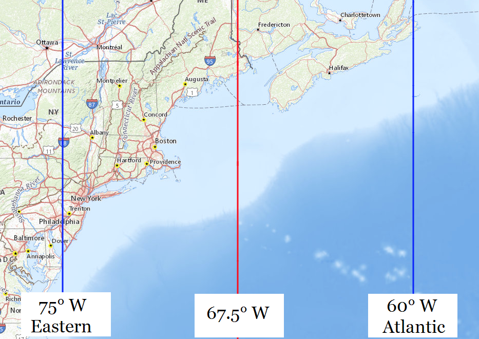
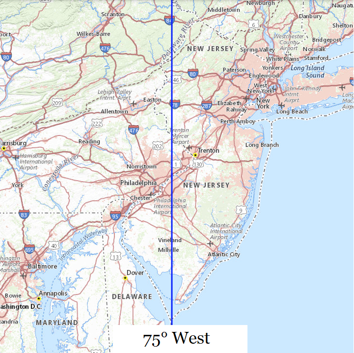
Mean solar time at noon
Eastern Standard Time
(Central Daylight Saving Time) |
Mean solar time at noon
Atlantic Standard Time
(Eastern Daylight Saving Time) |
A B Z Academy School,
Middlesex County
|
Elevation: 32 meters*
Latitude: 40.54204° N
Longitude: 74.36043° W
|
12:02:33 |
11:02:33 |
A Chester Redshaw Elementary School,
Middlesex County
|
Elevation: 26 meters*
Latitude: 40.4807473° N
Longitude: 74.4683831° W
|
12:02:07 |
11:02:07 |
A Childs Place Preschool,
Somerset County
|
Elevation: 39 meters*
Latitude: 40.5128976° N
Longitude: 74.6868095° W
|
12:01:15 |
11:01:15 |
A Childs Place School,
Monmouth County
|
Elevation: 24 meters*
Latitude: 40.3454289° N
Longitude: 74.1308413° W
|
12:03:28 |
11:03:28 |
A Russell Knight Elementary School,
Camden County
|
Elevation: 15 meters*
Latitude: 39.9004099° N
Longitude: 75.0112383° W
|
11:59:57 |
10:59:57 |
ARC Dorothy B Hersh High School,
Monmouth County
|
Elevation: 43 meters*
Latitude: 40.2659866° N
Longitude: 74.0773307° W
|
12:03:41 |
11:03:41 |
ARC of Essex County Stepping Stones School,
Essex County
|
Elevation: 134 meters*
Latitude: 40.7722517° N
Longitude: 74.3008902° W
|
12:02:47 |
11:02:47 |
Aaron Decker Elementary School,
Morris County
|
Elevation: 160 meters*
Latitude: 41.0067643° N
Longitude: 74.35654° W
|
12:02:34 |
11:02:34 |
Abbott Avenue School (historical),
Bergen County
|
Elevation: 35 meters*
Latitude: 40.8326003° N
Longitude: 74.0051393° W
|
12:03:58 |
11:03:58 |
Abington Avenue Elementary School,
Essex County
|
Elevation: 40 meters*
Latitude: 40.7706564° N
Longitude: 74.1815336° W
|
12:03:16 |
11:03:16 |
Abraham Clark High School,
Union County
|
Elevation: 19 meters*
Latitude: 40.6537138° N
Longitude: 74.2612576° W
|
12:02:57 |
11:02:57 |
Abraham Levitt High School,
Burlington County
|
Elevation: 21 meters*
Latitude: 40.0281672° N
Longitude: 74.8948885° W
|
12:00:25 |
11:00:25 |
Abraham Lincoln Elementary School,
Bergen County
|
Elevation: 115 meters*
Latitude: 41.0150972° N
Longitude: 74.1612552° W
|
12:03:21 |
11:03:21 |
Abraham Lincoln Elementary School,
Union County
|
Elevation: 10 meters*
Latitude: 40.6601027° N
Longitude: 74.2273678° W
|
12:03:05 |
11:03:05 |
Abram Morris Elementary School,
Union County
|
Elevation: 15 meters*
Latitude: 40.6912132° N
Longitude: 74.2212567° W
|
12:03:06 |
11:03:06 |
Absalom Grundy School,
Passaic County
|
Elevation: 52 meters*
Latitude: 40.9328762° N
Longitude: 74.1890338° W
|
12:03:14 |
11:03:14 |
Absecon Highland School (historical),
Atlantic County
|
Elevation: 14 meters*
Latitude: 39.4573394° N
Longitude: 74.5109861° W
|
12:01:57 |
11:01:57 |
Absecon Post Office,
Atlantic County
|
Elevation: 8 meters*
Latitude: 39.4369236° N
Longitude: 74.5158142° W
|
12:01:56 |
11:01:56 |
Absegami High School,
Atlantic County
|
Elevation: 15 meters*
Latitude: 39.4811272° N
Longitude: 74.5157195° W
|
12:01:56 |
11:01:56 |
Absegami High School,
Atlantic County
|
Elevation: 16 meters*
Latitude: 39.4806729° N
Longitude: 74.5159863° W
|
12:01:56 |
11:01:56 |
Academy Charter High School,
Monmouth County
|
Elevation: 6 meters*
Latitude: 40.1719° N
Longitude: 74.02709° W
|
12:03:53 |
11:03:53 |
Academy II School,
Hudson County
|
Elevation: 27 meters*
Latitude: 40.7203798° N
Longitude: 74.0743082° W
|
12:03:42 |
11:03:42 |
Academy Learning Center School,
Middlesex County
|
Elevation: 32 meters*
Latitude: 40.3530768° N
Longitude: 74.4103045° W
|
12:02:21 |
11:02:21 |
Academy Street Elementary School,
Morris County
|
Elevation: 201 meters*
Latitude: 40.8787102° N
Longitude: 74.5593245° W
|
12:01:45 |
11:01:45 |
Academy for Allied Health Sciences,
Union County
|
Elevation: 22 meters*
Latitude: 40.6181459° N
Longitude: 74.35822° W
|
12:02:34 |
11:02:34 |
Academy for Information Technology,
Union County
|
Elevation: 21 meters*
Latitude: 40.6172049° N
Longitude: 74.3572568° W
|
12:02:34 |
11:02:34 |
Academy for Science Math Engineering Technologies High School,
Middlesex County
|
Elevation: 30 meters*
Latitude: 40.5045989° N
Longitude: 74.3695657° W
|
12:02:31 |
11:02:31 |
Academy of Saint Benedict,
Essex County
|
Elevation: 5 meters*
Latitude: 40.7248239° N
Longitude: 74.148477° W
|
12:03:24 |
11:03:24 |
Academy of Saint Elizabeth School,
Morris County
|
Elevation: 113 meters*
Latitude: 40.779004° N
Longitude: 74.4382083° W
|
12:02:14 |
11:02:14 |
Academy of the Sacred Heart High School,
Hudson County
|
Elevation: 9 meters*
Latitude: 40.7448239° N
Longitude: 74.027918° W
|
12:03:53 |
11:03:53 |
Acorn Montessori School,
Hunterdon County
|
Elevation: 70 meters*
Latitude: 40.6006697° N
Longitude: 74.8736787° W
|
12:00:30 |
11:00:30 |
Adams School,
Middlesex County
|
Elevation: 35 meters*
Latitude: 40.4473275° N
Longitude: 74.4973758° W
|
12:02:00 |
11:02:00 |
Adamsville Elementary School,
Somerset County
|
Elevation: 26 meters*
Latitude: 40.5689438° N
Longitude: 74.5818231° W
|
12:01:40 |
11:01:40 |
Adelphia Elementary School,
Monmouth County
|
Elevation: 28 meters*
Latitude: 40.2064858° N
Longitude: 74.2153559° W
|
12:03:08 |
11:03:08 |
Adelphia Post Office,
Monmouth County
|
Elevation: 31 meters*
Latitude: 40.2177702° N
Longitude: 74.2562497° W
|
12:02:58 |
11:02:58 |
Adlai Stevenson Elementary School,
Essex County
|
Elevation: 52 meters*
Latitude: 40.8820435° N
Longitude: 74.3157048° W
|
12:02:44 |
11:02:44 |
Admiral Farragut Academy,
Ocean County
|
Elevation: 5 meters*
Latitude: 39.9395626° N
Longitude: 74.1665288° W
|
12:03:20 |
11:03:20 |
Adult Learning Center School,
Cumberland County
|
Elevation: 20 meters*
Latitude: 39.4379287° N
Longitude: 75.2454737° W
|
11:59:01 |
10:59:01 |
Afrikan Peoples Action School,
Mercer County
|
Elevation: 28 meters*
Latitude: 40.2347136° N
Longitude: 74.7569428° W
|
12:00:58 |
11:00:58 |
Agapeland Childcare Center Preschool,
Middlesex County
|
Elevation: 11 meters*
Latitude: 40.4948335° N
Longitude: 74.3035931° W
|
12:02:47 |
11:02:47 |
Al-Ghazaly High School,
Bergen County
|
Elevation: 36 meters*
Latitude: 40.8877778° N
Longitude: 74.0247222° W
|
12:03:54 |
11:03:54 |
Alan B Shepard Elementary School,
Middlesex County
|
Elevation: 21 meters*
Latitude: 40.39888° N
Longitude: 74.31381° W
|
12:02:44 |
11:02:44 |
Albert E Burling Elementary School,
Camden County
|
Elevation: 5 meters*
Latitude: 39.9371687° N
Longitude: 75.0815801° W
|
11:59:40 |
10:59:40 |
Albert E Grice Middle School,
Mercer County
|
Elevation: 30 meters*
Latitude: 40.2019859° N
Longitude: 74.6916284° W
|
12:01:14 |
11:01:14 |
Albert P Terhune Elementary School,
Passaic County
|
Elevation: 119 meters*
Latitude: 40.9700979° N
Longitude: 74.2559806° W
|
12:02:58 |
11:02:58 |
Albion School,
Camden County
|
Elevation: 46 meters*
Latitude: 39.7720595° N
Longitude: 74.9621098° W
|
12:00:09 |
11:00:09 |
Albrook Montessori School,
Somerset County
|
Elevation: 75 meters*
Latitude: 40.6586163° N
Longitude: 74.59195° W
|
12:01:37 |
11:01:37 |
Alder Avenue Middle School,
Atlantic County
|
Elevation: 17 meters*
Latitude: 39.4143919° N
Longitude: 74.6442872° W
|
12:01:25 |
11:01:25 |
Aldrich Elementary School,
Monmouth County
|
Elevation: 32 meters*
Latitude: 40.1493979° N
Longitude: 74.2455719° W
|
12:03:01 |
11:03:01 |
Aletta Crichton Elementary School,
Burlington County
|
Elevation: 25 meters*
Latitude: 39.955474° N
Longitude: 74.5906745° W
|
12:01:38 |
11:01:38 |
Alexander Batcho Intermediate School,
Somerset County
|
Elevation: 17 meters*
Latitude: 40.5456493° N
Longitude: 74.5976723° W
|
12:01:36 |
11:01:36 |
Alexander D Sullivan Number 30 Elementary School,
Hudson County
|
Elevation: 17 meters*
Latitude: 40.6937136° N
Longitude: 74.0976422° W
|
12:03:36 |
11:03:36 |
Alexander Denbo Elementary School,
Burlington County
|
Elevation: 25 meters*
Latitude: 39.9554866° N
Longitude: 74.5906801° W
|
12:01:38 |
11:01:38 |
Alexander Elementary School,
Mercer County
|
Elevation: 26 meters*
Latitude: 40.2176333° N
Longitude: 74.6543013° W
|
12:01:22 |
11:01:22 |
Alexander Hamilton Elementary School,
Morris County
|
Elevation: 103 meters*
Latitude: 40.8014815° N
Longitude: 74.4907189° W
|
12:02:02 |
11:02:02 |
Alexander Street Elementary School,
Essex County
|
Elevation: 52 meters*
Latitude: 40.7442678° N
Longitude: 74.225146° W
|
12:03:05 |
11:03:05 |
Alexandria Middle School,
Hunterdon County
|
Elevation: 129 meters*
Latitude: 40.573° N
Longitude: 75.0116267° W
|
11:59:57 |
10:59:57 |
Alfred C MacKinnon Middle School,
Morris County
|
Elevation: 205 meters*
Latitude: 40.8953767° N
Longitude: 74.5754363° W
|
12:01:41 |
11:01:41 |
Alfred E Zampella Number 27 Elementary School,
Hudson County
|
Elevation: 48 meters*
Latitude: 40.7537125° N
Longitude: 74.0506965° W
|
12:03:47 |
11:03:47 |
Alfred Reed School,
Mercer County
|
Elevation: 33 meters*
Latitude: 40.2512195° N
Longitude: 74.7643281° W
|
12:00:56 |
11:00:56 |
Alfred S Faust Intermediate Elementary School,
Bergen County
|
Elevation: 26 meters*
Latitude: 40.8353778° N
Longitude: 74.0984755° W
|
12:03:36 |
11:03:36 |
Alfred Vail Elementary School,
Morris County
|
Elevation: 118 meters*
Latitude: 40.8178776° N
Longitude: 74.4807105° W
|
12:02:04 |
11:02:04 |
Alice Costello Elementary School,
Camden County
|
Elevation: 7 meters*
Latitude: 39.8781059° N
Longitude: 75.1185962° W
|
11:59:31 |
10:59:31 |
All Day Learning Centers School,
Somerset County
|
Elevation: 27 meters*
Latitude: 40.4697724° N
Longitude: 74.649575° W
|
12:01:24 |
11:01:24 |
All Saints Episcopal Day School,
Hudson County
|
Elevation: 8 meters*
Latitude: 40.7453795° N
Longitude: 74.027918° W
|
12:03:53 |
11:03:53 |
All Saints Regional Catholic School,
Ocean County
|
Elevation: 24 meters*
Latitude: 39.699129° N
Longitude: 74.2790551° W
|
12:02:53 |
11:02:53 |
All Saints School,
Burlington County
|
Elevation: 2 meters*
Latitude: 40.0748165° N
Longitude: 74.8572234° W
|
12:00:34 |
11:00:34 |
Allamuchy Post Office,
Warren County
|
Elevation: 260 meters*
Latitude: 40.9040827° N
Longitude: 74.8238623° W
|
12:00:42 |
11:00:42 |
Allegro School,
Morris County
|
Elevation: 86 meters*
Latitude: 40.8187109° N
Longitude: 74.4504317° W
|
12:02:11 |
11:02:11 |
Allen W Roberts Elementary School,
Union County
|
Elevation: 68 meters*
Latitude: 40.69196° N
Longitude: 74.41515° W
|
12:02:20 |
11:02:20 |
Allendale Post Office,
Bergen County
|
Elevation: 87 meters*
Latitude: 41.0309826° N
Longitude: 74.1295555° W
|
12:03:28 |
11:03:28 |
Allenhurst Post Office,
Monmouth County
|
Elevation: 6 meters*
Latitude: 40.2391062° N
Longitude: 74.0051601° W
|
12:03:58 |
11:03:58 |
Allentown High School,
Monmouth County
|
Elevation: 32 meters*
Latitude: 40.1724799° N
Longitude: 74.5891852° W
|
12:01:38 |
11:01:38 |
Allentown Post Office,
Monmouth County
|
Elevation: 25 meters*
Latitude: 40.1776423° N
Longitude: 74.5848373° W
|
12:01:39 |
11:01:39 |
Allenwood Elementary School,
Monmouth County
|
Elevation: 16 meters*
Latitude: 40.1417729° N
Longitude: 74.1031934° W
|
12:03:35 |
11:03:35 |
Allenwood Post Office,
Monmouth County
|
Elevation: 18 meters*
Latitude: 40.1425547° N
Longitude: 74.1020875° W
|
12:03:35 |
11:03:35 |
Alloway Post Office,
Salem County
|
Elevation: 12 meters*
Latitude: 39.5592757° N
Longitude: 75.3631085° W
|
11:58:32 |
10:58:32 |
Alloway Township School,
Salem County
|
Elevation: 10 meters*
Latitude: 39.5583416° N
Longitude: 75.3639555° W
|
11:58:32 |
10:58:32 |
Allwood Post Office,
Passaic County
|
Elevation: 42 meters*
Latitude: 40.8421363° N
Longitude: 74.1588677° W
|
12:03:21 |
11:03:21 |
Allwood Post Office,
Passaic County
|
Elevation: 42 meters*
Latitude: 40.8421346° N
Longitude: 74.1588679° W
|
12:03:21 |
11:03:21 |
Alma White College (historical),
Somerset County
|
Elevation: 11 meters*
Latitude: 40.5376034° N
Longitude: 74.5779343° W
|
12:01:41 |
11:01:41 |
Alpha Elementary School,
Warren County
|
Elevation: 105 meters*
Latitude: 40.6642973° N
Longitude: 75.1646054° W
|
11:59:20 |
10:59:20 |
Alpha Post Office,
Warren County
|
Elevation: 93 meters*
Latitude: 40.6646456° N
Longitude: 75.1588346° W
|
11:59:21 |
10:59:21 |
Alpha School,
Ocean County
|
Elevation: 21 meters*
Latitude: 40.1007312° N
Longitude: 74.2201658° W
|
12:03:07 |
11:03:07 |
Alpine Post Office,
Bergen County
|
Elevation: 126 meters*
Latitude: 40.9485975° N
Longitude: 73.9289934° W
|
12:04:17 |
11:04:17 |
Alpine Public Elementary School,
Bergen County
|
Elevation: 134 meters*
Latitude: 40.9409319° N
Longitude: 73.9276366° W
|
12:04:17 |
11:04:17 |
Ambassador Christian Academy Elementary School,
Ocean County
|
Elevation: 12 meters*
Latitude: 39.9590999° N
Longitude: 74.2000221° W
|
12:03:11 |
11:03:11 |
Ambassador Christian Academy School,
Gloucester County
|
Elevation: 39 meters*
Latitude: 39.7132291° N
Longitude: 75.1320682° W
|
11:59:28 |
10:59:28 |
American Boychoir School,
Mercer County
|
Elevation: 52 meters*
Latitude: 40.3420459° N
Longitude: 74.6973413° W
|
12:01:12 |
11:01:12 |
Amerigo A Anastasia Elementary School,
Monmouth County
|
Elevation: 3 meters*
Latitude: 40.3058471° N
Longitude: 73.997412° W
|
12:04:00 |
11:04:00 |
Ampere Post Office,
Essex County
|
Elevation: 39 meters*
Latitude: 40.7648717° N
Longitude: 74.1961342° W
|
12:03:12 |
11:03:12 |
Amsterdam Elementary School,
Somerset County
|
Elevation: 30 meters*
Latitude: 40.4808292° N
Longitude: 74.5941379° W
|
12:01:37 |
11:01:37 |
Amwell School (historical),
Hunterdon County
|
Elevation: 68 meters*
Latitude: 40.4548268° N
Longitude: 74.8390532° W
|
12:00:38 |
11:00:38 |
An Noor Academy School,
Middlesex County
|
Elevation: 25 meters*
Latitude: 40.5304008° N
Longitude: 74.4291196° W
|
12:02:17 |
11:02:17 |
Andover Morris Elementary School,
Warren County
|
Elevation: 60 meters*
Latitude: 40.681622° N
Longitude: 75.180936° W
|
11:59:16 |
10:59:16 |
Andover Post Office,
Sussex County
|
Elevation: 182 meters*
Latitude: 40.9882983° N
Longitude: 74.7414841° W
|
12:01:02 |
11:01:02 |
Andover School (historical),
Sussex County
|
Elevation: 183 meters*
Latitude: 40.9881534° N
Longitude: 74.7393311° W
|
12:01:02 |
11:01:02 |
Angelo Tomaso Elementary School,
Somerset County
|
Elevation: 83 meters*
Latitude: 40.6034167° N
Longitude: 74.5240707° W
|
12:01:54 |
11:01:54 |
Anita Metzger Memorial School,
Atlantic County
|
Elevation: 2 meters*
Latitude: 39.3429963° N
Longitude: 74.4721495° W
|
12:02:06 |
11:02:06 |
Ann A Mullen Middle School,
Camden County
|
Elevation: 42 meters*
Latitude: 39.7488154° N
Longitude: 75.0163495° W
|
11:59:56 |
10:59:56 |
Ann Street Elementary School,
Essex County
|
Elevation: 5 meters*
Latitude: 40.723435° N
Longitude: 74.1556994° W
|
12:03:22 |
11:03:22 |
Anna E Scott Elementary School,
Bergen County
|
Elevation: 36 meters*
Latitude: 40.8603777° N
Longitude: 73.9879164° W
|
12:04:02 |
11:04:02 |
Anna L Klein Elementary School,
Hudson County
|
Elevation: 71 meters*
Latitude: 40.7939898° N
Longitude: 74.0084729° W
|
12:03:57 |
11:03:57 |
Annandale Post Office,
Hunterdon County
|
Elevation: 89 meters*
Latitude: 40.6401514° N
Longitude: 74.8813688° W
|
12:00:28 |
11:00:28 |
Annandale School (historical),
Hunterdon County
|
Elevation: 82 meters*
Latitude: 40.6392682° N
Longitude: 74.8823891° W
|
12:00:28 |
11:00:28 |
Annunciation Regional School,
Camden County
|
Elevation: 11 meters*
Latitude: 39.8745679° N
Longitude: 75.1043531° W
|
11:59:34 |
10:59:34 |
Anshe Emeth Religious School,
Middlesex County
|
Elevation: 26 meters*
Latitude: 40.4852778° N
Longitude: 74.4513889° W
|
12:02:11 |
11:02:11 |
Anthony J Infante Number 31 Elementary School,
Hudson County
|
Elevation: 28 meters*
Latitude: 40.738435° N
Longitude: 74.0626413° W
|
12:03:44 |
11:03:44 |
Anthony Rossi Intermediate School,
Cumberland County
|
Elevation: 30 meters*
Latitude: 39.4481165° N
Longitude: 74.9796367° W
|
12:00:04 |
11:00:04 |
Anthony School,
Morris County
|
Elevation: 72 meters*
Latitude: 40.7673226° N
Longitude: 74.4162637° W
|
12:02:20 |
11:02:20 |
Anthony V Ceres Elementary School,
Middlesex County
|
Elevation: 15 meters*
Latitude: 40.51431° N
Longitude: 74.26583° W
|
12:02:56 |
11:02:56 |
Apple Montessori School,
Middlesex County
|
Elevation: 28 meters*
Latitude: 40.5154657° N
Longitude: 74.3589803° W
|
12:02:33 |
11:02:33 |
Applegarth Middle School,
Middlesex County
|
Elevation: 43 meters*
Latitude: 40.29562° N
Longitude: 74.47191° W
|
12:02:06 |
11:02:06 |
Apples Books Bugs And Sticks Preschool,
Somerset County
|
Elevation: 30 meters*
Latitude: 40.5531648° N
Longitude: 74.7259346° W
|
12:01:05 |
11:01:05 |
Apples and Books Learning Center School,
Somerset County
|
Elevation: 36 meters*
Latitude: 40.5641435° N
Longitude: 74.6947186° W
|
12:01:13 |
11:01:13 |
Apshawa Elementary School,
Passaic County
|
Elevation: 215 meters*
Latitude: 41.0198196° N
Longitude: 74.3704296° W
|
12:02:31 |
11:02:31 |
Aquinas Academy School,
Essex County
|
Elevation: 86 meters*
Latitude: 40.7806497° N
Longitude: 74.3187724° W
|
12:02:43 |
11:02:43 |
Arbor Elementary School,
Middlesex County
|
Elevation: 23 meters*
Latitude: 40.5909143° N
Longitude: 74.4471257° W
|
12:02:12 |
11:02:12 |
Archbishop Damiano School,
Gloucester County
|
Elevation: 17 meters*
Latitude: 39.8480081° N
Longitude: 75.1238902° W
|
11:59:30 |
10:59:30 |
Archway Lower School,
Camden County
|
Elevation: 45 meters*
Latitude: 39.7815677° N
Longitude: 74.8918275° W
|
12:00:25 |
11:00:25 |
Archway School - Washington Township,
Gloucester County
|
Elevation: 41 meters*
Latitude: 39.7236779° N
Longitude: 75.0865237° W
|
11:59:39 |
10:59:39 |
Archway Upper School,
Burlington County
|
Elevation: 42 meters*
Latitude: 39.7833237° N
Longitude: 74.8913971° W
|
12:00:26 |
11:00:26 |
Ardena Elementary School,
Monmouth County
|
Elevation: 23 meters*
Latitude: 40.2034071° N
Longitude: 74.2076625° W
|
12:03:10 |
11:03:10 |
Arleth Elementary School,
Middlesex County
|
Elevation: 18 meters*
Latitude: 40.4687231° N
Longitude: 74.3043109° W
|
12:02:46 |
11:02:46 |
Arlington Avenue School,
Essex County
|
Elevation: 20 meters*
Latitude: 40.7656565° N
Longitude: 74.1662554° W
|
12:03:20 |
11:03:20 |
Aronson Bell School,
Burlington County
|
Elevation: 18 meters*
Latitude: 40.0228895° N
Longitude: 74.9346122° W
|
12:00:15 |
11:00:15 |
Arthur L Johnson High School,
Union County
|
Elevation: 17 meters*
Latitude: 40.6221911° N
Longitude: 74.3131615° W
|
12:02:44 |
11:02:44 |
Arthur M Judd Elementary School,
Middlesex County
|
Elevation: 36 meters*
Latitude: 40.44879° N
Longitude: 74.47446° W
|
12:02:06 |
11:02:06 |
Arthur P Schalick High School,
Salem County
|
Elevation: 31 meters*
Latitude: 39.5286985° N
Longitude: 75.1631206° W
|
11:59:20 |
10:59:20 |
Arthur Rann School,
Atlantic County
|
Elevation: 16 meters*
Latitude: 39.4551172° N
Longitude: 74.505708° W
|
12:01:58 |
11:01:58 |
Arthur Rann School,
Atlantic County
|
Elevation: 16 meters*
Latitude: 39.455395° N
Longitude: 74.5059858° W
|
12:01:58 |
11:01:58 |
Arthur Stanlick Elementary School,
Morris County
|
Elevation: 286 meters*
Latitude: 40.9720426° N
Longitude: 74.5893261° W
|
12:01:38 |
11:01:38 |
Arts High School,
Essex County
|
Elevation: 21 meters*
Latitude: 40.7359347° N
Longitude: 74.1795891° W
|
12:03:16 |
11:03:16 |
Asbury Park Adult Learning Center School,
Monmouth County
|
Elevation: 2 meters*
Latitude: 40.2161581° N
Longitude: 74.0076537° W
|
12:03:58 |
11:03:58 |
Asbury Park High School,
Monmouth County
|
Elevation: 3 meters*
Latitude: 40.2286778° N
Longitude: 74.0129207° W
|
12:03:56 |
11:03:56 |
Asbury Park Middle School,
Monmouth County
|
Elevation: 8 meters*
Latitude: 40.2181521° N
Longitude: 74.0198677° W
|
12:03:55 |
11:03:55 |
Asbury Park Post Office,
Monmouth County
|
Elevation: 5 meters*
Latitude: 40.2179709° N
Longitude: 74.0132282° W
|
12:03:56 |
11:03:56 |
Asbury Post Office,
Warren County
|
Elevation: 103 meters*
Latitude: 40.7009157° N
Longitude: 75.0128156° W
|
11:59:56 |
10:59:56 |
Ashbrook Elementary School,
Burlington County
|
Elevation: 14 meters*
Latitude: 39.9644651° N
Longitude: 74.7963525° W
|
12:00:48 |
11:00:48 |
Ashbury School,
Camden County
|
Elevation: 13 meters*
Latitude: 39.9478° N
Longitude: 75.0839° W
|
11:59:39 |
10:59:39 |
Asher Holmes Elementary School,
Monmouth County
|
Elevation: 51 meters*
Latitude: 40.3440012° N
Longitude: 74.2940975° W
|
12:02:49 |
11:02:49 |
Ashland School (historical),
Essex County
|
Elevation: 44 meters*
Latitude: 40.7698229° N
Longitude: 74.2098678° W
|
12:03:09 |
11:03:09 |
Ashland School,
Camden County
|
Elevation: 23 meters*
Latitude: 39.8542805° N
Longitude: 75.0065571° W
|
11:59:58 |
10:59:58 |
Assumption Catholic School,
Middlesex County
|
Elevation: 24 meters*
Latitude: 40.52277° N
Longitude: 74.27326° W
|
12:02:54 |
11:02:54 |
Assumption College for Sisters,
Morris County
|
Elevation: 188 meters*
Latitude: 40.7573543° N
Longitude: 74.6026586° W
|
12:01:35 |
11:01:35 |
Assumption Regional Catholic School,
Atlantic County
|
Elevation: 12 meters*
Latitude: 39.4758244° N
Longitude: 74.4911495° W
|
12:02:02 |
11:02:02 |
Assumption School,
Bergen County
|
Elevation: 17 meters*
Latitude: 40.9759312° N
Longitude: 74.0237504° W
|
12:03:54 |
11:03:54 |
Assumption School,
Bergen County
|
Elevation: 54 meters*
Latitude: 40.8467666° N
Longitude: 74.0854194° W
|
12:03:39 |
11:03:39 |
Assumption School,
Camden County
|
Elevation: 53 meters*
Latitude: 39.7701065° N
Longitude: 74.8952685° W
|
12:00:25 |
11:00:25 |
Assumption School,
Morris County
|
Elevation: 111 meters*
Latitude: 40.7908855° N
Longitude: 74.4806411° W
|
12:02:04 |
11:02:04 |
Atco Elementary School,
Camden County
|
Elevation: 51 meters*
Latitude: 39.7724345° N
Longitude: 74.8941404° W
|
12:00:25 |
11:00:25 |
Atco Post Office,
Camden County
|
Elevation: 43 meters*
Latitude: 39.7674595° N
Longitude: 74.8881743° W
|
12:00:26 |
11:00:26 |
Atlantic Avenue Elementary School,
Camden County
|
Elevation: 27 meters*
Latitude: 39.8853408° N
Longitude: 75.0609134° W
|
11:59:45 |
10:59:45 |
Atlantic Cape Community College - Atlantic City Campus,
Atlantic County
|
Elevation: 2 meters*
Latitude: 39.3634525° N
Longitude: 74.4314012° W
|
12:02:16 |
11:02:16 |
Atlantic Cape Community College - Cape May Campus,
Cape May County
|
Elevation: 7 meters*
Latitude: 39.102603° N
Longitude: 74.8203001° W
|
12:00:43 |
11:00:43 |
Atlantic Christian School,
Atlantic County
|
Elevation: 12 meters*
Latitude: 39.3591182° N
Longitude: 74.6399302° W
|
12:01:26 |
11:01:26 |
Atlantic City Evening High School,
Atlantic County
|
Elevation: 3 meters*
Latitude: 39.3590373° N
Longitude: 74.4334837° W
|
12:02:15 |
11:02:15 |
Atlantic City High School,
Atlantic County
|
Elevation: 4 meters*
Latitude: 39.3680386° N
Longitude: 74.476144° W
|
12:02:05 |
11:02:05 |
Atlantic City Post Office,
Atlantic County
|
Elevation: 3 meters*
Latitude: 39.360092° N
Longitude: 74.4336605° W
|
12:02:15 |
11:02:15 |
Atlantic Community College,
Atlantic County
|
Elevation: 15 meters*
Latitude: 39.4606721° N
Longitude: 74.6809938° W
|
12:01:16 |
11:01:16 |
Atlantic County Adult Education School,
Atlantic County
|
Elevation: 15 meters*
Latitude: 39.4426347° N
Longitude: 74.6965461° W
|
12:01:12 |
11:01:12 |
Atlantic County Institute of Technology,
Atlantic County
|
Elevation: 15 meters*
Latitude: 39.4426849° N
Longitude: 74.6964803° W
|
12:01:12 |
11:01:12 |
Atlantic County Special Elementary School,
Atlantic County
|
Elevation: 21 meters*
Latitude: 39.4383302° N
Longitude: 74.6946054° W
|
12:01:13 |
11:01:13 |
Atlantic County Special High School,
Atlantic County
|
Elevation: 21 meters*
Latitude: 39.4383288° N
Longitude: 74.6946757° W
|
12:01:13 |
11:01:13 |
Atlantic Highlands Elementary School,
Monmouth County
|
Elevation: 6 meters*
Latitude: 40.4113832° N
Longitude: 74.0385745° W
|
12:03:50 |
11:03:50 |
Atlantic Highlands Post Office,
Monmouth County
|
Elevation: 3 meters*
Latitude: 40.4134756° N
Longitude: 74.0388057° W
|
12:03:50 |
11:03:50 |
Atlantic Township Grade School (historical),
Monmouth County
|
Elevation: 27 meters*
Latitude: 40.2884441° N
Longitude: 74.1706984° W
|
12:03:19 |
11:03:19 |
Atlantis Elementary School,
Burlington County
|
Elevation: 30 meters*
Latitude: 40.0497817° N
Longitude: 74.5780408° W
|
12:01:41 |
11:01:41 |
Atlantis Preparatory School,
Monmouth County
|
Elevation: 28 meters*
Latitude: 40.1354477° N
Longitude: 74.0762611° W
|
12:03:41 |
11:03:41 |
Audrey W Clark Elementary School,
Monmouth County
|
Elevation: 6 meters*
Latitude: 40.3021146° N
Longitude: 73.9861935° W
|
12:04:03 |
11:04:03 |
Audubon High School,
Camden County
|
Elevation: 15 meters*
Latitude: 39.8847516° N
Longitude: 75.0760728° W
|
11:59:41 |
10:59:41 |
Audubon Post Office,
Camden County
|
Elevation: 6 meters*
Latitude: 39.890224° N
Longitude: 75.0882856° W
|
11:59:38 |
10:59:38 |
Augusta Elementary School,
Essex County
|
Elevation: 37 meters*
Latitude: 40.7226015° N
Longitude: 74.2298682° W
|
12:03:04 |
11:03:04 |
Augusta Post Office,
Sussex County
|
Elevation: 161 meters*
Latitude: 41.1162293° N
Longitude: 74.7184584° W
|
12:01:07 |
11:01:07 |
Aura Elementary School,
Gloucester County
|
Elevation: 44 meters*
Latitude: 39.6734681° N
Longitude: 75.1419865° W
|
11:59:25 |
10:59:25 |
Austin Academy School,
Monmouth County
|
Elevation: 15 meters*
Latitude: 40.4018583° N
Longitude: 74.0998203° W
|
12:03:36 |
11:03:36 |
Auten Road Intermediate School,
Somerset County
|
Elevation: 37 meters*
Latitude: 40.5200307° N
Longitude: 74.6615245° W
|
12:01:21 |
11:01:21 |
Avalon Elementary School,
Cape May County
|
Elevation: 2 meters*
Latitude: 39.0959208° N
Longitude: 74.7253733° W
|
12:01:05 |
11:01:05 |
Avalon Post Office,
Cape May County
|
Elevation: 2 meters*
Latitude: 39.0942439° N
Longitude: 74.723882° W
|
12:01:06 |
11:01:06 |
Avenel Middle School,
Middlesex County
|
Elevation: 12 meters*
Latitude: 40.5887117° N
Longitude: 74.2846041° W
|
12:02:51 |
11:02:51 |
Avenel Post Office,
Middlesex County
|
Elevation: 13 meters*
Latitude: 40.5778307° N
Longitude: 74.2696365° W
|
12:02:55 |
11:02:55 |
Avenel Street Elementary School,
Middlesex County
|
Elevation: 20 meters*
Latitude: 40.5784479° N
Longitude: 74.2790711° W
|
12:02:53 |
11:02:53 |
Avon By the Sea Post Office,
Monmouth County
|
Elevation: 5 meters*
Latitude: 40.1916041° N
Longitude: 74.0223603° W
|
12:03:54 |
11:03:54 |
Avon Elementary School,
Camden County
|
Elevation: 24 meters*
Latitude: 39.880525° N
Longitude: 75.0444599° W
|
11:59:49 |
10:59:49 |
Avon Elementary School,
Monmouth County
|
Elevation: 5 meters*
Latitude: 40.1903276° N
Longitude: 74.0209373° W
|
12:03:54 |
11:03:54 |
B Bernice Young Elementary School,
Burlington County
|
Elevation: 11 meters*
Latitude: 40.0774676° N
Longitude: 74.8168753° W
|
12:00:43 |
11:00:43 |
B E S T Academy School,
Monmouth County
|
Elevation: 2 meters*
Latitude: 40.422662° N
Longitude: 74.0631812° W
|
12:03:44 |
11:03:44 |
B'nai Jeshurun Early Childhood School,
Essex County
|
Elevation: 121 meters*
Latitude: 40.7570481° N
Longitude: 74.3126032° W
|
12:02:44 |
11:02:44 |
Bacon School,
Cumberland County
|
Elevation: 8 meters*
Latitude: 39.3870595° N
Longitude: 75.0304544° W
|
11:59:52 |
10:59:52 |
Bacons Neck School,
Cumberland County
|
Elevation: 4 meters*
Latitude: 39.3951134° N
Longitude: 75.375195° W
|
11:58:29 |
10:58:29 |
Bais Chinuch L'Bonos Bayis Ruchel School,
Ocean County
|
Elevation: 21 meters*
Latitude: 40.1024572° N
Longitude: 74.2128983° W
|
12:03:08 |
11:03:08 |
Bais Faiga Park Avenue Campus School,
Ocean County
|
Elevation: 17 meters*
Latitude: 40.0919269° N
Longitude: 74.2085223° W
|
12:03:09 |
11:03:09 |
Bais Faiga School,
Ocean County
|
Elevation: 21 meters*
Latitude: 40.1029983° N
Longitude: 74.2178296° W
|
12:03:07 |
11:03:07 |
Bais Kaila Torah Preparatory High School,
Ocean County
|
Elevation: 21 meters*
Latitude: 40.0719591° N
Longitude: 74.2083366° W
|
12:03:09 |
11:03:09 |
Bais Rivka Rochel School,
Ocean County
|
Elevation: 19 meters*
Latitude: 40.0800224° N
Longitude: 74.2163024° W
|
12:03:08 |
11:03:08 |
Bais Shaindel High School,
Ocean County
|
Elevation: 26 meters*
Latitude: 40.0712534° N
Longitude: 74.2175973° W
|
12:03:07 |
11:03:07 |
Baldwin School,
Camden County
|
Elevation: 15 meters*
Latitude: 39.9603558° N
Longitude: 75.0772113° W
|
11:59:41 |
10:59:41 |
Bancroft Elementary Program School,
Camden County
|
Elevation: 20 meters*
Latitude: 39.8839921° N
Longitude: 75.0664447° W
|
11:59:44 |
10:59:44 |
Bancroft School - Cherry Hill,
Camden County
|
Elevation: 14 meters*
Latitude: 39.9124802° N
Longitude: 75.0117037° W
|
11:59:57 |
10:59:57 |
Bancroft School - Haddonfield,
Camden County
|
Elevation: 15 meters*
Latitude: 39.9036397° N
Longitude: 75.0248° W
|
11:59:54 |
10:59:54 |
Bancroft School - Voorhees,
Camden County
|
Elevation: 37 meters*
Latitude: 39.8505819° N
Longitude: 74.9696275° W
|
12:00:07 |
11:00:07 |
Bangs Avenue Elementary School,
Monmouth County
|
Elevation: 7 meters*
Latitude: 40.2185225° N
Longitude: 74.0220873° W
|
12:03:54 |
11:03:54 |
Bankbridge Regional School,
Gloucester County
|
Elevation: 22 meters*
Latitude: 39.7911449° N
Longitude: 75.1177385° W
|
11:59:31 |
10:59:31 |
Baptist High School,
Camden County
|
Elevation: 25 meters*
Latitude: 39.8844° N
Longitude: 75.0552° W
|
11:59:46 |
10:59:46 |
Baptist Regional Elementary School,
Camden County
|
Elevation: 23 meters*
Latitude: 39.8950399° N
Longitude: 74.9664613° W
|
12:00:08 |
11:00:08 |
Baptist Regional School,
Camden County
|
Elevation: 26 meters*
Latitude: 39.8844261° N
Longitude: 75.0545883° W
|
11:59:46 |
10:59:46 |
Baptistown Post Office,
Hunterdon County
|
Elevation: 156 meters*
Latitude: 40.5236735° N
Longitude: 75.0060712° W
|
11:59:58 |
10:59:58 |
Barber Avenue School,
Salem County
|
Elevation: 4 meters*
Latitude: 39.7287248° N
Longitude: 75.4649178° W
|
11:58:08 |
10:58:08 |
Barber Elementary School,
Warren County
|
Elevation: 114 meters*
Latitude: 40.698465° N
Longitude: 75.1837813° W
|
11:59:15 |
10:59:15 |
Barclay Brook Elementary School,
Middlesex County
|
Elevation: 35 meters*
Latitude: 40.3381853° N
Longitude: 74.4168631° W
|
12:02:19 |
11:02:19 |
Barclay School,
Camden County
|
Elevation: 13 meters*
Latitude: 39.9031527° N
Longitude: 74.9920777° W
|
12:00:01 |
11:00:01 |
Barley Sheaf Elementary School,
Hunterdon County
|
Elevation: 65 meters*
Latitude: 40.4976007° N
Longitude: 74.8259416° W
|
12:00:41 |
11:00:41 |
Barnegat High School,
Ocean County
|
Elevation: 28 meters*
Latitude: 39.7699377° N
Longitude: 74.2320621° W
|
12:03:04 |
11:03:04 |
Barnegat Light Post Office,
Ocean County
|
Elevation: 2 meters*
Latitude: 39.7561007° N
Longitude: 74.1083393° W
|
12:03:33 |
11:03:33 |
Barnegat Post Office,
Ocean County
|
Elevation: 27 meters*
Latitude: 39.7568012° N
Longitude: 74.235991° W
|
12:03:03 |
11:03:03 |
Barringer High School,
Essex County
|
Elevation: 41 meters*
Latitude: 40.7553788° N
Longitude: 74.1790335° W
|
12:03:17 |
11:03:17 |
Barrington Post Office,
Camden County
|
Elevation: 22 meters*
Latitude: 39.8726001° N
Longitude: 75.0516493° W
|
11:59:47 |
10:59:47 |
Bartle Elementary School,
Middlesex County
|
Elevation: 27 meters*
Latitude: 40.4964° N
Longitude: 74.42304° W
|
12:02:18 |
11:02:18 |
Basking Ridge Post Office,
Somerset County
|
Elevation: 104 meters*
Latitude: 40.7055963° N
Longitude: 74.5505126° W
|
12:01:47 |
11:01:47 |
Bass River Township Elementary School,
Burlington County
|
Elevation: 5 meters*
Latitude: 39.5942841° N
Longitude: 74.4520436° W
|
12:02:11 |
11:02:11 |
Bates Mill School,
Camden County
|
Elevation: 38 meters*
Latitude: 39.7184497° N
Longitude: 74.8568296° W
|
12:00:34 |
11:00:34 |
Batsto Post Office,
Burlington County
|
Elevation: 7 meters*
Latitude: 39.643016° N
Longitude: 74.6485964° W
|
12:01:24 |
11:01:24 |
Battin Middle School,
Union County
|
Elevation: 12 meters*
Latitude: 40.6572298° N
Longitude: 74.2149109° W
|
12:03:08 |
11:03:08 |
Battle Hill Elementary School,
Union County
|
Elevation: 28 meters*
Latitude: 40.6995297° N
Longitude: 74.2976541° W
|
12:02:48 |
11:02:48 |
Bay Head Elementary School,
Ocean County
|
Elevation: 1 meters*
Latitude: 40.069708° N
Longitude: 74.05022° W
|
12:03:47 |
11:03:47 |
Bay Head Post Office,
Ocean County
|
Elevation: 1 meters*
Latitude: 40.0708194° N
Longitude: 74.0462632° W
|
12:03:48 |
11:03:48 |
Bayard Street School (historical),
Middlesex County
|
Elevation: 11 meters*
Latitude: 40.4941667° N
Longitude: 74.4427778° W
|
12:02:13 |
11:02:13 |
Bayberry Elementary School,
Somerset County
|
Elevation: 109 meters*
Latitude: 40.6526157° N
Longitude: 74.4235867° W
|
12:02:18 |
11:02:18 |
Bayonne High School,
Hudson County
|
Elevation: 8 meters*
Latitude: 40.6717696° N
Longitude: 74.1212538° W
|
12:03:30 |
11:03:30 |
Bayonne Post Office,
Hudson County
|
Elevation: 11 meters*
Latitude: 40.6665528° N
Longitude: 74.1156675° W
|
12:03:32 |
11:03:32 |
Bayshore Higher Education Center,
Monmouth County
|
Elevation: 4 meters*
Latitude: 40.4381632° N
Longitude: 74.1412534° W
|
12:03:26 |
11:03:26 |
Bayshore Middle School,
Monmouth County
|
Elevation: 11 meters*
Latitude: 40.4123506° N
Longitude: 74.0590019° W
|
12:03:45 |
11:03:45 |
Bayside School,
Atlantic County
|
Elevation: 8 meters*
Latitude: 39.3792832° N
Longitude: 74.5351539° W
|
12:01:51 |
11:01:51 |
Baytul Iman Academy School,
Middlesex County
|
Elevation: 36 meters*
Latitude: 40.4270573° N
Longitude: 74.2568431° W
|
12:02:58 |
11:02:58 |
Bayview Elementary School,
Monmouth County
|
Elevation: 18 meters*
Latitude: 40.4137276° N
Longitude: 74.0843923° W
|
12:03:39 |
11:03:39 |
Bayville Elementary School,
Ocean County
|
Elevation: 10 meters*
Latitude: 39.9177875° N
Longitude: 74.1587568° W
|
12:03:21 |
11:03:21 |
Bayville Post Office,
Ocean County
|
Elevation: 8 meters*
Latitude: 39.8903159° N
Longitude: 74.1602236° W
|
12:03:21 |
11:03:21 |
Bayway Station Elizabeth Post Office,
Union County
|
Elevation: 6 meters*
Latitude: 40.6450037° N
Longitude: 74.2133087° W
|
12:03:08 |
11:03:08 |
Beach Haven Elementary School,
Ocean County
|
Elevation: 2 meters*
Latitude: 39.5674903° N
Longitude: 74.235664° W
|
12:03:03 |
11:03:03 |
Beach Haven Post Office,
Ocean County
|
Elevation: 1 meters*
Latitude: 39.567055° N
Longitude: 74.2380075° W
|
12:03:02 |
11:03:02 |
Beachwood Elementary School,
Ocean County
|
Elevation: 17 meters*
Latitude: 39.9234363° N
Longitude: 74.1918482° W
|
12:03:13 |
11:03:13 |
Beachwood Post Office,
Ocean County
|
Elevation: 7 meters*
Latitude: 39.9400537° N
Longitude: 74.192743° W
|
12:03:13 |
11:03:13 |
Beacon Academy Preschool and Kindergarten,
Gloucester County
|
Elevation: 44 meters*
Latitude: 39.7344736° N
Longitude: 75.0634056° W
|
11:59:44 |
10:59:44 |
Beadleston High School,
Union County
|
Elevation: 23 meters*
Latitude: 40.62643° N
Longitude: 74.3376086° W
|
12:02:38 |
11:02:38 |
Bear Tavern Elementary School,
Mercer County
|
Elevation: 54 meters*
Latitude: 40.3042901° N
Longitude: 74.8467986° W
|
12:00:36 |
11:00:36 |
Beatrice Gilmore Elementary School,
Passaic County
|
Elevation: 40 meters*
Latitude: 40.8928768° N
Longitude: 74.2084789° W
|
12:03:09 |
11:03:09 |
Bedminster Post Office,
Somerset County
|
Elevation: 49 meters*
Latitude: 40.6797174° N
Longitude: 74.6460326° W
|
12:01:24 |
11:01:24 |
Bedminster Township Elementary School,
Somerset County
|
Elevation: 42 meters*
Latitude: 40.6784276° N
Longitude: 74.6429459° W
|
12:01:25 |
11:01:25 |
Bedwell Elementary School,
Somerset County
|
Elevation: 167 meters*
Latitude: 40.7323659° N
Longitude: 74.5704258° W
|
12:01:43 |
11:01:43 |
Bee Meadow Elementary School,
Morris County
|
Elevation: 73 meters*
Latitude: 40.8314886° N
Longitude: 74.4065413° W
|
12:02:22 |
11:02:22 |
Beech Street School,
Bergen County
|
Elevation: 5 meters*
Latitude: 40.8850993° N
Longitude: 74.0509738° W
|
12:03:47 |
11:03:47 |
Beechwood School,
Camden County
|
Elevation: 14 meters*
Latitude: 39.9108527° N
Longitude: 75.0305835° W
|
11:59:52 |
10:59:52 |
Beechwood School,
Union County
|
Elevation: 74 meters*
Latitude: 40.6720968° N
Longitude: 74.3693484° W
|
12:02:31 |
11:02:31 |
Beeler Elementary School,
Burlington County
|
Elevation: 20 meters*
Latitude: 39.8901135° N
Longitude: 74.9000967° W
|
12:00:23 |
11:00:23 |
Beers School,
Warren County
|
Elevation: 66 meters*
Latitude: 40.6837101° N
Longitude: 75.1854536° W
|
11:59:15 |
10:59:15 |
Beers Street Elementary School,
Monmouth County
|
Elevation: 19 meters*
Latitude: 40.4153433° N
Longitude: 74.1991995° W
|
12:03:12 |
11:03:12 |
Belford Post Office,
Monmouth County
|
Elevation: 7 meters*
Latitude: 40.419414° N
Longitude: 74.086423° W
|
12:03:39 |
11:03:39 |
Belhaven Avenue Middle School,
Atlantic County
|
Elevation: 6 meters*
Latitude: 39.3414095° N
Longitude: 74.5758603° W
|
12:01:41 |
11:01:41 |
Bell Oaks Elementary School,
Camden County
|
Elevation: 15 meters*
Latitude: 39.8703951° N
Longitude: 75.0907849° W
|
11:59:38 |
10:59:38 |
Belle Mead Post Office,
Somerset County
|
Elevation: 33 meters*
Latitude: 40.4695391° N
Longitude: 74.6610854° W
|
12:01:21 |
11:01:21 |
Belleville Middle School,
Essex County
|
Elevation: 19 meters*
Latitude: 40.7906562° N
Longitude: 74.1518105° W
|
12:03:23 |
11:03:23 |
Belleville Post Office,
Essex County
|
Elevation: 15 meters*
Latitude: 40.7949403° N
Longitude: 74.1498398° W
|
12:03:24 |
11:03:24 |
Belleville Senior High School,
Essex County
|
Elevation: 36 meters*
Latitude: 40.8033264° N
Longitude: 74.1620081° W
|
12:03:21 |
11:03:21 |
Bellmawr Park Elementary School,
Camden County
|
Elevation: 12 meters*
Latitude: 39.8697256° N
Longitude: 75.1044483° W
|
11:59:34 |
10:59:34 |
Bellmawr Post Office,
Camden County
|
Elevation: 11 meters*
Latitude: 39.8606296° N
Longitude: 75.0981352° W
|
11:59:36 |
10:59:36 |
Bells Elementary School,
Gloucester County
|
Elevation: 32 meters*
Latitude: 39.7558076° N
Longitude: 75.0645965° W
|
11:59:44 |
10:59:44 |
Belmar Elementary School,
Monmouth County
|
Elevation: 5 meters*
Latitude: 40.1781107° N
Longitude: 74.0266835° W
|
12:03:53 |
11:03:53 |
Belmar Post Office,
Monmouth County
|
Elevation: 6 meters*
Latitude: 40.1759909° N
Longitude: 74.0265036° W
|
12:03:53 |
11:03:53 |
Belmont-Runyon Elementary School,
Essex County
|
Elevation: 16 meters*
Latitude: 40.7151017° N
Longitude: 74.1970895° W
|
12:03:12 |
11:03:12 |
Belvidere Post Office,
Warren County
|
Elevation: 85 meters*
Latitude: 40.827968° N
Longitude: 75.0770551° W
|
11:59:41 |
10:59:41 |
Bender Memorial Academy,
Union County
|
Elevation: 13 meters*
Latitude: 40.6612138° N
Longitude: 74.2290344° W
|
12:03:05 |
11:03:05 |
Beneath the Tree Center,
Camden County
|
Elevation: 34 meters*
Latitude: 39.8634° N
Longitude: 75.0346° W
|
11:59:51 |
10:59:51 |
Benedict A Cucinella Elementary School,
Morris County
|
Elevation: 336 meters*
Latitude: 40.8380123° N
Longitude: 74.7805041° W
|
12:00:52 |
11:00:52 |
Benedictine Academy,
Passaic County
|
Elevation: 32 meters*
Latitude: 40.9187098° N
Longitude: 74.1587551° W
|
12:03:21 |
11:03:21 |
Benedictine Academy,
Union County
|
Elevation: 14 meters*
Latitude: 40.6837134° N
Longitude: 74.2154231° W
|
12:03:08 |
11:03:08 |
Benjamin C Gregory Elementary School,
Mercer County
|
Elevation: 33 meters*
Latitude: 40.2320505° N
Longitude: 74.7782175° W
|
12:00:53 |
11:00:53 |
Benjamin Franklin Elementary School,
Camden County
|
Elevation: 13 meters*
Latitude: 39.9620703° N
Longitude: 75.0408961° W
|
11:59:50 |
10:59:50 |
Benjamin Franklin Elementary School,
Mercer County
|
Elevation: 26 meters*
Latitude: 40.2769293° N
Longitude: 74.7201239° W
|
12:01:07 |
11:01:07 |
Benjamin Franklin Elementary School,
Middlesex County
|
Elevation: 23 meters*
Latitude: 40.50546° N
Longitude: 74.3807° W
|
12:02:28 |
11:02:28 |
Benjamin Franklin Elementary School,
Union County
|
Elevation: 5 meters*
Latitude: 40.6559363° N
Longitude: 74.1820887° W
|
12:03:16 |
11:03:16 |
Benjamin Franklin Middle School,
Bergen County
|
Elevation: 25 meters*
Latitude: 40.8995436° N
Longitude: 74.0106947° W
|
12:03:57 |
11:03:57 |
Benjamin Franklin Middle School,
Bergen County
|
Elevation: 31 meters*
Latitude: 40.9864866° N
Longitude: 74.0993085° W
|
12:03:36 |
11:03:36 |
Bennett Street School (historical),
Monmouth County
|
Elevation: 50 meters*
Latitude: 40.2614998° N
Longitude: 74.2693127° W
|
12:02:55 |
11:02:55 |
Bergen Boulevard School,
Bergen County
|
Elevation: 79 meters*
Latitude: 40.8292671° N
Longitude: 73.9943056° W
|
12:04:01 |
11:04:01 |
Bergen Catholic High School,
Bergen County
|
Elevation: 37 meters*
Latitude: 40.9598203° N
Longitude: 74.0493068° W
|
12:03:48 |
11:03:48 |
Bergen Community College,
Bergen County
|
Elevation: 25 meters*
Latitude: 40.9514871° N
Longitude: 74.0873637° W
|
12:03:39 |
11:03:39 |
Bergen North Post Office,
Hudson County
|
Elevation: 25 meters*
Latitude: 40.7186157° N
Longitude: 74.0747365° W
|
12:03:42 |
11:03:42 |
Bergen Point Post Office,
Hudson County
|
Elevation: 5 meters*
Latitude: 40.6530168° N
Longitude: 74.1277408° W
|
12:03:29 |
11:03:29 |
Bergen South Post Office,
Hudson County
|
Elevation: 23 meters*
Latitude: 40.7114358° N
Longitude: 74.0790235° W
|
12:03:41 |
11:03:41 |
Bergen Square School,
Camden County
|
Elevation: 3 meters*
Latitude: 39.9320573° N
Longitude: 75.1218423° W
|
11:59:30 |
10:59:30 |
Bergenfield High School,
Bergen County
|
Elevation: 27 meters*
Latitude: 40.9248209° N
Longitude: 74.0079167° W
|
12:03:58 |
11:03:58 |
Bergenfield Post Office,
Bergen County
|
Elevation: 21 meters*
Latitude: 40.9281114° N
Longitude: 73.99758° W
|
12:04:00 |
11:04:00 |
Bergenline Post Office,
Hudson County
|
Elevation: 65 meters*
Latitude: 40.7657577° N
Longitude: 74.0334615° W
|
12:03:51 |
11:03:51 |
Berkeley Avenue Elementary School,
Bergen County
|
Elevation: 11 meters*
Latitude: 40.9917643° N
Longitude: 74.0243058° W
|
12:03:54 |
11:03:54 |
Berkeley Elementary School,
Essex County
|
Elevation: 48 meters*
Latitude: 40.7862116° N
Longitude: 74.1929228° W
|
12:03:13 |
11:03:13 |
Berkeley Heights Post Office,
Union County
|
Elevation: 68 meters*
Latitude: 40.6865114° N
Longitude: 74.436827° W
|
12:02:15 |
11:02:15 |
Berkeley Terrace Elementary School,
Essex County
|
Elevation: 53 meters*
Latitude: 40.7314902° N
Longitude: 74.2190346° W
|
12:03:07 |
11:03:07 |
Berkeley Township Elementary School,
Ocean County
|
Elevation: 6 meters*
Latitude: 39.8991603° N
Longitude: 74.1580029° W
|
12:03:22 |
11:03:22 |
Berkley Street Elementary School,
Bergen County
|
Elevation: 10 meters*
Latitude: 40.9281543° N
Longitude: 74.0226394° W
|
12:03:54 |
11:03:54 |
Berlin Community Elementary School,
Camden County
|
Elevation: 56 meters*
Latitude: 39.7972135° N
Longitude: 74.948264° W
|
12:00:12 |
11:00:12 |
Berlin Post Office,
Camden County
|
Elevation: 47 meters*
Latitude: 39.7968212° N
Longitude: 74.9314253° W
|
12:00:16 |
11:00:16 |
Bernards High School,
Somerset County
|
Elevation: 135 meters*
Latitude: 40.7209435° N
Longitude: 74.5659937° W
|
12:01:44 |
11:01:44 |
Bernardsville Middle School,
Somerset County
|
Elevation: 171 meters*
Latitude: 40.7333972° N
Longitude: 74.5704288° W
|
12:01:43 |
11:01:43 |
Bernardsville Post Office,
Somerset County
|
Elevation: 117 meters*
Latitude: 40.7186388° N
Longitude: 74.5702193° W
|
12:01:43 |
11:01:43 |
Bertram F Gibbs Elementary School,
Bergen County
|
Elevation: 9 meters*
Latitude: 40.9462095° N
Longitude: 74.0118056° W
|
12:03:57 |
11:03:57 |
Beth Israel School,
Gloucester County
|
Elevation: 13 meters*
Latitude: 39.8362246° N
Longitude: 75.1615668° W
|
11:59:21 |
10:59:21 |
Beth Medrash Govoha,
Ocean County
|
Elevation: 27 meters*
Latitude: 40.0959439° N
Longitude: 74.2226508° W
|
12:03:06 |
11:03:06 |
Beth Shalom School,
Union County
|
Elevation: 34 meters*
Latitude: 40.7020462° N
Longitude: 74.2690359° W
|
12:02:55 |
11:02:55 |
Bethany Baptist Christian School,
Gloucester County
|
Elevation: 10 meters*
Latitude: 39.8060093° N
Longitude: 75.0838475° W
|
11:59:39 |
10:59:39 |
Bethany Christian Academy School,
Salem County
|
Elevation: 20 meters*
Latitude: 39.6444992° N
Longitude: 75.2968364° W
|
11:58:48 |
10:58:48 |
Bethlehem School,
Hunterdon County
|
Elevation: 130 meters*
Latitude: 40.6645449° N
Longitude: 75.0332273° W
|
11:59:52 |
10:59:52 |
Betsy Ross Elementary School,
Bergen County
|
Elevation: 122 meters*
Latitude: 41.0931517° N
Longitude: 74.140144° W
|
12:03:26 |
11:03:26 |
Bettlewood School,
Camden County
|
Elevation: 12 meters*
Latitude: 39.9178908° N
Longitude: 75.0535052° W
|
11:59:47 |
10:59:47 |
Betty McElmon Elementary School,
Monmouth County
|
Elevation: 7 meters*
Latitude: 40.2898939° N
Longitude: 74.0197374° W
|
12:03:55 |
11:03:55 |
Beverly Elementary School,
Burlington County
|
Elevation: 9 meters*
Latitude: 40.0602444° N
Longitude: 74.9227351° W
|
12:00:18 |
11:00:18 |
Beverly Post Office,
Burlington County
|
Elevation: 8 meters*
Latitude: 40.0647693° N
Longitude: 74.9211867° W
|
12:00:18 |
11:00:18 |
Beverly Road School,
Burlington County
|
Elevation: 6 meters*
Latitude: 40.0681666° N
Longitude: 74.8846102° W
|
12:00:27 |
11:00:27 |
Bezal-el Yeshiva School,
Ocean County
|
Elevation: 22 meters*
Latitude: 40.0946064° N
Longitude: 74.2177787° W
|
12:03:07 |
11:03:07 |
Billingsport Elementary School,
Gloucester County
|
Elevation: 8 meters*
Latitude: 39.8425801° N
Longitude: 75.2435509° W
|
11:59:01 |
10:59:01 |
Bingham Elementary School,
Camden County
|
Elevation: 19 meters*
Latitude: 39.8493751° N
Longitude: 75.0792041° W
|
11:59:40 |
10:59:40 |
Biotechnology High School,
Monmouth County
|
Elevation: 49 meters*
Latitude: 40.261244° N
Longitude: 74.2478306° W
|
12:03:00 |
11:03:00 |
Birches Elementary School,
Gloucester County
|
Elevation: 42 meters*
Latitude: 39.743057° N
Longitude: 75.0522146° W
|
11:59:47 |
10:59:47 |
Birchwood Elementary School,
Morris County
|
Elevation: 225 meters*
Latitude: 40.8992657° N
Longitude: 74.5362684° W
|
12:01:51 |
11:01:51 |
Birmingham Post Office,
Burlington County
|
Elevation: 10 meters*
Latitude: 39.976768° N
Longitude: 74.71015° W
|
12:01:09 |
11:01:09 |
Bishop Eustace Preparatory School,
Camden County
|
Elevation: 5 meters*
Latitude: 39.9293134° N
Longitude: 75.0651854° W
|
11:59:44 |
10:59:44 |
Bishop George Ahr Saint Thomas High School,
Middlesex County
|
Elevation: 41 meters*
Latitude: 40.5780715° N
Longitude: 74.3762785° W
|
12:02:29 |
11:02:29 |
Bishop Guilfoyle Regional Catholic School,
Salem County
|
Elevation: 4 meters*
Latitude: 39.7103402° N
Longitude: 75.4640421° W
|
11:58:08 |
10:58:08 |
Bishop McHugh Regional Catholic School,
Cape May County
|
Elevation: 8 meters*
Latitude: 39.1636968° N
Longitude: 74.7534273° W
|
12:00:59 |
11:00:59 |
Bissell School (historical),
Hunterdon County
|
Elevation: 90 meters*
Latitude: 40.6664903° N
Longitude: 74.7843305° W
|
12:00:51 |
11:00:51 |
Black River Middle School,
Morris County
|
Elevation: 277 meters*
Latitude: 40.7967315° N
Longitude: 74.6723953° W
|
12:01:18 |
11:01:18 |
Blackwood Elementary School,
Camden County
|
Elevation: 28 meters*
Latitude: 39.8043671° N
Longitude: 75.0583355° W
|
11:59:45 |
10:59:45 |
Blackwood Post Office,
Camden County
|
Elevation: 27 meters*
Latitude: 39.789642° N
Longitude: 75.0546323° W
|
11:59:46 |
10:59:46 |
Blair Academy,
Warren County
|
Elevation: 121 meters*
Latitude: 40.9864863° N
Longitude: 74.9640614° W
|
12:00:08 |
11:00:08 |
Blairstown Post Office,
Warren County
|
Elevation: 104 meters*
Latitude: 40.982673° N
Longitude: 74.9618436° W
|
12:00:09 |
11:00:09 |
Blairstown Township Elementary School,
Warren County
|
Elevation: 106 meters*
Latitude: 40.9825975° N
Longitude: 74.9537833° W
|
12:00:11 |
11:00:11 |
Blawenburg Post Office,
Somerset County
|
Elevation: 42 meters*
Latitude: 40.4067282° N
Longitude: 74.701136° W
|
12:01:11 |
11:01:11 |
Blessed Sacrament Regional Elementary School,
Atlantic County
|
Elevation: 2 meters*
Latitude: 39.32783° N
Longitude: 74.5040455° W
|
12:01:59 |
11:01:59 |
Blessed Sacrament Roman Catholic School,
Union County
|
Elevation: 7 meters*
Latitude: 40.6795468° N
Longitude: 74.2020894° W
|
12:03:11 |
11:03:11 |
Blessed Sacrament School (historical),
Essex County
|
Elevation: 54 meters*
Latitude: 40.7223238° N
Longitude: 74.2057008° W
|
12:03:10 |
11:03:10 |
Blessed Sacrament School,
Passaic County
|
Elevation: 28 meters*
Latitude: 40.9334318° N
Longitude: 74.1534771° W
|
12:03:23 |
11:03:23 |
Bloomfield College,
Essex County
|
Elevation: 40 meters*
Latitude: 40.7947452° N
Longitude: 74.1963361° W
|
12:03:12 |
11:03:12 |
Bloomfield High School,
Essex County
|
Elevation: 42 meters*
Latitude: 40.7995447° N
Longitude: 74.1973675° W
|
12:03:12 |
11:03:12 |
Bloomfield Middle School,
Essex County
|
Elevation: 48 meters*
Latitude: 40.8245444° N
Longitude: 74.1837559° W
|
12:03:15 |
11:03:15 |
Bloomfield Post Office,
Essex County
|
Elevation: 37 meters*
Latitude: 40.792064° N
Longitude: 74.1962952° W
|
12:03:12 |
11:03:12 |
Bloomingdale Avenue Elementary School,
Union County
|
Elevation: 27 meters*
Latitude: 40.6642432° N
Longitude: 74.2904203° W
|
12:02:50 |
11:02:50 |
Bloomingdale Post Office,
Passaic County
|
Elevation: 88 meters*
Latitude: 41.0038865° N
Longitude: 74.3332504° W
|
12:02:40 |
11:02:40 |
Bloomingdale School (historical),
Somerset County
|
Elevation: 28 meters*
Latitude: 40.5020483° N
Longitude: 74.6418251° W
|
12:01:25 |
11:01:25 |
Bloomsbury Elementary School,
Hunterdon County
|
Elevation: 94 meters*
Latitude: 40.6544299° N
Longitude: 75.0866319° W
|
11:59:39 |
10:59:39 |
Bloomsbury Post Office,
Hunterdon County
|
Elevation: 101 meters*
Latitude: 40.6547426° N
Longitude: 75.0837919° W
|
11:59:39 |
10:59:39 |
Bobbys Run Elementary School,
Burlington County
|
Elevation: 14 meters*
Latitude: 39.9726659° N
Longitude: 74.7854203° W
|
12:00:51 |
11:00:51 |
Bogota High School,
Bergen County
|
Elevation: 45 meters*
Latitude: 40.8775995° N
Longitude: 74.0231952° W
|
12:03:54 |
11:03:54 |
Bogota Post Office,
Bergen County
|
Elevation: 20 meters*
Latitude: 40.8783944° N
Longitude: 74.0301041° W
|
12:03:52 |
11:03:52 |
Bond Street School (historical),
Monmouth County
|
Elevation: 7 meters*
Latitude: 40.2184462° N
Longitude: 74.0109705° W
|
12:03:57 |
11:03:57 |
Bonhamtown Grade School (historical),
Middlesex County
|
Elevation: 26 meters*
Latitude: 40.5156604° N
Longitude: 74.3590378° W
|
12:02:33 |
11:02:33 |
Bonnie Brae School,
Somerset County
|
Elevation: 84 meters*
Latitude: 40.658973° N
Longitude: 74.5620637° W
|
12:01:45 |
11:01:45 |
Bonsall Elementary School,
Camden County
|
Elevation: 11 meters*
Latitude: 39.9253771° N
Longitude: 75.105971° W
|
11:59:34 |
10:59:34 |
Booker T Washington Alternative School,
Camden County
|
Elevation: 18 meters*
Latitude: 39.9741° N
Longitude: 75.0549° W
|
11:59:46 |
10:59:46 |
Boonton High School,
Morris County
|
Elevation: 118 meters*
Latitude: 40.9034322° N
Longitude: 74.4037637° W
|
12:02:23 |
11:02:23 |
Boonton Post Office,
Morris County
|
Elevation: 143 meters*
Latitude: 40.9047921° N
Longitude: 74.4094604° W
|
12:02:21 |
11:02:21 |
Bordentown Post Office,
Burlington County
|
Elevation: 17 meters*
Latitude: 40.1461869° N
Longitude: 74.7127924° W
|
12:01:08 |
11:01:08 |
Bordentown Regional High School,
Burlington County
|
Elevation: 30 meters*
Latitude: 40.1524641° N
Longitude: 74.6872206° W
|
12:01:15 |
11:01:15 |
Bordentown Regional Middle School,
Burlington County
|
Elevation: 31 meters*
Latitude: 40.1315572° N
Longitude: 74.7134599° W
|
12:01:08 |
11:01:08 |
Bordentown Seminary,
Mercer County
|
Elevation: 12 meters*
Latitude: 40.1542768° N
Longitude: 74.7087708° W
|
12:01:09 |
11:01:09 |
Borough Elementary School,
Morris County
|
Elevation: 121 meters*
Latitude: 40.8256553° N
Longitude: 74.4815439° W
|
12:02:04 |
11:02:04 |
Boudinot School (historical),
Union County
|
Elevation: 5 meters*
Latitude: 40.6603806° N
Longitude: 74.2045893° W
|
12:03:10 |
11:03:10 |
Bound Brook High School,
Somerset County
|
Elevation: 15 meters*
Latitude: 40.5675954° N
Longitude: 74.5362399° W
|
12:01:51 |
11:01:51 |
Bound Brook Post Office,
Somerset County
|
Elevation: 10 meters*
Latitude: 40.5624608° N
Longitude: 74.5317214° W
|
12:01:52 |
11:01:52 |
Bowne Munro Elementary School,
Middlesex County
|
Elevation: 16 meters*
Latitude: 40.4129003° N
Longitude: 74.3712516° W
|
12:02:30 |
11:02:30 |
Boylan Early Childhood Center,
Essex County
|
Elevation: 48 meters*
Latitude: 40.745101° N
Longitude: 74.2265349° W
|
12:03:05 |
11:03:05 |
Boys Vocational School,
Essex County
|
Elevation: 44 meters*
Latitude: 40.7884338° N
Longitude: 74.1890338° W
|
12:03:14 |
11:03:14 |
Bradford Elementary School,
Essex County
|
Elevation: 110 meters*
Latitude: 40.8542662° N
Longitude: 74.2001453° W
|
12:03:11 |
11:03:11 |
Bradley Beach Elementary School,
Monmouth County
|
Elevation: 6 meters*
Latitude: 40.2023299° N
Longitude: 74.015459° W
|
12:03:56 |
11:03:56 |
Bradley Beach Post Office,
Monmouth County
|
Elevation: 8 meters*
Latitude: 40.202743° N
Longitude: 74.0183625° W
|
12:03:55 |
11:03:55 |
Bradley Elementary School,
Monmouth County
|
Elevation: 6 meters*
Latitude: 40.2244755° N
Longitude: 74.0165998° W
|
12:03:56 |
11:03:56 |
Bradley Gardens Elementary School,
Somerset County
|
Elevation: 24 meters*
Latitude: 40.5631141° N
Longitude: 74.6631733° W
|
12:01:20 |
11:01:20 |
Bradley Park School (historical),
Monmouth County
|
Elevation: 5 meters*
Latitude: 40.2078909° N
Longitude: 74.023193° W
|
12:03:54 |
11:03:54 |
Bragaw Avenue Elementary School,
Essex County
|
Elevation: 58 meters*
Latitude: 40.7178794° N
Longitude: 74.2168122° W
|
12:03:07 |
11:03:07 |
Bragg Elementary School,
Morris County
|
Elevation: 268 meters*
Latitude: 40.7834008° N
Longitude: 74.6790699° W
|
12:01:17 |
11:01:17 |
Brainards School,
Warren County
|
Elevation: 98 meters*
Latitude: 40.7700977° N
Longitude: 75.1660096° W
|
11:59:20 |
10:59:20 |
Brainerd School,
Camden County
|
Elevation: 16 meters*
Latitude: 39.9340018° N
Longitude: 74.9979469° W
|
12:00:00 |
11:00:00 |
Brainy Boro Post Office,
Middlesex County
|
Elevation: 25 meters*
Latitude: 40.5440744° N
Longitude: 74.3701996° W
|
12:02:31 |
11:02:31 |
Branch Brook School,
Essex County
|
Elevation: 43 meters*
Latitude: 40.7609342° N
Longitude: 74.1759779° W
|
12:03:17 |
11:03:17 |
Branchville Post Office,
Sussex County
|
Elevation: 175 meters*
Latitude: 41.1466897° N
Longitude: 74.7516768° W
|
12:00:59 |
11:00:59 |
Brass Castle Elementary School,
Warren County
|
Elevation: 136 meters*
Latitude: 40.7587988° N
Longitude: 75.0059522° W
|
11:59:58 |
10:59:58 |
Brayton Elementary School,
Union County
|
Elevation: 115 meters*
Latitude: 40.7095259° N
Longitude: 74.3643229° W
|
12:02:32 |
11:02:32 |
Bresinger School,
Warren County
|
Elevation: 99 meters*
Latitude: 40.6820436° N
Longitude: 75.1704532° W
|
11:59:19 |
10:59:19 |
Bret Harte Elementary School,
Camden County
|
Elevation: 36 meters*
Latitude: 39.8721973° N
Longitude: 74.9773169° W
|
12:00:05 |
11:00:05 |
Briarcliff Elementary School,
Morris County
|
Elevation: 154 meters*
Latitude: 40.8912101° N
Longitude: 74.4312647° W
|
12:02:16 |
11:02:16 |
Briarwood Elementary School,
Morris County
|
Elevation: 61 meters*
Latitude: 40.7789747° N
Longitude: 74.3848531° W
|
12:02:27 |
11:02:27 |
Brick Avon Academy,
Essex County
|
Elevation: 47 meters*
Latitude: 40.7259348° N
Longitude: 74.2004229° W
|
12:03:11 |
11:03:11 |
Brick Center Vocational School,
Ocean County
|
Elevation: 9 meters*
Latitude: 40.0745602° N
Longitude: 74.1548631° W
|
12:03:22 |
11:03:22 |
Brick Community Primary Learning Center School,
Ocean County
|
Elevation: 8 meters*
Latitude: 40.0687719° N
Longitude: 74.1490562° W
|
12:03:24 |
11:03:24 |
Brick Post Office,
Ocean County
|
Elevation: 9 meters*
Latitude: 40.0647578° N
Longitude: 74.1454224° W
|
12:03:25 |
11:03:25 |
Brick Township High School,
Ocean County
|
Elevation: 8 meters*
Latitude: 40.0728869° N
Longitude: 74.1523443° W
|
12:03:23 |
11:03:23 |
Brick Township Memorial High School,
Ocean County
|
Elevation: 16 meters*
Latitude: 40.1042819° N
Longitude: 74.1293068° W
|
12:03:28 |
11:03:28 |
Bridge Academy School,
Mercer County
|
Elevation: 25 meters*
Latitude: 40.2750355° N
Longitude: 74.7315492° W
|
12:01:04 |
11:01:04 |
Bridgeport Post Office,
Gloucester County
|
Elevation: 5 meters*
Latitude: 39.8011574° N
Longitude: 75.3422409° W
|
11:58:37 |
10:58:37 |
Bridgeton Christian School,
Cumberland County
|
Elevation: 24 meters*
Latitude: 39.4295928° N
Longitude: 75.2471726° W
|
11:59:00 |
10:59:00 |
Bridgeton Post Office,
Cumberland County
|
Elevation: 15 meters*
Latitude: 39.4278341° N
Longitude: 75.2406281° W
|
11:59:02 |
10:59:02 |
Bridgeton Senior High School,
Cumberland County
|
Elevation: 20 meters*
Latitude: 39.4379735° N
Longitude: 75.245386° W
|
11:59:01 |
10:59:01 |
Bridgewater Post Office,
Somerset County
|
Elevation: 35 meters*
Latitude: 40.5880846° N
Longitude: 74.6090987° W
|
12:01:33 |
11:01:33 |
Bridgewater Raritan High School,
Somerset County
|
Elevation: 29 meters*
Latitude: 40.5925865° N
Longitude: 74.6343547° W
|
12:01:27 |
11:01:27 |
Bridgewater Raritan Middle School,
Somerset County
|
Elevation: 35 meters*
Latitude: 40.5820685° N
Longitude: 74.5865513° W
|
12:01:39 |
11:01:39 |
Brielle Elementary School,
Monmouth County
|
Elevation: 7 meters*
Latitude: 40.1120678° N
Longitude: 74.0601469° W
|
12:03:45 |
11:03:45 |
Brielle Post Office,
Monmouth County
|
Elevation: 5 meters*
Latitude: 40.1069407° N
Longitude: 74.056952° W
|
12:03:46 |
11:03:46 |
Brigantine Central School,
Atlantic County
|
Elevation: 2 meters*
Latitude: 39.4028948° N
Longitude: 74.3740355° W
|
12:02:30 |
11:02:30 |
Brigantine Central School,
Atlantic County
|
Elevation: 2 meters*
Latitude: 39.4031726° N
Longitude: 74.3740355° W
|
12:02:30 |
11:02:30 |
Brigantine North School,
Atlantic County
|
Elevation: 2 meters*
Latitude: 39.4109504° N
Longitude: 74.3645906° W
|
12:02:32 |
11:02:32 |
Brigantine North School,
Atlantic County
|
Elevation: 2 meters*
Latitude: 39.4109504° N
Longitude: 74.3645906° W
|
12:02:32 |
11:02:32 |
Brigantine Post Office,
Atlantic County
|
Elevation: 3 meters*
Latitude: 39.3918769° N
Longitude: 74.3970523° W
|
12:02:24 |
11:02:24 |
Bright Beginnings Learning Center School Annex II,
Middlesex County
|
Elevation: 34 meters*
Latitude: 40.4607149° N
Longitude: 74.4802819° W
|
12:02:04 |
11:02:04 |
Bright Beginnings Learning Center School,
Middlesex County
|
Elevation: 27 meters*
Latitude: 40.5319317° N
Longitude: 74.4196594° W
|
12:02:19 |
11:02:19 |
Bright Beginnings Preschool,
Middlesex County
|
Elevation: 35 meters*
Latitude: 40.5714164° N
Longitude: 74.349863° W
|
12:02:36 |
11:02:36 |
Brighton Avenue Preschool,
Atlantic County
|
Elevation: 2 meters*
Latitude: 39.3551° N
Longitude: 74.4475° W
|
12:02:12 |
11:02:12 |
Brimm Medical Arts High School,
Camden County
|
Elevation: 7 meters*
Latitude: 39.9239653° N
Longitude: 75.0956629° W
|
11:59:37 |
10:59:37 |
Britt School,
Burlington County
|
Elevation: 11 meters*
Latitude: 39.943724° N
Longitude: 74.9043327° W
|
12:00:22 |
11:00:22 |
Broad Street Elementary School,
Cumberland County
|
Elevation: 24 meters*
Latitude: 39.430811° N
Longitude: 75.2450245° W
|
11:59:01 |
10:59:01 |
Broad Street Elementary School,
Gloucester County
|
Elevation: 5 meters*
Latitude: 39.8259361° N
Longitude: 75.2849659° W
|
11:58:51 |
10:58:51 |
Broad Street School (historical),
Monmouth County
|
Elevation: 58 meters*
Latitude: 40.2589999° N
Longitude: 74.2784796° W
|
12:02:53 |
11:02:53 |
Broad Street School,
Salem County
|
Elevation: 4 meters*
Latitude: 39.7306693° N
Longitude: 75.4676957° W
|
11:58:07 |
10:58:07 |
Broadway Elementary School,
Essex County
|
Elevation: 11 meters*
Latitude: 40.772323° N
Longitude: 74.1598663° W
|
12:03:21 |
11:03:21 |
Broadway Post Office,
Monmouth County
|
Elevation: 8 meters*
Latitude: 40.3000363° N
Longitude: 74.0016196° W
|
12:03:59 |
11:03:59 |
Broadway Post Office,
Warren County
|
Elevation: 108 meters*
Latitude: 40.731315° N
Longitude: 75.0515577° W
|
11:59:47 |
10:59:47 |
Broadway School,
Bergen County
|
Elevation: 2 meters*
Latitude: 40.8739884° N
Longitude: 74.0426403° W
|
12:03:49 |
11:03:49 |
Brookdale Avenue Elementary School,
Essex County
|
Elevation: 131 meters*
Latitude: 40.8264887° N
Longitude: 74.2376465° W
|
12:03:02 |
11:03:02 |
Brookdale Community College Eastern Monmouth Campus,
Monmouth County
|
Elevation: 11 meters*
Latitude: 40.2120601° N
Longitude: 74.0349892° W
|
12:03:51 |
11:03:51 |
Brookdale Community College Northern Monmouth Campus,
Monmouth County
|
Elevation: 12 meters*
Latitude: 40.4210759° N
Longitude: 74.1580488° W
|
12:03:22 |
11:03:22 |
Brookdale Community College Wall Campus,
Monmouth County
|
Elevation: 25 meters*
Latitude: 40.1832092° N
Longitude: 74.0648745° W
|
12:03:44 |
11:03:44 |
Brookdale Community College Western Monmouth Campus,
Monmouth County
|
Elevation: 48 meters*
Latitude: 40.243231° N
Longitude: 74.2839125° W
|
12:02:51 |
11:02:51 |
Brookdale Community College,
Monmouth County
|
Elevation: 26 meters*
Latitude: 40.3264902° N
Longitude: 74.1322905° W
|
12:03:28 |
11:03:28 |
Brookdale Elementary School,
Essex County
|
Elevation: 53 meters*
Latitude: 40.8328777° N
Longitude: 74.1820892° W
|
12:03:16 |
11:03:16 |
Brookdale Post Office,
Essex County
|
Elevation: 51 meters*
Latitude: 40.8344466° N
Longitude: 74.1812069° W
|
12:03:16 |
11:03:16 |
Brookfield Academy School,
Camden County
|
Elevation: 20 meters*
Latitude: 39.8840077° N
Longitude: 75.0131242° W
|
11:59:56 |
10:59:56 |
Brookfield Elementary School,
Camden County
|
Elevation: 20 meters*
Latitude: 39.8845063° N
Longitude: 75.0657819° W
|
11:59:44 |
10:59:44 |
Brooklake Elementary School,
Morris County
|
Elevation: 60 meters*
Latitude: 40.7795299° N
Longitude: 74.3821173° W
|
12:02:28 |
11:02:28 |
Brooklawn Middle School,
Morris County
|
Elevation: 107 meters*
Latitude: 40.8578772° N
Longitude: 74.4501541° W
|
12:02:11 |
11:02:11 |
Brooks Crossing Elementary School,
Middlesex County
|
Elevation: 27 meters*
Latitude: 40.4010779° N
Longitude: 74.5106787° W
|
12:01:57 |
11:01:57 |
Brooks Crossing Elementary at Deans School,
Middlesex County
|
Elevation: 26 meters*
Latitude: 40.4035897° N
Longitude: 74.5158967° W
|
12:01:56 |
11:01:56 |
Brookside Elementary School,
Bergen County
|
Elevation: 17 meters*
Latitude: 40.9828756° N
Longitude: 74.0445844° W
|
12:03:49 |
11:03:49 |
Brookside Elementary School,
Bergen County
|
Elevation: 87 meters*
Latitude: 41.0298192° N
Longitude: 74.1359766° W
|
12:03:27 |
11:03:27 |
Brookside Elementary School,
Middlesex County
|
Elevation: 35 meters*
Latitude: 40.33677° N
Longitude: 74.41513° W
|
12:02:20 |
11:02:20 |
Brookside Place Elementary School,
Union County
|
Elevation: 21 meters*
Latitude: 40.6641522° N
Longitude: 74.3170799° W
|
12:02:43 |
11:02:43 |
Brookside Post Office,
Morris County
|
Elevation: 130 meters*
Latitude: 40.7946886° N
Longitude: 74.568228° W
|
12:01:43 |
11:01:43 |
Brookside School,
Essex County
|
Elevation: 44 meters*
Latitude: 40.8070446° N
Longitude: 74.1954229° W
|
12:03:13 |
11:03:13 |
Brookside School,
Essex County
|
Elevation: 88 meters*
Latitude: 40.8045446° N
Longitude: 74.2201459° W
|
12:03:07 |
11:03:07 |
Brookside School,
Monmouth County
|
Elevation: 7 meters*
Latitude: 40.1413971° N
Longitude: 74.0621513° W
|
12:03:45 |
11:03:45 |
Brown School,
Cumberland County
|
Elevation: 1 meters*
Latitude: 39.2417811° N
Longitude: 75.0251774° W
|
11:59:53 |
10:59:53 |
Brown Street Elementary School,
Camden County
|
Elevation: 6 meters*
Latitude: 39.8942° N
Longitude: 75.1174° W
|
11:59:31 |
10:59:31 |
Browns Mills Post Office,
Burlington County
|
Elevation: 24 meters*
Latitude: 39.9694972° N
Longitude: 74.5851425° W
|
12:01:39 |
11:01:39 |
Bruce Street School,
Essex County
|
Elevation: 46 meters*
Latitude: 40.7431568° N
Longitude: 74.1884783° W
|
12:03:14 |
11:03:14 |
Brunswick Acres Elementary School,
Middlesex County
|
Elevation: 37 meters*
Latitude: 40.4348637° N
Longitude: 74.5282483° W
|
12:01:53 |
11:01:53 |
Bruriah School for Girls,
Union County
|
Elevation: 12 meters*
Latitude: 40.6823245° N
Longitude: 74.2162565° W
|
12:03:08 |
11:03:08 |
Bryant Elementary School,
Bergen County
|
Elevation: 33 meters*
Latitude: 40.9045435° N
Longitude: 73.9976387° W
|
12:04:00 |
11:04:00 |
Bryant School (historical),
Union County
|
Elevation: 31 meters*
Latitude: 40.6212138° N
Longitude: 74.4132071° W
|
12:02:20 |
11:02:20 |
Buckingham Park School,
Burlington County
|
Elevation: 13 meters*
Latitude: 40.0417781° N
Longitude: 74.8871104° W
|
12:00:27 |
11:00:27 |
Buckshutem Road Elementary School,
Cumberland County
|
Elevation: 27 meters*
Latitude: 39.4232211° N
Longitude: 75.2144132° W
|
11:59:08 |
10:59:08 |
Budd Lake Post Office,
Morris County
|
Elevation: 292 meters*
Latitude: 40.8710626° N
Longitude: 74.7331755° W
|
12:01:04 |
11:01:04 |
Budd Lake School,
Morris County
|
Elevation: 300 meters*
Latitude: 40.8853767° N
Longitude: 74.7262745° W
|
12:01:05 |
11:01:05 |
Buena Post Office,
Atlantic County
|
Elevation: 29 meters*
Latitude: 39.5060257° N
Longitude: 74.9081711° W
|
12:00:22 |
11:00:22 |
Buena Regional High School,
Atlantic County
|
Elevation: 36 meters*
Latitude: 39.536576° N
Longitude: 74.9190839° W
|
12:00:19 |
11:00:19 |
Buffalo Avenue School,
Atlantic County
|
Elevation: 14 meters*
Latitude: 39.5342839° N
Longitude: 74.6376582° W
|
12:01:26 |
11:01:26 |
Bunker Hill Middle School,
Gloucester County
|
Elevation: 47 meters*
Latitude: 39.7117291° N
Longitude: 75.069608° W
|
11:59:43 |
10:59:43 |
Bunker Hill School,
Gloucester County
|
Elevation: 46 meters*
Latitude: 39.7387256° N
Longitude: 75.0743385° W
|
11:59:42 |
10:59:42 |
Bunnvale School (historical),
Hunterdon County
|
Elevation: 217 meters*
Latitude: 40.7028783° N
Longitude: 74.8837785° W
|
12:00:27 |
11:00:27 |
Burlington City High School,
Burlington County
|
Elevation: 3 meters*
Latitude: 40.0704788° N
Longitude: 74.8523832° W
|
12:00:35 |
11:00:35 |
Burlington County Alternative High School,
Burlington County
|
Elevation: 18 meters*
Latitude: 39.9643368° N
Longitude: 74.6451559° W
|
12:01:25 |
11:01:25 |
Burlington County College - Mount Laurel,
Burlington County
|
Elevation: 13 meters*
Latitude: 39.9722667° N
Longitude: 74.8925274° W
|
12:00:25 |
11:00:25 |
Burlington County College,
Burlington County
|
Elevation: 18 meters*
Latitude: 39.9643525° N
Longitude: 74.6454672° W
|
12:01:25 |
11:01:25 |
Burlington County Institute of Technology School - Medford,
Burlington County
|
Elevation: 13 meters*
Latitude: 39.8941639° N
Longitude: 74.8034888° W
|
12:00:47 |
11:00:47 |
Burlington County Institute of Technology School - Westampton,
Burlington County
|
Elevation: 22 meters*
Latitude: 40.0190475° N
Longitude: 74.8230988° W
|
12:00:42 |
11:00:42 |
Burlington County Special Services Junior Senior High School,
Burlington County
|
Elevation: 16 meters*
Latitude: 40.0147547° N
Longitude: 74.818853° W
|
12:00:43 |
11:00:43 |
Burlington County Special Services School Lumberton Campus,
Burlington County
|
Elevation: 16 meters*
Latitude: 39.9327215° N
Longitude: 74.852057° W
|
12:00:35 |
11:00:35 |
Burlington County Special Services School Westampton Campus,
Burlington County
|
Elevation: 16 meters*
Latitude: 40.0148159° N
Longitude: 74.8187754° W
|
12:00:43 |
11:00:43 |
Burlington Post Office,
Burlington County
|
Elevation: 3 meters*
Latitude: 40.0768542° N
Longitude: 74.8573134° W
|
12:00:34 |
11:00:34 |
Burlington Township High School,
Burlington County
|
Elevation: 15 meters*
Latitude: 40.0642424° N
Longitude: 74.8356387° W
|
12:00:39 |
11:00:39 |
Burlington Township Middle School,
Burlington County
|
Elevation: 23 meters*
Latitude: 40.0565936° N
Longitude: 74.8417081° W
|
12:00:37 |
11:00:37 |
Burnet Hill Elementary School,
Essex County
|
Elevation: 87 meters*
Latitude: 40.7781151° N
Longitude: 74.3329547° W
|
12:02:40 |
11:02:40 |
Burnet Middle School,
Union County
|
Elevation: 38 meters*
Latitude: 40.6989907° N
Longitude: 74.2765362° W
|
12:02:53 |
11:02:53 |
Burnet Street Elementary School,
Essex County
|
Elevation: 12 meters*
Latitude: 40.7462123° N
Longitude: 74.1732° W
|
12:03:18 |
11:03:18 |
Burnt Hill Road School,
Somerset County
|
Elevation: 35 meters*
Latitude: 40.4203833° N
Longitude: 74.6746036° W
|
12:01:18 |
11:01:18 |
Bushnells Riding Academy (historical),
Middlesex County
|
Elevation: 38 meters*
Latitude: 40.5989923° N
Longitude: 74.3401489° W
|
12:02:38 |
11:02:38 |
Butler Avenue School,
Cumberland County
|
Elevation: 29 meters*
Latitude: 39.438171° N
Longitude: 75.0101752° W
|
11:59:57 |
10:59:57 |
Butler High School,
Morris County
|
Elevation: 119 meters*
Latitude: 40.9978755° N
Longitude: 74.3393171° W
|
12:02:38 |
11:02:38 |
Butler Post Office,
Morris County
|
Elevation: 103 meters*
Latitude: 41.0031579° N
Longitude: 74.3406127° W
|
12:02:38 |
11:02:38 |
Byram Township Intermediate Elementary School,
Sussex County
|
Elevation: 214 meters*
Latitude: 40.935654° N
Longitude: 74.7046074° W
|
12:01:10 |
11:01:10 |
C F Seabrook Elementary School,
Cumberland County
|
Elevation: 34 meters*
Latitude: 39.5036222° N
Longitude: 75.2190217° W
|
11:59:07 |
10:59:07 |
C Richard Applegate Elementary School,
Monmouth County
|
Elevation: 48 meters*
Latitude: 40.2796828° N
Longitude: 74.2829523° W
|
12:02:52 |
11:02:52 |
CPC High Point Adolescent School,
Monmouth County
|
Elevation: 30 meters*
Latitude: 40.3877299° N
Longitude: 74.2335764° W
|
12:03:03 |
11:03:03 |
CPC High Point Elementary School,
Monmouth County
|
Elevation: 32 meters*
Latitude: 40.3876848° N
Longitude: 74.2335459° W
|
12:03:03 |
11:03:03 |
Cadwalader Elementary School,
Mercer County
|
Elevation: 17 meters*
Latitude: 40.2284271° N
Longitude: 74.7797811° W
|
12:00:52 |
11:00:52 |
Calabro Primary School,
Hudson County
|
Elevation: 2 meters*
Latitude: 40.7439906° N
Longitude: 74.031807° W
|
12:03:52 |
11:03:52 |
Calais School,
Morris County
|
Elevation: 71 meters*
Latitude: 40.8234331° N
Longitude: 74.4098747° W
|
12:02:21 |
11:02:21 |
Caldwell College,
Essex County
|
Elevation: 148 meters*
Latitude: 40.8342664° N
Longitude: 74.2726477° W
|
12:02:54 |
11:02:54 |
Caldwell Post Office,
Essex County
|
Elevation: 123 meters*
Latitude: 40.8411439° N
Longitude: 74.2765335° W
|
12:02:53 |
11:02:53 |
Califon Borough Elementary School,
Hunterdon County
|
Elevation: 169 meters*
Latitude: 40.7247341° N
Longitude: 74.8394681° W
|
12:00:38 |
11:00:38 |
Califon Post Office,
Hunterdon County
|
Elevation: 144 meters*
Latitude: 40.7198557° N
Longitude: 74.8370955° W
|
12:00:39 |
11:00:39 |
Calno School,
Warren County
|
Elevation: 100 meters*
Latitude: 41.0520406° N
Longitude: 75.0104517° W
|
11:59:57 |
10:59:57 |
Calvary Academy School,
Ocean County
|
Elevation: 17 meters*
Latitude: 40.1043317° N
Longitude: 74.1749726° W
|
12:03:18 |
11:03:18 |
Calvary Christian Academy,
Passaic County
|
Elevation: 63 meters*
Latitude: 40.9291667° N
Longitude: 74.2261111° W
|
12:03:05 |
11:03:05 |
Calvary Christian School,
Burlington County
|
Elevation: 20 meters*
Latitude: 40.0133008° N
Longitude: 74.8766787° W
|
12:00:29 |
11:00:29 |
Calvary Christian School,
Middlesex County
|
Elevation: 11 meters*
Latitude: 40.4060951° N
Longitude: 74.3182287° W
|
12:02:43 |
11:02:43 |
Calvin Coolidge Elementary School,
Bergen County
|
Elevation: 104 meters*
Latitude: 40.983431° N
Longitude: 74.1551438° W
|
12:03:22 |
11:03:22 |
Calvin Coolidge Elementary School,
Union County
|
Elevation: 30 meters*
Latitude: 40.6995463° N
Longitude: 74.2451463° W
|
12:03:01 |
11:03:01 |
Cambridge Elementary School,
Middlesex County
|
Elevation: 58 meters*
Latitude: 40.4184495° N
Longitude: 74.5637631° W
|
12:01:44 |
11:01:44 |
Cambridge Park School,
Monmouth County
|
Elevation: 17 meters*
Latitude: 40.401785° N
Longitude: 74.2235915° W
|
12:03:06 |
11:03:06 |
Cambridge School,
Mercer County
|
Elevation: 61 meters*
Latitude: 40.3314795° N
Longitude: 74.7966345° W
|
12:00:48 |
11:00:48 |
Camden Catholic Elementary School,
Camden County
|
Elevation: 13 meters*
Latitude: 39.9382° N
Longitude: 75.0526° W
|
11:59:47 |
10:59:47 |
Camden Catholic High School,
Camden County
|
Elevation: 12 meters*
Latitude: 39.9383304° N
Longitude: 75.0524681° W
|
11:59:47 |
10:59:47 |
Camden Center for Youth Development Alternative School,
Camden County
|
Elevation: 4 meters*
Latitude: 39.9473537° N
Longitude: 75.1231503° W
|
11:59:30 |
10:59:30 |
Camden Community College City Campus,
Camden County
|
Elevation: 6 meters*
Latitude: 39.9472° N
Longitude: 75.12° W
|
11:59:31 |
10:59:31 |
Camden Community College Rohrer City,
Camden County
|
Elevation: 28 meters*
Latitude: 39.9013° N
Longitude: 74.9661° W
|
12:00:08 |
11:00:08 |
Camden County College,
Camden County
|
Elevation: 32 meters*
Latitude: 39.7863541° N
Longitude: 75.0391295° W
|
11:59:50 |
10:59:50 |
Camden County Technical Vocational School,
Camden County
|
Elevation: 43 meters*
Latitude: 39.7637789° N
Longitude: 74.9744248° W
|
12:00:06 |
11:00:06 |
Camden County Technical Vocational School,
Camden County
|
Elevation: 7 meters*
Latitude: 39.9390805° N
Longitude: 75.0656691° W
|
11:59:44 |
10:59:44 |
Camden County Vocational Technical School,
Camden County
|
Elevation: 7 meters*
Latitude: 39.9388° N
Longitude: 75.0656° W
|
11:59:44 |
10:59:44 |
Camden County Youth Center,
Camden County
|
Elevation: 18 meters*
Latitude: 39.7838579° N
Longitude: 75.0681389° W
|
11:59:43 |
10:59:43 |
Camden Forward School,
Camden County
|
Elevation: 13 meters*
Latitude: 39.9484729° N
Longitude: 75.0719791° W
|
11:59:42 |
10:59:42 |
Camden High School,
Camden County
|
Elevation: 15 meters*
Latitude: 39.9355868° N
Longitude: 75.0982351° W
|
11:59:36 |
10:59:36 |
Camden Middle School,
Essex County
|
Elevation: 51 meters*
Latitude: 40.7348235° N
Longitude: 74.1948673° W
|
12:03:13 |
11:03:13 |
Camden Post Office,
Camden County
|
Elevation: 5 meters*
Latitude: 39.9460338° N
Longitude: 75.1220235° W
|
11:59:30 |
10:59:30 |
Camden Street Elementary School,
Essex County
|
Elevation: 52 meters*
Latitude: 40.7348235° N
Longitude: 74.1957006° W
|
12:03:13 |
11:03:13 |
Camdens Promise Charter School,
Camden County
|
Elevation: 6 meters*
Latitude: 39.957741° N
Longitude: 75.085871° W
|
11:59:39 |
10:59:39 |
Camden’s Academy Charter High School,
Camden County
|
Elevation: 6 meters*
Latitude: 39.9574407° N
Longitude: 75.0856427° W
|
11:59:39 |
10:59:39 |
Camelot School,
Mercer County
|
Elevation: 46 meters*
Latitude: 40.28996° N
Longitude: 74.7765325° W
|
12:00:53 |
11:00:53 |
Campbell Elementary School,
Middlesex County
|
Elevation: 28 meters*
Latitude: 40.5448327° N
Longitude: 74.3648927° W
|
12:02:32 |
11:02:32 |
Campbell School,
Middlesex County
|
Elevation: 40 meters*
Latitude: 40.4406618° N
Longitude: 74.3848719° W
|
12:02:27 |
11:02:27 |
Camplain Road School,
Somerset County
|
Elevation: 14 meters*
Latitude: 40.5401034° N
Longitude: 74.5915459° W
|
12:01:38 |
11:01:38 |
Canfield Avenue Elementary School,
Morris County
|
Elevation: 263 meters*
Latitude: 40.876488° N
Longitude: 74.6018259° W
|
12:01:35 |
11:01:35 |
Canton School,
Salem County
|
Elevation: 4 meters*
Latitude: 39.4767797° N
Longitude: 75.4196411° W
|
11:58:19 |
10:58:19 |
Cape Christian Academy Elementary School,
Cape May County
|
Elevation: 5 meters*
Latitude: 39.0563203° N
Longitude: 74.8423915° W
|
12:00:37 |
11:00:37 |
Cape May City Elementary School,
Cape May County
|
Elevation: 4 meters*
Latitude: 38.9393422° N
Longitude: 74.9183769° W
|
12:00:19 |
11:00:19 |
Cape May County Alternative High School,
Cape May County
|
Elevation: 3 meters*
Latitude: 39.1008979° N
Longitude: 74.7986325° W
|
12:00:48 |
11:00:48 |
Cape May County Evening High and Vocational School,
Cape May County
|
Elevation: 3 meters*
Latitude: 39.1049518° N
Longitude: 74.7971304° W
|
12:00:48 |
11:00:48 |
Cape May County Technical High School,
Cape May County
|
Elevation: 3 meters*
Latitude: 39.1049577° N
Longitude: 74.7971582° W
|
12:00:48 |
11:00:48 |
Cape May Court House Post Office,
Cape May County
|
Elevation: 6 meters*
Latitude: 39.0724557° N
Longitude: 74.8307063° W
|
12:00:40 |
11:00:40 |
Cape May Point Post Office,
Cape May County
|
Elevation: 2 meters*
Latitude: 38.9355352° N
Longitude: 74.9669402° W
|
12:00:07 |
11:00:07 |
Cape May Post Office,
Cape May County
|
Elevation: 4 meters*
Latitude: 38.9351541° N
Longitude: 74.9192104° W
|
12:00:19 |
11:00:19 |
Captain James Lawrence Elementary School,
Burlington County
|
Elevation: 3 meters*
Latitude: 40.0790762° N
Longitude: 74.8530575° W
|
12:00:35 |
11:00:35 |
Cardinal McCarrick High School,
Middlesex County
|
Elevation: 12 meters*
Latitude: 40.4826° N
Longitude: 74.28409° W
|
12:02:51 |
11:02:51 |
Career Education and Life Skills Center School,
Mercer County
|
Elevation: 16 meters*
Latitude: 40.2330872° N
Longitude: 74.7443137° W
|
12:01:01 |
11:01:01 |
Carl H Kumpf Middle School,
Union County
|
Elevation: 24 meters*
Latitude: 40.6139899° N
Longitude: 74.3137666° W
|
12:02:44 |
11:02:44 |
Carl Sandburg Middle School,
Middlesex County
|
Elevation: 27 meters*
Latitude: 40.400158° N
Longitude: 74.3018265° W
|
12:02:47 |
11:02:47 |
Carl T Mitnick Elementary School,
Cape May County
|
Elevation: 5 meters*
Latitude: 38.9666567° N
Longitude: 74.9207242° W
|
12:00:19 |
11:00:19 |
Carl W Goetz Middle School,
Ocean County
|
Elevation: 50 meters*
Latitude: 40.154078° N
Longitude: 74.3922201° W
|
12:02:25 |
11:02:25 |
Carlstadt Post Office,
Bergen County
|
Elevation: 43 meters*
Latitude: 40.8384698° N
Longitude: 74.0947327° W
|
12:03:37 |
11:03:37 |
Caroline D Swartz College of Nursing,
Essex County
|
Elevation: 76 meters*
Latitude: 40.7442677° N
Longitude: 74.2448688° W
|
12:03:01 |
11:03:01 |
Caroline L Reutter Elementary School,
Gloucester County
|
Elevation: 34 meters*
Latitude: 39.6103225° N
Longitude: 75.0709725° W
|
11:59:42 |
10:59:42 |
Cartaret Junior School,
Essex County
|
Elevation: 191 meters*
Latitude: 40.7864893° N
Longitude: 74.2562582° W
|
12:02:58 |
11:02:58 |
Cartaret Senior School,
Essex County
|
Elevation: 185 meters*
Latitude: 40.7773227° N
Longitude: 74.2607027° W
|
12:02:57 |
11:02:57 |
Carteret Elementary School,
Essex County
|
Elevation: 35 meters*
Latitude: 40.7784339° N
Longitude: 74.190145° W
|
12:03:14 |
11:03:14 |
Carteret High School,
Middlesex County
|
Elevation: 3 meters*
Latitude: 40.5806552° N
Longitude: 74.2273528° W
|
12:03:05 |
11:03:05 |
Carteret Middle School,
Middlesex County
|
Elevation: 5 meters*
Latitude: 40.5812° N
Longitude: 74.23288° W
|
12:03:04 |
11:03:04 |
Carteret Post Office,
Middlesex County
|
Elevation: 5 meters*
Latitude: 40.5780977° N
Longitude: 74.2206101° W
|
12:03:07 |
11:03:07 |
Carusi Middle School,
Burlington County
|
Elevation: 12 meters*
Latitude: 39.9331° N
Longitude: 75.0007° W
|
11:59:59 |
10:59:59 |
Castle Academy Elementary School,
Camden County
|
Elevation: 24 meters*
Latitude: 39.866944° N
Longitude: 75.0536424° W
|
11:59:47 |
10:59:47 |
Cathedral Preparatory Academy,
Middlesex County
|
Elevation: 13 meters*
Latitude: 40.50942° N
Longitude: 74.27174° W
|
12:02:54 |
11:02:54 |
Cathedral of Love Christian Academy Preschool,
Burlington County
|
Elevation: 4 meters*
Latitude: 40.0305873° N
Longitude: 74.9119131° W
|
12:00:21 |
11:00:21 |
Catherine A Dwyer Elementary School,
Morris County
|
Elevation: 256 meters*
Latitude: 40.9225987° N
Longitude: 74.5432132° W
|
12:01:49 |
11:01:49 |
Catherine E Doyle Elementary School,
Bergen County
|
Elevation: 50 meters*
Latitude: 40.8520442° N
Longitude: 74.0909752° W
|
12:03:38 |
11:03:38 |
Catto Elementary School,
Camden County
|
Elevation: 19 meters*
Latitude: 39.9487213° N
Longitude: 75.0804703° W
|
11:59:40 |
10:59:40 |
Cecil S Collins Elementary School,
Ocean County
|
Elevation: 35 meters*
Latitude: 39.7594447° N
Longitude: 74.2393553° W
|
12:03:02 |
11:03:02 |
Cecil School Number 8,
Gloucester County
|
Elevation: 38 meters*
Latitude: 39.6473379° N
Longitude: 74.9465565° W
|
12:00:12 |
11:00:12 |
Cedar Brook Post Office,
Camden County
|
Elevation: 39 meters*
Latitude: 39.7208095° N
Longitude: 74.9012587° W
|
12:00:23 |
11:00:23 |
Cedar Creek Elementary School,
Ocean County
|
Elevation: 11 meters*
Latitude: 39.8695009° N
Longitude: 74.1973428° W
|
12:03:12 |
11:03:12 |
Cedar Drive Middle School,
Monmouth County
|
Elevation: 38 meters*
Latitude: 40.2962306° N
Longitude: 74.2059537° W
|
12:03:10 |
11:03:10 |
Cedar Grove Elementary School,
Ocean County
|
Elevation: 11 meters*
Latitude: 39.9687088° N
Longitude: 74.1696093° W
|
12:03:19 |
11:03:19 |
Cedar Grove High School,
Essex County
|
Elevation: 117 meters*
Latitude: 40.8523217° N
Longitude: 74.2234794° W
|
12:03:06 |
11:03:06 |
Cedar Grove Post Office,
Essex County
|
Elevation: 94 meters*
Latitude: 40.8510064° N
Longitude: 74.2288135° W
|
12:03:05 |
11:03:05 |
Cedar Grove School (historical),
Middlesex County
|
Elevation: 26 meters*
Latitude: 40.408441° N
Longitude: 74.2704236° W
|
12:02:55 |
11:02:55 |
Cedar Hill Elementary School,
Morris County
|
Elevation: 118 meters*
Latitude: 40.9162098° N
Longitude: 74.3407058° W
|
12:02:38 |
11:02:38 |
Cedar Hill Elementary School,
Somerset County
|
Elevation: 114 meters*
Latitude: 40.6917634° N
Longitude: 74.5470584° W
|
12:01:48 |
11:01:48 |
Cedar Knolls Post Office,
Morris County
|
Elevation: 91 meters*
Latitude: 40.8234704° N
Longitude: 74.4494155° W
|
12:02:12 |
11:02:12 |
Cedarbrook Elementary School,
Union County
|
Elevation: 27 meters*
Latitude: 40.6045219° N
Longitude: 74.4148989° W
|
12:02:20 |
11:02:20 |
Cedarcroft School,
Middlesex County
|
Elevation: 22 meters*
Latitude: 40.5912143° N
Longitude: 74.4126514° W
|
12:02:20 |
11:02:20 |
Cedarville Post Office,
Cumberland County
|
Elevation: 8 meters*
Latitude: 39.3329825° N
Longitude: 75.2005908° W
|
11:59:11 |
10:59:11 |
Centenary College,
Warren County
|
Elevation: 178 meters*
Latitude: 40.848445° N
Longitude: 74.8332675° W
|
12:00:40 |
11:00:40 |
Center City Middle School,
Camden County
|
Elevation: 8 meters*
Latitude: 39.9448° N
Longitude: 75.1187° W
|
11:59:31 |
10:59:31 |
Center Grove Elementary School,
Morris County
|
Elevation: 316 meters*
Latitude: 40.8445439° N
Longitude: 74.5704358° W
|
12:01:43 |
11:01:43 |
Center Play School,
Monmouth County
|
Elevation: 9 meters*
Latitude: 40.2551516° N
Longitude: 74.004358° W
|
12:03:58 |
11:03:58 |
Center School,
Essex County
|
Elevation: 40 meters*
Latitude: 40.795656° N
Longitude: 74.1951452° W
|
12:03:13 |
11:03:13 |
Center School,
Middlesex County
|
Elevation: 27 meters*
Latitude: 40.5025625° N
Longitude: 74.4296055° W
|
12:02:16 |
11:02:16 |
Center Square Elementary School,
Gloucester County
|
Elevation: 10 meters*
Latitude: 39.7557343° N
Longitude: 75.3561519° W
|
11:58:34 |
10:58:34 |
Central Avenue Elementary School,
Morris County
|
Elevation: 71 meters*
Latitude: 40.7614997° N
Longitude: 74.41348° W
|
12:02:20 |
11:02:20 |
Central Early Childhood Center School,
Gloucester County
|
Elevation: 17 meters*
Latitude: 39.8266447° N
Longitude: 75.1241718° W
|
11:59:30 |
10:59:30 |
Central Elementary School,
Bergen County
|
Elevation: 45 meters*
Latitude: 40.9639869° N
Longitude: 74.1256983° W
|
12:03:29 |
11:03:29 |
Central Elementary School,
Camden County
|
Elevation: 24 meters*
Latitude: 39.8944757° N
Longitude: 75.0340177° W
|
11:59:51 |
10:59:51 |
Central Elementary School,
Camden County
|
Elevation: 18 meters*
Latitude: 39.957704° N
Longitude: 75.0582591° W
|
11:59:46 |
10:59:46 |
Central Elementary School,
Essex County
|
Elevation: 62 meters*
Latitude: 40.7739895° N
Longitude: 74.2318129° W
|
12:03:04 |
11:03:04 |
Central Elementary School,
Middlesex County
|
Elevation: 39 meters*
Latitude: 40.4365068° N
Longitude: 74.3987323° W
|
12:02:24 |
11:02:24 |
Central Elementary School,
Monmouth County
|
Elevation: 24 meters*
Latitude: 40.1821431° N
Longitude: 74.0865361° W
|
12:03:39 |
11:03:39 |
Central Elementary School,
Morris County
|
Elevation: 68 meters*
Latitude: 40.8259331° N
Longitude: 74.3623731° W
|
12:02:33 |
11:02:33 |
Central Elementary School,
Somerset County
|
Elevation: 133 meters*
Latitude: 40.6275405° N
Longitude: 74.4988002° W
|
12:02:00 |
11:02:00 |
Central Five-Jefferson Elementary School,
Union County
|
Elevation: 45 meters*
Latitude: 40.7164904° N
Longitude: 74.2793142° W
|
12:02:52 |
11:02:52 |
Central High School (historical),
Mercer County
|
Elevation: 64 meters*
Latitude: 40.3173294° N
Longitude: 74.789329° W
|
12:00:50 |
11:00:50 |
Central High School,
Mercer County
|
Elevation: 66 meters*
Latitude: 40.3280915° N
Longitude: 74.8038138° W
|
12:00:47 |
11:00:47 |
Central Jersey Arts Charter School,
Union County
|
Elevation: 32 meters*
Latitude: 40.6206766° N
Longitude: 74.4223729° W
|
12:02:18 |
11:02:18 |
Central Middle School,
Morris County
|
Elevation: 95 meters*
Latitude: 40.8673215° N
Longitude: 74.4037636° W
|
12:02:23 |
11:02:23 |
Central Middle School,
Morris County
|
Elevation: 82 meters*
Latitude: 40.6773083° N
Longitude: 74.498484° W
|
12:02:00 |
11:02:00 |
Central Middle School,
Somerset County
|
Elevation: 42 meters*
Latitude: 40.5739933° N
Longitude: 74.7132493° W
|
12:01:08 |
11:01:08 |
Central Park Elementary School,
Salem County
|
Elevation: 2 meters*
Latitude: 39.661487° N
Longitude: 75.5060547° W
|
11:57:58 |
10:57:58 |
Central Regional High School,
Ocean County
|
Elevation: 21 meters*
Latitude: 39.8903429° N
Longitude: 74.2052629° W
|
12:03:10 |
11:03:10 |
Central Regional Middle School,
Ocean County
|
Elevation: 21 meters*
Latitude: 39.8903658° N
Longitude: 74.2046643° W
|
12:03:10 |
11:03:10 |
Central School,
Cumberland County
|
Elevation: 36 meters*
Latitude: 39.4876156° N
Longitude: 75.02212° W
|
11:59:54 |
10:59:54 |
Central School,
Essex County
|
Elevation: 91 meters*
Latitude: 40.7895447° N
Longitude: 74.312649° W
|
12:02:44 |
11:02:44 |
Central School,
Middlesex County
|
Elevation: 14 meters*
Latitude: 40.5748251° N
Longitude: 74.5065434° W
|
12:01:58 |
11:01:58 |
Central School,
Warren County
|
Elevation: 149 meters*
Latitude: 40.8023211° N
Longitude: 74.9948943° W
|
12:00:01 |
11:00:01 |
Centre City Elementary School,
Gloucester County
|
Elevation: 30 meters*
Latitude: 39.7727867° N
Longitude: 75.1810229° W
|
11:59:16 |
10:59:16 |
Century School (historical),
Hunterdon County
|
Elevation: 74 meters*
Latitude: 40.559825° N
Longitude: 74.8665546° W
|
12:00:32 |
11:00:32 |
Chairville Elementary School,
Burlington County
|
Elevation: 14 meters*
Latitude: 39.8968939° N
Longitude: 74.8038765° W
|
12:00:47 |
11:00:47 |
Challenge Square Academy,
Camden County
|
Elevation: 3 meters*
Latitude: 39.9319° N
Longitude: 75.1064° W
|
11:59:34 |
10:59:34 |
Challenger Elementary School,
Burlington County
|
Elevation: 29 meters*
Latitude: 40.050501° N
Longitude: 74.5760852° W
|
12:01:41 |
11:01:41 |
Chancellor Avenue Elementary School,
Essex County
|
Elevation: 54 meters*
Latitude: 40.709824° N
Longitude: 74.2207012° W
|
12:03:07 |
11:03:07 |
Chancellor Avenue Elementary School,
Essex County
|
Elevation: 60 meters*
Latitude: 40.7178793° N
Longitude: 74.2440352° W
|
12:03:01 |
11:03:01 |
Changewater Post Office,
Warren County
|
Elevation: 127 meters*
Latitude: 40.7382845° N
Longitude: 74.9448301° W
|
12:00:13 |
11:00:13 |
Chapin School,
Mercer County
|
Elevation: 25 meters*
Latitude: 40.3120619° N
Longitude: 74.6929253° W
|
12:01:13 |
11:01:13 |
Charles A Selzer Elementary School,
Bergen County
|
Elevation: 18 meters*
Latitude: 40.9500983° N
Longitude: 74.0009719° W
|
12:03:59 |
11:03:59 |
Charles Brimm Medical Arts High School,
Camden County
|
Elevation: 6 meters*
Latitude: 39.9236° N
Longitude: 75.0958° W
|
11:59:37 |
10:59:37 |
Charles DeWolf Middle School,
Bergen County
|
Elevation: 25 meters*
Latitude: 41.0112085° N
Longitude: 73.9884715° W
|
12:04:02 |
11:04:02 |
Charles H Brewer School,
Union County
|
Elevation: 19 meters*
Latitude: 40.6253809° N
Longitude: 74.3134814° W
|
12:02:44 |
11:02:44 |
Charles H Stillman Elementary School,
Union County
|
Elevation: 30 meters*
Latitude: 40.6155225° N
Longitude: 74.421649° W
|
12:02:18 |
11:02:18 |
Charles Hudson Elementary School,
Union County
|
Elevation: 9 meters*
Latitude: 40.6548251° N
Longitude: 74.1990336° W
|
12:03:12 |
11:03:12 |
Charles Kresge School,
Atlantic County
|
Elevation: 6 meters*
Latitude: 39.3715052° N
Longitude: 74.5687665° W
|
12:01:43 |
11:01:43 |
Charles Kresqe School,
Atlantic County
|
Elevation: 6 meters*
Latitude: 39.3701163° N
Longitude: 74.5679331° W
|
12:01:43 |
11:01:43 |
Charles Olbon Elementary School,
Passaic County
|
Elevation: 84 meters*
Latitude: 40.8903768° N
Longitude: 74.1984786° W
|
12:03:12 |
11:03:12 |
Charles Street Elementary School,
Burlington County
|
Elevation: 5 meters*
Latitude: 39.997309° N
Longitude: 75.0215615° W
|
11:59:54 |
10:59:54 |
Charles W Lewis Middle School,
Camden County
|
Elevation: 34 meters*
Latitude: 39.7939592° N
Longitude: 75.0396576° W
|
11:59:50 |
10:59:50 |
Charlton Street School,
Essex County
|
Elevation: 33 meters*
Latitude: 40.7259348° N
Longitude: 74.1901449° W
|
12:03:14 |
11:03:14 |
Charter Tech High School for Performing Arts,
Atlantic County
|
Elevation: 4 meters*
Latitude: 39.3272887° N
Longitude: 74.5976396° W
|
12:01:36 |
11:01:36 |
Chatham Annex Post Office,
Morris County
|
Elevation: 71 meters*
Latitude: 40.7400354° N
Longitude: 74.3812088° W
|
12:02:28 |
11:02:28 |
Chatham Day School,
Morris County
|
Elevation: 90 meters*
Latitude: 40.7489363° N
Longitude: 74.4354478° W
|
12:02:15 |
11:02:15 |
Chatham High School,
Morris County
|
Elevation: 110 meters*
Latitude: 40.7317463° N
Longitude: 74.4007445° W
|
12:02:23 |
11:02:23 |
Chatham Middle School,
Morris County
|
Elevation: 62 meters*
Latitude: 40.7461754° N
Longitude: 74.3896067° W
|
12:02:26 |
11:02:26 |
Chatham Post Office,
Morris County
|
Elevation: 69 meters*
Latitude: 40.7395662° N
Longitude: 74.3814605° W
|
12:02:28 |
11:02:28 |
Chatham Public School Number 1 (historical),
Morris County
|
Elevation: 76 meters*
Latitude: 40.7387119° N
Longitude: 74.3843179° W
|
12:02:27 |
11:02:27 |
Chatsworth Elementary School,
Burlington County
|
Elevation: 30 meters*
Latitude: 39.8151434° N
Longitude: 74.5365198° W
|
12:01:51 |
11:01:51 |
Chatsworth Post Office,
Burlington County
|
Elevation: 29 meters*
Latitude: 39.816341° N
Longitude: 74.5353149° W
|
12:01:51 |
11:01:51 |
Cheesequake Elementary School,
Middlesex County
|
Elevation: 31 meters*
Latitude: 40.4268655° N
Longitude: 74.2927431° W
|
12:02:49 |
11:02:49 |
Cheesequake School (historical),
Middlesex County
|
Elevation: 31 meters*
Latitude: 40.4270515° N
Longitude: 74.2923688° W
|
12:02:49 |
11:02:49 |
Chelsea Heights Chelsea Heights Elementary School,
Atlantic County
|
Elevation: 2 meters*
Latitude: 39.35568° N
Longitude: 74.4637529° W
|
12:02:08 |
11:02:08 |
Cherokee High School,
Burlington County
|
Elevation: 34 meters*
Latitude: 39.8739691° N
Longitude: 74.8975007° W
|
12:00:24 |
11:00:24 |
Cherry Blossom Montessori School,
Somerset County
|
Elevation: 38 meters*
Latitude: 40.5197723° N
Longitude: 74.6850363° W
|
12:01:15 |
11:01:15 |
Cherry Hill Alternative High School,
Camden County
|
Elevation: 15 meters*
Latitude: 39.9143053° N
Longitude: 74.9911364° W
|
12:00:02 |
11:00:02 |
Cherry Hill Elementary School,
Bergen County
|
Elevation: 29 meters*
Latitude: 40.9203766° N
Longitude: 74.036251° W
|
12:03:51 |
11:03:51 |
Cherry Hill High School East,
Camden County
|
Elevation: 26 meters*
Latitude: 39.876554° N
Longitude: 74.9634371° W
|
12:00:08 |
11:00:08 |
Cherry Hill High School West,
Camden County
|
Elevation: 27 meters*
Latitude: 39.9288304° N
Longitude: 75.0193661° W
|
11:59:55 |
10:59:55 |
Cherry Hill Post Office,
Camden County
|
Elevation: 19 meters*
Latitude: 39.9010768° N
Longitude: 74.9776823° W
|
12:00:05 |
11:00:05 |
Cherry Hills School,
Bergen County
|
Elevation: 25 meters*
Latitude: 40.8950991° N
Longitude: 74.1084757° W
|
12:03:33 |
11:03:33 |
Cherry Lane Child Care and Learning Center,
Ocean County
|
Elevation: 12 meters*
Latitude: 39.9604387° N
Longitude: 74.1999915° W
|
12:03:12 |
11:03:12 |
Cherry Street Elementary School,
Cumberland County
|
Elevation: 16 meters*
Latitude: 39.4191447° N
Longitude: 75.2207679° W
|
11:59:07 |
10:59:07 |
Chester M Stevens Elementary School,
Morris County
|
Elevation: 345 meters*
Latitude: 40.8592659° N
Longitude: 74.7284966° W
|
12:01:05 |
11:01:05 |
Chester Post Office,
Morris County
|
Elevation: 267 meters*
Latitude: 40.7879022° N
Longitude: 74.684027° W
|
12:01:15 |
11:01:15 |
Chesterbrook Academy Elementary School,
Monmouth County
|
Elevation: 37 meters*
Latitude: 40.2501699° N
Longitude: 74.3675389° W
|
12:02:31 |
11:02:31 |
Chesterbrook Academy Preschool,
Burlington County
|
Elevation: 17 meters*
Latitude: 39.8579867° N
Longitude: 74.8718391° W
|
12:00:30 |
11:00:30 |
Chesterbrook Academy Preschool,
Camden County
|
Elevation: 35 meters*
Latitude: 39.8643713° N
Longitude: 74.9421417° W
|
12:00:13 |
11:00:13 |
Chesterbrook Academy Preschool,
Gloucester County
|
Elevation: 27 meters*
Latitude: 39.7659607° N
Longitude: 75.0872261° W
|
11:59:39 |
10:59:39 |
Chesterbrook Academy Preschool,
Gloucester County
|
Elevation: 41 meters*
Latitude: 39.719819° N
Longitude: 75.1084147° W
|
11:59:33 |
10:59:33 |
Chesterfield Elementary School,
Burlington County
|
Elevation: 29 meters*
Latitude: 40.1186619° N
Longitude: 74.6422665° W
|
12:01:25 |
11:01:25 |
Chestnut Ridge Middle School,
Gloucester County
|
Elevation: 27 meters*
Latitude: 39.7523723° N
Longitude: 75.0962109° W
|
11:59:36 |
10:59:36 |
Chestnut Station Union Post Office,
Union County
|
Elevation: 29 meters*
Latitude: 40.6867326° N
Longitude: 74.2692245° W
|
12:02:55 |
11:02:55 |
Chews Elementary School,
Camden County
|
Elevation: 19 meters*
Latitude: 39.8409515° N
Longitude: 75.0495707° W
|
11:59:48 |
10:59:48 |
Child Development Center School at Bristol Myers,
Middlesex County
|
Elevation: 32 meters*
Latitude: 40.3431371° N
Longitude: 74.6112589° W
|
12:01:33 |
11:01:33 |
Child Family Center Preschool,
Cumberland County
|
Elevation: 15 meters*
Latitude: 39.4144554° N
Longitude: 75.0214423° W
|
11:59:54 |
10:59:54 |
Children First Christian Montessori School,
Middlesex County
|
Elevation: 25 meters*
Latitude: 40.5429926° N
Longitude: 74.3708661° W
|
12:02:30 |
11:02:30 |
Children of the King Academy School,
Monmouth County
|
Elevation: 8 meters*
Latitude: 40.2814508° N
Longitude: 73.9925948° W
|
12:04:01 |
11:04:01 |
Childrens Academy School,
Union County
|
Elevation: 30 meters*
Latitude: 40.711876° N
Longitude: 74.3103831° W
|
12:02:45 |
11:02:45 |
Childrens Center of Monmouth County School,
Monmouth County
|
Elevation: 30 meters*
Latitude: 40.2318549° N
Longitude: 74.0777754° W
|
12:03:41 |
11:03:41 |
Childrens Choice School,
Middlesex County
|
Elevation: 25 meters*
Latitude: 40.4495827° N
Longitude: 74.3997061° W
|
12:02:24 |
11:02:24 |
Childrens Corner of BUMC School,
Somerset County
|
Elevation: 46 meters*
Latitude: 40.60558° N
Longitude: 74.6433244° W
|
12:01:25 |
11:01:25 |
Childrens House Montessori School,
Middlesex County
|
Elevation: 27 meters*
Latitude: 40.5018108° N
Longitude: 74.4266835° W
|
12:02:17 |
11:02:17 |
Childrens Montessori School House,
Gloucester County
|
Elevation: 7 meters*
Latitude: 39.85007° N
Longitude: 75.1547° W
|
11:59:22 |
10:59:22 |
Childrens Specialized Hospital School,
Union County
|
Elevation: 56 meters*
Latitude: 40.6410921° N
Longitude: 74.3803743° W
|
12:02:28 |
11:02:28 |
Childrens Workshop School,
Somerset County
|
Elevation: 31 meters*
Latitude: 40.4792747° N
Longitude: 74.6388444° W
|
12:01:26 |
11:01:26 |
Chisholm School,
Union County
|
Elevation: 31 meters*
Latitude: 40.7003795° N
Longitude: 74.3184821° W
|
12:02:43 |
11:02:43 |
Chittick Elementary School,
Middlesex County
|
Elevation: 48 meters*
Latitude: 40.4261992° N
Longitude: 74.3751486° W
|
12:02:29 |
11:02:29 |
Christ Episcopal School (historical),
Middlesex County
|
Elevation: 15 meters*
Latitude: 40.4867726° N
Longitude: 74.2840351° W
|
12:02:51 |
11:02:51 |
Christ The King Elementary School,
Somerset County
|
Elevation: 17 meters*
Latitude: 40.5455019° N
Longitude: 74.5994759° W
|
12:01:36 |
11:01:36 |
Christ The King Preparatory High School,
Essex County
|
Elevation: 24 meters*
Latitude: 40.7744444° N
Longitude: 74.1644444° W
|
12:03:20 |
11:03:20 |
Christ The King Regional School,
Camden County
|
Elevation: 15 meters*
Latitude: 39.901725° N
Longitude: 75.0339681° W
|
11:59:51 |
10:59:51 |
Christ the King School,
Union County
|
Elevation: 14 meters*
Latitude: 40.6962131° N
Longitude: 74.2359793° W
|
12:03:03 |
11:03:03 |
Christ the Teacher Interparochial School,
Bergen County
|
Elevation: 99 meters*
Latitude: 40.8514889° N
Longitude: 73.9748605° W
|
12:04:06 |
11:04:06 |
Christa McAuliffe Middle School,
Ocean County
|
Elevation: 31 meters*
Latitude: 40.0798171° N
Longitude: 74.2649548° W
|
12:02:56 |
11:02:56 |
Christian Brothers Academy School,
Monmouth County
|
Elevation: 18 meters*
Latitude: 40.3375753° N
Longitude: 74.1390517° W
|
12:03:26 |
11:03:26 |
Christian Playcare Center Daycare and Preschool,
Gloucester County
|
Elevation: 12 meters*
Latitude: 39.8186281° N
Longitude: 75.0980788° W
|
11:59:36 |
10:59:36 |
Christopher Academy Montessori School,
Union County
|
Elevation: 39 meters*
Latitude: 40.6518874° N
Longitude: 74.3374882° W
|
12:02:39 |
11:02:39 |
Christopher Academy School,
Union County
|
Elevation: 36 meters*
Latitude: 40.62336° N
Longitude: 74.3739755° W
|
12:02:30 |
11:02:30 |
Christopher Columbus Elementary School,
Mercer County
|
Elevation: 31 meters*
Latitude: 40.2420573° N
Longitude: 74.7453873° W
|
12:01:01 |
11:01:01 |
Christopher Columbus Elementary School,
Union County
|
Elevation: 7 meters*
Latitude: 40.652603° N
Longitude: 74.202367° W
|
12:03:11 |
11:03:11 |
Christopher Columbus Middle School,
Passaic County
|
Elevation: 30 meters*
Latitude: 40.880377° N
Longitude: 74.1512549° W
|
12:03:23 |
11:03:23 |
Christopher Columbus School,
Hudson County
|
Elevation: 69 meters*
Latitude: 40.7614903° N
Longitude: 74.0343071° W
|
12:03:51 |
11:03:51 |
Church School (historical),
Sussex County
|
Elevation: 182 meters*
Latitude: 41.3177778° N
Longitude: 74.7325° W
|
12:01:04 |
11:01:04 |
Churchill Junior High School,
Middlesex County
|
Elevation: 25 meters*
Latitude: 40.4594857° N
Longitude: 74.4088465° W
|
12:02:21 |
11:02:21 |
Cicely Tyson School of Performing and Fine Arts,
Essex County
|
Elevation: 52 meters*
Latitude: 40.753712° N
Longitude: 74.2207014° W
|
12:03:07 |
11:03:07 |
Cinnaminson High School,
Burlington County
|
Elevation: 18 meters*
Latitude: 40.0076169° N
Longitude: 74.9964602° W
|
12:00:00 |
11:00:00 |
Cinnaminson Middle School,
Burlington County
|
Elevation: 11 meters*
Latitude: 39.9847495° N
Longitude: 74.9969059° W
|
12:00:00 |
11:00:00 |
Cinnaminson Post Office,
Burlington County
|
Elevation: 19 meters*
Latitude: 40.004775° N
Longitude: 74.9766728° W
|
12:00:05 |
11:00:05 |
Circle Branch Trenton Post Office,
Mercer County
|
Elevation: 22 meters*
Latitude: 40.2618937° N
Longitude: 74.7232573° W
|
12:01:06 |
11:01:06 |
Clara B Worth Elementary School,
Ocean County
|
Elevation: 12 meters*
Latitude: 39.8908129° N
Longitude: 74.1641614° W
|
12:03:20 |
11:03:20 |
Clara Barton Elementary School,
Burlington County
|
Elevation: 20 meters*
Latitude: 40.1457343° N
Longitude: 74.7074455° W
|
12:01:10 |
11:01:10 |
Clara Barton Elementary School,
Camden County
|
Elevation: 23 meters*
Latitude: 39.922819° N
Longitude: 75.0136358° W
|
11:59:56 |
10:59:56 |
Clara Barton Grade School (historical),
Middlesex County
|
Elevation: 32 meters*
Latitude: 40.5342713° N
Longitude: 74.3370928° W
|
12:02:39 |
11:02:39 |
Clara E Coleman Elementary School,
Bergen County
|
Elevation: 26 meters*
Latitude: 40.956487° N
Longitude: 74.1151425° W
|
12:03:32 |
11:03:32 |
Claremont Avenue Elementary School,
Middlesex County
|
Elevation: 16 meters*
Latitude: 40.5939787° N
Longitude: 74.3068173° W
|
12:02:46 |
11:02:46 |
Clarence B Lamb Elementary School,
Burlington County
|
Elevation: 59 meters*
Latitude: 40.0743335° N
Longitude: 74.588224° W
|
12:01:38 |
11:01:38 |
Clarendon Number 4 Elementary School,
Hudson County
|
Elevation: 10 meters*
Latitude: 40.7906564° N
Longitude: 74.0656968° W
|
12:03:44 |
11:03:44 |
Clark Mills Elementary School,
Monmouth County
|
Elevation: 27 meters*
Latitude: 40.3047568° N
Longitude: 74.3473315° W
|
12:02:36 |
11:02:36 |
Clark Post Office,
Union County
|
Elevation: 18 meters*
Latitude: 40.6281007° N
Longitude: 74.3143219° W
|
12:02:44 |
11:02:44 |
Clarksboro Post Office,
Gloucester County
|
Elevation: 10 meters*
Latitude: 39.8177314° N
Longitude: 75.2351832° W
|
11:59:03 |
10:59:03 |
Clarksburg Post Office,
Monmouth County
|
Elevation: 72 meters*
Latitude: 40.1922478° N
Longitude: 74.4290616° W
|
12:02:17 |
11:02:17 |
Class Academy School,
Monmouth County
|
Elevation: 12 meters*
Latitude: 40.2138136° N
Longitude: 74.0353305° W
|
12:03:51 |
11:03:51 |
Clayton High School,
Gloucester County
|
Elevation: 43 meters*
Latitude: 39.6635881° N
Longitude: 75.0850883° W
|
11:59:39 |
10:59:39 |
Clayton J Davenport Primary School,
Atlantic County
|
Elevation: 19 meters*
Latitude: 39.4244155° N
Longitude: 74.5812231° W
|
12:01:40 |
11:01:40 |
Clayton Middle School,
Gloucester County
|
Elevation: 43 meters*
Latitude: 39.6635881° N
Longitude: 75.0850138° W
|
11:59:39 |
10:59:39 |
Clayton Post Office,
Gloucester County
|
Elevation: 42 meters*
Latitude: 39.6650688° N
Longitude: 75.0940911° W
|
11:59:37 |
10:59:37 |
Clayville School,
Salem County
|
Elevation: 1 meters*
Latitude: 39.5820574° N
Longitude: 75.4618641° W
|
11:58:09 |
10:58:09 |
Clearview Regional High School,
Gloucester County
|
Elevation: 42 meters*
Latitude: 39.7506493° N
Longitude: 75.2074001° W
|
11:59:10 |
10:59:10 |
Clearview Regional Middle School,
Gloucester County
|
Elevation: 42 meters*
Latitude: 39.7519681° N
Longitude: 75.2039957° W
|
11:59:11 |
10:59:11 |
Cleary School,
Atlantic County
|
Elevation: 36 meters*
Latitude: 39.513727° N
Longitude: 74.9476716° W
|
12:00:12 |
11:00:12 |
Clementon Elementary School,
Camden County
|
Elevation: 18 meters*
Latitude: 39.8018779° N
Longitude: 74.9916361° W
|
12:00:02 |
11:00:02 |
Clementon Post Office,
Camden County
|
Elevation: 17 meters*
Latitude: 39.804771° N
Longitude: 74.9895918° W
|
12:00:02 |
11:00:02 |
Cleveland Elementary School,
Bergen County
|
Elevation: 17 meters*
Latitude: 40.9073213° N
Longitude: 73.9731935° W
|
12:04:06 |
11:04:06 |
Cleveland Elementary School,
Essex County
|
Elevation: 47 meters*
Latitude: 40.7317681° N
Longitude: 74.1951451° W
|
12:03:13 |
11:03:13 |
Cleveland Middle School,
Union County
|
Elevation: 10 meters*
Latitude: 40.6523252° N
Longitude: 74.1990335° W
|
12:03:12 |
11:03:12 |
Cleveland School,
Middlesex County
|
Elevation: 9 meters*
Latitude: 40.5734378° N
Longitude: 74.2243115° W
|
12:03:06 |
11:03:06 |
Cleveland School,
Union County
|
Elevation: 25 meters*
Latitude: 40.6584358° N
Longitude: 74.3037591° W
|
12:02:47 |
11:02:47 |
Cleveland Street School,
Essex County
|
Elevation: 49 meters*
Latitude: 40.7823227° N
Longitude: 74.2257016° W
|
12:03:05 |
11:03:05 |
Cliff Park Post Office,
Bergen County
|
Elevation: 88 meters*
Latitude: 40.8243297° N
Longitude: 73.9890373° W
|
12:04:02 |
11:04:02 |
Cliffside Park High School,
Bergen County
|
Elevation: 83 meters*
Latitude: 40.8214894° N
Longitude: 73.9865276° W
|
12:04:03 |
11:04:03 |
Cliffside Park Post Office,
Bergen County
|
Elevation: 59 meters*
Latitude: 40.8139717° N
Longitude: 73.9905076° W
|
12:04:02 |
11:04:02 |
Cliffwood Avenue Elementary School,
Monmouth County
|
Elevation: 13 meters*
Latitude: 40.4381929° N
Longitude: 74.2296477° W
|
12:03:04 |
11:03:04 |
Cliffwood Grade School (historical),
Monmouth County
|
Elevation: 13 meters*
Latitude: 40.4378851° N
Longitude: 74.2307002° W
|
12:03:04 |
11:03:04 |
Cliffwood Post Office,
Monmouth County
|
Elevation: 11 meters*
Latitude: 40.4378351° N
Longitude: 74.2241501° W
|
12:03:06 |
11:03:06 |
Clifton Avenue Grade School,
Ocean County
|
Elevation: 23 meters*
Latitude: 40.0967733° N
Longitude: 74.2145837° W
|
12:03:08 |
11:03:08 |
Clifton High School,
Passaic County
|
Elevation: 38 meters*
Latitude: 40.8723215° N
Longitude: 74.1631997° W
|
12:03:20 |
11:03:20 |
Clifton Post Office,
Passaic County
|
Elevation: 28 meters*
Latitude: 40.8691095° N
Longitude: 74.1517777° W
|
12:03:23 |
11:03:23 |
Clifton T Barkalow Elementary School,
Monmouth County
|
Elevation: 54 meters*
Latitude: 40.2398414° N
Longitude: 74.2991486° W
|
12:02:48 |
11:02:48 |
Clinton Avenue Elementary School,
Essex County
|
Elevation: 46 meters*
Latitude: 40.722046° N
Longitude: 74.2034786° W
|
12:03:11 |
11:03:11 |
Clinton Elementary School,
Essex County
|
Elevation: 80 meters*
Latitude: 40.7348234° N
Longitude: 74.2537579° W
|
12:02:59 |
11:02:59 |
Clinton Elementary School,
Hunterdon County
|
Elevation: 74 meters*
Latitude: 40.6354246° N
Longitude: 74.9059631° W
|
12:00:22 |
11:00:22 |
Clinton Elementary School,
Union County
|
Elevation: 24 meters*
Latitude: 40.5989748° N
Longitude: 74.4417277° W
|
12:02:13 |
11:02:13 |
Clinton High School (historical),
Hunterdon County
|
Elevation: 74 meters*
Latitude: 40.6353793° N
Longitude: 74.9062788° W
|
12:00:22 |
11:00:22 |
Clinton Post Office,
Hunterdon County
|
Elevation: 59 meters*
Latitude: 40.6374163° N
Longitude: 74.9082395° W
|
12:00:22 |
11:00:22 |
Clinton Township Middle School,
Hunterdon County
|
Elevation: 76 meters*
Latitude: 40.6428182° N
Longitude: 74.8958019° W
|
12:00:25 |
11:00:25 |
Closter Post Office,
Bergen County
|
Elevation: 13 meters*
Latitude: 40.9698287° N
Longitude: 73.9527956° W
|
12:04:11 |
11:04:11 |
Clove School (historical),
Sussex County
|
Elevation: 177 meters*
Latitude: 41.3336111° N
Longitude: 74.6997222° W
|
12:01:12 |
11:01:12 |
Clover Hill School (historical),
Somerset County
|
Elevation: 52 meters*
Latitude: 40.4920485° N
Longitude: 74.7765515° W
|
12:00:53 |
11:00:53 |
Clyde S Jennings Elementary School,
Camden County
|
Elevation: 16 meters*
Latitude: 39.9001988° N
Longitude: 75.0716113° W
|
11:59:42 |
10:59:42 |
Coast Guard Base Post Office,
Cape May County
|
Elevation: 3 meters*
Latitude: 38.9476926° N
Longitude: 74.8826201° W
|
12:00:28 |
11:00:28 |
Coastal Learning Center Day School,
Ocean County
|
Elevation: 5 meters*
Latitude: 39.6125967° N
Longitude: 74.3237132° W
|
12:02:42 |
11:02:42 |
Coastal Learning Center School,
Monmouth County
|
Elevation: 14 meters*
Latitude: 40.1109747° N
Longitude: 74.1752569° W
|
12:03:17 |
11:03:17 |
Coastal Learning Center School,
Monmouth County
|
Elevation: 49 meters*
Latitude: 40.3762675° N
Longitude: 74.2445073° W
|
12:03:01 |
11:03:01 |
Coes Place School,
Essex County
|
Elevation: 13 meters*
Latitude: 40.7320459° N
Longitude: 74.1793112° W
|
12:03:16 |
11:03:16 |
Cohansey Seventh Day Adventist School,
Salem County
|
Elevation: 34 meters*
Latitude: 39.5112442° N
Longitude: 75.2983068° W
|
11:58:48 |
10:58:48 |
Cokesbury School (historical),
Hunterdon County
|
Elevation: 208 meters*
Latitude: 40.6809343° N
Longitude: 74.8401658° W
|
12:00:38 |
11:00:38 |
Cold Springs Elementary School,
Camden County
|
Elevation: 5 meters*
Latitude: 39.8873592° N
Longitude: 75.1138786° W
|
11:59:32 |
10:59:32 |
College Of Saint Elizabeth,
Morris County
|
Elevation: 120 meters*
Latitude: 40.7809047° N
Longitude: 74.4376235° W
|
12:02:14 |
11:02:14 |
College at Florham Fairleigh Dickinson University,
Morris County
|
Elevation: 98 meters*
Latitude: 40.7754461° N
Longitude: 74.4320674° W
|
12:02:16 |
11:02:16 |
Collier High School,
Monmouth County
|
Elevation: 90 meters*
Latitude: 40.3645543° N
Longitude: 74.2328705° W
|
12:03:04 |
11:03:04 |
Collings Lake Elementary School,
Atlantic County
|
Elevation: 23 meters*
Latitude: 39.5874093° N
Longitude: 74.8810847° W
|
12:00:28 |
11:00:28 |
Collingswood Middle School,
Camden County
|
Elevation: 8 meters*
Latitude: 39.9126453° N
Longitude: 75.0775805° W
|
11:59:41 |
10:59:41 |
Collingswood Post Office,
Camden County
|
Elevation: 12 meters*
Latitude: 39.9140468° N
Longitude: 75.0620252° W
|
11:59:45 |
10:59:45 |
Collingswood Senior High School,
Camden County
|
Elevation: 8 meters*
Latitude: 39.912591° N
Longitude: 75.0776347° W
|
11:59:41 |
10:59:41 |
Collingwood Park Seventh Day Adventist School,
Monmouth County
|
Elevation: 29 meters*
Latitude: 40.2270033° N
Longitude: 74.1223825° W
|
12:03:30 |
11:03:30 |
Collins Elementary School,
Essex County
|
Elevation: 82 meters*
Latitude: 40.778667° N
Longitude: 74.3131621° W
|
12:02:44 |
11:02:44 |
Collins Tract Elementary School,
Camden County
|
Elevation: 24 meters*
Latitude: 39.9588° N
Longitude: 75.0504° W
|
11:59:47 |
10:59:47 |
Collinsville School (historical),
Morris County
|
Elevation: 116 meters*
Latitude: 40.8073221° N
Longitude: 74.4712657° W
|
12:02:06 |
11:02:06 |
Cologne Post Office,
Atlantic County
|
Elevation: 18 meters*
Latitude: 39.5038522° N
Longitude: 74.6109422° W
|
12:01:33 |
11:01:33 |
Colonia Grade School (historical),
Middlesex County
|
Elevation: 11 meters*
Latitude: 40.5826039° N
Longitude: 74.3023697° W
|
12:02:47 |
11:02:47 |
Colonia High School,
Middlesex County
|
Elevation: 29 meters*
Latitude: 40.5918687° N
Longitude: 74.3203149° W
|
12:02:43 |
11:02:43 |
Colonia Middle School,
Middlesex County
|
Elevation: 26 meters*
Latitude: 40.60259° N
Longitude: 74.3209603° W
|
12:02:42 |
11:02:42 |
Colonia Post Office,
Middlesex County
|
Elevation: 22 meters*
Latitude: 40.5991319° N
Longitude: 74.3266891° W
|
12:02:41 |
11:02:41 |
Colts Neck High School,
Monmouth County
|
Elevation: 37 meters*
Latitude: 40.2773649° N
Longitude: 74.2100165° W
|
12:03:09 |
11:03:09 |
Colts Neck Post Office,
Monmouth County
|
Elevation: 24 meters*
Latitude: 40.2927317° N
Longitude: 74.1756348° W
|
12:03:17 |
11:03:17 |
Columbia Elementary School,
Burlington County
|
Elevation: 32 meters*
Latitude: 40.0461632° N
Longitude: 74.5799871° W
|
12:01:40 |
11:01:40 |
Columbia Grade School (historical),
Union County
|
Elevation: 5 meters*
Latitude: 40.6017704° N
Longitude: 74.2776467° W
|
12:02:53 |
11:02:53 |
Columbia High School,
Essex County
|
Elevation: 48 meters*
Latitude: 40.7356567° N
Longitude: 74.2657027° W
|
12:02:56 |
11:02:56 |
Columbia Middle School,
Union County
|
Elevation: 74 meters*
Latitude: 40.6764709° N
Longitude: 74.4404449° W
|
12:02:14 |
11:02:14 |
Columbia Post Office,
Warren County
|
Elevation: 94 meters*
Latitude: 40.9262197° N
Longitude: 75.0939209° W
|
11:59:37 |
10:59:37 |
Columbia School,
Essex County
|
Elevation: 54 meters*
Latitude: 40.7453787° N
Longitude: 74.2579247° W
|
12:02:58 |
11:02:58 |
Columbia School,
Essex County
|
Elevation: 177 meters*
Latitude: 40.7887114° N
Longitude: 74.2584804° W
|
12:02:57 |
11:02:57 |
Columbus Elementary School,
Bergen County
|
Elevation: 25 meters*
Latitude: 40.8825993° N
Longitude: 74.0887529° W
|
12:03:38 |
11:03:38 |
Columbus Elementary School,
Bergen County
|
Elevation: 30 meters*
Latitude: 40.8787104° N
Longitude: 74.1084757° W
|
12:03:33 |
11:03:33 |
Columbus Elementary School,
Bergen County
|
Elevation: 25 meters*
Latitude: 40.8128781° N
Longitude: 74.1131982° W
|
12:03:32 |
11:03:32 |
Columbus Elementary School,
Middlesex County
|
Elevation: 8 meters*
Latitude: 40.57351° N
Longitude: 74.2222° W
|
12:03:06 |
11:03:06 |
Columbus Post Office,
Burlington County
|
Elevation: 25 meters*
Latitude: 40.0722537° N
Longitude: 74.7213118° W
|
12:01:06 |
11:01:06 |
Columbus School,
Union County
|
Elevation: 39 meters*
Latitude: 40.6537136° N
Longitude: 74.3337601° W
|
12:02:39 |
11:02:39 |
Commodore Perry School,
Bergen County
|
Elevation: 100 meters*
Latitude: 41.0945404° N
Longitude: 74.1512555° W
|
12:03:23 |
11:03:23 |
Communications High School,
Monmouth County
|
Elevation: 15 meters*
Latitude: 40.1698176° N
Longitude: 74.0622523° W
|
12:03:45 |
11:03:45 |
Community Baptist Christian Academy School,
Somerset County
|
Elevation: 36 meters*
Latitude: 40.5103476° N
Longitude: 74.5076631° W
|
12:01:58 |
11:01:58 |
Community Middle School,
Middlesex County
|
Elevation: 26 meters*
Latitude: 40.3246922° N
Longitude: 74.598508° W
|
12:01:36 |
11:01:36 |
Community Park Elementary School,
Mercer County
|
Elevation: 46 meters*
Latitude: 40.3587603° N
Longitude: 74.6640793° W
|
12:01:20 |
11:01:20 |
Community Park School,
Morris County
|
Elevation: 113 meters*
Latitude: 40.8337108° N
Longitude: 74.4668212° W
|
12:02:07 |
11:02:07 |
Conackamack Middle School,
Middlesex County
|
Elevation: 27 meters*
Latitude: 40.5347761° N
Longitude: 74.4771108° W
|
12:02:05 |
11:02:05 |
Conerly Road Elementary School,
Somerset County
|
Elevation: 19 meters*
Latitude: 40.505082° N
Longitude: 74.4941191° W
|
12:02:01 |
11:02:01 |
Congregation B'nai Jeshurun School,
Passaic County
|
Elevation: 29 meters*
Latitude: 40.9175987° N
Longitude: 74.1398655° W
|
12:03:26 |
11:03:26 |
Congregation M'kor Shalom Preschool,
Camden County
|
Elevation: 26 meters*
Latitude: 39.8732006° N
Longitude: 74.9313541° W
|
12:00:16 |
11:00:16 |
Congregation Sons of Israel Nursery School,
Monmouth County
|
Elevation: 25 meters*
Latitude: 40.3033669° N
Longitude: 74.3478883° W
|
12:02:36 |
11:02:36 |
Connecticut Farms Elementary School,
Union County
|
Elevation: 33 meters*
Latitude: 40.693713° N
Longitude: 74.2726472° W
|
12:02:54 |
11:02:54 |
Connors Primary School,
Hudson County
|
Elevation: 1 meters*
Latitude: 40.740935° N
Longitude: 74.0390294° W
|
12:03:50 |
11:03:50 |
Conover Road Elementary School,
Monmouth County
|
Elevation: 35 meters*
Latitude: 40.3186614° N
Longitude: 74.1904175° W
|
12:03:14 |
11:03:14 |
Conover Road Primary School,
Monmouth County
|
Elevation: 33 meters*
Latitude: 40.3168141° N
Longitude: 74.1899274° W
|
12:03:14 |
11:03:14 |
Consolidated School,
Sussex County
|
Elevation: 218 meters*
Latitude: 40.9375984° N
Longitude: 74.7121076° W
|
12:01:09 |
11:01:09 |
Constable Elementary School,
Middlesex County
|
Elevation: 66 meters*
Latitude: 40.4117441° N
Longitude: 74.57406° W
|
12:01:42 |
11:01:42 |
Convent Station Post Office,
Morris County
|
Elevation: 117 meters*
Latitude: 40.7783349° N
Longitude: 74.443518° W
|
12:02:13 |
11:02:13 |
Cookstown Post Office,
Burlington County
|
Elevation: 34 meters*
Latitude: 40.0416939° N
Longitude: 74.5809084° W
|
12:01:40 |
11:01:40 |
Coolidge School,
Bergen County
|
Elevation: 13 meters*
Latitude: 40.9098211° N
Longitude: 74.0918084° W
|
12:03:37 |
11:03:37 |
Cooper B Hatch Middle School,
Camden County
|
Elevation: 12 meters*
Latitude: 39.9310417° N
Longitude: 75.0952747° W
|
11:59:37 |
10:59:37 |
Cooper Grant Alternative School,
Camden County
|
Elevation: 5 meters*
Latitude: 39.9489° N
Longitude: 75.1224° W
|
11:59:30 |
10:59:30 |
Coopers Poynt Elementary School,
Camden County
|
Elevation: 4 meters*
Latitude: 39.9539067° N
Longitude: 75.1220237° W
|
11:59:30 |
10:59:30 |
Copeland Middle School,
Morris County
|
Elevation: 232 meters*
Latitude: 40.9181544° N
Longitude: 74.5221014° W
|
12:01:54 |
11:01:54 |
Copper Hill School,
Hunterdon County
|
Elevation: 67 meters*
Latitude: 40.4650484° N
Longitude: 74.85401° W
|
12:00:35 |
11:00:35 |
Cornelia F Bradford Number 16 Elementary School,
Hudson County
|
Elevation: 3 meters*
Latitude: 40.7231577° N
Longitude: 74.0381961° W
|
12:03:50 |
11:03:50 |
Cornerstone Christian School,
Middlesex County
|
Elevation: 25 meters*
Latitude: 40.4276766° N
Longitude: 74.4444246° W
|
12:02:13 |
11:02:13 |
Cornerstone Day School,
Union County
|
Elevation: 26 meters*
Latitude: 40.6907079° N
Longitude: 74.3161443° W
|
12:02:44 |
11:02:44 |
Corpus Christi Elementary School,
Burlington County
|
Elevation: 6 meters*
Latitude: 40.0425296° N
Longitude: 74.9004598° W
|
12:00:23 |
11:00:23 |
Corpus Christi Elementary School,
Middlesex County
|
Elevation: 40 meters*
Latitude: 40.4372364° N
Longitude: 74.3818992° W
|
12:02:28 |
11:02:28 |
Corpus Christi School,
Bergen County
|
Elevation: 38 meters*
Latitude: 40.8631552° N
Longitude: 74.0754191° W
|
12:03:41 |
11:03:41 |
Country Club Ridge School,
Burlington County
|
Elevation: 22 meters*
Latitude: 40.0187228° N
Longitude: 74.8946107° W
|
12:00:25 |
11:00:25 |
Country Day School,
Hunterdon County
|
Elevation: 130 meters*
Latitude: 40.7005154° N
Longitude: 74.9445148° W
|
12:00:13 |
11:00:13 |
Country Day School,
Mercer County
|
Elevation: 40 meters*
Latitude: 40.3476071° N
Longitude: 74.6448801° W
|
12:01:25 |
11:01:25 |
Countryside Elementary School,
Burlington County
|
Elevation: 13 meters*
Latitude: 39.9255241° N
Longitude: 74.9735547° W
|
12:00:06 |
11:00:06 |
County College of Morris,
Morris County
|
Elevation: 290 meters*
Latitude: 40.8589882° N
Longitude: 74.5812696° W
|
12:01:40 |
11:01:40 |
County Road Elementary School,
Bergen County
|
Elevation: 14 meters*
Latitude: 40.9520428° N
Longitude: 73.9562485° W
|
12:04:10 |
11:04:10 |
Court Street Public School (historical),
Monmouth County
|
Elevation: 50 meters*
Latitude: 40.2664997° N
Longitude: 74.2832019° W
|
12:02:52 |
11:02:52 |
Cove Road School,
Monmouth County
|
Elevation: 7 meters*
Latitude: 40.4300775° N
Longitude: 74.1745527° W
|
12:03:18 |
11:03:18 |
Covenant Nursery School,
Mercer County
|
Elevation: 35 meters*
Latitude: 40.2426085° N
Longitude: 74.7815508° W
|
12:00:52 |
11:00:52 |
Cozy Lake Elementary School,
Morris County
|
Elevation: 252 meters*
Latitude: 41.0262087° N
Longitude: 74.4968234° W
|
12:02:00 |
11:02:00 |
Cramer Elementary School,
Camden County
|
Elevation: 13 meters*
Latitude: 39.9450022° N
Longitude: 75.0837373° W
|
11:59:39 |
10:59:39 |
Cranberry Pines Elementary School,
Burlington County
|
Elevation: 23 meters*
Latitude: 39.8540436° N
Longitude: 74.8452251° W
|
12:00:37 |
11:00:37 |
Cranbury Elementary School,
Middlesex County
|
Elevation: 29 meters*
Latitude: 40.3117149° N
Longitude: 74.5173595° W
|
12:01:55 |
11:01:55 |
Cranbury Post Office,
Middlesex County
|
Elevation: 29 meters*
Latitude: 40.3136302° N
Longitude: 74.5156648° W
|
12:01:56 |
11:01:56 |
Cranford Child Care Center School,
Union County
|
Elevation: 20 meters*
Latitude: 40.65332° N
Longitude: 74.30569° W
|
12:02:46 |
11:02:46 |
Cranford High School,
Union County
|
Elevation: 23 meters*
Latitude: 40.6615464° N
Longitude: 74.3129379° W
|
12:02:44 |
11:02:44 |
Cranford Post Office,
Union County
|
Elevation: 25 meters*
Latitude: 40.6561884° N
Longitude: 74.3067688° W
|
12:02:46 |
11:02:46 |
Crawford Rodriquez Elementary School,
Ocean County
|
Elevation: 45 meters*
Latitude: 40.148922° N
Longitude: 74.2659789° W
|
12:02:56 |
11:02:56 |
Cream Ridge Post Office,
Monmouth County
|
Elevation: 30 meters*
Latitude: 40.1326861° N
Longitude: 74.5280975° W
|
12:01:53 |
11:01:53 |
Creative Achievement Academy Downe Academy,
Cumberland County
|
Elevation: 4 meters*
Latitude: 39.2716063° N
Longitude: 75.1022452° W
|
11:59:35 |
10:59:35 |
Creative Achievement Academy Grape Street School,
Cumberland County
|
Elevation: 33 meters*
Latitude: 39.4841592° N
Longitude: 75.0305824° W
|
11:59:52 |
10:59:52 |
Creative Achievement Academy West Avenue School,
Cumberland County
|
Elevation: 26 meters*
Latitude: 39.487273° N
Longitude: 75.0353382° W
|
11:59:51 |
10:59:51 |
Creative Achievement Academy Wood Street Elementary School,
Cumberland County
|
Elevation: 25 meters*
Latitude: 39.4879582° N
Longitude: 75.034019° W
|
11:59:51 |
10:59:51 |
Creative Learning Center School,
Monmouth County
|
Elevation: 4 meters*
Latitude: 40.3138424° N
Longitude: 74.0596329° W
|
12:03:45 |
11:03:45 |
Creative Learning Preschool,
Atlantic County
|
Elevation: 2 meters*
Latitude: 39.3421013° N
Longitude: 74.5836913° W
|
12:01:39 |
11:01:39 |
Crescent Elementary School,
Bergen County
|
Elevation: 84 meters*
Latitude: 41.0184305° N
Longitude: 74.1373655° W
|
12:03:27 |
11:03:27 |
Crescent Hill Academy School,
Camden County
|
Elevation: 8 meters*
Latitude: 39.9710238° N
Longitude: 75.0427732° W
|
11:59:49 |
10:59:49 |
Crescent Park School,
Camden County
|
Elevation: 3 meters*
Latitude: 39.8712245° N
Longitude: 75.1168418° W
|
11:59:31 |
10:59:31 |
Cresskill Junior-Senior High School,
Bergen County
|
Elevation: 12 meters*
Latitude: 40.9478762° N
Longitude: 73.9637487° W
|
12:04:08 |
11:04:08 |
Cresskill Post Office,
Bergen County
|
Elevation: 13 meters*
Latitude: 40.9408715° N
Longitude: 73.9596314° W
|
12:04:09 |
11:04:09 |
Crest Memorial Elementary School,
Cape May County
|
Elevation: 3 meters*
Latitude: 38.9634153° N
Longitude: 74.8500277° W
|
12:00:35 |
11:00:35 |
Crim Elementary School,
Somerset County
|
Elevation: 77 meters*
Latitude: 40.6130721° N
Longitude: 74.5903964° W
|
12:01:38 |
11:01:38 |
Crossroads Christian Academy School,
Hunterdon County
|
Elevation: 99 meters*
Latitude: 40.6273568° N
Longitude: 74.9226405° W
|
12:00:18 |
11:00:18 |
Crossroads Country Day Care Prechool,
Middlesex County
|
Elevation: 22 meters*
Latitude: 40.40924° N
Longitude: 74.38267° W
|
12:02:28 |
11:02:28 |
Crossroads Middle School North Campus,
Middlesex County
|
Elevation: 28 meters*
Latitude: 40.3903674° N
Longitude: 74.5242878° W
|
12:01:54 |
11:01:54 |
Crossroads Middle School South Campus,
Middlesex County
|
Elevation: 27 meters*
Latitude: 40.3869993° N
Longitude: 74.5270774° W
|
12:01:53 |
11:01:53 |
Crossroads School,
Union County
|
Elevation: 29 meters*
Latitude: 40.6808002° N
Longitude: 74.3298351° W
|
12:02:40 |
11:02:40 |
Crosswicks Post Office,
Burlington County
|
Elevation: 27 meters*
Latitude: 40.1527476° N
Longitude: 74.6458037° W
|
12:01:25 |
11:01:25 |
Croydon Hall School,
Monmouth County
|
Elevation: 14 meters*
Latitude: 40.4109419° N
Longitude: 74.0548622° W
|
12:03:46 |
11:03:46 |
Cruise Memorial Elementary School,
Passaic County
|
Elevation: 19 meters*
Latitude: 40.8623217° N
Longitude: 74.1337543° W
|
12:03:27 |
11:03:27 |
Culbertson School,
Camden County
|
Elevation: 25 meters*
Latitude: 39.8673357° N
Longitude: 75.0540602° W
|
11:59:47 |
10:59:47 |
Culver School,
Cumberland County
|
Elevation: 10 meters*
Latitude: 39.3962262° N
Longitude: 75.0357325° W
|
11:59:51 |
10:59:51 |
Cumberland Christian School,
Cumberland County
|
Elevation: 27 meters*
Latitude: 39.4480013° N
Longitude: 75.0490156° W
|
11:59:48 |
10:59:48 |
Cumberland County College,
Cumberland County
|
Elevation: 17 meters*
Latitude: 39.43984° N
Longitude: 75.0579815° W
|
11:59:46 |
10:59:46 |
Cumberland County Technical Education Center School,
Cumberland County
|
Elevation: 25 meters*
Latitude: 39.4593717° N
Longitude: 75.1608955° W
|
11:59:21 |
10:59:21 |
Cumberland Regional High School,
Cumberland County
|
Elevation: 28 meters*
Latitude: 39.4749387° N
Longitude: 75.2204933° W
|
11:59:07 |
10:59:07 |
Cunningham School,
Cumberland County
|
Elevation: 35 meters*
Latitude: 39.4823378° N
Longitude: 75.0165641° W
|
11:59:56 |
10:59:56 |
Curtis School (historical),
Morris County
|
Elevation: 213 meters*
Latitude: 40.8981545° N
Longitude: 74.5846033° W
|
12:01:39 |
11:01:39 |
Dale Avenue Elementary School,
Passaic County
|
Elevation: 23 meters*
Latitude: 40.9139876° N
Longitude: 74.1684776° W
|
12:03:19 |
11:03:19 |
Daniel Webster Number 2 Elementary School,
Hudson County
|
Elevation: 57 meters*
Latitude: 40.7687124° N
Longitude: 74.0281958° W
|
12:03:53 |
11:03:53 |
Daretown School,
Salem County
|
Elevation: 40 meters*
Latitude: 39.6071405° N
Longitude: 75.2532665° W
|
11:58:59 |
10:58:59 |
Darul Arqam School,
Middlesex County
|
Elevation: 6 meters*
Latitude: 40.4513722° N
Longitude: 74.3826485° W
|
12:02:28 |
11:02:28 |
Davenport School,
Atlantic County
|
Elevation: 7 meters*
Latitude: 39.4253947° N
Longitude: 74.5307092° W
|
12:01:52 |
11:01:52 |
Davenport School,
Atlantic County
|
Elevation: 20 meters*
Latitude: 39.42595° N
Longitude: 74.5812671° W
|
12:01:40 |
11:01:40 |
David Brearley High School,
Union County
|
Elevation: 27 meters*
Latitude: 40.6790203° N
Longitude: 74.2959977° W
|
12:02:48 |
11:02:48 |
David E Owens Middle School,
Bergen County
|
Elevation: 12 meters*
Latitude: 40.9378763° N
Longitude: 74.0126391° W
|
12:03:56 |
11:03:56 |
Davis Elementary School,
Camden County
|
Elevation: 9 meters*
Latitude: 39.9528727° N
Longitude: 75.0766095° W
|
11:59:41 |
10:59:41 |
Dawes Avenue Elementary School,
Atlantic County
|
Elevation: 8 meters*
Latitude: 39.3241995° N
Longitude: 74.5889453° W
|
12:01:38 |
11:01:38 |
Daylight Twilight High School South Ward,
Mercer County
|
Elevation: 16 meters*
Latitude: 40.2021945° N
Longitude: 74.7484156° W
|
12:01:00 |
11:01:00 |
Daylight Twilight High School,
Mercer County
|
Elevation: 24 meters*
Latitude: 40.2328497° N
Longitude: 74.782165° W
|
12:00:52 |
11:00:52 |
Dayton Post Office,
Middlesex County
|
Elevation: 34 meters*
Latitude: 40.3730118° N
Longitude: 74.5110534° W
|
12:01:57 |
11:01:57 |
Dayton Street Elementary School,
Essex County
|
Elevation: 6 meters*
Latitude: 40.6945465° N
Longitude: 74.2020895° W
|
12:03:11 |
11:03:11 |
Daytop Preparatory School,
Morris County
|
Elevation: 170 meters*
Latitude: 40.7742921° N
Longitude: 74.6140944° W
|
12:01:32 |
11:01:32 |
De Paul High School,
Passaic County
|
Elevation: 105 meters*
Latitude: 40.9578758° N
Longitude: 74.2440356° W
|
12:03:01 |
11:03:01 |
DeVitte Military Academy (historical),
Monmouth County
|
Elevation: 33 meters*
Latitude: 40.3778862° N
Longitude: 74.2615345° W
|
12:02:57 |
11:02:57 |
DeVry University,
Middlesex County
|
Elevation: 32 meters*
Latitude: 40.4674879° N
Longitude: 74.4421121° W
|
12:02:13 |
11:02:13 |
Deal Elementary School,
Monmouth County
|
Elevation: 9 meters*
Latitude: 40.2470516° N
Longitude: 74.0057484° W
|
12:03:58 |
11:03:58 |
Deal Post Office,
Monmouth County
|
Elevation: 8 meters*
Latitude: 40.2553121° N
Longitude: 74.0007613° W
|
12:03:59 |
11:03:59 |
Deal Yeshiva School,
Monmouth County
|
Elevation: 13 meters*
Latitude: 40.285109° N
Longitude: 74.0188597° W
|
12:03:55 |
11:03:55 |
Deal Yeshiva School,
Monmouth County
|
Elevation: 10 meters*
Latitude: 40.2361909° N
Longitude: 74.0332811° W
|
12:03:52 |
11:03:52 |
Deane Porter Elementary School,
Monmouth County
|
Elevation: 8 meters*
Latitude: 40.3712314° N
Longitude: 74.0048609° W
|
12:03:58 |
11:03:58 |
Deepwater Post Office,
Salem County
|
Elevation: 2 meters*
Latitude: 39.6852198° N
Longitude: 75.4890703° W
|
11:58:02 |
10:58:02 |
Deerfield Elementary School,
Essex County
|
Elevation: 131 meters*
Latitude: 40.7506698° N
Longitude: 74.3132526° W
|
12:02:44 |
11:02:44 |
Deerfield Elementary School,
Union County
|
Elevation: 44 meters*
Latitude: 40.6812197° N
Longitude: 74.3499955° W
|
12:02:36 |
11:02:36 |
Deerfield Street Post Office,
Cumberland County
|
Elevation: 34 meters*
Latitude: 39.5234257° N
Longitude: 75.236128° W
|
11:59:03 |
10:59:03 |
Deerfield Terrace Elementary School,
Union County
|
Elevation: 16 meters*
Latitude: 40.6331587° N
Longitude: 74.2734801° W
|
12:02:54 |
11:02:54 |
Deerfield Township School,
Cumberland County
|
Elevation: 30 meters*
Latitude: 39.4619499° N
Longitude: 75.1259477° W
|
11:59:29 |
10:59:29 |
Delair Elementary School,
Camden County
|
Elevation: 15 meters*
Latitude: 39.9750583° N
Longitude: 75.0543663° W
|
11:59:46 |
10:59:46 |
Delanco Post Office,
Burlington County
|
Elevation: 4 meters*
Latitude: 40.0502696° N
Longitude: 74.952902° W
|
12:00:11 |
11:00:11 |
Delawanna Station Clifton Post Office,
Passaic County
|
Elevation: 12 meters*
Latitude: 40.8353036° N
Longitude: 74.1375565° W
|
12:03:26 |
11:03:26 |
Delaware Avenue School,
Burlington County
|
Elevation: 5 meters*
Latitude: 40.0035714° N
Longitude: 75.0283938° W
|
11:59:53 |
10:59:53 |
Delaware Park School,
Warren County
|
Elevation: 115 meters*
Latitude: 40.703432° N
Longitude: 75.1890649° W
|
11:59:14 |
10:59:14 |
Delaware Post Office,
Warren County
|
Elevation: 90 meters*
Latitude: 40.8931535° N
Longitude: 75.0643979° W
|
11:59:44 |
10:59:44 |
Delaware Township Elementary School,
Hunterdon County
|
Elevation: 106 meters*
Latitude: 40.446226° N
Longitude: 74.9361361° W
|
12:00:15 |
11:00:15 |
Delaware Valley Junior Academy School,
Gloucester County
|
Elevation: 22 meters*
Latitude: 39.8145963° N
Longitude: 75.1034438° W
|
11:59:35 |
10:59:35 |
Delaware Valley Regional High School,
Hunterdon County
|
Elevation: 148 meters*
Latitude: 40.5626268° N
Longitude: 75.0051492° W
|
11:59:58 |
10:59:58 |
Delaware Valley School for Exceptional Chiildren,
Mercer County
|
Elevation: 27 meters*
Latitude: 40.1868289° N
Longitude: 74.7058507° W
|
12:01:10 |
11:01:10 |
Delbarton School,
Morris County
|
Elevation: 151 meters*
Latitude: 40.7878631° N
Longitude: 74.5290689° W
|
12:01:53 |
11:01:53 |
Delmont Post Office,
Cumberland County
|
Elevation: 3 meters*
Latitude: 39.2143971° N
Longitude: 74.9511321° W
|
12:00:11 |
11:00:11 |
Delran High School,
Burlington County
|
Elevation: 13 meters*
Latitude: 40.0140287° N
Longitude: 74.9427383° W
|
12:00:13 |
11:00:13 |
Delran Intermediate School,
Burlington County
|
Elevation: 19 meters*
Latitude: 40.0226841° N
Longitude: 74.9356996° W
|
12:00:15 |
11:00:15 |
Delran Middle School,
Burlington County
|
Elevation: 12 meters*
Latitude: 40.0220687° N
Longitude: 74.9588227° W
|
12:00:09 |
11:00:09 |
Delran Post Office,
Burlington County
|
Elevation: 18 meters*
Latitude: 40.0115591° N
Longitude: 74.9600499° W
|
12:00:09 |
11:00:09 |
Delsea Regional High School,
Gloucester County
|
Elevation: 34 meters*
Latitude: 39.6084445° N
Longitude: 75.0660215° W
|
11:59:44 |
10:59:44 |
Delsea Regional Middle School,
Gloucester County
|
Elevation: 34 meters*
Latitude: 39.6082532° N
Longitude: 75.0658461° W
|
11:59:44 |
10:59:44 |
Demarest Elementary School,
Essex County
|
Elevation: 57 meters*
Latitude: 40.8242667° N
Longitude: 74.1776446° W
|
12:03:17 |
11:03:17 |
Demarest Middle School,
Bergen County
|
Elevation: 18 meters*
Latitude: 40.9587093° N
Longitude: 73.9601374° W
|
12:04:09 |
11:04:09 |
Demarest Post Office,
Bergen County
|
Elevation: 15 meters*
Latitude: 40.9573968° N
Longitude: 73.9640183° W
|
12:04:08 |
11:04:08 |
Demarest School for the Arts and Humanities,
Hudson County
|
Elevation: 4 meters*
Latitude: 40.7417684° N
Longitude: 74.0304181° W
|
12:03:52 |
11:03:52 |
Dennis B O'Brien Elementary School,
Morris County
|
Elevation: 220 meters*
Latitude: 40.9095432° N
Longitude: 74.5457132° W
|
12:01:49 |
11:01:49 |
Dennis Township Elementary School,
Cape May County
|
Elevation: 5 meters*
Latitude: 39.1985591° N
Longitude: 74.8175369° W
|
12:00:43 |
11:00:43 |
Dennis Township Middle School,
Cape May County
|
Elevation: 5 meters*
Latitude: 39.1984259° N
Longitude: 74.8175903° W
|
12:00:43 |
11:00:43 |
Dennisville Post Office,
Cape May County
|
Elevation: 4 meters*
Latitude: 39.1931815° N
Longitude: 74.8197736° W
|
12:00:43 |
11:00:43 |
Denville Post Office,
Morris County
|
Elevation: 155 meters*
Latitude: 40.8946107° N
Longitude: 74.4778808° W
|
12:02:05 |
11:02:05 |
Deptford High School,
Gloucester County
|
Elevation: 21 meters*
Latitude: 39.8122° N
Longitude: 75.1112° W
|
11:59:33 |
10:59:33 |
Deptford Post Office,
Gloucester County
|
Elevation: 16 meters*
Latitude: 39.8259197° N
Longitude: 75.0887205° W
|
11:59:38 |
10:59:38 |
Deptford Township High School,
Gloucester County
|
Elevation: 21 meters*
Latitude: 39.8113584° N
Longitude: 75.1108376° W
|
11:59:33 |
10:59:33 |
Deron School of New Jersey I,
Union County
|
Elevation: 34 meters*
Latitude: 40.7034173° N
Longitude: 74.2780789° W
|
12:02:53 |
11:02:53 |
Developmental Learning Center School - Kenilworth,
Union County
|
Elevation: 27 meters*
Latitude: 40.6762926° N
Longitude: 74.2948687° W
|
12:02:49 |
11:02:49 |
Developmental Learning Center School - New Providence,
Union County
|
Elevation: 86 meters*
Latitude: 40.6984226° N
Longitude: 74.393472° W
|
12:02:25 |
11:02:25 |
Developmental Learning Center School - Warren,
Somerset County
|
Elevation: 103 meters*
Latitude: 40.6384887° N
Longitude: 74.5180004° W
|
12:01:55 |
11:01:55 |
Developmental Learning Center School,
Monmouth County
|
Elevation: 17 meters*
Latitude: 40.4017267° N
Longitude: 74.2238245° W
|
12:03:06 |
11:03:06 |
Devereux New Jersey Center School,
Cumberland County
|
Elevation: 18 meters*
Latitude: 39.4312904° N
Longitude: 75.2601915° W
|
11:58:57 |
10:58:57 |
Dewitt D Barlow Elementary School,
Union County
|
Elevation: 35 meters*
Latitude: 40.6303735° N
Longitude: 74.4146044° W
|
12:02:20 |
11:02:20 |
Dickerson Elementary School,
Morris County
|
Elevation: 269 meters*
Latitude: 40.784832° N
Longitude: 74.6793561° W
|
12:01:16 |
11:01:16 |
Dionne Warwick Institute of Economics and Entrepreneurship,
Essex County
|
Elevation: 56 meters*
Latitude: 40.7523232° N
Longitude: 74.2065343° W
|
12:03:10 |
11:03:10 |
Discovery Elementary School,
Burlington County
|
Elevation: 35 meters*
Latitude: 40.0489511° N
Longitude: 74.5807649° W
|
12:01:40 |
11:01:40 |
Distinctions in Urban Education Season Charter School,
Camden County
|
Elevation: 6 meters*
Latitude: 39.9291219° N
Longitude: 75.108071° W
|
11:59:34 |
10:59:34 |
Dividing Creek Post Office,
Cumberland County
|
Elevation: 3 meters*
Latitude: 39.2713141° N
Longitude: 75.1010085° W
|
11:59:35 |
10:59:35 |
Doctor Albert M Bean Elementary School,
Camden County
|
Elevation: 58 meters*
Latitude: 39.7897285° N
Longitude: 74.9862219° W
|
12:00:03 |
11:00:03 |
Doctor Charles C Polk School,
Union County
|
Elevation: 13 meters*
Latitude: 40.6476029° N
Longitude: 74.2532017° W
|
12:02:59 |
11:02:59 |
Doctor Charles P DeFuccio Number 39 Elementary School,
Hudson County
|
Elevation: 5 meters*
Latitude: 40.7301018° N
Longitude: 74.0804195° W
|
12:03:40 |
11:03:40 |
Doctor E Alma Flagg Elementary School,
Essex County
|
Elevation: 38 meters*
Latitude: 40.7534343° N
Longitude: 74.1870894° W
|
12:03:15 |
11:03:15 |
Doctor John Howard Junior Elementary School,
Essex County
|
Elevation: 44 meters*
Latitude: 40.7706563° N
Longitude: 74.2104233° W
|
12:03:09 |
11:03:09 |
Doctor Martin L King Junior School Complex,
Atlantic County
|
Elevation: 2 meters*
Latitude: 39.3710193° N
Longitude: 74.4395371° W
|
12:02:14 |
11:02:14 |
Doctor Mennies School,
Cumberland County
|
Elevation: 32 meters*
Latitude: 39.4851156° N
Longitude: 75.0312872° W
|
11:59:52 |
10:59:52 |
Doctor William H Horton Elementary School,
Essex County
|
Elevation: 37 meters*
Latitude: 40.7598231° N
Longitude: 74.1868116° W
|
12:03:15 |
11:03:15 |
Doddtown Post Office,
Essex County
|
Elevation: 46 meters*
Latitude: 40.7816642° N
Longitude: 74.2160419° W
|
12:03:08 |
11:03:08 |
Dogwood Hill Elementary School,
Bergen County
|
Elevation: 98 meters*
Latitude: 41.0181528° N
Longitude: 74.2440358° W
|
12:03:01 |
11:03:01 |
Dominick V Daniels Post Office,
Hudson County
|
Elevation: 2 meters*
Latitude: 40.7468837° N
Longitude: 74.1100115° W
|
12:03:33 |
11:03:33 |
Don Bosco College,
Sussex County
|
Elevation: 207 meters*
Latitude: 41.0684303° N
Longitude: 74.7576653° W
|
12:00:58 |
11:00:58 |
Don Bosco Institute,
Bergen County
|
Elevation: 132 meters*
Latitude: 41.0723186° N
Longitude: 74.135977° W
|
12:03:27 |
11:03:27 |
Don Bosco Technical School,
Passaic County
|
Elevation: 38 meters*
Latitude: 40.9162098° N
Longitude: 74.1923673° W
|
12:03:13 |
11:03:13 |
Donald A Quarles Elementary School,
Bergen County
|
Elevation: 27 meters*
Latitude: 40.9034325° N
Longitude: 73.9645822° W
|
12:04:08 |
11:04:08 |
Dorchester Elementary School,
Bergen County
|
Elevation: 64 meters*
Latitude: 41.0245415° N
Longitude: 74.0590295° W
|
12:03:45 |
11:03:45 |
Dorchester Post Office,
Cumberland County
|
Elevation: 3 meters*
Latitude: 39.272289° N
Longitude: 74.9737532° W
|
12:00:06 |
11:00:06 |
Dorothy L Bullock School,
Gloucester County
|
Elevation: 42 meters*
Latitude: 39.7061858° N
Longitude: 75.1005584° W
|
11:59:35 |
10:59:35 |
Dorothy Post Office,
Atlantic County
|
Elevation: 24 meters*
Latitude: 39.4074155° N
Longitude: 74.8299767° W
|
12:00:40 |
11:00:40 |
Douglas College,
Middlesex County
|
Elevation: 23 meters*
Latitude: 40.4856604° N
Longitude: 74.4295958° W
|
12:02:16 |
11:02:16 |
Douglas Rutgers Child Study Center School,
Middlesex County
|
Elevation: 31 meters*
Latitude: 40.4839091° N
Longitude: 74.4382879° W
|
12:02:14 |
11:02:14 |
Dover High School,
Morris County
|
Elevation: 203 meters*
Latitude: 40.8978767° N
Longitude: 74.5593247° W
|
12:01:45 |
11:01:45 |
Dover Middle School,
Morris County
|
Elevation: 174 meters*
Latitude: 40.8898212° N
Longitude: 74.5482131° W
|
12:01:48 |
11:01:48 |
Dover Post Office,
Morris County
|
Elevation: 174 meters*
Latitude: 40.8850091° N
Longitude: 74.5582869° W
|
12:01:46 |
11:01:46 |
Downe Township Elementary School,
Cumberland County
|
Elevation: 4 meters*
Latitude: 39.2970874° N
Longitude: 75.1652675° W
|
11:59:20 |
10:59:20 |
Downing Elementary School,
Camden County
|
Elevation: 26 meters*
Latitude: 39.8517° N
Longitude: 75.0713645° W
|
11:59:42 |
10:59:42 |
Dr Joy D Miller Elementary School,
Atlantic County
|
Elevation: 15 meters*
Latitude: 39.4198455° N
Longitude: 74.6402972° W
|
12:01:26 |
11:01:26 |
Dr William Mennies Elementary School,
Cumberland County
|
Elevation: 28 meters*
Latitude: 39.4504775° N
Longitude: 75.0218854° W
|
11:59:54 |
10:59:54 |
Drew University,
Morris County
|
Elevation: 103 meters*
Latitude: 40.7619915° N
Longitude: 74.4243157° W
|
12:02:18 |
11:02:18 |
Drum Point Road Elementary School,
Ocean County
|
Elevation: 4 meters*
Latitude: 40.0443049° N
Longitude: 74.1392629° W
|
12:03:26 |
11:03:26 |
Dudley Elementary School,
Camden County
|
Elevation: 6 meters*
Latitude: 39.9463481° N
Longitude: 75.0914751° W
|
11:59:38 |
10:59:38 |
Dumont High School,
Bergen County
|
Elevation: 20 meters*
Latitude: 40.9436111° N
Longitude: 73.9986111° W
|
12:04:00 |
11:04:00 |
Dumont Post Office,
Bergen County
|
Elevation: 26 meters*
Latitude: 40.9408448° N
Longitude: 73.9971833° W
|
12:04:00 |
11:04:00 |
Dunellen High School,
Middlesex County
|
Elevation: 18 meters*
Latitude: 40.5922456° N
Longitude: 74.4679264° W
|
12:02:07 |
11:02:07 |
Dunellen Post Office,
Middlesex County
|
Elevation: 18 meters*
Latitude: 40.5914034° N
Longitude: 74.4631332° W
|
12:02:08 |
11:02:08 |
Durand Academy School,
Gloucester County
|
Elevation: 7 meters*
Latitude: 39.840628° N
Longitude: 75.1438639° W
|
11:59:25 |
10:59:25 |
Durand Academy,
Gloucester County
|
Elevation: 8 meters*
Latitude: 39.8396° N
Longitude: 75.1432° W
|
11:59:25 |
10:59:25 |
Durban Avenue Elementary School,
Sussex County
|
Elevation: 309 meters*
Latitude: 40.9278763° N
Longitude: 74.6768286° W
|
12:01:17 |
11:01:17 |
Dutch Neck Elementary School,
Mercer County
|
Elevation: 31 meters*
Latitude: 40.2812635° N
Longitude: 74.6100069° W
|
12:01:33 |
11:01:33 |
Dwight D Eisenhower Elementary School,
Middlesex County
|
Elevation: 23 meters*
Latitude: 40.46005° N
Longitude: 74.2833° W
|
12:02:52 |
11:02:52 |
Dwight D Eisenhower Elementary School,
Middlesex County
|
Elevation: 26 meters*
Latitude: 40.56281° N
Longitude: 74.4530591° W
|
12:02:11 |
11:02:11 |
Dwight D Eisenhower Elementary School,
Monmouth County
|
Elevation: 52 meters*
Latitude: 40.2635003° N
Longitude: 74.2369491° W
|
12:03:03 |
11:03:03 |
Dwight D Eisenhower Middle School,
Bergen County
|
Elevation: 106 meters*
Latitude: 40.9923198° N
Longitude: 74.1695887° W
|
12:03:19 |
11:03:19 |
Dwight D Eisenhower Middle School,
Camden County
|
Elevation: 50 meters*
Latitude: 39.8151807° N
Longitude: 74.9327325° W
|
12:00:16 |
11:00:16 |
Dwight Junior School,
Bergen County
|
Elevation: 63 meters*
Latitude: 40.8923216° N
Longitude: 73.9629155° W
|
12:04:08 |
11:04:08 |
Dwight Morrow High School,
Bergen County
|
Elevation: 19 meters*
Latitude: 40.9075991° N
Longitude: 73.9826383° W
|
12:04:04 |
11:04:04 |
Dwight School,
Bergen County
|
Elevation: 80 meters*
Latitude: 40.8878772° N
Longitude: 73.9618044° W
|
12:04:09 |
11:04:09 |
E H Slaybaugh School,
Atlantic County
|
Elevation: 16 meters*
Latitude: 39.3695604° N
Longitude: 74.631547° W
|
12:01:28 |
11:01:28 |
E Raymond Appleby Elementary School,
Middlesex County
|
Elevation: 9 meters*
Latitude: 40.3928642° N
Longitude: 74.3899785° W
|
12:02:26 |
11:02:26 |
E Roy Bixby Elementary School,
Bergen County
|
Elevation: 25 meters*
Latitude: 40.869544° N
Longitude: 74.0262509° W
|
12:03:53 |
11:03:53 |
ECLC School of New Jersey,
Morris County
|
Elevation: 78 meters*
Latitude: 40.7386745° N
Longitude: 74.3857777° W
|
12:02:27 |
11:02:27 |
ESC Academy at Tewksbury School,
Hunterdon County
|
Elevation: 195 meters*
Latitude: 40.703707° N
Longitude: 74.7822073° W
|
12:00:52 |
11:00:52 |
ESC Kingston School,
Somerset County
|
Elevation: 35 meters*
Latitude: 40.3775722° N
Longitude: 74.6141887° W
|
12:01:32 |
11:01:32 |
ESC School,
Hunterdon County
|
Elevation: 88 meters*
Latitude: 40.3856183° N
Longitude: 74.9178891° W
|
12:00:19 |
11:00:19 |
Eagle Academy Alternative School,
Atlantic County
|
Elevation: 10 meters*
Latitude: 39.3610631° N
Longitude: 74.5821578° W
|
12:01:40 |
11:01:40 |
Eagleswood Township Elementary School,
Ocean County
|
Elevation: 12 meters*
Latitude: 39.6571503° N
Longitude: 74.2909945° W
|
12:02:50 |
11:02:50 |
Early Childhood Center Hamilton Terrace School,
Union County
|
Elevation: 114 meters*
Latitude: 40.66968° N
Longitude: 74.43626° W
|
12:02:15 |
11:02:15 |
Early Childhood Development Center School,
Camden County
|
Elevation: 5 meters*
Latitude: 39.9463217° N
Longitude: 75.0915276° W
|
11:59:38 |
10:59:38 |
Early Learning Center Preschool,
Middlesex County
|
Elevation: 31 meters*
Latitude: 40.5344432° N
Longitude: 74.4739455° W
|
12:02:06 |
11:02:06 |
Early Learning Center,
Cumberland County
|
Elevation: 31 meters*
Latitude: 39.490429° N
Longitude: 75.0128975° W
|
11:59:56 |
10:59:56 |
East Amwell Township Elementary School,
Hunterdon County
|
Elevation: 71 meters*
Latitude: 40.4292316° N
Longitude: 74.8590686° W
|
12:00:33 |
11:00:33 |
East Brook Elementary School,
Bergen County
|
Elevation: 35 meters*
Latitude: 41.0259304° N
Longitude: 74.0281951° W
|
12:03:53 |
11:03:53 |
East Brook Middle School,
Bergen County
|
Elevation: 15 meters*
Latitude: 40.9300986° N
Longitude: 74.0548627° W
|
12:03:46 |
11:03:46 |
East Brunswick High School,
Middlesex County
|
Elevation: 42 meters*
Latitude: 40.4328761° N
Longitude: 74.3976766° W
|
12:02:24 |
11:02:24 |
East Brunswick Post Office,
Middlesex County
|
Elevation: 34 meters*
Latitude: 40.4069399° N
Longitude: 74.4211715° W
|
12:02:18 |
11:02:18 |
East Brunswick Vocational School,
Middlesex County
|
Elevation: 46 meters*
Latitude: 40.4218201° N
Longitude: 74.3848621° W
|
12:02:27 |
11:02:27 |
East Camden Middle School,
Camden County
|
Elevation: 10 meters*
Latitude: 39.9446761° N
Longitude: 75.0789849° W
|
11:59:41 |
10:59:41 |
East Camden Post Office,
Camden County
|
Elevation: 13 meters*
Latitude: 39.9465022° N
Longitude: 75.0835935° W
|
11:59:39 |
10:59:39 |
East Dover Elementary School,
Ocean County
|
Elevation: 16 meters*
Latitude: 39.966212° N
Longitude: 74.1490231° W
|
12:03:24 |
11:03:24 |
East End Elementary School,
Somerset County
|
Elevation: 37 meters*
Latitude: 40.6306933° N
Longitude: 74.4221101° W
|
12:02:18 |
11:02:18 |
East Hanover Middle School,
Morris County
|
Elevation: 74 meters*
Latitude: 40.8253776° N
Longitude: 74.3534839° W
|
12:02:35 |
11:02:35 |
East Hanover Post Office,
Morris County
|
Elevation: 69 meters*
Latitude: 40.8206912° N
Longitude: 74.3669106° W
|
12:02:31 |
11:02:31 |
East Keyport School (historical),
Monmouth County
|
Elevation: 6 meters*
Latitude: 40.4384407° N
Longitude: 74.1948659° W
|
12:03:13 |
11:03:13 |
East Millstone Branch Somerset Post Office,
Somerset County
|
Elevation: 14 meters*
Latitude: 40.5027308° N
Longitude: 74.5818007° W
|
12:01:40 |
11:01:40 |
East Mountain School,
Somerset County
|
Elevation: 35 meters*
Latitude: 40.4663635° N
Longitude: 74.6811069° W
|
12:01:16 |
11:01:16 |
East Newark Public Elementary School,
Hudson County
|
Elevation: 15 meters*
Latitude: 40.750379° N
Longitude: 74.1581996° W
|
12:03:22 |
11:03:22 |
East Orange Campus Nine,
Essex County
|
Elevation: 57 meters*
Latitude: 40.7634341° N
Longitude: 74.210979° W
|
12:03:09 |
11:03:09 |
East Orange Catholic High School (historical),
Essex County
|
Elevation: 51 meters*
Latitude: 40.774545° N
Longitude: 74.2159791° W
|
12:03:08 |
11:03:08 |
East Orange High School,
Essex County
|
Elevation: 44 meters*
Latitude: 40.7767673° N
Longitude: 74.2032009° W
|
12:03:11 |
11:03:11 |
East Orange Post Office,
Essex County
|
Elevation: 51 meters*
Latitude: 40.761016° N
Longitude: 74.2093186° W
|
12:03:09 |
11:03:09 |
East Rutherford Post Office,
Bergen County
|
Elevation: 21 meters*
Latitude: 40.8309667° N
Longitude: 74.0991045° W
|
12:03:36 |
11:03:36 |
East Side High School,
Essex County
|
Elevation: 4 meters*
Latitude: 40.7239906° N
Longitude: 74.1587551° W
|
12:03:21 |
11:03:21 |
East Vineland School,
Cumberland County
|
Elevation: 23 meters*
Latitude: 39.4551157° N
Longitude: 74.9454499° W
|
12:00:13 |
11:00:13 |
Eastampton Elementary School,
Burlington County
|
Elevation: 22 meters*
Latitude: 39.9991478° N
Longitude: 74.7549595° W
|
12:00:58 |
11:00:58 |
Eastampton Middle School,
Burlington County
|
Elevation: 22 meters*
Latitude: 39.9991365° N
Longitude: 74.7550121° W
|
12:00:58 |
11:00:58 |
Eastern Christian High School,
Passaic County
|
Elevation: 67 meters*
Latitude: 40.9456539° N
Longitude: 74.1793112° W
|
12:03:16 |
11:03:16 |
Eastern Christian Institute,
Essex County
|
Elevation: 69 meters*
Latitude: 40.7592675° N
Longitude: 74.2362575° W
|
12:03:03 |
11:03:03 |
Eastern Christian Junior High School,
Passaic County
|
Elevation: 50 meters*
Latitude: 40.9325985° N
Longitude: 74.1720888° W
|
12:03:18 |
11:03:18 |
Eastern High School,
Camden County
|
Elevation: 36 meters*
Latitude: 39.8497869° N
Longitude: 74.9671495° W
|
12:00:07 |
11:00:07 |
Eastern Intermediate High School,
Camden County
|
Elevation: 36 meters*
Latitude: 39.8497869° N
Longitude: 74.9669973° W
|
12:00:07 |
11:00:07 |
Eastlake Elementary School,
Morris County
|
Elevation: 93 meters*
Latitude: 40.8628771° N
Longitude: 74.4284867° W
|
12:02:17 |
11:02:17 |
Eastside HIgh School,
Passaic County
|
Elevation: 38 meters*
Latitude: 40.9145431° N
Longitude: 74.160144° W
|
12:03:21 |
11:03:21 |
Eastside High School Annex (historical),
Passaic County
|
Elevation: 29 meters*
Latitude: 40.9137098° N
Longitude: 74.1723666° W
|
12:03:18 |
11:03:18 |
Eatontown Post Office,
Monmouth County
|
Elevation: 14 meters*
Latitude: 40.2942388° N
Longitude: 74.0558686° W
|
12:03:46 |
11:03:46 |
Ecole T Louverture Elementary School,
Essex County
|
Elevation: 51 meters*
Latitude: 40.7559342° N
Longitude: 74.2151458° W
|
12:03:08 |
11:03:08 |
Eden Institute School,
Mercer County
|
Elevation: 22 meters*
Latitude: 40.3367811° N
Longitude: 74.6323769° W
|
12:01:28 |
11:01:28 |
Edgar Elementary School,
Middlesex County
|
Elevation: 36 meters*
Latitude: 40.5314448° N
Longitude: 74.3618207° W
|
12:02:33 |
11:02:33 |
Edgarton Memorial Elementary School,
Gloucester County
|
Elevation: 35 meters*
Latitude: 39.5479189° N
Longitude: 75.0176836° W
|
11:59:55 |
10:59:55 |
Edgemont Elementary School,
Essex County
|
Elevation: 96 meters*
Latitude: 40.8303776° N
Longitude: 74.2143124° W
|
12:03:08 |
11:03:08 |
Edgewater Park School,
Burlington County
|
Elevation: 9 meters*
Latitude: 40.0573334° N
Longitude: 74.9098889° W
|
12:00:21 |
11:00:21 |
Edgewater Post Office,
Bergen County
|
Elevation: 9 meters*
Latitude: 40.8212537° N
Longitude: 73.9776446° W
|
12:04:05 |
11:04:05 |
Edison High School,
Middlesex County
|
Elevation: 37 meters*
Latitude: 40.5145495° N
Longitude: 74.3870769° W
|
12:02:27 |
11:02:27 |
Edison Middle School,
Essex County
|
Elevation: 72 meters*
Latitude: 40.790656° N
Longitude: 74.2312574° W
|
12:03:04 |
11:03:04 |
Edison Post Office,
Middlesex County
|
Elevation: 32 meters*
Latitude: 40.5269121° N
Longitude: 74.3872436° W
|
12:02:27 |
11:02:27 |
Edith A Bogert Elementary School,
Bergen County
|
Elevation: 77 meters*
Latitude: 41.0625966° N
Longitude: 74.099309° W
|
12:03:36 |
11:03:36 |
Edith M Griebling Elementary School,
Monmouth County
|
Elevation: 30 meters*
Latitude: 40.2092006° N
Longitude: 74.239832° W
|
12:03:02 |
11:03:02 |
Edith Ort Thomas Elementary School,
Hunterdon County
|
Elevation: 43 meters*
Latitude: 40.5340361° N
Longitude: 75.0622127° W
|
11:59:45 |
10:59:45 |
Edward H Bryan Elementary School,
Bergen County
|
Elevation: 16 meters*
Latitude: 40.9445429° N
Longitude: 73.9681932° W
|
12:04:07 |
11:04:07 |
Edward J Patten Elementary School,
Middlesex County
|
Elevation: 15 meters*
Latitude: 40.51753° N
Longitude: 74.26698° W
|
12:02:55 |
11:02:55 |
Edward T Hamilton Elementary School,
Camden County
|
Elevation: 56 meters*
Latitude: 39.8261185° N
Longitude: 74.9423528° W
|
12:00:13 |
11:00:13 |
Edward V Walton Elementary School,
Union County
|
Elevation: 36 meters*
Latitude: 40.6934131° N
Longitude: 74.3271766° W
|
12:02:41 |
11:02:41 |
Edward W Kilpartick Elementary School,
Passaic County
|
Elevation: 29 meters*
Latitude: 40.9175987° N
Longitude: 74.1643108° W
|
12:03:20 |
11:03:20 |
Egg Harbor City Post Office,
Atlantic County
|
Elevation: 17 meters*
Latitude: 39.531138° N
Longitude: 74.6452664° W
|
12:01:25 |
11:01:25 |
Egg Harbor Township High School,
Atlantic County
|
Elevation: 17 meters*
Latitude: 39.3949591° N
Longitude: 74.6285849° W
|
12:01:29 |
11:01:29 |
Eighteenth Avenue Elementary School,
Essex County
|
Elevation: 32 meters*
Latitude: 40.7287126° N
Longitude: 74.1920894° W
|
12:03:13 |
11:03:13 |
Eisenhower Intermediate School,
Somerset County
|
Elevation: 47 meters*
Latitude: 40.6151194° N
Longitude: 74.6484457° W
|
12:01:24 |
11:01:24 |
Eisenhower Middle School,
Morris County
|
Elevation: 215 meters*
Latitude: 40.8606548° N
Longitude: 74.6368269° W
|
12:01:27 |
11:01:27 |
Elberon Elementary School,
Monmouth County
|
Elevation: 13 meters*
Latitude: 40.2695492° N
Longitude: 73.9979181° W
|
12:04:00 |
11:04:00 |
Elberon Post Office,
Monmouth County
|
Elevation: 12 meters*
Latitude: 40.2666249° N
Longitude: 73.9965153° W
|
12:04:00 |
11:04:00 |
Eldora School,
Cape May County
|
Elevation: 2 meters*
Latitude: 39.2098365° N
Longitude: 74.9035045° W
|
12:00:23 |
11:00:23 |
Eldridge Park Elementary School,
Mercer County
|
Elevation: 31 meters*
Latitude: 40.2623365° N
Longitude: 74.742664° W
|
12:01:01 |
11:01:01 |
Eleanor G Hewitt Elementary School,
Passaic County
|
Elevation: 100 meters*
Latitude: 41.1198178° N
Longitude: 74.2637596° W
|
12:02:56 |
11:02:56 |
Eleanor Rush Intermediate School,
Burlington County
|
Elevation: 16 meters*
Latitude: 40.0052883° N
Longitude: 74.9934238° W
|
12:00:01 |
11:00:01 |
Eleanor Van Gelder Elementary School,
Bergen County
|
Elevation: 15 meters*
Latitude: 40.8220449° N
Longitude: 73.9784719° W
|
12:04:05 |
11:04:05 |
Elias Boudinot Elementary School,
Burlington County
|
Elevation: 3 meters*
Latitude: 40.0785206° N
Longitude: 74.8655005° W
|
12:00:32 |
11:00:32 |
Elias Bourdinet School,
Burlington County
|
Elevation: 3 meters*
Latitude: 40.0787° N
Longitude: 74.8653° W
|
12:00:32 |
11:00:32 |
Elite Preparatory Academy School,
Somerset County
|
Elevation: 27 meters*
Latitude: 40.5297001° N
Longitude: 74.544803° W
|
12:01:49 |
11:01:49 |
Elizabeth Avenue Elementary School,
Somerset County
|
Elevation: 20 meters*
Latitude: 40.5420072° N
Longitude: 74.5337839° W
|
12:01:51 |
11:01:51 |
Elizabeth F Moore Elementary School,
Cumberland County
|
Elevation: 35 meters*
Latitude: 39.5023735° N
Longitude: 75.2180067° W
|
11:59:07 |
10:59:07 |
Elizabeth Haddon Elementary School,
Camden County
|
Elevation: 21 meters*
Latitude: 39.8962349° N
Longitude: 75.0447093° W
|
11:59:49 |
10:59:49 |
Elizabeth High School,
Union County
|
Elevation: 5 meters*
Latitude: 40.6588625° N
Longitude: 74.2113632° W
|
12:03:09 |
11:03:09 |
Elizabeth Post Office,
Union County
|
Elevation: 10 meters*
Latitude: 40.6696733° N
Longitude: 74.2165131° W
|
12:03:08 |
11:03:08 |
Elizabethport Station Elizabeth Post Office,
Union County
|
Elevation: 8 meters*
Latitude: 40.652603° N
Longitude: 74.1907° W
|
12:03:14 |
11:03:14 |
Ella G Clarke Elementary School,
Ocean County
|
Elevation: 17 meters*
Latitude: 40.0947901° N
Longitude: 74.1984463° W
|
12:03:12 |
11:03:12 |
Ellen T Briggs Elementary School,
Morris County
|
Elevation: 308 meters*
Latitude: 40.9528761° N
Longitude: 74.6132156° W
|
12:01:32 |
11:01:32 |
Elliott Street Elementary School,
Essex County
|
Elevation: 24 meters*
Latitude: 40.7762119° N
Longitude: 74.1620886° W
|
12:03:21 |
11:03:21 |
Ellisburg Post Office,
Camden County
|
Elevation: 26 meters*
Latitude: 39.9252735° N
Longitude: 74.9997084° W
|
12:00:00 |
11:00:00 |
Elm Street School,
Union County
|
Elevation: 41 meters*
Latitude: 40.6545468° N
Longitude: 74.3520941° W
|
12:02:35 |
11:02:35 |
Elmer Elementary School,
Salem County
|
Elevation: 36 meters*
Latitude: 39.5926106° N
Longitude: 75.176678° W
|
11:59:17 |
10:59:17 |
Elmer Post Office,
Salem County
|
Elevation: 37 meters*
Latitude: 39.6016276° N
Longitude: 75.1763919° W
|
11:59:17 |
10:59:17 |
Elmora Elementary School,
Union County
|
Elevation: 15 meters*
Latitude: 40.6692692° N
Longitude: 74.2337569° W
|
12:03:03 |
11:03:03 |
Elmora Post Office,
Union County
|
Elevation: 10 meters*
Latitude: 40.6631311° N
Longitude: 74.2333969° W
|
12:03:03 |
11:03:03 |
Elms Elementary School,
Ocean County
|
Elevation: 47 meters*
Latitude: 40.1519395° N
Longitude: 74.3961365° W
|
12:02:24 |
11:02:24 |
Elmwood Park Memorial Senior High School,
Bergen County
|
Elevation: 12 meters*
Latitude: 40.9092655° N
Longitude: 74.1298652° W
|
12:03:28 |
11:03:28 |
Elmwood Park Middle School,
Bergen County
|
Elevation: 14 meters*
Latitude: 40.909821° N
Longitude: 74.1287541° W
|
12:03:29 |
11:03:29 |
Elmwood Park Post Office,
Bergen County
|
Elevation: 15 meters*
Latitude: 40.9070466° N
Longitude: 74.1189713° W
|
12:03:31 |
11:03:31 |
Elsinboro Elementary School,
Salem County
|
Elevation: 5 meters*
Latitude: 39.5512156° N
Longitude: 75.5185217° W
|
11:57:55 |
10:57:55 |
Elsinboro School Number 3,
Salem County
|
Elevation: 2 meters*
Latitude: 39.5526128° N
Longitude: 75.4671426° W
|
11:58:07 |
10:58:07 |
Elsinboro School,
Salem County
|
Elevation: 3 meters*
Latitude: 39.5295571° N
Longitude: 75.4721432° W
|
11:58:06 |
10:58:06 |
Elsmere School,
Gloucester County
|
Elevation: 44 meters*
Latitude: 39.6970588° N
Longitude: 75.1348995° W
|
11:59:27 |
10:59:27 |
Elwood Kindle Elementary School,
Gloucester County
|
Elevation: 45 meters*
Latitude: 39.7267919° N
Longitude: 75.1207289° W
|
11:59:31 |
10:59:31 |
Elwood Post Office,
Atlantic County
|
Elevation: 28 meters*
Latitude: 39.5796276° N
Longitude: 74.7213805° W
|
12:01:06 |
11:01:06 |
Elysian Charter School,
Hudson County
|
Elevation: 3 meters*
Latitude: 40.7406574° N
Longitude: 74.0309737° W
|
12:03:52 |
11:03:52 |
Emerson Elementary School (historical),
Bergen County
|
Elevation: 35 meters*
Latitude: 40.8878771° N
Longitude: 74.0243063° W
|
12:03:54 |
11:03:54 |
Emerson Elementary School,
Union County
|
Elevation: 37 meters*
Latitude: 40.63452° N
Longitude: 74.40633° W
|
12:02:22 |
11:02:22 |
Emerson High School,
Hudson County
|
Elevation: 64 meters*
Latitude: 40.7631569° N
Longitude: 74.0329181° W
|
12:03:52 |
11:03:52 |
Emerson Junior-Senior High School,
Bergen County
|
Elevation: 10 meters*
Latitude: 40.9728757° N
Longitude: 74.0170835° W
|
12:03:55 |
11:03:55 |
Emerson Post Office,
Bergen County
|
Elevation: 21 meters*
Latitude: 40.9823373° N
Longitude: 74.0239625° W
|
12:03:54 |
11:03:54 |
Emil A Cavallini Middle School,
Bergen County
|
Elevation: 67 meters*
Latitude: 41.0625966° N
Longitude: 74.0962534° W
|
12:03:36 |
11:03:36 |
Emily C Reynolds Middle School,
Mercer County
|
Elevation: 30 meters*
Latitude: 40.2190526° N
Longitude: 74.6621077° W
|
12:01:21 |
11:01:21 |
Emily Fisher Charter School of Advanced Studies,
Mercer County
|
Elevation: 16 meters*
Latitude: 40.2208188° N
Longitude: 74.7667015° W
|
12:00:55 |
11:00:55 |
Emma C Attales School,
Atlantic County
|
Elevation: 16 meters*
Latitude: 39.4367838° N
Longitude: 74.4945964° W
|
12:02:01 |
11:02:01 |
Emma C Attales School,
Atlantic County
|
Elevation: 16 meters*
Latitude: 39.4367838° N
Longitude: 74.4948742° W
|
12:02:01 |
11:02:01 |
Emma Havens Young Elementary School,
Ocean County
|
Elevation: 3 meters*
Latitude: 40.0431967° N
Longitude: 74.1376909° W
|
12:03:26 |
11:03:26 |
Emmanuel Day School,
Atlantic County
|
Elevation: 30 meters*
Latitude: 39.4974114° N
Longitude: 74.9540665° W
|
12:00:11 |
11:00:11 |
Englewood Cliffs Post Office,
Bergen County
|
Elevation: 106 meters*
Latitude: 40.8814538° N
Longitude: 73.9534745° W
|
12:04:11 |
11:04:11 |
Englewood Parcel Post Office,
Bergen County
|
Elevation: 2 meters*
Latitude: 40.8844293° N
Longitude: 73.9823975° W
|
12:04:04 |
11:04:04 |
Englewood Post Office,
Bergen County
|
Elevation: 17 meters*
Latitude: 40.895408° N
Longitude: 73.9712586° W
|
12:04:06 |
11:04:06 |
Englewood School,
Bergen County
|
Elevation: 83 meters*
Latitude: 40.8867662° N
Longitude: 73.9615266° W
|
12:04:09 |
11:04:09 |
English Creek Academy PreSchool,
Atlantic County
|
Elevation: 19 meters*
Latitude: 39.4324987° N
Longitude: 74.6143736° W
|
12:01:32 |
11:01:32 |
Englishtown Post Office,
Monmouth County
|
Elevation: 25 meters*
Latitude: 40.2916773° N
Longitude: 74.3419274° W
|
12:02:37 |
11:02:37 |
Environment Community Opportunity Charter School,
Camden County
|
Elevation: 8 meters*
Latitude: 39.9453522° N
Longitude: 75.1157142° W
|
11:59:32 |
10:59:32 |
Environmental Montessori School,
Somerset County
|
Elevation: 70 meters*
Latitude: 40.6944053° N
Longitude: 74.523261° W
|
12:01:54 |
11:01:54 |
Epithany School,
Bergen County
|
Elevation: 80 meters*
Latitude: 40.8287115° N
Longitude: 73.9837498° W
|
12:04:03 |
11:04:03 |
Erial Community Church School,
Camden County
|
Elevation: 53 meters*
Latitude: 39.7681575° N
Longitude: 75.0023641° W
|
11:59:59 |
10:59:59 |
Erial Elementary School,
Camden County
|
Elevation: 53 meters*
Latitude: 39.7705575° N
Longitude: 75.0086657° W
|
11:59:57 |
10:59:57 |
Eric S Smith Middle School,
Bergen County
|
Elevation: 104 meters*
Latitude: 41.0670409° N
Longitude: 74.1504219° W
|
12:03:23 |
11:03:23 |
Ernest J Finizio-Aldene Elementary School,
Union County
|
Elevation: 27 meters*
Latitude: 40.6648247° N
Longitude: 74.2782027° W
|
12:02:53 |
11:02:53 |
Ernston Post Office,
Middlesex County
|
Elevation: 52 meters*
Latitude: 40.4544863° N
Longitude: 74.2949585° W
|
12:02:49 |
11:02:49 |
Erwinna School,
Hunterdon County
|
Elevation: 47 meters*
Latitude: 40.5003808° N
Longitude: 75.0732268° W
|
11:59:42 |
10:59:42 |
Escola Infante D Henrique School,
Middlesex County
|
Elevation: 21 meters*
Latitude: 40.4522222° N
Longitude: 74.3908333° W
|
12:02:26 |
11:02:26 |
Essex County College,
Essex County
|
Elevation: 20 meters*
Latitude: 40.7384481° N
Longitude: 74.1779134° W
|
12:03:17 |
11:03:17 |
Essex County Girls Vocational School,
Essex County
|
Elevation: 35 meters*
Latitude: 40.7662119° N
Longitude: 74.1912562° W
|
12:03:14 |
11:03:14 |
Essex County Technical Careers Center,
Essex County
|
Elevation: 29 meters*
Latitude: 40.7406569° N
Longitude: 74.1815336° W
|
12:03:16 |
11:03:16 |
Essex Fells Elementary School,
Essex County
|
Elevation: 128 meters*
Latitude: 40.8306554° N
Longitude: 74.2809813° W
|
12:02:52 |
11:02:52 |
Essex Fells Post Office,
Essex County
|
Elevation: 101 meters*
Latitude: 40.8325341° N
Longitude: 74.2880539° W
|
12:02:50 |
11:02:50 |
Estell Manor Post Office,
Atlantic County
|
Elevation: 24 meters*
Latitude: 39.3793536° N
Longitude: 74.8063357° W
|
12:00:46 |
11:00:46 |
Estell Manor School,
Atlantic County
|
Elevation: 25 meters*
Latitude: 39.3781711° N
Longitude: 74.8254447° W
|
12:00:41 |
11:00:41 |
Estelle Malberg Alternative School,
Camden County
|
Elevation: 21 meters*
Latitude: 39.9113° N
Longitude: 74.9931° W
|
12:00:01 |
11:00:01 |
Ethel A Jacobsen Elementary School,
Ocean County
|
Elevation: 2 meters*
Latitude: 39.6549122° N
Longitude: 74.1766° W
|
12:03:17 |
11:03:17 |
Ethel Hoppock Middle School,
Hunterdon County
|
Elevation: 130 meters*
Latitude: 40.6647712° N
Longitude: 75.0331727° W
|
11:59:52 |
10:59:52 |
Ethel M Burke Elementary School,
Camden County
|
Elevation: 10 meters*
Latitude: 39.8648284° N
Longitude: 75.0793327° W
|
11:59:40 |
10:59:40 |
Ethel McKnight Elementary School,
Mercer County
|
Elevation: 33 meters*
Latitude: 40.2612037° N
Longitude: 74.4902979° W
|
12:02:02 |
11:02:02 |
Etta Gero Number 9 Elementary School,
Passaic County
|
Elevation: 7 meters*
Latitude: 40.8664884° N
Longitude: 74.1170871° W
|
12:03:31 |
11:03:31 |
Euclid Elementary School,
Bergen County
|
Elevation: 50 meters*
Latitude: 40.8570441° N
Longitude: 74.0784748° W
|
12:03:41 |
11:03:41 |
Evergreen Avenue Elementary School,
Gloucester County
|
Elevation: 9 meters*
Latitude: 39.8384342° N
Longitude: 75.1423885° W
|
11:59:25 |
10:59:25 |
Evergreen Elementary School,
Union County
|
Elevation: 54 meters*
Latitude: 40.6556424° N
Longitude: 74.3848457° W
|
12:02:27 |
11:02:27 |
Evergreen Elementary School,
Union County
|
Elevation: 27 meters*
Latitude: 40.6126022° N
Longitude: 74.4101485° W
|
12:02:21 |
11:02:21 |
Evergreen Post Office,
Essex County
|
Elevation: 53 meters*
Latitude: 40.7635682° N
Longitude: 74.2205032° W
|
12:03:07 |
11:03:07 |
Everitt Academy School,
Somerset County
|
Elevation: 65 meters*
Latitude: 40.7132767° N
Longitude: 74.6586722° W
|
12:01:21 |
11:01:21 |
Ewan Post Office,
Gloucester County
|
Elevation: 31 meters*
Latitude: 39.699062° N
Longitude: 75.1886732° W
|
11:59:14 |
10:59:14 |
Ewing High School,
Mercer County
|
Elevation: 37 meters*
Latitude: 40.2543442° N
Longitude: 74.7905749° W
|
12:00:50 |
11:00:50 |
Excel Learning Center School,
Burlington County
|
Elevation: 33 meters*
Latitude: 39.89017° N
Longitude: 74.9159355° W
|
12:00:20 |
11:00:20 |
Excel Learning Center School,
Burlington County
|
Elevation: 28 meters*
Latitude: 39.9167954° N
Longitude: 74.9256854° W
|
12:00:17 |
11:00:17 |
Ezra L Nolan Number 40 Elementary School,
Hudson County
|
Elevation: 12 meters*
Latitude: 40.6906582° N
Longitude: 74.0954198° W
|
12:03:37 |
11:03:37 |
F N Brown Elementary School,
Essex County
|
Elevation: 104 meters*
Latitude: 40.8395441° N
Longitude: 74.2437578° W
|
12:03:01 |
11:03:01 |
F W Holbein Middle School,
Burlington County
|
Elevation: 9 meters*
Latitude: 40.0009445° N
Longitude: 74.7954366° W
|
12:00:49 |
11:00:49 |
Fair Haven Post Office,
Monmouth County
|
Elevation: 9 meters*
Latitude: 40.3610402° N
Longitude: 74.0416864° W
|
12:03:49 |
11:03:49 |
Fair Lawn High School,
Bergen County
|
Elevation: 24 meters*
Latitude: 40.9320429° N
Longitude: 74.1251428° W
|
12:03:29 |
11:03:29 |
Fair Lawn Post Office,
Bergen County
|
Elevation: 28 meters*
Latitude: 40.9404595° N
Longitude: 74.1189865° W
|
12:03:31 |
11:03:31 |
Fairfield Post Office,
Essex County
|
Elevation: 53 meters*
Latitude: 40.8863481° N
Longitude: 74.2801803° W
|
12:02:52 |
11:02:52 |
Fairfield Township Elementary School,
Cumberland County
|
Elevation: 27 meters*
Latitude: 39.4212654° N
Longitude: 75.1827559° W
|
11:59:16 |
10:59:16 |
Fairleigh Dickinson University,
Bergen County
|
Elevation: 5 meters*
Latitude: 40.8984325° N
Longitude: 74.0281952° W
|
12:03:53 |
11:03:53 |
Fairmount Avenue School (historical),
Morris County
|
Elevation: 78 meters*
Latitude: 40.7387119° N
Longitude: 74.3859847° W
|
12:02:27 |
11:02:27 |
Fairmount Elementary School,
Bergen County
|
Elevation: 7 meters*
Latitude: 40.9009324° N
Longitude: 74.0434735° W
|
12:03:49 |
11:03:49 |
Fairmount School,
Essex County
|
Elevation: 56 meters*
Latitude: 40.7784338° N
Longitude: 74.2409799° W
|
12:03:02 |
11:03:02 |
Fairton Christian Center,
Cumberland County
|
Elevation: 16 meters*
Latitude: 39.3846211° N
Longitude: 75.2076362° W
|
11:59:10 |
10:59:10 |
Fairton Post Office,
Cumberland County
|
Elevation: 11 meters*
Latitude: 39.3858322° N
Longitude: 75.2225554° W
|
11:59:06 |
10:59:06 |
Fairview Elementary School,
Essex County
|
Elevation: 34 meters*
Latitude: 40.7934337° N
Longitude: 74.1859782° W
|
12:03:15 |
11:03:15 |
Fairview Elementary School,
Monmouth County
|
Elevation: 31 meters*
Latitude: 40.3726188° N
Longitude: 74.0837536° W
|
12:03:39 |
11:03:39 |
Fairview Post Office,
Bergen County
|
Elevation: 69 meters*
Latitude: 40.8106717° N
Longitude: 74.0000825° W
|
12:03:59 |
11:03:59 |
Fairview School (historical),
Bergen County
|
Elevation: 39 meters*
Latitude: 40.9306542° N
Longitude: 74.0651408° W
|
12:03:44 |
11:03:44 |
Fairview School,
Somerset County
|
Elevation: 33 meters*
Latitude: 40.5081594° N
Longitude: 74.7340502° W
|
12:01:03 |
11:01:03 |
Faith Christian Academy School,
Gloucester County
|
Elevation: 45 meters*
Latitude: 39.7022281° N
Longitude: 75.1097669° W
|
11:59:33 |
10:59:33 |
Faith Christian School,
Mercer County
|
Elevation: 32 meters*
Latitude: 40.2030044° N
Longitude: 74.6839853° W
|
12:01:15 |
11:01:15 |
Faith Lutheran Nursery School,
Ocean County
|
Elevation: 2 meters*
Latitude: 39.9647987° N
Longitude: 74.0695513° W
|
12:03:43 |
11:03:43 |
Family Guidance Center Childrens Day School,
Mercer County
|
Elevation: 37 meters*
Latitude: 40.2668701° N
Longitude: 74.7840704° W
|
12:00:51 |
11:00:51 |
Fanny D Rittenberg Elementary School,
Atlantic County
|
Elevation: 16 meters*
Latitude: 39.5345879° N
Longitude: 74.6404045° W
|
12:01:26 |
11:01:26 |
Fanny M Hillers Elementary School,
Bergen County
|
Elevation: 35 meters*
Latitude: 40.8800994° N
Longitude: 74.0576408° W
|
12:03:46 |
11:03:46 |
Fanwood Post Office,
Union County
|
Elevation: 50 meters*
Latitude: 40.6414789° N
Longitude: 74.3833145° W
|
12:02:28 |
11:02:28 |
Far Brook School,
Essex County
|
Elevation: 136 meters*
Latitude: 40.7481237° N
Longitude: 74.3146647° W
|
12:02:44 |
11:02:44 |
Far Hills Country Day School,
Somerset County
|
Elevation: 102 meters*
Latitude: 40.696558° N
Longitude: 74.6172161° W
|
12:01:31 |
11:01:31 |
Far Hills Post Office,
Somerset County
|
Elevation: 47 meters*
Latitude: 40.6840929° N
Longitude: 74.635237° W
|
12:01:27 |
11:01:27 |
Farmingdale Elementary School,
Monmouth County
|
Elevation: 23 meters*
Latitude: 40.1957675° N
Longitude: 74.1695409° W
|
12:03:19 |
11:03:19 |
Farmingdale Post Office,
Monmouth County
|
Elevation: 24 meters*
Latitude: 40.1945692° N
Longitude: 74.1667014° W
|
12:03:19 |
11:03:19 |
Farmington School,
Atlantic County
|
Elevation: 13 meters*
Latitude: 39.4070611° N
Longitude: 74.5390428° W
|
12:01:50 |
11:01:50 |
Farmington School,
Atlantic County
|
Elevation: 13 meters*
Latitude: 39.4070611° N
Longitude: 74.5395985° W
|
12:01:50 |
11:01:50 |
Featherbed Lane School,
Union County
|
Elevation: 15 meters*
Latitude: 40.62367° N
Longitude: 74.32234° W
|
12:02:42 |
11:02:42 |
Felician College,
Bergen County
|
Elevation: 12 meters*
Latitude: 40.8664885° N
Longitude: 74.0926419° W
|
12:03:37 |
11:03:37 |
Felician School for Exceptional Children,
Bergen County
|
Elevation: 11 meters*
Latitude: 40.8659329° N
Longitude: 74.0937531° W
|
12:03:37 |
11:03:37 |
Fernbrook Elementary School,
Morris County
|
Elevation: 258 meters*
Latitude: 40.8664882° N
Longitude: 74.5648803° W
|
12:01:44 |
11:01:44 |
Fernwood Avenue Middle School,
Atlantic County
|
Elevation: 16 meters*
Latitude: 39.4076476° N
Longitude: 74.6008213° W
|
12:01:35 |
11:01:35 |
Fetters Alternative High School,
Camden County
|
Elevation: 3 meters*
Latitude: 39.9329° N
Longitude: 75.1247° W
|
11:59:30 |
10:59:30 |
Field Street Elementary School,
Salem County
|
Elevation: 6 meters*
Latitude: 39.7296545° N
Longitude: 75.4582839° W
|
11:58:10 |
10:58:10 |
Fielding School,
Essex County
|
Elevation: 53 meters*
Latitude: 40.7362122° N
Longitude: 74.2643138° W
|
12:02:56 |
11:02:56 |
Fieldstone Middle School,
Bergen County
|
Elevation: 110 meters*
Latitude: 41.0542634° N
Longitude: 74.0493072° W
|
12:03:48 |
11:03:48 |
Fifteenth Avenue Elementary School,
Essex County
|
Elevation: 67 meters*
Latitude: 40.7384345° N
Longitude: 74.2057009° W
|
12:03:10 |
11:03:10 |
Fifty-Fourth Street School,
Bergen County
|
Elevation: 14 meters*
Latitude: 40.9092656° N
Longitude: 74.1140313° W
|
12:03:32 |
11:03:32 |
Fines School,
Mercer County
|
Elevation: 65 meters*
Latitude: 40.3484403° N
Longitude: 74.6657141° W
|
12:01:20 |
11:01:20 |
First Avenue Elementary School,
Essex County
|
Elevation: 33 meters*
Latitude: 40.7687119° N
Longitude: 74.1865337° W
|
12:03:15 |
11:03:15 |
First Baptist Church Christian Academy School,
Camden County
|
Elevation: 25 meters*
Latitude: 39.9543077° N
Longitude: 75.0491621° W
|
11:59:48 |
10:59:48 |
First Class School,
Middlesex County
|
Elevation: 30 meters*
Latitude: 40.5287307° N
Longitude: 74.4354187° W
|
12:02:15 |
11:02:15 |
First Step of Lebanon Preschool,
Hunterdon County
|
Elevation: 125 meters*
Latitude: 40.6580259° N
Longitude: 74.8298963° W
|
12:00:40 |
11:00:40 |
Fishing Creek School,
Cape May County
|
Elevation: 5 meters*
Latitude: 39.0142794° N
Longitude: 74.9385069° W
|
12:00:14 |
11:00:14 |
Fisk School,
Mercer County
|
Elevation: 53 meters*
Latitude: 40.2656637° N
Longitude: 74.8207187° W
|
12:00:43 |
11:00:43 |
Five Corners Post Office,
Hudson County
|
Elevation: 30 meters*
Latitude: 40.7338379° N
Longitude: 74.0586478° W
|
12:03:45 |
11:03:45 |
Flagtown Post Office,
Somerset County
|
Elevation: 41 meters*
Latitude: 40.5220484° N
Longitude: 74.6837218° W
|
12:01:15 |
11:01:15 |
Flanders Post Office,
Morris County
|
Elevation: 218 meters*
Latitude: 40.8404657° N
Longitude: 74.7078753° W
|
12:01:10 |
11:01:10 |
Fleetwood Elementary School,
Burlington County
|
Elevation: 12 meters*
Latitude: 39.9817634° N
Longitude: 74.8637845° W
|
12:00:32 |
11:00:32 |
Flemington Country Day School,
Hunterdon County
|
Elevation: 46 meters*
Latitude: 40.533547° N
Longitude: 74.8528682° W
|
12:00:35 |
11:00:35 |
Flemington Montessori School,
Hunterdon County
|
Elevation: 51 meters*
Latitude: 40.4965151° N
Longitude: 74.8629661° W
|
12:00:32 |
11:00:32 |
Flemington Post Office,
Hunterdon County
|
Elevation: 45 meters*
Latitude: 40.5101694° N
Longitude: 74.8421614° W
|
12:00:37 |
11:00:37 |
Flemington Post Office,
Hunterdon County
|
Elevation: 52 meters*
Latitude: 40.5118326° N
Longitude: 74.8594648° W
|
12:00:33 |
11:00:33 |
Flocktown Kossman Elementary School,
Morris County
|
Elevation: 328 meters*
Latitude: 40.8106405° N
Longitude: 74.8032465° W
|
12:00:47 |
11:00:47 |
Florence Avenue Elementary School,
Essex County
|
Elevation: 63 meters*
Latitude: 40.7248236° N
Longitude: 74.2445909° W
|
12:03:01 |
11:03:01 |
Florence L Walther Elementary School,
Burlington County
|
Elevation: 11 meters*
Latitude: 39.96787° N
Longitude: 74.8073892° W
|
12:00:46 |
11:00:46 |
Florence M Burd Elementary School,
Sussex County
|
Elevation: 184 meters*
Latitude: 41.0395417° N
Longitude: 74.7048857° W
|
12:01:10 |
11:01:10 |
Florence M Gaudineer Middle School,
Union County
|
Elevation: 29 meters*
Latitude: 40.7009069° N
Longitude: 74.3171312° W
|
12:02:43 |
11:02:43 |
Florence Post Office,
Burlington County
|
Elevation: 8 meters*
Latitude: 40.1194568° N
Longitude: 74.8051741° W
|
12:00:46 |
11:00:46 |
Florence Township Memorial High School,
Burlington County
|
Elevation: 16 meters*
Latitude: 40.0938785° N
Longitude: 74.7909516° W
|
12:00:50 |
11:00:50 |
Florence Township Riverfront School,
Burlington County
|
Elevation: 23 meters*
Latitude: 40.1192083° N
Longitude: 74.796295° W
|
12:00:48 |
11:00:48 |
Florence V Evans Elementary School,
Burlington County
|
Elevation: 37 meters*
Latitude: 39.8839931° N
Longitude: 74.9197117° W
|
12:00:19 |
11:00:19 |
Florham Park Post Office,
Morris County
|
Elevation: 60 meters*
Latitude: 40.7876161° N
Longitude: 74.3925918° W
|
12:02:25 |
11:02:25 |
Folsom Elementary School,
Atlantic County
|
Elevation: 31 meters*
Latitude: 39.6033459° N
Longitude: 74.8468947° W
|
12:00:36 |
11:00:36 |
Ford Avenue Elementary School,
Middlesex County
|
Elevation: 45 meters*
Latitude: 40.53588° N
Longitude: 74.3171° W
|
12:02:43 |
11:02:43 |
Fords Middle School,
Middlesex County
|
Elevation: 44 meters*
Latitude: 40.5407197° N
Longitude: 74.3212601° W
|
12:02:42 |
11:02:42 |
Fords Post Office,
Middlesex County
|
Elevation: 40 meters*
Latitude: 40.5276827° N
Longitude: 74.3098892° W
|
12:02:45 |
11:02:45 |
Forest Avenue Elementary School,
Essex County
|
Elevation: 66 meters*
Latitude: 40.8201° N
Longitude: 74.1948674° W
|
12:03:13 |
11:03:13 |
Forest Avenue Elementary School,
Essex County
|
Elevation: 144 meters*
Latitude: 40.8281554° N
Longitude: 74.2559804° W
|
12:02:58 |
11:02:58 |
Forest Glen School,
Essex County
|
Elevation: 28 meters*
Latitude: 40.8054449° N
Longitude: 74.1822079° W
|
12:03:16 |
11:03:16 |
Forest Hill Elementary School,
Camden County
|
Elevation: 6 meters*
Latitude: 39.9368506° N
Longitude: 75.098945° W
|
11:59:36 |
10:59:36 |
Forest Street Elementary School,
Essex County
|
Elevation: 52 meters*
Latitude: 40.7667673° N
Longitude: 74.2493134° W
|
12:03:00 |
11:03:00 |
Forked River Elementary School,
Ocean County
|
Elevation: 5 meters*
Latitude: 39.84248° N
Longitude: 74.1922584° W
|
12:03:13 |
11:03:13 |
Forked River Post Office,
Ocean County
|
Elevation: 14 meters*
Latitude: 39.8542401° N
Longitude: 74.2007333° W
|
12:03:11 |
11:03:11 |
Fornachon School,
Bergen County
|
Elevation: 43 meters*
Latitude: 40.9803756° N
Longitude: 74.1298651° W
|
12:03:28 |
11:03:28 |
Forrestdale Middle School,
Monmouth County
|
Elevation: 7 meters*
Latitude: 40.3717805° N
Longitude: 74.0031787° W
|
12:03:59 |
11:03:59 |
Fort Dix Elementary School,
Burlington County
|
Elevation: 52 meters*
Latitude: 39.9932269° N
Longitude: 74.6276578° W
|
12:01:29 |
11:01:29 |
Fort Dix Post Office,
Burlington County
|
Elevation: 51 meters*
Latitude: 40.0093299° N
Longitude: 74.6275694° W
|
12:01:29 |
11:01:29 |
Fort Lee Education Center,
Bergen County
|
Elevation: 101 meters*
Latitude: 40.8625999° N
Longitude: 73.9637491° W
|
12:04:08 |
11:04:08 |
Fort Lee High School,
Bergen County
|
Elevation: 96 meters*
Latitude: 40.8578777° N
Longitude: 73.9648602° W
|
12:04:08 |
11:04:08 |
Fort Lee Post Office,
Bergen County
|
Elevation: 87 meters*
Latitude: 40.8517335° N
Longitude: 73.9713578° W
|
12:04:06 |
11:04:06 |
Fortescue Post Office,
Cumberland County
|
Elevation: 2 meters*
Latitude: 39.2385754° N
Longitude: 75.1713467° W
|
11:59:18 |
10:59:18 |
Forty Fifth Street Post Office,
Hudson County
|
Elevation: 54 meters*
Latitude: 40.7803682° N
Longitude: 74.0230241° W
|
12:03:54 |
11:03:54 |
Foundation Academy Charter School,
Mercer County
|
Elevation: 14 meters*
Latitude: 40.223757° N
Longitude: 74.7772391° W
|
12:00:53 |
11:00:53 |
Fountain Woods Elementary School,
Burlington County
|
Elevation: 11 meters*
Latitude: 40.0656798° N
Longitude: 74.8391153° W
|
12:00:38 |
11:00:38 |
Fourteenth Avenue Elementary School,
Essex County
|
Elevation: 66 meters*
Latitude: 40.7389901° N
Longitude: 74.1995897° W
|
12:03:12 |
11:03:12 |
Fourth Avenue Elementary School,
Essex County
|
Elevation: 45 meters*
Latitude: 40.7664897° N
Longitude: 74.2004231° W
|
12:03:11 |
11:03:11 |
Frances Demasi Elementary School,
Burlington County
|
Elevation: 13 meters*
Latitude: 39.9050123° N
Longitude: 74.9083192° W
|
12:00:22 |
11:00:22 |
Frances Demasi Middle School,
Burlington County
|
Elevation: 13 meters*
Latitude: 39.9050197° N
Longitude: 74.9083207° W
|
12:00:22 |
11:00:22 |
Francis A Desmares Elementary School,
Hunterdon County
|
Elevation: 61 meters*
Latitude: 40.5420931° N
Longitude: 74.8613356° W
|
12:00:33 |
11:00:33 |
Francis Lore Elementary School,
Mercer County
|
Elevation: 67 meters*
Latitude: 40.2780795° N
Longitude: 74.8360571° W
|
12:00:39 |
11:00:39 |
Frank Antonides Elementary School,
Monmouth County
|
Elevation: 8 meters*
Latitude: 40.289907° N
Longitude: 74.0183243° W
|
12:03:55 |
11:03:55 |
Frank Defino Central Elementary School,
Monmouth County
|
Elevation: 58 meters*
Latitude: 40.3406773° N
Longitude: 74.2505536° W
|
12:02:59 |
11:02:59 |
Frank J Dugan Elementary School,
Monmouth County
|
Elevation: 44 meters*
Latitude: 40.3193508° N
Longitude: 74.2707197° W
|
12:02:55 |
11:02:55 |
Frank J Smith Elementary School,
Morris County
|
Elevation: 54 meters*
Latitude: 40.8125999° N
Longitude: 74.3512615° W
|
12:02:35 |
11:02:35 |
Frank K Hehnly Elementary School,
Union County
|
Elevation: 19 meters*
Latitude: 40.61501° N
Longitude: 74.32799° W
|
12:02:41 |
11:02:41 |
Frank R Conwell Number 3 Elementary School,
Hudson County
|
Elevation: 3 meters*
Latitude: 40.7173244° N
Longitude: 74.0470852° W
|
12:03:48 |
11:03:48 |
Frank W Gavlak Elementary School,
Bergen County
|
Elevation: 17 meters*
Latitude: 40.8531553° N
Longitude: 74.1034756° W
|
12:03:35 |
11:03:35 |
Franklin Avenue Middle School,
Bergen County
|
Elevation: 128 meters*
Latitude: 41.0206527° N
Longitude: 74.2034789° W
|
12:03:11 |
11:03:11 |
Franklin Charter School,
Somerset County
|
Elevation: 22 meters*
Latitude: 40.5342° N
Longitude: 74.51572° W
|
12:01:56 |
11:01:56 |
Franklin Elementary School,
Bergen County
|
Elevation: 26 meters*
Latitude: 40.9281543° N
Longitude: 74.0034721° W
|
12:03:59 |
11:03:59 |
Franklin Elementary School,
Bergen County
|
Elevation: 23 meters*
Latitude: 40.8934324° N
Longitude: 74.0962531° W
|
12:03:36 |
11:03:36 |
Franklin Elementary School,
Bergen County
|
Elevation: 16 meters*
Latitude: 40.8114892° N
Longitude: 74.1279208° W
|
12:03:29 |
11:03:29 |
Franklin Elementary School,
Essex County
|
Elevation: 27 meters*
Latitude: 40.7553788° N
Longitude: 74.1748668° W
|
12:03:18 |
11:03:18 |
Franklin Elementary School,
Essex County
|
Elevation: 54 meters*
Latitude: 40.8089891° N
Longitude: 74.1845893° W
|
12:03:15 |
11:03:15 |
Franklin Elementary School,
Hudson County
|
Elevation: 3 meters*
Latitude: 40.7567678° N
Longitude: 74.1448659° W
|
12:03:25 |
11:03:25 |
Franklin Elementary School,
Mercer County
|
Elevation: 16 meters*
Latitude: 40.2058308° N
Longitude: 74.7401765° W
|
12:01:02 |
11:01:02 |
Franklin Elementary School,
Middlesex County
|
Elevation: 21 meters*
Latitude: 40.59283° N
Longitude: 74.43117° W
|
12:02:16 |
11:02:16 |
Franklin Elementary School,
Morris County
|
Elevation: 216 meters*
Latitude: 40.8706547° N
Longitude: 74.6332158° W
|
12:01:28 |
11:01:28 |
Franklin Elementary School,
Sussex County
|
Elevation: 202 meters*
Latitude: 41.1175965° N
Longitude: 74.5826602° W
|
12:01:40 |
11:01:40 |
Franklin Elementary School,
Union County
|
Elevation: 31 meters*
Latitude: 40.7062128° N
Longitude: 74.25598° W
|
12:02:58 |
11:02:58 |
Franklin Elementary School,
Union County
|
Elevation: 9 meters*
Latitude: 40.6178756° N
Longitude: 74.2821164° W
|
12:02:52 |
11:02:52 |
Franklin Elementary School,
Union County
|
Elevation: 31 meters*
Latitude: 40.6551025° N
Longitude: 74.3265376° W
|
12:02:41 |
11:02:41 |
Franklin Elementary School,
Union County
|
Elevation: 51 meters*
Latitude: 40.657415° N
Longitude: 74.3600323° W
|
12:02:33 |
11:02:33 |
Franklin Elementary School,
Union County
|
Elevation: 110 meters*
Latitude: 40.7089865° N
Longitude: 74.3754903° W
|
12:02:29 |
11:02:29 |
Franklin High School (historical),
Middlesex County
|
Elevation: 27 meters*
Latitude: 40.5420487° N
Longitude: 74.3657049° W
|
12:02:32 |
11:02:32 |
Franklin High School,
Somerset County
|
Elevation: 24 meters*
Latitude: 40.5302587° N
Longitude: 74.5404585° W
|
12:01:50 |
11:01:50 |
Franklin Lakes Post Office,
Bergen County
|
Elevation: 121 meters*
Latitude: 41.0219215° N
Longitude: 74.2056873° W
|
12:03:10 |
11:03:10 |
Franklin Middle School,
Somerset County
|
Elevation: 37 meters*
Latitude: 40.4896441° N
Longitude: 74.4871899° W
|
12:02:03 |
11:02:03 |
Franklin Number 3 Elementary School,
Hudson County
|
Elevation: 21 meters*
Latitude: 40.7884343° N
Longitude: 74.0265289° W
|
12:03:53 |
11:03:53 |
Franklin Park Elementary School,
Somerset County
|
Elevation: 34 meters*
Latitude: 40.44335° N
Longitude: 74.54132° W
|
12:01:50 |
11:01:50 |
Franklin Park Post Office,
Middlesex County
|
Elevation: 41 meters*
Latitude: 40.4354738° N
Longitude: 74.540129° W
|
12:01:50 |
11:01:50 |
Franklin Post Office,
Sussex County
|
Elevation: 187 meters*
Latitude: 41.1183694° N
Longitude: 74.5791457° W
|
12:01:41 |
11:01:41 |
Franklin School,
Bergen County
|
Elevation: 39 meters*
Latitude: 40.8606553° N
Longitude: 74.0754191° W
|
12:03:41 |
11:03:41 |
Franklin School,
Bergen County
|
Elevation: 23 meters*
Latitude: 40.8345444° N
Longitude: 74.1006977° W
|
12:03:35 |
11:03:35 |
Franklin School,
Passaic County
|
Elevation: 21 meters*
Latitude: 40.8470442° N
Longitude: 74.1287542° W
|
12:03:29 |
11:03:29 |
Franklin School,
Passaic County
|
Elevation: 21 meters*
Latitude: 40.9425983° N
Longitude: 74.1581994° W
|
12:03:22 |
11:03:22 |
Franklin School,
Union County
|
Elevation: 26 meters*
Latitude: 40.5423264° N
Longitude: 74.3754275° W
|
12:02:29 |
11:02:29 |
Franklin Township Adult High School,
Somerset County
|
Elevation: 36 meters*
Latitude: 40.4896587° N
Longitude: 74.4873317° W
|
12:02:03 |
11:02:03 |
Franklin Township Elementary School,
Hunterdon County
|
Elevation: 184 meters*
Latitude: 40.5670048° N
Longitude: 74.9473653° W
|
12:00:12 |
11:00:12 |
Franklin Township Elementary School,
Warren County
|
Elevation: 110 meters*
Latitude: 40.7277031° N
Longitude: 75.0489989° W
|
11:59:48 |
10:59:48 |
Franklinville Post Office,
Gloucester County
|
Elevation: 30 meters*
Latitude: 39.6148921° N
Longitude: 75.0773621° W
|
11:59:41 |
10:59:41 |
Frederic A Priff Elementary School,
Ocean County
|
Elevation: 6 meters*
Latitude: 39.7906587° N
Longitude: 74.2019315° W
|
12:03:11 |
11:03:11 |
Frederic W Cook Elementary School,
Union County
|
Elevation: 42 meters*
Latitude: 40.62805° N
Longitude: 74.39564° W
|
12:02:25 |
11:02:25 |
Freedom Academy Charter School,
Camden County
|
Elevation: 3 meters*
Latitude: 39.9048597° N
Longitude: 75.1009453° W
|
11:59:35 |
10:59:35 |
Freehold Borough High School,
Monmouth County
|
Elevation: 52 meters*
Latitude: 40.2681383° N
Longitude: 74.2687775° W
|
12:02:55 |
11:02:55 |
Freehold Intermediate School,
Monmouth County
|
Elevation: 56 meters*
Latitude: 40.2512222° N
Longitude: 74.2807019° W
|
12:02:52 |
11:02:52 |
Freehold Learning Center Elementary School,
Monmouth County
|
Elevation: 50 meters*
Latitude: 40.266789° N
Longitude: 74.2648883° W
|
12:02:56 |
11:02:56 |
Freehold Post Office,
Monmouth County
|
Elevation: 55 meters*
Latitude: 40.2401919° N
Longitude: 74.3085922° W
|
12:02:45 |
11:02:45 |
Freehold Regional Evening High School,
Monmouth County
|
Elevation: 52 meters*
Latitude: 40.2682375° N
Longitude: 74.2689631° W
|
12:02:55 |
11:02:55 |
Freehold Township Early Childhood Learning Center School,
Monmouth County
|
Elevation: 54 meters*
Latitude: 40.2402279° N
Longitude: 74.2994831° W
|
12:02:48 |
11:02:48 |
Freehold Township High School,
Monmouth County
|
Elevation: 33 meters*
Latitude: 40.2197857° N
Longitude: 74.2824683° W
|
12:02:52 |
11:02:52 |
Freeman Elementary School,
Warren County
|
Elevation: 111 meters*
Latitude: 40.6916153° N
Longitude: 75.1953847° W
|
11:59:13 |
10:59:13 |
Frelinghuysen Middle School,
Morris County
|
Elevation: 129 meters*
Latitude: 40.8223063° N
Longitude: 74.5002873° W
|
12:01:59 |
11:01:59 |
Frenchtown Post Office,
Hunterdon County
|
Elevation: 38 meters*
Latitude: 40.5254816° N
Longitude: 75.061392° W
|
11:59:45 |
10:59:45 |
Friends Academy School of Westampton,
Burlington County
|
Elevation: 17 meters*
Latitude: 40.0068053° N
Longitude: 74.8686117° W
|
12:00:31 |
11:00:31 |
Friends School - Mullica Hill,
Gloucester County
|
Elevation: 33 meters*
Latitude: 39.7315801° N
Longitude: 75.2262613° W
|
11:59:05 |
10:59:05 |
Frost Elementary School,
Middlesex County
|
Elevation: 40 meters*
Latitude: 40.41127° N
Longitude: 74.40056° W
|
12:02:23 |
11:02:23 |
G Austin Schoenly Elementary School,
Middlesex County
|
Elevation: 16 meters*
Latitude: 40.40416° N
Longitude: 74.39246° W
|
12:02:25 |
11:02:25 |
G H Carson Elementary School,
Camden County
|
Elevation: 8 meters*
Latitude: 39.9421142° N
Longitude: 75.0682597° W
|
11:59:43 |
10:59:43 |
G Harold Antrim Elementary School,
Ocean County
|
Elevation: 3 meters*
Latitude: 40.0962495° N
Longitude: 74.0462481° W
|
12:03:48 |
11:03:48 |
G W Carver Institute,
Essex County
|
Elevation: 40 meters*
Latitude: 40.7689897° N
Longitude: 74.1993119° W
|
12:03:12 |
11:03:12 |
Gables Elementary School,
Monmouth County
|
Elevation: 16 meters*
Latitude: 40.2128361° N
Longitude: 74.0416399° W
|
12:03:50 |
11:03:50 |
Galloway Community Charter School,
Atlantic County
|
Elevation: 15 meters*
Latitude: 39.4811899° N
Longitude: 74.4592661° W
|
12:02:09 |
11:02:09 |
Galloway Township Middle School,
Atlantic County
|
Elevation: 14 meters*
Latitude: 39.4887603° N
Longitude: 74.5146345° W
|
12:01:56 |
11:01:56 |
Ganter Avenue Elementary School,
Bergen County
|
Elevation: 20 meters*
Latitude: 40.8925991° N
Longitude: 74.123754° W
|
12:03:30 |
11:03:30 |
Garfield East Elementary School,
Burlington County
|
Elevation: 14 meters*
Latitude: 40.0185285° N
Longitude: 74.8680178° W
|
12:00:31 |
11:00:31 |
Garfield Elementary School,
Hudson County
|
Elevation: 35 meters*
Latitude: 40.7651009° N
Longitude: 74.1531995° W
|
12:03:23 |
11:03:23 |
Garfield High School,
Bergen County
|
Elevation: 9 meters*
Latitude: 40.8825993° N
Longitude: 74.1126425° W
|
12:03:32 |
11:03:32 |
Garfield Park Academy School,
Burlington County
|
Elevation: 13 meters*
Latitude: 40.0204499° N
Longitude: 74.8776173° W
|
12:00:29 |
11:00:29 |
Garfield Park East Elementary School,
Burlington County
|
Elevation: 14 meters*
Latitude: 40.0186° N
Longitude: 74.8684° W
|
12:00:31 |
11:00:31 |
Garfield Park Elementary School,
Burlington County
|
Elevation: 13 meters*
Latitude: 40.0204° N
Longitude: 74.8779° W
|
12:00:29 |
11:00:29 |
Garfield Post Office,
Bergen County
|
Elevation: 7 meters*
Latitude: 40.8732331° N
Longitude: 74.1092896° W
|
12:03:33 |
11:03:33 |
Garwood Post Office,
Union County
|
Elevation: 25 meters*
Latitude: 40.6505526° N
Longitude: 74.3250125° W
|
12:02:41 |
11:02:41 |
Gateway Regional High School,
Gloucester County
|
Elevation: 17 meters*
Latitude: 39.8176503° N
Longitude: 75.1401139° W
|
11:59:26 |
10:59:26 |
Gateway School,
Middlesex County
|
Elevation: 7 meters*
Latitude: 40.5748498° N
Longitude: 74.2212834° W
|
12:03:06 |
11:03:06 |
George B Fine Elementary School,
Camden County
|
Elevation: 20 meters*
Latitude: 39.9559675° N
Longitude: 75.0282131° W
|
11:59:53 |
10:59:53 |
George C Baker Elementary School,
Burlington County
|
Elevation: 17 meters*
Latitude: 39.9692007° N
Longitude: 74.9567676° W
|
12:00:10 |
11:00:10 |
George E Wilson Elementary School,
Mercer County
|
Elevation: 16 meters*
Latitude: 40.1999881° N
Longitude: 74.7210547° W
|
12:01:06 |
11:01:06 |
George G White Elementary School,
Bergen County
|
Elevation: 22 meters*
Latitude: 41.0039863° N
Longitude: 74.0365285° W
|
12:03:51 |
11:03:51 |
George J Mitchell Elementary School,
Ocean County
|
Elevation: 11 meters*
Latitude: 39.6201401° N
Longitude: 74.3426933° W
|
12:02:37 |
11:02:37 |
George L Hess Educational Complex Elementary School,
Atlantic County
|
Elevation: 10 meters*
Latitude: 39.4314895° N
Longitude: 74.6946511° W
|
12:01:13 |
11:01:13 |
George Washington Carver Elementary School,
Essex County
|
Elevation: 52 meters*
Latitude: 40.7126017° N
Longitude: 74.2154233° W
|
12:03:08 |
11:03:08 |
George Washington Elementary School,
Bergen County
|
Elevation: 117 meters*
Latitude: 41.0081529° N
Longitude: 74.1701444° W
|
12:03:19 |
11:03:19 |
George Washington Elementary School,
Bergen County
|
Elevation: 121 meters*
Latitude: 41.0414857° N
Longitude: 74.1757003° W
|
12:03:17 |
11:03:17 |
George Washington Elementary School,
Camden County
|
Elevation: 10 meters*
Latitude: 39.9558735° N
Longitude: 75.0948183° W
|
11:59:37 |
10:59:37 |
George Washington Elementary School,
Union County
|
Elevation: 7 meters*
Latitude: 40.6517697° N
Longitude: 74.1887556° W
|
12:03:14 |
11:03:14 |
George Washington Elementary School,
Union County
|
Elevation: 45 meters*
Latitude: 40.7070462° N
Longitude: 74.2276459° W
|
12:03:05 |
11:03:05 |
George Washington Middle School,
Bergen County
|
Elevation: 38 meters*
Latitude: 40.9806534° N
Longitude: 74.1270872° W
|
12:03:29 |
11:03:29 |
George Washington Middle School,
Passaic County
|
Elevation: 80 meters*
Latitude: 40.9409316° N
Longitude: 74.2668142° W
|
12:02:55 |
11:02:55 |
George Washington School,
Morris County
|
Elevation: 96 meters*
Latitude: 40.7959333° N
Longitude: 74.4701546° W
|
12:02:07 |
11:02:07 |
Georgian Court University,
Ocean County
|
Elevation: 26 meters*
Latitude: 40.0987503° N
Longitude: 74.2284765° W
|
12:03:05 |
11:03:05 |
Geraldine Nursery School,
Union County
|
Elevation: 20 meters*
Latitude: 40.6571569° N
Longitude: 74.2990601° W
|
12:02:48 |
11:02:48 |
Geraldyn O Foster Early Childhood Center Preschool,
Cumberland County
|
Elevation: 27 meters*
Latitude: 39.423195° N
Longitude: 75.2143709° W
|
11:59:08 |
10:59:08 |
Gershom Mott Elementary School,
Mercer County
|
Elevation: 13 meters*
Latitude: 40.1996416° N
Longitude: 74.7549016° W
|
12:00:58 |
11:00:58 |
Gertrude Folwell Elementary School,
Burlington County
|
Elevation: 18 meters*
Latitude: 40.0027285° N
Longitude: 74.7803377° W
|
12:00:52 |
11:00:52 |
Gibbs College,
Essex County
|
Elevation: 57 meters*
Latitude: 40.7992536° N
Longitude: 74.3567255° W
|
12:02:34 |
11:02:34 |
Gibbs School,
Camden County
|
Elevation: 22 meters*
Latitude: 39.8101144° N
Longitude: 74.9882223° W
|
12:00:02 |
11:00:02 |
Gibbs School,
Essex County
|
Elevation: 92 meters*
Latitude: 40.8128779° N
Longitude: 74.2207015° W
|
12:03:07 |
11:03:07 |
Gibbsboro Elementary School,
Camden County
|
Elevation: 30 meters*
Latitude: 39.83713° N
Longitude: 74.96808° W
|
12:00:07 |
11:00:07 |
Gibbsboro Post Office,
Camden County
|
Elevation: 29 meters*
Latitude: 39.8370052° N
Longitude: 74.9709303° W
|
12:00:06 |
11:00:06 |
Gibbstown Post Office,
Gloucester County
|
Elevation: 5 meters*
Latitude: 39.8248654° N
Longitude: 75.2888623° W
|
11:58:50 |
10:58:50 |
Gilbert Avenue Elementary School,
Bergen County
|
Elevation: 19 meters*
Latitude: 40.9103766° N
Longitude: 74.1248651° W
|
12:03:30 |
11:03:30 |
Gill Saint Bernards School,
Morris County
|
Elevation: 85 meters*
Latitude: 40.733735° N
Longitude: 74.6701808° W
|
12:01:19 |
11:01:19 |
Gillette Elementary School,
Morris County
|
Elevation: 72 meters*
Latitude: 40.6723163° N
Longitude: 74.4703287° W
|
12:02:07 |
11:02:07 |
Gillette Post Office,
Morris County
|
Elevation: 67 meters*
Latitude: 40.6750597° N
Longitude: 74.4647582° W
|
12:02:08 |
11:02:08 |
Gilmore J Fisher Middle School,
Mercer County
|
Elevation: 39 meters*
Latitude: 40.2731473° N
Longitude: 74.7939211° W
|
12:00:49 |
11:00:49 |
Githens Center School,
Burlington County
|
Elevation: 13 meters*
Latitude: 39.9883281° N
Longitude: 74.795974° W
|
12:00:48 |
11:00:48 |
Gladstone Post Office,
Somerset County
|
Elevation: 71 meters*
Latitude: 40.7219576° N
Longitude: 74.6673186° W
|
12:01:19 |
11:01:19 |
Gladys Hillman-Jones Middle School,
Essex County
|
Elevation: 14 meters*
Latitude: 40.7520455° N
Longitude: 74.1720889° W
|
12:03:18 |
11:03:18 |
Glassboro High School,
Gloucester County
|
Elevation: 40 meters*
Latitude: 39.7158946° N
Longitude: 75.1226819° W
|
11:59:30 |
10:59:30 |
Glassboro Intermediate School,
Gloucester County
|
Elevation: 45 meters*
Latitude: 39.7077496° N
Longitude: 75.1084437° W
|
11:59:33 |
10:59:33 |
Glassboro Post Office,
Gloucester County
|
Elevation: 45 meters*
Latitude: 39.701889° N
Longitude: 75.1089693° W
|
11:59:33 |
10:59:33 |
Glasser Post Office,
Sussex County
|
Elevation: 286 meters*
Latitude: 40.9715074° N
Longitude: 74.6350386° W
|
12:01:27 |
11:01:27 |
Glen Gardner Post Office,
Hunterdon County
|
Elevation: 125 meters*
Latitude: 40.6941217° N
Longitude: 74.9393903° W
|
12:00:14 |
11:00:14 |
Glen Gardner School (historical),
Hunterdon County
|
Elevation: 132 meters*
Latitude: 40.7006559° N
Longitude: 74.9448917° W
|
12:00:13 |
11:00:13 |
Glen Landing Middle School,
Camden County
|
Elevation: 23 meters*
Latitude: 39.8252312° N
Longitude: 75.0556585° W
|
11:59:46 |
10:59:46 |
Glen Ridge High School,
Essex County
|
Elevation: 64 meters*
Latitude: 40.7995447° N
Longitude: 74.2059788° W
|
12:03:10 |
11:03:10 |
Glen Ridge Post Office,
Essex County
|
Elevation: 59 meters*
Latitude: 40.7998308° N
Longitude: 74.204451° W
|
12:03:10 |
11:03:10 |
Glen Rock High School,
Bergen County
|
Elevation: 35 meters*
Latitude: 40.9562092° N
Longitude: 74.1212538° W
|
12:03:30 |
11:03:30 |
Glen Rock Middle School,
Bergen County
|
Elevation: 22 meters*
Latitude: 40.9520426° N
Longitude: 74.1306985° W
|
12:03:28 |
11:03:28 |
Glen Rock Post Office,
Bergen County
|
Elevation: 29 meters*
Latitude: 40.9616464° N
Longitude: 74.1305374° W
|
12:03:28 |
11:03:28 |
Glendola School,
Monmouth County
|
Elevation: 31 meters*
Latitude: 40.1848356° N
Longitude: 74.0820837° W
|
12:03:40 |
11:03:40 |
Glendora Elementary School,
Camden County
|
Elevation: 14 meters*
Latitude: 39.8383839° N
Longitude: 75.0720688° W
|
11:59:42 |
10:59:42 |
Glendora Post Office,
Camden County
|
Elevation: 21 meters*
Latitude: 39.8389507° N
Longitude: 75.0674269° W
|
11:59:43 |
10:59:43 |
Glenfield Middle School,
Essex County
|
Elevation: 67 meters*
Latitude: 40.8062113° N
Longitude: 74.2098678° W
|
12:03:09 |
11:03:09 |
Glenview Elementary School,
Camden County
|
Elevation: 17 meters*
Latitude: 39.8768987° N
Longitude: 75.0749961° W
|
11:59:42 |
10:59:42 |
Glenwood Avenue Elementary School,
Cape May County
|
Elevation: 2 meters*
Latitude: 38.9940273° N
Longitude: 74.8135646° W
|
12:00:44 |
11:00:44 |
Glenwood Elementary School,
Essex County
|
Elevation: 71 meters*
Latitude: 40.7255758° N
Longitude: 74.3322456° W
|
12:02:40 |
11:02:40 |
Glenwood Post Office,
Sussex County
|
Elevation: 125 meters*
Latitude: 41.2493165° N
Longitude: 74.4781173° W
|
12:02:05 |
11:02:05 |
Glenwood School,
Sussex County
|
Elevation: 217 meters*
Latitude: 41.2481505° N
Longitude: 74.4982143° W
|
12:02:00 |
11:02:00 |
Gloucester Catholic High School,
Camden County
|
Elevation: 4 meters*
Latitude: 39.8962525° N
Longitude: 75.1243619° W
|
11:59:30 |
10:59:30 |
Gloucester City Adult High School,
Camden County
|
Elevation: 5 meters*
Latitude: 39.8949485° N
Longitude: 75.1216841° W
|
11:59:30 |
10:59:30 |
Gloucester City Junior Senior High School,
Camden County
|
Elevation: 6 meters*
Latitude: 39.8850867° N
Longitude: 75.1104565° W
|
11:59:33 |
10:59:33 |
Gloucester City Middle School and High School,
Camden County
|
Elevation: 6 meters*
Latitude: 39.8852° N
Longitude: 75.1108° W
|
11:59:33 |
10:59:33 |
Gloucester City Post Office,
Camden County
|
Elevation: 4 meters*
Latitude: 39.8941379° N
Longitude: 75.1206419° W
|
11:59:31 |
10:59:31 |
Gloucester County Adult Regional High School,
Gloucester County
|
Elevation: 16 meters*
Latitude: 39.7882622° N
Longitude: 75.1220455° W
|
11:59:30 |
10:59:30 |
Gloucester County Alternative High School,
Gloucester County
|
Elevation: 16 meters*
Latitude: 39.7882098° N
Longitude: 75.1221591° W
|
11:59:30 |
10:59:30 |
Gloucester County Christian School,
Gloucester County
|
Elevation: 41 meters*
Latitude: 39.7375962° N
Longitude: 75.159526° W
|
11:59:21 |
10:59:21 |
Gloucester County Institute of Technology School,
Gloucester County
|
Elevation: 17 meters*
Latitude: 39.7883565° N
Longitude: 75.1222929° W
|
11:59:30 |
10:59:30 |
Gloucester Township Elementary School,
Camden County
|
Elevation: 21 meters*
Latitude: 39.7974667° N
Longitude: 75.0652265° W
|
11:59:44 |
10:59:44 |
Goddard School - Hazlet,
Monmouth County
|
Elevation: 12 meters*
Latitude: 40.4210047° N
Longitude: 74.1925313° W
|
12:03:13 |
11:03:13 |
Goddard School - Woodbridge,
Middlesex County
|
Elevation: 22 meters*
Latitude: 40.5602753° N
Longitude: 74.3128959° W
|
12:02:44 |
11:02:44 |
Goddard School,
Middlesex County
|
Elevation: 25 meters*
Latitude: 40.4062073° N
Longitude: 74.2757505° W
|
12:02:53 |
11:02:53 |
Goddard School,
Middlesex County
|
Elevation: 13 meters*
Latitude: 40.3768521° N
Longitude: 74.3563962° W
|
12:02:34 |
11:02:34 |
Goddard School,
Middlesex County
|
Elevation: 12 meters*
Latitude: 40.4029409° N
Longitude: 74.3864918° W
|
12:02:27 |
11:02:27 |
Goddard School,
Monmouth County
|
Elevation: 13 meters*
Latitude: 40.2840221° N
Longitude: 74.0205279° W
|
12:03:55 |
11:03:55 |
Goddard School,
Monmouth County
|
Elevation: 31 meters*
Latitude: 40.1513105° N
Longitude: 74.0981812° W
|
12:03:36 |
11:03:36 |
Goddard School,
Monmouth County
|
Elevation: 43 meters*
Latitude: 40.2379962° N
Longitude: 74.2886607° W
|
12:02:50 |
11:02:50 |
Goddard School,
Somerset County
|
Elevation: 112 meters*
Latitude: 40.6402597° N
Longitude: 74.5139714° W
|
12:01:56 |
11:01:56 |
Godwin School,
Bergen County
|
Elevation: 96 meters*
Latitude: 40.9928754° N
Longitude: 74.1398654° W
|
12:03:26 |
11:03:26 |
Good Day Preschool,
Middlesex County
|
Elevation: 16 meters*
Latitude: 40.4488281° N
Longitude: 74.4356739° W
|
12:02:15 |
11:02:15 |
Good Intent Elementary School,
Gloucester County
|
Elevation: 25 meters*
Latitude: 39.8163045° N
Longitude: 75.1098465° W
|
11:59:33 |
10:59:33 |
Good Shepherd Childrens Center School,
Middlesex County
|
Elevation: 26 meters*
Latitude: 40.4004663° N
Longitude: 74.3055953° W
|
12:02:46 |
11:02:46 |
Good Shepherd Christian Academy School,
Warren County
|
Elevation: 125 meters*
Latitude: 40.7464268° N
Longitude: 75.0214185° W
|
11:59:54 |
10:59:54 |
Goodard School,
Somerset County
|
Elevation: 35 meters*
Latitude: 40.5031995° N
Longitude: 74.6719773° W
|
12:01:18 |
11:01:18 |
Gordon Parks Academy Elementary School,
Essex County
|
Elevation: 42 meters*
Latitude: 40.7603787° N
Longitude: 74.1995897° W
|
12:03:12 |
11:03:12 |
Gould-Mountain Elementary School,
Essex County
|
Elevation: 146 meters*
Latitude: 40.8589883° N
Longitude: 74.2593139° W
|
12:02:57 |
11:02:57 |
Governor Charles C Stratton School,
Gloucester County
|
Elevation: 31 meters*
Latitude: 39.7433699° N
Longitude: 75.3345679° W
|
11:58:39 |
10:58:39 |
Governor Livingston High School,
Union County
|
Elevation: 166 meters*
Latitude: 40.6871728° N
Longitude: 74.3866234° W
|
12:02:27 |
11:02:27 |
Grace A Dunn Middle School,
Mercer County
|
Elevation: 16 meters*
Latitude: 40.20159° N
Longitude: 74.74197° W
|
12:01:01 |
11:01:01 |
Grace Lutheran School,
Union County
|
Elevation: 29 meters*
Latitude: 40.703435° N
Longitude: 74.2732028° W
|
12:02:54 |
11:02:54 |
Grace M Breckwedel Middle School,
Middlesex County
|
Elevation: 21 meters*
Latitude: 40.3523157° N
Longitude: 74.4373551° W
|
12:02:15 |
11:02:15 |
Grace Norton Rogers Elementary School,
Mercer County
|
Elevation: 37 meters*
Latitude: 40.2715384° N
Longitude: 74.5326435° W
|
12:01:52 |
11:01:52 |
Grace and Peace Academy and Preschool,
Ocean County
|
Elevation: 27 meters*
Latitude: 40.0046881° N
Longitude: 74.2010957° W
|
12:03:11 |
11:03:11 |
Grade School Number 10 (historical),
Middlesex County
|
Elevation: 36 meters*
Latitude: 40.5301049° N
Longitude: 74.2932023° W
|
12:02:49 |
11:02:49 |
Grade School Number 11 (historical),
Middlesex County
|
Elevation: 6 meters*
Latitude: 40.5556601° N
Longitude: 74.2809798° W
|
12:02:52 |
11:02:52 |
Grade School Number 7 (historical),
Middlesex County
|
Elevation: 44 meters*
Latitude: 40.5312159° N
Longitude: 74.3082028° W
|
12:02:46 |
11:02:46 |
Grade School Number 8 (historical),
Middlesex County
|
Elevation: 18 meters*
Latitude: 40.5181607° N
Longitude: 74.3076472° W
|
12:02:46 |
11:02:46 |
Grade School Number 9 (historical),
Middlesex County
|
Elevation: 26 meters*
Latitude: 40.5287162° N
Longitude: 74.2732016° W
|
12:02:54 |
11:02:54 |
Grandview Elementary School,
Essex County
|
Elevation: 146 meters*
Latitude: 40.8739881° N
Longitude: 74.2551471° W
|
12:02:58 |
11:02:58 |
Grandview Elementary School,
Middlesex County
|
Elevation: 22 meters*
Latitude: 40.5670363° N
Longitude: 74.4742861° W
|
12:02:06 |
11:02:06 |
Grant Elementary School,
Bergen County
|
Elevation: 35 meters*
Latitude: 40.9478762° N
Longitude: 73.9843048° W
|
12:04:03 |
11:04:03 |
Grant Elementary School,
Bergen County
|
Elevation: 5 meters*
Latitude: 40.8476° N
Longitude: 74.0218063° W
|
12:03:54 |
11:03:54 |
Grant Elementary School,
Mercer County
|
Elevation: 17 meters*
Latitude: 40.2248225° N
Longitude: 74.7540645° W
|
12:00:59 |
11:00:59 |
Grant Elementary School,
Middlesex County
|
Elevation: 22 meters*
Latitude: 40.5909591° N
Longitude: 74.4126573° W
|
12:02:20 |
11:02:20 |
Grant Elementary School,
Passaic County
|
Elevation: 23 meters*
Latitude: 40.8684328° N
Longitude: 74.1348655° W
|
12:03:27 |
11:03:27 |
Grant School,
Bergen County
|
Elevation: 11 meters*
Latitude: 40.8687106° N
Longitude: 74.1081979° W
|
12:03:34 |
11:03:34 |
Grant School,
Union County
|
Elevation: 38 meters*
Latitude: 40.6570468° N
Longitude: 74.3418159° W
|
12:02:37 |
11:02:37 |
Grasselli Station Linden Post Office,
Union County
|
Elevation: 4 meters*
Latitude: 40.6258844° N
Longitude: 74.2427277° W
|
12:03:01 |
11:03:01 |
Great Meadows Post Office,
Warren County
|
Elevation: 163 meters*
Latitude: 40.8728898° N
Longitude: 74.9017393° W
|
12:00:23 |
11:00:23 |
Greater Brunswick Charter School,
Middlesex County
|
Elevation: 17 meters*
Latitude: 40.479675° N
Longitude: 74.4612219° W
|
12:02:09 |
11:02:09 |
Green Bank Elementary School,
Burlington County
|
Elevation: 6 meters*
Latitude: 39.6144943° N
Longitude: 74.5827179° W
|
12:01:40 |
11:01:40 |
Green Brook Academy School,
Somerset County
|
Elevation: 10 meters*
Latitude: 40.5628218° N
Longitude: 74.54069° W
|
12:01:50 |
11:01:50 |
Green Brook Middle School,
Somerset County
|
Elevation: 16 meters*
Latitude: 40.6034379° N
Longitude: 74.4646556° W
|
12:02:08 |
11:02:08 |
Green Brook Post Office,
Somerset County
|
Elevation: 18 meters*
Latitude: 40.6018061° N
Longitude: 74.4744018° W
|
12:02:06 |
11:02:06 |
Green Creek Post Office,
Cape May County
|
Elevation: 4 meters*
Latitude: 39.0458301° N
Longitude: 74.9014898° W
|
12:00:23 |
11:00:23 |
Green Fields Elementary School,
Gloucester County
|
Elevation: 15 meters*
Latitude: 39.8156082° N
Longitude: 75.1703421° W
|
11:59:19 |
10:59:19 |
Green Grove Elementary School,
Monmouth County
|
Elevation: 34 meters*
Latitude: 40.224591° N
Longitude: 74.0729109° W
|
12:03:42 |
11:03:42 |
Green Knoll School (historical),
Somerset County
|
Elevation: 34 meters*
Latitude: 40.5926026° N
Longitude: 74.6251584° W
|
12:01:29 |
11:01:29 |
Green Street Elementary School,
Warren County
|
Elevation: 97 meters*
Latitude: 40.6824336° N
Longitude: 75.1683327° W
|
11:59:19 |
10:59:19 |
Green Village Post Office,
Morris County
|
Elevation: 75 meters*
Latitude: 40.7412397° N
Longitude: 74.4396913° W
|
12:02:14 |
11:02:14 |
Greenberg Center for Education School,
Burlington County
|
Elevation: 27 meters*
Latitude: 39.8938915° N
Longitude: 74.9195653° W
|
12:00:19 |
11:00:19 |
Greenbrook Elementary School,
Middlesex County
|
Elevation: 50 meters*
Latitude: 40.4273251° N
Longitude: 74.550171° W
|
12:01:47 |
11:01:47 |
Greendell Post Office,
Sussex County
|
Elevation: 190 meters*
Latitude: 40.9727627° N
Longitude: 74.8199313° W
|
12:00:43 |
11:00:43 |
Greenville Elementary School,
Monmouth County
|
Elevation: 20 meters*
Latitude: 40.1156532° N
Longitude: 74.1513023° W
|
12:03:23 |
11:03:23 |
Greenville Post Office,
Hudson County
|
Elevation: 16 meters*
Latitude: 40.693417° N
Longitude: 74.0936569° W
|
12:03:37 |
11:03:37 |
Greenwich Elementary School,
Gloucester County
|
Elevation: 5 meters*
Latitude: 39.8255° N
Longitude: 75.2852° W
|
11:58:51 |
10:58:51 |
Greenwich Post Office,
Cumberland County
|
Elevation: 4 meters*
Latitude: 39.3896651° N
Longitude: 75.3386387° W
|
11:58:38 |
10:58:38 |
Greenwood Elementary School,
Mercer County
|
Elevation: 16 meters*
Latitude: 40.2299966° N
Longitude: 74.7236754° W
|
12:01:06 |
11:01:06 |
Gregory Elementary School,
Essex County
|
Elevation: 100 meters*
Latitude: 40.7656562° N
Longitude: 74.2584804° W
|
12:02:57 |
11:02:57 |
Gregory Elementary School,
Monmouth County
|
Elevation: 5 meters*
Latitude: 40.3069745° N
Longitude: 73.9874414° W
|
12:04:03 |
11:04:03 |
Grenloch Post Office,
Gloucester County
|
Elevation: 24 meters*
Latitude: 39.7816917° N
Longitude: 75.0601933° W
|
11:59:45 |
10:59:45 |
Grenloch Terrace Early Childhood Center School,
Gloucester County
|
Elevation: 25 meters*
Latitude: 39.7780847° N
Longitude: 75.0585308° W
|
11:59:45 |
10:59:45 |
Grove Post Office,
Essex County
|
Elevation: 35 meters*
Latitude: 40.7778218° N
Longitude: 74.1898996° W
|
12:03:14 |
11:03:14 |
Grove Street Elementary School,
Essex County
|
Elevation: 61 meters*
Latitude: 40.7370456° N
Longitude: 74.2140345° W
|
12:03:08 |
11:03:08 |
Grove Street School,
Essex County
|
Elevation: 78 meters*
Latitude: 40.8162112° N
Longitude: 74.2068121° W
|
12:03:10 |
11:03:10 |
Grover Cleveland Elementary School,
Union County
|
Elevation: 5 meters*
Latitude: 40.60533° N
Longitude: 74.26733° W
|
12:02:55 |
11:02:55 |
Grover Cleveland Junior High School,
Essex County
|
Elevation: 117 meters*
Latitude: 40.8425996° N
Longitude: 74.2843147° W
|
12:02:51 |
11:02:51 |
Growing Tree Preschool,
Somerset County
|
Elevation: 30 meters*
Latitude: 40.6214295° N
Longitude: 74.4297944° W
|
12:02:16 |
11:02:16 |
Guardian Angels Regional Catholic School,
Gloucester County
|
Elevation: 2 meters*
Latitude: 39.8220596° N
Longitude: 75.285181° W
|
11:58:51 |
10:58:51 |
Guttenberg Post Office,
Hudson County
|
Elevation: 62 meters*
Latitude: 40.7920521° N
Longitude: 74.0035024° W
|
12:03:59 |
11:03:59 |
H Ashton Marsh Elementary School,
Atlantic County
|
Elevation: 16 meters*
Latitude: 39.4370465° N
Longitude: 74.4956155° W
|
12:02:01 |
11:02:01 |
H B Wilson Elementary School,
Camden County
|
Elevation: 6 meters*
Latitude: 39.9156562° N
Longitude: 75.1110051° W
|
11:59:33 |
10:59:33 |
H Russel Smith School,
Atlantic County
|
Elevation: 14 meters*
Latitude: 39.3701161° N
Longitude: 74.6287692° W
|
12:01:29 |
11:01:29 |
H W Mountz Elementary School,
Monmouth County
|
Elevation: 8 meters*
Latitude: 40.1575461° N
Longitude: 74.0301404° W
|
12:03:52 |
11:03:52 |
H and M Potter Elementary School,
Ocean County
|
Elevation: 3 meters*
Latitude: 39.9143723° N
Longitude: 74.1450631° W
|
12:03:25 |
11:03:25 |
Hackensack High School,
Bergen County
|
Elevation: 7 meters*
Latitude: 40.8856549° N
Longitude: 74.0526406° W
|
12:03:47 |
11:03:47 |
Hackensack Post Office,
Bergen County
|
Elevation: 7 meters*
Latitude: 40.8855393° N
Longitude: 74.0435395° W
|
12:03:49 |
11:03:49 |
Hackettstown High School,
Warren County
|
Elevation: 171 meters*
Latitude: 40.8434324° N
Longitude: 74.829611° W
|
12:00:40 |
11:00:40 |
Hackettstown Middle School,
Warren County
|
Elevation: 170 meters*
Latitude: 40.850099° N
Longitude: 74.8282221° W
|
12:00:41 |
11:00:41 |
Hackettstown Post Office,
Warren County
|
Elevation: 177 meters*
Latitude: 40.8534883° N
Longitude: 74.8305952° W
|
12:00:40 |
11:00:40 |
Haddon Heights High School,
Camden County
|
Elevation: 34 meters*
Latitude: 39.8841638° N
Longitude: 75.0505297° W
|
11:59:47 |
10:59:47 |
Haddon Heights Middle School and High School,
Camden County
|
Elevation: 34 meters*
Latitude: 39.884° N
Longitude: 75.0506° W
|
11:59:47 |
10:59:47 |
Haddon Heights Post Office,
Camden County
|
Elevation: 21 meters*
Latitude: 39.8815342° N
Longitude: 75.0603163° W
|
11:59:45 |
10:59:45 |
Haddon Township High School,
Camden County
|
Elevation: 9 meters*
Latitude: 39.9050995° N
Longitude: 75.0568295° W
|
11:59:46 |
10:59:46 |
Haddon Township School,
Camden County
|
Elevation: 7 meters*
Latitude: 39.9046° N
Longitude: 75.0574° W
|
11:59:46 |
10:59:46 |
Haddonfield Friends School,
Camden County
|
Elevation: 17 meters*
Latitude: 39.8993319° N
Longitude: 75.0335728° W
|
11:59:51 |
10:59:51 |
Haddonfield Memorial High School,
Camden County
|
Elevation: 18 meters*
Latitude: 39.9017919° N
Longitude: 75.0261129° W
|
11:59:53 |
10:59:53 |
Haddonfield Middle School,
Camden County
|
Elevation: 25 meters*
Latitude: 39.8945068° N
Longitude: 75.0338501° W
|
11:59:51 |
10:59:51 |
Haddonfield Post Office,
Camden County
|
Elevation: 23 meters*
Latitude: 39.8976551° N
Longitude: 75.0306074° W
|
11:59:52 |
10:59:52 |
Hagaman Heights School,
Middlesex County
|
Elevation: 8 meters*
Latitude: 40.5717712° N
Longitude: 74.2362563° W
|
12:03:03 |
11:03:03 |
Haig Elementary School,
Burlington County
|
Elevation: 12 meters*
Latitude: 39.9583° N
Longitude: 74.9994° W
|
12:00:00 |
11:00:00 |
Haines Memorial Sixth Grade Center School,
Burlington County
|
Elevation: 15 meters*
Latitude: 39.8909379° N
Longitude: 74.8237687° W
|
12:00:42 |
11:00:42 |
Hainesport Elementary School,
Burlington County
|
Elevation: 11 meters*
Latitude: 39.9866057° N
Longitude: 74.8271552° W
|
12:00:41 |
11:00:41 |
Hainesport Post Office,
Burlington County
|
Elevation: 10 meters*
Latitude: 39.985271° N
Longitude: 74.8275435° W
|
12:00:41 |
11:00:41 |
Haledon Post Office,
Passaic County
|
Elevation: 51 meters*
Latitude: 40.9381593° N
Longitude: 74.181044° W
|
12:03:16 |
11:03:16 |
Haleyville Mauricetown Elementary School,
Cumberland County
|
Elevation: 8 meters*
Latitude: 39.2825029° N
Longitude: 75.0236257° W
|
11:59:54 |
10:59:54 |
Hamburg Post Office,
Sussex County
|
Elevation: 140 meters*
Latitude: 41.1514504° N
Longitude: 74.5755599° W
|
12:01:41 |
11:01:41 |
Hamilton East Steinert High School,
Mercer County
|
Elevation: 27 meters*
Latitude: 40.2162646° N
Longitude: 74.6623433° W
|
12:01:21 |
11:01:21 |
Hamilton Elementary School,
Somerset County
|
Elevation: 87 meters*
Latitude: 40.6367891° N
Longitude: 74.6143171° W
|
12:01:32 |
11:01:32 |
Hamilton Middle School,
Union County
|
Elevation: 10 meters*
Latitude: 40.6681582° N
Longitude: 74.2215342° W
|
12:03:06 |
11:03:06 |
Hamilton North Nottingham High School,
Mercer County
|
Elevation: 17 meters*
Latitude: 40.2294631° N
Longitude: 74.7091685° W
|
12:01:09 |
11:01:09 |
Hamilton School,
Middlesex County
|
Elevation: 25 meters*
Latitude: 40.5031601° N
Longitude: 74.4293181° W
|
12:02:16 |
11:02:16 |
Hamilton School,
Somerset County
|
Elevation: 33 meters*
Latitude: 40.4903822° N
Longitude: 74.4765419° W
|
12:02:05 |
11:02:05 |
Hamilton School,
Union County
|
Elevation: 30 meters*
Latitude: 40.7087127° N
Longitude: 74.2840365° W
|
12:02:51 |
11:02:51 |
Hamilton Township Evening High School,
Mercer County
|
Elevation: 30 meters*
Latitude: 40.2322838° N
Longitude: 74.6626174° W
|
12:01:20 |
11:01:20 |
Hamilton West Watson High School,
Mercer County
|
Elevation: 15 meters*
Latitude: 40.1983582° N
Longitude: 74.7234101° W
|
12:01:06 |
11:01:06 |
Hamlin School,
Bergen County
|
Elevation: 12 meters*
Latitude: 40.9250986° N
Longitude: 74.1384766° W
|
12:03:26 |
11:03:26 |
Hammarskjold Middle School,
Middlesex County
|
Elevation: 45 meters*
Latitude: 40.420382° N
Longitude: 74.3937689° W
|
12:02:25 |
11:02:25 |
Hammonton Early Childhood Education Center School,
Atlantic County
|
Elevation: 27 meters*
Latitude: 39.6504429° N
Longitude: 74.8049499° W
|
12:00:46 |
11:00:46 |
Hammonton High School,
Atlantic County
|
Elevation: 31 meters*
Latitude: 39.6564259° N
Longitude: 74.807069° W
|
12:00:46 |
11:00:46 |
Hammonton Middle School,
Atlantic County
|
Elevation: 25 meters*
Latitude: 39.6475626° N
Longitude: 74.7976438° W
|
12:00:48 |
11:00:48 |
Hammonton Post Office,
Atlantic County
|
Elevation: 30 meters*
Latitude: 39.6358715° N
Longitude: 74.8006575° W
|
12:00:47 |
11:00:47 |
Hampton Academy School,
Burlington County
|
Elevation: 18 meters*
Latitude: 40.0212781° N
Longitude: 74.8062683° W
|
12:00:46 |
11:00:46 |
Hampton Elementary School,
Hunterdon County
|
Elevation: 176 meters*
Latitude: 40.7056549° N
Longitude: 74.9549631° W
|
12:00:10 |
11:00:10 |
Hampton Post Office,
Hunterdon County
|
Elevation: 190 meters*
Latitude: 40.7029413° N
Longitude: 74.9584257° W
|
12:00:09 |
11:00:09 |
Hancocks Bridge Post Office,
Salem County
|
Elevation: 2 meters*
Latitude: 39.5072405° N
Longitude: 75.4585683° W
|
11:58:09 |
10:58:09 |
Handy Street Post Office,
Middlesex County
|
Elevation: 22 meters*
Latitude: 40.4910769° N
Longitude: 74.4534362° W
|
12:02:11 |
11:02:11 |
Hanover Park High School,
Morris County
|
Elevation: 58 meters*
Latitude: 40.8039889° N
Longitude: 74.3729289° W
|
12:02:30 |
11:02:30 |
Harbor School,
Monmouth County
|
Elevation: 6 meters*
Latitude: 40.3055748° N
Longitude: 74.0500987° W
|
12:03:47 |
11:03:47 |
Harding Elementary School,
Union County
|
Elevation: 27 meters*
Latitude: 40.67621° N
Longitude: 74.2948542° W
|
12:02:49 |
11:02:49 |
Harding Township Elementary School,
Morris County
|
Elevation: 116 meters*
Latitude: 40.7417688° N
Longitude: 74.5023976° W
|
12:01:59 |
11:01:59 |
Hardyston Township Elementary School,
Sussex County
|
Elevation: 180 meters*
Latitude: 41.1048189° N
Longitude: 74.5787711° W
|
12:01:41 |
11:01:41 |
Harker Wylie Elementary School,
Burlington County
|
Elevation: 29 meters*
Latitude: 39.9751465° N
Longitude: 74.587982° W
|
12:01:38 |
11:01:38 |
Harmony Elementary School,
Monmouth County
|
Elevation: 13 meters*
Latitude: 40.4173117° N
Longitude: 74.1212441° W
|
12:03:30 |
11:03:30 |
Harmony School at Foxmoor,
Mercer County
|
Elevation: 28 meters*
Latitude: 40.231925° N
Longitude: 74.6336022° W
|
12:01:27 |
11:01:27 |
Harmony Township Elementary School,
Warren County
|
Elevation: 167 meters*
Latitude: 40.7424891° N
Longitude: 75.1413303° W
|
11:59:26 |
10:59:26 |
Harold G Hoffman High School (historical),
Middlesex County
|
Elevation: 9 meters*
Latitude: 40.4812171° N
Longitude: 74.2801461° W
|
12:02:52 |
11:02:52 |
Harold Van Zant Elementary School,
Burlington County
|
Elevation: 29 meters*
Latitude: 39.9051° N
Longitude: 74.9435° W
|
12:00:13 |
11:00:13 |
Harriet Tubman Elementary School,
Essex County
|
Elevation: 60 meters*
Latitude: 40.7353791° N
Longitude: 74.2018119° W
|
12:03:11 |
11:03:11 |
Harrington Park Elementary School,
Bergen County
|
Elevation: 17 meters*
Latitude: 40.9870421° N
Longitude: 73.9834713° W
|
12:04:03 |
11:04:03 |
Harrington Park Post Office,
Bergen County
|
Elevation: 16 meters*
Latitude: 40.9832107° N
Longitude: 73.9795365° W
|
12:04:04 |
11:04:04 |
Harrison Elementary School,
Essex County
|
Elevation: 93 meters*
Latitude: 40.8039312° N
Longitude: 74.3129307° W
|
12:02:44 |
11:02:44 |
Harrison Elementary School,
Mercer County
|
Elevation: 17 meters*
Latitude: 40.20622° N
Longitude: 74.74687° W
|
12:01:00 |
11:01:00 |
Harrison Elementary School,
Union County
|
Elevation: 19 meters*
Latitude: 40.6589916° N
Longitude: 74.2518128° W
|
12:02:59 |
11:02:59 |
Harrison High School,
Hudson County
|
Elevation: 8 meters*
Latitude: 40.7473234° N
Longitude: 74.1537551° W
|
12:03:23 |
11:03:23 |
Harrison Post Office,
Hudson County
|
Elevation: 8 meters*
Latitude: 40.7464367° N
Longitude: 74.1546995° W
|
12:03:22 |
11:03:22 |
Harrison School,
Essex County
|
Elevation: 74 meters*
Latitude: 40.8500995° N
Longitude: 74.2848704° W
|
12:02:51 |
11:02:51 |
Harrison School,
Somerset County
|
Elevation: 23 meters*
Latitude: 40.6212137° N
Longitude: 74.4390413° W
|
12:02:14 |
11:02:14 |
Harrison Township Elementary School,
Gloucester County
|
Elevation: 28 meters*
Latitude: 39.745918° N
Longitude: 75.2236996° W
|
11:59:06 |
10:59:06 |
Harrisonville Post Office,
Gloucester County
|
Elevation: 25 meters*
Latitude: 39.6879196° N
Longitude: 75.2662835° W
|
11:58:56 |
10:58:56 |
Harry B Kellman Academy School,
Camden County
|
Elevation: 24 meters*
Latitude: 39.925867° N
Longitude: 75.0057327° W
|
11:59:58 |
10:59:58 |
Harry C Sharp Elementary School,
Camden County
|
Elevation: 10 meters*
Latitude: 39.95926° N
Longitude: 75.0852111° W
|
11:59:39 |
10:59:39 |
Harry L Bain Elementary School,
Hudson County
|
Elevation: 52 meters*
Latitude: 40.7892677° N
Longitude: 74.0087507° W
|
12:03:57 |
11:03:57 |
Harry S Truman Elementary School,
Middlesex County
|
Elevation: 35 meters*
Latitude: 40.4739555° N
Longitude: 74.3076417° W
|
12:02:46 |
11:02:46 |
Hartford School,
Burlington County
|
Elevation: 13 meters*
Latitude: 39.9502775° N
Longitude: 74.8743139° W
|
12:00:30 |
11:00:30 |
Hartridge School,
Union County
|
Elevation: 26 meters*
Latitude: 40.6028807° N
Longitude: 74.4218184° W
|
12:02:18 |
11:02:18 |
Hartshorn Elementary School,
Essex County
|
Elevation: 116 meters*
Latitude: 40.7334474° N
Longitude: 74.3409795° W
|
12:02:38 |
11:02:38 |
Harvey Cedars Post Office,
Ocean County
|
Elevation: 1 meters*
Latitude: 39.7050902° N
Longitude: 74.1351892° W
|
12:03:27 |
11:03:27 |
Hasbrouck Heights High School,
Bergen County
|
Elevation: 30 meters*
Latitude: 40.8673218° N
Longitude: 74.0737524° W
|
12:03:42 |
11:03:42 |
Hasbrouck Heights Middle School,
Bergen County
|
Elevation: 30 meters*
Latitude: 40.8673218° N
Longitude: 74.0737524° W
|
12:03:42 |
11:03:42 |
Hasbrouck Heights Post Office,
Bergen County
|
Elevation: 38 meters*
Latitude: 40.8611062° N
Longitude: 74.0794053° W
|
12:03:40 |
11:03:40 |
Haskel Elementary School,
Passaic County
|
Elevation: 71 meters*
Latitude: 41.0342637° N
Longitude: 74.2954268° W
|
12:02:49 |
11:02:49 |
Haskell Post Office,
Passaic County
|
Elevation: 68 meters*
Latitude: 41.0276826° N
Longitude: 74.2964233° W
|
12:02:48 |
11:02:48 |
Hatchery Hill Elementary School,
Warren County
|
Elevation: 171 meters*
Latitude: 40.8439879° N
Longitude: 74.8368335° W
|
12:00:39 |
11:00:39 |
Haviland Avenue Elementary School,
Camden County
|
Elevation: 19 meters*
Latitude: 39.8944536° N
Longitude: 75.0644665° W
|
11:59:44 |
10:59:44 |
Hawes Elementary School,
Bergen County
|
Elevation: 21 meters*
Latitude: 40.9592648° N
Longitude: 74.1043087° W
|
12:03:34 |
11:03:34 |
Hawkins Street Elementary School,
Essex County
|
Elevation: 6 meters*
Latitude: 40.7309349° N
Longitude: 74.1401435° W
|
12:03:26 |
11:03:26 |
Haworth Elementary School,
Bergen County
|
Elevation: 19 meters*
Latitude: 40.9614871° N
Longitude: 73.9856936° W
|
12:04:03 |
11:04:03 |
Haworth Post Office,
Bergen County
|
Elevation: 19 meters*
Latitude: 40.9591668° N
Longitude: 73.9889359° W
|
12:04:02 |
11:04:02 |
Hawthorne Elementary School,
Bergen County
|
Elevation: 6 meters*
Latitude: 40.8778773° N
Longitude: 74.0012501° W
|
12:03:59 |
11:03:59 |
Hawthorne Elementary School,
Burlington County
|
Elevation: 10 meters*
Latitude: 40.0362217° N
Longitude: 74.8717221° W
|
12:00:30 |
11:00:30 |
Hawthorne High School,
Passaic County
|
Elevation: 26 meters*
Latitude: 40.9537093° N
Longitude: 74.1598662° W
|
12:03:21 |
11:03:21 |
Hawthorne Park Elementary School,
Burlington County
|
Elevation: 11 meters*
Latitude: 40.036° N
Longitude: 74.8716° W
|
12:00:30 |
11:00:30 |
Hawthorne Post Office,
Passaic County
|
Elevation: 25 meters*
Latitude: 40.9488137° N
Longitude: 74.1534409° W
|
12:03:23 |
11:03:23 |
Hazel Avenue Elementary School,
Essex County
|
Elevation: 70 meters*
Latitude: 40.7703784° N
Longitude: 74.249869° W
|
12:03:00 |
11:03:00 |
Hazelwood Elementary School,
Middlesex County
|
Elevation: 14 meters*
Latitude: 40.5757° N
Longitude: 74.51513° W
|
12:01:56 |
11:01:56 |
Hazlet Grade School (historical),
Monmouth County
|
Elevation: 21 meters*
Latitude: 40.4120524° N
Longitude: 74.1879212° W
|
12:03:14 |
11:03:14 |
Hazlet Middle School,
Monmouth County
|
Elevation: 4 meters*
Latitude: 40.4340151° N
Longitude: 74.1630033° W
|
12:03:20 |
11:03:20 |
Hazlet Post Office,
Monmouth County
|
Elevation: 15 meters*
Latitude: 40.4214624° N
Longitude: 74.1845383° W
|
12:03:15 |
11:03:15 |
Health Sciences Technology High School,
Middlesex County
|
Elevation: 23 meters*
Latitude: 40.4935389° N
Longitude: 74.4512588° W
|
12:02:11 |
11:02:11 |
Hebertsville Elementary School,
Ocean County
|
Elevation: 13 meters*
Latitude: 40.1120532° N
Longitude: 74.1123333° W
|
12:03:33 |
11:03:33 |
Hedgepeth Williams School,
Mercer County
|
Elevation: 17 meters*
Latitude: 40.22175° N
Longitude: 74.73648° W
|
12:01:03 |
11:01:03 |
Heights Elementary School,
Bergen County
|
Elevation: 137 meters*
Latitude: 41.0342636° N
Longitude: 74.2251465° W
|
12:03:05 |
11:03:05 |
Heirs of Promise Christian School,
Union County
|
Elevation: 30 meters*
Latitude: 40.61831° N
Longitude: 74.42151° W
|
12:02:18 |
11:02:18 |
Heislerville Post Office,
Cumberland County
|
Elevation: 3 meters*
Latitude: 39.2211624° N
Longitude: 74.9913759° W
|
12:00:02 |
11:00:02 |
Helen A Fort Middle School,
Burlington County
|
Elevation: 25 meters*
Latitude: 39.9982099° N
Longitude: 74.6591864° W
|
12:01:21 |
11:01:21 |
Helen I Smith Elementary School,
Bergen County
|
Elevation: 14 meters*
Latitude: 40.9128766° N
Longitude: 74.0954196° W
|
12:03:37 |
11:03:37 |
Helen Morgan Elementary School,
Sussex County
|
Elevation: 297 meters*
Latitude: 41.0223198° N
Longitude: 74.6390502° W
|
12:01:26 |
11:01:26 |
Helmetta Post Office,
Middlesex County
|
Elevation: 11 meters*
Latitude: 40.3750834° N
Longitude: 74.4265274° W
|
12:02:17 |
11:02:17 |
Helping Hands Learning Center School,
Middlesex County
|
Elevation: 28 meters*
Latitude: 40.5252921° N
Longitude: 74.3193101° W
|
12:02:43 |
11:02:43 |
Henry B Milnes Elementary School,
Bergen County
|
Elevation: 26 meters*
Latitude: 40.9356541° N
Longitude: 74.1054199° W
|
12:03:34 |
11:03:34 |
Henry B Whitehorne Middle School,
Essex County
|
Elevation: 108 meters*
Latitude: 40.8331553° N
Longitude: 74.2457023° W
|
12:03:01 |
11:03:01 |
Henry C Beck Middle School,
Camden County
|
Elevation: 19 meters*
Latitude: 39.8843033° N
Longitude: 74.9486728° W
|
12:00:12 |
11:00:12 |
Henry E Harris Number 1 Elementary School,
Hudson County
|
Elevation: 8 meters*
Latitude: 40.6506589° N
Longitude: 74.1304206° W
|
12:03:28 |
11:03:28 |
Henry Hudson Regional High School,
Monmouth County
|
Elevation: 70 meters*
Latitude: 40.3926024° N
Longitude: 73.9857289° W
|
12:04:03 |
11:04:03 |
Henry P Becton Regional High School,
Bergen County
|
Elevation: 5 meters*
Latitude: 40.8326001° N
Longitude: 74.0920864° W
|
12:03:37 |
11:03:37 |
Henry Snyder High School,
Hudson County
|
Elevation: 28 meters*
Latitude: 40.71038° N
Longitude: 74.0818084° W
|
12:03:40 |
11:03:40 |
Herbert Hoover Middle School,
Middlesex County
|
Elevation: 29 meters*
Latitude: 40.5325981° N
Longitude: 74.3390356° W
|
12:02:38 |
11:02:38 |
Herbert N Richardson School,
Middlesex County
|
Elevation: 17 meters*
Latitude: 40.511919° N
Longitude: 74.2774925° W
|
12:02:53 |
11:02:53 |
Heritage Christian Academy School,
Burlington County
|
Elevation: 7 meters*
Latitude: 39.9564392° N
Longitude: 74.8977488° W
|
12:00:24 |
11:00:24 |
Heritage Junior High School,
Camden County
|
Elevation: 26 meters*
Latitude: 39.8873356° N
Longitude: 74.9968349° W
|
12:00:00 |
11:00:00 |
Heritage Middle School,
Essex County
|
Elevation: 70 meters*
Latitude: 40.7861923° N
Longitude: 74.3409813° W
|
12:02:38 |
11:02:38 |
Herma S Simmons Elementary School,
Gloucester County
|
Elevation: 39 meters*
Latitude: 39.6505588° N
Longitude: 75.096532° W
|
11:59:36 |
10:59:36 |
Heulings-Coles School,
Camden County
|
Elevation: 10 meters*
Latitude: 39.9420572° N
Longitude: 75.0160035° W
|
11:59:56 |
10:59:56 |
Hewitt Post Office,
Passaic County
|
Elevation: 195 meters*
Latitude: 41.1533117° N
Longitude: 74.3544144° W
|
12:02:34 |
11:02:34 |
Heywood Avenue Elementary School,
Essex County
|
Elevation: 75 meters*
Latitude: 40.7576008° N
Longitude: 74.2465355° W
|
12:03:00 |
11:03:00 |
Hibernia Post Office,
Morris County
|
Elevation: 168 meters*
Latitude: 40.9462121° N
Longitude: 74.4942916° W
|
12:02:01 |
11:02:01 |
Hibernia School,
Morris County
|
Elevation: 168 meters*
Latitude: 40.9445429° N
Longitude: 74.4959895° W
|
12:02:00 |
11:02:00 |
Hickory Street School,
Burlington County
|
Elevation: 4 meters*
Latitude: 40.0487224° N
Longitude: 74.9540571° W
|
12:00:11 |
11:00:11 |
High Bridge Elementary School,
Hunterdon County
|
Elevation: 145 meters*
Latitude: 40.6731572° N
Longitude: 74.8927167° W
|
12:00:25 |
11:00:25 |
High Bridge Middle School,
Hunterdon County
|
Elevation: 112 meters*
Latitude: 40.6691937° N
Longitude: 74.89229° W
|
12:00:25 |
11:00:25 |
High Bridge Post Office,
Hunterdon County
|
Elevation: 89 meters*
Latitude: 40.6677317° N
Longitude: 74.8947355° W
|
12:00:25 |
11:00:25 |
High Mountain Middle School,
Passaic County
|
Elevation: 76 meters*
Latitude: 40.9550981° N
Longitude: 74.1829225° W
|
12:03:16 |
11:03:16 |
High Mountain Road Elementary School,
Bergen County
|
Elevation: 128 meters*
Latitude: 40.9914865° N
Longitude: 74.2104234° W
|
12:03:09 |
11:03:09 |
High Road School of Ocean County,
Ocean County
|
Elevation: 15 meters*
Latitude: 39.9734333° N
Longitude: 74.1678133° W
|
12:03:19 |
11:03:19 |
High Road School,
Middlesex County
|
Elevation: 26 meters*
Latitude: 40.5296271° N
Longitude: 74.3341167° W
|
12:02:39 |
11:02:39 |
High Road Upper School,
Somerset County
|
Elevation: 26 meters*
Latitude: 40.5300198° N
Longitude: 74.5493462° W
|
12:01:48 |
11:01:48 |
High Technology High School,
Monmouth County
|
Elevation: 26 meters*
Latitude: 40.3266851° N
Longitude: 74.1331032° W
|
12:03:28 |
11:03:28 |
Higher Education Program at Wiley Campus,
Mercer County
|
Elevation: 16 meters*
Latitude: 40.1943897° N
Longitude: 74.7273377° W
|
12:01:05 |
11:01:05 |
Highland Academy School,
Atlantic County
|
Elevation: 9 meters*
Latitude: 39.4945576° N
Longitude: 74.4683675° W
|
12:02:07 |
11:02:07 |
Highland Avenue Elementary School,
Bergen County
|
Elevation: 90 meters*
Latitude: 40.9917643° N
Longitude: 74.140421° W
|
12:03:26 |
11:03:26 |
Highland Avenue Elementary School,
Union County
|
Elevation: 19 meters*
Latitude: 40.6414918° N
Longitude: 74.2834805° W
|
12:02:51 |
11:02:51 |
Highland Lakes Post Office,
Sussex County
|
Elevation: 373 meters*
Latitude: 41.1838181° N
Longitude: 74.4592422° W
|
12:02:09 |
11:02:09 |
Highland Manor School,
Monmouth County
|
Elevation: 12 meters*
Latitude: 40.2798338° N
Longitude: 74.0048598° W
|
12:03:58 |
11:03:58 |
Highland Park High School,
Middlesex County
|
Elevation: 24 meters*
Latitude: 40.5028918° N
Longitude: 74.425146° W
|
12:02:17 |
11:02:17 |
Highland Park Middle School,
Middlesex County
|
Elevation: 23 meters*
Latitude: 40.5028227° N
Longitude: 74.4254271° W
|
12:02:17 |
11:02:17 |
Highland Park Post Office,
Middlesex County
|
Elevation: 26 meters*
Latitude: 40.499723° N
Longitude: 74.4255742° W
|
12:02:17 |
11:02:17 |
Highland Regional High School,
Camden County
|
Elevation: 29 meters*
Latitude: 39.8020215° N
Longitude: 75.049878° W
|
11:59:48 |
10:59:48 |
Highlands Elementary School,
Monmouth County
|
Elevation: 29 meters*
Latitude: 40.4034606° N
Longitude: 73.9968299° W
|
12:04:00 |
11:04:00 |
Highlands Post Office,
Monmouth County
|
Elevation: 1 meters*
Latitude: 40.4018628° N
Longitude: 73.9869826° W
|
12:04:03 |
11:04:03 |
Hightstown High School,
Mercer County
|
Elevation: 39 meters*
Latitude: 40.2612126° N
Longitude: 74.5301502° W
|
12:01:52 |
11:01:52 |
Hightstown Post Office,
Mercer County
|
Elevation: 30 meters*
Latitude: 40.2684914° N
Longitude: 74.5256587° W
|
12:01:53 |
11:01:53 |
Hilda S Frame School,
Atlantic County
|
Elevation: 17 meters*
Latitude: 39.6395617° N
Longitude: 74.7090485° W
|
12:01:09 |
11:01:09 |
Hillcrest Academy North School,
Union County
|
Elevation: 62 meters*
Latitude: 40.65482° N
Longitude: 74.37368° W
|
12:02:30 |
11:02:30 |
Hillcrest Academy South School,
Union County
|
Elevation: 16 meters*
Latitude: 40.626135° N
Longitude: 74.3278171° W
|
12:02:41 |
11:02:41 |
Hillcrest Elementary School,
Morris County
|
Elevation: 186 meters*
Latitude: 40.7912397° N
Longitude: 74.5010536° W
|
12:01:59 |
11:01:59 |
Hillcrest Elementary School,
Somerset County
|
Elevation: 28 meters*
Latitude: 40.4926843° N
Longitude: 74.4832485° W
|
12:02:04 |
11:02:04 |
Hillcrest School (historical),
Passaic County
|
Elevation: 252 meters*
Latitude: 41.1117628° N
Longitude: 74.3748749° W
|
12:02:30 |
11:02:30 |
Hillcrest School,
Monmouth County
|
Elevation: 51 meters*
Latitude: 40.400386° N
Longitude: 74.1918102° W
|
12:03:13 |
11:03:13 |
Hilldale Elementary School,
Morris County
|
Elevation: 78 meters*
Latitude: 40.8817658° N
Longitude: 74.3518173° W
|
12:02:35 |
11:02:35 |
Hillel Academy Hebrew Day School,
Middlesex County
|
Elevation: 7 meters*
Latitude: 40.5031612° N
Longitude: 74.2740347° W
|
12:02:54 |
11:02:54 |
Hillel High School,
Monmouth County
|
Elevation: 19 meters*
Latitude: 40.2511611° N
Longitude: 74.0532836° W
|
12:03:47 |
11:03:47 |
Hillel Yeshiva School,
Monmouth County
|
Elevation: 19 meters*
Latitude: 40.2512947° N
Longitude: 74.0533471° W
|
12:03:47 |
11:03:47 |
Hillsborough Elementary School,
Somerset County
|
Elevation: 31 meters*
Latitude: 40.5029921° N
Longitude: 74.6434487° W
|
12:01:25 |
11:01:25 |
Hillsborough High School,
Somerset County
|
Elevation: 30 meters*
Latitude: 40.4964701° N
Longitude: 74.6557897° W
|
12:01:22 |
11:01:22 |
Hillsborough Middle School,
Somerset County
|
Elevation: 27 meters*
Latitude: 40.5170097° N
Longitude: 74.6464304° W
|
12:01:24 |
11:01:24 |
Hillsborough Post Office,
Somerset County
|
Elevation: 27 meters*
Latitude: 40.5004572° N
Longitude: 74.6492904° W
|
12:01:24 |
11:01:24 |
Hillsdale Post Office,
Bergen County
|
Elevation: 17 meters*
Latitude: 41.0023217° N
Longitude: 74.0432035° W
|
12:03:49 |
11:03:49 |
Hillside Avenue Elementary School,
Union County
|
Elevation: 22 meters*
Latitude: 40.64629° N
Longitude: 74.29617° W
|
12:02:48 |
11:02:48 |
Hillside Elementary School,
Bergen County
|
Elevation: 20 meters*
Latitude: 40.9667648° N
Longitude: 73.9498593° W
|
12:04:12 |
11:04:12 |
Hillside Elementary School,
Bergen County
|
Elevation: 105 meters*
Latitude: 41.032597° N
Longitude: 74.142088° W
|
12:03:25 |
11:03:25 |
Hillside Elementary School,
Burlington County
|
Elevation: 23 meters*
Latitude: 39.9350407° N
Longitude: 74.8888431° W
|
12:00:26 |
11:00:26 |
Hillside Elementary School,
Essex County
|
Elevation: 100 meters*
Latitude: 40.8156556° N
Longitude: 74.2237572° W
|
12:03:06 |
11:03:06 |
Hillside Elementary School,
Essex County
|
Elevation: 91 meters*
Latitude: 40.7898135° N
Longitude: 74.3254248° W
|
12:02:41 |
11:02:41 |
Hillside High School,
Union County
|
Elevation: 17 meters*
Latitude: 40.6912132° N
Longitude: 74.2359793° W
|
12:03:03 |
11:03:03 |
Hillside Intermediate School,
Somerset County
|
Elevation: 79 meters*
Latitude: 40.6281809° N
Longitude: 74.6289139° W
|
12:01:29 |
11:01:29 |
Hillside Post Office,
Union County
|
Elevation: 16 meters*
Latitude: 40.6935201° N
Longitude: 74.2374197° W
|
12:03:03 |
11:03:03 |
Hilltop Elementary School,
Bergen County
|
Elevation: 26 meters*
Latitude: 40.8664885° N
Longitude: 74.0829193° W
|
12:03:40 |
11:03:40 |
Hilltop Elementary School,
Morris County
|
Elevation: 193 meters*
Latitude: 40.7748109° N
Longitude: 74.5993119° W
|
12:01:36 |
11:01:36 |
Hilltop Nursery and Kindergarten School,
Ocean County
|
Elevation: 23 meters*
Latitude: 39.9944453° N
Longitude: 74.2764133° W
|
12:02:53 |
11:02:53 |
Hillview Elementary School,
Morris County
|
Elevation: 58 meters*
Latitude: 40.958987° N
Longitude: 74.2979265° W
|
12:02:48 |
11:02:48 |
Hinchman School,
Camden County
|
Elevation: 13 meters*
Latitude: 39.9373351° N
Longitude: 75.0368378° W
|
11:59:51 |
10:59:51 |
Ho Ho Kus Post Office,
Bergen County
|
Elevation: 40 meters*
Latitude: 40.9983857° N
Longitude: 74.1110901° W
|
12:03:33 |
11:03:33 |
Ho-Ho-Kus Elementary School,
Bergen County
|
Elevation: 37 meters*
Latitude: 40.9998197° N
Longitude: 74.1034753° W
|
12:03:35 |
11:03:35 |
Hoboken Catholic Academy,
Hudson County
|
Elevation: 10 meters*
Latitude: 40.7414907° N
Longitude: 74.0284736° W
|
12:03:53 |
11:03:53 |
Hoboken Charter School,
Hudson County
|
Elevation: 4 meters*
Latitude: 40.7417684° N
Longitude: 74.0304181° W
|
12:03:52 |
11:03:52 |
Hoboken High School,
Hudson County
|
Elevation: 2 meters*
Latitude: 40.7484349° N
Longitude: 74.0334738° W
|
12:03:51 |
11:03:51 |
Hoboken Post Office,
Hudson County
|
Elevation: 3 meters*
Latitude: 40.7366597° N
Longitude: 74.028535° W
|
12:03:53 |
11:03:53 |
Holdrum Middle School,
Bergen County
|
Elevation: 18 meters*
Latitude: 41.0075974° N
Longitude: 74.0115276° W
|
12:03:57 |
11:03:57 |
Holiday City Post Office,
Ocean County
|
Elevation: 9 meters*
Latitude: 39.9719501° N
Longitude: 74.2454056° W
|
12:03:01 |
11:03:01 |
Holland Brook Elementary School,
Hunterdon County
|
Elevation: 67 meters*
Latitude: 40.5910147° N
Longitude: 74.7540521° W
|
12:00:59 |
11:00:59 |
Holland Township Elementary School,
Hunterdon County
|
Elevation: 105 meters*
Latitude: 40.599752° N
Longitude: 75.1159341° W
|
11:59:32 |
10:59:32 |
Holland Township Middle School,
Hunterdon County
|
Elevation: 108 meters*
Latitude: 40.5992826° N
Longitude: 75.1157685° W
|
11:59:32 |
10:59:32 |
Holly Glen Elementary School,
Gloucester County
|
Elevation: 49 meters*
Latitude: 39.694859° N
Longitude: 75.0047171° W
|
11:59:58 |
10:59:58 |
Holly Heights Elementary School,
Cumberland County
|
Elevation: 9 meters*
Latitude: 39.3853658° N
Longitude: 74.9956182° W
|
12:00:01 |
11:00:01 |
Holly Hills Elementary School,
Burlington County
|
Elevation: 8 meters*
Latitude: 40.0018438° N
Longitude: 74.8071907° W
|
12:00:46 |
11:00:46 |
Hollydell School,
Gloucester County
|
Elevation: 26 meters*
Latitude: 39.7460865° N
Longitude: 75.1083676° W
|
11:59:33 |
10:59:33 |
Holmdel Grade School (historical),
Monmouth County
|
Elevation: 34 meters*
Latitude: 40.3487205° N
Longitude: 74.18431° W
|
12:03:15 |
11:03:15 |
Holmdel High School,
Monmouth County
|
Elevation: 51 meters*
Latitude: 40.3822503° N
Longitude: 74.1791235° W
|
12:03:17 |
11:03:17 |
Holmdel Post Office,
Monmouth County
|
Elevation: 56 meters*
Latitude: 40.3844217° N
Longitude: 74.1858963° W
|
12:03:15 |
11:03:15 |
Holmdel Preschool Center,
Monmouth County
|
Elevation: 19 meters*
Latitude: 40.4070125° N
Longitude: 74.1946131° W
|
12:03:13 |
11:03:13 |
Holmes Marshall School,
Middlesex County
|
Elevation: 9 meters*
Latitude: 40.5264926° N
Longitude: 74.4898759° W
|
12:02:02 |
11:02:02 |
Holy Angels School,
Mercer County
|
Elevation: 15 meters*
Latitude: 40.1995158° N
Longitude: 74.7335009° W
|
12:01:03 |
11:01:03 |
Holy Angels School,
Passaic County
|
Elevation: 51 meters*
Latitude: 40.8852778° N
Longitude: 74.2438889° W
|
12:03:01 |
11:03:01 |
Holy Assumption Elementary School,
Burlington County
|
Elevation: 15 meters*
Latitude: 40.11571° N
Longitude: 74.78345° W
|
12:00:51 |
11:00:51 |
Holy Cross Christian Kindergarten School,
Union County
|
Elevation: 39 meters*
Latitude: 40.6927343° N
Longitude: 74.3285762° W
|
12:02:41 |
11:02:41 |
Holy Cross Elementary School,
Monmouth County
|
Elevation: 4 meters*
Latitude: 40.3656618° N
Longitude: 73.9807389° W
|
12:04:04 |
11:04:04 |
Holy Cross High School,
Burlington County
|
Elevation: 21 meters*
Latitude: 40.0197649° N
Longitude: 74.9521173° W
|
12:00:11 |
11:00:11 |
Holy Cross Lutheran School,
Burlington County
|
Elevation: 30 meters*
Latitude: 40.1417913° N
Longitude: 74.6851835° W
|
12:01:15 |
11:01:15 |
Holy Cross School,
Hudson County
|
Elevation: 10 meters*
Latitude: 40.7459345° N
Longitude: 74.1559773° W
|
12:03:22 |
11:03:22 |
Holy Cross School,
Mercer County
|
Elevation: 15 meters*
Latitude: 40.2059423° N
Longitude: 74.7512722° W
|
12:00:59 |
11:00:59 |
Holy Cross School,
Monmouth County
|
Elevation: 4 meters*
Latitude: 40.3655556° N
Longitude: 73.9808333° W
|
12:04:04 |
11:04:04 |
Holy Cross School,
Passaic County
|
Elevation: 54 meters*
Latitude: 40.9106543° N
Longitude: 74.2607029° W
|
12:02:57 |
11:02:57 |
Holy Family Academy School,
Somerset County
|
Elevation: 11 meters*
Latitude: 40.5626874° N
Longitude: 74.5330375° W
|
12:01:52 |
11:01:52 |
Holy Family Academy,
Hudson County
|
Elevation: 7 meters*
Latitude: 40.656492° N
Longitude: 74.1334763° W
|
12:03:27 |
11:03:27 |
Holy Family Elementary School,
Middlesex County
|
Elevation: 7 meters*
Latitude: 40.57808° N
Longitude: 74.2213869° W
|
12:03:06 |
11:03:06 |
Holy Family Elementary School,
Monmouth County
|
Elevation: 5 meters*
Latitude: 40.4362619° N
Longitude: 74.1703967° W
|
12:03:19 |
11:03:19 |
Holy Family School,
Essex County
|
Elevation: 33 meters*
Latitude: 40.8095447° N
Longitude: 74.1604218° W
|
12:03:21 |
11:03:21 |
Holy Family School,
Hudson County
|
Elevation: 54 meters*
Latitude: 40.7742679° N
Longitude: 74.030418° W
|
12:03:52 |
11:03:52 |
Holy Family School,
Morris County
|
Elevation: 68 meters*
Latitude: 40.7783393° N
Longitude: 74.391868° W
|
12:02:25 |
11:02:25 |
Holy Family School,
Ocean County
|
Elevation: 16 meters*
Latitude: 40.1031615° N
Longitude: 74.1720584° W
|
12:03:18 |
11:03:18 |
Holy Innocents Elementary School,
Monmouth County
|
Elevation: 25 meters*
Latitude: 40.2104449° N
Longitude: 74.0792203° W
|
12:03:40 |
11:03:40 |
Holy Light Christian Academy School,
Burlington County
|
Elevation: 3 meters*
Latitude: 40.080085° N
Longitude: 74.8558967° W
|
12:00:34 |
11:00:34 |
Holy Name Hospital School of Nursing,
Bergen County
|
Elevation: 21 meters*
Latitude: 40.8822222° N
Longitude: 74.0111111° W
|
12:03:57 |
11:03:57 |
Holy Name School (historical),
Essex County
|
Elevation: 55 meters*
Latitude: 40.7826005° N
Longitude: 74.2129234° W
|
12:03:08 |
11:03:08 |
Holy Name School,
Camden County
|
Elevation: 6 meters*
Latitude: 39.9521472° N
Longitude: 75.1187635° W
|
11:59:31 |
10:59:31 |
Holy Rosary Academy,
Hudson County
|
Elevation: 73 meters*
Latitude: 40.7620458° N
Longitude: 74.0368071° W
|
12:03:51 |
11:03:51 |
Holy Rosary School,
Camden County
|
Elevation: 20 meters*
Latitude: 39.8637248° N
Longitude: 74.9996124° W
|
12:00:00 |
11:00:00 |
Holy Saviour Regional School,
Camden County
|
Elevation: 15 meters*
Latitude: 39.9147031° N
Longitude: 75.0515871° W
|
11:59:47 |
10:59:47 |
Holy Spirit High School,
Atlantic County
|
Elevation: 7 meters*
Latitude: 39.417221° N
Longitude: 74.5095773° W
|
12:01:57 |
11:01:57 |
Holy Trinity Elementary School,
Monmouth County
|
Elevation: 7 meters*
Latitude: 40.2980269° N
Longitude: 73.9954603° W
|
12:04:01 |
11:04:01 |
Holy Trinity High School,
Union County
|
Elevation: 39 meters*
Latitude: 40.6523246° N
Longitude: 74.3504273° W
|
12:02:35 |
11:02:35 |
Holy Trinity Interparochial School,
Union County
|
Elevation: 36 meters*
Latitude: 40.6473212° N
Longitude: 74.3506196° W
|
12:02:35 |
11:02:35 |
Holy Trinity Regional School,
Gloucester County
|
Elevation: 18 meters*
Latitude: 39.8434018° N
Longitude: 75.1238902° W
|
11:59:30 |
10:59:30 |
Holy Trinity School (historical),
Middlesex County
|
Elevation: 21 meters*
Latitude: 40.5170497° N
Longitude: 74.2707014° W
|
12:02:55 |
11:02:55 |
Holy Trinity School,
Bergen County
|
Elevation: 7 meters*
Latitude: 40.8942659° N
Longitude: 74.0412513° W
|
12:03:50 |
11:03:50 |
Holy Trinity School,
Bergen County
|
Elevation: 26 meters*
Latitude: 40.8762105° N
Longitude: 74.1095868° W
|
12:03:33 |
11:03:33 |
Holy Trinity School,
Passaic County
|
Elevation: 13 meters*
Latitude: 40.870655° N
Longitude: 74.1254207° W
|
12:03:29 |
11:03:29 |
Home Away From Home Academy School,
Monmouth County
|
Elevation: 33 meters*
Latitude: 40.3930519° N
Longitude: 74.2218824° W
|
12:03:06 |
11:03:06 |
Honiss Elementary School,
Bergen County
|
Elevation: 34 meters*
Latitude: 40.9381542° N
Longitude: 73.9868049° W
|
12:04:03 |
11:04:03 |
Hooper Avenue Elementary School,
Ocean County
|
Elevation: 11 meters*
Latitude: 39.9951313° N
Longitude: 74.1700735° W
|
12:03:19 |
11:03:19 |
Hoover Elementary School,
Bergen County
|
Elevation: 21 meters*
Latitude: 40.9150989° N
Longitude: 73.9937497° W
|
12:04:01 |
11:04:01 |
Hopatcong High School,
Sussex County
|
Elevation: 304 meters*
Latitude: 40.9256541° N
Longitude: 74.6704395° W
|
12:01:19 |
11:01:19 |
Hopatcong Middle School,
Sussex County
|
Elevation: 284 meters*
Latitude: 40.9214875° N
Longitude: 74.6740507° W
|
12:01:18 |
11:01:18 |
Hopatcong Post Office,
Sussex County
|
Elevation: 309 meters*
Latitude: 40.933761° N
Longitude: 74.6616499° W
|
12:01:21 |
11:01:21 |
Hope Academy Charter School,
Monmouth County
|
Elevation: 5 meters*
Latitude: 40.2186753° N
Longitude: 74.0075347° W
|
12:03:58 |
11:03:58 |
Hope Post Office,
Warren County
|
Elevation: 141 meters*
Latitude: 40.9117082° N
Longitude: 74.9678632° W
|
12:00:07 |
11:00:07 |
Hope Township Elementary School,
Warren County
|
Elevation: 127 meters*
Latitude: 40.9112092° N
Longitude: 74.9640608° W
|
12:00:08 |
11:00:08 |
Hopewell Country Day School,
Mercer County
|
Elevation: 60 meters*
Latitude: 40.3322864° N
Longitude: 74.7953538° W
|
12:00:49 |
11:00:49 |
Hopewell Crest Elementary School,
Cumberland County
|
Elevation: 33 meters*
Latitude: 39.4547255° N
Longitude: 75.2625997° W
|
11:58:56 |
10:58:56 |
Hopewell Elementary School,
Mercer County
|
Elevation: 54 meters*
Latitude: 40.3875542° N
Longitude: 74.7579719° W
|
12:00:58 |
11:00:58 |
Hopewell Post Office,
Mercer County
|
Elevation: 58 meters*
Latitude: 40.3882975° N
Longitude: 74.7615111° W
|
12:00:57 |
11:00:57 |
Hopewell School,
Cumberland County
|
Elevation: 27 meters*
Latitude: 39.4401145° N
Longitude: 75.2732454° W
|
11:58:54 |
10:58:54 |
Horace Mann Elementary School,
Camden County
|
Elevation: 20 meters*
Latitude: 39.8636221° N
Longitude: 74.999778° W
|
12:00:00 |
11:00:00 |
Horace Mann Number 6 Elementary School,
Hudson County
|
Elevation: 10 meters*
Latitude: 40.6764917° N
Longitude: 74.1087535° W
|
12:03:33 |
11:03:33 |
Horace Mann Number 9 Elementary School,
Hudson County
|
Elevation: 57 meters*
Latitude: 40.8064896° N
Longitude: 74.0109729° W
|
12:03:57 |
11:03:57 |
Horizon High School,
Essex County
|
Elevation: 59 meters*
Latitude: 40.8011188° N
Longitude: 74.3550329° W
|
12:02:34 |
11:02:34 |
Horizon School,
Essex County
|
Elevation: 60 meters*
Latitude: 40.7948558° N
Longitude: 74.3461997° W
|
12:02:36 |
11:02:36 |
Hovnanian Armenian School,
Bergen County
|
Elevation: 10 meters*
Latitude: 40.9277778° N
Longitude: 74.0252778° W
|
12:03:53 |
11:03:53 |
Howard B Brunner Elementary School,
Union County
|
Elevation: 57 meters*
Latitude: 40.65053° N
Longitude: 74.38052° W
|
12:02:28 |
11:02:28 |
Howard C Johnson Elementary School,
Ocean County
|
Elevation: 49 meters*
Latitude: 40.1489888° N
Longitude: 74.2670675° W
|
12:02:55 |
11:02:55 |
Howard L Emmons Elementary School,
Burlington County
|
Elevation: 20 meters*
Latitude: 39.9620834° N
Longitude: 74.6820671° W
|
12:01:16 |
11:01:16 |
Howard M Phifer Middle School,
Camden County
|
Elevation: 15 meters*
Latitude: 39.9629471° N
Longitude: 75.0282515° W
|
11:59:53 |
10:59:53 |
Howard R Yocum Elementary School,
Burlington County
|
Elevation: 13 meters*
Latitude: 39.9680098° N
Longitude: 75.0119993° W
|
11:59:57 |
10:59:57 |
Howell High School,
Monmouth County
|
Elevation: 20 meters*
Latitude: 40.1867565° N
Longitude: 74.1773813° W
|
12:03:17 |
11:03:17 |
Howell Post Office,
Monmouth County
|
Elevation: 43 meters*
Latitude: 40.1513519° N
Longitude: 74.2285445° W
|
12:03:05 |
11:03:05 |
Howell School,
Warren County
|
Elevation: 83 meters*
Latitude: 40.6975987° N
Longitude: 75.1948984° W
|
11:59:13 |
10:59:13 |
Howell Township Middle School North,
Monmouth County
|
Elevation: 23 meters*
Latitude: 40.1906496° N
Longitude: 74.1821207° W
|
12:03:16 |
11:03:16 |
Howell Township Middle School South,
Monmouth County
|
Elevation: 16 meters*
Latitude: 40.1146852° N
Longitude: 74.1582425° W
|
12:03:22 |
11:03:22 |
Hua Xia Edison Chinese School,
Middlesex County
|
Elevation: 39 meters*
Latitude: 40.5144444° N
Longitude: 74.3947222° W
|
12:02:25 |
11:02:25 |
Hubbard Middle School,
Union County
|
Elevation: 27 meters*
Latitude: 40.60586° N
Longitude: 74.42383° W
|
12:02:18 |
11:02:18 |
Huber Street Number 3 Elementary School,
Hudson County
|
Elevation: 13 meters*
Latitude: 40.798434° N
Longitude: 74.0570854° W
|
12:03:46 |
11:03:46 |
Hudson City Post Office,
Hudson County
|
Elevation: 46 meters*
Latitude: 40.7481558° N
Longitude: 74.0476179° W
|
12:03:48 |
11:03:48 |
Hudson County Community College,
Hudson County
|
Elevation: 27 meters*
Latitude: 40.7308287° N
Longitude: 74.0622727° W
|
12:03:45 |
11:03:45 |
Hudson County School of Technology - North Bergen Center,
Hudson County
|
Elevation: 7 meters*
Latitude: 40.8101006° N
Longitude: 74.0145841° W
|
12:03:56 |
11:03:56 |
Hudson Elementary School,
Hudson County
|
Elevation: 63 meters*
Latitude: 40.7620458° N
Longitude: 74.0309737° W
|
12:03:52 |
11:03:52 |
Hudson Maxim Elementary School,
Sussex County
|
Elevation: 290 meters*
Latitude: 40.9398206° N
Longitude: 74.6576615° W
|
12:01:22 |
11:01:22 |
Hudson School,
Hudson County
|
Elevation: 2 meters*
Latitude: 40.7442684° N
Longitude: 74.0320848° W
|
12:03:52 |
11:03:52 |
Hudson Street Grammar School (historical),
Monmouth County
|
Elevation: 53 meters*
Latitude: 40.2598332° N
Longitude: 74.2701461° W
|
12:02:55 |
11:02:55 |
Hugh J Boyd Junior Elementary School,
Ocean County
|
Elevation: 2 meters*
Latitude: 39.9462326° N
Longitude: 74.0781827° W
|
12:03:41 |
11:03:41 |
Hunterdon Central High School,
Hunterdon County
|
Elevation: 46 meters*
Latitude: 40.5170362° N
Longitude: 74.8518363° W
|
12:00:35 |
11:00:35 |
Hunterdon Christian Academy School,
Hunterdon County
|
Elevation: 131 meters*
Latitude: 40.3618896° N
Longitude: 74.9028401° W
|
12:00:23 |
11:00:23 |
Hunterdon County Polytech Academy School Bartles Corner Campus,
Hunterdon County
|
Elevation: 50 meters*
Latitude: 40.5347041° N
Longitude: 74.8543089° W
|
12:00:34 |
11:00:34 |
Hunterdon County Polytech Academy School Central Campus,
Hunterdon County
|
Elevation: 42 meters*
Latitude: 40.5221002° N
Longitude: 74.8499284° W
|
12:00:36 |
11:00:36 |
Hunterdon County Vocational High School,
Hunterdon County
|
Elevation: 38 meters*
Latitude: 40.5188332° N
Longitude: 74.8520224° W
|
12:00:35 |
11:00:35 |
Hunterdon Learning Center School,
Hunterdon County
|
Elevation: 202 meters*
Latitude: 40.699755° N
Longitude: 74.8662385° W
|
12:00:32 |
11:00:32 |
Hunterdon State School,
Hunterdon County
|
Elevation: 91 meters*
Latitude: 40.6281571° N
Longitude: 74.9287794° W
|
12:00:17 |
11:00:17 |
Hurden-Looker Elementary School,
Union County
|
Elevation: 15 meters*
Latitude: 40.6962131° N
Longitude: 74.2332015° W
|
12:03:04 |
11:03:04 |
Hurffville Elementary School,
Gloucester County
|
Elevation: 27 meters*
Latitude: 39.7574505° N
Longitude: 75.1016879° W
|
11:59:35 |
10:59:35 |
Hurley School (historical),
Monmouth County
|
Elevation: 35 meters*
Latitude: 40.2081683° N
Longitude: 74.1279188° W
|
12:03:29 |
11:03:29 |
Ignacio Cruz School,
Middlesex County
|
Elevation: 16 meters*
Latitude: 40.5195179° N
Longitude: 74.2677155° W
|
12:02:55 |
11:02:55 |
Ilan High School,
Monmouth County
|
Elevation: 12 meters*
Latitude: 40.2698097° N
Longitude: 73.9989399° W
|
12:04:00 |
11:04:00 |
Immaculata High School,
Somerset County
|
Elevation: 23 meters*
Latitude: 40.580602° N
Longitude: 74.6178549° W
|
12:01:31 |
11:01:31 |
Immaculate Conception High School,
Bergen County
|
Elevation: 12 meters*
Latitude: 40.8667663° N
Longitude: 74.0923641° W
|
12:03:37 |
11:03:37 |
Immaculate Conception School,
Cumberland County
|
Elevation: 24 meters*
Latitude: 39.4396239° N
Longitude: 75.2260723° W
|
11:59:05 |
10:59:05 |
Immaculate Conception School,
Hudson County
|
Elevation: 12 meters*
Latitude: 40.7884342° N
Longitude: 74.0556965° W
|
12:03:46 |
11:03:46 |
Immaculate Conception School,
Hunterdon County
|
Elevation: 100 meters*
Latitude: 40.6359851° N
Longitude: 74.8776429° W
|
12:00:29 |
11:00:29 |
Immaculate Conception School,
Mercer County
|
Elevation: 18 meters*
Latitude: 40.2131458° N
Longitude: 74.7462428° W
|
12:01:00 |
11:01:00 |
Immaculate Conception School,
Middlesex County
|
Elevation: 8 meters*
Latitude: 40.389088° N
Longitude: 74.3922631° W
|
12:02:25 |
11:02:25 |
Immaculate Conception School,
Somerset County
|
Elevation: 24 meters*
Latitude: 40.5731175° N
Longitude: 74.6203666° W
|
12:01:31 |
11:01:31 |
Immaculate Conception School,
Sussex County
|
Elevation: 170 meters*
Latitude: 41.1169444° N
Longitude: 74.5922222° W
|
12:01:37 |
11:01:37 |
Immaculate Conception School,
Union County
|
Elevation: 7 meters*
Latitude: 40.6723247° N
Longitude: 74.2165341° W
|
12:03:08 |
11:03:08 |
Immaculate Conception Seminary,
Bergen County
|
Elevation: 125 meters*
Latitude: 41.0720408° N
Longitude: 74.1898677° W
|
12:03:14 |
11:03:14 |
Immaculate Conception Seminary,
Essex County
|
Elevation: 77 meters*
Latitude: 40.7420454° N
Longitude: 74.2470911° W
|
12:03:00 |
11:03:00 |
Immaculate Heart of Mary School,
Essex County
|
Elevation: 71 meters*
Latitude: 40.7306569° N
Longitude: 74.245702° W
|
12:03:01 |
11:03:01 |
Immaculate Heart of Mary School,
Passaic County
|
Elevation: 67 meters*
Latitude: 40.9483333° N
Longitude: 74.2519444° W
|
12:02:59 |
11:02:59 |
Incarnation - Saint James Parish School,
Mercer County
|
Elevation: 30 meters*
Latitude: 40.2519558° N
Longitude: 74.778089° W
|
12:00:53 |
11:00:53 |
Independence Avenue Post Office,
Mercer County
|
Elevation: 19 meters*
Latitude: 40.1914158° N
Longitude: 74.7217042° W
|
12:01:06 |
11:01:06 |
Independence School (historical),
Hunterdon County
|
Elevation: 159 meters*
Latitude: 40.510659° N
Longitude: 74.9793354° W
|
12:00:04 |
11:00:04 |
Indian Avenue Elementary School,
Cumberland County
|
Elevation: 18 meters*
Latitude: 39.4401617° N
Longitude: 75.2181454° W
|
11:59:07 |
10:59:07 |
Indian Fields Elementary School,
Middlesex County
|
Elevation: 34 meters*
Latitude: 40.3728795° N
Longitude: 74.5048785° W
|
12:01:58 |
11:01:58 |
Indian Fields Elementary at Dayton School,
Middlesex County
|
Elevation: 33 meters*
Latitude: 40.3726° N
Longitude: 74.5092831° W
|
12:01:57 |
11:01:57 |
Indian Hill Elementary School,
Monmouth County
|
Elevation: 34 meters*
Latitude: 40.4059729° N
Longitude: 74.1878527° W
|
12:03:14 |
11:03:14 |
Indian Hills High School,
Bergen County
|
Elevation: 138 meters*
Latitude: 41.0223193° N
Longitude: 74.2309799° W
|
12:03:04 |
11:03:04 |
Indian Mills Elementary School,
Burlington County
|
Elevation: 25 meters*
Latitude: 39.7980521° N
Longitude: 74.7449537° W
|
12:01:01 |
11:01:01 |
Indian Mills Memorial Elementary School,
Burlington County
|
Elevation: 33 meters*
Latitude: 39.8182268° N
Longitude: 74.7652491° W
|
12:00:56 |
11:00:56 |
Indiana Avenue Elementary School,
Middlesex County
|
Elevation: 13 meters*
Latitude: 40.5695° N
Longitude: 74.31417° W
|
12:02:44 |
11:02:44 |
Industrial Hillside Post Office,
Union County
|
Elevation: 39 meters*
Latitude: 40.7034225° N
Longitude: 74.2329986° W
|
12:03:04 |
11:03:04 |
Inness School,
Essex County
|
Elevation: 87 meters*
Latitude: 40.8231556° N
Longitude: 74.2104234° W
|
12:03:09 |
11:03:09 |
Intermedial School,
Monmouth County
|
Elevation: 7 meters*
Latitude: 40.2984445° N
Longitude: 73.9926374° W
|
12:04:01 |
11:04:01 |
Intermediate Elementary School,
Cape May County
|
Elevation: 2 meters*
Latitude: 39.2705537° N
Longitude: 74.5929673° W
|
12:01:37 |
11:01:37 |
Intermediate Middle School,
Monmouth County
|
Elevation: 56 meters*
Latitude: 40.2511907° N
Longitude: 74.2806965° W
|
12:02:52 |
11:02:52 |
International Charter School of Trenton,
Mercer County
|
Elevation: 17 meters*
Latitude: 40.2051861° N
Longitude: 74.7501427° W
|
12:00:59 |
11:00:59 |
Intervale Elementary School,
Morris County
|
Elevation: 120 meters*
Latitude: 40.8820435° N
Longitude: 74.4229309° W
|
12:02:18 |
11:02:18 |
Irene E Feldkirchner Elementary School,
Somerset County
|
Elevation: 19 meters*
Latitude: 40.6003442° N
Longitude: 74.4776932° W
|
12:02:05 |
11:02:05 |
Ironbound Post Office,
Essex County
|
Elevation: 5 meters*
Latitude: 40.7276939° N
Longitude: 74.1511046° W
|
12:03:23 |
11:03:23 |
Ironia Elementary School,
Morris County
|
Elevation: 296 meters*
Latitude: 40.8334328° N
Longitude: 74.6126594° W
|
12:01:32 |
11:01:32 |
Ironia Post Office,
Morris County
|
Elevation: 274 meters*
Latitude: 40.8220628° N
Longitude: 74.6266005° W
|
12:01:29 |
11:01:29 |
Irving Primary School,
Middlesex County
|
Elevation: 37 meters*
Latitude: 40.50216° N
Longitude: 74.41709° W
|
12:02:19 |
11:02:19 |
Irving School (historical),
Union County
|
Elevation: 25 meters*
Latitude: 40.6034362° N
Longitude: 74.43543° W
|
12:02:15 |
11:02:15 |
Irvington Adult High School,
Essex County
|
Elevation: 41 meters*
Latitude: 40.7295457° N
Longitude: 74.234035° W
|
12:03:03 |
11:03:03 |
Irvington High School,
Essex County
|
Elevation: 42 meters*
Latitude: 40.7298235° N
Longitude: 74.2343128° W
|
12:03:03 |
11:03:03 |
Irvington Post Office,
Essex County
|
Elevation: 37 meters*
Latitude: 40.7260277° N
Longitude: 74.2331225° W
|
12:03:04 |
11:03:04 |
Irwin Elementary School,
Middlesex County
|
Elevation: 46 meters*
Latitude: 40.42737° N
Longitude: 74.38917° W
|
12:02:26 |
11:02:26 |
Isaiah Haines Elementary School,
Burlington County
|
Elevation: 33 meters*
Latitude: 39.9762565° N
Longitude: 74.5883521° W
|
12:01:38 |
11:01:38 |
Iselin Middle School,
Middlesex County
|
Elevation: 23 meters*
Latitude: 40.5703791° N
Longitude: 74.3048723° W
|
12:02:46 |
11:02:46 |
Iselin Post Office,
Middlesex County
|
Elevation: 20 meters*
Latitude: 40.5718759° N
Longitude: 74.3226837° W
|
12:02:42 |
11:02:42 |
Iselin Retail Post Office,
Middlesex County
|
Elevation: 19 meters*
Latitude: 40.5716394° N
Longitude: 74.3232635° W
|
12:02:42 |
11:02:42 |
Islamic Day School,
Monmouth County
|
Elevation: 5 meters*
Latitude: 40.2157441° N
Longitude: 74.0121228° W
|
12:03:57 |
11:03:57 |
Island Heights Elementary School,
Ocean County
|
Elevation: 3 meters*
Latitude: 39.9440783° N
Longitude: 74.1479019° W
|
12:03:24 |
11:03:24 |
Island Heights Post Office,
Ocean County
|
Elevation: 3 meters*
Latitude: 39.9403807° N
Longitude: 74.1357247° W
|
12:03:27 |
11:03:27 |
J Ackerman Coles Elementary School,
Union County
|
Elevation: 40 meters*
Latitude: 40.6250221° N
Longitude: 74.3812732° W
|
12:02:28 |
11:02:28 |
J Creswell Stuart Elementary School,
Burlington County
|
Elevation: 11 meters*
Latitude: 40.0456195° N
Longitude: 74.8976452° W
|
12:00:24 |
11:00:24 |
J F Cooper Elementary School,
Burlington County
|
Elevation: 25 meters*
Latitude: 39.9062° N
Longitude: 74.9594° W
|
12:00:09 |
11:00:09 |
J Fithian Tatem Elementary School,
Camden County
|
Elevation: 15 meters*
Latitude: 39.9026528° N
Longitude: 75.0296132° W
|
11:59:52 |
10:59:52 |
J G Whittier Elementary School,
Camden County
|
Elevation: 5 meters*
Latitude: 39.9324556° N
Longitude: 75.1139199° W
|
11:59:32 |
10:59:32 |
J Garfield Jackson Senior Academy Elementary School,
Essex County
|
Elevation: 57 meters*
Latitude: 40.7701007° N
Longitude: 74.2145902° W
|
12:03:08 |
11:03:08 |
J Harold Van Zant Elementary School,
Burlington County
|
Elevation: 29 meters*
Latitude: 39.90556° N
Longitude: 74.9429329° W
|
12:00:13 |
11:00:13 |
J Harvey Rodgers School,
Gloucester County
|
Elevation: 47 meters*
Latitude: 39.705616° N
Longitude: 75.1287805° W
|
11:59:29 |
10:59:29 |
J Mason Tomlin Elementary School,
Gloucester County
|
Elevation: 22 meters*
Latitude: 39.7847271° N
Longitude: 75.1685939° W
|
11:59:19 |
10:59:19 |
J P Case Middle School,
Hunterdon County
|
Elevation: 51 meters*
Latitude: 40.5016901° N
Longitude: 74.832624° W
|
12:00:40 |
11:00:40 |
J P Stevens High School,
Middlesex County
|
Elevation: 37 meters*
Latitude: 40.58062° N
Longitude: 74.3609295° W
|
12:02:33 |
11:02:33 |
J Spencer Smith Elementary School,
Bergen County
|
Elevation: 42 meters*
Latitude: 40.9114879° N
Longitude: 73.9576376° W
|
12:04:10 |
11:04:10 |
JDT Christian Academy School,
Camden County
|
Elevation: 2 meters*
Latitude: 39.9356461° N
Longitude: 75.0834188° W
|
11:59:39 |
10:59:39 |
Jackson Academy,
Essex County
|
Elevation: 57 meters*
Latitude: 40.7695451° N
Longitude: 74.2143124° W
|
12:03:08 |
11:03:08 |
Jackson Avenue Elementary School,
Bergen County
|
Elevation: 3 meters*
Latitude: 40.8645441° N
Longitude: 74.0398624° W
|
12:03:50 |
11:03:50 |
Jackson Liberty High School,
Ocean County
|
Elevation: 38 meters*
Latitude: 40.0915605° N
Longitude: 74.2643904° W
|
12:02:56 |
11:02:56 |
Jackson Memorial High School,
Ocean County
|
Elevation: 34 meters*
Latitude: 40.1076048° N
Longitude: 74.3457392° W
|
12:02:37 |
11:02:37 |
Jackson Post Office,
Ocean County
|
Elevation: 29 meters*
Latitude: 40.1297374° N
Longitude: 74.273848° W
|
12:02:54 |
11:02:54 |
Jackson Township Adult High School,
Ocean County
|
Elevation: 33 meters*
Latitude: 40.106513° N
Longitude: 74.3445209° W
|
12:02:37 |
11:02:37 |
James A Garfield Elementary School,
Camden County
|
Elevation: 9 meters*
Latitude: 39.9180899° N
Longitude: 75.0756992° W
|
11:59:41 |
10:59:41 |
James A McFaul Environmental Center,
Bergen County
|
Elevation: 92 meters*
Latitude: 41.0084306° N
Longitude: 74.150977° W
|
12:03:23 |
11:03:23 |
James Caldwell Elementary School,
Union County
|
Elevation: 29 meters*
Latitude: 40.7109323° N
Longitude: 74.3145874° W
|
12:02:44 |
11:02:44 |
James Caldwell High School,
Essex County
|
Elevation: 71 meters*
Latitude: 40.8423218° N
Longitude: 74.2962597° W
|
12:02:48 |
11:02:48 |
James F Cooper Elementary School,
Camden County
|
Elevation: 25 meters*
Latitude: 39.9062275° N
Longitude: 74.9589371° W
|
12:00:09 |
11:00:09 |
James F Murray Number 38 Elementary School,
Hudson County
|
Elevation: 10 meters*
Latitude: 40.7084355° N
Longitude: 74.0909753° W
|
12:03:38 |
11:03:38 |
James J Ferris High School,
Hudson County
|
Elevation: 3 meters*
Latitude: 40.7217688° N
Longitude: 74.0520853° W
|
12:03:47 |
11:03:47 |
James J Flynn Elementary School,
Middlesex County
|
Elevation: 30 meters*
Latitude: 40.5336903° N
Longitude: 74.284555° W
|
12:02:51 |
11:02:51 |
James Johnson Elementary School,
Camden County
|
Elevation: 22 meters*
Latitude: 39.8895169° N
Longitude: 75.0037583° W
|
11:59:59 |
10:59:59 |
James Locuson School,
Atlantic County
|
Elevation: 7 meters*
Latitude: 39.3784497° N
Longitude: 74.5565436° W
|
12:01:46 |
11:01:46 |
James Locuson School,
Atlantic County
|
Elevation: 7 meters*
Latitude: 39.3784497° N
Longitude: 74.5568215° W
|
12:01:46 |
11:01:46 |
James Madison Intermediate School,
Middlesex County
|
Elevation: 45 meters*
Latitude: 40.58504° N
Longitude: 74.35307° W
|
12:02:35 |
11:02:35 |
James Madison Primary School,
Middlesex County
|
Elevation: 45 meters*
Latitude: 40.58647° N
Longitude: 74.35453° W
|
12:02:34 |
11:02:34 |
James McDivitt Elementary School,
Middlesex County
|
Elevation: 12 meters*
Latitude: 40.4103439° N
Longitude: 74.3009663° W
|
12:02:47 |
11:02:47 |
James Monroe Elementary School,
Middlesex County
|
Elevation: 38 meters*
Latitude: 40.5406292° N
Longitude: 74.330983° W
|
12:02:40 |
11:02:40 |
James W Lilley Elementary School,
Camden County
|
Elevation: 56 meters*
Latitude: 39.7547317° N
Longitude: 75.0008447° W
|
11:59:59 |
10:59:59 |
Jamesburg Post Office,
Middlesex County
|
Elevation: 16 meters*
Latitude: 40.3485483° N
Longitude: 74.4353241° W
|
12:02:15 |
11:02:15 |
Janis E Dismus Middle School,
Bergen County
|
Elevation: 12 meters*
Latitude: 40.9053769° N
Longitude: 73.984305° W
|
12:04:03 |
11:04:03 |
Jardine Academy School - Cranford,
Union County
|
Elevation: 27 meters*
Latitude: 40.6509333° N
Longitude: 74.2882889° W
|
12:02:50 |
11:02:50 |
Jefferson Elementary School,
Bergen County
|
Elevation: 35 meters*
Latitude: 40.9320431° N
Longitude: 73.9868049° W
|
12:04:03 |
11:04:03 |
Jefferson Elementary School,
Bergen County
|
Elevation: 35 meters*
Latitude: 40.8548219° N
Longitude: 74.0998644° W
|
12:03:36 |
11:03:36 |
Jefferson Elementary School,
Bergen County
|
Elevation: 14 meters*
Latitude: 40.8173225° N
Longitude: 74.121254° W
|
12:03:30 |
11:03:30 |
Jefferson Elementary School,
Bergen County
|
Elevation: 40 meters*
Latitude: 40.7862118° N
Longitude: 74.1393101° W
|
12:03:26 |
11:03:26 |
Jefferson Elementary School,
Essex County
|
Elevation: 55 meters*
Latitude: 40.7359344° N
Longitude: 74.2773698° W
|
12:02:53 |
11:02:53 |
Jefferson Elementary School,
Essex County
|
Elevation: 105 meters*
Latitude: 40.8406552° N
Longitude: 74.2895927° W
|
12:02:50 |
11:02:50 |
Jefferson Elementary School,
Hudson County
|
Elevation: 59 meters*
Latitude: 40.7720456° N
Longitude: 74.0259735° W
|
12:03:53 |
11:03:53 |
Jefferson Elementary School,
Morris County
|
Elevation: 232 meters*
Latitude: 40.8575992° N
Longitude: 74.6634945° W
|
12:01:20 |
11:01:20 |
Jefferson Elementary School,
Union County
|
Elevation: 27 meters*
Latitude: 40.6372208° N
Longitude: 74.3286714° W
|
12:02:41 |
11:02:41 |
Jefferson Elementary School,
Union County
|
Elevation: 103 meters*
Latitude: 40.7060069° N
Longitude: 74.3506349° W
|
12:02:35 |
11:02:35 |
Jefferson Elementary School,
Union County
|
Elevation: 18 meters*
Latitude: 40.5978373° N
Longitude: 74.4552429° W
|
12:02:10 |
11:02:10 |
Jefferson Post Office,
Morris County
|
Elevation: 256 meters*
Latitude: 41.034652° N
Longitude: 74.5061324° W
|
12:01:58 |
11:01:58 |
Jefferson School,
Mercer County
|
Elevation: 22 meters*
Latitude: 40.2306643° N
Longitude: 74.7584946° W
|
12:00:57 |
11:00:57 |
Jefferson Township High School,
Morris County
|
Elevation: 293 meters*
Latitude: 41.0162088° N
Longitude: 74.5523807° W
|
12:01:47 |
11:01:47 |
Jefferson Township Middle School,
Morris County
|
Elevation: 302 meters*
Latitude: 41.0150977° N
Longitude: 74.5537697° W
|
12:01:47 |
11:01:47 |
Jeffrey Clark Elementary School,
Gloucester County
|
Elevation: 21 meters*
Latitude: 39.7886454° N
Longitude: 75.2429077° W
|
11:59:01 |
10:59:01 |
Jericho School,
Gloucester County
|
Elevation: 28 meters*
Latitude: 39.8073359° N
Longitude: 75.1393431° W
|
11:59:26 |
10:59:26 |
Jerrothia Riggs Adult Education School,
Camden County
|
Elevation: 3 meters*
Latitude: 39.9324636° N
Longitude: 75.0906925° W
|
11:59:38 |
10:59:38 |
Jerry Davis Early Childhood Center School,
Somerset County
|
Elevation: 16 meters*
Latitude: 40.5410389° N
Longitude: 74.5877465° W
|
12:01:38 |
11:01:38 |
Jersey City Post Office,
Hudson County
|
Elevation: 5 meters*
Latitude: 40.7163457° N
Longitude: 74.0371995° W
|
12:03:51 |
11:03:51 |
Jersey Shore Baptist Academy,
Atlantic County
|
Elevation: 14 meters*
Latitude: 39.4752918° N
Longitude: 74.5126309° W
|
12:01:56 |
11:01:56 |
Jessie F George Elementary School,
Bergen County
|
Elevation: 39 meters*
Latitude: 40.9914865° N
Longitude: 74.0518068° W
|
12:03:47 |
11:03:47 |
Jesus School,
Hunterdon County
|
Elevation: 22 meters*
Latitude: 40.36546° N
Longitude: 74.94562° W
|
12:00:13 |
11:00:13 |
Jewish Community Center School Metro West,
Essex County
|
Elevation: 137 meters*
Latitude: 40.7682111° N
Longitude: 74.2952375° W
|
12:02:49 |
11:02:49 |
Jewish Community Center of Central New Jersey Preschool,
Union County
|
Elevation: 38 meters*
Latitude: 40.6320713° N
Longitude: 74.3654221° W
|
12:02:32 |
11:02:32 |
Jewish Community Day School,
Atlantic County
|
Elevation: 6 meters*
Latitude: 39.3705133° N
Longitude: 74.5679223° W
|
12:01:43 |
11:01:43 |
Jobstown Post Office,
Burlington County
|
Elevation: 22 meters*
Latitude: 40.0368317° N
Longitude: 74.6905582° W
|
12:01:14 |
11:01:14 |
Johanna Huntowski Academy School,
Monmouth County
|
Elevation: 27 meters*
Latitude: 40.2883959° N
Longitude: 74.1713017° W
|
12:03:18 |
11:03:18 |
John A Carusi Middle School,
Camden County
|
Elevation: 16 meters*
Latitude: 39.9344285° N
Longitude: 74.9986886° W
|
12:00:00 |
11:00:00 |
John A Forrest Elementary School,
Bergen County
|
Elevation: 22 meters*
Latitude: 40.9339874° N
Longitude: 74.1298652° W
|
12:03:28 |
11:03:28 |
John Adams Elementary School,
Middlesex County
|
Elevation: 35 meters*
Latitude: 40.4648554° N
Longitude: 74.489879° W
|
12:02:02 |
11:02:02 |
John Adams Middle School,
Middlesex County
|
Elevation: 38 meters*
Latitude: 40.5787993° N
Longitude: 74.3696709° W
|
12:02:31 |
11:02:31 |
John Brainerd Elementary School,
Burlington County
|
Elevation: 5 meters*
Latitude: 39.9892069° N
Longitude: 74.7824148° W
|
12:00:52 |
11:00:52 |
John C Milanesi Elementary School,
Atlantic County
|
Elevation: 31 meters*
Latitude: 39.5125091° N
Longitude: 74.9238383° W
|
12:00:18 |
11:00:18 |
John E Riley Elementary School,
Middlesex County
|
Elevation: 23 meters*
Latitude: 40.59432° N
Longitude: 74.40453° W
|
12:02:22 |
11:02:22 |
John F Kennedy Elementary School,
Middlesex County
|
Elevation: 25 meters*
Latitude: 40.58657° N
Longitude: 74.39918° W
|
12:02:24 |
11:02:24 |
John F Kennedy Elementary School,
Middlesex County
|
Elevation: 30 meters*
Latitude: 40.3492971° N
Longitude: 74.4422154° W
|
12:02:13 |
11:02:13 |
John F Kennedy Elementary School,
Passaic County
|
Elevation: 73 meters*
Latitude: 40.9475982° N
Longitude: 74.2220905° W
|
12:03:06 |
11:03:06 |
John F Kennedy High School,
Burlington County
|
Elevation: 12 meters*
Latitude: 40.0312226° N
Longitude: 74.8821102° W
|
12:00:28 |
11:00:28 |
John F Kennedy High School,
Passaic County
|
Elevation: 46 meters*
Latitude: 40.9148209° N
Longitude: 74.1879226° W
|
12:03:14 |
11:03:14 |
John F Kennedy Memorial Elementary School,
Camden County
|
Elevation: 50 meters*
Latitude: 39.8142877° N
Longitude: 74.9349079° W
|
12:00:15 |
11:00:15 |
John F Kennedy Memorial High School,
Middlesex County
|
Elevation: 25 meters*
Latitude: 40.5725703° N
Longitude: 74.3034697° W
|
12:02:47 |
11:02:47 |
John F Kennedy Number 7 Elementary School,
Hudson County
|
Elevation: 54 meters*
Latitude: 40.761768° N
Longitude: 74.0440295° W
|
12:03:49 |
11:03:49 |
John F Kennedy Primary School,
Somerset County
|
Elevation: 26 meters*
Latitude: 40.5690367° N
Longitude: 74.6485367° W
|
12:01:24 |
11:01:24 |
John Fenwick Elementary School,
Salem County
|
Elevation: 1 meters*
Latitude: 39.567006° N
Longitude: 75.469536° W
|
11:58:07 |
10:58:07 |
John Glenn Elementary School,
Camden County
|
Elevation: 45 meters*
Latitude: 39.77748° N
Longitude: 74.97931° W
|
12:00:04 |
11:00:04 |
John H Glenn Junior School,
Middlesex County
|
Elevation: 10 meters*
Latitude: 40.3923299° N
Longitude: 74.3282033° W
|
12:02:41 |
11:02:41 |
John H Winslow Elementary School,
Cumberland County
|
Elevation: 29 meters*
Latitude: 39.4637177° N
Longitude: 75.002724° W
|
11:59:59 |
10:59:59 |
John Hill Elementary School,
Morris County
|
Elevation: 118 meters*
Latitude: 40.9009322° N
Longitude: 74.4018191° W
|
12:02:23 |
11:02:23 |
John Hydock Elementary School,
Burlington County
|
Elevation: 19 meters*
Latitude: 40.0737811° N
Longitude: 74.7181888° W
|
12:01:07 |
11:01:07 |
John I Dawes Early Learning Center School,
Monmouth County
|
Elevation: 28 meters*
Latitude: 40.3047822° N
Longitude: 74.3464522° W
|
12:02:36 |
11:02:36 |
John Kennedy Child Care Center School,
Middlesex County
|
Elevation: 8 meters*
Latitude: 40.4957145° N
Longitude: 74.3687813° W
|
12:02:31 |
11:02:31 |
John L Costley Senior Middle School,
Essex County
|
Elevation: 44 meters*
Latitude: 40.7726007° N
Longitude: 74.2082011° W
|
12:03:10 |
11:03:10 |
John M Bailey Number 12 Elementary School,
Hudson County
|
Elevation: 8 meters*
Latitude: 40.6570475° N
Longitude: 74.1284762° W
|
12:03:29 |
11:03:29 |
John Marshall Elementary School,
Middlesex County
|
Elevation: 22 meters*
Latitude: 40.512° N
Longitude: 74.41764° W
|
12:02:19 |
11:02:19 |
John Marshall Elementary School,
Union County
|
Elevation: 6 meters*
Latitude: 40.6589918° N
Longitude: 74.1907001° W
|
12:03:14 |
11:03:14 |
John P Faber Elementary School,
Middlesex County
|
Elevation: 16 meters*
Latitude: 40.5823879° N
Longitude: 74.4676835° W
|
12:02:07 |
11:02:07 |
John V B Wicoff Elementary School,
Middlesex County
|
Elevation: 27 meters*
Latitude: 40.3331668° N
Longitude: 74.5934828° W
|
12:01:37 |
11:01:37 |
John Witherspoon Middle School,
Mercer County
|
Elevation: 50 meters*
Latitude: 40.3609391° N
Longitude: 74.6544465° W
|
12:01:22 |
11:01:22 |
John Y Dater Elementary School,
Bergen County
|
Elevation: 107 meters*
Latitude: 41.0584299° N
Longitude: 74.1448661° W
|
12:03:25 |
11:03:25 |
Johnnie L Cochran Junior Academy Elementary School,
Essex County
|
Elevation: 55 meters*
Latitude: 40.7826005° N
Longitude: 74.2126457° W
|
12:03:08 |
11:03:08 |
Johnson Learning Center,
Middlesex County
|
Elevation: 28 meters*
Latitude: 40.5064937° N
Longitude: 74.3673715° W
|
12:02:31 |
11:02:31 |
Johnson Park School,
Mercer County
|
Elevation: 31 meters*
Latitude: 40.3487271° N
Longitude: 74.6849832° W
|
12:01:15 |
11:01:15 |
Johnson and Johnson Child Development Center School,
Middlesex County
|
Elevation: 4 meters*
Latitude: 40.4998285° N
Longitude: 74.4430537° W
|
12:02:13 |
11:02:13 |
Johnson and Johnson Child Development Center School,
Somerset County
|
Elevation: 73 meters*
Latitude: 40.4339025° N
Longitude: 74.7135722° W
|
12:01:08 |
11:01:08 |
Johnsonburg Post Office,
Warren County
|
Elevation: 176 meters*
Latitude: 40.9645422° N
Longitude: 74.8782248° W
|
12:00:29 |
11:00:29 |
Johnstone Elementary School,
Atlantic County
|
Elevation: 35 meters*
Latitude: 39.5356583° N
Longitude: 74.9571876° W
|
12:00:10 |
11:00:10 |
Jonas Salk Middle School,
Middlesex County
|
Elevation: 11 meters*
Latitude: 40.3859355° N
Longitude: 74.3667999° W
|
12:02:31 |
11:02:31 |
Jonathan Dayton High School,
Union County
|
Elevation: 28 meters*
Latitude: 40.7064437° N
Longitude: 74.3139975° W
|
12:02:44 |
11:02:44 |
Jordan Road School,
Atlantic County
|
Elevation: 7 meters*
Latitude: 39.319838° N
Longitude: 74.6065459° W
|
12:01:34 |
11:01:34 |
Jordan Road School,
Atlantic County
|
Elevation: 7 meters*
Latitude: 39.3201158° N
Longitude: 74.6071015° W
|
12:01:34 |
11:01:34 |
Josa Nursery School and Kindergarten,
Union County
|
Elevation: 101 meters*
Latitude: 40.6963323° N
Longitude: 74.3885472° W
|
12:02:26 |
11:02:26 |
Joseph A Citta Elementary School,
Ocean County
|
Elevation: 22 meters*
Latitude: 40.0275443° N
Longitude: 74.2254799° W
|
12:03:05 |
11:03:05 |
Joseph C Caruso Elementary School,
Monmouth County
|
Elevation: 3 meters*
Latitude: 40.4442585° N
Longitude: 74.1337479° W
|
12:03:27 |
11:03:27 |
Joseph C Shaner Memorial Elementary School,
Atlantic County
|
Elevation: 5 meters*
Latitude: 39.4542045° N
Longitude: 74.7233577° W
|
12:01:06 |
11:01:06 |
Joseph D Sharp Elementary School,
Camden County
|
Elevation: 21 meters*
Latitude: 39.8888895° N
Longitude: 74.9519511° W
|
12:00:11 |
11:00:11 |
Joseph E Soehl Middle School,
Union County
|
Elevation: 11 meters*
Latitude: 40.636492° N
Longitude: 74.2545906° W
|
12:02:58 |
11:02:58 |
Joseph F Brandt Middle School,
Hudson County
|
Elevation: 2 meters*
Latitude: 40.7481572° N
Longitude: 74.0304181° W
|
12:03:52 |
11:03:52 |
Joseph F Cappello School,
Mercer County
|
Elevation: 30 meters*
Latitude: 40.2529444° N
Longitude: 74.6574843° W
|
12:01:22 |
11:01:22 |
Joseph H Brensinger Number 17 Elementary School,
Hudson County
|
Elevation: 15 meters*
Latitude: 40.7264908° N
Longitude: 74.0748638° W
|
12:03:42 |
11:03:42 |
Joseph J Catena Elementary School,
Monmouth County
|
Elevation: 54 meters*
Latitude: 40.2635103° N
Longitude: 74.2399052° W
|
12:03:02 |
11:03:02 |
Joseph Kushner Hebrew Academy School,
Essex County
|
Elevation: 71 meters*
Latitude: 40.7737211° N
Longitude: 74.3600907° W
|
12:02:33 |
11:02:33 |
Joseph M Ferraina Early Childhood Learning Center School,
Monmouth County
|
Elevation: 3 meters*
Latitude: 40.3171413° N
Longitude: 73.9815933° W
|
12:04:04 |
11:04:04 |
Joseph R Bolger Middle School,
Monmouth County
|
Elevation: 5 meters*
Latitude: 40.4370566° N
Longitude: 74.1279184° W
|
12:03:29 |
11:03:29 |
Joseph Stackhouse Elementary School,
Burlington County
|
Elevation: 34 meters*
Latitude: 39.9766207° N
Longitude: 74.5874074° W
|
12:01:39 |
11:01:39 |
Joseph Stokes Memorial Elementary School,
Mercer County
|
Elevation: 34 meters*
Latitude: 40.2409128° N
Longitude: 74.7822178° W
|
12:00:52 |
11:00:52 |
Jotham W Wakeman Number 6 Elementary School,
Hudson County
|
Elevation: 31 meters*
Latitude: 40.7364907° N
Longitude: 74.0548633° W
|
12:03:46 |
11:03:46 |
Journal Square Post Office,
Hudson County
|
Elevation: 26 meters*
Latitude: 40.7300378° N
Longitude: 74.0655531° W
|
12:03:44 |
11:03:44 |
Joyce Kilmer Elementary School,
Bergen County
|
Elevation: 120 meters*
Latitude: 41.0892628° N
Longitude: 74.1618113° W
|
12:03:21 |
11:03:21 |
Joyce Kilmer Elementary School,
Camden County
|
Elevation: 24 meters*
Latitude: 39.9271432° N
Longitude: 75.00528° W
|
11:59:58 |
10:59:58 |
Joyce Kilmer Elementary School,
Mercer County
|
Elevation: 31 meters*
Latitude: 40.2411117° N
Longitude: 74.7907762° W
|
12:00:50 |
11:00:50 |
Joyce Kilmer Elementary School,
Middlesex County
|
Elevation: 17 meters*
Latitude: 40.4518396° N
Longitude: 74.4404463° W
|
12:02:14 |
11:02:14 |
Joyful Noise Christian Preschool,
Burlington County
|
Elevation: 32 meters*
Latitude: 39.8905202° N
Longitude: 74.9175005° W
|
12:00:19 |
11:00:19 |
Julia A Barnes Number 12 Elementary School,
Hudson County
|
Elevation: 18 meters*
Latitude: 40.7187132° N
Longitude: 74.0701415° W
|
12:03:43 |
11:03:43 |
Julia A Traphagen Elementary School,
Bergen County
|
Elevation: 68 meters*
Latitude: 41.0162083° N
Longitude: 74.1098645° W
|
12:03:33 |
11:03:33 |
Juliustown Post Office,
Burlington County
|
Elevation: 31 meters*
Latitude: 40.0136572° N
Longitude: 74.668835° W
|
12:01:19 |
11:01:19 |
Junior High School Number 1,
Mercer County
|
Elevation: 30 meters*
Latitude: 40.2320531° N
Longitude: 74.7598835° W
|
12:00:57 |
11:00:57 |
Junior High School Number 5,
Mercer County
|
Elevation: 23 meters*
Latitude: 40.2259421° N
Longitude: 74.7626614° W
|
12:00:56 |
11:00:56 |
Just Children Preschool,
Burlington County
|
Elevation: 24 meters*
Latitude: 39.9189042° N
Longitude: 74.9408883° W
|
12:00:14 |
11:00:14 |
Jutland School (historical),
Hunterdon County
|
Elevation: 100 meters*
Latitude: 40.6220459° N
Longitude: 74.9651694° W
|
12:00:08 |
11:00:08 |
Kangaroo Kids Learning Center School,
Somerset County
|
Elevation: 23 meters*
Latitude: 40.6021473° N
Longitude: 74.6771251° W
|
12:01:17 |
11:01:17 |
Katherine D Malone Elementary School,
Morris County
|
Elevation: 232 meters*
Latitude: 40.9656539° N
Longitude: 74.4923784° W
|
12:02:01 |
11:02:01 |
Katz Jewish Community Center Preschool,
Camden County
|
Elevation: 22 meters*
Latitude: 39.8821844° N
Longitude: 74.9679449° W
|
12:00:07 |
11:00:07 |
Kawameeh Middle School,
Union County
|
Elevation: 16 meters*
Latitude: 40.6923242° N
Longitude: 74.2604245° W
|
12:02:57 |
11:02:57 |
Kay Environmental Education Center,
Morris County
|
Elevation: 251 meters*
Latitude: 40.7639891° N
Longitude: 74.7121065° W
|
12:01:09 |
11:01:09 |
Kealy School,
Hudson County
|
Elevation: 1 meters*
Latitude: 40.7428795° N
Longitude: 74.0351405° W
|
12:03:51 |
11:03:51 |
Kean University of New Jersey East Campus,
Union County
|
Elevation: 12 meters*
Latitude: 40.6801023° N
Longitude: 74.2240344° W
|
12:03:06 |
11:03:06 |
Kean University,
Union County
|
Elevation: 14 meters*
Latitude: 40.6795617° N
Longitude: 74.2354005° W
|
12:03:03 |
11:03:03 |
Keansburg High School,
Monmouth County
|
Elevation: 3 meters*
Latitude: 40.4395559° N
Longitude: 74.1237274° W
|
12:03:30 |
11:03:30 |
Keansburg Post Office,
Monmouth County
|
Elevation: 3 meters*
Latitude: 40.4438546° N
Longitude: 74.1293302° W
|
12:03:28 |
11:03:28 |
Kearny High School,
Hudson County
|
Elevation: 27 meters*
Latitude: 40.7620454° N
Longitude: 74.1468104° W
|
12:03:24 |
11:03:24 |
Kearny Post Office,
Hudson County
|
Elevation: 38 meters*
Latitude: 40.7711937° N
Longitude: 74.1466205° W
|
12:03:24 |
11:03:24 |
Keasbey Post Office,
Middlesex County
|
Elevation: 8 meters*
Latitude: 40.5160631° N
Longitude: 74.3025879° W
|
12:02:47 |
11:02:47 |
Keith Wold Johnson Child Care Center School,
Middlesex County
|
Elevation: 43 meters*
Latitude: 40.5753221° N
Longitude: 74.3741981° W
|
12:02:30 |
11:02:30 |
Kenilworth Post Office,
Union County
|
Elevation: 33 meters*
Latitude: 40.6768373° N
Longitude: 74.2869781° W
|
12:02:51 |
11:02:51 |
Kennedy Elementary School,
Morris County
|
Elevation: 236 meters*
Latitude: 40.8459327° N
Longitude: 74.6571053° W
|
12:01:22 |
11:01:22 |
Kennedy Park Elementary School,
Middlesex County
|
Elevation: 24 meters*
Latitude: 40.5787916° N
Longitude: 74.3232849° W
|
12:02:42 |
11:02:42 |
Kenneth R Olson Middle School,
Burlington County
|
Elevation: 30 meters*
Latitude: 39.8478073° N
Longitude: 74.7070489° W
|
12:01:10 |
11:01:10 |
Kent Place School,
Union County
|
Elevation: 102 meters*
Latitude: 40.7201246° N
Longitude: 74.3655354° W
|
12:02:32 |
11:02:32 |
Kenvil Post Office,
Morris County
|
Elevation: 220 meters*
Latitude: 40.8792337° N
Longitude: 74.6294997° W
|
12:01:28 |
11:01:28 |
Kessler Institute,
Essex County
|
Elevation: 145 meters*
Latitude: 40.7853782° N
Longitude: 74.2770922° W
|
12:02:53 |
11:02:53 |
Ketler Elementary School,
Bergen County
|
Elevation: 17 meters*
Latitude: 40.9856533° N
Longitude: 74.0373619° W
|
12:03:51 |
11:03:51 |
Keyboard Kids Preschool,
Middlesex County
|
Elevation: 33 meters*
Latitude: 40.4507146° N
Longitude: 74.5042747° W
|
12:01:58 |
11:01:58 |
Keyport Central Elementary School,
Monmouth County
|
Elevation: 7 meters*
Latitude: 40.4301355° N
Longitude: 74.1967904° W
|
12:03:12 |
11:03:12 |
Keyport Grammar School (historical),
Monmouth County
|
Elevation: 9 meters*
Latitude: 40.4339964° N
Longitude: 74.1993105° W
|
12:03:12 |
11:03:12 |
Keyport High School,
Monmouth County
|
Elevation: 8 meters*
Latitude: 40.428703° N
Longitude: 74.195974° W
|
12:03:12 |
11:03:12 |
Keyport Post Office,
Monmouth County
|
Elevation: 4 meters*
Latitude: 40.4366259° N
Longitude: 74.2052063° W
|
12:03:10 |
11:03:10 |
Kiddie Academy School of Branchburg,
Somerset County
|
Elevation: 31 meters*
Latitude: 40.5648359° N
Longitude: 74.6901079° W
|
12:01:14 |
11:01:14 |
Kiddie Academy School of Bridgewater,
Somerset County
|
Elevation: 58 meters*
Latitude: 40.6401761° N
Longitude: 74.6357179° W
|
12:01:27 |
11:01:27 |
Kiddie Academy School of Chester,
Morris County
|
Elevation: 266 meters*
Latitude: 40.7870849° N
Longitude: 74.6899068° W
|
12:01:14 |
11:01:14 |
Kiddie Academy School of Cranbury,
Middlesex County
|
Elevation: 35 meters*
Latitude: 40.3410321° N
Longitude: 74.5015423° W
|
12:01:59 |
11:01:59 |
Kiddie Academy School of Hillsborough,
Somerset County
|
Elevation: 29 meters*
Latitude: 40.4942385° N
Longitude: 74.6422627° W
|
12:01:25 |
11:01:25 |
Kiddie Academy School of Lebanaon,
Hunterdon County
|
Elevation: 94 meters*
Latitude: 40.6439867° N
Longitude: 74.8455014° W
|
12:00:37 |
11:00:37 |
Kiddie Academy School of Lopatcong,
Warren County
|
Elevation: 102 meters*
Latitude: 40.7016535° N
Longitude: 75.1415406° W
|
11:59:26 |
10:59:26 |
Kiddie Academy School of Marlboro,
Monmouth County
|
Elevation: 32 meters*
Latitude: 40.354807° N
Longitude: 74.2800305° W
|
12:02:52 |
11:02:52 |
Kiddie Academy School of Neptune,
Monmouth County
|
Elevation: 34 meters*
Latitude: 40.2291548° N
Longitude: 74.0613072° W
|
12:03:45 |
11:03:45 |
Kiel Elementary School,
Morris County
|
Elevation: 229 meters*
Latitude: 40.9964867° N
Longitude: 74.3726518° W
|
12:02:30 |
11:02:30 |
Kilmer Post Office,
Middlesex County
|
Elevation: 24 meters*
Latitude: 40.5198587° N
Longitude: 74.4211563° W
|
12:02:18 |
11:02:18 |
Kimberly School,
Essex County
|
Elevation: 98 meters*
Latitude: 40.8270443° N
Longitude: 74.2159791° W
|
12:03:08 |
11:03:08 |
Kinder College Early Childhood Preschool,
Middlesex County
|
Elevation: 19 meters*
Latitude: 40.5515808° N
Longitude: 74.4569111° W
|
12:02:10 |
11:02:10 |
Kinder College Early Childhood Preschool,
Monmouth County
|
Elevation: 12 meters*
Latitude: 40.289912° N
Longitude: 74.0814452° W
|
12:03:40 |
11:03:40 |
KinderCare Learning Center School,
Mercer County
|
Elevation: 30 meters*
Latitude: 40.2959614° N
Longitude: 74.595907° W
|
12:01:36 |
11:01:36 |
Kindercare Learning Center - Old Bridge,
Middlesex County
|
Elevation: 22 meters*
Latitude: 40.3837889° N
Longitude: 74.3171248° W
|
12:02:43 |
11:02:43 |
Kindercare Learning Center School,
Burlington County
|
Elevation: 10 meters*
Latitude: 39.9454897° N
Longitude: 74.9397295° W
|
12:00:14 |
11:00:14 |
Kindercare Learning Center School,
Camden County
|
Elevation: 28 meters*
Latitude: 39.9005321° N
Longitude: 74.9602439° W
|
12:00:09 |
11:00:09 |
Kindercare Learning Center School,
Camden County
|
Elevation: 19 meters*
Latitude: 39.8479722° N
Longitude: 75.0035531° W
|
11:59:59 |
10:59:59 |
Kindercare Learning Center School,
Camden County
|
Elevation: 54 meters*
Latitude: 39.7745408° N
Longitude: 75.003752° W
|
11:59:59 |
10:59:59 |
Kindercare Learning Center School,
Camden County
|
Elevation: 33 meters*
Latitude: 39.8010491° N
Longitude: 75.0386715° W
|
11:59:50 |
10:59:50 |
Kindercare Learning Center School,
Middlesex County
|
Elevation: 26 meters*
Latitude: 40.5256975° N
Longitude: 74.4716828° W
|
12:02:06 |
11:02:06 |
Kindercare Learning Center School,
Monmouth County
|
Elevation: 34 meters*
Latitude: 40.1380074° N
Longitude: 74.0860509° W
|
12:03:39 |
11:03:39 |
Kindercare Learning Center School,
Monmouth County
|
Elevation: 12 meters*
Latitude: 40.4149145° N
Longitude: 74.0876311° W
|
12:03:38 |
11:03:38 |
Kindercare Learning Center School,
Monmouth County
|
Elevation: 46 meters*
Latitude: 40.3105873° N
Longitude: 74.3181904° W
|
12:02:43 |
11:02:43 |
Kindercare Learning Center School,
Somerset County
|
Elevation: 95 meters*
Latitude: 40.6213109° N
Longitude: 74.4852957° W
|
12:02:03 |
11:02:03 |
Kindercare Learning Center School,
Somerset County
|
Elevation: 30 meters*
Latitude: 40.4908081° N
Longitude: 74.6506726° W
|
12:01:23 |
11:01:23 |
Kindercare Learning Center School,
Somerset County
|
Elevation: 47 meters*
Latitude: 40.6038534° N
Longitude: 74.6894176° W
|
12:01:14 |
11:01:14 |
Kindercare Learning Center,
Middlesex County
|
Elevation: 35 meters*
Latitude: 40.4076631° N
Longitude: 74.4207467° W
|
12:02:19 |
11:02:19 |
Kindercare Learning Center,
Ocean County
|
Elevation: 6 meters*
Latitude: 39.974605° N
Longitude: 74.1360103° W
|
12:03:27 |
11:03:27 |
Kinderland Learning Center School,
Monmouth County
|
Elevation: 56 meters*
Latitude: 40.2969915° N
Longitude: 74.2557485° W
|
12:02:58 |
11:02:58 |
King of Kings School,
Monmouth County
|
Elevation: 13 meters*
Latitude: 40.4125308° N
Longitude: 74.1241512° W
|
12:03:30 |
11:03:30 |
Kingman School,
Cumberland County
|
Elevation: 34 meters*
Latitude: 39.5073378° N
Longitude: 75.0407318° W
|
11:59:50 |
10:59:50 |
Kings Academy School,
Burlington County
|
Elevation: 39 meters*
Latitude: 40.0368683° N
Longitude: 74.6122874° W
|
12:01:33 |
11:01:33 |
Kings Christian High School,
Camden County
|
Elevation: 13 meters*
Latitude: 39.9038° N
Longitude: 74.9921° W
|
12:00:01 |
11:00:01 |
Kings Daughters Day School,
Union County
|
Elevation: 29 meters*
Latitude: 40.61516° N
Longitude: 74.42944° W
|
12:02:16 |
11:02:16 |
Kings Road Elementary School,
Morris County
|
Elevation: 92 meters*
Latitude: 40.748978° N
Longitude: 74.4037445° W
|
12:02:23 |
11:02:23 |
Kingston Elementary School,
Camden County
|
Elevation: 12 meters*
Latitude: 39.9210664° N
Longitude: 74.9889469° W
|
12:00:02 |
11:00:02 |
Kingston Elementary School,
Somerset County
|
Elevation: 35 meters*
Latitude: 40.3776066° N
Longitude: 74.6143236° W
|
12:01:32 |
11:01:32 |
Kingston Post Office,
Somerset County
|
Elevation: 33 meters*
Latitude: 40.3752588° N
Longitude: 74.6152024° W
|
12:01:32 |
11:01:32 |
Kingsway Learning Center School,
Burlington County
|
Elevation: 7 meters*
Latitude: 39.9524623° N
Longitude: 74.9509106° W
|
12:00:11 |
11:00:11 |
Kingsway Learning Center School,
Camden County
|
Elevation: 24 meters*
Latitude: 39.8938281° N
Longitude: 75.039088° W
|
11:59:50 |
10:59:50 |
Kingsway Learning Center,
Camden County
|
Elevation: 25 meters*
Latitude: 39.8937° N
Longitude: 75.04° W
|
11:59:50 |
10:59:50 |
Kingsway Regional High School,
Gloucester County
|
Elevation: 22 meters*
Latitude: 39.7614801° N
Longitude: 75.2902099° W
|
11:58:50 |
10:58:50 |
Kingsway Regional Middle School,
Gloucester County
|
Elevation: 22 meters*
Latitude: 39.7616221° N
Longitude: 75.2900453° W
|
11:58:50 |
10:58:50 |
Kingwood Township Elementary School,
Hunterdon County
|
Elevation: 154 meters*
Latitude: 40.5063283° N
Longitude: 75.0117985° W
|
11:59:57 |
10:59:57 |
Kinnelon High School,
Morris County
|
Elevation: 221 meters*
Latitude: 40.9956534° N
Longitude: 74.376263° W
|
12:02:29 |
11:02:29 |
Kirbys Mill Elementary School,
Burlington County
|
Elevation: 15 meters*
Latitude: 39.9046414° N
Longitude: 74.8458005° W
|
12:00:37 |
11:00:37 |
Kisthardt Elementary School,
Mercer County
|
Elevation: 21 meters*
Latitude: 40.1872768° N
Longitude: 74.7159587° W
|
12:01:08 |
11:01:08 |
Kiva High School,
Monmouth County
|
Elevation: 15 meters*
Latitude: 40.30036° N
Longitude: 74.09007° W
|
12:03:38 |
11:03:38 |
Klinesville School (historical),
Hunterdon County
|
Elevation: 160 meters*
Latitude: 40.5348254° N
Longitude: 74.8804437° W
|
12:00:28 |
11:00:28 |
Klockner Elementary School,
Mercer County
|
Elevation: 17 meters*
Latitude: 40.2345929° N
Longitude: 74.7095543° W
|
12:01:09 |
11:01:09 |
Knollwood Elementary School,
Middlesex County
|
Elevation: 26 meters*
Latitude: 40.5386831° N
Longitude: 74.4871114° W
|
12:02:03 |
11:02:03 |
Knollwood Elementary School,
Monmouth County
|
Elevation: 9 meters*
Latitude: 40.3560946° N
Longitude: 74.0430346° W
|
12:03:49 |
11:03:49 |
Knollwood Elementary School,
Morris County
|
Elevation: 99 meters*
Latitude: 40.8828769° N
Longitude: 74.3948744° W
|
12:02:25 |
11:02:25 |
Knowledge Beginnings Preschool,
Essex County
|
Elevation: 86 meters*
Latitude: 40.8173403° N
Longitude: 74.3034564° W
|
12:02:47 |
11:02:47 |
Knowledge Beginnings School,
Middlesex County
|
Elevation: 29 meters*
Latitude: 40.3520898° N
Longitude: 74.5948184° W
|
12:01:37 |
11:01:37 |
Koinonia Academy School,
Union County
|
Elevation: 26 meters*
Latitude: 40.6028885° N
Longitude: 74.4224042° W
|
12:02:18 |
11:02:18 |
Kossuth Street School (historical),
Passaic County
|
Elevation: 55 meters*
Latitude: 40.9384317° N
Longitude: 74.1837559° W
|
12:03:15 |
11:03:15 |
Kresson Elementary School,
Camden County
|
Elevation: 29 meters*
Latitude: 39.8611492° N
Longitude: 74.9243619° W
|
12:00:18 |
11:00:18 |
Kuser Elementary School,
Mercer County
|
Elevation: 18 meters*
Latitude: 40.2202246° N
Longitude: 74.7253759° W
|
12:01:05 |
11:01:05 |
L'Academy Montessori School,
Union County
|
Elevation: 41 meters*
Latitude: 40.64384° N
Longitude: 74.40187° W
|
12:02:23 |
11:02:23 |
LEAP Academy University Charter School,
Camden County
|
Elevation: 8 meters*
Latitude: 39.9464948° N
Longitude: 75.1176037° W
|
11:59:31 |
10:59:31 |
LaMonte Elementary School,
Somerset County
|
Elevation: 12 meters*
Latitude: 40.5629977° N
Longitude: 74.5414807° W
|
12:01:50 |
11:01:50 |
Lacey Township High School,
Ocean County
|
Elevation: 14 meters*
Latitude: 39.8608767° N
Longitude: 74.1948029° W
|
12:03:13 |
11:03:13 |
Lacey Township Middle School,
Ocean County
|
Elevation: 15 meters*
Latitude: 39.8582176° N
Longitude: 74.1988502° W
|
12:03:12 |
11:03:12 |
Lafayette Elementary School,
Morris County
|
Elevation: 106 meters*
Latitude: 40.7320894° N
Longitude: 74.3987856° W
|
12:02:24 |
11:02:24 |
Lafayette Elementary School,
Passaic County
|
Elevation: 68 meters*
Latitude: 40.9350984° N
Longitude: 74.2198682° W
|
12:03:07 |
11:03:07 |
Lafayette Elementary School,
Somerset County
|
Elevation: 13 meters*
Latitude: 40.5642455° N
Longitude: 74.5367277° W
|
12:01:51 |
11:01:51 |
Lafayette Estates Elementary School,
Middlesex County
|
Elevation: 28 meters*
Latitude: 40.5467751° N
Longitude: 74.3151485° W
|
12:02:44 |
11:02:44 |
Lafayette Learning Center,
Morris County
|
Elevation: 113 meters*
Latitude: 40.8056555° N
Longitude: 74.4768214° W
|
12:02:05 |
11:02:05 |
Lafayette Mills Elementary School,
Monmouth County
|
Elevation: 33 meters*
Latitude: 40.3000916° N
Longitude: 74.2935581° W
|
12:02:49 |
11:02:49 |
Lafayette Pershing Elementary School,
Salem County
|
Elevation: 4 meters*
Latitude: 39.7146756° N
Longitude: 75.4701603° W
|
11:58:07 |
10:58:07 |
Lafayette Post Office,
Sussex County
|
Elevation: 169 meters*
Latitude: 41.0979798° N
Longitude: 74.688246° W
|
12:01:14 |
11:01:14 |
Lafayette School,
Atlantic County
|
Elevation: 2 meters*
Latitude: 39.3395607° N
Longitude: 74.4957076° W
|
12:02:01 |
11:02:01 |
Lafayette School,
Salem County
|
Elevation: 4 meters*
Latitude: 39.7153915° N
Longitude: 75.470196° W
|
11:58:07 |
10:58:07 |
Lafayette School,
Somerset County
|
Elevation: 18 meters*
Latitude: 40.5678808° N
Longitude: 74.6034909° W
|
12:01:35 |
11:01:35 |
Lafayette Street Elementary School,
Essex County
|
Elevation: 10 meters*
Latitude: 40.729546° N
Longitude: 74.1631997° W
|
12:03:20 |
11:03:20 |
Lake Drive School for the Hearing Impaired,
Morris County
|
Elevation: 155 meters*
Latitude: 40.8923212° N
Longitude: 74.4395983° W
|
12:02:14 |
11:02:14 |
Lake Hiawatha Post Office,
Morris County
|
Elevation: 74 meters*
Latitude: 40.8769716° N
Longitude: 74.3833755° W
|
12:02:27 |
11:02:27 |
Lake Hiawatha School,
Morris County
|
Elevation: 75 meters*
Latitude: 40.8756548° N
Longitude: 74.384874° W
|
12:02:27 |
11:02:27 |
Lake Hopatcong Post Office,
Morris County
|
Elevation: 288 meters*
Latitude: 40.9579347° N
Longitude: 74.5975478° W
|
12:01:36 |
11:01:36 |
Lake Nelson Seventh Day Adventist School,
Middlesex County
|
Elevation: 18 meters*
Latitude: 40.54158° N
Longitude: 74.45583° W
|
12:02:10 |
11:02:10 |
Lake Parsippany Elementary School,
Morris County
|
Elevation: 102 meters*
Latitude: 40.8603772° N
Longitude: 74.4404315° W
|
12:02:14 |
11:02:14 |
Lake Riviera Middle School,
Ocean County
|
Elevation: 10 meters*
Latitude: 40.0290283° N
Longitude: 74.1576211° W
|
12:03:22 |
11:03:22 |
Lake School,
Gloucester County
|
Elevation: 34 meters*
Latitude: 39.5698377° N
Longitude: 75.0060056° W
|
11:59:58 |
10:59:58 |
Lake Tract Elementary School,
Gloucester County
|
Elevation: 13 meters*
Latitude: 39.8231731° N
Longitude: 75.1451827° W
|
11:59:25 |
10:59:25 |
Lakehurst Elementary School,
Ocean County
|
Elevation: 21 meters*
Latitude: 40.0123249° N
Longitude: 74.3173615° W
|
12:02:43 |
11:02:43 |
Lakehurst Naec Post Office,
Ocean County
|
Elevation: 30 meters*
Latitude: 40.0327067° N
Longitude: 74.3183121° W
|
12:02:43 |
11:02:43 |
Lakehurst Post Office,
Ocean County
|
Elevation: 20 meters*
Latitude: 40.0118514° N
Longitude: 74.3086359° W
|
12:02:45 |
11:02:45 |
Lakeland Regional High School,
Passaic County
|
Elevation: 81 meters*
Latitude: 41.0598188° N
Longitude: 74.2815375° W
|
12:02:52 |
11:02:52 |
Lakeside Middle School,
Cumberland County
|
Elevation: 14 meters*
Latitude: 39.4176° N
Longitude: 75.0420921° W
|
11:59:49 |
10:59:49 |
Lakeside Middle School,
Passaic County
|
Elevation: 66 meters*
Latitude: 41.0045419° N
Longitude: 74.2840372° W
|
12:02:51 |
11:02:51 |
Lakeview Elementary School,
Morris County
|
Elevation: 216 meters*
Latitude: 40.8703771° N
Longitude: 74.5040449° W
|
12:01:59 |
11:01:59 |
Lakeview School,
Middlesex County
|
Elevation: 19 meters*
Latitude: 40.55252° N
Longitude: 74.34298° W
|
12:02:37 |
11:02:37 |
Lakewood Cheder School for Boys,
Ocean County
|
Elevation: 21 meters*
Latitude: 40.0989577° N
Longitude: 74.2177235° W
|
12:03:07 |
11:03:07 |
Lakewood High School,
Ocean County
|
Elevation: 19 meters*
Latitude: 40.0995353° N
Longitude: 74.1931969° W
|
12:03:13 |
11:03:13 |
Lakewood Middle School,
Ocean County
|
Elevation: 18 meters*
Latitude: 40.0967879° N
Longitude: 74.1932019° W
|
12:03:13 |
11:03:13 |
Lakewood Multicultural Preschool,
Ocean County
|
Elevation: 17 meters*
Latitude: 40.0948951° N
Longitude: 74.2072869° W
|
12:03:10 |
11:03:10 |
Lakewood Post Office,
Ocean County
|
Elevation: 8 meters*
Latitude: 40.0784983° N
Longitude: 74.1759705° W
|
12:03:17 |
11:03:17 |
Lakewood Township High School,
Ocean County
|
Elevation: 9 meters*
Latitude: 40.0742825° N
Longitude: 74.1559742° W
|
12:03:22 |
11:03:22 |
Lalor Elementary School,
Mercer County
|
Elevation: 15 meters*
Latitude: 40.1962191° N
Longitude: 74.7407404° W
|
12:01:02 |
11:01:02 |
Lambertville Elementary School,
Hunterdon County
|
Elevation: 23 meters*
Latitude: 40.373614° N
Longitude: 74.9444913° W
|
12:00:13 |
11:00:13 |
Lambertville Post Office,
Hunterdon County
|
Elevation: 24 meters*
Latitude: 40.3682894° N
Longitude: 74.9462873° W
|
12:00:12 |
11:00:12 |
Lambs Road Academy School,
Gloucester County
|
Elevation: 30 meters*
Latitude: 39.7536005° N
Longitude: 75.1232516° W
|
11:59:30 |
10:59:30 |
Land O'Pines Elementary School,
Monmouth County
|
Elevation: 39 meters*
Latitude: 40.1701421° N
Longitude: 74.2251021° W
|
12:03:05 |
11:03:05 |
Landing Post Office,
Morris County
|
Elevation: 282 meters*
Latitude: 40.9071344° N
Longitude: 74.6651976° W
|
12:01:20 |
11:01:20 |
Landis Junior High School,
Cumberland County
|
Elevation: 28 meters*
Latitude: 39.4862267° N
Longitude: 75.0373986° W
|
11:59:51 |
10:59:51 |
Landisville Post Office,
Atlantic County
|
Elevation: 34 meters*
Latitude: 39.524876° N
Longitude: 74.9377532° W
|
12:00:14 |
11:00:14 |
Lanes Mill Road Elementary School,
Ocean County
|
Elevation: 15 meters*
Latitude: 40.1012301° N
Longitude: 74.1338329° W
|
12:03:27 |
11:03:27 |
Langston Hughes School,
Essex County
|
Elevation: 53 meters*
Latitude: 40.7539898° N
Longitude: 74.2223682° W
|
12:03:06 |
11:03:06 |
Langtree Elementary School,
Mercer County
|
Elevation: 27 meters*
Latitude: 40.2242231° N
Longitude: 74.6781741° W
|
12:01:17 |
11:01:17 |
Lanning Avenue Elementary School,
Essex County
|
Elevation: 153 meters*
Latitude: 40.8306554° N
Longitude: 74.2337575° W
|
12:03:03 |
11:03:03 |
Lanning Elementary School Annex,
Camden County
|
Elevation: 7 meters*
Latitude: 39.9382987° N
Longitude: 75.119183° W
|
11:59:31 |
10:59:31 |
Lanning School,
Mercer County
|
Elevation: 37 meters*
Latitude: 40.2667748° N
Longitude: 74.7840509° W
|
12:00:51 |
11:00:51 |
Lanning Square Elementary School,
Camden County
|
Elevation: 3 meters*
Latitude: 39.9330223° N
Longitude: 75.1242959° W
|
11:59:30 |
10:59:30 |
Lanoka Harbor Elementary School,
Ocean County
|
Elevation: 9 meters*
Latitude: 39.8670713° N
Longitude: 74.1850626° W
|
12:03:15 |
11:03:15 |
Lanoka Harbor Post Office,
Ocean County
|
Elevation: 7 meters*
Latitude: 39.8532435° N
Longitude: 74.1822476° W
|
12:03:16 |
11:03:16 |
Larc School,
Camden County
|
Elevation: 3 meters*
Latitude: 39.8709915° N
Longitude: 75.1174149° W
|
11:59:31 |
10:59:31 |
Larchmont Elementary School,
Burlington County
|
Elevation: 13 meters*
Latitude: 39.965854° N
Longitude: 74.8766013° W
|
12:00:29 |
11:00:29 |
Laura Donovan Elementary School,
Monmouth County
|
Elevation: 36 meters*
Latitude: 40.2277015° N
Longitude: 74.2866343° W
|
12:02:51 |
11:02:51 |
Laurel Hill School,
Burlington County
|
Elevation: 33 meters*
Latitude: 39.9762256° N
Longitude: 74.5882111° W
|
12:01:38 |
11:01:38 |
Laurel Springs Elementary School,
Camden County
|
Elevation: 27 meters*
Latitude: 39.8228061° N
Longitude: 75.0036553° W
|
11:59:59 |
10:59:59 |
Laurelton School,
Ocean County
|
Elevation: 7 meters*
Latitude: 40.0673501° N
Longitude: 74.1244199° W
|
12:03:30 |
11:03:30 |
Laurence Harbor Post Office,
Middlesex County
|
Elevation: 7 meters*
Latitude: 40.4571528° N
Longitude: 74.2477783° W
|
12:03:00 |
11:03:00 |
Laurence Harbor Public School (historical),
Middlesex County
|
Elevation: 18 meters*
Latitude: 40.4506625° N
Longitude: 74.2487562° W
|
12:03:00 |
11:03:00 |
Lavallette Elementary School,
Ocean County
|
Elevation: 2 meters*
Latitude: 39.9687305° N
Longitude: 74.0706764° W
|
12:03:43 |
11:03:43 |
Lavallette Post Office,
Ocean County
|
Elevation: 2 meters*
Latitude: 39.9864586° N
Longitude: 74.065629° W
|
12:03:44 |
11:03:44 |
Lavallette Post Office,
Ocean County
|
Elevation: 2 meters*
Latitude: 39.968349° N
Longitude: 74.0695863° W
|
12:03:43 |
11:03:43 |
Lawnside Elementary School,
Camden County
|
Elevation: 21 meters*
Latitude: 39.8641° N
Longitude: 75.0213° W
|
11:59:54 |
10:59:54 |
Lawnside Post Office,
Camden County
|
Elevation: 30 meters*
Latitude: 39.8705669° N
Longitude: 75.0365583° W
|
11:59:51 |
10:59:51 |
Lawnside Public Elementary School,
Camden County
|
Elevation: 20 meters*
Latitude: 39.8637421° N
Longitude: 75.0210106° W
|
11:59:54 |
10:59:54 |
Lawrence Brook Elementary School,
Middlesex County
|
Elevation: 27 meters*
Latitude: 40.4625917° N
Longitude: 74.4176452° W
|
12:02:19 |
11:02:19 |
Lawrence High School,
Mercer County
|
Elevation: 33 meters*
Latitude: 40.2653526° N
Longitude: 74.7306951° W
|
12:01:04 |
11:01:04 |
Lawrence Intermediate School,
Mercer County
|
Elevation: 30 meters*
Latitude: 40.2732249° N
Longitude: 74.7390286° W
|
12:01:02 |
11:01:02 |
Lawrence Middle School,
Mercer County
|
Elevation: 31 meters*
Latitude: 40.2628492° N
Longitude: 74.7324477° W
|
12:01:04 |
11:01:04 |
Lawrenceville Elementary School,
Mercer County
|
Elevation: 42 meters*
Latitude: 40.2986212° N
Longitude: 74.7326793° W
|
12:01:04 |
11:01:04 |
Lawrenceville Post Office,
Mercer County
|
Elevation: 36 meters*
Latitude: 40.2960809° N
Longitude: 74.7314893° W
|
12:01:04 |
11:01:04 |
Lawrenceville School,
Mercer County
|
Elevation: 31 meters*
Latitude: 40.2939665° N
Longitude: 74.7290555° W
|
12:01:05 |
11:01:05 |
Lawton C Johnson Summit Middle School,
Union County
|
Elevation: 116 meters*
Latitude: 40.7134556° N
Longitude: 74.3598697° W
|
12:02:33 |
11:02:33 |
Layton Post Office,
Sussex County
|
Elevation: 162 meters*
Latitude: 41.216243° N
Longitude: 74.8257887° W
|
12:00:41 |
11:00:41 |
Learning Circle Kindergarten School,
Union County
|
Elevation: 92 meters*
Latitude: 40.7122898° N
Longitude: 74.3458936° W
|
12:02:36 |
11:02:36 |
Lebanon Borough Elementary School,
Hunterdon County
|
Elevation: 81 meters*
Latitude: 40.6406353° N
Longitude: 74.8356167° W
|
12:00:39 |
11:00:39 |
Lebanon Post Office,
Hunterdon County
|
Elevation: 75 meters*
Latitude: 40.643062° N
Longitude: 74.8314497° W
|
12:00:40 |
11:00:40 |
Ledgewood Post Office,
Morris County
|
Elevation: 223 meters*
Latitude: 40.8783754° N
Longitude: 74.6478636° W
|
12:01:24 |
11:01:24 |
Leeds Avenue School,
Atlantic County
|
Elevation: 7 meters*
Latitude: 39.4087279° N
Longitude: 74.5095971° W
|
12:01:57 |
11:01:57 |
Leeds Point Post Office,
Atlantic County
|
Elevation: 15 meters*
Latitude: 39.490774° N
Longitude: 74.4361347° W
|
12:02:15 |
11:02:15 |
Leesburg Post Office,
Cumberland County
|
Elevation: 5 meters*
Latitude: 39.2572531° N
Longitude: 74.988345° W
|
12:00:02 |
11:00:02 |
Leesburg School,
Cumberland County
|
Elevation: 6 meters*
Latitude: 39.2637256° N
Longitude: 74.982675° W
|
12:00:04 |
11:00:04 |
Lehmann School and Technical Education Center,
Ocean County
|
Elevation: 15 meters*
Latitude: 40.0558197° N
Longitude: 74.1800801° W
|
12:03:16 |
11:03:16 |
Lenape High School,
Burlington County
|
Elevation: 27 meters*
Latitude: 39.9214361° N
Longitude: 74.8554319° W
|
12:00:34 |
11:00:34 |
Lenape Valley Regional High School,
Sussex County
|
Elevation: 288 meters*
Latitude: 40.9209319° N
Longitude: 74.6982182° W
|
12:01:12 |
11:01:12 |
Lenna W Conrow Elementary School,
Monmouth County
|
Elevation: 3 meters*
Latitude: 40.3168148° N
Longitude: 73.9837139° W
|
12:04:03 |
11:04:03 |
Lenox Elementary School,
Passaic County
|
Elevation: 66 meters*
Latitude: 41.0037086° N
Longitude: 74.289593° W
|
12:02:50 |
11:02:50 |
Leonard V Moore Middle School,
Union County
|
Elevation: 16 meters*
Latitude: 40.6512139° N
Longitude: 74.2648688° W
|
12:02:56 |
11:02:56 |
Leonardo Elementary School,
Monmouth County
|
Elevation: 13 meters*
Latitude: 40.4114783° N
Longitude: 74.0590925° W
|
12:03:45 |
11:03:45 |
Leonardo Post Office,
Monmouth County
|
Elevation: 9 meters*
Latitude: 40.4154734° N
Longitude: 74.0588517° W
|
12:03:45 |
11:03:45 |
Leonia High School,
Bergen County
|
Elevation: 2 meters*
Latitude: 40.8712108° N
Longitude: 73.9884719° W
|
12:04:02 |
11:04:02 |
Leonia Middle School,
Bergen County
|
Elevation: 31 meters*
Latitude: 40.8678775° N
Longitude: 73.9840273° W
|
12:04:03 |
11:04:03 |
Leonia Post Office,
Bergen County
|
Elevation: 27 meters*
Latitude: 40.8646501° N
Longitude: 73.9862046° W
|
12:04:03 |
11:04:03 |
Leroy Gordon Cooper Elementary School,
Middlesex County
|
Elevation: 13 meters*
Latitude: 40.44623° N
Longitude: 74.23997° W
|
12:03:02 |
11:03:02 |
Lester C Noecker School,
Essex County
|
Elevation: 75 meters*
Latitude: 40.8233956° N
Longitude: 74.3121169° W
|
12:02:45 |
11:02:45 |
Lester D Wilson Elementary School,
Hunterdon County
|
Elevation: 118 meters*
Latitude: 40.5678877° N
Longitude: 75.0229859° W
|
11:59:54 |
10:59:54 |
Levitt Middle School,
Burlington County
|
Elevation: 21 meters*
Latitude: 40.0283236° N
Longitude: 74.8951821° W
|
12:00:25 |
11:00:25 |
Lewis F Cole Middle School,
Bergen County
|
Elevation: 79 meters*
Latitude: 40.8492668° N
Longitude: 73.9804162° W
|
12:04:04 |
11:04:04 |
Liberty Academy Charter School,
Hudson County
|
Elevation: 3 meters*
Latitude: 40.7162133° N
Longitude: 74.0401406° W
|
12:03:50 |
11:03:50 |
Liberty Christian School,
Monmouth County
|
Elevation: 17 meters*
Latitude: 40.1543954° N
Longitude: 74.1599919° W
|
12:03:21 |
11:03:21 |
Liberty Corner Elementary School,
Somerset County
|
Elevation: 85 meters*
Latitude: 40.6661899° N
Longitude: 74.5829388° W
|
12:01:40 |
11:01:40 |
Liberty Corner Post Office,
Somerset County
|
Elevation: 78 meters*
Latitude: 40.665027° N
Longitude: 74.5784438° W
|
12:01:41 |
11:01:41 |
Liberty Middle School,
Essex County
|
Elevation: 159 meters*
Latitude: 40.79295° N
Longitude: 74.2846278° W
|
12:02:51 |
11:02:51 |
Liberty School,
Bergen County
|
Elevation: 9 meters*
Latitude: 40.8973214° N
Longitude: 73.9793049° W
|
12:04:04 |
11:04:04 |
Liberty School,
Somerset County
|
Elevation: 19 meters*
Latitude: 40.5281592° N
Longitude: 74.6259914° W
|
12:01:29 |
11:01:29 |
Life Center Academy School,
Burlington County
|
Elevation: 18 meters*
Latitude: 40.0810232° N
Longitude: 74.7906707° W
|
12:00:50 |
11:00:50 |
Lighthouse Christian Academy,
Ocean County
|
Elevation: 7 meters*
Latitude: 39.6992078° N
Longitude: 74.2455971° W
|
12:03:01 |
11:03:01 |
Lillian Drive School,
Monmouth County
|
Elevation: 17 meters*
Latitude: 40.4299378° N
Longitude: 74.1495423° W
|
12:03:24 |
11:03:24 |
Lillian M Dunfee Elementary School,
Ocean County
|
Elevation: 34 meters*
Latitude: 39.7484339° N
Longitude: 74.2425691° W
|
12:03:01 |
11:03:01 |
Lillian M Steen Elementary School,
Bergen County
|
Elevation: 12 meters*
Latitude: 40.8784328° N
Longitude: 74.03264° W
|
12:03:52 |
11:03:52 |
Lillian Whitfield Seveth Day Adventist School,
Cape May County
|
Elevation: 5 meters*
Latitude: 39.0697685° N
Longitude: 74.8315347° W
|
12:00:40 |
11:00:40 |
Lincoln Avenue Elementary School,
Essex County
|
Elevation: 57 meters*
Latitude: 40.7678785° N
Longitude: 74.2362575° W
|
12:03:03 |
11:03:03 |
Lincoln Elementary School Annex,
Middlesex County
|
Elevation: 26 meters*
Latitude: 40.4805893° N
Longitude: 74.4681686° W
|
12:02:07 |
11:02:07 |
Lincoln Elementary School,
Bergen County
|
Elevation: 5 meters*
Latitude: 40.8937104° N
Longitude: 73.9776382° W
|
12:04:05 |
11:04:05 |
Lincoln Elementary School,
Bergen County
|
Elevation: 17 meters*
Latitude: 40.9412096° N
Longitude: 74.0034721° W
|
12:03:59 |
11:03:59 |
Lincoln Elementary School,
Bergen County
|
Elevation: 33 meters*
Latitude: 40.9173211° N
Longitude: 74.0073612° W
|
12:03:58 |
11:03:58 |
Lincoln Elementary School,
Bergen County
|
Elevation: 24 meters*
Latitude: 40.8620442° N
Longitude: 74.0251398° W
|
12:03:53 |
11:03:53 |
Lincoln Elementary School,
Bergen County
|
Elevation: 24 meters*
Latitude: 40.8653774° N
Longitude: 74.0684745° W
|
12:03:43 |
11:03:43 |
Lincoln Elementary School,
Bergen County
|
Elevation: 12 meters*
Latitude: 40.8384333° N
Longitude: 74.0876418° W
|
12:03:38 |
11:03:38 |
Lincoln Elementary School,
Bergen County
|
Elevation: 10 meters*
Latitude: 40.8675995° N
Longitude: 74.1070868° W
|
12:03:34 |
11:03:34 |
Lincoln Elementary School,
Bergen County
|
Elevation: 20 meters*
Latitude: 40.8267668° N
Longitude: 74.1176428° W
|
12:03:31 |
11:03:31 |
Lincoln Elementary School,
Bergen County
|
Elevation: 19 meters*
Latitude: 40.8095448° N
Longitude: 74.1184761° W
|
12:03:31 |
11:03:31 |
Lincoln Elementary School,
Essex County
|
Elevation: 41 meters*
Latitude: 40.8135038° N
Longitude: 74.1707008° W
|
12:03:19 |
11:03:19 |
Lincoln Elementary School,
Essex County
|
Elevation: 65 meters*
Latitude: 40.7431566° N
Longitude: 74.2351463° W
|
12:03:03 |
11:03:03 |
Lincoln Elementary School,
Essex County
|
Elevation: 148 meters*
Latitude: 40.8367664° N
Longitude: 74.2701476° W
|
12:02:55 |
11:02:55 |
Lincoln Elementary School,
Hudson County
|
Elevation: 34 meters*
Latitude: 40.7695453° N
Longitude: 74.1451437° W
|
12:03:25 |
11:03:25 |
Lincoln Elementary School,
Middlesex County
|
Elevation: 32 meters*
Latitude: 40.5217503° N
Longitude: 74.3826797° W
|
12:02:28 |
11:02:28 |
Lincoln Elementary School,
Middlesex County
|
Elevation: 23 meters*
Latitude: 40.5003913° N
Longitude: 74.4535115° W
|
12:02:11 |
11:02:11 |
Lincoln Elementary School,
Morris County
|
Elevation: 171 meters*
Latitude: 40.8978768° N
Longitude: 74.5118231° W
|
12:01:57 |
11:01:57 |
Lincoln Elementary School,
Passaic County
|
Elevation: 32 meters*
Latitude: 40.9514871° N
Longitude: 74.1493102° W
|
12:03:24 |
11:03:24 |
Lincoln Elementary School,
Passaic County
|
Elevation: 58 meters*
Latitude: 40.9923198° N
Longitude: 74.2826483° W
|
12:02:52 |
11:02:52 |
Lincoln Franklin Elementary School,
Union County
|
Elevation: 33 meters*
Latitude: 40.6545° N
Longitude: 74.3269876° W
|
12:02:41 |
11:02:41 |
Lincoln High School,
Hudson County
|
Elevation: 23 meters*
Latitude: 40.7259352° N
Longitude: 74.0698637° W
|
12:03:43 |
11:03:43 |
Lincoln Hubbard Elementary School,
Union County
|
Elevation: 117 meters*
Latitude: 40.7208197° N
Longitude: 74.3608034° W
|
12:02:33 |
11:02:33 |
Lincoln Junior High School,
Hudson County
|
Elevation: 13 meters*
Latitude: 40.7851009° N
Longitude: 74.055141° W
|
12:03:46 |
11:03:46 |
Lincoln Middle School,
Middlesex County
|
Elevation: 17 meters*
Latitude: 40.5920419° N
Longitude: 74.4682069° W
|
12:02:07 |
11:02:07 |
Lincoln Number 3 Elementary School,
Hudson County
|
Elevation: 12 meters*
Latitude: 40.7489901° N
Longitude: 74.1556995° W
|
12:03:22 |
11:03:22 |
Lincoln Number 5 Elementary School,
Hudson County
|
Elevation: 65 meters*
Latitude: 40.7945453° N
Longitude: 74.0198621° W
|
12:03:55 |
11:03:55 |
Lincoln Number 5 Elementary School,
Hudson County
|
Elevation: 7 meters*
Latitude: 40.6670474° N
Longitude: 74.1101424° W
|
12:03:33 |
11:03:33 |
Lincoln Park Elementary School,
Morris County
|
Elevation: 58 meters*
Latitude: 40.910932° N
Longitude: 74.2865371° W
|
12:02:51 |
11:02:51 |
Lincoln Park Middle School,
Morris County
|
Elevation: 55 meters*
Latitude: 40.9353762° N
Longitude: 74.2970932° W
|
12:02:48 |
11:02:48 |
Lincoln Park Post Office,
Morris County
|
Elevation: 54 meters*
Latitude: 40.9237245° N
Longitude: 74.3055862° W
|
12:02:46 |
11:02:46 |
Lincoln School (historical),
Union County
|
Elevation: 5 meters*
Latitude: 40.6092702° N
Longitude: 74.285147° W
|
12:02:51 |
11:02:51 |
Lincoln School,
Bergen County
|
Elevation: 73 meters*
Latitude: 40.8137117° N
Longitude: 73.9970835° W
|
12:04:00 |
11:04:00 |
Lincoln School,
Bergen County
|
Elevation: 17 meters*
Latitude: 40.8956547° N
Longitude: 74.0826415° W
|
12:03:40 |
11:03:40 |
Lincoln School,
Bergen County
|
Elevation: 11 meters*
Latitude: 40.8725995° N
Longitude: 74.0862528° W
|
12:03:39 |
11:03:39 |
Lincoln School,
Bergen County
|
Elevation: 10 meters*
Latitude: 40.833989° N
Longitude: 74.0915308° W
|
12:03:38 |
11:03:38 |
Lincoln School,
Middlesex County
|
Elevation: 2 meters*
Latitude: 40.4534392° N
Longitude: 74.3840385° W
|
12:02:27 |
11:02:27 |
Lincoln School,
Passaic County
|
Elevation: 19 meters*
Latitude: 40.9462094° N
Longitude: 74.1434767° W
|
12:03:25 |
11:03:25 |
Lincoln School,
Union County
|
Elevation: 26 meters*
Latitude: 40.6523248° N
Longitude: 74.2965365° W
|
12:02:48 |
11:02:48 |
Lincoln School,
Union County
|
Elevation: 38 meters*
Latitude: 40.6456582° N
Longitude: 74.3420937° W
|
12:02:37 |
11:02:37 |
Lincoln School,
Union County
|
Elevation: 56 meters*
Latitude: 40.7473229° N
Longitude: 74.3612617° W
|
12:02:33 |
11:02:33 |
Lincoln School,
Union County
|
Elevation: 70 meters*
Latitude: 40.7078791° N
Longitude: 74.4034851° W
|
12:02:23 |
11:02:23 |
Lincoln-Roosevelt Elementary School,
Morris County
|
Elevation: 223 meters*
Latitude: 40.8725991° N
Longitude: 74.6365492° W
|
12:01:27 |
11:01:27 |
Lincroft Center For Children Preschool,
Monmouth County
|
Elevation: 25 meters*
Latitude: 40.3454561° N
Longitude: 74.1353838° W
|
12:03:27 |
11:03:27 |
Lincroft Elementary School,
Monmouth County
|
Elevation: 25 meters*
Latitude: 40.3295218° N
Longitude: 74.125174° W
|
12:03:29 |
11:03:29 |
Lincroft Post Office,
Monmouth County
|
Elevation: 25 meters*
Latitude: 40.3322105° N
Longitude: 74.1300196° W
|
12:03:28 |
11:03:28 |
Lindbergh Elementary School,
Bergen County
|
Elevation: 47 meters*
Latitude: 40.843711° N
Longitude: 74.0945864° W
|
12:03:37 |
11:03:37 |
Lindbergh School,
Bergen County
|
Elevation: 32 meters*
Latitude: 40.8484333° N
Longitude: 73.9920832° W
|
12:04:01 |
11:04:01 |
Linden Adult Education School,
Union County
|
Elevation: 17 meters*
Latitude: 40.6351031° N
Longitude: 74.2651465° W
|
12:02:56 |
11:02:56 |
Linden Avenue Elementary School,
Essex County
|
Elevation: 54 meters*
Latitude: 40.7934337° N
Longitude: 74.2087567° W
|
12:03:09 |
11:03:09 |
Linden Avenue Elementary School,
Sussex County
|
Elevation: 267 meters*
Latitude: 40.9056543° N
Longitude: 74.7073851° W
|
12:01:10 |
11:01:10 |
Linden High School,
Union County
|
Elevation: 17 meters*
Latitude: 40.6351031° N
Longitude: 74.2651465° W
|
12:02:56 |
11:02:56 |
Linden Post Office,
Union County
|
Elevation: 11 meters*
Latitude: 40.632747° N
Longitude: 74.2557205° W
|
12:02:58 |
11:02:58 |
Lindeneau Elementary School,
Middlesex County
|
Elevation: 32 meters*
Latitude: 40.50455° N
Longitude: 74.40826° W
|
12:02:22 |
11:02:22 |
Lindenwold High School,
Camden County
|
Elevation: 36 meters*
Latitude: 39.8204688° N
Longitude: 74.9755069° W
|
12:00:05 |
11:00:05 |
Lindenwold Middle School,
Camden County
|
Elevation: 25 meters*
Latitude: 39.8147793° N
Longitude: 74.9917844° W
|
12:00:01 |
11:00:01 |
Lindenwold Number Five Elementary School,
Camden County
|
Elevation: 19 meters*
Latitude: 39.8095874° N
Longitude: 75.0154541° W
|
11:59:56 |
10:59:56 |
Lindenwold Number Four Elementary School,
Camden County
|
Elevation: 26 meters*
Latitude: 39.823786° N
Longitude: 74.9770825° W
|
12:00:05 |
11:00:05 |
Linwood Middle School,
Middlesex County
|
Elevation: 34 meters*
Latitude: 40.4690115° N
Longitude: 74.4595961° W
|
12:02:09 |
11:02:09 |
Linwood Post Office,
Atlantic County
|
Elevation: 6 meters*
Latitude: 39.3472835° N
Longitude: 74.5695289° W
|
12:01:43 |
11:01:43 |
Little Acres Learning Center School,
Cumberland County
|
Elevation: 31 meters*
Latitude: 39.4845269° N
Longitude: 74.98143° W
|
12:00:04 |
11:00:04 |
Little Egg Harbor Post Office,
Ocean County
|
Elevation: 11 meters*
Latitude: 39.582954° N
Longitude: 74.3685974° W
|
12:02:31 |
11:02:31 |
Little Egg Harbor Township Intermediate School,
Ocean County
|
Elevation: 10 meters*
Latitude: 39.6292518° N
Longitude: 74.3277315° W
|
12:02:41 |
11:02:41 |
Little Falls Post Office,
Passaic County
|
Elevation: 56 meters*
Latitude: 40.8829225° N
Longitude: 74.2351898° W
|
12:03:03 |
11:03:03 |
Little Falls Public School Number 3,
Passaic County
|
Elevation: 53 meters*
Latitude: 40.8847222° N
Longitude: 74.2477778° W
|
12:03:00 |
11:03:00 |
Little Ferry Post Office,
Bergen County
|
Elevation: 2 meters*
Latitude: 40.8502877° N
Longitude: 74.033339° W
|
12:03:51 |
11:03:51 |
Little Friends Hamilton Day School,
Mercer County
|
Elevation: 27 meters*
Latitude: 40.2385955° N
Longitude: 74.682596° W
|
12:01:16 |
11:01:16 |
Little School,
Morris County
|
Elevation: 75 meters*
Latitude: 40.8262109° N
Longitude: 74.3568173° W
|
12:02:34 |
11:02:34 |
Little Silver Post Office,
Monmouth County
|
Elevation: 7 meters*
Latitude: 40.3395464° N
Longitude: 74.0414262° W
|
12:03:50 |
11:03:50 |
Littlebrook Elementary School,
Mercer County
|
Elevation: 31 meters*
Latitude: 40.3639769° N
Longitude: 74.6376425° W
|
12:01:26 |
11:01:26 |
Littleton Elementary School,
Morris County
|
Elevation: 128 meters*
Latitude: 40.8589883° N
Longitude: 74.4601545° W
|
12:02:09 |
11:02:09 |
Livingston Avenue High School (historical),
Middlesex County
|
Elevation: 14 meters*
Latitude: 40.4913889° N
Longitude: 74.4472222° W
|
12:02:12 |
11:02:12 |
Livingston Avenue School,
Union County
|
Elevation: 22 meters*
Latitude: 40.6450599° N
Longitude: 74.3098132° W
|
12:02:45 |
11:02:45 |
Livingston Elementary School,
Middlesex County
|
Elevation: 26 meters*
Latitude: 40.48521° N
Longitude: 74.45095° W
|
12:02:11 |
11:02:11 |
Livingston Elementary School,
Union County
|
Elevation: 30 meters*
Latitude: 40.6884354° N
Longitude: 74.2507019° W
|
12:02:59 |
11:02:59 |
Livingston High School,
Essex County
|
Elevation: 88 meters*
Latitude: 40.7842649° N
Longitude: 74.3201452° W
|
12:02:43 |
11:02:43 |
Livingston Park Elementary School,
Middlesex County
|
Elevation: 37 meters*
Latitude: 40.46548° N
Longitude: 74.4728° W
|
12:02:06 |
11:02:06 |
Livingston Post Office,
Essex County
|
Elevation: 92 meters*
Latitude: 40.7949627° N
Longitude: 74.3172734° W
|
12:02:43 |
11:02:43 |
Lloyd McCorkle Training School for Boys and Girls,
Somerset County
|
Elevation: 40 meters*
Latitude: 40.4181611° N
Longitude: 74.7057157° W
|
12:01:10 |
11:01:10 |
Lloyd Road Elementary School,
Monmouth County
|
Elevation: 16 meters*
Latitude: 40.4023337° N
Longitude: 74.2190848° W
|
12:03:07 |
11:03:07 |
Lodi High School,
Bergen County
|
Elevation: 23 meters*
Latitude: 40.886766° N
Longitude: 74.088475° W
|
12:03:38 |
11:03:38 |
Lodi Post Office,
Bergen County
|
Elevation: 11 meters*
Latitude: 40.8761743° N
Longitude: 74.0850815° W
|
12:03:39 |
11:03:39 |
Logan Elementary School,
Gloucester County
|
Elevation: 15 meters*
Latitude: 39.7515361° N
Longitude: 75.3565611° W
|
11:58:34 |
10:58:34 |
Long Beach Island Elementary School,
Ocean County
|
Elevation: 2 meters*
Latitude: 39.6439545° N
Longitude: 74.1836603° W
|
12:03:15 |
11:03:15 |
Long Beach Post Office,
Ocean County
|
Elevation: 2 meters*
Latitude: 39.612992° N
Longitude: 74.2020356° W
|
12:03:11 |
11:03:11 |
Long Branch High School Annex,
Monmouth County
|
Elevation: 7 meters*
Latitude: 40.3011111° N
Longitude: 73.9869444° W
|
12:04:03 |
11:04:03 |
Long Branch High School,
Monmouth County
|
Elevation: 6 meters*
Latitude: 40.2909241° N
Longitude: 73.9932028° W
|
12:04:01 |
11:04:01 |
Long Branch Middle School,
Monmouth County
|
Elevation: 8 meters*
Latitude: 40.2917842° N
Longitude: 73.9918118° W
|
12:04:01 |
11:04:01 |
Long Branch Post Office,
Monmouth County
|
Elevation: 8 meters*
Latitude: 40.3024583° N
Longitude: 73.9877982° W
|
12:04:02 |
11:04:02 |
Long Memorial Elementary School,
Bergen County
|
Elevation: 20 meters*
Latitude: 40.9142655° N
Longitude: 74.1068089° W
|
12:03:34 |
11:03:34 |
Long Pond School,
Sussex County
|
Elevation: 184 meters*
Latitude: 41.0328752° N
Longitude: 74.707108° W
|
12:01:10 |
11:01:10 |
Long Valley Middle School,
Morris County
|
Elevation: 162 meters*
Latitude: 40.7830975° N
Longitude: 74.7837542° W
|
12:00:51 |
11:00:51 |
Long Valley Post Office,
Morris County
|
Elevation: 190 meters*
Latitude: 40.7831987° N
Longitude: 74.7684767° W
|
12:00:55 |
11:00:55 |
Long Valley School (historical),
Morris County
|
Elevation: 192 meters*
Latitude: 40.7887109° N
Longitude: 74.7837757° W
|
12:00:51 |
11:00:51 |
Longfellow Elementary School,
Camden County
|
Elevation: 22 meters*
Latitude: 39.9650222° N
Longitude: 75.0641323° W
|
11:59:44 |
10:59:44 |
Longport Post Office,
Atlantic County
|
Elevation: 2 meters*
Latitude: 39.3134575° N
Longitude: 74.525617° W
|
12:01:53 |
11:01:53 |
Lopatcong Elementary School,
Warren County
|
Elevation: 112 meters*
Latitude: 40.7014695° N
Longitude: 75.1535415° W
|
11:59:23 |
10:59:23 |
Lopatcong Township Middle School,
Warren County
|
Elevation: 127 meters*
Latitude: 40.7165172° N
Longitude: 75.1655363° W
|
11:59:20 |
10:59:20 |
Lord Stirling Elementary School,
Middlesex County
|
Elevation: 19 meters*
Latitude: 40.4877191° N
Longitude: 74.4409324° W
|
12:02:14 |
11:02:14 |
Lord Stirling School,
Somerset County
|
Elevation: 82 meters*
Latitude: 40.6925681° N
Longitude: 74.5294565° W
|
12:01:52 |
11:01:52 |
Loring Flemming Elementary School,
Camden County
|
Elevation: 26 meters*
Latitude: 39.8239883° N
Longitude: 75.0545212° W
|
11:59:46 |
10:59:46 |
Loudenslager Elementary School,
Gloucester County
|
Elevation: 4 meters*
Latitude: 39.8267475° N
Longitude: 75.2412989° W
|
11:59:02 |
10:59:02 |
Loudenslager Elementary School,
Gloucester County
|
Elevation: 3 meters*
Latitude: 39.8265° N
Longitude: 75.2417° W
|
11:59:01 |
10:59:01 |
Louise A Spencer Elementary School,
Essex County
|
Elevation: 20 meters*
Latitude: 40.7259348° N
Longitude: 74.1870892° W
|
12:03:15 |
11:03:15 |
Lowell Elementary School,
Bergen County
|
Elevation: 28 meters*
Latitude: 40.8962103° N
Longitude: 74.0223618° W
|
12:03:54 |
11:03:54 |
Lower Alloways Creek Elementary School,
Salem County
|
Elevation: 4 meters*
Latitude: 39.4641643° N
Longitude: 75.4110957° W
|
11:58:21 |
10:58:21 |
Lower Berkshire Valley School,
Morris County
|
Elevation: 215 meters*
Latitude: 40.9125987° N
Longitude: 74.608493° W
|
12:01:33 |
11:01:33 |
Lower Cape May Regional High School,
Cape May County
|
Elevation: 5 meters*
Latitude: 38.978903° N
Longitude: 74.9054562° W
|
12:00:22 |
11:00:22 |
Lucy N Holman Elementary School,
Ocean County
|
Elevation: 45 meters*
Latitude: 40.1162426° N
Longitude: 74.2860054° W
|
12:02:51 |
11:02:51 |
Ludlams School,
Cape May County
|
Elevation: 4 meters*
Latitude: 39.1945586° N
Longitude: 74.833501° W
|
12:00:39 |
11:00:39 |
Luis Munoz Marin Middle School,
Essex County
|
Elevation: 14 meters*
Latitude: 40.7726008° N
Longitude: 74.1604219° W
|
12:03:21 |
11:03:21 |
Luis Munoz Rivera Elementary School,
Mercer County
|
Elevation: 23 meters*
Latitude: 40.2259535° N
Longitude: 74.7626235° W
|
12:00:56 |
11:00:56 |
Lumberton Middle School,
Burlington County
|
Elevation: 15 meters*
Latitude: 39.9729913° N
Longitude: 74.7842645° W
|
12:00:51 |
11:00:51 |
Lumberton Post Office,
Burlington County
|
Elevation: 12 meters*
Latitude: 39.9765086° N
Longitude: 74.7997878° W
|
12:00:48 |
11:00:48 |
Luther Lee Emerson Elementary School,
Bergen County
|
Elevation: 22 meters*
Latitude: 40.9559316° N
Longitude: 73.9712489° W
|
12:04:06 |
11:04:06 |
Lyncrest Elementary School,
Bergen County
|
Elevation: 20 meters*
Latitude: 40.927043° N
Longitude: 74.1259762° W
|
12:03:29 |
11:03:29 |
Lyndhurst High School,
Bergen County
|
Elevation: 10 meters*
Latitude: 40.8092671° N
Longitude: 74.1265319° W
|
12:03:29 |
11:03:29 |
Lyndhurst Post Office,
Bergen County
|
Elevation: 11 meters*
Latitude: 40.8113015° N
Longitude: 74.123671° W
|
12:03:30 |
11:03:30 |
Lynn Crest Elementary School,
Middlesex County
|
Elevation: 28 meters*
Latitude: 40.58891° N
Longitude: 74.33084° W
|
12:02:40 |
11:02:40 |
Lyons Post Office,
Somerset County
|
Elevation: 92 meters*
Latitude: 40.6700966° N
Longitude: 74.5570674° W
|
12:01:46 |
11:01:46 |
M Scott Carpenter Elementary School,
Middlesex County
|
Elevation: 6 meters*
Latitude: 40.3986526° N
Longitude: 74.3365277° W
|
12:02:39 |
11:02:39 |
MacAfee Road Elementary School,
Somerset County
|
Elevation: 37 meters*
Latitude: 40.4951261° N
Longitude: 74.4987488° W
|
12:02:00 |
11:02:00 |
MacFarland Junior School,
Burlington County
|
Elevation: 20 meters*
Latitude: 40.1466341° N
Longitude: 74.7076317° W
|
12:01:10 |
11:01:10 |
Macopin Middle School,
Passaic County
|
Elevation: 323 meters*
Latitude: 41.0773189° N
Longitude: 74.3834861° W
|
12:02:27 |
11:02:27 |
Madison Avenue Elementary School,
Essex County
|
Elevation: 46 meters*
Latitude: 40.7320457° N
Longitude: 74.2284794° W
|
12:03:05 |
11:03:05 |
Madison Elementary School,
Essex County
|
Elevation: 63 meters*
Latitude: 40.7264904° N
Longitude: 74.2123678° W
|
12:03:09 |
11:03:09 |
Madison Elementary School,
Union County
|
Elevation: 10 meters*
Latitude: 40.6098506° N
Longitude: 74.2937473° W
|
12:02:49 |
11:02:49 |
Madison High School,
Morris County
|
Elevation: 79 meters*
Latitude: 40.7701309° N
Longitude: 74.4082309° W
|
12:02:22 |
11:02:22 |
Madison Junior School,
Morris County
|
Elevation: 72 meters*
Latitude: 40.7565193° N
Longitude: 74.4092911° W
|
12:02:21 |
11:02:21 |
Madison Montessori School,
Morris County
|
Elevation: 80 meters*
Latitude: 40.7573363° N
Longitude: 74.4174372° W
|
12:02:19 |
11:02:19 |
Madison Park Elementary School,
Middlesex County
|
Elevation: 38 meters*
Latitude: 40.4520014° N
Longitude: 74.3085° W
|
12:02:45 |
11:02:45 |
Madison Post Office,
Morris County
|
Elevation: 74 meters*
Latitude: 40.7575849° N
Longitude: 74.4149131° W
|
12:02:20 |
11:02:20 |
Madison-Monroe Elementary School,
Union County
|
Elevation: 8 meters*
Latitude: 40.6801024° N
Longitude: 74.2018116° W
|
12:03:11 |
11:03:11 |
Magic Kingdom Day Nursery School,
Morris County
|
Elevation: 56 meters*
Latitude: 40.757934° N
Longitude: 74.384176° W
|
12:02:27 |
11:02:27 |
Magnolia Elementary School,
Camden County
|
Elevation: 29 meters*
Latitude: 39.8584849° N
Longitude: 75.0334825° W
|
11:59:51 |
10:59:51 |
Magnolia Post Office,
Camden County
|
Elevation: 26 meters*
Latitude: 39.8548122° N
Longitude: 75.027136° W
|
11:59:53 |
10:59:53 |
Magowan Elementary School,
Burlington County
|
Elevation: 8 meters*
Latitude: 40.0584426° N
Longitude: 74.9085591° W
|
12:00:21 |
11:00:21 |
Mahala F Atchinson Elementary School,
Monmouth County
|
Elevation: 20 meters*
Latitude: 40.3153685° N
Longitude: 74.0912295° W
|
12:03:38 |
11:03:38 |
Mahwah High School,
Bergen County
|
Elevation: 117 meters*
Latitude: 41.0909294° N
Longitude: 74.1584779° W
|
12:03:21 |
11:03:21 |
Mahwah Post Office,
Bergen County
|
Elevation: 90 meters*
Latitude: 41.0936387° N
Longitude: 74.1461243° W
|
12:03:24 |
11:03:24 |
Main Avenue Post Office,
Passaic County
|
Elevation: 18 meters*
Latitude: 40.874656° N
Longitude: 74.1384644° W
|
12:03:26 |
11:03:26 |
Main Road Elementary School,
Gloucester County
|
Elevation: 36 meters*
Latitude: 39.5562892° N
Longitude: 74.9974507° W
|
12:00:00 |
11:00:00 |
Mainlaid High School,
Atlantic County
|
Elevation: 4 meters*
Latitude: 39.3459494° N
Longitude: 74.5765445° W
|
12:01:41 |
11:01:41 |
Mainland Baptist Christian School,
Atlantic County
|
Elevation: 17 meters*
Latitude: 39.4509829° N
Longitude: 74.4954558° W
|
12:02:01 |
11:02:01 |
Mainland Regional High School,
Atlantic County
|
Elevation: 5 meters*
Latitude: 39.3478939° N
Longitude: 74.5801559° W
|
12:01:40 |
11:01:40 |
Malaga Post Office,
Gloucester County
|
Elevation: 33 meters*
Latitude: 39.5741402° N
Longitude: 75.048928° W
|
11:59:48 |
10:59:48 |
Malcolm S Mackay Elementary School,
Bergen County
|
Elevation: 18 meters*
Latitude: 40.9292654° N
Longitude: 73.9715267° W
|
12:04:06 |
11:04:06 |
Malcolm X Shabazz High School,
Essex County
|
Elevation: 23 meters*
Latitude: 40.7187128° N
Longitude: 74.191256° W
|
12:03:14 |
11:03:14 |
Manahawkin Post Office,
Ocean County
|
Elevation: 5 meters*
Latitude: 39.6870189° N
Longitude: 74.2416138° W
|
12:03:02 |
11:03:02 |
Manalapan Englishtown Middle School,
Monmouth County
|
Elevation: 31 meters*
Latitude: 40.2844351° N
Longitude: 74.3576889° W
|
12:02:34 |
11:02:34 |
Manalapan High School,
Monmouth County
|
Elevation: 34 meters*
Latitude: 40.2889879° N
Longitude: 74.3360083° W
|
12:02:39 |
11:02:39 |
Manasquan Elementary School,
Monmouth County
|
Elevation: 4 meters*
Latitude: 40.1273342° N
Longitude: 74.0475915° W
|
12:03:48 |
11:03:48 |
Manasquan High School,
Monmouth County
|
Elevation: 5 meters*
Latitude: 40.1281743° N
Longitude: 74.0490479° W
|
12:03:48 |
11:03:48 |
Manasquan Post Office,
Monmouth County
|
Elevation: 4 meters*
Latitude: 40.122108° N
Longitude: 74.051703° W
|
12:03:47 |
11:03:47 |
Manchester Regional High School,
Passaic County
|
Elevation: 65 meters*
Latitude: 40.941765° N
Longitude: 74.1790334° W
|
12:03:17 |
11:03:17 |
Manchester Township Elementary School,
Ocean County
|
Elevation: 20 meters*
Latitude: 40.0169611° N
Longitude: 74.2988655° W
|
12:02:48 |
11:02:48 |
Manchester Township High School,
Ocean County
|
Elevation: 20 meters*
Latitude: 40.0050309° N
Longitude: 74.3099251° W
|
12:02:45 |
11:02:45 |
Manchester Township Middle School,
Ocean County
|
Elevation: 16 meters*
Latitude: 40.0192877° N
Longitude: 74.2640082° W
|
12:02:56 |
11:02:56 |
Manito Elementary School,
Bergen County
|
Elevation: 156 meters*
Latitude: 41.0359302° N
Longitude: 74.2134794° W
|
12:03:08 |
11:03:08 |
Mannington Elementary School,
Salem County
|
Elevation: 7 meters*
Latitude: 39.6014937° N
Longitude: 75.4236604° W
|
11:58:18 |
10:58:18 |
Mansfield Township Elementary School,
Burlington County
|
Elevation: 25 meters*
Latitude: 40.0881263° N
Longitude: 74.6890732° W
|
12:01:14 |
11:01:14 |
Mansfield Township Elementary School,
Warren County
|
Elevation: 157 meters*
Latitude: 40.7744043° N
Longitude: 74.9123141° W
|
12:00:21 |
11:00:21 |
Mansion Avenue Elementary School,
Camden County
|
Elevation: 15 meters*
Latitude: 39.8884781° N
Longitude: 75.0732579° W
|
11:59:42 |
10:59:42 |
Mansion Avenue Elementary School,
Camden County
|
Elevation: 15 meters*
Latitude: 39.8881° N
Longitude: 75.0739° W
|
11:59:42 |
10:59:42 |
Mantoloking Post Office,
Ocean County
|
Elevation: 1 meters*
Latitude: 40.0368152° N
Longitude: 74.0519776° W
|
12:03:47 |
11:03:47 |
Mantua Post Office,
Gloucester County
|
Elevation: 13 meters*
Latitude: 39.792507° N
Longitude: 75.1734222° W
|
11:59:18 |
10:59:18 |
Mantua Terrace School,
Gloucester County
|
Elevation: 23 meters*
Latitude: 39.8009469° N
Longitude: 75.171012° W
|
11:59:18 |
10:59:18 |
Manville High School,
Somerset County
|
Elevation: 17 meters*
Latitude: 40.5444351° N
Longitude: 74.5975333° W
|
12:01:36 |
11:01:36 |
Manville Post Office,
Somerset County
|
Elevation: 15 meters*
Latitude: 40.5449938° N
Longitude: 74.5878432° W
|
12:01:38 |
11:01:38 |
Maple Avenue Elementary School,
Essex County
|
Elevation: 43 meters*
Latitude: 40.7087129° N
Longitude: 74.2159788° W
|
12:03:08 |
11:03:08 |
Maple Meade School,
Middlesex County
|
Elevation: 35 meters*
Latitude: 40.4392723° N
Longitude: 74.4765416° W
|
12:02:05 |
11:02:05 |
Maple Place Elementary School,
Monmouth County
|
Elevation: 4 meters*
Latitude: 40.3181053° N
Longitude: 74.0081921° W
|
12:03:58 |
11:03:58 |
Maple Road Elementary School,
Passaic County
|
Elevation: 304 meters*
Latitude: 41.063708° N
Longitude: 74.3895973° W
|
12:02:26 |
11:02:26 |
Maple Shade High School,
Burlington County
|
Elevation: 12 meters*
Latitude: 39.9479211° N
Longitude: 75.0065519° W
|
11:59:58 |
10:59:58 |
Maple Shade Post Office,
Burlington County
|
Elevation: 11 meters*
Latitude: 39.9557262° N
Longitude: 75.0012876° W
|
11:59:59 |
10:59:59 |
Maplecrest Post Office,
Essex County
|
Elevation: 66 meters*
Latitude: 40.7212289° N
Longitude: 74.2646011° W
|
12:02:56 |
11:02:56 |
Maplewood Middle School,
Essex County
|
Elevation: 39 meters*
Latitude: 40.7295456° N
Longitude: 74.2768142° W
|
12:02:53 |
11:02:53 |
Maplewood Post Office,
Essex County
|
Elevation: 41 meters*
Latitude: 40.7300371° N
Longitude: 74.2794784° W
|
12:02:52 |
11:02:52 |
Maranatha Baptist School,
Cumberland County
|
Elevation: 28 meters*
Latitude: 39.4150119° N
Longitude: 75.1523091° W
|
11:59:23 |
10:59:23 |
Maranatha Christian Academy,
Monmouth County
|
Elevation: 21 meters*
Latitude: 40.4120524° N
Longitude: 74.1879212° W
|
12:03:14 |
11:03:14 |
Marcus W Newcomb Middle School,
Burlington County
|
Elevation: 25 meters*
Latitude: 39.9966867° N
Longitude: 74.6579506° W
|
12:01:22 |
11:01:22 |
Margaret C Clifford Elementary School,
Gloucester County
|
Elevation: 15 meters*
Latitude: 39.7462975° N
Longitude: 75.3133817° W
|
11:58:44 |
10:58:44 |
Margaret L Vetter Elementary School,
Monmouth County
|
Elevation: 10 meters*
Latitude: 40.2976264° N
Longitude: 74.0640139° W
|
12:03:44 |
11:03:44 |
Margaret Mace Elementary School,
Cape May County
|
Elevation: 2 meters*
Latitude: 38.9993498° N
Longitude: 74.7978495° W
|
12:00:48 |
11:00:48 |
Margate City Post Office,
Atlantic County
|
Elevation: 2 meters*
Latitude: 39.329829° N
Longitude: 74.4981555° W
|
12:02:00 |
11:02:00 |
Marie Durand Elementary School,
Cumberland County
|
Elevation: 29 meters*
Latitude: 39.5257629° N
Longitude: 75.0291341° W
|
11:59:53 |
10:59:53 |
Marine Academy of Science and Technology High School,
Monmouth County
|
Elevation: 2 meters*
Latitude: 40.4598796° N
Longitude: 74.0007953° W
|
12:03:59 |
11:03:59 |
Marist High School,
Hudson County
|
Elevation: 8 meters*
Latitude: 40.6906581° N
Longitude: 74.1062535° W
|
12:03:34 |
11:03:34 |
Mark Newbie Elementary School,
Camden County
|
Elevation: 9 meters*
Latitude: 39.9206968° N
Longitude: 75.0801711° W
|
11:59:40 |
10:59:40 |
Mark Twain School,
Bergen County
|
Elevation: 30 meters*
Latitude: 40.8720439° N
Longitude: 74.0993087° W
|
12:03:36 |
11:03:36 |
Market Street School,
Essex County
|
Elevation: 6 meters*
Latitude: 40.7301016° N
Longitude: 74.1465325° W
|
12:03:24 |
11:03:24 |
Markham Place Elementary School,
Monmouth County
|
Elevation: 11 meters*
Latitude: 40.3375719° N
Longitude: 74.0443667° W
|
12:03:49 |
11:03:49 |
Marlboro Early Learning Center School,
Monmouth County
|
Elevation: 29 meters*
Latitude: 40.3687028° N
Longitude: 74.2625308° W
|
12:02:56 |
11:02:56 |
Marlboro Elementary School,
Monmouth County
|
Elevation: 48 meters*
Latitude: 40.3232838° N
Longitude: 74.2643132° W
|
12:02:56 |
11:02:56 |
Marlboro Grade School (historical),
Monmouth County
|
Elevation: 55 meters*
Latitude: 40.3123322° N
Longitude: 74.2462564° W
|
12:03:00 |
11:03:00 |
Marlboro High School,
Monmouth County
|
Elevation: 43 meters*
Latitude: 40.3290603° N
Longitude: 74.246348° W
|
12:03:00 |
11:03:00 |
Marlboro Jewish Center School,
Monmouth County
|
Elevation: 49 meters*
Latitude: 40.3235268° N
Longitude: 74.2673136° W
|
12:02:55 |
11:02:55 |
Marlboro Memorial Middle School,
Monmouth County
|
Elevation: 50 meters*
Latitude: 40.3830415° N
Longitude: 74.2280125° W
|
12:03:05 |
11:03:05 |
Marlboro Middle School,
Monmouth County
|
Elevation: 50 meters*
Latitude: 40.3329469° N
Longitude: 74.264917° W
|
12:02:56 |
11:02:56 |
Marlboro Montessori School,
Monmouth County
|
Elevation: 48 meters*
Latitude: 40.3728125° N
Longitude: 74.2463162° W
|
12:03:00 |
11:03:00 |
Marlboro Post Office,
Monmouth County
|
Elevation: 52 meters*
Latitude: 40.3147039° N
Longitude: 74.2501986° W
|
12:02:59 |
11:02:59 |
Marlton Christian Academy School,
Burlington County
|
Elevation: 18 meters*
Latitude: 39.8857907° N
Longitude: 74.8846167° W
|
12:00:27 |
11:00:27 |
Marlton Elementary School,
Burlington County
|
Elevation: 23 meters*
Latitude: 39.8691834° N
Longitude: 74.8958694° W
|
12:00:24 |
11:00:24 |
Marlton Middle School,
Burlington County
|
Elevation: 27 meters*
Latitude: 39.8707685° N
Longitude: 74.8985565° W
|
12:00:24 |
11:00:24 |
Marlton Post Office,
Burlington County
|
Elevation: 23 meters*
Latitude: 39.8867832° N
Longitude: 74.9099791° W
|
12:00:21 |
11:00:21 |
Marmora Post Office,
Cape May County
|
Elevation: 8 meters*
Latitude: 39.2653835° N
Longitude: 74.6541124° W
|
12:01:23 |
11:01:23 |
Marquis de Lafayette Elementary School,
Union County
|
Elevation: 11 meters*
Latitude: 40.6734358° N
Longitude: 74.2040338° W
|
12:03:11 |
11:03:11 |
Marshall Elementary School,
Essex County
|
Elevation: 70 meters*
Latitude: 40.7478787° N
Longitude: 74.2476467° W
|
12:03:00 |
11:03:00 |
Marshall Hill Elementary School,
Passaic County
|
Elevation: 209 meters*
Latitude: 41.1348179° N
Longitude: 74.350152° W
|
12:02:35 |
11:02:35 |
Marshall W Errickson Elementary School,
Monmouth County
|
Elevation: 32 meters*
Latitude: 40.2201686° N
Longitude: 74.278862° W
|
12:02:53 |
11:02:53 |
Martha B Day Elementary School,
Passaic County
|
Elevation: 131 meters*
Latitude: 41.0167641° N
Longitude: 74.3201499° W
|
12:02:43 |
11:02:43 |
Martin J Ryerson Middle School,
Passaic County
|
Elevation: 175 meters*
Latitude: 41.1087069° N
Longitude: 74.2437587° W
|
12:03:01 |
11:03:01 |
Martin Luther Christian School,
Camden County
|
Elevation: 13 meters*
Latitude: 39.9447071° N
Longitude: 75.0683993° W
|
11:59:43 |
10:59:43 |
Martin Luther King Elementary School,
Middlesex County
|
Elevation: 26 meters*
Latitude: 40.5956575° N
Longitude: 74.3748951° W
|
12:02:30 |
11:02:30 |
Martin Luther King Elementary School,
Middlesex County
|
Elevation: 24 meters*
Latitude: 40.5339769° N
Longitude: 74.4796208° W
|
12:02:04 |
11:02:04 |
Martin Luther King Elementary School,
Passaic County
|
Elevation: 26 meters*
Latitude: 40.9078766° N
Longitude: 74.1487548° W
|
12:03:24 |
11:03:24 |
Martin Luther King Junior Elementary School,
Essex County
|
Elevation: 56 meters*
Latitude: 40.7484344° N
Longitude: 74.1951452° W
|
12:03:13 |
11:03:13 |
Martin Luther King Junior Middle School,
Mercer County
|
Elevation: 29 meters*
Latitude: 40.2320362° N
Longitude: 74.7599259° W
|
12:00:57 |
11:00:57 |
Martin Luther King Junior School,
Passaic County
|
Elevation: 15 meters*
Latitude: 40.8642662° N
Longitude: 74.125143° W
|
12:03:29 |
11:03:29 |
Martinsville Post Office,
Somerset County
|
Elevation: 89 meters*
Latitude: 40.5999674° N
Longitude: 74.5583251° W
|
12:01:46 |
11:01:46 |
Mary A Dobbins School,
Burlington County
|
Elevation: 14 meters*
Latitude: 39.9851439° N
Longitude: 74.7828616° W
|
12:00:52 |
11:00:52 |
Mary A Hubbard Elementary School,
Bergen County
|
Elevation: 127 meters*
Latitude: 41.0475967° N
Longitude: 74.1595887° W
|
12:03:21 |
11:03:21 |
Mary Bray Elementary School,
Camden County
|
Elevation: 8 meters*
Latitude: 39.8810701° N
Longitude: 75.0906949° W
|
11:59:38 |
10:59:38 |
Mary E Costello Elementary School,
Camden County
|
Elevation: 5 meters*
Latitude: 39.8948993° N
Longitude: 75.1214976° W
|
11:59:30 |
10:59:30 |
Mary E Roberts Elementary School,
Burlington County
|
Elevation: 15 meters*
Latitude: 39.9595553° N
Longitude: 74.9529761° W
|
12:00:11 |
11:00:11 |
Mary E Volz Elementary School,
Camden County
|
Elevation: 11 meters*
Latitude: 39.8515045° N
Longitude: 75.082387° W
|
11:59:40 |
10:59:40 |
Mary F Janvier Elementary School,
Gloucester County
|
Elevation: 39 meters*
Latitude: 39.6184841° N
Longitude: 75.0220025° W
|
11:59:54 |
10:59:54 |
Mary J Donohoe Number 4 Elementary School,
Hudson County
|
Elevation: 6 meters*
Latitude: 40.65177° N
Longitude: 74.1270872° W
|
12:03:29 |
11:03:29 |
Mary S Shoemaker Elementary School,
Salem County
|
Elevation: 14 meters*
Latitude: 39.6464471° N
Longitude: 75.3199334° W
|
11:58:43 |
10:58:43 |
Marylawn School,
Essex County
|
Elevation: 63 meters*
Latitude: 40.7539897° N
Longitude: 74.2515357° W
|
12:02:59 |
11:02:59 |
Matawan Aberdeen Middle School,
Monmouth County
|
Elevation: 18 meters*
Latitude: 40.4327921° N
Longitude: 74.2310033° W
|
12:03:04 |
11:03:04 |
Matawan Childrens Center School,
Monmouth County
|
Elevation: 31 meters*
Latitude: 40.392574° N
Longitude: 74.241692° W
|
12:03:01 |
11:03:01 |
Matawan High School (historical),
Monmouth County
|
Elevation: 18 meters*
Latitude: 40.4095523° N
Longitude: 74.2318113° W
|
12:03:04 |
11:03:04 |
Matawan Post Office,
Monmouth County
|
Elevation: 17 meters*
Latitude: 40.4138292° N
Longitude: 74.2297882° W
|
12:03:04 |
11:03:04 |
Matawan Regional High School,
Monmouth County
|
Elevation: 15 meters*
Latitude: 40.4106508° N
Longitude: 74.2223456° W
|
12:03:06 |
11:03:06 |
Mater Dei High School,
Monmouth County
|
Elevation: 8 meters*
Latitude: 40.4148814° N
Longitude: 74.1040512° W
|
12:03:35 |
11:03:35 |
Matheny School,
Somerset County
|
Elevation: 161 meters*
Latitude: 40.7119363° N
Longitude: 74.6407169° W
|
12:01:26 |
11:01:26 |
Matthew Jago Elementary School,
Middlesex County
|
Elevation: 8 meters*
Latitude: 40.5589941° N
Longitude: 74.2593274° W
|
12:02:57 |
11:02:57 |
Maud H Abrams Elementary School,
Cape May County
|
Elevation: 6 meters*
Latitude: 38.9724047° N
Longitude: 74.9241427° W
|
12:00:18 |
11:00:18 |
Maude M Wilkins Elementary School,
Burlington County
|
Elevation: 15 meters*
Latitude: 39.9460105° N
Longitude: 74.9981587° W
|
12:00:00 |
11:00:00 |
Maurice Fels Elementary School,
Cumberland County
|
Elevation: 31 meters*
Latitude: 39.48418° N
Longitude: 75.02097° W
|
11:59:54 |
10:59:54 |
Maurice Hawk Elementary School,
Mercer County
|
Elevation: 31 meters*
Latitude: 40.3066821° N
Longitude: 74.6259903° W
|
12:01:29 |
11:01:29 |
Maurice River Township Elementary School,
Cumberland County
|
Elevation: 3 meters*
Latitude: 39.3082971° N
Longitude: 74.980087° W
|
12:00:04 |
11:00:04 |
Mauricetown Post Office,
Cumberland County
|
Elevation: 5 meters*
Latitude: 39.2861883° N
Longitude: 74.9940206° W
|
12:00:01 |
11:00:01 |
Mawbey Street Elementary School,
Middlesex County
|
Elevation: 14 meters*
Latitude: 40.5604924° N
Longitude: 74.2886414° W
|
12:02:50 |
11:02:50 |
Max Leuchter Elementary School,
Cumberland County
|
Elevation: 32 meters*
Latitude: 39.4937409° N
Longitude: 75.034129° W
|
11:59:51 |
10:59:51 |
Maxson Middle School,
Union County
|
Elevation: 38 meters*
Latitude: 40.62546° N
Longitude: 74.40347° W
|
12:02:23 |
11:02:23 |
Mays Landing Post Office,
Atlantic County
|
Elevation: 9 meters*
Latitude: 39.4452516° N
Longitude: 74.7037708° W
|
12:01:11 |
11:01:11 |
Maywood Avenue Elementary School,
Bergen County
|
Elevation: 32 meters*
Latitude: 40.9003769° N
Longitude: 74.0626409° W
|
12:03:44 |
11:03:44 |
Maywood Post Office,
Bergen County
|
Elevation: 27 meters*
Latitude: 40.9055207° N
Longitude: 74.0636887° W
|
12:03:44 |
11:03:44 |
McAfee Post Office,
Sussex County
|
Elevation: 136 meters*
Latitude: 41.173816° N
Longitude: 74.5472319° W
|
12:01:48 |
11:01:48 |
McAuley School,
Somerset County
|
Elevation: 88 meters*
Latitude: 40.6485581° N
Longitude: 74.4144415° W
|
12:02:20 |
11:02:20 |
McCorristin Catholic High School,
Mercer County
|
Elevation: 18 meters*
Latitude: 40.2165765° N
Longitude: 74.7195721° W
|
12:01:07 |
11:01:07 |
McGalliard Elementary School,
Mercer County
|
Elevation: 22 meters*
Latitude: 40.1972634° N
Longitude: 74.7078066° W
|
12:01:10 |
11:01:10 |
McGinnis School,
Middlesex County
|
Elevation: 40 meters*
Latitude: 40.420662° N
Longitude: 74.43154° W
|
12:02:16 |
11:02:16 |
McGraw Elementary School,
Camden County
|
Elevation: 8 meters*
Latitude: 39.9438095° N
Longitude: 75.0795991° W
|
11:59:40 |
10:59:40 |
McKee City School,
Atlantic County
|
Elevation: 17 meters*
Latitude: 39.4251165° N
Longitude: 74.6137685° W
|
12:01:32 |
11:01:32 |
McKenzie School,
Bergen County
|
Elevation: 6 meters*
Latitude: 40.8464887° N
Longitude: 74.1134759° W
|
12:03:32 |
11:03:32 |
McKinley Community Elementary School,
Middlesex County
|
Elevation: 31 meters*
Latitude: 40.4830355° N
Longitude: 74.4721418° W
|
12:02:06 |
11:02:06 |
McKinley Elementary School,
Essex County
|
Elevation: 23 meters*
Latitude: 40.7509344° N
Longitude: 74.1770891° W
|
12:03:17 |
11:03:17 |
McKinley Elementary School,
Union County
|
Elevation: 42 meters*
Latitude: 40.6448404° N
Longitude: 74.353908° W
|
12:02:35 |
11:02:35 |
McKinley Number 10 Elementary School,
Hudson County
|
Elevation: 33 meters*
Latitude: 40.7759344° N
Longitude: 74.038196° W
|
12:03:50 |
11:03:50 |
McKinley School (historical),
Passaic County
|
Elevation: 8 meters*
Latitude: 40.862044° N
Longitude: 74.1131981° W
|
12:03:32 |
11:03:32 |
McKinley School,
Hudson County
|
Elevation: 33 meters*
Latitude: 40.7556567° N
Longitude: 74.1520883° W
|
12:03:23 |
11:03:23 |
McKinley School,
Union County
|
Elevation: 27 meters*
Latitude: 40.6770466° N
Longitude: 74.2943144° W
|
12:02:49 |
11:02:49 |
McNair Academic High School,
Hudson County
|
Elevation: 2 meters*
Latitude: 40.7267687° N
Longitude: 74.0470852° W
|
12:03:48 |
11:03:48 |
Mcguire Air Force Base Post Office,
Burlington County
|
Elevation: 36 meters*
Latitude: 40.0371149° N
Longitude: 74.5836964° W
|
12:01:39 |
11:01:39 |
Mckinley Avenue Elementary School,
Ocean County
|
Elevation: 23 meters*
Latitude: 39.702672° N
Longitude: 74.2832889° W
|
12:02:52 |
11:02:52 |
Meadow View Junior Academy,
Burlington County
|
Elevation: 26 meters*
Latitude: 40.1254863° N
Longitude: 74.6523513° W
|
12:01:23 |
11:01:23 |
Meadowbrook Elementary School,
Monmouth County
|
Elevation: 9 meters*
Latitude: 40.3034317° N
Longitude: 74.0445433° W
|
12:03:49 |
11:03:49 |
Meadows Post Office,
Hudson County
|
Elevation: 3 meters*
Latitude: 40.7870769° N
Longitude: 74.0448904° W
|
12:03:49 |
11:03:49 |
Medford Memorial Middle School,
Burlington County
|
Elevation: 15 meters*
Latitude: 39.8888325° N
Longitude: 74.8247829° W
|
12:00:42 |
11:00:42 |
Medford Post Office,
Burlington County
|
Elevation: 16 meters*
Latitude: 39.8869052° N
Longitude: 74.8220122° W
|
12:00:42 |
11:00:42 |
Meinders Primary Learning Center School,
Ocean County
|
Elevation: 23 meters*
Latitude: 39.7025605° N
Longitude: 74.2831501° W
|
12:02:52 |
11:02:52 |
Melvin H Kreps Middle School,
Mercer County
|
Elevation: 31 meters*
Latitude: 40.2734677° N
Longitude: 74.5623241° W
|
12:01:45 |
11:01:45 |
Memorial Day Nursery,
Passaic County
|
Elevation: 24 meters*
Latitude: 40.9131543° N
Longitude: 74.1709777° W
|
12:03:18 |
11:03:18 |
Memorial Elementary School,
Bergen County
|
Elevation: 34 meters*
Latitude: 40.9817645° N
Longitude: 74.0329173° W
|
12:03:52 |
11:03:52 |
Memorial Elementary School,
Bergen County
|
Elevation: 46 meters*
Latitude: 41.0414858° N
Longitude: 74.0345844° W
|
12:03:51 |
11:03:51 |
Memorial Elementary School,
Bergen County
|
Elevation: 1 meters*
Latitude: 40.8464889° N
Longitude: 74.0415292° W
|
12:03:50 |
11:03:50 |
Memorial Elementary School,
Bergen County
|
Elevation: 1 meters*
Latitude: 40.8489888° N
Longitude: 74.045696° W
|
12:03:49 |
11:03:49 |
Memorial Elementary School,
Bergen County
|
Elevation: 30 meters*
Latitude: 40.9470427° N
Longitude: 74.054307° W
|
12:03:46 |
11:03:46 |
Memorial Elementary School,
Bergen County
|
Elevation: 26 meters*
Latitude: 40.9106545° N
Longitude: 74.0615296° W
|
12:03:45 |
11:03:45 |
Memorial Elementary School,
Cape May County
|
Elevation: 5 meters*
Latitude: 39.0093223° N
Longitude: 74.9373898° W
|
12:00:15 |
11:00:15 |
Memorial Elementary School,
Gloucester County
|
Elevation: 29 meters*
Latitude: 39.7346329° N
Longitude: 75.1401367° W
|
11:59:26 |
10:59:26 |
Memorial Elementary School,
Middlesex County
|
Elevation: 10 meters*
Latitude: 40.4451257° N
Longitude: 74.2473613° W
|
12:03:00 |
11:03:00 |
Memorial Elementary School,
Middlesex County
|
Elevation: 38 meters*
Latitude: 40.43404° N
Longitude: 74.41939° W
|
12:02:19 |
11:02:19 |
Memorial Elementary School,
Monmouth County
|
Elevation: 10 meters*
Latitude: 40.2956986° N
Longitude: 74.0651306° W
|
12:03:44 |
11:03:44 |
Memorial Elementary School,
Passaic County
|
Elevation: 90 meters*
Latitude: 40.9603758° N
Longitude: 74.1840336° W
|
12:03:15 |
11:03:15 |
Memorial High School,
Cumberland County
|
Elevation: 14 meters*
Latitude: 39.4029572° N
Longitude: 75.0319728° W
|
11:59:52 |
10:59:52 |
Memorial High School,
Hudson County
|
Elevation: 48 meters*
Latitude: 40.7837122° N
Longitude: 74.0120841° W
|
12:03:57 |
11:03:57 |
Memorial Junior High School,
Cumberland County
|
Elevation: 28 meters*
Latitude: 39.4790045° N
Longitude: 75.0023967° W
|
11:59:59 |
10:59:59 |
Memorial Middle School,
Bergen County
|
Elevation: 11 meters*
Latitude: 40.9309318° N
Longitude: 74.1393099° W
|
12:03:26 |
11:03:26 |
Memorial Middle School,
Middlesex County
|
Elevation: 12 meters*
Latitude: 40.40042° N
Longitude: 74.38929° W
|
12:02:26 |
11:02:26 |
Memorial Middle School,
Monmouth County
|
Elevation: 28 meters*
Latitude: 40.2063899° N
Longitude: 74.2146061° W
|
12:03:08 |
11:03:08 |
Memorial Middle School,
Ocean County
|
Elevation: 5 meters*
Latitude: 40.0792665° N
Longitude: 74.0726202° W
|
12:03:42 |
11:03:42 |
Memorial Middle School,
Passaic County
|
Elevation: 45 meters*
Latitude: 40.9050988° N
Longitude: 74.20709° W
|
12:03:10 |
11:03:10 |
Memorial Middle School,
Passaic County
|
Elevation: 39 meters*
Latitude: 40.8912101° N
Longitude: 74.2087567° W
|
12:03:09 |
11:03:09 |
Memorial Middle Shcool,
Morris County
|
Elevation: 73 meters*
Latitude: 40.8245442° N
Longitude: 74.412097° W
|
12:02:21 |
11:02:21 |
Memorial Station Montclair Post Office,
Essex County
|
Elevation: 93 meters*
Latitude: 40.8306649° N
Longitude: 74.2047409° W
|
12:03:10 |
11:03:10 |
Memorial Upper Elementary School,
Burlington County
|
Elevation: 11 meters*
Latitude: 40.0297407° N
Longitude: 74.8654557° W
|
12:00:32 |
11:00:32 |
Menantico Colony,
Cumberland County
|
Elevation: 24 meters*
Latitude: 39.4373377° N
Longitude: 74.967951° W
|
12:00:07 |
11:00:07 |
Mendham Country Day School,
Somerset County
|
Elevation: 87 meters*
Latitude: 40.7316025° N
Longitude: 74.5416492° W
|
12:01:50 |
11:01:50 |
Mendham Post Office,
Morris County
|
Elevation: 169 meters*
Latitude: 40.7813638° N
Longitude: 74.5885451° W
|
12:01:38 |
11:01:38 |
Mendham Township Elementary School,
Morris County
|
Elevation: 143 meters*
Latitude: 40.7925815° N
Longitude: 74.5712691° W
|
12:01:42 |
11:01:42 |
Mendham Township Middle School,
Morris County
|
Elevation: 151 meters*
Latitude: 40.8020777° N
Longitude: 74.5526286° W
|
12:01:47 |
11:01:47 |
Menlo Park Elementary School,
Middlesex County
|
Elevation: 34 meters*
Latitude: 40.5626° N
Longitude: 74.3522° W
|
12:02:35 |
11:02:35 |
Menlo Park Grade School (historical),
Middlesex County
|
Elevation: 38 meters*
Latitude: 40.5637152° N
Longitude: 74.337093° W
|
12:02:39 |
11:02:39 |
Menlo Park Post Office,
Middlesex County
|
Elevation: 34 meters*
Latitude: 40.5457605° N
Longitude: 74.3369583° W
|
12:02:39 |
11:02:39 |
Menlo Park Terrace Elementary School,
Middlesex County
|
Elevation: 17 meters*
Latitude: 40.5573361° N
Longitude: 74.3221454° W
|
12:02:42 |
11:02:42 |
Mercer Arts Charter School,
Mercer County
|
Elevation: 31 meters*
Latitude: 40.237689° N
Longitude: 74.7499724° W
|
12:01:00 |
11:01:00 |
Mercer County Community College,
Mercer County
|
Elevation: 29 meters*
Latitude: 40.2543127° N
Longitude: 74.6515889° W
|
12:01:23 |
11:01:23 |
Mercer County Performing Arts High School,
Mercer County
|
Elevation: 29 meters*
Latitude: 40.2536144° N
Longitude: 74.6509257° W
|
12:01:23 |
11:01:23 |
Mercer County Technical Adult Evening School,
Mercer County
|
Elevation: 26 meters*
Latitude: 40.2495723° N
Longitude: 74.6550795° W
|
12:01:22 |
11:01:22 |
Mercer County Technical School Assunpink Center,
Mercer County
|
Elevation: 26 meters*
Latitude: 40.2495987° N
Longitude: 74.6551173° W
|
12:01:22 |
11:01:22 |
Mercer County Technical School Health Career Center,
Mercer County
|
Elevation: 18 meters*
Latitude: 40.2301685° N
Longitude: 74.7081397° W
|
12:01:10 |
11:01:10 |
Mercer County Technical School Sypek Center,
Mercer County
|
Elevation: 44 meters*
Latitude: 40.2870508° N
Longitude: 74.7682481° W
|
12:00:55 |
11:00:55 |
Mercer Elementary School,
Mercer County
|
Elevation: 28 meters*
Latitude: 40.2515534° N
Longitude: 74.6595731° W
|
12:01:21 |
11:01:21 |
Mercer Junior Senior High School,
Mercer County
|
Elevation: 29 meters*
Latitude: 40.2529779° N
Longitude: 74.6588571° W
|
12:01:21 |
11:01:21 |
Mercerville Elementary School,
Mercer County
|
Elevation: 27 meters*
Latitude: 40.2374883° N
Longitude: 74.6898974° W
|
12:01:14 |
11:01:14 |
Mercerville Post Office,
Mercer County
|
Elevation: 25 meters*
Latitude: 40.2326579° N
Longitude: 74.6861251° W
|
12:01:15 |
11:01:15 |
Merchantville Elementary School,
Camden County
|
Elevation: 27 meters*
Latitude: 39.9492635° N
Longitude: 75.0488927° W
|
11:59:48 |
10:59:48 |
Merchantville Post Office,
Camden County
|
Elevation: 27 meters*
Latitude: 39.9500347° N
Longitude: 75.0503218° W
|
11:59:47 |
10:59:47 |
Merchantville School,
Camden County
|
Elevation: 27 meters*
Latitude: 39.949° N
Longitude: 75.0494° W
|
11:59:48 |
10:59:48 |
Merck Child Learn Center School,
Hunterdon County
|
Elevation: 48 meters*
Latitude: 40.6429015° N
Longitude: 74.7637005° W
|
12:00:56 |
11:00:56 |
Meridian Academy Special Education School,
Ocean County
|
Elevation: 8 meters*
Latitude: 40.078517° N
Longitude: 74.1756154° W
|
12:03:17 |
11:03:17 |
Merritt Memorial Elementary School,
Bergen County
|
Elevation: 16 meters*
Latitude: 40.9431541° N
Longitude: 73.9593041° W
|
12:04:09 |
11:04:09 |
Mesivta Keser Torah School,
Monmouth County
|
Elevation: 4 meters*
Latitude: 40.1776082° N
Longitude: 74.0221272° W
|
12:03:54 |
11:03:54 |
Messiah Lutheran School,
Union County
|
Elevation: 34 meters*
Latitude: 40.62714° N
Longitude: 74.41536° W
|
12:02:20 |
11:02:20 |
MetEast High School,
Camden County
|
Elevation: 4 meters*
Latitude: 39.9321064° N
Longitude: 75.1058174° W
|
11:59:34 |
10:59:34 |
Metropolitan Schechter High School,
Bergen County
|
Elevation: 26 meters*
Latitude: 40.8847222° N
Longitude: 74.0097222° W
|
12:03:57 |
11:03:57 |
Metuchen Christian Academy,
Middlesex County
|
Elevation: 36 meters*
Latitude: 40.53002° N
Longitude: 74.36869° W
|
12:02:31 |
11:02:31 |
Metuchen Edison Community Day School,
Middlesex County
|
Elevation: 44 meters*
Latitude: 40.54439° N
Longitude: 74.35379° W
|
12:02:35 |
11:02:35 |
Metuchen High School,
Middlesex County
|
Elevation: 37 meters*
Latitude: 40.5535055° N
Longitude: 74.3542545° W
|
12:02:34 |
11:02:34 |
Metuchen Post Office,
Middlesex County
|
Elevation: 33 meters*
Latitude: 40.5397943° N
Longitude: 74.3602127° W
|
12:02:33 |
11:02:33 |
Mickle Elementary School,
Camden County
|
Elevation: 3 meters*
Latitude: 39.9231° N
Longitude: 75.1187° W
|
11:59:31 |
10:59:31 |
Mickleton Post Office,
Gloucester County
|
Elevation: 7 meters*
Latitude: 39.800903° N
Longitude: 75.2580622° W
|
11:58:58 |
10:58:58 |
Middle Road School,
Monmouth County
|
Elevation: 7 meters*
Latitude: 40.4270269° N
Longitude: 74.1676759° W
|
12:03:19 |
11:03:19 |
Middle Township 1 Elementary School,
Cape May County
|
Elevation: 5 meters*
Latitude: 39.0780416° N
Longitude: 74.8236253° W
|
12:00:42 |
11:00:42 |
Middle Township 2 Elementary School,
Cape May County
|
Elevation: 6 meters*
Latitude: 39.0761586° N
Longitude: 74.8304174° W
|
12:00:40 |
11:00:40 |
Middle Township 4 Middle School,
Cape May County
|
Elevation: 4 meters*
Latitude: 39.0739153° N
Longitude: 74.81911° W
|
12:00:43 |
11:00:43 |
Middle Township High School,
Cape May County
|
Elevation: 4 meters*
Latitude: 39.0759047° N
Longitude: 74.8193325° W
|
12:00:43 |
11:00:43 |
Middle Valley School (historical),
Morris County
|
Elevation: 155 meters*
Latitude: 40.7553777° N
Longitude: 74.8232213° W
|
12:00:42 |
11:00:42 |
Middlesex County Adult High School,
Middlesex County
|
Elevation: 30 meters*
Latitude: 40.5210534° N
Longitude: 74.2849663° W
|
12:02:51 |
11:02:51 |
Middlesex County Adult High School,
Middlesex County
|
Elevation: 46 meters*
Latitude: 40.4217958° N
Longitude: 74.3849768° W
|
12:02:27 |
11:02:27 |
Middlesex County College,
Middlesex County
|
Elevation: 26 meters*
Latitude: 40.506979° N
Longitude: 74.3671303° W
|
12:02:31 |
11:02:31 |
Middlesex High School,
Middlesex County
|
Elevation: 13 meters*
Latitude: 40.5828529° N
Longitude: 74.4945924° W
|
12:02:01 |
11:02:01 |
Middlesex Post Office,
Middlesex County
|
Elevation: 14 meters*
Latitude: 40.5788301° N
Longitude: 74.5035003° W
|
12:01:59 |
11:01:59 |
Middletown High School North,
Monmouth County
|
Elevation: 15 meters*
Latitude: 40.4018086° N
Longitude: 74.0998403° W
|
12:03:36 |
11:03:36 |
Middletown High School South,
Monmouth County
|
Elevation: 26 meters*
Latitude: 40.3572659° N
Longitude: 74.1156556° W
|
12:03:32 |
11:03:32 |
Middletown Post Office,
Monmouth County
|
Elevation: 17 meters*
Latitude: 40.4060273° N
Longitude: 74.1274125° W
|
12:03:29 |
11:03:29 |
Middletown Village Elementary School,
Monmouth County
|
Elevation: 36 meters*
Latitude: 40.3970781° N
Longitude: 74.1228257° W
|
12:03:30 |
11:03:30 |
Middleville Post Office,
Sussex County
|
Elevation: 154 meters*
Latitude: 41.0557931° N
Longitude: 74.8625013° W
|
12:00:32 |
11:00:32 |
Midland Elementary School Number 1,
Bergen County
|
Elevation: 16 meters*
Latitude: 40.9048212° N
Longitude: 74.0773635° W
|
12:03:41 |
11:03:41 |
Midland Elementary School,
Bergen County
|
Elevation: 21 meters*
Latitude: 40.961487° N
Longitude: 74.089586° W
|
12:03:38 |
11:03:38 |
Midland Park High School,
Bergen County
|
Elevation: 118 meters*
Latitude: 40.9995419° N
Longitude: 74.1368097° W
|
12:03:27 |
11:03:27 |
Midland Park Post Office,
Bergen County
|
Elevation: 79 meters*
Latitude: 40.9889024° N
Longitude: 74.1409363° W
|
12:03:26 |
11:03:26 |
Midland School,
Somerset County
|
Elevation: 30 meters*
Latitude: 40.5961265° N
Longitude: 74.7023745° W
|
12:01:11 |
11:01:11 |
Midstreams Elementary School,
Ocean County
|
Elevation: 5 meters*
Latitude: 40.0681457° N
Longitude: 74.1001101° W
|
12:03:35 |
11:03:35 |
Midtown Community Elementary School,
Hudson County
|
Elevation: 8 meters*
Latitude: 40.6670474° N
Longitude: 74.1237539° W
|
12:03:30 |
11:03:30 |
Midtown Community Elementary School,
Monmouth County
|
Elevation: 4 meters*
Latitude: 40.2119247° N
Longitude: 74.0189708° W
|
12:03:55 |
11:03:55 |
Midtown Post Office,
Essex County
|
Elevation: 10 meters*
Latitude: 40.7360778° N
Longitude: 74.1696502° W
|
12:03:19 |
11:03:19 |
Midway School,
Burlington County
|
Elevation: 14 meters*
Latitude: 39.9634189° N
Longitude: 74.7847802° W
|
12:00:51 |
11:00:51 |
Milandra Hall Post Office,
Camden County
|
Elevation: 3 meters*
Latitude: 39.9024921° N
Longitude: 75.1036283° W
|
11:59:35 |
10:59:35 |
Mildred B Garvin Micro Society School,
Essex County
|
Elevation: 44 meters*
Latitude: 40.7598231° N
Longitude: 74.2007009° W
|
12:03:11 |
11:03:11 |
Mildred B Moss Elementary School,
Middlesex County
|
Elevation: 35 meters*
Latitude: 40.53848° N
Longitude: 74.35556° W
|
12:02:34 |
11:02:34 |
Milford Brook Elementary School,
Monmouth County
|
Elevation: 25 meters*
Latitude: 40.3067537° N
Longitude: 74.3493449° W
|
12:02:36 |
11:02:36 |
Milford Elementary School,
Hunterdon County
|
Elevation: 53 meters*
Latitude: 40.5683165° N
Longitude: 75.09288° W
|
11:59:37 |
10:59:37 |
Milford Post Office,
Hunterdon County
|
Elevation: 43 meters*
Latitude: 40.5687746° N
Longitude: 75.0947248° W
|
11:59:37 |
10:59:37 |
Mill Lake Elementary School,
Middlesex County
|
Elevation: 11 meters*
Latitude: 40.3692576° N
Longitude: 74.3805068° W
|
12:02:28 |
11:02:28 |
Mill Pond Elementary School,
Ocean County
|
Elevation: 11 meters*
Latitude: 39.8678371° N
Longitude: 74.1987717° W
|
12:03:12 |
11:03:12 |
Mill Road School,
Atlantic County
|
Elevation: 7 meters*
Latitude: 39.3681719° N
Longitude: 74.5598772° W
|
12:01:45 |
11:01:45 |
Mill Road School,
Atlantic County
|
Elevation: 7 meters*
Latitude: 39.3684496° N
Longitude: 74.5598772° W
|
12:01:45 |
11:01:45 |
Mill Street School (historical),
Morris County
|
Elevation: 107 meters*
Latitude: 40.8026° N
Longitude: 74.4898775° W
|
12:02:02 |
11:02:02 |
Millbridge Elementary School,
Burlington County
|
Elevation: 13 meters*
Latitude: 40.0090075° N
Longitude: 74.9418617° W
|
12:00:13 |
11:00:13 |
Millbrook Park School,
Burlington County
|
Elevation: 10 meters*
Latitude: 40.0259449° N
Longitude: 74.8873882° W
|
12:00:27 |
11:00:27 |
Millburn Middle School,
Essex County
|
Elevation: 54 meters*
Latitude: 40.7264513° N
Longitude: 74.3101725° W
|
12:02:45 |
11:02:45 |
Millburn Post Office,
Essex County
|
Elevation: 44 meters*
Latitude: 40.7242425° N
Longitude: 74.3041748° W
|
12:02:46 |
11:02:46 |
Millburn Senior High School,
Essex County
|
Elevation: 36 meters*
Latitude: 40.7204087° N
Longitude: 74.315705° W
|
12:02:44 |
11:02:44 |
Miller School,
Burlington County
|
Elevation: 13 meters*
Latitude: 39.9981675° N
Longitude: 74.7929403° W
|
12:00:49 |
11:00:49 |
Miller Street Elementary School,
Essex County
|
Elevation: 5 meters*
Latitude: 40.7201017° N
Longitude: 74.1854224° W
|
12:03:15 |
11:03:15 |
Millington Elementary School,
Morris County
|
Elevation: 87 meters*
Latitude: 40.6734633° N
Longitude: 74.5170769° W
|
12:01:55 |
11:01:55 |
Millington Post Office,
Morris County
|
Elevation: 87 meters*
Latitude: 40.6739292° N
Longitude: 74.5232822° W
|
12:01:54 |
11:01:54 |
Millstone River Elementary School,
Middlesex County
|
Elevation: 28 meters*
Latitude: 40.3247978° N
Longitude: 74.5954804° W
|
12:01:37 |
11:01:37 |
Millstone Township Elementary School,
Monmouth County
|
Elevation: 79 meters*
Latitude: 40.2051559° N
Longitude: 74.4276588° W
|
12:02:17 |
11:02:17 |
Millstone Township Middle School,
Monmouth County
|
Elevation: 54 meters*
Latitude: 40.2390609° N
Longitude: 74.3930642° W
|
12:02:25 |
11:02:25 |
Millstone Township Primary School,
Monmouth County
|
Elevation: 87 meters*
Latitude: 40.20281° N
Longitude: 74.4248761° W
|
12:02:18 |
11:02:18 |
Milltown Post Office,
Middlesex County
|
Elevation: 8 meters*
Latitude: 40.4515032° N
Longitude: 74.4359111° W
|
12:02:15 |
11:02:15 |
Milltown School,
Somerset County
|
Elevation: 24 meters*
Latitude: 40.5981596° N
Longitude: 74.6725343° W
|
12:01:18 |
11:01:18 |
Millville Post Office,
Cumberland County
|
Elevation: 11 meters*
Latitude: 39.398744° N
Longitude: 75.0388751° W
|
11:59:50 |
10:59:50 |
Millville Senior High School,
Cumberland County
|
Elevation: 12 meters*
Latitude: 39.3983571° N
Longitude: 75.0191499° W
|
11:59:55 |
10:59:55 |
Milmay Post Office,
Atlantic County
|
Elevation: 29 meters*
Latitude: 39.4388739° N
Longitude: 74.8583437° W
|
12:00:33 |
11:00:33 |
Milton Avenue Elementary School,
Morris County
|
Elevation: 56 meters*
Latitude: 40.747573° N
Longitude: 74.3804185° W
|
12:02:28 |
11:02:28 |
Milton Elementary School,
Morris County
|
Elevation: 263 meters*
Latitude: 41.0273198° N
Longitude: 74.5271022° W
|
12:01:53 |
11:01:53 |
Milton H Allen Elementary School,
Burlington County
|
Elevation: 20 meters*
Latitude: 39.897922° N
Longitude: 74.8272347° W
|
12:00:41 |
11:00:41 |
Milton School,
Essex County
|
Elevation: 150 meters*
Latitude: 40.7946939° N
Longitude: 74.2937483° W
|
12:02:49 |
11:02:49 |
Minotola Post Office,
Atlantic County
|
Elevation: 38 meters*
Latitude: 39.519447° N
Longitude: 74.9480851° W
|
12:00:12 |
11:00:12 |
Mister Robert L Craig Elementary School,
Bergen County
|
Elevation: 2 meters*
Latitude: 40.8448222° N
Longitude: 74.0470849° W
|
12:03:48 |
11:03:48 |
Mizpah Post Office,
Atlantic County
|
Elevation: 28 meters*
Latitude: 39.481933° N
Longitude: 74.8373394° W
|
12:00:39 |
11:00:39 |
Mohawk Avenue Elementary School,
Sussex County
|
Elevation: 220 meters*
Latitude: 41.0350974° N
Longitude: 74.6404392° W
|
12:01:26 |
11:01:26 |
Monitor Post Office,
Hudson County
|
Elevation: 48 meters*
Latitude: 40.7857583° N
Longitude: 74.0088792° W
|
12:03:57 |
11:03:57 |
Monmouth Academy School,
Monmouth County
|
Elevation: 28 meters*
Latitude: 40.1283473° N
Longitude: 74.2140141° W
|
12:03:08 |
11:03:08 |
Monmouth Adult Education Community School,
Monmouth County
|
Elevation: 44 meters*
Latitude: 40.2700647° N
Longitude: 74.0810358° W
|
12:03:40 |
11:03:40 |
Monmouth Beach Elementary School,
Monmouth County
|
Elevation: 2 meters*
Latitude: 40.3295684° N
Longitude: 73.9840225° W
|
12:04:03 |
11:04:03 |
Monmouth Beach Post Office,
Monmouth County
|
Elevation: 2 meters*
Latitude: 40.3303522° N
Longitude: 73.9800248° W
|
12:04:04 |
11:04:04 |
Monmouth County Academy of Allied Health and Science School,
Monmouth County
|
Elevation: 18 meters*
Latitude: 40.2145261° N
Longitude: 74.0379041° W
|
12:03:50 |
11:03:50 |
Monmouth County Career Center School,
Monmouth County
|
Elevation: 49 meters*
Latitude: 40.2614123° N
Longitude: 74.2478107° W
|
12:03:00 |
11:03:00 |
Monmouth County Fire and Police Academy,
Monmouth County
|
Elevation: 33 meters*
Latitude: 40.2320563° N
Longitude: 74.2062551° W
|
12:03:10 |
11:03:10 |
Monmouth County Vocational Technical High School,
Monmouth County
|
Elevation: 3 meters*
Latitude: 40.2280264° N
Longitude: 74.0121567° W
|
12:03:57 |
11:03:57 |
Monmouth Junction Elementary School,
Middlesex County
|
Elevation: 33 meters*
Latitude: 40.3786619° N
Longitude: 74.5493401° W
|
12:01:48 |
11:01:48 |
Monmouth Junction Post Office,
Middlesex County
|
Elevation: 32 meters*
Latitude: 40.3771848° N
Longitude: 74.5490024° W
|
12:01:48 |
11:01:48 |
Monmouth Regional High School,
Monmouth County
|
Elevation: 15 meters*
Latitude: 40.3049271° N
Longitude: 74.0899399° W
|
12:03:38 |
11:03:38 |
Monmouth School,
Essex County
|
Elevation: 80 meters*
Latitude: 40.7767671° N
Longitude: 74.324316° W
|
12:02:42 |
11:02:42 |
Monmouth University,
Monmouth County
|
Elevation: 8 meters*
Latitude: 40.2781087° N
Longitude: 74.0065278° W
|
12:03:58 |
11:03:58 |
Monongahela Middle School,
Gloucester County
|
Elevation: 22 meters*
Latitude: 39.7920715° N
Longitude: 75.123499° W
|
11:59:30 |
10:59:30 |
Monroe Township Middle School,
Middlesex County
|
Elevation: 49 meters*
Latitude: 40.3223958° N
Longitude: 74.4365499° W
|
12:02:15 |
11:02:15 |
Monroe Township Post Office,
Middlesex County
|
Elevation: 48 meters*
Latitude: 40.3185979° N
Longitude: 74.437457° W
|
12:02:15 |
11:02:15 |
Monroeville Post Office,
Salem County
|
Elevation: 42 meters*
Latitude: 39.6289658° N
Longitude: 75.1603121° W
|
11:59:21 |
10:59:21 |
Monsignor Donovan High School,
Ocean County
|
Elevation: 19 meters*
Latitude: 39.9599903° N
Longitude: 74.1881007° W
|
12:03:14 |
11:03:14 |
Montague Post Office,
Sussex County
|
Elevation: 196 meters*
Latitude: 41.3131747° N
Longitude: 74.7587854° W
|
12:00:57 |
11:00:57 |
Montclair Academy,
Essex County
|
Elevation: 125 meters*
Latitude: 40.8203778° N
Longitude: 74.2251461° W
|
12:03:05 |
11:03:05 |
Montclair High School,
Essex County
|
Elevation: 89 meters*
Latitude: 40.8231555° N
Longitude: 74.2129234° W
|
12:03:08 |
11:03:08 |
Montclair Post Office,
Essex County
|
Elevation: 73 meters*
Latitude: 40.8123124° N
Longitude: 74.2119812° W
|
12:03:09 |
11:03:09 |
Montclair State University,
Passaic County
|
Elevation: 138 meters*
Latitude: 40.8606551° N
Longitude: 74.1976453° W
|
12:03:12 |
11:03:12 |
Montessori Academy of New Jersey School,
Monmouth County
|
Elevation: 36 meters*
Latitude: 40.2320113° N
Longitude: 74.0703259° W
|
12:03:43 |
11:03:43 |
Montessori Academy of New Jersey,
Burlington County
|
Elevation: 20 meters*
Latitude: 40.0027° N
Longitude: 74.9489° W
|
12:00:12 |
11:00:12 |
Montessori Childrens Academy School,
Morris County
|
Elevation: 89 meters*
Latitude: 40.7613331° N
Longitude: 74.4198399° W
|
12:02:19 |
11:02:19 |
Montessori Childrens House School,
Burlington County
|
Elevation: 12 meters*
Latitude: 39.9590737° N
Longitude: 74.9479819° W
|
12:00:12 |
11:00:12 |
Montessori Enrichment Center School,
Monmouth County
|
Elevation: 45 meters*
Latitude: 40.1492885° N
Longitude: 74.2183647° W
|
12:03:07 |
11:03:07 |
Montessori Family School,
Monmouth County
|
Elevation: 44 meters*
Latitude: 40.250882° N
Longitude: 74.4354865° W
|
12:02:15 |
11:02:15 |
Montessori Learning Center School,
Camden County
|
Elevation: 17 meters*
Latitude: 39.9079897° N
Longitude: 74.9743867° W
|
12:00:06 |
11:00:06 |
Montessori Preschool Academy,
Middlesex County
|
Elevation: 35 meters*
Latitude: 40.3168203° N
Longitude: 74.508113° W
|
12:01:58 |
11:01:58 |
Montessori School of Millburn,
Essex County
|
Elevation: 30 meters*
Latitude: 40.7157811° N
Longitude: 74.3077429° W
|
12:02:46 |
11:02:46 |
Montgomery Academy School,
Morris County
|
Elevation: 205 meters*
Latitude: 40.7372545° N
Longitude: 74.6529811° W
|
12:01:23 |
11:01:23 |
Montgomery Kid Connection School,
Somerset County
|
Elevation: 31 meters*
Latitude: 40.4183398° N
Longitude: 74.67703° W
|
12:01:17 |
11:01:17 |
Montgomery Street High School,
Essex County
|
Elevation: 27 meters*
Latitude: 40.7309348° N
Longitude: 74.1859781° W
|
12:03:15 |
11:03:15 |
Montgomery Township High School,
Somerset County
|
Elevation: 36 meters*
Latitude: 40.4171397° N
Longitude: 74.6999811° W
|
12:01:12 |
11:01:12 |
Montgomery Township Lower Middle School,
Somerset County
|
Elevation: 30 meters*
Latitude: 40.4249357° N
Longitude: 74.6687891° W
|
12:01:19 |
11:01:19 |
Montogomery Township Upper Middle School,
Somerset County
|
Elevation: 33 meters*
Latitude: 40.4284837° N
Longitude: 74.6722513° W
|
12:01:18 |
11:01:18 |
Montrose School,
Essex County
|
Elevation: 46 meters*
Latitude: 40.7539897° N
Longitude: 74.2557025° W
|
12:02:58 |
11:02:58 |
Montvale Post Office,
Bergen County
|
Elevation: 46 meters*
Latitude: 41.0397674° N
Longitude: 74.0315342° W
|
12:03:52 |
11:03:52 |
Montville High School,
Morris County
|
Elevation: 70 meters*
Latitude: 40.8937101° N
Longitude: 74.3598732° W
|
12:02:33 |
11:02:33 |
Montville Post Office,
Morris County
|
Elevation: 101 meters*
Latitude: 40.9105104° N
Longitude: 74.3821395° W
|
12:02:28 |
11:02:28 |
Monument Elementary School,
Mercer County
|
Elevation: 25 meters*
Latitude: 40.2284288° N
Longitude: 74.7687825° W
|
12:00:55 |
11:00:55 |
Moorestown Childrens Preschool,
Burlington County
|
Elevation: 15 meters*
Latitude: 40.0003923° N
Longitude: 74.9284396° W
|
12:00:17 |
11:00:17 |
Moorestown Friends School,
Burlington County
|
Elevation: 17 meters*
Latitude: 39.9642651° N
Longitude: 74.9418041° W
|
12:00:13 |
11:00:13 |
Moorestown High School,
Burlington County
|
Elevation: 21 meters*
Latitude: 39.9870599° N
Longitude: 74.9432608° W
|
12:00:13 |
11:00:13 |
Moorestown Post Office,
Burlington County
|
Elevation: 23 meters*
Latitude: 39.9671019° N
Longitude: 74.9435023° W
|
12:00:13 |
11:00:13 |
Moorestown Upper Elementary School,
Burlington County
|
Elevation: 19 meters*
Latitude: 39.9839074° N
Longitude: 74.9138867° W
|
12:00:20 |
11:00:20 |
Morgan Elementary School,
Mercer County
|
Elevation: 19 meters*
Latitude: 40.2433421° N
Longitude: 74.6805233° W
|
12:01:16 |
11:01:16 |
Morgan Village Middle School,
Camden County
|
Elevation: 4 meters*
Latitude: 39.9134503° N
Longitude: 75.1087051° W
|
11:59:33 |
10:59:33 |
Morganville Grade School (historical),
Monmouth County
|
Elevation: 52 meters*
Latitude: 40.3762197° N
Longitude: 74.2437562° W
|
12:03:01 |
11:03:01 |
Morganville Post Office,
Monmouth County
|
Elevation: 41 meters*
Latitude: 40.3748163° N
Longitude: 74.2569336° W
|
12:02:58 |
11:02:58 |
Morris Avenue School,
Monmouth County
|
Elevation: 8 meters*
Latitude: 40.2982277° N
Longitude: 73.9921796° W
|
12:04:01 |
11:04:01 |
Morris Catholic High School,
Morris County
|
Elevation: 170 meters*
Latitude: 40.9059322° N
Longitude: 74.489878° W
|
12:02:02 |
11:02:02 |
Morris County Academy For Mathmatics, Science And Engineering,
Morris County
|
Elevation: 209 meters*
Latitude: 40.89° N
Longitude: 74.5294444° W
|
12:01:52 |
11:01:52 |
Morris Goodwin Elementary School,
Cumberland County
|
Elevation: 4 meters*
Latitude: 39.399838° N
Longitude: 75.3454284° W
|
11:58:37 |
10:58:37 |
Morris Hills High School,
Morris County
|
Elevation: 209 meters*
Latitude: 40.890099° N
Longitude: 74.5293236° W
|
12:01:52 |
11:01:52 |
Morris Knolls High School,
Morris County
|
Elevation: 219 meters*
Latitude: 40.8853769° N
Longitude: 74.5084896° W
|
12:01:57 |
11:01:57 |
Morris Park School,
Warren County
|
Elevation: 116 meters*
Latitude: 40.7009321° N
Longitude: 75.1710089° W
|
11:59:18 |
10:59:18 |
Morris Plains Post Office,
Morris County
|
Elevation: 121 meters*
Latitude: 40.8253549° N
Longitude: 74.4798415° W
|
12:02:04 |
11:02:04 |
Morris Street Post Office,
Morris County
|
Elevation: 110 meters*
Latitude: 40.7968782° N
Longitude: 74.4792922° W
|
12:02:04 |
11:02:04 |
Morris Township Public School (historical),
Morris County
|
Elevation: 120 meters*
Latitude: 40.8234331° N
Longitude: 74.4895998° W
|
12:02:02 |
11:02:02 |
Morristown Beard School,
Morris County
|
Elevation: 105 meters*
Latitude: 40.8043899° N
Longitude: 74.4480123° W
|
12:02:12 |
11:02:12 |
Morristown High School,
Morris County
|
Elevation: 108 meters*
Latitude: 40.801476° N
Longitude: 74.4860615° W
|
12:02:03 |
11:02:03 |
Morristown Post Office,
Morris County
|
Elevation: 102 meters*
Latitude: 40.8049234° N
Longitude: 74.4657424° W
|
12:02:08 |
11:02:08 |
Morrow Schools,
Bergen County
|
Elevation: 77 meters*
Latitude: 40.9031548° N
Longitude: 73.957082° W
|
12:04:10 |
11:04:10 |
Morton Street Elementary School,
Essex County
|
Elevation: 29 meters*
Latitude: 40.7334347° N
Longitude: 74.184867° W
|
12:03:15 |
11:03:15 |
Moshe Aaron Yeshiva High School,
Middlesex County
|
Elevation: 7 meters*
Latitude: 40.44781° N
Longitude: 74.37793° W
|
12:02:29 |
11:02:29 |
Most Holy Rosary School,
Middlesex County
|
Elevation: 20 meters*
Latitude: 40.5162165° N
Longitude: 74.2723682° W
|
12:02:54 |
11:02:54 |
Mother Goose Learning Center Preschool,
Camden County
|
Elevation: 25 meters*
Latitude: 39.8244306° N
Longitude: 75.0536066° W
|
11:59:47 |
10:59:47 |
Mother Seton Regional High School,
Union County
|
Elevation: 19 meters*
Latitude: 40.6255835° N
Longitude: 74.3032149° W
|
12:02:47 |
11:02:47 |
Mother Seton School,
Hudson County
|
Elevation: 69 meters*
Latitude: 40.7617681° N
Longitude: 74.0348627° W
|
12:03:51 |
11:03:51 |
Mother Teresa Regional School,
Monmouth County
|
Elevation: 9 meters*
Latitude: 40.4150222° N
Longitude: 74.0456929° W
|
12:03:49 |
11:03:49 |
Mount Arlington Post Office,
Morris County
|
Elevation: 305 meters*
Latitude: 40.9286111° N
Longitude: 74.6340849° W
|
12:01:27 |
11:01:27 |
Mount Arlington Public Elementary School,
Morris County
|
Elevation: 329 meters*
Latitude: 40.9181542° N
Longitude: 74.6379384° W
|
12:01:26 |
11:01:26 |
Mount Carmel School,
Essex County
|
Elevation: 3 meters*
Latitude: 40.7223239° N
Longitude: 74.1615329° W
|
12:03:21 |
11:03:21 |
Mount Carmel School,
Essex County
|
Elevation: 59 meters*
Latitude: 40.7692674° N
Longitude: 74.2315351° W
|
12:03:04 |
11:03:04 |
Mount Ephraim Post Office,
Camden County
|
Elevation: 10 meters*
Latitude: 39.8808742° N
Longitude: 75.0917494° W
|
11:59:37 |
10:59:37 |
Mount Freedom Post Office,
Morris County
|
Elevation: 286 meters*
Latitude: 40.8269838° N
Longitude: 74.5827468° W
|
12:01:40 |
11:01:40 |
Mount Hebron Middle School,
Essex County
|
Elevation: 104 meters*
Latitude: 40.8406553° N
Longitude: 74.2026454° W
|
12:03:11 |
11:03:11 |
Mount Holly Post Office,
Burlington County
|
Elevation: 3 meters*
Latitude: 39.9925075° N
Longitude: 74.7894347° W
|
12:00:50 |
11:00:50 |
Mount Horeb Elementary School,
Somerset County
|
Elevation: 138 meters*
Latitude: 40.6197316° N
Longitude: 74.5395713° W
|
12:01:50 |
11:01:50 |
Mount Laurel Post Office,
Burlington County
|
Elevation: 10 meters*
Latitude: 39.9580608° N
Longitude: 74.9230253° W
|
12:00:18 |
11:00:18 |
Mount Olive High School,
Morris County
|
Elevation: 331 meters*
Latitude: 40.8584325° N
Longitude: 74.7143294° W
|
12:01:08 |
11:01:08 |
Mount Olivet Seventh Day Adventist School,
Camden County
|
Elevation: 6 meters*
Latitude: 39.9178559° N
Longitude: 75.1119987° W
|
11:59:33 |
10:59:33 |
Mount Pleasant Elementary School,
Cumberland County
|
Elevation: 20 meters*
Latitude: 39.4000863° N
Longitude: 75.0609294° W
|
11:59:45 |
10:59:45 |
Mount Pleasant Elementary School,
Essex County
|
Elevation: 98 meters*
Latitude: 40.7965216° N
Longitude: 74.3037228° W
|
12:02:47 |
11:02:47 |
Mount Pleasant Middle School,
Essex County
|
Elevation: 98 meters*
Latitude: 40.7964705° N
Longitude: 74.3037228° W
|
12:02:47 |
11:02:47 |
Mount Pleasant School,
Essex County
|
Elevation: 176 meters*
Latitude: 40.7931274° N
Longitude: 74.2779946° W
|
12:02:53 |
11:02:53 |
Mount Pleasant School,
Morris County
|
Elevation: 200 meters*
Latitude: 40.9139877° N
Longitude: 74.5757142° W
|
12:01:41 |
11:01:41 |
Mount Prospect Elementary School,
Somerset County
|
Elevation: 165 meters*
Latitude: 40.6561712° N
Longitude: 74.6225602° W
|
12:01:30 |
11:01:30 |
Mount Royal Post Office,
Gloucester County
|
Elevation: 10 meters*
Latitude: 39.8100445° N
Longitude: 75.2110782° W
|
11:59:09 |
10:59:09 |
Mount Saint Francis School,
Passaic County
|
Elevation: 128 meters*
Latitude: 41.133151° N
Longitude: 74.2520925° W
|
12:02:59 |
11:02:59 |
Mount Saint Mary Academy High School,
Somerset County
|
Elevation: 89 meters*
Latitude: 40.6486913° N
Longitude: 74.4146126° W
|
12:02:20 |
11:02:20 |
Mount Sinai Seventh Day Adventist School,
Mercer County
|
Elevation: 35 meters*
Latitude: 40.2384181° N
Longitude: 74.7739951° W
|
12:00:54 |
11:00:54 |
Mount Tabor Elementary School,
Morris County
|
Elevation: 168 meters*
Latitude: 40.8684326° N
Longitude: 74.4732105° W
|
12:02:06 |
11:02:06 |
Mount Tabor Post Office,
Morris County
|
Elevation: 183 meters*
Latitude: 40.8733247° N
Longitude: 74.4792998° W
|
12:02:04 |
11:02:04 |
Mount Vernon Avenue Elementary School,
Essex County
|
Elevation: 40 meters*
Latitude: 40.717046° N
Longitude: 74.2340349° W
|
12:03:03 |
11:03:03 |
Mount Vernon Avenue School,
Atlantic County
|
Elevation: 8 meters*
Latitude: 39.373172° N
Longitude: 74.54821° W
|
12:01:48 |
11:01:48 |
Mount Vernon Avenue School,
Atlantic County
|
Elevation: 9 meters*
Latitude: 39.3737275° N
Longitude: 74.5484878° W
|
12:01:48 |
11:01:48 |
Mount Vernon Elementary School,
Essex County
|
Elevation: 76 meters*
Latitude: 40.7373233° N
Longitude: 74.2451466° W
|
12:03:01 |
11:03:01 |
Mountain Hill School,
Monmouth County
|
Elevation: 60 meters*
Latitude: 40.3958302° N
Longitude: 74.0591621° W
|
12:03:45 |
11:03:45 |
Mountain Lakes High School,
Morris County
|
Elevation: 143 meters*
Latitude: 40.8953768° N
Longitude: 74.42682° W
|
12:02:17 |
11:02:17 |
Mountain Lakes Post Office,
Morris County
|
Elevation: 140 meters*
Latitude: 40.8867868° N
Longitude: 74.4335311° W
|
12:02:15 |
11:02:15 |
Mountain Park Elementary School,
Union County
|
Elevation: 69 meters*
Latitude: 40.6681666° N
Longitude: 74.451° W
|
12:02:11 |
11:02:11 |
Mountain Top Preschool,
Somerset County
|
Elevation: 140 meters*
Latitude: 40.6216797° N
Longitude: 74.5329215° W
|
12:01:52 |
11:01:52 |
Mountain View Elementary School,
Morris County
|
Elevation: 195 meters*
Latitude: 40.8262106° N
Longitude: 74.7023844° W
|
12:01:11 |
11:01:11 |
Mountain View School Elementary School,
Morris County
|
Elevation: 183 meters*
Latitude: 40.7809057° N
Longitude: 74.6023515° W
|
12:01:35 |
11:01:35 |
Mountain Way Elementary School,
Morris County
|
Elevation: 142 meters*
Latitude: 40.8350996° N
Longitude: 74.4851553° W
|
12:02:03 |
11:02:03 |
Mountainside Post Office,
Union County
|
Elevation: 46 meters*
Latitude: 40.6666559° N
Longitude: 74.3492645° W
|
12:02:36 |
11:02:36 |
Mountainside School,
Union County
|
Elevation: 40 meters*
Latitude: 40.6723243° N
Longitude: 74.3557054° W
|
12:02:34 |
11:02:34 |
Mountview Road Elementary School,
Morris County
|
Elevation: 108 meters*
Latitude: 40.8298219° N
Longitude: 74.4576543° W
|
12:02:10 |
11:02:10 |
Muhlenberg Post Office,
Union County
|
Elevation: 25 meters*
Latitude: 40.6077837° N
Longitude: 74.4097961° W
|
12:02:21 |
11:02:21 |
Mulberry Child Care Preschool,
Somerset County
|
Elevation: 19 meters*
Latitude: 40.5498074° N
Longitude: 74.6135933° W
|
12:01:32 |
11:01:32 |
Mullica Hill Post Office,
Gloucester County
|
Elevation: 29 meters*
Latitude: 39.7260012° N
Longitude: 75.2217534° W
|
11:59:06 |
10:59:06 |
Mullica Township Middle School,
Atlantic County
|
Elevation: 29 meters*
Latitude: 39.5794435° N
Longitude: 74.7130259° W
|
12:01:08 |
11:01:08 |
Mustard Seed School,
Hudson County
|
Elevation: 2 meters*
Latitude: 40.7428795° N
Longitude: 74.0329181° W
|
12:03:52 |
11:03:52 |
Myles J McManus Elementary School,
Union County
|
Elevation: 21 meters*
Latitude: 40.637603° N
Longitude: 74.2757024° W
|
12:02:53 |
11:02:53 |
Myron L Powell Elementary School,
Cumberland County
|
Elevation: 10 meters*
Latitude: 39.3397817° N
Longitude: 75.2007968° W
|
11:59:11 |
10:59:11 |
N M Butler Elementary School,
Union County
|
Elevation: 7 meters*
Latitude: 40.6751025° N
Longitude: 74.2170898° W
|
12:03:07 |
11:03:07 |
Nash Education Center Preschool,
Cumberland County
|
Elevation: 33 meters*
Latitude: 39.4838377° N
Longitude: 74.9949462° W
|
12:00:01 |
11:00:01 |
Nathan Hale Elementary School,
Middlesex County
|
Elevation: 9 meters*
Latitude: 40.5848781° N
Longitude: 74.2225289° W
|
12:03:06 |
11:03:06 |
Nathan Hale Middle School,
Bergen County
|
Elevation: 21 meters*
Latitude: 41.0070419° N
Longitude: 73.9518037° W
|
12:04:11 |
11:04:11 |
National Park Elementary School,
Gloucester County
|
Elevation: 8 meters*
Latitude: 39.8651289° N
Longitude: 75.1811663° W
|
11:59:16 |
10:59:16 |
National Park Post Office,
Gloucester County
|
Elevation: 6 meters*
Latitude: 39.866127° N
Longitude: 75.1811122° W
|
11:59:16 |
10:59:16 |
Naudain Academy Montessori School,
Camden County
|
Elevation: 30 meters*
Latitude: 39.859829° N
Longitude: 74.926021° W
|
12:00:17 |
11:00:17 |
Navesink Elementary School,
Monmouth County
|
Elevation: 13 meters*
Latitude: 40.4000909° N
Longitude: 74.0312093° W
|
12:03:52 |
11:03:52 |
Navesink Post Office,
Monmouth County
|
Elevation: 55 meters*
Latitude: 40.4059748° N
Longitude: 74.0061402° W
|
12:03:58 |
11:03:58 |
Neeta Elementary School,
Burlington County
|
Elevation: 19 meters*
Latitude: 39.8666062° N
Longitude: 74.8054247° W
|
12:00:46 |
11:00:46 |
Nehaunsey Middle School,
Gloucester County
|
Elevation: 2 meters*
Latitude: 39.8186011° N
Longitude: 75.2681096° W
|
11:58:55 |
10:58:55 |
Nellie F Bennett Elementary School,
Ocean County
|
Elevation: 2 meters*
Latitude: 40.0682199° N
Longitude: 74.0626709° W
|
12:03:44 |
11:03:44 |
Nellie K Parker Elementary School,
Bergen County
|
Elevation: 12 meters*
Latitude: 40.8934325° N
Longitude: 74.0587519° W
|
12:03:45 |
11:03:45 |
Neptune City Branch Neptune Post Office,
Monmouth County
|
Elevation: 4 meters*
Latitude: 40.201549° N
Longitude: 74.0292573° W
|
12:03:52 |
11:03:52 |
Neptune Evening High School,
Monmouth County
|
Elevation: 13 meters*
Latitude: 40.2119641° N
Longitude: 74.0366307° W
|
12:03:51 |
11:03:51 |
Neptune High School,
Monmouth County
|
Elevation: 13 meters*
Latitude: 40.2120127° N
Longitude: 74.0362591° W
|
12:03:51 |
11:03:51 |
Neptune Middle School,
Monmouth County
|
Elevation: 15 meters*
Latitude: 40.213164° N
Longitude: 74.0401165° W
|
12:03:50 |
11:03:50 |
Neptune Post Office,
Monmouth County
|
Elevation: 10 meters*
Latitude: 40.2114939° N
Longitude: 74.0350633° W
|
12:03:51 |
11:03:51 |
Neptune Township Early Childhood Development Center School,
Monmouth County
|
Elevation: 3 meters*
Latitude: 40.2128161° N
Longitude: 74.0164824° W
|
12:03:56 |
11:03:56 |
Nesco School,
Atlantic County
|
Elevation: 17 meters*
Latitude: 39.6395617° N
Longitude: 74.7093263° W
|
12:01:09 |
11:01:09 |
Neshanic School (historical),
Somerset County
|
Elevation: 49 meters*
Latitude: 40.5006596° N
Longitude: 74.7112718° W
|
12:01:09 |
11:01:09 |
Neshanic Station Post Office,
Somerset County
|
Elevation: 27 meters*
Latitude: 40.5078463° N
Longitude: 74.729666° W
|
12:01:04 |
11:01:04 |
Netcong Elementary School,
Morris County
|
Elevation: 294 meters*
Latitude: 40.8992655° N
Longitude: 74.6990514° W
|
12:01:12 |
11:01:12 |
Netcong Post Office,
Morris County
|
Elevation: 267 meters*
Latitude: 40.898536° N
Longitude: 74.7049773° W
|
12:01:10 |
11:01:10 |
Netherwood Station Plainfield Post Office,
Union County
|
Elevation: 34 meters*
Latitude: 40.6301645° N
Longitude: 74.4030593° W
|
12:02:23 |
11:02:23 |
New Albany Elementary School,
Burlington County
|
Elevation: 10 meters*
Latitude: 39.9966242° N
Longitude: 74.972127° W
|
12:00:06 |
11:00:06 |
New Bridge Landing Post Office,
Bergen County
|
Elevation: 5 meters*
Latitude: 40.9119828° N
Longitude: 74.0365815° W
|
12:03:51 |
11:03:51 |
New Bridge School,
Bergen County
|
Elevation: 8 meters*
Latitude: 40.9200988° N
Longitude: 74.023195° W
|
12:03:54 |
11:03:54 |
New Brunswick Adult Learning Center School,
Middlesex County
|
Elevation: 20 meters*
Latitude: 40.4893308° N
Longitude: 74.4529649° W
|
12:02:11 |
11:02:11 |
New Brunswick High School,
Middlesex County
|
Elevation: 32 meters*
Latitude: 40.4726469° N
Longitude: 74.4673438° W
|
12:02:07 |
11:02:07 |
New Brunswick Post Office,
Middlesex County
|
Elevation: 16 meters*
Latitude: 40.4938273° N
Longitude: 74.4461349° W
|
12:02:12 |
11:02:12 |
New Brunswick Theological Seminary,
Middlesex County
|
Elevation: 16 meters*
Latitude: 40.5014729° N
Longitude: 74.4478586° W
|
12:02:12 |
11:02:12 |
New Brunswick Vocational School,
Middlesex County
|
Elevation: 17 meters*
Latitude: 40.5020105° N
Longitude: 74.4603751° W
|
12:02:09 |
11:02:09 |
New Egypt Elementary School,
Ocean County
|
Elevation: 23 meters*
Latitude: 40.0713023° N
Longitude: 74.526793° W
|
12:01:53 |
11:01:53 |
New Egypt High School,
Ocean County
|
Elevation: 31 meters*
Latitude: 40.0806311° N
Longitude: 74.5306491° W
|
12:01:52 |
11:01:52 |
New Egypt Middle School,
Ocean County
|
Elevation: 30 meters*
Latitude: 40.079495° N
Longitude: 74.5292823° W
|
12:01:52 |
11:01:52 |
New Egypt Post Office,
Ocean County
|
Elevation: 22 meters*
Latitude: 40.0687671° N
Longitude: 74.5286239° W
|
12:01:53 |
11:01:53 |
New Egypt Primary School,
Ocean County
|
Elevation: 33 meters*
Latitude: 40.0825041° N
Longitude: 74.5318593° W
|
12:01:52 |
11:01:52 |
New Gretna Post Office,
Burlington County
|
Elevation: 5 meters*
Latitude: 39.591304° N
Longitude: 74.4565865° W
|
12:02:10 |
11:02:10 |
New Hanover Township Elementary School,
Burlington County
|
Elevation: 42 meters*
Latitude: 40.0350014° N
Longitude: 74.6187598° W
|
12:01:31 |
11:01:31 |
New Hope Boro Post Office,
Hunterdon County
|
Elevation: 23 meters*
Latitude: 40.3682° N
Longitude: 74.9464° W
|
12:00:12 |
11:00:12 |
New Horizons Montessori School,
Mercer County
|
Elevation: 26 meters*
Latitude: 40.317761° N
Longitude: 74.6151659° W
|
12:01:32 |
11:01:32 |
New Jersey Avenue Elementary School,
Atlantic County
|
Elevation: 2 meters*
Latitude: 39.3663972° N
Longitude: 74.4199884° W
|
12:02:19 |
11:02:19 |
New Jersey Center for Judaic Study,
Ocean County
|
Elevation: 21 meters*
Latitude: 40.107463° N
Longitude: 74.2279768° W
|
12:03:05 |
11:03:05 |
New Jersey City University,
Hudson County
|
Elevation: 18 meters*
Latitude: 40.7098181° N
Longitude: 74.0862485° W
|
12:03:39 |
11:03:39 |
New Jersey Institute of Technology,
Essex County
|
Elevation: 27 meters*
Latitude: 40.7423021° N
Longitude: 74.1787411° W
|
12:03:17 |
11:03:17 |
New Jersey Regional Day School Jackson,
Ocean County
|
Elevation: 27 meters*
Latitude: 40.0567289° N
Longitude: 74.3547523° W
|
12:02:34 |
11:02:34 |
New Jersey Regional Day School at Hamilton,
Mercer County
|
Elevation: 29 meters*
Latitude: 40.2517804° N
Longitude: 74.6587721° W
|
12:01:21 |
11:01:21 |
New Jersey Regional Day School at Mannington,
Salem County
|
Elevation: 16 meters*
Latitude: 39.6282908° N
Longitude: 75.3663863° W
|
11:58:32 |
10:58:32 |
New Jersey Regional Day School,
Camden County
|
Elevation: 55 meters*
Latitude: 39.7484565° N
Longitude: 74.8998389° W
|
12:00:24 |
11:00:24 |
New Jersey School for the Deaf Katzenbach Campus,
Mercer County
|
Elevation: 31 meters*
Latitude: 40.2538981° N
Longitude: 74.8128281° W
|
12:00:44 |
11:00:44 |
New Jersey Training School for Boys,
Middlesex County
|
Elevation: 34 meters*
Latitude: 40.3428862° N
Longitude: 74.3970943° W
|
12:02:24 |
11:02:24 |
New Jersey United Christian Academy School,
Monmouth County
|
Elevation: 28 meters*
Latitude: 40.1087895° N
Longitude: 74.5343686° W
|
12:01:51 |
11:01:51 |
New Life Academy School,
Cumberland County
|
Elevation: 29 meters*
Latitude: 39.4863147° N
Longitude: 75.0369262° W
|
11:59:51 |
10:59:51 |
New Life Christian School,
Middlesex County
|
Elevation: 22 meters*
Latitude: 40.5924913° N
Longitude: 74.4403672° W
|
12:02:14 |
11:02:14 |
New Lisbon Post Office,
Burlington County
|
Elevation: 14 meters*
Latitude: 39.9589534° N
Longitude: 74.6282485° W
|
12:01:29 |
11:01:29 |
New Market Post Office,
Middlesex County
|
Elevation: 25 meters*
Latitude: 40.5729822° N
Longitude: 74.4576476° W
|
12:02:10 |
11:02:10 |
New Milford High School,
Bergen County
|
Elevation: 9 meters*
Latitude: 40.9420429° N
Longitude: 74.0215282° W
|
12:03:54 |
11:03:54 |
New Milford Post Office,
Bergen County
|
Elevation: 7 meters*
Latitude: 40.9193833° N
Longitude: 74.0258469° W
|
12:03:53 |
11:03:53 |
New Monmouth Elementary School,
Monmouth County
|
Elevation: 13 meters*
Latitude: 40.4087924° N
Longitude: 74.1054563° W
|
12:03:34 |
11:03:34 |
New Monmouth Post Office,
Monmouth County
|
Elevation: 8 meters*
Latitude: 40.4140162° N
Longitude: 74.1086564° W
|
12:03:33 |
11:03:33 |
New Providence High School,
Union County
|
Elevation: 66 meters*
Latitude: 40.7009078° N
Longitude: 74.4084279° W
|
12:02:21 |
11:02:21 |
New Providence Middle School,
Union County
|
Elevation: 66 meters*
Latitude: 40.7009224° N
Longitude: 74.4085065° W
|
12:02:21 |
11:02:21 |
New Providence Post Office,
Union County
|
Elevation: 69 meters*
Latitude: 40.6971658° N
Longitude: 74.4045928° W
|
12:02:22 |
11:02:22 |
New School of Monmouth County,
Monmouth County
|
Elevation: 8 meters*
Latitude: 40.4217° N
Longitude: 74.14011° W
|
12:03:26 |
11:03:26 |
New Sharon School,
Gloucester County
|
Elevation: 25 meters*
Latitude: 39.8058823° N
Longitude: 75.1245469° W
|
11:59:30 |
10:59:30 |
New Vernon Post Office,
Morris County
|
Elevation: 109 meters*
Latitude: 40.7441591° N
Longitude: 74.4952605° W
|
12:02:01 |
11:02:01 |
New York Avenue Elementary School,
Atlantic County
|
Elevation: 2 meters*
Latitude: 39.3673164° N
Longitude: 74.4331449° W
|
12:02:16 |
11:02:16 |
New York Avenue School,
Atlantic County
|
Elevation: 10 meters*
Latitude: 39.3156714° N
Longitude: 74.5965454° W
|
12:01:36 |
11:01:36 |
New York Avenue School,
Atlantic County
|
Elevation: 10 meters*
Latitude: 39.3159491° N
Longitude: 74.5968233° W
|
12:01:36 |
11:01:36 |
Newark Academy School,
Essex County
|
Elevation: 65 meters*
Latitude: 40.7785844° N
Longitude: 74.3611036° W
|
12:02:33 |
11:02:33 |
Newark Academy,
Essex County
|
Elevation: 38 meters*
Latitude: 40.7523232° N
Longitude: 74.1845893° W
|
12:03:15 |
11:03:15 |
Newark Evening High School,
Essex County
|
Elevation: 65 meters*
Latitude: 40.7423234° N
Longitude: 74.2032009° W
|
12:03:11 |
11:03:11 |
Newark Post Office,
Essex County
|
Elevation: 5 meters*
Latitude: 40.7305826° N
Longitude: 74.1731018° W
|
12:03:18 |
11:03:18 |
Newbury Elementary School,
Monmouth County
|
Elevation: 30 meters*
Latitude: 40.1547649° N
Longitude: 74.2126347° W
|
12:03:08 |
11:03:08 |
Newfield Post Office,
Gloucester County
|
Elevation: 36 meters*
Latitude: 39.5470997° N
Longitude: 75.0254957° W
|
11:59:53 |
10:59:53 |
Newfoundland Post Office,
Passaic County
|
Elevation: 232 meters*
Latitude: 41.0476067° N
Longitude: 74.4414504° W
|
12:02:14 |
11:02:14 |
Newfoundland School (historical),
Passaic County
|
Elevation: 238 meters*
Latitude: 41.0534305° N
Longitude: 74.4526553° W
|
12:02:11 |
11:02:11 |
Newgrange School,
Mercer County
|
Elevation: 17 meters*
Latitude: 40.2191839° N
Longitude: 74.7313005° W
|
12:01:04 |
11:01:04 |
Newmark High School,
Middlesex County
|
Elevation: 6 meters*
Latitude: 40.5782344° N
Longitude: 74.2212232° W
|
12:03:06 |
11:03:06 |
Newmark School,
Union County
|
Elevation: 36 meters*
Latitude: 40.6332381° N
Longitude: 74.4044324° W
|
12:02:22 |
11:02:22 |
Newport Post Office,
Cumberland County
|
Elevation: 3 meters*
Latitude: 39.2963537° N
Longitude: 75.1774648° W
|
11:59:17 |
10:59:17 |
Newstead School,
Essex County
|
Elevation: 163 meters*
Latitude: 40.755934° N
Longitude: 74.2762588° W
|
12:02:53 |
11:02:53 |
Newton High School,
Sussex County
|
Elevation: 201 meters*
Latitude: 41.0506528° N
Longitude: 74.7596097° W
|
12:00:57 |
11:00:57 |
Newton Post Office,
Sussex County
|
Elevation: 201 meters*
Latitude: 41.0573838° N
Longitude: 74.7528059° W
|
12:00:59 |
11:00:59 |
Newton Street School of Humanities,
Essex County
|
Elevation: 42 meters*
Latitude: 40.7384346° N
Longitude: 74.1890338° W
|
12:03:14 |
11:03:14 |
Newtonville Post Office,
Atlantic County
|
Elevation: 31 meters*
Latitude: 39.5593088° N
Longitude: 74.8652612° W
|
12:00:32 |
11:00:32 |
Nicholas Montessori School,
Somerset County
|
Elevation: 78 meters*
Latitude: 40.5981119° N
Longitude: 74.559604° W
|
12:01:45 |
11:01:45 |
Nicolas Copernicus Number 25 Elementary School,
Hudson County
|
Elevation: 42 meters*
Latitude: 40.7481571° N
Longitude: 74.0562522° W
|
12:03:46 |
11:03:46 |
Nishuane Elementary School,
Essex County
|
Elevation: 84 meters*
Latitude: 40.7998225° N
Longitude: 74.2215348° W
|
12:03:06 |
11:03:06 |
Nixon Post Office,
Middlesex County
|
Elevation: 32 meters*
Latitude: 40.5007395° N
Longitude: 74.3988403° W
|
12:02:24 |
11:02:24 |
Nokomis Elementary School,
Burlington County
|
Elevation: 26 meters*
Latitude: 39.8529931° N
Longitude: 74.8047784° W
|
12:00:46 |
11:00:46 |
Noor-ul-iman School,
Middlesex County
|
Elevation: 40 meters*
Latitude: 40.3875129° N
Longitude: 74.5698374° W
|
12:01:43 |
11:01:43 |
Norma Post Office,
Salem County
|
Elevation: 25 meters*
Latitude: 39.4961287° N
Longitude: 75.0882143° W
|
11:59:38 |
10:59:38 |
Norma School,
Salem County
|
Elevation: 24 meters*
Latitude: 39.5005847° N
Longitude: 75.0876502° W
|
11:59:38 |
10:59:38 |
Norman S Weir Elementary School,
Passaic County
|
Elevation: 19 meters*
Latitude: 40.9178765° N
Longitude: 74.1698665° W
|
12:03:19 |
11:03:19 |
Normandy Beach Post Office,
Ocean County
|
Elevation: 2 meters*
Latitude: 40.0022816° N
Longitude: 74.0611029° W
|
12:03:45 |
11:03:45 |
Normandy Park Elementary School,
Morris County
|
Elevation: 120 meters*
Latitude: 40.7911437° N
Longitude: 74.4488575° W
|
12:02:12 |
11:02:12 |
North Arlington High School,
Bergen County
|
Elevation: 40 meters*
Latitude: 40.7892674° N
Longitude: 74.1315321° W
|
12:03:28 |
11:03:28 |
North Arlington Middle School,
Bergen County
|
Elevation: 30 meters*
Latitude: 40.7814897° N
Longitude: 74.1334766° W
|
12:03:27 |
11:03:27 |
North Arlington Post Office,
Bergen County
|
Elevation: 36 meters*
Latitude: 40.7953771° N
Longitude: 74.1291093° W
|
12:03:29 |
11:03:29 |
North Bergen High School,
Hudson County
|
Elevation: 71 meters*
Latitude: 40.8017675° N
Longitude: 74.013473° W
|
12:03:56 |
11:03:56 |
North Bergen Post Office,
Hudson County
|
Elevation: 6 meters*
Latitude: 40.7849911° N
Longitude: 74.0328592° W
|
12:03:52 |
11:03:52 |
North Boulevard Elementary School,
Morris County
|
Elevation: 61 meters*
Latitude: 40.9745423° N
Longitude: 74.3048713° W
|
12:02:46 |
11:02:46 |
North Branch Post Office,
Somerset County
|
Elevation: 61 meters*
Latitude: 40.6062731° N
Longitude: 74.6978133° W
|
12:01:12 |
11:01:12 |
North Brunswick Post Office,
Middlesex County
|
Elevation: 35 meters*
Latitude: 40.4675554° N
Longitude: 74.4718536° W
|
12:02:06 |
11:02:06 |
North Brunswick Township High School,
Middlesex County
|
Elevation: 39 meters*
Latitude: 40.453041° N
Longitude: 74.4686392° W
|
12:02:07 |
11:02:07 |
North Cape May Post Office,
Cape May County
|
Elevation: 4 meters*
Latitude: 38.9742263° N
Longitude: 74.9438526° W
|
12:00:13 |
11:00:13 |
North Center Post Office,
Essex County
|
Elevation: 38 meters*
Latitude: 40.8075842° N
Longitude: 74.1922553° W
|
12:03:13 |
11:03:13 |
North Centerville Grade School (historical),
Monmouth County
|
Elevation: 6 meters*
Latitude: 40.4264967° N
Longitude: 74.1662541° W
|
12:03:20 |
11:03:20 |
North Dover Elementary School,
Morris County
|
Elevation: 203 meters*
Latitude: 40.8953768° N
Longitude: 74.5609914° W
|
12:01:45 |
11:01:45 |
North Dover Elementary School,
Ocean County
|
Elevation: 28 meters*
Latitude: 40.0176191° N
Longitude: 74.1976601° W
|
12:03:12 |
11:03:12 |
North Elizabeth Post Office,
Union County
|
Elevation: 11 meters*
Latitude: 40.6811507° N
Longitude: 74.2090838° W
|
12:03:09 |
11:03:09 |
North End Elementary School,
Essex County
|
Elevation: 82 meters*
Latitude: 40.8731548° N
Longitude: 74.2348686° W
|
12:03:03 |
11:03:03 |
North Fourth Street Christian School,
Passaic County
|
Elevation: 30 meters*
Latitude: 40.9303763° N
Longitude: 74.1706999° W
|
12:03:19 |
11:03:19 |
North Hunterdon High School,
Hunterdon County
|
Elevation: 108 meters*
Latitude: 40.6281925° N
Longitude: 74.8840337° W
|
12:00:27 |
11:00:27 |
North Jersey Developmental Center,
Passaic County
|
Elevation: 78 meters*
Latitude: 40.9039877° N
Longitude: 74.2270906° W
|
12:03:05 |
11:03:05 |
North Main Street Elementary School,
Atlantic County
|
Elevation: 12 meters*
Latitude: 39.3965001° N
Longitude: 74.5187575° W
|
12:01:55 |
11:01:55 |
North Plainfield Adult High School,
Somerset County
|
Elevation: 25 meters*
Latitude: 40.621369° N
Longitude: 74.4403355° W
|
12:02:14 |
11:02:14 |
North Plainfield High School,
Somerset County
|
Elevation: 25 meters*
Latitude: 40.622369° N
Longitude: 74.4386799° W
|
12:02:14 |
11:02:14 |
North Plainfield Middle School,
Somerset County
|
Elevation: 28 meters*
Latitude: 40.6226565° N
Longitude: 74.4397524° W
|
12:02:14 |
11:02:14 |
North Plainfield Post Office,
Somerset County
|
Elevation: 31 meters*
Latitude: 40.6220583° N
Longitude: 74.4292739° W
|
12:02:16 |
11:02:16 |
North Post Office,
Essex County
|
Elevation: 17 meters*
Latitude: 40.7587617° N
Longitude: 74.1690815° W
|
12:03:19 |
11:03:19 |
North School,
Cumberland County
|
Elevation: 30 meters*
Latitude: 39.5251156° N
Longitude: 75.0232303° W
|
11:59:54 |
10:59:54 |
North Warren Regional High School,
Warren County
|
Elevation: 107 meters*
Latitude: 40.9817641° N
Longitude: 74.9890623° W
|
12:00:02 |
11:00:02 |
Northeast Elementary School,
Essex County
|
Elevation: 66 meters*
Latitude: 40.845933° N
Longitude: 74.1926451° W
|
12:03:13 |
11:03:13 |
Northeastern Bible College,
Essex County
|
Elevation: 109 meters*
Latitude: 40.8300998° N
Longitude: 74.2901483° W
|
12:02:50 |
11:02:50 |
Northern Burlington County Regional High School,
Burlington County
|
Elevation: 27 meters*
Latitude: 40.0875596° N
Longitude: 74.6856317° W
|
12:01:15 |
11:01:15 |
Northern Burlington County Regional Middle School,
Burlington County
|
Elevation: 26 meters*
Latitude: 40.0877244° N
Longitude: 74.6864621° W
|
12:01:15 |
11:01:15 |
Northern Highlands Regional High School,
Bergen County
|
Elevation: 115 meters*
Latitude: 41.0384302° N
Longitude: 74.143477° W
|
12:03:25 |
11:03:25 |
Northern Valley Regional High School,
Bergen County
|
Elevation: 28 meters*
Latitude: 40.9634314° N
Longitude: 73.9731933° W
|
12:04:06 |
11:04:06 |
Northern Valley Regional Old Tappan High School,
Bergen County
|
Elevation: 21 meters*
Latitude: 41.0098196° N
Longitude: 73.9790267° W
|
12:04:05 |
11:04:05 |
Northfield Community Elementary School,
Atlantic County
|
Elevation: 7 meters*
Latitude: 39.3670969° N
Longitude: 74.5609682° W
|
12:01:45 |
11:01:45 |
Northfield Community Middle School,
Atlantic County
|
Elevation: 7 meters*
Latitude: 39.3672166° N
Longitude: 74.5611119° W
|
12:01:45 |
11:01:45 |
Northfield Post Office,
Atlantic County
|
Elevation: 9 meters*
Latitude: 39.3778214° N
Longitude: 74.5502278° W
|
12:01:47 |
11:01:47 |
Northvail Elementary School,
Morris County
|
Elevation: 92 meters*
Latitude: 40.8717659° N
Longitude: 74.3998746° W
|
12:02:24 |
11:02:24 |
Northvale Post Office,
Bergen County
|
Elevation: 17 meters*
Latitude: 41.0071177° N
Longitude: 73.9510406° W
|
12:04:11 |
11:04:11 |
Norton School (historical),
Hunterdon County
|
Elevation: 102 meters*
Latitude: 40.6556565° N
Longitude: 74.9771145° W
|
12:00:05 |
11:00:05 |
Norwood Elementary School,
Bergen County
|
Elevation: 17 meters*
Latitude: 40.9959309° N
Longitude: 73.9601373° W
|
12:04:09 |
11:04:09 |
Norwood Post Office,
Bergen County
|
Elevation: 11 meters*
Latitude: 40.9953607° N
Longitude: 73.9555036° W
|
12:04:10 |
11:04:10 |
Notre Dame High School,
Mercer County
|
Elevation: 20 meters*
Latitude: 40.2555149° N
Longitude: 74.7434723° W
|
12:01:01 |
11:01:01 |
Notre Dame Regional School,
Gloucester County
|
Elevation: 38 meters*
Latitude: 39.5485221° N
Longitude: 75.0230978° W
|
11:59:54 |
10:59:54 |
Notre Dame School,
Morris County
|
Elevation: 84 meters*
Latitude: 40.8231554° N
Longitude: 74.4465426° W
|
12:02:12 |
11:02:12 |
NuView Academy School,
Middlesex County
|
Elevation: 33 meters*
Latitude: 40.4607621° N
Longitude: 74.4803527° W
|
12:02:04 |
11:02:04 |
Number 1 Elementary School,
Bergen County
|
Elevation: 91 meters*
Latitude: 40.848989° N
Longitude: 73.9718049° W
|
12:04:06 |
11:04:06 |
Number 1 Elementary School,
Hudson County
|
Elevation: 60 meters*
Latitude: 40.7914898° N
Longitude: 74.0159731° W
|
12:03:56 |
11:03:56 |
Number 1 Elementary School,
Hudson County
|
Elevation: 2 meters*
Latitude: 40.7245465° N
Longitude: 74.0381961° W
|
12:03:50 |
11:03:50 |
Number 1 Elementary School,
Passaic County
|
Elevation: 33 meters*
Latitude: 40.8834325° N
Longitude: 74.1520882° W
|
12:03:23 |
11:03:23 |
Number 1 Elementary School,
Passaic County
|
Elevation: 60 meters*
Latitude: 40.8800991° N
Longitude: 74.2279239° W
|
12:03:05 |
11:03:05 |
Number 1 Elementary School,
Union County
|
Elevation: 13 meters*
Latitude: 40.6356587° N
Longitude: 74.2598685° W
|
12:02:57 |
11:02:57 |
Number 10 Elementary School,
Essex County
|
Elevation: 32 meters*
Latitude: 40.7934338° N
Longitude: 74.1712556° W
|
12:03:18 |
11:03:18 |
Number 10 Elementary School,
Passaic County
|
Elevation: 24 meters*
Latitude: 40.9273207° N
Longitude: 74.1606995° W
|
12:03:21 |
11:03:21 |
Number 11 Elementary School,
Passaic County
|
Elevation: 18 meters*
Latitude: 40.8848214° N
Longitude: 74.1390322° W
|
12:03:26 |
11:03:26 |
Number 11 Elementary School,
Passaic County
|
Elevation: 30 meters*
Latitude: 40.9142654° N
Longitude: 74.1637552° W
|
12:03:20 |
11:03:20 |
Number 12 Elementary School,
Passaic County
|
Elevation: 12 meters*
Latitude: 40.876766° N
Longitude: 74.1318097° W
|
12:03:28 |
11:03:28 |
Number 12 Elementary School,
Passaic County
|
Elevation: 29 meters*
Latitude: 40.9300985° N
Longitude: 74.170422° W
|
12:03:19 |
11:03:19 |
Number 13 Elementary School,
Passaic County
|
Elevation: 28 meters*
Latitude: 40.9164876° N
Longitude: 74.152366° W
|
12:03:23 |
11:03:23 |
Number 13 Elementary School,
Passaic County
|
Elevation: 37 meters*
Latitude: 40.8620439° N
Longitude: 74.1529215° W
|
12:03:23 |
11:03:23 |
Number 14 Elementary School,
Hudson County
|
Elevation: 21 meters*
Latitude: 40.7145465° N
Longitude: 74.0768082° W
|
12:03:41 |
11:03:41 |
Number 14 Elementary School,
Passaic County
|
Elevation: 63 meters*
Latitude: 40.8564885° N
Longitude: 74.1651442° W
|
12:03:20 |
11:03:20 |
Number 14 Elementary School,
Passaic County
|
Elevation: 36 meters*
Latitude: 40.9234319° N
Longitude: 74.180978° W
|
12:03:16 |
11:03:16 |
Number 14 School,
Hudson County
|
Elevation: 7 meters*
Latitude: 40.663992° N
Longitude: 74.1148647° W
|
12:03:32 |
11:03:32 |
Number 15 Elementary School,
Passaic County
|
Elevation: 37 meters*
Latitude: 40.8687105° N
Longitude: 74.1454213° W
|
12:03:25 |
11:03:25 |
Number 15 Elementary School,
Passaic County
|
Elevation: 43 meters*
Latitude: 40.9112099° N
Longitude: 74.1612552° W
|
12:03:21 |
11:03:21 |
Number 16 Elementary School,
Passaic County
|
Elevation: 37 meters*
Latitude: 40.9048211° N
Longitude: 74.1573661° W
|
12:03:22 |
11:03:22 |
Number 16 Elementary School,
Passaic County
|
Elevation: 75 meters*
Latitude: 40.8587106° N
Longitude: 74.1870893° W
|
12:03:15 |
11:03:15 |
Number 17 Elementary School,
Passaic County
|
Elevation: 45 meters*
Latitude: 40.9281541° N
Longitude: 74.1745889° W
|
12:03:18 |
11:03:18 |
Number 18 Elementary School,
Passaic County
|
Elevation: 17 meters*
Latitude: 40.9384317° N
Longitude: 74.1493102° W
|
12:03:24 |
11:03:24 |
Number 19 Elementary School,
Passaic County
|
Elevation: 51 meters*
Latitude: 40.9200986° N
Longitude: 74.1890338° W
|
12:03:14 |
11:03:14 |
Number 2 Elementary School,
Bergen County
|
Elevation: 89 meters*
Latitude: 40.858711° N
Longitude: 73.9787495° W
|
12:04:05 |
11:04:05 |
Number 2 Elementary School,
Hudson County
|
Elevation: 45 meters*
Latitude: 40.7820455° N
Longitude: 74.0140286° W
|
12:03:56 |
11:03:56 |
Number 2 Elementary School,
Passaic County
|
Elevation: 55 meters*
Latitude: 40.871766° N
Longitude: 74.1701444° W
|
12:03:19 |
11:03:19 |
Number 2 Elementary School,
Passaic County
|
Elevation: 20 meters*
Latitude: 40.915932° N
Longitude: 74.1765334° W
|
12:03:17 |
11:03:17 |
Number 2 Elementary School,
Passaic County
|
Elevation: 68 meters*
Latitude: 40.8756548° N
Longitude: 74.2132013° W
|
12:03:08 |
11:03:08 |
Number 2 Elementary School,
Union County
|
Elevation: 6 meters*
Latitude: 40.6217702° N
Longitude: 74.2376456° W
|
12:03:02 |
11:03:02 |
Number 20 Elementary School,
Hudson County
|
Elevation: 21 meters*
Latitude: 40.6973247° N
Longitude: 74.0912531° W
|
12:03:38 |
11:03:38 |
Number 20 Elementary School,
Passaic County
|
Elevation: 19 meters*
Latitude: 40.90621° N
Longitude: 74.1412545° W
|
12:03:26 |
11:03:26 |
Number 21 Elementary School,
Passaic County
|
Elevation: 28 meters*
Latitude: 40.9239875° N
Longitude: 74.1515325° W
|
12:03:23 |
11:03:23 |
Number 22 Elementary School,
Hudson County
|
Elevation: 2 meters*
Latitude: 40.7137133° N
Longitude: 74.0609745° W
|
12:03:45 |
11:03:45 |
Number 23 Elementary School,
Hudson County
|
Elevation: 16 meters*
Latitude: 40.734824° N
Longitude: 74.0681969° W
|
12:03:43 |
11:03:43 |
Number 24 Elementary School,
Hudson County
|
Elevation: 10 meters*
Latitude: 40.7162132° N
Longitude: 74.0848641° W
|
12:03:39 |
11:03:39 |
Number 24 Elementary School,
Passaic County
|
Elevation: 25 meters*
Latitude: 40.9095432° N
Longitude: 74.1534771° W
|
12:03:23 |
11:03:23 |
Number 25 Elementary School,
Passaic County
|
Elevation: 32 meters*
Latitude: 40.8973212° N
Longitude: 74.1448657° W
|
12:03:25 |
11:03:25 |
Number 26 Elementary School,
Passaic County
|
Elevation: 17 meters*
Latitude: 40.922043° N
Longitude: 74.1420878° W
|
12:03:25 |
11:03:25 |
Number 27 Elementary School,
Passaic County
|
Elevation: 50 meters*
Latitude: 40.9206542° N
Longitude: 74.2001453° W
|
12:03:11 |
11:03:11 |
Number 28 Elementary School,
Hudson County
|
Elevation: 42 meters*
Latitude: 40.7478794° N
Longitude: 74.0462519° W
|
12:03:48 |
11:03:48 |
Number 28 Elementary School,
Passaic County
|
Elevation: 15 meters*
Latitude: 40.9237097° N
Longitude: 74.1729221° W
|
12:03:18 |
11:03:18 |
Number 29 Elementary School,
Hudson County
|
Elevation: 22 meters*
Latitude: 40.7087134° N
Longitude: 74.0787528° W
|
12:03:41 |
11:03:41 |
Number 29 Elementary School,
Passaic County
|
Elevation: 48 meters*
Latitude: 40.9067655° N
Longitude: 74.1912561° W
|
12:03:14 |
11:03:14 |
Number 3 Elementary School,
Bergen County
|
Elevation: 107 meters*
Latitude: 40.8645442° N
Longitude: 73.9654157° W
|
12:04:08 |
11:04:08 |
Number 3 Elementary School,
Bergen County
|
Elevation: 78 meters*
Latitude: 40.8173228° N
Longitude: 73.9904166° W
|
12:04:02 |
11:04:02 |
Number 3 Elementary School,
Bergen County
|
Elevation: 89 meters*
Latitude: 40.8189894° N
Longitude: 73.9959724° W
|
12:04:00 |
11:04:00 |
Number 3 Elementary School,
Essex County
|
Elevation: 33 meters*
Latitude: 40.7953783° N
Longitude: 74.1554217° W
|
12:03:22 |
11:03:22 |
Number 3 Elementary School,
Hudson County
|
Elevation: 55 meters*
Latitude: 40.7864899° N
Longitude: 74.0212511° W
|
12:03:54 |
11:03:54 |
Number 3 Elementary School,
Passaic County
|
Elevation: 43 meters*
Latitude: 40.8756549° N
Longitude: 74.156255° W
|
12:03:22 |
11:03:22 |
Number 3 Elementary School,
Passaic County
|
Elevation: 32 meters*
Latitude: 40.9100988° N
Longitude: 74.1720888° W
|
12:03:18 |
11:03:18 |
Number 33 Elementary School,
Hudson County
|
Elevation: 9 meters*
Latitude: 40.7192687° N
Longitude: 74.0843085° W
|
12:03:39 |
11:03:39 |
Number 34 Elementary School,
Hudson County
|
Elevation: 24 meters*
Latitude: 40.7026023° N
Longitude: 74.0904197° W
|
12:03:38 |
11:03:38 |
Number 4 Elementary School,
Bergen County
|
Elevation: 82 meters*
Latitude: 40.8387113° N
Longitude: 73.9823608° W
|
12:04:04 |
11:04:04 |
Number 4 Elementary School,
Bergen County
|
Elevation: 85 meters*
Latitude: 40.8267671° N
Longitude: 73.9859721° W
|
12:04:03 |
11:04:03 |
Number 4 Elementary School,
Essex County
|
Elevation: 33 meters*
Latitude: 40.7817673° N
Longitude: 74.1795891° W
|
12:03:16 |
11:03:16 |
Number 4 Elementary School,
Hudson County
|
Elevation: 67 meters*
Latitude: 40.7920453° N
Longitude: 74.0098618° W
|
12:03:57 |
11:03:57 |
Number 4 Elementary School,
Passaic County
|
Elevation: 48 meters*
Latitude: 40.8878769° N
Longitude: 74.157644° W
|
12:03:22 |
11:03:22 |
Number 4 Elementary School,
Passaic County
|
Elevation: 14 meters*
Latitude: 40.9248208° N
Longitude: 74.1734778° W
|
12:03:18 |
11:03:18 |
Number 4 Elementary School,
Union County
|
Elevation: 8 meters*
Latitude: 40.6478807° N
Longitude: 74.239868° W
|
12:03:02 |
11:03:02 |
Number 5 Elementary School,
Bergen County
|
Elevation: 71 meters*
Latitude: 40.8112118° N
Longitude: 73.9943057° W
|
12:04:01 |
11:04:01 |
Number 5 Elementary School,
Essex County
|
Elevation: 36 meters*
Latitude: 40.8030969° N
Longitude: 74.1618767° W
|
12:03:21 |
11:03:21 |
Number 5 Elementary School,
Hudson County
|
Elevation: 50 meters*
Latitude: 40.78399° N
Longitude: 74.0154175° W
|
12:03:56 |
11:03:56 |
Number 5 Elementary School,
Hudson County
|
Elevation: 2 meters*
Latitude: 40.7256576° N
Longitude: 74.0520854° W
|
12:03:47 |
11:03:47 |
Number 5 Elementary School,
Passaic County
|
Elevation: 85 meters*
Latitude: 40.8937101° N
Longitude: 74.1748667° W
|
12:03:18 |
11:03:18 |
Number 5 Elementary School,
Passaic County
|
Elevation: 50 meters*
Latitude: 40.919543° N
Longitude: 74.1820891° W
|
12:03:16 |
11:03:16 |
Number 5 Elementary School,
Union County
|
Elevation: 13 meters*
Latitude: 40.6414919° N
Longitude: 74.2526461° W
|
12:02:59 |
11:02:59 |
Number 5 Middle School,
Passaic County
|
Elevation: 7 meters*
Latitude: 40.8670439° N
Longitude: 74.1195872° W
|
12:03:31 |
11:03:31 |
Number 6 Elementary School,
Bergen County
|
Elevation: 83 meters*
Latitude: 40.8259337° N
Longitude: 73.9923611° W
|
12:04:01 |
11:04:01 |
Number 6 Elementary School,
Passaic County
|
Elevation: 35 meters*
Latitude: 40.9198208° N
Longitude: 74.1612552° W
|
12:03:21 |
11:03:21 |
Number 6 Elementary School,
Union County
|
Elevation: 8 meters*
Latitude: 40.6298255° N
Longitude: 74.2482014° W
|
12:03:00 |
11:03:00 |
Number 7 Elementary School,
Essex County
|
Elevation: 41 meters*
Latitude: 40.8012204° N
Longitude: 74.1635316° W
|
12:03:20 |
11:03:20 |
Number 7 Elementary School,
Middlesex County
|
Elevation: 10 meters*
Latitude: 40.5042723° N
Longitude: 74.2715347° W
|
12:02:54 |
11:02:54 |
Number 7 Elementary School,
Passaic County
|
Elevation: 42 meters*
Latitude: 40.9087099° N
Longitude: 74.1873671° W
|
12:03:15 |
11:03:15 |
Number 8 Elementary School,
Essex County
|
Elevation: 30 meters*
Latitude: 40.7903784° N
Longitude: 74.1581996° W
|
12:03:22 |
11:03:22 |
Number 8 Elementary School,
Hudson County
|
Elevation: 34 meters*
Latitude: 40.7431573° N
Longitude: 74.0481964° W
|
12:03:48 |
11:03:48 |
Number 8 Elementary School,
Passaic County
|
Elevation: 13 meters*
Latitude: 40.8292667° N
Longitude: 74.1320876° W
|
12:03:28 |
11:03:28 |
Number 8 Elementary School,
Passaic County
|
Elevation: 43 meters*
Latitude: 40.9034322° N
Longitude: 74.1687554° W
|
12:03:19 |
11:03:19 |
Number 8 Elementary School,
Union County
|
Elevation: 9 meters*
Latitude: 40.6281588° N
Longitude: 74.2579239° W
|
12:02:58 |
11:02:58 |
Number 9 Elementary School,
Essex County
|
Elevation: 4 meters*
Latitude: 40.7981561° N
Longitude: 74.1431991° W
|
12:03:25 |
11:03:25 |
Number 9 Elementary School,
Passaic County
|
Elevation: 42 meters*
Latitude: 40.8462108° N
Longitude: 74.1579217° W
|
12:03:22 |
11:03:22 |
Number 9 Elementary School,
Passaic County
|
Elevation: 41 meters*
Latitude: 40.8956546° N
Longitude: 74.1581995° W
|
12:03:22 |
11:03:22 |
Nut Swamp Elementary School,
Monmouth County
|
Elevation: 33 meters*
Latitude: 40.3667919° N
Longitude: 74.1173497° W
|
12:03:31 |
11:03:31 |
Nutley High School,
Essex County
|
Elevation: 25 meters*
Latitude: 40.8171544° N
Longitude: 74.160267° W
|
12:03:21 |
11:03:21 |
Nutley Post Office,
Essex County
|
Elevation: 25 meters*
Latitude: 40.8198507° N
Longitude: 74.1587595° W
|
12:03:21 |
11:03:21 |
Oak Hill Academy School,
Monmouth County
|
Elevation: 19 meters*
Latitude: 40.3442503° N
Longitude: 74.1264981° W
|
12:03:29 |
11:03:29 |
Oak Knoll Elementary School,
Gloucester County
|
Elevation: 50 meters*
Latitude: 39.6820191° N
Longitude: 74.9964039° W
|
12:00:00 |
11:00:00 |
Oak Knoll School,
Union County
|
Elevation: 127 meters*
Latitude: 40.71104° N
Longitude: 74.36694° W
|
12:02:31 |
11:02:31 |
Oak Ridge Heights Elementary School,
Middlesex County
|
Elevation: 30 meters*
Latitude: 40.5989551° N
Longitude: 74.3333287° W
|
12:02:40 |
11:02:40 |
Oak Ridge Post Office,
Passaic County
|
Elevation: 252 meters*
Latitude: 41.050174° N
Longitude: 74.4779876° W
|
12:02:05 |
11:02:05 |
Oak Street Elementary School,
Ocean County
|
Elevation: 25 meters*
Latitude: 40.067894° N
Longitude: 74.2126339° W
|
12:03:08 |
11:03:08 |
Oak Street Elementary School,
Somerset County
|
Elevation: 104 meters*
Latitude: 40.7053906° N
Longitude: 74.5526029° W
|
12:01:47 |
11:01:47 |
Oak Tree Grade School (historical),
Middlesex County
|
Elevation: 44 meters*
Latitude: 40.5759369° N
Longitude: 74.373761° W
|
12:02:30 |
11:02:30 |
Oak Valley Elementary School,
Gloucester County
|
Elevation: 26 meters*
Latitude: 39.8063999° N
Longitude: 75.1595888° W
|
11:59:21 |
10:59:21 |
Oak View Elementary School,
Essex County
|
Elevation: 61 meters*
Latitude: 40.837322° N
Longitude: 74.1726445° W
|
12:03:18 |
11:03:18 |
Oak and Main School Kindergarten Center,
Cumberland County
|
Elevation: 35 meters*
Latitude: 39.4997297° N
Longitude: 74.9955613° W
|
12:00:01 |
11:00:01 |
Oakcrest Academy School,
Somerset County
|
Elevation: 30 meters*
Latitude: 40.4582328° N
Longitude: 74.5337752° W
|
12:01:51 |
11:01:51 |
Oakcrest High School,
Atlantic County
|
Elevation: 24 meters*
Latitude: 39.4551657° N
Longitude: 74.6762887° W
|
12:01:17 |
11:01:17 |
Oakgrove School (historical),
Hunterdon County
|
Elevation: 49 meters*
Latitude: 40.5276033° N
Longitude: 74.8557207° W
|
12:00:34 |
11:00:34 |
Oakhurst Country Day School,
Monmouth County
|
Elevation: 14 meters*
Latitude: 40.2653171° N
Longitude: 74.0142109° W
|
12:03:56 |
11:03:56 |
Oakhurst Post Office,
Monmouth County
|
Elevation: 16 meters*
Latitude: 40.2659106° N
Longitude: 74.0399778° W
|
12:03:50 |
11:03:50 |
Oakhurst School,
Monmouth County
|
Elevation: 13 meters*
Latitude: 40.2640008° N
Longitude: 74.0129155° W
|
12:03:56 |
11:03:56 |
Oakland Post Office,
Bergen County
|
Elevation: 84 meters*
Latitude: 41.0231545° N
Longitude: 74.2421478° W
|
12:03:01 |
11:03:01 |
Oaklyn Elementary School,
Camden County
|
Elevation: 7 meters*
Latitude: 39.9000434° N
Longitude: 75.0845282° W
|
11:59:39 |
10:59:39 |
Oaklyn Junior High School,
Camden County
|
Elevation: 7 meters*
Latitude: 39.8996629° N
Longitude: 75.0835057° W
|
11:59:39 |
10:59:39 |
Oaklyn Post Office,
Camden County
|
Elevation: 12 meters*
Latitude: 39.9054409° N
Longitude: 75.0789396° W
|
11:59:41 |
10:59:41 |
Oakview Elementary School,
Gloucester County
|
Elevation: 7 meters*
Latitude: 39.8527055° N
Longitude: 75.1568412° W
|
11:59:22 |
10:59:22 |
Oakwood Avenue Elementary School,
Essex County
|
Elevation: 55 meters*
Latitude: 40.765934° N
Longitude: 74.2257016° W
|
12:03:05 |
11:03:05 |
Oakwood School,
Monmouth County
|
Elevation: 12 meters*
Latitude: 40.3349449° N
Longitude: 74.0861205° W
|
12:03:39 |
11:03:39 |
Ocean Academy Day School,
Ocean County
|
Elevation: 9 meters*
Latitude: 39.9264903° N
Longitude: 74.1727881° W
|
12:03:18 |
11:03:18 |
Ocean Academy School,
Cape May County
|
Elevation: 3 meters*
Latitude: 39.1007929° N
Longitude: 74.7984938° W
|
12:00:48 |
11:00:48 |
Ocean Acres Elementary School,
Ocean County
|
Elevation: 36 meters*
Latitude: 39.7417686° N
Longitude: 74.2807771° W
|
12:02:52 |
11:02:52 |
Ocean Avenue Elementary School,
Monmouth County
|
Elevation: 3 meters*
Latitude: 40.436217° N
Longitude: 74.1173737° W
|
12:03:31 |
11:03:31 |
Ocean Center Vocational School,
Ocean County
|
Elevation: 15 meters*
Latitude: 39.7956749° N
Longitude: 74.2468083° W
|
12:03:00 |
11:03:00 |
Ocean City High School,
Cape May County
|
Elevation: 3 meters*
Latitude: 39.2803743° N
Longitude: 74.5684537° W
|
12:01:43 |
11:01:43 |
Ocean City Post Office,
Cape May County
|
Elevation: 2 meters*
Latitude: 39.2771238° N
Longitude: 74.5734584° W
|
12:01:42 |
11:01:42 |
Ocean County College,
Ocean County
|
Elevation: 14 meters*
Latitude: 40.0079253° N
Longitude: 74.1657826° W
|
12:03:20 |
11:03:20 |
Ocean County Vocational Technical School Jackson Center,
Ocean County
|
Elevation: 29 meters*
Latitude: 40.0585283° N
Longitude: 74.3547894° W
|
12:02:34 |
11:02:34 |
Ocean County Vocational Technical School Marine Academy of Technology,
Ocean County
|
Elevation: 17 meters*
Latitude: 39.7112091° N
Longitude: 74.2574946° W
|
12:02:58 |
11:02:58 |
Ocean County Vocational Technical School Navy Lakehurst Center,
Ocean County
|
Elevation: 28 meters*
Latitude: 40.0291055° N
Longitude: 74.3138967° W
|
12:02:44 |
11:02:44 |
Ocean Day School,
Ocean County
|
Elevation: 18 meters*
Latitude: 40.09389° N
Longitude: 74.22476° W
|
12:03:06 |
11:03:06 |
Ocean Early Childhood Center Elementary School,
Ocean County
|
Elevation: 8 meters*
Latitude: 40.0678021° N
Longitude: 74.1269484° W
|
12:03:29 |
11:03:29 |
Ocean Gate Elementary School,
Ocean County
|
Elevation: 3 meters*
Latitude: 39.9240009° N
Longitude: 74.1429123° W
|
12:03:25 |
11:03:25 |
Ocean Gate Post Office,
Ocean County
|
Elevation: 2 meters*
Latitude: 39.9269321° N
Longitude: 74.1408691° W
|
12:03:26 |
11:03:26 |
Ocean Grove Post Office,
Monmouth County
|
Elevation: 5 meters*
Latitude: 40.2123752° N
Longitude: 74.0071637° W
|
12:03:58 |
11:03:58 |
Ocean Post Office,
Monmouth County
|
Elevation: 12 meters*
Latitude: 40.2362335° N
Longitude: 74.0363595° W
|
12:03:51 |
11:03:51 |
Ocean Road Elementary School,
Ocean County
|
Elevation: 6 meters*
Latitude: 40.0828807° N
Longitude: 74.0623806° W
|
12:03:45 |
11:03:45 |
Ocean Township Elementary School,
Monmouth County
|
Elevation: 16 meters*
Latitude: 40.2628671° N
Longitude: 74.0293087° W
|
12:03:52 |
11:03:52 |
Ocean Township High School,
Monmouth County
|
Elevation: 14 meters*
Latitude: 40.2665153° N
Longitude: 74.0309939° W
|
12:03:52 |
11:03:52 |
Ocean Township Intermediate School,
Monmouth County
|
Elevation: 22 meters*
Latitude: 40.2612473° N
Longitude: 74.0634696° W
|
12:03:44 |
11:03:44 |
Ocean View Post Office,
Cape May County
|
Elevation: 6 meters*
Latitude: 39.1763769° N
Longitude: 74.7324758° W
|
12:01:04 |
11:01:04 |
Oceanport Post Office,
Monmouth County
|
Elevation: 2 meters*
Latitude: 40.313982° N
Longitude: 74.0258372° W
|
12:03:53 |
11:03:53 |
Oceanside Charter School,
Atlantic County
|
Elevation: 2 meters*
Latitude: 39.3635103° N
Longitude: 74.4347985° W
|
12:02:15 |
11:02:15 |
Oceanville Kindergarten Learning Center School,
Atlantic County
|
Elevation: 13 meters*
Latitude: 39.4638415° N
Longitude: 74.4633174° W
|
12:02:08 |
11:02:08 |
Oceanville Post Office,
Atlantic County
|
Elevation: 11 meters*
Latitude: 39.4727384° N
Longitude: 74.4598776° W
|
12:02:09 |
11:02:09 |
Octavius V Catto Community School,
Camden County
|
Elevation: 16 meters*
Latitude: 39.9490711° N
Longitude: 75.0817257° W
|
11:59:40 |
10:59:40 |
Ogdensburg Elementary School,
Sussex County
|
Elevation: 201 meters*
Latitude: 41.0798192° N
Longitude: 74.5937713° W
|
12:01:37 |
11:01:37 |
Ogdensburg Post Office,
Sussex County
|
Elevation: 179 meters*
Latitude: 41.0668595° N
Longitude: 74.6031935° W
|
12:01:35 |
11:01:35 |
Old Bridge High School,
Middlesex County
|
Elevation: 23 meters*
Latitude: 40.4067789° N
Longitude: 74.2721247° W
|
12:02:54 |
11:02:54 |
Old Bridge Post Office,
Middlesex County
|
Elevation: 9 meters*
Latitude: 40.4089464° N
Longitude: 74.3488678° W
|
12:02:36 |
11:02:36 |
Old Farmers Road Elementary School,
Morris County
|
Elevation: 259 meters*
Latitude: 40.7704864° N
Longitude: 74.7636348° W
|
12:00:56 |
11:00:56 |
Old Mill Elementary School,
Monmouth County
|
Elevation: 4 meters*
Latitude: 40.1421851° N
Longitude: 74.0551455° W
|
12:03:46 |
11:03:46 |
Old Turnpike Middle School,
Hunterdon County
|
Elevation: 209 meters*
Latitude: 40.7040046° N
Longitude: 74.7743253° W
|
12:00:54 |
11:00:54 |
Old York Elementary School,
Somerset County
|
Elevation: 38 meters*
Latitude: 40.5603779° N
Longitude: 74.6971748° W
|
12:01:12 |
11:01:12 |
Oldmans Township School,
Salem County
|
Elevation: 5 meters*
Latitude: 39.7547239° N
Longitude: 75.4041441° W
|
11:58:23 |
10:58:23 |
Oldwick Post Office,
Hunterdon County
|
Elevation: 83 meters*
Latitude: 40.6655649° N
Longitude: 74.7480757° W
|
12:01:00 |
11:01:00 |
Oliver Street Elementary School,
Essex County
|
Elevation: 3 meters*
Latitude: 40.7256572° N
Longitude: 74.1676443° W
|
12:03:19 |
11:03:19 |
Olivet Elementary School,
Salem County
|
Elevation: 35 meters*
Latitude: 39.5483091° N
Longitude: 75.1557513° W
|
11:59:22 |
10:59:22 |
Oradell Elementary School,
Bergen County
|
Elevation: 26 meters*
Latitude: 40.9534316° N
Longitude: 74.0351398° W
|
12:03:51 |
11:03:51 |
Oradell Post Office,
Bergen County
|
Elevation: 9 meters*
Latitude: 40.9547875° N
Longitude: 74.0306153° W
|
12:03:52 |
11:03:52 |
Orange Avenue Elementary School,
Union County
|
Elevation: 25 meters*
Latitude: 40.66988° N
Longitude: 74.29815° W
|
12:02:48 |
11:02:48 |
Orange High School,
Essex County
|
Elevation: 63 meters*
Latitude: 40.7656563° N
Longitude: 74.2390353° W
|
12:03:02 |
11:03:02 |
Orange Middle School,
Essex County
|
Elevation: 61 meters*
Latitude: 40.7664896° N
Longitude: 74.238202° W
|
12:03:02 |
11:03:02 |
Orange Post Office,
Essex County
|
Elevation: 60 meters*
Latitude: 40.7730353° N
Longitude: 74.2326269° W
|
12:03:04 |
11:03:04 |
Oratory Preparatory School,
Union County
|
Elevation: 88 meters*
Latitude: 40.7236847° N
Longitude: 74.3676632° W
|
12:02:31 |
11:02:31 |
Oratory School,
Union County
|
Elevation: 55 meters*
Latitude: 40.7526007° N
Longitude: 74.3682064° W
|
12:02:31 |
11:02:31 |
Orchard Elementary School,
Bergen County
|
Elevation: 26 meters*
Latitude: 40.9734312° N
Longitude: 74.1284762° W
|
12:03:29 |
11:03:29 |
Orchard Friends School,
Burlington County
|
Elevation: 4 meters*
Latitude: 40.0087991° N
Longitude: 75.0183044° W
|
11:59:55 |
10:59:55 |
Orchard Hill Elementary School,
Somerset County
|
Elevation: 35 meters*
Latitude: 40.4202253° N
Longitude: 74.6743783° W
|
12:01:18 |
11:01:18 |
Orchard Road Elementary School,
Somerset County
|
Elevation: 15 meters*
Latitude: 40.4201056° N
Longitude: 74.6343245° W
|
12:01:27 |
11:01:27 |
Orchard Road School,
Cumberland County
|
Elevation: 28 meters*
Latitude: 39.4837266° N
Longitude: 75.052955° W
|
11:59:47 |
10:59:47 |
Orchard Valley Middle School,
Gloucester County
|
Elevation: 37 meters*
Latitude: 39.7239518° N
Longitude: 75.0909723° W
|
11:59:38 |
10:59:38 |
Osage Elementary School,
Camden County
|
Elevation: 27 meters*
Latitude: 39.8529805° N
Longitude: 75.0040635° W
|
11:59:59 |
10:59:59 |
Osbornsville Elementary School,
Ocean County
|
Elevation: 6 meters*
Latitude: 40.044561° N
Longitude: 74.1231949° W
|
12:03:30 |
11:03:30 |
Osbornville Post Office,
Ocean County
|
Elevation: 5 meters*
Latitude: 40.0440554° N
Longitude: 74.1284852° W
|
12:03:29 |
11:03:29 |
Our Lady Help of the Christians Parochial School,
Essex County
|
Elevation: 51 meters*
Latitude: 40.7651008° N
Longitude: 74.2143124° W
|
12:03:08 |
11:03:08 |
Our Lady Lourdes Elementary School,
Middlesex County
|
Elevation: 23 meters*
Latitude: 40.45769° N
Longitude: 74.44272° W
|
12:02:13 |
11:02:13 |
Our Lady Queen of Peace School (historical),
Bergen County
|
Elevation: 29 meters*
Latitude: 40.8988889° N
Longitude: 74.0630556° W
|
12:03:44 |
11:03:44 |
Our Lady Star of the Sea Elementary School,
Atlantic County
|
Elevation: 2 meters*
Latitude: 39.3558879° N
Longitude: 74.444211° W
|
12:02:13 |
11:02:13 |
Our Lady Star of the Sea School,
Cape May County
|
Elevation: 5 meters*
Latitude: 38.9337159° N
Longitude: 74.9225399° W
|
12:00:18 |
11:00:18 |
Our Lady of Consolation Academy,
Passaic County
|
Elevation: 96 meters*
Latitude: 40.9719444° N
Longitude: 74.2672222° W
|
12:02:55 |
11:02:55 |
Our Lady of Czestochowa School,
Hudson County
|
Elevation: 2 meters*
Latitude: 40.7162133° N
Longitude: 74.0418072° W
|
12:03:49 |
11:03:49 |
Our Lady of Fatima School,
Middlesex County
|
Elevation: 20 meters*
Latitude: 40.578724° N
Longitude: 74.4582106° W
|
12:02:10 |
11:02:10 |
Our Lady of Good Counsel Grade School,
Essex County
|
Elevation: 25 meters*
Latitude: 40.7747222° N
Longitude: 74.1644444° W
|
12:03:20 |
11:03:20 |
Our Lady of Good Counsel High School (historical),
Essex County
|
Elevation: 24 meters*
Latitude: 40.7744444° N
Longitude: 74.1644444° W
|
12:03:20 |
11:03:20 |
Our Lady of Good Counsel School,
Burlington County
|
Elevation: 21 meters*
Latitude: 39.9619837° N
Longitude: 74.948362° W
|
12:00:12 |
11:00:12 |
Our Lady of Grace Holy Rosary Regional School,
Camden County
|
Elevation: 31 meters*
Latitude: 39.8459087° N
Longitude: 75.0205663° W
|
11:59:55 |
10:59:55 |
Our Lady of Liberia School,
Hudson County
|
Elevation: 54 meters*
Latitude: 40.7901009° N
Longitude: 74.02264° W
|
12:03:54 |
11:03:54 |
Our Lady of Lourdes School,
Essex County
|
Elevation: 83 meters*
Latitude: 40.794267° N
Longitude: 74.2340352° W
|
12:03:03 |
11:03:03 |
Our Lady of Lourdes School,
Passaic County
|
Elevation: 29 meters*
Latitude: 40.9298207° N
Longitude: 74.160144° W
|
12:03:21 |
11:03:21 |
Our Lady of Mercy Academy School,
Gloucester County
|
Elevation: 36 meters*
Latitude: 39.5440024° N
Longitude: 74.9965177° W
|
12:00:00 |
11:00:00 |
Our Lady of Mercy School,
Bergen County
|
Elevation: 41 meters*
Latitude: 41.0314859° N
Longitude: 74.0459736° W
|
12:03:48 |
11:03:48 |
Our Lady of Mercy School,
Hudson County
|
Elevation: 4 meters*
Latitude: 40.7014912° N
Longitude: 74.099031° W
|
12:03:36 |
11:03:36 |
Our Lady of Mount Carmel School,
Bergen County
|
Elevation: 17 meters*
Latitude: 40.9234321° N
Longitude: 73.9637488° W
|
12:04:08 |
11:04:08 |
Our Lady of Mount Carmel School,
Camden County
|
Elevation: 51 meters*
Latitude: 39.8038488° N
Longitude: 74.9479875° W
|
12:00:12 |
11:00:12 |
Our Lady of Mount Carmel School,
Hudson County
|
Elevation: 8 meters*
Latitude: 40.6631587° N
Longitude: 74.1176426° W
|
12:03:31 |
11:03:31 |
Our Lady of Mount Carmel School,
Monmouth County
|
Elevation: 7 meters*
Latitude: 40.2226965° N
Longitude: 74.0186161° W
|
12:03:55 |
11:03:55 |
Our Lady of Mount Carmel School,
Morris County
|
Elevation: 187 meters*
Latitude: 40.9084321° N
Longitude: 74.4134863° W
|
12:02:20 |
11:02:20 |
Our Lady of Mount Carmel School,
Passaic County
|
Elevation: 14 meters*
Latitude: 40.8589885° N
Longitude: 74.1234762° W
|
12:03:30 |
11:03:30 |
Our Lady of Mount Virgin School,
Middlesex County
|
Elevation: 15 meters*
Latitude: 40.570604° N
Longitude: 74.4986926° W
|
12:02:00 |
11:02:00 |
Our Lady of Peace Elementary School,
Middlesex County
|
Elevation: 34 meters*
Latitude: 40.5212163° N
Longitude: 74.2754238° W
|
12:02:53 |
11:02:53 |
Our Lady of Peace School,
Middlesex County
|
Elevation: 36 meters*
Latitude: 40.5297797° N
Longitude: 74.3174659° W
|
12:02:43 |
11:02:43 |
Our Lady of Peace School,
Union County
|
Elevation: 65 meters*
Latitude: 40.7025587° N
Longitude: 74.40599° W
|
12:02:22 |
11:02:22 |
Our Lady of Perpetual Help School,
Burlington County
|
Elevation: 13 meters*
Latitude: 39.9553778° N
Longitude: 74.9979994° W
|
12:00:00 |
11:00:00 |
Our Lady of Perpetual Help School,
Monmouth County
|
Elevation: 7 meters*
Latitude: 40.4002773° N
Longitude: 73.9876001° W
|
12:04:02 |
11:04:02 |
Our Lady of Sorrows School,
Essex County
|
Elevation: 62 meters*
Latitude: 40.7423232° N
Longitude: 74.2590359° W
|
12:02:57 |
11:02:57 |
Our Lady of Sorrows School,
Essex County
|
Elevation: 179 meters*
Latitude: 40.7853782° N
Longitude: 74.2604249° W
|
12:02:57 |
11:02:57 |
Our Lady of Sorrows School,
Mercer County
|
Elevation: 29 meters*
Latitude: 40.2374428° N
Longitude: 74.6922278° W
|
12:01:13 |
11:01:13 |
Our Lady of Victories School,
Hudson County
|
Elevation: 11 meters*
Latitude: 40.7159354° N
Longitude: 74.0848641° W
|
12:03:39 |
11:03:39 |
Our Lady of Victories School,
Middlesex County
|
Elevation: 20 meters*
Latitude: 40.4581796° N
Longitude: 74.3598452° W
|
12:02:33 |
11:02:33 |
Our Lady of the Valley School,
Passaic County
|
Elevation: 67 meters*
Latitude: 40.9336111° N
Longitude: 74.2269444° W
|
12:03:05 |
11:03:05 |
Our Redeemer Lutheran School,
Middlesex County
|
Elevation: 37 meters*
Latitude: 40.5303672° N
Longitude: 74.3160499° W
|
12:02:44 |
11:02:44 |
Outwater Post Office,
Bergen County
|
Elevation: 8 meters*
Latitude: 40.8815492° N
Longitude: 74.115065° W
|
12:03:32 |
11:03:32 |
Overbrook High School,
Camden County
|
Elevation: 50 meters*
Latitude: 39.7774823° N
Longitude: 74.9662517° W
|
12:00:08 |
11:00:08 |
Owens School (historical),
Sussex County
|
Elevation: 132 meters*
Latitude: 41.2613889° N
Longitude: 74.5297222° W
|
12:01:52 |
11:01:52 |
Oxford Post Office,
Warren County
|
Elevation: 143 meters*
Latitude: 40.8046902° N
Longitude: 74.9949967° W
|
12:00:01 |
11:00:01 |
Oxycocus Elementary School,
Ocean County
|
Elevation: 9 meters*
Latitude: 39.7017861° N
Longitude: 74.2565349° W
|
12:02:58 |
11:02:58 |
Pace Charter School of Hamilton,
Mercer County
|
Elevation: 17 meters*
Latitude: 40.2260303° N
Longitude: 74.7130254° W
|
12:01:08 |
11:01:08 |
Packanack Cooperative Nursery School,
Passaic County
|
Elevation: 60 meters*
Latitude: 40.9419444° N
Longitude: 74.2508333° W
|
12:02:59 |
11:02:59 |
Packanack Elementary School,
Passaic County
|
Elevation: 59 meters*
Latitude: 40.9481538° N
Longitude: 74.2551472° W
|
12:02:58 |
11:02:58 |
Packanack Lake Post Office,
Passaic County
|
Elevation: 55 meters*
Latitude: 40.9363702° N
Longitude: 74.2566894° W
|
12:02:58 |
11:02:58 |
Palisade Post Office,
Bergen County
|
Elevation: 84 meters*
Latitude: 40.8397818° N
Longitude: 73.9816827° W
|
12:04:04 |
11:04:04 |
Palisades Park Junior-Senior High School,
Bergen County
|
Elevation: 2 meters*
Latitude: 40.8453779° N
Longitude: 74.0054169° W
|
12:03:58 |
11:03:58 |
Palisades Park Post Office,
Bergen County
|
Elevation: 4 meters*
Latitude: 40.8510163° N
Longitude: 74.0020127° W
|
12:03:59 |
11:03:59 |
Palmer School,
Somerset County
|
Elevation: 130 meters*
Latitude: 40.7190869° N
Longitude: 74.5673441° W
|
12:01:43 |
11:01:43 |
Palmer Square Post Office,
Mercer County
|
Elevation: 57 meters*
Latitude: 40.3521608° N
Longitude: 74.6502064° W
|
12:01:23 |
11:01:23 |
Palmyra Evening High School,
Burlington County
|
Elevation: 6 meters*
Latitude: 40.0027869° N
Longitude: 75.0275951° W
|
11:59:53 |
10:59:53 |
Palmyra High School,
Burlington County
|
Elevation: 6 meters*
Latitude: 40.0028539° N
Longitude: 75.0274601° W
|
11:59:53 |
10:59:53 |
Palmyra Post Office,
Burlington County
|
Elevation: 6 meters*
Latitude: 40.0025565° N
Longitude: 75.0232758° W
|
11:59:54 |
10:59:54 |
Pamrapo Post Office,
Hudson County
|
Elevation: 10 meters*
Latitude: 40.6781877° N
Longitude: 74.1064896° W
|
12:03:34 |
11:03:34 |
Paradise Knoll Elementary School,
Passaic County
|
Elevation: 281 meters*
Latitude: 41.0587082° N
Longitude: 74.4643224° W
|
12:02:08 |
11:02:08 |
Paramus Catholic High School,
Bergen County
|
Elevation: 19 meters*
Latitude: 40.9556538° N
Longitude: 74.0954195° W
|
12:03:37 |
11:03:37 |
Paramus High School,
Bergen County
|
Elevation: 21 meters*
Latitude: 40.9287097° N
Longitude: 74.0593073° W
|
12:03:45 |
11:03:45 |
Paramus Post Office,
Bergen County
|
Elevation: 17 meters*
Latitude: 40.9492486° N
Longitude: 74.0693268° W
|
12:03:43 |
11:03:43 |
Park Avenue Elementary School,
Essex County
|
Elevation: 53 meters*
Latitude: 40.7762117° N
Longitude: 74.2240349° W
|
12:03:06 |
11:03:06 |
Park Avenue Elementary School,
Monmouth County
|
Elevation: 56 meters*
Latitude: 40.2509499° N
Longitude: 74.2801252° W
|
12:02:52 |
11:02:52 |
Park Middle School,
Union County
|
Elevation: 44 meters*
Latitude: 40.6470685° N
Longitude: 74.3945938° W
|
12:02:25 |
11:02:25 |
Park Ridge High School,
Bergen County
|
Elevation: 41 meters*
Latitude: 41.0339859° N
Longitude: 74.0418067° W
|
12:03:49 |
11:03:49 |
Park Ridge Post Office,
Bergen County
|
Elevation: 37 meters*
Latitude: 41.033791° N
Longitude: 74.0408871° W
|
12:03:50 |
11:03:50 |
Park Station Paterson Post Office,
Passaic County
|
Elevation: 34 meters*
Latitude: 40.9062608° N
Longitude: 74.1521591° W
|
12:03:23 |
11:03:23 |
Parker Elementary School Annex II,
Mercer County
|
Elevation: 15 meters*
Latitude: 40.2061572° N
Longitude: 74.7515995° W
|
12:00:59 |
11:00:59 |
Parker Elementary School,
Mercer County
|
Elevation: 9 meters*
Latitude: 40.2093242° N
Longitude: 74.7638418° W
|
12:00:56 |
11:00:56 |
Parker Elementary School,
Middlesex County
|
Elevation: 13 meters*
Latitude: 40.5809179° N
Longitude: 74.4879553° W
|
12:02:02 |
11:02:02 |
Parkside Elementary School,
Camden County
|
Elevation: 5 meters*
Latitude: 39.9333341° N
Longitude: 75.102482° W
|
11:59:35 |
10:59:35 |
Parkview Elementary School,
Camden County
|
Elevation: 20 meters*
Latitude: 39.8301041° N
Longitude: 75.0312899° W
|
11:59:52 |
10:59:52 |
Parkview Elementary School,
Gloucester County
|
Elevation: 5 meters*
Latitude: 39.8665055° N
Longitude: 75.1271151° W
|
11:59:29 |
10:59:29 |
Parkview Elementary School,
Middlesex County
|
Elevation: 12 meters*
Latitude: 40.45058° N
Longitude: 74.43059° W
|
12:02:16 |
11:02:16 |
Parkview Farms Elementary School,
Camden County
|
Elevation: 19 meters*
Latitude: 39.83° N
Longitude: 75.0315° W
|
11:59:52 |
10:59:52 |
Parkway Elementary School,
Bergen County
|
Elevation: 28 meters*
Latitude: 40.9659313° N
Longitude: 74.0676408° W
|
12:03:43 |
11:03:43 |
Parkway Elementary School,
Burlington County
|
Elevation: 10 meters*
Latitude: 39.9295625° N
Longitude: 74.9449016° W
|
12:00:13 |
11:00:13 |
Parkway Elementary School,
Mercer County
|
Elevation: 33 meters*
Latitude: 40.2426362° N
Longitude: 74.7795617° W
|
12:00:52 |
11:00:52 |
Parlin Post Office,
Middlesex County
|
Elevation: 29 meters*
Latitude: 40.4617571° N
Longitude: 74.3287414° W
|
12:02:41 |
11:02:41 |
Parsippany High School,
Morris County
|
Elevation: 88 meters*
Latitude: 40.8689882° N
Longitude: 74.3926521° W
|
12:02:25 |
11:02:25 |
Parsippany Post Office,
Morris County
|
Elevation: 95 meters*
Latitude: 40.8723672° N
Longitude: 74.4301284° W
|
12:02:16 |
11:02:16 |
Parsippnay Hills High School,
Morris County
|
Elevation: 124 meters*
Latitude: 40.8617661° N
Longitude: 74.4573766° W
|
12:02:10 |
11:02:10 |
Parsons Elementary School,
Middlesex County
|
Elevation: 25 meters*
Latitude: 40.47336° N
Longitude: 74.45633° W
|
12:02:10 |
11:02:10 |
Pascack Hills High School,
Bergen County
|
Elevation: 120 meters*
Latitude: 41.0592633° N
Longitude: 74.0493072° W
|
12:03:48 |
11:03:48 |
Pascack Valley High School,
Bergen County
|
Elevation: 19 meters*
Latitude: 41.0088976° N
Longitude: 74.0287684° W
|
12:03:53 |
11:03:53 |
Passaic County Community College,
Passaic County
|
Elevation: 20 meters*
Latitude: 40.9181543° N
Longitude: 74.1690331° W
|
12:03:19 |
11:03:19 |
Passaic County Technical Institute,
Passaic County
|
Elevation: 135 meters*
Latitude: 40.9298207° N
Longitude: 74.2037566° W
|
12:03:11 |
11:03:11 |
Passaic High School,
Passaic County
|
Elevation: 38 meters*
Latitude: 40.857044° N
Longitude: 74.148477° W
|
12:03:24 |
11:03:24 |
Passaic Park Post Office,
Passaic County
|
Elevation: 14 meters*
Latitude: 40.8446191° N
Longitude: 74.128302° W
|
12:03:29 |
11:03:29 |
Passaic Post Office,
Passaic County
|
Elevation: 22 meters*
Latitude: 40.8603357° N
Longitude: 74.1286835° W
|
12:03:29 |
11:03:29 |
Passaic Valley Regional High School,
Passaic County
|
Elevation: 45 meters*
Latitude: 40.8789881° N
Longitude: 74.2157013° W
|
12:03:08 |
11:03:08 |
Paterson Catholic Regional High School (historical),
Passaic County
|
Elevation: 14 meters*
Latitude: 40.9198209° N
Longitude: 74.1329208° W
|
12:03:28 |
11:03:28 |
Paterson City Normal School (historical),
Passaic County
|
Elevation: 24 meters*
Latitude: 40.9095432° N
Longitude: 74.1537549° W
|
12:03:23 |
11:03:23 |
Paterson Post Office,
Passaic County
|
Elevation: 23 meters*
Latitude: 40.9141038° N
Longitude: 74.1667771° W
|
12:03:19 |
11:03:19 |
Patrick Francis Healy Middle School,
Essex County
|
Elevation: 43 meters*
Latitude: 40.7717674° N
Longitude: 74.2073678° W
|
12:03:10 |
11:03:10 |
Patrick M Villano Elementary School,
Bergen County
|
Elevation: 19 meters*
Latitude: 40.9739868° N
Longitude: 74.022917° W
|
12:03:54 |
11:03:54 |
Patrick McGaheran Elementary School,
Hunterdon County
|
Elevation: 81 meters*
Latitude: 40.609988° N
Longitude: 74.8757884° W
|
12:00:29 |
11:00:29 |
Pats Day Care Center School,
Union County
|
Elevation: 7 meters*
Latitude: 40.6101271° N
Longitude: 74.278869° W
|
12:02:53 |
11:02:53 |
Patton J Hill Elementary School,
Mercer County
|
Elevation: 16 meters*
Latitude: 40.2256166° N
Longitude: 74.7426241° W
|
12:01:01 |
11:01:01 |
Paul Robeson Community Elementary School Annex,
Middlesex County
|
Elevation: 23 meters*
Latitude: 40.4859725° N
Longitude: 74.4418498° W
|
12:02:13 |
11:02:13 |
Paul Robeson Community Elementary School,
Middlesex County
|
Elevation: 26 meters*
Latitude: 40.4808395° N
Longitude: 74.4685865° W
|
12:02:07 |
11:02:07 |
Paul Robeson Elementary School,
Mercer County
|
Elevation: 17 meters*
Latitude: 40.2217463° N
Longitude: 74.7364993° W
|
12:01:03 |
11:01:03 |
Paul VI High School,
Camden County
|
Elevation: 20 meters*
Latitude: 39.8991288° N
Longitude: 75.0604563° W
|
11:59:45 |
10:59:45 |
Paul W Carleton Elementary School,
Salem County
|
Elevation: 4 meters*
Latitude: 39.7204109° N
Longitude: 75.4720919° W
|
11:58:06 |
10:58:06 |
Paulsboro High School,
Gloucester County
|
Elevation: 4 meters*
Latitude: 39.8367596° N
Longitude: 75.2447086° W
|
11:59:01 |
10:59:01 |
Paulsboro Post Office,
Gloucester County
|
Elevation: 2 meters*
Latitude: 39.8326763° N
Longitude: 75.2414918° W
|
11:59:02 |
10:59:02 |
Peapack Post Office,
Somerset County
|
Elevation: 65 meters*
Latitude: 40.7152818° N
Longitude: 74.6592314° W
|
12:01:21 |
11:01:21 |
Pearl R Miller Middle School,
Morris County
|
Elevation: 234 meters*
Latitude: 40.9950978° N
Longitude: 74.3732073° W
|
12:02:30 |
11:02:30 |
Pearson Elementary School,
Burlington County
|
Elevation: 6 meters*
Latitude: 40.0526592° N
Longitude: 74.9472194° W
|
12:00:12 |
11:00:12 |
Peck School,
Morris County
|
Elevation: 111 meters*
Latitude: 40.7867463° N
Longitude: 74.4706573° W
|
12:02:07 |
11:02:07 |
Peddie Prep School,
Mercer County
|
Elevation: 33 meters*
Latitude: 40.2659428° N
Longitude: 74.5232089° W
|
12:01:54 |
11:01:54 |
Peddie School,
Mercer County
|
Elevation: 34 meters*
Latitude: 40.2636494° N
Longitude: 74.522616° W
|
12:01:54 |
11:01:54 |
Pedricktown Post Office,
Salem County
|
Elevation: 4 meters*
Latitude: 39.7583895° N
Longitude: 75.4069438° W
|
11:58:22 |
10:58:22 |
Pemberton Borough Elementary School,
Burlington County
|
Elevation: 21 meters*
Latitude: 39.972866° N
Longitude: 74.6794279° W
|
12:01:16 |
11:01:16 |
Pemberton Post Office,
Burlington County
|
Elevation: 19 meters*
Latitude: 39.970222° N
Longitude: 74.67639° W
|
12:01:17 |
11:01:17 |
Pemberton Township High School,
Burlington County
|
Elevation: 17 meters*
Latitude: 39.9923559° N
Longitude: 74.685646° W
|
12:01:15 |
11:01:15 |
Penn Beach Elementary School,
Salem County
|
Elevation: 4 meters*
Latitude: 39.6412272° N
Longitude: 75.5296861° W
|
11:57:52 |
10:57:52 |
Penn School,
Union County
|
Elevation: 8 meters*
Latitude: 40.6492698° N
Longitude: 74.1957001° W
|
12:03:13 |
11:03:13 |
Pennington Montessori School,
Mercer County
|
Elevation: 58 meters*
Latitude: 40.3361768° N
Longitude: 74.799355° W
|
12:00:48 |
11:00:48 |
Pennington Post Office,
Mercer County
|
Elevation: 58 meters*
Latitude: 40.3306231° N
Longitude: 74.7967665° W
|
12:00:48 |
11:00:48 |
Pennington School,
Mercer County
|
Elevation: 64 meters*
Latitude: 40.3272222° N
Longitude: 74.7938889° W
|
12:00:49 |
11:00:49 |
Penns Grove High School,
Salem County
|
Elevation: 5 meters*
Latitude: 39.7166321° N
Longitude: 75.4568593° W
|
11:58:10 |
10:58:10 |
Penns Grove Middle School,
Salem County
|
Elevation: 4 meters*
Latitude: 39.7193305° N
Longitude: 75.4710561° W
|
11:58:06 |
10:58:06 |
Penns Grove Post Office,
Salem County
|
Elevation: 2 meters*
Latitude: 39.7305848° N
Longitude: 75.4702707° W
|
11:58:07 |
10:58:07 |
Penns Neck School (historical),
Mercer County
|
Elevation: 31 meters*
Latitude: 40.3270519° N
Longitude: 74.6437689° W
|
12:01:25 |
11:01:25 |
Pennsauken Elementary School Number Five,
Camden County
|
Elevation: 22 meters*
Latitude: 39.9588° N
Longitude: 75.0337° W
|
11:59:51 |
10:59:51 |
Pennsauken High School,
Camden County
|
Elevation: 11 meters*
Latitude: 39.9867966° N
Longitude: 75.0273323° W
|
11:59:53 |
10:59:53 |
Pennsauken Intermediate School,
Camden County
|
Elevation: 14 meters*
Latitude: 39.963736° N
Longitude: 75.0300479° W
|
11:59:52 |
10:59:52 |
Pennsauken Post Office,
Camden County
|
Elevation: 22 meters*
Latitude: 39.9575038° N
Longitude: 75.0666563° W
|
11:59:44 |
10:59:44 |
Pennsville Adult High School,
Salem County
|
Elevation: 3 meters*
Latitude: 39.6502203° N
Longitude: 75.5189917° W
|
11:57:55 |
10:57:55 |
Pennsville Memorial High School,
Salem County
|
Elevation: 3 meters*
Latitude: 39.6502183° N
Longitude: 75.5190931° W
|
11:57:55 |
10:57:55 |
Pennsville Middle School,
Salem County
|
Elevation: 3 meters*
Latitude: 39.6481861° N
Longitude: 75.5178039° W
|
11:57:55 |
10:57:55 |
Pennsville Post Office,
Salem County
|
Elevation: 3 meters*
Latitude: 39.6438519° N
Longitude: 75.516821° W
|
11:57:55 |
10:57:55 |
Pennsylvania Avenue Elementary School,
Middlesex County
|
Elevation: 26 meters*
Latitude: 40.60264° N
Longitude: 74.31392° W
|
12:02:44 |
11:02:44 |
Peppermint Tree Child Care Center School,
Middlesex County
|
Elevation: 10 meters*
Latitude: 40.5121672° N
Longitude: 74.3455455° W
|
12:02:37 |
11:02:37 |
Peppermint Tree Too Preschool,
Burlington County
|
Elevation: 14 meters*
Latitude: 39.9743503° N
Longitude: 74.7817419° W
|
12:00:52 |
11:00:52 |
Pequannock Post Office,
Morris County
|
Elevation: 55 meters*
Latitude: 40.9475282° N
Longitude: 74.2890075° W
|
12:02:50 |
11:02:50 |
Pequannock School,
Morris County
|
Elevation: 55 meters*
Latitude: 40.9462093° N
Longitude: 74.2912597° W
|
12:02:50 |
11:02:50 |
Pequannock Township High School,
Morris County
|
Elevation: 58 meters*
Latitude: 40.9612092° N
Longitude: 74.3045935° W
|
12:02:46 |
11:02:46 |
Pequannock Valley Middle School,
Morris County
|
Elevation: 58 meters*
Latitude: 40.9603759° N
Longitude: 74.2954264° W
|
12:02:49 |
11:02:49 |
Perrineville Post Office,
Monmouth County
|
Elevation: 56 meters*
Latitude: 40.2240126° N
Longitude: 74.4299173° W
|
12:02:16 |
11:02:16 |
Perry L Drew Elementary School,
Mercer County
|
Elevation: 34 meters*
Latitude: 40.274307° N
Longitude: 74.4890541° W
|
12:02:02 |
11:02:02 |
Perth Amboy Adult High School,
Middlesex County
|
Elevation: 16 meters*
Latitude: 40.5126061° N
Longitude: 74.2688355° W
|
12:02:55 |
11:02:55 |
Perth Amboy Catholic Intermediate School,
Middlesex County
|
Elevation: 10 meters*
Latitude: 40.51563° N
Longitude: 74.2639° W
|
12:02:56 |
11:02:56 |
Perth Amboy Catholic Middle School,
Middlesex County
|
Elevation: 17 meters*
Latitude: 40.52153° N
Longitude: 74.26738° W
|
12:02:55 |
11:02:55 |
Perth Amboy Catholic Primary School,
Middlesex County
|
Elevation: 37 meters*
Latitude: 40.52497° N
Longitude: 74.28772° W
|
12:02:50 |
11:02:50 |
Perth Amboy Grade School Number 8 (historical),
Middlesex County
|
Elevation: 34 meters*
Latitude: 40.5206608° N
Longitude: 74.2809796° W
|
12:02:52 |
11:02:52 |
Perth Amboy High School,
Middlesex County
|
Elevation: 17 meters*
Latitude: 40.52379° N
Longitude: 74.27041° W
|
12:02:55 |
11:02:55 |
Perth Amboy Post Office,
Middlesex County
|
Elevation: 12 meters*
Latitude: 40.5102648° N
Longitude: 74.2713226° W
|
12:02:54 |
11:02:54 |
Perth Amboy Public School Number 11 (historical),
Middlesex County
|
Elevation: 28 meters*
Latitude: 40.5217719° N
Longitude: 74.2737572° W
|
12:02:54 |
11:02:54 |
Perth Amboy Technical Vocational School,
Middlesex County
|
Elevation: 9 meters*
Latitude: 40.514178° N
Longitude: 74.2625827° W
|
12:02:56 |
11:02:56 |
Peshine Avenue Elementary School,
Essex County
|
Elevation: 32 meters*
Latitude: 40.7120462° N
Longitude: 74.2032007° W
|
12:03:11 |
11:03:11 |
Peter Cooper Elementary School,
Passaic County
|
Elevation: 107 meters*
Latitude: 41.0673187° N
Longitude: 74.2659815° W
|
12:02:56 |
11:02:56 |
Peter Muschal School,
Burlington County
|
Elevation: 30 meters*
Latitude: 40.1515076° N
Longitude: 74.6848869° W
|
12:01:15 |
11:01:15 |
Peterson Elementary School,
Middlesex County
|
Elevation: 15 meters*
Latitude: 40.5076056° N
Longitude: 74.2676457° W
|
12:02:55 |
11:02:55 |
Peterstown Elementary School,
Union County
|
Elevation: 7 meters*
Latitude: 40.6573251° N
Longitude: 74.2040337° W
|
12:03:11 |
11:03:11 |
Petway Elementary School,
Cumberland County
|
Elevation: 27 meters*
Latitude: 39.4677474° N
Longitude: 74.97447° W
|
12:00:06 |
11:00:06 |
Phillip G Vroom Number 2 Elementary School,
Hudson County
|
Elevation: 12 meters*
Latitude: 40.6664919° N
Longitude: 74.117087° W
|
12:03:31 |
11:03:31 |
Phillips School,
Burlington County
|
Elevation: 24 meters*
Latitude: 39.9898345° N
Longitude: 74.9887809° W
|
12:00:02 |
11:00:02 |
Phillipsburg Christian Academy School,
Warren County
|
Elevation: 116 meters*
Latitude: 40.7009377° N
Longitude: 75.1710498° W
|
11:59:18 |
10:59:18 |
Phillipsburg Early Learning Center School,
Warren County
|
Elevation: 95 meters*
Latitude: 40.6883411° N
Longitude: 75.1759253° W
|
11:59:17 |
10:59:17 |
Phillipsburg High School,
Warren County
|
Elevation: 101 meters*
Latitude: 40.6978603° N
Longitude: 75.191485° W
|
11:59:14 |
10:59:14 |
Phillipsburg Middle School,
Warren County
|
Elevation: 84 meters*
Latitude: 40.6899133° N
Longitude: 75.1809584° W
|
11:59:16 |
10:59:16 |
Phillipsburg Post Office,
Warren County
|
Elevation: 91 meters*
Latitude: 40.6958266° N
Longitude: 75.1903646° W
|
11:59:14 |
10:59:14 |
Pierrepont Elementary School,
Bergen County
|
Elevation: 33 meters*
Latitude: 40.8214891° N
Longitude: 74.1106981° W
|
12:03:33 |
11:03:33 |
Pine Acres Early Childhood Center School,
Gloucester County
|
Elevation: 15 meters*
Latitude: 39.79658° N
Longitude: 75.16253° W
|
11:59:20 |
10:59:20 |
Pine Beach Elementary School,
Ocean County
|
Elevation: 8 meters*
Latitude: 39.9354701° N
Longitude: 74.1795435° W
|
12:03:16 |
11:03:16 |
Pine Beach Post Office,
Ocean County
|
Elevation: 9 meters*
Latitude: 39.9334274° N
Longitude: 74.1693595° W
|
12:03:19 |
11:03:19 |
Pine Brook Elementary School,
Monmouth County
|
Elevation: 26 meters*
Latitude: 40.3155817° N
Longitude: 74.3267899° W
|
12:02:41 |
11:02:41 |
Pine Brook Post Office,
Morris County
|
Elevation: 55 meters*
Latitude: 40.8592647° N
Longitude: 74.3332204° W
|
12:02:40 |
11:02:40 |
Pine Brook School (historical),
Monmouth County
|
Elevation: 26 meters*
Latitude: 40.2865° N
Longitude: 74.0968072° W
|
12:03:36 |
11:03:36 |
Pine Grove Manor Elementary School,
Somerset County
|
Elevation: 21 meters*
Latitude: 40.4981573° N
Longitude: 74.4723562° W
|
12:02:06 |
11:02:06 |
Pine Hill Middle School,
Camden County
|
Elevation: 48 meters*
Latitude: 39.7774233° N
Longitude: 74.9686947° W
|
12:00:07 |
11:00:07 |
Pineland Learning Center Elementary School,
Cumberland County
|
Elevation: 22 meters*
Latitude: 39.4346125° N
Longitude: 75.1258369° W
|
11:59:29 |
10:59:29 |
Pineland Learning Center Middle School,
Cumberland County
|
Elevation: 24 meters*
Latitude: 39.4360595° N
Longitude: 75.1219252° W
|
11:59:30 |
10:59:30 |
Pinelands Regional High School,
Ocean County
|
Elevation: 6 meters*
Latitude: 39.6105403° N
Longitude: 74.3592646° W
|
12:02:33 |
11:02:33 |
Pinelands Regional Junior High School,
Ocean County
|
Elevation: 10 meters*
Latitude: 39.6142324° N
Longitude: 74.3604853° W
|
12:02:33 |
11:02:33 |
Pines Lake Elementary School,
Passaic County
|
Elevation: 105 meters*
Latitude: 40.983431° N
Longitude: 74.2601474° W
|
12:02:57 |
11:02:57 |
Pingry School (historical),
Union County
|
Elevation: 12 meters*
Latitude: 40.6798245° N
Longitude: 74.2243122° W
|
12:03:06 |
11:03:06 |
Pingry School Short Hills Campus,
Essex County
|
Elevation: 87 meters*
Latitude: 40.7423217° N
Longitude: 74.3343048° W
|
12:02:39 |
11:02:39 |
Pioneer Academy of Science School South Jersey,
Camden County
|
Elevation: 28 meters*
Latitude: 39.8599453° N
Longitude: 75.006008° W
|
11:59:58 |
10:59:58 |
Piscataway Post Office,
Middlesex County
|
Elevation: 31 meters*
Latitude: 40.5376963° N
Longitude: 74.4732574° W
|
12:02:06 |
11:02:06 |
Piscataway Regional Day School,
Middlesex County
|
Elevation: 28 meters*
Latitude: 40.5309914° N
Longitude: 74.41969° W
|
12:02:19 |
11:02:19 |
Piscataway Township High School,
Middlesex County
|
Elevation: 20 meters*
Latitude: 40.54612° N
Longitude: 74.47026° W
|
12:02:07 |
11:02:07 |
Piscataway Vocational Technical High School,
Middlesex County
|
Elevation: 35 meters*
Latitude: 40.5257° N
Longitude: 74.42702° W
|
12:02:17 |
11:02:17 |
Pitman High School,
Gloucester County
|
Elevation: 29 meters*
Latitude: 39.7405314° N
Longitude: 75.1269228° W
|
11:59:29 |
10:59:29 |
Pitman Middle School,
Gloucester County
|
Elevation: 39 meters*
Latitude: 39.7351293° N
Longitude: 75.1272343° W
|
11:59:29 |
10:59:29 |
Pitman Post Office,
Gloucester County
|
Elevation: 39 meters*
Latitude: 39.733716° N
Longitude: 75.1317171° W
|
11:59:28 |
10:59:28 |
Pittsgrove Township Middle School,
Salem County
|
Elevation: 26 meters*
Latitude: 39.5256181° N
Longitude: 75.1630334° W
|
11:59:20 |
10:59:20 |
Pittstown Post Office,
Hunterdon County
|
Elevation: 114 meters*
Latitude: 40.5862574° N
Longitude: 74.9533293° W
|
12:00:11 |
11:00:11 |
Pixie Preschool,
Middlesex County
|
Elevation: 7 meters*
Latitude: 40.3936161° N
Longitude: 74.3869574° W
|
12:02:27 |
11:02:27 |
Plainfield High School,
Union County
|
Elevation: 27 meters*
Latitude: 40.6117671° N
Longitude: 74.4126615° W
|
12:02:20 |
11:02:20 |
Plainfield Post Office,
Union County
|
Elevation: 30 meters*
Latitude: 40.6195825° N
Longitude: 74.4205307° W
|
12:02:19 |
11:02:19 |
Plainsboro Post Office,
Middlesex County
|
Elevation: 24 meters*
Latitude: 40.3371119° N
Longitude: 74.5930007° W
|
12:01:37 |
11:01:37 |
Plaza Child Care School,
Middlesex County
|
Elevation: 25 meters*
Latitude: 40.59762° N
Longitude: 74.359° W
|
12:02:33 |
11:02:33 |
Plaza Post Office,
Hudson County
|
Elevation: 4 meters*
Latitude: 40.7892087° N
Longitude: 74.0568055° W
|
12:03:46 |
11:03:46 |
PleasanTech Academy 2 Charter School,
Atlantic County
|
Elevation: 9 meters*
Latitude: 39.3919425° N
Longitude: 74.5344313° W
|
12:01:51 |
11:01:51 |
PleasanTech Academy Charter School,
Atlantic County
|
Elevation: 12 meters*
Latitude: 39.3963033° N
Longitude: 74.5296117° W
|
12:01:52 |
11:01:52 |
Pleasant Valley Elementary School,
Gloucester County
|
Elevation: 33 meters*
Latitude: 39.7465055° N
Longitude: 75.2096076° W
|
11:59:09 |
10:59:09 |
Pleasant Valley Nursery School,
Burlington County
|
Elevation: 10 meters*
Latitude: 39.9628886° N
Longitude: 74.8791397° W
|
12:00:29 |
11:00:29 |
Pleasantdale Elementary School,
Essex County
|
Elevation: 128 meters*
Latitude: 40.8081557° N
Longitude: 74.2618139° W
|
12:02:57 |
11:02:57 |
Pleasantville High School,
Atlantic County
|
Elevation: 12 meters*
Latitude: 39.4056175° N
Longitude: 74.5269449° W
|
12:01:53 |
11:01:53 |
Pleasantville Middle School,
Atlantic County
|
Elevation: 11 meters*
Latitude: 39.4077254° N
Longitude: 74.5265412° W
|
12:01:53 |
11:01:53 |
Pleasantville Post Office,
Atlantic County
|
Elevation: 10 meters*
Latitude: 39.3945073° N
Longitude: 74.5382946° W
|
12:01:50 |
11:01:50 |
Pluckemin Post Office,
Somerset County
|
Elevation: 62 meters*
Latitude: 40.6488565° N
Longitude: 74.6418517° W
|
12:01:25 |
11:01:25 |
Pohatcong School,
Warren County
|
Elevation: 91 meters*
Latitude: 40.6547092° N
Longitude: 75.15342° W
|
11:59:23 |
10:59:23 |
Point Pleasant Beach High School,
Ocean County
|
Elevation: 4 meters*
Latitude: 40.0892793° N
Longitude: 74.0523817° W
|
12:03:47 |
11:03:47 |
Point Pleasant Beach Post Office,
Ocean County
|
Elevation: 2 meters*
Latitude: 40.0916819° N
Longitude: 74.0472398° W
|
12:03:48 |
11:03:48 |
Point Pleasant Boro Post Office,
Ocean County
|
Elevation: 3 meters*
Latitude: 40.0723147° N
Longitude: 74.0686173° W
|
12:03:43 |
11:03:43 |
Point Pleasant High School,
Ocean County
|
Elevation: 4 meters*
Latitude: 40.0778937° N
Longitude: 74.0712488° W
|
12:03:42 |
11:03:42 |
Point Road Elementary School,
Monmouth County
|
Elevation: 3 meters*
Latitude: 40.3359709° N
Longitude: 74.0301643° W
|
12:03:52 |
11:03:52 |
Politz Day School,
Camden County
|
Elevation: 17 meters*
Latitude: 39.9328188° N
Longitude: 75.0127253° W
|
11:59:56 |
10:59:56 |
Pomona Elementary School,
Atlantic County
|
Elevation: 20 meters*
Latitude: 39.4817505° N
Longitude: 74.5768229° W
|
12:01:41 |
11:01:41 |
Pomona Post Office,
Atlantic County
|
Elevation: 20 meters*
Latitude: 39.4780003° N
Longitude: 74.5732711° W
|
12:01:42 |
11:01:42 |
Pompton Lakes High School,
Passaic County
|
Elevation: 65 meters*
Latitude: 41.0045419° N
Longitude: 74.2887597° W
|
12:02:50 |
11:02:50 |
Pompton Lakes Post Office,
Passaic County
|
Elevation: 66 meters*
Latitude: 41.0052331° N
Longitude: 74.2895721° W
|
12:02:50 |
11:02:50 |
Pompton Plains Post Office,
Morris County
|
Elevation: 60 meters*
Latitude: 40.9653085° N
Longitude: 74.2948135° W
|
12:02:49 |
11:02:49 |
Pond Road Middle School,
Mercer County
|
Elevation: 24 meters*
Latitude: 40.2361591° N
Longitude: 74.6250521° W
|
12:01:29 |
11:01:29 |
Pope John Paul II Regional School,
Burlington County
|
Elevation: 6 meters*
Latitude: 40.042539° N
Longitude: 74.9005298° W
|
12:00:23 |
11:00:23 |
Pope John XXIII High School,
Sussex County
|
Elevation: 252 meters*
Latitude: 41.0320418° N
Longitude: 74.6673845° W
|
12:01:19 |
11:01:19 |
Pope John XXIII Regional School,
Monmouth County
|
Elevation: 11 meters*
Latitude: 40.2437341° N
Longitude: 74.024093° W
|
12:03:54 |
11:03:54 |
Pope Pius XII High School (historical),
Passaic County
|
Elevation: 7 meters*
Latitude: 40.8662106° N
Longitude: 74.1173649° W
|
12:03:31 |
11:03:31 |
Poplar Avenue School,
Atlantic County
|
Elevation: 6 meters*
Latitude: 39.3534494° N
Longitude: 74.5732111° W
|
12:01:42 |
11:01:42 |
Poplar Avenue School,
Atlantic County
|
Elevation: 6 meters*
Latitude: 39.3548384° N
Longitude: 74.5734889° W
|
12:01:42 |
11:01:42 |
Port Colden Elementary School,
Warren County
|
Elevation: 156 meters*
Latitude: 40.7664023° N
Longitude: 74.9549245° W
|
12:00:10 |
11:00:10 |
Port Elizabeth Post Office,
Cumberland County
|
Elevation: 3 meters*
Latitude: 39.3086844° N
Longitude: 74.9820606° W
|
12:00:04 |
11:00:04 |
Port Monmouth Elementary School,
Monmouth County
|
Elevation: 5 meters*
Latitude: 40.4275993° N
Longitude: 74.1068111° W
|
12:03:34 |
11:03:34 |
Port Monmouth Post Office,
Monmouth County
|
Elevation: 4 meters*
Latitude: 40.4276367° N
Longitude: 74.1038734° W
|
12:03:35 |
11:03:35 |
Port Monmouth Road School,
Monmouth County
|
Elevation: 3 meters*
Latitude: 40.4418451° N
Longitude: 74.1239481° W
|
12:03:30 |
11:03:30 |
Port Morris School (historical),
Morris County
|
Elevation: 270 meters*
Latitude: 40.9056543° N
Longitude: 74.6843287° W
|
12:01:15 |
11:01:15 |
Port Murray Post Office,
Warren County
|
Elevation: 184 meters*
Latitude: 40.7864488° N
Longitude: 74.915846° W
|
12:00:20 |
11:00:20 |
Port Norris Middle School,
Cumberland County
|
Elevation: 4 meters*
Latitude: 39.2473765° N
Longitude: 75.0343898° W
|
11:59:51 |
10:59:51 |
Port Norris Post Office,
Cumberland County
|
Elevation: 3 meters*
Latitude: 39.2454513° N
Longitude: 75.0291736° W
|
11:59:52 |
10:59:52 |
Port Reading Elementary School,
Middlesex County
|
Elevation: 5 meters*
Latitude: 40.5714968° N
Longitude: 74.2417934° W
|
12:03:01 |
11:03:01 |
Port Reading Post Office,
Middlesex County
|
Elevation: 3 meters*
Latitude: 40.5687784° N
Longitude: 74.2459473° W
|
12:03:00 |
11:03:00 |
Port Republic Elementary School,
Atlantic County
|
Elevation: 4 meters*
Latitude: 39.5207201° N
Longitude: 74.4947862° W
|
12:02:01 |
11:02:01 |
Pottersville Post Office,
Hunterdon County
|
Elevation: 65 meters*
Latitude: 40.7151674° N
Longitude: 74.7215511° W
|
12:01:06 |
11:01:06 |
Preakness Post Office,
Passaic County
|
Elevation: 111 meters*
Latitude: 40.9634355° N
Longitude: 74.2435516° W
|
12:03:01 |
11:03:01 |
Preakness School (historical),
Passaic County
|
Elevation: 108 meters*
Latitude: 40.960098° N
Longitude: 74.2345909° W
|
12:03:03 |
11:03:03 |
Presbyterian Nursery and Kindergarten School,
Union County
|
Elevation: 39 meters*
Latitude: 40.6544429° N
Longitude: 74.3476124° W
|
12:02:36 |
11:02:36 |
Preschool Place Kindergarten School,
Somerset County
|
Elevation: 47 meters*
Latitude: 40.5970815° N
Longitude: 74.6083771° W
|
12:01:33 |
11:01:33 |
Primary Elementary School,
Cape May County
|
Elevation: 2 meters*
Latitude: 39.2834737° N
Longitude: 74.5723507° W
|
12:01:42 |
11:01:42 |
Princeton Academy of the Sacred Heart School,
Mercer County
|
Elevation: 111 meters*
Latitude: 40.3762339° N
Longitude: 74.7004691° W
|
12:01:11 |
11:01:11 |
Princeton Avenue School,
Ocean County
|
Elevation: 22 meters*
Latitude: 40.0973374° N
Longitude: 74.2087542° W
|
12:03:09 |
11:03:09 |
Princeton Charter School,
Mercer County
|
Elevation: 60 meters*
Latitude: 40.3693285° N
Longitude: 74.6571265° W
|
12:01:22 |
11:01:22 |
Princeton Child Development Institute School,
Mercer County
|
Elevation: 64 meters*
Latitude: 40.3314981° N
Longitude: 74.7288066° W
|
12:01:05 |
11:01:05 |
Princeton Day School,
Mercer County
|
Elevation: 61 meters*
Latitude: 40.3626029° N
Longitude: 74.6898826° W
|
12:01:14 |
11:01:14 |
Princeton French School,
Mercer County
|
Elevation: 51 meters*
Latitude: 40.3725915° N
Longitude: 74.6454563° W
|
12:01:25 |
11:01:25 |
Princeton Friends School,
Mercer County
|
Elevation: 26 meters*
Latitude: 40.3268227° N
Longitude: 74.6780343° W
|
12:01:17 |
11:01:17 |
Princeton Graduate College,
Mercer County
|
Elevation: 55 meters*
Latitude: 40.3409405° N
Longitude: 74.6657141° W
|
12:01:20 |
11:01:20 |
Princeton High School,
Mercer County
|
Elevation: 50 meters*
Latitude: 40.3578709° N
Longitude: 74.6554333° W
|
12:01:22 |
11:01:22 |
Princeton Institute for Advanced Studies,
Mercer County
|
Elevation: 32 meters*
Latitude: 40.330663° N
Longitude: 74.6676586° W
|
12:01:19 |
11:01:19 |
Princeton Junction Post Office,
Mercer County
|
Elevation: 34 meters*
Latitude: 40.3058682° N
Longitude: 74.6333281° W
|
12:01:28 |
11:01:28 |
Princeton Junior School,
Mercer County
|
Elevation: 27 meters*
Latitude: 40.3106373° N
Longitude: 74.7083309° W
|
12:01:10 |
11:01:10 |
Princeton Montessori School,
Somerset County
|
Elevation: 79 meters*
Latitude: 40.3828533° N
Longitude: 74.6954465° W
|
12:01:13 |
11:01:13 |
Princeton Post Office,
Mercer County
|
Elevation: 21 meters*
Latitude: 40.3173368° N
Longitude: 74.6448424° W
|
12:01:25 |
11:01:25 |
Princeton Public School,
Mercer County
|
Elevation: 60 meters*
Latitude: 40.3506626° N
Longitude: 74.6546026° W
|
12:01:22 |
11:01:22 |
Princeton Theological Seminary,
Mercer County
|
Elevation: 63 meters*
Latitude: 40.3454106° N
Longitude: 74.6684589° W
|
12:01:19 |
11:01:19 |
Princeton Township School,
Mercer County
|
Elevation: 42 meters*
Latitude: 40.3606624° N
Longitude: 74.6632141° W
|
12:01:20 |
11:01:20 |
Princeton University Medical Research Center,
Middlesex County
|
Elevation: 31 meters*
Latitude: 40.3473294° N
Longitude: 74.6146013° W
|
12:01:32 |
11:01:32 |
Princeton University,
Mercer County
|
Elevation: 42 meters*
Latitude: 40.3428452° N
Longitude: 74.6568153° W
|
12:01:22 |
11:01:22 |
Private Nicholas Minue Elementary School,
Middlesex County
|
Elevation: 7 meters*
Latitude: 40.59863° N
Longitude: 74.23805° W
|
12:03:02 |
11:03:02 |
Project School,
Somerset County
|
Elevation: 17 meters*
Latitude: 40.5459366° N
Longitude: 74.597935° W
|
12:01:36 |
11:01:36 |
Prospect Park Elementary School,
Passaic County
|
Elevation: 55 meters*
Latitude: 40.9348206° N
Longitude: 74.1726444° W
|
12:03:18 |
11:03:18 |
Providence Christian Academy School,
Monmouth County
|
Elevation: 29 meters*
Latitude: 40.2145072° N
Longitude: 74.2937293° W
|
12:02:49 |
11:02:49 |
Public School 1,
Passaic County
|
Elevation: 16 meters*
Latitude: 40.919543° N
Longitude: 74.1712555° W
|
12:03:18 |
11:03:18 |
Public School 22,
Passaic County
|
Elevation: 14 meters*
Latitude: 40.9331541° N
Longitude: 74.1626441° W
|
12:03:20 |
11:03:20 |
Public School 23 (historical),
Passaic County
|
Elevation: 25 meters*
Latitude: 40.913432° N
Longitude: 74.1706999° W
|
12:03:19 |
11:03:19 |
Public School 7,
Passaic County
|
Elevation: 15 meters*
Latitude: 40.8789882° N
Longitude: 74.1251429° W
|
12:03:29 |
11:03:29 |
Public School Number 1 (historical),
Somerset County
|
Elevation: 16 meters*
Latitude: 40.5403812° N
Longitude: 74.5873791° W
|
12:01:39 |
11:01:39 |
Public School Number 1 (historical),
Somerset County
|
Elevation: 25 meters*
Latitude: 40.5712141° N
Longitude: 74.6134912° W
|
12:01:32 |
11:01:32 |
Public School Number 1 (historical),
Somerset County
|
Elevation: 20 meters*
Latitude: 40.5681586° N
Longitude: 74.6362698° W
|
12:01:27 |
11:01:27 |
Public School Number 2 (historical),
Middlesex County
|
Elevation: 20 meters*
Latitude: 40.4834392° N
Longitude: 74.2870908° W
|
12:02:51 |
11:02:51 |
Public School Number 2 (historical),
Somerset County
|
Elevation: 25 meters*
Latitude: 40.5712141° N
Longitude: 74.6140468° W
|
12:01:32 |
11:01:32 |
Public School Number 2 (historical),
Somerset County
|
Elevation: 20 meters*
Latitude: 40.5687141° N
Longitude: 74.6365475° W
|
12:01:27 |
11:01:27 |
Public School Number 2,
Middlesex County
|
Elevation: 9 meters*
Latitude: 40.4564949° N
Longitude: 74.3623712° W
|
12:02:33 |
11:02:33 |
Public School Number 5 (historical),
Middlesex County
|
Elevation: 15 meters*
Latitude: 40.5220497° N
Longitude: 74.2659791° W
|
12:02:56 |
11:02:56 |
Pulaski Elementary School,
Passaic County
|
Elevation: 4 meters*
Latitude: 40.8650995° N
Longitude: 74.1140314° W
|
12:03:32 |
11:03:32 |
Purnell School,
Somerset County
|
Elevation: 72 meters*
Latitude: 40.7155577° N
Longitude: 74.7175935° W
|
12:01:07 |
11:01:07 |
Pyne Poynt Middle School,
Camden County
|
Elevation: 5 meters*
Latitude: 39.9546599° N
Longitude: 75.1135745° W
|
11:59:32 |
10:59:32 |
Quakertown Post Office,
Hunterdon County
|
Elevation: 196 meters*
Latitude: 40.5665163° N
Longitude: 74.9427244° W
|
12:00:13 |
11:00:13 |
Quarter Mile Lane Elementary School,
Cumberland County
|
Elevation: 18 meters*
Latitude: 39.4203261° N
Longitude: 75.2488099° W
|
11:59:00 |
10:59:00 |
Queen City Academy Charter School,
Union County
|
Elevation: 26 meters*
Latitude: 40.6037941° N
Longitude: 74.4296991° W
|
12:02:16 |
11:02:16 |
Queen of Angels School,
Essex County
|
Elevation: 40 meters*
Latitude: 40.7335° N
Longitude: 74.1896° W
|
12:03:14 |
11:03:14 |
Queen of Heaven Regional School,
Camden County
|
Elevation: 15 meters*
Latitude: 39.9165923° N
Longitude: 75.0191539° W
|
11:59:55 |
10:59:55 |
Queen of Peace School,
Bergen County
|
Elevation: 41 meters*
Latitude: 40.7870451° N
Longitude: 74.132921° W
|
12:03:28 |
11:03:28 |
Queen of the Rosary School,
Passaic County
|
Elevation: 124 meters*
Latitude: 41.0934293° N
Longitude: 74.2645927° W
|
12:02:56 |
11:02:56 |
Quenten School,
Essex County
|
Elevation: 139 meters*
Latitude: 40.7776005° N
Longitude: 74.2557025° W
|
12:02:58 |
11:02:58 |
Quibbletown Middle School,
Middlesex County
|
Elevation: 22 meters*
Latitude: 40.5735713° N
Longitude: 74.4514639° W
|
12:02:11 |
11:02:11 |
Quinton Post Office,
Salem County
|
Elevation: 6 meters*
Latitude: 39.5471608° N
Longitude: 75.4130383° W
|
11:58:20 |
10:58:20 |
Quinton Township Elementary School,
Salem County
|
Elevation: 5 meters*
Latitude: 39.5432219° N
Longitude: 75.4115172° W
|
11:58:21 |
10:58:21 |
Quitman Community School,
Essex County
|
Elevation: 29 meters*
Latitude: 40.7309348° N
Longitude: 74.1834781° W
|
12:03:15 |
11:03:15 |
R C Molina Elementary School,
Camden County
|
Elevation: 9 meters*
Latitude: 39.9509079° N
Longitude: 75.1167905° W
|
11:59:31 |
10:59:31 |
R T Cream Family School,
Camden County
|
Elevation: 4 meters*
Latitude: 39.9205° N
Longitude: 75.1077° W
|
11:59:34 |
10:59:34 |
Rabbi Jacob Joseph Yeshiva School,
Middlesex County
|
Elevation: 32 meters*
Latitude: 40.50099° N
Longitude: 74.39798° W
|
12:02:24 |
11:02:24 |
Rabbi Pesach Raymon Yeshiva School,
Middlesex County
|
Elevation: 20 meters*
Latitude: 40.5082086° N
Longitude: 74.4281269° W
|
12:02:17 |
11:02:17 |
Rabbinical College of America,
Morris County
|
Elevation: 105 meters*
Latitude: 40.8106427° N
Longitude: 74.503049° W
|
12:01:59 |
11:01:59 |
Radburn Elementary School,
Bergen County
|
Elevation: 28 meters*
Latitude: 40.9456539° N
Longitude: 74.1165313° W
|
12:03:32 |
11:03:32 |
Radcliffe Elementary School,
Essex County
|
Elevation: 30 meters*
Latitude: 40.8212268° N
Longitude: 74.1672397° W
|
12:03:19 |
11:03:19 |
Radix Elementary School,
Gloucester County
|
Elevation: 47 meters*
Latitude: 39.6902671° N
Longitude: 74.9789826° W
|
12:00:05 |
11:00:05 |
Rafael Cordero Molina Elementary School,
Camden County
|
Elevation: 9 meters*
Latitude: 39.9509478° N
Longitude: 75.1166479° W
|
11:59:32 |
10:59:32 |
Rafael Hernandez Elementary School,
Essex County
|
Elevation: 18 meters*
Latitude: 40.7626009° N
Longitude: 74.1665332° W
|
12:03:20 |
11:03:20 |
Rafael de J Cordero Number 37 Elementary School,
Hudson County
|
Elevation: 4 meters*
Latitude: 40.7298241° N
Longitude: 74.0426407° W
|
12:03:49 |
11:03:49 |
Rahway High School,
Union County
|
Elevation: 11 meters*
Latitude: 40.6109461° N
Longitude: 74.2940564° W
|
12:02:49 |
11:02:49 |
Rahway Middle School,
Union County
|
Elevation: 11 meters*
Latitude: 40.6145442° N
Longitude: 74.2949013° W
|
12:02:49 |
11:02:49 |
Rahway Post Office,
Union County
|
Elevation: 3 meters*
Latitude: 40.6049341° N
Longitude: 74.2753433° W
|
12:02:53 |
11:02:53 |
Rainbow Academy School,
Middlesex County
|
Elevation: 8 meters*
Latitude: 40.5568217° N
Longitude: 74.2832391° W
|
12:02:52 |
11:02:52 |
Rainbow Montessori School,
Morris County
|
Elevation: 91 meters*
Latitude: 40.7585717° N
Longitude: 74.4199285° W
|
12:02:19 |
11:02:19 |
Rainbow Rascals Learning Center School,
Somerset County
|
Elevation: 30 meters*
Latitude: 40.5004479° N
Longitude: 74.6330655° W
|
12:01:28 |
11:01:28 |
Rainbow World Preschool,
Monmouth County
|
Elevation: 38 meters*
Latitude: 40.1687676° N
Longitude: 74.2217164° W
|
12:03:06 |
11:03:06 |
Ralph J Steinhauer Elementary School,
Burlington County
|
Elevation: 15 meters*
Latitude: 39.9567722° N
Longitude: 74.9970383° W
|
12:00:00 |
11:00:00 |
Ralph S Maugham Elementary School,
Bergen County
|
Elevation: 22 meters*
Latitude: 40.9295431° N
Longitude: 73.9601376° W
|
12:04:09 |
11:04:09 |
Ramapo College of New Jersey,
Bergen County
|
Elevation: 109 meters*
Latitude: 41.0981516° N
Longitude: 74.1759786° W
|
12:03:17 |
11:03:17 |
Ramapo High School,
Bergen County
|
Elevation: 166 meters*
Latitude: 40.9981531° N
Longitude: 74.1926451° W
|
12:03:13 |
11:03:13 |
Ramapo Ridge Middle School,
Bergen County
|
Elevation: 142 meters*
Latitude: 41.085374° N
Longitude: 74.1615335° W
|
12:03:21 |
11:03:21 |
Ramsey High School,
Bergen County
|
Elevation: 113 meters*
Latitude: 41.057041° N
Longitude: 74.1348657° W
|
12:03:27 |
11:03:27 |
Ramsey Post Office,
Bergen County
|
Elevation: 105 meters*
Latitude: 41.0579441° N
Longitude: 74.1371622° W
|
12:03:27 |
11:03:27 |
Ramtown Elementary School,
Monmouth County
|
Elevation: 18 meters*
Latitude: 40.114579° N
Longitude: 74.1537317° W
|
12:03:23 |
11:03:23 |
Rancocas Post Office,
Burlington County
|
Elevation: 20 meters*
Latitude: 40.0107646° N
Longitude: 74.8673766° W
|
12:00:31 |
11:00:31 |
Rancocas Valley Regional Evening High School,
Burlington County
|
Elevation: 22 meters*
Latitude: 40.0025475° N
Longitude: 74.7819665° W
|
12:00:52 |
11:00:52 |
Rancocas Valley Regional High School,
Burlington County
|
Elevation: 22 meters*
Latitude: 40.002709° N
Longitude: 74.7819753° W
|
12:00:52 |
11:00:52 |
Rand Elementary School,
Essex County
|
Elevation: 83 meters*
Latitude: 40.8212111° N
Longitude: 74.2115345° W
|
12:03:09 |
11:03:09 |
Randall Carter Elementary School,
Passaic County
|
Elevation: 122 meters*
Latitude: 40.9262096° N
Longitude: 74.2476469° W
|
12:03:00 |
11:03:00 |
Randolph High School,
Morris County
|
Elevation: 298 meters*
Latitude: 40.8467661° N
Longitude: 74.5665468° W
|
12:01:44 |
11:01:44 |
Randolph Middle School,
Morris County
|
Elevation: 306 meters*
Latitude: 40.8478772° N
Longitude: 74.5648801° W
|
12:01:44 |
11:01:44 |
Randolphville Elementary School,
Middlesex County
|
Elevation: 27 meters*
Latitude: 40.5466185° N
Longitude: 74.4500868° W
|
12:02:11 |
11:02:11 |
Ranney School,
Monmouth County
|
Elevation: 10 meters*
Latitude: 40.3085926° N
Longitude: 74.0788869° W
|
12:03:41 |
11:03:41 |
Raritan High School,
Monmouth County
|
Elevation: 13 meters*
Latitude: 40.4270549° N
Longitude: 74.1510142° W
|
12:03:23 |
11:03:23 |
Raritan Post Office,
Somerset County
|
Elevation: 19 meters*
Latitude: 40.568149° N
Longitude: 74.6312011° W
|
12:01:28 |
11:01:28 |
Raritan Road Riding Academy (historical),
Union County
|
Elevation: 17 meters*
Latitude: 40.621492° N
Longitude: 74.3243151° W
|
12:02:42 |
11:02:42 |
Raritan Valley Academy School,
Middlesex County
|
Elevation: 26 meters*
Latitude: 40.53004° N
Longitude: 74.41846° W
|
12:02:19 |
11:02:19 |
Raritan Valley Community College,
Somerset County
|
Elevation: 46 meters*
Latitude: 40.6100961° N
Longitude: 74.6876042° W
|
12:01:14 |
11:01:14 |
Raritan Valley Elementary School,
Monmouth County
|
Elevation: 14 meters*
Latitude: 40.4134676° N
Longitude: 74.2049343° W
|
12:03:10 |
11:03:10 |
Raritan Valley Montessori Academy School,
Somerset County
|
Elevation: 29 meters*
Latitude: 40.5682149° N
Longitude: 74.5758644° W
|
12:01:41 |
11:01:41 |
Rava Farms School,
Ocean County
|
Elevation: 41 meters*
Latitude: 40.1087249° N
Longitude: 74.3879268° W
|
12:02:26 |
11:02:26 |
Ravine Drive Elementary School,
Monmouth County
|
Elevation: 27 meters*
Latitude: 40.4224001° N
Longitude: 74.2454285° W
|
12:03:01 |
11:03:01 |
Raymond E Voorhees Elementary School,
Middlesex County
|
Elevation: 8 meters*
Latitude: 40.3899989° N
Longitude: 74.3620866° W
|
12:02:33 |
11:02:33 |
Raymond W Kershaw Elementary School,
Camden County
|
Elevation: 13 meters*
Latitude: 39.8787309° N
Longitude: 75.0851705° W
|
11:59:39 |
10:59:39 |
Reading Fleming Intermediate School,
Hunterdon County
|
Elevation: 56 meters*
Latitude: 40.5089685° N
Longitude: 74.8640623° W
|
12:00:32 |
11:00:32 |
Readington Middle School,
Hunterdon County
|
Elevation: 73 meters*
Latitude: 40.5902081° N
Longitude: 74.7593795° W
|
12:00:57 |
11:00:57 |
Readington Post Office,
Hunterdon County
|
Elevation: 31 meters*
Latitude: 40.5690302° N
Longitude: 74.7384779° W
|
12:01:02 |
11:01:02 |
Reaville School (historical),
Hunterdon County
|
Elevation: 61 meters*
Latitude: 40.4795486° N
Longitude: 74.8198861° W
|
12:00:43 |
11:00:43 |
Red Bank Catholic High School,
Monmouth County
|
Elevation: 12 meters*
Latitude: 40.3481649° N
Longitude: 74.0649937° W
|
12:03:44 |
11:03:44 |
Red Bank Charter School,
Monmouth County
|
Elevation: 12 meters*
Latitude: 40.3482519° N
Longitude: 74.0718461° W
|
12:03:42 |
11:03:42 |
Red Bank Elementary School,
Gloucester County
|
Elevation: 3 meters*
Latitude: 39.8676994° N
Longitude: 75.1658653° W
|
11:59:20 |
10:59:20 |
Red Bank Middle School,
Monmouth County
|
Elevation: 14 meters*
Latitude: 40.3473091° N
Longitude: 74.0609315° W
|
12:03:45 |
11:03:45 |
Red Bank Post Office,
Monmouth County
|
Elevation: 13 meters*
Latitude: 40.3465114° N
Longitude: 74.0644744° W
|
12:03:44 |
11:03:44 |
Red Bank Primary School,
Monmouth County
|
Elevation: 3 meters*
Latitude: 40.3439981° N
Longitude: 74.0823725° W
|
12:03:40 |
11:03:40 |
Red Bank Regional High School,
Monmouth County
|
Elevation: 12 meters*
Latitude: 40.3495221° N
Longitude: 74.0398421° W
|
12:03:50 |
11:03:50 |
Red Bank School Number 1,
Gloucester County
|
Elevation: 2 meters*
Latitude: 39.8631689° N
Longitude: 75.1674005° W
|
11:59:19 |
10:59:19 |
Red Oak Preschool,
Monmouth County
|
Elevation: 12 meters*
Latitude: 40.4052673° N
Longitude: 74.1020664° W
|
12:03:35 |
11:03:35 |
Redeemer Lutheran School,
Union County
|
Elevation: 51 meters*
Latitude: 40.6519466° N
Longitude: 74.3540869° W
|
12:02:35 |
11:02:35 |
Redshaw School,
Middlesex County
|
Elevation: 23 meters*
Latitude: 40.4867714° N
Longitude: 74.4426519° W
|
12:02:13 |
11:02:13 |
Redwood Elementary School,
Essex County
|
Elevation: 134 meters*
Latitude: 40.8126° N
Longitude: 74.2509802° W
|
12:02:59 |
11:02:59 |
Reeds Road Elementary School,
Atlantic County
|
Elevation: 13 meters*
Latitude: 39.4846198° N
Longitude: 74.5158757° W
|
12:01:56 |
11:01:56 |
Reese School,
Warren County
|
Elevation: 66 meters*
Latitude: 40.6867656° N
Longitude: 75.1923983° W
|
11:59:13 |
10:59:13 |
Regional Alternative School,
Monmouth County
|
Elevation: 44 meters*
Latitude: 40.2701265° N
Longitude: 74.0811075° W
|
12:03:40 |
11:03:40 |
Reilly Middle School,
Union County
|
Elevation: 8 meters*
Latitude: 40.6545473° N
Longitude: 74.2176453° W
|
12:03:07 |
11:03:07 |
Resurrection Parish School,
Hudson County
|
Elevation: 3 meters*
Latitude: 40.7201021° N
Longitude: 74.0509742° W
|
12:03:47 |
11:03:47 |
Resurrection School,
Hudson County
|
Elevation: 2 meters*
Latitude: 40.7264909° N
Longitude: 74.0504186° W
|
12:03:47 |
11:03:47 |
Reverend George A Brown School,
Sussex County
|
Elevation: 244 meters*
Latitude: 41.0334307° N
Longitude: 74.66544° W
|
12:01:20 |
11:01:20 |
Richard Butler Elementary School,
Morris County
|
Elevation: 125 meters*
Latitude: 40.9962088° N
Longitude: 74.3379281° W
|
12:02:38 |
11:02:38 |
Richard C Crockett Middle School,
Mercer County
|
Elevation: 28 meters*
Latitude: 40.2057397° N
Longitude: 74.6471806° W
|
12:01:24 |
11:01:24 |
Richard E Byrd Elementary School,
Bergen County
|
Elevation: 25 meters*
Latitude: 40.9617647° N
Longitude: 74.1359765° W
|
12:03:27 |
11:03:27 |
Richard L Rice School,
Burlington County
|
Elevation: 26 meters*
Latitude: 39.849575° N
Longitude: 74.8778458° W
|
12:00:29 |
11:00:29 |
Richard M Teitelman Middle School,
Cape May County
|
Elevation: 5 meters*
Latitude: 38.9788866° N
Longitude: 74.9054841° W
|
12:00:22 |
11:00:22 |
Richard Stockton Elementary School,
Camden County
|
Elevation: 27 meters*
Latitude: 39.8962456° N
Longitude: 74.9616986° W
|
12:00:09 |
11:00:09 |
Richard Stockton State College,
Atlantic County
|
Elevation: 12 meters*
Latitude: 39.5023396° N
Longitude: 74.5237644° W
|
12:01:54 |
11:01:54 |
Richland Post Office,
Atlantic County
|
Elevation: 28 meters*
Latitude: 39.4918773° N
Longitude: 74.8715348° W
|
12:00:30 |
11:00:30 |
Richmond Avenue Elementary School,
Atlantic County
|
Elevation: 2 meters*
Latitude: 39.3491535° N
Longitude: 74.4600535° W
|
12:02:09 |
11:02:09 |
Richwood Post Office,
Gloucester County
|
Elevation: 47 meters*
Latitude: 39.7205239° N
Longitude: 75.1574824° W
|
11:59:22 |
10:59:22 |
Rider College,
Mercer County
|
Elevation: 16 meters*
Latitude: 40.2212199° N
Longitude: 74.7568278° W
|
12:00:58 |
11:00:58 |
Rider University,
Mercer County
|
Elevation: 27 meters*
Latitude: 40.2790781° N
Longitude: 74.7392803° W
|
12:01:02 |
11:01:02 |
Ridge Avenue Elementary School,
Monmouth County
|
Elevation: 4 meters*
Latitude: 40.212613° N
Longitude: 74.0248598° W
|
12:03:54 |
11:03:54 |
Ridge Elementary School,
Bergen County
|
Elevation: 76 meters*
Latitude: 40.9856533° N
Longitude: 74.1315318° W
|
12:03:28 |
11:03:28 |
Ridge High School,
Somerset County
|
Elevation: 120 meters*
Latitude: 40.6936985° N
Longitude: 74.5471315° W
|
12:01:48 |
11:01:48 |
Ridge Ranch Elementary School,
Bergen County
|
Elevation: 18 meters*
Latitude: 40.9442651° N
Longitude: 74.0640296° W
|
12:03:44 |
11:03:44 |
Ridge Street Elementary School,
Essex County
|
Elevation: 43 meters*
Latitude: 40.7787118° N
Longitude: 74.1656998° W
|
12:03:20 |
11:03:20 |
Ridgedale Middle School,
Morris County
|
Elevation: 67 meters*
Latitude: 40.7780204° N
Longitude: 74.4023618° W
|
12:02:23 |
11:02:23 |
Ridgefield Memorial High School,
Bergen County
|
Elevation: 9 meters*
Latitude: 40.8312114° N
Longitude: 73.9993057° W
|
12:04:00 |
11:04:00 |
Ridgefield Park Junior-Senior High School,
Bergen County
|
Elevation: 3 meters*
Latitude: 40.8584331° N
Longitude: 74.0134727° W
|
12:03:56 |
11:03:56 |
Ridgefield Park Post Office,
Bergen County
|
Elevation: 19 meters*
Latitude: 40.855079° N
Longitude: 74.0252366° W
|
12:03:53 |
11:03:53 |
Ridgefield Post Office,
Bergen County
|
Elevation: 21 meters*
Latitude: 40.8390763° N
Longitude: 74.0050645° W
|
12:03:58 |
11:03:58 |
Ridgeway Elementary School,
Ocean County
|
Elevation: 17 meters*
Latitude: 40.0203598° N
Longitude: 74.2663037° W
|
12:02:56 |
11:02:56 |
Ridgewood High School,
Bergen County
|
Elevation: 29 meters*
Latitude: 40.9775978° N
Longitude: 74.1056976° W
|
12:03:34 |
11:03:34 |
Ridgewood Post Office,
Bergen County
|
Elevation: 34 meters*
Latitude: 40.9795449° N
Longitude: 74.1164841° W
|
12:03:32 |
11:03:32 |
Rieck Avenue Elementary School,
Cumberland County
|
Elevation: 18 meters*
Latitude: 39.3890792° N
Longitude: 75.0738751° W
|
11:59:42 |
10:59:42 |
Riker Hill Elementary School,
Essex County
|
Elevation: 91 meters*
Latitude: 40.8008823° N
Longitude: 74.3320095° W
|
12:02:40 |
11:02:40 |
Riletta T Cream Elementary School,
Camden County
|
Elevation: 4 meters*
Latitude: 39.9202647° N
Longitude: 75.1074601° W
|
11:59:34 |
10:59:34 |
Ring Kindergarten School,
Mercer County
|
Elevation: 38 meters*
Latitude: 40.2589072° N
Longitude: 74.7965257° W
|
12:00:48 |
11:00:48 |
Ringoes Post Office,
Hunterdon County
|
Elevation: 62 meters*
Latitude: 40.4257998° N
Longitude: 74.8676207° W
|
12:00:31 |
11:00:31 |
Ringwood Post Office,
Passaic County
|
Elevation: 130 meters*
Latitude: 41.0854714° N
Longitude: 74.2606262° W
|
12:02:57 |
11:02:57 |
Rio Grande Post Office,
Cape May County
|
Elevation: 7 meters*
Latitude: 39.0164771° N
Longitude: 74.8827438° W
|
12:00:28 |
11:00:28 |
River Dell Regional High School,
Bergen County
|
Elevation: 26 meters*
Latitude: 40.9442651° N
Longitude: 74.0365286° W
|
12:03:51 |
11:03:51 |
River Edge Post Office,
Bergen County
|
Elevation: 19 meters*
Latitude: 40.929931° N
Longitude: 74.0339264° W
|
12:03:51 |
11:03:51 |
River Plaza Elementary School,
Monmouth County
|
Elevation: 10 meters*
Latitude: 40.3556432° N
Longitude: 74.0867972° W
|
12:03:39 |
11:03:39 |
River Road Post Office,
Bergen County
|
Elevation: 20 meters*
Latitude: 40.9324296° N
Longitude: 74.1327347° W
|
12:03:28 |
11:03:28 |
River School Number 1 (historical),
Sussex County
|
Elevation: 131 meters*
Latitude: 41.3366667° N
Longitude: 74.7427778° W
|
12:01:01 |
11:01:01 |
River Street School,
Monmouth County
|
Elevation: 12 meters*
Latitude: 40.3434432° N
Longitude: 74.0743068° W
|
12:03:42 |
11:03:42 |
River Street Station Paterson Post Office,
Passaic County
|
Elevation: 23 meters*
Latitude: 40.9342651° N
Longitude: 74.1543104° W
|
12:03:22 |
11:03:22 |
River Vale Post Office,
Bergen County
|
Elevation: 18 meters*
Latitude: 40.994759° N
Longitude: 74.005085° W
|
12:03:58 |
11:03:58 |
Riverdale Post Office,
Morris County
|
Elevation: 68 meters*
Latitude: 40.9986797° N
Longitude: 74.3029694° W
|
12:02:47 |
11:02:47 |
Riverdale Public Elementary School,
Morris County
|
Elevation: 66 meters*
Latitude: 40.9928755° N
Longitude: 74.3034824° W
|
12:02:47 |
11:02:47 |
Riverside Elementary School,
Burlington County
|
Elevation: 7 meters*
Latitude: 40.0342139° N
Longitude: 74.9553492° W
|
12:00:10 |
11:00:10 |
Riverside Elementary School,
Mercer County
|
Elevation: 38 meters*
Latitude: 40.3548469° N
Longitude: 74.6365259° W
|
12:01:27 |
11:01:27 |
Riverside High School,
Burlington County
|
Elevation: 7 meters*
Latitude: 40.0342345° N
Longitude: 74.9553698° W
|
12:00:10 |
11:00:10 |
Riverside Middle School,
Burlington County
|
Elevation: 8 meters*
Latitude: 40.0342345° N
Longitude: 74.9553725° W
|
12:00:10 |
11:00:10 |
Riverside Middle and High School,
Burlington County
|
Elevation: 8 meters*
Latitude: 40.0341° N
Longitude: 74.9558° W
|
12:00:10 |
11:00:10 |
Riverside Post Office,
Burlington County
|
Elevation: 7 meters*
Latitude: 40.0375743° N
Longitude: 74.9601194° W
|
12:00:09 |
11:00:09 |
Riverside School,
Bergen County
|
Elevation: 4 meters*
Latitude: 40.8145447° N
Longitude: 74.1340321° W
|
12:03:27 |
11:03:27 |
Riverton Post Office,
Burlington County
|
Elevation: 6 meters*
Latitude: 40.0095477° N
Longitude: 75.0111677° W
|
11:59:57 |
10:59:57 |
Riverton Public School,
Burlington County
|
Elevation: 4 meters*
Latitude: 40.0114453° N
Longitude: 75.0128622° W
|
11:59:56 |
10:59:56 |
Riverview Elementary School,
Morris County
|
Elevation: 157 meters*
Latitude: 40.8973212° N
Longitude: 74.4823777° W
|
12:02:04 |
11:02:04 |
Robbins Annex Elementary School,
Mercer County
|
Elevation: 18 meters*
Latitude: 40.2127416° N
Longitude: 74.7463219° W
|
12:01:00 |
11:01:00 |
Robbins Elementary School,
Mercer County
|
Elevation: 19 meters*
Latitude: 40.2164853° N
Longitude: 74.7498045° W
|
12:01:00 |
11:01:00 |
Robbins Nest Preschool,
Somerset County
|
Elevation: 34 meters*
Latitude: 40.4592517° N
Longitude: 74.5097641° W
|
12:01:57 |
11:01:57 |
Robbinsville High School,
Mercer County
|
Elevation: 28 meters*
Latitude: 40.2377199° N
Longitude: 74.6157963° W
|
12:01:32 |
11:01:32 |
Roberge Elementary School,
Bergen County
|
Elevation: 15 meters*
Latitude: 40.9934309° N
Longitude: 74.0112499° W
|
12:03:57 |
11:03:57 |
Robert B Jaggard Elementary School,
Burlington County
|
Elevation: 31 meters*
Latitude: 39.8778997° N
Longitude: 74.9047721° W
|
12:00:22 |
11:00:22 |
Robert D Reynolds Elementary School,
Bergen County
|
Elevation: 80 meters*
Latitude: 41.0634298° N
Longitude: 74.0998646° W
|
12:03:36 |
11:03:36 |
Robert Erskine Elementary School,
Passaic County
|
Elevation: 125 meters*
Latitude: 41.0934293° N
Longitude: 74.2643149° W
|
12:02:56 |
11:02:56 |
Robert Fulton Number 2 Elementary School,
Hudson County
|
Elevation: 61 meters*
Latitude: 40.7973231° N
Longitude: 74.005695° W
|
12:03:58 |
11:03:58 |
Robert Gordon Elementary School,
Union County
|
Elevation: 22 meters*
Latitude: 40.6645469° N
Longitude: 74.2668134° W
|
12:02:55 |
11:02:55 |
Robert Hunter Elementary School,
Hunterdon County
|
Elevation: 62 meters*
Latitude: 40.5040175° N
Longitude: 74.8754715° W
|
12:00:29 |
11:00:29 |
Robert L Horbelt Elementary School,
Ocean County
|
Elevation: 25 meters*
Latitude: 39.7570783° N
Longitude: 74.2328529° W
|
12:03:04 |
11:03:04 |
Robert Mascenik Elementary School,
Middlesex County
|
Elevation: 11 meters*
Latitude: 40.57468° N
Longitude: 74.31486° W
|
12:02:44 |
11:02:44 |
Robert Morris Elementary School,
Somerset County
|
Elevation: 17 meters*
Latitude: 40.5544325° N
Longitude: 74.5303559° W
|
12:01:52 |
11:01:52 |
Robert Morris Elementary School,
Union County
|
Elevation: 12 meters*
Latitude: 40.6839912° N
Longitude: 74.2109786° W
|
12:03:09 |
11:03:09 |
Robert N Wilentz School,
Middlesex County
|
Elevation: 6 meters*
Latitude: 40.5020623° N
Longitude: 74.2755161° W
|
12:02:53 |
11:02:53 |
Robert R Lazer Middle School,
Morris County
|
Elevation: 63 meters*
Latitude: 40.8967656° N
Longitude: 74.3654289° W
|
12:02:32 |
11:02:32 |
Robert Waters Elementary School,
Hudson County
|
Elevation: 56 meters*
Latitude: 40.7714901° N
Longitude: 74.0337515° W
|
12:03:51 |
11:03:51 |
Robert Wood Johnson Medical School - Camden,
Camden County
|
Elevation: 7 meters*
Latitude: 39.9405189° N
Longitude: 75.1151143° W
|
11:59:32 |
10:59:32 |
Robert Wood Johnson Medical School - New Brunswick,
Middlesex County
|
Elevation: 19 meters*
Latitude: 40.4952398° N
Longitude: 74.4490859° W
|
12:02:12 |
11:02:12 |
Robert Wood Johnson Medical School - Piscataway,
Middlesex County
|
Elevation: 31 meters*
Latitude: 40.5246767° N
Longitude: 74.4692932° W
|
12:02:07 |
11:02:07 |
Roberto Clemente Elementary School,
Essex County
|
Elevation: 20 meters*
Latitude: 40.7606566° N
Longitude: 74.1698667° W
|
12:03:19 |
11:03:19 |
Roberto Clemente Elementary School,
Passaic County
|
Elevation: 38 meters*
Latitude: 40.9137098° N
Longitude: 74.1593106° W
|
12:03:21 |
11:03:21 |
Robertsville Elementary School,
Monmouth County
|
Elevation: 52 meters*
Latitude: 40.3453388° N
Longitude: 74.2929435° W
|
12:02:49 |
11:02:49 |
Robinson Elementary School,
Mercer County
|
Elevation: 30 meters*
Latitude: 40.1958505° N
Longitude: 74.6945211° W
|
12:01:13 |
11:01:13 |
Rochelle Park Post Office,
Bergen County
|
Elevation: 14 meters*
Latitude: 40.9032548° N
Longitude: 74.0785431° W
|
12:03:41 |
11:03:41 |
Rock Brook School,
Somerset County
|
Elevation: 24 meters*
Latitude: 40.4162267° N
Longitude: 74.6618596° W
|
12:01:21 |
11:01:21 |
Rockaway Meadows Elementary School,
Morris County
|
Elevation: 54 meters*
Latitude: 40.8673215° N
Longitude: 74.3687623° W
|
12:02:31 |
11:02:31 |
Rockaway Neck School,
Morris County
|
Elevation: 58 meters*
Latitude: 40.8598216° N
Longitude: 74.3529283° W
|
12:02:35 |
11:02:35 |
Rockaway Post Office,
Morris County
|
Elevation: 168 meters*
Latitude: 40.8999055° N
Longitude: 74.5133956° W
|
12:01:56 |
11:01:56 |
Rockaway Valley Elementary School,
Morris County
|
Elevation: 157 meters*
Latitude: 40.9245431° N
Longitude: 74.4301537° W
|
12:02:16 |
11:02:16 |
Rocktown School (historical),
Hunterdon County
|
Elevation: 124 meters*
Latitude: 40.4076054° N
Longitude: 74.8618315° W
|
12:00:33 |
11:00:33 |
Rocky Hill Post Office,
Somerset County
|
Elevation: 26 meters*
Latitude: 40.4002642° N
Longitude: 74.6351149° W
|
12:01:27 |
11:01:27 |
Roebling Elementary School 5,
Burlington County
|
Elevation: 12 meters*
Latitude: 40.115711° N
Longitude: 74.7805881° W
|
12:00:52 |
11:00:52 |
Roebling Post Office,
Burlington County
|
Elevation: 13 meters*
Latitude: 40.1184535° N
Longitude: 74.7768767° W
|
12:00:53 |
11:00:53 |
Rogosin Yeshiva High School (historical),
Hudson County
|
Elevation: 28 meters*
Latitude: 40.7339907° N
Longitude: 74.0598634° W
|
12:03:45 |
11:03:45 |
Roland E Rogers Elementary School,
Atlantic County
|
Elevation: 13 meters*
Latitude: 39.4846826° N
Longitude: 74.5152475° W
|
12:01:56 |
11:01:56 |
Roosevelt Elementary School,
Bergen County
|
Elevation: 31 meters*
Latitude: 40.8620442° N
Longitude: 74.0168061° W
|
12:03:55 |
11:03:55 |
Roosevelt Elementary School,
Bergen County
|
Elevation: 27 meters*
Latitude: 40.9339875° N
Longitude: 74.0345842° W
|
12:03:51 |
11:03:51 |
Roosevelt Elementary School,
Bergen County
|
Elevation: 21 meters*
Latitude: 40.8737105° N
Longitude: 74.1029199° W
|
12:03:35 |
11:03:35 |
Roosevelt Elementary School,
Bergen County
|
Elevation: 17 meters*
Latitude: 40.7956562° N
Longitude: 74.1212541° W
|
12:03:30 |
11:03:30 |
Roosevelt Elementary School,
Bergen County
|
Elevation: 14 meters*
Latitude: 40.8084337° N
Longitude: 74.1304209° W
|
12:03:28 |
11:03:28 |
Roosevelt Elementary School,
Camden County
|
Elevation: 9 meters*
Latitude: 39.9417355° N
Longitude: 75.0553305° W
|
11:59:46 |
10:59:46 |
Roosevelt Elementary School,
Hudson County
|
Elevation: 52 meters*
Latitude: 40.7787122° N
Longitude: 74.0198622° W
|
12:03:55 |
11:03:55 |
Roosevelt Elementary School,
Hudson County
|
Elevation: 42 meters*
Latitude: 40.7767675° N
Longitude: 74.1426436° W
|
12:03:25 |
11:03:25 |
Roosevelt Elementary School,
Middlesex County
|
Elevation: 27 meters*
Latitude: 40.57136° N
Longitude: 74.41706° W
|
12:02:19 |
11:02:19 |
Roosevelt Elementary School,
Middlesex County
|
Elevation: 17 meters*
Latitude: 40.4909639° N
Longitude: 74.4468179° W
|
12:02:12 |
11:02:12 |
Roosevelt Elementary School,
Monmouth County
|
Elevation: 43 meters*
Latitude: 40.2186778° N
Longitude: 74.4753164° W
|
12:02:05 |
11:02:05 |
Roosevelt Elementary School,
Passaic County
|
Elevation: 11 meters*
Latitude: 40.870655° N
Longitude: 74.1223651° W
|
12:03:30 |
11:03:30 |
Roosevelt Elementary School,
Passaic County
|
Elevation: 37 meters*
Latitude: 40.9656536° N
Longitude: 74.1551438° W
|
12:03:22 |
11:03:22 |
Roosevelt Elementary School,
Somerset County
|
Elevation: 18 meters*
Latitude: 40.5451569° N
Longitude: 74.5913971° W
|
12:01:38 |
11:01:38 |
Roosevelt Elementary School,
Union County
|
Elevation: 7 meters*
Latitude: 40.6042586° N
Longitude: 74.2887911° W
|
12:02:50 |
11:02:50 |
Roosevelt Intermediate School,
Union County
|
Elevation: 50 meters*
Latitude: 40.6513628° N
Longitude: 74.3561538° W
|
12:02:34 |
11:02:34 |
Roosevelt Middle School,
Essex County
|
Elevation: 113 meters*
Latitude: 40.7714895° N
Longitude: 74.2565359° W
|
12:02:58 |
11:02:58 |
Roosevelt Post Office,
Monmouth County
|
Elevation: 42 meters*
Latitude: 40.2179812° N
Longitude: 74.4741093° W
|
12:02:06 |
11:02:06 |
Roosevelt School (historical),
Monmouth County
|
Elevation: 6 meters*
Latitude: 40.2012244° N
Longitude: 74.0231929° W
|
12:03:54 |
11:03:54 |
Roosevelt School,
Bergen County
|
Elevation: 24 meters*
Latitude: 40.8787107° N
Longitude: 73.9759715° W
|
12:04:05 |
11:04:05 |
Roosevelt School,
Bergen County
|
Elevation: 7 meters*
Latitude: 40.8731551° N
Longitude: 74.089864° W
|
12:03:38 |
11:03:38 |
Roosevelt School,
Essex County
|
Elevation: 67 meters*
Latitude: 40.8487106° N
Longitude: 74.2929261° W
|
12:02:49 |
11:02:49 |
Roosevelt School,
Essex County
|
Elevation: 80 meters*
Latitude: 40.7748226° N
Longitude: 74.3237605° W
|
12:02:42 |
11:02:42 |
Roosevelt School,
Union County
|
Elevation: 23 meters*
Latitude: 40.6681579° N
Longitude: 74.298759° W
|
12:02:48 |
11:02:48 |
Roosevelt School,
Union County
|
Elevation: 120 meters*
Latitude: 40.7248234° N
Longitude: 74.3479277° W
|
12:02:36 |
11:02:36 |
Rosa International Middle School,
Camden County
|
Elevation: 26 meters*
Latitude: 39.8876215° N
Longitude: 74.9971761° W
|
12:00:00 |
11:00:00 |
Rosa Parks Arts High School,
Passaic County
|
Elevation: 32 meters*
Latitude: 40.9206543° N
Longitude: 74.1465324° W
|
12:03:24 |
11:03:24 |
Rose Haven School,
Bergen County
|
Elevation: 24 meters*
Latitude: 41.0000976° N
Longitude: 73.9281919° W
|
12:04:17 |
11:04:17 |
Roseland Post Office,
Essex County
|
Elevation: 109 meters*
Latitude: 40.8209718° N
Longitude: 74.2932495° W
|
12:02:49 |
11:02:49 |
Roselle Catholic High School,
Union County
|
Elevation: 16 meters*
Latitude: 40.6483333° N
Longitude: 74.265° W
|
12:02:56 |
11:02:56 |
Roselle Park High School,
Union County
|
Elevation: 25 meters*
Latitude: 40.6662136° N
Longitude: 74.2712581° W
|
12:02:54 |
11:02:54 |
Roselle Park Middle School,
Union County
|
Elevation: 23 meters*
Latitude: 40.6645469° N
Longitude: 74.2659801° W
|
12:02:56 |
11:02:56 |
Roselle Park Post Office,
Union County
|
Elevation: 23 meters*
Latitude: 40.6638712° N
Longitude: 74.2647842° W
|
12:02:56 |
11:02:56 |
Roselle Post Office,
Union County
|
Elevation: 24 meters*
Latitude: 40.6596445° N
Longitude: 74.2639526° W
|
12:02:56 |
11:02:56 |
Rosemont Post Office,
Hunterdon County
|
Elevation: 98 meters*
Latitude: 40.4277686° N
Longitude: 74.9906236° W
|
12:00:02 |
11:00:02 |
Rosenhayn Post Office,
Cumberland County
|
Elevation: 28 meters*
Latitude: 39.4701979° N
Longitude: 75.1276535° W
|
11:59:29 |
10:59:29 |
Roseville Avenue Elementary School,
Essex County
|
Elevation: 45 meters*
Latitude: 40.7534343° N
Longitude: 74.1915339° W
|
12:03:14 |
11:03:14 |
Roseville Post Office,
Essex County
|
Elevation: 42 meters*
Latitude: 40.7544697° N
Longitude: 74.1898105° W
|
12:03:14 |
11:03:14 |
Ross Street Elementary School,
Middlesex County
|
Elevation: 8 meters*
Latitude: 40.5556425° N
Longitude: 74.28178° W
|
12:02:52 |
11:02:52 |
Round Valley Middle School,
Hunterdon County
|
Elevation: 103 meters*
Latitude: 40.654035° N
Longitude: 74.8281907° W
|
12:00:41 |
11:00:41 |
Rowan College at Gloucester County,
Gloucester County
|
Elevation: 28 meters*
Latitude: 39.7803652° N
Longitude: 75.1210049° W
|
11:59:30 |
10:59:30 |
Rowan University,
Gloucester County
|
Elevation: 47 meters*
Latitude: 39.707094° N
Longitude: 75.1207153° W
|
11:59:31 |
10:59:31 |
Roxbury High School,
Morris County
|
Elevation: 217 meters*
Latitude: 40.8617659° N
Longitude: 74.6412716° W
|
12:01:26 |
11:01:26 |
Roy W Brown Middle School,
Bergen County
|
Elevation: 20 meters*
Latitude: 40.9231544° N
Longitude: 73.9979164° W
|
12:04:00 |
11:04:00 |
Rudeville School,
Sussex County
|
Elevation: 214 meters*
Latitude: 41.1459295° N
Longitude: 74.5468259° W
|
12:01:48 |
11:01:48 |
Rue School (historical),
Hudson County
|
Elevation: 3 meters*
Latitude: 40.7406574° N
Longitude: 74.0309737° W
|
12:03:52 |
11:03:52 |
Rumson Country Day School (historical),
Monmouth County
|
Elevation: 19 meters*
Latitude: 40.3631023° N
Longitude: 74.0126521° W
|
12:03:56 |
11:03:56 |
Rumson Fair Haven Regional High School,
Monmouth County
|
Elevation: 14 meters*
Latitude: 40.3692145° N
Longitude: 74.0003967° W
|
12:03:59 |
11:03:59 |
Rumson Post Office,
Monmouth County
|
Elevation: 4 meters*
Latitude: 40.3772169° N
Longitude: 74.0112112° W
|
12:03:57 |
11:03:57 |
Runnemede Post Office,
Camden County
|
Elevation: 21 meters*
Latitude: 39.8508678° N
Longitude: 75.0737593° W
|
11:59:42 |
10:59:42 |
Russell O Brackman Middle School,
Ocean County
|
Elevation: 33 meters*
Latitude: 39.7587402° N
Longitude: 74.2364021° W
|
12:03:03 |
11:03:03 |
Rutgers College of Agriculture,
Middlesex County
|
Elevation: 36 meters*
Latitude: 40.4814938° N
Longitude: 74.4323737° W
|
12:02:16 |
11:02:16 |
Rutgers Livingston Day Care School,
Middlesex County
|
Elevation: 37 meters*
Latitude: 40.5248727° N
Longitude: 74.4371363° W
|
12:02:15 |
11:02:15 |
Rutgers Preparatory School,
Somerset County
|
Elevation: 12 meters*
Latitude: 40.5255737° N
Longitude: 74.4953181° W
|
12:02:01 |
11:02:01 |
Rutgers University Camden,
Camden County
|
Elevation: 5 meters*
Latitude: 39.9480782° N
Longitude: 75.1213742° W
|
11:59:30 |
10:59:30 |
Rutgers University New Brunswick,
Middlesex County
|
Elevation: 9 meters*
Latitude: 40.4995152° N
Longitude: 74.4444272° W
|
12:02:13 |
11:02:13 |
Rutgers University Newark,
Essex County
|
Elevation: 10 meters*
Latitude: 40.7421555° N
Longitude: 74.173563° W
|
12:03:18 |
11:03:18 |
Rutgers University,
Middlesex County
|
Elevation: 9 meters*
Latitude: 40.4995488° N
Longitude: 74.4443186° W
|
12:02:13 |
11:02:13 |
Rutherford Campus Fairleigh Dickinson University (historical),
Bergen County
|
Elevation: 35 meters*
Latitude: 40.8312112° N
Longitude: 74.1118092° W
|
12:03:33 |
11:03:33 |
Rutherford Campus Felician College,
Bergen County
|
Elevation: 35 meters*
Latitude: 40.8312112° N
Longitude: 74.1118092° W
|
12:03:33 |
11:03:33 |
Rutherford High School,
Bergen County
|
Elevation: 26 meters*
Latitude: 40.8292668° N
Longitude: 74.1079202° W
|
12:03:34 |
11:03:34 |
Rutherford Post Office,
Bergen County
|
Elevation: 27 meters*
Latitude: 40.8262667° N
Longitude: 74.1077945° W
|
12:03:34 |
11:03:34 |
Ryan Academy Preschool,
Middlesex County
|
Elevation: 36 meters*
Latitude: 40.47381° N
Longitude: 74.4489123° W
|
12:02:12 |
11:02:12 |
Ryerson Elementary School,
Passaic County
|
Elevation: 64 meters*
Latitude: 40.9295428° N
Longitude: 74.2704255° W
|
12:02:55 |
11:02:55 |
Sacred Heart Elementary School (historical),
Middlesex County
|
Elevation: 23 meters*
Latitude: 40.4863889° N
Longitude: 74.4419444° W
|
12:02:13 |
11:02:13 |
Sacred Heart Elementary School,
Burlington County
|
Elevation: 15 meters*
Latitude: 39.9989749° N
Longitude: 74.791004° W
|
12:00:50 |
11:00:50 |
Sacred Heart Elementary School,
Middlesex County
|
Elevation: 39 meters*
Latitude: 40.48051° N
Longitude: 74.29049° W
|
12:02:50 |
11:02:50 |
Sacred Heart Grade School,
Camden County
|
Elevation: 3 meters*
Latitude: 39.9223489° N
Longitude: 75.1210728° W
|
11:59:30 |
10:59:30 |
Sacred Heart High School,
Cumberland County
|
Elevation: 34 meters*
Latitude: 39.4863514° N
Longitude: 75.0162051° W
|
11:59:56 |
10:59:56 |
Sacred Heart Institute,
Hudson County
|
Elevation: 27 meters*
Latitude: 40.7584343° N
Longitude: 74.1565329° W
|
12:03:22 |
11:03:22 |
Sacred Heart School (historical),
Somerset County
|
Elevation: 16 meters*
Latitude: 40.5414923° N
Longitude: 74.5873792° W
|
12:01:39 |
11:01:39 |
Sacred Heart School (historical),
Union County
|
Elevation: 10 meters*
Latitude: 40.6678805° N
Longitude: 74.2023671° W
|
12:03:11 |
11:03:11 |
Sacred Heart School of Trenton,
Mercer County
|
Elevation: 13 meters*
Latitude: 40.2145233° N
Longitude: 74.7615379° W
|
12:00:57 |
11:00:57 |
Sacred Heart Schools,
Burlington County
|
Elevation: 3 meters*
Latitude: 40.0087232° N
Longitude: 75.0179488° W
|
11:59:55 |
10:59:55 |
Sacred Heart School,
Bergen County
|
Elevation: 29 meters*
Latitude: 40.9595426° N
Longitude: 73.9918049° W
|
12:04:01 |
11:04:01 |
Sacred Heart School,
Bergen County
|
Elevation: 18 meters*
Latitude: 40.9053768° N
Longitude: 74.0776413° W
|
12:03:41 |
11:03:41 |
Sacred Heart School,
Bergen County
|
Elevation: 5 meters*
Latitude: 40.8514886° N
Longitude: 74.1151427° W
|
12:03:32 |
11:03:32 |
Sacred Heart School,
Bergen County
|
Elevation: 18 meters*
Latitude: 40.808156° N
Longitude: 74.1179205° W
|
12:03:31 |
11:03:31 |
Sacred Heart School,
Cumberland County
|
Elevation: 35 meters*
Latitude: 39.4862267° N
Longitude: 75.0151752° W
|
11:59:56 |
10:59:56 |
Sacred Heart School,
Essex County
|
Elevation: 40 meters*
Latitude: 40.7970448° N
Longitude: 74.1990341° W
|
12:03:12 |
11:03:12 |
Sacred Heart School,
Essex County
|
Elevation: 60 meters*
Latitude: 40.7453788° N
Longitude: 74.232924° W
|
12:03:04 |
11:03:04 |
Sacred Heart School,
Hudson County
|
Elevation: 27 meters*
Latitude: 40.7070467° N
Longitude: 74.0829195° W
|
12:03:40 |
11:03:40 |
Sacred Heart School,
Middlesex County
|
Elevation: 21 meters*
Latitude: 40.5814807° N
Longitude: 74.4082109° W
|
12:02:22 |
11:02:22 |
Sacred Heart School,
Passaic County
|
Elevation: 19 meters*
Latitude: 40.8789882° N
Longitude: 74.1268096° W
|
12:03:29 |
11:03:29 |
Sacred Heart of Jesus School,
Essex County
|
Elevation: 57 meters*
Latitude: 40.7392679° N
Longitude: 74.2137568° W
|
12:03:08 |
11:03:08 |
Saddle Brook High School,
Bergen County
|
Elevation: 13 meters*
Latitude: 40.905099° N
Longitude: 74.0906973° W
|
12:03:38 |
11:03:38 |
Saddle Brook Post Office,
Bergen County
|
Elevation: 17 meters*
Latitude: 40.8965676° N
Longitude: 74.0966401° W
|
12:03:36 |
11:03:36 |
Saddle River Post Office,
Bergen County
|
Elevation: 44 meters*
Latitude: 41.0330766° N
Longitude: 74.1000962° W
|
12:03:35 |
11:03:35 |
Sage Day School,
Somerset County
|
Elevation: 31 meters*
Latitude: 40.4587373° N
Longitude: 74.5349034° W
|
12:01:51 |
11:01:51 |
Saint Adalbert School,
Union County
|
Elevation: 8 meters*
Latitude: 40.6514919° N
Longitude: 74.1912556° W
|
12:03:14 |
11:03:14 |
Saint Aedans School,
Hudson County
|
Elevation: 26 meters*
Latitude: 40.7278797° N
Longitude: 74.0659747° W
|
12:03:44 |
11:03:44 |
Saint Agnes School (historical),
Passaic County
|
Elevation: 39 meters*
Latitude: 40.90371° N
Longitude: 74.1673665° W
|
12:03:19 |
11:03:19 |
Saint Agnes School,
Camden County
|
Elevation: 18 meters*
Latitude: 39.8020473° N
Longitude: 75.0704545° W
|
11:59:43 |
10:59:43 |
Saint Agnes School,
Union County
|
Elevation: 22 meters*
Latitude: 40.61819° N
Longitude: 74.31801° W
|
12:02:43 |
11:02:43 |
Saint Aloysius Academy,
Hudson County
|
Elevation: 26 meters*
Latitude: 40.7228798° N
Longitude: 74.0751416° W
|
12:03:41 |
11:03:41 |
Saint Aloysius School,
Hudson County
|
Elevation: 12 meters*
Latitude: 40.7251019° N
Longitude: 74.0779194° W
|
12:03:41 |
11:03:41 |
Saint Aloysius School,
Ocean County
|
Elevation: 33 meters*
Latitude: 40.1307385° N
Longitude: 74.2713964° W
|
12:02:54 |
11:02:54 |
Saint Ambrose School,
Middlesex County
|
Elevation: 28 meters*
Latitude: 40.39589° N
Longitude: 74.31549° W
|
12:02:44 |
11:02:44 |
Saint Anastasias School,
Bergen County
|
Elevation: 30 meters*
Latitude: 40.8928771° N
Longitude: 74.0018055° W
|
12:03:59 |
11:03:59 |
Saint Andrew's Catholic School,
Hudson County
|
Elevation: 10 meters*
Latitude: 40.6501033° N
Longitude: 74.1270872° W
|
12:03:29 |
11:03:29 |
Saint Andrew's Nursery School and Kindergarten,
Camden County
|
Elevation: 13 meters*
Latitude: 39.9141317° N
Longitude: 75.0140067° W
|
11:59:56 |
10:59:56 |
Saint Andrews Nursery School and Kindergarten,
Union County
|
Elevation: 93 meters*
Latitude: 40.69298° N
Longitude: 74.40056° W
|
12:02:23 |
11:02:23 |
Saint Andrews School,
Bergen County
|
Elevation: 18 meters*
Latitude: 40.9923198° N
Longitude: 74.0365285° W
|
12:03:51 |
11:03:51 |
Saint Andrews School,
Passaic County
|
Elevation: 71 meters*
Latitude: 40.8548218° N
Longitude: 74.1620885° W
|
12:03:21 |
11:03:21 |
Saint Ann Elementary School,
Mercer County
|
Elevation: 30 meters*
Latitude: 40.2662121° N
Longitude: 74.744037° W
|
12:01:01 |
11:01:01 |
Saint Ann Elementary School,
Monmouth County
|
Elevation: 2 meters*
Latitude: 40.4450724° N
Longitude: 74.1326408° W
|
12:03:28 |
11:03:28 |
Saint Ann Elementary School,
Somerset County
|
Elevation: 20 meters*
Latitude: 40.5695606° N
Longitude: 74.6356271° W
|
12:01:27 |
11:01:27 |
Saint Ann Regional Elementary School,
Cape May County
|
Elevation: 2 meters*
Latitude: 38.9929037° N
Longitude: 74.8116509° W
|
12:00:45 |
11:00:45 |
Saint Annas School (historical),
Morris County
|
Elevation: 185 meters*
Latitude: 40.7670446° N
Longitude: 74.6198814° W
|
12:01:31 |
11:01:31 |
Saint Anne's School,
Hudson County
|
Elevation: 47 meters*
Latitude: 40.753157° N
Longitude: 74.0518076° W
|
12:03:47 |
11:03:47 |
Saint Annes School,
Bergen County
|
Elevation: 24 meters*
Latitude: 40.9223209° N
Longitude: 74.1193093° W
|
12:03:31 |
11:03:31 |
Saint Annes School,
Union County
|
Elevation: 31 meters*
Latitude: 40.6551025° N
Longitude: 74.323482° W
|
12:02:42 |
11:02:42 |
Saint Anns School,
Essex County
|
Elevation: 61 meters*
Latitude: 40.7364902° N
Longitude: 74.1987563° W
|
12:03:12 |
11:03:12 |
Saint Anns School,
Gloucester County
|
Elevation: 3 meters*
Latitude: 39.8715022° N
Longitude: 75.1290647° W
|
11:59:29 |
10:59:29 |
Saint Anthony of Padua School,
Camden County
|
Elevation: 6 meters*
Latitude: 39.9567139° N
Longitude: 75.0916156° W
|
11:59:38 |
10:59:38 |
Saint Anthony's Grammer School (historical),
Hudson County
|
Elevation: 55 meters*
Latitude: 40.7573236° N
Longitude: 74.0415295° W
|
12:03:50 |
11:03:50 |
Saint Anthony's High School,
Hudson County
|
Elevation: 4 meters*
Latitude: 40.7264909° N
Longitude: 74.0406961° W
|
12:03:50 |
11:03:50 |
Saint Anthony's Padua School,
Morris County
|
Elevation: 132 meters*
Latitude: 40.9962088° N
Longitude: 74.3412617° W
|
12:02:38 |
11:02:38 |
Saint Anthonys Convent,
Mercer County
|
Elevation: 17 meters*
Latitude: 40.2192757° N
Longitude: 74.7312715° W
|
12:01:04 |
11:01:04 |
Saint Anthonys School,
Bergen County
|
Elevation: 11 meters*
Latitude: 41.0042642° N
Longitude: 73.946248° W
|
12:04:12 |
11:04:12 |
Saint Anthonys School,
Passaic County
|
Elevation: 24 meters*
Latitude: 40.9489871° N
Longitude: 74.1520881° W
|
12:03:23 |
11:03:23 |
Saint Anthonys School,
Passaic County
|
Elevation: 26 meters*
Latitude: 40.909821° N
Longitude: 74.1651442° W
|
12:03:20 |
11:03:20 |
Saint Antoninus School,
Essex County
|
Elevation: 65 meters*
Latitude: 40.7406568° N
Longitude: 74.1995897° W
|
12:03:12 |
11:03:12 |
Saint Augustine Preparatory School,
Atlantic County
|
Elevation: 32 meters*
Latitude: 39.5001753° N
Longitude: 74.8733012° W
|
12:00:30 |
11:00:30 |
Saint Augustine Regional Elementary School,
Cape May County
|
Elevation: 2 meters*
Latitude: 39.2736752° N
Longitude: 74.5829412° W
|
12:01:40 |
11:01:40 |
Saint Augustine of Canterbury School,
Middlesex County
|
Elevation: 42 meters*
Latitude: 40.43326° N
Longitude: 74.53839° W
|
12:01:50 |
11:01:50 |
Saint Augustine's School,
Hudson County
|
Elevation: 52 meters*
Latitude: 40.7756568° N
Longitude: 74.0243067° W
|
12:03:54 |
11:03:54 |
Saint Bartholomew Interparochial School,
Union County
|
Elevation: 48 meters*
Latitude: 40.6525989° N
Longitude: 74.3909357° W
|
12:02:26 |
11:02:26 |
Saint Bartholomew School,
Middlesex County
|
Elevation: 37 meters*
Latitude: 40.43234° N
Longitude: 74.42242° W
|
12:02:18 |
11:02:18 |
Saint Benedict School,
Monmouth County
|
Elevation: 28 meters*
Latitude: 40.4042627° N
Longitude: 74.2033991° W
|
12:03:11 |
11:03:11 |
Saint Bernard Preschool,
Somerset County
|
Elevation: 35 meters*
Latitude: 40.5895374° N
Longitude: 74.6473218° W
|
12:01:24 |
11:01:24 |
Saint Bernards School,
Union County
|
Elevation: 37 meters*
Latitude: 40.6334358° N
Longitude: 74.4037624° W
|
12:02:23 |
11:02:23 |
Saint Bonaventures School (historical),
Passaic County
|
Elevation: 48 meters*
Latitude: 40.9067655° N
Longitude: 74.1909783° W
|
12:03:14 |
11:03:14 |
Saint Boniface School,
Passaic County
|
Elevation: 30 meters*
Latitude: 40.9103766° N
Longitude: 74.1715332° W
|
12:03:18 |
11:03:18 |
Saint Brendan School,
Passaic County
|
Elevation: 37 meters*
Latitude: 40.8920435° N
Longitude: 74.1387544° W
|
12:03:26 |
11:03:26 |
Saint Bridget Regional School,
Gloucester County
|
Elevation: 45 meters*
Latitude: 39.70283° N
Longitude: 75.11217° W
|
11:59:33 |
10:59:33 |
Saint Brigids School,
Hudson County
|
Elevation: 4 meters*
Latitude: 40.7842677° N
Longitude: 74.0318069° W
|
12:03:52 |
11:03:52 |
Saint Casimir Elementary School,
Burlington County
|
Elevation: 5 meters*
Latitude: 40.0348531° N
Longitude: 74.9662455° W
|
12:00:08 |
11:00:08 |
Saint Casimir School,
Essex County
|
Elevation: 4 meters*
Latitude: 40.723435° N
Longitude: 74.1587551° W
|
12:03:21 |
11:03:21 |
Saint Cassian School,
Essex County
|
Elevation: 101 meters*
Latitude: 40.8414886° N
Longitude: 74.2040343° W
|
12:03:11 |
11:03:11 |
Saint Catharine School,
Monmouth County
|
Elevation: 3 meters*
Latitude: 40.1437371° N
Longitude: 74.0298839° W
|
12:03:52 |
11:03:52 |
Saint Catherine School,
Bergen County
|
Elevation: 27 meters*
Latitude: 40.9559314° N
Longitude: 74.1312541° W
|
12:03:28 |
11:03:28 |
Saint Catherine of Siena Regional School,
Gloucester County
|
Elevation: 41 meters*
Latitude: 39.6638676° N
Longitude: 75.0959807° W
|
11:59:36 |
10:59:36 |
Saint Catherine of Siena School,
Essex County
|
Elevation: 122 meters*
Latitude: 40.8456552° N
Longitude: 74.2270906° W
|
12:03:05 |
11:03:05 |
Saint Catherines School,
Union County
|
Elevation: 15 meters*
Latitude: 40.6867689° N
Longitude: 74.2132008° W
|
12:03:08 |
11:03:08 |
Saint Cecelia School,
Middlesex County
|
Elevation: 21 meters*
Latitude: 40.5739831° N
Longitude: 74.3226348° W
|
12:02:42 |
11:02:42 |
Saint Cecilia Elementary School,
Camden County
|
Elevation: 22 meters*
Latitude: 39.957273° N
Longitude: 75.0651439° W
|
11:59:44 |
10:59:44 |
Saint Cecilia School,
Hudson County
|
Elevation: 37 meters*
Latitude: 40.7559344° N
Longitude: 74.1529217° W
|
12:03:23 |
11:03:23 |
Saint Cecilias School,
Bergen County
|
Elevation: 13 meters*
Latitude: 40.8992659° N
Longitude: 73.9745825° W
|
12:04:06 |
11:04:06 |
Saint Charles Borromen School,
Essex County
|
Elevation: 32 meters*
Latitude: 40.7112129° N
Longitude: 74.2029229° W
|
12:03:11 |
11:03:11 |
Saint Charles Borromeo School,
Burlington County
|
Elevation: 22 meters*
Latitude: 39.9885277° N
Longitude: 74.990959° W
|
12:00:02 |
11:00:02 |
Saint Christophers School,
Union County
|
Elevation: 45 meters*
Latitude: 40.6670466° N
Longitude: 74.3512608° W
|
12:02:35 |
11:02:35 |
Saint Cloud Elementary School,
Essex County
|
Elevation: 118 meters*
Latitude: 40.7710942° N
Longitude: 74.2783283° W
|
12:02:53 |
11:02:53 |
Saint Columbus School,
Essex County
|
Elevation: 8 meters*
Latitude: 40.724546° N
Longitude: 74.1798668° W
|
12:03:16 |
11:03:16 |
Saint Denis Elementary School,
Monmouth County
|
Elevation: 2 meters*
Latitude: 40.1183656° N
Longitude: 74.0502727° W
|
12:03:47 |
11:03:47 |
Saint Dominic Academy,
Hudson County
|
Elevation: 28 meters*
Latitude: 40.7248242° N
Longitude: 74.0729193° W
|
12:03:42 |
11:03:42 |
Saint Dominics School,
Ocean County
|
Elevation: 7 meters*
Latitude: 40.0756715° N
Longitude: 74.1143059° W
|
12:03:32 |
11:03:32 |
Saint Edwards School,
Camden County
|
Elevation: 54 meters*
Latitude: 39.78955° N
Longitude: 74.9907023° W
|
12:00:02 |
11:00:02 |
Saint Elias School,
Middlesex County
|
Elevation: 5 meters*
Latitude: 40.5773266° N
Longitude: 74.2193114° W
|
12:03:07 |
11:03:07 |
Saint Elizabeth School,
Bergen County
|
Elevation: 106 meters*
Latitude: 41.0148194° N
Longitude: 74.1701444° W
|
12:03:19 |
11:03:19 |
Saint Elizabeths School,
Union County
|
Elevation: 9 meters*
Latitude: 40.6334365° N
Longitude: 74.2526461° W
|
12:02:59 |
11:02:59 |
Saint Frances Cabrini School,
Middlesex County
|
Elevation: 20 meters*
Latitude: 40.54127° N
Longitude: 74.49483° W
|
12:02:01 |
11:02:01 |
Saint Francis Academy,
Hudson County
|
Elevation: 77 meters*
Latitude: 40.7639902° N
Longitude: 74.0381961° W
|
12:03:50 |
11:03:50 |
Saint Francis Cathedral School,
Middlesex County
|
Elevation: 29 meters*
Latitude: 40.54526° N
Longitude: 74.36338° W
|
12:02:32 |
11:02:32 |
Saint Francis Xavier School,
Essex County
|
Elevation: 39 meters*
Latitude: 40.7709341° N
Longitude: 74.1818114° W
|
12:03:16 |
11:03:16 |
Saint Francis de Sales Regional School,
Camden County
|
Elevation: 23 meters*
Latitude: 39.8677643° N
Longitude: 75.0563371° W
|
11:59:46 |
10:59:46 |
Saint Francis of Assisi School,
Cumberland County
|
Elevation: 29 meters*
Latitude: 39.479019° N
Longitude: 75.0422621° W
|
11:59:49 |
10:59:49 |
Saint Francis of Assisi School,
Passaic County
|
Elevation: 71 meters*
Latitude: 41.0378748° N
Longitude: 74.2920934° W
|
12:02:49 |
11:02:49 |
Saint Gabriel College (historical),
Ocean County
|
Elevation: 23 meters*
Latitude: 40.1098369° N
Longitude: 74.252367° W
|
12:02:59 |
11:02:59 |
Saint Geneview School,
Union County
|
Elevation: 15 meters*
Latitude: 40.6701025° N
Longitude: 74.2382014° W
|
12:03:02 |
11:03:02 |
Saint George School,
Passaic County
|
Elevation: 40 meters*
Latitude: 40.8928769° N
Longitude: 74.1559772° W
|
12:03:22 |
11:03:22 |
Saint Gerald Majella Roman Catholic School,
Passaic County
|
Elevation: 46 meters*
Latitude: 40.9275985° N
Longitude: 74.1893116° W
|
12:03:14 |
11:03:14 |
Saint Gregory School,
Camden County
|
Elevation: 24 meters*
Latitude: 39.8553915° N
Longitude: 75.0290585° W
|
11:59:53 |
10:59:53 |
Saint Gregory the Great School,
Mercer County
|
Elevation: 33 meters*
Latitude: 40.2235231° N
Longitude: 74.6383° W
|
12:01:26 |
11:01:26 |
Saint Hedwig School,
Mercer County
|
Elevation: 31 meters*
Latitude: 40.2381543° N
Longitude: 74.750171° W
|
12:00:59 |
11:00:59 |
Saint Hedwig School,
Union County
|
Elevation: 7 meters*
Latitude: 40.6448253° N
Longitude: 74.2143117° W
|
12:03:08 |
11:03:08 |
Saint Helena Elementary School,
Middlesex County
|
Elevation: 40 meters*
Latitude: 40.58532° N
Longitude: 74.35937° W
|
12:02:33 |
11:02:33 |
Saint Henrys School,
Hudson County
|
Elevation: 13 meters*
Latitude: 40.6689918° N
Longitude: 74.1179203° W
|
12:03:31 |
11:03:31 |
Saint James Elementary School,
Atlantic County
|
Elevation: 3 meters*
Latitude: 39.3372781° N
Longitude: 74.4817095° W
|
12:02:04 |
11:02:04 |
Saint James Elementary School,
Monmouth County
|
Elevation: 12 meters*
Latitude: 40.3482663° N
Longitude: 74.0658929° W
|
12:03:44 |
11:03:44 |
Saint James School (historical),
Union County
|
Elevation: 29 meters*
Latitude: 40.7106571° N
Longitude: 74.3151488° W
|
12:02:44 |
11:02:44 |
Saint James School,
Essex County
|
Elevation: 8 meters*
Latitude: 40.7278794° N
Longitude: 74.1623663° W
|
12:03:21 |
11:03:21 |
Saint James School,
Mercer County
|
Elevation: 29 meters*
Latitude: 40.2348308° N
Longitude: 74.7576613° W
|
12:00:58 |
11:00:58 |
Saint James School,
Middlesex County
|
Elevation: 12 meters*
Latitude: 40.55237° N
Longitude: 74.28179° W
|
12:02:52 |
11:02:52 |
Saint James School,
Passaic County
|
Elevation: 61 meters*
Latitude: 40.905° N
Longitude: 74.2127778° W
|
12:03:08 |
11:03:08 |
Saint James School,
Salem County
|
Elevation: 4 meters*
Latitude: 39.7267804° N
Longitude: 75.4729737° W
|
11:58:06 |
10:58:06 |
Saint James School,
Somerset County
|
Elevation: 115 meters*
Latitude: 40.6995408° N
Longitude: 74.5470512° W
|
12:01:48 |
11:01:48 |
Saint James School,
Union County
|
Elevation: 29 meters*
Latitude: 40.702939° N
Longitude: 74.3173753° W
|
12:02:43 |
11:02:43 |
Saint Jerome Elementary School,
Monmouth County
|
Elevation: 16 meters*
Latitude: 40.2843816° N
Longitude: 74.0234965° W
|
12:03:54 |
11:03:54 |
Saint Joachims School,
Mercer County
|
Elevation: 17 meters*
Latitude: 40.2131645° N
Longitude: 74.7529388° W
|
12:00:59 |
11:00:59 |
Saint Joan of Arc Elementary School,
Burlington County
|
Elevation: 25 meters*
Latitude: 39.8824338° N
Longitude: 74.9059783° W
|
12:00:22 |
11:00:22 |
Saint Joan of Arc School,
Camden County
|
Elevation: 3 meters*
Latitude: 39.9048353° N
Longitude: 75.1010077° W
|
11:59:35 |
10:59:35 |
Saint John Regional Catholic School,
Camden County
|
Elevation: 9 meters*
Latitude: 39.9137167° N
Longitude: 75.066413° W
|
11:59:44 |
10:59:44 |
Saint John Vianney Regional High School,
Monmouth County
|
Elevation: 32 meters*
Latitude: 40.4023842° N
Longitude: 74.2073279° W
|
12:03:10 |
11:03:10 |
Saint John Vianney School,
Middlesex County
|
Elevation: 28 meters*
Latitude: 40.60031° N
Longitude: 74.32° W
|
12:02:43 |
11:02:43 |
Saint John the Apostle School,
Union County
|
Elevation: 19 meters*
Latitude: 40.6262029° N
Longitude: 74.3025717° W
|
12:02:47 |
11:02:47 |
Saint John the Baptist School,
Bergen County
|
Elevation: 19 meters*
Latitude: 41.0034307° N
Longitude: 74.0443065° W
|
12:03:49 |
11:03:49 |
Saint John's School,
Hudson County
|
Elevation: 30 meters*
Latitude: 40.7373239° N
Longitude: 74.0620857° W
|
12:03:45 |
11:03:45 |
Saint Johns Academy,
Morris County
|
Elevation: 202 meters*
Latitude: 40.7376005° N
Longitude: 74.6526601° W
|
12:01:23 |
11:01:23 |
Saint Johns Greek Catholic School (historical),
Middlesex County
|
Elevation: 17 meters*
Latitude: 40.5126055° N
Longitude: 74.2670902° W
|
12:02:55 |
11:02:55 |
Saint Johns School,
Bergen County
|
Elevation: 29 meters*
Latitude: 40.8659331° N
Longitude: 73.9854163° W
|
12:04:03 |
11:04:03 |
Saint Johns School,
Bergen County
|
Elevation: 31 meters*
Latitude: 40.9287098° N
Longitude: 73.9945829° W
|
12:04:01 |
11:04:01 |
Saint Johns School,
Bergen County
|
Elevation: 80 meters*
Latitude: 40.8164895° N
Longitude: 73.9956946° W
|
12:04:01 |
11:04:01 |
Saint Johns School,
Essex County
|
Elevation: 70 meters*
Latitude: 40.7776005° N
Longitude: 74.2326463° W
|
12:03:04 |
11:03:04 |
Saint Johns School,
Essex County
|
Elevation: 62 meters*
Latitude: 40.7367679° N
Longitude: 74.2365351° W
|
12:03:03 |
11:03:03 |
Saint Johns School,
Gloucester County
|
Elevation: 3 meters*
Latitude: 39.8356688° N
Longitude: 75.240183° W
|
11:59:02 |
10:59:02 |
Saint Johns School,
Hudson County
|
Elevation: 78 meters*
Latitude: 40.7981564° N
Longitude: 74.0118062° W
|
12:03:57 |
11:03:57 |
Saint Johns School,
Middlesex County
|
Elevation: 18 meters*
Latitude: 40.5928807° N
Longitude: 74.465431° W
|
12:02:08 |
11:02:08 |
Saint Johns School,
Morris County
|
Elevation: 191 meters*
Latitude: 40.770378° N
Longitude: 74.6154368° W
|
12:01:32 |
11:01:32 |
Saint Johns School,
Passaic County
|
Elevation: 29 meters*
Latitude: 40.913432° N
Longitude: 74.1740333° W
|
12:03:18 |
11:03:18 |
Saint Johns School,
Union County
|
Elevation: 15 meters*
Latitude: 40.6312142° N
Longitude: 74.2809804° W
|
12:02:52 |
11:02:52 |
Saint Joseph Elementary School,
Middlesex County
|
Elevation: 5 meters*
Latitude: 40.5909427° N
Longitude: 74.2318362° W
|
12:03:04 |
11:03:04 |
Saint Joseph Elementary School,
Morris County
|
Elevation: 183 meters*
Latitude: 40.7753564° N
Longitude: 74.6024929° W
|
12:01:35 |
11:01:35 |
Saint Joseph Elementary School,
Somerset County
|
Elevation: 32 meters*
Latitude: 40.6248571° N
Longitude: 74.4251443° W
|
12:02:17 |
11:02:17 |
Saint Joseph Grade School,
Ocean County
|
Elevation: 19 meters*
Latitude: 39.9603002° N
Longitude: 74.1879146° W
|
12:03:14 |
11:03:14 |
Saint Joseph High School,
Atlantic County
|
Elevation: 29 meters*
Latitude: 39.636708° N
Longitude: 74.8004099° W
|
12:00:47 |
11:00:47 |
Saint Joseph High School,
Middlesex County
|
Elevation: 28 meters*
Latitude: 40.55333° N
Longitude: 74.37228° W
|
12:02:30 |
11:02:30 |
Saint Joseph Procathedral School,
Camden County
|
Elevation: 13 meters*
Latitude: 39.947148° N
Longitude: 75.0838429° W
|
11:59:39 |
10:59:39 |
Saint Joseph Regional School,
Atlantic County
|
Elevation: 7 meters*
Latitude: 39.3169293° N
Longitude: 74.5922882° W
|
12:01:37 |
11:01:37 |
Saint Joseph School,
Burlington County
|
Elevation: 7 meters*
Latitude: 40.0640221° N
Longitude: 74.9243605° W
|
12:00:18 |
11:00:18 |
Saint Joseph School,
Monmouth County
|
Elevation: 11 meters*
Latitude: 40.4267699° N
Longitude: 74.2115771° W
|
12:03:09 |
11:03:09 |
Saint Joseph School,
Morris County
|
Elevation: 54 meters*
Latitude: 40.9267652° N
Longitude: 74.3020933° W
|
12:02:47 |
11:02:47 |
Saint Joseph School,
Somerset County
|
Elevation: 11 meters*
Latitude: 40.5631587° N
Longitude: 74.5340442° W
|
12:01:51 |
11:01:51 |
Saint Joseph's Grammar School,
Hudson County
|
Elevation: 25 meters*
Latitude: 40.7301019° N
Longitude: 74.0568077° W
|
12:03:46 |
11:03:46 |
Saint Joseph's High School,
Hudson County
|
Elevation: 47 meters*
Latitude: 40.7831567° N
Longitude: 74.0129174° W
|
12:03:56 |
11:03:56 |
Saint Joseph's Parochial School,
Bergen County
|
Elevation: 26 meters*
Latitude: 40.8359333° N
Longitude: 74.0923642° W
|
12:03:37 |
11:03:37 |
Saint Joseph's Parochial School,
Essex County
|
Elevation: 55 meters*
Latitude: 40.7520454° N
Longitude: 74.2101456° W
|
12:03:09 |
11:03:09 |
Saint Joseph's Preparatory Seminary,
Middlesex County
|
Elevation: 31 meters*
Latitude: 40.3587181° N
Longitude: 74.6207126° W
|
12:01:31 |
11:01:31 |
Saint Joseph's School,
Bergen County
|
Elevation: 38 meters*
Latitude: 40.8759328° N
Longitude: 74.0254174° W
|
12:03:53 |
11:03:53 |
Saint Josephs High School,
Camden County
|
Elevation: 9 meters*
Latitude: 39.9223352° N
Longitude: 75.103508° W
|
11:59:35 |
10:59:35 |
Saint Josephs School,
Bergen County
|
Elevation: 18 meters*
Latitude: 40.9595426° N
Longitude: 73.9601374° W
|
12:04:09 |
11:04:09 |
Saint Josephs School,
Bergen County
|
Elevation: 9 meters*
Latitude: 40.9509316° N
Longitude: 74.0237505° W
|
12:03:54 |
11:03:54 |
Saint Josephs School,
Burlington County
|
Elevation: 16 meters*
Latitude: 39.9017805° N
Longitude: 74.8265517° W
|
12:00:41 |
11:00:41 |
Saint Josephs School,
Hudson County
|
Elevation: 62 meters*
Latitude: 40.7914898° N
Longitude: 74.0109729° W
|
12:03:57 |
11:03:57 |
Saint Josephs School,
Middlesex County
|
Elevation: 6 meters*
Latitude: 40.5748267° N
Longitude: 74.2209781° W
|
12:03:06 |
11:03:06 |
Saint Josephs School,
Passaic County
|
Elevation: 7 meters*
Latitude: 40.8675995° N
Longitude: 74.1204205° W
|
12:03:31 |
11:03:31 |
Saint Josephs School,
Passaic County
|
Elevation: 35 meters*
Latitude: 40.9145431° N
Longitude: 74.1618107° W
|
12:03:21 |
11:03:21 |
Saint Josephs School,
Union County
|
Elevation: 19 meters*
Latitude: 40.6578805° N
Longitude: 74.260702° W
|
12:02:57 |
11:02:57 |
Saint Josephs School,
Union County
|
Elevation: 37 meters*
Latitude: 40.7323234° N
Longitude: 74.2712585° W
|
12:02:54 |
11:02:54 |
Saint Jude Regional School,
Camden County
|
Elevation: 20 meters*
Latitude: 39.7943869° N
Longitude: 75.0631727° W
|
11:59:44 |
10:59:44 |
Saint Judes Regional School South Annex,
Gloucester County
|
Elevation: 42 meters*
Latitude: 39.7411073° N
Longitude: 75.0344407° W
|
11:59:51 |
10:59:51 |
Saint Ladislaus School,
Middlesex County
|
Elevation: 28 meters*
Latitude: 40.4953822° N
Longitude: 74.4518188° W
|
12:02:11 |
11:02:11 |
Saint Lawrence Regional School,
Camden County
|
Elevation: 30 meters*
Latitude: 39.8217532° N
Longitude: 74.9946064° W
|
12:00:01 |
11:00:01 |
Saint Leo the Great Roman Catholic School,
Monmouth County
|
Elevation: 26 meters*
Latitude: 40.3330556° N
Longitude: 74.1172222° W
|
12:03:31 |
11:03:31 |
Saint Leo the Great School,
Monmouth County
|
Elevation: 26 meters*
Latitude: 40.3330517° N
Longitude: 74.1170727° W
|
12:03:31 |
11:03:31 |
Saint Leos School,
Bergen County
|
Elevation: 15 meters*
Latitude: 40.8995434° N
Longitude: 74.1176427° W
|
12:03:31 |
11:03:31 |
Saint Leos School,
Essex County
|
Elevation: 49 meters*
Latitude: 40.7306569° N
Longitude: 74.2257015° W
|
12:03:05 |
11:03:05 |
Saint Luke Catholic School,
Camden County
|
Elevation: 26 meters*
Latitude: 39.830659° N
Longitude: 75.0171078° W
|
11:59:55 |
10:59:55 |
Saint Lukes School,
Bergen County
|
Elevation: 65 meters*
Latitude: 41.0067641° N
Longitude: 74.1154201° W
|
12:03:32 |
11:03:32 |
Saint Margaret Regional School,
Gloucester County
|
Elevation: 20 meters*
Latitude: 39.814204° N
Longitude: 75.1576226° W
|
11:59:22 |
10:59:22 |
Saint Margarets School,
Bergen County
|
Elevation: 2 meters*
Latitude: 40.8462111° N
Longitude: 74.0409737° W
|
12:03:50 |
11:03:50 |
Saint Marguerites School,
Morris County
|
Elevation: 187 meters*
Latitude: 40.7667669° N
Longitude: 74.6209926° W
|
12:01:30 |
11:01:30 |
Saint Martins School,
Somerset County
|
Elevation: 105 meters*
Latitude: 40.6279621° N
Longitude: 74.6026458° W
|
12:01:35 |
11:01:35 |
Saint Mary Assumption School,
Mercer County
|
Elevation: 17 meters*
Latitude: 40.2049813° N
Longitude: 74.7485075° W
|
12:01:00 |
11:01:00 |
Saint Mary Elementary School,
Middlesex County
|
Elevation: 14 meters*
Latitude: 40.48283° N
Longitude: 74.28524° W
|
12:02:51 |
11:02:51 |
Saint Mary Magdalen Elementary School,
Cumberland County
|
Elevation: 12 meters*
Latitude: 39.403253° N
Longitude: 75.0409582° W
|
11:59:50 |
10:59:50 |
Saint Mary School,
Burlington County
|
Elevation: 16 meters*
Latitude: 40.1471359° N
Longitude: 74.7091734° W
|
12:01:09 |
11:01:09 |
Saint Mary School,
Gloucester County
|
Elevation: 46 meters*
Latitude: 39.6789615° N
Longitude: 74.9882287° W
|
12:00:02 |
11:00:02 |
Saint Mary of Mount Virgin School,
Middlesex County
|
Elevation: 28 meters*
Latitude: 40.48368° N
Longitude: 74.44995° W
|
12:02:12 |
11:02:12 |
Saint Mary of the Assumption High School,
Union County
|
Elevation: 12 meters*
Latitude: 40.6581377° N
Longitude: 74.2157959° W
|
12:03:08 |
11:03:08 |
Saint Mary of the Lakes School,
Burlington County
|
Elevation: 17 meters*
Latitude: 39.9014014° N
Longitude: 74.8271356° W
|
12:00:41 |
11:00:41 |
Saint Mary's Grade School,
Camden County
|
Elevation: 4 meters*
Latitude: 39.8963416° N
Longitude: 75.1235868° W
|
11:59:30 |
10:59:30 |
Saint Mary's Hall Doane Academy School,
Burlington County
|
Elevation: 3 meters*
Latitude: 40.0794933° N
Longitude: 74.8672322° W
|
12:00:31 |
11:00:31 |
Saint Mary's Junior-Senior High School,
Hudson County
|
Elevation: 4 meters*
Latitude: 40.7228799° N
Longitude: 74.0429184° W
|
12:03:49 |
11:03:49 |
Saint Mary's Parochial School,
Warren County
|
Elevation: 181 meters*
Latitude: 40.8573211° N
Longitude: 74.8293333° W
|
12:00:40 |
11:00:40 |
Saint Mary's Regional School,
Atlantic County
|
Elevation: 29 meters*
Latitude: 39.4714657° N
Longitude: 74.9209762° W
|
12:00:18 |
11:00:18 |
Saint Mary's School,
Morris County
|
Elevation: 156 meters*
Latitude: 40.8953768° N
Longitude: 74.4820999° W
|
12:02:04 |
11:02:04 |
Saint Mary's School,
Morris County
|
Elevation: 196 meters*
Latitude: 40.8881546° N
Longitude: 74.5798809° W
|
12:01:40 |
11:01:40 |
Saint Mary's School,
Passaic County
|
Elevation: 65 meters*
Latitude: 41.0023197° N
Longitude: 74.2890374° W
|
12:02:50 |
11:02:50 |
Saint Mary's Star of the Sea School,
Hudson County
|
Elevation: 6 meters*
Latitude: 40.6578809° N
Longitude: 74.1251428° W
|
12:03:29 |
11:03:29 |
Saint Marys Early Childhood Center School,
Middlesex County
|
Elevation: 12 meters*
Latitude: 40.510429° N
Longitude: 74.2656341° W
|
12:02:56 |
11:02:56 |
Saint Marys High School,
Bergen County
|
Elevation: 18 meters*
Latitude: 40.8295445° N
Longitude: 74.1045868° W
|
12:03:34 |
11:03:34 |
Saint Marys High School,
Passaic County
|
Elevation: 50 meters*
Latitude: 40.9212097° N
Longitude: 74.1876449° W
|
12:03:14 |
11:03:14 |
Saint Marys Lyceum (historical),
Middlesex County
|
Elevation: 10 meters*
Latitude: 40.5112166° N
Longitude: 74.2645901° W
|
12:02:56 |
11:02:56 |
Saint Marys School,
Bergen County
|
Elevation: 16 meters*
Latitude: 40.9737091° N
Longitude: 73.9662486° W
|
12:04:08 |
11:04:08 |
Saint Marys School,
Bergen County
|
Elevation: 30 meters*
Latitude: 40.9445428° N
Longitude: 73.9934717° W
|
12:04:01 |
11:04:01 |
Saint Marys School,
Camden County
|
Elevation: 8 meters*
Latitude: 39.9453906° N
Longitude: 75.1173977° W
|
11:59:31 |
10:59:31 |
Saint Marys School,
Essex County
|
Elevation: 28 meters*
Latitude: 40.8114892° N
Longitude: 74.1470881° W
|
12:03:24 |
11:03:24 |
Saint Marys School,
Hudson County
|
Elevation: 79 meters*
Latitude: 40.7939898° N
Longitude: 74.014862° W
|
12:03:56 |
11:03:56 |
Saint Marys School,
Monmouth County
|
Elevation: 7 meters*
Latitude: 40.4140054° N
Longitude: 74.1020612° W
|
12:03:35 |
11:03:35 |
Saint Marys School,
Somerset County
|
Elevation: 12 meters*
Latitude: 40.5637142° N
Longitude: 74.5412667° W
|
12:01:50 |
11:01:50 |
Saint Marys School,
Union County
|
Elevation: 9 meters*
Latitude: 40.60949° N
Longitude: 74.27876° W
|
12:02:53 |
11:02:53 |
Saint Marys School,
Union County
|
Elevation: 28 meters*
Latitude: 40.6112139° N
Longitude: 74.4226519° W
|
12:02:18 |
11:02:18 |
Saint Marys School,
Warren County
|
Elevation: 96 meters*
Latitude: 40.6642663° N
Longitude: 75.1551749° W
|
11:59:22 |
10:59:22 |
Saint Marys of Ostrabrama School,
Middlesex County
|
Elevation: 6 meters*
Latitude: 40.44948° N
Longitude: 74.3779° W
|
12:02:29 |
11:02:29 |
Saint Matthew Regional School,
Gloucester County
|
Elevation: 7 meters*
Latitude: 39.8608634° N
Longitude: 75.1647882° W
|
11:59:20 |
10:59:20 |
Saint Matthew School,
Middlesex County
|
Elevation: 38 meters*
Latitude: 40.5107° N
Longitude: 74.39746° W
|
12:02:24 |
11:02:24 |
Saint Matthews School,
Bergen County
|
Elevation: 32 meters*
Latitude: 40.834267° N
Longitude: 74.0062504° W
|
12:03:58 |
11:03:58 |
Saint Matthias Elementary School,
Somerset County
|
Elevation: 26 meters*
Latitude: 40.5005023° N
Longitude: 74.5027965° W
|
12:01:59 |
11:01:59 |
Saint Michael School,
Union County
|
Elevation: 24 meters*
Latitude: 40.65841° N
Longitude: 74.3048906° W
|
12:02:46 |
11:02:46 |
Saint Michael's Grammar School,
Essex County
|
Elevation: 18 meters*
Latitude: 40.7567677° N
Longitude: 74.1704222° W
|
12:03:19 |
11:03:19 |
Saint Michael's Parochial School (historical),
Passaic County
|
Elevation: 29 meters*
Latitude: 40.9139876° N
Longitude: 74.1743111° W
|
12:03:18 |
11:03:18 |
Saint Michael's School (historical),
Passaic County
|
Elevation: 8 meters*
Latitude: 40.8648217° N
Longitude: 74.1165315° W
|
12:03:32 |
11:03:32 |
Saint Michaels Elementary School (historical),
Union County
|
Elevation: 8 meters*
Latitude: 40.6617695° N
Longitude: 74.2026449° W
|
12:03:11 |
11:03:11 |
Saint Michaels School (historical),
Hudson County
|
Elevation: 68 meters*
Latitude: 40.7612125° N
Longitude: 74.0345849° W
|
12:03:51 |
11:03:51 |
Saint Michaels School (historical),
Middlesex County
|
Elevation: 34 meters*
Latitude: 40.5212163° N
Longitude: 74.2754238° W
|
12:02:53 |
11:02:53 |
Saint Michaels School,
Bergen County
|
Elevation: 30 meters*
Latitude: 40.8037116° N
Longitude: 74.1218096° W
|
12:03:30 |
11:03:30 |
Saint Michaels School,
Union County
|
Elevation: 27 meters*
Latitude: 40.7045461° N
Longitude: 74.2704249° W
|
12:02:55 |
11:02:55 |
Saint Nicholas Roman Catholic School,
Passaic County
|
Elevation: 13 meters*
Latitude: 40.8628774° N
Longitude: 74.1229206° W
|
12:03:30 |
11:03:30 |
Saint Nicholas School,
Atlantic County
|
Elevation: 17 meters*
Latitude: 39.5323056° N
Longitude: 74.6371223° W
|
12:01:27 |
11:01:27 |
Saint Nicholas School,
Hudson County
|
Elevation: 36 meters*
Latitude: 40.7417684° N
Longitude: 74.0504187° W
|
12:03:47 |
11:03:47 |
Saint Patrick Elementary School,
Gloucester County
|
Elevation: 8 meters*
Latitude: 39.8356863° N
Longitude: 75.1485352° W
|
11:59:24 |
10:59:24 |
Saint Patrick School,
Morris County
|
Elevation: 85 meters*
Latitude: 40.7372397° N
Longitude: 74.3885799° W
|
12:02:26 |
11:02:26 |
Saint Patrick's Grammar School,
Union County
|
Elevation: 7 meters*
Latitude: 40.6528808° N
Longitude: 74.1859777° W
|
12:03:15 |
11:03:15 |
Saint Patrick's High School,
Union County
|
Elevation: 7 meters*
Latitude: 40.6528808° N
Longitude: 74.1862555° W
|
12:03:15 |
11:03:15 |
Saint Patricks School,
Hudson County
|
Elevation: 20 meters*
Latitude: 40.7137133° N
Longitude: 74.0723637° W
|
12:03:42 |
11:03:42 |
Saint Paul Christian School,
Hunterdon County
|
Elevation: 56 meters*
Latitude: 40.5332806° N
Longitude: 74.8591215° W
|
12:00:33 |
11:00:33 |
Saint Paul School,
Mercer County
|
Elevation: 58 meters*
Latitude: 40.3517709° N
Longitude: 74.6531739° W
|
12:01:23 |
11:01:23 |
Saint Paul of the Cross School,
Hudson County
|
Elevation: 39 meters*
Latitude: 40.7478794° N
Longitude: 74.044863° W
|
12:03:49 |
11:03:49 |
Saint Paul the Apostle School,
Essex County
|
Elevation: 51 meters*
Latitude: 40.7164904° N
Longitude: 74.2462576° W
|
12:03:00 |
11:03:00 |
Saint Paul's Christian School,
Ocean County
|
Elevation: 16 meters*
Latitude: 40.1163266° N
Longitude: 74.1149245° W
|
12:03:32 |
11:03:32 |
Saint Paul's Day School,
Union County
|
Elevation: 40 meters*
Latitude: 40.6541129° N
Longitude: 74.3447638° W
|
12:02:37 |
11:02:37 |
Saint Paul's Parochial School,
Burlington County
|
Elevation: 5 meters*
Latitude: 40.0675998° N
Longitude: 74.8478928° W
|
12:00:36 |
11:00:36 |
Saint Pauls School,
Hudson County
|
Elevation: 20 meters*
Latitude: 40.7028801° N
Longitude: 74.0937532° W
|
12:03:37 |
11:03:37 |
Saint Pauls School,
Middlesex County
|
Elevation: 29 meters*
Latitude: 40.5003823° N
Longitude: 74.4237623° W
|
12:02:18 |
11:02:18 |
Saint Pauls School,
Passaic County
|
Elevation: 22 meters*
Latitude: 40.8781549° N
Longitude: 74.1429212° W
|
12:03:25 |
11:03:25 |
Saint Pauls School,
Passaic County
|
Elevation: 51 meters*
Latitude: 40.9348206° N
Longitude: 74.1776446° W
|
12:03:17 |
11:03:17 |
Saint Peter Academy,
Bergen County
|
Elevation: 21 meters*
Latitude: 40.9264876° N
Longitude: 74.0459735° W
|
12:03:48 |
11:03:48 |
Saint Peter Celestine Catholic School,
Camden County
|
Elevation: 21 meters*
Latitude: 39.9290476° N
Longitude: 74.9961282° W
|
12:00:00 |
11:00:00 |
Saint Peter Elementary School,
Camden County
|
Elevation: 26 meters*
Latitude: 39.9501381° N
Longitude: 75.052383° W
|
11:59:47 |
10:59:47 |
Saint Peter School,
Atlantic County
|
Elevation: 6 meters*
Latitude: 39.3898388° N
Longitude: 74.5259868° W
|
12:01:53 |
11:01:53 |
Saint Peter School,
Atlantic County
|
Elevation: 6 meters*
Latitude: 39.3898388° N
Longitude: 74.5262646° W
|
12:01:53 |
11:01:53 |
Saint Peter the Apostle Elementary School,
Middlesex County
|
Elevation: 27 meters*
Latitude: 40.49631° N
Longitude: 74.45021° W
|
12:02:11 |
11:02:11 |
Saint Peter's Middle School,
Hudson County
|
Elevation: 3 meters*
Latitude: 40.7162133° N
Longitude: 74.0401406° W
|
12:03:50 |
11:03:50 |
Saint Peter's Preparatory School,
Hudson County
|
Elevation: 4 meters*
Latitude: 40.7159355° N
Longitude: 74.0393072° W
|
12:03:50 |
11:03:50 |
Saint Peter's School,
Ocean County
|
Elevation: 3 meters*
Latitude: 40.088449° N
Longitude: 74.0465257° W
|
12:03:48 |
11:03:48 |
Saint Peters College,
Hudson County
|
Elevation: 24 meters*
Latitude: 40.7273223° N
Longitude: 74.0712402° W
|
12:03:42 |
11:03:42 |
Saint Peters Elementary School,
Burlington County
|
Elevation: 7 meters*
Latitude: 40.0377939° N
Longitude: 74.9567923° W
|
12:00:10 |
11:00:10 |
Saint Peters High School,
Middlesex County
|
Elevation: 27 meters*
Latitude: 40.4964933° N
Longitude: 74.4501522° W
|
12:02:11 |
11:02:11 |
Saint Peters Lyceum,
Middlesex County
|
Elevation: 20 meters*
Latitude: 40.4975° N
Longitude: 74.4469444° W
|
12:02:12 |
11:02:12 |
Saint Peters School,
Essex County
|
Elevation: 28 meters*
Latitude: 40.7856562° N
Longitude: 74.1570885° W
|
12:03:22 |
11:03:22 |
Saint Peters School,
Essex County
|
Elevation: 41 meters*
Latitude: 40.7339903° N
Longitude: 74.1890337° W
|
12:03:14 |
11:03:14 |
Saint Peters School,
Essex County
|
Elevation: 52 meters*
Latitude: 40.7123239° N
Longitude: 74.2198679° W
|
12:03:07 |
11:03:07 |
Saint Philip School,
Atlantic County
|
Elevation: 3 meters*
Latitude: 39.3898391° N
Longitude: 74.393203° W
|
12:02:25 |
11:02:25 |
Saint Philip the Apostle School,
Passaic County
|
Elevation: 96 meters*
Latitude: 40.8723215° N
Longitude: 74.1859782° W
|
12:03:15 |
11:03:15 |
Saint Phillip School,
Atlantic County
|
Elevation: 3 meters*
Latitude: 39.3901169° N
Longitude: 74.393203° W
|
12:02:25 |
11:02:25 |
Saint Phillip the Apostle School,
Bergen County
|
Elevation: 12 meters*
Latitude: 40.9081545° N
Longitude: 74.0906973° W
|
12:03:38 |
11:03:38 |
Saint Raphael School,
Mercer County
|
Elevation: 22 meters*
Latitude: 40.1897023° N
Longitude: 74.6972881° W
|
12:01:12 |
11:01:12 |
Saint Raymond Regional Elementary School,
Cape May County
|
Elevation: 3 meters*
Latitude: 39.0321297° N
Longitude: 74.9339928° W
|
12:00:15 |
11:00:15 |
Saint Roccos School,
Essex County
|
Elevation: 63 meters*
Latitude: 40.7409345° N
Longitude: 74.2034787° W
|
12:03:11 |
11:03:11 |
Saint Rose Grammar School,
Monmouth County
|
Elevation: 4 meters*
Latitude: 40.1828619° N
Longitude: 74.0228253° W
|
12:03:54 |
11:03:54 |
Saint Rose High School,
Monmouth County
|
Elevation: 3 meters*
Latitude: 40.1819269° N
Longitude: 74.023689° W
|
12:03:54 |
11:03:54 |
Saint Rose of Lima Elementary School,
Camden County
|
Elevation: 28 meters*
Latitude: 39.8872455° N
Longitude: 75.0576049° W
|
11:59:46 |
10:59:46 |
Saint Rose of Lima School,
Essex County
|
Elevation: 47 meters*
Latitude: 40.7212326° N
Longitude: 74.3184623° W
|
12:02:43 |
11:02:43 |
Saint Rose of Lima School,
Monmouth County
|
Elevation: 55 meters*
Latitude: 40.2556874° N
Longitude: 74.2740388° W
|
12:02:54 |
11:02:54 |
Saint Stanislaus Kostka School,
Bergen County
|
Elevation: 11 meters*
Latitude: 40.8870436° N
Longitude: 74.1173649° W
|
12:03:31 |
11:03:31 |
Saint Stanislaus Kostka School,
Middlesex County
|
Elevation: 7 meters*
Latitude: 40.46706° N
Longitude: 74.36382° W
|
12:02:32 |
11:02:32 |
Saint Stephen's School,
Passaic County
|
Elevation: 10 meters*
Latitude: 40.8692662° N
Longitude: 74.1168093° W
|
12:03:31 |
11:03:31 |
Saint Stephens Preschool,
Essex County
|
Elevation: 35 meters*
Latitude: 40.7213637° N
Longitude: 74.3072137° W
|
12:02:46 |
11:02:46 |
Saint Stephens School,
Camden County
|
Elevation: 8 meters*
Latitude: 39.9377597° N
Longitude: 75.0659387° W
|
11:59:44 |
10:59:44 |
Saint Stephens School,
Hudson County
|
Elevation: 31 meters*
Latitude: 40.7703787° N
Longitude: 74.1429213° W
|
12:03:25 |
11:03:25 |
Saint Teresa Regional School,
Camden County
|
Elevation: 22 meters*
Latitude: 39.8452706° N
Longitude: 75.0699085° W
|
11:59:43 |
10:59:43 |
Saint Theresa Elementary School,
Union County
|
Elevation: 29 meters*
Latitude: 40.6791992° N
Longitude: 74.2904934° W
|
12:02:50 |
11:02:50 |
Saint Theresa Preschool,
Union County
|
Elevation: 118 meters*
Latitude: 40.7156572° N
Longitude: 74.3625229° W
|
12:02:32 |
11:02:32 |
Saint Theresas School,
Union County
|
Elevation: 5 meters*
Latitude: 40.6278811° N
Longitude: 74.2426458° W
|
12:03:01 |
11:03:01 |
Saint Thereses School,
Bergen County
|
Elevation: 22 meters*
Latitude: 40.9425985° N
Longitude: 73.9693044° W
|
12:04:07 |
11:04:07 |
Saint Thereses School,
Passaic County
|
Elevation: 22 meters*
Latitude: 40.9162098° N
Longitude: 74.14181° W
|
12:03:25 |
11:03:25 |
Saint Thomas Christian Academy,
Ocean County
|
Elevation: 2 meters*
Latitude: 40.06394° N
Longitude: 74.13802° W
|
12:03:26 |
11:03:26 |
Saint Thomas More Nursery School,
Monmouth County
|
Elevation: 31 meters*
Latitude: 40.3073894° N
Longitude: 74.3267151° W
|
12:02:41 |
11:02:41 |
Saint Thomas School,
Essex County
|
Elevation: 58 meters*
Latitude: 40.8317666° N
Longitude: 74.1762557° W
|
12:03:17 |
11:03:17 |
Saint Thomas the Apostle School,
Middlesex County
|
Elevation: 8 meters*
Latitude: 40.40275° N
Longitude: 74.35528° W
|
12:02:34 |
11:02:34 |
Saint Veronica Elementary School,
Monmouth County
|
Elevation: 43 meters*
Latitude: 40.1520103° N
Longitude: 74.2229021° W
|
12:03:06 |
11:03:06 |
Saint Vincent Academy,
Essex County
|
Elevation: 47 meters*
Latitude: 40.7434345° N
Longitude: 74.1870893° W
|
12:03:15 |
11:03:15 |
Saint Vincent Martyr School,
Morris County
|
Elevation: 84 meters*
Latitude: 40.7576156° N
Longitude: 74.4182267° W
|
12:02:19 |
11:02:19 |
Saint Vincent de Paul Regional School,
Atlantic County
|
Elevation: 4 meters*
Latitude: 39.4516113° N
Longitude: 74.7250592° W
|
12:01:05 |
11:01:05 |
Saint Vincent de Paul School,
Morris County
|
Elevation: 80 meters*
Latitude: 40.6756899° N
Longitude: 74.4938263° W
|
12:02:01 |
11:02:01 |
Saint Virgil's Parochial School,
Morris County
|
Elevation: 120 meters*
Latitude: 40.8209331° N
Longitude: 74.4820995° W
|
12:02:04 |
11:02:04 |
Saints Peter and Paul School,
Camden County
|
Elevation: 7 meters*
Latitude: 39.9342796° N
Longitude: 75.1190643° W
|
11:59:31 |
10:59:31 |
Saints Peter and Paul School,
Union County
|
Elevation: 6 meters*
Latitude: 40.6556586° N
Longitude: 74.1806998° W
|
12:03:16 |
11:03:16 |
Saints Philip and James School,
Warren County
|
Elevation: 125 meters*
Latitude: 40.702936° N
Longitude: 75.1800873° W
|
11:59:16 |
10:59:16 |
Salem Community College,
Salem County
|
Elevation: 3 meters*
Latitude: 39.7012233° N
Longitude: 75.4701401° W
|
11:58:07 |
10:58:07 |
Salem Country Technical School,
Salem County
|
Elevation: 5 meters*
Latitude: 39.6992803° N
Longitude: 75.4701963° W
|
11:58:07 |
10:58:07 |
Salem County Career and Technical High School,
Salem County
|
Elevation: 19 meters*
Latitude: 39.6449361° N
Longitude: 75.3374732° W
|
11:58:39 |
10:58:39 |
Salem County Christian Academy,
Salem County
|
Elevation: 2 meters*
Latitude: 39.6575965° N
Longitude: 75.5081229° W
|
11:57:58 |
10:57:58 |
Salem Drive Elementary School,
Morris County
|
Elevation: 95 meters*
Latitude: 40.8128777° N
Longitude: 74.4357089° W
|
12:02:15 |
11:02:15 |
Salem High School,
Salem County
|
Elevation: 2 meters*
Latitude: 39.5590163° N
Longitude: 75.4757025° W
|
11:58:05 |
10:58:05 |
Salem Middle School,
Salem County
|
Elevation: 4 meters*
Latitude: 39.5698138° N
Longitude: 75.4685714° W
|
11:58:07 |
10:58:07 |
Salem Post Office,
Salem County
|
Elevation: 4 meters*
Latitude: 39.5727364° N
Longitude: 75.4690128° W
|
11:58:07 |
10:58:07 |
Salt Brook Elementary School,
Union County
|
Elevation: 81 meters*
Latitude: 40.7087157° N
Longitude: 74.3893785° W
|
12:02:26 |
11:02:26 |
Sampson G Smith Intermediate School,
Somerset County
|
Elevation: 34 meters*
Latitude: 40.49623° N
Longitude: 74.5191563° W
|
12:01:55 |
11:01:55 |
Samsel Upper Elementary School,
Middlesex County
|
Elevation: 46 meters*
Latitude: 40.4560565° N
Longitude: 74.2988461° W
|
12:02:48 |
11:02:48 |
Samuel E Shull Middle School,
Middlesex County
|
Elevation: 32 meters*
Latitude: 40.52152° N
Longitude: 74.27444° W
|
12:02:54 |
11:02:54 |
Samuel L Berliner School,
Essex County
|
Elevation: 28 meters*
Latitude: 40.7306571° N
Longitude: 74.184867° W
|
12:03:15 |
11:03:15 |
Samuel M Ridgeway School,
Burlington County
|
Elevation: 10 meters*
Latitude: 40.0464° N
Longitude: 74.9149° W
|
12:00:20 |
11:00:20 |
Samuel M Ridgway Middle School,
Burlington County
|
Elevation: 10 meters*
Latitude: 40.0463229° N
Longitude: 74.9142915° W
|
12:00:20 |
11:00:20 |
Samuel Mickle Elementary School,
Gloucester County
|
Elevation: 18 meters*
Latitude: 39.7871723° N
Longitude: 75.2458878° W
|
11:59:00 |
10:59:00 |
Samuel R Donald Elementary School,
Passaic County
|
Elevation: 115 meters*
Latitude: 41.0048198° N
Longitude: 74.3332058° W
|
12:02:40 |
11:02:40 |
Samuel S Yellin Elementary School,
Camden County
|
Elevation: 28 meters*
Latitude: 39.8317587° N
Longitude: 75.0190683° W
|
11:59:55 |
10:59:55 |
Samuel Smith Elementary School,
Burlington County
|
Elevation: 3 meters*
Latitude: 40.0675096° N
Longitude: 74.8619413° W
|
12:00:33 |
11:00:33 |
Samuel T Busansky Elementary School,
Burlington County
|
Elevation: 19 meters*
Latitude: 39.9596647° N
Longitude: 74.6816641° W
|
12:01:16 |
11:01:16 |
Sand Castles Early Childhood Center School,
Ocean County
|
Elevation: 8 meters*
Latitude: 39.95764° N
Longitude: 74.21351° W
|
12:03:08 |
11:03:08 |
Sand Hills Grade School (historical),
Middlesex County
|
Elevation: 27 meters*
Latitude: 40.5253827° N
Longitude: 74.3193143° W
|
12:02:43 |
11:02:43 |
Sandman Consolidated Elementary School,
Cape May County
|
Elevation: 5 meters*
Latitude: 38.9709989° N
Longitude: 74.9203779° W
|
12:00:19 |
11:00:19 |
Sara M Glimore Elementary School,
Hudson County
|
Elevation: 67 meters*
Latitude: 40.7648235° N
Longitude: 74.0401406° W
|
12:03:50 |
11:03:50 |
Sawmill Elementary School,
Hunterdon County
|
Elevation: 196 meters*
Latitude: 40.7039897° N
Longitude: 74.7823863° W
|
12:00:52 |
11:00:52 |
Saybrook Elementary School,
Union County
|
Elevation: 14 meters*
Latitude: 40.6895466° N
Longitude: 74.2223678° W
|
12:03:06 |
11:03:06 |
Sayen Elementary School,
Mercer County
|
Elevation: 31 meters*
Latitude: 40.2317386° N
Longitude: 74.671221° W
|
12:01:18 |
11:01:18 |
Sayreville Middle School,
Middlesex County
|
Elevation: 38 meters*
Latitude: 40.4615005° N
Longitude: 74.3212494° W
|
12:02:42 |
11:02:42 |
Sayreville Post Office,
Middlesex County
|
Elevation: 17 meters*
Latitude: 40.4605593° N
Longitude: 74.3608002° W
|
12:02:33 |
11:02:33 |
School Number 1 (historical),
Bergen County
|
Elevation: 56 meters*
Latitude: 40.8448221° N
Longitude: 74.0865306° W
|
12:03:39 |
11:03:39 |
School Number 1 (historical),
Hudson County
|
Elevation: 3 meters*
Latitude: 40.7406574° N
Longitude: 74.0312515° W
|
12:03:52 |
11:03:52 |
School Number 1 (historical),
Morris County
|
Elevation: 55 meters*
Latitude: 40.9206542° N
Longitude: 74.3032045° W
|
12:02:47 |
11:02:47 |
School Number 1 (historical),
Passaic County
|
Elevation: 52 meters*
Latitude: 40.9142653° N
Longitude: 74.2637586° W
|
12:02:56 |
11:02:56 |
School Number 10,
Bergen County
|
Elevation: 24 meters*
Latitude: 40.8753774° N
Longitude: 74.0140282° W
|
12:03:56 |
11:03:56 |
School Number 10,
Bergen County
|
Elevation: 18 meters*
Latitude: 40.8670439° N
Longitude: 74.1029199° W
|
12:03:35 |
11:03:35 |
School Number 17,
Middlesex County
|
Elevation: 28 meters*
Latitude: 40.6006591° N
Longitude: 74.3198704° W
|
12:02:43 |
11:02:43 |
School Number 18,
Hudson County
|
Elevation: 21 meters*
Latitude: 40.7228798° N
Longitude: 74.0679191° W
|
12:03:43 |
11:03:43 |
School Number 1,
Atlantic County
|
Elevation: 29 meters*
Latitude: 39.5798392° N
Longitude: 74.712383° W
|
12:01:09 |
11:01:09 |
School Number 1,
Bergen County
|
Elevation: 111 meters*
Latitude: 40.867322° N
Longitude: 73.9601378° W
|
12:04:09 |
11:04:09 |
School Number 1,
Burlington County
|
Elevation: 7 meters*
Latitude: 40.1220546° N
Longitude: 74.8073852° W
|
12:00:46 |
11:00:46 |
School Number 1,
Essex County
|
Elevation: 11 meters*
Latitude: 40.7876006° N
Longitude: 74.149866° W
|
12:03:24 |
11:03:24 |
School Number 1,
Gloucester County
|
Elevation: 4 meters*
Latitude: 39.8690023° N
Longitude: 75.1260091° W
|
11:59:29 |
10:59:29 |
School Number 1,
Hudson County
|
Elevation: 10 meters*
Latitude: 40.7926008° N
Longitude: 74.0631967° W
|
12:03:44 |
11:03:44 |
School Number 1,
Passaic County
|
Elevation: 47 meters*
Latitude: 40.9017656° N
Longitude: 74.1990341° W
|
12:03:12 |
11:03:12 |
School Number 2,
Bergen County
|
Elevation: 33 meters*
Latitude: 40.8473223° N
Longitude: 73.9968056° W
|
12:04:00 |
11:04:00 |
School Number 2,
Bergen County
|
Elevation: 32 meters*
Latitude: 40.8945437° N
Longitude: 74.0023611° W
|
12:03:59 |
11:03:59 |
School Number 2,
Bergen County
|
Elevation: 45 meters*
Latitude: 40.8784326° N
Longitude: 74.110698° W
|
12:03:33 |
11:03:33 |
School Number 2,
Hudson County
|
Elevation: 4 meters*
Latitude: 40.7256576° N
Longitude: 74.0431962° W
|
12:03:49 |
11:03:49 |
School Number 3 (historical),
Monmouth County
|
Elevation: 10 meters*
Latitude: 40.2187239° N
Longitude: 74.0348602° W
|
12:03:51 |
11:03:51 |
School Number 3,
Bergen County
|
Elevation: 8 meters*
Latitude: 40.8895437° N
Longitude: 74.0420846° W
|
12:03:49 |
11:03:49 |
School Number 3,
Bergen County
|
Elevation: 1 meters*
Latitude: 40.8420444° N
Longitude: 74.0481961° W
|
12:03:48 |
11:03:48 |
School Number 3,
Gloucester County
|
Elevation: 3 meters*
Latitude: 39.8698355° N
Longitude: 75.1310094° W
|
11:59:28 |
10:59:28 |
School Number 3,
Monmouth County
|
Elevation: 4 meters*
Latitude: 40.320944° N
Longitude: 73.9793038° W
|
12:04:04 |
11:04:04 |
School Number 3,
Union County
|
Elevation: 5 meters*
Latitude: 40.6459363° N
Longitude: 74.2223675° W
|
12:03:06 |
11:03:06 |
School Number 4 (historical),
Hudson County
|
Elevation: 4 meters*
Latitude: 40.7264909° N
Longitude: 74.0406961° W
|
12:03:50 |
11:03:50 |
School Number 4 (historical),
Morris County
|
Elevation: 63 meters*
Latitude: 40.9242653° N
Longitude: 74.3440393° W
|
12:02:37 |
11:02:37 |
School Number 41,
Hudson County
|
Elevation: 27 meters*
Latitude: 40.7089911° N
Longitude: 74.0818084° W
|
12:03:40 |
11:03:40 |
School Number 4,
Burlington County
|
Elevation: 11 meters*
Latitude: 39.9670569° N
Longitude: 75.011837° W
|
11:59:57 |
10:59:57 |
School Number 4,
Gloucester County
|
Elevation: 3 meters*
Latitude: 39.8476133° N
Longitude: 75.1896241° W
|
11:59:14 |
10:59:14 |
School Number 4,
Passaic County
|
Elevation: 24 meters*
Latitude: 40.8598218° N
Longitude: 74.1334765° W
|
12:03:27 |
11:03:27 |
School Number 4,
Union County
|
Elevation: 9 meters*
Latitude: 40.646214° N
Longitude: 74.2434792° W
|
12:03:01 |
11:03:01 |
School Number 5,
Atlantic County
|
Elevation: 29 meters*
Latitude: 39.4378936° N
Longitude: 74.8626686° W
|
12:00:32 |
11:00:32 |
School Number 6,
Passaic County
|
Elevation: 34 meters*
Latitude: 40.8687105° N
Longitude: 74.1543105° W
|
12:03:22 |
11:03:22 |
School Number 7,
Hudson County
|
Elevation: 10 meters*
Latitude: 40.6606587° N
Longitude: 74.1231982° W
|
12:03:30 |
11:03:30 |
School Number 7,
Union County
|
Elevation: 5 meters*
Latitude: 40.6151036° N
Longitude: 74.2298675° W
|
12:03:04 |
11:03:04 |
School Number 8,
Hudson County
|
Elevation: 2 meters*
Latitude: 40.7459349° N
Longitude: 74.0354182° W
|
12:03:51 |
11:03:51 |
School Number 9,
Middlesex County
|
Elevation: 6 meters*
Latitude: 40.5642712° N
Longitude: 74.2532011° W
|
12:02:59 |
11:02:59 |
School Number One Elementary School,
Union County
|
Elevation: 43 meters*
Latitude: 40.6449253° N
Longitude: 74.3965053° W
|
12:02:24 |
11:02:24 |
School Street Elementary School,
Morris County
|
Elevation: 171 meters*
Latitude: 40.9070432° N
Longitude: 74.4120973° W
|
12:02:21 |
11:02:21 |
School for Children with Hidden Intelligence,
Ocean County
|
Elevation: 28 meters*
Latitude: 40.065522° N
Longitude: 74.208193° W
|
12:03:10 |
11:03:10 |
School for Children,
Monmouth County
|
Elevation: 18 meters*
Latitude: 40.2756921° N
Longitude: 74.0536133° W
|
12:03:47 |
11:03:47 |
School of Saint Elizabeth,
Somerset County
|
Elevation: 134 meters*
Latitude: 40.7248873° N
Longitude: 74.5716144° W
|
12:01:42 |
11:01:42 |
School of Saint John the Baptist,
Middlesex County
|
Elevation: 14 meters*
Latitude: 40.4888889° N
Longitude: 74.4397222° W
|
12:02:14 |
11:02:14 |
School of the Holy Rosary,
Union County
|
Elevation: 9 meters*
Latitude: 40.6545473° N
Longitude: 74.1993114° W
|
12:03:12 |
11:03:12 |
Schooleys Mountain Post Office,
Morris County
|
Elevation: 300 meters*
Latitude: 40.800731° N
Longitude: 74.8139708° W
|
12:00:44 |
11:00:44 |
Schroth School and Technical Education Center,
Monmouth County
|
Elevation: 28 meters*
Latitude: 40.2419227° N
Longitude: 74.0432547° W
|
12:03:49 |
11:03:49 |
Schuyler Elementary School,
Hudson County
|
Elevation: 29 meters*
Latitude: 40.7742676° N
Longitude: 74.13431° W
|
12:03:27 |
11:03:27 |
Schuyler-Colfax Middle School,
Passaic County
|
Elevation: 118 meters*
Latitude: 40.9678757° N
Longitude: 74.2534805° W
|
12:02:59 |
11:02:59 |
Scotch Plains Baptist School,
Union County
|
Elevation: 46 meters*
Latitude: 40.6523244° N
Longitude: 74.3993179° W
|
12:02:24 |
11:02:24 |
Scotch Plains Fanwood High School,
Union County
|
Elevation: 53 meters*
Latitude: 40.6537097° N
Longitude: 74.3837233° W
|
12:02:27 |
11:02:27 |
Scotch Plains Grade School (historical),
Union County
|
Elevation: 31 meters*
Latitude: 40.6159363° N
Longitude: 74.3693166° W
|
12:02:31 |
11:02:31 |
Scotch Plains Post Office,
Union County
|
Elevation: 44 meters*
Latitude: 40.6483072° N
Longitude: 74.3957046° W
|
12:02:25 |
11:02:25 |
Scotch Plains Public School Number 3 (historical),
Union County
|
Elevation: 62 meters*
Latitude: 40.6551023° N
Longitude: 74.3734837° W
|
12:02:30 |
11:02:30 |
Scotch Plains School Number 1 (historical),
Union County
|
Elevation: 45 meters*
Latitude: 40.649269° N
Longitude: 74.3954289° W
|
12:02:25 |
11:02:25 |
Sea Girt Elementary School,
Monmouth County
|
Elevation: 7 meters*
Latitude: 40.1328537° N
Longitude: 74.0423075° W
|
12:03:49 |
11:03:49 |
Sea Girt Post Office,
Monmouth County
|
Elevation: 5 meters*
Latitude: 40.1306449° N
Longitude: 74.0416246° W
|
12:03:50 |
11:03:50 |
Sea Isle City Post Office,
Cape May County
|
Elevation: 3 meters*
Latitude: 39.1566617° N
Longitude: 74.6925415° W
|
12:01:13 |
11:01:13 |
Sea Isle City Public Elementary School,
Cape May County
|
Elevation: 2 meters*
Latitude: 39.1539429° N
Longitude: 74.696895° W
|
12:01:12 |
11:01:12 |
Search Day Program School,
Monmouth County
|
Elevation: 11 meters*
Latitude: 40.2437341° N
Longitude: 74.0241465° W
|
12:03:54 |
11:03:54 |
Seashore School,
Monmouth County
|
Elevation: 6 meters*
Latitude: 40.2933881° N
Longitude: 73.9834227° W
|
12:04:03 |
11:04:03 |
Seaside Heights Post Office,
Ocean County
|
Elevation: 3 meters*
Latitude: 39.9410244° N
Longitude: 74.0729261° W
|
12:03:42 |
11:03:42 |
Seaside Park Elementary School,
Ocean County
|
Elevation: 1 meters*
Latitude: 39.9206793° N
Longitude: 74.0793132° W
|
12:03:40 |
11:03:40 |
Seaside Park Post Office,
Ocean County
|
Elevation: 1 meters*
Latitude: 39.9165111° N
Longitude: 74.0790818° W
|
12:03:41 |
11:03:41 |
Seaview School,
Atlantic County
|
Elevation: 4 meters*
Latitude: 39.3342827° N
Longitude: 74.5837672° W
|
12:01:39 |
11:01:39 |
Seaview School,
Atlantic County
|
Elevation: 4 meters*
Latitude: 39.3345604° N
Longitude: 74.5837672° W
|
12:01:39 |
11:01:39 |
Secaucus High School,
Hudson County
|
Elevation: 2 meters*
Latitude: 40.8037117° N
Longitude: 74.0504185° W
|
12:03:47 |
11:03:47 |
Secaucus Post Office,
Hudson County
|
Elevation: 13 meters*
Latitude: 40.7740946° N
Longitude: 74.06262° W
|
12:03:44 |
11:03:44 |
Selover Elementary School,
Middlesex County
|
Elevation: 47 meters*
Latitude: 40.456013° N
Longitude: 74.2988723° W
|
12:02:48 |
11:02:48 |
Seneca High School,
Burlington County
|
Elevation: 31 meters*
Latitude: 39.8569672° N
Longitude: 74.7177251° W
|
12:01:07 |
11:01:07 |
Sergeantsville Post Office,
Hunterdon County
|
Elevation: 104 meters*
Latitude: 40.4460329° N
Longitude: 74.9426634° W
|
12:00:13 |
11:00:13 |
Seth Boyden Elementary School,
Essex County
|
Elevation: 58 meters*
Latitude: 40.7214647° N
Longitude: 74.2543113° W
|
12:02:58 |
11:02:58 |
Seton Hall Preparatory School,
Essex County
|
Elevation: 81 meters*
Latitude: 40.7751005° N
Longitude: 74.2476468° W
|
12:03:00 |
11:03:00 |
Seton Hall University Law School,
Essex County
|
Elevation: 10 meters*
Latitude: 40.7364927° N
Longitude: 74.165985° W
|
12:03:20 |
11:03:20 |
Seton Hall University,
Essex County
|
Elevation: 77 meters*
Latitude: 40.7426046° N
Longitude: 74.2473745° W
|
12:03:00 |
11:03:00 |
Seventh Avenue Elementary School,
Camden County
|
Elevation: 23 meters*
Latitude: 39.8780749° N
Longitude: 75.0566869° W
|
11:59:46 |
10:59:46 |
Sewaren Post Office,
Middlesex County
|
Elevation: 6 meters*
Latitude: 40.5526308° N
Longitude: 74.2608551° W
|
12:02:57 |
11:02:57 |
Sewell Elementary School,
Gloucester County
|
Elevation: 26 meters*
Latitude: 39.7654711° N
Longitude: 75.1367913° W
|
11:59:27 |
10:59:27 |
Sewell Post Office,
Gloucester County
|
Elevation: 24 meters*
Latitude: 39.7673604° N
Longitude: 75.1414562° W
|
11:59:26 |
10:59:26 |
Shackamaxon School,
Union County
|
Elevation: 38 meters*
Latitude: 40.6320471° N
Longitude: 74.3654277° W
|
12:02:32 |
11:02:32 |
Shady Lane Elementary School,
Gloucester County
|
Elevation: 15 meters*
Latitude: 39.8503581° N
Longitude: 75.1323183° W
|
11:59:28 |
10:59:28 |
Shaler School,
Bergen County
|
Elevation: 8 meters*
Latitude: 40.8301003° N
Longitude: 74.0048615° W
|
12:03:58 |
11:03:58 |
Shalom Torah Academy School,
Mercer County
|
Elevation: 37 meters*
Latitude: 40.2657429° N
Longitude: 74.4902269° W
|
12:02:02 |
11:02:02 |
Shark River Hills Elementary School,
Monmouth County
|
Elevation: 24 meters*
Latitude: 40.1975913° N
Longitude: 74.0539883° W
|
12:03:47 |
11:03:47 |
Sharon Elementary School,
Mercer County
|
Elevation: 47 meters*
Latitude: 40.2135829° N
Longitude: 74.5769555° W
|
12:01:41 |
11:01:41 |
Shawnee High School,
Burlington County
|
Elevation: 31 meters*
Latitude: 39.8559543° N
Longitude: 74.7761225° W
|
12:00:53 |
11:00:53 |
Shedaker School,
Burlington County
|
Elevation: 6 meters*
Latitude: 40.0670554° N
Longitude: 74.8846102° W
|
12:00:27 |
11:00:27 |
Sheffield Station Post Office,
Passaic County
|
Elevation: 57 meters*
Latitude: 40.9700077° N
Longitude: 74.2768764° W
|
12:02:53 |
11:02:53 |
Shelton College (historical),
Passaic County
|
Elevation: 207 meters*
Latitude: 41.1253733° N
Longitude: 74.2379252° W
|
12:03:02 |
11:03:02 |
Shepard High School,
Morris County
|
Elevation: 111 meters*
Latitude: 40.8034905° N
Longitude: 74.4832056° W
|
12:02:04 |
11:02:04 |
Shephard Academy School,
Morris County
|
Elevation: 109 meters*
Latitude: 40.8034611° N
Longitude: 74.4832441° W
|
12:02:04 |
11:02:04 |
Sherman Elementary School,
Union County
|
Elevation: 22 meters*
Latitude: 40.6664914° N
Longitude: 74.2545908° W
|
12:02:58 |
11:02:58 |
Sherman School,
Union County
|
Elevation: 20 meters*
Latitude: 40.6501026° N
Longitude: 74.305148° W
|
12:02:46 |
11:02:46 |
Shiloh Elementary School,
Cumberland County
|
Elevation: 34 meters*
Latitude: 39.4572235° N
Longitude: 75.2971371° W
|
11:58:48 |
10:58:48 |
Shiloh Post Office,
Cumberland County
|
Elevation: 35 meters*
Latitude: 39.4608757° N
Longitude: 75.3003743° W
|
11:58:47 |
10:58:47 |
Shimer School,
Warren County
|
Elevation: 88 meters*
Latitude: 40.6734327° N
Longitude: 75.1565638° W
|
11:59:22 |
10:59:22 |
Ship Bottom Post Office,
Ocean County
|
Elevation: 2 meters*
Latitude: 39.6450535° N
Longitude: 74.1801362° W
|
12:03:16 |
11:03:16 |
Shirley B Foster Elementary School,
Camden County
|
Elevation: 43 meters*
Latitude: 39.7276801° N
Longitude: 74.8879011° W
|
12:00:26 |
11:00:26 |
Shongum Elementary School,
Morris County
|
Elevation: 293 meters*
Latitude: 40.8278775° N
Longitude: 74.5496017° W
|
12:01:48 |
11:01:48 |
Shore Christian Academy School,
Monmouth County
|
Elevation: 35 meters*
Latitude: 40.1353376° N
Longitude: 74.1294443° W
|
12:03:28 |
11:03:28 |
Shore Regional High School,
Monmouth County
|
Elevation: 7 meters*
Latitude: 40.2953597° N
Longitude: 74.0226275° W
|
12:03:54 |
11:03:54 |
Short Hills Post Office,
Essex County
|
Elevation: 64 meters*
Latitude: 40.7250227° N
Longitude: 74.3248525° W
|
12:02:42 |
11:02:42 |
Short Hills School,
Essex County
|
Elevation: 69 meters*
Latitude: 40.7281568° N
Longitude: 74.3165377° W
|
12:02:44 |
11:02:44 |
Shrewsbury Elementary School,
Monmouth County
|
Elevation: 13 meters*
Latitude: 40.3284541° N
Longitude: 74.0627868° W
|
12:03:44 |
11:03:44 |
Shrewsbury Post Office,
Monmouth County
|
Elevation: 9 meters*
Latitude: 40.3327646° N
Longitude: 74.0632755° W
|
12:03:44 |
11:03:44 |
Sicklerville Post Office,
Camden County
|
Elevation: 45 meters*
Latitude: 39.7177997° N
Longitude: 74.971945° W
|
12:00:06 |
11:00:06 |
Sicomac Elementary School,
Bergen County
|
Elevation: 122 meters*
Latitude: 40.9870421° N
Longitude: 74.1748667° W
|
12:03:18 |
11:03:18 |
Signal Hill Elementary School,
Camden County
|
Elevation: 52 meters*
Latitude: 39.8307254° N
Longitude: 74.9236769° W
|
12:00:18 |
11:00:18 |
Silver Bay Elementary School,
Ocean County
|
Elevation: 3 meters*
Latitude: 40.0078807° N
Longitude: 74.1396954° W
|
12:03:26 |
11:03:26 |
Silver Run Elementary School,
Cumberland County
|
Elevation: 6 meters*
Latitude: 39.3868043° N
Longitude: 75.0448315° W
|
11:59:49 |
10:59:49 |
Sinai School,
Essex County
|
Elevation: 71 meters*
Latitude: 40.7737093° N
Longitude: 74.3601297° W
|
12:02:33 |
11:02:33 |
Sinai School,
Union County
|
Elevation: 29 meters*
Latitude: 40.7017686° N
Longitude: 74.2220901° W
|
12:03:06 |
11:03:06 |
Sister Georgine School,
Mercer County
|
Elevation: 18 meters*
Latitude: 40.2118217° N
Longitude: 74.7462931° W
|
12:01:00 |
11:01:00 |
Sisters Academy,
Monmouth County
|
Elevation: 5 meters*
Latitude: 40.2237069° N
Longitude: 74.0102351° W
|
12:03:57 |
11:03:57 |
Sitgreaves School,
Warren County
|
Elevation: 72 meters*
Latitude: 40.6892656° N
Longitude: 75.1982317° W
|
11:59:12 |
10:59:12 |
Sixteenth Avenue Elementary School,
Bergen County
|
Elevation: 24 meters*
Latitude: 40.918432° N
Longitude: 74.1190315° W
|
12:03:31 |
11:03:31 |
Skillman Post Office,
Somerset County
|
Elevation: 39 meters*
Latitude: 40.4215296° N
Longitude: 74.7029392° W
|
12:01:11 |
11:01:11 |
Slackwood Elementary School,
Mercer County
|
Elevation: 24 meters*
Latitude: 40.2514658° N
Longitude: 74.7398766° W
|
12:01:02 |
11:01:02 |
Slaybaugh School,
Atlantic County
|
Elevation: 17 meters*
Latitude: 39.3698382° N
Longitude: 74.6312693° W
|
12:01:28 |
11:01:28 |
Slocum-Skewes Elementary School,
Bergen County
|
Elevation: 31 meters*
Latitude: 40.8364891° N
Longitude: 74.0029169° W
|
12:03:59 |
11:03:59 |
Slover School,
Middlesex County
|
Elevation: 30 meters*
Latitude: 40.4695507° N
Longitude: 74.2745904° W
|
12:02:54 |
11:02:54 |
Smalley Elementary School,
Somerset County
|
Elevation: 17 meters*
Latitude: 40.5704409° N
Longitude: 74.5390075° W
|
12:01:50 |
11:01:50 |
Smith School,
Atlantic County
|
Elevation: 14 meters*
Latitude: 39.3701161° N
Longitude: 74.6284914° W
|
12:01:29 |
11:01:29 |
Smith School,
Middlesex County
|
Elevation: 30 meters*
Latitude: 40.4617723° N
Longitude: 74.4065393° W
|
12:02:22 |
11:02:22 |
Smithville Elementary School,
Atlantic County
|
Elevation: 9 meters*
Latitude: 39.4899649° N
Longitude: 74.4755401° W
|
12:02:05 |
11:02:05 |
Sojourner Truth Middle School,
Essex County
|
Elevation: 43 meters*
Latitude: 40.7723229° N
Longitude: 74.2079233° W
|
12:03:10 |
11:03:10 |
Solomon Schechter Academy School,
Monmouth County
|
Elevation: 22 meters*
Latitude: 40.1124985° N
Longitude: 74.2320715° W
|
12:03:04 |
11:03:04 |
Solomon Schechter Day School West Orange Upper Campus,
Essex County
|
Elevation: 106 meters*
Latitude: 40.7742326° N
Longitude: 74.2811847° W
|
12:02:52 |
11:02:52 |
Solomon Schechter Day School of Greater Monmouth County,
Monmouth County
|
Elevation: 55 meters*
Latitude: 40.3122719° N
Longitude: 74.2468183° W
|
12:03:00 |
11:03:00 |
Solomon Schechter Day School,
Middlesex County
|
Elevation: 35 meters*
Latitude: 40.42875° N
Longitude: 74.42308° W
|
12:02:18 |
11:02:18 |
Solomon Schechter Day School,
Union County
|
Elevation: 23 meters*
Latitude: 40.66762° N
Longitude: 74.29909° W
|
12:02:48 |
11:02:48 |
Solomon Schecter Day School,
Middlesex County
|
Elevation: 36 meters*
Latitude: 40.4288889° N
Longitude: 74.4230556° W
|
12:02:18 |
11:02:18 |
Solve E Dlppolito Intermediate School,
Cumberland County
|
Elevation: 26 meters*
Latitude: 39.5070895° N
Longitude: 75.0069177° W
|
11:59:58 |
10:59:58 |
Somerdale Park Elementary School,
Camden County
|
Elevation: 18 meters*
Latitude: 39.8498103° N
Longitude: 75.0210219° W
|
11:59:54 |
10:59:54 |
Somerdale Post Office,
Camden County
|
Elevation: 29 meters*
Latitude: 39.8432346° N
Longitude: 75.0163328° W
|
11:59:56 |
10:59:56 |
Somerdale School,
Camden County
|
Elevation: 28 meters*
Latitude: 39.8420583° N
Longitude: 75.0221135° W
|
11:59:54 |
10:59:54 |
Somers Point Post Office,
Atlantic County
|
Elevation: 4 meters*
Latitude: 39.3249096° N
Longitude: 74.5980086° W
|
12:01:36 |
11:01:36 |
Somerset Academy,
Somerset County
|
Elevation: 19 meters*
Latitude: 40.5678808° N
Longitude: 74.6318251° W
|
12:01:28 |
11:01:28 |
Somerset Christian College,
Somerset County
|
Elevation: 11 meters*
Latitude: 40.5373201° N
Longitude: 74.5770681° W
|
12:01:41 |
11:01:41 |
Somerset County Technology Institute School,
Somerset County
|
Elevation: 36 meters*
Latitude: 40.5875973° N
Longitude: 74.6043301° W
|
12:01:34 |
11:01:34 |
Somerset County Vocational Technical High School,
Somerset County
|
Elevation: 34 meters*
Latitude: 40.5880081° N
Longitude: 74.6040877° W
|
12:01:35 |
11:01:35 |
Somerset Elementary Academy School,
Somerset County
|
Elevation: 25 meters*
Latitude: 40.5577894° N
Longitude: 74.5792537° W
|
12:01:40 |
11:01:40 |
Somerset Elementary School,
Somerset County
|
Elevation: 30 meters*
Latitude: 40.6218005° N
Longitude: 74.4289983° W
|
12:02:17 |
11:02:17 |
Somerset Elementary School,
Somerset County
|
Elevation: 30 meters*
Latitude: 40.5681586° N
Longitude: 74.5784901° W
|
12:01:41 |
11:01:41 |
Somerset Hills Learning Institute School,
Somerset County
|
Elevation: 60 meters*
Latitude: 40.6448979° N
Longitude: 74.6484354° W
|
12:01:24 |
11:01:24 |
Somerset Hills Montessori School,
Somerset County
|
Elevation: 100 meters*
Latitude: 40.7191062° N
Longitude: 74.539663° W
|
12:01:50 |
11:01:50 |
Somerset Hills School,
Somerset County
|
Elevation: 147 meters*
Latitude: 40.6256847° N
Longitude: 74.5035971° W
|
12:01:59 |
11:01:59 |
Somerset Post Office,
Somerset County
|
Elevation: 36 meters*
Latitude: 40.4968599° N
Longitude: 74.523558° W
|
12:01:54 |
11:01:54 |
Somerset Secondary Academy School,
Somerset County
|
Elevation: 25 meters*
Latitude: 40.5577983° N
Longitude: 74.5792061° W
|
12:01:40 |
11:01:40 |
Somerville Elementary School,
Bergen County
|
Elevation: 29 meters*
Latitude: 40.973709° N
Longitude: 74.0993085° W
|
12:03:36 |
11:03:36 |
Somerville High School,
Somerset County
|
Elevation: 26 meters*
Latitude: 40.5781549° N
Longitude: 74.6120969° W
|
12:01:33 |
11:01:33 |
Somerville Middle School,
Somerset County
|
Elevation: 25 meters*
Latitude: 40.5720808° N
Longitude: 74.6137634° W
|
12:01:32 |
11:01:32 |
Somerville Post Office,
Somerset County
|
Elevation: 19 meters*
Latitude: 40.5669168° N
Longitude: 74.613005° W
|
12:01:32 |
11:01:32 |
South Amboy Elementary School,
Middlesex County
|
Elevation: 10 meters*
Latitude: 40.4809951° N
Longitude: 74.2805568° W
|
12:02:52 |
11:02:52 |
South Amboy High-Middle School,
Middlesex County
|
Elevation: 5 meters*
Latitude: 40.4808333° N
Longitude: 74.275° W
|
12:02:54 |
11:02:54 |
South Amboy Intermediate School,
Middlesex County
|
Elevation: 10 meters*
Latitude: 40.4809393° N
Longitude: 74.2804239° W
|
12:02:52 |
11:02:52 |
South Amboy Middle High School,
Middlesex County
|
Elevation: 5 meters*
Latitude: 40.4811292° N
Longitude: 74.2742147° W
|
12:02:54 |
11:02:54 |
South Amboy Post Office,
Middlesex County
|
Elevation: 11 meters*
Latitude: 40.4810366° N
Longitude: 74.2779984° W
|
12:02:53 |
11:02:53 |
South Bergen Hebrew Institute,
Bergen County
|
Elevation: 21 meters*
Latitude: 40.8326001° N
Longitude: 74.0973643° W
|
12:03:36 |
11:03:36 |
South Bound Brook Post Office,
Somerset County
|
Elevation: 11 meters*
Latitude: 40.5581697° N
Longitude: 74.5315536° W
|
12:01:52 |
11:01:52 |
South Bound Brook Public School (historical),
Somerset County
|
Elevation: 16 meters*
Latitude: 40.5545476° N
Longitude: 74.5298774° W
|
12:01:52 |
11:01:52 |
South Brunswick High School,
Middlesex County
|
Elevation: 36 meters*
Latitude: 40.374194° N
Longitude: 74.5634607° W
|
12:01:44 |
11:01:44 |
South Camden Alternative Middle School,
Camden County
|
Elevation: 7 meters*
Latitude: 39.9332622° N
Longitude: 75.118531° W
|
11:59:31 |
10:59:31 |
South Dennis Post Office,
Cape May County
|
Elevation: 3 meters*
Latitude: 39.1777571° N
Longitude: 74.8197694° W
|
12:00:43 |
11:00:43 |
South End Elementary School,
Essex County
|
Elevation: 121 meters*
Latitude: 40.8406553° N
Longitude: 74.2323685° W
|
12:03:04 |
11:03:04 |
South Hackensack Post Office,
Bergen County
|
Elevation: 2 meters*
Latitude: 40.8605493° N
Longitude: 74.0490937° W
|
12:03:48 |
11:03:48 |
South Harrison Township Elementary School,
Gloucester County
|
Elevation: 25 meters*
Latitude: 39.6894483° N
Longitude: 75.2665558° W
|
11:58:56 |
10:58:56 |
South Hunterdon Regional High School,
Hunterdon County
|
Elevation: 126 meters*
Latitude: 40.3869869° N
Longitude: 74.8900825° W
|
12:00:26 |
11:00:26 |
South Livingston Post Office,
Essex County
|
Elevation: 81 meters*
Latitude: 40.7748979° N
Longitude: 74.3254074° W
|
12:02:41 |
11:02:41 |
South Main Street Elementary School,
Atlantic County
|
Elevation: 7 meters*
Latitude: 39.3853294° N
Longitude: 74.5288611° W
|
12:01:53 |
11:01:53 |
South Market Street School,
Essex County
|
Elevation: 6 meters*
Latitude: 40.7301016° N
Longitude: 74.1465325° W
|
12:03:24 |
11:03:24 |
South Mountain Elementary School,
Essex County
|
Elevation: 57 meters*
Latitude: 40.7376011° N
Longitude: 74.2723697° W
|
12:02:54 |
11:02:54 |
South Mountain Elementary School,
Essex County
|
Elevation: 31 meters*
Latitude: 40.719835° N
Longitude: 74.2984322° W
|
12:02:48 |
11:02:48 |
South Mountain Nursury and Kindergarten,
Essex County
|
Elevation: 63 meters*
Latitude: 40.7346939° N
Longitude: 74.2793513° W
|
12:02:52 |
11:02:52 |
South Orange Middle School,
Essex County
|
Elevation: 43 meters*
Latitude: 40.7484342° N
Longitude: 74.261536° W
|
12:02:57 |
11:02:57 |
South Orange Post Office,
Essex County
|
Elevation: 47 meters*
Latitude: 40.74746° N
Longitude: 74.2584893° W
|
12:02:57 |
11:02:57 |
South Paterson Post Office,
Passaic County
|
Elevation: 44 meters*
Latitude: 40.894935° N
Longitude: 74.1600174° W
|
12:03:21 |
11:03:21 |
South Plainfield High School,
Middlesex County
|
Elevation: 21 meters*
Latitude: 40.58926° N
Longitude: 74.4117912° W
|
12:02:21 |
11:02:21 |
South Plainfield Middle School,
Middlesex County
|
Elevation: 23 meters*
Latitude: 40.5892835° N
Longitude: 74.4173535° W
|
12:02:19 |
11:02:19 |
South Plainfield Post Office,
Middlesex County
|
Elevation: 21 meters*
Latitude: 40.5786241° N
Longitude: 74.4097045° W
|
12:02:21 |
11:02:21 |
South Post Office,
Essex County
|
Elevation: 3 meters*
Latitude: 40.7029908° N
Longitude: 74.1946775° W
|
12:03:13 |
11:03:13 |
South River Elementary School,
Middlesex County
|
Elevation: 32 meters*
Latitude: 40.44103° N
Longitude: 74.38136° W
|
12:02:28 |
11:02:28 |
South River High School,
Middlesex County
|
Elevation: 39 meters*
Latitude: 40.4395611° N
Longitude: 74.3801582° W
|
12:02:28 |
11:02:28 |
South River Middle School,
Middlesex County
|
Elevation: 39 meters*
Latitude: 40.43911° N
Longitude: 74.38083° W
|
12:02:28 |
11:02:28 |
South River Post Office,
Middlesex County
|
Elevation: 4 meters*
Latitude: 40.4501871° N
Longitude: 74.3801788° W
|
12:02:28 |
11:02:28 |
South River Primary School,
Middlesex County
|
Elevation: 38 meters*
Latitude: 40.4404281° N
Longitude: 74.3853111° W
|
12:02:27 |
11:02:27 |
South River School,
Middlesex County
|
Elevation: 6 meters*
Latitude: 40.4514949° N
Longitude: 74.3823719° W
|
12:02:28 |
11:02:28 |
South Seaville Post Office,
Cape May County
|
Elevation: 7 meters*
Latitude: 39.1792462° N
Longitude: 74.7606846° W
|
12:00:57 |
11:00:57 |
South Seventeenth Street Elementary School,
Essex County
|
Elevation: 67 meters*
Latitude: 40.7345457° N
Longitude: 74.2101455° W
|
12:03:09 |
11:03:09 |
South Street Elementary School,
Essex County
|
Elevation: 4 meters*
Latitude: 40.7217684° N
Longitude: 74.1720888° W
|
12:03:18 |
11:03:18 |
South Toms River Elementary School,
Ocean County
|
Elevation: 17 meters*
Latitude: 39.9402405° N
Longitude: 74.2190375° W
|
12:03:07 |
11:03:07 |
South Valley Elementary School,
Burlington County
|
Elevation: 15 meters*
Latitude: 39.9667772° N
Longitude: 74.9290798° W
|
12:00:17 |
11:00:17 |
South Vineland Elementary School,
Cumberland County
|
Elevation: 29 meters*
Latitude: 39.445093° N
Longitude: 75.0284268° W
|
11:59:53 |
10:59:53 |
South Vineland Post Office,
Cumberland County
|
Elevation: 28 meters*
Latitude: 39.4454609° N
Longitude: 75.0287764° W
|
11:59:53 |
10:59:53 |
Southampton Township School Number 1,
Burlington County
|
Elevation: 12 meters*
Latitude: 39.9353457° N
Longitude: 74.7477931° W
|
12:01:00 |
11:01:00 |
Southampton Township School Number 2,
Burlington County
|
Elevation: 12 meters*
Latitude: 39.9359394° N
Longitude: 74.7459° W
|
12:01:00 |
11:01:00 |
Southampton Township School Number 3,
Burlington County
|
Elevation: 12 meters*
Latitude: 39.9350015° N
Longitude: 74.7460042° W
|
12:01:00 |
11:01:00 |
Southard Elementary School,
Monmouth County
|
Elevation: 36 meters*
Latitude: 40.1292547° N
Longitude: 74.2265406° W
|
12:03:05 |
11:03:05 |
Southern Boulvard Elementary School,
Morris County
|
Elevation: 96 meters*
Latitude: 40.7306383° N
Longitude: 74.412897° W
|
12:02:20 |
11:02:20 |
Southern Regional Adult Evening High School,
Ocean County
|
Elevation: 11 meters*
Latitude: 39.7107423° N
Longitude: 74.2526432° W
|
12:02:59 |
11:02:59 |
Southern Regional High School,
Ocean County
|
Elevation: 11 meters*
Latitude: 39.7109593° N
Longitude: 74.2526472° W
|
12:02:59 |
11:02:59 |
Southern Regional Middle School,
Ocean County
|
Elevation: 18 meters*
Latitude: 39.7081605° N
Longitude: 74.2565068° W
|
12:02:58 |
11:02:58 |
Southwest School,
Essex County
|
Elevation: 125 meters*
Latitude: 40.806489° N
Longitude: 74.2326463° W
|
12:03:04 |
11:03:04 |
Southwood Elementary School,
Middlesex County
|
Elevation: 10 meters*
Latitude: 40.4064957° N
Longitude: 74.3510036° W
|
12:02:35 |
11:02:35 |
Sovereign Avenue Elementary School,
Atlantic County
|
Elevation: 2 meters*
Latitude: 39.3545805° N
Longitude: 74.451972° W
|
12:02:11 |
11:02:11 |
Sparta Alpine Elementary School,
Sussex County
|
Elevation: 269 meters*
Latitude: 41.0239864° N
Longitude: 74.6765514° W
|
12:01:17 |
11:01:17 |
Sparta High School,
Sussex County
|
Elevation: 184 meters*
Latitude: 41.0548194° N
Longitude: 74.6243277° W
|
12:01:30 |
11:01:30 |
Sparta Post Office,
Sussex County
|
Elevation: 224 meters*
Latitude: 41.0367196° N
Longitude: 74.6367323° W
|
12:01:27 |
11:01:27 |
Speedway Avenue Elementary School,
Essex County
|
Elevation: 56 meters*
Latitude: 40.7434344° N
Longitude: 74.2132012° W
|
12:03:08 |
11:03:08 |
Spotswood High School,
Middlesex County
|
Elevation: 10 meters*
Latitude: 40.39874° N
Longitude: 74.38886° W
|
12:02:26 |
11:02:26 |
Spotswood Post Office,
Middlesex County
|
Elevation: 7 meters*
Latitude: 40.3937258° N
Longitude: 74.3873276° W
|
12:02:27 |
11:02:27 |
Spring Garden Elementary School,
Essex County
|
Elevation: 47 meters*
Latitude: 40.8282458° N
Longitude: 74.1638064° W
|
12:03:20 |
11:03:20 |
Spring Lake Heights Elementary School,
Monmouth County
|
Elevation: 8 meters*
Latitude: 40.154541° N
Longitude: 74.0364879° W
|
12:03:51 |
11:03:51 |
Spring Lake Post Office,
Monmouth County
|
Elevation: 6 meters*
Latitude: 40.1548365° N
Longitude: 74.0270813° W
|
12:03:53 |
11:03:53 |
Spring Lake Post Office,
Monmouth County
|
Elevation: 4 meters*
Latitude: 40.1634429° N
Longitude: 74.0356646° W
|
12:03:51 |
11:03:51 |
Spring Run School,
Hunterdon County
|
Elevation: 46 meters*
Latitude: 40.5294866° N
Longitude: 74.8535571° W
|
12:00:35 |
11:00:35 |
Spring Valley School,
Bergen County
|
Elevation: 17 meters*
Latitude: 40.9395429° N
Longitude: 74.0476402° W
|
12:03:48 |
11:03:48 |
Springfield Avenue Post Office,
Essex County
|
Elevation: 39 meters*
Latitude: 40.7345687° N
Longitude: 74.1913285° W
|
12:03:14 |
11:03:14 |
Springfield Post Office,
Union County
|
Elevation: 30 meters*
Latitude: 40.7052949° N
Longitude: 74.3172745° W
|
12:02:43 |
11:02:43 |
Springfield Township Elementary School,
Burlington County
|
Elevation: 21 meters*
Latitude: 40.0361538° N
Longitude: 74.7020534° W
|
12:01:11 |
11:01:11 |
Springville Elementary School,
Burlington County
|
Elevation: 21 meters*
Latitude: 39.9357943° N
Longitude: 74.8684287° W
|
12:00:31 |
11:00:31 |
Sprout House School,
Morris County
|
Elevation: 72 meters*
Latitude: 40.7403126° N
Longitude: 74.3801694° W
|
12:02:28 |
11:02:28 |
Spruce Run Elementary School,
Hunterdon County
|
Elevation: 98 meters*
Latitude: 40.6442091° N
Longitude: 74.8921015° W
|
12:00:25 |
11:00:25 |
Spruce Street Elementary School,
Ocean County
|
Elevation: 25 meters*
Latitude: 40.0698608° N
Longitude: 74.2132124° W
|
12:03:08 |
11:03:08 |
Squiretown School,
Essex County
|
Elevation: 62 meters*
Latitude: 40.7945446° N
Longitude: 74.3457057° W
|
12:02:37 |
11:02:37 |
Stafford Intermediate School,
Ocean County
|
Elevation: 25 meters*
Latitude: 39.7025783° N
Longitude: 74.2847269° W
|
12:02:51 |
11:02:51 |
Stafford School,
Camden County
|
Elevation: 21 meters*
Latitude: 39.8837245° N
Longitude: 75.0135025° W
|
11:59:56 |
10:59:56 |
Stanhope Post Office,
Sussex County
|
Elevation: 258 meters*
Latitude: 40.9022783° N
Longitude: 74.7091353° W
|
12:01:09 |
11:01:09 |
Stanton Learning Center School,
Hunterdon County
|
Elevation: 111 meters*
Latitude: 40.5758707° N
Longitude: 74.8382139° W
|
12:00:38 |
11:00:38 |
Stanton Post Office,
Hunterdon County
|
Elevation: 111 meters*
Latitude: 40.5756067° N
Longitude: 74.8377058° W
|
12:00:38 |
11:00:38 |
Stanwick School,
Burlington County
|
Elevation: 21 meters*
Latitude: 39.9717792° N
Longitude: 74.9351675° W
|
12:00:15 |
11:00:15 |
Star Bright Christian Learning Center School,
Union County
|
Elevation: 31 meters*
Latitude: 40.61857° N
Longitude: 74.42304° W
|
12:02:18 |
11:02:18 |
Start Rite Nursery School,
Middlesex County
|
Elevation: 21 meters*
Latitude: 40.57543° N
Longitude: 74.45723° W
|
12:02:10 |
11:02:10 |
State Teachers College,
Essex County
|
Elevation: 15 meters*
Latitude: 40.7570454° N
Longitude: 74.1684777° W
|
12:03:19 |
11:03:19 |
Station A Linden Post Office,
Union County
|
Elevation: 15 meters*
Latitude: 40.6331819° N
Longitude: 74.2686295° W
|
12:02:55 |
11:02:55 |
Station A Plainfield Post Office,
Union County
|
Elevation: 23 meters*
Latitude: 40.6033052° N
Longitude: 74.4464096° W
|
12:02:12 |
11:02:12 |
Steelman School,
Monmouth County
|
Elevation: 6 meters*
Latitude: 40.3067775° N
Longitude: 74.0504169° W
|
12:03:47 |
11:03:47 |
Steelmanville School,
Atlantic County
|
Elevation: 9 meters*
Latitude: 39.3465049° N
Longitude: 74.6023791° W
|
12:01:35 |
11:01:35 |
Stephen J Gerace Elementary School,
Morris County
|
Elevation: 56 meters*
Latitude: 40.9459316° N
Longitude: 74.2979265° W
|
12:02:48 |
11:02:48 |
Stepping Stone School,
Warren County
|
Elevation: 73 meters*
Latitude: 40.6363339° N
Longitude: 75.1347639° W
|
11:59:27 |
10:59:27 |
Sterling High School,
Camden County
|
Elevation: 26 meters*
Latitude: 39.8364559° N
Longitude: 75.0259796° W
|
11:59:53 |
10:59:53 |
Steuben School (historical),
Bergen County
|
Elevation: 9 meters*
Latitude: 40.9278765° N
Longitude: 74.0254172° W
|
12:03:53 |
11:03:53 |
Stevens Cooperative School,
Hudson County
|
Elevation: 3 meters*
Latitude: 40.7406574° N
Longitude: 74.0309737° W
|
12:03:52 |
11:03:52 |
Stevens Institute of Technology,
Hudson County
|
Elevation: 30 meters*
Latitude: 40.7449992° N
Longitude: 74.0239707° W
|
12:03:54 |
11:03:54 |
Stewartsville Elementary School,
Warren County
|
Elevation: 97 meters*
Latitude: 40.6878755° N
Longitude: 75.1114707° W
|
11:59:33 |
10:59:33 |
Stewartsville Post Office,
Warren County
|
Elevation: 128 meters*
Latitude: 40.704677° N
Longitude: 75.1178723° W
|
11:59:31 |
10:59:31 |
Stillwater Post Office,
Sussex County
|
Elevation: 133 meters*
Latitude: 41.0351289° N
Longitude: 74.8763334° W
|
12:00:29 |
11:00:29 |
Stirling Post Office,
Morris County
|
Elevation: 66 meters*
Latitude: 40.6671976° N
Longitude: 74.4889053° W
|
12:02:02 |
11:02:02 |
Stockholm Post Office,
Sussex County
|
Elevation: 314 meters*
Latitude: 41.0883973° N
Longitude: 74.5203536° W
|
12:01:55 |
11:01:55 |
Stockholm School (historical),
Sussex County
|
Elevation: 299 meters*
Latitude: 41.0889858° N
Longitude: 74.51238° W
|
12:01:57 |
11:01:57 |
Stockton Elementary School,
Hunterdon County
|
Elevation: 24 meters*
Latitude: 40.4048839° N
Longitude: 74.9755797° W
|
12:00:05 |
11:00:05 |
Stockton Post Office,
Hunterdon County
|
Elevation: 23 meters*
Latitude: 40.4045138° N
Longitude: 74.9781172° W
|
12:00:05 |
11:00:05 |
Stockton State College,
Atlantic County
|
Elevation: 16 meters*
Latitude: 39.4923395° N
Longitude: 74.5312648° W
|
12:01:52 |
11:01:52 |
Stone Harbor Elementary School,
Cape May County
|
Elevation: 1 meters*
Latitude: 39.0560825° N
Longitude: 74.7587543° W
|
12:00:57 |
11:00:57 |
Stone Harbor Post Office,
Cape May County
|
Elevation: 2 meters*
Latitude: 39.0534414° N
Longitude: 74.7590913° W
|
12:00:57 |
11:00:57 |
Stony Brook Elementary School,
Mercer County
|
Elevation: 60 meters*
Latitude: 40.3054362° N
Longitude: 74.7587044° W
|
12:00:57 |
11:00:57 |
Stony Brook Elementary School,
Morris County
|
Elevation: 222 meters*
Latitude: 40.9153766° N
Longitude: 74.521268° W
|
12:01:54 |
11:01:54 |
Stony Brook Elementary School,
Somerset County
|
Elevation: 26 meters*
Latitude: 40.6236421° N
Longitude: 74.4382349° W
|
12:02:14 |
11:02:14 |
Stony Brook Elementary School,
Somerset County
|
Elevation: 59 meters*
Latitude: 40.5771237° N
Longitude: 74.6988075° W
|
12:01:12 |
11:01:12 |
Stony Brook School,
Mercer County
|
Elevation: 32 meters*
Latitude: 40.3345516° N
Longitude: 74.6809923° W
|
12:01:16 |
11:01:16 |
Stony Lane Elementary School,
Bergen County
|
Elevation: 27 meters*
Latitude: 40.9706535° N
Longitude: 74.0887526° W
|
12:03:38 |
11:03:38 |
Stonybrook Elementary School,
Morris County
|
Elevation: 221 meters*
Latitude: 40.9728758° N
Longitude: 74.3534843° W
|
12:02:35 |
11:02:35 |
Stow Creek School,
Cumberland County
|
Elevation: 31 meters*
Latitude: 39.4531694° N
Longitude: 75.344082° W
|
11:58:37 |
10:58:37 |
Stoy Elementary School,
Camden County
|
Elevation: 13 meters*
Latitude: 39.9064649° N
Longitude: 75.0535625° W
|
11:59:47 |
10:59:47 |
Strabel School,
Burlington County
|
Elevation: 21 meters*
Latitude: 39.9920566° N
Longitude: 74.9890586° W
|
12:00:02 |
11:00:02 |
Strang School Ranch Hope for Boys,
Salem County
|
Elevation: 9 meters*
Latitude: 39.547851° N
Longitude: 75.3625923° W
|
11:58:32 |
10:58:32 |
Stratford Academy,
Camden County
|
Elevation: 16 meters*
Latitude: 39.8198363° N
Longitude: 75.0151683° W
|
11:59:56 |
10:59:56 |
Stratford Classical Christian Academy School,
Camden County
|
Elevation: 24 meters*
Latitude: 39.8281325° N
Longitude: 75.0158679° W
|
11:59:56 |
10:59:56 |
Stratford Post Office,
Camden County
|
Elevation: 26 meters*
Latitude: 39.8314777° N
Longitude: 75.0211393° W
|
11:59:54 |
10:59:54 |
Stratford School,
Camden County
|
Elevation: 26 meters*
Latitude: 39.8345584° N
Longitude: 75.007668° W
|
11:59:58 |
10:59:58 |
Strathmere Post Office,
Cape May County
|
Elevation: 1 meters*
Latitude: 39.1988335° N
Longitude: 74.6549439° W
|
12:01:22 |
11:01:22 |
Strathmore Elementary School,
Monmouth County
|
Elevation: 22 meters*
Latitude: 40.404291° N
Longitude: 74.2134844° W
|
12:03:08 |
11:03:08 |
Strawbridge Elementary School,
Camden County
|
Elevation: 13 meters*
Latitude: 39.9178587° N
Longitude: 75.0537259° W
|
11:59:47 |
10:59:47 |
Stuart Country Day School of the Sacred Heart,
Mercer County
|
Elevation: 60 meters*
Latitude: 40.3683508° N
Longitude: 74.6846559° W
|
12:01:15 |
11:01:15 |
Suburban Hills School,
Essex County
|
Elevation: 174 meters*
Latitude: 40.7928371° N
Longitude: 74.2816131° W
|
12:02:52 |
11:02:52 |
Suburban Hills School,
Morris County
|
Elevation: 263 meters*
Latitude: 40.7899571° N
Longitude: 74.682565° W
|
12:01:16 |
11:01:16 |
Succasunna Post Office,
Morris County
|
Elevation: 219 meters*
Latitude: 40.8695367° N
Longitude: 74.6507018° W
|
12:01:23 |
11:01:23 |
Summer Hill Preschool,
Monmouth County
|
Elevation: 16 meters*
Latitude: 40.1998193° N
Longitude: 74.0789963° W
|
12:03:41 |
11:03:41 |
Summer Place School,
Essex County
|
Elevation: 21 meters*
Latitude: 40.7681565° N
Longitude: 74.1656998° W
|
12:03:20 |
11:03:20 |
Summerfield Elementary School,
Monmouth County
|
Elevation: 23 meters*
Latitude: 40.2114027° N
Longitude: 74.0656513° W
|
12:03:44 |
11:03:44 |
Summerfield School (historical),
Monmouth County
|
Elevation: 6 meters*
Latitude: 40.2131686° N
Longitude: 74.014026° W
|
12:03:56 |
11:03:56 |
Summit Avenue Post Office,
Hudson County
|
Elevation: 54 meters*
Latitude: 40.7587312° N
Longitude: 74.0427079° W
|
12:03:49 |
11:03:49 |
Summit Avenue School,
Gloucester County
|
Elevation: 44 meters*
Latitude: 39.7337254° N
Longitude: 75.127676° W
|
11:59:29 |
10:59:29 |
Summit Child Care Center School,
Union County
|
Elevation: 110 meters*
Latitude: 40.7143078° N
Longitude: 74.3774297° W
|
12:02:29 |
11:02:29 |
Summit Post Office,
Union County
|
Elevation: 119 meters*
Latitude: 40.7165903° N
Longitude: 74.3595031° W
|
12:02:33 |
11:02:33 |
Summit School (historical),
Hunterdon County
|
Elevation: 174 meters*
Latitude: 40.5142702° N
Longitude: 74.8996109° W
|
12:00:24 |
11:00:24 |
Summit Senior High School,
Union County
|
Elevation: 97 meters*
Latitude: 40.7204019° N
Longitude: 74.3709919° W
|
12:02:30 |
11:02:30 |
Summit Speech School,
Union County
|
Elevation: 66 meters*
Latitude: 40.6978884° N
Longitude: 74.4112949° W
|
12:02:21 |
11:02:21 |
Sumner Elementary School,
Camden County
|
Elevation: 4 meters*
Latitude: 39.9242517° N
Longitude: 75.1115079° W
|
11:59:33 |
10:59:33 |
Sunnybrae Elementary School,
Mercer County
|
Elevation: 20 meters*
Latitude: 40.1888479° N
Longitude: 74.6715835° W
|
12:01:18 |
11:01:18 |
Sunnymead Elementary School,
Somerset County
|
Elevation: 18 meters*
Latitude: 40.5313479° N
Longitude: 74.6118703° W
|
12:01:33 |
11:01:33 |
Sussex Avenue Elementary School,
Essex County
|
Elevation: 42 meters*
Latitude: 40.7503789° N
Longitude: 74.1887561° W
|
12:03:14 |
11:03:14 |
Sussex Avenue Elementary School,
Morris County
|
Elevation: 134 meters*
Latitude: 40.8098221° N
Longitude: 74.490433° W
|
12:02:02 |
11:02:02 |
Sussex County Technical Vocational School,
Sussex County
|
Elevation: 206 meters*
Latitude: 41.0953746° N
Longitude: 74.6546066° W
|
12:01:22 |
11:01:22 |
Sussex Post Office,
Sussex County
|
Elevation: 123 meters*
Latitude: 41.2039902° N
Longitude: 74.6008589° W
|
12:01:35 |
11:01:35 |
Suz Anne School,
Middlesex County
|
Elevation: 26 meters*
Latitude: 40.5609371° N
Longitude: 74.3818167° W
|
12:02:28 |
11:02:28 |
Swartswood Post Office,
Sussex County
|
Elevation: 163 meters*
Latitude: 41.0870355° N
Longitude: 74.8277952° W
|
12:00:41 |
11:00:41 |
Swedesboro Post Office,
Gloucester County
|
Elevation: 25 meters*
Latitude: 39.7371173° N
Longitude: 75.3179428° W
|
11:58:43 |
10:58:43 |
Swimming River Elementary School,
Monmouth County
|
Elevation: 13 meters*
Latitude: 40.3267593° N
Longitude: 74.089605° W
|
12:03:38 |
11:03:38 |
Switlik Elementary School,
Ocean County
|
Elevation: 39 meters*
Latitude: 40.1106549° N
Longitude: 74.3479096° W
|
12:02:36 |
11:02:36 |
Sycamore Drive School,
Monmouth County
|
Elevation: 8 meters*
Latitude: 40.4229239° N
Longitude: 74.1857535° W
|
12:03:15 |
11:03:15 |
Sylvan Elementary School,
Bergen County
|
Elevation: 30 meters*
Latitude: 40.8242669° N
Longitude: 74.1051424° W
|
12:03:34 |
11:03:34 |
Sylvia Rosenauer Elementary School,
Ocean County
|
Elevation: 27 meters*
Latitude: 40.1217786° N
Longitude: 74.2498741° W
|
12:03:00 |
11:03:00 |
T Baldwin Demarest Elementary School,
Bergen County
|
Elevation: 24 meters*
Latitude: 41.0100974° N
Longitude: 73.9862492° W
|
12:04:03 |
11:04:03 |
TLC Nursery School and Learning Center,
Gloucester County
|
Elevation: 45 meters*
Latitude: 39.7455237° N
Longitude: 75.0835153° W
|
11:59:39 |
10:59:39 |
Tabernacle Elementary School,
Burlington County
|
Elevation: 32 meters*
Latitude: 39.8464947° N
Longitude: 74.7095237° W
|
12:01:09 |
11:01:09 |
Talmud Torah Bais Avrohom School,
Ocean County
|
Elevation: 18 meters*
Latitude: 40.0539135° N
Longitude: 74.1961459° W
|
12:03:12 |
11:03:12 |
Tamaques Elementary School,
Union County
|
Elevation: 30 meters*
Latitude: 40.6346374° N
Longitude: 74.3382827° W
|
12:02:38 |
11:02:38 |
Tansboro School,
Camden County
|
Elevation: 47 meters*
Latitude: 39.760949° N
Longitude: 74.9157195° W
|
12:00:20 |
11:00:20 |
Tashbar of Lakewood,
Ocean County
|
Elevation: 22 meters*
Latitude: 40.0973232° N
Longitude: 74.2087791° W
|
12:03:09 |
11:03:09 |
Taunton Elementary School,
Monmouth County
|
Elevation: 31 meters*
Latitude: 40.1499611° N
Longitude: 74.2123618° W
|
12:03:09 |
11:03:09 |
Taunton Forge Elementary School,
Burlington County
|
Elevation: 15 meters*
Latitude: 39.8807806° N
Longitude: 74.8440074° W
|
12:00:37 |
11:00:37 |
Taurus Post Office,
Hudson County
|
Elevation: 62 meters*
Latitude: 40.7925536° N
Longitude: 74.0133247° W
|
12:03:56 |
11:03:56 |
Taylor Mills Elementary School,
Monmouth County
|
Elevation: 28 meters*
Latitude: 40.3019875° N
Longitude: 74.3429107° W
|
12:02:37 |
11:02:37 |
Taylor Street Elementary School,
Warren County
|
Elevation: 147 meters*
Latitude: 40.7609005° N
Longitude: 74.9793199° W
|
12:00:04 |
11:00:04 |
Teaneck High School,
Bergen County
|
Elevation: 49 meters*
Latitude: 40.8912104° N
Longitude: 74.0079168° W
|
12:03:58 |
11:03:58 |
Teaneck Post Office,
Bergen County
|
Elevation: 33 meters*
Latitude: 40.8866647° N
Longitude: 74.0192017° W
|
12:03:55 |
11:03:55 |
Technical School,
Mercer County
|
Elevation: 17 meters*
Latitude: 40.2209421° N
Longitude: 74.7596057° W
|
12:00:57 |
11:00:57 |
Technology High School,
Essex County
|
Elevation: 15 meters*
Latitude: 40.7573232° N
Longitude: 74.1684777° W
|
12:03:19 |
11:03:19 |
Temple B'nai Shalom Preschool,
Middlesex County
|
Elevation: 33 meters*
Latitude: 40.3981927° N
Longitude: 74.4210907° W
|
12:02:18 |
11:02:18 |
Temple Beth Ahm Preschool,
Union County
|
Elevation: 50 meters*
Latitude: 40.7149368° N
Longitude: 74.3273989° W
|
12:02:41 |
11:02:41 |
Temple Beth Shalom School,
Monmouth County
|
Elevation: 24 meters*
Latitude: 40.2919153° N
Longitude: 74.3447827° W
|
12:02:37 |
11:02:37 |
Temple Beth Sholom Preschool,
Camden County
|
Elevation: 40 meters*
Latitude: 39.8752915° N
Longitude: 74.9543578° W
|
12:00:10 |
11:00:10 |
Temple Beth-El Preschool,
Somerset County
|
Elevation: 17 meters*
Latitude: 40.5465434° N
Longitude: 74.6134227° W
|
12:01:32 |
11:01:32 |
Temple Emanuel Preschool,
Camden County
|
Elevation: 21 meters*
Latitude: 39.8809995° N
Longitude: 74.9693291° W
|
12:00:07 |
11:00:07 |
Temple Emanuel School,
Passaic County
|
Elevation: 22 meters*
Latitude: 40.9187098° N
Longitude: 74.1409767° W
|
12:03:26 |
11:03:26 |
Temple Shaari Emeth Preschool,
Monmouth County
|
Elevation: 45 meters*
Latitude: 40.2853795° N
Longitude: 74.3000197° W
|
12:02:47 |
11:02:47 |
Tenafly High School,
Bergen County
|
Elevation: 12 meters*
Latitude: 40.9328765° N
Longitude: 73.9662488° W
|
12:04:08 |
11:04:08 |
Tenafly Middle School,
Bergen County
|
Elevation: 14 meters*
Latitude: 40.9298209° N
Longitude: 73.9676378° W
|
12:04:07 |
11:04:07 |
Tenafly Post Office,
Bergen County
|
Elevation: 14 meters*
Latitude: 40.9261849° N
Longitude: 73.9669251° W
|
12:04:07 |
11:04:07 |
Tenakill Middle School,
Bergen County
|
Elevation: 13 meters*
Latitude: 40.975098° N
Longitude: 73.9662486° W
|
12:04:08 |
11:04:08 |
Tennent Post Office,
Monmouth County
|
Elevation: 31 meters*
Latitude: 40.28131° N
Longitude: 74.3304771° W
|
12:02:40 |
11:02:40 |
Terrill Middle School,
Union County
|
Elevation: 41 meters*
Latitude: 40.6273173° N
Longitude: 74.3762812° W
|
12:02:29 |
11:02:29 |
Tewksbury Elementary School,
Hunterdon County
|
Elevation: 211 meters*
Latitude: 40.7230439° N
Longitude: 74.7647079° W
|
12:00:56 |
11:00:56 |
Texas Avenue Elementary School,
Atlantic County
|
Elevation: 3 meters*
Latitude: 39.357954° N
Longitude: 74.4437159° W
|
12:02:13 |
11:02:13 |
The ARC Kohler School,
Union County
|
Elevation: 47 meters*
Latitude: 40.6782843° N
Longitude: 74.3416055° W
|
12:02:38 |
11:02:38 |
The Academy Preschool,
Monmouth County
|
Elevation: 43 meters*
Latitude: 40.3951619° N
Longitude: 74.1213183° W
|
12:03:30 |
11:03:30 |
The College of New Jersey,
Mercer County
|
Elevation: 38 meters*
Latitude: 40.2701461° N
Longitude: 74.7781509° W
|
12:00:53 |
11:00:53 |
The Creative Arts Morgan Village Academy,
Camden County
|
Elevation: 4 meters*
Latitude: 39.9133435° N
Longitude: 75.1100157° W
|
11:59:33 |
10:59:33 |
The Education Academy Day School,
Ocean County
|
Elevation: 11 meters*
Latitude: 39.8556042° N
Longitude: 74.1794092° W
|
12:03:16 |
11:03:16 |
The Ellison School,
Cumberland County
|
Elevation: 31 meters*
Latitude: 39.4697041° N
Longitude: 74.9890219° W
|
12:00:02 |
11:00:02 |
The First Class Childcare School,
Monmouth County
|
Elevation: 51 meters*
Latitude: 40.4004597° N
Longitude: 74.1916893° W
|
12:03:13 |
11:03:13 |
The Goddard School - Cherry Hill,
Camden County
|
Elevation: 15 meters*
Latitude: 39.9129474° N
Longitude: 74.9658823° W
|
12:00:08 |
11:00:08 |
The Goddard School - Laurel Springs,
Camden County
|
Elevation: 26 meters*
Latitude: 39.8187561° N
Longitude: 75.0345871° W
|
11:59:51 |
10:59:51 |
The Goddard School - Mount Laurel,
Burlington County
|
Elevation: 12 meters*
Latitude: 39.9665545° N
Longitude: 74.8973223° W
|
12:00:24 |
11:00:24 |
The Goddard School - Sicklerville,
Camden County
|
Elevation: 36 meters*
Latitude: 39.74964° N
Longitude: 75.0225527° W
|
11:59:54 |
10:59:54 |
The Goddard School - Voorhees,
Camden County
|
Elevation: 56 meters*
Latitude: 39.8242464° N
Longitude: 74.9511399° W
|
12:00:11 |
11:00:11 |
The Goddard School,
Ocean County
|
Elevation: 23 meters*
Latitude: 39.9908665° N
Longitude: 74.2023838° W
|
12:03:11 |
11:03:11 |
The Goddard School,
Ocean County
|
Elevation: 21 meters*
Latitude: 40.0357957° N
Longitude: 74.2461337° W
|
12:03:00 |
11:03:00 |
The Harmony School at Princeton Forrestal Village,
Middlesex County
|
Elevation: 36 meters*
Latitude: 40.3540241° N
Longitude: 74.6150909° W
|
12:01:32 |
11:01:32 |
The Hun School of Princeton,
Mercer County
|
Elevation: 53 meters*
Latitude: 40.3382193° N
Longitude: 74.684603° W
|
12:01:15 |
11:01:15 |
The Kings Christian School,
Camden County
|
Elevation: 14 meters*
Latitude: 39.9170001° N
Longitude: 74.9622767° W
|
12:00:09 |
11:00:09 |
The Lewis School of Princeton,
Mercer County
|
Elevation: 64 meters*
Latitude: 40.3508739° N
Longitude: 74.6653722° W
|
12:01:20 |
11:01:20 |
The Littlest Angels Nursery School,
Camden County
|
Elevation: 45 meters*
Latitude: 39.7198703° N
Longitude: 74.9740285° W
|
12:00:06 |
11:00:06 |
The Nest School of Somerset,
Somerset County
|
Elevation: 19 meters*
Latitude: 40.5347089° N
Longitude: 74.5138723° W
|
12:01:56 |
11:01:56 |
The Park School,
Essex County
|
Elevation: 24 meters*
Latitude: 40.8173224° N
Longitude: 74.1595885° W
|
12:03:21 |
11:03:21 |
The Pennington School,
Mercer County
|
Elevation: 64 meters*
Latitude: 40.3272561° N
Longitude: 74.7936278° W
|
12:00:49 |
11:00:49 |
The Pilgrim Academy School,
Atlantic County
|
Elevation: 14 meters*
Latitude: 39.5169837° N
Longitude: 74.5396045° W
|
12:01:50 |
11:01:50 |
The Pingry School,
Somerset County
|
Elevation: 141 meters*
Latitude: 40.6200347° N
Longitude: 74.5677172° W
|
12:01:43 |
11:01:43 |
The Power of Christs Gospel Academy,
Monmouth County
|
Elevation: 3 meters*
Latitude: 40.309179° N
Longitude: 73.9938676° W
|
12:04:01 |
11:04:01 |
The Rugby School at Woodfield,
Monmouth County
|
Elevation: 32 meters*
Latitude: 40.1905634° N
Longitude: 74.0927361° W
|
12:03:37 |
11:03:37 |
The San Miguel School,
Camden County
|
Elevation: 3 meters*
Latitude: 39.9351489° N
Longitude: 75.1223453° W
|
11:59:30 |
10:59:30 |
The School of the Hills,
Somerset County
|
Elevation: 117 meters*
Latitude: 40.7249221° N
Longitude: 74.6893205° W
|
12:01:14 |
11:01:14 |
The Studio for Experiential Learning School,
Mercer County
|
Elevation: 19 meters*
Latitude: 40.3160071° N
Longitude: 74.8942287° W
|
12:00:25 |
11:00:25 |
The Sundance School,
Somerset County
|
Elevation: 21 meters*
Latitude: 40.6140538° N
Longitude: 74.4470228° W
|
12:02:12 |
11:02:12 |
The Titusville Academy,
Mercer County
|
Elevation: 18 meters*
Latitude: 40.3043362° N
Longitude: 74.8767844° W
|
12:00:29 |
11:00:29 |
The Village Charter School,
Mercer County
|
Elevation: 22 meters*
Latitude: 40.2408951° N
Longitude: 74.8059503° W
|
12:00:46 |
11:00:46 |
Thelma L Sandmeier Elementary School,
Union County
|
Elevation: 33 meters*
Latitude: 40.6914195° N
Longitude: 74.3240343° W
|
12:02:42 |
11:02:42 |
Theodore Roosevelt Elementary School,
Union County
|
Elevation: 6 meters*
Latitude: 40.6462141° N
Longitude: 74.2157007° W
|
12:03:08 |
11:03:08 |
Theodore Roosevelt Number 5 Elementary School,
Hudson County
|
Elevation: 53 meters*
Latitude: 40.7764901° N
Longitude: 74.0154175° W
|
12:03:56 |
11:03:56 |
Theodore Schor Middle School,
Middlesex County
|
Elevation: 23 meters*
Latitude: 40.5642987° N
Longitude: 74.4665422° W
|
12:02:08 |
11:02:08 |
Theunis Day Elementary School,
Passaic County
|
Elevation: 79 meters*
Latitude: 40.962598° N
Longitude: 74.2618141° W
|
12:02:57 |
11:02:57 |
Thirteenth Avenue Elementary School,
Essex County
|
Elevation: 64 meters*
Latitude: 40.742879° N
Longitude: 74.1976452° W
|
12:03:12 |
11:03:12 |
Thomas A Edison Elementary School,
Camden County
|
Elevation: 11 meters*
Latitude: 39.913203° N
Longitude: 75.0452204° W
|
11:59:49 |
10:59:49 |
Thomas A Edison Elementary School,
Hudson County
|
Elevation: 53 meters*
Latitude: 40.7564903° N
Longitude: 74.0420851° W
|
12:03:49 |
11:03:49 |
Thomas A Edison Vocational School,
Union County
|
Elevation: 2 meters*
Latitude: 40.6506586° N
Longitude: 74.2115339° W
|
12:03:09 |
11:03:09 |
Thomas B Conley Elementary School,
Hunterdon County
|
Elevation: 248 meters*
Latitude: 40.6833846° N
Longitude: 74.9930557° W
|
12:00:01 |
11:00:01 |
Thomas E Bowe Elementary School,
Gloucester County
|
Elevation: 38 meters*
Latitude: 39.7190735° N
Longitude: 75.1270083° W
|
11:59:29 |
10:59:29 |
Thomas E Harrington Middle School,
Burlington County
|
Elevation: 23 meters*
Latitude: 39.9330408° N
Longitude: 74.8881947° W
|
12:00:26 |
11:00:26 |
Thomas Edison Intermediate School,
Union County
|
Elevation: 33 meters*
Latitude: 40.6382555° N
Longitude: 74.3423675° W
|
12:02:37 |
11:02:37 |
Thomas Edison State College,
Mercer County
|
Elevation: 13 meters*
Latitude: 40.2203037° N
Longitude: 74.7684446° W
|
12:00:55 |
11:00:55 |
Thomas J Rubino Academy High School,
Mercer County
|
Elevation: 33 meters*
Latitude: 40.2512199° N
Longitude: 74.7643103° W
|
12:00:56 |
11:00:56 |
Thomas Jefferson Elementary School,
Bergen County
|
Elevation: 25 meters*
Latitude: 41.0125974° N
Longitude: 73.9529149° W
|
12:04:11 |
11:04:11 |
Thomas Jefferson Elementary School,
Gloucester County
|
Elevation: 39 meters*
Latitude: 39.7294047° N
Longitude: 75.0742174° W
|
11:59:42 |
10:59:42 |
Thomas Jefferson Elementary School,
Mercer County
|
Elevation: 32 meters*
Latitude: 40.2412043° N
Longitude: 74.7905099° W
|
12:00:50 |
11:00:50 |
Thomas Jefferson Elementary School,
Morris County
|
Elevation: 93 meters*
Latitude: 40.7864835° N
Longitude: 74.4801637° W
|
12:02:04 |
11:02:04 |
Thomas Jefferson Elementary School,
Passaic County
|
Elevation: 36 meters*
Latitude: 40.853433° N
Longitude: 74.1376434° W
|
12:03:26 |
11:03:26 |
Thomas Jefferson Elementary School,
Passaic County
|
Elevation: 66 meters*
Latitude: 40.9703757° N
Longitude: 74.1612551° W
|
12:03:21 |
11:03:21 |
Thomas Jefferson High School (historical),
Union County
|
Elevation: 7 meters*
Latitude: 40.6628805° N
Longitude: 74.2101451° W
|
12:03:09 |
11:03:09 |
Thomas Jefferson Middle School,
Bergen County
|
Elevation: 8 meters*
Latitude: 40.8800995° N
Longitude: 74.0079169° W
|
12:03:58 |
11:03:58 |
Thomas Jefferson Middle School,
Bergen County
|
Elevation: 22 meters*
Latitude: 40.8748216° N
Longitude: 74.0926419° W
|
12:03:37 |
11:03:37 |
Thomas Jefferson Middle School,
Bergen County
|
Elevation: 18 meters*
Latitude: 40.9342652° N
Longitude: 74.1043087° W
|
12:03:34 |
11:03:34 |
Thomas Jefferson Middle School,
Bergen County
|
Elevation: 18 meters*
Latitude: 40.8898214° N
Longitude: 74.1051423° W
|
12:03:34 |
11:03:34 |
Thomas Jefferson Middle School,
Middlesex County
|
Elevation: 28 meters*
Latitude: 40.51643° N
Longitude: 74.40921° W
|
12:02:21 |
11:02:21 |
Thomas Jefferson Middle School,
Morris County
|
Elevation: 172 meters*
Latitude: 40.8973212° N
Longitude: 74.5090452° W
|
12:01:57 |
11:01:57 |
Thomas P Hughes Elementary School,
Union County
|
Elevation: 99 meters*
Latitude: 40.6767725° N
Longitude: 74.4287615° W
|
12:02:17 |
11:02:17 |
Thomas Paine Elementary School,
Camden County
|
Elevation: 13 meters*
Latitude: 39.9325278° N
Longitude: 74.983211° W
|
12:00:04 |
11:00:04 |
Thomas R Grover Middle School,
Mercer County
|
Elevation: 29 meters*
Latitude: 40.2728609° N
Longitude: 74.594967° W
|
12:01:37 |
11:01:37 |
Thomas Richards Elementary School,
Camden County
|
Elevation: 34 meters*
Latitude: 39.7648028° N
Longitude: 74.8377136° W
|
12:00:38 |
11:00:38 |
Thomas Sharp Elementary School,
Camden County
|
Elevation: 7 meters*
Latitude: 39.9117767° N
Longitude: 75.0893741° W
|
11:59:38 |
10:59:38 |
Thomas W Wallace Junior Middle School,
Cumberland County
|
Elevation: 22 meters*
Latitude: 39.4983449° N
Longitude: 75.0612613° W
|
11:59:45 |
10:59:45 |
Thompson Middle School,
Monmouth County
|
Elevation: 40 meters*
Latitude: 40.3673345° N
Longitude: 74.1195679° W
|
12:03:31 |
11:03:31 |
Thorne Middle School,
Monmouth County
|
Elevation: 9 meters*
Latitude: 40.4214835° N
Longitude: 74.1193387° W
|
12:03:31 |
11:03:31 |
Thorofare Post Office,
Gloucester County
|
Elevation: 6 meters*
Latitude: 39.842548° N
Longitude: 75.1965314° W
|
11:59:12 |
10:59:12 |
Three Bridges Elementary School,
Hunterdon County
|
Elevation: 48 meters*
Latitude: 40.5239813° N
Longitude: 74.7954031° W
|
12:00:49 |
11:00:49 |
Three Bridges Post Office,
Hunterdon County
|
Elevation: 54 meters*
Latitude: 40.5248255° N
Longitude: 74.7990401° W
|
12:00:48 |
11:00:48 |
Three Bridges School (historical),
Hunterdon County
|
Elevation: 49 meters*
Latitude: 40.5231591° N
Longitude: 74.798219° W
|
12:00:48 |
11:00:48 |
Thurgood G Marshall Elementary School,
Essex County
|
Elevation: 59 meters*
Latitude: 40.7248237° N
Longitude: 74.2182012° W
|
12:03:07 |
11:03:07 |
Thurgood Marshall Elementary School,
Monmouth County
|
Elevation: 6 meters*
Latitude: 40.2180755° N
Longitude: 74.0100233° W
|
12:03:57 |
11:03:57 |
Tiferes Bais Yaakov Elementary School,
Ocean County
|
Elevation: 7 meters*
Latitude: 40.0781292° N
Longitude: 74.1755941° W
|
12:03:17 |
11:03:17 |
Tighe Junior High School,
Atlantic County
|
Elevation: 2 meters*
Latitude: 39.334283° N
Longitude: 74.5015412° W
|
12:01:59 |
11:01:59 |
Timber Creek High School,
Camden County
|
Elevation: 42 meters*
Latitude: 39.7617957° N
Longitude: 75.0176495° W
|
11:59:55 |
10:59:55 |
Timberlane Middle School,
Mercer County
|
Elevation: 68 meters*
Latitude: 40.3281275° N
Longitude: 74.8070503° W
|
12:00:46 |
11:00:46 |
Timothy Christian Academy School,
Burlington County
|
Elevation: 22 meters*
Latitude: 40.0037495° N
Longitude: 74.7533193° W
|
12:00:59 |
11:00:59 |
Timothy Christian School,
Middlesex County
|
Elevation: 26 meters*
Latitude: 40.5326977° N
Longitude: 74.4142351° W
|
12:02:20 |
11:02:20 |
Tinc Road Elementary School,
Morris County
|
Elevation: 341 meters*
Latitude: 40.8481549° N
Longitude: 74.7234963° W
|
12:01:06 |
11:01:06 |
Tinton Falls Middle School,
Monmouth County
|
Elevation: 18 meters*
Latitude: 40.3028851° N
Longitude: 74.099318° W
|
12:03:36 |
11:03:36 |
Titusville Post Office,
Mercer County
|
Elevation: 18 meters*
Latitude: 40.3019175° N
Longitude: 74.8706343° W
|
12:00:31 |
11:00:31 |
Toll Gate Grammar Elementary School,
Mercer County
|
Elevation: 59 meters*
Latitude: 40.3212119° N
Longitude: 74.7890607° W
|
12:00:50 |
11:00:50 |
Tollgate Grammer School,
Mercer County
|
Elevation: 62 meters*
Latitude: 40.32° N
Longitude: 74.7897222° W
|
12:00:50 |
11:00:50 |
Tom River Intermediate South School,
Ocean County
|
Elevation: 16 meters*
Latitude: 39.9156299° N
Longitude: 74.2066413° W
|
12:03:10 |
11:03:10 |
Toms River Center Vocational School,
Ocean County
|
Elevation: 20 meters*
Latitude: 39.9851177° N
Longitude: 74.1956973° W
|
12:03:13 |
11:03:13 |
Toms River East High School,
Ocean County
|
Elevation: 14 meters*
Latitude: 39.9642847° N
Longitude: 74.1423615° W
|
12:03:25 |
11:03:25 |
Toms River Intermediate School - East,
Ocean County
|
Elevation: 10 meters*
Latitude: 39.9973398° N
Longitude: 74.1662518° W
|
12:03:20 |
11:03:20 |
Toms River Intermediate School - West,
Ocean County
|
Elevation: 21 meters*
Latitude: 39.9928954° N
Longitude: 74.2009754° W
|
12:03:11 |
11:03:11 |
Toms River North High School,
Ocean County
|
Elevation: 24 meters*
Latitude: 39.9828955° N
Longitude: 74.1954194° W
|
12:03:13 |
11:03:13 |
Toms River Nursery School and Kindergarten,
Ocean County
|
Elevation: 24 meters*
Latitude: 39.9947828° N
Longitude: 74.1971422° W
|
12:03:12 |
11:03:12 |
Toms River Post Office,
Ocean County
|
Elevation: 2 meters*
Latitude: 39.9527089° N
Longitude: 74.2013005° W
|
12:03:11 |
11:03:11 |
Toms River South High School,
Ocean County
|
Elevation: 9 meters*
Latitude: 39.9565069° N
Longitude: 74.1954191° W
|
12:03:13 |
11:03:13 |
Torey J Sabatini Elementary School,
Morris County
|
Elevation: 111 meters*
Latitude: 40.7551005° N
Longitude: 74.4290417° W
|
12:02:17 |
11:02:17 |
Torey J Sabatini Elementary School,
Morris County
|
Elevation: 111 meters*
Latitude: 40.755102° N
Longitude: 74.4290864° W
|
12:02:17 |
11:02:17 |
Totowa Post Office,
Passaic County
|
Elevation: 62 meters*
Latitude: 40.902591° N
Longitude: 74.2155518° W
|
12:03:08 |
11:03:08 |
Towaco Post Office,
Morris County
|
Elevation: 65 meters*
Latitude: 40.9247277° N
Longitude: 74.3414596° W
|
12:02:38 |
11:02:38 |
Tower Hill School,
Monmouth County
|
Elevation: 40 meters*
Latitude: 40.3463206° N
Longitude: 74.0538867° W
|
12:03:47 |
11:03:47 |
Town Center Elementary School,
Middlesex County
|
Elevation: 26 meters*
Latitude: 40.3338927° N
Longitude: 74.5823466° W
|
12:01:40 |
11:01:40 |
Town Center Post Office,
Essex County
|
Elevation: 56 meters*
Latitude: 40.7762801° N
Longitude: 74.2391495° W
|
12:03:02 |
11:03:02 |
Town Hall School,
Salem County
|
Elevation: 7 meters*
Latitude: 39.6006689° N
Longitude: 75.4240842° W
|
11:58:18 |
10:58:18 |
Township Central School,
Warren County
|
Elevation: 172 meters*
Latitude: 40.8734319° N
Longitude: 74.9029472° W
|
12:00:23 |
11:00:23 |
Township Middle School,
Cape May County
|
Elevation: 8 meters*
Latitude: 39.2623371° N
Longitude: 74.7321071° W
|
12:01:04 |
11:01:04 |
Township Of Washington Post Office,
Bergen County
|
Elevation: 20 meters*
Latitude: 40.98513° N
Longitude: 74.0626655° W
|
12:03:44 |
11:03:44 |
Township School Number 1 (historical),
Middlesex County
|
Elevation: 35 meters*
Latitude: 40.3378862° N
Longitude: 74.4168171° W
|
12:02:19 |
11:02:19 |
Township School Number 1,
Camden County
|
Elevation: 7 meters*
Latitude: 39.9784458° N
Longitude: 75.0543392° W
|
11:59:46 |
10:59:46 |
Township School Number 2 (historical),
Middlesex County
|
Elevation: 42 meters*
Latitude: 40.2953869° N
Longitude: 74.472652° W
|
12:02:06 |
11:02:06 |
Township School Number 4,
Mercer County
|
Elevation: 18 meters*
Latitude: 40.2723305° N
Longitude: 74.709882° W
|
12:01:09 |
11:01:09 |
Township School Number 5,
Camden County
|
Elevation: 22 meters*
Latitude: 39.9592793° N
Longitude: 75.0335047° W
|
11:59:51 |
10:59:51 |
Township School Number 9,
Camden County
|
Elevation: 20 meters*
Latitude: 39.9551127° N
Longitude: 75.0673952° W
|
11:59:43 |
10:59:43 |
Township School,
Cape May County
|
Elevation: 9 meters*
Latitude: 39.2701152° N
Longitude: 74.6476589° W
|
12:01:24 |
11:01:24 |
Tranquility Post Office,
Sussex County
|
Elevation: 177 meters*
Latitude: 40.9496873° N
Longitude: 74.7998716° W
|
12:00:48 |
11:00:48 |
Tranquility Riding Academy (historical),
Middlesex County
|
Elevation: 29 meters*
Latitude: 40.3964967° N
Longitude: 74.2968134° W
|
12:02:48 |
11:02:48 |
Transfiguration Academy,
Bergen County
|
Elevation: 8 meters*
Latitude: 40.9181544° N
Longitude: 74.0212505° W
|
12:03:54 |
11:03:54 |
Travell Elementary School,
Bergen County
|
Elevation: 30 meters*
Latitude: 40.985931° N
Longitude: 74.1004196° W
|
12:03:35 |
11:03:35 |
Treat School,
Essex County
|
Elevation: 37 meters*
Latitude: 40.7398235° N
Longitude: 74.1854226° W
|
12:03:15 |
11:03:15 |
Tree of Life Christian Academy School,
Burlington County
|
Elevation: 17 meters*
Latitude: 39.8953442° N
Longitude: 74.8551197° W
|
12:00:34 |
11:00:34 |
Tremont Avenue School,
Essex County
|
Elevation: 75 meters*
Latitude: 40.7578786° N
Longitude: 74.2465355° W
|
12:03:00 |
11:03:00 |
Trenton (Downtown) Post Office,
Mercer County
|
Elevation: 12 meters*
Latitude: 40.2193709° N
Longitude: 74.7611223° W
|
12:00:57 |
11:00:57 |
Trenton Carriers Post Office,
Mercer County
|
Elevation: 20 meters*
Latitude: 40.1840841° N
Longitude: 74.658546° W
|
12:01:21 |
11:01:21 |
Trenton Catholic Academy School,
Mercer County
|
Elevation: 17 meters*
Latitude: 40.2178284° N
Longitude: 74.7182279° W
|
12:01:07 |
11:01:07 |
Trenton Central High School West,
Mercer County
|
Elevation: 11 meters*
Latitude: 40.2320097° N
Longitude: 74.792514° W
|
12:00:49 |
11:00:49 |
Trenton Central High School,
Mercer County
|
Elevation: 16 meters*
Latitude: 40.2187563° N
Longitude: 74.7429157° W
|
12:01:01 |
11:01:01 |
Trenton Community Charter School,
Mercer County
|
Elevation: 16 meters*
Latitude: 40.223319° N
Longitude: 74.7761556° W
|
12:00:53 |
11:00:53 |
Trenton County High School Medical Arts Academy,
Mercer County
|
Elevation: 17 meters*
Latitude: 40.22261° N
Longitude: 74.7544396° W
|
12:00:58 |
11:00:58 |
Trenton Day School,
Mercer County
|
Elevation: 21 meters*
Latitude: 40.2462196° N
Longitude: 74.7587724° W
|
12:00:57 |
11:00:57 |
Trenton Post Office,
Mercer County
|
Elevation: 19 meters*
Latitude: 40.193191° N
Longitude: 74.6474669° W
|
12:01:24 |
11:01:24 |
Triangle Elementary School,
Somerset County
|
Elevation: 29 meters*
Latitude: 40.5149277° N
Longitude: 74.6482689° W
|
12:01:24 |
11:01:24 |
Trinity Cathedral Academy School,
Mercer County
|
Elevation: 12 meters*
Latitude: 40.22928° N
Longitude: 74.78611° W
|
12:00:51 |
11:00:51 |
Triton Regional High School,
Camden County
|
Elevation: 28 meters*
Latitude: 39.8503701° N
Longitude: 75.0629709° W
|
11:59:44 |
10:59:44 |
Trocki Hebrew Academy School of Alantic County,
Atlantic County
|
Elevation: 14 meters*
Latitude: 39.3985885° N
Longitude: 74.5536277° W
|
12:01:47 |
11:01:47 |
Troy Avenue School,
Atlantic County
|
Elevation: 2 meters*
Latitude: 39.3373386° N
Longitude: 74.4851516° W
|
12:02:03 |
11:02:03 |
Troy Hills Elementary School,
Morris County
|
Elevation: 69 meters*
Latitude: 40.8506551° N
Longitude: 74.3923742° W
|
12:02:25 |
11:02:25 |
Tuckahoe Post Office,
Cape May County
|
Elevation: 6 meters*
Latitude: 39.2906871° N
Longitude: 74.7540954° W
|
12:00:59 |
11:00:59 |
Tuckerton Elementary School,
Ocean County
|
Elevation: 6 meters*
Latitude: 39.6017073° N
Longitude: 74.336469° W
|
12:02:39 |
11:02:39 |
Tuckerton Post Office,
Ocean County
|
Elevation: 7 meters*
Latitude: 39.6038586° N
Longitude: 74.3381638° W
|
12:02:38 |
11:02:38 |
Tulsa Trail Elementary School,
Sussex County
|
Elevation: 319 meters*
Latitude: 40.9259318° N
Longitude: 74.6684951° W
|
12:01:19 |
11:01:19 |
Turnersville Post Office,
Gloucester County
|
Elevation: 44 meters*
Latitude: 39.7340357° N
Longitude: 75.0636024° W
|
11:59:44 |
10:59:44 |
Turrell Child Care & Early Learning Center,
Bergen County
|
Elevation: 13 meters*
Latitude: 40.9328103° N
Longitude: 74.0737885° W
|
12:03:42 |
11:03:42 |
Tuscan Elementary School,
Essex County
|
Elevation: 52 meters*
Latitude: 40.7253791° N
Longitude: 74.271814° W
|
12:02:54 |
11:02:54 |
Twin Hills Elementary School,
Burlington County
|
Elevation: 15 meters*
Latitude: 40.0068739° N
Longitude: 74.8759925° W
|
12:00:29 |
11:00:29 |
Tyler Park Post Office,
Hudson County
|
Elevation: 50 meters*
Latitude: 40.7583497° N
Longitude: 74.0454621° W
|
12:03:49 |
11:03:49 |
US Wiggins Elementary School,
Camden County
|
Elevation: 6 meters*
Latitude: 39.933228° N
Longitude: 75.1212923° W
|
11:59:30 |
10:59:30 |
Under The Sun Learning Center School,
Burlington County
|
Elevation: 30 meters*
Latitude: 39.8822126° N
Longitude: 74.9261791° W
|
12:00:17 |
11:00:17 |
Under The Sun Learning Center School,
Camden County
|
Elevation: 23 meters*
Latitude: 39.8339975° N
Longitude: 75.0046749° W
|
11:59:58 |
10:59:58 |
Under The Sun Learning Center School,
Gloucester County
|
Elevation: 22 meters*
Latitude: 39.8013767° N
Longitude: 75.1700581° W
|
11:59:19 |
10:59:19 |
Union Avenue Elementary School,
Atlantic County
|
Elevation: 2 meters*
Latitude: 39.3254675° N
Longitude: 74.5122262° W
|
12:01:57 |
11:01:57 |
Union Avenue Middle School,
Essex County
|
Elevation: 29 meters*
Latitude: 40.7137127° N
Longitude: 74.2412574° W
|
12:03:02 |
11:03:02 |
Union Beach Memorial School,
Monmouth County
|
Elevation: 3 meters*
Latitude: 40.4412228° N
Longitude: 74.172943° W
|
12:03:18 |
11:03:18 |
Union Catholic Regional High School,
Union County
|
Elevation: 35 meters*
Latitude: 40.6253417° N
Longitude: 74.3579048° W
|
12:02:34 |
11:02:34 |
Union Center Post Office,
Union County
|
Elevation: 35 meters*
Latitude: 40.6962198° N
Longitude: 74.2679581° W
|
12:02:55 |
11:02:55 |
Union City Post Office,
Hudson County
|
Elevation: 58 meters*
Latitude: 40.7701177° N
Longitude: 74.0280745° W
|
12:03:53 |
11:03:53 |
Union County College,
Union County
|
Elevation: 26 meters*
Latitude: 40.6678348° N
Longitude: 74.3197845° W
|
12:02:43 |
11:02:43 |
Union County Magnet High School,
Union County
|
Elevation: 22 meters*
Latitude: 40.618046° N
Longitude: 74.3569698° W
|
12:02:34 |
11:02:34 |
Union County TEAMS Charter School,
Union County
|
Elevation: 29 meters*
Latitude: 40.6125163° N
Longitude: 74.425926° W
|
12:02:17 |
11:02:17 |
Union County Vocational Technical School,
Union County
|
Elevation: 20 meters*
Latitude: 40.6167166° N
Longitude: 74.3583505° W
|
12:02:33 |
11:02:33 |
Union Elementary School,
Bergen County
|
Elevation: 20 meters*
Latitude: 40.8367667° N
Longitude: 74.1151427° W
|
12:03:32 |
11:03:32 |
Union Hill High School,
Hudson County
|
Elevation: 52 meters*
Latitude: 40.7737123° N
Longitude: 74.0231956° W
|
12:03:54 |
11:03:54 |
Union Junior College,
Union County
|
Elevation: 21 meters*
Latitude: 40.6595469° N
Longitude: 74.3048703° W
|
12:02:46 |
11:02:46 |
Union Post Office,
Union County
|
Elevation: 30 meters*
Latitude: 40.6929849° N
Longitude: 74.2847732° W
|
12:02:51 |
11:02:51 |
Union School (historical),
Morris County
|
Elevation: 100 meters*
Latitude: 40.7495448° N
Longitude: 74.6318261° W
|
12:01:28 |
11:01:28 |
Union School,
Salem County
|
Elevation: 2 meters*
Latitude: 39.5420569° N
Longitude: 75.5054779° W
|
11:57:58 |
10:57:58 |
Union Senior High School,
Union County
|
Elevation: 33 meters*
Latitude: 40.7042684° N
Longitude: 74.2837587° W
|
12:02:51 |
11:02:51 |
Union Square Post Office,
Union County
|
Elevation: 4 meters*
Latitude: 40.6600984° N
Longitude: 74.2068619° W
|
12:03:10 |
11:03:10 |
Union Street School,
Bergen County
|
Elevation: 36 meters*
Latitude: 40.9764867° N
Longitude: 74.1165313° W
|
12:03:32 |
11:03:32 |
Union Township Elementary School,
Hunterdon County
|
Elevation: 116 meters*
Latitude: 40.6275573° N
Longitude: 74.9667235° W
|
12:00:07 |
11:00:07 |
Union Township Middle School,
Hunterdon County
|
Elevation: 113 meters*
Latitude: 40.6309374° N
Longitude: 74.9701885° W
|
12:00:07 |
11:00:07 |
Union Valley Elementary School,
Camden County
|
Elevation: 51 meters*
Latitude: 39.771694° N
Longitude: 74.9923669° W
|
12:00:01 |
11:00:01 |
Unitarian Montessori School,
Middlesex County
|
Elevation: 14 meters*
Latitude: 40.45399° N
Longitude: 74.41947° W
|
12:02:19 |
11:02:19 |
United Hebrew School,
Hudson County
|
Elevation: 14 meters*
Latitude: 40.6728807° N
Longitude: 74.1145869° W
|
12:03:32 |
11:03:32 |
University Heights Elementary School,
Mercer County
|
Elevation: 26 meters*
Latitude: 40.2552478° N
Longitude: 74.6708253° W
|
12:01:19 |
11:01:19 |
University High School,
Essex County
|
Elevation: 58 meters*
Latitude: 40.7209349° N
Longitude: 74.2109788° W
|
12:03:09 |
11:03:09 |
University Middle School,
Essex County
|
Elevation: 46 meters*
Latitude: 40.7348235° N
Longitude: 74.2218125° W
|
12:03:06 |
11:03:06 |
University of Medicine and Dentistry of New Jersey,
Essex County
|
Elevation: 46 meters*
Latitude: 40.740379° N
Longitude: 74.1887753° W
|
12:03:14 |
11:03:14 |
University of Medicine and Dentistry of New Jersey,
Middlesex County
|
Elevation: 26 meters*
Latitude: 40.5248821° N
Longitude: 74.4689944° W
|
12:02:07 |
11:02:07 |
University of Phoenix Jersey City Campus,
Hudson County
|
Elevation: 3 meters*
Latitude: 40.7264708° N
Longitude: 74.0333628° W
|
12:03:51 |
11:03:51 |
Upper Cliff Elementary School,
Bergen County
|
Elevation: 102 meters*
Latitude: 40.8762107° N
Longitude: 73.9562488° W
|
12:04:10 |
11:04:10 |
Upper Deerfield Preschool,
Cumberland County
|
Elevation: 29 meters*
Latitude: 39.4682555° N
Longitude: 75.2059797° W
|
11:59:10 |
10:59:10 |
Upper Freehold Regional Elementary School,
Monmouth County
|
Elevation: 30 meters*
Latitude: 40.1728962° N
Longitude: 74.586702° W
|
12:01:39 |
11:01:39 |
Upper Montclair Post Office,
Essex County
|
Elevation: 102 meters*
Latitude: 40.8396867° N
Longitude: 74.2079224° W
|
12:03:10 |
11:03:10 |
Upper Pittsgrove Elementary School,
Salem County
|
Elevation: 42 meters*
Latitude: 39.6292527° N
Longitude: 75.2015859° W
|
11:59:11 |
10:59:11 |
Upper School Elementary School,
Bergen County
|
Elevation: 123 meters*
Latitude: 40.8937105° N
Longitude: 73.9470818° W
|
12:04:12 |
11:04:12 |
Upper Township Elementary School,
Cape May County
|
Elevation: 9 meters*
Latitude: 39.2693446° N
Longitude: 74.6471603° W
|
12:01:24 |
11:01:24 |
Upsala College (historical),
Essex County
|
Elevation: 55 meters*
Latitude: 40.7762117° N
Longitude: 74.2093122° W
|
12:03:09 |
11:03:09 |
Upton School Complex,
Atlantic County
|
Elevation: 2 meters*
Latitude: 39.370903° N
Longitude: 74.4172367° W
|
12:02:19 |
11:02:19 |
Uptown Post Office,
Hudson County
|
Elevation: 3 meters*
Latitude: 40.7529725° N
Longitude: 74.0255125° W
|
12:03:53 |
11:03:53 |
Urban Promise Academy High School,
Camden County
|
Elevation: 13 meters*
Latitude: 39.948511° N
Longitude: 75.0719791° W
|
11:59:42 |
10:59:42 |
Vail Deane Girls School (historical),
Union County
|
Elevation: 10 meters*
Latitude: 40.6764913° N
Longitude: 74.2151453° W
|
12:03:08 |
11:03:08 |
Vail School,
Warren County
|
Elevation: 105 meters*
Latitude: 40.9656528° N
Longitude: 75.0198966° W
|
11:59:55 |
10:59:55 |
Vailsburg Middle School,
Essex County
|
Elevation: 65 meters*
Latitude: 40.7381567° N
Longitude: 74.2379241° W
|
12:03:02 |
11:03:02 |
Vailsburg Post Office,
Essex County
|
Elevation: 48 meters*
Latitude: 40.7389097° N
Longitude: 74.2309785° W
|
12:03:04 |
11:03:04 |
Valley Brook Country Day School,
Morris County
|
Elevation: 240 meters*
Latitude: 40.770639° N
Longitude: 74.7562821° W
|
12:00:58 |
11:00:58 |
Valley Middle School,
Bergen County
|
Elevation: 76 meters*
Latitude: 41.0237082° N
Longitude: 74.2462582° W
|
12:03:00 |
11:03:00 |
Valley Park Elementary School,
Salem County
|
Elevation: 5 meters*
Latitude: 39.6339842° N
Longitude: 75.5043659° W
|
11:57:58 |
10:57:58 |
Valley Post Office,
Passaic County
|
Elevation: 67 meters*
Latitude: 40.9319261° N
Longitude: 74.2262711° W
|
12:03:05 |
11:03:05 |
Valley Road Elementary School,
Sussex County
|
Elevation: 288 meters*
Latitude: 40.9162097° N
Longitude: 74.7054406° W
|
12:01:10 |
11:01:10 |
Valley Road Elementary School,
Union County
|
Elevation: 21 meters*
Latitude: 40.6260795° N
Longitude: 74.2962191° W
|
12:02:48 |
11:02:48 |
Valley View Elementary School,
Hunterdon County
|
Elevation: 157 meters*
Latitude: 40.7175171° N
Longitude: 74.8509286° W
|
12:00:35 |
11:00:35 |
Valley View Elementary School,
Morris County
|
Elevation: 92 meters*
Latitude: 40.8939879° N
Longitude: 74.353484° W
|
12:02:35 |
11:02:35 |
Valley View Middle School,
Somerset County
|
Elevation: 81 meters*
Latitude: 40.6379037° N
Longitude: 74.4593399° W
|
12:02:09 |
11:02:09 |
Valleyview Middle School,
Morris County
|
Elevation: 162 meters*
Latitude: 40.90621° N
Longitude: 74.462377° W
|
12:02:09 |
11:02:09 |
Van Derveer Elementary School,
Somerset County
|
Elevation: 24 meters*
Latitude: 40.572617° N
Longitude: 74.5965185° W
|
12:01:36 |
11:01:36 |
Van Holten Elementary School,
Somerset County
|
Elevation: 49 meters*
Latitude: 40.6017825° N
Longitude: 74.652095° W
|
12:01:23 |
11:01:23 |
Van Sciver Elementary School,
Camden County
|
Elevation: 19 meters*
Latitude: 39.8994292° N
Longitude: 75.0550671° W
|
11:59:46 |
10:59:46 |
Vauxhall Post Office,
Union County
|
Elevation: 38 meters*
Latitude: 40.7180818° N
Longitude: 74.2847122° W
|
12:02:51 |
11:02:51 |
Venice Park Elementary School,
Atlantic County
|
Elevation: 1 meters*
Latitude: 39.3754501° N
Longitude: 74.4484533° W
|
12:02:12 |
11:02:12 |
Ventnor City Post Office,
Atlantic County
|
Elevation: 2 meters*
Latitude: 39.352467° N
Longitude: 74.4759845° W
|
12:02:05 |
11:02:05 |
Ventnor Elementary School,
Atlantic County
|
Elevation: 2 meters*
Latitude: 39.3393208° N
Longitude: 74.4955734° W
|
12:02:01 |
11:02:01 |
Ventnor Middle School,
Atlantic County
|
Elevation: 2 meters*
Latitude: 39.3394581° N
Longitude: 74.4954132° W
|
12:02:01 |
11:02:01 |
Verga School,
Gloucester County
|
Elevation: 11 meters*
Latitude: 39.8592801° N
Longitude: 75.1501772° W
|
11:59:23 |
10:59:23 |
Veritas Christian Academy,
Sussex County
|
Elevation: 199 meters*
Latitude: 41.0711111° N
Longitude: 74.6561111° W
|
12:01:22 |
11:01:22 |
Vernon Post Office,
Sussex County
|
Elevation: 178 meters*
Latitude: 41.1950677° N
Longitude: 74.4830382° W
|
12:02:04 |
11:02:04 |
Verona High School,
Essex County
|
Elevation: 128 meters*
Latitude: 40.8412107° N
Longitude: 74.247369° W
|
12:03:00 |
11:03:00 |
Verona Post Office,
Essex County
|
Elevation: 119 meters*
Latitude: 40.8335031° N
Longitude: 74.2491669° W
|
12:03:00 |
11:03:00 |
Veteran's Memorial Elementary School,
Ocean County
|
Elevation: 6 meters*
Latitude: 40.0828935° N
Longitude: 74.114306° W
|
12:03:32 |
11:03:32 |
Veteran's Memorial Middle School,
Ocean County
|
Elevation: 9 meters*
Latitude: 40.083449° N
Longitude: 74.118195° W
|
12:03:31 |
11:03:31 |
Veteran's Memorial School,
Hudson County
|
Elevation: 72 meters*
Latitude: 40.7626013° N
Longitude: 74.0390294° W
|
12:03:50 |
11:03:50 |
Veterans Memorial Middle School,
Camden County
|
Elevation: 15 meters*
Latitude: 39.9533333° N
Longitude: 75.0935506° W
|
11:59:37 |
10:59:37 |
Victor Mravlag Elementary School,
Union County
|
Elevation: 27 meters*
Latitude: 40.6728802° N
Longitude: 74.2440349° W
|
12:03:01 |
11:03:01 |
Victory Christian School,
Gloucester County
|
Elevation: 43 meters*
Latitude: 39.6896837° N
Longitude: 74.9657914° W
|
12:00:08 |
11:00:08 |
Vienna Post Office,
Warren County
|
Elevation: 159 meters*
Latitude: 40.8713525° N
Longitude: 74.8936064° W
|
12:00:25 |
11:00:25 |
Viking Academy School,
Atlantic County
|
Elevation: 2 meters*
Latitude: 39.3618559° N
Longitude: 74.43413° W
|
12:02:15 |
11:02:15 |
Villa Park Station Trenton Post Office,
Mercer County
|
Elevation: 17 meters*
Latitude: 40.2192909° N
Longitude: 74.7338773° W
|
12:01:03 |
11:01:03 |
Villa Victoria Academy School,
Mercer County
|
Elevation: 13 meters*
Latitude: 40.2549388° N
Longitude: 74.8412303° W
|
12:00:38 |
11:00:38 |
Villa Walsh Academy School,
Morris County
|
Elevation: 214 meters*
Latitude: 40.7858249° N
Longitude: 74.5104277° W
|
12:01:57 |
11:01:57 |
Villa Walsh College,
Morris County
|
Elevation: 212 meters*
Latitude: 40.7859334° N
Longitude: 74.5104336° W
|
12:01:57 |
11:01:57 |
Village Elementary School,
Mercer County
|
Elevation: 28 meters*
Latitude: 40.2717317° N
Longitude: 74.5998396° W
|
12:01:36 |
11:01:36 |
Village Elementary School,
Monmouth County
|
Elevation: 29 meters*
Latitude: 40.3456427° N
Longitude: 74.1693355° W
|
12:03:19 |
11:03:19 |
Village Elementary School,
Somerset County
|
Elevation: 29 meters*
Latitude: 40.4164277° N
Longitude: 74.6868029° W
|
12:01:15 |
11:01:15 |
Village Montessori School,
Hunterdon County
|
Elevation: 42 meters*
Latitude: 40.5194441° N
Longitude: 74.8545576° W
|
12:00:34 |
11:00:34 |
Village Post Office Sea Bright,
Monmouth County
|
Elevation: 2 meters*
Latitude: 40.3621328° N
Longitude: 73.9743106° W
|
12:04:06 |
11:04:06 |
Village Post Office,
Somerset County
|
Elevation: 169 meters*
Latitude: 40.6547807° N
Longitude: 74.6209777° W
|
12:01:30 |
11:01:30 |
Village School,
Bergen County
|
Elevation: 19 meters*
Latitude: 40.9717647° N
Longitude: 73.9637486° W
|
12:04:08 |
11:04:08 |
Villas Post Office,
Cape May County
|
Elevation: 4 meters*
Latitude: 39.0177129° N
Longitude: 74.9357872° W
|
12:00:15 |
11:00:15 |
Vincent S Mastro Montessori Academy School,
Monmouth County
|
Elevation: 5 meters*
Latitude: 40.329644° N
Longitude: 74.0448785° W
|
12:03:49 |
11:03:49 |
Vincentown Post Office,
Burlington County
|
Elevation: 17 meters*
Latitude: 39.8950985° N
Longitude: 74.7415441° W
|
12:01:02 |
11:01:02 |
Vineland Adult Education Center,
Cumberland County
|
Elevation: 24 meters*
Latitude: 39.4870823° N
Longitude: 75.0396273° W
|
11:59:50 |
10:59:50 |
Vineland Alternative High School,
Cumberland County
|
Elevation: 21 meters*
Latitude: 39.4589687° N
Longitude: 75.0288643° W
|
11:59:53 |
10:59:53 |
Vineland High School North,
Cumberland County
|
Elevation: 25 meters*
Latitude: 39.4807226° N
Longitude: 74.9707317° W
|
12:00:07 |
11:00:07 |
Vineland High School South,
Cumberland County
|
Elevation: 32 meters*
Latitude: 39.4774876° N
Longitude: 74.9724851° W
|
12:00:06 |
11:00:06 |
Vineland Post Office,
Cumberland County
|
Elevation: 36 meters*
Latitude: 39.4862573° N
Longitude: 75.0198663° W
|
11:59:55 |
10:59:55 |
Vineland State School,
Cumberland County
|
Elevation: 30 meters*
Latitude: 39.4903935° N
Longitude: 74.9923962° W
|
12:00:01 |
11:00:01 |
Vineland Training School,
Cumberland County
|
Elevation: 33 meters*
Latitude: 39.4815046° N
Longitude: 74.9910073° W
|
12:00:02 |
11:00:02 |
Viola L Sickles Elementary School,
Monmouth County
|
Elevation: 9 meters*
Latitude: 40.3642807° N
Longitude: 74.0340709° W
|
12:03:51 |
11:03:51 |
Virgil Grissom Elementary School,
Middlesex County
|
Elevation: 14 meters*
Latitude: 40.39108° N
Longitude: 74.31987° W
|
12:02:43 |
11:02:43 |
Visitation Academy,
Bergen County
|
Elevation: 39 meters*
Latitude: 40.9344444° N
Longitude: 74.0619444° W
|
12:03:45 |
11:03:45 |
Von E Mauger Middle School,
Middlesex County
|
Elevation: 14 meters*
Latitude: 40.57506° N
Longitude: 74.50706° W
|
12:01:58 |
11:01:58 |
Voorhees Corner School (historical),
Hunterdon County
|
Elevation: 63 meters*
Latitude: 40.5026038° N
Longitude: 74.8090525° W
|
12:00:45 |
11:00:45 |
Voorhees High School,
Hunterdon County
|
Elevation: 233 meters*
Latitude: 40.6969898° N
Longitude: 74.8848018° W
|
12:00:27 |
11:00:27 |
Voorhees Middle School,
Camden County
|
Elevation: 30 meters*
Latitude: 39.8611393° N
Longitude: 74.9632412° W
|
12:00:08 |
11:00:08 |
Voorhees Post Office,
Camden County
|
Elevation: 44 meters*
Latitude: 39.8580165° N
Longitude: 74.9481718° W
|
12:00:12 |
11:00:12 |
W C K Walls Elementary School,
Gloucester County
|
Elevation: 34 meters*
Latitude: 39.7292687° N
Longitude: 75.1359902° W
|
11:59:27 |
10:59:27 |
W R James Senior Elementary School,
Burlington County
|
Elevation: 11 meters*
Latitude: 40.0320625° N
Longitude: 74.9000775° W
|
12:00:23 |
11:00:23 |
Wade School,
Middlesex County
|
Elevation: 33 meters*
Latitude: 40.4417728° N
Longitude: 74.3932055° W
|
12:02:25 |
11:02:25 |
Waldorf School of Princeton,
Somerset County
|
Elevation: 34 meters*
Latitude: 40.4015325° N
Longitude: 74.6833595° W
|
12:01:15 |
11:01:15 |
Waldwick High School,
Bergen County
|
Elevation: 65 meters*
Latitude: 41.0106529° N
Longitude: 74.1279206° W
|
12:03:29 |
11:03:29 |
Waldwick Post Office,
Bergen County
|
Elevation: 77 meters*
Latitude: 41.0096886° N
Longitude: 74.1207794° W
|
12:03:31 |
11:03:31 |
Wall High School,
Monmouth County
|
Elevation: 15 meters*
Latitude: 40.1687219° N
Longitude: 74.0612494° W
|
12:03:45 |
11:03:45 |
Wall Intermediate School,
Monmouth County
|
Elevation: 20 meters*
Latitude: 40.1513631° N
Longitude: 74.073826° W
|
12:03:42 |
11:03:42 |
Wall Post Office,
Monmouth County
|
Elevation: 22 meters*
Latitude: 40.1771426° N
Longitude: 74.0620408° W
|
12:03:45 |
11:03:45 |
Wall Primary School,
Monmouth County
|
Elevation: 24 meters*
Latitude: 40.175756° N
Longitude: 74.06304° W
|
12:03:44 |
11:03:44 |
Wallace Primary School,
Hudson County
|
Elevation: 3 meters*
Latitude: 40.7506572° N
Longitude: 74.0309737° W
|
12:03:52 |
11:03:52 |
Wallington Junior-Senior High School,
Bergen County
|
Elevation: 8 meters*
Latitude: 40.8553775° N
Longitude: 74.106809° W
|
12:03:34 |
11:03:34 |
Wallington Post Office,
Bergen County
|
Elevation: 4 meters*
Latitude: 40.8512948° N
Longitude: 74.1134247° W
|
12:03:32 |
11:03:32 |
Wallington School,
Bergen County
|
Elevation: 7 meters*
Latitude: 40.8523219° N
Longitude: 74.1154204° W
|
12:03:32 |
11:03:32 |
Wallpack Consolidated School,
Sussex County
|
Elevation: 167 meters*
Latitude: 41.2153729° N
Longitude: 74.8196117° W
|
12:00:43 |
11:00:43 |
Walnut Avenue Elementary School,
Union County
|
Elevation: 19 meters*
Latitude: 40.6456989° N
Longitude: 74.3051984° W
|
12:02:46 |
11:02:46 |
Walnut Street Elementary School,
Burlington County
|
Elevation: 5 meters*
Latitude: 40.0492937° N
Longitude: 74.9550182° W
|
12:00:10 |
11:00:10 |
Walnut Street Elementary School,
Gloucester County
|
Elevation: 8 meters*
Latitude: 39.846473° N
Longitude: 75.1491596° W
|
11:59:24 |
10:59:24 |
Walnut Street Elementary School,
Ocean County
|
Elevation: 22 meters*
Latitude: 39.9690929° N
Longitude: 74.1963219° W
|
12:03:12 |
11:03:12 |
Walsh High School,
Essex County
|
Elevation: 51 meters*
Latitude: 40.7301013° N
Longitude: 74.2265348° W
|
12:03:05 |
11:03:05 |
Walter C Black Elementary School,
Mercer County
|
Elevation: 38 meters*
Latitude: 40.2706739° N
Longitude: 74.5334767° W
|
12:01:51 |
11:01:51 |
Walter F Robinson Elementary School,
Hudson County
|
Elevation: 16 meters*
Latitude: 40.6726029° N
Longitude: 74.1168092° W
|
12:03:31 |
11:03:31 |
Walter H Hill Elementary School,
Gloucester County
|
Elevation: 25 meters*
Latitude: 39.7421862° N
Longitude: 75.3159382° W
|
11:58:44 |
10:58:44 |
Walter M Schirra Elementary School,
Middlesex County
|
Elevation: 27 meters*
Latitude: 40.39306° N
Longitude: 74.31563° W
|
12:02:44 |
11:02:44 |
Walter O Krumbiegel Elementary School,
Union County
|
Elevation: 21 meters*
Latitude: 40.6992687° N
Longitude: 74.2229234° W
|
12:03:06 |
11:03:06 |
Walter Stillman Elementary School,
Bergen County
|
Elevation: 16 meters*
Latitude: 40.9159322° N
Longitude: 73.9718046° W
|
12:04:06 |
11:04:06 |
Walter T Bergen Middle School,
Passaic County
|
Elevation: 112 meters*
Latitude: 41.0206529° N
Longitude: 74.3379283° W
|
12:02:38 |
11:02:38 |
Wanamassa Elementary School,
Monmouth County
|
Elevation: 8 meters*
Latitude: 40.2381673° N
Longitude: 74.0265344° W
|
12:03:53 |
11:03:53 |
Wanaque Elementary School,
Passaic County
|
Elevation: 78 meters*
Latitude: 41.0550967° N
Longitude: 74.284871° W
|
12:02:51 |
11:02:51 |
Wanaque Post Office,
Passaic County
|
Elevation: 77 meters*
Latitude: 41.0542939° N
Longitude: 74.2876342° W
|
12:02:50 |
11:02:50 |
Wandell Elementary School,
Bergen County
|
Elevation: 48 meters*
Latitude: 41.0317637° N
Longitude: 74.0962531° W
|
12:03:36 |
11:03:36 |
War Memorial High School,
Middlesex County
|
Elevation: 16 meters*
Latitude: 40.4634423° N
Longitude: 74.3162317° W
|
12:02:44 |
11:02:44 |
Wardlaw Hartridge School,
Middlesex County
|
Elevation: 23 meters*
Latitude: 40.5945° N
Longitude: 74.3794661° W
|
12:02:28 |
11:02:28 |
Waretown Elementary School,
Ocean County
|
Elevation: 6 meters*
Latitude: 39.7891503° N
Longitude: 74.2007955° W
|
12:03:11 |
11:03:11 |
Waretown Post Office,
Ocean County
|
Elevation: 6 meters*
Latitude: 39.7998805° N
Longitude: 74.1985001° W
|
12:03:12 |
11:03:12 |
Warnsdorfer Elementary School,
Middlesex County
|
Elevation: 39 meters*
Latitude: 40.42122° N
Longitude: 74.4323997° W
|
12:02:16 |
11:02:16 |
Warren County Community College,
Warren County
|
Elevation: 122 meters*
Latitude: 40.7447799° N
Longitude: 75.0183063° W
|
11:59:55 |
10:59:55 |
Warren County Special Services School,
Warren County
|
Elevation: 117 meters*
Latitude: 40.7433702° N
Longitude: 75.0250865° W
|
11:59:53 |
10:59:53 |
Warren County Technical School,
Warren County
|
Elevation: 117 meters*
Latitude: 40.7432211° N
Longitude: 75.0254093° W
|
11:59:53 |
10:59:53 |
Warren E Sooy Junior Elementary School,
Atlantic County
|
Elevation: 27 meters*
Latitude: 39.648881° N
Longitude: 74.8052512° W
|
12:00:46 |
11:00:46 |
Warren Hills Middle School,
Warren County
|
Elevation: 147 meters*
Latitude: 40.7633216° N
Longitude: 74.9869771° W
|
12:00:03 |
11:00:03 |
Warren Hills Regional High School,
Warren County
|
Elevation: 149 meters*
Latitude: 40.7741531° N
Longitude: 74.9836075° W
|
12:00:03 |
11:00:03 |
Warren Middle School,
Somerset County
|
Elevation: 118 meters*
Latitude: 40.6376811° N
Longitude: 74.4860468° W
|
12:02:03 |
11:02:03 |
Warren Point Elementary School,
Bergen County
|
Elevation: 22 meters*
Latitude: 40.9250986° N
Longitude: 74.1056977° W
|
12:03:34 |
11:03:34 |
Warren Point Post Office,
Bergen County
|
Elevation: 22 meters*
Latitude: 40.9240449° N
Longitude: 74.1055817° W
|
12:03:34 |
11:03:34 |
Warren Post Office,
Somerset County
|
Elevation: 139 meters*
Latitude: 40.6351312° N
Longitude: 74.5066131° W
|
12:01:58 |
11:01:58 |
Warren Street Elementary School,
Essex County
|
Elevation: 33 meters*
Latitude: 40.7420456° N
Longitude: 74.1818114° W
|
12:03:16 |
11:03:16 |
Warwick Christian Academy School,
Camden County
|
Elevation: 32 meters*
Latitude: 39.8653607° N
Longitude: 75.0339863° W
|
11:59:51 |
10:59:51 |
Washington Academy Elementary School,
Essex County
|
Elevation: 56 meters*
Latitude: 40.7556565° N
Longitude: 74.2284795° W
|
12:03:05 |
11:03:05 |
Washington Avenue Elementary School,
Atlantic County
|
Elevation: 9 meters*
Latitude: 39.3928836° N
Longitude: 74.5266695° W
|
12:01:53 |
11:01:53 |
Washington Avenue Elementary School,
Morris County
|
Elevation: 85 meters*
Latitude: 40.7365155° N
Longitude: 74.3907309° W
|
12:02:26 |
11:02:26 |
Washington Community Elementary School,
Union County
|
Elevation: 28 meters*
Latitude: 40.60658° N
Longitude: 74.42968° W
|
12:02:16 |
11:02:16 |
Washington Elementary School,
Bergen County
|
Elevation: 32 meters*
Latitude: 40.9264876° N
Longitude: 73.9929162° W
|
12:04:01 |
11:04:01 |
Washington Elementary School,
Bergen County
|
Elevation: 2 meters*
Latitude: 40.8476° N
Longitude: 74.0423626° W
|
12:03:49 |
11:03:49 |
Washington Elementary School,
Bergen County
|
Elevation: 39 meters*
Latitude: 40.992042° N
Longitude: 74.0654184° W
|
12:03:44 |
11:03:44 |
Washington Elementary School,
Bergen County
|
Elevation: 9 meters*
Latitude: 40.8839882° N
Longitude: 74.0823637° W
|
12:03:40 |
11:03:40 |
Washington Elementary School,
Bergen County
|
Elevation: 39 meters*
Latitude: 40.8376° N
Longitude: 74.0929197° W
|
12:03:37 |
11:03:37 |
Washington Elementary School,
Bergen County
|
Elevation: 19 meters*
Latitude: 40.8334333° N
Longitude: 74.1062535° W
|
12:03:34 |
11:03:34 |
Washington Elementary School,
Bergen County
|
Elevation: 33 meters*
Latitude: 40.8009338° N
Longitude: 74.1248653° W
|
12:03:30 |
11:03:30 |
Washington Elementary School,
Bergen County
|
Elevation: 27 meters*
Latitude: 40.794545° N
Longitude: 74.1348656° W
|
12:03:27 |
11:03:27 |
Washington Elementary School,
Essex County
|
Elevation: 24 meters*
Latitude: 40.811421° N
Longitude: 74.1459952° W
|
12:03:24 |
11:03:24 |
Washington Elementary School,
Essex County
|
Elevation: 96 meters*
Latitude: 40.8531551° N
Longitude: 74.2770923° W
|
12:02:53 |
11:02:53 |
Washington Elementary School,
Hudson County
|
Elevation: 18 meters*
Latitude: 40.7556567° N
Longitude: 74.1590329° W
|
12:03:21 |
11:03:21 |
Washington Elementary School,
Mercer County
|
Elevation: 18 meters*
Latitude: 40.20988° N
Longitude: 74.7455° W
|
12:01:01 |
11:01:01 |
Washington Elementary School,
Middlesex County
|
Elevation: 39 meters*
Latitude: 40.51578° N
Longitude: 74.39454° W
|
12:02:25 |
11:02:25 |
Washington Elementary School,
Passaic County
|
Elevation: 78 meters*
Latitude: 40.9425983° N
Longitude: 74.1687554° W
|
12:03:19 |
11:03:19 |
Washington Elementary School,
Union County
|
Elevation: 34 meters*
Latitude: 40.6817689° N
Longitude: 74.2634801° W
|
12:02:56 |
11:02:56 |
Washington Elementary School,
Union County
|
Elevation: 21 meters*
Latitude: 40.650936° N
Longitude: 74.275147° W
|
12:02:53 |
11:02:53 |
Washington Elementary School,
Union County
|
Elevation: 25 meters*
Latitude: 40.6484195° N
Longitude: 74.3218207° W
|
12:02:42 |
11:02:42 |
Washington Elementary School,
Union County
|
Elevation: 36 meters*
Latitude: 40.6608376° N
Longitude: 74.3322435° W
|
12:02:40 |
11:02:40 |
Washington Elementary School,
Union County
|
Elevation: 79 meters*
Latitude: 40.7263779° N
Longitude: 74.3720171° W
|
12:02:30 |
11:02:30 |
Washington Grade School (historical),
Union County
|
Elevation: 6 meters*
Latitude: 40.609548° N
Longitude: 74.2693131° W
|
12:02:55 |
11:02:55 |
Washington Irving Elementary School,
Bergen County
|
Elevation: 10 meters*
Latitude: 40.8839881° N
Longitude: 74.1209761° W
|
12:03:30 |
11:03:30 |
Washington Memorial Elementary School,
Warren County
|
Elevation: 135 meters*
Latitude: 40.75809° N
Longitude: 74.991911° W
|
12:00:01 |
11:00:01 |
Washington Number 1 Middle School,
Hudson County
|
Elevation: 9 meters*
Latitude: 40.7476012° N
Longitude: 74.1590329° W
|
12:03:21 |
11:03:21 |
Washington Number 9 Elementary School,
Hudson County
|
Elevation: 14 meters*
Latitude: 40.6839916° N
Longitude: 74.1084757° W
|
12:03:33 |
11:03:33 |
Washington Park Elementary School,
Passaic County
|
Elevation: 64 meters*
Latitude: 40.9031544° N
Longitude: 74.2170903° W
|
12:03:07 |
11:03:07 |
Washington Post Office,
Warren County
|
Elevation: 140 meters*
Latitude: 40.7594446° N
Longitude: 74.9799787° W
|
12:00:04 |
11:00:04 |
Washington School (historical),
Middlesex County
|
Elevation: 24 meters*
Latitude: 40.4925° N
Longitude: 74.4538889° W
|
12:02:11 |
11:02:11 |
Washington School,
Bergen County
|
Elevation: 17 meters*
Latitude: 40.8967658° N
Longitude: 74.0881972° W
|
12:03:38 |
11:03:38 |
Washington School,
Bergen County
|
Elevation: 21 meters*
Latitude: 40.9367651° N
Longitude: 74.1362543° W
|
12:03:27 |
11:03:27 |
Washington School,
Essex County
|
Elevation: 69 meters*
Latitude: 40.8084335° N
Longitude: 74.2068121° W
|
12:03:10 |
11:03:10 |
Washington School,
Essex County
|
Elevation: 40 meters*
Latitude: 40.7234346° N
Longitude: 74.3090374° W
|
12:02:45 |
11:02:45 |
Washington School,
Hudson County
|
Elevation: 52 meters*
Latitude: 40.7756568° N
Longitude: 74.0254178° W
|
12:03:53 |
11:03:53 |
Washington School,
Middlesex County
|
Elevation: 12 meters*
Latitude: 40.5834376° N
Longitude: 74.2182003° W
|
12:03:07 |
11:03:07 |
Washington School,
Middlesex County
|
Elevation: 12 meters*
Latitude: 40.4712168° N
Longitude: 74.3507041° W
|
12:02:35 |
11:02:35 |
Washington School,
Somerset County
|
Elevation: 36 meters*
Latitude: 40.5759362° N
Longitude: 74.6379364° W
|
12:01:26 |
11:01:26 |
Washington School,
Union County
|
Elevation: 52 meters*
Latitude: 40.7567673° N
Longitude: 74.3729287° W
|
12:02:30 |
11:02:30 |
Washington Street Elementary School,
Essex County
|
Elevation: 62 meters*
Latitude: 40.788156° N
Longitude: 74.2298684° W
|
12:03:04 |
11:03:04 |
Washington Street Elementary School,
Ocean County
|
Elevation: 11 meters*
Latitude: 39.9548466° N
Longitude: 74.1710379° W
|
12:03:18 |
11:03:18 |
Washington Street Post Office,
Hudson County
|
Elevation: 6 meters*
Latitude: 40.7457803° N
Longitude: 74.0285859° W
|
12:03:53 |
11:03:53 |
Washington Township High School,
Gloucester County
|
Elevation: 46 meters*
Latitude: 39.7421101° N
Longitude: 75.0765347° W
|
11:59:41 |
10:59:41 |
Watchung Elementary School,
Essex County
|
Elevation: 89 meters*
Latitude: 40.8275999° N
Longitude: 74.2045899° W
|
12:03:10 |
11:03:10 |
Watchung Elementary School,
Middlesex County
|
Elevation: 14 meters*
Latitude: 40.5740628° N
Longitude: 74.5072649° W
|
12:01:58 |
11:01:58 |
Watchung Hills Regional High School,
Somerset County
|
Elevation: 101 meters*
Latitude: 40.6527317° N
Longitude: 74.4743725° W
|
12:02:06 |
11:02:06 |
Watchung Post Office,
Somerset County
|
Elevation: 37 meters*
Latitude: 40.6306795° N
Longitude: 74.4424728° W
|
12:02:13 |
11:02:13 |
Watchung School,
Somerset County
|
Elevation: 30 meters*
Latitude: 40.6262136° N
Longitude: 74.4323745° W
|
12:02:16 |
11:02:16 |
Waterford Elementary School,
Camden County
|
Elevation: 38 meters*
Latitude: 39.7269947° N
Longitude: 74.8510215° W
|
12:00:35 |
11:00:35 |
Waterford Works Post Office,
Camden County
|
Elevation: 42 meters*
Latitude: 39.7231403° N
Longitude: 74.860678° W
|
12:00:33 |
11:00:33 |
Watsessing Elementary School,
Essex County
|
Elevation: 36 meters*
Latitude: 40.7856561° N
Longitude: 74.2034787° W
|
12:03:11 |
11:03:11 |
Wayne Hills High School,
Passaic County
|
Elevation: 121 meters*
Latitude: 40.9681535° N
Longitude: 74.2390355° W
|
12:03:02 |
11:03:02 |
Wayne Valley High School,
Passaic County
|
Elevation: 65 meters*
Latitude: 40.930654° N
Longitude: 74.2307018° W
|
12:03:04 |
11:03:04 |
Wayside Elementary School,
Monmouth County
|
Elevation: 40 meters*
Latitude: 40.2517309° N
Longitude: 74.0712691° W
|
12:03:42 |
11:03:42 |
Weber School,
Middlesex County
|
Elevation: 25 meters*
Latitude: 40.434828° N
Longitude: 74.4601522° W
|
12:02:09 |
11:02:09 |
Wedgwood Elementary School,
Gloucester County
|
Elevation: 33 meters*
Latitude: 39.7624603° N
Longitude: 75.0764209° W
|
11:59:41 |
10:59:41 |
Wee People Preschool,
Somerset County
|
Elevation: 12 meters*
Latitude: 40.5662758° N
Longitude: 74.5366833° W
|
12:01:51 |
11:01:51 |
Weehawken High School,
Hudson County
|
Elevation: 53 meters*
Latitude: 40.7739901° N
Longitude: 74.0179176° W
|
12:03:55 |
11:03:55 |
Weehawken Post Office,
Hudson County
|
Elevation: 50 meters*
Latitude: 40.7741807° N
Longitude: 74.0199795° W
|
12:03:55 |
11:03:55 |
Weequahic High School,
Essex County
|
Elevation: 58 meters*
Latitude: 40.7184349° N
Longitude: 74.2123677° W
|
12:03:09 |
11:03:09 |
Weequahic High School,
Essex County
|
Elevation: 52 meters*
Latitude: 40.7092685° N
Longitude: 74.2207012° W
|
12:03:07 |
11:03:07 |
Wemrock Brook Elementary School,
Monmouth County
|
Elevation: 33 meters*
Latitude: 40.2845567° N
Longitude: 74.3504933° W
|
12:02:35 |
11:02:35 |
Wenonah Elementary School,
Gloucester County
|
Elevation: 25 meters*
Latitude: 39.7946381° N
Longitude: 75.1494557° W
|
11:59:24 |
10:59:24 |
Wenonah Post Office,
Gloucester County
|
Elevation: 17 meters*
Latitude: 39.7907711° N
Longitude: 75.1510831° W
|
11:59:23 |
10:59:23 |
Wesley D Tisdale Elementary School,
Bergen County
|
Elevation: 112 meters*
Latitude: 41.0650965° N
Longitude: 74.1373659° W
|
12:03:27 |
11:03:27 |
West Amwell School,
Hunterdon County
|
Elevation: 91 meters*
Latitude: 40.3870501° N
Longitude: 74.9196109° W
|
12:00:19 |
11:00:19 |
West Amwell Township Elementary School,
Hunterdon County
|
Elevation: 91 meters*
Latitude: 40.3870491° N
Longitude: 74.9201733° W
|
12:00:19 |
11:00:19 |
West Avenue Elementary School,
Cumberland County
|
Elevation: 15 meters*
Latitude: 39.4343001° N
Longitude: 75.2456515° W
|
11:59:01 |
10:59:01 |
West Belmar Elementary School,
Monmouth County
|
Elevation: 8 meters*
Latitude: 40.1723133° N
Longitude: 74.0342777° W
|
12:03:51 |
11:03:51 |
West Berlin Post Office,
Camden County
|
Elevation: 50 meters*
Latitude: 39.8069072° N
Longitude: 74.9388106° W
|
12:00:14 |
11:00:14 |
West Brook Middle School,
Bergen County
|
Elevation: 18 meters*
Latitude: 40.9612092° N
Longitude: 74.0823635° W
|
12:03:40 |
11:03:40 |
West Caldwell Post Office,
Essex County
|
Elevation: 58 meters*
Latitude: 40.8558839° N
Longitude: 74.3023361° W
|
12:02:47 |
11:02:47 |
West Cape May Elementary School,
Cape May County
|
Elevation: 5 meters*
Latitude: 38.9407991° N
Longitude: 74.9355271° W
|
12:00:15 |
11:00:15 |
West Creek Post Office,
Ocean County
|
Elevation: 4 meters*
Latitude: 39.6338039° N
Longitude: 74.3077759° W
|
12:02:46 |
11:02:46 |
West Deptford High School,
Gloucester County
|
Elevation: 7 meters*
Latitude: 39.8548578° N
Longitude: 75.1615723° W
|
11:59:21 |
10:59:21 |
West Deptford Middle School,
Gloucester County
|
Elevation: 15 meters*
Latitude: 39.8284789° N
Longitude: 75.1918105° W
|
11:59:13 |
10:59:13 |
West Dover Elementary School,
Ocean County
|
Elevation: 18 meters*
Latitude: 39.9717875° N
Longitude: 74.2326487° W
|
12:03:04 |
11:03:04 |
West End Elementary School,
Monmouth County
|
Elevation: 7 meters*
Latitude: 40.2856597° N
Longitude: 73.987873° W
|
12:04:02 |
11:04:02 |
West End Elementary School,
Somerset County
|
Elevation: 26 meters*
Latitude: 40.6125199° N
Longitude: 74.448892° W
|
12:02:12 |
11:02:12 |
West End Memorial Elementary School,
Gloucester County
|
Elevation: 14 meters*
Latitude: 39.8342061° N
Longitude: 75.1621296° W
|
11:59:21 |
10:59:21 |
West End Post Office,
Monmouth County
|
Elevation: 7 meters*
Latitude: 40.2846432° N
Longitude: 73.9858321° W
|
12:04:03 |
11:04:03 |
West Englewood Station Teaneck Post Office,
Bergen County
|
Elevation: 23 meters*
Latitude: 40.9019616° N
Longitude: 74.0064988° W
|
12:03:58 |
11:03:58 |
West Essex High School,
Essex County
|
Elevation: 85 meters*
Latitude: 40.8745436° N
Longitude: 74.2690364° W
|
12:02:55 |
11:02:55 |
West Essex Junior High School,
Essex County
|
Elevation: 92 meters*
Latitude: 40.8739881° N
Longitude: 74.2648697° W
|
12:02:56 |
11:02:56 |
West Freehold Elementary School,
Monmouth County
|
Elevation: 55 meters*
Latitude: 40.2415536° N
Longitude: 74.3004793° W
|
12:02:47 |
11:02:47 |
West Keansburg School (historical),
Monmouth County
|
Elevation: 4 meters*
Latitude: 40.4381632° N
Longitude: 74.1412534° W
|
12:03:26 |
11:03:26 |
West Kenney Junior High School,
Essex County
|
Elevation: 36 meters*
Latitude: 40.7334347° N
Longitude: 74.1904227° W
|
12:03:14 |
11:03:14 |
West Keyport School (historical),
Monmouth County
|
Elevation: 7 meters*
Latitude: 40.4351074° N
Longitude: 74.2034773° W
|
12:03:11 |
11:03:11 |
West Long Branch Post Office,
Monmouth County
|
Elevation: 8 meters*
Latitude: 40.2862923° N
Longitude: 74.0181125° W
|
12:03:55 |
11:03:55 |
West Milford High School,
Passaic County
|
Elevation: 317 meters*
Latitude: 41.0789855° N
Longitude: 74.3818194° W
|
12:02:28 |
11:02:28 |
West Milford Post Office,
Passaic County
|
Elevation: 200 meters*
Latitude: 41.1348147° N
Longitude: 74.3668734° W
|
12:02:31 |
11:02:31 |
West Milford School (historical),
Passaic County
|
Elevation: 301 meters*
Latitude: 41.0862076° N
Longitude: 74.3798749° W
|
12:02:28 |
11:02:28 |
West Milford School,
Passaic County
|
Elevation: 317 meters*
Latitude: 41.0450971° N
Longitude: 74.389875° W
|
12:02:26 |
11:02:26 |
West Milford Township School Number 4 (historical),
Passaic County
|
Elevation: 217 meters*
Latitude: 41.1289848° N
Longitude: 74.3701527° W
|
12:02:31 |
11:02:31 |
West Milford Township School Number 5 (historical),
Passaic County
|
Elevation: 127 meters*
Latitude: 41.1423177° N
Longitude: 74.3115393° W
|
12:02:45 |
11:02:45 |
West Morris Central High School,
Morris County
|
Elevation: 189 meters*
Latitude: 40.8098063° N
Longitude: 74.7287482° W
|
12:01:05 |
11:01:05 |
West Morris Mendham High School,
Morris County
|
Elevation: 187 meters*
Latitude: 40.7775105° N
Longitude: 74.5912047° W
|
12:01:38 |
11:01:38 |
West New York Post Office,
Hudson County
|
Elevation: 56 meters*
Latitude: 40.7856287° N
Longitude: 74.0193235° W
|
12:03:55 |
11:03:55 |
West Orange High School,
Essex County
|
Elevation: 120 meters*
Latitude: 40.8070445° N
Longitude: 74.2601472° W
|
12:02:57 |
11:02:57 |
West Orange Post Office,
Essex County
|
Elevation: 123 meters*
Latitude: 40.8095735° N
Longitude: 74.2590698° W
|
12:02:57 |
11:02:57 |
West Paterson Post Office,
Passaic County
|
Elevation: 40 meters*
Latitude: 40.8929284° N
Longitude: 74.2068314° W
|
12:03:10 |
11:03:10 |
West Ridge Elementary School,
Bergen County
|
Elevation: 110 meters*
Latitude: 41.0398191° N
Longitude: 74.054585° W
|
12:03:46 |
11:03:46 |
West Side Christian Academy,
Monmouth County
|
Elevation: 13 meters*
Latitude: 40.3411877° N
Longitude: 74.0767439° W
|
12:03:41 |
11:03:41 |
West Side High School,
Essex County
|
Elevation: 64 meters*
Latitude: 40.7426012° N
Longitude: 74.2034787° W
|
12:03:11 |
11:03:11 |
West Side Hoboken Post Office,
Hudson County
|
Elevation: 1 meters*
Latitude: 40.7433732° N
Longitude: 74.0350709° W
|
12:03:51 |
11:03:51 |
West Side Jersey City Post Office,
Hudson County
|
Elevation: 10 meters*
Latitude: 40.7179884° N
Longitude: 74.0838009° W
|
12:03:39 |
11:03:39 |
West Trenton Post Office,
Mercer County
|
Elevation: 52 meters*
Latitude: 40.2645754° N
Longitude: 74.8189375° W
|
12:00:43 |
11:00:43 |
West Windsor Plainsboro High School North,
Middlesex County
|
Elevation: 24 meters*
Latitude: 40.32236° N
Longitude: 74.60058° W
|
12:01:35 |
11:01:35 |
West Windsor Plainsboro High School South,
Mercer County
|
Elevation: 31 meters*
Latitude: 40.3059454° N
Longitude: 74.61906° W
|
12:01:31 |
11:01:31 |
Westampton Middle School,
Burlington County
|
Elevation: 15 meters*
Latitude: 40.0078172° N
Longitude: 74.8378931° W
|
12:00:38 |
11:00:38 |
Westboro Post Office,
Monmouth County
|
Elevation: 11 meters*
Latitude: 40.3473925° N
Longitude: 74.0765873° W
|
12:03:41 |
11:03:41 |
Westbrook Elementary School,
Passaic County
|
Elevation: 302 meters*
Latitude: 41.0817633° N
Longitude: 74.3795971° W
|
12:02:28 |
11:02:28 |
Western School,
Cumberland County
|
Elevation: 6 meters*
Latitude: 39.3945595° N
Longitude: 75.0465664° W
|
11:59:48 |
10:59:48 |
Westfield Day Care Center School,
Union County
|
Elevation: 42 meters*
Latitude: 40.6543129° N
Longitude: 74.3478661° W
|
12:02:36 |
11:02:36 |
Westfield Friends School,
Burlington County
|
Elevation: 21 meters*
Latitude: 39.9920658° N
Longitude: 74.9894876° W
|
12:00:02 |
11:00:02 |
Westfield Friends School,
Burlington County
|
Elevation: 23 meters*
Latitude: 39.9951064° N
Longitude: 74.9919068° W
|
12:00:01 |
11:00:01 |
Westfield Post Office,
Union County
|
Elevation: 36 meters*
Latitude: 40.6511822° N
Longitude: 74.3460124° W
|
12:02:36 |
11:02:36 |
Westfield Senior High School,
Union County
|
Elevation: 34 meters*
Latitude: 40.6440758° N
Longitude: 74.3484879° W
|
12:02:36 |
11:02:36 |
Westfield YMCA Childrens Center School,
Union County
|
Elevation: 41 meters*
Latitude: 40.65309° N
Longitude: 74.34977° W
|
12:02:36 |
11:02:36 |
Westlake School,
Union County
|
Elevation: 23 meters*
Latitude: 40.62643° N
Longitude: 74.3375439° W
|
12:02:38 |
11:02:38 |
Westminster Choir College,
Mercer County
|
Elevation: 53 meters*
Latitude: 40.3564983° N
Longitude: 74.6532041° W
|
12:01:23 |
11:01:23 |
Westminster Preschool,
Union County
|
Elevation: 49 meters*
Latitude: 40.6392692° N
Longitude: 74.382095° W
|
12:02:28 |
11:02:28 |
Westmont Montessori School,
Morris County
|
Elevation: 125 meters*
Latitude: 40.7742448° N
Longitude: 74.6401935° W
|
12:01:26 |
11:01:26 |
Westmoreland Elementary School,
Bergen County
|
Elevation: 18 meters*
Latitude: 40.9412095° N
Longitude: 74.1343097° W
|
12:03:27 |
11:03:27 |
Weston Elementary School,
Somerset County
|
Elevation: 20 meters*
Latitude: 40.5353826° N
Longitude: 74.5935229° W
|
12:01:37 |
11:01:37 |
Westons Mill School,
Middlesex County
|
Elevation: 23 meters*
Latitude: 40.4701054° N
Longitude: 74.4082061° W
|
12:02:22 |
11:02:22 |
Westside Elementary School,
Bergen County
|
Elevation: 43 meters*
Latitude: 41.0073196° N
Longitude: 74.0668074° W
|
12:03:43 |
11:03:43 |
Westville Post Office,
Gloucester County
|
Elevation: 2 meters*
Latitude: 39.8684307° N
Longitude: 75.1283018° W
|
11:59:29 |
10:59:29 |
Westwood Junior-Senior High School,
Bergen County
|
Elevation: 19 meters*
Latitude: 40.97982° N
Longitude: 74.0615294° W
|
12:03:45 |
11:03:45 |
Westwood Post Office,
Bergen County
|
Elevation: 20 meters*
Latitude: 40.9928681° N
Longitude: 74.0306679° W
|
12:03:52 |
11:03:52 |
Weymouth Township Elementary School,
Atlantic County
|
Elevation: 21 meters*
Latitude: 39.4055514° N
Longitude: 74.8165315° W
|
12:00:44 |
11:00:44 |
Wharton Post Office,
Morris County
|
Elevation: 196 meters*
Latitude: 40.9103654° N
Longitude: 74.5783904° W
|
12:01:41 |
11:01:41 |
Whippany Park High School,
Morris County
|
Elevation: 73 meters*
Latitude: 40.8145443° N
Longitude: 74.4240418° W
|
12:02:18 |
11:02:18 |
White Rock Elementary School,
Morris County
|
Elevation: 266 meters*
Latitude: 41.0337086° N
Longitude: 74.5132129° W
|
12:01:56 |
11:01:56 |
White Township School,
Warren County
|
Elevation: 106 meters*
Latitude: 40.8362094° N
Longitude: 75.0273955° W
|
11:59:53 |
10:59:53 |
Whited Brown School,
Middlesex County
|
Elevation: 31 meters*
Latitude: 40.4267738° N
Longitude: 74.2923688° W
|
12:02:49 |
11:02:49 |
Whitehall Elementary School,
Gloucester County
|
Elevation: 37 meters*
Latitude: 39.6461841° N
Longitude: 74.9481892° W
|
12:00:12 |
11:00:12 |
Whitehouse Elementary School,
Hunterdon County
|
Elevation: 57 meters*
Latitude: 40.6145875° N
Longitude: 74.7590572° W
|
12:00:57 |
11:00:57 |
Whitehouse Post Office,
Hunterdon County
|
Elevation: 65 meters*
Latitude: 40.6186327° N
Longitude: 74.7462828° W
|
12:01:00 |
11:01:00 |
Whitehouse School (historical),
Hunterdon County
|
Elevation: 57 meters*
Latitude: 40.6145466° N
Longitude: 74.7590516° W
|
12:00:57 |
11:00:57 |
Whitehouse Station Post Office,
Hunterdon County
|
Elevation: 59 meters*
Latitude: 40.6139063° N
Longitude: 74.772299° W
|
12:00:54 |
11:00:54 |
Whitesboro Post Office,
Cape May County
|
Elevation: 6 meters*
Latitude: 39.0399722° N
Longitude: 74.8614739° W
|
12:00:33 |
11:00:33 |
Whiting Elementary School,
Ocean County
|
Elevation: 54 meters*
Latitude: 39.9593846° N
Longitude: 74.3774463° W
|
12:02:29 |
11:02:29 |
Whiting Post Office,
Ocean County
|
Elevation: 53 meters*
Latitude: 39.9536767° N
Longitude: 74.3811467° W
|
12:02:28 |
11:02:28 |
Whitman Elementary School,
Gloucester County
|
Elevation: 38 meters*
Latitude: 39.7489979° N
Longitude: 75.0359999° W
|
11:59:51 |
10:59:51 |
Whitney E Houston Academy Elementary School,
Essex County
|
Elevation: 46 meters*
Latitude: 40.7812116° N
Longitude: 74.2112568° W
|
12:03:09 |
11:03:09 |
Whitney M Young Junior Middle School,
Hudson County
|
Elevation: 22 meters*
Latitude: 40.7034357° N
Longitude: 74.082364° W
|
12:03:40 |
11:03:40 |
Whiton Elementary School,
Somerset County
|
Elevation: 42 meters*
Latitude: 40.545269° N
Longitude: 74.7225877° W
|
12:01:06 |
11:01:06 |
Whittier Elementary School,
Bergen County
|
Elevation: 42 meters*
Latitude: 40.9053769° N
Longitude: 74.0159726° W
|
12:03:56 |
11:03:56 |
Whittier School,
Middlesex County
|
Elevation: 15 meters*
Latitude: 40.587603° N
Longitude: 74.4615419° W
|
12:02:09 |
11:02:09 |
Wickatunk Post Office,
Monmouth County
|
Elevation: 41 meters*
Latitude: 40.3525268° N
Longitude: 74.2492275° W
|
12:03:00 |
11:03:00 |
Wilberforce School,
Mercer County
|
Elevation: 18 meters*
Latitude: 40.3749936° N
Longitude: 74.620612° W
|
12:01:31 |
11:01:31 |
Wilbur Watts Intermediate School,
Burlington County
|
Elevation: 1 meters*
Latitude: 40.0728367° N
Longitude: 74.8570614° W
|
12:00:34 |
11:00:34 |
Wilday Middle School,
Union County
|
Elevation: 14 meters*
Latitude: 40.6434362° N
Longitude: 74.2654243° W
|
12:02:56 |
11:02:56 |
Wildwood Catholic High School,
Cape May County
|
Elevation: 2 meters*
Latitude: 38.99912° N
Longitude: 74.8019281° W
|
12:00:47 |
11:00:47 |
Wildwood Elementary School,
Morris County
|
Elevation: 146 meters*
Latitude: 40.8942657° N
Longitude: 74.432098° W
|
12:02:16 |
11:02:16 |
Wildwood High,
Cape May County
|
Elevation: 3 meters*
Latitude: 38.9855662° N
Longitude: 74.8195341° W
|
12:00:43 |
11:00:43 |
Wildwood Middle School,
Cape May County
|
Elevation: 3 meters*
Latitude: 38.9855509° N
Longitude: 74.8195516° W
|
12:00:43 |
11:00:43 |
Wildwood Post Office,
Cape May County
|
Elevation: 2 meters*
Latitude: 38.9886851° N
Longitude: 74.8111634° W
|
12:00:45 |
11:00:45 |
Willard Elementary School,
Bergen County
|
Elevation: 94 meters*
Latitude: 40.9978753° N
Longitude: 74.122087° W
|
12:03:30 |
11:03:30 |
Willett School,
Middlesex County
|
Elevation: 7 meters*
Latitude: 40.4478839° N
Longitude: 74.3773717° W
|
12:02:29 |
11:02:29 |
William A Miller Elementary School,
Middlesex County
|
Elevation: 6 meters*
Latitude: 40.4110045° N
Longitude: 74.356788° W
|
12:02:34 |
11:02:34 |
William Allen III Middle School,
Burlington County
|
Elevation: 22 meters*
Latitude: 39.9841899° N
Longitude: 74.9429189° W
|
12:00:13 |
11:00:13 |
William Annin Middle School,
Somerset County
|
Elevation: 78 meters*
Latitude: 40.6822435° N
Longitude: 74.5657564° W
|
12:01:44 |
11:01:44 |
William B Donini Elementary School,
Atlantic County
|
Elevation: 37 meters*
Latitude: 39.5269786° N
Longitude: 74.9431937° W
|
12:00:13 |
11:00:13 |
William C McGinnis Middle School,
Middlesex County
|
Elevation: 15 meters*
Latitude: 40.50787° N
Longitude: 74.26884° W
|
12:02:55 |
11:02:55 |
William Davies Middle School,
Atlantic County
|
Elevation: 20 meters*
Latitude: 39.4492771° N
Longitude: 74.6780789° W
|
12:01:17 |
11:01:17 |
William F Halloran Elementary School,
Union County
|
Elevation: 4 meters*
Latitude: 40.6445475° N
Longitude: 74.2090338° W
|
12:03:09 |
11:03:09 |
William F Powell Elementary School,
Camden County
|
Elevation: 7 meters*
Latitude: 39.9476886° N
Longitude: 75.1114006° W
|
11:59:33 |
10:59:33 |
William G Rohrer Middle School,
Camden County
|
Elevation: 11 meters*
Latitude: 39.9038583° N
Longitude: 75.0564903° W
|
11:59:46 |
10:59:46 |
William H Brown Academy,
Essex County
|
Elevation: 33 meters*
Latitude: 40.719546° N
Longitude: 74.201534° W
|
12:03:11 |
11:03:11 |
William H Ross III Intermediate School,
Atlantic County
|
Elevation: 2 meters*
Latitude: 39.3317863° N
Longitude: 74.5027321° W
|
12:01:59 |
11:01:59 |
William J McGinn Elementary School,
Union County
|
Elevation: 47 meters*
Latitude: 40.6395472° N
Longitude: 74.3734684° W
|
12:02:30 |
11:02:30 |
William L Antheil Elementary School,
Mercer County
|
Elevation: 35 meters*
Latitude: 40.2729209° N
Longitude: 74.7670172° W
|
12:00:55 |
11:00:55 |
William L Dickinson High School,
Hudson County
|
Elevation: 30 meters*
Latitude: 40.7303797° N
Longitude: 74.0534743° W
|
12:03:47 |
11:03:47 |
William P Tatem Elementary School,
Camden County
|
Elevation: 11 meters*
Latitude: 39.9196106° N
Longitude: 75.0660502° W
|
11:59:44 |
10:59:44 |
William Paterson University of New Jersey,
Passaic County
|
Elevation: 135 meters*
Latitude: 40.9501311° N
Longitude: 74.2075899° W
|
12:03:10 |
11:03:10 |
William R Satz Intermediate School,
Monmouth County
|
Elevation: 51 meters*
Latitude: 40.3828442° N
Longitude: 74.1806781° W
|
12:03:16 |
11:03:16 |
William Woodruff Elementary School,
Union County
|
Elevation: 67 meters*
Latitude: 40.68813° N
Longitude: 74.43266° W
|
12:02:16 |
11:02:16 |
Williamstown High School,
Gloucester County
|
Elevation: 50 meters*
Latitude: 39.6826151° N
Longitude: 75.0110289° W
|
11:59:57 |
10:59:57 |
Williamstown Middle School,
Gloucester County
|
Elevation: 48 meters*
Latitude: 39.6812833° N
Longitude: 75.0032436° W
|
11:59:59 |
10:59:59 |
Williamstown Post Office,
Gloucester County
|
Elevation: 44 meters*
Latitude: 39.6864747° N
Longitude: 74.9914617° W
|
12:00:02 |
11:00:02 |
Willingboro High School,
Burlington County
|
Elevation: 6 meters*
Latitude: 40.0110429° N
Longitude: 74.8861205° W
|
12:00:27 |
11:00:27 |
Willingboro Memorial Junior High School,
Burlington County
|
Elevation: 11 meters*
Latitude: 40.0297° N
Longitude: 74.8651° W
|
12:00:32 |
11:00:32 |
Willingboro Post Office,
Burlington County
|
Elevation: 22 meters*
Latitude: 40.0310702° N
Longitude: 74.8945524° W
|
12:00:25 |
11:00:25 |
Willis School,
Middlesex County
|
Elevation: 20 meters*
Latitude: 40.5923252° N
Longitude: 74.4393189° W
|
12:02:14 |
11:02:14 |
Willow Grove Elementary School,
Warren County
|
Elevation: 198 meters*
Latitude: 40.8634322° N
Longitude: 74.8176664° W
|
12:00:43 |
11:00:43 |
Willow School,
Somerset County
|
Elevation: 113 meters*
Latitude: 40.7195805° N
Longitude: 74.6807989° W
|
12:01:16 |
11:01:16 |
Willow Tree Nursery School,
Monmouth County
|
Elevation: 30 meters*
Latitude: 40.1847536° N
Longitude: 74.0818363° W
|
12:03:40 |
11:03:40 |
Wilson Avenue Elementary School,
Essex County
|
Elevation: 4 meters*
Latitude: 40.7273238° N
Longitude: 74.1545883° W
|
12:03:22 |
11:03:22 |
Wilson Elementary School,
Essex County
|
Elevation: 65 meters*
Latitude: 40.8370441° N
Longitude: 74.3026488° W
|
12:02:47 |
11:02:47 |
Wilson Elementary School,
Middlesex County
|
Elevation: 21 meters*
Latitude: 40.4620237° N
Longitude: 74.356537° W
|
12:02:34 |
11:02:34 |
Wilson Elementary School,
Union County
|
Elevation: 45 meters*
Latitude: 40.6620451° N
Longitude: 74.3434881° W
|
12:02:37 |
11:02:37 |
Wilson School Number 5,
Bergen County
|
Elevation: 13 meters*
Latitude: 40.875655° N
Longitude: 74.0823638° W
|
12:03:40 |
11:03:40 |
Wilson School,
Bergen County
|
Elevation: 1 meters*
Latitude: 40.8509332° N
Longitude: 74.0343067° W
|
12:03:51 |
11:03:51 |
Wilson School,
Morris County
|
Elevation: 167 meters*
Latitude: 40.8909323° N
Longitude: 74.4434873° W
|
12:02:13 |
11:02:13 |
Winding Brook School,
Monmouth County
|
Elevation: 23 meters*
Latitude: 40.3112677° N
Longitude: 74.0945386° W
|
12:03:37 |
11:03:37 |
Windsor Elementary School,
Bergen County
|
Elevation: 41 meters*
Latitude: 40.848711° N
Longitude: 74.079586° W
|
12:03:40 |
11:03:40 |
Windsor Post Office,
Mercer County
|
Elevation: 28 meters*
Latitude: 40.2399821° N
Longitude: 74.5832732° W
|
12:01:40 |
11:01:40 |
Winfield Elementary School,
Union County
|
Elevation: 20 meters*
Latitude: 40.6353808° N
Longitude: 74.2873695° W
|
12:02:51 |
11:02:51 |
Winfield Scott Elementary School,
Union County
|
Elevation: 8 meters*
Latitude: 40.6648249° N
Longitude: 74.2095895° W
|
12:03:09 |
11:03:09 |
Winslow Post Office,
Camden County
|
Elevation: 34 meters*
Latitude: 39.6568714° N
Longitude: 74.8630126° W
|
12:00:32 |
11:00:32 |
Winslow Townhsip Middle School,
Camden County
|
Elevation: 52 meters*
Latitude: 39.7482717° N
Longitude: 74.9044087° W
|
12:00:22 |
11:00:22 |
Winslow Township Elementary School Number 1,
Camden County
|
Elevation: 35 meters*
Latitude: 39.675636° N
Longitude: 74.8918357° W
|
12:00:25 |
11:00:25 |
Winslow Township Elementary School Number 2,
Camden County
|
Elevation: 47 meters*
Latitude: 39.716981° N
Longitude: 74.9153335° W
|
12:00:20 |
11:00:20 |
Winslow Township Elementary School Number 3,
Camden County
|
Elevation: 35 meters*
Latitude: 39.7063761° N
Longitude: 74.9534167° W
|
12:00:11 |
11:00:11 |
Winslow Township Elementary School Number 4,
Camden County
|
Elevation: 49 meters*
Latitude: 39.7278728° N
Longitude: 74.9974869° W
|
12:00:00 |
11:00:00 |
Winslow Township Elementary School Number 5,
Camden County
|
Elevation: 47 meters*
Latitude: 39.7199088° N
Longitude: 74.9178435° W
|
12:00:19 |
11:00:19 |
Winslow Township Elementary School Number 6,
Camden County
|
Elevation: 48 meters*
Latitude: 39.7306684° N
Longitude: 74.9822493° W
|
12:00:04 |
11:00:04 |
Winslow Township High School,
Camden County
|
Elevation: 54 meters*
Latitude: 39.7458954° N
Longitude: 74.9077307° W
|
12:00:22 |
11:00:22 |
Winston Churchill Elementary School,
Essex County
|
Elevation: 53 meters*
Latitude: 40.8795435° N
Longitude: 74.2912595° W
|
12:02:50 |
11:02:50 |
Winston School,
Essex County
|
Elevation: 90 meters*
Latitude: 40.7313232° N
Longitude: 74.3251215° W
|
12:02:41 |
11:02:41 |
Wolf Hill Elementary School,
Monmouth County
|
Elevation: 10 meters*
Latitude: 40.3070773° N
Longitude: 74.0327802° W
|
12:03:52 |
11:03:52 |
Wood Ridge Post Office,
Bergen County
|
Elevation: 43 meters*
Latitude: 40.8493074° N
Longitude: 74.079741° W
|
12:03:40 |
11:03:40 |
Wood School,
Cumberland County
|
Elevation: 11 meters*
Latitude: 39.4034485° N
Longitude: 75.0421217° W
|
11:59:49 |
10:59:49 |
Wood-Ridge High School,
Bergen County
|
Elevation: 36 meters*
Latitude: 40.8481555° N
Longitude: 74.0793081° W
|
12:03:40 |
11:03:40 |
Woodbine Avenue Elementary School,
Middlesex County
|
Elevation: 17 meters*
Latitude: 40.5884435° N
Longitude: 74.2829306° W
|
12:02:52 |
11:02:52 |
Woodbine Elementary School,
Cape May County
|
Elevation: 13 meters*
Latitude: 39.2349127° N
Longitude: 74.8169999° W
|
12:00:43 |
11:00:43 |
Woodbine Post Office,
Cape May County
|
Elevation: 14 meters*
Latitude: 39.238941° N
Longitude: 74.8187383° W
|
12:00:43 |
11:00:43 |
Woodbridge Grade School Number 12 (historical),
Middlesex County
|
Elevation: 6 meters*
Latitude: 40.5537158° N
Longitude: 74.2615346° W
|
12:02:57 |
11:02:57 |
Woodbridge Grade School Number 15 (historical),
Middlesex County
|
Elevation: 26 meters*
Latitude: 40.5764928° N
Longitude: 74.327926° W
|
12:02:41 |
11:02:41 |
Woodbridge Grade School Number 3 (historical),
Middlesex County
|
Elevation: 12 meters*
Latitude: 40.5478825° N
Longitude: 74.2759796° W
|
12:02:53 |
11:02:53 |
Woodbridge High School,
Middlesex County
|
Elevation: 12 meters*
Latitude: 40.5667528° N
Longitude: 74.2856623° W
|
12:02:51 |
11:02:51 |
Woodbridge Middle School,
Middlesex County
|
Elevation: 7 meters*
Latitude: 40.5590247° N
Longitude: 74.2795909° W
|
12:02:52 |
11:02:52 |
Woodbridge Post Office,
Middlesex County
|
Elevation: 5 meters*
Latitude: 40.554767° N
Longitude: 74.2786469° W
|
12:02:53 |
11:02:53 |
Woodbridge Public School Number 6 (historical),
Middlesex County
|
Elevation: 14 meters*
Latitude: 40.5731596° N
Longitude: 74.3187591° W
|
12:02:43 |
11:02:43 |
Woodbridge Vocational Technical High School,
Middlesex County
|
Elevation: 8 meters*
Latitude: 40.54068° N
Longitude: 74.27851° W
|
12:02:53 |
11:02:53 |
Woodbrook Elementary School,
Middlesex County
|
Elevation: 28 meters*
Latitude: 40.557607° N
Longitude: 74.3776257° W
|
12:02:29 |
11:02:29 |
Woodbury Heights Elementary School,
Gloucester County
|
Elevation: 15 meters*
Latitude: 39.8162731° N
Longitude: 75.1502026° W
|
11:59:23 |
10:59:23 |
Woodbury Junior Senior High School,
Gloucester County
|
Elevation: 14 meters*
Latitude: 39.8401095° N
Longitude: 75.1535793° W
|
11:59:23 |
10:59:23 |
Woodbury Post Office,
Gloucester County
|
Elevation: 16 meters*
Latitude: 39.8391888° N
Longitude: 75.1527241° W
|
11:59:23 |
10:59:23 |
Woodcastle School,
Somerset County
|
Elevation: 132 meters*
Latitude: 40.6492685° N
Longitude: 74.6046025° W
|
12:01:34 |
11:01:34 |
Woodcliff Academy School,
Monmouth County
|
Elevation: 20 meters*
Latitude: 40.212737° N
Longitude: 74.1199595° W
|
12:03:31 |
11:03:31 |
Woodcliff Lake Post Office,
Bergen County
|
Elevation: 32 meters*
Latitude: 41.0165101° N
Longitude: 74.0409273° W
|
12:03:50 |
11:03:50 |
Woodcliff Middle School,
Bergen County
|
Elevation: 57 meters*
Latitude: 41.0212083° N
Longitude: 74.0573628° W
|
12:03:46 |
11:03:46 |
Woodcliff Post Office,
Hudson County
|
Elevation: 66 meters*
Latitude: 40.8023833° N
Longitude: 74.0066219° W
|
12:03:58 |
11:03:58 |
Woodcrest Elementary School,
Camden County
|
Elevation: 25 meters*
Latitude: 39.8745° N
Longitude: 74.9946649° W
|
12:00:01 |
11:00:01 |
Woodcrest Post Office,
Camden County
|
Elevation: 19 meters*
Latitude: 39.8723° N
Longitude: 75.0107° W
|
11:59:57 |
10:59:57 |
Woodcrest Station Cherry Hill Post Office,
Camden County
|
Elevation: 25 meters*
Latitude: 39.8791423° N
Longitude: 75.0042707° W
|
11:59:58 |
10:59:58 |
Woodcroft School,
Mercer County
|
Elevation: 59 meters*
Latitude: 40.3334404° N
Longitude: 74.7234937° W
|
12:01:06 |
11:01:06 |
Woodfern Elementary School,
Somerset County
|
Elevation: 37 meters*
Latitude: 40.4967704° N
Longitude: 74.7588011° W
|
12:00:57 |
11:00:57 |
Woodglen Elementary School,
Hunterdon County
|
Elevation: 292 meters*
Latitude: 40.7171495° N
Longitude: 74.8859979° W
|
12:00:27 |
11:00:27 |
Woodland Avenue Elementary School,
Morris County
|
Elevation: 90 meters*
Latitude: 40.7842609° N
Longitude: 74.4637632° W
|
12:02:08 |
11:02:08 |
Woodland Avenue School,
Essex County
|
Elevation: 61 meters*
Latitude: 40.728157° N
Longitude: 74.2054231° W
|
12:03:10 |
11:03:10 |
Woodland Country Day School,
Cumberland County
|
Elevation: 16 meters*
Latitude: 39.4676929° N
Longitude: 75.3506688° W
|
11:58:35 |
10:58:35 |
Woodland Elementary School,
Camden County
|
Elevation: 24 meters*
Latitude: 39.8690216° N
Longitude: 75.0493005° W
|
11:59:48 |
10:59:48 |
Woodland Elementary School,
Middlesex County
|
Elevation: 8 meters*
Latitude: 40.3798899° N
Longitude: 74.3914833° W
|
12:02:26 |
11:02:26 |
Woodland Elementary School,
Somerset County
|
Elevation: 101 meters*
Latitude: 40.6530217° N
Longitude: 74.4769773° W
|
12:02:05 |
11:02:05 |
Woodland Elementary School,
Union County
|
Elevation: 35 meters*
Latitude: 40.6235° N
Longitude: 74.40358° W
|
12:02:23 |
11:02:23 |
Woodland School,
Bergen County
|
Elevation: 24 meters*
Latitude: 40.9400985° N
Longitude: 74.0368065° W
|
12:03:51 |
11:03:51 |
Woodlynne Elementary School,
Camden County
|
Elevation: 6 meters*
Latitude: 39.9191225° N
Longitude: 75.0942836° W
|
11:59:37 |
10:59:37 |
Woodmere Elementary School,
Monmouth County
|
Elevation: 24 meters*
Latitude: 40.2809289° N
Longitude: 74.0588041° W
|
12:03:45 |
11:03:45 |
Woodmont Elementary School,
Morris County
|
Elevation: 69 meters*
Latitude: 40.8723214° N
Longitude: 74.346817° W
|
12:02:36 |
11:02:36 |
Woodrow Wilson Elementary School,
Bergen County
|
Elevation: 25 meters*
Latitude: 40.8828771° N
Longitude: 74.109309° W
|
12:03:33 |
11:03:33 |
Woodrow Wilson Elementary School,
Mercer County
|
Elevation: 16 meters*
Latitude: 40.23509° N
Longitude: 74.7438709° W
|
12:01:01 |
11:01:01 |
Woodrow Wilson Elementary School,
Middlesex County
|
Elevation: 23 meters*
Latitude: 40.48534° N
Longitude: 74.40594° W
|
12:02:22 |
11:02:22 |
Woodrow Wilson Elementary School,
Monmouth County
|
Elevation: 10 meters*
Latitude: 40.2037153° N
Longitude: 74.0390994° W
|
12:03:50 |
11:03:50 |
Woodrow Wilson Elementary School,
Union County
|
Elevation: 7 meters*
Latitude: 40.6523251° N
Longitude: 74.2212564° W
|
12:03:06 |
11:03:06 |
Woodrow Wilson High School,
Camden County
|
Elevation: 15 meters*
Latitude: 39.9465239° N
Longitude: 75.0773537° W
|
11:59:41 |
10:59:41 |
Woodrow Wilson Middle School,
Middlesex County
|
Elevation: 27 meters*
Latitude: 40.5547771° N
Longitude: 74.3752363° W
|
12:02:29 |
11:02:29 |
Woodrow Wilson Middle School,
Passaic County
|
Elevation: 73 meters*
Latitude: 40.8748215° N
Longitude: 74.1729222° W
|
12:03:18 |
11:03:18 |
Woodrow Wilson Number 10 Elementary School,
Hudson County
|
Elevation: 9 meters*
Latitude: 40.6887137° N
Longitude: 74.1026423° W
|
12:03:35 |
11:03:35 |
Woodrow Wilson School,
Hudson County
|
Elevation: 48 meters*
Latitude: 40.7698235° N
Longitude: 74.0223623° W
|
12:03:54 |
11:03:54 |
Woodruff Middle School,
Cumberland County
|
Elevation: 32 meters*
Latitude: 39.5052197° N
Longitude: 75.2198355° W
|
11:59:07 |
10:59:07 |
Woods Road Elementary School,
Somerset County
|
Elevation: 39 meters*
Latitude: 40.4718761° N
Longitude: 74.6074773° W
|
12:01:34 |
11:01:34 |
Woodside Avenue Elementary School,
Bergen County
|
Elevation: 130 meters*
Latitude: 41.0256527° N
Longitude: 74.1832004° W
|
12:03:16 |
11:03:16 |
Woodstown High School,
Salem County
|
Elevation: 19 meters*
Latitude: 39.6507871° N
Longitude: 75.3213289° W
|
11:58:42 |
10:58:42 |
Woodstown Middle School,
Salem County
|
Elevation: 16 meters*
Latitude: 39.650156° N
Longitude: 75.3216553° W
|
11:58:42 |
10:58:42 |
Woodstown Post Office,
Salem County
|
Elevation: 16 meters*
Latitude: 39.6516605° N
Longitude: 75.3260938° W
|
11:58:41 |
10:58:41 |
World Harvest Christian Academy School,
Camden County
|
Elevation: 17 meters*
Latitude: 39.96882° N
Longitude: 75.04748° W
|
11:59:48 |
10:59:48 |
Wrightstown Post Office,
Burlington County
|
Elevation: 41 meters*
Latitude: 40.0359139° N
Longitude: 74.6169703° W
|
12:01:31 |
11:01:31 |
Wyckoff Post Office,
Bergen County
|
Elevation: 107 meters*
Latitude: 41.0142477° N
Longitude: 74.1682195° W
|
12:03:19 |
11:03:19 |
Wyncoop School,
Salem County
|
Elevation: 6 meters*
Latitude: 39.5715021° N
Longitude: 75.4301961° W
|
11:58:16 |
10:58:16 |
Wyoming Elementary School,
Essex County
|
Elevation: 63 meters*
Latitude: 40.72814° N
Longitude: 74.2910187° W
|
12:02:50 |
11:02:50 |
Y A L E School - Cherry Hill,
Camden County
|
Elevation: 10 meters*
Latitude: 39.9431076° N
Longitude: 75.0155943° W
|
11:59:56 |
10:59:56 |
Y A L E School - North Neeta,
Burlington County
|
Elevation: 19 meters*
Latitude: 39.8664677° N
Longitude: 74.805528° W
|
12:00:46 |
11:00:46 |
Y A L E School - North Nokomis,
Burlington County
|
Elevation: 26 meters*
Latitude: 39.8529515° N
Longitude: 74.8048287° W
|
12:00:46 |
11:00:46 |
Y A L E School - Southeast,
Camden County
|
Elevation: 29 meters*
Latitude: 39.8447451° N
Longitude: 74.9756665° W
|
12:00:05 |
11:00:05 |
Y A L E School,
Gloucester County
|
Elevation: 48 meters*
Latitude: 39.6920775° N
Longitude: 74.995606° W
|
12:00:01 |
11:00:01 |
YALE School East,
Atlantic County
|
Elevation: 7 meters*
Latitude: 39.3786067° N
Longitude: 74.5566157° W
|
12:01:46 |
11:01:46 |
YM - YWHA of Raritan Valley Nursery School,
Middlesex County
|
Elevation: 15 meters*
Latitude: 40.4972178° N
Longitude: 74.4358879° W
|
12:02:15 |
11:02:15 |
Yantacaw Elementary School,
Essex County
|
Elevation: 15 meters*
Latitude: 40.8241175° N
Longitude: 74.150045° W
|
12:03:23 |
11:03:23 |
Yardville Elementary School,
Mercer County
|
Elevation: 18 meters*
Latitude: 40.1773982° N
Longitude: 74.6623021° W
|
12:01:21 |
11:01:21 |
Yardville Heights Elementary School,
Mercer County
|
Elevation: 16 meters*
Latitude: 40.1867029° N
Longitude: 74.6856113° W
|
12:01:15 |
11:01:15 |
Yavneh Academy (historical),
Passaic County
|
Elevation: 32 meters*
Latitude: 40.920932° N
Longitude: 74.1465324° W
|
12:03:24 |
11:03:24 |
Yavneh Academy,
Bergen County
|
Elevation: 39 meters*
Latitude: 40.9308333° N
Longitude: 74.0652778° W
|
12:03:44 |
11:03:44 |
Yeshiva K'tana of Lakewood,
Ocean County
|
Elevation: 18 meters*
Latitude: 40.0925645° N
Longitude: 74.2109517° W
|
12:03:09 |
11:03:09 |
Yeshiva School,
Hudson County
|
Elevation: 58 meters*
Latitude: 40.7678791° N
Longitude: 74.0312514° W
|
12:03:52 |
11:03:52 |
Yeshiva Shaarei Tzion Boys School,
Middlesex County
|
Elevation: 24 meters*
Latitude: 40.531242° N
Longitude: 74.4271925° W
|
12:02:17 |
11:02:17 |
Yeshiva Shaarei Tzion Preschool,
Middlesex County
|
Elevation: 29 meters*
Latitude: 40.5045108° N
Longitude: 74.4176025° W
|
12:02:19 |
11:02:19 |
Yeshiva Shaarie Tzion School,
Middlesex County
|
Elevation: 12 meters*
Latitude: 40.5263777° N
Longitude: 74.4889254° W
|
12:02:02 |
11:02:02 |
Yeshiva Tiferes Naftol Central School,
Middlesex County
|
Elevation: 17 meters*
Latitude: 40.3417733° N
Longitude: 74.358442° W
|
12:02:33 |
11:02:33 |
Yorkship Elementary School,
Camden County
|
Elevation: 3 meters*
Latitude: 39.904509° N
Longitude: 75.1050197° W
|
11:59:34 |
10:59:34 |
You and Me Preschool,
Middlesex County
|
Elevation: 43 meters*
Latitude: 40.5753221° N
Longitude: 74.3741892° W
|
12:02:30 |
11:02:30 |
Young World Montessori School,
Morris County
|
Elevation: 82 meters*
Latitude: 40.6758001° N
Longitude: 74.4962905° W
|
12:02:00 |
11:02:00 |
Zane North Elementary School,
Camden County
|
Elevation: 7 meters*
Latitude: 39.9120543° N
Longitude: 75.0667199° W
|
11:59:43 |
10:59:43 |
Zarapheth Post Office,
Somerset County
|
Elevation: 10 meters*
Latitude: 40.5376034° N
Longitude: 74.5757121° W
|
12:01:41 |
11:01:41 |
Zarephath Christian School,
Somerset County
|
Elevation: 13 meters*
Latitude: 40.5363803° N
Longitude: 74.5743556° W
|
12:01:42 |
11:01:42 |
Zimmer Preschool,
Somerset County
|
Elevation: 79 meters*
Latitude: 40.663213° N
Longitude: 74.5331973° W
|
12:01:52 |
11:01:52 |