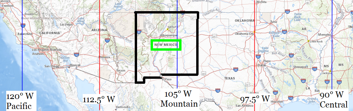
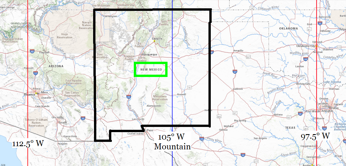
| Location |
Co-Ordinates
(Latitude, Longitude and Elevation) |
Mean solar time at noon
Pacific Standard Time |
Mean solar time at noon
Mountain Standard Time
Pacific Daylight Saving Time) |
Mean solar time at noon
Central Standard Time
(Mountain Daylight Saving Time) |
A Montoya Elementary School,
Bernalillo County
|
Elevation: 1911 meters*
Latitude: 35.07667° N
Longitude: 106.39° W
|
12:54:26 |
11:54:26 |
10:54:26 |
Abbott Post Office (historical),
Colfax County
|
Elevation: 1865 meters*
Latitude: 36.2922517° N
Longitude: 104.2369249° W
|
13:03:03 |
12:03:03 |
11:03:03 |
Abeytas Post Office (historical),
Socorro County
|
Elevation: 1448 meters*
Latitude: 34.4675637° N
Longitude: 106.8114154° W
|
12:52:45 |
11:52:45 |
10:52:45 |
Abiquiu Post Office,
Rio Arriba County
|
Elevation: 1832 meters*
Latitude: 36.208986° N
Longitude: 106.3200667° W
|
12:54:43 |
11:54:43 |
10:54:43 |
Abo Elementary School,
Eddy County
|
Elevation: 1032 meters*
Latitude: 32.8384457° N
Longitude: 104.4027407° W
|
13:02:23 |
12:02:23 |
11:02:23 |
Abo Post Office (historical),
Torrance County
|
Elevation: 1873 meters*
Latitude: 34.4558977° N
Longitude: 106.3330712° W
|
12:54:40 |
11:54:40 |
10:54:40 |
Abundant Life Christian Academy,
Valencia County
|
Elevation: 1466 meters*
Latitude: 34.6628367° N
Longitude: 106.776416° W
|
12:52:53 |
11:52:53 |
10:52:53 |
Academy Post Office,
Bernalillo County
|
Elevation: 1610 meters*
Latitude: 35.1605568° N
Longitude: 106.5757467° W
|
12:53:41 |
11:53:41 |
10:53:41 |
Acequia Madre Elementary School,
Santa Fe County
|
Elevation: 2157 meters*
Latitude: 35.6722534° N
Longitude: 105.93891° W
|
12:56:14 |
11:56:14 |
10:56:14 |
Acequia Madre School,
Santa Fe County
|
Elevation: 2158 meters*
Latitude: 35.6803088° N
Longitude: 105.9289099° W
|
12:56:17 |
11:56:17 |
10:56:17 |
Acme Post Office (historical),
Chaves County
|
Elevation: 1120 meters*
Latitude: 33.5923153° N
Longitude: 104.3285785° W
|
13:02:41 |
12:02:41 |
11:02:41 |
Acoma Elementary School,
Bernalillo County
|
Elevation: 1703 meters*
Latitude: 35.0961579° N
Longitude: 106.5172451° W
|
12:53:55 |
11:53:55 |
10:53:55 |
Acomita Post Office (historical),
Valencia County
|
Elevation: 1841 meters*
Latitude: 35.0553199° N
Longitude: 107.5717171° W
|
12:49:42 |
11:49:42 |
10:49:42 |
Acomita School,
Cibola County
|
Elevation: 1848 meters*
Latitude: 35.0525421° N
Longitude: 107.5775505° W
|
12:49:41 |
11:49:41 |
10:49:41 |
Adams Diggings Post Office (historical),
Catron County
|
Elevation: 2275 meters*
Latitude: 34.4694953° N
Longitude: 108.2847863° W
|
12:46:51 |
11:46:51 |
10:46:51 |
Adelino Post Office (historical),
Valencia County
|
Elevation: 1470 meters*
Latitude: 34.7158909° N
Longitude: 106.7311374° W
|
12:53:04 |
11:53:04 |
10:53:04 |
Adelino School,
Valencia County
|
Elevation: 1469 meters*
Latitude: 34.7131133° N
Longitude: 106.730304° W
|
12:53:04 |
11:53:04 |
10:53:04 |
Aden Post Office (historical),
Doña Ana County
|
Elevation: 1339 meters*
Latitude: 32.1528722° N
Longitude: 107.1275128° W
|
12:51:29 |
11:51:29 |
10:51:29 |
Adobe Acres Elementary School,
Bernalillo County
|
Elevation: 1503 meters*
Latitude: 35.0223254° N
Longitude: 106.6858835° W
|
12:53:15 |
11:53:15 |
10:53:15 |
Adobe Post Office (historical),
Socorro County
|
Elevation: 1803 meters*
Latitude: 33.8622929° N
Longitude: 106.305003° W
|
12:54:46 |
11:54:46 |
10:54:46 |
Afton Post Office,
Doña Ana County
|
Elevation: 1287 meters*
Latitude: 32.0395426° N
Longitude: 106.9441727° W
|
12:52:13 |
11:52:13 |
10:52:13 |
Agua Fria Elementary School,
Santa Fe County
|
Elevation: 2102 meters*
Latitude: 35.6722222° N
Longitude: 105.9613889° W
|
12:56:09 |
11:56:09 |
10:56:09 |
Agua Fria Elementary School,
Santa Fe County
|
Elevation: 2026 meters*
Latitude: 35.6597532° N
Longitude: 106.0044667° W
|
12:55:58 |
11:55:58 |
10:55:58 |
Agua Fria Post Office (historical),
Colfax County
|
Elevation: 2550 meters*
Latitude: 36.4300319° N
Longitude: 105.2988976° W
|
12:58:48 |
11:58:48 |
10:58:48 |
Agua Negra Post Office (historical),
Mora County
|
Elevation: 2325 meters*
Latitude: 36.0353099° N
Longitude: 105.388069° W
|
12:58:26 |
11:58:26 |
10:58:26 |
Agudo Post Office (historical),
De Baca County
|
Elevation: 1297 meters*
Latitude: 34.4053469° N
Longitude: 104.3035865° W
|
13:02:47 |
12:02:47 |
11:02:47 |
Airport Mail Facility Post Office,
Bernalillo County
|
Elevation: 1612 meters*
Latitude: 35.0475522° N
Longitude: 106.6234946° W
|
12:53:30 |
11:53:30 |
10:53:30 |
Akela Post Office (historical),
Luna County
|
Elevation: 1269 meters*
Latitude: 32.246756° N
Longitude: 107.4055761° W
|
12:50:22 |
11:50:22 |
10:50:22 |
Alameda Elementary School,
Bernalillo County
|
Elevation: 1523 meters*
Latitude: 35.1900811° N
Longitude: 106.6189147° W
|
12:53:31 |
11:53:31 |
10:53:31 |
Alameda Elementary School,
Doña Ana County
|
Elevation: 1186 meters*
Latitude: 32.3195377° N
Longitude: 106.786671° W
|
12:52:51 |
11:52:51 |
10:52:51 |
Alameda Junior HIgh School,
Santa Fe County
|
Elevation: 2069 meters*
Latitude: 35.6347541° N
Longitude: 105.978355° W
|
12:56:05 |
11:56:05 |
10:56:05 |
Alameda Junior High School,
Doña Ana County
|
Elevation: 1186 meters*
Latitude: 32.3164823° N
Longitude: 106.7830598° W
|
12:52:52 |
11:52:52 |
10:52:52 |
Alameda Junior High School,
Santa Fe County
|
Elevation: 2092 meters*
Latitude: 35.684475° N
Longitude: 105.9622439° W
|
12:56:09 |
11:56:09 |
10:56:09 |
Alameda Post Office (historical),
Bernalillo County
|
Elevation: 1525 meters*
Latitude: 35.1867101° N
Longitude: 106.6180813° W
|
12:53:31 |
11:53:31 |
10:53:31 |
Alameda Post Office,
Bernalillo County
|
Elevation: 1523 meters*
Latitude: 35.1852793° N
Longitude: 106.6205154° W
|
12:53:31 |
11:53:31 |
10:53:31 |
Alameda School,
Doña Ana County
|
Elevation: 1186 meters*
Latitude: 32.3214821° N
Longitude: 106.7861155° W
|
12:52:51 |
11:52:51 |
10:52:51 |
Alamo Day School,
Socorro County
|
Elevation: 1864 meters*
Latitude: 34.4311694° N
Longitude: 107.5089308° W
|
12:49:57 |
11:49:57 |
10:49:57 |
Alamo Navajo School,
Socorro County
|
Elevation: 2003 meters*
Latitude: 34.1167305° N
Longitude: 107.2439251° W
|
12:51:01 |
11:51:01 |
10:51:01 |
Alamo Post Office (historical),
Guadalupe County
|
Elevation: 1394 meters*
Latitude: 34.837561° N
Longitude: 104.2780331° W
|
13:02:53 |
12:02:53 |
11:02:53 |
Alamogordo Christian Academy,
Otero County
|
Elevation: 1323 meters*
Latitude: 32.8995325° N
Longitude: 105.960265° W
|
12:56:09 |
11:56:09 |
10:56:09 |
Alamogordo Post Office,
Otero County
|
Elevation: 1332 meters*
Latitude: 32.9012588° N
Longitude: 105.950712° W
|
12:56:11 |
11:56:11 |
10:56:11 |
Alamosa Elementary School,
Bernalillo County
|
Elevation: 1527 meters*
Latitude: 35.0721387° N
Longitude: 106.7055965° W
|
12:53:10 |
11:53:10 |
10:53:10 |
Albemarle Post Office (historical),
Sandoval County
|
Elevation: 2340 meters*
Latitude: 35.7466926° N
Longitude: 106.4850312° W
|
12:54:03 |
11:54:03 |
10:54:03 |
Albert Academy,
Harding County
|
Elevation: 1379 meters*
Latitude: 35.8911482° N
Longitude: 103.8149662° W
|
13:04:44 |
12:04:44 |
11:04:44 |
Albert Post Office (historical),
Harding County
|
Elevation: 1419 meters*
Latitude: 35.9344805° N
Longitude: 103.8652454° W
|
13:04:32 |
12:04:32 |
11:04:32 |
Albuquerque Academy,
Bernalillo County
|
Elevation: 1666 meters*
Latitude: 35.1514337° N
Longitude: 106.5533575° W
|
12:53:47 |
11:53:47 |
10:53:47 |
Albuquerque Downtown Post Office,
Bernalillo County
|
Elevation: 1510 meters*
Latitude: 35.0834714° N
Longitude: 106.6535621° W
|
12:53:23 |
11:53:23 |
10:53:23 |
Albuquerque High School,
Bernalillo County
|
Elevation: 1535 meters*
Latitude: 35.0965213° N
Longitude: 106.6351035° W
|
12:53:27 |
11:53:27 |
10:53:27 |
Albuquerque Post Office,
Bernalillo County
|
Elevation: 1512 meters*
Latitude: 35.0937444° N
Longitude: 106.643621° W
|
12:53:25 |
11:53:25 |
10:53:25 |
Alcalde Elementary School,
Rio Arriba County
|
Elevation: 1741 meters*
Latitude: 36.0889116° N
Longitude: 106.053634° W
|
12:55:47 |
11:55:47 |
10:55:47 |
Alcalde Post Office,
Rio Arriba County
|
Elevation: 1752 meters*
Latitude: 36.0940646° N
Longitude: 106.0477806° W
|
12:55:48 |
11:55:48 |
10:55:48 |
Alcatraz Post Office (historical),
San Juan County
|
Elevation: 1713 meters*
Latitude: 36.7563942° N
Longitude: 107.7570043° W
|
12:48:58 |
11:48:58 |
10:48:58 |
Aleman Post Office (historical),
Sierra County
|
Elevation: 1423 meters*
Latitude: 32.9897967° N
Longitude: 107.0075202° W
|
12:51:58 |
11:51:58 |
10:51:58 |
Alexander Elementary School,
Lea County
|
Elevation: 1192 meters*
Latitude: 32.9440077° N
Longitude: 103.3485543° W
|
13:06:36 |
12:06:36 |
11:06:36 |
Algodones Post Office,
Sandoval County
|
Elevation: 1558 meters*
Latitude: 35.3805931° N
Longitude: 106.4791925° W
|
12:54:04 |
11:54:04 |
10:54:04 |
Alire Post Office (historical),
Rio Arriba County
|
Elevation: 2174 meters*
Latitude: 36.4764052° N
Longitude: 106.580868° W
|
12:53:40 |
11:53:40 |
10:53:40 |
All Tribes Indian Mission School,
Sandoval County
|
Elevation: 1540 meters*
Latitude: 35.30004° N
Longitude: 106.5511369° W
|
12:53:47 |
11:53:47 |
10:53:47 |
Allen Post Office (historical),
Quay County
|
Elevation: 1221 meters*
Latitude: 35.0122832° N
Longitude: 103.1385592° W
|
13:07:26 |
12:07:26 |
11:07:26 |
Allison Post Office (historical),
McKinley County
|
Elevation: 1977 meters*
Latitude: 35.5241893° N
Longitude: 108.7850853° W
|
12:44:51 |
11:44:51 |
10:44:51 |
Alma Post Office (historical),
Catron County
|
Elevation: 1488 meters*
Latitude: 33.3795055° N
Longitude: 108.903398° W
|
12:44:23 |
11:44:23 |
10:44:23 |
Alta Vista Middle School,
Eddy County
|
Elevation: 948 meters*
Latitude: 32.4223401° N
Longitude: 104.2360601° W
|
13:03:03 |
12:03:03 |
11:03:03 |
Alternative School Program,
Eddy County
|
Elevation: 948 meters*
Latitude: 32.4223401° N
Longitude: 104.2360601° W
|
13:03:03 |
12:03:03 |
11:03:03 |
Alto Post Office,
Lincoln County
|
Elevation: 2281 meters*
Latitude: 33.4059203° N
Longitude: 105.6752451° W
|
12:57:17 |
11:57:17 |
10:57:17 |
Alvarado Elementary School,
Bernalillo County
|
Elevation: 1518 meters*
Latitude: 35.1511555° N
Longitude: 106.653915° W
|
12:53:23 |
11:53:23 |
10:53:23 |
Alvis School,
Union County
|
Elevation: 1536 meters*
Latitude: 36.4453043° N
Longitude: 103.1760481° W
|
13:07:17 |
12:07:17 |
11:07:17 |
Alvord Elementary School,
Santa Fe County
|
Elevation: 2113 meters*
Latitude: 35.6819752° N
Longitude: 105.953077° W
|
12:56:11 |
11:56:11 |
10:56:11 |
Amalia Post Office,
Taos County
|
Elevation: 2505 meters*
Latitude: 36.9327905° N
Longitude: 105.4443336° W
|
12:58:13 |
11:58:13 |
10:58:13 |
Amalia School,
Taos County
|
Elevation: 2500 meters*
Latitude: 36.9255797° N
Longitude: 105.451396° W
|
12:58:11 |
11:58:11 |
10:58:11 |
Amand Hammer World College of the American West,
San Miguel County
|
Elevation: 2048 meters*
Latitude: 35.6522648° N
Longitude: 105.2763988° W
|
12:58:53 |
11:58:53 |
10:58:53 |
Amargo Post Office (historical),
Rio Arriba County
|
Elevation: 2136 meters*
Latitude: 36.9377889° N
Longitude: 106.891704° W
|
12:52:25 |
11:52:25 |
10:52:25 |
Amistad Elementary School,
Union County
|
Elevation: 1541 meters*
Latitude: 36.451693° N
Longitude: 103.1841039° W
|
13:07:15 |
12:07:15 |
11:07:15 |
Amistad Post Office,
Union County
|
Elevation: 1366 meters*
Latitude: 35.9192026° N
Longitude: 103.157263° W
|
13:07:22 |
12:07:22 |
11:07:22 |
Anapra Post Office (historical),
Doña Ana County
|
Elevation: 1178 meters*
Latitude: 31.7842743° N
Longitude: 106.5638776° W
|
12:53:44 |
11:53:44 |
10:53:44 |
Ancho Post Office (historical),
Lincoln County
|
Elevation: 1868 meters*
Latitude: 33.937848° N
Longitude: 105.7397082° W
|
12:57:02 |
11:57:02 |
10:57:02 |
Ancones Post Office (historical),
Rio Arriba County
|
Elevation: 2097 meters*
Latitude: 36.423908° N
Longitude: 106.0630763° W
|
12:55:44 |
11:55:44 |
10:55:44 |
Angel Fire Post Office,
Colfax County
|
Elevation: 2560 meters*
Latitude: 36.4042375° N
Longitude: 105.2905328° W
|
12:58:50 |
11:58:50 |
10:58:50 |
Animas Elementary School,
San Juan County
|
Elevation: 1615 meters*
Latitude: 36.7280583° N
Longitude: 108.2186856° W
|
12:47:07 |
11:47:07 |
10:47:07 |
Animas High School,
Hidalgo County
|
Elevation: 1342 meters*
Latitude: 31.9514799° N
Longitude: 108.8083889° W
|
12:44:45 |
11:44:45 |
10:44:45 |
Animas Post Office,
Hidalgo County
|
Elevation: 1342 meters*
Latitude: 31.9513389° N
Longitude: 108.8074997° W
|
12:44:46 |
11:44:46 |
10:44:46 |
Ann Parish Elementary School,
Valencia County
|
Elevation: 1479 meters*
Latitude: 34.8047222° N
Longitude: 106.7327778° W
|
12:53:04 |
11:53:04 |
10:53:04 |
Ann Parish Elementary,
Valencia County
|
Elevation: 1480 meters*
Latitude: 34.806166° N
Longitude: 106.7316931° W
|
12:53:04 |
11:53:04 |
10:53:04 |
Anniston Post Office (historical),
Quay County
|
Elevation: 1248 meters*
Latitude: 35.2072784° N
Longitude: 103.322455° W
|
13:06:42 |
12:06:42 |
11:06:42 |
Antelope Post Office (historical),
Torrance County
|
Elevation: 1875 meters*
Latitude: 34.832279° N
Longitude: 106.0680749° W
|
12:55:43 |
11:55:43 |
10:55:43 |
Anthony Elementary School,
Doña Ana County
|
Elevation: 1159 meters*
Latitude: 32.0039897° N
Longitude: 106.6058257° W
|
12:53:34 |
11:53:34 |
10:53:34 |
Anthony Post Office,
Doña Ana County
|
Elevation: 1160 meters*
Latitude: 32.0132509° N
Longitude: 106.6044137° W
|
12:53:34 |
11:53:34 |
10:53:34 |
Anton Chico Elementary School,
Guadalupe County
|
Elevation: 1601 meters*
Latitude: 35.2000506° N
Longitude: 105.1422244° W
|
12:59:25 |
11:59:25 |
10:59:25 |
Anton Chico Post Office,
Guadalupe County
|
Elevation: 1600 meters*
Latitude: 35.1998874° N
Longitude: 105.1419056° W
|
12:59:25 |
11:59:25 |
10:59:25 |
Apache Creek Post Office (historical),
Catron County
|
Elevation: 1954 meters*
Latitude: 33.833109° N
Longitude: 108.6250625° W
|
12:45:29 |
11:45:29 |
10:45:29 |
Apache Elementary School,
Bernalillo County
|
Elevation: 1731 meters*
Latitude: 35.0783333° N
Longitude: 106.5022222° W
|
12:53:59 |
11:53:59 |
10:53:59 |
Apache Post Office (historical),
Union County
|
Elevation: 1886 meters*
Latitude: 33.3253573° N
Longitude: 105.9027681° W
|
12:56:23 |
11:56:23 |
10:56:23 |
Apache School,
San Juan County
|
Elevation: 1618 meters*
Latitude: 36.7347248° N
Longitude: 108.2139632° W
|
12:47:08 |
11:47:08 |
10:47:08 |
Arabela Post Office (historical),
Lincoln County
|
Elevation: 1670 meters*
Latitude: 33.5870308° N
Longitude: 105.173318° W
|
12:59:18 |
11:59:18 |
10:59:18 |
Arch Post Office (historical),
Roosevelt County
|
Elevation: 1196 meters*
Latitude: 34.113416° N
Longitude: 103.1424478° W
|
13:07:25 |
12:07:25 |
11:07:25 |
Arenas Valley Post Office,
Grant County
|
Elevation: 1871 meters*
Latitude: 32.7939639° N
Longitude: 108.1842122° W
|
12:47:15 |
11:47:15 |
10:47:15 |
Arise and Shine School,
Grant County
|
Elevation: 1809 meters*
Latitude: 32.770075° N
Longitude: 108.280326° W
|
12:46:52 |
11:46:52 |
10:46:52 |
Armijo Elementary School,
Bernalillo County
|
Elevation: 1507 meters*
Latitude: 35.0615822° N
Longitude: 106.6739709° W
|
12:53:18 |
11:53:18 |
10:53:18 |
Armijo Elementary School,
San Miguel County
|
Elevation: 2034 meters*
Latitude: 35.5939325° N
Longitude: 105.1672283° W
|
12:59:19 |
11:59:19 |
10:59:19 |
Armijo Post Office (historical),
Bernalillo County
|
Elevation: 1507 meters*
Latitude: 35.0536584° N
Longitude: 106.677248° W
|
12:53:17 |
11:53:17 |
10:53:17 |
Arrey Elementary School,
Sierra County
|
Elevation: 1274 meters*
Latitude: 32.848685° N
Longitude: 107.3191907° W
|
12:50:43 |
11:50:43 |
10:50:43 |
Arrey Post Office,
Sierra County
|
Elevation: 1275 meters*
Latitude: 32.8491616° N
Longitude: 107.3194099° W
|
12:50:43 |
11:50:43 |
10:50:43 |
Arroyo Hondo Elementary School,
Taos County
|
Elevation: 2072 meters*
Latitude: 36.5358566° N
Longitude: 105.6697335° W
|
12:57:19 |
11:57:19 |
10:57:19 |
Arroyo Hondo Post Office,
Taos County
|
Elevation: 2074 meters*
Latitude: 36.5332315° N
Longitude: 105.6685768° W
|
12:57:19 |
11:57:19 |
10:57:19 |
Arroyo Seco Elementary School,
Taos County
|
Elevation: 2331 meters*
Latitude: 36.5191928° N
Longitude: 105.5691762° W
|
12:57:43 |
11:57:43 |
10:57:43 |
Arroyo Seco Post Office,
Taos County
|
Elevation: 2331 meters*
Latitude: 36.5184572° N
Longitude: 105.5687767° W
|
12:57:43 |
11:57:43 |
10:57:43 |
Arroyo del Oso Elementary School,
Bernalillo County
|
Elevation: 1607 meters*
Latitude: 35.1522669° N
Longitude: 106.5753023° W
|
12:53:41 |
11:53:41 |
10:53:41 |
Artesia High School,
Eddy County
|
Elevation: 1032 meters*
Latitude: 32.8384457° N
Longitude: 104.4027407° W
|
13:02:23 |
12:02:23 |
11:02:23 |
Artesia Post Office,
Eddy County
|
Elevation: 1029 meters*
Latitude: 32.8435155° N
Longitude: 104.4013931° W
|
13:02:23 |
12:02:23 |
11:02:23 |
Aspen Elementary School,
Los Alamos County
|
Elevation: 2225 meters*
Latitude: 35.8828018° N
Longitude: 106.3219726° W
|
12:54:42 |
11:54:42 |
10:54:42 |
Aspen Meadows Hospital School,
Rio Arriba County
|
Elevation: 1756 meters*
Latitude: 36.1589119° N
Longitude: 105.9747434° W
|
12:56:06 |
11:56:06 |
10:56:06 |
Aspen School,
Los Alamos County
|
Elevation: 2221 meters*
Latitude: 35.8953016° N
Longitude: 106.3108613° W
|
12:54:45 |
11:54:45 |
10:54:45 |
Atalaya Elementary School,
Santa Fe County
|
Elevation: 2220 meters*
Latitude: 35.673087° N
Longitude: 105.9122429° W
|
12:56:21 |
11:56:21 |
10:56:21 |
Atarque Post Office (historical),
Valencia County
|
Elevation: 2071 meters*
Latitude: 34.7364301° N
Longitude: 108.7031321° W
|
12:45:11 |
11:45:11 |
10:45:11 |
Atencio Post Office (historical),
Union County
|
Elevation: 1469 meters*
Latitude: 36.7714125° N
Longitude: 103.125767° W
|
13:07:29 |
12:07:29 |
11:07:29 |
Atrisco Elementary School,
Bernalillo County
|
Elevation: 1506 meters*
Latitude: 35.0624321° N
Longitude: 106.6936414° W
|
12:53:13 |
11:53:13 |
10:53:13 |
Atrisco Heritage Academy High School,
Bernalillo County
|
Elevation: 1579 meters*
Latitude: 35.022491° N
Longitude: 106.7497872° W
|
12:53:00 |
11:53:00 |
10:53:00 |
Atrisco Post Office (historical),
Bernalillo County
|
Elevation: 1510 meters*
Latitude: 35.0811575° N
Longitude: 106.6875262° W
|
12:53:14 |
11:53:14 |
10:53:14 |
Augustine Post Office (historical),
Bernalillo County
|
Elevation: 2023 meters*
Latitude: 34.9369954° N
Longitude: 106.1941909° W
|
12:55:13 |
11:55:13 |
10:55:13 |
Aurora Post Office (historical),
Colfax County
|
Elevation: 1903 meters*
Latitude: 35.1467171° N
Longitude: 105.4491765° W
|
12:58:12 |
11:58:12 |
10:58:12 |
Avis Post Office (historical),
Otero County
|
Elevation: 2075 meters*
Latitude: 32.7003803° N
Longitude: 105.4547018° W
|
12:58:10 |
11:58:10 |
10:58:10 |
Aztec High School,
San Juan County
|
Elevation: 1811 meters*
Latitude: 36.7888932° N
Longitude: 107.9950677° W
|
12:48:01 |
11:48:01 |
10:48:01 |
Aztec Montessori School,
McKinley County
|
Elevation: 1985 meters*
Latitude: 35.5280783° N
Longitude: 108.7425843° W
|
12:45:01 |
11:45:01 |
10:45:01 |
Aztec Post Office,
San Juan County
|
Elevation: 1723 meters*
Latitude: 36.8146197° N
Longitude: 107.9993496° W
|
12:48:00 |
11:48:00 |
10:48:00 |
Aztec School,
Bernalillo County
|
Elevation: 1676 meters*
Latitude: 35.1133794° N
Longitude: 106.5336345° W
|
12:53:51 |
11:53:51 |
10:53:51 |
Bacaville Post Office (historical),
Valencia County
|
Elevation: 1466 meters*
Latitude: 34.6422816° N
Longitude: 106.7805827° W
|
12:52:52 |
11:52:52 |
10:52:52 |
Bagley School,
Lea County
|
Elevation: 1316 meters*
Latitude: 33.3587191° N
Longitude: 103.6616212° W
|
13:05:21 |
12:05:21 |
11:05:21 |
Baldy Post Office (historical),
Colfax County
|
Elevation: 2993 meters*
Latitude: 36.6264211° N
Longitude: 105.1905601° W
|
12:59:14 |
11:59:14 |
10:59:14 |
Bandelier Elementary School,
Bernalillo County
|
Elevation: 1607 meters*
Latitude: 35.0707115° N
Longitude: 106.6075301° W
|
12:53:34 |
11:53:34 |
10:53:34 |
Barcelona Elementary School,
Bernalillo County
|
Elevation: 1504 meters*
Latitude: 35.0311502° N
Longitude: 106.6933755° W
|
12:53:13 |
11:53:13 |
10:53:13 |
Bard Post Office,
Quay County
|
Elevation: 1217 meters*
Latitude: 35.1250584° N
Longitude: 103.2443961° W
|
13:07:01 |
12:07:01 |
11:07:01 |
Barranca Mesa Elementary School,
Los Alamos County
|
Elevation: 2225 meters*
Latitude: 35.8828018° N
Longitude: 106.3219726° W
|
12:54:42 |
11:54:42 |
10:54:42 |
Barranca Post Office (historical),
Taos County
|
Elevation: 1845 meters*
Latitude: 36.2036299° N
Longitude: 106.3458628° W
|
12:54:36 |
11:54:36 |
10:54:36 |
Barranca School,
Los Alamos County
|
Elevation: 2224 meters*
Latitude: 35.9030795° N
Longitude: 106.2816938° W
|
12:54:52 |
11:54:52 |
10:54:52 |
Barry Elementary School,
Curry County
|
Elevation: 1301 meters*
Latitude: 34.4047987° N
Longitude: 103.2052272° W
|
13:07:10 |
12:07:10 |
11:07:10 |
Barton Post Office (historical),
Santa Fe County
|
Elevation: 2056 meters*
Latitude: 35.0831016° N
Longitude: 106.2469704° W
|
12:55:00 |
11:55:00 |
10:55:00 |
Bayard Elementary School,
Grant County
|
Elevation: 1774 meters*
Latitude: 32.7617427° N
Longitude: 108.1305989° W
|
12:47:28 |
11:47:28 |
10:47:28 |
Bayard Post Office,
Grant County
|
Elevation: 1770 meters*
Latitude: 32.7597184° N
Longitude: 108.1315359° W
|
12:47:28 |
11:47:28 |
10:47:28 |
Bear Den School,
Sierra County
|
Elevation: 1610 meters*
Latitude: 33.3753527° N
Longitude: 106.6544574° W
|
12:53:22 |
11:53:22 |
10:53:22 |
Beenham Post Office (historical),
Union County
|
Elevation: 1594 meters*
Latitude: 36.2144758° N
Longitude: 103.6344027° W
|
13:05:27 |
12:05:27 |
11:05:27 |
Bel - Air Elementary School,
Bernalillo County
|
Elevation: 1579 meters*
Latitude: 35.1175799° N
Longitude: 106.5920088° W
|
12:53:37 |
11:53:37 |
10:53:37 |
Belen High School,
Valencia County
|
Elevation: 1467 meters*
Latitude: 34.6670032° N
Longitude: 106.7747494° W
|
12:52:54 |
11:52:54 |
10:52:54 |
Belen Post Office,
Valencia County
|
Elevation: 1466 meters*
Latitude: 34.6642025° N
Longitude: 106.7747143° W
|
12:52:54 |
11:52:54 |
10:52:54 |
Bell Ranch Post Office (historical),
San Miguel County
|
Elevation: 1319 meters*
Latitude: 35.5292122° N
Longitude: 104.0935854° W
|
13:03:37 |
12:03:37 |
11:03:37 |
Bell School,
Luna County
|
Elevation: 1319 meters*
Latitude: 32.2661981° N
Longitude: 107.7478067° W
|
12:49:00 |
11:49:00 |
10:49:00 |
Bella Vista Elementary School,
Curry County
|
Elevation: 1301 meters*
Latitude: 34.4047987° N
Longitude: 103.2052272° W
|
13:07:10 |
12:07:10 |
11:07:10 |
Bellehaven Elementary School,
Bernalillo County
|
Elevation: 1641 meters*
Latitude: 35.0983333° N
Longitude: 106.5469444° W
|
12:53:48 |
11:53:48 |
10:53:48 |
Bellview Post Office,
Curry County
|
Elevation: 1358 meters*
Latitude: 34.8211764° N
Longitude: 103.1077251° W
|
13:07:34 |
12:07:34 |
11:07:34 |
Benito School,
San Juan County
|
Elevation: 1926 meters*
Latitude: 36.9636155° N
Longitude: 107.5806096° W
|
12:49:40 |
11:49:40 |
10:49:40 |
Bennett Post Office (historical),
Lea County
|
Elevation: 903 meters*
Latitude: 32.0679045° N
Longitude: 103.2110114° W
|
13:07:09 |
12:07:09 |
11:07:09 |
Benson Post Office (historical),
Roosevelt County
|
Elevation: 1363 meters*
Latitude: 34.200356° N
Longitude: 103.7902409° W
|
13:04:50 |
12:04:50 |
11:04:50 |
Bent Post Office,
Otero County
|
Elevation: 1780 meters*
Latitude: 33.158995° N
Longitude: 105.8560389° W
|
12:56:34 |
11:56:34 |
10:56:34 |
Bent Public School,
Otero County
|
Elevation: 1831 meters*
Latitude: 33.161751° N
Longitude: 105.845822° W
|
12:56:37 |
11:56:37 |
10:56:37 |
Berean Mission Navajo School,
San Juan County
|
Elevation: 1665 meters*
Latitude: 36.7127832° N
Longitude: 107.9836783° W
|
12:48:03 |
11:48:03 |
10:48:03 |
Berean School,
San Juan County
|
Elevation: 2088 meters*
Latitude: 36.4022325° N
Longitude: 107.8520059° W
|
12:48:35 |
11:48:35 |
10:48:35 |
Berino Elementary School,
Doña Ana County
|
Elevation: 1159 meters*
Latitude: 32.0039897° N
Longitude: 106.6058257° W
|
12:53:34 |
11:53:34 |
10:53:34 |
Berino Post Office (historical),
Doña Ana County
|
Elevation: 1168 meters*
Latitude: 32.0709325° N
Longitude: 106.6213827° W
|
12:53:30 |
11:53:30 |
10:53:30 |
Bernal Post Office (historical),
San Miguel County
|
Elevation: 1875 meters*
Latitude: 35.3928231° N
Longitude: 105.3175088° W
|
12:58:43 |
11:58:43 |
10:58:43 |
Bernalillo High School,
Sandoval County
|
Elevation: 1544 meters*
Latitude: 35.3208726° N
Longitude: 106.5408593° W
|
12:53:50 |
11:53:50 |
10:53:50 |
Bernalillo Middle School,
Sandoval County
|
Elevation: 1540 meters*
Latitude: 35.3125395° N
Longitude: 106.552526° W
|
12:53:47 |
11:53:47 |
10:53:47 |
Bernalillo Post Office,
Sandoval County
|
Elevation: 1541 meters*
Latitude: 35.3049404° N
Longitude: 106.5468836° W
|
12:53:48 |
11:53:48 |
10:53:48 |
Bernardo Post Office (historical),
Socorro County
|
Elevation: 1445 meters*
Latitude: 34.4186756° N
Longitude: 106.8336377° W
|
12:52:39 |
11:52:39 |
10:52:39 |
Berrendo School,
Chaves County
|
Elevation: 1097 meters*
Latitude: 33.4528746° N
Longitude: 104.5299691° W
|
13:01:52 |
12:01:52 |
11:01:52 |
Bethel Post Office (historical),
Roosevelt County
|
Elevation: 1240 meters*
Latitude: 34.228691° N
Longitude: 103.4746793° W
|
13:06:06 |
12:06:06 |
11:06:06 |
Bible Baptist School,
McKinley County
|
Elevation: 2128 meters*
Latitude: 35.6780769° N
Longitude: 108.1511785° W
|
12:47:23 |
11:47:23 |
10:47:23 |
Bible Baptist Shepherd,
San Juan County
|
Elevation: 2117 meters*
Latitude: 36.2666791° N
Longitude: 107.7420022° W
|
12:49:01 |
11:49:01 |
10:49:01 |
Bibo Post Office (historical),
Valencia County
|
Elevation: 1895 meters*
Latitude: 35.1742064° N
Longitude: 107.3886585° W
|
12:50:26 |
11:50:26 |
10:50:26 |
Bickley School,
Curry County
|
Elevation: 1305 meters*
Latitude: 34.4125764° N
Longitude: 103.2099494° W
|
13:07:09 |
12:07:09 |
11:07:09 |
Bingham Post Office,
Socorro County
|
Elevation: 1709 meters*
Latitude: 33.9109029° N
Longitude: 106.3494491° W
|
12:54:36 |
11:54:36 |
10:54:36 |
Bingham Post Office,
Socorro County
|
Elevation: 1662 meters*
Latitude: 33.8886807° N
Longitude: 106.3797281° W
|
12:54:28 |
11:54:28 |
10:54:28 |
Black Hawk Post Office (historical),
Grant County
|
Elevation: 1874 meters*
Latitude: 32.7053539° N
Longitude: 108.5228291° W
|
12:45:54 |
11:45:54 |
10:45:54 |
Black Lake Post Office (historical),
Colfax County
|
Elevation: 2668 meters*
Latitude: 36.2739225° N
Longitude: 105.2433438° W
|
12:59:01 |
11:59:01 |
10:59:01 |
Black Rock Post Office (historical),
McKinley County
|
Elevation: 1967 meters*
Latitude: 35.0883657° N
Longitude: 108.7911938° W
|
12:44:50 |
11:44:50 |
10:44:50 |
Blackdom Post Office (historical),
Chaves County
|
Elevation: 1113 meters*
Latitude: 33.1637167° N
Longitude: 104.5088556° W
|
13:01:57 |
12:01:57 |
11:01:57 |
Blanco Elementary School,
San Juan County
|
Elevation: 1665 meters*
Latitude: 36.7127832° N
Longitude: 107.9836783° W
|
12:48:03 |
11:48:03 |
10:48:03 |
Blanco Post Office,
San Juan County
|
Elevation: 1702 meters*
Latitude: 36.7232379° N
Longitude: 107.8286656° W
|
12:48:41 |
11:48:41 |
10:48:41 |
Bland Post Office (historical),
Sandoval County
|
Elevation: 2247 meters*
Latitude: 35.7575258° N
Longitude: 106.4653087° W
|
12:54:08 |
11:54:08 |
10:54:08 |
Blessed kateri Tekakwitha School,
McKinley County
|
Elevation: 2177 meters*
Latitude: 35.4025272° N
Longitude: 108.2234015° W
|
12:47:06 |
11:47:06 |
10:47:06 |
Bloomfield Post Office,
San Juan County
|
Elevation: 1661 meters*
Latitude: 36.7120021° N
Longitude: 107.9917814° W
|
12:48:01 |
11:48:01 |
10:48:01 |
Blossburg Post Office (historical),
Colfax County
|
Elevation: 2067 meters*
Latitude: 36.9091915° N
Longitude: 104.4908215° W
|
13:02:02 |
12:02:02 |
11:02:02 |
Bluewater Elementary School,
Cibola County
|
Elevation: 1679 meters*
Latitude: 33.5578642° N
Longitude: 105.1860958° W
|
12:59:15 |
11:59:15 |
10:59:15 |
Bluewater Post Office,
Cibola County
|
Elevation: 2016 meters*
Latitude: 35.2558733° N
Longitude: 107.9769856° W
|
12:48:05 |
11:48:05 |
10:48:05 |
Bluffview School,
San Juan County
|
Elevation: 1625 meters*
Latitude: 36.7180589° N
Longitude: 108.1775731° W
|
12:47:17 |
11:47:17 |
10:47:17 |
Bluitt Post Office (historical),
Roosevelt County
|
Elevation: 1235 meters*
Latitude: 33.6292655° N
Longitude: 103.1835588° W
|
13:07:15 |
12:07:15 |
11:07:15 |
Boaz Post Office (historical),
Chaves County
|
Elevation: 1250 meters*
Latitude: 33.7367575° N
Longitude: 103.971352° W
|
13:04:06 |
12:04:06 |
11:04:06 |
Bonanza Post Office (historical),
Santa Fe County
|
Elevation: 1837 meters*
Latitude: 35.5389232° N
Longitude: 106.1200224° W
|
12:55:31 |
11:55:31 |
10:55:31 |
Bonito Post Office (historical),
Lincoln County
|
Elevation: 2179 meters*
Latitude: 33.4506345° N
Longitude: 105.7088741° W
|
12:57:09 |
11:57:09 |
10:57:09 |
Booker T Washington Center,
Lea County
|
Elevation: 1104 meters*
Latitude: 32.7026116° N
Longitude: 103.1360403° W
|
13:07:27 |
12:07:27 |
11:07:27 |
Booker T Washington Elementary School,
Lea County
|
Elevation: 1098 meters*
Latitude: 32.6943306° N
Longitude: 103.1220459° W
|
13:07:30 |
12:07:30 |
11:07:30 |
Borica Post Office (historical),
Guadalupe County
|
Elevation: 1459 meters*
Latitude: 34.6753423° N
Longitude: 104.6477651° W
|
13:01:24 |
12:01:24 |
11:01:24 |
Borrega Pass,
McKinley County
|
Elevation: 2122 meters*
Latitude: 35.6780765° N
Longitude: 108.2234028° W
|
12:47:06 |
11:47:06 |
10:47:06 |
Bosque Farms Christian Academy,
Valencia County
|
Elevation: 1526 meters*
Latitude: 34.857831° N
Longitude: 106.7333598° W
|
12:53:03 |
11:53:03 |
10:53:03 |
Bosque Farms School,
Valencia County
|
Elevation: 1483 meters*
Latitude: 34.8547756° N
Longitude: 106.7053036° W
|
12:53:10 |
11:53:10 |
10:53:10 |
Bosque Post Office,
Valencia County
|
Elevation: 1457 meters*
Latitude: 34.5600569° N
Longitude: 106.7895484° W
|
12:52:50 |
11:52:50 |
10:52:50 |
Bosque School (historical),
Doña Ana County
|
Elevation: 1159 meters*
Latitude: 32.0359332° N
Longitude: 106.6419383° W
|
12:53:25 |
11:53:25 |
10:53:25 |
Bradley School,
Doña Ana County
|
Elevation: 1198 meters*
Latitude: 32.3089826° N
Longitude: 106.7705593° W
|
12:52:55 |
11:52:55 |
10:52:55 |
Bramlett Post Office (historical),
Hidalgo County
|
Elevation: 1568 meters*
Latitude: 31.3342741° N
Longitude: 108.8439366° W
|
12:44:37 |
11:44:37 |
10:44:37 |
Brazito School (historical),
Doña Ana County
|
Elevation: 1179 meters*
Latitude: 32.2023185° N
Longitude: 106.7188887° W
|
12:53:07 |
11:53:07 |
10:53:07 |
Brazos Post Office (historical),
Rio Arriba County
|
Elevation: 2255 meters*
Latitude: 36.7514028° N
Longitude: 106.5614236° W
|
12:53:45 |
11:53:45 |
10:53:45 |
Brethren Navajo Boarding School,
Sandoval County
|
Elevation: 2161 meters*
Latitude: 36.208625° N
Longitude: 107.4619932° W
|
12:50:09 |
11:50:09 |
10:50:09 |
Brethren in Christ Mission School,
San Juan County
|
Elevation: 2101 meters*
Latitude: 36.3330667° N
Longitude: 107.8414499° W
|
12:48:38 |
11:48:38 |
10:48:38 |
Brilliant Post Office (historical),
Colfax County
|
Elevation: 2184 meters*
Latitude: 36.9561352° N
Longitude: 104.5344333° W
|
13:01:51 |
12:01:51 |
11:01:51 |
Broadmoor Elementary School,
Lea County
|
Elevation: 1103 meters*
Latitude: 32.7152141° N
Longitude: 103.1310304° W
|
13:07:28 |
12:07:28 |
11:07:28 |
Broadview Post Office,
Curry County
|
Elevation: 1376 meters*
Latitude: 34.81951° N
Longitude: 103.2135603° W
|
13:07:08 |
12:07:08 |
11:07:08 |
Brown Elementary School,
Roosevelt County
|
Elevation: 1221 meters*
Latitude: 34.1861922° N
Longitude: 103.3343978° W
|
13:06:39 |
12:06:39 |
11:06:39 |
Brown School,
Roosevelt County
|
Elevation: 1221 meters*
Latitude: 34.1814701° N
Longitude: 103.3380089° W
|
13:06:38 |
12:06:38 |
11:06:38 |
Buchanan Post Office (historical),
De Baca County
|
Elevation: 1564 meters*
Latitude: 34.432017° N
Longitude: 104.7924875° W
|
13:00:49 |
12:00:49 |
11:00:49 |
Buckeye Post Office (historical),
Lea County
|
Elevation: 1216 meters*
Latitude: 32.802068° N
Longitude: 103.505775° W
|
13:05:58 |
12:05:58 |
11:05:58 |
Buckhorn Post Office,
Grant County
|
Elevation: 1456 meters*
Latitude: 33.0344033° N
Longitude: 108.7052433° W
|
12:45:10 |
11:45:10 |
10:45:10 |
Buckman Post Office (historical),
Santa Fe County
|
Elevation: 1688 meters*
Latitude: 35.8319704° N
Longitude: 106.1566916° W
|
12:55:22 |
11:55:22 |
10:55:22 |
Buena Vista Post Office (historical),
Mora County
|
Elevation: 2130 meters*
Latitude: 35.91365° N
Longitude: 105.2491778° W
|
12:59:00 |
11:59:00 |
10:59:00 |
Buena Vista Post Office,
Mora County
|
Elevation: 2151 meters*
Latitude: 35.913133° N
Longitude: 105.2532544° W
|
12:58:59 |
11:58:59 |
10:58:59 |
Buena Vista School,
Otero County
|
Elevation: 1382 meters*
Latitude: 32.9117552° N
Longitude: 105.9285981° W
|
12:56:17 |
11:56:17 |
10:56:17 |
Buena Vista School,
Quay County
|
Elevation: 1278 meters*
Latitude: 35.1550566° N
Longitude: 103.734133° W
|
13:05:03 |
12:05:03 |
11:05:03 |
Bueyeros Post Office,
Harding County
|
Elevation: 1386 meters*
Latitude: 35.9794798° N
Longitude: 103.6871836° W
|
13:05:15 |
12:05:15 |
11:05:15 |
Burke Junior High School,
Lea County
|
Elevation: 939 meters*
Latitude: 32.1165149° N
Longitude: 103.2004575° W
|
13:07:11 |
12:07:11 |
11:07:11 |
C V Junior High School,
San Juan County
|
Elevation: 1811 meters*
Latitude: 36.7888932° N
Longitude: 107.9950677° W
|
12:48:01 |
11:48:01 |
10:48:01 |
CA School,
Harding County
|
Elevation: 1490 meters*
Latitude: 35.6136549° N
Longitude: 103.8244121° W
|
13:04:42 |
12:04:42 |
11:04:42 |
CARC Farm School,
Eddy County
|
Elevation: 948 meters*
Latitude: 32.4223401° N
Longitude: 104.2360601° W
|
13:03:03 |
12:03:03 |
11:03:03 |
Caballo Post Office,
Sierra County
|
Elevation: 1296 meters*
Latitude: 32.9753802° N
Longitude: 107.3084229° W
|
12:50:45 |
11:50:45 |
10:50:45 |
Cabezon Post Office (historical),
Sandoval County
|
Elevation: 1864 meters*
Latitude: 35.6264164° N
Longitude: 107.0978205° W
|
12:51:36 |
11:51:36 |
10:51:36 |
Cabra Springs Post Office (historical),
San Miguel County
|
Elevation: 1470 meters*
Latitude: 35.3150498° N
Longitude: 104.6597108° W
|
13:01:21 |
12:01:21 |
11:01:21 |
Calvary Christian Academy,
Bernalillo County
|
Elevation: 1761 meters*
Latitude: 35.0955841° N
Longitude: 106.5015395° W
|
12:53:59 |
11:53:59 |
10:53:59 |
Cambray Post Office (historical),
Luna County
|
Elevation: 1286 meters*
Latitude: 32.2253687° N
Longitude: 107.317518° W
|
12:50:43 |
11:50:43 |
10:50:43 |
Cameo Elementary School,
Curry County
|
Elevation: 1301 meters*
Latitude: 34.4047987° N
Longitude: 103.2052272° W
|
13:07:10 |
12:07:10 |
11:07:10 |
Cameron Post Office (historical),
Quay County
|
Elevation: 1446 meters*
Latitude: 34.9086111° N
Longitude: 103.3183333° W
|
13:06:43 |
12:06:43 |
11:06:43 |
Canjilon Elementary School,
Rio Arriba County
|
Elevation: 2373 meters*
Latitude: 36.4794611° N
Longitude: 106.4378091° W
|
12:54:14 |
11:54:14 |
10:54:14 |
Canjilon Post Office,
Rio Arriba County
|
Elevation: 2374 meters*
Latitude: 36.4810117° N
Longitude: 106.4380401° W
|
12:54:14 |
11:54:14 |
10:54:14 |
Canode Post Office (historical),
Quay County
|
Elevation: 1201 meters*
Latitude: 35.4408333° N
Longitude: 103.3438889° W
|
13:06:37 |
12:06:37 |
11:06:37 |
Cantara Post Office (historical),
Curry County
|
Elevation: 1344 meters*
Latitude: 34.4245178° N
Longitude: 103.7430179° W
|
13:05:01 |
12:05:01 |
11:05:01 |
Canton Post Office (historical),
De Baca County
|
Elevation: 1321 meters*
Latitude: 34.2167425° N
Longitude: 104.0321901° W
|
13:03:52 |
12:03:52 |
11:03:52 |
Canton School,
De Baca County
|
Elevation: 1321 meters*
Latitude: 34.2167425° N
Longitude: 104.0321901° W
|
13:03:52 |
12:03:52 |
11:03:52 |
Canyoncito Montessori School,
Los Alamos County
|
Elevation: 2198 meters*
Latitude: 35.8880796° N
Longitude: 106.3069722° W
|
12:54:46 |
11:54:46 |
10:54:46 |
Canyoncito School,
Los Alamos County
|
Elevation: 2221 meters*
Latitude: 35.8841908° N
Longitude: 106.2961386° W
|
12:54:48 |
11:54:48 |
10:54:48 |
Capital Christian School,
Santa Fe County
|
Elevation: 2098 meters*
Latitude: 35.6778086° N
Longitude: 105.9619661° W
|
12:56:09 |
11:56:09 |
10:56:09 |
Capital High School,
Santa Fe County
|
Elevation: 2069 meters*
Latitude: 35.6347541° N
Longitude: 105.978355° W
|
12:56:05 |
11:56:05 |
10:56:05 |
Capitan Elementary School,
Lincoln County
|
Elevation: 1948 meters*
Latitude: 33.5445237° N
Longitude: 105.5824822° W
|
12:57:40 |
11:57:40 |
10:57:40 |
Capitan High School,
Lincoln County
|
Elevation: 1948 meters*
Latitude: 33.5445237° N
Longitude: 105.5824822° W
|
12:57:40 |
11:57:40 |
10:57:40 |
Capitan Post Office,
Lincoln County
|
Elevation: 1939 meters*
Latitude: 33.5459197° N
Longitude: 105.5756434° W
|
12:57:41 |
11:57:41 |
10:57:41 |
Capitol High School,
Santa Fe County
|
Elevation: 1961 meters*
Latitude: 35.6211431° N
Longitude: 106.0419669° W
|
12:55:49 |
11:55:49 |
10:55:49 |
Caprock Post Office,
Lea County
|
Elevation: 1334 meters*
Latitude: 33.392051° N
Longitude: 103.7124551° W
|
13:05:09 |
12:05:09 |
11:05:09 |
Capshaw Junior High School,
Santa Fe County
|
Elevation: 2101 meters*
Latitude: 35.6480873° N
Longitude: 105.950299° W
|
12:56:11 |
11:56:11 |
10:56:11 |
Capulin Post Office,
Union County
|
Elevation: 2302 meters*
Latitude: 36.2311273° N
Longitude: 106.8058729° W
|
12:52:46 |
11:52:46 |
10:52:46 |
Capulin School,
Rio Arriba County
|
Elevation: 2309 meters*
Latitude: 36.2275165° N
Longitude: 106.8214286° W
|
12:52:42 |
11:52:42 |
10:52:42 |
Carisbrook Post Office (historical),
Colfax County
|
Elevation: 2044 meters*
Latitude: 36.9169689° N
Longitude: 104.3713734° W
|
13:02:30 |
12:02:30 |
11:02:30 |
Carlos Gilbert Elementary School,
Santa Fe County
|
Elevation: 2127 meters*
Latitude: 35.6905862° N
Longitude: 105.9405769° W
|
12:56:14 |
11:56:14 |
10:56:14 |
Carlos Gilbert Elementary School,
Santa Fe County
|
Elevation: 2130 meters*
Latitude: 35.6833641° N
Longitude: 105.9419657° W
|
12:56:13 |
11:56:13 |
10:56:13 |
Carlos Rey Elementary School,
Bernalillo County
|
Elevation: 1598 meters*
Latitude: 35.0525191° N
Longitude: 106.750314° W
|
12:52:59 |
11:52:59 |
10:52:59 |
Carlsbad High School,
Eddy County
|
Elevation: 948 meters*
Latitude: 32.4223401° N
Longitude: 104.2360601° W
|
13:03:03 |
12:03:03 |
11:03:03 |
Carlsbad Post Office,
Eddy County
|
Elevation: 946 meters*
Latitude: 32.4229127° N
Longitude: 104.2279771° W
|
13:03:05 |
12:03:05 |
11:03:05 |
Carne Post Office (historical),
Luna County
|
Elevation: 1278 meters*
Latitude: 32.2881431° N
Longitude: 107.5714138° W
|
12:49:42 |
11:49:42 |
10:49:42 |
Carrizozo Elementary School,
Lincoln County
|
Elevation: 1651 meters*
Latitude: 33.6445185° N
Longitude: 105.879712° W
|
12:56:28 |
11:56:28 |
10:56:28 |
Carrizozo High School,
Lincoln County
|
Elevation: 1651 meters*
Latitude: 33.6445185° N
Longitude: 105.879712° W
|
12:56:28 |
11:56:28 |
10:56:28 |
Carrizozo Middle School,
Lincoln County
|
Elevation: 1651 meters*
Latitude: 33.6445185° N
Longitude: 105.879712° W
|
12:56:28 |
11:56:28 |
10:56:28 |
Carrizozo Post Office,
Lincoln County
|
Elevation: 1658 meters*
Latitude: 33.6411803° N
Longitude: 105.8770502° W
|
12:56:29 |
11:56:29 |
10:56:29 |
Carrol Elementary School,
Sandoval County
|
Elevation: 1543 meters*
Latitude: 35.3133728° N
Longitude: 106.5422481° W
|
12:53:49 |
11:53:49 |
10:53:49 |
Carson Post Office (historical),
Taos County
|
Elevation: 2087 meters*
Latitude: 36.3644667° N
Longitude: 105.7652927° W
|
12:56:56 |
11:56:56 |
10:56:56 |
Carson Post Office,
Taos County
|
Elevation: 2079 meters*
Latitude: 36.3639773° N
Longitude: 105.8084083° W
|
12:56:45 |
11:56:45 |
10:56:45 |
Carson School Historic Site,
Taos County
|
Elevation: 2088 meters*
Latitude: 36.3644667° N
Longitude: 105.7658483° W
|
12:56:56 |
11:56:56 |
10:56:56 |
Carthage Post Office (historical),
Socorro County
|
Elevation: 1548 meters*
Latitude: 33.8767333° N
Longitude: 106.72974° W
|
12:53:04 |
11:53:04 |
10:53:04 |
Carver School,
Chaves County
|
Elevation: 1089 meters*
Latitude: 33.3892656° N
Longitude: 104.5208019° W
|
13:01:55 |
12:01:55 |
11:01:55 |
Casa Blanca Post Office (historical),
Valencia County
|
Elevation: 1801 meters*
Latitude: 35.0455986° N
Longitude: 107.4714367° W
|
12:50:06 |
11:50:06 |
10:50:06 |
Casa Blanca Post Office,
Cibola County
|
Elevation: 1811 meters*
Latitude: 35.0301992° N
Longitude: 107.4767354° W
|
12:50:05 |
11:50:05 |
10:50:05 |
Casa Colorada School,
Valencia County
|
Elevation: 1463 meters*
Latitude: 34.5681172° N
Longitude: 106.7491926° W
|
12:53:00 |
11:53:00 |
10:53:00 |
Casa Grande Post Office (historical),
San Miguel County
|
Elevation: 2297 meters*
Latitude: 36.8883609° N
Longitude: 104.978888° W
|
13:00:05 |
12:00:05 |
11:00:05 |
Casa Salazar Post Office (historical),
Sandoval County
|
Elevation: 1767 meters*
Latitude: 35.4833651° N
Longitude: 107.1161543° W
|
12:51:32 |
11:51:32 |
10:51:32 |
Casa Salazar School,
Sandoval County
|
Elevation: 1784 meters*
Latitude: 35.5228084° N
Longitude: 107.0969874° W
|
12:51:36 |
11:51:36 |
10:51:36 |
Cathedral High School,
McKinley County
|
Elevation: 2023 meters*
Latitude: 35.518634° N
Longitude: 108.7420288° W
|
12:45:01 |
11:45:01 |
10:45:01 |
Caton Junior High School,
Lea County
|
Elevation: 1051 meters*
Latitude: 32.4373434° N
Longitude: 103.1590798° W
|
13:07:21 |
12:07:21 |
11:07:21 |
Catskill Post Office (historical),
Colfax County
|
Elevation: 2406 meters*
Latitude: 36.9397479° N
Longitude: 104.8072162° W
|
13:00:46 |
12:00:46 |
11:00:46 |
Causey Post Office,
Roosevelt County
|
Elevation: 1243 meters*
Latitude: 33.8797971° N
Longitude: 103.1266312° W
|
13:07:29 |
12:07:29 |
11:07:29 |
Cavel School,
Chaves County
|
Elevation: 1321 meters*
Latitude: 33.9461937° N
Longitude: 104.4894177° W
|
13:02:02 |
12:02:02 |
11:02:02 |
Cañon Brethren School,
Taos County
|
Elevation: 2133 meters*
Latitude: 36.389471° N
Longitude: 105.5636221° W
|
12:57:44 |
11:57:44 |
10:57:44 |
Cañon Post Office (historical),
Taos County
|
Elevation: 2130 meters*
Latitude: 36.3908599° N
Longitude: 105.5633443° W
|
12:57:44 |
11:57:44 |
10:57:44 |
Cañoncito Navajo Day School,
Bernalillo County
|
Elevation: 1715 meters*
Latitude: 35.100599° N
Longitude: 107.1122607° W
|
12:51:33 |
11:51:33 |
10:51:33 |
Cañoncito Post Office (historical),
Santa Fe County
|
Elevation: 2121 meters*
Latitude: 35.5492022° N
Longitude: 105.8258517° W
|
12:56:41 |
11:56:41 |
10:56:41 |
Cañones Grade School,
Rio Arriba County
|
Elevation: 2034 meters*
Latitude: 36.184463° N
Longitude: 106.4353102° W
|
12:54:15 |
11:54:15 |
10:54:15 |
Cañones Post Office,
Rio Arriba County
|
Elevation: 2026 meters*
Latitude: 36.1880741° N
Longitude: 106.4400326° W
|
12:54:14 |
11:54:14 |
10:54:14 |
Cebolla Post Office,
Rio Arriba County
|
Elevation: 2336 meters*
Latitude: 36.539761° N
Longitude: 106.4855197° W
|
12:54:03 |
11:54:03 |
10:54:03 |
Cedar Crest Post Office,
Bernalillo County
|
Elevation: 2080 meters*
Latitude: 35.1299066° N
Longitude: 106.365676° W
|
12:54:32 |
11:54:32 |
10:54:32 |
Cedar Crest Post Office,
Bernalillo County
|
Elevation: 2006 meters*
Latitude: 35.1075459° N
Longitude: 106.372802° W
|
12:54:30 |
11:54:30 |
10:54:30 |
Cedar Hill Post Office (historical),
San Juan County
|
Elevation: 1787 meters*
Latitude: 36.9369472° N
Longitude: 107.8903431° W
|
12:48:26 |
11:48:26 |
10:48:26 |
Cedarvale Post Office (historical),
Torrance County
|
Elevation: 1946 meters*
Latitude: 34.3706262° N
Longitude: 105.7019501° W
|
12:57:11 |
11:57:11 |
10:57:11 |
Center Point School,
Torrance County
|
Elevation: 2004 meters*
Latitude: 34.3472889° N
Longitude: 106.1133427° W
|
12:55:32 |
11:55:32 |
10:55:32 |
Center School,
Curry County
|
Elevation: 1278 meters*
Latitude: 34.3475777° N
Longitude: 103.2149499° W
|
13:07:08 |
12:07:08 |
11:07:08 |
Center for Exceptional Children,
Otero County
|
Elevation: 1326 meters*
Latitude: 32.8934216° N
Longitude: 105.9544314° W
|
12:56:10 |
11:56:10 |
10:56:10 |
Centerville Post Office (historical),
Union County
|
Elevation: 1318 meters*
Latitude: 35.7947611° N
Longitude: 103.089941° W
|
13:07:38 |
12:07:38 |
11:07:38 |
Central Chritian School,
Chaves County
|
Elevation: 1095 meters*
Latitude: 33.3834324° N
Longitude: 104.5324687° W
|
13:01:52 |
12:01:52 |
11:01:52 |
Central Elementary School,
Eddy County
|
Elevation: 1032 meters*
Latitude: 32.8384457° N
Longitude: 104.4027407° W
|
13:02:23 |
12:02:23 |
11:02:23 |
Central Elementary School,
Grant County
|
Elevation: 1774 meters*
Latitude: 32.7617427° N
Longitude: 108.1305989° W
|
12:47:28 |
11:47:28 |
10:47:28 |
Central Elementary School,
Hidalgo County
|
Elevation: 1295 meters*
Latitude: 32.3503605° N
Longitude: 108.7086649° W
|
12:45:09 |
11:45:09 |
10:45:09 |
Central Elementary School,
Valencia County
|
Elevation: 1467 meters*
Latitude: 34.6670032° N
Longitude: 106.7747494° W
|
12:52:54 |
11:52:54 |
10:52:54 |
Central High School,
San Juan County
|
Elevation: 1578 meters*
Latitude: 36.7372238° N
Longitude: 108.3714678° W
|
12:46:30 |
11:46:30 |
10:46:30 |
Central Junior High School,
McKinley County
|
Elevation: 1993 meters*
Latitude: 35.524745° N
Longitude: 108.7436955° W
|
12:45:01 |
11:45:01 |
10:45:01 |
Central Junior High School,
San Juan County
|
Elevation: 1578 meters*
Latitude: 36.736946° N
Longitude: 108.36869° W
|
12:46:31 |
11:46:31 |
10:46:31 |
Central New Mexico Community College - Joesph M Montoya Campus,
Bernalillo County
|
Elevation: 1737 meters*
Latitude: 35.1353961° N
Longitude: 106.5196395° W
|
12:53:55 |
11:53:55 |
10:53:55 |
Central New Mexico Community College,
Bernalillo County
|
Elevation: 1564 meters*
Latitude: 35.0747222° N
Longitude: 106.6277778° W
|
12:53:29 |
11:53:29 |
10:53:29 |
Central School,
Doña Ana County
|
Elevation: 1150 meters*
Latitude: 31.9189921° N
Longitude: 106.6327696° W
|
12:53:28 |
11:53:28 |
10:53:28 |
Central School,
Doña Ana County
|
Elevation: 1186 meters*
Latitude: 32.3106491° N
Longitude: 106.7813929° W
|
12:52:52 |
11:52:52 |
10:52:52 |
Central School,
Eddy County
|
Elevation: 1032 meters*
Latitude: 32.8384457° N
Longitude: 104.4027407° W
|
13:02:23 |
12:02:23 |
11:02:23 |
Cerrillos Post Office,
Santa Fe County
|
Elevation: 1731 meters*
Latitude: 35.4344217° N
Longitude: 106.121571° W
|
12:55:30 |
11:55:30 |
10:55:30 |
Cerrillos Public School (historical),
Santa Fe County
|
Elevation: 1799 meters*
Latitude: 35.4453148° N
Longitude: 106.1278° W
|
12:55:29 |
11:55:29 |
10:55:29 |
Cerro Elementary School,
Taos County
|
Elevation: 2274 meters*
Latitude: 36.7039143° N
Longitude: 105.5950065° W
|
12:57:37 |
11:57:37 |
10:57:37 |
Cerro Post Office,
Taos County
|
Elevation: 2318 meters*
Latitude: 36.7540338° N
Longitude: 105.6135689° W
|
12:57:32 |
11:57:32 |
10:57:32 |
Chaco Post Office (historical),
San Juan County
|
Elevation: 1870 meters*
Latitude: 36.0605708° N
Longitude: 107.9617301° W
|
12:48:09 |
11:48:09 |
10:48:09 |
Chacon Post Office,
Mora County
|
Elevation: 2446 meters*
Latitude: 36.1336378° N
Longitude: 105.3688076° W
|
12:58:31 |
11:58:31 |
10:58:31 |
Chama Elementary School,
Rio Arriba County
|
Elevation: 2399 meters*
Latitude: 36.9030679° N
Longitude: 106.5794793° W
|
12:53:40 |
11:53:40 |
10:53:40 |
Chama Post Office,
Rio Arriba County
|
Elevation: 2400 meters*
Latitude: 36.9032572° N
Longitude: 106.5801443° W
|
12:53:40 |
11:53:40 |
10:53:40 |
Chamberino Post Office,
Doña Ana County
|
Elevation: 1160 meters*
Latitude: 32.0498217° N
Longitude: 106.6752728° W
|
12:53:17 |
11:53:17 |
10:53:17 |
Chamberino School,
Doña Ana County
|
Elevation: 1159 meters*
Latitude: 32.0309333° N
Longitude: 106.6727723° W
|
12:53:18 |
11:53:18 |
10:53:18 |
Chamisa Elementary,
Los Alamos County
|
Elevation: 1940 meters*
Latitude: 35.8275258° N
Longitude: 106.2039145° W
|
12:55:11 |
11:55:11 |
10:55:11 |
Chamisal Post Office,
Taos County
|
Elevation: 2266 meters*
Latitude: 36.1687983° N
Longitude: 105.7336632° W
|
12:57:03 |
11:57:03 |
10:57:03 |
Chamita Post Office (historical),
Rio Arriba County
|
Elevation: 1745 meters*
Latitude: 36.0703003° N
Longitude: 106.0969681° W
|
12:55:36 |
11:55:36 |
10:55:36 |
Chamiza Elementary School,
Bernalillo County
|
Elevation: 1582 meters*
Latitude: 35.1687432° N
Longitude: 106.7015073° W
|
12:53:11 |
11:53:11 |
10:53:11 |
Chaparral Elementary School,
Bernalillo County
|
Elevation: 1559 meters*
Latitude: 35.1330041° N
Longitude: 106.7118576° W
|
12:53:09 |
11:53:09 |
10:53:09 |
Chaparral Elementary School,
Santa Fe County
|
Elevation: 2069 meters*
Latitude: 35.6347222° N
Longitude: 105.9777778° W
|
12:56:05 |
11:56:05 |
10:56:05 |
Chaparral Junior High School,
Otero County
|
Elevation: 1357 meters*
Latitude: 32.9059218° N
Longitude: 105.9374869° W
|
12:56:15 |
11:56:15 |
10:56:15 |
Chapelle Post Office (historical),
San Miguel County
|
Elevation: 1861 meters*
Latitude: 35.3892123° N
Longitude: 105.2936194° W
|
12:58:49 |
11:58:49 |
10:58:49 |
Chaperito Post Office (historical),
San Miguel County
|
Elevation: 1652 meters*
Latitude: 35.3658811° N
Longitude: 104.9452745° W
|
13:00:13 |
12:00:13 |
11:00:13 |
Chee Dodge Elementary School,
McKinley County
|
Elevation: 1985 meters*
Latitude: 35.5280783° N
Longitude: 108.7425843° W
|
12:45:01 |
11:45:01 |
10:45:01 |
Chelwood Elementary School,
Bernalillo County
|
Elevation: 1743 meters*
Latitude: 35.0944444° N
Longitude: 106.5052778° W
|
12:53:58 |
11:53:58 |
10:53:58 |
Chi Chil Tah Jones Ranch School,
McKinley County
|
Elevation: 2007 meters*
Latitude: 35.1561408° N
Longitude: 108.8742513° W
|
12:44:30 |
11:44:30 |
10:44:30 |
Chi Chil'Tah - Jones Ranch Community School,
McKinley County
|
Elevation: 2069 meters*
Latitude: 35.2480451° N
Longitude: 108.9055834° W
|
12:44:22 |
11:44:22 |
10:44:22 |
Chico Post Office (historical),
Colfax County
|
Elevation: 2059 meters*
Latitude: 36.4866946° N
Longitude: 104.1927579° W
|
13:03:13 |
12:03:13 |
11:03:13 |
Child Garden School,
Chaves County
|
Elevation: 1095 meters*
Latitude: 33.3834324° N
Longitude: 104.5324687° W
|
13:01:52 |
12:01:52 |
11:01:52 |
Childrens School,
Santa Fe County
|
Elevation: 2069 meters*
Latitude: 35.6347541° N
Longitude: 105.978355° W
|
12:56:05 |
11:56:05 |
10:56:05 |
Chilili Post Office (historical),
Bernalillo County
|
Elevation: 2077 meters*
Latitude: 34.8894968° N
Longitude: 106.2328016° W
|
12:55:04 |
11:55:04 |
10:55:04 |
Chimayo Elementary School,
Rio Arriba County
|
Elevation: 1887 meters*
Latitude: 36.0025243° N
Longitude: 105.9302986° W
|
12:56:16 |
11:56:16 |
10:56:16 |
Chimayo Post Office,
Rio Arriba County
|
Elevation: 1850 meters*
Latitude: 36.004152° N
Longitude: 105.9474721° W
|
12:56:12 |
11:56:12 |
10:56:12 |
Chisum Elementary School,
Chaves County
|
Elevation: 1097 meters*
Latitude: 33.3764883° N
Longitude: 104.5130239° W
|
13:01:56 |
12:01:56 |
11:01:56 |
Chisum Post Office (historical),
Chaves County
|
Elevation: 1080 meters*
Latitude: 33.2620484° N
Longitude: 104.4188549° W
|
13:02:19 |
12:02:19 |
11:02:19 |
Chloride Post Office (historical),
Sierra County
|
Elevation: 1884 meters*
Latitude: 33.338681° N
Longitude: 107.6778146° W
|
12:49:17 |
11:49:17 |
10:49:17 |
Christian Life Academy,
Santa Fe County
|
Elevation: 2069 meters*
Latitude: 35.6347541° N
Longitude: 105.978355° W
|
12:56:05 |
11:56:05 |
10:56:05 |
Church Rock Elementary School,
McKinley County
|
Elevation: 1985 meters*
Latitude: 35.5280783° N
Longitude: 108.7425843° W
|
12:45:01 |
11:45:01 |
10:45:01 |
Church Rock Post Office,
McKinley County
|
Elevation: 2042 meters*
Latitude: 35.5417005° N
Longitude: 108.6084108° W
|
12:45:33 |
11:45:33 |
10:45:33 |
Chuska Boarding School,
McKinley County
|
Elevation: 1965 meters*
Latitude: 35.8589039° N
Longitude: 108.7614749° W
|
12:44:57 |
11:44:57 |
10:44:57 |
Chuska School,
McKinley County
|
Elevation: 1953 meters*
Latitude: 35.8486264° N
Longitude: 108.7453634° W
|
12:45:01 |
11:45:01 |
10:45:01 |
Cibola High School,
Bernalillo County
|
Elevation: 1546 meters*
Latitude: 35.2046284° N
Longitude: 106.6636963° W
|
12:53:20 |
11:53:20 |
10:53:20 |
Cienega School,
Otero County
|
Elevation: 1113 meters*
Latitude: 32.0515005° N
Longitude: 105.0988449° W
|
12:59:36 |
11:59:36 |
10:59:36 |
Cienega School,
Santa Fe County
|
Elevation: 1816 meters*
Latitude: 35.5625335° N
Longitude: 106.1253004° W
|
12:55:29 |
11:55:29 |
10:55:29 |
Cimarron Elementary School,
Colfax County
|
Elevation: 1960 meters*
Latitude: 36.5108691° N
Longitude: 104.9158341° W
|
13:00:20 |
12:00:20 |
11:00:20 |
Cimarron High School,
Colfax County
|
Elevation: 1960 meters*
Latitude: 36.5108691° N
Longitude: 104.9158341° W
|
13:00:20 |
12:00:20 |
11:00:20 |
Cimarron Junior High School,
Colfax County
|
Elevation: 1960 meters*
Latitude: 36.5108691° N
Longitude: 104.9158341° W
|
13:00:20 |
12:00:20 |
11:00:20 |
Cimarron Post Office,
Colfax County
|
Elevation: 2081 meters*
Latitude: 35.510878° N
Longitude: 104.9158297° W
|
13:00:20 |
12:00:20 |
11:00:20 |
Cimarron Post Office,
Colfax County
|
Elevation: 1961 meters*
Latitude: 36.5111825° N
Longitude: 104.9174402° W
|
13:00:19 |
12:00:19 |
11:00:19 |
Claud Post Office (historical),
Curry County
|
Elevation: 1354 meters*
Latitude: 34.5942384° N
Longitude: 103.1791151° W
|
13:07:17 |
12:07:17 |
11:07:17 |
Claunch Post Office (historical),
Socorro County
|
Elevation: 1895 meters*
Latitude: 34.142013° N
Longitude: 105.9944443° W
|
12:56:01 |
11:56:01 |
10:56:01 |
Claunch Post Office,
Socorro County
|
Elevation: 1896 meters*
Latitude: 34.1430952° N
Longitude: 105.9940393° W
|
12:56:01 |
11:56:01 |
10:56:01 |
Clayton High School,
Union County
|
Elevation: 1541 meters*
Latitude: 36.451693° N
Longitude: 103.1841039° W
|
13:07:15 |
12:07:15 |
11:07:15 |
Clayton Junior High School,
Union County
|
Elevation: 1532 meters*
Latitude: 36.4428043° N
Longitude: 103.1754925° W
|
13:07:17 |
12:07:17 |
11:07:17 |
Clayton Post Office,
Union County
|
Elevation: 1542 meters*
Latitude: 36.4508149° N
Longitude: 103.1848585° W
|
13:07:15 |
12:07:15 |
11:07:15 |
Cleveland Middle School,
Bernalillo County
|
Elevation: 1613 meters*
Latitude: 35.1281714° N
Longitude: 106.5694891° W
|
12:53:43 |
11:53:43 |
10:53:43 |
Cleveland Post Office,
Mora County
|
Elevation: 2249 meters*
Latitude: 35.9905191° N
Longitude: 105.3692987° W
|
12:58:31 |
11:58:31 |
10:58:31 |
Cliff Elementary School,
Grant County
|
Elevation: 1371 meters*
Latitude: 32.9622918° N
Longitude: 108.6111649° W
|
12:45:33 |
11:45:33 |
10:45:33 |
Cliff High School,
Grant County
|
Elevation: 1371 meters*
Latitude: 32.9622918° N
Longitude: 108.6111649° W
|
12:45:33 |
11:45:33 |
10:45:33 |
Cliff Post Office,
Grant County
|
Elevation: 1374 meters*
Latitude: 32.9596009° N
Longitude: 108.6111424° W
|
12:45:33 |
11:45:33 |
10:45:33 |
Clines Corners Post Office,
Torrance County
|
Elevation: 2152 meters*
Latitude: 35.0093434° N
Longitude: 105.6682791° W
|
12:57:19 |
11:57:19 |
10:57:19 |
Cloudcroft Elementary School,
Otero County
|
Elevation: 2638 meters*
Latitude: 32.9580194° N
Longitude: 105.7410392° W
|
12:57:02 |
11:57:02 |
10:57:02 |
Cloudcroft High School,
Otero County
|
Elevation: 2638 meters*
Latitude: 32.9579909° N
Longitude: 105.741489° W
|
12:57:02 |
11:57:02 |
10:57:02 |
Cloudcroft Middle School,
Otero County
|
Elevation: 2641 meters*
Latitude: 32.9581122° N
Longitude: 105.7423313° W
|
12:57:01 |
11:57:01 |
10:57:01 |
Cloudcroft Municipal School,
Otero County
|
Elevation: 2642 meters*
Latitude: 32.9573134° N
Longitude: 105.7424855° W
|
12:57:01 |
11:57:01 |
10:57:01 |
Cloudcroft Post Office,
Otero County
|
Elevation: 2639 meters*
Latitude: 32.9583222° N
Longitude: 105.7442146° W
|
12:57:01 |
11:57:01 |
10:57:01 |
Clovis Community College,
Curry County
|
Elevation: 1301 meters*
Latitude: 34.4047987° N
Longitude: 103.2052272° W
|
13:07:10 |
12:07:10 |
11:07:10 |
Clovis Evening School,
Curry County
|
Elevation: 1301 meters*
Latitude: 34.4047987° N
Longitude: 103.2052272° W
|
13:07:10 |
12:07:10 |
11:07:10 |
Clovis High School,
Curry County
|
Elevation: 1301 meters*
Latitude: 34.4047987° N
Longitude: 103.2052272° W
|
13:07:10 |
12:07:10 |
11:07:10 |
Clovis Post Office Northwest Station,
Curry County
|
Elevation: 1312 meters*
Latitude: 34.4203588° N
Longitude: 103.2198826° W
|
13:07:07 |
12:07:07 |
11:07:07 |
Clovis Post Office,
Curry County
|
Elevation: 1300 meters*
Latitude: 34.4025047° N
Longitude: 103.2024217° W
|
13:07:11 |
12:07:11 |
11:07:11 |
Coalora Post Office (historical),
Lincoln County
|
Elevation: 1999 meters*
Latitude: 33.5678566° N
Longitude: 105.597205° W
|
12:57:36 |
11:57:36 |
10:57:36 |
Cobre High School,
Grant County
|
Elevation: 1774 meters*
Latitude: 32.7617427° N
Longitude: 108.1305989° W
|
12:47:28 |
11:47:28 |
10:47:28 |
Cochiti Elementary School,
Bernalillo County
|
Elevation: 1513 meters*
Latitude: 35.1161565° N
Longitude: 106.6644705° W
|
12:53:20 |
11:53:20 |
10:53:20 |
Cochiti Junior High School,
Sandoval County
|
Elevation: 1634 meters*
Latitude: 35.5808655° N
Longitude: 106.3239144° W
|
12:54:42 |
11:54:42 |
10:54:42 |
Cochiti Post Office,
Sandoval County
|
Elevation: 1602 meters*
Latitude: 35.6094755° N
Longitude: 106.344193° W
|
12:54:37 |
11:54:37 |
10:54:37 |
Colfax Post Office (historical),
Colfax County
|
Elevation: 1881 meters*
Latitude: 36.5967008° N
Longitude: 104.7383283° W
|
13:01:02 |
12:01:02 |
11:01:02 |
College Lane Elementary School,
Lea County
|
Elevation: 1116 meters*
Latitude: 32.7700854° N
Longitude: 103.1590279° W
|
13:07:21 |
12:07:21 |
11:07:21 |
College Post Office,
Santa Fe County
|
Elevation: 2067 meters*
Latitude: 35.6572222° N
Longitude: 105.9777778° W
|
12:56:05 |
11:56:05 |
10:56:05 |
College Street School,
Grant County
|
Elevation: 1809 meters*
Latitude: 32.770075° N
Longitude: 108.280326° W
|
12:46:52 |
11:46:52 |
10:46:52 |
College of Santa Fe,
Santa Fe County
|
Elevation: 2066 meters*
Latitude: 35.6572535° N
Longitude: 105.9783552° W
|
12:56:05 |
11:56:05 |
10:56:05 |
Collet Park Elementary School,
Bernalillo County
|
Elevation: 1692 meters*
Latitude: 35.10639° N
Longitude: 106.52111° W
|
12:53:54 |
11:53:54 |
10:53:54 |
Colmor Post Office (historical),
Colfax County
|
Elevation: 1881 meters*
Latitude: 36.5967008° N
Longitude: 104.7383283° W
|
13:01:02 |
12:01:02 |
11:01:02 |
Colonias Post Office (historical),
Guadalupe County
|
Elevation: 1487 meters*
Latitude: 35.1097765° N
Longitude: 104.8472156° W
|
13:00:36 |
12:00:36 |
11:00:36 |
Columbian School,
Colfax County
|
Elevation: 2042 meters*
Latitude: 36.9094691° N
Longitude: 104.4380421° W
|
13:02:14 |
12:02:14 |
11:02:14 |
Columbus Elementary School,
Luna County
|
Elevation: 1240 meters*
Latitude: 31.8276002° N
Longitude: 107.6400232° W
|
12:49:26 |
11:49:26 |
10:49:26 |
Columbus Post Office,
Luna County
|
Elevation: 1238 meters*
Latitude: 31.8301465° N
Longitude: 107.6381696° W
|
12:49:26 |
11:49:26 |
10:49:26 |
Comanche Elementary School,
Bernalillo County
|
Elevation: 1633 meters*
Latitude: 35.1244901° N
Longitude: 106.5603018° W
|
12:53:45 |
11:53:45 |
10:53:45 |
Commerce Post Office,
Doña Ana County
|
Elevation: 1250 meters*
Latitude: 32.3488908° N
Longitude: 106.7623112° W
|
12:52:57 |
11:52:57 |
10:52:57 |
Community Christian School,
Otero County
|
Elevation: 1323 meters*
Latitude: 32.8995325° N
Longitude: 105.960265° W
|
12:56:09 |
11:56:09 |
10:56:09 |
Conchas Dam Post Office (historical),
San Miguel County
|
Elevation: 1280 meters*
Latitude: 35.4028261° N
Longitude: 104.1899762° W
|
13:03:14 |
12:03:14 |
11:03:14 |
Conchas Dam Post Office,
San Miguel County
|
Elevation: not available.
Latitude: 35.3713182° N
Longitude: 104.1872786° W
|
13:03:15 |
12:03:15 |
11:03:15 |
Conchas School,
San Miguel County
|
Elevation: 1301 meters*
Latitude: 35.3764379° N
Longitude: 104.1799759° W
|
13:03:16 |
12:03:16 |
11:03:16 |
Conlee School,
Doña Ana County
|
Elevation: 1214 meters*
Latitude: 32.298983° N
Longitude: 106.7511141° W
|
12:52:59 |
11:52:59 |
10:52:59 |
Continental Divide Post Office,
McKinley County
|
Elevation: 2217 meters*
Latitude: 35.4216928° N
Longitude: 108.3106266° W
|
12:46:45 |
11:46:45 |
10:46:45 |
Contreras Post Office (historical),
Socorro County
|
Elevation: 1444 meters*
Latitude: 34.382843° N
Longitude: 106.8136365° W
|
12:52:44 |
11:52:44 |
10:52:44 |
Coolidge Post Office (historical),
McKinley County
|
Elevation: 2168 meters*
Latitude: 35.4469695° N
Longitude: 108.3634063° W
|
12:46:32 |
11:46:32 |
10:46:32 |
Cooney Post Office (historical),
Catron County
|
Elevation: 1759 meters*
Latitude: 33.4228388° N
Longitude: 108.8078405° W
|
12:44:46 |
11:44:46 |
10:44:46 |
Coors Post Office Express,
Bernalillo County
|
Elevation: 1553 meters*
Latitude: 35.0808278° N
Longitude: 106.7129798° W
|
12:53:08 |
11:53:08 |
10:53:08 |
Coppertown Post Office (historical),
Valencia County
|
Elevation: 2544 meters*
Latitude: 35.1461465° N
Longitude: 108.1500645° W
|
12:47:23 |
11:47:23 |
10:47:23 |
Cordova Post Office (historical),
Rio Arriba County
|
Elevation: 2120 meters*
Latitude: 36.0072472° N
Longitude: 105.8605749° W
|
12:56:33 |
11:56:33 |
10:56:33 |
Cordova Post Office,
Rio Arriba County
|
Elevation: 2098 meters*
Latitude: 36.0068835° N
Longitude: 105.8706337° W
|
12:56:31 |
11:56:31 |
10:56:31 |
Corona Elementary School,
Lincoln County
|
Elevation: 2039 meters*
Latitude: 34.2509071° N
Longitude: 105.5966686° W
|
12:57:36 |
11:57:36 |
10:57:36 |
Corona High School,
Lincoln County
|
Elevation: 2039 meters*
Latitude: 34.2509071° N
Longitude: 105.5966686° W
|
12:57:36 |
11:57:36 |
10:57:36 |
Corona Post Office,
Lincoln County
|
Elevation: 2035 meters*
Latitude: 34.2500024° N
Longitude: 105.5950143° W
|
12:57:37 |
11:57:37 |
10:57:37 |
Coronado Elementary School,
Lea County
|
Elevation: 1107 meters*
Latitude: 32.729975° N
Longitude: 103.1205262° W
|
13:07:31 |
12:07:31 |
11:07:31 |
Coronado Elementary School,
Lea County
|
Elevation: 1104 meters*
Latitude: 32.7026116° N
Longitude: 103.1360403° W
|
13:07:27 |
12:07:27 |
11:07:27 |
Coronado Post Office,
Santa Fe County
|
Elevation: 2109 meters*
Latitude: 35.6543387° N
Longitude: 105.9575076° W
|
12:56:10 |
11:56:10 |
10:56:10 |
Coronado School,
Bernalillo County
|
Elevation: 1509 meters*
Latitude: 35.0792133° N
Longitude: 106.6525254° W
|
12:53:23 |
11:53:23 |
10:53:23 |
Corrales Elementary School,
Sandoval County
|
Elevation: 1528 meters*
Latitude: 35.2273936° N
Longitude: 106.6103122° W
|
12:53:33 |
11:53:33 |
10:53:33 |
Corrales Post Office,
Sandoval County
|
Elevation: 1527 meters*
Latitude: 35.2212644° N
Longitude: 106.6192199° W
|
12:53:31 |
11:53:31 |
10:53:31 |
Correo Post Office (historical),
Valencia County
|
Elevation: 1604 meters*
Latitude: 35.2472745° N
Longitude: 104.1677532° W
|
13:03:19 |
12:03:19 |
11:03:19 |
Corrumpa Post Office (historical),
Union County
|
Elevation: 1688 meters*
Latitude: 36.7822446° N
Longitude: 103.5077286° W
|
13:05:58 |
12:05:58 |
11:05:58 |
Cortez School,
Bernalillo County
|
Elevation: 1590 meters*
Latitude: 35.1050462° N
Longitude: 106.5853021° W
|
12:53:39 |
11:53:39 |
10:53:39 |
Costilla Elementary School,
Taos County
|
Elevation: 2274 meters*
Latitude: 36.7039143° N
Longitude: 105.5950065° W
|
12:57:37 |
11:57:37 |
10:57:37 |
Costilla Post Office,
Taos County
|
Elevation: 2379 meters*
Latitude: 36.9791963° N
Longitude: 105.5332771° W
|
12:57:52 |
11:57:52 |
10:57:52 |
Cottonwood Montessori,
Sandoval County
|
Elevation: 1527 meters*
Latitude: 35.2186535° N
Longitude: 106.621415° W
|
12:53:30 |
11:53:30 |
10:53:30 |
Cottonwood Post Office,
Bernalillo County
|
Elevation: 1528 meters*
Latitude: 35.2051618° N
Longitude: 106.6480377° W
|
12:53:24 |
11:53:24 |
10:53:24 |
Cottonwood School,
Eddy County
|
Elevation: 1042 meters*
Latitude: 32.9295552° N
Longitude: 104.4294082° W
|
13:02:16 |
12:02:16 |
11:02:16 |
Council Rock Post Office (historical),
Socorro County
|
Elevation: 2206 meters*
Latitude: 34.1672846° N
Longitude: 107.4069831° W
|
12:50:22 |
11:50:22 |
10:50:22 |
Counselor Post Office,
Sandoval County
|
Elevation: 2148 meters*
Latitude: 36.2099514° N
Longitude: 107.4584477° W
|
12:50:09 |
11:50:09 |
10:50:09 |
Country Club School,
San Juan County
|
Elevation: 1697 meters*
Latitude: 36.7775029° N
Longitude: 108.1381279° W
|
12:47:26 |
11:47:26 |
10:47:26 |
Court Junior High School,
Doña Ana County
|
Elevation: 1186 meters*
Latitude: 32.3123157° N
Longitude: 106.7844487° W
|
12:52:51 |
11:52:51 |
10:52:51 |
Covenant Christian School,
Los Alamos County
|
Elevation: 1944 meters*
Latitude: 35.8275258° N
Longitude: 106.2066923° W
|
12:55:10 |
11:55:10 |
10:55:10 |
Cowles Post Office (historical),
San Miguel County
|
Elevation: 2483 meters*
Latitude: 35.8119752° N
Longitude: 105.6597392° W
|
12:57:21 |
11:57:21 |
10:57:21 |
Coyote Post Office,
Rio Arriba County
|
Elevation: 2057 meters*
Latitude: 36.1656247° N
Longitude: 106.6168326° W
|
12:53:31 |
11:53:31 |
10:53:31 |
Crestview SDA Elementary,
Bernalillo County
|
Elevation: 1558 meters*
Latitude: 35.1119444° N
Longitude: 106.7086111° W
|
12:53:09 |
11:53:09 |
10:53:09 |
Cristo Rey School,
Santa Fe County
|
Elevation: 2157 meters*
Latitude: 35.6722534° N
Longitude: 105.93891° W
|
12:56:14 |
11:56:14 |
10:56:14 |
Crossroads Post Office,
Lea County
|
Elevation: 1256 meters*
Latitude: 33.5123245° N
Longitude: 103.3396737° W
|
13:06:38 |
12:06:38 |
11:06:38 |
Crownpoint Boarding School,
McKinley County
|
Elevation: 2109 meters*
Latitude: 35.6847434° N
Longitude: 108.1409004° W
|
12:47:26 |
11:47:26 |
10:47:26 |
Crownpoint Elementary School,
McKinley County
|
Elevation: 2128 meters*
Latitude: 35.6780769° N
Longitude: 108.1511785° W
|
12:47:23 |
11:47:23 |
10:47:23 |
Crownpoint High School,
McKinley County
|
Elevation: 2128 meters*
Latitude: 35.6780769° N
Longitude: 108.1511785° W
|
12:47:23 |
11:47:23 |
10:47:23 |
Crownpoint Institute of Technology,
McKinley County
|
Elevation: 2128 meters*
Latitude: 35.6780769° N
Longitude: 108.1511785° W
|
12:47:23 |
11:47:23 |
10:47:23 |
Crownpoint Post Office,
McKinley County
|
Elevation: 2129 meters*
Latitude: 35.6782819° N
Longitude: 108.1501971° W
|
12:47:23 |
11:47:23 |
10:47:23 |
Crystal Post Office (historical),
San Juan County
|
Elevation: 2293 meters*
Latitude: 36.0458424° N
Longitude: 108.9662046° W
|
12:44:08 |
11:44:08 |
10:44:08 |
Cuates Post Office (historical),
Union County
|
Elevation: 1651 meters*
Latitude: 36.7858568° N
Longitude: 103.3238307° W
|
13:06:42 |
12:06:42 |
11:06:42 |
Cuates School,
Union County
|
Elevation: 1651 meters*
Latitude: 36.7858568° N
Longitude: 103.3238307° W
|
13:06:42 |
12:06:42 |
11:06:42 |
Cuba Elementary School,
Sandoval County
|
Elevation: 2105 meters*
Latitude: 36.0222403° N
Longitude: 106.9583721° W
|
12:52:09 |
11:52:09 |
10:52:09 |
Cuba High School,
Sandoval County
|
Elevation: 2105 meters*
Latitude: 36.0222403° N
Longitude: 106.9583721° W
|
12:52:09 |
11:52:09 |
10:52:09 |
Cuba Middle School,
Sandoval County
|
Elevation: 2105 meters*
Latitude: 36.0222403° N
Longitude: 106.9583721° W
|
12:52:09 |
11:52:09 |
10:52:09 |
Cuba Post Office,
Sandoval County
|
Elevation: 2100 meters*
Latitude: 36.0142765° N
Longitude: 106.9642003° W
|
12:52:08 |
11:52:08 |
10:52:08 |
Cubero Elementary School,
Cibola County
|
Elevation: 1895 meters*
Latitude: 35.0858748° N
Longitude: 107.5181051° W
|
12:49:55 |
11:49:55 |
10:49:55 |
Cubero Post Office,
Cibola County
|
Elevation: 1889 meters*
Latitude: 35.0850431° N
Longitude: 107.5206426° W
|
12:49:55 |
11:49:55 |
10:49:55 |
Cuchillo Post Office,
Sierra County
|
Elevation: 1457 meters*
Latitude: 33.2359051° N
Longitude: 107.3605893° W
|
12:50:33 |
11:50:33 |
10:50:33 |
Cuervo Post Office,
Guadalupe County
|
Elevation: 1481 meters*
Latitude: 35.0311689° N
Longitude: 104.4085929° W
|
13:02:21 |
12:02:21 |
11:02:21 |
Cumbres Junior High School,
Los Alamos County
|
Elevation: 2254 meters*
Latitude: 35.8944683° N
Longitude: 106.296972° W
|
12:54:48 |
11:54:48 |
10:54:48 |
Cundiyo Post Office (historical),
Santa Fe County
|
Elevation: 2032 meters*
Latitude: 35.9591922° N
Longitude: 105.8964091° W
|
12:56:24 |
11:56:24 |
10:56:24 |
Curry Post Office (historical),
Quay County
|
Elevation: 1546 meters*
Latitude: 34.7725° N
Longitude: 104.7566667° W
|
13:00:58 |
12:00:58 |
11:00:58 |
Custer Mountain School (historical),
Lea County
|
Elevation: 985 meters*
Latitude: 32.1440156° N
Longitude: 103.3224083° W
|
13:06:42 |
12:06:42 |
11:06:42 |
Cutter Post Office (historical),
Sierra County
|
Elevation: 1435 meters*
Latitude: 33.0603517° N
Longitude: 107.0225217° W
|
12:51:54 |
11:51:54 |
10:51:54 |
Dahlia Post Office,
Guadalupe County
|
Elevation: 1715 meters*
Latitude: 35.1214409° N
Longitude: 105.2769498° W
|
12:58:53 |
11:58:53 |
10:58:53 |
Dahlia School,
Guadalupe County
|
Elevation: 1705 meters*
Latitude: 35.1183854° N
Longitude: 105.268894° W
|
12:58:55 |
11:58:55 |
10:58:55 |
Dalies Post Office (historical),
Valencia County
|
Elevation: 1618 meters*
Latitude: 34.7719999° N
Longitude: 106.8605852° W
|
12:52:33 |
11:52:33 |
10:52:33 |
Daniel Fernandez Intermediate School,
Valencia County
|
Elevation: 1478 meters*
Latitude: 34.7966667° N
Longitude: 106.71° W
|
12:53:09 |
11:53:09 |
10:53:09 |
Datil Elementary School,
Catron County
|
Elevation: 2261 meters*
Latitude: 34.1449794° N
Longitude: 107.8471434° W
|
12:48:36 |
11:48:36 |
10:48:36 |
Datil Post Office,
Catron County
|
Elevation: 2250 meters*
Latitude: 34.1455784° N
Longitude: 107.8432064° W
|
12:48:37 |
11:48:37 |
10:48:37 |
David Skeet Elementary,
McKinley County
|
Elevation: 2006 meters*
Latitude: 35.1561409° N
Longitude: 108.8714735° W
|
12:44:30 |
11:44:30 |
10:44:30 |
Dawson Post Office (historical),
Colfax County
|
Elevation: 1932 meters*
Latitude: 36.6641997° N
Longitude: 104.7747179° W
|
13:00:54 |
12:00:54 |
11:00:54 |
Dayton Post Office (historical),
Eddy County
|
Elevation: 1028 meters*
Latitude: 32.7315029° N
Longitude: 104.3852396° W
|
13:02:27 |
12:02:27 |
11:02:27 |
De Vargas Junior High School,
Santa Fe County
|
Elevation: 2073 meters*
Latitude: 35.6564202° N
Longitude: 105.9730773° W
|
12:56:06 |
11:56:06 |
10:56:06 |
De Vargas Post Office,
Santa Fe County
|
Elevation: 2114 meters*
Latitude: 35.6933242° N
Longitude: 105.9505721° W
|
12:56:11 |
11:56:11 |
10:56:11 |
Defiance Post Office (historical),
McKinley County
|
Elevation: 1941 meters*
Latitude: 35.4905783° N
Longitude: 108.8964767° W
|
12:44:24 |
11:44:24 |
10:44:24 |
Dehaven Post Office (historical),
Harding County
|
Elevation: 1638 meters*
Latitude: 36.0617004° N
Longitude: 103.8271881° W
|
13:04:41 |
12:04:41 |
11:04:41 |
Del Norte High School,
Bernalillo County
|
Elevation: 1593 meters*
Latitude: 35.1333786° N
Longitude: 106.5836357° W
|
12:53:39 |
11:53:39 |
10:53:39 |
Del Norte School,
Chaves County
|
Elevation: 1094 meters*
Latitude: 33.4275977° N
Longitude: 104.5138575° W
|
13:01:56 |
12:01:56 |
11:01:56 |
Delphos Post Office (historical),
Roosevelt County
|
Elevation: 1299 meters*
Latitude: 34.075361° N
Longitude: 103.492457° W
|
13:06:01 |
12:06:01 |
11:06:01 |
Deming High School,
Luna County
|
Elevation: 1323 meters*
Latitude: 32.2686981° N
Longitude: 107.7586404° W
|
12:48:57 |
11:48:57 |
10:48:57 |
Deming Junior High School,
Luna County
|
Elevation: 1323 meters*
Latitude: 32.2686981° N
Longitude: 107.7586404° W
|
12:48:57 |
11:48:57 |
10:48:57 |
Deming Post Office,
Luna County
|
Elevation: 1323 meters*
Latitude: 32.2676187° N
Longitude: 107.7601752° W
|
12:48:57 |
11:48:57 |
10:48:57 |
Dennis Chavez Elementary School,
Bernalillo County
|
Elevation: 1670 meters*
Latitude: 35.1683776° N
Longitude: 106.5497464° W
|
12:53:48 |
11:53:48 |
10:53:48 |
Dennis Chavez Elementary School,
Valencia County
|
Elevation: 1467 meters*
Latitude: 34.6670032° N
Longitude: 106.7747494° W
|
12:52:54 |
11:52:54 |
10:52:54 |
Dennison Post Office (historical),
Santa Fe County
|
Elevation: 2000 meters*
Latitude: 35.2550423° N
Longitude: 106.0502999° W
|
12:55:47 |
11:55:47 |
10:55:47 |
Derry Post Office,
Sierra County
|
Elevation: 1256 meters*
Latitude: 32.7936349° N
Longitude: 107.287252° W
|
12:50:51 |
11:50:51 |
10:50:51 |
Des Moines Elementary School,
Union County
|
Elevation: 2029 meters*
Latitude: 36.7583579° N
Longitude: 103.8341299° W
|
13:04:39 |
12:04:39 |
11:04:39 |
Des Moines High School,
Union County
|
Elevation: 2029 meters*
Latitude: 36.7583579° N
Longitude: 103.8341299° W
|
13:04:39 |
12:04:39 |
11:04:39 |
Des Moines Post Office,
Union County
|
Elevation: 2026 meters*
Latitude: 36.76162° N
Longitude: 103.8356883° W
|
13:04:39 |
12:04:39 |
11:04:39 |
Desert Ridge Middle School,
Bernalillo County
|
Elevation: 1673 meters*
Latitude: 35.1797662° N
Longitude: 106.5500242° W
|
12:53:47 |
11:53:47 |
10:53:47 |
Desert View Elementary,
Valencia County
|
Elevation: 1478 meters*
Latitude: 34.7966667° N
Longitude: 106.71° W
|
12:53:09 |
11:53:09 |
10:53:09 |
Detroit Post Office (historical),
Doña Ana County
|
Elevation: 1331 meters*
Latitude: 32.6286941° N
Longitude: 106.9705693° W
|
12:52:07 |
11:52:07 |
10:52:07 |
Dewey Post Office (historical),
McKinley County
|
Elevation: 2168 meters*
Latitude: 35.4469695° N
Longitude: 108.3634063° W
|
12:46:32 |
11:46:32 |
10:46:32 |
Dexter Elementary School,
Chaves County
|
Elevation: 1056 meters*
Latitude: 33.197328° N
Longitude: 104.3730202° W
|
13:02:30 |
12:02:30 |
11:02:30 |
Dexter High School,
Chaves County
|
Elevation: 1056 meters*
Latitude: 33.197328° N
Longitude: 104.3730202° W
|
13:02:30 |
12:02:30 |
11:02:30 |
Dexter Junior High School,
Chaves County
|
Elevation: 1056 meters*
Latitude: 33.197328° N
Longitude: 104.3730202° W
|
13:02:30 |
12:02:30 |
11:02:30 |
Dexter Post Office,
Chaves County
|
Elevation: 1055 meters*
Latitude: 33.1952194° N
Longitude: 104.3715525° W
|
13:02:30 |
12:02:30 |
11:02:30 |
Diener Post Office (historical),
Valencia County
|
Elevation: 2566 meters*
Latitude: 35.174757° N
Longitude: 108.1272864° W
|
12:47:29 |
11:47:29 |
10:47:29 |
Dilia Post Office (historical),
Guadalupe County
|
Elevation: 1590 meters*
Latitude: 35.1931068° N
Longitude: 105.0636108° W
|
12:59:44 |
11:59:44 |
10:59:44 |
Dixon Elementary School,
Rio Arriba County
|
Elevation: 1837 meters*
Latitude: 36.1986344° N
Longitude: 105.8886301° W
|
12:56:26 |
11:56:26 |
10:56:26 |
Dixon Post Office,
Rio Arriba County
|
Elevation: 1848 meters*
Latitude: 36.1965464° N
Longitude: 105.8860756° W
|
12:56:27 |
11:56:27 |
10:56:27 |
Doctor E M Smith Elementary School,
Eddy County
|
Elevation: 948 meters*
Latitude: 32.4223401° N
Longitude: 104.2360601° W
|
13:03:03 |
12:03:03 |
11:03:03 |
Dolores Gonzales Elementary School,
Bernalillo County
|
Elevation: 1508 meters*
Latitude: 35.07656° N
Longitude: 106.6591° W
|
12:53:21 |
11:53:21 |
10:53:21 |
Domingo Post Office (historical),
Sandoval County
|
Elevation: 1606 meters*
Latitude: 35.5108678° N
Longitude: 106.3214133° W
|
12:54:42 |
11:54:42 |
10:54:42 |
Don Cecilio Martinez Elementary School,
San Miguel County
|
Elevation: 1980 meters*
Latitude: 35.5934711° N
Longitude: 105.2309385° W
|
12:59:04 |
11:59:04 |
10:59:04 |
Dona Ana Elementary School,
Doña Ana County
|
Elevation: 1186 meters*
Latitude: 32.3195377° N
Longitude: 106.786671° W
|
12:52:51 |
11:52:51 |
10:52:51 |
Dona Ana Post Office,
Doña Ana County
|
Elevation: 1208 meters*
Latitude: 32.3891549° N
Longitude: 106.8142068° W
|
12:52:44 |
11:52:44 |
10:52:44 |
Dora Elementary School,
Roosevelt County
|
Elevation: 1308 meters*
Latitude: 33.9386985° N
Longitude: 103.3366192° W
|
13:06:39 |
12:06:39 |
11:06:39 |
Dora High School,
Roosevelt County
|
Elevation: 1308 meters*
Latitude: 33.9386985° N
Longitude: 103.3366192° W
|
13:06:39 |
12:06:39 |
11:06:39 |
Dora Post Office,
Roosevelt County
|
Elevation: 1307 meters*
Latitude: 33.9409689° N
Longitude: 103.3367173° W
|
13:06:39 |
12:06:39 |
11:06:39 |
Double Eagle Elementary School,
Bernalillo County
|
Elevation: 1803 meters*
Latitude: 35.1839329° N
Longitude: 106.5078012° W
|
12:53:58 |
11:53:58 |
10:53:58 |
Douglas Avenue School Historic Site,
San Miguel County
|
Elevation: 1961 meters*
Latitude: 35.5939325° N
Longitude: 105.2177855° W
|
12:59:07 |
11:59:07 |
10:59:07 |
Douglas MacArthur School,
Bernalillo County
|
Elevation: 1516 meters*
Latitude: 35.1369892° N
Longitude: 106.6494704° W
|
12:53:24 |
11:53:24 |
10:53:24 |
Douglas Post Office (historical),
Quay County
|
Elevation: 1247 meters*
Latitude: 35.1716667° N
Longitude: 103.7244444° W
|
13:05:06 |
12:05:06 |
11:05:06 |
Douglas School (historical),
Doña Ana County
|
Elevation: 1324 meters*
Latitude: 32.4903669° N
Longitude: 106.6941697° W
|
12:53:13 |
11:53:13 |
10:53:13 |
Dowa Yalanne School,
McKinley County
|
Elevation: 1917 meters*
Latitude: 35.0633658° N
Longitude: 108.8486946° W
|
12:44:36 |
11:44:36 |
10:44:36 |
Down to Earth School,
Grant County
|
Elevation: 1809 meters*
Latitude: 32.770075° N
Longitude: 108.280326° W
|
12:46:52 |
11:46:52 |
10:46:52 |
Doña Ana- East Picacho,
Doña Ana County
|
Elevation: 1208 meters*
Latitude: 32.3834247° N
Longitude: 106.8094503° W
|
12:52:45 |
11:52:45 |
10:52:45 |
Dudley School,
Otero County
|
Elevation: 1324 meters*
Latitude: 32.8953661° N
Longitude: 105.9572093° W
|
12:56:10 |
11:56:10 |
10:56:10 |
Dulce Elementary School,
Rio Arriba County
|
Elevation: 2066 meters*
Latitude: 36.9336211° N
Longitude: 106.9989265° W
|
12:52:00 |
11:52:00 |
10:52:00 |
Dulce High School,
Rio Arriba County
|
Elevation: 2066 meters*
Latitude: 36.9336211° N
Longitude: 106.9989265° W
|
12:52:00 |
11:52:00 |
10:52:00 |
Dulce Middle School,
Rio Arriba County
|
Elevation: 2066 meters*
Latitude: 36.9336211° N
Longitude: 106.9989265° W
|
12:52:00 |
11:52:00 |
10:52:00 |
Dulce Post Office,
Rio Arriba County
|
Elevation: 2066 meters*
Latitude: 36.9336211° N
Longitude: 106.9989265° W
|
12:52:00 |
11:52:00 |
10:52:00 |
Dunbar School,
Doña Ana County
|
Elevation: 1165 meters*
Latitude: 32.1181537° N
Longitude: 106.6627738° W
|
12:53:20 |
11:53:20 |
10:53:20 |
Dunken Post Office (historical),
Chaves County
|
Elevation: 1662 meters*
Latitude: 32.8128801° N
Longitude: 105.2024779° W
|
12:59:11 |
11:59:11 |
10:59:11 |
Dunlap Post Office (historical),
De Baca County
|
Elevation: 1237 meters*
Latitude: 34.084802° N
Longitude: 104.5285866° W
|
13:01:53 |
12:01:53 |
11:01:53 |
Duran Post Office,
Torrance County
|
Elevation: 1913 meters*
Latitude: 34.4672935° N
Longitude: 105.3969482° W
|
12:58:24 |
11:58:24 |
10:58:24 |
Duranes Elementary School,
Bernalillo County
|
Elevation: 1513 meters*
Latitude: 35.1112308° N
Longitude: 106.674426° W
|
12:53:18 |
11:53:18 |
10:53:18 |
Durran-Tarango Middle School,
Hidalgo County
|
Elevation: 1295 meters*
Latitude: 32.3503605° N
Longitude: 108.7086649° W
|
12:45:09 |
11:45:09 |
10:45:09 |
Dusty Post Office (historical),
Socorro County
|
Elevation: 1948 meters*
Latitude: 33.6122876° N
Longitude: 107.6517068° W
|
12:49:23 |
11:49:23 |
10:49:23 |
Dwyer Post Office (historical),
Grant County
|
Elevation: 1585 meters*
Latitude: 32.628414° N
Longitude: 107.8669781° W
|
12:48:31 |
11:48:31 |
10:48:31 |
Dzilth-na-o-dith-hle School,
San Juan County
|
Elevation: 2059 meters*
Latitude: 36.3911216° N
Longitude: 107.8378387° W
|
12:48:38 |
11:48:38 |
10:48:38 |
Dzilth-na-o-dith-hle,
San Juan County
|
Elevation: 1665 meters*
Latitude: 36.7127832° N
Longitude: 107.9836783° W
|
12:48:03 |
11:48:03 |
10:48:03 |
E J Martinez Elementary,
Santa Fe County
|
Elevation: 2159 meters*
Latitude: 35.6722222° N
Longitude: 105.9383333° W
|
12:56:14 |
11:56:14 |
10:56:14 |
Eagle Hill Post Office (historical),
Roosevelt County
|
Elevation: 1308 meters*
Latitude: 33.6573187° N
Longitude: 103.4607875° W
|
13:06:09 |
12:06:09 |
11:06:09 |
Eagle Nest Elementary,
Colfax County
|
Elevation: 2511 meters*
Latitude: 36.5547541° N
Longitude: 105.2636179° W
|
12:58:56 |
11:58:56 |
10:58:56 |
Eagle Nest Post Office,
Colfax County
|
Elevation: 2503 meters*
Latitude: 36.5539186° N
Longitude: 105.2660882° W
|
12:58:56 |
11:58:56 |
10:58:56 |
East Camp Post Office (historical),
Grant County
|
Elevation: 1753 meters*
Latitude: 32.8411819° N
Longitude: 108.929505° W
|
12:44:16 |
11:44:16 |
10:44:16 |
East Grand Plain Elementary,
Chaves County
|
Elevation: 1079 meters*
Latitude: 33.3359346° N
Longitude: 104.438578° W
|
13:02:14 |
12:02:14 |
11:02:14 |
East Junior High School,
Chaves County
|
Elevation: 1090 meters*
Latitude: 33.3873213° N
Longitude: 104.5002459° W
|
13:01:59 |
12:01:59 |
11:01:59 |
East Mesa School,
Torrance County
|
Elevation: 2017 meters*
Latitude: 34.4422886° N
Longitude: 106.0313997° W
|
12:55:52 |
11:55:52 |
10:55:52 |
East Mountain High School,
Bernalillo County
|
Elevation: 2084 meters*
Latitude: 35.1754642° N
Longitude: 106.3435665° W
|
12:54:37 |
11:54:37 |
10:54:37 |
East San Jose Elementary School,
Bernalillo County
|
Elevation: 1511 meters*
Latitude: 35.0625472° N
Longitude: 106.6466919° W
|
12:53:24 |
11:53:24 |
10:53:24 |
East San Jose Elementary,
Bernalillo County
|
Elevation: 1512 meters*
Latitude: 35.0625° N
Longitude: 106.6463889° W
|
12:53:24 |
11:53:24 |
10:53:24 |
East Side Public School (historical),
Luna County
|
Elevation: 1321 meters*
Latitude: 32.2678648° N
Longitude: 107.7528069° W
|
12:48:59 |
11:48:59 |
10:48:59 |
East Side School,
Chaves County
|
Elevation: 1085 meters*
Latitude: 33.3981543° N
Longitude: 104.5160797° W
|
13:01:56 |
12:01:56 |
11:01:56 |
East Side School,
San Juan County
|
Elevation: 1672 meters*
Latitude: 36.7627808° N
Longitude: 108.1492392° W
|
12:47:24 |
11:47:24 |
10:47:24 |
Eastern New Mexico University - Ruidoso Campus,
Lincoln County
|
Elevation: 2048 meters*
Latitude: 33.3316667° N
Longitude: 105.6725° W
|
12:57:18 |
11:57:18 |
10:57:18 |
Eastern New Mexico University,
Roosevelt County
|
Elevation: 1221 meters*
Latitude: 34.1773035° N
Longitude: 103.3474536° W
|
13:06:36 |
12:06:36 |
11:06:36 |
Eddy Elementary School,
Eddy County
|
Elevation: 948 meters*
Latitude: 32.4223401° N
Longitude: 104.2360601° W
|
13:03:03 |
12:03:03 |
11:03:03 |
Edgewood Christian School,
Santa Fe County
|
Elevation: 2025 meters*
Latitude: 35.0614359° N
Longitude: 106.1894696° W
|
12:55:14 |
11:55:14 |
10:55:14 |
Edgewood Elementary School,
Santa Fe County
|
Elevation: 2026 meters*
Latitude: 35.0614358° N
Longitude: 106.1914141° W
|
12:55:14 |
11:55:14 |
10:55:14 |
Edgewood Post Office,
Santa Fe County
|
Elevation: 2030 meters*
Latitude: 35.0635014° N
Longitude: 106.1955543° W
|
12:55:13 |
11:55:13 |
10:55:13 |
Edgewood School,
Chaves County
|
Elevation: 1084 meters*
Latitude: 33.4003764° N
Longitude: 104.5141351° W
|
13:01:56 |
12:01:56 |
11:01:56 |
Edison Elementary School,
Lea County
|
Elevation: 1099 meters*
Latitude: 32.6952536° N
Longitude: 103.1303319° W
|
13:07:28 |
12:07:28 |
11:07:28 |
Edison Elementary School,
Lea County
|
Elevation: 1104 meters*
Latitude: 32.7026116° N
Longitude: 103.1360403° W
|
13:07:27 |
12:07:27 |
11:07:27 |
Edison Kindergarten Center,
Eddy County
|
Elevation: 948 meters*
Latitude: 32.4223401° N
Longitude: 104.2360601° W
|
13:03:03 |
12:03:03 |
11:03:03 |
Edmund G. Ross Elementary School,
Bernalillo County
|
Elevation: 1611 meters*
Latitude: 35.1717108° N
Longitude: 106.5722469° W
|
12:53:42 |
11:53:42 |
10:53:42 |
Educational Development Center,
McKinley County
|
Elevation: 1985 meters*
Latitude: 35.5280783° N
Longitude: 108.7425843° W
|
12:45:01 |
11:45:01 |
10:45:01 |
Edward E Torres Elementary School,
Socorro County
|
Elevation: 1403 meters*
Latitude: 34.0583995° N
Longitude: 106.8914159° W
|
12:52:26 |
11:52:26 |
10:52:26 |
Edward Gonzales Elementary School,
Bernalillo County
|
Elevation: 1564 meters*
Latitude: 35.0646972° N
Longitude: 106.7328886° W
|
12:53:04 |
11:53:04 |
10:53:04 |
Eiland Post Office (historical),
Roosevelt County
|
Elevation: 1200 meters*
Latitude: 34.1134162° N
Longitude: 103.1955049° W
|
13:07:13 |
12:07:13 |
11:07:13 |
Eisenhower Middle School,
Bernalillo County
|
Elevation: 1756 meters*
Latitude: 35.1458785° N
Longitude: 106.5186345° W
|
12:53:55 |
11:53:55 |
10:53:55 |
Eisenhower Middle School,
Eddy County
|
Elevation: 948 meters*
Latitude: 32.4223401° N
Longitude: 104.2360601° W
|
13:03:03 |
12:03:03 |
11:03:03 |
El Capitan School,
Chaves County
|
Elevation: 1102 meters*
Latitude: 33.3873209° N
Longitude: 104.5649695° W
|
13:01:44 |
12:01:44 |
11:01:44 |
El Cerrito Post Office,
San Miguel County
|
Elevation: 1741 meters*
Latitude: 35.2756032° N
Longitude: 105.3119522° W
|
12:58:45 |
11:58:45 |
10:58:45 |
El Dorado Elementary School,
Santa Fe County
|
Elevation: 2097 meters*
Latitude: 35.538924° N
Longitude: 105.9091864° W
|
12:56:21 |
11:56:21 |
10:56:21 |
El Dorado Elementary School,
Santa Fe County
|
Elevation: 2069 meters*
Latitude: 35.6347541° N
Longitude: 105.978355° W
|
12:56:05 |
11:56:05 |
10:56:05 |
El Morro Post Office (historical),
Cibola County
|
Elevation: 2224 meters*
Latitude: 35.0444814° N
Longitude: 108.3203463° W
|
12:46:43 |
11:46:43 |
10:46:43 |
El Paso Gap Post Office (historical),
Eddy County
|
Elevation: 1674 meters*
Latitude: 32.0851117° N
Longitude: 104.8335628° W
|
13:00:39 |
12:00:39 |
11:00:39 |
El Porvenir Post Office (historical),
San Miguel County
|
Elevation: 2222 meters*
Latitude: 35.6967059° N
Longitude: 105.3827902° W
|
12:58:28 |
11:58:28 |
10:58:28 |
El Prado Post Office,
Taos County
|
Elevation: 2167 meters*
Latitude: 36.4482198° N
Longitude: 105.5866083° W
|
12:57:39 |
11:57:39 |
10:57:39 |
El Rancho School,
Santa Fe County
|
Elevation: 1728 meters*
Latitude: 35.8900253° N
Longitude: 106.0861349° W
|
12:55:39 |
11:55:39 |
10:55:39 |
El Rito Campus,
Rio Arriba County
|
Elevation: 2096 meters*
Latitude: 36.3433518° N
Longitude: 106.1886356° W
|
12:55:14 |
11:55:14 |
10:55:14 |
El Rito Normal School,
Rio Arriba County
|
Elevation: 2098 meters*
Latitude: 36.3364075° N
Longitude: 106.1914134° W
|
12:55:14 |
11:55:14 |
10:55:14 |
El Rito Post Office,
Rio Arriba County
|
Elevation: 2092 meters*
Latitude: 36.3357946° N
Longitude: 106.1893676° W
|
12:55:14 |
11:55:14 |
10:55:14 |
El Turquillo Post Office (historical),
Mora County
|
Elevation: 2237 meters*
Latitude: 36.0797581° N
Longitude: 105.2511226° W
|
12:58:59 |
11:58:59 |
10:58:59 |
El Vado Post Office (historical),
Rio Arriba County
|
Elevation: 2107 meters*
Latitude: 36.613° N
Longitude: 106.749722° W
|
12:53:00 |
11:53:00 |
10:53:00 |
El Valle Post Office (historical),
Taos County
|
Elevation: 2410 meters*
Latitude: 36.1103032° N
Longitude: 105.7266828° W
|
12:57:05 |
11:57:05 |
10:57:05 |
Eldorado High School,
Bernalillo County
|
Elevation: 1747 meters*
Latitude: 35.1283791° N
Longitude: 106.5128008° W
|
12:53:56 |
11:53:56 |
10:53:56 |
Elephant Butte Post Office (historical),
Sierra County
|
Elevation: 1361 meters*
Latitude: 33.1486833° N
Longitude: 107.1847503° W
|
12:51:15 |
11:51:15 |
10:51:15 |
Elephant Butte Post Office,
Sierra County
|
Elevation: 1391 meters*
Latitude: 33.1868424° N
Longitude: 107.22257° W
|
12:51:06 |
11:51:06 |
10:51:06 |
Elida Post Office,
Roosevelt County
|
Elevation: 1329 meters*
Latitude: 33.9470559° N
Longitude: 103.6552453° W
|
13:05:22 |
12:05:22 |
11:05:22 |
Elizabethtown Post Office (historical),
Colfax County
|
Elevation: 2585 meters*
Latitude: 36.619198° N
Longitude: 105.2844501° W
|
12:58:51 |
11:58:51 |
10:58:51 |
Elk Post Office (historical),
Chaves County
|
Elevation: 1781 meters*
Latitude: 32.9431537° N
Longitude: 105.334426° W
|
12:58:39 |
11:58:39 |
10:58:39 |
Elkins Post Office (historical),
Chaves County
|
Elevation: 1226 meters*
Latitude: 33.6945361° N
Longitude: 104.0549639° W
|
13:03:46 |
12:03:46 |
11:03:46 |
Elmendorf Post Office (historical),
Socorro County
|
Elevation: 1385 meters*
Latitude: 33.7592325° N
Longitude: 106.9122499° W
|
12:52:21 |
11:52:21 |
10:52:21 |
Embudo Post Office,
Rio Arriba County
|
Elevation: 1793 meters*
Latitude: 36.2115918° N
Longitude: 105.9228315° W
|
12:56:18 |
11:56:18 |
10:56:18 |
Embudo Post Office,
Rio Arriba County
|
Elevation: 1772 meters*
Latitude: 36.2075228° N
Longitude: 105.9611318° W
|
12:56:09 |
11:56:09 |
10:56:09 |
Emerson Elementary School,
Bernalillo County
|
Elevation: 1622 meters*
Latitude: 35.068103° N
Longitude: 106.5708571° W
|
12:53:42 |
11:53:42 |
10:53:42 |
Emery Gap Post Office (historical),
Union County
|
Elevation: 1934 meters*
Latitude: 36.9961341° N
Longitude: 103.8669077° W
|
13:04:31 |
12:04:31 |
11:04:31 |
Enchanted Hills Elementary School,
Sandoval County
|
Elevation: 1583 meters*
Latitude: 35.279207° N
Longitude: 106.6239158° W
|
12:53:30 |
11:53:30 |
10:53:30 |
Enchanted Hills Elementary School,
Sandoval County
|
Elevation: 1579 meters*
Latitude: 35.2783333° N
Longitude: 106.6252778° W
|
12:53:29 |
11:53:29 |
10:53:29 |
Encino Post Office,
Torrance County
|
Elevation: 1865 meters*
Latitude: 34.6512166° N
Longitude: 105.4609583° W
|
12:58:09 |
11:58:09 |
10:58:09 |
Encinoso Post Office (historical),
Lincoln County
|
Elevation: 1907 meters*
Latitude: 33.6856359° N
Longitude: 105.4833159° W
|
12:58:04 |
11:58:04 |
10:58:04 |
Endee Post Office (historical),
Quay County
|
Elevation: 1167 meters*
Latitude: 35.1545023° N
Longitude: 103.1077258° W
|
13:07:34 |
12:07:34 |
11:07:34 |
Engle Post Office (historical),
Sierra County
|
Elevation: 1456 meters*
Latitude: 33.1770179° N
Longitude: 107.0314131° W
|
12:51:52 |
11:51:52 |
10:51:52 |
Enos Garcia Elementary School,
Taos County
|
Elevation: 2124 meters*
Latitude: 36.4072485° N
Longitude: 105.5730665° W
|
12:57:42 |
11:57:42 |
10:57:42 |
Ensenada Post Office (historical),
Rio Arriba County
|
Elevation: 2298 meters*
Latitude: 36.7272363° N
Longitude: 106.5333673° W
|
12:53:51 |
11:53:51 |
10:53:51 |
Ernie Pyle Middle School,
Bernalillo County
|
Elevation: 1506 meters*
Latitude: 35.0483874° N
Longitude: 106.6819924° W
|
12:53:16 |
11:53:16 |
10:53:16 |
Escabosa Post Office (historical),
Bernalillo County
|
Elevation: 2226 meters*
Latitude: 34.925051° N
Longitude: 106.2900244° W
|
12:54:50 |
11:54:50 |
10:54:50 |
Escallante High School,
Rio Arriba County
|
Elevation: 2295 meters*
Latitude: 36.7002922° N
Longitude: 106.5497566° W
|
12:53:48 |
11:53:48 |
10:53:48 |
Escondida Post Office,
Socorro County
|
Elevation: 1404 meters*
Latitude: 34.0847884° N
Longitude: 106.8964162° W
|
12:52:24 |
11:52:24 |
10:52:24 |
Escuela de Abajo,
Rio Arriba County
|
Elevation: 2198 meters*
Latitude: 36.1350245° N
Longitude: 105.7961284° W
|
12:56:48 |
11:56:48 |
10:56:48 |
Espanola Elementary School,
Rio Arriba County
|
Elevation: 1705 meters*
Latitude: 35.9911344° N
Longitude: 106.080579° W
|
12:55:40 |
11:55:40 |
10:55:40 |
Espanola Junior High School,
Rio Arriba County
|
Elevation: 1705 meters*
Latitude: 35.9911344° N
Longitude: 106.080579° W
|
12:55:40 |
11:55:40 |
10:55:40 |
Espanola Post Office,
Rio Arriba County
|
Elevation: 1729 meters*
Latitude: 36.0072879° N
Longitude: 106.0891929° W
|
12:55:38 |
11:55:38 |
10:55:38 |
Espanola Valley High School,
Rio Arriba County
|
Elevation: 1705 meters*
Latitude: 35.9911344° N
Longitude: 106.080579° W
|
12:55:40 |
11:55:40 |
10:55:40 |
Estancia Elementary School,
Torrance County
|
Elevation: 1862 meters*
Latitude: 34.7583935° N
Longitude: 106.0558507° W
|
12:55:46 |
11:55:46 |
10:55:46 |
Estancia High School,
Torrance County
|
Elevation: 1862 meters*
Latitude: 34.7583935° N
Longitude: 106.0558507° W
|
12:55:46 |
11:55:46 |
10:55:46 |
Estancia Middle School,
Torrance County
|
Elevation: 1862 meters*
Latitude: 34.7583935° N
Longitude: 106.0558507° W
|
12:55:46 |
11:55:46 |
10:55:46 |
Estancia Post Office,
Torrance County
|
Elevation: 1861 meters*
Latitude: 34.7577137° N
Longitude: 106.054552° W
|
12:55:46 |
11:55:46 |
10:55:46 |
Eubank Elementary School,
Bernalillo County
|
Elevation: 1661 meters*
Latitude: 35.1022687° N
Longitude: 106.5358567° W
|
12:53:51 |
11:53:51 |
10:53:51 |
Eugene Field Elementary School,
Bernalillo County
|
Elevation: 1521 meters*
Latitude: 35.0763889° N
Longitude: 106.6427778° W
|
12:53:25 |
11:53:25 |
10:53:25 |
Eunice High School,
Lea County
|
Elevation: 1051 meters*
Latitude: 32.4373434° N
Longitude: 103.1590798° W
|
13:07:21 |
12:07:21 |
11:07:21 |
Eunice Holiness Academy,
Lea County
|
Elevation: 1049 meters*
Latitude: 32.4390101° N
Longitude: 103.1590799° W
|
13:07:21 |
12:07:21 |
11:07:21 |
Eunice Post Office (historical),
Lea County
|
Elevation: 1051 meters*
Latitude: 32.4373434° N
Longitude: 103.1590798° W
|
13:07:21 |
12:07:21 |
11:07:21 |
Eunice Post Office,
Lea County
|
Elevation: 1049 meters*
Latitude: 32.4379714° N
Longitude: 103.1584916° W
|
13:07:21 |
12:07:21 |
11:07:21 |
Evangelical School,
Rio Arriba County
|
Elevation: 1756 meters*
Latitude: 36.157523° N
Longitude: 105.9766879° W
|
12:56:05 |
11:56:05 |
10:56:05 |
Ewing School,
Torrance County
|
Elevation: 1917 meters*
Latitude: 34.6667271° N
Longitude: 106.1877957° W
|
12:55:14 |
11:55:14 |
10:55:14 |
Excel the Career Program School,
Doña Ana County
|
Elevation: 1216 meters*
Latitude: 32.3195378° N
Longitude: 106.7644481° W
|
12:52:56 |
11:52:56 |
10:52:56 |
Fairacres Post Office,
Doña Ana County
|
Elevation: 1187 meters*
Latitude: 32.3080964° N
Longitude: 106.8372704° W
|
12:52:39 |
11:52:39 |
10:52:39 |
Fairview Post Office (historical),
Rio Arriba County
|
Elevation: 1733 meters*
Latitude: 36.0097455° N
Longitude: 106.0478007° W
|
12:55:48 |
11:55:48 |
10:55:48 |
Fairview Post Office,
Rio Arriba County
|
Elevation: 1718 meters*
Latitude: 36.0234518° N
Longitude: 106.0628971° W
|
12:55:44 |
11:55:44 |
10:55:44 |
Faith Christian School,
Taos County
|
Elevation: 2278 meters*
Latitude: 36.165858° N
Longitude: 105.7377936° W
|
12:57:02 |
11:57:02 |
10:57:02 |
Farley Post Office (historical),
Colfax County
|
Elevation: 1849 meters*
Latitude: 36.3528069° N
Longitude: 104.0391399° W
|
13:03:50 |
12:03:50 |
11:03:50 |
Farmington Mennonite School,
San Juan County
|
Elevation: 1615 meters*
Latitude: 36.7280583° N
Longitude: 108.2186856° W
|
12:47:07 |
11:47:07 |
10:47:07 |
Farmington Post Office,
San Juan County
|
Elevation: 1645 meters*
Latitude: 36.7477159° N
Longitude: 108.1765475° W
|
12:47:17 |
11:47:17 |
10:47:17 |
Farmington Special Preschool,
San Juan County
|
Elevation: 1615 meters*
Latitude: 36.7280583° N
Longitude: 108.2186856° W
|
12:47:07 |
11:47:07 |
10:47:07 |
Farmington high School,
San Juan County
|
Elevation: 1615 meters*
Latitude: 36.7280583° N
Longitude: 108.2186856° W
|
12:47:07 |
11:47:07 |
10:47:07 |
Father James B Hay Catholic School,
Otero County
|
Elevation: 1323 meters*
Latitude: 32.8995325° N
Longitude: 105.960265° W
|
12:56:09 |
11:56:09 |
10:56:09 |
Fayette Saint Academy,
Santa Fe County
|
Elevation: 2069 meters*
Latitude: 35.6347541° N
Longitude: 105.978355° W
|
12:56:05 |
11:56:05 |
10:56:05 |
Faywood Post Office (historical),
Grant County
|
Elevation: 1536 meters*
Latitude: 32.5642484° N
Longitude: 108.0242037° W
|
12:47:54 |
11:47:54 |
10:47:54 |
Faywood Post Office,
Grant County
|
Elevation: 1579 meters*
Latitude: 32.6263299° N
Longitude: 107.8701986° W
|
12:48:31 |
11:48:31 |
10:48:31 |
Fence Lake Post Office,
Cibola County
|
Elevation: 2156 meters*
Latitude: 34.6550863° N
Longitude: 108.6779676° W
|
12:45:17 |
11:45:17 |
10:45:17 |
Field Post Office (historical),
Curry County
|
Elevation: 1414 meters*
Latitude: 34.6286812° N
Longitude: 103.5655142° W
|
13:05:44 |
12:05:44 |
11:05:44 |
Fierro Post Office (historical),
Grant County
|
Elevation: 2017 meters*
Latitude: 32.8453525° N
Longitude: 108.0780977° W
|
12:47:41 |
11:47:41 |
10:47:41 |
First Baptist Center School,
Santa Fe County
|
Elevation: 2069 meters*
Latitude: 35.6347541° N
Longitude: 105.978355° W
|
12:56:05 |
11:56:05 |
10:56:05 |
Five Points Post Office,
Bernalillo County
|
Elevation: 1507 meters*
Latitude: 35.0650719° N
Longitude: 106.6735402° W
|
12:53:18 |
11:53:18 |
10:53:18 |
Five Points School,
Bernalillo County
|
Elevation: 1507 meters*
Latitude: 35.068658° N
Longitude: 106.6683591° W
|
12:53:19 |
11:53:19 |
10:53:19 |
Flora Vista Post Office (historical),
San Juan County
|
Elevation: 1679 meters*
Latitude: 36.7944478° N
Longitude: 108.0803484° W
|
12:47:40 |
11:47:40 |
10:47:40 |
Flora Vista Post Office,
San Juan County
|
Elevation: 1696 meters*
Latitude: 36.8018399° N
Longitude: 108.0877022° W
|
12:47:38 |
11:47:38 |
10:47:38 |
Flora Vista School,
Chaves County
|
Elevation: 1092 meters*
Latitude: 33.386488° N
Longitude: 104.5060794° W
|
13:01:58 |
12:01:58 |
11:01:58 |
Florida Post Office (historical),
Luna County
|
Elevation: 1374 meters*
Latitude: 32.4159199° N
Longitude: 107.5766925° W
|
12:49:41 |
11:49:41 |
10:49:41 |
Florida Post Office (historical),
Socorro County
|
Elevation: 1411 meters*
Latitude: 34.0911774° N
Longitude: 106.8983609° W
|
12:52:24 |
11:52:24 |
10:52:24 |
Florida Vista School,
Luna County
|
Elevation: 1323 meters*
Latitude: 32.2686981° N
Longitude: 107.7586404° W
|
12:48:57 |
11:48:57 |
10:48:57 |
Floyd Elementary School,
Sierra County
|
Elevation: 1266 meters*
Latitude: 34.2142463° N
Longitude: 103.5805147° W
|
13:05:40 |
12:05:40 |
11:05:40 |
Floyd High School,
Sierra County
|
Elevation: 1266 meters*
Latitude: 34.2142463° N
Longitude: 103.5805147° W
|
13:05:40 |
12:05:40 |
11:05:40 |
Floyd Post Office,
Roosevelt County
|
Elevation: 1265 meters*
Latitude: 34.2142122° N
Longitude: 103.5782045° W
|
13:05:41 |
12:05:41 |
11:05:41 |
Flying H Post Office (historical),
Chaves County
|
Elevation: 1544 meters*
Latitude: 33.0050984° N
Longitude: 105.1030349° W
|
12:59:35 |
11:59:35 |
10:59:35 |
Folsom Post Office,
Union County
|
Elevation: 1949 meters*
Latitude: 36.8450066° N
Longitude: 103.9184322° W
|
13:04:19 |
12:04:19 |
11:04:19 |
Foothills Post Office,
Bernalillo County
|
Elevation: 1746 meters*
Latitude: 35.0869757° N
Longitude: 106.5011329° W
|
12:53:59 |
11:53:59 |
10:53:59 |
Ford Post Office (historical),
Quay County
|
Elevation: 1442 meters*
Latitude: 34.6925° N
Longitude: 103.8294444° W
|
13:04:40 |
12:04:40 |
11:04:40 |
Forrest Post Office (historical),
Quay County
|
Elevation: 1436 meters*
Latitude: 34.7947222° N
Longitude: 103.5836111° W
|
13:05:39 |
12:05:39 |
11:05:39 |
Forrester Elementary School,
Colfax County
|
Elevation: 1767 meters*
Latitude: 36.3611445° N
Longitude: 104.5952668° W
|
13:01:37 |
12:01:37 |
11:01:37 |
Fort Bayard Post Office (historical),
Grant County
|
Elevation: 1865 meters*
Latitude: 32.7961863° N
Longitude: 108.1503221° W
|
12:47:23 |
11:47:23 |
10:47:23 |
Fort Craig Post Office (historical),
Socorro County
|
Elevation: 1377 meters*
Latitude: 33.635623° N
Longitude: 107.0147531° W
|
12:51:56 |
11:51:56 |
10:51:56 |
Fort Cummings Post Office (historical),
Luna County
|
Elevation: 1477 meters*
Latitude: 32.4656414° N
Longitude: 107.6464164° W
|
12:49:24 |
11:49:24 |
10:49:24 |
Fort Selden Post Office (historical),
Doña Ana County
|
Elevation: 1215 meters*
Latitude: 32.4836989° N
Longitude: 106.9200106° W
|
12:52:19 |
11:52:19 |
10:52:19 |
Fort Stanton Post Office,
Lincoln County
|
Elevation: 1893 meters*
Latitude: 33.4964736° N
Longitude: 105.5248851° W
|
12:57:54 |
11:57:54 |
10:57:54 |
Fort Sumner Elementary School,
De Baca County
|
Elevation: 1229 meters*
Latitude: 34.4717333° N
Longitude: 104.2455304° W
|
13:03:01 |
12:03:01 |
11:03:01 |
Fort Sumner High School,
De Baca County
|
Elevation: 1229 meters*
Latitude: 34.4717333° N
Longitude: 104.2455304° W
|
13:03:01 |
12:03:01 |
11:03:01 |
Fort Sumner Middle School,
De Baca County
|
Elevation: 1229 meters*
Latitude: 34.4717333° N
Longitude: 104.2455304° W
|
13:03:01 |
12:03:01 |
11:03:01 |
Fort Sumner Post Office,
De Baca County
|
Elevation: 1232 meters*
Latitude: 34.4725743° N
Longitude: 104.2443524° W
|
13:03:01 |
12:03:01 |
11:03:01 |
Fort Union Post Office (historical),
Mora County
|
Elevation: 2068 meters*
Latitude: 35.907262° N
Longitude: 105.0122258° W
|
12:59:57 |
11:59:57 |
10:59:57 |
Fort Wingate Post Office,
McKinley County
|
Elevation: 2121 meters*
Latitude: 35.4706368° N
Longitude: 108.543084° W
|
12:45:49 |
11:45:49 |
10:45:49 |
Francis Family School,
Santa Fe County
|
Elevation: 2117 meters*
Latitude: 35.6875307° N
Longitude: 105.9461325° W
|
12:56:12 |
11:56:12 |
10:56:12 |
Francis X Nava Elementary School,
Santa Fe County
|
Elevation: 2069 meters*
Latitude: 35.6347541° N
Longitude: 105.978355° W
|
12:56:05 |
11:56:05 |
10:56:05 |
Frazier (historical),
Chaves County
|
Elevation: 1123 meters*
Latitude: 33.5978706° N
Longitude: 104.3324674° W
|
13:02:40 |
12:02:40 |
11:02:40 |
Frazier Post Office (historical),
Chaves County
|
Elevation: 1123 meters*
Latitude: 33.5978706° N
Longitude: 104.3324674° W
|
13:02:40 |
12:02:40 |
11:02:40 |
Free Trinity School,
McKinley County
|
Elevation: 2051 meters*
Latitude: 35.5722438° N
Longitude: 108.7653629° W
|
12:44:56 |
11:44:56 |
10:44:56 |
French Post Office (historical),
Colfax County
|
Elevation: 1772 meters*
Latitude: 36.4741996° N
Longitude: 104.5583229° W
|
13:01:46 |
12:01:46 |
11:01:46 |
Frio Post Office (historical),
Quay County
|
Elevation: 1466 meters*
Latitude: 34.8163889° N
Longitude: 103.6344444° W
|
13:05:27 |
12:05:27 |
11:05:27 |
Fruitland Post Office,
San Juan County
|
Elevation: 1560 meters*
Latitude: 36.7401256° N
Longitude: 108.3975419° W
|
12:46:24 |
11:46:24 |
10:46:24 |
Fullerton Post Office (historical),
Catron County
|
Elevation: 2074 meters*
Latitude: 33.8061682° N
Longitude: 108.1472769° W
|
12:47:24 |
11:47:24 |
10:47:24 |
Gabaldon Post Office (historical),
San Miguel County
|
Elevation: 1939 meters*
Latitude: 35.4755996° N
Longitude: 105.2916755° W
|
12:58:49 |
11:58:49 |
10:58:49 |
Gadsden High School,
Doña Ana County
|
Elevation: 1156 meters*
Latitude: 31.9981563° N
Longitude: 106.6572158° W
|
12:53:22 |
11:53:22 |
10:53:22 |
Gadsden Junior High School,
Doña Ana County
|
Elevation: 1156 meters*
Latitude: 31.9981563° N
Longitude: 106.6572158° W
|
12:53:22 |
11:53:22 |
10:53:22 |
Gadsden Junior and Senior High School,
Doña Ana County
|
Elevation: 1156 meters*
Latitude: 31.9981563° N
Longitude: 106.6572158° W
|
12:53:22 |
11:53:22 |
10:53:22 |
Gage Post Office (historical),
Luna County
|
Elevation: 1369 meters*
Latitude: 32.2295319° N
Longitude: 108.0861497° W
|
12:47:39 |
11:47:39 |
10:47:39 |
Galisteo Post Office (historical),
Santa Fe County
|
Elevation: 1846 meters*
Latitude: 35.3955945° N
Longitude: 105.9464093° W
|
12:56:12 |
11:56:12 |
10:56:12 |
Gallegos Post Office (historical),
Harding County
|
Elevation: 1262 meters*
Latitude: 35.6097662° N
Longitude: 103.7071869° W
|
13:05:10 |
12:05:10 |
11:05:10 |
Galleria Post Office,
Bernalillo County
|
Elevation: 1511 meters*
Latitude: 35.0862599° N
Longitude: 106.6492667° W
|
12:53:24 |
11:53:24 |
10:53:24 |
Gallina Post Office,
Rio Arriba County
|
Elevation: 2317 meters*
Latitude: 36.228651° N
Longitude: 106.8173116° W
|
12:52:43 |
11:52:43 |
10:52:43 |
Gallinas School,
San Miguel County
|
Elevation: 1954 meters*
Latitude: 35.5897658° N
Longitude: 105.2175077° W
|
12:59:07 |
11:59:07 |
10:59:07 |
Gallinas School,
San Miguel County
|
Elevation: 2201 meters*
Latitude: 35.6894841° N
Longitude: 105.3669565° W
|
12:58:31 |
11:58:31 |
10:58:31 |
Gallup Christian School,
McKinley County
|
Elevation: 1981 meters*
Latitude: 35.5280783° N
Longitude: 108.7453622° W
|
12:45:01 |
11:45:01 |
10:45:01 |
Gallup High School,
McKinley County
|
Elevation: 2014 meters*
Latitude: 35.5172451° N
Longitude: 108.7084168° W
|
12:45:09 |
11:45:09 |
10:45:09 |
Gallup Middle School,
McKinley County
|
Elevation: 2014 meters*
Latitude: 35.5172451° N
Longitude: 108.7084168° W
|
12:45:09 |
11:45:09 |
10:45:09 |
Gallup Post Office,
McKinley County
|
Elevation: 1994 meters*
Latitude: 35.5241547° N
Longitude: 108.7413091° W
|
12:45:02 |
11:45:02 |
10:45:02 |
Gallup Post Office,
McKinley County
|
Elevation: 1981 meters*
Latitude: 35.5237054° N
Longitude: 108.7525818° W
|
12:44:59 |
11:44:59 |
10:44:59 |
Gamerco Post Office (historical),
McKinley County
|
Elevation: 2051 meters*
Latitude: 35.5722438° N
Longitude: 108.7653629° W
|
12:44:56 |
11:44:56 |
10:44:56 |
Garcia Post Office (historical),
Union County
|
Elevation: 1576 meters*
Latitude: 31.3339961° N
Longitude: 108.865604° W
|
12:44:32 |
11:44:32 |
10:44:32 |
Garcia Street Club School,
Santa Fe County
|
Elevation: 2157 meters*
Latitude: 35.6722534° N
Longitude: 105.93891° W
|
12:56:14 |
11:56:14 |
10:56:14 |
Gardiner Post Office (historical),
Colfax County
|
Elevation: 2034 meters*
Latitude: 36.885303° N
Longitude: 104.4824879° W
|
13:02:04 |
12:02:04 |
11:02:04 |
Garfield Elementary School,
Doña Ana County
|
Elevation: 1251 meters*
Latitude: 32.7570193° N
Longitude: 107.2644667° W
|
12:50:56 |
11:50:56 |
10:50:56 |
Garfield Middle School,
Bernalillo County
|
Elevation: 1515 meters*
Latitude: 35.118101° N
Longitude: 106.6486369° W
|
12:53:24 |
11:53:24 |
10:53:24 |
Garfield Post Office,
Doña Ana County
|
Elevation: 1251 meters*
Latitude: 32.7567468° N
Longitude: 107.2646003° W
|
12:50:56 |
11:50:56 |
10:50:56 |
Garita Post Office (historical),
San Miguel County
|
Elevation: 1403 meters*
Latitude: 35.2600516° N
Longitude: 104.478317° W
|
13:02:05 |
12:02:05 |
11:02:05 |
Garita Post Office,
San Miguel County
|
Elevation: 1354 meters*
Latitude: 35.3971728° N
Longitude: 104.4610042° W
|
13:02:09 |
12:02:09 |
11:02:09 |
Garrison Post Office (historical),
Roosevelt County
|
Elevation: 1260 meters*
Latitude: 33.8506468° N
Longitude: 103.2132823° W
|
13:07:08 |
12:07:08 |
11:07:08 |
Gascon Post Office (historical),
Mora County
|
Elevation: 2454 meters*
Latitude: 35.8866997° N
Longitude: 105.4461255° W
|
12:58:12 |
11:58:12 |
10:58:12 |
Gateway Christian School,
Chaves County
|
Elevation: 1095 meters*
Latitude: 33.3834325° N
Longitude: 104.5130239° W
|
13:01:56 |
12:01:56 |
11:01:56 |
Georgetown Post Office (historical),
Grant County
|
Elevation: 1989 meters*
Latitude: 32.851186° N
Longitude: 108.025318° W
|
12:47:53 |
11:47:53 |
10:47:53 |
Georgia O'Keeffe Elementary School,
Bernalillo County
|
Elevation: 1789 meters*
Latitude: 35.1492118° N
Longitude: 106.5094676° W
|
12:53:57 |
11:53:57 |
10:53:57 |
Geronimo Springs Post Office,
Sierra County
|
Elevation: 1297 meters*
Latitude: 33.1298329° N
Longitude: 107.2532902° W
|
12:50:59 |
11:50:59 |
10:50:59 |
Gibson Post Office (historical),
McKinley County
|
Elevation: 2086 meters*
Latitude: 35.56679° N
Longitude: 108.74139° W
|
12:45:02 |
11:45:02 |
10:45:02 |
Gil Sanchez Elementary School,
Valencia County
|
Elevation: 1467 meters*
Latitude: 34.6670032° N
Longitude: 106.7747494° W
|
12:52:54 |
11:52:54 |
10:52:54 |
Gila Post Office,
Grant County
|
Elevation: 1389 meters*
Latitude: 32.9635263° N
Longitude: 108.5777409° W
|
12:45:41 |
11:45:41 |
10:45:41 |
Gila School,
Grant County
|
Elevation: 1837 meters*
Latitude: 32.7917413° N
Longitude: 108.2678259° W
|
12:46:55 |
11:46:55 |
10:46:55 |
Gladiola Post Office (historical),
Lea County
|
Elevation: 1187 meters*
Latitude: 33.2573321° N
Longitude: 103.1799471° W
|
13:07:16 |
12:07:16 |
11:07:16 |
Gladstone Post Office,
Union County
|
Elevation: 1793 meters*
Latitude: 36.3047518° N
Longitude: 103.9730262° W
|
13:04:06 |
12:04:06 |
11:04:06 |
Glencoe Post Office,
Lincoln County
|
Elevation: 1756 meters*
Latitude: 33.418826° N
Longitude: 105.4340093° W
|
12:58:15 |
11:58:15 |
10:58:15 |
Glenrio Post Office (historical),
Quay County
|
Elevation: 1160 meters*
Latitude: 35.1789464° N
Longitude: 103.0588355° W
|
13:07:45 |
12:07:45 |
11:07:45 |
Glenwood Elementary School,
Catron County
|
Elevation: 1481 meters*
Latitude: 33.3211075° N
Longitude: 108.8860382° W
|
12:44:27 |
11:44:27 |
10:44:27 |
Glenwood Post Office,
Catron County
|
Elevation: 1434 meters*
Latitude: 33.3158288° N
Longitude: 108.8832523° W
|
12:44:28 |
11:44:28 |
10:44:28 |
Glorieta Post Office,
Santa Fe County
|
Elevation: 2270 meters*
Latitude: 35.5835742° N
Longitude: 105.7727562° W
|
12:56:54 |
11:56:54 |
10:56:54 |
Goddard High School,
Chaves County
|
Elevation: 1090 meters*
Latitude: 33.4117649° N
Longitude: 104.5130241° W
|
13:01:56 |
12:01:56 |
11:01:56 |
Golden Post Office (historical),
Santa Fe County
|
Elevation: 2023 meters*
Latitude: 35.2669859° N
Longitude: 106.2139126° W
|
12:55:08 |
11:55:08 |
10:55:08 |
Gonzales Elementary School,
Santa Fe County
|
Elevation: 2098 meters*
Latitude: 35.6778086° N
Longitude: 105.9619661° W
|
12:56:09 |
11:56:09 |
10:56:09 |
Gonzales Ranch Post Office,
San Miguel County
|
Elevation: 2011 meters*
Latitude: 35.2458803° N
Longitude: 105.4939007° W
|
12:58:01 |
11:58:01 |
10:58:01 |
Gonzales Ranch School,
San Miguel County
|
Elevation: 1966 meters*
Latitude: 35.2408807° N
Longitude: 105.462511° W
|
12:58:08 |
11:58:08 |
10:58:08 |
Gonzales School,
Santa Fe County
|
Elevation: 2101 meters*
Latitude: 35.6894749° N
Longitude: 105.9558549° W
|
12:56:10 |
11:56:10 |
10:56:10 |
Goodson School,
Union County
|
Elevation: 1370 meters*
Latitude: 36.9186321° N
Longitude: 103.0918775° W
|
13:07:37 |
12:07:37 |
11:07:37 |
Governer Bent Elementary School,
Bernalillo County
|
Elevation: 1594 meters*
Latitude: 35.1292121° N
Longitude: 106.5816911° W
|
12:53:40 |
11:53:40 |
10:53:40 |
Grace B Wilson School,
San Juan County
|
Elevation: 1581 meters*
Latitude: 36.7341684° N
Longitude: 108.3598009° W
|
12:46:33 |
11:46:33 |
10:46:33 |
Grace Baptist Academy,
Cibola County
|
Elevation: 1987 meters*
Latitude: 35.1697592° N
Longitude: 107.890892° W
|
12:48:26 |
11:48:26 |
10:48:26 |
Grace Baptist Academy,
San Juan County
|
Elevation: 1615 meters*
Latitude: 36.7280583° N
Longitude: 108.2186856° W
|
12:47:07 |
11:47:07 |
10:47:07 |
Grady Elementary School,
Curry County
|
Elevation: 1402 meters*
Latitude: 34.8214543° N
Longitude: 103.3174518° W
|
13:06:43 |
12:06:43 |
11:06:43 |
Grady High School,
Curry County
|
Elevation: 1402 meters*
Latitude: 34.8214543° N
Longitude: 103.3174518° W
|
13:06:43 |
12:06:43 |
11:06:43 |
Grady Post Office,
Curry County
|
Elevation: 1403 meters*
Latitude: 34.8217716° N
Longitude: 103.3190902° W
|
13:06:43 |
12:06:43 |
11:06:43 |
Grafton Post Office (historical),
Sierra County
|
Elevation: 2077 meters*
Latitude: 33.4306241° N
Longitude: 107.7461505° W
|
12:49:00 |
11:49:00 |
10:49:00 |
Gran Quivira Post Office (historical),
Torrance County
|
Elevation: 1935 meters*
Latitude: 34.2636788° N
Longitude: 106.1019513° W
|
12:55:35 |
11:55:35 |
10:55:35 |
Grand Heights Early Childhood Center,
Eddy County
|
Elevation: 1032 meters*
Latitude: 32.8384457° N
Longitude: 104.4027407° W
|
13:02:23 |
12:02:23 |
11:02:23 |
Grande Post Office (historical),
Union County
|
Elevation: 1955 meters*
Latitude: 36.6705808° N
Longitude: 103.7744053° W
|
13:04:54 |
12:04:54 |
11:04:54 |
Grandview Post Office (historical),
Union County
|
Elevation: 1619 meters*
Latitude: 36.6547467° N
Longitude: 103.2893854° W
|
13:06:50 |
12:06:50 |
11:06:50 |
Granger School,
Quay County
|
Elevation: 1250 meters*
Latitude: 35.1703341° N
Longitude: 103.7280219° W
|
13:05:05 |
12:05:05 |
11:05:05 |
Grant Middle School,
Bernalillo County
|
Elevation: 1648 meters*
Latitude: 35.0919444° N
Longitude: 106.5416667° W
|
12:53:49 |
11:53:49 |
10:53:49 |
Grants Christian Academy,
Cibola County
|
Elevation: 1959 meters*
Latitude: 35.15226° N
Longitude: 107.8431132° W
|
12:48:37 |
11:48:37 |
10:48:37 |
Grants High School,
Cibola County
|
Elevation: 1959 meters*
Latitude: 35.15226° N
Longitude: 107.8431132° W
|
12:48:37 |
11:48:37 |
10:48:37 |
Grants Post Office,
Cibola County
|
Elevation: 1969 meters*
Latitude: 35.1542742° N
Longitude: 107.8571278° W
|
12:48:34 |
11:48:34 |
10:48:34 |
Gray School,
Hidalgo County
|
Elevation: 1538 meters*
Latitude: 31.5698229° N
Longitude: 108.8744962° W
|
12:44:30 |
11:44:30 |
10:44:30 |
Greenfield Post Office (historical),
Chaves County
|
Elevation: 1047 meters*
Latitude: 33.1653845° N
Longitude: 104.3491306° W
|
13:02:36 |
12:02:36 |
11:02:36 |
Greens Gap Post Office (historical),
Catron County
|
Elevation: 2345 meters*
Latitude: 34.0931107° N
Longitude: 108.1881155° W
|
12:47:14 |
11:47:14 |
10:47:14 |
Grenville Post Office,
Union County
|
Elevation: 1830 meters*
Latitude: 36.5955254° N
Longitude: 103.6189786° W
|
13:05:31 |
12:05:31 |
11:05:31 |
Griegos Elementary School,
Bernalillo County
|
Elevation: 1515 meters*
Latitude: 35.1292117° N
Longitude: 106.6644706° W
|
12:53:20 |
11:53:20 |
10:53:20 |
Griegos School,
Bernalillo County
|
Elevation: 1515 meters*
Latitude: 35.1289339° N
Longitude: 106.663915° W
|
12:53:20 |
11:53:20 |
10:53:20 |
Grier Post Office (historical),
Curry County
|
Elevation: 1333 meters*
Latitude: 34.4106324° N
Longitude: 103.3985656° W
|
13:06:24 |
12:06:24 |
11:06:24 |
Guadalupe Montessori School,
Grant County
|
Elevation: 1809 meters*
Latitude: 32.770075° N
Longitude: 108.280326° W
|
12:46:52 |
11:46:52 |
10:46:52 |
Guadalupe Post Office,
De Baca County
|
Elevation: 1284 meters*
Latitude: 34.5461772° N
Longitude: 104.4280358° W
|
13:02:17 |
12:02:17 |
11:02:17 |
Guadalupita Post Office,
Mora County
|
Elevation: 2314 meters*
Latitude: 36.1460017° N
Longitude: 105.2418649° W
|
12:59:01 |
11:59:01 |
10:59:01 |
Guique Post Office (historical),
Rio Arriba County
|
Elevation: 1733 meters*
Latitude: 36.0878003° N
Longitude: 106.0741899° W
|
12:55:42 |
11:55:42 |
10:55:42 |
Guy Post Office (historical),
Union County
|
Elevation: 1677 meters*
Latitude: 36.8144668° N
Longitude: 103.4324466° W
|
13:06:16 |
12:06:16 |
11:06:16 |
Hachita Post Office (historical),
Grant County
|
Elevation: 1378 meters*
Latitude: 31.9181501° N
Longitude: 108.3203211° W
|
12:46:43 |
11:46:43 |
10:46:43 |
Hachita Post Office,
Grant County
|
Elevation: 1376 meters*
Latitude: 31.9165631° N
Longitude: 108.3231279° W
|
12:46:42 |
11:46:42 |
10:46:42 |
Hacienda de los Muchachos,
Colfax County
|
Elevation: 1850 meters*
Latitude: 36.3544735° N
Longitude: 104.0371955° W
|
13:03:51 |
12:03:51 |
11:03:51 |
Hagan Post Office (historical),
Sandoval County
|
Elevation: 1763 meters*
Latitude: 35.3172622° N
Longitude: 106.313913° W
|
12:54:44 |
11:54:44 |
10:54:44 |
Hagerman Elementary School,
Chaves County
|
Elevation: 1043 meters*
Latitude: 33.1151078° N
Longitude: 104.3269074° W
|
13:02:41 |
12:02:41 |
11:02:41 |
Hagerman High School,
Chaves County
|
Elevation: 1043 meters*
Latitude: 33.1151078° N
Longitude: 104.3269074° W
|
13:02:41 |
12:02:41 |
11:02:41 |
Hagerman Junior High School,
Chaves County
|
Elevation: 1043 meters*
Latitude: 33.1151078° N
Longitude: 104.3269074° W
|
13:02:41 |
12:02:41 |
11:02:41 |
Hagerman Post Office,
Chaves County
|
Elevation: 1043 meters*
Latitude: 33.1138372° N
Longitude: 104.326976° W
|
13:02:41 |
12:02:41 |
11:02:41 |
Hanover Post Office,
Grant County
|
Elevation: 1939 meters*
Latitude: 32.8181749° N
Longitude: 108.0850118° W
|
12:47:39 |
11:47:39 |
10:47:39 |
Hanover School,
Grant County
|
Elevation: 1918 meters*
Latitude: 32.8095197° N
Longitude: 108.0922646° W
|
12:47:37 |
11:47:37 |
10:47:37 |
Haqiqah Osrah School,
Rio Arriba County
|
Elevation: 1849 meters*
Latitude: 36.207241° N
Longitude: 106.3186397° W
|
12:54:43 |
11:54:43 |
10:54:43 |
Harrison A Schmitt School,
Grant County
|
Elevation: 1822 meters*
Latitude: 32.7495199° N
Longitude: 108.2825481° W
|
12:46:52 |
11:46:52 |
10:46:52 |
Harrison H Schmidt Elementary School,
Grant County
|
Elevation: 1797 meters*
Latitude: 32.770075° N
Longitude: 108.2778259° W
|
12:46:53 |
11:46:53 |
10:46:53 |
Harrison Middle School,
Bernalillo County
|
Elevation: 1502 meters*
Latitude: 35.0182086° N
Longitude: 106.6780082° W
|
12:53:17 |
11:53:17 |
10:53:17 |
Harroun School,
Eddy County
|
Elevation: 905 meters*
Latitude: 32.2523442° N
Longitude: 104.0221578° W
|
13:03:54 |
12:03:54 |
11:03:54 |
Harwood Girls School,
Bernalillo County
|
Elevation: 1512 meters*
Latitude: 35.0947683° N
Longitude: 106.6530812° W
|
12:53:23 |
11:53:23 |
10:53:23 |
Hassell Post Office (historical),
Quay County
|
Elevation: 1516 meters*
Latitude: 34.7067306° N
Longitude: 104.023581° W
|
13:03:54 |
12:03:54 |
11:03:54 |
Hatch Post Office,
Doña Ana County
|
Elevation: 1237 meters*
Latitude: 32.6664681° N
Longitude: 107.1530662° W
|
12:51:23 |
11:51:23 |
10:51:23 |
Hatch Valley Elementary School,
Doña Ana County
|
Elevation: 1237 meters*
Latitude: 32.6653573° N
Longitude: 107.1530744° W
|
12:51:23 |
11:51:23 |
10:51:23 |
Hatch Valley High School,
Doña Ana County
|
Elevation: 1237 meters*
Latitude: 32.6653573° N
Longitude: 107.1530744° W
|
12:51:23 |
11:51:23 |
10:51:23 |
Hatch Valley Junior High School,
Doña Ana County
|
Elevation: 1237 meters*
Latitude: 32.6653573° N
Longitude: 107.1530744° W
|
12:51:23 |
11:51:23 |
10:51:23 |
Hawthorne Elementary School,
Bernalillo County
|
Elevation: 1649 meters*
Latitude: 35.0794916° N
Longitude: 106.5414121° W
|
12:53:50 |
11:53:50 |
10:53:50 |
Hay School,
Otero County
|
Elevation: 1331 meters*
Latitude: 32.8975884° N
Longitude: 105.9497092° W
|
12:56:12 |
11:56:12 |
10:56:12 |
Hayden Post Office (historical),
Union County
|
Elevation: 1434 meters*
Latitude: 35.9683688° N
Longitude: 103.271613° W
|
13:06:54 |
12:06:54 |
11:06:54 |
Hayes Middle School,
Bernalillo County
|
Elevation: 1629 meters*
Latitude: 35.089911° N
Longitude: 106.5548625° W
|
12:53:46 |
11:53:46 |
10:53:46 |
Haynes Post Office,
Rio Arriba County
|
Elevation: 2459 meters*
Latitude: 36.255754° N
Longitude: 107.450392° W
|
12:50:11 |
11:50:11 |
10:50:11 |
Hebron Post Office,
Colfax County
|
Elevation: 1881 meters*
Latitude: 36.7386389° N
Longitude: 104.4658212° W
|
13:02:08 |
12:02:08 |
11:02:08 |
Heights Junior High School,
San Juan County
|
Elevation: 1615 meters*
Latitude: 36.7280583° N
Longitude: 108.2186856° W
|
12:47:07 |
11:47:07 |
10:47:07 |
Heights School,
Otero County
|
Elevation: 1363 meters*
Latitude: 32.8986997° N
Longitude: 105.9330423° W
|
12:56:16 |
11:56:16 |
10:56:16 |
Heizer Middle School,
Lea County
|
Elevation: 1099 meters*
Latitude: 32.6814556° N
Longitude: 103.1369619° W
|
13:07:27 |
12:07:27 |
11:07:27 |
Hematite Post Office (historical),
Colfax County
|
Elevation: 2998 meters*
Latitude: 36.6536412° N
Longitude: 105.3588943° W
|
12:58:33 |
11:58:33 |
10:58:33 |
Hermanas Post Office (historical),
Luna County
|
Elevation: 1356 meters*
Latitude: 31.8509325° N
Longitude: 107.9519754° W
|
12:48:11 |
11:48:11 |
10:48:11 |
Hermosa Elementary School,
Eddy County
|
Elevation: 1032 meters*
Latitude: 32.8384457° N
Longitude: 104.4027407° W
|
13:02:23 |
12:02:23 |
11:02:23 |
Hermosa Heights School,
Doña Ana County
|
Elevation: 1215 meters*
Latitude: 32.3120381° N
Longitude: 106.7619479° W
|
12:52:57 |
11:52:57 |
10:52:57 |
Hermosa Junior High School,
San Juan County
|
Elevation: 1668 meters*
Latitude: 36.7533359° N
Longitude: 108.1878514° W
|
12:47:14 |
11:47:14 |
10:47:14 |
Hermosa Post Office (historical),
Sierra County
|
Elevation: 1862 meters*
Latitude: 33.1575712° N
Longitude: 107.7300347° W
|
12:49:04 |
11:49:04 |
10:49:04 |
Hernandez Elementary School,
Rio Arriba County
|
Elevation: 1712 meters*
Latitude: 36.0097454° N
Longitude: 106.0644677° W
|
12:55:44 |
11:55:44 |
10:55:44 |
Hernandez Post Office (historical),
Rio Arriba County
|
Elevation: 1734 meters*
Latitude: 36.0628001° N
Longitude: 106.1194685° W
|
12:55:31 |
11:55:31 |
10:55:31 |
Herrera Post Office (historical),
Bernalillo County
|
Elevation: 1799 meters*
Latitude: 35.1922632° N
Longitude: 107.06476° W
|
12:51:44 |
11:51:44 |
10:51:44 |
High Rolls Mountain Park Post Office,
Otero County
|
Elevation: 1983 meters*
Latitude: 32.9486412° N
Longitude: 105.8390254° W
|
12:56:38 |
11:56:38 |
10:56:38 |
High Rolls-Mountain Park School,
Otero County
|
Elevation: 2046 meters*
Latitude: 32.9442565° N
Longitude: 105.8313752° W
|
12:56:40 |
11:56:40 |
10:56:40 |
Highland Elementary School,
Curry County
|
Elevation: 1301 meters*
Latitude: 34.4047987° N
Longitude: 103.2052272° W
|
13:07:10 |
12:07:10 |
11:07:10 |
Highland Elementary School,
Doña Ana County
|
Elevation: 1216 meters*
Latitude: 32.3195378° N
Longitude: 106.7644481° W
|
12:52:56 |
11:52:56 |
10:52:56 |
Highland High School,
Bernalillo County
|
Elevation: 1600 meters*
Latitude: 35.0748404° N
Longitude: 106.5923419° W
|
12:53:37 |
11:53:37 |
10:53:37 |
Highland Middle School,
Lea County
|
Elevation: 1106 meters*
Latitude: 32.7288385° N
Longitude: 103.1220361° W
|
13:07:30 |
12:07:30 |
11:07:30 |
Highland Post Office,
Bernalillo County
|
Elevation: 1608 meters*
Latitude: 35.076013° N
Longitude: 106.5824897° W
|
12:53:40 |
11:53:40 |
10:53:40 |
Highland School,
Chaves County
|
Elevation: 1097 meters*
Latitude: 33.3828769° N
Longitude: 104.5216352° W
|
13:01:54 |
12:01:54 |
11:01:54 |
Highland School,
Curry County
|
Elevation: 1311 meters*
Latitude: 34.426465° N
Longitude: 103.2057826° W
|
13:07:10 |
12:07:10 |
11:07:10 |
Hill Post Office (historical),
Doña Ana County
|
Elevation: 1201 meters*
Latitude: 32.427312° N
Longitude: 106.853619° W
|
12:52:35 |
11:52:35 |
10:52:35 |
Hillcrest Elementary School,
Eddy County
|
Elevation: 948 meters*
Latitude: 32.4223401° N
Longitude: 104.2360601° W
|
13:03:03 |
12:03:03 |
11:03:03 |
Hillrise Elementary School,
Doña Ana County
|
Elevation: 1216 meters*
Latitude: 32.3195378° N
Longitude: 106.7644481° W
|
12:52:56 |
11:52:56 |
10:52:56 |
Hillsboro Post Office,
Sierra County
|
Elevation: 1605 meters*
Latitude: 32.9204011° N
Longitude: 107.5693793° W
|
12:49:43 |
11:49:43 |
10:49:43 |
Hilltop Christian Academy,
Los Alamos County
|
Elevation: 2198 meters*
Latitude: 35.8880796° N
Longitude: 106.3069722° W
|
12:54:46 |
11:54:46 |
10:54:46 |
Hobbs Alternative High School,
Lea County
|
Elevation: 1104 meters*
Latitude: 32.7026116° N
Longitude: 103.1360403° W
|
13:07:27 |
12:07:27 |
11:07:27 |
Hobbs Holiness Academy,
Lea County
|
Elevation: 1111 meters*
Latitude: 32.7209659° N
Longitude: 103.1629339° W
|
13:07:20 |
12:07:20 |
11:07:20 |
Hobbs Post Office,
Lea County
|
Elevation: 1107 meters*
Latitude: 32.7250569° N
Longitude: 103.1292967° W
|
13:07:28 |
12:07:28 |
11:07:28 |
Hobbs Seventh Day Adventist School,
Lea County
|
Elevation: 1104 meters*
Latitude: 32.7026116° N
Longitude: 103.1360403° W
|
13:07:27 |
12:07:27 |
11:07:27 |
Hodges Post Office (historical),
Taos County
|
Elevation: 2574 meters*
Latitude: 36.1155821° N
Longitude: 105.638904° W
|
12:57:26 |
11:57:26 |
10:57:26 |
Hodgin Elementary School,
Bernalillo County
|
Elevation: 1562 meters*
Latitude: 35.1264343° N
Longitude: 106.6019693° W
|
12:53:35 |
11:53:35 |
10:53:35 |
Holland Post Office (historical),
Union County
|
Elevation: 1440 meters*
Latitude: 36.1522551° N
Longitude: 103.2866117° W
|
13:06:51 |
12:06:51 |
11:06:51 |
Hollene Post Office (historical),
Curry County
|
Elevation: 1342 meters*
Latitude: 34.7775663° N
Longitude: 103.0907803° W
|
13:07:38 |
12:07:38 |
11:07:38 |
Holloman Air Force Base Post Office,
Otero County
|
Elevation: 1243 meters*
Latitude: 32.8423409° N
Longitude: 106.0784281° W
|
12:55:41 |
11:55:41 |
10:55:41 |
Holloman Post Office,
Otero County
|
Elevation: 1244 meters*
Latitude: 32.8314765° N
Longitude: 106.0569331° W
|
12:55:46 |
11:55:46 |
10:55:46 |
Hollywood Post Office (historical),
Lincoln County
|
Elevation: 1984 meters*
Latitude: 33.3234172° N
Longitude: 105.6349851° W
|
12:57:27 |
11:57:27 |
10:57:27 |
Hollywood Post Office,
Lincoln County
|
Elevation: 2004 meters*
Latitude: 33.3165115° N
Longitude: 105.6337031° W
|
12:57:27 |
11:57:27 |
10:57:27 |
Holman Elementary School,
Mora County
|
Elevation: 2186 meters*
Latitude: 35.9742016° N
Longitude: 105.3300127° W
|
12:58:40 |
11:58:40 |
10:58:40 |
Holman Post Office,
Mora County
|
Elevation: 2308 meters*
Latitude: 36.0411395° N
Longitude: 105.3852365° W
|
12:58:27 |
11:58:27 |
10:58:27 |
Holy Cross School,
Doña Ana County
|
Elevation: 1189 meters*
Latitude: 32.3212043° N
Longitude: 106.7900045° W
|
12:52:50 |
11:52:50 |
10:52:50 |
Holy Cross School,
Santa Fe County
|
Elevation: 1726 meters*
Latitude: 35.9922457° N
Longitude: 106.0472452° W
|
12:55:48 |
11:55:48 |
10:55:48 |
Holy Ghost School,
Bernalillo County
|
Elevation: 1619 meters*
Latitude: 35.0625475° N
Longitude: 106.5766904° W
|
12:53:41 |
11:53:41 |
10:53:41 |
Hondo Elementary School,
Lincoln County
|
Elevation: 1594 meters*
Latitude: 33.3875888° N
Longitude: 105.2708179° W
|
12:58:55 |
11:58:55 |
10:58:55 |
Hondo Post Office,
Lincoln County
|
Elevation: 1587 meters*
Latitude: 33.3769248° N
Longitude: 105.2522563° W
|
12:58:59 |
11:58:59 |
10:58:59 |
Hondo Valley School,
Lincoln County
|
Elevation: 1588 meters*
Latitude: 33.379256° N
Longitude: 105.2577623° W
|
12:58:58 |
11:58:58 |
10:58:58 |
Hoover Middle School,
Bernalillo County
|
Elevation: 1758 meters*
Latitude: 35.1222682° N
Longitude: 106.5041895° W
|
12:53:58 |
11:53:58 |
10:53:58 |
Hope Christian Elementary,
Bernalillo County
|
Elevation: 1585 meters*
Latitude: 35.1739329° N
Longitude: 106.5830805° W
|
12:53:40 |
11:53:40 |
10:53:40 |
Hope Christian School,
Bernalillo County
|
Elevation: 1619 meters*
Latitude: 35.1717108° N
Longitude: 106.5691913° W
|
12:53:43 |
11:53:43 |
10:53:43 |
Hope Connection School,
Bernalillo County
|
Elevation: 1704 meters*
Latitude: 35.1347677° N
Longitude: 106.5325235° W
|
12:53:52 |
11:53:52 |
10:53:52 |
Hope Post Office,
Eddy County
|
Elevation: 1246 meters*
Latitude: 32.8107971° N
Longitude: 104.7334119° W
|
13:01:03 |
12:01:03 |
11:01:03 |
Hot Springs High School,
Sierra County
|
Elevation: 1294 meters*
Latitude: 33.1284047° N
Longitude: 107.2528069° W
|
12:50:59 |
11:50:59 |
10:50:59 |
Hot Springs Post Office (historical),
San Miguel County
|
Elevation: 2064 meters*
Latitude: 35.6539311° N
Longitude: 105.2916769° W
|
12:58:49 |
11:58:49 |
10:58:49 |
House Post Office,
Quay County
|
Elevation: 1434 meters*
Latitude: 34.6458187° N
Longitude: 103.9060346° W
|
13:04:22 |
12:04:22 |
11:04:22 |
Houston Middle School,
Lea County
|
Elevation: 1103 meters*
Latitude: 32.7032418° N
Longitude: 103.1306022° W
|
13:07:28 |
12:07:28 |
11:07:28 |
Hubert H Humphrey Elementary,
Bernalillo County
|
Elevation: 1722 meters*
Latitude: 35.1511561° N
Longitude: 106.5305792° W
|
12:53:52 |
11:53:52 |
10:53:52 |
Hudson Post Office (historical),
Quay County
|
Elevation: 1236 meters*
Latitude: 35.2642207° N
Longitude: 103.533017° W
|
13:05:52 |
12:05:52 |
11:05:52 |
Humble City Post Office (historical),
Lea County
|
Elevation: 1131 meters*
Latitude: 32.7951152° N
Longitude: 103.2191009° W
|
13:07:07 |
12:07:07 |
11:07:07 |
Hurley Elementary School,
Grant County
|
Elevation: 1770 meters*
Latitude: 32.7128549° N
Longitude: 108.1319874° W
|
12:47:28 |
11:47:28 |
10:47:28 |
Hurley Post Office,
Grant County
|
Elevation: 1737 meters*
Latitude: 32.6988283° N
Longitude: 108.126386° W
|
12:47:29 |
11:47:29 |
10:47:29 |
Hyer Post Office (historical),
Santa Fe County
|
Elevation: 2028 meters*
Latitude: 35.2144876° N
Longitude: 106.1191898° W
|
12:55:31 |
11:55:31 |
10:55:31 |
Ilfeld Post Office (historical),
San Miguel County
|
Elevation: 1991 meters*
Latitude: 35.421153° N
Longitude: 105.5589028° W
|
12:57:45 |
11:57:45 |
10:57:45 |
Ima Post Office (historical),
Quay County
|
Elevation: 1637 meters*
Latitude: 34.9097834° N
Longitude: 104.0594161° W
|
13:03:45 |
12:03:45 |
11:03:45 |
Immaculate Conception School,
Sandoval County
|
Elevation: 2105 meters*
Latitude: 36.0222403° N
Longitude: 106.9583721° W
|
12:52:09 |
11:52:09 |
10:52:09 |
Independence High School,
Sandoval County
|
Elevation: 1613 meters*
Latitude: 35.2411111° N
Longitude: 106.6583333° W
|
12:53:22 |
11:53:22 |
10:53:22 |
Indian Hills Elementary School,
McKinley County
|
Elevation: 1985 meters*
Latitude: 35.5280783° N
Longitude: 108.7425843° W
|
12:45:01 |
11:45:01 |
10:45:01 |
Indian Post Office,
Luna County
|
Elevation: 1610 meters*
Latitude: 32.2106445° N
Longitude: 107.601414° W
|
12:49:35 |
11:49:35 |
10:49:35 |
Inez Elementary School,
Bernalillo County
|
Elevation: 1624 meters*
Latitude: 35.1015047° N
Longitude: 106.5591322° W
|
12:53:45 |
11:53:45 |
10:53:45 |
Inez Post Office (historical),
Roosevelt County
|
Elevation: 1272 meters*
Latitude: 33.9667537° N
Longitude: 103.1438358° W
|
13:07:25 |
12:07:25 |
11:07:25 |
Ingram Post Office (historical),
Roosevelt County
|
Elevation: 1382 meters*
Latitude: 34.1114697° N
Longitude: 103.7638511° W
|
13:04:56 |
12:04:56 |
11:04:56 |
Institute of American Indian Arts,
Santa Fe County
|
Elevation: 2130 meters*
Latitude: 35.6833641° N
Longitude: 105.9419657° W
|
12:56:13 |
11:56:13 |
10:56:13 |
Isleta Post Office,
Bernalillo County
|
Elevation: 1491 meters*
Latitude: 34.9061184° N
Longitude: 106.6965° W
|
12:53:12 |
11:53:12 |
10:53:12 |
J Hyson Memorial Education Center,
Rio Arriba County
|
Elevation: 1887 meters*
Latitude: 36.0025243° N
Longitude: 105.9302986° W
|
12:56:16 |
11:56:16 |
10:56:16 |
Jackson Middle School,
Bernalillo County
|
Elevation: 1679 meters*
Latitude: 35.1011577° N
Longitude: 106.5272454° W
|
12:53:53 |
11:53:53 |
10:53:53 |
Jal Elementary School,
Lea County
|
Elevation: 936 meters*
Latitude: 32.1131814° N
Longitude: 103.1935127° W
|
13:07:13 |
12:07:13 |
11:07:13 |
Jal High School,
Lea County
|
Elevation: 936 meters*
Latitude: 32.1131814° N
Longitude: 103.1935127° W
|
13:07:13 |
12:07:13 |
11:07:13 |
Jal Junior / Senior High School,
Lea County
|
Elevation: 931 meters*
Latitude: 32.1117407° N
Longitude: 103.1923504° W
|
13:07:13 |
12:07:13 |
11:07:13 |
Jal Post Office,
Lea County
|
Elevation: 939 meters*
Latitude: 32.1154808° N
Longitude: 103.1948533° W
|
13:07:13 |
12:07:13 |
11:07:13 |
James Bickley Elementary School,
Curry County
|
Elevation: 1301 meters*
Latitude: 34.4047987° N
Longitude: 103.2052272° W
|
13:07:10 |
12:07:10 |
11:07:10 |
James Elementary School,
Roosevelt County
|
Elevation: 1221 meters*
Latitude: 34.1861922° N
Longitude: 103.3343978° W
|
13:06:39 |
12:06:39 |
11:06:39 |
James Monroe Middle School (historical),
Bernalillo County
|
Elevation: 1611 meters*
Latitude: 35.10056° N
Longitude: 106.56694° W
|
12:53:43 |
11:53:43 |
10:53:43 |
Jarales Post Office,
Valencia County
|
Elevation: 1461 meters*
Latitude: 34.6192943° N
Longitude: 106.7628102° W
|
12:52:56 |
11:52:56 |
10:52:56 |
Jaramillo Elementary School,
Valencia County
|
Elevation: 1467 meters*
Latitude: 34.6670032° N
Longitude: 106.7747494° W
|
12:52:54 |
11:52:54 |
10:52:54 |
Jefferson Elementary School,
Lea County
|
Elevation: 1104 meters*
Latitude: 32.7026116° N
Longitude: 103.1360403° W
|
13:07:27 |
12:07:27 |
11:07:27 |
Jefferson Elementary School,
Lea County
|
Elevation: 1109 meters*
Latitude: 32.7053692° N
Longitude: 103.150474° W
|
13:07:23 |
12:07:23 |
11:07:23 |
Jefferson Middle School,
Bernalillo County
|
Elevation: 1581 meters*
Latitude: 35.08833° N
Longitude: 106.61139° W
|
12:53:33 |
11:53:33 |
10:53:33 |
Jefferson School,
McKinley County
|
Elevation: 1999 meters*
Latitude: 35.5272449° N
Longitude: 108.7156392° W
|
12:45:08 |
11:45:08 |
10:45:08 |
Jemez Day School,
Sandoval County
|
Elevation: 1708 meters*
Latitude: 35.6139173° N
Longitude: 106.725868° W
|
12:53:05 |
11:53:05 |
10:53:05 |
Jemez Pueblo Post Office,
Sandoval County
|
Elevation: 1712 meters*
Latitude: 35.6085285° N
Longitude: 106.7263405° W
|
12:53:05 |
11:53:05 |
10:53:05 |
Jemez Springs Post Office,
Sandoval County
|
Elevation: 1871 meters*
Latitude: 35.763028° N
Longitude: 106.6973644° W
|
12:53:12 |
11:53:12 |
10:53:12 |
Jemez Valley Elementary School,
Sandoval County
|
Elevation: 1708 meters*
Latitude: 35.6139173° N
Longitude: 106.725868° W
|
12:53:05 |
11:53:05 |
10:53:05 |
Jemez Valley High School,
Sandoval County
|
Elevation: 1751 meters*
Latitude: 35.657805° N
Longitude: 106.7369799° W
|
12:53:03 |
11:53:03 |
10:53:03 |
Jemez Valley Middle School,
Sandoval County
|
Elevation: 1708 meters*
Latitude: 35.6139173° N
Longitude: 106.725868° W
|
12:53:05 |
11:53:05 |
10:53:05 |
Jemez Valley Public Schools,
Sandoval County
|
Elevation: 1727 meters*
Latitude: 35.6550273° N
Longitude: 106.7361465° W
|
12:53:03 |
11:53:03 |
10:53:03 |
Jesuit School Building,
San Miguel County
|
Elevation: 1984 meters*
Latitude: 35.596988° N
Longitude: 105.2005628° W
|
12:59:11 |
11:59:11 |
10:59:11 |
Jicarilla Post Office (historical),
Lincoln County
|
Elevation: 2150 meters*
Latitude: 33.8689625° N
Longitude: 105.6630413° W
|
12:57:20 |
11:57:20 |
10:57:20 |
Jimmy Carter Middle School,
Bernalillo County
|
Elevation: 1569 meters*
Latitude: 35.0833457° N
Longitude: 106.7307667° W
|
12:53:04 |
11:53:04 |
10:53:04 |
Joe Stanley Smith School,
Eddy County
|
Elevation: 948 meters*
Latitude: 32.4223401° N
Longitude: 104.2360601° W
|
13:03:03 |
12:03:03 |
11:03:03 |
John Adams Middle School,
Bernalillo County
|
Elevation: 1553 meters*
Latitude: 35.0984644° N
Longitude: 106.7011789° W
|
12:53:11 |
11:53:11 |
10:53:11 |
John Baker Elementary School,
Bernalillo County
|
Elevation: 1753 meters*
Latitude: 35.1219444° N
Longitude: 106.5058333° W
|
12:53:58 |
11:53:58 |
10:53:58 |
John F Kennedy Middle School,
McKinley County
|
Elevation: 1985 meters*
Latitude: 35.5280783° N
Longitude: 108.7425843° W
|
12:45:01 |
11:45:01 |
10:45:01 |
John Hyson School,
Santa Fe County
|
Elevation: 1881 meters*
Latitude: 35.9997466° N
Longitude: 105.9305764° W
|
12:56:16 |
11:56:16 |
10:56:16 |
John Marshall School,
Bernalillo County
|
Elevation: 1523 meters*
Latitude: 35.0683803° N
Longitude: 106.6411363° W
|
12:53:26 |
11:53:26 |
10:53:26 |
Jordan Post Office (historical),
Quay County
|
Elevation: 1489 meters*
Latitude: 34.7945081° N
Longitude: 103.8482993° W
|
13:04:36 |
12:04:36 |
11:04:36 |
Jornada School,
Doña Ana County
|
Elevation: 1226 meters*
Latitude: 32.3481482° N
Longitude: 106.7777822° W
|
12:52:53 |
11:52:53 |
10:52:53 |
Jose Barrios Elementary School,
Grant County
|
Elevation: 1809 meters*
Latitude: 32.770075° N
Longitude: 108.280326° W
|
12:46:52 |
11:46:52 |
10:46:52 |
Juan De Onate Elementary School,
McKinley County
|
Elevation: 1985 meters*
Latitude: 35.5280783° N
Longitude: 108.7425843° W
|
12:45:01 |
11:45:01 |
10:45:01 |
Katherine Gallegos Elementary School,
Valencia County
|
Elevation: 1485 meters*
Latitude: 34.8125° N
Longitude: 106.7397222° W
|
12:53:02 |
11:53:02 |
10:53:02 |
Kaune Elementary School,
Santa Fe County
|
Elevation: 2103 meters*
Latitude: 35.670031° N
Longitude: 105.9611327° W
|
12:56:09 |
11:56:09 |
10:56:09 |
Kearney Elementary School,
Santa Fe County
|
Elevation: 2040 meters*
Latitude: 35.6466982° N
Longitude: 105.9877997° W
|
12:56:02 |
11:56:02 |
10:56:02 |
Kearney School,
Colfax County
|
Elevation: 2040 meters*
Latitude: 36.895025° N
Longitude: 104.4427645° W
|
13:02:13 |
12:02:13 |
11:02:13 |
Kearny Elementary School,
Colfax County
|
Elevation: 2036 meters*
Latitude: 36.9033581° N
Longitude: 104.4391532° W
|
13:02:14 |
12:02:14 |
11:02:14 |
Kearny Elementary School,
Santa Fe County
|
Elevation: 2069 meters*
Latitude: 35.6347541° N
Longitude: 105.978355° W
|
12:56:05 |
11:56:05 |
10:56:05 |
Kelly Post Office (historical),
Socorro County
|
Elevation: 2271 meters*
Latitude: 34.0831199° N
Longitude: 107.2053134° W
|
12:51:10 |
11:51:10 |
10:51:10 |
Kenna Post Office,
Roosevelt County
|
Elevation: 1361 meters*
Latitude: 33.8423111° N
Longitude: 103.7719053° W
|
13:04:54 |
12:04:54 |
11:04:54 |
Kennedy Middle School,
Bernalillo County
|
Elevation: 1672 meters*
Latitude: 35.0836111° N
Longitude: 106.525° W
|
12:53:54 |
11:53:54 |
10:53:54 |
Kennedy Post Office (historical),
Santa Fe County
|
Elevation: 1836 meters*
Latitude: 35.404205° N
Longitude: 105.9861323° W
|
12:56:03 |
11:56:03 |
10:56:03 |
Kermit Post Office (historical),
Roosevelt County
|
Elevation: 1339 meters*
Latitude: 34.0011955° N
Longitude: 103.5927365° W
|
13:05:37 |
12:05:37 |
11:05:37 |
Kiddie Kollege,
San Juan County
|
Elevation: 1615 meters*
Latitude: 36.7280583° N
Longitude: 108.2186856° W
|
12:47:07 |
11:47:07 |
10:47:07 |
Kinder Care,
Santa Fe County
|
Elevation: 2085 meters*
Latitude: 35.6778083° N
Longitude: 105.9953° W
|
12:56:01 |
11:56:01 |
10:56:01 |
King School,
Catron County
|
Elevation: 2246 meters*
Latitude: 34.4569968° N
Longitude: 108.1608952° W
|
12:47:21 |
11:47:21 |
10:47:21 |
Kingston Post Office (historical),
Sierra County
|
Elevation: 1897 meters*
Latitude: 32.917018° N
Longitude: 107.7061436° W
|
12:49:10 |
11:49:10 |
10:49:10 |
Kiowa Post Office (historical),
Colfax County
|
Elevation: 2164 meters*
Latitude: 36.6539153° N
Longitude: 104.107754° W
|
13:03:34 |
12:03:34 |
11:03:34 |
Kirtland Air Force Base Post Office,
Bernalillo County
|
Elevation: 1644 meters*
Latitude: 35.0551087° N
Longitude: 106.5534735° W
|
12:53:47 |
11:53:47 |
10:53:47 |
Kirtland Elementary School,
Bernalillo County
|
Elevation: 1683 meters*
Latitude: 35.057548° N
Longitude: 106.5047445° W
|
12:53:58 |
11:53:58 |
10:53:58 |
Kirtland Elementary School,
San Juan County
|
Elevation: 1581 meters*
Latitude: 36.7341684° N
Longitude: 108.3598009° W
|
12:46:33 |
11:46:33 |
10:46:33 |
Kirtland Middle School,
San Juan County
|
Elevation: 1581 meters*
Latitude: 36.7341684° N
Longitude: 108.3598009° W
|
12:46:33 |
11:46:33 |
10:46:33 |
Kirtland Post Office,
San Juan County
|
Elevation: 1593 meters*
Latitude: 36.7417162° N
Longitude: 108.3574357° W
|
12:46:34 |
11:46:34 |
10:46:34 |
Kiser School,
Union County
|
Elevation: 1540 meters*
Latitude: 36.4489152° N
Longitude: 103.1888264° W
|
13:07:14 |
12:07:14 |
11:07:14 |
Kit Carson Elementary School,
Bernalillo County
|
Elevation: 1506 meters*
Latitude: 35.0495415° N
Longitude: 106.6850511° W
|
12:53:15 |
11:53:15 |
10:53:15 |
Knowles Post Office (historical),
Lea County
|
Elevation: 1131 meters*
Latitude: 32.8403874° N
Longitude: 103.1277137° W
|
13:07:29 |
12:07:29 |
11:07:29 |
Knowles School,
Union County
|
Elevation: 1447 meters*
Latitude: 36.6416667° N
Longitude: 103.0363889° W
|
13:07:51 |
12:07:51 |
11:07:51 |
Knowles School,
Union County
|
Elevation: 1451 meters*
Latitude: 36.6428023° N
Longitude: 103.0368744° W
|
13:07:51 |
12:07:51 |
11:07:51 |
Koehler Post Office (historical),
Colfax County
|
Elevation: 1969 meters*
Latitude: 36.7408629° N
Longitude: 104.618325° W
|
13:01:31 |
12:01:31 |
11:01:31 |
Koogler Junior High School,
San Juan County
|
Elevation: 1723 meters*
Latitude: 36.8319481° N
Longitude: 108.0100683° W
|
12:47:57 |
11:47:57 |
10:47:57 |
L F D School,
Chaves County
|
Elevation: 1081 meters*
Latitude: 33.3831552° N
Longitude: 104.464412° W
|
13:02:08 |
12:02:08 |
11:02:08 |
La Bajada Post Office (historical),
Santa Fe County
|
Elevation: 1677 meters*
Latitude: 35.5561447° N
Longitude: 106.2408569° W
|
12:55:02 |
11:55:02 |
10:55:02 |
La Casita Elementary School,
Curry County
|
Elevation: 1301 meters*
Latitude: 34.4047987° N
Longitude: 103.2052272° W
|
13:07:10 |
12:07:10 |
11:07:10 |
La Casita Pre School,
Santa Fe County
|
Elevation: 2098 meters*
Latitude: 35.6778086° N
Longitude: 105.9619661° W
|
12:56:09 |
11:56:09 |
10:56:09 |
La Cienega Post Office (historical),
Santa Fe County
|
Elevation: 1808 meters*
Latitude: 35.5628113° N
Longitude: 106.1308561° W
|
12:55:28 |
11:55:28 |
10:55:28 |
La Cinta Post Office (historical),
San Miguel County
|
Elevation: 1234 meters*
Latitude: 35.4108817° N
Longitude: 104.1316416° W
|
13:03:28 |
12:03:28 |
11:03:28 |
La Cuesta Post Office (historical),
San Miguel County
|
Elevation: 1715 meters*
Latitude: 35.0783807° N
Longitude: 106.5069669° W
|
12:53:58 |
11:53:58 |
10:53:58 |
La Cueva High School,
Bernalillo County
|
Elevation: 1656 meters*
Latitude: 35.1839327° N
Longitude: 106.5558578° W
|
12:53:46 |
11:53:46 |
10:53:46 |
La Cueva Post Office (historical),
Mora County
|
Elevation: 2141 meters*
Latitude: 35.941705° N
Longitude: 105.2491779° W
|
12:59:00 |
11:59:00 |
10:59:00 |
La Jara Post Office,
Sandoval County
|
Elevation: 2171 meters*
Latitude: 36.0880146° N
Longitude: 106.9754766° W
|
12:52:05 |
11:52:05 |
10:52:05 |
La Jara School,
Sandoval County
|
Elevation: 2203 meters*
Latitude: 36.0947406° N
Longitude: 106.9597623° W
|
12:52:09 |
11:52:09 |
10:52:09 |
La Joya Post Office (historical),
Socorro County
|
Elevation: 1440 meters*
Latitude: 34.3461768° N
Longitude: 106.8455817° W
|
12:52:37 |
11:52:37 |
10:52:37 |
La Joya Post Office,
Socorro County
|
Elevation: 1441 meters*
Latitude: 34.3450785° N
Longitude: 106.8454106° W
|
12:52:37 |
11:52:37 |
10:52:37 |
La Junta Post Office (historical),
Mora County
|
Elevation: 1788 meters*
Latitude: 36.2114119° N
Longitude: 105.9169641° W
|
12:56:19 |
11:56:19 |
10:56:19 |
La Lande Post Office (historical),
De Baca County
|
Elevation: 1255 meters*
Latitude: 34.4481236° N
Longitude: 104.1341382° W
|
13:03:27 |
12:03:27 |
11:03:27 |
La Liendre Post Office (historical),
San Miguel County
|
Elevation: 1749 meters*
Latitude: 35.4250462° N
Longitude: 105.0505559° W
|
12:59:47 |
11:59:47 |
10:59:47 |
La Loma Post Office,
Guadalupe County
|
Elevation: 1592 meters*
Latitude: 35.187551° N
Longitude: 105.1219459° W
|
12:59:30 |
11:59:30 |
10:59:30 |
La Loma Post Office,
Santa Fe County
|
Elevation: 2167 meters*
Latitude: 35.6194771° N
Longitude: 105.928354° W
|
12:56:17 |
11:56:17 |
10:56:17 |
La Luz Elementary School,
Bernalillo County
|
Elevation: 1516 meters*
Latitude: 35.13167° N
Longitude: 106.63944° W
|
12:53:26 |
11:53:26 |
10:53:26 |
La Luz Post Office,
Otero County
|
Elevation: 1445 meters*
Latitude: 32.9790825° N
Longitude: 105.9435633° W
|
12:56:13 |
11:56:13 |
10:56:13 |
La Madera Post Office,
Rio Arriba County
|
Elevation: 1980 meters*
Latitude: 36.3835814° N
Longitude: 106.0403451° W
|
12:55:50 |
11:55:50 |
10:55:50 |
La Mesa Community School,
Valencia County
|
Elevation: 1466 meters*
Latitude: 34.6628367° N
Longitude: 106.776416° W
|
12:52:53 |
11:52:53 |
10:52:53 |
La Mesa Elementary School,
Bernalillo County
|
Elevation: 1628 meters*
Latitude: 35.0797693° N
Longitude: 106.5630792° W
|
12:53:44 |
11:53:44 |
10:53:44 |
La Mesa Elementary School,
Doña Ana County
|
Elevation: 1166 meters*
Latitude: 32.1220424° N
Longitude: 106.7077754° W
|
12:53:10 |
11:53:10 |
10:53:10 |
La Mesa Post Office (historical),
Doña Ana County
|
Elevation: 1166 meters*
Latitude: 32.1220424° N
Longitude: 106.7077754° W
|
12:53:10 |
11:53:10 |
10:53:10 |
La Mesa Post Office,
Doña Ana County
|
Elevation: 1166 meters*
Latitude: 32.1193796° N
Longitude: 106.7056787° W
|
12:53:10 |
11:53:10 |
10:53:10 |
La Mesilla School,
Rio Arriba County
|
Elevation: 1709 meters*
Latitude: 35.9505798° N
Longitude: 106.0716901° W
|
12:55:42 |
11:55:42 |
10:55:42 |
La Plata Middle School,
Grant County
|
Elevation: 1797 meters*
Latitude: 32.770075° N
Longitude: 108.2778259° W
|
12:46:53 |
11:46:53 |
10:46:53 |
La Plata Post Office,
San Juan County
|
Elevation: 1764 meters*
Latitude: 36.9288898° N
Longitude: 108.1903539° W
|
12:47:14 |
11:47:14 |
10:47:14 |
La Plata Post Office,
San Juan County
|
Elevation: 1752 meters*
Latitude: 36.8997058° N
Longitude: 108.1911363° W
|
12:47:14 |
11:47:14 |
10:47:14 |
La Puente Post Office (historical),
Rio Arriba County
|
Elevation: 2214 meters*
Latitude: 36.7000144° N
Longitude: 106.6008689° W
|
12:53:35 |
11:53:35 |
10:53:35 |
La Union Elementary School,
Doña Ana County
|
Elevation: 1166 meters*
Latitude: 32.1220424° N
Longitude: 106.7077754° W
|
12:53:10 |
11:53:10 |
10:53:10 |
La Vida Missions,
San Juan County
|
Elevation: 1615 meters*
Latitude: 36.7280583° N
Longitude: 108.2186856° W
|
12:47:07 |
11:47:07 |
10:47:07 |
LaVida Mission,
San Juan County
|
Elevation: 1814 meters*
Latitude: 36.1177902° N
Longitude: 108.1709035° W
|
12:47:18 |
11:47:18 |
10:47:18 |
Ladera del Norte School,
San Juan County
|
Elevation: 1697 meters*
Latitude: 36.7611135° N
Longitude: 108.2006297° W
|
12:47:11 |
11:47:11 |
10:47:11 |
Laguna Elementary School,
Cibola County
|
Elevation: 1792 meters*
Latitude: 35.0408767° N
Longitude: 107.4325467° W
|
12:50:16 |
11:50:16 |
10:50:16 |
Laguna Post Office,
Cibola County
|
Elevation: 1771 meters*
Latitude: 35.037367° N
Longitude: 107.3825048° W
|
12:50:28 |
11:50:28 |
10:50:28 |
Laguna-Acoma High School,
Cibola County
|
Elevation: 1789 meters*
Latitude: 35.0408767° N
Longitude: 107.4219909° W
|
12:50:18 |
11:50:18 |
10:50:18 |
Laguna-Acoma Middle School,
Cibola County
|
Elevation: 1789 meters*
Latitude: 35.0408767° N
Longitude: 107.4219909° W
|
12:50:18 |
11:50:18 |
10:50:18 |
Lagunita Post Office (historical),
San Miguel County
|
Elevation: 1734 meters*
Latitude: 35.3672687° N
Longitude: 105.2447291° W
|
12:59:01 |
11:59:01 |
10:59:01 |
Lake Arthur Elementary School,
Eddy County
|
Elevation: 1030 meters*
Latitude: 32.9981657° N
Longitude: 104.3666291° W
|
13:02:32 |
12:02:32 |
11:02:32 |
Lake Arthur High School,
Eddy County
|
Elevation: 1030 meters*
Latitude: 32.9981657° N
Longitude: 104.3666291° W
|
13:02:32 |
12:02:32 |
11:02:32 |
Lake Arthur Middle School,
Eddy County
|
Elevation: 1030 meters*
Latitude: 32.9981657° N
Longitude: 104.3666291° W
|
13:02:32 |
12:02:32 |
11:02:32 |
Lake Arthur Post Office,
Chaves County
|
Elevation: 1031 meters*
Latitude: 32.9987397° N
Longitude: 104.3642711° W
|
13:02:32 |
12:02:32 |
11:02:32 |
Lake Valley Boarding School,
San Juan County
|
Elevation: 1805 meters*
Latitude: 36.0900131° N
Longitude: 108.1564583° W
|
12:47:22 |
11:47:22 |
10:47:22 |
Lake Valley Navajo School,
McKinley County
|
Elevation: 2128 meters*
Latitude: 35.6780769° N
Longitude: 108.1511785° W
|
12:47:23 |
11:47:23 |
10:47:23 |
Lake Valley Post Office (historical),
Sierra County
|
Elevation: 1639 meters*
Latitude: 32.7178572° N
Longitude: 107.5678056° W
|
12:49:43 |
11:49:43 |
10:49:43 |
Lakewood Post Office,
Eddy County
|
Elevation: 1004 meters*
Latitude: 32.6326507° N
Longitude: 104.3702147° W
|
13:02:31 |
12:02:31 |
11:02:31 |
Lamy Post Office (historical),
Santa Fe County
|
Elevation: 1976 meters*
Latitude: 35.4814259° N
Longitude: 105.8797413° W
|
12:56:28 |
11:56:28 |
10:56:28 |
Lanark Post Office (historical),
Doña Ana County
|
Elevation: 1270 meters*
Latitude: 31.9701008° N
Longitude: 106.8163876° W
|
12:52:44 |
11:52:44 |
10:52:44 |
Larragoite School,
Santa Fe County
|
Elevation: 2081 meters*
Latitude: 35.6761419° N
Longitude: 105.9711329° W
|
12:56:06 |
11:56:06 |
10:56:06 |
Las Colonias Post Office (historical),
Guadalupe County
|
Elevation: 1557 meters*
Latitude: 35.3744821° N
Longitude: 106.4855813° W
|
12:54:03 |
11:54:03 |
10:54:03 |
Las Cruces High School,
Doña Ana County
|
Elevation: 1185 meters*
Latitude: 32.2917609° N
Longitude: 106.7644478° W
|
12:52:56 |
11:52:56 |
10:52:56 |
Las Cruces Post Office,
Doña Ana County
|
Elevation: 1192 meters*
Latitude: 32.3122011° N
Longitude: 106.7776925° W
|
12:52:53 |
11:52:53 |
10:52:53 |
Las Palomas Post Office (historical),
Sierra County
|
Elevation: 1301 meters*
Latitude: 33.062571° N
Longitude: 107.2983605° W
|
12:50:48 |
11:50:48 |
10:50:48 |
Las Tablas Post Office (historical),
Rio Arriba County
|
Elevation: 2294 meters*
Latitude: 36.5555736° N
Longitude: 106.0291852° W
|
12:55:52 |
11:55:52 |
10:55:52 |
Las Vegas Post Office,
San Miguel County
|
Elevation: 1959 meters*
Latitude: 35.592919° N
Longitude: 105.2201478° W
|
12:59:07 |
11:59:07 |
10:59:07 |
Lava Post Office (historical),
Socorro County
|
Elevation: 2594 meters*
Latitude: 36.9800135° N
Longitude: 106.0947452° W
|
12:55:37 |
11:55:37 |
10:55:37 |
Lavaland Elementary School,
Bernalillo County
|
Elevation: 1553 meters*
Latitude: 35.090334° N
Longitude: 106.7041678° W
|
12:53:10 |
11:53:10 |
10:53:10 |
Lea Elementary School,
Lea County
|
Elevation: 1192 meters*
Latitude: 32.9440077° N
Longitude: 103.3485543° W
|
13:06:36 |
12:06:36 |
11:06:36 |
Lea Post Office (historical),
Lea County
|
Elevation: 1158 meters*
Latitude: 32.5223457° N
Longitude: 103.5332653° W
|
13:05:52 |
12:05:52 |
11:05:52 |
Lea School,
Lea County
|
Elevation: 1198 meters*
Latitude: 32.9609523° N
Longitude: 103.3632775° W
|
13:06:32 |
12:06:32 |
11:06:32 |
Learning Institute,
Santa Fe County
|
Elevation: 2025 meters*
Latitude: 35.0614359° N
Longitude: 106.1894696° W
|
12:55:14 |
11:55:14 |
10:55:14 |
Leasburg Post Office,
Doña Ana County
|
Elevation: 1207 meters*
Latitude: 32.4539778° N
Longitude: 106.8830646° W
|
12:52:28 |
11:52:28 |
10:52:28 |
Ledoux Post Office,
Mora County
|
Elevation: 2280 meters*
Latitude: 35.9239239° N
Longitude: 105.3614019° W
|
12:58:33 |
11:58:33 |
10:58:33 |
Legion Park Elementary School,
San Miguel County
|
Elevation: 2000 meters*
Latitude: 35.6175875° N
Longitude: 105.2288501° W
|
12:59:05 |
11:59:05 |
10:59:05 |
Lemitar Post Office,
Socorro County
|
Elevation: 1415 meters*
Latitude: 34.1587245° N
Longitude: 106.911298° W
|
12:52:21 |
11:52:21 |
10:52:21 |
Leon Post Office (historical),
Harding County
|
Elevation: 2011 meters*
Latitude: 35.5711375° N
Longitude: 107.600054° W
|
12:49:35 |
11:49:35 |
10:49:35 |
Lesbia Post Office (historical),
Quay County
|
Elevation: 1218 meters*
Latitude: 35.1620009° N
Longitude: 103.5785731° W
|
13:05:41 |
12:05:41 |
11:05:41 |
Levy Post Office (historical),
Mora County
|
Elevation: 1911 meters*
Latitude: 36.0880911° N
Longitude: 104.6866573° W
|
13:01:15 |
12:01:15 |
11:01:15 |
Lew Wallace Elementary School,
Bernalillo County
|
Elevation: 1511 meters*
Latitude: 35.0900463° N
Longitude: 106.6530812° W
|
12:53:23 |
11:53:23 |
10:53:23 |
Lewis Flats School,
Luna County
|
Elevation: 1275 meters*
Latitude: 32.2286995° N
Longitude: 107.5725246° W
|
12:49:42 |
11:49:42 |
10:49:42 |
Leyba Post Office,
San Miguel County
|
Elevation: 1948 meters*
Latitude: 35.2250471° N
Longitude: 105.5736244° W
|
12:57:42 |
11:57:42 |
10:57:42 |
Liahona Christian Academy,
Cibola County
|
Elevation: 1792 meters*
Latitude: 35.0408767° N
Longitude: 107.4325467° W
|
12:50:16 |
11:50:16 |
10:50:16 |
Liberty School (historical),
Doña Ana County
|
Elevation: 1163 meters*
Latitude: 32.0887098° N
Longitude: 106.6830517° W
|
12:53:16 |
11:53:16 |
10:53:16 |
Liberty School,
De Baca County
|
Elevation: 1268 meters*
Latitude: 34.1264675° N
Longitude: 104.0316338° W
|
13:03:52 |
12:03:52 |
11:03:52 |
Liberty School,
Torrance County
|
Elevation: 1991 meters*
Latitude: 34.3908996° N
Longitude: 106.1041771° W
|
12:55:34 |
11:55:34 |
10:55:34 |
Lincoln Elementary School,
McKinley County
|
Elevation: 1985 meters*
Latitude: 35.5280783° N
Longitude: 108.7425843° W
|
12:45:01 |
11:45:01 |
10:45:01 |
Lincoln Jackson Elementary School,
Curry County
|
Elevation: 1301 meters*
Latitude: 34.4047987° N
Longitude: 103.2052272° W
|
13:07:10 |
12:07:10 |
11:07:10 |
Lincoln Junior High School,
Bernalillo County
|
Elevation: 1538 meters*
Latitude: 35.0742136° N
Longitude: 106.6378029° W
|
12:53:26 |
11:53:26 |
10:53:26 |
Lincoln Post Office,
Lincoln County
|
Elevation: 1741 meters*
Latitude: 33.4928382° N
Longitude: 105.3869304° W
|
12:58:27 |
11:58:27 |
10:58:27 |
Lincoln School,
McKinley County
|
Elevation: 1981 meters*
Latitude: 35.5216895° N
Longitude: 108.7489733° W
|
12:45:00 |
11:45:00 |
10:45:00 |
Lindrith Post Office,
Rio Arriba County
|
Elevation: 2208 meters*
Latitude: 36.305578° N
Longitude: 107.0454132° W
|
12:51:49 |
11:51:49 |
10:51:49 |
Lindsey Elementary School,
Roosevelt County
|
Elevation: 1221 meters*
Latitude: 34.1861922° N
Longitude: 103.3343978° W
|
13:06:39 |
12:06:39 |
11:06:39 |
Lindsey School,
Roosevelt County
|
Elevation: 1223 meters*
Latitude: 34.1906366° N
Longitude: 103.3468981° W
|
13:06:36 |
12:06:36 |
11:06:36 |
Lingo Post Office (historical),
Roosevelt County
|
Elevation: 1215 meters*
Latitude: 33.7884278° N
Longitude: 103.1146674° W
|
13:07:32 |
12:07:32 |
11:07:32 |
Little Earth School,
Santa Fe County
|
Elevation: 2157 meters*
Latitude: 35.6722534° N
Longitude: 105.93891° W
|
12:56:14 |
11:56:14 |
10:56:14 |
Living Waters Christian School,
Lea County
|
Elevation: 1104 meters*
Latitude: 32.7026116° N
Longitude: 103.1360403° W
|
13:07:27 |
12:07:27 |
11:07:27 |
Living Word School,
San Juan County
|
Elevation: 1615 meters*
Latitude: 36.7280583° N
Longitude: 108.2186856° W
|
12:47:07 |
11:47:07 |
10:47:07 |
Llano Elementary School,
Lea County
|
Elevation: 1192 meters*
Latitude: 32.9440077° N
Longitude: 103.3485543° W
|
13:06:36 |
12:06:36 |
11:06:36 |
Llano Post Office (historical),
Taos County
|
Elevation: 2455 meters*
Latitude: 36.1400257° N
Longitude: 105.681682° W
|
12:57:16 |
11:57:16 |
10:57:16 |
Llano School,
Lea County
|
Elevation: 1191 meters*
Latitude: 32.93873° N
Longitude: 103.3502207° W
|
13:06:35 |
12:06:35 |
11:06:35 |
Llaves Post Office (historical),
Rio Arriba County
|
Elevation: 2165 meters*
Latitude: 36.373627° N
Longitude: 106.8672613° W
|
12:52:31 |
11:52:31 |
10:52:31 |
Lobo Post Office (historical),
Taos County
|
Elevation: 2533 meters*
Latitude: 36.5858586° N
Longitude: 105.5994533° W
|
12:57:36 |
11:57:36 |
10:57:36 |
Lockney Post Office (historical),
Quay County
|
Elevation: 1329 meters*
Latitude: 35.5925433° N
Longitude: 103.3338432° W
|
13:06:39 |
12:06:39 |
11:06:39 |
Lockwood Elementary School,
Curry County
|
Elevation: 1301 meters*
Latitude: 34.4047987° N
Longitude: 103.2052272° W
|
13:07:10 |
12:07:10 |
11:07:10 |
Loco Hills Post Office,
Eddy County
|
Elevation: 1112 meters*
Latitude: 32.8190711° N
Longitude: 103.9788268° W
|
13:04:05 |
12:04:05 |
11:04:05 |
Logan Elementary School,
Quay County
|
Elevation: 1164 meters*
Latitude: 35.3667177° N
Longitude: 103.4116246° W
|
13:06:21 |
12:06:21 |
11:06:21 |
Logan Post Office,
Quay County
|
Elevation: 1164 meters*
Latitude: 35.3658503° N
Longitude: 103.4118254° W
|
13:06:21 |
12:06:21 |
11:06:21 |
Loma Heights School,
Doña Ana County
|
Elevation: 1216 meters*
Latitude: 32.3323153° N
Longitude: 106.7688928° W
|
12:52:55 |
11:52:55 |
10:52:55 |
Loma Parda Post Office (historical),
Mora County
|
Elevation: 2011 meters*
Latitude: 35.8467073° N
Longitude: 105.0758386° W
|
12:59:41 |
11:59:41 |
10:59:41 |
Lon Post Office (historical),
Lincoln County
|
Elevation: 1641 meters*
Latitude: 34.1475792° N
Longitude: 105.1236052° W
|
12:59:30 |
11:59:30 |
10:59:30 |
Longfellow Elementary School,
Bernalillo County
|
Elevation: 1522 meters*
Latitude: 35.0862113° N
Longitude: 106.6409935° W
|
12:53:26 |
11:53:26 |
10:53:26 |
Longfellow Elementary School,
Colfax County
|
Elevation: 2036 meters*
Latitude: 36.9033581° N
Longitude: 104.4391532° W
|
13:02:14 |
12:02:14 |
11:02:14 |
Longfellow School,
Colfax County
|
Elevation: 2016 meters*
Latitude: 36.8972471° N
Longitude: 104.4327642° W
|
13:02:16 |
12:02:16 |
11:02:16 |
Longs Post Office (historical),
Roosevelt County
|
Elevation: 1284 meters*
Latitude: 33.9239774° N
Longitude: 103.2116157° W
|
13:07:09 |
12:07:09 |
11:07:09 |
Longview School,
Doña Ana County
|
Elevation: 1328 meters*
Latitude: 32.2467588° N
Longitude: 107.152514° W
|
12:51:23 |
11:51:23 |
10:51:23 |
Lordsburg High School,
Hidalgo County
|
Elevation: 1295 meters*
Latitude: 32.3503605° N
Longitude: 108.7086649° W
|
12:45:09 |
11:45:09 |
10:45:09 |
Lordsburg Post Office,
Hidalgo County
|
Elevation: 1299 meters*
Latitude: 32.3475558° N
Longitude: 108.7086308° W
|
12:45:09 |
11:45:09 |
10:45:09 |
Los Alamitos Middle School,
Cibola County
|
Elevation: 1959 meters*
Latitude: 35.15226° N
Longitude: 107.8431132° W
|
12:48:37 |
11:48:37 |
10:48:37 |
Los Alamos High School,
Los Alamos County
|
Elevation: 2225 meters*
Latitude: 35.8828018° N
Longitude: 106.3219726° W
|
12:54:42 |
11:54:42 |
10:54:42 |
Los Alamos Middle School,
Los Alamos County
|
Elevation: 2225 meters*
Latitude: 35.8828018° N
Longitude: 106.3219726° W
|
12:54:42 |
11:54:42 |
10:54:42 |
Los Alamos Post Office,
Los Alamos County
|
Elevation: 2233 meters*
Latitude: 35.8816966° N
Longitude: 106.3009849° W
|
12:54:47 |
11:54:47 |
10:54:47 |
Los Alamos Post Office,
San Miguel County
|
Elevation: 2055 meters*
Latitude: 35.731987° N
Longitude: 105.1516736° W
|
12:59:23 |
11:59:23 |
10:59:23 |
Los Alamos Ranch School,
Los Alamos County
|
Elevation: 2212 meters*
Latitude: 35.8833574° N
Longitude: 106.3078056° W
|
12:54:46 |
11:54:46 |
10:54:46 |
Los Altos School,
Bernalillo County
|
Elevation: 1650 meters*
Latitude: 35.0911579° N
Longitude: 106.5400232° W
|
12:53:50 |
11:53:50 |
10:53:50 |
Los Chaves Post Office (historical),
Valencia County
|
Elevation: 1470 meters*
Latitude: 34.726724° N
Longitude: 106.7536381° W
|
12:52:59 |
11:52:59 |
10:52:59 |
Los Griegos Post Office (historical),
Bernalillo County
|
Elevation: 1516 meters*
Latitude: 35.1394891° N
Longitude: 106.6508594° W
|
12:53:23 |
11:53:23 |
10:53:23 |
Los Lunas Elementary,
Valencia County
|
Elevation: 1480 meters*
Latitude: 34.8080556° N
Longitude: 106.7258333° W
|
12:53:05 |
11:53:05 |
10:53:05 |
Los Lunas High School,
Valencia County
|
Elevation: 1513 meters*
Latitude: 34.8191667° N
Longitude: 106.7563889° W
|
12:52:58 |
11:52:58 |
10:52:58 |
Los Lunas Middle School,
Valencia County
|
Elevation: 1480 meters*
Latitude: 34.806166° N
Longitude: 106.7333599° W
|
12:53:03 |
11:53:03 |
10:53:03 |
Los Lunas Post Office,
Valencia County
|
Elevation: 1479 meters*
Latitude: 34.8045588° N
Longitude: 106.7226139° W
|
12:53:06 |
11:53:06 |
10:53:06 |
Los Niños Elementary School,
San Miguel County
|
Elevation: 2034 meters*
Latitude: 35.5939325° N
Longitude: 105.1672283° W
|
12:59:19 |
11:59:19 |
10:59:19 |
Los Ojitos Post Office (historical),
Guadalupe County
|
Elevation: 1312 meters*
Latitude: 34.6853411° N
Longitude: 104.4610944° W
|
13:02:09 |
12:02:09 |
11:02:09 |
Los Ojos Post Office,
Rio Arriba County
|
Elevation: 2240 meters*
Latitude: 36.7293823° N
Longitude: 106.5719473° W
|
12:53:42 |
11:53:42 |
10:53:42 |
Los Padillas Elementary School,
Bernalillo County
|
Elevation: 1495 meters*
Latitude: 34.9575° N
Longitude: 106.7086111° W
|
12:53:09 |
11:53:09 |
10:53:09 |
Los Pinos Post Office,
Valencia County
|
Elevation: 2095 meters*
Latitude: 35.1158787° N
Longitude: 106.3166915° W
|
12:54:43 |
11:54:43 |
10:54:43 |
Los Ranchos Elementary,
Bernalillo County
|
Elevation: 1521 meters*
Latitude: 35.1702778° N
Longitude: 106.6372222° W
|
12:53:27 |
11:53:27 |
10:53:27 |
Los Tanos Post Office (historical),
Guadalupe County
|
Elevation: 1495 meters*
Latitude: 34.9961694° N
Longitude: 104.5427639° W
|
13:01:49 |
12:01:49 |
11:01:49 |
Los Vigiles Post Office (historical),
San Miguel County
|
Elevation: 2039 meters*
Latitude: 35.6494873° N
Longitude: 105.2636208° W
|
12:58:56 |
11:58:56 |
10:58:56 |
Louisiana Poe Post Office,
Bernalillo County
|
Elevation: 1619 meters*
Latitude: 35.1293134° N
Longitude: 106.5674526° W
|
12:53:43 |
11:53:43 |
10:53:43 |
Lourdes High School (historical),
Bernalillo County
|
Elevation: 1510 meters*
Latitude: 35.0131043° N
Longitude: 106.6636363° W
|
12:53:20 |
11:53:20 |
10:53:20 |
Lourdes Post Office,
San Miguel County
|
Elevation: 1807 meters*
Latitude: 35.457823° N
Longitude: 105.1458373° W
|
12:59:24 |
11:59:24 |
10:59:24 |
Lourdes School,
San Miguel County
|
Elevation: 1839 meters*
Latitude: 35.4431011° N
Longitude: 105.135559° W
|
12:59:27 |
11:59:27 |
10:59:27 |
Loving Elementary School,
Eddy County
|
Elevation: 930 meters*
Latitude: 32.2862317° N
Longitude: 104.095773° W
|
13:03:37 |
12:03:37 |
11:03:37 |
Loving High School,
Eddy County
|
Elevation: 930 meters*
Latitude: 32.2862317° N
Longitude: 104.095773° W
|
13:03:37 |
12:03:37 |
11:03:37 |
Loving Middle School,
Eddy County
|
Elevation: 930 meters*
Latitude: 32.2862317° N
Longitude: 104.095773° W
|
13:03:37 |
12:03:37 |
11:03:37 |
Loving Post Office,
Eddy County
|
Elevation: 931 meters*
Latitude: 32.2850249° N
Longitude: 104.0960911° W
|
13:03:36 |
12:03:36 |
11:03:36 |
Lovington High School,
Lea County
|
Elevation: 1192 meters*
Latitude: 32.9440077° N
Longitude: 103.3485543° W
|
13:06:36 |
12:06:36 |
11:06:36 |
Lovington Junior High School,
Lea County
|
Elevation: 1192 meters*
Latitude: 32.9440077° N
Longitude: 103.3485543° W
|
13:06:36 |
12:06:36 |
11:06:36 |
Lovington Post Office,
Lea County
|
Elevation: 1192 meters*
Latitude: 32.9444145° N
Longitude: 103.3470829° W
|
13:06:36 |
12:06:36 |
11:06:36 |
Lowell Elementary School,
Bernalillo County
|
Elevation: 1556 meters*
Latitude: 35.0632086° N
Longitude: 106.6283889° W
|
12:53:29 |
11:53:29 |
10:53:29 |
Lower Nutrias School,
Rio Arriba County
|
Elevation: 2160 meters*
Latitude: 36.5680712° N
Longitude: 106.5964238° W
|
12:53:36 |
11:53:36 |
10:53:36 |
Lucero Post Office (historical),
Mora County
|
Elevation: 2171 meters*
Latitude: 36.0164258° N
Longitude: 105.2283443° W
|
12:59:05 |
11:59:05 |
10:59:05 |
Lucy Post Office (historical),
Torrance County
|
Elevation: 1885 meters*
Latitude: 34.652009° N
Longitude: 105.8369565° W
|
12:56:39 |
11:56:39 |
10:56:39 |
Lumberton Post Office,
Rio Arriba County
|
Elevation: 2090 meters*
Latitude: 36.9300107° N
Longitude: 106.936982° W
|
12:52:15 |
11:52:15 |
10:52:15 |
Luna Community College,
Guadalupe County
|
Elevation: 1400 meters*
Latitude: 34.9411111° N
Longitude: 104.6861111° W
|
13:01:15 |
12:01:15 |
11:01:15 |
Luna Post Office (historical),
Catron County
|
Elevation: 2146 meters*
Latitude: 33.8189419° N
Longitude: 108.9545153° W
|
12:44:10 |
11:44:10 |
10:44:10 |
Luna Post Office,
Catron County
|
Elevation: 2147 meters*
Latitude: 33.8182243° N
Longitude: 108.9582034° W
|
12:44:10 |
11:44:10 |
10:44:10 |
Luna Vocational-Technical Institute,
San Miguel County
|
Elevation: 1958 meters*
Latitude: 35.5939325° N
Longitude: 105.21723° W
|
12:59:07 |
11:59:07 |
10:59:07 |
Lyden Post Office (historical),
Rio Arriba County
|
Elevation: 1748 meters*
Latitude: 36.1461339° N
Longitude: 106.0055774° W
|
12:55:58 |
11:55:58 |
10:55:58 |
Lydia Rippey Elementary School,
San Juan County
|
Elevation: 1811 meters*
Latitude: 36.7888932° N
Longitude: 107.9950677° W
|
12:48:01 |
11:48:01 |
10:48:01 |
Lyndon Baines Johnson Middle School,
Bernalillo County
|
Elevation: 1560 meters*
Latitude: 35.1615185° N
Longitude: 106.6958871° W
|
12:53:12 |
11:53:12 |
10:53:12 |
Lynn Junior High School,
Doña Ana County
|
Elevation: 1223 meters*
Latitude: 32.3073161° N
Longitude: 106.7525031° W
|
12:52:59 |
11:52:59 |
10:52:59 |
Lynn Middle School,
Doña Ana County
|
Elevation: 1216 meters*
Latitude: 32.3195378° N
Longitude: 106.7644481° W
|
12:52:56 |
11:52:56 |
10:52:56 |
Lynn Post Office (historical),
Colfax County
|
Elevation: 2356 meters*
Latitude: 36.9864123° N
Longitude: 104.4985993° W
|
13:02:00 |
12:02:00 |
11:02:00 |
MacArthur School,
Doña Ana County
|
Elevation: 1186 meters*
Latitude: 32.3120378° N
Longitude: 106.7938934° W
|
12:52:49 |
11:52:49 |
10:52:49 |
Maddox School,
Hidalgo County
|
Elevation: 1436 meters*
Latitude: 31.747596° N
Longitude: 108.8064413° W
|
12:44:46 |
11:44:46 |
10:44:46 |
Madison Middle School,
Bernalillo County
|
Elevation: 1666 meters*
Latitude: 35.122268° N
Longitude: 106.5422459° W
|
12:53:49 |
11:53:49 |
10:53:49 |
Madison Post Office,
Union County
|
Elevation: 1865 meters*
Latitude: 36.8808571° N
Longitude: 103.8735755° W
|
13:04:30 |
12:04:30 |
11:04:30 |
Madrid Post Office,
Santa Fe County
|
Elevation: 1835 meters*
Latitude: 35.4067047° N
Longitude: 106.1525226° W
|
12:55:23 |
11:55:23 |
10:55:23 |
Madrone Post Office (historical),
Valencia County
|
Elevation: 1494 meters*
Latitude: 34.5939498° N
Longitude: 106.7330813° W
|
12:53:04 |
11:53:04 |
10:53:04 |
Maes Post Office (historical),
San Miguel County
|
Elevation: 1849 meters*
Latitude: 35.6817082° N
Longitude: 104.5947098° W
|
13:01:37 |
12:01:37 |
11:01:37 |
Maestas School,
San Miguel County
|
Elevation: 1849 meters*
Latitude: 35.7069851° N
Longitude: 104.5147073° W
|
13:01:56 |
12:01:56 |
11:01:56 |
Magdalena Elementary School,
Socorro County
|
Elevation: 2003 meters*
Latitude: 34.1167305° N
Longitude: 107.2439251° W
|
12:51:01 |
11:51:01 |
10:51:01 |
Magdalena High School,
Socorro County
|
Elevation: 2003 meters*
Latitude: 34.1167305° N
Longitude: 107.2439251° W
|
12:51:01 |
11:51:01 |
10:51:01 |
Magdalena Middle School,
Socorro County
|
Elevation: 2003 meters*
Latitude: 34.1167305° N
Longitude: 107.2439251° W
|
12:51:01 |
11:51:01 |
10:51:01 |
Magdalena Post Office,
Socorro County
|
Elevation: 2000 meters*
Latitude: 34.1196578° N
Longitude: 107.2370428° W
|
12:51:03 |
11:51:03 |
10:51:03 |
Maggie Cordova Elementary,
Sandoval County
|
Elevation: 1654 meters*
Latitude: 35.2411111° N
Longitude: 106.7027778° W
|
12:53:11 |
11:53:11 |
10:53:11 |
Malaga Post Office,
Eddy County
|
Elevation: 916 meters*
Latitude: 32.2248006° N
Longitude: 104.0725383° W
|
13:03:42 |
12:03:42 |
11:03:42 |
Maljamar Post Office,
Lea County
|
Elevation: 1265 meters*
Latitude: 32.8567796° N
Longitude: 103.7626628° W
|
13:04:56 |
12:04:56 |
11:04:56 |
Manchester Post Office (historical),
Lincoln County
|
Elevation: 2007 meters*
Latitude: 33.7114629° N
Longitude: 105.7535965° W
|
12:56:59 |
11:56:59 |
10:56:59 |
Manderfield School,
Santa Fe County
|
Elevation: 2178 meters*
Latitude: 35.6794755° N
Longitude: 105.9169653° W
|
12:56:19 |
11:56:19 |
10:56:19 |
Mangas Post Office (historical),
Catron County
|
Elevation: 2246 meters*
Latitude: 34.1586647° N
Longitude: 108.3189512° W
|
12:46:43 |
11:46:43 |
10:46:43 |
Manuelito Post Office (historical),
McKinley County
|
Elevation: 1908 meters*
Latitude: 35.4219675° N
Longitude: 108.9937007° W
|
12:44:01 |
11:44:01 |
10:44:01 |
Manzano Day School Historic Site,
Bernalillo County
|
Elevation: 1535 meters*
Latitude: 35.1253231° N
Longitude: 106.6258587° W
|
12:53:29 |
11:53:29 |
10:53:29 |
Manzano High School,
Bernalillo County
|
Elevation: 1712 meters*
Latitude: 35.0855556° N
Longitude: 106.5105556° W
|
12:53:57 |
11:53:57 |
10:53:57 |
Manzano Mesa Elementary,
Bernalillo County
|
Elevation: 1510 meters*
Latitude: 35.0922222° N
Longitude: 106.6663889° W
|
12:53:20 |
11:53:20 |
10:53:20 |
Manzano Post Office (historical),
Torrance County
|
Elevation: 2091 meters*
Latitude: 34.6467267° N
Longitude: 106.3450191° W
|
12:54:37 |
11:54:37 |
10:54:37 |
Manzano Post Office,
Bernalillo County
|
Elevation: 1710 meters*
Latitude: 35.0992299° N
Longitude: 106.5160041° W
|
12:53:56 |
11:53:56 |
10:53:56 |
Marcia Post Office (historical),
Otero County
|
Elevation: 2545 meters*
Latitude: 32.8287038° N
Longitude: 105.7677585° W
|
12:56:55 |
11:56:55 |
10:56:55 |
Marcy Park SDA School,
Santa Fe County
|
Elevation: 2132 meters*
Latitude: 35.6869752° N
Longitude: 105.937799° W
|
12:56:14 |
11:56:14 |
10:56:14 |
Marie M Hughes Elementary School,
Bernalillo County
|
Elevation: 1567 meters*
Latitude: 35.1606762° N
Longitude: 106.7055603° W
|
12:53:10 |
11:53:10 |
10:53:10 |
Mariposa Elementary,
Valencia County
|
Elevation: 1478 meters*
Latitude: 34.7966667° N
Longitude: 106.71° W
|
12:53:09 |
11:53:09 |
10:53:09 |
Mark Howell School,
Chaves County
|
Elevation: 1100 meters*
Latitude: 33.4084315° N
Longitude: 104.5299688° W
|
13:01:52 |
12:01:52 |
11:01:52 |
Mark Twain Elementary School,
Bernalillo County
|
Elevation: 1609 meters*
Latitude: 35.0942133° N
Longitude: 106.5725239° W
|
12:53:42 |
11:53:42 |
10:53:42 |
Marshall Junior High School,
Curry County
|
Elevation: 1301 meters*
Latitude: 34.4047987° N
Longitude: 103.2052272° W
|
13:07:10 |
12:07:10 |
11:07:10 |
Martin Luther King Elementary School,
Sandoval County
|
Elevation: 1624 meters*
Latitude: 35.235° N
Longitude: 106.6855556° W
|
12:53:15 |
11:53:15 |
10:53:15 |
Martin School,
Luna County
|
Elevation: 1323 meters*
Latitude: 32.2742536° N
Longitude: 107.7561404° W
|
12:48:58 |
11:48:58 |
10:48:58 |
Martinez Post Office (historical),
Bernalillo County
|
Elevation: 2026 meters*
Latitude: 34.9992153° N
Longitude: 106.1911369° W
|
12:55:14 |
11:55:14 |
10:55:14 |
Martinez School,
Santa Fe County
|
Elevation: 2135 meters*
Latitude: 35.664198° N
Longitude: 105.9483546° W
|
12:56:12 |
11:56:12 |
10:56:12 |
Mary Ann Binford Elementary School,
Bernalillo County
|
Elevation: 1541 meters*
Latitude: 35.0513381° N
Longitude: 106.7261946° W
|
12:53:05 |
11:53:05 |
10:53:05 |
Mary Francis School,
Bernalillo County
|
Elevation: 1622 meters*
Latitude: 35.0719917° N
Longitude: 106.5680792° W
|
12:53:43 |
11:53:43 |
10:53:43 |
Matheson Park Elementary School,
Bernalillo County
|
Elevation: 1699 meters*
Latitude: 35.113632° N
Longitude: 106.5207265° W
|
12:53:55 |
11:53:55 |
10:53:55 |
Maxwell Elementary School,
Colfax County
|
Elevation: 1806 meters*
Latitude: 36.540032° N
Longitude: 104.5433229° W
|
13:01:49 |
12:01:49 |
11:01:49 |
Maxwell High School,
Colfax County
|
Elevation: 1806 meters*
Latitude: 36.540032° N
Longitude: 104.5433229° W
|
13:01:49 |
12:01:49 |
11:01:49 |
Maxwell Post Office (historical),
Colfax County
|
Elevation: 1806 meters*
Latitude: 36.540032° N
Longitude: 104.5433229° W
|
13:01:49 |
12:01:49 |
11:01:49 |
Maxwell Post Office,
Colfax County
|
Elevation: 1805 meters*
Latitude: 36.5402544° N
Longitude: 104.5422517° W
|
13:01:49 |
12:01:49 |
11:01:49 |
Mayfield High School,
Doña Ana County
|
Elevation: 1189 meters*
Latitude: 32.3256485° N
Longitude: 106.8044495° W
|
12:52:46 |
11:52:46 |
10:52:46 |
Mayhill Post Office,
Otero County
|
Elevation: 2010 meters*
Latitude: 32.8901428° N
Longitude: 105.4782543° W
|
12:58:05 |
11:58:05 |
10:58:05 |
McAlister Post Office,
Quay County
|
Elevation: 1441 meters*
Latitude: 34.6928692° N
Longitude: 103.7769758° W
|
13:04:53 |
12:04:53 |
11:04:53 |
McCollum Elementary School,
Bernalillo County
|
Elevation: 1670 meters*
Latitude: 35.0897222° N
Longitude: 106.5275° W
|
12:53:53 |
11:53:53 |
10:53:53 |
McCormick School,
San Juan County
|
Elevation: 1623 meters*
Latitude: 36.7227808° N
Longitude: 108.1931292° W
|
12:47:13 |
11:47:13 |
10:47:13 |
McCoy Avenue Elementary School,
San Juan County
|
Elevation: 1811 meters*
Latitude: 36.7888932° N
Longitude: 107.9950677° W
|
12:48:01 |
11:48:01 |
10:48:01 |
McCoy Avenue School,
San Juan County
|
Elevation: 1724 meters*
Latitude: 36.8308371° N
Longitude: 107.9878454° W
|
12:48:02 |
11:48:02 |
10:48:02 |
McCurdy Elementary School,
Santa Fe County
|
Elevation: 1726 meters*
Latitude: 35.9939124° N
Longitude: 106.0475229° W
|
12:55:48 |
11:55:48 |
10:55:48 |
McCurdy High School,
Santa Fe County
|
Elevation: 1726 meters*
Latitude: 35.9939124° N
Longitude: 106.0475229° W
|
12:55:48 |
11:55:48 |
10:55:48 |
McCurdy School,
Santa Fe County
|
Elevation: 1728 meters*
Latitude: 35.9939124° N
Longitude: 106.0469674° W
|
12:55:48 |
11:55:48 |
10:55:48 |
McDonald Post Office,
Lea County
|
Elevation: 1208 meters*
Latitude: 33.1406704° N
Longitude: 103.3174478° W
|
13:06:43 |
12:06:43 |
11:06:43 |
McGaffey Post Office (historical),
McKinley County
|
Elevation: 2383 meters*
Latitude: 35.3753042° N
Longitude: 108.5156328° W
|
12:45:56 |
11:45:56 |
10:45:56 |
McIntosh Post Office,
Torrance County
|
Elevation: 1873 meters*
Latitude: 34.8647137° N
Longitude: 106.0536477° W
|
12:55:47 |
11:55:47 |
10:55:47 |
McKinley Middle School,
Bernalillo County
|
Elevation: 1576 meters*
Latitude: 35.1221258° N
Longitude: 106.5940699° W
|
12:53:37 |
11:53:37 |
10:53:37 |
McKinley School,
San Juan County
|
Elevation: 1660 meters*
Latitude: 36.7438915° N
Longitude: 108.1989628° W
|
12:47:12 |
11:47:12 |
10:47:12 |
Medanales Post Office,
Rio Arriba County
|
Elevation: 1777 meters*
Latitude: 36.1714452° N
Longitude: 106.1778583° W
|
12:55:17 |
11:55:17 |
10:55:17 |
Melrose Elementary School,
Curry County
|
Elevation: 1345 meters*
Latitude: 34.4303525° N
Longitude: 103.63246° W
|
13:05:28 |
12:05:28 |
11:05:28 |
Melrose High School,
Curry County
|
Elevation: 1345 meters*
Latitude: 34.4303525° N
Longitude: 103.63246° W
|
13:05:28 |
12:05:28 |
11:05:28 |
Melrose Post Office,
Curry County
|
Elevation: 1344 meters*
Latitude: 34.429034° N
Longitude: 103.6271442° W
|
13:05:29 |
12:05:29 |
11:05:29 |
Memorial Middle School,
San Miguel County
|
Elevation: 1986 meters*
Latitude: 35.6147131° N
Longitude: 105.2357173° W
|
12:59:03 |
11:59:03 |
10:59:03 |
Memorial School,
Luna County
|
Elevation: 1323 meters*
Latitude: 32.2570315° N
Longitude: 107.7714185° W
|
12:48:54 |
11:48:54 |
10:48:54 |
Mentmore Post Office,
McKinley County
|
Elevation: 1959 meters*
Latitude: 35.5141892° N
Longitude: 108.8456424° W
|
12:44:37 |
11:44:37 |
10:44:37 |
Menual School,
Bernalillo County
|
Elevation: 1523 meters*
Latitude: 35.1106013° N
Longitude: 106.6378032° W
|
12:53:26 |
11:53:26 |
10:53:26 |
Mesa Alta Junior High School,
San Juan County
|
Elevation: 1665 meters*
Latitude: 36.7127832° N
Longitude: 107.9836783° W
|
12:48:03 |
11:48:03 |
10:48:03 |
Mesa Alta Junior High School,
San Juan County
|
Elevation: 1670 meters*
Latitude: 36.714172° N
Longitude: 108.0025677° W
|
12:47:59 |
11:47:59 |
10:47:59 |
Mesa Elementary School,
Curry County
|
Elevation: 1301 meters*
Latitude: 34.4047987° N
Longitude: 103.2052272° W
|
13:07:10 |
12:07:10 |
11:07:10 |
Mesa Elementary School,
San Juan County
|
Elevation: 1495 meters*
Latitude: 36.7861098° N
Longitude: 108.680921° W
|
12:45:16 |
11:45:16 |
10:45:16 |
Mesa Junior High School,
Chaves County
|
Elevation: 1090 meters*
Latitude: 33.3875991° N
Longitude: 104.5008015° W
|
13:01:59 |
12:01:59 |
11:01:59 |
Mesa Middle School,
Chaves County
|
Elevation: 1095 meters*
Latitude: 33.3834325° N
Longitude: 104.5130239° W
|
13:01:56 |
12:01:56 |
11:01:56 |
Mesa Pinabetal School,
Rio Arriba County
|
Elevation: 2419 meters*
Latitude: 36.1322394° N
Longitude: 106.704482° W
|
12:53:10 |
11:53:10 |
10:53:10 |
Mesa Poleo School,
Rio Arriba County
|
Elevation: 2275 meters*
Latitude: 36.1522393° N
Longitude: 106.6797595° W
|
12:53:16 |
11:53:16 |
10:53:16 |
Mesa Verde School,
San Juan County
|
Elevation: 1703 meters*
Latitude: 36.7641695° N
Longitude: 108.166462° W
|
12:47:20 |
11:47:20 |
10:47:20 |
Mesa View Elementary School,
Cibola County
|
Elevation: 1959 meters*
Latitude: 35.15226° N
Longitude: 107.8431132° W
|
12:48:37 |
11:48:37 |
10:48:37 |
Mesa Vista Elementary School,
Taos County
|
Elevation: 1905 meters*
Latitude: 36.3030765° N
Longitude: 106.0466884° W
|
12:55:48 |
11:55:48 |
10:55:48 |
Mesa Vista High School,
Taos County
|
Elevation: 1905 meters*
Latitude: 36.3030765° N
Longitude: 106.0466884° W
|
12:55:48 |
11:55:48 |
10:55:48 |
Mesa Vista School,
Rio Arriba County
|
Elevation: 1953 meters*
Latitude: 36.3305763° N
Longitude: 106.0294655° W
|
12:55:52 |
11:55:52 |
10:55:52 |
Mescalero Post Office,
Otero County
|
Elevation: 1989 meters*
Latitude: 33.1566108° N
Longitude: 105.7781886° W
|
12:56:53 |
11:56:53 |
10:56:53 |
Mesilla Elementary School,
Doña Ana County
|
Elevation: 1183 meters*
Latitude: 32.2700945° N
Longitude: 106.8008376° W
|
12:52:47 |
11:52:47 |
10:52:47 |
Mesilla Park Elementary School,
Doña Ana County
|
Elevation: 1183 meters*
Latitude: 32.2700945° N
Longitude: 106.8008376° W
|
12:52:47 |
11:52:47 |
10:52:47 |
Mesilla Park Post Office,
Doña Ana County
|
Elevation: 1182 meters*
Latitude: 32.2755266° N
Longitude: 106.7633416° W
|
12:52:56 |
11:52:56 |
10:52:56 |
Mesilla Post Office,
Doña Ana County
|
Elevation: 1184 meters*
Latitude: 32.2729974° N
Longitude: 106.7963464° W
|
12:52:48 |
11:52:48 |
10:52:48 |
Mesita School,
Cibola County
|
Elevation: 1715 meters*
Latitude: 35.0061562° N
Longitude: 107.3083764° W
|
12:50:45 |
11:50:45 |
10:50:45 |
Mesquite Elementary School,
Doña Ana County
|
Elevation: 1170 meters*
Latitude: 32.1645415° N
Longitude: 106.6966649° W
|
12:53:12 |
11:53:12 |
10:53:12 |
Mesquite Post Office,
Doña Ana County
|
Elevation: 1170 meters*
Latitude: 32.1656938° N
Longitude: 106.6887109° W
|
12:53:14 |
11:53:14 |
10:53:14 |
Mettie Jordan Elementary School,
Lea County
|
Elevation: 1051 meters*
Latitude: 32.4373434° N
Longitude: 103.1590798° W
|
13:07:21 |
12:07:21 |
11:07:21 |
Mexican Springs Post Office,
McKinley County
|
Elevation: 1968 meters*
Latitude: 35.7927939° N
Longitude: 108.8270322° W
|
12:44:41 |
11:44:41 |
10:44:41 |
Miami Post Office (historical),
Colfax County
|
Elevation: 1889 meters*
Latitude: 36.3500355° N
Longitude: 104.7930509° W
|
13:00:49 |
12:00:49 |
11:00:49 |
Midnight Post Office (historical),
Taos County
|
Elevation: 3211 meters*
Latitude: 36.7639184° N
Longitude: 105.3527816° W
|
12:58:35 |
11:58:35 |
10:58:35 |
Midway Elementary School,
Socorro County
|
Elevation: 1421 meters*
Latitude: 34.2047888° N
Longitude: 106.9216958° W
|
12:52:18 |
11:52:18 |
10:52:18 |
Midway Post Office (historical),
Lea County
|
Elevation: 1089 meters*
Latitude: 33.2948248° N
Longitude: 104.4505223° W
|
13:02:11 |
12:02:11 |
11:02:11 |
Miera Post Office (historical),
Union County
|
Elevation: 1494 meters*
Latitude: 36.0911447° N
Longitude: 103.5521781° W
|
13:05:47 |
12:05:47 |
11:05:47 |
Milagro Post Office (historical),
Guadalupe County
|
Elevation: 1769 meters*
Latitude: 34.9383908° N
Longitude: 105.2391694° W
|
12:59:02 |
11:59:02 |
10:59:02 |
Milan Elementary School,
Cibola County
|
Elevation: 2006 meters*
Latitude: 35.1836477° N
Longitude: 107.8908921° W
|
12:48:26 |
11:48:26 |
10:48:26 |
Military Heights School,
Chaves County
|
Elevation: 1101 meters*
Latitude: 33.4162091° N
Longitude: 104.5341357° W
|
13:01:51 |
12:01:51 |
11:01:51 |
Mills Elementary School,
Lea County
|
Elevation: 1108 meters*
Latitude: 32.7337198° N
Longitude: 103.138269° W
|
13:07:26 |
12:07:26 |
11:07:26 |
Mills Post Office (historical),
Harding County
|
Elevation: 1864 meters*
Latitude: 36.0853104° N
Longitude: 104.2552577° W
|
13:02:58 |
12:02:58 |
11:02:58 |
Milnesand Post Office,
Roosevelt County
|
Elevation: 1277 meters*
Latitude: 33.6428625° N
Longitude: 103.3402618° W
|
13:06:38 |
12:06:38 |
11:06:38 |
Mimbres Post Office,
Grant County
|
Elevation: 1814 meters*
Latitude: 32.8513093° N
Longitude: 107.9763845° W
|
12:48:05 |
11:48:05 |
10:48:05 |
Mimbres School,
Grant County
|
Elevation: 1820 meters*
Latitude: 32.8561861° N
Longitude: 107.9797612° W
|
12:48:04 |
11:48:04 |
10:48:04 |
Mineral Hill Post Office (historical),
San Miguel County
|
Elevation: 2123 meters*
Latitude: 35.6097623° N
Longitude: 105.4014011° W
|
12:58:23 |
11:58:23 |
10:58:23 |
Miracle Center School,
Valencia County
|
Elevation: 1526 meters*
Latitude: 34.857831° N
Longitude: 106.7333598° W
|
12:53:03 |
11:53:03 |
10:53:03 |
Mission Avenue Elementary School,
Bernalillo County
|
Elevation: 1539 meters*
Latitude: 35.1414267° N
Longitude: 106.6168112° W
|
12:53:31 |
11:53:31 |
10:53:31 |
Missouri Avenue School,
Chaves County
|
Elevation: 1095 meters*
Latitude: 33.3862101° N
Longitude: 104.5316354° W
|
13:01:52 |
12:01:52 |
11:01:52 |
Mitchell Elementary School,
Bernalillo County
|
Elevation: 1701 meters*
Latitude: 35.1238889° N
Longitude: 106.5272222° W
|
12:53:53 |
11:53:53 |
10:53:53 |
Modoc Post Office (historical),
Doña Ana County
|
Elevation: 1925 meters*
Latitude: 32.3439817° N
Longitude: 106.5797187° W
|
12:53:40 |
11:53:40 |
10:53:40 |
Mogollon Post Office (historical),
Catron County
|
Elevation: 2016 meters*
Latitude: 33.3967283° N
Longitude: 108.7942288° W
|
12:44:49 |
11:44:49 |
10:44:49 |
Monero Post Office (historical),
Rio Arriba County
|
Elevation: 2223 meters*
Latitude: 36.9019561° N
Longitude: 106.8553155° W
|
12:52:34 |
11:52:34 |
10:52:34 |
Monica Post Office (historical),
Socorro County
|
Elevation: 2283 meters*
Latitude: 33.9572851° N
Longitude: 107.4953161° W
|
12:50:01 |
11:50:01 |
10:50:01 |
Monte Vista Elementary School,
Bernalillo County
|
Elevation: 1578 meters*
Latitude: 35.0825467° N
Longitude: 106.6103024° W
|
12:53:33 |
11:53:33 |
10:53:33 |
Monte Vista Montessori School,
Santa Fe County
|
Elevation: 2090 meters*
Latitude: 35.5422572° N
Longitude: 105.9150199° W
|
12:56:20 |
11:56:20 |
10:56:20 |
Monterey School,
Chaves County
|
Elevation: 1106 meters*
Latitude: 33.3612109° N
Longitude: 104.5358021° W
|
13:01:51 |
12:01:51 |
11:01:51 |
Monterrey Elementary School,
Eddy County
|
Elevation: 948 meters*
Latitude: 32.4223401° N
Longitude: 104.2360601° W
|
13:03:03 |
12:03:03 |
11:03:03 |
Montesito School,
Harding County
|
Elevation: 1208 meters*
Latitude: 35.4822698° N
Longitude: 103.567462° W
|
13:05:43 |
12:05:43 |
11:05:43 |
Montessori Learning School,
Otero County
|
Elevation: 1323 meters*
Latitude: 32.8995325° N
Longitude: 105.960265° W
|
12:56:09 |
11:56:09 |
10:56:09 |
Montessoris Little Red School House,
Lincoln County
|
Elevation: 2051 meters*
Latitude: 33.3317494° N
Longitude: 105.6730411° W
|
12:57:18 |
11:57:18 |
10:57:18 |
Montezuma Elementary School,
Bernalillo County
|
Elevation: 1572 meters*
Latitude: 35.101231° N
Longitude: 106.6096928° W
|
12:53:33 |
11:53:33 |
10:53:33 |
Montezuma Post Office (historical),
San Miguel County
|
Elevation: 2048 meters*
Latitude: 35.6522648° N
Longitude: 105.2763988° W
|
12:58:53 |
11:58:53 |
10:58:53 |
Montezuma Post Office,
San Miguel County
|
Elevation: 2044 meters*
Latitude: 35.6524486° N
Longitude: 105.2761514° W
|
12:58:53 |
11:58:53 |
10:58:53 |
Montezuma Street School,
San Miguel County
|
Elevation: 1970 meters*
Latitude: 35.5861547° N
Longitude: 105.2294526° W
|
12:59:04 |
11:59:04 |
10:59:04 |
Montgomery School,
Bernalillo County
|
Elevation: 1617 meters*
Latitude: 35.1217124° N
Longitude: 106.5691908° W
|
12:53:43 |
11:53:43 |
10:53:43 |
Monticello Post Office,
Sierra County
|
Elevation: 1597 meters*
Latitude: 33.3956741° N
Longitude: 107.4480566° W
|
12:50:12 |
11:50:12 |
10:50:12 |
Montoya Post Office (historical),
Quay County
|
Elevation: 1317 meters*
Latitude: 35.0997794° N
Longitude: 104.0638615° W
|
13:03:44 |
12:03:44 |
11:03:44 |
Monument Post Office,
Lea County
|
Elevation: 1101 meters*
Latitude: 32.6238649° N
Longitude: 103.2659113° W
|
13:06:56 |
12:06:56 |
11:06:56 |
Mora High School,
Mora County
|
Elevation: 2186 meters*
Latitude: 35.9742016° N
Longitude: 105.3300127° W
|
12:58:40 |
11:58:40 |
10:58:40 |
Mora Post Office,
Mora County
|
Elevation: 2196 meters*
Latitude: 35.975355° N
Longitude: 105.3361261° W
|
12:58:39 |
11:58:39 |
10:58:39 |
Mora Street School,
San Miguel County
|
Elevation: 1968 meters*
Latitude: 35.5989325° N
Longitude: 105.2216746° W
|
12:59:06 |
11:59:06 |
10:59:06 |
Moriarty Elementary School,
Santa Fe County
|
Elevation: 2026 meters*
Latitude: 35.0614358° N
Longitude: 106.1914141° W
|
12:55:14 |
11:55:14 |
10:55:14 |
Moriarty High School,
Santa Fe County
|
Elevation: 2026 meters*
Latitude: 35.0614358° N
Longitude: 106.1914141° W
|
12:55:14 |
11:55:14 |
10:55:14 |
Moriarty Middle School,
Santa Fe County
|
Elevation: 2026 meters*
Latitude: 35.0614358° N
Longitude: 106.1914141° W
|
12:55:14 |
11:55:14 |
10:55:14 |
Moriarty Post Office,
Torrance County
|
Elevation: 1898 meters*
Latitude: 35.0043698° N
Longitude: 106.0497643° W
|
12:55:48 |
11:55:48 |
10:55:48 |
Moses Post Office (historical),
Union County
|
Elevation: 1472 meters*
Latitude: 36.7122461° N
Longitude: 103.0602088° W
|
13:07:45 |
12:07:45 |
11:07:45 |
Mosquero Elementary School,
Harding County
|
Elevation: 1705 meters*
Latitude: 35.7805556° N
Longitude: 103.9572222° W
|
13:04:10 |
12:04:10 |
11:04:10 |
Mosquero High School,
Harding County
|
Elevation: 1705 meters*
Latitude: 35.7805556° N
Longitude: 103.9572222° W
|
13:04:10 |
12:04:10 |
11:04:10 |
Mosquero Post Office (historical),
Harding County
|
Elevation: 1705 meters*
Latitude: 35.7797614° N
Longitude: 103.9566375° W
|
13:04:10 |
12:04:10 |
11:04:10 |
Mosquero Post Office,
Harding County
|
Elevation: 1705 meters*
Latitude: 35.7768228° N
Longitude: 103.9573207° W
|
13:04:10 |
12:04:10 |
11:04:10 |
Mount Dora Post Office,
Union County
|
Elevation: 1742 meters*
Latitude: 36.51947° N
Longitude: 103.4891183° W
|
13:06:02 |
12:06:02 |
11:06:02 |
Mount Taylor Elementary School,
Cibola County
|
Elevation: 1987 meters*
Latitude: 35.1697592° N
Longitude: 107.890892° W
|
12:48:26 |
11:48:26 |
10:48:26 |
Mount View Middle School,
Chaves County
|
Elevation: 1095 meters*
Latitude: 33.3834325° N
Longitude: 104.5130239° W
|
13:01:56 |
12:01:56 |
11:01:56 |
Mountain Park Post Office (historical),
Otero County
|
Elevation: 2043 meters*
Latitude: 32.9506455° N
Longitude: 105.8247087° W
|
12:56:42 |
11:56:42 |
10:56:42 |
Mountain Run Poe Post Office,
Bernalillo County
|
Elevation: 1726 meters*
Latitude: 35.1467° N
Longitude: 106.52759° W
|
12:53:53 |
11:53:53 |
10:53:53 |
Mountain School,
Los Alamos County
|
Elevation: 2262 meters*
Latitude: 35.8978015° N
Longitude: 106.3233616° W
|
12:54:42 |
11:54:42 |
10:54:42 |
Mountain View Elementary School,
Bernalillo County
|
Elevation: 1511 meters*
Latitude: 35.0018774° N
Longitude: 106.6644954° W
|
12:53:20 |
11:53:20 |
10:53:20 |
Mountain View Elementary School,
Rio Arriba County
|
Elevation: 2120 meters*
Latitude: 36.0072472° N
Longitude: 105.8605749° W
|
12:56:33 |
11:56:33 |
10:56:33 |
Mountain View Middle School,
Sandoval County
|
Elevation: 1591 meters*
Latitude: 35.3211501° N
Longitude: 106.5894714° W
|
12:53:38 |
11:53:38 |
10:53:38 |
Mountain View School,
Quay County
|
Elevation: 1247 meters*
Latitude: 35.1633898° N
Longitude: 103.7194105° W
|
13:05:07 |
12:05:07 |
11:05:07 |
Mountain View School,
Santa Fe County
|
Elevation: 2069 meters*
Latitude: 35.6347541° N
Longitude: 105.978355° W
|
12:56:05 |
11:56:05 |
10:56:05 |
Mountainair Elementary School,
Torrance County
|
Elevation: 1996 meters*
Latitude: 34.5206188° N
Longitude: 106.2457425° W
|
12:55:01 |
11:55:01 |
10:55:01 |
Mountainair High School,
Torrance County
|
Elevation: 2006 meters*
Latitude: 34.5186482° N
Longitude: 106.2508988° W
|
12:54:59 |
11:54:59 |
10:54:59 |
Mountainair Junior High School,
Torrance County
|
Elevation: 2005 meters*
Latitude: 34.5186141° N
Longitude: 106.2507815° W
|
12:54:59 |
11:54:59 |
10:54:59 |
Mountainair Post Office,
Torrance County
|
Elevation: 1988 meters*
Latitude: 34.5206467° N
Longitude: 106.2428694° W
|
12:55:01 |
11:55:01 |
10:55:01 |
Mountainview Elementary School,
Santa Fe County
|
Elevation: 2026 meters*
Latitude: 35.0614358° N
Longitude: 106.1914141° W
|
12:55:14 |
11:55:14 |
10:55:14 |
Mule Creek Post Office,
Grant County
|
Elevation: 1595 meters*
Latitude: 33.1217599° N
Longitude: 108.9562503° W
|
12:44:10 |
11:44:10 |
10:44:10 |
Myndus Post Office (historical),
Luna County
|
Elevation: 1265 meters*
Latitude: 32.2600885° N
Longitude: 107.4572442° W
|
12:50:10 |
11:50:10 |
10:50:10 |
Naaba Ani Elementary School,
San Juan County
|
Elevation: 1665 meters*
Latitude: 36.7127832° N
Longitude: 107.9836783° W
|
12:48:03 |
11:48:03 |
10:48:03 |
Nadine Post Office (historical),
Lea County
|
Elevation: 1098 meters*
Latitude: 32.6240031° N
Longitude: 103.1274236° W
|
13:07:29 |
12:07:29 |
11:07:29 |
Nageezi Post Office,
San Juan County
|
Elevation: 2117 meters*
Latitude: 36.2663974° N
Longitude: 107.7419788° W
|
12:49:01 |
11:49:01 |
10:49:01 |
Nambe Indian School,
Santa Fe County
|
Elevation: 1875 meters*
Latitude: 35.8850263° N
Longitude: 105.9580772° W
|
12:56:10 |
11:56:10 |
10:56:10 |
Nambe Post Office (historical),
Santa Fe County
|
Elevation: 1827 meters*
Latitude: 35.8933592° N
Longitude: 105.9825221° W
|
12:56:04 |
11:56:04 |
10:56:04 |
Nara Vista Post Office,
Quay County
|
Elevation: 1274 meters*
Latitude: 35.6073281° N
Longitude: 103.1003106° W
|
13:07:35 |
12:07:35 |
11:07:35 |
Naranjos Post Office (historical),
Mora County
|
Elevation: 2247 meters*
Latitude: 36.1617037° N
Longitude: 104.9997261° W
|
13:00:00 |
12:00:00 |
11:00:00 |
Naschitti Elementary School,
San Juan County
|
Elevation: 1793 meters*
Latitude: 36.1433423° N
Longitude: 108.7073086° W
|
12:45:10 |
11:45:10 |
10:45:10 |
Natanni Nez Elementary School,
San Juan County
|
Elevation: 1495 meters*
Latitude: 36.7861098° N
Longitude: 108.680921° W
|
12:45:16 |
11:45:16 |
10:45:16 |
Native American Community Academy Charter School,
Bernalillo County
|
Elevation: 1513 meters*
Latitude: 35.1073616° N
Longitude: 106.6559931° W
|
12:53:22 |
11:53:22 |
10:53:22 |
Nava Elementary School,
Santa Fe County
|
Elevation: 2056 meters*
Latitude: 35.6528092° N
Longitude: 105.981133° W
|
12:56:04 |
11:56:04 |
10:56:04 |
Navajo Academy B,
San Juan County
|
Elevation: 1615 meters*
Latitude: 36.7280583° N
Longitude: 108.2186856° W
|
12:47:07 |
11:47:07 |
10:47:07 |
Navajo Bible School,
McKinley County
|
Elevation: 2103 meters*
Latitude: 35.6569625° N
Longitude: 109.0362035° W
|
12:43:51 |
11:43:51 |
10:43:51 |
Navajo Community College,
San Juan County
|
Elevation: 1492 meters*
Latitude: 36.7855543° N
Longitude: 108.6870322° W
|
12:45:15 |
11:45:15 |
10:45:15 |
Navajo Dam Post Office,
San Juan County
|
Elevation: 1733 meters*
Latitude: 36.8047961° N
Longitude: 107.6971854° W
|
12:49:12 |
11:49:12 |
10:49:12 |
Navajo Elementary School,
Bernalillo County
|
Elevation: 1506 meters*
Latitude: 35.0331979° N
Longitude: 106.7091865° W
|
12:53:09 |
11:53:09 |
10:53:09 |
Navajo Elementary School,
McKinley County
|
Elevation: 2168 meters*
Latitude: 35.9000121° N
Longitude: 109.0339832° W
|
12:43:51 |
11:43:51 |
10:43:51 |
Navajo Pine High School,
McKinley County
|
Elevation: 2007 meters*
Latitude: 36.9461201° N
Longitude: 107.0630945° W
|
12:51:44 |
11:51:44 |
10:51:44 |
Negra Post Office (historical),
Torrance County
|
Elevation: 1893 meters*
Latitude: 34.6639553° N
Longitude: 105.5372292° W
|
12:57:51 |
11:57:51 |
10:57:51 |
Nenahnezad Indian School,
San Juan County
|
Elevation: 1579 meters*
Latitude: 36.7316682° N
Longitude: 108.4078578° W
|
12:46:22 |
11:46:22 |
10:46:22 |
Nenahnezad School,
San Juan County
|
Elevation: 1561 meters*
Latitude: 36.7391682° N
Longitude: 108.3956352° W
|
12:46:25 |
11:46:25 |
10:46:25 |
New Albuquerque Post Office (historical),
Bernalillo County
|
Elevation: 1510 meters*
Latitude: 35.0844909° N
Longitude: 106.6511367° W
|
12:53:23 |
11:53:23 |
10:53:23 |
New Beginnings Christian School,
Torrance County
|
Elevation: 1987 meters*
Latitude: 34.5203411° N
Longitude: 106.241127° W
|
12:55:02 |
11:55:02 |
10:55:02 |
New Hobbs Post Office (historical),
Lea County
|
Elevation: 1104 meters*
Latitude: 32.7026116° N
Longitude: 103.1360403° W
|
13:07:27 |
12:07:27 |
11:07:27 |
New Laguna Post Office,
Valencia County
|
Elevation: 1789 meters*
Latitude: 35.0408767° N
Longitude: 107.4219909° W
|
12:50:18 |
11:50:18 |
10:50:18 |
New Life Christian Academy,
Lea County
|
Elevation: 1104 meters*
Latitude: 32.7026116° N
Longitude: 103.1360403° W
|
13:07:27 |
12:07:27 |
11:07:27 |
New Mexico Highlands University,
San Miguel County
|
Elevation: 1958 meters*
Latitude: 35.5939325° N
Longitude: 105.21723° W
|
12:59:07 |
11:59:07 |
10:59:07 |
New Mexico Highlands University,
San Miguel County
|
Elevation: 1972 meters*
Latitude: 35.5953176° N
Longitude: 105.2194035° W
|
12:59:07 |
11:59:07 |
10:59:07 |
New Mexico Independent Academy,
Valencia County
|
Elevation: 1466 meters*
Latitude: 34.6628367° N
Longitude: 106.776416° W
|
12:52:53 |
11:52:53 |
10:52:53 |
New Mexico Industrial School,
Colfax County
|
Elevation: 1784 meters*
Latitude: 36.3850338° N
Longitude: 104.6233236° W
|
13:01:30 |
12:01:30 |
11:01:30 |
New Mexico Institute of Mining and Technology,
Socorro County
|
Elevation: 1413 meters*
Latitude: 34.0661772° N
Longitude: 106.9066945° W
|
12:52:22 |
11:52:22 |
10:52:22 |
New Mexico Junior College,
Lea County
|
Elevation: 1119 meters*
Latitude: 32.7578071° N
Longitude: 103.1828217° W
|
13:07:16 |
12:07:16 |
11:07:16 |
New Mexico Military Institute,
Chaves County
|
Elevation: 1090 meters*
Latitude: 33.3942655° N
Longitude: 104.5230242° W
|
13:01:54 |
12:01:54 |
11:01:54 |
New Mexico School for the Visually Handicapped,
Otero County
|
Elevation: 1346 meters*
Latitude: 32.9134215° N
Longitude: 105.944154° W
|
12:56:13 |
11:56:13 |
10:56:13 |
New Mexico State School for the Deaf,
Santa Fe County
|
Elevation: 2107 meters*
Latitude: 35.6769753° N
Longitude: 105.9566882° W
|
12:56:10 |
11:56:10 |
10:56:10 |
New Mexico State Univ Dona Ana Branch Community College,
Doña Ana County
|
Elevation: 1191 meters*
Latitude: 32.3123157° N
Longitude: 106.7783374° W
|
12:52:53 |
11:52:53 |
10:52:53 |
New Mexico State University - Carlsbad Branch,
Eddy County
|
Elevation: 945 meters*
Latitude: 32.4205556° N
Longitude: 104.2283333° W
|
13:03:05 |
12:03:05 |
11:03:05 |
New Mexico State University Grants Branch,
Cibola County
|
Elevation: 1959 meters*
Latitude: 35.15226° N
Longitude: 107.8431132° W
|
12:48:37 |
11:48:37 |
10:48:37 |
New Mexico State University Post Office,
Doña Ana County
|
Elevation: 1192 meters*
Latitude: 32.3122222° N
Longitude: 106.7777778° W
|
12:52:53 |
11:52:53 |
10:52:53 |
New Mexico State University,
Doña Ana County
|
Elevation: 1200 meters*
Latitude: 32.2825945° N
Longitude: 106.7500027° W
|
12:52:59 |
11:52:59 |
10:52:59 |
New Mexico State University,
Doña Ana County
|
Elevation: 1193 meters*
Latitude: 32.2834278° N
Longitude: 106.7533362° W
|
12:52:59 |
11:52:59 |
10:52:59 |
Newcomb Elementary School,
San Juan County
|
Elevation: 1692 meters*
Latitude: 36.2847285° N
Longitude: 108.7059207° W
|
12:45:10 |
11:45:10 |
10:45:10 |
Newcomb High School,
San Juan County
|
Elevation: 1692 meters*
Latitude: 36.2847285° N
Longitude: 108.7059207° W
|
12:45:10 |
11:45:10 |
10:45:10 |
Newcomb Junior High School,
San Juan County
|
Elevation: 1692 meters*
Latitude: 36.2847285° N
Longitude: 108.7059207° W
|
12:45:10 |
11:45:10 |
10:45:10 |
Newcomb Post Office (historical),
San Juan County
|
Elevation: 1692 meters*
Latitude: 36.2847285° N
Longitude: 108.7059207° W
|
12:45:10 |
11:45:10 |
10:45:10 |
Newcomb Post Office,
San Juan County
|
Elevation: 1708 meters*
Latitude: 36.3351154° N
Longitude: 108.7131089° W
|
12:45:08 |
11:45:08 |
10:45:08 |
Newkirk Post Office,
Guadalupe County
|
Elevation: 1392 meters*
Latitude: 35.068098° N
Longitude: 104.2665463° W
|
13:02:56 |
12:02:56 |
11:02:56 |
Newman Post Office (historical),
Otero County
|
Elevation: 1220 meters*
Latitude: 32.0034362° N
Longitude: 106.3230399° W
|
12:54:42 |
11:54:42 |
10:54:42 |
Night High School,
Doña Ana County
|
Elevation: 1183 meters*
Latitude: 32.2700945° N
Longitude: 106.8008376° W
|
12:52:47 |
11:52:47 |
10:52:47 |
Night High School,
San Juan County
|
Elevation: 1615 meters*
Latitude: 36.7280583° N
Longitude: 108.2186856° W
|
12:47:07 |
11:47:07 |
10:47:07 |
Nizhoni Elementary School,
San Juan County
|
Elevation: 1495 meters*
Latitude: 36.7861098° N
Longitude: 108.680921° W
|
12:45:16 |
11:45:16 |
10:45:16 |
Nizhoni School,
Santa Fe County
|
Elevation: 2069 meters*
Latitude: 35.6347541° N
Longitude: 105.978355° W
|
12:56:05 |
11:56:05 |
10:56:05 |
Noahs Ark Christian Preschool and Kindergarten,
Chaves County
|
Elevation: 1095 meters*
Latitude: 33.3834325° N
Longitude: 104.5130239° W
|
13:01:56 |
12:01:56 |
11:01:56 |
Nob Hill Elementary School,
Lincoln County
|
Elevation: 2051 meters*
Latitude: 33.3317494° N
Longitude: 105.6730411° W
|
12:57:18 |
11:57:18 |
10:57:18 |
Nogal Post Office,
Lincoln County
|
Elevation: 1974 meters*
Latitude: 33.5549414° N
Longitude: 105.7075938° W
|
12:57:10 |
11:57:10 |
10:57:10 |
Nolan Post Office (historical),
Mora County
|
Elevation: 1857 meters*
Latitude: 36.1661458° N
Longitude: 104.6705455° W
|
13:01:19 |
12:01:19 |
11:01:19 |
North Public Elementary School,
San Miguel County
|
Elevation: 2034 meters*
Latitude: 35.5939325° N
Longitude: 105.1672283° W
|
12:59:19 |
11:59:19 |
10:59:19 |
North School,
Otero County
|
Elevation: 1333 meters*
Latitude: 32.9039771° N
Longitude: 105.9519317° W
|
12:56:11 |
11:56:11 |
10:56:11 |
North Star Elementary School,
Bernalillo County
|
Elevation: 1687 meters*
Latitude: 35.1925° N
Longitude: 106.5441667° W
|
12:53:49 |
11:53:49 |
10:53:49 |
North Valley Post Office,
Bernalillo County
|
Elevation: 1515 meters*
Latitude: 35.1213289° N
Longitude: 106.6459105° W
|
12:53:24 |
11:53:24 |
10:53:24 |
Northeast School,
San Juan County
|
Elevation: 1661 meters*
Latitude: 36.750836° N
Longitude: 108.1889625° W
|
12:47:14 |
11:47:14 |
10:47:14 |
Northern New Mexico Community College,
Rio Arriba County
|
Elevation: 2098 meters*
Latitude: 36.3363889° N
Longitude: 106.1916667° W
|
12:55:13 |
11:55:13 |
10:55:13 |
Norton Post Office (historical),
Quay County
|
Elevation: 1277 meters*
Latitude: 34.9983936° N
Longitude: 103.5252366° W
|
13:05:53 |
12:05:53 |
11:05:53 |
Nutt Post Office,
Luna County
|
Elevation: 1439 meters*
Latitude: 32.5728615° N
Longitude: 107.4494689° W
|
12:50:12 |
11:50:12 |
10:50:12 |
OLO Sorrows Elementary School,
San Miguel County
|
Elevation: 2034 meters*
Latitude: 35.5939325° N
Longitude: 105.1672283° W
|
12:59:19 |
11:59:19 |
10:59:19 |
Obar Post Office (historical),
Quay County
|
Elevation: 1259 meters*
Latitude: 35.5350451° N
Longitude: 103.2013396° W
|
13:07:11 |
12:07:11 |
11:07:11 |
Ochoa Post Office (historical),
Lea County
|
Elevation: 1053 meters*
Latitude: 32.1917917° N
Longitude: 103.4401938° W
|
13:06:14 |
12:06:14 |
11:06:14 |
Octate Post Office,
Mora County
|
Elevation: 2197 meters*
Latitude: 36.1745999° N
Longitude: 105.0479093° W
|
12:59:48 |
11:59:48 |
10:59:48 |
Odyssey School,
Catron County
|
Elevation: 2369 meters*
Latitude: 34.2983884° N
Longitude: 108.1347836° W
|
12:47:27 |
11:47:27 |
10:47:27 |
Ojito Post Office (historical),
Rio Arriba County
|
Elevation: 2239 meters*
Latitude: 36.4297362° N
Longitude: 107.0878182° W
|
12:51:38 |
11:51:38 |
10:51:38 |
Ojito Post Office,
Rio Arriba County
|
Elevation: 2255 meters*
Latitude: 36.4308472° N
Longitude: 107.0914294° W
|
12:51:38 |
11:51:38 |
10:51:38 |
Ojo Amarillo Elementary School,
San Juan County
|
Elevation: 1561 meters*
Latitude: 36.7391682° N
Longitude: 108.3956352° W
|
12:46:25 |
11:46:25 |
10:46:25 |
Ojo Caliente Post Office,
Taos County
|
Elevation: 1907 meters*
Latitude: 36.3007754° N
Longitude: 106.0467582° W
|
12:55:48 |
11:55:48 |
10:55:48 |
Ojo Caliente School,
Rio Arriba County
|
Elevation: 1876 meters*
Latitude: 36.269188° N
Longitude: 106.0530778° W
|
12:55:47 |
11:55:47 |
10:55:47 |
Ojo Encino Day School,
Sandoval County
|
Elevation: 2105 meters*
Latitude: 36.0222403° N
Longitude: 106.9583721° W
|
12:52:09 |
11:52:09 |
10:52:09 |
Ojo Encino Trailer School,
McKinley County
|
Elevation: 2067 meters*
Latitude: 35.9472403° N
Longitude: 107.3442125° W
|
12:50:37 |
11:50:37 |
10:50:37 |
Ojo Feliz Post Office (historical),
Mora County
|
Elevation: 2298 meters*
Latitude: 36.0578149° N
Longitude: 105.1183407° W
|
12:59:31 |
11:59:31 |
10:59:31 |
Ojo Sarco Post Office (historical),
Rio Arriba County
|
Elevation: 2257 meters*
Latitude: 36.1225247° N
Longitude: 105.7833504° W
|
12:56:51 |
11:56:51 |
10:56:51 |
Old Albuquerque Post Office (historical),
Bernalillo County
|
Elevation: 1510 meters*
Latitude: 35.0844909° N
Longitude: 106.6511367° W
|
12:53:23 |
11:53:23 |
10:53:23 |
Old Albuquerque Post Office,
Bernalillo County
|
Elevation: 1510 meters*
Latitude: 35.0937001° N
Longitude: 106.6697887° W
|
12:53:19 |
11:53:19 |
10:53:19 |
Old Armijo School,
Bernalillo County
|
Elevation: 1507 meters*
Latitude: 35.0561584° N
Longitude: 106.6697479° W
|
12:53:19 |
11:53:19 |
10:53:19 |
Old Las Vegas Post Office,
San Miguel County
|
Elevation: 1959 meters*
Latitude: 35.5939325° N
Longitude: 105.2175077° W
|
12:59:07 |
11:59:07 |
10:59:07 |
Old Los Padillas School,
Bernalillo County
|
Elevation: 1930 meters*
Latitude: 35.0000499° N
Longitude: 106.5005772° W
|
12:53:59 |
11:53:59 |
10:53:59 |
Old Maddox School (historical),
Hidalgo County
|
Elevation: 1672 meters*
Latitude: 31.7506518° N
Longitude: 108.9383893° W
|
12:44:14 |
11:44:14 |
10:44:14 |
Old Maddox School,
Hidalgo County
|
Elevation: 1433 meters*
Latitude: 31.7520403° N
Longitude: 108.8056081° W
|
12:44:46 |
11:44:46 |
10:44:46 |
Old Town Plaza Post Office,
Bernalillo County
|
Elevation: 1510 meters*
Latitude: 35.0964862° N
Longitude: 106.6705361° W
|
12:53:19 |
11:53:19 |
10:53:19 |
Old Town School (historical),
Bernalillo County
|
Elevation: 1510 meters*
Latitude: 35.0989348° N
Longitude: 106.6780817° W
|
12:53:17 |
11:53:17 |
10:53:17 |
Old Tuloso School,
San Miguel County
|
Elevation: 2001 meters*
Latitude: 35.5208781° N
Longitude: 104.760825° W
|
13:00:57 |
12:00:57 |
11:00:57 |
Olive Post Office (historical),
Chaves County
|
Elevation: 1226 meters*
Latitude: 33.9509171° N
Longitude: 104.0380214° W
|
13:03:50 |
12:03:50 |
11:03:50 |
Omega Post Office (historical),
Catron County
|
Elevation: 2166 meters*
Latitude: 34.3231074° N
Longitude: 108.3745085° W
|
12:46:30 |
11:46:30 |
10:46:30 |
Onate Elementary School,
Bernalillo County
|
Elevation: 1754 meters*
Latitude: 35.1052778° N
Longitude: 106.5041667° W
|
12:53:58 |
11:53:58 |
10:53:58 |
Onate High School,
Doña Ana County
|
Elevation: 1216 meters*
Latitude: 32.3195378° N
Longitude: 106.7644481° W
|
12:52:56 |
11:52:56 |
10:52:56 |
Onava Post Office (historical),
San Miguel County
|
Elevation: 2058 meters*
Latitude: 35.6967094° N
Longitude: 105.0944491° W
|
12:59:37 |
11:59:37 |
10:59:37 |
Optimo Post Office (historical),
Mora County
|
Elevation: 1945 meters*
Latitude: 35.8903166° N
Longitude: 104.8036063° W
|
13:00:47 |
12:00:47 |
11:00:47 |
Orange Post Office (historical),
Otero County
|
Elevation: 1148 meters*
Latitude: 31.8609383° N
Longitude: 106.6361022° W
|
12:53:27 |
11:53:27 |
10:53:27 |
Oregon School,
Otero County
|
Elevation: 1345 meters*
Latitude: 32.9064772° N
Longitude: 105.9441538° W
|
12:56:13 |
11:56:13 |
10:56:13 |
Organ Post Office (historical),
Doña Ana County
|
Elevation: 1567 meters*
Latitude: 32.4256464° N
Longitude: 106.5966649° W
|
12:53:36 |
11:53:36 |
10:53:36 |
Organ Post Office,
Doña Ana County
|
Elevation: 1535 meters*
Latitude: 32.4258828° N
Longitude: 106.6035592° W
|
12:53:35 |
11:53:35 |
10:53:35 |
Orogrande Post Office,
Otero County
|
Elevation: 1288 meters*
Latitude: 32.3799577° N
Longitude: 106.0916117° W
|
12:55:38 |
11:55:38 |
10:55:38 |
Oscura Post Office (historical),
Lincoln County
|
Elevation: 1534 meters*
Latitude: 33.4861862° N
Longitude: 106.0522184° W
|
12:55:47 |
11:55:47 |
10:55:47 |
Osuna Elementary School,
Bernalillo County
|
Elevation: 1680 meters*
Latitude: 35.1361565° N
Longitude: 106.5428015° W
|
12:53:49 |
11:53:49 |
10:53:49 |
Osuna Elementary School,
Bernalillo County
|
Elevation: 1680 meters*
Latitude: 35.1353232° N
Longitude: 106.5430793° W
|
12:53:49 |
11:53:49 |
10:53:49 |
Otis Post Office (historical),
Eddy County
|
Elevation: 945 meters*
Latitude: 32.3512303° N
Longitude: 104.1685557° W
|
13:03:19 |
12:03:19 |
11:03:19 |
Otowi Post Office (historical),
Los Alamos County
|
Elevation: 1681 meters*
Latitude: 35.8758585° N
Longitude: 106.1425246° W
|
12:55:25 |
11:55:25 |
10:55:25 |
Otto Post Office (historical),
Santa Fe County
|
Elevation: 1899 meters*
Latitude: 35.0731036° N
Longitude: 106.0089109° W
|
12:55:57 |
11:55:57 |
10:55:57 |
Our Lady of Fatima School,
Bernalillo County
|
Elevation: 1588 meters*
Latitude: 35.0856023° N
Longitude: 106.6003022° W
|
12:53:35 |
11:53:35 |
10:53:35 |
Our Lady of Sorrows School,
Sandoval County
|
Elevation: 1542 meters*
Latitude: 35.3144839° N
Longitude: 106.5469704° W
|
12:53:48 |
11:53:48 |
10:53:48 |
P R Leyva Junior High School,
Eddy County
|
Elevation: 948 meters*
Latitude: 32.4223401° N
Longitude: 104.2360601° W
|
13:03:03 |
12:03:03 |
11:03:03 |
Padillas Post Office (historical),
Bernalillo County
|
Elevation: 1497 meters*
Latitude: 34.9692166° N
Longitude: 106.695859° W
|
12:53:12 |
11:53:12 |
10:53:12 |
Page Post Office (historical),
McKinley County
|
Elevation: 2412 meters*
Latitude: 35.3211393° N
Longitude: 108.44063° W
|
12:46:14 |
11:46:14 |
10:46:14 |
Paguate Post Office,
Cibola County
|
Elevation: 1878 meters*
Latitude: 35.1411382° N
Longitude: 107.3763936° W
|
12:50:29 |
11:50:29 |
10:50:29 |
Painted Sky Elementary School,
Bernalillo County
|
Elevation: 1594 meters*
Latitude: 35.0950854° N
Longitude: 106.7358912° W
|
12:53:03 |
11:53:03 |
10:53:03 |
Pajarito Elementary School,
Bernalillo County
|
Elevation: 1500 meters*
Latitude: 35.0019431° N
Longitude: 106.7124264° W
|
12:53:09 |
11:53:09 |
10:53:09 |
Pajarito Post Office (historical),
Bernalillo County
|
Elevation: 1498 meters*
Latitude: 34.9864382° N
Longitude: 106.6966923° W
|
12:53:12 |
11:53:12 |
10:53:12 |
Paradise Christian School,
Bernalillo County
|
Elevation: 1638 meters*
Latitude: 35.1940801° N
Longitude: 106.7159351° W
|
12:53:08 |
11:53:08 |
10:53:08 |
Paraje Post Office (historical),
Socorro County
|
Elevation: 1360 meters*
Latitude: 33.5564576° N
Longitude: 107.0569747° W
|
12:51:46 |
11:51:46 |
10:51:46 |
Parish School,
Taos County
|
Elevation: 2113 meters*
Latitude: 36.5403003° N
Longitude: 105.6955672° W
|
12:57:13 |
11:57:13 |
10:57:13 |
Park Avenue Elementary School,
San Juan County
|
Elevation: 1811 meters*
Latitude: 36.7888932° N
Longitude: 107.9950677° W
|
12:48:01 |
11:48:01 |
10:48:01 |
Park Junior High School,
Eddy County
|
Elevation: 1032 meters*
Latitude: 32.8384457° N
Longitude: 104.4027407° W
|
13:02:23 |
12:02:23 |
11:02:23 |
Park School,
Eddy County
|
Elevation: 1036 meters*
Latitude: 32.8398345° N
Longitude: 104.4119077° W
|
13:02:21 |
12:02:21 |
11:02:21 |
Park Springs Post Office (historical),
San Miguel County
|
Elevation: 1565 meters*
Latitude: 35.2619946° N
Longitude: 104.9286071° W
|
13:00:17 |
12:00:17 |
11:00:17 |
Parkview Elementary School,
Curry County
|
Elevation: 1301 meters*
Latitude: 34.4047987° N
Longitude: 103.2052272° W
|
13:07:10 |
12:07:10 |
11:07:10 |
Parkview School,
Chaves County
|
Elevation: 1098 meters*
Latitude: 33.3898209° N
Longitude: 104.5485803° W
|
13:01:48 |
12:01:48 |
11:01:48 |
Parkview School,
Lea County
|
Elevation: 1192 meters*
Latitude: 32.9337301° N
Longitude: 103.356054° W
|
13:06:34 |
12:06:34 |
11:06:34 |
Pastura Post Office (historical),
Guadalupe County
|
Elevation: 1614 meters*
Latitude: 34.7828401° N
Longitude: 104.9447168° W
|
13:00:13 |
12:00:13 |
11:00:13 |
Pate Elementary School,
Eddy County
|
Elevation: 948 meters*
Latitude: 32.4223401° N
Longitude: 104.2360601° W
|
13:03:03 |
12:03:03 |
11:03:03 |
Paul D Henry Elementary School,
San Miguel County
|
Elevation: 2034 meters*
Latitude: 35.5939325° N
Longitude: 105.1672283° W
|
12:59:19 |
11:59:19 |
10:59:19 |
Paul D Henry Elementary School,
San Miguel County
|
Elevation: 1963 meters*
Latitude: 35.6033684° N
Longitude: 105.2158242° W
|
12:59:08 |
11:59:08 |
10:59:08 |
Pavillion Hospital Treatment Center,
Lea County
|
Elevation: 1104 meters*
Latitude: 32.7026116° N
Longitude: 103.1360403° W
|
13:07:27 |
12:07:27 |
11:07:27 |
Paxton Springs Post Office (historical),
Valencia County
|
Elevation: 2429 meters*
Latitude: 35.039206° N
Longitude: 108.0500613° W
|
12:47:47 |
11:47:47 |
10:47:47 |
Pecos Elementary School,
San Miguel County
|
Elevation: 2110 meters*
Latitude: 35.5742031° N
Longitude: 105.6750161° W
|
12:57:17 |
11:57:17 |
10:57:17 |
Pecos High School,
San Miguel County
|
Elevation: 2110 meters*
Latitude: 35.5742031° N
Longitude: 105.6750161° W
|
12:57:17 |
11:57:17 |
10:57:17 |
Pecos Middle School,
San Miguel County
|
Elevation: 2110 meters*
Latitude: 35.5742031° N
Longitude: 105.6750161° W
|
12:57:17 |
11:57:17 |
10:57:17 |
Pecos Post Office,
San Miguel County
|
Elevation: 2114 meters*
Latitude: 35.5734342° N
Longitude: 105.6757767° W
|
12:57:17 |
11:57:17 |
10:57:17 |
Pecos School,
Chaves County
|
Elevation: 1098 meters*
Latitude: 33.3717663° N
Longitude: 104.5138572° W
|
13:01:56 |
12:01:56 |
11:01:56 |
Pedernal Post Office (historical),
Torrance County
|
Elevation: 1941 meters*
Latitude: 34.6356219° N
Longitude: 105.6433421° W
|
12:57:25 |
11:57:25 |
10:57:25 |
Pena Blanca Post Office,
Sandoval County
|
Elevation: 1595 meters*
Latitude: 35.5733468° N
Longitude: 106.3368226° W
|
12:54:39 |
11:54:39 |
10:54:39 |
Penasco High School,
Taos County
|
Elevation: 2343 meters*
Latitude: 36.1694698° N
Longitude: 105.686404° W
|
12:57:15 |
11:57:15 |
10:57:15 |
Penasco Junior High School,
Taos County
|
Elevation: 2343 meters*
Latitude: 36.1694698° N
Longitude: 105.686404° W
|
12:57:15 |
11:57:15 |
10:57:15 |
Penasco Post Office,
Taos County
|
Elevation: 2319 meters*
Latitude: 36.1754347° N
Longitude: 105.6914775° W
|
12:57:14 |
11:57:14 |
10:57:14 |
Penasco School,
Chaves County
|
Elevation: 1609 meters*
Latitude: 32.8839897° N
Longitude: 105.1791453° W
|
12:59:17 |
11:59:17 |
10:59:17 |
Penistaja Post Office (historical),
Sandoval County
|
Elevation: 2106 meters*
Latitude: 35.9686287° N
Longitude: 107.2208765° W
|
12:51:06 |
11:51:06 |
10:51:06 |
Pennington Post Office (historical),
Union County
|
Elevation: 1737 meters*
Latitude: 36.3053076° N
Longitude: 103.6332912° W
|
13:05:28 |
12:05:28 |
11:05:28 |
Pentecostal School,
Cibola County
|
Elevation: 1882 meters*
Latitude: 35.0822634° N
Longitude: 107.5992181° W
|
12:49:36 |
11:49:36 |
10:49:36 |
Pep Post Office (historical),
Roosevelt County
|
Elevation: 1291 meters*
Latitude: 33.836202° N
Longitude: 103.3355078° W
|
13:06:39 |
12:06:39 |
11:06:39 |
Pep Post Office,
Roosevelt County
|
Elevation: 1291 meters*
Latitude: 33.8364545° N
Longitude: 103.3361953° W
|
13:06:39 |
12:06:39 |
11:06:39 |
Peralta Elementary School,
Valencia County
|
Elevation: 1481 meters*
Latitude: 34.8325° N
Longitude: 106.6902778° W
|
12:53:14 |
11:53:14 |
10:53:14 |
Peralta Post Office,
Valencia County
|
Elevation: 1482 meters*
Latitude: 34.8400064° N
Longitude: 106.690969° W
|
12:53:14 |
11:53:14 |
10:53:14 |
Peralta School,
Valencia County
|
Elevation: 1481 meters*
Latitude: 34.8325541° N
Longitude: 106.6891921° W
|
12:53:14 |
11:53:14 |
10:53:14 |
Perea Post Office (historical),
McKinley County
|
Elevation: 2088 meters*
Latitude: 35.4991898° N
Longitude: 108.4706324° W
|
12:46:07 |
11:46:07 |
10:46:07 |
Perryville Post Office (historical),
Colfax County
|
Elevation: 2463 meters*
Latitude: 36.5361436° N
Longitude: 105.2275066° W
|
12:59:05 |
11:59:05 |
10:59:05 |
Petaca Post Office (historical),
Rio Arriba County
|
Elevation: 2217 meters*
Latitude: 36.5083517° N
Longitude: 106.0105739° W
|
12:55:57 |
11:55:57 |
10:55:57 |
Petaca Post Office,
Rio Arriba County
|
Elevation: 2224 meters*
Latitude: 36.5094534° N
Longitude: 106.0110764° W
|
12:55:57 |
11:55:57 |
10:55:57 |
Petroglyph Elementary School,
Bernalillo County
|
Elevation: 1576 meters*
Latitude: 35.1845802° N
Longitude: 106.6815381° W
|
12:53:16 |
11:53:16 |
10:53:16 |
Peñasco Elementary School,
Taos County
|
Elevation: 2343 meters*
Latitude: 36.1694698° N
Longitude: 105.686404° W
|
12:57:15 |
11:57:15 |
10:57:15 |
Picacho Middle School,
Doña Ana County
|
Elevation: 1186 meters*
Latitude: 32.3195377° N
Longitude: 106.786671° W
|
12:52:51 |
11:52:51 |
10:52:51 |
Picacho Post Office,
Lincoln County
|
Elevation: 1521 meters*
Latitude: 33.3505526° N
Longitude: 105.1400883° W
|
12:59:26 |
11:59:26 |
10:59:26 |
Pie Town Post Office,
Catron County
|
Elevation: 2376 meters*
Latitude: 34.2997077° N
Longitude: 108.1319782° W
|
12:47:28 |
11:47:28 |
10:47:28 |
Pilar Post Office (historical),
Taos County
|
Elevation: 1847 meters*
Latitude: 36.2697454° N
Longitude: 105.7880717° W
|
12:56:50 |
11:56:50 |
10:56:50 |
Pilgrim Indian Mission School,
Sandoval County
|
Elevation: 1566 meters*
Latitude: 35.3283722° N
Longitude: 106.5672489° W
|
12:53:43 |
11:53:43 |
10:53:43 |
Pine Lodge Post Office (historical),
Lincoln County
|
Elevation: 1954 meters*
Latitude: 33.6231404° N
Longitude: 105.244987° W
|
12:59:01 |
11:59:01 |
10:59:01 |
Pinehaven Post Office (historical),
McKinley County
|
Elevation: 2227 meters*
Latitude: 35.332805° N
Longitude: 108.6703591° W
|
12:45:19 |
11:45:19 |
10:45:19 |
Pinehill Post Office,
Cibola County
|
Elevation: 2276 meters*
Latitude: 34.8905945° N
Longitude: 108.4140036° W
|
12:46:20 |
11:46:20 |
10:46:20 |
Pines Post Office (historical),
Sandoval County
|
Elevation: 2254 meters*
Latitude: 35.7803032° N
Longitude: 106.436975° W
|
12:54:15 |
11:54:15 |
10:54:15 |
Pinon Elementary School,
Santa Fe County
|
Elevation: 2069 meters*
Latitude: 35.6347541° N
Longitude: 105.978355° W
|
12:56:05 |
11:56:05 |
10:56:05 |
Pinon Hills Hospital and Training Center,
Santa Fe County
|
Elevation: 2098 meters*
Latitude: 35.6778086° N
Longitude: 105.9619661° W
|
12:56:09 |
11:56:09 |
10:56:09 |
Pinon Post Office,
Otero County
|
Elevation: 1850 meters*
Latitude: 32.6187271° N
Longitude: 105.3953609° W
|
12:58:25 |
11:58:25 |
10:58:25 |
Pinon School,
Los Alamos County
|
Elevation: 1972 meters*
Latitude: 35.8219703° N
Longitude: 106.2136369° W
|
12:55:08 |
11:55:08 |
10:55:08 |
Pintada Post Office (historical),
Guadalupe County
|
Elevation: 1618 meters*
Latitude: 34.8822818° N
Longitude: 105.0722203° W
|
12:59:42 |
11:59:42 |
10:59:42 |
Pitchfork School,
Lea County
|
Elevation: 1218 meters*
Latitude: 33.5412124° N
Longitude: 103.1405017° W
|
13:07:26 |
12:07:26 |
11:07:26 |
Pius X High School,
Bernalillo County
|
Elevation: 1612 meters*
Latitude: 35.1039352° N
Longitude: 106.5675239° W
|
12:53:43 |
11:53:43 |
10:53:43 |
Piñon Elementary School,
Santa Fe County
|
Elevation: 2038 meters*
Latitude: 35.6328096° N
Longitude: 105.9939108° W
|
12:56:01 |
11:56:01 |
10:56:01 |
Placitas Elementary School,
Sandoval County
|
Elevation: 1804 meters*
Latitude: 35.31004° N
Longitude: 106.4255801° W
|
12:54:17 |
11:54:17 |
10:54:17 |
Placitas Post Office,
Sandoval County
|
Elevation: 1801 meters*
Latitude: 35.3088593° N
Longitude: 106.426687° W
|
12:54:17 |
11:54:17 |
10:54:17 |
Plain Post Office (historical),
Quay County
|
Elevation: 1452 meters*
Latitude: 34.8367308° N
Longitude: 103.5480142° W
|
13:05:48 |
12:05:48 |
11:05:48 |
Plainview School,
Lincoln County
|
Elevation: 1573 meters*
Latitude: 33.6759195° N
Longitude: 105.1335959° W
|
12:59:27 |
11:59:27 |
10:59:27 |
Plaza del Alcalde Post Office (historical),
Rio Arriba County
|
Elevation: 1773 meters*
Latitude: 36.0597451° N
Longitude: 106.0469673° W
|
12:55:48 |
11:55:48 |
10:55:48 |
Pleano Post Office (historical),
Quay County
|
Elevation: 1403 meters*
Latitude: 34.8233333° N
Longitude: 103.4080556° W
|
13:06:22 |
12:06:22 |
11:06:22 |
Pleasanton Post Office (historical),
Catron County
|
Elevation: 1416 meters*
Latitude: 33.2722858° N
Longitude: 108.8728402° W
|
12:44:30 |
11:44:30 |
10:44:30 |
Pojoaque Elementary School,
Santa Fe County
|
Elevation: 1784 meters*
Latitude: 35.8928034° N
Longitude: 106.0230784° W
|
12:55:54 |
11:55:54 |
10:55:54 |
Pojoaque High School,
Santa Fe County
|
Elevation: 1784 meters*
Latitude: 35.8928034° N
Longitude: 106.0230784° W
|
12:55:54 |
11:55:54 |
10:55:54 |
Pojoaque Intermediate School,
Santa Fe County
|
Elevation: 1784 meters*
Latitude: 35.8928034° N
Longitude: 106.0230784° W
|
12:55:54 |
11:55:54 |
10:55:54 |
Pojoaque Middle High School,
Santa Fe County
|
Elevation: 1784 meters*
Latitude: 35.8928034° N
Longitude: 106.0230784° W
|
12:55:54 |
11:55:54 |
10:55:54 |
Pojoaque Post Office,
Santa Fe County
|
Elevation: 1784 meters*
Latitude: 35.8928034° N
Longitude: 106.0230784° W
|
12:55:54 |
11:55:54 |
10:55:54 |
Polk Middle School,
Bernalillo County
|
Elevation: 1497 meters*
Latitude: 34.9783799° N
Longitude: 106.7033123° W
|
12:53:11 |
11:53:11 |
10:53:11 |
Polvadera Post Office,
Socorro County
|
Elevation: 1421 meters*
Latitude: 34.2156787° N
Longitude: 106.9135877° W
|
12:52:20 |
11:52:20 |
10:52:20 |
Ponderosa Post Office,
Sandoval County
|
Elevation: 1912 meters*
Latitude: 35.6807026° N
Longitude: 106.6564799° W
|
12:53:22 |
11:53:22 |
10:53:22 |
Portales High School,
Roosevelt County
|
Elevation: 1221 meters*
Latitude: 34.1861922° N
Longitude: 103.3343978° W
|
13:06:39 |
12:06:39 |
11:06:39 |
Portales Junior High School,
Roosevelt County
|
Elevation: 1221 meters*
Latitude: 34.1861922° N
Longitude: 103.3343978° W
|
13:06:39 |
12:06:39 |
11:06:39 |
Portales Post Office,
Roosevelt County
|
Elevation: 1222 meters*
Latitude: 34.1863427° N
Longitude: 103.3381118° W
|
13:06:38 |
12:06:38 |
11:06:38 |
Porter Post Office (historical),
Quay County
|
Elevation: 1246 meters*
Latitude: 35.2156117° N
Longitude: 103.3132882° W
|
13:06:44 |
12:06:44 |
11:06:44 |
Porter Post Office (historical),
Sandoval County
|
Elevation: 2200 meters*
Latitude: 35.8189119° N
Longitude: 106.786982° W
|
12:52:51 |
11:52:51 |
10:52:51 |
Portillo Post Office (historical),
Guadalupe County
|
Elevation: 1292 meters*
Latitude: 31.8017703° N
Longitude: 106.9927822° W
|
12:52:01 |
11:52:01 |
10:52:01 |
Pratt Post Office (historical),
Hidalgo County
|
Elevation: 1347 meters*
Latitude: 31.9428689° N
Longitude: 108.8947795° W
|
12:44:25 |
11:44:25 |
10:44:25 |
Pre-K Trinity Methodist Day School,
Chaves County
|
Elevation: 1083 meters*
Latitude: 33.405654° N
Longitude: 104.513024° W
|
13:01:56 |
12:01:56 |
11:01:56 |
Prewitt Post Office,
McKinley County
|
Elevation: 2073 meters*
Latitude: 35.3566094° N
Longitude: 108.0252263° W
|
12:47:53 |
11:47:53 |
10:47:53 |
Program for Pregnant and Parenting Teens,
Doña Ana County
|
Elevation: 1183 meters*
Latitude: 32.2700945° N
Longitude: 106.8008376° W
|
12:52:47 |
11:52:47 |
10:52:47 |
Progresso Post Office (historical),
Torrance County
|
Elevation: 1888 meters*
Latitude: 34.4778452° N
Longitude: 105.8811214° W
|
12:56:28 |
11:56:28 |
10:56:28 |
Puckett Elementary School,
Eddy County
|
Elevation: 948 meters*
Latitude: 32.4223401° N
Longitude: 104.2360601° W
|
13:03:03 |
12:03:03 |
11:03:03 |
Pueblo Junior High School,
Chaves County
|
Elevation: 1090 meters*
Latitude: 33.395932° N
Longitude: 104.5283021° W
|
13:01:53 |
12:01:53 |
11:01:53 |
Pueblo Junior High,
Los Alamos County
|
Elevation: 2222 meters*
Latitude: 35.8925238° N
Longitude: 106.318917° W
|
12:54:43 |
11:54:43 |
10:54:43 |
Pueblo Pintado School,
McKinley County
|
Elevation: 1978 meters*
Latitude: 35.9658512° N
Longitude: 107.656165° W
|
12:49:22 |
11:49:22 |
10:49:22 |
Puertecito Post Office (historical),
Socorro County
|
Elevation: 1793 meters*
Latitude: 34.4481146° N
Longitude: 107.3928172° W
|
12:50:25 |
11:50:25 |
10:50:25 |
Puerto De Luna Post Office (historical),
Guadalupe County
|
Elevation: 1370 meters*
Latitude: 34.8320053° N
Longitude: 104.6213767° W
|
13:01:30 |
12:01:30 |
11:01:30 |
Puerto Post Office (historical),
Quay County
|
Elevation: 1311 meters*
Latitude: 34.9228399° N
Longitude: 103.5360699° W
|
13:05:51 |
12:05:51 |
11:05:51 |
Puerto de Luna School,
Guadalupe County
|
Elevation: 1372 meters*
Latitude: 34.8261722° N
Longitude: 104.6294325° W
|
13:01:28 |
12:01:28 |
11:01:28 |
Puesta del Sol Elementary,
Sandoval County
|
Elevation: 1715 meters*
Latitude: 35.2394444° N
Longitude: 106.7286111° W
|
12:53:05 |
11:53:05 |
10:53:05 |
Punta De Agua Post Office (historical),
Torrance County
|
Elevation: 2004 meters*
Latitude: 34.6000612° N
Longitude: 106.2839068° W
|
12:54:51 |
11:54:51 |
10:54:51 |
Putnam Post Office (historical),
San Juan County
|
Elevation: 1870 meters*
Latitude: 36.0605708° N
Longitude: 107.9617301° W
|
12:48:09 |
11:48:09 |
10:48:09 |
Quarai Post Office,
Torrance County
|
Elevation: 2021 meters*
Latitude: 34.5958946° N
Longitude: 106.2955735° W
|
12:54:49 |
11:54:49 |
10:54:49 |
Quay Post Office (historical),
Quay County
|
Elevation: 1306 meters*
Latitude: 34.9339503° N
Longitude: 103.7605204° W
|
13:04:57 |
12:04:57 |
11:04:57 |
Queen Post Office (historical),
Eddy County
|
Elevation: 1781 meters*
Latitude: 32.1909419° N
Longitude: 104.7457866° W
|
13:01:01 |
12:01:01 |
11:01:01 |
Queen of Heaven School,
Bernalillo County
|
Elevation: 1592 meters*
Latitude: 35.1119903° N
Longitude: 106.5853022° W
|
12:53:39 |
11:53:39 |
10:53:39 |
Quemado Elementary School,
Catron County
|
Elevation: 2098 meters*
Latitude: 34.3397934° N
Longitude: 108.4917886° W
|
12:46:01 |
11:46:01 |
10:46:01 |
Quemado High School,
Catron County
|
Elevation: 2098 meters*
Latitude: 34.3401504° N
Longitude: 108.4919761° W
|
12:46:01 |
11:46:01 |
10:46:01 |
Quemado Post Office,
Catron County
|
Elevation: 2098 meters*
Latitude: 34.3422517° N
Longitude: 108.4945355° W
|
12:46:01 |
11:46:01 |
10:46:01 |
Questa Christian Academy,
Taos County
|
Elevation: 2274 meters*
Latitude: 36.7039143° N
Longitude: 105.5950065° W
|
12:57:37 |
11:57:37 |
10:57:37 |
Questa Elementary School,
Taos County
|
Elevation: 2274 meters*
Latitude: 36.7039143° N
Longitude: 105.5950065° W
|
12:57:37 |
11:57:37 |
10:57:37 |
Questa High School,
Taos County
|
Elevation: 2329 meters*
Latitude: 36.7211364° N
Longitude: 105.5997285° W
|
12:57:36 |
11:57:36 |
10:57:36 |
Questa Middle School,
Taos County
|
Elevation: 2274 meters*
Latitude: 36.7039143° N
Longitude: 105.5950065° W
|
12:57:37 |
11:57:37 |
10:57:37 |
Questa Post Office,
Taos County
|
Elevation: 2269 meters*
Latitude: 36.7065218° N
Longitude: 105.5893074° W
|
12:57:38 |
11:57:38 |
10:57:38 |
R M Sweeny Elementary School,
Santa Fe County
|
Elevation: 2069 meters*
Latitude: 35.6347541° N
Longitude: 105.978355° W
|
12:56:05 |
11:56:05 |
10:56:05 |
R V Elementary School,
Hidalgo County
|
Elevation: 1295 meters*
Latitude: 32.3503605° N
Longitude: 108.7086649° W
|
12:45:09 |
11:45:09 |
10:45:09 |
Radium Springs Post Office,
Doña Ana County
|
Elevation: 1218 meters*
Latitude: 32.4855943° N
Longitude: 106.9154183° W
|
12:52:20 |
11:52:20 |
10:52:20 |
Ragland Post Office (historical),
Quay County
|
Elevation: 1495 meters*
Latitude: 34.8225637° N
Longitude: 103.7421858° W
|
13:05:01 |
12:05:01 |
11:05:01 |
Rainsville Post Office,
Mora County
|
Elevation: 2147 meters*
Latitude: 35.9786488° N
Longitude: 105.2091769° W
|
12:59:09 |
11:59:09 |
10:59:09 |
Ramah Elementary School,
McKinley County
|
Elevation: 2112 meters*
Latitude: 35.1330889° N
Longitude: 108.491741° W
|
12:46:01 |
11:46:01 |
10:46:01 |
Ramah High School,
McKinley County
|
Elevation: 2112 meters*
Latitude: 35.1330889° N
Longitude: 108.491741° W
|
12:46:01 |
11:46:01 |
10:46:01 |
Ramah Post Office,
McKinley County
|
Elevation: 2099 meters*
Latitude: 35.1336157° N
Longitude: 108.4980212° W
|
12:46:00 |
11:46:00 |
10:46:00 |
Ramon Post Office (historical),
Lincoln County
|
Elevation: 1559 meters*
Latitude: 34.2328564° N
Longitude: 104.8999882° W
|
13:00:24 |
12:00:24 |
11:00:24 |
Ranchitos Post Office,
Rio Arriba County
|
Elevation: 1720 meters*
Latitude: 36.0280786° N
Longitude: 106.063912° W
|
12:55:44 |
11:55:44 |
10:55:44 |
Ranchos Albuquerque School,
Bernalillo County
|
Elevation: 1521 meters*
Latitude: 35.1700439° N
Longitude: 106.6364148° W
|
12:53:27 |
11:53:27 |
10:53:27 |
Ranchos De Taos Elementary School,
Taos County
|
Elevation: 2105 meters*
Latitude: 36.3586367° N
Longitude: 105.6094566° W
|
12:57:33 |
11:57:33 |
10:57:33 |
Ranchos De Taos Post Office,
Taos County
|
Elevation: 2110 meters*
Latitude: 36.3594024° N
Longitude: 105.6081512° W
|
12:57:34 |
11:57:34 |
10:57:34 |
Ranchvale Elementary School,
Curry County
|
Elevation: 1301 meters*
Latitude: 34.4047987° N
Longitude: 103.2052272° W
|
13:07:10 |
12:07:10 |
11:07:10 |
Ranchvale Post Office (historical),
Curry County
|
Elevation: 1368 meters*
Latitude: 34.4925753° N
Longitude: 103.3185629° W
|
13:06:43 |
12:06:43 |
11:06:43 |
Raton Catholic School,
Colfax County
|
Elevation: 2036 meters*
Latitude: 36.9033581° N
Longitude: 104.4391532° W
|
13:02:14 |
12:02:14 |
11:02:14 |
Raton High School,
Colfax County
|
Elevation: 2039 meters*
Latitude: 36.8868876° N
Longitude: 104.4519632° W
|
13:02:11 |
12:02:11 |
11:02:11 |
Raton Middle School,
Colfax County
|
Elevation: 2139 meters*
Latitude: 36.9200245° N
Longitude: 104.4391532° W
|
13:02:14 |
12:02:14 |
11:02:14 |
Raton Post Office,
Colfax County
|
Elevation: 2036 meters*
Latitude: 36.9020859° N
Longitude: 104.4405421° W
|
13:02:14 |
12:02:14 |
11:02:14 |
Rayado Post Office (historical),
Colfax County
|
Elevation: 1984 meters*
Latitude: 36.368647° N
Longitude: 104.9269453° W
|
13:00:17 |
12:00:17 |
11:00:17 |
Raymond Gabaldon Elementary School,
Valencia County
|
Elevation: 1480 meters*
Latitude: 34.8088889° N
Longitude: 106.7311111° W
|
12:53:04 |
11:53:04 |
10:53:04 |
Raymond S Sarracino Middle School,
Socorro County
|
Elevation: 1403 meters*
Latitude: 34.0583995° N
Longitude: 106.8914159° W
|
12:52:26 |
11:52:26 |
10:52:26 |
Red Hill Post Office (historical),
Catron County
|
Elevation: 2214 meters*
Latitude: 34.2186593° N
Longitude: 108.8722962° W
|
12:44:30 |
11:44:30 |
10:44:30 |
Red Mountain Post Office (historical),
Colfax County
|
Elevation: 2569 meters*
Latitude: 36.9075242° N
Longitude: 104.149421° W
|
13:03:24 |
12:03:24 |
11:03:24 |
Red River Elementary School,
Taos County
|
Elevation: 2643 meters*
Latitude: 36.7080849° N
Longitude: 105.4061159° W
|
12:58:22 |
11:58:22 |
10:58:22 |
Red River Post Office,
Taos County
|
Elevation: 2643 meters*
Latitude: 36.708719° N
Longitude: 105.4068734° W
|
12:58:22 |
11:58:22 |
10:58:22 |
Red River Schoolhouse,
Taos County
|
Elevation: 2643 meters*
Latitude: 36.7080849° N
Longitude: 105.4061159° W
|
12:58:22 |
11:58:22 |
10:58:22 |
Red River School,
Colfax County
|
Elevation: 1832 meters*
Latitude: 36.6019747° N
Longitude: 104.5049886° W
|
13:01:58 |
12:01:58 |
11:01:58 |
Red Rock Elementary School,
McKinley County
|
Elevation: 1985 meters*
Latitude: 35.5280783° N
Longitude: 108.7425843° W
|
12:45:01 |
11:45:01 |
10:45:01 |
Regina Post Office (historical),
Sandoval County
|
Elevation: 2280 meters*
Latitude: 36.1841855° N
Longitude: 106.9567082° W
|
12:52:10 |
11:52:10 |
10:52:10 |
Reginald Chavez Elementary School,
Bernalillo County
|
Elevation: 1510 meters*
Latitude: 35.0988889° N
Longitude: 106.6794444° W
|
12:53:16 |
11:53:16 |
10:53:16 |
Rehoboth Christian Elementary School,
McKinley County
|
Elevation: 2006 meters*
Latitude: 35.5289115° N
Longitude: 108.6548043° W
|
12:45:22 |
11:45:22 |
10:45:22 |
Rehoboth Christian High School,
McKinley County
|
Elevation: 2006 meters*
Latitude: 35.5289115° N
Longitude: 108.6548043° W
|
12:45:22 |
11:45:22 |
10:45:22 |
Rehoboth Post Office,
McKinley County
|
Elevation: 2007 meters*
Latitude: 35.5297185° N
Longitude: 108.6538591° W
|
12:45:23 |
11:45:23 |
10:45:23 |
Remuda Christian School,
Santa Fe County
|
Elevation: 2132 meters*
Latitude: 35.6869752° N
Longitude: 105.937799° W
|
12:56:14 |
11:56:14 |
10:56:14 |
Remuda Christian School,
Santa Fe County
|
Elevation: 2069 meters*
Latitude: 35.6347541° N
Longitude: 105.978355° W
|
12:56:05 |
11:56:05 |
10:56:05 |
Rencona Post Office (historical),
San Miguel County
|
Elevation: 2180 meters*
Latitude: 35.3025441° N
Longitude: 105.6633485° W
|
12:57:20 |
11:57:20 |
10:57:20 |
Reserve Elementary School,
Catron County
|
Elevation: 1759 meters*
Latitude: 33.7131104° N
Longitude: 108.7578411° W
|
12:44:58 |
11:44:58 |
10:44:58 |
Reserve High School,
Catron County
|
Elevation: 1759 meters*
Latitude: 33.7131104° N
Longitude: 108.7578411° W
|
12:44:58 |
11:44:58 |
10:44:58 |
Reserve Post Office,
Catron County
|
Elevation: 1764 meters*
Latitude: 33.7126946° N
Longitude: 108.7588931° W
|
12:44:57 |
11:44:57 |
10:44:57 |
Reventon Post Office (historical),
Lincoln County
|
Elevation: 1978 meters*
Latitude: 33.7950755° N
Longitude: 105.6399847° W
|
12:57:26 |
11:57:26 |
10:57:26 |
Ribera Post Office,
San Miguel County
|
Elevation: 1845 meters*
Latitude: 35.3736554° N
Longitude: 105.4486228° W
|
12:58:12 |
11:58:12 |
10:58:12 |
Ricardo Post Office (historical),
De Baca County
|
Elevation: 1345 meters*
Latitude: 34.3906257° N
Longitude: 104.3852546° W
|
13:02:27 |
12:02:27 |
11:02:27 |
Richard J Pino Post Office,
Bernalillo County
|
Elevation: 1579 meters*
Latitude: 35.1867679° N
Longitude: 106.68076° W
|
12:53:16 |
11:53:16 |
10:53:16 |
Richardson School,
Lincoln County
|
Elevation: 1829 meters*
Latitude: 33.6911935° N
Longitude: 105.3624854° W
|
12:58:33 |
11:58:33 |
10:58:33 |
Richland Post Office (historical),
Roosevelt County
|
Elevation: 1261 meters*
Latitude: 33.8217585° N
Longitude: 103.2657839° W
|
13:06:56 |
12:06:56 |
11:06:56 |
Riley Post Office (historical),
Socorro County
|
Elevation: 1677 meters*
Latitude: 34.380617° N
Longitude: 107.2297584° W
|
12:51:04 |
11:51:04 |
10:51:04 |
Rincon Post Office (historical),
Doña Ana County
|
Elevation: 1240 meters*
Latitude: 32.6728583° N
Longitude: 107.064739° W
|
12:51:44 |
11:51:44 |
10:51:44 |
Rincon Post Office,
Doña Ana County
|
Elevation: 1239 meters*
Latitude: 32.6724992° N
Longitude: 107.0656181° W
|
12:51:44 |
11:51:44 |
10:51:44 |
Rinconada Post Office (historical),
Rio Arriba County
|
Elevation: 1806 meters*
Latitude: 36.2175232° N
Longitude: 105.8733519° W
|
12:56:30 |
11:56:30 |
10:56:30 |
Rio Grande Elementary School,
Valencia County
|
Elevation: 1467 meters*
Latitude: 34.6670032° N
Longitude: 106.7747494° W
|
12:52:54 |
11:52:54 |
10:52:54 |
Rio Grande High School,
Bernalillo County
|
Elevation: 1506 meters*
Latitude: 35.0504768° N
Longitude: 106.6944915° W
|
12:53:13 |
11:53:13 |
10:53:13 |
Rio Grande School,
Santa Fe County
|
Elevation: 2157 meters*
Latitude: 35.6722534° N
Longitude: 105.93891° W
|
12:56:14 |
11:56:14 |
10:56:14 |
Rio Lucio Post Office (historical),
Rio Arriba County
|
Elevation: 2210 meters*
Latitude: 36.1955802° N
Longitude: 105.725571° W
|
12:57:05 |
11:57:05 |
10:57:05 |
Rio Pueblo Post Office (historical),
Taos County
|
Elevation: 2328 meters*
Latitude: 36.1853038° N
Longitude: 105.6386255° W
|
12:57:26 |
11:57:26 |
10:57:26 |
Rio Rancho Elementary,
Sandoval County
|
Elevation: 1611 meters*
Latitude: 35.2488889° N
Longitude: 106.6455556° W
|
12:53:25 |
11:53:25 |
10:53:25 |
Rio Rancho Poe Post Office,
Sandoval County
|
Elevation: 1576 meters*
Latitude: 35.3233657° N
Longitude: 106.5765997° W
|
12:53:41 |
11:53:41 |
10:53:41 |
Rio Rancho Post Office,
Sandoval County
|
Elevation: 1619 meters*
Latitude: 35.242183° N
Longitude: 106.6660781° W
|
12:53:20 |
11:53:20 |
10:53:20 |
Rio Vista Elementary School,
San Juan County
|
Elevation: 1665 meters*
Latitude: 36.7127832° N
Longitude: 107.9836783° W
|
12:48:03 |
11:48:03 |
10:48:03 |
Riverside Elementary School,
Doña Ana County
|
Elevation: 1170 meters*
Latitude: 32.1645415° N
Longitude: 106.6966649° W
|
12:53:12 |
11:53:12 |
10:53:12 |
Riverside Elementary School,
Eddy County
|
Elevation: 948 meters*
Latitude: 32.4223401° N
Longitude: 104.2360601° W
|
13:03:03 |
12:03:03 |
11:03:03 |
Roat School,
McKinley County
|
Elevation: 1975 meters*
Latitude: 35.5150229° N
Longitude: 108.7700849° W
|
12:44:55 |
11:44:55 |
10:44:55 |
Robertson High School,
San Miguel County
|
Elevation: 1969 meters*
Latitude: 35.6029874° N
Longitude: 105.2180608° W
|
12:59:07 |
11:59:07 |
10:59:07 |
Rociada Post Office,
San Miguel County
|
Elevation: 2288 meters*
Latitude: 35.8432788° N
Longitude: 105.4009149° W
|
12:58:23 |
11:58:23 |
10:58:23 |
Rocinate High School,
San Juan County
|
Elevation: 1615 meters*
Latitude: 36.7280583° N
Longitude: 108.2186856° W
|
12:47:07 |
11:47:07 |
10:47:07 |
Rock Springs School,
Sandoval County
|
Elevation: 2105 meters*
Latitude: 36.0222403° N
Longitude: 106.9583721° W
|
12:52:09 |
11:52:09 |
10:52:09 |
Rocky Arroyo School,
Eddy County
|
Elevation: 1061 meters*
Latitude: 32.4715028° N
Longitude: 104.4396822° W
|
13:02:14 |
12:02:14 |
11:02:14 |
Rodarte Post Office (historical),
Taos County
|
Elevation: 2411 meters*
Latitude: 36.1519702° N
Longitude: 105.6727929° W
|
12:57:18 |
11:57:18 |
10:57:18 |
Rodeo Post Office,
Hidalgo County
|
Elevation: 1259 meters*
Latitude: 31.834199° N
Longitude: 109.0316897° W
|
12:43:52 |
11:43:52 |
10:43:52 |
Rodey Post Office (historical),
Doña Ana County
|
Elevation: 1235 meters*
Latitude: 32.6567467° N
Longitude: 107.1358517° W
|
12:51:27 |
11:51:27 |
10:51:27 |
Rogers Post Office,
Roosevelt County
|
Elevation: 1289 meters*
Latitude: 33.981387° N
Longitude: 103.2319153° W
|
13:07:04 |
12:07:04 |
11:07:04 |
Romero Post Office (historical),
San Miguel County
|
Elevation: 1927 meters*
Latitude: 35.5361551° N
Longitude: 105.224452° W
|
12:59:06 |
11:59:06 |
10:59:06 |
Romeroville Post Office (historical),
San Miguel County
|
Elevation: 1939 meters*
Latitude: 35.5228218° N
Longitude: 105.2447304° W
|
12:59:01 |
11:59:01 |
10:59:01 |
Roosevelt Elementary School,
McKinley County
|
Elevation: 1985 meters*
Latitude: 35.5280783° N
Longitude: 108.7425843° W
|
12:45:01 |
11:45:01 |
10:45:01 |
Roosevelt Elementary School,
Sandoval County
|
Elevation: 1540 meters*
Latitude: 35.3050398° N
Longitude: 106.551137° W
|
12:53:47 |
11:53:47 |
10:53:47 |
Roosevelt Middle School,
Bernalillo County
|
Elevation: 1911 meters*
Latitude: 35.0767136° N
Longitude: 106.3905795° W
|
12:54:26 |
11:54:26 |
10:54:26 |
Roosevelt School,
McKinley County
|
Elevation: 2023 meters*
Latitude: 35.5239117° N
Longitude: 108.7348064° W
|
12:45:03 |
11:45:03 |
10:45:03 |
Rosebud Post Office (historical),
Harding County
|
Elevation: 1471 meters*
Latitude: 35.841149° N
Longitude: 103.44551° W
|
13:06:13 |
12:06:13 |
11:06:13 |
Roselawn Elementary School,
Eddy County
|
Elevation: 1032 meters*
Latitude: 32.8384457° N
Longitude: 104.4027407° W
|
13:02:23 |
12:02:23 |
11:02:23 |
Roselawn School,
Eddy County
|
Elevation: 1027 meters*
Latitude: 32.84789° N
Longitude: 104.4005184° W
|
13:02:23 |
12:02:23 |
11:02:23 |
Roswell Ed Serv Center,
Chaves County
|
Elevation: 1104 meters*
Latitude: 33.3666667° N
Longitude: 104.5319444° W
|
13:01:52 |
12:01:52 |
11:01:52 |
Roswell High School,
Chaves County
|
Elevation: 1095 meters*
Latitude: 33.3834324° N
Longitude: 104.5324687° W
|
13:01:52 |
12:01:52 |
11:01:52 |
Roswell Post Office,
Chaves County
|
Elevation: 1090 meters*
Latitude: 33.3973215° N
Longitude: 104.5256656° W
|
13:01:53 |
12:01:53 |
11:01:53 |
Rowe Post Office,
San Miguel County
|
Elevation: 2079 meters*
Latitude: 35.4917053° N
Longitude: 105.6752935° W
|
12:57:17 |
11:57:17 |
10:57:17 |
Roy Elementary School,
Harding County
|
Elevation: 1797 meters*
Latitude: 35.9439243° N
Longitude: 104.1960888° W
|
13:03:12 |
12:03:12 |
11:03:12 |
Roy High School,
Eddy County
|
Elevation: 1797 meters*
Latitude: 35.9439243° N
Longitude: 104.1960888° W
|
13:03:12 |
12:03:12 |
11:03:12 |
Roy Post Office,
Harding County
|
Elevation: 1797 meters*
Latitude: 35.9440134° N
Longitude: 104.1970806° W
|
13:03:12 |
12:03:12 |
11:03:12 |
Rudolfo Anaya Elementary School,
Bernalillo County
|
Elevation: 1542 meters*
Latitude: 35.0352977° N
Longitude: 106.7327682° W
|
12:53:04 |
11:53:04 |
10:53:04 |
Ruia Post Office (historical),
Grant County
|
Elevation: 1391 meters*
Latitude: 32.207032° N
Longitude: 108.2347647° W
|
12:47:03 |
11:47:03 |
10:47:03 |
Ruidoso Christian School,
Lincoln County
|
Elevation: 2003 meters*
Latitude: 33.3456395° N
Longitude: 105.6044289° W
|
12:57:34 |
11:57:34 |
10:57:34 |
Ruidoso Downs Post Office,
Lincoln County
|
Elevation: 1959 meters*
Latitude: 33.330683° N
Longitude: 105.590536° W
|
12:57:38 |
11:57:38 |
10:57:38 |
Ruidoso High School,
Lincoln County
|
Elevation: 2051 meters*
Latitude: 33.3317494° N
Longitude: 105.6730411° W
|
12:57:18 |
11:57:18 |
10:57:18 |
Ruidoso Middle School,
Lincoln County
|
Elevation: 2051 meters*
Latitude: 33.3317494° N
Longitude: 105.6730411° W
|
12:57:18 |
11:57:18 |
10:57:18 |
Ruidoso Post Office,
Lincoln County
|
Elevation: 2106 meters*
Latitude: 33.3580192° N
Longitude: 105.6648005° W
|
12:57:20 |
11:57:20 |
10:57:20 |
Ruth N Bond Elementary School,
San Juan County
|
Elevation: 1581 meters*
Latitude: 36.7341684° N
Longitude: 108.3598009° W
|
12:46:33 |
11:46:33 |
10:46:33 |
Rutheron Post Office,
Rio Arriba County
|
Elevation: 2221 meters*
Latitude: 36.7186253° N
Longitude: 106.6117026° W
|
12:53:33 |
11:53:33 |
10:53:33 |
S Y Jackson Elementary School,
Bernalillo County
|
Elevation: 1769 meters*
Latitude: 35.1347678° N
Longitude: 106.5105786° W
|
12:53:57 |
11:53:57 |
10:53:57 |
Sabinal Post Office (historical),
Socorro County
|
Elevation: 1461 meters*
Latitude: 34.4936744° N
Longitude: 106.8075268° W
|
12:52:46 |
11:52:46 |
10:52:46 |
Sabinoso Post Office (historical),
San Miguel County
|
Elevation: 1403 meters*
Latitude: 35.6989298° N
Longitude: 104.4080378° W
|
13:02:22 |
12:02:22 |
11:02:22 |
Sacramento Post Office,
Otero County
|
Elevation: 2210 meters*
Latitude: 32.7940353° N
Longitude: 105.5633067° W
|
12:57:44 |
11:57:44 |
10:57:44 |
Sacramento School,
Otero County
|
Elevation: 1329 meters*
Latitude: 32.8928662° N
Longitude: 105.9508202° W
|
12:56:11 |
11:56:11 |
10:56:11 |
Sacred Heart Academy,
San Juan County
|
Elevation: 1562 meters*
Latitude: 36.7522232° N
Longitude: 108.453137° W
|
12:46:11 |
11:46:11 |
10:46:11 |
Sacred Heart Cathedral Elementary and Middle School,
McKinley County
|
Elevation: 2063 meters*
Latitude: 35.5722439° N
Longitude: 108.7486959° W
|
12:45:00 |
11:45:00 |
10:45:00 |
Sage Montessori School,
Los Alamos County
|
Elevation: 2198 meters*
Latitude: 35.8880796° N
Longitude: 106.3069722° W
|
12:54:46 |
11:54:46 |
10:54:46 |
Saint Andrews Epsicopal School,
Chaves County
|
Elevation: 1095 meters*
Latitude: 33.3834325° N
Longitude: 104.5130239° W
|
13:01:56 |
12:01:56 |
11:01:56 |
Saint Anne Elementary School,
Santa Fe County
|
Elevation: 2069 meters*
Latitude: 35.6347541° N
Longitude: 105.978355° W
|
12:56:05 |
11:56:05 |
10:56:05 |
Saint Anne School,
Bernalillo County
|
Elevation: 1506 meters*
Latitude: 35.050603° N
Longitude: 106.6764146° W
|
12:53:17 |
11:53:17 |
10:53:17 |
Saint Anne School,
Quay County
|
Elevation: 1247 meters*
Latitude: 35.1764451° N
Longitude: 103.7291331° W
|
13:05:05 |
12:05:05 |
11:05:05 |
Saint Anthony Mission School,
McKinley County
|
Elevation: 1917 meters*
Latitude: 35.0719767° N
Longitude: 108.8523058° W
|
12:44:35 |
11:44:35 |
10:44:35 |
Saint Anthony School,
Taos County
|
Elevation: 2343 meters*
Latitude: 36.1700254° N
Longitude: 105.6861263° W
|
12:57:15 |
11:57:15 |
10:57:15 |
Saint Anthony Zuni Indian School,
McKinley County
|
Elevation: 1917 meters*
Latitude: 35.0694768° N
Longitude: 108.8484168° W
|
12:44:36 |
11:44:36 |
10:44:36 |
Saint Catherines Indian School,
Santa Fe County
|
Elevation: 2128 meters*
Latitude: 35.6955861° N
Longitude: 105.9464103° W
|
12:56:12 |
11:56:12 |
10:56:12 |
Saint Charles Borromeo School,
Bernalillo County
|
Elevation: 1563 meters*
Latitude: 35.0764357° N
Longitude: 106.6266916° W
|
12:53:29 |
11:53:29 |
10:53:29 |
Saint Edwards School,
Eddy County
|
Elevation: 948 meters*
Latitude: 32.4223403° N
Longitude: 104.2193928° W
|
13:03:07 |
12:03:07 |
11:03:07 |
Saint Francis Cathedral School,
Santa Fe County
|
Elevation: 2131 meters*
Latitude: 35.6833333° N
Longitude: 105.9413889° W
|
12:56:14 |
11:56:14 |
10:56:14 |
Saint Francis Elementary School,
Rio Arriba County
|
Elevation: 2090 meters*
Latitude: 36.9300107° N
Longitude: 106.936982° W
|
12:52:15 |
11:52:15 |
10:52:15 |
Saint Francis School,
McKinley County
|
Elevation: 1981 meters*
Latitude: 35.5316893° N
Longitude: 108.7450844° W
|
12:45:01 |
11:45:01 |
10:45:01 |
Saint Francis Xavier School,
Bernalillo County
|
Elevation: 1514 meters*
Latitude: 35.0753246° N
Longitude: 106.6450253° W
|
12:53:25 |
11:53:25 |
10:53:25 |
Saint Francis of Assisi School,
McKinley County
|
Elevation: 2063 meters*
Latitude: 35.5722439° N
Longitude: 108.7486959° W
|
12:45:00 |
11:45:00 |
10:45:00 |
Saint Helenas School,
Lea County
|
Elevation: 1104 meters*
Latitude: 32.7026116° N
Longitude: 103.1360403° W
|
13:07:27 |
12:07:27 |
11:07:27 |
Saint Johns College,
Santa Fe County
|
Elevation: 2238 meters*
Latitude: 35.6669759° N
Longitude: 105.9122429° W
|
12:56:21 |
11:56:21 |
10:56:21 |
Saint Johns School,
Chaves County
|
Elevation: 1092 meters*
Latitude: 33.3887101° N
Longitude: 104.5185797° W
|
13:01:55 |
12:01:55 |
11:01:55 |
Saint Joseph Elementary School,
Cibola County
|
Elevation: 1882 meters*
Latitude: 35.0822634° N
Longitude: 107.5992181° W
|
12:49:36 |
11:49:36 |
10:49:36 |
Saint Mary School,
Bernalillo County
|
Elevation: 1510 meters*
Latitude: 35.0869908° N
Longitude: 106.6536367° W
|
12:53:23 |
11:53:23 |
10:53:23 |
Saint Mary School,
Valencia County
|
Elevation: 1466 meters*
Latitude: 34.6628367° N
Longitude: 106.776416° W
|
12:52:53 |
11:52:53 |
10:52:53 |
Saint Marys Academy,
Grant County
|
Elevation: 1820 meters*
Latitude: 32.7836858° N
Longitude: 108.2833817° W
|
12:46:51 |
11:46:51 |
10:46:51 |
Saint Michaels High School,
Santa Fe County
|
Elevation: 2118 meters*
Latitude: 35.6511428° N
Longitude: 105.950299° W
|
12:56:11 |
11:56:11 |
10:56:11 |
Saint Michaels High School,
Santa Fe County
|
Elevation: 2069 meters*
Latitude: 35.6347222° N
Longitude: 105.9777778° W
|
12:56:05 |
11:56:05 |
10:56:05 |
Saint Patricks School,
Colfax County
|
Elevation: 2036 meters*
Latitude: 36.8989138° N
Longitude: 104.4419311° W
|
13:02:13 |
12:02:13 |
11:02:13 |
Saint Peters School,
Chaves County
|
Elevation: 1095 meters*
Latitude: 33.3853769° N
Longitude: 104.521913° W
|
13:01:54 |
12:01:54 |
11:01:54 |
Saint Pius X High School,
Bernalillo County
|
Elevation: 1559 meters*
Latitude: 35.1305872° N
Longitude: 106.6976704° W
|
12:53:12 |
11:53:12 |
10:53:12 |
Saint Theresa of Avila School,
Cibola County
|
Elevation: 1959 meters*
Latitude: 35.15226° N
Longitude: 107.8431132° W
|
12:48:37 |
11:48:37 |
10:48:37 |
Saint Therese School,
Bernalillo County
|
Elevation: 1515 meters*
Latitude: 35.1186565° N
Longitude: 106.643359° W
|
12:53:25 |
11:53:25 |
10:53:25 |
Saint Vincent Academy,
Bernalillo County
|
Elevation: 1511 meters*
Latitude: 35.0919906° N
Longitude: 106.6528034° W
|
12:53:23 |
11:53:23 |
10:53:23 |
Saint Vrain Post Office (historical),
Curry County
|
Elevation: 1341 meters*
Latitude: 34.4161878° N
Longitude: 103.4896793° W
|
13:06:02 |
12:06:02 |
11:06:02 |
Salazar School,
Santa Fe County
|
Elevation: 2069 meters*
Latitude: 35.6644755° N
Longitude: 105.9783552° W
|
12:56:05 |
11:56:05 |
10:56:05 |
Saldo Post Office (historical),
De Baca County
|
Elevation: 1282 meters*
Latitude: 34.5878429° N
Longitude: 104.4116471° W
|
13:02:21 |
12:02:21 |
11:02:21 |
Salem Post Office,
Doña Ana County
|
Elevation: 1244 meters*
Latitude: 32.7074685° N
Longitude: 107.2171913° W
|
12:51:07 |
11:51:07 |
10:51:07 |
Salem School,
Doña Ana County
|
Elevation: 1244 meters*
Latitude: 32.7072989° N
Longitude: 107.2350212° W
|
12:51:03 |
11:51:03 |
10:51:03 |
Salinas Post Office (historical),
Otero County
|
Elevation: 1366 meters*
Latitude: 33.2350803° N
Longitude: 106.0602712° W
|
12:55:45 |
11:55:45 |
10:55:45 |
Salt Lake Post Office (historical),
Catron County
|
Elevation: 1900 meters*
Latitude: 34.4533786° N
Longitude: 108.7697965° W
|
12:44:55 |
11:44:55 |
10:44:55 |
San Acacia Post Office,
Socorro County
|
Elevation: 1426 meters*
Latitude: 34.2558386° N
Longitude: 106.916204° W
|
12:52:20 |
11:52:20 |
10:52:20 |
San Andres High School,
Doña Ana County
|
Elevation: 1183 meters*
Latitude: 32.2700945° N
Longitude: 106.8008376° W
|
12:52:47 |
11:52:47 |
10:52:47 |
San Antonio Elementary School,
Sandoval County
|
Elevation: 2072 meters*
Latitude: 35.1708774° N
Longitude: 106.3408577° W
|
12:54:38 |
11:54:38 |
10:54:38 |
San Antonio Post Office (historical),
Socorro County
|
Elevation: 1392 meters*
Latitude: 33.9178438° N
Longitude: 106.8658586° W
|
12:52:32 |
11:52:32 |
10:52:32 |
San Antonio Post Office,
Socorro County
|
Elevation: 1398 meters*
Latitude: 33.9180354° N
Longitude: 106.86956° W
|
12:52:31 |
11:52:31 |
10:52:31 |
San Antonito Elementary School,
Bernalillo County
|
Elevation: 2071 meters*
Latitude: 35.1711278° N
Longitude: 106.3405972° W
|
12:54:38 |
11:54:38 |
10:54:38 |
San Cristobal Post Office,
Taos County
|
Elevation: 2232 meters*
Latitude: 36.594198° N
Longitude: 105.6505257° W
|
12:57:23 |
11:57:23 |
10:57:23 |
San Diego Elem/Mid Mission School,
Sandoval County
|
Elevation: 1708 meters*
Latitude: 35.6139173° N
Longitude: 106.725868° W
|
12:53:05 |
11:53:05 |
10:53:05 |
San Felipe Post Office (historical),
Sandoval County
|
Elevation: 1564 meters*
Latitude: 35.4339248° N
Longitude: 106.4466928° W
|
12:54:12 |
11:54:12 |
10:54:12 |
San Felipe Pueblo Elementary,
Sandoval County
|
Elevation: 1632 meters*
Latitude: 35.3050394° N
Longitude: 106.6172495° W
|
12:53:31 |
11:53:31 |
10:53:31 |
San Felipe School,
Bernalillo County
|
Elevation: 1510 meters*
Latitude: 35.0947683° N
Longitude: 106.6683593° W
|
12:53:19 |
11:53:19 |
10:53:19 |
San Fidel Post Office (historical),
Valencia County
|
Elevation: 1882 meters*
Latitude: 35.0822634° N
Longitude: 107.5992181° W
|
12:49:36 |
11:49:36 |
10:49:36 |
San Fidel Post Office,
Cibola County
|
Elevation: 1880 meters*
Latitude: 35.0821821° N
Longitude: 107.5965932° W
|
12:49:36 |
11:49:36 |
10:49:36 |
San Francisco De Asis School,
Taos County
|
Elevation: 2105 meters*
Latitude: 36.3586367° N
Longitude: 105.6094566° W
|
12:57:33 |
11:57:33 |
10:57:33 |
San Francisco Post Office (historical),
Catron County
|
Elevation: 1442 meters*
Latitude: 34.3958981° N
Longitude: 106.8391932° W
|
12:52:38 |
11:52:38 |
10:52:38 |
San Geronimo Post Office (historical),
San Miguel County
|
Elevation: 2070 meters*
Latitude: 35.5800407° N
Longitude: 105.3952897° W
|
12:58:25 |
11:58:25 |
10:58:25 |
San Ignacio Post Office (historical),
Guadalupe County
|
Elevation: 1554 meters*
Latitude: 34.9133923° N
Longitude: 104.9458285° W
|
13:00:13 |
12:00:13 |
11:00:13 |
San Ignacio Post Office (historical),
San Miguel County
|
Elevation: 2222 meters*
Latitude: 35.7711499° N
Longitude: 105.3544568° W
|
12:58:34 |
11:58:34 |
10:58:34 |
San Ignacio School,
Bernalillo County
|
Elevation: 1532 meters*
Latitude: 35.095324° N
Longitude: 106.636692° W
|
12:53:27 |
11:53:27 |
10:53:27 |
San Ildefonso Day School,
Santa Fe County
|
Elevation: 1784 meters*
Latitude: 35.8928034° N
Longitude: 106.0230784° W
|
12:55:54 |
11:55:54 |
10:55:54 |
San Isidro School,
Doña Ana County
|
Elevation: 1253 meters*
Latitude: 32.7667417° N
Longitude: 107.2816893° W
|
12:50:52 |
11:50:52 |
10:50:52 |
San Jon High School,
Quay County
|
Elevation: 1229 meters*
Latitude: 35.1075585° N
Longitude: 103.328565° W
|
13:06:41 |
12:06:41 |
11:06:41 |
San Jon Post Office,
Quay County
|
Elevation: 1228 meters*
Latitude: 35.1058978° N
Longitude: 103.3307784° W
|
13:06:40 |
12:06:40 |
11:06:40 |
San Jon elementary School,
Quay County
|
Elevation: 1229 meters*
Latitude: 35.1075585° N
Longitude: 103.328565° W
|
13:06:41 |
12:06:41 |
11:06:41 |
San Jose Post Office (historical),
San Miguel County
|
Elevation: 1862 meters*
Latitude: 35.3972656° N
Longitude: 105.4750124° W
|
12:58:05 |
11:58:05 |
10:58:05 |
San Jose Post Office,
San Miguel County
|
Elevation: 1863 meters*
Latitude: 35.3971769° N
Longitude: 105.4752931° W
|
12:58:05 |
11:58:05 |
10:58:05 |
San Juan CCDC,
San Juan County
|
Elevation: 1616 meters*
Latitude: 36.7280556° N
Longitude: 108.2180556° W
|
12:47:07 |
11:47:07 |
10:47:07 |
San Juan College,
San Juan County
|
Elevation: 1721 meters*
Latitude: 36.7704173° N
Longitude: 108.1696682° W
|
12:47:19 |
11:47:19 |
10:47:19 |
San Juan College,
San Juan County
|
Elevation: 1615 meters*
Latitude: 36.7280583° N
Longitude: 108.2186856° W
|
12:47:07 |
11:47:07 |
10:47:07 |
San Juan Day School,
Rio Arriba County
|
Elevation: 1725 meters*
Latitude: 36.0528006° N
Longitude: 106.0705788° W
|
12:55:43 |
11:55:43 |
10:55:43 |
San Juan Elementary School,
Rio Arriba County
|
Elevation: 1777 meters*
Latitude: 36.0528008° N
Longitude: 106.0472451° W
|
12:55:48 |
11:55:48 |
10:55:48 |
San Juan Pueblo Post Office,
Rio Arriba County
|
Elevation: 1725 meters*
Latitude: 36.0528006° N
Longitude: 106.0705788° W
|
12:55:43 |
11:55:43 |
10:55:43 |
San Juan SDA School,
San Juan County
|
Elevation: 1615 meters*
Latitude: 36.7280583° N
Longitude: 108.2186856° W
|
12:47:07 |
11:47:07 |
10:47:07 |
San Lorenzo Elementary School,
Grant County
|
Elevation: 2172 meters*
Latitude: 36.0486324° N
Longitude: 106.285305° W
|
12:54:51 |
11:54:51 |
10:54:51 |
San Lorenzo Post Office (historical),
San Miguel County
|
Elevation: 2172 meters*
Latitude: 36.0486324° N
Longitude: 106.285305° W
|
12:54:51 |
11:54:51 |
10:54:51 |
San Marcial Post Office (historical),
Socorro County
|
Elevation: 1366 meters*
Latitude: 33.7000664° N
Longitude: 106.9872535° W
|
12:52:03 |
11:52:03 |
10:52:03 |
San Mateo Elementary,
Cibola County
|
Elevation: 2229 meters*
Latitude: 35.3314225° N
Longitude: 107.6431104° W
|
12:49:25 |
11:49:25 |
10:49:25 |
San Mateo Post Office,
Valencia County
|
Elevation: 2229 meters*
Latitude: 35.3314225° N
Longitude: 107.6431104° W
|
12:49:25 |
11:49:25 |
10:49:25 |
San Miguel Elementary School,
Doña Ana County
|
Elevation: 2158 meters*
Latitude: 35.9102983° N
Longitude: 106.9136499° W
|
12:52:20 |
11:52:20 |
10:52:20 |
San Miguel Post Office (historical),
San Miguel County
|
Elevation: 1836 meters*
Latitude: 35.3644889° N
Longitude: 105.450845° W
|
12:58:11 |
11:58:11 |
10:58:11 |
San Miguel Post Office,
Doña Ana County
|
Elevation: 1169 meters*
Latitude: 32.153338° N
Longitude: 106.7330682° W
|
12:53:04 |
11:53:04 |
10:53:04 |
San Miguel School,
Sandoval County
|
Elevation: 2134 meters*
Latitude: 35.9130759° N
Longitude: 106.9267055° W
|
12:52:17 |
11:52:17 |
10:52:17 |
San Miguel School,
Socorro County
|
Elevation: 1403 meters*
Latitude: 34.0583995° N
Longitude: 106.8914159° W
|
12:52:26 |
11:52:26 |
10:52:26 |
San Patricio Post Office,
Lincoln County
|
Elevation: 1651 meters*
Latitude: 33.4108451° N
Longitude: 105.3320674° W
|
12:58:40 |
11:58:40 |
10:58:40 |
San Pedro Post Office (historical),
Santa Fe County
|
Elevation: 2098 meters*
Latitude: 35.2397644° N
Longitude: 106.2094684° W
|
12:55:09 |
11:55:09 |
10:55:09 |
San Rafael Elementary School,
Cibola County
|
Elevation: 1972 meters*
Latitude: 35.1128164° N
Longitude: 107.882558° W
|
12:48:28 |
11:48:28 |
10:48:28 |
San Rafael Post Office,
Cibola County
|
Elevation: 1971 meters*
Latitude: 35.1079923° N
Longitude: 107.8828022° W
|
12:48:28 |
11:48:28 |
10:48:28 |
San Ysidro Post Office,
Sandoval County
|
Elevation: 1666 meters*
Latitude: 35.5557073° N
Longitude: 106.7783864° W
|
12:52:53 |
11:52:53 |
10:52:53 |
Sanchez Post Office (historical),
San Miguel County
|
Elevation: 1420 meters*
Latitude: 35.6272647° N
Longitude: 104.4233159° W
|
13:02:18 |
12:02:18 |
11:02:18 |
Sandhill Day School,
Santa Fe County
|
Elevation: 2069 meters*
Latitude: 35.6347541° N
Longitude: 105.978355° W
|
12:56:05 |
11:56:05 |
10:56:05 |
Sandia Elementary School,
Curry County
|
Elevation: 1301 meters*
Latitude: 34.4047987° N
Longitude: 103.2052272° W
|
13:07:10 |
12:07:10 |
11:07:10 |
Sandia High School,
Bernalillo County
|
Elevation: 1637 meters*
Latitude: 35.1174601° N
Longitude: 106.5579268° W
|
12:53:46 |
11:53:46 |
10:53:46 |
Sandia Park Post Office,
Bernalillo County
|
Elevation: 2080 meters*
Latitude: 35.162203° N
Longitude: 106.3450498° W
|
12:54:37 |
11:54:37 |
10:54:37 |
Sandia Post Office (historical),
Sandoval County
|
Elevation: 1614 meters*
Latitude: 34.8250538° N
Longitude: 106.8386404° W
|
12:52:38 |
11:52:38 |
10:52:38 |
Sandia Preparatory School,
Bernalillo County
|
Elevation: 1534 meters*
Latitude: 35.1503224° N
Longitude: 106.6175254° W
|
12:53:31 |
11:53:31 |
10:53:31 |
Sandia View Adventist Academy,
Sandoval County
|
Elevation: 1533 meters*
Latitude: 35.2467083° N
Longitude: 106.6055816° W
|
12:53:34 |
11:53:34 |
10:53:34 |
Sanger Elementary School,
Lea County
|
Elevation: 1104 meters*
Latitude: 32.7026116° N
Longitude: 103.1360403° W
|
13:07:27 |
12:07:27 |
11:07:27 |
Sanger Elementary School,
Lea County
|
Elevation: 1107 meters*
Latitude: 32.7226858° N
Longitude: 103.1393478° W
|
13:07:26 |
12:07:26 |
11:07:26 |
Sangre de Cristo Kindergarten School,
Taos County
|
Elevation: 2124 meters*
Latitude: 36.4072485° N
Longitude: 105.5730665° W
|
12:57:42 |
11:57:42 |
10:57:42 |
Santa Ana School,
Sandoval County
|
Elevation: 1551 meters*
Latitude: 35.341983° N
Longitude: 106.5216925° W
|
12:53:54 |
11:53:54 |
10:53:54 |
Santa Barbara School,
Bernalillo County
|
Elevation: 1520 meters*
Latitude: 35.0978239° N
Longitude: 106.6383587° W
|
12:53:26 |
11:53:26 |
10:53:26 |
Santa Clara Day School,
Rio Arriba County
|
Elevation: 1709 meters*
Latitude: 35.9655794° N
Longitude: 106.0886348° W
|
12:55:38 |
11:55:38 |
10:55:38 |
Santa Clara Post Office (historical),
Mora County
|
Elevation: 1712 meters*
Latitude: 35.9697459° N
Longitude: 106.0869681° W
|
12:55:39 |
11:55:39 |
10:55:39 |
Santa Clara Post Office,
Grant County
|
Elevation: 1816 meters*
Latitude: 32.7774492° N
Longitude: 108.1530126° W
|
12:47:23 |
11:47:23 |
10:47:23 |
Santa Cruz Post Office,
Santa Fe County
|
Elevation: 1729 meters*
Latitude: 35.9881801° N
Longitude: 106.0416084° W
|
12:55:50 |
11:55:50 |
10:55:50 |
Santa Domingo Pueblo Post Office,
Sandoval County
|
Elevation: 1586 meters*
Latitude: 35.5157604° N
Longitude: 106.3577323° W
|
12:54:34 |
11:54:34 |
10:54:34 |
Santa Fe Community College,
Santa Fe County
|
Elevation: 2130 meters*
Latitude: 35.6833641° N
Longitude: 105.9419657° W
|
12:56:13 |
11:56:13 |
10:56:13 |
Santa Fe Community College,
Santa Fe County
|
Elevation: 2020 meters*
Latitude: 35.6058658° N
Longitude: 105.9964107° W
|
12:56:00 |
11:56:00 |
10:56:00 |
Santa Fe Community School,
Santa Fe County
|
Elevation: 2069 meters*
Latitude: 35.6347541° N
Longitude: 105.978355° W
|
12:56:05 |
11:56:05 |
10:56:05 |
Santa Fe Hebrew Day School,
Santa Fe County
|
Elevation: 2069 meters*
Latitude: 35.6347541° N
Longitude: 105.978355° W
|
12:56:05 |
11:56:05 |
10:56:05 |
Santa Fe High School,
Santa Fe County
|
Elevation: 2076 meters*
Latitude: 35.6500315° N
Longitude: 105.9691882° W
|
12:56:07 |
11:56:07 |
10:56:07 |
Santa Fe Indian School,
Santa Fe County
|
Elevation: 2088 meters*
Latitude: 35.6714199° N
Longitude: 105.9675216° W
|
12:56:07 |
11:56:07 |
10:56:07 |
Santa Fe Indian School,
Santa Fe County
|
Elevation: 2069 meters*
Latitude: 35.6347541° N
Longitude: 105.978355° W
|
12:56:05 |
11:56:05 |
10:56:05 |
Santa Fe Post Office,
Santa Fe County
|
Elevation: 2132 meters*
Latitude: 35.6912636° N
Longitude: 105.9387912° W
|
12:56:14 |
11:56:14 |
10:56:14 |
Santa Fe Pre School,
Santa Fe County
|
Elevation: 2098 meters*
Latitude: 35.6778086° N
Longitude: 105.9619661° W
|
12:56:09 |
11:56:09 |
10:56:09 |
Santa Fe Preparatory School,
Santa Fe County
|
Elevation: 2157 meters*
Latitude: 35.6722534° N
Longitude: 105.93891° W
|
12:56:14 |
11:56:14 |
10:56:14 |
Santa Fe Vocational Technical High School,
Santa Fe County
|
Elevation: 2074 meters*
Latitude: 35.646976° N
Longitude: 105.9672438° W
|
12:56:07 |
11:56:07 |
10:56:07 |
Santa Rita Post Office (historical),
Grant County
|
Elevation: 1998 meters*
Latitude: 32.8036867° N
Longitude: 108.0608745° W
|
12:47:45 |
11:47:45 |
10:47:45 |
Santa Rosa Elementary School,
Guadalupe County
|
Elevation: 1396 meters*
Latitude: 34.9372222° N
Longitude: 104.6808333° W
|
13:01:16 |
12:01:16 |
11:01:16 |
Santa Rosa High School,
Guadalupe County
|
Elevation: 1395 meters*
Latitude: 34.9352778° N
Longitude: 104.6822222° W
|
13:01:16 |
12:01:16 |
11:01:16 |
Santa Rosa High School,
Santa Fe County
|
Elevation: 2069 meters*
Latitude: 35.6347541° N
Longitude: 105.978355° W
|
12:56:05 |
11:56:05 |
10:56:05 |
Santa Rosa Middle School,
Guadalupe County
|
Elevation: 1407 meters*
Latitude: 34.93867° N
Longitude: 104.6824892° W
|
13:01:16 |
12:01:16 |
11:01:16 |
Santa Rosa Post Office,
Guadalupe County
|
Elevation: 1402 meters*
Latitude: 34.9421642° N
Longitude: 104.6857854° W
|
13:01:15 |
12:01:15 |
11:01:15 |
Santa Rosa Public Schools Title 7 Bilingual,
Guadalupe County
|
Elevation: 1400 meters*
Latitude: 34.9397222° N
Longitude: 104.685° W
|
13:01:15 |
12:01:15 |
11:01:15 |
Santa Rosa School,
San Juan County
|
Elevation: 1700 meters*
Latitude: 36.7236167° N
Longitude: 107.8272842° W
|
12:48:41 |
11:48:41 |
10:48:41 |
Santa Teresa Post Office,
Doña Ana County
|
Elevation: 1152 meters*
Latitude: 31.8482004° N
Longitude: 106.6243722° W
|
12:53:30 |
11:53:30 |
10:53:30 |
Santa Waldorf School,
Santa Fe County
|
Elevation: 2157 meters*
Latitude: 35.6722534° N
Longitude: 105.93891° W
|
12:56:14 |
11:56:14 |
10:56:14 |
Santonino School,
Catron County
|
Elevation: 2053 meters*
Latitude: 33.8819969° N
Longitude: 108.540617° W
|
12:45:50 |
11:45:50 |
10:45:50 |
Sapello Elementary School,
San Miguel County
|
Elevation: 2124 meters*
Latitude: 35.7728199° N
Longitude: 105.2533437° W
|
12:58:59 |
11:58:59 |
10:58:59 |
Sapello Post Office,
San Miguel County
|
Elevation: 2124 meters*
Latitude: 35.7728199° N
Longitude: 105.2533437° W
|
12:58:59 |
11:58:59 |
10:58:59 |
Sawyer Post Office (historical),
Valencia County
|
Elevation: 2421 meters*
Latitude: 35.1792° N
Longitude: 108.2484007° W
|
12:47:00 |
11:47:00 |
10:47:00 |
Scholle Post Office (historical),
Torrance County
|
Elevation: 1779 meters*
Latitude: 34.4275649° N
Longitude: 106.4166829° W
|
12:54:19 |
11:54:19 |
10:54:19 |
School for Integrated Academics and Technologies Charter School,
Bernalillo County
|
Elevation: 1513 meters*
Latitude: 35.1092718° N
Longitude: 106.6609108° W
|
12:53:21 |
11:53:21 |
10:53:21 |
School of the North Star,
Taos County
|
Elevation: 2274 meters*
Latitude: 36.7039143° N
Longitude: 105.5950065° W
|
12:57:37 |
11:57:37 |
10:57:37 |
School on Wheels Alternative High School,
Bernalillo County
|
Elevation: 1507 meters*
Latitude: 35.0687337° N
Longitude: 106.6686315° W
|
12:53:19 |
11:53:19 |
10:53:19 |
Seama Post Office (historical),
Valencia County
|
Elevation: 1822 meters*
Latitude: 35.039765° N
Longitude: 107.5247714° W
|
12:49:54 |
11:49:54 |
10:49:54 |
Seama School,
Cibola County
|
Elevation: 1823 meters*
Latitude: 35.0492093° N
Longitude: 107.5250492° W
|
12:49:53 |
11:49:53 |
10:49:53 |
Seboyeta Elementary School,
Cibola County
|
Elevation: 1949 meters*
Latitude: 35.2011501° N
Longitude: 107.3892143° W
|
12:50:26 |
11:50:26 |
10:50:26 |
Seboyeta Post Office,
Cibola County
|
Elevation: 1949 meters*
Latitude: 35.2011501° N
Longitude: 107.3892143° W
|
12:50:26 |
11:50:26 |
10:50:26 |
Second Ward School,
Santa Fe County
|
Elevation: 2132 meters*
Latitude: 35.6869752° N
Longitude: 105.937799° W
|
12:56:14 |
11:56:14 |
10:56:14 |
Sedan Post Office,
San Miguel County
|
Elevation: 1791 meters*
Latitude: 35.2983798° N
Longitude: 105.3927876° W
|
12:58:25 |
11:58:25 |
10:58:25 |
Sedan Post Office,
Union County
|
Elevation: 1399 meters*
Latitude: 36.1441102° N
Longitude: 103.1324021° W
|
13:07:28 |
12:07:28 |
11:07:28 |
Seneca Post Office,
Union County
|
Elevation: 1521 meters*
Latitude: 36.6283579° N
Longitude: 103.1266004° W
|
13:07:29 |
12:07:29 |
11:07:29 |
Separ Post Office (historical),
Grant County
|
Elevation: 1372 meters*
Latitude: 32.2009194° N
Longitude: 108.4222702° W
|
12:46:18 |
11:46:18 |
10:46:18 |
Sequoia Preparatory School,
Santa Fe County
|
Elevation: 2069 meters*
Latitude: 35.6347541° N
Longitude: 105.978355° W
|
12:56:05 |
11:56:05 |
10:56:05 |
Serafina Post Office,
San Miguel County
|
Elevation: 1928 meters*
Latitude: 35.3895289° N
Longitude: 105.3443774° W
|
12:58:37 |
11:58:37 |
10:58:37 |
Seven Bar Elementary School,
Bernalillo County
|
Elevation: 1582 meters*
Latitude: 35.2047703° N
Longitude: 106.6719464° W
|
12:53:18 |
11:53:18 |
10:53:18 |
Seven Rivers Post Office (historical),
Eddy County
|
Elevation: 1010 meters*
Latitude: 32.5951139° N
Longitude: 104.4216281° W
|
13:02:18 |
12:02:18 |
11:02:18 |
Señorito Post Office (historical),
Sandoval County
|
Elevation: 2172 meters*
Latitude: 35.9780744° N
Longitude: 106.9147607° W
|
12:52:20 |
11:52:20 |
10:52:20 |
Sheep Springs Post Office,
San Juan County
|
Elevation: 1794 meters*
Latitude: 36.1439343° N
Longitude: 108.7080278° W
|
12:45:10 |
11:45:10 |
10:45:10 |
Sherman Post Office (historical),
Grant County
|
Elevation: 1690 meters*
Latitude: 32.7467441° N
Longitude: 107.8864242° W
|
12:48:27 |
11:48:27 |
10:48:27 |
Shiprock Alternative Kindergarten School,
San Juan County
|
Elevation: 1495 meters*
Latitude: 36.7861098° N
Longitude: 108.680921° W
|
12:45:16 |
11:45:16 |
10:45:16 |
Shiprock Alternative School,
San Juan County
|
Elevation: 1495 meters*
Latitude: 36.7861098° N
Longitude: 108.680921° W
|
12:45:16 |
11:45:16 |
10:45:16 |
Shiprock Northwest High School,
San Juan County
|
Elevation: 1523 meters*
Latitude: 36.805793° N
Longitude: 108.6976444° W
|
12:45:12 |
11:45:12 |
10:45:12 |
Shiprock Post Office,
San Juan County
|
Elevation: 1509 meters*
Latitude: 36.7741375° N
Longitude: 108.6982773° W
|
12:45:12 |
11:45:12 |
10:45:12 |
Shoemaker Post Office (historical),
Mora County
|
Elevation: 1913 meters*
Latitude: 35.8164293° N
Longitude: 104.8763867° W
|
13:00:29 |
12:00:29 |
11:00:29 |
Sierra Middle School,
Chaves County
|
Elevation: 1095 meters*
Latitude: 33.3834324° N
Longitude: 104.5324687° W
|
13:01:52 |
12:01:52 |
11:01:52 |
Sierra School,
Otero County
|
Elevation: 1342 meters*
Latitude: 32.9181437° N
Longitude: 105.9485987° W
|
12:56:12 |
11:56:12 |
10:56:12 |
Sierra Vista Elementary School,
San Miguel County
|
Elevation: 2034 meters*
Latitude: 35.5939325° N
Longitude: 105.1672283° W
|
12:59:19 |
11:59:19 |
10:59:19 |
Silver City Christian Academy,
Grant County
|
Elevation: 1809 meters*
Latitude: 32.770075° N
Longitude: 108.280326° W
|
12:46:52 |
11:46:52 |
10:46:52 |
Silver City Post Office,
Grant County
|
Elevation: 1797 meters*
Latitude: 32.7715936° N
Longitude: 108.2741368° W
|
12:46:54 |
11:46:54 |
10:46:54 |
Silver High School,
Grant County
|
Elevation: 1797 meters*
Latitude: 32.770075° N
Longitude: 108.2778259° W
|
12:46:53 |
11:46:53 |
10:46:53 |
Sky City Community,
Cibola County
|
Elevation: 2000 meters*
Latitude: 34.8964353° N
Longitude: 107.5817155° W
|
12:49:40 |
11:49:40 |
10:49:40 |
Sky City School,
McKinley County
|
Elevation: 2038 meters*
Latitude: 35.5383557° N
Longitude: 108.7406399° W
|
12:45:02 |
11:45:02 |
10:45:02 |
Small World Learning Center,
Santa Fe County
|
Elevation: 2069 meters*
Latitude: 35.6347541° N
Longitude: 105.978355° W
|
12:56:05 |
11:56:05 |
10:56:05 |
Smith Lake Elementary School,
McKinley County
|
Elevation: 2213 meters*
Latitude: 35.5222469° N
Longitude: 108.1397888° W
|
12:47:26 |
11:47:26 |
10:47:26 |
Smith School,
Luna County
|
Elevation: 1323 meters*
Latitude: 32.2639759° N
Longitude: 107.7608627° W
|
12:48:57 |
11:48:57 |
10:48:57 |
Snell Mid School,
Grant County
|
Elevation: 1774 meters*
Latitude: 32.7617427° N
Longitude: 108.1305989° W
|
12:47:28 |
11:47:28 |
10:47:28 |
Socorro High School,
Socorro County
|
Elevation: 1403 meters*
Latitude: 34.0583995° N
Longitude: 106.8914159° W
|
12:52:26 |
11:52:26 |
10:52:26 |
Socorro Post Office,
Socorro County
|
Elevation: 1408 meters*
Latitude: 34.057111° N
Longitude: 106.8944359° W
|
12:52:25 |
11:52:25 |
10:52:25 |
Sofia Post Office (historical),
Union County
|
Elevation: 1894 meters*
Latitude: 36.4516942° N
Longitude: 103.8235757° W
|
13:04:42 |
12:04:42 |
11:04:42 |
Soham Post Office (historical),
San Miguel County
|
Elevation: 1873 meters*
Latitude: 35.4155984° N
Longitude: 105.4941797° W
|
12:58:01 |
11:58:01 |
10:58:01 |
Solano Post Office,
Harding County
|
Elevation: 1716 meters*
Latitude: 35.8513506° N
Longitude: 104.066557° W
|
13:03:44 |
12:03:44 |
11:03:44 |
Sombra del Monte Elementary School,
Bernalillo County
|
Elevation: 1666 meters*
Latitude: 35.117546° N
Longitude: 106.5411347° W
|
12:53:50 |
11:53:50 |
10:53:50 |
Sombrillo Elementary School,
Rio Arriba County
|
Elevation: 1705 meters*
Latitude: 35.9911344° N
Longitude: 106.080579° W
|
12:55:40 |
11:55:40 |
10:55:40 |
Sombrio Post Office (historical),
Guadalupe County
|
Elevation: 1635 meters*
Latitude: 34.8772818° N
Longitude: 105.1419442° W
|
12:59:25 |
11:59:25 |
10:59:25 |
South Hill School,
Chaves County
|
Elevation: 1095 meters*
Latitude: 33.3862102° N
Longitude: 104.5163573° W
|
13:01:56 |
12:01:56 |
11:01:56 |
South Public School,
San Miguel County
|
Elevation: 1965 meters*
Latitude: 35.5883769° N
Longitude: 105.2252858° W
|
12:59:05 |
11:59:05 |
10:59:05 |
South Side Elementary School,
Hidalgo County
|
Elevation: 1295 meters*
Latitude: 32.3503605° N
Longitude: 108.7086649° W
|
12:45:09 |
11:45:09 |
10:45:09 |
Southern Heights Elementary School,
Lea County
|
Elevation: 1100 meters*
Latitude: 32.6889914° N
Longitude: 103.1355464° W
|
13:07:27 |
12:07:27 |
11:07:27 |
Southspring Post Office (historical),
Chaves County
|
Elevation: 1090 meters*
Latitude: 33.3356567° N
Longitude: 104.4727451° W
|
13:02:06 |
12:02:06 |
11:02:06 |
Southwestern Indian Polytechnic Institute,
Bernalillo County
|
Elevation: 1521 meters*
Latitude: 35.176075° N
Longitude: 106.663062° W
|
12:53:20 |
11:53:20 |
10:53:20 |
Spring Hill School,
Union County
|
Elevation: 1564 meters*
Latitude: 36.586969° N
Longitude: 103.2749406° W
|
13:06:54 |
12:06:54 |
11:06:54 |
Springer High School,
Colfax County
|
Elevation: 1767 meters*
Latitude: 36.3611445° N
Longitude: 104.5952668° W
|
13:01:37 |
12:01:37 |
11:01:37 |
Springer Post Office,
Colfax County
|
Elevation: 1768 meters*
Latitude: 36.3619249° N
Longitude: 104.5947169° W
|
13:01:37 |
12:01:37 |
11:01:37 |
Spur Lake Post Office (historical),
Catron County
|
Elevation: 2342 meters*
Latitude: 33.9931077° N
Longitude: 108.8759053° W
|
12:44:29 |
11:44:29 |
10:44:29 |
Stagecoach Elementary School,
McKinley County
|
Elevation: 1985 meters*
Latitude: 35.5280783° N
Longitude: 108.7425843° W
|
12:45:01 |
11:45:01 |
10:45:01 |
Stanley Post Office,
Santa Fe County
|
Elevation: 1931 meters*
Latitude: 35.147546° N
Longitude: 105.9769657° W
|
12:56:05 |
11:56:05 |
10:56:05 |
State Boys School Area 1,
Colfax County
|
Elevation: 1778 meters*
Latitude: 36.3719779° N
Longitude: 104.6047117° W
|
13:01:34 |
12:01:34 |
11:01:34 |
State Boys School Area 2,
Colfax County
|
Elevation: 1788 meters*
Latitude: 36.3869783° N
Longitude: 104.6269348° W
|
13:01:29 |
12:01:29 |
11:01:29 |
State School for Blind,
Otero County
|
Elevation: 1331 meters*
Latitude: 32.9134213° N
Longitude: 105.9583209° W
|
12:56:10 |
11:56:10 |
10:56:10 |
State University Ranch Headquarters,
Doña Ana County
|
Elevation: 1325 meters*
Latitude: 32.5303652° N
Longitude: 106.8041741° W
|
12:52:46 |
11:52:46 |
10:52:46 |
Stead Post Office,
Union County
|
Elevation: 1407 meters*
Latitude: 36.1000339° N
Longitude: 103.2027194° W
|
13:07:11 |
12:07:11 |
11:07:11 |
Steiner Elementary School,
Roosevelt County
|
Elevation: 1221 meters*
Latitude: 34.1861922° N
Longitude: 103.3343978° W
|
13:06:39 |
12:06:39 |
11:06:39 |
Steiner School,
Roosevelt County
|
Elevation: 1221 meters*
Latitude: 34.1850811° N
Longitude: 103.3296754° W
|
13:06:40 |
12:06:40 |
11:06:40 |
Steins Post Office (historical),
Hidalgo County
|
Elevation: 1325 meters*
Latitude: 32.2292481° N
Longitude: 108.9895014° W
|
12:44:02 |
11:44:02 |
10:44:02 |
Stern Post Office,
Colfax County
|
Elevation: 2295 meters*
Latitude: 36.6519771° N
Longitude: 105.0927806° W
|
12:59:37 |
11:59:37 |
10:59:37 |
Steve Schiff Post Office,
Bernalillo County
|
Elevation: 1684 meters*
Latitude: 35.1167807° N
Longitude: 106.531682° W
|
12:53:52 |
11:53:52 |
10:53:52 |
Stout Intermediate School,
Grant County
|
Elevation: 1797 meters*
Latitude: 32.770075° N
Longitude: 108.2778259° W
|
12:46:53 |
11:46:53 |
10:46:53 |
Strauss Post Office (historical),
Doña Ana County
|
Elevation: 1253 meters*
Latitude: 31.8642713° N
Longitude: 106.6988813° W
|
12:53:12 |
11:53:12 |
10:53:12 |
Stronghurst Alternative School,
Bernalillo County
|
Elevation: 1516 meters*
Latitude: 35.11111° N
Longitude: 106.6425° W
|
12:53:25 |
11:53:25 |
10:53:25 |
Sugarite Post Office (historical),
Colfax County
|
Elevation: 2115 meters*
Latitude: 36.943913° N
Longitude: 104.3819292° W
|
13:02:28 |
12:02:28 |
11:02:28 |
Sully School,
Grant County
|
Elevation: 2009 meters*
Latitude: 32.8075755° N
Longitude: 108.0655969° W
|
12:47:44 |
11:47:44 |
10:47:44 |
Sulphur Springs Post Office (historical),
Sandoval County
|
Elevation: 2500 meters*
Latitude: 35.9075217° N
Longitude: 106.6158685° W
|
12:53:32 |
11:53:32 |
10:53:32 |
Sunland Park Elementary School,
Doña Ana County
|
Elevation: 1170 meters*
Latitude: 32.1645415° N
Longitude: 106.6966649° W
|
12:53:12 |
11:53:12 |
10:53:12 |
Sunland Park Post Office (historical),
Doña Ana County
|
Elevation: 1137 meters*
Latitude: 31.8070513° N
Longitude: 106.5586° W
|
12:53:45 |
11:53:45 |
10:53:45 |
Sunland Park Post Office,
Doña Ana County
|
Elevation: 1162 meters*
Latitude: 31.8106199° N
Longitude: 106.5928628° W
|
12:53:37 |
11:53:37 |
10:53:37 |
Sunnyside School,
McKinley County
|
Elevation: 2003 meters*
Latitude: 35.5328004° N
Longitude: 108.7375842° W
|
12:45:02 |
11:45:02 |
10:45:02 |
Sunrise Elementary School,
Doña Ana County
|
Elevation: 1216 meters*
Latitude: 32.3195378° N
Longitude: 106.7644481° W
|
12:52:56 |
11:52:56 |
10:52:56 |
Sunset Elementary School,
Chaves County
|
Elevation: 1095 meters*
Latitude: 33.3834325° N
Longitude: 104.5130239° W
|
13:01:56 |
12:01:56 |
11:01:56 |
Sunset Elementary School,
Eddy County
|
Elevation: 948 meters*
Latitude: 32.4223401° N
Longitude: 104.2360601° W
|
13:03:03 |
12:03:03 |
11:03:03 |
Sunshine Elementary School,
Luna County
|
Elevation: 1323 meters*
Latitude: 32.2686981° N
Longitude: 107.7586404° W
|
12:48:57 |
11:48:57 |
10:48:57 |
Sunshine School,
Luna County
|
Elevation: 1295 meters*
Latitude: 32.1384238° N
Longitude: 107.7528061° W
|
12:48:59 |
11:48:59 |
10:48:59 |
Sunshine Valley Post Office,
Taos County
|
Elevation: 2269 meters*
Latitude: 36.8416889° N
Longitude: 105.6588975° W
|
12:57:21 |
11:57:21 |
10:57:21 |
Sunspot Post Office (historical),
Otero County
|
Elevation: 2800 meters*
Latitude: 32.7898145° N
Longitude: 105.820814° W
|
12:56:43 |
11:56:43 |
10:56:43 |
Susie Rayos Marmon Elementary School,
Bernalillo County
|
Elevation: 1563 meters*
Latitude: 35.1050394° N
Longitude: 106.7182927° W
|
12:53:07 |
11:53:07 |
10:53:07 |
Sweeney Elementary School,
Santa Fe County
|
Elevation: 1976 meters*
Latitude: 35.6358649° N
Longitude: 106.0361336° W
|
12:55:51 |
11:55:51 |
10:55:51 |
Swinburne Elementary School,
San Juan County
|
Elevation: 1615 meters*
Latitude: 36.7280583° N
Longitude: 108.2186856° W
|
12:47:07 |
11:47:07 |
10:47:07 |
Sylvanite Post Office (historical),
Hidalgo County
|
Elevation: 1586 meters*
Latitude: 31.8248181° N
Longitude: 108.4678231° W
|
12:46:07 |
11:46:07 |
10:46:07 |
Tafoya Post Office (historical),
Colfax County
|
Elevation: 1921 meters*
Latitude: 36.4458614° N
Longitude: 104.0613633° W
|
13:03:45 |
12:03:45 |
11:03:45 |
Taft Middle School,
Bernalillo County
|
Elevation: 1519 meters*
Latitude: 35.15417° N
Longitude: 106.63917° W
|
12:53:26 |
11:53:26 |
10:53:26 |
Taiban Post Office,
De Baca County
|
Elevation: 1259 meters*
Latitude: 34.4404812° N
Longitude: 104.0091115° W
|
13:03:57 |
12:03:57 |
11:03:57 |
Tajique Post Office,
Torrance County
|
Elevation: 2043 meters*
Latitude: 34.7517241° N
Longitude: 106.2877985° W
|
12:54:50 |
11:54:50 |
10:54:50 |
Talpa Elementary School,
Taos County
|
Elevation: 2125 meters*
Latitude: 36.4100263° N
Longitude: 105.5730665° W
|
12:57:42 |
11:57:42 |
10:57:42 |
Talpa Post Office (historical),
Taos County
|
Elevation: 2147 meters*
Latitude: 36.3414149° N
Longitude: 105.5969565° W
|
12:57:36 |
11:57:36 |
10:57:36 |
Taos Campus,
Rio Arriba County
|
Elevation: 2125 meters*
Latitude: 36.4100263° N
Longitude: 105.5730665° W
|
12:57:42 |
11:57:42 |
10:57:42 |
Taos Christian Academy,
Taos County
|
Elevation: 2124 meters*
Latitude: 36.4072485° N
Longitude: 105.5730665° W
|
12:57:42 |
11:57:42 |
10:57:42 |
Taos Day School,
Taos County
|
Elevation: 2124 meters*
Latitude: 36.4072485° N
Longitude: 105.5730665° W
|
12:57:42 |
11:57:42 |
10:57:42 |
Taos Elementary School,
Taos County
|
Elevation: 2125 meters*
Latitude: 36.4100263° N
Longitude: 105.5730665° W
|
12:57:42 |
11:57:42 |
10:57:42 |
Taos High School,
Taos County
|
Elevation: 2125 meters*
Latitude: 36.4100263° N
Longitude: 105.5730665° W
|
12:57:42 |
11:57:42 |
10:57:42 |
Taos Junior High School,
Taos County
|
Elevation: 2125 meters*
Latitude: 36.4100263° N
Longitude: 105.5730665° W
|
12:57:42 |
11:57:42 |
10:57:42 |
Taos Poe Post Office,
Taos County
|
Elevation: 2111 meters*
Latitude: 36.3927144° N
Longitude: 105.5829253° W
|
12:57:40 |
11:57:40 |
10:57:40 |
Taos Post Office,
Taos County
|
Elevation: 2131 meters*
Latitude: 36.4125006° N
Longitude: 105.5693391° W
|
12:57:43 |
11:57:43 |
10:57:43 |
Taos Valley School,
Taos County
|
Elevation: 2124 meters*
Latitude: 36.4072485° N
Longitude: 105.5730665° W
|
12:57:42 |
11:57:42 |
10:57:42 |
Tapicitoes Post Office (historical),
Rio Arriba County
|
Elevation: 2312 meters*
Latitude: 36.4591811° N
Longitude: 107.0139273° W
|
12:51:56 |
11:51:56 |
10:51:56 |
Tapicitoes Post Office,
Rio Arriba County
|
Elevation: 1865 meters*
Latitude: 36.2550215° N
Longitude: 106.0511335° W
|
12:55:47 |
11:55:47 |
10:55:47 |
Tate Post Office (historical),
Union County
|
Elevation: 1606 meters*
Latitude: 36.3041967° N
Longitude: 103.4005042° W
|
13:06:23 |
12:06:23 |
11:06:23 |
Tate School,
Union County
|
Elevation: 1606 meters*
Latitude: 36.3041967° N
Longitude: 103.4005042° W
|
13:06:23 |
12:06:23 |
11:06:23 |
Tatum Elementary School,
Lea County
|
Elevation: 1219 meters*
Latitude: 33.2570566° N
Longitude: 103.317728° W
|
13:06:43 |
12:06:43 |
11:06:43 |
Tatum High School,
Lea County
|
Elevation: 1219 meters*
Latitude: 33.2570566° N
Longitude: 103.317728° W
|
13:06:43 |
12:06:43 |
11:06:43 |
Tatum Junior High School,
Lea County
|
Elevation: 1219 meters*
Latitude: 33.2570566° N
Longitude: 103.317728° W
|
13:06:43 |
12:06:43 |
11:06:43 |
Tatum Post Office,
Lea County
|
Elevation: 1219 meters*
Latitude: 33.2564146° N
Longitude: 103.3187165° W
|
13:06:43 |
12:06:43 |
11:06:43 |
Tawid School,
Rio Arriba County
|
Elevation: 1849 meters*
Latitude: 36.207241° N
Longitude: 106.3186397° W
|
12:54:43 |
11:54:43 |
10:54:43 |
Taylor Elementary School,
Lea County
|
Elevation: 1103 meters*
Latitude: 32.7160736° N
Longitude: 103.1158255° W
|
13:07:32 |
12:07:32 |
11:07:32 |
Taylor Junior High School,
Lea County
|
Elevation: 1196 meters*
Latitude: 32.941508° N
Longitude: 103.3627211° W
|
13:06:32 |
12:06:32 |
11:06:32 |
Taylor Middle School,
Bernalillo County
|
Elevation: 1522 meters*
Latitude: 35.1763889° N
Longitude: 106.6380556° W
|
12:53:26 |
11:53:26 |
10:53:26 |
Taylor Middle School,
Lea County
|
Elevation: 1192 meters*
Latitude: 32.9440077° N
Longitude: 103.3485543° W
|
13:06:36 |
12:06:36 |
11:06:36 |
Taylor Springs Post Office (historical),
Colfax County
|
Elevation: 1737 meters*
Latitude: 36.3272543° N
Longitude: 104.49443° W
|
13:02:01 |
12:02:01 |
11:02:01 |
Techado Post Office (historical),
Valencia County
|
Elevation: 2261 meters*
Latitude: 34.5853249° N
Longitude: 108.3870106° W
|
12:46:27 |
11:46:27 |
10:46:27 |
Tecolote Post Office,
San Miguel County
|
Elevation: 1919 meters*
Latitude: 35.4603222° N
Longitude: 105.2805641° W
|
12:58:52 |
11:58:52 |
10:58:52 |
Temple Baptist Academy,
Quay County
|
Elevation: 1247 meters*
Latitude: 35.171723° N
Longitude: 103.7249662° W
|
13:05:06 |
12:05:06 |
11:05:06 |
Temple Baptist School,
Santa Fe County
|
Elevation: 2069 meters*
Latitude: 35.6347541° N
Longitude: 105.978355° W
|
12:56:05 |
11:56:05 |
10:56:05 |
Temple Beth Shalom School,
Santa Fe County
|
Elevation: 2069 meters*
Latitude: 35.6347541° N
Longitude: 105.978355° W
|
12:56:05 |
11:56:05 |
10:56:05 |
Tererro Post Office (historical),
San Miguel County
|
Elevation: 2399 meters*
Latitude: 35.7650315° N
Longitude: 105.6694616° W
|
12:57:19 |
11:57:19 |
10:57:19 |
Tererro Post Office,
San Miguel County
|
Elevation: 2342 meters*
Latitude: 35.7426395° N
Longitude: 105.6762749° W
|
12:57:17 |
11:57:17 |
10:57:17 |
Tesuque Elementary school,
Santa Fe County
|
Elevation: 2063 meters*
Latitude: 35.7636399° N
Longitude: 105.9325214° W
|
12:56:16 |
11:56:16 |
10:56:16 |
Tesuque Post Office,
Santa Fe County
|
Elevation: 2053 meters*
Latitude: 35.7670464° N
Longitude: 105.9353524° W
|
12:56:15 |
11:56:15 |
10:56:15 |
Tesuque Pueblo Day School,
Santa Fe County
|
Elevation: 1949 meters*
Latitude: 35.7994722° N
Longitude: 105.9719666° W
|
12:56:06 |
11:56:06 |
10:56:06 |
Tesuque School,
Santa Fe County
|
Elevation: 2070 meters*
Latitude: 35.76114° N
Longitude: 105.9302992° W
|
12:56:16 |
11:56:16 |
10:56:16 |
Texico Elementary School,
Curry County
|
Elevation: 1264 meters*
Latitude: 34.3886868° N
Longitude: 103.0513351° W
|
13:07:47 |
12:07:47 |
11:07:47 |
Texico High School,
Curry County
|
Elevation: 1264 meters*
Latitude: 34.3886868° N
Longitude: 103.0513351° W
|
13:07:47 |
12:07:47 |
11:07:47 |
Texico Junior High School,
Curry County
|
Elevation: 1264 meters*
Latitude: 34.3886868° N
Longitude: 103.0513351° W
|
13:07:47 |
12:07:47 |
11:07:47 |
Texico Post Office,
Curry County
|
Elevation: 1263 meters*
Latitude: 34.3901927° N
Longitude: 103.0448455° W
|
13:07:49 |
12:07:49 |
11:07:49 |
The Brunn School,
Santa Fe County
|
Elevation: 2069 meters*
Latitude: 35.6347541° N
Longitude: 105.978355° W
|
12:56:05 |
11:56:05 |
10:56:05 |
The Catholic Academy,
San Juan County
|
Elevation: 1615 meters*
Latitude: 36.7280583° N
Longitude: 108.2186856° W
|
12:47:07 |
11:47:07 |
10:47:07 |
The Gentle Nudge School,
Santa Fe County
|
Elevation: 2157 meters*
Latitude: 35.6722534° N
Longitude: 105.93891° W
|
12:56:14 |
11:56:14 |
10:56:14 |
The Montressori Childrens House Odyssey Montressori Elementary,
Santa Fe County
|
Elevation: 2099 meters*
Latitude: 35.6777778° N
Longitude: 105.9613889° W
|
12:56:09 |
11:56:09 |
10:56:09 |
The Tutorial School,
Santa Fe County
|
Elevation: 2130 meters*
Latitude: 35.6833641° N
Longitude: 105.9419657° W
|
12:56:13 |
11:56:13 |
10:56:13 |
Thomas Post Office (historical),
Union County
|
Elevation: 1527 meters*
Latitude: 36.2455871° N
Longitude: 103.2924444° W
|
13:06:49 |
12:06:49 |
11:06:49 |
Thomason School,
Union County
|
Elevation: 1629 meters*
Latitude: 36.2630864° N
Longitude: 103.4899527° W
|
13:06:02 |
12:06:02 |
11:06:02 |
Thoreau Elementary School,
McKinley County
|
Elevation: 2177 meters*
Latitude: 35.4025272° N
Longitude: 108.2234015° W
|
12:47:06 |
11:47:06 |
10:47:06 |
Thoreau High School,
McKinley County
|
Elevation: 2177 meters*
Latitude: 35.4025272° N
Longitude: 108.2234015° W
|
12:47:06 |
11:47:06 |
10:47:06 |
Thoreau Middle School,
McKinley County
|
Elevation: 2177 meters*
Latitude: 35.4025272° N
Longitude: 108.2234015° W
|
12:47:06 |
11:47:06 |
10:47:06 |
Thoreau Post Office,
McKinley County
|
Elevation: 2182 meters*
Latitude: 35.4070605° N
Longitude: 108.219043° W
|
12:47:07 |
11:47:07 |
10:47:07 |
Three Rivers Post Office (historical),
Otero County
|
Elevation: 1393 meters*
Latitude: 33.3214674° N
Longitude: 106.0749948° W
|
12:55:42 |
11:55:42 |
10:55:42 |
Tibbetts Junior High School,
San Juan County
|
Elevation: 1642 meters*
Latitude: 36.7347249° N
Longitude: 108.2014628° W
|
12:47:11 |
11:47:11 |
10:47:11 |
Tiendatas School,
Taos County
|
Elevation: 2535 meters*
Latitude: 36.3722526° N
Longitude: 105.3825096° W
|
12:58:28 |
11:58:28 |
10:58:28 |
Tierra Amarilla Elementary School,
Rio Arriba County
|
Elevation: 2295 meters*
Latitude: 36.7002922° N
Longitude: 106.5497566° W
|
12:53:48 |
11:53:48 |
10:53:48 |
Tierra Amarilla Middle School,
Rio Arriba County
|
Elevation: 2295 meters*
Latitude: 36.7002922° N
Longitude: 106.5497566° W
|
12:53:48 |
11:53:48 |
10:53:48 |
Tierra Amarilla Post Office,
Rio Arriba County
|
Elevation: 2281 meters*
Latitude: 36.7169117° N
Longitude: 106.5624972° W
|
12:53:45 |
11:53:45 |
10:53:45 |
Tierra Antigua Elementary School,
Bernalillo County
|
Elevation: 1667 meters*
Latitude: 35.1790018° N
Longitude: 106.7433283° W
|
12:53:01 |
11:53:01 |
10:53:01 |
Tijeras Post Office,
Bernalillo County
|
Elevation: 1917 meters*
Latitude: 35.0795731° N
Longitude: 106.3891001° W
|
12:54:26 |
11:54:26 |
10:54:26 |
Tingle Post Office (historical),
Valencia County
|
Elevation: 2211 meters*
Latitude: 34.6719881° N
Longitude: 108.5411816° W
|
12:45:50 |
11:45:50 |
10:45:50 |
Tinnie Post Office (historical),
Lincoln County
|
Elevation: 1576 meters*
Latitude: 33.3706458° N
Longitude: 105.2263727° W
|
12:59:05 |
11:59:05 |
10:59:05 |
Tinnie Post Office,
Lincoln County
|
Elevation: 1577 meters*
Latitude: 33.3703101° N
Longitude: 105.2275524° W
|
12:59:05 |
11:59:05 |
10:59:05 |
Tiptonville Post Office (historical),
Mora County
|
Elevation: 1972 meters*
Latitude: 35.8205966° N
Longitude: 104.9975026° W
|
13:00:00 |
12:00:00 |
11:00:00 |
Toadlena Post Office,
San Juan County
|
Elevation: 2062 meters*
Latitude: 36.2369503° N
Longitude: 108.8925925° W
|
12:44:25 |
11:44:25 |
10:44:25 |
Tohatchi Elementary School,
McKinley County
|
Elevation: 1965 meters*
Latitude: 35.8589039° N
Longitude: 108.7614749° W
|
12:44:57 |
11:44:57 |
10:44:57 |
Tohatchi High School,
McKinley County
|
Elevation: 1965 meters*
Latitude: 35.8589039° N
Longitude: 108.7614749° W
|
12:44:57 |
11:44:57 |
10:44:57 |
Tohatchi Middle School,
McKinley County
|
Elevation: 1965 meters*
Latitude: 35.8589039° N
Longitude: 108.7614749° W
|
12:44:57 |
11:44:57 |
10:44:57 |
Tohatchi Post Office,
McKinley County
|
Elevation: 1961 meters*
Latitude: 35.8557575° N
Longitude: 108.7646868° W
|
12:44:56 |
11:44:56 |
10:44:56 |
Tohatchi Special Education and Training Center,
McKinley County
|
Elevation: 1965 meters*
Latitude: 35.8589039° N
Longitude: 108.7614749° W
|
12:44:57 |
11:44:57 |
10:44:57 |
Tokay Post Office (historical),
Socorro County
|
Elevation: 1553 meters*
Latitude: 33.8736776° N
Longitude: 106.7391847° W
|
12:53:02 |
11:53:02 |
10:53:02 |
Tolar Post Office (historical),
Roosevelt County
|
Elevation: 1287 meters*
Latitude: 34.4509031° N
Longitude: 103.9316331° W
|
13:04:16 |
12:04:16 |
11:04:16 |
Tomasita Elementary School,
Bernalillo County
|
Elevation: 1672 meters*
Latitude: 35.0819444° N
Longitude: 106.5244444° W
|
12:53:54 |
11:53:54 |
10:53:54 |
Tombaugh Elementary School,
Doña Ana County
|
Elevation: 1185 meters*
Latitude: 32.2917609° N
Longitude: 106.7644478° W
|
12:52:56 |
11:52:56 |
10:52:56 |
Tome Elementary School,
Valencia County
|
Elevation: 1480 meters*
Latitude: 34.8083333° N
Longitude: 106.7319444° W
|
12:53:04 |
11:53:04 |
10:53:04 |
Tome Post Office,
Valencia County
|
Elevation: 1472 meters*
Latitude: 34.7461604° N
Longitude: 106.7264257° W
|
12:53:05 |
11:53:05 |
10:53:05 |
Tony Hillerman Middle School,
Bernalillo County
|
Elevation: 1650 meters*
Latitude: 35.1780065° N
Longitude: 106.7369448° W
|
12:53:03 |
11:53:03 |
10:53:03 |
Torrance Post Office,
Torrance County
|
Elevation: 1959 meters*
Latitude: 34.3411842° N
Longitude: 105.5280589° W
|
12:57:53 |
11:57:53 |
10:57:53 |
Torreon Christian School,
Sandoval County
|
Elevation: 2105 meters*
Latitude: 36.0222403° N
Longitude: 106.9583721° W
|
12:52:09 |
11:52:09 |
10:52:09 |
Torreon Day School,
Sandoval County
|
Elevation: 1941 meters*
Latitude: 35.7791891° N
Longitude: 107.244211° W
|
12:51:01 |
11:51:01 |
10:51:01 |
Torreon Post Office,
Torrance County
|
Elevation: 2045 meters*
Latitude: 34.7212087° N
Longitude: 106.2993446° W
|
12:54:48 |
11:54:48 |
10:54:48 |
Totavi Post Office (historical),
Santa Fe County
|
Elevation: 1773 meters*
Latitude: 35.8744694° N
Longitude: 106.1797474° W
|
12:55:16 |
11:55:16 |
10:55:16 |
Trampas Post Office,
Taos County
|
Elevation: 2263 meters*
Latitude: 36.1311359° N
Longitude: 105.7589053° W
|
12:56:57 |
11:56:57 |
10:56:57 |
Trementina Post Office,
San Miguel County
|
Elevation: 1529 meters*
Latitude: 35.4689994° N
Longitude: 104.5293909° W
|
13:01:52 |
12:01:52 |
11:01:52 |
Trementina School,
San Miguel County
|
Elevation: 1487 meters*
Latitude: 35.4631019° N
Longitude: 104.4947063° W
|
13:02:01 |
12:02:01 |
11:02:01 |
Tres Lagunas Post Office (historical),
Catron County
|
Elevation: 2270 meters*
Latitude: 34.3822763° N
Longitude: 108.0947828° W
|
12:47:37 |
11:47:37 |
10:47:37 |
Tres Piedras Post Office,
Taos County
|
Elevation: 2473 meters*
Latitude: 36.6518189° N
Longitude: 105.9685708° W
|
12:56:07 |
11:56:07 |
10:56:07 |
Tres Piedras,
Taos County
|
Elevation: 2469 meters*
Latitude: 36.6469626° N
Longitude: 105.9672384° W
|
12:56:07 |
11:56:07 |
10:56:07 |
Tres Ritos Post Office (historical),
Taos County
|
Elevation: 2582 meters*
Latitude: 36.1305837° N
Longitude: 105.5158469° W
|
12:57:56 |
11:57:56 |
10:57:56 |
Trinity Christian Academy,
Bernalillo County
|
Elevation: 1557 meters*
Latitude: 35.1536111° N
Longitude: 106.6955556° W
|
12:53:13 |
11:53:13 |
10:53:13 |
Truchas Post Office (historical),
Rio Arriba County
|
Elevation: 2454 meters*
Latitude: 36.0436363° N
Longitude: 105.8116848° W
|
12:56:45 |
11:56:45 |
10:56:45 |
Truchas Post Office,
Rio Arriba County
|
Elevation: 2454 meters*
Latitude: 36.0441111° N
Longitude: 105.8118034° W
|
12:56:45 |
11:56:45 |
10:56:45 |
Trudys Discovery House School,
Taos County
|
Elevation: 2124 meters*
Latitude: 36.4072485° N
Longitude: 105.5730665° W
|
12:57:42 |
11:57:42 |
10:57:42 |
Truman Middle School,
Bernalillo County
|
Elevation: 1567 meters*
Latitude: 35.0514542° N
Longitude: 106.7379577° W
|
12:53:02 |
11:53:02 |
10:53:02 |
Truth or Consequences Elementary School,
Sierra County
|
Elevation: 1294 meters*
Latitude: 33.1284047° N
Longitude: 107.2528069° W
|
12:50:59 |
11:50:59 |
10:50:59 |
Truth or Consequences Middle School,
Sierra County
|
Elevation: 1294 meters*
Latitude: 33.1284047° N
Longitude: 107.2528069° W
|
12:50:59 |
11:50:59 |
10:50:59 |
Truth or Consequences Post Office (historical),
Sierra County
|
Elevation: 1294 meters*
Latitude: 33.1284047° N
Longitude: 107.2528069° W
|
12:50:59 |
11:50:59 |
10:50:59 |
Truth or Consequences Post Office,
Sierra County
|
Elevation: 1335 meters*
Latitude: 33.1453308° N
Longitude: 107.247663° W
|
12:51:00 |
11:51:00 |
10:51:00 |
Tsaya Post Office (historical),
San Juan County
|
Elevation: 1799 meters*
Latitude: 36.1330677° N
Longitude: 108.174237° W
|
12:47:18 |
11:47:18 |
10:47:18 |
Tsc'ii'ahi Community School,
McKinley County
|
Elevation: 2128 meters*
Latitude: 35.6780769° N
Longitude: 108.1511785° W
|
12:47:23 |
11:47:23 |
10:47:23 |
Tse Bonita School,
McKinley County
|
Elevation: 2123 meters*
Latitude: 35.6283525° N
Longitude: 108.9556458° W
|
12:44:10 |
11:44:10 |
10:44:10 |
Tse' Bit' ai Mid School,
San Juan County
|
Elevation: 1495 meters*
Latitude: 36.7861098° N
Longitude: 108.680921° W
|
12:45:16 |
11:45:16 |
10:45:16 |
Tucumcari Area vocational School,
Quay County
|
Elevation: 1247 meters*
Latitude: 35.171723° N
Longitude: 103.7249662° W
|
13:05:06 |
12:05:06 |
11:05:06 |
Tucumcari High School,
Quay County
|
Elevation: 1247 meters*
Latitude: 35.171723° N
Longitude: 103.7249662° W
|
13:05:06 |
12:05:06 |
11:05:06 |
Tucumcari Junior High School,
Quay County
|
Elevation: 1247 meters*
Latitude: 35.171723° N
Longitude: 103.7249662° W
|
13:05:06 |
12:05:06 |
11:05:06 |
Tucumcari Post Office,
Quay County
|
Elevation: 1245 meters*
Latitude: 35.1773572° N
Longitude: 103.7243772° W
|
13:05:06 |
12:05:06 |
11:05:06 |
Tularosa High School,
Otero County
|
Elevation: 1374 meters*
Latitude: 33.073973° N
Longitude: 106.0186025° W
|
12:55:55 |
11:55:55 |
10:55:55 |
Tularosa Middle School,
Otero County
|
Elevation: 1374 meters*
Latitude: 33.073973° N
Longitude: 106.0186025° W
|
12:55:55 |
11:55:55 |
10:55:55 |
Tularosa Post Office,
Otero County
|
Elevation: 1379 meters*
Latitude: 33.0789779° N
Longitude: 106.0146921° W
|
12:55:56 |
11:55:56 |
10:55:56 |
Turley Post Office (historical),
San Juan County
|
Elevation: 1718 meters*
Latitude: 36.7525053° N
Longitude: 107.76506° W
|
12:48:56 |
11:48:56 |
10:48:56 |
Turn Post Office (historical),
Valencia County
|
Elevation: 1461 meters*
Latitude: 34.5739503° N
Longitude: 106.7491927° W
|
12:53:00 |
11:53:00 |
10:53:00 |
Turnerville Post Office,
Grant County
|
Elevation: 1933 meters*
Latitude: 32.8020199° N
Longitude: 108.0847642° W
|
12:47:39 |
11:47:39 |
10:47:39 |
Turquoise Trail Elementary School,
Santa Fe County
|
Elevation: 2069 meters*
Latitude: 35.6347541° N
Longitude: 105.978355° W
|
12:56:05 |
11:56:05 |
10:56:05 |
Turquoise Trail Elementary School,
Santa Fe County
|
Elevation: 1919 meters*
Latitude: 35.5358677° N
Longitude: 106.0527996° W
|
12:55:47 |
11:55:47 |
10:55:47 |
Tusas Post Office (historical),
Rio Arriba County
|
Elevation: 2560 meters*
Latitude: 36.662239° N
Longitude: 106.0950202° W
|
12:55:37 |
11:55:37 |
10:55:37 |
Twin Buttes High School,
McKinley County
|
Elevation: 2014 meters*
Latitude: 35.5341892° N
Longitude: 108.6364704° W
|
12:45:27 |
11:45:27 |
10:45:27 |
Twin Lakes Elementary School,
McKinley County
|
Elevation: 1985 meters*
Latitude: 35.5280783° N
Longitude: 108.7425843° W
|
12:45:01 |
11:45:01 |
10:45:01 |
Twin Spirit Rivers School,
Santa Fe County
|
Elevation: 2130 meters*
Latitude: 35.6833641° N
Longitude: 105.9419657° W
|
12:56:13 |
11:56:13 |
10:56:13 |
Twining Post Office (historical),
Taos County
|
Elevation: 2874 meters*
Latitude: 36.5947511° N
Longitude: 105.4502846° W
|
12:58:11 |
11:58:11 |
10:58:11 |
Tyrone Post Office (historical),
Grant County
|
Elevation: 1752 meters*
Latitude: 32.7097986° N
Longitude: 108.3011592° W
|
12:46:47 |
11:46:47 |
10:46:47 |
Tyrone Post Office,
Grant County
|
Elevation: 1736 meters*
Latitude: 32.7123028° N
Longitude: 108.2982338° W
|
12:46:48 |
11:46:48 |
10:46:48 |
UNM Valencia Branch,
Valencia County
|
Elevation: 1471 meters*
Latitude: 34.7288889° N
Longitude: 106.7336111° W
|
12:53:03 |
11:53:03 |
10:53:03 |
Union Elementary School,
San Miguel County
|
Elevation: 1958 meters*
Latitude: 35.5939325° N
Longitude: 105.21723° W
|
12:59:07 |
11:59:07 |
10:59:07 |
University Heights School (historical),
Bernalillo County
|
Elevation: 1571 meters*
Latitude: 35.076158° N
Longitude: 106.6247471° W
|
12:53:30 |
11:53:30 |
10:53:30 |
University High School,
Chaves County
|
Elevation: 1095 meters*
Latitude: 33.3834324° N
Longitude: 104.5324687° W
|
13:01:52 |
12:01:52 |
11:01:52 |
University Hills Elementary School,
Doña Ana County
|
Elevation: 1185 meters*
Latitude: 32.2917609° N
Longitude: 106.7644478° W
|
12:52:56 |
11:52:56 |
10:52:56 |
University Park Post Office (historical),
Doña Ana County
|
Elevation: 1193 meters*
Latitude: 32.2834278° N
Longitude: 106.7533362° W
|
12:52:59 |
11:52:59 |
10:52:59 |
University Park Post Office,
Doña Ana County
|
Elevation: 1213 meters*
Latitude: 32.2828927° N
Longitude: 106.7477166° W
|
12:53:00 |
11:53:00 |
10:53:00 |
University Post Office,
Bernalillo County
|
Elevation: 1575 meters*
Latitude: 35.0799134° N
Longitude: 106.619971° W
|
12:53:31 |
11:53:31 |
10:53:31 |
University of Albuquerque (historical),
Bernalillo County
|
Elevation: 1559 meters*
Latitude: 35.129767° N
Longitude: 106.6972491° W
|
12:53:12 |
11:53:12 |
10:53:12 |
University of New Mexico - Main Campus,
Bernalillo County
|
Elevation: 1571 meters*
Latitude: 35.0852755° N
Longitude: 106.6234307° W
|
12:53:30 |
11:53:30 |
10:53:30 |
University of New Mexico Experimental Farm,
San Juan County
|
Elevation: 1721 meters*
Latitude: 36.6883359° N
Longitude: 108.3078547° W
|
12:46:46 |
11:46:46 |
10:46:46 |
University of New Mexico Gallup Branch,
McKinley County
|
Elevation: 1985 meters*
Latitude: 35.5280783° N
Longitude: 108.7425843° W
|
12:45:01 |
11:45:01 |
10:45:01 |
University of New Mexico Los Alamos Branch,
Los Alamos County
|
Elevation: 2155 meters*
Latitude: 35.8861355° N
Longitude: 106.2525263° W
|
12:54:59 |
11:54:59 |
10:54:59 |
University of New Mexico Valencia Branch,
Valencia County
|
Elevation: 1478 meters*
Latitude: 34.7288889° N
Longitude: 106.7052778° W
|
12:53:10 |
11:53:10 |
10:53:10 |
University of New Mexico,
Los Alamos County
|
Elevation: 2224 meters*
Latitude: 35.8855796° N
Longitude: 106.3200281° W
|
12:54:43 |
11:54:43 |
10:54:43 |
University of New Mexico,
Taos County
|
Elevation: 2559 meters*
Latitude: 36.5828032° N
Longitude: 105.5944533° W
|
12:57:37 |
11:57:37 |
10:57:37 |
University of the Southwest,
Lea County
|
Elevation: 1124 meters*
Latitude: 32.7746952° N
Longitude: 103.1876952° W
|
13:07:14 |
12:07:14 |
11:07:14 |
Upper Black Lake School,
Taos County
|
Elevation: 2644 meters*
Latitude: 36.3205882° N
Longitude: 105.283899° W
|
12:58:51 |
11:58:51 |
10:58:51 |
Upton Post Office (historical),
Roosevelt County
|
Elevation: 1318 meters*
Latitude: 34.1553582° N
Longitude: 103.6530159° W
|
13:05:23 |
12:05:23 |
11:05:23 |
Uptown Post Office,
Bernalillo County
|
Elevation: 1576 meters*
Latitude: 35.1076469° N
Longitude: 106.598261° W
|
12:53:36 |
11:53:36 |
10:53:36 |
Ute Park Post Office,
Colfax County
|
Elevation: 2262 meters*
Latitude: 36.5585001° N
Longitude: 105.1144693° W
|
12:59:32 |
11:59:32 |
10:59:32 |
Vadito Post Office,
Taos County
|
Elevation: 2279 meters*
Latitude: 36.1893862° N
Longitude: 105.6765724° W
|
12:57:17 |
11:57:17 |
10:57:17 |
Vado Post Office (historical),
Doña Ana County
|
Elevation: 1165 meters*
Latitude: 32.1117649° N
Longitude: 106.6624959° W
|
12:53:21 |
11:53:21 |
10:53:21 |
Valdez Post Office,
Taos County
|
Elevation: 2264 meters*
Latitude: 36.5344701° N
Longitude: 105.5838984° W
|
12:57:39 |
11:57:39 |
10:57:39 |
Valedon Post Office (historical),
Hidalgo County
|
Elevation: 1386 meters*
Latitude: 32.3175828° N
Longitude: 108.7450543° W
|
12:45:01 |
11:45:01 |
10:45:01 |
Valencia Elementary School,
Valencia County
|
Elevation: 1478 meters*
Latitude: 34.8053328° N
Longitude: 106.6872477° W
|
12:53:15 |
11:53:15 |
10:53:15 |
Valencia Post Office (historical),
Valencia County
|
Elevation: 1478 meters*
Latitude: 34.7994996° N
Longitude: 106.7003035° W
|
12:53:11 |
11:53:11 |
10:53:11 |
Valle Vista Elementary School,
Bernalillo County
|
Elevation: 1509 meters*
Latitude: 35.0768819° N
Longitude: 106.6820638° W
|
12:53:16 |
11:53:16 |
10:53:16 |
Vallecitos Post Office,
Rio Arriba County
|
Elevation: 2459 meters*
Latitude: 35.9941985° N
Longitude: 105.4091807° W
|
12:58:21 |
11:58:21 |
10:58:21 |
Valley Christian School,
Bernalillo County
|
Elevation: 1503 meters*
Latitude: 35.0113889° N
Longitude: 106.7144444° W
|
12:53:08 |
11:53:08 |
10:53:08 |
Valley Elementary School,
San Miguel County
|
Elevation: 1804 meters*
Latitude: 35.3275469° N
Longitude: 105.2747295° W
|
12:58:54 |
11:58:54 |
10:58:54 |
Valley High School,
Bernalillo County
|
Elevation: 1515 meters*
Latitude: 35.1253229° N
Longitude: 106.6605816° W
|
12:53:21 |
11:53:21 |
10:53:21 |
Valley Junior High School,
San Miguel County
|
Elevation: 1804 meters*
Latitude: 35.3275469° N
Longitude: 105.2747295° W
|
12:58:54 |
11:58:54 |
10:58:54 |
Valley Junior High School,
San Miguel County
|
Elevation: 1877 meters*
Latitude: 35.3131015° N
Longitude: 105.4300107° W
|
12:58:16 |
11:58:16 |
10:58:16 |
Valley View Elementary School,
Doña Ana County
|
Elevation: 1185 meters*
Latitude: 32.2917609° N
Longitude: 106.7644478° W
|
12:52:56 |
11:52:56 |
10:52:56 |
Valley View School,
Chaves County
|
Elevation: 1100 meters*
Latitude: 33.376766° N
Longitude: 104.5324687° W
|
13:01:52 |
12:01:52 |
11:01:52 |
Valley View School,
Doña Ana County
|
Elevation: 1194 meters*
Latitude: 32.3006495° N
Longitude: 106.7675035° W
|
12:52:55 |
11:52:55 |
10:52:55 |
Valmont Post Office (historical),
Otero County
|
Elevation: 1231 meters*
Latitude: 32.7467565° N
Longitude: 105.987484° W
|
12:56:03 |
11:56:03 |
10:56:03 |
Valmora Post Office (historical),
Mora County
|
Elevation: 1938 meters*
Latitude: 35.8164295° N
Longitude: 104.9230552° W
|
13:00:18 |
12:00:18 |
11:00:18 |
Van Buren Middle School,
Bernalillo County
|
Elevation: 1627 meters*
Latitude: 35.0663889° N
Longitude: 106.5675° W
|
12:53:43 |
11:53:43 |
10:53:43 |
Van Houten Post Office (historical),
Colfax County
|
Elevation: 2055 meters*
Latitude: 36.79225° N
Longitude: 104.5658235° W
|
13:01:44 |
12:01:44 |
11:01:44 |
Vanadium Post Office (historical),
Grant County
|
Elevation: 1833 meters*
Latitude: 32.7792424° N
Longitude: 108.1175429° W
|
12:47:31 |
11:47:31 |
10:47:31 |
Vanderwagen Post Office (historical),
McKinley County
|
Elevation: 2179 meters*
Latitude: 35.2739172° N
Longitude: 108.7548056° W
|
12:44:58 |
11:44:58 |
10:44:58 |
Vanderwagen Post Office,
McKinley County
|
Elevation: 2178 meters*
Latitude: 35.2731614° N
Longitude: 108.7550705° W
|
12:44:58 |
11:44:58 |
10:44:58 |
Vanqueras Post Office (historical),
Rio Arriba County
|
Elevation: 2128 meters*
Latitude: 36.7588972° N
Longitude: 107.1997652° W
|
12:51:12 |
11:51:12 |
10:51:12 |
Vaughn Elementary School,
Guadalupe County
|
Elevation: 1822 meters*
Latitude: 34.6017346° N
Longitude: 105.2083337° W
|
12:59:09 |
11:59:09 |
10:59:09 |
Vaughn High School,
Guadalupe County
|
Elevation: 1822 meters*
Latitude: 34.6017346° N
Longitude: 105.2083337° W
|
12:59:09 |
11:59:09 |
10:59:09 |
Vaughn Post Office,
Guadalupe County
|
Elevation: 1828 meters*
Latitude: 34.6015257° N
Longitude: 105.2131212° W
|
12:59:08 |
11:59:08 |
10:59:08 |
Veguita Post Office,
Socorro County
|
Elevation: 1459 meters*
Latitude: 34.5167143° N
Longitude: 106.7676902° W
|
12:52:55 |
11:52:55 |
10:52:55 |
Velarde Elementary School,
Rio Arriba County
|
Elevation: 1756 meters*
Latitude: 36.1589119° N
Longitude: 105.9747434° W
|
12:56:06 |
11:56:06 |
10:56:06 |
Velarde Post Office,
Rio Arriba County
|
Elevation: 1766 meters*
Latitude: 36.1696109° N
Longitude: 105.9684425° W
|
12:56:07 |
11:56:07 |
10:56:07 |
Velarde School,
Rio Arriba County
|
Elevation: 1779 meters*
Latitude: 36.1483563° N
Longitude: 105.9805769° W
|
12:56:04 |
11:56:04 |
10:56:04 |
Ventana Ranch Elementary School,
Bernalillo County
|
Elevation: 1656 meters*
Latitude: 35.1959826° N
Longitude: 106.7317613° W
|
12:53:04 |
11:53:04 |
10:53:04 |
Victory Christian Academy,
Eddy County
|
Elevation: 948 meters*
Latitude: 32.4223401° N
Longitude: 104.2360601° W
|
13:03:03 |
12:03:03 |
11:03:03 |
Victory Christian School,
Rio Arriba County
|
Elevation: 1726 meters*
Latitude: 35.9939124° N
Longitude: 106.0475229° W
|
12:55:48 |
11:55:48 |
10:55:48 |
Villa Linda Post Office,
Santa Fe County
|
Elevation: 1996 meters*
Latitude: 35.6358122° N
Longitude: 106.0126706° W
|
12:55:56 |
11:55:56 |
10:55:56 |
Villa Solano School for Mentally Retarded Children,
Chaves County
|
Elevation: 1133 meters*
Latitude: 33.1389946° N
Longitude: 104.5433008° W
|
13:01:49 |
12:01:49 |
11:01:49 |
Villanueva Post Office,
San Miguel County
|
Elevation: 1789 meters*
Latitude: 35.2665234° N
Longitude: 105.3610736° W
|
12:58:33 |
11:58:33 |
10:58:33 |
Virginia Post Office (historical),
Colfax County
|
Elevation: 2719 meters*
Latitude: 36.5828099° N
Longitude: 105.2372282° W
|
12:59:03 |
11:59:03 |
10:59:03 |
Vista Grande Prepartory School,
Taos County
|
Elevation: 2124 meters*
Latitude: 36.4072485° N
Longitude: 105.5730665° W
|
12:57:42 |
11:57:42 |
10:57:42 |
Vista Middle School,
Doña Ana County
|
Elevation: 1216 meters*
Latitude: 32.3195378° N
Longitude: 106.7644481° W
|
12:52:56 |
11:52:56 |
10:52:56 |
W D Gattis Junior High School,
Curry County
|
Elevation: 1301 meters*
Latitude: 34.4047987° N
Longitude: 103.2052272° W
|
13:07:10 |
12:07:10 |
11:07:10 |
Wagon Mound Elementary School,
Mora County
|
Elevation: 1890 meters*
Latitude: 36.0089252° N
Longitude: 104.7066582° W
|
13:01:10 |
12:01:10 |
11:01:10 |
Wagon Mound High School,
Mora County
|
Elevation: 1890 meters*
Latitude: 36.0089252° N
Longitude: 104.7066582° W
|
13:01:10 |
12:01:10 |
11:01:10 |
Wagon Mound Post Office,
Mora County
|
Elevation: 1890 meters*
Latitude: 36.0101786° N
Longitude: 104.7061094° W
|
13:01:10 |
12:01:10 |
11:01:10 |
Waldo Post Office (historical),
Santa Fe County
|
Elevation: 1719 meters*
Latitude: 35.4505924° N
Longitude: 106.1478001° W
|
12:55:24 |
11:55:24 |
10:55:24 |
Walker Post Office,
Chaves County
|
Elevation: 1109 meters*
Latitude: 33.3238332° N
Longitude: 104.5236097° W
|
13:01:54 |
12:01:54 |
11:01:54 |
Walnut Wells Post Office (historical),
Hidalgo County
|
Elevation: 1359 meters*
Latitude: 31.5353819° N
Longitude: 108.5164305° W
|
12:45:56 |
11:45:56 |
10:45:56 |
Walter Craft AWARE Program School,
Eddy County
|
Elevation: 948 meters*
Latitude: 32.4222222° N
Longitude: 104.2355556° W
|
13:03:03 |
12:03:03 |
11:03:03 |
Wanette Post Office (historical),
Union County
|
Elevation: 1556 meters*
Latitude: 36.6186357° N
Longitude: 103.1854919° W
|
13:07:15 |
12:07:15 |
11:07:15 |
Warren Post Office,
Lea County
|
Elevation: 1092 meters*
Latitude: 32.6092826° N
Longitude: 103.1474227° W
|
13:07:24 |
12:07:24 |
11:07:24 |
Washington Avenue School,
Chaves County
|
Elevation: 1091 meters*
Latitude: 33.3967653° N
Longitude: 104.5324688° W
|
13:01:52 |
12:01:52 |
11:01:52 |
Washington Elementary School,
McKinley County
|
Elevation: 1985 meters*
Latitude: 35.5280783° N
Longitude: 108.7425843° W
|
12:45:01 |
11:45:01 |
10:45:01 |
Washington Middle School,
Bernalillo County
|
Elevation: 1510 meters*
Latitude: 35.0858333° N
Longitude: 106.6622222° W
|
12:53:21 |
11:53:21 |
10:53:21 |
Washington School,
Doña Ana County
|
Elevation: 1200 meters*
Latitude: 32.3220377° N
Longitude: 106.7744485° W
|
12:52:54 |
11:52:54 |
10:52:54 |
Washington School,
McKinley County
|
Elevation: 1981 meters*
Latitude: 35.5308559° N
Longitude: 108.7517513° W
|
12:44:59 |
11:44:59 |
10:44:59 |
Water Canyon Post Office (historical),
Socorro County
|
Elevation: 1833 meters*
Latitude: 34.0883985° N
Longitude: 107.0797563° W
|
12:51:40 |
11:51:40 |
10:51:40 |
Waterflow Post Office,
San Juan County
|
Elevation: 1539 meters*
Latitude: 36.7606404° N
Longitude: 108.4927907° W
|
12:46:01 |
11:46:01 |
10:46:01 |
Waterloo Post Office (historical),
Luna County
|
Elevation: 1262 meters*
Latitude: 31.9850952° N
Longitude: 107.7222489° W
|
12:49:06 |
11:49:06 |
10:49:06 |
Watrous Post Office,
Mora County
|
Elevation: 1957 meters*
Latitude: 35.790597° N
Longitude: 104.9816685° W
|
13:00:04 |
12:00:04 |
11:00:04 |
Watson School,
Taos County
|
Elevation: 2254 meters*
Latitude: 36.5166915° N
Longitude: 105.6166772° W
|
12:57:31 |
11:57:31 |
10:57:31 |
Weed Post Office,
Otero County
|
Elevation: 2149 meters*
Latitude: 32.8023933° N
Longitude: 105.516798° W
|
12:57:55 |
11:57:55 |
10:57:55 |
West Las Vegas High School,
San Miguel County
|
Elevation: 1958 meters*
Latitude: 35.589488° N
Longitude: 105.2241746° W
|
12:59:06 |
11:59:06 |
10:59:06 |
West Las Vegas Middle School,
San Miguel County
|
Elevation: 2034 meters*
Latitude: 35.5939325° N
Longitude: 105.1672283° W
|
12:59:19 |
11:59:19 |
10:59:19 |
West Las Vegas Post Office,
San Miguel County
|
Elevation: 1970 meters*
Latitude: 35.5938164° N
Longitude: 105.2281503° W
|
12:59:05 |
11:59:05 |
10:59:05 |
West Mesa High School,
Bernalillo County
|
Elevation: 1556 meters*
Latitude: 35.0958333° N
Longitude: 106.715° W
|
12:53:08 |
11:53:08 |
10:53:08 |
West Post Office (historical),
Quay County
|
Elevation: 1379 meters*
Latitude: 34.9247835° N
Longitude: 103.9710808° W
|
13:04:06 |
12:04:06 |
11:04:06 |
West San Jose School,
Bernalillo County
|
Elevation: 1508 meters*
Latitude: 35.0683803° N
Longitude: 106.6544699° W
|
12:53:22 |
11:53:22 |
10:53:22 |
Western New Mexico University,
Grant County
|
Elevation: 1839 meters*
Latitude: 32.7767416° N
Longitude: 108.282826° W
|
12:46:52 |
11:46:52 |
10:46:52 |
Western New Mexico University,
Grant County
|
Elevation: 1831 meters*
Latitude: 32.7770193° N
Longitude: 108.2844928° W
|
12:46:51 |
11:46:51 |
10:46:51 |
Wherry Elementary School,
Bernalillo County
|
Elevation: 1634 meters*
Latitude: 35.0575478° N
Longitude: 106.5622457° W
|
12:53:45 |
11:53:45 |
10:53:45 |
White Mountain Elementary School,
Lincoln County
|
Elevation: 2051 meters*
Latitude: 33.3317494° N
Longitude: 105.6730411° W
|
12:57:18 |
11:57:18 |
10:57:18 |
White Mountain Intermediate School,
Lincoln County
|
Elevation: 2051 meters*
Latitude: 33.3317494° N
Longitude: 105.6730411° W
|
12:57:18 |
11:57:18 |
10:57:18 |
White Oaks Post Office (historical),
Lincoln County
|
Elevation: 1929 meters*
Latitude: 33.7475738° N
Longitude: 105.7363739° W
|
12:57:03 |
11:57:03 |
10:57:03 |
White Rock Post Office,
Los Alamos County
|
Elevation: 1955 meters*
Latitude: 35.8252277° N
Longitude: 106.2110725° W
|
12:55:09 |
11:55:09 |
10:55:09 |
White Sands Missile Range Post Office,
Doña Ana County
|
Elevation: 1297 meters*
Latitude: 32.3833448° N
Longitude: 106.4827662° W
|
12:54:04 |
11:54:04 |
10:54:04 |
White Signal Post Office (historical),
Grant County
|
Elevation: 1822 meters*
Latitude: 32.5559135° N
Longitude: 108.3661591° W
|
12:46:32 |
11:46:32 |
10:46:32 |
White Signal School (historical),
Grant County
|
Elevation: 1820 meters*
Latitude: 32.5611912° N
Longitude: 108.3617146° W
|
12:46:33 |
11:46:33 |
10:46:33 |
Whites City Post Office,
Eddy County
|
Elevation: 1115 meters*
Latitude: 32.1755967° N
Longitude: 104.3773482° W
|
13:02:29 |
12:02:29 |
11:02:29 |
Whitewater Post Office (historical),
Grant County
|
Elevation: 1572 meters*
Latitude: 32.5814694° N
Longitude: 108.1339305° W
|
12:47:27 |
11:47:27 |
10:47:27 |
Whittier Elementary School,
Bernalillo County
|
Elevation: 1610 meters*
Latitude: 35.0644918° N
Longitude: 106.5889129° W
|
12:53:38 |
11:53:38 |
10:53:38 |
Wildcat Christian Academy,
McKinley County
|
Elevation: 1981 meters*
Latitude: 35.5280783° N
Longitude: 108.7453622° W
|
12:45:01 |
11:45:01 |
10:45:01 |
Wilferth Middle School,
Colfax County
|
Elevation: 1767 meters*
Latitude: 36.3611445° N
Longitude: 104.5952668° W
|
13:01:37 |
12:01:37 |
11:01:37 |
Will Rogers Elementary School,
Lea County
|
Elevation: 1106 meters*
Latitude: 32.7073536° N
Longitude: 103.1331239° W
|
13:07:28 |
12:07:28 |
11:07:28 |
Willard Post Office,
Torrance County
|
Elevation: 1859 meters*
Latitude: 34.5958972° N
Longitude: 106.0336253° W
|
12:55:51 |
11:55:51 |
10:55:51 |
Williamsburg Post Office,
Sierra County
|
Elevation: 1290 meters*
Latitude: 33.1152481° N
Longitude: 107.2934241° W
|
12:50:49 |
11:50:49 |
10:50:49 |
Willow Springs Post Office (historical),
Union County
|
Elevation: 1776 meters*
Latitude: 36.8205782° N
Longitude: 103.5830082° W
|
13:05:40 |
12:05:40 |
11:05:40 |
Willow Springs Post Office,
Colfax County
|
Elevation: 1968 meters*
Latitude: 36.4497504° N
Longitude: 104.1427556° W
|
13:03:25 |
12:03:25 |
11:03:25 |
Willow Valley School,
Santa Fe County
|
Elevation: 2130 meters*
Latitude: 35.6833641° N
Longitude: 105.9419657° W
|
12:56:13 |
11:56:13 |
10:56:13 |
Wilson Middle School,
Bernalillo County
|
Elevation: 1617 meters*
Latitude: 35.0614365° N
Longitude: 106.5789127° W
|
12:53:41 |
11:53:41 |
10:53:41 |
Wilson School,
McKinley County
|
Elevation: 1994 meters*
Latitude: 35.5289116° N
Longitude: 108.7264728° W
|
12:45:05 |
11:45:05 |
10:45:05 |
Wilson School,
San Juan County
|
Elevation: 1577 meters*
Latitude: 36.7366683° N
Longitude: 108.376468° W
|
12:46:29 |
11:46:29 |
10:46:29 |
Wingate Elementary School,
McKinley County
|
Elevation: 2134 meters*
Latitude: 35.4678017° N
Longitude: 108.5411898° W
|
12:45:50 |
11:45:50 |
10:45:50 |
Wingate High School,
McKinley County
|
Elevation: 2096 meters*
Latitude: 35.4786347° N
Longitude: 108.5467455° W
|
12:45:48 |
11:45:48 |
10:45:48 |
Winston Post Office,
Sierra County
|
Elevation: 1885 meters*
Latitude: 33.3492455° N
Longitude: 107.6484807° W
|
12:49:24 |
11:49:24 |
10:49:24 |
Wood-Gormley Elementary School,
Santa Fe County
|
Elevation: 2137 meters*
Latitude: 35.6797531° N
Longitude: 105.9405768° W
|
12:56:14 |
11:56:14 |
10:56:14 |
Wood-Gormley Elementary School,
Santa Fe County
|
Elevation: 2069 meters*
Latitude: 35.6347541° N
Longitude: 105.978355° W
|
12:56:05 |
11:56:05 |
10:56:05 |
Yankee Post Office (historical),
Colfax County
|
Elevation: 2149 meters*
Latitude: 36.9450241° N
Longitude: 104.3280387° W
|
13:02:41 |
12:02:41 |
11:02:41 |
Yarbro Elementary School,
Lea County
|
Elevation: 1192 meters*
Latitude: 32.9440077° N
Longitude: 103.3485543° W
|
13:06:36 |
12:06:36 |
11:06:36 |
Yates Post Office (historical),
Harding County
|
Elevation: 1710 meters*
Latitude: 36.1303102° N
Longitude: 103.9013572° W
|
13:04:23 |
12:04:23 |
11:04:23 |
Yeso Post Office,
De Baca County
|
Elevation: 1454 meters*
Latitude: 34.4385388° N
Longitude: 104.6109316° W
|
13:01:33 |
12:01:33 |
11:01:33 |
Young Junior High School,
Santa Fe County
|
Elevation: 2103 meters*
Latitude: 35.6789197° N
Longitude: 105.9586327° W
|
12:56:09 |
11:56:09 |
10:56:09 |
Youngsville Post Office (historical),
Rio Arriba County
|
Elevation: 2092 meters*
Latitude: 36.1875177° N
Longitude: 106.5564244° W
|
12:53:46 |
11:53:46 |
10:53:46 |
Youngsville Post Office,
Rio Arriba County
|
Elevation: 2071 meters*
Latitude: 36.1885027° N
Longitude: 106.5596277° W
|
12:53:45 |
11:53:45 |
10:53:45 |
Yucca Elementary School,
Eddy County
|
Elevation: 1032 meters*
Latitude: 32.8384457° N
Longitude: 104.4027407° W
|
13:02:23 |
12:02:23 |
11:02:23 |
Yucca Junior High School,
Curry County
|
Elevation: 1301 meters*
Latitude: 34.4047987° N
Longitude: 103.2052272° W
|
13:07:10 |
12:07:10 |
11:07:10 |
Yucca School,
Bernalillo County
|
Elevation: 1644 meters*
Latitude: 35.1192126° N
Longitude: 106.5530794° W
|
12:53:47 |
11:53:47 |
10:53:47 |
Yucca School,
Otero County
|
Elevation: 1344 meters*
Latitude: 32.8928664° N
Longitude: 105.9397089° W
|
12:56:14 |
11:56:14 |
10:56:14 |
Zia Day School,
Sandoval County
|
Elevation: 1668 meters*
Latitude: 35.5069758° N
Longitude: 106.720311° W
|
12:53:07 |
11:53:07 |
10:53:07 |
Zia Elementary School,
Bernalillo County
|
Elevation: 1592 meters*
Latitude: 35.08588° N
Longitude: 106.591691° W
|
12:53:37 |
11:53:37 |
10:53:37 |
Zia Elementary School,
Curry County
|
Elevation: 1301 meters*
Latitude: 34.4047987° N
Longitude: 103.2052272° W
|
13:07:10 |
12:07:10 |
11:07:10 |
Zia Junior High School,
Doña Ana County
|
Elevation: 1185 meters*
Latitude: 32.2762055° N
Longitude: 106.7844482° W
|
12:52:51 |
11:52:51 |
10:52:51 |
Zia School,
Otero County
|
Elevation: 1330 meters*
Latitude: 32.8898106° N
Longitude: 105.9508202° W
|
12:56:11 |
11:56:11 |
10:56:11 |
Zia School,
Quay County
|
Elevation: 1242 meters*
Latitude: 35.1761673° N
Longitude: 103.7180217° W
|
13:05:07 |
12:05:07 |
11:05:07 |
Zia intermediate School,
Eddy County
|
Elevation: 1032 meters*
Latitude: 32.8384457° N
Longitude: 104.4027407° W
|
13:02:23 |
12:02:23 |
11:02:23 |
Zimmerly School,
Socorro County
|
Elevation: 1404 meters*
Latitude: 34.0631218° N
Longitude: 106.8980829° W
|
12:52:24 |
11:52:24 |
10:52:24 |
Zuni Christian Reformed Mission School,
McKinley County
|
Elevation: 1917 meters*
Latitude: 35.0694768° N
Longitude: 108.8484168° W
|
12:44:36 |
11:44:36 |
10:44:36 |
Zuni Elementary School,
Bernalillo County
|
Elevation: 1608 meters*
Latitude: 35.1122682° N
Longitude: 106.575302° W
|
12:53:41 |
11:53:41 |
10:53:41 |
Zuni High School,
McKinley County
|
Elevation: 2014 meters*
Latitude: 35.5341892° N
Longitude: 108.6364704° W
|
12:45:27 |
11:45:27 |
10:45:27 |
Zuni Middle School,
McKinley County
|
Elevation: 2014 meters*
Latitude: 35.5341892° N
Longitude: 108.6364704° W
|
12:45:27 |
11:45:27 |
10:45:27 |
Zuni Post Office,
McKinley County
|
Elevation: 1917 meters*
Latitude: 35.0704905° N
Longitude: 108.8455625° W
|
12:44:37 |
11:44:37 |
10:44:37 |