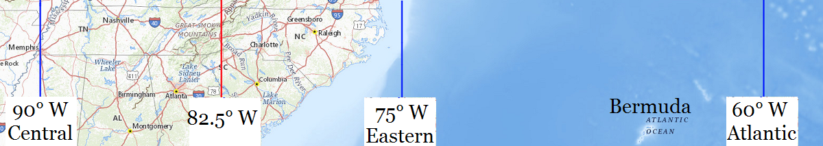
| Location |
Co-Ordinates
(Latitude, Longitude and Elevation) |
Mean solar time at noon
Central Standard Time
(Mountain Daylight Saving Time) |
Mean solar time at noon
Eastern Standard Time
(Central Daylight Saving Time) |
Mean solar time at noon
Atlantic Standard Time
(Eastern Daylight Saving Time) |
30th Street New Post Office,
Mecklenburg County
|
Elevation: 216 meters*
Latitude: 35.2539261° N
Longitude: 80.8012282° W
|
12:36:47 |
11:36:47 |
10:36:47 |
A B Combs Magnet Elementary School,
Wake County
|
Elevation: 129 meters*
Latitude: 35.7745162° N
Longitude: 78.7015425° W
|
12:45:11 |
11:45:11 |
10:45:11 |
A C Reynolds High School,
Buncombe County
|
Elevation: 682 meters*
Latitude: 35.5478923° N
Longitude: 82.4773437° W
|
12:30:05 |
11:30:05 |
10:30:05 |
A C Reynolds Middle School,
Buncombe County
|
Elevation: 674 meters*
Latitude: 35.5537253° N
Longitude: 82.4865109° W
|
12:30:03 |
11:30:03 |
10:30:03 |
A School,
Guilford County
|
Elevation: 247 meters*
Latitude: 36.0745798° N
Longitude: 79.7775305° W
|
12:40:53 |
11:40:53 |
10:40:53 |
A T Allen School,
Rowan County
|
Elevation: 234 meters*
Latitude: 35.6651394° N
Longitude: 80.4670038° W
|
12:38:07 |
11:38:07 |
10:38:07 |
AB Tech College,
Buncombe County
|
Elevation: 660 meters*
Latitude: 35.57039° N
Longitude: 82.5554029° W
|
12:29:46 |
11:29:46 |
10:29:46 |
Aberdeen Elementary School,
Moore County
|
Elevation: 106 meters*
Latitude: 35.1240472° N
Longitude: 79.4269791° W
|
12:42:17 |
11:42:17 |
10:42:17 |
Aberdeen Middle School,
Moore County
|
Elevation: 120 meters*
Latitude: 35.1387692° N
Longitude: 79.4261451° W
|
12:42:17 |
11:42:17 |
10:42:17 |
Aberdeen Post Office,
Moore County
|
Elevation: 101 meters*
Latitude: 35.1312611° N
Longitude: 79.4287232° W
|
12:42:17 |
11:42:17 |
10:42:17 |
Abernathy School,
Gaston County
|
Elevation: 241 meters*
Latitude: 35.2598597° N
Longitude: 81.2031341° W
|
12:35:11 |
11:35:11 |
10:35:11 |
Academy Heights School,
Moore County
|
Elevation: 137 meters*
Latitude: 35.210712° N
Longitude: 79.4841984° W
|
12:42:03 |
11:42:03 |
10:42:03 |
Academy Street Post Office,
Wake County
|
Elevation: 154 meters*
Latitude: 35.786305° N
Longitude: 78.780843° W
|
12:44:52 |
11:44:52 |
10:44:52 |
Acme Delco Elementary School,
Columbus County
|
Elevation: 17 meters*
Latitude: 34.36119° N
Longitude: 78.31761° W
|
12:46:43 |
11:46:43 |
10:46:43 |
Acme Delco Middle School,
Columbus County
|
Elevation: 18 meters*
Latitude: 34.3160194° N
Longitude: 78.2159139° W
|
12:47:08 |
11:47:08 |
10:47:08 |
Acresville Post Office (historical),
Beaufort County
|
Elevation: 10 meters*
Latitude: 35.595719° N
Longitude: 76.8241082° W
|
12:52:42 |
11:52:42 |
10:52:42 |
Ada Blair Elementary School (historical),
Guilford County
|
Elevation: 271 meters*
Latitude: 35.949927° N
Longitude: 80.010547° W
|
12:39:57 |
11:39:57 |
10:39:57 |
Adams Creek School,
Craven County
|
Elevation: 2 meters*
Latitude: 34.9212723° N
Longitude: 76.6832645° W
|
12:53:16 |
11:53:16 |
10:53:16 |
Adams Elementary School,
Wake County
|
Elevation: 137 meters*
Latitude: 35.7769127° N
Longitude: 78.762189° W
|
12:44:57 |
11:44:57 |
10:44:57 |
Adams School,
Person County
|
Elevation: 222 meters*
Latitude: 36.3929189° N
Longitude: 78.9455649° W
|
12:44:13 |
11:44:13 |
10:44:13 |
Adams School,
Wilson County
|
Elevation: 37 meters*
Latitude: 35.7151574° N
Longitude: 77.9139869° W
|
12:48:20 |
11:48:20 |
10:48:20 |
Advance Post Office,
Davie County
|
Elevation: 251 meters*
Latitude: 35.945851° N
Longitude: 80.4133574° W
|
12:38:20 |
11:38:20 |
10:38:20 |
Ahoskie Graded School,
Hertford County
|
Elevation: 14 meters*
Latitude: 36.2918222° N
Longitude: 76.9946811° W
|
12:52:01 |
11:52:01 |
10:52:01 |
Ahoskie Middle School,
Hertford County
|
Elevation: 16 meters*
Latitude: 36.2890445° N
Longitude: 76.9910699° W
|
12:52:02 |
11:52:02 |
10:52:02 |
Ahoskie Post Office,
Hertford County
|
Elevation: 17 meters*
Latitude: 36.2848478° N
Longitude: 76.9880199° W
|
12:52:02 |
11:52:02 |
10:52:02 |
Airport Post Office,
Mecklenburg County
|
Elevation: 219 meters*
Latitude: 35.2099083° N
Longitude: 80.9391447° W
|
12:36:14 |
11:36:14 |
10:36:14 |
Airy Grove School,
Lenoir County
|
Elevation: 22 meters*
Latitude: 35.3607185° N
Longitude: 77.5502461° W
|
12:49:47 |
11:49:47 |
10:49:47 |
Akers School,
Halifax County
|
Elevation: 49 meters*
Latitude: 36.4640396° N
Longitude: 77.6510908° W
|
12:49:23 |
11:49:23 |
10:49:23 |
Alamance Community College,
Alamance County
|
Elevation: 164 meters*
Latitude: 36.0665263° N
Longitude: 79.3575192° W
|
12:42:34 |
11:42:34 |
10:42:34 |
Alamance Post Office,
Alamance County
|
Elevation: 177 meters*
Latitude: 36.0327039° N
Longitude: 79.4876299° W
|
12:42:02 |
11:42:02 |
10:42:02 |
Alamance School,
Guilford County
|
Elevation: 226 meters*
Latitude: 36.0176354° N
Longitude: 79.7069718° W
|
12:41:10 |
11:41:10 |
10:41:10 |
Alarka School,
Swain County
|
Elevation: 637 meters*
Latitude: 35.3587065° N
Longitude: 83.4546026° W
|
12:26:10 |
11:26:10 |
10:26:10 |
Albemarle High School,
Stanly County
|
Elevation: 149 meters*
Latitude: 35.3709755° N
Longitude: 80.1933903° W
|
12:39:13 |
11:39:13 |
10:39:13 |
Albemarle Junior High School,
Stanly County
|
Elevation: 155 meters*
Latitude: 35.3545869° N
Longitude: 80.195613° W
|
12:39:13 |
11:39:13 |
10:39:13 |
Albemarle Post Office,
Stanly County
|
Elevation: 146 meters*
Latitude: 35.3474815° N
Longitude: 80.1990936° W
|
12:39:12 |
11:39:12 |
10:39:12 |
Albemarle Road Elementary School,
Mecklenburg County
|
Elevation: 228 meters*
Latitude: 35.1970888° N
Longitude: 80.7295137° W
|
12:37:04 |
11:37:04 |
10:37:04 |
Albemarle Road Middle School,
Mecklenburg County
|
Elevation: 235 meters*
Latitude: 35.1990332° N
Longitude: 80.7300693° W
|
12:37:04 |
11:37:04 |
10:37:04 |
Albermarle Academy,
Pasquotank County
|
Elevation: 3 meters*
Latitude: 36.2762678° N
Longitude: 76.2832692° W
|
12:54:52 |
11:54:52 |
10:54:52 |
Albertson Adult Education Center,
Duplin County
|
Elevation: 31 meters*
Latitude: 35.0682199° N
Longitude: 77.8188683° W
|
12:48:43 |
11:48:43 |
10:48:43 |
Albertson Post Office,
Duplin County
|
Elevation: 44 meters*
Latitude: 35.11411° N
Longitude: 77.8183337° W
|
12:48:43 |
11:48:43 |
10:48:43 |
Albian Academy (historical),
Franklin County
|
Elevation: 132 meters*
Latitude: 36.0973719° N
Longitude: 78.4616655° W
|
12:46:09 |
11:46:09 |
10:46:09 |
Alderman Elementary School,
Guilford County
|
Elevation: 255 meters*
Latitude: 36.0406916° N
Longitude: 79.8680893° W
|
12:40:31 |
11:40:31 |
10:40:31 |
Alderman School,
New Hanover County
|
Elevation: 14 meters*
Latitude: 34.2060036° N
Longitude: 77.9074864° W
|
12:48:22 |
11:48:22 |
10:48:22 |
Aldersgate Preschool,
Durham County
|
Elevation: 138 meters*
Latitude: 36.083056° N
Longitude: 78.938889° W
|
12:44:14 |
11:44:14 |
10:44:14 |
Alexander Central High School,
Alexander County
|
Elevation: 356 meters*
Latitude: 35.9170763° N
Longitude: 81.1892499° W
|
12:35:14 |
11:35:14 |
10:35:14 |
Alexander Elementary School,
Rutherford County
|
Elevation: 298 meters*
Latitude: 35.3090104° N
Longitude: 81.8578807° W
|
12:32:34 |
11:32:34 |
10:32:34 |
Alexander Graham Middle School,
Mecklenburg County
|
Elevation: 197 meters*
Latitude: 35.1668109° N
Longitude: 80.8328492° W
|
12:36:40 |
11:36:40 |
10:36:40 |
Alexander Post Office,
Buncombe County
|
Elevation: 545 meters*
Latitude: 35.7069709° N
Longitude: 82.6181297° W
|
12:29:31 |
11:29:31 |
10:29:31 |
Alexander School,
Buncombe County
|
Elevation: 631 meters*
Latitude: 35.6623295° N
Longitude: 82.6967995° W
|
12:29:12 |
11:29:12 |
10:29:12 |
Alexander School,
Rutherford County
|
Elevation: 345 meters*
Latitude: 35.4915132° N
Longitude: 81.9695472° W
|
12:32:07 |
11:32:07 |
10:32:07 |
Alexander Street School,
Mecklenburg County
|
Elevation: 201 meters*
Latitude: 35.2281983° N
Longitude: 80.8278488° W
|
12:36:41 |
11:36:41 |
10:36:41 |
Alexis Post Office,
Gaston County
|
Elevation: 267 meters*
Latitude: 35.3996241° N
Longitude: 81.1175347° W
|
12:35:31 |
11:35:31 |
10:35:31 |
Alleghany High School,
Alleghany County
|
Elevation: 895 meters*
Latitude: 36.5095735° N
Longitude: 81.1267526° W
|
12:35:29 |
11:35:29 |
10:35:29 |
Allen Jay Middle School,
Guilford County
|
Elevation: 248 meters*
Latitude: 35.9323588° N
Longitude: 79.9608714° W
|
12:40:09 |
11:40:09 |
10:40:09 |
Allen Junior High School,
Guilford County
|
Elevation: 251 meters*
Latitude: 36.0104135° N
Longitude: 79.8225316° W
|
12:40:42 |
11:40:42 |
10:40:42 |
Allen School,
Cabarrus County
|
Elevation: 196 meters*
Latitude: 35.3651413° N
Longitude: 80.5436771° W
|
12:37:49 |
11:37:49 |
10:37:49 |
Allenbrook Elementary School,
Mecklenburg County
|
Elevation: 216 meters*
Latitude: 35.2615297° N
Longitude: 80.9153503° W
|
12:36:20 |
11:36:20 |
10:36:20 |
Allens Creek Elementary School,
Haywood County
|
Elevation: 858 meters*
Latitude: 35.4606584° N
Longitude: 83.0018034° W
|
12:27:59 |
11:27:59 |
10:27:59 |
Allensville High School (historical),
Person County
|
Elevation: 182 meters*
Latitude: 36.404308° N
Longitude: 78.9019529° W
|
12:44:23 |
11:44:23 |
10:44:23 |
Alliance Post Office,
Pamlico County
|
Elevation: 2 meters*
Latitude: 35.144551° N
Longitude: 76.802999° W
|
12:52:47 |
11:52:47 |
10:52:47 |
Almond Post Office,
Swain County
|
Elevation: 583 meters*
Latitude: 35.3771485° N
Longitude: 83.5757482° W
|
12:25:41 |
11:25:41 |
10:25:41 |
Almond School,
Swain County
|
Elevation: 596 meters*
Latitude: 35.3734276° N
Longitude: 83.5059943° W
|
12:25:58 |
11:25:58 |
10:25:58 |
Altamahaw Post Office,
Alamance County
|
Elevation: 197 meters*
Latitude: 36.1846509° N
Longitude: 79.5063142° W
|
12:41:58 |
11:41:58 |
10:41:58 |
Altamahaw-Ossipee School,
Alamance County
|
Elevation: 198 meters*
Latitude: 36.1795793° N
Longitude: 79.5108573° W
|
12:41:57 |
11:41:57 |
10:41:57 |
Alwood Post Office,
Pitt County
|
Elevation: 12 meters*
Latitude: 35.6884932° N
Longitude: 77.3546876° W
|
12:50:34 |
11:50:34 |
10:50:34 |
Amay James Pre-Kindergarten Center,
Mecklenburg County
|
Elevation: 201 meters*
Latitude: 35.205° N
Longitude: 80.90278° W
|
12:36:23 |
11:36:23 |
10:36:23 |
Amherst Post Office,
Martin County
|
Elevation: 7 meters*
Latitude: 35.7396051° N
Longitude: 76.9796742° W
|
12:52:04 |
11:52:04 |
10:52:04 |
Amity School,
Iredell County
|
Elevation: 272 meters*
Latitude: 35.698472° N
Longitude: 80.7881267° W
|
12:36:50 |
11:36:50 |
10:36:50 |
Amostown School (historical),
Stokes County
|
Elevation: 309 meters*
Latitude: 36.5245826° N
Longitude: 80.0539347° W
|
12:39:47 |
11:39:47 |
10:39:47 |
Anderson Creek School,
Harnett County
|
Elevation: 75 meters*
Latitude: 35.2832164° N
Longitude: 78.9169696° W
|
12:44:19 |
11:44:19 |
10:44:19 |
Anderson Elementary School,
Caswell County
|
Elevation: 225 meters*
Latitude: 36.2645807° N
Longitude: 79.3394652° W
|
12:42:38 |
11:42:38 |
10:42:38 |
Andrews Elementary School,
Cherokee County
|
Elevation: 555 meters*
Latitude: 35.1984215° N
Longitude: 83.8254556° W
|
12:24:41 |
11:24:41 |
10:24:41 |
Andrews High School,
Cherokee County
|
Elevation: 560 meters*
Latitude: 35.1925882° N
Longitude: 83.8268444° W
|
12:24:41 |
11:24:41 |
10:24:41 |
Andrews Post Office,
Cherokee County
|
Elevation: 541 meters*
Latitude: 35.2011308° N
Longitude: 83.82674° W
|
12:24:41 |
11:24:41 |
10:24:41 |
Angier Middle School,
Harnett County
|
Elevation: 83 meters*
Latitude: 35.5037713° N
Longitude: 78.735848° W
|
12:45:03 |
11:45:03 |
10:45:03 |
Angier Post Office,
Harnett County
|
Elevation: 98 meters*
Latitude: 35.5156828° N
Longitude: 78.7401936° W
|
12:45:02 |
11:45:02 |
10:45:02 |
Anson Middle School,
Anson County
|
Elevation: 124 meters*
Latitude: 34.9745985° N
Longitude: 80.0870045° W
|
12:39:39 |
11:39:39 |
10:39:39 |
Ansonville Post Office,
Anson County
|
Elevation: 97 meters*
Latitude: 35.1009796° N
Longitude: 80.1083725° W
|
12:39:33 |
11:39:33 |
10:39:33 |
Ansonville School,
Anson County
|
Elevation: 98 meters*
Latitude: 35.1051499° N
Longitude: 80.1056147° W
|
12:39:34 |
11:39:34 |
10:39:34 |
Apex Elementary School,
Wake County
|
Elevation: 145 meters*
Latitude: 35.7215588° N
Longitude: 78.8566361° W
|
12:44:34 |
11:44:34 |
10:44:34 |
Apex High School,
Wake County
|
Elevation: 140 meters*
Latitude: 35.7453248° N
Longitude: 78.8372717° W
|
12:44:39 |
11:44:39 |
10:44:39 |
Apex Middle School,
Wake County
|
Elevation: 148 meters*
Latitude: 35.725968° N
Longitude: 78.8483736° W
|
12:44:36 |
11:44:36 |
10:44:36 |
Apex Post Office,
Wake County
|
Elevation: 138 meters*
Latitude: 35.7331549° N
Longitude: 78.8621799° W
|
12:44:33 |
11:44:33 |
10:44:33 |
Appalachian School,
Mitchell County
|
Elevation: 852 meters*
Latitude: 35.9390096° N
Longitude: 82.1140087° W
|
12:31:32 |
11:31:32 |
10:31:32 |
Appalachian State University,
Watauga County
|
Elevation: 979 meters*
Latitude: 36.2145727° N
Longitude: 81.6803852° W
|
12:33:16 |
11:33:16 |
10:33:16 |
Aquadale School,
Stanly County
|
Elevation: 153 meters*
Latitude: 35.2293122° N
Longitude: 80.2233944° W
|
12:39:06 |
11:39:06 |
10:39:06 |
Arapahoe Elementary School,
Pamlico County
|
Elevation: 13 meters*
Latitude: 35.0223833° N
Longitude: 76.8257704° W
|
12:52:41 |
11:52:41 |
10:52:41 |
Arapahoe Post Office,
Pamlico County
|
Elevation: 11 meters*
Latitude: 35.025983° N
Longitude: 76.82485° W
|
12:52:42 |
11:52:42 |
10:52:42 |
Ararat Post Office,
Surry County
|
Elevation: 290 meters*
Latitude: 36.4039884° N
Longitude: 80.5573469° W
|
12:37:46 |
11:37:46 |
10:37:46 |
Arcadia School,
Davidson County
|
Elevation: 257 meters*
Latitude: 35.9548594° N
Longitude: 80.2908847° W
|
12:38:50 |
11:38:50 |
10:38:50 |
Archdale Elementary School,
Randolph County
|
Elevation: 261 meters*
Latitude: 35.9129144° N
Longitude: 79.9755944° W
|
12:40:05 |
11:40:05 |
10:40:05 |
Archdale Post Office,
Randolph County
|
Elevation: 252 meters*
Latitude: 35.9056169° N
Longitude: 79.959294° W
|
12:40:09 |
11:40:09 |
10:40:09 |
Archdale-Trinity Middle School,
Randolph County
|
Elevation: 251 meters*
Latitude: 35.8859698° N
Longitude: 79.9542048° W
|
12:40:10 |
11:40:10 |
10:40:10 |
Archibald Murphy Elementary School,
Caswell County
|
Elevation: 173 meters*
Latitude: 36.4962514° N
Longitude: 79.2430728° W
|
12:43:01 |
11:43:01 |
10:43:01 |
Arden Post Office,
Buncombe County
|
Elevation: 679 meters*
Latitude: 35.4628265° N
Longitude: 82.515255° W
|
12:29:56 |
11:29:56 |
10:29:56 |
Ardmore School,
Forsyth County
|
Elevation: 273 meters*
Latitude: 36.0793041° N
Longitude: 80.2742171° W
|
12:38:54 |
11:38:54 |
10:38:54 |
Arendell Parrot Academy,
Lenoir County
|
Elevation: 26 meters*
Latitude: 35.3146074° N
Longitude: 77.6035813° W
|
12:49:35 |
11:49:35 |
10:49:35 |
Arlington Junior High School,
Gaston County
|
Elevation: 250 meters*
Latitude: 35.2631929° N
Longitude: 81.2109121° W
|
12:35:09 |
11:35:09 |
10:35:09 |
Armstrong Elementary School,
Cumberland County
|
Elevation: 40 meters*
Latitude: 35.0916101° N
Longitude: 78.7909624° W
|
12:44:50 |
11:44:50 |
10:44:50 |
Artesia School,
Columbus County
|
Elevation: 17 meters*
Latitude: 34.3110022° N
Longitude: 78.5789008° W
|
12:45:41 |
11:45:41 |
10:45:41 |
Asbury Elementary School,
Lincoln County
|
Elevation: 301 meters*
Latitude: 35.4773562° N
Longitude: 81.2084131° W
|
12:35:09 |
11:35:09 |
10:35:09 |
Asbury United Methodist Church Preschool,
Wake County
|
Elevation: 133 meters*
Latitude: 35.877274° N
Longitude: 78.676852° W
|
12:45:17 |
11:45:17 |
10:45:17 |
Ash Hill Post Office (historical),
Surry County
|
Elevation: 335 meters*
Latitude: 36.3954° N
Longitude: 80.572° W
|
12:37:42 |
11:37:42 |
10:37:42 |
Ash Post Office,
Brunswick County
|
Elevation: 15 meters*
Latitude: 34.0586404° N
Longitude: 78.520162° W
|
12:45:55 |
11:45:55 |
10:45:55 |
Ashbrook High School,
Gaston County
|
Elevation: 236 meters*
Latitude: 35.2440275° N
Longitude: 81.127299° W
|
12:35:29 |
11:35:29 |
10:35:29 |
Ashe Central School,
Ashe County
|
Elevation: 946 meters*
Latitude: 36.4304034° N
Longitude: 81.4353801° W
|
12:34:15 |
11:34:15 |
10:34:15 |
Asheboro High School,
Randolph County
|
Elevation: 269 meters*
Latitude: 35.6895812° N
Longitude: 79.8186452° W
|
12:40:43 |
11:40:43 |
10:40:43 |
Asheboro High School,
Randolph County
|
Elevation: 269 meters*
Latitude: 35.689859° N
Longitude: 79.8186452° W
|
12:40:43 |
11:40:43 |
10:40:43 |
Asheboro Junior High School,
Randolph County
|
Elevation: 263 meters*
Latitude: 35.689859° N
Longitude: 79.8211453° W
|
12:40:42 |
11:40:42 |
10:40:42 |
Asheboro Junior High School,
Randolph County
|
Elevation: 263 meters*
Latitude: 35.6895812° N
Longitude: 79.8214231° W
|
12:40:42 |
11:40:42 |
10:40:42 |
Asheboro Post Office,
Randolph County
|
Elevation: 261 meters*
Latitude: 35.6926543° N
Longitude: 79.8188828° W
|
12:40:43 |
11:40:43 |
10:40:43 |
Asheville (Downtown) Post Office,
Buncombe County
|
Elevation: 664 meters*
Latitude: 35.5930984° N
Longitude: 82.5556298° W
|
12:29:46 |
11:29:46 |
10:29:46 |
Asheville Biltmore College,
Buncombe County
|
Elevation: 643 meters*
Latitude: 35.6159446° N
Longitude: 82.5670714° W
|
12:29:43 |
11:29:43 |
10:29:43 |
Asheville Country Day School,
Buncombe County
|
Elevation: 662 meters*
Latitude: 35.5228913° N
Longitude: 82.5317892° W
|
12:29:52 |
11:29:52 |
10:29:52 |
Asheville Post Office,
Buncombe County
|
Elevation: 647 meters*
Latitude: 35.5526054° N
Longitude: 82.6007347° W
|
12:29:35 |
11:29:35 |
10:29:35 |
Asheville School for Boys,
Buncombe County
|
Elevation: 662 meters*
Latitude: 35.5656661° N
Longitude: 82.6229052° W
|
12:29:30 |
11:29:30 |
10:29:30 |
Asheville-Buncombe Technical Community College,
Buncombe County
|
Elevation: 656 meters*
Latitude: 35.5709455° N
Longitude: 82.5559584° W
|
12:29:46 |
11:29:46 |
10:29:46 |
Ashley Chapel School,
Richmond County
|
Elevation: 103 meters*
Latitude: 34.8970986° N
Longitude: 79.7845027° W
|
12:40:51 |
11:40:51 |
10:40:51 |
Ashley High School,
Gaston County
|
Elevation: 236 meters*
Latitude: 35.2529156° N
Longitude: 81.1881338° W
|
12:35:14 |
11:35:14 |
10:35:14 |
Ashley Park Elementary School,
Mecklenburg County
|
Elevation: 223 meters*
Latitude: 35.2334751° N
Longitude: 80.8906276° W
|
12:36:26 |
11:36:26 |
10:36:26 |
Ashley School,
Cumberland County
|
Elevation: 48 meters*
Latitude: 35.0384973° N
Longitude: 78.9069706° W
|
12:44:22 |
11:44:22 |
10:44:22 |
Ashley School,
Forsyth County
|
Elevation: 246 meters*
Latitude: 36.1179151° N
Longitude: 80.2136591° W
|
12:39:08 |
11:39:08 |
10:39:08 |
Ashmore Business College,
Davidson County
|
Elevation: 246 meters*
Latitude: 35.8854148° N
Longitude: 80.1261564° W
|
12:39:29 |
11:39:29 |
10:39:29 |
Ashpole Center School,
Robeson County
|
Elevation: 38 meters*
Latitude: 34.5451631° N
Longitude: 79.2533734° W
|
12:42:59 |
11:42:59 |
10:42:59 |
Askewville School,
Bertie County
|
Elevation: 19 meters*
Latitude: 36.1093246° N
Longitude: 76.9363432° W
|
12:52:15 |
11:52:15 |
10:52:15 |
Atkins High School,
Forsyth County
|
Elevation: 279 meters*
Latitude: 36.1101373° N
Longitude: 80.2222706° W
|
12:39:06 |
11:39:06 |
10:39:06 |
Atkinson Elementary School,
Henderson County
|
Elevation: 667 meters*
Latitude: 35.2834508° N
Longitude: 82.4920646° W
|
12:30:01 |
11:30:01 |
10:30:01 |
Atkinson Middle School,
Pender County
|
Elevation: 19 meters*
Latitude: 34.5287786° N
Longitude: 78.1736071° W
|
12:47:18 |
11:47:18 |
10:47:18 |
Atkinson Post Office,
Pender County
|
Elevation: 19 meters*
Latitude: 34.5274972° N
Longitude: 78.1704996° W
|
12:47:19 |
11:47:19 |
10:47:19 |
Atkinson School,
Pender County
|
Elevation: 20 meters*
Latitude: 34.5321121° N
Longitude: 78.1997189° W
|
12:47:12 |
11:47:12 |
10:47:12 |
Atlantic Beach Post Office (historical),
Carteret County
|
Elevation: 3 meters*
Latitude: 34.6990505° N
Longitude: 76.7402108° W
|
12:53:02 |
11:53:02 |
10:53:02 |
Atlantic Beach Post Office,
Carteret County
|
Elevation: 2 meters*
Latitude: 34.699929° N
Longitude: 76.7615489° W
|
12:52:57 |
11:52:57 |
10:52:57 |
Atlantic Post Office,
Carteret County
|
Elevation: 3 meters*
Latitude: 34.8774154° N
Longitude: 76.3478909° W
|
12:54:36 |
11:54:36 |
10:54:36 |
Atlantic School,
Carteret County
|
Elevation: 5 meters*
Latitude: 34.8823863° N
Longitude: 76.3424154° W
|
12:54:37 |
11:54:37 |
10:54:37 |
Atnens Drive High School,
Wake County
|
Elevation: 132 meters*
Latitude: 35.7687° N
Longitude: 78.7112732° W
|
12:45:09 |
11:45:09 |
10:45:09 |
Augusta Post Office (historical),
Davie County
|
Elevation: 221 meters*
Latitude: 35.8590269° N
Longitude: 80.5033917° W
|
12:37:59 |
11:37:59 |
10:37:59 |
Aulander Post Office,
Bertie County
|
Elevation: 20 meters*
Latitude: 36.2290463° N
Longitude: 77.1149881° W
|
12:51:32 |
11:51:32 |
10:51:32 |
Aurelian Springs Elementary School,
Halifax County
|
Elevation: 101 meters*
Latitude: 36.3634836° N
Longitude: 77.8077595° W
|
12:48:46 |
11:48:46 |
10:48:46 |
Aurora High School,
Beaufort County
|
Elevation: 2 meters*
Latitude: 35.3057245° N
Longitude: 76.7935434° W
|
12:52:49 |
11:52:49 |
10:52:49 |
Aurora Post Office,
Beaufort County
|
Elevation: 3 meters*
Latitude: 35.3010489° N
Longitude: 76.7881068° W
|
12:52:50 |
11:52:50 |
10:52:50 |
Autryville Post Office,
Sampson County
|
Elevation: 33 meters*
Latitude: 34.9976509° N
Longitude: 78.6419042° W
|
12:45:25 |
11:45:25 |
10:45:25 |
Avent Ferry Raleigh Post Office,
Wake County
|
Elevation: 143 meters*
Latitude: 35.7507215° N
Longitude: 78.7085087° W
|
12:45:09 |
11:45:09 |
10:45:09 |
Aventon Post Office,
Nash County
|
Elevation: 85 meters*
Latitude: 36.1529295° N
Longitude: 77.9497073° W
|
12:48:12 |
11:48:12 |
10:48:12 |
Aventon School (historical),
Nash County
|
Elevation: 70 meters*
Latitude: 36.1626516° N
Longitude: 77.9372068° W
|
12:48:15 |
11:48:15 |
10:48:15 |
Aventon School (historical),
Nash County
|
Elevation: 71 meters*
Latitude: 36.142374° N
Longitude: 77.956652° W
|
12:48:10 |
11:48:10 |
10:48:10 |
Aversboro Elementary School,
Wake County
|
Elevation: 98 meters*
Latitude: 35.6890428° N
Longitude: 78.6161161° W
|
12:45:32 |
11:45:32 |
10:45:32 |
Avery County High School,
Avery County
|
Elevation: 1113 meters*
Latitude: 36.0817931° N
Longitude: 81.9215027° W
|
12:32:18 |
11:32:18 |
10:32:18 |
Avery Sherrill School,
Iredell County
|
Elevation: 285 meters*
Latitude: 35.7659697° N
Longitude: 80.8892405° W
|
12:36:26 |
11:36:26 |
10:36:26 |
Avon Post Office,
Dare County
|
Elevation: 2 meters*
Latitude: 35.3440138° N
Longitude: 75.504637° W
|
12:57:58 |
11:57:58 |
10:57:58 |
Avondale-Henrietta School,
Rutherford County
|
Elevation: 251 meters*
Latitude: 35.274289° N
Longitude: 81.7973235° W
|
12:32:48 |
11:32:48 |
10:32:48 |
Aycock High School,
Wayne County
|
Elevation: 39 meters*
Latitude: 35.5098826° N
Longitude: 77.9799867° W
|
12:48:04 |
11:48:04 |
10:48:04 |
Aycock Junior High School,
Pitt County
|
Elevation: 21 meters*
Latitude: 35.5868282° N
Longitude: 77.3535754° W
|
12:50:35 |
11:50:35 |
10:50:35 |
Aycock Junior High School,
Wake County
|
Elevation: 85 meters*
Latitude: 35.7823736° N
Longitude: 78.6019472° W
|
12:45:35 |
11:45:35 |
10:45:35 |
Aycock School,
Buncombe County
|
Elevation: 657 meters*
Latitude: 35.5790003° N
Longitude: 82.5820707° W
|
12:29:40 |
11:29:40 |
10:29:40 |
Aycock School,
Guilford County
|
Elevation: 244 meters*
Latitude: 36.0840243° N
Longitude: 79.780864° W
|
12:40:52 |
11:40:52 |
10:40:52 |
Aycock School,
Orange County
|
Elevation: 220 meters*
Latitude: 36.1843054° N
Longitude: 79.1694598° W
|
12:43:19 |
11:43:19 |
10:43:19 |
Aycock School,
Vance County
|
Elevation: 143 meters*
Latitude: 36.3187578° N
Longitude: 78.3330513° W
|
12:46:40 |
11:46:40 |
10:46:40 |
Ayden Elementary School,
Pitt County
|
Elevation: 21 meters*
Latitude: 35.4754678° N
Longitude: 77.4326015° W
|
12:50:16 |
11:50:16 |
10:50:16 |
Ayden Middle School,
Pitt County
|
Elevation: 21 meters*
Latitude: 35.4751556° N
Longitude: 77.4317638° W
|
12:50:16 |
11:50:16 |
10:50:16 |
Ayden Post Office,
Pitt County
|
Elevation: 18 meters*
Latitude: 35.4718915° N
Longitude: 77.4189247° W
|
12:50:19 |
11:50:19 |
10:50:19 |
Ayden-Grifton High School,
Pitt County
|
Elevation: 18 meters*
Latitude: 35.4280551° N
Longitude: 77.4319625° W
|
12:50:16 |
11:50:16 |
10:50:16 |
Aydlett Post Office,
Currituck County
|
Elevation: 4 meters*
Latitude: 36.3238605° N
Longitude: 75.9055387° W
|
12:56:22 |
11:56:22 |
10:56:22 |
Azalea Post Office,
New Hanover County
|
Elevation: 12 meters*
Latitude: 34.2126168° N
Longitude: 77.8986641° W
|
12:48:24 |
11:48:24 |
10:48:24 |
B Everett Jordan Elementary School,
Alamance County
|
Elevation: 175 meters*
Latitude: 35.906529° N
Longitude: 79.3005726° W
|
12:42:47 |
11:42:47 |
10:42:47 |
Baden School (historical),
Stokes County
|
Elevation: 310 meters*
Latitude: 36.447638° N
Longitude: 80.3050536° W
|
12:38:46 |
11:38:46 |
10:38:46 |
Badin Post Office,
Stanly County
|
Elevation: 161 meters*
Latitude: 35.4045226° N
Longitude: 80.1136521° W
|
12:39:32 |
11:39:32 |
10:39:32 |
Badin School,
Stanly County
|
Elevation: 159 meters*
Latitude: 35.4020856° N
Longitude: 80.1142203° W
|
12:39:32 |
11:39:32 |
10:39:32 |
Bahama Post Office,
Durham County
|
Elevation: 156 meters*
Latitude: 36.1641048° N
Longitude: 78.8785453° W
|
12:44:29 |
11:44:29 |
10:44:29 |
Bailey Elementary School,
Nash County
|
Elevation: 74 meters*
Latitude: 35.7815453° N
Longitude: 78.1149918° W
|
12:47:32 |
11:47:32 |
10:47:32 |
Bailey Post Office,
Nash County
|
Elevation: 77 meters*
Latitude: 35.7796903° N
Longitude: 78.1133398° W
|
12:47:32 |
11:47:32 |
10:47:32 |
Baileywick Road Elementary School,
Wake County
|
Elevation: 139 meters*
Latitude: 35.908889° N
Longitude: 78.664167° W
|
12:45:20 |
11:45:20 |
10:45:20 |
Bain Elementary School,
Mecklenburg County
|
Elevation: 238 meters*
Latitude: 35.1757005° N
Longitude: 80.6484016° W
|
12:37:24 |
11:37:24 |
10:37:24 |
Bains School (historical),
Nash County
|
Elevation: 72 meters*
Latitude: 35.9840421° N
Longitude: 78.0260983° W
|
12:47:53 |
11:47:53 |
10:47:53 |
Baker Creek School,
Yancey County
|
Elevation: 861 meters*
Latitude: 35.8923354° N
Longitude: 82.3376282° W
|
12:30:38 |
11:30:38 |
10:30:38 |
Baker School,
Halifax County
|
Elevation: 29 meters*
Latitude: 36.146267° N
Longitude: 77.3824688° W
|
12:50:28 |
11:50:28 |
10:50:28 |
Bakers School (historical),
Warren County
|
Elevation: 85 meters*
Latitude: 36.3573717° N
Longitude: 77.9685992° W
|
12:48:07 |
11:48:07 |
10:48:07 |
Bakersville Post Office,
Mitchell County
|
Elevation: 752 meters*
Latitude: 36.015858° N
Longitude: 82.1561703° W
|
12:31:22 |
11:31:22 |
10:31:22 |
Bald Creek Elementary School,
Yancey County
|
Elevation: 787 meters*
Latitude: 35.9128888° N
Longitude: 82.4234652° W
|
12:30:18 |
11:30:18 |
10:30:18 |
Balfour School,
Henderson County
|
Elevation: 656 meters*
Latitude: 35.3492834° N
Longitude: 82.4762309° W
|
12:30:05 |
11:30:05 |
10:30:05 |
Balfour School,
Randolph County
|
Elevation: 224 meters*
Latitude: 35.7456924° N
Longitude: 79.8058657° W
|
12:40:46 |
11:40:46 |
10:40:46 |
Ballantyne Post Office,
Mecklenburg County
|
Elevation: 197 meters*
Latitude: 35.0574311° N
Longitude: 80.8180891° W
|
12:36:43 |
11:36:43 |
10:36:43 |
Ballard Industrial School,
Rowan County
|
Elevation: 229 meters*
Latitude: 35.6715284° N
Longitude: 80.4850598° W
|
12:38:03 |
11:38:03 |
10:38:03 |
Balls Creek School,
Catawba County
|
Elevation: 323 meters*
Latitude: 35.6304113° N
Longitude: 81.127024° W
|
12:35:29 |
11:35:29 |
10:35:29 |
Balsam Grove Post Office,
Transylvania County
|
Elevation: 855 meters*
Latitude: 35.2251595° N
Longitude: 82.8653373° W
|
12:28:32 |
11:28:32 |
10:28:32 |
Balsam Post Office,
Jackson County
|
Elevation: 1010 meters*
Latitude: 35.4296272° N
Longitude: 83.0832781° W
|
12:27:40 |
11:27:40 |
10:27:40 |
Bamboo School (historical),
Watauga County
|
Elevation: 1006 meters*
Latitude: 36.198462° N
Longitude: 81.607605° W
|
12:33:34 |
11:33:34 |
10:33:34 |
Banks Creek School,
Yancey County
|
Elevation: 838 meters*
Latitude: 35.8862236° N
Longitude: 82.3717959° W
|
12:30:30 |
11:30:30 |
10:30:30 |
Banks Elementary School,
Lenoir County
|
Elevation: 28 meters*
Latitude: 35.2807735° N
Longitude: 77.6811359° W
|
12:49:16 |
11:49:16 |
10:49:16 |
Banks School (historical),
Granville County
|
Elevation: 140 meters*
Latitude: 36.155425° N
Longitude: 78.5825013° W
|
12:45:40 |
11:45:40 |
10:45:40 |
Banner Elk Elementary School,
Avery County
|
Elevation: 1126 meters*
Latitude: 36.1626262° N
Longitude: 81.8698351° W
|
12:32:31 |
11:32:31 |
10:32:31 |
Banner Elk Post Office,
Avery County
|
Elevation: 1126 meters*
Latitude: 36.161286° N
Longitude: 81.8720515° W
|
12:32:30 |
11:32:30 |
10:32:30 |
Bannertown Elementary School (historical),
Surry County
|
Elevation: 324 meters*
Latitude: 36.4859679° N
Longitude: 80.5872851° W
|
12:37:39 |
11:37:39 |
10:37:39 |
Banoak Elementary School,
Catawba County
|
Elevation: 372 meters*
Latitude: 35.5823066° N
Longitude: 81.4165691° W
|
12:34:20 |
11:34:20 |
10:34:20 |
Barber-Scotia College,
Cabarrus County
|
Elevation: 205 meters*
Latitude: 35.4065295° N
Longitude: 80.5856223° W
|
12:37:39 |
11:37:39 |
10:37:39 |
Barco Post Office,
Currituck County
|
Elevation: 3 meters*
Latitude: 36.388348° N
Longitude: 75.9773312° W
|
12:56:05 |
11:56:05 |
10:56:05 |
Barium Springs Post Office,
Iredell County
|
Elevation: 288 meters*
Latitude: 35.7216346° N
Longitude: 80.8967176° W
|
12:36:24 |
11:36:24 |
10:36:24 |
Barker Tenmile School,
Robeson County
|
Elevation: 43 meters*
Latitude: 34.7118314° N
Longitude: 78.9522511° W
|
12:44:11 |
11:44:11 |
10:44:11 |
Barnard's Station Post Office,
Madison County
|
Elevation: 468 meters*
Latitude: 35.8395488° N
Longitude: 82.7540282° W
|
12:28:59 |
11:28:59 |
10:28:59 |
Barnardsville Elementary School,
Buncombe County
|
Elevation: 671 meters*
Latitude: 35.7748341° N
Longitude: 82.4595733° W
|
12:30:09 |
11:30:09 |
10:30:09 |
Barnardsville Post Office,
Buncombe County
|
Elevation: 670 meters*
Latitude: 35.778157° N
Longitude: 82.4554864° W
|
12:30:10 |
11:30:10 |
10:30:10 |
Barnes School (historical),
Rockingham County
|
Elevation: 220 meters*
Latitude: 36.4770825° N
Longitude: 79.8605945° W
|
12:40:33 |
11:40:33 |
10:40:33 |
Barnes School,
Wilson County
|
Elevation: 40 meters*
Latitude: 35.7129357° N
Longitude: 77.886094° W
|
12:48:27 |
11:48:27 |
10:48:27 |
Barringer Elementary School,
Mecklenburg County
|
Elevation: 195 meters*
Latitude: 35.210698° N
Longitude: 80.8875723° W
|
12:36:26 |
11:36:26 |
10:36:26 |
Barry Gold School,
Granville County
|
Elevation: 126 meters*
Latitude: 36.4993087° N
Longitude: 78.6144464° W
|
12:45:32 |
11:45:32 |
10:45:32 |
Bartlett Yancey Elementary School,
Caswell County
|
Elevation: 185 meters*
Latitude: 36.4048607° N
Longitude: 79.3308534° W
|
12:42:40 |
11:42:40 |
10:42:40 |
Barton College,
Wilson County
|
Elevation: 39 meters*
Latitude: 35.7355442° N
Longitude: 77.9137213° W
|
12:48:20 |
11:48:20 |
10:48:20 |
Baskerville School,
Edgecombe County
|
Elevation: 30 meters*
Latitude: 35.9504324° N
Longitude: 77.7719221° W
|
12:48:54 |
11:48:54 |
10:48:54 |
Bassett School,
Edgecombe County
|
Elevation: 36 meters*
Latitude: 35.9298771° N
Longitude: 77.7927564° W
|
12:48:49 |
11:48:49 |
10:48:49 |
Bastian Elementary School,
Rowan County
|
Elevation: 253 meters*
Latitude: 35.5240284° N
Longitude: 80.5420089° W
|
12:37:49 |
11:37:49 |
10:37:49 |
Bat Cave Post Office,
Henderson County
|
Elevation: 446 meters*
Latitude: 35.4509132° N
Longitude: 82.2848474° W
|
12:30:51 |
11:30:51 |
10:30:51 |
Bath Post Office,
Beaufort County
|
Elevation: 3 meters*
Latitude: 35.4763647° N
Longitude: 76.8085841° W
|
12:52:45 |
11:52:45 |
10:52:45 |
Bath School,
Beaufort County
|
Elevation: 4 meters*
Latitude: 35.4768317° N
Longitude: 76.8116045° W
|
12:52:45 |
11:52:45 |
10:52:45 |
Baton Elementary School,
Caldwell County
|
Elevation: 370 meters*
Latitude: 35.8084642° N
Longitude: 81.5359272° W
|
12:33:51 |
11:33:51 |
10:33:51 |
Battle School,
Nash County
|
Elevation: 35 meters*
Latitude: 35.9334881° N
Longitude: 77.8030345° W
|
12:48:47 |
11:48:47 |
10:48:47 |
Battleboro Post Office,
Nash County
|
Elevation: 39 meters*
Latitude: 36.0495496° N
Longitude: 77.7501731° W
|
12:48:59 |
11:48:59 |
10:48:59 |
Battleground Elementary School,
Lincoln County
|
Elevation: 251 meters*
Latitude: 35.4787448° N
Longitude: 81.2631366° W
|
12:34:56 |
11:34:56 |
10:34:56 |
Battleground Post Office,
Guilford County
|
Elevation: 279 meters*
Latitude: 36.1139493° N
Longitude: 79.8350266° W
|
12:40:39 |
11:40:39 |
10:40:39 |
Baucom Elementary School,
Wake County
|
Elevation: 153 meters*
Latitude: 35.7369872° N
Longitude: 78.854321° W
|
12:44:34 |
11:44:34 |
10:44:34 |
Baxter School (historical),
Nash County
|
Elevation: 42 meters*
Latitude: 35.9223769° N
Longitude: 77.8702594° W
|
12:48:31 |
11:48:31 |
10:48:31 |
Bay Leaf School (historical),
Wake County
|
Elevation: 132 meters*
Latitude: 35.9440381° N
Longitude: 78.6433364° W
|
12:45:25 |
11:45:25 |
10:45:25 |
Bayboro Post Office,
Pamlico County
|
Elevation: 3 meters*
Latitude: 35.142495° N
Longitude: 76.769522° W
|
12:52:55 |
11:52:55 |
10:52:55 |
Baycock School,
Cabarrus County
|
Elevation: 239 meters*
Latitude: 35.487639° N
Longitude: 80.6261787° W
|
12:37:29 |
11:37:29 |
10:37:29 |
Bayside School,
Beaufort County
|
Elevation: 3 meters*
Latitude: 35.4659986° N
Longitude: 76.8013259° W
|
12:52:47 |
11:52:47 |
10:52:47 |
Baysville School,
Scotland County
|
Elevation: 72 meters*
Latitude: 34.8507146° N
Longitude: 79.5125474° W
|
12:41:56 |
11:41:56 |
10:41:56 |
Beam School (historical),
Cleveland County
|
Elevation: 262 meters*
Latitude: 35.3512424° N
Longitude: 81.4689773° W
|
12:34:07 |
11:34:07 |
10:34:07 |
Bean Shoals Academy (historical),
Surry County
|
Elevation: 300 meters*
Latitude: 36.2748614° N
Longitude: 80.5117248° W
|
12:37:57 |
11:37:57 |
10:37:57 |
Bear Creek Post Office,
Chatham County
|
Elevation: 140 meters*
Latitude: 35.6173941° N
Longitude: 79.3838015° W
|
12:42:27 |
11:42:27 |
10:42:27 |
Bear Grass High School,
Martin County
|
Elevation: 19 meters*
Latitude: 35.7677289° N
Longitude: 77.1278219° W
|
12:51:29 |
11:51:29 |
10:51:29 |
Bear Swamp Post Office (historical),
Duplin County
|
Elevation: 33 meters*
Latitude: 35.094054° N
Longitude: 78.0244322° W
|
12:47:54 |
11:47:54 |
10:47:54 |
Beasley School (historical),
Stokes County
|
Elevation: 331 meters*
Latitude: 36.5323603° N
Longitude: 80.1261594° W
|
12:39:29 |
11:39:29 |
10:39:29 |
Beaufort Elementary School,
Beaufort County
|
Elevation: 3 meters*
Latitude: 35.5857202° N
Longitude: 76.6674347° W
|
12:53:19 |
11:53:19 |
10:53:19 |
Beaufort Elementary School,
Carteret County
|
Elevation: 3 meters*
Latitude: 34.7291917° N
Longitude: 76.6466298° W
|
12:53:24 |
11:53:24 |
10:53:24 |
Beaufort High School,
Carteret County
|
Elevation: 3 meters*
Latitude: 34.7204396° N
Longitude: 76.6549293° W
|
12:53:22 |
11:53:22 |
10:53:22 |
Beaufort Middle School,
Carteret County
|
Elevation: 3 meters*
Latitude: 34.7297093° N
Longitude: 76.6446183° W
|
12:53:25 |
11:53:25 |
10:53:25 |
Beaufort Post Office,
Carteret County
|
Elevation: 3 meters*
Latitude: 34.7352836° N
Longitude: 76.6360454° W
|
12:53:27 |
11:53:27 |
10:53:27 |
Beaver Creek High School,
Ashe County
|
Elevation: 939 meters*
Latitude: 36.3806813° N
Longitude: 81.4984384° W
|
12:34:00 |
11:34:00 |
10:34:00 |
Beaver Dam School,
Cumberland County
|
Elevation: 33 meters*
Latitude: 34.8946137° N
Longitude: 78.5808442° W
|
12:45:40 |
11:45:40 |
10:45:40 |
Beaverdam School (historical),
Cleveland County
|
Elevation: 257 meters*
Latitude: 35.2962385° N
Longitude: 81.6025935° W
|
12:33:35 |
11:33:35 |
10:33:35 |
Beaverdam School (historical),
Watauga County
|
Elevation: 959 meters*
Latitude: 36.3190119° N
Longitude: 81.8620594° W
|
12:32:33 |
11:32:33 |
10:32:33 |
Beaverdam School,
Haywood County
|
Elevation: 830 meters*
Latitude: 35.5592724° N
Longitude: 82.832912° W
|
12:28:40 |
11:28:40 |
10:28:40 |
Beaverdam School,
Watauga County
|
Elevation: 936 meters*
Latitude: 36.3273459° N
Longitude: 81.8215026° W
|
12:32:42 |
11:32:42 |
10:32:42 |
Beddingfield High School,
Wilson County
|
Elevation: 35 meters*
Latitude: 35.6617029° N
Longitude: 77.8759757° W
|
12:48:29 |
11:48:29 |
10:48:29 |
Bee Branch School,
Yancey County
|
Elevation: 728 meters*
Latitude: 36.0156678° N
Longitude: 82.2965192° W
|
12:30:48 |
11:30:48 |
10:30:48 |
Bee Log Elementary School,
Yancey County
|
Elevation: 739 meters*
Latitude: 35.9834437° N
Longitude: 82.4081889° W
|
12:30:22 |
11:30:22 |
10:30:22 |
Beech Creek School (historical),
Watauga County
|
Elevation: 1107 meters*
Latitude: 36.2270696° N
Longitude: 81.8823364° W
|
12:32:28 |
11:32:28 |
10:32:28 |
Beech Mountain School,
Avery County
|
Elevation: 1077 meters*
Latitude: 36.237624° N
Longitude: 81.9301159° W
|
12:32:16 |
11:32:16 |
10:32:16 |
Beers School,
Graham County
|
Elevation: 459 meters*
Latitude: 35.4442523° N
Longitude: 83.9179579° W
|
12:24:19 |
11:24:19 |
10:24:19 |
Belews Creek Post Office,
Forsyth County
|
Elevation: 261 meters*
Latitude: 36.2441979° N
Longitude: 80.0686159° W
|
12:39:43 |
11:39:43 |
10:39:43 |
Belfast Elementary School,
Wayne County
|
Elevation: 39 meters*
Latitude: 35.4321057° N
Longitude: 77.9805422° W
|
12:48:04 |
11:48:04 |
10:48:04 |
Belfast School,
Wayne County
|
Elevation: 40 meters*
Latitude: 35.4321057° N
Longitude: 77.9810979° W
|
12:48:04 |
11:48:04 |
10:48:04 |
Belhaven Elementary School,
Beaufort County
|
Elevation: 1 meters*
Latitude: 35.544332° N
Longitude: 76.6229875° W
|
12:53:30 |
11:53:30 |
10:53:30 |
Belhaven Post Office,
Beaufort County
|
Elevation: 2 meters*
Latitude: 35.5489889° N
Longitude: 76.6260356° W
|
12:53:29 |
11:53:29 |
10:53:29 |
Bell Fork Elementary School,
Onslow County
|
Elevation: 8 meters*
Latitude: 34.7532508° N
Longitude: 77.392177° W
|
12:50:25 |
11:50:25 |
10:50:25 |
Bell Mission School,
Cabarrus County
|
Elevation: 188 meters*
Latitude: 35.4334738° N
Longitude: 80.5308985° W
|
12:37:52 |
11:37:52 |
10:37:52 |
Bell School,
Richmond County
|
Elevation: 78 meters*
Latitude: 34.9470977° N
Longitude: 79.7661675° W
|
12:40:56 |
11:40:56 |
10:40:56 |
Bell Swamp School,
Brunswick County
|
Elevation: 7 meters*
Latitude: 34.1404486° N
Longitude: 78.0938824° W
|
12:47:37 |
11:47:37 |
10:47:37 |
Bellarthur Post Office,
Pitt County
|
Elevation: 24 meters*
Latitude: 35.5905999° N
Longitude: 77.5128987° W
|
12:49:56 |
11:49:56 |
10:49:56 |
Bellefont School,
Cabarrus County
|
Elevation: 215 meters*
Latitude: 35.29292° N
Longitude: 80.641457° W
|
12:37:26 |
11:37:26 |
10:37:26 |
Bellevoir School,
Sampson County
|
Elevation: 52 meters*
Latitude: 35.0351679° N
Longitude: 78.4091696° W
|
12:46:21 |
11:46:21 |
10:46:21 |
Belmont Abbey College,
Gaston County
|
Elevation: 225 meters*
Latitude: 35.2543061° N
Longitude: 81.0434083° W
|
12:35:49 |
11:35:49 |
10:35:49 |
Belmont Central Elementary School,
Gaston County
|
Elevation: 214 meters*
Latitude: 35.2415285° N
Longitude: 81.0500751° W
|
12:35:47 |
11:35:47 |
10:35:47 |
Belmont Junior High School,
Gaston County
|
Elevation: 187 meters*
Latitude: 35.2470843° N
Longitude: 81.0167409° W
|
12:35:55 |
11:35:55 |
10:35:55 |
Belmont Post Office,
Gaston County
|
Elevation: 210 meters*
Latitude: 35.2456024° N
Longitude: 81.035893° W
|
12:35:51 |
11:35:51 |
10:35:51 |
Belvedere School,
Cumberland County
|
Elevation: 56 meters*
Latitude: 35.0709969° N
Longitude: 78.903915° W
|
12:44:23 |
11:44:23 |
10:44:23 |
Belvidere Post Office,
Perquimans County
|
Elevation: 4 meters*
Latitude: 36.2683107° N
Longitude: 76.539144° W
|
12:53:50 |
11:53:50 |
10:53:50 |
Belvoir School,
Pitt County
|
Elevation: 10 meters*
Latitude: 35.66766° N
Longitude: 77.4177448° W
|
12:50:19 |
11:50:19 |
10:50:19 |
Belwood High School,
Cleveland County
|
Elevation: 312 meters*
Latitude: 35.4790206° N
Longitude: 81.5212017° W
|
12:33:54 |
11:33:54 |
10:33:54 |
Ben Lippen School,
Buncombe County
|
Elevation: 739 meters*
Latitude: 35.6098323° N
Longitude: 82.6165175° W
|
12:29:32 |
11:29:32 |
10:29:32 |
Benhaven High School,
Harnett County
|
Elevation: 102 meters*
Latitude: 35.3593239° N
Longitude: 79.094191° W
|
12:43:37 |
11:43:37 |
10:43:37 |
Benjamin J Martin Elementary School,
Cumberland County
|
Elevation: 85 meters*
Latitude: 35.0932181° N
Longitude: 79.0094735° W
|
12:43:57 |
11:43:57 |
10:43:57 |
Bennett College,
Guilford County
|
Elevation: 255 meters*
Latitude: 36.068191° N
Longitude: 79.7800305° W
|
12:40:52 |
11:40:52 |
10:40:52 |
Bennett Elementary School,
Chatham County
|
Elevation: 152 meters*
Latitude: 35.562365° N
Longitude: 79.5455806° W
|
12:41:49 |
11:41:49 |
10:41:49 |
Bennett Post Office,
Chatham County
|
Elevation: 149 meters*
Latitude: 35.5640761° N
Longitude: 79.5434999° W
|
12:41:49 |
11:41:49 |
10:41:49 |
Benson Elementary School,
Johnston County
|
Elevation: 84 meters*
Latitude: 35.3999554° N
Longitude: 78.5554352° W
|
12:45:46 |
11:45:46 |
10:45:46 |
Benson Post Office,
Johnston County
|
Elevation: 73 meters*
Latitude: 35.3782518° N
Longitude: 78.5495414° W
|
12:45:48 |
11:45:48 |
10:45:48 |
Benton Heights School,
Union County
|
Elevation: 187 meters*
Latitude: 34.9932052° N
Longitude: 80.5531224° W
|
12:37:47 |
11:37:47 |
10:37:47 |
Benton School (historical),
Cabarrus County
|
Elevation: 209 meters*
Latitude: 35.2554206° N
Longitude: 80.5903453° W
|
12:37:38 |
11:37:38 |
10:37:38 |
Bentonsville Beasley Post Office,
Johnston County
|
Elevation: 52 meters*
Latitude: 35.3487741° N
Longitude: 78.296666° W
|
12:46:48 |
11:46:48 |
10:46:48 |
Benvenue Middle School,
Nash County
|
Elevation: 38 meters*
Latitude: 35.9784874° N
Longitude: 77.8077568° W
|
12:48:46 |
11:48:46 |
10:48:46 |
Benvenue School,
Nash County
|
Elevation: 40 meters*
Latitude: 35.9804319° N
Longitude: 77.8094235° W
|
12:48:45 |
11:48:45 |
10:48:45 |
Berkeley Post Office,
Wayne County
|
Elevation: 35 meters*
Latitude: 35.3726546° N
Longitude: 77.9454246° W
|
12:48:13 |
11:48:13 |
10:48:13 |
Berryhill Elementary School,
Mecklenburg County
|
Elevation: 226 meters*
Latitude: 35.2262523° N
Longitude: 80.9592401° W
|
12:36:09 |
11:36:09 |
10:36:09 |
Bertie High School,
Bertie County
|
Elevation: 4 meters*
Latitude: 36.048176° N
Longitude: 76.9741357° W
|
12:52:06 |
11:52:06 |
10:52:06 |
Bertie Junior High School,
Bertie County
|
Elevation: 15 meters*
Latitude: 36.0334917° N
Longitude: 77.0144002° W
|
12:51:56 |
11:51:56 |
10:51:56 |
Bess Elementary School,
Gaston County
|
Elevation: 233 meters*
Latitude: 35.1873611° N
Longitude: 81.1361876° W
|
12:35:27 |
11:35:27 |
10:35:27 |
Bessember City Central Elementary School,
Gaston County
|
Elevation: 265 meters*
Latitude: 35.2851359° N
Longitude: 81.2767474° W
|
12:34:53 |
11:34:53 |
10:34:53 |
Bessemer City High School,
Gaston County
|
Elevation: 269 meters*
Latitude: 35.2973578° N
Longitude: 81.28147° W
|
12:34:52 |
11:34:52 |
10:34:52 |
Bessemer City Post Office,
Gaston County
|
Elevation: 270 meters*
Latitude: 35.2823261° N
Longitude: 81.2829326° W
|
12:34:52 |
11:34:52 |
10:34:52 |
Bessemer City Primary School,
Gaston County
|
Elevation: 263 meters*
Latitude: 35.2995801° N
Longitude: 81.2767475° W
|
12:34:53 |
11:34:53 |
10:34:53 |
Bessemer Elementary School,
Guilford County
|
Elevation: 237 meters*
Latitude: 36.0895796° N
Longitude: 79.7380847° W
|
12:41:02 |
11:41:02 |
10:41:02 |
Best High School,
Franklin County
|
Elevation: 115 meters*
Latitude: 36.0943178° N
Longitude: 78.1669358° W
|
12:47:19 |
11:47:19 |
10:47:19 |
Best School,
Franklin County
|
Elevation: 109 meters*
Latitude: 36.1270952° N
Longitude: 78.1588802° W
|
12:47:21 |
11:47:21 |
10:47:21 |
Bethania Post Office,
Forsyth County
|
Elevation: 255 meters*
Latitude: 36.1855669° N
Longitude: 80.3371699° W
|
12:38:39 |
11:38:39 |
10:38:39 |
Bethel Elementary School,
Haywood County
|
Elevation: 821 meters*
Latitude: 35.4726053° N
Longitude: 82.896245° W
|
12:28:24 |
11:28:24 |
10:28:24 |
Bethel Elementary School,
Pitt County
|
Elevation: 20 meters*
Latitude: 35.8093252° N
Longitude: 77.3741334° W
|
12:50:30 |
11:50:30 |
10:50:30 |
Bethel Elementary School,
Watauga County
|
Elevation: 826 meters*
Latitude: 36.2942909° N
Longitude: 81.8484474° W
|
12:32:36 |
11:32:36 |
10:32:36 |
Bethel High School (historical),
Haywood County
|
Elevation: 821 meters*
Latitude: 35.4726053° N
Longitude: 82.896245° W
|
12:28:24 |
11:28:24 |
10:28:24 |
Bethel Hill Elementary School,
Person County
|
Elevation: 194 meters*
Latitude: 36.5043075° N
Longitude: 78.9186207° W
|
12:44:19 |
11:44:19 |
10:44:19 |
Bethel Hill High School,
Person County
|
Elevation: 193 meters*
Latitude: 36.5043075° N
Longitude: 78.9188985° W
|
12:44:19 |
11:44:19 |
10:44:19 |
Bethel Post Office,
Pitt County
|
Elevation: 20 meters*
Latitude: 35.8080297° N
Longitude: 77.3715798° W
|
12:50:30 |
11:50:30 |
10:50:30 |
Bethel School,
Cabarrus County
|
Elevation: 186 meters*
Latitude: 35.248754° N
Longitude: 80.5364557° W
|
12:37:51 |
11:37:51 |
10:37:51 |
Bethel School,
Hoke County
|
Elevation: 80 meters*
Latitude: 34.9543317° N
Longitude: 79.2808688° W
|
12:42:52 |
11:42:52 |
10:42:52 |
Bethesda Elementary School,
Durham County
|
Elevation: 122 meters*
Latitude: 35.9401861° N
Longitude: 78.8377582° W
|
12:44:38 |
11:44:38 |
10:44:38 |
Bethlehem Elementary School,
Alexander County
|
Elevation: 335 meters*
Latitude: 35.8376318° N
Longitude: 81.3117532° W
|
12:34:45 |
11:34:45 |
10:34:45 |
Bethlehem School (historical),
Nash County
|
Elevation: 40 meters*
Latitude: 35.9382102° N
Longitude: 77.8397026° W
|
12:48:38 |
11:48:38 |
10:48:38 |
Bethlehem School (historical),
Nash County
|
Elevation: 108 meters*
Latitude: 36.0454302° N
Longitude: 78.0355431° W
|
12:47:51 |
11:47:51 |
10:47:51 |
Bethpage School,
Cabarrus County
|
Elevation: 209 meters*
Latitude: 35.4823605° N
Longitude: 80.7236817° W
|
12:37:06 |
11:37:06 |
10:37:06 |
Bethune School,
Mecklenburg County
|
Elevation: 225 meters*
Latitude: 35.2351423° N
Longitude: 80.8417378° W
|
12:36:37 |
11:36:37 |
10:36:37 |
Bethware Elementary School,
Cleveland County
|
Elevation: 267 meters*
Latitude: 35.2492988° N
Longitude: 81.4134192° W
|
12:34:20 |
11:34:20 |
10:34:20 |
Beulah Elementary School,
Surry County
|
Elevation: 365 meters*
Latitude: 36.4748537° N
Longitude: 80.7781252° W
|
12:36:53 |
11:36:53 |
10:36:53 |
Beulaville Elementary School,
Duplin County
|
Elevation: 26 meters*
Latitude: 34.91918° N
Longitude: 77.76203° W
|
12:48:57 |
11:48:57 |
10:48:57 |
Beulaville Post Office,
Duplin County
|
Elevation: 28 meters*
Latitude: 34.9226581° N
Longitude: 77.7646847° W
|
12:48:56 |
11:48:56 |
10:48:56 |
Beverly Hills School,
Cabarrus County
|
Elevation: 211 meters*
Latitude: 35.4318068° N
Longitude: 80.596178° W
|
12:37:36 |
11:37:36 |
10:37:36 |
Beverly Woods Elementary School,
Mecklenburg County
|
Elevation: 210 meters*
Latitude: 35.1312562° N
Longitude: 80.8370162° W
|
12:36:39 |
11:36:39 |
10:36:39 |
Biddleville School,
Mecklenburg County
|
Elevation: 216 meters*
Latitude: 35.2495862° N
Longitude: 80.8570158° W
|
12:36:34 |
11:36:34 |
10:36:34 |
Big Creek School,
Yancey County
|
Elevation: 658 meters*
Latitude: 36.018722° N
Longitude: 82.3590216° W
|
12:30:33 |
11:30:33 |
10:30:33 |
Big Hill School (historical),
Watauga County
|
Elevation: 996 meters*
Latitude: 36.2826273° N
Longitude: 81.6173291° W
|
12:33:31 |
11:33:31 |
10:33:31 |
Big Oak Academy,
Moore County
|
Elevation: 194 meters*
Latitude: 35.3462562° N
Longitude: 79.6539227° W
|
12:41:23 |
11:41:23 |
10:41:23 |
Billingsville Elementary School,
Mecklenburg County
|
Elevation: 202 meters*
Latitude: 35.1965492° N
Longitude: 80.8094679° W
|
12:36:45 |
11:36:45 |
10:36:45 |
Biltmore Post Office,
Buncombe County
|
Elevation: 664 meters*
Latitude: 35.544873° N
Longitude: 82.5326043° W
|
12:29:52 |
11:29:52 |
10:29:52 |
Birmingham Hough School,
Anson County
|
Elevation: 107 meters*
Latitude: 35.0226526° N
Longitude: 80.0264474° W
|
12:39:53 |
11:39:53 |
10:39:53 |
Biscoe Elementary School,
Montgomery County
|
Elevation: 191 meters*
Latitude: 35.3620848° N
Longitude: 79.7822613° W
|
12:40:52 |
11:40:52 |
10:40:52 |
Biscoe Post Office,
Montgomery County
|
Elevation: 185 meters*
Latitude: 35.3569521° N
Longitude: 79.7796703° W
|
12:40:52 |
11:40:52 |
10:40:52 |
Bishop McGuiness Memorial High School,
Forsyth County
|
Elevation: 234 meters*
Latitude: 36.0704151° N
Longitude: 80.261439° W
|
12:38:57 |
11:38:57 |
10:38:57 |
Bishop Spaugh Community Academy Middle School,
Mecklenburg County
|
Elevation: 228 meters*
Latitude: 35.2323641° N
Longitude: 80.8856275° W
|
12:36:27 |
11:36:27 |
10:36:27 |
Black Creek Post Office,
Wilson County
|
Elevation: 38 meters*
Latitude: 35.6353613° N
Longitude: 77.934629° W
|
12:48:15 |
11:48:15 |
10:48:15 |
Black Mountain College,
Buncombe County
|
Elevation: 710 meters*
Latitude: 35.6309494° N
Longitude: 82.3631764° W
|
12:30:32 |
11:30:32 |
10:30:32 |
Black Mountain Middle School,
Buncombe County
|
Elevation: 724 meters*
Latitude: 35.6223396° N
Longitude: 82.3148412° W
|
12:30:44 |
11:30:44 |
10:30:44 |
Black Mountain Post Office,
Buncombe County
|
Elevation: 722 meters*
Latitude: 35.6180465° N
Longitude: 82.3193093° W
|
12:30:43 |
11:30:43 |
10:30:43 |
Black Mountain Primary School,
Buncombe County
|
Elevation: 727 meters*
Latitude: 35.6206729° N
Longitude: 82.3187302° W
|
12:30:43 |
11:30:43 |
10:30:43 |
Black Mountain School,
Buncombe County
|
Elevation: 733 meters*
Latitude: 35.6153947° N
Longitude: 82.3401196° W
|
12:30:38 |
11:30:38 |
10:30:38 |
Blackburn Elementary School,
Catawba County
|
Elevation: 303 meters*
Latitude: 35.6151092° N
Longitude: 81.3314022° W
|
12:34:40 |
11:34:40 |
10:34:40 |
Bladen Community College,
Bladen County
|
Elevation: 45 meters*
Latitude: 34.6461342° N
Longitude: 78.7317403° W
|
12:45:04 |
11:45:04 |
10:45:04 |
Bladen Lakes School,
Bladen County
|
Elevation: 21 meters*
Latitude: 34.7112817° N
Longitude: 78.5952894° W
|
12:45:37 |
11:45:37 |
10:45:37 |
Bladen Technical College,
Bladen County
|
Elevation: 8 meters*
Latitude: 34.4554462° N
Longitude: 78.307223° W
|
12:46:46 |
11:46:46 |
10:46:46 |
Bladenboro High School,
Bladen County
|
Elevation: 36 meters*
Latitude: 34.5301686° N
Longitude: 78.7969657° W
|
12:44:48 |
11:44:48 |
10:44:48 |
Bladenboro Post Office,
Bladen County
|
Elevation: 32 meters*
Latitude: 34.5381745° N
Longitude: 78.7854207° W
|
12:44:51 |
11:44:51 |
10:44:51 |
Bland High School,
Sampson County
|
Elevation: 28 meters*
Latitude: 34.7229479° N
Longitude: 78.2155504° W
|
12:47:08 |
11:47:08 |
10:47:08 |
Blessed Sacrament School,
Alamance County
|
Elevation: 195 meters*
Latitude: 36.095414° N
Longitude: 79.4411324° W
|
12:42:14 |
11:42:14 |
10:42:14 |
Blevins School (historical),
Wilkes County
|
Elevation: 458 meters*
Latitude: 36.356797° N
Longitude: 81.1745317° W
|
12:35:18 |
11:35:18 |
10:35:18 |
Blount School,
New Hanover County
|
Elevation: 12 meters*
Latitude: 34.2432254° N
Longitude: 77.9005418° W
|
12:48:23 |
11:48:23 |
10:48:23 |
Blounts Creek Post Office,
Beaufort County
|
Elevation: 7 meters*
Latitude: 35.3695379° N
Longitude: 76.9530771° W
|
12:52:11 |
11:52:11 |
10:52:11 |
Blowing Rock Elementary School,
Watauga County
|
Elevation: 1080 meters*
Latitude: 36.1323512° N
Longitude: 81.6767724° W
|
12:33:17 |
11:33:17 |
10:33:17 |
Blowing Rock High School,
Watauga County
|
Elevation: 1075 meters*
Latitude: 36.132629° N
Longitude: 81.6759391° W
|
12:33:17 |
11:33:17 |
10:33:17 |
Blowing Rock Post Office,
Watauga County
|
Elevation: 1084 meters*
Latitude: 36.1346136° N
Longitude: 81.6770366° W
|
12:33:17 |
11:33:17 |
10:33:17 |
Blue Creek School,
Onslow County
|
Elevation: 9 meters*
Latitude: 34.7521085° N
Longitude: 77.4777437° W
|
12:50:05 |
11:50:05 |
10:50:05 |
Blue Ridge Academy,
Surry County
|
Elevation: 367 meters*
Latitude: 36.474024° N
Longitude: 80.5733956° W
|
12:37:42 |
11:37:42 |
10:37:42 |
Blue Ridge Community College (Flat Rock Campus),
Henderson County
|
Elevation: 645 meters*
Latitude: 35.3076166° N
Longitude: 82.425952° W
|
12:30:17 |
11:30:17 |
10:30:17 |
Blue Ridge Community College - Transylvania,
Transylvania County
|
Elevation: 650 meters*
Latitude: 35.2403916° N
Longitude: 82.7279027° W
|
12:29:05 |
11:29:05 |
10:29:05 |
Bluford Elementary School,
Guilford County
|
Elevation: 240 meters*
Latitude: 36.0576353° N
Longitude: 79.7647519° W
|
12:40:56 |
11:40:56 |
10:40:56 |
Blythe Legette Elementary School,
Mecklenburg County
|
Elevation: 255 meters*
Latitude: 35.3764152° N
Longitude: 80.835292° W
|
12:36:39 |
11:36:39 |
10:36:39 |
Bogue School,
Carteret County
|
Elevation: 7 meters*
Latitude: 34.708495° N
Longitude: 77.0127238° W
|
12:51:56 |
11:51:56 |
10:51:56 |
Boiling Springs Elementary School,
Cleveland County
|
Elevation: 269 meters*
Latitude: 35.2415144° N
Longitude: 81.6645407° W
|
12:33:20 |
11:33:20 |
10:33:20 |
Boiling Springs Post Office,
Cleveland County
|
Elevation: 265 meters*
Latitude: 35.250737° N
Longitude: 81.6669963° W
|
12:33:19 |
11:33:19 |
10:33:19 |
Bolivia Post Office,
Brunswick County
|
Elevation: 12 meters*
Latitude: 34.0666437° N
Longitude: 78.1484809° W
|
12:47:24 |
11:47:24 |
10:47:24 |
Bolton Elementary School,
Forsyth County
|
Elevation: 259 meters*
Latitude: 36.0737484° N
Longitude: 80.2911621° W
|
12:38:50 |
11:38:50 |
10:38:50 |
Bolton Post Office,
Columbus County
|
Elevation: 20 meters*
Latitude: 34.3211907° N
Longitude: 78.407926° W
|
12:46:22 |
11:46:22 |
10:46:22 |
Bond School,
Bertie County
|
Elevation: 23 meters*
Latitude: 36.1223792° N
Longitude: 77.1669065° W
|
12:51:19 |
11:51:19 |
10:51:19 |
Bonlee Elementary School,
Chatham County
|
Elevation: 166 meters*
Latitude: 35.6437546° N
Longitude: 79.420299° W
|
12:42:19 |
11:42:19 |
10:42:19 |
Bonlee Post Office,
Chatham County
|
Elevation: 162 meters*
Latitude: 35.6481215° N
Longitude: 79.398778° W
|
12:42:24 |
11:42:24 |
10:42:24 |
Bonus Post Office (historical),
Jones County
|
Elevation: 15 meters*
Latitude: 35.1623849° N
Longitude: 77.4721859° W
|
12:50:06 |
11:50:06 |
10:50:06 |
Booker T Washington School,
Bladen County
|
Elevation: 36 meters*
Latitude: 34.5004189° N
Longitude: 78.6677372° W
|
12:45:19 |
11:45:19 |
10:45:19 |
Boomer Post Office,
Wilkes County
|
Elevation: 375 meters*
Latitude: 36.0675017° N
Longitude: 81.2545132° W
|
12:34:58 |
11:34:58 |
10:34:58 |
Boomer-Ferguson School,
Wilkes County
|
Elevation: 355 meters*
Latitude: 36.1012419° N
Longitude: 81.2973123° W
|
12:34:48 |
11:34:48 |
10:34:48 |
Boone (Downtown) Post Office,
Watauga County
|
Elevation: 991 meters*
Latitude: 36.2192961° N
Longitude: 81.6841243° W
|
12:33:15 |
11:33:15 |
10:33:15 |
Boone Fork School (historical),
Watauga County
|
Elevation: 1068 meters*
Latitude: 36.1234622° N
Longitude: 81.7378855° W
|
12:33:02 |
11:33:02 |
10:33:02 |
Boone Post Office,
Watauga County
|
Elevation: 953 meters*
Latitude: 36.2004782° N
Longitude: 81.6619075° W
|
12:33:21 |
11:33:21 |
10:33:21 |
Boone School (historical),
Nash County
|
Elevation: 45 meters*
Latitude: 35.9629319° N
Longitude: 77.8713704° W
|
12:48:30 |
11:48:30 |
10:48:30 |
Boone Trail Elementary School,
Harnett County
|
Elevation: 115 meters*
Latitude: 35.4176577° N
Longitude: 78.9602994° W
|
12:44:09 |
11:44:09 |
10:44:09 |
Boonville Elementary School,
Yadkin County
|
Elevation: 323 meters*
Latitude: 36.2320806° N
Longitude: 80.7033985° W
|
12:37:11 |
11:37:11 |
10:37:11 |
Boonville Post Office,
Yadkin County
|
Elevation: 324 meters*
Latitude: 36.2312666° N
Longitude: 80.7089048° W
|
12:37:09 |
11:37:09 |
10:37:09 |
Bostic Elementary School,
Rutherford County
|
Elevation: 287 meters*
Latitude: 35.3609563° N
Longitude: 81.8326014° W
|
12:32:40 |
11:32:40 |
10:32:40 |
Bostic Post Office,
Rutherford County
|
Elevation: 305 meters*
Latitude: 35.3711479° N
Longitude: 81.8304637° W
|
12:32:40 |
11:32:40 |
10:32:40 |
Bottom Post Office (historical),
Surry County
|
Elevation: 349 meters*
Latitude: 36.4745397° N
Longitude: 80.7741505° W
|
12:36:54 |
11:36:54 |
10:36:54 |
Bowman Elem School,
Mitchell County
|
Elevation: 755 meters*
Latitude: 36.0134516° N
Longitude: 82.1515125° W
|
12:31:23 |
11:31:23 |
10:31:23 |
Bowman High School,
Anson County
|
Elevation: 116 meters*
Latitude: 34.9709875° N
Longitude: 80.090338° W
|
12:39:38 |
11:39:38 |
10:39:38 |
Bowman High School,
Mitchell County
|
Elevation: 763 meters*
Latitude: 36.0101182° N
Longitude: 82.1554015° W
|
12:31:22 |
11:31:22 |
10:31:22 |
Bowman Middle School,
Mitchell County
|
Elevation: 749 meters*
Latitude: 36.0126182° N
Longitude: 82.1542903° W
|
12:31:22 |
11:31:22 |
10:31:22 |
Bowmore School,
Hoke County
|
Elevation: 77 meters*
Latitude: 34.9365527° N
Longitude: 79.3117037° W
|
12:42:45 |
11:42:45 |
10:42:45 |
Boyd School,
Warren County
|
Elevation: 120 meters*
Latitude: 36.3951471° N
Longitude: 78.1583261° W
|
12:47:22 |
11:47:22 |
10:47:22 |
Boyden High School,
Rowan County
|
Elevation: 233 meters*
Latitude: 35.6643062° N
Longitude: 80.4845044° W
|
12:38:03 |
11:38:03 |
10:38:03 |
Boyden Post Office (historical),
Surry County
|
Elevation: 232 meters*
Latitude: 36.2623616° N
Longitude: 80.474779° W
|
12:38:06 |
11:38:06 |
10:38:06 |
Boylan Heights School,
Wake County
|
Elevation: 99 meters*
Latitude: 35.7743183° N
Longitude: 78.6505591° W
|
12:45:23 |
11:45:23 |
10:45:23 |
Boys Home Junior High School,
Columbus County
|
Elevation: 18 meters*
Latitude: 34.32128° N
Longitude: 78.5308433° W
|
12:45:52 |
11:45:52 |
10:45:52 |
Boys School,
Forsyth County
|
Elevation: 247 meters*
Latitude: 36.0898595° N
Longitude: 80.2342156° W
|
12:39:03 |
11:39:03 |
10:39:03 |
Bradley Creek Elementary School,
New Hanover County
|
Elevation: 8 meters*
Latitude: 34.19769° N
Longitude: 77.8452757° W
|
12:48:37 |
11:48:37 |
10:48:37 |
Bradshaw School (historical),
Watauga County
|
Elevation: 660 meters*
Latitude: 36.1195738° N
Longitude: 81.5956583° W
|
12:33:37 |
11:33:37 |
10:33:37 |
Bragg School (historical),
Granville County
|
Elevation: 148 meters*
Latitude: 36.1068152° N
Longitude: 78.5533342° W
|
12:45:47 |
11:45:47 |
10:45:47 |
Bragg Street School,
Lee County
|
Elevation: 128 meters*
Latitude: 35.4804316° N
Longitude: 79.1597436° W
|
12:43:21 |
11:43:21 |
10:43:21 |
Braggtown School,
Durham County
|
Elevation: 120 meters*
Latitude: 36.0348659° N
Longitude: 78.8888966° W
|
12:44:26 |
11:44:26 |
10:44:26 |
Branch School,
Duplin County
|
Elevation: 30 meters*
Latitude: 35.0679421° N
Longitude: 77.819146° W
|
12:48:43 |
11:48:43 |
10:48:43 |
Branch Street School,
Rockingham County
|
Elevation: 240 meters*
Latitude: 36.3612476° N
Longitude: 79.6572524° W
|
12:41:22 |
11:41:22 |
10:41:22 |
Branchs Store Post Office (historical),
Duplin County
|
Elevation: 38 meters*
Latitude: 35.1207199° N
Longitude: 77.8972049° W
|
12:48:24 |
11:48:24 |
10:48:24 |
Brassfield Elementary School,
Wake County
|
Elevation: 128 meters*
Latitude: 35.932416° N
Longitude: 78.629357° W
|
12:45:28 |
11:45:28 |
10:45:28 |
Brassfield School (historical),
Granville County
|
Elevation: 121 meters*
Latitude: 36.0993145° N
Longitude: 78.5988907° W
|
12:45:36 |
11:45:36 |
10:45:36 |
Brasstown Post Office,
Clay County
|
Elevation: 490 meters*
Latitude: 35.0398225° N
Longitude: 83.9560811° W
|
12:24:10 |
11:24:10 |
10:24:10 |
Braswell School (historical),
Nash County
|
Elevation: 63 meters*
Latitude: 36.1176517° N
Longitude: 78.0297101° W
|
12:47:52 |
11:47:52 |
10:47:52 |
Braswell School,
Nash County
|
Elevation: 34 meters*
Latitude: 35.9415436° N
Longitude: 77.80109° W
|
12:48:47 |
11:48:47 |
10:48:47 |
Brawley High School,
Halifax County
|
Elevation: 31 meters*
Latitude: 36.1332114° N
Longitude: 77.4141362° W
|
12:50:20 |
11:50:20 |
10:50:20 |
Brawley School,
Iredell County
|
Elevation: 265 meters*
Latitude: 35.582914° N
Longitude: 80.8778518° W
|
12:36:29 |
11:36:29 |
10:36:29 |
Braxton Craven Elementary School,
Randolph County
|
Elevation: 257 meters*
Latitude: 35.899581° N
Longitude: 79.9828171° W
|
12:40:04 |
11:40:04 |
10:40:04 |
Braxton School,
Chatham County
|
Elevation: 184 meters*
Latitude: 35.7231958° N
Longitude: 79.459743° W
|
12:42:09 |
11:42:09 |
10:42:09 |
Brentwood Elementary School (historical),
Guilford County
|
Elevation: 258 meters*
Latitude: 35.9504145° N
Longitude: 79.9805943° W
|
12:40:04 |
11:40:04 |
10:40:04 |
Brentwood Elementary School,
Cumberland County
|
Elevation: 63 meters*
Latitude: 35.0382189° N
Longitude: 78.9830844° W
|
12:44:04 |
11:44:04 |
10:44:04 |
Brentwood Post Office,
Wake County
|
Elevation: 74 meters*
Latitude: 35.8166166° N
Longitude: 78.595815° W
|
12:45:37 |
11:45:37 |
10:45:37 |
Brentwood School,
Wake County
|
Elevation: 70 meters*
Latitude: 35.8298732° N
Longitude: 78.596947° W
|
12:45:36 |
11:45:36 |
10:45:36 |
Brevard College,
Transylvania County
|
Elevation: 651 meters*
Latitude: 35.2387249° N
Longitude: 82.7292916° W
|
12:29:04 |
11:29:04 |
10:29:04 |
Brevard Elementary School,
Transylvania County
|
Elevation: 651 meters*
Latitude: 35.2251143° N
Longitude: 82.7220697° W
|
12:29:06 |
11:29:06 |
10:29:06 |
Brevard High School,
Transylvania County
|
Elevation: 654 meters*
Latitude: 35.216781° N
Longitude: 82.7351259° W
|
12:29:03 |
11:29:03 |
10:29:03 |
Brevard Middle School,
Transylvania County
|
Elevation: 668 meters*
Latitude: 35.245947° N
Longitude: 82.7287359° W
|
12:29:05 |
11:29:05 |
10:29:05 |
Brevard Post Office,
Transylvania County
|
Elevation: 674 meters*
Latitude: 35.2344941° N
Longitude: 82.7370339° W
|
12:29:03 |
11:29:03 |
10:29:03 |
Briarcliff Elementary School,
Wake County
|
Elevation: 141 meters*
Latitude: 35.7690709° N
Longitude: 78.7869969° W
|
12:44:51 |
11:44:51 |
10:44:51 |
Briarwood Elementary School,
Mecklenburg County
|
Elevation: 226 meters*
Latitude: 35.2518095° N
Longitude: 80.7653476° W
|
12:36:56 |
11:36:56 |
10:36:56 |
Bridger School,
Edgecombe County
|
Elevation: 21 meters*
Latitude: 35.9068464° N
Longitude: 77.5574785° W
|
12:49:46 |
11:49:46 |
10:49:46 |
Bridgeton Post Office,
Craven County
|
Elevation: 3 meters*
Latitude: 35.1222426° N
Longitude: 77.0201548° W
|
12:51:55 |
11:51:55 |
10:51:55 |
Bright Hope School,
Madison County
|
Elevation: 1077 meters*
Latitude: 35.9484417° N
Longitude: 82.5251363° W
|
12:29:53 |
11:29:53 |
10:29:53 |
Bright School,
Lenoir County
|
Elevation: 24 meters*
Latitude: 35.3640515° N
Longitude: 77.6149712° W
|
12:49:32 |
11:49:32 |
10:49:32 |
Brightwood School,
Guilford County
|
Elevation: 268 meters*
Latitude: 36.1481908° N
Longitude: 79.7533638° W
|
12:40:59 |
11:40:59 |
10:40:59 |
Brinson Memorial School,
Craven County
|
Elevation: 8 meters*
Latitude: 35.0684928° N
Longitude: 77.0177246° W
|
12:51:55 |
11:51:55 |
10:51:55 |
Brittain School (historical),
Rutherford County
|
Elevation: 307 meters*
Latitude: 35.4645687° N
Longitude: 81.8859346° W
|
12:32:27 |
11:32:27 |
10:32:27 |
Broad Creek Middle School,
Carteret County
|
Elevation: 7 meters*
Latitude: 34.7348834° N
Longitude: 76.914386° W
|
12:52:20 |
11:52:20 |
10:52:20 |
Broad River Academy (historical),
Cleveland County
|
Elevation: 243 meters*
Latitude: 35.1923499° N
Longitude: 81.5928716° W
|
12:33:37 |
11:33:37 |
10:33:37 |
Broadview Junior High School,
Alamance County
|
Elevation: 196 meters*
Latitude: 36.087359° N
Longitude: 79.3969647° W
|
12:42:24 |
11:42:24 |
10:42:24 |
Broadway Elementary School,
Lee County
|
Elevation: 147 meters*
Latitude: 35.4526557° N
Longitude: 79.0525214° W
|
12:43:47 |
11:43:47 |
10:43:47 |
Broadway Post Office,
Lee County
|
Elevation: 144 meters*
Latitude: 35.457444° N
Longitude: 79.0534183° W
|
12:43:47 |
11:43:47 |
10:43:47 |
Brocktown School (historical),
Wilkes County
|
Elevation: 382 meters*
Latitude: 36.0756873° N
Longitude: 81.1642506° W
|
12:35:20 |
11:35:20 |
10:35:20 |
Brogden Junior High School,
Wayne County
|
Elevation: 55 meters*
Latitude: 35.2932187° N
Longitude: 78.0374891° W
|
12:47:51 |
11:47:51 |
10:47:51 |
Brogden Middle School,
Durham County
|
Elevation: 111 meters*
Latitude: 36.0246727° N
Longitude: 78.9093005° W
|
12:44:21 |
11:44:21 |
10:44:21 |
Brogden School,
Wayne County
|
Elevation: 56 meters*
Latitude: 35.2723856° N
Longitude: 78.0358223° W
|
12:47:51 |
11:47:51 |
10:47:51 |
Brooks Chapel School,
Rutherford County
|
Elevation: 345 meters*
Latitude: 35.4412378° N
Longitude: 81.7003743° W
|
12:33:11 |
11:33:11 |
10:33:11 |
Brooks Museums Magnet Elementary School,
Wake County
|
Elevation: 101 meters*
Latitude: 35.844916° N
Longitude: 78.654537° W
|
12:45:22 |
11:45:22 |
10:45:22 |
Brooks School,
Guilford County
|
Elevation: 252 meters*
Latitude: 36.08708° N
Longitude: 79.8147542° W
|
12:40:44 |
11:40:44 |
10:40:44 |
Brookwood School,
Iredell County
|
Elevation: 264 meters*
Latitude: 35.7837479° N
Longitude: 80.8642396° W
|
12:36:32 |
11:36:32 |
10:36:32 |
Broughton High School,
Wake County
|
Elevation: 110 meters*
Latitude: 35.7904292° N
Longitude: 78.6525036° W
|
12:45:23 |
11:45:23 |
10:45:23 |
Brower School,
Randolph County
|
Elevation: 161 meters*
Latitude: 35.5598617° N
Longitude: 79.659474° W
|
12:41:21 |
11:41:21 |
10:41:21 |
Brown Mountain School,
Stokes County
|
Elevation: 379 meters*
Latitude: 36.4595822° N
Longitude: 80.3286655° W
|
12:38:41 |
11:38:41 |
10:38:41 |
Brown School (historical),
Surry County
|
Elevation: 329 meters*
Latitude: 36.3187498° N
Longitude: 80.4931135° W
|
12:38:01 |
11:38:01 |
10:38:01 |
Brown School,
Cabarrus County
|
Elevation: 241 meters*
Latitude: 35.49625° N
Longitude: 80.6184007° W
|
12:37:31 |
11:37:31 |
10:37:31 |
Brown School,
Hertford County
|
Elevation: 13 meters*
Latitude: 36.3854321° N
Longitude: 76.9377368° W
|
12:52:14 |
11:52:14 |
10:52:14 |
Browns Summit Post Office,
Guilford County
|
Elevation: 246 meters*
Latitude: 36.2116439° N
Longitude: 79.713963° W
|
12:41:08 |
11:41:08 |
10:41:08 |
Browns Summit School,
Guilford County
|
Elevation: 256 meters*
Latitude: 36.2106906° N
Longitude: 79.702252° W
|
12:41:11 |
11:41:11 |
10:41:11 |
Brunson Elementary School,
Forsyth County
|
Elevation: 236 meters*
Latitude: 36.0968041° N
Longitude: 80.2644945° W
|
12:38:56 |
11:38:56 |
10:38:56 |
Brunswick Community College,
Brunswick County
|
Elevation: 10 meters*
Latitude: 34.0388574° N
Longitude: 78.23068° W
|
12:47:04 |
11:47:04 |
10:47:04 |
Brunswick County School,
Brunswick County
|
Elevation: 8 meters*
Latitude: 33.9665609° N
Longitude: 78.3891705° W
|
12:46:26 |
11:46:26 |
10:46:26 |
Brunswick Post Office,
Columbus County
|
Elevation: 25 meters*
Latitude: 34.2878808° N
Longitude: 78.702123° W
|
12:45:11 |
11:45:11 |
10:45:11 |
Brunswick Technical College,
Brunswick County
|
Elevation: 10 meters*
Latitude: 34.0179495° N
Longitude: 78.2691657° W
|
12:46:55 |
11:46:55 |
10:46:55 |
Brush Creek School,
Swain County
|
Elevation: 626 meters*
Latitude: 35.3128723° N
Longitude: 83.487937° W
|
12:26:02 |
11:26:02 |
10:26:02 |
Brushy Fork School,
Forsyth County
|
Elevation: 263 meters*
Latitude: 36.0948595° N
Longitude: 80.2119925° W
|
12:39:09 |
11:39:09 |
10:39:09 |
Brutonville School,
Montgomery County
|
Elevation: 214 meters*
Latitude: 35.3018091° N
Longitude: 79.7358714° W
|
12:41:03 |
11:41:03 |
10:41:03 |
Bryan School (historical),
Surry County
|
Elevation: 409 meters*
Latitude: 36.3840217° N
Longitude: 80.8564611° W
|
12:36:34 |
11:36:34 |
10:36:34 |
Bryant Hill School (historical),
Granville County
|
Elevation: 132 meters*
Latitude: 36.2326456° N
Longitude: 78.6255574° W
|
12:45:29 |
11:45:29 |
10:45:29 |
Brynn Marr Post Office,
Onslow County
|
Elevation: 12 meters*
Latitude: 34.7612161° N
Longitude: 77.3759748° W
|
12:50:29 |
11:50:29 |
10:50:29 |
Bryson City Post Office,
Swain County
|
Elevation: 529 meters*
Latitude: 35.4287728° N
Longitude: 83.4492605° W
|
12:26:12 |
11:26:12 |
10:26:12 |
Buck Creek School (historical),
Macon County
|
Elevation: 1024 meters*
Latitude: 35.1439838° N
Longitude: 83.2218158° W
|
12:27:06 |
11:27:06 |
10:27:06 |
Buckland School,
Gates County
|
Elevation: 9 meters*
Latitude: 36.4682094° N
Longitude: 76.7602338° W
|
12:52:57 |
11:52:57 |
10:52:57 |
Buffalo Springs School,
Hoke County
|
Elevation: 96 meters*
Latitude: 34.9715517° N
Longitude: 79.3508712° W
|
12:42:35 |
11:42:35 |
10:42:35 |
Buies Creek Elementary School,
Harnett County
|
Elevation: 63 meters*
Latitude: 35.411828° N
Longitude: 78.7361285° W
|
12:45:03 |
11:45:03 |
10:45:03 |
Buies Creek Post Office,
Harnett County
|
Elevation: 62 meters*
Latitude: 35.410336° N
Longitude: 78.7366684° W
|
12:45:03 |
11:45:03 |
10:45:03 |
Buladean Elementary School,
Mitchell County
|
Elevation: 835 meters*
Latitude: 36.1048366° N
Longitude: 82.194572° W
|
12:31:13 |
11:31:13 |
10:31:13 |
Bull Creek School,
Madison County
|
Elevation: 702 meters*
Latitude: 35.8209415° N
Longitude: 82.5931898° W
|
12:29:37 |
11:29:37 |
10:29:37 |
Bullhead Post Office,
Greene County
|
Elevation: 16 meters*
Latitude: 35.4882163° N
Longitude: 77.806369° W
|
12:48:46 |
11:48:46 |
10:48:46 |
Bullock Post Office,
Granville County
|
Elevation: 130 meters*
Latitude: 36.4916998° N
Longitude: 78.5443394° W
|
12:45:49 |
11:45:49 |
10:45:49 |
Bullock School,
Edgecombe County
|
Elevation: 36 meters*
Latitude: 35.8834891° N
Longitude: 77.7202541° W
|
12:49:07 |
11:49:07 |
10:49:07 |
Bullock School,
Guilford County
|
Elevation: 259 meters*
Latitude: 35.9718023° N
Longitude: 79.7814188° W
|
12:40:52 |
11:40:52 |
10:40:52 |
Bunker Hill High School,
Catawba County
|
Elevation: 301 meters*
Latitude: 35.7540519° N
Longitude: 81.1194653° W
|
12:35:31 |
11:35:31 |
10:35:31 |
Bunn High School,
Franklin County
|
Elevation: 88 meters*
Latitude: 35.9557085° N
Longitude: 78.2491609° W
|
12:47:00 |
11:47:00 |
10:47:00 |
Bunn Post Office,
Franklin County
|
Elevation: 86 meters*
Latitude: 35.9605336° N
Longitude: 78.2532018° W
|
12:46:59 |
11:46:59 |
10:46:59 |
Bunnlevel Post Office,
Harnett County
|
Elevation: 46 meters*
Latitude: 35.306973° N
Longitude: 78.7818424° W
|
12:44:52 |
11:44:52 |
10:44:52 |
Burchett School,
Warren County
|
Elevation: 121 meters*
Latitude: 36.4759779° N
Longitude: 78.2836067° W
|
12:46:51 |
11:46:51 |
10:46:51 |
Burgaw Elementary School,
Pender County
|
Elevation: 14 meters*
Latitude: 34.5569332° N
Longitude: 77.928196° W
|
12:48:17 |
11:48:17 |
10:48:17 |
Burgaw Middle School,
Pender County
|
Elevation: 15 meters*
Latitude: 34.5452389° N
Longitude: 77.9245831° W
|
12:48:18 |
11:48:18 |
10:48:18 |
Burgaw Post Office,
Pender County
|
Elevation: 14 meters*
Latitude: 34.5485924° N
Longitude: 77.9255348° W
|
12:48:17 |
11:48:17 |
10:48:17 |
Burke County Human Resources Center,
Burke County
|
Elevation: 368 meters*
Latitude: 35.728463° N
Longitude: 81.6453734° W
|
12:33:25 |
11:33:25 |
10:33:25 |
Burlington Post Office,
Alamance County
|
Elevation: 193 meters*
Latitude: 36.0892263° N
Longitude: 79.4360094° W
|
12:42:15 |
11:42:15 |
10:42:15 |
Burlington School,
Hoke County
|
Elevation: 70 meters*
Latitude: 34.8659974° N
Longitude: 79.2578142° W
|
12:42:58 |
11:42:58 |
10:42:58 |
Burns High School,
Cleveland County
|
Elevation: 304 meters*
Latitude: 35.4201307° N
Longitude: 81.5328687° W
|
12:33:52 |
11:33:52 |
10:33:52 |
Burns Junior High School,
Cleveland County
|
Elevation: 285 meters*
Latitude: 35.4251306° N
Longitude: 81.53898° W
|
12:33:50 |
11:33:50 |
10:33:50 |
Burnsville Elementary School,
Yancey County
|
Elevation: 864 meters*
Latitude: 35.9217804° N
Longitude: 82.2940164° W
|
12:30:49 |
11:30:49 |
10:30:49 |
Burnsville Post Office,
Yancey County
|
Elevation: 833 meters*
Latitude: 35.9148719° N
Longitude: 82.311123° W
|
12:30:45 |
11:30:45 |
10:30:45 |
Burton Grove School,
Rockingham County
|
Elevation: 177 meters*
Latitude: 36.4859715° N
Longitude: 79.7708694° W
|
12:40:54 |
11:40:54 |
10:40:54 |
Burton Magnet Elementary School,
Durham County
|
Elevation: 116 meters*
Latitude: 35.9792562° N
Longitude: 78.8877155° W
|
12:44:26 |
11:44:26 |
10:44:26 |
Busbee Post Office (historical),
Buncombe County
|
Elevation: 695 meters*
Latitude: 35.4984475° N
Longitude: 82.517899° W
|
12:29:55 |
11:29:55 |
10:29:55 |
Bushtown School,
Caldwell County
|
Elevation: 405 meters*
Latitude: 35.9354084° N
Longitude: 81.5567637° W
|
12:33:46 |
11:33:46 |
10:33:46 |
Bushy Fork School (historical),
Person County
|
Elevation: 208 meters*
Latitude: 36.3059729° N
Longitude: 79.091402° W
|
12:43:38 |
11:43:38 |
10:43:38 |
Butner Post Office,
Granville County
|
Elevation: 117 meters*
Latitude: 36.1350637° N
Longitude: 78.7598316° W
|
12:44:57 |
11:44:57 |
10:44:57 |
Butner-Stem Central School,
Granville County
|
Elevation: 116 meters*
Latitude: 36.1376448° N
Longitude: 78.7602826° W
|
12:44:57 |
11:44:57 |
10:44:57 |
Buxton Post Office,
Dare County
|
Elevation: 3 meters*
Latitude: 35.2684027° N
Longitude: 75.5416777° W
|
12:57:49 |
11:57:49 |
10:57:49 |
Bynum School,
Lenoir County
|
Elevation: 11 meters*
Latitude: 35.2576636° N
Longitude: 77.5560786° W
|
12:49:46 |
11:49:46 |
10:49:46 |
C C Spaulding Elementary School,
Durham County
|
Elevation: 109 meters*
Latitude: 35.9782072° N
Longitude: 78.9060108° W
|
12:44:22 |
11:44:22 |
10:44:22 |
C Reid Ross Junior High School,
Cumberland County
|
Elevation: 66 meters*
Latitude: 35.1015524° N
Longitude: 78.8761363° W
|
12:44:29 |
11:44:29 |
10:44:29 |
C Wayne Collier Elementary School,
Cumberland County
|
Elevation: 53 meters*
Latitude: 34.9757193° N
Longitude: 78.9830847° W
|
12:44:04 |
11:44:04 |
10:44:04 |
C and L McDougle Elementary School,
Orange County
|
Elevation: 162 meters*
Latitude: 35.9292746° N
Longitude: 79.09889° W
|
12:43:36 |
11:43:36 |
10:43:36 |
C and L McDougle Middle School,
Orange County
|
Elevation: 163 meters*
Latitude: 35.928611° N
Longitude: 79.09889° W
|
12:43:36 |
11:43:36 |
10:43:36 |
CPU Bald Head Island,
Brunswick County
|
Elevation: 3 meters*
Latitude: 33.873206° N
Longitude: 78.0004922° W
|
12:47:59 |
11:47:59 |
10:47:59 |
CPU Cloverdale Ace Hardware Post Office,
Forsyth County
|
Elevation: 261 meters*
Latitude: 36.0906192° N
Longitude: 80.2759337° W
|
12:38:53 |
11:38:53 |
10:38:53 |
CPU Eagles at Chapel Hill,
Chatham County
|
Elevation: 169 meters*
Latitude: 35.8483511° N
Longitude: 79.0888416° W
|
12:43:38 |
11:43:38 |
10:43:38 |
Cabarrus Academy,
Cabarrus County
|
Elevation: 215 meters*
Latitude: 35.4120849° N
Longitude: 80.5836778° W
|
12:37:39 |
11:37:39 |
10:37:39 |
Cahoogue Creek School,
Craven County
|
Elevation: 5 meters*
Latitude: 34.8837717° N
Longitude: 76.8288265° W
|
12:52:41 |
11:52:41 |
10:52:41 |
Caintuck School,
Pender County
|
Elevation: 6 meters*
Latitude: 34.4123901° N
Longitude: 78.2052755° W
|
12:47:10 |
11:47:10 |
10:47:10 |
Cairo School,
Anson County
|
Elevation: 117 meters*
Latitude: 34.8840434° N
Longitude: 79.9453381° W
|
12:40:13 |
11:40:13 |
10:40:13 |
Cal-Vel School (historical),
Person County
|
Elevation: 158 meters*
Latitude: 36.4329186° N
Longitude: 78.9697325° W
|
12:44:07 |
11:44:07 |
10:44:07 |
Calabash Post Office,
Brunswick County
|
Elevation: 15 meters*
Latitude: 33.891267° N
Longitude: 78.574913° W
|
12:45:42 |
11:45:42 |
10:45:42 |
Caldwell Community College,
Caldwell County
|
Elevation: 369 meters*
Latitude: 35.8545756° N
Longitude: 81.483982° W
|
12:34:03 |
11:34:03 |
10:34:03 |
Caldwell Community College,
Watauga County
|
Elevation: 1060 meters*
Latitude: 36.2251281° N
Longitude: 81.7151086° W
|
12:33:08 |
11:33:08 |
10:33:08 |
Caldwell School,
Guilford County
|
Elevation: 256 meters*
Latitude: 36.0629132° N
Longitude: 79.7853084° W
|
12:40:51 |
11:40:51 |
10:40:51 |
Calvert School,
Greene County
|
Elevation: 12 meters*
Latitude: 35.4318293° N
Longitude: 77.5119119° W
|
12:49:57 |
11:49:57 |
10:49:57 |
Calvin H Wiley School,
Rowan County
|
Elevation: 231 meters*
Latitude: 35.6631951° N
Longitude: 80.4861711° W
|
12:38:03 |
11:38:03 |
10:38:03 |
Calypso Post Office,
Duplin County
|
Elevation: 49 meters*
Latitude: 35.154175° N
Longitude: 78.1058016° W
|
12:47:34 |
11:47:34 |
10:47:34 |
Camden High School,
Camden County
|
Elevation: 2 meters*
Latitude: 36.3271008° N
Longitude: 76.1718763° W
|
12:55:18 |
11:55:18 |
10:55:18 |
Camden Middle School,
Camden County
|
Elevation: 2 meters*
Latitude: 36.3609957° N
Longitude: 76.1742539° W
|
12:55:18 |
11:55:18 |
10:55:18 |
Camden Post Office,
Camden County
|
Elevation: 3 meters*
Latitude: 36.3286976° N
Longitude: 76.1704617° W
|
12:55:19 |
11:55:19 |
10:55:19 |
Cameron Elementary School,
Moore County
|
Elevation: 119 meters*
Latitude: 35.3265447° N
Longitude: 79.2661364° W
|
12:42:56 |
11:42:56 |
10:42:56 |
Cameron Grove School,
Richmond County
|
Elevation: 105 meters*
Latitude: 34.8743235° N
Longitude: 79.6167186° W
|
12:41:31 |
11:41:31 |
10:41:31 |
Cameron Park Elementary School,
Orange County
|
Elevation: 171 meters*
Latitude: 36.0771956° N
Longitude: 79.0947337° W
|
12:43:37 |
11:43:37 |
10:43:37 |
Cameron Park School,
Orange County
|
Elevation: 167 meters*
Latitude: 36.077085° N
Longitude: 79.0933457° W
|
12:43:37 |
11:43:37 |
10:43:37 |
Cameron Post Office,
Moore County
|
Elevation: 106 meters*
Latitude: 35.32647° N
Longitude: 79.2537512° W
|
12:42:59 |
11:42:59 |
10:42:59 |
Cameron Village Post Office,
Wake County
|
Elevation: 127 meters*
Latitude: 35.7914319° N
Longitude: 78.6632054° W
|
12:45:20 |
11:45:20 |
10:45:20 |
Camp Branch School,
Macon County
|
Elevation: 867 meters*
Latitude: 35.2634247° N
Longitude: 83.6465568° W
|
12:25:24 |
11:25:24 |
10:25:24 |
Camp Geiger Post Office,
Onslow County
|
Elevation: 6 meters*
Latitude: 34.7292289° N
Longitude: 77.4567573° W
|
12:50:10 |
11:50:10 |
10:50:10 |
Camp Glenn Elementary School,
Carteret County
|
Elevation: 8 meters*
Latitude: 34.7262722° N
Longitude: 76.7529892° W
|
12:52:59 |
11:52:59 |
10:52:59 |
Camp Johnson Post Office,
Onslow County
|
Elevation: 6 meters*
Latitude: 34.7339712° N
Longitude: 77.4090101° W
|
12:50:21 |
11:50:21 |
10:50:21 |
Camp Lejeune Post Office,
Onslow County
|
Elevation: 8 meters*
Latitude: 34.6602181° N
Longitude: 77.3412378° W
|
12:50:38 |
11:50:38 |
10:50:38 |
Camp Lejeune School,
Onslow County
|
Elevation: 9 meters*
Latitude: 34.7168296° N
Longitude: 77.3460708° W
|
12:50:36 |
11:50:36 |
10:50:36 |
Campbell Folk School,
Cherokee County
|
Elevation: 501 meters*
Latitude: 35.0395296° N
Longitude: 83.9635161° W
|
12:24:08 |
11:24:08 |
10:24:08 |
Campbell Post Office (historical),
Stokes County
|
Elevation: 348 meters*
Latitude: 36.5277086° N
Longitude: 80.2374458° W
|
12:39:03 |
11:39:03 |
10:39:03 |
Campbell University,
Harnett County
|
Elevation: 61 meters*
Latitude: 35.4098835° N
Longitude: 78.7402954° W
|
12:45:02 |
11:45:02 |
10:45:02 |
Candler Post Office,
Buncombe County
|
Elevation: 651 meters*
Latitude: 35.5462921° N
Longitude: 82.6631203° W
|
12:29:20 |
11:29:20 |
10:29:20 |
Candler School,
Buncombe County
|
Elevation: 686 meters*
Latitude: 35.5384422° N
Longitude: 82.6998517° W
|
12:29:12 |
11:29:12 |
10:29:12 |
Candor Elementary School,
Montgomery County
|
Elevation: 220 meters*
Latitude: 35.2901422° N
Longitude: 79.747261° W
|
12:41:00 |
11:41:00 |
10:41:00 |
Candor Post Office,
Montgomery County
|
Elevation: 227 meters*
Latitude: 35.29926° N
Longitude: 79.7464485° W
|
12:41:00 |
11:41:00 |
10:41:00 |
Cane Creek School,
Alamance County
|
Elevation: 189 meters*
Latitude: 35.8895825° N
Longitude: 79.445298° W
|
12:42:13 |
11:42:13 |
10:42:13 |
Cane River High School,
Yancey County
|
Elevation: 775 meters*
Latitude: 35.9123342° N
Longitude: 82.377908° W
|
12:30:29 |
11:30:29 |
10:30:29 |
Caney Fork School,
Jackson County
|
Elevation: 700 meters*
Latitude: 35.2931559° N
Longitude: 83.099585° W
|
12:27:36 |
11:27:36 |
10:27:36 |
Cannon Junior High School,
Cabarrus County
|
Elevation: 246 meters*
Latitude: 35.4979167° N
Longitude: 80.6189563° W
|
12:37:31 |
11:37:31 |
10:37:31 |
Canton Junior High School,
Haywood County
|
Elevation: 794 meters*
Latitude: 35.5270504° N
Longitude: 82.8423557° W
|
12:28:37 |
11:28:37 |
10:28:37 |
Canton Post Office,
Haywood County
|
Elevation: 799 meters*
Latitude: 35.5310219° N
Longitude: 82.8477363° W
|
12:28:36 |
11:28:36 |
10:28:36 |
Cape Fear Academy,
Harnett County
|
Elevation: 60 meters*
Latitude: 35.3579398° N
Longitude: 78.6952948° W
|
12:45:13 |
11:45:13 |
10:45:13 |
Cape Fear Academy,
New Hanover County
|
Elevation: 14 meters*
Latitude: 34.1701772° N
Longitude: 77.8939183° W
|
12:48:25 |
11:48:25 |
10:48:25 |
Cape Fear Senior High School,
Cumberland County
|
Elevation: 45 meters*
Latitude: 35.0346098° N
Longitude: 78.7622433° W
|
12:44:57 |
11:44:57 |
10:44:57 |
Cape Fear Technical Institute,
New Hanover County
|
Elevation: 3 meters*
Latitude: 34.2404476° N
Longitude: 77.9497104° W
|
12:48:12 |
11:48:12 |
10:48:12 |
Cape Hatteras Union School,
Dare County
|
Elevation: 3 meters*
Latitude: 35.2671221° N
Longitude: 75.5370964° W
|
12:57:51 |
11:57:51 |
10:57:51 |
Capitol Post Office,
Wake County
|
Elevation: 105 meters*
Latitude: 35.7806249° N
Longitude: 78.6340382° W
|
12:45:27 |
11:45:27 |
10:45:27 |
Carmel Academy,
Mecklenburg County
|
Elevation: 165 meters*
Latitude: 35.0932019° N
Longitude: 80.8192381° W
|
12:36:43 |
11:36:43 |
10:36:43 |
Carmel Middle School,
Mecklenburg County
|
Elevation: 204 meters*
Latitude: 35.1288851° N
Longitude: 80.8044388° W
|
12:36:46 |
11:36:46 |
10:36:46 |
Carmel Road New Post Office,
Mecklenburg County
|
Elevation: 169 meters*
Latitude: 35.0899552° N
Longitude: 80.860272° W
|
12:36:33 |
11:36:33 |
10:36:33 |
Carnage Junior High School,
Wake County
|
Elevation: 78 meters*
Latitude: 35.7623739° N
Longitude: 78.6277811° W
|
12:45:29 |
11:45:29 |
10:45:29 |
Caroleen Post Office,
Rutherford County
|
Elevation: 248 meters*
Latitude: 35.2808235° N
Longitude: 81.7990611° W
|
12:32:48 |
11:32:48 |
10:32:48 |
Carolina Beach Elementary School,
New Hanover County
|
Elevation: 2 meters*
Latitude: 34.03125° N
Longitude: 77.8997349° W
|
12:48:24 |
11:48:24 |
10:48:24 |
Carolina Beach Post Office,
New Hanover County
|
Elevation: 7 meters*
Latitude: 34.0491873° N
Longitude: 77.9021277° W
|
12:48:23 |
11:48:23 |
10:48:23 |
Carolina Friends School,
Orange County
|
Elevation: 145 meters*
Latitude: 36.0074754° N
Longitude: 79.0234248° W
|
12:43:54 |
11:43:54 |
10:43:54 |
Carolina Military Academy (historical),
Robeson County
|
Elevation: 59 meters*
Latitude: 34.7354393° N
Longitude: 79.3583765° W
|
12:42:33 |
11:42:33 |
10:42:33 |
Carr Middle School,
Durham County
|
Elevation: 113 meters*
Latitude: 36.0012548° N
Longitude: 78.9077859° W
|
12:44:22 |
11:44:22 |
10:44:22 |
Carr School,
Gaston County
|
Elevation: 237 meters*
Latitude: 35.3129146° N
Longitude: 81.1836896° W
|
12:35:15 |
11:35:15 |
10:35:15 |
Carrboro Elementary School,
Orange County
|
Elevation: 145 meters*
Latitude: 35.9154214° N
Longitude: 79.0791784° W
|
12:43:40 |
11:43:40 |
10:43:40 |
Carrboro Post Office,
Orange County
|
Elevation: 138 meters*
Latitude: 35.9175086° N
Longitude: 79.0929206° W
|
12:43:37 |
11:43:37 |
10:43:37 |
Carrboro Post Office,
Orange County
|
Elevation: 140 meters*
Latitude: 35.9186409° N
Longitude: 79.0937092° W
|
12:43:37 |
11:43:37 |
10:43:37 |
Carrington Middle School,
Durham County
|
Elevation: 135 meters*
Latitude: 36.0876429° N
Longitude: 78.9180636° W
|
12:44:19 |
11:44:19 |
10:44:19 |
Carroll Leadership in Technology Magnet Middle School,
Wake County
|
Elevation: 125 meters*
Latitude: 35.8431059° N
Longitude: 78.6417745° W
|
12:45:25 |
11:45:25 |
10:45:25 |
Carteret Community College,
Carteret County
|
Elevation: 4 meters*
Latitude: 34.7236183° N
Longitude: 76.7575053° W
|
12:52:58 |
11:52:58 |
10:52:58 |
Carters School (historical),
Nash County
|
Elevation: 47 meters*
Latitude: 35.8507114° N
Longitude: 77.8988719° W
|
12:48:24 |
11:48:24 |
10:48:24 |
Carthage Elementary School,
Moore County
|
Elevation: 169 meters*
Latitude: 35.3409868° N
Longitude: 79.4164157° W
|
12:42:20 |
11:42:20 |
10:42:20 |
Carthage Post Office,
Moore County
|
Elevation: 173 meters*
Latitude: 35.3458541° N
Longitude: 79.41857° W
|
12:42:19 |
11:42:19 |
10:42:19 |
Carver Elementary School,
Edgecombe County
|
Elevation: 26 meters*
Latitude: 35.7882131° N
Longitude: 77.6308074° W
|
12:49:28 |
11:49:28 |
10:49:28 |
Carver Elementary School,
Rutherford County
|
Elevation: 332 meters*
Latitude: 35.3595658° N
Longitude: 81.9178818° W
|
12:32:19 |
11:32:19 |
10:32:19 |
Carver Heights Elementary School,
Wayne County
|
Elevation: 30 meters*
Latitude: 35.3668288° N
Longitude: 77.9960985° W
|
12:48:00 |
11:48:00 |
10:48:00 |
Carver High School,
Forsyth County
|
Elevation: 284 meters*
Latitude: 36.1348595° N
Longitude: 80.2081033° W
|
12:39:10 |
11:39:10 |
10:39:10 |
Carver Middle School,
Scotland County
|
Elevation: 73 meters*
Latitude: 34.8146033° N
Longitude: 79.5519947° W
|
12:41:47 |
11:41:47 |
10:41:47 |
Carver Optional Elementary School,
Buncombe County
|
Elevation: 709 meters*
Latitude: 35.6220608° N
Longitude: 82.3573426° W
|
12:30:34 |
11:30:34 |
10:30:34 |
Carver School,
Cabarrus County
|
Elevation: 238 meters*
Latitude: 35.4929168° N
Longitude: 80.6159006° W
|
12:37:32 |
11:37:32 |
10:37:32 |
Carver School,
Vance County
|
Elevation: 144 meters*
Latitude: 36.3695904° N
Longitude: 78.3233291° W
|
12:46:42 |
11:46:42 |
10:46:42 |
Carver School,
Wake County
|
Elevation: 92 meters*
Latitude: 35.781265° N
Longitude: 78.3538878° W
|
12:46:35 |
11:46:35 |
10:46:35 |
Carver School,
Wayne County
|
Elevation: 50 meters*
Latitude: 35.1896088° N
Longitude: 78.0761013° W
|
12:47:41 |
11:47:41 |
10:47:41 |
Cary Elementary School,
Wake County
|
Elevation: 154 meters*
Latitude: 35.7820957° N
Longitude: 78.7816724° W
|
12:44:52 |
11:44:52 |
10:44:52 |
Cary High School,
Wake County
|
Elevation: 150 meters*
Latitude: 35.7711377° N
Longitude: 78.7663303° W
|
12:44:56 |
11:44:56 |
10:44:56 |
Cary Post Office,
Wake County
|
Elevation: 144 meters*
Latitude: 35.7655874° N
Longitude: 78.7855732° W
|
12:44:51 |
11:44:51 |
10:44:51 |
Casar Elementary School,
Cleveland County
|
Elevation: 350 meters*
Latitude: 35.5073516° N
Longitude: 81.6203715° W
|
12:33:31 |
11:33:31 |
10:33:31 |
Casar Post Office,
Cleveland County
|
Elevation: 347 meters*
Latitude: 35.5130622° N
Longitude: 81.6164287° W
|
12:33:32 |
11:33:32 |
10:33:32 |
Case School (historical),
Rockingham County
|
Elevation: 239 meters*
Latitude: 36.4287488° N
Longitude: 80.0089319° W
|
12:39:57 |
11:39:57 |
10:39:57 |
Cash Elementary School,
Forsyth County
|
Elevation: 289 meters*
Latitude: 36.1351369° N
Longitude: 80.1203219° W
|
12:39:31 |
11:39:31 |
10:39:31 |
Cashiers Post Office,
Jackson County
|
Elevation: 1061 meters*
Latitude: 35.1112107° N
Longitude: 83.10297° W
|
12:27:35 |
11:27:35 |
10:27:35 |
Castalia Post Office,
Nash County
|
Elevation: 94 meters*
Latitude: 36.0818718° N
Longitude: 78.0573406° W
|
12:47:46 |
11:47:46 |
10:47:46 |
Castle Hayne Post Office,
New Hanover County
|
Elevation: 6 meters*
Latitude: 34.3542069° N
Longitude: 77.8978096° W
|
12:48:24 |
11:48:24 |
10:48:24 |
Catawba College,
Rowan County
|
Elevation: 215 meters*
Latitude: 35.6915283° N
Longitude: 80.4831149° W
|
12:38:04 |
11:38:04 |
10:38:04 |
Catawba Heights School,
Gaston County
|
Elevation: 222 meters*
Latitude: 35.2745834° N
Longitude: 81.037575° W
|
12:35:50 |
11:35:50 |
10:35:50 |
Catawba Post Office,
Catawba County
|
Elevation: 261 meters*
Latitude: 35.707242° N
Longitude: 81.0746807° W
|
12:35:42 |
11:35:42 |
10:35:42 |
Catawba Rosenwald Education Center School,
Catawba County
|
Elevation: 277 meters*
Latitude: 35.701848° N
Longitude: 81.0755127° W
|
12:35:41 |
11:35:41 |
10:35:41 |
Catawba Valley Community College,
Catawba County
|
Elevation: 307 meters*
Latitude: 35.6997916° N
Longitude: 81.2878842° W
|
12:34:50 |
11:34:50 |
10:34:50 |
Catlett School,
New Hanover County
|
Elevation: 9 meters*
Latitude: 34.22767° N
Longitude: 77.9224871° W
|
12:48:18 |
11:48:18 |
10:48:18 |
Cecil School,
Davidson County
|
Elevation: 234 meters*
Latitude: 35.8198598° N
Longitude: 80.249217° W
|
12:39:00 |
11:39:00 |
10:39:00 |
Cecil School,
Haywood County
|
Elevation: 857 meters*
Latitude: 35.4326045° N
Longitude: 82.9281898° W
|
12:28:17 |
11:28:17 |
10:28:17 |
Cedar Creek School (historical),
Davie County
|
Elevation: 234 meters*
Latitude: 36.0043027° N
Longitude: 80.5458926° W
|
12:37:48 |
11:37:48 |
10:37:48 |
Cedar Falls Post Office,
Randolph County
|
Elevation: 203 meters*
Latitude: 35.7326704° N
Longitude: 79.7409867° W
|
12:41:02 |
11:41:02 |
10:41:02 |
Cedar Forks Elementary School,
Wake County
|
Elevation: 113 meters*
Latitude: 35.836538° N
Longitude: 78.8461181° W
|
12:44:36 |
11:44:36 |
10:44:36 |
Cedar Grove Post Office,
Orange County
|
Elevation: 216 meters*
Latitude: 36.1681299° N
Longitude: 79.1678892° W
|
12:43:19 |
11:43:19 |
10:43:19 |
Cedar Grove School (historical),
Cabarrus County
|
Elevation: 230 meters*
Latitude: 35.4154176° N
Longitude: 80.7092364° W
|
12:37:09 |
11:37:09 |
10:37:09 |
Cedar Grove School Number 1,
Person County
|
Elevation: 172 meters*
Latitude: 36.3868081° N
Longitude: 78.9013973° W
|
12:44:23 |
11:44:23 |
10:44:23 |
Cedar Grove School Number 2,
Person County
|
Elevation: 183 meters*
Latitude: 36.3693082° N
Longitude: 78.8975082° W
|
12:44:24 |
11:44:24 |
10:44:24 |
Cedar Grove School,
Brunswick County
|
Elevation: 15 meters*
Latitude: 33.9776721° N
Longitude: 78.308056° W
|
12:46:46 |
11:46:46 |
10:46:46 |
Cedar Grove School,
Nash County
|
Elevation: 76 meters*
Latitude: 36.0784856° N
Longitude: 77.9688745° W
|
12:48:07 |
11:48:07 |
10:48:07 |
Cedar Grove School,
Orange County
|
Elevation: 212 meters*
Latitude: 36.1790281° N
Longitude: 79.1366808° W
|
12:43:27 |
11:43:27 |
10:43:27 |
Cedar Hill School (historical),
Sampson County
|
Elevation: 51 meters*
Latitude: 35.1418329° N
Longitude: 78.5566776° W
|
12:45:46 |
11:45:46 |
10:45:46 |
Cedar Island Post Office,
Carteret County
|
Elevation: 1 meters*
Latitude: 35.0165946° N
Longitude: 76.3167935° W
|
12:54:43 |
11:54:43 |
10:54:43 |
Cedar Mountain Post Office,
Transylvania County
|
Elevation: 822 meters*
Latitude: 35.1478702° N
Longitude: 82.6638072° W
|
12:29:20 |
11:29:20 |
10:29:20 |
Cedar Rock Academy (historical),
Franklin County
|
Elevation: 104 meters*
Latitude: 36.0957069° N
Longitude: 78.1374906° W
|
12:47:27 |
11:47:27 |
10:47:27 |
Celeste Hinkel School,
Iredell County
|
Elevation: 297 meters*
Latitude: 35.7554123° N
Longitude: 80.9756321° W
|
12:36:05 |
11:36:05 |
10:36:05 |
Cemetery Newport Elementary School,
Carteret County
|
Elevation: 6 meters*
Latitude: 34.7890497° N
Longitude: 76.8599391° W
|
12:52:33 |
11:52:33 |
10:52:33 |
Center City Post Office,
Forsyth County
|
Elevation: 275 meters*
Latitude: 36.096211° N
Longitude: 80.2461059° W
|
12:39:00 |
11:39:00 |
10:39:00 |
Center Grove School (historical),
Person County
|
Elevation: 191 meters*
Latitude: 36.35042° N
Longitude: 78.8350067° W
|
12:44:39 |
11:44:39 |
10:44:39 |
Center School (historical),
Rutherford County
|
Elevation: 334 meters*
Latitude: 35.4867924° N
Longitude: 81.7709315° W
|
12:32:54 |
11:32:54 |
10:32:54 |
Center School,
Madison County
|
Elevation: 616 meters*
Latitude: 35.8395519° N
Longitude: 82.6154133° W
|
12:29:32 |
11:29:32 |
10:29:32 |
Centerview School,
Cabarrus County
|
Elevation: 231 meters*
Latitude: 35.4768059° N
Longitude: 80.6195119° W
|
12:37:31 |
11:37:31 |
10:37:31 |
Central Academy,
Franklin County
|
Elevation: 142 meters*
Latitude: 36.031262° N
Longitude: 78.480833° W
|
12:46:04 |
11:46:04 |
10:46:04 |
Central Cabarrus High School,
Cabarrus County
|
Elevation: 198 meters*
Latitude: 35.3627178° N
Longitude: 80.5838523° W
|
12:37:39 |
11:37:39 |
10:37:39 |
Central Carolina Technical Institute,
Lee County
|
Elevation: 130 meters*
Latitude: 35.4720985° N
Longitude: 79.1433548° W
|
12:43:25 |
11:43:25 |
10:43:25 |
Central Cleveland School,
Cleveland County
|
Elevation: 283 meters*
Latitude: 35.4076294° N
Longitude: 81.5770368° W
|
12:33:41 |
11:33:41 |
10:33:41 |
Central Davidson High School,
Davidson County
|
Elevation: 225 meters*
Latitude: 35.7401377° N
Longitude: 80.2231053° W
|
12:39:06 |
11:39:06 |
10:39:06 |
Central Davidson Junior High School,
Davidson County
|
Elevation: 224 meters*
Latitude: 35.7423599° N
Longitude: 80.2258831° W
|
12:39:05 |
11:39:05 |
10:39:05 |
Central Elementary School,
Currituck County
|
Elevation: 2 meters*
Latitude: 36.3887863° N
Longitude: 76.0087325° W
|
12:55:57 |
11:55:57 |
10:55:57 |
Central Elementary School,
Haywood County
|
Elevation: 814 meters*
Latitude: 35.4967705° N
Longitude: 82.9754141° W
|
12:28:05 |
11:28:05 |
10:28:05 |
Central Elementary School,
Iredell County
|
Elevation: 315 meters*
Latitude: 35.9279115° N
Longitude: 80.9606311° W
|
12:36:09 |
11:36:09 |
10:36:09 |
Central Elementary School,
Orange County
|
Elevation: 181 meters*
Latitude: 36.0792126° N
Longitude: 79.114906° W
|
12:43:32 |
11:43:32 |
10:43:32 |
Central Elementary School,
Scotland County
|
Elevation: 70 meters*
Latitude: 34.7707163° N
Longitude: 79.4606025° W
|
12:42:09 |
11:42:09 |
10:42:09 |
Central Elementary School,
Stanly County
|
Elevation: 160 meters*
Latitude: 35.3531981° N
Longitude: 80.1956131° W
|
12:39:13 |
11:39:13 |
10:39:13 |
Central Haywood High School,
Haywood County
|
Elevation: 771 meters*
Latitude: 35.5345808° N
Longitude: 82.9127655° W
|
12:28:20 |
11:28:20 |
10:28:20 |
Central High School (historical),
Mecklenburg County
|
Elevation: 197 meters*
Latitude: 35.2179207° N
Longitude: 80.8309044° W
|
12:36:40 |
11:36:40 |
10:36:40 |
Central High School,
Cumberland County
|
Elevation: 40 meters*
Latitude: 35.1223866° N
Longitude: 78.7614108° W
|
12:44:57 |
11:44:57 |
10:44:57 |
Central High School,
Lee County
|
Elevation: 134 meters*
Latitude: 35.467932° N
Longitude: 79.1480771° W
|
12:43:24 |
11:43:24 |
10:43:24 |
Central High School,
Orange County
|
Elevation: 189 meters*
Latitude: 36.0804182° N
Longitude: 79.1105685° W
|
12:43:33 |
11:43:33 |
10:43:33 |
Central Junior High School,
Gates County
|
Elevation: 10 meters*
Latitude: 36.4354319° N
Longitude: 76.727732° W
|
12:53:05 |
11:53:05 |
10:53:05 |
Central Junior High School,
Lincoln County
|
Elevation: 277 meters*
Latitude: 35.4784672° N
Longitude: 81.2373025° W
|
12:35:03 |
11:35:03 |
10:35:03 |
Central Middle School,
Cleveland County
|
Elevation: 311 meters*
Latitude: 35.2434676° N
Longitude: 81.341472° W
|
12:34:38 |
11:34:38 |
10:34:38 |
Central Piedmont Community College - Central Campus,
Mecklenburg County
|
Elevation: 199 meters*
Latitude: 35.2174309° N
Longitude: 80.8305021° W
|
12:36:40 |
11:36:40 |
10:36:40 |
Central School (historical),
Yadkin County
|
Elevation: 339 meters*
Latitude: 36.1565238° N
Longitude: 80.7978466° W
|
12:36:48 |
11:36:48 |
10:36:48 |
Central School,
Anson County
|
Elevation: 150 meters*
Latitude: 34.9620986° N
Longitude: 80.0795046° W
|
12:39:40 |
11:39:40 |
10:39:40 |
Central School,
Guilford County
|
Elevation: 241 meters*
Latitude: 36.0706911° N
Longitude: 79.797809° W
|
12:40:48 |
11:40:48 |
10:40:48 |
Central School,
Orange County
|
Elevation: 184 meters*
Latitude: 36.0801403° N
Longitude: 79.1144575° W
|
12:43:32 |
11:43:32 |
10:43:32 |
Central School,
Pamlico County
|
Elevation: 2 meters*
Latitude: 35.1385001° N
Longitude: 76.7624311° W
|
12:52:57 |
11:52:57 |
10:52:57 |
Central School,
Pasquotank County
|
Elevation: 3 meters*
Latitude: 36.2882121° N
Longitude: 76.2629908° W
|
12:54:56 |
11:54:56 |
10:54:56 |
Central School,
Perquimans County
|
Elevation: 4 meters*
Latitude: 36.2140464° N
Longitude: 76.4618854° W
|
12:54:09 |
11:54:09 |
10:54:09 |
Central School,
Randolph County
|
Elevation: 238 meters*
Latitude: 35.7106924° N
Longitude: 79.8036441° W
|
12:40:47 |
11:40:47 |
10:40:47 |
Central School,
Rockingham County
|
Elevation: 188 meters*
Latitude: 36.5048606° N
Longitude: 79.7305902° W
|
12:41:04 |
11:41:04 |
10:41:04 |
Central School,
Wayne County
|
Elevation: 41 meters*
Latitude: 35.3834952° N
Longitude: 77.9102617° W
|
12:48:21 |
11:48:21 |
10:48:21 |
Century Post Office,
Wake County
|
Elevation: 103 meters*
Latitude: 35.7766844° N
Longitude: 78.6397908° W
|
12:45:26 |
11:45:26 |
10:45:26 |
Cerro Gordo Elementary School,
Columbus County
|
Elevation: 29 meters*
Latitude: 34.3289551° N
Longitude: 78.9304375° W
|
12:44:16 |
11:44:16 |
10:44:16 |
Cerro Gordo Post Office,
Columbus County
|
Elevation: 27 meters*
Latitude: 34.3256997° N
Longitude: 78.920934° W
|
12:44:18 |
11:44:18 |
10:44:18 |
Cerro Gordo School,
Columbus County
|
Elevation: 29 meters*
Latitude: 34.3107234° N
Longitude: 78.9328047° W
|
12:44:16 |
11:44:16 |
10:44:16 |
Chadbourn Elementary School,
Columbus County
|
Elevation: 30 meters*
Latitude: 34.3253° N
Longitude: 78.82108° W
|
12:44:42 |
11:44:42 |
10:44:42 |
Chadbourn Junior High School,
Columbus County
|
Elevation: 32 meters*
Latitude: 34.3162795° N
Longitude: 78.8350223° W
|
12:44:39 |
11:44:39 |
10:44:39 |
Chadbourn Post Office,
Columbus County
|
Elevation: 30 meters*
Latitude: 34.3277406° N
Longitude: 78.8268636° W
|
12:44:41 |
11:44:41 |
10:44:41 |
Chaloner School,
Halifax County
|
Elevation: 42 meters*
Latitude: 36.4415397° N
Longitude: 77.6585905° W
|
12:49:21 |
11:49:21 |
10:49:21 |
Champbellton School,
Cumberland County
|
Elevation: 26 meters*
Latitude: 35.0490531° N
Longitude: 78.8691915° W
|
12:44:31 |
11:44:31 |
10:44:31 |
Chantilly Elementary School,
Mecklenburg County
|
Elevation: 204 meters*
Latitude: 35.20778° N
Longitude: 80.80028° W
|
12:36:47 |
11:36:47 |
10:36:47 |
Chapel Grove School,
Gaston County
|
Elevation: 243 meters*
Latitude: 35.2079146° N
Longitude: 81.2478562° W
|
12:35:00 |
11:35:00 |
10:35:00 |
Chapel Hill High School,
Orange County
|
Elevation: 149 meters*
Latitude: 35.945976° N
Longitude: 79.0805673° W
|
12:43:40 |
11:43:40 |
10:43:40 |
Chapel Hill Post Office,
Orange County
|
Elevation: 80 meters*
Latitude: 35.9284249° N
Longitude: 79.0311103° W
|
12:43:52 |
11:43:52 |
10:43:52 |
Chapel Hill School,
Scotland County
|
Elevation: 72 meters*
Latitude: 34.8148822° N
Longitude: 79.4794911° W
|
12:42:04 |
11:42:04 |
10:42:04 |
Charity Junior High School,
Duplin County
|
Elevation: 24 meters*
Latitude: 34.8248898° N
Longitude: 77.9685953° W
|
12:48:07 |
11:48:07 |
10:48:07 |
Charles C Bell School,
Buncombe County
|
Elevation: 675 meters*
Latitude: 35.5898358° N
Longitude: 82.4920679° W
|
12:30:01 |
11:30:01 |
10:30:01 |
Charles E Jordan High School,
Durham County
|
Elevation: 90 meters*
Latitude: 35.9223674° N
Longitude: 78.9625091° W
|
12:44:08 |
11:44:08 |
10:44:08 |
Charles R Bugg Magnet Elementary School,
Wake County
|
Elevation: 77 meters*
Latitude: 35.765878° N
Longitude: 78.5865583° W
|
12:45:39 |
11:45:39 |
10:45:39 |
Charles S Wallace High School,
Carteret County
|
Elevation: 4 meters*
Latitude: 34.7234946° N
Longitude: 76.7171543° W
|
12:53:07 |
11:53:07 |
10:53:07 |
Charley Creek School,
Jackson County
|
Elevation: 1189 meters*
Latitude: 35.2631582° N
Longitude: 82.9565226° W
|
12:28:10 |
11:28:10 |
10:28:10 |
Charlotte Catholic High School,
Mecklenburg County
|
Elevation: 216 meters*
Latitude: 35.1887545° N
Longitude: 80.8592385° W
|
12:36:33 |
11:36:33 |
10:36:33 |
Charlotte Christian School,
Mecklenburg County
|
Elevation: 186 meters*
Latitude: 35.1411064° N
Longitude: 80.7693297° W
|
12:36:55 |
11:36:55 |
10:36:55 |
Charlotte Country Day School,
Mecklenburg County
|
Elevation: 207 meters*
Latitude: 35.146534° N
Longitude: 80.8034042° W
|
12:36:47 |
11:36:47 |
10:36:47 |
Charlotte Latin School,
Mecklenburg County
|
Elevation: 197 meters*
Latitude: 35.0793138° N
Longitude: 80.7736815° W
|
12:36:54 |
11:36:54 |
10:36:54 |
Charlotte Passport Office Post Office,
Mecklenburg County
|
Elevation: 219 meters*
Latitude: 35.2599579° N
Longitude: 80.972779° W
|
12:36:06 |
11:36:06 |
10:36:06 |
Charlotte Police and Fire Academy,
Mecklenburg County
|
Elevation: 205 meters*
Latitude: 35.16431° N
Longitude: 80.9209067° W
|
12:36:18 |
11:36:18 |
10:36:18 |
Charlotte Post Office,
Mecklenburg County
|
Elevation: 209 meters*
Latitude: 35.2219321° N
Longitude: 80.8338668° W
|
12:36:39 |
11:36:39 |
10:36:39 |
Chase High School,
Rutherford County
|
Elevation: 283 meters*
Latitude: 35.2509541° N
Longitude: 81.8426033° W
|
12:32:37 |
11:32:37 |
10:32:37 |
Chase High School,
Rutherford County
|
Elevation: 282 meters*
Latitude: 35.2498429° N
Longitude: 81.8437144° W
|
12:32:37 |
11:32:37 |
10:32:37 |
Chatham Central High School,
Chatham County
|
Elevation: 135 meters*
Latitude: 35.6137562° N
Longitude: 79.3900212° W
|
12:42:26 |
11:42:26 |
10:42:26 |
Chatham Middle School,
Chatham County
|
Elevation: 195 meters*
Latitude: 35.7298622° N
Longitude: 79.4597429° W
|
12:42:09 |
11:42:09 |
10:42:09 |
Cherokee Elementary School,
Robeson County
|
Elevation: 65 meters*
Latitude: 34.8059963° N
Longitude: 79.2589266° W
|
12:42:57 |
11:42:57 |
10:42:57 |
Cherokee Post Office,
Swain County
|
Elevation: 596 meters*
Latitude: 35.485627° N
Longitude: 83.3157538° W
|
12:26:44 |
11:26:44 |
10:26:44 |
Cherry Point Post Office,
Craven County
|
Elevation: 7 meters*
Latitude: 34.9054992° N
Longitude: 76.8993357° W
|
12:52:24 |
11:52:24 |
10:52:24 |
Cherry School,
Hertford County
|
Elevation: 11 meters*
Latitude: 36.3076555° N
Longitude: 76.8113427° W
|
12:52:45 |
11:52:45 |
10:52:45 |
Cherryville Junior Senior High School,
Gaston County
|
Elevation: 288 meters*
Latitude: 35.3895774° N
Longitude: 81.3800851° W
|
12:34:28 |
11:34:28 |
10:34:28 |
Cherryville Post Office,
Gaston County
|
Elevation: 295 meters*
Latitude: 35.3793721° N
Longitude: 81.3815276° W
|
12:34:28 |
11:34:28 |
10:34:28 |
Chesterfield School,
Burke County
|
Elevation: 343 meters*
Latitude: 35.810963° N
Longitude: 81.6637089° W
|
12:33:20 |
11:33:20 |
10:33:20 |
Chestnut Grove Junior High School,
Stokes County
|
Elevation: 307 meters*
Latitude: 36.319305° N
Longitude: 80.3742207° W
|
12:38:30 |
11:38:30 |
10:38:30 |
Chestnut Ridge School (historical),
Surry County
|
Elevation: 454 meters*
Latitude: 36.4868028° N
Longitude: 80.5136714° W
|
12:37:56 |
11:37:56 |
10:37:56 |
Chestnut Ridge School (historical),
Yadkin County
|
Elevation: 293 meters*
Latitude: 36.2109723° N
Longitude: 80.4656119° W
|
12:38:08 |
11:38:08 |
10:38:08 |
Chestnut School,
Cumberland County
|
Elevation: 55 meters*
Latitude: 35.0446077° N
Longitude: 78.9728063° W
|
12:44:06 |
11:44:06 |
10:44:06 |
Chestnut Street Junior High School,
New Hanover County
|
Elevation: 3 meters*
Latitude: 34.2396142° N
Longitude: 77.9205426° W
|
12:48:19 |
11:48:19 |
10:48:19 |
Chewning Middle School,
Durham County
|
Elevation: 105 meters*
Latitude: 36.0723666° N
Longitude: 78.8230618° W
|
12:44:42 |
11:44:42 |
10:44:42 |
Chicod School,
Pitt County
|
Elevation: 13 meters*
Latitude: 35.4640518° N
Longitude: 77.2735714° W
|
12:50:54 |
11:50:54 |
10:50:54 |
Chimney Rock Post Office,
Rutherford County
|
Elevation: 324 meters*
Latitude: 35.4394081° N
Longitude: 82.2470056° W
|
12:31:00 |
11:31:00 |
10:31:00 |
China Grove Elementary School,
Rowan County
|
Elevation: 251 meters*
Latitude: 35.5670837° N
Longitude: 80.5853431° W
|
12:37:39 |
11:37:39 |
10:37:39 |
China Grove Junior High School,
Rowan County
|
Elevation: 244 meters*
Latitude: 35.5743061° N
Longitude: 80.5689535° W
|
12:37:43 |
11:37:43 |
10:37:43 |
China Grove Post Office,
Rowan County
|
Elevation: 239 meters*
Latitude: 35.567475° N
Longitude: 80.5802733° W
|
12:37:40 |
11:37:40 |
10:37:40 |
Chinquapin Elementary School,
Duplin County
|
Elevation: 13 meters*
Latitude: 34.8309998° N
Longitude: 77.8144238° W
|
12:48:44 |
11:48:44 |
10:48:44 |
Chinquapin II Elementary School,
Duplin County
|
Elevation: 13 meters*
Latitude: 34.8248887° N
Longitude: 77.8122015° W
|
12:48:45 |
11:48:45 |
10:48:45 |
Chinquapin Post Office,
Duplin County
|
Elevation: 12 meters*
Latitude: 34.831166° N
Longitude: 77.8182731° W
|
12:48:43 |
11:48:43 |
10:48:43 |
Chocowinity High School,
Beaufort County
|
Elevation: 11 meters*
Latitude: 35.5107188° N
Longitude: 77.1016202° W
|
12:51:35 |
11:51:35 |
10:51:35 |
Chocowinity Post Office,
Beaufort County
|
Elevation: 9 meters*
Latitude: 35.5164076° N
Longitude: 77.0968149° W
|
12:51:36 |
11:51:36 |
10:51:36 |
Chowan Academy,
Chowan County
|
Elevation: 6 meters*
Latitude: 36.1615468° N
Longitude: 76.6866139° W
|
12:53:15 |
11:53:15 |
10:53:15 |
Chowan High School,
Chowan County
|
Elevation: 8 meters*
Latitude: 36.2334899° N
Longitude: 76.6552252° W
|
12:53:22 |
11:53:22 |
10:53:22 |
Chowan Junior High School,
Chowan County
|
Elevation: 8 meters*
Latitude: 36.2334899° N
Longitude: 76.6552252° W
|
12:53:22 |
11:53:22 |
10:53:22 |
Chowan University - McDowell Columns Hall,
Hertford County
|
Elevation: 25 meters*
Latitude: 36.4363° N
Longitude: 77.0991° W
|
12:51:36 |
11:51:36 |
10:51:36 |
Chowan University - Robert Marks Hall,
Hertford County
|
Elevation: 24 meters*
Latitude: 36.4375° N
Longitude: 77.0978° W
|
12:51:36 |
11:51:36 |
10:51:36 |
Chowan University - Camp Hall,
Hertford County
|
Elevation: 20 meters*
Latitude: 36.4352° N
Longitude: 77.0987° W
|
12:51:36 |
11:51:36 |
10:51:36 |
Chowan University - Daniel Hall,
Hertford County
|
Elevation: 17 meters*
Latitude: 36.4363° N
Longitude: 77.0973° W
|
12:51:36 |
11:51:36 |
10:51:36 |
Chowan University - Green Hall,
Hertford County
|
Elevation: 22 meters*
Latitude: 36.4367° N
Longitude: 77.1002° W
|
12:51:35 |
11:51:35 |
10:51:35 |
Chowan University - Hawks Nest Student Center,
Hertford County
|
Elevation: 23 meters*
Latitude: 36.4353° N
Longitude: 77.0995° W
|
12:51:36 |
11:51:36 |
10:51:36 |
Chowan University - Helms Center,
Hertford County
|
Elevation: 20 meters*
Latitude: 36.4333° N
Longitude: 77.0955° W
|
12:51:37 |
11:51:37 |
10:51:37 |
Chowan University - Horner Graphics Center,
Hertford County
|
Elevation: 16 meters*
Latitude: 36.4352° N
Longitude: 77.0975° W
|
12:51:36 |
11:51:36 |
10:51:36 |
Chowan University - Jenkins Center,
Hertford County
|
Elevation: 26 meters*
Latitude: 36.439° N
Longitude: 77.1028° W
|
12:51:35 |
11:51:35 |
10:51:35 |
Chowan University - McSweeny Hall,
Hertford County
|
Elevation: 23 meters*
Latitude: 36.4369° N
Longitude: 77.0978° W
|
12:51:36 |
11:51:36 |
10:51:36 |
Chowan University - Penny Hall,
Hertford County
|
Elevation: 21 meters*
Latitude: 36.4358° N
Longitude: 77.0987° W
|
12:51:36 |
11:51:36 |
10:51:36 |
Chowan University,
Hertford County
|
Elevation: 18 meters*
Latitude: 36.4359173° N
Longitude: 77.0977609° W
|
12:51:36 |
11:51:36 |
10:51:36 |
Christ School,
Buncombe County
|
Elevation: 683 meters*
Latitude: 35.4648376° N
Longitude: 82.4876201° W
|
12:30:02 |
11:30:02 |
10:30:02 |
Christian Academy,
Pitt County
|
Elevation: 23 meters*
Latitude: 35.5746058° N
Longitude: 77.4246884° W
|
12:50:18 |
11:50:18 |
10:50:18 |
Christian College (historical),
Franklin County
|
Elevation: 129 meters*
Latitude: 36.1234826° N
Longitude: 78.4533319° W
|
12:46:11 |
11:46:11 |
10:46:11 |
Church Street School,
Davidson County
|
Elevation: 243 meters*
Latitude: 35.8895813° N
Longitude: 80.089766° W
|
12:39:38 |
11:39:38 |
10:39:38 |
Churchland Elementary School,
Davidson County
|
Elevation: 256 meters*
Latitude: 35.7854163° N
Longitude: 80.4158892° W
|
12:38:20 |
11:38:20 |
10:38:20 |
Cityview School,
Forsyth County
|
Elevation: 280 meters*
Latitude: 36.1131928° N
Longitude: 80.1911582° W
|
12:39:14 |
11:39:14 |
10:39:14 |
Claremont Elementary School,
Catawba County
|
Elevation: 296 meters*
Latitude: 35.7166678° N
Longitude: 81.1429028° W
|
12:35:25 |
11:35:25 |
10:35:25 |
Claremont Post Office,
Catawba County
|
Elevation: 301 meters*
Latitude: 35.7152301° N
Longitude: 81.1448445° W
|
12:35:25 |
11:35:25 |
10:35:25 |
Clarendon Post Office,
Columbus County
|
Elevation: 32 meters*
Latitude: 34.210103° N
Longitude: 78.8458226° W
|
12:44:37 |
11:44:37 |
10:44:37 |
Clark Chapel School (historical),
Macon County
|
Elevation: 652 meters*
Latitude: 35.1417608° N
Longitude: 83.3648759° W
|
12:26:32 |
11:26:32 |
10:26:32 |
Clark Street School,
Vance County
|
Elevation: 153 meters*
Latitude: 36.325424° N
Longitude: 78.3949971° W
|
12:46:25 |
11:46:25 |
10:46:25 |
Clarksville Post Office,
Davie County
|
Elevation: 271 meters*
Latitude: 36.0070799° N
Longitude: 80.6517297° W
|
12:37:23 |
11:37:23 |
10:37:23 |
Clarkton High School,
Bladen County
|
Elevation: 30 meters*
Latitude: 34.4941087° N
Longitude: 78.6527657° W
|
12:45:23 |
11:45:23 |
10:45:23 |
Clarkton Post Office,
Bladen County
|
Elevation: 28 meters*
Latitude: 34.4874963° N
Longitude: 78.6551183° W
|
12:45:22 |
11:45:22 |
10:45:22 |
Clarrmont Central School,
Catawba County
|
Elevation: 355 meters*
Latitude: 35.7359655° N
Longitude: 81.3345305° W
|
12:34:39 |
11:34:39 |
10:34:39 |
Claxton School,
Buncombe County
|
Elevation: 668 meters*
Latitude: 35.6081674° N
Longitude: 82.5534596° W
|
12:29:47 |
11:29:47 |
10:29:47 |
Claybottom School,
Beaufort County
|
Elevation: 10 meters*
Latitude: 35.4309961° N
Longitude: 77.0071704° W
|
12:51:58 |
11:51:58 |
10:51:58 |
Clayton Elementary School,
Guilford County
|
Elevation: 260 meters*
Latitude: 36.1118025° N
Longitude: 79.8619785° W
|
12:40:33 |
11:40:33 |
10:40:33 |
Clayton Elementary School,
Johnston County
|
Elevation: 105 meters*
Latitude: 35.6520997° N
Longitude: 78.460558° W
|
12:46:09 |
11:46:09 |
10:46:09 |
Clayton High School,
Johnston County
|
Elevation: 88 meters*
Latitude: 35.6495333° N
Longitude: 78.465728° W
|
12:46:08 |
11:46:08 |
10:46:08 |
Clayton Post Office,
Johnston County
|
Elevation: 103 meters*
Latitude: 35.6463364° N
Longitude: 78.451125° W
|
12:46:11 |
11:46:11 |
10:46:11 |
Clear Branch School,
Pender County
|
Elevation: 14 meters*
Latitude: 34.5240559° N
Longitude: 78.1044385° W
|
12:47:34 |
11:47:34 |
10:47:34 |
Clear Creek Elementary School,
Mecklenburg County
|
Elevation: 235 meters*
Latitude: 35.2240325° N
Longitude: 80.6250679° W
|
12:37:29 |
11:37:29 |
10:37:29 |
Clear Creek School (historical),
Mecklenburg County
|
Elevation: 239 meters*
Latitude: 35.2168105° N
Longitude: 80.6850687° W
|
12:37:15 |
11:37:15 |
10:37:15 |
Clear Creek School,
Macon County
|
Elevation: 763 meters*
Latitude: 35.0092558° N
Longitude: 83.2090411° W
|
12:27:09 |
11:27:09 |
10:27:09 |
Clear Run Middle School,
Sampson County
|
Elevation: 24 meters*
Latitude: 34.7454487° N
Longitude: 78.3119432° W
|
12:46:45 |
11:46:45 |
10:46:45 |
Clearmont School,
Yancey County
|
Elevation: 711 meters*
Latitude: 35.9762239° N
Longitude: 82.2976292° W
|
12:30:48 |
11:30:48 |
10:30:48 |
Clement Academy (historical),
Wake County
|
Elevation: 131 meters*
Latitude: 35.9568184° N
Longitude: 78.4352767° W
|
12:46:15 |
11:46:15 |
10:46:15 |
Clement School,
Sampson County
|
Elevation: 51 meters*
Latitude: 35.1051665° N
Longitude: 78.589179° W
|
12:45:38 |
11:45:38 |
10:45:38 |
Clemmons Elementary School,
Forsyth County
|
Elevation: 261 meters*
Latitude: 36.0226369° N
Longitude: 80.3756093° W
|
12:38:29 |
11:38:29 |
10:38:29 |
Clemmons Post Office,
Forsyth County
|
Elevation: 257 meters*
Latitude: 36.0223623° N
Longitude: 80.3806808° W
|
12:38:28 |
11:38:28 |
10:38:28 |
Clemons High School,
Washington County
|
Elevation: 4 meters*
Latitude: 35.8712737° N
Longitude: 76.610218° W
|
12:53:33 |
11:53:33 |
10:53:33 |
Cleveland Elementary School,
Johnston County
|
Elevation: 93 meters*
Latitude: 35.5790991° N
Longitude: 78.5425502° W
|
12:45:49 |
11:45:49 |
10:45:49 |
Cleveland Elementary School,
Rowan County
|
Elevation: 248 meters*
Latitude: 35.7293064° N
Longitude: 80.6811781° W
|
12:37:16 |
11:37:16 |
10:37:16 |
Cleveland Post Office,
Rowan County
|
Elevation: 249 meters*
Latitude: 35.7334372° N
Longitude: 80.6773649° W
|
12:37:17 |
11:37:17 |
10:37:17 |
Cliffdale Elementary School,
Cumberland County
|
Elevation: 68 meters*
Latitude: 35.0590518° N
Longitude: 78.9947513° W
|
12:44:01 |
11:44:01 |
10:44:01 |
Cliffdale Post Office,
Cumberland County
|
Elevation: 68 meters*
Latitude: 35.0591438° N
Longitude: 78.9918415° W
|
12:44:01 |
11:44:01 |
10:44:01 |
Cliffside Elementary School,
Rutherford County
|
Elevation: 252 meters*
Latitude: 35.2470672° N
Longitude: 81.7684339° W
|
12:32:55 |
11:32:55 |
10:32:55 |
Cliffside Elementary School,
Rutherford County
|
Elevation: 243 meters*
Latitude: 35.247345° N
Longitude: 81.7692672° W
|
12:32:55 |
11:32:55 |
10:32:55 |
Cliffside Post Office,
Rutherford County
|
Elevation: 235 meters*
Latitude: 35.2411125° N
Longitude: 81.7692378° W
|
12:32:55 |
11:32:55 |
10:32:55 |
Climax Post Office,
Guilford County
|
Elevation: 248 meters*
Latitude: 35.9135939° N
Longitude: 79.7085241° W
|
12:41:09 |
11:41:09 |
10:41:09 |
Cline School,
Cabarrus County
|
Elevation: 220 meters*
Latitude: 35.4601404° N
Longitude: 80.4700632° W
|
12:38:07 |
11:38:07 |
10:38:07 |
Clinton High School,
Sampson County
|
Elevation: 49 meters*
Latitude: 34.9735013° N
Longitude: 78.3324995° W
|
12:46:40 |
11:46:40 |
10:46:40 |
Clinton Post Office,
Sampson County
|
Elevation: 49 meters*
Latitude: 34.9930618° N
Longitude: 78.3398184° W
|
12:46:38 |
11:46:38 |
10:46:38 |
Cloudland Post Office (historical),
Mitchell County
|
Elevation: 1881 meters*
Latitude: 36.1042844° N
Longitude: 82.1326242° W
|
12:31:28 |
11:31:28 |
10:31:28 |
Cloverdale School,
Guilford County
|
Elevation: 267 meters*
Latitude: 35.9415257° N
Longitude: 80.0017064° W
|
12:39:59 |
11:39:59 |
10:39:59 |
Club Boulevard Humanities Magnet Elementary School,
Durham County
|
Elevation: 96 meters*
Latitude: 36.0192838° N
Longitude: 78.8966648° W
|
12:44:24 |
11:44:24 |
10:44:24 |
Clyde A Erwin High School,
Buncombe County
|
Elevation: 673 meters*
Latitude: 35.6184429° N
Longitude: 82.6292959° W
|
12:29:28 |
11:29:28 |
10:29:28 |
Clyde Campbell Elementary School,
Catawba County
|
Elevation: 324 meters*
Latitude: 35.777661° N
Longitude: 81.2865948° W
|
12:34:51 |
11:34:51 |
10:34:51 |
Clyde Post Office,
Haywood County
|
Elevation: 774 meters*
Latitude: 35.5318001° N
Longitude: 82.9154243° W
|
12:28:20 |
11:28:20 |
10:28:20 |
Coastal Carolina Community College,
Onslow County
|
Elevation: 13 meters*
Latitude: 34.7721756° N
Longitude: 77.3840921° W
|
12:50:27 |
11:50:27 |
10:50:27 |
Coats Elementary School,
Harnett County
|
Elevation: 91 meters*
Latitude: 35.4134947° N
Longitude: 78.6714035° W
|
12:45:18 |
11:45:18 |
10:45:18 |
Coats Post Office,
Harnett County
|
Elevation: 93 meters*
Latitude: 35.40762° N
Longitude: 78.6730624° W
|
12:45:18 |
11:45:18 |
10:45:18 |
Cobb Memorial School,
Caswell County
|
Elevation: 188 meters*
Latitude: 36.4362491° N
Longitude: 79.4714129° W
|
12:42:06 |
11:42:06 |
10:42:06 |
Cochrane Middle School,
Mecklenburg County
|
Elevation: 225 meters*
Latitude: 35.246532° N
Longitude: 80.7503473° W
|
12:36:59 |
11:36:59 |
10:36:59 |
Cockburns Post Office,
Union County
|
Elevation: 161 meters*
Latitude: 35.1384791° N
Longitude: 80.5375668° W
|
12:37:50 |
11:37:50 |
10:37:50 |
Cofield Post Office,
Hertford County
|
Elevation: 12 meters*
Latitude: 36.3557857° N
Longitude: 76.9101309° W
|
12:52:21 |
11:52:21 |
10:52:21 |
Cognac Post Office (historical),
Richmond County
|
Elevation: 120 meters*
Latitude: 34.9551557° N
Longitude: 79.609216° W
|
12:41:33 |
11:41:33 |
10:41:33 |
Coinjock Post Office,
Currituck County
|
Elevation: 2 meters*
Latitude: 36.3465465° N
Longitude: 75.9547482° W
|
12:56:10 |
11:56:10 |
10:56:10 |
Coker-Wimberly School,
Edgecombe County
|
Elevation: 19 meters*
Latitude: 35.9773778° N
Longitude: 77.6038623° W
|
12:49:35 |
11:49:35 |
10:49:35 |
Colerain Post Office,
Bertie County
|
Elevation: 18 meters*
Latitude: 36.2014622° N
Longitude: 76.7687815° W
|
12:52:55 |
11:52:55 |
10:52:55 |
Coleridge Elementary School,
Randolph County
|
Elevation: 143 meters*
Latitude: 35.645695° N
Longitude: 79.6166933° W
|
12:41:31 |
11:41:31 |
10:41:31 |
Coleville Post Office (historical),
Stokes County
|
Elevation: 367 meters*
Latitude: 36.5399252° N
Longitude: 80.2242333° W
|
12:39:06 |
11:39:06 |
10:39:06 |
Colfax Elementary School,
Guilford County
|
Elevation: 295 meters*
Latitude: 36.1090254° N
Longitude: 80.0083728° W
|
12:39:57 |
11:39:57 |
10:39:57 |
Colfax Post Office,
Guilford County
|
Elevation: 291 meters*
Latitude: 36.105229° N
Longitude: 80.0038651° W
|
12:39:59 |
11:39:59 |
10:39:59 |
Collage Street School,
Sampson County
|
Elevation: 47 meters*
Latitude: 34.9998896° N
Longitude: 78.3183323° W
|
12:46:43 |
11:46:43 |
10:46:43 |
College Lakes Elementary School,
Cumberland County
|
Elevation: 71 meters*
Latitude: 35.1279408° N
Longitude: 78.8989148° W
|
12:44:24 |
11:44:24 |
10:44:24 |
College Park Elementary School,
New Hanover County
|
Elevation: 12 meters*
Latitude: 34.23629° N
Longitude: 77.865° W
|
12:48:32 |
11:48:32 |
10:48:32 |
College of the Albermarle,
Pasquotank County
|
Elevation: 3 meters*
Latitude: 36.3251461° N
Longitude: 76.2202664° W
|
12:55:07 |
11:55:07 |
10:55:07 |
Collettsville Post Office,
Caldwell County
|
Elevation: 335 meters*
Latitude: 35.9257361° N
Longitude: 81.6755412° W
|
12:33:17 |
11:33:17 |
10:33:17 |
Collettsville School,
Caldwell County
|
Elevation: 336 meters*
Latitude: 35.9270744° N
Longitude: 81.6726012° W
|
12:33:18 |
11:33:18 |
10:33:18 |
Collinstown School (historical),
Stokes County
|
Elevation: 353 meters*
Latitude: 36.5384706° N
Longitude: 80.3464449° W
|
12:38:36 |
11:38:36 |
10:38:36 |
Collinswood Elementary School,
Mecklenburg County
|
Elevation: 221 meters*
Latitude: 35.1848655° N
Longitude: 80.8711833° W
|
12:36:30 |
11:36:30 |
10:36:30 |
Colonial Elementary School,
Davidson County
|
Elevation: 257 meters*
Latitude: 35.8784702° N
Longitude: 80.0864326° W
|
12:39:39 |
11:39:39 |
10:39:39 |
Coltrane - Webb Stem Elementary School,
Cabarrus County
|
Elevation: 205 meters*
Latitude: 35.4110676° N
Longitude: 80.5857622° W
|
12:37:39 |
11:37:39 |
10:37:39 |
Columbia High School,
Tyrrell County
|
Elevation: 1 meters*
Latitude: 35.9138673° N
Longitude: 76.2422488° W
|
12:55:01 |
11:55:01 |
10:55:01 |
Columbia Post Office,
Tyrrell County
|
Elevation: 1 meters*
Latitude: 35.9169011° N
Longitude: 76.2518444° W
|
12:54:59 |
11:54:59 |
10:54:59 |
Columbus Christian Academy,
Columbus County
|
Elevation: 24 meters*
Latitude: 34.330905° N
Longitude: 78.703903° W
|
12:45:11 |
11:45:11 |
10:45:11 |
Columbus Post Office,
Polk County
|
Elevation: 330 meters*
Latitude: 35.2512332° N
Longitude: 82.1968954° W
|
12:31:12 |
11:31:12 |
10:31:12 |
Comfort Elementary School,
Jones County
|
Elevation: 16 meters*
Latitude: 35.005324° N
Longitude: 77.5094707° W
|
12:49:57 |
11:49:57 |
10:49:57 |
Comfort Post Office,
Jones County
|
Elevation: 16 meters*
Latitude: 35.006058° N
Longitude: 77.5080928° W
|
12:49:58 |
11:49:58 |
10:49:58 |
Communities In Schools Academy,
Robeson County
|
Elevation: 52 meters*
Latitude: 34.686449° N
Longitude: 79.2041704° W
|
12:43:10 |
11:43:10 |
10:43:10 |
Community Developmental School,
Wayne County
|
Elevation: 33 meters*
Latitude: 35.3804398° N
Longitude: 77.9899872° W
|
12:48:02 |
11:48:02 |
10:48:02 |
Como Post Office,
Hertford County
|
Elevation: 21 meters*
Latitude: 36.5013467° N
Longitude: 77.0065059° W
|
12:51:58 |
11:51:58 |
10:51:58 |
Concord Parkway Post Office,
Cabarrus County
|
Elevation: 203 meters*
Latitude: 35.4086044° N
Longitude: 80.6119506° W
|
12:37:33 |
11:37:33 |
10:37:33 |
Concord Post Office,
Cabarrus County
|
Elevation: 208 meters*
Latitude: 35.4104812° N
Longitude: 80.5777556° W
|
12:37:41 |
11:37:41 |
10:37:41 |
Concordia Christian Day School,
Catawba County
|
Elevation: 322 meters*
Latitude: 35.7030494° N
Longitude: 81.2154202° W
|
12:35:08 |
11:35:08 |
10:35:08 |
Conetoe Post Office,
Edgecombe County
|
Elevation: 14 meters*
Latitude: 35.8151593° N
Longitude: 77.4583184° W
|
12:50:10 |
11:50:10 |
10:50:10 |
Conley High School,
Pitt County
|
Elevation: 21 meters*
Latitude: 35.5304402° N
Longitude: 77.324685° W
|
12:50:42 |
11:50:42 |
10:50:42 |
Conn School,
Wake County
|
Elevation: 82 meters*
Latitude: 35.7962624° N
Longitude: 78.6227809° W
|
12:45:30 |
11:45:30 |
10:45:30 |
Connelly Springs Post Office,
Burke County
|
Elevation: 373 meters*
Latitude: 35.7408835° N
Longitude: 81.502766° W
|
12:33:59 |
11:33:59 |
10:33:59 |
Conover Post Office,
Catawba County
|
Elevation: 318 meters*
Latitude: 35.70694° N
Longitude: 81.2174956° W
|
12:35:07 |
11:35:07 |
10:35:07 |
Conover School,
Catawba County
|
Elevation: 321 meters*
Latitude: 35.7015502° N
Longitude: 81.2217221° W
|
12:35:06 |
11:35:06 |
10:35:06 |
Contentnea Elementary School,
Lenoir County
|
Elevation: 22 meters*
Latitude: 35.3147517° N
Longitude: 77.5136924° W
|
12:49:56 |
11:49:56 |
10:49:56 |
Conway Junior High School,
Northampton County
|
Elevation: 31 meters*
Latitude: 36.4382086° N
Longitude: 77.2235784° W
|
12:51:06 |
11:51:06 |
10:51:06 |
Conway Post Office,
Northampton County
|
Elevation: 32 meters*
Latitude: 36.4354252° N
Longitude: 77.2291619° W
|
12:51:05 |
11:51:05 |
10:51:05 |
Cook School,
Forsyth County
|
Elevation: 272 meters*
Latitude: 36.1076374° N
Longitude: 80.2564387° W
|
12:38:58 |
11:38:58 |
10:38:58 |
Cooks School (historical),
Davie County
|
Elevation: 247 meters*
Latitude: 36.0354133° N
Longitude: 80.6781195° W
|
12:37:17 |
11:37:17 |
10:37:17 |
Cool Spring High School,
Rutherford County
|
Elevation: 315 meters*
Latitude: 35.3384551° N
Longitude: 81.8723252° W
|
12:32:30 |
11:32:30 |
10:32:30 |
Cool Spring School (historical),
Watauga County
|
Elevation: 1223 meters*
Latitude: 36.194571° N
Longitude: 81.8342787° W
|
12:32:39 |
11:32:39 |
10:32:39 |
Cool Spring School,
Iredell County
|
Elevation: 271 meters*
Latitude: 35.8459713° N
Longitude: 80.73229° W
|
12:37:04 |
11:37:04 |
10:37:04 |
Cool Spring School,
Scotland County
|
Elevation: 74 meters*
Latitude: 34.8551603° N
Longitude: 79.4425443° W
|
12:42:13 |
11:42:13 |
10:42:13 |
Cooleemee Elementary School,
Davie County
|
Elevation: 236 meters*
Latitude: 35.8156941° N
Longitude: 80.553394° W
|
12:37:47 |
11:37:47 |
10:37:47 |
Cooleemee Post Office,
Davie County
|
Elevation: 228 meters*
Latitude: 35.8135° N
Longitude: 80.5525018° W
|
12:37:47 |
11:37:47 |
10:37:47 |
Coon School,
Wilson County
|
Elevation: 39 meters*
Latitude: 35.7254355° N
Longitude: 77.9155395° W
|
12:48:20 |
11:48:20 |
10:48:20 |
Cooper High School,
Johnston County
|
Elevation: 99 meters*
Latitude: 35.6559886° N
Longitude: 78.4513911° W
|
12:46:11 |
11:46:11 |
10:46:11 |
Coopers School,
Nash County
|
Elevation: 59 meters*
Latitude: 35.8851551° N
Longitude: 77.9485959° W
|
12:48:12 |
11:48:12 |
10:48:12 |
Copeland Elementary School,
Surry County
|
Elevation: 356 meters*
Latitude: 36.3309692° N
Longitude: 80.6508972° W
|
12:37:23 |
11:37:23 |
10:37:23 |
Copeland High School (historical),
Surry County
|
Elevation: 355 meters*
Latitude: 36.3368025° N
Longitude: 80.6508972° W
|
12:37:23 |
11:37:23 |
10:37:23 |
Corapeake Post Office,
Gates County
|
Elevation: 15 meters*
Latitude: 36.5336727° N
Longitude: 76.577001° W
|
12:53:41 |
11:53:41 |
10:53:41 |
Cordova Elementary School,
Richmond County
|
Elevation: 86 meters*
Latitude: 34.9132096° N
Longitude: 79.8200582° W
|
12:40:43 |
11:40:43 |
10:40:43 |
Cordova Post Office,
Richmond County
|
Elevation: 87 meters*
Latitude: 34.9130028° N
Longitude: 79.8219652° W
|
12:40:42 |
11:40:42 |
10:40:42 |
Corinth Holders High School,
Johnston County
|
Elevation: 95 meters*
Latitude: 35.7255929° N
Longitude: 78.3388959° W
|
12:46:38 |
11:46:38 |
10:46:38 |
Corinth School (historical),
Sampson County
|
Elevation: 47 meters*
Latitude: 35.2032203° N
Longitude: 78.6102924° W
|
12:45:33 |
11:45:33 |
10:45:33 |
Cornelius Elementary School,
Mecklenburg County
|
Elevation: 251 meters*
Latitude: 35.4815254° N
Longitude: 80.8642403° W
|
12:36:32 |
11:36:32 |
10:36:32 |
Cornelius Post Office,
Mecklenburg County
|
Elevation: 245 meters*
Latitude: 35.4802181° N
Longitude: 80.8776517° W
|
12:36:29 |
11:36:29 |
10:36:29 |
Cornwall School,
Cleveland County
|
Elevation: 238 meters*
Latitude: 35.3492963° N
Longitude: 81.5406466° W
|
12:33:50 |
11:33:50 |
10:33:50 |
Corolla Post Office,
Currituck County
|
Elevation: 2 meters*
Latitude: 36.3800128° N
Longitude: 75.8311368° W
|
12:56:40 |
11:56:40 |
10:56:40 |
Corpening School,
Burke County
|
Elevation: 379 meters*
Latitude: 35.8517965° N
Longitude: 81.6742658° W
|
12:33:18 |
11:33:18 |
10:33:18 |
Corriher Lipe Junior High School,
Rowan County
|
Elevation: 263 meters*
Latitude: 35.5462501° N
Longitude: 80.6153445° W
|
12:37:32 |
11:37:32 |
10:37:32 |
Costner School,
Gaston County
|
Elevation: 260 meters*
Latitude: 35.3276362° N
Longitude: 81.2275795° W
|
12:35:05 |
11:35:05 |
10:35:05 |
Cotswold Elementary School,
Mecklenburg County
|
Elevation: 226 meters*
Latitude: 35.1791542° N
Longitude: 80.7977339° W
|
12:36:48 |
11:36:48 |
10:36:48 |
Coulwood Middle School,
Mecklenburg County
|
Elevation: 209 meters*
Latitude: 35.3045838° N
Longitude: 80.9453513° W
|
12:36:13 |
11:36:13 |
10:36:13 |
Council Christian Academy,
Durham County
|
Elevation: 106 meters*
Latitude: 36.0212562° N
Longitude: 78.8047282° W
|
12:44:46 |
11:44:46 |
10:44:46 |
Council Post Office,
Bladen County
|
Elevation: 21 meters*
Latitude: 34.4196481° N
Longitude: 78.468572° W
|
12:46:07 |
11:46:07 |
10:46:07 |
County Line Post Office (historical),
Davie County
|
Elevation: 265 meters*
Latitude: 35.9259698° N
Longitude: 80.7028435° W
|
12:37:11 |
11:37:11 |
10:37:11 |
County Union School,
Perquimans County
|
Elevation: 4 meters*
Latitude: 36.221824° N
Longitude: 76.4718858° W
|
12:54:06 |
11:54:06 |
10:54:06 |
Courthouse Bay Post Office,
Onslow County
|
Elevation: 11 meters*
Latitude: 34.5839469° N
Longitude: 77.3583391° W
|
12:50:33 |
11:50:33 |
10:50:33 |
Courtney High School,
Yadkin County
|
Elevation: 270 meters*
Latitude: 36.0670807° N
Longitude: 80.6028391° W
|
12:37:35 |
11:37:35 |
10:37:35 |
Cove City Post Office,
Craven County
|
Elevation: 14 meters*
Latitude: 35.1865126° N
Longitude: 77.3185327° W
|
12:50:43 |
11:50:43 |
10:50:43 |
Cove Creek Elementary School,
Watauga County
|
Elevation: 822 meters*
Latitude: 36.2654043° N
Longitude: 81.7837224° W
|
12:32:51 |
11:32:51 |
10:32:51 |
Covington Street Elementary School,
Scotland County
|
Elevation: 67 meters*
Latitude: 34.7740495° N
Longitude: 79.4692138° W
|
12:42:07 |
11:42:07 |
10:42:07 |
Cowan School (historical),
Rutherford County
|
Elevation: 285 meters*
Latitude: 35.5070697° N
Longitude: 81.8567668° W
|
12:32:34 |
11:32:34 |
10:32:34 |
Cowee School,
Macon County
|
Elevation: 655 meters*
Latitude: 35.2673182° N
Longitude: 83.4073771° W
|
12:26:22 |
11:26:22 |
10:26:22 |
Cox School,
Pitt County
|
Elevation: 23 meters*
Latitude: 35.5246064° N
Longitude: 77.4844119° W
|
12:50:03 |
11:50:03 |
10:50:03 |
Crabtree Iron Duff High School,
Haywood County
|
Elevation: 771 meters*
Latitude: 35.5973255° N
Longitude: 82.9354158° W
|
12:28:15 |
11:28:15 |
10:28:15 |
Crabtree Valley Post Office,
Wake County
|
Elevation: 69 meters*
Latitude: 35.8385589° N
Longitude: 78.674838° W
|
12:45:18 |
11:45:18 |
10:45:18 |
Cramerton Christian Academy,
Gaston County
|
Elevation: 211 meters*
Latitude: 35.2459723° N
Longitude: 81.0878537° W
|
12:35:38 |
11:35:38 |
10:35:38 |
Cramerton Elementary and Junior High School,
Gaston County
|
Elevation: 188 meters*
Latitude: 35.2395837° N
Longitude: 81.0747979° W
|
12:35:42 |
11:35:42 |
10:35:42 |
Cramerton Post Office,
Gaston County
|
Elevation: 181 meters*
Latitude: 35.2357643° N
Longitude: 81.0723157° W
|
12:35:42 |
11:35:42 |
10:35:42 |
Cranberry High School,
Avery County
|
Elevation: 942 meters*
Latitude: 36.1515135° N
Longitude: 81.9628939° W
|
12:32:08 |
11:32:08 |
10:32:08 |
Cranberry School (historical),
Yadkin County
|
Elevation: 330 meters*
Latitude: 36.1834688° N
Longitude: 80.7433999° W
|
12:37:01 |
11:37:01 |
10:37:01 |
Credle School,
Granville County
|
Elevation: 149 meters*
Latitude: 36.314867° N
Longitude: 78.5919456° W
|
12:45:37 |
11:45:37 |
10:45:37 |
Creech Road Elementary School,
Wake County
|
Elevation: 100 meters*
Latitude: 35.715° N
Longitude: 78.600833° W
|
12:45:35 |
11:45:35 |
10:45:35 |
Creedmoor Elementary School,
Granville County
|
Elevation: 119 meters*
Latitude: 36.121535° N
Longitude: 78.6850034° W
|
12:45:15 |
11:45:15 |
10:45:15 |
Creedmoor Post Office,
Granville County
|
Elevation: 107 meters*
Latitude: 36.1225209° N
Longitude: 78.667722° W
|
12:45:19 |
11:45:19 |
10:45:19 |
Creek School (historical),
Nash County
|
Elevation: 69 meters*
Latitude: 35.9576532° N
Longitude: 78.1530468° W
|
12:47:23 |
11:47:23 |
10:47:23 |
Creek School (historical),
Nash County
|
Elevation: 77 meters*
Latitude: 35.7584898° N
Longitude: 78.196662° W
|
12:47:12 |
11:47:12 |
10:47:12 |
Creekside Elementary School,
Durham County
|
Elevation: 92 meters*
Latitude: 35.9291386° N
Longitude: 78.9922375° W
|
12:44:01 |
11:44:01 |
10:44:01 |
Creekside Post Office,
Wake County
|
Elevation: 81 meters*
Latitude: 35.8202599° N
Longitude: 78.6184844° W
|
12:45:31 |
11:45:31 |
10:45:31 |
Cresset Christian Academy,
Durham County
|
Elevation: 93 meters*
Latitude: 35.976944° N
Longitude: 78.969167° W
|
12:44:07 |
11:44:07 |
10:44:07 |
Crest High School,
Cleveland County
|
Elevation: 258 meters*
Latitude: 35.2723492° N
Longitude: 81.6092604° W
|
12:33:33 |
11:33:33 |
10:33:33 |
Crest Junior High School,
Cleveland County
|
Elevation: 241 meters*
Latitude: 35.2770712° N
Longitude: 81.6187053° W
|
12:33:31 |
11:33:31 |
10:33:31 |
Crestdale Middle School,
Mecklenburg County
|
Elevation: 217 meters*
Latitude: 35.1270905° N
Longitude: 80.7186803° W
|
12:37:07 |
11:37:07 |
10:37:07 |
Creston Post Office,
Ashe County
|
Elevation: 874 meters*
Latitude: 36.4245801° N
Longitude: 81.622082° W
|
12:33:30 |
11:33:30 |
10:33:30 |
Creswell Elementary School,
Washington County
|
Elevation: 2 meters*
Latitude: 35.8697667° N
Longitude: 76.3967368° W
|
12:54:24 |
11:54:24 |
10:54:24 |
Creswell High School,
Washington County
|
Elevation: 3 meters*
Latitude: 35.8685873° N
Longitude: 76.3955355° W
|
12:54:25 |
11:54:25 |
10:54:25 |
Creswell Post Office,
Washington County
|
Elevation: 1 meters*
Latitude: 35.870213° N
Longitude: 76.3952465° W
|
12:54:25 |
11:54:25 |
10:54:25 |
Crossnore Elementary School,
Avery County
|
Elevation: 1035 meters*
Latitude: 36.0217938° N
Longitude: 81.9276134° W
|
12:32:17 |
11:32:17 |
10:32:17 |
Crossnore Post Office,
Avery County
|
Elevation: 1025 meters*
Latitude: 36.0225493° N
Longitude: 81.9311869° W
|
12:32:16 |
11:32:16 |
10:32:16 |
Crossnore-Newland Middle School,
Avery County
|
Elevation: 1127 meters*
Latitude: 36.0798486° N
Longitude: 81.9209471° W
|
12:32:18 |
11:32:18 |
10:32:18 |
Crouse Elementary School,
Lincoln County
|
Elevation: 264 meters*
Latitude: 35.4220783° N
Longitude: 81.3064714° W
|
12:34:46 |
11:34:46 |
10:34:46 |
Crouse Post Office,
Lincoln County
|
Elevation: 261 meters*
Latitude: 35.4206281° N
Longitude: 81.3034936° W
|
12:34:47 |
11:34:47 |
10:34:47 |
Crumpler Post Office,
Ashe County
|
Elevation: 776 meters*
Latitude: 36.503243° N
Longitude: 81.3907207° W
|
12:34:26 |
11:34:26 |
10:34:26 |
Culberson Post Office,
Cherokee County
|
Elevation: 495 meters*
Latitude: 34.9903307° N
Longitude: 84.1669422° W
|
12:23:19 |
11:23:19 |
10:23:19 |
Culbreth Junior High School,
Orange County
|
Elevation: 138 meters*
Latitude: 35.8898666° N
Longitude: 79.0675115° W
|
12:43:43 |
11:43:43 |
10:43:43 |
Cullowhee Post Office,
Jackson County
|
Elevation: 646 meters*
Latitude: 35.3062862° N
Longitude: 83.1899981° W
|
12:27:14 |
11:27:14 |
10:27:14 |
Cumberland Mills Elementary School,
Cumberland County
|
Elevation: 56 meters*
Latitude: 35.0021082° N
Longitude: 78.9686396° W
|
12:44:07 |
11:44:07 |
10:44:07 |
Cumberland Post Office,
Cumberland County
|
Elevation: 59 meters*
Latitude: 35.0094268° N
Longitude: 78.9635441° W
|
12:44:08 |
11:44:08 |
10:44:08 |
Cumberland Road Elementary School,
Cumberland County
|
Elevation: 57 meters*
Latitude: 35.0209975° N
Longitude: 78.9114153° W
|
12:44:21 |
11:44:21 |
10:44:21 |
Cummings High School,
Alamance County
|
Elevation: 194 meters*
Latitude: 36.0884701° N
Longitude: 79.3966869° W
|
12:42:24 |
11:42:24 |
10:42:24 |
Currie Post Office,
Pender County
|
Elevation: 10 meters*
Latitude: 34.4634102° N
Longitude: 78.1003696° W
|
12:47:35 |
11:47:35 |
10:47:35 |
Currie School,
Pender County
|
Elevation: 10 meters*
Latitude: 34.4723892° N
Longitude: 78.0830494° W
|
12:47:40 |
11:47:40 |
10:47:40 |
Currituck County High School,
Currituck County
|
Elevation: 2 meters*
Latitude: 36.3728376° N
Longitude: 75.9690943° W
|
12:56:07 |
11:56:07 |
10:56:07 |
Currituck Post Office,
Currituck County
|
Elevation: 3 meters*
Latitude: 36.450291° N
Longitude: 76.017294° W
|
12:55:55 |
11:55:55 |
10:55:55 |
Curry School,
Guilford County
|
Elevation: 257 meters*
Latitude: 36.0656912° N
Longitude: 79.8089205° W
|
12:40:45 |
11:40:45 |
10:40:45 |
D C Virgo Junior High School,
New Hanover County
|
Elevation: 9 meters*
Latitude: 34.2504475° N
Longitude: 77.9402657° W
|
12:48:14 |
11:48:14 |
10:48:14 |
D F Walker High School,
Chowan County
|
Elevation: 5 meters*
Latitude: 36.0687711° N
Longitude: 76.6010546° W
|
12:53:35 |
11:53:35 |
10:53:35 |
D N Hix Junior High School,
Granville County
|
Elevation: 146 meters*
Latitude: 36.3129227° N
Longitude: 78.585001° W
|
12:45:39 |
11:45:39 |
10:45:39 |
D Street Military Post Office,
Onslow County
|
Elevation: 5 meters*
Latitude: 34.7338797° N
Longitude: 77.453703° W
|
12:50:11 |
11:50:11 |
10:50:11 |
Dabney Elementary School,
Vance County
|
Elevation: 170 meters*
Latitude: 36.3487562° N
Longitude: 78.496388° W
|
12:46:00 |
11:46:00 |
10:46:00 |
Dailey School,
Lenoir County
|
Elevation: 35 meters*
Latitude: 35.2932185° N
Longitude: 77.6630282° W
|
12:49:20 |
11:49:20 |
10:49:20 |
Dallas Elementary School,
Gaston County
|
Elevation: 241 meters*
Latitude: 35.3145812° N
Longitude: 81.179245° W
|
12:35:16 |
11:35:16 |
10:35:16 |
Dallas Post Office,
Gaston County
|
Elevation: 238 meters*
Latitude: 35.3183141° N
Longitude: 81.1917996° W
|
12:35:13 |
11:35:13 |
10:35:13 |
Dana Post Office,
Henderson County
|
Elevation: 686 meters*
Latitude: 35.3295452° N
Longitude: 82.3751873° W
|
12:30:29 |
11:30:29 |
10:30:29 |
Dana School,
Henderson County
|
Elevation: 695 meters*
Latitude: 35.338172° N
Longitude: 82.3734507° W
|
12:30:30 |
11:30:30 |
10:30:30 |
Danbury Post Office,
Stokes County
|
Elevation: 233 meters*
Latitude: 36.4095921° N
Longitude: 80.2037017° W
|
12:39:11 |
11:39:11 |
10:39:11 |
Daniels Junior High School,
Wake County
|
Elevation: 105 meters*
Latitude: 35.8132066° N
Longitude: 78.656948° W
|
12:45:22 |
11:45:22 |
10:45:22 |
Darden High School,
Wilson County
|
Elevation: 41 meters*
Latitude: 35.71988° N
Longitude: 77.8960944° W
|
12:48:24 |
11:48:24 |
10:48:24 |
Davenport Elementary School,
Caldwell County
|
Elevation: 370 meters*
Latitude: 35.9115196° N
Longitude: 81.5384292° W
|
12:33:50 |
11:33:50 |
10:33:50 |
David Cox Road Elementary School,
Mecklenburg County
|
Elevation: 242 meters*
Latitude: 35.3368443° N
Longitude: 80.8009245° W
|
12:36:47 |
11:36:47 |
10:36:47 |
David W Butler High School,
Mecklenburg County
|
Elevation: 234 meters*
Latitude: 35.12028° N
Longitude: 80.69306° W
|
12:37:13 |
11:37:13 |
10:37:13 |
Davidson College,
Mecklenburg County
|
Elevation: 255 meters*
Latitude: 35.5001364° N
Longitude: 80.8450735° W
|
12:36:37 |
11:36:37 |
10:36:37 |
Davidson County Extended Day School,
Davidson County
|
Elevation: 255 meters*
Latitude: 35.8093048° N
Longitude: 80.3758878° W
|
12:38:29 |
11:38:29 |
10:38:29 |
Davidson Elementary School,
Mecklenburg County
|
Elevation: 252 meters*
Latitude: 35.4959697° N
Longitude: 80.8489624° W
|
12:36:36 |
11:36:36 |
10:36:36 |
Davidson Post Office,
Mecklenburg County
|
Elevation: 249 meters*
Latitude: 35.4996841° N
Longitude: 80.8492477° W
|
12:36:36 |
11:36:36 |
10:36:36 |
Davidson School (historical),
Cleveland County
|
Elevation: 281 meters*
Latitude: 35.2443007° N
Longitude: 81.3511946° W
|
12:34:35 |
11:34:35 |
10:34:35 |
Davie Avenue School,
Iredell County
|
Elevation: 275 meters*
Latitude: 35.7879141° N
Longitude: 80.8856291° W
|
12:36:27 |
11:36:27 |
10:36:27 |
Davie County High School,
Davie County
|
Elevation: 248 meters*
Latitude: 35.8731933° N
Longitude: 80.5528381° W
|
12:37:47 |
11:37:47 |
10:37:47 |
Davie Middle School,
Halifax County
|
Elevation: 79 meters*
Latitude: 36.4448721° N
Longitude: 77.7452593° W
|
12:49:01 |
11:49:01 |
10:49:01 |
Davis Elementary,
Hyde County
|
Elevation: 1 meters*
Latitude: 35.5132266° N
Longitude: 76.0221306° W
|
12:55:54 |
11:55:54 |
10:55:54 |
Davis Post Office,
Carteret County
|
Elevation: 1 meters*
Latitude: 34.7996452° N
Longitude: 76.459158° W
|
12:54:09 |
11:54:09 |
10:54:09 |
Davis-Townsend Elementary School,
Davidson County
|
Elevation: 238 meters*
Latitude: 35.8170817° N
Longitude: 80.188937° W
|
12:39:14 |
11:39:14 |
10:39:14 |
Dawson School,
Halifax County
|
Elevation: 38 meters*
Latitude: 36.1668216° N
Longitude: 77.5269171° W
|
12:49:53 |
11:49:53 |
10:49:53 |
Day Book Post Office,
Yancey County
|
Elevation: 737 meters*
Latitude: 35.9792795° N
Longitude: 82.2998516° W
|
12:30:48 |
11:30:48 |
10:30:48 |
Dean School,
Robeson County
|
Elevation: 59 meters*
Latitude: 34.7318283° N
Longitude: 79.3447649° W
|
12:42:37 |
11:42:37 |
10:42:37 |
Deans School (historical),
Nash County
|
Elevation: 59 meters*
Latitude: 35.9223766° N
Longitude: 77.9949865° W
|
12:48:01 |
11:48:01 |
10:48:01 |
Deans School (historical),
Nash County
|
Elevation: 74 meters*
Latitude: 35.8287664° N
Longitude: 78.1852718° W
|
12:47:15 |
11:47:15 |
10:47:15 |
Deaton School,
Mitchell County
|
Elevation: 820 meters*
Latitude: 35.9098441° N
Longitude: 82.088451° W
|
12:31:38 |
11:31:38 |
10:31:38 |
Debroux School (historical),
Nash County
|
Elevation: 76 meters*
Latitude: 35.9668201° N
Longitude: 78.0505435° W
|
12:47:47 |
11:47:47 |
10:47:47 |
Deep Branch Elementary School,
Robeson County
|
Elevation: 46 meters*
Latitude: 34.6309966° N
Longitude: 79.1455914° W
|
12:43:25 |
11:43:25 |
10:43:25 |
Deep Gap Post Office,
Watauga County
|
Elevation: 932 meters*
Latitude: 36.2389379° N
Longitude: 81.5237926° W
|
12:33:54 |
11:33:54 |
10:33:54 |
Deep Gap School (historical),
Watauga County
|
Elevation: 934 meters*
Latitude: 36.2392953° N
Longitude: 81.5234369° W
|
12:33:54 |
11:33:54 |
10:33:54 |
Deep River High School,
Lee County
|
Elevation: 116 meters*
Latitude: 35.5929286° N
Longitude: 79.1458513° W
|
12:43:24 |
11:43:24 |
10:43:24 |
Deep River School (historical),
Rockingham County
|
Elevation: 206 meters*
Latitude: 36.5120831° N
Longitude: 79.5855841° W
|
12:41:39 |
11:41:39 |
10:41:39 |
Deep Run Post Office,
Lenoir County
|
Elevation: 32 meters*
Latitude: 35.14264° N
Longitude: 77.7055717° W
|
12:49:10 |
11:49:10 |
10:49:10 |
Deep Run School,
Lenoir County
|
Elevation: 31 meters*
Latitude: 35.1459967° N
Longitude: 77.7041409° W
|
12:49:11 |
11:49:11 |
10:49:11 |
Delco Post Office,
Columbus County
|
Elevation: 16 meters*
Latitude: 34.3129701° N
Longitude: 78.2156958° W
|
12:47:08 |
11:47:08 |
10:47:08 |
Denton Elementary School,
Davidson County
|
Elevation: 216 meters*
Latitude: 35.632638° N
Longitude: 80.1192147° W
|
12:39:31 |
11:39:31 |
10:39:31 |
Denton High School,
Davidson County
|
Elevation: 216 meters*
Latitude: 35.632638° N
Longitude: 80.1192147° W
|
12:39:31 |
11:39:31 |
10:39:31 |
Denton Post Office,
Davidson County
|
Elevation: 213 meters*
Latitude: 35.633717° N
Longitude: 80.114194° W
|
12:39:32 |
11:39:32 |
10:39:32 |
Denver Post Office,
Lincoln County
|
Elevation: 269 meters*
Latitude: 35.5248721° N
Longitude: 81.0177047° W
|
12:35:55 |
11:35:55 |
10:35:55 |
Derita Alternative School,
Mecklenburg County
|
Elevation: 249 meters*
Latitude: 35.2948637° N
Longitude: 80.7970151° W
|
12:36:48 |
11:36:48 |
10:36:48 |
Derita Post Office,
Mecklenburg County
|
Elevation: 250 meters*
Latitude: 35.2969215° N
Longitude: 80.799626° W
|
12:36:48 |
11:36:48 |
10:36:48 |
Devonshire Elementary School,
Mecklenburg County
|
Elevation: 229 meters*
Latitude: 35.245421° N
Longitude: 80.7461805° W
|
12:37:00 |
11:37:00 |
10:37:00 |
Dicks Hollow School (historical),
Wilkes County
|
Elevation: 349 meters*
Latitude: 36.132075° N
Longitude: 81.3195361° W
|
12:34:43 |
11:34:43 |
10:34:43 |
Dillard Drive Elementary School,
Wake County
|
Elevation: 141 meters*
Latitude: 35.752222° N
Longitude: 78.723056° W
|
12:45:06 |
11:45:06 |
10:45:06 |
Dillard Drive Middle School,
Wake County
|
Elevation: 141 meters*
Latitude: 35.752778° N
Longitude: 78.724722° W
|
12:45:06 |
11:45:06 |
10:45:06 |
Dillard Elementary School,
Wayne County
|
Elevation: 28 meters*
Latitude: 35.3682177° N
Longitude: 77.9941539° W
|
12:48:01 |
11:48:01 |
10:48:01 |
Dillard Junior High School,
Caswell County
|
Elevation: 172 meters*
Latitude: 36.3995828° N
Longitude: 79.3330757° W
|
12:42:40 |
11:42:40 |
10:42:40 |
Dillon School,
Granville County
|
Elevation: 118 meters*
Latitude: 36.1501443° N
Longitude: 78.7925055° W
|
12:44:49 |
11:44:49 |
10:44:49 |
Dillsboro Post Office,
Jackson County
|
Elevation: 604 meters*
Latitude: 35.3699162° N
Longitude: 83.249386° W
|
12:27:00 |
11:27:00 |
10:27:00 |
Dilworth Elementary School,
Mecklenburg County
|
Elevation: 223 meters*
Latitude: 35.2115317° N
Longitude: 80.8511826° W
|
12:36:35 |
11:36:35 |
10:36:35 |
Discovery High School,
Catawba County
|
Elevation: 302 meters*
Latitude: 35.6803252° N
Longitude: 81.2226834° W
|
12:35:06 |
11:35:06 |
10:35:06 |
District 9 School,
Caldwell County
|
Elevation: 348 meters*
Latitude: 35.8765195° N
Longitude: 81.5709297° W
|
12:33:42 |
11:33:42 |
10:33:42 |
District Number 7 Elementary School,
Cumberland County
|
Elevation: 48 meters*
Latitude: 35.149609° N
Longitude: 78.7052971° W
|
12:45:10 |
11:45:10 |
10:45:10 |
Dixon Elementary School,
Onslow County
|
Elevation: 19 meters*
Latitude: 34.5578105° N
Longitude: 77.4450971° W
|
12:50:13 |
11:50:13 |
10:50:13 |
Dixon Senior High School,
Onslow County
|
Elevation: 19 meters*
Latitude: 34.584888° N
Longitude: 77.4794103° W
|
12:50:04 |
11:50:04 |
10:50:04 |
Dixson School (historical),
Cleveland County
|
Elevation: 252 meters*
Latitude: 35.185133° N
Longitude: 81.3806396° W
|
12:34:28 |
11:34:28 |
10:34:28 |
Dobbs School,
Lenoir County
|
Elevation: 29 meters*
Latitude: 35.3123851° N
Longitude: 77.6313603° W
|
12:49:28 |
11:49:28 |
10:49:28 |
Dobson Elementary School,
Surry County
|
Elevation: 379 meters*
Latitude: 36.3948556° N
Longitude: 80.7261782° W
|
12:37:05 |
11:37:05 |
10:37:05 |
Dobson High School (historical),
Surry County
|
Elevation: 379 meters*
Latitude: 36.3951334° N
Longitude: 80.7259004° W
|
12:37:05 |
11:37:05 |
10:37:05 |
Dobson Post Office,
Surry County
|
Elevation: 381 meters*
Latitude: 36.3962217° N
Longitude: 80.7248579° W
|
12:37:06 |
11:37:06 |
10:37:06 |
Doctor SMcCorkle School (historical),
Rowan County
|
Elevation: 264 meters*
Latitude: 35.6054169° N
Longitude: 80.6534005° W
|
12:37:23 |
11:37:23 |
10:37:23 |
Doctor W T Griggs Elementary School,
Currituck County
|
Elevation: 4 meters*
Latitude: 36.2798823° N
Longitude: 75.8913073° W
|
12:56:26 |
11:56:26 |
10:56:26 |
Doe Branch School,
Madison County
|
Elevation: 575 meters*
Latitude: 35.8523261° N
Longitude: 82.7834738° W
|
12:28:51 |
11:28:51 |
10:28:51 |
Dogwood Post Office,
New Hanover County
|
Elevation: 10 meters*
Latitude: 34.2499055° N
Longitude: 77.8756996° W
|
12:48:29 |
11:48:29 |
10:48:29 |
Dolph Post Office (historical),
Duplin County
|
Elevation: 40 meters*
Latitude: 35.0962762° N
Longitude: 78.0077649° W
|
12:47:58 |
11:47:58 |
10:47:58 |
Dortch School (historical),
Nash County
|
Elevation: 56 meters*
Latitude: 36.0087646° N
Longitude: 77.8558141° W
|
12:48:34 |
11:48:34 |
10:48:34 |
Double Chimney School (historical),
Lincoln County
|
Elevation: 305 meters*
Latitude: 35.4279102° N
Longitude: 81.4348095° W
|
12:34:15 |
11:34:15 |
10:34:15 |
Double Oak School (historical),
Yadkin County
|
Elevation: 299 meters*
Latitude: 36.0815248° N
Longitude: 80.6578411° W
|
12:37:22 |
11:37:22 |
10:37:22 |
Double Oaks Pre-K Academic Center,
Mecklenburg County
|
Elevation: 213 meters*
Latitude: 35.2506975° N
Longitude: 80.8400711° W
|
12:36:38 |
11:36:38 |
10:36:38 |
Double Spring School,
Jackson County
|
Elevation: 1084 meters*
Latitude: 35.2287098° N
Longitude: 83.174867° W
|
12:27:18 |
11:27:18 |
10:27:18 |
Douglas Byrd Elementary School,
Cumberland County
|
Elevation: 61 meters*
Latitude: 35.0348858° N
Longitude: 78.9475276° W
|
12:44:12 |
11:44:12 |
10:44:12 |
Douglas Byrd High School,
Cumberland County
|
Elevation: 61 meters*
Latitude: 35.0308269° N
Longitude: 78.9485117° W
|
12:44:12 |
11:44:12 |
10:44:12 |
Douglas Byrd Middle School,
Cumberland County
|
Elevation: 61 meters*
Latitude: 35.0328895° N
Longitude: 78.9486871° W
|
12:44:12 |
11:44:12 |
10:44:12 |
Douglas School,
Cleveland County
|
Elevation: 287 meters*
Latitude: 35.4092961° N
Longitude: 81.5795369° W
|
12:33:40 |
11:33:40 |
10:33:40 |
Douglas School,
Wake County
|
Elevation: 95 meters*
Latitude: 35.8404285° N
Longitude: 78.6291697° W
|
12:45:28 |
11:45:28 |
10:45:28 |
Douglass High School,
Rockingham County
|
Elevation: 196 meters*
Latitude: 36.4940272° N
Longitude: 79.7792031° W
|
12:40:52 |
11:40:52 |
10:40:52 |
Douglass Junior High School,
Duplin County
|
Elevation: 47 meters*
Latitude: 34.9957219° N
Longitude: 78.109435° W
|
12:47:33 |
11:47:33 |
10:47:33 |
Dover Post Office,
Craven County
|
Elevation: 18 meters*
Latitude: 35.2183653° N
Longitude: 77.4373605° W
|
12:50:15 |
11:50:15 |
10:50:15 |
Dover School,
Cleveland County
|
Elevation: 230 meters*
Latitude: 35.3045726° N
Longitude: 81.5748146° W
|
12:33:42 |
11:33:42 |
10:33:42 |
Dover School,
Cleveland County
|
Elevation: 223 meters*
Latitude: 35.3076283° N
Longitude: 81.5748146° W
|
12:33:42 |
11:33:42 |
10:33:42 |
Dr Jay M Robinson Middle School,
Mecklenburg County
|
Elevation: 207 meters*
Latitude: 35.0640363° N
Longitude: 80.7820151° W
|
12:36:52 |
11:36:52 |
10:36:52 |
Draper Elementary School,
Rockingham County
|
Elevation: 182 meters*
Latitude: 36.5170828° N
Longitude: 79.6891996° W
|
12:41:14 |
11:41:14 |
10:41:14 |
Dreamland Park School,
Forsyth County
|
Elevation: 257 meters*
Latitude: 36.116804° N
Longitude: 80.2128258° W
|
12:39:08 |
11:39:08 |
10:39:08 |
Drexel Post Office,
Burke County
|
Elevation: 375 meters*
Latitude: 35.7570426° N
Longitude: 81.6061595° W
|
12:33:34 |
11:33:34 |
10:33:34 |
Druid Hills Elementary School,
Mecklenburg County
|
Elevation: 226 meters*
Latitude: 35.2573068° N
Longitude: 80.8243462° W
|
12:36:42 |
11:36:42 |
10:36:42 |
Dry Pond School (historical),
Burke County
|
Elevation: 381 meters*
Latitude: 35.6570709° N
Longitude: 81.8398234° W
|
12:32:38 |
11:32:38 |
10:32:38 |
Drye School,
Cabarrus County
|
Elevation: 214 meters*
Latitude: 35.3823635° N
Longitude: 80.5042316° W
|
12:37:58 |
11:37:58 |
10:37:58 |
Dublin Post Office,
Bladen County
|
Elevation: 39 meters*
Latitude: 34.6578152° N
Longitude: 78.7273614° W
|
12:45:05 |
11:45:05 |
10:45:05 |
Dudley High School,
Guilford County
|
Elevation: 246 meters*
Latitude: 36.0598575° N
Longitude: 79.764752° W
|
12:40:56 |
11:40:56 |
10:40:56 |
Dudley Post Office,
Wayne County
|
Elevation: 56 meters*
Latitude: 35.2766959° N
Longitude: 78.0390067° W
|
12:47:50 |
11:47:50 |
10:47:50 |
Dudley School,
New Hanover County
|
Elevation: 13 meters*
Latitude: 34.2468364° N
Longitude: 77.9430435° W
|
12:48:13 |
11:48:13 |
10:48:13 |
Dudley Shoals Elementary School,
Caldwell County
|
Elevation: 324 meters*
Latitude: 35.8629093° N
Longitude: 81.372867° W
|
12:34:30 |
11:34:30 |
10:34:30 |
Duke Divinity School,
Durham County
|
Elevation: 119 meters*
Latitude: 36.0018099° N
Longitude: 78.9388976° W
|
12:44:14 |
11:44:14 |
10:44:14 |
Duke School (historical),
Burke County
|
Elevation: 367 meters*
Latitude: 35.7104053° N
Longitude: 81.800378° W
|
12:32:47 |
11:32:47 |
10:32:47 |
Duke University School of Engineering,
Durham County
|
Elevation: 107 meters*
Latitude: 36.004032° N
Longitude: 78.9402865° W
|
12:44:14 |
11:44:14 |
10:44:14 |
Duke University School of Law,
Durham County
|
Elevation: 116 meters*
Latitude: 36.0012542° N
Longitude: 78.944731° W
|
12:44:13 |
11:44:13 |
10:44:13 |
Duke University,
Durham County
|
Elevation: 120 meters*
Latitude: 36.0015321° N
Longitude: 78.9400087° W
|
12:44:14 |
11:44:14 |
10:44:14 |
Dulins Post Office (historical),
Davie County
|
Elevation: 222 meters*
Latitude: 35.9359703° N
Longitude: 80.4961689° W
|
12:38:00 |
11:38:00 |
10:38:00 |
Dunbar Elementary School,
Rutherford County
|
Elevation: 313 meters*
Latitude: 35.3312326° N
Longitude: 81.8814923° W
|
12:32:28 |
11:32:28 |
10:32:28 |
Dunbar High School,
Rowan County
|
Elevation: 229 meters*
Latitude: 35.6770837° N
Longitude: 80.4439473° W
|
12:38:13 |
11:38:13 |
10:38:13 |
Dunbar School,
Davidson County
|
Elevation: 235 meters*
Latitude: 35.8234709° N
Longitude: 80.2458836° W
|
12:39:00 |
11:39:00 |
10:39:00 |
Dunbar School,
Iredell County
|
Elevation: 255 meters*
Latitude: 35.5868039° N
Longitude: 80.8239616° W
|
12:36:42 |
11:36:42 |
10:36:42 |
Duncan Elementary School,
Caswell County
|
Elevation: 193 meters*
Latitude: 36.4284715° N
Longitude: 79.4275228° W
|
12:42:17 |
11:42:17 |
10:42:17 |
Dunn Middle School,
Harnett County
|
Elevation: 62 meters*
Latitude: 35.3146074° N
Longitude: 78.6150141° W
|
12:45:32 |
11:45:32 |
10:45:32 |
Dunn Post Office,
Harnett County
|
Elevation: 61 meters*
Latitude: 35.297291° N
Longitude: 78.6157814° W
|
12:45:32 |
11:45:32 |
10:45:32 |
Durant Road Elementary School,
Wake County
|
Elevation: 100 meters*
Latitude: 35.9° N
Longitude: 78.580556° W
|
12:45:40 |
11:45:40 |
10:45:40 |
Durant Road Middle School,
Wake County
|
Elevation: 105 meters*
Latitude: 35.903333° N
Longitude: 78.588056° W
|
12:45:38 |
11:45:38 |
10:45:38 |
Durants Neck Post Office,
Perquimans County
|
Elevation: 2 meters*
Latitude: 36.1530935° N
Longitude: 76.3133459° W
|
12:54:44 |
11:54:44 |
10:54:44 |
Durham Academy,
Durham County
|
Elevation: 113 meters*
Latitude: 35.9693107° N
Longitude: 78.944731° W
|
12:44:13 |
11:44:13 |
10:44:13 |
Durham College,
Durham County
|
Elevation: 87 meters*
Latitude: 35.9623669° N
Longitude: 78.9094525° W
|
12:44:21 |
11:44:21 |
10:44:21 |
Durham Post Office,
Durham County
|
Elevation: 122 meters*
Latitude: 35.9972425° N
Longitude: 78.9002887° W
|
12:44:23 |
11:44:23 |
10:44:23 |
Durham School (historical),
Wilkes County
|
Elevation: 393 meters*
Latitude: 36.273466° N
Longitude: 81.0381349° W
|
12:35:50 |
11:35:50 |
10:35:50 |
Durham School of the Arts,
Durham County
|
Elevation: 113 meters*
Latitude: 36.0027829° N
Longitude: 78.9069173° W
|
12:44:22 |
11:44:22 |
10:44:22 |
Durham Technical Community College,
Durham County
|
Elevation: 118 meters*
Latitude: 35.9752017° N
Longitude: 78.8807353° W
|
12:44:28 |
11:44:28 |
10:44:28 |
Dutch Creek School (historical),
Watauga County
|
Elevation: 967 meters*
Latitude: 36.1704053° N
Longitude: 81.8012217° W
|
12:32:47 |
11:32:47 |
10:32:47 |
Dutchman Post Office (historical),
Davie County
|
Elevation: 222 meters*
Latitude: 35.94847° N
Longitude: 80.5558933° W
|
12:37:46 |
11:37:46 |
10:37:46 |
E E Smith High School,
Cumberland County
|
Elevation: 62 meters*
Latitude: 35.0843303° N
Longitude: 78.8958591° W
|
12:44:24 |
11:44:24 |
10:44:24 |
E E Smith Middle,
Duplin County
|
Elevation: 31 meters*
Latitude: 34.95939° N
Longitude: 77.9761195° W
|
12:48:05 |
11:48:05 |
10:48:05 |
E E Waddell High School,
Mecklenburg County
|
Elevation: 213 meters*
Latitude: 35.1559771° N
Longitude: 80.8970174° W
|
12:36:24 |
11:36:24 |
10:36:24 |
E J Hayes School,
Martin County
|
Elevation: 22 meters*
Latitude: 35.847104° N
Longitude: 77.0624561° W
|
12:51:45 |
11:51:45 |
10:51:45 |
E K Powe Elementary School,
Durham County
|
Elevation: 118 meters*
Latitude: 36.0129212° N
Longitude: 78.9225084° W
|
12:44:18 |
11:44:18 |
10:44:18 |
E Lawson Brown Junior High School,
Davidson County
|
Elevation: 239 meters*
Latitude: 35.8473591° N
Longitude: 80.107267° W
|
12:39:34 |
11:39:34 |
10:39:34 |
ECU Station Post Office,
Pitt County
|
Elevation: 8 meters*
Latitude: 35.6041036° N
Longitude: 77.3657815° W
|
12:50:32 |
11:50:32 |
10:50:32 |
Eagle Springs Post Office,
Moore County
|
Elevation: 201 meters*
Latitude: 35.2923901° N
Longitude: 79.6520511° W
|
12:41:23 |
11:41:23 |
10:41:23 |
Earl Bradsher School,
Person County
|
Elevation: 218 meters*
Latitude: 36.3940296° N
Longitude: 78.9947328° W
|
12:44:01 |
11:44:01 |
10:44:01 |
Earl Post Office,
Cleveland County
|
Elevation: 257 meters*
Latitude: 35.1959656° N
Longitude: 81.5335049° W
|
12:33:51 |
11:33:51 |
10:33:51 |
Earl School (historical),
Cleveland County
|
Elevation: 260 meters*
Latitude: 35.1998512° N
Longitude: 81.5320355° W
|
12:33:52 |
11:33:52 |
10:33:52 |
Easley Year - Round Elementary School,
Durham County
|
Elevation: 128 meters*
Latitude: 36.075871° N
Longitude: 78.926839° W
|
12:44:17 |
11:44:17 |
10:44:17 |
East Albermarle School,
Stanly County
|
Elevation: 179 meters*
Latitude: 35.3512535° N
Longitude: 80.1683902° W
|
12:39:19 |
11:39:19 |
10:39:19 |
East Arcadia School,
Bladen County
|
Elevation: 17 meters*
Latitude: 34.4204465° N
Longitude: 78.3422245° W
|
12:46:37 |
11:46:37 |
10:46:37 |
East Belmont School,
Gaston County
|
Elevation: 212 meters*
Latitude: 35.23514° N
Longitude: 81.0317414° W
|
12:35:52 |
11:35:52 |
10:35:52 |
East Bend Elementary School,
Yadkin County
|
Elevation: 325 meters*
Latitude: 36.214028° N
Longitude: 80.5075578° W
|
12:37:58 |
11:37:58 |
10:37:58 |
East Bend Post Office,
Yadkin County
|
Elevation: 318 meters*
Latitude: 36.2167326° N
Longitude: 80.4966399° W
|
12:38:00 |
11:38:00 |
10:38:00 |
East Bladen High School,
Bladen County
|
Elevation: 36 meters*
Latitude: 34.6137815° N
Longitude: 78.6152904° W
|
12:45:32 |
11:45:32 |
10:45:32 |
East Burke High School,
Burke County
|
Elevation: 362 meters*
Latitude: 35.7220761° N
Longitude: 81.4784243° W
|
12:34:05 |
11:34:05 |
10:34:05 |
East Burke Junior High School,
Burke County
|
Elevation: 371 meters*
Latitude: 35.7145762° N
Longitude: 81.4684239° W
|
12:34:07 |
11:34:07 |
10:34:07 |
East Carolina University - Bate Building,
Pitt County
|
Elevation: 11 meters*
Latitude: 35.6061° N
Longitude: 77.3653° W
|
12:50:32 |
11:50:32 |
10:50:32 |
East Carolina University - Greenville Health Sciences Campus Biotechnology Building,
Pitt County
|
Elevation: 19 meters*
Latitude: 35.6102° N
Longitude: 77.4037° W
|
12:50:23 |
11:50:23 |
10:50:23 |
East Carolina University - Greenville Health Sciences Campus Brody Medical Sciences Building,
Pitt County
|
Elevation: 19 meters*
Latitude: 35.6096° N
Longitude: 77.4032° W
|
12:50:23 |
11:50:23 |
10:50:23 |
East Carolina University - Greenville Main Campus Howell Science Complex,
Pitt County
|
Elevation: 11 meters*
Latitude: 35.6054° N
Longitude: 77.3638° W
|
12:50:32 |
11:50:32 |
10:50:32 |
East Carolina University - Greenville Student Recreation Center,
Pitt County
|
Elevation: 19 meters*
Latitude: 35.6075° N
Longitude: 77.3714° W
|
12:50:30 |
11:50:30 |
10:50:30 |
East Carolina University - Rivers Building,
Pitt County
|
Elevation: 13 meters*
Latitude: 35.606° N
Longitude: 77.3613° W
|
12:50:33 |
11:50:33 |
10:50:33 |
East Carolina University - Science and Technology Building,
Pitt County
|
Elevation: 10 meters*
Latitude: 35.6052° N
Longitude: 77.3651° W
|
12:50:32 |
11:50:32 |
10:50:32 |
East Carolina University - Ward Sports Medicine Building,
Pitt County
|
Elevation: 17 meters*
Latitude: 35.5964° N
Longitude: 77.3673° W
|
12:50:31 |
11:50:31 |
10:50:31 |
East Carolina University,
Pitt County
|
Elevation: 18 meters*
Latitude: 35.600439° N
Longitude: 77.3644091° W
|
12:50:32 |
11:50:32 |
10:50:32 |
East Cary Junior High School,
Wake County
|
Elevation: 143 meters*
Latitude: 35.7792191° N
Longitude: 78.7658371° W
|
12:44:56 |
11:44:56 |
10:44:56 |
East Chapel Hill High School,
Orange County
|
Elevation: 150 meters*
Latitude: 35.9609878° N
Longitude: 79.0315061° W
|
12:43:52 |
11:43:52 |
10:43:52 |
East Coast Bible College,
Mecklenburg County
|
Elevation: 199 meters*
Latitude: 35.2390297° N
Longitude: 80.9581288° W
|
12:36:10 |
11:36:10 |
10:36:10 |
East Davidson High School,
Davidson County
|
Elevation: 236 meters*
Latitude: 35.8506925° N
Longitude: 80.1011556° W
|
12:39:35 |
11:39:35 |
10:39:35 |
East Duplin High School,
Duplin County
|
Elevation: 25 meters*
Latitude: 34.9407595° N
Longitude: 77.7854208° W
|
12:48:51 |
11:48:51 |
10:48:51 |
East Durham Post Office,
Durham County
|
Elevation: 99 meters*
Latitude: 35.9960389° N
Longitude: 78.8708473° W
|
12:44:30 |
11:44:30 |
10:44:30 |
East Elementary School,
Cleveland County
|
Elevation: 288 meters*
Latitude: 35.2493013° N
Longitude: 81.3306382° W
|
12:34:40 |
11:34:40 |
10:34:40 |
East Elementary School,
Union County
|
Elevation: 179 meters*
Latitude: 34.9784832° N
Longitude: 80.5320109° W
|
12:37:52 |
11:37:52 |
10:37:52 |
East End School,
Durham County
|
Elevation: 116 meters*
Latitude: 36.0009772° N
Longitude: 78.8894521° W
|
12:44:26 |
11:44:26 |
10:44:26 |
East End School,
Martin County
|
Elevation: 21 meters*
Latitude: 35.822721° N
Longitude: 77.2422845° W
|
12:51:01 |
11:51:01 |
10:51:01 |
East End School,
Wayne County
|
Elevation: 32 meters*
Latitude: 35.3718288° N
Longitude: 77.9858203° W
|
12:48:03 |
11:48:03 |
10:48:03 |
East Flat Rock Elementary School,
Henderson County
|
Elevation: 674 meters*
Latitude: 35.2809499° N
Longitude: 82.420952° W
|
12:30:18 |
11:30:18 |
10:30:18 |
East Flat Rock Post Office,
Henderson County
|
Elevation: 671 meters*
Latitude: 35.2788172° N
Longitude: 82.4224583° W
|
12:30:18 |
11:30:18 |
10:30:18 |
East Forsyth High School,
Forsyth County
|
Elevation: 265 meters*
Latitude: 36.1168037° N
Longitude: 80.1506009° W
|
12:39:23 |
11:39:23 |
10:39:23 |
East Garner Middle School,
Wake County
|
Elevation: 118 meters*
Latitude: 35.701944° N
Longitude: 78.585833° W
|
12:45:39 |
11:45:39 |
10:45:39 |
East Gaston Senior High School,
Gaston County
|
Elevation: 233 meters*
Latitude: 35.3145822° N
Longitude: 81.0736873° W
|
12:35:42 |
11:35:42 |
10:35:42 |
East Green School,
Greene County
|
Elevation: 22 meters*
Latitude: 35.4621064° N
Longitude: 77.5819151° W
|
12:49:40 |
11:49:40 |
10:49:40 |
East Harper Elementary School,
Caldwell County
|
Elevation: 340 meters*
Latitude: 35.915964° N
Longitude: 81.5350959° W
|
12:33:51 |
11:33:51 |
10:33:51 |
East Henderson High School,
Henderson County
|
Elevation: 652 meters*
Latitude: 35.2976166° N
Longitude: 82.4242853° W
|
12:30:18 |
11:30:18 |
10:30:18 |
East Iredell School,
Iredell County
|
Elevation: 271 meters*
Latitude: 35.8084704° N
Longitude: 80.8350718° W
|
12:36:39 |
11:36:39 |
10:36:39 |
East Junior High School,
Alexander County
|
Elevation: 348 meters*
Latitude: 35.9276323° N
Longitude: 81.1236923° W
|
12:35:30 |
11:35:30 |
10:35:30 |
East Laurinburg Center for Exceptional Children,
Scotland County
|
Elevation: 59 meters*
Latitude: 34.7704386° N
Longitude: 79.4475464° W
|
12:42:12 |
11:42:12 |
10:42:12 |
East Lee County Junior High School,
Lee County
|
Elevation: 135 meters*
Latitude: 35.4612658° N
Longitude: 79.1136327° W
|
12:43:32 |
11:43:32 |
10:43:32 |
East Lincoln High School,
Lincoln County
|
Elevation: 222 meters*
Latitude: 35.4459688° N
Longitude: 80.9981314° W
|
12:36:00 |
11:36:00 |
10:36:00 |
East Lincoln High School,
Lincoln County
|
Elevation: 241 meters*
Latitude: 35.4545796° N
Longitude: 81.025632° W
|
12:35:53 |
11:35:53 |
10:35:53 |
East Lincoln Junior High School,
Lincoln County
|
Elevation: 260 meters*
Latitude: 35.4740234° N
Longitude: 81.0934112° W
|
12:35:37 |
11:35:37 |
10:35:37 |
East Mcdowell Junior High School,
McDowell County
|
Elevation: 442 meters*
Latitude: 35.675124° N
Longitude: 82.0159413° W
|
12:31:56 |
11:31:56 |
10:31:56 |
East Mecklenburg High School,
Mecklenburg County
|
Elevation: 235 meters*
Latitude: 35.1760071° N
Longitude: 80.7579771° W
|
12:36:58 |
11:36:58 |
10:36:58 |
East Millbrook Intermediate School,
Wake County
|
Elevation: 104 meters*
Latitude: 35.8570952° N
Longitude: 78.5769466° W
|
12:45:41 |
11:45:41 |
10:45:41 |
East Montgomery High School,
Montgomery County
|
Elevation: 192 meters*
Latitude: 35.3390298° N
Longitude: 79.7769838° W
|
12:40:53 |
11:40:53 |
10:40:53 |
East Newton School,
Catawba County
|
Elevation: 286 meters*
Latitude: 35.6565219° N
Longitude: 81.2136927° W
|
12:35:08 |
11:35:08 |
10:35:08 |
East Robeson School,
Robeson County
|
Elevation: 41 meters*
Latitude: 34.6246102° N
Longitude: 78.9239164° W
|
12:44:18 |
11:44:18 |
10:44:18 |
East Rowan High School,
Rowan County
|
Elevation: 241 meters*
Latitude: 35.5934728° N
Longitude: 80.4236704° W
|
12:38:18 |
11:38:18 |
10:38:18 |
East Rutherford High School,
Rutherford County
|
Elevation: 291 meters*
Latitude: 35.3406785° N
Longitude: 81.817879° W
|
12:32:43 |
11:32:43 |
10:32:43 |
East School,
Gaston County
|
Elevation: 288 meters*
Latitude: 35.3787443° N
Longitude: 81.3714737° W
|
12:34:30 |
11:34:30 |
10:34:30 |
East Spencer Graded School (historical),
Rowan County
|
Elevation: 222 meters*
Latitude: 35.682917° N
Longitude: 80.4331134° W
|
12:38:16 |
11:38:16 |
10:38:16 |
East Spencer Post Office,
Rowan County
|
Elevation: 224 meters*
Latitude: 35.6833235° N
Longitude: 80.4347808° W
|
12:38:15 |
11:38:15 |
10:38:15 |
East Surry High School,
Surry County
|
Elevation: 345 meters*
Latitude: 36.3929156° N
Longitude: 80.4770026° W
|
12:38:05 |
11:38:05 |
10:38:05 |
East Union Middle School,
Union County
|
Elevation: 167 meters*
Latitude: 34.9854302° N
Longitude: 80.3839532° W
|
12:38:27 |
11:38:27 |
10:38:27 |
East Wake Middle School,
Wake County
|
Elevation: 90 meters*
Latitude: 35.825833° N
Longitude: 78.501944° W
|
12:45:59 |
11:45:59 |
10:45:59 |
East Wilkes High School,
Wilkes County
|
Elevation: 330 meters*
Latitude: 36.226245° N
Longitude: 80.927852° W
|
12:36:17 |
11:36:17 |
10:36:17 |
East Yancey Middle School,
Yancey County
|
Elevation: 783 meters*
Latitude: 35.9192812° N
Longitude: 82.2584595° W
|
12:30:57 |
11:30:57 |
10:30:57 |
Eastern Elementary School,
Beaufort County
|
Elevation: 3 meters*
Latitude: 35.54483° N
Longitude: 77.03627° W
|
12:51:51 |
11:51:51 |
10:51:51 |
Eastern High School,
Alamance County
|
Elevation: 175 meters*
Latitude: 36.113471° N
Longitude: 79.3027963° W
|
12:42:47 |
11:42:47 |
10:42:47 |
Eastern High School,
Guilford County
|
Elevation: 221 meters*
Latitude: 36.0923576° N
Longitude: 79.6141924° W
|
12:41:32 |
11:41:32 |
10:41:32 |
Eastern Middle School,
Alamance County
|
Elevation: 167 meters*
Latitude: 36.1151376° N
Longitude: 79.3047407° W
|
12:42:46 |
11:42:46 |
10:42:46 |
Eastern North Carolina School for Deaf,
Wilson County
|
Elevation: 36 meters*
Latitude: 35.7273799° N
Longitude: 77.8897052° W
|
12:48:26 |
11:48:26 |
10:48:26 |
Eastern Randolph High School,
Randolph County
|
Elevation: 186 meters*
Latitude: 35.7554156° N
Longitude: 79.6175253° W
|
12:41:31 |
11:41:31 |
10:41:31 |
Eastern Wayne Elementary School,
Wayne County
|
Elevation: 36 meters*
Latitude: 35.3760108° N
Longitude: 77.8800884° W
|
12:48:28 |
11:48:28 |
10:48:28 |
Eastern Wayne High School,
Wayne County
|
Elevation: 36 meters*
Latitude: 35.3776607° N
Longitude: 77.8815608° W
|
12:48:28 |
11:48:28 |
10:48:28 |
Eastern Wayne Junior High School,
Wayne County
|
Elevation: 41 meters*
Latitude: 35.383773° N
Longitude: 77.9094282° W
|
12:48:21 |
11:48:21 |
10:48:21 |
Eastfield Elementary School,
McDowell County
|
Elevation: 439 meters*
Latitude: 35.6834574° N
Longitude: 82.0137192° W
|
12:31:56 |
11:31:56 |
10:31:56 |
Eastlawn School,
Alamance County
|
Elevation: 181 meters*
Latitude: 36.1018032° N
Longitude: 79.4069651° W
|
12:42:22 |
11:42:22 |
10:42:22 |
Eastman School,
Halifax County
|
Elevation: 74 meters*
Latitude: 36.237929° N
Longitude: 77.8499808° W
|
12:48:36 |
11:48:36 |
10:48:36 |
Eastok School,
Forsyth County
|
Elevation: 282 meters*
Latitude: 36.0556929° N
Longitude: 80.2247709° W
|
12:39:06 |
11:39:06 |
10:39:06 |
Eastover Elementary School,
Mecklenburg County
|
Elevation: 209 meters*
Latitude: 35.1968103° N
Longitude: 80.8214599° W
|
12:36:42 |
11:36:42 |
10:36:42 |
Eastway Elementary School,
Durham County
|
Elevation: 104 meters*
Latitude: 35.9910779° N
Longitude: 78.8849842° W
|
12:44:27 |
11:44:27 |
10:44:27 |
Eastway Middle School,
Mecklenburg County
|
Elevation: 224 meters*
Latitude: 35.2098659° N
Longitude: 80.7778479° W
|
12:36:53 |
11:36:53 |
10:36:53 |
Eaton-Johnson Junior High School,
Vance County
|
Elevation: 147 meters*
Latitude: 36.3379237° N
Longitude: 78.4008305° W
|
12:46:23 |
11:46:23 |
10:46:23 |
Eaves Primary School,
Davidson County
|
Elevation: 219 meters*
Latitude: 35.8168043° N
Longitude: 80.2392166° W
|
12:39:02 |
11:39:02 |
10:39:02 |
Ebenezer School,
Cabarrus County
|
Elevation: 169 meters*
Latitude: 35.2531984° N
Longitude: 80.5267333° W
|
12:37:53 |
11:37:53 |
10:37:53 |
Ebenezer School,
Iredell County
|
Elevation: 259 meters*
Latitude: 35.8534693° N
Longitude: 80.8570166° W
|
12:36:34 |
11:36:34 |
10:36:34 |
Eden Post Office,
Rockingham County
|
Elevation: 200 meters*
Latitude: 36.5107503° N
Longitude: 79.7382096° W
|
12:41:02 |
11:41:02 |
10:41:02 |
Edenburg School,
Hoke County
|
Elevation: 75 meters*
Latitude: 34.9007187° N
Longitude: 79.3225383° W
|
12:42:42 |
11:42:42 |
10:42:42 |
Edenton Post Office,
Chowan County
|
Elevation: 4 meters*
Latitude: 36.0610127° N
Longitude: 76.6078166° W
|
12:53:34 |
11:53:34 |
10:53:34 |
Edgecombe Technical Institute,
Edgecombe County
|
Elevation: 30 meters*
Latitude: 35.8801568° N
Longitude: 77.5727503° W
|
12:49:42 |
11:49:42 |
10:49:42 |
Edgecombe Technical Institute,
Edgecombe County
|
Elevation: 32 meters*
Latitude: 35.9420991° N
Longitude: 77.7933119° W
|
12:48:49 |
11:48:49 |
10:48:49 |
Edgeville School,
Guilford County
|
Elevation: 236 meters*
Latitude: 36.0973575° N
Longitude: 79.7633635° W
|
12:40:56 |
11:40:56 |
10:40:56 |
Edgewood Middle School,
Cumberland County
|
Elevation: 58 meters*
Latitude: 35.0926636° N
Longitude: 78.8791919° W
|
12:44:28 |
11:44:28 |
10:44:28 |
Edgewood School,
Columbus County
|
Elevation: 24 meters*
Latitude: 34.331558° N
Longitude: 78.6969607° W
|
12:45:12 |
11:45:12 |
10:45:12 |
Edgewood School,
Wayne County
|
Elevation: 34 meters*
Latitude: 35.3807175° N
Longitude: 77.9713753° W
|
12:48:06 |
11:48:06 |
10:48:06 |
Edna Andrews School,
Martin County
|
Elevation: 23 meters*
Latitude: 35.9396027° N
Longitude: 77.2066287° W
|
12:51:10 |
11:51:10 |
10:51:10 |
Edneyville Post Office,
Henderson County
|
Elevation: 683 meters*
Latitude: 35.3950279° N
Longitude: 82.3401223° W
|
12:30:38 |
11:30:38 |
10:30:38 |
Edward Post Office,
Beaufort County
|
Elevation: 12 meters*
Latitude: 35.3261343° N
Longitude: 76.881666° W
|
12:52:28 |
11:52:28 |
10:52:28 |
Edwards Junior High School,
Nash County
|
Elevation: 35 meters*
Latitude: 35.9348769° N
Longitude: 77.8230352° W
|
12:48:42 |
11:48:42 |
10:48:42 |
Edwards Mill Road School,
Wake County
|
Elevation: 108 meters*
Latitude: 35.8359838° N
Longitude: 78.6922264° W
|
12:45:13 |
11:45:13 |
10:45:13 |
Edwards School (historical),
Nash County
|
Elevation: 90 meters*
Latitude: 36.0165414° N
Longitude: 78.0933224° W
|
12:47:37 |
11:47:37 |
10:47:37 |
Efland Post Office,
Orange County
|
Elevation: 197 meters*
Latitude: 36.0809064° N
Longitude: 79.1707812° W
|
12:43:19 |
11:43:19 |
10:43:19 |
Efland-Cheeks School,
Orange County
|
Elevation: 203 meters*
Latitude: 36.0829171° N
Longitude: 79.1891818° W
|
12:43:14 |
11:43:14 |
10:43:14 |
El Bethel School (historical),
Cleveland County
|
Elevation: 270 meters*
Latitude: 35.2348548° N
Longitude: 81.3970296° W
|
12:34:24 |
11:34:24 |
10:34:24 |
Eldora School (historical),
Surry County
|
Elevation: 335 meters*
Latitude: 36.3929141° N
Longitude: 80.5739505° W
|
12:37:42 |
11:37:42 |
10:37:42 |
Eldorado School (historical),
Montgomery County
|
Elevation: 155 meters*
Latitude: 35.4690283° N
Longitude: 80.0272708° W
|
12:39:53 |
11:39:53 |
10:39:53 |
Eliada Home for Children,
Buncombe County
|
Elevation: 696 meters*
Latitude: 35.6001102° N
Longitude: 82.6187394° W
|
12:29:31 |
11:29:31 |
10:29:31 |
Elise School,
Moore County
|
Elevation: 133 meters*
Latitude: 35.436256° N
Longitude: 79.5894736° W
|
12:41:38 |
11:41:38 |
10:41:38 |
Elizabeth Cashwell Elementary School,
Cumberland County
|
Elevation: 67 meters*
Latitude: 35.0065532° N
Longitude: 78.9150265° W
|
12:44:20 |
11:44:20 |
10:44:20 |
Elizabeth City Federal Building Post Office,
Pasquotank County
|
Elevation: 2 meters*
Latitude: 36.300293° N
Longitude: 76.221612° W
|
12:55:06 |
11:55:06 |
10:55:06 |
Elizabeth City High School,
Pasquotank County
|
Elevation: 1 meters*
Latitude: 36.3023787° N
Longitude: 76.2224339° W
|
12:55:06 |
11:55:06 |
10:55:06 |
Elizabeth City Junior High School,
Pasquotank County
|
Elevation: 1 meters*
Latitude: 36.3023787° N
Longitude: 76.2218782° W
|
12:55:06 |
11:55:06 |
10:55:06 |
Elizabeth City Post Office,
Pasquotank County
|
Elevation: 2 meters*
Latitude: 36.2948227° N
Longitude: 76.2345641° W
|
12:55:03 |
11:55:03 |
10:55:03 |
Elizabeth City State University - Dixon-Patterson Hall,
Pasquotank County
|
Elevation: 3 meters*
Latitude: 36.2788° N
Longitude: 76.2144° W
|
12:55:08 |
11:55:08 |
10:55:08 |
Elizabeth City State University - E V Wilkins Computer Center,
Pasquotank County
|
Elevation: 3 meters*
Latitude: 36.2825° N
Longitude: 76.2116° W
|
12:55:09 |
11:55:09 |
10:55:09 |
Elizabeth City State University - Griffin Hall,
Pasquotank County
|
Elevation: 3 meters*
Latitude: 36.2795° N
Longitude: 76.2157° W
|
12:55:08 |
11:55:08 |
10:55:08 |
Elizabeth City State University - H L Trigg Building,
Pasquotank County
|
Elevation: 3 meters*
Latitude: 36.2846° N
Longitude: 76.2132° W
|
12:55:08 |
11:55:08 |
10:55:08 |
Elizabeth City State University - Information Technology Center,
Pasquotank County
|
Elevation: 3 meters*
Latitude: 36.2787° N
Longitude: 76.212° W
|
12:55:09 |
11:55:09 |
10:55:09 |
Elizabeth City State University - Jimmy R Jenkins Science Center,
Pasquotank County
|
Elevation: 3 meters*
Latitude: 36.2848° N
Longitude: 76.2153° W
|
12:55:08 |
11:55:08 |
10:55:08 |
Elizabeth City State University - Johnson Hall,
Pasquotank County
|
Elevation: 3 meters*
Latitude: 36.2839° N
Longitude: 76.2128° W
|
12:55:08 |
11:55:08 |
10:55:08 |
Elizabeth City State University - K E White Graduate Center,
Pasquotank County
|
Elevation: 3 meters*
Latitude: 36.2748° N
Longitude: 76.2096° W
|
12:55:09 |
11:55:09 |
10:55:09 |
Elizabeth City State University - Lane Hall,
Pasquotank County
|
Elevation: 3 meters*
Latitude: 36.2842° N
Longitude: 76.2115° W
|
12:55:09 |
11:55:09 |
10:55:09 |
Elizabeth City State University - Lester Hall,
Pasquotank County
|
Elevation: 3 meters*
Latitude: 36.2843° N
Longitude: 76.2144° W
|
12:55:08 |
11:55:08 |
10:55:08 |
Elizabeth City State University - Marion D Thorpe Administration Building,
Pasquotank County
|
Elevation: 3 meters*
Latitude: 36.2779° N
Longitude: 76.2141° W
|
12:55:08 |
11:55:08 |
10:55:08 |
Elizabeth City State University - McLendon Hall,
Pasquotank County
|
Elevation: 3 meters*
Latitude: 36.28° N
Longitude: 76.2154° W
|
12:55:08 |
11:55:08 |
10:55:08 |
Elizabeth City State University - Moore Hall,
Pasquotank County
|
Elevation: 3 meters*
Latitude: 36.2845° N
Longitude: 76.2126° W
|
12:55:08 |
11:55:08 |
10:55:08 |
Elizabeth City State University - R L Vaughan Center,
Pasquotank County
|
Elevation: 3 meters*
Latitude: 36.2822° N
Longitude: 76.216° W
|
12:55:08 |
11:55:08 |
10:55:08 |
Elizabeth City State University - Ridley Student Center Complex,
Pasquotank County
|
Elevation: 3 meters*
Latitude: 36.2824° N
Longitude: 76.2147° W
|
12:55:08 |
11:55:08 |
10:55:08 |
Elizabeth City State University - Ridley Student Services Complex,
Pasquotank County
|
Elevation: 3 meters*
Latitude: 36.2819° N
Longitude: 76.2147° W
|
12:55:08 |
11:55:08 |
10:55:08 |
Elizabeth City State University - Thomas L Caldwell Physical Education Center and Field House,
Pasquotank County
|
Elevation: 3 meters*
Latitude: 36.2839° N
Longitude: 76.2193° W
|
12:55:07 |
11:55:07 |
10:55:07 |
Elizabeth City State University - Thomas-Jenkins Building,
Pasquotank County
|
Elevation: 3 meters*
Latitude: 36.2797° N
Longitude: 76.2144° W
|
12:55:08 |
11:55:08 |
10:55:08 |
Elizabeth City State University - Williams Hall,
Pasquotank County
|
Elevation: 3 meters*
Latitude: 36.2828° N
Longitude: 76.2126° W
|
12:55:08 |
11:55:08 |
10:55:08 |
Elizabeth City State University,
Pasquotank County
|
Elevation: 3 meters*
Latitude: 36.278022° N
Longitude: 76.2140444° W
|
12:55:08 |
11:55:08 |
10:55:08 |
Elizabeth College (historical),
Mecklenburg County
|
Elevation: 222 meters*
Latitude: 35.2118098° N
Longitude: 80.8242376° W
|
12:36:42 |
11:36:42 |
10:36:42 |
Elizabeth School,
Cleveland County
|
Elevation: 285 meters*
Latitude: 35.2798522° N
Longitude: 81.493978° W
|
12:34:01 |
11:34:01 |
10:34:01 |
Elizabeth Traditional Elementary School,
Mecklenburg County
|
Elevation: 210 meters*
Latitude: 35.2156986° N
Longitude: 80.8256265° W
|
12:36:41 |
11:36:41 |
10:36:41 |
Elizabethtown Junior High School,
Bladen County
|
Elevation: 40 meters*
Latitude: 34.6301704° N
Longitude: 78.614457° W
|
12:45:32 |
11:45:32 |
10:45:32 |
Elizabethtown Post Office,
Bladen County
|
Elevation: 35 meters*
Latitude: 34.6265839° N
Longitude: 78.6054433° W
|
12:45:34 |
11:45:34 |
10:45:34 |
Elk Park Elementary School,
Avery County
|
Elevation: 981 meters*
Latitude: 36.1617908° N
Longitude: 81.9801168° W
|
12:32:04 |
11:32:04 |
10:32:04 |
Elk Park Post Office,
Avery County
|
Elevation: 964 meters*
Latitude: 36.157807° N
Longitude: 81.9800302° W
|
12:32:04 |
11:32:04 |
10:32:04 |
Elk School (historical),
Watauga County
|
Elevation: 556 meters*
Latitude: 36.2020733° N
Longitude: 81.5456588° W
|
12:33:49 |
11:33:49 |
10:33:49 |
Elkin Elementary School,
Surry County
|
Elevation: 303 meters*
Latitude: 36.2459679° N
Longitude: 80.8525712° W
|
12:36:35 |
11:36:35 |
10:36:35 |
Elkin High School,
Surry County
|
Elevation: 298 meters*
Latitude: 36.2459678° N
Longitude: 80.8600715° W
|
12:36:33 |
11:36:33 |
10:36:33 |
Elkin Post Office,
Surry County
|
Elevation: 278 meters*
Latitude: 36.2435461° N
Longitude: 80.8525663° W
|
12:36:35 |
11:36:35 |
10:36:35 |
Elkland School,
Ashe County
|
Elevation: 921 meters*
Latitude: 36.3131822° N
Longitude: 81.6001069° W
|
12:33:35 |
11:33:35 |
10:33:35 |
Ellenboro Elementary School,
Rutherford County
|
Elevation: 327 meters*
Latitude: 35.3317907° N
Longitude: 81.7595439° W
|
12:32:57 |
11:32:57 |
10:32:57 |
Ellenboro Post Office,
Rutherford County
|
Elevation: 318 meters*
Latitude: 35.3281067° N
Longitude: 81.7588084° W
|
12:32:57 |
11:32:57 |
10:32:57 |
Ellendale Elementary School,
Alexander County
|
Elevation: 388 meters*
Latitude: 35.9267981° N
Longitude: 81.2789754° W
|
12:34:53 |
11:34:53 |
10:34:53 |
Eller School,
Wilkes County
|
Elevation: 333 meters*
Latitude: 36.2770783° N
Longitude: 80.8886839° W
|
12:36:26 |
11:36:26 |
10:36:26 |
Ellerbe Elementary School,
Richmond County
|
Elevation: 164 meters*
Latitude: 35.0690387° N
Longitude: 79.7614396° W
|
12:40:57 |
11:40:57 |
10:40:57 |
Ellerbe Middle School,
Richmond County
|
Elevation: 161 meters*
Latitude: 35.0742223° N
Longitude: 79.7633462° W
|
12:40:56 |
11:40:56 |
10:40:56 |
Ellerbe Post Office,
Richmond County
|
Elevation: 164 meters*
Latitude: 35.0717628° N
Longitude: 79.7623872° W
|
12:40:57 |
11:40:57 |
10:40:57 |
Elliot Duncan Elementary School,
Rockingham County
|
Elevation: 200 meters*
Latitude: 36.4140264° N
Longitude: 79.9711526° W
|
12:40:06 |
11:40:06 |
10:40:06 |
Elm City Elementary School,
Wilson County
|
Elevation: 42 meters*
Latitude: 35.8067615° N
Longitude: 77.8715249° W
|
12:48:30 |
11:48:30 |
10:48:30 |
Elm City Middle School,
Wilson County
|
Elevation: 41 meters*
Latitude: 35.8075137° N
Longitude: 77.8588297° W
|
12:48:33 |
11:48:33 |
10:48:33 |
Elm City Post Office,
Wilson County
|
Elevation: 41 meters*
Latitude: 35.8073392° N
Longitude: 77.8671699° W
|
12:48:31 |
11:48:31 |
10:48:31 |
Elm Grove School (historical),
Nash County
|
Elevation: 51 meters*
Latitude: 35.9426541° N
Longitude: 77.9769301° W
|
12:48:05 |
11:48:05 |
10:48:05 |
Elmhurst School,
Pitt County
|
Elevation: 21 meters*
Latitude: 35.5957169° N
Longitude: 77.3630201° W
|
12:50:32 |
11:50:32 |
10:50:32 |
Elmira School,
Alamance County
|
Elevation: 198 meters*
Latitude: 36.1068028° N
Longitude: 79.4427993° W
|
12:42:13 |
11:42:13 |
10:42:13 |
Elmore School,
Sampson County
|
Elevation: 56 meters*
Latitude: 35.2482204° N
Longitude: 78.3058329° W
|
12:46:46 |
11:46:46 |
10:46:46 |
Elon Elementary School,
Alamance County
|
Elevation: 215 meters*
Latitude: 36.1029132° N
Longitude: 79.5066895° W
|
12:41:58 |
11:41:58 |
10:41:58 |
Elon Post Office,
Alamance County
|
Elevation: 218 meters*
Latitude: 36.1001058° N
Longitude: 79.506299° W
|
12:41:58 |
11:41:58 |
10:41:58 |
Elvie Street School,
Wilson County
|
Elevation: 41 meters*
Latitude: 35.7126579° N
Longitude: 77.9074837° W
|
12:48:22 |
11:48:22 |
10:48:22 |
Emerald Isle Post Office,
Carteret County
|
Elevation: 5 meters*
Latitude: 34.6648567° N
Longitude: 77.033613° W
|
12:51:51 |
11:51:51 |
10:51:51 |
Emerywood Post Office,
Guilford County
|
Elevation: 275 meters*
Latitude: 35.9753538° N
Longitude: 80.0197876° W
|
12:39:55 |
11:39:55 |
10:39:55 |
Emma B Trask Elementary School,
New Hanover County
|
Elevation: 11 meters*
Latitude: 34.3032247° N
Longitude: 77.8758186° W
|
12:48:29 |
11:48:29 |
10:48:29 |
Emma Blair Elementary School (historical),
Guilford County
|
Elevation: 279 meters*
Latitude: 35.9520812° N
Longitude: 79.9983729° W
|
12:40:00 |
11:40:00 |
10:40:00 |
Emma Elementary School,
Buncombe County
|
Elevation: 656 meters*
Latitude: 35.598722° N
Longitude: 82.5920718° W
|
12:29:37 |
11:29:37 |
10:29:37 |
Emsley A Laney High School,
New Hanover County
|
Elevation: 12 meters*
Latitude: 34.3011979° N
Longitude: 77.874259° W
|
12:48:30 |
11:48:30 |
10:48:30 |
Enderly Park School,
Mecklenburg County
|
Elevation: 228 meters*
Latitude: 35.2404195° N
Longitude: 80.8789607° W
|
12:36:29 |
11:36:29 |
10:36:29 |
Endy School,
Stanly County
|
Elevation: 141 meters*
Latitude: 35.3054213° N
Longitude: 80.2767275° W
|
12:38:53 |
11:38:53 |
10:38:53 |
Enfield Middle School,
Halifax County
|
Elevation: 34 meters*
Latitude: 36.1849083° N
Longitude: 77.6766259° W
|
12:49:17 |
11:49:17 |
10:49:17 |
Enfield Post Office,
Halifax County
|
Elevation: 32 meters*
Latitude: 36.1809887° N
Longitude: 77.6688362° W
|
12:49:19 |
11:49:19 |
10:49:19 |
Engelhard Post Office,
Hyde County
|
Elevation: 1 meters*
Latitude: 35.5088699° N
Longitude: 76.0053162° W
|
12:55:58 |
11:55:58 |
10:55:58 |
Englewood School,
Nash County
|
Elevation: 36 meters*
Latitude: 35.9618209° N
Longitude: 77.8408136° W
|
12:48:38 |
11:48:38 |
10:48:38 |
Enka High School,
Buncombe County
|
Elevation: 671 meters*
Latitude: 35.5537207° N
Longitude: 82.6640175° W
|
12:29:20 |
11:29:20 |
10:29:20 |
Enka Post Office,
Buncombe County
|
Elevation: 632 meters*
Latitude: 35.5388191° N
Longitude: 82.651928° W
|
12:29:23 |
11:29:23 |
10:29:23 |
Enloe East High School,
Wake County
|
Elevation: 86 meters*
Latitude: 35.7820958° N
Longitude: 78.6016694° W
|
12:45:35 |
11:45:35 |
10:45:35 |
Enloe High School,
Wake County
|
Elevation: 82 meters*
Latitude: 35.7843181° N
Longitude: 78.6041694° W
|
12:45:34 |
11:45:34 |
10:45:34 |
Ennice Post Office,
Alleghany County
|
Elevation: 880 meters*
Latitude: 36.5219529° N
Longitude: 80.9911646° W
|
12:36:02 |
11:36:02 |
10:36:02 |
Eno Valley Elementary School,
Durham County
|
Elevation: 129 meters*
Latitude: 36.0848652° N
Longitude: 78.9122302° W
|
12:44:21 |
11:44:21 |
10:44:21 |
Eno Valley Post Office,
Durham County
|
Elevation: 136 meters*
Latitude: 36.0893939° N
Longitude: 78.9145553° W
|
12:44:20 |
11:44:20 |
10:44:20 |
Enochville Elementary School,
Rowan County
|
Elevation: 270 meters*
Latitude: 35.5356942° N
Longitude: 80.6659018° W
|
12:37:20 |
11:37:20 |
10:37:20 |
Enterprise School (historical),
Sampson County
|
Elevation: 64 meters*
Latitude: 35.2304429° N
Longitude: 78.5083425° W
|
12:45:57 |
11:45:57 |
10:45:57 |
Enterprise School,
Sampson County
|
Elevation: 63 meters*
Latitude: 35.2334984° N
Longitude: 78.4983419° W
|
12:46:00 |
11:46:00 |
10:46:00 |
Ephesus Road School,
Orange County
|
Elevation: 98 meters*
Latitude: 35.9334774° N
Longitude: 79.0161213° W
|
12:43:56 |
11:43:56 |
10:43:56 |
Epsom Elementary School,
Franklin County
|
Elevation: 112 meters*
Latitude: 36.2434815° N
Longitude: 78.2852722° W
|
12:46:51 |
11:46:51 |
10:46:51 |
Ernul Post Office,
Craven County
|
Elevation: 7 meters*
Latitude: 35.2522284° N
Longitude: 77.079542° W
|
12:51:40 |
11:51:40 |
10:51:40 |
Erwin Junior High School,
Rowan County
|
Elevation: 237 meters*
Latitude: 35.5956951° N
Longitude: 80.4228371° W
|
12:38:18 |
11:38:18 |
10:38:18 |
Erwin Middle,
Harnett County
|
Elevation: 63 meters*
Latitude: 35.3257182° N
Longitude: 78.6702944° W
|
12:45:19 |
11:45:19 |
10:45:19 |
Erwin Open Elementary School,
Guilford County
|
Elevation: 240 meters*
Latitude: 36.0926352° N
Longitude: 79.7450295° W
|
12:41:01 |
11:41:01 |
10:41:01 |
Erwin Post Office,
Harnett County
|
Elevation: 57 meters*
Latitude: 35.317406° N
Longitude: 78.6822564° W
|
12:45:16 |
11:45:16 |
10:45:16 |
Erwin School,
Onslow County
|
Elevation: 6 meters*
Latitude: 34.7557189° N
Longitude: 77.4124629° W
|
12:50:21 |
11:50:21 |
10:50:21 |
Eskridge Grove School (historical),
Cleveland County
|
Elevation: 272 meters*
Latitude: 35.3109608° N
Longitude: 81.6053714° W
|
12:33:34 |
11:33:34 |
10:33:34 |
Estes Hills School,
Orange County
|
Elevation: 131 meters*
Latitude: 35.9359769° N
Longitude: 79.0438998° W
|
12:43:49 |
11:43:49 |
10:43:49 |
Ether Post Office,
Montgomery County
|
Elevation: 191 meters*
Latitude: 35.4400893° N
Longitude: 79.7843293° W
|
12:40:51 |
11:40:51 |
10:40:51 |
Etna Post Office,
Macon County
|
Elevation: 591 meters*
Latitude: 35.2784286° N
Longitude: 83.4426566° W
|
12:26:13 |
11:26:13 |
10:26:13 |
Etowah Post Office,
Henderson County
|
Elevation: 642 meters*
Latitude: 35.3162468° N
Longitude: 82.5971871° W
|
12:29:36 |
11:29:36 |
10:29:36 |
Eugene Rankin School,
Buncombe County
|
Elevation: 645 meters*
Latitude: 35.5706671° N
Longitude: 82.584015° W
|
12:29:39 |
11:29:39 |
10:29:39 |
Eure Post Office,
Gates County
|
Elevation: 7 meters*
Latitude: 36.4275557° N
Longitude: 76.8529949° W
|
12:52:35 |
11:52:35 |
10:52:35 |
Eureka Elementary School,
Wayne County
|
Elevation: 38 meters*
Latitude: 35.5412711° N
Longitude: 77.8744271° W
|
12:48:30 |
11:48:30 |
10:48:30 |
Eureka Post Office,
Wayne County
|
Elevation: 45 meters*
Latitude: 35.544647° N
Longitude: 77.975333° W
|
12:48:05 |
11:48:05 |
10:48:05 |
Eutaw Post Office,
Cumberland County
|
Elevation: 59 meters*
Latitude: 35.074929° N
Longitude: 78.9252369° W
|
12:44:17 |
11:44:17 |
10:44:17 |
Evans College,
Cabarrus County
|
Elevation: 204 meters*
Latitude: 35.4281953° N
Longitude: 80.6681243° W
|
12:37:19 |
11:37:19 |
10:37:19 |
Evans School (historical),
Nash County
|
Elevation: 60 meters*
Latitude: 36.0232085° N
Longitude: 77.9663741° W
|
12:48:08 |
11:48:08 |
10:48:08 |
Evans School (historical),
Yadkin County
|
Elevation: 357 meters*
Latitude: 36.1679123° N
Longitude: 80.8436818° W
|
12:36:37 |
11:36:37 |
10:36:37 |
Everetts Post Office,
Martin County
|
Elevation: 19 meters*
Latitude: 35.8348127° N
Longitude: 77.1706674° W
|
12:51:19 |
11:51:19 |
10:51:19 |
Everetts School,
Halifax County
|
Elevation: 95 meters*
Latitude: 36.4429276° N
Longitude: 77.7583152° W
|
12:48:58 |
11:48:58 |
10:48:58 |
Evergreen Elementary School,
Columbus County
|
Elevation: 32 meters*
Latitude: 34.4068822° N
Longitude: 78.8984196° W
|
12:44:24 |
11:44:24 |
10:44:24 |
Evergreen Post Office,
Columbus County
|
Elevation: 31 meters*
Latitude: 34.408883° N
Longitude: 78.9040577° W
|
12:44:23 |
11:44:23 |
10:44:23 |
Fair Bluff Elementary School,
Columbus County
|
Elevation: 21 meters*
Latitude: 34.3137777° N
Longitude: 79.0255871° W
|
12:43:53 |
11:43:53 |
10:43:53 |
Fair Bluff Post Office,
Columbus County
|
Elevation: 20 meters*
Latitude: 34.3135537° N
Longitude: 79.0357868° W
|
12:43:51 |
11:43:51 |
10:43:51 |
Fair Grove School,
Davidson County
|
Elevation: 266 meters*
Latitude: 35.8490257° N
Longitude: 80.0789325° W
|
12:39:41 |
11:39:41 |
10:39:41 |
Fairfield Post Office,
Hyde County
|
Elevation: 0 meters*
Latitude: 35.5429729° N
Longitude: 76.2253781° W
|
12:55:05 |
11:55:05 |
10:55:05 |
Fairgrove School,
Robeson County
|
Elevation: 38 meters*
Latitude: 34.4929417° N
Longitude: 79.1736487° W
|
12:43:18 |
11:43:18 |
10:43:18 |
Fairmont High School,
Robeson County
|
Elevation: 40 meters*
Latitude: 34.4735142° N
Longitude: 79.1025951° W
|
12:43:35 |
11:43:35 |
10:43:35 |
Fairmont Middle School,
Robeson County
|
Elevation: 39 meters*
Latitude: 34.4979422° N
Longitude: 79.1178133° W
|
12:43:31 |
11:43:31 |
10:43:31 |
Fairmont Post Office,
Robeson County
|
Elevation: 38 meters*
Latitude: 34.4975861° N
Longitude: 79.1128055° W
|
12:43:32 |
11:43:32 |
10:43:32 |
Fairplains School,
Wilkes County
|
Elevation: 388 meters*
Latitude: 36.1959651° N
Longitude: 81.1489735° W
|
12:35:24 |
11:35:24 |
10:35:24 |
Fairview Elementary School,
Jackson County
|
Elevation: 667 meters*
Latitude: 35.3556558° N
Longitude: 83.194312° W
|
12:27:13 |
11:27:13 |
10:27:13 |
Fairview Post Office,
Buncombe County
|
Elevation: 702 meters*
Latitude: 35.5251701° N
Longitude: 82.4105798° W
|
12:30:21 |
11:30:21 |
10:30:21 |
Fairview School (historical),
Montgomery County
|
Elevation: 132 meters*
Latitude: 35.1676511° N
Longitude: 79.6297619° W
|
12:41:28 |
11:41:28 |
10:41:28 |
Fairview School (historical),
Rutherford County
|
Elevation: 293 meters*
Latitude: 35.3140134° N
Longitude: 81.7287096° W
|
12:33:05 |
11:33:05 |
10:33:05 |
Fairview School (historical),
Yadkin County
|
Elevation: 310 meters*
Latitude: 36.0631903° N
Longitude: 80.7964575° W
|
12:36:48 |
11:36:48 |
10:36:48 |
Fairview School,
Buncombe County
|
Elevation: 700 meters*
Latitude: 35.5228942° N
Longitude: 82.4106741° W
|
12:30:21 |
11:30:21 |
10:30:21 |
Fairview School,
Forsyth County
|
Elevation: 293 meters*
Latitude: 36.1173596° N
Longitude: 80.2344933° W
|
12:39:03 |
11:39:03 |
10:39:03 |
Fairview School,
Guilford County
|
Elevation: 266 meters*
Latitude: 35.9481924° N
Longitude: 80.00754° W
|
12:39:58 |
11:39:58 |
10:39:58 |
Fairview School,
Mecklenburg County
|
Elevation: 213 meters*
Latitude: 35.2412532° N
Longitude: 80.8478491° W
|
12:36:36 |
11:36:36 |
10:36:36 |
Fairview School,
Richmond County
|
Elevation: 120 meters*
Latitude: 34.8884882° N
Longitude: 79.7133897° W
|
12:41:08 |
11:41:08 |
10:41:08 |
Fairview School,
Union County
|
Elevation: 163 meters*
Latitude: 35.1395902° N
Longitude: 80.5367333° W
|
12:37:51 |
11:37:51 |
10:37:51 |
Faison Post Office,
Duplin County
|
Elevation: 49 meters*
Latitude: 35.11625° N
Longitude: 78.1351596° W
|
12:47:27 |
11:47:27 |
10:47:27 |
Faith Christian Day School,
Henderson County
|
Elevation: 645 meters*
Latitude: 35.3095612° N
Longitude: 82.4487303° W
|
12:30:12 |
11:30:12 |
10:30:12 |
Faith Elementary School,
Rowan County
|
Elevation: 247 meters*
Latitude: 35.5948618° N
Longitude: 80.4628384° W
|
12:38:08 |
11:38:08 |
10:38:08 |
Faith Post Office,
Rowan County
|
Elevation: 268 meters*
Latitude: 35.5879371° N
Longitude: 80.4607284° W
|
12:38:09 |
11:38:09 |
10:38:09 |
Falcon Post Office,
Cumberland County
|
Elevation: 44 meters*
Latitude: 35.1902358° N
Longitude: 78.6487477° W
|
12:45:24 |
11:45:24 |
10:45:24 |
Falkland Post Office,
Pitt County
|
Elevation: 24 meters*
Latitude: 35.6987196° N
Longitude: 77.5141732° W
|
12:49:56 |
11:49:56 |
10:49:56 |
Falkland School,
Pitt County
|
Elevation: 25 meters*
Latitude: 35.6696041° N
Longitude: 77.4874691° W
|
12:50:03 |
11:50:03 |
10:50:03 |
Fall Creek School,
Yadkin County
|
Elevation: 341 meters*
Latitude: 36.2295824° N
Longitude: 80.5883942° W
|
12:37:38 |
11:37:38 |
10:37:38 |
Falls Creek School,
Cumberland County
|
Elevation: 32 meters*
Latitude: 35.065164° N
Longitude: 78.8753029° W
|
12:44:29 |
11:44:29 |
10:44:29 |
Fallston Elementary School,
Cleveland County
|
Elevation: 314 meters*
Latitude: 35.4262427° N
Longitude: 81.4995342° W
|
12:34:00 |
11:34:00 |
10:34:00 |
Fallston Post Office,
Cleveland County
|
Elevation: 313 meters*
Latitude: 35.4290168° N
Longitude: 81.5022091° W
|
12:33:59 |
11:33:59 |
10:33:59 |
Farm Life School,
Craven County
|
Elevation: 9 meters*
Latitude: 35.3065508° N
Longitude: 77.1468969° W
|
12:51:24 |
11:51:24 |
10:51:24 |
Farm Life School,
Moore County
|
Elevation: 115 meters*
Latitude: 35.2748782° N
Longitude: 79.3905835° W
|
12:42:26 |
11:42:26 |
10:42:26 |
Farmer Elementary School,
Randolph County
|
Elevation: 163 meters*
Latitude: 35.6520815° N
Longitude: 79.9772645° W
|
12:40:05 |
11:40:05 |
10:40:05 |
Farmington Woods Elementary School,
Wake County
|
Elevation: 140 meters*
Latitude: 35.7585047° N
Longitude: 78.7752312° W
|
12:44:53 |
11:44:53 |
10:44:53 |
Farmville Middle School,
Pitt County
|
Elevation: 24 meters*
Latitude: 35.5934937° N
Longitude: 77.5727492° W
|
12:49:42 |
11:49:42 |
10:49:42 |
Farmville Post Office,
Pitt County
|
Elevation: 25 meters*
Latitude: 35.5978059° N
Longitude: 77.5843867° W
|
12:49:39 |
11:49:39 |
10:49:39 |
Fayetteville Academy,
Cumberland County
|
Elevation: 68 meters*
Latitude: 35.0634967° N
Longitude: 78.9405828° W
|
12:44:14 |
11:44:14 |
10:44:14 |
Fayetteville Main Post Office,
Cumberland County
|
Elevation: 27 meters*
Latitude: 35.0558021° N
Longitude: 78.8777134° W
|
12:44:29 |
11:44:29 |
10:44:29 |
Fayetteville State University,
Cumberland County
|
Elevation: 40 meters*
Latitude: 35.070997° N
Longitude: 78.8925257° W
|
12:44:25 |
11:44:25 |
10:44:25 |
Fayetteville Street Elementary School,
Durham County
|
Elevation: 98 meters*
Latitude: 35.9645124° N
Longitude: 78.9056446° W
|
12:44:22 |
11:44:22 |
10:44:22 |
Felix Post Office,
Davie County
|
Elevation: 246 meters*
Latitude: 36.0173577° N
Longitude: 80.650063° W
|
12:37:23 |
11:37:23 |
10:37:23 |
Ferguson Elementary School,
Cumberland County
|
Elevation: 62 meters*
Latitude: 35.0848857° N
Longitude: 78.8997481° W
|
12:44:24 |
11:44:24 |
10:44:24 |
Ferguson Post Office,
Wilkes County
|
Elevation: 331 meters*
Latitude: 36.0851675° N
Longitude: 81.370335° W
|
12:34:31 |
11:34:31 |
10:34:31 |
Fieldsboro Post Office (historical),
Greene County
|
Elevation: 28 meters*
Latitude: 35.6062708° N
Longitude: 77.6746973° W
|
12:49:18 |
11:49:18 |
10:49:18 |
Fines Creek School,
Haywood County
|
Elevation: 761 meters*
Latitude: 35.6820462° N
Longitude: 82.9545854° W
|
12:28:10 |
11:28:10 |
10:28:10 |
First Ward Elementary School,
Mecklenburg County
|
Elevation: 221 meters*
Latitude: 35.2281982° N
Longitude: 80.8334044° W
|
12:36:39 |
11:36:39 |
10:36:39 |
Fisher Street School,
Alamance County
|
Elevation: 203 meters*
Latitude: 36.0993029° N
Longitude: 79.4375213° W
|
12:42:14 |
11:42:14 |
10:42:14 |
Five Fork School (historical),
Person County
|
Elevation: 186 meters*
Latitude: 36.4204195° N
Longitude: 78.8252846° W
|
12:44:41 |
11:44:41 |
10:44:41 |
Five Points Post Office,
Wake County
|
Elevation: 98 meters*
Latitude: 35.8043609° N
Longitude: 78.6468124° W
|
12:45:24 |
11:45:24 |
10:45:24 |
Flat Creek Elementary School,
Buncombe County
|
Elevation: 707 meters*
Latitude: 35.8270535° N
Longitude: 82.5504111° W
|
12:29:47 |
11:29:47 |
10:29:47 |
Flat Rock Elementary,
Surry County
|
Elevation: 351 meters*
Latitude: 36.5126348° N
Longitude: 80.5683961° W
|
12:37:43 |
11:37:43 |
10:37:43 |
Flat Rock Junior High School,
Henderson County
|
Elevation: 669 meters*
Latitude: 35.2695611° N
Longitude: 82.4276188° W
|
12:30:17 |
11:30:17 |
10:30:17 |
Flat Rock Post Office,
Henderson County
|
Elevation: 674 meters*
Latitude: 35.2724272° N
Longitude: 82.4421653° W
|
12:30:13 |
11:30:13 |
10:30:13 |
Flat Rock School (historical),
Stokes County
|
Elevation: 347 meters*
Latitude: 36.3831935° N
Longitude: 80.3972778° W
|
12:38:24 |
11:38:24 |
10:38:24 |
Flat Rock School,
Cleveland County
|
Elevation: 292 meters*
Latitude: 35.4517983° N
Longitude: 81.5131458° W
|
12:33:56 |
11:33:56 |
10:33:56 |
Fleetwood Elementary School,
Ashe County
|
Elevation: 905 meters*
Latitude: 36.3106828° N
Longitude: 81.5101045° W
|
12:33:57 |
11:33:57 |
10:33:57 |
Fleetwood Post Office,
Ashe County
|
Elevation: 875 meters*
Latitude: 36.3063246° N
Longitude: 81.5110667° W
|
12:33:57 |
11:33:57 |
10:33:57 |
Fletcher Academy,
Henderson County
|
Elevation: 693 meters*
Latitude: 35.3967828° N
Longitude: 82.4901202° W
|
12:30:02 |
11:30:02 |
10:30:02 |
Fletcher Post Office,
Henderson County
|
Elevation: 651 meters*
Latitude: 35.4325073° N
Longitude: 82.5007745° W
|
12:29:59 |
11:29:59 |
10:29:59 |
Fletcher School,
Henderson County
|
Elevation: 655 meters*
Latitude: 35.4356711° N
Longitude: 82.5003983° W
|
12:29:59 |
11:29:59 |
10:29:59 |
Flint Groves School,
Gaston County
|
Elevation: 255 meters*
Latitude: 35.280971° N
Longitude: 81.149522° W
|
12:35:24 |
11:35:24 |
10:35:24 |
Flint Hill School (historical),
Cleveland County
|
Elevation: 244 meters*
Latitude: 35.220404° N
Longitude: 81.6434289° W
|
12:33:25 |
11:33:25 |
10:33:25 |
Flint Hill School (historical),
Montgomery County
|
Elevation: 203 meters*
Latitude: 35.4784717° N
Longitude: 79.9139318° W
|
12:40:20 |
11:40:20 |
10:40:20 |
Florence Elementary School,
Guilford County
|
Elevation: 273 meters*
Latitude: 36.024581° N
Longitude: 79.9569818° W
|
12:40:10 |
11:40:10 |
10:40:10 |
Florence School,
Pamlico County
|
Elevation: 1 meters*
Latitude: 35.1232204° N
Longitude: 76.6177061° W
|
12:53:31 |
11:53:31 |
10:53:31 |
Floyds Creek School (historical),
Rutherford County
|
Elevation: 289 meters*
Latitude: 35.2395652° N
Longitude: 81.8478813° W
|
12:32:36 |
11:32:36 |
10:32:36 |
Fontana Dam Post Office,
Graham County
|
Elevation: 535 meters*
Latitude: 35.4350747° N
Longitude: 83.8255421° W
|
12:24:41 |
11:24:41 |
10:24:41 |
Forbush High School,
Yadkin County
|
Elevation: 250 meters*
Latitude: 36.1401375° N
Longitude: 80.5558929° W
|
12:37:46 |
11:37:46 |
10:37:46 |
Forbush School,
Yadkin County
|
Elevation: 244 meters*
Latitude: 36.123749° N
Longitude: 80.4956129° W
|
12:38:01 |
11:38:01 |
10:38:01 |
Forest City Elementary School,
Rutherford County
|
Elevation: 307 meters*
Latitude: 35.3298441° N
Longitude: 81.8581581° W
|
12:32:34 |
11:32:34 |
10:32:34 |
Forest City Post Office,
Rutherford County
|
Elevation: 311 meters*
Latitude: 35.3324783° N
Longitude: 81.8632014° W
|
12:32:32 |
11:32:32 |
10:32:32 |
Forest Grove School (historical),
Watauga County
|
Elevation: 873 meters*
Latitude: 36.2992915° N
Longitude: 81.8103906° W
|
12:32:45 |
11:32:45 |
10:32:45 |
Forest Heights Elementary School,
Gaston County
|
Elevation: 237 meters*
Latitude: 35.2470817° N
Longitude: 81.2281346° W
|
12:35:05 |
11:35:05 |
10:35:05 |
Forest Hill Elementary School,
Burke County
|
Elevation: 351 meters*
Latitude: 35.7323513° N
Longitude: 81.700097° W
|
12:33:11 |
11:33:11 |
10:33:11 |
Forest Hill School,
Alamance County
|
Elevation: 198 meters*
Latitude: 36.0762476° N
Longitude: 79.4219651° W
|
12:42:18 |
11:42:18 |
10:42:18 |
Forest Hills High School,
Union County
|
Elevation: 174 meters*
Latitude: 34.9795962° N
Longitude: 80.4133981° W
|
12:38:20 |
11:38:20 |
10:38:20 |
Forest Hills School,
New Hanover County
|
Elevation: 4 meters*
Latitude: 34.2307256° N
Longitude: 77.9135979° W
|
12:48:20 |
11:48:20 |
10:48:20 |
Forest Park Elementary School,
Forsyth County
|
Elevation: 283 meters*
Latitude: 36.071804° N
Longitude: 80.2153261° W
|
12:39:08 |
11:39:08 |
10:39:08 |
Forest View Elementary School,
Durham County
|
Elevation: 105 meters*
Latitude: 35.9890142° N
Longitude: 78.9921237° W
|
12:44:01 |
11:44:01 |
10:44:01 |
Fork Church Post Office,
Davie County
|
Elevation: 248 meters*
Latitude: 35.8806933° N
Longitude: 80.445612° W
|
12:38:13 |
11:38:13 |
10:38:13 |
Forsyth Technical Community College,
Forsyth County
|
Elevation: 246 meters*
Latitude: 36.0680285° N
Longitude: 80.2719531° W
|
12:38:54 |
11:38:54 |
10:38:54 |
Forsyth Vocational High School,
Forsyth County
|
Elevation: 272 meters*
Latitude: 36.0620817° N
Longitude: 80.2389382° W
|
12:39:02 |
11:39:02 |
10:39:02 |
Fort Barnwell Elementary School,
Craven County
|
Elevation: 13 meters*
Latitude: 35.2932182° N
Longitude: 77.3405153° W
|
12:50:38 |
11:50:38 |
10:50:38 |
Fort Bragg Macomb Post Office,
Cumberland County
|
Elevation: 88 meters*
Latitude: 35.1525733° N
Longitude: 78.9882633° W
|
12:44:02 |
11:44:02 |
10:44:02 |
Fort Bragg Post Office,
Cumberland County
|
Elevation: 75 meters*
Latitude: 35.1303604° N
Longitude: 78.9958622° W
|
12:44:00 |
11:44:00 |
10:44:00 |
Fort Run Post Office (historical),
Greene County
|
Elevation: 30 meters*
Latitude: 35.4909939° N
Longitude: 77.7747012° W
|
12:48:54 |
11:48:54 |
10:48:54 |
Fountain Post Office,
Pitt County
|
Elevation: 34 meters*
Latitude: 35.6743843° N
Longitude: 77.6389838° W
|
12:49:26 |
11:49:26 |
10:49:26 |
Fountain School,
Edgecombe County
|
Elevation: 37 meters*
Latitude: 35.9982096° N
Longitude: 77.7702553° W
|
12:48:55 |
11:48:55 |
10:48:55 |
Four Oaks High School,
Johnston County
|
Elevation: 64 meters*
Latitude: 35.4501613° N
Longitude: 78.4327825° W
|
12:46:16 |
11:46:16 |
10:46:16 |
Four Oaks Post Office,
Johnston County
|
Elevation: 62 meters*
Latitude: 35.4456757° N
Longitude: 78.4288969° W
|
12:46:17 |
11:46:17 |
10:46:17 |
Four Seasons Post Office,
Guilford County
|
Elevation: 252 meters*
Latitude: 36.0395209° N
Longitude: 79.83788° W
|
12:40:38 |
11:40:38 |
10:40:38 |
Fourteenth Street School,
Forsyth County
|
Elevation: 281 meters*
Latitude: 36.1123595° N
Longitude: 80.2222706° W
|
12:39:06 |
11:39:06 |
10:39:06 |
Fourth Street Elementary School,
Washington County
|
Elevation: 5 meters*
Latitude: 35.8657172° N
Longitude: 76.7291104° W
|
12:53:05 |
11:53:05 |
10:53:05 |
Foust Elementary School,
Guilford County
|
Elevation: 230 meters*
Latitude: 36.0373578° N
Longitude: 79.8091979° W
|
12:40:45 |
11:40:45 |
10:40:45 |
Fowle Post Office (historical),
Jones County
|
Elevation: 8 meters*
Latitude: 34.841549° N
Longitude: 77.1693968° W
|
12:51:19 |
11:51:19 |
10:51:19 |
Francis Bradley Middle School,
Mecklenburg County
|
Elevation: 219 meters*
Latitude: 35.3962487° N
Longitude: 80.9234073° W
|
12:36:18 |
11:36:18 |
10:36:18 |
Francisco Elementary School,
Stokes County
|
Elevation: 348 meters*
Latitude: 36.5087485° N
Longitude: 80.3547781° W
|
12:38:34 |
11:38:34 |
10:38:34 |
Franklin Academy,
Franklin County
|
Elevation: 93 meters*
Latitude: 36.1259833° N
Longitude: 78.3022171° W
|
12:46:47 |
11:46:47 |
10:46:47 |
Franklin Elementary School,
Surry County
|
Elevation: 335 meters*
Latitude: 36.4898559° N
Longitude: 80.6311756° W
|
12:37:28 |
11:37:28 |
10:37:28 |
Franklin Post Office,
Macon County
|
Elevation: 619 meters*
Latitude: 35.1788148° N
Longitude: 83.3743017° W
|
12:26:30 |
11:26:30 |
10:26:30 |
Franklin School,
Macon County
|
Elevation: 656 meters*
Latitude: 35.1709277° N
Longitude: 83.4012658° W
|
12:26:23 |
11:26:23 |
10:26:23 |
Franklin Street Post Office,
Orange County
|
Elevation: 145 meters*
Latitude: 35.9145399° N
Longitude: 79.0532813° W
|
12:43:47 |
11:43:47 |
10:43:47 |
Franklin Street School,
Rockingham County
|
Elevation: 256 meters*
Latitude: 36.3604143° N
Longitude: 79.6700306° W
|
12:41:19 |
11:41:19 |
10:41:19 |
Franklinton Elementary School,
Franklin County
|
Elevation: 131 meters*
Latitude: 36.0973719° N
Longitude: 78.4613878° W
|
12:46:09 |
11:46:09 |
10:46:09 |
Franklinton High School,
Franklin County
|
Elevation: 134 meters*
Latitude: 36.1043163° N
Longitude: 78.4574988° W
|
12:46:10 |
11:46:10 |
10:46:10 |
Franklinton Post Office,
Franklin County
|
Elevation: 126 meters*
Latitude: 36.1009374° N
Longitude: 78.4589131° W
|
12:46:09 |
11:46:09 |
10:46:09 |
Franklinville Elementary School,
Randolph County
|
Elevation: 161 meters*
Latitude: 35.7473595° N
Longitude: 79.6930834° W
|
12:41:13 |
11:41:13 |
10:41:13 |
Franklinville Post Office,
Randolph County
|
Elevation: 165 meters*
Latitude: 35.7474142° N
Longitude: 79.694745° W
|
12:41:13 |
11:41:13 |
10:41:13 |
Frazier Elementary School,
Guilford County
|
Elevation: 247 meters*
Latitude: 36.0112469° N
Longitude: 79.8239206° W
|
12:40:42 |
11:40:42 |
10:40:42 |
Fred A Anderson Elementary School,
Pamlico County
|
Elevation: 3 meters*
Latitude: 35.14262° N
Longitude: 76.78043° W
|
12:52:52 |
11:52:52 |
10:52:52 |
Fred T Foard High School,
Catawba County
|
Elevation: 321 meters*
Latitude: 35.6175086° N
Longitude: 81.3710674° W
|
12:34:30 |
11:34:30 |
10:34:30 |
Freedom High School,
Burke County
|
Elevation: 310 meters*
Latitude: 35.7417956° N
Longitude: 81.7192641° W
|
12:33:07 |
11:33:07 |
10:33:07 |
Freedom New Post Office,
Mecklenburg County
|
Elevation: 227 meters*
Latitude: 35.2247141° N
Longitude: 80.8931113° W
|
12:36:25 |
11:36:25 |
10:36:25 |
Freedom School,
Hoke County
|
Elevation: 76 meters*
Latitude: 34.9490546° N
Longitude: 79.2586458° W
|
12:42:57 |
11:42:57 |
10:42:57 |
Fremont Elementary School,
Wayne County
|
Elevation: 45 meters*
Latitude: 35.5448822° N
Longitude: 77.9774866° W
|
12:48:05 |
11:48:05 |
10:48:05 |
Fremont Post Office,
Wayne County
|
Elevation: 45 meters*
Latitude: 35.5441061° N
Longitude: 77.9744162° W
|
12:48:06 |
11:48:06 |
10:48:06 |
French Broad School,
Buncombe County
|
Elevation: 656 meters*
Latitude: 35.699275° N
Longitude: 82.6373543° W
|
12:29:27 |
11:29:27 |
10:29:27 |
French Creek Post Office,
Onslow County
|
Elevation: 8 meters*
Latitude: 34.6506701° N
Longitude: 77.3322178° W
|
12:50:40 |
11:50:40 |
10:50:40 |
Friendly Post Office,
Guilford County
|
Elevation: 247 meters*
Latitude: 36.0849996° N
Longitude: 79.8325623° W
|
12:40:40 |
11:40:40 |
10:40:40 |
Friendship Elementary School,
Davidson County
|
Elevation: 251 meters*
Latitude: 35.9598452° N
Longitude: 80.1401782° W
|
12:39:26 |
11:39:26 |
10:39:26 |
Friendship Institute (historical),
Stokes County
|
Elevation: 295 meters*
Latitude: 36.3048601° N
Longitude: 80.269217° W
|
12:38:55 |
11:38:55 |
10:38:55 |
Frink School,
Lenoir County
|
Elevation: 32 meters*
Latitude: 35.3148847° N
Longitude: 77.7930341° W
|
12:48:49 |
11:48:49 |
10:48:49 |
Frisco Post Office,
Dare County
|
Elevation: 1 meters*
Latitude: 35.2341391° N
Longitude: 75.6251814° W
|
12:57:29 |
11:57:29 |
10:57:29 |
Fruitland Bible Institute,
Henderson County
|
Elevation: 667 meters*
Latitude: 35.3942834° N
Longitude: 82.3917842° W
|
12:30:25 |
11:30:25 |
10:30:25 |
Fulilove School,
Pitt County
|
Elevation: 21 meters*
Latitude: 35.6043278° N
Longitude: 77.388021° W
|
12:50:26 |
11:50:26 |
10:50:26 |
Fulilove School,
Pitt County
|
Elevation: 21 meters*
Latitude: 35.6048833° N
Longitude: 77.388021° W
|
12:50:26 |
11:50:26 |
10:50:26 |
Fuller GT Magnet Elementary School,
Wake County
|
Elevation: 83 meters*
Latitude: 35.7548223° N
Longitude: 78.6247668° W
|
12:45:30 |
11:45:30 |
10:45:30 |
Fuller School,
Durham County
|
Elevation: 123 meters*
Latitude: 35.9973661° N
Longitude: 78.8977857° W
|
12:44:24 |
11:44:24 |
10:44:24 |
Fuquay - Varina Elementary School,
Wake County
|
Elevation: 120 meters*
Latitude: 35.6030996° N
Longitude: 78.7569405° W
|
12:44:58 |
11:44:58 |
10:44:58 |
Fuquay Middle School,
Wake County
|
Elevation: 123 meters*
Latitude: 35.586268° N
Longitude: 78.7941792° W
|
12:44:49 |
11:44:49 |
10:44:49 |
Fuquay School,
Wake County
|
Elevation: 118 meters*
Latitude: 35.5879344° N
Longitude: 78.8047349° W
|
12:44:46 |
11:44:46 |
10:44:46 |
Fuquay Senior High School,
Wake County
|
Elevation: 129 meters*
Latitude: 35.5976565° N
Longitude: 78.7969566° W
|
12:44:48 |
11:44:48 |
10:44:48 |
Fuquay Varina Post Office,
Wake County
|
Elevation: 122 meters*
Latitude: 35.5868193° N
Longitude: 78.7826664° W
|
12:44:52 |
11:44:52 |
10:44:52 |
G R Whitefield School,
Pitt County
|
Elevation: 11 meters*
Latitude: 35.564329° N
Longitude: 77.1816245° W
|
12:51:16 |
11:51:16 |
10:51:16 |
Galloway School (historical),
Rockingham County
|
Elevation: 202 meters*
Latitude: 36.4470821° N
Longitude: 79.7955918° W
|
12:40:49 |
11:40:49 |
10:40:49 |
Gamewell Elementary School,
Caldwell County
|
Elevation: 323 meters*
Latitude: 35.8687415° N
Longitude: 81.5975971° W
|
12:33:36 |
11:33:36 |
10:33:36 |
Gamewell Middle School,
Caldwell County
|
Elevation: 340 meters*
Latitude: 35.8740192° N
Longitude: 81.6034307° W
|
12:33:35 |
11:33:35 |
10:33:35 |
Garden Creek School (historical),
Wilkes County
|
Elevation: 403 meters*
Latitude: 36.3884646° N
Longitude: 81.0689707° W
|
12:35:43 |
11:35:43 |
10:35:43 |
Gardner - Webb University,
Cleveland County
|
Elevation: 259 meters*
Latitude: 35.2476252° N
Longitude: 81.6703743° W
|
12:33:19 |
11:33:19 |
10:33:19 |
Gardner Park Elementary School,
Gaston County
|
Elevation: 229 meters*
Latitude: 35.2512495° N
Longitude: 81.1334103° W
|
12:35:27 |
11:35:27 |
10:35:27 |
Gardners School,
Wilson County
|
Elevation: 38 meters*
Latitude: 35.7437687° N
Longitude: 77.782201° W
|
12:48:52 |
11:48:52 |
10:48:52 |
Garinger High School,
Mecklenburg County
|
Elevation: 232 meters*
Latitude: 35.2409762° N
Longitude: 80.7825701° W
|
12:36:52 |
11:36:52 |
10:36:52 |
Garland Elementary School,
Sampson County
|
Elevation: 39 meters*
Latitude: 34.7885041° N
Longitude: 78.39278° W
|
12:46:25 |
11:46:25 |
10:46:25 |
Garland Post Office,
Sampson County
|
Elevation: 41 meters*
Latitude: 34.7837151° N
Longitude: 78.3944525° W
|
12:46:25 |
11:46:25 |
10:46:25 |
Garner Consolidated School,
Wake County
|
Elevation: 116 meters*
Latitude: 35.7026533° N
Longitude: 78.5866706° W
|
12:45:39 |
11:45:39 |
10:45:39 |
Garner Elementary School,
Wake County
|
Elevation: 115 meters*
Latitude: 35.7120975° N
Longitude: 78.6122264° W
|
12:45:33 |
11:45:33 |
10:45:33 |
Garner Post Office,
Wake County
|
Elevation: 95 meters*
Latitude: 35.6854864° N
Longitude: 78.6066792° W
|
12:45:34 |
11:45:34 |
10:45:34 |
Garner Senior High School,
Wake County
|
Elevation: 107 meters*
Latitude: 35.7107089° N
Longitude: 78.635838° W
|
12:45:27 |
11:45:27 |
10:45:27 |
Garysburg Elementary School,
Northampton County
|
Elevation: 40 meters*
Latitude: 36.4499801° N
Longitude: 77.5757055° W
|
12:49:41 |
11:49:41 |
10:49:41 |
Garysburg Post Office,
Northampton County
|
Elevation: 40 meters*
Latitude: 36.4461216° N
Longitude: 77.5581718° W
|
12:49:46 |
11:49:46 |
10:49:46 |
Gaston College,
Gaston County
|
Elevation: 236 meters*
Latitude: 35.312359° N
Longitude: 81.1889675° W
|
12:35:14 |
11:35:14 |
10:35:14 |
Gaston County Schools Administration,
Gaston County
|
Elevation: 235 meters*
Latitude: 35.2513581° N
Longitude: 81.1783272° W
|
12:35:17 |
11:35:17 |
10:35:17 |
Gaston Day School,
Gaston County
|
Elevation: 247 meters*
Latitude: 35.2012495° N
Longitude: 81.1581324° W
|
12:35:22 |
11:35:22 |
10:35:22 |
Gaston Junior High School,
Northampton County
|
Elevation: 48 meters*
Latitude: 36.4979282° N
Longitude: 77.6460915° W
|
12:49:24 |
11:49:24 |
10:49:24 |
Gaston Post Office,
Northampton County
|
Elevation: 54 meters*
Latitude: 36.4997486° N
Longitude: 77.6447349° W
|
12:49:25 |
11:49:25 |
10:49:25 |
Gaston School,
Northampton County
|
Elevation: 103 meters*
Latitude: 36.5354267° N
Longitude: 77.7916522° W
|
12:48:50 |
11:48:50 |
10:48:50 |
Gastonia Central Elementary School,
Gaston County
|
Elevation: 247 meters*
Latitude: 35.2601377° N
Longitude: 81.1806336° W
|
12:35:16 |
11:35:16 |
10:35:16 |
Gastonia Post Office,
Gaston County
|
Elevation: 249 meters*
Latitude: 35.2634401° N
Longitude: 81.1860167° W
|
12:35:15 |
11:35:15 |
10:35:15 |
Gates County High School,
Gates County
|
Elevation: 10 meters*
Latitude: 36.4457096° N
Longitude: 76.705787° W
|
12:53:10 |
11:53:10 |
10:53:10 |
Gates Post Office,
Gates County
|
Elevation: 21 meters*
Latitude: 36.5036777° N
Longitude: 76.7690489° W
|
12:52:55 |
11:52:55 |
10:52:55 |
Gatesville Elementary School,
Gates County
|
Elevation: 7 meters*
Latitude: 36.4111037° N
Longitude: 76.7546725° W
|
12:52:58 |
11:52:58 |
10:52:58 |
Gatesville Post Office,
Gates County
|
Elevation: 5 meters*
Latitude: 36.4032287° N
Longitude: 76.7526449° W
|
12:52:59 |
11:52:59 |
10:52:59 |
Gatlin Creek School,
Pamlico County
|
Elevation: 4 meters*
Latitude: 34.9982163° N
Longitude: 76.7929913° W
|
12:52:49 |
11:52:49 |
10:52:49 |
Gentry Primary School,
Harnett County
|
Elevation: 61 meters*
Latitude: 35.3381871° N
Longitude: 78.670481° W
|
12:45:19 |
11:45:19 |
10:45:19 |
George Hildebrand Elementary School,
Burke County
|
Elevation: 401 meters*
Latitude: 35.6376317° N
Longitude: 81.5131469° W
|
12:33:56 |
11:33:56 |
10:33:56 |
George Watts Elementary School,
Durham County
|
Elevation: 120 meters*
Latitude: 36.0079214° N
Longitude: 78.9105636° W
|
12:44:21 |
11:44:21 |
10:44:21 |
Germanton Post Office,
Stokes County
|
Elevation: 207 meters*
Latitude: 36.2659917° N
Longitude: 80.2200897° W
|
12:39:07 |
11:39:07 |
10:39:07 |
Germantown Elementary School,
Stokes County
|
Elevation: 246 meters*
Latitude: 36.2904155° N
Longitude: 80.23116° W
|
12:39:04 |
11:39:04 |
10:39:04 |
Gerogetown High School,
Onslow County
|
Elevation: 5 meters*
Latitude: 34.7446082° N
Longitude: 77.4471867° W
|
12:50:12 |
11:50:12 |
10:50:12 |
Gerton Post Office,
Henderson County
|
Elevation: 809 meters*
Latitude: 35.4788635° N
Longitude: 82.3468667° W
|
12:30:36 |
11:30:36 |
10:30:36 |
Gethsemane School,
Franklin County
|
Elevation: 68 meters*
Latitude: 35.9415419° N
Longitude: 78.2641615° W
|
12:46:56 |
11:46:56 |
10:46:56 |
Gibbons High School,
Wake County
|
Elevation: 123 meters*
Latitude: 35.7773738° N
Longitude: 78.6697261° W
|
12:45:19 |
11:45:19 |
10:45:19 |
Gibson Post Office,
Scotland County
|
Elevation: 76 meters*
Latitude: 34.7591217° N
Longitude: 79.6095247° W
|
12:41:33 |
11:41:33 |
10:41:33 |
Gibson School,
Scotland County
|
Elevation: 78 meters*
Latitude: 34.7673808° N
Longitude: 79.6153328° W
|
12:41:32 |
11:41:32 |
10:41:32 |
Gibsonville Elementary School,
Guilford County
|
Elevation: 218 meters*
Latitude: 36.1090243° N
Longitude: 79.5439129° W
|
12:41:49 |
11:41:49 |
10:41:49 |
Gibsonville Post Office,
Guilford County
|
Elevation: 220 meters*
Latitude: 36.1055532° N
Longitude: 79.5403871° W
|
12:41:50 |
11:41:50 |
10:41:50 |
Gilkey Elementary School,
Rutherford County
|
Elevation: 332 meters*
Latitude: 35.4465117° N
Longitude: 81.9837152° W
|
12:32:03 |
11:32:03 |
10:32:03 |
Gillespie Park School,
Guilford County
|
Elevation: 237 meters*
Latitude: 36.0490243° N
Longitude: 79.7783635° W
|
12:40:53 |
11:40:53 |
10:40:53 |
Gilreath School (historical),
Wilkes County
|
Elevation: 490 meters*
Latitude: 36.0937435° N
Longitude: 81.0828584° W
|
12:35:40 |
11:35:40 |
10:35:40 |
Gingles School,
Gaston County
|
Elevation: 222 meters*
Latitude: 35.3081926° N
Longitude: 81.1706337° W
|
12:35:19 |
11:35:19 |
10:35:19 |
Glade Creek School,
Alleghany County
|
Elevation: 864 meters*
Latitude: 36.5004091° N
Longitude: 80.9798002° W
|
12:36:04 |
11:36:04 |
10:36:04 |
Glade Valley High School (historical),
Alleghany County
|
Elevation: 842 meters*
Latitude: 36.4717974° N
Longitude: 81.0528593° W
|
12:35:47 |
11:35:47 |
10:35:47 |
Glade Valley Post Office,
Alleghany County
|
Elevation: 842 meters*
Latitude: 36.4713636° N
Longitude: 81.0501675° W
|
12:35:47 |
11:35:47 |
10:35:47 |
Glen Alpine Elementary and Junior High School,
Burke County
|
Elevation: 377 meters*
Latitude: 35.7242946° N
Longitude: 81.7787105° W
|
12:32:53 |
11:32:53 |
10:32:53 |
Glen Alpine Post Office,
Burke County
|
Elevation: 370 meters*
Latitude: 35.7290961° N
Longitude: 81.7793086° W
|
12:32:52 |
11:32:52 |
10:32:52 |
Glen Alpine Rural School (historical),
Burke County
|
Elevation: 391 meters*
Latitude: 35.7037387° N
Longitude: 81.7864885° W
|
12:32:51 |
11:32:51 |
10:32:51 |
Glen Arden Elementary School,
Buncombe County
|
Elevation: 695 meters*
Latitude: 35.4603925° N
Longitude: 82.5184544° W
|
12:29:55 |
11:29:55 |
10:29:55 |
Glen Ayre School,
Mitchell County
|
Elevation: 974 meters*
Latitude: 36.0642855° N
Longitude: 82.1251231° W
|
12:31:29 |
11:31:29 |
10:31:29 |
Glencoe School (historical),
Sampson County
|
Elevation: 53 meters*
Latitude: 35.1493329° N
Longitude: 78.395281° W
|
12:46:25 |
11:46:25 |
10:46:25 |
Glendale Acres Elementary School,
Cumberland County
|
Elevation: 63 meters*
Latitude: 35.034886° N
Longitude: 78.9275269° W
|
12:44:17 |
11:44:17 |
10:44:17 |
Glendale Chapel School,
Johnston County
|
Elevation: 61 meters*
Latitude: 35.6182142° N
Longitude: 78.16805° W
|
12:47:19 |
11:47:19 |
10:47:19 |
Glendale Springs Post Office,
Ashe County
|
Elevation: 940 meters*
Latitude: 36.3443685° N
Longitude: 81.3806957° W
|
12:34:28 |
11:34:28 |
10:34:28 |
Glenn Elementary School,
Durham County
|
Elevation: 111 meters*
Latitude: 36.0284778° N
Longitude: 78.8372289° W
|
12:44:39 |
11:44:39 |
10:44:39 |
Glenn High School,
Forsyth County
|
Elevation: 292 meters*
Latitude: 36.0684703° N
Longitude: 80.1125439° W
|
12:39:32 |
11:39:32 |
10:39:32 |
Glenn School (historical),
Rockingham County
|
Elevation: 206 meters*
Latitude: 36.4729159° N
Longitude: 79.6753099° W
|
12:41:17 |
11:41:17 |
10:41:17 |
Glenville Post Office,
Jackson County
|
Elevation: 1076 meters*
Latitude: 35.1681682° N
Longitude: 83.1276431° W
|
12:27:29 |
11:27:29 |
10:27:29 |
Glenwood Elementary School,
McDowell County
|
Elevation: 395 meters*
Latitude: 35.6165135° N
Longitude: 81.9798275° W
|
12:32:04 |
11:32:04 |
10:32:04 |
Glenwood School (historical),
Rutherford County
|
Elevation: 288 meters*
Latitude: 35.1995628° N
Longitude: 81.9545513° W
|
12:32:10 |
11:32:10 |
10:32:10 |
Glenwood School,
Orange County
|
Elevation: 92 meters*
Latitude: 35.9065336° N
Longitude: 79.0263994° W
|
12:43:53 |
11:43:53 |
10:43:53 |
Gloucester Post Office,
Carteret County
|
Elevation: 2 meters*
Latitude: 34.7289703° N
Longitude: 76.5478115° W
|
12:53:48 |
11:53:48 |
10:53:48 |
Godwin Post Office,
Cumberland County
|
Elevation: 47 meters*
Latitude: 35.2163245° N
Longitude: 78.6784642° W
|
12:45:17 |
11:45:17 |
10:45:17 |
Goin School (historical),
Rockingham County
|
Elevation: 310 meters*
Latitude: 36.5120828° N
Longitude: 80.0228226° W
|
12:39:54 |
11:39:54 |
10:39:54 |
Gold Hill Post Office,
Rowan County
|
Elevation: 231 meters*
Latitude: 35.5221412° N
Longitude: 80.3380401° W
|
12:38:38 |
11:38:38 |
10:38:38 |
Gold Sand Middle School,
Franklin County
|
Elevation: 115 meters*
Latitude: 36.1918165° N
Longitude: 78.1733251° W
|
12:47:18 |
11:47:18 |
10:47:18 |
Gold Sand School,
Franklin County
|
Elevation: 95 meters*
Latitude: 36.1923724° N
Longitude: 78.1252684° W
|
12:47:29 |
11:47:29 |
10:47:29 |
Gold Valley School (historical),
Nash County
|
Elevation: 83 meters*
Latitude: 35.9001541° N
Longitude: 78.1691591° W
|
12:47:19 |
11:47:19 |
10:47:19 |
Goldsboro High School,
Wayne County
|
Elevation: 35 meters*
Latitude: 35.386273° N
Longitude: 77.9802646° W
|
12:48:04 |
11:48:04 |
10:48:04 |
Goldsboro Junior High School,
Wayne County
|
Elevation: 36 meters*
Latitude: 35.3890507° N
Longitude: 77.89915° W
|
12:48:24 |
11:48:24 |
10:48:24 |
Goldsboro Post Office,
Wayne County
|
Elevation: 33 meters*
Latitude: 35.3838355° N
Longitude: 77.992475° W
|
12:48:01 |
11:48:01 |
10:48:01 |
Goldston Post Office,
Chatham County
|
Elevation: 130 meters*
Latitude: 35.5917326° N
Longitude: 79.3265048° W
|
12:42:41 |
11:42:41 |
10:42:41 |
Good Shepherd Lutheran Preschool,
Wake County
|
Elevation: 134 meters*
Latitude: 35.8820957° N
Longitude: 78.6783615° W
|
12:45:17 |
11:45:17 |
10:45:17 |
Good Will School (historical),
Rockingham County
|
Elevation: 223 meters*
Latitude: 36.3951374° N
Longitude: 80.0219872° W
|
12:39:54 |
11:39:54 |
10:39:54 |
Gorham School,
Edgecombe County
|
Elevation: 34 meters*
Latitude: 35.934877° N
Longitude: 77.7902563° W
|
12:48:50 |
11:48:50 |
10:48:50 |
Goshen School,
Guilford County
|
Elevation: 257 meters*
Latitude: 36.0051356° N
Longitude: 79.8066975° W
|
12:40:46 |
11:40:46 |
10:40:46 |
Gouge Primary Elementary,
Mitchell County
|
Elevation: 829 meters*
Latitude: 35.9751179° N
Longitude: 82.1679012° W
|
12:31:19 |
11:31:19 |
10:31:19 |
Grace Baptist School,
Davidson County
|
Elevation: 244 meters*
Latitude: 35.819027° N
Longitude: 80.3836658° W
|
12:38:27 |
11:38:27 |
10:38:27 |
Grace Baptist School,
Onslow County
|
Elevation: 6 meters*
Latitude: 34.7592081° N
Longitude: 77.4194215° W
|
12:50:19 |
11:50:19 |
10:50:19 |
Grace Post Office,
Buncombe County
|
Elevation: 664 meters*
Latitude: 35.6237762° N
Longitude: 82.554081° W
|
12:29:47 |
11:29:47 |
10:29:47 |
Grady A Brown Elementary School,
Orange County
|
Elevation: 212 meters*
Latitude: 36.0518071° N
Longitude: 79.1241798° W
|
12:43:30 |
11:43:30 |
10:43:30 |
Grady High School,
Duplin County
|
Elevation: 21 meters*
Latitude: 35.0559977° N
Longitude: 77.8319243° W
|
12:48:40 |
11:48:40 |
10:48:40 |
Graham High School,
Alamance County
|
Elevation: 184 meters*
Latitude: 36.075137° N
Longitude: 79.3819642° W
|
12:42:28 |
11:42:28 |
10:42:28 |
Graham Middle School,
Alamance County
|
Elevation: 188 meters*
Latitude: 36.066248° N
Longitude: 79.39502° W
|
12:42:25 |
11:42:25 |
10:42:25 |
Graham Post Office,
Alamance County
|
Elevation: 191 meters*
Latitude: 36.0682874° N
Longitude: 79.3980761° W
|
12:42:24 |
11:42:24 |
10:42:24 |
Graham School (historical),
Mecklenburg County
|
Elevation: 215 meters*
Latitude: 35.2131984° N
Longitude: 80.8492381° W
|
12:36:36 |
11:36:36 |
10:36:36 |
Graham School,
Cleveland County
|
Elevation: 267 meters*
Latitude: 35.2887395° N
Longitude: 81.5589806° W
|
12:33:45 |
11:33:45 |
10:33:45 |
Graham School,
Orange County
|
Elevation: 106 meters*
Latitude: 35.8998663° N
Longitude: 79.071956° W
|
12:43:42 |
11:43:42 |
10:43:42 |
Grandview Middle School,
Catawba County
|
Elevation: 321 meters*
Latitude: 35.7039649° N
Longitude: 81.3302426° W
|
12:34:40 |
11:34:40 |
10:34:40 |
Grandy Post Office,
Currituck County
|
Elevation: 3 meters*
Latitude: 36.238686° N
Longitude: 75.8779432° W
|
12:56:29 |
11:56:29 |
10:56:29 |
Grandy School,
Camden County
|
Elevation: 2 meters*
Latitude: 36.3334895° N
Longitude: 76.182988° W
|
12:55:16 |
11:55:16 |
10:55:16 |
Granite Falls Elementary School,
Caldwell County
|
Elevation: 343 meters*
Latitude: 35.8067982° N
Longitude: 81.4350906° W
|
12:34:15 |
11:34:15 |
10:34:15 |
Granite Falls Middle School,
Caldwell County
|
Elevation: 370 meters*
Latitude: 35.8001315° N
Longitude: 81.4381461° W
|
12:34:14 |
11:34:14 |
10:34:14 |
Granite Falls Post Office,
Caldwell County
|
Elevation: 365 meters*
Latitude: 35.7986457° N
Longitude: 81.4343304° W
|
12:34:15 |
11:34:15 |
10:34:15 |
Granite Quarry Elementary School,
Rowan County
|
Elevation: 244 meters*
Latitude: 35.6104173° N
Longitude: 80.4478376° W
|
12:38:12 |
11:38:12 |
10:38:12 |
Granite Quarry Post Office,
Rowan County
|
Elevation: 238 meters*
Latitude: 35.6141364° N
Longitude: 80.4450347° W
|
12:38:13 |
11:38:13 |
10:38:13 |
Grantham Elementary School,
Wayne County
|
Elevation: 50 meters*
Latitude: 35.2965525° N
Longitude: 78.1649939° W
|
12:47:20 |
11:47:20 |
10:47:20 |
Grantsboro Post Office,
Pamlico County
|
Elevation: 11 meters*
Latitude: 35.139809° N
Longitude: 76.84532° W
|
12:52:37 |
11:52:37 |
10:52:37 |
Granville School,
Forsyth County
|
Elevation: 265 meters*
Latitude: 36.0845818° N
Longitude: 80.2528276° W
|
12:38:59 |
11:38:59 |
10:38:59 |
Grassy Creek Post Office,
Ashe County
|
Elevation: 805 meters*
Latitude: 36.5730977° N
Longitude: 81.3892787° W
|
12:34:26 |
11:34:26 |
10:34:26 |
Grassy Springs School (historical),
Rockingham County
|
Elevation: 201 meters*
Latitude: 36.4609712° N
Longitude: 79.8314266° W
|
12:40:40 |
11:40:40 |
10:40:40 |
Gray High School,
Forsyth County
|
Elevation: 254 meters*
Latitude: 36.074304° N
Longitude: 80.2375492° W
|
12:39:02 |
11:39:02 |
10:39:02 |
Grays Chapel Elementary School,
Randolph County
|
Elevation: 234 meters*
Latitude: 35.8209701° N
Longitude: 79.698361° W
|
12:41:12 |
11:41:12 |
10:41:12 |
Grays Creek Elementary School,
Cumberland County
|
Elevation: 51 meters*
Latitude: 34.8909988° N
Longitude: 78.867247° W
|
12:44:31 |
11:44:31 |
10:44:31 |
Great Falls School,
Richmond County
|
Elevation: 66 meters*
Latitude: 34.9393202° N
Longitude: 79.7828347° W
|
12:40:52 |
11:40:52 |
10:40:52 |
Green Grove Elementary School,
Robeson County
|
Elevation: 43 meters*
Latitude: 34.5575782° N
Longitude: 79.142584° W
|
12:43:25 |
11:43:25 |
10:43:25 |
Green Hall School (historical),
Franklin County
|
Elevation: 111 meters*
Latitude: 36.0898724° N
Longitude: 78.3686077° W
|
12:46:31 |
11:46:31 |
10:46:31 |
Green Hill Elementary School,
Rutherford County
|
Elevation: 304 meters*
Latitude: 35.4053986° N
Longitude: 82.0395512° W
|
12:31:50 |
11:31:50 |
10:31:50 |
Green Mountain Post Office,
Yancey County
|
Elevation: 657 meters*
Latitude: 35.9939543° N
Longitude: 82.259266° W
|
12:30:57 |
11:30:57 |
10:30:57 |
Green Park School,
Catawba County
|
Elevation: 345 meters*
Latitude: 35.7284655° N
Longitude: 81.3464754° W
|
12:34:36 |
11:34:36 |
10:34:36 |
Green School,
Wake County
|
Elevation: 133 meters*
Latitude: 35.8543172° N
Longitude: 78.6438922° W
|
12:45:25 |
11:45:25 |
10:45:25 |
Green Spring School (historical),
Rockingham County
|
Elevation: 294 meters*
Latitude: 36.529305° N
Longitude: 79.9650427° W
|
12:40:08 |
11:40:08 |
10:40:08 |
Green Valley Elementary School,
Watauga County
|
Elevation: 988 meters*
Latitude: 36.2773496° N
Longitude: 81.6464965° W
|
12:33:24 |
11:33:24 |
10:33:24 |
Greene Central High School,
Greene County
|
Elevation: 23 meters*
Latitude: 35.4506166° N
Longitude: 77.6684779° W
|
12:49:19 |
11:49:19 |
10:49:19 |
Greene Central Junior High School,
Greene County
|
Elevation: 17 meters*
Latitude: 35.481828° N
Longitude: 77.6705301° W
|
12:49:19 |
11:49:19 |
10:49:19 |
Greene Elementary School,
Guilford County
|
Elevation: 258 meters*
Latitude: 36.1034689° N
Longitude: 79.8316994° W
|
12:40:40 |
11:40:40 |
10:40:40 |
Greene School,
Nash County
|
Elevation: 60 meters*
Latitude: 35.9648759° N
Longitude: 77.9655407° W
|
12:48:08 |
11:48:08 |
10:48:08 |
Greenfield School (historical),
Granville County
|
Elevation: 115 meters*
Latitude: 36.132369° N
Longitude: 78.6325023° W
|
12:45:28 |
11:45:28 |
10:45:28 |
Greenfield School,
Wilson County
|
Elevation: 35 meters*
Latitude: 35.7199568° N
Longitude: 77.9693211° W
|
12:48:07 |
11:48:07 |
10:48:07 |
Greenleaf School,
Wayne County
|
Elevation: 35 meters*
Latitude: 35.3990506° N
Longitude: 77.9883204° W
|
12:48:02 |
11:48:02 |
10:48:02 |
Greens Creek School,
Polk County
|
Elevation: 323 meters*
Latitude: 35.2295605° N
Longitude: 82.0523323° W
|
12:31:47 |
11:31:47 |
10:31:47 |
Greensboro College,
Guilford County
|
Elevation: 251 meters*
Latitude: 36.0706911° N
Longitude: 79.8003091° W
|
12:40:47 |
11:40:47 |
10:40:47 |
Greensboro High School,
Guilford County
|
Elevation: 238 meters*
Latitude: 36.0834689° N
Longitude: 79.815032° W
|
12:40:44 |
11:40:44 |
10:40:44 |
Greensboro NDC Phantom Post Office,
Guilford County
|
Elevation: 260 meters*
Latitude: 36.058785° N
Longitude: 79.8740815° W
|
12:40:30 |
11:40:30 |
10:40:30 |
Greensboro Post Office,
Guilford County
|
Elevation: 242 meters*
Latitude: 36.0745321° N
Longitude: 79.7839555° W
|
12:40:51 |
11:40:51 |
10:40:51 |
Greenville Middle School,
Pitt County
|
Elevation: 18 meters*
Latitude: 35.5929391° N
Longitude: 77.3849653° W
|
12:50:27 |
11:50:27 |
10:50:27 |
Greenville Post Office,
Pitt County
|
Elevation: 17 meters*
Latitude: 35.6151968° N
Longitude: 77.3747994° W
|
12:50:30 |
11:50:30 |
10:50:30 |
Greenway Park Elementary School,
Mecklenburg County
|
Elevation: 195 meters*
Latitude: 35.1559787° N
Longitude: 80.7478474° W
|
12:37:00 |
11:37:00 |
10:37:00 |
Greenwood School (historical),
Warren County
|
Elevation: 122 meters*
Latitude: 36.3704247° N
Longitude: 78.2122158° W
|
12:47:09 |
11:47:09 |
10:47:09 |
Greenwood School,
Granville County
|
Elevation: 149 meters*
Latitude: 36.3887545° N
Longitude: 78.6344467° W
|
12:45:27 |
11:45:27 |
10:45:27 |
Greenwood School,
Lee County
|
Elevation: 116 meters*
Latitude: 35.3882109° N
Longitude: 79.1933571° W
|
12:43:13 |
11:43:13 |
10:43:13 |
Greenwood School,
Wayne County
|
Elevation: 35 meters*
Latitude: 35.3668288° N
Longitude: 77.941374° W
|
12:48:14 |
11:48:14 |
10:48:14 |
Grey Culbreth Middle School,
Orange County
|
Elevation: 128 meters*
Latitude: 35.8917439° N
Longitude: 79.0663875° W
|
12:43:44 |
11:43:44 |
10:43:44 |
Grey Stone Christian Learning Center,
Durham County
|
Elevation: 121 meters*
Latitude: 36.0090528° N
Longitude: 78.9290293° W
|
12:44:17 |
11:44:17 |
10:44:17 |
Grier Junior High School,
Gaston County
|
Elevation: 241 meters*
Latitude: 35.254027° N
Longitude: 81.1550775° W
|
12:35:22 |
11:35:22 |
10:35:22 |
Griffin School (historical),
Nash County
|
Elevation: 38 meters*
Latitude: 35.8982108° N
Longitude: 77.8533143° W
|
12:48:35 |
11:48:35 |
10:48:35 |
Griffin School (historical),
Nash County
|
Elevation: 70 meters*
Latitude: 36.1051519° N
Longitude: 78.018043° W
|
12:47:55 |
11:47:55 |
10:47:55 |
Griffith School,
Forsyth County
|
Elevation: 272 meters*
Latitude: 36.0401373° N
Longitude: 80.2647725° W
|
12:38:56 |
11:38:56 |
10:38:56 |
Grifton Post Office,
Pitt County
|
Elevation: 8 meters*
Latitude: 35.374032° N
Longitude: 77.4375738° W
|
12:50:14 |
11:50:14 |
10:50:14 |
Grifton School,
Pitt County
|
Elevation: 9 meters*
Latitude: 35.3748056° N
Longitude: 77.4366735° W
|
12:50:15 |
11:50:15 |
10:50:15 |
Grimes Primary School,
Davidson County
|
Elevation: 239 meters*
Latitude: 35.8334709° N
Longitude: 80.2558839° W
|
12:38:58 |
11:38:58 |
10:38:58 |
Grimesland Post Office,
Pitt County
|
Elevation: 13 meters*
Latitude: 35.5630995° N
Longitude: 77.1905954° W
|
12:51:14 |
11:51:14 |
10:51:14 |
Grove Park School,
Alamance County
|
Elevation: 194 meters*
Latitude: 36.080136° N
Longitude: 79.4611327° W
|
12:42:09 |
11:42:09 |
10:42:09 |
Grover Elementary School,
Cleveland County
|
Elevation: 264 meters*
Latitude: 35.1734645° N
Longitude: 81.4475874° W
|
12:34:12 |
11:34:12 |
10:34:12 |
Grover Post Office,
Cleveland County
|
Elevation: 268 meters*
Latitude: 35.1706932° N
Longitude: 81.4489941° W
|
12:34:12 |
11:34:12 |
10:34:12 |
Guideway Elementary School,
Columbus County
|
Elevation: 19 meters*
Latitude: 34.0655527° N
Longitude: 78.7003611° W
|
12:45:11 |
11:45:11 |
10:45:11 |
Guilford College,
Guilford County
|
Elevation: 284 meters*
Latitude: 36.0934692° N
Longitude: 79.888646° W
|
12:40:26 |
11:40:26 |
10:40:26 |
Guilford Middle School,
Guilford County
|
Elevation: 287 meters*
Latitude: 36.0820804° N
Longitude: 79.8953129° W
|
12:40:25 |
11:40:25 |
10:40:25 |
Guilford Post Office,
Guilford County
|
Elevation: 284 meters*
Latitude: 36.0772138° N
Longitude: 79.894925° W
|
12:40:25 |
11:40:25 |
10:40:25 |
Guilford Primary School,
Guilford County
|
Elevation: 284 meters*
Latitude: 36.0737472° N
Longitude: 79.9119801° W
|
12:40:21 |
11:40:21 |
10:40:21 |
Gulf Post Office,
Chatham County
|
Elevation: 77 meters*
Latitude: 35.5577742° N
Longitude: 79.285451° W
|
12:42:51 |
11:42:51 |
10:42:51 |
Gumberry School,
Northampton County
|
Elevation: 44 meters*
Latitude: 36.4651519° N
Longitude: 77.520532° W
|
12:49:55 |
11:49:55 |
10:49:55 |
Gunn School,
Alamance County
|
Elevation: 196 meters*
Latitude: 36.1043029° N
Longitude: 79.4319656° W
|
12:42:16 |
11:42:16 |
10:42:16 |
H B Sugg Elementary School,
Pitt County
|
Elevation: 23 meters*
Latitude: 35.5940188° N
Longitude: 77.5750369° W
|
12:49:41 |
11:49:41 |
10:49:41 |
H H Beam Elementary School,
Gaston County
|
Elevation: 242 meters*
Latitude: 35.2229154° N
Longitude: 81.2009113° W
|
12:35:11 |
11:35:11 |
10:35:11 |
Halfway Branch School,
Pender County
|
Elevation: 19 meters*
Latitude: 34.5648899° N
Longitude: 78.1341608° W
|
12:47:27 |
11:47:27 |
10:47:27 |
Halifax Academy,
Halifax County
|
Elevation: 48 meters*
Latitude: 36.3982067° N
Longitude: 77.6710897° W
|
12:49:18 |
11:49:18 |
10:49:18 |
Halifax Post Office,
Halifax County
|
Elevation: 37 meters*
Latitude: 36.3277592° N
Longitude: 77.5906578° W
|
12:49:38 |
11:49:38 |
10:49:38 |
Haliwa Indian School,
Warren County
|
Elevation: 94 meters*
Latitude: 36.2523728° N
Longitude: 77.9810981° W
|
12:48:04 |
11:48:04 |
10:48:04 |
Hall Fletcher School,
Buncombe County
|
Elevation: 637 meters*
Latitude: 35.5748339° N
Longitude: 82.5742925° W
|
12:29:42 |
11:29:42 |
10:29:42 |
Halls-Piney Grove School,
Sampson County
|
Elevation: 54 meters*
Latitude: 35.1140551° N
Longitude: 78.3177773° W
|
12:46:43 |
11:46:43 |
10:46:43 |
Hallsboro Elementary School,
Columbus County
|
Elevation: 17 meters*
Latitude: 34.3110022° N
Longitude: 78.5789008° W
|
12:45:41 |
11:45:41 |
10:45:41 |
Hallsboro High School,
Columbus County
|
Elevation: 16 meters*
Latitude: 34.3207246° N
Longitude: 78.5930679° W
|
12:45:37 |
11:45:37 |
10:45:37 |
Hallsboro Post Office,
Columbus County
|
Elevation: 19 meters*
Latitude: 34.322545° N
Longitude: 78.6002706° W
|
12:45:35 |
11:45:35 |
10:45:35 |
Hamilton Post Office,
Martin County
|
Elevation: 22 meters*
Latitude: 35.9436838° N
Longitude: 77.2073118° W
|
12:51:10 |
11:51:10 |
10:51:10 |
Hamlet Junior High School,
Richmond County
|
Elevation: 105 meters*
Latitude: 34.8909881° N
Longitude: 79.719501° W
|
12:41:07 |
11:41:07 |
10:41:07 |
Hamlet Post Office,
Richmond County
|
Elevation: 104 meters*
Latitude: 34.8844879° N
Longitude: 79.7019701° W
|
12:41:11 |
11:41:11 |
10:41:11 |
Hampstead Post Office,
Pender County
|
Elevation: 10 meters*
Latitude: 34.3658382° N
Longitude: 77.7097827° W
|
12:49:09 |
11:49:09 |
10:49:09 |
Hampton Elementary School,
Guilford County
|
Elevation: 232 meters*
Latitude: 36.066802° N
Longitude: 79.7547517° W
|
12:40:58 |
11:40:58 |
10:40:58 |
Hamptonville Post Office,
Yadkin County
|
Elevation: 335 meters*
Latitude: 36.11826° N
Longitude: 80.7952695° W
|
12:36:49 |
11:36:49 |
10:36:49 |
Hanes High School,
Forsyth County
|
Elevation: 294 meters*
Latitude: 36.125693° N
Longitude: 80.2383823° W
|
12:39:02 |
11:39:02 |
10:39:02 |
Hanes Mall Post Office,
Forsyth County
|
Elevation: 255 meters*
Latitude: 36.0698019° N
Longitude: 80.3008163° W
|
12:38:47 |
11:38:47 |
10:38:47 |
Happy Home Elementary School,
Rockingham County
|
Elevation: 220 meters*
Latitude: 36.497083° N
Longitude: 79.6316971° W
|
12:41:28 |
11:41:28 |
10:41:28 |
Happy Valley School,
Caldwell County
|
Elevation: 399 meters*
Latitude: 35.9887416° N
Longitude: 81.5687097° W
|
12:33:43 |
11:33:43 |
10:33:43 |
Harbinger Post Office,
Currituck County
|
Elevation: 3 meters*
Latitude: 36.1008877° N
Longitude: 75.8144056° W
|
12:56:44 |
11:56:44 |
10:56:44 |
Hardin Park Elementary School,
Watauga County
|
Elevation: 975 meters*
Latitude: 36.2229061° N
Longitude: 81.6617736° W
|
12:33:21 |
11:33:21 |
10:33:21 |
Hardin School (historical),
Cleveland County
|
Elevation: 227 meters*
Latitude: 35.1809635° N
Longitude: 81.4850892° W
|
12:34:03 |
11:34:03 |
10:34:03 |
Harding University High School,
Mecklenburg County
|
Elevation: 233 meters*
Latitude: 35.2362527° N
Longitude: 80.9034056° W
|
12:36:23 |
11:36:23 |
10:36:23 |
Hargrove School,
Sampson County
|
Elevation: 47 meters*
Latitude: 35.0921103° N
Longitude: 78.2372182° W
|
12:47:03 |
11:47:03 |
10:47:03 |
Harkers Island Post Office,
Carteret County
|
Elevation: 2 meters*
Latitude: 34.6966293° N
Longitude: 76.5661678° W
|
12:53:44 |
11:53:44 |
10:53:44 |
Harkers Island School,
Carteret County
|
Elevation: 2 meters*
Latitude: 34.6940518° N
Longitude: 76.5515911° W
|
12:53:47 |
11:53:47 |
10:53:47 |
Harmony Post Office,
Iredell County
|
Elevation: 302 meters*
Latitude: 35.956872° N
Longitude: 80.7713817° W
|
12:36:54 |
11:36:54 |
10:36:54 |
Harmony School,
Iredell County
|
Elevation: 302 meters*
Latitude: 35.9615243° N
Longitude: 80.7747903° W
|
12:36:54 |
11:36:54 |
10:36:54 |
Harnett Central High School,
Harnett County
|
Elevation: 90 meters*
Latitude: 35.4623823° N
Longitude: 78.7805725° W
|
12:44:52 |
11:44:52 |
10:44:52 |
Harnett Primary School,
Harnett County
|
Elevation: 63 meters*
Latitude: 35.3098854° N
Longitude: 78.6002912° W
|
12:45:35 |
11:45:35 |
10:45:35 |
Harpertown School,
Caldwell County
|
Elevation: 379 meters*
Latitude: 35.9201305° N
Longitude: 81.5639859° W
|
12:33:44 |
11:33:44 |
10:33:44 |
Harrells Academy,
Sampson County
|
Elevation: 25 meters*
Latitude: 34.7273922° N
Longitude: 78.1966606° W
|
12:47:12 |
11:47:12 |
10:47:12 |
Harrells Post Office,
Sampson County
|
Elevation: 22 meters*
Latitude: 34.7256706° N
Longitude: 78.1945548° W
|
12:47:13 |
11:47:13 |
10:47:13 |
Harrellsville Post Office,
Hertford County
|
Elevation: 20 meters*
Latitude: 36.3021587° N
Longitude: 76.7917769° W
|
12:52:49 |
11:52:49 |
10:52:49 |
Harris Elementary School,
Rutherford County
|
Elevation: 254 meters*
Latitude: 35.2403979° N
Longitude: 81.8734377° W
|
12:32:30 |
11:32:30 |
10:32:30 |
Harris High School,
Mitchell County
|
Elevation: 807 meters*
Latitude: 35.9098442° N
Longitude: 82.0848397° W
|
12:31:39 |
11:31:39 |
10:31:39 |
Harris Middle School,
Mitchell County
|
Elevation: 784 meters*
Latitude: 35.9129006° N
Longitude: 82.0681723° W
|
12:31:43 |
11:31:43 |
10:31:43 |
Harris Post Office,
Rutherford County
|
Elevation: 247 meters*
Latitude: 35.2413758° N
Longitude: 81.8737605° W
|
12:32:30 |
11:32:30 |
10:32:30 |
Harris School,
Cabarrus County
|
Elevation: 213 meters*
Latitude: 35.409585° N
Longitude: 80.5767331° W
|
12:37:41 |
11:37:41 |
10:37:41 |
Harris School,
Mitchell County
|
Elevation: 781 meters*
Latitude: 35.9131784° N
Longitude: 82.0676168° W
|
12:31:43 |
11:31:43 |
10:31:43 |
Harrisburg Post Office,
Cabarrus County
|
Elevation: 188 meters*
Latitude: 35.3238571° N
Longitude: 80.6481597° W
|
12:37:24 |
11:37:24 |
10:37:24 |
Harrison High School,
Johnston County
|
Elevation: 54 meters*
Latitude: 35.5365485° N
Longitude: 78.2913883° W
|
12:46:50 |
11:46:50 |
10:46:50 |
Harrison School (historical),
Nash County
|
Elevation: 96 meters*
Latitude: 36.1482071° N
Longitude: 78.0030429° W
|
12:47:59 |
11:47:59 |
10:47:59 |
Harry M Arnot Middle School,
Catawba County
|
Elevation: 332 meters*
Latitude: 35.7765211° N
Longitude: 81.2775846° W
|
12:34:53 |
11:34:53 |
10:34:53 |
Hartsell School,
Cabarrus County
|
Elevation: 197 meters*
Latitude: 35.3918074° N
Longitude: 80.5931225° W
|
12:37:37 |
11:37:37 |
10:37:37 |
Harvey R Newlin Elementary School,
Alamance County
|
Elevation: 195 meters*
Latitude: 36.0731922° N
Longitude: 79.4205761° W
|
12:42:19 |
11:42:19 |
10:42:19 |
Harvey Street Building,
Beaufort County
|
Elevation: 1 meters*
Latitude: 35.5462739° N
Longitude: 77.0471739° W
|
12:51:48 |
11:51:48 |
10:51:48 |
Haslir School (historical),
Beaufort County
|
Elevation: 3 meters*
Latitude: 35.5740542° N
Longitude: 76.5863205° W
|
12:53:39 |
11:53:39 |
10:53:39 |
Hassell Post Office,
Martin County
|
Elevation: 24 meters*
Latitude: 35.9079828° N
Longitude: 77.2774638° W
|
12:50:53 |
11:50:53 |
10:50:53 |
Hasty Elementary School,
Davidson County
|
Elevation: 260 meters*
Latitude: 35.9223591° N
Longitude: 80.0805987° W
|
12:39:40 |
11:39:40 |
10:39:40 |
Hatteras Post Office,
Dare County
|
Elevation: 1 meters*
Latitude: 35.2188688° N
Longitude: 75.6900847° W
|
12:57:14 |
11:57:14 |
10:57:14 |
Havelock Post Office,
Craven County
|
Elevation: 8 meters*
Latitude: 34.8944175° N
Longitude: 76.9274119° W
|
12:52:17 |
11:52:17 |
10:52:17 |
Haw River Elementary School,
Alamance County
|
Elevation: 180 meters*
Latitude: 36.092915° N
Longitude: 79.3583528° W
|
12:42:33 |
11:42:33 |
10:42:33 |
Haw River Post Office,
Alamance County
|
Elevation: 181 meters*
Latitude: 36.0952573° N
Longitude: 79.3553591° W
|
12:42:34 |
11:42:34 |
10:42:34 |
Hawk Ridge Elementary School,
Mecklenburg County
|
Elevation: 212 meters*
Latitude: 35.0459808° N
Longitude: 80.8245163° W
|
12:36:42 |
11:36:42 |
10:36:42 |
Hawkins School,
Warren County
|
Elevation: 104 meters*
Latitude: 36.3970914° N
Longitude: 78.1636041° W
|
12:47:20 |
11:47:20 |
10:47:20 |
Hawley School,
Granville County
|
Elevation: 108 meters*
Latitude: 36.1087576° N
Longitude: 78.6713921° W
|
12:45:18 |
11:45:18 |
10:45:18 |
Hawthorne Middle School,
Mecklenburg County
|
Elevation: 224 meters*
Latitude: 35.2287539° N
Longitude: 80.8147929° W
|
12:36:44 |
11:36:44 |
10:36:44 |
Hayesville Elementary School,
Clay County
|
Elevation: 573 meters*
Latitude: 35.0414782° N
Longitude: 83.817397° W
|
12:24:43 |
11:24:43 |
10:24:43 |
Hayesville High School,
Clay County
|
Elevation: 572 meters*
Latitude: 35.0409226° N
Longitude: 83.816008° W
|
12:24:44 |
11:24:44 |
10:24:44 |
Hayesville Post Office,
Clay County
|
Elevation: 572 meters*
Latitude: 35.0462732° N
Longitude: 83.8165624° W
|
12:24:44 |
11:24:44 |
10:24:44 |
Haymount Post Office,
Cumberland County
|
Elevation: 62 meters*
Latitude: 35.0572441° N
Longitude: 78.8990147° W
|
12:44:24 |
11:44:24 |
10:44:24 |
Haynes School (historical),
Yadkin County
|
Elevation: 331 meters*
Latitude: 36.2015238° N
Longitude: 80.8122917° W
|
12:36:45 |
11:36:45 |
10:36:45 |
Hays Post Office,
Wilkes County
|
Elevation: 411 meters*
Latitude: 36.2496381° N
Longitude: 81.1164059° W
|
12:35:32 |
11:35:32 |
10:35:32 |
Hazelwood Elementary School,
Haywood County
|
Elevation: 834 meters*
Latitude: 35.4756586° N
Longitude: 82.9993034° W
|
12:28:00 |
11:28:00 |
10:28:00 |
Hazelwood Post Office,
Haywood County
|
Elevation: 827 meters*
Latitude: 35.4780391° N
Longitude: 83.0017201° W
|
12:27:59 |
11:27:59 |
10:27:59 |
Healing Springs School,
Ashe County
|
Elevation: 825 meters*
Latitude: 36.5006804° N
Longitude: 81.4001012° W
|
12:34:23 |
11:34:23 |
10:34:23 |
Hearn School,
Halifax County
|
Elevation: 54 meters*
Latitude: 36.4634838° N
Longitude: 77.6630355° W
|
12:49:20 |
11:49:20 |
10:49:20 |
Hearne School,
Wilson County
|
Elevation: 40 meters*
Latitude: 35.7318244° N
Longitude: 77.908317° W
|
12:48:22 |
11:48:22 |
10:48:22 |
Hecks Grove School,
Warren County
|
Elevation: 116 meters*
Latitude: 36.2768148° N
Longitude: 78.2338823° W
|
12:47:03 |
11:47:03 |
10:47:03 |
Helena School,
Person County
|
Elevation: 181 meters*
Latitude: 36.2873635° N
Longitude: 78.9533422° W
|
12:44:11 |
11:44:11 |
10:44:11 |
Helton School,
Ashe County
|
Elevation: 861 meters*
Latitude: 36.5542884° N
Longitude: 81.4967749° W
|
12:34:00 |
11:34:00 |
10:34:00 |
Hemby Bridge Elementary School,
Union County
|
Elevation: 188 meters*
Latitude: 35.1104243° N
Longitude: 80.6145122° W
|
12:37:32 |
11:37:32 |
10:37:32 |
Henderson Junior High School,
Vance County
|
Elevation: 153 meters*
Latitude: 36.3273683° N
Longitude: 78.3997194° W
|
12:46:24 |
11:46:24 |
10:46:24 |
Henderson Nail Academy,
Guilford County
|
Elevation: 254 meters*
Latitude: 36.05628° N
Longitude: 79.841112° W
|
12:40:38 |
11:40:38 |
10:40:38 |
Henderson Post Office,
Vance County
|
Elevation: 154 meters*
Latitude: 36.3218464° N
Longitude: 78.4100545° W
|
12:46:21 |
11:46:21 |
10:46:21 |
Henderson School,
Rowan County
|
Elevation: 225 meters*
Latitude: 35.676806° N
Longitude: 80.4564477° W
|
12:38:10 |
11:38:10 |
10:38:10 |
Hendersonville Annex Post Office,
Henderson County
|
Elevation: 647 meters*
Latitude: 35.3496025° N
Longitude: 82.4446603° W
|
12:30:13 |
11:30:13 |
10:30:13 |
Hendersonville Elementary School,
Henderson County
|
Elevation: 665 meters*
Latitude: 35.3226169° N
Longitude: 82.4753976° W
|
12:30:05 |
11:30:05 |
10:30:05 |
Hendersonville High School,
Henderson County
|
Elevation: 650 meters*
Latitude: 35.3215057° N
Longitude: 82.4637306° W
|
12:30:08 |
11:30:08 |
10:30:08 |
Hendersonville Junior High School,
Henderson County
|
Elevation: 666 meters*
Latitude: 35.3220613° N
Longitude: 82.4726197° W
|
12:30:06 |
11:30:06 |
10:30:06 |
Hendersonville Post Office,
Henderson County
|
Elevation: 652 meters*
Latitude: 35.3343433° N
Longitude: 82.445497° W
|
12:30:13 |
11:30:13 |
10:30:13 |
Henrico Post Office,
Northampton County
|
Elevation: 84 meters*
Latitude: 36.5328567° N
Longitude: 77.8395056° W
|
12:48:38 |
11:48:38 |
10:48:38 |
Henrietta Post Office,
Rutherford County
|
Elevation: 244 meters*
Latitude: 35.2666405° N
Longitude: 81.7928432° W
|
12:32:49 |
11:32:49 |
10:32:49 |
Henry Grove School,
Anson County
|
Elevation: 149 meters*
Latitude: 34.9637647° N
Longitude: 79.9725587° W
|
12:40:06 |
11:40:06 |
10:40:06 |
Heritage College,
Harnett County
|
Elevation: 57 meters*
Latitude: 35.268497° N
Longitude: 78.6125148° W
|
12:45:32 |
11:45:32 |
10:45:32 |
Hertford Grammer School,
Perquimans County
|
Elevation: 3 meters*
Latitude: 36.1890469° N
Longitude: 76.477719° W
|
12:54:05 |
11:54:05 |
10:54:05 |
Hertford Post Office,
Perquimans County
|
Elevation: 3 meters*
Latitude: 36.1897738° N
Longitude: 76.466566° W
|
12:54:08 |
11:54:08 |
10:54:08 |
Hertiage Hall School,
Henderson County
|
Elevation: 647 meters*
Latitude: 35.3087279° N
Longitude: 82.4490081° W
|
12:30:12 |
11:30:12 |
10:30:12 |
Hibriten High School,
Caldwell County
|
Elevation: 348 meters*
Latitude: 35.9254087° N
Longitude: 81.4950946° W
|
12:34:01 |
11:34:01 |
10:34:01 |
Hickory Career and Arts Magnet High School,
Catawba County
|
Elevation: 345 meters*
Latitude: 35.7433783° N
Longitude: 81.3312802° W
|
12:34:40 |
11:34:40 |
10:34:40 |
Hickory Grove Elementary School,
Mecklenburg County
|
Elevation: 241 meters*
Latitude: 35.2262547° N
Longitude: 80.7195135° W
|
12:37:07 |
11:37:07 |
10:37:07 |
Hickory High School,
Catawba County
|
Elevation: 348 meters*
Latitude: 35.7495353° N
Longitude: 81.3320812° W
|
12:34:40 |
11:34:40 |
10:34:40 |
Hickory Post Office,
Catawba County
|
Elevation: 351 meters*
Latitude: 35.73111° N
Longitude: 81.3409996° W
|
12:34:38 |
11:34:38 |
10:34:38 |
Hickory Rock School (historical),
Franklin County
|
Elevation: 114 meters*
Latitude: 36.1223728° N
Longitude: 78.2005478° W
|
12:47:11 |
11:47:11 |
10:47:11 |
Hidden Valley Elementary School,
Mecklenburg County
|
Elevation: 233 meters*
Latitude: 35.26792° N
Longitude: 80.7845146° W
|
12:36:51 |
11:36:51 |
10:36:51 |
Hiddenite Elementary School,
Alexander County
|
Elevation: 348 meters*
Latitude: 35.9065216° N
Longitude: 81.09008° W
|
12:35:38 |
11:35:38 |
10:35:38 |
Hiddenite Post Office,
Alexander County
|
Elevation: 351 meters*
Latitude: 35.9009024° N
Longitude: 81.0896497° W
|
12:35:38 |
11:35:38 |
10:35:38 |
Higdon School (historical),
Macon County
|
Elevation: 655 meters*
Latitude: 35.1784291° N
Longitude: 83.2962622° W
|
12:26:48 |
11:26:48 |
10:26:48 |
High Falls Elementary School,
Moore County
|
Elevation: 119 meters*
Latitude: 35.4862568° N
Longitude: 79.5230808° W
|
12:41:54 |
11:41:54 |
10:41:54 |
High Plain School (historical),
Person County
|
Elevation: 158 meters*
Latitude: 36.5384738° N
Longitude: 78.8497302° W
|
12:44:36 |
11:44:36 |
10:44:36 |
High Point Central High School,
Guilford County
|
Elevation: 271 meters*
Latitude: 35.9573591° N
Longitude: 80.0236517° W
|
12:39:54 |
11:39:54 |
10:39:54 |
High Point College East Campus,
Guilford County
|
Elevation: 272 meters*
Latitude: 35.9815257° N
Longitude: 79.9786495° W
|
12:40:05 |
11:40:05 |
10:40:05 |
High Point Post Office,
Guilford County
|
Elevation: 276 meters*
Latitude: 35.9548959° N
Longitude: 80.000424° W
|
12:39:59 |
11:39:59 |
10:39:59 |
High Point University,
Guilford County
|
Elevation: 265 meters*
Latitude: 35.9720812° N
Longitude: 79.9936503° W
|
12:40:01 |
11:40:01 |
10:40:01 |
High Rock School,
Caswell County
|
Elevation: 178 meters*
Latitude: 36.4376396° N
Longitude: 79.2286283° W
|
12:43:05 |
11:43:05 |
10:43:05 |
High School,
Pitt County
|
Elevation: 21 meters*
Latitude: 35.5940493° N
Longitude: 77.5683045° W
|
12:49:43 |
11:49:43 |
10:49:43 |
High Shoals Elementary School,
Gaston County
|
Elevation: 239 meters*
Latitude: 35.4043019° N
Longitude: 81.201746° W
|
12:35:11 |
11:35:11 |
10:35:11 |
High Shoals Post Office,
Gaston County
|
Elevation: 255 meters*
Latitude: 35.4088291° N
Longitude: 81.2026106° W
|
12:35:11 |
11:35:11 |
10:35:11 |
Highfalls Post Office,
Moore County
|
Elevation: 102 meters*
Latitude: 35.4817185° N
Longitude: 79.5217062° W
|
12:41:54 |
11:41:54 |
10:41:54 |
Highland Christian Academy,
Moore County
|
Elevation: 125 meters*
Latitude: 35.216384° N
Longitude: 79.328563° W
|
12:42:41 |
11:42:41 |
10:42:41 |
Highland Junior High School,
Gaston County
|
Elevation: 234 meters*
Latitude: 35.2804151° N
Longitude: 81.1909118° W
|
12:35:14 |
11:35:14 |
10:35:14 |
Highland Middle School,
Montgomery County
|
Elevation: 125 meters*
Latitude: 35.2284777° N
Longitude: 79.9981114° W
|
12:40:00 |
11:40:00 |
10:40:00 |
Highland Mill Elementary School,
Mecklenburg County
|
Elevation: 219 meters*
Latitude: 35.2431982° N
Longitude: 80.8042371° W
|
12:36:46 |
11:36:46 |
10:36:46 |
Highland Post Office,
Cumberland County
|
Elevation: 62 meters*
Latitude: 35.047364° N
Longitude: 78.9226048° W
|
12:44:18 |
11:44:18 |
10:44:18 |
Highland Renaissance Academy Elementary School,
Mecklenburg County
|
Elevation: 216 meters*
Latitude: 35.2554201° N
Longitude: 80.8009037° W
|
12:36:47 |
11:36:47 |
10:36:47 |
Highland School,
Catawba County
|
Elevation: 348 meters*
Latitude: 35.7426323° N
Longitude: 81.31703° W
|
12:34:43 |
11:34:43 |
10:34:43 |
Highlands Post Office,
Macon County
|
Elevation: 1163 meters*
Latitude: 35.0544252° N
Longitude: 83.2033881° W
|
12:27:11 |
11:27:11 |
10:27:11 |
Highway 51 Senior High School,
Mecklenburg County
|
Elevation: 209 meters*
Latitude: 35.1115353° N
Longitude: 80.76007° W
|
12:36:57 |
11:36:57 |
10:36:57 |
Hilburn Annex Post Office,
Wake County
|
Elevation: 130 meters*
Latitude: 35.8686605° N
Longitude: 78.7149098° W
|
12:45:08 |
11:45:08 |
10:45:08 |
Hildebran Post Office,
Burke County
|
Elevation: 353 meters*
Latitude: 35.714173° N
Longitude: 81.4204754° W
|
12:34:19 |
11:34:19 |
10:34:19 |
Hildebran School,
Burke County
|
Elevation: 403 meters*
Latitude: 35.6362428° N
Longitude: 81.5134247° W
|
12:33:56 |
11:33:56 |
10:33:56 |
Hill School,
Forsyth County
|
Elevation: 283 meters*
Latitude: 36.0662483° N
Longitude: 80.2047701° W
|
12:39:10 |
11:39:10 |
10:39:10 |
Hill Street School,
Buncombe County
|
Elevation: 644 meters*
Latitude: 35.5953894° N
Longitude: 82.5651263° W
|
12:29:44 |
11:29:44 |
10:29:44 |
Hillandale School,
Durham County
|
Elevation: 130 meters*
Latitude: 36.0362541° N
Longitude: 78.936953° W
|
12:44:15 |
11:44:15 |
10:44:15 |
Hillandale School,
Henderson County
|
Elevation: 668 meters*
Latitude: 35.27095° N
Longitude: 82.427341° W
|
12:30:17 |
11:30:17 |
10:30:17 |
Hillardston School (historical),
Nash County
|
Elevation: 64 meters*
Latitude: 36.0993189° N
Longitude: 77.9463736° W
|
12:48:12 |
11:48:12 |
10:48:12 |
Hillardston School (historical),
Nash County
|
Elevation: 79 meters*
Latitude: 36.0959855° N
Longitude: 77.9688746° W
|
12:48:07 |
11:48:07 |
10:48:07 |
Hillcrest Avenue School,
Alamance County
|
Elevation: 191 meters*
Latitude: 36.0943028° N
Longitude: 79.4461325° W
|
12:42:12 |
11:42:12 |
10:42:12 |
Hillcrest Elementary School,
Burke County
|
Elevation: 360 meters*
Latitude: 35.7540184° N
Longitude: 81.6742631° W
|
12:33:18 |
11:33:18 |
10:33:18 |
Hillcrest Middle School,
Cumberland County
|
Elevation: 55 meters*
Latitude: 35.0518304° N
Longitude: 78.92336° W
|
12:44:18 |
11:44:18 |
10:44:18 |
Hillsborough Post Office,
Orange County
|
Elevation: 159 meters*
Latitude: 36.0750318° N
Longitude: 79.0973559° W
|
12:43:36 |
11:43:36 |
10:43:36 |
Hillside High School,
Durham County
|
Elevation: 109 meters*
Latitude: 35.9532765° N
Longitude: 78.9035977° W
|
12:44:23 |
11:44:23 |
10:44:23 |
Hilltop Finance Post Office,
Guilford County
|
Elevation: 266 meters*
Latitude: 36.031632° N
Longitude: 79.8662156° W
|
12:40:32 |
11:40:32 |
10:40:32 |
Hilly Branch School,
Robeson County
|
Elevation: 43 meters*
Latitude: 34.5904415° N
Longitude: 79.1230908° W
|
12:43:30 |
11:43:30 |
10:43:30 |
Hines School (historical),
Sampson County
|
Elevation: 47 meters*
Latitude: 35.1571095° N
Longitude: 78.1736049° W
|
12:47:18 |
11:47:18 |
10:47:18 |
Hiwassee Dam School,
Cherokee County
|
Elevation: 509 meters*
Latitude: 35.1031359° N
Longitude: 84.2235287° W
|
12:23:06 |
11:23:06 |
10:23:06 |
Hobbsville Post Office,
Gates County
|
Elevation: 12 meters*
Latitude: 36.3482477° N
Longitude: 76.603483° W
|
12:53:35 |
11:53:35 |
10:53:35 |
Hobbton Elementary School,
Sampson County
|
Elevation: 53 meters*
Latitude: 35.1801655° N
Longitude: 78.3297226° W
|
12:46:40 |
11:46:40 |
10:46:40 |
Hobbton High School,
Sampson County
|
Elevation: 56 meters*
Latitude: 35.1779434° N
Longitude: 78.329167° W
|
12:46:40 |
11:46:40 |
10:46:40 |
Hobgood Post Office,
Halifax County
|
Elevation: 27 meters*
Latitude: 36.030869° N
Longitude: 77.3993355° W
|
12:50:24 |
11:50:24 |
10:50:24 |
Hobucken Post Office,
Pamlico County
|
Elevation: 2 meters*
Latitude: 35.2475592° N
Longitude: 76.5696544° W
|
12:53:43 |
11:53:43 |
10:53:43 |
Hodmans Post Office,
Davie County
|
Elevation: 252 meters*
Latitude: 35.9279146° N
Longitude: 80.6011729° W
|
12:37:35 |
11:37:35 |
10:37:35 |
Hoffman Elementary School,
Richmond County
|
Elevation: 127 meters*
Latitude: 35.0234892° N
Longitude: 79.5478219° W
|
12:41:48 |
11:41:48 |
10:41:48 |
Hoffman High School (historical),
Richmond County
|
Elevation: 129 meters*
Latitude: 35.0382117° N
Longitude: 79.5319871° W
|
12:41:52 |
11:41:52 |
10:41:52 |
Hoffman Post Office,
Richmond County
|
Elevation: 133 meters*
Latitude: 34.9989021° N
Longitude: 79.5698977° W
|
12:41:43 |
11:41:43 |
10:41:43 |
Hoggard High School,
New Hanover County
|
Elevation: 14 meters*
Latitude: 34.1998926° N
Longitude: 77.8930414° W
|
12:48:25 |
11:48:25 |
10:48:25 |
Hoke County High School,
Hoke County
|
Elevation: 77 meters*
Latitude: 34.9729571° N
Longitude: 79.2343426° W
|
12:43:03 |
11:43:03 |
10:43:03 |
Holbrook High School,
Gaston County
|
Elevation: 226 meters*
Latitude: 35.2659717° N
Longitude: 81.1064654° W
|
12:35:34 |
11:35:34 |
10:35:34 |
Holbrook School (historical),
Wilkes County
|
Elevation: 380 meters*
Latitude: 36.325132° N
Longitude: 81.0561918° W
|
12:35:46 |
11:35:46 |
10:35:46 |
Holden Beach Post Office (historical),
Brunswick County
|
Elevation: 0 meters*
Latitude: 33.9132284° N
Longitude: 78.3038892° W
|
12:46:47 |
11:46:47 |
10:46:47 |
Holding Industrial Education Center,
Wake County
|
Elevation: 112 meters*
Latitude: 35.6507111° N
Longitude: 78.7050082° W
|
12:45:10 |
11:45:10 |
10:45:10 |
Holland School (historical),
Rockingham County
|
Elevation: 220 meters*
Latitude: 36.500694° N
Longitude: 79.8203158° W
|
12:40:43 |
11:40:43 |
10:40:43 |
Holland School,
Nash County
|
Elevation: 37 meters*
Latitude: 35.9304326° N
Longitude: 77.8099793° W
|
12:48:45 |
11:48:45 |
10:48:45 |
Hollemen School (historical),
Yadkin County
|
Elevation: 315 meters*
Latitude: 36.2379128° N
Longitude: 80.8106249° W
|
12:36:45 |
11:36:45 |
10:36:45 |
Hollis School (historical),
Rutherford County
|
Elevation: 365 meters*
Latitude: 35.434848° N
Longitude: 81.7300975° W
|
12:33:04 |
11:33:04 |
10:33:04 |
Hollister Elementary School,
Halifax County
|
Elevation: 78 meters*
Latitude: 36.2573729° N
Longitude: 77.9422075° W
|
12:48:13 |
11:48:13 |
10:48:13 |
Hollister Post Office,
Halifax County
|
Elevation: 74 meters*
Latitude: 36.2553218° N
Longitude: 77.9356586° W
|
12:48:15 |
11:48:15 |
10:48:15 |
Holloway Street Elementary School,
Durham County
|
Elevation: 112 meters*
Latitude: 35.9945886° N
Longitude: 78.8813965° W
|
12:44:28 |
11:44:28 |
10:44:28 |
Holly Ridge Post Office,
Onslow County
|
Elevation: 19 meters*
Latitude: 34.4982422° N
Longitude: 77.5521828° W
|
12:49:47 |
11:49:47 |
10:49:47 |
Holly Springs Elementary School,
Wake County
|
Elevation: 138 meters*
Latitude: 35.6547782° N
Longitude: 78.8303526° W
|
12:44:40 |
11:44:40 |
10:44:40 |
Holly Springs Post Office,
Wake County
|
Elevation: 128 meters*
Latitude: 35.657147° N
Longitude: 78.8364536° W
|
12:44:39 |
11:44:39 |
10:44:39 |
Holly Springs School (historical),
Cleveland County
|
Elevation: 267 meters*
Latitude: 35.193736° N
Longitude: 81.7128766° W
|
12:33:08 |
11:33:08 |
10:33:08 |
Holly Springs School,
Macon County
|
Elevation: 690 meters*
Latitude: 35.2064852° N
Longitude: 83.3270962° W
|
12:26:41 |
11:26:41 |
10:26:41 |
Holly Springs-Southern Wake Optional School,
Wake County
|
Elevation: 136 meters*
Latitude: 35.6462657° N
Longitude: 78.829733° W
|
12:44:40 |
11:44:40 |
10:44:40 |
Holmes High School,
Chowan County
|
Elevation: 4 meters*
Latitude: 36.0668268° N
Longitude: 76.6046658° W
|
12:53:34 |
11:53:34 |
10:53:34 |
Holt Elementary School,
Durham County
|
Elevation: 133 meters*
Latitude: 36.0562544° N
Longitude: 78.9063969° W
|
12:44:22 |
11:44:22 |
10:44:22 |
Holt School,
Alamance County
|
Elevation: 195 meters*
Latitude: 36.0212472° N
Longitude: 79.4894659° W
|
12:42:02 |
11:42:02 |
10:42:02 |
Holton Middle School,
Durham County
|
Elevation: 120 meters*
Latitude: 35.9898666° N
Longitude: 78.8786186° W
|
12:44:29 |
11:44:29 |
10:44:29 |
Hood Theological Seminary,
Rowan County
|
Elevation: 227 meters*
Latitude: 35.6684728° N
Longitude: 80.4833931° W
|
12:38:03 |
11:38:03 |
10:38:03 |
Hookerton Post Office,
Greene County
|
Elevation: 20 meters*
Latitude: 35.424008° N
Longitude: 77.5883687° W
|
12:49:38 |
11:49:38 |
10:49:38 |
Hooper School,
New Hanover County
|
Elevation: 13 meters*
Latitude: 34.221559° N
Longitude: 77.9424879° W
|
12:48:13 |
11:48:13 |
10:48:13 |
Hope Charter Leadership Academy,
Wake County
|
Elevation: 90 meters*
Latitude: 35.7952309° N
Longitude: 78.6352314° W
|
12:45:27 |
11:45:27 |
10:45:27 |
Hope Mills High School,
Cumberland County
|
Elevation: 63 meters*
Latitude: 34.979331° N
Longitude: 78.9275271° W
|
12:44:17 |
11:44:17 |
10:44:17 |
Hope Mills Junior High School,
Cumberland County
|
Elevation: 34 meters*
Latitude: 34.9659975° N
Longitude: 78.9391941° W
|
12:44:14 |
11:44:14 |
10:44:14 |
Hope Mills Post Office,
Cumberland County
|
Elevation: 49 meters*
Latitude: 34.9791839° N
Longitude: 78.9571659° W
|
12:44:10 |
11:44:10 |
10:44:10 |
Hope Valley Elementary School,
Durham County
|
Elevation: 112 meters*
Latitude: 35.9675701° N
Longitude: 78.938136° W
|
12:44:14 |
11:44:14 |
10:44:14 |
Hopewell High School,
Mecklenburg County
|
Elevation: 216 meters*
Latitude: 35.376805° N
Longitude: 80.9084068° W
|
12:36:21 |
11:36:21 |
10:36:21 |
Hopewell School,
Cleveland County
|
Elevation: 290 meters*
Latitude: 35.3437416° N
Longitude: 81.5017562° W
|
12:33:59 |
11:33:59 |
10:33:59 |
Hornets Nest Elementary School,
Mecklenburg County
|
Elevation: 236 meters*
Latitude: 35.3245844° N
Longitude: 80.8656277° W
|
12:36:32 |
11:36:32 |
10:36:32 |
Horse Shoe Post Office,
Henderson County
|
Elevation: 632 meters*
Latitude: 35.3414582° N
Longitude: 82.5470238° W
|
12:29:48 |
11:29:48 |
10:29:48 |
Horton Middle School,
Chatham County
|
Elevation: 120 meters*
Latitude: 35.7137576° N
Longitude: 79.1764039° W
|
12:43:17 |
11:43:17 |
10:43:17 |
Hoskins School (historical),
Mecklenburg County
|
Elevation: 230 meters*
Latitude: 35.2609745° N
Longitude: 80.8834052° W
|
12:36:27 |
11:36:27 |
10:36:27 |
Hot Springs Elementary School,
Madison County
|
Elevation: 409 meters*
Latitude: 35.8917699° N
Longitude: 82.8279206° W
|
12:28:41 |
11:28:41 |
10:28:41 |
Hot Springs Post Office,
Madison County
|
Elevation: 406 meters*
Latitude: 35.8928039° N
Longitude: 82.8277015° W
|
12:28:41 |
11:28:41 |
10:28:41 |
Hough School,
Anson County
|
Elevation: 84 meters*
Latitude: 35.0526513° N
Longitude: 80.0114468° W
|
12:39:57 |
11:39:57 |
10:39:57 |
Howard Creek School (historical),
Watauga County
|
Elevation: 992 meters*
Latitude: 36.2451281° N
Longitude: 81.6648298° W
|
12:33:20 |
11:33:20 |
10:33:20 |
Howard L Hall Elementary School,
Cumberland County
|
Elevation: 71 meters*
Latitude: 35.1690514° N
Longitude: 78.8966924° W
|
12:44:24 |
11:44:24 |
10:44:24 |
Howards Creek School,
Lincoln County
|
Elevation: 285 meters*
Latitude: 35.4640223° N
Longitude: 81.3256389° W
|
12:34:41 |
11:34:41 |
10:34:41 |
Howell School (historical),
Yadkin County
|
Elevation: 349 meters*
Latitude: 36.1979123° N
Longitude: 80.8559045° W
|
12:36:34 |
11:36:34 |
10:36:34 |
Hubbard School,
Nash County
|
Elevation: 45 meters*
Latitude: 36.0382089° N
Longitude: 77.8213684° W
|
12:48:42 |
11:48:42 |
10:48:42 |
Hubert Post Office,
Onslow County
|
Elevation: 11 meters*
Latitude: 34.7136581° N
Longitude: 77.2357389° W
|
12:51:03 |
11:51:03 |
10:51:03 |
Hudson Elementary School,
Caldwell County
|
Elevation: 387 meters*
Latitude: 35.845409° N
Longitude: 81.4900931° W
|
12:34:02 |
11:34:02 |
10:34:02 |
Hudson Middle School,
Caldwell County
|
Elevation: 377 meters*
Latitude: 35.8481868° N
Longitude: 81.4789817° W
|
12:34:05 |
11:34:05 |
10:34:05 |
Hudson Post Office,
Caldwell County
|
Elevation: 385 meters*
Latitude: 35.8480574° N
Longitude: 81.4961818° W
|
12:34:00 |
11:34:00 |
10:34:00 |
Humphrey School,
Gaston County
|
Elevation: 226 meters*
Latitude: 35.2623608° N
Longitude: 81.1006318° W
|
12:35:35 |
11:35:35 |
10:35:35 |
Hunkadora Post Office (historical),
Durham County
|
Elevation: 156 meters*
Latitude: 36.1659763° N
Longitude: 78.8766738° W
|
12:44:29 |
11:44:29 |
10:44:29 |
Hunter School,
Guilford County
|
Elevation: 254 meters*
Latitude: 36.0515247° N
Longitude: 79.8514221° W
|
12:40:35 |
11:40:35 |
10:40:35 |
Hunter School,
Wake County
|
Elevation: 100 meters*
Latitude: 35.774596° N
Longitude: 78.622781° W
|
12:45:30 |
11:45:30 |
10:45:30 |
Huntersville Elementary School,
Mecklenburg County
|
Elevation: 247 meters*
Latitude: 35.4109716° N
Longitude: 80.8475727° W
|
12:36:36 |
11:36:36 |
10:36:36 |
Huntersville Post Office,
Mecklenburg County
|
Elevation: 243 meters*
Latitude: 35.4112441° N
Longitude: 80.8508577° W
|
12:36:35 |
11:36:35 |
10:36:35 |
Huntingtowne Farms Elementary School,
Mecklenburg County
|
Elevation: 196 meters*
Latitude: 35.1329226° N
Longitude: 80.8597945° W
|
12:36:33 |
11:36:33 |
10:36:33 |
Hunts School (historical),
Nash County
|
Elevation: 85 meters*
Latitude: 35.990986° N
Longitude: 78.1241566° W
|
12:47:30 |
11:47:30 |
10:47:30 |
Huntsville School (historical),
Granville County
|
Elevation: 166 meters*
Latitude: 36.3479218° N
Longitude: 78.631391° W
|
12:45:28 |
11:45:28 |
10:45:28 |
Hurdle Mills Post Office,
Person County
|
Elevation: 195 meters*
Latitude: 36.2724838° N
Longitude: 79.0507102° W
|
12:43:47 |
11:43:47 |
10:43:47 |
Hurdle Mills School (historical),
Person County
|
Elevation: 206 meters*
Latitude: 36.268751° N
Longitude: 79.0569562° W
|
12:43:46 |
11:43:46 |
10:43:46 |
Hurley Elementary School,
Rowan County
|
Elevation: 257 meters*
Latitude: 35.7001395° N
Longitude: 80.5589511° W
|
12:37:45 |
11:37:45 |
10:37:45 |
Husk Post Office,
Ashe County
|
Elevation: 890 meters*
Latitude: 36.5709539° N
Longitude: 81.5473327° W
|
12:33:48 |
11:33:48 |
10:33:48 |
Huss High School,
Gaston County
|
Elevation: 237 meters*
Latitude: 35.2401376° N
Longitude: 81.2064674° W
|
12:35:10 |
11:35:10 |
10:35:10 |
Hyde County Training School,
Hyde County
|
Elevation: 1 meters*
Latitude: 35.4587773° N
Longitude: 76.4899261° W
|
12:54:02 |
11:54:02 |
10:54:02 |
Icard Elementary School,
Burke County
|
Elevation: 368 meters*
Latitude: 35.7287428° N
Longitude: 81.4687018° W
|
12:34:07 |
11:34:07 |
10:34:07 |
Icard Post Office,
Burke County
|
Elevation: 368 meters*
Latitude: 35.7186553° N
Longitude: 81.4690136° W
|
12:34:07 |
11:34:07 |
10:34:07 |
Idlewild Elementary School,
Mecklenburg County
|
Elevation: 227 meters*
Latitude: 35.187089° N
Longitude: 80.7475695° W
|
12:37:00 |
11:37:00 |
10:37:00 |
Idlewild Post Office,
Mecklenburg County
|
Elevation: 224 meters*
Latitude: 35.2031296° N
Longitude: 80.7340437° W
|
12:37:03 |
11:37:03 |
10:37:03 |
Immaculata Catholic School,
Henderson County
|
Elevation: 660 meters*
Latitude: 35.3192836° N
Longitude: 82.4642862° W
|
12:30:08 |
11:30:08 |
10:30:08 |
Imogene School (historical),
Surry County
|
Elevation: 407 meters*
Latitude: 36.5523534° N
Longitude: 80.7200687° W
|
12:37:07 |
11:37:07 |
10:37:07 |
Inborden School,
Halifax County
|
Elevation: 32 meters*
Latitude: 36.1712644° N
Longitude: 77.6663638° W
|
12:49:20 |
11:49:20 |
10:49:20 |
Independence Annex Post Office,
Mecklenburg County
|
Elevation: 214 meters*
Latitude: 35.2037106° N
Longitude: 80.7843269° W
|
12:36:51 |
11:36:51 |
10:36:51 |
Independence High School,
Mecklenburg County
|
Elevation: 240 meters*
Latitude: 35.1970887° N
Longitude: 80.6875688° W
|
12:37:14 |
11:37:14 |
10:37:14 |
Indian Creek School,
Yancey County
|
Elevation: 864 meters*
Latitude: 35.850112° N
Longitude: 82.4137407° W
|
12:30:20 |
11:30:20 |
10:30:20 |
Indian Grove Post Office (historical),
Surry County
|
Elevation: 443 meters*
Latitude: 36.4868028° N
Longitude: 80.5161715° W
|
12:37:56 |
11:37:56 |
10:37:56 |
Indian Grove School (historical),
Surry County
|
Elevation: 443 meters*
Latitude: 36.494858° N
Longitude: 80.524783° W
|
12:37:54 |
11:37:54 |
10:37:54 |
Indian Trail Post Office,
Union County
|
Elevation: 204 meters*
Latitude: 35.0806702° N
Longitude: 80.6595198° W
|
12:37:21 |
11:37:21 |
10:37:21 |
Indian Trail School,
Union County
|
Elevation: 215 meters*
Latitude: 35.0740364° N
Longitude: 80.6739576° W
|
12:37:18 |
11:37:18 |
10:37:18 |
Ingram School,
Richmond County
|
Elevation: 73 meters*
Latitude: 35.0954272° N
Longitude: 79.9467221° W
|
12:40:12 |
11:40:12 |
10:40:12 |
Invitation School,
Greene County
|
Elevation: 29 meters*
Latitude: 35.4901607° N
Longitude: 77.7727567° W
|
12:48:54 |
11:48:54 |
10:48:54 |
Ira B Jones School,
Buncombe County
|
Elevation: 681 meters*
Latitude: 35.6306672° N
Longitude: 82.548738° W
|
12:29:48 |
11:29:48 |
10:29:48 |
Iredell County Schools Special Services,
Iredell County
|
Elevation: 287 meters*
Latitude: 35.7004143° N
Longitude: 80.885074° W
|
12:36:27 |
11:36:27 |
10:36:27 |
Iron Station Elementary School,
Lincoln County
|
Elevation: 270 meters*
Latitude: 35.4429126° N
Longitude: 81.1550787° W
|
12:35:22 |
11:35:22 |
10:35:22 |
Iron Station Post Office,
Lincoln County
|
Elevation: 269 meters*
Latitude: 35.4447411° N
Longitude: 81.1562777° W
|
12:35:22 |
11:35:22 |
10:35:22 |
Irving Park School,
Guilford County
|
Elevation: 247 meters*
Latitude: 36.0965244° N
Longitude: 79.813921° W
|
12:40:44 |
11:40:44 |
10:40:44 |
Irwin Avenue Open Elementary School,
Mecklenburg County
|
Elevation: 205 meters*
Latitude: 35.2376422° N
Longitude: 80.8503491° W
|
12:36:35 |
11:36:35 |
10:36:35 |
Isenburg Elementary School,
Rowan County
|
Elevation: 211 meters*
Latitude: 35.7020838° N
Longitude: 80.5042265° W
|
12:37:58 |
11:37:58 |
10:37:58 |
Island Grove School,
Robeson County
|
Elevation: 68 meters*
Latitude: 34.80044° N
Longitude: 79.3108733° W
|
12:42:45 |
11:42:45 |
10:42:45 |
Isothermal Community College,
Rutherford County
|
Elevation: 314 meters*
Latitude: 35.341788° N
Longitude: 81.9045483° W
|
12:32:22 |
11:32:22 |
10:32:22 |
Ivanhoe Post Office,
Sampson County
|
Elevation: 9 meters*
Latitude: 34.6099251° N
Longitude: 78.2427191° W
|
12:47:01 |
11:47:01 |
10:47:01 |
Ivory Ridge School (historical),
Watauga County
|
Elevation: 895 meters*
Latitude: 36.2595698° N
Longitude: 81.8453911° W
|
12:32:37 |
11:32:37 |
10:32:37 |
J A Wilkerson High School,
Beaufort County
|
Elevation: 1 meters*
Latitude: 35.5404431° N
Longitude: 76.6224319° W
|
12:53:30 |
11:53:30 |
10:53:30 |
J C Lassiter School,
Rockingham County
|
Elevation: 203 meters*
Latitude: 36.3901372° N
Longitude: 79.966152° W
|
12:40:08 |
11:40:08 |
10:40:08 |
J D Clement Early College High School,
Durham County
|
Elevation: 93 meters*
Latitude: 35.9708029° N
Longitude: 78.8958832° W
|
12:44:24 |
11:44:24 |
10:44:24 |
J E Holmes Junior High School,
Rockingham County
|
Elevation: 203 meters*
Latitude: 36.5259715° N
Longitude: 79.7442018° W
|
12:41:01 |
11:41:01 |
10:41:01 |
J H Gunn Elementary School,
Mecklenburg County
|
Elevation: 237 meters*
Latitude: 35.2179216° N
Longitude: 80.6861798° W
|
12:37:15 |
11:37:15 |
10:37:15 |
J H Sampson Elementary School,
Lenoir County
|
Elevation: 13 meters*
Latitude: 35.2631921° N
Longitude: 77.5720335° W
|
12:49:42 |
11:49:42 |
10:49:42 |
J H Small Elementary School,
Beaufort County
|
Elevation: 2 meters*
Latitude: 35.5446072° N
Longitude: 77.0493962° W
|
12:51:48 |
11:51:48 |
10:51:48 |
J P Knapp Junior High School,
Currituck County
|
Elevation: 11 meters*
Latitude: 36.3946006° N
Longitude: 76.0140927° W
|
12:55:56 |
11:55:56 |
10:55:56 |
J R Faison School,
Anson County
|
Elevation: 143 meters*
Latitude: 34.9632098° N
Longitude: 80.0811713° W
|
12:39:40 |
11:39:40 |
10:39:40 |
J S Walters School,
Chatham County
|
Elevation: 135 meters*
Latitude: 35.6023692° N
Longitude: 79.3247426° W
|
12:42:42 |
11:42:42 |
10:42:42 |
J Sam Gentry Middle School,
Surry County
|
Elevation: 333 meters*
Latitude: 36.5015218° N
Longitude: 80.660899° W
|
12:37:21 |
11:37:21 |
10:37:21 |
J T Williams Middle School,
Mecklenburg County
|
Elevation: 211 meters*
Latitude: 35.2662527° N
Longitude: 80.8414601° W
|
12:36:38 |
11:36:38 |
10:36:38 |
J W Coon Elementary School,
Cumberland County
|
Elevation: 63 meters*
Latitude: 35.0326636° N
Longitude: 78.9597503° W
|
12:44:09 |
11:44:09 |
10:44:09 |
J W McLauchlin Elementary School,
Hoke County
|
Elevation: 76 meters*
Latitude: 34.9820554° N
Longitude: 79.2227863° W
|
12:43:06 |
11:43:06 |
10:43:06 |
J W Turlington Middle - High School,
Hoke County
|
Elevation: 76 meters*
Latitude: 34.9849113° N
Longitude: 79.2260188° W
|
12:43:05 |
11:43:05 |
10:43:05 |
Jackson Junior High School,
Guilford County
|
Elevation: 252 meters*
Latitude: 36.0445801° N
Longitude: 79.8236431° W
|
12:40:42 |
11:40:42 |
10:40:42 |
Jackson Park School,
Rowan County
|
Elevation: 235 meters*
Latitude: 35.5048612° N
Longitude: 80.6028446° W
|
12:37:35 |
11:37:35 |
10:37:35 |
Jackson Post Office,
Northampton County
|
Elevation: 33 meters*
Latitude: 36.3901867° N
Longitude: 77.4184853° W
|
12:50:19 |
11:50:19 |
10:50:19 |
Jackson School,
Halifax County
|
Elevation: 31 meters*
Latitude: 36.3318194° N
Longitude: 77.5871977° W
|
12:49:39 |
11:49:39 |
10:49:39 |
Jackson Springs Post Office,
Moore County
|
Elevation: 150 meters*
Latitude: 35.2065852° N
Longitude: 79.6262721° W
|
12:41:29 |
11:41:29 |
10:41:29 |
Jackson Training School,
Cabarrus County
|
Elevation: 221 meters*
Latitude: 35.3656967° N
Longitude: 80.5970116° W
|
12:37:36 |
11:37:36 |
10:37:36 |
Jackson-Eastside Elementary School,
Northampton County
|
Elevation: 28 meters*
Latitude: 36.3882089° N
Longitude: 77.4021941° W
|
12:50:23 |
11:50:23 |
10:50:23 |
Jacksonville Post Office,
Onslow County
|
Elevation: 7 meters*
Latitude: 34.7499241° N
Longitude: 77.4221628° W
|
12:50:18 |
11:50:18 |
10:50:18 |
Jacksonville School,
Guilford County
|
Elevation: 245 meters*
Latitude: 36.0554133° N
Longitude: 79.7978088° W
|
12:40:48 |
11:40:48 |
10:40:48 |
Jacksonville Senior High School,
Onslow County
|
Elevation: 10 meters*
Latitude: 34.7837742° N
Longitude: 77.4271856° W
|
12:50:17 |
11:50:17 |
10:50:17 |
James Chapel School (historical),
Haywood County
|
Elevation: 873 meters*
Latitude: 35.6337147° N
Longitude: 82.8918045° W
|
12:28:25 |
11:28:25 |
10:28:25 |
James Kenan High School,
Duplin County
|
Elevation: 43 meters*
Latitude: 34.9842816° N
Longitude: 78.0391307° W
|
12:47:50 |
11:47:50 |
10:47:50 |
James Love School,
Cleveland County
|
Elevation: 246 meters*
Latitude: 35.2659613° N
Longitude: 81.5673143° W
|
12:33:43 |
11:33:43 |
10:33:43 |
James Martin Middle School,
Mecklenburg County
|
Elevation: 210 meters*
Latitude: 35.2984387° N
Longitude: 80.7669223° W
|
12:36:55 |
11:36:55 |
10:36:55 |
James Sprunt Community College,
Duplin County
|
Elevation: 42 meters*
Latitude: 34.9468467° N
Longitude: 77.9776206° W
|
12:48:05 |
11:48:05 |
10:48:05 |
Jamestown Elementary School,
Guilford County
|
Elevation: 236 meters*
Latitude: 35.9931921° N
Longitude: 79.9389255° W
|
12:40:14 |
11:40:14 |
10:40:14 |
Jamestown Middle School,
Guilford County
|
Elevation: 259 meters*
Latitude: 35.9940253° N
Longitude: 79.9178135° W
|
12:40:19 |
11:40:19 |
10:40:19 |
Jamestown Post Office,
Guilford County
|
Elevation: 250 meters*
Latitude: 35.9958619° N
Longitude: 79.935735° W
|
12:40:15 |
11:40:15 |
10:40:15 |
Jamesville Post Office,
Martin County
|
Elevation: 13 meters*
Latitude: 35.8113713° N
Longitude: 76.9009989° W
|
12:52:23 |
11:52:23 |
10:52:23 |
Jamesville Union School,
Martin County
|
Elevation: 13 meters*
Latitude: 35.8104385° N
Longitude: 76.9010606° W
|
12:52:23 |
11:52:23 |
10:52:23 |
Janaluska School,
Cherokee County
|
Elevation: 590 meters*
Latitude: 35.1856446° N
Longitude: 83.7965649° W
|
12:24:48 |
11:24:48 |
10:24:48 |
Janie C Hargrave Elementary School,
Robeson County
|
Elevation: 43 meters*
Latitude: 34.6138191° N
Longitude: 78.987006° W
|
12:44:03 |
11:44:03 |
10:44:03 |
Jarvisburg Post Office,
Currituck County
|
Elevation: 4 meters*
Latitude: 36.2023891° N
Longitude: 75.8658887° W
|
12:56:32 |
11:56:32 |
10:56:32 |
Jason School,
Greene County
|
Elevation: 39 meters*
Latitude: 35.4023837° N
Longitude: 77.7630334° W
|
12:48:56 |
11:48:56 |
10:48:56 |
Jasper Elementary School,
Craven County
|
Elevation: 11 meters*
Latitude: 35.2004388° N
Longitude: 77.2041206° W
|
12:51:11 |
11:51:11 |
10:51:11 |
Jefferson Elementary School,
Ashe County
|
Elevation: 910 meters*
Latitude: 36.4204029° N
Longitude: 81.4776045° W
|
12:34:05 |
11:34:05 |
10:34:05 |
Jefferson Post Office,
Ashe County
|
Elevation: 886 meters*
Latitude: 36.4205785° N
Longitude: 81.4684718° W
|
12:34:07 |
11:34:07 |
10:34:07 |
Jefferson School,
Cleveland County
|
Elevation: 267 meters*
Latitude: 35.3020742° N
Longitude: 81.5125899° W
|
12:33:56 |
11:33:56 |
10:33:56 |
Jefferson School,
Forsyth County
|
Elevation: 283 meters*
Latitude: 36.1165265° N
Longitude: 80.3206073° W
|
12:38:43 |
11:38:43 |
10:38:43 |
Jeffreys Grove School,
Wake County
|
Elevation: 131 meters*
Latitude: 35.8687611° N
Longitude: 78.6819484° W
|
12:45:16 |
11:45:16 |
10:45:16 |
Jenkins Elementary School,
Catawba County
|
Elevation: 317 meters*
Latitude: 35.7803962° N
Longitude: 81.3210568° W
|
12:34:42 |
11:34:42 |
10:34:42 |
Jenkins Kindergarten,
Mecklenburg County
|
Elevation: 245 meters*
Latitude: 35.499303° N
Longitude: 80.8534069° W
|
12:36:35 |
11:36:35 |
10:36:35 |
Jericho School,
Lenoir County
|
Elevation: 22 meters*
Latitude: 35.300719° N
Longitude: 77.5360781° W
|
12:49:51 |
11:49:51 |
10:49:51 |
Jerry Ann School,
Robeson County
|
Elevation: 42 meters*
Latitude: 34.6271088° N
Longitude: 78.9950309° W
|
12:44:01 |
11:44:01 |
10:44:01 |
Jerusalem Post Office (historical),
Davie County
|
Elevation: 241 meters*
Latitude: 35.8151385° N
Longitude: 80.5156147° W
|
12:37:56 |
11:37:56 |
10:37:56 |
Jesse Wharton School,
Guilford County
|
Elevation: 267 meters*
Latitude: 36.1334687° N
Longitude: 79.7919761° W
|
12:40:49 |
11:40:49 |
10:40:49 |
Jim Richardson Post Office,
Mecklenburg County
|
Elevation: 231 meters*
Latitude: 35.2645309° N
Longitude: 80.8558546° W
|
12:36:34 |
11:36:34 |
10:36:34 |
Joe P Moore School,
Robeson County
|
Elevation: 42 meters*
Latitude: 34.6229421° N
Longitude: 79.0053091° W
|
12:43:58 |
11:43:58 |
10:43:58 |
Joe Post Office,
Madison County
|
Elevation: 806 meters*
Latitude: 35.7967685° N
Longitude: 82.9087539° W
|
12:28:21 |
11:28:21 |
10:28:21 |
Joe Tolers School,
Granville County
|
Elevation: 167 meters*
Latitude: 36.4629196° N
Longitude: 78.732227° W
|
12:45:04 |
11:45:04 |
10:45:04 |
John C Tayloe Elementary School,
Beaufort County
|
Elevation: 3 meters*
Latitude: 35.5586615° N
Longitude: 77.0637249° W
|
12:51:44 |
11:51:44 |
10:51:44 |
John J Blair Elementary School,
New Hanover County
|
Elevation: 14 meters*
Latitude: 34.2550533° N
Longitude: 77.8380893° W
|
12:48:38 |
11:48:38 |
10:48:38 |
John Law School,
Bertie County
|
Elevation: 10 meters*
Latitude: 35.9951604° N
Longitude: 76.7643915° W
|
12:52:56 |
11:52:56 |
10:52:56 |
John McKnitt Alexander Middle School,
Mecklenburg County
|
Elevation: 256 meters*
Latitude: 35.3784153° N
Longitude: 80.8355164° W
|
12:36:39 |
11:36:39 |
10:36:39 |
John Motley Morehead STEM Academy,
Mecklenburg County
|
Elevation: 235 meters*
Latitude: 35.2966979° N
Longitude: 80.7751374° W
|
12:36:53 |
11:36:53 |
10:36:53 |
John W Dillard Elementary School,
Rockingham County
|
Elevation: 208 meters*
Latitude: 36.4020818° N
Longitude: 79.9775415° W
|
12:40:05 |
11:40:05 |
10:40:05 |
Johns School,
Rowan County
|
Elevation: 230 meters*
Latitude: 35.673195° N
Longitude: 80.4720038° W
|
12:38:06 |
11:38:06 |
10:38:06 |
Johnson C Smith University,
Mecklenburg County
|
Elevation: 233 meters*
Latitude: 35.243753° N
Longitude: 80.856738° W
|
12:36:34 |
11:36:34 |
10:36:34 |
Johnson Middle School,
Scotland County
|
Elevation: 68 meters*
Latitude: 34.793772° N
Longitude: 79.4231004° W
|
12:42:18 |
11:42:18 |
10:42:18 |
Johnson Primary School,
Onslow County
|
Elevation: 7 meters*
Latitude: 34.6903575° N
Longitude: 77.3586966° W
|
12:50:33 |
11:50:33 |
10:50:33 |
Johnson School (historical),
Watauga County
|
Elevation: 817 meters*
Latitude: 36.2376262° N
Longitude: 81.8265013° W
|
12:32:41 |
11:32:41 |
10:32:41 |
Johnson School (historical),
Yadkin County
|
Elevation: 325 meters*
Latitude: 36.2490245° N
Longitude: 80.7495114° W
|
12:37:00 |
11:37:00 |
10:37:00 |
Johnson School,
Edgecombe County
|
Elevation: 33 meters*
Latitude: 35.9370992° N
Longitude: 77.7763668° W
|
12:48:53 |
11:48:53 |
10:48:53 |
Johnson Street School,
Guilford County
|
Elevation: 268 meters*
Latitude: 35.9779147° N
Longitude: 80.0172623° W
|
12:39:55 |
11:39:55 |
10:39:55 |
Johnsons School (historical),
Yadkin County
|
Elevation: 283 meters*
Latitude: 36.1726386° N
Longitude: 80.5031132° W
|
12:37:59 |
11:37:59 |
10:37:59 |
Johnsonville Elementary School,
Harnett County
|
Elevation: 112 meters*
Latitude: 35.3001584° N
Longitude: 79.0986371° W
|
12:43:36 |
11:43:36 |
10:43:36 |
Johnston School,
Buncombe County
|
Elevation: 680 meters*
Latitude: 35.586777° N
Longitude: 82.6198502° W
|
12:29:31 |
11:29:31 |
10:29:31 |
Jonas Ridge Post Office,
Burke County
|
Elevation: 1151 meters*
Latitude: 35.9754111° N
Longitude: 81.8924677° W
|
12:32:25 |
11:32:25 |
10:32:25 |
Jonas Ridge School Building,
Burke County
|
Elevation: 1159 meters*
Latitude: 35.970961° N
Longitude: 81.8948332° W
|
12:32:25 |
11:32:25 |
10:32:25 |
Jones Elementary School,
Surry County
|
Elevation: 372 meters*
Latitude: 36.5309673° N
Longitude: 80.6031199° W
|
12:37:35 |
11:37:35 |
10:37:35 |
Jones High School,
Jones County
|
Elevation: 13 meters*
Latitude: 35.0340484° N
Longitude: 77.3332918° W
|
12:50:40 |
11:50:40 |
10:50:40 |
Jones Junior High School,
Jones County
|
Elevation: 8 meters*
Latitude: 35.0671045° N
Longitude: 77.347459° W
|
12:50:36 |
11:50:36 |
10:50:36 |
Jones School,
Guilford County
|
Elevation: 244 meters*
Latitude: 36.0556911° N
Longitude: 79.797531° W
|
12:40:48 |
11:40:48 |
10:40:48 |
Jonesboro Elementary School,
Lee County
|
Elevation: 127 meters*
Latitude: 35.4437661° N
Longitude: 79.123911° W
|
12:43:30 |
11:43:30 |
10:43:30 |
Jonesboro School,
Guilford County
|
Elevation: 245 meters*
Latitude: 36.0779131° N
Longitude: 79.7594742° W
|
12:40:57 |
11:40:57 |
10:40:57 |
Jonesville Elementary School,
Yadkin County
|
Elevation: 314 meters*
Latitude: 36.232079° N
Longitude: 80.8442374° W
|
12:36:37 |
11:36:37 |
10:36:37 |
Jonesville Post Office,
Yadkin County
|
Elevation: 299 meters*
Latitude: 36.2349172° N
Longitude: 80.8432584° W
|
12:36:37 |
11:36:37 |
10:36:37 |
Jordan-Matthews High School,
Chatham County
|
Elevation: 173 meters*
Latitude: 35.7234737° N
Longitude: 79.4511317° W
|
12:42:11 |
11:42:11 |
10:42:11 |
Joyce School (historical),
Rockingham County
|
Elevation: 232 meters*
Latitude: 36.4506935° N
Longitude: 79.9642085° W
|
12:40:08 |
11:40:08 |
10:40:08 |
Joyner Elementary School,
Guilford County
|
Elevation: 258 meters*
Latitude: 36.1159688° N
Longitude: 79.8164213° W
|
12:40:44 |
11:40:44 |
10:40:44 |
Joyner School (historical),
Iredell County
|
Elevation: 310 meters*
Latitude: 36.0320796° N
Longitude: 80.7189544° W
|
12:37:07 |
11:37:07 |
10:37:07 |
Joyner School (historical),
Nash County
|
Elevation: 38 meters*
Latitude: 35.9301546° N
Longitude: 77.8633146° W
|
12:48:32 |
11:48:32 |
10:48:32 |
Joyner School,
Wake County
|
Elevation: 71 meters*
Latitude: 35.8145955° N
Longitude: 78.6333365° W
|
12:45:27 |
11:45:27 |
10:45:27 |
Julian Post Office,
Guilford County
|
Elevation: 225 meters*
Latitude: 35.9080239° N
Longitude: 79.6580701° W
|
12:41:22 |
11:41:22 |
10:41:22 |
Junaluska Elementary School,
Haywood County
|
Elevation: 798 meters*
Latitude: 35.5084372° N
Longitude: 82.9623584° W
|
12:28:09 |
11:28:09 |
10:28:09 |
Jute School (historical),
Stokes County
|
Elevation: 344 meters*
Latitude: 36.5112494° N
Longitude: 80.2064401° W
|
12:39:10 |
11:39:10 |
10:39:10 |
Kannapolis Post Office,
Cabarrus County
|
Elevation: 238 meters*
Latitude: 35.487931° N
Longitude: 80.6259047° W
|
12:37:29 |
11:37:29 |
10:37:29 |
Keener School,
Madison County
|
Elevation: 952 meters*
Latitude: 35.7578793° N
Longitude: 82.9276423° W
|
12:28:17 |
11:28:17 |
10:28:17 |
Kelford Post Office,
Bertie County
|
Elevation: 27 meters*
Latitude: 36.1802258° N
Longitude: 77.2244775° W
|
12:51:06 |
11:51:06 |
10:51:06 |
Kellam School (historical),
Rockingham County
|
Elevation: 294 meters*
Latitude: 36.4995828° N
Longitude: 79.930875° W
|
12:40:16 |
11:40:16 |
10:40:16 |
Kellersville School (historical),
Watauga County
|
Elevation: 820 meters*
Latitude: 36.2451246° N
Longitude: 81.8984482° W
|
12:32:24 |
11:32:24 |
10:32:24 |
Kellumtown School,
Onslow County
|
Elevation: 12 meters*
Latitude: 34.7115511° N
Longitude: 77.279401° W
|
12:50:52 |
11:50:52 |
10:50:52 |
Kelly Post Office,
Bladen County
|
Elevation: 8 meters*
Latitude: 34.4668931° N
Longitude: 78.323606° W
|
12:46:42 |
11:46:42 |
10:46:42 |
Kenansville Elementary School,
Duplin County
|
Elevation: 41 meters*
Latitude: 34.9565703° N
Longitude: 77.9590612° W
|
12:48:09 |
11:48:09 |
10:48:09 |
Kenansville Post Office,
Duplin County
|
Elevation: 36 meters*
Latitude: 34.9617051° N
Longitude: 77.9609886° W
|
12:48:09 |
11:48:09 |
10:48:09 |
Kenly Elementary School,
Johnston County
|
Elevation: 59 meters*
Latitude: 35.5890481° N
Longitude: 78.1274928° W
|
12:47:29 |
11:47:29 |
10:47:29 |
Kenly Post Office,
Johnston County
|
Elevation: 60 meters*
Latitude: 35.5951999° N
Longitude: 78.1232196° W
|
12:47:30 |
11:47:30 |
10:47:30 |
Kenworth School,
Catawba County
|
Elevation: 358 meters*
Latitude: 35.7287434° N
Longitude: 81.3306414° W
|
12:34:40 |
11:34:40 |
10:34:40 |
Kern Street Elementary School,
Davidson County
|
Elevation: 250 meters*
Latitude: 35.8884702° N
Longitude: 80.0800434° W
|
12:39:40 |
11:39:40 |
10:39:40 |
Kernersville Elementary School,
Forsyth County
|
Elevation: 307 meters*
Latitude: 36.1270811° N
Longitude: 80.0808758° W
|
12:39:40 |
11:39:40 |
10:39:40 |
Kernersville Post Office,
Forsyth County
|
Elevation: 306 meters*
Latitude: 36.1230588° N
Longitude: 80.0779083° W
|
12:39:41 |
11:39:41 |
10:39:41 |
Kerr Lake School,
Vance County
|
Elevation: 125 meters*
Latitude: 36.4970877° N
Longitude: 78.4163866° W
|
12:46:20 |
11:46:20 |
10:46:20 |
Kerr School,
Sampson County
|
Elevation: 47 meters*
Latitude: 35.014334° N
Longitude: 78.3199991° W
|
12:46:43 |
11:46:43 |
10:46:43 |
Kill Devil Hills Post Office,
Dare County
|
Elevation: 3 meters*
Latitude: 36.0114448° N
Longitude: 75.6603373° W
|
12:57:21 |
11:57:21 |
10:57:21 |
Kimberly School,
Forsyth County
|
Elevation: 283 meters*
Latitude: 36.1162485° N
Longitude: 80.2542163° W
|
12:38:58 |
11:38:58 |
10:38:58 |
Kinches School (historical),
Franklin County
|
Elevation: 140 meters*
Latitude: 36.0973713° N
Longitude: 78.5244448° W
|
12:45:54 |
11:45:54 |
10:45:54 |
King Elementary School,
Stokes County
|
Elevation: 337 meters*
Latitude: 36.2784717° N
Longitude: 80.3556085° W
|
12:38:34 |
11:38:34 |
10:38:34 |
King High School,
Stokes County
|
Elevation: 335 meters*
Latitude: 36.278194° N
Longitude: 80.3531084° W
|
12:38:35 |
11:38:35 |
10:38:35 |
King Intermediate School,
Stokes County
|
Elevation: 309 meters*
Latitude: 36.3190272° N
Longitude: 80.3622759° W
|
12:38:33 |
11:38:33 |
10:38:33 |
King Post Office,
Stokes County
|
Elevation: 340 meters*
Latitude: 36.2664686° N
Longitude: 80.3599898° W
|
12:38:33 |
11:38:33 |
10:38:33 |
Kings College,
Mecklenburg County
|
Elevation: 217 meters*
Latitude: 35.2134764° N
Longitude: 80.8222932° W
|
12:36:42 |
11:36:42 |
10:36:42 |
Kings Creek School (historical),
Alleghany County
|
Elevation: 808 meters*
Latitude: 36.5384586° N
Longitude: 81.3134306° W
|
12:34:44 |
11:34:44 |
10:34:44 |
Kings Creek School,
Caldwell County
|
Elevation: 390 meters*
Latitude: 35.9917975° N
Longitude: 81.4009253° W
|
12:34:23 |
11:34:23 |
10:34:23 |
Kings Knob School (historical),
Yadkin County
|
Elevation: 283 meters*
Latitude: 36.1756935° N
Longitude: 80.5556151° W
|
12:37:46 |
11:37:46 |
10:37:46 |
Kings Mountain High School,
Cleveland County
|
Elevation: 273 meters*
Latitude: 35.2345778° N
Longitude: 81.3698063° W
|
12:34:31 |
11:34:31 |
10:34:31 |
Kings Mountain Junior High School,
Cleveland County
|
Elevation: 292 meters*
Latitude: 35.2245775° N
Longitude: 81.3781398° W
|
12:34:29 |
11:34:29 |
10:34:29 |
Kings Mountain Post Office,
Cleveland County
|
Elevation: 297 meters*
Latitude: 35.2379768° N
Longitude: 81.3411068° W
|
12:34:38 |
11:34:38 |
10:34:38 |
Kings Mountain Post Office,
Cleveland County
|
Elevation: 308 meters*
Latitude: 35.2390231° N
Longitude: 81.3420274° W
|
12:34:37 |
11:34:37 |
10:34:37 |
Kings School (historical),
Sampson County
|
Elevation: 52 meters*
Latitude: 35.1773873° N
Longitude: 78.2152732° W
|
12:47:08 |
11:47:08 |
10:47:08 |
Kingswood School,
Wake County
|
Elevation: 150 meters*
Latitude: 35.7932067° N
Longitude: 78.7786169° W
|
12:44:53 |
11:44:53 |
10:44:53 |
Kinston High School,
Lenoir County
|
Elevation: 23 meters*
Latitude: 35.2950677° N
Longitude: 77.5769671° W
|
12:49:41 |
11:49:41 |
10:49:41 |
Kinston Junior High School,
Lenoir County
|
Elevation: 23 meters*
Latitude: 35.2715523° N
Longitude: 77.576913° W
|
12:49:41 |
11:49:41 |
10:49:41 |
Kinston Post Office,
Lenoir County
|
Elevation: 12 meters*
Latitude: 35.2605712° N
Longitude: 77.5783745° W
|
12:49:41 |
11:49:41 |
10:49:41 |
Kipling Post Office,
Harnett County
|
Elevation: 95 meters*
Latitude: 35.4790083° N
Longitude: 78.8198979° W
|
12:44:43 |
11:44:43 |
10:44:43 |
Kirkland Park School,
Guilford County
|
Elevation: 261 meters*
Latitude: 35.9743036° N
Longitude: 80.0033729° W
|
12:39:59 |
11:39:59 |
10:39:59 |
Kiser Junior High School,
Guilford County
|
Elevation: 240 meters*
Latitude: 36.0856912° N
Longitude: 79.8197544° W
|
12:40:43 |
11:40:43 |
10:40:43 |
Kiser School,
Gaston County
|
Elevation: 254 meters*
Latitude: 35.3618034° N
Longitude: 81.0917435° W
|
12:35:37 |
11:35:37 |
10:35:37 |
Kittrell Junior College,
Vance County
|
Elevation: 126 meters*
Latitude: 36.2259807° N
Longitude: 78.4444425° W
|
12:46:13 |
11:46:13 |
10:46:13 |
Kittrell Post Office,
Vance County
|
Elevation: 127 meters*
Latitude: 36.2208638° N
Longitude: 78.4447759° W
|
12:46:13 |
11:46:13 |
10:46:13 |
Kitty Hawk Post Office,
Dare County
|
Elevation: 4 meters*
Latitude: 36.0662698° N
Longitude: 75.6921673° W
|
12:57:13 |
11:57:13 |
10:57:13 |
Kitty Hawk School,
Dare County
|
Elevation: 3 meters*
Latitude: 36.0968316° N
Longitude: 75.7326815° W
|
12:57:04 |
11:57:04 |
10:57:04 |
Kizer Elementary School,
Rowan County
|
Elevation: 229 meters*
Latitude: 35.6459729° N
Longitude: 80.5072833° W
|
12:37:58 |
11:37:58 |
10:37:58 |
Knight School,
Lee County
|
Elevation: 137 meters*
Latitude: 35.4634873° N
Longitude: 79.166133° W
|
12:43:20 |
11:43:20 |
10:43:20 |
Knightdale Elementary School,
Wake County
|
Elevation: 94 meters*
Latitude: 35.7841185° N
Longitude: 78.478606° W
|
12:46:05 |
11:46:05 |
10:46:05 |
Knightdale Post Office,
Wake County
|
Elevation: 87 meters*
Latitude: 35.7940641° N
Longitude: 78.4899724° W
|
12:46:02 |
11:46:02 |
10:46:02 |
Knob Creek School,
Cleveland County
|
Elevation: 284 meters*
Latitude: 35.4915202° N
Longitude: 81.5412024° W
|
12:33:50 |
11:33:50 |
10:33:50 |
Knob School (historical),
Surry County
|
Elevation: 447 meters*
Latitude: 36.5312477° N
Longitude: 80.4506149° W
|
12:38:11 |
11:38:11 |
10:38:11 |
Knobbs School (historical),
Yadkin County
|
Elevation: 333 meters*
Latitude: 36.1768017° N
Longitude: 80.7909018° W
|
12:36:50 |
11:36:50 |
10:36:50 |
Knollwood Elementary School,
Rowan County
|
Elevation: 241 meters*
Latitude: 35.6137505° N
Longitude: 80.5736753° W
|
12:37:42 |
11:37:42 |
10:37:42 |
Knotts Island Elementary School,
Currituck County
|
Elevation: 3 meters*
Latitude: 36.5132649° N
Longitude: 75.9203319° W
|
12:56:19 |
11:56:19 |
10:56:19 |
Knotts Island Post Office,
Currituck County
|
Elevation: 3 meters*
Latitude: 36.5295988° N
Longitude: 75.9246465° W
|
12:56:18 |
11:56:18 |
10:56:18 |
Knotts Island Post Office,
Currituck County
|
Elevation: 4 meters*
Latitude: 36.5298884° N
Longitude: 75.9251309° W
|
12:56:17 |
11:56:17 |
10:56:17 |
Knox Junior High School,
Rowan County
|
Elevation: 204 meters*
Latitude: 35.685695° N
Longitude: 80.4775593° W
|
12:38:05 |
11:38:05 |
10:38:05 |
Konnoak Elementary School,
Forsyth County
|
Elevation: 271 meters*
Latitude: 36.0509706° N
Longitude: 80.2469941° W
|
12:39:00 |
11:39:00 |
10:39:00 |
Kugler Field,
Beaufort County
|
Elevation: 3 meters*
Latitude: 35.5404407° N
Longitude: 77.0399513° W
|
12:51:50 |
11:51:50 |
10:51:50 |
Kure Beach Post Office,
New Hanover County
|
Elevation: 6 meters*
Latitude: 34.0013553° N
Longitude: 77.9058667° W
|
12:48:22 |
11:48:22 |
10:48:22 |
La Grange Elementary School,
Lenoir County
|
Elevation: 33 meters*
Latitude: 35.3104403° N
Longitude: 77.7949787° W
|
12:48:49 |
11:48:49 |
10:48:49 |
La Grange Post Office,
Lenoir County
|
Elevation: 33 meters*
Latitude: 35.3044402° N
Longitude: 77.7890907° W
|
12:48:50 |
11:48:50 |
10:48:50 |
La Savannah School (historical),
Brunswick County
|
Elevation: 11 meters*
Latitude: 33.9443386° N
Longitude: 78.5527885° W
|
12:45:47 |
11:45:47 |
10:45:47 |
Lacy School,
Wake County
|
Elevation: 131 meters*
Latitude: 35.8143177° N
Longitude: 78.6819485° W
|
12:45:16 |
11:45:16 |
10:45:16 |
Lafayette Post Office,
Cumberland County
|
Elevation: 64 meters*
Latitude: 35.0443161° N
Longitude: 78.9562122° W
|
12:44:10 |
11:44:10 |
10:44:10 |
Lafayette School,
Harnett County
|
Elevation: 99 meters*
Latitude: 35.4957147° N
Longitude: 78.8125165° W
|
12:44:44 |
11:44:44 |
10:44:44 |
Lake Forest School,
New Hanover County
|
Elevation: 9 meters*
Latitude: 34.2151702° N
Longitude: 77.9297096° W
|
12:48:16 |
11:48:16 |
10:48:16 |
Lake Junaluska Post Office,
Haywood County
|
Elevation: 779 meters*
Latitude: 35.5277756° N
Longitude: 82.9591102° W
|
12:28:09 |
11:28:09 |
10:28:09 |
Lake Lure Post Office,
Rutherford County
|
Elevation: 333 meters*
Latitude: 35.4309547° N
Longitude: 82.2207147° W
|
12:31:07 |
11:31:07 |
10:31:07 |
Lake Myra Elementary School,
Wake County
|
Elevation: 73 meters*
Latitude: 35.7613° N
Longitude: 78.4298° W
|
12:46:16 |
11:46:16 |
10:46:16 |
Lake Toxaway Post Office,
Transylvania County
|
Elevation: 914 meters*
Latitude: 35.1428956° N
Longitude: 82.931034° W
|
12:28:16 |
11:28:16 |
10:28:16 |
Lake Waccamaw Post Office,
Columbus County
|
Elevation: 18 meters*
Latitude: 34.32277° N
Longitude: 78.5219702° W
|
12:45:54 |
11:45:54 |
10:45:54 |
Lake Wylie Elementary School,
Mecklenburg County
|
Elevation: 187 meters*
Latitude: 35.1140331° N
Longitude: 80.9725753° W
|
12:36:06 |
11:36:06 |
10:36:06 |
Lakedale Post Office,
Cumberland County
|
Elevation: 59 meters*
Latitude: 35.0175026° N
Longitude: 78.9039662° W
|
12:44:23 |
11:44:23 |
10:44:23 |
Lakeside Elementary School,
Rockingham County
|
Elevation: 199 meters*
Latitude: 36.5148605° N
Longitude: 79.770314° W
|
12:40:55 |
11:40:55 |
10:40:55 |
Lakeview Elementary School,
Durham County
|
Elevation: 105 meters*
Latitude: 36.0379217° N
Longitude: 78.8783407° W
|
12:44:29 |
11:44:29 |
10:44:29 |
Lakeview Post Office,
Moore County
|
Elevation: 91 meters*
Latitude: 35.2429265° N
Longitude: 79.3071966° W
|
12:42:46 |
11:42:46 |
10:42:46 |
Lakeview School,
Mecklenburg County
|
Elevation: 214 meters*
Latitude: 35.2520858° N
Longitude: 80.8781273° W
|
12:36:29 |
11:36:29 |
10:36:29 |
Lakewood Elementary School,
Durham County
|
Elevation: 111 meters*
Latitude: 35.9832261° N
Longitude: 78.9355231° W
|
12:44:15 |
11:44:15 |
10:44:15 |
Lakewood High School,
Sampson County
|
Elevation: 48 meters*
Latitude: 34.9907251° N
Longitude: 78.5025066° W
|
12:45:59 |
11:45:59 |
10:45:59 |
Landis Elementary School,
Rowan County
|
Elevation: 264 meters*
Latitude: 35.5543057° N
Longitude: 80.6206222° W
|
12:37:31 |
11:37:31 |
10:37:31 |
Landis Post Office,
Rowan County
|
Elevation: 263 meters*
Latitude: 35.5456092° N
Longitude: 80.60912° W
|
12:37:33 |
11:37:33 |
10:37:33 |
Lansdowne Elementary School,
Mecklenburg County
|
Elevation: 201 meters*
Latitude: 35.143201° N
Longitude: 80.7814593° W
|
12:36:52 |
11:36:52 |
10:36:52 |
Lansing Elementary School,
Ashe County
|
Elevation: 830 meters*
Latitude: 36.5006785° N
Longitude: 81.505107° W
|
12:33:58 |
11:33:58 |
10:33:58 |
Lansing Post Office,
Ashe County
|
Elevation: 810 meters*
Latitude: 36.4986097° N
Longitude: 81.5104053° W
|
12:33:57 |
11:33:57 |
10:33:57 |
Latham Elementary School,
Forsyth County
|
Elevation: 252 meters*
Latitude: 36.0787485° N
Longitude: 80.2558832° W
|
12:38:58 |
11:38:58 |
10:38:58 |
Lattimore Elementary School,
Cleveland County
|
Elevation: 284 meters*
Latitude: 35.3195707° N
Longitude: 81.6592623° W
|
12:33:21 |
11:33:21 |
10:33:21 |
Lattimore Post Office,
Cleveland County
|
Elevation: 278 meters*
Latitude: 35.3174446° N
Longitude: 81.6549419° W
|
12:33:22 |
11:33:22 |
10:33:22 |
Laughlin School,
Guilford County
|
Elevation: 274 meters*
Latitude: 36.213469° N
Longitude: 79.9089252° W
|
12:40:21 |
11:40:21 |
10:40:21 |
Laurel Elementary School,
Madison County
|
Elevation: 634 meters*
Latitude: 35.9287168° N
Longitude: 82.6779173° W
|
12:29:17 |
11:29:17 |
10:29:17 |
Laurel Hill Elementary School,
Scotland County
|
Elevation: 79 meters*
Latitude: 34.809048° N
Longitude: 79.54255° W
|
12:41:49 |
11:41:49 |
10:41:49 |
Laurel Hill Post Office,
Scotland County
|
Elevation: 77 meters*
Latitude: 34.8094605° N
Longitude: 79.5474139° W
|
12:41:48 |
11:41:48 |
10:41:48 |
Laurel School,
Burke County
|
Elevation: 407 meters*
Latitude: 35.6951301° N
Longitude: 81.6123167° W
|
12:33:33 |
11:33:33 |
10:33:33 |
Laurel Springs Post Office,
Alleghany County
|
Elevation: 839 meters*
Latitude: 36.412354° N
Longitude: 81.2633862° W
|
12:34:56 |
11:34:56 |
10:34:56 |
Laurel Springs School (historical),
Alleghany County
|
Elevation: 870 meters*
Latitude: 36.4170729° N
Longitude: 81.2581479° W
|
12:34:58 |
11:34:58 |
10:34:58 |
Laurel Valley School,
Madison County
|
Elevation: 1022 meters*
Latitude: 35.9137204° N
Longitude: 82.4993012° W
|
12:30:00 |
11:30:00 |
10:30:00 |
Laurinburg Post Office,
Scotland County
|
Elevation: 68 meters*
Latitude: 34.7773751° N
Longitude: 79.4637042° W
|
12:42:08 |
11:42:08 |
10:42:08 |
Lawndale Post Office,
Cleveland County
|
Elevation: 255 meters*
Latitude: 35.4180572° N
Longitude: 81.558987° W
|
12:33:45 |
11:33:45 |
10:33:45 |
Lawrence Academy,
Bertie County
|
Elevation: 11 meters*
Latitude: 36.0098823° N
Longitude: 76.7691141° W
|
12:52:55 |
11:52:55 |
10:52:55 |
Lawsonville Avenue School,
Rockingham County
|
Elevation: 253 meters*
Latitude: 36.3576365° N
Longitude: 79.6591968° W
|
12:41:21 |
11:41:21 |
10:41:21 |
Lawsonville Elementary School,
Stokes County
|
Elevation: 357 meters*
Latitude: 36.4868051° N
Longitude: 80.2303296° W
|
12:39:04 |
11:39:04 |
10:39:04 |
Lawsonville Post Office,
Stokes County
|
Elevation: 361 meters*
Latitude: 36.4896359° N
Longitude: 80.2330062° W
|
12:39:04 |
11:39:04 |
10:39:04 |
Leak Street Elementary School,
Richmond County
|
Elevation: 82 meters*
Latitude: 34.9387645° N
Longitude: 79.76089° W
|
12:40:57 |
11:40:57 |
10:40:57 |
Leakes School,
Montgomery County
|
Elevation: 194 meters*
Latitude: 35.2204244° N
Longitude: 79.6992061° W
|
12:41:12 |
11:41:12 |
10:41:12 |
Leaksville Junior High School,
Rockingham County
|
Elevation: 185 meters*
Latitude: 36.492916° N
Longitude: 79.7589247° W
|
12:40:57 |
11:40:57 |
10:40:57 |
Learning Academy,
Mecklenburg County
|
Elevation: 248 meters*
Latitude: 35.3981944° N
Longitude: 80.8359056° W
|
12:36:39 |
11:36:39 |
10:36:39 |
Leasburg Post Office,
Caswell County
|
Elevation: 190 meters*
Latitude: 36.3940358° N
Longitude: 79.1583605° W
|
12:43:21 |
11:43:21 |
10:43:21 |
Leather Hinge School (historical),
Wilkes County
|
Elevation: 400 meters*
Latitude: 36.1520753° N
Longitude: 81.2606448° W
|
12:34:57 |
11:34:57 |
10:34:57 |
Lebanon Road Elementary School,
Mecklenburg County
|
Elevation: 231 meters*
Latitude: 35.1848668° N
Longitude: 80.6900688° W
|
12:37:14 |
11:37:14 |
10:37:14 |
Ledford High School,
Davidson County
|
Elevation: 246 meters*
Latitude: 35.947637° N
Longitude: 80.1200447° W
|
12:39:31 |
11:39:31 |
10:39:31 |
Ledford Senior High School,
Davidson County
|
Elevation: 231 meters*
Latitude: 35.9659704° N
Longitude: 80.1319895° W
|
12:39:28 |
11:39:28 |
10:39:28 |
Ledger School,
Mitchell County
|
Elevation: 835 meters*
Latitude: 35.9656762° N
Longitude: 82.1148428° W
|
12:31:32 |
11:31:32 |
10:31:32 |
Lee Edwards School,
Buncombe County
|
Elevation: 640 meters*
Latitude: 35.5723345° N
Longitude: 82.5523472° W
|
12:29:47 |
11:29:47 |
10:29:47 |
Lee-Jeffers School,
Person County
|
Elevation: 182 meters*
Latitude: 36.4384745° N
Longitude: 78.8875084° W
|
12:44:26 |
11:44:26 |
10:44:26 |
Lees-McRae College,
Avery County
|
Elevation: 1133 meters*
Latitude: 36.1620705° N
Longitude: 81.8756686° W
|
12:32:29 |
11:32:29 |
10:32:29 |
Leesville Road Elementary School,
Wake County
|
Elevation: 129 meters*
Latitude: 35.8876098° N
Longitude: 78.7186743° W
|
12:45:07 |
11:45:07 |
10:45:07 |
Leesville Road High School,
Wake County
|
Elevation: 134 meters*
Latitude: 35.8903623° N
Longitude: 78.7185948° W
|
12:45:07 |
11:45:07 |
10:45:07 |
Leesville Road Middle School,
Wake County
|
Elevation: 129 meters*
Latitude: 35.888474° N
Longitude: 78.718816° W
|
12:45:07 |
11:45:07 |
10:45:07 |
Legion Road School,
Cumberland County
|
Elevation: 62 meters*
Latitude: 34.9790531° N
Longitude: 78.9341939° W
|
12:44:15 |
11:44:15 |
10:44:15 |
Leicester Post Office,
Buncombe County
|
Elevation: 607 meters*
Latitude: 35.6477096° N
Longitude: 82.6788139° W
|
12:29:17 |
11:29:17 |
10:29:17 |
Leicester School,
Buncombe County
|
Elevation: 653 meters*
Latitude: 35.658996° N
Longitude: 82.7062442° W
|
12:29:10 |
11:29:10 |
10:29:10 |
Lejeune High School,
Onslow County
|
Elevation: 9 meters*
Latitude: 34.7051632° N
Longitude: 77.3552379° W
|
12:50:34 |
11:50:34 |
10:50:34 |
Leland Middle School,
Brunswick County
|
Elevation: 7 meters*
Latitude: 34.2368923° N
Longitude: 78.0339002° W
|
12:47:51 |
11:47:51 |
10:47:51 |
Leland Post Office,
Brunswick County
|
Elevation: 6 meters*
Latitude: 34.2490701° N
Longitude: 78.0322318° W
|
12:47:52 |
11:47:52 |
10:47:52 |
Lemon Springs Post Office,
Lee County
|
Elevation: 121 meters*
Latitude: 35.390271° N
Longitude: 79.1944632° W
|
12:43:13 |
11:43:13 |
10:43:13 |
Lenoir - Rhyne University,
Catawba County
|
Elevation: 353 meters*
Latitude: 35.7389533° N
Longitude: 81.3288311° W
|
12:34:41 |
11:34:41 |
10:34:41 |
Lenoir Community College - Snow Hill,
Greene County
|
Elevation: 15 meters*
Latitude: 35.4758307° N
Longitude: 77.670507° W
|
12:49:19 |
11:49:19 |
10:49:19 |
Lenoir Community College,
Jones County
|
Elevation: 9 meters*
Latitude: 35.0643269° N
Longitude: 77.3580149° W
|
12:50:34 |
11:50:34 |
10:50:34 |
Lenoir Community College,
Lenoir County
|
Elevation: 11 meters*
Latitude: 35.2349478° N
Longitude: 77.5710579° W
|
12:49:42 |
11:49:42 |
10:49:42 |
Lenoir Post Office,
Caldwell County
|
Elevation: 349 meters*
Latitude: 35.9157073° N
Longitude: 81.536938° W
|
12:33:51 |
11:33:51 |
10:33:51 |
Leonard Street School,
Guilford County
|
Elevation: 279 meters*
Latitude: 35.9595812° N
Longitude: 79.992817° W
|
12:40:01 |
11:40:01 |
10:40:01 |
Lewis Chapel School,
Cumberland County
|
Elevation: 56 meters*
Latitude: 35.0476632° N
Longitude: 78.9766952° W
|
12:44:05 |
11:44:05 |
10:44:05 |
Lewis Elementary School,
Lenoir County
|
Elevation: 14 meters*
Latitude: 35.2651635° N
Longitude: 77.5774685° W
|
12:49:41 |
11:49:41 |
10:49:41 |
Lewiston Woodville Post Office,
Bertie County
|
Elevation: 22 meters*
Latitude: 36.1217465° N
Longitude: 77.1771905° W
|
12:51:17 |
11:51:17 |
10:51:17 |
Lewisville Elementary School,
Forsyth County
|
Elevation: 292 meters*
Latitude: 36.0951375° N
Longitude: 80.4197772° W
|
12:38:19 |
11:38:19 |
10:38:19 |
Lewisville Post Office,
Forsyth County
|
Elevation: 292 meters*
Latitude: 36.0959329° N
Longitude: 80.4212158° W
|
12:38:18 |
11:38:18 |
10:38:18 |
Lexington Middle School,
Davidson County
|
Elevation: 241 meters*
Latitude: 35.834582° N
Longitude: 80.2458835° W
|
12:39:00 |
11:39:00 |
10:39:00 |
Lexington Post Office,
Davidson County
|
Elevation: 243 meters*
Latitude: 35.8260199° N
Longitude: 80.2537506° W
|
12:38:59 |
11:38:59 |
10:38:59 |
Lexington Senior High School,
Davidson County
|
Elevation: 245 meters*
Latitude: 35.8334709° N
Longitude: 80.2486614° W
|
12:39:00 |
11:39:00 |
10:39:00 |
Liberty Drive Elementary School,
Davidson County
|
Elevation: 266 meters*
Latitude: 35.8790257° N
Longitude: 80.0655984° W
|
12:39:44 |
11:39:44 |
10:39:44 |
Liberty Elementary School,
Randolph County
|
Elevation: 237 meters*
Latitude: 35.8551372° N
Longitude: 79.5700236° W
|
12:41:43 |
11:41:43 |
10:41:43 |
Liberty Junior High School,
Burke County
|
Elevation: 356 meters*
Latitude: 35.7087404° N
Longitude: 81.6706516° W
|
12:33:19 |
11:33:19 |
10:33:19 |
Liberty Post Office,
Randolph County
|
Elevation: 236 meters*
Latitude: 35.8531004° N
Longitude: 79.5777635° W
|
12:41:41 |
11:41:41 |
10:41:41 |
Liberty School (historical),
Franklin County
|
Elevation: 121 meters*
Latitude: 36.0465397° N
Longitude: 78.413609° W
|
12:46:20 |
11:46:20 |
10:46:20 |
Liberty School (historical),
Watauga County
|
Elevation: 876 meters*
Latitude: 36.207906° N
Longitude: 81.7367755° W
|
12:33:03 |
11:33:03 |
10:33:03 |
Life Christian Academy,
Pender County
|
Elevation: 21 meters*
Latitude: 34.453917° N
Longitude: 77.606735° W
|
12:49:34 |
11:49:34 |
10:49:34 |
Ligon High School,
Wake County
|
Elevation: 91 meters*
Latitude: 35.7712627° N
Longitude: 78.6263921° W
|
12:45:29 |
11:45:29 |
10:45:29 |
Ligon Middle School,
Wake County
|
Elevation: 91 meters*
Latitude: 35.771389° N
Longitude: 78.626389° W
|
12:45:29 |
11:45:29 |
10:45:29 |
Lilesville Post Office,
Anson County
|
Elevation: 152 meters*
Latitude: 34.967778° N
Longitude: 79.9842805° W
|
12:40:03 |
11:40:03 |
10:40:03 |
Lilesville School,
Anson County
|
Elevation: 151 meters*
Latitude: 34.9637647° N
Longitude: 79.9895033° W
|
12:40:02 |
11:40:02 |
10:40:02 |
Lillington Middle School,
Harnett County
|
Elevation: 65 meters*
Latitude: 35.3984935° N
Longitude: 78.8230752° W
|
12:44:42 |
11:44:42 |
10:44:42 |
Lillington Post Office,
Harnett County
|
Elevation: 64 meters*
Latitude: 35.397816° N
Longitude: 78.8177844° W
|
12:44:43 |
11:44:43 |
10:44:43 |
Lillys Chapel School,
Hoke County
|
Elevation: 73 meters*
Latitude: 34.8579405° N
Longitude: 79.318928° W
|
12:42:43 |
11:42:43 |
10:42:43 |
Lincoln Elementary School,
Rockingham County
|
Elevation: 226 meters*
Latitude: 36.4651381° N
Longitude: 79.648642° W
|
12:41:24 |
11:41:24 |
10:41:24 |
Lincoln Height School,
Wilkes County
|
Elevation: 314 meters*
Latitude: 36.1487431° N
Longitude: 81.130361° W
|
12:35:28 |
11:35:28 |
10:35:28 |
Lincoln Heights Academy,
Mecklenburg County
|
Elevation: 212 meters*
Latitude: 35.2588818° N
Longitude: 80.8424735° W
|
12:36:37 |
11:36:37 |
10:36:37 |
Lincoln Heights School,
Wake County
|
Elevation: 132 meters*
Latitude: 35.5898787° N
Longitude: 78.8091793° W
|
12:44:45 |
11:44:45 |
10:44:45 |
Lincoln High School,
Brunswick County
|
Elevation: 8 meters*
Latitude: 34.2623916° N
Longitude: 78.0433254° W
|
12:47:49 |
11:47:49 |
10:47:49 |
Lincoln Junior High School,
Gaston County
|
Elevation: 281 meters*
Latitude: 35.2726354° N
Longitude: 81.2998039° W
|
12:34:48 |
11:34:48 |
10:34:48 |
Lincoln Junior High School,
Guilford County
|
Elevation: 245 meters*
Latitude: 36.0615242° N
Longitude: 79.7664188° W
|
12:40:56 |
11:40:56 |
10:40:56 |
Lincoln School,
Orange County
|
Elevation: 131 meters*
Latitude: 35.9034774° N
Longitude: 79.0683448° W
|
12:43:43 |
11:43:43 |
10:43:43 |
Lincoln School,
Richmond County
|
Elevation: 108 meters*
Latitude: 35.0179311° N
Longitude: 79.6736611° W
|
12:41:18 |
11:41:18 |
10:41:18 |
Lincoln School,
Rowan County
|
Elevation: 223 meters*
Latitude: 35.6604172° N
Longitude: 80.4736708° W
|
12:38:06 |
11:38:06 |
10:38:06 |
Lincolnton High School,
Lincoln County
|
Elevation: 238 meters*
Latitude: 35.4770781° N
Longitude: 81.2734147° W
|
12:34:54 |
11:34:54 |
10:34:54 |
Lincolnton Junior High School,
Lincoln County
|
Elevation: 263 meters*
Latitude: 35.4759671° N
Longitude: 81.2539696° W
|
12:34:59 |
11:34:59 |
10:34:59 |
Lincolnton Post Office,
Lincoln County
|
Elevation: 264 meters*
Latitude: 35.4723821° N
Longitude: 81.2527586° W
|
12:34:59 |
11:34:59 |
10:34:59 |
Linden Post Office,
Cumberland County
|
Elevation: 35 meters*
Latitude: 35.2547996° N
Longitude: 78.7469227° W
|
12:45:00 |
11:45:00 |
10:45:00 |
Lindley Junior High School,
Guilford County
|
Elevation: 263 meters*
Latitude: 36.0631913° N
Longitude: 79.8300324° W
|
12:40:40 |
11:40:40 |
10:40:40 |
Lindley Park Elementary School,
Randolph County
|
Elevation: 249 meters*
Latitude: 35.7018035° N
Longitude: 79.8069777° W
|
12:40:46 |
11:40:46 |
10:40:46 |
Line Academy (historical),
Sampson County
|
Elevation: 46 meters*
Latitude: 35.0184996° N
Longitude: 78.1613816° W
|
12:47:21 |
11:47:21 |
10:47:21 |
Lingerfeldt Elementary School,
Gaston County
|
Elevation: 205 meters*
Latitude: 35.2206927° N
Longitude: 81.2339674° W
|
12:35:03 |
11:35:03 |
10:35:03 |
Linville Falls Post Office,
Burke County
|
Elevation: 1007 meters*
Latitude: 35.9584891° N
Longitude: 81.9420282° W
|
12:32:13 |
11:32:13 |
10:32:13 |
Linville Post Office,
Avery County
|
Elevation: 1109 meters*
Latitude: 36.0713393° N
Longitude: 81.8712122° W
|
12:32:30 |
11:32:30 |
10:32:30 |
Linwood Post Office,
Davidson County
|
Elevation: 209 meters*
Latitude: 35.761063° N
Longitude: 80.3139619° W
|
12:38:44 |
11:38:44 |
10:38:44 |
Little Hope School (historical),
Mecklenburg County
|
Elevation: 213 meters*
Latitude: 35.1865323° N
Longitude: 80.8592385° W
|
12:36:33 |
11:36:33 |
10:36:33 |
Little Pine School (historical),
Alleghany County
|
Elevation: 861 meters*
Latitude: 36.5204086° N
Longitude: 80.992301° W
|
12:36:01 |
11:36:01 |
10:36:01 |
Little River School,
Durham County
|
Elevation: 133 meters*
Latitude: 36.1454205° N
Longitude: 78.9066744° W
|
12:44:22 |
11:44:22 |
10:44:22 |
Little Switzerland Post Office,
McDowell County
|
Elevation: 1052 meters*
Latitude: 35.8491218° N
Longitude: 82.0940439° W
|
12:31:37 |
11:31:37 |
10:31:37 |
Littlefield High School,
Robeson County
|
Elevation: 44 meters*
Latitude: 34.6454436° N
Longitude: 78.9164161° W
|
12:44:20 |
11:44:20 |
10:44:20 |
Littleton Post Office,
Halifax County
|
Elevation: 116 meters*
Latitude: 36.4337849° N
Longitude: 77.911695° W
|
12:48:21 |
11:48:21 |
10:48:21 |
Livingstone College,
Rowan County
|
Elevation: 233 meters*
Latitude: 35.6709728° N
Longitude: 80.4839487° W
|
12:38:03 |
11:38:03 |
10:38:03 |
Lockhart Elementary School,
Wake County
|
Elevation: 89 meters*
Latitude: 35.8031919° N
Longitude: 78.4854952° W
|
12:46:03 |
11:46:03 |
10:46:03 |
Locust Grove School (historical),
Stokes County
|
Elevation: 355 meters*
Latitude: 36.5031926° N
Longitude: 80.4153354° W
|
12:38:20 |
11:38:20 |
10:38:20 |
Locust Post Office,
Stanly County
|
Elevation: 220 meters*
Latitude: 35.2601555° N
Longitude: 80.4272048° W
|
12:38:17 |
11:38:17 |
10:38:17 |
Locust School,
Stanly County
|
Elevation: 211 meters*
Latitude: 35.2626433° N
Longitude: 80.4192313° W
|
12:38:19 |
11:38:19 |
10:38:19 |
Loflin School,
Randolph County
|
Elevation: 255 meters*
Latitude: 35.7018035° N
Longitude: 79.8194783° W
|
12:40:43 |
11:40:43 |
10:40:43 |
Log Cabin School,
Jackson County
|
Elevation: 600 meters*
Latitude: 35.3878768° N
Longitude: 83.2915392° W
|
12:26:50 |
11:26:50 |
10:26:50 |
Logan School,
Cabarrus County
|
Elevation: 201 meters*
Latitude: 35.4001407° N
Longitude: 80.5803445° W
|
12:37:40 |
11:37:40 |
10:37:40 |
London Road Annex Post Office,
Buncombe County
|
Elevation: 614 meters*
Latitude: 35.5630386° N
Longitude: 82.5351449° W
|
12:29:51 |
11:29:51 |
10:29:51 |
Long Beach Post Office (historical),
Brunswick County
|
Elevation: 2 meters*
Latitude: 33.9104515° N
Longitude: 78.1177711° W
|
12:47:31 |
11:47:31 |
10:47:31 |
Long Branch School,
Johnston County
|
Elevation: 55 meters*
Latitude: 35.304886° N
Longitude: 78.3958371° W
|
12:46:24 |
11:46:24 |
10:46:24 |
Long Branch School,
Robeson County
|
Elevation: 34 meters*
Latitude: 34.5370511° N
Longitude: 78.95782° W
|
12:44:10 |
11:44:10 |
10:44:10 |
Long Creek Elementary School,
Mecklenburg County
|
Elevation: 239 meters*
Latitude: 35.3504169° N
Longitude: 80.8900729° W
|
12:36:26 |
11:36:26 |
10:36:26 |
Long Creek Grady School,
Pender County
|
Elevation: 5 meters*
Latitude: 34.4426671° N
Longitude: 78.0347146° W
|
12:47:51 |
11:47:51 |
10:47:51 |
Long Creek School (historical),
Mecklenburg County
|
Elevation: 241 meters*
Latitude: 35.3793046° N
Longitude: 80.9289628° W
|
12:36:17 |
11:36:17 |
10:36:17 |
Long Hill School (historical),
Surry County
|
Elevation: 352 meters*
Latitude: 36.4165259° N
Longitude: 80.521171° W
|
12:37:54 |
11:37:54 |
10:37:54 |
Long Hill School,
Cumberland County
|
Elevation: 41 meters*
Latitude: 35.1484963° N
Longitude: 78.8703029° W
|
12:44:31 |
11:44:31 |
10:44:31 |
Long School (historical),
Warren County
|
Elevation: 69 meters*
Latitude: 36.3345941° N
Longitude: 77.9685989° W
|
12:48:07 |
11:48:07 |
10:48:07 |
Longview Elementary School,
Catawba County
|
Elevation: 347 meters*
Latitude: 35.7279403° N
Longitude: 81.3800091° W
|
12:34:28 |
11:34:28 |
10:34:28 |
Longview School,
Wake County
|
Elevation: 88 meters*
Latitude: 35.7857422° N
Longitude: 78.6097731° W
|
12:45:33 |
11:45:33 |
10:45:33 |
Longwood Post Office,
Brunswick County
|
Elevation: 14 meters*
Latitude: 34.005044° N
Longitude: 78.5436148° W
|
12:45:49 |
11:45:49 |
10:45:49 |
Looking Glass Montessori School - Rosman,
Henderson County
|
Elevation: 658 meters*
Latitude: 35.42308° N
Longitude: 82.565762° W
|
12:29:44 |
11:29:44 |
10:29:44 |
Looking Glass Montessori School,
Transylvania County
|
Elevation: 659 meters*
Latitude: 35.249869° N
Longitude: 82.71953° W
|
12:29:07 |
11:29:07 |
10:29:07 |
Louisburg College,
Franklin County
|
Elevation: 87 meters*
Latitude: 36.1051503° N
Longitude: 78.2991614° W
|
12:46:48 |
11:46:48 |
10:46:48 |
Louisburg Elementary School,
Franklin County
|
Elevation: 68 meters*
Latitude: 36.0945948° N
Longitude: 78.3066616° W
|
12:46:46 |
11:46:46 |
10:46:46 |
Louisburg High School,
Franklin County
|
Elevation: 82 meters*
Latitude: 36.1098724° N
Longitude: 78.3008282° W
|
12:46:47 |
11:46:47 |
10:46:47 |
Louisburg Post Office,
Franklin County
|
Elevation: 72 meters*
Latitude: 36.1001668° N
Longitude: 78.3004885° W
|
12:46:47 |
11:46:47 |
10:46:47 |
Love Grove School,
Pender County
|
Elevation: 16 meters*
Latitude: 34.5607226° N
Longitude: 78.0233241° W
|
12:47:54 |
11:47:54 |
10:47:54 |
Love Memorial Elementary School,
Lincoln County
|
Elevation: 248 meters*
Latitude: 35.4493007° N
Longitude: 81.2767481° W
|
12:34:53 |
11:34:53 |
10:34:53 |
Low Gap Elementary School,
Surry County
|
Elevation: 430 meters*
Latitude: 36.5292973° N
Longitude: 80.8684073° W
|
12:36:31 |
11:36:31 |
10:36:31 |
Lowe's Grove Magnet Middle School of Technology,
Durham County
|
Elevation: 97 meters*
Latitude: 35.9047028° N
Longitude: 78.8907637° W
|
12:44:26 |
11:44:26 |
10:44:26 |
Lowell Elementary School,
Gaston County
|
Elevation: 216 meters*
Latitude: 35.2804161° N
Longitude: 81.0914652° W
|
12:35:38 |
11:35:38 |
10:35:38 |
Lowell Post Office,
Gaston County
|
Elevation: 232 meters*
Latitude: 35.2652595° N
Longitude: 81.0999341° W
|
12:35:36 |
11:35:36 |
10:35:36 |
Lower Big Pine School,
Madison County
|
Elevation: 591 meters*
Latitude: 35.8173261° N
Longitude: 82.7848619° W
|
12:28:51 |
11:28:51 |
10:28:51 |
Lower Creek School,
Caldwell County
|
Elevation: 351 meters*
Latitude: 35.9229086° N
Longitude: 81.5114841° W
|
12:33:57 |
11:33:57 |
10:33:57 |
Lower Elk School (historical),
Watauga County
|
Elevation: 441 meters*
Latitude: 36.1656849° N
Longitude: 81.5045454° W
|
12:33:58 |
11:33:58 |
10:33:58 |
Lower Poplar School,
Mitchell County
|
Elevation: 678 meters*
Latitude: 36.0876103° N
Longitude: 82.3365227° W
|
12:30:39 |
11:30:39 |
10:30:39 |
Lower Pungo School,
Beaufort County
|
Elevation: 1 meters*
Latitude: 35.6518313° N
Longitude: 76.6088236° W
|
12:53:33 |
11:53:33 |
10:53:33 |
Lowes Grove Elementary School,
Durham County
|
Elevation: 96 meters*
Latitude: 35.9029245° N
Longitude: 78.888341° W
|
12:44:26 |
11:44:26 |
10:44:26 |
Lowgap Post Office,
Surry County
|
Elevation: 438 meters*
Latitude: 36.5228048° N
Longitude: 80.8671827° W
|
12:36:31 |
11:36:31 |
10:36:31 |
Lowrance School,
Forsyth County
|
Elevation: 293 meters*
Latitude: 36.1268041° N
Longitude: 80.2386601° W
|
12:39:02 |
11:39:02 |
10:39:02 |
Lucama Elementary School,
Wilson County
|
Elevation: 40 meters*
Latitude: 35.6409921° N
Longitude: 78.0019318° W
|
12:47:59 |
11:47:59 |
10:47:59 |
Lucama Post Office,
Wilson County
|
Elevation: 40 meters*
Latitude: 35.6450811° N
Longitude: 78.0094351° W
|
12:47:57 |
11:47:57 |
10:47:57 |
Lucile Souders Elementary School,
Cumberland County
|
Elevation: 63 meters*
Latitude: 35.0996079° N
Longitude: 78.8811365° W
|
12:44:28 |
11:44:28 |
10:44:28 |
Lucy B Herring Elementary School,
Buncombe County
|
Elevation: 683 meters*
Latitude: 35.5973344° N
Longitude: 82.5420699° W
|
12:29:49 |
11:29:49 |
10:29:49 |
Lucy Ragsdale Senior High School,
Guilford County
|
Elevation: 255 meters*
Latitude: 35.995692° N
Longitude: 79.9164245° W
|
12:40:20 |
11:40:20 |
10:40:20 |
Lufkin Road Middle School,
Wake County
|
Elevation: 129 meters*
Latitude: 35.7167135° N
Longitude: 78.8367271° W
|
12:44:39 |
11:44:39 |
10:44:39 |
Lumber Bridge Post Office,
Robeson County
|
Elevation: 59 meters*
Latitude: 34.8884514° N
Longitude: 79.0729114° W
|
12:43:42 |
11:43:42 |
10:43:42 |
Lumberton High School,
Robeson County
|
Elevation: 42 meters*
Latitude: 34.6469048° N
Longitude: 78.9987785° W
|
12:44:00 |
11:44:00 |
10:44:00 |
Lumberton Junior High School,
Robeson County
|
Elevation: 36 meters*
Latitude: 34.6047414° N
Longitude: 79.031316° W
|
12:43:52 |
11:43:52 |
10:43:52 |
Lumberton Middle School,
Robeson County
|
Elevation: 38 meters*
Latitude: 34.6565529° N
Longitude: 79.0072536° W
|
12:43:58 |
11:43:58 |
10:43:58 |
Lumberton Post Office,
Robeson County
|
Elevation: 42 meters*
Latitude: 34.6219719° N
Longitude: 79.0052158° W
|
12:43:58 |
11:43:58 |
10:43:58 |
Lutheran College,
Guilford County
|
Elevation: 247 meters*
Latitude: 36.0748575° N
Longitude: 79.7683634° W
|
12:40:55 |
11:40:55 |
10:40:55 |
Lynn Post Office,
Polk County
|
Elevation: 282 meters*
Latitude: 35.2279632° N
Longitude: 82.2340353° W
|
12:31:03 |
11:31:03 |
10:31:03 |
Lyon Park School,
Durham County
|
Elevation: 115 meters*
Latitude: 35.9893105° N
Longitude: 78.9197305° W
|
12:44:19 |
11:44:19 |
10:44:19 |
MCS Noble Middle School,
New Hanover County
|
Elevation: 14 meters*
Latitude: 34.253467° N
Longitude: 77.8363091° W
|
12:48:39 |
11:48:39 |
10:48:39 |
Mabel Elementary School,
Watauga County
|
Elevation: 941 meters*
Latitude: 36.3156809° N
Longitude: 81.7659449° W
|
12:32:56 |
11:32:56 |
10:32:56 |
Macclesfield Post Office,
Edgecombe County
|
Elevation: 29 meters*
Latitude: 35.7520949° N
Longitude: 77.6716587° W
|
12:49:18 |
11:49:18 |
10:49:18 |
Macedonia School (historical),
Nash County
|
Elevation: 62 meters*
Latitude: 35.8843217° N
Longitude: 78.0119316° W
|
12:47:57 |
11:47:57 |
10:47:57 |
Macedonia School (historical),
Stokes County
|
Elevation: 347 meters*
Latitude: 36.5209714° N
Longitude: 80.2372745° W
|
12:39:03 |
11:39:03 |
10:39:03 |
Macedonia School,
Cherokee County
|
Elevation: 538 meters*
Latitude: 34.9934162° N
Longitude: 84.1115784° W
|
12:23:33 |
11:23:33 |
10:23:33 |
Macedonia School,
Hoke County
|
Elevation: 75 meters*
Latitude: 34.8837745° N
Longitude: 79.3028157° W
|
12:42:47 |
11:42:47 |
10:42:47 |
Macon Post Office,
Warren County
|
Elevation: 115 meters*
Latitude: 36.4380459° N
Longitude: 78.0853781° W
|
12:47:39 |
11:47:39 |
10:47:39 |
Madison Elementary School,
Guilford County
|
Elevation: 246 meters*
Latitude: 36.1468019° N
Longitude: 79.6953066° W
|
12:41:13 |
11:41:13 |
10:41:13 |
Madison Post Office,
Rockingham County
|
Elevation: 203 meters*
Latitude: 36.3904538° N
Longitude: 79.9671372° W
|
12:40:07 |
11:40:07 |
10:40:07 |
Madison Seminary,
Madison County
|
Elevation: 615 meters*
Latitude: 35.8089957° N
Longitude: 82.6562469° W
|
12:29:22 |
11:29:22 |
10:29:22 |
Madison-Mayodan High School,
Rockingham County
|
Elevation: 203 meters*
Latitude: 36.4020818° N
Longitude: 79.9789304° W
|
12:40:05 |
11:40:05 |
10:40:05 |
Madison-Mayodan Junior High School,
Rockingham County
|
Elevation: 204 meters*
Latitude: 36.3987484° N
Longitude: 79.9725412° W
|
12:40:06 |
11:40:06 |
10:40:06 |
Maggie Valley Post Office,
Haywood County
|
Elevation: 924 meters*
Latitude: 35.5184561° N
Longitude: 83.1000941° W
|
12:27:35 |
11:27:35 |
10:27:35 |
Magnolia High School,
Robeson County
|
Elevation: 46 meters*
Latitude: 34.7115525° N
Longitude: 79.0036424° W
|
12:43:59 |
11:43:59 |
10:43:59 |
Magnolia Post Office,
Duplin County
|
Elevation: 40 meters*
Latitude: 34.8971527° N
Longitude: 78.0533118° W
|
12:47:47 |
11:47:47 |
10:47:47 |
Magnolia Post Office,
New Hanover County
|
Elevation: 16 meters*
Latitude: 34.2992753° N
Longitude: 77.7925469° W
|
12:48:49 |
11:48:49 |
10:48:49 |
Magnolia-Rose Hill School,
Duplin County
|
Elevation: 26 meters*
Latitude: 34.8501677° N
Longitude: 78.0233197° W
|
12:47:54 |
11:47:54 |
10:47:54 |
Maiden Elementary School,
Catawba County
|
Elevation: 278 meters*
Latitude: 35.5781486° N
Longitude: 81.2108502° W
|
12:35:09 |
11:35:09 |
10:35:09 |
Maiden High School,
Catawba County
|
Elevation: 279 meters*
Latitude: 35.5796935° N
Longitude: 81.2242398° W
|
12:35:06 |
11:35:06 |
10:35:06 |
Maiden Post Office,
Catawba County
|
Elevation: 302 meters*
Latitude: 35.5623252° N
Longitude: 81.1970715° W
|
12:35:12 |
11:35:12 |
10:35:12 |
Main Street Junior High School,
Davidson County
|
Elevation: 259 meters*
Latitude: 35.8834701° N
Longitude: 80.0789323° W
|
12:39:41 |
11:39:41 |
10:39:41 |
Mallard Creek Elementary School,
Mecklenburg County
|
Elevation: 225 meters*
Latitude: 35.3353917° N
Longitude: 80.7745124° W
|
12:36:54 |
11:36:54 |
10:36:54 |
Mamers Post Office,
Harnett County
|
Elevation: 103 meters*
Latitude: 35.418965° N
Longitude: 78.9352543° W
|
12:44:15 |
11:44:15 |
10:44:15 |
Mammings School (historical),
Nash County
|
Elevation: 71 meters*
Latitude: 35.7901561° N
Longitude: 78.1522154° W
|
12:47:23 |
11:47:23 |
10:47:23 |
Mangum School,
Durham County
|
Elevation: 155 meters*
Latitude: 36.1698652° N
Longitude: 78.8758404° W
|
12:44:29 |
11:44:29 |
10:44:29 |
Manning Farmlife School,
Martin County
|
Elevation: 12 meters*
Latitude: 35.7293275° N
Longitude: 76.9780073° W
|
12:52:05 |
11:52:05 |
10:52:05 |
Manns Harbor Post Office,
Dare County
|
Elevation: 1 meters*
Latitude: 35.8894162° N
Longitude: 75.7650663° W
|
12:56:56 |
11:56:56 |
10:56:56 |
Manor Post Office,
Forsyth County
|
Elevation: 260 meters*
Latitude: 36.0762869° N
Longitude: 80.310292° W
|
12:38:45 |
11:38:45 |
10:38:45 |
Manson Post Office,
Warren County
|
Elevation: 129 meters*
Latitude: 36.422028° N
Longitude: 78.2824758° W
|
12:46:52 |
11:46:52 |
10:46:52 |
Manteo Post Office,
Dare County
|
Elevation: 2 meters*
Latitude: 35.9028782° N
Longitude: 75.6730787° W
|
12:57:18 |
11:57:18 |
10:57:18 |
Maple Avenue School,
Alamance County
|
Elevation: 193 meters*
Latitude: 36.0854142° N
Longitude: 79.4322432° W
|
12:42:16 |
11:42:16 |
10:42:16 |
Maple Grove School,
Beaufort County
|
Elevation: 9 meters*
Latitude: 35.4609964° N
Longitude: 77.0216159° W
|
12:51:54 |
11:51:54 |
10:51:54 |
Maple Grove School,
Sampson County
|
Elevation: 61 meters*
Latitude: 35.2382206° N
Longitude: 78.4502842° W
|
12:46:11 |
11:46:11 |
10:46:11 |
Maple Hill Post Office,
Pender County
|
Elevation: 9 meters*
Latitude: 34.6598976° N
Longitude: 77.6795691° W
|
12:49:16 |
11:49:16 |
10:49:16 |
Maple Hill School,
Pender County
|
Elevation: 8 meters*
Latitude: 34.6598888° N
Longitude: 77.6796972° W
|
12:49:16 |
11:49:16 |
10:49:16 |
Maple Hill Village Post Office,
Pender County
|
Elevation: 9 meters*
Latitude: 34.6666001° N
Longitude: 77.7047477° W
|
12:49:10 |
11:49:10 |
10:49:10 |
Maple Post Office,
Currituck County
|
Elevation: 1 meters*
Latitude: 36.4129947° N
Longitude: 76.0030652° W
|
12:55:59 |
11:55:59 |
10:55:59 |
Maple Springs School (historical),
Franklin County
|
Elevation: 144 meters*
Latitude: 36.0540386° N
Longitude: 78.5322229° W
|
12:45:52 |
11:45:52 |
10:45:52 |
Marble Elementary School,
Cherokee County
|
Elevation: 517 meters*
Latitude: 35.1739748° N
Longitude: 83.9268497° W
|
12:24:17 |
11:24:17 |
10:24:17 |
Marble Post Office,
Cherokee County
|
Elevation: 517 meters*
Latitude: 35.1762933° N
Longitude: 83.9265629° W
|
12:24:17 |
11:24:17 |
10:24:17 |
Margarettsville Post Office,
Northampton County
|
Elevation: 15 meters*
Latitude: 36.5318302° N
Longitude: 77.346418° W
|
12:50:36 |
11:50:36 |
10:50:36 |
Maribel School,
Pamlico County
|
Elevation: 2 meters*
Latitude: 35.1715565° N
Longitude: 76.69604° W
|
12:53:12 |
11:53:12 |
10:53:12 |
Marie G Davis Middle School,
Mecklenburg County
|
Elevation: 208 meters*
Latitude: 35.2029206° N
Longitude: 80.8781276° W
|
12:36:29 |
11:36:29 |
10:36:29 |
Marietta Post Office,
Robeson County
|
Elevation: 28 meters*
Latitude: 34.3690118° N
Longitude: 79.1219913° W
|
12:43:30 |
11:43:30 |
10:43:30 |
Marietta School,
Robeson County
|
Elevation: 28 meters*
Latitude: 34.3740531° N
Longitude: 79.1267034° W
|
12:43:29 |
11:43:29 |
10:43:29 |
Marion Elementary School,
Cleveland County
|
Elevation: 246 meters*
Latitude: 35.2887404° N
Longitude: 81.5253682° W
|
12:33:53 |
11:33:53 |
10:33:53 |
Marion Elementary School,
McDowell County
|
Elevation: 458 meters*
Latitude: 35.6917909° N
Longitude: 82.0081636° W
|
12:31:58 |
11:31:58 |
10:31:58 |
Marion Post Office,
McDowell County
|
Elevation: 429 meters*
Latitude: 35.6814811° N
Longitude: 82.0069162° W
|
12:31:58 |
11:31:58 |
10:31:58 |
Mars Hill Post Office,
Madison County
|
Elevation: 710 meters*
Latitude: 35.8260391° N
Longitude: 82.5481682° W
|
12:29:48 |
11:29:48 |
10:29:48 |
Mars Hill School (historical),
Nash County
|
Elevation: 79 meters*
Latitude: 36.055708° N
Longitude: 78.0166538° W
|
12:47:56 |
11:47:56 |
10:47:56 |
Marshall Chapel School,
Onslow County
|
Elevation: 10 meters*
Latitude: 34.740718° N
Longitude: 77.3235699° W
|
12:50:42 |
11:50:42 |
10:50:42 |
Marshall Elementary School,
Madison County
|
Elevation: 498 meters*
Latitude: 35.7959394° N
Longitude: 82.6870807° W
|
12:29:15 |
11:29:15 |
10:29:15 |
Marshall Post Office,
Madison County
|
Elevation: 500 meters*
Latitude: 35.7967155° N
Longitude: 82.6825523° W
|
12:29:16 |
11:29:16 |
10:29:16 |
Marshall Primary School,
Madison County
|
Elevation: 617 meters*
Latitude: 35.8131614° N
Longitude: 82.6959703° W
|
12:29:12 |
11:29:12 |
10:29:12 |
Marshallberg Post Office,
Carteret County
|
Elevation: 2 meters*
Latitude: 34.7247245° N
Longitude: 76.5178966° W
|
12:53:55 |
11:53:55 |
10:53:55 |
Marshville Post Office,
Union County
|
Elevation: 168 meters*
Latitude: 34.9890221° N
Longitude: 80.3648727° W
|
12:38:32 |
11:38:32 |
10:38:32 |
Martin Academy,
Martin County
|
Elevation: 20 meters*
Latitude: 35.8343259° N
Longitude: 77.16496° W
|
12:51:20 |
11:51:20 |
10:51:20 |
Martin Community College,
Martin County
|
Elevation: 24 meters*
Latitude: 35.8364351° N
Longitude: 77.0943349° W
|
12:51:37 |
11:51:37 |
10:51:37 |
Martin Junior High School,
Wake County
|
Elevation: 125 meters*
Latitude: 35.8120954° N
Longitude: 78.6869486° W
|
12:45:15 |
11:45:15 |
10:45:15 |
Martin Luther King Junior Middle School,
Mecklenburg County
|
Elevation: 223 meters*
Latitude: 35.26611° N
Longitude: 80.78139° W
|
12:36:52 |
11:36:52 |
10:36:52 |
Martin Middle School,
Edgecombe County
|
Elevation: 21 meters*
Latitude: 35.907379° N
Longitude: 77.5366383° W
|
12:49:51 |
11:49:51 |
10:49:51 |
Martin School (historical),
Rockingham County
|
Elevation: 282 meters*
Latitude: 36.4976384° N
Longitude: 80.0003219° W
|
12:39:59 |
11:39:59 |
10:39:59 |
Martins Creek Elementary School,
Cherokee County
|
Elevation: 514 meters*
Latitude: 35.0236949° N
Longitude: 84.0310192° W
|
12:23:52 |
11:23:52 |
10:23:52 |
Mary C Williams Elementary School,
New Hanover County
|
Elevation: 7 meters*
Latitude: 34.1389284° N
Longitude: 77.9139337° W
|
12:48:20 |
11:48:20 |
10:48:20 |
Mary McArthur Elementary School,
Cumberland County
|
Elevation: 59 meters*
Latitude: 35.0251638° N
Longitude: 78.9408607° W
|
12:44:14 |
11:44:14 |
10:44:14 |
Mary Potter School,
Granville County
|
Elevation: 134 meters*
Latitude: 36.317367° N
Longitude: 78.5858344° W
|
12:45:39 |
11:45:39 |
10:45:39 |
Mary Stewart School,
Harnett County
|
Elevation: 75 meters*
Latitude: 35.3426628° N
Longitude: 78.5822342° W
|
12:45:40 |
11:45:40 |
10:45:40 |
Mashburn Branch School (historical),
Macon County
|
Elevation: 663 meters*
Latitude: 35.1556503° N
Longitude: 83.3379306° W
|
12:26:38 |
11:26:38 |
10:26:38 |
Massey Hill School,
Cumberland County
|
Elevation: 54 meters*
Latitude: 35.0312753° N
Longitude: 78.894748° W
|
12:44:25 |
11:44:25 |
10:44:25 |
Matrimony School (historical),
Rockingham County
|
Elevation: 256 meters*
Latitude: 36.5201383° N
Longitude: 79.8672617° W
|
12:40:31 |
11:40:31 |
10:40:31 |
Mattamuskeet High School,
Hyde County
|
Elevation: 1 meters*
Latitude: 35.4396207° N
Longitude: 76.2191454° W
|
12:55:07 |
11:55:07 |
10:55:07 |
Matthews Elementary School,
Mecklenburg County
|
Elevation: 213 meters*
Latitude: 35.1126465° N
Longitude: 80.7225693° W
|
12:37:06 |
11:37:06 |
10:37:06 |
Matthews Post Office,
Mecklenburg County
|
Elevation: 217 meters*
Latitude: 35.1151131° N
Longitude: 80.7198148° W
|
12:37:07 |
11:37:07 |
10:37:07 |
Maury Post Office,
Greene County
|
Elevation: 23 meters*
Latitude: 35.4810839° N
Longitude: 77.5857597° W
|
12:49:39 |
11:49:39 |
10:49:39 |
Maxton Post Office,
Robeson County
|
Elevation: 60 meters*
Latitude: 34.7384995° N
Longitude: 79.3474933° W
|
12:42:36 |
11:42:36 |
10:42:36 |
Maxwell School (historical),
Macon County
|
Elevation: 661 meters*
Latitude: 35.1500936° N
Longitude: 83.4587676° W
|
12:26:09 |
11:26:09 |
10:26:09 |
Maxwell School,
Cumberland County
|
Elevation: 28 meters*
Latitude: 35.044609° N
Longitude: 78.8391904° W
|
12:44:38 |
11:44:38 |
10:44:38 |
Mayflower School (historical),
Warren County
|
Elevation: 113 meters*
Latitude: 36.2420941° N
Longitude: 78.0999902° W
|
12:47:36 |
11:47:36 |
10:47:36 |
Mayodan Post Office,
Rockingham County
|
Elevation: 205 meters*
Latitude: 36.4153218° N
Longitude: 79.9766281° W
|
12:40:05 |
11:40:05 |
10:40:05 |
Maysville Post Office,
Jones County
|
Elevation: 12 meters*
Latitude: 34.8982551° N
Longitude: 77.2321759° W
|
12:51:04 |
11:51:04 |
10:51:04 |
Mc Alpine School,
Burke County
|
Elevation: 398 meters*
Latitude: 35.7020716° N
Longitude: 81.8128784° W
|
12:32:44 |
11:32:44 |
10:32:44 |
Mc Iver School,
Guilford County
|
Elevation: 257 meters*
Latitude: 36.0631911° N
Longitude: 79.8011424° W
|
12:40:47 |
11:40:47 |
10:40:47 |
McAdenville Elementary School,
Gaston County
|
Elevation: 203 meters*
Latitude: 35.2531946° N
Longitude: 81.0770201° W
|
12:35:41 |
11:35:41 |
10:35:41 |
McAdenville Post Office,
Gaston County
|
Elevation: 185 meters*
Latitude: 35.2585609° N
Longitude: 81.0766797° W
|
12:35:41 |
11:35:41 |
10:35:41 |
McAllister School,
Cabarrus County
|
Elevation: 202 meters*
Latitude: 35.3979186° N
Longitude: 80.5664552° W
|
12:37:44 |
11:37:44 |
10:37:44 |
McAlpine Elementary School,
Mecklenburg County
|
Elevation: 180 meters*
Latitude: 35.0829243° N
Longitude: 80.8270162° W
|
12:36:41 |
11:36:41 |
10:36:41 |
McClintock Middle School,
Mecklenburg County
|
Elevation: 220 meters*
Latitude: 35.1797722° N
Longitude: 80.7687269° W
|
12:36:55 |
11:36:55 |
10:36:55 |
McCrary School,
Randolph County
|
Elevation: 266 meters*
Latitude: 35.7126368° N
Longitude: 79.8178114° W
|
12:40:43 |
11:40:43 |
10:40:43 |
McCutcheon Field Post Office,
Onslow County
|
Elevation: 5 meters*
Latitude: 34.723828° N
Longitude: 77.4492713° W
|
12:50:12 |
11:50:12 |
10:50:12 |
McDowell High School,
McDowell County
|
Elevation: 425 meters*
Latitude: 35.6962345° N
Longitude: 82.0401096° W
|
12:31:50 |
11:31:50 |
10:31:50 |
McFarlan Post Office,
Anson County
|
Elevation: 93 meters*
Latitude: 34.8110131° N
Longitude: 79.970334° W
|
12:40:07 |
11:40:07 |
10:40:07 |
McFarland School,
Hoke County
|
Elevation: 92 meters*
Latitude: 35.0146054° N
Longitude: 79.3928162° W
|
12:42:25 |
11:42:25 |
10:42:25 |
McGowen Post Office (historical),
Duplin County
|
Elevation: 40 meters*
Latitude: 35.0323874° N
Longitude: 77.9233168° W
|
12:48:18 |
11:48:18 |
10:48:18 |
McGrady Post Office,
Wilkes County
|
Elevation: 436 meters*
Latitude: 36.3270765° N
Longitude: 81.2242626° W
|
12:35:06 |
11:35:06 |
10:35:06 |
McIver School (historical),
Cabarrus County
|
Elevation: 248 meters*
Latitude: 35.49375° N
Longitude: 80.6267343° W
|
12:37:29 |
11:37:29 |
10:37:29 |
McIver School,
Lee County
|
Elevation: 114 meters*
Latitude: 35.4804314° N
Longitude: 79.1716881° W
|
12:43:18 |
11:43:18 |
10:43:18 |
McIver School,
Lee County
|
Elevation: 123 meters*
Latitude: 35.3743223° N
Longitude: 79.1944685° W
|
12:43:13 |
11:43:13 |
10:43:13 |
McKee Road Elementary School,
Mecklenburg County
|
Elevation: 221 meters*
Latitude: 35.0690364° N
Longitude: 80.7547921° W
|
12:36:58 |
11:36:58 |
10:36:58 |
McKnight School,
Rowan County
|
Elevation: 235 meters*
Latitude: 35.5143055° N
Longitude: 80.6353455° W
|
12:37:27 |
11:37:27 |
10:37:27 |
McLeansville Middle School,
Guilford County
|
Elevation: 229 meters*
Latitude: 36.1056909° N
Longitude: 79.6614162° W
|
12:41:21 |
11:41:21 |
10:41:21 |
McLeansville Post Office,
Guilford County
|
Elevation: 233 meters*
Latitude: 36.1094022° N
Longitude: 79.6593141° W
|
12:41:21 |
11:41:21 |
10:41:21 |
McMickle School (historical),
Surry County
|
Elevation: 406 meters*
Latitude: 36.4442987° N
Longitude: 80.8322939° W
|
12:36:40 |
11:36:40 |
10:36:40 |
McRae School,
Anson County
|
Elevation: 110 meters*
Latitude: 34.8570993° N
Longitude: 80.0020059° W
|
12:39:59 |
11:39:59 |
10:39:59 |
Mcdowell High School,
McDowell County
|
Elevation: 432 meters*
Latitude: 35.6895689° N
Longitude: 81.9959408° W
|
12:32:00 |
11:32:00 |
10:32:00 |
Mciver School,
Halifax County
|
Elevation: 107 meters*
Latitude: 36.4415379° N
Longitude: 77.8938757° W
|
12:48:25 |
11:48:25 |
10:48:25 |
Meadow Elementary School,
Johnston County
|
Elevation: 61 meters*
Latitude: 35.3198858° N
Longitude: 78.4530617° W
|
12:46:11 |
11:46:11 |
10:46:11 |
Meadow Fork School,
Madison County
|
Elevation: 819 meters*
Latitude: 35.7926019° N
Longitude: 82.9040315° W
|
12:28:23 |
11:28:23 |
10:28:23 |
Meadow Lane School,
Wayne County
|
Elevation: 36 meters*
Latitude: 35.364051° N
Longitude: 77.941374° W
|
12:48:14 |
11:48:14 |
10:48:14 |
Meadow View School,
Cabarrus County
|
Elevation: 192 meters*
Latitude: 35.425695° N
Longitude: 80.7392373° W
|
12:37:02 |
11:37:02 |
10:37:02 |
Mebane Post Office,
Alamance County
|
Elevation: 196 meters*
Latitude: 36.0784345° N
Longitude: 79.2909823° W
|
12:42:50 |
11:42:50 |
10:42:50 |
Meherrin School,
Northampton County
|
Elevation: 21 meters*
Latitude: 36.5104299° N
Longitude: 77.1899672° W
|
12:51:14 |
11:51:14 |
10:51:14 |
Memorial Industrial School,
Forsyth County
|
Elevation: 265 meters*
Latitude: 36.2273597° N
Longitude: 80.2283815° W
|
12:39:05 |
11:39:05 |
10:39:05 |
Mendenhall School,
Guilford County
|
Elevation: 239 meters*
Latitude: 36.1084687° N
Longitude: 79.8000317° W
|
12:40:47 |
11:40:47 |
10:40:47 |
Meredith College,
Wake County
|
Elevation: 144 meters*
Latitude: 35.799336° N
Longitude: 78.6899693° W
|
12:45:14 |
11:45:14 |
10:45:14 |
Merrick-Moore School,
Durham County
|
Elevation: 114 meters*
Latitude: 36.0054223° N
Longitude: 78.8519514° W
|
12:44:35 |
11:44:35 |
10:44:35 |
Merritt Post Office,
Pamlico County
|
Elevation: 2 meters*
Latitude: 35.100941° N
Longitude: 76.713659° W
|
12:53:08 |
11:53:08 |
10:53:08 |
Merry Hill Post Office,
Bertie County
|
Elevation: 11 meters*
Latitude: 36.0114178° N
Longitude: 76.7714671° W
|
12:52:54 |
11:52:54 |
10:52:54 |
Merry Oaks International Academy Elementary School,
Mecklenburg County
|
Elevation: 220 meters*
Latitude: 35.2201434° N
Longitude: 80.782848° W
|
12:36:52 |
11:36:52 |
10:36:52 |
Method Post Office,
Wake County
|
Elevation: 138 meters*
Latitude: 35.7941137° N
Longitude: 78.6924336° W
|
12:45:13 |
11:45:13 |
10:45:13 |
Methodist College,
Cumberland County
|
Elevation: 75 meters*
Latitude: 35.1343299° N
Longitude: 78.8741918° W
|
12:44:30 |
11:44:30 |
10:44:30 |
Metro School,
Mecklenburg County
|
Elevation: 207 meters*
Latitude: 35.2195872° N
Longitude: 80.8328489° W
|
12:36:40 |
11:36:40 |
10:36:40 |
Metro School,
Mecklenburg County
|
Elevation: 214 meters*
Latitude: 35.2187071° N
Longitude: 80.8424248° W
|
12:36:37 |
11:36:37 |
10:36:37 |
Micaville Elementary School,
Yancey County
|
Elevation: 752 meters*
Latitude: 35.9051164° N
Longitude: 82.2165128° W
|
12:31:08 |
11:31:08 |
10:31:08 |
Micaville Post Office,
Yancey County
|
Elevation: 747 meters*
Latitude: 35.9076926° N
Longitude: 82.2160531° W
|
12:31:08 |
11:31:08 |
10:31:08 |
Michel School,
Granville County
|
Elevation: 135 meters*
Latitude: 36.4393102° N
Longitude: 78.5280553° W
|
12:45:53 |
11:45:53 |
10:45:53 |
Micro - Pine Level Elementary School,
Johnston County
|
Elevation: 51 meters*
Latitude: 35.5127893° N
Longitude: 78.2480838° W
|
12:47:00 |
11:47:00 |
10:47:00 |
Micro Elementary School,
Johnston County
|
Elevation: 62 meters*
Latitude: 35.5587706° N
Longitude: 78.2016626° W
|
12:47:11 |
11:47:11 |
10:47:11 |
Micro Post Office,
Johnston County
|
Elevation: 60 meters*
Latitude: 35.561413° N
Longitude: 78.2044195° W
|
12:47:10 |
11:47:10 |
10:47:10 |
Mid - Atlantic Christian University,
Pasquotank County
|
Elevation: 2 meters*
Latitude: 36.3047069° N
Longitude: 76.2171917° W
|
12:55:07 |
11:55:07 |
10:55:07 |
Middle School North,
Wayne County
|
Elevation: 29 meters*
Latitude: 35.3682177° N
Longitude: 77.9935984° W
|
12:48:01 |
11:48:01 |
10:48:01 |
Middle School South,
Wayne County
|
Elevation: 30 meters*
Latitude: 35.3668288° N
Longitude: 77.9960985° W
|
12:48:00 |
11:48:00 |
10:48:00 |
Middle School,
Orange County
|
Elevation: 176 meters*
Latitude: 35.9068068° N
Longitude: 79.300017° W
|
12:42:47 |
11:42:47 |
10:42:47 |
Middle School,
Pitt County
|
Elevation: 24 meters*
Latitude: 35.5934937° N
Longitude: 77.5727492° W
|
12:49:42 |
11:49:42 |
10:49:42 |
Middle School,
Rockingham County
|
Elevation: 251 meters*
Latitude: 36.3629143° N
Longitude: 79.6703085° W
|
12:41:19 |
11:41:19 |
10:41:19 |
Middleburg Post Office,
Vance County
|
Elevation: 141 meters*
Latitude: 36.3998799° N
Longitude: 78.3245366° W
|
12:46:42 |
11:46:42 |
10:46:42 |
Middlesex Elementary School,
Nash County
|
Elevation: 85 meters*
Latitude: 35.7868226° N
Longitude: 78.2127735° W
|
12:47:08 |
11:47:08 |
10:47:08 |
Middlesex Post Office,
Nash County
|
Elevation: 76 meters*
Latitude: 35.7871862° N
Longitude: 78.2043051° W
|
12:47:10 |
11:47:10 |
10:47:10 |
Midland Post Office,
Cabarrus County
|
Elevation: 160 meters*
Latitude: 35.2331665° N
Longitude: 80.506253° W
|
12:37:58 |
11:37:58 |
10:37:58 |
Midway Elementary School,
Davidson County
|
Elevation: 275 meters*
Latitude: 35.9526373° N
Longitude: 80.2142152° W
|
12:39:08 |
11:39:08 |
10:39:08 |
Midway High School,
Sampson County
|
Elevation: 60 meters*
Latitude: 35.1754439° N
Longitude: 78.4788961° W
|
12:46:05 |
11:46:05 |
10:46:05 |
Midway High School,
Sampson County
|
Elevation: 63 meters*
Latitude: 35.1904437° N
Longitude: 78.5044529° W
|
12:45:58 |
11:45:58 |
10:45:58 |
Midway Park School,
Onslow County
|
Elevation: 11 meters*
Latitude: 34.7212737° N
Longitude: 77.3207919° W
|
12:50:43 |
11:50:43 |
10:50:43 |
Midwood High School,
Mecklenburg County
|
Elevation: 223 meters*
Latitude: 35.2206987° N
Longitude: 80.8089596° W
|
12:36:45 |
11:36:45 |
10:36:45 |
Midwood Post Office,
Mecklenburg County
|
Elevation: 225 meters*
Latitude: 35.2196701° N
Longitude: 80.811154° W
|
12:36:45 |
11:36:45 |
10:36:45 |
Mill Spring Elementary,
Polk County
|
Elevation: 317 meters*
Latitude: 35.2995604° N
Longitude: 82.1606679° W
|
12:31:21 |
11:31:21 |
10:31:21 |
Mill Spring Post Office,
Polk County
|
Elevation: 313 meters*
Latitude: 35.2991493° N
Longitude: 82.1629297° W
|
12:31:20 |
11:31:20 |
10:31:20 |
Millbrook Elementary School,
Wake County
|
Elevation: 106 meters*
Latitude: 35.8495951° N
Longitude: 78.6102806° W
|
12:45:33 |
11:45:33 |
10:45:33 |
Millbrook High School,
Wake County
|
Elevation: 110 meters*
Latitude: 35.8657062° N
Longitude: 78.6038915° W
|
12:45:35 |
11:45:35 |
10:45:35 |
Millbrook Post Office,
Wake County
|
Elevation: 88 meters*
Latitude: 35.8485079° N
Longitude: 78.5965244° W
|
12:45:36 |
11:45:36 |
10:45:36 |
Millbrook United Methodist Preschool,
Wake County
|
Elevation: 100 meters*
Latitude: 35.84951° N
Longitude: 78.607° W
|
12:45:34 |
11:45:34 |
10:45:34 |
Miller Gap School,
Madison County
|
Elevation: 1220 meters*
Latitude: 35.8101011° N
Longitude: 82.9523667° W
|
12:28:11 |
11:28:11 |
10:28:11 |
Miller School (historical),
Wilkes County
|
Elevation: 368 meters*
Latitude: 36.1587436° N
Longitude: 81.0770252° W
|
12:35:41 |
11:35:41 |
10:35:41 |
Millers Creek High School,
Wilkes County
|
Elevation: 443 meters*
Latitude: 36.1879089° N
Longitude: 81.2336997° W
|
12:35:03 |
11:35:03 |
10:35:03 |
Millers Creek Post Office,
Wilkes County
|
Elevation: 426 meters*
Latitude: 36.187245° N
Longitude: 81.237698° W
|
12:35:02 |
11:35:02 |
10:35:02 |
Millers School (historical),
Watauga County
|
Elevation: 942 meters*
Latitude: 36.2642945° N
Longitude: 81.6214956° W
|
12:33:30 |
11:33:30 |
10:33:30 |
Millingport School,
Stanly County
|
Elevation: 205 meters*
Latitude: 35.3781977° N
Longitude: 80.3006153° W
|
12:38:47 |
11:38:47 |
10:38:47 |
Millis Road Elementary School,
Guilford County
|
Elevation: 257 meters*
Latitude: 35.9959697° N
Longitude: 79.9122576° W
|
12:40:21 |
11:40:21 |
10:40:21 |
Mills River School,
Henderson County
|
Elevation: 646 meters*
Latitude: 35.3767815° N
Longitude: 82.5670668° W
|
12:29:43 |
11:29:43 |
10:29:43 |
Mills School,
Iredell County
|
Elevation: 286 meters*
Latitude: 35.7879135° N
Longitude: 80.9114634° W
|
12:36:21 |
11:36:21 |
10:36:21 |
Milton Post Office,
Caswell County
|
Elevation: 131 meters*
Latitude: 36.5384182° N
Longitude: 79.2046862° W
|
12:43:10 |
11:43:10 |
10:43:10 |
Mine Fork School,
Yancey County
|
Elevation: 786 meters*
Latitude: 35.9562246° N
Longitude: 82.2829059° W
|
12:30:52 |
11:30:52 |
10:30:52 |
Mineral Springs Elementary School,
Forsyth County
|
Elevation: 281 meters*
Latitude: 36.1554152° N
Longitude: 80.2353266° W
|
12:39:03 |
11:39:03 |
10:39:03 |
Mineral Springs Elementary School,
Forsyth County
|
Elevation: 288 meters*
Latitude: 36.1576374° N
Longitude: 80.2353266° W
|
12:39:03 |
11:39:03 |
10:39:03 |
Mineral Springs Post Office,
Union County
|
Elevation: 191 meters*
Latitude: 34.9380577° N
Longitude: 80.6700637° W
|
12:37:19 |
11:37:19 |
10:37:19 |
Mineral Springs School,
Richmond County
|
Elevation: 154 meters*
Latitude: 35.06265° N
Longitude: 79.7539398° W
|
12:40:59 |
11:40:59 |
10:40:59 |
Miners Ridge School (historical),
Wilkes County
|
Elevation: 381 meters*
Latitude: 36.3348553° N
Longitude: 80.916741° W
|
12:36:19 |
11:36:19 |
10:36:19 |
Mingo School,
Sampson County
|
Elevation: 58 meters*
Latitude: 35.1884987° N
Longitude: 78.5669564° W
|
12:45:43 |
11:45:43 |
10:45:43 |
Minneapolis Elementary School,
Avery County
|
Elevation: 970 meters*
Latitude: 36.0981806° N
Longitude: 81.986783° W
|
12:32:03 |
11:32:03 |
10:32:03 |
Minneapolis Post Office,
Avery County
|
Elevation: 978 meters*
Latitude: 36.1009868° N
Longitude: 81.9870284° W
|
12:32:03 |
11:32:03 |
10:32:03 |
Mint Hill Middle School,
Mecklenburg County
|
Elevation: 225 meters*
Latitude: 35.15083° N
Longitude: 80.7° W
|
12:37:11 |
11:37:11 |
10:37:11 |
Mint Hill Post Office,
Mecklenburg County
|
Elevation: 225 meters*
Latitude: 35.1878711° N
Longitude: 80.6926618° W
|
12:37:13 |
11:37:13 |
10:37:13 |
Minuet Annex Post Office,
Mecklenburg County
|
Elevation: 215 meters*
Latitude: 35.1689611° N
Longitude: 80.8800318° W
|
12:36:28 |
11:36:28 |
10:36:28 |
Misenheimer Post Office,
Stanly County
|
Elevation: 205 meters*
Latitude: 35.484677° N
Longitude: 80.286° W
|
12:38:51 |
11:38:51 |
10:38:51 |
Mitchell College,
Iredell County
|
Elevation: 289 meters*
Latitude: 35.7831917° N
Longitude: 80.8942406° W
|
12:36:25 |
11:36:25 |
10:36:25 |
Mock School (historical),
Davie County
|
Elevation: 246 meters*
Latitude: 35.9623591° N
Longitude: 80.4297778° W
|
12:38:16 |
11:38:16 |
10:38:16 |
Mocksville Elementary School,
Davie County
|
Elevation: 254 meters*
Latitude: 35.9054151° N
Longitude: 80.5520045° W
|
12:37:47 |
11:37:47 |
10:37:47 |
Mocksville Middle School,
Davie County
|
Elevation: 254 meters*
Latitude: 35.9073595° N
Longitude: 80.551449° W
|
12:37:47 |
11:37:47 |
10:37:47 |
Mocksville Post Office,
Davie County
|
Elevation: 255 meters*
Latitude: 35.9130255° N
Longitude: 80.5791975° W
|
12:37:40 |
11:37:40 |
10:37:40 |
Moncure Post Office,
Chatham County
|
Elevation: 63 meters*
Latitude: 35.6195418° N
Longitude: 79.0774661° W
|
12:43:41 |
11:43:41 |
10:43:41 |
Moncure School,
Chatham County
|
Elevation: 82 meters*
Latitude: 35.6318177° N
Longitude: 79.0777935° W
|
12:43:41 |
11:43:41 |
10:43:41 |
Monroe Annex Post Office,
Union County
|
Elevation: 189 meters*
Latitude: 35.0022667° N
Longitude: 80.5687758° W
|
12:37:43 |
11:37:43 |
10:37:43 |
Monroe Avenue Elementary School,
Richmond County
|
Elevation: 120 meters*
Latitude: 34.8970995° N
Longitude: 79.6981109° W
|
12:41:12 |
11:41:12 |
10:41:12 |
Monroe High School,
Union County
|
Elevation: 183 meters*
Latitude: 34.9720944° N
Longitude: 80.526733° W
|
12:37:53 |
11:37:53 |
10:37:53 |
Monroe Middle School,
Union County
|
Elevation: 183 meters*
Latitude: 34.9726499° N
Longitude: 80.5408999° W
|
12:37:50 |
11:37:50 |
10:37:50 |
Monroe Post Office,
Union County
|
Elevation: 185 meters*
Latitude: 34.9807137° N
Longitude: 80.5515029° W
|
12:37:47 |
11:37:47 |
10:37:47 |
Monroe School,
Bladen County
|
Elevation: 31 meters*
Latitude: 34.5382245° N
Longitude: 78.7800205° W
|
12:44:52 |
11:44:52 |
10:44:52 |
Monroe Street Elementary School,
Rowan County
|
Elevation: 224 meters*
Latitude: 35.673195° N
Longitude: 80.484782° W
|
12:38:03 |
11:38:03 |
10:38:03 |
Monroeton Elementary School,
Rockingham County
|
Elevation: 254 meters*
Latitude: 36.2909689° N
Longitude: 79.7350319° W
|
12:41:03 |
11:41:03 |
10:41:03 |
Montclair Elementary School,
Cumberland County
|
Elevation: 68 meters*
Latitude: 35.0557189° N
Longitude: 78.9608613° W
|
12:44:09 |
11:44:09 |
10:44:09 |
Montclaire Elementary School,
Mecklenburg County
|
Elevation: 209 meters*
Latitude: 35.1520886° N
Longitude: 80.8667389° W
|
12:36:31 |
11:36:31 |
10:36:31 |
Montezuma Post Office,
Avery County
|
Elevation: 1163 meters*
Latitude: 36.0643317° N
Longitude: 81.9023783° W
|
12:32:23 |
11:32:23 |
10:32:23 |
Montgomery Technical Institute,
Montgomery County
|
Elevation: 169 meters*
Latitude: 35.367085° N
Longitude: 79.8697662° W
|
12:40:31 |
11:40:31 |
10:40:31 |
Monticello Elementary School,
Guilford County
|
Elevation: 258 meters*
Latitude: 36.2193017° N
Longitude: 79.6775292° W
|
12:41:17 |
11:41:17 |
10:41:17 |
Monticello School,
Iredell County
|
Elevation: 304 meters*
Latitude: 35.8048571° N
Longitude: 80.9422976° W
|
12:36:13 |
11:36:13 |
10:36:13 |
Montreat Post Office,
Buncombe County
|
Elevation: 802 meters*
Latitude: 35.6450889° N
Longitude: 82.3025476° W
|
12:30:47 |
11:30:47 |
10:30:47 |
Montvale School,
Transylvania County
|
Elevation: 1003 meters*
Latitude: 35.0648132° N
Longitude: 83.0109775° W
|
12:27:57 |
11:27:57 |
10:27:57 |
Moore School,
Duplin County
|
Elevation: 49 meters*
Latitude: 35.1126655° N
Longitude: 78.1619375° W
|
12:47:21 |
11:47:21 |
10:47:21 |
Moore School,
Forsyth County
|
Elevation: 267 meters*
Latitude: 36.0845818° N
Longitude: 80.2856063° W
|
12:38:51 |
11:38:51 |
10:38:51 |
Moore School,
Guilford County
|
Elevation: 238 meters*
Latitude: 36.0765243° N
Longitude: 79.7805861° W
|
12:40:52 |
11:40:52 |
10:40:52 |
Moore School,
Pasquotank County
|
Elevation: 3 meters*
Latitude: 36.2898789° N
Longitude: 76.2282673° W
|
12:55:05 |
11:55:05 |
10:55:05 |
Moore Square Museum Magnet Middle School,
Wake County
|
Elevation: 94 meters*
Latitude: 35.7764479° N
Longitude: 78.6345624° W
|
12:45:27 |
11:45:27 |
10:45:27 |
Moores School (historical),
Stokes County
|
Elevation: 323 meters*
Latitude: 36.4887495° N
Longitude: 80.1494934° W
|
12:39:24 |
11:39:24 |
10:39:24 |
Mooresboro Post Office,
Cleveland County
|
Elevation: 272 meters*
Latitude: 35.298745° N
Longitude: 81.698994° W
|
12:33:12 |
11:33:12 |
10:33:12 |
Mooresville Junior High School,
Iredell County
|
Elevation: 276 meters*
Latitude: 35.5823597° N
Longitude: 80.8034055° W
|
12:36:47 |
11:36:47 |
10:36:47 |
Mooresville Post Office,
Iredell County
|
Elevation: 277 meters*
Latitude: 35.585255° N
Longitude: 80.8069277° W
|
12:36:46 |
11:36:46 |
10:36:46 |
Mooresville Senior High School,
Iredell County
|
Elevation: 272 meters*
Latitude: 35.5823597° N
Longitude: 80.8045166° W
|
12:36:46 |
11:36:46 |
10:36:46 |
Moravian Falls Post Office,
Wilkes County
|
Elevation: 368 meters*
Latitude: 36.0983892° N
Longitude: 81.1810574° W
|
12:35:16 |
11:35:16 |
10:35:16 |
Morehead City Post Office,
Carteret County
|
Elevation: 8 meters*
Latitude: 34.7274826° N
Longitude: 76.7539882° W
|
12:52:59 |
11:52:59 |
10:52:59 |
Morehead Elementary School,
Carteret County
|
Elevation: 4 meters*
Latitude: 34.7237724° N
Longitude: 76.7174321° W
|
12:53:07 |
11:53:07 |
10:53:07 |
Morehead Montessori Magnet Elementary School,
Durham County
|
Elevation: 115 meters*
Latitude: 35.9887577° N
Longitude: 78.9137239° W
|
12:44:20 |
11:44:20 |
10:44:20 |
Morehead School,
Rockingham County
|
Elevation: 200 meters*
Latitude: 36.5051383° N
Longitude: 79.7355905° W
|
12:41:03 |
11:41:03 |
10:41:03 |
Morgan Elementary School,
Mecklenburg County
|
Elevation: 203 meters*
Latitude: 35.2101431° N
Longitude: 80.8334045° W
|
12:36:39 |
11:36:39 |
10:36:39 |
Morgan Elementary School,
Rowan County
|
Elevation: 229 meters*
Latitude: 35.5798616° N
Longitude: 80.3367234° W
|
12:38:39 |
11:38:39 |
10:38:39 |
Morgan School (historical),
Nash County
|
Elevation: 78 meters*
Latitude: 35.8201556° N
Longitude: 78.1366589° W
|
12:47:27 |
11:47:27 |
10:47:27 |
Morganton Junior Academy,
Burke County
|
Elevation: 408 meters*
Latitude: 35.6906827° N
Longitude: 81.8101004° W
|
12:32:45 |
11:32:45 |
10:32:45 |
Morganton Junior High School,
Burke County
|
Elevation: 352 meters*
Latitude: 35.7395737° N
Longitude: 81.6850966° W
|
12:33:15 |
11:33:15 |
10:33:15 |
Morganton Post Office,
Burke County
|
Elevation: 322 meters*
Latitude: 35.7485091° N
Longitude: 81.7033885° W
|
12:33:11 |
11:33:11 |
10:33:11 |
Morganton Road Elementary School,
Cumberland County
|
Elevation: 71 meters*
Latitude: 35.0798849° N
Longitude: 78.987251° W
|
12:44:03 |
11:44:03 |
10:44:03 |
Morhead City Middle School,
Carteret County
|
Elevation: 4 meters*
Latitude: 34.732661° N
Longitude: 76.7413221° W
|
12:53:02 |
11:53:02 |
10:53:02 |
Moriah School,
Cleveland County
|
Elevation: 362 meters*
Latitude: 35.5165167° N
Longitude: 81.6878736° W
|
12:33:14 |
11:33:14 |
10:33:14 |
Morningside High School,
Iredell County
|
Elevation: 266 meters*
Latitude: 35.7804143° N
Longitude: 80.878129° W
|
12:36:29 |
11:36:29 |
10:36:29 |
Morningside at Graham Alternative School,
Mecklenburg County
|
Elevation: 227 meters*
Latitude: 35.24139° N
Longitude: 80.83472° W
|
12:36:39 |
11:36:39 |
10:36:39 |
Morrison Grove School,
Richmond County
|
Elevation: 101 meters*
Latitude: 34.8704326° N
Longitude: 79.7400583° W
|
12:41:02 |
11:41:02 |
10:41:02 |
Morrison Training School,
Richmond County
|
Elevation: 122 meters*
Latitude: 35.0234879° N
Longitude: 79.6067133° W
|
12:41:34 |
11:41:34 |
10:41:34 |
Morrisville Elementary School,
Wake County
|
Elevation: 100 meters*
Latitude: 35.8115389° N
Longitude: 78.8344512° W
|
12:44:39 |
11:44:39 |
10:44:39 |
Morrisville Post Office,
Wake County
|
Elevation: 115 meters*
Latitude: 35.8425604° N
Longitude: 78.8325626° W
|
12:44:40 |
11:44:40 |
10:44:40 |
Morton School,
Onslow County
|
Elevation: 8 meters*
Latitude: 34.769884° N
Longitude: 77.3091247° W
|
12:50:45 |
11:50:45 |
10:50:45 |
Morven Post Office,
Anson County
|
Elevation: 108 meters*
Latitude: 34.8637169° N
Longitude: 80.0005692° W
|
12:39:59 |
11:39:59 |
10:39:59 |
Morven School,
Anson County
|
Elevation: 119 meters*
Latitude: 34.8645992° N
Longitude: 80.0045057° W
|
12:39:58 |
11:39:58 |
10:39:58 |
Moss Hill School,
Lenoir County
|
Elevation: 33 meters*
Latitude: 35.1951633° N
Longitude: 77.7527543° W
|
12:48:59 |
11:48:59 |
10:48:59 |
Moss Street School,
Rockingham County
|
Elevation: 225 meters*
Latitude: 36.3659699° N
Longitude: 79.6791976° W
|
12:41:16 |
11:41:16 |
10:41:16 |
Mount Airy Annex Post Office,
Surry County
|
Elevation: 335 meters*
Latitude: 36.5042448° N
Longitude: 80.6057128° W
|
12:37:34 |
11:37:34 |
10:37:34 |
Mount Airy High School,
Surry County
|
Elevation: 326 meters*
Latitude: 36.5115227° N
Longitude: 80.6153421° W
|
12:37:32 |
11:37:32 |
10:37:32 |
Mount Airy Junior High School,
Surry County
|
Elevation: 315 meters*
Latitude: 36.5137449° N
Longitude: 80.6156199° W
|
12:37:32 |
11:37:32 |
10:37:32 |
Mount Airy Post Office,
Surry County
|
Elevation: 336 meters*
Latitude: 36.4991879° N
Longitude: 80.6066328° W
|
12:37:34 |
11:37:34 |
10:37:34 |
Mount Auburn School,
Wake County
|
Elevation: 100 meters*
Latitude: 35.6918202° N
Longitude: 78.5425034° W
|
12:45:49 |
11:45:49 |
10:45:49 |
Mount Gilead Elementary School,
Montgomery County
|
Elevation: 120 meters*
Latitude: 35.2132006° N
Longitude: 80.0020006° W
|
12:39:59 |
11:39:59 |
10:39:59 |
Mount Gilead Post Office,
Montgomery County
|
Elevation: 122 meters*
Latitude: 35.2154971° N
Longitude: 80.003651° W
|
12:39:59 |
11:39:59 |
10:39:59 |
Mount Holly Post Office,
Gaston County
|
Elevation: 198 meters*
Latitude: 35.304673° N
Longitude: 81.0321546° W
|
12:35:52 |
11:35:52 |
10:35:52 |
Mount Mitchell Post Office (historical),
Yancey County
|
Elevation: 844 meters*
Latitude: 35.9123361° N
Longitude: 82.2912383° W
|
12:30:50 |
11:30:50 |
10:30:50 |
Mount Mourne Post Office,
Iredell County
|
Elevation: 260 meters*
Latitude: 35.5418521° N
Longitude: 80.8471947° W
|
12:36:36 |
11:36:36 |
10:36:36 |
Mount Mourne School,
Iredell County
|
Elevation: 266 meters*
Latitude: 35.547081° N
Longitude: 80.8456288° W
|
12:36:37 |
11:36:37 |
10:36:37 |
Mount Olive College - Communications Building,
Wayne County
|
Elevation: 50 meters*
Latitude: 35.2078° N
Longitude: 78.0689° W
|
12:47:43 |
11:47:43 |
10:47:43 |
Mount Olive College - Grantham Hall,
Wayne County
|
Elevation: 51 meters*
Latitude: 35.2053° N
Longitude: 78.0691° W
|
12:47:43 |
11:47:43 |
10:47:43 |
Mount Olive College - Henderson Building,
Wayne County
|
Elevation: 50 meters*
Latitude: 35.2087° N
Longitude: 78.0696° W
|
12:47:43 |
11:47:43 |
10:47:43 |
Mount Olive College - Laughinghouse Hall,
Wayne County
|
Elevation: 50 meters*
Latitude: 35.2066° N
Longitude: 78.0682° W
|
12:47:43 |
11:47:43 |
10:47:43 |
Mount Olive College - Lois K Murphy Regional Center,
Wayne County
|
Elevation: 50 meters*
Latitude: 35.2073° N
Longitude: 78.0712° W
|
12:47:42 |
11:47:42 |
10:47:42 |
Mount Olive College - Poole Administration Building,
Wayne County
|
Elevation: 50 meters*
Latitude: 35.2078° N
Longitude: 78.071° W
|
12:47:42 |
11:47:42 |
10:47:42 |
Mount Olive College - Pope Wellness Center,
Wayne County
|
Elevation: 50 meters*
Latitude: 35.2058° N
Longitude: 78.0719° W
|
12:47:42 |
11:47:42 |
10:47:42 |
Mount Olive College - W Burkette and Rose M Raper Hall,
Wayne County
|
Elevation: 50 meters*
Latitude: 35.2076° N
Longitude: 78.068° W
|
12:47:43 |
11:47:43 |
10:47:43 |
Mount Olive College,
Wayne County
|
Elevation: 50 meters*
Latitude: 35.2087753° N
Longitude: 78.0697123° W
|
12:47:43 |
11:47:43 |
10:47:43 |
Mount Olive Junior High School,
Wayne County
|
Elevation: 49 meters*
Latitude: 35.2012754° N
Longitude: 78.0724902° W
|
12:47:42 |
11:47:42 |
10:47:42 |
Mount Olive Post Office,
Wayne County
|
Elevation: 48 meters*
Latitude: 35.2030722° N
Longitude: 78.0660758° W
|
12:47:44 |
11:47:44 |
10:47:44 |
Mount Paran School (historical),
Watauga County
|
Elevation: 725 meters*
Latitude: 36.2042957° N
Longitude: 81.5051021° W
|
12:33:58 |
11:33:58 |
10:33:58 |
Mount Pisgah Academy,
Buncombe County
|
Elevation: 685 meters*
Latitude: 35.5692759° N
Longitude: 82.6709626° W
|
12:29:18 |
11:29:18 |
10:29:18 |
Mount Pleasant Post Office,
Cabarrus County
|
Elevation: 191 meters*
Latitude: 35.398011° N
Longitude: 80.4357955° W
|
12:38:15 |
11:38:15 |
10:38:15 |
Mount Pleasant School (historical),
Nash County
|
Elevation: 86 meters*
Latitude: 35.8226557° N
Longitude: 78.1138803° W
|
12:47:32 |
11:47:32 |
10:47:32 |
Mount Tabor High School,
Forsyth County
|
Elevation: 278 meters*
Latitude: 36.1265265° N
Longitude: 80.3136627° W
|
12:38:44 |
11:38:44 |
10:38:44 |
Mount Tirzah School,
Person County
|
Elevation: 199 meters*
Latitude: 36.3168088° N
Longitude: 78.8625071° W
|
12:44:32 |
11:44:32 |
10:44:32 |
Mount Ulla Elementary School,
Rowan County
|
Elevation: 250 meters*
Latitude: 35.6654171° N
Longitude: 80.7172913° W
|
12:37:07 |
11:37:07 |
10:37:07 |
Mount Ulla Post Office,
Rowan County
|
Elevation: 252 meters*
Latitude: 35.658776° N
Longitude: 80.7273222° W
|
12:37:05 |
11:37:05 |
10:37:05 |
Mount Vernon Elementary School,
Rutherford County
|
Elevation: 328 meters*
Latitude: 35.4109561° N
Longitude: 81.9103807° W
|
12:32:21 |
11:32:21 |
10:32:21 |
Mount Vernon Goodwin School,
Wake County
|
Elevation: 145 meters*
Latitude: 35.7904292° N
Longitude: 78.7186158° W
|
12:45:07 |
11:45:07 |
10:45:07 |
Mount Zion School,
Robeson County
|
Elevation: 67 meters*
Latitude: 34.8284967° N
Longitude: 79.2580927° W
|
12:42:58 |
11:42:58 |
10:42:58 |
Mount Zion,
Guilford County
|
Elevation: 248 meters*
Latitude: 36.095413° N
Longitude: 79.7294735° W
|
12:41:04 |
11:41:04 |
10:41:04 |
Mountain Creek School,
Graham County
|
Elevation: 651 meters*
Latitude: 35.3511997° N
Longitude: 83.7887867° W
|
12:24:50 |
11:24:50 |
10:24:50 |
Mountain Creek School,
Granville County
|
Elevation: 137 meters*
Latitude: 36.4459758° N
Longitude: 78.6480582° W
|
12:45:24 |
11:45:24 |
10:45:24 |
Mountain Heritage High School,
Yancey County
|
Elevation: 839 meters*
Latitude: 35.9006686° N
Longitude: 82.3409619° W
|
12:30:38 |
11:30:38 |
10:30:38 |
Mountain Home Post Office (historical),
Henderson County
|
Elevation: 649 meters*
Latitude: 35.3695608° N
Longitude: 82.492898° W
|
12:30:01 |
11:30:01 |
10:30:01 |
Mountain Home Post Office,
Henderson County
|
Elevation: 634 meters*
Latitude: 35.3750351° N
Longitude: 82.4959373° W
|
12:30:00 |
11:30:00 |
10:30:00 |
Mountain Island Elementary School,
Mecklenburg County
|
Elevation: 225 meters*
Latitude: 35.3084728° N
Longitude: 80.9295176° W
|
12:36:16 |
11:36:16 |
10:36:16 |
Mountain Orphanage,
Buncombe County
|
Elevation: 712 meters*
Latitude: 35.6148384° N
Longitude: 82.3698427° W
|
12:30:31 |
11:30:31 |
10:30:31 |
Mountain Park Elementary School,
Surry County
|
Elevation: 382 meters*
Latitude: 36.3729107° N
Longitude: 80.8545165° W
|
12:36:34 |
11:36:34 |
10:36:34 |
Mountain Park Institute (historical),
Surry County
|
Elevation: 392 meters*
Latitude: 36.3729107° N
Longitude: 80.8520164° W
|
12:36:35 |
11:36:35 |
10:36:35 |
Mountain School (historical),
Person County
|
Elevation: 172 meters*
Latitude: 36.2684751° N
Longitude: 78.9100078° W
|
12:44:21 |
11:44:21 |
10:44:21 |
Mountain School,
Granville County
|
Elevation: 173 meters*
Latitude: 36.3945883° N
Longitude: 78.5550004° W
|
12:45:46 |
11:45:46 |
10:45:46 |
Mountain Valley School (historical),
Wilkes County
|
Elevation: 373 meters*
Latitude: 36.2423534° N
Longitude: 81.218422° W
|
12:35:07 |
11:35:07 |
10:35:07 |
Mountain View Elementary School,
Burke County
|
Elevation: 329 meters*
Latitude: 35.7534625° N
Longitude: 81.7017638° W
|
12:33:11 |
11:33:11 |
10:33:11 |
Mountain View School,
Catawba County
|
Elevation: 331 meters*
Latitude: 35.6904101° N
Longitude: 81.3578643° W
|
12:34:34 |
11:34:34 |
10:34:34 |
Mountain View School,
Wilkes County
|
Elevation: 416 meters*
Latitude: 36.2484655° N
Longitude: 81.1161945° W
|
12:35:32 |
11:35:32 |
10:35:32 |
Mountainview School,
Yancey County
|
Elevation: 745 meters*
Latitude: 36.0664987° N
Longitude: 82.3854129° W
|
12:30:27 |
11:30:27 |
10:30:27 |
Moyock Elementary School,
Currituck County
|
Elevation: 2 meters*
Latitude: 36.524696° N
Longitude: 76.1741987° W
|
12:55:18 |
11:55:18 |
10:55:18 |
Moyock Middle School,
Currituck County
|
Elevation: 3 meters*
Latitude: 36.5027429° N
Longitude: 76.1569896° W
|
12:55:22 |
11:55:22 |
10:55:22 |
Moyock Post Office,
Currituck County
|
Elevation: 3 meters*
Latitude: 36.5212596° N
Longitude: 76.175169° W
|
12:55:17 |
11:55:17 |
10:55:17 |
Mulberry Saint School,
Iredell County
|
Elevation: 281 meters*
Latitude: 35.7784696° N
Longitude: 80.889796° W
|
12:36:26 |
11:36:26 |
10:36:26 |
Mulberry School (historical),
Wilkes County
|
Elevation: 440 meters*
Latitude: 36.3292968° N
Longitude: 81.2256453° W
|
12:35:05 |
11:35:05 |
10:35:05 |
Mulberry School,
Wilkes County
|
Elevation: 402 meters*
Latitude: 36.237076° N
Longitude: 81.179531° W
|
12:35:16 |
11:35:16 |
10:35:16 |
Mull School,
Burke County
|
Elevation: 374 meters*
Latitude: 35.7045738° N
Longitude: 81.6592624° W
|
12:33:21 |
11:33:21 |
10:33:21 |
Mullin Bible Camp,
Rutherford County
|
Elevation: 388 meters*
Latitude: 35.4592879° N
Longitude: 82.1239977° W
|
12:31:30 |
11:31:30 |
10:31:30 |
Murfreesboro High School,
Hertford County
|
Elevation: 19 meters*
Latitude: 36.4304312° N
Longitude: 77.0885749° W
|
12:51:38 |
11:51:38 |
10:51:38 |
Murfreesboro Post Office,
Hertford County
|
Elevation: 27 meters*
Latitude: 36.4429706° N
Longitude: 77.101278° W
|
12:51:35 |
11:51:35 |
10:51:35 |
Murphey Elementary School,
Guilford County
|
Elevation: 249 meters*
Latitude: 36.0481913° N
Longitude: 79.8275322° W
|
12:40:41 |
11:40:41 |
10:40:41 |
Murphy Elementary School,
Cherokee County
|
Elevation: 482 meters*
Latitude: 35.0895281° N
Longitude: 84.0304648° W
|
12:23:52 |
11:23:52 |
10:23:52 |
Murphy High School,
Cherokee County
|
Elevation: 479 meters*
Latitude: 35.1000839° N
Longitude: 84.0168532° W
|
12:23:55 |
11:23:55 |
10:23:55 |
Murphy Post Office,
Cherokee County
|
Elevation: 476 meters*
Latitude: 35.0896387° N
Longitude: 84.028011° W
|
12:23:53 |
11:23:53 |
10:23:53 |
Murphy School,
Wake County
|
Elevation: 107 meters*
Latitude: 35.785707° N
Longitude: 78.6350033° W
|
12:45:27 |
11:45:27 |
10:45:27 |
Murray School,
Cumberland County
|
Elevation: 106 meters*
Latitude: 35.1384952° N
Longitude: 79.0108621° W
|
12:43:57 |
11:43:57 |
10:43:57 |
Myers Park High School,
Mecklenburg County
|
Elevation: 198 meters*
Latitude: 35.1712552° N
Longitude: 80.8345159° W
|
12:36:39 |
11:36:39 |
10:36:39 |
Myers Park Traditional Elementary School,
Mecklenburg County
|
Elevation: 206 meters*
Latitude: 35.1906992° N
Longitude: 80.8342379° W
|
12:36:39 |
11:36:39 |
10:36:39 |
Myrtle Grove Post Office,
New Hanover County
|
Elevation: 9 meters*
Latitude: 34.1338703° N
Longitude: 77.8934307° W
|
12:48:25 |
11:48:25 |
10:48:25 |
Myrtle School,
Gaston County
|
Elevation: 256 meters*
Latitude: 35.2673593° N
Longitude: 81.2236902° W
|
12:35:06 |
11:35:06 |
10:35:06 |
Nags Head Post Office (historical),
Dare County
|
Elevation: 2 meters*
Latitude: 35.9573922° N
Longitude: 75.6240619° W
|
12:57:30 |
11:57:30 |
10:57:30 |
Nags Head Post Office,
Dare County
|
Elevation: 4 meters*
Latitude: 35.9514164° N
Longitude: 75.6235411° W
|
12:57:30 |
11:57:30 |
10:57:30 |
Nahunta Elementary School,
Wayne County
|
Elevation: 45 meters*
Latitude: 35.5076604° N
Longitude: 78.0633234° W
|
12:47:44 |
11:47:44 |
10:47:44 |
Nakina High School,
Columbus County
|
Elevation: 15 meters*
Latitude: 34.1076702° N
Longitude: 78.6539038° W
|
12:45:23 |
11:45:23 |
10:45:23 |
Nakina High School,
Columbus County
|
Elevation: 16 meters*
Latitude: 34.1146145° N
Longitude: 78.6552927° W
|
12:45:22 |
11:45:22 |
10:45:22 |
Nakina Post Office,
Columbus County
|
Elevation: 14 meters*
Latitude: 34.1361818° N
Longitude: 78.6689428° W
|
12:45:19 |
11:45:19 |
10:45:19 |
Naples Post Office,
Henderson County
|
Elevation: 631 meters*
Latitude: 35.3929911° N
Longitude: 82.5017513° W
|
12:29:59 |
11:29:59 |
10:29:59 |
Nash Central School,
Nash County
|
Elevation: 60 meters*
Latitude: 35.956265° N
Longitude: 77.9569293° W
|
12:48:10 |
11:48:10 |
10:48:10 |
Nash School,
Nash County
|
Elevation: 60 meters*
Latitude: 35.9707092° N
Longitude: 77.9647073° W
|
12:48:08 |
11:48:08 |
10:48:08 |
Nash Tech Institute,
Nash County
|
Elevation: 61 meters*
Latitude: 35.9973756° N
Longitude: 77.9033159° W
|
12:48:23 |
11:48:23 |
10:48:23 |
Nashville Post Office,
Nash County
|
Elevation: 56 meters*
Latitude: 35.9713521° N
Longitude: 77.9712958° W
|
12:48:06 |
11:48:06 |
10:48:06 |
Nashville School,
Scotland County
|
Elevation: 77 meters*
Latitude: 34.9032148° N
Longitude: 79.471711° W
|
12:42:06 |
11:42:06 |
10:42:06 |
Nathanael Greene Elementary School,
Guilford County
|
Elevation: 209 meters*
Latitude: 35.9459695° N
Longitude: 79.6066912° W
|
12:41:34 |
11:41:34 |
10:41:34 |
Nathaniel Alexander Elementary School,
Mecklenburg County
|
Elevation: 233 meters*
Latitude: 35.2987358° N
Longitude: 80.7747519° W
|
12:36:54 |
11:36:54 |
10:36:54 |
Nathans Creek Elementary School,
Ashe County
|
Elevation: 917 meters*
Latitude: 36.4512371° N
Longitude: 81.3828774° W
|
12:34:28 |
11:34:28 |
10:34:28 |
Nations Ford Elementary School,
Mecklenburg County
|
Elevation: 214 meters*
Latitude: 35.1406999° N
Longitude: 80.8947953° W
|
12:36:25 |
11:36:25 |
10:36:25 |
Navassa Post Office,
Brunswick County
|
Elevation: 7 meters*
Latitude: 34.2555904° N
Longitude: 78.0086765° W
|
12:47:57 |
11:47:57 |
10:47:57 |
Neal Middle School,
Durham County
|
Elevation: 112 meters*
Latitude: 35.977924° N
Longitude: 78.7813946° W
|
12:44:52 |
11:44:52 |
10:44:52 |
Nebo Elementary School,
McDowell County
|
Elevation: 437 meters*
Latitude: 35.6840135° N
Longitude: 81.9926072° W
|
12:32:01 |
11:32:01 |
10:32:01 |
Nebo Post Office,
McDowell County
|
Elevation: 406 meters*
Latitude: 35.7134788° N
Longitude: 81.9293253° W
|
12:32:16 |
11:32:16 |
10:32:16 |
Needham Broughton High School,
Wake County
|
Elevation: 102 meters*
Latitude: 35.7890501° N
Longitude: 78.6509576° W
|
12:45:23 |
11:45:23 |
10:45:23 |
Nestor Post Office,
Davie County
|
Elevation: 262 meters*
Latitude: 36.00208° N
Longitude: 80.618673° W
|
12:37:31 |
11:37:31 |
10:37:31 |
Neuse Forest Post Office,
Craven County
|
Elevation: 9 meters*
Latitude: 35.0733268° N
Longitude: 77.0235346° W
|
12:51:54 |
11:51:54 |
10:51:54 |
Neuse Post Office,
Wake County
|
Elevation: 90 meters*
Latitude: 35.8709074° N
Longitude: 78.5782521° W
|
12:45:41 |
11:45:41 |
10:45:41 |
Nevin Vocational Training Center,
Mecklenburg County
|
Elevation: 237 meters*
Latitude: 35.283197° N
Longitude: 80.8295156° W
|
12:36:40 |
11:36:40 |
10:36:40 |
New Bern (Downtown) Post Office,
Craven County
|
Elevation: 4 meters*
Latitude: 35.1060149° N
Longitude: 77.0403956° W
|
12:51:50 |
11:51:50 |
10:51:50 |
New Bern Post Office,
Craven County
|
Elevation: 8 meters*
Latitude: 35.1063964° N
Longitude: 77.0986841° W
|
12:51:36 |
11:51:36 |
10:51:36 |
New Bridge Middle School,
Onslow County
|
Elevation: 7 meters*
Latitude: 34.751204° N
Longitude: 77.4258753° W
|
12:50:17 |
11:50:17 |
10:50:17 |
New Christian Academy,
Nash County
|
Elevation: 42 meters*
Latitude: 35.8779333° N
Longitude: 77.8360915° W
|
12:48:39 |
11:48:39 |
10:48:39 |
New Dotmond School,
Caswell County
|
Elevation: 168 meters*
Latitude: 36.5137513° N
Longitude: 79.1758491° W
|
12:43:17 |
11:43:17 |
10:43:17 |
New Hanover High School,
New Hanover County
|
Elevation: 5 meters*
Latitude: 34.23664° N
Longitude: 77.93281° W
|
12:48:16 |
11:48:16 |
10:48:16 |
New Harris School (historical),
Franklin County
|
Elevation: 118 meters*
Latitude: 35.9773743° N
Longitude: 78.3488854° W
|
12:46:36 |
11:46:36 |
10:46:36 |
New Hill Post Office,
Wake County
|
Elevation: 104 meters*
Latitude: 35.6811262° N
Longitude: 78.9346134° W
|
12:44:15 |
11:44:15 |
10:44:15 |
New Holland School,
Hyde County
|
Elevation: 1 meters*
Latitude: 35.4565585° N
Longitude: 76.1357452° W
|
12:55:27 |
11:55:27 |
10:55:27 |
New Home School (historical),
Surry County
|
Elevation: 489 meters*
Latitude: 36.4492985° N
Longitude: 80.92952° W
|
12:36:16 |
11:36:16 |
10:36:16 |
New Hope Elementary School,
Orange County
|
Elevation: 175 meters*
Latitude: 36.0185836° N
Longitude: 79.0747186° W
|
12:43:42 |
11:43:42 |
10:43:42 |
New Hope Elementary School,
Rutherford County
|
Elevation: 314 meters*
Latitude: 35.3723431° N
Longitude: 81.9659385° W
|
12:32:08 |
11:32:08 |
10:32:08 |
New Hope Elementary School,
Wilson County
|
Elevation: 48 meters*
Latitude: 35.7929345° N
Longitude: 77.9497074° W
|
12:48:12 |
11:48:12 |
10:48:12 |
New Hope Post Office,
Gaston County
|
Elevation: 233 meters*
Latitude: 35.2440079° N
Longitude: 81.1339307° W
|
12:35:27 |
11:35:27 |
10:35:27 |
New Hope School,
Columbus County
|
Elevation: 32 meters*
Latitude: 34.2751689° N
Longitude: 78.7427957° W
|
12:45:01 |
11:45:01 |
10:45:01 |
New Hope School,
Gaston County
|
Elevation: 226 meters*
Latitude: 35.2106953° N
Longitude: 81.0831313° W
|
12:35:40 |
11:35:40 |
10:35:40 |
New Hope School,
Person County
|
Elevation: 188 meters*
Latitude: 36.2790299° N
Longitude: 78.9797316° W
|
12:44:04 |
11:44:04 |
10:44:04 |
New Hope School,
Vance County
|
Elevation: 132 meters*
Latitude: 36.4645881° N
Longitude: 78.4422203° W
|
12:46:13 |
11:46:13 |
10:46:13 |
New Light School (historical),
Wake County
|
Elevation: 125 meters*
Latitude: 36.0326479° N
Longitude: 78.6463919° W
|
12:45:24 |
11:45:24 |
10:45:24 |
New London Post Office,
Stanly County
|
Elevation: 223 meters*
Latitude: 35.4427383° N
Longitude: 80.2191818° W
|
12:39:07 |
11:39:07 |
10:39:07 |
New London School,
Stanly County
|
Elevation: 214 meters*
Latitude: 35.4379188° N
Longitude: 80.2222784° W
|
12:39:06 |
11:39:06 |
10:39:06 |
New Market Elementary School,
Randolph County
|
Elevation: 251 meters*
Latitude: 35.8326364° N
Longitude: 79.8655901° W
|
12:40:32 |
11:40:32 |
10:40:32 |
New Zebulon Elementary School,
Wake County
|
Elevation: 104 meters*
Latitude: 35.8415427° N
Longitude: 78.3202754° W
|
12:46:43 |
11:46:43 |
10:46:43 |
Newbern School,
Greene County
|
Elevation: 32 meters*
Latitude: 35.4134948° N
Longitude: 77.7416437° W
|
12:49:02 |
11:49:02 |
10:49:02 |
Newbold Training School,
Cumberland County
|
Elevation: 45 meters*
Latitude: 35.073497° N
Longitude: 78.8950258° W
|
12:44:25 |
11:44:25 |
10:44:25 |
Newell Elementary School,
Mecklenburg County
|
Elevation: 224 meters*
Latitude: 35.2859756° N
Longitude: 80.7339584° W
|
12:37:03 |
11:37:03 |
10:37:03 |
Newell Post Office,
Mecklenburg County
|
Elevation: 232 meters*
Latitude: 35.2790921° N
Longitude: 80.7366908° W
|
12:37:03 |
11:37:03 |
10:37:03 |
Newkirk School,
Pender County
|
Elevation: 21 meters*
Latitude: 34.7082241° N
Longitude: 78.038043° W
|
12:47:50 |
11:47:50 |
10:47:50 |
Newland Elementary School,
Avery County
|
Elevation: 1111 meters*
Latitude: 36.0962371° N
Longitude: 81.9298365° W
|
12:32:16 |
11:32:16 |
10:32:16 |
Newland Post Office,
Avery County
|
Elevation: 1102 meters*
Latitude: 36.0872389° N
Longitude: 81.925915° W
|
12:32:17 |
11:32:17 |
10:32:17 |
Newlight School,
Bladen County
|
Elevation: 21 meters*
Latitude: 34.7623903° N
Longitude: 78.7839099° W
|
12:44:51 |
11:44:51 |
10:44:51 |
Newport Elementary School,
Carteret County
|
Elevation: 5 meters*
Latitude: 34.786288° N
Longitude: 76.8584213° W
|
12:52:33 |
11:52:33 |
10:52:33 |
Newport Post Office,
Carteret County
|
Elevation: 7 meters*
Latitude: 34.7879989° N
Longitude: 76.8693904° W
|
12:52:31 |
11:52:31 |
10:52:31 |
Newton - Conover High School,
Catawba County
|
Elevation: 306 meters*
Latitude: 35.6779511° N
Longitude: 81.223975° W
|
12:35:06 |
11:35:06 |
10:35:06 |
Newton Grove Post Office,
Sampson County
|
Elevation: 55 meters*
Latitude: 35.2445838° N
Longitude: 78.3553823° W
|
12:46:34 |
11:46:34 |
10:46:34 |
Newton Post Office,
Catawba County
|
Elevation: 298 meters*
Latitude: 35.6612365° N
Longitude: 81.22366° W
|
12:35:06 |
11:35:06 |
10:35:06 |
Newton School,
Buncombe County
|
Elevation: 650 meters*
Latitude: 35.5765013° N
Longitude: 82.5465139° W
|
12:29:48 |
11:29:48 |
10:29:48 |
Newton-Conover Junior High School,
Catawba County
|
Elevation: 302 meters*
Latitude: 35.6681886° N
Longitude: 81.2225819° W
|
12:35:06 |
11:35:06 |
10:35:06 |
Norlina Middle School,
Warren County
|
Elevation: 130 meters*
Latitude: 36.4482015° N
Longitude: 78.1952717° W
|
12:47:13 |
11:47:13 |
10:47:13 |
Norlina Post Office,
Warren County
|
Elevation: 131 meters*
Latitude: 36.4447025° N
Longitude: 78.1935629° W
|
12:47:13 |
11:47:13 |
10:47:13 |
Norman Post Office,
Richmond County
|
Elevation: 190 meters*
Latitude: 35.1714942° N
Longitude: 79.7234697° W
|
12:41:06 |
11:41:06 |
10:41:06 |
Norrington School,
Harnett County
|
Elevation: 67 meters*
Latitude: 35.3512707° N
Longitude: 78.9122451° W
|
12:44:21 |
11:44:21 |
10:44:21 |
North Albemarle School,
Stanly County
|
Elevation: 146 meters*
Latitude: 35.3626424° N
Longitude: 80.2100577° W
|
12:39:09 |
11:39:09 |
10:39:09 |
North Asheboro Junior High School,
Randolph County
|
Elevation: 229 meters*
Latitude: 35.7440256° N
Longitude: 79.8222554° W
|
12:40:42 |
11:40:42 |
10:40:42 |
North Belmont Elementary School,
Gaston County
|
Elevation: 223 meters*
Latitude: 35.2720834° N
Longitude: 81.0464641° W
|
12:35:48 |
11:35:48 |
10:35:48 |
North Brook Elementary School,
Lincoln County
|
Elevation: 333 meters*
Latitude: 35.4967993° N
Longitude: 81.4548105° W
|
12:34:10 |
11:34:10 |
10:34:10 |
North Brook School Number 1,
Lincoln County
|
Elevation: 309 meters*
Latitude: 35.4365215° N
Longitude: 81.4206423° W
|
12:34:19 |
11:34:19 |
10:34:19 |
North Brook School Number 3,
Lincoln County
|
Elevation: 367 meters*
Latitude: 35.5454102° N
Longitude: 81.4800896° W
|
12:34:04 |
11:34:04 |
10:34:04 |
North Brunswick High School,
Brunswick County
|
Elevation: 5 meters*
Latitude: 34.2403638° N
Longitude: 78.0248635° W
|
12:47:54 |
11:47:54 |
10:47:54 |
North Buncombe High School,
Buncombe County
|
Elevation: 673 meters*
Latitude: 35.7159435° N
Longitude: 82.5573523° W
|
12:29:46 |
11:29:46 |
10:29:46 |
North Burlington Post Office,
Alamance County
|
Elevation: 180 meters*
Latitude: 36.094193° N
Longitude: 79.3982134° W
|
12:42:24 |
11:42:24 |
10:42:24 |
North Canton School,
Haywood County
|
Elevation: 837 meters*
Latitude: 35.5470503° N
Longitude: 82.8348561° W
|
12:28:39 |
11:28:39 |
10:28:39 |
North Carolina A&T State University,
Guilford County
|
Elevation: 240 meters*
Latitude: 36.0737465° N
Longitude: 79.7764193° W
|
12:40:53 |
11:40:53 |
10:40:53 |
North Carolina Central University,
Durham County
|
Elevation: 108 meters*
Latitude: 35.9745889° N
Longitude: 78.8994523° W
|
12:44:24 |
11:44:24 |
10:44:24 |
North Carolina Outward Bound,
Burke County
|
Elevation: 894 meters*
Latitude: 35.9012386° N
Longitude: 81.8776083° W
|
12:32:29 |
11:32:29 |
10:32:29 |
North Carolina School for the Deaf,
Burke County
|
Elevation: 350 meters*
Latitude: 35.7312403° N
Longitude: 81.6850966° W
|
12:33:15 |
11:33:15 |
10:33:15 |
North Carolina School of Science and Mathematics,
Durham County
|
Elevation: 125 meters*
Latitude: 36.018199° N
Longitude: 78.9205638° W
|
12:44:19 |
11:44:19 |
10:44:19 |
North Carolina State University Central Research Station,
Johnston County
|
Elevation: 106 meters*
Latitude: 35.666821° N
Longitude: 78.5088921° W
|
12:45:57 |
11:45:57 |
10:45:57 |
North Carolina State University Post Office,
Wake County
|
Elevation: 128 meters*
Latitude: 35.7882293° N
Longitude: 78.6677118° W
|
12:45:19 |
11:45:19 |
10:45:19 |
North Carolina State University,
Wake County
|
Elevation: 119 meters*
Latitude: 35.7870959° N
Longitude: 78.672504° W
|
12:45:18 |
11:45:18 |
10:45:18 |
North Carolina Vocational Textile School,
Gaston County
|
Elevation: 218 meters*
Latitude: 35.2418064° N
Longitude: 81.0414638° W
|
12:35:50 |
11:35:50 |
10:35:50 |
North Carolina Wesleyan College,
Nash County
|
Elevation: 40 meters*
Latitude: 36.0187648° N
Longitude: 77.7741442° W
|
12:48:54 |
11:48:54 |
10:48:54 |
North Cove Elementary School,
McDowell County
|
Elevation: 455 meters*
Latitude: 35.836792° N
Longitude: 81.9903888° W
|
12:32:02 |
11:32:02 |
10:32:02 |
North Davidson High School,
Davidson County
|
Elevation: 269 meters*
Latitude: 35.9240263° N
Longitude: 80.2461611° W
|
12:39:00 |
11:39:00 |
10:39:00 |
North Davidson Junior High School,
Davidson County
|
Elevation: 267 meters*
Latitude: 35.9270818° N
Longitude: 80.2456055° W
|
12:39:01 |
11:39:01 |
10:39:01 |
North Davie Junior High School,
Davie County
|
Elevation: 218 meters*
Latitude: 35.9593033° N
Longitude: 80.5353369° W
|
12:37:51 |
11:37:51 |
10:37:51 |
North Drive School,
Wayne County
|
Elevation: 36 meters*
Latitude: 35.3887729° N
Longitude: 77.9616526° W
|
12:48:09 |
11:48:09 |
10:48:09 |
North Duplin Elementary School,
Duplin County
|
Elevation: 46 meters*
Latitude: 35.1367293° N
Longitude: 78.0837604° W
|
12:47:39 |
11:47:39 |
10:47:39 |
North Duplin School,
Duplin County
|
Elevation: 45 meters*
Latitude: 35.1340539° N
Longitude: 78.0852681° W
|
12:47:39 |
11:47:39 |
10:47:39 |
North Durham Post Office,
Durham County
|
Elevation: 113 meters*
Latitude: 36.0366826° N
Longitude: 78.8912555° W
|
12:44:26 |
11:44:26 |
10:44:26 |
North Durham School,
Durham County
|
Elevation: 114 meters*
Latitude: 36.0043105° N
Longitude: 78.898619° W
|
12:44:24 |
11:44:24 |
10:44:24 |
North Edgecombe High School,
Edgecombe County
|
Elevation: 20 meters*
Latitude: 35.9906289° N
Longitude: 77.5820577° W
|
12:49:40 |
11:49:40 |
10:49:40 |
North Elementary School,
Cleveland County
|
Elevation: 314 meters*
Latitude: 35.2551343° N
Longitude: 81.3403609° W
|
12:34:38 |
11:34:38 |
10:34:38 |
North Elementary School,
Person County
|
Elevation: 196 meters*
Latitude: 36.4070853° N
Longitude: 78.9663989° W
|
12:44:08 |
11:44:08 |
10:44:08 |
North Elkin Elementary School,
Surry County
|
Elevation: 327 meters*
Latitude: 36.2615234° N
Longitude: 80.850349° W
|
12:36:35 |
11:36:35 |
10:36:35 |
North End School,
Currituck County
|
Elevation: 3 meters*
Latitude: 36.5318211° N
Longitude: 75.9271466° W
|
12:56:17 |
11:56:17 |
10:56:17 |
North End School,
Person County
|
Elevation: 169 meters*
Latitude: 36.43903° N
Longitude: 78.9055643° W
|
12:44:22 |
11:44:22 |
10:44:22 |
North End School,
Rockingham County
|
Elevation: 243 meters*
Latitude: 36.3737478° N
Longitude: 79.6689196° W
|
12:41:19 |
11:41:19 |
10:41:19 |
North Everetts School,
Martin County
|
Elevation: 19 meters*
Latitude: 35.841548° N
Longitude: 77.1727381° W
|
12:51:18 |
11:51:18 |
10:51:18 |
North Fork School (historical),
Watauga County
|
Elevation: 988 meters*
Latitude: 36.3298467° N
Longitude: 81.7806679° W
|
12:32:52 |
11:32:52 |
10:32:52 |
North Garner Intermediate School,
Wake County
|
Elevation: 106 meters*
Latitude: 35.7154308° N
Longitude: 78.6122263° W
|
12:45:33 |
11:45:33 |
10:45:33 |
North Gaston Senior High School,
Gaston County
|
Elevation: 236 meters*
Latitude: 35.3345809° N
Longitude: 81.1792451° W
|
12:35:16 |
11:35:16 |
10:35:16 |
North Graham School,
Alamance County
|
Elevation: 200 meters*
Latitude: 36.0765256° N
Longitude: 79.4050203° W
|
12:42:22 |
11:42:22 |
10:42:22 |
North Granville School,
Granville County
|
Elevation: 164 meters*
Latitude: 36.3812544° N
Longitude: 78.6580583° W
|
12:45:22 |
11:45:22 |
10:45:22 |
North Greene School,
Greene County
|
Elevation: 36 meters*
Latitude: 35.5809932° N
Longitude: 77.6988649° W
|
12:49:12 |
11:49:12 |
10:49:12 |
North Harnett School,
Harnett County
|
Elevation: 84 meters*
Latitude: 35.4782156° N
Longitude: 78.7791831° W
|
12:44:52 |
11:44:52 |
10:44:52 |
North High School,
Wilkes County
|
Elevation: 401 meters*
Latitude: 36.282632° N
Longitude: 81.098416° W
|
12:35:36 |
11:35:36 |
10:35:36 |
North Hills Post Office,
Wake County
|
Elevation: 66 meters*
Latitude: 35.8196951° N
Longitude: 78.6282323° W
|
12:45:29 |
11:45:29 |
10:45:29 |
North Iredell High School,
Iredell County
|
Elevation: 268 meters*
Latitude: 35.9304126° N
Longitude: 80.8681275° W
|
12:36:31 |
11:36:31 |
10:36:31 |
North Johnston High School,
Johnston County
|
Elevation: 55 meters*
Latitude: 35.5709904° N
Longitude: 78.1843788° W
|
12:47:15 |
11:47:15 |
10:47:15 |
North Lake Post Office,
Iredell County
|
Elevation: 266 meters*
Latitude: 35.592168° N
Longitude: 80.8724257° W
|
12:36:30 |
11:36:30 |
10:36:30 |
North Laurinburg Elementary School,
Scotland County
|
Elevation: 68 meters*
Latitude: 34.7823829° N
Longitude: 79.4453238° W
|
12:42:13 |
11:42:13 |
10:42:13 |
North Lenoir High School,
Lenoir County
|
Elevation: 33 meters*
Latitude: 35.3419829° N
Longitude: 77.6759015° W
|
12:49:17 |
11:49:17 |
10:49:17 |
North Mecklenburg High School,
Mecklenburg County
|
Elevation: 258 meters*
Latitude: 35.3726778° N
Longitude: 80.8348775° W
|
12:36:39 |
11:36:39 |
10:36:39 |
North Moore School,
Moore County
|
Elevation: 136 meters*
Latitude: 35.4682008° N
Longitude: 79.5536381° W
|
12:41:47 |
11:41:47 |
10:41:47 |
North Newton Elementary School,
Catawba County
|
Elevation: 310 meters*
Latitude: 35.688935° N
Longitude: 81.2220044° W
|
12:35:06 |
11:35:06 |
10:35:06 |
North Pitt High School,
Pitt County
|
Elevation: 16 meters*
Latitude: 35.7475085° N
Longitude: 77.3645635° W
|
12:50:32 |
11:50:32 |
10:50:32 |
North Point Post Office,
Forsyth County
|
Elevation: 270 meters*
Latitude: 36.1520959° N
Longitude: 80.2760059° W
|
12:38:53 |
11:38:53 |
10:38:53 |
North Ridge Elementary School,
Wake County
|
Elevation: 136 meters*
Latitude: 35.8815391° N
Longitude: 78.6230584° W
|
12:45:30 |
11:45:30 |
10:45:30 |
North Ridge Post Office,
Wake County
|
Elevation: 138 meters*
Latitude: 35.8909307° N
Longitude: 78.6263936° W
|
12:45:29 |
11:45:29 |
10:45:29 |
North Rowan High School,
Rowan County
|
Elevation: 210 meters*
Latitude: 35.6970835° N
Longitude: 80.4300575° W
|
12:38:16 |
11:38:16 |
10:38:16 |
North Rowan Primary School,
Rowan County
|
Elevation: 201 meters*
Latitude: 35.7023613° N
Longitude: 80.4297796° W
|
12:38:16 |
11:38:16 |
10:38:16 |
North School,
Forsyth County
|
Elevation: 283 meters*
Latitude: 36.1134707° N
Longitude: 80.2425493° W
|
12:39:01 |
11:39:01 |
10:39:01 |
North Stanly High School,
Stanly County
|
Elevation: 194 meters*
Latitude: 35.4276412° N
Longitude: 80.2128339° W
|
12:39:08 |
11:39:08 |
10:39:08 |
North Stokes High School,
Stokes County
|
Elevation: 275 meters*
Latitude: 36.4645825° N
Longitude: 80.2800531° W
|
12:38:52 |
11:38:52 |
10:38:52 |
North Surry High School,
Surry County
|
Elevation: 329 meters*
Latitude: 36.5051326° N
Longitude: 80.6733995° W
|
12:37:18 |
11:37:18 |
10:37:18 |
North Tarboro School,
Edgecombe County
|
Elevation: 22 meters*
Latitude: 35.9107123° N
Longitude: 77.5510831° W
|
12:49:47 |
11:49:47 |
10:49:47 |
North Tryon Post Office,
Mecklenburg County
|
Elevation: 239 meters*
Latitude: 35.2795761° N
Longitude: 80.7646528° W
|
12:36:56 |
11:36:56 |
10:36:56 |
North Vance Elementary School,
Vance County
|
Elevation: 149 meters*
Latitude: 36.3970899° N
Longitude: 78.3286071° W
|
12:46:41 |
11:46:41 |
10:46:41 |
North Warren High School,
Warren County
|
Elevation: 98 meters*
Latitude: 36.5073677° N
Longitude: 78.1644384° W
|
12:47:20 |
11:47:20 |
10:47:20 |
North Whitakers School,
Nash County
|
Elevation: 41 meters*
Latitude: 36.1159861° N
Longitude: 77.7633103° W
|
12:48:56 |
11:48:56 |
10:48:56 |
North Wilkesboro Elementary School,
Wilkes County
|
Elevation: 362 meters*
Latitude: 36.1781875° N
Longitude: 81.1381394° W
|
12:35:26 |
11:35:26 |
10:35:26 |
North Wilkesboro Post Office,
Wilkes County
|
Elevation: 331 meters*
Latitude: 36.1612745° N
Longitude: 81.1451077° W
|
12:35:25 |
11:35:25 |
10:35:25 |
Northampton High East,
Northampton County
|
Elevation: 35 meters*
Latitude: 36.4273752° N
Longitude: 77.3163587° W
|
12:50:44 |
11:50:44 |
10:50:44 |
Northeast Academy,
Northampton County
|
Elevation: 24 meters*
Latitude: 36.3506067° N
Longitude: 77.3011121° W
|
12:50:47 |
11:50:47 |
10:50:47 |
Northeast Junior High School,
Guilford County
|
Elevation: 232 meters*
Latitude: 36.1612462° N
Longitude: 79.6747506° W
|
12:41:18 |
11:41:18 |
10:41:18 |
Northeast Middle School,
Mecklenburg County
|
Elevation: 238 meters*
Latitude: 35.2170882° N
Longitude: 80.6856242° W
|
12:37:15 |
11:37:15 |
10:37:15 |
Northeast Post Office,
Mecklenburg County
|
Elevation: 215 meters*
Latitude: 35.3160831° N
Longitude: 80.7000018° W
|
12:37:11 |
11:37:11 |
10:37:11 |
Northeast Senior High School,
Guilford County
|
Elevation: 239 meters*
Latitude: 36.1584684° N
Longitude: 79.6725283° W
|
12:41:18 |
11:41:18 |
10:41:18 |
Northeastern High School,
Pasquotank County
|
Elevation: 3 meters*
Latitude: 36.2860515° N
Longitude: 76.254952° W
|
12:54:58 |
11:54:58 |
10:54:58 |
Northern High School,
Durham County
|
Elevation: 143 meters*
Latitude: 36.0940671° N
Longitude: 78.9124805° W
|
12:44:21 |
11:44:21 |
10:44:21 |
Northern Junior High School,
Person County
|
Elevation: 214 meters*
Latitude: 36.395974° N
Longitude: 78.9930661° W
|
12:44:01 |
11:44:01 |
10:44:01 |
Northern Nash High School,
Nash County
|
Elevation: 59 meters*
Latitude: 35.9987646° N
Longitude: 77.8913711° W
|
12:48:26 |
11:48:26 |
10:48:26 |
Northridge Middle School,
Mecklenburg County
|
Elevation: 249 meters*
Latitude: 35.258754° N
Longitude: 80.7309026° W
|
12:37:04 |
11:37:04 |
10:37:04 |
Northside School,
Cleveland County
|
Elevation: 263 meters*
Latitude: 35.3104071° N
Longitude: 81.5328685° W
|
12:33:52 |
11:33:52 |
10:33:52 |
Northside School,
Orange County
|
Elevation: 133 meters*
Latitude: 35.917366° N
Longitude: 79.0636225° W
|
12:43:44 |
11:43:44 |
10:43:44 |
Northside School,
Warren County
|
Elevation: 128 meters*
Latitude: 36.4568126° N
Longitude: 78.184716° W
|
12:47:15 |
11:47:15 |
10:47:15 |
Northview School,
Iredell County
|
Elevation: 260 meters*
Latitude: 35.8056917° N
Longitude: 80.8825734° W
|
12:36:28 |
11:36:28 |
10:36:28 |
Northwest Elementary School,
Davidson County
|
Elevation: 237 meters*
Latitude: 35.9434706° N
Longitude: 80.3033851° W
|
12:38:47 |
11:38:47 |
10:38:47 |
Northwest High School,
Ashe County
|
Elevation: 836 meters*
Latitude: 36.4640126° N
Longitude: 81.5101066° W
|
12:33:57 |
11:33:57 |
10:33:57 |
Northwest High School,
Halifax County
|
Elevation: 88 meters*
Latitude: 36.3876501° N
Longitude: 77.7897038° W
|
12:48:50 |
11:48:50 |
10:48:50 |
Northwest Junior High School,
Forsyth County
|
Elevation: 284 meters*
Latitude: 36.1923601° N
Longitude: 80.3081067° W
|
12:38:46 |
11:38:46 |
10:38:46 |
Northwest Junior High School,
Guilford County
|
Elevation: 273 meters*
Latitude: 36.1545805° N
Longitude: 79.9533709° W
|
12:40:11 |
11:40:11 |
10:40:11 |
Northwest School of the Arts High School,
Mecklenburg County
|
Elevation: 229 meters*
Latitude: 35.257086° N
Longitude: 80.8561825° W
|
12:36:34 |
11:36:34 |
10:36:34 |
Northwest School,
Lenoir County
|
Elevation: 25 meters*
Latitude: 35.2782189° N
Longitude: 77.6033031° W
|
12:49:35 |
11:49:35 |
10:49:35 |
Northwest Senior High School,
Guilford County
|
Elevation: 273 meters*
Latitude: 36.1548583° N
Longitude: 79.9533709° W
|
12:40:11 |
11:40:11 |
10:40:11 |
Northwood High School,
Chatham County
|
Elevation: 158 meters*
Latitude: 35.7440347° N
Longitude: 79.1691806° W
|
12:43:19 |
11:43:19 |
10:43:19 |
Northwood School,
Guilford County
|
Elevation: 256 meters*
Latitude: 35.9776369° N
Longitude: 80.0369854° W
|
12:39:51 |
11:39:51 |
10:39:51 |
Northwood School,
Wake County
|
Elevation: 147 meters*
Latitude: 35.7951509° N
Longitude: 78.7894504° W
|
12:44:50 |
11:44:50 |
10:44:50 |
Northwoods Park School,
Onslow County
|
Elevation: 7 meters*
Latitude: 34.7721078° N
Longitude: 77.4382973° W
|
12:50:14 |
11:50:14 |
10:50:14 |
Northwoods Post Office,
Onslow County
|
Elevation: 5 meters*
Latitude: 34.7633061° N
Longitude: 77.4188368° W
|
12:50:19 |
11:50:19 |
10:50:19 |
Northwoods School,
Onslow County
|
Elevation: 6 meters*
Latitude: 34.7723854° N
Longitude: 77.4271857° W
|
12:50:17 |
11:50:17 |
10:50:17 |
Norwayne School,
Wayne County
|
Elevation: 32 meters*
Latitude: 35.5137715° N
Longitude: 77.9541523° W
|
12:48:11 |
11:48:11 |
10:48:11 |
Norwood Post Office,
Stanly County
|
Elevation: 126 meters*
Latitude: 35.2232902° N
Longitude: 80.1158188° W
|
12:39:32 |
11:39:32 |
10:39:32 |
Norwood School,
Stanly County
|
Elevation: 124 meters*
Latitude: 35.2209786° N
Longitude: 80.1150587° W
|
12:39:32 |
11:39:32 |
10:39:32 |
Number 3 School,
Cleveland County
|
Elevation: 264 meters*
Latitude: 35.2176289° N
Longitude: 81.5317575° W
|
12:33:52 |
11:33:52 |
10:33:52 |
Nutbush School,
Vance County
|
Elevation: 125 meters*
Latitude: 36.4573667° N
Longitude: 78.3383297° W
|
12:46:38 |
11:46:38 |
10:46:38 |
O'Berry Training School,
Wayne County
|
Elevation: 35 meters*
Latitude: 35.4015507° N
Longitude: 78.0355445° W
|
12:47:51 |
11:47:51 |
10:47:51 |
Oak City Post Office,
Martin County
|
Elevation: 25 meters*
Latitude: 35.9624524° N
Longitude: 77.3054864° W
|
12:50:46 |
11:50:46 |
10:50:46 |
Oak Grove Elementary School,
Durham County
|
Elevation: 100 meters*
Latitude: 35.9807012° N
Longitude: 78.8197286° W
|
12:44:43 |
11:44:43 |
10:44:43 |
Oak Grove School (historical),
Granville County
|
Elevation: 152 meters*
Latitude: 36.2945887° N
Longitude: 78.6716694° W
|
12:45:18 |
11:45:18 |
10:45:18 |
Oak Grove School (historical),
Rutherford County
|
Elevation: 273 meters*
Latitude: 35.3190117° N
Longitude: 81.80649° W
|
12:32:46 |
11:32:46 |
10:32:46 |
Oak Grove School (historical),
Sampson County
|
Elevation: 58 meters*
Latitude: 35.2165542° N
Longitude: 78.4022262° W
|
12:46:23 |
11:46:23 |
10:46:23 |
Oak Grove School (historical),
Stokes County
|
Elevation: 332 meters*
Latitude: 36.3493048° N
Longitude: 80.3556094° W
|
12:38:34 |
11:38:34 |
10:38:34 |
Oak Grove School (historical),
Wilkes County
|
Elevation: 349 meters*
Latitude: 36.210966° N
Longitude: 81.0528577° W
|
12:35:47 |
11:35:47 |
10:35:47 |
Oak Grove School,
Cabarrus County
|
Elevation: 211 meters*
Latitude: 35.3195861° N
Longitude: 80.659235° W
|
12:37:21 |
11:37:21 |
10:37:21 |
Oak Grove School,
Forsyth County
|
Elevation: 285 meters*
Latitude: 36.17236° N
Longitude: 80.320885° W
|
12:38:42 |
11:38:42 |
10:38:42 |
Oak Grove School,
Scotland County
|
Elevation: 52 meters*
Latitude: 34.6687724° N
Longitude: 79.4681037° W
|
12:42:07 |
11:42:07 |
10:42:07 |
Oak Grove School,
Vance County
|
Elevation: 160 meters*
Latitude: 36.356534° N
Longitude: 78.4799988° W
|
12:46:04 |
11:46:04 |
10:46:04 |
Oak Hill Elementary and Junior High School,
Burke County
|
Elevation: 404 meters*
Latitude: 35.7765175° N
Longitude: 81.7567661° W
|
12:32:58 |
11:32:58 |
10:32:58 |
Oak Hill School,
Caldwell County
|
Elevation: 389 meters*
Latitude: 35.9020756° N
Longitude: 81.4173135° W
|
12:34:19 |
11:34:19 |
10:34:19 |
Oak Hill School,
Granville County
|
Elevation: 148 meters*
Latitude: 36.487086° N
Longitude: 78.7222269° W
|
12:45:06 |
11:45:06 |
10:45:06 |
Oak Lane School,
Person County
|
Elevation: 204 meters*
Latitude: 36.2743061° N
Longitude: 79.0966798° W
|
12:43:36 |
11:43:36 |
10:43:36 |
Oak Level School (historical),
Nash County
|
Elevation: 62 meters*
Latitude: 35.9557097° N
Longitude: 77.9033161° W
|
12:48:23 |
11:48:23 |
10:48:23 |
Oak Ridge Elementary School,
Guilford County
|
Elevation: 288 meters*
Latitude: 36.1751361° N
Longitude: 79.9867053° W
|
12:40:03 |
11:40:03 |
10:40:03 |
Oak Ridge Post Office,
Guilford County
|
Elevation: 290 meters*
Latitude: 36.1714669° N
Longitude: 79.998997° W
|
12:40:00 |
11:40:00 |
10:40:00 |
Oak Ridge School,
Macon County
|
Elevation: 663 meters*
Latitude: 35.2192628° N
Longitude: 83.3598751° W
|
12:26:33 |
11:26:33 |
10:26:33 |
Oak Summit School,
Forsyth County
|
Elevation: 301 meters*
Latitude: 36.1662485° N
Longitude: 80.2353266° W
|
12:39:03 |
11:39:03 |
10:39:03 |
Oak View School (historical),
Person County
|
Elevation: 186 meters*
Latitude: 36.3931953° N
Longitude: 79.1364036° W
|
12:43:27 |
11:43:27 |
10:43:27 |
Oakboro Post Office,
Stanly County
|
Elevation: 158 meters*
Latitude: 35.2245262° N
Longitude: 80.3268936° W
|
12:38:41 |
11:38:41 |
10:38:41 |
Oakboro School,
Stanly County
|
Elevation: 157 meters*
Latitude: 35.233478° N
Longitude: 80.3353411° W
|
12:38:39 |
11:38:39 |
10:38:39 |
Oakdale Elementary School,
Mecklenburg County
|
Elevation: 251 meters*
Latitude: 35.3006957° N
Longitude: 80.8964615° W
|
12:36:24 |
11:36:24 |
10:36:24 |
Oakdale Post Office,
Mecklenburg County
|
Elevation: 228 meters*
Latitude: 35.3230674° N
Longitude: 80.9011579° W
|
12:36:23 |
11:36:23 |
10:36:23 |
Oakdale School (historical),
Macon County
|
Elevation: 667 meters*
Latitude: 35.2128715° N
Longitude: 83.4993249° W
|
12:26:00 |
11:26:00 |
10:26:00 |
Oakdale School,
Lenoir County
|
Elevation: 20 meters*
Latitude: 35.3293298° N
Longitude: 77.5633019° W
|
12:49:44 |
11:49:44 |
10:49:44 |
Oakhill School,
Guilford County
|
Elevation: 275 meters*
Latitude: 35.9354146° N
Longitude: 80.026152° W
|
12:39:53 |
11:39:53 |
10:39:53 |
Oakhurst Elementary School,
Mecklenburg County
|
Elevation: 234 meters*
Latitude: 35.1948662° N
Longitude: 80.7839592° W
|
12:36:51 |
11:36:51 |
10:36:51 |
Oakhurst School (historical),
Sampson County
|
Elevation: 41 meters*
Latitude: 35.0237793° N
Longitude: 78.557232° W
|
12:45:46 |
11:45:46 |
10:45:46 |
Oakland Elementary School,
Rutherford County
|
Elevation: 334 meters*
Latitude: 35.3326207° N
Longitude: 81.9226047° W
|
12:32:18 |
11:32:18 |
10:32:18 |
Oakland School (historical),
Sampson County
|
Elevation: 56 meters*
Latitude: 35.1440549° N
Longitude: 78.3380561° W
|
12:46:38 |
11:46:38 |
10:46:38 |
Oakland School (historical),
Sampson County
|
Elevation: 58 meters*
Latitude: 35.2809973° N
Longitude: 78.547789° W
|
12:45:48 |
11:45:48 |
10:45:48 |
Oaklawn Elementary School,
Lincoln County
|
Elevation: 240 meters*
Latitude: 35.4645784° N
Longitude: 81.2531361° W
|
12:34:59 |
11:34:59 |
10:34:59 |
Oaklawn Language Academy,
Mecklenburg County
|
Elevation: 212 meters*
Latitude: 35.25111° N
Longitude: 80.85° W
|
12:36:36 |
11:36:36 |
10:36:35 |
Oakley Elementary School,
Buncombe County
|
Elevation: 658 meters*
Latitude: 35.5640023° N
Longitude: 82.5131788° W
|
12:29:56 |
11:29:56 |
10:29:56 |
Oakview School (historical),
Sampson County
|
Elevation: 43 meters*
Latitude: 35.0385007° N
Longitude: 78.6069572° W
|
12:45:34 |
11:45:34 |
10:45:34 |
Oakview School,
Lenoir County
|
Elevation: 34 meters*
Latitude: 35.3329402° N
Longitude: 77.7035859° W
|
12:49:11 |
11:49:11 |
10:49:11 |
Oakwood Junior High School,
Iredell County
|
Elevation: 259 meters*
Latitude: 35.787081° N
Longitude: 80.8717398° W
|
12:36:30 |
11:36:30 |
10:36:30 |
Oakwood School,
Caswell County
|
Elevation: 177 meters*
Latitude: 36.4159719° N
Longitude: 79.331409° W
|
12:42:40 |
11:42:40 |
10:42:40 |
Ocean Isle Beach Post Office (historical),
Dare County
|
Elevation: 0 meters*
Latitude: 33.8943393° N
Longitude: 78.426672° W
|
12:46:17 |
11:46:17 |
10:46:17 |
Ocracoke Post Office,
Hyde County
|
Elevation: 1 meters*
Latitude: 35.1068884° N
Longitude: 75.9724332° W
|
12:56:06 |
11:56:06 |
10:56:06 |
Odell High School,
Cabarrus County
|
Elevation: 216 meters*
Latitude: 35.4398613° N
Longitude: 80.728126° W
|
12:37:05 |
11:37:05 |
10:37:05 |
Ogden Elementary School,
New Hanover County
|
Elevation: 9 meters*
Latitude: 34.2658619° N
Longitude: 77.8101185° W
|
12:48:45 |
11:48:45 |
10:48:45 |
Ogden School,
Clay County
|
Elevation: 513 meters*
Latitude: 35.0095306° N
Longitude: 83.929347° W
|
12:24:16 |
11:24:16 |
10:24:16 |
Old Dock Elementary School,
Columbus County
|
Elevation: 13 meters*
Latitude: 34.1943403° N
Longitude: 78.6088983° W
|
12:45:33 |
11:45:33 |
10:45:33 |
Old Dock School,
Columbus County
|
Elevation: 13 meters*
Latitude: 34.1646138° N
Longitude: 78.5936237° W
|
12:45:37 |
11:45:37 |
10:45:37 |
Old Fort Elementary School,
McDowell County
|
Elevation: 430 meters*
Latitude: 35.6251205° N
Longitude: 82.1767805° W
|
12:31:17 |
11:31:17 |
10:31:17 |
Old Fort Post Office,
McDowell County
|
Elevation: 440 meters*
Latitude: 35.6301506° N
Longitude: 82.1783563° W
|
12:31:17 |
11:31:17 |
10:31:17 |
Old Hundred School,
Scotland County
|
Elevation: 92 meters*
Latitude: 34.8109915° N
Longitude: 79.5953305° W
|
12:41:37 |
11:41:37 |
10:41:37 |
Old Notre Dame Academy,
Moore County
|
Elevation: 120 meters*
Latitude: 35.17377° N
Longitude: 79.3475307° W
|
12:42:36 |
11:42:36 |
10:42:36 |
Old Richmond Elementary School,
Forsyth County
|
Elevation: 303 meters*
Latitude: 36.2054162° N
Longitude: 80.3889427° W
|
12:38:26 |
11:38:26 |
10:38:26 |
Old Town Elementary School,
Forsyth County
|
Elevation: 275 meters*
Latitude: 36.1643046° N
Longitude: 80.3328299° W
|
12:38:40 |
11:38:40 |
10:38:40 |
Old Westfield Academy,
Surry County
|
Elevation: 383 meters*
Latitude: 36.476248° N
Longitude: 80.4481137° W
|
12:38:12 |
11:38:12 |
10:38:12 |
Old Westfield Academy,
Surry County
|
Elevation: 380 meters*
Latitude: 36.4773591° N
Longitude: 80.4483915° W
|
12:38:12 |
11:38:12 |
10:38:12 |
Olde Providence Elementary School,
Mecklenburg County
|
Elevation: 188 meters*
Latitude: 35.1104238° N
Longitude: 80.7984042° W
|
12:36:48 |
11:36:48 |
10:36:48 |
Olds School,
Wake County
|
Elevation: 132 meters*
Latitude: 35.7937624° N
Longitude: 78.6755595° W
|
12:45:17 |
11:45:17 |
10:45:17 |
Olif Grove School (historical),
Granville County
|
Elevation: 142 meters*
Latitude: 36.2782004° N
Longitude: 78.6386132° W
|
12:45:26 |
11:45:26 |
10:45:26 |
Olin Post Office,
Iredell County
|
Elevation: 273 meters*
Latitude: 35.949082° N
Longitude: 80.8424347° W
|
12:36:37 |
11:36:37 |
10:36:37 |
Olive Chapel Elementary School,
Wake County
|
Elevation: 106 meters*
Latitude: 35.73479° N
Longitude: 78.894332° W
|
12:44:25 |
11:44:25 |
10:44:25 |
Olive Hill School (historical),
Macon County
|
Elevation: 635 meters*
Latitude: 35.2148167° N
Longitude: 83.4504342° W
|
12:26:11 |
11:26:11 |
10:26:11 |
Olive Hill School (historical),
Person County
|
Elevation: 198 meters*
Latitude: 36.4218071° N
Longitude: 79.0464011° W
|
12:43:48 |
11:43:48 |
10:43:48 |
Olivia Post Office,
Harnett County
|
Elevation: 93 meters*
Latitude: 35.3598334° N
Longitude: 79.1107837° W
|
12:43:33 |
11:43:33 |
10:43:33 |
Olympic High School,
Mecklenburg County
|
Elevation: 207 meters*
Latitude: 35.1587543° N
Longitude: 80.9522964° W
|
12:36:11 |
11:36:11 |
10:36:11 |
Olyphic Post Office,
Columbus County
|
Elevation: 9 meters*
Latitude: 33.9776716° N
Longitude: 78.6647376° W
|
12:45:20 |
11:45:20 |
10:45:20 |
Onslow Academy,
Onslow County
|
Elevation: 13 meters*
Latitude: 34.7812737° N
Longitude: 77.3827392° W
|
12:50:28 |
11:50:28 |
10:50:28 |
Ophir School (historical),
Montgomery County
|
Elevation: 173 meters*
Latitude: 35.4818055° N
Longitude: 79.9778238° W
|
12:40:05 |
11:40:05 |
10:40:05 |
Orange High School,
Orange County
|
Elevation: 196 meters*
Latitude: 36.0926405° N
Longitude: 79.0947347° W
|
12:43:37 |
11:43:37 |
10:43:37 |
Orange Junior High School,
Orange County
|
Elevation: 189 meters*
Latitude: 36.0895849° N
Longitude: 79.0947347° W
|
12:43:37 |
11:43:37 |
10:43:37 |
Oriental Post Office,
Pamlico County
|
Elevation: 3 meters*
Latitude: 35.031678° N
Longitude: 76.693083° W
|
12:53:13 |
11:53:13 |
10:53:13 |
Orridge School,
Lenoir County
|
Elevation: 29 meters*
Latitude: 35.334329° N
Longitude: 77.7413654° W
|
12:49:02 |
11:49:02 |
10:49:02 |
Orrum High School,
Robeson County
|
Elevation: 32 meters*
Latitude: 34.46461° N
Longitude: 79.0103092° W
|
12:43:57 |
11:43:57 |
10:43:57 |
Orrum Post Office,
Robeson County
|
Elevation: 29 meters*
Latitude: 34.4662942° N
Longitude: 79.0080158° W
|
12:43:58 |
11:43:58 |
10:43:58 |
Oteen Post Office,
Buncombe County
|
Elevation: 668 meters*
Latitude: 35.5857055° N
Longitude: 82.48872° W
|
12:30:02 |
11:30:02 |
10:30:02 |
Otter Creek School,
Macon County
|
Elevation: 897 meters*
Latitude: 35.258981° N
Longitude: 83.6054432° W
|
12:25:34 |
11:25:34 |
10:25:34 |
Otto Elementary School,
Macon County
|
Elevation: 641 meters*
Latitude: 35.0584254° N
Longitude: 83.3876547° W
|
12:26:26 |
11:26:26 |
10:26:26 |
Otto Post Office,
Macon County
|
Elevation: 628 meters*
Latitude: 35.0566113° N
Longitude: 83.386524° W
|
12:26:27 |
11:26:27 |
10:26:27 |
Our Lady of Lourdes School,
Wake County
|
Elevation: 73 meters*
Latitude: 35.8193177° N
Longitude: 78.6347255° W
|
12:45:27 |
11:45:27 |
10:45:27 |
Our Lady of the Assumption Catholic School,
Mecklenburg County
|
Elevation: 220 meters*
Latitude: 35.2165321° N
Longitude: 80.8120151° W
|
12:36:45 |
11:36:45 |
10:36:45 |
Overton School,
Rowan County
|
Elevation: 202 meters*
Latitude: 35.6898616° N
Longitude: 80.4736702° W
|
12:38:06 |
11:38:06 |
10:38:06 |
Owen High School,
Buncombe County
|
Elevation: 688 meters*
Latitude: 35.6062273° N
Longitude: 82.3753982° W
|
12:30:29 |
11:30:29 |
10:30:29 |
Oxford Elementary School,
Catawba County
|
Elevation: 315 meters*
Latitude: 35.7733962° N
Longitude: 81.1562466° W
|
12:35:22 |
11:35:22 |
10:35:22 |
Oxford Post Office,
Granville County
|
Elevation: 149 meters*
Latitude: 36.3104138° N
Longitude: 78.5879944° W
|
12:45:38 |
11:45:38 |
10:45:38 |
P S Jones Junior High School,
Beaufort County
|
Elevation: 4 meters*
Latitude: 35.5526627° N
Longitude: 77.0557855° W
|
12:51:46 |
11:51:46 |
10:51:46 |
Pace Academy,
Pitt County
|
Elevation: 22 meters*
Latitude: 35.5521062° N
Longitude: 77.3969096° W
|
12:50:24 |
11:50:24 |
10:50:24 |
Pactolus Elementary School,
Pitt County
|
Elevation: 4 meters*
Latitude: 35.622588° N
Longitude: 77.2217199° W
|
12:51:06 |
11:51:06 |
10:51:06 |
Page High School,
Guilford County
|
Elevation: 247 meters*
Latitude: 36.1093021° N
Longitude: 79.7869756° W
|
12:40:51 |
11:40:51 |
10:40:51 |
Paisley School,
Forsyth County
|
Elevation: 282 meters*
Latitude: 36.1140263° N
Longitude: 80.26255° W
|
12:38:56 |
11:38:56 |
10:38:56 |
Palmer Fire School (historical),
Mecklenburg County
|
Elevation: 197 meters*
Latitude: 35.2056991° N
Longitude: 80.8092373° W
|
12:36:45 |
11:36:45 |
10:36:45 |
Palmer School (historical),
Cleveland County
|
Elevation: 260 meters*
Latitude: 35.1859596° N
Longitude: 81.6559298° W
|
12:33:22 |
11:33:22 |
10:33:22 |
Palmers Grove School (historical),
Cleveland County
|
Elevation: 288 meters*
Latitude: 35.4548502° N
Longitude: 81.6525949° W
|
12:33:23 |
11:33:23 |
10:33:23 |
Pamlico High School,
Pamlico County
|
Elevation: 3 meters*
Latitude: 35.1429443° N
Longitude: 76.7793765° W
|
12:52:52 |
11:52:52 |
10:52:52 |
Panhandle School (historical),
Gaston County
|
Elevation: 295 meters*
Latitude: 35.403188° N
Longitude: 81.4214756° W
|
12:34:18 |
11:34:18 |
10:34:18 |
Pantego Junior High School,
Beaufort County
|
Elevation: 2 meters*
Latitude: 35.5912758° N
Longitude: 76.6546567° W
|
12:53:22 |
11:53:22 |
10:53:22 |
Pantego Post Office,
Beaufort County
|
Elevation: 1 meters*
Latitude: 35.5883604° N
Longitude: 76.657812° W
|
12:53:22 |
11:53:22 |
10:53:22 |
Panther Creek School (historical),
Haywood County
|
Elevation: 805 meters*
Latitude: 35.6426019° N
Longitude: 82.9801405° W
|
12:28:04 |
11:28:04 |
10:28:04 |
Park Elementary School,
Lincoln County
|
Elevation: 258 meters*
Latitude: 35.4754116° N
Longitude: 81.2550807° W
|
12:34:58 |
11:34:58 |
10:34:58 |
Park Road Elementary School,
Mecklenburg County
|
Elevation: 199 meters*
Latitude: 35.177366° N
Longitude: 80.848405° W
|
12:36:36 |
11:36:36 |
10:36:36 |
Park Road Post Office,
Mecklenburg County
|
Elevation: 198 meters*
Latitude: 35.1755112° N
Longitude: 80.8497892° W
|
12:36:36 |
11:36:36 |
10:36:36 |
Park View School,
Guilford County
|
Elevation: 260 meters*
Latitude: 35.9695812° N
Longitude: 79.9830942° W
|
12:40:04 |
11:40:04 |
10:40:04 |
Parker Junior High School,
Edgecombe County
|
Elevation: 29 meters*
Latitude: 35.9518213° N
Longitude: 77.7744222° W
|
12:48:54 |
11:48:54 |
10:48:54 |
Parker School,
Bertie County
|
Elevation: 18 meters*
Latitude: 36.07238° N
Longitude: 77.0796808° W
|
12:51:40 |
11:51:40 |
10:51:40 |
Parker School,
Johnston County
|
Elevation: 61 meters*
Latitude: 35.4171063° N
Longitude: 78.4447275° W
|
12:46:13 |
11:46:13 |
10:46:13 |
Parkton K-12 School,
Robeson County
|
Elevation: 57 meters*
Latitude: 34.9040524° N
Longitude: 79.0064193° W
|
12:43:58 |
11:43:58 |
10:43:58 |
Parkton Post Office,
Robeson County
|
Elevation: 56 meters*
Latitude: 34.9019478° N
Longitude: 79.0113728° W
|
12:43:57 |
11:43:57 |
10:43:57 |
Parkview School,
Iredell County
|
Elevation: 279 meters*
Latitude: 35.5901376° N
Longitude: 80.8022944° W
|
12:36:47 |
11:36:47 |
10:36:47 |
Parkway Elementary School,
Watauga County
|
Elevation: 997 meters*
Latitude: 36.2317953° N
Longitude: 81.5626045° W
|
12:33:44 |
11:33:44 |
10:33:44 |
Parkwood Elementary School,
Durham County
|
Elevation: 92 meters*
Latitude: 35.8914466° N
Longitude: 78.9063518° W
|
12:44:22 |
11:44:22 |
10:44:22 |
Parkwood High School,
Union County
|
Elevation: 219 meters*
Latitude: 34.9015391° N
Longitude: 80.6306228° W
|
12:37:28 |
11:37:28 |
10:37:28 |
Parkwood Post Office,
Wilson County
|
Elevation: 44 meters*
Latitude: 35.7218977° N
Longitude: 77.938436° W
|
12:48:14 |
11:48:14 |
10:48:14 |
Parkwood School,
Onslow County
|
Elevation: 8 meters*
Latitude: 34.7801633° N
Longitude: 77.4405195° W
|
12:50:14 |
11:50:14 |
10:50:14 |
Parmele Post Office,
Martin County
|
Elevation: 22 meters*
Latitude: 35.8168836° N
Longitude: 77.312246° W
|
12:50:45 |
11:50:45 |
10:50:45 |
Parson Grove School,
Anson County
|
Elevation: 146 meters*
Latitude: 34.955987° N
Longitude: 79.9967258° W
|
12:40:00 |
11:40:00 |
10:40:00 |
Partnership Elementary School,
Wake County
|
Elevation: 100 meters*
Latitude: 35.789703° N
Longitude: 78.647686° W
|
12:45:24 |
11:45:24 |
10:45:24 |
Pasquotank School,
Pasquotank County
|
Elevation: 2 meters*
Latitude: 36.2834901° N
Longitude: 76.2246559° W
|
12:55:06 |
11:55:06 |
10:55:06 |
Pate Gardner Elementary School,
Scotland County
|
Elevation: 73 meters*
Latitude: 34.7623813° N
Longitude: 79.5886648° W
|
12:41:38 |
11:41:38 |
10:41:38 |
Patterson Post Office,
Caldwell County
|
Elevation: 384 meters*
Latitude: 35.9989973° N
Longitude: 81.5642741° W
|
12:33:44 |
11:33:44 |
10:33:44 |
Patterson School,
Caldwell County
|
Elevation: 376 meters*
Latitude: 36.0120749° N
Longitude: 81.5198194° W
|
12:33:55 |
11:33:55 |
10:33:55 |
Patterson Springs Elementary School (historical),
Cleveland County
|
Elevation: 275 meters*
Latitude: 35.2356848° N
Longitude: 81.5139789° W
|
12:33:56 |
11:33:56 |
10:33:56 |
Pattillo Elementary School,
Edgecombe County
|
Elevation: 15 meters*
Latitude: 35.9076° N
Longitude: 77.52711° W
|
12:49:53 |
11:49:53 |
10:49:53 |
Patton School,
Haywood County
|
Elevation: 829 meters*
Latitude: 35.5370499° N
Longitude: 82.8609676° W
|
12:28:33 |
11:28:33 |
10:28:33 |
Pattons School (historical),
Macon County
|
Elevation: 656 meters*
Latitude: 35.1573161° N
Longitude: 83.4284889° W
|
12:26:17 |
11:26:17 |
10:26:17 |
Pauline Jones Elementary School,
Cumberland County
|
Elevation: 27 meters*
Latitude: 35.052942° N
Longitude: 78.8691915° W
|
12:44:31 |
11:44:31 |
10:44:31 |
Paw Creek Christian Academy,
Mecklenburg County
|
Elevation: 207 meters*
Latitude: 35.2620849° N
Longitude: 80.9395174° W
|
12:36:14 |
11:36:14 |
10:36:14 |
Paw Creek Elementary School,
Mecklenburg County
|
Elevation: 217 meters*
Latitude: 35.2915286° N
Longitude: 80.9447955° W
|
12:36:13 |
11:36:13 |
10:36:13 |
Paw Creek Post Office,
Mecklenburg County
|
Elevation: 241 meters*
Latitude: 35.2787864° N
Longitude: 80.9301649° W
|
12:36:16 |
11:36:16 |
10:36:16 |
Pawtuckett Elementary School,
Mecklenburg County
|
Elevation: 228 meters*
Latitude: 35.2743068° N
Longitude: 80.9506288° W
|
12:36:11 |
11:36:11 |
10:36:11 |
Peabody School,
New Hanover County
|
Elevation: 15 meters*
Latitude: 34.242392° N
Longitude: 77.9433213° W
|
12:48:13 |
11:48:13 |
10:48:13 |
Peachland Post Office,
Anson County
|
Elevation: 141 meters*
Latitude: 34.9930771° N
Longitude: 80.266156° W
|
12:38:56 |
11:38:56 |
10:38:56 |
Peachtree Elementary School,
Cherokee County
|
Elevation: 500 meters*
Latitude: 35.0911967° N
Longitude: 83.9457382° W
|
12:24:13 |
11:24:13 |
10:24:13 |
Pearsall Post Office (historical),
Duplin County
|
Elevation: 42 meters*
Latitude: 35.0209983° N
Longitude: 77.8905376° W
|
12:48:26 |
11:48:26 |
10:48:26 |
Pearsontown Magnet Elementary School,
Durham County
|
Elevation: 121 meters*
Latitude: 35.9322931° N
Longitude: 78.908595° W
|
12:44:21 |
11:44:21 |
10:44:21 |
Peck School,
Guilford County
|
Elevation: 254 meters*
Latitude: 36.0515245° N
Longitude: 79.8178096° W
|
12:40:43 |
11:40:43 |
10:40:43 |
Pee Dee School,
Richmond County
|
Elevation: 74 meters*
Latitude: 34.9482089° N
Longitude: 79.7786677° W
|
12:40:53 |
11:40:53 |
10:40:53 |
Peedin School,
Gaston County
|
Elevation: 250 meters*
Latitude: 35.2640262° N
Longitude: 81.2123011° W
|
12:35:09 |
11:35:09 |
10:35:09 |
Peeler Elementary School,
Guilford County
|
Elevation: 225 meters*
Latitude: 36.049302° N
Longitude: 79.7666963° W
|
12:40:55 |
11:40:55 |
10:40:55 |
Peelers School,
Cleveland County
|
Elevation: 272 meters*
Latitude: 35.3856856° N
Longitude: 81.5412022° W
|
12:33:50 |
11:33:50 |
10:33:50 |
Pelham Elementary School (historical),
Caswell County
|
Elevation: 227 meters*
Latitude: 36.5134131° N
Longitude: 79.4711494° W
|
12:42:06 |
11:42:06 |
10:42:06 |
Pelham Post Office,
Caswell County
|
Elevation: 220 meters*
Latitude: 36.4848256° N
Longitude: 79.4858369° W
|
12:42:03 |
11:42:03 |
10:42:03 |
Pembroke Elementary School,
Robeson County
|
Elevation: 53 meters*
Latitude: 34.6854404° N
Longitude: 79.2017041° W
|
12:43:11 |
11:43:11 |
10:43:11 |
Pembroke Junior High School,
Robeson County
|
Elevation: 52 meters*
Latitude: 34.6743293° N
Longitude: 79.2108711° W
|
12:43:09 |
11:43:09 |
10:43:09 |
Pembroke Post Office,
Robeson County
|
Elevation: 51 meters*
Latitude: 34.6768769° N
Longitude: 79.1900531° W
|
12:43:14 |
11:43:14 |
10:43:14 |
Pender Academy,
Pender County
|
Elevation: 12 meters*
Latitude: 34.4365565° N
Longitude: 77.8844302° W
|
12:48:27 |
11:48:27 |
10:48:27 |
Pender High School,
Pender County
|
Elevation: 14 meters*
Latitude: 34.54452° N
Longitude: 78.01761° W
|
12:47:55 |
11:47:55 |
10:47:55 |
Penderlea School,
Pender County
|
Elevation: 20 meters*
Latitude: 34.6558008° N
Longitude: 78.0470858° W
|
12:47:48 |
11:47:48 |
10:47:48 |
Pendleton Post Office,
Northampton County
|
Elevation: 25 meters*
Latitude: 36.4724086° N
Longitude: 77.1985986° W
|
12:51:12 |
11:51:12 |
10:51:12 |
Penland Post Office,
Mitchell County
|
Elevation: 754 meters*
Latitude: 35.930573° N
Longitude: 82.1111723° W
|
12:31:33 |
11:31:33 |
10:31:33 |
Penland School,
Mitchell County
|
Elevation: 866 meters*
Latitude: 35.944565° N
Longitude: 82.1153978° W
|
12:31:32 |
11:31:32 |
10:31:32 |
Penley School (historical),
Watauga County
|
Elevation: 691 meters*
Latitude: 36.1345738° N
Longitude: 81.5573241° W
|
12:33:46 |
11:33:46 |
10:33:46 |
Pennsylvania Avenue School,
Haywood County
|
Elevation: 829 meters*
Latitude: 35.5295505° N
Longitude: 82.8354112° W
|
12:28:39 |
11:28:39 |
10:28:39 |
Penrose Post Office,
Transylvania County
|
Elevation: 643 meters*
Latitude: 35.2723549° N
Longitude: 82.6410027° W
|
12:29:26 |
11:29:26 |
10:29:26 |
Penrose School,
Transylvania County
|
Elevation: 660 meters*
Latitude: 35.2726148° N
Longitude: 82.6476234° W
|
12:29:24 |
11:29:24 |
10:29:24 |
Pentego Post Office,
Beaufort County
|
Elevation: 1 meters*
Latitude: 35.5883528° N
Longitude: 76.6578059° W
|
12:53:22 |
11:53:22 |
10:53:22 |
Peoples Bible School,
Guilford County
|
Elevation: 253 meters*
Latitude: 36.0426359° N
Longitude: 79.8522553° W
|
12:40:35 |
11:40:35 |
10:40:35 |
Perquimans Central School,
Perquimans County
|
Elevation: 4 meters*
Latitude: 36.2140289° N
Longitude: 76.4612071° W
|
12:54:09 |
11:54:09 |
10:54:09 |
Perquimans County High School,
Perquimans County
|
Elevation: 2 meters*
Latitude: 36.1848962° N
Longitude: 76.4741815° W
|
12:54:06 |
11:54:06 |
10:54:06 |
Perry School,
Sampson County
|
Elevation: 40 meters*
Latitude: 34.9543362° N
Longitude: 78.5233411° W
|
12:45:54 |
11:45:54 |
10:45:54 |
Person County Senior High School,
Person County
|
Elevation: 206 meters*
Latitude: 36.4109741° N
Longitude: 78.9802882° W
|
12:44:04 |
11:44:04 |
10:44:04 |
Person Technical Institute,
Person County
|
Elevation: 187 meters*
Latitude: 36.4312519° N
Longitude: 78.9802883° W
|
12:44:04 |
11:44:04 |
10:44:04 |
Peterson School (historical),
Cleveland County
|
Elevation: 222 meters*
Latitude: 35.1715214° N
Longitude: 81.4006405° W
|
12:34:23 |
11:34:23 |
10:34:23 |
Peterson School,
Robeson County
|
Elevation: 63 meters*
Latitude: 34.8121077° N
Longitude: 79.1900357° W
|
12:43:14 |
11:43:14 |
10:43:14 |
Petersville School (historical),
Davidson County
|
Elevation: 231 meters*
Latitude: 35.8254159° N
Longitude: 80.4117222° W
|
12:38:21 |
11:38:21 |
10:38:21 |
Pettiford School (historical),
Granville County
|
Elevation: 133 meters*
Latitude: 36.2234798° N
Longitude: 78.555556° W
|
12:45:46 |
11:45:46 |
10:45:46 |
Pfafftown Post Office,
Forsyth County
|
Elevation: 249 meters*
Latitude: 36.1530769° N
Longitude: 80.3613629° W
|
12:38:33 |
11:38:33 |
10:38:33 |
Pfeiffer College,
Stanly County
|
Elevation: 204 meters*
Latitude: 35.4851403° N
Longitude: 80.2845014° W
|
12:38:51 |
11:38:51 |
10:38:51 |
Philadelphia School (historical),
Nash County
|
Elevation: 78 meters*
Latitude: 36.0804301° N
Longitude: 77.9685967° W
|
12:48:07 |
11:48:07 |
10:48:07 |
Philadelphia School (historical),
Nash County
|
Elevation: 85 meters*
Latitude: 36.0701524° N
Longitude: 77.978597° W
|
12:48:05 |
11:48:05 |
10:48:05 |
Philadelphia School,
Cleveland County
|
Elevation: 298 meters*
Latitude: 35.4151308° N
Longitude: 81.5237017° W
|
12:33:54 |
11:33:54 |
10:33:54 |
Phillip O Berry Academy of Technology,
Mecklenburg County
|
Elevation: 233 meters*
Latitude: 35.2387527° N
Longitude: 80.8920165° W
|
12:36:25 |
11:36:25 |
10:36:25 |
Phillips High School,
Wake County
|
Elevation: 96 meters*
Latitude: 35.7875187° N
Longitude: 78.6148958° W
|
12:45:32 |
11:45:32 |
10:45:32 |
Phillips Junior High School,
Orange County
|
Elevation: 131 meters*
Latitude: 35.9362546° N
Longitude: 79.0469554° W
|
12:43:48 |
11:43:48 |
10:43:48 |
Phillips School (historical),
Watauga County
|
Elevation: 835 meters*
Latitude: 36.2609594° N
Longitude: 81.8101121° W
|
12:32:45 |
11:32:45 |
10:32:45 |
Phillips School,
Edgecombe County
|
Elevation: 24 meters*
Latitude: 36.0026546° N
Longitude: 77.6860863° W
|
12:49:15 |
11:49:15 |
10:49:15 |
Phillips School,
Wake County
|
Elevation: 96 meters*
Latitude: 35.7876514° N
Longitude: 78.6161141° W
|
12:45:32 |
11:45:32 |
10:45:32 |
Philo Middle School,
Forsyth County
|
Elevation: 267 meters*
Latitude: 36.0537484° N
Longitude: 80.248383° W
|
12:39:00 |
11:39:00 |
10:39:00 |
Pickett Elementary,
Davidson County
|
Elevation: 239 meters*
Latitude: 35.8459709° N
Longitude: 80.2656064° W
|
12:38:56 |
11:38:56 |
10:38:56 |
Piedmont Academy,
Caswell County
|
Elevation: 172 meters*
Latitude: 36.4993064° N
Longitude: 79.3697432° W
|
12:42:31 |
11:42:31 |
10:42:31 |
Piedmont High School,
Cleveland County
|
Elevation: 272 meters*
Latitude: 35.4217968° N
Longitude: 81.554536° W
|
12:33:46 |
11:33:46 |
10:33:46 |
Piedmont High School,
Union County
|
Elevation: 182 meters*
Latitude: 35.0951471° N
Longitude: 80.4911771° W
|
12:38:02 |
11:38:02 |
10:38:02 |
Piedmont Open IB Middle School,
Mecklenburg County
|
Elevation: 213 meters*
Latitude: 35.2231984° N
Longitude: 80.8242375° W
|
12:36:42 |
11:36:42 |
10:36:42 |
Piedmont Technical Institute,
Person County
|
Elevation: 183 meters*
Latitude: 36.404308° N
Longitude: 78.9016751° W
|
12:44:23 |
11:44:23 |
10:44:23 |
Piedmont Tech,
Person County
|
Elevation: 199 meters*
Latitude: 36.3168088° N
Longitude: 78.8625071° W
|
12:44:32 |
11:44:32 |
10:44:32 |
Pierce School (historical),
Franklin County
|
Elevation: 107 meters*
Latitude: 35.9162641° N
Longitude: 78.3063852° W
|
12:46:46 |
11:46:46 |
10:46:46 |
Pierce School,
Gates County
|
Elevation: 12 meters*
Latitude: 36.533486° N
Longitude: 76.6410639° W
|
12:53:26 |
11:53:26 |
10:53:26 |
Pigford School,
Sampson County
|
Elevation: 47 meters*
Latitude: 35.0346114° N
Longitude: 78.3133322° W
|
12:46:44 |
11:46:44 |
10:46:44 |
Pikeville Elementary School,
Wayne County
|
Elevation: 43 meters*
Latitude: 35.5012716° N
Longitude: 77.9847091° W
|
12:48:03 |
11:48:03 |
10:48:03 |
Pikeville Post Office,
Wayne County
|
Elevation: 41 meters*
Latitude: 35.4967085° N
Longitude: 77.9783072° W
|
12:48:05 |
11:48:05 |
10:48:05 |
Pilot Elementary School,
Davidson County
|
Elevation: 249 meters*
Latitude: 35.8793038° N
Longitude: 80.1342123° W
|
12:39:27 |
11:39:27 |
10:39:27 |
Pilot Elementary School,
Surry County
|
Elevation: 339 meters*
Latitude: 36.3901378° N
Longitude: 80.470058° W
|
12:38:07 |
11:38:07 |
10:38:07 |
Pilot Elementary School,
Surry County
|
Elevation: 340 meters*
Latitude: 36.3901378° N
Longitude: 80.4706135° W
|
12:38:07 |
11:38:07 |
10:38:07 |
Pilot Mountain Post Office,
Surry County
|
Elevation: 316 meters*
Latitude: 36.3805318° N
Longitude: 80.4789549° W
|
12:38:05 |
11:38:05 |
10:38:05 |
Pilot Mountain School,
Burke County
|
Elevation: 365 meters*
Latitude: 35.6462384° N
Longitude: 81.7692653° W
|
12:32:55 |
11:32:55 |
10:32:55 |
Pilot View School (historical),
Surry County
|
Elevation: 327 meters*
Latitude: 36.3368048° N
Longitude: 80.5200591° W
|
12:37:55 |
11:37:55 |
10:37:55 |
Pine Forest Senior High School,
Cumberland County
|
Elevation: 69 meters*
Latitude: 35.1543295° N
Longitude: 78.8872478° W
|
12:44:27 |
11:44:27 |
10:44:27 |
Pine Grove School (historical),
Macon County
|
Elevation: 664 meters*
Latitude: 35.1278719° N
Longitude: 83.2815404° W
|
12:26:52 |
11:26:52 |
10:26:52 |
Pine Hall Elementary School,
Stokes County
|
Elevation: 195 meters*
Latitude: 36.3293036° N
Longitude: 80.0478204° W
|
12:39:48 |
11:39:48 |
10:39:48 |
Pine Hall Post Office,
Stokes County
|
Elevation: 184 meters*
Latitude: 36.3209119° N
Longitude: 80.0509689° W
|
12:39:47 |
11:39:47 |
10:39:47 |
Pine Level Post Office,
Johnston County
|
Elevation: 50 meters*
Latitude: 35.5130772° N
Longitude: 78.2456484° W
|
12:47:01 |
11:47:01 |
10:47:01 |
Pine Ridge School (historical),
Franklin County
|
Elevation: 92 meters*
Latitude: 35.9112648° N
Longitude: 78.2402726° W
|
12:47:02 |
11:47:02 |
10:47:02 |
Pine Ridge School (historical),
Surry County
|
Elevation: 395 meters*
Latitude: 36.500965° N
Longitude: 80.7220122° W
|
12:37:06 |
11:37:06 |
10:37:06 |
Pine Valley School,
New Hanover County
|
Elevation: 16 meters*
Latitude: 34.1790596° N
Longitude: 77.8997083° W
|
12:48:24 |
11:48:24 |
10:48:24 |
Pine View School,
Richmond County
|
Elevation: 176 meters*
Latitude: 35.1473708° N
Longitude: 79.7047662° W
|
12:41:10 |
11:41:10 |
10:41:10 |
Pinebluff Post Office,
Moore County
|
Elevation: 127 meters*
Latitude: 35.1092081° N
Longitude: 79.4721342° W
|
12:42:06 |
11:42:06 |
10:42:06 |
Pinecrest High School,
Moore County
|
Elevation: 137 meters*
Latitude: 35.1879351° N
Longitude: 79.4339209° W
|
12:42:15 |
11:42:15 |
10:42:15 |
Pinedale School (historical),
Burke County
|
Elevation: 368 meters*
Latitude: 35.6592943° N
Longitude: 81.7537093° W
|
12:32:59 |
11:32:59 |
10:32:59 |
Pinehurst Elementary School,
Moore County
|
Elevation: 138 meters*
Latitude: 35.210712° N
Longitude: 79.4839207° W
|
12:42:03 |
11:42:03 |
10:42:03 |
Pinehurst Middle School,
Moore County
|
Elevation: 158 meters*
Latitude: 35.199879° N
Longitude: 79.4633653° W
|
12:42:08 |
11:42:08 |
10:42:08 |
Pinehurst Post Office,
Moore County
|
Elevation: 163 meters*
Latitude: 35.1710591° N
Longitude: 79.4691212° W
|
12:42:07 |
11:42:07 |
10:42:07 |
Pinehurst School (historical),
Rutherford County
|
Elevation: 300 meters*
Latitude: 35.3565125° N
Longitude: 81.7962114° W
|
12:32:48 |
11:32:48 |
10:32:48 |
Pineola Post Office,
Avery County
|
Elevation: 1075 meters*
Latitude: 36.0285803° N
Longitude: 81.8936274° W
|
12:32:25 |
11:32:25 |
10:32:25 |
Pinetops Post Office,
Edgecombe County
|
Elevation: 33 meters*
Latitude: 35.7907869° N
Longitude: 77.6382657° W
|
12:49:26 |
11:49:26 |
10:49:26 |
Pinetown Elementary School,
Beaufort County
|
Elevation: 13 meters*
Latitude: 35.6132186° N
Longitude: 76.8604994° W
|
12:52:33 |
11:52:33 |
10:52:33 |
Pinetown Post Office,
Beaufort County
|
Elevation: 10 meters*
Latitude: 35.6072851° N
Longitude: 76.8614329° W
|
12:52:33 |
11:52:33 |
10:52:33 |
Pineville Elementary School,
Mecklenburg County
|
Elevation: 178 meters*
Latitude: 35.0818126° N
Longitude: 80.8872956° W
|
12:36:27 |
11:36:27 |
10:36:27 |
Pineville Post Office,
Mecklenburg County
|
Elevation: 172 meters*
Latitude: 35.0867432° N
Longitude: 80.8889509° W
|
12:36:26 |
11:36:26 |
10:36:26 |
Pinewood Elementary School,
Mecklenburg County
|
Elevation: 205 meters*
Latitude: 35.1659772° N
Longitude: 80.8625721° W
|
12:36:32 |
11:36:32 |
10:36:32 |
Pinewood School,
Gaston County
|
Elevation: 217 meters*
Latitude: 35.3293049° N
Longitude: 80.9992413° W
|
12:36:00 |
11:36:00 |
10:36:00 |
Piney Creek High School,
Alleghany County
|
Elevation: 884 meters*
Latitude: 36.549014° N
Longitude: 81.3039859° W
|
12:34:47 |
11:34:47 |
10:34:47 |
Piney Creek Post Office,
Alleghany County
|
Elevation: 845 meters*
Latitude: 36.551045° N
Longitude: 81.2877926° W
|
12:34:50 |
11:34:50 |
10:34:50 |
Piney Grove Elementary School,
Mecklenburg County
|
Elevation: 197 meters*
Latitude: 35.1712561° N
Longitude: 80.7339583° W
|
12:37:03 |
11:37:03 |
10:37:03 |
Piney Grove School,
Forsyth County
|
Elevation: 280 meters*
Latitude: 36.1548598° N
Longitude: 80.2775503° W
|
12:38:53 |
11:38:53 |
10:38:53 |
Piney Grove School,
Madison County
|
Elevation: 672 meters*
Latitude: 35.7292722° N
Longitude: 82.7295803° W
|
12:29:04 |
11:29:04 |
10:29:04 |
Piney Grove School,
Yancey County
|
Elevation: 821 meters*
Latitude: 35.9851109° N
Longitude: 82.3851326° W
|
12:30:27 |
11:30:27 |
10:30:27 |
Piney Ridge School (historical),
Wilkes County
|
Elevation: 407 meters*
Latitude: 36.2273544° N
Longitude: 81.111194° W
|
12:35:33 |
11:35:33 |
10:35:33 |
Pink Hill Elementary School,
Lenoir County
|
Elevation: 42 meters*
Latitude: 35.05357° N
Longitude: 77.7454646° W
|
12:49:01 |
11:49:01 |
10:49:01 |
Pink Hill Post Office,
Lenoir County
|
Elevation: 44 meters*
Latitude: 35.074429° N
Longitude: 77.7340827° W
|
12:49:03 |
11:49:03 |
10:49:03 |
Pinkston Street Elementary School,
Vance County
|
Elevation: 145 meters*
Latitude: 36.3243129° N
Longitude: 78.3863858° W
|
12:46:27 |
11:46:27 |
10:46:27 |
Pinnacle High School,
Stokes County
|
Elevation: 322 meters*
Latitude: 36.328194° N
Longitude: 80.4370006° W
|
12:38:15 |
11:38:15 |
10:38:15 |
Pinnacle Post Office,
Stokes County
|
Elevation: 333 meters*
Latitude: 36.3313985° N
Longitude: 80.4346816° W
|
12:38:15 |
11:38:15 |
10:38:15 |
Pinnacle School,
Stokes County
|
Elevation: 321 meters*
Latitude: 36.3204163° N
Longitude: 80.4283892° W
|
12:38:17 |
11:38:17 |
10:38:17 |
Pino Post Office,
Davie County
|
Elevation: 242 meters*
Latitude: 36.0237471° N
Longitude: 80.5786715° W
|
12:37:41 |
11:37:41 |
10:37:41 |
Pisgah Forest Post Office,
Transylvania County
|
Elevation: 642 meters*
Latitude: 35.25393° N
Longitude: 82.7009011° W
|
12:29:11 |
11:29:11 |
10:29:11 |
Pisgah High School,
Haywood County
|
Elevation: 807 meters*
Latitude: 35.5217728° N
Longitude: 82.8395777° W
|
12:28:38 |
11:28:38 |
10:28:38 |
Pisgah School,
Buncombe County
|
Elevation: 686 meters*
Latitude: 35.5034419° N
Longitude: 82.730963° W
|
12:29:04 |
11:29:04 |
10:29:04 |
Pitt Community College,
Pitt County
|
Elevation: 22 meters*
Latitude: 35.5513889° N
Longitude: 77.4072222° W
|
12:50:22 |
11:50:22 |
10:50:22 |
Pittman School,
Halifax County
|
Elevation: 53 meters*
Latitude: 36.2643182° N
Longitude: 77.7430319° W
|
12:49:01 |
11:49:01 |
10:49:01 |
Pittsboro Elementary School,
Chatham County
|
Elevation: 125 meters*
Latitude: 35.7129243° N
Longitude: 79.1766816° W
|
12:43:17 |
11:43:17 |
10:43:17 |
Pittsboro High School (historical),
Chatham County
|
Elevation: 119 meters*
Latitude: 35.7195906° N
Longitude: 79.1839039° W
|
12:43:15 |
11:43:15 |
10:43:15 |
Pittsboro Post Office,
Chatham County
|
Elevation: 121 meters*
Latitude: 35.7189604° N
Longitude: 79.161275° W
|
12:43:21 |
11:43:21 |
10:43:21 |
Plain View School,
Bladen County
|
Elevation: 40 meters*
Latitude: 34.7379448° N
Longitude: 78.840857° W
|
12:44:38 |
11:44:38 |
10:44:38 |
Plain View School,
Sampson County
|
Elevation: 63 meters*
Latitude: 35.2496088° N
Longitude: 78.5575121° W
|
12:45:46 |
11:45:46 |
10:45:46 |
Plank School (historical),
Cleveland County
|
Elevation: 290 meters*
Latitude: 35.3131885° N
Longitude: 81.3861962° W
|
12:34:27 |
11:34:27 |
10:34:27 |
Plaza Charlotte Post Office,
Mecklenburg County
|
Elevation: 244 meters*
Latitude: 35.2564323° N
Longitude: 80.7356917° W
|
12:37:03 |
11:37:03 |
10:37:03 |
Plaza Kinston Post Office,
Lenoir County
|
Elevation: 20 meters*
Latitude: 35.285401° N
Longitude: 77.5858055° W
|
12:49:39 |
11:49:39 |
10:49:39 |
Plaza Road Pre-Kindergarten Center,
Mecklenburg County
|
Elevation: 233 meters*
Latitude: 35.24417° N
Longitude: 80.795° W
|
12:36:49 |
11:36:49 |
10:36:49 |
Pleasant Garden Elementary School,
Guilford County
|
Elevation: 262 meters*
Latitude: 35.9612467° N
Longitude: 79.7616957° W
|
12:40:57 |
11:40:57 |
10:40:57 |
Pleasant Garden Post Office,
Guilford County
|
Elevation: 252 meters*
Latitude: 35.9689409° N
Longitude: 79.76418° W
|
12:40:56 |
11:40:56 |
10:40:56 |
Pleasant Grove Academy (historical),
Nash County
|
Elevation: 75 meters*
Latitude: 35.9945973° N
Longitude: 78.0408209° W
|
12:47:50 |
11:47:50 |
10:47:50 |
Pleasant Grove School (historical),
Cabarrus County
|
Elevation: 215 meters*
Latitude: 35.3795847° N
Longitude: 80.7392369° W
|
12:37:02 |
11:37:02 |
10:37:02 |
Pleasant Grove School,
Alamance County
|
Elevation: 223 meters*
Latitude: 36.2170811° N
Longitude: 79.3069641° W
|
12:42:46 |
11:42:46 |
10:42:46 |
Pleasant Hill Post Office,
Northampton County
|
Elevation: 36 meters*
Latitude: 36.5346798° N
Longitude: 77.5337196° W
|
12:49:51 |
11:49:51 |
10:49:51 |
Pleasant Mount Post Office,
Pitt County
|
Elevation: 14 meters*
Latitude: 35.5432171° N
Longitude: 77.5235802° W
|
12:49:54 |
11:49:54 |
10:49:54 |
Pleasant Ridge School,
Gaston County
|
Elevation: 242 meters*
Latitude: 35.2493043° N
Longitude: 81.2048008° W
|
12:35:10 |
11:35:10 |
10:35:10 |
Pleasant View School,
Robeson County
|
Elevation: 47 meters*
Latitude: 34.7571095° N
Longitude: 78.9189162° W
|
12:44:19 |
11:44:19 |
10:44:19 |
Plumtree Post Office,
Avery County
|
Elevation: 875 meters*
Latitude: 36.0302321° N
Longitude: 82.006901° W
|
12:31:58 |
11:31:58 |
10:31:58 |
Plymouth High School,
Washington County
|
Elevation: 4 meters*
Latitude: 35.8702677° N
Longitude: 76.7381093° W
|
12:53:02 |
11:53:02 |
10:53:02 |
Plymouth Post Office,
Washington County
|
Elevation: 4 meters*
Latitude: 35.8658109° N
Longitude: 76.7516688° W
|
12:52:59 |
11:52:59 |
10:52:59 |
Poe School,
Wake County
|
Elevation: 92 meters*
Latitude: 35.7737626° N
Longitude: 78.6052807° W
|
12:45:34 |
11:45:34 |
10:45:34 |
Point Harbor Post Office,
Currituck County
|
Elevation: 3 meters*
Latitude: 36.0793995° N
Longitude: 75.7935316° W
|
12:56:49 |
11:56:49 |
10:56:49 |
Polk Central School,
Polk County
|
Elevation: 278 meters*
Latitude: 35.2881717° N
Longitude: 82.1276117° W
|
12:31:29 |
11:31:29 |
10:31:29 |
Polk Youth Center,
Wake County
|
Elevation: 149 meters*
Latitude: 35.8070955° N
Longitude: 78.7058378° W
|
12:45:10 |
11:45:10 |
10:45:10 |
Polkton Post Office,
Anson County
|
Elevation: 97 meters*
Latitude: 35.0062454° N
Longitude: 80.2042206° W
|
12:39:10 |
11:39:10 |
10:39:10 |
Polkville Post Office,
Cleveland County
|
Elevation: 330 meters*
Latitude: 35.4192398° N
Longitude: 81.6438411° W
|
12:33:25 |
11:33:25 |
10:33:25 |
Polkville School,
Cleveland County
|
Elevation: 323 meters*
Latitude: 35.4156835° N
Longitude: 81.6414835° W
|
12:33:26 |
11:33:26 |
10:33:26 |
Pollocksville Elementary School,
Jones County
|
Elevation: 7 meters*
Latitude: 35.0048002° N
Longitude: 77.2253569° W
|
12:51:05 |
11:51:05 |
10:51:05 |
Pollocksville Post Office,
Jones County
|
Elevation: 4 meters*
Latitude: 35.008031° N
Longitude: 77.2196099° W
|
12:51:07 |
11:51:07 |
10:51:07 |
Ponderosa Elementary School,
Cumberland County
|
Elevation: 76 meters*
Latitude: 35.0868293° N
Longitude: 78.9872509° W
|
12:44:03 |
11:44:03 |
10:44:03 |
Pool School,
Wake County
|
Elevation: 87 meters*
Latitude: 35.7595962° N
Longitude: 78.6433368° W
|
12:45:25 |
11:45:25 |
10:45:25 |
Pope Army Airfield Post Office,
Cumberland County
|
Elevation: 62 meters*
Latitude: 35.1747647° N
Longitude: 79.0024685° W
|
12:43:59 |
11:43:59 |
10:43:59 |
Pope School,
Edgecombe County
|
Elevation: 27 meters*
Latitude: 35.9437658° N
Longitude: 77.7847004° W
|
12:48:51 |
11:48:51 |
10:48:51 |
Poplar Branch Post Office,
Currituck County
|
Elevation: 4 meters*
Latitude: 36.2815136° N
Longitude: 75.8924695° W
|
12:56:25 |
11:56:25 |
10:56:25 |
Poplar Gap School,
Madison County
|
Elevation: 1169 meters*
Latitude: 35.7895456° N
Longitude: 82.942088° W
|
12:28:13 |
11:28:13 |
10:28:13 |
Poplar Grove School,
Guilford County
|
Elevation: 250 meters*
Latitude: 36.1584685° N
Longitude: 79.7358634° W
|
12:41:03 |
11:41:03 |
10:41:03 |
Poplar Hill School (historical),
Granville County
|
Elevation: 108 meters*
Latitude: 36.1593146° N
Longitude: 78.5288891° W
|
12:45:53 |
11:45:53 |
10:45:53 |
Porterville School,
Bladen County
|
Elevation: 33 meters*
Latitude: 34.4498923° N
Longitude: 78.5766777° W
|
12:45:41 |
11:45:41 |
10:45:41 |
Poteat School (historical),
Rockingham County
|
Elevation: 211 meters*
Latitude: 36.4829163° N
Longitude: 79.5861396° W
|
12:41:39 |
11:41:39 |
10:41:39 |
Potecasi Post Office,
Northampton County
|
Elevation: 21 meters*
Latitude: 36.3622631° N
Longitude: 77.239042° W
|
12:51:02 |
11:51:02 |
10:51:02 |
Potters Hill School,
Duplin County
|
Elevation: 31 meters*
Latitude: 34.9707197° N
Longitude: 77.7116416° W
|
12:49:09 |
11:49:09 |
10:49:09 |
Pottertown School (historical),
Watauga County
|
Elevation: 1062 meters*
Latitude: 36.3529027° N
Longitude: 81.6814987° W
|
12:33:16 |
11:33:16 |
10:33:16 |
Powell School (historical),
Nash County
|
Elevation: 41 meters*
Latitude: 36.0993195° N
Longitude: 77.8135902° W
|
12:48:44 |
11:48:44 |
10:48:44 |
Powell School (historical),
Nash County
|
Elevation: 44 meters*
Latitude: 35.9843206° N
Longitude: 77.8380357° W
|
12:48:38 |
11:48:38 |
10:48:38 |
Powell School,
Wake County
|
Elevation: 83 meters*
Latitude: 35.7957069° N
Longitude: 78.6030583° W
|
12:45:35 |
11:45:35 |
10:45:35 |
Powells Point Post Office,
Currituck County
|
Elevation: 3 meters*
Latitude: 36.1622776° N
Longitude: 75.8592359° W
|
12:56:33 |
11:56:33 |
10:56:33 |
Powellsville Post Office,
Bertie County
|
Elevation: 20 meters*
Latitude: 36.2259182° N
Longitude: 76.9320886° W
|
12:52:16 |
11:52:16 |
10:52:16 |
Pratt School (historical),
Rockingham County
|
Elevation: 251 meters*
Latitude: 36.5334715° N
Longitude: 79.8036483° W
|
12:40:47 |
11:40:47 |
10:40:47 |
Pressly School,
Iredell County
|
Elevation: 259 meters*
Latitude: 35.7948588° N
Longitude: 80.8642395° W
|
12:36:32 |
11:36:32 |
10:36:32 |
Price High School,
Rowan County
|
Elevation: 223 meters*
Latitude: 35.6768061° N
Longitude: 80.4847819° W
|
12:38:03 |
11:38:03 |
10:38:03 |
Price School,
Guilford County
|
Elevation: 252 meters*
Latitude: 36.0598577° N
Longitude: 79.7994756° W
|
12:40:48 |
11:40:48 |
10:40:48 |
Pridgen School (historical),
Nash County
|
Elevation: 56 meters*
Latitude: 35.8687666° N
Longitude: 77.9202615° W
|
12:48:19 |
11:48:19 |
10:48:19 |
Princeton Post Office,
Johnston County
|
Elevation: 46 meters*
Latitude: 35.4655615° N
Longitude: 78.1600241° W
|
12:47:21 |
11:47:21 |
10:47:21 |
Princeton Union School,
Johnston County
|
Elevation: 48 meters*
Latitude: 35.4676609° N
Longitude: 78.1577719° W
|
12:47:22 |
11:47:22 |
10:47:22 |
Princeville Elementary School,
Edgecombe County
|
Elevation: 13 meters*
Latitude: 35.886546° N
Longitude: 77.5249713° W
|
12:49:54 |
11:49:54 |
10:49:54 |
Proctor School,
Rutherford County
|
Elevation: 260 meters*
Latitude: 35.2690115° N
Longitude: 81.7820453° W
|
12:32:52 |
11:32:52 |
10:32:52 |
Proctorville Elementary School,
Robeson County
|
Elevation: 34 meters*
Latitude: 34.4834985° N
Longitude: 79.0330878° W
|
12:43:52 |
11:43:52 |
10:43:52 |
Proctorville Post Office,
Robeson County
|
Elevation: 36 meters*
Latitude: 34.4763459° N
Longitude: 79.0371754° W
|
12:43:51 |
11:43:51 |
10:43:51 |
Prospect Elementary School,
Robeson County
|
Elevation: 58 meters*
Latitude: 34.7325401° N
Longitude: 79.2325521° W
|
12:43:04 |
11:43:04 |
10:43:04 |
Prospect Elementary School,
Union County
|
Elevation: 208 meters*
Latitude: 34.8604286° N
Longitude: 80.6139557° W
|
12:37:32 |
11:37:32 |
10:37:32 |
Prospect Hill Post Office,
Caswell County
|
Elevation: 218 meters*
Latitude: 36.2497678° N
Longitude: 79.1902285° W
|
12:43:14 |
11:43:14 |
10:43:14 |
Providence Post Office,
Caswell County
|
Elevation: 170 meters*
Latitude: 36.5018925° N
Longitude: 79.3717775° W
|
12:42:30 |
11:42:30 |
10:42:30 |
Providence School (historical),
Granville County
|
Elevation: 128 meters*
Latitude: 36.2451451° N
Longitude: 78.6577803° W
|
12:45:22 |
11:45:22 |
10:45:22 |
Providence Senior High School,
Mecklenburg County
|
Elevation: 209 meters*
Latitude: 35.1093131° N
Longitude: 80.7628478° W
|
12:36:56 |
11:36:56 |
10:36:56 |
Proximity School,
Guilford County
|
Elevation: 246 meters*
Latitude: 36.0948575° N
Longitude: 79.7703082° W
|
12:40:55 |
11:40:55 |
10:40:55 |
Pruette School (historical),
Cleveland County
|
Elevation: 256 meters*
Latitude: 35.2454061° N
Longitude: 81.5489802° W
|
12:33:48 |
11:33:48 |
10:33:48 |
Pumpkin Creek School (historical),
Wilkes County
|
Elevation: 343 meters*
Latitude: 36.1048529° N
Longitude: 81.3117574° W
|
12:34:45 |
11:34:45 |
10:34:45 |
Pungo Post Office,
Beaufort County
|
Elevation: 0 meters*
Latitude: 35.6368314° N
Longitude: 76.6118788° W
|
12:53:33 |
11:53:33 |
10:53:33 |
Purlear Post Office,
Wilkes County
|
Elevation: 417 meters*
Latitude: 36.183869° N
Longitude: 81.2848324° W
|
12:34:51 |
11:34:51 |
10:34:51 |
Quail Hollow Middle School,
Mecklenburg County
|
Elevation: 191 meters*
Latitude: 35.11333° N
Longitude: 80.85361° W
|
12:36:35 |
11:36:35 |
10:36:35 |
Queens College,
Mecklenburg County
|
Elevation: 208 meters*
Latitude: 35.1881993° N
Longitude: 80.8328491° W
|
12:36:40 |
11:36:40 |
10:36:40 |
R Homer Andrews Elementary School,
Alamance County
|
Elevation: 179 meters*
Latitude: 36.091248° N
Longitude: 79.3814089° W
|
12:42:28 |
11:42:28 |
10:42:28 |
R N Harris Magnet Elementary School,
Durham County
|
Elevation: 102 meters*
Latitude: 35.9712491° N
Longitude: 78.8837787° W
|
12:44:27 |
11:44:27 |
10:44:27 |
Race Saint School,
Iredell County
|
Elevation: 270 meters*
Latitude: 35.7904137° N
Longitude: 80.9009074° W
|
12:36:23 |
11:36:23 |
10:36:23 |
Raeford Post Office,
Hoke County
|
Elevation: 79 meters*
Latitude: 34.9802331° N
Longitude: 79.2255983° W
|
12:43:05 |
11:43:05 |
10:43:05 |
Raleigh Christian Academy,
Wake County
|
Elevation: 88 meters*
Latitude: 35.8089858° N
Longitude: 78.5771965° W
|
12:45:41 |
11:45:41 |
10:45:41 |
Raleigh Institute of Biblical Studies,
Wake County
|
Elevation: 96 meters*
Latitude: 35.8339621° N
Longitude: 78.6080492° W
|
12:45:34 |
11:45:34 |
10:45:34 |
Raleigh Road Kindergarten,
Cumberland County
|
Elevation: 70 meters*
Latitude: 35.2171069° N
Longitude: 78.8408578° W
|
12:44:38 |
11:44:38 |
10:44:38 |
Ralph L Fike High School,
Wilson County
|
Elevation: 42 meters*
Latitude: 35.7529352° N
Longitude: 77.9216508° W
|
12:48:18 |
11:48:18 |
10:48:18 |
Rama Road Elementary School,
Mecklenburg County
|
Elevation: 229 meters*
Latitude: 35.1695892° N
Longitude: 80.7717367° W
|
12:36:54 |
11:36:54 |
10:36:54 |
Ramseur Elementary School,
Randolph County
|
Elevation: 166 meters*
Latitude: 35.7390266° N
Longitude: 79.6528045° W
|
12:41:23 |
11:41:23 |
10:41:23 |
Ramseur Post Office,
Randolph County
|
Elevation: 157 meters*
Latitude: 35.732987° N
Longitude: 79.6547059° W
|
12:41:22 |
11:41:22 |
10:41:22 |
Ramseur School,
Cleveland County
|
Elevation: 260 meters*
Latitude: 35.3704069° N
Longitude: 81.5698144° W
|
12:33:43 |
11:33:43 |
10:33:43 |
Ramsey Street Elementary School,
Cumberland County
|
Elevation: 53 meters*
Latitude: 35.0793304° N
Longitude: 78.8830809° W
|
12:44:28 |
11:44:28 |
10:44:28 |
Randleman Elementary School,
Randolph County
|
Elevation: 221 meters*
Latitude: 35.8093032° N
Longitude: 79.8005872° W
|
12:40:47 |
11:40:47 |
10:40:47 |
Randleman High School,
Randolph County
|
Elevation: 219 meters*
Latitude: 35.8268031° N
Longitude: 79.8208659° W
|
12:40:42 |
11:40:42 |
10:40:42 |
Randleman Middle School,
Randolph County
|
Elevation: 224 meters*
Latitude: 35.8254142° N
Longitude: 79.8180879° W
|
12:40:43 |
11:40:43 |
10:40:43 |
Randleman Post Office,
Randolph County
|
Elevation: 210 meters*
Latitude: 35.8202826° N
Longitude: 79.8173264° W
|
12:40:43 |
11:40:43 |
10:40:43 |
Randolph Middle School,
Mecklenburg County
|
Elevation: 229 meters*
Latitude: 35.1838196° N
Longitude: 80.7946898° W
|
12:36:49 |
11:36:49 |
10:36:49 |
Randolph New Post Office,
Mecklenburg County
|
Elevation: 225 meters*
Latitude: 35.1907547° N
Longitude: 80.7979094° W
|
12:36:48 |
11:36:48 |
10:36:48 |
Randolph School (historical),
Yadkin County
|
Elevation: 316 meters*
Latitude: 36.1804138° N
Longitude: 80.7058985° W
|
12:37:10 |
11:37:10 |
10:37:10 |
Randolph School,
Buncombe County
|
Elevation: 663 meters*
Latitude: 35.5976117° N
Longitude: 82.5623485° W
|
12:29:45 |
11:29:45 |
10:29:45 |
Randolph Technical Institute,
Randolph County
|
Elevation: 256 meters*
Latitude: 35.6731925° N
Longitude: 79.827257° W
|
12:40:41 |
11:40:41 |
10:40:41 |
Ranger School,
Cherokee County
|
Elevation: 553 meters*
Latitude: 35.0161929° N
Longitude: 84.1824151° W
|
12:23:16 |
11:23:16 |
10:23:16 |
Rankin Elementary School,
Gaston County
|
Elevation: 200 meters*
Latitude: 35.2979165° N
Longitude: 81.0225749° W
|
12:35:54 |
11:35:54 |
10:35:54 |
Rankin School,
Guilford County
|
Elevation: 251 meters*
Latitude: 36.1201353° N
Longitude: 79.7636416° W
|
12:40:56 |
11:40:56 |
10:40:56 |
Ranson Middle School,
Mecklenburg County
|
Elevation: 246 meters*
Latitude: 35.3003336° N
Longitude: 80.8388853° W
|
12:36:38 |
11:36:38 |
10:36:38 |
Ravenscroft School,
Wake County
|
Elevation: 88 meters*
Latitude: 35.7868181° N
Longitude: 78.6483369° W
|
12:45:24 |
11:45:24 |
10:45:24 |
Red Oak Elementary School,
Nash County
|
Elevation: 66 meters*
Latitude: 36.0395974° N
Longitude: 77.9044272° W
|
12:48:22 |
11:48:22 |
10:48:22 |
Red Oak Post Office,
Nash County
|
Elevation: 60 meters*
Latitude: 36.0387578° N
Longitude: 77.9070636° W
|
12:48:22 |
11:48:22 |
10:48:22 |
Red Oak School,
Buncombe County
|
Elevation: 655 meters*
Latitude: 35.7506639° N
Longitude: 82.6095772° W
|
12:29:33 |
11:29:33 |
10:29:33 |
Red Springs High School,
Robeson County
|
Elevation: 62 meters*
Latitude: 34.8234967° N
Longitude: 79.1855909° W
|
12:43:15 |
11:43:15 |
10:43:15 |
Red Springs Middle School,
Robeson County
|
Elevation: 63 meters*
Latitude: 34.8193301° N
Longitude: 79.1855909° W
|
12:43:15 |
11:43:15 |
10:43:15 |
Red Springs Post Office,
Robeson County
|
Elevation: 62 meters*
Latitude: 34.8140839° N
Longitude: 79.1833545° W
|
12:43:15 |
11:43:15 |
10:43:15 |
Redland School (historical),
Nash County
|
Elevation: 54 meters*
Latitude: 36.0687639° N
Longitude: 77.875815° W
|
12:48:29 |
11:48:29 |
10:48:29 |
Reece School (historical),
Yadkin County
|
Elevation: 331 meters*
Latitude: 36.2284689° N
Longitude: 80.7453446° W
|
12:37:01 |
11:37:01 |
10:37:01 |
Reeds Elementary School,
Davidson County
|
Elevation: 258 meters*
Latitude: 35.8426378° N
Longitude: 80.332553° W
|
12:38:40 |
11:38:40 |
10:38:40 |
Reedy Branch School (historical),
Granville County
|
Elevation: 101 meters*
Latitude: 36.0762586° N
Longitude: 78.6377804° W
|
12:45:26 |
11:45:26 |
10:45:26 |
Reedy Creek Elementary School,
Mecklenburg County
|
Elevation: 212 meters*
Latitude: 35.2615317° N
Longitude: 80.6720129° W
|
12:37:18 |
11:37:18 |
10:37:18 |
Reedy Creek School,
Davidson County
|
Elevation: 227 meters*
Latitude: 35.9187484° N
Longitude: 80.3325528° W
|
12:38:40 |
11:38:40 |
10:38:40 |
Rehobeth School (historical),
Cleveland County
|
Elevation: 304 meters*
Latitude: 35.3648491° N
Longitude: 81.6553731° W
|
12:33:22 |
11:33:22 |
10:33:22 |
Reid Park Elementary School,
Mecklenburg County
|
Elevation: 214 meters*
Latitude: 35.2040313° N
Longitude: 80.9100728° W
|
12:36:21 |
11:36:21 |
10:36:21 |
Reidsville High School,
Rockingham County
|
Elevation: 237 meters*
Latitude: 36.3295805° N
Longitude: 79.6753083° W
|
12:41:17 |
11:41:17 |
10:41:17 |
Reidsville Junior High School,
Rockingham County
|
Elevation: 242 meters*
Latitude: 36.3281916° N
Longitude: 79.6822529° W
|
12:41:16 |
11:41:16 |
10:41:16 |
Reidsville Middle School,
Rockingham County
|
Elevation: 240 meters*
Latitude: 36.3631921° N
Longitude: 79.6797532° W
|
12:41:16 |
11:41:16 |
10:41:16 |
Reidsville Post Office,
Rockingham County
|
Elevation: 245 meters*
Latitude: 36.3558469° N
Longitude: 79.6629838° W
|
12:41:20 |
11:41:20 |
10:41:20 |
Rennert School,
Robeson County
|
Elevation: 58 meters*
Latitude: 34.8434969° N
Longitude: 79.0889216° W
|
12:43:38 |
11:43:38 |
10:43:38 |
Research Triangle Park Post Office,
Durham County
|
Elevation: 97 meters*
Latitude: 35.9108819° N
Longitude: 78.8764623° W
|
12:44:29 |
11:44:29 |
10:44:29 |
Rex Post Office,
Robeson County
|
Elevation: 57 meters*
Latitude: 34.8545349° N
Longitude: 79.0484287° W
|
12:43:48 |
11:43:48 |
10:43:48 |
Reynolds High School,
Forsyth County
|
Elevation: 267 meters*
Latitude: 36.1015263° N
Longitude: 80.2658834° W
|
12:38:56 |
11:38:56 |
10:38:56 |
Reynolds Memorial School,
Stokes County
|
Elevation: 324 meters*
Latitude: 36.4376378° N
Longitude: 80.3439435° W
|
12:38:37 |
11:38:37 |
10:38:37 |
Rhodhiss Post Office,
Caldwell County
|
Elevation: 332 meters*
Latitude: 35.777661° N
Longitude: 81.4293636° W
|
12:34:16 |
11:34:16 |
10:34:16 |
Rhodo School,
Cherokee County
|
Elevation: 663 meters*
Latitude: 35.2148119° N
Longitude: 83.7543407° W
|
12:24:58 |
11:24:58 |
10:24:58 |
Rhyne School (historical),
Cleveland County
|
Elevation: 269 meters*
Latitude: 35.3173542° N
Longitude: 81.4264755° W
|
12:34:17 |
11:34:17 |
10:34:17 |
Rhyne School,
Gaston County
|
Elevation: 239 meters*
Latitude: 35.2793038° N
Longitude: 81.2070232° W
|
12:35:10 |
11:35:10 |
10:35:10 |
Rice School,
Madison County
|
Elevation: 648 meters*
Latitude: 35.9073285° N
Longitude: 82.6509715° W
|
12:29:23 |
11:29:23 |
10:29:23 |
Rich Mountain School (historical),
Watauga County
|
Elevation: 1221 meters*
Latitude: 36.2781826° N
Longitude: 81.7176095° W
|
12:33:07 |
11:33:07 |
10:33:07 |
Rich Square Post Office,
Northampton County
|
Elevation: 22 meters*
Latitude: 36.2739872° N
Longitude: 77.2855431° W
|
12:50:51 |
11:50:51 |
10:50:51 |
Rich Square-W S Creecy Elementary School,
Northampton County
|
Elevation: 22 meters*
Latitude: 36.2662663° N
Longitude: 77.287745° W
|
12:50:50 |
11:50:50 |
10:50:50 |
Richfield Post Office,
Stanly County
|
Elevation: 195 meters*
Latitude: 35.4733779° N
Longitude: 80.2623184° W
|
12:38:57 |
11:38:57 |
10:38:57 |
Richfield School,
Stanly County
|
Elevation: 197 meters*
Latitude: 35.4687517° N
Longitude: 80.2558898° W
|
12:38:58 |
11:38:58 |
10:38:58 |
Richlands Elementary School,
Onslow County
|
Elevation: 20 meters*
Latitude: 34.9053749° N
Longitude: 77.5545325° W
|
12:49:46 |
11:49:46 |
10:49:46 |
Richlands High School,
Onslow County
|
Elevation: 12 meters*
Latitude: 34.8920996° N
Longitude: 77.5447273° W
|
12:49:49 |
11:49:49 |
10:49:49 |
Richlands Post Office,
Onslow County
|
Elevation: 15 meters*
Latitude: 34.8944441° N
Longitude: 77.5483298° W
|
12:49:48 |
11:49:48 |
10:49:48 |
Ridge View School (historical),
Surry County
|
Elevation: 381 meters*
Latitude: 36.4534701° N
Longitude: 80.5036707° W
|
12:37:59 |
11:37:59 |
10:37:59 |
Ridgecrest Post Office,
Buncombe County
|
Elevation: 779 meters*
Latitude: 35.6172416° N
Longitude: 82.2812082° W
|
12:30:52 |
11:30:52 |
10:30:52 |
Ridgecrest School,
Stanly County
|
Elevation: 224 meters*
Latitude: 35.319865° N
Longitude: 80.3647848° W
|
12:38:32 |
11:38:32 |
10:38:32 |
Ridgecroft School,
Hertford County
|
Elevation: 15 meters*
Latitude: 36.3542111° N
Longitude: 77.0099149° W
|
12:51:57 |
11:51:57 |
10:51:57 |
Ridgeview School,
Catawba County
|
Elevation: 350 meters*
Latitude: 35.7231878° N
Longitude: 81.3417528° W
|
12:34:37 |
11:34:37 |
10:34:37 |
Ridgeway Post Office,
Warren County
|
Elevation: 127 meters*
Latitude: 36.4359059° N
Longitude: 78.2369665° W
|
12:47:03 |
11:47:03 |
10:47:03 |
Riegelwood Post Office,
Columbus County
|
Elevation: 12 meters*
Latitude: 34.3402642° N
Longitude: 78.2246451° W
|
12:47:06 |
11:47:06 |
10:47:06 |
Riley High - Northern Wake Optional School,
Wake County
|
Elevation: 109 meters*
Latitude: 35.8579302° N
Longitude: 78.4163881° W
|
12:46:20 |
11:46:20 |
10:46:20 |
River Road School,
Carteret County
|
Elevation: 5 meters*
Latitude: 35.5240521° N
Longitude: 76.9991158° W
|
12:52:00 |
11:52:00 |
10:52:00 |
Riverside High School,
Durham County
|
Elevation: 126 meters*
Latitude: 36.06678° N
Longitude: 78.94414° W
|
12:44:13 |
11:44:13 |
10:44:13 |
Riverside School,
Avery County
|
Elevation: 866 meters*
Latitude: 36.021236° N
Longitude: 82.0226172° W
|
12:31:54 |
11:31:54 |
10:31:54 |
Riverview Elementary School,
Hertford County
|
Elevation: 23 meters*
Latitude: 36.4384841° N
Longitude: 77.0763869° W
|
12:51:41 |
11:51:41 |
10:51:41 |
Riverview School,
Ashe County
|
Elevation: 854 meters*
Latitude: 36.4520673° N
Longitude: 81.6031647° W
|
12:33:35 |
11:33:35 |
10:33:35 |
Roanoke High School,
Martin County
|
Elevation: 23 meters*
Latitude: 35.8561167° N
Longitude: 77.2438955° W
|
12:51:01 |
11:51:01 |
10:51:01 |
Roanoke Rapids Post Office,
Halifax County
|
Elevation: 51 meters*
Latitude: 36.4606022° N
Longitude: 77.6555763° W
|
12:49:22 |
11:49:22 |
10:49:22 |
Roanoke-Chowan Technical Institute,
Hertford County
|
Elevation: 18 meters*
Latitude: 36.3273772° N
Longitude: 77.0230159° W
|
12:51:54 |
11:51:54 |
10:51:54 |
Roaring Fork School,
Madison County
|
Elevation: 668 meters*
Latitude: 35.8153798° N
Longitude: 82.8968096° W
|
12:28:24 |
11:28:24 |
10:28:24 |
Roaring Gap Post Office,
Alleghany County
|
Elevation: 906 meters*
Latitude: 36.3981709° N
Longitude: 80.9863556° W
|
12:36:03 |
11:36:03 |
10:36:03 |
Roaring River Elementary School,
Wilkes County
|
Elevation: 313 meters*
Latitude: 36.2087442° N
Longitude: 81.0036885° W
|
12:35:59 |
11:35:59 |
10:35:59 |
Roaring River Post Office,
Wilkes County
|
Elevation: 290 meters*
Latitude: 36.2054373° N
Longitude: 81.008923° W
|
12:35:57 |
11:35:57 |
10:35:57 |
Robbins Elementary School,
Moore County
|
Elevation: 136 meters*
Latitude: 35.4312564° N
Longitude: 79.5841957° W
|
12:41:39 |
11:41:39 |
10:41:39 |
Robbins Post Office,
Moore County
|
Elevation: 120 meters*
Latitude: 35.4356531° N
Longitude: 79.5865942° W
|
12:41:39 |
11:41:39 |
10:41:39 |
Robbins School,
Davidson County
|
Elevation: 240 meters*
Latitude: 35.8215266° N
Longitude: 80.2614397° W
|
12:38:57 |
11:38:57 |
10:38:57 |
Robbinsville Elementary School,
Graham County
|
Elevation: 615 meters*
Latitude: 35.3273104° N
Longitude: 83.8087879° W
|
12:24:45 |
11:24:45 |
10:24:45 |
Robbinsville High School,
Graham County
|
Elevation: 616 meters*
Latitude: 35.3259215° N
Longitude: 83.8085101° W
|
12:24:45 |
11:24:45 |
10:24:45 |
Robbinsville Post Office,
Graham County
|
Elevation: 608 meters*
Latitude: 35.3238912° N
Longitude: 83.8008759° W
|
12:24:47 |
11:24:47 |
10:24:47 |
Roberdell Grammar School (historical),
Richmond County
|
Elevation: 88 meters*
Latitude: 34.9770973° N
Longitude: 79.7419993° W
|
12:41:01 |
11:41:01 |
10:41:01 |
Roberson School,
Martin County
|
Elevation: 24 meters*
Latitude: 35.8798799° N
Longitude: 77.4196906° W
|
12:50:19 |
11:50:19 |
10:50:19 |
Robersonville Post Office,
Martin County
|
Elevation: 21 meters*
Latitude: 35.8236928° N
Longitude: 77.2551553° W
|
12:50:58 |
11:50:58 |
10:50:58 |
Robert F Kennedy Middle School,
Mecklenburg County
|
Elevation: 205 meters*
Latitude: 35.1531989° N
Longitude: 80.9539632° W
|
12:36:11 |
11:36:11 |
10:36:11 |
Roberts School (historical),
Cleveland County
|
Elevation: 235 meters*
Latitude: 35.2809639° N
Longitude: 81.4706437° W
|
12:34:07 |
11:34:07 |
10:34:07 |
Robeson County School,
Robeson County
|
Elevation: 58 meters*
Latitude: 34.8787748° N
Longitude: 79.0614206° W
|
12:43:45 |
11:43:45 |
10:43:45 |
Robeson Technical Institute,
Robeson County
|
Elevation: 44 meters*
Latitude: 34.7112758° N
Longitude: 78.9519733° W
|
12:44:11 |
11:44:11 |
10:44:11 |
Robinson School,
Gaston County
|
Elevation: 264 meters*
Latitude: 35.2137494° N
Longitude: 81.1636883° W
|
12:35:20 |
11:35:20 |
10:35:20 |
Robinson School,
Pitt County
|
Elevation: 21 meters*
Latitude: 35.5334954° N
Longitude: 77.3991316° W
|
12:50:24 |
11:50:24 |
10:50:24 |
Rochelle Blvd School,
Lenoir County
|
Elevation: 24 meters*
Latitude: 35.2626635° N
Longitude: 77.5616344° W
|
12:49:45 |
11:49:45 |
10:49:45 |
Rock Bridge School,
Jackson County
|
Elevation: 1109 meters*
Latitude: 35.1975976° N
Longitude: 83.0026379° W
|
12:27:59 |
11:27:59 |
10:27:59 |
Rock Cut School (historical),
Cleveland County
|
Elevation: 276 meters*
Latitude: 35.3137417° N
Longitude: 81.4856444° W
|
12:34:03 |
11:34:03 |
10:34:03 |
Rock Hill School,
Haywood County
|
Elevation: 779 meters*
Latitude: 35.57538° N
Longitude: 83.0165287° W
|
12:27:56 |
11:27:56 |
10:27:56 |
Rock Ridge Elementary School,
Wilson County
|
Elevation: 44 meters*
Latitude: 35.70238° N
Longitude: 78.0680457° W
|
12:47:43 |
11:47:43 |
10:47:43 |
Rock Springs Elementary School,
Lincoln County
|
Elevation: 276 meters*
Latitude: 35.5293008° N
Longitude: 81.026466° W
|
12:35:53 |
11:35:53 |
10:35:53 |
Rockfish Road School,
Cumberland County
|
Elevation: 47 meters*
Latitude: 34.9718307° N
Longitude: 78.9572504° W
|
12:44:10 |
11:44:10 |
10:44:10 |
Rockford School (historical),
Surry County
|
Elevation: 319 meters*
Latitude: 36.2787476° N
Longitude: 80.6656195° W
|
12:37:20 |
11:37:20 |
10:37:20 |
Rockford School,
Surry County
|
Elevation: 340 meters*
Latitude: 36.497634° N
Longitude: 80.6092304° W
|
12:37:33 |
11:37:33 |
10:37:33 |
Rockhill School (historical),
Mecklenburg County
|
Elevation: 185 meters*
Latitude: 35.1437568° N
Longitude: 80.5814563° W
|
12:37:40 |
11:37:40 |
10:37:40 |
Rockhill School (historical),
Union County
|
Elevation: 185 meters*
Latitude: 35.1437568° N
Longitude: 80.581734° W
|
12:37:40 |
11:37:40 |
10:37:40 |
Rockingham Community College,
Rockingham County
|
Elevation: 262 meters*
Latitude: 36.3879147° N
Longitude: 79.7569785° W
|
12:40:58 |
11:40:58 |
10:40:58 |
Rockingham County High School,
Rockingham County
|
Elevation: 264 meters*
Latitude: 36.395137° N
Longitude: 79.7558675° W
|
12:40:58 |
11:40:58 |
10:40:58 |
Rockingham Junior High School,
Richmond County
|
Elevation: 86 meters*
Latitude: 34.9451533° N
Longitude: 79.7633898° W
|
12:40:56 |
11:40:56 |
10:40:56 |
Rockingham Post Office,
Richmond County
|
Elevation: 78 meters*
Latitude: 34.938546° N
Longitude: 79.776555° W
|
12:40:53 |
11:40:53 |
10:40:53 |
Rockwell Elementary School,
Rowan County
|
Elevation: 243 meters*
Latitude: 35.555973° N
Longitude: 80.414782° W
|
12:38:20 |
11:38:20 |
10:38:20 |
Rockwell Post Office,
Rowan County
|
Elevation: 238 meters*
Latitude: 35.5512931° N
Longitude: 80.4061858° W
|
12:38:22 |
11:38:22 |
10:38:22 |
Rockwell School (historical),
Mecklenburg County
|
Elevation: 240 meters*
Latitude: 35.3056968° N
Longitude: 80.8017375° W
|
12:36:47 |
11:36:47 |
10:36:47 |
Rocky Ford School,
Scotland County
|
Elevation: 60 meters*
Latitude: 34.7598834° N
Longitude: 79.3911554° W
|
12:42:26 |
11:42:26 |
10:42:26 |
Rocky Mount Academy,
Nash County
|
Elevation: 35 meters*
Latitude: 35.9457101° N
Longitude: 77.8435916° W
|
12:48:37 |
11:48:37 |
10:48:37 |
Rocky Mount Annex Post Office,
Nash County
|
Elevation: 32 meters*
Latitude: 35.9510427° N
Longitude: 77.8300452° W
|
12:48:40 |
11:48:40 |
10:48:40 |
Rocky Mount High School,
Nash County
|
Elevation: 34 meters*
Latitude: 35.9418213° N
Longitude: 77.8080346° W
|
12:48:46 |
11:48:46 |
10:48:46 |
Rocky Mount Post Office,
Edgecombe County
|
Elevation: 30 meters*
Latitude: 35.9373975° N
Longitude: 77.7914481° W
|
12:48:50 |
11:48:50 |
10:48:50 |
Rocky Mount Post Office,
Nash County
|
Elevation: 34 meters*
Latitude: 35.9404325° N
Longitude: 77.810257° W
|
12:48:45 |
11:48:45 |
10:48:45 |
Rocky Point Elementary School,
Pender County
|
Elevation: 11 meters*
Latitude: 34.4288002° N
Longitude: 77.8771537° W
|
12:48:29 |
11:48:29 |
10:48:29 |
Rocky Point Post Office,
Pender County
|
Elevation: 12 meters*
Latitude: 34.4428299° N
Longitude: 77.8797966° W
|
12:48:28 |
11:48:28 |
10:48:28 |
Rocky Run School,
Craven County
|
Elevation: 9 meters*
Latitude: 35.0790482° N
Longitude: 77.16023° W
|
12:51:21 |
11:51:21 |
10:51:21 |
Rodanthe Post Office,
Dare County
|
Elevation: 2 meters*
Latitude: 35.5623098° N
Longitude: 75.4683516° W
|
12:58:07 |
11:58:07 |
10:58:07 |
Rodgers School,
Martin County
|
Elevation: 16 meters*
Latitude: 35.7815488° N
Longitude: 77.0771785° W
|
12:51:41 |
11:51:41 |
10:51:41 |
Rodmans Quarter School,
Beaufort County
|
Elevation: 4 meters*
Latitude: 35.52822° N
Longitude: 76.7871601° W
|
12:52:51 |
11:52:51 |
10:52:51 |
Roduco Post Office,
Gates County
|
Elevation: 11 meters*
Latitude: 36.4628147° N
Longitude: 76.8135129° W
|
12:52:44 |
11:52:44 |
10:52:44 |
Roe School,
Carteret County
|
Elevation: 1 meters*
Latitude: 34.9787761° N
Longitude: 76.2979686° W
|
12:54:48 |
11:54:48 |
10:54:48 |
Roe School,
New Hanover County
|
Elevation: 15 meters*
Latitude: 34.1848928° N
Longitude: 77.94221° W
|
12:48:13 |
11:48:13 |
10:48:13 |
Rogers - Herr Year Round Magnet Middle School,
Durham County
|
Elevation: 118 meters*
Latitude: 35.9731159° N
Longitude: 78.9352901° W
|
12:44:15 |
11:44:15 |
10:44:15 |
Rohanen School,
Richmond County
|
Elevation: 103 meters*
Latitude: 34.9148761° N
Longitude: 79.7650575° W
|
12:40:56 |
11:40:56 |
10:40:56 |
Roland School,
Yancey County
|
Elevation: 841 meters*
Latitude: 35.9473341° N
Longitude: 82.3623529° W
|
12:30:33 |
11:30:33 |
10:30:33 |
Roland-Grise Junior High School,
New Hanover County
|
Elevation: 12 meters*
Latitude: 34.2062814° N
Longitude: 77.8899857° W
|
12:48:26 |
11:48:26 |
10:48:26 |
Rolesville Elementary School,
Wake County
|
Elevation: 130 meters*
Latitude: 35.9190406° N
Longitude: 78.4627776° W
|
12:46:08 |
11:46:08 |
10:46:08 |
Rolesville Post Office,
Wake County
|
Elevation: 128 meters*
Latitude: 35.920857° N
Longitude: 78.4668019° W
|
12:46:07 |
11:46:07 |
10:46:07 |
Rollins School,
Vance County
|
Elevation: 148 meters*
Latitude: 36.319035° N
Longitude: 78.4186086° W
|
12:46:19 |
11:46:19 |
10:46:19 |
Rominger School (historical),
Watauga County
|
Elevation: 1022 meters*
Latitude: 36.2301258° N
Longitude: 81.8523353° W
|
12:32:35 |
11:32:35 |
10:32:35 |
Ronda Post Office,
Wilkes County
|
Elevation: 287 meters*
Latitude: 36.2170759° N
Longitude: 80.9426313° W
|
12:36:13 |
11:36:13 |
10:36:13 |
Ronda-Clingman School,
Wilkes County
|
Elevation: 324 meters*
Latitude: 36.2048559° N
Longitude: 80.9372968° W
|
12:36:15 |
11:36:15 |
10:36:15 |
Root School,
Wake County
|
Elevation: 74 meters*
Latitude: 35.8257065° N
Longitude: 78.6502813° W
|
12:45:23 |
11:45:23 |
10:45:23 |
Roper Elementary School,
Washington County
|
Elevation: 3 meters*
Latitude: 35.8748848° N
Longitude: 76.6096624° W
|
12:53:33 |
11:53:33 |
10:53:33 |
Roper Post Office,
Washington County
|
Elevation: 4 meters*
Latitude: 35.8782445° N
Longitude: 76.6157321° W
|
12:53:32 |
11:53:32 |
10:53:32 |
Rose Bay School,
Hyde County
|
Elevation: 0 meters*
Latitude: 35.447667° N
Longitude: 76.3668656° W
|
12:54:31 |
11:54:31 |
10:54:31 |
Rose High School,
Pitt County
|
Elevation: 18 meters*
Latitude: 35.5996056° N
Longitude: 77.3605201° W
|
12:50:33 |
11:50:33 |
10:50:33 |
Rose Hill Post Office,
Duplin County
|
Elevation: 28 meters*
Latitude: 34.8239982° N
Longitude: 78.026876° W
|
12:47:53 |
11:47:53 |
10:47:53 |
Roseboro Middle School,
Sampson County
|
Elevation: 41 meters*
Latitude: 34.9507253° N
Longitude: 78.512785° W
|
12:45:56 |
11:45:56 |
10:45:56 |
Roseboro Post Office,
Sampson County
|
Elevation: 40 meters*
Latitude: 34.9509742° N
Longitude: 78.5115102° W
|
12:45:57 |
11:45:57 |
10:45:57 |
Rosenwald School,
Richmond County
|
Elevation: 71 meters*
Latitude: 35.1109823° N
Longitude: 80.011724° W
|
12:39:57 |
11:39:57 |
10:39:57 |
Rosenwald School,
Robeson County
|
Elevation: 38 meters*
Latitude: 34.5021088° N
Longitude: 79.1192021° W
|
12:43:31 |
11:43:31 |
10:43:31 |
Rosenwald School,
Transylvania County
|
Elevation: 685 meters*
Latitude: 35.2365026° N
Longitude: 82.7429032° W
|
12:29:01 |
11:29:01 |
10:29:01 |
Rosewood Elementary School,
Wayne County
|
Elevation: 39 meters*
Latitude: 35.4134949° N
Longitude: 78.0711015° W
|
12:47:42 |
11:47:42 |
10:47:42 |
Rosman Elementary School,
Transylvania County
|
Elevation: 670 meters*
Latitude: 35.1412205° N
Longitude: 82.8270768° W
|
12:28:41 |
11:28:41 |
10:28:41 |
Rosman High School,
Transylvania County
|
Elevation: 675 meters*
Latitude: 35.1439988° N
Longitude: 82.8209653° W
|
12:28:42 |
11:28:42 |
10:28:42 |
Rosman Post Office,
Transylvania County
|
Elevation: 666 meters*
Latitude: 35.1422318° N
Longitude: 82.8232307° W
|
12:28:42 |
11:28:42 |
10:28:42 |
Rougemont Post Office,
Durham County
|
Elevation: 163 meters*
Latitude: 36.2100148° N
Longitude: 78.9215293° W
|
12:44:18 |
11:44:18 |
10:44:18 |
Rowan Technical College,
Rowan County
|
Elevation: 237 meters*
Latitude: 35.6395839° N
Longitude: 80.477838° W
|
12:38:05 |
11:38:05 |
10:38:05 |
Rowland Middle School,
Robeson County
|
Elevation: 44 meters*
Latitude: 34.5407185° N
Longitude: 79.2967085° W
|
12:42:48 |
11:42:48 |
10:42:48 |
Rowland Norment Elementary School,
Robeson County
|
Elevation: 42 meters*
Latitude: 34.6223908° N
Longitude: 78.9954308° W
|
12:44:01 |
11:44:01 |
10:44:01 |
Rowland Post Office,
Robeson County
|
Elevation: 45 meters*
Latitude: 34.5376862° N
Longitude: 79.2899905° W
|
12:42:50 |
11:42:50 |
10:42:50 |
Rowlin School,
Macon County
|
Elevation: 673 meters*
Latitude: 35.2662018° N
Longitude: 83.6879483° W
|
12:25:14 |
11:25:14 |
10:25:14 |
Roxboro Post Office,
Person County
|
Elevation: 226 meters*
Latitude: 36.3916748° N
Longitude: 78.9855473° W
|
12:44:03 |
11:44:03 |
10:44:03 |
Roxobel Post Office,
Bertie County
|
Elevation: 28 meters*
Latitude: 36.2030072° N
Longitude: 77.2459771° W
|
12:51:00 |
11:51:00 |
10:51:00 |
Roxobel-Kelford School,
Bertie County
|
Elevation: 28 meters*
Latitude: 36.1923783° N
Longitude: 77.2366317° W
|
12:51:03 |
11:51:03 |
10:51:03 |
Royal Oak School,
Brunswick County
|
Elevation: 17 meters*
Latitude: 34.0218383° N
Longitude: 78.2950002° W
|
12:46:49 |
11:46:49 |
10:46:49 |
Royal Oaks School,
Cabarrus County
|
Elevation: 224 meters*
Latitude: 35.4670838° N
Longitude: 80.6131228° W
|
12:37:32 |
11:37:32 |
10:37:32 |
Ruffin High School,
Rockingham County
|
Elevation: 215 meters*
Latitude: 36.4509713° N
Longitude: 79.5405819° W
|
12:41:50 |
11:41:50 |
10:41:50 |
Ruffin Post Office,
Rockingham County
|
Elevation: 215 meters*
Latitude: 36.4503789° N
Longitude: 79.5435914° W
|
12:41:49 |
11:41:49 |
10:41:49 |
Rugby Junior High School,
Henderson County
|
Elevation: 638 meters*
Latitude: 35.3626161° N
Longitude: 82.5173431° W
|
12:29:55 |
11:29:55 |
10:29:55 |
Rural Hall Elementary School,
Forsyth County
|
Elevation: 299 meters*
Latitude: 36.2395824° N
Longitude: 80.2906059° W
|
12:38:50 |
11:38:50 |
10:38:50 |
Rural Hall Post Office,
Forsyth County
|
Elevation: 305 meters*
Latitude: 36.2439959° N
Longitude: 80.2966739° W
|
12:38:48 |
11:38:48 |
10:38:48 |
Rush Branch School (historical),
Watauga County
|
Elevation: 895 meters*
Latitude: 36.2595698° N
Longitude: 81.8453911° W
|
12:32:37 |
11:32:37 |
10:32:37 |
Ruth Elementary School,
Rutherford County
|
Elevation: 326 meters*
Latitude: 35.3817881° N
Longitude: 81.9517712° W
|
12:32:11 |
11:32:11 |
10:32:11 |
Rutherford College (historical),
Burke County
|
Elevation: 368 meters*
Latitude: 35.7484645° N
Longitude: 81.5225925° W
|
12:33:54 |
11:33:54 |
10:33:54 |
Rutherford College Elementary School,
Burke County
|
Elevation: 368 meters*
Latitude: 35.7484645° N
Longitude: 81.5234258° W
|
12:33:54 |
11:33:54 |
10:33:54 |
Rutherford College Post Office,
Burke County
|
Elevation: 370 meters*
Latitude: 35.7477843° N
Longitude: 81.5250133° W
|
12:33:53 |
11:33:53 |
10:33:53 |
Rutherfordton Elementary School,
Rutherford County
|
Elevation: 280 meters*
Latitude: 35.366232° N
Longitude: 81.960383° W
|
12:32:09 |
11:32:09 |
10:32:09 |
Rutherfordton Post Office,
Rutherford County
|
Elevation: 277 meters*
Latitude: 35.366658° N
Longitude: 81.9563868° W
|
12:32:10 |
11:32:10 |
10:32:10 |
Rutherfordton-Spindale High School,
Rutherford County
|
Elevation: 340 meters*
Latitude: 35.36651° N
Longitude: 81.9445491° W
|
12:32:13 |
11:32:13 |
10:32:13 |
Rutherwood School (historical),
Watauga County
|
Elevation: 996 meters*
Latitude: 36.2240174° N
Longitude: 81.6159391° W
|
12:33:32 |
11:33:32 |
10:33:32 |
Rutledge College,
Cumberland County
|
Elevation: 58 meters*
Latitude: 35.1040523° N
Longitude: 78.88947° W
|
12:44:26 |
11:44:26 |
10:44:26 |
S Ray Lowder Elementary School,
Lincoln County
|
Elevation: 248 meters*
Latitude: 35.4631897° N
Longitude: 81.2453582° W
|
12:35:01 |
11:35:01 |
10:35:01 |
S W Snowden Elementary School,
Beaufort County
|
Elevation: 3 meters*
Latitude: 35.3068145° N
Longitude: 76.7927916° W
|
12:52:49 |
11:52:49 |
10:52:49 |
Sacred Heart College,
Gaston County
|
Elevation: 222 meters*
Latitude: 35.2498617° N
Longitude: 81.0389637° W
|
12:35:50 |
11:35:50 |
10:35:50 |
Sacred Heart School,
Rowan County
|
Elevation: 230 meters*
Latitude: 35.6715283° N
Longitude: 80.4733928° W
|
12:38:06 |
11:38:06 |
10:38:06 |
Sadie Saulter Elementary School,
Pitt County
|
Elevation: 19 meters*
Latitude: 35.60974° N
Longitude: 77.38452° W
|
12:50:27 |
11:50:27 |
10:50:27 |
Sadler Elementary School,
Rockingham County
|
Elevation: 242 meters*
Latitude: 36.4062483° N
Longitude: 79.6205848° W
|
12:41:31 |
11:41:31 |
10:41:31 |
Saint Andrews College,
Scotland County
|
Elevation: 62 meters*
Latitude: 34.7407164° N
Longitude: 79.4814373° W
|
12:42:04 |
11:42:04 |
10:42:04 |
Saint Ann's Catholic School,
Mecklenburg County
|
Elevation: 199 meters*
Latitude: 35.1801437° N
Longitude: 80.8495161° W
|
12:36:36 |
11:36:36 |
10:36:36 |
Saint Augustines College,
Wake County
|
Elevation: 98 meters*
Latitude: 35.7850319° N
Longitude: 78.6218058° W
|
12:45:30 |
11:45:30 |
10:45:30 |
Saint Clair School,
Lee County
|
Elevation: 95 meters*
Latitude: 35.4812645° N
Longitude: 79.1877994° W
|
12:43:14 |
11:43:14 |
10:43:14 |
Saint Egbert School,
Carteret County
|
Elevation: 0 meters*
Latitude: 34.7043283° N
Longitude: 76.7263213° W
|
12:53:05 |
11:53:05 |
10:53:05 |
Saint Francis DeSales School,
Robeson County
|
Elevation: 40 meters*
Latitude: 34.619331° N
Longitude: 79.002809° W
|
12:43:59 |
11:43:59 |
10:43:59 |
Saint Gabriel School,
Pitt County
|
Elevation: 20 meters*
Latitude: 35.6134942° N
Longitude: 77.3857988° W
|
12:50:27 |
11:50:27 |
10:50:27 |
Saint Gabriel's Catholic School,
Mecklenburg County
|
Elevation: 212 meters*
Latitude: 35.1693111° N
Longitude: 80.8064598° W
|
12:36:46 |
11:36:46 |
10:36:46 |
Saint James School (historical),
Person County
|
Elevation: 200 meters*
Latitude: 36.3406978° N
Longitude: 78.8386178° W
|
12:44:38 |
11:44:38 |
10:44:38 |
Saint Johns School,
Davie County
|
Elevation: 249 meters*
Latitude: 35.8737488° N
Longitude: 80.4395007° W
|
12:38:14 |
11:38:14 |
10:38:14 |
Saint Marys College,
Wake County
|
Elevation: 117 meters*
Latitude: 35.7829293° N
Longitude: 78.6527814° W
|
12:45:23 |
11:45:23 |
10:45:23 |
Saint Marys School,
Guilford County
|
Elevation: 245 meters*
Latitude: 36.0648575° N
Longitude: 79.7691966° W
|
12:40:55 |
11:40:55 |
10:40:55 |
Saint Marys School,
New Hanover County
|
Elevation: 18 meters*
Latitude: 34.2323921° N
Longitude: 77.9441546° W
|
12:48:13 |
11:48:13 |
10:48:13 |
Saint Marys School,
Wayne County
|
Elevation: 37 meters*
Latitude: 35.3868286° N
Longitude: 77.9688752° W
|
12:48:07 |
11:48:07 |
10:48:07 |
Saint Patrick's Catholic School,
Mecklenburg County
|
Elevation: 209 meters*
Latitude: 35.2054209° N
Longitude: 80.8447937° W
|
12:36:37 |
11:36:37 |
10:36:37 |
Saint Paul High School,
Robeson County
|
Elevation: 50 meters*
Latitude: 34.8118305° N
Longitude: 78.9766963° W
|
12:44:05 |
11:44:05 |
10:44:05 |
Saint Pauls Elementary School,
Robeson County
|
Elevation: 51 meters*
Latitude: 34.8073863° N
Longitude: 78.9622513° W
|
12:44:09 |
11:44:09 |
10:44:09 |
Saint Pauls High School,
Robeson County
|
Elevation: 50 meters*
Latitude: 34.8118305° N
Longitude: 78.9769742° W
|
12:44:05 |
11:44:05 |
10:44:05 |
Saint Pauls Middle School,
Robeson County
|
Elevation: 49 meters*
Latitude: 34.8104415° N
Longitude: 78.9822522° W
|
12:44:04 |
11:44:04 |
10:44:04 |
Saint Pauls Post Office,
Robeson County
|
Elevation: 52 meters*
Latitude: 34.8072823° N
Longitude: 78.9745457° W
|
12:44:06 |
11:44:06 |
10:44:06 |
Saint Pauls School,
Craven County
|
Elevation: 4 meters*
Latitude: 35.1101598° N
Longitude: 77.0393919° W
|
12:51:50 |
11:51:50 |
10:51:50 |
Saint Peters School,
Henderson County
|
Elevation: 697 meters*
Latitude: 35.4140062° N
Longitude: 82.3295603° W
|
12:30:40 |
11:30:40 |
10:30:40 |
Saint Peters School,
Pitt County
|
Elevation: 8 meters*
Latitude: 35.6065501° N
Longitude: 77.341353° W
|
12:50:38 |
11:50:38 |
10:50:38 |
Saint Philip Lutheran Church Preschool,
Wake County
|
Elevation: 134 meters*
Latitude: 35.884308° N
Longitude: 78.626056° W
|
12:45:29 |
11:45:29 |
10:45:29 |
Saint Stephens High School,
Catawba County
|
Elevation: 335 meters*
Latitude: 35.7721144° N
Longitude: 81.269093° W
|
12:34:55 |
11:34:55 |
10:34:55 |
Saint Stephens Lutheran School,
Catawba County
|
Elevation: 350 meters*
Latitude: 35.7459037° N
Longitude: 81.2906231° W
|
12:34:50 |
11:34:50 |
10:34:50 |
Saint Thomas More School,
Orange County
|
Elevation: 89 meters*
Latitude: 35.9054224° N
Longitude: 79.0313995° W
|
12:43:52 |
11:43:52 |
10:43:52 |
Salem College,
Forsyth County
|
Elevation: 250 meters*
Latitude: 36.0876373° N
Longitude: 80.2403271° W
|
12:39:02 |
11:39:02 |
10:39:02 |
Salem Elementary and Junior High School,
Burke County
|
Elevation: 381 meters*
Latitude: 35.6948509° N
Longitude: 81.7017635° W
|
12:33:11 |
11:33:11 |
10:33:11 |
Salem Middle School,
Wake County
|
Elevation: 150 meters*
Latitude: 35.7548253° N
Longitude: 78.8503428° W
|
12:44:35 |
11:44:35 |
10:44:35 |
Salem School (historical),
Nash County
|
Elevation: 62 meters*
Latitude: 36.1137635° N
Longitude: 77.8638702° W
|
12:48:32 |
11:48:32 |
10:48:32 |
Salem School,
Granville County
|
Elevation: 150 meters*
Latitude: 36.3437558° N
Longitude: 78.5505558° W
|
12:45:47 |
11:45:47 |
10:45:47 |
Salem School,
Macon County
|
Elevation: 654 meters*
Latitude: 35.1448167° N
Longitude: 83.3109854° W
|
12:26:45 |
11:26:45 |
10:26:45 |
Salemburg Elementary School,
Sampson County
|
Elevation: 50 meters*
Latitude: 35.0204468° N
Longitude: 78.5016733° W
|
12:45:59 |
11:45:59 |
10:45:59 |
Salemburg Post Office,
Sampson County
|
Elevation: 50 meters*
Latitude: 35.0169189° N
Longitude: 78.5048803° W
|
12:45:58 |
11:45:58 |
10:45:58 |
Salisbury Business College,
Rowan County
|
Elevation: 214 meters*
Latitude: 35.6873616° N
Longitude: 80.4839484° W
|
12:38:03 |
11:38:03 |
10:38:03 |
Salisbury Post Office,
Rowan County
|
Elevation: 224 meters*
Latitude: 35.6620528° N
Longitude: 80.4646651° W
|
12:38:08 |
11:38:08 |
10:38:08 |
Saluda Elementary,
Polk County
|
Elevation: 654 meters*
Latitude: 35.2440042° N
Longitude: 82.3476173° W
|
12:30:36 |
11:30:36 |
10:30:36 |
Saluda Junior High School,
Polk County
|
Elevation: 641 meters*
Latitude: 35.2365041° N
Longitude: 82.3448394° W
|
12:30:37 |
11:30:37 |
10:30:37 |
Saluda Post Office,
Polk County
|
Elevation: 637 meters*
Latitude: 35.2357258° N
Longitude: 82.3467608° W
|
12:30:36 |
11:30:36 |
10:30:36 |
Sam D Bundy Elementary School,
Pitt County
|
Elevation: 23 meters*
Latitude: 35.5949842° N
Longitude: 77.576504° W
|
12:49:41 |
11:49:41 |
10:49:41 |
Sampson College,
Sampson County
|
Elevation: 51 meters*
Latitude: 34.9910013° N
Longitude: 78.3602785° W
|
12:46:33 |
11:46:33 |
10:46:33 |
Sampson Middle School,
Sampson County
|
Elevation: 46 meters*
Latitude: 34.9973898° N
Longitude: 78.3308328° W
|
12:46:40 |
11:46:40 |
10:46:40 |
Sand Hill Middle School,
Buncombe County
|
Elevation: 666 meters*
Latitude: 35.5531661° N
Longitude: 82.6295717° W
|
12:29:28 |
11:29:28 |
10:29:28 |
Sand Hill Primary School,
Buncombe County
|
Elevation: 655 meters*
Latitude: 35.554277° N
Longitude: 82.6395721° W
|
12:29:26 |
11:29:26 |
10:29:26 |
Sanderson High School,
Wake County
|
Elevation: 119 meters*
Latitude: 35.8604281° N
Longitude: 78.6469478° W
|
12:45:24 |
11:45:24 |
10:45:24 |
Sandy Hill School,
Gates County
|
Elevation: 16 meters*
Latitude: 36.5159862° N
Longitude: 76.8374587° W
|
12:52:39 |
11:52:39 |
10:52:39 |
Sandy Ridge Elementary School,
Stokes County
|
Elevation: 341 meters*
Latitude: 36.5004162° N
Longitude: 80.101992° W
|
12:39:35 |
11:39:35 |
10:39:35 |
Sandy Ridge Post Office,
Stokes County
|
Elevation: 342 meters*
Latitude: 36.4988789° N
Longitude: 80.1041153° W
|
12:39:35 |
11:39:35 |
10:39:35 |
Sandy Ridge School (historical),
Stokes County
|
Elevation: 317 meters*
Latitude: 36.5212494° N
Longitude: 80.0697686° W
|
12:39:43 |
11:39:43 |
10:39:43 |
Sandy Ridge School,
Richmond County
|
Elevation: 126 meters*
Latitude: 34.9957081° N
Longitude: 79.7769994° W
|
12:40:53 |
11:40:53 |
10:40:53 |
Sanford Post Office,
Lee County
|
Elevation: 123 meters*
Latitude: 35.469186° N
Longitude: 79.1662262° W
|
12:43:20 |
11:43:20 |
10:43:20 |
Sapphire Post Office,
Transylvania County
|
Elevation: 944 meters*
Latitude: 35.1134919° N
Longitude: 82.9559593° W
|
12:28:10 |
11:28:10 |
10:28:10 |
Saratoga Post Office,
Wilson County
|
Elevation: 36 meters*
Latitude: 35.6560941° N
Longitude: 77.7795845° W
|
12:48:52 |
11:48:52 |
10:48:52 |
Satterfield School (historical),
Person County
|
Elevation: 156 meters*
Latitude: 36.3190307° N
Longitude: 78.8969523° W
|
12:44:24 |
11:44:24 |
10:44:24 |
Saunders School (historical),
Rockingham County
|
Elevation: 241 meters*
Latitude: 36.448471° N
Longitude: 79.7625352° W
|
12:40:56 |
11:40:56 |
10:40:56 |
Savannah Junior High School,
Lenoir County
|
Elevation: 23 meters*
Latitude: 35.3398854° N
Longitude: 77.513022° W
|
12:49:56 |
11:49:56 |
10:49:56 |
Sawmills School,
Caldwell County
|
Elevation: 371 meters*
Latitude: 35.8187424° N
Longitude: 81.4789812° W
|
12:34:05 |
11:34:05 |
10:34:05 |
Sawyer School,
Pasquotank County
|
Elevation: 2 meters*
Latitude: 36.2893235° N
Longitude: 76.2113221° W
|
12:55:09 |
11:55:09 |
10:55:09 |
Saxapahaw Post Office,
Alamance County
|
Elevation: 145 meters*
Latitude: 35.9477087° N
Longitude: 79.321332° W
|
12:42:42 |
11:42:42 |
10:42:42 |
Scaly Mountain Post Office,
Macon County
|
Elevation: 1106 meters*
Latitude: 35.0217183° N
Longitude: 83.304157° W
|
12:26:47 |
11:26:47 |
10:26:47 |
Scaly School,
Macon County
|
Elevation: 1086 meters*
Latitude: 35.0237016° N
Longitude: 83.3101538° W
|
12:26:45 |
11:26:45 |
10:26:45 |
School Street Elementary School,
Wayne County
|
Elevation: 22 meters*
Latitude: 35.3818287° N
Longitude: 78.0038766° W
|
12:47:59 |
11:47:59 |
10:47:59 |
Schoolhouse,
Carteret County
|
Elevation: 0 meters*
Latitude: 35.0685024° N
Longitude: 76.0679579° W
|
12:55:43 |
11:55:43 |
10:55:43 |
Scotland County High School,
Scotland County
|
Elevation: 69 meters*
Latitude: 34.7768271° N
Longitude: 79.4786587° W
|
12:42:05 |
11:42:05 |
10:42:05 |
Scotland Neck Post Office,
Halifax County
|
Elevation: 31 meters*
Latitude: 36.1290669° N
Longitude: 77.4218956° W
|
12:50:18 |
11:50:18 |
10:50:18 |
Scott School,
Rockingham County
|
Elevation: 200 meters*
Latitude: 36.3893039° N
Longitude: 79.9669853° W
|
12:40:07 |
11:40:07 |
10:40:07 |
Scotts Creek School,
Jackson County
|
Elevation: 690 meters*
Latitude: 35.4039896° N
Longitude: 83.164033° W
|
12:27:20 |
11:27:20 |
10:27:20 |
Scotts Post Office,
Iredell County
|
Elevation: 314 meters*
Latitude: 35.8438727° N
Longitude: 81.0101972° W
|
12:35:57 |
11:35:57 |
10:35:57 |
Scotts School,
Iredell County
|
Elevation: 312 meters*
Latitude: 35.8437446° N
Longitude: 81.0142443° W
|
12:35:56 |
11:35:56 |
10:35:56 |
Scranton Post Office,
Hyde County
|
Elevation: 2 meters*
Latitude: 35.4955339° N
Longitude: 76.4520011° W
|
12:54:11 |
11:54:11 |
10:54:11 |
Scurlock School,
Hoke County
|
Elevation: 74 meters*
Latitude: 34.9862769° N
Longitude: 79.1783657° W
|
12:43:17 |
11:43:17 |
10:43:17 |
Seaboard Post Office,
Northampton County
|
Elevation: 40 meters*
Latitude: 36.4902118° N
Longitude: 77.4409462° W
|
12:50:14 |
11:50:14 |
10:50:14 |
Seaboard-Coates Elementary School,
Northampton County
|
Elevation: 42 meters*
Latitude: 36.4876519° N
Longitude: 77.4433078° W
|
12:50:13 |
11:50:13 |
10:50:13 |
Seabrook School,
Cumberland County
|
Elevation: 41 meters*
Latitude: 34.9876661° N
Longitude: 78.7552983° W
|
12:44:58 |
11:44:58 |
10:44:58 |
Seagrove Elementary School,
Randolph County
|
Elevation: 220 meters*
Latitude: 35.5448591° N
Longitude: 79.775868° W
|
12:40:53 |
11:40:53 |
10:40:53 |
Seagrove Post Office,
Randolph County
|
Elevation: 226 meters*
Latitude: 35.5427481° N
Longitude: 79.7804689° W
|
12:40:52 |
11:40:52 |
10:40:52 |
Sealevel Post Office,
Carteret County
|
Elevation: 2 meters*
Latitude: 34.8740737° N
Longitude: 76.3875943° W
|
12:54:26 |
11:54:26 |
10:54:26 |
Seawell School,
Orange County
|
Elevation: 158 meters*
Latitude: 35.9406985° N
Longitude: 79.0794562° W
|
12:43:40 |
11:43:40 |
10:43:40 |
Second Ward High School (historical),
Mecklenburg County
|
Elevation: 213 meters*
Latitude: 35.2184761° N
Longitude: 80.8414602° W
|
12:36:38 |
11:36:38 |
10:36:38 |
Sedalia Elementary School,
Guilford County
|
Elevation: 216 meters*
Latitude: 36.068191° N
Longitude: 79.6269703° W
|
12:41:29 |
11:41:29 |
10:41:29 |
Sedalia Post Office,
Guilford County
|
Elevation: 217 meters*
Latitude: 36.0677877° N
Longitude: 79.6210679° W
|
12:41:30 |
11:41:30 |
10:41:30 |
Sedge Garden School,
Forsyth County
|
Elevation: 292 meters*
Latitude: 36.0956926° N
Longitude: 80.1356004° W
|
12:39:27 |
11:39:27 |
10:39:27 |
Sedgefield Elementary School,
Guilford County
|
Elevation: 271 meters*
Latitude: 36.0287471° N
Longitude: 79.8658669° W
|
12:40:32 |
11:40:32 |
10:40:32 |
Sedgefield Elementary School,
Mecklenburg County
|
Elevation: 219 meters*
Latitude: 35.1912544° N
Longitude: 80.8622941° W
|
12:36:33 |
11:36:33 |
10:36:33 |
Sedgefield Middle School,
Mecklenburg County
|
Elevation: 218 meters*
Latitude: 35.1970876° N
Longitude: 80.855905° W
|
12:36:34 |
11:36:34 |
10:36:34 |
Sellars High School,
Alamance County
|
Elevation: 196 meters*
Latitude: 36.105414° N
Longitude: 79.4316878° W
|
12:42:16 |
11:42:16 |
10:42:16 |
Selma Elementary School,
Johnston County
|
Elevation: 52 meters*
Latitude: 35.5408402° N
Longitude: 78.2823287° W
|
12:46:52 |
11:46:52 |
10:46:52 |
Selma Post Office,
Johnston County
|
Elevation: 53 meters*
Latitude: 35.5377716° N
Longitude: 78.2814825° W
|
12:46:52 |
11:46:52 |
10:46:52 |
Selwyn Elementary School,
Mecklenburg County
|
Elevation: 193 meters*
Latitude: 35.1684775° N
Longitude: 80.8347937° W
|
12:36:39 |
11:36:39 |
10:36:39 |
Semora Post Office,
Caswell County
|
Elevation: 180 meters*
Latitude: 36.5001454° N
Longitude: 79.1485339° W
|
12:43:24 |
11:43:24 |
10:43:24 |
Seven Springs Post Office,
Wayne County
|
Elevation: 16 meters*
Latitude: 35.2271621° N
Longitude: 77.8466316° W
|
12:48:36 |
11:48:36 |
10:48:36 |
Seventy-First Elementary School,
Cumberland County
|
Elevation: 67 meters*
Latitude: 35.0382188° N
Longitude: 79.0091961° W
|
12:43:57 |
11:43:57 |
10:43:57 |
Seventyfirst High School,
Cumberland County
|
Elevation: 67 meters*
Latitude: 35.0382188° N
Longitude: 79.0091961° W
|
12:43:57 |
11:43:57 |
10:43:57 |
Severn Post Office,
Northampton County
|
Elevation: 19 meters*
Latitude: 36.514458° N
Longitude: 77.1900842° W
|
12:51:14 |
11:51:14 |
10:51:14 |
Seversville School,
Mecklenburg County
|
Elevation: 224 meters*
Latitude: 35.2406975° N
Longitude: 80.8617381° W
|
12:36:33 |
11:36:33 |
10:36:33 |
Shady Brook School,
Cabarrus County
|
Elevation: 237 meters*
Latitude: 35.4743058° N
Longitude: 80.6406236° W
|
12:37:26 |
11:37:26 |
10:37:26 |
Shady Grove Elementary School,
Davie County
|
Elevation: 253 meters*
Latitude: 35.9468037° N
Longitude: 80.4164442° W
|
12:38:20 |
11:38:20 |
10:38:20 |
Shady Grove School (historical),
Nash County
|
Elevation: 46 meters*
Latitude: 36.1062637° N
Longitude: 77.8397024° W
|
12:48:38 |
11:48:38 |
10:48:38 |
Shady Grove School (historical),
Sampson County
|
Elevation: 57 meters*
Latitude: 35.198499° N
Longitude: 78.4727849° W
|
12:46:06 |
11:46:06 |
10:46:06 |
Shallop Creek School,
Beaufort County
|
Elevation: 1 meters*
Latitude: 35.5926657° N
Longitude: 76.515763° W
|
12:53:56 |
11:53:56 |
10:53:56 |
Shallotte Post Office,
Brunswick County
|
Elevation: 8 meters*
Latitude: 33.9821787° N
Longitude: 78.3792548° W
|
12:46:28 |
11:46:28 |
10:46:28 |
Shamrock Gardens Elementary School,
Mecklenburg County
|
Elevation: 221 meters*
Latitude: 35.2340319° N
Longitude: 80.7881257° W
|
12:36:50 |
11:36:50 |
10:36:50 |
Shanghi School (historical),
Cleveland County
|
Elevation: 255 meters*
Latitude: 35.2634604° N
Longitude: 81.6023157° W
|
12:33:35 |
11:33:35 |
10:33:35 |
Shankletown School,
Cabarrus County
|
Elevation: 193 meters*
Latitude: 35.417918° N
Longitude: 80.614234° W
|
12:37:32 |
11:37:32 |
10:37:32 |
Shannon Plaza Post Office,
Durham County
|
Elevation: 108 meters*
Latitude: 35.9563409° N
Longitude: 78.9563803° W
|
12:44:10 |
11:44:10 |
10:44:10 |
Shannon Post Office,
Robeson County
|
Elevation: 61 meters*
Latitude: 34.8477753° N
Longitude: 79.1378681° W
|
12:43:26 |
11:43:26 |
10:43:26 |
Sharon Elementary School,
Iredell County
|
Elevation: 298 meters*
Latitude: 35.7706109° N
Longitude: 81.0611274° W
|
12:35:45 |
11:35:45 |
10:35:45 |
Sharon Elementary School,
Mecklenburg County
|
Elevation: 211 meters*
Latitude: 35.1501448° N
Longitude: 80.8214602° W
|
12:36:42 |
11:36:42 |
10:36:42 |
Sharon School (historical),
Cleveland County
|
Elevation: 254 meters*
Latitude: 35.2504047° N
Longitude: 81.6012046° W
|
12:33:35 |
11:33:35 |
10:33:35 |
Sharon School,
Granville County
|
Elevation: 174 meters*
Latitude: 36.3865312° N
Longitude: 78.7797278° W
|
12:44:52 |
11:44:52 |
10:44:52 |
Sharon School,
Mecklenburg County
|
Elevation: 216 meters*
Latitude: 35.1462559° N
Longitude: 80.8309048° W
|
12:36:40 |
11:36:40 |
10:36:40 |
Sharpsburg Post Office,
Nash County
|
Elevation: 42 meters*
Latitude: 35.8617177° N
Longitude: 77.8321128° W
|
12:48:40 |
11:48:40 |
10:48:40 |
Shatter Post Office (historical),
Warren County
|
Elevation: 139 meters*
Latitude: 36.3626466° N
Longitude: 78.2563833° W
|
12:46:58 |
11:46:58 |
10:46:58 |
Shaw High School,
Scotland County
|
Elevation: 77 meters*
Latitude: 34.8587719° N
Longitude: 79.4169875° W
|
12:42:19 |
11:42:19 |
10:42:19 |
Shaw High School,
Scotland County
|
Elevation: 81 meters*
Latitude: 34.8943273° N
Longitude: 79.4180979° W
|
12:42:19 |
11:42:19 |
10:42:19 |
Shaw University,
Wake County
|
Elevation: 93 meters*
Latitude: 35.7711807° N
Longitude: 78.6376932° W
|
12:45:26 |
11:45:26 |
10:45:26 |
Shawboro Post Office,
Currituck County
|
Elevation: 4 meters*
Latitude: 36.4080814° N
Longitude: 76.0935727° W
|
12:55:37 |
11:55:37 |
10:55:37 |
Shawtown Elementary School,
Harnett County
|
Elevation: 77 meters*
Latitude: 35.3851603° N
Longitude: 78.8300202° W
|
12:44:40 |
11:44:40 |
10:44:40 |
Sheep-Harney Elementary School,
Pasquotank County
|
Elevation: 2 meters*
Latitude: 36.3032121° N
Longitude: 76.2238228° W
|
12:55:06 |
11:55:06 |
10:55:06 |
Shelby High School,
Cleveland County
|
Elevation: 246 meters*
Latitude: 35.2751288° N
Longitude: 81.5392575° W
|
12:33:50 |
11:33:50 |
10:33:50 |
Shelby Junior High School,
Cleveland County
|
Elevation: 271 meters*
Latitude: 35.2926288° N
Longitude: 81.5456467° W
|
12:33:49 |
11:33:49 |
10:33:49 |
Shelby Post Office,
Cleveland County
|
Elevation: 266 meters*
Latitude: 35.2876823° N
Longitude: 81.5368618° W
|
12:33:51 |
11:33:51 |
10:33:51 |
Sheltontown School (historical),
Surry County
|
Elevation: 407 meters*
Latitude: 36.4951355° N
Longitude: 80.5406169° W
|
12:37:50 |
11:37:50 |
10:37:50 |
Shepard High School,
Wake County
|
Elevation: 96 meters*
Latitude: 35.8318207° N
Longitude: 78.3133309° W
|
12:46:44 |
11:46:44 |
10:46:44 |
Shepard International Baccalaureate Magnet Middle School,
Durham County
|
Elevation: 91 meters*
Latitude: 35.965313° N
Longitude: 78.8999202° W
|
12:44:24 |
11:44:24 |
10:44:24 |
Shepard Middle School,
Durham County
|
Elevation: 91 meters*
Latitude: 35.9654226° N
Longitude: 78.8997301° W
|
12:44:24 |
11:44:24 |
10:44:24 |
Sherrills Ford Post Office,
Catawba County
|
Elevation: 277 meters*
Latitude: 35.6186721° N
Longitude: 80.9853711° W
|
12:36:03 |
11:36:03 |
10:36:03 |
Sherwood Forest Elementary School,
Forsyth County
|
Elevation: 264 meters*
Latitude: 36.1065264° N
Longitude: 80.310607° W
|
12:38:45 |
11:38:45 |
10:38:45 |
Sherwood Githens Middle School,
Durham County
|
Elevation: 83 meters*
Latitude: 35.9445858° N
Longitude: 78.980812° W
|
12:44:04 |
11:44:04 |
10:44:04 |
Sherwood Park Elementary School,
Cumberland County
|
Elevation: 61 meters*
Latitude: 35.0182193° N
Longitude: 78.9622504° W
|
12:44:09 |
11:44:09 |
10:44:09 |
Sherwood School,
Gaston County
|
Elevation: 244 meters*
Latitude: 35.2493049° N
Longitude: 81.1545219° W
|
12:35:22 |
11:35:22 |
10:35:22 |
Sherwood-Bates School,
Wake County
|
Elevation: 98 meters*
Latitude: 35.8143177° N
Longitude: 78.658337° W
|
12:45:21 |
11:45:21 |
10:45:21 |
Shield School,
Halifax County
|
Elevation: 24 meters*
Latitude: 36.0326566° N
Longitude: 77.3924682° W
|
12:50:25 |
11:50:25 |
10:50:25 |
Shiloh Elementary School,
Rutherford County
|
Elevation: 327 meters*
Latitude: 35.295675° N
Longitude: 81.9398281° W
|
12:32:14 |
11:32:14 |
10:32:14 |
Shiloh Post Office,
Camden County
|
Elevation: 2 meters*
Latitude: 36.2734112° N
Longitude: 76.0858441° W
|
12:55:39 |
11:55:39 |
10:55:39 |
Shiloh School (historical),
Nash County
|
Elevation: 37 meters*
Latitude: 36.1218193° N
Longitude: 77.788867° W
|
12:48:50 |
11:48:50 |
10:48:50 |
Shiloh School (historical),
Sampson County
|
Elevation: 45 meters*
Latitude: 35.1265548° N
Longitude: 78.6169586° W
|
12:45:31 |
11:45:31 |
10:45:31 |
Shiloh School,
Union County
|
Elevation: 201 meters*
Latitude: 35.0293153° N
Longitude: 80.6097899° W
|
12:37:33 |
11:37:33 |
10:37:33 |
Shoals Elementary School,
Surry County
|
Elevation: 321 meters*
Latitude: 36.3031946° N
Longitude: 80.5003359° W
|
12:37:59 |
11:37:59 |
10:37:59 |
Shoals High School (historical),
Surry County
|
Elevation: 323 meters*
Latitude: 36.3031946° N
Longitude: 80.5000581° W
|
12:37:59 |
11:37:59 |
10:37:59 |
Shooting Creek School,
Clay County
|
Elevation: 640 meters*
Latitude: 35.0225917° N
Longitude: 83.660999° W
|
12:25:21 |
11:25:21 |
10:25:21 |
Short Journey School,
Johnston County
|
Elevation: 58 meters*
Latitude: 35.5343261° N
Longitude: 78.4222257° W
|
12:46:18 |
11:46:18 |
10:46:18 |
Shuford Elementary School,
Catawba County
|
Elevation: 307 meters*
Latitude: 35.7202842° N
Longitude: 81.2001309° W
|
12:35:11 |
11:35:11 |
10:35:11 |
Siler City Elementary School,
Chatham County
|
Elevation: 192 meters*
Latitude: 35.7229178° N
Longitude: 79.4697432° W
|
12:42:07 |
11:42:07 |
10:42:07 |
Siler City Post Office,
Chatham County
|
Elevation: 186 meters*
Latitude: 35.7229811° N
Longitude: 79.4625368° W
|
12:42:08 |
11:42:08 |
10:42:08 |
Silk Hope Elementary School,
Chatham County
|
Elevation: 198 meters*
Latitude: 35.7804186° N
Longitude: 79.3669628° W
|
12:42:31 |
11:42:31 |
10:42:31 |
Siloam Post Office,
Surry County
|
Elevation: 259 meters*
Latitude: 36.2864538° N
Longitude: 80.5623671° W
|
12:37:45 |
11:37:45 |
10:37:45 |
Siloam School (historical),
Surry County
|
Elevation: 297 meters*
Latitude: 36.2920823° N
Longitude: 80.5708939° W
|
12:37:42 |
11:37:42 |
10:37:42 |
Siloam School,
Person County
|
Elevation: 184 meters*
Latitude: 36.2815316° N
Longitude: 78.8363952° W
|
12:44:39 |
11:44:39 |
10:44:39 |
Silver Valley Elementary School,
Davidson County
|
Elevation: 225 meters*
Latitude: 35.732637° N
Longitude: 80.1017121° W
|
12:39:35 |
11:39:35 |
10:39:35 |
Silverdaale School,
Onslow County
|
Elevation: 9 meters*
Latitude: 34.7773831° N
Longitude: 77.2030092° W
|
12:51:11 |
11:51:11 |
10:51:11 |
Simmons School (historical),
Surry County
|
Elevation: 316 meters*
Latitude: 36.3905° N
Longitude: 80.5769° W
|
12:37:41 |
11:37:41 |
10:37:41 |
Simpson Post Office,
Pitt County
|
Elevation: 18 meters*
Latitude: 35.5734029° N
Longitude: 77.2764408° W
|
12:50:53 |
11:50:53 |
10:50:53 |
Sims Post Office,
Wilson County
|
Elevation: 61 meters*
Latitude: 35.7598768° N
Longitude: 78.0596594° W
|
12:47:45 |
11:47:45 |
10:47:45 |
Sims School,
Wilson County
|
Elevation: 72 meters*
Latitude: 35.7537682° N
Longitude: 78.0605453° W
|
12:47:45 |
11:47:45 |
10:47:45 |
Skyland Post Office,
Buncombe County
|
Elevation: 693 meters*
Latitude: 35.4910515° N
Longitude: 82.5220986° W
|
12:29:54 |
11:29:54 |
10:29:54 |
Skyland School,
Forsyth County
|
Elevation: 244 meters*
Latitude: 36.1015262° N
Longitude: 80.2192149° W
|
12:39:07 |
11:39:07 |
10:39:07 |
Slagle School,
Macon County
|
Elevation: 673 meters*
Latitude: 35.1489824° N
Longitude: 83.4748791° W
|
12:26:06 |
11:26:06 |
10:26:06 |
Sloan Creek School (historical),
Wilkes County
|
Elevation: 389 meters*
Latitude: 36.257633° N
Longitude: 81.0200783° W
|
12:35:55 |
11:35:55 |
10:35:55 |
Sloop Point Post Office,
Pender County
|
Elevation: 9 meters*
Latitude: 34.4457233° N
Longitude: 77.5974719° W
|
12:49:36 |
11:49:36 |
10:49:36 |
Slow Creek School,
Cherokee County
|
Elevation: 539 meters*
Latitude: 35.1281413° N
Longitude: 83.938794° W
|
12:24:14 |
11:24:14 |
10:24:14 |
Smith Academy of International Languages,
Mecklenburg County
|
Elevation: 212 meters*
Latitude: 35.1623661° N
Longitude: 80.8711834° W
|
12:36:30 |
11:36:30 |
10:36:30 |
Smith Elementary School,
Wake County
|
Elevation: 92 meters*
Latitude: 35.71182° N
Longitude: 78.6530605° W
|
12:45:23 |
11:45:23 |
10:45:23 |
Smith Grove School,
Davie County
|
Elevation: 261 meters*
Latitude: 35.9856921° N
Longitude: 80.4822793° W
|
12:38:04 |
11:38:04 |
10:38:04 |
Smith High School,
Guilford County
|
Elevation: 254 meters*
Latitude: 36.0345803° N
Longitude: 79.8483662° W
|
12:40:36 |
11:40:36 |
10:40:36 |
Smith River School,
Rockingham County
|
Elevation: 189 meters*
Latitude: 36.4979161° N
Longitude: 79.7697584° W
|
12:40:55 |
11:40:55 |
10:40:55 |
Smith School,
Alamance County
|
Elevation: 197 meters*
Latitude: 36.0740246° N
Longitude: 79.4922444° W
|
12:42:01 |
11:42:01 |
10:42:01 |
Smith School,
Granville County
|
Elevation: 147 meters*
Latitude: 36.4834747° N
Longitude: 78.7622278° W
|
12:44:57 |
11:44:57 |
10:44:57 |
Smithfield - Selma High School,
Johnston County
|
Elevation: 47 meters*
Latitude: 35.5297748° N
Longitude: 78.32392° W
|
12:46:42 |
11:46:42 |
10:46:42 |
Smithfield Elementary School,
Johnston County
|
Elevation: 43 meters*
Latitude: 35.5051602° N
Longitude: 78.3508348° W
|
12:46:35 |
11:46:35 |
10:46:35 |
Smithfield Elementary School,
Mecklenburg County
|
Elevation: 195 meters*
Latitude: 35.1123677° N
Longitude: 80.8511833° W
|
12:36:35 |
11:36:35 |
10:36:35 |
Smithfield Middle School,
Johnston County
|
Elevation: 45 meters*
Latitude: 35.5286477° N
Longitude: 78.335037° W
|
12:46:39 |
11:46:39 |
10:46:39 |
Smithfield Post Office,
Johnston County
|
Elevation: 42 meters*
Latitude: 35.5128701° N
Longitude: 78.3456396° W
|
12:46:37 |
11:46:37 |
10:46:37 |
Smoky Mountain Elementary School,
Jackson County
|
Elevation: 616 meters*
Latitude: 35.4348207° N
Longitude: 83.3248745° W
|
12:26:42 |
11:26:42 |
10:26:42 |
Smyrna Branch School,
Granville County
|
Elevation: 153 meters*
Latitude: 36.4565308° N
Longitude: 78.7252824° W
|
12:45:05 |
11:45:05 |
10:45:05 |
Smyrna Elementary School,
Carteret County
|
Elevation: 2 meters*
Latitude: 34.7578647° N
Longitude: 76.5287329° W
|
12:53:53 |
11:53:53 |
10:53:53 |
Smyrna Post Office,
Carteret County
|
Elevation: 2 meters*
Latitude: 34.7676589° N
Longitude: 76.5184383° W
|
12:53:55 |
11:53:55 |
10:53:55 |
Sneads Ferry Post Office,
Onslow County
|
Elevation: 15 meters*
Latitude: 34.5504231° N
Longitude: 77.4314328° W
|
12:50:16 |
11:50:16 |
10:50:16 |
Sneads Grove School,
Scotland County
|
Elevation: 79 meters*
Latitude: 34.8321038° N
Longitude: 79.5033807° W
|
12:41:59 |
11:41:59 |
10:41:59 |
Snow Camp Post Office,
Alamance County
|
Elevation: 184 meters*
Latitude: 35.8935362° N
Longitude: 79.4313326° W
|
12:42:16 |
11:42:16 |
10:42:16 |
Snow Hill Elementary School,
Greene County
|
Elevation: 23 meters*
Latitude: 35.4504394° N
Longitude: 77.6644185° W
|
12:49:20 |
11:49:20 |
10:49:20 |
Snow Hill Post Office,
Greene County
|
Elevation: 22 meters*
Latitude: 35.443509° N
Longitude: 77.6632137° W
|
12:49:20 |
11:49:20 |
10:49:20 |
Snowbird Cherokee Indian School,
Graham County
|
Elevation: 628 meters*
Latitude: 35.3034201° N
Longitude: 83.874625° W
|
12:24:30 |
11:24:30 |
10:24:30 |
Snowbird School,
Graham County
|
Elevation: 640 meters*
Latitude: 35.3011977° N
Longitude: 83.882681° W
|
12:24:28 |
11:24:28 |
10:24:28 |
Snowhill School (historical),
Nash County
|
Elevation: 82 meters*
Latitude: 36.0243193° N
Longitude: 78.0319318° W
|
12:47:52 |
11:47:52 |
10:47:52 |
Sophia Post Office,
Randolph County
|
Elevation: 236 meters*
Latitude: 35.8262869° N
Longitude: 79.8627518° W
|
12:40:32 |
11:40:32 |
10:40:32 |
South Aulander School,
Bertie County
|
Elevation: 21 meters*
Latitude: 36.2146006° N
Longitude: 77.1063501° W
|
12:51:34 |
11:51:34 |
10:51:34 |
South Brunswick High School,
Brunswick County
|
Elevation: 13 meters*
Latitude: 34.0095686° N
Longitude: 78.0442388° W
|
12:47:49 |
11:47:49 |
10:47:49 |
South Brunswick Middle School,
Brunswick County
|
Elevation: 14 meters*
Latitude: 34.0086005° N
Longitude: 78.0474195° W
|
12:47:48 |
11:47:48 |
10:47:48 |
South Brunswick Post Office,
Brunswick County
|
Elevation: 8 meters*
Latitude: 33.9016809° N
Longitude: 78.4878286° W
|
12:46:02 |
11:46:02 |
10:46:02 |
South Caldwell High School,
Caldwell County
|
Elevation: 337 meters*
Latitude: 35.8220758° N
Longitude: 81.4464801° W
|
12:34:12 |
11:34:12 |
10:34:12 |
South Charlotte Middle School,
Mecklenburg County
|
Elevation: 202 meters*
Latitude: 35.0915354° N
Longitude: 80.7972932° W
|
12:36:48 |
11:36:48 |
10:36:48 |
South Cleveland School,
Cleveland County
|
Elevation: 252 meters*
Latitude: 35.2076279° N
Longitude: 81.5759262° W
|
12:33:41 |
11:33:41 |
10:33:41 |
South Davie Junior High School,
Davie County
|
Elevation: 253 meters*
Latitude: 35.8865264° N
Longitude: 80.5667274° W
|
12:37:43 |
11:37:43 |
10:37:43 |
South Edgecombe Junior High School,
Edgecombe County
|
Elevation: 31 meters*
Latitude: 35.777102° N
Longitude: 77.6433077° W
|
12:49:25 |
11:49:25 |
10:49:25 |
South Elementary School,
Iredell County
|
Elevation: 269 meters*
Latitude: 35.5751374° N
Longitude: 80.8059056° W
|
12:36:46 |
11:36:46 |
10:36:46 |
South Elementary School,
Person County
|
Elevation: 221 meters*
Latitude: 36.3754186° N
Longitude: 78.9883436° W
|
12:44:02 |
11:44:02 |
10:44:02 |
South End School,
Rockingham County
|
Elevation: 249 meters*
Latitude: 36.3437474° N
Longitude: 79.6678082° W
|
12:41:19 |
11:41:19 |
10:41:19 |
South Fork Elementary School,
Forsyth County
|
Elevation: 263 meters*
Latitude: 36.0845818° N
Longitude: 80.3250521° W
|
12:38:41 |
11:38:41 |
10:38:41 |
South Graham School,
Alamance County
|
Elevation: 178 meters*
Latitude: 36.0523593° N
Longitude: 79.3936309° W
|
12:42:25 |
11:42:25 |
10:42:25 |
South Granville School,
Granville County
|
Elevation: 108 meters*
Latitude: 36.1229241° N
Longitude: 78.675281° W
|
12:45:17 |
11:45:17 |
10:45:17 |
South Greenville Elementary School,
Pitt County
|
Elevation: 21 meters*
Latitude: 35.5985079° N
Longitude: 77.3858221° W
|
12:50:27 |
11:50:27 |
10:50:27 |
South Harnett School,
Harnett County
|
Elevation: 69 meters*
Latitude: 35.2979386° N
Longitude: 78.8944687° W
|
12:44:25 |
11:44:25 |
10:44:25 |
South Hoke Elementary School,
Hoke County
|
Elevation: 74 meters*
Latitude: 34.9148871° N
Longitude: 79.2642022° W
|
12:42:56 |
11:42:56 |
10:42:56 |
South Iredell High School,
Iredell County
|
Elevation: 291 meters*
Latitude: 35.717636° N
Longitude: 80.9100747° W
|
12:36:21 |
11:36:21 |
10:36:21 |
South Johnston High School,
Johnston County
|
Elevation: 55 meters*
Latitude: 35.4095432° N
Longitude: 78.5009586° W
|
12:45:59 |
11:45:59 |
10:45:59 |
South Lenoir High School,
Lenoir County
|
Elevation: 30 meters*
Latitude: 35.1457947° N
Longitude: 77.7028883° W
|
12:49:11 |
11:49:11 |
10:49:11 |
South Lexington Primary School,
Davidson County
|
Elevation: 230 meters*
Latitude: 35.7948599° N
Longitude: 80.2608841° W
|
12:38:57 |
11:38:57 |
10:38:57 |
South Mebane School,
Alamance County
|
Elevation: 199 meters*
Latitude: 36.0887493° N
Longitude: 79.2752954° W
|
12:42:53 |
11:42:53 |
10:42:53 |
South Mecklenburg High School,
Mecklenburg County
|
Elevation: 191 meters*
Latitude: 35.1095898° N
Longitude: 80.8600725° W
|
12:36:33 |
11:36:33 |
10:36:33 |
South Memorial Post Office,
Pitt County
|
Elevation: 18 meters*
Latitude: 35.5882609° N
Longitude: 77.3970318° W
|
12:50:24 |
11:50:24 |
10:50:24 |
South Mills Post Office,
Camden County
|
Elevation: 2 meters*
Latitude: 36.4452556° N
Longitude: 76.3288784° W
|
12:54:41 |
11:54:41 |
10:54:41 |
South Mountain Institute (historical),
Rutherford County
|
Elevation: 379 meters*
Latitude: 35.5404038° N
Longitude: 81.8006546° W
|
12:32:47 |
11:32:47 |
10:32:47 |
South Mountain Institute,
Burke County
|
Elevation: 464 meters*
Latitude: 35.775126° N
Longitude: 81.9223286° W
|
12:32:18 |
11:32:18 |
10:32:18 |
South Newton Elementary School,
Catawba County
|
Elevation: 282 meters*
Latitude: 35.6545455° N
Longitude: 81.2288174° W
|
12:35:05 |
11:35:05 |
10:35:05 |
South Point High School,
Gaston County
|
Elevation: 218 meters*
Latitude: 35.2226402° N
Longitude: 81.0389639° W
|
12:35:50 |
11:35:50 |
10:35:50 |
South Providence Post Office,
Mecklenburg County
|
Elevation: 209 meters*
Latitude: 35.0539102° N
Longitude: 80.7702378° W
|
12:36:55 |
11:36:55 |
10:36:55 |
South Robeson School,
Robeson County
|
Elevation: 28 meters*
Latitude: 34.3912752° N
Longitude: 79.1317035° W
|
12:43:28 |
11:43:28 |
10:43:28 |
South Rowan High School,
Rowan County
|
Elevation: 257 meters*
Latitude: 35.5734724° N
Longitude: 80.6095105° W
|
12:37:33 |
11:37:33 |
10:37:33 |
South School,
Gaston County
|
Elevation: 286 meters*
Latitude: 35.3717998° N
Longitude: 81.3756404° W
|
12:34:29 |
11:34:29 |
10:34:29 |
South School,
Iredell County
|
Elevation: 270 meters*
Latitude: 35.580693° N
Longitude: 80.811739° W
|
12:36:45 |
11:36:45 |
10:36:45 |
South Scotland School,
Scotland County
|
Elevation: 60 meters*
Latitude: 34.7348833° N
Longitude: 79.4397688° W
|
12:42:14 |
11:42:14 |
10:42:14 |
South Stanly High School,
Stanly County
|
Elevation: 146 meters*
Latitude: 35.2309784° N
Longitude: 80.1642263° W
|
12:39:20 |
11:39:20 |
10:39:20 |
South Stokes High School,
Stokes County
|
Elevation: 275 meters*
Latitude: 36.326249° N
Longitude: 80.2406053° W
|
12:39:02 |
11:39:02 |
10:39:02 |
South Toe River School,
Yancey County
|
Elevation: 859 meters*
Latitude: 35.840396° N
Longitude: 82.1887318° W
|
12:31:14 |
11:31:14 |
10:31:14 |
South View Junior High School,
Cumberland County
|
Elevation: 63 meters*
Latitude: 34.9807199° N
Longitude: 78.9297493° W
|
12:44:16 |
11:44:16 |
10:44:16 |
South View Senior High School,
Cumberland County
|
Elevation: 63 meters*
Latitude: 34.979331° N
Longitude: 78.9280826° W
|
12:44:17 |
11:44:17 |
10:44:17 |
South Warren School,
Warren County
|
Elevation: 118 meters*
Latitude: 36.3201478° N
Longitude: 78.1994374° W
|
12:47:12 |
11:47:12 |
10:47:12 |
Southeast High School,
Guilford County
|
Elevation: 235 meters*
Latitude: 35.9726357° N
Longitude: 79.6978049° W
|
12:41:12 |
11:41:12 |
10:41:12 |
Southeast High School,
Halifax County
|
Elevation: 36 meters*
Latitude: 36.2084878° N
Longitude: 77.541362° W
|
12:49:50 |
11:49:50 |
10:49:50 |
Southeast Junior High School,
Guilford County
|
Elevation: 233 meters*
Latitude: 35.9720801° N
Longitude: 79.6947492° W
|
12:41:13 |
11:41:13 |
10:41:13 |
Southeast Raleigh High School,
Wake County
|
Elevation: 97 meters*
Latitude: 35.74575° N
Longitude: 78.603976° W
|
12:45:35 |
11:45:35 |
10:45:35 |
Southeast School,
Lenoir County
|
Elevation: 11 meters*
Latitude: 35.2576635° N
Longitude: 77.5705236° W
|
12:49:43 |
11:49:43 |
10:49:43 |
Southeastern Community College,
Columbus County
|
Elevation: 29 meters*
Latitude: 34.3323716° N
Longitude: 78.7835896° W
|
12:44:51 |
11:44:51 |
10:44:51 |
Southeastern Junior High School,
Stokes County
|
Elevation: 223 meters*
Latitude: 36.3098594° N
Longitude: 80.1386567° W
|
12:39:26 |
11:39:26 |
10:39:26 |
Southeastern Theological Seminary,
Wake County
|
Elevation: 116 meters*
Latitude: 35.9820955° N
Longitude: 78.5138895° W
|
12:45:56 |
11:45:56 |
10:45:56 |
Southern Guilford High School,
Guilford County
|
Elevation: 245 meters*
Latitude: 35.9493028° N
Longitude: 79.8553111° W
|
12:40:34 |
11:40:34 |
10:40:34 |
Southern High School,
Alamance County
|
Elevation: 191 meters*
Latitude: 36.001804° N
Longitude: 79.4064084° W
|
12:42:22 |
11:42:22 |
10:42:22 |
Southern High School,
Durham County
|
Elevation: 110 meters*
Latitude: 35.9409793° N
Longitude: 78.8658406° W
|
12:44:32 |
11:44:32 |
10:44:32 |
Southern Junior High School,
Person County
|
Elevation: 235 meters*
Latitude: 36.378474° N
Longitude: 78.9919548° W
|
12:44:01 |
11:44:01 |
10:44:01 |
Southern Nash High School,
Nash County
|
Elevation: 75 meters*
Latitude: 35.8512664° N
Longitude: 78.0872123° W
|
12:47:39 |
11:47:39 |
10:47:39 |
Southern Nash Junior High School,
Nash County
|
Elevation: 71 meters*
Latitude: 35.8757104° N
Longitude: 78.0897122° W
|
12:47:38 |
11:47:38 |
10:47:38 |
Southern Pilgrim College,
Forsyth County
|
Elevation: 293 meters*
Latitude: 36.11097° N
Longitude: 80.0561526° W
|
12:39:46 |
11:39:46 |
10:39:46 |
Southern Pines Elementary School,
Moore County
|
Elevation: 155 meters*
Latitude: 35.1851578° N
Longitude: 79.4047537° W
|
12:42:22 |
11:42:22 |
10:42:22 |
Southern Pines Post Office,
Moore County
|
Elevation: 152 meters*
Latitude: 35.1737137° N
Longitude: 79.393325° W
|
12:42:25 |
11:42:25 |
10:42:25 |
Southern Wayne High School,
Wayne County
|
Elevation: 51 meters*
Latitude: 35.2540526° N
Longitude: 78.0452672° W
|
12:47:49 |
11:47:49 |
10:47:49 |
Southlake Christian Academy,
Mecklenburg County
|
Elevation: 241 meters*
Latitude: 35.42847° N
Longitude: 80.9361856° W
|
12:36:15 |
11:36:15 |
10:36:15 |
Southmont Elementary School,
Davidson County
|
Elevation: 209 meters*
Latitude: 35.6648608° N
Longitude: 80.2694973° W
|
12:38:55 |
11:38:55 |
10:38:55 |
Southmont Post Office,
Davidson County
|
Elevation: 205 meters*
Latitude: 35.664479° N
Longitude: 80.2672009° W
|
12:38:55 |
11:38:55 |
10:38:55 |
Southport Annex Post Office,
Brunswick County
|
Elevation: 8 meters*
Latitude: 33.9418378° N
Longitude: 78.0579741° W
|
12:47:46 |
11:47:46 |
10:47:46 |
Southport Post Office,
Brunswick County
|
Elevation: 6 meters*
Latitude: 33.9195642° N
Longitude: 78.0174995° W
|
12:47:55 |
11:47:55 |
10:47:55 |
Southport Primary School,
Brunswick County
|
Elevation: 5 meters*
Latitude: 33.925174° N
Longitude: 78.0316569° W
|
12:47:52 |
11:47:52 |
10:47:52 |
Southside School,
Durham County
|
Elevation: 123 meters*
Latitude: 36.0084765° N
Longitude: 78.931953° W
|
12:44:16 |
11:44:16 |
10:44:16 |
Southside School,
Robeson County
|
Elevation: 43 meters*
Latitude: 34.5321073° N
Longitude: 79.297542° W
|
12:42:48 |
11:42:48 |
10:42:48 |
Southwest Edgecombe High School,
Edgecombe County
|
Elevation: 28 meters*
Latitude: 35.8374388° N
Longitude: 77.6590266° W
|
12:49:21 |
11:49:21 |
10:49:21 |
Southwest Elementary School,
Davidson County
|
Elevation: 241 meters*
Latitude: 35.9009702° N
Longitude: 80.0780988° W
|
12:39:41 |
11:39:41 |
10:39:41 |
Southwest Elementary School,
Durham County
|
Elevation: 108 meters*
Latitude: 35.9289142° N
Longitude: 78.9239599° W
|
12:44:18 |
11:44:18 |
10:44:18 |
Southwest Elementary School,
Guilford County
|
Elevation: 276 meters*
Latitude: 36.0512477° N
Longitude: 79.9833718° W
|
12:40:03 |
11:40:03 |
10:40:03 |
Southwest High School,
Guilford County
|
Elevation: 261 meters*
Latitude: 36.0418034° N
Longitude: 79.99365° W
|
12:40:01 |
11:40:01 |
10:40:01 |
Southwest Junior High School,
Forsyth County
|
Elevation: 254 meters*
Latitude: 36.0676373° N
Longitude: 80.3833872° W
|
12:38:27 |
11:38:27 |
10:38:27 |
Southwest Junior High School,
Gaston County
|
Elevation: 228 meters*
Latitude: 35.2315264° N
Longitude: 81.2073005° W
|
12:35:10 |
11:35:10 |
10:35:10 |
Southwest Middle School,
Mecklenburg County
|
Elevation: 191 meters*
Latitude: 35.10778° N
Longitude: 80.98972° W
|
12:36:02 |
11:36:02 |
10:36:02 |
Southwest School,
Catawba County
|
Elevation: 333 meters*
Latitude: 35.7095765° N
Longitude: 81.3870321° W
|
12:34:27 |
11:34:27 |
10:34:27 |
Southwestern Randolph High School,
Randolph County
|
Elevation: 236 meters*
Latitude: 35.6248593° N
Longitude: 79.8697599° W
|
12:40:31 |
11:40:31 |
10:40:31 |
Southwood Elementary School,
Davidson County
|
Elevation: 210 meters*
Latitude: 35.8162488° N
Longitude: 80.2789403° W
|
12:38:53 |
11:38:53 |
10:38:53 |
Southwood Elementary School,
Lenoir County
|
Elevation: 22 meters*
Latitude: 35.2082487° N
Longitude: 77.5646057° W
|
12:49:44 |
11:49:44 |
10:49:44 |
Spangle School (historical),
Cleveland County
|
Elevation: 254 meters*
Latitude: 35.3715189° N
Longitude: 81.5378688° W
|
12:33:50 |
11:33:50 |
10:33:50 |
Sparta Post Office,
Alleghany County
|
Elevation: 882 meters*
Latitude: 36.5059896° N
Longitude: 81.1182675° W
|
12:35:31 |
11:35:31 |
10:35:31 |
Spaulding Middle School,
Nash County
|
Elevation: 80 meters*
Latitude: 35.9379315° N
Longitude: 78.108879° W
|
12:47:33 |
11:47:33 |
10:47:33 |
Spaulding Monroe Middle School,
Bladen County
|
Elevation: 33 meters*
Latitude: 34.5373911° N
Longitude: 78.7797427° W
|
12:44:52 |
11:44:52 |
10:44:52 |
Speas Elementary School,
Forsyth County
|
Elevation: 284 meters*
Latitude: 36.1298598° N
Longitude: 80.2964399° W
|
12:38:48 |
11:38:48 |
10:38:48 |
Speed Post Office,
Edgecombe County
|
Elevation: 17 meters*
Latitude: 35.9694562° N
Longitude: 77.4439675° W
|
12:50:13 |
11:50:13 |
10:50:13 |
Speight Middle School,
Wilson County
|
Elevation: 35 meters*
Latitude: 35.65348° N
Longitude: 77.79559° W
|
12:48:49 |
11:48:49 |
10:48:49 |
Speights Bridge Post Office (historical),
Greene County
|
Elevation: 11 meters*
Latitude: 35.5168271° N
Longitude: 77.7371997° W
|
12:49:03 |
11:49:03 |
10:49:03 |
Spencer High School (historical),
Rowan County
|
Elevation: 219 meters*
Latitude: 35.6918059° N
Longitude: 80.4350578° W
|
12:38:15 |
11:38:15 |
10:38:15 |
Spencer Post Office,
Rowan County
|
Elevation: 225 meters*
Latitude: 35.6897208° N
Longitude: 80.4336288° W
|
12:38:15 |
11:38:15 |
10:38:15 |
Spindale Elementary School,
Rutherford County
|
Elevation: 332 meters*
Latitude: 35.3592879° N
Longitude: 81.9323267° W
|
12:32:16 |
11:32:16 |
10:32:16 |
Spindale Post Office,
Rutherford County
|
Elevation: 335 meters*
Latitude: 35.3568123° N
Longitude: 81.9311183° W
|
12:32:16 |
11:32:16 |
10:32:16 |
Spring Creek School,
Madison County
|
Elevation: 692 meters*
Latitude: 35.7687135° N
Longitude: 82.87403° W
|
12:28:30 |
11:28:30 |
10:28:30 |
Spring Creek School,
Wayne County
|
Elevation: 45 meters*
Latitude: 35.2268302° N
Longitude: 77.8974829° W
|
12:48:24 |
11:48:24 |
10:48:24 |
Spring Hill School (historical),
Haywood County
|
Elevation: 853 meters*
Latitude: 35.4862174° N
Longitude: 82.8479105° W
|
12:28:36 |
11:28:36 |
10:28:36 |
Spring Hope Elementary School,
Nash County
|
Elevation: 88 meters*
Latitude: 35.9515424° N
Longitude: 78.1094344° W
|
12:47:33 |
11:47:33 |
10:47:33 |
Spring Hope Post Office,
Nash County
|
Elevation: 80 meters*
Latitude: 35.9440732° N
Longitude: 78.1100897° W
|
12:47:33 |
11:47:33 |
10:47:33 |
Spring Lake Post Office,
Cumberland County
|
Elevation: 77 meters*
Latitude: 35.1688316° N
Longitude: 78.9777347° W
|
12:44:05 |
11:44:05 |
10:44:05 |
Spring Valley Elementary,
Durham County
|
Elevation: 127 meters*
Latitude: 35.95236° N
Longitude: 78.830455° W
|
12:44:40 |
11:44:40 |
10:44:40 |
Spring Valley Post Office,
Guilford County
|
Elevation: 238 meters*
Latitude: 36.0420805° N
Longitude: 79.7973298° W
|
12:40:48 |
11:40:48 |
10:40:48 |
Springdale School,
Haywood County
|
Elevation: 869 meters*
Latitude: 35.4464964° N
Longitude: 82.8156867° W
|
12:28:44 |
11:28:44 |
10:28:44 |
Springfield School,
Gaston County
|
Elevation: 258 meters*
Latitude: 35.3481925° N
Longitude: 81.0967435° W
|
12:35:36 |
11:35:36 |
10:35:36 |
Springfield School,
Onslow County
|
Elevation: 23 meters*
Latitude: 34.7976656° N
Longitude: 77.6730296° W
|
12:49:18 |
11:49:18 |
10:49:18 |
Springfield School,
Wilson County
|
Elevation: 52 meters*
Latitude: 35.6651583° N
Longitude: 78.0636011° W
|
12:47:44 |
11:47:44 |
10:47:44 |
Spruce Pine Post Office,
Mitchell County
|
Elevation: 780 meters*
Latitude: 35.918805° N
Longitude: 82.0607494° W
|
12:31:45 |
11:31:45 |
10:31:45 |
Squire School,
Northampton County
|
Elevation: 56 meters*
Latitude: 36.5051501° N
Longitude: 77.6660922° W
|
12:49:20 |
11:49:20 |
10:49:20 |
Stacy School,
Carteret County
|
Elevation: 1 meters*
Latitude: 34.8551631° N
Longitude: 76.4163082° W
|
12:54:20 |
11:54:20 |
10:54:20 |
Staley Post Office,
Randolph County
|
Elevation: 218 meters*
Latitude: 35.7951437° N
Longitude: 79.5530977° W
|
12:41:47 |
11:41:47 |
10:41:47 |
Stanfield Post Office,
Stanly County
|
Elevation: 186 meters*
Latitude: 35.2334411° N
Longitude: 80.426419° W
|
12:38:17 |
11:38:17 |
10:38:17 |
Stanfield School,
Stanly County
|
Elevation: 177 meters*
Latitude: 35.232644° N
Longitude: 80.4233982° W
|
12:38:18 |
11:38:18 |
10:38:18 |
Stanley Junior High School,
Gaston County
|
Elevation: 249 meters*
Latitude: 35.3670809° N
Longitude: 81.1039661° W
|
12:35:35 |
11:35:35 |
10:35:35 |
Stanley Post Office,
Gaston County
|
Elevation: 249 meters*
Latitude: 35.3561561° N
Longitude: 81.0883447° W
|
12:35:38 |
11:35:38 |
10:35:38 |
Stanly Technical Institute,
Stanly County
|
Elevation: 197 meters*
Latitude: 35.3395874° N
Longitude: 80.236448° W
|
12:39:03 |
11:39:03 |
10:39:03 |
Stantonsburg Elementary School,
Wilson County
|
Elevation: 19 meters*
Latitude: 35.6018011° N
Longitude: 77.8292359° W
|
12:48:40 |
11:48:40 |
10:48:40 |
Stantonsburg Post Office,
Wilson County
|
Elevation: 27 meters*
Latitude: 35.6064802° N
Longitude: 77.8244911° W
|
12:48:42 |
11:48:42 |
10:48:42 |
Star Middle School,
Montgomery County
|
Elevation: 192 meters*
Latitude: 35.3954173° N
Longitude: 79.7839273° W
|
12:40:51 |
11:40:51 |
10:40:51 |
Star Peak School (historical),
Yadkin County
|
Elevation: 341 meters*
Latitude: 36.2170795° N
Longitude: 80.788124° W
|
12:36:50 |
11:36:50 |
10:36:50 |
Star Post Office,
Montgomery County
|
Elevation: 196 meters*
Latitude: 35.3986527° N
Longitude: 79.7839162° W
|
12:40:51 |
11:40:51 |
10:40:51 |
Starmount Elementary School,
Mecklenburg County
|
Elevation: 199 meters*
Latitude: 35.1398667° N
Longitude: 80.8709058° W
|
12:36:30 |
11:36:30 |
10:36:30 |
Starmount High School,
Yadkin County
|
Elevation: 348 meters*
Latitude: 36.1826352° N
Longitude: 80.7714567° W
|
12:36:54 |
11:36:54 |
10:36:54 |
Starmount Post Office,
Mecklenburg County
|
Elevation: 208 meters*
Latitude: 35.1503456° N
Longitude: 80.875424° W
|
12:36:29 |
11:36:29 |
10:36:29 |
Startown Elementary School,
Catawba County
|
Elevation: 302 meters*
Latitude: 35.6387946° N
Longitude: 81.2693982° W
|
12:34:55 |
11:34:55 |
10:34:55 |
State Road Post Office,
Surry County
|
Elevation: 400 meters*
Latitude: 36.3162008° N
Longitude: 80.8617139° W
|
12:36:33 |
11:36:33 |
10:36:33 |
State School for the Blind and Deaf,
Wake County
|
Elevation: 105 meters*
Latitude: 35.7340413° N
Longitude: 78.6294482° W
|
12:45:28 |
11:45:28 |
10:45:28 |
Statesville Post Office,
Iredell County
|
Elevation: 284 meters*
Latitude: 35.7774665° N
Longitude: 80.9099546° W
|
12:36:21 |
11:36:21 |
10:36:21 |
Statesville Road Elementary School,
Mecklenburg County
|
Elevation: 241 meters*
Latitude: 35.3001379° N
Longitude: 80.8456589° W
|
12:36:37 |
11:36:37 |
10:36:37 |
Statesville Senior High School,
Iredell County
|
Elevation: 267 meters*
Latitude: 35.7887473° N
Longitude: 80.8892404° W
|
12:36:26 |
11:36:26 |
10:36:26 |
Stearns Post Office (historical),
Polk County
|
Elevation: 783 meters*
Latitude: 35.2726145° N
Longitude: 82.2162254° W
|
12:31:08 |
11:31:08 |
10:31:08 |
Stearns School,
Polk County
|
Elevation: 344 meters*
Latitude: 35.2531698° N
Longitude: 82.1992807° W
|
12:31:12 |
11:31:12 |
10:31:12 |
Stecoah Union School,
Graham County
|
Elevation: 630 meters*
Latitude: 35.3684238° N
Longitude: 83.6929484° W
|
12:25:13 |
11:25:13 |
10:25:13 |
Stedman Elementary School,
Cumberland County
|
Elevation: 38 meters*
Latitude: 35.0126666° N
Longitude: 78.6944618° W
|
12:45:13 |
11:45:13 |
10:45:13 |
Stedman Junior High School,
Cumberland County
|
Elevation: 39 meters*
Latitude: 35.0137776° N
Longitude: 78.6966841° W
|
12:45:12 |
11:45:12 |
10:45:12 |
Stedman Post Office,
Cumberland County
|
Elevation: 38 meters*
Latitude: 35.0130889° N
Longitude: 78.6918614° W
|
12:45:13 |
11:45:13 |
10:45:13 |
Steele Creek Elementary School (historical),
Mecklenburg County
|
Elevation: 187 meters*
Latitude: 35.1115332° N
Longitude: 80.9717419° W
|
12:36:06 |
11:36:06 |
10:36:06 |
Steele Creek Post Office,
Mecklenburg County
|
Elevation: 194 meters*
Latitude: 35.1398018° N
Longitude: 80.9838529° W
|
12:36:03 |
11:36:03 |
10:36:03 |
Stella Post Office,
Carteret County
|
Elevation: 3 meters*
Latitude: 34.7750862° N
Longitude: 77.1517847° W
|
12:51:23 |
11:51:23 |
10:51:23 |
Stem Post Office,
Granville County
|
Elevation: 145 meters*
Latitude: 36.2003484° N
Longitude: 78.721761° W
|
12:45:06 |
11:45:06 |
10:45:06 |
Stephens Lee High School,
Buncombe County
|
Elevation: 660 meters*
Latitude: 35.5931677° N
Longitude: 82.5476256° W
|
12:29:48 |
11:29:48 |
10:29:48 |
Sterling Elementary School,
Mecklenburg County
|
Elevation: 200 meters*
Latitude: 35.106812° N
Longitude: 80.8859065° W
|
12:36:27 |
11:36:27 |
10:36:27 |
Sternberger School,
Guilford County
|
Elevation: 260 meters*
Latitude: 36.0854135° N
Longitude: 79.845311° W
|
12:40:37 |
11:40:37 |
10:40:37 |
Stewart Creek School (historical),
Sampson County
|
Elevation: 39 meters*
Latitude: 34.9112789° N
Longitude: 78.1838823° W
|
12:47:15 |
11:47:15 |
10:47:15 |
Stokes Elementary School,
Pitt County
|
Elevation: 8 meters*
Latitude: 35.6902° N
Longitude: 77.206° W
|
12:51:10 |
11:51:10 |
10:51:10 |
Stokes Post Office,
Pitt County
|
Elevation: 16 meters*
Latitude: 35.7162948° N
Longitude: 77.263877° W
|
12:50:56 |
11:50:56 |
10:50:56 |
Stokes School (historical),
Nash County
|
Elevation: 94 meters*
Latitude: 35.827933° N
Longitude: 78.2213843° W
|
12:47:06 |
11:47:06 |
10:47:06 |
Stokesdale Elementary School,
Guilford County
|
Elevation: 291 meters*
Latitude: 36.2362469° N
Longitude: 79.9800386° W
|
12:40:04 |
11:40:04 |
10:40:04 |
Stokesdale Post Office,
Guilford County
|
Elevation: 290 meters*
Latitude: 36.2391019° N
Longitude: 79.981007° W
|
12:40:04 |
11:40:04 |
10:40:04 |
Stone Junior High School,
Rockingham County
|
Elevation: 244 meters*
Latitude: 36.4554157° N
Longitude: 79.9150404° W
|
12:40:20 |
11:40:20 |
10:40:20 |
Stoneville High School,
Rockingham County
|
Elevation: 241 meters*
Latitude: 36.4631936° N
Longitude: 79.9050402° W
|
12:40:22 |
11:40:22 |
10:40:22 |
Stoneville Post Office,
Rockingham County
|
Elevation: 251 meters*
Latitude: 36.4663129° N
Longitude: 79.9058808° W
|
12:40:22 |
11:40:22 |
10:40:22 |
Stonewall Post Office,
Pamlico County
|
Elevation: 3 meters*
Latitude: 35.13733° N
Longitude: 76.747305° W
|
12:53:00 |
11:53:00 |
10:53:00 |
Stoney Point Elementary School,
Alexander County
|
Elevation: 21 meters*
Latitude: 35.9015456° N
Longitude: 77.5585833° W
|
12:49:45 |
11:49:45 |
10:49:45 |
Stony Creek School,
Caswell County
|
Elevation: 206 meters*
Latitude: 36.3451368° N
Longitude: 79.4236338° W
|
12:42:18 |
11:42:18 |
10:42:18 |
Stony Fork School (historical),
Watauga County
|
Elevation: 723 meters*
Latitude: 36.2098513° N
Longitude: 81.477601° W
|
12:34:05 |
11:34:05 |
10:34:05 |
Stony Point Post Office,
Alexander County
|
Elevation: 323 meters*
Latitude: 35.8623625° N
Longitude: 81.0470471° W
|
12:35:48 |
11:35:48 |
10:35:48 |
Stough Elementary School,
Wake County
|
Elevation: 108 meters*
Latitude: 35.8356714° N
Longitude: 78.692346° W
|
12:45:13 |
11:45:13 |
10:45:13 |
Stovall Post Office,
Granville County
|
Elevation: 145 meters*
Latitude: 36.4477278° N
Longitude: 78.5694404° W
|
12:45:43 |
11:45:43 |
10:45:43 |
Stovall School,
Granville County
|
Elevation: 155 meters*
Latitude: 36.4384764° N
Longitude: 78.5763898° W
|
12:45:41 |
11:45:41 |
10:45:41 |
Stovall-Shaw School,
Granville County
|
Elevation: 144 meters*
Latitude: 36.4493097° N
Longitude: 78.5700008° W
|
12:45:43 |
11:45:43 |
10:45:43 |
Straus Elementary School,
Transylvania County
|
Elevation: 660 meters*
Latitude: 35.249836° N
Longitude: 82.7212356° W
|
12:29:06 |
11:29:06 |
10:29:06 |
Straus School,
Transylvania County
|
Elevation: 660 meters*
Latitude: 35.249836° N
Longitude: 82.7212356° W
|
12:29:06 |
11:29:06 |
10:29:06 |
Strickland School (historical),
Nash County
|
Elevation: 65 meters*
Latitude: 35.8607108° N
Longitude: 78.0738784° W
|
12:47:42 |
11:47:42 |
10:47:42 |
Strickland School (historical),
Rutherford County
|
Elevation: 276 meters*
Latitude: 35.214285° N
Longitude: 81.9520513° W
|
12:32:11 |
11:32:11 |
10:32:11 |
Sugar Grove Post Office,
Watauga County
|
Elevation: 816 meters*
Latitude: 36.2527243° N
Longitude: 81.7884715° W
|
12:32:50 |
11:32:50 |
10:32:50 |
Sugar Hill School (historical),
Nash County
|
Elevation: 41 meters*
Latitude: 35.8368226° N
Longitude: 77.9730414° W
|
12:48:06 |
11:48:06 |
10:48:06 |
Sugarloaf School,
Alexander County
|
Elevation: 374 meters*
Latitude: 35.9704094° N
Longitude: 81.1917505° W
|
12:35:13 |
11:35:13 |
10:35:13 |
Suggs School,
Greene County
|
Elevation: 24 meters*
Latitude: 35.4271064° N
Longitude: 77.635806° W
|
12:49:27 |
11:49:27 |
10:49:27 |
Sulphur Springs Academy (historical),
Wilkes County
|
Elevation: 402 meters*
Latitude: 36.237076° N
Longitude: 81.179531° W
|
12:35:16 |
11:35:16 |
10:35:16 |
Summerfield Elementary School,
Guilford County
|
Elevation: 271 meters*
Latitude: 36.1993024° N
Longitude: 79.903925° W
|
12:40:23 |
11:40:23 |
10:40:23 |
Summerfield Post Office,
Guilford County
|
Elevation: 268 meters*
Latitude: 36.1991009° N
Longitude: 79.902234° W
|
12:40:23 |
11:40:23 |
10:40:23 |
Summersill School,
Onslow County
|
Elevation: 7 meters*
Latitude: 34.812941° N
Longitude: 77.4666315° W
|
12:50:08 |
11:50:08 |
10:50:08 |
Summit Post Office,
Guilford County
|
Elevation: 234 meters*
Latitude: 36.0949903° N
Longitude: 79.7804536° W
|
12:40:52 |
11:40:52 |
10:40:52 |
Summit School,
Forsyth County
|
Elevation: 281 meters*
Latitude: 36.1231931° N
Longitude: 80.2867173° W
|
12:38:51 |
11:38:51 |
10:38:51 |
Sumner School,
Guilford County
|
Elevation: 264 meters*
Latitude: 35.9851359° N
Longitude: 79.8305875° W
|
12:40:40 |
11:40:40 |
10:40:40 |
Sun Valley High School,
Union County
|
Elevation: 204 meters*
Latitude: 35.0462593° N
Longitude: 80.6453461° W
|
12:37:25 |
11:37:25 |
10:37:25 |
Sun Valley Middle School,
Union County
|
Elevation: 203 meters*
Latitude: 35.0448704° N
Longitude: 80.6453461° W
|
12:37:25 |
11:37:25 |
10:37:25 |
Sunbury Elementary School,
Gates County
|
Elevation: 10 meters*
Latitude: 36.4465426° N
Longitude: 76.6052281° W
|
12:53:34 |
11:53:34 |
10:53:34 |
Sunbury Post Office,
Gates County
|
Elevation: 11 meters*
Latitude: 36.4415557° N
Longitude: 76.613027° W
|
12:53:32 |
11:53:32 |
10:53:32 |
Sunny View Elementary School,
Polk County
|
Elevation: 333 meters*
Latitude: 35.3712289° N
Longitude: 82.1831676° W
|
12:31:16 |
11:31:16 |
10:31:16 |
Sunnybrook Post Office,
Wake County
|
Elevation: 77 meters*
Latitude: 35.777989° N
Longitude: 78.5843633° W
|
12:45:39 |
11:45:39 |
10:45:39 |
Sunnyside School,
Cumberland County
|
Elevation: 36 meters*
Latitude: 35.0282208° N
Longitude: 78.7966889° W
|
12:44:48 |
11:44:48 |
10:44:48 |
Sunrise School (historical),
Wake County
|
Elevation: 129 meters*
Latitude: 36.0159828° N
Longitude: 78.5761128° W
|
12:45:41 |
11:45:41 |
10:45:41 |
Sunset Beach Post Office (historical),
Brunswick County
|
Elevation: 0 meters*
Latitude: 33.880728° N
Longitude: 78.5122311° W
|
12:45:57 |
11:45:57 |
10:45:57 |
Sunset Park Elementary School,
New Hanover County
|
Elevation: 6 meters*
Latitude: 34.207188° N
Longitude: 77.941672° W
|
12:48:13 |
11:48:13 |
10:48:13 |
Sunset Park Junior High School,
New Hanover County
|
Elevation: 8 meters*
Latitude: 34.206837° N
Longitude: 77.9466546° W
|
12:48:12 |
11:48:12 |
10:48:12 |
Supply Post Office,
Brunswick County
|
Elevation: 9 meters*
Latitude: 34.0165224° N
Longitude: 78.2710852° W
|
12:46:54 |
11:46:54 |
10:46:54 |
Surf City Post Office,
Pender County
|
Elevation: 9 meters*
Latitude: 34.4478501° N
Longitude: 77.5624978° W
|
12:49:45 |
11:49:45 |
10:49:45 |
Surry Central High School,
Surry County
|
Elevation: 357 meters*
Latitude: 36.3812449° N
Longitude: 80.7206223° W
|
12:37:07 |
11:37:07 |
10:37:07 |
Surry County Community College,
Surry County
|
Elevation: 365 meters*
Latitude: 36.3840227° N
Longitude: 80.7167333° W
|
12:37:07 |
11:37:07 |
10:37:07 |
Swain County High School,
Swain County
|
Elevation: 564 meters*
Latitude: 35.4237069° N
Longitude: 83.4487699° W
|
12:26:12 |
11:26:12 |
10:26:12 |
Swain School,
Chowan County
|
Elevation: 3 meters*
Latitude: 36.0598824° N
Longitude: 76.6063324° W
|
12:53:34 |
11:53:34 |
10:53:34 |
Swannann Middle School,
Buncombe County
|
Elevation: 669 meters*
Latitude: 35.5965045° N
Longitude: 82.4056765° W
|
12:30:22 |
11:30:22 |
10:30:22 |
Swannanoa Post Office,
Buncombe County
|
Elevation: 664 meters*
Latitude: 35.597882° N
Longitude: 82.4059869° W
|
12:30:22 |
11:30:22 |
10:30:22 |
Swannanoa School,
Buncombe County
|
Elevation: 666 meters*
Latitude: 35.6028933° N
Longitude: 82.4042878° W
|
12:30:22 |
11:30:22 |
10:30:22 |
Swanquarter Post Office,
Hyde County
|
Elevation: 1 meters*
Latitude: 35.4214869° N
Longitude: 76.3172511° W
|
12:54:43 |
11:54:43 |
10:54:43 |
Swanquarter School,
Hyde County
|
Elevation: 1 meters*
Latitude: 35.4221116° N
Longitude: 76.3160301° W
|
12:54:44 |
11:54:44 |
10:54:44 |
Swans Creek School,
Cumberland County
|
Elevation: 51 meters*
Latitude: 34.8898874° N
Longitude: 78.8889146° W
|
12:44:26 |
11:44:26 |
10:44:26 |
Swansboro Elementary School,
Onslow County
|
Elevation: 9 meters*
Latitude: 34.6949298° N
Longitude: 77.1395225° W
|
12:51:26 |
11:51:26 |
10:51:26 |
Swansboro High School,
Onslow County
|
Elevation: 10 meters*
Latitude: 34.7015201° N
Longitude: 77.1548389° W
|
12:51:22 |
11:51:22 |
10:51:22 |
Swansboro Junior High School,
Onslow County
|
Elevation: 9 meters*
Latitude: 34.6940509° N
Longitude: 77.1299504° W
|
12:51:28 |
11:51:28 |
10:51:28 |
Swansboro Middle School,
Onslow County
|
Elevation: 10 meters*
Latitude: 34.7043289° N
Longitude: 77.1532534° W
|
12:51:23 |
11:51:23 |
10:51:23 |
Swansboro Post Office,
Onslow County
|
Elevation: 7 meters*
Latitude: 34.6932491° N
Longitude: 77.1272789° W
|
12:51:29 |
11:51:29 |
10:51:29 |
Sweet Gum School,
Caswell County
|
Elevation: 211 meters*
Latitude: 36.2965262° N
Longitude: 79.2786303° W
|
12:42:53 |
11:42:53 |
10:42:53 |
Sweetwater School,
Clay County
|
Elevation: 546 meters*
Latitude: 35.0525873° N
Longitude: 83.886012° W
|
12:24:27 |
11:24:27 |
10:24:27 |
Swift Creek Elementary School,
Wake County
|
Elevation: 142 meters*
Latitude: 35.74503° N
Longitude: 78.7336399° W
|
12:45:03 |
11:45:03 |
10:45:03 |
Swift Creek School,
Nash County
|
Elevation: 67 meters*
Latitude: 36.1068191° N
Longitude: 77.8977605° W
|
12:48:24 |
11:48:24 |
10:48:24 |
Sycamore Lane Middle School,
Scotland County
|
Elevation: 66 meters*
Latitude: 34.7496051° N
Longitude: 79.4819927° W
|
12:42:04 |
11:42:04 |
10:42:04 |
Sylva Post Office,
Jackson County
|
Elevation: 652 meters*
Latitude: 35.3810512° N
Longitude: 83.220302° W
|
12:27:07 |
11:27:07 |
10:27:07 |
Sylva-Webster High School,
Jackson County
|
Elevation: 666 meters*
Latitude: 35.3542668° N
Longitude: 83.1990345° W
|
12:27:12 |
11:27:12 |
10:27:12 |
Sylvan School,
Alamance County
|
Elevation: 198 meters*
Latitude: 35.8798605° N
Longitude: 79.4364089° W
|
12:42:15 |
11:42:15 |
10:42:15 |
T S Cooper Elementary School,
Gates County
|
Elevation: 11 meters*
Latitude: 36.4243207° N
Longitude: 76.6080054° W
|
12:53:34 |
11:53:34 |
10:53:34 |
T W Andrews High School,
Guilford County
|
Elevation: 255 meters*
Latitude: 35.9856924° N
Longitude: 79.9900389° W
|
12:40:02 |
11:40:02 |
10:40:02 |
TC Roberson High School,
Buncombe County
|
Elevation: 669 meters*
Latitude: 35.486225° N
Longitude: 82.5351218° W
|
12:29:51 |
11:29:51 |
10:29:51 |
Tabbs Creek School,
Granville County
|
Elevation: 138 meters*
Latitude: 36.3151453° N
Longitude: 78.5369444° W
|
12:45:51 |
11:45:51 |
10:45:51 |
Tabernacle School,
Onslow County
|
Elevation: 12 meters*
Latitude: 34.8323824° N
Longitude: 77.229399° W
|
12:51:04 |
11:51:04 |
10:51:04 |
Tabernacle School,
Randolph County
|
Elevation: 171 meters*
Latitude: 35.7326364° N
Longitude: 79.9661513° W
|
12:40:08 |
11:40:08 |
10:40:08 |
Tabor City Post Office,
Columbus County
|
Elevation: 31 meters*
Latitude: 34.1494112° N
Longitude: 78.8743947° W
|
12:44:30 |
11:44:30 |
10:44:30 |
Tabor City West Junior High School,
Columbus County
|
Elevation: 31 meters*
Latitude: 34.1482249° N
Longitude: 78.8864144° W
|
12:44:27 |
11:44:27 |
10:44:27 |
Tallyho School (historical),
Granville County
|
Elevation: 136 meters*
Latitude: 36.2082005° N
Longitude: 78.7113925° W
|
12:45:09 |
11:45:09 |
10:45:09 |
Tanglewood School,
Robeson County
|
Elevation: 41 meters*
Latitude: 34.6384974° N
Longitude: 79.0128094° W
|
12:43:56 |
11:43:56 |
10:43:56 |
Tar Heel Post Office,
Bladen County
|
Elevation: 39 meters*
Latitude: 34.7331856° N
Longitude: 78.7899983° W
|
12:44:50 |
11:44:50 |
10:44:50 |
Tar River School (historical),
Granville County
|
Elevation: 109 meters*
Latitude: 36.185424° N
Longitude: 78.6230575° W
|
12:45:30 |
11:45:30 |
10:45:30 |
Tar River School,
Nash County
|
Elevation: 50 meters*
Latitude: 35.8657111° N
Longitude: 77.9402623° W
|
12:48:14 |
11:48:14 |
10:48:14 |
Tarawa Terrace Elementary School,
Onslow County
|
Elevation: 6 meters*
Latitude: 34.7323853° N
Longitude: 77.3782946° W
|
12:50:29 |
11:50:29 |
10:50:29 |
Tarawa Terrace Post Office,
Onslow County
|
Elevation: 7 meters*
Latitude: 34.7319491° N
Longitude: 77.3742658° W
|
12:50:30 |
11:50:30 |
10:50:30 |
Tarawa Terrance Number 1 Elementary School,
Onslow County
|
Elevation: 9 meters*
Latitude: 34.7384962° N
Longitude: 77.3663497° W
|
12:50:32 |
11:50:32 |
10:50:32 |
Tarboro Edgecombe Academy,
Edgecombe County
|
Elevation: 22 meters*
Latitude: 35.9190455° N
Longitude: 77.543583° W
|
12:49:49 |
11:49:49 |
10:49:49 |
Tarboro High School,
Edgecombe County
|
Elevation: 22 meters*
Latitude: 35.90012° N
Longitude: 77.55939° W
|
12:49:45 |
11:49:45 |
10:49:45 |
Tarboro Post Office,
Edgecombe County
|
Elevation: 16 meters*
Latitude: 35.8991246° N
Longitude: 77.5354591° W
|
12:49:51 |
11:49:51 |
10:49:51 |
Tate Teen-Age Parents School,
Mecklenburg County
|
Elevation: 224 meters*
Latitude: 35.22056° N
Longitude: 80.80944° W
|
12:36:45 |
11:36:45 |
10:36:45 |
Taybron School (historical),
Nash County
|
Elevation: 85 meters*
Latitude: 35.8870987° N
Longitude: 78.1786041° W
|
12:47:17 |
11:47:17 |
10:47:17 |
Taylor School (historical),
Nash County
|
Elevation: 50 meters*
Latitude: 35.8357115° N
Longitude: 77.9863753° W
|
12:48:03 |
11:48:03 |
10:48:03 |
Taylors School (historical),
Nash County
|
Elevation: 71 meters*
Latitude: 36.0340416° N
Longitude: 77.9833192° W
|
12:48:04 |
11:48:04 |
10:48:04 |
Taylorsville Elementary School,
Alexander County
|
Elevation: 371 meters*
Latitude: 35.9204098° N
Longitude: 81.1825832° W
|
12:35:16 |
11:35:16 |
10:35:16 |
Taylorsville Post Office,
Alexander County
|
Elevation: 371 meters*
Latitude: 35.9205977° N
Longitude: 81.1787839° W
|
12:35:17 |
11:35:17 |
10:35:17 |
Teachers Memorial School,
Lenoir County
|
Elevation: 24 meters*
Latitude: 35.2873855° N
Longitude: 77.5760798° W
|
12:49:41 |
11:49:41 |
10:49:41 |
Teachey Post Office,
Duplin County
|
Elevation: 22 meters*
Latitude: 34.7681969° N
Longitude: 78.0089317° W
|
12:47:57 |
11:47:57 |
10:47:57 |
Teachey School,
Randolph County
|
Elevation: 230 meters*
Latitude: 35.6734702° N
Longitude: 79.8089228° W
|
12:40:45 |
11:40:45 |
10:40:45 |
Technical College of Alamance,
Alamance County
|
Elevation: 164 meters*
Latitude: 36.0676374° N
Longitude: 79.3561302° W
|
12:42:34 |
11:42:34 |
10:42:34 |
Technical Institute of Alamance,
Alamance County
|
Elevation: 179 meters*
Latitude: 36.1020809° N
Longitude: 79.4089096° W
|
12:42:21 |
11:42:21 |
10:42:21 |
Teller High School,
Edgecombe County
|
Elevation: 14 meters*
Latitude: 35.9051569° N
Longitude: 77.5246936° W
|
12:49:54 |
11:49:54 |
10:49:54 |
Tennyson Post Office (historical),
Davie County
|
Elevation: 212 meters*
Latitude: 35.8409715° N
Longitude: 80.5050586° W
|
12:37:58 |
11:37:58 |
10:37:58 |
Terrell Post Office,
Catawba County
|
Elevation: 259 meters*
Latitude: 35.5890281° N
Longitude: 80.9771467° W
|
12:36:05 |
11:36:05 |
10:36:05 |
Terry Sanford High School,
Cumberland County
|
Elevation: 65 meters*
Latitude: 35.0654414° N
Longitude: 78.9150264° W
|
12:44:20 |
11:44:20 |
10:44:20 |
Thankful School,
Wilkes County
|
Elevation: 382 meters*
Latitude: 36.0481865° N
Longitude: 81.2911999° W
|
12:34:50 |
11:34:50 |
10:34:50 |
Tharrington Elementary School,
Surry County
|
Elevation: 317 meters*
Latitude: 36.4904121° N
Longitude: 80.6011745° W
|
12:37:35 |
11:37:35 |
10:37:35 |
Third Street Elementary School,
Pitt County
|
Elevation: 18 meters*
Latitude: 35.6151609° N
Longitude: 77.3802432° W
|
12:50:28 |
11:50:28 |
10:50:28 |
Thomas School (historical),
Watauga County
|
Elevation: 1017 meters*
Latitude: 36.3737351° N
Longitude: 81.7184445° W
|
12:33:07 |
11:33:07 |
10:33:07 |
Thomasboro Academy,
Mecklenburg County
|
Elevation: 240 meters*
Latitude: 35.2551411° N
Longitude: 80.8981277° W
|
12:36:24 |
11:36:24 |
10:36:24 |
Thomasville Post Office,
Davidson County
|
Elevation: 259 meters*
Latitude: 35.88147° N
Longitude: 80.0844159° W
|
12:39:39 |
11:39:39 |
10:39:39 |
Thomasville Senior High School,
Davidson County
|
Elevation: 250 meters*
Latitude: 35.8993036° N
Longitude: 80.0783766° W
|
12:39:41 |
11:39:41 |
10:39:41 |
Thompson Children's Home,
Mecklenburg County
|
Elevation: 193 meters*
Latitude: 35.1673673° N
Longitude: 80.7311805° W
|
12:37:04 |
11:37:04 |
10:37:04 |
Thompson Junior High School,
Iredell County
|
Elevation: 289 meters*
Latitude: 35.7787472° N
Longitude: 80.8975741° W
|
12:36:24 |
11:36:24 |
10:36:24 |
Thompson School,
Wake County
|
Elevation: 105 meters*
Latitude: 35.7784848° N
Longitude: 78.6294477° W
|
12:45:28 |
11:45:28 |
10:45:28 |
Thorpe School (historical),
Nash County
|
Elevation: 31 meters*
Latitude: 35.9915428° N
Longitude: 77.8085901° W
|
12:48:45 |
11:48:45 |
10:48:45 |
Three B School (historical),
Cleveland County
|
Elevation: 266 meters*
Latitude: 35.2098541° N
Longitude: 81.4220306° W
|
12:34:18 |
11:34:18 |
10:34:18 |
Thrift Hill School (historical),
Warren County
|
Elevation: 98 meters*
Latitude: 36.3384825° N
Longitude: 78.0372121° W
|
12:47:51 |
11:47:51 |
10:47:51 |
Thurmond Post Office,
Surry County
|
Elevation: 426 meters*
Latitude: 36.3653455° N
Longitude: 80.9254956° W
|
12:36:17 |
11:36:17 |
10:36:17 |
Tileston School,
New Hanover County
|
Elevation: 18 meters*
Latitude: 34.2315589° N
Longitude: 77.9435991° W
|
12:48:13 |
11:48:13 |
10:48:13 |
Tillery Chapel School,
Halifax County
|
Elevation: 21 meters*
Latitude: 36.2479326° N
Longitude: 77.4910837° W
|
12:50:02 |
11:50:02 |
10:50:02 |
Tillery Post Office,
Halifax County
|
Elevation: 20 meters*
Latitude: 36.2519841° N
Longitude: 77.4842201° W
|
12:50:03 |
11:50:03 |
10:50:03 |
Timber Drive Elementary School,
Wake County
|
Elevation: 96 meters*
Latitude: 35.69013° N
Longitude: 78.63567° W
|
12:45:27 |
11:45:27 |
10:45:27 |
Timberlake Post Office,
Person County
|
Elevation: 167 meters*
Latitude: 36.2870258° N
Longitude: 78.9493383° W
|
12:44:12 |
11:44:12 |
10:44:12 |
Timberlyne Post Office,
Orange County
|
Elevation: 169 meters*
Latitude: 35.96238° N
Longitude: 79.0527011° W
|
12:43:47 |
11:43:47 |
10:43:47 |
Timberlyne Post Office,
Orange County
|
Elevation: 175 meters*
Latitude: 35.96346° N
Longitude: 79.0561° W
|
12:43:46 |
11:43:46 |
10:43:46 |
Tiny Oak School,
Hyde County
|
Elevation: 1 meters*
Latitude: 35.4071119° N
Longitude: 76.2563053° W
|
12:54:58 |
11:54:58 |
10:54:58 |
Tipton Hill Elementary School,
Mitchell County
|
Elevation: 741 meters*
Latitude: 36.0348346° N
Longitude: 82.2690186° W
|
12:30:55 |
11:30:55 |
10:30:55 |
Toast Post Office,
Surry County
|
Elevation: 336 meters*
Latitude: 36.5023045° N
Longitude: 80.6319776° W
|
12:37:28 |
11:37:28 |
10:37:28 |
Tobaccoville Post Office,
Forsyth County
|
Elevation: 310 meters*
Latitude: 36.2382859° N
Longitude: 80.3716248° W
|
12:38:30 |
11:38:30 |
10:38:30 |
Todd Post Office,
Ashe County
|
Elevation: 902 meters*
Latitude: 36.3090864° N
Longitude: 81.5971416° W
|
12:33:36 |
11:33:36 |
10:33:36 |
Toe River School,
Avery County
|
Elevation: 890 meters*
Latitude: 36.0540134° N
Longitude: 82.0198397° W
|
12:31:55 |
11:31:55 |
10:31:55 |
Toecane School,
Yancey County
|
Elevation: 849 meters*
Latitude: 35.915947° N
Longitude: 82.2990165° W
|
12:30:48 |
11:30:48 |
10:30:48 |
Tokay Annex Post Office,
Cumberland County
|
Elevation: 59 meters*
Latitude: 35.0970008° N
Longitude: 78.8760044° W
|
12:44:29 |
11:44:29 |
10:44:29 |
Toler-Oak Hill School,
Granville County
|
Elevation: 167 meters*
Latitude: 36.4637529° N
Longitude: 78.732227° W
|
12:45:04 |
11:45:04 |
10:45:04 |
Tomlinson School,
Guilford County
|
Elevation: 272 meters*
Latitude: 35.9570813° N
Longitude: 80.0236517° W
|
12:39:54 |
11:39:54 |
10:39:54 |
Topsail Elementary School,
Pender County
|
Elevation: 15 meters*
Latitude: 34.3955077° N
Longitude: 77.678297° W
|
12:49:17 |
11:49:17 |
10:49:17 |
Topsail High School,
Pender County
|
Elevation: 18 meters*
Latitude: 34.3956102° N
Longitude: 77.68156° W
|
12:49:16 |
11:49:16 |
10:49:16 |
Topsail High School,
Pender County
|
Elevation: 17 meters*
Latitude: 34.3710019° N
Longitude: 77.7063664° W
|
12:49:10 |
11:49:10 |
10:49:10 |
Topton Post Office,
Cherokee County
|
Elevation: 789 meters*
Latitude: 35.2438325° N
Longitude: 83.7054479° W
|
12:25:10 |
11:25:10 |
10:25:10 |
Townsend Middle School,
Robeson County
|
Elevation: 60 meters*
Latitude: 34.7340504° N
Longitude: 79.3530985° W
|
12:42:35 |
11:42:35 |
10:42:35 |
Township School,
Harnett County
|
Elevation: 112 meters*
Latitude: 35.3001584° N
Longitude: 79.0986371° W
|
12:43:36 |
11:43:36 |
10:43:36 |
Township School,
Pender County
|
Elevation: 5 meters*
Latitude: 34.4426671° N
Longitude: 78.0347146° W
|
12:47:51 |
11:47:51 |
10:47:51 |
Township School,
Stanly County
|
Elevation: 146 meters*
Latitude: 35.3054213° N
Longitude: 80.2781164° W
|
12:38:53 |
11:38:53 |
10:38:53 |
Township School,
Wake County
|
Elevation: 145 meters*
Latitude: 35.7448748° N
Longitude: 78.7363942° W
|
12:45:03 |
11:45:03 |
10:45:03 |
Townsville Post Office,
Vance County
|
Elevation: 131 meters*
Latitude: 36.4938358° N
Longitude: 78.4241536° W
|
12:46:18 |
11:46:18 |
10:46:18 |
Tracadia Post Office (historical),
Yadkin County
|
Elevation: 275 meters*
Latitude: 36.1479157° N
Longitude: 80.5297809° W
|
12:37:52 |
11:37:52 |
10:37:52 |
Traphill Post Office,
Wilkes County
|
Elevation: 389 meters*
Latitude: 36.3449827° N
Longitude: 81.0333524° W
|
12:35:51 |
11:35:51 |
10:35:51 |
Trenton Elementary School,
Jones County
|
Elevation: 8 meters*
Latitude: 35.0659139° N
Longitude: 77.3480895° W
|
12:50:36 |
11:50:36 |
10:50:36 |
Trenton Post Office,
Jones County
|
Elevation: 8 meters*
Latitude: 35.062653° N
Longitude: 77.3537648° W
|
12:50:35 |
11:50:35 |
10:50:35 |
Trexter Junior High School,
Onslow County
|
Elevation: 16 meters*
Latitude: 34.8987742° N
Longitude: 77.5399673° W
|
12:49:50 |
11:49:50 |
10:49:50 |
Tri-Community Elementary School,
Rutherford County
|
Elevation: 270 meters*
Latitude: 35.2840114° N
Longitude: 81.7948233° W
|
12:32:49 |
11:32:49 |
10:32:49 |
Triangle Presbyterian Preschool and Kindergarten,
Durham County
|
Elevation: 98 meters*
Latitude: 35.912405° N
Longitude: 78.948162° W
|
12:44:12 |
11:44:12 |
10:44:12 |
Triangle School (historical),
Chatham County
|
Elevation: 80 meters*
Latitude: 35.7551496° N
Longitude: 79.0083433° W
|
12:43:57 |
11:43:57 |
10:43:57 |
Triangle School,
Lincoln County
|
Elevation: 242 meters*
Latitude: 35.456802° N
Longitude: 80.9925759° W
|
12:36:01 |
11:36:01 |
10:36:01 |
Trigg School,
Pasquotank County
|
Elevation: 2 meters*
Latitude: 36.2857124° N
Longitude: 76.2124332° W
|
12:55:09 |
11:55:09 |
10:55:09 |
Trindale School,
Randolph County
|
Elevation: 248 meters*
Latitude: 35.9015254° N
Longitude: 79.9630939° W
|
12:40:08 |
11:40:08 |
10:40:08 |
Trinity Elementary School,
Randolph County
|
Elevation: 255 meters*
Latitude: 35.894581° N
Longitude: 79.984206° W
|
12:40:03 |
11:40:03 |
10:40:03 |
Trinity High School,
Randolph County
|
Elevation: 240 meters*
Latitude: 35.8943033° N
Longitude: 79.9969844° W
|
12:40:00 |
11:40:00 |
10:40:00 |
Trinity Post Office,
Randolph County
|
Elevation: 249 meters*
Latitude: 35.8970495° N
Longitude: 79.9888504° W
|
12:40:02 |
11:40:02 |
10:40:02 |
Trinity School,
Randolph County
|
Elevation: 255 meters*
Latitude: 35.8931921° N
Longitude: 79.9742056° W
|
12:40:06 |
11:40:06 |
10:40:06 |
Triton High School,
Harnett County
|
Elevation: 60 meters*
Latitude: 35.3383819° N
Longitude: 78.6650335° W
|
12:45:20 |
11:45:20 |
10:45:20 |
Troutman Elementary School,
Iredell County
|
Elevation: 278 meters*
Latitude: 35.6970809° N
Longitude: 80.885074° W
|
12:36:27 |
11:36:27 |
10:36:27 |
Troutman Post Office,
Iredell County
|
Elevation: 283 meters*
Latitude: 35.6996962° N
Longitude: 80.888249° W
|
12:36:26 |
11:36:26 |
10:36:26 |
Troy Elementary School,
Montgomery County
|
Elevation: 203 meters*
Latitude: 35.3620853° N
Longitude: 79.8908787° W
|
12:40:26 |
11:40:26 |
10:40:26 |
Troy Junior High School,
Montgomery County
|
Elevation: 190 meters*
Latitude: 35.355141° N
Longitude: 79.894768° W
|
12:40:25 |
11:40:25 |
10:40:25 |
Troy Post Office,
Montgomery County
|
Elevation: 190 meters*
Latitude: 35.3648442° N
Longitude: 79.8954478° W
|
12:40:25 |
11:40:25 |
10:40:25 |
Tryon Elementary School,
Gaston County
|
Elevation: 281 meters*
Latitude: 35.3495786° N
Longitude: 81.3234161° W
|
12:34:42 |
11:34:42 |
10:34:42 |
Tryon Hills Pre-Kindergarten Center,
Mecklenburg County
|
Elevation: 222 meters*
Latitude: 35.2523643° N
Longitude: 80.8214597° W
|
12:36:42 |
11:36:42 |
10:36:42 |
Tryon Post Office,
Polk County
|
Elevation: 339 meters*
Latitude: 35.2083102° N
Longitude: 82.2398113° W
|
12:31:02 |
11:31:02 |
10:31:02 |
Tuckahoe Post Office (historical),
Jones County
|
Elevation: 20 meters*
Latitude: 35.1187737° N
Longitude: 77.5174655° W
|
12:49:55 |
11:49:55 |
10:49:55 |
Tuckahoe Post Office (historical),
Jones County
|
Elevation: 27 meters*
Latitude: 34.9879412° N
Longitude: 77.6674727° W
|
12:49:19 |
11:49:19 |
10:49:19 |
Tuckaseegee Elementary School,
Mecklenburg County
|
Elevation: 229 meters*
Latitude: 35.2490296° N
Longitude: 80.9414618° W
|
12:36:14 |
11:36:14 |
10:36:14 |
Tuckasegee Post Office,
Jackson County
|
Elevation: 658 meters*
Latitude: 35.2697842° N
Longitude: 83.1222801° W
|
12:27:30 |
11:27:30 |
10:27:30 |
Tuckertown School (historical),
Montgomery County
|
Elevation: 186 meters*
Latitude: 35.4948619° N
Longitude: 80.1731084° W
|
12:39:18 |
11:39:18 |
10:39:18 |
Turkey Post Office,
Sampson County
|
Elevation: 44 meters*
Latitude: 34.9914291° N
Longitude: 78.1836524° W
|
12:47:15 |
11:47:15 |
10:47:15 |
Turnersburg Post Office,
Iredell County
|
Elevation: 262 meters*
Latitude: 35.9066473° N
Longitude: 80.8142057° W
|
12:36:44 |
11:36:44 |
10:36:44 |
Turrentine Junior High School,
Alamance County
|
Elevation: 192 meters*
Latitude: 36.0909692° N
Longitude: 79.4625218° W
|
12:42:08 |
11:42:08 |
10:42:08 |
Tuscola High School,
Haywood County
|
Elevation: 844 meters*
Latitude: 35.5228538° N
Longitude: 82.9513295° W
|
12:28:11 |
11:28:11 |
10:28:11 |
Twelve Oaks Academy,
Cleveland County
|
Elevation: 266 meters*
Latitude: 35.2884619° N
Longitude: 81.5506469° W
|
12:33:47 |
11:33:47 |
10:33:47 |
Tyndall School,
Lenoir County
|
Elevation: 26 meters*
Latitude: 35.354607° N
Longitude: 77.6341385° W
|
12:49:27 |
11:49:27 |
10:49:27 |
Tyner Post Office,
Chowan County
|
Elevation: 14 meters*
Latitude: 36.2147717° N
Longitude: 76.6113795° W
|
12:53:33 |
11:53:33 |
10:53:33 |
Tyro Junior High School,
Davidson County
|
Elevation: 246 meters*
Latitude: 35.8051381° N
Longitude: 80.3714433° W
|
12:38:30 |
11:38:30 |
10:38:30 |
Tyrrell Elementary School,
Tyrrell County
|
Elevation: 1 meters*
Latitude: 35.9191435° N
Longitude: 76.2458188° W
|
12:55:01 |
11:55:01 |
10:55:01 |
Tysons School (historical),
Nash County
|
Elevation: 72 meters*
Latitude: 35.8987658° N
Longitude: 78.0280432° W
|
12:47:53 |
11:47:53 |
10:47:53 |
Unaka Elementary School,
Cherokee County
|
Elevation: 520 meters*
Latitude: 35.19397° N
Longitude: 84.1385261° W
|
12:23:26 |
11:23:26 |
10:23:26 |
Underwood School,
Wake County
|
Elevation: 93 meters*
Latitude: 35.8023734° N
Longitude: 78.6450035° W
|
12:45:25 |
11:45:25 |
10:45:25 |
Union Chapel School,
Davidson County
|
Elevation: 248 meters*
Latitude: 35.7612499° N
Longitude: 80.4258896° W
|
12:38:17 |
11:38:17 |
10:38:17 |
Union County Career Center,
Union County
|
Elevation: 192 meters*
Latitude: 34.9698721° N
Longitude: 80.5670114° W
|
12:37:43 |
11:37:43 |
10:37:43 |
Union Cross Elementary School,
Forsyth County
|
Elevation: 290 meters*
Latitude: 36.0479148° N
Longitude: 80.1175442° W
|
12:39:31 |
11:39:31 |
10:39:31 |
Union Elementary School,
Robeson County
|
Elevation: 49 meters*
Latitude: 34.6357182° N
Longitude: 79.2467058° W
|
12:43:00 |
11:43:00 |
10:43:00 |
Union Grove Post Office,
Iredell County
|
Elevation: 338 meters*
Latitude: 36.023766° N
Longitude: 80.8636517° W
|
12:36:32 |
11:36:32 |
10:36:32 |
Union Grove School,
Iredell County
|
Elevation: 340 meters*
Latitude: 36.0220784° N
Longitude: 80.8642379° W
|
12:36:32 |
11:36:32 |
10:36:32 |
Union High School,
Sampson County
|
Elevation: 38 meters*
Latitude: 34.8682037° N
Longitude: 78.2561969° W
|
12:46:58 |
11:46:58 |
10:46:58 |
Union Hill School,
Guilford County
|
Elevation: 262 meters*
Latitude: 35.9609699° N
Longitude: 79.9500374° W
|
12:40:11 |
11:40:11 |
10:40:11 |
Union Hope School (historical),
Nash County
|
Elevation: 100 meters*
Latitude: 35.8409882° N
Longitude: 78.2261065° W
|
12:47:05 |
11:47:05 |
10:47:05 |
Union Mills Post Office,
Rutherford County
|
Elevation: 331 meters*
Latitude: 35.4876106° N
Longitude: 81.9628184° W
|
12:32:08 |
11:32:08 |
10:32:08 |
Union Pines High School,
Moore County
|
Elevation: 122 meters*
Latitude: 35.3176551° N
Longitude: 79.3466931° W
|
12:42:36 |
11:42:36 |
10:42:36 |
Union School (historical),
Granville County
|
Elevation: 140 meters*
Latitude: 36.1534806° N
Longitude: 78.5830568° W
|
12:45:40 |
11:45:40 |
10:45:40 |
Union School,
Brunswick County
|
Elevation: 16 meters*
Latitude: 33.9585052° N
Longitude: 78.4591734° W
|
12:46:09 |
11:46:09 |
10:46:09 |
Union School,
Lincoln County
|
Elevation: 301 meters*
Latitude: 35.5173552° N
Longitude: 81.367863° W
|
12:34:31 |
11:34:31 |
10:34:31 |
Union School,
Sampson County
|
Elevation: 34 meters*
Latitude: 34.855447° N
Longitude: 78.2811085° W
|
12:46:52 |
11:46:52 |
10:46:52 |
Union School,
Union County
|
Elevation: 169 meters*
Latitude: 34.882653° N
Longitude: 80.4172872° W
|
12:38:19 |
11:38:19 |
10:38:19 |
Union School,
Wilkes County
|
Elevation: 379 meters*
Latitude: 36.1659648° N
Longitude: 81.1914752° W
|
12:35:14 |
11:35:14 |
10:35:14 |
Union Township School,
Wilkes County
|
Elevation: 368 meters*
Latitude: 36.2515196° N
Longitude: 81.2753696° W
|
12:34:53 |
11:34:53 |
10:34:53 |
Unionville School,
Union County
|
Elevation: 170 meters*
Latitude: 35.0848695° N
Longitude: 80.5050662° W
|
12:37:58 |
11:37:58 |
10:37:58 |
Unity High School,
Iredell County
|
Elevation: 289 meters*
Latitude: 35.7756926° N
Longitude: 80.8597951° W
|
12:36:33 |
11:36:33 |
10:36:33 |
University Meadows Elementary School,
Mecklenburg County
|
Elevation: 211 meters*
Latitude: 35.3237527° N
Longitude: 80.7122916° W
|
12:37:09 |
11:37:09 |
10:37:09 |
University Park Creative Arts Elementary School,
Mecklenburg County
|
Elevation: 227 meters*
Latitude: 35.2606971° N
Longitude: 80.8589604° W
|
12:36:33 |
11:36:33 |
10:36:33 |
University of Mount Olive,
Wayne County
|
Elevation: 50 meters*
Latitude: 35.2065055° N
Longitude: 78.0712027° W
|
12:47:42 |
11:47:42 |
10:47:42 |
University of North Carolina - Wilmington Campus Alderman Hall,
New Hanover County
|
Elevation: 12 meters*
Latitude: 34.2269° N
Longitude: 77.8771° W
|
12:48:29 |
11:48:29 |
10:48:29 |
University of North Carolina - Wilmington Campus Almkuist-Nixon Sparts Medicine Complex,
New Hanover County
|
Elevation: 12 meters*
Latitude: 34.224° N
Longitude: 77.8784° W
|
12:48:29 |
11:48:29 |
10:48:29 |
University of North Carolina - Wilmington Campus Bear Hall,
New Hanover County
|
Elevation: 13 meters*
Latitude: 34.2285° N
Longitude: 77.8729° W
|
12:48:30 |
11:48:30 |
10:48:30 |
University of North Carolina - Wilmington Campus Belk Hall,
New Hanover County
|
Elevation: 14 meters*
Latitude: 34.2221° N
Longitude: 77.8716° W
|
12:48:30 |
11:48:30 |
10:48:30 |
University of North Carolina - Wilmington Campus Burney Center,
New Hanover County
|
Elevation: 11 meters*
Latitude: 34.2249° N
Longitude: 77.8745° W
|
12:48:30 |
11:48:30 |
10:48:30 |
University of North Carolina - Wilmington Campus Cameron Hall,
New Hanover County
|
Elevation: 13 meters*
Latitude: 34.2261° N
Longitude: 77.8696° W
|
12:48:31 |
11:48:31 |
10:48:31 |
University of North Carolina - Wilmington Campus Computer Information Systems Building,
New Hanover County
|
Elevation: 11 meters*
Latitude: 34.2261° N
Longitude: 77.8717° W
|
12:48:30 |
11:48:30 |
10:48:30 |
University of North Carolina - Wilmington Campus Cornerstone Hall,
New Hanover County
|
Elevation: 11 meters*
Latitude: 34.2254° N
Longitude: 77.863° W
|
12:48:32 |
11:48:32 |
10:48:32 |
University of North Carolina - Wilmington Campus Cultural Arts Building,
New Hanover County
|
Elevation: 14 meters*
Latitude: 34.2284° N
Longitude: 77.8671° W
|
12:48:31 |
11:48:31 |
10:48:31 |
University of North Carolina - Wilmington Campus DeLoach Hall,
New Hanover County
|
Elevation: 12 meters*
Latitude: 34.2288° N
Longitude: 77.8745° W
|
12:48:30 |
11:48:30 |
10:48:30 |
University of North Carolina - Wilmington Campus Morton Hall,
New Hanover County
|
Elevation: 12 meters*
Latitude: 34.2277° N
Longitude: 77.8727° W
|
12:48:30 |
11:48:30 |
10:48:30 |
University of North Carolina - Botanical Gardens,
Buncombe County
|
Elevation: 635 meters*
Latitude: 35.6145557° N
Longitude: 82.5665159° W
|
12:29:44 |
11:29:44 |
10:29:44 |
University of North Carolina - Charlotte,
Mecklenburg County
|
Elevation: 223 meters*
Latitude: 35.3051419° N
Longitude: 80.732014° W
|
12:37:04 |
11:37:04 |
10:37:04 |
University of North Carolina - Greensboro,
Guilford County
|
Elevation: 246 meters*
Latitude: 36.0709689° N
Longitude: 79.8111428° W
|
12:40:45 |
11:40:45 |
10:40:45 |
University of North Carolina - Pembroke Campus Belk Residence Hall,
Robeson County
|
Elevation: 52 meters*
Latitude: 34.6866° N
Longitude: 79.2023° W
|
12:43:11 |
11:43:11 |
10:43:11 |
University of North Carolina - Pembroke Campus Business Administration Building,
Robeson County
|
Elevation: 52 meters*
Latitude: 34.6878° N
Longitude: 79.2015° W
|
12:43:11 |
11:43:11 |
10:43:11 |
University of North Carolina - Pembroke Campus Business Services Building,
Robeson County
|
Elevation: 52 meters*
Latitude: 34.6887° N
Longitude: 79.202° W
|
12:43:11 |
11:43:11 |
10:43:11 |
University of North Carolina - Pembroke Campus Chavis University Center,
Robeson County
|
Elevation: 53 meters*
Latitude: 34.6883° N
Longitude: 79.2003° W
|
12:43:11 |
11:43:11 |
10:43:11 |
University of North Carolina - Pembroke Campus D F Lowry Building,
Robeson County
|
Elevation: 52 meters*
Latitude: 34.6869° N
Longitude: 79.201° W
|
12:43:11 |
11:43:11 |
10:43:11 |
University of North Carolina - Pembroke Campus Dial Humanities Building,
Robeson County
|
Elevation: 53 meters*
Latitude: 34.6907° N
Longitude: 79.1998° W
|
12:43:12 |
11:43:12 |
10:43:12 |
University of North Carolina - Pembroke Campus Dogwood Building,
Robeson County
|
Elevation: 53 meters*
Latitude: 34.687° N
Longitude: 79.205° W
|
12:43:10 |
11:43:10 |
10:43:10 |
University of North Carolina - Pembroke Campus Education Center,
Robeson County
|
Elevation: 52 meters*
Latitude: 34.6874° N
Longitude: 79.2019° W
|
12:43:11 |
11:43:11 |
10:43:11 |
University of North Carolina - Pembroke Campus Jacobs Hall,
Robeson County
|
Elevation: 52 meters*
Latitude: 34.6867° N
Longitude: 79.1995° W
|
12:43:12 |
11:43:12 |
10:43:12 |
University of North Carolina - Pembroke Campus Jones Athletic Center,
Robeson County
|
Elevation: 53 meters*
Latitude: 34.6894° N
Longitude: 79.2015° W
|
12:43:11 |
11:43:11 |
10:43:11 |
University of North Carolina - Pembroke Campus Locklear Hall,
Robeson County
|
Elevation: 52 meters*
Latitude: 34.6867° N
Longitude: 79.2003° W
|
12:43:11 |
11:43:11 |
10:43:11 |
University of North Carolina - Pembroke Campus Lumbee Hall,
Robeson County
|
Elevation: 53 meters*
Latitude: 34.6904° N
Longitude: 79.2008° W
|
12:43:11 |
11:43:11 |
10:43:11 |
University of North Carolina - Pembroke Campus Moore Hall,
Robeson County
|
Elevation: 53 meters*
Latitude: 34.686° N
Longitude: 79.2001° W
|
12:43:11 |
11:43:11 |
10:43:11 |
University of North Carolina - Pembroke Campus North Residence Hall,
Robeson County
|
Elevation: 52 meters*
Latitude: 34.6869° N
Longitude: 79.2019° W
|
12:43:11 |
11:43:11 |
10:43:11 |
University of North Carolina - Pembroke Campus Nursing Building,
Robeson County
|
Elevation: 53 meters*
Latitude: 34.6858° N
Longitude: 79.2024° W
|
12:43:11 |
11:43:11 |
10:43:11 |
University of North Carolina - Pembroke Campus Oxendine Science Building,
Robeson County
|
Elevation: 52 meters*
Latitude: 34.6851° N
Longitude: 79.2° W
|
12:43:12 |
11:43:12 |
10:43:11 |
University of North Carolina - Pembroke Campus Sampson Building,
Robeson County
|
Elevation: 53 meters*
Latitude: 34.6921° N
Longitude: 79.1996° W
|
12:43:12 |
11:43:12 |
10:43:12 |
University of North Carolina - Pembroke Campus Student Health Services,
Robeson County
|
Elevation: 53 meters*
Latitude: 34.686° N
Longitude: 79.2022° W
|
12:43:11 |
11:43:11 |
10:43:11 |
University of North Carolina - Pembroke Campus Wellons Residence Hall,
Robeson County
|
Elevation: 52 meters*
Latitude: 34.6873° N
Longitude: 79.2005° W
|
12:43:11 |
11:43:11 |
10:43:11 |
University of North Carolina - Pembroke Campus West Residence Hall,
Robeson County
|
Elevation: 53 meters*
Latitude: 34.6869° N
Longitude: 79.2028° W
|
12:43:11 |
11:43:11 |
10:43:11 |
University of North Carolina - Wilmington Campus Dobo Hall,
New Hanover County
|
Elevation: 13 meters*
Latitude: 34.2256° N
Longitude: 77.8684° W
|
12:48:31 |
11:48:31 |
10:48:31 |
University of North Carolina - Wilmington Campus Education Building,
New Hanover County
|
Elevation: 12 meters*
Latitude: 34.2271° N
Longitude: 77.8674° W
|
12:48:31 |
11:48:31 |
10:48:31 |
University of North Carolina - Wilmington Campus Fisher Student Center,
New Hanover County
|
Elevation: 11 meters*
Latitude: 34.2261° N
Longitude: 77.8743° W
|
12:48:30 |
11:48:30 |
10:48:30 |
University of North Carolina - Wilmington Campus Fisher University Union Building,
New Hanover County
|
Elevation: 11 meters*
Latitude: 34.2256° N
Longitude: 77.8734° W
|
12:48:30 |
11:48:30 |
10:48:30 |
University of North Carolina - Wilmington Campus Friday Hall,
New Hanover County
|
Elevation: 14 meters*
Latitude: 34.2281° N
Longitude: 77.8702° W
|
12:48:31 |
11:48:31 |
10:48:31 |
University of North Carolina - Wilmington Campus Galloway Hall,
New Hanover County
|
Elevation: 13 meters*
Latitude: 34.2214° N
Longitude: 77.8719° W
|
12:48:30 |
11:48:30 |
10:48:30 |
University of North Carolina - Wilmington Campus Graham Hall,
New Hanover County
|
Elevation: 13 meters*
Latitude: 34.2204° N
Longitude: 77.8714° W
|
12:48:30 |
11:48:30 |
10:48:30 |
University of North Carolina - Wilmington Campus Hanover Hall,
New Hanover County
|
Elevation: 12 meters*
Latitude: 34.2246° N
Longitude: 77.8774° W
|
12:48:29 |
11:48:29 |
10:48:29 |
University of North Carolina - Wilmington Campus Hewlett Hall,
New Hanover County
|
Elevation: 13 meters*
Latitude: 34.2201° N
Longitude: 77.8708° W
|
12:48:31 |
11:48:31 |
10:48:31 |
University of North Carolina - Wilmington Campus Hoggard Hall,
New Hanover County
|
Elevation: 12 meters*
Latitude: 34.226° N
Longitude: 77.8766° W
|
12:48:29 |
11:48:29 |
10:48:29 |
University of North Carolina - Wilmington Campus Honors House,
New Hanover County
|
Elevation: 11 meters*
Latitude: 34.2246° N
Longitude: 77.8631° W
|
12:48:32 |
11:48:32 |
10:48:32 |
University of North Carolina - Wilmington Campus International House,
New Hanover County
|
Elevation: 11 meters*
Latitude: 34.2249° N
Longitude: 77.8637° W
|
12:48:32 |
11:48:32 |
10:48:32 |
University of North Carolina - Wilmington Campus James Hall,
New Hanover County
|
Elevation: 12 meters*
Latitude: 34.2269° N
Longitude: 77.877° W
|
12:48:29 |
11:48:29 |
10:48:29 |
University of North Carolina - Wilmington Campus Kenan Hall,
New Hanover County
|
Elevation: 13 meters*
Latitude: 34.2275° N
Longitude: 77.8759° W
|
12:48:29 |
11:48:29 |
10:48:29 |
University of North Carolina - Wilmington Campus King Hall,
New Hanover County
|
Elevation: 11 meters*
Latitude: 34.227° N
Longitude: 77.8745° W
|
12:48:30 |
11:48:30 |
10:48:30 |
University of North Carolina - Wilmington Campus Leutze Hall,
New Hanover County
|
Elevation: 12 meters*
Latitude: 34.2272° N
Longitude: 77.8718° W
|
12:48:30 |
11:48:30 |
10:48:30 |
University of North Carolina - Wilmington Campus Natural Sciences Building,
New Hanover County
|
Elevation: 11 meters*
Latitude: 34.2246° N
Longitude: 77.8663° W
|
12:48:32 |
11:48:32 |
10:48:32 |
University of North Carolina - Wilmington Campus Network and Communications Building,
New Hanover County
|
Elevation: 11 meters*
Latitude: 34.2194° N
Longitude: 77.8673° W
|
12:48:31 |
11:48:31 |
10:48:31 |
University of North Carolina - Wilmington Campus Schwartz Hall,
New Hanover County
|
Elevation: 11 meters*
Latitude: 34.2214° N
Longitude: 77.867° W
|
12:48:31 |
11:48:31 |
10:48:31 |
University of North Carolina - Wilmington Campus Social and Behavioral Sciences Building,
New Hanover County
|
Elevation: 11 meters*
Latitude: 34.2258° N
Longitude: 77.871° W
|
12:48:30 |
11:48:30 |
10:48:30 |
University of North Carolina - Wilmington Campus Wagoner Hall,
New Hanover County
|
Elevation: 11 meters*
Latitude: 34.2232° N
Longitude: 77.8647° W
|
12:48:32 |
11:48:32 |
10:48:32 |
University of North Carolina - Wilmington Campus Warwick Center,
New Hanover County
|
Elevation: 11 meters*
Latitude: 34.2252° N
Longitude: 77.8756° W
|
12:48:29 |
11:48:29 |
10:48:29 |
University of North Carolina - Wilmington Campus Westside Hall,
New Hanover County
|
Elevation: 12 meters*
Latitude: 34.2268° N
Longitude: 77.8756° W
|
12:48:29 |
11:48:29 |
10:48:29 |
University of North Carolina Wilmington,
New Hanover County
|
Elevation: 11 meters*
Latitude: 34.2244119° N
Longitude: 77.8743111° W
|
12:48:30 |
11:48:30 |
10:48:30 |
University of North Carolina at Asheville,
Buncombe County
|
Elevation: 648 meters*
Latitude: 35.6166181° N
Longitude: 82.5652586° W
|
12:29:44 |
11:29:44 |
10:29:44 |
University of North Carolina at Pembroke,
Robeson County
|
Elevation: 52 meters*
Latitude: 34.687231° N
Longitude: 79.201895° W
|
12:43:11 |
11:43:11 |
10:43:11 |
University of North Carolina,
Orange County
|
Elevation: 144 meters*
Latitude: 35.9101442° N
Longitude: 79.0486221° W
|
12:43:48 |
11:43:48 |
10:43:48 |
Upchurch Elementary School,
Hoke County
|
Elevation: 84 meters*
Latitude: 34.9917381° N
Longitude: 79.2391868° W
|
12:43:02 |
11:43:02 |
10:43:02 |
Upper Big Pine School,
Madison County
|
Elevation: 755 meters*
Latitude: 35.7859368° N
Longitude: 82.8118063° W
|
12:28:45 |
11:28:45 |
10:28:45 |
Upper Grapevine School,
Madison County
|
Elevation: 709 meters*
Latitude: 35.8792738° N
Longitude: 82.6215256° W
|
12:29:30 |
11:29:30 |
10:29:30 |
Upper Little Pine School,
Madison County
|
Elevation: 660 meters*
Latitude: 35.7523263° N
Longitude: 82.7823602° W
|
12:28:52 |
11:28:52 |
10:28:52 |
Upper Pungo School,
Beaufort County
|
Elevation: 2 meters*
Latitude: 35.6801641° N
Longitude: 76.6288251° W
|
12:53:29 |
11:53:29 |
10:53:29 |
Uwharrie School (historical),
Montgomery County
|
Elevation: 139 meters*
Latitude: 35.4145848° N
Longitude: 80.0042164° W
|
12:39:58 |
11:39:58 |
10:39:58 |
VPO Middlesex,
Nash County
|
Elevation: 69 meters*
Latitude: 35.8736127° N
Longitude: 78.1770742° W
|
12:47:17 |
11:47:17 |
10:47:17 |
VPO Raleigh,
Wake County
|
Elevation: 105 meters*
Latitude: 35.7795797° N
Longitude: 78.6211369° W
|
12:45:30 |
11:45:30 |
10:45:30 |
Valdese Elementary School,
Burke County
|
Elevation: 374 meters*
Latitude: 35.745964° N
Longitude: 81.568427° W
|
12:33:43 |
11:33:43 |
10:33:43 |
Valdese Junior High School,
Burke County
|
Elevation: 376 meters*
Latitude: 35.7448529° N
Longitude: 81.5667602° W
|
12:33:43 |
11:33:43 |
10:33:43 |
Valdese Post Office,
Burke County
|
Elevation: 376 meters*
Latitude: 35.7420928° N
Longitude: 81.5633968° W
|
12:33:44 |
11:33:44 |
10:33:44 |
Vale Post Office,
Lincoln County
|
Elevation: 288 meters*
Latitude: 35.5398761° N
Longitude: 81.3969006° W
|
12:34:24 |
11:34:24 |
10:34:24 |
Valle Crucis Elementary School,
Watauga County
|
Elevation: 813 meters*
Latitude: 36.209572° N
Longitude: 81.7778881° W
|
12:32:53 |
11:32:53 |
10:32:53 |
Valle Crucis Mission,
Watauga County
|
Elevation: 860 meters*
Latitude: 36.1979053° N
Longitude: 81.788166° W
|
12:32:50 |
11:32:50 |
10:32:50 |
Valle Crucis Post Office,
Watauga County
|
Elevation: 816 meters*
Latitude: 36.2103354° N
Longitude: 81.7816279° W
|
12:32:52 |
11:32:52 |
10:32:52 |
Valle Crucis School (historical),
Watauga County
|
Elevation: 864 meters*
Latitude: 36.1979053° N
Longitude: 81.7884438° W
|
12:32:50 |
11:32:50 |
10:32:50 |
Valley Springs School,
Buncombe County
|
Elevation: 677 meters*
Latitude: 35.4842805° N
Longitude: 82.5398442° W
|
12:29:50 |
11:29:50 |
10:29:50 |
Valmead School,
Caldwell County
|
Elevation: 365 meters*
Latitude: 35.9365195° N
Longitude: 81.5400965° W
|
12:33:50 |
11:33:50 |
10:33:50 |
Van Lindley School,
Guilford County
|
Elevation: 247 meters*
Latitude: 36.0720801° N
Longitude: 79.8286435° W
|
12:40:41 |
11:40:41 |
10:40:41 |
Vance Academy,
Vance County
|
Elevation: 134 meters*
Latitude: 36.2937574° N
Longitude: 78.4519426° W
|
12:46:11 |
11:46:11 |
10:46:11 |
Vance Grove School,
Cleveland County
|
Elevation: 272 meters*
Latitude: 35.4734638° N
Longitude: 81.5648142° W
|
12:33:44 |
11:33:44 |
10:33:44 |
Vance High School,
Mecklenburg County
|
Elevation: 211 meters*
Latitude: 35.2309756° N
Longitude: 80.8536826° W
|
12:36:35 |
11:36:35 |
10:36:35 |
Vance High School,
Vance County
|
Elevation: 139 meters*
Latitude: 36.2418139° N
Longitude: 78.4311089° W
|
12:46:16 |
11:46:16 |
10:46:16 |
Vance School,
Buncombe County
|
Elevation: 656 meters*
Latitude: 35.5773332° N
Longitude: 82.6004048° W
|
12:29:35 |
11:29:35 |
10:29:35 |
Vance School,
Wake County
|
Elevation: 123 meters*
Latitude: 35.6562663° N
Longitude: 78.6683405° W
|
12:45:19 |
11:45:19 |
10:45:19 |
Vance Senior High School,
Vance County
|
Elevation: 154 meters*
Latitude: 36.3504237° N
Longitude: 78.37333° W
|
12:46:30 |
11:46:30 |
10:46:30 |
Vance-Granville Community College,
Vance County
|
Elevation: 145 meters*
Latitude: 36.3237566° N
Longitude: 78.4886101° W
|
12:46:02 |
11:46:02 |
10:46:02 |
Vanceboro Post Office,
Craven County
|
Elevation: 6 meters*
Latitude: 35.3040129° N
Longitude: 77.1548746° W
|
12:51:22 |
11:51:22 |
10:51:22 |
Vancey School,
Vance County
|
Elevation: 151 meters*
Latitude: 36.3054242° N
Longitude: 78.402775° W
|
12:46:23 |
11:46:23 |
10:46:23 |
Vandalia Elementary School,
Guilford County
|
Elevation: 251 meters*
Latitude: 36.0173577° N
Longitude: 79.7797521° W
|
12:40:52 |
11:40:52 |
10:40:52 |
Vandora Springs Elementary School,
Wake County
|
Elevation: 96 meters*
Latitude: 35.6990425° N
Longitude: 78.628616° W
|
12:45:29 |
11:45:29 |
10:45:29 |
Vann School,
Hertford County
|
Elevation: 14 meters*
Latitude: 36.2923777° N
Longitude: 76.9732916° W
|
12:52:06 |
11:52:06 |
10:52:06 |
Vanstory Hills Elementary School,
Cumberland County
|
Elevation: 65 meters*
Latitude: 35.056917° N
Longitude: 78.9275172° W
|
12:44:17 |
11:44:17 |
10:44:17 |
Vardell Hall,
Robeson County
|
Elevation: 61 meters*
Latitude: 34.8173855° N
Longitude: 79.1772575° W
|
12:43:17 |
11:43:17 |
10:43:17 |
Vass Post Office,
Moore County
|
Elevation: 94 meters*
Latitude: 35.2562682° N
Longitude: 79.2817965° W
|
12:42:52 |
11:42:52 |
10:42:52 |
Vass-Lakeview School,
Moore County
|
Elevation: 90 meters*
Latitude: 35.2515463° N
Longitude: 79.2919715° W
|
12:42:49 |
11:42:49 |
10:42:49 |
Vaughan Elementary School,
Warren County
|
Elevation: 108 meters*
Latitude: 36.4215375° N
Longitude: 77.9988792° W
|
12:48:00 |
11:48:00 |
10:48:00 |
Vaughans School (historical),
Nash County
|
Elevation: 46 meters*
Latitude: 35.8687665° N
Longitude: 77.970819° W
|
12:48:07 |
11:48:07 |
10:48:07 |
Venable Elementary School,
Buncombe County
|
Elevation: 634 meters*
Latitude: 35.6223324° N
Longitude: 82.6062397° W
|
12:29:34 |
11:29:34 |
10:29:34 |
Vestal School (historical),
Yadkin County
|
Elevation: 308 meters*
Latitude: 36.0737465° N
Longitude: 80.7131208° W
|
12:37:08 |
11:37:08 |
10:37:08 |
Vick School,
Wilson County
|
Elevation: 37 meters*
Latitude: 35.7234911° N
Longitude: 77.8977611° W
|
12:48:24 |
11:48:24 |
10:48:24 |
Vienna Elementary School,
Forsyth County
|
Elevation: 285 meters*
Latitude: 36.141249° N
Longitude: 80.3892206° W
|
12:38:26 |
11:38:26 |
10:38:26 |
Viewmont Elementary School,
Catawba County
|
Elevation: 346 meters*
Latitude: 35.752999° N
Longitude: 81.3393292° W
|
12:34:38 |
11:34:38 |
10:34:38 |
Vilas Post Office,
Watauga County
|
Elevation: 844 meters*
Latitude: 36.2476355° N
Longitude: 81.7689631° W
|
12:32:55 |
11:32:55 |
10:32:55 |
Villa Heights Elementary School,
Mecklenburg County
|
Elevation: 236 meters*
Latitude: 35.2365315° N
Longitude: 80.8136818° W
|
12:36:44 |
11:36:44 |
10:36:44 |
Vinson-Bynum School,
Wilson County
|
Elevation: 45 meters*
Latitude: 35.7204356° N
Longitude: 77.9405405° W
|
12:48:14 |
11:48:14 |
10:48:14 |
Virginia-North Carolina School,
Ashe County
|
Elevation: 842 meters*
Latitude: 36.5754007° N
Longitude: 81.3937141° W
|
12:34:25 |
11:34:25 |
10:34:25 |
Virgo Junior High School,
New Hanover County
|
Elevation: 9 meters*
Latitude: 34.2501697° N
Longitude: 77.9405434° W
|
12:48:14 |
11:48:14 |
10:48:14 |
Vixen Post Office (historical),
Yancey County
|
Elevation: 845 meters*
Latitude: 35.8737254° N
Longitude: 82.2981818° W
|
12:30:48 |
11:30:48 |
10:30:48 |
Volunteer School (historical),
Stokes County
|
Elevation: 330 meters*
Latitude: 36.3679159° N
Longitude: 80.4200561° W
|
12:38:19 |
11:38:19 |
10:38:19 |
W Albemarle School,
Stanly County
|
Elevation: 148 meters*
Latitude: 35.3626424° N
Longitude: 80.2095021° W
|
12:39:09 |
11:39:09 |
10:39:09 |
W B Wicker Elementary School,
Lee County
|
Elevation: 111 meters*
Latitude: 35.4737647° N
Longitude: 79.1830773° W
|
12:43:16 |
11:43:16 |
10:43:16 |
W G Pearson Lab Elementary School,
Durham County
|
Elevation: 115 meters*
Latitude: 35.9823666° N
Longitude: 78.8963968° W
|
12:44:24 |
11:44:24 |
10:44:24 |
W H Knuckles Elementary School,
Robeson County
|
Elevation: 35 meters*
Latitude: 34.6108083° N
Longitude: 79.02205° W
|
12:43:54 |
11:43:54 |
10:43:54 |
W L Manning Elementary School,
Halifax County
|
Elevation: 42 meters*
Latitude: 36.4520952° N
Longitude: 77.6435904° W
|
12:49:25 |
11:49:25 |
10:49:25 |
W T Medlin Elementary School,
Halifax County
|
Elevation: 40 meters*
Latitude: 36.4712616° N
Longitude: 77.6580356° W
|
12:49:22 |
11:49:22 |
10:49:22 |
WT Harris Post Office,
Mecklenburg County
|
Elevation: 244 meters*
Latitude: 35.3353164° N
Longitude: 80.7925764° W
|
12:36:49 |
11:36:49 |
10:36:49 |
Waccamaw Academy,
Columbus County
|
Elevation: 25 meters*
Latitude: 34.3490581° N
Longitude: 78.6894605° W
|
12:45:14 |
11:45:14 |
10:45:14 |
Waccamaw Institute,
Columbus County
|
Elevation: 19 meters*
Latitude: 34.2412796° N
Longitude: 78.3841718° W
|
12:46:27 |
11:46:27 |
10:46:27 |
Waccamaw School,
Brunswick County
|
Elevation: 20 meters*
Latitude: 34.0643373° N
Longitude: 78.5158428° W
|
12:45:56 |
11:45:56 |
10:45:56 |
Waco High School,
Cleveland County
|
Elevation: 277 meters*
Latitude: 35.3598543° N
Longitude: 81.4281423° W
|
12:34:17 |
11:34:17 |
10:34:17 |
Waco Post Office,
Cleveland County
|
Elevation: 283 meters*
Latitude: 35.36213° N
Longitude: 81.428326° W
|
12:34:17 |
11:34:17 |
10:34:17 |
Wade Post Office,
Cumberland County
|
Elevation: 45 meters*
Latitude: 35.1606109° N
Longitude: 78.7280247° W
|
12:45:05 |
11:45:05 |
10:45:05 |
Wades Point Post Office,
Beaufort County
|
Elevation: 1 meters*
Latitude: 35.3990557° N
Longitude: 76.6254849° W
|
12:53:29 |
11:53:29 |
10:53:29 |
Wadesboro Post Office,
Anson County
|
Elevation: 160 meters*
Latitude: 34.9674919° N
Longitude: 80.0763291° W
|
12:39:41 |
11:39:41 |
10:39:41 |
Wadesboro School,
Anson County
|
Elevation: 140 meters*
Latitude: 34.951543° N
Longitude: 80.0608934° W
|
12:39:45 |
11:39:45 |
10:39:45 |
Wagram Post Office,
Scotland County
|
Elevation: 72 meters*
Latitude: 34.8853882° N
Longitude: 79.3688403° W
|
12:42:31 |
11:42:31 |
10:42:31 |
Wagram School,
Scotland County
|
Elevation: 68 meters*
Latitude: 34.8859955° N
Longitude: 79.3544843° W
|
12:42:34 |
11:42:34 |
10:42:34 |
Wahl Coates School,
Pitt County
|
Elevation: 8 meters*
Latitude: 35.6059945° N
Longitude: 77.3488532° W
|
12:50:36 |
11:50:36 |
10:50:36 |
Wake Academy,
Wake County
|
Elevation: 101 meters*
Latitude: 35.841817° N
Longitude: 78.7213936° W
|
12:45:06 |
11:45:06 |
10:45:06 |
Wake Forest Elementary School,
Wake County
|
Elevation: 121 meters*
Latitude: 35.97654° N
Longitude: 78.5144451° W
|
12:45:56 |
11:45:56 |
10:45:56 |
Wake Forest Post Office,
Wake County
|
Elevation: 111 meters*
Latitude: 35.9706884° N
Longitude: 78.5124333° W
|
12:45:57 |
11:45:57 |
10:45:57 |
Wake Forest University,
Forsyth County
|
Elevation: 287 meters*
Latitude: 36.1334708° N
Longitude: 80.2772726° W
|
12:38:53 |
11:38:53 |
10:38:53 |
Wake Forest-Rolesville Middle School,
Wake County
|
Elevation: 131 meters*
Latitude: 35.9848736° N
Longitude: 78.5005559° W
|
12:45:59 |
11:45:59 |
10:45:59 |
Wake Forest-Rolesville Senior High School,
Wake County
|
Elevation: 105 meters*
Latitude: 35.9848733° N
Longitude: 78.5155562° W
|
12:45:56 |
11:45:56 |
10:45:56 |
Wakefield Elementary School,
Wake County
|
Elevation: 90 meters*
Latitude: 35.9442937° N
Longitude: 78.5676494° W
|
12:45:43 |
11:45:43 |
10:45:43 |
Wakefield High School,
Wake County
|
Elevation: 109 meters*
Latitude: 35.9473465° N
Longitude: 78.5703763° W
|
12:45:43 |
11:45:43 |
10:45:43 |
Wakefield Middle School,
Wake County
|
Elevation: 100 meters*
Latitude: 35.94571° N
Longitude: 78.569554° W
|
12:45:43 |
11:45:43 |
10:45:43 |
Wakelon High School,
Wake County
|
Elevation: 102 meters*
Latitude: 35.8309873° N
Longitude: 78.3205532° W
|
12:46:43 |
11:46:43 |
10:46:43 |
Walker-Spivey Elementary School,
Cumberland County
|
Elevation: 27 meters*
Latitude: 35.0390532° N
Longitude: 78.872525° W
|
12:44:30 |
11:44:30 |
10:44:30 |
Walkertown Elementary School,
Forsyth County
|
Elevation: 300 meters*
Latitude: 36.1709703° N
Longitude: 80.1506008° W
|
12:39:23 |
11:39:23 |
10:39:23 |
Walkertown Middle School,
Forsyth County
|
Elevation: 296 meters*
Latitude: 36.170137° N
Longitude: 80.1475452° W
|
12:39:24 |
11:39:24 |
10:39:24 |
Walkertown Post Office,
Forsyth County
|
Elevation: 304 meters*
Latitude: 36.1745799° N
Longitude: 80.1532639° W
|
12:39:23 |
11:39:23 |
10:39:23 |
Wallace Elementary School,
Duplin County
|
Elevation: 18 meters*
Latitude: 34.740581° N
Longitude: 77.9761471° W
|
12:48:05 |
11:48:05 |
10:48:05 |
Wallace Post Office,
Duplin County
|
Elevation: 16 meters*
Latitude: 34.7363632° N
Longitude: 77.9943824° W
|
12:48:01 |
11:48:01 |
10:48:01 |
Wallace Rose Hill High School,
Duplin County
|
Elevation: 22 meters*
Latitude: 34.7712216° N
Longitude: 77.9997054° W
|
12:48:00 |
11:48:00 |
10:48:00 |
Wallace School,
Lenoir County
|
Elevation: 20 meters*
Latitude: 35.290719° N
Longitude: 77.5474674° W
|
12:49:48 |
11:49:48 |
10:49:48 |
Wallburg Elementary School,
Davidson County
|
Elevation: 281 meters*
Latitude: 36.0104149° N
Longitude: 80.1431009° W
|
12:39:25 |
11:39:25 |
10:39:25 |
Wallburg Post Office,
Davidson County
|
Elevation: 277 meters*
Latitude: 36.0099189° N
Longitude: 80.1377839° W
|
12:39:26 |
11:39:26 |
10:39:26 |
Wallburg School,
Forsyth County
|
Elevation: 282 meters*
Latitude: 36.0093038° N
Longitude: 80.1419897° W
|
12:39:25 |
11:39:25 |
10:39:25 |
Walltown School,
Durham County
|
Elevation: 110 meters*
Latitude: 36.0165324° N
Longitude: 78.9138971° W
|
12:44:20 |
11:44:20 |
10:44:20 |
Walnut Cove Elementary School,
Stokes County
|
Elevation: 215 meters*
Latitude: 36.3018039° N
Longitude: 80.1350454° W
|
12:39:27 |
11:39:27 |
10:39:27 |
Walnut Cove Intermediate School,
Stokes County
|
Elevation: 199 meters*
Latitude: 36.2995816° N
Longitude: 80.1464347° W
|
12:39:24 |
11:39:24 |
10:39:24 |
Walnut Cove Post Office,
Stokes County
|
Elevation: 197 meters*
Latitude: 36.2949147° N
Longitude: 80.1426818° W
|
12:39:25 |
11:39:25 |
10:39:25 |
Walnut Creek School,
Macon County
|
Elevation: 886 meters*
Latitude: 35.154262° N
Longitude: 83.259317° W
|
12:26:57 |
11:26:57 |
10:26:57 |
Walnut Grove School (historical),
Wilkes County
|
Elevation: 414 meters*
Latitude: 36.333742° N
Longitude: 81.149808° W
|
12:35:24 |
11:35:24 |
10:35:24 |
Walnut Grove School (historical),
Wilkes County
|
Elevation: 429 meters*
Latitude: 36.3442974° N
Longitude: 81.1589753° W
|
12:35:21 |
11:35:21 |
10:35:21 |
Walnut Street School,
Wayne County
|
Elevation: 33 meters*
Latitude: 35.3804398° N
Longitude: 77.9897093° W
|
12:48:02 |
11:48:02 |
10:48:02 |
Walstonburg Post Office,
Greene County
|
Elevation: 35 meters*
Latitude: 35.5949099° N
Longitude: 77.6979427° W
|
12:49:12 |
11:49:12 |
10:49:12 |
Walter Bickett School,
Union County
|
Elevation: 191 meters*
Latitude: 34.9762609° N
Longitude: 80.5534001° W
|
12:37:47 |
11:37:47 |
10:37:47 |
Walter G Byers Elementary School,
Mecklenburg County
|
Elevation: 212 meters*
Latitude: 35.2437532° N
Longitude: 80.8422934° W
|
12:36:37 |
11:36:37 |
10:36:37 |
Walter M Thompson Elementary School,
Onslow County
|
Elevation: 4 meters*
Latitude: 34.7484969° N
Longitude: 77.4288526° W
|
12:50:17 |
11:50:17 |
10:50:17 |
Wanchese Post Office,
Dare County
|
Elevation: 1 meters*
Latitude: 35.8462605° N
Longitude: 75.6375258° W
|
12:57:26 |
11:57:26 |
10:57:26 |
Ware Creek School,
Beaufort County
|
Elevation: 10 meters*
Latitude: 35.4201638° N
Longitude: 76.9385552° W
|
12:52:14 |
11:52:14 |
10:52:14 |
Ware School (historical),
Cleveland County
|
Elevation: 258 meters*
Latitude: 35.2440202° N
Longitude: 81.4392535° W
|
12:34:14 |
11:34:14 |
10:34:14 |
Warlick School,
Gaston County
|
Elevation: 243 meters*
Latitude: 35.2829156° N
Longitude: 81.1334105° W
|
12:35:27 |
11:35:27 |
10:35:27 |
Warne Post Office,
Clay County
|
Elevation: 530 meters*
Latitude: 34.9946909° N
Longitude: 83.8935963° W
|
12:24:25 |
11:24:25 |
10:24:25 |
Warren Academy,
Warren County
|
Elevation: 130 meters*
Latitude: 36.3354252° N
Longitude: 78.2147156° W
|
12:47:08 |
11:47:08 |
10:47:08 |
Warren County High School,
Warren County
|
Elevation: 136 meters*
Latitude: 36.4348688° N
Longitude: 78.1552709° W
|
12:47:22 |
11:47:22 |
10:47:22 |
Warren Wilson College,
Buncombe County
|
Elevation: 690 meters*
Latitude: 35.6134478° N
Longitude: 82.4406782° W
|
12:30:14 |
11:30:14 |
10:30:14 |
Warrens Grove School (historical),
Person County
|
Elevation: 216 meters*
Latitude: 36.3712516° N
Longitude: 79.0180666° W
|
12:43:55 |
11:43:55 |
10:43:55 |
Warrensville Post Office,
Ashe County
|
Elevation: 821 meters*
Latitude: 36.460938° N
Longitude: 81.5177501° W
|
12:33:55 |
11:33:55 |
10:33:55 |
Warrenton Post Office,
Warren County
|
Elevation: 118 meters*
Latitude: 36.4000897° N
Longitude: 78.1549276° W
|
12:47:22 |
11:47:22 |
10:47:22 |
Warrenwood Elementary School,
Cumberland County
|
Elevation: 72 meters*
Latitude: 35.120163° N
Longitude: 78.9089151° W
|
12:44:21 |
11:44:21 |
10:44:21 |
Warsaw Elementary School,
Duplin County
|
Elevation: 45 meters*
Latitude: 34.9964849° N
Longitude: 78.0767045° W
|
12:47:41 |
11:47:41 |
10:47:41 |
Warsaw Junior High School (historical),
Duplin County
|
Elevation: 46 meters*
Latitude: 35.0065551° N
Longitude: 78.0899899° W
|
12:47:38 |
11:47:38 |
10:47:38 |
Warsaw Post Office,
Duplin County
|
Elevation: 47 meters*
Latitude: 35.0012824° N
Longitude: 78.0934348° W
|
12:47:37 |
11:47:37 |
10:47:37 |
Washington High School,
Beaufort County
|
Elevation: 8 meters*
Latitude: 35.5573411° N
Longitude: 77.0122489° W
|
12:51:57 |
11:51:57 |
10:51:57 |
Washington High School,
Pitt County
|
Elevation: 3 meters*
Latitude: 35.5462739° N
Longitude: 77.0605078° W
|
12:51:45 |
11:51:45 |
10:51:45 |
Washington Park School,
Scotland County
|
Elevation: 66 meters*
Latitude: 34.759883° N
Longitude: 79.4597694° W
|
12:42:09 |
11:42:09 |
10:42:09 |
Washington Post Office,
Beaufort County
|
Elevation: 3 meters*
Latitude: 35.544663° N
Longitude: 77.0566843° W
|
12:51:46 |
11:51:46 |
10:51:46 |
Washington School,
Cleveland County
|
Elevation: 268 meters*
Latitude: 35.3356878° N
Longitude: 81.4214754° W
|
12:34:18 |
11:34:18 |
10:34:18 |
Washington School,
Cleveland County
|
Elevation: 266 meters*
Latitude: 35.3048513° N
Longitude: 81.5389798° W
|
12:33:50 |
11:33:50 |
10:33:50 |
Washington School,
New Hanover County
|
Elevation: 17 meters*
Latitude: 34.2218368° N
Longitude: 77.9341542° W
|
12:48:15 |
11:48:15 |
10:48:15 |
Washington School,
Wake County
|
Elevation: 83 meters*
Latitude: 35.7673739° N
Longitude: 78.6427813° W
|
12:45:25 |
11:45:25 |
10:45:25 |
Washington Street Elementary School,
Washington County
|
Elevation: 5 meters*
Latitude: 35.8623836° N
Longitude: 76.7474443° W
|
12:53:00 |
11:53:00 |
10:53:00 |
Washington Street School,
Guilford County
|
Elevation: 249 meters*
Latitude: 36.0676354° N
Longitude: 79.7739191° W
|
12:40:54 |
11:40:54 |
10:40:54 |
Watauga County High School,
Watauga County
|
Elevation: 986 meters*
Latitude: 36.2012396° N
Longitude: 81.6745514° W
|
12:33:18 |
11:33:18 |
10:33:18 |
Watauga School (historical),
Watauga County
|
Elevation: 979 meters*
Latitude: 36.1445722° N
Longitude: 81.7995546° W
|
12:32:48 |
11:32:48 |
10:32:48 |
Watauga School,
Macon County
|
Elevation: 658 meters*
Latitude: 35.2306524° N
Longitude: 83.3393186° W
|
12:26:38 |
11:26:38 |
10:26:38 |
Water Branch School,
Greene County
|
Elevation: 14 meters*
Latitude: 35.4476625° N
Longitude: 77.5141343° W
|
12:49:56 |
11:49:56 |
10:49:56 |
Watia School,
Swain County
|
Elevation: 614 meters*
Latitude: 35.3584259° N
Longitude: 83.5898874° W
|
12:25:38 |
11:25:38 |
10:25:38 |
Watkins School (historical),
Rutherford County
|
Elevation: 308 meters*
Latitude: 35.4020664° N
Longitude: 81.9523264° W
|
12:32:11 |
11:32:11 |
10:32:11 |
Watts School of Nursing,
Durham County
|
Elevation: 118 meters*
Latitude: 36.0371372° N
Longitude: 78.8965829° W
|
12:44:24 |
11:44:24 |
10:44:24 |
Waughtown Post Office,
Forsyth County
|
Elevation: 289 meters*
Latitude: 36.0699205° N
Longitude: 80.206391° W
|
12:39:10 |
11:39:10 |
10:39:10 |
Waxhaw Post Office,
Union County
|
Elevation: 192 meters*
Latitude: 34.9326828° N
Longitude: 80.748326° W
|
12:37:00 |
11:37:00 |
10:37:00 |
Waymon Chapel School,
Richmond County
|
Elevation: 104 meters*
Latitude: 34.8237667° N
Longitude: 79.7422822° W
|
12:41:01 |
11:41:01 |
10:41:01 |
Wayne Avenue School,
Harnett County
|
Elevation: 61 meters*
Latitude: 35.3159963° N
Longitude: 78.617792° W
|
12:45:31 |
11:45:31 |
10:45:31 |
Wayne Community College,
Wayne County
|
Elevation: 38 meters*
Latitude: 35.403495° N
Longitude: 77.9447075° W
|
12:48:13 |
11:48:13 |
10:48:13 |
Wayne Community College,
Wayne County
|
Elevation: 36 meters*
Latitude: 35.3973839° N
Longitude: 77.9747087° W
|
12:48:06 |
11:48:06 |
10:48:06 |
Wayne County Day School,
Wayne County
|
Elevation: 36 meters*
Latitude: 35.4062727° N
Longitude: 77.9633194° W
|
12:48:08 |
11:48:08 |
10:48:08 |
Waynesville Junior High School,
Haywood County
|
Elevation: 820 meters*
Latitude: 35.4909367° N
Longitude: 82.9920811° W
|
12:28:01 |
11:28:01 |
10:28:01 |
Waynesville Post Office,
Haywood County
|
Elevation: 836 meters*
Latitude: 35.4890831° N
Longitude: 82.9898951° W
|
12:28:02 |
11:28:02 |
10:28:02 |
Wayside School,
Iredell County
|
Elevation: 267 meters*
Latitude: 35.7554161° N
Longitude: 80.8175718° W
|
12:36:43 |
11:36:43 |
10:36:43 |
Weaverville Post Office,
Buncombe County
|
Elevation: 669 meters*
Latitude: 35.7095993° N
Longitude: 82.5616722° W
|
12:29:45 |
11:29:45 |
10:29:45 |
Weaverville Primary School,
Buncombe County
|
Elevation: 660 meters*
Latitude: 35.6948096° N
Longitude: 82.5608918° W
|
12:29:45 |
11:29:45 |
10:29:45 |
Weaverville Primary School,
Buncombe County
|
Elevation: 660 meters*
Latitude: 35.6892771° N
Longitude: 82.5626294° W
|
12:29:44 |
11:29:44 |
10:29:44 |
Webb High School,
Granville County
|
Elevation: 142 meters*
Latitude: 36.3376444° N
Longitude: 78.5969457° W
|
12:45:36 |
11:45:36 |
10:45:36 |
Webster Post Office,
Jackson County
|
Elevation: 659 meters*
Latitude: 35.3453722° N
Longitude: 83.219944° W
|
12:27:07 |
11:27:07 |
10:27:07 |
Weeksville Elementary School,
Pasquotank County
|
Elevation: 1 meters*
Latitude: 36.2050597° N
Longitude: 76.1680417° W
|
12:55:19 |
11:55:19 |
10:55:19 |
Welcome Elementary School,
Davidson County
|
Elevation: 269 meters*
Latitude: 35.9037485° N
Longitude: 80.258106° W
|
12:38:58 |
11:38:58 |
10:38:58 |
Welcome Post Office,
Davidson County
|
Elevation: 264 meters*
Latitude: 35.91161° N
Longitude: 80.2542689° W
|
12:38:58 |
11:38:58 |
10:38:58 |
Welcome School (historical),
Sampson County
|
Elevation: 46 meters*
Latitude: 35.1151662° N
Longitude: 78.6030688° W
|
12:45:35 |
11:45:35 |
10:45:35 |
Weldon Elementary School,
Halifax County
|
Elevation: 24 meters*
Latitude: 36.4219883° N
Longitude: 77.5998217° W
|
12:49:36 |
11:49:36 |
10:49:36 |
Weldon High School,
Halifax County
|
Elevation: 36 meters*
Latitude: 36.4123953° N
Longitude: 77.6125964° W
|
12:49:32 |
11:49:32 |
10:49:32 |
Weldon Post Office,
Halifax County
|
Elevation: 26 meters*
Latitude: 36.4254117° N
Longitude: 77.5976157° W
|
12:49:36 |
11:49:36 |
10:49:36 |
Wellcome Middle School,
Pitt County
|
Elevation: 11 meters*
Latitude: 35.666436° N
Longitude: 77.3627853° W
|
12:50:32 |
11:50:32 |
10:50:32 |
Wells School,
Wilson County
|
Elevation: 41 meters*
Latitude: 35.7448797° N
Longitude: 77.9180396° W
|
12:48:19 |
11:48:19 |
10:48:19 |
Wendell Elementary School,
Wake County
|
Elevation: 102 meters*
Latitude: 35.785654° N
Longitude: 78.372254° W
|
12:46:30 |
11:46:30 |
10:46:30 |
Wendell Post Office,
Wake County
|
Elevation: 100 meters*
Latitude: 35.7933431° N
Longitude: 78.3761419° W
|
12:46:29 |
11:46:29 |
10:46:29 |
Wenthworth School,
Johnston County
|
Elevation: 59 meters*
Latitude: 35.3093305° N
Longitude: 78.4286163° W
|
12:46:17 |
11:46:17 |
10:46:17 |
Wentworth Elementary School,
Rockingham County
|
Elevation: 235 meters*
Latitude: 36.3987481° N
Longitude: 79.7592009° W
|
12:40:57 |
11:40:57 |
10:40:57 |
Wentworth Post Office,
Rockingham County
|
Elevation: 231 meters*
Latitude: 36.3984151° N
Longitude: 79.7701691° W
|
12:40:55 |
11:40:55 |
10:40:55 |
Wesley Chapel School,
Union County
|
Elevation: 189 meters*
Latitude: 35.0059825° N
Longitude: 80.6725687° W
|
12:37:18 |
11:37:18 |
10:37:18 |
Wesley Heights School,
Mecklenburg County
|
Elevation: 209 meters*
Latitude: 35.2356977° N
Longitude: 80.8589604° W
|
12:36:33 |
11:36:33 |
10:36:33 |
Wesleyan College Post Office,
Nash County
|
Elevation: 40 meters*
Latitude: 36.0175669° N
Longitude: 77.7744258° W
|
12:48:54 |
11:48:54 |
10:48:54 |
West Ansonville School,
Anson County
|
Elevation: 95 meters*
Latitude: 35.1034833° N
Longitude: 80.1131149° W
|
12:39:32 |
11:39:32 |
10:39:32 |
West Asheville Post Office,
Buncombe County
|
Elevation: 650 meters*
Latitude: 35.5840423° N
Longitude: 82.6013451° W
|
12:29:35 |
11:29:35 |
10:29:35 |
West Bertie School,
Bertie County
|
Elevation: 26 meters*
Latitude: 36.1576565° N
Longitude: 77.2152419° W
|
12:51:08 |
11:51:08 |
10:51:08 |
West Brunswick High School,
Brunswick County
|
Elevation: 12 meters*
Latitude: 33.9796442° N
Longitude: 78.4098404° W
|
12:46:21 |
11:46:21 |
10:46:21 |
West Buncombe School,
Buncombe County
|
Elevation: 629 meters*
Latitude: 35.6351096° N
Longitude: 82.6237407° W
|
12:29:30 |
11:29:30 |
10:29:30 |
West Caldwell High School,
Caldwell County
|
Elevation: 367 meters*
Latitude: 35.890686° N
Longitude: 81.595653° W
|
12:33:37 |
11:33:37 |
10:33:37 |
West Carteret High School,
Carteret County
|
Elevation: 7 meters*
Latitude: 34.7373338° N
Longitude: 76.7859711° W
|
12:52:51 |
11:52:51 |
10:52:51 |
West Cary Middle School,
Wake County
|
Elevation: 142 meters*
Latitude: 35.8024716° N
Longitude: 78.7943108° W
|
12:44:49 |
11:44:49 |
10:44:49 |
West Charlotte High School,
Mecklenburg County
|
Elevation: 233 meters*
Latitude: 35.2648636° N
Longitude: 80.8575715° W
|
12:36:34 |
11:36:34 |
10:36:34 |
West Clayton Elementary School,
Johnston County
|
Elevation: 92 meters*
Latitude: 35.6435054° N
Longitude: 78.4699376° W
|
12:46:07 |
11:46:07 |
10:46:07 |
West Cleveland Elementary School,
Cleveland County
|
Elevation: 270 meters*
Latitude: 35.2537365° N
Longitude: 81.6634295° W
|
12:33:20 |
11:33:20 |
10:33:20 |
West Colerain School,
Bertie County
|
Elevation: 17 meters*
Latitude: 36.2026569° N
Longitude: 76.7785619° W
|
12:52:53 |
11:52:53 |
10:52:53 |
West Columbus High School,
Columbus County
|
Elevation: 27 meters*
Latitude: 34.3286618° N
Longitude: 78.9248923° W
|
12:44:18 |
11:44:18 |
10:44:18 |
West Concord School,
Burke County
|
Elevation: 357 meters*
Latitude: 35.7365181° N
Longitude: 81.6914857° W
|
12:33:14 |
11:33:14 |
10:33:14 |
West Craven High School,
Craven County
|
Elevation: 2 meters*
Latitude: 35.29248° N
Longitude: 77.15158° W
|
12:51:23 |
11:51:23 |
10:51:23 |
West Craven Junior High School,
Craven County
|
Elevation: 5 meters*
Latitude: 35.2173833° N
Longitude: 77.1510629° W
|
12:51:23 |
11:51:23 |
10:51:23 |
West Davidson Senior High School,
Davidson County
|
Elevation: 244 meters*
Latitude: 35.8051381° N
Longitude: 80.3661653° W
|
12:38:32 |
11:38:32 |
10:38:32 |
West Deep Creek School,
Anson County
|
Elevation: 141 meters*
Latitude: 34.8584884° N
Longitude: 80.1656179° W
|
12:39:20 |
11:39:20 |
10:39:20 |
West Durham Post Office,
Durham County
|
Elevation: 113 meters*
Latitude: 36.0138822° N
Longitude: 78.9498722° W
|
12:44:12 |
11:44:12 |
10:44:12 |
West Edgecombe Junior High School,
Edgecombe County
|
Elevation: 34 meters*
Latitude: 35.9048776° N
Longitude: 77.7377545° W
|
12:49:02 |
11:49:02 |
10:49:02 |
West Elementary School,
Cleveland County
|
Elevation: 289 meters*
Latitude: 35.2395783° N
Longitude: 81.35175° W
|
12:34:35 |
11:34:35 |
10:34:35 |
West End Post Office,
Moore County
|
Elevation: 179 meters*
Latitude: 35.2449857° N
Longitude: 79.5688675° W
|
12:41:43 |
11:41:43 |
10:41:43 |
West End School,
Alamance County
|
Elevation: 206 meters*
Latitude: 36.0968047° N
Longitude: 79.2816844° W
|
12:42:52 |
11:42:52 |
10:42:52 |
West End School,
Moore County
|
Elevation: 184 meters*
Latitude: 35.2607071° N
Longitude: 79.5811441° W
|
12:41:40 |
11:41:40 |
10:41:40 |
West Forsyth High School,
Forsyth County
|
Elevation: 243 meters*
Latitude: 36.062915° N
Longitude: 80.3875541° W
|
12:38:26 |
11:38:26 |
10:38:26 |
West Greene School,
Greene County
|
Elevation: 34 meters*
Latitude: 35.4540503° N
Longitude: 77.686364° W
|
12:49:15 |
11:49:15 |
10:49:15 |
West Henderson High School,
Henderson County
|
Elevation: 659 meters*
Latitude: 35.3653939° N
Longitude: 82.5153986° W
|
12:29:56 |
11:29:56 |
10:29:56 |
West High School,
Wilkes County
|
Elevation: 418 meters*
Latitude: 36.1854087° N
Longitude: 81.2595343° W
|
12:34:57 |
11:34:57 |
10:34:57 |
West Hoke Elementary School,
Hoke County
|
Elevation: 105 meters*
Latitude: 34.9757194° N
Longitude: 79.3219811° W
|
12:42:42 |
11:42:42 |
10:42:42 |
West Iredell High School,
Iredell County
|
Elevation: 297 meters*
Latitude: 35.7906895° N
Longitude: 80.9931326° W
|
12:36:01 |
11:36:01 |
10:36:01 |
West Iredell Middle School,
Iredell County
|
Elevation: 307 meters*
Latitude: 35.7859674° N
Longitude: 80.9872991° W
|
12:36:03 |
11:36:03 |
10:36:03 |
West Jefferson Elementary School,
Ashe County
|
Elevation: 913 meters*
Latitude: 36.4017921° N
Longitude: 81.4887159° W
|
12:34:02 |
11:34:02 |
10:34:02 |
West Jefferson Post Office,
Ashe County
|
Elevation: 898 meters*
Latitude: 36.4055067° N
Longitude: 81.4895595° W
|
12:34:02 |
11:34:02 |
10:34:02 |
West Junior High School,
Alexander County
|
Elevation: 335 meters*
Latitude: 35.8748538° N
Longitude: 81.3089759° W
|
12:34:45 |
11:34:45 |
10:34:45 |
West Junior High School,
McDowell County
|
Elevation: 404 meters*
Latitude: 35.7004012° N
Longitude: 82.0401097° W
|
12:31:50 |
11:31:50 |
10:31:50 |
West Lee Junior High School,
Lee County
|
Elevation: 120 meters*
Latitude: 35.4695977° N
Longitude: 79.2194665° W
|
12:43:07 |
11:43:07 |
10:43:07 |
West Lenoir Elementary School,
Caldwell County
|
Elevation: 341 meters*
Latitude: 35.909575° N
Longitude: 81.5528742° W
|
12:33:47 |
11:33:47 |
10:33:47 |
West Lincoln Junior High School,
Lincoln County
|
Elevation: 261 meters*
Latitude: 35.4876329° N
Longitude: 81.3975861° W
|
12:34:24 |
11:34:24 |
10:34:24 |
West Lincolnton School,
Lincoln County
|
Elevation: 300 meters*
Latitude: 35.4854107° N
Longitude: 81.3895302° W
|
12:34:26 |
11:34:26 |
10:34:26 |
West Lumberton Elementary School,
Robeson County
|
Elevation: 36 meters*
Latitude: 34.6229419° N
Longitude: 79.0344767° W
|
12:43:51 |
11:43:51 |
10:43:51 |
West Marion Elementary School,
McDowell County
|
Elevation: 470 meters*
Latitude: 35.6612349° N
Longitude: 82.0276082° W
|
12:31:53 |
11:31:53 |
10:31:53 |
West Martin Elementary School,
Martin County
|
Elevation: 24 meters*
Latitude: 35.9596909° N
Longitude: 77.298498° W
|
12:50:48 |
11:50:48 |
10:50:48 |
West McDowell Junior High School,
McDowell County
|
Elevation: 417 meters*
Latitude: 35.6926246° N
Longitude: 81.9923296° W
|
12:32:01 |
11:32:01 |
10:32:01 |
West Mecklenburg High School,
Mecklenburg County
|
Elevation: 226 meters*
Latitude: 35.2484739° N
Longitude: 80.9520175° W
|
12:36:11 |
11:36:11 |
10:36:11 |
West Millbrook Junior High School,
Wake County
|
Elevation: 135 meters*
Latitude: 35.8918167° N
Longitude: 78.6302808° W
|
12:45:28 |
11:45:28 |
10:45:28 |
West Montgomery High School,
Montgomery County
|
Elevation: 170 meters*
Latitude: 35.2962536° N
Longitude: 79.9600516° W
|
12:40:09 |
11:40:09 |
10:40:09 |
West Oxford School,
Granville County
|
Elevation: 157 meters*
Latitude: 36.3223667° N
Longitude: 78.6125016° W
|
12:45:32 |
11:45:32 |
10:45:32 |
West Pender Primary School,
Pender County
|
Elevation: 17 meters*
Latitude: 34.5282227° N
Longitude: 78.1030494° W
|
12:47:35 |
11:47:35 |
10:47:35 |
West Robeson Senior High School,
Robeson County
|
Elevation: 53 meters*
Latitude: 34.6954401° N
Longitude: 79.252539° W
|
12:42:59 |
11:42:59 |
10:42:59 |
West Rockingham Elementary School,
Richmond County
|
Elevation: 88 meters*
Latitude: 34.9451534° N
Longitude: 79.7889457° W
|
12:40:50 |
11:40:50 |
10:40:50 |
West Rocky Mount Post Office,
Nash County
|
Elevation: 34 meters*
Latitude: 35.9406705° N
Longitude: 77.8103309° W
|
12:48:45 |
11:48:45 |
10:48:45 |
West Rowan High School,
Rowan County
|
Elevation: 222 meters*
Latitude: 35.6993062° N
Longitude: 80.6436768° W
|
12:37:25 |
11:37:25 |
10:37:25 |
West Rowan Junior High School,
Rowan County
|
Elevation: 243 meters*
Latitude: 35.7323619° N
Longitude: 80.6686775° W
|
12:37:19 |
11:37:19 |
10:37:19 |
West School,
Gaston County
|
Elevation: 285 meters*
Latitude: 35.2881911° N
Longitude: 81.2881368° W
|
12:34:50 |
11:34:50 |
10:34:50 |
West School,
Gaston County
|
Elevation: 295 meters*
Latitude: 35.3762441° N
Longitude: 81.3820296° W
|
12:34:28 |
11:34:28 |
10:34:28 |
West Stanly High School,
Stanly County
|
Elevation: 182 meters*
Latitude: 35.2679215° N
Longitude: 80.3470076° W
|
12:38:36 |
11:38:36 |
10:38:36 |
West Yadkin School,
Yadkin County
|
Elevation: 337 meters*
Latitude: 36.1234682° N
Longitude: 80.7878461° W
|
12:36:50 |
11:36:50 |
10:36:50 |
Westarea Elementary School,
Cumberland County
|
Elevation: 61 meters*
Latitude: 35.0982188° N
Longitude: 78.9122485° W
|
12:44:21 |
11:44:21 |
10:44:21 |
Westchester Academy,
Davidson County
|
Elevation: 249 meters*
Latitude: 35.9737481° N
Longitude: 80.0905988° W
|
12:39:38 |
11:39:38 |
10:39:38 |
Westerly Hills Elementary School,
Mecklenburg County
|
Elevation: 208 meters*
Latitude: 35.2323637° N
Longitude: 80.9147948° W
|
12:36:20 |
11:36:20 |
10:36:20 |
Western Carolina Center,
Burke County
|
Elevation: 352 meters*
Latitude: 35.716796° N
Longitude: 81.6739851° W
|
12:33:18 |
11:33:18 |
10:33:18 |
Western Carolina Teachers College,
Jackson County
|
Elevation: 653 meters*
Latitude: 35.3109333° N
Longitude: 83.1818113° W
|
12:27:16 |
11:27:16 |
10:27:16 |
Western Guilford High School,
Guilford County
|
Elevation: 276 meters*
Latitude: 36.0823583° N
Longitude: 79.9080911° W
|
12:40:22 |
11:40:22 |
10:40:22 |
Western Harnett High School,
Harnett County
|
Elevation: 93 meters*
Latitude: 35.3359923° N
Longitude: 78.9805802° W
|
12:44:04 |
11:44:04 |
10:44:04 |
Western High School,
Alamance County
|
Elevation: 197 meters*
Latitude: 36.1531907° N
Longitude: 79.4986344° W
|
12:42:00 |
11:42:00 |
10:42:00 |
Western Piedmont Community College,
Burke County
|
Elevation: 337 meters*
Latitude: 35.7201291° N
Longitude: 81.6892633° W
|
12:33:14 |
11:33:14 |
10:33:14 |
Western Union School,
Union County
|
Elevation: 214 meters*
Latitude: 34.9248717° N
Longitude: 80.6909014° W
|
12:37:14 |
11:37:14 |
10:37:14 |
Westfield Elementary School,
Surry County
|
Elevation: 384 meters*
Latitude: 36.4770813° N
Longitude: 80.4470026° W
|
12:38:12 |
11:38:12 |
10:38:12 |
Westfield Elementary School,
Surry County
|
Elevation: 384 meters*
Latitude: 36.4773591° N
Longitude: 80.4470026° W
|
12:38:12 |
11:38:12 |
10:38:12 |
Westfield High School (historical),
Surry County
|
Elevation: 384 meters*
Latitude: 36.4773591° N
Longitude: 80.4470026° W
|
12:38:12 |
11:38:12 |
10:38:12 |
Westfield Post Office,
Surry County
|
Elevation: 382 meters*
Latitude: 36.4769711° N
Longitude: 80.447827° W
|
12:38:12 |
11:38:12 |
10:38:12 |
Westgate Post Office,
Wake County
|
Elevation: 145 meters*
Latitude: 35.9074483° N
Longitude: 78.7503636° W
|
12:44:59 |
11:44:59 |
10:44:59 |
Westminster School (historical),
Rutherford County
|
Elevation: 298 meters*
Latitude: 35.4534574° N
Longitude: 81.8864904° W
|
12:32:27 |
11:32:27 |
10:32:27 |
Westmont School,
Catawba County
|
Elevation: 347 meters*
Latitude: 35.7326321° N
Longitude: 81.3617536° W
|
12:34:33 |
11:34:33 |
10:34:33 |
Westmore School,
Moore County
|
Elevation: 162 meters*
Latitude: 35.4870839° N
Longitude: 79.6858652° W
|
12:41:15 |
11:41:15 |
10:41:15 |
Westridge Post Office,
Nash County
|
Elevation: 41 meters*
Latitude: 35.9633946° N
Longitude: 77.8528647° W
|
12:48:35 |
11:48:35 |
10:48:35 |
Wests Mill Post Office,
Macon County
|
Elevation: 602 meters*
Latitude: 35.2628737° N
Longitude: 83.4093215° W
|
12:26:21 |
11:26:21 |
10:26:21 |
Westside Annex Post Office,
Guilford County
|
Elevation: 269 meters*
Latitude: 36.071034° N
Longitude: 79.8608063° W
|
12:40:33 |
11:40:33 |
10:40:33 |
Wheat Swamp School,
Lenoir County
|
Elevation: 31 meters*
Latitude: 35.3443292° N
Longitude: 77.6577507° W
|
12:49:22 |
11:49:22 |
10:49:22 |
Whitaker Elementary School,
Forsyth County
|
Elevation: 282 meters*
Latitude: 36.1065264° N
Longitude: 80.2861618° W
|
12:38:51 |
11:38:51 |
10:38:51 |
Whitakers Post Office,
Nash County
|
Elevation: 38 meters*
Latitude: 36.1057548° N
Longitude: 77.7129797° W
|
12:49:08 |
11:49:08 |
10:49:08 |
Whitakers School (historical),
Nash County
|
Elevation: 37 meters*
Latitude: 36.0979311° N
Longitude: 77.7199759° W
|
12:49:07 |
11:49:07 |
10:49:07 |
White Church School,
Cherokee County
|
Elevation: 557 meters*
Latitude: 35.15675° N
Longitude: 84.0449108° W
|
12:23:49 |
11:23:49 |
10:23:49 |
White Lake Post Office (historical),
Bladen County
|
Elevation: 21 meters*
Latitude: 34.640449° N
Longitude: 78.4838952° W
|
12:46:03 |
11:46:03 |
10:46:03 |
White Oak Elementary School,
Halifax County
|
Elevation: 80 meters*
Latitude: 36.1865406° N
Longitude: 77.8580366° W
|
12:48:34 |
11:48:34 |
10:48:34 |
White Oak High School,
Onslow County
|
Elevation: 9 meters*
Latitude: 34.7688118° N
Longitude: 77.3476626° W
|
12:50:36 |
11:50:36 |
10:50:36 |
White Oak Limb School (historical),
Yadkin County
|
Elevation: 310 meters*
Latitude: 36.263194° N
Longitude: 80.5645045° W
|
12:37:44 |
11:37:44 |
10:37:44 |
White Oak Post Office,
Bladen County
|
Elevation: 19 meters*
Latitude: 34.7514542° N
Longitude: 78.7068151° W
|
12:45:10 |
11:45:10 |
10:45:10 |
White Oak School (historical),
Nash County
|
Elevation: 66 meters*
Latitude: 35.9312652° N
Longitude: 78.03721° W
|
12:47:51 |
11:47:51 |
10:47:51 |
White Oak School,
Chowan County
|
Elevation: 8 meters*
Latitude: 36.2115459° N
Longitude: 76.6610584° W
|
12:53:21 |
11:53:21 |
10:53:21 |
White Oak School,
Onslow County
|
Elevation: 12 meters*
Latitude: 34.8323824° N
Longitude: 77.2288435° W
|
12:51:05 |
11:51:05 |
10:51:05 |
White Oak School,
Swain County
|
Elevation: 576 meters*
Latitude: 35.3584278° N
Longitude: 83.4940491° W
|
12:26:01 |
11:26:01 |
10:26:01 |
White Plains Academy (historical),
Cleveland County
|
Elevation: 270 meters*
Latitude: 35.2351326° N
Longitude: 81.3964741° W
|
12:34:24 |
11:34:24 |
10:34:24 |
White Plains Christian Academy,
Surry County
|
Elevation: 341 meters*
Latitude: 36.4470787° N
Longitude: 80.6350643° W
|
12:37:27 |
11:37:27 |
10:37:27 |
White Plains Elementary School,
Surry County
|
Elevation: 382 meters*
Latitude: 36.4554113° N
Longitude: 80.6711767° W
|
12:37:18 |
11:37:18 |
10:37:18 |
White Plains High School (historical),
Surry County
|
Elevation: 349 meters*
Latitude: 36.4440233° N
Longitude: 80.6345086° W
|
12:37:27 |
11:37:27 |
10:37:27 |
White Plains Post Office,
Surry County
|
Elevation: 344 meters*
Latitude: 36.4454389° N
Longitude: 80.6329935° W
|
12:37:28 |
11:37:28 |
10:37:28 |
White Rock School,
Forsyth County
|
Elevation: 308 meters*
Latitude: 36.1598595° N
Longitude: 80.2047697° W
|
12:39:10 |
11:39:10 |
10:39:10 |
White School,
Bertie County
|
Elevation: 20 meters*
Latitude: 36.2237675° N
Longitude: 76.9249557° W
|
12:52:18 |
11:52:18 |
10:52:18 |
White School,
Lenoir County
|
Elevation: 25 meters*
Latitude: 35.3212741° N
Longitude: 77.6019146° W
|
12:49:35 |
11:49:35 |
10:49:35 |
Whiteoaks School,
Greene County
|
Elevation: 27 meters*
Latitude: 35.4787719° N
Longitude: 77.7452555° W
|
12:49:01 |
11:49:01 |
10:49:01 |
Whiterock School,
Jackson County
|
Elevation: 913 meters*
Latitude: 35.2312098° N
Longitude: 83.1929234° W
|
12:27:13 |
11:27:13 |
10:27:13 |
Whiteville High School,
Columbus County
|
Elevation: 24 meters*
Latitude: 34.33472° N
Longitude: 78.70607° W
|
12:45:10 |
11:45:10 |
10:45:10 |
Whiteville Post Office,
Columbus County
|
Elevation: 23 meters*
Latitude: 34.3284616° N
Longitude: 78.7049688° W
|
12:45:10 |
11:45:10 |
10:45:10 |
Whiteville School,
Columbus County
|
Elevation: 23 meters*
Latitude: 34.3396135° N
Longitude: 78.7130725° W
|
12:45:08 |
11:45:08 |
10:45:08 |
Whiting School (historical),
Watauga County
|
Elevation: 1091 meters*
Latitude: 36.1270731° N
Longitude: 81.758164° W
|
12:32:58 |
11:32:58 |
10:32:58 |
Whitley High School,
Wake County
|
Elevation: 105 meters*
Latitude: 35.8134858° N
Longitude: 78.4247219° W
|
12:46:18 |
11:46:18 |
10:46:18 |
Whitley Middle School,
Wake County
|
Elevation: 109 meters*
Latitude: 35.8198746° N
Longitude: 78.4313887° W
|
12:46:16 |
11:46:16 |
10:46:16 |
Whitnel School,
Caldwell County
|
Elevation: 399 meters*
Latitude: 35.8898531° N
Longitude: 81.5220394° W
|
12:33:54 |
11:33:54 |
10:33:54 |
Whitsett Post Office,
Guilford County
|
Elevation: 205 meters*
Latitude: 36.0672117° N
Longitude: 79.5638628° W
|
12:41:44 |
11:41:44 |
10:41:44 |
Whitted Middle School,
Durham County
|
Elevation: 124 meters*
Latitude: 35.9823665° N
Longitude: 78.902508° W
|
12:44:23 |
11:44:23 |
10:44:23 |
Whittier Elementary School,
Swain County
|
Elevation: 587 meters*
Latitude: 35.4370421° N
Longitude: 83.3609875° W
|
12:26:33 |
11:26:33 |
10:26:33 |
Whittier Post Office,
Jackson County
|
Elevation: 561 meters*
Latitude: 35.4346592° N
Longitude: 83.35844° W
|
12:26:33 |
11:26:33 |
10:26:33 |
Wilburn School,
Wake County
|
Elevation: 93 meters*
Latitude: 35.82154° N
Longitude: 78.5750022° W
|
12:45:41 |
11:45:41 |
10:45:41 |
Wilders Grove School (historical),
Wake County
|
Elevation: 101 meters*
Latitude: 35.810429° N
Longitude: 78.5652799° W
|
12:45:44 |
11:45:44 |
10:45:44 |
Wiley School,
Forsyth County
|
Elevation: 250 meters*
Latitude: 36.098193° N
Longitude: 80.2658834° W
|
12:38:56 |
11:38:56 |
10:38:56 |
Wiley School,
Wake County
|
Elevation: 107 meters*
Latitude: 35.7851515° N
Longitude: 78.6513925° W
|
12:45:23 |
11:45:23 |
10:45:23 |
Wilhams School (historical),
Nash County
|
Elevation: 62 meters*
Latitude: 35.7998785° N
Longitude: 78.0549893° W
|
12:47:46 |
11:47:46 |
10:47:46 |
Wilkes Central High School,
Wilkes County
|
Elevation: 301 meters*
Latitude: 36.1523541° N
Longitude: 81.143695° W
|
12:35:25 |
11:35:25 |
10:35:25 |
Wilkesboro Community College,
Wilkes County
|
Elevation: 327 meters*
Latitude: 36.1387426° N
Longitude: 81.1836967° W
|
12:35:15 |
11:35:15 |
10:35:15 |
Wilkesboro Elementary School,
Wilkes County
|
Elevation: 320 meters*
Latitude: 36.1326316° N
Longitude: 81.1770296° W
|
12:35:17 |
11:35:17 |
10:35:17 |
Wilkesboro Post Office,
Wilkes County
|
Elevation: 316 meters*
Latitude: 36.1472174° N
Longitude: 81.1547131° W
|
12:35:22 |
11:35:22 |
10:35:22 |
Wilkins School (historical),
Rutherford County
|
Elevation: 297 meters*
Latitude: 35.2659517° N
Longitude: 81.9456622° W
|
12:32:13 |
11:32:13 |
10:32:13 |
Wilkinson School,
Nash County
|
Elevation: 32 meters*
Latitude: 35.9501545° N
Longitude: 77.7988677° W
|
12:48:48 |
11:48:48 |
10:48:48 |
Willard Post Office,
Pender County
|
Elevation: 17 meters*
Latitude: 34.6895988° N
Longitude: 77.9790855° W
|
12:48:05 |
11:48:05 |
10:48:05 |
Willard Primary School,
Pender County
|
Elevation: 18 meters*
Latitude: 34.6921123° N
Longitude: 77.9574849° W
|
12:48:10 |
11:48:10 |
10:48:10 |
William C Friday Junior High School,
Gaston County
|
Elevation: 241 meters*
Latitude: 35.3348587° N
Longitude: 81.182023° W
|
12:35:16 |
11:35:16 |
10:35:16 |
William J Owen Elementary School,
Cumberland County
|
Elevation: 64 meters*
Latitude: 35.0423857° N
Longitude: 78.9539167° W
|
12:44:11 |
11:44:11 |
10:44:11 |
William Lenoir Middle School,
Caldwell County
|
Elevation: 385 meters*
Latitude: 35.9251307° N
Longitude: 81.5367627° W
|
12:33:51 |
11:33:51 |
10:33:51 |
William Peace University,
Wake County
|
Elevation: 100 meters*
Latitude: 35.7891049° N
Longitude: 78.6367924° W
|
12:45:27 |
11:45:27 |
10:45:27 |
William Penn High School,
Guilford County
|
Elevation: 279 meters*
Latitude: 35.9626368° N
Longitude: 79.9964283° W
|
12:40:00 |
11:40:00 |
10:40:00 |
William R Davie Elementary School,
Davie County
|
Elevation: 276 meters*
Latitude: 35.9804137° N
Longitude: 80.62284° W
|
12:37:30 |
11:37:30 |
10:37:30 |
William W Estes Elementary School,
Buncombe County
|
Elevation: 677 meters*
Latitude: 35.4870582° N
Longitude: 82.5395664° W
|
12:29:50 |
11:29:50 |
10:29:50 |
Williams High School,
Alamance County
|
Elevation: 194 meters*
Latitude: 36.089025° N
Longitude: 79.4541882° W
|
12:42:10 |
11:42:10 |
10:42:10 |
Williams School,
Duplin County
|
Elevation: 39 meters*
Latitude: 34.8865564° N
Longitude: 78.0577658° W
|
12:47:46 |
11:47:46 |
10:47:46 |
Williams School,
Lee County
|
Elevation: 104 meters*
Latitude: 35.492931° N
Longitude: 79.1833546° W
|
12:43:15 |
11:43:15 |
10:43:15 |
Williams Township High School,
Columbus County
|
Elevation: 34 meters*
Latitude: 34.2040582° N
Longitude: 78.7639078° W
|
12:44:56 |
11:44:56 |
10:44:56 |
Williamsburg School,
Rockingham County
|
Elevation: 234 meters*
Latitude: 36.2795796° N
Longitude: 79.6244727° W
|
12:41:30 |
11:41:30 |
10:41:30 |
Williamston High School,
Martin County
|
Elevation: 23 meters*
Latitude: 35.8365868° N
Longitude: 77.0705982° W
|
12:51:43 |
11:51:43 |
10:51:43 |
Williamston Junior High School,
Martin County
|
Elevation: 22 meters*
Latitude: 35.8593262° N
Longitude: 77.057456° W
|
12:51:46 |
11:51:46 |
10:51:46 |
Williamston Post Office,
Martin County
|
Elevation: 20 meters*
Latitude: 35.8552518° N
Longitude: 77.0541361° W
|
12:51:47 |
11:51:47 |
10:51:47 |
Williamston Primary School,
Martin County
|
Elevation: 22 meters*
Latitude: 35.8418036° N
Longitude: 77.0733048° W
|
12:51:42 |
11:51:42 |
10:51:42 |
Williford School,
Nash County
|
Elevation: 40 meters*
Latitude: 35.9282104° N
Longitude: 77.8185907° W
|
12:48:43 |
11:48:43 |
10:48:43 |
Willis-Hare Elementary School,
Northampton County
|
Elevation: 31 meters*
Latitude: 36.4784858° N
Longitude: 77.188578° W
|
12:51:14 |
11:51:14 |
10:51:14 |
Williston Junior High School,
New Hanover County
|
Elevation: 13 meters*
Latitude: 34.2321143° N
Longitude: 77.935821° W
|
12:48:15 |
11:48:15 |
10:48:15 |
Willow Grove School,
Edgecombe County
|
Elevation: 36 meters*
Latitude: 36.0787656° N
Longitude: 77.6255296° W
|
12:49:29 |
11:49:29 |
10:49:29 |
Willow Spring Post Office,
Wake County
|
Elevation: 115 meters*
Latitude: 35.5943953° N
Longitude: 78.7269719° W
|
12:45:05 |
11:45:05 |
10:45:05 |
Willow Springs Elementary School,
Wake County
|
Elevation: 115 meters*
Latitude: 35.5936784° N
Longitude: 78.7286022° W
|
12:45:05 |
11:45:05 |
10:45:05 |
Willow Tree School,
Burke County
|
Elevation: 378 meters*
Latitude: 35.7554062° N
Longitude: 81.7667658° W
|
12:32:55 |
11:32:55 |
10:32:55 |
Wilmington Post Office,
New Hanover County
|
Elevation: 9 meters*
Latitude: 34.2373056° N
Longitude: 77.9484535° W
|
12:48:12 |
11:48:12 |
10:48:12 |
Wilmore School,
Mecklenburg County
|
Elevation: 214 meters*
Latitude: 35.2156982° N
Longitude: 80.8645162° W
|
12:36:32 |
11:36:32 |
10:36:32 |
Wilson Christian School,
Wilson County
|
Elevation: 41 meters*
Latitude: 35.7351576° N
Longitude: 77.9788753° W
|
12:48:05 |
11:48:05 |
10:48:05 |
Wilson County Technical Institute,
Wilson County
|
Elevation: 27 meters*
Latitude: 35.7296021° N
Longitude: 77.8866495° W
|
12:48:27 |
11:48:27 |
10:48:27 |
Wilson Junior High School,
Edgecombe County
|
Elevation: 34 meters*
Latitude: 35.9387658° N
Longitude: 77.7935897° W
|
12:48:49 |
11:48:49 |
10:48:49 |
Wilson Middle School,
Mecklenburg County
|
Elevation: 236 meters*
Latitude: 35.2495851° N
Longitude: 80.9459063° W
|
12:36:12 |
11:36:12 |
10:36:12 |
Wilson Post Office,
Wilson County
|
Elevation: 34 meters*
Latitude: 35.7215238° N
Longitude: 77.9165702° W
|
12:48:20 |
11:48:20 |
10:48:20 |
Wilson School,
Alamance County
|
Elevation: 189 meters*
Latitude: 36.0293046° N
Longitude: 79.345574° W
|
12:42:37 |
11:42:37 |
10:42:37 |
Wilson School,
Gaston County
|
Elevation: 249 meters*
Latitude: 35.2662486° N
Longitude: 81.1903562° W
|
12:35:14 |
11:35:14 |
10:35:14 |
Wilson School,
Robeson County
|
Elevation: 59 meters*
Latitude: 34.7821063° N
Longitude: 79.3292078° W
|
12:42:40 |
11:42:40 |
10:42:40 |
Wilsons Mills Elementary School,
Johnston County
|
Elevation: 71 meters*
Latitude: 35.5837694° N
Longitude: 78.3591676° W
|
12:46:33 |
11:46:33 |
10:46:33 |
Wilsons Mills Post Office,
Johnston County
|
Elevation: 68 meters*
Latitude: 35.5832487° N
Longitude: 78.35687° W
|
12:46:34 |
11:46:34 |
10:46:34 |
Wilsons School (historical),
Rutherford County
|
Elevation: 313 meters*
Latitude: 35.4215126° N
Longitude: 81.8601013° W
|
12:32:33 |
11:32:33 |
10:32:33 |
Wilton Elementary School,
Granville County
|
Elevation: 142 meters*
Latitude: 36.1459807° N
Longitude: 78.5802791° W
|
12:45:40 |
11:45:40 |
10:45:40 |
Winding Springs Elementary School,
Mecklenburg County
|
Elevation: 238 meters*
Latitude: 35.3064309° N
Longitude: 80.8285748° W
|
12:36:41 |
11:36:41 |
10:36:41 |
Windsor Park Elementary School,
Mecklenburg County
|
Elevation: 235 meters*
Latitude: 35.2229214° N
Longitude: 80.7589586° W
|
12:36:57 |
11:36:57 |
10:36:57 |
Windsor Post Office,
Bertie County
|
Elevation: 2 meters*
Latitude: 35.9991116° N
Longitude: 76.9474237° W
|
12:52:12 |
11:52:12 |
10:52:12 |
Windy Gap School (historical),
Watauga County
|
Elevation: 882 meters*
Latitude: 36.2587359° N
Longitude: 81.870392° W
|
12:32:31 |
11:32:31 |
10:32:31 |
Winebarger School (historical),
Watauga County
|
Elevation: 1080 meters*
Latitude: 36.3062374° N
Longitude: 81.6837202° W
|
12:33:15 |
11:33:15 |
10:33:15 |
Winecoff School,
Cabarrus County
|
Elevation: 221 meters*
Latitude: 35.4462508° N
Longitude: 80.6184008° W
|
12:37:31 |
11:37:31 |
10:37:31 |
Winfall Post Office,
Perquimans County
|
Elevation: 4 meters*
Latitude: 36.2195133° N
Longitude: 76.4636516° W
|
12:54:08 |
11:54:08 |
10:54:08 |
Wingate College,
Union County
|
Elevation: 170 meters*
Latitude: 34.9843178° N
Longitude: 80.4445096° W
|
12:38:13 |
11:38:13 |
10:38:13 |
Wingate Post Office,
Union County
|
Elevation: 173 meters*
Latitude: 34.9840503° N
Longitude: 80.4488248° W
|
12:38:12 |
11:38:12 |
10:38:12 |
Winnabow Post Office,
Brunswick County
|
Elevation: 8 meters*
Latitude: 34.1415376° N
Longitude: 78.0943427° W
|
12:47:37 |
11:47:37 |
10:47:37 |
Winstead School,
Wilson County
|
Elevation: 40 meters*
Latitude: 35.7129357° N
Longitude: 77.9313735° W
|
12:48:16 |
11:48:16 |
10:48:16 |
Winston Salem Post Office,
Forsyth County
|
Elevation: 282 meters*
Latitude: 36.1133581° N
Longitude: 80.242871° W
|
12:39:01 |
11:39:01 |
10:39:01 |
Winston School (historical),
Granville County
|
Elevation: 107 meters*
Latitude: 36.1595901° N
Longitude: 78.6838922° W
|
12:45:15 |
11:45:15 |
10:45:15 |
Winston-Salem State University,
Forsyth County
|
Elevation: 264 meters*
Latitude: 36.091804° N
Longitude: 80.2261598° W
|
12:39:05 |
11:39:05 |
10:39:05 |
Winter Park Elementary School,
New Hanover County
|
Elevation: 12 meters*
Latitude: 34.2112469° N
Longitude: 77.882406° W
|
12:48:28 |
11:48:28 |
10:48:28 |
Winterfield Elementary School,
Mecklenburg County
|
Elevation: 226 meters*
Latitude: 35.2081995° N
Longitude: 80.7667365° W
|
12:36:55 |
11:36:55 |
10:36:55 |
Wintergreen Elementary School,
Pitt County
|
Elevation: 22 meters*
Latitude: 35.544051° N
Longitude: 77.3527416° W
|
12:50:35 |
11:50:35 |
10:50:35 |
Winterville Post Office,
Pitt County
|
Elevation: 23 meters*
Latitude: 35.5286869° N
Longitude: 77.3929578° W
|
12:50:25 |
11:50:25 |
10:50:25 |
Winton Post Office,
Hertford County
|
Elevation: 14 meters*
Latitude: 36.3938827° N
Longitude: 76.9334619° W
|
12:52:15 |
11:52:15 |
10:52:15 |
Wise Post Office,
Warren County
|
Elevation: 119 meters*
Latitude: 36.4887966° N
Longitude: 78.1710561° W
|
12:47:18 |
11:47:18 |
10:47:18 |
Wittenburg School,
Alexander County
|
Elevation: 328 meters*
Latitude: 35.8395768° N
Longitude: 81.1848048° W
|
12:35:15 |
11:35:15 |
10:35:15 |
Woodard School,
Wilson County
|
Elevation: 41 meters*
Latitude: 35.7326576° N
Longitude: 77.9210953° W
|
12:48:18 |
11:48:18 |
10:48:18 |
Woodard School,
Wilson County
|
Elevation: 38 meters*
Latitude: 35.6396032° N
Longitude: 77.9377628° W
|
12:48:14 |
11:48:14 |
10:48:14 |
Woodburn Post Office (historical),
Person County
|
Elevation: 115 meters*
Latitude: 36.5168071° N
Longitude: 79.0283456° W
|
12:43:53 |
11:43:53 |
10:43:53 |
Woodfin Elementary School,
Buncombe County
|
Elevation: 659 meters*
Latitude: 35.6323328° N
Longitude: 82.5845726° W
|
12:29:39 |
11:29:39 |
10:29:39 |
Woodhill School,
Gaston County
|
Elevation: 235 meters*
Latitude: 35.2784707° N
Longitude: 81.1809115° W
|
12:35:16 |
11:35:16 |
10:35:16 |
Woodington School,
Lenoir County
|
Elevation: 38 meters*
Latitude: 35.1587743° N
Longitude: 77.6338599° W
|
12:49:27 |
11:49:27 |
10:49:27 |
Woodland Post Office,
Northampton County
|
Elevation: 21 meters*
Latitude: 36.3307079° N
Longitude: 77.2130105° W
|
12:51:08 |
11:51:08 |
10:51:08 |
Woodland School,
Forsyth County
|
Elevation: 289 meters*
Latitude: 36.1087485° N
Longitude: 80.2328267° W
|
12:39:04 |
11:39:04 |
10:39:04 |
Woodland School,
Person County
|
Elevation: 164 meters*
Latitude: 36.4623626° N
Longitude: 79.0825134° W
|
12:43:40 |
11:43:40 |
10:43:40 |
Woodland-Olney Elementary School,
Northampton County
|
Elevation: 20 meters*
Latitude: 36.3334878° N
Longitude: 77.2080212° W
|
12:51:10 |
11:51:10 |
10:51:10 |
Woodlawn School (historical),
Mecklenburg County
|
Elevation: 219 meters*
Latitude: 35.1793099° N
Longitude: 80.892017° W
|
12:36:25 |
11:36:25 |
10:36:25 |
Woodlawn School,
Wilkes County
|
Elevation: 352 meters*
Latitude: 36.1729097° N
Longitude: 81.1420284° W
|
12:35:25 |
11:35:25 |
10:35:25 |
Woodleaf Elementary School,
Rowan County
|
Elevation: 248 meters*
Latitude: 35.7704171° N
Longitude: 80.589507° W
|
12:37:38 |
11:37:38 |
10:37:38 |
Woodleaf Post Office,
Rowan County
|
Elevation: 237 meters*
Latitude: 35.7727095° N
Longitude: 80.5859648° W
|
12:37:39 |
11:37:39 |
10:37:39 |
Woodrow Wilson Elementary School,
Rowan County
|
Elevation: 254 meters*
Latitude: 35.5081194° N
Longitude: 80.618951° W
|
12:37:31 |
11:37:31 |
10:37:31 |
Woodward Junior High School,
Wilkes County
|
Elevation: 301 meters*
Latitude: 36.1523541° N
Longitude: 81.143695° W
|
12:35:25 |
11:35:25 |
10:35:25 |
Worth School,
Lenoir County
|
Elevation: 24 meters*
Latitude: 35.3143297° N
Longitude: 77.5994144° W
|
12:49:36 |
11:49:36 |
10:49:36 |
Wray Junior High School,
Gaston County
|
Elevation: 233 meters*
Latitude: 35.2554155° N
Longitude: 81.1925784° W
|
12:35:13 |
11:35:13 |
10:35:13 |
Wright School,
Durham County
|
Elevation: 118 meters*
Latitude: 36.0318104° N
Longitude: 78.8891743° W
|
12:44:26 |
11:44:26 |
10:44:26 |
Wright School,
Wilkes County
|
Elevation: 361 meters*
Latitude: 36.1381878° N
Longitude: 81.1048041° W
|
12:35:34 |
11:35:34 |
10:35:34 |
Wrightsboro Elementary School,
New Hanover County
|
Elevation: 10 meters*
Latitude: 34.2924711° N
Longitude: 77.9203351° W
|
12:48:19 |
11:48:19 |
10:48:19 |
Wrightsville Beach Elementary School,
New Hanover County
|
Elevation: 1 meters*
Latitude: 34.2120381° N
Longitude: 77.7984793° W
|
12:48:48 |
11:48:48 |
10:48:48 |
Wrightsville Beach Post Office,
New Hanover County
|
Elevation: 2 meters*
Latitude: 34.2160348° N
Longitude: 77.8101326° W
|
12:48:45 |
11:48:45 |
10:48:45 |
Wynche School,
Mecklenburg County
|
Elevation: 225 meters*
Latitude: 35.2240314° N
Longitude: 80.8517381° W
|
12:36:35 |
11:36:35 |
10:36:35 |
Xenia Post Office (historical),
Duplin County
|
Elevation: 24 meters*
Latitude: 34.8329452° N
Longitude: 77.9522059° W
|
12:48:11 |
11:48:11 |
10:48:11 |
Y E Smith Elementary Museum School,
Durham County
|
Elevation: 116 meters*
Latitude: 35.9856344° N
Longitude: 78.8729755° W
|
12:44:30 |
11:44:30 |
10:44:30 |
Yadkin College,
Davidson County
|
Elevation: 242 meters*
Latitude: 35.8773598° N
Longitude: 80.3814434° W
|
12:38:28 |
11:38:28 |
10:38:28 |
Yadkin County Developmental Resource Center,
Yadkin County
|
Elevation: 320 meters*
Latitude: 36.236803° N
Longitude: 80.6997873° W
|
12:37:12 |
11:37:12 |
10:37:12 |
Yadkinville Elementary School,
Yadkin County
|
Elevation: 288 meters*
Latitude: 36.136803° N
Longitude: 80.6614524° W
|
12:37:21 |
11:37:21 |
10:37:21 |
Yadkinville Post Office,
Yadkin County
|
Elevation: 288 meters*
Latitude: 36.1335607° N
Longitude: 80.6641356° W
|
12:37:20 |
11:37:20 |
10:37:20 |
Yancey High School,
Caswell County
|
Elevation: 183 meters*
Latitude: 36.4037496° N
Longitude: 79.3272423° W
|
12:42:41 |
11:42:41 |
10:42:41 |
Yanceyville Post Office,
Caswell County
|
Elevation: 186 meters*
Latitude: 36.4044881° N
Longitude: 79.3371935° W
|
12:42:39 |
11:42:39 |
10:42:39 |
Yates Mill Elementary School,
Wake County
|
Elevation: 137 meters*
Latitude: 35.73765° N
Longitude: 78.72882° W
|
12:45:05 |
11:45:05 |
10:45:05 |
Yoder School,
Alamance County
|
Elevation: 208 meters*
Latitude: 36.1004159° N
Longitude: 79.2750177° W
|
12:42:53 |
11:42:53 |
10:42:53 |
York Elementary School,
Wake County
|
Elevation: 109 meters*
Latitude: 35.8509178° N
Longitude: 78.6828741° W
|
12:45:16 |
11:45:16 |
10:45:16 |
York School,
Wake County
|
Elevation: 108 meters*
Latitude: 35.852928° N
Longitude: 78.6841706° W
|
12:45:15 |
11:45:15 |
10:45:15 |
Young Mens Christian Academy,
Orange County
|
Elevation: 151 meters*
Latitude: 35.9114° N
Longitude: 79.0512° W
|
12:43:47 |
11:43:47 |
10:43:47 |
Young School (historical),
Warren County
|
Elevation: 72 meters*
Latitude: 36.2201505° N
Longitude: 78.0372108° W
|
12:47:51 |
11:47:51 |
10:47:51 |
Young Zion School,
Granville County
|
Elevation: 144 meters*
Latitude: 36.4154209° N
Longitude: 78.6222242° W
|
12:45:30 |
11:45:30 |
10:45:30 |
Youngs School (historical),
Stokes County
|
Elevation: 307 meters*
Latitude: 36.4398603° N
Longitude: 80.1583818° W
|
12:39:21 |
11:39:21 |
10:39:21 |
Youngsville Post Office,
Franklin County
|
Elevation: 139 meters*
Latitude: 36.0229116° N
Longitude: 78.4745915° W
|
12:46:06 |
11:46:06 |
10:46:06 |
Youngsville School,
Franklin County
|
Elevation: 141 meters*
Latitude: 36.0232066° N
Longitude: 78.4797219° W
|
12:46:04 |
11:46:04 |
10:46:04 |
Zebulon Post Office,
Wake County
|
Elevation: 98 meters*
Latitude: 35.8221746° N
Longitude: 78.311231° W
|
12:46:45 |
11:46:45 |
10:46:45 |
Zephyr School (historical),
Surry County
|
Elevation: 401 meters*
Latitude: 36.3687442° N
Longitude: 80.8153483° W
|
12:36:44 |
11:36:44 |
10:36:44 |
Zion Hill School (historical),
Surry County
|
Elevation: 421 meters*
Latitude: 36.5331863° N
Longitude: 80.7506248° W
|
12:36:59 |
11:36:59 |
10:36:59 |
Zionville Post Office,
Watauga County
|
Elevation: 1030 meters*
Latitude: 36.3264242° N
Longitude: 81.7351649° W
|
12:33:03 |
11:33:03 |
10:33:03 |
Zirconia Post Office,
Henderson County
|
Elevation: 686 meters*
Latitude: 35.243203° N
Longitude: 82.4184838° W
|
12:30:19 |
11:30:19 |
10:30:19 |
Zoar School,
Cleveland County
|
Elevation: 240 meters*
Latitude: 35.2690169° N
Longitude: 81.568981° W
|
12:33:43 |
11:33:43 |
10:33:43 |