| Location |
Co-Ordinates
(Latitude, Longitude and Elevation) |
Mean solar time at noon
Eastern Standard Time
(Central Daylight Saving Time) |
Mean solar time at noon
Atlantic Standard Time
(Eastern Daylight Saving Time) |
30th Street Post Office,
Philadelphia County
|
Elevation: 11 meters*
Latitude: 39.9552455° N
Longitude: 75.1820737° W
|
11:59:16 |
10:59:16 |
A C Emmerick Academy,
Bucks County
|
Elevation: 67 meters*
Latitude: 40.1567763° N
Longitude: 75.014614° W
|
11:59:56 |
10:59:56 |
A Fergusen Elementary School (historical),
York County
|
Elevation: 116 meters*
Latitude: 39.9681538° N
Longitude: 76.7346893° W
|
11:53:03 |
10:53:03 |
A Goode Elementary School,
York County
|
Elevation: 118 meters*
Latitude: 39.969265° N
Longitude: 76.7205224° W
|
11:53:07 |
10:53:07 |
A H Martin Elementary School,
York County
|
Elevation: 123 meters*
Latitude: 39.9587095° N
Longitude: 76.744134° W
|
11:53:01 |
10:53:01 |
Aaronsburg Post Office,
Centre County
|
Elevation: 348 meters*
Latitude: 40.8989672° N
Longitude: 77.4521993° W
|
11:50:11 |
10:50:11 |
Abbottstown Post Office,
Adams County
|
Elevation: 174 meters*
Latitude: 39.8821789° N
Longitude: 76.9969001° W
|
11:52:00 |
10:52:00 |
Abington Fire Training Center,
Montgomery County
|
Elevation: 107 meters*
Latitude: 40.1162° N
Longitude: 75.1359° W
|
11:59:27 |
10:59:27 |
Abington Friends School,
Montgomery County
|
Elevation: 91 meters*
Latitude: 40.0917773° N
Longitude: 75.1196185° W
|
11:59:31 |
10:59:31 |
Abington Heights High School,
Lackawanna County
|
Elevation: 440 meters*
Latitude: 41.4931333° N
Longitude: 75.7238032° W
|
11:57:06 |
10:57:06 |
Abington Heights Middle School,
Lackawanna County
|
Elevation: 414 meters*
Latitude: 41.4778552° N
Longitude: 75.7485262° W
|
11:57:00 |
10:57:00 |
Abington Heights South Campus High School,
Lackawanna County
|
Elevation: 390 meters*
Latitude: 41.4889671° N
Longitude: 75.7026913° W
|
11:57:11 |
10:57:11 |
Abington High School,
Montgomery County
|
Elevation: 99 meters*
Latitude: 40.1173323° N
Longitude: 75.1296184° W
|
11:59:28 |
10:59:28 |
Abington Junior High School,
Montgomery County
|
Elevation: 103 meters*
Latitude: 40.112888° N
Longitude: 75.1290629° W
|
11:59:29 |
10:59:29 |
Abington Post Office,
Montgomery County
|
Elevation: 100 meters*
Latitude: 40.1217074° N
Longitude: 75.1190778° W
|
11:59:31 |
10:59:31 |
Abraham Lincoln Elementary School,
Allegheny County
|
Elevation: 384 meters*
Latitude: 40.354514° N
Longitude: 80.0178307° W
|
11:39:55 |
10:39:55 |
Abraham Lincoln School,
Lycoming County
|
Elevation: 161 meters*
Latitude: 41.2325776° N
Longitude: 77.0524681° W
|
11:51:47 |
10:51:47 |
Abrams Hebrew Academy,
Bucks County
|
Elevation: 34 meters*
Latitude: 40.2384418° N
Longitude: 74.8373858° W
|
12:00:39 |
11:00:39 |
Abraxas High School,
Allegheny County
|
Elevation: 280 meters*
Latitude: 40.4622484° N
Longitude: 79.9103162° W
|
11:40:21 |
10:40:21 |
Abraxas III School,
Allegheny County
|
Elevation: 232 meters*
Latitude: 40.453647° N
Longitude: 80.0179873° W
|
11:39:55 |
10:39:55 |
Academia School,
Juniata County
|
Elevation: 178 meters*
Latitude: 40.4984114° N
Longitude: 77.4880456° W
|
11:50:02 |
10:50:02 |
Academy Park High School,
Delaware County
|
Elevation: 24 meters*
Latitude: 39.9078906° N
Longitude: 75.2674063° W
|
11:58:55 |
10:58:55 |
Academy of Medicine,
Dauphin County
|
Elevation: 106 meters*
Latitude: 40.284811° N
Longitude: 76.8960849° W
|
11:52:24 |
10:52:24 |
Academy of Notre Dame De Namur,
Delaware County
|
Elevation: 120 meters*
Latitude: 40.0181659° N
Longitude: 75.3690797° W
|
11:58:31 |
10:58:31 |
Academy of the New Church,
Montgomery County
|
Elevation: 87 meters*
Latitude: 40.1317766° N
Longitude: 75.0612825° W
|
11:59:45 |
10:59:45 |
Academy of the Way,
Philadelphia County
|
Elevation: 37 meters*
Latitude: 39.9718° N
Longitude: 75.2365° W
|
11:59:03 |
10:59:03 |
Acker School,
Bedford County
|
Elevation: 339 meters*
Latitude: 40.1564675° N
Longitude: 78.5336282° W
|
11:45:51 |
10:45:51 |
Ackley Station Post Office (historical),
Warren County
|
Elevation: 378 meters*
Latitude: 41.9647809° N
Longitude: 79.1308791° W
|
11:43:28 |
10:43:28 |
Acme Post Office,
Westmoreland County
|
Elevation: 600 meters*
Latitude: 40.1274297° N
Longitude: 79.4342315° W
|
11:42:15 |
10:42:15 |
Acmetonia Elementary School,
Allegheny County
|
Elevation: 235 meters*
Latitude: 40.5422898° N
Longitude: 79.8000489° W
|
11:40:47 |
10:40:47 |
Acosta Post Office,
Somerset County
|
Elevation: 565 meters*
Latitude: 40.1084847° N
Longitude: 79.0696039° W
|
11:43:43 |
10:43:43 |
Ada B Cheston Elementary School,
Northampton County
|
Elevation: 95 meters*
Latitude: 40.6762701° N
Longitude: 75.2183988° W
|
11:59:07 |
10:59:07 |
Adaire School,
Philadelphia County
|
Elevation: 8 meters*
Latitude: 39.9723348° N
Longitude: 75.1301762° W
|
11:59:28 |
10:59:28 |
Adams Elementary School,
Blair County
|
Elevation: 294 meters*
Latitude: 40.6814512° N
Longitude: 78.2427914° W
|
11:47:01 |
10:47:01 |
Adams Elementary School,
Lackawanna County
|
Elevation: 223 meters*
Latitude: 41.4195244° N
Longitude: 75.657412° W
|
11:57:22 |
10:57:22 |
Adams Intermediate School,
Butler County
|
Elevation: 363 meters*
Latitude: 40.6945107° N
Longitude: 79.9856136° W
|
11:40:03 |
10:40:03 |
Adams Post Office (historical),
Armstrong County
|
Elevation: 399 meters*
Latitude: 40.9411749° N
Longitude: 79.6422699° W
|
11:41:25 |
10:41:25 |
Adams School,
Blair County
|
Elevation: 344 meters*
Latitude: 40.5020148° N
Longitude: 78.4050135° W
|
11:46:22 |
10:46:22 |
Adams School,
Montgomery County
|
Elevation: 66 meters*
Latitude: 40.1834355° N
Longitude: 75.5357416° W
|
11:57:51 |
10:57:51 |
Adams Street School (historical),
Cumberland County
|
Elevation: 133 meters*
Latitude: 40.280922° N
Longitude: 76.9305301° W
|
11:52:16 |
10:52:16 |
Adams-Summerhill High School,
Cambria County
|
Elevation: 492 meters*
Latitude: 40.3320194° N
Longitude: 78.7525204° W
|
11:44:59 |
10:44:59 |
Adamsburg Post Office,
Westmoreland County
|
Elevation: 359 meters*
Latitude: 40.311818° N
Longitude: 79.6556098° W
|
11:41:22 |
10:41:22 |
Adamstown Post Office,
Lancaster County
|
Elevation: 146 meters*
Latitude: 40.2422252° N
Longitude: 76.0589655° W
|
11:55:45 |
10:55:45 |
Adamsville Post Office,
Crawford County
|
Elevation: 317 meters*
Latitude: 41.5113479° N
Longitude: 80.3694425° W
|
11:38:31 |
10:38:31 |
Addison Post Office (historical),
Somerset County
|
Elevation: 623 meters*
Latitude: 39.7473003° N
Longitude: 79.3392013° W
|
11:42:38 |
10:42:38 |
Addison Post Office,
Somerset County
|
Elevation: 638 meters*
Latitude: 39.7472082° N
Longitude: 79.332511° W
|
11:42:40 |
10:42:40 |
Adrian Post Office,
Armstrong County
|
Elevation: 321 meters*
Latitude: 40.8851199° N
Longitude: 79.5418669° W
|
11:41:49 |
10:41:49 |
Advent School,
Wayne County
|
Elevation: 504 meters*
Latitude: 41.4281409° N
Longitude: 75.3993484° W
|
11:58:24 |
10:58:24 |
Agape Learning Center,
Allegheny County
|
Elevation: 239 meters*
Latitude: 40.4593235° N
Longitude: 80.0235133° W
|
11:39:54 |
10:39:54 |
Agnes Irwin School,
Delaware County
|
Elevation: 117 meters*
Latitude: 40.028° N
Longitude: 75.3504° W
|
11:58:35 |
10:58:35 |
Agora Cyber Charter School,
Delaware County
|
Elevation: 61 meters*
Latitude: 40.0763803° N
Longitude: 75.4122162° W
|
11:58:21 |
10:58:21 |
Airy Hill School,
Adams County
|
Elevation: 158 meters*
Latitude: 39.9881518° N
Longitude: 76.9499759° W
|
11:52:12 |
10:52:12 |
Airy View School,
Perry County
|
Elevation: 238 meters*
Latitude: 40.4364728° N
Longitude: 77.1627602° W
|
11:51:20 |
10:51:20 |
Airy View School,
Perry County
|
Elevation: 178 meters*
Latitude: 40.3331413° N
Longitude: 77.1722039° W
|
11:51:18 |
10:51:18 |
Akiba Academy,
Montgomery County
|
Elevation: 93 meters*
Latitude: 40.0031682° N
Longitude: 75.2426812° W
|
11:59:01 |
10:59:01 |
Akron Elementary School,
Lancaster County
|
Elevation: 127 meters*
Latitude: 40.1500952° N
Longitude: 76.1982853° W
|
11:55:12 |
10:55:12 |
Akron Post Office,
Lancaster County
|
Elevation: 147 meters*
Latitude: 40.1590228° N
Longitude: 76.2042673° W
|
11:55:10 |
10:55:10 |
Albany Elementary School,
Berks County
|
Elevation: 129 meters*
Latitude: 40.623612° N
Longitude: 75.858117° W
|
11:56:34 |
10:56:34 |
Albert Gallatin Senior High School,
Fayette County
|
Elevation: 297 meters*
Latitude: 39.7786887° N
Longitude: 79.91839° W
|
11:40:19 |
10:40:19 |
Albert M Greenfield Elementary School,
Philadelphia County
|
Elevation: 8 meters*
Latitude: 39.9517° N
Longitude: 75.178° W
|
11:59:17 |
10:59:17 |
Albert Schweitzer Elementary School,
Bucks County
|
Elevation: 34 meters*
Latitude: 40.1645539° N
Longitude: 74.8857209° W
|
12:00:27 |
11:00:27 |
Albion Post Office,
Erie County
|
Elevation: 273 meters*
Latitude: 41.8906778° N
Longitude: 80.3652919° W
|
11:38:32 |
10:38:32 |
Albright College,
Berks County
|
Elevation: 102 meters*
Latitude: 40.3609263° N
Longitude: 75.9096509° W
|
11:56:21 |
10:56:21 |
Albrightsville Post Office,
Carbon County
|
Elevation: 478 meters*
Latitude: 41.020189° N
Longitude: 75.5873133° W
|
11:57:39 |
10:57:39 |
Alburtis Elementary School,
Lehigh County
|
Elevation: 151 meters*
Latitude: 40.5075965° N
Longitude: 75.6062989° W
|
11:57:34 |
10:57:34 |
Alburtis Post Office,
Lehigh County
|
Elevation: 147 meters*
Latitude: 40.509334° N
Longitude: 75.6027355° W
|
11:57:35 |
10:57:35 |
Alcorn Elementary School,
Philadelphia County
|
Elevation: 12 meters*
Latitude: 39.9351129° N
Longitude: 75.1979574° W
|
11:59:12 |
10:59:12 |
Alcorn School,
Venango County
|
Elevation: 460 meters*
Latitude: 41.5958917° N
Longitude: 79.7564427° W
|
11:40:58 |
10:40:58 |
Aldan Elementary School,
Delaware County
|
Elevation: 40 meters*
Latitude: 39.9223347° N
Longitude: 75.2879632° W
|
11:58:50 |
10:58:50 |
Aleppo Post Office,
Greene County
|
Elevation: 326 meters*
Latitude: 39.8219564° N
Longitude: 80.4435009° W
|
11:38:13 |
10:38:13 |
Alexander School,
Washington County
|
Elevation: 305 meters*
Latitude: 40.2525703° N
Longitude: 80.1997801° W
|
11:39:12 |
10:39:12 |
Alexandria Post Office,
Huntingdon County
|
Elevation: 216 meters*
Latitude: 40.5606571° N
Longitude: 78.1044971° W
|
11:47:34 |
10:47:34 |
Alfarata School (historical),
Huntingdon County
|
Elevation: 199 meters*
Latitude: 40.495629° N
Longitude: 78.0163927° W
|
11:47:56 |
10:47:56 |
Aliquippa Post Office,
Beaver County
|
Elevation: 221 meters*
Latitude: 40.6149479° N
Longitude: 80.2488064° W
|
11:39:00 |
10:39:00 |
All Saints School,
Allegheny County
|
Elevation: 227 meters*
Latitude: 40.5031243° N
Longitude: 79.9497746° W
|
11:40:12 |
10:40:12 |
All Saints School,
Philadelphia County
|
Elevation: 24 meters*
Latitude: 40.0584445° N
Longitude: 74.9937808° W
|
12:00:01 |
11:00:01 |
All Saints School,
Philadelphia County
|
Elevation: 6 meters*
Latitude: 40.001779° N
Longitude: 75.0693401° W
|
11:59:43 |
10:59:43 |
Allegheny 1 Elementary School,
Blair County
|
Elevation: 303 meters*
Latitude: 40.4434053° N
Longitude: 78.4264028° W
|
11:46:17 |
10:46:17 |
Allegheny 2 Elementary School,
Blair County
|
Elevation: 330 meters*
Latitude: 40.4184059° N
Longitude: 78.4489032° W
|
11:46:12 |
10:46:12 |
Allegheny Clarion Valley High School,
Clarion County
|
Elevation: 357 meters*
Latitude: 41.1445063° N
Longitude: 79.6756045° W
|
11:41:17 |
10:41:17 |
Allegheny College,
Crawford County
|
Elevation: 382 meters*
Latitude: 41.6492217° N
Longitude: 80.1478372° W
|
11:39:24 |
10:39:24 |
Allegheny County Day School,
Allegheny County
|
Elevation: 339 meters*
Latitude: 40.4722236° N
Longitude: 80.0153431° W
|
11:39:56 |
10:39:56 |
Allegheny County High School,
Allegheny County
|
Elevation: 224 meters*
Latitude: 40.4314319° N
Longitude: 80.0012441° W
|
11:39:59 |
10:39:59 |
Allegheny High School (historical),
Allegheny County
|
Elevation: 234 meters*
Latitude: 40.4534024° N
Longitude: 80.0083868° W
|
11:39:57 |
10:39:57 |
Allegheny Post Office,
Allegheny County
|
Elevation: 225 meters*
Latitude: 40.4499165° N
Longitude: 80.0051389° W
|
11:39:58 |
10:39:58 |
Allegheny Traditional Elementary School,
Allegheny County
|
Elevation: 235 meters*
Latitude: 40.4534202° N
Longitude: 80.0079135° W
|
11:39:58 |
10:39:58 |
Allegheny Traditional Middle School,
Allegheny County
|
Elevation: 235 meters*
Latitude: 40.4534202° N
Longitude: 80.0079135° W
|
11:39:58 |
10:39:58 |
Allegheny Valley School,
Lebanon County
|
Elevation: 109 meters*
Latitude: 40.2314799° N
Longitude: 76.7152477° W
|
11:53:08 |
10:53:08 |
Allen Middle School,
Cumberland County
|
Elevation: 120 meters*
Latitude: 40.2158051° N
Longitude: 76.9503774° W
|
11:52:11 |
10:52:11 |
Allen School (historical),
Crawford County
|
Elevation: 464 meters*
Latitude: 41.7650567° N
Longitude: 80.0514445° W
|
11:39:47 |
10:39:47 |
Allen School (historical),
Jefferson County
|
Elevation: 541 meters*
Latitude: 41.2022844° N
Longitude: 78.9186442° W
|
11:44:19 |
10:44:19 |
Allen School,
Allegheny County
|
Elevation: 356 meters*
Latitude: 40.4231249° N
Longitude: 79.9944973° W
|
11:40:01 |
10:40:01 |
Allenport Post Office,
Washington County
|
Elevation: 233 meters*
Latitude: 40.1003462° N
Longitude: 79.8453383° W
|
11:40:37 |
10:40:37 |
Allensville Post Office (historical),
Mifflin County
|
Elevation: 300 meters*
Latitude: 40.5342397° N
Longitude: 77.8197186° W
|
11:48:43 |
10:48:43 |
Allensville Post Office,
Mifflin County
|
Elevation: 300 meters*
Latitude: 40.5335616° N
Longitude: 77.8192197° W
|
11:48:43 |
10:48:43 |
Allentown Airport Post Office,
Lehigh County
|
Elevation: 107 meters*
Latitude: 40.6442179° N
Longitude: 75.4346142° W
|
11:58:15 |
10:58:15 |
Allentown High School,
Lehigh County
|
Elevation: 88 meters*
Latitude: 40.6078754° N
Longitude: 75.4521267° W
|
11:58:11 |
10:58:11 |
Allentown High School,
Lehigh County
|
Elevation: 86 meters*
Latitude: 40.6087085° N
Longitude: 75.4674049° W
|
11:58:07 |
10:58:07 |
Allentown Post Office,
Lehigh County
|
Elevation: 104 meters*
Latitude: 40.6030459° N
Longitude: 75.4672375° W
|
11:58:07 |
10:58:07 |
Allenwood Post Office,
Union County
|
Elevation: 151 meters*
Latitude: 41.1080901° N
Longitude: 76.8992586° W
|
11:52:24 |
10:52:24 |
Alliance College (historical),
Crawford County
|
Elevation: 384 meters*
Latitude: 41.7986675° N
Longitude: 80.0547776° W
|
11:39:46 |
10:39:46 |
Allison Park Elementary School,
Washington County
|
Elevation: 313 meters*
Latitude: 40.2314595° N
Longitude: 80.2270033° W
|
11:39:05 |
10:39:05 |
Allison Park Post Office,
Allegheny County
|
Elevation: 349 meters*
Latitude: 40.5954205° N
Longitude: 79.9471326° W
|
11:40:12 |
10:40:12 |
Allison Post Office,
Fayette County
|
Elevation: 337 meters*
Latitude: 39.9836805° N
Longitude: 79.8775602° W
|
11:40:29 |
10:40:29 |
Allison School (historical),
Bedford County
|
Elevation: 432 meters*
Latitude: 40.0867461° N
Longitude: 78.6633524° W
|
11:45:20 |
10:45:20 |
Allison School (historical),
Indiana County
|
Elevation: 390 meters*
Latitude: 40.8031201° N
Longitude: 79.1503142° W
|
11:43:23 |
10:43:23 |
Allison School (historical),
Indiana County
|
Elevation: 347 meters*
Latitude: 40.7608978° N
Longitude: 79.2097599° W
|
11:43:09 |
10:43:09 |
Allport Post Office,
Clearfield County
|
Elevation: 490 meters*
Latitude: 40.9648738° N
Longitude: 78.2017184° W
|
11:47:11 |
10:47:11 |
Almont Post Office (historical),
Bucks County
|
Elevation: 174 meters*
Latitude: 40.3642696° N
Longitude: 75.3343433° W
|
11:58:39 |
10:58:39 |
Aloysius Fitzpatrick School,
Philadelphia County
|
Elevation: 20 meters*
Latitude: 40.0801108° N
Longitude: 74.9757244° W
|
12:00:05 |
11:00:05 |
Alpha Omega Christian Academy,
Berks County
|
Elevation: 119 meters*
Latitude: 40.330175° N
Longitude: 75.649896° W
|
11:57:24 |
10:57:24 |
Altoona Area High School,
Blair County
|
Elevation: 363 meters*
Latitude: 40.5097924° N
Longitude: 78.3980691° W
|
11:46:24 |
10:46:24 |
Altoona Post Office,
Blair County
|
Elevation: 360 meters*
Latitude: 40.5153232° N
Longitude: 78.4009142° W
|
11:46:23 |
10:46:23 |
Alum Bank Post Office,
Bedford County
|
Elevation: 365 meters*
Latitude: 40.1759526° N
Longitude: 78.6070223° W
|
11:45:34 |
10:45:34 |
Alum Rock Post Office (historical),
Clarion County
|
Elevation: 331 meters*
Latitude: 41.167284° N
Longitude: 79.6211593° W
|
11:41:30 |
10:41:30 |
Alumbank Post Office (historical),
Bedford County
|
Elevation: 380 meters*
Latitude: 40.1806336° N
Longitude: 78.6136291° W
|
11:45:32 |
10:45:32 |
Alverda Post Office,
Indiana County
|
Elevation: 552 meters*
Latitude: 40.6318927° N
Longitude: 78.8642548° W
|
11:44:32 |
10:44:32 |
Alvernia College,
Berks County
|
Elevation: 103 meters*
Latitude: 40.3100925° N
Longitude: 75.9365979° W
|
11:56:15 |
10:56:15 |
Alverton Post Office,
Westmoreland County
|
Elevation: 345 meters*
Latitude: 40.1431087° N
Longitude: 79.5900674° W
|
11:41:38 |
10:41:38 |
Alverton School,
Westmoreland County
|
Elevation: 350 meters*
Latitude: 40.1361833° N
Longitude: 79.5925394° W
|
11:41:37 |
10:41:37 |
Amanda E Stout School,
Berks County
|
Elevation: 80 meters*
Latitude: 40.3303705° N
Longitude: 75.9171517° W
|
11:56:19 |
10:56:19 |
Amasland Elementary School,
Delaware County
|
Elevation: 31 meters*
Latitude: 39.900668° N
Longitude: 75.3160209° W
|
11:58:44 |
10:58:44 |
Amberson Post Office,
Franklin County
|
Elevation: 293 meters*
Latitude: 40.1705585° N
Longitude: 77.6770299° W
|
11:49:17 |
10:49:17 |
Ambler Post Office,
Montgomery County
|
Elevation: 57 meters*
Latitude: 40.1517829° N
Longitude: 75.2266932° W
|
11:59:05 |
10:59:05 |
Ambridge Area Catholic School,
Beaver County
|
Elevation: 231 meters*
Latitude: 40.5886783° N
Longitude: 80.2272822° W
|
11:39:05 |
10:39:05 |
Ambridge Area High School,
Beaver County
|
Elevation: 233 meters*
Latitude: 40.5917339° N
Longitude: 80.2261711° W
|
11:39:05 |
10:39:05 |
Ambridge Post Office,
Beaver County
|
Elevation: 230 meters*
Latitude: 40.5923573° N
Longitude: 80.229916° W
|
11:39:04 |
10:39:04 |
Ambrose School (historical),
Indiana County
|
Elevation: 365 meters*
Latitude: 40.7775643° N
Longitude: 79.1183689° W
|
11:43:31 |
10:43:31 |
American School,
Beaver County
|
Elevation: 330 meters*
Latitude: 40.8442311° N
Longitude: 80.1689496° W
|
11:39:19 |
10:39:19 |
Amick School,
Bedford County
|
Elevation: 471 meters*
Latitude: 40.0628578° N
Longitude: 78.584185° W
|
11:45:39 |
10:45:39 |
Amity Intermediate School,
Berks County
|
Elevation: 103 meters*
Latitude: 40.293088° N
Longitude: 75.736123° W
|
11:57:03 |
10:57:03 |
Amity Post Office,
Washington County
|
Elevation: 358 meters*
Latitude: 40.0371361° N
Longitude: 80.2051816° W
|
11:39:10 |
10:39:10 |
Amity Primary Center,
Berks County
|
Elevation: 107 meters*
Latitude: 40.297778° N
Longitude: 75.735591° W
|
11:57:03 |
10:57:03 |
Amity School,
Bucks County
|
Elevation: 180 meters*
Latitude: 40.509546° N
Longitude: 75.2590651° W
|
11:58:57 |
10:58:57 |
Amity School,
Washington County
|
Elevation: 413 meters*
Latitude: 40.0542391° N
Longitude: 80.2092269° W
|
11:39:09 |
10:39:09 |
Ammermanton School,
Wayne County
|
Elevation: 449 meters*
Latitude: 41.4459208° N
Longitude: 75.3104566° W
|
11:58:45 |
10:58:45 |
Amosland Elementary School,
Delaware County
|
Elevation: 29 meters*
Latitude: 39.9005° N
Longitude: 75.317° W
|
11:58:43 |
10:58:43 |
Amsler School,
Clarion County
|
Elevation: 484 meters*
Latitude: 41.3258954° N
Longitude: 79.4417124° W
|
11:42:13 |
10:42:13 |
Amsterdam School,
Lancaster County
|
Elevation: 131 meters*
Latitude: 40.11843° N
Longitude: 76.1180053° W
|
11:55:31 |
10:55:31 |
Amy Northwest Middle School,
Philadelphia County
|
Elevation: 95 meters*
Latitude: 40.0645° N
Longitude: 75.1946° W
|
11:59:13 |
10:59:13 |
Analomink Post Office,
Monroe County
|
Elevation: 162 meters*
Latitude: 41.0519218° N
Longitude: 75.2198876° W
|
11:59:07 |
10:59:07 |
Ancillae Academy,
Montgomery County
|
Elevation: 109 meters*
Latitude: 40.0914995° N
Longitude: 75.1565643° W
|
11:59:22 |
10:59:22 |
Andalusia Elementary School,
Bucks County
|
Elevation: 16 meters*
Latitude: 40.0684443° N
Longitude: 74.9690575° W
|
12:00:07 |
11:00:07 |
Andalusia Post Office (historical),
Bucks County
|
Elevation: 18 meters*
Latitude: 40.0695554° N
Longitude: 74.9712799° W
|
12:00:06 |
11:00:06 |
Anderson Elementary School,
Philadelphia County
|
Elevation: 29 meters*
Latitude: 39.9467795° N
Longitude: 75.2451821° W
|
11:59:01 |
10:59:01 |
Anderson School,
Cumberland County
|
Elevation: 135 meters*
Latitude: 40.2173115° N
Longitude: 77.0544221° W
|
11:51:46 |
10:51:46 |
Andreas Post Office,
Schuylkill County
|
Elevation: 181 meters*
Latitude: 40.7515325° N
Longitude: 75.792332° W
|
11:56:49 |
10:56:49 |
Andrew Buchanan Elementary School,
Franklin County
|
Elevation: 197 meters*
Latitude: 39.9317579° N
Longitude: 77.6488797° W
|
11:49:24 |
10:49:24 |
Andrew Jackson School,
Lycoming County
|
Elevation: 175 meters*
Latitude: 41.2406328° N
Longitude: 77.062746° W
|
11:51:44 |
10:51:44 |
Andrew Maier Elementary School,
Berks County
|
Elevation: 118 meters*
Latitude: 40.441291° N
Longitude: 75.883664° W
|
11:56:27 |
10:56:27 |
Andrews Run School,
Warren County
|
Elevation: 392 meters*
Latitude: 41.81117° N
Longitude: 79.3850489° W
|
11:42:27 |
10:42:27 |
Anita Post Office,
Jefferson County
|
Elevation: 414 meters*
Latitude: 40.9971843° N
Longitude: 78.968335° W
|
11:44:07 |
10:44:07 |
Ankeny School (historical),
Somerset County
|
Elevation: 630 meters*
Latitude: 39.9850776° N
Longitude: 79.1089172° W
|
11:43:33 |
10:43:33 |
Annie B Nye Elementary School,
Dauphin County
|
Elevation: 122 meters*
Latitude: 40.2631459° N
Longitude: 76.7121923° W
|
11:53:09 |
10:53:09 |
Annin Creek School (historical),
McKean County
|
Elevation: 521 meters*
Latitude: 41.9011763° N
Longitude: 78.2605682° W
|
11:46:57 |
10:46:57 |
Annunciation School,
Delaware County
|
Elevation: 91 meters*
Latitude: 39.9823343° N
Longitude: 75.2943522° W
|
11:58:49 |
10:58:49 |
Annunication School (historical),
Allegheny County
|
Elevation: 308 meters*
Latitude: 40.4697912° N
Longitude: 80.0142204° W
|
11:39:56 |
10:39:56 |
Annville Elementary School,
Lebanon County
|
Elevation: 127 meters*
Latitude: 40.3267582° N
Longitude: 76.5144109° W
|
11:53:56 |
10:53:56 |
Annville Post Office,
Lebanon County
|
Elevation: 129 meters*
Latitude: 40.3300357° N
Longitude: 76.5178429° W
|
11:53:55 |
10:53:55 |
Annville-Cleona High School,
Lebanon County
|
Elevation: 138 meters*
Latitude: 40.323425° N
Longitude: 76.5096887° W
|
11:53:57 |
10:53:57 |
Antes Fort Post Office,
Lycoming County
|
Elevation: 178 meters*
Latitude: 41.1923479° N
Longitude: 77.2244085° W
|
11:51:06 |
10:51:06 |
Anthony Wayne Elementary School,
Beaver County
|
Elevation: 237 meters*
Latitude: 40.6025671° N
Longitude: 80.2256156° W
|
11:39:05 |
10:39:05 |
Antietam Academy,
Berks County
|
Elevation: 139 meters*
Latitude: 40.327239° N
Longitude: 75.886647° W
|
11:56:27 |
10:56:27 |
Antietam Middle-Senior High School,
Berks County
|
Elevation: 119 meters*
Latitude: 40.348219° N
Longitude: 75.867525° W
|
11:56:31 |
10:56:31 |
Antietam School,
Berks County
|
Elevation: 194 meters*
Latitude: 40.3356486° N
Longitude: 75.8577018° W
|
11:56:34 |
10:56:34 |
Antonelli Institute,
Montgomery County
|
Elevation: 87 meters*
Latitude: 40.125° N
Longitude: 75.2909° W
|
11:58:50 |
10:58:50 |
Antrim Mennonite School,
Franklin County
|
Elevation: 202 meters*
Latitude: 39.8153706° N
Longitude: 77.7019373° W
|
11:49:11 |
10:49:11 |
Apollo Post Office,
Armstrong County
|
Elevation: 247 meters*
Latitude: 40.5821339° N
Longitude: 79.5673644° W
|
11:41:43 |
10:41:43 |
Apollo-Ridge Elementary School,
Armstrong County
|
Elevation: 255 meters*
Latitude: 40.5836768° N
Longitude: 79.5653222° W
|
11:41:44 |
10:41:44 |
Apollo-Ridge High School,
Armstrong County
|
Elevation: 444 meters*
Latitude: 40.6056209° N
Longitude: 79.4742092° W
|
11:42:06 |
10:42:06 |
Apollo-Ridge Middle School,
Armstrong County
|
Elevation: 270 meters*
Latitude: 40.5836768° N
Longitude: 79.5636554° W
|
11:41:44 |
10:41:44 |
Apple School,
Lehigh County
|
Elevation: 234 meters*
Latitude: 40.5725949° N
Longitude: 75.7093576° W
|
11:57:09 |
10:57:09 |
Aquashicola Post Office,
Carbon County
|
Elevation: 126 meters*
Latitude: 40.8112467° N
Longitude: 75.5907182° W
|
11:57:38 |
10:57:38 |
Aqueduct School,
Huntingdon County
|
Elevation: 207 meters*
Latitude: 40.5459038° N
Longitude: 78.0733393° W
|
11:47:42 |
10:47:42 |
Aquinas Academy,
Westmoreland County
|
Elevation: 360 meters*
Latitude: 40.3070088° N
Longitude: 79.5460146° W
|
11:41:48 |
10:41:48 |
Arab School,
Mercer County
|
Elevation: 457 meters*
Latitude: 41.3161681° N
Longitude: 80.0581149° W
|
11:39:46 |
10:39:46 |
Arcadia Post Office,
Indiana County
|
Elevation: 446 meters*
Latitude: 40.7817836° N
Longitude: 78.854596° W
|
11:44:34 |
10:44:34 |
Arcadia University,
Montgomery County
|
Elevation: 103 meters*
Latitude: 40.0914995° N
Longitude: 75.1632313° W
|
11:59:20 |
10:59:20 |
Arch Rock School,
Juniata County
|
Elevation: 152 meters*
Latitude: 40.6061868° N
Longitude: 77.4191572° W
|
11:50:19 |
10:50:19 |
Archbald Post Office,
Lackawanna County
|
Elevation: 292 meters*
Latitude: 41.4906037° N
Longitude: 75.5524348° W
|
11:57:47 |
10:57:47 |
Archbishop Carroll High School,
Delaware County
|
Elevation: 136 meters*
Latitude: 40.0462209° N
Longitude: 75.3535212° W
|
11:58:35 |
10:58:35 |
Archbishop Ryan High School,
Philadelphia County
|
Elevation: 31 meters*
Latitude: 40.0848° N
Longitude: 74.9869° W
|
12:00:03 |
11:00:03 |
Archbishop Ryan School,
Philadelphia County
|
Elevation: 33 meters*
Latitude: 39.9629° N
Longitude: 75.1943° W
|
11:59:13 |
10:59:13 |
Archbishop Wood High School,
Bucks County
|
Elevation: 90 meters*
Latitude: 40.2092751° N
Longitude: 75.0985047° W
|
11:59:36 |
10:59:36 |
Arcola Intermediate School,
Montgomery County
|
Elevation: 125 meters*
Latitude: 40.1485° N
Longitude: 75.4241° W
|
11:58:18 |
10:58:18 |
Ardara Post Office,
Westmoreland County
|
Elevation: 264 meters*
Latitude: 40.3593684° N
Longitude: 79.7392081° W
|
11:41:02 |
10:41:02 |
Ardmore Avenue Elementary School,
Delaware County
|
Elevation: 40 meters*
Latitude: 39.9423981° N
Longitude: 75.280652° W
|
11:58:52 |
10:58:52 |
Ardmore Post Office,
Montgomery County
|
Elevation: 109 meters*
Latitude: 40.0084148° N
Longitude: 75.2944013° W
|
11:58:49 |
10:58:49 |
Ardmore Presbyterian Church School,
Montgomery County
|
Elevation: 105 meters*
Latitude: 40.0101118° N
Longitude: 75.291296° W
|
11:58:50 |
10:58:50 |
Ardsley School,
Montgomery County
|
Elevation: 84 meters*
Latitude: 40.1242766° N
Longitude: 75.1543413° W
|
11:59:22 |
10:59:22 |
Areford School,
Fayette County
|
Elevation: 342 meters*
Latitude: 39.8945206° N
Longitude: 79.7492113° W
|
11:41:00 |
10:41:00 |
Arendtsville Elementary School,
Adams County
|
Elevation: 212 meters*
Latitude: 39.9260242° N
Longitude: 77.2979555° W
|
11:50:48 |
10:50:48 |
Arendtsville Post Office,
Adams County
|
Elevation: 216 meters*
Latitude: 39.9214779° N
Longitude: 77.2994894° W
|
11:50:48 |
10:50:48 |
Argus Post Office (historical),
Bucks County
|
Elevation: 151 meters*
Latitude: 40.3664908° N
Longitude: 75.3829554° W
|
11:58:28 |
10:58:28 |
Aristes Post Office,
Columbia County
|
Elevation: 519 meters*
Latitude: 40.8170961° N
Longitude: 76.3377664° W
|
11:54:38 |
10:54:38 |
Arlington Elementary School,
Allegheny County
|
Elevation: 349 meters*
Latitude: 40.417847° N
Longitude: 79.9717188° W
|
11:40:06 |
10:40:06 |
Arlington School,
Wayne County
|
Elevation: 446 meters*
Latitude: 41.404255° N
Longitude: 75.2885123° W
|
11:58:50 |
10:58:50 |
Armagh Post Office,
Indiana County
|
Elevation: 466 meters*
Latitude: 40.4540173° N
Longitude: 79.0309037° W
|
11:43:52 |
10:43:52 |
Armagh Township Elementary School,
Mifflin County
|
Elevation: 238 meters*
Latitude: 40.7153455° N
Longitude: 77.5852735° W
|
11:49:39 |
10:49:39 |
Armbrust Post Office,
Westmoreland County
|
Elevation: 293 meters*
Latitude: 40.2227554° N
Longitude: 79.5528679° W
|
11:41:47 |
10:41:47 |
Armbrust School,
Westmoreland County
|
Elevation: 361 meters*
Latitude: 40.2667364° N
Longitude: 79.5280947° W
|
11:41:53 |
10:41:53 |
Armenian Sisters Academy,
Montgomery County
|
Elevation: 141 meters*
Latitude: 40.0614° N
Longitude: 75.354° W
|
11:58:35 |
10:58:35 |
Armitage School (historical),
Warren County
|
Elevation: 500 meters*
Latitude: 41.8258912° N
Longitude: 79.5461617° W
|
11:41:48 |
10:41:48 |
Arndt School,
Northampton County
|
Elevation: 111 meters*
Latitude: 40.712876° N
Longitude: 75.236844° W
|
11:59:03 |
10:59:03 |
Arnold Post Office,
Westmoreland County
|
Elevation: 239 meters*
Latitude: 40.5785694° N
Longitude: 79.7677428° W
|
11:40:55 |
10:40:55 |
Arnold School,
McKean County
|
Elevation: 456 meters*
Latitude: 41.814787° N
Longitude: 78.2755684° W
|
11:46:53 |
10:46:53 |
Arnold School,
Philadelphia County
|
Elevation: 29 meters*
Latitude: 39.989557° N
Longitude: 75.1696225° W
|
11:59:19 |
10:59:19 |
Arnold School,
Snyder County
|
Elevation: 177 meters*
Latitude: 40.6842515° N
Longitude: 76.9146982° W
|
11:52:20 |
10:52:20 |
Arnot Post Office,
Tioga County
|
Elevation: 512 meters*
Latitude: 41.6626779° N
Longitude: 77.1223859° W
|
11:51:30 |
10:51:30 |
Arona Post Office,
Westmoreland County
|
Elevation: 295 meters*
Latitude: 40.2691795° N
Longitude: 79.6612895° W
|
11:41:21 |
10:41:21 |
Aronimink Elementary School,
Delaware County
|
Elevation: 69 meters*
Latitude: 39.9528898° N
Longitude: 75.3154652° W
|
11:58:44 |
10:58:44 |
Arrowhead Elementary School,
Montgomery County
|
Elevation: 75 meters*
Latitude: 40.1634381° N
Longitude: 75.4496286° W
|
11:58:12 |
10:58:12 |
Arsenal Post Office,
Allegheny County
|
Elevation: 232 meters*
Latitude: 40.4704396° N
Longitude: 79.9611936° W
|
11:40:09 |
10:40:09 |
Art Institute of Pittsburgh,
Allegheny County
|
Elevation: 223 meters*
Latitude: 40.4425692° N
Longitude: 80.0019976° W
|
11:39:59 |
10:39:59 |
Artemas Village Post Office,
Bedford County
|
Elevation: 283 meters*
Latitude: 39.7324521° N
Longitude: 78.4107791° W
|
11:46:21 |
10:46:21 |
Arthur McGill Elementary School,
Lawrence County
|
Elevation: 323 meters*
Latitude: 41.0189495° N
Longitude: 80.3408979° W
|
11:38:38 |
10:38:38 |
Arthur School,
Philadelphia County
|
Elevation: 13 meters*
Latitude: 39.9415018° N
Longitude: 75.1762896° W
|
11:59:17 |
10:59:17 |
Arthur T Howells Middle School,
Lackawanna County
|
Elevation: 522 meters*
Latitude: 41.337305° N
Longitude: 75.5312973° W
|
11:57:52 |
10:57:52 |
Artman School,
Mercer County
|
Elevation: 338 meters*
Latitude: 41.4303319° N
Longitude: 80.4720141° W
|
11:38:06 |
10:38:06 |
Asa Packer Elementary School,
Northampton County
|
Elevation: 116 meters*
Latitude: 40.6567642° N
Longitude: 75.4112924° W
|
11:58:21 |
10:58:21 |
Asbury Elementary School,
Erie County
|
Elevation: 262 meters*
Latitude: 42.0620013° N
Longitude: 80.17645° W
|
11:39:17 |
10:39:17 |
Ascension School of the Community,
Allegheny County
|
Elevation: 254 meters*
Latitude: 40.4069943° N
Longitude: 79.9049204° W
|
11:40:22 |
10:40:22 |
Ascension School,
Philadelphia County
|
Elevation: 19 meters*
Latitude: 39.9987235° N
Longitude: 75.1157311° W
|
11:59:32 |
10:59:32 |
Ash School,
Carbon County
|
Elevation: 156 meters*
Latitude: 40.8184268° N
Longitude: 75.5632414° W
|
11:57:44 |
10:57:44 |
Ash School,
Erie County
|
Elevation: 436 meters*
Latitude: 41.9358888° N
Longitude: 80.0800552° W
|
11:39:40 |
10:39:40 |
Ash Shahid Islamic Private School,
Philadelphia County
|
Elevation: 67 meters*
Latitude: 39.9897° N
Longitude: 75.2491° W
|
11:59:00 |
10:59:00 |
Ashbourne School,
Montgomery County
|
Elevation: 57 meters*
Latitude: 40.0725° N
Longitude: 75.1323° W
|
11:59:28 |
10:59:28 |
Ashfield Post Office,
Carbon County
|
Elevation: 160 meters*
Latitude: 40.7794902° N
Longitude: 75.7109605° W
|
11:57:09 |
10:57:09 |
Ashgrove School,
Adams County
|
Elevation: 177 meters*
Latitude: 39.7556548° N
Longitude: 77.1091499° W
|
11:51:33 |
10:51:33 |
Ashland Area Elementary School,
Schuylkill County
|
Elevation: 280 meters*
Latitude: 40.770921° N
Longitude: 76.3349491° W
|
11:54:39 |
10:54:39 |
Ashland Middle School,
Delaware County
|
Elevation: 30 meters*
Latitude: 39.9098347° N
Longitude: 75.2960195° W
|
11:58:48 |
10:58:48 |
Ashland Post Office,
Schuylkill County
|
Elevation: 292 meters*
Latitude: 40.7841264° N
Longitude: 76.3432685° W
|
11:54:37 |
10:54:37 |
Ashland School,
Clarion County
|
Elevation: 472 meters*
Latitude: 41.28395° N
Longitude: 79.5733815° W
|
11:41:42 |
10:41:42 |
Ashland School,
Lancaster County
|
Elevation: 152 meters*
Latitude: 39.8931581° N
Longitude: 76.1768992° W
|
11:55:17 |
10:55:17 |
Ashland School,
Montgomery County
|
Elevation: 84 meters*
Latitude: 40.0242788° N
Longitude: 75.2390693° W
|
11:59:02 |
10:59:02 |
Ashtola School,
Somerset County
|
Elevation: 667 meters*
Latitude: 40.2250769° N
Longitude: 78.7830763° W
|
11:44:52 |
10:44:52 |
Ashville Post Office (historical),
Cambria County
|
Elevation: 502 meters*
Latitude: 40.5600684° N
Longitude: 78.5486289° W
|
11:45:48 |
10:45:48 |
Ashville Post Office,
Cambria County
|
Elevation: 501 meters*
Latitude: 40.5599628° N
Longitude: 78.5489321° W
|
11:45:48 |
10:45:48 |
Asper School,
York County
|
Elevation: 153 meters*
Latitude: 39.9959291° N
Longitude: 76.980255° W
|
11:52:04 |
10:52:04 |
Aspers Post Office,
Adams County
|
Elevation: 205 meters*
Latitude: 39.9795414° N
Longitude: 77.2341895° W
|
11:51:03 |
10:51:03 |
Assumption School,
Allegheny County
|
Elevation: 296 meters*
Latitude: 40.4981243° N
Longitude: 80.0575551° W
|
11:39:46 |
10:39:46 |
Assumption School,
Bucks County
|
Elevation: 63 meters*
Latitude: 40.1606652° N
Longitude: 74.9810018° W
|
12:00:04 |
11:00:04 |
Assumption School,
Lehigh County
|
Elevation: 148 meters*
Latitude: 40.7462063° N
Longitude: 75.6162975° W
|
11:57:32 |
10:57:32 |
Assumption School,
Philadelphia County
|
Elevation: 14 meters*
Latitude: 39.9620571° N
Longitude: 75.1573997° W
|
11:59:22 |
10:59:22 |
Assumption School,
Venango County
|
Elevation: 320 meters*
Latitude: 41.4425595° N
Longitude: 79.701719° W
|
11:41:11 |
10:41:11 |
Astleys Contractor Postal Unit,
Allegheny County
|
Elevation: 275 meters*
Latitude: 40.3531872° N
Longitude: 79.8229566° W
|
11:40:42 |
10:40:42 |
Aston Elementary School,
Delaware County
|
Elevation: 79 meters*
Latitude: 39.8707° N
Longitude: 75.4421° W
|
11:58:13 |
10:58:13 |
Aston Post Office,
Delaware County
|
Elevation: 55 meters*
Latitude: 39.8591228° N
Longitude: 75.4265423° W
|
11:58:17 |
10:58:17 |
Atglen Post Office,
Chester County
|
Elevation: 148 meters*
Latitude: 39.9491153° N
Longitude: 75.9739665° W
|
11:56:06 |
10:56:06 |
Athens Post Office,
Bradford County
|
Elevation: 231 meters*
Latitude: 41.9575531° N
Longitude: 76.5181861° W
|
11:53:55 |
10:53:55 |
Atlantic Post Office,
Crawford County
|
Elevation: 356 meters*
Latitude: 41.5056109° N
Longitude: 80.3375514° W
|
11:38:38 |
10:38:38 |
Atlantic School,
Allegheny County
|
Elevation: 321 meters*
Latitude: 40.4175689° N
Longitude: 79.8456041° W
|
11:40:37 |
10:40:37 |
Atlasburg Elementary School,
Washington County
|
Elevation: 333 meters*
Latitude: 40.3409028° N
Longitude: 80.3831197° W
|
11:38:28 |
10:38:28 |
Atlasburg Post Office,
Washington County
|
Elevation: 321 meters*
Latitude: 40.3403276° N
Longitude: 80.3848271° W
|
11:38:27 |
10:38:27 |
Auberle Education Center,
Allegheny County
|
Elevation: 246 meters*
Latitude: 40.4053816° N
Longitude: 79.9109987° W
|
11:40:21 |
10:40:21 |
Auburn Post Office,
Schuylkill County
|
Elevation: 158 meters*
Latitude: 40.5970792° N
Longitude: 76.0968265° W
|
11:55:36 |
10:55:36 |
Auburn School,
Chester County
|
Elevation: 114 meters*
Latitude: 39.7828879° N
Longitude: 75.8199396° W
|
11:56:43 |
10:56:43 |
Aubury School,
Erie County
|
Elevation: 379 meters*
Latitude: 41.9894995° N
Longitude: 80.0650543° W
|
11:39:44 |
10:39:44 |
Aucheys School,
Schuylkill County
|
Elevation: 187 meters*
Latitude: 40.5803694° N
Longitude: 76.1579986° W
|
11:55:22 |
10:55:22 |
Audenried Junior High School,
Philadelphia County
|
Elevation: 13 meters*
Latitude: 39.933724° N
Longitude: 75.1993464° W
|
11:59:12 |
10:59:12 |
Audubon Elementary School,
Lackawanna County
|
Elevation: 287 meters*
Latitude: 41.4014694° N
Longitude: 75.6457449° W
|
11:57:25 |
10:57:25 |
Audubon Elementary School,
Montgomery County
|
Elevation: 62 meters*
Latitude: 40.129273° N
Longitude: 75.4229637° W
|
11:58:18 |
10:58:18 |
Audubon Post Office,
Montgomery County
|
Elevation: 54 meters*
Latitude: 40.1275755° N
Longitude: 75.4347227° W
|
11:58:15 |
10:58:15 |
Aurand School,
Clearfield County
|
Elevation: 466 meters*
Latitude: 41.0392287° N
Longitude: 78.7819753° W
|
11:44:52 |
10:44:52 |
Aurand School,
Mifflin County
|
Elevation: 195 meters*
Latitude: 40.6072941° N
Longitude: 77.6136048° W
|
11:49:32 |
10:49:32 |
Ausar-Auset Church School,
Philadelphia County
|
Elevation: 74 meters*
Latitude: 40.0393° N
Longitude: 75.1784° W
|
11:59:17 |
10:59:17 |
Austin Post Office,
Potter County
|
Elevation: 410 meters*
Latitude: 41.6310492° N
Longitude: 78.0915685° W
|
11:47:38 |
10:47:38 |
Austin School,
Warren County
|
Elevation: 605 meters*
Latitude: 41.6917277° N
Longitude: 79.0664292° W
|
11:43:44 |
10:43:44 |
Avalon Elementary School,
Allegheny County
|
Elevation: 293 meters*
Latitude: 40.5009019° N
Longitude: 80.0664443° W
|
11:39:44 |
10:39:44 |
Avella Area Junior Senior High School,
Washington County
|
Elevation: 359 meters*
Latitude: 40.2717372° N
Longitude: 80.4647894° W
|
11:38:08 |
10:38:08 |
Avella Post Office,
Washington County
|
Elevation: 279 meters*
Latitude: 40.2752021° N
Longitude: 80.4602481° W
|
11:38:09 |
10:38:09 |
Avery School (historical),
Susquehanna County
|
Elevation: 463 meters*
Latitude: 41.8192482° N
Longitude: 75.557684° W
|
11:57:46 |
10:57:46 |
Avis Elementary School,
Lycoming County
|
Elevation: 184 meters*
Latitude: 41.1939607° N
Longitude: 77.311362° W
|
11:50:45 |
10:50:45 |
Avis Post Office,
Clinton County
|
Elevation: 181 meters*
Latitude: 41.1850122° N
Longitude: 77.3156942° W
|
11:50:44 |
10:50:44 |
Avon Grove High School,
Chester County
|
Elevation: 131 meters*
Latitude: 39.8234427° N
Longitude: 75.8043848° W
|
11:56:46 |
10:56:46 |
Avona School,
Northampton County
|
Elevation: 114 meters*
Latitude: 40.6734321° N
Longitude: 75.2407327° W
|
11:59:02 |
10:59:02 |
Avondale Post Office,
Chester County
|
Elevation: 86 meters*
Latitude: 39.8251568° N
Longitude: 75.7837963° W
|
11:56:51 |
10:56:51 |
Avonmore Post Office,
Westmoreland County
|
Elevation: 264 meters*
Latitude: 40.5302425° N
Longitude: 79.4651992° W
|
11:42:08 |
10:42:08 |
Avonworth Junior-Senior High School,
Allegheny County
|
Elevation: 349 meters*
Latitude: 40.5320126° N
Longitude: 80.0781118° W
|
11:39:41 |
10:39:41 |
B Free Franklin Post Office,
Philadelphia County
|
Elevation: 8 meters*
Latitude: 39.9500652° N
Longitude: 75.1464597° W
|
11:59:24 |
10:59:24 |
Bache School,
Philadelphia County
|
Elevation: 31 meters*
Latitude: 39.9695571° N
Longitude: 75.1740671° W
|
11:59:18 |
10:59:18 |
Baden Post Office,
Beaver County
|
Elevation: 238 meters*
Latitude: 40.6357227° N
Longitude: 80.2283367° W
|
11:39:05 |
10:39:05 |
Bagdad School,
Armstrong County
|
Elevation: 244 meters*
Latitude: 40.6522876° N
Longitude: 79.630602° W
|
11:41:28 |
10:41:28 |
Baggaley Elementary School,
Westmoreland County
|
Elevation: 332 meters*
Latitude: 40.2642374° N
Longitude: 79.3778136° W
|
11:42:29 |
10:42:29 |
Bailey School,
York County
|
Elevation: 153 meters*
Latitude: 40.1364807° N
Longitude: 77.0152551° W
|
11:51:56 |
10:51:56 |
Bainbridge Post Office (historical),
Lancaster County
|
Elevation: 94 meters*
Latitude: 40.0909286° N
Longitude: 76.6674673° W
|
11:53:19 |
10:53:19 |
Bainbridge Post Office,
Lancaster County
|
Elevation: 100 meters*
Latitude: 40.0934444° N
Longitude: 76.6691414° W
|
11:53:19 |
10:53:19 |
Bairdford Post Office,
Allegheny County
|
Elevation: 336 meters*
Latitude: 40.6322208° N
Longitude: 79.87917° W
|
11:40:28 |
10:40:28 |
Baity School (historical),
Tioga County
|
Elevation: 500 meters*
Latitude: 41.7461853° N
Longitude: 77.0055206° W
|
11:51:58 |
10:51:58 |
Baker Elementary School,
Blair County
|
Elevation: 336 meters*
Latitude: 40.4856265° N
Longitude: 78.4089024° W
|
11:46:21 |
10:46:21 |
Baker School,
Adams County
|
Elevation: 171 meters*
Latitude: 39.9737069° N
Longitude: 77.0213678° W
|
11:51:54 |
10:51:54 |
Bakerstown Post Office,
Allegheny County
|
Elevation: 326 meters*
Latitude: 40.6507069° N
Longitude: 79.9354367° W
|
11:40:15 |
10:40:15 |
Bakerton Elementary School,
Cambria County
|
Elevation: 502 meters*
Latitude: 40.6042357° N
Longitude: 78.7491913° W
|
11:45:00 |
10:45:00 |
Bala Cynwyd Post Office,
Montgomery County
|
Elevation: 89 meters*
Latitude: 40.0047946° N
Longitude: 75.2298719° W
|
11:59:04 |
10:59:04 |
Bala-Cynwyd Junior High School,
Montgomery County
|
Elevation: 83 meters*
Latitude: 40.0145567° N
Longitude: 75.2443476° W
|
11:59:01 |
10:59:01 |
Bald Eagle Area Middle - Senior High School,
Centre County
|
Elevation: 229 meters*
Latitude: 40.9371867° N
Longitude: 77.8111317° W
|
11:48:45 |
10:48:45 |
Bald Eagle School,
Fulton County
|
Elevation: 234 meters*
Latitude: 39.7898135° N
Longitude: 78.0808374° W
|
11:47:40 |
10:47:40 |
Baldi Middle School,
Philadelphia County
|
Elevation: 50 meters*
Latitude: 40.0934439° N
Longitude: 75.0562828° W
|
11:59:46 |
10:59:46 |
Baldwin High School,
Allegheny County
|
Elevation: 370 meters*
Latitude: 40.3553473° N
Longitude: 79.9775518° W
|
11:40:05 |
10:40:05 |
Baldwin Post Office (historical),
Butler County
|
Elevation: 426 meters*
Latitude: 41.0145075° N
Longitude: 79.7428275° W
|
11:41:01 |
10:41:01 |
Baldwin School,
Erie County
|
Elevation: 449 meters*
Latitude: 41.9378329° N
Longitude: 79.8442183° W
|
11:40:37 |
10:40:37 |
Baldwin School,
Montgomery County
|
Elevation: 111 meters*
Latitude: 40.0242778° N
Longitude: 75.3121303° W
|
11:58:45 |
10:58:45 |
Baldwin School,
Philadelphia County
|
Elevation: 6 meters*
Latitude: 39.9190019° N
Longitude: 75.1746229° W
|
11:59:18 |
10:59:18 |
Ballibay School (historical),
Bradford County
|
Elevation: 401 meters*
Latitude: 41.755353° N
Longitude: 76.2629894° W
|
11:54:56 |
10:54:56 |
Bally Post Office,
Berks County
|
Elevation: 142 meters*
Latitude: 40.4026713° N
Longitude: 75.5855236° W
|
11:57:39 |
10:57:39 |
Bancroft Elementary School,
Lackawanna County
|
Elevation: 210 meters*
Latitude: 41.4234132° N
Longitude: 75.66269° W
|
11:57:20 |
10:57:20 |
Banderson School,
Philadelphia County
|
Elevation: 29 meters*
Latitude: 39.9467795° N
Longitude: 75.2451821° W
|
11:59:01 |
10:59:01 |
Bane School,
Allegheny County
|
Elevation: 357 meters*
Latitude: 40.4184025° N
Longitude: 79.9769967° W
|
11:40:05 |
10:40:05 |
Bangor Elementary School,
Northampton County
|
Elevation: 169 meters*
Latitude: 40.866207° N
Longitude: 75.210179° W
|
11:59:09 |
10:59:09 |
Bangor Junior-Senior High School,
Northampton County
|
Elevation: 206 meters*
Latitude: 40.8845407° N
Longitude: 75.1510108° W
|
11:59:23 |
10:59:23 |
Bangor Post Office,
Northampton County
|
Elevation: 152 meters*
Latitude: 40.8646783° N
Longitude: 75.2067226° W
|
11:59:10 |
10:59:10 |
Banksville Elementary School,
Allegheny County
|
Elevation: 335 meters*
Latitude: 40.4081154° N
Longitude: 80.0374713° W
|
11:39:51 |
10:39:51 |
Baptist Institute,
Delaware County
|
Elevation: 123 meters*
Latitude: 40.015944° N
Longitude: 75.3490782° W
|
11:58:36 |
10:58:36 |
Barclay School,
Bucks County
|
Elevation: 80 meters*
Latitude: 40.2364966° N
Longitude: 75.1282272° W
|
11:59:29 |
10:59:29 |
Bareville Post Office (historical),
Lancaster County
|
Elevation: 143 meters*
Latitude: 40.0923195° N
Longitude: 76.1557855° W
|
11:55:22 |
10:55:22 |
Barkley School,
Chester County
|
Elevation: 53 meters*
Latitude: 40.1273267° N
Longitude: 75.5182466° W
|
11:57:55 |
10:57:55 |
Barklie School,
Somerset County
|
Elevation: 674 meters*
Latitude: 39.9909097° N
Longitude: 79.1858635° W
|
11:43:15 |
10:43:15 |
Barkman School,
Bedford County
|
Elevation: 465 meters*
Latitude: 39.8586961° N
Longitude: 78.4583492° W
|
11:46:09 |
10:46:09 |
Barkridge School,
Huntingdon County
|
Elevation: 315 meters*
Latitude: 40.5009069° N
Longitude: 77.9672242° W
|
11:48:07 |
10:48:07 |
Barlett Junior High School,
Philadelphia County
|
Elevation: 8 meters*
Latitude: 39.9398351° N
Longitude: 75.1621222° W
|
11:59:21 |
10:59:21 |
Barlietz School,
Monroe County
|
Elevation: 168 meters*
Latitude: 40.8400943° N
Longitude: 75.4104606° W
|
11:58:21 |
10:58:21 |
Barlow School (historical),
Crawford County
|
Elevation: 407 meters*
Latitude: 41.7236686° N
Longitude: 79.886165° W
|
11:40:27 |
10:40:27 |
Barn Hills School,
Perry County
|
Elevation: 161 meters*
Latitude: 40.311197° N
Longitude: 77.1922042° W
|
11:51:13 |
10:51:13 |
Barnard Post Office (historical),
Armstrong County
|
Elevation: 361 meters*
Latitude: 40.8253427° N
Longitude: 79.2297604° W
|
11:43:04 |
10:43:04 |
Barners School,
Perry County
|
Elevation: 237 meters*
Latitude: 40.6048068° N
Longitude: 76.9949794° W
|
11:52:01 |
10:52:01 |
Barnestown Post Office (historical),
Chester County
|
Elevation: 146 meters*
Latitude: 40.1045447° N
Longitude: 75.8099352° W
|
11:56:45 |
10:56:45 |
Barnesville Post Office,
Schuylkill County
|
Elevation: 342 meters*
Latitude: 40.8170856° N
Longitude: 76.0469324° W
|
11:55:48 |
10:55:48 |
Barneyville School (historical),
Warren County
|
Elevation: 566 meters*
Latitude: 41.9428342° N
Longitude: 79.4706059° W
|
11:42:07 |
10:42:07 |
Barratt Junior High School,
Philadelphia County
|
Elevation: 9 meters*
Latitude: 39.9348351° N
Longitude: 75.170456° W
|
11:59:19 |
10:59:19 |
Barren Run School,
Westmoreland County
|
Elevation: 315 meters*
Latitude: 40.151739° N
Longitude: 79.7000416° W
|
11:41:11 |
10:41:11 |
Barrens School,
York County
|
Elevation: 162 meters*
Latitude: 40.0617606° N
Longitude: 77.0024776° W
|
11:51:59 |
10:51:59 |
Barrs School,
Washington County
|
Elevation: 289 meters*
Latitude: 40.0070177° N
Longitude: 80.0908892° W
|
11:39:38 |
10:39:38 |
Barrville School,
Mifflin County
|
Elevation: 257 meters*
Latitude: 40.6689574° N
Longitude: 77.6669398° W
|
11:49:19 |
10:49:19 |
Barry School,
Philadelphia County
|
Elevation: 34 meters*
Latitude: 39.9645572° N
Longitude: 75.2387926° W
|
11:59:02 |
10:59:02 |
Bart Colerain Elementary School,
Lancaster County
|
Elevation: 219 meters*
Latitude: 39.889271° N
Longitude: 76.0738404° W
|
11:55:42 |
10:55:42 |
Bart Post Office,
Lancaster County
|
Elevation: 206 meters*
Latitude: 39.9382625° N
Longitude: 76.0832499° W
|
11:55:40 |
10:55:40 |
Bart School,
Lancaster County
|
Elevation: 181 meters*
Latitude: 39.9234368° N
Longitude: 76.0735632° W
|
11:55:42 |
10:55:42 |
Bartman Elementary School,
Mercer County
|
Elevation: 318 meters*
Latitude: 41.2381119° N
Longitude: 80.451458° W
|
11:38:11 |
10:38:11 |
Barto Post Office,
Berks County
|
Elevation: 161 meters*
Latitude: 40.3902011° N
Longitude: 75.6148967° W
|
11:57:32 |
10:57:32 |
Barton School,
Erie County
|
Elevation: 442 meters*
Latitude: 41.9856102° N
Longitude: 79.9281072° W
|
11:40:17 |
10:40:17 |
Bartonsville Post Office,
Monroe County
|
Elevation: 238 meters*
Latitude: 41.006986° N
Longitude: 75.2846589° W
|
11:58:51 |
10:58:51 |
Bartonsville School,
Monroe County
|
Elevation: 247 meters*
Latitude: 41.0134256° N
Longitude: 75.2887942° W
|
11:58:50 |
10:58:50 |
Bartram Freshman Center High School,
Philadelphia County
|
Elevation: 2 meters*
Latitude: 39.8985° N
Longitude: 75.2463° W
|
11:59:00 |
10:59:00 |
Bartram High School,
Philadelphia County
|
Elevation: 20 meters*
Latitude: 39.9215018° N
Longitude: 75.2324039° W
|
11:59:04 |
10:59:04 |
Bartram Human Services High School,
Philadelphia County
|
Elevation: 23 meters*
Latitude: 39.9569° N
Longitude: 75.2061° W
|
11:59:10 |
10:59:10 |
Bartram Motivation High School,
Philadelphia County
|
Elevation: 7 meters*
Latitude: 39.9065° N
Longitude: 75.2479° W
|
11:59:00 |
10:59:00 |
Bartville Post Office (historical),
Lancaster County
|
Elevation: 208 meters*
Latitude: 39.8912154° N
Longitude: 76.0682846° W
|
11:55:43 |
10:55:43 |
Bath Post Office,
Northampton County
|
Elevation: 135 meters*
Latitude: 40.7290775° N
Longitude: 75.394029° W
|
11:58:25 |
10:58:25 |
Battle Hill School,
York County
|
Elevation: 163 meters*
Latitude: 39.8837121° N
Longitude: 76.4227404° W
|
11:54:18 |
10:54:18 |
Battle Hollow School (historical),
Jefferson County
|
Elevation: 498 meters*
Latitude: 41.0042311° N
Longitude: 78.9983676° W
|
11:44:00 |
10:44:00 |
Battles Memorial School,
Erie County
|
Elevation: 239 meters*
Latitude: 42.0036671° N
Longitude: 80.3111748° W
|
11:38:45 |
10:38:45 |
Bauder School,
Butler County
|
Elevation: 429 meters*
Latitude: 40.9025636° N
Longitude: 80.1358932° W
|
11:39:27 |
10:39:27 |
Baum School,
Jefferson County
|
Elevation: 508 meters*
Latitude: 41.1231187° N
Longitude: 78.9669786° W
|
11:44:07 |
10:44:07 |
Bausch School,
Lehigh County
|
Elevation: 177 meters*
Latitude: 40.653428° N
Longitude: 75.7290794° W
|
11:57:05 |
10:57:05 |
Bausman Post Office,
Lancaster County
|
Elevation: 125 meters*
Latitude: 40.0233112° N
Longitude: 76.3273218° W
|
11:54:41 |
10:54:41 |
Beach Haven Post Office,
Luzerne County
|
Elevation: 156 meters*
Latitude: 41.0676302° N
Longitude: 76.1757409° W
|
11:55:17 |
10:55:17 |
Beach Lake Post Office,
Wayne County
|
Elevation: 401 meters*
Latitude: 41.5982586° N
Longitude: 75.1541221° W
|
11:59:23 |
10:59:23 |
Beallsville Post Office,
Washington County
|
Elevation: 363 meters*
Latitude: 40.0638019° N
Longitude: 80.0227572° W
|
11:39:54 |
10:39:54 |
Beans Cove Post Office (historical),
Bedford County
|
Elevation: 339 meters*
Latitude: 39.7936968° N
Longitude: 78.576128° W
|
11:45:41 |
10:45:41 |
Bear Branch School (historical),
Lackawanna County
|
Elevation: 500 meters*
Latitude: 41.3434167° N
Longitude: 75.4929628° W
|
11:58:01 |
10:58:01 |
Bear Creek Post Office,
Luzerne County
|
Elevation: 461 meters*
Latitude: 41.1768145° N
Longitude: 75.7537016° W
|
11:56:59 |
10:56:59 |
Bear Lake Post Office,
Warren County
|
Elevation: 472 meters*
Latitude: 41.9931287° N
Longitude: 79.5026304° W
|
11:41:59 |
10:41:59 |
Bear Rock School (historical),
Fayette County
|
Elevation: 604 meters*
Latitude: 40.1009061° N
Longitude: 79.4430919° W
|
11:42:13 |
10:42:13 |
Bear Swamp School (historical),
Monroe County
|
Elevation: 312 meters*
Latitude: 41.1123154° N
Longitude: 75.1493449° W
|
11:59:24 |
10:59:24 |
Beard School,
York County
|
Elevation: 239 meters*
Latitude: 39.8603779° N
Longitude: 76.8021946° W
|
11:52:47 |
10:52:47 |
Beards School,
Berks County
|
Elevation: 58 meters*
Latitude: 40.2712037° N
Longitude: 75.8379774° W
|
11:56:38 |
10:56:38 |
Beardsley School,
Crawford County
|
Elevation: 426 meters*
Latitude: 41.6942241° N
Longitude: 79.8672763° W
|
11:40:31 |
10:40:31 |
Bears School,
Cumberland County
|
Elevation: 151 meters*
Latitude: 40.2084207° N
Longitude: 77.2627611° W
|
11:50:56 |
10:50:56 |
Bears School,
York County
|
Elevation: 175 meters*
Latitude: 39.817322° N
Longitude: 76.9413675° W
|
11:52:14 |
10:52:14 |
Beartown Post Office (historical),
Lancaster County
|
Elevation: 170 meters*
Latitude: 40.1114871° N
Longitude: 75.9774442° W
|
11:56:05 |
10:56:05 |
Beaumont Elementary School,
Chester County
|
Elevation: 129 meters*
Latitude: 40.0234425° N
Longitude: 75.4288064° W
|
11:58:17 |
10:58:17 |
Beaver Area Junior Senior High School,
Beaver County
|
Elevation: 237 meters*
Latitude: 40.6967325° N
Longitude: 80.3192293° W
|
11:38:43 |
10:38:43 |
Beaver Brook School,
Monroe County
|
Elevation: 582 meters*
Latitude: 41.0750887° N
Longitude: 75.4407409° W
|
11:58:14 |
10:58:14 |
Beaver County Adult Vocational Technical School,
Beaver County
|
Elevation: 331 meters*
Latitude: 40.6550149° N
Longitude: 80.3081149° W
|
11:38:46 |
10:38:46 |
Beaver County Christian -West Park Elementary School,
Beaver County
|
Elevation: 330 meters*
Latitude: 40.7784555° N
Longitude: 80.3389028° W
|
11:38:38 |
10:38:38 |
Beaver Creek Elementary School,
Chester County
|
Elevation: 77 meters*
Latitude: 40.0023291° N
Longitude: 75.7202205° W
|
11:57:07 |
10:57:07 |
Beaver Creek School,
Adams County
|
Elevation: 181 meters*
Latitude: 39.8634318° N
Longitude: 76.9838683° W
|
11:52:03 |
10:52:03 |
Beaver Creek School,
Fayette County
|
Elevation: 588 meters*
Latitude: 39.7889651° N
Longitude: 79.4789278° W
|
11:42:05 |
10:42:05 |
Beaver Falls Middle School (historical),
Beaver County
|
Elevation: 243 meters*
Latitude: 40.7583985° N
Longitude: 80.3197852° W
|
11:38:43 |
10:38:43 |
Beaver Falls Middle School,
Beaver County
|
Elevation: 242 meters*
Latitude: 40.7575652° N
Longitude: 80.3214519° W
|
11:38:42 |
10:38:42 |
Beaver Falls Post Office,
Beaver County
|
Elevation: 243 meters*
Latitude: 40.7522312° N
Longitude: 80.3206142° W
|
11:38:43 |
10:38:43 |
Beaver Falls Senior High School,
Beaver County
|
Elevation: 239 meters*
Latitude: 40.7589541° N
Longitude: 80.3217296° W
|
11:38:42 |
10:38:42 |
Beaver Meadows Post Office,
Carbon County
|
Elevation: 483 meters*
Latitude: 40.9281556° N
Longitude: 75.9145516° W
|
11:56:20 |
10:56:20 |
Beaver Post Office,
Beaver County
|
Elevation: 242 meters*
Latitude: 40.693359° N
Longitude: 80.3062023° W
|
11:38:46 |
10:38:46 |
Beaver School,
Clearfield County
|
Elevation: 458 meters*
Latitude: 40.8442251° N
Longitude: 78.3039052° W
|
11:46:47 |
10:46:47 |
Beaver School,
Columbia County
|
Elevation: 313 meters*
Latitude: 40.959253° N
Longitude: 76.3066065° W
|
11:54:46 |
10:54:46 |
Beaver Springs Post Office,
Snyder County
|
Elevation: 179 meters*
Latitude: 40.7470314° N
Longitude: 77.2089746° W
|
11:51:09 |
10:51:09 |
Beaver Valley Christian Academy,
Beaver County
|
Elevation: 257 meters*
Latitude: 40.70265° N
Longitude: 80.2813497° W
|
11:38:52 |
10:38:52 |
Beaver Valley Montessori School,
Beaver County
|
Elevation: 241 meters*
Latitude: 40.6914083° N
Longitude: 80.3063498° W
|
11:38:46 |
10:38:46 |
Beaver Valley Number 27 School,
Beaver County
|
Elevation: 356 meters*
Latitude: 40.6494531° N
Longitude: 80.2992474° W
|
11:38:48 |
10:38:48 |
Beaver Valley School (historical),
Forest County
|
Elevation: 412 meters*
Latitude: 41.5870061° N
Longitude: 79.3136563° W
|
11:42:44 |
10:42:44 |
Beaver-Adams School,
Snyder County
|
Elevation: 196 meters*
Latitude: 40.7489684° N
Longitude: 77.1922085° W
|
11:51:13 |
10:51:13 |
Beaverdale Post Office,
Cambria County
|
Elevation: 600 meters*
Latitude: 40.3196751° N
Longitude: 78.6981782° W
|
11:45:12 |
10:45:12 |
Beaverdam School,
Centre County
|
Elevation: 337 meters*
Latitude: 40.8425662° N
Longitude: 77.5486064° W
|
11:49:48 |
10:49:48 |
Beavertown Post Office,
Snyder County
|
Elevation: 196 meters*
Latitude: 40.7527651° N
Longitude: 77.1670126° W
|
11:51:19 |
10:51:19 |
Bechtelsville Post Office,
Berks County
|
Elevation: 124 meters*
Latitude: 40.3731646° N
Longitude: 75.6302471° W
|
11:57:28 |
10:57:28 |
Bedford Intermediate Elementary School,
Bedford County
|
Elevation: 338 meters*
Latitude: 40.0325807° N
Longitude: 78.5058512° W
|
11:45:58 |
10:45:58 |
Bedford Middle School,
Bedford County
|
Elevation: 325 meters*
Latitude: 40.01397° N
Longitude: 78.4964068° W
|
11:46:00 |
10:46:00 |
Bedford Post Office,
Bedford County
|
Elevation: 336 meters*
Latitude: 40.017265° N
Longitude: 78.5029421° W
|
11:45:59 |
10:45:59 |
Bedford Primary Elementary School,
Bedford County
|
Elevation: 341 meters*
Latitude: 40.015081° N
Longitude: 78.5039069° W
|
11:45:59 |
10:45:59 |
Bedford Senior High School,
Bedford County
|
Elevation: 335 meters*
Latitude: 40.0161921° N
Longitude: 78.4983512° W
|
11:46:00 |
10:46:00 |
Bedford Springs Post Office (historical),
Bedford County
|
Elevation: 337 meters*
Latitude: 40.0186921° N
Longitude: 78.5039069° W
|
11:45:59 |
10:45:59 |
Bedford Valley Post Office (historical),
Bedford County
|
Elevation: 363 meters*
Latitude: 39.8292512° N
Longitude: 78.6497401° W
|
11:45:24 |
10:45:24 |
Bedminster Elementary School,
Bucks County
|
Elevation: 130 meters*
Latitude: 40.4228815° N
Longitude: 75.1954518° W
|
11:59:13 |
10:59:13 |
Bedminster Post Office (historical),
Bucks County
|
Elevation: 130 meters*
Latitude: 40.4259371° N
Longitude: 75.1790625° W
|
11:59:17 |
10:59:17 |
Bedminster Post Office,
Bucks County
|
Elevation: 128 meters*
Latitude: 40.4264216° N
Longitude: 75.1792966° W
|
11:59:16 |
10:59:16 |
Beeber Junior High School,
Philadelphia County
|
Elevation: 71 meters*
Latitude: 39.9865016° N
Longitude: 75.2424037° W
|
11:59:01 |
10:59:01 |
Beech Creek Post Office,
Clinton County
|
Elevation: 189 meters*
Latitude: 41.0756868° N
Longitude: 77.5882542° W
|
11:49:38 |
10:49:38 |
Beech Grove School,
Blair County
|
Elevation: 308 meters*
Latitude: 40.600622° N
Longitude: 78.3200141° W
|
11:46:43 |
10:46:43 |
Beech Grove School,
Lycoming County
|
Elevation: 450 meters*
Latitude: 41.4445175° N
Longitude: 77.1910848° W
|
11:51:14 |
10:51:14 |
Beech Hollow School,
Jefferson County
|
Elevation: 454 meters*
Latitude: 41.0847864° N
Longitude: 79.0703139° W
|
11:43:43 |
10:43:43 |
Beech School,
Crawford County
|
Elevation: 437 meters*
Latitude: 41.7186673° N
Longitude: 80.0736678° W
|
11:39:42 |
10:39:42 |
Beech School,
Crawford County
|
Elevation: 387 meters*
Latitude: 41.7261663° N
Longitude: 80.292562° W
|
11:38:49 |
10:38:49 |
Beech Valley School,
Lycoming County
|
Elevation: 404 meters*
Latitude: 41.3981327° N
Longitude: 76.979133° W
|
11:52:05 |
10:52:05 |
Beechwood Elementary School,
Allegheny County
|
Elevation: 356 meters*
Latitude: 40.4145137° N
Longitude: 80.020609° W
|
11:39:55 |
10:39:55 |
Beechwoods Schools,
Jefferson County
|
Elevation: 515 meters*
Latitude: 41.1889507° N
Longitude: 78.8486423° W
|
11:44:36 |
10:44:36 |
Beham Knob School,
Washington County
|
Elevation: 424 meters*
Latitude: 40.0306301° N
Longitude: 80.5020137° W
|
11:37:59 |
10:37:59 |
Beisecker School (historical),
Somerset County
|
Elevation: 577 meters*
Latitude: 40.1361868° N
Longitude: 79.0930841° W
|
11:43:37 |
10:43:37 |
Bel Air Post Office,
Cambria County
|
Elevation: 597 meters*
Latitude: 40.2860905° N
Longitude: 78.8674211° W
|
11:44:31 |
10:44:31 |
Bell Avenue Elementary School,
Delaware County
|
Elevation: 26 meters*
Latitude: 39.9267796° N
Longitude: 75.2510159° W
|
11:58:59 |
10:58:59 |
Bell Avenue School,
Allegheny County
|
Elevation: 269 meters*
Latitude: 40.4022913° N
Longitude: 79.8606043° W
|
11:40:33 |
10:40:33 |
Bell Hill School (historical),
Crawford County
|
Elevation: 430 meters*
Latitude: 41.5392204° N
Longitude: 80.0306145° W
|
11:39:52 |
10:39:52 |
Bell Run School,
McKean County
|
Elevation: 475 meters*
Latitude: 41.9364544° N
Longitude: 78.229734° W
|
11:47:04 |
10:47:04 |
Bell School (historical),
Mercer County
|
Elevation: 408 meters*
Latitude: 41.434499° N
Longitude: 80.1817287° W
|
11:39:16 |
10:39:16 |
Bell School,
Cumberland County
|
Elevation: 153 meters*
Latitude: 40.1531462° N
Longitude: 77.0838678° W
|
11:51:39 |
10:51:39 |
Bell School,
Northampton County
|
Elevation: 109 meters*
Latitude: 40.731209° N
Longitude: 75.2285107° W
|
11:59:05 |
10:59:05 |
Bell Township Elementary School,
Jefferson County
|
Elevation: 439 meters*
Latitude: 40.9653416° N
Longitude: 78.9241996° W
|
11:44:18 |
10:44:18 |
Bellaire Elementary School,
Cumberland County
|
Elevation: 141 meters*
Latitude: 40.2144934° N
Longitude: 77.2039024° W
|
11:51:11 |
10:51:11 |
Belle Valley Elementary School (historical),
Erie County
|
Elevation: 294 meters*
Latitude: 42.1045007° N
Longitude: 80.021166° W
|
11:39:54 |
10:39:54 |
Belle Valley Elementary School,
Erie County
|
Elevation: 303 meters*
Latitude: 42.0982027° N
Longitude: 80.0261593° W
|
11:39:53 |
10:39:53 |
Belle Vernon Post Office,
Westmoreland County
|
Elevation: 308 meters*
Latitude: 40.1778084° N
Longitude: 79.8066724° W
|
11:40:46 |
10:40:46 |
Bellefonte Post Office,
Centre County
|
Elevation: 239 meters*
Latitude: 40.913238° N
Longitude: 77.7779591° W
|
11:48:53 |
10:48:53 |
Bellemont Post Office (historical),
Lancaster County
|
Elevation: 118 meters*
Latitude: 39.9948235° N
Longitude: 76.101343° W
|
11:55:35 |
10:55:35 |
Bellemont School,
Lancaster County
|
Elevation: 147 meters*
Latitude: 39.9839905° N
Longitude: 76.0980093° W
|
11:55:36 |
10:55:36 |
Beller School,
Lancaster County
|
Elevation: 129 meters*
Latitude: 40.0578764° N
Longitude: 76.1402307° W
|
11:55:26 |
10:55:26 |
Belleview School,
Centre County
|
Elevation: 304 meters*
Latitude: 40.8811702° N
Longitude: 77.9622269° W
|
11:48:09 |
10:48:09 |
Belleview School,
York County
|
Elevation: 176 meters*
Latitude: 39.7609371° N
Longitude: 76.3994059° W
|
11:54:24 |
10:54:24 |
Belleville Post Office,
Mifflin County
|
Elevation: 261 meters*
Latitude: 40.6079331° N
Longitude: 77.716593° W
|
11:49:08 |
10:49:08 |
Belleville School,
Mifflin County
|
Elevation: 270 meters*
Latitude: 40.5909045° N
Longitude: 77.7258277° W
|
11:49:05 |
10:49:05 |
Bellevue Elementary School,
Allegheny County
|
Elevation: 300 meters*
Latitude: 40.4947909° N
Longitude: 80.0536661° W
|
11:39:47 |
10:39:47 |
Bellevue Post Office,
Allegheny County
|
Elevation: 297 meters*
Latitude: 40.4970623° N
Longitude: 80.0573621° W
|
11:39:46 |
10:39:46 |
Bellmar Junior High School,
Westmoreland County
|
Elevation: 278 meters*
Latitude: 40.1317391° N
Longitude: 79.86588° W
|
11:40:32 |
10:40:32 |
Bells School (historical),
Jefferson County
|
Elevation: 391 meters*
Latitude: 40.959786° N
Longitude: 78.9222552° W
|
11:44:18 |
10:44:18 |
Belltown School,
Mifflin County
|
Elevation: 243 meters*
Latitude: 40.711183° N
Longitude: 77.4277705° W
|
11:50:17 |
10:50:17 |
Bellvue School (historical),
Fayette County
|
Elevation: 338 meters*
Latitude: 40.0550736° N
Longitude: 79.5805941° W
|
11:41:40 |
10:41:40 |
Bellvue School,
Westmoreland County
|
Elevation: 330 meters*
Latitude: 40.5975657° N
Longitude: 79.586156° W
|
11:41:39 |
10:41:39 |
Bellwood Antis Junior Senior High School,
Blair County
|
Elevation: 319 meters*
Latitude: 40.5950667° N
Longitude: 78.3316808° W
|
11:46:40 |
10:46:40 |
Bellwood Kindergarten,
Allegheny County
|
Elevation: 379 meters*
Latitude: 40.5833598° N
Longitude: 80.0796941° W
|
11:39:40 |
10:39:40 |
Bellwood Post Office,
Blair County
|
Elevation: 325 meters*
Latitude: 40.6005474° N
Longitude: 78.3323641° W
|
11:46:40 |
10:46:40 |
Bellwood Preschool and Kindergarten,
Allegheny County
|
Elevation: 314 meters*
Latitude: 40.4150688° N
Longitude: 79.806714° W
|
11:40:46 |
10:40:46 |
Bellwood School,
Armstrong County
|
Elevation: 243 meters*
Latitude: 40.7786753° N
Longitude: 79.5233782° W
|
11:41:54 |
10:41:54 |
Belmar Elementary School,
Allegheny County
|
Elevation: 282 meters*
Latitude: 40.4609021° N
Longitude: 79.896717° W
|
11:40:24 |
10:40:24 |
Belmont Hill Elementary School,
Bucks County
|
Elevation: 59 meters*
Latitude: 40.1434431° N
Longitude: 74.9423895° W
|
12:00:13 |
11:00:13 |
Belmont Hills Elementary School,
Montgomery County
|
Elevation: 80 meters*
Latitude: 40.023° N
Longitude: 75.2381° W
|
11:59:02 |
10:59:02 |
Belmont School (historical),
Adams County
|
Elevation: 167 meters*
Latitude: 39.9306509° N
Longitude: 77.130537° W
|
11:51:28 |
10:51:28 |
Belmont School,
Adams County
|
Elevation: 173 meters*
Latitude: 39.8439843° N
Longitude: 77.2633181° W
|
11:50:56 |
10:50:56 |
Belmont School,
Montgomery County
|
Elevation: 67 meters*
Latitude: 40.108719° N
Longitude: 75.3676848° W
|
11:58:31 |
10:58:31 |
Belmont School,
Philadelphia County
|
Elevation: 35 meters*
Latitude: 39.9670571° N
Longitude: 75.2051799° W
|
11:59:10 |
10:59:10 |
Belsano Post Office (historical),
Cambria County
|
Elevation: 557 meters*
Latitude: 40.5195145° N
Longitude: 78.8711367° W
|
11:44:30 |
10:44:30 |
Belsano Post Office,
Cambria County
|
Elevation: 558 meters*
Latitude: 40.5195423° N
Longitude: 78.8707017° W
|
11:44:31 |
10:44:31 |
Beltzhoover Elementary School,
Allegheny County
|
Elevation: 364 meters*
Latitude: 40.4178471° N
Longitude: 80.0017196° W
|
11:39:59 |
10:39:59 |
Belvidere Corner School,
Northampton County
|
Elevation: 153 meters*
Latitude: 40.8625975° N
Longitude: 75.0760083° W
|
11:59:41 |
10:59:41 |
Ben Avon Elementary School,
Allegheny County
|
Elevation: 258 meters*
Latitude: 40.5061796° N
Longitude: 80.0806113° W
|
11:39:40 |
10:39:40 |
Ben Franklin School,
Allegheny County
|
Elevation: 308 meters*
Latitude: 40.4753463° N
Longitude: 79.8617162° W
|
11:40:33 |
10:40:33 |
Ben Franklin School,
Westmoreland County
|
Elevation: 274 meters*
Latitude: 40.1570163° N
Longitude: 79.8728249° W
|
11:40:30 |
10:40:30 |
Benchmark School,
Delaware County
|
Elevation: 89 meters*
Latitude: 39.9464° N
Longitude: 75.4014° W
|
11:58:23 |
10:58:23 |
Bendersville Post Office,
Adams County
|
Elevation: 240 meters*
Latitude: 39.9841335° N
Longitude: 77.2477211° W
|
11:51:00 |
10:51:00 |
Beneto Center Devereux Day School,
Chester County
|
Elevation: 149 meters*
Latitude: 40.0082° N
Longitude: 75.5106° W
|
11:57:57 |
10:57:57 |
Benezett Post Office,
Elk County
|
Elevation: 308 meters*
Latitude: 41.3149294° N
Longitude: 78.3841066° W
|
11:46:27 |
10:46:27 |
Benjamin Franklin Elementary School,
Dauphin County
|
Elevation: 105 meters*
Latitude: 40.2709224° N
Longitude: 76.885529° W
|
11:52:27 |
10:52:27 |
Benjamin Franklin Elementary School,
Indiana County
|
Elevation: 395 meters*
Latitude: 40.6203439° N
Longitude: 79.1914248° W
|
11:43:14 |
10:43:14 |
Benjamin Franklin High School,
Lawrence County
|
Elevation: 283 meters*
Latitude: 40.990061° N
Longitude: 80.3358976° W
|
11:38:39 |
10:38:39 |
Benjamin Franklin Junior High School (historical),
Fayette County
|
Elevation: 332 meters*
Latitude: 39.891465° N
Longitude: 79.7336555° W
|
11:41:03 |
10:41:03 |
Benjamin Franklin School,
Bucks County
|
Elevation: 16 meters*
Latitude: 40.1373322° N
Longitude: 74.8551645° W
|
12:00:34 |
11:00:34 |
Benjamin Rush School,
Bucks County
|
Elevation: 31 meters*
Latitude: 40.1042772° N
Longitude: 74.9404452° W
|
12:00:14 |
11:00:14 |
Bennett Brook School,
McKean County
|
Elevation: 531 meters*
Latitude: 41.9767294° N
Longitude: 78.6855849° W
|
11:45:15 |
10:45:15 |
Bensalem High School,
Bucks County
|
Elevation: 31 meters*
Latitude: 40.1126103° N
Longitude: 74.931556° W
|
12:00:16 |
11:00:16 |
Bensalem Post Office,
Bucks County
|
Elevation: 31 meters*
Latitude: 40.1094165° N
Longitude: 74.9269316° W
|
12:00:17 |
11:00:17 |
Bensalem Township High School,
Bucks County
|
Elevation: 31 meters*
Latitude: 40.1126103° N
Longitude: 74.9312783° W
|
12:00:16 |
11:00:16 |
Bentley School,
Crawford County
|
Elevation: 445 meters*
Latitude: 41.8708895° N
Longitude: 79.7833851° W
|
11:40:51 |
10:40:51 |
Bentleyville Post Office,
Washington County
|
Elevation: 290 meters*
Latitude: 40.1215757° N
Longitude: 80.0060644° W
|
11:39:58 |
10:39:58 |
Bentleyville Public Library,
Washington County
|
Elevation: 291 meters*
Latitude: 40.1217705° N
Longitude: 80.0057835° W
|
11:39:58 |
10:39:58 |
Benton Post Office,
Columbia County
|
Elevation: 233 meters*
Latitude: 41.1970514° N
Longitude: 76.3847786° W
|
11:54:27 |
10:54:27 |
Bentworth Senior High School,
Washington County
|
Elevation: 323 meters*
Latitude: 40.1075721° N
Longitude: 80.019497° W
|
11:39:55 |
10:39:55 |
Berger School,
Bucks County
|
Elevation: 83 meters*
Latitude: 40.2964951° N
Longitude: 75.2029512° W
|
11:59:11 |
10:59:11 |
Berger School,
Snyder County
|
Elevation: 221 meters*
Latitude: 40.8209142° N
Longitude: 77.1102574° W
|
11:51:33 |
10:51:33 |
Bergstrasse School,
Lancaster County
|
Elevation: 129 meters*
Latitude: 40.1642617° N
Longitude: 76.1491159° W
|
11:55:24 |
10:55:24 |
Berkheimer School,
York County
|
Elevation: 198 meters*
Latitude: 39.8531553° N
Longitude: 76.868864° W
|
11:52:31 |
10:52:31 |
Berks Career and Technical Center-East Campus,
Berks County
|
Elevation: 129 meters*
Latitude: 40.383633° N
Longitude: 75.795984° W
|
11:56:48 |
10:56:48 |
Berks Career and Technical Center-West Campus,
Berks County
|
Elevation: 91 meters*
Latitude: 40.38797° N
Longitude: 76.000735° W
|
11:55:59 |
10:55:59 |
Berks Christian School,
Berks County
|
Elevation: 80 meters*
Latitude: 40.285701° N
Longitude: 75.816209° W
|
11:56:44 |
10:56:44 |
Berks Technical Institute,
Berks County
|
Elevation: 107 meters*
Latitude: 40.344394° N
Longitude: 75.978797° W
|
11:56:05 |
10:56:05 |
Berkshire Heights Elementary School,
Berks County
|
Elevation: 93 meters*
Latitude: 40.343357° N
Longitude: 75.96245° W
|
11:56:09 |
10:56:09 |
Berlin Post Office,
Somerset County
|
Elevation: 705 meters*
Latitude: 39.9209704° N
Longitude: 78.9576456° W
|
11:44:10 |
10:44:10 |
Berlin-Brothersvalley Joint Schools,
Somerset County
|
Elevation: 696 meters*
Latitude: 39.9164698° N
Longitude: 78.942524° W
|
11:44:13 |
10:44:13 |
Bern School,
Berks County
|
Elevation: 164 meters*
Latitude: 40.4156486° N
Longitude: 76.0024365° W
|
11:55:59 |
10:55:59 |
Bernville Post Office,
Berks County
|
Elevation: 98 meters*
Latitude: 40.4329371° N
Longitude: 76.1105326° W
|
11:55:33 |
10:55:33 |
Berrie School,
Crawford County
|
Elevation: 344 meters*
Latitude: 41.5428316° N
Longitude: 80.1375608° W
|
11:39:26 |
10:39:26 |
Berrysburg Post Office,
Dauphin County
|
Elevation: 225 meters*
Latitude: 40.6026225° N
Longitude: 76.8137565° W
|
11:52:44 |
10:52:44 |
Berwick Post Office,
Columbia County
|
Elevation: 175 meters*
Latitude: 41.0576356° N
Longitude: 76.2331597° W
|
11:55:04 |
10:55:04 |
Berwyn Post Office,
Chester County
|
Elevation: 155 meters*
Latitude: 40.0475154° N
Longitude: 75.4424267° W
|
11:58:13 |
10:58:13 |
Bessemer Post Office,
Lawrence County
|
Elevation: 335 meters*
Latitude: 40.97536° N
Longitude: 80.4918335° W
|
11:38:01 |
10:38:01 |
Beth Jacob School of Philidelphia,
Montgomery County
|
Elevation: 61 meters*
Latitude: 40.0706° N
Longitude: 75.1255° W
|
11:59:29 |
10:59:29 |
Beth Tikvah Bnai Jeshurun School,
Montgomery County
|
Elevation: 80 meters*
Latitude: 40.0938° N
Longitude: 75.205° W
|
11:59:10 |
10:59:10 |
Bethany School,
Lancaster County
|
Elevation: 144 meters*
Latitude: 40.1670392° N
Longitude: 76.1668945° W
|
11:55:19 |
10:55:19 |
Bethel Elementary School,
Berks County
|
Elevation: 158 meters*
Latitude: 40.469233° N
Longitude: 76.290959° W
|
11:54:50 |
10:54:50 |
Bethel Junior High School,
Allegheny County
|
Elevation: 367 meters*
Latitude: 40.3303475° N
Longitude: 80.0283863° W
|
11:39:53 |
10:39:53 |
Bethel Memorial Elementary School,
Allegheny County
|
Elevation: 349 meters*
Latitude: 40.3242364° N
Longitude: 80.053387° W
|
11:39:47 |
10:39:47 |
Bethel Park High School,
Allegheny County
|
Elevation: 359 meters*
Latitude: 40.3353474° N
Longitude: 80.0397756° W
|
11:39:50 |
10:39:50 |
Bethel Park Post Office,
Allegheny County
|
Elevation: 359 meters*
Latitude: 40.3274838° N
Longitude: 80.033917° W
|
11:39:51 |
10:39:51 |
Bethel Post Office (historical),
Berks County
|
Elevation: 173 meters*
Latitude: 40.4745362° N
Longitude: 76.2913413° W
|
11:54:50 |
10:54:50 |
Bethel Post Office,
Berks County
|
Elevation: 170 meters*
Latitude: 40.4747271° N
Longitude: 76.2924249° W
|
11:54:49 |
10:54:49 |
Bethel School (historical),
Northampton County
|
Elevation: 121 meters*
Latitude: 40.8145414° N
Longitude: 75.1798995° W
|
11:59:16 |
10:59:16 |
Bethel School,
Luzerne County
|
Elevation: 395 meters*
Latitude: 41.2750818° N
Longitude: 76.2477114° W
|
11:55:00 |
10:55:00 |
Bethel Township School,
Armstrong County
|
Elevation: 355 meters*
Latitude: 40.7078424° N
Longitude: 79.5383782° W
|
11:41:50 |
10:41:50 |
Bethesda Post Office (historical),
Lancaster County
|
Elevation: 201 meters*
Latitude: 39.8459355° N
Longitude: 76.3038475° W
|
11:54:47 |
10:54:47 |
Bethlehem Airport Post Office,
Lehigh County
|
Elevation: 107 meters*
Latitude: 40.6435312° N
Longitude: 75.4347515° W
|
11:58:15 |
10:58:15 |
Bethlehem Area Vocational-Technical School,
Northampton County
|
Elevation: 129 meters*
Latitude: 40.6645425° N
Longitude: 75.3346238° W
|
11:58:39 |
10:58:39 |
Bethlehem Catholic High School,
Northampton County
|
Elevation: 111 meters*
Latitude: 40.6425981° N
Longitude: 75.3724025° W
|
11:58:30 |
10:58:30 |
Bethlehem High School,
Northampton County
|
Elevation: 95 meters*
Latitude: 40.608154° N
Longitude: 75.3804581° W
|
11:58:28 |
10:58:28 |
Bethlehem Post Office,
Northampton County
|
Elevation: 97 meters*
Latitude: 40.6215594° N
Longitude: 75.3645612° W
|
11:58:32 |
10:58:32 |
Bethlehem School,
Clearfield County
|
Elevation: 416 meters*
Latitude: 40.9811683° N
Longitude: 78.3922417° W
|
11:46:25 |
10:46:25 |
Better Beginnings Child Daycare Center,
Allegheny County
|
Elevation: 250 meters*
Latitude: 40.4997441° N
Longitude: 80.0724801° W
|
11:39:42 |
10:39:42 |
Beulah School (historical),
Somerset County
|
Elevation: 649 meters*
Latitude: 40.0875771° N
Longitude: 79.0386381° W
|
11:43:50 |
10:43:50 |
Beuter School,
Tioga County
|
Elevation: 518 meters*
Latitude: 41.5836846° N
Longitude: 77.1535833° W
|
11:51:23 |
10:51:23 |
Beverly Hills Middle School,
Delaware County
|
Elevation: 40 meters*
Latitude: 39.9548347° N
Longitude: 75.2718506° W
|
11:58:54 |
10:58:54 |
Beyer Post Office,
Indiana County
|
Elevation: 352 meters*
Latitude: 40.7868534° N
Longitude: 79.199208° W
|
11:43:12 |
10:43:12 |
Bide-A-Wee Day Care Center,
Westmoreland County
|
Elevation: 263 meters*
Latitude: 40.5691341° N
Longitude: 79.7599023° W
|
11:40:57 |
10:40:57 |
Big Beaver Elementary School,
Beaver County
|
Elevation: 243 meters*
Latitude: 40.7561763° N
Longitude: 80.3214519° W
|
11:38:42 |
10:38:42 |
Big Bend School,
Cambria County
|
Elevation: 524 meters*
Latitude: 40.4997928° N
Longitude: 78.8661361° W
|
11:44:32 |
10:44:32 |
Big Dam School,
York County
|
Elevation: 159 meters*
Latitude: 40.0384275° N
Longitude: 77.0288673° W
|
11:51:53 |
10:51:53 |
Big Road School,
Crawford County
|
Elevation: 360 meters*
Latitude: 41.7042216° N
Longitude: 80.3306191° W
|
11:38:40 |
10:38:40 |
Big Rock School,
York County
|
Elevation: 160 meters*
Latitude: 40.0509282° N
Longitude: 76.9021958° W
|
11:52:23 |
10:52:23 |
Big Run Elementary School,
Jefferson County
|
Elevation: 391 meters*
Latitude: 40.9672856° N
Longitude: 78.876699° W
|
11:44:29 |
10:44:29 |
Big Run Post Office,
Jefferson County
|
Elevation: 395 meters*
Latitude: 40.9689174° N
Longitude: 78.8703965° W
|
11:44:31 |
10:44:31 |
Big Run School (historical),
Juniata County
|
Elevation: 163 meters*
Latitude: 40.6131327° N
Longitude: 77.3580447° W
|
11:50:34 |
10:50:34 |
Big Run School,
Centre County
|
Elevation: 257 meters*
Latitude: 41.081175° N
Longitude: 77.6683276° W
|
11:49:19 |
10:49:19 |
Big Spring School,
Cumberland County
|
Elevation: 165 meters*
Latitude: 40.1317552° N
Longitude: 77.4066519° W
|
11:50:22 |
10:50:22 |
Bigler Post Office,
Clearfield County
|
Elevation: 508 meters*
Latitude: 40.9850802° N
Longitude: 78.3084841° W
|
11:46:45 |
10:46:45 |
Biglerville Post Office,
Adams County
|
Elevation: 198 meters*
Latitude: 39.9301297° N
Longitude: 77.2508902° W
|
11:50:59 |
10:50:59 |
Binkleys Bridge Post Office (historical),
Lancaster County
|
Elevation: 87 meters*
Latitude: 40.0789856° N
Longitude: 76.2605119° W
|
11:54:57 |
10:54:57 |
Birchard School,
Crawford County
|
Elevation: 420 meters*
Latitude: 41.7758898° N
Longitude: 80.0706114° W
|
11:39:43 |
10:39:43 |
Birchardsville Post Office (historical),
Susquehanna County
|
Elevation: 320 meters*
Latitude: 41.8475753° N
Longitude: 76.0121451° W
|
11:55:57 |
10:55:57 |
Birchrunville Post Office,
Chester County
|
Elevation: 97 meters*
Latitude: 40.1308856° N
Longitude: 75.64015° W
|
11:57:26 |
10:57:26 |
Bird In Hand Post Office,
Lancaster County
|
Elevation: 108 meters*
Latitude: 40.0383678° N
Longitude: 76.1803492° W
|
11:55:16 |
10:55:16 |
Birdsboro Elementary Center,
Berks County
|
Elevation: 71 meters*
Latitude: 40.263726° N
Longitude: 75.815235° W
|
11:56:44 |
10:56:44 |
Birdsboro Post Office,
Berks County
|
Elevation: 59 meters*
Latitude: 40.2672496° N
Longitude: 75.8186244° W
|
11:56:43 |
10:56:43 |
Birdville Elementary School,
Allegheny County
|
Elevation: 317 meters*
Latitude: 40.628955° N
Longitude: 79.7172704° W
|
11:41:07 |
10:41:07 |
Birmingham School,
Chester County
|
Elevation: 129 meters*
Latitude: 39.7376079° N
Longitude: 76.0780047° W
|
11:55:41 |
10:55:41 |
Bishop Carroll High School,
Cambria County
|
Elevation: 657 meters*
Latitude: 40.4861828° N
Longitude: 78.7358541° W
|
11:45:03 |
10:45:03 |
Bishop Conwell High School,
Bucks County
|
Elevation: 11 meters*
Latitude: 40.1439988° N
Longitude: 74.8196077° W
|
12:00:43 |
11:00:43 |
Bishop Guilfoyle Catholic High School,
Blair County
|
Elevation: 342 meters*
Latitude: 40.4956263° N
Longitude: 78.3955688° W
|
11:46:25 |
10:46:25 |
Bishop Hannan High School,
Lackawanna County
|
Elevation: 228 meters*
Latitude: 41.4106357° N
Longitude: 75.6624122° W
|
11:57:21 |
10:57:21 |
Bishop McDowell School,
Allegheny County
|
Elevation: 384 meters*
Latitude: 40.3932635° N
Longitude: 79.9740953° W
|
11:40:06 |
10:40:06 |
Bishop Mcdevitt High School,
Montgomery County
|
Elevation: 85 meters*
Latitude: 40.0951105° N
Longitude: 75.1487862° W
|
11:59:24 |
10:59:24 |
Bishop Neumann High School,
Lycoming County
|
Elevation: 169 meters*
Latitude: 41.2492452° N
Longitude: 76.9966341° W
|
11:52:00 |
10:52:00 |
Bishop O'Hara High School,
Lackawanna County
|
Elevation: 328 meters*
Latitude: 41.4211917° N
Longitude: 75.6226887° W
|
11:57:30 |
10:57:30 |
Bishop Street School,
Centre County
|
Elevation: 266 meters*
Latitude: 40.91145° N
Longitude: 77.7727792° W
|
11:48:54 |
10:48:54 |
Bitner School,
Clinton County
|
Elevation: 297 meters*
Latitude: 41.1158993° N
Longitude: 77.5913784° W
|
11:49:38 |
10:49:38 |
Bittersville School,
York County
|
Elevation: 185 meters*
Latitude: 39.9287108° N
Longitude: 76.5424656° W
|
11:53:49 |
10:53:49 |
Bittle School (historical),
Bedford County
|
Elevation: 379 meters*
Latitude: 39.9486939° N
Longitude: 78.4697391° W
|
11:46:07 |
10:46:07 |
Bitz School,
Northampton County
|
Elevation: 207 meters*
Latitude: 40.8189852° N
Longitude: 75.2374011° W
|
11:59:03 |
10:59:03 |
Bitzer School,
Lancaster County
|
Elevation: 102 meters*
Latitude: 40.1489844° N
Longitude: 76.1513389° W
|
11:55:23 |
10:55:23 |
Black Horse Post Office (historical),
Chester County
|
Elevation: 212 meters*
Latitude: 39.9842706° N
Longitude: 75.9543945° W
|
11:56:10 |
10:56:10 |
Black Horse School,
Schuylkill County
|
Elevation: 261 meters*
Latitude: 40.5970355° N
Longitude: 76.2152241° W
|
11:55:08 |
10:55:08 |
Black Lick Post Office,
Indiana County
|
Elevation: 302 meters*
Latitude: 40.4717403° N
Longitude: 79.1975525° W
|
11:43:12 |
10:43:12 |
Black Oak High School,
Dauphin County
|
Elevation: 189 meters*
Latitude: 40.2070366° N
Longitude: 76.662469° W
|
11:53:21 |
10:53:21 |
Black Oak School,
Centre County
|
Elevation: 425 meters*
Latitude: 40.8700587° N
Longitude: 78.0088946° W
|
11:47:57 |
10:47:57 |
Black Oak School,
Clearfield County
|
Elevation: 531 meters*
Latitude: 40.9986677° N
Longitude: 78.2341801° W
|
11:47:03 |
10:47:03 |
Black River School,
Northampton County
|
Elevation: 97 meters*
Latitude: 40.5787101° N
Longitude: 75.3660132° W
|
11:58:32 |
10:58:32 |
Black School,
Clarion County
|
Elevation: 461 meters*
Latitude: 41.2728392° N
Longitude: 79.5108804° W
|
11:41:57 |
10:41:57 |
Black School,
Erie County
|
Elevation: 476 meters*
Latitude: 41.9258888° N
Longitude: 80.0378317° W
|
11:39:50 |
10:39:50 |
Blackberry School,
Adams County
|
Elevation: 215 meters*
Latitude: 40.050926° N
Longitude: 77.1233136° W
|
11:51:30 |
10:51:30 |
Blackburn School,
Allegheny County
|
Elevation: 346 meters*
Latitude: 40.555901° N
Longitude: 80.1417246° W
|
11:39:25 |
10:39:25 |
Blackhawk High School,
Beaver County
|
Elevation: 356 meters*
Latitude: 40.7567311° N
Longitude: 80.402287° W
|
11:38:23 |
10:38:23 |
Blackhawk Kindergarten,
Beaver County
|
Elevation: 368 meters*
Latitude: 40.7700645° N
Longitude: 80.3758976° W
|
11:38:29 |
10:38:29 |
Blackhawk Post Office (historical),
Beaver County
|
Elevation: 355 meters*
Latitude: 40.713486° N
Longitude: 80.456733° W
|
11:38:10 |
10:38:10 |
Blackrock School,
York County
|
Elevation: 259 meters*
Latitude: 39.7345464° N
Longitude: 76.8710886° W
|
11:52:30 |
10:52:30 |
Blacks Creek School (historical),
Lycoming County
|
Elevation: 316 meters*
Latitude: 41.4775721° N
Longitude: 77.2369205° W
|
11:51:03 |
10:51:03 |
Blacks School,
Greene County
|
Elevation: 323 meters*
Latitude: 39.7445228° N
Longitude: 80.137567° W
|
11:39:26 |
10:39:26 |
Blain Post Office,
Perry County
|
Elevation: 218 meters*
Latitude: 40.3382091° N
Longitude: 77.5123613° W
|
11:49:57 |
10:49:57 |
Blaine School,
Philadelphia County
|
Elevation: 34 meters*
Latitude: 39.9851126° N
Longitude: 75.1840675° W
|
11:59:15 |
10:59:15 |
Blair Elementary School,
Blair County
|
Elevation: 305 meters*
Latitude: 40.4022956° N
Longitude: 78.3875135° W
|
11:46:26 |
10:46:26 |
Blair Mill Elementary School,
Montgomery County
|
Elevation: 74 meters*
Latitude: 40.188442° N
Longitude: 75.1129499° W
|
11:59:32 |
10:59:32 |
Blair School (historical),
Clarion County
|
Elevation: 414 meters*
Latitude: 41.0064534° N
Longitude: 79.431432° W
|
11:42:16 |
10:42:16 |
Blair School,
Butler County
|
Elevation: 457 meters*
Latitude: 41.1233949° N
Longitude: 79.8056072° W
|
11:40:46 |
10:40:46 |
Blair School,
Mercer County
|
Elevation: 441 meters*
Latitude: 41.444221° N
Longitude: 80.0120035° W
|
11:39:57 |
10:39:57 |
Blairs Mills Post Office,
Huntingdon County
|
Elevation: 223 meters*
Latitude: 40.2838245° N
Longitude: 77.718427° W
|
11:49:07 |
10:49:07 |
Blairsville Joint High School,
Indiana County
|
Elevation: 352 meters*
Latitude: 40.4486796° N
Longitude: 79.2186459° W
|
11:43:07 |
10:43:07 |
Blairsville Junior High School,
Indiana County
|
Elevation: 308 meters*
Latitude: 40.4334017° N
Longitude: 79.2650358° W
|
11:42:56 |
10:42:56 |
Blairsville Post Office,
Indiana County
|
Elevation: 308 meters*
Latitude: 40.4304424° N
Longitude: 79.2646911° W
|
11:42:56 |
10:42:56 |
Blakely High School (historical),
Lackawanna County
|
Elevation: 247 meters*
Latitude: 41.4817474° N
Longitude: 75.5885206° W
|
11:57:38 |
10:57:38 |
Blakeslee Post Office,
Monroe County
|
Elevation: 511 meters*
Latitude: 41.0931742° N
Longitude: 75.5937382° W
|
11:57:37 |
10:57:37 |
Blakeslee School,
Monroe County
|
Elevation: 511 meters*
Latitude: 41.0934193° N
Longitude: 75.5943552° W
|
11:57:37 |
10:57:37 |
Blanchard Post Office,
Centre County
|
Elevation: 199 meters*
Latitude: 41.0652956° N
Longitude: 77.5977452° W
|
11:49:36 |
10:49:36 |
Blandburg Post Office,
Cambria County
|
Elevation: 615 meters*
Latitude: 40.6835971° N
Longitude: 78.4177904° W
|
11:46:19 |
10:46:19 |
Blandon Post Office,
Berks County
|
Elevation: 119 meters*
Latitude: 40.4415087° N
Longitude: 75.8789576° W
|
11:56:29 |
10:56:29 |
Blankenburg Elementary School,
Philadelphia County
|
Elevation: 35 meters*
Latitude: 39.9723349° N
Longitude: 75.2149025° W
|
11:59:08 |
10:59:08 |
Blanket Hill Post Office (historical),
Armstrong County
|
Elevation: 432 meters*
Latitude: 40.7656199° N
Longitude: 79.4214314° W
|
11:42:18 |
10:42:18 |
Blanks School,
Westmoreland County
|
Elevation: 359 meters*
Latitude: 40.3217356° N
Longitude: 79.5283734° W
|
11:41:53 |
10:41:53 |
Blauser School,
Venango County
|
Elevation: 440 meters*
Latitude: 41.3539498° N
Longitude: 79.5981046° W
|
11:41:36 |
10:41:36 |
Blawnox Post Office,
Allegheny County
|
Elevation: 226 meters*
Latitude: 40.4880749° N
Longitude: 79.875958° W
|
11:40:29 |
10:40:29 |
Blessed Sacrament School,
Allegheny County
|
Elevation: 302 meters*
Latitude: 40.620344° N
Longitude: 79.7269926° W
|
11:41:05 |
10:41:05 |
Blessed Sacrament School,
Erie County
|
Elevation: 229 meters*
Latitude: 42.0995015° N
Longitude: 80.1089482° W
|
11:39:33 |
10:39:33 |
Blessed Sacrament School,
Philadelphia County
|
Elevation: 26 meters*
Latitude: 39.9370573° N
Longitude: 75.2254588° W
|
11:59:05 |
10:59:05 |
Blessed Virgin Mary School,
Delaware County
|
Elevation: 14 meters*
Latitude: 39.9220572° N
Longitude: 75.2643503° W
|
11:58:56 |
10:58:56 |
Blick School (historical),
Huntingdon County
|
Elevation: 354 meters*
Latitude: 40.7245056° N
Longitude: 78.1080643° W
|
11:47:34 |
10:47:34 |
Blocher School (historical),
Forest County
|
Elevation: 488 meters*
Latitude: 41.4447845° N
Longitude: 79.4100456° W
|
11:42:21 |
10:42:21 |
Bloomfield Post Office,
Allegheny County
|
Elevation: 280 meters*
Latitude: 40.4571377° N
Longitude: 79.9413419° W
|
11:40:14 |
10:40:14 |
Bloomfield School,
Butler County
|
Elevation: 381 meters*
Latitude: 40.8350647° N
Longitude: 80.0806151° W
|
11:39:40 |
10:39:40 |
Bloomfield School,
Crawford County
|
Elevation: 421 meters*
Latitude: 41.7920018° N
Longitude: 79.8333861° W
|
11:40:39 |
10:40:39 |
Blooming Glen Post Office (historical),
Bucks County
|
Elevation: 125 meters*
Latitude: 40.3695489° N
Longitude: 75.2482306° W
|
11:59:00 |
10:59:00 |
Blooming Glen Post Office,
Bucks County
|
Elevation: 133 meters*
Latitude: 40.3681979° N
Longitude: 75.2464276° W
|
11:59:00 |
10:59:00 |
Blooming Grove School,
Pike County
|
Elevation: 444 meters*
Latitude: 41.3700903° N
Longitude: 75.1262857° W
|
11:59:29 |
10:59:29 |
Bloomsburg Area High School,
Columbia County
|
Elevation: 147 meters*
Latitude: 40.9900869° N
Longitude: 76.4546683° W
|
11:54:10 |
10:54:10 |
Bloomsburg Area Middle School,
Columbia County
|
Elevation: 147 meters*
Latitude: 40.9906425° N
Longitude: 76.4552239° W
|
11:54:10 |
10:54:10 |
Bloomsburg Post Office,
Columbia County
|
Elevation: 159 meters*
Latitude: 41.0018953° N
Longitude: 76.4579522° W
|
11:54:10 |
10:54:10 |
Bloomsburg University of Pennsylvania,
Columbia County
|
Elevation: 212 meters*
Latitude: 41.0079886° N
Longitude: 76.446383° W
|
11:54:12 |
10:54:12 |
Blossburg Post Office,
Tioga County
|
Elevation: 406 meters*
Latitude: 41.6798131° N
Longitude: 77.0658633° W
|
11:51:44 |
10:51:44 |
Blough School,
Somerset County
|
Elevation: 506 meters*
Latitude: 40.1592434° N
Longitude: 78.9833593° W
|
11:44:03 |
10:44:03 |
Blue Ball Post Office (historical),
Lancaster County
|
Elevation: 134 meters*
Latitude: 40.1187084° N
Longitude: 76.0471691° W
|
11:55:48 |
10:55:48 |
Blue Ball Post Office,
Lancaster County
|
Elevation: 145 meters*
Latitude: 40.1169658° N
Longitude: 76.0512904° W
|
11:55:47 |
10:55:47 |
Blue Ball School,
Clearfield County
|
Elevation: 474 meters*
Latitude: 40.9292241° N
Longitude: 78.2830709° W
|
11:46:52 |
10:46:52 |
Blue Bell Elementary School,
Montgomery County
|
Elevation: 98 meters*
Latitude: 40.1578864° N
Longitude: 75.271289° W
|
11:58:54 |
10:58:54 |
Blue Bell Post Office,
Montgomery County
|
Elevation: 84 meters*
Latitude: 40.1366109° N
Longitude: 75.2849207° W
|
11:58:51 |
10:58:51 |
Blue Eye School,
Warren County
|
Elevation: 502 meters*
Latitude: 41.8953348° N
Longitude: 79.5025504° W
|
11:41:59 |
10:41:59 |
Blue Mountain Academy High School,
Berks County
|
Elevation: 168 meters*
Latitude: 40.554316° N
Longitude: 76.035131° W
|
11:55:51 |
10:55:51 |
Blue Mountain Christian School,
Lebanon County
|
Elevation: 136 meters*
Latitude: 40.4192571° N
Longitude: 76.4982975° W
|
11:54:00 |
10:54:00 |
Blue Mountain East Elementary School,
Schuylkill County
|
Elevation: 213 meters*
Latitude: 40.6559241° N
Longitude: 76.0888261° W
|
11:55:38 |
10:55:38 |
Blue Mountain High School,
Schuylkill County
|
Elevation: 188 meters*
Latitude: 40.650924° N
Longitude: 76.1371626° W
|
11:55:27 |
10:55:27 |
Blue Mountain Middle School,
Schuylkill County
|
Elevation: 206 meters*
Latitude: 40.6559242° N
Longitude: 76.0863259° W
|
11:55:39 |
10:55:39 |
Blue Mountain Seventh Day Adventist Elementary School,
Berks County
|
Elevation: 184 meters*
Latitude: 40.555911° N
Longitude: 76.039901° W
|
11:55:50 |
10:55:50 |
Blue Mountain West Elementary School,
Schuylkill County
|
Elevation: 209 meters*
Latitude: 40.6042576° N
Longitude: 76.2388366° W
|
11:55:02 |
10:55:02 |
Blue Ridge Summit Post Office,
Franklin County
|
Elevation: 401 meters*
Latitude: 39.7304951° N
Longitude: 77.4737295° W
|
11:50:06 |
10:50:06 |
Blue Rock School,
Franklin County
|
Elevation: 237 meters*
Latitude: 39.7850933° N
Longitude: 77.5483238° W
|
11:49:48 |
10:49:48 |
Blue School (historical),
Lehigh County
|
Elevation: 189 meters*
Latitude: 40.5162102° N
Longitude: 75.4187923° W
|
11:58:19 |
10:58:19 |
Blue Spring School,
Franklin County
|
Elevation: 186 meters*
Latitude: 39.7962036° N
Longitude: 77.9355546° W
|
11:48:15 |
10:48:15 |
Bluehill School,
Cumberland County
|
Elevation: 187 meters*
Latitude: 40.1756433° N
Longitude: 77.3827628° W
|
11:50:28 |
10:50:28 |
Boal School,
Fayette County
|
Elevation: 716 meters*
Latitude: 39.7517431° N
Longitude: 79.4930953° W
|
11:42:01 |
10:42:01 |
Boalsburg Elementary School,
Centre County
|
Elevation: 347 meters*
Latitude: 40.7858959° N
Longitude: 77.7944438° W
|
11:48:49 |
10:48:49 |
Boalsburg Post Office,
Centre County
|
Elevation: 332 meters*
Latitude: 40.776382° N
Longitude: 77.7934849° W
|
11:48:49 |
10:48:49 |
Boardyard School,
Fulton County
|
Elevation: 245 meters*
Latitude: 39.7650916° N
Longitude: 78.0994491° W
|
11:47:36 |
10:47:36 |
Boas School (historical),
Dauphin County
|
Elevation: 101 meters*
Latitude: 40.2664781° N
Longitude: 76.8874736° W
|
11:52:27 |
10:52:27 |
Boat School (historical),
Venango County
|
Elevation: 348 meters*
Latitude: 41.5117232° N
Longitude: 79.8483895° W
|
11:40:36 |
10:40:36 |
Bobtown Elementary School,
Greene County
|
Elevation: 363 meters*
Latitude: 39.7600784° N
Longitude: 79.9847824° W
|
11:40:03 |
10:40:03 |
Bobtown Post Office,
Greene County
|
Elevation: 362 meters*
Latitude: 39.7594106° N
Longitude: 79.9799543° W
|
11:40:04 |
10:40:04 |
Bodst Mountain School,
Lycoming County
|
Elevation: 520 meters*
Latitude: 41.3642418° N
Longitude: 77.1149702° W
|
11:51:32 |
10:51:32 |
Boggs School (historical),
Beaver County
|
Elevation: 363 meters*
Latitude: 40.7211773° N
Longitude: 80.2353389° W
|
11:39:03 |
10:39:03 |
Boiling Springs High School,
Cumberland County
|
Elevation: 156 meters*
Latitude: 40.153042° N
Longitude: 77.1368448° W
|
11:51:27 |
10:51:27 |
Boiling Springs Post Office,
Cumberland County
|
Elevation: 148 meters*
Latitude: 40.1505276° N
Longitude: 77.1269812° W
|
11:51:29 |
10:51:29 |
Bok Vocation School,
Philadelphia County
|
Elevation: 7 meters*
Latitude: 39.9256685° N
Longitude: 75.1604554° W
|
11:59:21 |
10:59:21 |
Bok Vocational Technical School,
Philadelphia County
|
Elevation: 7 meters*
Latitude: 39.9257° N
Longitude: 75.1606° W
|
11:59:21 |
10:59:21 |
Bolich School,
Schuylkill County
|
Elevation: 202 meters*
Latitude: 40.7170372° N
Longitude: 75.8532529° W
|
11:56:35 |
10:56:35 |
Bolinger School (historical),
Jefferson County
|
Elevation: 540 meters*
Latitude: 41.0536745° N
Longitude: 78.9333667° W
|
11:44:15 |
10:44:15 |
Bolivar Post Office,
Westmoreland County
|
Elevation: 319 meters*
Latitude: 40.3953753° N
Longitude: 79.1523201° W
|
11:43:23 |
10:43:23 |
Bolivar Run School,
McKean County
|
Elevation: 472 meters*
Latitude: 41.9808963° N
Longitude: 78.652528° W
|
11:45:23 |
10:45:23 |
Bon Air Elementary School,
Allegheny County
|
Elevation: 333 meters*
Latitude: 40.4078472° N
Longitude: 80.0003307° W
|
11:39:59 |
10:39:59 |
Bon Air School,
Westmoreland County
|
Elevation: 295 meters*
Latitude: 40.5842333° N
Longitude: 79.7064361° W
|
11:41:10 |
10:41:10 |
Bon Aire School,
Butler County
|
Elevation: 388 meters*
Latitude: 40.882842° N
Longitude: 79.9017216° W
|
11:40:23 |
10:40:23 |
Bon Meade Elementary School,
Allegheny County
|
Elevation: 344 meters*
Latitude: 40.5456231° N
Longitude: 80.2389489° W
|
11:39:02 |
10:39:02 |
Bonnell School,
Erie County
|
Elevation: 386 meters*
Latitude: 41.9872769° N
Longitude: 79.963663° W
|
11:40:08 |
10:40:08 |
Bonner Prendergast Catholic High School,
Delaware County
|
Elevation: 63 meters*
Latitude: 39.9536466° N
Longitude: 75.281648° W
|
11:58:52 |
10:58:52 |
Bonsall School,
Chester County
|
Elevation: 184 meters*
Latitude: 39.9967715° N
Longitude: 75.8791151° W
|
11:56:29 |
10:56:29 |
Books Woods School (historical),
Lawrence County
|
Elevation: 338 meters*
Latitude: 41.0514482° N
Longitude: 80.4761796° W
|
11:38:05 |
10:38:05 |
Boone School,
Philadelphia County
|
Elevation: 4 meters*
Latitude: 39.9673349° N
Longitude: 75.1376766° W
|
11:59:26 |
10:59:26 |
Booth School,
Delaware County
|
Elevation: 106 meters*
Latitude: 40.017055° N
Longitude: 75.3538008° W
|
11:58:35 |
10:58:35 |
Boothwyn Elementary School,
Delaware County
|
Elevation: 32 meters*
Latitude: 39.830668° N
Longitude: 75.4413066° W
|
11:58:14 |
10:58:14 |
Boothwyn Post Office,
Delaware County
|
Elevation: 37 meters*
Latitude: 39.8374019° N
Longitude: 75.4428845° W
|
11:58:13 |
10:58:13 |
Borland Manor Elementary School,
Washington County
|
Elevation: 379 meters*
Latitude: 40.2595146° N
Longitude: 80.1672791° W
|
11:39:19 |
10:39:19 |
Borland Post Office (historical),
Allegheny County
|
Elevation: 263 meters*
Latitude: 40.3611805° N
Longitude: 80.0922773° W
|
11:39:37 |
10:39:37 |
Borland School,
Armstrong County
|
Elevation: 417 meters*
Latitude: 40.8581207° N
Longitude: 79.2372606° W
|
11:43:03 |
10:43:03 |
Borland School,
Mercer County
|
Elevation: 403 meters*
Latitude: 41.4033885° N
Longitude: 80.1358945° W
|
11:39:27 |
10:39:27 |
Bortner School,
York County
|
Elevation: 240 meters*
Latitude: 39.7753799° N
Longitude: 76.7846962° W
|
11:52:51 |
10:52:51 |
Boston Post Office,
Allegheny County
|
Elevation: 231 meters*
Latitude: 40.3113667° N
Longitude: 79.8256193° W
|
11:40:41 |
10:40:41 |
Boston School,
Mercer County
|
Elevation: 377 meters*
Latitude: 41.1956143° N
Longitude: 80.2058954° W
|
11:39:10 |
10:39:10 |
Boswell Post Office,
Somerset County
|
Elevation: 556 meters*
Latitude: 40.1612431° N
Longitude: 79.0333146° W
|
11:43:52 |
10:43:52 |
Bottle Hill School,
Mercer County
|
Elevation: 389 meters*
Latitude: 41.1689483° N
Longitude: 80.1397826° W
|
11:39:26 |
10:39:26 |
Bottle Run School,
Lycoming County
|
Elevation: 213 meters*
Latitude: 41.2656321° N
Longitude: 77.0841352° W
|
11:51:39 |
10:51:39 |
Boucher School (historical),
Westmoreland County
|
Elevation: 366 meters*
Latitude: 40.2359055° N
Longitude: 79.240588° W
|
11:43:02 |
10:43:02 |
Bougher Hill School,
Northampton County
|
Elevation: 181 meters*
Latitude: 40.6087113° N
Longitude: 75.2121203° W
|
11:59:09 |
10:59:09 |
Boulevard Post Office,
Philadelphia County
|
Elevation: 25 meters*
Latitude: 40.0325771° N
Longitude: 75.0643903° W
|
11:59:44 |
10:59:44 |
Bousson School (historical),
Crawford County
|
Elevation: 396 meters*
Latitude: 41.5972768° N
Longitude: 80.0392247° W
|
11:39:50 |
10:39:50 |
Bovard Post Office,
Westmoreland County
|
Elevation: 323 meters*
Latitude: 40.3181454° N
Longitude: 79.5066039° W
|
11:41:58 |
10:41:58 |
Bower Hill Post Office (historical),
Allegheny County
|
Elevation: 282 meters*
Latitude: 40.3734026° N
Longitude: 80.0936663° W
|
11:39:37 |
10:39:37 |
Bower Hill School,
Allegheny County
|
Elevation: 313 meters*
Latitude: 40.3689583° N
Longitude: 80.083666° W
|
11:39:39 |
10:39:39 |
Bower School,
Jefferson County
|
Elevation: 492 meters*
Latitude: 41.200896° N
Longitude: 78.9922573° W
|
11:44:01 |
10:44:01 |
Bowers Post Office,
Berks County
|
Elevation: 142 meters*
Latitude: 40.4879069° N
Longitude: 75.7370662° W
|
11:57:03 |
10:57:03 |
Bowersox School (historical),
Mifflin County
|
Elevation: 226 meters*
Latitude: 40.6884079° N
Longitude: 77.3722129° W
|
11:50:30 |
10:50:30 |
Bowie School,
Mercer County
|
Elevation: 418 meters*
Latitude: 41.2489472° N
Longitude: 80.1072824° W
|
11:39:34 |
10:39:34 |
Bowman School,
Somerset County
|
Elevation: 634 meters*
Latitude: 39.8403603° N
Longitude: 78.9314124° W
|
11:44:16 |
10:44:16 |
Bowmanstown Post Office,
Carbon County
|
Elevation: 133 meters*
Latitude: 40.7993704° N
Longitude: 75.6652726° W
|
11:57:20 |
10:57:20 |
Bowmansville Post Office (historical),
Lancaster County
|
Elevation: 132 meters*
Latitude: 40.1967609° N
Longitude: 76.0174416° W
|
11:55:55 |
10:55:55 |
Bowmansville Post Office,
Lancaster County
|
Elevation: 135 meters*
Latitude: 40.1973262° N
Longitude: 76.0152033° W
|
11:55:56 |
10:55:56 |
Boy School (historical),
Centre County
|
Elevation: 402 meters*
Latitude: 40.9108988° N
Longitude: 77.5541614° W
|
11:49:47 |
10:49:47 |
Boy School (historical),
Centre County
|
Elevation: 302 meters*
Latitude: 40.9717292° N
Longitude: 77.6641653° W
|
11:49:20 |
10:49:20 |
Boyce Elementary School,
Allegheny County
|
Elevation: 353 meters*
Latitude: 40.3167364° N
Longitude: 80.0947771° W
|
11:39:37 |
10:39:37 |
Boyd School,
Adams County
|
Elevation: 162 meters*
Latitude: 39.8595398° N
Longitude: 77.2366508° W
|
11:51:03 |
10:51:03 |
Boyd School,
Allegheny County
|
Elevation: 296 meters*
Latitude: 40.5136793° N
Longitude: 79.8567166° W
|
11:40:34 |
10:40:34 |
Boyer School,
Dauphin County
|
Elevation: 192 meters*
Latitude: 40.5686965° N
Longitude: 76.7738578° W
|
11:52:54 |
10:52:54 |
Boyer School,
Montgomery County
|
Elevation: 71 meters*
Latitude: 40.1778825° N
Longitude: 75.4332378° W
|
11:58:16 |
10:58:16 |
Boyer School,
Northampton County
|
Elevation: 117 meters*
Latitude: 40.6545432° N
Longitude: 75.2854558° W
|
11:58:51 |
10:58:51 |
Boyer School,
York County
|
Elevation: 196 meters*
Latitude: 39.8873219° N
Longitude: 76.784971° W
|
11:52:51 |
10:52:51 |
Boyers Post Office,
Butler County
|
Elevation: 366 meters*
Latitude: 41.1085124° N
Longitude: 79.8993192° W
|
11:40:24 |
10:40:24 |
Boyertown Area High School,
Berks County
|
Elevation: 113 meters*
Latitude: 40.331132° N
Longitude: 75.629949° W
|
11:57:28 |
10:57:28 |
Boyertown East Junior High School,
Montgomery County
|
Elevation: 83 meters*
Latitude: 40.3142648° N
Longitude: 75.5774048° W
|
11:57:41 |
10:57:41 |
Boyertown Elementary School,
Berks County
|
Elevation: 114 meters*
Latitude: 40.325364° N
Longitude: 75.630494° W
|
11:57:28 |
10:57:28 |
Boyertown Junior High West,
Berks County
|
Elevation: 115 meters*
Latitude: 40.324059° N
Longitude: 75.632945° W
|
11:57:28 |
10:57:28 |
Boyertown Post Office,
Berks County
|
Elevation: 121 meters*
Latitude: 40.3297496° N
Longitude: 75.6367473° W
|
11:57:27 |
10:57:27 |
Boylan School,
Mercer County
|
Elevation: 415 meters*
Latitude: 41.4733871° N
Longitude: 80.1186722° W
|
11:39:31 |
10:39:31 |
Boyle School,
Fayette County
|
Elevation: 326 meters*
Latitude: 39.9081317° N
Longitude: 79.7311548° W
|
11:41:04 |
10:41:04 |
Boynton Post Office,
Somerset County
|
Elevation: 606 meters*
Latitude: 39.7671572° N
Longitude: 79.0678629° W
|
11:43:43 |
10:43:43 |
Brackenridge Avenue School,
Allegheny County
|
Elevation: 234 meters*
Latitude: 40.6053443° N
Longitude: 79.7383815° W
|
11:41:02 |
10:41:02 |
Brackenridge Post Office,
Allegheny County
|
Elevation: 232 meters*
Latitude: 40.6060291° N
Longitude: 79.736035° W
|
11:41:03 |
10:41:03 |
Brackney Post Office,
Susquehanna County
|
Elevation: 482 meters*
Latitude: 41.970672° N
Longitude: 75.9401639° W
|
11:56:14 |
10:56:14 |
Braddock Post Office,
Allegheny County
|
Elevation: 232 meters*
Latitude: 40.3978306° N
Longitude: 79.8616605° W
|
11:40:33 |
10:40:33 |
Braden School,
Lawrence County
|
Elevation: 372 meters*
Latitude: 41.0328392° N
Longitude: 80.1670047° W
|
11:39:19 |
10:39:19 |
Bradenville Elementary School,
Westmoreland County
|
Elevation: 326 meters*
Latitude: 40.3186811° N
Longitude: 79.3378136° W
|
11:42:38 |
10:42:38 |
Bradenville Post Office,
Westmoreland County
|
Elevation: 334 meters*
Latitude: 40.3216492° N
Longitude: 79.3413867° W
|
11:42:38 |
10:42:38 |
Bradford Area Senior High School,
McKean County
|
Elevation: 452 meters*
Latitude: 41.9597851° N
Longitude: 78.6544724° W
|
11:45:22 |
10:45:22 |
Bradford Elementary School,
Clearfield County
|
Elevation: 531 meters*
Latitude: 40.9847791° N
Longitude: 78.302516° W
|
11:46:47 |
10:46:47 |
Bradford Heights Elementary School,
Chester County
|
Elevation: 161 meters*
Latitude: 39.9889962° N
Longitude: 75.7104973° W
|
11:57:09 |
10:57:09 |
Bradford Post Office,
McKean County
|
Elevation: 438 meters*
Latitude: 41.9577494° N
Longitude: 78.6458106° W
|
11:45:25 |
10:45:25 |
Bradford Woods Elementary School,
Allegheny County
|
Elevation: 364 meters*
Latitude: 40.6356226° N
Longitude: 80.0814472° W
|
11:39:40 |
10:39:40 |
Bradfordwoods Post Office,
Allegheny County
|
Elevation: 375 meters*
Latitude: 40.6379658° N
Longitude: 80.0831036° W
|
11:39:40 |
10:39:40 |
Bradigum School,
Somerset County
|
Elevation: 632 meters*
Latitude: 39.8625826° N
Longitude: 78.8580773° W
|
11:44:34 |
10:44:34 |
Bradley School South,
Washington County
|
Elevation: 305 meters*
Latitude: 40.2459956° N
Longitude: 80.1394737° W
|
11:39:26 |
10:39:26 |
Bradley School,
Allegheny County
|
Elevation: 371 meters*
Latitude: 40.3909477° N
Longitude: 80.0263406° W
|
11:39:53 |
10:39:53 |
Bradley School,
Allegheny County
|
Elevation: 334 meters*
Latitude: 40.4413604° N
Longitude: 80.1553583° W
|
11:39:22 |
10:39:22 |
Brady School,
Adams County
|
Elevation: 365 meters*
Latitude: 39.9184261° N
Longitude: 77.3866525° W
|
11:50:27 |
10:50:27 |
Brady School,
Clinton County
|
Elevation: 227 meters*
Latitude: 41.2128492° N
Longitude: 77.34553° W
|
11:50:37 |
10:50:37 |
Bradys Bend Township School,
Armstrong County
|
Elevation: 280 meters*
Latitude: 40.9978415° N
Longitude: 79.6272695° W
|
11:41:29 |
10:41:29 |
Braeburn School,
Westmoreland County
|
Elevation: 239 meters*
Latitude: 40.6142329° N
Longitude: 79.7092144° W
|
11:41:09 |
10:41:09 |
Branchdale Post Office,
Schuylkill County
|
Elevation: 247 meters*
Latitude: 40.6700359° N
Longitude: 76.3235846° W
|
11:54:42 |
10:54:42 |
Branchville School (historical),
Erie County
|
Elevation: 365 meters*
Latitude: 41.9594999° N
Longitude: 80.1364458° W
|
11:39:27 |
10:39:27 |
Branchville School,
Erie County
|
Elevation: 365 meters*
Latitude: 41.9594999° N
Longitude: 80.1364458° W
|
11:39:27 |
10:39:27 |
Brandamore Post Office,
Chester County
|
Elevation: 188 meters*
Latitude: 40.0537487° N
Longitude: 75.8199214° W
|
11:56:43 |
10:56:43 |
Brandon School,
Indiana County
|
Elevation: 427 meters*
Latitude: 40.7808975° N
Longitude: 79.0730901° W
|
11:43:42 |
10:43:42 |
Brandywine Heights High School,
Berks County
|
Elevation: 147 meters*
Latitude: 40.510517° N
Longitude: 75.69445° W
|
11:57:13 |
10:57:13 |
Brandywine Heights Middle School,
Berks County
|
Elevation: 161 meters*
Latitude: 40.496707° N
Longitude: 75.703256° W
|
11:57:11 |
10:57:11 |
Brandywine Wallace Elementary School,
Chester County
|
Elevation: 175 meters*
Latitude: 40.039549° N
Longitude: 75.7549404° W
|
11:56:58 |
10:56:58 |
Brashear High School,
Allegheny County
|
Elevation: 302 meters*
Latitude: 40.4170465° N
Longitude: 80.0197038° W
|
11:39:55 |
10:39:55 |
Brashear High School,
Allegheny County
|
Elevation: 310 meters*
Latitude: 40.4172915° N
Longitude: 80.0208868° W
|
11:39:54 |
10:39:54 |
Braun School,
Allegheny County
|
Elevation: 292 meters*
Latitude: 40.5164575° N
Longitude: 79.9586641° W
|
11:40:09 |
10:40:09 |
Brave Post Office,
Greene County
|
Elevation: 297 meters*
Latitude: 39.726486° N
Longitude: 80.260983° W
|
11:38:57 |
10:38:57 |
Breastwork School,
Somerset County
|
Elevation: 650 meters*
Latitude: 40.1017448° N
Longitude: 78.8980792° W
|
11:44:24 |
10:44:24 |
Breckenridge School (historical),
Crawford County
|
Elevation: 372 meters*
Latitude: 41.6481102° N
Longitude: 80.2606173° W
|
11:38:57 |
10:38:57 |
Brecknock School,
Lancaster County
|
Elevation: 153 meters*
Latitude: 40.1959275° N
Longitude: 76.0343869° W
|
11:55:51 |
10:55:51 |
Breezewood Elementary School,
Bedford County
|
Elevation: 411 meters*
Latitude: 39.997306° N
Longitude: 78.2441786° W
|
11:47:01 |
10:47:01 |
Breezewood Post Office,
Bedford County
|
Elevation: 414 meters*
Latitude: 39.9981076° N
Longitude: 78.2431079° W
|
11:47:01 |
10:47:01 |
Bregy School,
Philadelphia County
|
Elevation: 6 meters*
Latitude: 39.9142797° N
Longitude: 75.1765675° W
|
11:59:17 |
10:59:17 |
Breiner School,
Schuylkill County
|
Elevation: 304 meters*
Latitude: 40.747312° N
Longitude: 76.0188193° W
|
11:55:55 |
10:55:55 |
Breinigsville Post Office,
Lehigh County
|
Elevation: 123 meters*
Latitude: 40.5367617° N
Longitude: 75.6294841° W
|
11:57:28 |
10:57:28 |
Brenizer Elementary School (historical),
Westmoreland County
|
Elevation: 333 meters*
Latitude: 40.4031245° N
Longitude: 79.2703133° W
|
11:42:55 |
10:42:55 |
Brenneman School,
York County
|
Elevation: 219 meters*
Latitude: 39.9820428° N
Longitude: 76.5760767° W
|
11:53:41 |
10:53:41 |
Brentwood Junior-Senior High School,
Allegheny County
|
Elevation: 377 meters*
Latitude: 40.3745138° N
Longitude: 79.9742184° W
|
11:40:06 |
10:40:06 |
Brentwood Post Office,
Allegheny County
|
Elevation: 366 meters*
Latitude: 40.3667447° N
Longitude: 79.9830365° W
|
11:40:04 |
10:40:04 |
Brice School,
Mifflin County
|
Elevation: 172 meters*
Latitude: 40.6264604° N
Longitude: 77.5880494° W
|
11:49:38 |
10:49:38 |
Brick Church School,
Bucks County
|
Elevation: 120 meters*
Latitude: 40.453437° N
Longitude: 75.1051719° W
|
11:59:34 |
10:59:34 |
Brick Hill School,
Lancaster County
|
Elevation: 202 meters*
Latitude: 39.8534369° N
Longitude: 76.1616204° W
|
11:55:21 |
10:55:21 |
Brick Schoolhouse,
Crawford County
|
Elevation: 328 meters*
Latitude: 41.5042201° N
Longitude: 80.4470133° W
|
11:38:12 |
10:38:12 |
Brick School,
Clinton County
|
Elevation: 255 meters*
Latitude: 41.0959027° N
Longitude: 77.3991466° W
|
11:50:24 |
10:50:24 |
Brick School,
Lancaster County
|
Elevation: 193 meters*
Latitude: 39.8998268° N
Longitude: 76.043284° W
|
11:55:49 |
10:55:49 |
Brickerville Post Office (historical),
Lancaster County
|
Elevation: 164 meters*
Latitude: 40.2259263° N
Longitude: 76.3024557° W
|
11:54:47 |
10:54:47 |
Bridesburg Post Office,
Philadelphia County
|
Elevation: 6 meters*
Latitude: 39.9978309° N
Longitude: 75.0742723° W
|
11:59:42 |
10:59:42 |
Bridesburg School,
Philadelphia County
|
Elevation: 5 meters*
Latitude: 40.0003901° N
Longitude: 75.06684° W
|
11:59:43 |
10:59:43 |
Bridge School,
Adams County
|
Elevation: 171 meters*
Latitude: 39.9273168° N
Longitude: 77.1888715° W
|
11:51:14 |
10:51:14 |
Bridge School,
Huntingdon County
|
Elevation: 223 meters*
Latitude: 40.6136787° N
Longitude: 78.0038929° W
|
11:47:59 |
10:47:59 |
Bridge Valley Post Office (historical),
Bucks County
|
Elevation: 80 meters*
Latitude: 40.2795515° N
Longitude: 75.0843372° W
|
11:59:39 |
10:59:39 |
Bridgeport Post Office,
Montgomery County
|
Elevation: 24 meters*
Latitude: 40.105968° N
Longitude: 75.3445569° W
|
11:58:37 |
10:58:37 |
Bridgeton Township Elementary School,
Bucks County
|
Elevation: 159 meters*
Latitude: 40.5617684° N
Longitude: 75.1168396° W
|
11:59:31 |
10:59:31 |
Bridgeville Post Office,
Allegheny County
|
Elevation: 256 meters*
Latitude: 40.3569333° N
Longitude: 80.1135449° W
|
11:39:32 |
10:39:32 |
Bridgewater Post Office (historical),
Bucks County
|
Elevation: 22 meters*
Latitude: 40.0978883° N
Longitude: 74.9193334° W
|
12:00:19 |
11:00:19 |
Bridgewater School,
Cumberland County
|
Elevation: 162 meters*
Latitude: 40.1631431° N
Longitude: 77.4952643° W
|
11:50:01 |
10:50:01 |
Bridle Path Elementary School,
Montgomery County
|
Elevation: 99 meters*
Latitude: 40.2598° N
Longitude: 75.2549° W
|
11:58:58 |
10:58:58 |
Brier Hill Post Office,
Fayette County
|
Elevation: 340 meters*
Latitude: 39.9795186° N
Longitude: 79.8303877° W
|
11:40:40 |
10:40:40 |
Brier Hill School,
Crawford County
|
Elevation: 463 meters*
Latitude: 41.6447794° N
Longitude: 79.8600547° W
|
11:40:33 |
10:40:33 |
Brighton Township School,
Beaver County
|
Elevation: 397 meters*
Latitude: 40.7070094° N
Longitude: 80.403398° W
|
11:38:23 |
10:38:23 |
Brindle School,
Cumberland County
|
Elevation: 165 meters*
Latitude: 40.1725899° N
Longitude: 77.1016459° W
|
11:51:35 |
10:51:35 |
Brindles School,
Cumberland County
|
Elevation: 161 meters*
Latitude: 40.1406462° N
Longitude: 77.105535° W
|
11:51:34 |
10:51:34 |
Brine School,
Philadelphia County
|
Elevation: 40 meters*
Latitude: 40.0292786° N
Longitude: 75.1379537° W
|
11:59:26 |
10:59:26 |
Brinkell School (historical),
Indiana County
|
Elevation: 489 meters*
Latitude: 40.7945088° N
Longitude: 78.8872537° W
|
11:44:27 |
10:44:27 |
Brinker School,
Butler County
|
Elevation: 394 meters*
Latitude: 40.8345088° N
Longitude: 79.830331° W
|
11:40:40 |
10:40:40 |
Brinker School,
Northampton County
|
Elevation: 122 meters*
Latitude: 40.7148205° N
Longitude: 75.2090655° W
|
11:59:09 |
10:59:09 |
Brinkerton Post Office (historical),
Clarion County
|
Elevation: 409 meters*
Latitude: 41.0772866° N
Longitude: 79.3594865° W
|
11:42:33 |
10:42:33 |
Brisbin Post Office,
Clearfield County
|
Elevation: 470 meters*
Latitude: 40.8353572° N
Longitude: 78.3496523° W
|
11:46:36 |
10:46:36 |
Bristol Middle - High School,
Bucks County
|
Elevation: 6 meters*
Latitude: 40.1082263° N
Longitude: 74.8450835° W
|
12:00:37 |
11:00:37 |
Bristol Post Office (historical),
Bucks County
|
Elevation: 7 meters*
Latitude: 40.1006661° N
Longitude: 74.8518311° W
|
12:00:35 |
11:00:35 |
Bristol Post Office,
Bucks County
|
Elevation: 8 meters*
Latitude: 40.1036296° N
Longitude: 74.8552992° W
|
12:00:34 |
11:00:34 |
Bristol Vocational Technical School,
Bucks County
|
Elevation: 28 meters*
Latitude: 40.164554° N
Longitude: 74.8576645° W
|
12:00:34 |
11:00:34 |
Britten School (historical),
Jefferson County
|
Elevation: 477 meters*
Latitude: 41.1286744° N
Longitude: 78.9936459° W
|
11:44:01 |
10:44:01 |
Broad Street Elementary School,
Cumberland County
|
Elevation: 135 meters*
Latitude: 40.2075165° N
Longitude: 77.0169174° W
|
11:51:55 |
10:51:55 |
Broad Top Post Office (historical),
Huntingdon County
|
Elevation: 602 meters*
Latitude: 40.2023022° N
Longitude: 78.1408408° W
|
11:47:26 |
10:47:26 |
Broad Top Post Office,
Huntingdon County
|
Elevation: 623 meters*
Latitude: 40.1983181° N
Longitude: 78.1399967° W
|
11:47:26 |
10:47:26 |
Broadford School,
Crawford County
|
Elevation: 381 meters*
Latitude: 41.7467229° N
Longitude: 80.1364465° W
|
11:39:27 |
10:39:27 |
Broadway School,
Franklin County
|
Elevation: 229 meters*
Latitude: 39.7453717° N
Longitude: 77.7052713° W
|
11:49:10 |
10:49:10 |
Broadway School,
Luzerne County
|
Elevation: 354 meters*
Latitude: 41.2528601° N
Longitude: 76.2082651° W
|
11:55:10 |
10:55:10 |
Brockport Post Office,
Elk County
|
Elevation: 452 meters*
Latitude: 41.2592882° N
Longitude: 78.7272919° W
|
11:45:05 |
10:45:05 |
Brockton Post Office,
Schuylkill County
|
Elevation: 247 meters*
Latitude: 40.7496977° N
Longitude: 76.0691848° W
|
11:55:43 |
10:55:43 |
Brockway Post Office,
Jefferson County
|
Elevation: 445 meters*
Latitude: 41.2491411° N
Longitude: 78.8005723° W
|
11:44:47 |
10:44:47 |
Brodbeck School,
York County
|
Elevation: 252 meters*
Latitude: 39.776213° N
Longitude: 76.8080303° W
|
11:52:46 |
10:52:46 |
Brodheadsville Post Office,
Monroe County
|
Elevation: 232 meters*
Latitude: 40.9219141° N
Longitude: 75.3990367° W
|
11:58:24 |
10:58:24 |
Brogue Post Office,
York County
|
Elevation: 244 meters*
Latitude: 39.8721171° N
Longitude: 76.4848387° W
|
11:54:03 |
10:54:03 |
Bromm School (historical),
Somerset County
|
Elevation: 666 meters*
Latitude: 39.9734114° N
Longitude: 79.0880832° W
|
11:43:38 |
10:43:38 |
Bromm School (historical),
Somerset County
|
Elevation: 662 meters*
Latitude: 39.9742448° N
Longitude: 79.0889167° W
|
11:43:38 |
10:43:38 |
Brookeside Montessori School,
Berks County
|
Elevation: 128 meters*
Latitude: 40.372282° N
Longitude: 75.618797° W
|
11:57:31 |
10:57:31 |
Brookhaven Junior High School,
Delaware County
|
Elevation: 27 meters*
Latitude: 39.8692788° N
Longitude: 75.395193° W
|
11:58:25 |
10:58:25 |
Brookhaven Post Office,
Delaware County
|
Elevation: 33 meters*
Latitude: 39.8698993° N
Longitude: 75.3848401° W
|
11:58:27 |
10:58:27 |
Brookhouser Elementary School,
Crawford County
|
Elevation: 382 meters*
Latitude: 41.7239446° N
Longitude: 80.1661697° W
|
11:39:20 |
10:39:20 |
Brookline Elementary School,
Allegheny County
|
Elevation: 381 meters*
Latitude: 40.3942361° N
Longitude: 80.0247757° W
|
11:39:54 |
10:39:54 |
Brookline Post Office,
Allegheny County
|
Elevation: 367 meters*
Latitude: 40.3952099° N
Longitude: 80.0223127° W
|
11:39:54 |
10:39:54 |
Brookline Regional Catholic Elementary School,
Allegheny County
|
Elevation: 368 meters*
Latitude: 40.3959012° N
Longitude: 80.0289062° W
|
11:39:53 |
10:39:53 |
Brookline School,
Delaware County
|
Elevation: 87 meters*
Latitude: 39.9823343° N
Longitude: 75.2921299° W
|
11:58:49 |
10:58:49 |
Brooklyn Post Office,
Susquehanna County
|
Elevation: 350 meters*
Latitude: 41.7531129° N
Longitude: 75.8073254° W
|
11:56:46 |
10:56:46 |
Brooks School (historical),
Crawford County
|
Elevation: 365 meters*
Latitude: 41.5575539° N
Longitude: 80.2528405° W
|
11:38:59 |
10:38:59 |
Brooks School (historical),
Susquehanna County
|
Elevation: 622 meters*
Latitude: 41.8342486° N
Longitude: 75.5385165° W
|
11:57:50 |
10:57:50 |
Brooks School,
Clearfield County
|
Elevation: 456 meters*
Latitude: 41.0978391° N
Longitude: 78.7336403° W
|
11:45:03 |
10:45:03 |
Brooks School,
Philadelphia County
|
Elevation: 32 meters*
Latitude: 39.9684461° N
Longitude: 75.2337924° W
|
11:59:03 |
10:59:03 |
Brookside School,
Franklin County
|
Elevation: 211 meters*
Latitude: 40.0328678° N
Longitude: 77.5219313° W
|
11:49:54 |
10:49:54 |
Brookside School,
York County
|
Elevation: 189 meters*
Latitude: 39.793989° N
Longitude: 76.9691466° W
|
11:52:07 |
10:52:07 |
Brookville Junior Senior High School,
Jefferson County
|
Elevation: 443 meters*
Latitude: 41.1725635° N
Longitude: 79.0858703° W
|
11:43:39 |
10:43:39 |
Brookville Post Office,
Jefferson County
|
Elevation: 382 meters*
Latitude: 41.1602892° N
Longitude: 79.0842407° W
|
11:43:39 |
10:43:39 |
Broomall Post Office,
Delaware County
|
Elevation: 112 meters*
Latitude: 39.9818187° N
Longitude: 75.3626538° W
|
11:58:32 |
10:58:32 |
Broughal Middle School,
Northampton County
|
Elevation: 92 meters*
Latitude: 40.6084317° N
Longitude: 75.3807359° W
|
11:58:28 |
10:58:28 |
Brouse School,
Snyder County
|
Elevation: 222 meters*
Latitude: 40.857029° N
Longitude: 76.9180271° W
|
11:52:19 |
10:52:19 |
Brown Hill School (historical),
Crawford County
|
Elevation: 384 meters*
Latitude: 41.5983875° N
Longitude: 80.2464509° W
|
11:39:00 |
10:39:00 |
Brown Hill School (historical),
Warren County
|
Elevation: 559 meters*
Latitude: 41.9172801° N
Longitude: 79.3150495° W
|
11:42:44 |
10:42:44 |
Brown School (historical),
Lawrence County
|
Elevation: 298 meters*
Latitude: 41.1092251° N
Longitude: 80.459235° W
|
11:38:09 |
10:38:09 |
Brown School (historical),
Monroe County
|
Elevation: 172 meters*
Latitude: 41.0242608° N
Longitude: 75.1679573° W
|
11:59:19 |
10:59:19 |
Brown School,
Clinton County
|
Elevation: 179 meters*
Latitude: 41.1061785° N
Longitude: 77.5063758° W
|
11:49:58 |
10:49:58 |
Brown School,
Crawford County
|
Elevation: 442 meters*
Latitude: 41.5692209° N
Longitude: 80.0072802° W
|
11:39:58 |
10:39:58 |
Brown School,
Philadelphia County
|
Elevation: 19 meters*
Latitude: 40.0434448° N
Longitude: 75.0246155° W
|
11:59:54 |
10:59:54 |
Brown School,
Philadelphia County
|
Elevation: 9 meters*
Latitude: 39.9867792° N
Longitude: 75.1276761° W
|
11:59:29 |
10:59:29 |
Brown School,
Wayne County
|
Elevation: 469 meters*
Latitude: 41.4084181° N
Longitude: 75.423516° W
|
11:58:18 |
10:58:18 |
Brown Township Elementary School,
Mifflin County
|
Elevation: 244 meters*
Latitude: 40.6861799° N
Longitude: 77.5941617° W
|
11:49:37 |
10:49:37 |
Brownfield Elementary School,
Fayette County
|
Elevation: 290 meters*
Latitude: 40.0639628° N
Longitude: 79.6603177° W
|
11:41:21 |
10:41:21 |
Brownfield Post Office,
Fayette County
|
Elevation: 352 meters*
Latitude: 39.8582838° N
Longitude: 79.7166869° W
|
11:41:07 |
10:41:07 |
Browns School (historical),
Clarion County
|
Elevation: 381 meters*
Latitude: 41.0336753° N
Longitude: 79.4386546° W
|
11:42:14 |
10:42:14 |
Browns School (historical),
Clearfield County
|
Elevation: 463 meters*
Latitude: 41.1867272° N
Longitude: 78.669193° W
|
11:45:19 |
10:45:19 |
Brownsburg Post Office (historical),
Bucks County
|
Elevation: 23 meters*
Latitude: 40.3181626° N
Longitude: 74.9201663° W
|
12:00:19 |
11:00:19 |
Brownstown Elementary School,
Lancaster County
|
Elevation: 107 meters*
Latitude: 40.1234292° N
Longitude: 76.2110644° W
|
11:55:09 |
10:55:09 |
Brownstown Post Office,
Lancaster County
|
Elevation: 106 meters*
Latitude: 40.1246791° N
Longitude: 76.2183893° W
|
11:55:07 |
10:55:07 |
Brownstown Vocational Technical School,
Lancaster County
|
Elevation: 109 meters*
Latitude: 40.1342624° N
Longitude: 76.1930078° W
|
11:55:13 |
10:55:13 |
Brownsville Post Office,
Fayette County
|
Elevation: 236 meters*
Latitude: 40.0213926° N
Longitude: 79.8866621° W
|
11:40:27 |
10:40:27 |
Bruin Elementary School,
Butler County
|
Elevation: 339 meters*
Latitude: 41.0597849° N
Longitude: 79.7258829° W
|
11:41:05 |
10:41:05 |
Bruin Post Office,
Butler County
|
Elevation: 336 meters*
Latitude: 41.0581622° N
Longitude: 79.7275053° W
|
11:41:05 |
10:41:05 |
Brumbach School,
Berks County
|
Elevation: 112 meters*
Latitude: 40.3978715° N
Longitude: 75.7604711° W
|
11:56:57 |
10:56:57 |
Brumbaugh School,
Westmoreland County
|
Elevation: 369 meters*
Latitude: 40.1436829° N
Longitude: 79.5236493° W
|
11:41:54 |
10:41:54 |
Brunersville Post Office (historical),
Lancaster County
|
Elevation: 159 meters*
Latitude: 40.1848162° N
Longitude: 76.2846776° W
|
11:54:51 |
10:54:51 |
Brush College School,
Crawford County
|
Elevation: 399 meters*
Latitude: 41.5019978° N
Longitude: 80.4184014° W
|
11:38:19 |
10:38:19 |
Brush Creek School,
Somerset County
|
Elevation: 624 meters*
Latitude: 39.8698043° N
Longitude: 78.9003006° W
|
11:44:23 |
10:44:23 |
Brush Creek School,
Westmoreland County
|
Elevation: 314 meters*
Latitude: 40.3264581° N
Longitude: 79.6508761° W
|
11:41:23 |
10:41:23 |
Brush Hill School,
Venango County
|
Elevation: 424 meters*
Latitude: 41.2183932° N
Longitude: 79.8864433° W
|
11:40:27 |
10:40:27 |
Brush Ridge School,
Huntingdon County
|
Elevation: 316 meters*
Latitude: 40.6459012° N
Longitude: 77.7966638° W
|
11:48:48 |
10:48:48 |
Brush Run School,
Adams County
|
Elevation: 171 meters*
Latitude: 39.8384309° N
Longitude: 77.1008154° W
|
11:51:35 |
10:51:35 |
Brush Run School,
Mifflin County
|
Elevation: 213 meters*
Latitude: 40.4103551° N
Longitude: 77.8180508° W
|
11:48:43 |
10:48:43 |
Brush Valley Post Office,
Indiana County
|
Elevation: 440 meters*
Latitude: 40.5367733° N
Longitude: 79.0650757° W
|
11:43:44 |
10:43:44 |
Brushtown School,
Somerset County
|
Elevation: 604 meters*
Latitude: 39.8667432° N
Longitude: 79.3455899° W
|
11:42:37 |
10:42:37 |
Brushville School (historical),
Susquehanna County
|
Elevation: 355 meters*
Latitude: 41.9245246° N
Longitude: 75.628795° W
|
11:57:29 |
10:57:29 |
Brushy Mountain School,
Monroe County
|
Elevation: 256 meters*
Latitude: 41.0525936° N
Longitude: 75.1762908° W
|
11:59:17 |
10:59:17 |
Bryan Hill School,
Cameron County
|
Elevation: 518 meters*
Latitude: 41.4725626° N
Longitude: 78.2891782° W
|
11:46:50 |
10:46:50 |
Bryant Elementary School,
Philadelphia County
|
Elevation: 34 meters*
Latitude: 39.9528906° N
Longitude: 75.2432374° W
|
11:59:01 |
10:59:01 |
Bryn Athly College of the New Church,
Montgomery County
|
Elevation: 83 meters*
Latitude: 40.1329° N
Longitude: 75.0597° W
|
11:59:45 |
10:59:45 |
Bryn Athyn College of the New Church,
Montgomery County
|
Elevation: 87 meters*
Latitude: 40.1314988° N
Longitude: 75.0607269° W
|
11:59:45 |
10:59:45 |
Bryn Athyn Post Office,
Montgomery County
|
Elevation: 39 meters*
Latitude: 40.1302218° N
Longitude: 75.070799° W
|
11:59:43 |
10:59:43 |
Bryn Mawr College,
Montgomery County
|
Elevation: 115 meters*
Latitude: 40.0289998° N
Longitude: 75.3126857° W
|
11:58:44 |
10:58:44 |
Bryn Mawr Post Office,
Montgomery County
|
Elevation: 127 meters*
Latitude: 40.0218425° N
Longitude: 75.3175412° W
|
11:58:43 |
10:58:43 |
Bryner School (historical),
Fayette County
|
Elevation: 591 meters*
Latitude: 39.8584088° N
Longitude: 79.5414289° W
|
11:41:50 |
10:41:50 |
Brysonia School,
Adams County
|
Elevation: 280 meters*
Latitude: 39.949815° N
Longitude: 77.3108177° W
|
11:50:45 |
10:50:45 |
Buchanan Elementary School,
Lehigh County
|
Elevation: 103 meters*
Latitude: 40.6375978° N
Longitude: 75.4068478° W
|
11:58:22 |
10:58:22 |
Buchanan Elementary School,
Mifflin County
|
Elevation: 169 meters*
Latitude: 40.5961839° N
Longitude: 77.5883265° W
|
11:49:38 |
10:49:38 |
Buchanan Read School,
Philadelphia County
|
Elevation: 7 meters*
Latitude: 39.9065019° N
Longitude: 75.2474049° W
|
11:59:00 |
10:59:00 |
Buchanan School,
Beaver County
|
Elevation: 334 meters*
Latitude: 40.5408997° N
Longitude: 80.4703444° W
|
11:38:07 |
10:38:07 |
Buchanan School,
Franklin County
|
Elevation: 234 meters*
Latitude: 39.8637021° N
Longitude: 77.9388883° W
|
11:48:14 |
10:48:14 |
Buchanan School,
Fulton County
|
Elevation: 420 meters*
Latitude: 39.8867529° N
Longitude: 78.2666785° W
|
11:46:55 |
10:46:55 |
Bucheit School (historical),
Jefferson County
|
Elevation: 412 meters*
Latitude: 40.9920074° N
Longitude: 78.8505877° W
|
11:44:35 |
10:44:35 |
Bucher Elementary School,
Lancaster County
|
Elevation: 109 meters*
Latitude: 40.0837076° N
Longitude: 76.3319036° W
|
11:54:40 |
10:54:40 |
Buchland School,
Lancaster County
|
Elevation: 212 meters*
Latitude: 40.0784331° N
Longitude: 75.9663346° W
|
11:56:08 |
10:56:08 |
Buck Hill Falls Post Office (historical),
Monroe County
|
Elevation: 399 meters*
Latitude: 41.1878682° N
Longitude: 75.265737° W
|
11:58:56 |
10:58:56 |
Buck Hill Falls Post Office,
Monroe County
|
Elevation: 400 meters*
Latitude: 41.1918276° N
Longitude: 75.2707334° W
|
11:58:55 |
10:58:55 |
Buck Hill School,
Cumberland County
|
Elevation: 162 meters*
Latitude: 40.22481° N
Longitude: 77.1794255° W
|
11:51:16 |
10:51:16 |
Buck Post Office (historical),
Lancaster County
|
Elevation: 216 meters*
Latitude: 39.8726021° N
Longitude: 76.2288452° W
|
11:55:05 |
10:55:05 |
Buck Run School (historical),
Clearfield County
|
Elevation: 399 meters*
Latitude: 41.1031139° N
Longitude: 78.2411233° W
|
11:47:02 |
10:47:02 |
Buckhorn School,
Clarion County
|
Elevation: 457 meters*
Latitude: 41.226173° N
Longitude: 79.4783795° W
|
11:42:05 |
10:42:05 |
Buckingham Elementary School,
Bucks County
|
Elevation: 70 meters*
Latitude: 40.3209398° N
Longitude: 75.0576701° W
|
11:59:46 |
10:59:46 |
Buckingham Friends School,
Bucks County
|
Elevation: 107 meters*
Latitude: 40.3448283° N
Longitude: 75.0387808° W
|
11:59:50 |
10:59:50 |
Buckingham Post Office (historical),
Bucks County
|
Elevation: 75 meters*
Latitude: 40.3242731° N
Longitude: 75.0610035° W
|
11:59:45 |
10:59:45 |
Buckingham Post Office,
Bucks County
|
Elevation: 73 meters*
Latitude: 40.3226733° N
Longitude: 75.0610487° W
|
11:59:45 |
10:59:45 |
Buckingham School (historical),
Bucks County
|
Elevation: 137 meters*
Latitude: 40.3503836° N
Longitude: 75.070726° W
|
11:59:43 |
10:59:43 |
Buckingham Valley Post Office (historical),
Bucks County
|
Elevation: 67 meters*
Latitude: 40.3098289° N
Longitude: 75.0496142° W
|
11:59:48 |
10:59:48 |
Bucknell University,
Union County
|
Elevation: 157 meters*
Latitude: 40.9553627° N
Longitude: 76.8841327° W
|
11:52:27 |
10:52:27 |
Bucks County Community College,
Bucks County
|
Elevation: 63 meters*
Latitude: 40.239275° N
Longitude: 74.9679452° W
|
12:00:07 |
11:00:07 |
Bucks County Technical High School,
Bucks County
|
Elevation: 31 meters*
Latitude: 40.1595649° N
Longitude: 74.8529493° W
|
12:00:35 |
11:00:35 |
Bucks School,
Lehigh County
|
Elevation: 243 meters*
Latitude: 40.6242615° N
Longitude: 75.7204684° W
|
11:57:07 |
10:57:07 |
Buckstown School,
Somerset County
|
Elevation: 772 meters*
Latitude: 40.0806342° N
Longitude: 78.8697451° W
|
11:44:31 |
10:44:31 |
Bucksville Post Office (historical),
Bucks County
|
Elevation: 163 meters*
Latitude: 40.5064911° N
Longitude: 75.1876743° W
|
11:59:14 |
10:59:14 |
Buehrie Elementary School,
Lancaster County
|
Elevation: 100 meters*
Latitude: 40.0520418° N
Longitude: 76.2957916° W
|
11:54:49 |
10:54:49 |
Buena Vista Post Office (historical),
Allegheny County
|
Elevation: 233 meters*
Latitude: 40.2772922° N
Longitude: 79.7992124° W
|
11:40:48 |
10:40:48 |
Buena Vista Post Office,
Allegheny County
|
Elevation: 230 meters*
Latitude: 40.2750165° N
Longitude: 79.8004499° W
|
11:40:47 |
10:40:47 |
Buena Vista School,
Chester County
|
Elevation: 126 meters*
Latitude: 39.7412212° N
Longitude: 75.9004974° W
|
11:56:23 |
10:56:23 |
Buena Vista School,
Chester County
|
Elevation: 196 meters*
Latitude: 39.8481629° N
Longitude: 75.9349459° W
|
11:56:15 |
10:56:15 |
Buena Vista Spring Post Office (historical),
Franklin County
|
Elevation: 399 meters*
Latitude: 39.7320387° N
Longitude: 77.5030455° W
|
11:49:59 |
10:49:59 |
Buffalo Mills Post Office,
Bedford County
|
Elevation: 399 meters*
Latitude: 39.9461743° N
Longitude: 78.645894° W
|
11:45:24 |
10:45:24 |
Buffalo Run School (historical),
Bedford County
|
Elevation: 384 meters*
Latitude: 39.9592485° N
Longitude: 78.6372411° W
|
11:45:27 |
10:45:27 |
Buffalo School (historical),
Fulton County
|
Elevation: 365 meters*
Latitude: 39.9414743° N
Longitude: 78.2283443° W
|
11:47:05 |
10:47:05 |
Buffalo School,
Washington County
|
Elevation: 403 meters*
Latitude: 40.2300709° N
Longitude: 80.359508° W
|
11:38:33 |
10:38:33 |
Buffalo Township Elementary School,
Butler County
|
Elevation: 332 meters*
Latitude: 40.7225651° N
Longitude: 79.7542172° W
|
11:40:58 |
10:40:58 |
Bulger Post Office,
Washington County
|
Elevation: 362 meters*
Latitude: 40.3741889° N
Longitude: 80.3238632° W
|
11:38:42 |
10:38:42 |
Bull Run School,
Monroe County
|
Elevation: 193 meters*
Latitude: 40.9120385° N
Longitude: 75.2929595° W
|
11:58:49 |
10:58:49 |
Bull Run School,
Perry County
|
Elevation: 208 meters*
Latitude: 40.3306388° N
Longitude: 77.4902655° W
|
11:50:02 |
10:50:02 |
Bull School,
Bradford County
|
Elevation: 342 meters*
Latitude: 41.6970196° N
Longitude: 76.3921617° W
|
11:54:25 |
10:54:25 |
Bullskin Elementary School,
Fayette County
|
Elevation: 301 meters*
Latitude: 40.0567402° N
Longitude: 79.5597605° W
|
11:41:45 |
10:41:45 |
Bulltown Schoolhouse (historical),
Westmoreland County
|
Elevation: 316 meters*
Latitude: 40.4634011° N
Longitude: 79.685323° W
|
11:41:15 |
10:41:15 |
Bully Hill School,
Clarion County
|
Elevation: 477 meters*
Latitude: 41.1292315° N
Longitude: 79.2269841° W
|
11:43:05 |
10:43:05 |
Bunker Hill School (historical),
Fayette County
|
Elevation: 339 meters*
Latitude: 39.7292447° N
Longitude: 79.8264435° W
|
11:40:41 |
10:40:41 |
Bunker Hill School,
Butler County
|
Elevation: 413 meters*
Latitude: 40.9447857° N
Longitude: 80.0456134° W
|
11:39:49 |
10:39:49 |
Bunker Hill School,
Juniata County
|
Elevation: 229 meters*
Latitude: 40.439246° N
Longitude: 77.5386011° W
|
11:49:50 |
10:49:50 |
Bunola Post Office,
Allegheny County
|
Elevation: 243 meters*
Latitude: 40.2371899° N
Longitude: 79.9531141° W
|
11:40:11 |
10:40:11 |
Burcher School (historical),
Wayne County
|
Elevation: 363 meters*
Latitude: 41.6611997° N
Longitude: 75.1290598° W
|
11:59:29 |
10:59:29 |
Burd School,
Cumberland County
|
Elevation: 220 meters*
Latitude: 40.0528675° N
Longitude: 77.5033198° W
|
11:49:59 |
10:49:59 |
Burgettstown Post Office,
Washington County
|
Elevation: 302 meters*
Latitude: 40.3852751° N
Longitude: 80.3913646° W
|
11:38:26 |
10:38:26 |
Burgwin Elementary School,
Allegheny County
|
Elevation: 265 meters*
Latitude: 40.4039581° N
Longitude: 79.9381066° W
|
11:40:14 |
10:40:14 |
Burkett Hollow School,
Jefferson County
|
Elevation: 426 meters*
Latitude: 41.0225646° N
Longitude: 79.0439241° W
|
11:43:49 |
10:43:49 |
Burlington Post Office,
Bradford County
|
Elevation: 270 meters*
Latitude: 41.7785942° N
Longitude: 76.6086173° W
|
11:53:33 |
10:53:33 |
Burnham Post Office,
Mifflin County
|
Elevation: 158 meters*
Latitude: 40.6318512° N
Longitude: 77.5688704° W
|
11:49:43 |
10:49:43 |
Burns School,
Crawford County
|
Elevation: 415 meters*
Latitude: 41.7175555° N
Longitude: 80.1931148° W
|
11:39:13 |
10:39:13 |
Burns School,
Erie County
|
Elevation: 200 meters*
Latitude: 42.1270019° N
Longitude: 80.0956151° W
|
11:39:37 |
10:39:37 |
Burns School,
Franklin County
|
Elevation: 288 meters*
Latitude: 40.2250843° N
Longitude: 77.6963797° W
|
11:49:12 |
10:49:12 |
Burns School,
Lawrence County
|
Elevation: 391 meters*
Latitude: 41.1039491° N
Longitude: 80.1789499° W
|
11:39:17 |
10:39:17 |
Burnside Elementary School,
Montgomery County
|
Elevation: 72 meters*
Latitude: 40.1353847° N
Longitude: 75.3804613° W
|
11:58:28 |
10:58:28 |
Burnside School,
Butler County
|
Elevation: 377 meters*
Latitude: 40.9575627° N
Longitude: 80.1464487° W
|
11:39:24 |
10:39:24 |
Burnt Cabins Post Office,
Fulton County
|
Elevation: 271 meters*
Latitude: 40.0779263° N
Longitude: 77.8944294° W
|
11:48:25 |
10:48:25 |
Burrell High School,
Westmoreland County
|
Elevation: 325 meters*
Latitude: 40.5847887° N
Longitude: 79.6972693° W
|
11:41:12 |
10:41:12 |
Burrow School,
Lancaster County
|
Elevation: 104 meters*
Latitude: 40.0423199° N
Longitude: 76.282458° W
|
11:54:52 |
10:54:52 |
Bursonville Post Office (historical),
Bucks County
|
Elevation: 181 meters*
Latitude: 40.5378791° N
Longitude: 75.240176° W
|
11:59:02 |
10:59:02 |
Burton Elementary School,
Erie County
|
Elevation: 221 meters*
Latitude: 42.1302175° N
Longitude: 80.0385006° W
|
11:39:50 |
10:39:50 |
Bush Hill School (historical),
McKean County
|
Elevation: 599 meters*
Latitude: 41.8292309° N
Longitude: 78.3822391° W
|
11:46:28 |
10:46:28 |
Bush School,
Berks County
|
Elevation: 320 meters*
Latitude: 40.4692622° N
Longitude: 75.6774124° W
|
11:57:17 |
10:57:17 |
Busheys School,
Adams County
|
Elevation: 171 meters*
Latitude: 40.0439821° N
Longitude: 77.0952576° W
|
11:51:37 |
10:51:37 |
Bushkill Post Office,
Pike County
|
Elevation: 265 meters*
Latitude: 41.1276734° N
Longitude: 75.0077497° W
|
11:59:58 |
10:59:58 |
Bushkill School,
Northampton County
|
Elevation: 234 meters*
Latitude: 40.8203731° N
Longitude: 75.3535147° W
|
11:58:35 |
10:58:35 |
Bushkill Township Elementary School,
Northampton County
|
Elevation: 208 meters*
Latitude: 40.7923183° N
Longitude: 75.3224025° W
|
11:58:42 |
10:58:42 |
Bushtown School,
Franklin County
|
Elevation: 200 meters*
Latitude: 39.7498161° N
Longitude: 77.7266604° W
|
11:49:05 |
10:49:05 |
Bustleton Elementary School,
Philadelphia County
|
Elevation: 51 meters*
Latitude: 40.0889996° N
Longitude: 75.0343376° W
|
11:59:51 |
10:59:51 |
Bustleton Post Office,
Philadelphia County
|
Elevation: 48 meters*
Latitude: 40.0995402° N
Longitude: 75.0294554° W
|
11:59:52 |
10:59:52 |
Butler Area Senior High School,
Butler County
|
Elevation: 381 meters*
Latitude: 40.8633977° N
Longitude: 79.9181112° W
|
11:40:19 |
10:40:19 |
Butler County Child Center, Inc,
Butler County
|
Elevation: 388 meters*
Latitude: 40.882842° N
Longitude: 79.9017216° W
|
11:40:23 |
10:40:23 |
Butler Post Office,
Butler County
|
Elevation: 323 meters*
Latitude: 40.8574138° N
Longitude: 79.8948331° W
|
11:40:25 |
10:40:25 |
Butler School,
Northampton County
|
Elevation: 120 meters*
Latitude: 40.7267644° N
Longitude: 75.267956° W
|
11:58:55 |
10:58:55 |
Butz School,
Monroe County
|
Elevation: 338 meters*
Latitude: 41.0731473° N
Longitude: 75.2793491° W
|
11:58:52 |
10:58:52 |
Butztown Post Office,
Northampton County
|
Elevation: 98 meters*
Latitude: 40.65268° N
Longitude: 75.3356044° W
|
11:58:39 |
10:58:39 |
Buxmont Academy,
Montgomery County
|
Elevation: 99 meters*
Latitude: 40.2477° N
Longitude: 75.292° W
|
11:58:49 |
10:58:49 |
Byers School,
Lawrence County
|
Elevation: 309 meters*
Latitude: 40.9747835° N
Longitude: 80.3453423° W
|
11:38:37 |
10:38:37 |
Byham School,
Crawford County
|
Elevation: 453 meters*
Latitude: 41.5911655° N
Longitude: 80.1136707° W
|
11:39:32 |
10:39:32 |
Byrnedale Post Office,
Elk County
|
Elevation: 367 meters*
Latitude: 41.2876505° N
Longitude: 78.5016374° W
|
11:45:59 |
10:45:59 |
Bywood Elementary School,
Delaware County
|
Elevation: 40 meters*
Latitude: 39.9562237° N
Longitude: 75.2674058° W
|
11:58:55 |
10:58:55 |
Byzantine Catholic Seminary of Saints Cyril and Methodius,
Allegheny County
|
Elevation: 359 meters*
Latitude: 40.4844862° N
Longitude: 80.0153226° W
|
11:39:56 |
10:39:56 |
Byzantine Seminary,
Allegheny County
|
Elevation: 362 meters*
Latitude: 40.4845134° N
Longitude: 80.0158873° W
|
11:39:56 |
10:39:56 |
C School,
Schuylkill County
|
Elevation: 194 meters*
Latitude: 40.5948136° N
Longitude: 76.1685546° W
|
11:55:19 |
10:55:19 |
Cabin Ford School (historical),
Huntingdon County
|
Elevation: 378 meters*
Latitude: 40.6745077° N
Longitude: 78.1569546° W
|
11:47:22 |
10:47:22 |
Cabot Post Office,
Butler County
|
Elevation: 372 meters*
Latitude: 40.7639156° N
Longitude: 79.7670713° W
|
11:40:55 |
10:40:55 |
Cabrini Academy,
Berks County
|
Elevation: 65 meters*
Latitude: 40.333626° N
Longitude: 75.932709° W
|
11:56:16 |
10:56:16 |
Cabrini College,
Delaware County
|
Elevation: 137 meters*
Latitude: 40.0545536° N
Longitude: 75.3749111° W
|
11:58:30 |
10:58:30 |
Cadogan Post Office,
Armstrong County
|
Elevation: 273 meters*
Latitude: 40.7535778° N
Longitude: 79.5812727° W
|
11:41:40 |
10:41:40 |
Cagey School,
Fayette County
|
Elevation: 346 meters*
Latitude: 39.7561889° N
Longitude: 79.9022791° W
|
11:40:23 |
10:40:23 |
Cains Post Office (historical),
Lancaster County
|
Elevation: 147 meters*
Latitude: 40.0270467° N
Longitude: 75.9541152° W
|
11:56:11 |
10:56:11 |
Cairnbrook Post Office,
Somerset County
|
Elevation: 666 meters*
Latitude: 40.1218381° N
Longitude: 78.8138072° W
|
11:44:44 |
10:44:44 |
Calcium Post Office (historical),
Berks County
|
Elevation: 105 meters*
Latitude: 40.4517603° N
Longitude: 75.9079839° W
|
11:56:22 |
10:56:22 |
Calder Square Post Office,
Centre County
|
Elevation: 341 meters*
Latitude: 40.7949356° N
Longitude: 77.8596758° W
|
11:48:33 |
10:48:33 |
Caldwell School (historical),
Clearfield County
|
Elevation: 463 meters*
Latitude: 40.8875593° N
Longitude: 78.5058564° W
|
11:45:58 |
10:45:58 |
Caldwell School,
Jefferson County
|
Elevation: 478 meters*
Latitude: 41.2303413° N
Longitude: 79.1464277° W
|
11:43:24 |
10:43:24 |
Caldwell School,
Mercer County
|
Elevation: 367 meters*
Latitude: 41.3325559° N
Longitude: 80.3192319° W
|
11:38:43 |
10:38:43 |
Caley Road School,
Montgomery County
|
Elevation: 52 meters*
Latitude: 40.1064965° N
Longitude: 75.3874082° W
|
11:58:27 |
10:58:27 |
Calhoun School (historical),
Bedford County
|
Elevation: 384 meters*
Latitude: 39.9620279° N
Longitude: 78.3566811° W
|
11:46:34 |
10:46:34 |
California High School,
Washington County
|
Elevation: 253 meters*
Latitude: 40.0639624° N
Longitude: 79.8914363° W
|
11:40:26 |
10:40:26 |
California Post Office,
Washington County
|
Elevation: 234 meters*
Latitude: 40.067721° N
Longitude: 79.8891819° W
|
11:40:26 |
10:40:26 |
California School (historical),
Somerset County
|
Elevation: 620 meters*
Latitude: 40.0967443° N
Longitude: 78.9864147° W
|
11:44:03 |
10:44:03 |
California School,
Franklin County
|
Elevation: 174 meters*
Latitude: 39.7709268° N
Longitude: 77.7605499° W
|
11:48:57 |
10:48:57 |
California School,
Lancaster County
|
Elevation: 201 meters*
Latitude: 40.1562076° N
Longitude: 75.9366051° W
|
11:56:15 |
10:56:15 |
California University of Pennsylvania,
Fayette County
|
Elevation: 250 meters*
Latitude: 40.0617403° N
Longitude: 79.8831025° W
|
11:40:28 |
10:40:28 |
Callensburg Post Office,
Clarion County
|
Elevation: 340 meters*
Latitude: 41.1258082° N
Longitude: 79.5576826° W
|
11:41:46 |
10:41:46 |
Callery Post Office,
Butler County
|
Elevation: 298 meters*
Latitude: 40.7381245° N
Longitude: 80.0360532° W
|
11:39:51 |
10:39:51 |
Caln Elementary School,
Chester County
|
Elevation: 90 meters*
Latitude: 39.996218° N
Longitude: 75.750223° W
|
11:56:59 |
10:56:59 |
Caln Township School,
Chester County
|
Elevation: 90 meters*
Latitude: 39.9964958° N
Longitude: 75.750223° W
|
11:56:59 |
10:56:59 |
Calton Post Office,
Mercer County
|
Elevation: 322 meters*
Latitude: 41.4770541° N
Longitude: 80.0205731° W
|
11:39:55 |
10:39:55 |
Calvary Baptist Nursery and Kindergarten,
Allegheny County
|
Elevation: 348 meters*
Latitude: 40.3805538° N
Longitude: 79.8877129° W
|
11:40:26 |
10:40:26 |
Calvary Christian School and Kindergarten,
Westmoreland County
|
Elevation: 319 meters*
Latitude: 40.3192537° N
Longitude: 79.6826542° W
|
11:41:16 |
10:41:16 |
Calvary Independent Baptist School,
Delaware County
|
Elevation: 39 meters*
Latitude: 39.9032° N
Longitude: 75.3194° W
|
11:58:43 |
10:58:43 |
Calvin Parsons Elementary School,
Luzerne County
|
Elevation: 184 meters*
Latitude: 41.2564703° N
Longitude: 75.8424174° W
|
11:56:37 |
10:56:37 |
Calvin Post Office,
Huntingdon County
|
Elevation: 355 meters*
Latitude: 40.3373791° N
Longitude: 78.0267765° W
|
11:47:53 |
10:47:53 |
Calypso Elementary School,
Lehigh County
|
Elevation: 109 meters*
Latitude: 40.6200981° N
Longitude: 75.4001809° W
|
11:58:23 |
10:58:23 |
Camargo Post Office (historical),
Lancaster County
|
Elevation: 133 meters*
Latitude: 39.9162131° N
Longitude: 76.174955° W
|
11:55:18 |
10:55:18 |
Cambra Post Office,
Luzerne County
|
Elevation: 316 meters*
Latitude: 41.1980623° N
Longitude: 76.3057153° W
|
11:54:46 |
10:54:46 |
Cambria Heights 7th and 8th Wards Middle School,
Cambria County
|
Elevation: 529 meters*
Latitude: 40.6642339° N
Longitude: 78.7139145° W
|
11:45:08 |
10:45:08 |
Cambria Heights Senior High School,
Cambria County
|
Elevation: 557 meters*
Latitude: 40.6334003° N
Longitude: 78.6297444° W
|
11:45:28 |
10:45:28 |
Cambria Mills School,
Cambria County
|
Elevation: 523 meters*
Latitude: 40.7022849° N
Longitude: 78.4275187° W
|
11:46:17 |
10:46:17 |
Cambridge Post Office (historical),
Chester County
|
Elevation: 219 meters*
Latitude: 40.0814889° N
Longitude: 75.937444° W
|
11:56:15 |
10:56:15 |
Cambridge Springs Elementary School,
Crawford County
|
Elevation: 370 meters*
Latitude: 41.7992231° N
Longitude: 80.0656112° W
|
11:39:44 |
10:39:44 |
Cambridge Springs High School,
Crawford County
|
Elevation: 367 meters*
Latitude: 41.7995008° N
Longitude: 80.0670001° W
|
11:39:43 |
10:39:43 |
Cambridge Springs Junior Senior High School,
Crawford County
|
Elevation: 368 meters*
Latitude: 41.7992231° N
Longitude: 80.0664446° W
|
11:39:44 |
10:39:44 |
Cambridge Springs Post Office,
Crawford County
|
Elevation: 355 meters*
Latitude: 41.8030313° N
Longitude: 80.0606274° W
|
11:39:45 |
10:39:45 |
Cameron School,
Dauphin County
|
Elevation: 99 meters*
Latitude: 40.2756446° N
Longitude: 76.8946959° W
|
11:52:25 |
10:52:25 |
Cameron School,
Westmoreland County
|
Elevation: 326 meters*
Latitude: 40.2250708° N
Longitude: 79.727821° W
|
11:41:05 |
10:41:05 |
Camp Curtain Early Childhood School,
Dauphin County
|
Elevation: 104 meters*
Latitude: 40.2925887° N
Longitude: 76.8960849° W
|
11:52:24 |
10:52:24 |
Camp Hill Middle School,
Cumberland County
|
Elevation: 119 meters*
Latitude: 40.2383653° N
Longitude: 76.9262571° W
|
11:52:17 |
10:52:17 |
Camp Hill Post Office (historical),
Cumberland County
|
Elevation: 128 meters*
Latitude: 40.2400896° N
Longitude: 76.9213632° W
|
11:52:18 |
10:52:18 |
Camp Hill Post Office,
Cumberland County
|
Elevation: 145 meters*
Latitude: 40.250053° N
Longitude: 76.9165245° W
|
11:52:20 |
10:52:20 |
Campbell School (historical),
Bradford County
|
Elevation: 465 meters*
Latitude: 41.9367411° N
Longitude: 76.4629969° W
|
11:54:08 |
10:54:08 |
Campbell School (historical),
Butler County
|
Elevation: 376 meters*
Latitude: 40.9786746° N
Longitude: 79.863664° W
|
11:40:32 |
10:40:32 |
Campbell School,
Butler County
|
Elevation: 425 meters*
Latitude: 41.1108952° N
Longitude: 79.7711619° W
|
11:40:54 |
10:40:54 |
Campbelltown Post Office,
Lebanon County
|
Elevation: 136 meters*
Latitude: 40.2780719° N
Longitude: 76.5857522° W
|
11:53:39 |
10:53:39 |
Camphill Special School,
Chester County
|
Elevation: 83 meters*
Latitude: 40.1403° N
Longitude: 75.5971° W
|
11:57:36 |
10:57:36 |
Camptown Post Office,
Bradford County
|
Elevation: 227 meters*
Latitude: 41.7296593° N
Longitude: 76.2357003° W
|
11:55:03 |
10:55:03 |
Canaan School (historical),
Fayette County
|
Elevation: 549 meters*
Latitude: 39.7409103° N
Longitude: 79.5917108° W
|
11:41:37 |
10:41:37 |
Canaan School,
Wayne County
|
Elevation: 460 meters*
Latitude: 41.5703625° N
Longitude: 75.4099033° W
|
11:58:21 |
10:58:21 |
Canadensis Post Office,
Monroe County
|
Elevation: 313 meters*
Latitude: 41.1967143° N
Longitude: 75.2554677° W
|
11:58:58 |
10:58:58 |
Candlebrook School,
Montgomery County
|
Elevation: 45 meters*
Latitude: 40.0984414° N
Longitude: 75.3740746° W
|
11:58:30 |
10:58:30 |
Canebrake School,
Franklin County
|
Elevation: 218 meters*
Latitude: 39.7650936° N
Longitude: 77.70666° W
|
11:49:10 |
10:49:10 |
Canevin High School,
Allegheny County
|
Elevation: 279 meters*
Latitude: 40.4231247° N
Longitude: 80.0706104° W
|
11:39:43 |
10:39:43 |
Caney Valley School,
Fayette County
|
Elevation: 480 meters*
Latitude: 39.7364668° N
Longitude: 79.4211488° W
|
11:42:18 |
10:42:18 |
Canfield School (historical),
Wayne County
|
Elevation: 386 meters*
Latitude: 41.7198106° N
Longitude: 75.1323927° W
|
11:59:28 |
10:59:28 |
Canoe Creek Post Office (historical),
Blair County
|
Elevation: 281 meters*
Latitude: 40.476183° N
Longitude: 78.2714006° W
|
11:46:54 |
10:46:54 |
Canoe Grant School,
Indiana County
|
Elevation: 405 meters*
Latitude: 40.813953° N
Longitude: 78.9891996° W
|
11:44:02 |
10:44:02 |
Canoe Run School (historical),
Lycoming County
|
Elevation: 283 meters*
Latitude: 41.2550729° N
Longitude: 77.2644154° W
|
11:50:56 |
10:50:56 |
Canon McMillan Junior High School,
Washington County
|
Elevation: 314 meters*
Latitude: 40.2611813° N
Longitude: 80.1864464° W
|
11:39:15 |
10:39:15 |
Canon-McMillan High School,
Washington County
|
Elevation: 362 meters*
Latitude: 40.2511814° N
Longitude: 80.1939466° W
|
11:39:13 |
10:39:13 |
Canonsburg Carrier Annex Post Office,
Washington County
|
Elevation: 288 meters*
Latitude: 40.2672958° N
Longitude: 80.1663752° W
|
11:39:20 |
10:39:20 |
Canonsburg Post Office,
Washington County
|
Elevation: 294 meters*
Latitude: 40.2585675° N
Longitude: 80.1893964° W
|
11:39:14 |
10:39:14 |
Canton Post Office,
Bradford County
|
Elevation: 367 meters*
Latitude: 41.6553261° N
Longitude: 76.8532538° W
|
11:52:35 |
10:52:35 |
Cape Horn School (historical),
Mercer County
|
Elevation: 367 meters*
Latitude: 41.2556136° N
Longitude: 80.1561724° W
|
11:39:22 |
10:39:22 |
Capitol View School,
Bucks County
|
Elevation: 23 meters*
Latitude: 40.2131645° N
Longitude: 74.7834954° W
|
12:00:51 |
11:00:51 |
Carbon County Vocational-Techinical School,
Carbon County
|
Elevation: 295 meters*
Latitude: 40.8853677° N
Longitude: 75.7276905° W
|
11:57:05 |
10:57:05 |
Carbondale Area Junior / Senior High School,
Lackawanna County
|
Elevation: 316 meters*
Latitude: 41.5682326° N
Longitude: 75.5121862° W
|
11:57:57 |
10:57:57 |
Carbondale Post Office,
Lackawanna County
|
Elevation: 322 meters*
Latitude: 41.5754883° N
Longitude: 75.5032329° W
|
11:57:59 |
10:57:59 |
Card Creek School,
Potter County
|
Elevation: 484 meters*
Latitude: 41.775065° N
Longitude: 78.1830652° W
|
11:47:16 |
10:47:16 |
Card Creek School,
Potter County
|
Elevation: 480 meters*
Latitude: 41.7772872° N
Longitude: 78.1836208° W
|
11:47:15 |
10:47:15 |
Cardale Elementary School,
Fayette County
|
Elevation: 299 meters*
Latitude: 39.9572975° N
Longitude: 79.8703255° W
|
11:40:31 |
10:40:31 |
Cardale Post Office,
Fayette County
|
Elevation: 297 meters*
Latitude: 39.9566572° N
Longitude: 79.864308° W
|
11:40:32 |
10:40:32 |
Cardinal Dougherty High School (historical),
Philadelphia County
|
Elevation: 58 meters*
Latitude: 40.0470559° N
Longitude: 75.1218416° W
|
11:59:30 |
10:59:30 |
Cardinal Maida Academy,
Armstrong County
|
Elevation: 288 meters*
Latitude: 40.6000696° N
Longitude: 79.5642652° W
|
11:41:44 |
10:41:44 |
Cardinal O'Hara High School,
Delaware County
|
Elevation: 99 meters*
Latitude: 39.9476116° N
Longitude: 75.3474122° W
|
11:58:36 |
10:58:36 |
Cardington-Stonhurst Elementary School,
Delaware County
|
Elevation: 37 meters*
Latitude: 39.9572° N
Longitude: 75.2536° W
|
11:58:59 |
10:58:59 |
Carl O Benner Elementary School,
Chester County
|
Elevation: 107 meters*
Latitude: 39.9848283° N
Longitude: 75.8143908° W
|
11:56:44 |
10:56:44 |
Carlisle Barracks Post Office,
Cumberland County
|
Elevation: 143 meters*
Latitude: 40.2088733° N
Longitude: 77.1759543° W
|
11:51:17 |
10:51:17 |
Carlisle High School,
Cumberland County
|
Elevation: 143 meters*
Latitude: 40.2079868° N
Longitude: 77.205639° W
|
11:51:10 |
10:51:10 |
Carlisle Post Office,
Cumberland County
|
Elevation: 142 meters*
Latitude: 40.203025° N
Longitude: 77.1903816° W
|
11:51:14 |
10:51:14 |
Carlow College,
Allegheny County
|
Elevation: 315 meters*
Latitude: 40.4397913° N
Longitude: 79.963941° W
|
11:40:08 |
10:40:08 |
Carlyton High School,
Allegheny County
|
Elevation: 333 meters*
Latitude: 40.425069° N
Longitude: 80.0970001° W
|
11:39:36 |
10:39:36 |
Carmalt Elementary School,
Allegheny County
|
Elevation: 368 meters*
Latitude: 40.388125° N
Longitude: 80.0067195° W
|
11:39:58 |
10:39:58 |
Carmalt Science and Technology Elementary School,
Allegheny County
|
Elevation: 370 meters*
Latitude: 40.388813° N
Longitude: 80.0077048° W
|
11:39:58 |
10:39:58 |
Carmelite Monastery,
Erie County
|
Elevation: 294 meters*
Latitude: 42.0964454° N
Longitude: 80.0495006° W
|
11:39:48 |
10:39:48 |
Carmichael School (historical),
Mercer County
|
Elevation: 438 meters*
Latitude: 41.2853355° N
Longitude: 80.0456145° W
|
11:39:49 |
10:39:49 |
Carmichaels Area Junior and Senior High School,
Greene County
|
Elevation: 304 meters*
Latitude: 39.8967425° N
Longitude: 79.9786661° W
|
11:40:05 |
10:40:05 |
Carmichaels Post Office,
Greene County
|
Elevation: 305 meters*
Latitude: 39.8974751° N
Longitude: 79.9760223° W
|
11:40:05 |
10:40:05 |
Carnegie Elementary School,
Allegheny County
|
Elevation: 285 meters*
Latitude: 40.4014581° N
Longitude: 80.0742215° W
|
11:39:42 |
10:39:42 |
Carnegie Institute of Technology,
Butler County
|
Elevation: 399 meters*
Latitude: 40.7322874° N
Longitude: 79.8178309° W
|
11:40:43 |
10:40:43 |
Carnegie Mellon University,
Allegheny County
|
Elevation: 295 meters*
Latitude: 40.4411801° N
Longitude: 79.9428294° W
|
11:40:13 |
10:40:13 |
Carnegie Post Office,
Allegheny County
|
Elevation: 235 meters*
Latitude: 40.408271° N
Longitude: 80.0858727° W
|
11:39:39 |
10:39:39 |
Carnell School,
Philadelphia County
|
Elevation: 34 meters*
Latitude: 40.0387227° N
Longitude: 75.0837847° W
|
11:59:39 |
10:59:39 |
Carnes School,
Venango County
|
Elevation: 442 meters*
Latitude: 41.3420052° N
Longitude: 79.6108826° W
|
11:41:33 |
10:41:33 |
Carr Post Office (historical),
Butler County
|
Elevation: 318 meters*
Latitude: 40.7583988° N
Longitude: 80.0317267° W
|
11:39:52 |
10:39:52 |
Carr School,
Crawford County
|
Elevation: 386 meters*
Latitude: 41.7450552° N
Longitude: 80.3286742° W
|
11:38:41 |
10:38:41 |
Carr School,
Lawrence County
|
Elevation: 387 meters*
Latitude: 41.0620048° N
Longitude: 80.2422844° W
|
11:39:01 |
10:39:01 |
Carrick High School,
Allegheny County
|
Elevation: 372 meters*
Latitude: 40.3909027° N
Longitude: 79.9889413° W
|
11:40:02 |
10:40:02 |
Carrolltown 6th Ward Elementary School,
Cambria County
|
Elevation: 664 meters*
Latitude: 40.6025687° N
Longitude: 78.708079° W
|
11:45:10 |
10:45:10 |
Carrolltown Post Office,
Cambria County
|
Elevation: 657 meters*
Latitude: 40.6040073° N
Longitude: 78.7092561° W
|
11:45:09 |
10:45:09 |
Carson Long Institute,
Perry County
|
Elevation: 222 meters*
Latitude: 40.4220283° N
Longitude: 77.1897052° W
|
11:51:14 |
10:51:14 |
Carson Post Office,
Allegheny County
|
Elevation: 230 meters*
Latitude: 40.4289853° N
Longitude: 79.980969° W
|
11:40:04 |
10:40:04 |
Carson Valley School,
Montgomery County
|
Elevation: 56 meters*
Latitude: 40.1026103° N
Longitude: 75.2187886° W
|
11:59:07 |
10:59:07 |
Carter Hill School,
Erie County
|
Elevation: 559 meters*
Latitude: 41.9719991° N
Longitude: 79.7017175° W
|
11:41:11 |
10:41:11 |
Carvell School,
Philadelphia County
|
Elevation: 7 meters*
Latitude: 39.9795569° N
Longitude: 75.110453° W
|
11:59:33 |
10:59:33 |
Carver School,
Philadelphia County
|
Elevation: 30 meters*
Latitude: 39.9831682° N
Longitude: 75.1618443° W
|
11:59:21 |
10:59:21 |
Carversville Post Office (historical),
Bucks County
|
Elevation: 69 meters*
Latitude: 40.3864941° N
Longitude: 75.0626705° W
|
11:59:44 |
10:59:44 |
Carversville Post Office,
Bucks County
|
Elevation: 67 meters*
Latitude: 40.3868784° N
Longitude: 75.0625211° W
|
11:59:44 |
10:59:44 |
Case School,
Bucks County
|
Elevation: 12 meters*
Latitude: 40.2064979° N
Longitude: 74.7776619° W
|
12:00:53 |
11:00:53 |
Casebeer School (historical),
Somerset County
|
Elevation: 632 meters*
Latitude: 40.0784099° N
Longitude: 79.0833614° W
|
11:43:39 |
10:43:39 |
Cashtown Post Office,
Adams County
|
Elevation: 229 meters*
Latitude: 39.8848339° N
Longitude: 77.3587927° W
|
11:50:33 |
10:50:33 |
Caslow School,
York County
|
Elevation: 248 meters*
Latitude: 39.829268° N
Longitude: 76.7416376° W
|
11:53:02 |
10:53:02 |
Cass Post Office (historical),
Venango County
|
Elevation: 364 meters*
Latitude: 41.3178383° N
Longitude: 79.6556054° W
|
11:41:22 |
10:41:22 |
Cass School,
Mercer County
|
Elevation: 397 meters*
Latitude: 41.2889462° N
Longitude: 80.1564503° W
|
11:39:22 |
10:39:22 |
Cassandra Post Office,
Cambria County
|
Elevation: 548 meters*
Latitude: 40.4085232° N
Longitude: 78.6402864° W
|
11:45:26 |
10:45:26 |
Cassidy School,
Philadelphia County
|
Elevation: 61 meters*
Latitude: 39.9751127° N
Longitude: 75.2507375° W
|
11:58:59 |
10:58:59 |
Cassville Post Office,
Huntingdon County
|
Elevation: 373 meters*
Latitude: 40.2943035° N
Longitude: 78.0267383° W
|
11:47:53 |
10:47:53 |
Castanea Post Office,
Clinton County
|
Elevation: 184 meters*
Latitude: 41.1245722° N
Longitude: 77.4316915° W
|
11:50:16 |
10:50:16 |
Castle Post Office,
Philadelphia County
|
Elevation: 7 meters*
Latitude: 39.9284729° N
Longitude: 75.1684182° W
|
11:59:19 |
10:59:19 |
Castle School,
Wyoming County
|
Elevation: 246 meters*
Latitude: 41.5092434° N
Longitude: 75.9971454° W
|
11:56:00 |
10:56:00 |
Castle Shannon Post Office,
Allegheny County
|
Elevation: 339 meters*
Latitude: 40.374355° N
Longitude: 80.0359769° W
|
11:39:51 |
10:39:51 |
Castor Post Office,
Philadelphia County
|
Elevation: 35 meters*
Latitude: 40.0390048° N
Longitude: 75.0781843° W
|
11:59:41 |
10:59:41 |
Cataract School (historical),
Clearfield County
|
Elevation: 332 meters*
Latitude: 41.1511711° N
Longitude: 78.0583378° W
|
11:47:45 |
10:47:45 |
Catasauqua High School,
Lehigh County
|
Elevation: 109 meters*
Latitude: 40.6584302° N
Longitude: 75.4646271° W
|
11:58:08 |
10:58:08 |
Catasauqua Post Office,
Lehigh County
|
Elevation: 97 meters*
Latitude: 40.65422° N
Longitude: 75.4731808° W
|
11:58:06 |
10:58:06 |
Catawissa Post Office,
Columbia County
|
Elevation: 156 meters*
Latitude: 40.9530977° N
Longitude: 76.4616677° W
|
11:54:09 |
10:54:09 |
Catham Elementary School,
Allegheny County
|
Elevation: 345 meters*
Latitude: 40.4897911° N
Longitude: 80.0136651° W
|
11:39:56 |
10:39:56 |
Catharine School,
Philadelphia County
|
Elevation: 22 meters*
Latitude: 39.9273351° N
Longitude: 75.2396264° W
|
11:59:02 |
10:59:02 |
Cathedral Preparatory School,
Erie County
|
Elevation: 202 meters*
Latitude: 42.1242286° N
Longitude: 80.0879409° W
|
11:39:38 |
10:39:38 |
Cathedral School,
Philadelphia County
|
Elevation: 11 meters*
Latitude: 39.9595571° N
Longitude: 75.1693447° W
|
11:59:19 |
10:59:19 |
Cathedral of Learning,
Allegheny County
|
Elevation: 279 meters*
Latitude: 40.4442358° N
Longitude: 79.9528297° W
|
11:40:11 |
10:40:11 |
Catholic High School,
Blair County
|
Elevation: 369 meters*
Latitude: 40.5134033° N
Longitude: 78.3955691° W
|
11:46:25 |
10:46:25 |
Cebu School (historical),
Bradford County
|
Elevation: 391 meters*
Latitude: 41.8167417° N
Longitude: 76.2924348° W
|
11:54:49 |
10:54:49 |
Cecil Elementary School,
Washington County
|
Elevation: 291 meters*
Latitude: 40.3275696° N
Longitude: 80.1864466° W
|
11:39:15 |
10:39:15 |
Cecil Junior High School,
Washington County
|
Elevation: 316 meters*
Latitude: 40.3192364° N
Longitude: 80.2108917° W
|
11:39:09 |
10:39:09 |
Cecil Post Office,
Washington County
|
Elevation: 296 meters*
Latitude: 40.3230283° N
Longitude: 80.19772° W
|
11:39:12 |
10:39:12 |
Cecilian Academy,
Philadelphia County
|
Elevation: 99 meters*
Latitude: 40.0520558° N
Longitude: 75.1890665° W
|
11:59:14 |
10:59:14 |
Cedar Cliff High School,
Cumberland County
|
Elevation: 122 meters*
Latitude: 40.2296372° N
Longitude: 76.8963524° W
|
11:52:24 |
10:52:24 |
Cedar Crest College,
Lehigh County
|
Elevation: 110 meters*
Latitude: 40.5870414° N
Longitude: 75.5196287° W
|
11:57:55 |
10:57:55 |
Cedar Crest High School,
Lebanon County
|
Elevation: 165 meters*
Latitude: 40.3112032° N
Longitude: 76.3985716° W
|
11:54:24 |
10:54:24 |
Cedar Crest Middle School,
Lebanon County
|
Elevation: 160 meters*
Latitude: 40.3117587° N
Longitude: 76.4016273° W
|
11:54:23 |
10:54:23 |
Cedar Grove Christian Academy,
Philadelphia County
|
Elevation: 39 meters*
Latitude: 40.0493° N
Longitude: 75.0926° W
|
11:59:37 |
10:59:37 |
Cedar Grove Christian Academy,
Philadelphia County
|
Elevation: 96 meters*
Latitude: 40.0517° N
Longitude: 75.19° W
|
11:59:14 |
10:59:14 |
Cedar Grove Christian School,
Philadelphia County
|
Elevation: 35 meters*
Latitude: 40.0304° N
Longitude: 75.1175° W
|
11:59:31 |
10:59:31 |
Cedar Grove School (historical),
Huntingdon County
|
Elevation: 326 meters*
Latitude: 40.1564709° N
Longitude: 78.0158357° W
|
11:47:56 |
10:47:56 |
Cedar Grove School,
Lancaster County
|
Elevation: 147 meters*
Latitude: 40.1131533° N
Longitude: 76.0274464° W
|
11:55:53 |
10:55:53 |
Cedar Grove School,
Washington County
|
Elevation: 307 meters*
Latitude: 40.3072922° N
Longitude: 80.4447886° W
|
11:38:13 |
10:38:13 |
Cedar Grove School,
York County
|
Elevation: 235 meters*
Latitude: 40.1784249° N
Longitude: 76.8738618° W
|
11:52:30 |
10:52:30 |
Cedar Hill School,
Lancaster County
|
Elevation: 249 meters*
Latitude: 39.9617688° N
Longitude: 76.1024536° W
|
11:55:35 |
10:55:35 |
Cedar Road School,
Montgomery County
|
Elevation: 78 meters*
Latitude: 40.0878885° N
Longitude: 75.0965621° W
|
11:59:36 |
10:59:36 |
Cedar Run School,
Cumberland County
|
Elevation: 115 meters*
Latitude: 40.223979° N
Longitude: 76.9133074° W
|
11:52:20 |
10:52:20 |
Cedar Spring School (historical),
Clinton County
|
Elevation: 258 meters*
Latitude: 41.0386767° N
Longitude: 77.5461029° W
|
11:49:48 |
10:49:48 |
Cedarbrook Middle School,
Montgomery County
|
Elevation: 95 meters*
Latitude: 40.0791° N
Longitude: 75.1578° W
|
11:59:22 |
10:59:22 |
Cedarhurst Post Office,
Allegheny County
|
Elevation: 362 meters*
Latitude: 40.3758427° N
Longitude: 80.0679746° W
|
11:39:43 |
10:39:43 |
Cedars Post Office,
Montgomery County
|
Elevation: 73 meters*
Latitude: 40.2111709° N
Longitude: 75.3663861° W
|
11:58:32 |
10:58:32 |
Centennial Hall School,
Adams County
|
Elevation: 138 meters*
Latitude: 39.7375978° N
Longitude: 77.242763° W
|
11:51:01 |
10:51:01 |
Centennial Junior High School,
Bucks County
|
Elevation: 108 meters*
Latitude: 40.1851089° N
Longitude: 75.068782° W
|
11:59:43 |
10:59:43 |
Centennial School (historical),
Bedford County
|
Elevation: 375 meters*
Latitude: 40.0764686° N
Longitude: 78.6022407° W
|
11:45:35 |
10:45:35 |
Centennial School (historical),
Centre County
|
Elevation: 387 meters*
Latitude: 40.7758934° N
Longitude: 78.0336172° W
|
11:47:51 |
10:47:51 |
Centennial School,
Elk County
|
Elevation: 433 meters*
Latitude: 41.4211724° N
Longitude: 78.7280832° W
|
11:45:05 |
10:45:05 |
Centennial School,
Northampton County
|
Elevation: 102 meters*
Latitude: 40.6887098° N
Longitude: 75.226288° W
|
11:59:05 |
10:59:05 |
Centennial School,
Union County
|
Elevation: 241 meters*
Latitude: 40.9809138° N
Longitude: 77.0683019° W
|
11:51:43 |
10:51:43 |
Center Avenue Elementary School,
Butler County
|
Elevation: 318 meters*
Latitude: 40.8553422° N
Longitude: 79.887277° W
|
11:40:27 |
10:40:27 |
Center City Post Office,
Lycoming County
|
Elevation: 159 meters*
Latitude: 41.2442468° N
Longitude: 77.0071921° W
|
11:51:58 |
10:51:58 |
Center Elementary School,
Allegheny County
|
Elevation: 341 meters*
Latitude: 40.4803459° N
Longitude: 79.7594912° W
|
11:40:57 |
10:40:57 |
Center Grove School (historical),
Huntingdon County
|
Elevation: 288 meters*
Latitude: 40.1734147° N
Longitude: 78.0319474° W
|
11:47:52 |
10:47:52 |
Center Hill School,
Jefferson County
|
Elevation: 504 meters*
Latitude: 41.0636751° N
Longitude: 79.0083681° W
|
11:43:57 |
10:43:57 |
Center Road Station Post Office (historical),
Crawford County
|
Elevation: 349 meters*
Latitude: 41.7119993° N
Longitude: 80.4167333° W
|
11:38:19 |
10:38:19 |
Center School (historical),
Bedford County
|
Elevation: 280 meters*
Latitude: 39.7592547° N
Longitude: 78.3952915° W
|
11:46:25 |
10:46:25 |
Center School (historical),
Crawford County
|
Elevation: 462 meters*
Latitude: 41.658112° N
Longitude: 79.935611° W
|
11:40:15 |
10:40:15 |
Center School (historical),
Crawford County
|
Elevation: 367 meters*
Latitude: 41.7250551° N
Longitude: 80.3289523° W
|
11:38:41 |
10:38:41 |
Center School (historical),
Crawford County
|
Elevation: 352 meters*
Latitude: 41.530887° N
Longitude: 80.3364544° W
|
11:38:39 |
10:38:39 |
Center School (historical),
Crawford County
|
Elevation: 373 meters*
Latitude: 41.5306092° N
Longitude: 80.455069° W
|
11:38:10 |
10:38:10 |
Center School (historical),
Huntingdon County
|
Elevation: 281 meters*
Latitude: 40.1209184° N
Longitude: 77.8616631° W
|
11:48:33 |
10:48:33 |
Center School (historical),
Huntingdon County
|
Elevation: 227 meters*
Latitude: 40.451742° N
Longitude: 77.906388° W
|
11:48:22 |
10:48:22 |
Center School (historical),
Mifflin County
|
Elevation: 189 meters*
Latitude: 40.3995217° N
Longitude: 77.8491631° W
|
11:48:36 |
10:48:36 |
Center School (historical),
Perry County
|
Elevation: 184 meters*
Latitude: 40.3681386° N
Longitude: 77.3922088° W
|
11:50:25 |
10:50:25 |
Center School (historical),
York County
|
Elevation: 281 meters*
Latitude: 39.7828805° N
Longitude: 76.616913° W
|
11:53:31 |
10:53:31 |
Center School,
Adams County
|
Elevation: 187 meters*
Latitude: 39.7553779° N
Longitude: 77.0394266° W
|
11:51:50 |
10:51:50 |
Center School,
Berks County
|
Elevation: 133 meters*
Latitude: 40.4850941° N
Longitude: 75.8318666° W
|
11:56:40 |
10:56:40 |
Center School,
Bradford County
|
Elevation: 345 meters*
Latitude: 41.7659084° N
Longitude: 76.3329921° W
|
11:54:40 |
10:54:40 |
Center School,
Butler County
|
Elevation: 406 meters*
Latitude: 40.9208972° N
Longitude: 79.913666° W
|
11:40:20 |
10:40:20 |
Center School,
Butler County
|
Elevation: 385 meters*
Latitude: 41.0028401° N
Longitude: 80.1211701° W
|
11:39:30 |
10:39:30 |
Center School,
Clearfield County
|
Elevation: 491 meters*
Latitude: 40.8822801° N
Longitude: 78.2866822° W
|
11:46:51 |
10:46:51 |
Center School,
Clearfield County
|
Elevation: 590 meters*
Latitude: 40.9570017° N
Longitude: 78.3189056° W
|
11:46:43 |
10:46:43 |
Center School,
Clinton County
|
Elevation: 183 meters*
Latitude: 41.1592378° N
Longitude: 77.3346969° W
|
11:50:39 |
10:50:39 |
Center School,
Columbia County
|
Elevation: 187 meters*
Latitude: 41.0545299° N
Longitude: 76.3491068° W
|
11:54:36 |
10:54:36 |
Center School,
Crawford County
|
Elevation: 425 meters*
Latitude: 41.740058° N
Longitude: 79.8389422° W
|
11:40:38 |
10:40:38 |
Center School,
Crawford County
|
Elevation: 416 meters*
Latitude: 41.5742208° N
Longitude: 80.1547828° W
|
11:39:22 |
10:39:22 |
Center School,
Cumberland County
|
Elevation: 213 meters*
Latitude: 40.0798115° N
Longitude: 77.4730416° W
|
11:50:06 |
10:50:06 |
Center School,
Franklin County
|
Elevation: 181 meters*
Latitude: 39.7692595° N
Longitude: 78.0150013° W
|
11:47:56 |
10:47:56 |
Center School,
Fulton County
|
Elevation: 256 meters*
Latitude: 39.7728689° N
Longitude: 78.1227835° W
|
11:47:30 |
10:47:30 |
Center School,
Fulton County
|
Elevation: 325 meters*
Latitude: 39.7709221° N
Longitude: 78.2891782° W
|
11:46:50 |
10:46:50 |
Center School,
Huntingdon County
|
Elevation: 282 meters*
Latitude: 40.1206407° N
Longitude: 77.861941° W
|
11:48:33 |
10:48:33 |
Center School,
Juniata County
|
Elevation: 192 meters*
Latitude: 40.4909124° N
Longitude: 77.4397112° W
|
11:50:14 |
10:50:14 |
Center School,
Lancaster County
|
Elevation: 156 meters*
Latitude: 40.1600958° N
Longitude: 76.015499° W
|
11:55:56 |
10:55:56 |
Center School,
Lancaster County
|
Elevation: 128 meters*
Latitude: 40.1178747° N
Longitude: 76.0991156° W
|
11:55:36 |
10:55:36 |
Center School,
Lawrence County
|
Elevation: 371 meters*
Latitude: 41.067561° N
Longitude: 80.1503379° W
|
11:39:23 |
10:39:23 |
Center School,
Mercer County
|
Elevation: 427 meters*
Latitude: 41.3242234° N
Longitude: 80.1336721° W
|
11:39:27 |
10:39:27 |
Center School,
Mifflin County
|
Elevation: 197 meters*
Latitude: 40.6995177° N
Longitude: 77.3980472° W
|
11:50:24 |
10:50:24 |
Center School,
Mifflin County
|
Elevation: 180 meters*
Latitude: 40.5653512° N
Longitude: 77.6436042° W
|
11:49:25 |
10:49:25 |
Center School,
Mifflin County
|
Elevation: 186 meters*
Latitude: 40.3959107° N
Longitude: 77.8452741° W
|
11:48:37 |
10:48:37 |
Center School,
Northampton County
|
Elevation: 180 meters*
Latitude: 40.7837072° N
Longitude: 75.3476807° W
|
11:58:36 |
10:58:36 |
Center School,
Perry County
|
Elevation: 190 meters*
Latitude: 40.4992507° N
Longitude: 77.0227566° W
|
11:51:54 |
10:51:54 |
Center School,
Perry County
|
Elevation: 169 meters*
Latitude: 40.4859159° N
Longitude: 77.2083175° W
|
11:51:10 |
10:51:10 |
Center School,
Sullivan County
|
Elevation: 489 meters*
Latitude: 41.5356312° N
Longitude: 76.6463403° W
|
11:53:24 |
10:53:24 |
Center School,
York County
|
Elevation: 237 meters*
Latitude: 39.7537121° N
Longitude: 76.9522022° W
|
11:52:11 |
10:52:11 |
Center Street School,
York County
|
Elevation: 184 meters*
Latitude: 39.8000999° N
Longitude: 76.9666464° W
|
11:52:08 |
10:52:08 |
Center Township Elementary School,
Butler County
|
Elevation: 417 meters*
Latitude: 40.906453° N
Longitude: 79.928111° W
|
11:40:17 |
10:40:17 |
Center Township School,
Beaver County
|
Elevation: 356 meters*
Latitude: 40.6500663° N
Longitude: 80.2997843° W
|
11:38:48 |
10:38:48 |
Center Valley Post Office,
Lehigh County
|
Elevation: 124 meters*
Latitude: 40.5357546° N
Longitude: 75.3950405° W
|
11:58:25 |
10:58:25 |
Center for Arts and Technology,
Chester County
|
Elevation: 72 meters*
Latitude: 40.1179° N
Longitude: 75.5407° W
|
11:57:50 |
10:57:50 |
Center for Technical Studies of Montgomery County,
Montgomery County
|
Elevation: 67 meters*
Latitude: 40.1244° N
Longitude: 75.3145° W
|
11:58:44 |
10:58:44 |
Center for the Arts and Technology - Pickering Campus,
Chester County
|
Elevation: 72 meters*
Latitude: 40.1178821° N
Longitude: 75.5399158° W
|
11:57:50 |
10:57:50 |
Centerport Post Office,
Berks County
|
Elevation: 103 meters*
Latitude: 40.4863772° N
Longitude: 76.0065668° W
|
11:55:58 |
10:55:58 |
Centerville Elementary School,
Lancaster County
|
Elevation: 152 meters*
Latitude: 40.0645413° N
Longitude: 76.3916283° W
|
11:54:26 |
10:54:26 |
Centerville Junior High School,
Lancaster County
|
Elevation: 154 meters*
Latitude: 40.0645413° N
Longitude: 76.394684° W
|
11:54:25 |
10:54:25 |
Centerville Post Office,
Crawford County
|
Elevation: 398 meters*
Latitude: 41.7361521° N
Longitude: 79.7635159° W
|
11:40:56 |
10:40:56 |
Centerville School (historical),
Wayne County
|
Elevation: 394 meters*
Latitude: 41.3989761° N
Longitude: 75.3312914° W
|
11:58:40 |
10:58:40 |
Centerville School,
Lancaster County
|
Elevation: 133 meters*
Latitude: 40.05871° N
Longitude: 76.113841° W
|
11:55:32 |
10:55:32 |
Central Academy,
Allegheny County
|
Elevation: 309 meters*
Latitude: 40.4458949° N
Longitude: 79.9763598° W
|
11:40:05 |
10:40:05 |
Central Bucks High School East,
Bucks County
|
Elevation: 95 meters*
Latitude: 40.3392728° N
Longitude: 75.0554478° W
|
11:59:46 |
10:59:46 |
Central Bucks High School West,
Bucks County
|
Elevation: 118 meters*
Latitude: 40.3051063° N
Longitude: 75.1379497° W
|
11:59:26 |
10:59:26 |
Central Christian High School,
Clearfield County
|
Elevation: 451 meters*
Latitude: 41.1158949° N
Longitude: 78.7772523° W
|
11:44:53 |
10:44:53 |
Central Christian High School,
McKean County
|
Elevation: 465 meters*
Latitude: 41.9495072° N
Longitude: 78.6722508° W
|
11:45:18 |
10:45:18 |
Central City Post Office,
Somerset County
|
Elevation: 663 meters*
Latitude: 40.1070664° N
Longitude: 78.8072372° W
|
11:44:46 |
10:44:46 |
Central Dauphin East High School,
Dauphin County
|
Elevation: 153 meters*
Latitude: 40.2845337° N
Longitude: 76.7999715° W
|
11:52:48 |
10:52:48 |
Central Dauphin East Junior High School,
Dauphin County
|
Elevation: 155 meters*
Latitude: 40.2856449° N
Longitude: 76.7949714° W
|
11:52:49 |
10:52:49 |
Central Dauphin High School,
Dauphin County
|
Elevation: 162 meters*
Latitude: 40.2937002° N
Longitude: 76.8105272° W
|
11:52:45 |
10:52:45 |
Central District Catholic High School,
Allegheny County
|
Elevation: 274 meters*
Latitude: 40.4467357° N
Longitude: 79.9453295° W
|
11:40:13 |
10:40:13 |
Central East Middle School,
Philadelphia County
|
Elevation: 33 meters*
Latitude: 40.0208° N
Longitude: 75.1214° W
|
11:59:30 |
10:59:30 |
Central Elementary School,
Allegheny County
|
Elevation: 343 meters*
Latitude: 40.2764589° N
Longitude: 79.8261577° W
|
11:40:41 |
10:40:41 |
Central Elementary School,
Allegheny County
|
Elevation: 354 meters*
Latitude: 40.5715542° N
Longitude: 79.9262879° W
|
11:40:17 |
10:40:17 |
Central Elementary School,
Armstrong County
|
Elevation: 245 meters*
Latitude: 40.8170086° N
Longitude: 79.5200449° W
|
11:41:55 |
10:41:55 |
Central Elementary School,
Greene County
|
Elevation: 302 meters*
Latitude: 39.8947981° N
Longitude: 79.9736659° W
|
11:40:06 |
10:40:06 |
Central Elementary School,
Lehigh County
|
Elevation: 115 meters*
Latitude: 40.6048196° N
Longitude: 75.4762941° W
|
11:58:05 |
10:58:05 |
Central High School,
Blair County
|
Elevation: 412 meters*
Latitude: 40.3061875° N
Longitude: 78.3400132° W
|
11:46:38 |
10:46:38 |
Central High School,
Cambria County
|
Elevation: 357 meters*
Latitude: 40.321463° N
Longitude: 78.9219698° W
|
11:44:18 |
10:44:18 |
Central High School,
Fayette County
|
Elevation: 302 meters*
Latitude: 40.0622961° N
Longitude: 79.8328226° W
|
11:40:40 |
10:40:40 |
Central High School,
Lackawanna County
|
Elevation: 239 meters*
Latitude: 41.4117468° N
Longitude: 75.6585231° W
|
11:57:21 |
10:57:21 |
Central High School,
Philadelphia County
|
Elevation: 55 meters*
Latitude: 40.0376117° N
Longitude: 75.1496208° W
|
11:59:24 |
10:59:24 |
Central High School,
Westmoreland County
|
Elevation: 338 meters*
Latitude: 40.2875695° N
Longitude: 79.5525401° W
|
11:41:47 |
10:41:47 |
Central Highlands Contractor Postal Unit,
Allegheny County
|
Elevation: 355 meters*
Latitude: 40.2718655° N
Longitude: 79.8372236° W
|
11:40:39 |
10:40:39 |
Central Manor Elementary School,
Lancaster County
|
Elevation: 110 meters*
Latitude: 39.9995428° N
Longitude: 76.4255184° W
|
11:54:17 |
10:54:17 |
Central Montgomery County Vocational Technical School,
Montgomery County
|
Elevation: 64 meters*
Latitude: 40.1261° N
Longitude: 75.3142° W
|
11:58:44 |
10:58:44 |
Central School (historical),
McKean County
|
Elevation: 621 meters*
Latitude: 41.6597838° N
Longitude: 78.8078093° W
|
11:44:46 |
10:44:46 |
Central School,
Allegheny County
|
Elevation: 238 meters*
Latitude: 40.515068° N
Longitude: 80.1628357° W
|
11:39:20 |
10:39:20 |
Central School,
Beaver County
|
Elevation: 242 meters*
Latitude: 40.7336767° N
Longitude: 80.3086737° W
|
11:38:45 |
10:38:45 |
Central School,
Berks County
|
Elevation: 144 meters*
Latitude: 40.3337039° N
Longitude: 75.9090953° W
|
11:56:21 |
10:56:21 |
Central School,
Blair County
|
Elevation: 317 meters*
Latitude: 40.4320169° N
Longitude: 78.3941801° W
|
11:46:25 |
10:46:25 |
Central School,
Bradford County
|
Elevation: 225 meters*
Latitude: 41.777575° N
Longitude: 76.3968835° W
|
11:54:24 |
10:54:24 |
Central School,
Chester County
|
Elevation: 206 meters*
Latitude: 40.1331543° N
Longitude: 75.8227107° W
|
11:56:42 |
10:56:42 |
Central School,
Clinton County
|
Elevation: 301 meters*
Latitude: 41.4342319° N
Longitude: 77.9022173° W
|
11:48:23 |
10:48:23 |
Central School,
Delaware County
|
Elevation: 68 meters*
Latitude: 39.9265009° N
Longitude: 75.3329666° W
|
11:58:40 |
10:58:40 |
Central School,
Elk County
|
Elevation: 433 meters*
Latitude: 41.4200613° N
Longitude: 78.7286388° W
|
11:45:05 |
10:45:05 |
Central School,
Erie County
|
Elevation: 220 meters*
Latitude: 42.1675569° N
Longitude: 79.9550536° W
|
11:40:10 |
10:40:10 |
Central School,
Erie County
|
Elevation: 407 meters*
Latitude: 42.0317221° N
Longitude: 80.0444987° W
|
11:39:49 |
10:39:49 |
Central School,
Greene County
|
Elevation: 298 meters*
Latitude: 39.9314638° N
Longitude: 80.0620016° W
|
11:39:45 |
10:39:45 |
Central School,
Lycoming County
|
Elevation: 177 meters*
Latitude: 41.2273011° N
Longitude: 76.9988564° W
|
11:52:00 |
10:52:00 |
Central School,
Mercer County
|
Elevation: 388 meters*
Latitude: 41.1578377° N
Longitude: 80.0892258° W
|
11:39:38 |
10:39:38 |
Central School,
Monroe County
|
Elevation: 184 meters*
Latitude: 41.05454° N
Longitude: 75.0468419° W
|
11:59:48 |
10:59:48 |
Central School,
Northampton County
|
Elevation: 212 meters*
Latitude: 40.8067628° N
Longitude: 75.287402° W
|
11:58:51 |
10:58:51 |
Central School,
Somerset County
|
Elevation: 535 meters*
Latitude: 40.2428537° N
Longitude: 78.9186358° W
|
11:44:19 |
10:44:19 |
Central School,
Union County
|
Elevation: 175 meters*
Latitude: 41.0439727° N
Longitude: 76.9027423° W
|
11:52:23 |
10:52:23 |
Central School,
York County
|
Elevation: 185 meters*
Latitude: 40.0764816° N
Longitude: 77.0655344° W
|
11:51:44 |
10:51:44 |
Central Senior High School,
York County
|
Elevation: 119 meters*
Latitude: 39.9784313° N
Longitude: 76.7280223° W
|
11:53:05 |
10:53:05 |
Central Washington Post Office,
Washington County
|
Elevation: 349 meters*
Latitude: 40.171314° N
Longitude: 80.2453427° W
|
11:39:01 |
10:39:01 |
Central West End School,
Butler County
|
Elevation: 304 meters*
Latitude: 40.8625644° N
Longitude: 79.9025552° W
|
11:40:23 |
10:40:23 |
Central Westmoreland Area Vocational-Technical School,
Westmoreland County
|
Elevation: 303 meters*
Latitude: 40.2295149° N
Longitude: 79.601707° W
|
11:41:35 |
10:41:35 |
Central York Middle School,
York County
|
Elevation: 252 meters*
Latitude: 39.9978755° N
Longitude: 76.6955216° W
|
11:53:13 |
10:53:13 |
Centre Hall Post Office,
Centre County
|
Elevation: 407 meters*
Latitude: 40.8486476° N
Longitude: 77.6864293° W
|
11:49:15 |
10:49:15 |
Centre School,
Clearfield County
|
Elevation: 361 meters*
Latitude: 40.9995015° N
Longitude: 78.4722448° W
|
11:46:06 |
10:46:06 |
Centre School,
Perry County
|
Elevation: 221 meters*
Latitude: 40.4078616° N
Longitude: 77.2308174° W
|
11:51:04 |
10:51:04 |
Cessna School,
Bedford County
|
Elevation: 417 meters*
Latitude: 39.9059168° N
Longitude: 78.4972394° W
|
11:46:00 |
10:46:00 |
Cetronia Elementary School,
Lehigh County
|
Elevation: 105 meters*
Latitude: 40.5859302° N
Longitude: 75.5324069° W
|
11:57:52 |
10:57:52 |
Chadds Ford Post Office,
Delaware County
|
Elevation: 50 meters*
Latitude: 39.8716961° N
Longitude: 75.5907421° W
|
11:57:38 |
10:57:38 |
Chadds Ford School,
Chester County
|
Elevation: 61 meters*
Latitude: 39.8737216° N
Longitude: 75.5988184° W
|
11:57:36 |
10:57:36 |
Chaffee School,
Erie County
|
Elevation: 472 meters*
Latitude: 41.9736656° N
Longitude: 79.7994956° W
|
11:40:48 |
10:40:48 |
Chalfont Elementary School,
Bucks County
|
Elevation: 95 meters*
Latitude: 40.2912173° N
Longitude: 75.2121181° W
|
11:59:09 |
10:59:09 |
Chalfont Post Office (historical),
Bucks County
|
Elevation: 86 meters*
Latitude: 40.2884396° N
Longitude: 75.2090624° W
|
11:59:09 |
10:59:09 |
Chalfont Post Office,
Bucks County
|
Elevation: 93 meters*
Latitude: 40.2904315° N
Longitude: 75.2132245° W
|
11:59:08 |
10:59:08 |
Chalk Hill Post Office,
Fayette County
|
Elevation: 629 meters*
Latitude: 39.8446653° N
Longitude: 79.6180694° W
|
11:41:31 |
10:41:31 |
Chambers Hill School,
Dauphin County
|
Elevation: 195 meters*
Latitude: 40.2559232° N
Longitude: 76.7766377° W
|
11:52:53 |
10:52:53 |
Chambersburg Area Middle School,
Franklin County
|
Elevation: 204 meters*
Latitude: 39.924258° N
Longitude: 77.6405462° W
|
11:49:26 |
10:49:26 |
Chambersburg Area Senior High School,
Franklin County
|
Elevation: 193 meters*
Latitude: 39.9291979° N
Longitude: 77.6529934° W
|
11:49:23 |
10:49:23 |
Chambersburgh Post Office,
Franklin County
|
Elevation: 193 meters*
Latitude: 39.9365498° N
Longitude: 77.6568731° W
|
11:49:22 |
10:49:22 |
Chambersville Post Office,
Indiana County
|
Elevation: 322 meters*
Latitude: 40.7055851° N
Longitude: 79.1604278° W
|
11:43:21 |
10:43:21 |
Champion Post Office,
Westmoreland County
|
Elevation: 456 meters*
Latitude: 40.0756986° N
Longitude: 79.358609° W
|
11:42:33 |
10:42:33 |
Chancellor Street School,
Bucks County
|
Elevation: 55 meters*
Latitude: 40.2309418° N
Longitude: 74.9337777° W
|
12:00:15 |
11:00:15 |
Chandler School,
Philadelphia County
|
Elevation: 5 meters*
Latitude: 39.9698348° N
Longitude: 75.1265648° W
|
11:59:29 |
10:59:29 |
Chandlers Valley Post Office,
Warren County
|
Elevation: 458 meters*
Latitude: 41.9330561° N
Longitude: 79.3019226° W
|
11:42:47 |
10:42:47 |
Chapman Lake Post Office (historical),
Lackawanna County
|
Elevation: 492 meters*
Latitude: 41.5486914° N
Longitude: 75.5982428° W
|
11:57:36 |
10:57:36 |
Chapman School (historical),
Bradford County
|
Elevation: 421 meters*
Latitude: 41.9272966° N
Longitude: 76.4854978° W
|
11:54:03 |
10:54:03 |
Charleroi Area Junior Senior High School,
Washington County
|
Elevation: 278 meters*
Latitude: 40.1367388° N
Longitude: 79.901437° W
|
11:40:23 |
10:40:23 |
Charleroi Post Office,
Washington County
|
Elevation: 232 meters*
Latitude: 40.1400324° N
Longitude: 79.8987922° W
|
11:40:24 |
10:40:24 |
Charles F Patton Middle School,
Chester County
|
Elevation: 135 meters*
Latitude: 39.8859425° N
Longitude: 75.7196609° W
|
11:57:07 |
10:57:07 |
Charles H Boehm High School,
Bucks County
|
Elevation: 37 meters*
Latitude: 40.2089978° N
Longitude: 74.8271078° W
|
12:00:41 |
11:00:41 |
Charles H Russell Elementary School,
Delaware County
|
Elevation: 104 meters*
Latitude: 39.9720556° N
Longitude: 75.3596355° W
|
11:58:33 |
10:58:33 |
Charles S Foos School,
Berks County
|
Elevation: 96 meters*
Latitude: 40.3478706° N
Longitude: 75.9371534° W
|
11:56:15 |
10:56:15 |
Charles W Longer Elementary School,
Blair County
|
Elevation: 292 meters*
Latitude: 40.4389612° N
Longitude: 78.3961246° W
|
11:46:24 |
10:46:24 |
Charleston Consolidated School,
Tioga County
|
Elevation: 486 meters*
Latitude: 41.7536843° N
Longitude: 77.229695° W
|
11:51:04 |
10:51:04 |
Charlestown Play School,
Chester County
|
Elevation: 77 meters*
Latitude: 40.1027° N
Longitude: 75.5568° W
|
11:57:46 |
10:57:46 |
Charlton School,
Chester County
|
Elevation: 175 meters*
Latitude: 39.8342751° N
Longitude: 75.8757767° W
|
11:56:29 |
10:56:29 |
Chartier Valley High School,
Allegheny County
|
Elevation: 282 meters*
Latitude: 40.3964581° N
Longitude: 80.0786661° W
|
11:39:41 |
10:39:41 |
Chartiers Elementary School,
Allegheny County
|
Elevation: 239 meters*
Latitude: 40.4575689° N
Longitude: 80.0753331° W
|
11:39:41 |
10:39:41 |
Chartiers Township High School,
Washington County
|
Elevation: 301 meters*
Latitude: 40.2331261° N
Longitude: 80.2153363° W
|
11:39:08 |
10:39:08 |
Chatham College Contractor Postal Unit,
Allegheny County
|
Elevation: 316 meters*
Latitude: 40.4472119° N
Longitude: 79.924809° W
|
11:40:18 |
10:40:18 |
Chatham College,
Allegheny County
|
Elevation: 318 meters*
Latitude: 40.4492356° N
Longitude: 79.9256067° W
|
11:40:17 |
10:40:17 |
Chatham Elementary School,
Allegheny County
|
Elevation: 350 meters*
Latitude: 40.4898505° N
Longitude: 80.015202° W
|
11:39:56 |
10:39:56 |
Chatham Park Elementary School,
Delaware County
|
Elevation: 78 meters*
Latitude: 39.9759454° N
Longitude: 75.2979637° W
|
11:58:48 |
10:58:48 |
Chatley School (historical),
Mercer County
|
Elevation: 434 meters*
Latitude: 41.4700538° N
Longitude: 80.083116° W
|
11:39:40 |
10:39:40 |
Chelteham High School,
Montgomery County
|
Elevation: 58 meters*
Latitude: 40.0709443° N
Longitude: 75.1240635° W
|
11:59:30 |
10:59:30 |
Cheltenham High School,
Montgomery County
|
Elevation: 107 meters*
Latitude: 40.0876107° N
Longitude: 75.1593423° W
|
11:59:21 |
10:59:21 |
Cheltenham Post Office,
Montgomery County
|
Elevation: 34 meters*
Latitude: 40.0605693° N
Longitude: 75.0947935° W
|
11:59:37 |
10:59:37 |
Cheltenham School,
Montgomery County
|
Elevation: 53 meters*
Latitude: 40.0714999° N
Longitude: 75.1251747° W
|
11:59:29 |
10:59:29 |
Cheltonham Elementary School,
Montgomery County
|
Elevation: 59 meters*
Latitude: 40.0595556° N
Longitude: 75.1079519° W
|
11:59:34 |
10:59:34 |
Cherry Grove School,
Cumberland County
|
Elevation: 233 meters*
Latitude: 40.0289791° N
Longitude: 77.4983197° W
|
11:50:00 |
10:50:00 |
Cherry Grove School,
Lancaster County
|
Elevation: 125 meters*
Latitude: 40.2045379° N
Longitude: 76.267454° W
|
11:54:55 |
10:54:55 |
Cherry Grove School,
Warren County
|
Elevation: 586 meters*
Latitude: 41.6947831° N
Longitude: 79.1414313° W
|
11:43:26 |
10:43:26 |
Cherry Grove School,
York County
|
Elevation: 178 meters*
Latitude: 39.890655° N
Longitude: 76.8133054° W
|
11:52:44 |
10:52:44 |
Cherry Lane School,
Lebanon County
|
Elevation: 171 meters*
Latitude: 40.3134255° N
Longitude: 76.3052326° W
|
11:54:46 |
10:54:46 |
Cherry Run School,
Centre County
|
Elevation: 445 meters*
Latitude: 41.0547805° N
Longitude: 77.9788933° W
|
11:48:05 |
10:48:05 |
Cherry Tree Post Office,
Indiana County
|
Elevation: 416 meters*
Latitude: 40.7215305° N
Longitude: 78.8010987° W
|
11:44:47 |
10:44:47 |
Cherry Valley School (historical),
Butler County
|
Elevation: 399 meters*
Latitude: 41.1575612° N
Longitude: 79.7986628° W
|
11:40:48 |
10:40:48 |
Cherry Valley School (historical),
Monroe County
|
Elevation: 118 meters*
Latitude: 40.9575944° N
Longitude: 75.2126806° W
|
11:59:08 |
10:59:08 |
Cherrytree School,
Venango County
|
Elevation: 468 meters*
Latitude: 41.5722812° N
Longitude: 79.7069973° W
|
11:41:10 |
10:41:10 |
Cherryville Post Office,
Northampton County
|
Elevation: 221 meters*
Latitude: 40.7556228° N
Longitude: 75.5368671° W
|
11:57:51 |
10:57:51 |
Chest Springs Post Office,
Cambria County
|
Elevation: 603 meters*
Latitude: 40.5803752° N
Longitude: 78.6081514° W
|
11:45:34 |
10:45:34 |
Chester County Area Vocational Technical School,
Chester County
|
Elevation: 111 meters*
Latitude: 39.9895508° N
Longitude: 75.7921682° W
|
11:56:49 |
10:56:49 |
Chester Heights Post Office,
Delaware County
|
Elevation: 78 meters*
Latitude: 39.8858638° N
Longitude: 75.4711895° W
|
11:58:06 |
10:58:06 |
Chester High School,
Delaware County
|
Elevation: 17 meters*
Latitude: 39.8492792° N
Longitude: 75.3701912° W
|
11:58:31 |
10:58:31 |
Chester Post Office,
Delaware County
|
Elevation: 5 meters*
Latitude: 39.8470798° N
Longitude: 75.3613568° W
|
11:58:33 |
10:58:33 |
Chester Springs Post Office,
Chester County
|
Elevation: 92 meters*
Latitude: 40.0935169° N
Longitude: 75.6215648° W
|
11:57:30 |
10:57:30 |
Chester Valley Post Office (historical),
Chester County
|
Elevation: 66 meters*
Latitude: 40.0623297° N
Longitude: 75.462972° W
|
11:58:08 |
10:58:08 |
Chesterbrook Academy,
Bucks County
|
Elevation: 125 meters*
Latitude: 40.2709° N
Longitude: 75.2209° W
|
11:59:06 |
10:59:06 |
Chesterbrook Academy,
Chester County
|
Elevation: 66 meters*
Latitude: 40.0705° N
Longitude: 75.4647° W
|
11:58:08 |
10:58:08 |
Chesterbrook Academy,
Montgomery County
|
Elevation: 88 meters*
Latitude: 40.1315° N
Longitude: 75.2753° W
|
11:58:53 |
10:58:53 |
Chesterbrook Academy,
Montgomery County
|
Elevation: 100 meters*
Latitude: 40.2162° N
Longitude: 75.2882° W
|
11:58:50 |
10:58:50 |
Chesterbrook Academy,
Montgomery County
|
Elevation: 28 meters*
Latitude: 40.1313° N
Longitude: 75.4399° W
|
11:58:14 |
10:58:14 |
Chesterbrook Academy,
Montgomery County
|
Elevation: 47 meters*
Latitude: 40.1977° N
Longitude: 75.5224° W
|
11:57:54 |
10:57:54 |
Chestnut Crossroads School,
Cumberland County
|
Elevation: 242 meters*
Latitude: 40.0506456° N
Longitude: 77.4519302° W
|
11:50:11 |
10:50:11 |
Chestnut Grove School (historical),
Lycoming County
|
Elevation: 327 meters*
Latitude: 41.2686851° N
Longitude: 77.2044146° W
|
11:51:10 |
10:51:10 |
Chestnut Grove School,
Chester County
|
Elevation: 177 meters*
Latitude: 39.8020524° N
Longitude: 75.9696682° W
|
11:56:07 |
10:56:07 |
Chestnut Grove School,
Cumberland County
|
Elevation: 266 meters*
Latitude: 40.0573122° N
Longitude: 77.4255409° W
|
11:50:17 |
10:50:17 |
Chestnut Grove School,
Cumberland County
|
Elevation: 234 meters*
Latitude: 40.1903643° N
Longitude: 77.5497099° W
|
11:49:48 |
10:49:48 |
Chestnut Grove School,
Huntingdon County
|
Elevation: 249 meters*
Latitude: 40.3392451° N
Longitude: 77.893609° W
|
11:48:25 |
10:48:25 |
Chestnut Grove School,
Lycoming County
|
Elevation: 351 meters*
Latitude: 41.1875837° N
Longitude: 76.5849518° W
|
11:53:39 |
10:53:39 |
Chestnut Hill Academy,
Philadelphia County
|
Elevation: 104 meters*
Latitude: 40.0620556° N
Longitude: 75.2082337° W
|
11:59:10 |
10:59:10 |
Chestnut Hill College,
Montgomery County
|
Elevation: 41 meters*
Latitude: 40.0870551° N
Longitude: 75.227956° W
|
11:59:05 |
10:59:05 |
Chestnut Hill Post Office,
Philadelphia County
|
Elevation: 118 meters*
Latitude: 40.0739436° N
Longitude: 75.203024° W
|
11:59:11 |
10:59:11 |
Chestnut Hill School,
Adams County
|
Elevation: 208 meters*
Latitude: 39.7351003° N
Longitude: 77.0383155° W
|
11:51:50 |
10:51:50 |
Chestnut Hill School,
York County
|
Elevation: 184 meters*
Latitude: 40.0609262° N
Longitude: 77.084146° W
|
11:51:39 |
10:51:39 |
Chestnut Level Post Office (historical),
Lancaster County
|
Elevation: 171 meters*
Latitude: 39.8228812° N
Longitude: 76.2157887° W
|
11:55:08 |
10:55:08 |
Chestnut Ridge High School,
Bedford County
|
Elevation: 372 meters*
Latitude: 40.1345232° N
Longitude: 78.5855734° W
|
11:45:39 |
10:45:39 |
Chestnut Ridge Post Office,
Fayette County
|
Elevation: 324 meters*
Latitude: 39.9810407° N
Longitude: 79.8093382° W
|
11:40:45 |
10:40:45 |
Chestnut Ridge School (historical),
Bucks County
|
Elevation: 175 meters*
Latitude: 40.5492687° N
Longitude: 75.1029502° W
|
11:59:35 |
10:59:35 |
Chestnut Ridge School,
Bedford County
|
Elevation: 364 meters*
Latitude: 40.1406343° N
Longitude: 78.5814067° W
|
11:45:40 |
10:45:40 |
Chestnut Ridge School,
Clearfield County
|
Elevation: 543 meters*
Latitude: 41.0039471° N
Longitude: 78.5519696° W
|
11:45:47 |
10:45:47 |
Chestnut Ridge School,
Cumberland County
|
Elevation: 302 meters*
Latitude: 40.0350918° N
Longitude: 77.2174824° W
|
11:51:07 |
10:51:07 |
Chestnut Ridge School,
Mercer County
|
Elevation: 400 meters*
Latitude: 41.1839482° N
Longitude: 80.1242268° W
|
11:39:30 |
10:39:30 |
Chestnut School,
Bradford County
|
Elevation: 417 meters*
Latitude: 41.7911861° N
Longitude: 76.3227139° W
|
11:54:42 |
10:54:42 |
Chestnut School,
Lancaster County
|
Elevation: 171 meters*
Latitude: 40.1931498° N
Longitude: 76.0682776° W
|
11:55:43 |
10:55:43 |
Chestnut Street Elementary School,
McKean County
|
Elevation: 599 meters*
Latitude: 41.6575616° N
Longitude: 78.8139206° W
|
11:44:44 |
10:44:44 |
Chestnut Street School,
Perry County
|
Elevation: 123 meters*
Latitude: 40.344532° N
Longitude: 76.931086° W
|
11:52:16 |
10:52:16 |
Chestnuthill Elementary School,
Monroe County
|
Elevation: 232 meters*
Latitude: 40.9234258° N
Longitude: 75.4012951° W
|
11:58:23 |
10:58:23 |
Chestnutwold School,
Delaware County
|
Elevation: 89 meters*
Latitude: 39.9970563° N
Longitude: 75.3001861° W
|
11:58:47 |
10:58:47 |
Cheswick Christian Academy,
Allegheny County
|
Elevation: 233 meters*
Latitude: 40.5411809° N
Longitude: 79.8011037° W
|
11:40:47 |
10:40:47 |
Cheswick Post Office,
Allegheny County
|
Elevation: 232 meters*
Latitude: 40.5415226° N
Longitude: 79.7976576° W
|
11:40:48 |
10:40:48 |
Cheyney Post Office,
Delaware County
|
Elevation: 77 meters*
Latitude: 39.9306789° N
Longitude: 75.5186825° W
|
11:57:55 |
10:57:55 |
Cheyney University of Pennsylvania,
Chester County
|
Elevation: 88 meters*
Latitude: 39.9334431° N
Longitude: 75.528815° W
|
11:57:53 |
10:57:53 |
Chichester High School,
Delaware County
|
Elevation: 28 meters*
Latitude: 39.8384456° N
Longitude: 75.4393621° W
|
11:58:14 |
10:58:14 |
Chichester Junior High School,
Delaware County
|
Elevation: 30 meters*
Latitude: 39.8317792° N
Longitude: 75.4351951° W
|
11:58:15 |
10:58:15 |
Chicora Elementary School,
Butler County
|
Elevation: 376 meters*
Latitude: 40.949508° N
Longitude: 79.737272° W
|
11:41:03 |
10:41:03 |
Chicora Post Office,
Butler County
|
Elevation: 363 meters*
Latitude: 40.9488178° N
Longitude: 79.7452131° W
|
11:41:01 |
10:41:01 |
Chief Logan School,
Mifflin County
|
Elevation: 177 meters*
Latitude: 40.6231275° N
Longitude: 77.566938° W
|
11:49:43 |
10:49:43 |
Chief Tatamy School,
Northampton County
|
Elevation: 71 meters*
Latitude: 40.720654° N
Longitude: 75.1879539° W
|
11:59:14 |
10:59:14 |
Child Development Center and Montogmery County Intermediate School,
Montgomery County
|
Elevation: 63 meters*
Latitude: 40.1268° N
Longitude: 75.3671° W
|
11:58:31 |
10:58:31 |
Childrens Institute of Pittsburgh,
Allegheny County
|
Elevation: 332 meters*
Latitude: 40.4424247° N
Longitude: 79.9189487° W
|
11:40:19 |
10:40:19 |
Childrens School of Washington,
Washington County
|
Elevation: 358 meters*
Latitude: 40.1766461° N
Longitude: 80.2296847° W
|
11:39:04 |
10:39:04 |
Childrens School,
Philadelphia County
|
Elevation: 8 meters*
Latitude: 39.931224° N
Longitude: 75.1732339° W
|
11:59:18 |
10:59:18 |
Childs Elementary School,
Philadelphia County
|
Elevation: 9 meters*
Latitude: 39.9313° N
Longitude: 75.1733° W
|
11:59:18 |
10:59:18 |
Childtowne Montessori School,
Bucks County
|
Elevation: 54 meters*
Latitude: 40.1801092° N
Longitude: 75.0126693° W
|
11:59:56 |
10:59:56 |
Chinchester Middle School,
Delaware County
|
Elevation: 30 meters*
Latitude: 39.8317° N
Longitude: 75.4345° W
|
11:58:15 |
10:58:15 |
Chinchilla Post Office,
Lackawanna County
|
Elevation: 324 meters*
Latitude: 41.4745972° N
Longitude: 75.6833934° W
|
11:57:15 |
10:57:15 |
Chippewa Mall Post Office,
Beaver County
|
Elevation: 378 meters*
Latitude: 40.7747646° N
Longitude: 80.3724331° W
|
11:38:30 |
10:38:30 |
Choppins School,
Delaware County
|
Elevation: 86 meters*
Latitude: 39.9328877° N
Longitude: 75.526037° W
|
11:57:53 |
10:57:53 |
Christ Home School,
Bucks County
|
Elevation: 89 meters*
Latitude: 40.2134416° N
Longitude: 75.0996158° W
|
11:59:36 |
10:59:36 |
Christ the Divine Teacher Catholic Academy,
Allegheny County
|
Elevation: 229 meters*
Latitude: 40.4908284° N
Longitude: 79.9010519° W
|
11:40:23 |
10:40:23 |
Christ the Divine Teacher School,
Westmoreland County
|
Elevation: 305 meters*
Latitude: 40.3147427° N
Longitude: 79.3822087° W
|
11:42:28 |
10:42:28 |
Christ the King School,
Philadelphia County
|
Elevation: 28 meters*
Latitude: 40.0753887° N
Longitude: 74.9948918° W
|
12:00:01 |
11:00:01 |
Christian Fellowship Academy,
Westmoreland County
|
Elevation: 407 meters*
Latitude: 40.3647907° N
Longitude: 79.5880975° W
|
11:41:38 |
10:41:38 |
Christian School of York,
York County
|
Elevation: 156 meters*
Latitude: 39.9937086° N
Longitude: 76.7708008° W
|
11:52:55 |
10:52:55 |
Christian School,
Allegheny County
|
Elevation: 324 meters*
Latitude: 40.4564575° N
Longitude: 79.8453268° W
|
11:40:37 |
10:40:37 |
Christiana Post Office (historical),
Lancaster County
|
Elevation: 145 meters*
Latitude: 39.9548262° N
Longitude: 75.9968949° W
|
11:56:00 |
10:56:00 |
Christiana Post Office,
Lancaster County
|
Elevation: 148 meters*
Latitude: 39.95549° N
Longitude: 75.996687° W
|
11:56:00 |
10:56:00 |
Christmans School (historical),
Monroe County
|
Elevation: 291 meters*
Latitude: 40.8634263° N
Longitude: 75.4865735° W
|
11:58:03 |
10:58:03 |
Christopher Columbus Elementary School,
Delaware County
|
Elevation: 16 meters*
Latitude: 39.8501125° N
Longitude: 75.3710246° W
|
11:58:30 |
10:58:30 |
Christopher School,
Fayette County
|
Elevation: 301 meters*
Latitude: 39.9184089° N
Longitude: 79.9131067° W
|
11:40:20 |
10:40:20 |
Chum Nursery School,
Westmoreland County
|
Elevation: 366 meters*
Latitude: 40.3090243° N
Longitude: 79.7057183° W
|
11:41:10 |
10:41:10 |
Church Farm School,
Chester County
|
Elevation: 120 meters*
Latitude: 40.0323289° N
Longitude: 75.5935404° W
|
11:57:37 |
10:57:37 |
Church Hill School,
Juniata County
|
Elevation: 166 meters*
Latitude: 40.5159123° N
Longitude: 77.396933° W
|
11:50:24 |
10:50:24 |
Church School,
Crawford County
|
Elevation: 339 meters*
Latitude: 41.6142213° N
Longitude: 80.1497821° W
|
11:39:24 |
10:39:24 |
Church School,
Lancaster County
|
Elevation: 178 meters*
Latitude: 40.2223152° N
Longitude: 76.2846769° W
|
11:54:51 |
10:54:51 |
Church Street School,
Chester County
|
Elevation: 59 meters*
Latitude: 40.177602° N
Longitude: 75.5487987° W
|
11:57:48 |
10:57:48 |
Churchill High School,
Allegheny County
|
Elevation: 369 meters*
Latitude: 40.4361799° N
Longitude: 79.8558823° W
|
11:40:34 |
10:40:34 |
Churchman College,
Northampton County
|
Elevation: 62 meters*
Latitude: 40.693432° N
Longitude: 75.2104543° W
|
11:59:09 |
10:59:09 |
Churchtown Post Office (historical),
Lancaster County
|
Elevation: 172 meters*
Latitude: 40.133153° N
Longitude: 75.9646642° W
|
11:56:08 |
10:56:08 |
Churchville Elementary School,
Bucks County
|
Elevation: 68 meters*
Latitude: 40.208442° N
Longitude: 75.0137802° W
|
11:59:56 |
10:59:56 |
Churchville Elementary School,
Bucks County
|
Elevation: 85 meters*
Latitude: 40.192609° N
Longitude: 75.0173916° W
|
11:59:55 |
10:59:55 |
Churchville Post Office (historical),
Bucks County
|
Elevation: 62 meters*
Latitude: 40.1862202° N
Longitude: 75.0187806° W
|
11:59:55 |
10:59:55 |
Circle C Youth and Family Center,
Allegheny County
|
Elevation: 331 meters*
Latitude: 40.4323044° N
Longitude: 80.0518937° W
|
11:39:47 |
10:39:47 |
Circle School,
Northampton County
|
Elevation: 119 meters*
Latitude: 40.7192648° N
Longitude: 75.2243437° W
|
11:59:06 |
10:59:06 |
Cisna School,
Perry County
|
Elevation: 191 meters*
Latitude: 40.351472° N
Longitude: 77.4263759° W
|
11:50:17 |
10:50:17 |
City School (historical),
Somerset County
|
Elevation: 657 meters*
Latitude: 40.0900781° N
Longitude: 78.9214131° W
|
11:44:18 |
10:44:18 |
Claghorn School,
Philadelphia County
|
Elevation: 27 meters*
Latitude: 39.9859459° N
Longitude: 75.1612888° W
|
11:59:21 |
10:59:21 |
Clairton High School,
Allegheny County
|
Elevation: 333 meters*
Latitude: 40.2939587° N
Longitude: 79.9353278° W
|
11:40:15 |
10:40:15 |
Clairton Intermediate Elementary School,
Allegheny County
|
Elevation: 289 meters*
Latitude: 40.2953476° N
Longitude: 79.8819928° W
|
11:40:28 |
10:40:28 |
Clairton Post Office,
Allegheny County
|
Elevation: 286 meters*
Latitude: 40.2931287° N
Longitude: 79.8852812° W
|
11:40:27 |
10:40:27 |
Clara Barton Elementary School,
Allegheny County
|
Elevation: 365 meters*
Latitude: 40.3425695° N
Longitude: 79.9208833° W
|
11:40:18 |
10:40:18 |
Clara Barton Elementary School,
Bucks County
|
Elevation: 21 meters*
Latitude: 40.1365627° N
Longitude: 74.8638327° W
|
12:00:32 |
11:00:32 |
Clara Barton School,
Philadelphia County
|
Elevation: 29 meters*
Latitude: 40.0206676° N
Longitude: 75.1196198° W
|
11:59:31 |
10:59:31 |
Clara School,
Potter County
|
Elevation: 502 meters*
Latitude: 41.892288° N
Longitude: 78.102785° W
|
11:47:35 |
10:47:35 |
Clarence M Gockley Elementary School,
Lehigh County
|
Elevation: 121 meters*
Latitude: 40.6450967° N
Longitude: 75.5046281° W
|
11:57:58 |
10:57:58 |
Clarence Post Office,
Centre County
|
Elevation: 429 meters*
Latitude: 41.0478968° N
Longitude: 77.9405338° W
|
11:48:14 |
10:48:14 |
Clarence R Orendorff Elementary School,
York County
|
Elevation: 131 meters*
Latitude: 40.0592626° N
Longitude: 76.7152449° W
|
11:53:08 |
10:53:08 |
Clarendon Post Office,
Warren County
|
Elevation: 427 meters*
Latitude: 41.780324° N
Longitude: 79.0934108° W
|
11:43:37 |
10:43:37 |
Claridge Post Office,
Westmoreland County
|
Elevation: 315 meters*
Latitude: 40.3667648° N
Longitude: 79.6166159° W
|
11:41:32 |
10:41:32 |
Clarion Post Office,
Clarion County
|
Elevation: 450 meters*
Latitude: 41.2134356° N
Longitude: 79.3830763° W
|
11:42:28 |
10:42:28 |
Clarion University of Pennsylvania,
Clarion County
|
Elevation: 469 meters*
Latitude: 41.2097852° N
Longitude: 79.3783771° W
|
11:42:29 |
10:42:29 |
Clarion-Limestone High School,
Clarion County
|
Elevation: 488 meters*
Latitude: 41.1836754° N
Longitude: 79.2761524° W
|
11:42:53 |
10:42:53 |
Clark Elementary School,
Erie County
|
Elevation: 283 meters*
Latitude: 42.1476125° N
Longitude: 79.9404437° W
|
11:40:14 |
10:40:14 |
Clark High School,
Allegheny County
|
Elevation: 250 meters*
Latitude: 40.397847° N
Longitude: 80.0842217° W
|
11:39:39 |
10:39:39 |
Clark Mills Post Office,
Mercer County
|
Elevation: 354 meters*
Latitude: 41.3944449° N
Longitude: 80.1847556° W
|
11:39:15 |
10:39:15 |
Clark Post Office,
Mercer County
|
Elevation: 288 meters*
Latitude: 41.2832579° N
Longitude: 80.4262775° W
|
11:38:17 |
10:38:17 |
Clark School (historical),
Crawford County
|
Elevation: 351 meters*
Latitude: 41.5589428° N
Longitude: 80.2170064° W
|
11:39:07 |
10:39:07 |
Clark School (historical),
Montour County
|
Elevation: 228 meters*
Latitude: 41.129251° N
Longitude: 76.6649556° W
|
11:53:20 |
10:53:20 |
Clark School,
Bedford County
|
Elevation: 429 meters*
Latitude: 39.9478619° N
Longitude: 78.3330693° W
|
11:46:40 |
10:46:40 |
Clark School,
Lehigh County
|
Elevation: 105 meters*
Latitude: 40.5814859° N
Longitude: 75.5304624° W
|
11:57:52 |
10:57:52 |
Clark School,
Washington County
|
Elevation: 318 meters*
Latitude: 40.1845155° N
Longitude: 80.264783° W
|
11:38:56 |
10:38:56 |
Clark Summit Post Office,
Lackawanna County
|
Elevation: 379 meters*
Latitude: 41.4949791° N
Longitude: 75.7042521° W
|
11:57:10 |
10:57:10 |
Clark Wood Elementary School,
Tioga County
|
Elevation: 344 meters*
Latitude: 41.9915858° N
Longitude: 77.3039096° W
|
11:50:47 |
10:50:47 |
Clarks School,
Perry County
|
Elevation: 197 meters*
Latitude: 40.3520274° N
Longitude: 77.4422095° W
|
11:50:13 |
10:50:13 |
Clarksburg Post Office,
Indiana County
|
Elevation: 280 meters*
Latitude: 40.5341412° N
Longitude: 79.378987° W
|
11:42:29 |
10:42:29 |
Clarksville Post Office,
Greene County
|
Elevation: 242 meters*
Latitude: 39.9735029° N
Longitude: 80.0447736° W
|
11:39:49 |
10:39:49 |
Clausen School,
Crawford County
|
Elevation: 387 meters*
Latitude: 41.803389° N
Longitude: 80.2031146° W
|
11:39:11 |
10:39:11 |
Clay Hill School,
Franklin County
|
Elevation: 219 meters*
Latitude: 40.1409203° N
Longitude: 77.630545° W
|
11:49:28 |
10:49:28 |
Clay Hill School,
Franklin County
|
Elevation: 229 meters*
Latitude: 39.8159262° N
Longitude: 77.6688812° W
|
11:49:19 |
10:49:19 |
Clay Ridge School (historical),
Bucks County
|
Elevation: 163 meters*
Latitude: 40.4967694° N
Longitude: 75.1262837° W
|
11:59:29 |
10:59:29 |
Clay Run School,
Fayette County
|
Elevation: 727 meters*
Latitude: 39.9489642° N
Longitude: 79.3844794° W
|
11:42:27 |
10:42:27 |
Clay School,
Bedford County
|
Elevation: 464 meters*
Latitude: 40.0259135° N
Longitude: 78.7408534° W
|
11:45:02 |
10:45:02 |
Clay Street School,
McKean County
|
Elevation: 625 meters*
Latitude: 41.6628394° N
Longitude: 78.7986423° W
|
11:44:48 |
10:44:48 |
Clayhole School,
Lycoming County
|
Elevation: 171 meters*
Latitude: 41.2256375° N
Longitude: 76.7146789° W
|
11:53:08 |
10:53:08 |
Claylick School,
Franklin County
|
Elevation: 182 meters*
Latitude: 39.7612045° N
Longitude: 77.8911089° W
|
11:48:26 |
10:48:26 |
Claysburg - Kimmel High School,
Blair County
|
Elevation: 363 meters*
Latitude: 40.284906° N
Longitude: 78.452317° W
|
11:46:11 |
10:46:11 |
Claysburg Post Office,
Blair County
|
Elevation: 349 meters*
Latitude: 40.2942272° N
Longitude: 78.4483157° W
|
11:46:12 |
10:46:12 |
Claysville Post Office,
Washington County
|
Elevation: 349 meters*
Latitude: 40.1167651° N
Longitude: 80.4129456° W
|
11:38:20 |
10:38:20 |
Clayton Elementary School,
Allegheny County
|
Elevation: 342 meters*
Latitude: 40.4617358° N
Longitude: 80.0114426° W
|
11:39:57 |
10:39:57 |
Clayton School,
Columbia County
|
Elevation: 227 meters*
Latitude: 40.9334201° N
Longitude: 76.4880054° W
|
11:54:02 |
10:54:02 |
Clear Run School (historical),
Clearfield County
|
Elevation: 456 meters*
Latitude: 41.1408946° N
Longitude: 78.7514181° W
|
11:44:59 |
10:44:59 |
Clearfield Area High School,
Clearfield County
|
Elevation: 349 meters*
Latitude: 41.0339464° N
Longitude: 78.4489102° W
|
11:46:12 |
10:46:12 |
Clearfield Area High School,
Clearfield County
|
Elevation: 368 meters*
Latitude: 40.9925573° N
Longitude: 78.4819674° W
|
11:46:04 |
10:46:04 |
Clearfield Area Middle School,
Clearfield County
|
Elevation: 353 meters*
Latitude: 41.0308907° N
Longitude: 78.4189091° W
|
11:46:19 |
10:46:19 |
Clearfield Junior High School (historical),
Clearfield County
|
Elevation: 338 meters*
Latitude: 41.021724° N
Longitude: 78.4402989° W
|
11:46:14 |
10:46:14 |
Clearfield Post Office,
Clearfield County
|
Elevation: 336 meters*
Latitude: 41.024116° N
Longitude: 78.4384355° W
|
11:46:14 |
10:46:14 |
Clearfield School,
Butler County
|
Elevation: 421 meters*
Latitude: 40.8531197° N
Longitude: 79.7292166° W
|
11:41:04 |
10:41:04 |
Clearfield School,
Franklin County
|
Elevation: 213 meters*
Latitude: 40.0492561° N
Longitude: 77.5769327° W
|
11:49:41 |
10:49:41 |
Clearspring School,
Adams County
|
Elevation: 223 meters*
Latitude: 39.9314824° N
Longitude: 77.2722063° W
|
11:50:54 |
10:50:54 |
Clearview Elementary School,
Lehigh County
|
Elevation: 112 meters*
Latitude: 40.6373199° N
Longitude: 75.418237° W
|
11:58:19 |
10:58:19 |
Clearview School,
Adams County
|
Elevation: 169 meters*
Latitude: 39.8675975° N
Longitude: 77.0583143° W
|
11:51:46 |
10:51:46 |
Clearview School,
Monroe County
|
Elevation: 146 meters*
Latitude: 41.0095381° N
Longitude: 75.2046253° W
|
11:59:10 |
10:59:10 |
Clearville Post Office,
Bedford County
|
Elevation: 427 meters*
Latitude: 39.9169461° N
Longitude: 78.3841296° W
|
11:46:27 |
10:46:27 |
Cleland School,
Washington County
|
Elevation: 333 meters*
Latitude: 40.1622938° N
Longitude: 80.3331188° W
|
11:38:40 |
10:38:40 |
Clelian Heights School,
Westmoreland County
|
Elevation: 450 meters*
Latitude: 40.3731238° N
Longitude: 79.5655971° W
|
11:41:44 |
10:41:44 |
Clemente Middle School,
Philadelphia County
|
Elevation: 33 meters*
Latitude: 40.0117789° N
Longitude: 75.1396208° W
|
11:59:26 |
10:59:26 |
Clendenning School (historical),
Warren County
|
Elevation: 662 meters*
Latitude: 41.9722816° N
Longitude: 79.0375427° W
|
11:43:50 |
10:43:50 |
Clenmoore School,
Lawrence County
|
Elevation: 314 meters*
Latitude: 41.0208938° N
Longitude: 80.3542316° W
|
11:38:34 |
10:38:34 |
Cleona Elementary School,
Lebanon County
|
Elevation: 135 meters*
Latitude: 40.3353695° N
Longitude: 76.4735757° W
|
11:54:06 |
10:54:06 |
Cleona Post Office,
Lebanon County
|
Elevation: 137 meters*
Latitude: 40.3382106° N
Longitude: 76.4742638° W
|
11:54:06 |
10:54:06 |
Cleveland Elementary School,
Lehigh County
|
Elevation: 111 meters*
Latitude: 40.6075973° N
Longitude: 75.4787941° W
|
11:58:05 |
10:58:05 |
Cleveland School,
Philadelphia County
|
Elevation: 39 meters*
Latitude: 40.0115012° N
Longitude: 75.1582328° W
|
11:59:22 |
10:59:22 |
Cliff School (historical),
Jefferson County
|
Elevation: 432 meters*
Latitude: 41.0483982° N
Longitude: 79.1280925° W
|
11:43:29 |
10:43:29 |
Clifford M Dible Elementary,
Allegheny County
|
Elevation: 331 meters*
Latitude: 40.4509018° N
Longitude: 79.8056033° W
|
11:40:46 |
10:40:46 |
Clifford N Pritts School,
Fayette County
|
Elevation: 448 meters*
Latitude: 40.0600738° N
Longitude: 79.3717013° W
|
11:42:30 |
10:42:30 |
Clifford Post Office,
Susquehanna County
|
Elevation: 323 meters*
Latitude: 41.6508292° N
Longitude: 75.5998508° W
|
11:57:36 |
10:57:36 |
Clifton Heights Post Office,
Delaware County
|
Elevation: 43 meters*
Latitude: 39.928474° N
Longitude: 75.2949887° W
|
11:58:49 |
10:58:49 |
Clinton Elementary School,
Butler County
|
Elevation: 399 meters*
Latitude: 40.7200654° N
Longitude: 79.8400536° W
|
11:40:38 |
10:40:38 |
Clinton Post Office,
Allegheny County
|
Elevation: 375 meters*
Latitude: 40.4890057° N
Longitude: 80.2953457° W
|
11:38:49 |
10:38:49 |
Clinton School,
Clinton County
|
Elevation: 225 meters*
Latitude: 41.0311778° N
Longitude: 77.491934° W
|
11:50:01 |
10:50:01 |
Clintonville Post Office,
Venango County
|
Elevation: 435 meters*
Latitude: 41.200078° N
Longitude: 79.8718411° W
|
11:40:30 |
10:40:30 |
Clover Hill School,
Cumberland County
|
Elevation: 206 meters*
Latitude: 40.1461983° N
Longitude: 77.5866551° W
|
11:49:39 |
10:49:39 |
Clune Post Office,
Indiana County
|
Elevation: 349 meters*
Latitude: 40.5578075° N
Longitude: 79.304074° W
|
11:42:47 |
10:42:47 |
Clymer Post Office,
Indiana County
|
Elevation: 377 meters*
Latitude: 40.6664768° N
Longitude: 79.0130738° W
|
11:43:56 |
10:43:56 |
Clymer School,
Philadelphia County
|
Elevation: 31 meters*
Latitude: 39.9959458° N
Longitude: 75.1507327° W
|
11:59:23 |
10:59:23 |
Coal Center Post Office,
Washington County
|
Elevation: 235 meters*
Latitude: 40.0699151° N
Longitude: 79.9000667° W
|
11:40:23 |
10:40:23 |
Coal Hill School (historical),
Clearfield County
|
Elevation: 602 meters*
Latitude: 41.0425609° N
Longitude: 78.7011401° W
|
11:45:11 |
10:45:11 |
Coal Valley School,
Venango County
|
Elevation: 428 meters*
Latitude: 41.1908938° N
Longitude: 79.8436641° W
|
11:40:37 |
10:40:37 |
Coaldale Post Office,
Schuylkill County
|
Elevation: 321 meters*
Latitude: 40.824186° N
Longitude: 75.905546° W
|
11:56:22 |
10:56:22 |
Coalport Post Office,
Clearfield County
|
Elevation: 424 meters*
Latitude: 40.746902° N
Longitude: 78.5350084° W
|
11:45:51 |
10:45:51 |
Coatesville Area Senior High School,
Chester County
|
Elevation: 116 meters*
Latitude: 39.9906619° N
Longitude: 75.796335° W
|
11:56:48 |
10:56:48 |
Coatesville Post Office,
Chester County
|
Elevation: 106 meters*
Latitude: 39.9843212° N
Longitude: 75.8213176° W
|
11:56:42 |
10:56:42 |
Cobham School,
Warren County
|
Elevation: 485 meters*
Latitude: 41.7242269° N
Longitude: 79.3158802° W
|
11:42:44 |
10:42:44 |
Coburn Post Office,
Centre County
|
Elevation: 316 meters*
Latitude: 40.8630824° N
Longitude: 77.4606145° W
|
11:50:09 |
10:50:09 |
Cocalico High School,
Lancaster County
|
Elevation: 147 meters*
Latitude: 40.2159266° N
Longitude: 76.1155012° W
|
11:55:32 |
10:55:32 |
Cocalico Post Office (historical),
Lancaster County
|
Elevation: 170 meters*
Latitude: 40.2887033° N
Longitude: 76.2032823° W
|
11:55:11 |
10:55:11 |
Cocalico Union School,
Lancaster County
|
Elevation: 129 meters*
Latitude: 40.2284261° N
Longitude: 76.1471691° W
|
11:55:24 |
10:55:24 |
Cochran Junior High School,
Cambria County
|
Elevation: 362 meters*
Latitude: 40.3028524° N
Longitude: 78.909747° W
|
11:44:21 |
10:44:21 |
Cochran School,
Butler County
|
Elevation: 459 meters*
Latitude: 41.1178394° N
Longitude: 79.8292189° W
|
11:40:40 |
10:40:40 |
Cochran School,
Lycoming County
|
Elevation: 171 meters*
Latitude: 41.253967° N
Longitude: 77.0113566° W
|
11:51:57 |
10:51:57 |
Cochranton Elementary School,
Crawford County
|
Elevation: 329 meters*
Latitude: 41.5114365° N
Longitude: 80.0387369° W
|
11:39:50 |
10:39:50 |
Cochranton Junior Senior High School,
Crawford County
|
Elevation: 323 meters*
Latitude: 41.5234098° N
Longitude: 80.0536926° W
|
11:39:47 |
10:39:47 |
Cochranton Post Office,
Crawford County
|
Elevation: 324 meters*
Latitude: 41.5205988° N
Longitude: 80.0489239° W
|
11:39:48 |
10:39:48 |
Cochranville Post Office,
Chester County
|
Elevation: 180 meters*
Latitude: 39.8941418° N
Longitude: 75.9218959° W
|
11:56:18 |
10:56:18 |
Cockrell Christian School,
Philadelphia County
|
Elevation: 31 meters*
Latitude: 39.962° N
Longitude: 75.2021° W
|
11:59:11 |
10:59:11 |
Codorus Post Office,
York County
|
Elevation: 201 meters*
Latitude: 39.8165036° N
Longitude: 76.8410703° W
|
11:52:38 |
10:52:38 |
Coebourn School,
Delaware County
|
Elevation: 32 meters*
Latitude: 39.8737232° N
Longitude: 75.3938041° W
|
11:58:25 |
10:58:25 |
Coffee Hill School,
Somerset County
|
Elevation: 671 meters*
Latitude: 40.1400779° N
Longitude: 78.8380778° W
|
11:44:38 |
10:44:38 |
Cogan House School,
Lycoming County
|
Elevation: 517 meters*
Latitude: 41.4547962° N
Longitude: 77.1394165° W
|
11:51:26 |
10:51:26 |
Cogan Station Post Office (historical),
Lycoming County
|
Elevation: 185 meters*
Latitude: 41.317854° N
Longitude: 77.0788578° W
|
11:51:41 |
10:51:41 |
Cogan Station Post Office,
Lycoming County
|
Elevation: 195 meters*
Latitude: 41.3116563° N
Longitude: 77.0733923° W
|
11:51:42 |
10:51:42 |
Cohlhepp School (historical),
Clarion County
|
Elevation: 467 meters*
Latitude: 41.3028395° N
Longitude: 79.4772687° W
|
11:42:05 |
10:42:05 |
Coil School,
Crawford County
|
Elevation: 400 meters*
Latitude: 41.7547806° N
Longitude: 79.7394966° W
|
11:41:02 |
10:41:02 |
Cokeburg Post Office,
Washington County
|
Elevation: 341 meters*
Latitude: 40.1004076° N
Longitude: 80.0648124° W
|
11:39:44 |
10:39:44 |
Cold Spring Elementary School,
Bucks County
|
Elevation: 114 meters*
Latitude: 40.3606611° N
Longitude: 75.0918377° W
|
11:59:37 |
10:59:37 |
Cold Spring Elementary School,
Montgomery County
|
Elevation: 84 meters*
Latitude: 40.1528872° N
Longitude: 75.1098949° W
|
11:59:33 |
10:59:33 |
Cold Spring School (historical),
Somerset County
|
Elevation: 683 meters*
Latitude: 39.803138° N
Longitude: 79.013081° W
|
11:43:56 |
10:43:56 |
Cold Spring School,
Huntingdon County
|
Elevation: 221 meters*
Latitude: 40.5250721° N
Longitude: 77.9975033° W
|
11:48:00 |
10:48:00 |
Cold Springs School,
Adams County
|
Elevation: 479 meters*
Latitude: 39.8409264° N
Longitude: 77.4602659° W
|
11:50:09 |
10:50:09 |
Coldbrook Elementary School,
Franklin County
|
Elevation: 182 meters*
Latitude: 39.9262023° N
Longitude: 77.6697136° W
|
11:49:19 |
10:49:19 |
Cole Hill School (historical),
Warren County
|
Elevation: 563 meters*
Latitude: 41.7895034° N
Longitude: 79.4383827° W
|
11:42:14 |
10:42:14 |
Cole Manor School,
Montgomery County
|
Elevation: 73 meters*
Latitude: 40.1362191° N
Longitude: 75.3240698° W
|
11:58:42 |
10:58:42 |
Colebrookdale Elementary School,
Berks County
|
Elevation: 110 meters*
Latitude: 40.339643° N
Longitude: 75.62758° W
|
11:57:29 |
10:57:29 |
Colegrove School,
Erie County
|
Elevation: 525 meters*
Latitude: 41.9036673° N
Longitude: 79.6281064° W
|
11:41:29 |
10:41:29 |
Coleman School (historical),
Blair County
|
Elevation: 371 meters*
Latitude: 40.5592349° N
Longitude: 78.3939035° W
|
11:46:25 |
10:46:25 |
Coleman School,
Armstrong County
|
Elevation: 459 meters*
Latitude: 41.0242324° N
Longitude: 79.2272609° W
|
11:43:05 |
10:43:05 |
Coleman School,
Somerset County
|
Elevation: 759 meters*
Latitude: 39.9700791° N
Longitude: 79.0255816° W
|
11:43:53 |
10:43:53 |
Colemanville Post Office (historical),
Lancaster County
|
Elevation: 66 meters*
Latitude: 39.9006564° N
Longitude: 76.3427379° W
|
11:54:37 |
10:54:37 |
Colerain Post Office (historical),
Lancaster County
|
Elevation: 141 meters*
Latitude: 39.840939° N
Longitude: 76.0605057° W
|
11:55:45 |
10:55:45 |
Colfax Elementary School,
Allegheny County
|
Elevation: 239 meters*
Latitude: 40.5400675° N
Longitude: 79.7839373° W
|
11:40:51 |
10:40:51 |
Colfax Elementary School,
Allegheny County
|
Elevation: 340 meters*
Latitude: 40.4328468° N
Longitude: 79.9153285° W
|
11:40:20 |
10:40:20 |
Colfax Spanish Elementary School,
Allegheny County
|
Elevation: 337 meters*
Latitude: 40.4333523° N
Longitude: 79.9143771° W
|
11:40:20 |
10:40:20 |
Colgate School (historical),
Huntingdon County
|
Elevation: 185 meters*
Latitude: 40.278413° N
Longitude: 77.9188874° W
|
11:48:19 |
10:48:19 |
Collamer Post Office (historical),
Chester County
|
Elevation: 143 meters*
Latitude: 39.8609397° N
Longitude: 75.9866146° W
|
11:56:03 |
10:56:03 |
College Heights School,
Centre County
|
Elevation: 371 meters*
Latitude: 40.7981171° N
Longitude: 77.8744461° W
|
11:48:30 |
10:48:30 |
College Square Elementary School,
Beaver County
|
Elevation: 243 meters*
Latitude: 40.6964548° N
Longitude: 80.3061735° W
|
11:38:46 |
10:38:46 |
College of Fine Arts,
Allegheny County
|
Elevation: 295 meters*
Latitude: 40.4413889° N
Longitude: 79.9433333° W
|
11:40:13 |
10:40:13 |
Collegeville Post Office,
Montgomery County
|
Elevation: 48 meters*
Latitude: 40.1843219° N
Longitude: 75.4537182° W
|
11:58:11 |
10:58:11 |
Collegeville-Trappe High School,
Montgomery County
|
Elevation: 78 meters*
Latitude: 40.1959368° N
Longitude: 75.4657371° W
|
11:58:08 |
10:58:08 |
Collegeville-Trappe School,
Montgomery County
|
Elevation: 80 meters*
Latitude: 40.2003812° N
Longitude: 75.4651812° W
|
11:58:08 |
10:58:08 |
Collingdale Post Office,
Delaware County
|
Elevation: 31 meters*
Latitude: 39.9114° N
Longitude: 75.2775° W
|
11:58:53 |
10:58:53 |
Collins School,
York County
|
Elevation: 195 meters*
Latitude: 39.8053804° N
Longitude: 76.4980205° W
|
11:54:00 |
10:54:00 |
Collinsburg School,
Westmoreland County
|
Elevation: 277 meters*
Latitude: 40.2225708° N
Longitude: 79.7719887° W
|
11:40:54 |
10:40:54 |
Colmar Post Office,
Montgomery County
|
Elevation: 94 meters*
Latitude: 40.2676408° N
Longitude: 75.2549806° W
|
11:58:58 |
10:58:58 |
Colonel J Hall Steinman College Center,
Lancaster County
|
Elevation: 125 meters*
Latitude: 40.0472222° N
Longitude: 76.3197222° W
|
11:54:43 |
10:54:43 |
Colonial Middle School,
Montgomery County
|
Elevation: 63 meters*
Latitude: 40.1267° N
Longitude: 75.3095° W
|
11:58:45 |
10:58:45 |
Colonial School,
Fayette County
|
Elevation: 357 meters*
Latitude: 39.9909084° N
Longitude: 79.8442118° W
|
11:40:37 |
10:40:37 |
Colorado School (historical),
Warren County
|
Elevation: 408 meters*
Latitude: 41.6425603° N
Longitude: 79.5328273° W
|
11:41:52 |
10:41:52 |
Colter School,
Huntingdon County
|
Elevation: 254 meters*
Latitude: 40.3111924° N
Longitude: 77.738603° W
|
11:49:02 |
10:49:02 |
Columbia Cross Roads Post Office,
Bradford County
|
Elevation: 343 meters*
Latitude: 41.8355095° N
Longitude: 76.8028845° W
|
11:52:47 |
10:52:47 |
Columbia Junior Senior High School,
Lancaster County
|
Elevation: 156 meters*
Latitude: 40.0459305° N
Longitude: 76.4974655° W
|
11:54:00 |
10:54:00 |
Columbia Post Office,
Lancaster County
|
Elevation: 93 meters*
Latitude: 40.0337978° N
Longitude: 76.5018365° W
|
11:53:59 |
10:53:59 |
Columbia School,
Mercer County
|
Elevation: 300 meters*
Latitude: 41.4044991° N
Longitude: 80.3786781° W
|
11:38:29 |
10:38:29 |
Columbus Middle School,
Allegheny County
|
Elevation: 268 meters*
Latitude: 40.4599925° N
Longitude: 80.0155027° W
|
11:39:56 |
10:39:56 |
Columbus Post Office,
Warren County
|
Elevation: 428 meters*
Latitude: 41.9405564° N
Longitude: 79.5808994° W
|
11:41:40 |
10:41:40 |
Columbus School,
Erie County
|
Elevation: 214 meters*
Latitude: 42.1139462° N
Longitude: 80.0936701° W
|
11:39:37 |
10:39:37 |
Columbus School,
Lackawanna County
|
Elevation: 248 meters*
Latitude: 41.4759136° N
Longitude: 75.6071324° W
|
11:57:34 |
10:57:34 |
Columbus School,
Northampton County
|
Elevation: 231 meters*
Latitude: 40.8792623° N
Longitude: 75.2165682° W
|
11:59:08 |
10:59:08 |
Columbus Traditional Academy,
Allegheny County
|
Elevation: 240 meters*
Latitude: 40.4581247° N
Longitude: 80.0161649° W
|
11:39:56 |
10:39:56 |
Colver Post Office,
Cambria County
|
Elevation: 662 meters*
Latitude: 40.5425983° N
Longitude: 78.7897615° W
|
11:44:50 |
10:44:50 |
Colwyn Elementary School,
Delaware County
|
Elevation: 15 meters*
Latitude: 39.9122° N
Longitude: 75.2528° W
|
11:58:59 |
10:58:59 |
Colwyne Elementary School,
Delaware County
|
Elevation: 13 meters*
Latitude: 39.9123351° N
Longitude: 75.2521273° W
|
11:58:59 |
10:58:59 |
Comegys School,
Philadelphia County
|
Elevation: 20 meters*
Latitude: 39.9406685° N
Longitude: 75.2168473° W
|
11:59:07 |
10:59:07 |
Comly School,
Philadelphia County
|
Elevation: 69 meters*
Latitude: 40.1209435° N
Longitude: 75.0090585° W
|
11:59:57 |
10:59:57 |
Commodore Post Office,
Indiana County
|
Elevation: 432 meters*
Latitude: 40.7127757° N
Longitude: 78.943837° W
|
11:44:13 |
10:44:13 |
Community Child Development Center,
Allegheny County
|
Elevation: 230 meters*
Latitude: 40.4929468° N
Longitude: 79.9041401° W
|
11:40:23 |
10:40:23 |
Community College of Allegheny County,
Allegheny County
|
Elevation: 216 meters*
Latitude: 40.4414581° N
Longitude: 80.0164425° W
|
11:39:56 |
10:39:56 |
Community School West,
Allegheny County
|
Elevation: 295 meters*
Latitude: 40.4898837° N
Longitude: 80.052185° W
|
11:39:47 |
10:39:47 |
Community School of Music and the Arts,
Berks County
|
Elevation: 87 meters*
Latitude: 40.34765° N
Longitude: 75.927816° W
|
11:56:17 |
10:56:17 |
Community Specialists of Allegheny Academy,
Allegheny County
|
Elevation: 368 meters*
Latitude: 40.399201° N
Longitude: 79.9677472° W
|
11:40:07 |
10:40:07 |
Compass School,
Chester County
|
Elevation: 151 meters*
Latitude: 40.0262137° N
Longitude: 75.9385592° W
|
11:56:14 |
10:56:14 |
Compton School,
Crawford County
|
Elevation: 373 meters*
Latitude: 41.6425547° N
Longitude: 80.2089496° W
|
11:39:09 |
10:39:09 |
Concord Elementary School,
Allegheny County
|
Elevation: 360 meters*
Latitude: 40.3870138° N
Longitude: 79.9844967° W
|
11:40:03 |
10:40:03 |
Concord Elementary School,
Erie County
|
Elevation: 444 meters*
Latitude: 41.9197781° N
Longitude: 79.6356064° W
|
11:41:27 |
10:41:27 |
Concord Pioneer School (historical),
Westmoreland County
|
Elevation: 286 meters*
Latitude: 40.1620165° N
Longitude: 79.7794882° W
|
11:40:52 |
10:40:52 |
Concord Post Office,
Franklin County
|
Elevation: 274 meters*
Latitude: 40.249538° N
Longitude: 77.7017491° W
|
11:49:11 |
10:49:11 |
Concord School (historical),
Huntingdon County
|
Elevation: 296 meters*
Latitude: 40.5178514° N
Longitude: 77.837219° W
|
11:48:39 |
10:48:39 |
Concord School,
Delaware County
|
Elevation: 105 meters*
Latitude: 39.8662225° N
Longitude: 75.5063116° W
|
11:57:58 |
10:57:58 |
Concordville Post Office,
Delaware County
|
Elevation: 126 meters*
Latitude: 39.887° N
Longitude: 75.5227° W
|
11:57:54 |
10:57:54 |
Conelway School,
Erie County
|
Elevation: 437 meters*
Latitude: 41.9303333° N
Longitude: 79.6831066° W
|
11:41:16 |
10:41:16 |
Conemaugh Valley Elementary School,
Cambria County
|
Elevation: 624 meters*
Latitude: 40.3275743° N
Longitude: 78.8714128° W
|
11:44:30 |
10:44:30 |
Conemaugh Valley Junior Senior High School,
Cambria County
|
Elevation: 538 meters*
Latitude: 40.3597957° N
Longitude: 78.8847468° W
|
11:44:27 |
10:44:27 |
Conestoga High School,
Chester County
|
Elevation: 166 meters*
Latitude: 40.0476694° N
Longitude: 75.4532339° W
|
11:58:11 |
10:58:11 |
Conestoga Post Office (historical),
Lancaster County
|
Elevation: 151 meters*
Latitude: 39.9406555° N
Longitude: 76.3463493° W
|
11:54:36 |
10:54:36 |
Conestoga Post Office,
Lancaster County
|
Elevation: 152 meters*
Latitude: 39.9403397° N
Longitude: 76.3463255° W
|
11:54:36 |
10:54:36 |
Conestoga School,
Lancaster County
|
Elevation: 168 meters*
Latitude: 40.1359311° N
Longitude: 75.8999376° W
|
11:56:24 |
10:56:24 |
Conestoga School,
Lancaster County
|
Elevation: 183 meters*
Latitude: 40.1492638° N
Longitude: 75.9068813° W
|
11:56:22 |
10:56:22 |
Conestoga School,
Lancaster County
|
Elevation: 128 meters*
Latitude: 40.1345412° N
Longitude: 76.0280009° W
|
11:55:53 |
10:55:53 |
Conestoga School,
Lancaster County
|
Elevation: 108 meters*
Latitude: 40.1506513° N
Longitude: 76.0996699° W
|
11:55:36 |
10:55:36 |
Conestoga Valley Junior High School,
Lancaster County
|
Elevation: 128 meters*
Latitude: 40.0884304° N
Longitude: 76.1924537° W
|
11:55:13 |
10:55:13 |
Conestoga Valley Senior High School,
Lancaster County
|
Elevation: 113 meters*
Latitude: 40.0506535° N
Longitude: 76.2213447° W
|
11:55:06 |
10:55:06 |
Conestoga View School,
Lancaster County
|
Elevation: 108 meters*
Latitude: 40.1456511° N
Longitude: 76.1582837° W
|
11:55:22 |
10:55:22 |
Conewago Elementary School,
Dauphin County
|
Elevation: 173 meters*
Latitude: 40.2242589° N
Longitude: 76.6202467° W
|
11:53:31 |
10:53:31 |
Conewago School,
York County
|
Elevation: 134 meters*
Latitude: 40.0589844° N
Longitude: 76.7805241° W
|
11:52:52 |
10:52:52 |
Confluence Post Office,
Somerset County
|
Elevation: 406 meters*
Latitude: 39.8114945° N
Longitude: 79.3594306° W
|
11:42:33 |
10:42:33 |
Congo School (historical),
Wayne County
|
Elevation: 430 meters*
Latitude: 41.790365° N
Longitude: 75.2957312° W
|
11:58:49 |
10:58:49 |
Congress Hill School (historical),
Clearfield County
|
Elevation: 434 meters*
Latitude: 41.0767246° N
Longitude: 78.2644579° W
|
11:46:56 |
10:46:56 |
Congress Hill School,
Venango County
|
Elevation: 464 meters*
Latitude: 41.3450584° N
Longitude: 79.8478323° W
|
11:40:36 |
10:40:36 |
Conley School Number 1,
Butler County
|
Elevation: 360 meters*
Latitude: 40.6878441° N
Longitude: 79.9789466° W
|
11:40:05 |
10:40:05 |
Conn School,
Fayette County
|
Elevation: 345 meters*
Latitude: 39.7298006° N
Longitude: 79.8920018° W
|
11:40:25 |
10:40:25 |
Conneaut Lake Middle School,
Crawford County
|
Elevation: 350 meters*
Latitude: 41.6058954° N
Longitude: 80.3235654° W
|
11:38:42 |
10:38:42 |
Conneaut Lake Post Office (historical),
Crawford County
|
Elevation: 330 meters*
Latitude: 41.6033875° N
Longitude: 80.3053416° W
|
11:38:46 |
10:38:46 |
Conneaut Lake Post Office,
Crawford County
|
Elevation: 329 meters*
Latitude: 41.6042132° N
Longitude: 80.3055766° W
|
11:38:46 |
10:38:46 |
Conneaut Valley Elementary School,
Crawford County
|
Elevation: 293 meters*
Latitude: 41.7586664° N
Longitude: 80.3645089° W
|
11:38:32 |
10:38:32 |
Conneaut Valley High School,
Crawford County
|
Elevation: 316 meters*
Latitude: 41.7756109° N
Longitude: 80.3625645° W
|
11:38:32 |
10:38:32 |
Conneautville Post Office,
Crawford County
|
Elevation: 288 meters*
Latitude: 41.7591051° N
Longitude: 80.3697474° W
|
11:38:31 |
10:38:31 |
Connellsville Area Senior High School,
Fayette County
|
Elevation: 320 meters*
Latitude: 40.0217412° N
Longitude: 79.6153166° W
|
11:41:32 |
10:41:32 |
Connellsville Post Office,
Fayette County
|
Elevation: 274 meters*
Latitude: 40.018337° N
Longitude: 79.5912673° W
|
11:41:38 |
10:41:38 |
Connellsville Township Elementary School,
Fayette County
|
Elevation: 330 meters*
Latitude: 40.0225742° N
Longitude: 79.5822605° W
|
11:41:40 |
10:41:40 |
Connelly School,
Allegheny County
|
Elevation: 293 meters*
Latitude: 40.4445136° N
Longitude: 79.988664° W
|
11:40:02 |
10:40:02 |
Conner Post Office (historical),
Somerset County
|
Elevation: 578 meters*
Latitude: 40.1928534° N
Longitude: 79.0408609° W
|
11:43:50 |
10:43:50 |
Connoquenessing Post Office,
Butler County
|
Elevation: 394 meters*
Latitude: 40.8173137° N
Longitude: 80.014256° W
|
11:39:56 |
10:39:56 |
Connoquenessing Valley Elementary School,
Butler County
|
Elevation: 310 meters*
Latitude: 40.7930587° N
Longitude: 80.1266963° W
|
11:39:29 |
10:39:29 |
Connor School,
Fulton County
|
Elevation: 221 meters*
Latitude: 39.8500902° N
Longitude: 78.0536145° W
|
11:47:47 |
10:47:47 |
Conrad School (historical),
Bedford County
|
Elevation: 303 meters*
Latitude: 39.801198° N
Longitude: 78.4055697° W
|
11:46:22 |
10:46:22 |
Conrad Weiser East Elementary School,
Berks County
|
Elevation: 125 meters*
Latitude: 40.324807° N
Longitude: 76.07912° W
|
11:55:41 |
10:55:41 |
Conrad Weiser High School,
Berks County
|
Elevation: 116 meters*
Latitude: 40.348166° N
Longitude: 76.119922° W
|
11:55:31 |
10:55:31 |
Conrad Weiser House,
Berks County
|
Elevation: 129 meters*
Latitude: 40.358385° N
Longitude: 76.171853° W
|
11:55:18 |
10:55:18 |
Conrad Weiser Middle School,
Berks County
|
Elevation: 120 meters*
Latitude: 40.349535° N
Longitude: 76.123447° W
|
11:55:30 |
10:55:30 |
Conrad Weiser West Elementary School,
Berks County
|
Elevation: 143 meters*
Latitude: 40.361174° N
Longitude: 76.190446° W
|
11:55:14 |
10:55:14 |
Conroy Education Center,
Allegheny County
|
Elevation: 228 meters*
Latitude: 40.451641° N
Longitude: 80.0252916° W
|
11:39:53 |
10:39:53 |
Conshohocken Carrier Annex Post Office,
Montgomery County
|
Elevation: 48 meters*
Latitude: 40.0994807° N
Longitude: 75.3109995° W
|
11:58:45 |
10:58:45 |
Conshohocken Elementary School,
Montgomery County
|
Elevation: 50 meters*
Latitude: 40.0748322° N
Longitude: 75.3032384° W
|
11:58:47 |
10:58:47 |
Conshohocken Post Office,
Montgomery County
|
Elevation: 56 meters*
Latitude: 40.0767856° N
Longitude: 75.3029233° W
|
11:58:47 |
10:58:47 |
Consolidated School,
Montour County
|
Elevation: 153 meters*
Latitude: 40.9942536° N
Longitude: 76.6413446° W
|
11:53:26 |
10:53:26 |
Contennial School,
Allegheny County
|
Elevation: 311 meters*
Latitude: 40.3422917° N
Longitude: 79.8556036° W
|
11:40:34 |
10:40:34 |
Continental Post Office,
Philadelphia County
|
Elevation: 9 meters*
Latitude: 39.9496799° N
Longitude: 75.1518762° W
|
11:59:23 |
10:59:23 |
Continental School,
Fayette County
|
Elevation: 307 meters*
Latitude: 39.893965° N
Longitude: 79.7381° W
|
11:41:02 |
10:41:02 |
Conway Post Office,
Beaver County
|
Elevation: 231 meters*
Latitude: 40.6614872° N
Longitude: 80.2379956° W
|
11:39:02 |
10:39:02 |
Conwell - Egan Catholic High School,
Bucks County
|
Elevation: 33 meters*
Latitude: 40.1621156° N
Longitude: 74.8498808° W
|
12:00:36 |
11:00:36 |
Conwell School,
Philadelphia County
|
Elevation: 9 meters*
Latitude: 39.9942791° N
Longitude: 75.1143421° W
|
11:59:32 |
10:59:32 |
Conyngham Post Office,
Luzerne County
|
Elevation: 287 meters*
Latitude: 40.9935716° N
Longitude: 76.0606516° W
|
11:55:45 |
10:55:45 |
Cook School,
Allegheny County
|
Elevation: 287 meters*
Latitude: 40.3584027° N
Longitude: 80.0994997° W
|
11:39:36 |
10:39:36 |
Cook Wissahickon Elementary School,
Philadelphia County
|
Elevation: 69 meters*
Latitude: 40.0206° N
Longitude: 75.209° W
|
11:59:09 |
10:59:09 |
Cooke Junior High School,
Philadelphia County
|
Elevation: 36 meters*
Latitude: 40.0256675° N
Longitude: 75.1457319° W
|
11:59:25 |
10:59:25 |
Cooksburg Post Office,
Forest County
|
Elevation: 355 meters*
Latitude: 41.3290324° N
Longitude: 79.2039687° W
|
11:43:11 |
10:43:11 |
Cooley School (historical),
Wayne County
|
Elevation: 388 meters*
Latitude: 41.7981438° N
Longitude: 75.123225° W
|
11:59:30 |
10:59:30 |
Coon Island Post Office (historical),
Washington County
|
Elevation: 304 meters*
Latitude: 40.1117397° N
Longitude: 80.4614566° W
|
11:38:09 |
10:38:09 |
Cooper School (historical),
Crawford County
|
Elevation: 393 meters*
Latitude: 41.7444997° N
Longitude: 80.2822836° W
|
11:38:52 |
10:38:52 |
Cooper School,
Chester County
|
Elevation: 153 meters*
Latitude: 39.7278868° N
Longitude: 76.0363365° W
|
11:55:51 |
10:55:51 |
Cooper School,
Lawrence County
|
Elevation: 390 meters*
Latitude: 41.0397832° N
Longitude: 80.205339° W
|
11:39:10 |
10:39:10 |
Cooper School,
Somerset County
|
Elevation: 608 meters*
Latitude: 40.1834086° N
Longitude: 79.0669726° W
|
11:43:43 |
10:43:43 |
Coopersburg Elementary School,
Lehigh County
|
Elevation: 151 meters*
Latitude: 40.5112107° N
Longitude: 75.3862913° W
|
11:58:27 |
10:58:27 |
Coopersburg Post Office,
Lehigh County
|
Elevation: 148 meters*
Latitude: 40.509273° N
Longitude: 75.3877545° W
|
11:58:26 |
10:58:26 |
Coopertown School,
Delaware County
|
Elevation: 125 meters*
Latitude: 40.0106668° N
Longitude: 75.3279656° W
|
11:58:41 |
10:58:41 |
Copeland School,
Allegheny County
|
Elevation: 267 meters*
Latitude: 40.4097912° N
Longitude: 79.8714381° W
|
11:40:30 |
10:40:30 |
Copeland School,
Chester County
|
Elevation: 105 meters*
Latitude: 39.9706638° N
Longitude: 75.6382689° W
|
11:57:26 |
10:57:26 |
Coplay Post Office,
Lehigh County
|
Elevation: 122 meters*
Latitude: 40.669269° N
Longitude: 75.5008373° W
|
11:57:59 |
10:57:59 |
Copper Beech Elementary School,
Montgomery County
|
Elevation: 104 meters*
Latitude: 40.113° N
Longitude: 75.1295° W
|
11:59:28 |
10:59:28 |
Copperstown Post Office,
Venango County
|
Elevation: 348 meters*
Latitude: 41.5008196° N
Longitude: 79.8719678° W
|
11:40:30 |
10:40:30 |
Coral Post Office,
Indiana County
|
Elevation: 314 meters*
Latitude: 40.499725° N
Longitude: 79.1736191° W
|
11:43:18 |
10:43:18 |
Coraopolis Finance Post Office,
Allegheny County
|
Elevation: 222 meters*
Latitude: 40.5179783° N
Longitude: 80.1663937° W
|
11:39:20 |
10:39:20 |
Coraopolis Post Office,
Allegheny County
|
Elevation: 347 meters*
Latitude: 40.5047947° N
Longitude: 80.2093243° W
|
11:39:09 |
10:39:09 |
Corbin School,
Huntingdon County
|
Elevation: 184 meters*
Latitude: 40.4395193° N
Longitude: 77.981391° W
|
11:48:04 |
10:48:04 |
Cores School (historical),
Fayette County
|
Elevation: 367 meters*
Latitude: 39.8659096° N
Longitude: 79.8219936° W
|
11:40:42 |
10:40:42 |
Corl Street School,
Centre County
|
Elevation: 357 meters*
Latitude: 40.7825617° N
Longitude: 77.8722236° W
|
11:48:30 |
10:48:30 |
Corliss Post Office,
Allegheny County
|
Elevation: 269 meters*
Latitude: 40.4533394° N
Longitude: 80.053421° W
|
11:39:47 |
10:39:47 |
Cornelius School,
Union County
|
Elevation: 185 meters*
Latitude: 40.9856378° N
Longitude: 77.0299679° W
|
11:51:52 |
10:51:52 |
Cornell Elementary School,
Allegheny County
|
Elevation: 319 meters*
Latitude: 40.508413° N
Longitude: 80.1622642° W
|
11:39:21 |
10:39:21 |
Cornell Junior - Senior High School,
Allegheny County
|
Elevation: 320 meters*
Latitude: 40.5083562° N
Longitude: 80.1628321° W
|
11:39:20 |
10:39:20 |
Cornerstone Leadership Academy,
Allegheny County
|
Elevation: 265 meters*
Latitude: 40.3711167° N
Longitude: 79.8473075° W
|
11:40:36 |
10:40:36 |
Cornman School,
Philadelphia County
|
Elevation: 16 meters*
Latitude: 39.9648349° N
Longitude: 75.1565663° W
|
11:59:22 |
10:59:22 |
Cornwall Post Office,
Lebanon County
|
Elevation: 177 meters*
Latitude: 40.2755122° N
Longitude: 76.4109399° W
|
11:54:21 |
10:54:21 |
Cornwall Terrace Elementary School,
Berks County
|
Elevation: 124 meters*
Latitude: 40.318725° N
Longitude: 76.011383° W
|
11:55:57 |
10:55:57 |
Cornwell Heights Post Office,
Bucks County
|
Elevation: 18 meters*
Latitude: 40.0676° N
Longitude: 74.9713° W
|
12:00:06 |
11:00:06 |
Cornwells Elementary School,
Bucks County
|
Elevation: 25 meters*
Latitude: 40.0801108° N
Longitude: 74.9471123° W
|
12:00:12 |
11:00:12 |
Cornwells Heights Post Office (historical),
Bucks County
|
Elevation: 21 meters*
Latitude: 40.0767776° N
Longitude: 74.9487791° W
|
12:00:12 |
11:00:12 |
Corpus Christi School,
Franklin County
|
Elevation: 188 meters*
Latitude: 39.9409276° N
Longitude: 77.6593419° W
|
11:49:21 |
10:49:21 |
Corpus Christi School,
Montgomery County
|
Elevation: 92 meters*
Latitude: 40.2259394° N
Longitude: 75.3101761° W
|
11:58:45 |
10:58:45 |
Corpus Christi School,
Philadelphia County
|
Elevation: 38 meters*
Latitude: 40.0053902° N
Longitude: 75.1771226° W
|
11:59:17 |
10:59:17 |
Corry Junior-Senior High School,
Erie County
|
Elevation: 435 meters*
Latitude: 41.9183893° N
Longitude: 79.626162° W
|
11:41:29 |
10:41:29 |
Corry Post Office,
Erie County
|
Elevation: 438 meters*
Latitude: 41.9193223° N
Longitude: 79.6402173° W
|
11:41:26 |
10:41:26 |
Corsica Post Office (historical),
Jefferson County
|
Elevation: 485 meters*
Latitude: 41.1811753° N
Longitude: 79.2022618° W
|
11:43:11 |
10:43:11 |
Corsica Post Office,
Jefferson County
|
Elevation: 478 meters*
Latitude: 41.1850733° N
Longitude: 79.1985519° W
|
11:43:12 |
10:43:12 |
Cortez School (historical),
Jefferson County
|
Elevation: 482 meters*
Latitude: 41.017842° N
Longitude: 78.9842007° W
|
11:44:03 |
10:44:03 |
Cottingham School,
Northampton County
|
Elevation: 80 meters*
Latitude: 40.690932° N
Longitude: 75.2201768° W
|
11:59:07 |
10:59:07 |
Cotton Avenue Elementary School,
Luzerne County
|
Elevation: 202 meters*
Latitude: 41.277581° N
Longitude: 75.8318615° W
|
11:56:40 |
10:56:40 |
Cotton School,
Lawrence County
|
Elevation: 360 meters*
Latitude: 41.1175587° N
Longitude: 80.3947889° W
|
11:38:25 |
10:38:25 |
Cottonhollow School (historical),
Bradford County
|
Elevation: 371 meters*
Latitude: 41.9525744° N
Longitude: 76.4488296° W
|
11:54:12 |
10:54:12 |
Couch School,
Jefferson County
|
Elevation: 485 meters*
Latitude: 40.9258971° N
Longitude: 78.905588° W
|
11:44:22 |
10:44:22 |
Coudersport Area Elementary School,
Potter County
|
Elevation: 502 meters*
Latitude: 41.7733989° N
Longitude: 78.0219492° W
|
11:47:54 |
10:47:54 |
Coudersport Area Junior Senior High School,
Potter County
|
Elevation: 507 meters*
Latitude: 41.7733989° N
Longitude: 78.0102822° W
|
11:47:57 |
10:47:57 |
Coudersport Post Office,
Potter County
|
Elevation: 504 meters*
Latitude: 41.7757281° N
Longitude: 78.0212196° W
|
11:47:54 |
10:47:54 |
Coughenour School,
Bedford County
|
Elevation: 341 meters*
Latitude: 39.8809165° N
Longitude: 78.6880742° W
|
11:45:14 |
10:45:14 |
Coulter School (historical),
Crawford County
|
Elevation: 439 meters*
Latitude: 41.7208897° N
Longitude: 80.0447783° W
|
11:39:49 |
10:39:49 |
Coulters Post Office,
Allegheny County
|
Elevation: 239 meters*
Latitude: 40.2962504° N
Longitude: 79.8007205° W
|
11:40:47 |
10:40:47 |
Council Bluff School,
Cumberland County
|
Elevation: 157 meters*
Latitude: 40.2003648° N
Longitude: 77.420541° W
|
11:50:19 |
10:50:19 |
Council Rock High School,
Bucks County
|
Elevation: 62 meters*
Latitude: 40.2317751° N
Longitude: 74.9446113° W
|
12:00:13 |
11:00:13 |
Council Rock High School,
Bucks County
|
Elevation: 57 meters*
Latitude: 40.2276085° N
Longitude: 74.9504448° W
|
12:00:11 |
11:00:11 |
Council Rock International School,
Bucks County
|
Elevation: 57 meters*
Latitude: 40.1939979° N
Longitude: 74.9685012° W
|
12:00:07 |
11:00:07 |
Council Rock School,
Bucks County
|
Elevation: 80 meters*
Latitude: 40.2078865° N
Longitude: 75.0068355° W
|
11:59:58 |
10:59:58 |
Country Day School of the Sacred Heart,
Delaware County
|
Elevation: 70 meters*
Latitude: 40.0114° N
Longitude: 75.3447° W
|
11:58:37 |
10:58:37 |
Courtney School,
Butler County
|
Elevation: 376 meters*
Latitude: 41.1150607° N
Longitude: 80.0708918° W
|
11:39:42 |
10:39:42 |
Coventry Post Office (historical),
Chester County
|
Elevation: 97 meters*
Latitude: 40.1973209° N
Longitude: 75.6426911° W
|
11:57:25 |
10:57:25 |
Covington Elementary School,
Lackawanna County
|
Elevation: 560 meters*
Latitude: 41.3067499° N
Longitude: 75.5187971° W
|
11:57:55 |
10:57:55 |
Covington Post Office,
Tioga County
|
Elevation: 365 meters*
Latitude: 41.7442917° N
Longitude: 77.077152° W
|
11:51:41 |
10:51:41 |
Covode School,
Westmoreland County
|
Elevation: 409 meters*
Latitude: 40.3336822° N
Longitude: 79.1883658° W
|
11:43:14 |
10:43:14 |
Cow Run School,
Potter County
|
Elevation: 519 meters*
Latitude: 41.9389546° N
Longitude: 78.1719541° W
|
11:47:18 |
10:47:18 |
Cowansville Post Office,
Armstrong County
|
Elevation: 417 meters*
Latitude: 40.8879047° N
Longitude: 79.5888411° W
|
11:41:38 |
10:41:38 |
Cowley School,
Allegheny County
|
Elevation: 237 meters*
Latitude: 40.4559024° N
Longitude: 80.0103314° W
|
11:39:57 |
10:39:57 |
Crabtree Post Office,
Westmoreland County
|
Elevation: 303 meters*
Latitude: 40.3623511° N
Longitude: 79.4711159° W
|
11:42:06 |
10:42:06 |
Crafton Elementary School,
Allegheny County
|
Elevation: 282 meters*
Latitude: 40.4472911° N
Longitude: 80.0669994° W
|
11:39:43 |
10:39:43 |
Crafton Post Office,
Allegheny County
|
Elevation: 246 meters*
Latitude: 40.4388653° N
Longitude: 80.0705533° W
|
11:39:43 |
10:39:43 |
Craig Academy Elementary School of Sharpsburg,
Allegheny County
|
Elevation: 225 meters*
Latitude: 40.4951356° N
Longitude: 79.9317917° W
|
11:40:16 |
10:40:16 |
Craig Academy,
Allegheny County
|
Elevation: 276 meters*
Latitude: 40.4712727° N
Longitude: 79.9270848° W
|
11:40:17 |
10:40:17 |
Craig School,
Fayette County
|
Elevation: 327 meters*
Latitude: 39.8920205° N
Longitude: 79.7305998° W
|
11:41:04 |
10:41:04 |
Craley Post Office,
York County
|
Elevation: 192 meters*
Latitude: 39.9466718° N
Longitude: 76.5045955° W
|
11:53:58 |
10:53:58 |
Cramp School,
Philadelphia County
|
Elevation: 435 meters*
Latitude: 41.3500599° N
Longitude: 79.7114403° W
|
11:41:09 |
10:41:09 |
Cranberry Area High School,
Venango County
|
Elevation: 437 meters*
Latitude: 41.3770043° N
Longitude: 79.7017181° W
|
11:41:11 |
10:41:11 |
Cranberry Elementary School,
Venango County
|
Elevation: 434 meters*
Latitude: 41.351171° N
Longitude: 79.715607° W
|
11:41:08 |
10:41:08 |
Cranberry Post Office (historical),
Venango County
|
Elevation: 436 meters*
Latitude: 41.3492267° N
Longitude: 79.7114403° W
|
11:41:09 |
10:41:09 |
Cranberry School,
Adams County
|
Elevation: 220 meters*
Latitude: 39.974538° N
Longitude: 77.1860932° W
|
11:51:15 |
10:51:15 |
Cranberry School,
Butler County
|
Elevation: 324 meters*
Latitude: 40.705344° N
Longitude: 80.0947819° W
|
11:39:37 |
10:39:37 |
Cranberry School,
Mercer County
|
Elevation: 390 meters*
Latitude: 41.1856149° N
Longitude: 80.1050598° W
|
11:39:34 |
10:39:34 |
Cranberry School,
Mercer County
|
Elevation: 390 meters*
Latitude: 41.1858926° N
Longitude: 80.1058931° W
|
11:39:34 |
10:39:34 |
Cranberry Township Post Office,
Butler County
|
Elevation: 319 meters*
Latitude: 40.686598° N
Longitude: 80.106777° W
|
11:39:34 |
10:39:34 |
Cranberry Township Post Office,
Butler County
|
Elevation: 315 meters*
Latitude: 40.6896015° N
Longitude: 80.1091504° W
|
11:39:33 |
10:39:33 |
Cranesville Post Office,
Erie County
|
Elevation: 291 meters*
Latitude: 41.9046282° N
Longitude: 80.3428996° W
|
11:38:37 |
10:38:37 |
Crate School,
Jefferson County
|
Elevation: 449 meters*
Latitude: 41.1325639° N
Longitude: 79.0889257° W
|
11:43:38 |
10:43:38 |
Crawford County Area Vocational Technical School,
Crawford County
|
Elevation: 367 meters*
Latitude: 41.6342216° N
Longitude: 80.1261703° W
|
11:39:29 |
10:39:29 |
Crawford School (historical),
Jefferson County
|
Elevation: 554 meters*
Latitude: 41.15784° N
Longitude: 78.8719763° W
|
11:44:30 |
10:44:30 |
Crawford School,
Allegheny County
|
Elevation: 284 meters*
Latitude: 40.3653471° N
Longitude: 79.846437° W
|
11:40:36 |
10:40:36 |
Crawford School,
Fayette County
|
Elevation: 268 meters*
Latitude: 40.01813° N
Longitude: 79.5992051° W
|
11:41:36 |
10:41:36 |
Crawford School,
Indiana County
|
Elevation: 416 meters*
Latitude: 40.8267308° N
Longitude: 78.9783662° W
|
11:44:05 |
10:44:05 |
Crawford School,
Indiana County
|
Elevation: 444 meters*
Latitude: 40.846453° N
Longitude: 78.9847553° W
|
11:44:03 |
10:44:03 |
Crawfordtown Delancey Post Office (historical),
Jefferson County
|
Elevation: 410 meters*
Latitude: 40.9892309° N
Longitude: 78.9700338° W
|
11:44:07 |
10:44:07 |
Cream School,
Chester County
|
Elevation: 170 meters*
Latitude: 39.8370516° N
Longitude: 75.9705024° W
|
11:56:07 |
10:56:07 |
Creamery Post Office,
Montgomery County
|
Elevation: 79 meters*
Latitude: 40.2203429° N
Longitude: 75.4144991° W
|
11:58:20 |
10:58:20 |
Creative World Christian Academy,
Philadelphia County
|
Elevation: 33 meters*
Latitude: 39.9706° N
Longitude: 75.218° W
|
11:59:07 |
10:59:07 |
Creekside Post Office,
Indiana County
|
Elevation: 315 meters*
Latitude: 40.681953° N
Longitude: 79.1928604° W
|
11:43:13 |
10:43:13 |
Creekside Washington School,
Indiana County
|
Elevation: 336 meters*
Latitude: 40.7325646° N
Longitude: 79.2078152° W
|
11:43:10 |
10:43:10 |
Creighton Post Office,
Allegheny County
|
Elevation: 230 meters*
Latitude: 40.5865742° N
Longitude: 79.7769819° W
|
11:40:53 |
10:40:53 |
Creighton School,
Philadelphia County
|
Elevation: 35 meters*
Latitude: 40.0342784° N
Longitude: 75.1051745° W
|
11:59:34 |
10:59:34 |
Crescent Elementary School,
Allegheny County
|
Elevation: 298 meters*
Latitude: 40.4542355° N
Longitude: 79.8808832° W
|
11:40:28 |
10:40:28 |
Crescent Post Office,
Allegheny County
|
Elevation: 235 meters*
Latitude: 40.5597683° N
Longitude: 80.223515° W
|
11:39:06 |
10:39:06 |
Crescent School (historical),
Lycoming County
|
Elevation: 227 meters*
Latitude: 41.3459092° N
Longitude: 77.0830247° W
|
11:51:40 |
10:51:40 |
Cresco Post Office,
Monroe County
|
Elevation: 366 meters*
Latitude: 41.1588576° N
Longitude: 75.2797548° W
|
11:58:52 |
10:58:52 |
Cresson Post Office,
Cambria County
|
Elevation: 686 meters*
Latitude: 40.4588657° N
Longitude: 78.5768404° W
|
11:45:41 |
10:45:41 |
Cressona Post Office,
Schuylkill County
|
Elevation: 165 meters*
Latitude: 40.6348007° N
Longitude: 76.1936246° W
|
11:55:13 |
10:55:13 |
Crest Avenue Elementary School,
Washington County
|
Elevation: 279 meters*
Latitude: 40.1400721° N
Longitude: 79.9042148° W
|
11:40:22 |
10:40:22 |
Crest School,
Allegheny County
|
Elevation: 349 meters*
Latitude: 40.5697902° N
Longitude: 80.0189447° W
|
11:39:55 |
10:39:55 |
Crestmont Post Office (historical),
Sullivan County
|
Elevation: 650 meters*
Latitude: 41.4139669° N
Longitude: 76.5738385° W
|
11:53:42 |
10:53:42 |
Crestview Elementary School,
Cumberland County
|
Elevation: 142 meters*
Latitude: 40.2259209° N
Longitude: 77.1941482° W
|
11:51:13 |
10:51:13 |
Creswell School,
Lancaster County
|
Elevation: 160 meters*
Latitude: 39.9562104° N
Longitude: 76.436352° W
|
11:54:15 |
10:54:15 |
Cribbs School,
Mercer County
|
Elevation: 369 meters*
Latitude: 41.1889478° N
Longitude: 80.1881172° W
|
11:39:14 |
10:39:14 |
Crispin School,
Philadelphia County
|
Elevation: 20 meters*
Latitude: 40.0365005° N
Longitude: 75.0262823° W
|
11:59:53 |
10:59:53 |
Criswell School,
Venango County
|
Elevation: 456 meters*
Latitude: 41.253394° N
Longitude: 79.6525492° W
|
11:41:23 |
10:41:23 |
Critchfield School,
Fayette County
|
Elevation: 473 meters*
Latitude: 39.9820191° N
Longitude: 79.4205911° W
|
11:42:19 |
10:42:19 |
Crocker School,
Butler County
|
Elevation: 378 meters*
Latitude: 41.0511729° N
Longitude: 80.0814473° W
|
11:39:40 |
10:39:40 |
Croman School,
Bradford County
|
Elevation: 347 meters*
Latitude: 41.7792413° N
Longitude: 76.7930117° W
|
11:52:49 |
10:52:49 |
Crooked Billet Elementary School,
Montgomery County
|
Elevation: 78 meters*
Latitude: 40.1842755° N
Longitude: 75.0996163° W
|
11:59:36 |
10:59:36 |
Crooker School,
McKean County
|
Elevation: 484 meters*
Latitude: 41.9200625° N
Longitude: 78.7025296° W
|
11:45:11 |
10:45:11 |
Crosby Post Office,
McKean County
|
Elevation: 460 meters*
Latitude: 41.7454497° N
Longitude: 78.3894411° W
|
11:46:26 |
10:46:26 |
Crosby School (historical),
Wayne County
|
Elevation: 427 meters*
Latitude: 41.8103639° N
Longitude: 75.3398992° W
|
11:58:38 |
10:58:38 |
Cross Fork Post Office,
Potter County
|
Elevation: 321 meters*
Latitude: 41.4828439° N
Longitude: 77.8154298° W
|
11:48:44 |
10:48:44 |
Cross Roads School,
Lancaster County
|
Elevation: 120 meters*
Latitude: 40.1328742° N
Longitude: 76.0866145° W
|
11:55:39 |
10:55:39 |
Crossan School,
Philadelphia County
|
Elevation: 47 meters*
Latitude: 40.0620556° N
Longitude: 75.0807286° W
|
11:59:40 |
10:59:40 |
Crossroad School,
Somerset County
|
Elevation: 689 meters*
Latitude: 39.8436914° N
Longitude: 79.0900276° W
|
11:43:38 |
10:43:38 |
Crossroad School,
Somerset County
|
Elevation: 709 meters*
Latitude: 39.7423038° N
Longitude: 79.1239174° W
|
11:43:30 |
10:43:30 |
Crossroads Preschool,
Allegheny County
|
Elevation: 363 meters*
Latitude: 40.4396239° N
Longitude: 80.1923517° W
|
11:39:13 |
10:39:13 |
Crossroads School (historical),
Blair County
|
Elevation: 341 meters*
Latitude: 40.6175656° N
Longitude: 78.2289011° W
|
11:47:05 |
10:47:05 |
Crossroads School (historical),
Clearfield County
|
Elevation: 524 meters*
Latitude: 40.8097865° N
Longitude: 78.7261402° W
|
11:45:05 |
10:45:05 |
Crossroads School (historical),
Clearfield County
|
Elevation: 454 meters*
Latitude: 41.0567284° N
Longitude: 78.7575303° W
|
11:44:58 |
10:44:58 |
Crossroads School (historical),
Cumberland County
|
Elevation: 161 meters*
Latitude: 40.1895319° N
Longitude: 77.3577624° W
|
11:50:34 |
10:50:34 |
Crossroads School (historical),
Fayette County
|
Elevation: 347 meters*
Latitude: 40.0884062° N
Longitude: 79.5569828° W
|
11:41:46 |
10:41:46 |
Crossroads School (historical),
Indiana County
|
Elevation: 590 meters*
Latitude: 40.8436752° N
Longitude: 78.8505868° W
|
11:44:35 |
10:44:35 |
Crossroads School,
Bedford County
|
Elevation: 359 meters*
Latitude: 40.0770243° N
Longitude: 78.5191842° W
|
11:45:55 |
10:45:55 |
Crossroads School,
Bedford County
|
Elevation: 243 meters*
Latitude: 39.7509188° N
Longitude: 78.7514071° W
|
11:44:59 |
10:44:59 |
Crossroads School,
Indiana County
|
Elevation: 428 meters*
Latitude: 40.8275647° N
Longitude: 79.1650368° W
|
11:43:20 |
10:43:20 |
Crossroads School,
Jefferson County
|
Elevation: 466 meters*
Latitude: 41.0108958° N
Longitude: 78.8153095° W
|
11:44:44 |
10:44:44 |
Crossroads School,
Luzerne County
|
Elevation: 264 meters*
Latitude: 41.0448063° N
Longitude: 76.1252079° W
|
11:55:29 |
10:55:29 |
Crossroads School,
Washington County
|
Elevation: 390 meters*
Latitude: 40.2428483° N
Longitude: 80.263949° W
|
11:38:56 |
10:38:56 |
Crothers School,
Delaware County
|
Elevation: 35 meters*
Latitude: 39.8945566° N
Longitude: 75.3468565° W
|
11:58:36 |
10:58:36 |
Croton Elementary School,
Lawrence County
|
Elevation: 294 meters*
Latitude: 41.007283° N
Longitude: 80.3222863° W
|
11:38:42 |
10:38:42 |
Crouser School,
Mercer County
|
Elevation: 402 meters*
Latitude: 41.4172771° N
Longitude: 80.0511708° W
|
11:39:47 |
10:39:47 |
Crowl Post Office (historical),
Northumberland County
|
Elevation: 168 meters*
Latitude: 40.8698083° N
Longitude: 76.5944015° W
|
11:53:37 |
10:53:37 |
Crown Post Office,
Clarion County
|
Elevation: 506 meters*
Latitude: 41.3973765° N
Longitude: 79.2576186° W
|
11:42:58 |
10:42:58 |
Crowtown School,
Schuylkill County
|
Elevation: 156 meters*
Latitude: 40.5339791° N
Longitude: 76.3866229° W
|
11:54:27 |
10:54:27 |
Croydon Post Office (historical),
Bucks County
|
Elevation: 8 meters*
Latitude: 40.0873329° N
Longitude: 74.9034996° W
|
12:00:23 |
11:00:23 |
Croydon Post Office,
Bucks County
|
Elevation: 9 meters*
Latitude: 40.0932155° N
Longitude: 74.9114592° W
|
12:00:21 |
11:00:21 |
Crozer Chester Medical School,
Delaware County
|
Elevation: 16 meters*
Latitude: 39.8565013° N
Longitude: 75.3671355° W
|
11:58:31 |
10:58:31 |
Crozer Seminary,
Delaware County
|
Elevation: 26 meters*
Latitude: 39.8559457° N
Longitude: 75.3707468° W
|
11:58:31 |
10:58:31 |
Crucible Elementary School,
Greene County
|
Elevation: 323 meters*
Latitude: 39.9495193° N
Longitude: 79.9653302° W
|
11:40:08 |
10:40:08 |
Crucible Post Office,
Greene County
|
Elevation: 327 meters*
Latitude: 39.9473455° N
Longitude: 79.9639555° W
|
11:40:08 |
10:40:08 |
Crum Lynne Post Office,
Delaware County
|
Elevation: 7 meters*
Latitude: 39.8673587° N
Longitude: 75.3394147° W
|
11:58:38 |
10:58:38 |
Crystal Spring Post Office,
Fulton County
|
Elevation: 356 meters*
Latitude: 39.9470097° N
Longitude: 78.231969° W
|
11:47:04 |
10:47:04 |
Cuddy Post Office,
Allegheny County
|
Elevation: 266 meters*
Latitude: 40.3484036° N
Longitude: 80.1558804° W
|
11:39:22 |
10:39:22 |
Culbert School,
Indiana County
|
Elevation: 376 meters*
Latitude: 40.4103488° N
Longitude: 79.0519743° W
|
11:43:47 |
10:43:47 |
Culbertson Elementary School,
Delaware County
|
Elevation: 133 meters*
Latitude: 39.9964992° N
Longitude: 75.4029727° W
|
11:58:23 |
10:58:23 |
Culver School (historical),
Tioga County
|
Elevation: 565 meters*
Latitude: 41.7120175° N
Longitude: 77.214695° W
|
11:51:08 |
10:51:08 |
Cumberland Valley Elementary School,
Bedford County
|
Elevation: 369 meters*
Latitude: 39.8275845° N
Longitude: 78.6522401° W
|
11:45:23 |
10:45:23 |
Cumberland Valley High School,
Cumberland County
|
Elevation: 133 meters*
Latitude: 40.2400887° N
Longitude: 77.0546998° W
|
11:51:46 |
10:51:46 |
Cumbola Post Office,
Schuylkill County
|
Elevation: 208 meters*
Latitude: 40.7110789° N
Longitude: 76.1382451° W
|
11:55:26 |
10:55:26 |
Cummings School,
Carbon County
|
Elevation: 193 meters*
Latitude: 40.8531467° N
Longitude: 75.7149121° W
|
11:57:08 |
10:57:08 |
Cummings School,
Crawford County
|
Elevation: 359 meters*
Latitude: 41.8633892° N
Longitude: 80.061444° W
|
11:39:45 |
10:39:45 |
Cumminsville School,
Cumberland County
|
Elevation: 205 meters*
Latitude: 40.1195336° N
Longitude: 77.3147062° W
|
11:50:44 |
10:50:44 |
Cumru Elementary School,
Berks County
|
Elevation: 102 meters*
Latitude: 40.2998146° N
Longitude: 75.9538219° W
|
11:56:11 |
10:56:11 |
Cunningham School (historical),
Fayette County
|
Elevation: 312 meters*
Latitude: 40.062574° N
Longitude: 79.6672622° W
|
11:41:19 |
10:41:19 |
Cunningham School (historical),
Fayette County
|
Elevation: 304 meters*
Latitude: 39.9881314° N
Longitude: 79.7417073° W
|
11:41:01 |
10:41:01 |
Curiosity Shoppe School,
Bucks County
|
Elevation: 113 meters*
Latitude: 40.3102° N
Longitude: 75.0994° W
|
11:59:36 |
10:59:36 |
Curiosity Shoppe,
Bucks County
|
Elevation: 129 meters*
Latitude: 40.3089954° N
Longitude: 75.0960043° W
|
11:59:36 |
10:59:36 |
Curley School (historical),
Bedford County
|
Elevation: 379 meters*
Latitude: 39.9845254° N
Longitude: 78.7055752° W
|
11:45:10 |
10:45:10 |
Curllsville Post Office,
Clarion County
|
Elevation: 369 meters*
Latitude: 41.0985713° N
Longitude: 79.4464156° W
|
11:42:12 |
10:42:12 |
Currier School,
Mercer County
|
Elevation: 359 meters*
Latitude: 41.3681115° N
Longitude: 80.0856156° W
|
11:39:39 |
10:39:39 |
Curry School (historical),
Clearfield County
|
Elevation: 433 meters*
Latitude: 40.9125594° N
Longitude: 78.5355796° W
|
11:45:51 |
10:45:51 |
Curryville Post Office,
Blair County
|
Elevation: 435 meters*
Latitude: 40.2758823° N
Longitude: 78.3378955° W
|
11:46:38 |
10:46:38 |
Curtin Elementary School,
Blair County
|
Elevation: 355 meters*
Latitude: 40.4995149° N
Longitude: 78.4158469° W
|
11:46:20 |
10:46:20 |
Curtin School,
Lycoming County
|
Elevation: 172 meters*
Latitude: 41.251745° N
Longitude: 77.0035787° W
|
11:51:59 |
10:51:59 |
Curtis School,
Crawford County
|
Elevation: 367 meters*
Latitude: 41.7395° N
Longitude: 80.2064482° W
|
11:39:10 |
10:39:10 |
Curtis Valley School,
Wayne County
|
Elevation: 438 meters*
Latitude: 41.6786958° N
Longitude: 75.4104587° W
|
11:58:21 |
10:58:21 |
Curtisville Post Office,
Allegheny County
|
Elevation: 315 meters*
Latitude: 40.6403423° N
Longitude: 79.8501707° W
|
11:40:35 |
10:40:35 |
Curwensville Post Office,
Clearfield County
|
Elevation: 365 meters*
Latitude: 40.9762912° N
Longitude: 78.5272951° W
|
11:45:53 |
10:45:53 |
Cush Creek School,
Clearfield County
|
Elevation: 398 meters*
Latitude: 40.831731° N
Longitude: 78.7919749° W
|
11:44:49 |
10:44:49 |
Cussewago Township School,
Crawford County
|
Elevation: 351 meters*
Latitude: 41.8025556° N
Longitude: 80.2214484° W
|
11:39:06 |
10:39:06 |
Custer City Post Office,
McKean County
|
Elevation: 461 meters*
Latitude: 41.9058917° N
Longitude: 78.6515783° W
|
11:45:23 |
10:45:23 |
Custer City Private School,
McKean County
|
Elevation: 460 meters*
Latitude: 41.9076313° N
Longitude: 78.6508763° W
|
11:45:23 |
10:45:23 |
Custer School,
Westmoreland County
|
Elevation: 266 meters*
Latitude: 40.6028434° N
Longitude: 79.5678224° W
|
11:41:43 |
10:41:43 |
Cutler School,
Warren County
|
Elevation: 526 meters*
Latitude: 41.7208925° N
Longitude: 79.6081066° W
|
11:41:34 |
10:41:34 |
Cyclone Post Office (historical),
McKean County
|
Elevation: 672 meters*
Latitude: 41.832563° N
Longitude: 78.58558° W
|
11:45:39 |
10:45:39 |
Cyclone Post Office,
McKean County
|
Elevation: 675 meters*
Latitude: 41.8355967° N
Longitude: 78.588512° W
|
11:45:38 |
10:45:38 |
Cynwyd Elementary School,
Montgomery County
|
Elevation: 97 meters*
Latitude: 40.012° N
Longitude: 75.2423° W
|
11:59:01 |
10:59:01 |
D H H Lengel Middle School,
Schuylkill County
|
Elevation: 246 meters*
Latitude: 40.6825899° N
Longitude: 76.2121668° W
|
11:55:09 |
10:55:09 |
Dacey School (historical),
Susquehanna County
|
Elevation: 508 meters*
Latitude: 41.9034093° N
Longitude: 75.9163068° W
|
11:56:20 |
10:56:20 |
Daeufers Valley School,
Lehigh County
|
Elevation: 194 meters*
Latitude: 40.7156512° N
Longitude: 75.5818523° W
|
11:57:40 |
10:57:40 |
Dagus Mine Post Office,
Elk County
|
Elevation: 593 meters*
Latitude: 41.3532709° N
Longitude: 78.6075791° W
|
11:45:34 |
10:45:34 |
Daisytown Post Office,
Washington County
|
Elevation: 255 meters*
Latitude: 40.0544658° N
Longitude: 79.9324753° W
|
11:40:16 |
10:40:16 |
Dakota School (historical),
Clearfield County
|
Elevation: 480 meters*
Latitude: 40.7311731° N
Longitude: 78.4677983° W
|
11:46:07 |
10:46:07 |
Dale School,
Clearfield County
|
Elevation: 525 meters*
Latitude: 41.0189459° N
Longitude: 78.2902931° W
|
11:46:50 |
10:46:50 |
Dallas Elementary School,
Luzerne County
|
Elevation: 378 meters*
Latitude: 41.3450799° N
Longitude: 75.9546434° W
|
11:56:10 |
10:56:10 |
Dallas High School,
Luzerne County
|
Elevation: 383 meters*
Latitude: 41.3464687° N
Longitude: 75.9624214° W
|
11:56:09 |
10:56:09 |
Dallas Middle School,
Luzerne County
|
Elevation: 390 meters*
Latitude: 41.3431355° N
Longitude: 75.95131° W
|
11:56:11 |
10:56:11 |
Dallas Post Office,
Luzerne County
|
Elevation: 342 meters*
Latitude: 41.3364747° N
Longitude: 75.9624918° W
|
11:56:09 |
10:56:09 |
Dallas Senior High School,
Luzerne County
|
Elevation: 397 meters*
Latitude: 41.3409132° N
Longitude: 75.95131° W
|
11:56:11 |
10:56:11 |
Dallastown Area Middle School,
York County
|
Elevation: 252 meters*
Latitude: 39.8934334° N
Longitude: 76.6502455° W
|
11:53:23 |
10:53:23 |
Dallastown Area Senior High School,
York County
|
Elevation: 259 meters*
Latitude: 39.8934334° N
Longitude: 76.6524677° W
|
11:53:23 |
10:53:23 |
Dallastown Elementary School (historical),
York County
|
Elevation: 256 meters*
Latitude: 39.9017667° N
Longitude: 76.648023° W
|
11:53:24 |
10:53:24 |
Dallastown Elementary School,
York County
|
Elevation: 265 meters*
Latitude: 39.8989889° N
Longitude: 76.6413563° W
|
11:53:26 |
10:53:26 |
Dallastown Post Office,
York County
|
Elevation: 257 meters*
Latitude: 39.9017722° N
Longitude: 76.6436833° W
|
11:53:25 |
10:53:25 |
Dalmatia Post Office,
Northumberland County
|
Elevation: 148 meters*
Latitude: 40.6518369° N
Longitude: 76.9013916° W
|
11:52:23 |
10:52:23 |
Dalrymple Hill School,
Warren County
|
Elevation: 551 meters*
Latitude: 41.960057° N
Longitude: 79.3681057° W
|
11:42:31 |
10:42:31 |
Dalton Post Office,
Lackawanna County
|
Elevation: 297 meters*
Latitude: 41.5344918° N
Longitude: 75.7365015° W
|
11:57:03 |
10:57:03 |
Damascus Post Office,
Wayne County
|
Elevation: 278 meters*
Latitude: 41.6981626° N
Longitude: 75.0791811° W
|
11:59:40 |
10:59:40 |
Danboro Post Office (historical),
Bucks County
|
Elevation: 151 meters*
Latitude: 40.3545498° N
Longitude: 75.1326721° W
|
11:59:28 |
10:59:28 |
Danboro Post Office,
Bucks County
|
Elevation: 151 meters*
Latitude: 40.35498° N
Longitude: 75.1326581° W
|
11:59:28 |
10:59:28 |
Daniel Boone High School,
Berks County
|
Elevation: 99 meters*
Latitude: 40.256776° N
Longitude: 75.797483° W
|
11:56:48 |
10:56:48 |
Daniel Boone Middle School,
Berks County
|
Elevation: 117 meters*
Latitude: 40.303861° N
Longitude: 75.744846° W
|
11:57:01 |
10:57:01 |
Daniel J Flood Elementary School,
Luzerne County
|
Elevation: 190 meters*
Latitude: 41.2564703° N
Longitude: 75.8643625° W
|
11:56:32 |
10:56:32 |
Daniel Webster School,
Lycoming County
|
Elevation: 164 meters*
Latitude: 41.2422998° N
Longitude: 77.0427458° W
|
11:51:49 |
10:51:49 |
Daniels School (historical),
Crawford County
|
Elevation: 409 meters*
Latitude: 41.8225557° N
Longitude: 80.1953367° W
|
11:39:13 |
10:39:13 |
Danielsville Post Office,
Northampton County
|
Elevation: 213 meters*
Latitude: 40.7946678° N
Longitude: 75.5291911° W
|
11:57:52 |
10:57:52 |
Danville Area Senior High School,
Montour County
|
Elevation: 168 meters*
Latitude: 40.9586978° N
Longitude: 76.5996768° W
|
11:53:36 |
10:53:36 |
Danville Elementary School,
Montour County
|
Elevation: 145 meters*
Latitude: 40.9575866° N
Longitude: 76.614122° W
|
11:53:32 |
10:53:32 |
Danville Middle School,
Montour County
|
Elevation: 140 meters*
Latitude: 40.9642534° N
Longitude: 76.6202333° W
|
11:53:31 |
10:53:31 |
Danville Post Office,
Montour County
|
Elevation: 142 meters*
Latitude: 40.9612904° N
Longitude: 76.6178547° W
|
11:53:31 |
10:53:31 |
Darby Colwyn Middle School,
Delaware County
|
Elevation: 15 meters*
Latitude: 39.9149° N
Longitude: 75.2575° W
|
11:58:58 |
10:58:58 |
Darby Post Office,
Delaware County
|
Elevation: 13 meters*
Latitude: 39.9184909° N
Longitude: 75.2595731° W
|
11:58:57 |
10:58:57 |
Darby Township Elementary School,
Delaware County
|
Elevation: 32 meters*
Latitude: 39.9131681° N
Longitude: 75.2960194° W
|
11:58:48 |
10:58:48 |
Dark Swamp School (historical),
Pike County
|
Elevation: 411 meters*
Latitude: 41.2962038° N
Longitude: 74.9610039° W
|
12:00:09 |
11:00:09 |
Darlington Post Office,
Beaver County
|
Elevation: 278 meters*
Latitude: 40.8098942° N
Longitude: 80.4234127° W
|
11:38:18 |
10:38:18 |
Daroff Elementary School,
Philadelphia County
|
Elevation: 34 meters*
Latitude: 39.9651° N
Longitude: 75.2332° W
|
11:59:04 |
10:59:04 |
Darragh Post Office,
Westmoreland County
|
Elevation: 289 meters*
Latitude: 40.2650676° N
Longitude: 79.6778936° W
|
11:41:17 |
10:41:17 |
Darrah School,
Philadelphia County
|
Elevation: 27 meters*
Latitude: 39.9681683° N
Longitude: 75.1657334° W
|
11:59:20 |
10:59:20 |
Dars School,
York County
|
Elevation: 137 meters*
Latitude: 39.9553745° N
Longitude: 76.965255° W
|
11:52:08 |
10:52:08 |
Daschers School,
Lehigh County
|
Elevation: 174 meters*
Latitude: 40.5025969° N
Longitude: 75.5754644° W
|
11:57:41 |
10:57:41 |
Daubenspeck School (historical),
Butler County
|
Elevation: 360 meters*
Latitude: 41.0411739° N
Longitude: 79.7656059° W
|
11:40:56 |
10:40:56 |
Dauphin County Area Vocational Technical School,
Dauphin County
|
Elevation: 153 meters*
Latitude: 40.2928671° N
Longitude: 76.7796931° W
|
11:52:52 |
10:52:52 |
Dauphin Post Office,
Dauphin County
|
Elevation: 105 meters*
Latitude: 40.3656268° N
Longitude: 76.9300285° W
|
11:52:16 |
10:52:16 |
Davey Hill School,
Warren County
|
Elevation: 528 meters*
Latitude: 41.7742262° N
Longitude: 79.3658816° W
|
11:42:32 |
10:42:32 |
David B Oliver Senior High School,
Allegheny County
|
Elevation: 278 meters*
Latitude: 40.4645134° N
Longitude: 80.0242206° W
|
11:39:54 |
10:39:54 |
David E Williams Middle School,
Allegheny County
|
Elevation: 331 meters*
Latitude: 40.4855° N
Longitude: 80.1024596° W
|
11:39:35 |
10:39:35 |
David Elementary School,
Carbon County
|
Elevation: 181 meters*
Latitude: 40.8314807° N
Longitude: 75.723801° W
|
11:57:06 |
10:57:06 |
David L Swartz Intermediate School,
Cumberland County
|
Elevation: 150 meters*
Latitude: 40.207588° N
Longitude: 77.2030373° W
|
11:51:11 |
10:51:11 |
Davidson School,
Allegheny County
|
Elevation: 279 meters*
Latitude: 40.4986792° N
Longitude: 79.7894922° W
|
11:40:50 |
10:40:50 |
Davidsville Post Office,
Somerset County
|
Elevation: 524 meters*
Latitude: 40.2258886° N
Longitude: 78.9374137° W
|
11:44:15 |
10:44:15 |
Davis Elementary School,
Bucks County
|
Elevation: 75 meters*
Latitude: 40.1860614° N
Longitude: 75.0389921° W
|
11:59:50 |
10:59:50 |
Davis Elementary School,
York County
|
Elevation: 136 meters*
Latitude: 39.9664873° N
Longitude: 76.6980223° W
|
11:53:12 |
10:53:12 |
Davis Gifford Post Office (historical),
McKean County
|
Elevation: 677 meters*
Latitude: 41.8583963° N
Longitude: 78.5964139° W
|
11:45:36 |
10:45:36 |
Davis School (historical),
Indiana County
|
Elevation: 454 meters*
Latitude: 40.8211758° N
Longitude: 79.1889262° W
|
11:43:14 |
10:43:14 |
Davis School,
Allegheny County
|
Elevation: 238 meters*
Latitude: 40.4842354° N
Longitude: 80.0719998° W
|
11:39:42 |
10:39:42 |
Davis School,
Crawford County
|
Elevation: 432 meters*
Latitude: 41.5933878° N
Longitude: 80.0756144° W
|
11:39:41 |
10:39:41 |
Davis School,
Jefferson County
|
Elevation: 616 meters*
Latitude: 40.9145079° N
Longitude: 78.8261425° W
|
11:44:41 |
10:44:41 |
Davis School,
Lycoming County
|
Elevation: 155 meters*
Latitude: 41.2231364° N
Longitude: 76.8269054° W
|
11:52:41 |
10:52:41 |
Dawson Post Office,
Fayette County
|
Elevation: 260 meters*
Latitude: 40.0458289° N
Longitude: 79.6541974° W
|
11:41:22 |
10:41:22 |
Dawson-Vanderbilt School,
Fayette County
|
Elevation: 310 meters*
Latitude: 40.0250745° N
Longitude: 79.6250389° W
|
11:41:29 |
10:41:29 |
Dayton Elementary School,
Armstrong County
|
Elevation: 422 meters*
Latitude: 40.8822874° N
Longitude: 79.2364274° W
|
11:43:03 |
10:43:03 |
Dayton High School,
Armstrong County
|
Elevation: 426 meters*
Latitude: 40.8822875° N
Longitude: 79.2397607° W
|
11:43:02 |
10:43:02 |
Dayton Post Office,
Armstrong County
|
Elevation: 408 meters*
Latitude: 40.8799892° N
Longitude: 79.2422912° W
|
11:43:01 |
10:43:01 |
Daytown School,
Crawford County
|
Elevation: 434 meters*
Latitude: 41.7697805° N
Longitude: 79.708663° W
|
11:41:09 |
10:41:09 |
De Haven School,
Allegheny County
|
Elevation: 326 meters*
Latitude: 40.5447904° N
Longitude: 79.9711651° W
|
11:40:06 |
10:40:06 |
De Hay School,
Somerset County
|
Elevation: 708 meters*
Latitude: 39.7931365° N
Longitude: 79.1055834° W
|
11:43:34 |
10:43:34 |
De Lancey Post Office,
Jefferson County
|
Elevation: 438 meters*
Latitude: 40.9845118° N
Longitude: 78.9613846° W
|
11:44:09 |
10:44:09 |
DeArment School (historical),
Crawford County
|
Elevation: 377 meters*
Latitude: 41.5208869° N
Longitude: 80.2547854° W
|
11:38:58 |
10:38:58 |
DeBinder School,
Schuylkill County
|
Elevation: 212 meters*
Latitude: 40.5562027° N
Longitude: 76.2427265° W
|
11:55:01 |
10:55:01 |
DeBurgos Elementary School,
Philadelphia County
|
Elevation: 25 meters*
Latitude: 39.992° N
Longitude: 75.1391° W
|
11:59:26 |
10:59:26 |
DeLong Memorial School,
Montour County
|
Elevation: 173 meters*
Latitude: 41.053419° N
Longitude: 76.6727345° W
|
11:53:18 |
10:53:18 |
DePaul Institute,
Allegheny County
|
Elevation: 374 meters*
Latitude: 40.390625° N
Longitude: 80.0269979° W
|
11:39:53 |
10:39:53 |
DeSales University,
Lehigh County
|
Elevation: 137 meters*
Latitude: 40.538155° N
Longitude: 75.3768466° W
|
11:58:29 |
10:58:29 |
DeSalle Vocational School,
Bucks County
|
Elevation: 19 meters*
Latitude: 40.0851108° N
Longitude: 74.9362786° W
|
12:00:15 |
11:00:15 |
DeYoung Post Office (historical),
Elk County
|
Elevation: 583 meters*
Latitude: 41.5714505° N
Longitude: 78.9080901° W
|
11:44:22 |
10:44:22 |
Deal High School,
Montour County
|
Elevation: 172 meters*
Latitude: 40.9586978° N
Longitude: 76.59801° W
|
11:53:36 |
10:53:36 |
Dean Institute of Technology,
Allegheny County
|
Elevation: 272 meters*
Latitude: 40.410988° N
Longitude: 80.011967° W
|
11:39:57 |
10:39:57 |
Dean School,
Crawford County
|
Elevation: 339 meters*
Latitude: 41.5381093° N
Longitude: 80.0822821° W
|
11:39:40 |
10:39:40 |
Dearmond School (historical),
Fayette County
|
Elevation: 338 meters*
Latitude: 39.8478541° N
Longitude: 79.7492133° W
|
11:41:00 |
10:41:00 |
Decatur School,
Mifflin County
|
Elevation: 188 meters*
Latitude: 40.6720182° N
Longitude: 77.4105471° W
|
11:50:21 |
10:50:21 |
Decker School,
Centre County
|
Elevation: 353 meters*
Latitude: 40.8225657° N
Longitude: 77.5827739° W
|
11:49:40 |
10:49:40 |
Deemer School (historical),
Northampton County
|
Elevation: 110 meters*
Latitude: 40.6281554° N
Longitude: 75.2182317° W
|
11:59:07 |
10:59:07 |
Deemston School,
Washington County
|
Elevation: 368 meters*
Latitude: 40.0231289° N
Longitude: 80.0289422° W
|
11:39:53 |
10:39:53 |
Deep Hollow School,
Mercer County
|
Elevation: 328 meters*
Latitude: 41.3261668° N
Longitude: 80.3720112° W
|
11:38:30 |
10:38:30 |
Deer Creek School (historical),
Mercer County
|
Elevation: 405 meters*
Latitude: 41.4575542° N
Longitude: 80.2308963° W
|
11:39:04 |
10:39:04 |
Deer Lakes Junior and Senior High School,
Allegheny County
|
Elevation: 352 meters*
Latitude: 40.6203445° N
Longitude: 79.8508853° W
|
11:40:35 |
10:40:35 |
Deer Run School (historical),
Clearfield County
|
Elevation: 498 meters*
Latitude: 40.8353416° N
Longitude: 78.720029° W
|
11:45:07 |
10:45:07 |
Deeter School,
Mercer County
|
Elevation: 302 meters*
Latitude: 41.2636668° N
Longitude: 80.4742364° W
|
11:38:06 |
10:38:06 |
Defiance Elementary School,
Bedford County
|
Elevation: 316 meters*
Latitude: 40.1606361° N
Longitude: 78.2289002° W
|
11:47:05 |
10:47:05 |
Defiance Post Office,
Bedford County
|
Elevation: 307 meters*
Latitude: 40.1610218° N
Longitude: 78.2321597° W
|
11:47:04 |
10:47:04 |
Deibert School,
Schuylkill County
|
Elevation: 183 meters*
Latitude: 40.6117579° N
Longitude: 76.1610538° W
|
11:55:21 |
10:55:21 |
Deise School (historical),
Clinton County
|
Elevation: 190 meters*
Latitude: 41.168189° N
Longitude: 77.400194° W
|
11:50:23 |
10:50:23 |
Delamater School (historical),
Crawford County
|
Elevation: 421 meters*
Latitude: 41.6875561° N
Longitude: 80.0036669° W
|
11:39:59 |
10:39:59 |
Delano Post Office,
Schuylkill County
|
Elevation: 510 meters*
Latitude: 40.8379475° N
Longitude: 76.0743871° W
|
11:55:42 |
10:55:42 |
Delano School,
Cambria County
|
Elevation: 460 meters*
Latitude: 40.4781262° N
Longitude: 78.9155819° W
|
11:44:20 |
10:44:20 |
Delaware County AVTS - Aston,
Delaware County
|
Elevation: 91 meters*
Latitude: 39.8823337° N
Longitude: 75.4538083° W
|
11:58:11 |
10:58:11 |
Delaware County Area Vocational-Technical School-Folcroft,
Delaware County
|
Elevation: 10 meters*
Latitude: 39.8928906° N
Longitude: 75.2715733° W
|
11:58:54 |
10:58:54 |
Delaware County Christian Elementary School,
Delaware County
|
Elevation: 126 meters*
Latitude: 39.9855° N
Longitude: 75.4017° W
|
11:58:23 |
10:58:23 |
Delaware County Christian High School,
Delaware County
|
Elevation: 101 meters*
Latitude: 39.9986° N
Longitude: 75.3847° W
|
11:58:27 |
10:58:27 |
Delaware County Christian Middle School,
Delaware County
|
Elevation: 99 meters*
Latitude: 39.9984° N
Longitude: 75.3847° W
|
11:58:27 |
10:58:27 |
Delaware County Community College,
Delaware County
|
Elevation: 105 meters*
Latitude: 39.9667775° N
Longitude: 75.3932494° W
|
11:58:25 |
10:58:25 |
Delaware Elementary School,
Carbon County
|
Elevation: 139 meters*
Latitude: 40.7995381° N
Longitude: 75.6140757° W
|
11:57:32 |
10:57:32 |
Delaware School,
Juniata County
|
Elevation: 212 meters*
Latitude: 40.5975802° N
Longitude: 77.2544309° W
|
11:50:58 |
10:50:58 |
Delaware Valley College,
Bucks County
|
Elevation: 102 meters*
Latitude: 40.2973286° N
Longitude: 75.1560057° W
|
11:59:22 |
10:59:22 |
Delaware Valley High School,
Pike County
|
Elevation: 129 meters*
Latitude: 41.3498161° N
Longitude: 74.7371085° W
|
12:01:03 |
11:01:03 |
Delaware Water Gap Post Office,
Monroe County
|
Elevation: 119 meters*
Latitude: 40.9835735° N
Longitude: 75.1427099° W
|
11:59:25 |
10:59:25 |
Delcroft Elementary School,
Delaware County
|
Elevation: 13 meters*
Latitude: 39.8901128° N
Longitude: 75.2810185° W
|
11:58:52 |
10:58:52 |
Delhaas High School,
Bucks County
|
Elevation: 10 meters*
Latitude: 40.1089993° N
Longitude: 74.8765541° W
|
12:00:29 |
11:00:29 |
Deliverance Temple Ministries Roots Christian Academy,
Beaver County
|
Elevation: 246 meters*
Latitude: 40.6108263° N
Longitude: 80.2639964° W
|
11:38:56 |
10:38:56 |
Dellinger School,
York County
|
Elevation: 201 meters*
Latitude: 39.9234332° N
Longitude: 76.5041317° W
|
11:53:59 |
10:53:59 |
Delmont Post Office,
Westmoreland County
|
Elevation: 387 meters*
Latitude: 40.4115411° N
Longitude: 79.5717854° W
|
11:41:42 |
10:41:42 |
Delta Post Office,
York County
|
Elevation: 149 meters*
Latitude: 39.7262117° N
Longitude: 76.3259408° W
|
11:54:41 |
10:54:41 |
Dennis School (historical),
Crawford County
|
Elevation: 347 meters*
Latitude: 41.5869985° N
Longitude: 80.3031194° W
|
11:38:47 |
10:38:47 |
Denny School (historical),
Crawford County
|
Elevation: 349 meters*
Latitude: 41.6719993° N
Longitude: 80.2275606° W
|
11:39:05 |
10:39:05 |
Denver Post Office,
Lancaster County
|
Elevation: 120 meters*
Latitude: 40.2274852° N
Longitude: 76.1291788° W
|
11:55:28 |
10:55:28 |
Derrick City Elementary School,
McKean County
|
Elevation: 477 meters*
Latitude: 41.9706192° N
Longitude: 78.5725247° W
|
11:45:42 |
10:45:42 |
Derrick City Post Office,
McKean County
|
Elevation: 468 meters*
Latitude: 41.9718761° N
Longitude: 78.577994° W
|
11:45:41 |
10:45:41 |
Derry Area Junior High School,
Westmoreland County
|
Elevation: 363 meters*
Latitude: 40.3400698° N
Longitude: 79.3119799° W
|
11:42:45 |
10:42:45 |
Derry Area Senior High School,
Westmoreland County
|
Elevation: 364 meters*
Latitude: 40.3403476° N
Longitude: 79.3139244° W
|
11:42:44 |
10:42:44 |
Derry Borough High School (historical),
Westmoreland County
|
Elevation: 370 meters*
Latitude: 40.3311812° N
Longitude: 79.2983684° W
|
11:42:48 |
10:42:48 |
Derry Elementary School,
Dauphin County
|
Elevation: 129 meters*
Latitude: 40.2817575° N
Longitude: 76.6430245° W
|
11:53:25 |
10:53:25 |
Derry Elementary School,
Mifflin County
|
Elevation: 211 meters*
Latitude: 40.6370155° N
Longitude: 77.5822162° W
|
11:49:40 |
10:49:40 |
Derry High School,
Dauphin County
|
Elevation: 129 meters*
Latitude: 40.2800908° N
Longitude: 76.6410801° W
|
11:53:26 |
10:53:26 |
Derry One-Room School (historical),
Dauphin County
|
Elevation: 122 meters*
Latitude: 40.2909239° N
Longitude: 76.64358° W
|
11:53:25 |
10:53:25 |
Derry Post Office,
Westmoreland County
|
Elevation: 360 meters*
Latitude: 40.333732° N
Longitude: 79.3004775° W
|
11:42:47 |
10:42:47 |
Derrydown Post Office (historical),
Chester County
|
Elevation: 112 meters*
Latitude: 39.905663° N
Longitude: 75.8357776° W
|
11:56:39 |
10:56:39 |
Dets School,
Venango County
|
Elevation: 453 meters*
Latitude: 41.5417247° N
Longitude: 79.7781101° W
|
11:40:53 |
10:40:53 |
Devault Post Office,
Chester County
|
Elevation: 128 meters*
Latitude: 40.078033° N
Longitude: 75.534895° W
|
11:57:51 |
10:57:51 |
Devereux Foundation School,
Chester County
|
Elevation: 145 meters*
Latitude: 40.0345534° N
Longitude: 75.4190824° W
|
11:58:19 |
10:58:19 |
Devereux Gateway School,
Delaware County
|
Elevation: 118 meters*
Latitude: 40.0197° N
Longitude: 75.401° W
|
11:58:23 |
10:58:23 |
Devereux Preparatory School,
Chester County
|
Elevation: 143 meters*
Latitude: 40.0345° N
Longitude: 75.4194° W
|
11:58:19 |
10:58:19 |
Devereux School,
Chester County
|
Elevation: 167 meters*
Latitude: 40.0089965° N
Longitude: 75.6035439° W
|
11:57:35 |
10:57:35 |
Devereux School,
Chester County
|
Elevation: 105 meters*
Latitude: 40.0034405° N
Longitude: 75.6824396° W
|
11:57:16 |
10:57:16 |
Devereux School,
Chester County
|
Elevation: 123 meters*
Latitude: 40.0812133° N
Longitude: 75.7591019° W
|
11:56:57 |
10:56:57 |
Devon Elementary School,
Chester County
|
Elevation: 136 meters*
Latitude: 40.03622° N
Longitude: 75.4240827° W
|
11:58:18 |
10:58:18 |
Devon Post Office,
Chester County
|
Elevation: 137 meters*
Latitude: 40.0463367° N
Longitude: 75.4233456° W
|
11:58:18 |
10:58:18 |
Devon Prepatory School,
Chester County
|
Elevation: 154 meters*
Latitude: 40.0552° N
Longitude: 75.4212° W
|
11:58:18 |
10:58:18 |
Dewart Post Office,
Northumberland County
|
Elevation: 147 meters*
Latitude: 41.1084108° N
Longitude: 76.8794146° W
|
11:52:28 |
10:52:28 |
Dewitt C Fenton Elementary School,
Allegheny County
|
Elevation: 344 meters*
Latitude: 40.4789576° N
Longitude: 80.0814445° W
|
11:39:40 |
10:39:40 |
Diamond Rock School,
Chester County
|
Elevation: 93 meters*
Latitude: 40.0776064° N
Longitude: 75.4957504° W
|
11:58:01 |
10:58:01 |
Diamond School,
Westmoreland County
|
Elevation: 318 meters*
Latitude: 40.2472924° N
Longitude: 79.6372636° W
|
11:41:27 |
10:41:27 |
Dice School (historical),
Crawford County
|
Elevation: 405 meters*
Latitude: 41.5225536° N
Longitude: 80.220618° W
|
11:39:07 |
10:39:07 |
Dick School,
Butler County
|
Elevation: 411 meters*
Latitude: 40.9006197° N
Longitude: 80.0167246° W
|
11:39:55 |
10:39:55 |
Dick School,
Philadelphia County
|
Elevation: 35 meters*
Latitude: 39.987057° N
Longitude: 75.1751783° W
|
11:59:17 |
10:59:17 |
Dickerson Run Post Office,
Fayette County
|
Elevation: 294 meters*
Latitude: 40.0421178° N
Longitude: 79.6604277° W
|
11:41:21 |
10:41:21 |
Dickey School,
Clinton County
|
Elevation: 177 meters*
Latitude: 41.1325687° N
Longitude: 77.4541492° W
|
11:50:11 |
10:50:11 |
Dickinson College,
Cumberland County
|
Elevation: 140 meters*
Latitude: 40.2028654° N
Longitude: 77.2452608° W
|
11:51:01 |
10:51:01 |
Dickinson Law School,
Cumberland County
|
Elevation: 149 meters*
Latitude: 40.1995326° N
Longitude: 77.1972039° W
|
11:51:12 |
10:51:12 |
Dickson High School (historical),
Allegheny County
|
Elevation: 280 meters*
Latitude: 40.4234023° N
Longitude: 79.8933833° W
|
11:40:25 |
10:40:25 |
Dickson High School,
Lackawanna County
|
Elevation: 243 meters*
Latitude: 41.4639691° N
Longitude: 75.6224108° W
|
11:57:30 |
10:57:30 |
Diehl Elementary School,
Erie County
|
Elevation: 224 meters*
Latitude: 42.1330087° N
Longitude: 80.0239064° W
|
11:39:54 |
10:39:54 |
Diehl School,
Bedford County
|
Elevation: 407 meters*
Latitude: 39.9867477° N
Longitude: 78.689464° W
|
11:45:14 |
10:45:14 |
Diehl School,
Berks County
|
Elevation: 141 meters*
Latitude: 40.4064863° N
Longitude: 75.5826849° W
|
11:57:40 |
10:57:40 |
Diehl School,
York County
|
Elevation: 158 meters*
Latitude: 39.8509338° N
Longitude: 76.7866386° W
|
11:52:51 |
10:52:51 |
Dilliner Post Office,
Greene County
|
Elevation: 247 meters*
Latitude: 39.7512167° N
Longitude: 79.9234129° W
|
11:40:18 |
10:40:18 |
Dillsburg Post Office,
York County
|
Elevation: 168 meters*
Latitude: 40.1119892° N
Longitude: 77.0356333° W
|
11:51:51 |
10:51:51 |
Dilltown Post Office,
Indiana County
|
Elevation: 409 meters*
Latitude: 40.4684368° N
Longitude: 79.0002869° W
|
11:43:59 |
10:43:59 |
Dilts School,
Indiana County
|
Elevation: 366 meters*
Latitude: 40.8567312° N
Longitude: 79.0836463° W
|
11:43:39 |
10:43:39 |
Dilworth School,
Allegheny County
|
Elevation: 280 meters*
Latitude: 40.4681244° N
Longitude: 79.9172733° W
|
11:40:19 |
10:40:19 |
Dilworth Traditional Academy,
Chester County
|
Elevation: 142 meters*
Latitude: 39.8992769° N
Longitude: 75.5671502° W
|
11:57:43 |
10:57:43 |
Dilworth Traditional Elementary School,
Allegheny County
|
Elevation: 283 meters*
Latitude: 40.4689128° N
Longitude: 79.9181114° W
|
11:40:19 |
10:40:19 |
Dime Post Office (historical),
Armstrong County
|
Elevation: 303 meters*
Latitude: 40.6561761° N
Longitude: 79.5328221° W
|
11:41:52 |
10:41:52 |
Dimock Post Office,
Susquehanna County
|
Elevation: 458 meters*
Latitude: 41.7461287° N
Longitude: 75.8986636° W
|
11:56:24 |
10:56:24 |
Dinger School,
Clarion County
|
Elevation: 437 meters*
Latitude: 41.0653431° N
Longitude: 79.2272613° W
|
11:43:05 |
10:43:05 |
Dingman Delaware Elementary School,
Pike County
|
Elevation: 401 meters*
Latitude: 41.2920373° N
Longitude: 74.9529482° W
|
12:00:11 |
11:00:11 |
Dingman Run School,
Potter County
|
Elevation: 616 meters*
Latitude: 41.80451° N
Longitude: 78.0505611° W
|
11:47:47 |
10:47:47 |
Dingmans Ferry Post Office,
Pike County
|
Elevation: 413 meters*
Latitude: 41.2803178° N
Longitude: 74.9304403° W
|
12:00:16 |
11:00:16 |
Disston School,
Philadelphia County
|
Elevation: 20 meters*
Latitude: 40.0281674° N
Longitude: 75.0465609° W
|
11:59:48 |
10:59:48 |
Distant Post Office,
Armstrong County
|
Elevation: 444 meters*
Latitude: 40.9745326° N
Longitude: 79.3493621° W
|
11:42:36 |
10:42:36 |
District-Topton Elementary Center,
Berks County
|
Elevation: 156 meters*
Latitude: 40.499965° N
Longitude: 75.70508° W
|
11:57:10 |
10:57:10 |
Ditch Run School,
Fulton County
|
Elevation: 237 meters*
Latitude: 39.7353699° N
Longitude: 78.1122271° W
|
11:47:33 |
10:47:33 |
Divide School,
Perry County
|
Elevation: 186 meters*
Latitude: 40.350639° N
Longitude: 77.4008199° W
|
11:50:23 |
10:50:23 |
Dividing Ridge School,
Northumberland County
|
Elevation: 322 meters*
Latitude: 41.1523051° N
Longitude: 76.7763489° W
|
11:52:53 |
10:52:53 |
Divine Mercy Academy,
Beaver County
|
Elevation: 234 meters*
Latitude: 40.7505348° N
Longitude: 80.3179398° W
|
11:38:43 |
10:38:43 |
Divine Redeemer School,
Armstrong County
|
Elevation: 238 meters*
Latitude: 40.7679053° N
Longitude: 79.5337586° W
|
11:41:51 |
10:41:51 |
Divine Word Seminary,
Erie County
|
Elevation: 236 meters*
Latitude: 42.0106117° N
Longitude: 80.3031192° W
|
11:38:47 |
10:38:47 |
Dix School (historical),
Wayne County
|
Elevation: 561 meters*
Latitude: 41.8723065° N
Longitude: 75.4190674° W
|
11:58:19 |
10:58:19 |
Dixon Avenue School,
Allegheny County
|
Elevation: 263 meters*
Latitude: 40.3934024° N
Longitude: 79.8275478° W
|
11:40:41 |
10:40:41 |
Dixon School,
Indiana County
|
Elevation: 357 meters*
Latitude: 40.4772902° N
Longitude: 79.2180907° W
|
11:43:07 |
10:43:07 |
Dixonville Post Office,
Indiana County
|
Elevation: 390 meters*
Latitude: 40.7176929° N
Longitude: 79.0067185° W
|
11:43:58 |
10:43:58 |
Doane School,
Warren County
|
Elevation: 471 meters*
Latitude: 41.9933887° N
Longitude: 79.5081061° W
|
11:41:58 |
10:41:58 |
Dobbins Vocational School,
Philadelphia County
|
Elevation: 35 meters*
Latitude: 39.9948347° N
Longitude: 75.1674001° W
|
11:59:19 |
10:59:19 |
Dobbs School,
Crawford County
|
Elevation: 438 meters*
Latitude: 41.7658909° N
Longitude: 79.8800534° W
|
11:40:28 |
10:40:28 |
Dobson School,
Philadelphia County
|
Elevation: 36 meters*
Latitude: 40.0315008° N
Longitude: 75.2301799° W
|
11:59:04 |
10:59:04 |
Dock School,
Montgomery County
|
Elevation: 94 meters*
Latitude: 40.254827° N
Longitude: 75.3357308° W
|
11:58:39 |
10:58:39 |
Doctor David W Kistler Elementary School,
Luzerne County
|
Elevation: 164 meters*
Latitude: 41.2403596° N
Longitude: 75.9107528° W
|
11:56:21 |
10:56:21 |
Dodson Elementary School,
Luzerne County
|
Elevation: 205 meters*
Latitude: 41.2320262° N
Longitude: 75.8935302° W
|
11:56:25 |
10:56:25 |
Doe Run Elementary School,
Lancaster County
|
Elevation: 141 meters*
Latitude: 40.1743975° N
Longitude: 76.3721681° W
|
11:54:30 |
10:54:30 |
Dolington Post Office (historical),
Bucks County
|
Elevation: 79 meters*
Latitude: 40.265108° N
Longitude: 74.8954431° W
|
12:00:25 |
11:00:25 |
Dominion Christian Academy,
Westmoreland County
|
Elevation: 320 meters*
Latitude: 40.3015418° N
Longitude: 79.5495523° W
|
11:41:48 |
10:41:48 |
Don Quanella School,
Delaware County
|
Elevation: 104 meters*
Latitude: 39.9534448° N
Longitude: 75.3507458° W
|
11:58:35 |
10:58:35 |
Donation School (historical),
Venango County
|
Elevation: 475 meters*
Latitude: 41.5294996° N
Longitude: 79.9172794° W
|
11:40:19 |
10:40:19 |
Donation School,
Erie County
|
Elevation: 514 meters*
Latitude: 41.9508882° N
Longitude: 79.7272733° W
|
11:41:05 |
10:41:05 |
Donegal High School,
Lancaster County
|
Elevation: 129 meters*
Latitude: 40.0917628° N
Longitude: 76.5180217° W
|
11:53:55 |
10:53:55 |
Donegal Post Office,
Westmoreland County
|
Elevation: 557 meters*
Latitude: 40.1103627° N
Longitude: 79.3803909° W
|
11:42:28 |
10:42:28 |
Donegal School,
Westmoreland County
|
Elevation: 547 meters*
Latitude: 40.0997955° N
Longitude: 79.3578123° W
|
11:42:34 |
10:42:34 |
Donegan Elementary School,
Northampton County
|
Elevation: 121 meters*
Latitude: 40.6103764° N
Longitude: 75.359902° W
|
11:58:33 |
10:58:33 |
Donner School,
York County
|
Elevation: 142 meters*
Latitude: 39.9795406° N
Longitude: 76.9760884° W
|
11:52:05 |
10:52:05 |
Donora Post Office,
Washington County
|
Elevation: 237 meters*
Latitude: 40.1776441° N
Longitude: 79.8555197° W
|
11:40:34 |
10:40:34 |
Donovan School,
Franklin County
|
Elevation: 214 meters*
Latitude: 40.0786996° N
Longitude: 77.6174893° W
|
11:49:31 |
10:49:31 |
Dornsife Post Office,
Northumberland County
|
Elevation: 150 meters*
Latitude: 40.7440548° N
Longitude: 76.7901055° W
|
11:52:50 |
10:52:50 |
Dorset School,
Schuylkill County
|
Elevation: 212 meters*
Latitude: 40.7064813° N
Longitude: 75.8779771° W
|
11:56:29 |
10:56:29 |
Dorseyville Junior High School,
Allegheny County
|
Elevation: 327 meters*
Latitude: 40.5786785° N
Longitude: 79.8867188° W
|
11:40:27 |
10:40:27 |
Doty Hill School (historical),
Bradford County
|
Elevation: 476 meters*
Latitude: 41.9850739° N
Longitude: 76.7482867° W
|
11:53:00 |
10:53:00 |
Doubling Gap Post Office (historical),
Cumberland County
|
Elevation: 254 meters*
Latitude: 40.2806407° N
Longitude: 77.4191526° W
|
11:50:19 |
10:50:19 |
Douglas School,
Delaware County
|
Elevation: 14 meters*
Latitude: 39.8417792° N
Longitude: 75.3818585° W
|
11:58:28 |
10:58:28 |
Douglas School,
Philadelphia County
|
Elevation: 4 meters*
Latitude: 39.9762237° N
Longitude: 75.1168422° W
|
11:59:31 |
10:59:31 |
Douglass School,
Philadelphia County
|
Elevation: 33 meters*
Latitude: 39.9840015° N
Longitude: 75.1701781° W
|
11:59:19 |
10:59:19 |
Douglassville Post Office,
Berks County
|
Elevation: 60 meters*
Latitude: 40.2625918° N
Longitude: 75.7249278° W
|
11:57:06 |
10:57:06 |
Dover Area Elementary School,
York County
|
Elevation: 137 meters*
Latitude: 40.0053744° N
Longitude: 76.8438597° W
|
11:52:37 |
10:52:37 |
Dover Post Office,
York County
|
Elevation: 139 meters*
Latitude: 40.001991° N
Longitude: 76.8514057° W
|
11:52:35 |
10:52:35 |
Downey Early Childhood School,
Dauphin County
|
Elevation: 96 meters*
Latitude: 40.2742558° N
Longitude: 76.8763622° W
|
11:52:29 |
10:52:29 |
Downing School,
Venango County
|
Elevation: 416 meters*
Latitude: 41.2095051° N
Longitude: 79.7706066° W
|
11:40:55 |
10:40:55 |
Downingtown East High School,
Chester County
|
Elevation: 198 meters*
Latitude: 40.0412167° N
Longitude: 75.6604888° W
|
11:57:21 |
10:57:21 |
Downingtown Industrial and Agricultural School,
Chester County
|
Elevation: 140 meters*
Latitude: 40.0259388° N
Longitude: 75.7435526° W
|
11:57:01 |
10:57:01 |
Downingtown Middle School,
Chester County
|
Elevation: 82 meters*
Latitude: 40.0139952° N
Longitude: 75.7196634° W
|
11:57:07 |
10:57:07 |
Downingtown Ninth Grade Center,
Chester County
|
Elevation: 74 meters*
Latitude: 40.0089955° N
Longitude: 75.7138303° W
|
11:57:08 |
10:57:08 |
Downingtown Post Office,
Chester County
|
Elevation: 93 meters*
Latitude: 40.0017925° N
Longitude: 75.6879863° W
|
11:57:14 |
10:57:14 |
Downingtown West High School,
Chester County
|
Elevation: 75 meters*
Latitude: 40.0117732° N
Longitude: 75.7179968° W
|
11:57:07 |
10:57:07 |
Doyle Elementary School,
Bucks County
|
Elevation: 100 meters*
Latitude: 40.3101062° N
Longitude: 75.1437833° W
|
11:59:25 |
10:59:25 |
Doylestown Boro Post Office,
Bucks County
|
Elevation: 108 meters*
Latitude: 40.3133° N
Longitude: 75.1357° W
|
11:59:27 |
10:59:27 |
Doylestown Post Office (historical),
Bucks County
|
Elevation: 127 meters*
Latitude: 40.3101063° N
Longitude: 75.129894° W
|
11:59:28 |
10:59:28 |
Doylestown Post Office,
Bucks County
|
Elevation: 106 meters*
Latitude: 40.3180346° N
Longitude: 75.133299° W
|
11:59:28 |
10:59:28 |
Drake School,
Crawford County
|
Elevation: 457 meters*
Latitude: 41.5450542° N
Longitude: 79.9767246° W
|
11:40:05 |
10:40:05 |
Drakes Creek School (historical),
Carbon County
|
Elevation: 484 meters*
Latitude: 40.970921° N
Longitude: 75.6710235° W
|
11:57:18 |
10:57:18 |
Dravosburg Post Office,
Allegheny County
|
Elevation: 265 meters*
Latitude: 40.3485638° N
Longitude: 79.89214° W
|
11:40:25 |
10:40:25 |
Dreibelbis School,
Berks County
|
Elevation: 242 meters*
Latitude: 40.4092603° N
Longitude: 75.8274215° W
|
11:56:41 |
10:56:41 |
Dresher Post Office,
Montgomery County
|
Elevation: 61 meters*
Latitude: 40.1433° N
Longitude: 75.1667° W
|
11:59:19 |
10:59:19 |
Drexel Hill Middle School,
Delaware County
|
Elevation: 58 meters*
Latitude: 39.9567789° N
Longitude: 75.2968526° W
|
11:58:48 |
10:58:48 |
Drexel Hill Post Office,
Delaware County
|
Elevation: 64 meters*
Latitude: 39.9493022° N
Longitude: 75.3072949° W
|
11:58:46 |
10:58:46 |
Drexel School (historical),
Philadelphia County
|
Elevation: 7 meters*
Latitude: 39.9281685° N
Longitude: 75.1726784° W
|
11:59:18 |
10:59:18 |
Drexel University,
Philadelphia County
|
Elevation: 17 meters*
Latitude: 39.9540017° N
Longitude: 75.192957° W
|
11:59:13 |
10:59:13 |
Drifting Post Office,
Clearfield County
|
Elevation: 500 meters*
Latitude: 41.0153498° N
Longitude: 78.121625° W
|
11:47:30 |
10:47:30 |
Drifton Post Office,
Luzerne County
|
Elevation: 510 meters*
Latitude: 41.0039514° N
Longitude: 75.907606° W
|
11:56:22 |
10:56:22 |
Driftwood Post Office,
Cameron County
|
Elevation: 259 meters*
Latitude: 41.3392481° N
Longitude: 78.1337786° W
|
11:47:27 |
10:47:27 |
Drinker School,
Lackawanna County
|
Elevation: 501 meters*
Latitude: 41.3620284° N
Longitude: 75.4654619° W
|
11:58:08 |
10:58:08 |
Driver School,
McKean County
|
Elevation: 478 meters*
Latitude: 41.9353411° N
Longitude: 78.5869695° W
|
11:45:39 |
10:45:39 |
Dropsie College,
Philadelphia County
|
Elevation: 23 meters*
Latitude: 39.9890015° N
Longitude: 75.1557329° W
|
11:59:22 |
10:59:22 |
Drumheller School,
Northumberland County
|
Elevation: 155 meters*
Latitude: 40.8642519° N
Longitude: 76.7813543° W
|
11:52:52 |
10:52:52 |
Drumhellers School,
Berks County
|
Elevation: 124 meters*
Latitude: 40.3920392° N
Longitude: 75.7038014° W
|
11:57:11 |
10:57:11 |
Drumhold School (historical),
Lehigh County
|
Elevation: 125 meters*
Latitude: 40.695096° N
Longitude: 75.5357401° W
|
11:57:51 |
10:57:51 |
Drumore Post Office,
Lancaster County
|
Elevation: 195 meters*
Latitude: 39.8310734° N
Longitude: 76.2642877° W
|
11:54:56 |
10:54:56 |
Drums Post Office,
Luzerne County
|
Elevation: 352 meters*
Latitude: 41.0112871° N
Longitude: 75.964834° W
|
11:56:08 |
10:56:08 |
Dry Ridge School (historical),
Armstrong County
|
Elevation: 451 meters*
Latitude: 40.9772879° N
Longitude: 79.2197605° W
|
11:43:07 |
10:43:07 |
Dry Run Post Office,
Franklin County
|
Elevation: 268 meters*
Latitude: 40.1686817° N
Longitude: 77.7526295° W
|
11:48:59 |
10:48:59 |
Dryville Post Office (historical),
Berks County
|
Elevation: 243 meters*
Latitude: 40.4564831° N
Longitude: 75.7515821° W
|
11:56:59 |
10:56:59 |
Du Bois Area Junior High School,
Clearfield County
|
Elevation: 426 meters*
Latitude: 41.1220058° N
Longitude: 78.7572518° W
|
11:44:58 |
10:44:58 |
Du Bois Post Office,
Clearfield County
|
Elevation: 428 meters*
Latitude: 41.123012° N
Longitude: 78.7450684° W
|
11:45:01 |
10:45:01 |
Dublin Post Office (historical),
Bucks County
|
Elevation: 175 meters*
Latitude: 40.3717714° N
Longitude: 75.2015627° W
|
11:59:11 |
10:59:11 |
Dublin Post Office,
Bucks County
|
Elevation: 162 meters*
Latitude: 40.373775° N
Longitude: 75.2043973° W
|
11:59:10 |
10:59:10 |
Dubstardt School (historical),
Somerset County
|
Elevation: 724 meters*
Latitude: 40.0534123° N
Longitude: 78.8730785° W
|
11:44:30 |
10:44:30 |
Duckery Elementary School,
Philadelphia County
|
Elevation: 31 meters*
Latitude: 39.9853° N
Longitude: 75.1594° W
|
11:59:21 |
10:59:21 |
Dudley Post Office,
Huntingdon County
|
Elevation: 437 meters*
Latitude: 40.2055584° N
Longitude: 78.1765567° W
|
11:47:17 |
10:47:17 |
Duffield Elementary School,
Franklin County
|
Elevation: 249 meters*
Latitude: 39.8842587° N
Longitude: 77.5752675° W
|
11:49:41 |
10:49:41 |
Dugan School (historical),
Butler County
|
Elevation: 408 meters*
Latitude: 41.1172835° N
Longitude: 79.9269994° W
|
11:40:17 |
10:40:17 |
Duke Center Post Office,
McKean County
|
Elevation: 479 meters*
Latitude: 41.9529225° N
Longitude: 78.4808136° W
|
11:46:04 |
10:46:04 |
Dulaney School,
Greene County
|
Elevation: 323 meters*
Latitude: 39.7639669° N
Longitude: 80.135344° W
|
11:39:27 |
10:39:27 |
Dumas School,
Somerset County
|
Elevation: 439 meters*
Latitude: 39.7800778° N
Longitude: 79.3164227° W
|
11:42:44 |
10:42:44 |
Dunbar Post Office,
Fayette County
|
Elevation: 303 meters*
Latitude: 39.9756887° N
Longitude: 79.616017° W
|
11:41:32 |
10:41:32 |
Duncannon Post Office,
Perry County
|
Elevation: 110 meters*
Latitude: 40.3925406° N
Longitude: 77.0292654° W
|
11:51:52 |
10:51:52 |
Duncansville Post Office,
Blair County
|
Elevation: 320 meters*
Latitude: 40.4249111° N
Longitude: 78.4409304° W
|
11:46:14 |
10:46:14 |
Dundon School,
Crawford County
|
Elevation: 405 meters*
Latitude: 41.8317226° N
Longitude: 80.147002° W
|
11:39:24 |
10:39:24 |
Dunkle School,
Dauphin County
|
Elevation: 153 meters*
Latitude: 40.4859183° N
Longitude: 76.925253° W
|
11:52:17 |
10:52:17 |
Dunlevy Post Office,
Washington County
|
Elevation: 241 meters*
Latitude: 40.1132397° N
Longitude: 79.8571107° W
|
11:40:34 |
10:40:34 |
Dunlo Post Office,
Cambria County
|
Elevation: 666 meters*
Latitude: 40.2934414° N
Longitude: 78.7215089° W
|
11:45:06 |
10:45:06 |
Dunmore Elementary School,
Lackawanna County
|
Elevation: 275 meters*
Latitude: 41.4278581° N
Longitude: 75.6354668° W
|
11:57:27 |
10:57:27 |
Dunmore High School,
Lackawanna County
|
Elevation: 279 meters*
Latitude: 41.4284137° N
Longitude: 75.6335223° W
|
11:57:27 |
10:57:27 |
Dunmore Post Office,
Lackawanna County
|
Elevation: 303 meters*
Latitude: 41.422374° N
Longitude: 75.6296977° W
|
11:57:28 |
10:57:28 |
Dunn School (historical),
Crawford County
|
Elevation: 355 meters*
Latitude: 41.7125553° N
Longitude: 80.2103375° W
|
11:39:09 |
10:39:09 |
Duquesne Elementary School,
Allegheny County
|
Elevation: 290 meters*
Latitude: 40.3700693° N
Longitude: 79.8497704° W
|
11:40:36 |
10:40:36 |
Duquesne Junior High School,
Allegheny County
|
Elevation: 266 meters*
Latitude: 40.3720137° N
Longitude: 79.8481037° W
|
11:40:36 |
10:40:36 |
Duquesne Post Office,
Allegheny County
|
Elevation: 243 meters*
Latitude: 40.3730656° N
Longitude: 79.8454481° W
|
11:40:37 |
10:40:37 |
Duquesne University of the Holy Ghost,
Allegheny County
|
Elevation: 268 meters*
Latitude: 40.4361803° N
Longitude: 79.9928307° W
|
11:40:01 |
10:40:01 |
Durbins School,
Fayette County
|
Elevation: 302 meters*
Latitude: 40.06174° N
Longitude: 79.5492047° W
|
11:41:48 |
10:41:48 |
Durham Post Office (historical),
Bucks County
|
Elevation: 71 meters*
Latitude: 40.5756563° N
Longitude: 75.2232314° W
|
11:59:06 |
10:59:06 |
Durham Post Office,
Bucks County
|
Elevation: 58 meters*
Latitude: 40.576404° N
Longitude: 75.2238599° W
|
11:59:06 |
10:59:06 |
Durham School,
Philadelphia County
|
Elevation: 12 meters*
Latitude: 39.944835° N
Longitude: 75.1693448° W
|
11:59:19 |
10:59:19 |
Durham Union School,
Bucks County
|
Elevation: 71 meters*
Latitude: 40.5792673° N
Longitude: 75.2273982° W
|
11:59:05 |
10:59:05 |
Durham-Nockamixon Elementary School,
Bucks County
|
Elevation: 183 meters*
Latitude: 40.522324° N
Longitude: 75.2007303° W
|
11:59:11 |
10:59:11 |
Durlach Post Office (historical),
Lancaster County
|
Elevation: 134 meters*
Latitude: 40.2314816° N
Longitude: 76.2296734° W
|
11:55:04 |
10:55:04 |
Durlach School,
Lancaster County
|
Elevation: 171 meters*
Latitude: 40.2339815° N
Longitude: 76.2374516° W
|
11:55:03 |
10:55:03 |
Duryea Post Office,
Luzerne County
|
Elevation: 177 meters*
Latitude: 41.3502915° N
Longitude: 75.7609156° W
|
11:56:57 |
10:56:57 |
Dushore Post Office,
Sullivan County
|
Elevation: 441 meters*
Latitude: 41.5239827° N
Longitude: 76.4016781° W
|
11:54:23 |
10:54:23 |
Dutch Hill School (historical),
Columbia County
|
Elevation: 281 meters*
Latitude: 41.0628638° N
Longitude: 76.546617° W
|
11:53:48 |
10:53:48 |
Dutch Hill School,
Jefferson County
|
Elevation: 503 meters*
Latitude: 41.3522844° N
Longitude: 78.9980917° W
|
11:44:00 |
10:44:00 |
Dutch Hill School,
Venango County
|
Elevation: 431 meters*
Latitude: 41.6108926° N
Longitude: 79.6678297° W
|
11:41:19 |
10:41:19 |
Dutch Hill School,
Warren County
|
Elevation: 545 meters*
Latitude: 41.9045033° N
Longitude: 79.1950471° W
|
11:43:13 |
10:43:13 |
Dwight D Eisenhower Elementary School,
Bucks County
|
Elevation: 32 meters*
Latitude: 40.1601096° N
Longitude: 74.8707204° W
|
12:00:31 |
11:00:31 |
Dyers Hill School,
Bucks County
|
Elevation: 124 meters*
Latitude: 40.3473278° N
Longitude: 75.1271163° W
|
11:59:29 |
10:59:29 |
Dysart Post Office,
Cambria County
|
Elevation: 484 meters*
Latitude: 40.5947147° N
Longitude: 78.5177126° W
|
11:45:55 |
10:45:55 |
E L Richardson Middle School,
Delaware County
|
Elevation: 70 meters*
Latitude: 39.9248341° N
Longitude: 75.3429673° W
|
11:58:37 |
10:58:37 |
E M Crouthamel Elementary School,
Montgomery County
|
Elevation: 156 meters*
Latitude: 40.3121° N
Longitude: 75.3109° W
|
11:58:45 |
10:58:45 |
E T Richardson Middle School,
Delaware County
|
Elevation: 62 meters*
Latitude: 39.9247° N
Longitude: 75.3435° W
|
11:58:37 |
10:58:37 |
Eagle Eye School,
Clearfield County
|
Elevation: 600 meters*
Latitude: 40.9278355° N
Longitude: 78.3308504° W
|
11:46:40 |
10:46:40 |
Eagle Rock School,
Venango County
|
Elevation: 322 meters*
Latitude: 41.4620053° N
Longitude: 79.5839383° W
|
11:41:39 |
10:41:39 |
Eagle School,
Lycoming County
|
Elevation: 246 meters*
Latitude: 41.2761888° N
Longitude: 77.0252457° W
|
11:51:53 |
10:51:53 |
Eaglehurst Post Office (historical),
Erie County
|
Elevation: 217 meters*
Latitude: 42.0956132° N
Longitude: 80.1633953° W
|
11:39:20 |
10:39:20 |
Eagles Mere Chautauqua Post Office (historical),
Sullivan County
|
Elevation: 628 meters*
Latitude: 41.4109113° N
Longitude: 76.5818943° W
|
11:53:40 |
10:53:40 |
Eagles Mere Post Office,
Sullivan County
|
Elevation: 622 meters*
Latitude: 41.4103164° N
Longitude: 76.5835962° W
|
11:53:39 |
10:53:39 |
Eagles Nest Christian School,
Philadelphia County
|
Elevation: 70 meters*
Latitude: 40.0241° N
Longitude: 75.1709° W
|
11:59:18 |
10:59:18 |
Eagleville Carrier Annex Post Office,
Montgomery County
|
Elevation: 77 meters*
Latitude: 40.1522269° N
Longitude: 75.3632592° W
|
11:58:32 |
10:58:32 |
Eagleville Elementary School,
Montgomery County
|
Elevation: 117 meters*
Latitude: 40.1639946° N
Longitude: 75.4029601° W
|
11:58:23 |
10:58:23 |
Eagleville Post Office,
Montgomery County
|
Elevation: 123 meters*
Latitude: 40.1568239° N
Longitude: 75.4061691° W
|
11:58:22 |
10:58:22 |
Eakin School,
Venango County
|
Elevation: 417 meters*
Latitude: 41.2108928° N
Longitude: 79.9770013° W
|
11:40:05 |
10:40:05 |
Ealy School,
Bedford County
|
Elevation: 572 meters*
Latitude: 39.9042494° N
Longitude: 78.7122413° W
|
11:45:09 |
10:45:09 |
Earl C Davis Elementary School,
Erie County
|
Elevation: 242 meters*
Latitude: 42.2200575° N
Longitude: 79.831994° W
|
11:40:40 |
10:40:40 |
Earl Elementary School,
Berks County
|
Elevation: 160 meters*
Latitude: 40.369506° N
Longitude: 75.705789° W
|
11:57:10 |
10:57:10 |
Earl Union School,
Lancaster County
|
Elevation: 129 meters*
Latitude: 40.1270412° N
Longitude: 76.0730031° W
|
11:55:42 |
10:55:42 |
Earlington Post Office,
Montgomery County
|
Elevation: 115 meters*
Latitude: 40.3208792° N
Longitude: 75.3725466° W
|
11:58:30 |
10:58:30 |
Earlville Post Office,
Berks County
|
Elevation: 91 meters*
Latitude: 40.317451° N
Longitude: 75.7293987° W
|
11:57:04 |
10:57:04 |
Early Learning Institute,
Allegheny County
|
Elevation: 226 meters*
Latitude: 40.4052335° N
Longitude: 79.8284481° W
|
11:40:41 |
10:40:41 |
Early Learning Institute,
Allegheny County
|
Elevation: 372 meters*
Latitude: 40.359564° N
Longitude: 80.0150957° W
|
11:39:56 |
10:39:56 |
Early Learning Institute,
Allegheny County
|
Elevation: 334 meters*
Latitude: 40.4887205° N
Longitude: 80.1165137° W
|
11:39:32 |
10:39:32 |
Earlytown School,
Centre County
|
Elevation: 389 meters*
Latitude: 40.8270081° N
Longitude: 77.6855535° W
|
11:49:15 |
10:49:15 |
East Allegheny Junior High School,
Allegheny County
|
Elevation: 348 meters*
Latitude: 40.3659025° N
Longitude: 79.7869908° W
|
11:40:51 |
10:40:51 |
East Ararat School (historical),
Susquehanna County
|
Elevation: 621 meters*
Latitude: 41.7928608° N
Longitude: 75.4854605° W
|
11:58:03 |
10:58:03 |
East Berlin Post Office,
Adams County
|
Elevation: 128 meters*
Latitude: 39.9381214° N
Longitude: 76.9811225° W
|
11:52:04 |
10:52:04 |
East Brady Elementary School,
Clarion County
|
Elevation: 301 meters*
Latitude: 40.9850637° N
Longitude: 79.6131025° W
|
11:41:32 |
10:41:32 |
East Brady Junior-Senior High School,
Clarion County
|
Elevation: 298 meters*
Latitude: 40.9850637° N
Longitude: 79.6136581° W
|
11:41:32 |
10:41:32 |
East Brady Post Office,
Clarion County
|
Elevation: 262 meters*
Latitude: 40.9872764° N
Longitude: 79.6163315° W
|
11:41:32 |
10:41:32 |
East Branch School (historical),
Clearfield County
|
Elevation: 431 meters*
Latitude: 41.0042289° N
Longitude: 78.7891979° W
|
11:44:50 |
10:44:50 |
East Bridgewater School,
Susquehanna County
|
Elevation: 402 meters*
Latitude: 41.818966° N
Longitude: 75.8071356° W
|
11:56:46 |
10:56:46 |
East Buffalo School,
Washington County
|
Elevation: 404 meters*
Latitude: 40.1375719° N
Longitude: 80.3275634° W
|
11:38:41 |
10:38:41 |
East Butler Post Office,
Butler County
|
Elevation: 318 meters*
Latitude: 40.8766933° N
Longitude: 79.8436933° W
|
11:40:37 |
10:40:37 |
East Cherry Ridge School,
Wayne County
|
Elevation: 432 meters*
Latitude: 41.5306442° N
Longitude: 75.2568428° W
|
11:58:58 |
10:58:58 |
East Conemaugh Post Office (historical),
Cambria County
|
Elevation: 351 meters*
Latitude: 40.3556288° N
Longitude: 78.9372483° W
|
11:44:15 |
10:44:15 |
East Coventry Elementary School,
Chester County
|
Elevation: 72 meters*
Latitude: 40.209266° N
Longitude: 75.6054652° W
|
11:57:34 |
10:57:34 |
East District School (historical),
Northumberland County
|
Elevation: 170 meters*
Latitude: 41.1234165° N
Longitude: 76.8121837° W
|
11:52:45 |
10:52:45 |
East Drumore Central School,
Lancaster County
|
Elevation: 199 meters*
Latitude: 39.8531592° N
Longitude: 76.1618982° W
|
11:55:21 |
10:55:21 |
East Earl Post Office,
Lancaster County
|
Elevation: 160 meters*
Latitude: 40.1095386° N
Longitude: 76.03417° W
|
11:55:51 |
10:55:51 |
East End Elementary School,
Crawford County
|
Elevation: 363 meters*
Latitude: 41.6367216° N
Longitude: 80.1383927° W
|
11:39:26 |
10:39:26 |
East End School,
Allegheny County
|
Elevation: 228 meters*
Latitude: 40.353125° N
Longitude: 79.838381° W
|
11:40:38 |
10:40:38 |
East End School,
Dauphin County
|
Elevation: 94 meters*
Latitude: 40.2042581° N
Longitude: 76.7738593° W
|
11:52:54 |
10:52:54 |
East End School,
Dauphin County
|
Elevation: 122 meters*
Latitude: 40.2159242° N
Longitude: 76.8077492° W
|
11:52:46 |
10:52:46 |
East End School,
Fayette County
|
Elevation: 324 meters*
Latitude: 39.897576° N
Longitude: 79.7161549° W
|
11:41:08 |
10:41:08 |
East End School,
Washington County
|
Elevation: 292 meters*
Latitude: 40.0256296° N
Longitude: 79.9169927° W
|
11:40:19 |
10:40:19 |
East Fallowfield Elementary School,
Chester County
|
Elevation: 159 meters*
Latitude: 39.9495512° N
Longitude: 75.8118895° W
|
11:56:45 |
10:56:45 |
East Falls Post Office,
Philadelphia County
|
Elevation: 9 meters*
Latitude: 40.0080649° N
Longitude: 75.1927532° W
|
11:59:13 |
10:59:13 |
East Forest Elementary School,
Forest County
|
Elevation: 530 meters*
Latitude: 41.4736736° N
Longitude: 79.1255956° W
|
11:43:29 |
10:43:29 |
East Forrest Junior Senior High School,
Forest County
|
Elevation: 530 meters*
Latitude: 41.4736736° N
Longitude: 79.1255956° W
|
11:43:29 |
10:43:29 |
East Freedom Post Office,
Blair County
|
Elevation: 309 meters*
Latitude: 40.3580624° N
Longitude: 78.4286013° W
|
11:46:17 |
10:46:17 |
East Germantown Post Office,
Philadelphia County
|
Elevation: 76 meters*
Latitude: 40.0552631° N
Longitude: 75.1544858° W
|
11:59:22 |
10:59:22 |
East Goshen Elementary School,
Chester County
|
Elevation: 124 meters*
Latitude: 39.993° N
Longitude: 75.5452° W
|
11:57:49 |
10:57:49 |
East Great Bend School (historical),
Susquehanna County
|
Elevation: 326 meters*
Latitude: 41.9789676° N
Longitude: 75.7054632° W
|
11:57:10 |
10:57:10 |
East Greenville Post Office,
Montgomery County
|
Elevation: 125 meters*
Latitude: 40.4074141° N
Longitude: 75.5029877° W
|
11:57:59 |
10:57:59 |
East Hanover Elementary School,
Dauphin County
|
Elevation: 162 meters*
Latitude: 40.3612003° N
Longitude: 76.674135° W
|
11:53:18 |
10:53:18 |
East Hanover Elementary School,
Lebanon County
|
Elevation: 151 meters*
Latitude: 40.3987008° N
Longitude: 76.5821884° W
|
11:53:40 |
10:53:40 |
East Hempfield Post Office (historical),
Lancaster County
|
Elevation: 113 meters*
Latitude: 40.1000961° N
Longitude: 76.3541265° W
|
11:54:35 |
10:54:35 |
East High State School,
Lancaster County
|
Elevation: 153 meters*
Latitude: 40.158983° N
Longitude: 76.5874676° W
|
11:53:39 |
10:53:39 |
East High Street Elementary School,
Lancaster County
|
Elevation: 154 meters*
Latitude: 40.1592608° N
Longitude: 76.5877454° W
|
11:53:38 |
10:53:38 |
East Hill Elementary School,
Allegheny County
|
Elevation: 334 meters*
Latitude: 40.4531243° N
Longitude: 79.869494° W
|
11:40:31 |
10:40:31 |
East Hills Middle School,
Northampton County
|
Elevation: 84 meters*
Latitude: 40.5806549° N
Longitude: 75.344068° W
|
11:58:37 |
10:58:37 |
East Juniata High School,
Juniata County
|
Elevation: 204 meters*
Latitude: 40.6584134° N
Longitude: 77.2166527° W
|
11:51:08 |
10:51:08 |
East Lampeter High School,
Lancaster County
|
Elevation: 116 meters*
Latitude: 40.0392651° N
Longitude: 76.2074557° W
|
11:55:10 |
10:55:10 |
East Lampeter School,
Lancaster County
|
Elevation: 117 meters*
Latitude: 40.0389873° N
Longitude: 76.2074557° W
|
11:55:10 |
10:55:10 |
East Lancaster Post Office,
Lancaster County
|
Elevation: 107 meters*
Latitude: 40.050613° N
Longitude: 76.2488077° W
|
11:55:00 |
10:55:00 |
East Lansdowne Elementary School,
Delaware County
|
Elevation: 27 meters*
Latitude: 39.9456684° N
Longitude: 75.2551827° W
|
11:58:58 |
10:58:58 |
East Lawrence Elementary School,
Lawrence County
|
Elevation: 369 meters*
Latitude: 41.0722831° N
Longitude: 80.1533935° W
|
11:39:23 |
10:39:23 |
East Lawrence School,
Lawrence County
|
Elevation: 369 meters*
Latitude: 41.0722831° N
Longitude: 80.152838° W
|
11:39:23 |
10:39:23 |
East Liberty Education Center,
Allegheny County
|
Elevation: 275 meters*
Latitude: 40.4622146° N
Longitude: 79.9286709° W
|
11:40:17 |
10:40:17 |
East Liberty Post Office,
Allegheny County
|
Elevation: 278 meters*
Latitude: 40.4603268° N
Longitude: 79.9171567° W
|
11:40:19 |
10:40:19 |
East Lycoming High School,
Lycoming County
|
Elevation: 175 meters*
Latitude: 41.2403592° N
Longitude: 76.7321794° W
|
11:53:04 |
10:53:04 |
East McKeesport Post Office,
Allegheny County
|
Elevation: 357 meters*
Latitude: 40.3835484° N
Longitude: 79.8091551° W
|
11:40:45 |
10:40:45 |
East Middle School,
Erie County
|
Elevation: 197 meters*
Latitude: 42.1377175° N
Longitude: 80.0597042° W
|
11:39:45 |
10:39:45 |
East Millsboro Post Office,
Fayette County
|
Elevation: 238 meters*
Latitude: 39.9812047° N
Longitude: 79.9936567° W
|
11:40:01 |
10:40:01 |
East Mont Elementary School,
Allegheny County
|
Elevation: 364 meters*
Latitude: 40.4411797° N
Longitude: 79.8153257° W
|
11:40:44 |
10:40:44 |
East Norriton Middle School,
Montgomery County
|
Elevation: 62 meters*
Latitude: 40.153441° N
Longitude: 75.3210133° W
|
11:58:42 |
10:58:42 |
East Penn Elementary School,
Carbon County
|
Elevation: 170 meters*
Latitude: 40.782038° N
Longitude: 75.7226893° W
|
11:57:06 |
10:57:06 |
East Penn School,
Berks County
|
Elevation: 134 meters*
Latitude: 40.5081501° N
Longitude: 75.7479711° W
|
11:57:00 |
10:57:00 |
East Pennsboro Area Middle School,
Cumberland County
|
Elevation: 136 meters*
Latitude: 40.2989772° N
Longitude: 76.9413638° W
|
11:52:14 |
10:52:14 |
East Pennsboro Area Senior High School,
Cumberland County
|
Elevation: 127 meters*
Latitude: 40.2967551° N
Longitude: 76.9413638° W
|
11:52:14 |
10:52:14 |
East Petersburg Elementary School,
Lancaster County
|
Elevation: 107 meters*
Latitude: 40.0956518° N
Longitude: 76.3569045° W
|
11:54:34 |
10:54:34 |
East Petersburg Post Office,
Lancaster County
|
Elevation: 106 meters*
Latitude: 40.0939518° N
Longitude: 76.3486917° W
|
11:54:36 |
10:54:36 |
East Pike Elementary School,
Indiana County
|
Elevation: 437 meters*
Latitude: 40.6167331° N
Longitude: 79.1250342° W
|
11:43:29 |
10:43:29 |
East Pikeland Elementary School,
Chester County
|
Elevation: 57 meters*
Latitude: 40.137603° N
Longitude: 75.5704712° W
|
11:57:43 |
10:57:43 |
East Pittsburgh Post Office,
Allegheny County
|
Elevation: 237 meters*
Latitude: 40.3998524° N
Longitude: 79.8358427° W
|
11:40:39 |
10:40:39 |
East Prospect Post Office,
York County
|
Elevation: 139 meters*
Latitude: 39.9711482° N
Longitude: 76.5201701° W
|
11:53:55 |
10:53:55 |
East Sandy School,
Venango County
|
Elevation: 426 meters*
Latitude: 41.3250604° N
Longitude: 79.6664391° W
|
11:41:20 |
10:41:20 |
East School,
Sullivan County
|
Elevation: 525 meters*
Latitude: 41.5631312° N
Longitude: 76.7049536° W
|
11:53:10 |
10:53:10 |
East School,
Wayne County
|
Elevation: 460 meters*
Latitude: 41.4006415° N
Longitude: 75.383515° W
|
11:58:27 |
10:58:27 |
East Sharpsburg Post Office (historical),
Blair County
|
Elevation: 392 meters*
Latitude: 40.3320199° N
Longitude: 78.3697357° W
|
11:46:31 |
10:46:31 |
East Side School,
Bradford County
|
Elevation: 235 meters*
Latitude: 41.9831298° N
Longitude: 76.5107765° W
|
11:53:57 |
10:53:57 |
East Side School,
Dauphin County
|
Elevation: 117 meters*
Latitude: 40.2159241° N
Longitude: 76.8088604° W
|
11:52:45 |
10:52:45 |
East Smethport Post Office,
McKean County
|
Elevation: 447 meters*
Latitude: 41.8100557° N
Longitude: 78.4271791° W
|
11:46:17 |
10:46:17 |
East Smithfield Post Office,
Bradford County
|
Elevation: 392 meters*
Latitude: 41.8632958° N
Longitude: 76.626432° W
|
11:53:29 |
10:53:29 |
East Springfield Post Office,
Erie County
|
Elevation: 230 meters*
Latitude: 41.9656175° N
Longitude: 80.4059107° W
|
11:38:22 |
10:38:22 |
East Stroudsburg Post Office,
Monroe County
|
Elevation: 126 meters*
Latitude: 40.9962487° N
Longitude: 75.1823702° W
|
11:59:16 |
10:59:16 |
East Stroudsburg Senior High School,
Monroe County
|
Elevation: 137 meters*
Latitude: 41.0056497° N
Longitude: 75.1849025° W
|
11:59:15 |
10:59:15 |
East Stroudsburg University of Pennsylvania,
Monroe County
|
Elevation: 160 meters*
Latitude: 40.9959278° N
Longitude: 75.1721242° W
|
11:59:18 |
10:59:18 |
East Texas Post Office,
Lehigh County
|
Elevation: 134 meters*
Latitude: 40.5481448° N
Longitude: 75.5608883° W
|
11:57:45 |
10:57:45 |
East Union School,
Fayette County
|
Elevation: 361 meters*
Latitude: 39.8992427° N
Longitude: 79.7014322° W
|
11:41:11 |
10:41:11 |
East Vandergrift Post Office,
Westmoreland County
|
Elevation: 244 meters*
Latitude: 40.5993991° N
Longitude: 79.5607435° W
|
11:41:45 |
10:41:45 |
East Ward Elementary School,
Chester County
|
Elevation: 77 meters*
Latitude: 40.01094° N
Longitude: 75.6949397° W
|
11:57:13 |
10:57:13 |
East Ward Elementary School,
Greene County
|
Elevation: 303 meters*
Latitude: 39.8984084° N
Longitude: 80.1789521° W
|
11:39:17 |
10:39:17 |
East Waterford Post Office,
Juniata County
|
Elevation: 195 meters*
Latitude: 40.3695064° N
Longitude: 77.6069463° W
|
11:49:34 |
10:49:34 |
East York Elementary School,
York County
|
Elevation: 135 meters*
Latitude: 39.9642652° N
Longitude: 76.6788556° W
|
11:53:17 |
10:53:17 |
East York Post Office,
York County
|
Elevation: 133 meters*
Latitude: 39.9895155° N
Longitude: 76.6597964° W
|
11:53:21 |
10:53:21 |
East-West Finley School,
Washington County
|
Elevation: 453 meters*
Latitude: 40.0784063° N
Longitude: 80.3967326° W
|
11:38:24 |
10:38:24 |
Easterly Parkway School,
Centre County
|
Elevation: 331 meters*
Latitude: 40.788673° N
Longitude: 77.8472231° W
|
11:48:36 |
10:48:36 |
Eastern Bible Institute,
Montgomery County
|
Elevation: 102 meters*
Latitude: 40.3467669° N
Longitude: 75.4840679° W
|
11:58:03 |
10:58:03 |
Eastern Center for Arts and Technology,
Montgomery County
|
Elevation: 65 meters*
Latitude: 40.1588° N
Longitude: 75.1088° W
|
11:59:33 |
10:59:33 |
Eastern Pennsylvania Psychiatric Institue,
Philadelphia County
|
Elevation: 52 meters*
Latitude: 40.0106679° N
Longitude: 75.1826784° W
|
11:59:16 |
10:59:16 |
Eastern Pilgrim College,
Lehigh County
|
Elevation: 113 meters*
Latitude: 40.6225977° N
Longitude: 75.4335151° W
|
11:58:15 |
10:58:15 |
Eastern Theological Seminary,
Montgomery County
|
Elevation: 59 meters*
Latitude: 39.9887237° N
Longitude: 75.2571268° W
|
11:58:58 |
10:58:58 |
Eastern University,
Delaware County
|
Elevation: 95 meters*
Latitude: 40.0509427° N
Longitude: 75.3701888° W
|
11:58:31 |
10:58:31 |
Eastman School (historical),
Warren County
|
Elevation: 481 meters*
Latitude: 41.8006138° N
Longitude: 79.5864398° W
|
11:41:39 |
10:41:39 |
Easton Area Middle School,
Northampton County
|
Elevation: 104 meters*
Latitude: 40.6909319° N
Longitude: 75.2273992° W
|
11:59:05 |
10:59:05 |
Easton Catholic Elementary School,
Northampton County
|
Elevation: 107 meters*
Latitude: 40.6873209° N
Longitude: 75.2204545° W
|
11:59:07 |
10:59:07 |
Easton High School,
Northampton County
|
Elevation: 100 meters*
Latitude: 40.6828764° N
Longitude: 75.2526775° W
|
11:58:59 |
10:58:59 |
Easton Post Office,
Northampton County
|
Elevation: 59 meters*
Latitude: 40.6899709° N
Longitude: 75.2072715° W
|
11:59:10 |
10:59:10 |
Eatonville School,
Wyoming County
|
Elevation: 204 meters*
Latitude: 41.5142434° N
Longitude: 75.9685333° W
|
11:56:07 |
10:56:07 |
Eau Claire Post Office,
Butler County
|
Elevation: 466 meters*
Latitude: 41.1352038° N
Longitude: 79.7986875° W
|
11:40:48 |
10:40:48 |
Ebenezer Elementary School,
Lebanon County
|
Elevation: 179 meters*
Latitude: 40.3609247° N
Longitude: 76.4607966° W
|
11:54:09 |
10:54:09 |
Ebensburg Post Office,
Cambria County
|
Elevation: 650 meters*
Latitude: 40.4859081° N
Longitude: 78.7252168° W
|
11:45:05 |
10:45:05 |
Ebensburg State School,
Cambria County
|
Elevation: 654 meters*
Latitude: 40.4697943° N
Longitude: 78.752799° W
|
11:44:59 |
10:44:59 |
Ebervale Post Office,
Luzerne County
|
Elevation: 481 meters*
Latitude: 40.98714° N
Longitude: 75.9428538° W
|
11:56:13 |
10:56:13 |
Echo Lake Post Office (historical),
Monroe County
|
Elevation: 161 meters*
Latitude: 41.0650953° N
Longitude: 75.0565643° W
|
11:59:46 |
10:59:46 |
Echo Post Office (historical),
Armstrong County
|
Elevation: 343 meters*
Latitude: 40.8500648° N
Longitude: 79.3272627° W
|
11:42:41 |
10:42:41 |
Eckhardt School,
Carbon County
|
Elevation: 207 meters*
Latitude: 40.8525926° N
Longitude: 75.5507415° W
|
11:57:47 |
10:57:47 |
Eckles School,
Cumberland County
|
Elevation: 143 meters*
Latitude: 40.2553658° N
Longitude: 77.0910897° W
|
11:51:38 |
10:51:38 |
Eckles School,
Mercer County
|
Elevation: 322 meters*
Latitude: 41.2103342° N
Longitude: 80.4903478° W
|
11:38:02 |
10:38:02 |
Ecktown School,
Lycoming County
|
Elevation: 250 meters*
Latitude: 41.1556298° N
Longitude: 77.2010804° W
|
11:51:11 |
10:51:11 |
Economy School,
Allegheny County
|
Elevation: 230 meters*
Latitude: 40.5984004° N
Longitude: 80.2317268° W
|
11:39:04 |
10:39:04 |
Economy Township School,
Beaver County
|
Elevation: 303 meters*
Latitude: 40.642289° N
Longitude: 80.1672818° W
|
11:39:19 |
10:39:19 |
Eddystone Elementary School,
Delaware County
|
Elevation: 8 meters*
Latitude: 39.8612237° N
Longitude: 75.3390781° W
|
11:58:38 |
10:58:38 |
Edelman School (historical),
Northampton County
|
Elevation: 216 meters*
Latitude: 40.7498188° N
Longitude: 75.3665694° W
|
11:58:32 |
10:58:32 |
Eden Christian Academy - Berkeley Hills Campus,
Allegheny County
|
Elevation: 340 meters*
Latitude: 40.5309254° N
Longitude: 80.0029721° W
|
11:39:59 |
10:39:59 |
Eden Christian Academy of Wexford,
Allegheny County
|
Elevation: 381 meters*
Latitude: 40.6362634° N
Longitude: 80.0621766° W
|
11:39:45 |
10:39:45 |
Eden Christian Academy,
Allegheny County
|
Elevation: 365 meters*
Latitude: 40.5658054° N
Longitude: 80.1026034° W
|
11:39:35 |
10:39:35 |
Eden Hill School (historical),
Huntingdon County
|
Elevation: 326 meters*
Latitude: 40.624788° N
Longitude: 78.1527873° W
|
11:47:23 |
10:47:23 |
Eden Post Office (historical),
Bucks County
|
Elevation: 35 meters*
Latitude: 40.1567763° N
Longitude: 74.9079439° W
|
12:00:22 |
11:00:22 |
Edgar C Moore Elementary School,
York County
|
Elevation: 266 meters*
Latitude: 39.8926003° N
Longitude: 76.6088559° W
|
11:53:33 |
10:53:33 |
Edgeboro School,
Northampton County
|
Elevation: 100 meters*
Latitude: 40.6331539° N
Longitude: 75.3604576° W
|
11:58:33 |
10:58:33 |
Edgegrove School,
Adams County
|
Elevation: 146 meters*
Latitude: 39.7320428° N
Longitude: 77.2016511° W
|
11:51:11 |
10:51:11 |
Edgemont Post Office,
Delaware County
|
Elevation: 108 meters*
Latitude: 39.9737506° N
Longitude: 75.4529934° W
|
11:58:11 |
10:58:11 |
Edgemont School,
Delaware County
|
Elevation: 127 meters*
Latitude: 39.9462213° N
Longitude: 75.4668661° W
|
11:58:07 |
10:58:07 |
Edgewood Elementary School,
Bucks County
|
Elevation: 45 meters*
Latitude: 40.2256643° N
Longitude: 74.8371081° W
|
12:00:39 |
11:00:39 |
Edgewood Elementary School,
Westmoreland County
|
Elevation: 296 meters*
Latitude: 40.5734003° N
Longitude: 79.7544925° W
|
11:40:58 |
10:40:58 |
Edgewood Middle School,
Allegheny County
|
Elevation: 289 meters*
Latitude: 40.4331245° N
Longitude: 79.8831053° W
|
11:40:28 |
10:40:28 |
Edgewood School,
Bucks County
|
Elevation: 46 meters*
Latitude: 40.2237198° N
Longitude: 74.8723869° W
|
12:00:30 |
11:00:30 |
Edgewood School,
Cambria County
|
Elevation: 396 meters*
Latitude: 40.3414624° N
Longitude: 78.9486374° W
|
11:44:12 |
10:44:12 |
Edgewood School,
Delaware County
|
Elevation: 34 meters*
Latitude: 39.8951123° N
Longitude: 75.3299108° W
|
11:58:40 |
10:58:40 |
Edgewood School,
Franklin County
|
Elevation: 251 meters*
Latitude: 39.9978686° N
Longitude: 77.5199869° W
|
11:49:55 |
10:49:55 |
Edgeworth Elementary School,
Allegheny County
|
Elevation: 221 meters*
Latitude: 40.5492343° N
Longitude: 80.1903368° W
|
11:39:14 |
10:39:14 |
Edinboro Elementary School,
Erie County
|
Elevation: 386 meters*
Latitude: 41.8822779° N
Longitude: 80.1486686° W
|
11:39:24 |
10:39:24 |
Edinboro Post Office,
Erie County
|
Elevation: 375 meters*
Latitude: 41.8773531° N
Longitude: 80.1193813° W
|
11:39:31 |
10:39:31 |
Edinboro University of Pennsylvania,
Erie County
|
Elevation: 371 meters*
Latitude: 41.8714447° N
Longitude: 80.1283903° W
|
11:39:29 |
10:39:29 |
Edinburg Post Office,
Lawrence County
|
Elevation: 242 meters*
Latitude: 41.0142971° N
Longitude: 80.4365505° W
|
11:38:15 |
10:38:15 |
Edingers School,
Bradford County
|
Elevation: 371 meters*
Latitude: 41.6731311° N
Longitude: 76.1574298° W
|
11:55:22 |
10:55:22 |
Edison Elementary School,
Erie County
|
Elevation: 198 meters*
Latitude: 42.144791° N
Longitude: 80.0425272° W
|
11:39:49 |
10:39:49 |
Edison Elementary School,
Northumberland County
|
Elevation: 133 meters*
Latitude: 40.8689741° N
Longitude: 76.7863544° W
|
11:52:51 |
10:52:51 |
Edison High School,
Philadelphia County
|
Elevation: 33 meters*
Latitude: 39.9934458° N
Longitude: 75.1443435° W
|
11:59:25 |
10:59:25 |
Edison Junior High School,
Dauphin County
|
Elevation: 129 meters*
Latitude: 40.2664782° N
Longitude: 76.8616396° W
|
11:52:33 |
10:52:33 |
Edison Post Office (historical),
Bucks County
|
Elevation: 60 meters*
Latitude: 40.2814957° N
Longitude: 75.1276716° W
|
11:59:29 |
10:59:29 |
Edison School,
Allegheny County
|
Elevation: 350 meters*
Latitude: 40.3703471° N
Longitude: 79.8689377° W
|
11:40:31 |
10:40:31 |
Edison School,
Blair County
|
Elevation: 371 meters*
Latitude: 40.4836819° N
Longitude: 78.4372361° W
|
11:46:15 |
10:46:15 |
Edmonds School,
Philadelphia County
|
Elevation: 107 meters*
Latitude: 40.0728888° N
Longitude: 75.1704541° W
|
11:59:19 |
10:59:19 |
Edmunds School,
Philadelphia County
|
Elevation: 29 meters*
Latitude: 40.0253897° N
Longitude: 75.0871183° W
|
11:59:39 |
10:59:39 |
Edna School (historical),
Fayette County
|
Elevation: 324 meters*
Latitude: 39.9795201° N
Longitude: 79.783376° W
|
11:40:51 |
10:40:51 |
Edsallville Post Office (historical),
Bradford County
|
Elevation: 542 meters*
Latitude: 41.9011853° N
Longitude: 76.8919048° W
|
11:52:25 |
10:52:25 |
Edward Tracy Elementary School,
Northampton County
|
Elevation: 112 meters*
Latitude: 40.715098° N
Longitude: 75.2521222° W
|
11:58:59 |
10:58:59 |
Effort Post Office,
Monroe County
|
Elevation: 236 meters*
Latitude: 40.9371059° N
Longitude: 75.4362328° W
|
11:58:15 |
10:58:15 |
Eichholtz School,
Lancaster County
|
Elevation: 93 meters*
Latitude: 40.0289869° N
Longitude: 76.3063479° W
|
11:54:46 |
10:54:46 |
Eight Square School,
Bedford County
|
Elevation: 374 meters*
Latitude: 40.1356344° N
Longitude: 78.5839068° W
|
11:45:39 |
10:45:39 |
Eight Square School,
Butler County
|
Elevation: 355 meters*
Latitude: 41.0208952° N
Longitude: 80.1325594° W
|
11:39:28 |
10:39:28 |
Eighth Ward School,
Washington County
|
Elevation: 355 meters*
Latitude: 40.1709045° N
Longitude: 80.2620053° W
|
11:38:57 |
10:38:57 |
Eighth Ward School,
Westmoreland County
|
Elevation: 337 meters*
Latitude: 40.2953471° N
Longitude: 79.5389288° W
|
11:41:50 |
10:41:50 |
Eighty Four Post Office,
Washington County
|
Elevation: 317 meters*
Latitude: 40.1792562° N
Longitude: 80.1331449° W
|
11:39:28 |
10:39:28 |
Eisenhower Elementary School,
Adams County
|
Elevation: 150 meters*
Latitude: 39.8384292° N
Longitude: 77.2263731° W
|
11:51:05 |
10:51:05 |
Eisenhower Elementary School,
Allegheny County
|
Elevation: 370 meters*
Latitude: 40.3495139° N
Longitude: 80.0617208° W
|
11:39:45 |
10:39:45 |
Eisenhower Elementary School,
Indiana County
|
Elevation: 389 meters*
Latitude: 40.620344° N
Longitude: 79.1689242° W
|
11:43:19 |
10:43:19 |
Eisenhower High School,
Warren County
|
Elevation: 462 meters*
Latitude: 41.962836° N
Longitude: 79.2031038° W
|
11:43:11 |
10:43:11 |
Eisenhower Middle School,
Montgomery County
|
Elevation: 55 meters*
Latitude: 40.1306635° N
Longitude: 75.3365707° W
|
11:58:39 |
10:58:39 |
Eisenhower School,
Cumberland County
|
Elevation: 141 meters*
Latitude: 40.2478672° N
Longitude: 76.9233076° W
|
11:52:18 |
10:52:18 |
Elco Middle School,
Lebanon County
|
Elevation: 157 meters*
Latitude: 40.3450921° N
Longitude: 76.2885646° W
|
11:54:50 |
10:54:50 |
Elco Senior High School,
Lebanon County
|
Elevation: 157 meters*
Latitude: 40.3450921° N
Longitude: 76.2885646° W
|
11:54:50 |
10:54:50 |
Elcock Schoolhouse,
York County
|
Elevation: 187 meters*
Latitude: 40.0887047° N
Longitude: 76.9485865° W
|
11:52:12 |
10:52:12 |
Eldenau Post Office (historical),
Butler County
|
Elevation: 286 meters*
Latitude: 40.7695098° N
Longitude: 80.0622824° W
|
11:39:45 |
10:39:45 |
Elders Ridge Joint High School,
Indiana County
|
Elevation: 380 meters*
Latitude: 40.5708991° N
Longitude: 79.4025406° W
|
11:42:23 |
10:42:23 |
Eldersville Elementary School,
Washington County
|
Elevation: 405 meters*
Latitude: 40.3489582° N
Longitude: 80.4764563° W
|
11:38:05 |
10:38:05 |
Elderton Elementary School,
Armstrong County
|
Elevation: 389 meters*
Latitude: 40.6917317° N
Longitude: 79.3394845° W
|
11:42:38 |
10:42:38 |
Elderton High School,
Armstrong County
|
Elevation: 388 meters*
Latitude: 40.6928427° N
Longitude: 79.3394846° W
|
11:42:38 |
10:42:38 |
Elderton Post Office,
Armstrong County
|
Elevation: 383 meters*
Latitude: 40.694984° N
Longitude: 79.3431441° W
|
11:42:37 |
10:42:37 |
Eldred Post Office,
McKean County
|
Elevation: 437 meters*
Latitude: 41.9577744° N
Longitude: 78.3859415° W
|
11:46:27 |
10:46:27 |
Eldred Township Elementary School,
Monroe County
|
Elevation: 183 meters*
Latitude: 40.8481493° N
Longitude: 75.4549061° W
|
11:58:10 |
10:58:10 |
Eleanor Post Office (historical),
Jefferson County
|
Elevation: 445 meters*
Latitude: 41.0261744° N
Longitude: 78.9033662° W
|
11:44:23 |
10:44:23 |
Eleanor Roosevelt Elementary School,
Bucks County
|
Elevation: 39 meters*
Latitude: 40.2006647° N
Longitude: 74.8262745° W
|
12:00:41 |
11:00:41 |
Electric Heights School,
Allegheny County
|
Elevation: 319 meters*
Latitude: 40.4150688° N
Longitude: 79.8142142° W
|
11:40:44 |
10:40:44 |
Electric Plant Elementary School,
Allegheny County
|
Elevation: 295 meters*
Latitude: 40.4095133° N
Longitude: 79.8153254° W
|
11:40:44 |
10:40:44 |
Eleventh Ward Elementary School,
Allegheny County
|
Elevation: 245 meters*
Latitude: 40.3347917° N
Longitude: 79.8439366° W
|
11:40:37 |
10:40:37 |
Elgin Post Office,
Erie County
|
Elevation: 425 meters*
Latitude: 41.9049829° N
Longitude: 79.7435422° W
|
11:41:01 |
10:41:01 |
Elizabeth Forward Junior High School,
Allegheny County
|
Elevation: 323 meters*
Latitude: 40.2742367° N
Longitude: 79.8258799° W
|
11:40:41 |
10:40:41 |
Elizabeth Jenkins Elementary School,
Lancaster County
|
Elevation: 99 meters*
Latitude: 40.0003763° N
Longitude: 76.3571831° W
|
11:54:34 |
10:54:34 |
Elizabeth Post Office,
Allegheny County
|
Elevation: 229 meters*
Latitude: 40.271362° N
Longitude: 79.8887525° W
|
11:40:26 |
10:40:26 |
Elizabeth Seton Regional Catholic School,
Allegheny County
|
Elevation: 281 meters*
Latitude: 40.455251° N
Longitude: 80.0548762° W
|
11:39:46 |
10:39:46 |
Elizabeth Z Price Elementary School,
Dauphin County
|
Elevation: 121 meters*
Latitude: 40.2639793° N
Longitude: 76.7055255° W
|
11:53:10 |
10:53:10 |
Elizabeth-Forward High School,
Allegheny County
|
Elevation: 359 meters*
Latitude: 40.2545145° N
Longitude: 79.8564362° W
|
11:40:34 |
10:40:34 |
Elizabethtown College,
Lancaster County
|
Elevation: 151 meters*
Latitude: 40.149261° N
Longitude: 76.5930231° W
|
11:53:37 |
10:53:37 |
Elizabethtown Junior Senior High School,
Lancaster County
|
Elevation: 146 meters*
Latitude: 40.1559274° N
Longitude: 76.5944121° W
|
11:53:37 |
10:53:37 |
Elizabethtown Middle School,
Lancaster County
|
Elevation: 146 meters*
Latitude: 40.1559274° N
Longitude: 76.5944121° W
|
11:53:37 |
10:53:37 |
Elizabethtown Post Office,
Lancaster County
|
Elevation: 134 meters*
Latitude: 40.1494899° N
Longitude: 76.6043145° W
|
11:53:34 |
10:53:34 |
Elizabethville Post Office,
Dauphin County
|
Elevation: 197 meters*
Latitude: 40.5513797° N
Longitude: 76.8118187° W
|
11:52:45 |
10:52:45 |
Elk Creek School,
Erie County
|
Elevation: 299 meters*
Latitude: 41.8914445° N
Longitude: 80.3361751° W
|
11:38:39 |
10:38:39 |
Elk Lick Post Office (historical),
Somerset County
|
Elevation: 712 meters*
Latitude: 39.7361938° N
Longitude: 79.0808607° W
|
11:43:40 |
10:43:40 |
Elk Run Post Office (historical),
Tioga County
|
Elevation: 421 meters*
Latitude: 41.713403° N
Longitude: 77.5780396° W
|
11:49:41 |
10:49:41 |
Elk School,
Erie County
|
Elevation: 390 meters*
Latitude: 41.8797779° N
Longitude: 80.2261709° W
|
11:39:05 |
10:39:05 |
Elkins Park Junior High School,
Montgomery County
|
Elevation: 52 meters*
Latitude: 40.0692777° N
Longitude: 75.1118408° W
|
11:59:33 |
10:59:33 |
Elkins Park Post Office,
Montgomery County
|
Elevation: 86 meters*
Latitude: 40.0745921° N
Longitude: 75.1418439° W
|
11:59:25 |
10:59:25 |
Elkland Area High School,
Tioga County
|
Elevation: 343 meters*
Latitude: 41.9909438° N
Longitude: 77.3048356° W
|
11:50:46 |
10:50:46 |
Elkland Post Office,
Tioga County
|
Elevation: 345 meters*
Latitude: 41.9856168° N
Longitude: 77.3118989° W
|
11:50:45 |
10:50:45 |
Elkland School,
Sullivan County
|
Elevation: 518 meters*
Latitude: 41.5556309° N
Longitude: 76.5691147° W
|
11:53:43 |
10:53:43 |
Elklick School (historical),
Clearfield County
|
Elevation: 485 meters*
Latitude: 40.8208978° N
Longitude: 78.7580854° W
|
11:44:58 |
10:44:58 |
Elkview School,
Chester County
|
Elevation: 134 meters*
Latitude: 39.8123308° N
Longitude: 75.8957768° W
|
11:56:25 |
10:56:25 |
Ellenberger School (historical),
Monroe County
|
Elevation: 153 meters*
Latitude: 41.0325952° N
Longitude: 75.0954548° W
|
11:59:37 |
10:59:37 |
Elliots School,
Cumberland County
|
Elevation: 148 meters*
Latitude: 40.2792541° N
Longitude: 77.1072015° W
|
11:51:34 |
10:51:34 |
Elliotsburg Post Office,
Perry County
|
Elevation: 194 meters*
Latitude: 40.3807519° N
Longitude: 77.3054795° W
|
11:50:46 |
10:50:46 |
Elliott School (historical),
Butler County
|
Elevation: 399 meters*
Latitude: 40.9011752° N
Longitude: 79.9028326° W
|
11:40:23 |
10:40:23 |
Ellis School for Girls (historical),
Delaware County
|
Elevation: 132 meters*
Latitude: 39.9903881° N
Longitude: 75.4082509° W
|
11:58:22 |
10:58:22 |
Ellis School,
Allegheny County
|
Elevation: 290 meters*
Latitude: 40.4542356° N
Longitude: 79.917551° W
|
11:40:19 |
10:40:19 |
Ellis School,
Crawford County
|
Elevation: 436 meters*
Latitude: 41.636166° N
Longitude: 80.1150589° W
|
11:39:32 |
10:39:32 |
Ellsworth Post Office,
Washington County
|
Elevation: 301 meters*
Latitude: 40.1082264° N
Longitude: 80.0215534° W
|
11:39:54 |
10:39:54 |
Ellwood City Post Office,
Lawrence County
|
Elevation: 277 meters*
Latitude: 40.8576427° N
Longitude: 80.2908977° W
|
11:38:50 |
10:38:50 |
Elm Grove School,
Franklin County
|
Elevation: 213 meters*
Latitude: 40.0542554° N
Longitude: 77.6852688° W
|
11:49:15 |
10:49:15 |
Elm Grove School,
Washington County
|
Elevation: 321 meters*
Latitude: 40.2939588° N
Longitude: 80.0928325° W
|
11:39:37 |
10:39:37 |
Elm Post Office (historical),
Lancaster County
|
Elevation: 184 meters*
Latitude: 40.2037047° N
Longitude: 76.3488476° W
|
11:54:36 |
10:54:36 |
Elm Post Office,
Lancaster County
|
Elevation: 181 meters*
Latitude: 40.2029186° N
Longitude: 76.3476159° W
|
11:54:36 |
10:54:36 |
Elm School,
Wayne County
|
Elevation: 492 meters*
Latitude: 41.4675841° N
Longitude: 75.4390713° W
|
11:58:14 |
10:58:14 |
Elm Street School,
Crawford County
|
Elevation: 370 meters*
Latitude: 41.6317258° N
Longitude: 79.6844966° W
|
11:41:15 |
10:41:15 |
Elm Tree School,
Lancaster County
|
Elevation: 111 meters*
Latitude: 40.113429° N
Longitude: 76.4569088° W
|
11:54:10 |
10:54:10 |
Elmer Avenue School,
Bradford County
|
Elevation: 244 meters*
Latitude: 41.9906298° N
Longitude: 76.5238327° W
|
11:53:54 |
10:53:54 |
Elmhurst Elementary School,
Lackawanna County
|
Elevation: 453 meters*
Latitude: 41.3711935° N
Longitude: 75.5437975° W
|
11:57:49 |
10:57:49 |
Elmora Post Office,
Cambria County
|
Elevation: 506 meters*
Latitude: 40.6016307° N
Longitude: 78.7448472° W
|
11:45:01 |
10:45:01 |
Eloise and Edith School,
Allegheny County
|
Elevation: 280 meters*
Latitude: 40.4025216° N
Longitude: 79.9101708° W
|
11:40:21 |
10:40:21 |
Elrama Post Office,
Washington County
|
Elevation: 254 meters*
Latitude: 40.2523851° N
Longitude: 79.9251234° W
|
11:40:17 |
10:40:17 |
Elrico School,
Westmoreland County
|
Elevation: 352 meters*
Latitude: 40.4636776° N
Longitude: 79.5064308° W
|
11:41:58 |
10:41:58 |
Elroy Avenue Elementary School,
Allegheny County
|
Elevation: 370 meters*
Latitude: 40.3795138° N
Longitude: 79.9728296° W
|
11:40:06 |
10:40:06 |
Elton Post Office (historical),
Cambria County
|
Elevation: 626 meters*
Latitude: 40.279798° N
Longitude: 78.8022438° W
|
11:44:47 |
10:44:47 |
Elton Post Office,
Cambria County
|
Elevation: 640 meters*
Latitude: 40.2791783° N
Longitude: 78.8040895° W
|
11:44:47 |
10:44:47 |
Elverson Post Office,
Chester County
|
Elevation: 192 meters*
Latitude: 40.1570735° N
Longitude: 75.8273524° W
|
11:56:41 |
10:56:41 |
Elverson School,
Philadelphia County
|
Elevation: 26 meters*
Latitude: 39.9856682° N
Longitude: 75.1548996° W
|
11:59:22 |
10:59:22 |
Elwood School,
Northampton County
|
Elevation: 122 meters*
Latitude: 40.6762097° N
Longitude: 75.2615665° W
|
11:58:57 |
10:58:57 |
Elwood School,
Philadelphia County
|
Elevation: 68 meters*
Latitude: 40.0551113° N
Longitude: 75.1376755° W
|
11:59:26 |
10:59:26 |
Elwyn Post Office,
Delaware County
|
Elevation: 85 meters*
Latitude: 39.9045749° N
Longitude: 75.4152661° W
|
11:58:20 |
10:58:20 |
Elwyn Training School,
Delaware County
|
Elevation: 93 meters*
Latitude: 39.9148335° N
Longitude: 75.4113058° W
|
11:58:21 |
10:58:21 |
Elysburg Post Office,
Northumberland County
|
Elevation: 181 meters*
Latitude: 40.8649367° N
Longitude: 76.5498062° W
|
11:53:48 |
10:53:48 |
Emanuel School,
Philadelphia County
|
Elevation: 59 meters*
Latitude: 40.0481671° N
Longitude: 75.1443425° W
|
11:59:25 |
10:59:25 |
Emeigh Post Office,
Cambria County
|
Elevation: 457 meters*
Latitude: 40.6961933° N
Longitude: 78.7915925° W
|
11:44:50 |
10:44:50 |
Emerson - Gridley Elementary School,
Erie County
|
Elevation: 199 meters*
Latitude: 42.1237036° N
Longitude: 80.1033301° W
|
11:39:35 |
10:39:35 |
Emerson Elementary School,
Allegheny County
|
Elevation: 344 meters*
Latitude: 40.3622915° N
Longitude: 79.863104° W
|
11:40:32 |
10:40:32 |
Emerson School,
Erie County
|
Elevation: 423 meters*
Latitude: 41.8831116° N
Longitude: 79.8556077° W
|
11:40:34 |
10:40:34 |
Emery School (historical),
Butler County
|
Elevation: 447 meters*
Latitude: 41.0417294° N
Longitude: 79.7972734° W
|
11:40:48 |
10:40:48 |
Emery Towers School,
McKean County
|
Elevation: 440 meters*
Latitude: 41.9558962° N
Longitude: 78.6516944° W
|
11:45:23 |
10:45:23 |
Emig School,
York County
|
Elevation: 132 meters*
Latitude: 39.9587088° N
Longitude: 76.8410827° W
|
11:52:38 |
10:52:38 |
Emigsville Post Office,
York County
|
Elevation: 112 meters*
Latitude: 40.0182529° N
Longitude: 76.7279412° W
|
11:53:05 |
10:53:05 |
Emilie Post Office (historical),
Bucks County
|
Elevation: 33 meters*
Latitude: 40.1539986° N
Longitude: 74.8551644° W
|
12:00:34 |
11:00:34 |
Emily Brittain Elementary School,
Butler County
|
Elevation: 310 meters*
Latitude: 40.8647865° N
Longitude: 79.897555° W
|
11:40:24 |
10:40:24 |
Emlen School,
Philadelphia County
|
Elevation: 88 meters*
Latitude: 40.0542781° N
Longitude: 75.1776772° W
|
11:59:17 |
10:59:17 |
Emlenton Elementary School,
Venango County
|
Elevation: 288 meters*
Latitude: 41.1778391° N
Longitude: 79.7092163° W
|
11:41:09 |
10:41:09 |
Emlenton Post Office,
Venango County
|
Elevation: 276 meters*
Latitude: 41.1774058° N
Longitude: 79.7121168° W
|
11:41:09 |
10:41:09 |
Emmaus High School,
Lehigh County
|
Elevation: 123 meters*
Latitude: 40.5348199° N
Longitude: 75.5051838° W
|
11:57:58 |
10:57:58 |
Emmaus Junior High School,
Lehigh County
|
Elevation: 123 meters*
Latitude: 40.5356532° N
Longitude: 75.5065727° W
|
11:57:58 |
10:57:58 |
Emmaus Post Office,
Lehigh County
|
Elevation: 132 meters*
Latitude: 40.5358843° N
Longitude: 75.4942303° W
|
11:58:01 |
10:58:01 |
Emory Green School,
Perry County
|
Elevation: 214 meters*
Latitude: 40.3795269° N
Longitude: 77.4097093° W
|
11:50:21 |
10:50:21 |
Emporium Post Office,
Cameron County
|
Elevation: 313 meters*
Latitude: 41.5112566° N
Longitude: 78.2384539° W
|
11:47:02 |
10:47:02 |
Emrick School (historical),
Somerset County
|
Elevation: 644 meters*
Latitude: 39.8800826° N
Longitude: 78.8022427° W
|
11:44:47 |
10:44:47 |
Endeavor Post Office,
Forest County
|
Elevation: 337 meters*
Latitude: 41.589599° N
Longitude: 79.3900648° W
|
11:42:26 |
10:42:26 |
Enders-Fisherville School,
Dauphin County
|
Elevation: 209 meters*
Latitude: 40.496752° N
Longitude: 76.851639° W
|
11:52:35 |
10:52:35 |
Enfield Elementary School,
Montgomery County
|
Elevation: 72 meters*
Latitude: 40.1064992° N
Longitude: 75.1885096° W
|
11:59:14 |
10:59:14 |
Enfield Junior High School,
Montgomery County
|
Elevation: 63 meters*
Latitude: 40.1045547° N
Longitude: 75.1935099° W
|
11:59:13 |
10:59:13 |
Enid School (historical),
Fulton County
|
Elevation: 342 meters*
Latitude: 40.0931386° N
Longitude: 78.1219513° W
|
11:47:30 |
10:47:30 |
Enoch Stahl School,
Westmoreland County
|
Elevation: 520 meters*
Latitude: 40.1556283° N
Longitude: 79.3269785° W
|
11:42:41 |
10:42:41 |
Enola Post Office,
Cumberland County
|
Elevation: 131 meters*
Latitude: 40.2794872° N
Longitude: 76.9394355° W
|
11:52:14 |
10:52:14 |
Enon Valley Post Office,
Lawrence County
|
Elevation: 301 meters*
Latitude: 40.8548961° N
Longitude: 80.4569209° W
|
11:38:10 |
10:38:10 |
Enterprise Post Office (historical),
Lancaster County
|
Elevation: 109 meters*
Latitude: 40.0387098° N
Longitude: 76.1821771° W
|
11:55:16 |
10:55:16 |
Enterprise School (historical),
Crawford County
|
Elevation: 512 meters*
Latitude: 41.8467235° N
Longitude: 79.7375517° W
|
11:41:02 |
10:41:02 |
Enyeart School,
Huntingdon County
|
Elevation: 186 meters*
Latitude: 40.2550805° N
Longitude: 77.9019421° W
|
11:48:23 |
10:48:23 |
Ephrata Post Office (historical),
Lancaster County
|
Elevation: 110 meters*
Latitude: 40.1798165° N
Longitude: 76.1788391° W
|
11:55:17 |
10:55:17 |
Ephrata Post Office,
Lancaster County
|
Elevation: 120 meters*
Latitude: 40.1768527° N
Longitude: 76.1755884° W
|
11:55:17 |
10:55:17 |
Ephrata School,
Lancaster County
|
Elevation: 118 meters*
Latitude: 40.2006493° N
Longitude: 76.1724492° W
|
11:55:18 |
10:55:18 |
Epiphany School,
Bradford County
|
Elevation: 238 meters*
Latitude: 41.9850742° N
Longitude: 76.5188325° W
|
11:53:55 |
10:53:55 |
Epiphany of Our Lord School,
Montgomery County
|
Elevation: 87 meters*
Latitude: 40.1302° N
Longitude: 75.2791° W
|
11:58:53 |
10:58:53 |
Episcopal Academy Devon Campus,
Chester County
|
Elevation: 108 meters*
Latitude: 40.0195° N
Longitude: 75.4257° W
|
11:58:17 |
10:58:17 |
Episcopal Academy,
Montgomery County
|
Elevation: 86 meters*
Latitude: 39.995946° N
Longitude: 75.2449037° W
|
11:59:01 |
10:59:01 |
Epler School,
Berks County
|
Elevation: 97 meters*
Latitude: 40.3881485° N
Longitude: 75.9771568° W
|
11:56:05 |
10:56:05 |
Epton Post Office (historical),
Allegheny County
|
Elevation: 286 meters*
Latitude: 40.2784032° N
Longitude: 79.9650507° W
|
11:40:08 |
10:40:08 |
Equinunk Post Office,
Wayne County
|
Elevation: 268 meters*
Latitude: 41.8552085° N
Longitude: 75.2276745° W
|
11:59:05 |
10:59:05 |
Erdenheim Elementary School,
Montgomery County
|
Elevation: 70 meters*
Latitude: 40.1051103° N
Longitude: 75.1976767° W
|
11:59:12 |
10:59:12 |
Erdly School,
Snyder County
|
Elevation: 159 meters*
Latitude: 40.7961943° N
Longitude: 77.0463688° W
|
11:51:48 |
10:51:48 |
Erichleburg High School,
York County
|
Elevation: 190 meters*
Latitude: 39.805933° N
Longitude: 76.9863693° W
|
11:52:03 |
10:52:03 |
Erickson School (historical),
McKean County
|
Elevation: 612 meters*
Latitude: 41.6458949° N
Longitude: 78.8114204° W
|
11:44:45 |
10:44:45 |
Erie (Downtown) Post Office,
Erie County
|
Elevation: 203 meters*
Latitude: 42.1216462° N
Longitude: 80.0796779° W
|
11:39:40 |
10:39:40 |
Erie High School,
Erie County
|
Elevation: 235 meters*
Latitude: 42.102012° N
Longitude: 80.0820049° W
|
11:39:40 |
10:39:40 |
Erie Post Office,
Erie County
|
Elevation: 252 meters*
Latitude: 42.1202272° N
Longitude: 80.0225185° W
|
11:39:54 |
10:39:54 |
Erwinna Post Office,
Bucks County
|
Elevation: 40 meters*
Latitude: 40.5007357° N
Longitude: 75.0724546° W
|
11:59:42 |
10:59:42 |
Eshleman Elementary School,
Lancaster County
|
Elevation: 103 meters*
Latitude: 40.0131538° N
Longitude: 76.3644054° W
|
11:54:32 |
10:54:32 |
Espe Elementary School,
Allegheny County
|
Elevation: 376 meters*
Latitude: 40.5647901° N
Longitude: 80.0414451° W
|
11:39:50 |
10:39:50 |
Essington Post Office,
Delaware County
|
Elevation: 7 meters*
Latitude: 39.8663135° N
Longitude: 75.2964383° W
|
11:58:48 |
10:58:48 |
Esterly Post Office,
Berks County
|
Elevation: 119 meters*
Latitude: 40.3273151° N
Longitude: 75.8579795° W
|
11:56:34 |
10:56:34 |
Ethan Allen School,
Philadelphia County
|
Elevation: 29 meters*
Latitude: 40.029834° N
Longitude: 75.0615616° W
|
11:59:45 |
10:59:45 |
Etna Post Office,
Allegheny County
|
Elevation: 231 meters*
Latitude: 40.4962689° N
Longitude: 79.9445997° W
|
11:40:13 |
10:40:13 |
Etters Post Office,
York County
|
Elevation: 95 meters*
Latitude: 40.1511884° N
Longitude: 76.7512986° W
|
11:52:59 |
10:52:59 |
Eugene Klinger Middle School,
Bucks County
|
Elevation: 72 meters*
Latitude: 40.1857204° N
Longitude: 75.0316249° W
|
11:59:52 |
10:59:52 |
Eureka School,
Cambria County
|
Elevation: 616 meters*
Latitude: 40.2492433° N
Longitude: 78.7747428° W
|
11:44:54 |
10:44:54 |
Eureka School,
Erie County
|
Elevation: 402 meters*
Latitude: 41.903389° N
Longitude: 80.2139484° W
|
11:39:08 |
10:39:08 |
Eureka School,
Erie County
|
Elevation: 402 meters*
Latitude: 41.903389° N
Longitude: 80.2142261° W
|
11:39:08 |
10:39:08 |
Evans City Elementary School,
Butler County
|
Elevation: 292 meters*
Latitude: 40.7697876° N
Longitude: 80.0697824° W
|
11:39:43 |
10:39:43 |
Evans City Post Office,
Butler County
|
Elevation: 286 meters*
Latitude: 40.768684° N
Longitude: 80.0615201° W
|
11:39:45 |
10:39:45 |
Evans School,
Delaware County
|
Elevation: 31 meters*
Latitude: 39.9367796° N
Longitude: 75.2515714° W
|
11:58:59 |
10:58:59 |
Everett Area Middle / High School,
Bedford County
|
Elevation: 351 meters*
Latitude: 40.0152699° N
Longitude: 78.3651988° W
|
11:46:32 |
10:46:32 |
Everett Post Office,
Bedford County
|
Elevation: 309 meters*
Latitude: 40.0116574° N
Longitude: 78.3728152° W
|
11:46:30 |
10:46:30 |
Everett School,
Bucks County
|
Elevation: 27 meters*
Latitude: 40.1556653° N
Longitude: 74.884332° W
|
12:00:27 |
11:00:27 |
Evergreen Elementary School,
Allegheny County
|
Elevation: 346 meters*
Latitude: 40.4461796° N
Longitude: 79.7714357° W
|
11:40:54 |
10:40:54 |
Evergreen School,
Clearfield County
|
Elevation: 457 meters*
Latitude: 40.9247807° N
Longitude: 78.4964119° W
|
11:46:00 |
10:46:00 |
Evergreen School,
Cumberland County
|
Elevation: 172 meters*
Latitude: 40.2581421° N
Longitude: 77.229427° W
|
11:51:04 |
10:51:04 |
Everson Post Office,
Fayette County
|
Elevation: 323 meters*
Latitude: 40.0926091° N
Longitude: 79.5882918° W
|
11:41:38 |
10:41:38 |
Ewing Hills Preschool,
Allegheny County
|
Elevation: 290 meters*
Latitude: 40.4013498° N
Longitude: 80.1118703° W
|
11:39:33 |
10:39:33 |
Ewing Park School,
Lawrence County
|
Elevation: 275 meters*
Latitude: 40.8628415° N
Longitude: 80.2728401° W
|
11:38:54 |
10:38:54 |
Exeter School,
Berks County
|
Elevation: 103 meters*
Latitude: 40.3250929° N
Longitude: 75.8471452° W
|
11:56:36 |
10:56:36 |
Exeter Township Junior High School,
Berks County
|
Elevation: 102 meters*
Latitude: 40.318238° N
Longitude: 75.866982° W
|
11:56:31 |
10:56:31 |
Exeter Township School,
Luzerne County
|
Elevation: 251 meters*
Latitude: 41.3873012° N
Longitude: 75.8479735° W
|
11:56:36 |
10:56:36 |
Exeter Township School,
Wyoming County
|
Elevation: 179 meters*
Latitude: 41.4450779° N
Longitude: 75.857974° W
|
11:56:34 |
10:56:34 |
Exeter Township Senior High School,
Berks County
|
Elevation: 108 meters*
Latitude: 40.319811° N
Longitude: 75.869581° W
|
11:56:31 |
10:56:31 |
Export Post Office,
Westmoreland County
|
Elevation: 297 meters*
Latitude: 40.4186287° N
Longitude: 79.6270756° W
|
11:41:29 |
10:41:29 |
Exton Post Office,
Chester County
|
Elevation: 100 meters*
Latitude: 40.0329128° N
Longitude: 75.6277981° W
|
11:57:29 |
10:57:29 |
Eyer Junior High School,
Lehigh County
|
Elevation: 137 meters*
Latitude: 40.5150973° N
Longitude: 75.542963° W
|
11:57:49 |
10:57:49 |
F D Roosevelt Junior High School,
Bucks County
|
Elevation: 9 meters*
Latitude: 40.1062215° N
Longitude: 74.880721° W
|
12:00:28 |
11:00:28 |
Factory School,
Somerset County
|
Elevation: 636 meters*
Latitude: 39.9109139° N
Longitude: 78.9969697° W
|
11:44:00 |
10:44:00 |
Factory School,
Westmoreland County
|
Elevation: 449 meters*
Latitude: 40.3717373° N
Longitude: 79.1680879° W
|
11:43:19 |
10:43:19 |
Factoryville Post Office,
Wyoming County
|
Elevation: 254 meters*
Latitude: 41.564113° N
Longitude: 75.7825007° W
|
11:56:52 |
10:56:52 |
Fair Hill School (historical),
Susquehanna County
|
Elevation: 509 meters*
Latitude: 41.843687° N
Longitude: 75.9404751° W
|
11:56:14 |
10:56:14 |
Fair Oak School,
Huntingdon County
|
Elevation: 246 meters*
Latitude: 40.2606369° N
Longitude: 77.8413843° W
|
11:48:38 |
10:48:38 |
Fair School,
York County
|
Elevation: 252 meters*
Latitude: 39.7659358° N
Longitude: 76.7680292° W
|
11:52:55 |
10:52:55 |
Fairbank Post Office,
Fayette County
|
Elevation: 301 meters*
Latitude: 39.9418027° N
Longitude: 79.8439451° W
|
11:40:37 |
10:40:37 |
Fairchance Post Office,
Fayette County
|
Elevation: 321 meters*
Latitude: 39.8203695° N
Longitude: 79.7545058° W
|
11:40:58 |
10:40:58 |
Fairchance-Georges School,
Fayette County
|
Elevation: 315 meters*
Latitude: 39.8306321° N
Longitude: 79.7839378° W
|
11:40:51 |
10:40:51 |
Fairfield Post Office,
Adams County
|
Elevation: 182 meters*
Latitude: 39.7916676° N
Longitude: 77.3645834° W
|
11:50:32 |
10:50:32 |
Fairfield School,
Adams County
|
Elevation: 186 meters*
Latitude: 39.7817618° N
Longitude: 77.375543° W
|
11:50:29 |
10:50:29 |
Fairfield School,
Bucks County
|
Elevation: 62 meters*
Latitude: 40.2887186° N
Longitude: 74.939889° W
|
12:00:14 |
11:00:14 |
Fairgrounds School,
Fayette County
|
Elevation: 305 meters*
Latitude: 39.910076° N
Longitude: 79.7264324° W
|
11:41:05 |
10:41:05 |
Fairhaven School,
Allegheny County
|
Elevation: 304 meters*
Latitude: 40.3811806° N
Longitude: 79.9967192° W
|
11:40:00 |
10:40:00 |
Fairhill Post Office,
Philadelphia County
|
Elevation: 22 meters*
Latitude: 39.9920098° N
Longitude: 75.1354426° W
|
11:59:27 |
10:59:27 |
Fairhill School,
Philadelphia County
|
Elevation: 31 meters*
Latitude: 39.9942792° N
Longitude: 75.142399° W
|
11:59:25 |
10:59:25 |
Fairhope Post Office,
Somerset County
|
Elevation: 413 meters*
Latitude: 39.8417074° N
Longitude: 78.7931738° W
|
11:44:49 |
10:44:49 |
Fairland Elementary School,
Lancaster County
|
Elevation: 160 meters*
Latitude: 40.1484282° N
Longitude: 76.3616265° W
|
11:54:33 |
10:54:33 |
Fairless Hills Post Office,
Bucks County
|
Elevation: 26 meters*
Latitude: 40.1721225° N
Longitude: 74.8500883° W
|
12:00:35 |
11:00:35 |
Fairless View School,
Bucks County
|
Elevation: 22 meters*
Latitude: 40.1709428° N
Longitude: 74.8598867° W
|
12:00:33 |
11:00:33 |
Fairmont Post Office,
Philadelphia County
|
Elevation: 32 meters*
Latitude: 39.9714513° N
Longitude: 75.167943° W
|
11:59:19 |
10:59:19 |
Fairmont School (historical),
Clearfield County
|
Elevation: 438 meters*
Latitude: 41.0775581° N
Longitude: 78.1577875° W
|
11:47:22 |
10:47:22 |
Fairmont School (historical),
Wayne County
|
Elevation: 548 meters*
Latitude: 41.9156398° N
Longitude: 75.4196221° W
|
11:58:19 |
10:58:19 |
Fairmount Avenue Elementary School,
Centre County
|
Elevation: 353 meters*
Latitude: 40.7900618° N
Longitude: 77.8580567° W
|
11:48:34 |
10:48:34 |
Fairmount City Post Office,
Clarion County
|
Elevation: 327 meters*
Latitude: 41.0072474° N
Longitude: 79.3143966° W
|
11:42:44 |
10:42:44 |
Fairmount Elementary School,
Allegheny County
|
Elevation: 286 meters*
Latitude: 40.6111775° N
Longitude: 79.7400484° W
|
11:41:02 |
10:41:02 |
Fairmount Finance Post Office,
Philadelphia County
|
Elevation: 27 meters*
Latitude: 39.967403° N
Longitude: 75.1699659° W
|
11:59:19 |
10:59:19 |
Fairoak School,
Snyder County
|
Elevation: 159 meters*
Latitude: 40.8242514° N
Longitude: 76.9088616° W
|
11:52:21 |
10:52:21 |
Fairview Christian Academy,
Montgomery County
|
Elevation: 139 meters*
Latitude: 40.1628° N
Longitude: 75.3849° W
|
11:58:27 |
10:58:27 |
Fairview Christian School,
Berks County
|
Elevation: 93 meters*
Latitude: 40.329129° N
Longitude: 75.910919° W
|
11:56:21 |
10:56:21 |
Fairview Elementary School,
Allegheny County
|
Elevation: 364 meters*
Latitude: 40.5464568° N
Longitude: 79.8994963° W
|
11:40:24 |
10:40:24 |
Fairview Elementary School,
Lancaster County
|
Elevation: 161 meters*
Latitude: 40.1728718° N
Longitude: 76.5574676° W
|
11:53:46 |
10:53:46 |
Fairview Hall School,
Cumberland County
|
Elevation: 150 meters*
Latitude: 40.2825876° N
Longitude: 77.0794229° W
|
11:51:40 |
10:51:40 |
Fairview Post Office,
Erie County
|
Elevation: 242 meters*
Latitude: 42.0325731° N
Longitude: 80.2567638° W
|
11:38:58 |
10:38:58 |
Fairview School (historical),
Clearfield County
|
Elevation: 536 meters*
Latitude: 40.789785° N
Longitude: 78.6169701° W
|
11:45:31 |
10:45:31 |
Fairview School (historical),
Somerset County
|
Elevation: 742 meters*
Latitude: 40.0934119° N
Longitude: 78.8380777° W
|
11:44:38 |
10:44:38 |
Fairview School,
Adams County
|
Elevation: 173 meters*
Latitude: 39.7773204° N
Longitude: 77.1519281° W
|
11:51:23 |
10:51:23 |
Fairview School,
Adams County
|
Elevation: 179 meters*
Latitude: 39.8564848° N
Longitude: 77.2024836° W
|
11:51:11 |
10:51:11 |
Fairview School,
Berks County
|
Elevation: 101 meters*
Latitude: 40.3092592° N
Longitude: 75.9438209° W
|
11:56:13 |
10:56:13 |
Fairview School,
Clearfield County
|
Elevation: 483 meters*
Latitude: 41.0406129° N
Longitude: 78.2352907° W
|
11:47:03 |
10:47:03 |
Fairview School,
Cumberland County
|
Elevation: 198 meters*
Latitude: 40.1203661° N
Longitude: 77.4974865° W
|
11:50:00 |
10:50:00 |
Fairview School,
Fayette County
|
Elevation: 646 meters*
Latitude: 40.0300737° N
Longitude: 79.4730922° W
|
11:42:06 |
10:42:06 |
Fairview School,
Franklin County
|
Elevation: 221 meters*
Latitude: 39.755927° N
Longitude: 77.5899916° W
|
11:49:38 |
10:49:38 |
Fairview School,
Franklin County
|
Elevation: 246 meters*
Latitude: 40.0873101° N
Longitude: 77.6880465° W
|
11:49:14 |
10:49:14 |
Fairview School,
Huntingdon County
|
Elevation: 313 meters*
Latitude: 40.1064741° N
Longitude: 77.8938867° W
|
11:48:25 |
10:48:25 |
Fairview School,
Indiana County
|
Elevation: 451 meters*
Latitude: 40.8333974° N
Longitude: 78.9439214° W
|
11:44:13 |
10:44:13 |
Fairview School,
Jefferson County
|
Elevation: 491 meters*
Latitude: 40.9272875° N
Longitude: 79.1889265° W
|
11:43:14 |
10:43:14 |
Fairview School,
Lancaster County
|
Elevation: 117 meters*
Latitude: 40.0162108° N
Longitude: 76.1643996° W
|
11:55:20 |
10:55:20 |
Fairview School,
Lancaster County
|
Elevation: 127 meters*
Latitude: 40.0034327° N
Longitude: 76.2091233° W
|
11:55:09 |
10:55:09 |
Fairview School,
Lancaster County
|
Elevation: 166 meters*
Latitude: 40.2300929° N
Longitude: 76.3121784° W
|
11:54:45 |
10:54:45 |
Fairview School,
Lebanon County
|
Elevation: 148 meters*
Latitude: 40.417591° N
Longitude: 76.41996° W
|
11:54:19 |
10:54:19 |
Fairview School,
Lycoming County
|
Elevation: 153 meters*
Latitude: 41.2131374° N
Longitude: 76.7549584° W
|
11:52:58 |
10:52:58 |
Fairview School,
Mifflin County
|
Elevation: 223 meters*
Latitude: 40.4445208° N
Longitude: 77.8022171° W
|
11:48:47 |
10:48:47 |
Fairview School,
Northampton County
|
Elevation: 218 meters*
Latitude: 40.6487104° N
Longitude: 75.2321211° W
|
11:59:04 |
10:59:04 |
Fairview School,
Northampton County
|
Elevation: 125 meters*
Latitude: 40.6889875° N
Longitude: 75.236566° W
|
11:59:03 |
10:59:03 |
Fairview School,
Northampton County
|
Elevation: 147 meters*
Latitude: 40.7364861° N
Longitude: 75.3099015° W
|
11:58:45 |
10:58:45 |
Fairview School,
Perry County
|
Elevation: 268 meters*
Latitude: 40.2878611° N
Longitude: 77.6105449° W
|
11:49:33 |
10:49:33 |
Fairview School,
Philadelphia County
|
Elevation: 81 meters*
Latitude: 40.0303897° N
Longitude: 75.2199017° W
|
11:59:07 |
10:59:07 |
Fairview School,
York County
|
Elevation: 189 meters*
Latitude: 40.1995353° N
Longitude: 76.8852511° W
|
11:52:27 |
10:52:27 |
Fairview School,
York County
|
Elevation: 246 meters*
Latitude: 39.7612119° N
Longitude: 76.9583134° W
|
11:52:10 |
10:52:10 |
Fairview Village Post Office,
Montgomery County
|
Elevation: 145 meters*
Latitude: 40.1628723° N
Longitude: 75.3792387° W
|
11:58:28 |
10:58:28 |
Fairville Post Office (historical),
Lancaster County
|
Elevation: 165 meters*
Latitude: 40.1573179° N
Longitude: 76.0505007° W
|
11:55:47 |
10:55:47 |
Fairywood School,
Allegheny County
|
Elevation: 242 meters*
Latitude: 40.4497911° N
Longitude: 80.0794997° W
|
11:39:40 |
10:39:40 |
Faison Arts Elementary School,
Allegheny County
|
Elevation: 278 meters*
Latitude: 40.4529763° N
Longitude: 79.8939544° W
|
11:40:25 |
10:40:25 |
Faith Baptist Christian Academy,
Bucks County
|
Elevation: 32 meters*
Latitude: 40.1660887° N
Longitude: 74.8686382° W
|
12:00:31 |
11:00:31 |
Faith Christian Academy,
Armstrong County
|
Elevation: 241 meters*
Latitude: 40.8135674° N
Longitude: 79.5207203° W
|
11:41:55 |
10:41:55 |
Faith Christian School of Washington,
Washington County
|
Elevation: 348 meters*
Latitude: 40.1750909° N
Longitude: 80.2311125° W
|
11:39:04 |
10:39:04 |
Faith Christian School,
Allegheny County
|
Elevation: 277 meters*
Latitude: 40.4167397° N
Longitude: 79.8253368° W
|
11:40:41 |
10:40:41 |
Faith Mennonite High School,
Lancaster County
|
Elevation: 207 meters*
Latitude: 39.9789915° N
Longitude: 76.0432856° W
|
11:55:49 |
10:55:49 |
Faith Preparatory Academy,
Allegheny County
|
Elevation: 369 meters*
Latitude: 40.4614655° N
Longitude: 79.8644417° W
|
11:40:32 |
10:40:32 |
Faith Theological Seminary,
Montgomery County
|
Elevation: 90 meters*
Latitude: 40.076222° N
Longitude: 75.1398974° W
|
11:59:26 |
10:59:26 |
Faith Valley Christian School,
Franklin County
|
Elevation: 246 meters*
Latitude: 39.9153695° N
Longitude: 77.5349884° W
|
11:49:51 |
10:49:51 |
Fallentimber Post Office,
Cambria County
|
Elevation: 440 meters*
Latitude: 40.6899677° N
Longitude: 78.5008135° W
|
11:45:59 |
10:45:59 |
Falling Spring Elementary School,
Franklin County
|
Elevation: 217 meters*
Latitude: 39.9142582° N
Longitude: 77.6249905° W
|
11:49:30 |
10:49:30 |
Fallowfield Elementary School,
Washington County
|
Elevation: 377 meters*
Latitude: 40.1317387° N
Longitude: 79.9544945° W
|
11:40:10 |
10:40:10 |
Falls Creek Post Office,
Jefferson County
|
Elevation: 435 meters*
Latitude: 41.1445994° N
Longitude: 78.7992982° W
|
11:44:48 |
10:44:48 |
Falls Factory School,
Lycoming County
|
Elevation: 183 meters*
Latitude: 41.309799° N
Longitude: 77.0502462° W
|
11:51:47 |
10:51:47 |
Falls Post Office,
Wyoming County
|
Elevation: 179 meters*
Latitude: 41.4598624° N
Longitude: 75.8566507° W
|
11:56:34 |
10:56:34 |
Falls-Overfield School,
Wyoming County
|
Elevation: 274 meters*
Latitude: 41.4922993° N
Longitude: 75.8396403° W
|
11:56:38 |
10:56:38 |
Fallsington Elementary School,
Bucks County
|
Elevation: 30 meters*
Latitude: 40.1892759° N
Longitude: 74.8179409° W
|
12:00:43 |
11:00:43 |
Fallsington Post Office (historical),
Bucks County
|
Elevation: 16 meters*
Latitude: 40.1856649° N
Longitude: 74.8171075° W
|
12:00:43 |
11:00:43 |
Falmouth Post Office (historical),
Lancaster County
|
Elevation: 109 meters*
Latitude: 40.1295383° N
Longitude: 76.7138571° W
|
11:53:08 |
10:53:08 |
Fannett-Metal High School,
Franklin County
|
Elevation: 260 meters*
Latitude: 40.1192529° N
Longitude: 77.7841602° W
|
11:48:51 |
10:48:51 |
Fannettsburg Post Office,
Franklin County
|
Elevation: 257 meters*
Latitude: 40.0667301° N
Longitude: 77.8291676° W
|
11:48:40 |
10:48:40 |
Farm School Post Office (historical),
Bucks County
|
Elevation: 98 meters*
Latitude: 40.2995507° N
Longitude: 75.1590613° W
|
11:59:21 |
10:59:21 |
Farm School,
Bucks County
|
Elevation: 98 meters*
Latitude: 40.2995507° N
Longitude: 75.1590613° W
|
11:59:21 |
10:59:21 |
Farmers Academy,
Cumberland County
|
Elevation: 181 meters*
Latitude: 40.1300893° N
Longitude: 77.241094° W
|
11:51:02 |
10:51:02 |
Farmersville Elementary School,
Northampton County
|
Elevation: 136 meters*
Latitude: 40.665654° N
Longitude: 75.2985118° W
|
11:58:48 |
10:58:48 |
Farmersville Post Office (historical),
Lancaster County
|
Elevation: 111 meters*
Latitude: 40.1275961° N
Longitude: 76.1649513° W
|
11:55:20 |
10:55:20 |
Farmington Post Office,
Fayette County
|
Elevation: 562 meters*
Latitude: 39.8074529° N
Longitude: 79.5652892° W
|
11:41:44 |
10:41:44 |
Farmington School,
Berks County
|
Elevation: 140 meters*
Latitude: 40.5242622° N
Longitude: 75.6699124° W
|
11:57:19 |
10:57:19 |
Farmington Township School,
Clarion County
|
Elevation: 481 meters*
Latitude: 41.3789519° N
Longitude: 79.3114323° W
|
11:42:45 |
10:42:45 |
Farr School (historical),
Bradford County
|
Elevation: 363 meters*
Latitude: 41.5945197° N
Longitude: 76.3104922° W
|
11:54:45 |
10:54:45 |
Farrel School,
Crawford County
|
Elevation: 373 meters*
Latitude: 41.6492262° N
Longitude: 79.617551° W
|
11:41:31 |
10:41:31 |
Farrell Area High School,
Mercer County
|
Elevation: 326 meters*
Latitude: 41.2128342° N
Longitude: 80.4853477° W
|
11:38:03 |
10:38:03 |
Farrell Post Office,
Mercer County
|
Elevation: 280 meters*
Latitude: 41.2121374° N
Longitude: 80.5028477° W
|
11:37:59 |
10:37:59 |
Farrell School,
Philadelphia County
|
Elevation: 42 meters*
Latitude: 40.0667778° N
Longitude: 75.0515607° W
|
11:59:47 |
10:59:47 |
Farrow School,
Northampton County
|
Elevation: 119 meters*
Latitude: 40.8125968° N
Longitude: 75.2043445° W
|
11:59:10 |
10:59:10 |
Father Judge High School,
Philadelphia County
|
Elevation: 28 meters*
Latitude: 40.0484447° N
Longitude: 75.0232264° W
|
11:59:54 |
10:59:54 |
Faudie School,
Clearfield County
|
Elevation: 531 meters*
Latitude: 41.0100613° N
Longitude: 78.7253078° W
|
11:45:05 |
10:45:05 |
Fawcette School,
Allegheny County
|
Elevation: 284 meters*
Latitude: 40.3534027° N
Longitude: 79.8283807° W
|
11:40:41 |
10:40:41 |
Fawn Elementary School,
Allegheny County
|
Elevation: 378 meters*
Latitude: 40.6472882° N
Longitude: 79.7494936° W
|
11:41:00 |
10:41:00 |
Fawn Grove Post Office,
York County
|
Elevation: 222 meters*
Latitude: 39.7281591° N
Longitude: 76.451455° W
|
11:54:11 |
10:54:11 |
Fayette City Post Office,
Fayette County
|
Elevation: 232 meters*
Latitude: 40.1034276° N
Longitude: 79.8389708° W
|
11:40:38 |
10:40:38 |
Fayette School,
Lackawanna County
|
Elevation: 533 meters*
Latitude: 41.2314726° N
Longitude: 75.5421315° W
|
11:57:49 |
10:57:49 |
Fayetteville Elementary School,
Franklin County
|
Elevation: 251 meters*
Latitude: 39.910925° N
Longitude: 77.549711° W
|
11:49:48 |
10:49:48 |
Fayetteville Post Office,
Franklin County
|
Elevation: 253 meters*
Latitude: 39.9108311° N
Longitude: 77.5598959° W
|
11:49:45 |
10:49:45 |
Feasterville Post Office (historical),
Bucks County
|
Elevation: 67 meters*
Latitude: 40.1439987° N
Longitude: 75.0051694° W
|
11:59:58 |
10:59:58 |
Feasterville Trevose Post Office,
Bucks County
|
Elevation: 53 meters*
Latitude: 40.1467013° N
Longitude: 74.9964659° W
|
12:00:00 |
11:00:00 |
Federal Square Post Office,
Dauphin County
|
Elevation: 102 meters*
Latitude: 40.2614398° N
Longitude: 76.8828102° W
|
11:52:28 |
10:52:28 |
Felician Sisters Academy,
Allegheny County
|
Elevation: 338 meters*
Latitude: 40.5020126° N
Longitude: 80.1567242° W
|
11:39:22 |
10:39:22 |
Felix Post Office (historical),
Bedford County
|
Elevation: 720 meters*
Latitude: 40.2034108° N
Longitude: 78.7030747° W
|
11:45:11 |
10:45:11 |
Fell School,
Philadelphia County
|
Elevation: 5 meters*
Latitude: 39.9156686° N
Longitude: 75.1635112° W
|
11:59:20 |
10:59:20 |
Fells School,
Northampton County
|
Elevation: 190 meters*
Latitude: 40.8339856° N
Longitude: 75.1829554° W
|
11:59:16 |
10:59:16 |
Fels High School,
Philadelphia County
|
Elevation: 31 meters*
Latitude: 40.0409° N
Longitude: 75.0865° W
|
11:59:39 |
10:59:39 |
Fels School,
Philadelphia County
|
Elevation: 30 meters*
Latitude: 40.0409449° N
Longitude: 75.0854513° W
|
11:59:39 |
10:59:39 |
Felton Post Office,
York County
|
Elevation: 167 meters*
Latitude: 39.8553017° N
Longitude: 76.5709806° W
|
11:53:42 |
10:53:42 |
Feltonville School,
Philadelphia County
|
Elevation: 35 meters*
Latitude: 40.0245563° N
Longitude: 75.1226755° W
|
11:59:30 |
10:59:30 |
Felty School,
Adams County
|
Elevation: 181 meters*
Latitude: 39.78871° N
Longitude: 77.0772045° W
|
11:51:41 |
10:51:41 |
Fenelton Post Office,
Butler County
|
Elevation: 331 meters*
Latitude: 40.8702388° N
Longitude: 79.7264982° W
|
11:41:05 |
10:41:05 |
Fenno School,
Erie County
|
Elevation: 414 meters*
Latitude: 41.9039446° N
Longitude: 79.8217185° W
|
11:40:42 |
10:40:42 |
Ferguson Elementary School,
York County
|
Elevation: 115 meters*
Latitude: 39.9673204° N
Longitude: 76.7383004° W
|
11:53:02 |
10:53:02 |
Ferguson School,
Lycoming County
|
Elevation: 172 meters*
Latitude: 41.1886837° N
Longitude: 77.2641373° W
|
11:50:56 |
10:50:56 |
Ferguson School,
Philadelphia County
|
Elevation: 18 meters*
Latitude: 39.982057° N
Longitude: 75.1465658° W
|
11:59:24 |
10:59:24 |
Fermoy School,
Wayne County
|
Elevation: 422 meters*
Latitude: 41.5550859° N
Longitude: 75.3632351° W
|
11:58:32 |
10:58:32 |
Fern Rock Community Baptist School,
Philadelphia County
|
Elevation: 72 meters*
Latitude: 40.0558° N
Longitude: 75.1417° W
|
11:59:25 |
10:59:25 |
Ferndale Post Office (historical),
Bucks County
|
Elevation: 91 meters*
Latitude: 40.5337128° N
Longitude: 75.1787854° W
|
11:59:17 |
10:59:17 |
Ferndale Post Office,
Bucks County
|
Elevation: 90 meters*
Latitude: 40.5319895° N
Longitude: 75.1782971° W
|
11:59:17 |
10:59:17 |
Fertigs Post Office (historical),
Venango County
|
Elevation: 466 meters*
Latitude: 41.3511721° N
Longitude: 79.5831043° W
|
11:41:40 |
10:41:40 |
Fertility Post Office (historical),
Lancaster County
|
Elevation: 94 meters*
Latitude: 40.0270426° N
Longitude: 76.2430125° W
|
11:55:01 |
10:55:01 |
Fetter School,
Lancaster County
|
Elevation: 150 meters*
Latitude: 40.2453701° N
Longitude: 76.2421738° W
|
11:55:01 |
10:55:01 |
Fickes School,
Adams County
|
Elevation: 182 meters*
Latitude: 39.9642618° N
Longitude: 77.0930359° W
|
11:51:37 |
10:51:37 |
Fifth Street School,
Cumberland County
|
Elevation: 98 meters*
Latitude: 40.2289791° N
Longitude: 76.8671952° W
|
11:52:31 |
10:52:31 |
Fifth Street School,
Washington County
|
Elevation: 291 meters*
Latitude: 40.1775715° N
Longitude: 79.8614358° W
|
11:40:33 |
10:40:33 |
Fifth Ward School (historical),
McKean County
|
Elevation: 451 meters*
Latitude: 41.9528408° N
Longitude: 78.6436386° W
|
11:45:25 |
10:45:25 |
Fifth Ward School,
Allegheny County
|
Elevation: 232 meters*
Latitude: 40.4517358° N
Longitude: 80.0242205° W
|
11:39:54 |
10:39:54 |
Fifth Ward School,
Beaver County
|
Elevation: 292 meters*
Latitude: 40.6753442° N
Longitude: 80.2650613° W
|
11:38:56 |
10:38:56 |
Filbert Street School,
Cumberland County
|
Elevation: 134 meters*
Latitude: 40.2095345° N
Longitude: 76.9955317° W
|
11:52:01 |
10:52:01 |
Fink Ridge School,
Crawford County
|
Elevation: 506 meters*
Latitude: 41.7064477° N
Longitude: 79.690052° W
|
11:41:14 |
10:41:14 |
Finletter School,
Philadelphia County
|
Elevation: 47 meters*
Latitude: 40.0434449° N
Longitude: 75.1190638° W
|
11:59:31 |
10:59:31 |
Finleyville Post Office,
Washington County
|
Elevation: 295 meters*
Latitude: 40.2522122° N
Longitude: 80.0052915° W
|
11:39:58 |
10:39:58 |
Fio Forge School (historical),
Perry County
|
Elevation: 158 meters*
Latitude: 40.370919° N
Longitude: 77.1049801° W
|
11:51:34 |
10:51:34 |
Fire Line School (historical),
Carbon County
|
Elevation: 186 meters*
Latitude: 40.8117597° N
Longitude: 75.651299° W
|
11:57:23 |
10:57:23 |
First Children's Academy,
Bucks County
|
Elevation: 81 meters*
Latitude: 40.1767312° N
Longitude: 75.0487257° W
|
11:59:48 |
10:59:48 |
First District Elementary School,
Crawford County
|
Elevation: 343 meters*
Latitude: 41.6431154° N
Longitude: 80.1481899° W
|
11:39:24 |
10:39:24 |
First Fork School (historical),
Cameron County
|
Elevation: 298 meters*
Latitude: 41.4058972° N
Longitude: 78.0188894° W
|
11:47:55 |
10:47:55 |
First Street School,
Washington County
|
Elevation: 289 meters*
Latitude: 40.1731272° N
Longitude: 79.8625469° W
|
11:40:32 |
10:40:32 |
First Ward Elementary School,
Carbon County
|
Elevation: 179 meters*
Latitude: 40.8289809° N
Longitude: 75.7126896° W
|
11:57:08 |
10:57:08 |
First Ward School,
Allegheny County
|
Elevation: 251 meters*
Latitude: 40.3364584° N
Longitude: 79.887549° W
|
11:40:26 |
10:40:26 |
First Ward School,
Allegheny County
|
Elevation: 287 meters*
Latitude: 40.4372912° N
Longitude: 80.0625548° W
|
11:39:44 |
10:39:44 |
First Ward School,
Beaver County
|
Elevation: 222 meters*
Latitude: 40.6914551° N
Longitude: 80.2814507° W
|
11:38:52 |
10:38:52 |
First Ward School,
Clearfield County
|
Elevation: 458 meters*
Latitude: 41.1197838° N
Longitude: 78.7716965° W
|
11:44:54 |
10:44:54 |
First Ward School,
Venango County
|
Elevation: 304 meters*
Latitude: 41.4042245° N
Longitude: 79.837555° W
|
11:40:38 |
10:40:38 |
First Ward School,
Washington County
|
Elevation: 296 meters*
Latitude: 40.2672924° N
Longitude: 80.1800573° W
|
11:39:16 |
10:39:16 |
First Ward School,
Washington County
|
Elevation: 327 meters*
Latitude: 40.167849° N
Longitude: 80.2470048° W
|
11:39:00 |
10:39:00 |
First Ward School,
Westmoreland County
|
Elevation: 281 meters*
Latitude: 40.1564607° N
Longitude: 79.8822697° W
|
11:40:28 |
10:40:28 |
Fish School (historical),
Susquehanna County
|
Elevation: 360 meters*
Latitude: 41.9853544° N
Longitude: 75.8532474° W
|
11:56:35 |
10:56:35 |
Fisher Post Office,
Clarion County
|
Elevation: 492 meters*
Latitude: 41.2665171° N
Longitude: 79.2405593° W
|
11:43:02 |
10:43:02 |
Fisher School,
Snyder County
|
Elevation: 160 meters*
Latitude: 40.8420292° N
Longitude: 76.8510803° W
|
11:52:35 |
10:52:35 |
Fishertown Post Office,
Bedford County
|
Elevation: 360 meters*
Latitude: 40.1324078° N
Longitude: 78.5822496° W
|
11:45:40 |
10:45:40 |
Fishery School,
Carbon County
|
Elevation: 429 meters*
Latitude: 41.0695292° N
Longitude: 75.7176915° W
|
11:57:07 |
10:57:07 |
Fishing Creek School (historical),
Potter County
|
Elevation: 526 meters*
Latitude: 41.8381211° N
Longitude: 78.1266746° W
|
11:47:29 |
10:47:29 |
Fishing Creek School,
Centre County
|
Elevation: 290 meters*
Latitude: 40.9156174° N
Longitude: 77.7283336° W
|
11:49:05 |
10:49:05 |
Fishing Creek School,
Dauphin County
|
Elevation: 182 meters*
Latitude: 40.3920321° N
Longitude: 76.76997° W
|
11:52:55 |
10:52:55 |
Fishing Creek School,
Dauphin County
|
Elevation: 140 meters*
Latitude: 40.3634208° N
Longitude: 76.8738622° W
|
11:52:30 |
10:52:30 |
Fishing Creek School,
York County
|
Elevation: 156 meters*
Latitude: 40.1778696° N
Longitude: 76.8380274° W
|
11:52:38 |
10:52:38 |
Fiss School,
Snyder County
|
Elevation: 211 meters*
Latitude: 40.8061908° N
Longitude: 77.1524815° W
|
11:51:23 |
10:51:23 |
Fitch School,
Wyoming County
|
Elevation: 326 meters*
Latitude: 41.420634° N
Longitude: 75.8840858° W
|
11:56:27 |
10:56:27 |
Fitler School,
Philadelphia County
|
Elevation: 64 meters*
Latitude: 40.0262231° N
Longitude: 75.1657328° W
|
11:59:20 |
10:59:20 |
Fitz Simons Junior High School,
Philadelphia County
|
Elevation: 36 meters*
Latitude: 39.9937237° N
Longitude: 75.175456° W
|
11:59:17 |
10:59:17 |
Fitzgerald School,
Jefferson County
|
Elevation: 471 meters*
Latitude: 41.350341° N
Longitude: 79.1880961° W
|
11:43:14 |
10:43:14 |
Fitzwater Elementary School,
Montgomery County
|
Elevation: 113 meters*
Latitude: 40.1417° N
Longitude: 75.1474° W
|
11:59:24 |
10:59:24 |
Five Point School,
Northumberland County
|
Elevation: 177 meters*
Latitude: 41.1239725° N
Longitude: 76.7721825° W
|
11:52:54 |
10:52:54 |
Five Points Elementary School,
Northampton County
|
Elevation: 206 meters*
Latitude: 40.8845407° N
Longitude: 75.1512886° W
|
11:59:23 |
10:59:23 |
Five Points School,
Clarion County
|
Elevation: 388 meters*
Latitude: 41.1217301° N
Longitude: 79.4325442° W
|
11:42:16 |
10:42:16 |
Five Points School,
Venango County
|
Elevation: 458 meters*
Latitude: 41.2986698° N
Longitude: 79.8781103° W
|
11:40:29 |
10:40:29 |
Flanigan School,
Fayette County
|
Elevation: 608 meters*
Latitude: 39.7925769° N
Longitude: 79.4039254° W
|
11:42:23 |
10:42:23 |
Flat Rock School,
Butler County
|
Elevation: 442 meters*
Latitude: 41.0836731° N
Longitude: 79.8922761° W
|
11:40:25 |
10:40:25 |
Flat School,
Indiana County
|
Elevation: 399 meters*
Latitude: 40.8208979° N
Longitude: 79.1478142° W
|
11:43:24 |
10:43:24 |
Fleetville Post Office,
Lackawanna County
|
Elevation: 382 meters*
Latitude: 41.5995934° N
Longitude: 75.7153986° W
|
11:57:08 |
10:57:08 |
Fleetwood Area Middle School,
Berks County
|
Elevation: 123 meters*
Latitude: 40.4589828° N
Longitude: 75.8232547° W
|
11:56:42 |
10:56:42 |
Fleetwood Area Senior High School,
Berks County
|
Elevation: 123 meters*
Latitude: 40.4595383° N
Longitude: 75.8246437° W
|
11:56:42 |
10:56:42 |
Fleetwood Christian Day School,
Berks County
|
Elevation: 115 meters*
Latitude: 40.4662132° N
Longitude: 75.8373979° W
|
11:56:39 |
10:56:39 |
Fleetwood Elementary School,
Berks County
|
Elevation: 127 meters*
Latitude: 40.4575939° N
Longitude: 75.8224213° W
|
11:56:42 |
10:56:42 |
Fleetwood Post Office,
Berks County
|
Elevation: 122 meters*
Latitude: 40.4493518° N
Longitude: 75.8341197° W
|
11:56:39 |
10:56:39 |
Fleming Hill School,
Forest County
|
Elevation: 501 meters*
Latitude: 41.5972834° N
Longitude: 79.4250472° W
|
11:42:17 |
10:42:17 |
Fleming Post Office,
Centre County
|
Elevation: 239 meters*
Latitude: 40.9058108° N
Longitude: 77.8761341° W
|
11:48:29 |
10:48:29 |
Fletcher School,
Bedford County
|
Elevation: 476 meters*
Latitude: 39.8570299° N
Longitude: 78.4152927° W
|
11:46:20 |
10:46:20 |
Flickinger School,
Somerset County
|
Elevation: 774 meters*
Latitude: 39.9436908° N
Longitude: 79.0180814° W
|
11:43:55 |
10:43:55 |
Flinton Post Office,
Cambria County
|
Elevation: 422 meters*
Latitude: 40.7191234° N
Longitude: 78.5261354° W
|
11:45:53 |
10:45:53 |
Flintstone Creek School,
Bedford County
|
Elevation: 316 meters*
Latitude: 39.7431424° N
Longitude: 78.590572° W
|
11:45:38 |
10:45:38 |
Floreffe Post Office,
Allegheny County
|
Elevation: 246 meters*
Latitude: 40.25757° N
Longitude: 79.9197714° W
|
11:40:19 |
10:40:19 |
Florence D Titus Elementary School,
Bucks County
|
Elevation: 107 meters*
Latitude: 40.2403854° N
Longitude: 75.1393385° W
|
11:59:26 |
10:59:26 |
Flourtown Post Office,
Montgomery County
|
Elevation: 48 meters*
Latitude: 40.1103778° N
Longitude: 75.2130948° W
|
11:59:08 |
10:59:08 |
Floyd R Shafer Elementary School,
Northampton County
|
Elevation: 138 meters*
Latitude: 40.7406528° N
Longitude: 75.3010124° W
|
11:58:47 |
10:58:47 |
Flynn School (historical),
Forest County
|
Elevation: 478 meters*
Latitude: 41.4433959° N
Longitude: 79.3606002° W
|
11:42:33 |
10:42:33 |
Flynn School,
Susquehanna County
|
Elevation: 480 meters*
Latitude: 41.8509085° N
Longitude: 76.0682586° W
|
11:55:43 |
10:55:43 |
Fogelsville Elementary School,
Lehigh County
|
Elevation: 133 meters*
Latitude: 40.5678739° N
Longitude: 75.6162989° W
|
11:57:32 |
10:57:32 |
Fogelsville Post Office,
Lehigh County
|
Elevation: 145 meters*
Latitude: 40.5831408° N
Longitude: 75.6319866° W
|
11:57:28 |
10:57:28 |
Folcroft Middle School,
Delaware County
|
Elevation: 24 meters*
Latitude: 39.8993° N
Longitude: 75.2792° W
|
11:58:52 |
10:58:52 |
Folcroft Post Office,
Delaware County
|
Elevation: 22 meters*
Latitude: 39.8931728° N
Longitude: 75.2833081° W
|
11:58:52 |
10:58:52 |
Follmer School,
Northumberland County
|
Elevation: 166 meters*
Latitude: 41.0289745° N
Longitude: 76.7824617° W
|
11:52:52 |
10:52:52 |
Folsom Post Office,
Delaware County
|
Elevation: 29 meters*
Latitude: 39.8939739° N
Longitude: 75.3185941° W
|
11:58:43 |
10:58:43 |
Foltz School,
Butler County
|
Elevation: 378 meters*
Latitude: 41.0089521° N
Longitude: 80.0008895° W
|
11:39:59 |
10:39:59 |
Fontbonne Hall School,
Philadelphia County
|
Elevation: 84 meters*
Latitude: 40.083444° N
Longitude: 75.2154556° W
|
11:59:08 |
10:59:08 |
Foose School,
Dauphin County
|
Elevation: 116 meters*
Latitude: 40.2512007° N
Longitude: 76.8619174° W
|
11:52:33 |
10:52:33 |
Forbes Elementary School,
Allegheny County
|
Elevation: 365 meters*
Latitude: 40.4839572° N
Longitude: 79.8269931° W
|
11:40:41 |
10:40:41 |
Forbes High School,
Somerset County
|
Elevation: 528 meters*
Latitude: 40.1014667° N
Longitude: 78.936969° W
|
11:44:15 |
10:44:15 |
Forbes Road Elementary School,
Fulton County
|
Elevation: 348 meters*
Latitude: 40.0820283° N
Longitude: 78.0655601° W
|
11:47:44 |
10:47:44 |
Forbes Road Junior-Senior High School,
Fulton County
|
Elevation: 343 meters*
Latitude: 40.0845282° N
Longitude: 78.0638934° W
|
11:47:44 |
10:47:44 |
Forbes Road Post Office,
Westmoreland County
|
Elevation: 333 meters*
Latitude: 40.355522° N
Longitude: 79.5226518° W
|
11:41:54 |
10:41:54 |
Force Post Office,
Elk County
|
Elevation: 376 meters*
Latitude: 41.2572321° N
Longitude: 78.5014772° W
|
11:45:59 |
10:45:59 |
Ford City Junior-Senior High School,
Armstrong County
|
Elevation: 316 meters*
Latitude: 40.7639531° N
Longitude: 79.517267° W
|
11:41:55 |
10:41:55 |
Ford City Post Office,
Armstrong County
|
Elevation: 238 meters*
Latitude: 40.7693744° N
Longitude: 79.5321852° W
|
11:41:52 |
10:41:52 |
Forest Area School,
Forest County
|
Elevation: 347 meters*
Latitude: 41.49284° N
Longitude: 79.4539354° W
|
11:42:11 |
10:42:11 |
Forest City Post Office,
Susquehanna County
|
Elevation: 472 meters*
Latitude: 41.6467466° N
Longitude: 75.466387° W
|
11:58:08 |
10:58:08 |
Forest Glen School,
Lycoming County
|
Elevation: 242 meters*
Latitude: 41.2570203° N
Longitude: 77.1185801° W
|
11:51:31 |
10:51:31 |
Forest Grove Post Office,
Bucks County
|
Elevation: 89 meters*
Latitude: 40.2925257° N
Longitude: 75.0592176° W
|
11:59:45 |
10:59:45 |
Forest Grove School,
Luzerne County
|
Elevation: 315 meters*
Latitude: 41.4011898° N
Longitude: 75.8865859° W
|
11:56:27 |
10:56:27 |
Forest Hills Middle School,
Allegheny County
|
Elevation: 361 meters*
Latitude: 40.4270133° N
Longitude: 79.8561601° W
|
11:40:34 |
10:40:34 |
Forest Hills Nursery School,
Allegheny County
|
Elevation: 322 meters*
Latitude: 40.4253726° N
Longitude: 79.8605495° W
|
11:40:33 |
10:40:33 |
Forest Park Post Office (historical),
Pike County
|
Elevation: 347 meters*
Latitude: 41.1392614° N
Longitude: 75.0182292° W
|
11:59:55 |
10:59:55 |
Forest School (historical),
Warren County
|
Elevation: 519 meters*
Latitude: 41.9889453° N
Longitude: 79.3975505° W
|
11:42:24 |
10:42:24 |
Forest School,
Cumberland County
|
Elevation: 179 meters*
Latitude: 40.1103673° N
Longitude: 77.2833168° W
|
11:50:52 |
10:50:52 |
Forest School,
Franklin County
|
Elevation: 307 meters*
Latitude: 39.8414815° N
Longitude: 77.5408229° W
|
11:49:50 |
10:49:50 |
Forest School,
Northumberland County
|
Elevation: 238 meters*
Latitude: 40.6625848° N
Longitude: 76.7599676° W
|
11:52:57 |
10:52:57 |
Forestville Post Office,
Butler County
|
Elevation: 404 meters*
Latitude: 41.1068378° N
Longitude: 80.0063367° W
|
11:39:58 |
10:39:58 |
Forge Street School,
Lebanon County
|
Elevation: 141 meters*
Latitude: 40.3084243° N
Longitude: 76.5827456° W
|
11:53:40 |
10:53:40 |
Forks School (historical),
Columbia County
|
Elevation: 186 meters*
Latitude: 41.0025871° N
Longitude: 76.4907808° W
|
11:54:02 |
10:54:02 |
Forks Township Elementary School,
Northampton County
|
Elevation: 124 meters*
Latitude: 40.7156539° N
Longitude: 75.2140657° W
|
11:59:08 |
10:59:08 |
Forksville Post Office,
Sullivan County
|
Elevation: 311 meters*
Latitude: 41.4879536° N
Longitude: 76.6013123° W
|
11:53:35 |
10:53:35 |
Forman School (historical),
Crawford County
|
Elevation: 394 meters*
Latitude: 41.6756106° N
Longitude: 80.2036712° W
|
11:39:11 |
10:39:11 |
Forrest School,
Philadelphia County
|
Elevation: 24 meters*
Latitude: 40.034556° N
Longitude: 75.0357271° W
|
11:59:51 |
10:59:51 |
Forsythe School,
Mifflin County
|
Elevation: 185 meters*
Latitude: 40.6125726° N
Longitude: 77.5455487° W
|
11:49:49 |
10:49:49 |
Fort Allen School,
Westmoreland County
|
Elevation: 355 meters*
Latitude: 40.275903° N
Longitude: 79.5919852° W
|
11:41:37 |
10:41:37 |
Fort Augusta Elementary School,
Northumberland County
|
Elevation: 135 meters*
Latitude: 40.8720296° N
Longitude: 76.7916322° W
|
11:52:50 |
10:52:50 |
Fort Couch Middle School,
Allegheny County
|
Elevation: 370 meters*
Latitude: 40.3542362° N
Longitude: 80.0639432° W
|
11:39:44 |
10:39:44 |
Fort Crawford Elementary School,
Westmoreland County
|
Elevation: 231 meters*
Latitude: 40.5545116° N
Longitude: 79.7631035° W
|
11:40:56 |
10:40:56 |
Fort Hill Post Office,
Somerset County
|
Elevation: 508 meters*
Latitude: 39.8320611° N
Longitude: 79.2743559° W
|
11:42:54 |
10:42:54 |
Fort Hill School,
Somerset County
|
Elevation: 551 meters*
Latitude: 39.8184111° N
Longitude: 79.2664211° W
|
11:42:56 |
10:42:56 |
Fort LeBoeuf Senior High School,
Erie County
|
Elevation: 391 meters*
Latitude: 41.9517219° N
Longitude: 79.989219° W
|
11:40:02 |
10:40:02 |
Fort Lookout School (historical),
Bedford County
|
Elevation: 355 meters*
Latitude: 39.7800854° N
Longitude: 78.6858511° W
|
11:45:15 |
10:45:15 |
Fort Loudon Post Office,
Franklin County
|
Elevation: 193 meters*
Latitude: 39.9141919° N
Longitude: 77.9053471° W
|
11:48:22 |
10:48:22 |
Fort McIntosh Junior High School,
Beaver County
|
Elevation: 241 meters*
Latitude: 40.6917327° N
Longitude: 80.3064513° W
|
11:38:46 |
10:38:46 |
Fort Pitt Elementary School,
Allegheny County
|
Elevation: 340 meters*
Latitude: 40.4689578° N
Longitude: 79.9417184° W
|
11:40:13 |
10:40:13 |
Fort Pitt Elementary School,
Westmoreland County
|
Elevation: 311 meters*
Latitude: 40.3342357° N
Longitude: 79.6244867° W
|
11:41:30 |
10:41:30 |
Fort Robinson School,
Westmoreland County
|
Elevation: 324 meters*
Latitude: 40.1881271° N
Longitude: 79.698931° W
|
11:41:12 |
10:41:12 |
Fort School,
Westmoreland County
|
Elevation: 446 meters*
Latitude: 40.3195163° N
Longitude: 79.1436423° W
|
11:43:25 |
10:43:25 |
Fort Washington Elementary School,
Montgomery County
|
Elevation: 86 meters*
Latitude: 40.1481649° N
Longitude: 75.2018424° W
|
11:59:11 |
10:59:11 |
Fort Washington Post Office,
Montgomery County
|
Elevation: 60 meters*
Latitude: 40.1408153° N
Longitude: 75.1925644° W
|
11:59:13 |
10:59:13 |
Foster Elementary School,
Allegheny County
|
Elevation: 238 meters*
Latitude: 40.4728466° N
Longitude: 80.074222° W
|
11:39:42 |
10:39:42 |
Foster Hill School (historical),
Venango County
|
Elevation: 453 meters*
Latitude: 41.4886698° N
Longitude: 79.7428319° W
|
11:41:01 |
10:41:01 |
Fountain Hill Elementary School,
Lehigh County
|
Elevation: 137 meters*
Latitude: 40.5984317° N
Longitude: 75.3965696° W
|
11:58:24 |
10:58:24 |
Fountain Hill High School,
Lehigh County
|
Elevation: 136 meters*
Latitude: 40.5984317° N
Longitude: 75.3968474° W
|
11:58:24 |
10:58:24 |
Fountainville Post Office,
Bucks County
|
Elevation: 118 meters*
Latitude: 40.342483° N
Longitude: 75.1521741° W
|
11:59:23 |
10:59:23 |
Fourmile School,
Lycoming County
|
Elevation: 197 meters*
Latitude: 41.26119° N
Longitude: 76.9469099° W
|
11:52:12 |
10:52:12 |
Fourth Avenue Post Office,
Allegheny County
|
Elevation: 226 meters*
Latitude: 40.4388386° N
Longitude: 80.0002713° W
|
11:39:59 |
10:39:59 |
Fourth Saint School,
Beaver County
|
Elevation: 277 meters*
Latitude: 40.6428431° N
Longitude: 80.4558994° W
|
11:38:10 |
10:38:10 |
Fourth Ward School,
Beaver County
|
Elevation: 298 meters*
Latitude: 40.6825662° N
Longitude: 80.2814507° W
|
11:38:52 |
10:38:52 |
Fourth Ward School,
Beaver County
|
Elevation: 245 meters*
Latitude: 40.7397877° N
Longitude: 80.3120071° W
|
11:38:45 |
10:38:45 |
Fourth Ward School,
Bradford County
|
Elevation: 240 meters*
Latitude: 41.9772964° N
Longitude: 76.5210548° W
|
11:53:54 |
10:53:54 |
Fourth Ward School,
Clearfield County
|
Elevation: 353 meters*
Latitude: 41.0278352° N
Longitude: 78.4291872° W
|
11:46:16 |
10:46:16 |
Fourth Ward School,
Clearfield County
|
Elevation: 446 meters*
Latitude: 41.1142282° N
Longitude: 78.7633631° W
|
11:44:56 |
10:44:56 |
Fowler School,
Monroe County
|
Elevation: 213 meters*
Latitude: 41.0267598° N
Longitude: 75.2279593° W
|
11:59:05 |
10:59:05 |
Fox Chapel Country Day School,
Allegheny County
|
Elevation: 272 meters*
Latitude: 40.5232474° N
Longitude: 79.8921628° W
|
11:40:25 |
10:40:25 |
Fox Chapel High School,
Allegheny County
|
Elevation: 301 meters*
Latitude: 40.5184015° N
Longitude: 79.8689393° W
|
11:40:31 |
10:40:31 |
Fox Chapel School,
Allegheny County
|
Elevation: 289 meters*
Latitude: 40.4947906° N
Longitude: 79.8639388° W
|
11:40:32 |
10:40:32 |
Fox Chase Farm,
Montgomery County
|
Elevation: 47 meters*
Latitude: 40.09005° N
Longitude: 75.07499° W
|
11:59:42 |
10:59:42 |
Fox Chase Post Office,
Philadelphia County
|
Elevation: 45 meters*
Latitude: 40.0604205° N
Longitude: 75.0854627° W
|
11:59:39 |
10:59:39 |
Fox Chase School,
Philadelphia County
|
Elevation: 64 meters*
Latitude: 40.0748331° N
Longitude: 75.0804506° W
|
11:59:40 |
10:59:40 |
Fox Hill School,
Franklin County
|
Elevation: 259 meters*
Latitude: 39.815093° N
Longitude: 77.5605458° W
|
11:49:45 |
10:49:45 |
Fox Hill School,
Potter County
|
Elevation: 714 meters*
Latitude: 41.8517345° N
Longitude: 77.7705484° W
|
11:48:55 |
10:48:55 |
Fox Run School (historical),
Huntingdon County
|
Elevation: 257 meters*
Latitude: 40.5345146° N
Longitude: 78.176676° W
|
11:47:17 |
10:47:17 |
Fox School,
Clarion County
|
Elevation: 462 meters*
Latitude: 41.2047865° N
Longitude: 79.2464297° W
|
11:43:00 |
10:43:00 |
Fox School,
Northampton County
|
Elevation: 111 meters*
Latitude: 40.665098° N
Longitude: 75.3501798° W
|
11:58:35 |
10:58:35 |
Foxburg Post Office,
Clarion County
|
Elevation: 274 meters*
Latitude: 41.1409488° N
Longitude: 79.6794325° W
|
11:41:16 |
10:41:16 |
Foxcroft Elementary School,
Allegheny County
|
Elevation: 323 meters*
Latitude: 40.3939582° N
Longitude: 80.0731103° W
|
11:39:42 |
10:39:42 |
Foxcroft Square Post Office,
Montgomery County
|
Elevation: 85 meters*
Latitude: 40.0902997° N
Longitude: 75.1243739° W
|
11:59:30 |
10:59:30 |
Foy Corners School,
Erie County
|
Elevation: 401 meters*
Latitude: 41.9028335° N
Longitude: 80.1853364° W
|
11:39:15 |
10:39:15 |
Frackville Area Elementary School,
Schuylkill County
|
Elevation: 440 meters*
Latitude: 40.7825885° N
Longitude: 76.2346658° W
|
11:55:03 |
10:55:03 |
Frackville Post Office,
Schuylkill County
|
Elevation: 451 meters*
Latitude: 40.7834882° N
Longitude: 76.2299069° W
|
11:55:04 |
10:55:04 |
Frame School,
Centre County
|
Elevation: 299 meters*
Latitude: 41.0183977° N
Longitude: 77.58555° W
|
11:49:39 |
10:49:39 |
Frampton Post Office (historical),
Clarion County
|
Elevation: 439 meters*
Latitude: 41.1675639° N
Longitude: 79.3339313° W
|
11:42:39 |
10:42:39 |
Frances School,
Monroe County
|
Elevation: 212 meters*
Latitude: 40.8773161° N
Longitude: 75.3651826° W
|
11:58:32 |
10:58:32 |
Francis D Raub Middle School,
Lehigh County
|
Elevation: 108 meters*
Latitude: 40.5939862° N
Longitude: 75.4935167° W
|
11:58:01 |
10:58:01 |
Francis H Sheckler Elementary School,
Lehigh County
|
Elevation: 106 meters*
Latitude: 40.6559303° N
Longitude: 75.4579602° W
|
11:58:10 |
10:58:10 |
Franconia School,
Montgomery County
|
Elevation: 143 meters*
Latitude: 40.3120479° N
Longitude: 75.3515651° W
|
11:58:35 |
10:58:35 |
Frank Post Office (historical),
Allegheny County
|
Elevation: 278 meters*
Latitude: 40.2634034° N
Longitude: 79.7947677° W
|
11:40:49 |
10:40:49 |
Frankford Elementary School,
Cumberland County
|
Elevation: 182 meters*
Latitude: 40.247864° N
Longitude: 77.3605402° W
|
11:50:33 |
10:50:33 |
Frankford High School,
Philadelphia County
|
Elevation: 26 meters*
Latitude: 40.0217786° N
Longitude: 75.0848961° W
|
11:59:39 |
10:59:39 |
Frankford Post Office,
Philadelphia County
|
Elevation: 17 meters*
Latitude: 40.0125728° N
Longitude: 75.0861189° W
|
11:59:39 |
10:59:39 |
Franklin Area High School,
Venango County
|
Elevation: 463 meters*
Latitude: 41.3703359° N
Longitude: 79.8481103° W
|
11:40:36 |
10:40:36 |
Franklin Area Middle School,
Venango County
|
Elevation: 464 meters*
Latitude: 41.3703359° N
Longitude: 79.8494993° W
|
11:40:36 |
10:40:36 |
Franklin Center Post Office,
Delaware County
|
Elevation: 75 meters*
Latitude: 39.9052° N
Longitude: 75.4542° W
|
11:58:10 |
10:58:10 |
Franklin County Special Education Center,
Franklin County
|
Elevation: 178 meters*
Latitude: 39.8950917° N
Longitude: 77.6880475° W
|
11:49:14 |
10:49:14 |
Franklin County Vocational Technical School,
Franklin County
|
Elevation: 186 meters*
Latitude: 39.8981472° N
Longitude: 77.6808252° W
|
11:49:16 |
10:49:16 |
Franklin D Roosevelt Elementary School,
Blair County
|
Elevation: 362 meters*
Latitude: 40.2847985° N
Longitude: 78.4525149° W
|
11:46:11 |
10:46:11 |
Franklin Elementary School (historical),
York County
|
Elevation: 125 meters*
Latitude: 39.9687094° N
Longitude: 76.7063557° W
|
11:53:10 |
10:53:10 |
Franklin Elementary School,
Allegheny County
|
Elevation: 379 meters*
Latitude: 40.5870119° N
Longitude: 80.0964466° W
|
11:39:36 |
10:39:36 |
Franklin Elementary School,
Carbon County
|
Elevation: 190 meters*
Latitude: 40.8445361° N
Longitude: 75.6849113° W
|
11:57:15 |
10:57:15 |
Franklin Elementary School,
Fayette County
|
Elevation: 422 meters*
Latitude: 40.0206307° N
Longitude: 79.713929° W
|
11:41:08 |
10:41:08 |
Franklin Elementary School,
Montgomery County
|
Elevation: 79 meters*
Latitude: 40.2598189° N
Longitude: 75.6299065° W
|
11:57:28 |
10:57:28 |
Franklin Elementary School,
Northampton County
|
Elevation: 117 meters*
Latitude: 40.6781522° N
Longitude: 75.4846276° W
|
11:58:03 |
10:58:03 |
Franklin Hall School,
Cumberland County
|
Elevation: 135 meters*
Latitude: 40.2578647° N
Longitude: 77.1924815° W
|
11:51:13 |
10:51:13 |
Franklin Heights School,
Carbon County
|
Elevation: 171 meters*
Latitude: 40.8348141° N
Longitude: 75.6968559° W
|
11:57:12 |
10:57:12 |
Franklin High School,
Philadelphia County
|
Elevation: 19 meters*
Latitude: 39.9637238° N
Longitude: 75.1624° W
|
11:59:21 |
10:59:21 |
Franklin Hill School,
Monroe County
|
Elevation: 175 meters*
Latitude: 41.023428° N
Longitude: 75.1354562° W
|
11:59:27 |
10:59:27 |
Franklin Hill School,
Northampton County
|
Elevation: 179 meters*
Latitude: 40.7867639° N
Longitude: 75.203233° W
|
11:59:11 |
10:59:11 |
Franklin Hill School,
Susquehanna County
|
Elevation: 505 meters*
Latitude: 41.9095216° N
Longitude: 75.8029679° W
|
11:56:47 |
10:56:47 |
Franklin Mills Post Office,
Philadelphia County
|
Elevation: 29 meters*
Latitude: 40.0894159° N
Longitude: 74.9612493° W
|
12:00:09 |
11:00:09 |
Franklin Post Office,
Venango County
|
Elevation: 302 meters*
Latitude: 41.3986735° N
Longitude: 79.8271909° W
|
11:40:41 |
10:40:41 |
Franklin Regional Senior High School,
Westmoreland County
|
Elevation: 301 meters*
Latitude: 40.4259014° N
Longitude: 79.6667109° W
|
11:41:19 |
10:41:19 |
Franklin School,
Allegheny County
|
Elevation: 358 meters*
Latitude: 40.4189578° N
Longitude: 79.8411596° W
|
11:40:38 |
10:40:38 |
Franklin School,
Allegheny County
|
Elevation: 357 meters*
Latitude: 40.3250697° N
Longitude: 80.0317197° W
|
11:39:52 |
10:39:52 |
Franklin School,
Bucks County
|
Elevation: 151 meters*
Latitude: 40.5428789° N
Longitude: 75.2529541° W
|
11:58:59 |
10:58:59 |
Franklin School,
Carbon County
|
Elevation: 123 meters*
Latitude: 40.8059269° N
Longitude: 75.6015755° W
|
11:57:35 |
10:57:35 |
Franklin School,
Chester County
|
Elevation: 168 meters*
Latitude: 40.1026002° N
Longitude: 75.8277142° W
|
11:56:41 |
10:56:41 |
Franklin School,
Chester County
|
Elevation: 121 meters*
Latitude: 39.7601103° N
Longitude: 75.8418842° W
|
11:56:37 |
10:56:37 |
Franklin School,
Delaware County
|
Elevation: 8 meters*
Latitude: 39.8451126° N
Longitude: 75.3646353° W
|
11:58:32 |
10:58:32 |
Franklin School,
Delaware County
|
Elevation: 26 meters*
Latitude: 39.8437235° N
Longitude: 75.4010265° W
|
11:58:23 |
10:58:23 |
Franklin School,
Fayette County
|
Elevation: 345 meters*
Latitude: 40.1392385° N
Longitude: 79.4947598° W
|
11:42:01 |
10:42:01 |
Franklin School,
Fayette County
|
Elevation: 358 meters*
Latitude: 40.0222974° N
Longitude: 79.7669858° W
|
11:40:55 |
10:40:55 |
Franklin School,
Franklin County
|
Elevation: 156 meters*
Latitude: 39.8014816° N
Longitude: 77.8474966° W
|
11:48:36 |
10:48:36 |
Franklin School,
Lackawanna County
|
Elevation: 343 meters*
Latitude: 41.4225807° N
Longitude: 75.6190773° W
|
11:57:31 |
10:57:31 |
Franklin School,
Lebanon County
|
Elevation: 138 meters*
Latitude: 40.4020345° N
Longitude: 76.5482989° W
|
11:53:48 |
10:53:48 |
Franklin School,
Lehigh County
|
Elevation: 155 meters*
Latitude: 40.5453774° N
Longitude: 75.3560127° W
|
11:58:34 |
10:58:34 |
Franklin School,
Lycoming County
|
Elevation: 164 meters*
Latitude: 41.2570218° N
Longitude: 77.0444125° W
|
11:51:49 |
10:51:49 |
Franklin School,
Northampton County
|
Elevation: 174 meters*
Latitude: 40.6328732° N
Longitude: 75.6554662° W
|
11:57:22 |
10:57:22 |
Franklin School,
Philadelphia County
|
Elevation: 37 meters*
Latitude: 40.042056° N
Longitude: 75.104341° W
|
11:59:34 |
10:59:34 |
Franklin School,
Pike County
|
Elevation: 250 meters*
Latitude: 41.3178713° N
Longitude: 74.8410004° W
|
12:00:38 |
11:00:38 |
Franklin Township Elementary School,
Adams County
|
Elevation: 215 meters*
Latitude: 39.8794969° N
Longitude: 77.3494918° W
|
11:50:36 |
10:50:36 |
Franklin Township Elementary School,
Butler County
|
Elevation: 396 meters*
Latitude: 40.9036753° N
Longitude: 79.9897795° W
|
11:40:02 |
10:40:02 |
Franklin and Marshall College,
Lancaster County
|
Elevation: 123 meters*
Latitude: 40.0475975° N
Longitude: 76.3205147° W
|
11:54:43 |
10:54:43 |
Franklintown Post Office,
York County
|
Elevation: 214 meters*
Latitude: 40.0764419° N
Longitude: 77.028373° W
|
11:51:53 |
10:51:53 |
Frankstown Elementary School,
Blair County
|
Elevation: 289 meters*
Latitude: 40.422573° N
Longitude: 78.3627909° W
|
11:46:32 |
10:46:32 |
Frantz School,
Lycoming County
|
Elevation: 313 meters*
Latitude: 41.2636925° N
Longitude: 76.6802328° W
|
11:53:16 |
10:53:16 |
Frantz School,
Monroe County
|
Elevation: 289 meters*
Latitude: 40.8731487° N
Longitude: 75.4546286° W
|
11:58:10 |
10:58:10 |
Frazer Post Office,
Chester County
|
Elevation: 128 meters*
Latitude: 40.0357776° N
Longitude: 75.5648556° W
|
11:57:44 |
10:57:44 |
Frazier High School,
Fayette County
|
Elevation: 304 meters*
Latitude: 40.0884071° N
Longitude: 79.754764° W
|
11:40:58 |
10:40:58 |
Frazier School,
Clarion County
|
Elevation: 415 meters*
Latitude: 41.0797873° N
Longitude: 79.2780958° W
|
11:42:53 |
10:42:53 |
Fred J Stackpole Elementary School,
Bucks County
|
Elevation: 64 meters*
Latitude: 40.1745536° N
Longitude: 75.0223919° W
|
11:59:54 |
10:59:54 |
Fred L Aiken Elementary School,
Allegheny County
|
Elevation: 359 meters*
Latitude: 40.4237133° N
Longitude: 80.0427213° W
|
11:39:49 |
10:39:49 |
Fredell Post Office (historical),
Clarion County
|
Elevation: 268 meters*
Latitude: 41.0372855° N
Longitude: 79.6111583° W
|
11:41:33 |
10:41:33 |
Fredericksburg Elementary School,
Lebanon County
|
Elevation: 147 meters*
Latitude: 40.445924° N
Longitude: 76.4291266° W
|
11:54:17 |
10:54:17 |
Fredericksburg Post Office,
Lebanon County
|
Elevation: 141 meters*
Latitude: 40.4418712° N
Longitude: 76.4293115° W
|
11:54:16 |
10:54:16 |
Fredericktown Post Office,
Washington County
|
Elevation: 239 meters*
Latitude: 40.0014394° N
Longitude: 79.9980499° W
|
11:40:00 |
10:40:00 |
Fredonia Post Office,
Mercer County
|
Elevation: 361 meters*
Latitude: 41.3221517° N
Longitude: 80.2588544° W
|
11:38:57 |
10:38:57 |
Fredrick Post Office,
Montgomery County
|
Elevation: 109 meters*
Latitude: 40.3111202° N
Longitude: 75.5391648° W
|
11:57:50 |
10:57:50 |
Free Spring School,
Juniata County
|
Elevation: 193 meters*
Latitude: 40.5900792° N
Longitude: 77.301932° W
|
11:50:47 |
10:50:47 |
Freeburg Post Office,
Snyder County
|
Elevation: 161 meters*
Latitude: 40.7626477° N
Longitude: 76.9406733° W
|
11:52:14 |
10:52:14 |
Freeburg Washington Elementary School,
Snyder County
|
Elevation: 165 meters*
Latitude: 40.7634181° N
Longitude: 76.9408107° W
|
11:52:14 |
10:52:14 |
Freedom High School,
Northampton County
|
Elevation: 119 meters*
Latitude: 40.663987° N
Longitude: 75.339624° W
|
11:58:38 |
10:58:38 |
Freedom Post Office,
Beaver County
|
Elevation: 217 meters*
Latitude: 40.6866413° N
Longitude: 80.2523388° W
|
11:38:59 |
10:38:59 |
Freedom School,
Juniata County
|
Elevation: 155 meters*
Latitude: 40.498135° N
Longitude: 77.409433° W
|
11:50:21 |
10:50:21 |
Freeland Post Office,
Luzerne County
|
Elevation: 567 meters*
Latitude: 41.01765° N
Longitude: 75.896551° W
|
11:56:24 |
10:56:24 |
Freeman School (historical),
Crawford County
|
Elevation: 430 meters*
Latitude: 41.8017226° N
Longitude: 80.1664471° W
|
11:39:20 |
10:39:20 |
Freemansburg Elementary School,
Northampton County
|
Elevation: 98 meters*
Latitude: 40.627043° N
Longitude: 75.3401794° W
|
11:58:38 |
10:58:38 |
Freeport Area Senior High School,
Armstrong County
|
Elevation: 241 meters*
Latitude: 40.6750654° N
Longitude: 79.6881037° W
|
11:41:14 |
10:41:14 |
Freeport Post Office,
Armstrong County
|
Elevation: 242 meters*
Latitude: 40.673843° N
Longitude: 79.6859175° W
|
11:41:15 |
10:41:15 |
French Creek Valley Elementary School,
Chester County
|
Elevation: 109 meters*
Latitude: 40.1645435° N
Longitude: 75.6879757° W
|
11:57:14 |
10:57:14 |
Frenchtown School,
Lycoming County
|
Elevation: 277 meters*
Latitude: 41.2128605° N
Longitude: 76.6466207° W
|
11:53:24 |
10:53:24 |
Frenchville Post Office,
Clearfield County
|
Elevation: 435 meters*
Latitude: 41.1037821° N
Longitude: 78.226964° W
|
11:47:05 |
10:47:05 |
Fretz Junior High School,
McKean County
|
Elevation: 445 meters*
Latitude: 41.9670076° N
Longitude: 78.6186377° W
|
11:45:31 |
10:45:31 |
Fretz School,
Bucks County
|
Elevation: 171 meters*
Latitude: 40.3528827° N
Longitude: 75.2337857° W
|
11:59:03 |
10:59:03 |
Frick Middle School,
Allegheny County
|
Elevation: 285 meters*
Latitude: 40.4431247° N
Longitude: 79.9578298° W
|
11:40:10 |
10:40:10 |
Friedenburg Post Office,
Schuylkill County
|
Elevation: 209 meters*
Latitude: 40.6022437° N
Longitude: 76.2450614° W
|
11:55:01 |
10:55:01 |
Friedens Elementary School,
Somerset County
|
Elevation: 664 meters*
Latitude: 40.0450782° N
Longitude: 79.0047481° W
|
11:43:58 |
10:43:58 |
Friedens Post Office,
Somerset County
|
Elevation: 622 meters*
Latitude: 40.0522961° N
Longitude: 78.993° W
|
11:44:01 |
10:44:01 |
Friedensville School,
Lehigh County
|
Elevation: 146 meters*
Latitude: 40.5723209° N
Longitude: 75.3940694° W
|
11:58:25 |
10:58:25 |
Friends Central Lower School,
Philadelphia County
|
Elevation: 79 meters*
Latitude: 40.0295° N
Longitude: 75.2119° W
|
11:59:09 |
10:59:09 |
Friends Central School,
Montgomery County
|
Elevation: 68 meters*
Latitude: 39.9851126° N
Longitude: 75.2615716° W
|
11:58:57 |
10:58:57 |
Friends Grove School,
Adams County
|
Elevation: 172 meters*
Latitude: 39.9420385° N
Longitude: 77.1997049° W
|
11:51:12 |
10:51:12 |
Friends School,
Bucks County
|
Elevation: 47 meters*
Latitude: 40.2084421° N
Longitude: 74.9307221° W
|
12:00:16 |
11:00:16 |
Friends School,
Chester County
|
Elevation: 79 meters*
Latitude: 40.0142733° N
Longitude: 75.688272° W
|
11:57:14 |
10:57:14 |
Friends School,
Delaware County
|
Elevation: 126 meters*
Latitude: 40.0145558° N
Longitude: 75.3082416° W
|
11:58:46 |
10:58:46 |
Friends School,
Philadelphia County
|
Elevation: 72 meters*
Latitude: 40.0331674° N
Longitude: 75.1740663° W
|
11:59:18 |
10:59:18 |
Friendship Elementary School,
Allegheny County
|
Elevation: 293 meters*
Latitude: 40.4622911° N
Longitude: 79.9353294° W
|
11:40:15 |
10:40:15 |
Friendship Hill Elementary School,
Fayette County
|
Elevation: 296 meters*
Latitude: 39.7797998° N
Longitude: 79.9181122° W
|
11:40:19 |
10:40:19 |
Friendship School (historical),
Bucks County
|
Elevation: 111 meters*
Latitude: 40.3381615° N
Longitude: 75.1112826° W
|
11:59:33 |
10:59:33 |
Friendsville Post Office,
Susquehanna County
|
Elevation: 465 meters*
Latitude: 41.9184184° N
Longitude: 76.047021° W
|
11:55:48 |
10:55:48 |
Frisbie School,
Wayne County
|
Elevation: 430 meters*
Latitude: 41.4942508° N
Longitude: 75.4321264° W
|
11:58:16 |
10:58:16 |
Frogtown School (historical),
Lackawanna County
|
Elevation: 517 meters*
Latitude: 41.3442512° N
Longitude: 75.4493506° W
|
11:58:12 |
10:58:12 |
Frost School (historical),
Jefferson County
|
Elevation: 519 meters*
Latitude: 41.2353391° N
Longitude: 78.8125299° W
|
11:44:44 |
10:44:44 |
Fruit School,
Mercer County
|
Elevation: 350 meters*
Latitude: 41.3022783° N
Longitude: 80.3670111° W
|
11:38:31 |
10:38:31 |
Fryburg Post Office,
Clarion County
|
Elevation: 520 meters*
Latitude: 41.3533282° N
Longitude: 79.436917° W
|
11:42:15 |
10:42:15 |
Fuhrmans School,
Dauphin County
|
Elevation: 206 meters*
Latitude: 40.2309251° N
Longitude: 76.6360802° W
|
11:53:27 |
10:53:27 |
Fulkerson School,
Wayne County
|
Elevation: 593 meters*
Latitude: 41.7653621° N
Longitude: 75.42657° W
|
11:58:17 |
10:58:17 |
Fulton Elementary School,
Allegheny County
|
Elevation: 293 meters*
Latitude: 40.4750688° N
Longitude: 79.9219957° W
|
11:40:18 |
10:40:18 |
Fulton House Post Office (historical),
Lancaster County
|
Elevation: 122 meters*
Latitude: 39.8053826° N
Longitude: 76.158842° W
|
11:55:21 |
10:55:21 |
Fulton School,
Lancaster County
|
Elevation: 119 meters*
Latitude: 40.1756501° N
Longitude: 76.1791169° W
|
11:55:17 |
10:55:17 |
Fulton School,
Philadelphia County
|
Elevation: 71 meters*
Latitude: 40.0395561° N
Longitude: 75.1746218° W
|
11:59:18 |
10:59:18 |
Fulton School,
York County
|
Elevation: 246 meters*
Latitude: 39.8437126° N
Longitude: 76.566911° W
|
11:53:43 |
10:53:43 |
Fulton Township School,
Lancaster County
|
Elevation: 125 meters*
Latitude: 39.7714941° N
Longitude: 76.1802313° W
|
11:55:16 |
10:55:16 |
Funks School,
Berks County
|
Elevation: 264 meters*
Latitude: 40.4548164° N
Longitude: 75.7446373° W
|
11:57:01 |
10:57:01 |
Furlong Post Office (historical),
Bucks County
|
Elevation: 95 meters*
Latitude: 40.2967735° N
Longitude: 75.0829483° W
|
11:59:40 |
10:59:40 |
Furlong Post Office,
Bucks County
|
Elevation: 89 meters*
Latitude: 40.2952494° N
Longitude: 75.0861188° W
|
11:59:39 |
10:59:39 |
Furnace School (historical),
Union County
|
Elevation: 216 meters*
Latitude: 41.0661941° N
Longitude: 76.9305206° W
|
11:52:16 |
10:52:16 |
Furnace School,
Beaver County
|
Elevation: 279 meters*
Latitude: 40.8128427° N
Longitude: 80.1678385° W
|
11:39:19 |
10:39:19 |
Furnace School,
Clarion County
|
Elevation: 494 meters*
Latitude: 41.1853422° N
Longitude: 79.2275402° W
|
11:43:05 |
10:43:05 |
Furnace School,
Schuylkill County
|
Elevation: 181 meters*
Latitude: 40.7481494° N
Longitude: 75.790748° W
|
11:56:50 |
10:56:50 |
Furness Junior High School,
Philadelphia County
|
Elevation: 5 meters*
Latitude: 39.9237241° N
Longitude: 75.1510105° W
|
11:59:23 |
10:59:23 |
G Ross Elementary School,
Lancaster County
|
Elevation: 109 meters*
Latitude: 40.0512085° N
Longitude: 76.3085699° W
|
11:54:45 |
10:54:45 |
Gackenbachs School,
Lehigh County
|
Elevation: 244 meters*
Latitude: 40.6095391° N
Longitude: 75.7340802° W
|
11:57:03 |
10:57:03 |
Gaffnee Post Office (historical),
Potter County
|
Elevation: 480 meters*
Latitude: 41.7900677° N
Longitude: 77.7622142° W
|
11:48:57 |
10:48:57 |
Gaines Post Office,
Tioga County
|
Elevation: 391 meters*
Latitude: 41.7514702° N
Longitude: 77.5559557° W
|
11:49:46 |
10:49:46 |
Galbreath School Number 2,
Butler County
|
Elevation: 374 meters*
Latitude: 40.7086772° N
Longitude: 79.9886697° W
|
11:40:02 |
10:40:02 |
Galeton Post Office,
Potter County
|
Elevation: 400 meters*
Latitude: 41.7344278° N
Longitude: 77.6426247° W
|
11:49:25 |
10:49:25 |
Gallatin School,
Fayette County
|
Elevation: 301 meters*
Latitude: 39.9067427° N
Longitude: 79.7225436° W
|
11:41:06 |
10:41:06 |
Gallatin School,
Fayette County
|
Elevation: 345 meters*
Latitude: 39.820632° N
Longitude: 79.7433809° W
|
11:41:01 |
10:41:01 |
Gallitzin Post Office,
Cambria County
|
Elevation: 662 meters*
Latitude: 40.4827381° N
Longitude: 78.5523195° W
|
11:45:47 |
10:45:47 |
Gamble School,
Crawford County
|
Elevation: 393 meters*
Latitude: 41.5375537° N
Longitude: 80.4317349° W
|
11:38:16 |
10:38:16 |
Gamble School,
Indiana County
|
Elevation: 409 meters*
Latitude: 40.8939536° N
Longitude: 79.09448° W
|
11:43:37 |
10:43:37 |
Gamble School,
Mercer County
|
Elevation: 304 meters*
Latitude: 41.2453336° N
Longitude: 80.4961815° W
|
11:38:00 |
10:38:00 |
Gangney School (historical),
Somerset County
|
Elevation: 602 meters*
Latitude: 39.8336925° N
Longitude: 79.0411374° W
|
11:43:50 |
10:43:50 |
Gannon University,
Erie County
|
Elevation: 199 meters*
Latitude: 42.1281953° N
Longitude: 80.0865738° W
|
11:39:39 |
10:39:39 |
Gannondale Residential Center for Girls,
Erie County
|
Elevation: 197 meters*
Latitude: 42.1634543° N
Longitude: 80.0070153° W
|
11:39:58 |
10:39:58 |
Gans Hill School,
Fayette County
|
Elevation: 353 meters*
Latitude: 39.7589665° N
Longitude: 79.8722778° W
|
11:40:30 |
10:40:30 |
Gap Post Office,
Lancaster County
|
Elevation: 179 meters*
Latitude: 39.9819179° N
Longitude: 76.0168131° W
|
11:55:55 |
10:55:55 |
Gap School,
Franklin County
|
Elevation: 249 meters*
Latitude: 39.7839823° N
Longitude: 77.5349903° W
|
11:49:51 |
10:49:51 |
Gap School,
Mifflin County
|
Elevation: 269 meters*
Latitude: 40.6417358° N
Longitude: 77.7091618° W
|
11:49:09 |
10:49:09 |
Garards Fort Post Office,
Greene County
|
Elevation: 305 meters*
Latitude: 39.8150518° N
Longitude: 80.0242048° W
|
11:39:54 |
10:39:54 |
Garden Montessori School,
Butler County
|
Elevation: 318 meters*
Latitude: 40.6952512° N
Longitude: 80.1121076° W
|
11:39:33 |
10:39:33 |
Garden Spot Junior Senior High School,
Lancaster County
|
Elevation: 169 meters*
Latitude: 40.1109307° N
Longitude: 76.0696704° W
|
11:55:43 |
10:55:43 |
Gardenville School (historical),
Bucks County
|
Elevation: 166 meters*
Latitude: 40.3689942° N
Longitude: 75.1126717° W
|
11:59:32 |
10:59:32 |
Gardner Hill School,
Elk County
|
Elevation: 550 meters*
Latitude: 41.2783936° N
Longitude: 78.558078° W
|
11:45:46 |
10:45:46 |
Gardner School (historical),
Lycoming County
|
Elevation: 385 meters*
Latitude: 41.2092502° N
Longitude: 76.5546727° W
|
11:53:46 |
10:53:46 |
Gardner School,
Erie County
|
Elevation: 402 meters*
Latitude: 41.9036668° N
Longitude: 80.0542212° W
|
11:39:46 |
10:39:46 |
Gardner School,
Susquehanna County
|
Elevation: 466 meters*
Latitude: 41.8431327° N
Longitude: 75.8029685° W
|
11:56:47 |
10:56:47 |
Gardners Post Office,
Adams County
|
Elevation: 265 meters*
Latitude: 40.0059239° N
Longitude: 77.2066321° W
|
11:51:10 |
10:51:10 |
Garfield Junior High School,
Cambria County
|
Elevation: 367 meters*
Latitude: 40.3509066° N
Longitude: 78.9450263° W
|
11:44:13 |
10:44:13 |
Garfield School,
Blair County
|
Elevation: 403 meters*
Latitude: 40.51257° N
Longitude: 78.4130693° W
|
11:46:20 |
10:46:20 |
Garfield School,
Erie County
|
Elevation: 219 meters*
Latitude: 42.1186682° N
Longitude: 80.0695022° W
|
11:39:43 |
10:39:43 |
Garfield School,
Franklin County
|
Elevation: 229 meters*
Latitude: 39.9662018° N
Longitude: 77.6683243° W
|
11:49:19 |
10:49:19 |
Garfield School,
Lebanon County
|
Elevation: 145 meters*
Latitude: 40.3473139° N
Longitude: 76.4182944° W
|
11:54:19 |
10:54:19 |
Garfield School,
Lebanon County
|
Elevation: 142 meters*
Latitude: 40.2812029° N
Longitude: 76.5483012° W
|
11:53:48 |
10:53:48 |
Garland Post Office,
Warren County
|
Elevation: 394 meters*
Latitude: 41.8169203° N
Longitude: 79.4447827° W
|
11:42:13 |
10:42:13 |
Garman School,
Clinton County
|
Elevation: 172 meters*
Latitude: 41.2072941° N
Longitude: 77.3116396° W
|
11:50:45 |
10:50:45 |
Garnet Valley Elementary School,
Delaware County
|
Elevation: 107 meters*
Latitude: 39.8718° N
Longitude: 75.515° W
|
11:57:56 |
10:57:56 |
Garnet Valley High School,
Delaware County
|
Elevation: 98 meters*
Latitude: 39.8670558° N
Longitude: 75.5032558° W
|
11:57:59 |
10:57:59 |
Garnet Valley Middle School,
Delaware County
|
Elevation: 118 meters*
Latitude: 39.8704° N
Longitude: 75.512° W
|
11:57:57 |
10:57:57 |
Garrett Grove School,
Cumberland County
|
Elevation: 153 meters*
Latitude: 40.1800907° N
Longitude: 77.0124769° W
|
11:51:57 |
10:51:57 |
Garrett Post Office,
Somerset County
|
Elevation: 586 meters*
Latitude: 39.8628479° N
Longitude: 79.0597339° W
|
11:43:45 |
10:43:45 |
Garrettford Elementary School,
Delaware County
|
Elevation: 67 meters*
Latitude: 39.9437234° N
Longitude: 75.2971305° W
|
11:58:48 |
10:58:48 |
Gary School,
Philadelphia County
|
Elevation: 4 meters*
Latitude: 39.8862241° N
Longitude: 75.2457383° W
|
11:59:01 |
10:59:01 |
Gaskill School,
Westmoreland County
|
Elevation: 365 meters*
Latitude: 40.3303467° N
Longitude: 79.5900415° W
|
11:41:38 |
10:41:38 |
Gaston School (historical),
Northumberland County
|
Elevation: 161 meters*
Latitude: 41.0842509° N
Longitude: 76.7946836° W
|
11:52:49 |
10:52:49 |
Gaston School,
Indiana County
|
Elevation: 535 meters*
Latitude: 40.8625641° N
Longitude: 78.9144767° W
|
11:44:20 |
10:44:20 |
Gastonville Elementary School,
Washington County
|
Elevation: 290 meters*
Latitude: 40.2556256° N
Longitude: 79.9933846° W
|
11:40:01 |
10:40:01 |
Gastonville Post Office,
Washington County
|
Elevation: 286 meters*
Latitude: 40.2559715° N
Longitude: 79.9897486° W
|
11:40:02 |
10:40:02 |
Gateway Center Post Office,
Allegheny County
|
Elevation: 222 meters*
Latitude: 40.4431836° N
Longitude: 80.0048032° W
|
11:39:58 |
10:39:58 |
Gateway Center for the Performing Arts,
Berks County
|
Elevation: 89 meters*
Latitude: 40.357343° N
Longitude: 75.949466° W
|
11:56:12 |
10:56:12 |
Gateway High School,
Allegheny County
|
Elevation: 368 meters*
Latitude: 40.4300686° N
Longitude: 79.7550461° W
|
11:40:58 |
10:40:58 |
Gateway Junior High School,
Allegheny County
|
Elevation: 368 meters*
Latitude: 40.4434018° N
Longitude: 79.7614353° W
|
11:40:57 |
10:40:57 |
Gateway School for Communication and Technology,
Berks County
|
Elevation: 76 meters*
Latitude: 40.32467° N
Longitude: 75.950395° W
|
11:56:11 |
10:56:11 |
Gateway To The Arts School,
Allegheny County
|
Elevation: 264 meters*
Latitude: 40.4300635° N
Longitude: 79.892427° W
|
11:40:25 |
10:40:25 |
Gateway Upper Elementary School,
Allegheny County
|
Elevation: 362 meters*
Latitude: 40.4289575° N
Longitude: 79.7550461° W
|
11:40:58 |
10:40:58 |
Gault School (historical),
Fayette County
|
Elevation: 320 meters*
Latitude: 40.075073° N
Longitude: 79.5361491° W
|
11:41:51 |
10:41:51 |
Gault School,
Fayette County
|
Elevation: 351 meters*
Latitude: 40.0809068° N
Longitude: 79.6567066° W
|
11:41:22 |
10:41:22 |
Gay School,
Erie County
|
Elevation: 217 meters*
Latitude: 42.2508912° N
Longitude: 79.7722691° W
|
11:40:54 |
10:40:54 |
Gay Street Post Office,
Chester County
|
Elevation: 140 meters*
Latitude: 39.9613643° N
Longitude: 75.6039333° W
|
11:57:35 |
10:57:35 |
Gay Street School,
Chester County
|
Elevation: 47 meters*
Latitude: 40.13066° N
Longitude: 75.5174129° W
|
11:57:55 |
10:57:55 |
Gay Street School,
Venango County
|
Elevation: 383 meters*
Latitude: 41.4397818° N
Longitude: 79.6994967° W
|
11:41:12 |
10:41:12 |
Gayman Elementary School,
Bucks County
|
Elevation: 156 meters*
Latitude: 40.3567721° N
Longitude: 75.1285053° W
|
11:59:29 |
10:59:29 |
Gehmans School,
Lancaster County
|
Elevation: 141 meters*
Latitude: 40.2212042° N
Longitude: 76.0638317° W
|
11:55:44 |
10:55:44 |
Gehrton School (historical),
Crawford County
|
Elevation: 344 meters*
Latitude: 41.6467212° N
Longitude: 80.3606207° W
|
11:38:33 |
10:38:33 |
Geibel High School,
Fayette County
|
Elevation: 337 meters*
Latitude: 40.0264631° N
Longitude: 79.5797605° W
|
11:41:40 |
10:41:40 |
Geiger School,
Somerset County
|
Elevation: 716 meters*
Latitude: 39.7828617° N
Longitude: 78.8928° W
|
11:44:25 |
10:44:25 |
Geigertown Post Office,
Berks County
|
Elevation: 119 meters*
Latitude: 40.2060733° N
Longitude: 75.8368663° W
|
11:56:39 |
10:56:39 |
Gelnett School,
Clearfield County
|
Elevation: 472 meters*
Latitude: 41.1078386° N
Longitude: 78.7005837° W
|
11:45:11 |
10:45:11 |
Gelvin School,
Franklin County
|
Elevation: 222 meters*
Latitude: 40.0123121° N
Longitude: 77.6649906° W
|
11:49:20 |
10:49:20 |
General McLane High School,
Erie County
|
Elevation: 390 meters*
Latitude: 41.917° N
Longitude: 80.1231121° W
|
11:39:30 |
10:39:30 |
General Nash Elementary School,
Montgomery County
|
Elevation: 80 meters*
Latitude: 40.235° N
Longitude: 75.3473° W
|
11:58:36 |
10:58:36 |
General Wayne Elementary School,
Chester County
|
Elevation: 145 meters*
Latitude: 40.0299° N
Longitude: 75.4939° W
|
11:58:01 |
10:58:01 |
General Wayne Junior High School,
Chester County
|
Elevation: 145 meters*
Latitude: 40.0298301° N
Longitude: 75.4935331° W
|
11:58:01 |
10:58:01 |
Genesee Post Office,
Potter County
|
Elevation: 498 meters*
Latitude: 41.9900706° N
Longitude: 77.8690499° W
|
11:48:31 |
10:48:31 |
Genesis Preschool,
Berks County
|
Elevation: 122 meters*
Latitude: 40.326519° N
Longitude: 76.027153° W
|
11:55:53 |
10:55:53 |
Geneva College,
Beaver County
|
Elevation: 265 meters*
Latitude: 40.7725649° N
Longitude: 80.3211742° W
|
11:38:42 |
10:38:42 |
Gentzel School (historical),
Centre County
|
Elevation: 325 meters*
Latitude: 40.8917293° N
Longitude: 77.7033325° W
|
11:49:11 |
10:49:11 |
Gentzel School,
Centre County
|
Elevation: 319 meters*
Latitude: 40.8481222° N
Longitude: 77.5208279° W
|
11:49:55 |
10:49:55 |
George A Smith Middle School,
Lancaster County
|
Elevation: 158 meters*
Latitude: 39.8962138° N
Longitude: 76.1585654° W
|
11:55:21 |
10:55:21 |
George Bath Elementary School,
Northampton County
|
Elevation: 132 meters*
Latitude: 40.7225968° N
Longitude: 75.3885143° W
|
11:58:26 |
10:58:26 |
George D Steckel Elementary School,
Lehigh County
|
Elevation: 116 meters*
Latitude: 40.6473189° N
Longitude: 75.4990724° W
|
11:58:00 |
10:58:00 |
George G Blaisdell Elementary School,
McKean County
|
Elevation: 463 meters*
Latitude: 41.9739519° N
Longitude: 78.6439165° W
|
11:45:25 |
10:45:25 |
George School,
Bucks County
|
Elevation: 50 meters*
Latitude: 40.2137198° N
Longitude: 74.9354444° W
|
12:00:15 |
11:00:15 |
George School,
Washington County
|
Elevation: 324 meters*
Latitude: 40.3522915° N
Longitude: 80.2689492° W
|
11:38:55 |
10:38:55 |
George W Feaser Middle School,
Dauphin County
|
Elevation: 102 meters*
Latitude: 40.1978697° N
Longitude: 76.7244138° W
|
11:53:06 |
10:53:06 |
George W Feaser Middle School,
Dauphin County
|
Elevation: 102 meters*
Latitude: 40.1978697° N
Longitude: 76.7246917° W
|
11:53:06 |
10:53:06 |
George Washington Elementary School,
Allegheny County
|
Elevation: 315 meters*
Latitude: 40.3400695° N
Longitude: 79.8417143° W
|
11:40:37 |
10:40:37 |
George Washington Elementary School,
Bucks County
|
Elevation: 9 meters*
Latitude: 40.1546327° N
Longitude: 74.8391699° W
|
12:00:38 |
11:00:38 |
George Washington Elementary School,
Lancaster County
|
Elevation: 99 meters*
Latitude: 40.0306536° N
Longitude: 76.2921807° W
|
11:54:49 |
10:54:49 |
George Washington High School,
Lawrence County
|
Elevation: 285 meters*
Latitude: 40.990061° N
Longitude: 80.3350643° W
|
11:38:39 |
10:38:39 |
George Washington High School,
Philadelphia County
|
Elevation: 50 meters*
Latitude: 40.1053882° N
Longitude: 75.0251705° W
|
11:59:53 |
10:59:53 |
George Washington Junior High School,
Lawrence County
|
Elevation: 314 meters*
Latitude: 41.0167273° N
Longitude: 80.3456202° W
|
11:38:37 |
10:38:37 |
George Washington School,
Beaver County
|
Elevation: 225 meters*
Latitude: 40.6911773° N
Longitude: 80.2786729° W
|
11:38:53 |
10:38:53 |
George Washington School,
Lycoming County
|
Elevation: 159 meters*
Latitude: 41.2392452° N
Longitude: 77.0041342° W
|
11:51:59 |
10:51:59 |
George Westinghouse High School,
Allegheny County
|
Elevation: 274 meters*
Latitude: 40.4609021° N
Longitude: 79.9008839° W
|
11:40:23 |
10:40:23 |
Georgetown Amish School,
Lancaster County
|
Elevation: 216 meters*
Latitude: 39.96° N
Longitude: 76.0844444° W
|
11:55:39 |
10:55:39 |
Georgetown Post Office,
Beaver County
|
Elevation: 230 meters*
Latitude: 40.6417042° N
Longitude: 80.4996227° W
|
11:38:00 |
10:38:00 |
German Central Elementary School,
Fayette County
|
Elevation: 344 meters*
Latitude: 39.8845205° N
Longitude: 79.862828° W
|
11:40:32 |
10:40:32 |
German School (historical),
Clearfield County
|
Elevation: 472 meters*
Latitude: 41.0414464° N
Longitude: 78.1066753° W
|
11:47:34 |
10:47:34 |
German School (historical),
Pike County
|
Elevation: 351 meters*
Latitude: 41.3142598° N
Longitude: 74.893224° W
|
12:00:25 |
11:00:25 |
German Settlement School (historical),
Centre County
|
Elevation: 530 meters*
Latitude: 41.0645026° N
Longitude: 78.0005601° W
|
11:47:59 |
10:47:59 |
German Township High School,
Fayette County
|
Elevation: 319 meters*
Latitude: 39.8850761° N
Longitude: 79.8714395° W
|
11:40:30 |
10:40:30 |
German Valley School (historical),
Pike County
|
Elevation: 544 meters*
Latitude: 41.2662001° N
Longitude: 75.2885146° W
|
11:58:50 |
10:58:50 |
Germania Post Office (historical),
Potter County
|
Elevation: 621 meters*
Latitude: 41.6461793° N
Longitude: 77.6605423° W
|
11:49:21 |
10:49:21 |
Germansville Post Office,
Lehigh County
|
Elevation: 180 meters*
Latitude: 40.7011637° N
Longitude: 75.708456° W
|
11:57:09 |
10:57:09 |
Germantown Academy,
Montgomery County
|
Elevation: 55 meters*
Latitude: 40.1370539° N
Longitude: 75.2162877° W
|
11:59:08 |
10:59:08 |
Germantown Academy,
Philadelphia County
|
Elevation: 76 meters*
Latitude: 40.0317786° N
Longitude: 75.1746219° W
|
11:59:18 |
10:59:18 |
Germantown High School,
Philadelphia County
|
Elevation: 74 meters*
Latitude: 40.0403895° N
Longitude: 75.1760107° W
|
11:59:17 |
10:59:17 |
Germantown Post Office,
Philadelphia County
|
Elevation: 71 meters*
Latitude: 40.0298758° N
Longitude: 75.1684794° W
|
11:59:19 |
10:59:19 |
Gerry School (historical),
Fayette County
|
Elevation: 595 meters*
Latitude: 40.063962° N
Longitude: 79.4855926° W
|
11:42:03 |
10:42:03 |
Gettamy School,
Fayette County
|
Elevation: 641 meters*
Latitude: 39.9220198° N
Longitude: 79.6111516° W
|
11:41:33 |
10:41:33 |
Gettysburg Area High School,
Adams County
|
Elevation: 157 meters*
Latitude: 39.8533488° N
Longitude: 77.2194492° W
|
11:51:07 |
10:51:07 |
Gettysburg Area Middle School,
Adams County
|
Elevation: 164 meters*
Latitude: 39.8265416° N
Longitude: 77.2270179° W
|
11:51:05 |
10:51:05 |
Gettysburg College,
Adams County
|
Elevation: 158 meters*
Latitude: 39.8354913° N
Longitude: 77.2317058° W
|
11:51:04 |
10:51:04 |
Gettysburg Post Office,
Adams County
|
Elevation: 159 meters*
Latitude: 39.8324467° N
Longitude: 77.2389044° W
|
11:51:02 |
10:51:02 |
Gibbon Glade Post Office,
Fayette County
|
Elevation: 512 meters*
Latitude: 39.739456° N
Longitude: 79.5941741° W
|
11:41:37 |
10:41:37 |
Gibon School,
Lancaster County
|
Elevation: 113 meters*
Latitude: 40.0514872° N
Longitude: 76.1846768° W
|
11:55:15 |
10:55:15 |
Gibson Post Office,
Susquehanna County
|
Elevation: 369 meters*
Latitude: 41.8030426° N
Longitude: 75.644623° W
|
11:57:25 |
10:57:25 |
Gibson School,
Crawford County
|
Elevation: 408 meters*
Latitude: 41.6808888° N
Longitude: 80.1131137° W
|
11:39:32 |
10:39:32 |
Gibson School,
Crawford County
|
Elevation: 451 meters*
Latitude: 41.8583891° N
Longitude: 80.1614468° W
|
11:39:21 |
10:39:21 |
Gibsonia Post Office,
Allegheny County
|
Elevation: 324 meters*
Latitude: 40.6344791° N
Longitude: 79.9402356° W
|
11:40:14 |
10:40:14 |
Gideon Elementary School,
Philadelphia County
|
Elevation: 34 meters*
Latitude: 39.9807° N
Longitude: 75.1851° W
|
11:59:15 |
10:59:15 |
Giebner School (historical),
Mercer County
|
Elevation: 463 meters*
Latitude: 41.305335° N
Longitude: 80.0753375° W
|
11:39:41 |
10:39:41 |
Gifford Post Office,
McKean County
|
Elevation: 677 meters*
Latitude: 41.8579741° N
Longitude: 78.5966465° W
|
11:45:36 |
10:45:36 |
Gilbert Post Office,
Monroe County
|
Elevation: 216 meters*
Latitude: 40.9150808° N
Longitude: 75.4391373° W
|
11:58:14 |
10:58:14 |
Gilbert School,
Snyder County
|
Elevation: 176 meters*
Latitude: 40.8070284° N
Longitude: 77.0216453° W
|
11:51:54 |
10:51:54 |
Gilbertsville Post Office,
Montgomery County
|
Elevation: 98 meters*
Latitude: 40.314671° N
Longitude: 75.6068178° W
|
11:57:34 |
10:57:34 |
Gilboa School,
Huntingdon County
|
Elevation: 194 meters*
Latitude: 40.3036904° N
Longitude: 77.9008313° W
|
11:48:23 |
10:48:23 |
Gill Hall Elementary School,
Allegheny County
|
Elevation: 364 meters*
Latitude: 40.3011809° N
Longitude: 79.9606063° W
|
11:40:09 |
10:40:09 |
Gillespie School,
Cumberland County
|
Elevation: 195 meters*
Latitude: 40.2303642° N
Longitude: 77.3949852° W
|
11:50:25 |
10:50:25 |
Gillett Post Office,
Bradford County
|
Elevation: 352 meters*
Latitude: 41.9530365° N
Longitude: 76.7947745° W
|
11:52:49 |
10:52:49 |
Gillingham Charter School,
Schuylkill County
|
Elevation: 243 meters*
Latitude: 40.6807265° N
Longitude: 76.2005858° W
|
11:55:11 |
10:55:11 |
Gilmer School,
Crawford County
|
Elevation: 397 meters*
Latitude: 41.7392231° N
Longitude: 80.0906122° W
|
11:39:38 |
10:39:38 |
Gilmore School (historical),
Fayette County
|
Elevation: 309 meters*
Latitude: 40.0334072° N
Longitude: 79.5580936° W
|
11:41:46 |
10:41:46 |
Gilmore School,
Allegheny County
|
Elevation: 279 meters*
Latitude: 40.4167356° N
Longitude: 79.8258813° W
|
11:40:41 |
10:40:41 |
Gilpin Elementary School,
Armstrong County
|
Elevation: 255 meters*
Latitude: 40.6383987° N
Longitude: 79.6044902° W
|
11:41:34 |
10:41:34 |
Gilson Ridge School,
Crawford County
|
Elevation: 469 meters*
Latitude: 41.6761699° N
Longitude: 79.7000523° W
|
11:41:11 |
10:41:11 |
Gilson School,
Venango County
|
Elevation: 474 meters*
Latitude: 41.3892276° N
Longitude: 79.588938° W
|
11:41:38 |
10:41:38 |
Ginders School,
Carbon County
|
Elevation: 207 meters*
Latitude: 40.7875932° N
Longitude: 75.7510234° W
|
11:56:59 |
10:56:59 |
Gipes School,
York County
|
Elevation: 166 meters*
Latitude: 39.9350997° N
Longitude: 76.4785755° W
|
11:54:05 |
10:54:05 |
Gipsy Post Office,
Indiana County
|
Elevation: 481 meters*
Latitude: 40.8075214° N
Longitude: 78.8766678° W
|
11:44:29 |
10:44:29 |
Girard College,
Philadelphia County
|
Elevation: 31 meters*
Latitude: 39.9742794° N
Longitude: 75.1740671° W
|
11:59:18 |
10:59:18 |
Girard Elementary School,
Clearfield County
|
Elevation: 404 meters*
Latitude: 41.0842247° N
Longitude: 78.2700136° W
|
11:46:55 |
10:46:55 |
Girard Elementary School,
Philadelphia County
|
Elevation: 7 meters*
Latitude: 39.9245573° N
Longitude: 75.177123° W
|
11:59:17 |
10:59:17 |
Girard Post Office,
Erie County
|
Elevation: 236 meters*
Latitude: 42.0012849° N
Longitude: 80.3158229° W
|
11:38:44 |
10:38:44 |
Girardville Elementary School,
Schuylkill County
|
Elevation: 291 meters*
Latitude: 40.7931436° N
Longitude: 76.2816122° W
|
11:54:52 |
10:54:52 |
Girardville Post Office,
Schuylkill County
|
Elevation: 288 meters*
Latitude: 40.7915912° N
Longitude: 76.2886017° W
|
11:54:50 |
10:54:50 |
Givler School,
Cumberland County
|
Elevation: 164 meters*
Latitude: 40.1731459° N
Longitude: 77.0613671° W
|
11:51:45 |
10:51:45 |
Glade Run School,
Lycoming County
|
Elevation: 180 meters*
Latitude: 41.1861935° N
Longitude: 76.7596812° W
|
11:52:57 |
10:52:57 |
Gladehurst School,
Somerset County
|
Elevation: 680 meters*
Latitude: 40.0053558° N
Longitude: 79.0611382° W
|
11:43:45 |
10:43:45 |
Gladeview School,
Westmoreland County
|
Elevation: 318 meters*
Latitude: 40.5886778° N
Longitude: 79.7353257° W
|
11:41:03 |
10:41:03 |
Gladstone Middle School,
Allegheny County
|
Elevation: 263 meters*
Latitude: 40.4122914° N
Longitude: 79.9419957° W
|
11:40:13 |
10:40:13 |
Gladwyne Elementary School,
Montgomery County
|
Elevation: 110 meters*
Latitude: 40.0334447° N
Longitude: 75.278794° W
|
11:58:53 |
10:58:53 |
Gladwyne Montessori School,
Montgomery County
|
Elevation: 118 meters*
Latitude: 40.0362° N
Longitude: 75.2825° W
|
11:58:52 |
10:58:52 |
Gladwyne Post Office,
Montgomery County
|
Elevation: 117 meters*
Latitude: 40.0376142° N
Longitude: 75.2789356° W
|
11:58:53 |
10:58:53 |
Glasgow Post Office,
Cambria County
|
Elevation: 521 meters*
Latitude: 40.7081371° N
Longitude: 78.4466982° W
|
11:46:12 |
10:46:12 |
Glassick School,
York County
|
Elevation: 227 meters*
Latitude: 39.8301018° N
Longitude: 76.5574665° W
|
11:53:46 |
10:53:46 |
Glassport Central Elementary School,
Allegheny County
|
Elevation: 233 meters*
Latitude: 40.3314585° N
Longitude: 79.8906045° W
|
11:40:26 |
10:40:26 |
Glassport Post Office,
Allegheny County
|
Elevation: 232 meters*
Latitude: 40.3232457° N
Longitude: 79.8926435° W
|
11:40:25 |
10:40:25 |
Glaze School,
Northumberland County
|
Elevation: 178 meters*
Latitude: 41.0720293° N
Longitude: 76.7621829° W
|
11:52:57 |
10:52:57 |
Gleeten School,
Erie County
|
Elevation: 446 meters*
Latitude: 41.8892224° N
Longitude: 80.0953337° W
|
11:39:37 |
10:39:37 |
Glen Campbell Post Office,
Indiana County
|
Elevation: 449 meters*
Latitude: 40.8208499° N
Longitude: 78.8271531° W
|
11:44:41 |
10:44:41 |
Glen Lyon Post Office,
Luzerne County
|
Elevation: 208 meters*
Latitude: 41.1747201° N
Longitude: 76.0748193° W
|
11:55:42 |
10:55:42 |
Glen Mills Carrier Annex Post Office,
Delaware County
|
Elevation: 106 meters*
Latitude: 39.8919674° N
Longitude: 75.5287304° W
|
11:57:53 |
10:57:53 |
Glen Mills Post Office,
Delaware County
|
Elevation: 71 meters*
Latitude: 39.9188495° N
Longitude: 75.4919644° W
|
11:58:01 |
10:58:01 |
Glen Mills School,
Delaware County
|
Elevation: 68 meters*
Latitude: 39.9228882° N
Longitude: 75.4913119° W
|
11:58:02 |
10:58:02 |
Glen Mills School,
Delaware County
|
Elevation: 128 meters*
Latitude: 39.918166° N
Longitude: 75.5002014° W
|
11:57:59 |
10:57:59 |
Glen Riddle Lima Post Office,
Delaware County
|
Elevation: 116 meters*
Latitude: 39.9112011° N
Longitude: 75.4401227° W
|
11:58:14 |
10:58:14 |
Glen Rock Post Office,
York County
|
Elevation: 215 meters*
Latitude: 39.7984432° N
Longitude: 76.7297795° W
|
11:53:04 |
10:53:04 |
Glen School,
Wyoming County
|
Elevation: 260 meters*
Latitude: 41.5681326° N
Longitude: 75.7957491° W
|
11:56:49 |
10:56:49 |
Glen Summit Post Office (historical),
Luzerne County
|
Elevation: 561 meters*
Latitude: 41.1461939° N
Longitude: 75.8601963° W
|
11:56:33 |
10:56:33 |
Glen Summit Springs Post Office (historical),
Luzerne County
|
Elevation: 498 meters*
Latitude: 41.1500828° N
Longitude: 75.8679743° W
|
11:56:31 |
10:56:31 |
Glenkirk School,
Lawrence County
|
Elevation: 336 meters*
Latitude: 40.8695073° N
Longitude: 80.36312° W
|
11:38:32 |
10:38:32 |
Glenmoore Post Office,
Chester County
|
Elevation: 139 meters*
Latitude: 40.0907436° N
Longitude: 75.775793° W
|
11:56:53 |
10:56:53 |
Glenn School (historical),
Butler County
|
Elevation: 373 meters*
Latitude: 41.0095076° N
Longitude: 79.8586637° W
|
11:40:33 |
10:40:33 |
Glenn School,
Mercer County
|
Elevation: 441 meters*
Latitude: 41.3861667° N
Longitude: 80.01867° W
|
11:39:55 |
10:39:55 |
Glenolden Elementary School,
Delaware County
|
Elevation: 28 meters*
Latitude: 39.9045° N
Longitude: 75.2965° W
|
11:58:48 |
10:58:48 |
Glenolden Post Office,
Delaware County
|
Elevation: 30 meters*
Latitude: 39.9035411° N
Longitude: 75.2946073° W
|
11:58:49 |
10:58:49 |
Glenshaw Post Office,
Allegheny County
|
Elevation: 247 meters*
Latitude: 40.5309902° N
Longitude: 79.9610639° W
|
11:40:09 |
10:40:09 |
Glenshaw Valley School,
Allegheny County
|
Elevation: 242 meters*
Latitude: 40.5289573° N
Longitude: 79.9528309° W
|
11:40:11 |
10:40:11 |
Glenside Elementary School,
Berks County
|
Elevation: 88 meters*
Latitude: 40.3592595° N
Longitude: 75.9446541° W
|
11:56:13 |
10:56:13 |
Glenside Post Office,
Montgomery County
|
Elevation: 77 meters*
Latitude: 40.0964215° N
Longitude: 75.1581783° W
|
11:59:22 |
10:59:22 |
Glenside School,
Montgomery County
|
Elevation: 87 meters*
Latitude: 40.0967772° N
Longitude: 75.1626756° W
|
11:59:20 |
10:59:20 |
Glenside Weldon Junior High School,
Montgomery County
|
Elevation: 87 meters*
Latitude: 40.1078881° N
Longitude: 75.1448969° W
|
11:59:25 |
10:59:25 |
Glenville Post Office,
York County
|
Elevation: 212 meters*
Latitude: 39.7591277° N
Longitude: 76.8160392° W
|
11:52:44 |
10:52:44 |
Glenwood Elementary School (historical),
Erie County
|
Elevation: 242 meters*
Latitude: 42.1003347° N
Longitude: 80.0792244° W
|
11:39:40 |
10:39:40 |
Glenwood School,
Adams County
|
Elevation: 173 meters*
Latitude: 39.8342617° N
Longitude: 77.3138747° W
|
11:50:44 |
10:50:44 |
Glenwood School,
Dauphin County
|
Elevation: 138 meters*
Latitude: 40.2895333° N
Longitude: 76.8594173° W
|
11:52:33 |
10:52:33 |
Glenwood School,
Delaware County
|
Elevation: 101 meters*
Latitude: 39.9042779° N
Longitude: 75.4415856° W
|
11:58:14 |
10:58:14 |
Glenwood School,
York County
|
Elevation: 216 meters*
Latitude: 40.0784264° N
Longitude: 77.0341448° W
|
11:51:51 |
10:51:51 |
Glessner School,
Somerset County
|
Elevation: 701 meters*
Latitude: 39.961747° N
Longitude: 78.8997454° W
|
11:44:24 |
10:44:24 |
Glonmel Post Office (historical),
Lancaster County
|
Elevation: 154 meters*
Latitude: 39.8792707° N
Longitude: 76.1046745° W
|
11:55:34 |
10:55:34 |
Gluck School (historical),
Huntingdon County
|
Elevation: 196 meters*
Latitude: 40.3392455° N
Longitude: 77.8669413° W
|
11:48:31 |
10:48:31 |
Gochenours School,
York County
|
Elevation: 142 meters*
Latitude: 40.016206° N
Longitude: 77.0194227° W
|
11:51:55 |
10:51:55 |
Godfrey School,
Mercer County
|
Elevation: 403 meters*
Latitude: 41.3117235° N
Longitude: 80.1997845° W
|
11:39:12 |
10:39:12 |
Goffe School,
Clearfield County
|
Elevation: 543 meters*
Latitude: 40.9958931° N
Longitude: 78.6344719° W
|
11:45:27 |
10:45:27 |
Gold School,
Clarion County
|
Elevation: 493 meters*
Latitude: 41.3397851° N
Longitude: 79.3383771° W
|
11:42:38 |
10:42:38 |
Gold School,
Clarion County
|
Elevation: 493 meters*
Latitude: 41.3397851° N
Longitude: 79.3386549° W
|
11:42:38 |
10:42:38 |
Gompers School,
Philadelphia County
|
Elevation: 71 meters*
Latitude: 39.9923349° N
Longitude: 75.2382367° W
|
11:59:02 |
10:59:02 |
Good Hope School,
Cumberland County
|
Elevation: 128 meters*
Latitude: 40.252589° N
Longitude: 76.9813645° W
|
11:52:04 |
10:52:04 |
Good Intent School,
Bucks County
|
Elevation: 96 meters*
Latitude: 40.2548303° N
Longitude: 74.9587783° W
|
12:00:09 |
11:00:09 |
Good School,
Lancaster County
|
Elevation: 132 meters*
Latitude: 40.102597° N
Longitude: 76.1485627° W
|
11:55:24 |
10:55:24 |
Good School,
Luzerne County
|
Elevation: 291 meters*
Latitude: 41.0817501° N
Longitude: 76.065205° W
|
11:55:44 |
10:55:44 |
Good Shepherd School,
Allegheny County
|
Elevation: 233 meters*
Latitude: 40.3989283° N
Longitude: 79.8626969° W
|
11:40:32 |
10:40:32 |
Good Shepherd School,
Cumberland County
|
Elevation: 126 meters*
Latitude: 40.2398117° N
Longitude: 76.9385858° W
|
11:52:14 |
10:52:14 |
Good Shepherd School,
Philadelphia County
|
Elevation: 23 meters*
Latitude: 39.9281685° N
Longitude: 75.240182° W
|
11:59:02 |
10:59:02 |
Goodban School,
Erie County
|
Elevation: 371 meters*
Latitude: 41.9589445° N
Longitude: 80.2045036° W
|
11:39:10 |
10:39:10 |
Goodintent School,
Adams County
|
Elevation: 172 meters*
Latitude: 39.8925951° N
Longitude: 77.2035944° W
|
11:51:11 |
10:51:11 |
Goodnow School,
Bucks County
|
Elevation: 78 meters*
Latitude: 40.2345528° N
Longitude: 74.9262774° W
|
12:00:17 |
11:00:17 |
Goodville Post Office (historical),
Lancaster County
|
Elevation: 163 meters*
Latitude: 40.1256529° N
Longitude: 76.0032781° W
|
11:55:59 |
10:55:59 |
Goodville Post Office,
Lancaster County
|
Elevation: 161 meters*
Latitude: 40.1263767° N
Longitude: 76.0030039° W
|
11:55:59 |
10:55:59 |
Goodwill School,
Warren County
|
Elevation: 513 meters*
Latitude: 41.6939487° N
Longitude: 79.5328278° W
|
11:41:52 |
10:41:52 |
Gordon Middle School,
Chester County
|
Elevation: 100 meters*
Latitude: 39.9823283° N
Longitude: 75.8185575° W
|
11:56:43 |
10:56:43 |
Gordon Post Office,
Schuylkill County
|
Elevation: 259 meters*
Latitude: 40.7503252° N
Longitude: 76.3385471° W
|
11:54:38 |
10:54:38 |
Gordon School,
Bedford County
|
Elevation: 363 meters*
Latitude: 39.8053636° N
Longitude: 78.511683° W
|
11:45:57 |
10:45:57 |
Gordon School,
Mercer County
|
Elevation: 417 meters*
Latitude: 41.2175588° N
Longitude: 80.1003376° W
|
11:39:35 |
10:39:35 |
Gordonville Post Office (historical),
Lancaster County
|
Elevation: 122 meters*
Latitude: 40.0201° N
Longitude: 76.1335653° W
|
11:55:27 |
10:55:27 |
Gordonville Post Office,
Lancaster County
|
Elevation: 122 meters*
Latitude: 40.0195804° N
Longitude: 76.1348551° W
|
11:55:27 |
10:55:27 |
Gorman School (historical),
Warren County
|
Elevation: 491 meters*
Latitude: 41.6425606° N
Longitude: 79.4644928° W
|
11:42:08 |
10:42:08 |
Gorsich School,
Beaver County
|
Elevation: 333 meters*
Latitude: 40.5492336° N
Longitude: 80.3531187° W
|
11:38:35 |
10:38:35 |
Goshen Elementary School,
Clearfield County
|
Elevation: 345 meters*
Latitude: 41.0789468° N
Longitude: 78.3408498° W
|
11:46:38 |
10:46:38 |
Goshen Post Office (historical),
Lancaster County
|
Elevation: 114 meters*
Latitude: 39.7878829° N
Longitude: 76.1655087° W
|
11:55:20 |
10:55:20 |
Goshen School (historical),
Clearfield County
|
Elevation: 446 meters*
Latitude: 41.0833913° N
Longitude: 78.4072413° W
|
11:46:22 |
10:46:22 |
Gotwalls School,
Montgomery County
|
Elevation: 44 meters*
Latitude: 40.1189971° N
Longitude: 75.3399049° W
|
11:58:38 |
10:58:38 |
Gotwals Elementary School,
Montgomery County
|
Elevation: 42 meters*
Latitude: 40.1189° N
Longitude: 75.342° W
|
11:58:37 |
10:58:37 |
Goucher Street School,
Cambria County
|
Elevation: 518 meters*
Latitude: 40.2997967° N
Longitude: 78.9450259° W
|
11:44:13 |
10:44:13 |
Gouldsboro Post Office,
Wayne County
|
Elevation: 576 meters*
Latitude: 41.2450907° N
Longitude: 75.4534479° W
|
11:58:11 |
10:58:11 |
Governor Mifflin High School,
Berks County
|
Elevation: 101 meters*
Latitude: 40.3039813° N
Longitude: 75.9596557° W
|
11:56:09 |
10:56:09 |
Governor Mifflin Intermediate School,
Berks County
|
Elevation: 96 meters*
Latitude: 40.301409° N
Longitude: 75.954342° W
|
11:56:10 |
10:56:10 |
Governor Mifflin Middle School,
Berks County
|
Elevation: 102 meters*
Latitude: 40.30458° N
Longitude: 75.963685° W
|
11:56:08 |
10:56:08 |
Governor Mifflin School,
Berks County
|
Elevation: 238 meters*
Latitude: 40.2431479° N
Longitude: 75.9982713° W
|
11:56:00 |
10:56:00 |
Governor Wolf Elementary School,
Northampton County
|
Elevation: 117 meters*
Latitude: 40.6525982° N
Longitude: 75.3435129° W
|
11:58:37 |
10:58:37 |
Gower School,
Monroe County
|
Elevation: 253 meters*
Latitude: 40.875649° N
Longitude: 75.4204613° W
|
11:58:19 |
10:58:19 |
Grace B Luhrs University Elementary School,
Cumberland County
|
Elevation: 204 meters*
Latitude: 40.0602778° N
Longitude: 77.52° W
|
11:49:55 |
10:49:55 |
Grace Christian School,
Armstrong County
|
Elevation: 311 meters*
Latitude: 40.8110518° N
Longitude: 79.5302944° W
|
11:41:52 |
10:41:52 |
Grace E Loucks Elementary School,
York County
|
Elevation: 118 meters*
Latitude: 39.9534318° N
Longitude: 76.7480231° W
|
11:53:00 |
10:53:00 |
Grace Park Elementary School,
Delaware County
|
Elevation: 33 meters*
Latitude: 39.8876123° N
Longitude: 75.3438007° W
|
11:58:37 |
10:58:37 |
Grace S Beck Elementary School,
Northumberland County
|
Elevation: 133 meters*
Latitude: 40.8617518° N
Longitude: 76.7860768° W
|
11:52:51 |
10:52:51 |
Gracey School (historical),
Fulton County
|
Elevation: 334 meters*
Latitude: 40.0817506° N
Longitude: 78.0622267° W
|
11:47:45 |
10:47:45 |
Gradatim Post Office (historical),
Washington County
|
Elevation: 283 meters*
Latitude: 40.3392362° N
Longitude: 80.1786686° W
|
11:39:17 |
10:39:17 |
Gradyville Post Office,
Delaware County
|
Elevation: 134 meters*
Latitude: 39.9435344° N
Longitude: 75.4687252° W
|
11:58:07 |
10:58:07 |
Graefenburg Post Office,
Adams County
|
Elevation: 312 meters*
Latitude: 39.9034256° N
Longitude: 77.4663762° W
|
11:50:08 |
10:50:08 |
Grampian Post Office,
Clearfield County
|
Elevation: 475 meters*
Latitude: 40.9654155° N
Longitude: 78.6129884° W
|
11:45:32 |
10:45:32 |
Grand Point School,
Franklin County
|
Elevation: 222 meters*
Latitude: 39.9545354° N
Longitude: 77.6083229° W
|
11:49:34 |
10:49:34 |
Grand Valley Post Office,
Warren County
|
Elevation: 415 meters*
Latitude: 41.7215539° N
Longitude: 79.5393655° W
|
11:41:50 |
10:41:50 |
Grandview Elementary School,
Allegheny County
|
Elevation: 322 meters*
Latitude: 40.3370139° N
Longitude: 79.8358808° W
|
11:40:39 |
10:40:39 |
Grandview Elementary School,
Allegheny County
|
Elevation: 374 meters*
Latitude: 40.4239582° N
Longitude: 79.9919972° W
|
11:40:01 |
10:40:01 |
Grandview Elementary School,
Bucks County
|
Elevation: 26 meters*
Latitude: 40.205109° N
Longitude: 74.7896067° W
|
12:00:50 |
11:00:50 |
Grandview Elementary School,
Franklin County
|
Elevation: 207 meters*
Latitude: 39.9959237° N
Longitude: 77.6127671° W
|
11:49:32 |
10:49:32 |
Grandview Elementary School,
Lancaster County
|
Elevation: 120 meters*
Latitude: 40.1159289° N
Longitude: 76.5166331° W
|
11:53:56 |
10:53:56 |
Grandview Elementary School,
Westmoreland County
|
Elevation: 357 meters*
Latitude: 40.342292° N
Longitude: 79.310591° W
|
11:42:45 |
10:42:45 |
Grandview School,
Dauphin County
|
Elevation: 114 meters*
Latitude: 40.204536° N
Longitude: 76.7380252° W
|
11:53:02 |
10:53:02 |
Grandview School,
Westmoreland County
|
Elevation: 288 meters*
Latitude: 40.3575692° N
Longitude: 79.736156° W
|
11:41:03 |
10:41:03 |
Grant Hill School,
Bradford County
|
Elevation: 366 meters*
Latitude: 41.575631° N
Longitude: 76.2360446° W
|
11:55:03 |
10:55:03 |
Grant School,
Allegheny County
|
Elevation: 296 meters*
Latitude: 40.4903466° N
Longitude: 80.051166° W
|
11:39:47 |
10:39:47 |
Grant Street School,
Allegheny County
|
Elevation: 352 meters*
Latitude: 40.4881241° N
Longitude: 80.1153343° W
|
11:39:32 |
10:39:32 |
Grant Street School,
Venango County
|
Elevation: 323 meters*
Latitude: 41.4239485° N
Longitude: 79.7028299° W
|
11:41:11 |
10:41:11 |
Grantham Post Office,
Cumberland County
|
Elevation: 137 meters*
Latitude: 40.1582638° N
Longitude: 76.9895835° W
|
11:52:02 |
10:52:02 |
Grantley Elementary School (historical),
York County
|
Elevation: 122 meters*
Latitude: 39.9478765° N
Longitude: 76.7349676° W
|
11:53:03 |
10:53:03 |
Grantville Post Office,
Dauphin County
|
Elevation: 153 meters*
Latitude: 40.3787265° N
Longitude: 76.6474053° W
|
11:53:24 |
10:53:24 |
Granville Post Office,
Mifflin County
|
Elevation: 152 meters*
Latitude: 40.5500029° N
Longitude: 77.6242984° W
|
11:49:30 |
10:49:30 |
Granville School,
Bradford County
|
Elevation: 415 meters*
Latitude: 41.7192416° N
Longitude: 76.7693998° W
|
11:52:55 |
10:52:55 |
Granville Summit Post Office,
Bradford County
|
Elevation: 418 meters*
Latitude: 41.7200882° N
Longitude: 76.7704368° W
|
11:52:55 |
10:52:55 |
Grapeville Post Office,
Westmoreland County
|
Elevation: 357 meters*
Latitude: 40.324635° N
Longitude: 79.6054388° W
|
11:41:34 |
10:41:34 |
Gratz College,
Montgomery County
|
Elevation: 64 meters*
Latitude: 40.0669° N
Longitude: 75.1341° W
|
11:59:27 |
10:59:27 |
Gratz High School,
Philadelphia County
|
Elevation: 40 meters*
Latitude: 40.0134455° N
Longitude: 75.1557326° W
|
11:59:22 |
10:59:22 |
Gratz Post Office,
Dauphin County
|
Elevation: 251 meters*
Latitude: 40.6109423° N
Longitude: 76.7189384° W
|
11:53:07 |
10:53:07 |
Gratztown School,
Westmoreland County
|
Elevation: 237 meters*
Latitude: 40.2300706° N
Longitude: 79.7858782° W
|
11:40:51 |
10:40:51 |
Gravel Hill School (historical),
Northampton County
|
Elevation: 155 meters*
Latitude: 40.8250976° N
Longitude: 75.104342° W
|
11:59:34 |
10:59:34 |
Gravel Hill School,
Clinton County
|
Elevation: 342 meters*
Latitude: 41.194238° N
Longitude: 77.3427525° W
|
11:50:37 |
10:50:37 |
Gray Elementary School (historical),
Allegheny County
|
Elevation: 346 meters*
Latitude: 40.4264577° N
Longitude: 79.8236591° W
|
11:40:42 |
10:40:42 |
Gray Post Office,
Somerset County
|
Elevation: 570 meters*
Latitude: 40.1356007° N
Longitude: 79.0944184° W
|
11:43:37 |
10:43:37 |
Gray Valley School,
Tioga County
|
Elevation: 453 meters*
Latitude: 41.794241° N
Longitude: 76.9441292° W
|
11:52:13 |
10:52:13 |
Grays Valley Post Office (historical),
Tioga County
|
Elevation: 458 meters*
Latitude: 41.7950743° N
Longitude: 76.9421847° W
|
11:52:13 |
10:52:13 |
Grayson School,
Franklin County
|
Elevation: 214 meters*
Latitude: 40.0503674° N
Longitude: 77.5341539° W
|
11:49:51 |
10:49:51 |
Graysville Post Office,
Greene County
|
Elevation: 335 meters*
Latitude: 39.9320066° N
Longitude: 80.3870892° W
|
11:38:27 |
10:38:27 |
Great Bend Post Office,
Susquehanna County
|
Elevation: 272 meters*
Latitude: 41.9721416° N
Longitude: 75.7436119° W
|
11:57:01 |
10:57:01 |
Greater Allen Christian Academy,
Allegheny County
|
Elevation: 233 meters*
Latitude: 40.458403° N
Longitude: 80.0257271° W
|
11:39:53 |
10:39:53 |
Greater Latrobe Senior High School,
Westmoreland County
|
Elevation: 347 meters*
Latitude: 40.2800704° N
Longitude: 79.3755915° W
|
11:42:29 |
10:42:29 |
Greater Philadelphia Junior Academy,
Montgomery County
|
Elevation: 56 meters*
Latitude: 40.1584° N
Longitude: 75.0727° W
|
11:59:42 |
10:59:42 |
Greater Works Christian School,
Allegheny County
|
Elevation: 350 meters*
Latitude: 40.4474293° N
Longitude: 79.7381195° W
|
11:41:02 |
10:41:02 |
Greeley Post Office,
Pike County
|
Elevation: 340 meters*
Latitude: 41.4223435° N
Longitude: 74.9958707° W
|
12:00:00 |
11:00:00 |
Greeley School,
Erie County
|
Elevation: 521 meters*
Latitude: 41.9881103° N
Longitude: 79.6453286° W
|
11:41:25 |
10:41:25 |
Greeley School,
Greene County
|
Elevation: 297 meters*
Latitude: 39.7339677° N
Longitude: 80.1056217° W
|
11:39:34 |
10:39:34 |
Greeley School,
Pike County
|
Elevation: 387 meters*
Latitude: 41.4325903° N
Longitude: 75.0010028° W
|
11:59:59 |
10:59:59 |
Green Bank Post Office (historical),
Lancaster County
|
Elevation: 186 meters*
Latitude: 40.0845432° N
Longitude: 76.0346704° W
|
11:55:51 |
10:55:51 |
Green Grove School,
Perry County
|
Elevation: 233 meters*
Latitude: 40.3242504° N
Longitude: 77.4438758° W
|
11:50:13 |
10:50:13 |
Green Grove School,
Susquehanna County
|
Elevation: 270 meters*
Latitude: 41.6514676° N
Longitude: 75.6815777° W
|
11:57:16 |
10:57:16 |
Green Grove School,
Union County
|
Elevation: 190 meters*
Latitude: 40.8995267° N
Longitude: 77.0460845° W
|
11:51:48 |
10:51:48 |
Green Hill School,
Cumberland County
|
Elevation: 165 meters*
Latitude: 40.1659213° N
Longitude: 77.3566512° W
|
11:50:34 |
10:50:34 |
Green Lane Post Office,
Montgomery County
|
Elevation: 68 meters*
Latitude: 40.3372264° N
Longitude: 75.4721432° W
|
11:58:06 |
10:58:06 |
Green Lane-Marlborough School,
Montgomery County
|
Elevation: 90 meters*
Latitude: 40.3353787° N
Longitude: 75.4607339° W
|
11:58:09 |
10:58:09 |
Green Mount Post Office,
Adams County
|
Elevation: 153 meters*
Latitude: 39.7609302° N
Longitude: 77.2769303° W
|
11:50:53 |
10:50:53 |
Green Mountain School,
Lycoming County
|
Elevation: 458 meters*
Latitude: 41.4295188° N
Longitude: 77.1274713° W
|
11:51:29 |
10:51:29 |
Green Ridge Elementary School,
Cumberland County
|
Elevation: 136 meters*
Latitude: 40.2684214° N
Longitude: 77.0513665° W
|
11:51:47 |
10:51:47 |
Green Ridge School,
Adams County
|
Elevation: 159 meters*
Latitude: 39.900097° N
Longitude: 77.0433136° W
|
11:51:49 |
10:51:49 |
Green Ridge School,
Delaware County
|
Elevation: 64 meters*
Latitude: 39.8673342° N
Longitude: 75.4199169° W
|
11:58:19 |
10:58:19 |
Green Run School (historical),
Clearfield County
|
Elevation: 486 meters*
Latitude: 40.8542282° N
Longitude: 78.6008589° W
|
11:45:35 |
10:45:35 |
Green School,
Delaware County
|
Elevation: 111 meters*
Latitude: 39.8484452° N
Longitude: 75.4849208° W
|
11:58:03 |
10:58:03 |
Green School,
Huntingdon County
|
Elevation: 365 meters*
Latitude: 40.2381348° N
Longitude: 78.1013947° W
|
11:47:35 |
10:47:35 |
Green School,
Jefferson County
|
Elevation: 463 meters*
Latitude: 41.1647859° N
Longitude: 79.1050374° W
|
11:43:34 |
10:43:34 |
Green Valley Elementary School,
Allegheny County
|
Elevation: 327 meters*
Latitude: 40.3745136° N
Longitude: 79.8250475° W
|
11:40:41 |
10:40:41 |
Green Valley Elementary School,
Berks County
|
Elevation: 101 meters*
Latitude: 40.338776° N
Longitude: 76.043725° W
|
11:55:49 |
10:55:49 |
Greenbank School,
Lancaster County
|
Elevation: 174 meters*
Latitude: 40.0906541° N
Longitude: 76.0418925° W
|
11:55:49 |
10:55:49 |
Greenbrier School,
Fayette County
|
Elevation: 598 meters*
Latitude: 39.903964° N
Longitude: 79.5339279° W
|
11:41:51 |
10:41:51 |
Greenburg School,
Philadelphia County
|
Elevation: 62 meters*
Latitude: 40.0953884° N
Longitude: 75.0565605° W
|
11:59:46 |
10:59:46 |
Greencastle Antrim Elementary School,
Franklin County
|
Elevation: 189 meters*
Latitude: 39.7809267° N
Longitude: 77.7213824° W
|
11:49:06 |
10:49:06 |
Greencastle Antrim Middle School,
Franklin County
|
Elevation: 190 meters*
Latitude: 39.7828711° N
Longitude: 77.7247158° W
|
11:49:06 |
10:49:06 |
Greencastle Antrim Senior High School,
Franklin County
|
Elevation: 192 meters*
Latitude: 39.78426° N
Longitude: 77.7238825° W
|
11:49:06 |
10:49:06 |
Greencastle Post Office,
Franklin County
|
Elevation: 182 meters*
Latitude: 39.7900311° N
Longitude: 77.7259114° W
|
11:49:05 |
10:49:05 |
Greendale School,
Franklin County
|
Elevation: 231 meters*
Latitude: 39.8117597° N
Longitude: 77.6227693° W
|
11:49:30 |
10:49:30 |
Greendale School,
McKean County
|
Elevation: 629 meters*
Latitude: 41.6672839° N
Longitude: 78.768919° W
|
11:44:55 |
10:44:55 |
Greene Post Office,
Lancaster County
|
Elevation: 135 meters*
Latitude: 39.7848263° N
Longitude: 76.2243998° W
|
11:55:06 |
10:55:06 |
Greene Street Friends School,
Philadelphia County
|
Elevation: 73 meters*
Latitude: 40.033° N
Longitude: 75.1749° W
|
11:59:18 |
10:59:18 |
Greenfield Elementary School,
Allegheny County
|
Elevation: 282 meters*
Latitude: 40.4263029° N
Longitude: 79.9432186° W
|
11:40:13 |
10:40:13 |
Greenfield Elementary School,
Allegheny County
|
Elevation: 248 meters*
Latitude: 40.4284024° N
Longitude: 79.9436626° W
|
11:40:13 |
10:40:13 |
Greenfield High School,
Lackawanna County
|
Elevation: 457 meters*
Latitude: 41.6203583° N
Longitude: 75.5960202° W
|
11:57:36 |
10:57:36 |
Greenfield Township Elementary School,
Erie County
|
Elevation: 432 meters*
Latitude: 42.117556° N
Longitude: 79.8300503° W
|
11:40:40 |
10:40:40 |
Greenland Post Office (historical),
Lancaster County
|
Elevation: 109 meters*
Latitude: 40.0303761° N
Longitude: 76.2341233° W
|
11:55:03 |
10:55:03 |
Greenman Hill School (historical),
Potter County
|
Elevation: 666 meters*
Latitude: 41.8628439° N
Longitude: 78.0133376° W
|
11:47:56 |
10:47:56 |
Greenmount School,
Franklin County
|
Elevation: 181 meters*
Latitude: 39.7320386° N
Longitude: 77.7441606° W
|
11:49:01 |
10:49:01 |
Greenock Elementary School,
Allegheny County
|
Elevation: 310 meters*
Latitude: 40.3117364° N
Longitude: 79.8019906° W
|
11:40:47 |
10:40:47 |
Greenock Post Office,
Allegheny County
|
Elevation: 257 meters*
Latitude: 40.3120915° N
Longitude: 79.7965208° W
|
11:40:48 |
10:40:48 |
Greensboro Post Office,
Greene County
|
Elevation: 245 meters*
Latitude: 39.7923315° N
Longitude: 79.911862° W
|
11:40:21 |
10:40:21 |
Greensburg Central Catholic High School,
Westmoreland County
|
Elevation: 335 meters*
Latitude: 40.2860834° N
Longitude: 79.5555328° W
|
11:41:46 |
10:41:46 |
Greensburg Post Office,
Westmoreland County
|
Elevation: 320 meters*
Latitude: 40.3003091° N
Longitude: 79.5450789° W
|
11:41:49 |
10:41:49 |
Greensburg Salem High School,
Westmoreland County
|
Elevation: 357 meters*
Latitude: 40.3264577° N
Longitude: 79.5405959° W
|
11:41:50 |
10:41:50 |
Greenstone Post Office,
Adams County
|
Elevation: 372 meters*
Latitude: 39.7517612° N
Longitude: 77.4497115° W
|
11:50:12 |
10:50:12 |
Greentown Post Office,
Pike County
|
Elevation: 484 meters*
Latitude: 41.3501289° N
Longitude: 75.304341° W
|
11:58:46 |
10:58:46 |
Greentree Post Office,
Allegheny County
|
Elevation: 274 meters*
Latitude: 40.4126965° N
Longitude: 80.0678983° W
|
11:39:43 |
10:39:43 |
Greenville Post Office,
Mercer County
|
Elevation: 288 meters*
Latitude: 41.4041271° N
Longitude: 80.3881281° W
|
11:38:26 |
10:38:26 |
Greenville School,
Clearfield County
|
Elevation: 546 meters*
Latitude: 41.0106148° N
Longitude: 78.6039155° W
|
11:45:35 |
10:45:35 |
Greenville School,
Somerset County
|
Elevation: 808 meters*
Latitude: 39.7423065° N
Longitude: 78.9580794° W
|
11:44:10 |
10:44:10 |
Greenville Senior High School,
Mercer County
|
Elevation: 314 meters*
Latitude: 41.4031103° N
Longitude: 80.372289° W
|
11:38:30 |
10:38:30 |
Greenwald School,
Westmoreland County
|
Elevation: 305 meters*
Latitude: 40.5856224° N
Longitude: 79.7519926° W
|
11:40:59 |
10:40:59 |
Greenway Middle School,
Allegheny County
|
Elevation: 268 meters*
Latitude: 40.450069° N
Longitude: 80.0461656° W
|
11:39:48 |
10:39:48 |
Greenwich-Lenhartsville Elementary School,
Berks County
|
Elevation: 233 meters*
Latitude: 40.5748163° N
Longitude: 75.801863° W
|
11:56:47 |
10:56:47 |
Greenwood Elementary School,
Chester County
|
Elevation: 118 meters*
Latitude: 39.8728877° N
Longitude: 75.6668788° W
|
11:57:19 |
10:57:19 |
Greenwood School (historical),
Huntingdon County
|
Elevation: 317 meters*
Latitude: 40.2298013° N
Longitude: 78.2119549° W
|
11:47:09 |
10:47:09 |
Greenwood School (historical),
Lycoming County
|
Elevation: 236 meters*
Latitude: 41.3022962° N
Longitude: 77.1941374° W
|
11:51:13 |
10:51:13 |
Greenwood School,
Allegheny County
|
Elevation: 250 meters*
Latitude: 40.3253474° N
Longitude: 79.8344917° W
|
11:40:39 |
10:40:39 |
Greenwood School,
Forest County
|
Elevation: 475 meters*
Latitude: 41.3908963° N
Longitude: 79.1928188° W
|
11:43:13 |
10:43:13 |
Greenwood School,
Luzerne County
|
Elevation: 339 meters*
Latitude: 41.1014717° N
Longitude: 75.9957574° W
|
11:56:01 |
10:56:01 |
Greenzweig School,
Carbon County
|
Elevation: 292 meters*
Latitude: 40.8648147° N
Longitude: 75.5287968° W
|
11:57:53 |
10:57:53 |
Greer Mitchell School,
Butler County
|
Elevation: 369 meters*
Latitude: 41.0536735° N
Longitude: 79.9447773° W
|
11:40:13 |
10:40:13 |
Gregg School (historical),
Centre County
|
Elevation: 368 meters*
Latitude: 40.8183966° N
Longitude: 77.7163873° W
|
11:49:08 |
10:49:08 |
Grey Nuns of the Sacred Heart College,
Bucks County
|
Elevation: 54 meters*
Latitude: 40.2464972° N
Longitude: 74.8893318° W
|
12:00:26 |
11:00:26 |
Gridley High School,
Erie County
|
Elevation: 199 meters*
Latitude: 42.1236686° N
Longitude: 80.1031154° W
|
11:39:35 |
10:39:35 |
Grier School,
Huntingdon County
|
Elevation: 290 meters*
Latitude: 40.6458977° N
Longitude: 78.1933446° W
|
11:47:13 |
10:47:13 |
Griffin School,
Fayette County
|
Elevation: 338 meters*
Latitude: 39.7995215° N
Longitude: 79.8650537° W
|
11:40:32 |
10:40:32 |
Grim Independent School,
Lehigh County
|
Elevation: 142 meters*
Latitude: 40.5528732° N
Longitude: 75.6768567° W
|
11:57:17 |
10:57:17 |
Grim School,
Delaware County
|
Elevation: 127 meters*
Latitude: 39.9856661° N
Longitude: 75.4013058° W
|
11:58:23 |
10:58:23 |
Grindstone Post Office,
Fayette County
|
Elevation: 287 meters*
Latitude: 40.0134275° N
Longitude: 79.8302198° W
|
11:40:40 |
10:40:40 |
Grinell School (historical),
Crawford County
|
Elevation: 405 meters*
Latitude: 41.5225536° N
Longitude: 80.220618° W
|
11:39:07 |
10:39:07 |
Groff School,
Lebanon County
|
Elevation: 144 meters*
Latitude: 40.4317571° N
Longitude: 76.4794073° W
|
11:54:04 |
10:54:04 |
Grove City Area High School,
Mercer County
|
Elevation: 381 meters*
Latitude: 41.1617265° N
Longitude: 80.0992261° W
|
11:39:36 |
10:39:36 |
Grove City Area Junior High School,
Mercer County
|
Elevation: 380 meters*
Latitude: 41.1558932° N
Longitude: 80.086448° W
|
11:39:39 |
10:39:39 |
Grove City College,
Mercer County
|
Elevation: 396 meters*
Latitude: 41.1556156° N
Longitude: 80.0792256° W
|
11:39:40 |
10:39:40 |
Grove City Post Office,
Mercer County
|
Elevation: 379 meters*
Latitude: 41.1597859° N
Longitude: 80.0854966° W
|
11:39:39 |
10:39:39 |
Grove City Postal Retail Store Post Office,
Mercer County
|
Elevation: 395 meters*
Latitude: 41.1397809° N
Longitude: 80.1568476° W
|
11:39:22 |
10:39:22 |
Grove Hill School,
Franklin County
|
Elevation: 219 meters*
Latitude: 39.7862044° N
Longitude: 77.6058248° W
|
11:49:34 |
10:49:34 |
Grove School,
Susquehanna County
|
Elevation: 498 meters*
Latitude: 41.8328555° N
Longitude: 75.745466° W
|
11:57:01 |
10:57:01 |
Grove Street Elementary School,
Lackawanna County
|
Elevation: 411 meters*
Latitude: 41.4936895° N
Longitude: 75.6899131° W
|
11:57:14 |
10:57:14 |
Groveland School,
Bucks County
|
Elevation: 158 meters*
Latitude: 40.3989936° N
Longitude: 75.1154496° W
|
11:59:32 |
10:59:32 |
Grover Cleveland Elementary School,
Erie County
|
Elevation: 245 meters*
Latitude: 42.0909047° N
Longitude: 80.1001201° W
|
11:39:35 |
10:39:35 |
Grover Post Office,
Bradford County
|
Elevation: 374 meters*
Latitude: 41.6150124° N
Longitude: 76.8668418° W
|
11:52:31 |
10:52:31 |
Grover Washington Junior Middle School,
Philadelphia County
|
Elevation: 38 meters*
Latitude: 40.035° N
Longitude: 75.1177° W
|
11:59:31 |
10:59:31 |
Groves School (historical),
Jefferson County
|
Elevation: 505 meters*
Latitude: 41.1920058° N
Longitude: 78.7914186° W
|
11:44:50 |
10:44:50 |
Grubb School,
Crawford County
|
Elevation: 414 meters*
Latitude: 41.7192226° N
Longitude: 80.1225577° W
|
11:39:30 |
10:39:30 |
Grube School (historical),
Jefferson County
|
Elevation: 427 meters*
Latitude: 40.9731195° N
Longitude: 78.9414222° W
|
11:44:14 |
10:44:14 |
Gruver School (historical),
Lehigh County
|
Elevation: 140 meters*
Latitude: 40.583987° N
Longitude: 75.4301817° W
|
11:58:16 |
10:58:16 |
Guilford Hills Elementary School,
Franklin County
|
Elevation: 234 meters*
Latitude: 39.9189805° N
Longitude: 77.5827673° W
|
11:49:40 |
10:49:40 |
Guilford School,
Franklin County
|
Elevation: 195 meters*
Latitude: 39.8917584° N
Longitude: 77.670825° W
|
11:49:19 |
10:49:19 |
Guion S Bluford Elementary School,
Philadelphia County
|
Elevation: 40 meters*
Latitude: 39.9742° N
Longitude: 75.2365° W
|
11:59:03 |
10:59:03 |
Gunbert School,
Allegheny County
|
Elevation: 366 meters*
Latitude: 40.5514571° N
Longitude: 80.0178332° W
|
11:39:55 |
10:39:55 |
Guthrie School (historical),
Fayette County
|
Elevation: 535 meters*
Latitude: 39.7336884° N
Longitude: 79.6250458° W
|
11:41:29 |
10:41:29 |
Guys Mills Post Office,
Crawford County
|
Elevation: 424 meters*
Latitude: 41.6318468° N
Longitude: 79.9764752° W
|
11:40:05 |
10:40:05 |
Gwens Montessori School,
Washington County
|
Elevation: 328 meters*
Latitude: 40.1811505° N
Longitude: 80.260601° W
|
11:38:57 |
10:38:57 |
Gwyn-Nor Elementary School,
Montgomery County
|
Elevation: 131 meters*
Latitude: 40.2217739° N
Longitude: 75.263231° W
|
11:58:56 |
10:58:56 |
Gwynedd Mercy Academy Elementary School,
Montgomery County
|
Elevation: 95 meters*
Latitude: 40.1842° N
Longitude: 75.226° W
|
11:59:05 |
10:59:05 |
Gwynedd Mercy Academy High School,
Montgomery County
|
Elevation: 99 meters*
Latitude: 40.196° N
Longitude: 75.2434° W
|
11:59:01 |
10:59:01 |
Gwynedd Post Office,
Montgomery County
|
Elevation: 129 meters*
Latitude: 40.2026° N
Longitude: 75.2544° W
|
11:58:58 |
10:58:58 |
Gwynedd Square Elementary School,
Montgomery County
|
Elevation: 94 meters*
Latitude: 40.2232° N
Longitude: 75.3104° W
|
11:58:45 |
10:58:45 |
Gwynedd Valley Post Office,
Montgomery County
|
Elevation: 84 meters*
Latitude: 40.1849738° N
Longitude: 75.2564708° W
|
11:58:58 |
10:58:58 |
Gwynedd-Mercy College,
Montgomery County
|
Elevation: 89 meters*
Latitude: 40.1970525° N
Longitude: 75.2382311° W
|
11:59:02 |
10:59:02 |
H C Bergard Elementary School,
Lancaster County
|
Elevation: 122 meters*
Latitude: 40.1589836° N
Longitude: 76.3966282° W
|
11:54:24 |
10:54:24 |
Haagen School,
Clinton County
|
Elevation: 185 meters*
Latitude: 41.0825661° N
Longitude: 77.5558232° W
|
11:49:46 |
10:49:46 |
Hackett School,
Philadelphia County
|
Elevation: 6 meters*
Latitude: 39.9792793° N
Longitude: 75.1271205° W
|
11:59:29 |
10:59:29 |
Hadley Post Office,
Mercer County
|
Elevation: 323 meters*
Latitude: 41.4141071° N
Longitude: 80.2324934° W
|
11:39:04 |
10:39:04 |
Hadley School,
Mercer County
|
Elevation: 335 meters*
Latitude: 41.2381116° N
Longitude: 80.4803477° W
|
11:38:04 |
10:38:04 |
Hahnemann Medical College,
Philadelphia County
|
Elevation: 13 meters*
Latitude: 39.9570572° N
Longitude: 75.1632333° W
|
11:59:20 |
10:59:20 |
Haines School (historical),
Fayette County
|
Elevation: 353 meters*
Latitude: 39.9692414° N
Longitude: 79.9525511° W
|
11:40:11 |
10:40:11 |
Hair Schoolhouse (historical),
Washington County
|
Elevation: 430 meters*
Latitude: 40.0878508° N
Longitude: 80.4056217° W
|
11:38:22 |
10:38:22 |
Hake School,
York County
|
Elevation: 213 meters*
Latitude: 39.9012115° N
Longitude: 76.4855201° W
|
11:54:03 |
10:54:03 |
Hale School,
Warren County
|
Elevation: 405 meters*
Latitude: 41.9817254° N
Longitude: 79.1233791° W
|
11:43:30 |
10:43:30 |
Halifax Area Elementary School,
Dauphin County
|
Elevation: 131 meters*
Latitude: 40.4634186° N
Longitude: 76.9330309° W
|
11:52:16 |
10:52:16 |
Halifax Area High School,
Dauphin County
|
Elevation: 159 meters*
Latitude: 40.4617521° N
Longitude: 76.9288641° W
|
11:52:17 |
10:52:17 |
Halifax Post Office,
Dauphin County
|
Elevation: 121 meters*
Latitude: 40.4696956° N
Longitude: 76.9319663° W
|
11:52:16 |
10:52:16 |
Hall School,
Jefferson County
|
Elevation: 502 meters*
Latitude: 41.2042302° N
Longitude: 79.1139268° W
|
11:43:32 |
10:43:32 |
Hallahan Catholic Girls High School,
Philadelphia County
|
Elevation: 11 meters*
Latitude: 39.9598° N
Longitude: 75.17° W
|
11:59:19 |
10:59:19 |
Hallam School Two (historical),
York County
|
Elevation: 116 meters*
Latitude: 40.0025978° N
Longitude: 76.6088545° W
|
11:53:33 |
10:53:33 |
Hallowell Elementary School,
Montgomery County
|
Elevation: 110 meters*
Latitude: 40.1928864° N
Longitude: 75.1354505° W
|
11:59:27 |
10:59:27 |
Halls Grove School (historical),
Allegheny County
|
Elevation: 272 meters*
Latitude: 40.4772911° N
Longitude: 80.0272764° W
|
11:39:53 |
10:39:53 |
Hallstead Post Office,
Susquehanna County
|
Elevation: 268 meters*
Latitude: 41.9607596° N
Longitude: 75.7437649° W
|
11:57:01 |
10:57:01 |
Hamblin Hill School,
Warren County
|
Elevation: 566 meters*
Latitude: 41.8936693° N
Longitude: 79.3172714° W
|
11:42:43 |
10:42:43 |
Hambright School,
Lancaster County
|
Elevation: 121 meters*
Latitude: 40.0387087° N
Longitude: 76.3635719° W
|
11:54:32 |
10:54:32 |
Hamburg Area High School,
Berks County
|
Elevation: 152 meters*
Latitude: 40.550866° N
Longitude: 75.974991° W
|
11:56:06 |
10:56:06 |
Hamburg Area Middle School,
Berks County
|
Elevation: 144 meters*
Latitude: 40.551833° N
Longitude: 75.970907° W
|
11:56:06 |
10:56:06 |
Hamburg Elementary School,
Berks County
|
Elevation: 138 meters*
Latitude: 40.557216° N
Longitude: 75.977482° W
|
11:56:05 |
10:56:05 |
Hamburg Post Office,
Berks County
|
Elevation: 113 meters*
Latitude: 40.5560603° N
Longitude: 75.9845637° W
|
11:56:03 |
10:56:03 |
Hamilton Avenue School (historical),
Montgomery County
|
Elevation: 100 meters*
Latitude: 40.1337209° N
Longitude: 75.1282292° W
|
11:59:29 |
10:59:29 |
Hamilton Elementary School,
Cumberland County
|
Elevation: 142 meters*
Latitude: 40.2136991° N
Longitude: 77.1847035° W
|
11:51:15 |
10:51:15 |
Hamilton Elementary School,
Dauphin County
|
Elevation: 111 meters*
Latitude: 40.2762001° N
Longitude: 76.8877514° W
|
11:52:26 |
10:52:26 |
Hamilton Elementary School,
Lancaster County
|
Elevation: 111 meters*
Latitude: 40.0212092° N
Longitude: 76.3174595° W
|
11:54:43 |
10:54:43 |
Hamilton Elementary School,
Philadelphia County
|
Elevation: 29 meters*
Latitude: 39.9551128° N
Longitude: 75.2354592° W
|
11:59:03 |
10:59:03 |
Hamilton Heights Elementary School,
Franklin County
|
Elevation: 199 meters*
Latitude: 39.9428688° N
Longitude: 77.6686023° W
|
11:49:19 |
10:49:19 |
Hamilton Post Office,
Jefferson County
|
Elevation: 360 meters*
Latitude: 40.9239383° N
Longitude: 79.0814941° W
|
11:43:40 |
10:43:40 |
Hamilton School (historical),
Cumberland County
|
Elevation: 153 meters*
Latitude: 40.2578652° N
Longitude: 77.13998° W
|
11:51:26 |
10:51:26 |
Hamilton School,
Allegheny County
|
Elevation: 365 meters*
Latitude: 40.5039577° N
Longitude: 80.0239433° W
|
11:39:54 |
10:39:54 |
Hamilton School,
Cumberland County
|
Elevation: 153 meters*
Latitude: 40.2578652° N
Longitude: 77.13998° W
|
11:51:26 |
10:51:26 |
Hamilton School,
Erie County
|
Elevation: 233 meters*
Latitude: 42.095057° N
Longitude: 80.1092258° W
|
11:39:33 |
10:39:33 |
Hamilton School,
Monroe County
|
Elevation: 187 meters*
Latitude: 40.9250939° N
Longitude: 75.2868485° W
|
11:58:51 |
10:58:51 |
Hamilton School,
Northampton County
|
Elevation: 117 meters*
Latitude: 40.6370426° N
Longitude: 75.3687913° W
|
11:58:31 |
10:58:31 |
Hamilton Township Elementary School,
Monroe County
|
Elevation: 203 meters*
Latitude: 40.918427° N
Longitude: 75.3112933° W
|
11:58:45 |
10:58:45 |
Hamlin Post Office,
Wayne County
|
Elevation: 470 meters*
Latitude: 41.404698° N
Longitude: 75.4123058° W
|
11:58:21 |
10:58:21 |
Hamlin School (historical),
Susquehanna County
|
Elevation: 473 meters*
Latitude: 41.8517422° N
Longitude: 75.9779768° W
|
11:56:05 |
10:56:05 |
Hampden School,
Cumberland County
|
Elevation: 128 meters*
Latitude: 40.252589° N
Longitude: 76.9810867° W
|
11:52:04 |
10:52:04 |
Hampton High School,
Allegheny County
|
Elevation: 329 meters*
Latitude: 40.5834011° N
Longitude: 79.9819997° W
|
11:40:04 |
10:40:04 |
Hampton Middle School,
Allegheny County
|
Elevation: 380 meters*
Latitude: 40.5884008° N
Longitude: 79.9458876° W
|
11:40:12 |
10:40:12 |
Hampton School,
Fayette County
|
Elevation: 522 meters*
Latitude: 39.9600745° N
Longitude: 79.4864261° W
|
11:42:03 |
10:42:03 |
Hanatown School,
Allegheny County
|
Elevation: 354 meters*
Latitude: 40.4220133° N
Longitude: 79.8633824° W
|
11:40:32 |
10:40:32 |
Hancock Elementary School,
Montgomery County
|
Elevation: 45 meters*
Latitude: 40.1223305° N
Longitude: 75.3276819° W
|
11:58:41 |
10:58:41 |
Hancock Elementary School,
Philadelphia County
|
Elevation: 24 meters*
Latitude: 40.0667778° N
Longitude: 74.9896139° W
|
12:00:02 |
11:00:02 |
Hancock School (historical),
Montgomery County
|
Elevation: 119 meters*
Latitude: 40.232051° N
Longitude: 75.2801754° W
|
11:58:52 |
10:58:52 |
Hand Junior High School,
Lancaster County
|
Elevation: 97 meters*
Latitude: 40.0328757° N
Longitude: 76.2927363° W
|
11:54:49 |
10:54:49 |
Handwork School (historical),
Somerset County
|
Elevation: 722 meters*
Latitude: 39.8259137° N
Longitude: 79.1053057° W
|
11:43:34 |
10:43:34 |
Hankins School (historical),
Wayne County
|
Elevation: 474 meters*
Latitude: 41.8328657° N
Longitude: 75.2048941° W
|
11:59:10 |
10:59:10 |
Hanlon Hill School (historical),
Bradford County
|
Elevation: 477 meters*
Latitude: 41.9911851° N
Longitude: 76.6718945° W
|
11:53:18 |
10:53:18 |
Hanna School,
Philadelphia County
|
Elevation: 39 meters*
Latitude: 39.9742794° N
Longitude: 75.2362924° W
|
11:59:03 |
10:59:03 |
Hannah Penn Middle School,
York County
|
Elevation: 126 meters*
Latitude: 39.9592652° N
Longitude: 76.716356° W
|
11:53:08 |
10:53:08 |
Hannastown Post Office,
Westmoreland County
|
Elevation: 312 meters*
Latitude: 40.3529234° N
Longitude: 79.4971995° W
|
11:42:00 |
10:42:00 |
Hanover Elementary School,
Northampton County
|
Elevation: 113 meters*
Latitude: 40.668153° N
Longitude: 75.4018477° W
|
11:58:23 |
10:58:23 |
Hanover Post Office,
York County
|
Elevation: 182 meters*
Latitude: 39.7996659° N
Longitude: 76.9865474° W
|
11:52:03 |
10:52:03 |
Hanover Street School,
York County
|
Elevation: 186 meters*
Latitude: 39.7981555° N
Longitude: 76.9774802° W
|
11:52:05 |
10:52:05 |
Hanover Township School,
Washington County
|
Elevation: 402 meters*
Latitude: 40.4186793° N
Longitude: 80.4606221° W
|
11:38:09 |
10:38:09 |
Hans Graf School,
Lancaster County
|
Elevation: 119 meters*
Latitude: 40.1284294° N
Longitude: 76.1605066° W
|
11:55:21 |
10:55:21 |
Hans Herr Elementary School,
Lancaster County
|
Elevation: 123 meters*
Latitude: 39.9945437° N
Longitude: 76.2274573° W
|
11:55:05 |
10:55:05 |
Har-Mer Elementary School,
Butler County
|
Elevation: 400 meters*
Latitude: 41.1356163° N
Longitude: 80.0108906° W
|
11:39:57 |
10:39:57 |
Harbaugh School (historical),
Somerset County
|
Elevation: 731 meters*
Latitude: 39.918409° N
Longitude: 79.3644791° W
|
11:42:32 |
10:42:32 |
Harbolds School,
Adams County
|
Elevation: 181 meters*
Latitude: 40.0392597° N
Longitude: 77.1219248° W
|
11:51:30 |
10:51:30 |
Harbor Hall School,
Crawford County
|
Elevation: 477 meters*
Latitude: 41.8508903° N
Longitude: 79.6564401° W
|
11:41:22 |
10:41:22 |
Harbor Mills School (historical),
Lycoming County
|
Elevation: 205 meters*
Latitude: 41.2259054° N
Longitude: 77.3080282° W
|
11:50:46 |
10:50:46 |
Harborcreek Junior-Senior High School,
Erie County
|
Elevation: 244 meters*
Latitude: 42.1547789° N
Longitude: 79.9539423° W
|
11:40:11 |
10:40:11 |
Harborcreek Post Office,
Erie County
|
Elevation: 222 meters*
Latitude: 42.1729844° N
Longitude: 79.9439968° W
|
11:40:13 |
10:40:13 |
Harborcreek School for Boys,
Erie County
|
Elevation: 216 meters*
Latitude: 42.1614458° N
Longitude: 79.9728318° W
|
11:40:06 |
10:40:06 |
Harcum Junior College,
Montgomery County
|
Elevation: 116 meters*
Latitude: 40.0237222° N
Longitude: 75.3137972° W
|
11:58:44 |
10:58:44 |
Harcum Kindergarten,
Montgomery County
|
Elevation: 125 meters*
Latitude: 40.0221° N
Longitude: 75.3124° W
|
11:58:45 |
10:58:45 |
Harding Junior High School,
Philadelphia County
|
Elevation: 11 meters*
Latitude: 40.0128899° N
Longitude: 75.0740623° W
|
11:59:42 |
10:59:42 |
Harding School,
Allegheny County
|
Elevation: 310 meters*
Latitude: 40.4847903° N
Longitude: 79.7667136° W
|
11:40:55 |
10:40:55 |
Harding School,
Allegheny County
|
Elevation: 236 meters*
Latitude: 40.4095135° N
Longitude: 80.0900554° W
|
11:39:38 |
10:39:38 |
Harding School,
Erie County
|
Elevation: 210 meters*
Latitude: 42.1095019° N
Longitude: 80.121727° W
|
11:39:30 |
10:39:30 |
Hare School,
Somerset County
|
Elevation: 569 meters*
Latitude: 40.1764651° N
Longitude: 79.0147491° W
|
11:43:56 |
10:43:56 |
Harford Post Office,
Susquehanna County
|
Elevation: 388 meters*
Latitude: 41.7815467° N
Longitude: 75.7010858° W
|
11:57:11 |
10:57:11 |
Harkness School (historical),
Bradford County
|
Elevation: 408 meters*
Latitude: 41.8572966° N
Longitude: 76.7088411° W
|
11:53:09 |
10:53:09 |
Harleigh Post Office,
Luzerne County
|
Elevation: 470 meters*
Latitude: 40.9799646° N
Longitude: 75.9754084° W
|
11:56:05 |
10:56:05 |
Harleysville Post Office,
Montgomery County
|
Elevation: 102 meters*
Latitude: 40.2784748° N
Longitude: 75.3979011° W
|
11:58:24 |
10:58:24 |
Harmonia School,
Fulton County
|
Elevation: 281 meters*
Latitude: 39.7481449° N
Longitude: 78.2941781° W
|
11:46:49 |
10:46:49 |
Harmonsburg Post Office,
Crawford County
|
Elevation: 343 meters*
Latitude: 41.6616663° N
Longitude: 80.317364° W
|
11:38:43 |
10:38:43 |
Harmonville Branch Post Office,
Montgomery County
|
Elevation: 49 meters*
Latitude: 40.0944° N
Longitude: 75.2943° W
|
11:58:49 |
10:58:49 |
Harmony Hall School,
Cumberland County
|
Elevation: 134 meters*
Latitude: 40.2192548° N
Longitude: 77.1602584° W
|
11:51:21 |
10:51:21 |
Harmony School (historical),
Clearfield County
|
Elevation: 550 meters*
Latitude: 40.7803426° N
Longitude: 78.7289179° W
|
11:45:05 |
10:45:05 |
Harmony School,
Lancaster County
|
Elevation: 202 meters*
Latitude: 39.8801035° N
Longitude: 76.1318976° W
|
11:55:28 |
10:55:28 |
Harrer School (historical),
Tioga County
|
Elevation: 526 meters*
Latitude: 41.565353° N
Longitude: 77.0299676° W
|
11:51:52 |
10:51:52 |
Harrington School,
Philadelphia County
|
Elevation: 32 meters*
Latitude: 39.947335° N
Longitude: 75.2301813° W
|
11:59:04 |
10:59:04 |
Harris School,
Delaware County
|
Elevation: 25 meters*
Latitude: 39.915946° N
Longitude: 75.2779625° W
|
11:58:53 |
10:58:53 |
Harrisburg Academy,
Cumberland County
|
Elevation: 133 meters*
Latitude: 40.2525893° N
Longitude: 76.9119185° W
|
11:52:21 |
10:52:21 |
Harrisburg Area Community College,
Dauphin County
|
Elevation: 98 meters*
Latitude: 40.2973109° N
Longitude: 76.8849735° W
|
11:52:27 |
10:52:27 |
Harrisburg Catholic Elementary School Holy Family Campus,
Dauphin County
|
Elevation: 146 meters*
Latitude: 40.2652355° N
Longitude: 76.8434959° W
|
11:52:37 |
10:52:37 |
Harrisburg Catholic Elementary School,
Dauphin County
|
Elevation: 101 meters*
Latitude: 40.2637255° N
Longitude: 76.8863422° W
|
11:52:27 |
10:52:27 |
Harrisburg Christian School,
Dauphin County
|
Elevation: 164 meters*
Latitude: 40.3517548° N
Longitude: 76.8049713° W
|
11:52:46 |
10:52:46 |
Harrisburg High School John Harris Campus,
Dauphin County
|
Elevation: 154 meters*
Latitude: 40.2706981° N
Longitude: 76.8470512° W
|
11:52:36 |
10:52:36 |
Harrisburg Post Office,
Dauphin County
|
Elevation: 120 meters*
Latitude: 40.2954021° N
Longitude: 76.8760429° W
|
11:52:29 |
10:52:29 |
Harrison City Post Office,
Westmoreland County
|
Elevation: 305 meters*
Latitude: 40.3546798° N
Longitude: 79.6516266° W
|
11:41:23 |
10:41:23 |
Harrison Junior High School,
Allegheny County
|
Elevation: 376 meters*
Latitude: 40.3522918° N
Longitude: 80.0014413° W
|
11:39:59 |
10:39:59 |
Harrison School,
Erie County
|
Elevation: 364 meters*
Latitude: 41.9803333° N
Longitude: 80.1636689° W
|
11:39:20 |
10:39:20 |
Harrison School,
Franklin County
|
Elevation: 171 meters*
Latitude: 39.7259277° N
Longitude: 77.6055472° W
|
11:49:34 |
10:49:34 |
Harrison School,
Franklin County
|
Elevation: 206 meters*
Latitude: 39.9067583° N
Longitude: 77.647491° W
|
11:49:24 |
10:49:24 |
Harrison-Morton High School,
Lehigh County
|
Elevation: 85 meters*
Latitude: 40.6084308° N
Longitude: 75.4596269° W
|
11:58:09 |
10:58:09 |
Harrisonville Post Office,
Fulton County
|
Elevation: 238 meters*
Latitude: 39.9874684° N
Longitude: 78.0601398° W
|
11:47:45 |
10:47:45 |
Harrisville Post Office,
Butler County
|
Elevation: 400 meters*
Latitude: 41.1363025° N
Longitude: 80.0089917° W
|
11:39:57 |
10:39:57 |
Harriton High School,
Montgomery County
|
Elevation: 129 meters*
Latitude: 40.0434438° N
Longitude: 75.3162964° W
|
11:58:44 |
10:58:44 |
Harrity Elementary School,
Philadelphia County
|
Elevation: 25 meters*
Latitude: 39.9487239° N
Longitude: 75.2360149° W
|
11:59:03 |
10:59:03 |
Harrold Junior High School,
Westmoreland County
|
Elevation: 374 meters*
Latitude: 40.2803474° N
Longitude: 79.596152° W
|
11:41:36 |
10:41:36 |
Harry S Truman Elementary School,
Lehigh County
|
Elevation: 144 meters*
Latitude: 40.5881537° N
Longitude: 75.4290705° W
|
11:58:17 |
10:58:17 |
Harry S Truman High School,
Bucks County
|
Elevation: 14 meters*
Latitude: 40.13511° N
Longitude: 74.8612758° W
|
12:00:33 |
11:00:33 |
Harry W Lockley Elementary School,
Lawrence County
|
Elevation: 312 meters*
Latitude: 41.001172° N
Longitude: 80.3281197° W
|
11:38:41 |
10:38:41 |
Hart School,
Bucks County
|
Elevation: 75 meters*
Latitude: 40.2256636° N
Longitude: 75.105449° W
|
11:59:34 |
10:59:34 |
Harter School,
Luzerne County
|
Elevation: 239 meters*
Latitude: 41.0228627° N
Longitude: 76.196322° W
|
11:55:12 |
10:55:12 |
Hartford Heights Elementary School,
Westmoreland County
|
Elevation: 365 meters*
Latitude: 40.3617359° N
Longitude: 79.7700458° W
|
11:40:55 |
10:40:55 |
Hartleton Post Office,
Union County
|
Elevation: 197 meters*
Latitude: 40.9015425° N
Longitude: 77.1530027° W
|
11:51:23 |
10:51:23 |
Hartman Junior High School,
Allegheny County
|
Elevation: 339 meters*
Latitude: 40.4061801° N
Longitude: 79.845604° W
|
11:40:37 |
10:40:37 |
Hartman School (historical),
Indiana County
|
Elevation: 491 meters*
Latitude: 40.7556199° N
Longitude: 78.9380875° W
|
11:44:14 |
10:44:14 |
Hartman School,
Lehigh County
|
Elevation: 126 meters*
Latitude: 40.5659319° N
Longitude: 75.407681° W
|
11:58:22 |
10:58:22 |
Hartman School,
Snyder County
|
Elevation: 316 meters*
Latitude: 40.827582° N
Longitude: 77.0735896° W
|
11:51:42 |
10:51:42 |
Hartman School,
York County
|
Elevation: 250 meters*
Latitude: 39.8437124° N
Longitude: 76.6344126° W
|
11:53:27 |
10:53:27 |
Hartmens School,
Dauphin County
|
Elevation: 172 meters*
Latitude: 40.5189737° N
Longitude: 76.9074747° W
|
11:52:22 |
10:52:22 |
Hartranft School,
Montgomery County
|
Elevation: 35 meters*
Latitude: 40.1189969° N
Longitude: 75.3501832° W
|
11:58:35 |
10:58:35 |
Hartstown Post Office,
Crawford County
|
Elevation: 317 meters*
Latitude: 41.5521159° N
Longitude: 80.377827° W
|
11:38:29 |
10:38:29 |
Harty Bible School,
Allegheny County
|
Elevation: 300 meters*
Latitude: 40.4467893° N
Longitude: 79.9682646° W
|
11:40:07 |
10:40:07 |
Hartzell School,
Beaver County
|
Elevation: 375 meters*
Latitude: 40.7870097° N
Longitude: 80.2022833° W
|
11:39:11 |
10:39:11 |
Hartzell School,
Northampton County
|
Elevation: 228 meters*
Latitude: 40.8428746° N
Longitude: 75.161566° W
|
11:59:21 |
10:59:21 |
Harvest Baptist Academy,
Westmoreland County
|
Elevation: 246 meters*
Latitude: 40.5658849° N
Longitude: 79.7626451° W
|
11:40:56 |
10:40:56 |
Harvey School (historical),
Potter County
|
Elevation: 544 meters*
Latitude: 41.8211772° N
Longitude: 77.9805585° W
|
11:48:04 |
10:48:04 |
Harveys Lake Post Office,
Luzerne County
|
Elevation: 386 meters*
Latitude: 41.3643029° N
Longitude: 76.0598199° W
|
11:55:45 |
10:55:45 |
Harwick Post Office,
Allegheny County
|
Elevation: 292 meters*
Latitude: 40.5534702° N
Longitude: 79.8057676° W
|
11:40:46 |
10:40:46 |
Harwood Mines Post Office,
Luzerne County
|
Elevation: 512 meters*
Latitude: 40.9439739° N
Longitude: 76.0193717° W
|
11:55:55 |
10:55:55 |
Hassinger School,
Snyder County
|
Elevation: 182 meters*
Latitude: 40.7859154° N
Longitude: 77.0877593° W
|
11:51:38 |
10:51:38 |
Hasson Heights Elementary School,
Venango County
|
Elevation: 458 meters*
Latitude: 41.4414487° N
Longitude: 79.6850519° W
|
11:41:15 |
10:41:15 |
Hastings Post Office,
Cambria County
|
Elevation: 526 meters*
Latitude: 40.6652637° N
Longitude: 78.7120866° W
|
11:45:09 |
10:45:09 |
Hatboro Post Office,
Montgomery County
|
Elevation: 74 meters*
Latitude: 40.1775539° N
Longitude: 75.1057452° W
|
11:59:34 |
10:59:34 |
Hatboro-Horsham Senior High School,
Montgomery County
|
Elevation: 87 meters*
Latitude: 40.1976084° N
Longitude: 75.1635068° W
|
11:59:20 |
10:59:20 |
Hatch Hollow School,
Erie County
|
Elevation: 397 meters*
Latitude: 41.9519993° N
Longitude: 79.8217181° W
|
11:40:42 |
10:40:42 |
Hatch School,
Crawford County
|
Elevation: 406 meters*
Latitude: 41.7239468° N
Longitude: 79.8322756° W
|
11:40:40 |
10:40:40 |
Hatch School,
Crawford County
|
Elevation: 465 meters*
Latitude: 41.6611669° N
Longitude: 79.9872782° W
|
11:40:03 |
10:40:03 |
Hatch School,
Crawford County
|
Elevation: 441 meters*
Latitude: 41.6586666° N
Longitude: 80.0489461° W
|
11:39:48 |
10:39:48 |
Hatfield Elementary School,
Fayette County
|
Elevation: 366 meters*
Latitude: 39.8792429° N
Longitude: 79.7278226° W
|
11:41:05 |
10:41:05 |
Hatfield Post Office,
Montgomery County
|
Elevation: 101 meters*
Latitude: 40.2804869° N
Longitude: 75.3004872° W
|
11:58:47 |
10:58:47 |
Hatville School,
Lancaster County
|
Elevation: 134 meters*
Latitude: 40.0320447° N
Longitude: 76.08023° W
|
11:55:40 |
10:55:40 |
Haupt School,
Lancaster County
|
Elevation: 115 meters*
Latitude: 40.0448198° N
Longitude: 76.3030142° W
|
11:54:47 |
10:54:47 |
Hause School,
Chester County
|
Elevation: 164 meters*
Latitude: 40.1417653° N
Longitude: 75.7782623° W
|
11:56:53 |
10:56:53 |
Haverford College,
Delaware County
|
Elevation: 116 meters*
Latitude: 40.0117782° N
Longitude: 75.3057415° W
|
11:58:46 |
10:58:46 |
Haverford High School,
Delaware County
|
Elevation: 90 meters*
Latitude: 39.9837231° N
Longitude: 75.3010195° W
|
11:58:47 |
10:58:47 |
Haverford Middle School,
Delaware County
|
Elevation: 94 meters*
Latitude: 39.9834452° N
Longitude: 75.3057421° W
|
11:58:46 |
10:58:46 |
Haverford Post Office (historical),
Delaware County
|
Elevation: 92 meters*
Latitude: 39.9717786° N
Longitude: 75.3107426° W
|
11:58:45 |
10:58:45 |
Haverford Post Office (historical),
Delaware County
|
Elevation: 92 meters*
Latitude: 39.9745563° N
Longitude: 75.3121316° W
|
11:58:45 |
10:58:45 |
Haverford Post Office,
Montgomery County
|
Elevation: 112 meters*
Latitude: 40.0129543° N
Longitude: 75.300604° W
|
11:58:47 |
10:58:47 |
Haverford School for Boys,
Montgomery County
|
Elevation: 116 meters*
Latitude: 40.0142° N
Longitude: 75.3055° W
|
11:58:46 |
10:58:46 |
Haverford School,
Montgomery County
|
Elevation: 116 meters*
Latitude: 40.0142° N
Longitude: 75.3055° W
|
11:58:46 |
10:58:46 |
Haverford Senior High School,
Delaware County
|
Elevation: 91 meters*
Latitude: 39.9835° N
Longitude: 75.3018° W
|
11:58:47 |
10:58:47 |
Havertown Post Office,
Delaware County
|
Elevation: 50 meters*
Latitude: 39.9721561° N
Longitude: 75.2874814° W
|
11:58:51 |
10:58:51 |
Hawk Run Post Office,
Clearfield County
|
Elevation: 447 meters*
Latitude: 40.923675° N
Longitude: 78.2063266° W
|
11:47:10 |
10:47:10 |
Hawley Post Office,
Wayne County
|
Elevation: 274 meters*
Latitude: 41.4779346° N
Longitude: 75.1846504° W
|
11:59:15 |
10:59:15 |
Hawthorn Post Office,
Clarion County
|
Elevation: 335 meters*
Latitude: 41.0192409° N
Longitude: 79.2738158° W
|
11:42:54 |
10:42:54 |
Hawthorne School,
Allegheny County
|
Elevation: 340 meters*
Latitude: 40.42868° N
Longitude: 79.8678271° W
|
11:40:31 |
10:40:31 |
Hawthorne School,
Washington County
|
Elevation: 316 meters*
Latitude: 40.2606258° N
Longitude: 80.1958911° W
|
11:39:12 |
10:39:12 |
Hay School,
Northampton County
|
Elevation: 127 meters*
Latitude: 40.6850986° N
Longitude: 75.239066° W
|
11:59:02 |
10:59:02 |
Hay School,
Northampton County
|
Elevation: 118 meters*
Latitude: 40.6800974° N
Longitude: 75.387403° W
|
11:58:27 |
10:58:27 |
Haycock Elementary School,
Bucks County
|
Elevation: 174 meters*
Latitude: 40.4876017° N
Longitude: 75.2735098° W
|
11:58:54 |
10:58:54 |
Hayes School,
Franklin County
|
Elevation: 319 meters*
Latitude: 40.2175842° N
Longitude: 77.7349916° W
|
11:49:03 |
10:49:03 |
Hays Avenue School,
Washington County
|
Elevation: 325 meters*
Latitude: 40.1750712° N
Longitude: 80.2703389° W
|
11:38:55 |
10:38:55 |
Hays School (historical),
Somerset County
|
Elevation: 576 meters*
Latitude: 39.9381335° N
Longitude: 79.1422513° W
|
11:43:25 |
10:43:25 |
Hays School,
Allegheny County
|
Elevation: 242 meters*
Latitude: 40.3825693° N
Longitude: 79.9297728° W
|
11:40:16 |
10:40:16 |
Hays School,
Erie County
|
Elevation: 534 meters*
Latitude: 41.8783897° N
Longitude: 79.6836624° W
|
11:41:15 |
10:41:15 |
Hayshire Elementary School,
York County
|
Elevation: 124 meters*
Latitude: 40.0053752° N
Longitude: 76.7307996° W
|
11:53:04 |
10:53:04 |
Hazard School,
Carbon County
|
Elevation: 145 meters*
Latitude: 40.7981492° N
Longitude: 75.6326873° W
|
11:57:28 |
10:57:28 |
Hazel Dell School,
Butler County
|
Elevation: 387 meters*
Latitude: 40.8647865° N
Longitude: 80.0781148° W
|
11:39:41 |
10:39:41 |
Hazel Dell School,
Clarion County
|
Elevation: 458 meters*
Latitude: 41.2192308° N
Longitude: 79.2258738° W
|
11:43:05 |
10:43:05 |
Hazel Dell School,
Jefferson County
|
Elevation: 482 meters*
Latitude: 41.1775641° N
Longitude: 79.1772612° W
|
11:43:17 |
10:43:17 |
Hazel Hurst Post Office,
McKean County
|
Elevation: 528 meters*
Latitude: 41.7058908° N
Longitude: 78.5823438° W
|
11:45:40 |
10:45:40 |
Hazeltine School (historical),
Warren County
|
Elevation: 451 meters*
Latitude: 41.9120021° N
Longitude: 79.3567162° W
|
11:42:34 |
10:42:34 |
Hazelton School (historical),
Clearfield County
|
Elevation: 523 meters*
Latitude: 40.7783963° N
Longitude: 78.6155811° W
|
11:45:32 |
10:45:32 |
Hazelwood Post Office,
Allegheny County
|
Elevation: 236 meters*
Latitude: 40.4078328° N
Longitude: 79.9437604° W
|
11:40:13 |
10:40:13 |
Hazleton Area Career Center,
Luzerne County
|
Elevation: 482 meters*
Latitude: 40.972862° N
Longitude: 75.9929812° W
|
11:56:01 |
10:56:01 |
Hazleton Post Office,
Luzerne County
|
Elevation: 506 meters*
Latitude: 40.9596704° N
Longitude: 75.9707697° W
|
11:56:07 |
10:56:07 |
Hazlett School (historical),
Bedford County
|
Elevation: 404 meters*
Latitude: 40.0681356° N
Longitude: 78.552518° W
|
11:45:47 |
10:45:47 |
Hazlett School (historical),
Snyder County
|
Elevation: 180 meters*
Latitude: 40.8561954° N
Longitude: 77.0002531° W
|
11:51:59 |
10:51:59 |
Heard Memorial School,
Erie County
|
Elevation: 243 meters*
Latitude: 42.2178353° N
Longitude: 79.8328274° W
|
11:40:40 |
10:40:40 |
Heberling School (historical),
Cumberland County
|
Elevation: 149 meters*
Latitude: 40.2448101° N
Longitude: 77.1210905° W
|
11:51:30 |
10:51:30 |
Heberling School,
Cumberland County
|
Elevation: 145 meters*
Latitude: 40.2448101° N
Longitude: 77.1216461° W
|
11:51:30 |
10:51:30 |
Hebrew School,
Northampton County
|
Elevation: 92 meters*
Latitude: 40.6892654° N
Longitude: 75.2143432° W
|
11:59:08 |
10:59:08 |
Hebron Elementary,
Allegheny County
|
Elevation: 385 meters*
Latitude: 40.4617352° N
Longitude: 79.828104° W
|
11:40:41 |
10:40:41 |
Hebron School (historical),
Allegheny County
|
Elevation: 362 meters*
Latitude: 40.4606242° N
Longitude: 79.8400488° W
|
11:40:38 |
10:40:38 |
Hecht School,
Lycoming County
|
Elevation: 164 meters*
Latitude: 41.2536898° N
Longitude: 76.9669107° W
|
11:52:07 |
10:52:07 |
Heckler School,
Clinton County
|
Elevation: 210 meters*
Latitude: 41.1806262° N
Longitude: 77.3755321° W
|
11:50:29 |
10:50:29 |
Hecktown School,
Berks County
|
Elevation: 130 meters*
Latitude: 40.469538° N
Longitude: 75.9318747° W
|
11:56:16 |
10:56:16 |
Hegins Post Office,
Schuylkill County
|
Elevation: 245 meters*
Latitude: 40.6491065° N
Longitude: 76.5004453° W
|
11:53:59 |
10:53:59 |
Hegins-Hubley School,
Schuylkill County
|
Elevation: 236 meters*
Latitude: 40.6411978° N
Longitude: 76.5638506° W
|
11:53:44 |
10:53:44 |
Heidelberg School (historical),
Lehigh County
|
Elevation: 229 meters*
Latitude: 40.7081506° N
Longitude: 75.6707437° W
|
11:57:19 |
10:57:19 |
Heidelberg School,
York County
|
Elevation: 170 meters*
Latitude: 39.8317664° N
Longitude: 76.9199775° W
|
11:52:19 |
10:52:19 |
Heights Murray Elementary School,
Luzerne County
|
Elevation: 194 meters*
Latitude: 41.2378595° N
Longitude: 75.8763074° W
|
11:56:29 |
10:56:29 |
Heilwood Post Office,
Indiana County
|
Elevation: 532 meters*
Latitude: 40.6217796° N
Longitude: 78.9154121° W
|
11:44:20 |
10:44:20 |
Heindel Elementary School (historical),
York County
|
Elevation: 141 meters*
Latitude: 39.9114882° N
Longitude: 76.7660806° W
|
11:52:56 |
10:52:56 |
Heinly School,
Berks County
|
Elevation: 135 meters*
Latitude: 40.6228709° N
Longitude: 75.8763121° W
|
11:56:29 |
10:56:29 |
Heise Run School,
Tioga County
|
Elevation: 524 meters*
Latitude: 41.7336833° N
Longitude: 77.3488655° W
|
11:50:36 |
10:50:36 |
Hellam Post Office,
York County
|
Elevation: 112 meters*
Latitude: 40.00482° N
Longitude: 76.6041322° W
|
11:53:35 |
10:53:35 |
Hellertown High School,
Northampton County
|
Elevation: 99 meters*
Latitude: 40.5839881° N
Longitude: 75.3418458° W
|
11:58:37 |
10:58:37 |
Hellertown Post Office,
Northampton County
|
Elevation: 89 meters*
Latitude: 40.5793298° N
Longitude: 75.3381261° W
|
11:58:38 |
10:58:38 |
Hemlock School (historical),
Jefferson County
|
Elevation: 552 meters*
Latitude: 41.0495081° N
Longitude: 78.9642005° W
|
11:44:08 |
10:44:08 |
Hemlock School (historical),
Wayne County
|
Elevation: 417 meters*
Latitude: 41.4903628° N
Longitude: 75.3990698° W
|
11:58:24 |
10:58:24 |
Hemlock School,
Erie County
|
Elevation: 426 meters*
Latitude: 41.8789451° N
Longitude: 79.7369959° W
|
11:41:03 |
10:41:03 |
Hemlock School,
Mercer County
|
Elevation: 394 meters*
Latitude: 41.1950594° N
Longitude: 80.0483918° W
|
11:39:48 |
10:39:48 |
Hemperly School,
Lebanon County
|
Elevation: 124 meters*
Latitude: 40.3606454° N
Longitude: 76.6224676° W
|
11:53:30 |
10:53:30 |
Hempfield Elementary School,
Mercer County
|
Elevation: 332 meters*
Latitude: 41.393666° N
Longitude: 80.3653444° W
|
11:38:32 |
10:38:32 |
Hempfield High School,
Lancaster County
|
Elevation: 123 meters*
Latitude: 40.0925963° N
Longitude: 76.4132958° W
|
11:54:20 |
10:54:20 |
Hempfield Post Office (historical),
Lancaster County
|
Elevation: 109 meters*
Latitude: 40.0528751° N
Longitude: 76.3599606° W
|
11:54:33 |
10:54:33 |
Henderson Road School,
Montgomery County
|
Elevation: 66 meters*
Latitude: 40.080109° N
Longitude: 75.3507411° W
|
11:58:35 |
10:58:35 |
Henderson School,
Centre County
|
Elevation: 289 meters*
Latitude: 40.9525619° N
Longitude: 77.703889° W
|
11:49:11 |
10:49:11 |
Henderson School,
Centre County
|
Elevation: 474 meters*
Latitude: 40.7814481° N
Longitude: 78.1486218° W
|
11:47:24 |
10:47:24 |
Henderson School,
Crawford County
|
Elevation: 465 meters*
Latitude: 41.6436704° N
Longitude: 79.6506071° W
|
11:41:23 |
10:41:23 |
Henderson School,
Jefferson County
|
Elevation: 449 meters*
Latitude: 40.9850632° N
Longitude: 78.8675324° W
|
11:44:31 |
10:44:31 |
Henlen School,
Clarion County
|
Elevation: 490 meters*
Latitude: 41.3578398° N
Longitude: 79.4644908° W
|
11:42:08 |
10:42:08 |
Henning Hill School (historical),
Warren County
|
Elevation: 556 meters*
Latitude: 41.9403358° N
Longitude: 79.2711607° W
|
11:42:54 |
10:42:54 |
Henry Clay School,
Lycoming County
|
Elevation: 160 meters*
Latitude: 41.2373004° N
Longitude: 77.0213567° W
|
11:51:54 |
10:51:54 |
Henry Edmunds School,
Philadelphia County
|
Elevation: 29 meters*
Latitude: 40.025° N
Longitude: 75.0877° W
|
11:59:38 |
10:59:38 |
Henry School (historical),
Clarion County
|
Elevation: 461 meters*
Latitude: 41.3461746° N
Longitude: 79.2497642° W
|
11:43:00 |
10:43:00 |
Henry School (historical),
Clarion County
|
Elevation: 462 meters*
Latitude: 41.3461746° N
Longitude: 79.250042° W
|
11:42:59 |
10:42:59 |
Henry School,
Indiana County
|
Elevation: 487 meters*
Latitude: 40.8658974° N
Longitude: 78.9439216° W
|
11:44:13 |
10:44:13 |
Henry School,
Lancaster County
|
Elevation: 122 meters*
Latitude: 40.0395421° N
Longitude: 76.2957918° W
|
11:54:49 |
10:54:49 |
Henry School,
Philadelphia County
|
Elevation: 17 meters*
Latitude: 40.0120565° N
Longitude: 75.0854518° W
|
11:59:39 |
10:59:39 |
Henry School,
Philadelphia County
|
Elevation: 88 meters*
Latitude: 40.0465005° N
Longitude: 75.1960114° W
|
11:59:12 |
10:59:12 |
Henrys Bend Post Office (historical),
Venango County
|
Elevation: 318 meters*
Latitude: 41.4628385° N
Longitude: 79.6006054° W
|
11:41:35 |
10:41:35 |
Henryville Post Office,
Monroe County
|
Elevation: 213 meters*
Latitude: 41.0960458° N
Longitude: 75.2457084° W
|
11:59:01 |
10:59:01 |
Hepburn Lycoming School,
Lycoming County
|
Elevation: 188 meters*
Latitude: 41.3017434° N
Longitude: 77.0591351° W
|
11:51:45 |
10:51:45 |
Hepner School,
Berks County
|
Elevation: 149 meters*
Latitude: 40.5475931° N
Longitude: 75.9602091° W
|
11:56:09 |
10:56:09 |
Herbert Hoover Elementary School,
Dauphin County
|
Elevation: 140 meters*
Latitude: 40.3289771° N
Longitude: 76.8705287° W
|
11:52:31 |
10:52:31 |
Herd School (historical),
Clearfield County
|
Elevation: 405 meters*
Latitude: 40.8158966° N
Longitude: 78.6747498° W
|
11:45:18 |
10:45:18 |
Hereford Elementary School,
Berks County
|
Elevation: 124 meters*
Latitude: 40.4392646° N
Longitude: 75.5479618° W
|
11:57:48 |
10:57:48 |
Hereford Post Office,
Berks County
|
Elevation: 132 meters*
Latitude: 40.4481005° N
Longitude: 75.5532512° W
|
11:57:47 |
10:57:47 |
Heritage Baptist Academy,
Westmoreland County
|
Elevation: 341 meters*
Latitude: 40.3176915° N
Longitude: 79.6177671° W
|
11:41:31 |
10:41:31 |
Herman Avenue School,
Cumberland County
|
Elevation: 120 meters*
Latitude: 40.2412008° N
Longitude: 76.8941403° W
|
11:52:25 |
10:52:25 |
Herman Post Office,
Butler County
|
Elevation: 389 meters*
Latitude: 40.8303638° N
Longitude: 79.8109861° W
|
11:40:45 |
10:40:45 |
Herman School (historical),
Somerset County
|
Elevation: 599 meters*
Latitude: 39.8928597° N
Longitude: 78.863911° W
|
11:44:32 |
10:44:32 |
Herman School,
Snyder County
|
Elevation: 220 meters*
Latitude: 40.8414696° N
Longitude: 77.1069226° W
|
11:51:34 |
10:51:34 |
Hermans School,
Snyder County
|
Elevation: 251 meters*
Latitude: 40.8386958° N
Longitude: 76.9110833° W
|
11:52:21 |
10:52:21 |
Herminie Post Office,
Westmoreland County
|
Elevation: 321 meters*
Latitude: 40.2615779° N
Longitude: 79.7152014° W
|
11:41:08 |
10:41:08 |
Hermitage Post Office,
Mercer County
|
Elevation: 329 meters*
Latitude: 41.2327569° N
Longitude: 80.4473255° W
|
11:38:12 |
10:38:12 |
Hermitage School (historical),
Westmoreland County
|
Elevation: 455 meters*
Latitude: 40.2356283° N
Longitude: 79.2064206° W
|
11:43:10 |
10:43:10 |
Hermitage School,
Mercer County
|
Elevation: 322 meters*
Latitude: 41.2364452° N
Longitude: 80.4511801° W
|
11:38:11 |
10:38:11 |
Herndon Post Office,
Northumberland County
|
Elevation: 137 meters*
Latitude: 40.7095398° N
Longitude: 76.8427936° W
|
11:52:37 |
10:52:37 |
Herrick Post Office (historical),
Bradford County
|
Elevation: 393 meters*
Latitude: 41.7770195° N
Longitude: 76.2546556° W
|
11:54:58 |
10:54:58 |
Herring School,
Montgomery County
|
Elevation: 113 meters*
Latitude: 40.3787101° N
Longitude: 75.5210146° W
|
11:57:54 |
10:57:54 |
Herron Hill Junior High School,
Allegheny County
|
Elevation: 348 meters*
Latitude: 40.4497913° N
Longitude: 79.9622744° W
|
11:40:09 |
10:40:09 |
Herrs School,
Lebanon County
|
Elevation: 180 meters*
Latitude: 40.3484247° N
Longitude: 76.4991324° W
|
11:54:00 |
10:54:00 |
Hershey Intermediate School,
Dauphin County
|
Elevation: 132 meters*
Latitude: 40.2689801° N
Longitude: 76.6258023° W
|
11:53:29 |
10:53:29 |
Hershey Post Office,
Dauphin County
|
Elevation: 128 meters*
Latitude: 40.2852626° N
Longitude: 76.6536614° W
|
11:53:23 |
10:53:23 |
Hershey School,
Lebanon County
|
Elevation: 122 meters*
Latitude: 40.3795343° N
Longitude: 76.5891333° W
|
11:53:38 |
10:53:38 |
Hertzlers School,
Dauphin County
|
Elevation: 138 meters*
Latitude: 40.1878708° N
Longitude: 76.6271906° W
|
11:53:29 |
10:53:29 |
Herzog School,
Berks County
|
Elevation: 318 meters*
Latitude: 40.4545393° N
Longitude: 75.7088024° W
|
11:57:09 |
10:57:09 |
Hesburn School (historical),
Lycoming County
|
Elevation: 171 meters*
Latitude: 41.2806325° N
Longitude: 77.0596906° W
|
11:51:45 |
10:51:45 |
Heshbon School,
Indiana County
|
Elevation: 479 meters*
Latitude: 40.4828467° N
Longitude: 79.1091988° W
|
11:43:33 |
10:43:33 |
Hessdale Post Office (historical),
Lancaster County
|
Elevation: 121 meters*
Latitude: 39.9434341° N
Longitude: 76.2105118° W
|
11:55:09 |
10:55:09 |
Hesston Post Office,
Huntingdon County
|
Elevation: 227 meters*
Latitude: 40.4201198° N
Longitude: 78.108739° W
|
11:47:33 |
10:47:33 |
Heston Elementary School,
Philadelphia County
|
Elevation: 41 meters*
Latitude: 39.9777° N
Longitude: 75.2298° W
|
11:59:04 |
10:59:04 |
Heston School,
Philadelphia County
|
Elevation: 40 meters*
Latitude: 39.9778905° N
Longitude: 75.2293475° W
|
11:59:04 |
10:59:04 |
Hiawatha School (historical),
Wayne County
|
Elevation: 463 meters*
Latitude: 41.9264739° N
Longitude: 75.3729536° W
|
11:58:30 |
10:58:30 |
Hibbs Post Office,
Fayette County
|
Elevation: 311 meters*
Latitude: 39.9286573° N
Longitude: 79.881909° W
|
11:40:28 |
10:40:28 |
Hickory Bottom School,
Blair County
|
Elevation: 418 meters*
Latitude: 40.7497816° N
Longitude: 78.1644557° W
|
11:47:20 |
10:47:20 |
Hickory Grove Elementary School,
Jefferson County
|
Elevation: 447 meters*
Latitude: 41.1728414° N
Longitude: 79.0892037° W
|
11:43:38 |
10:43:38 |
Hickory Grove School,
Lancaster County
|
Elevation: 126 meters*
Latitude: 40.0214893° N
Longitude: 76.1060645° W
|
11:55:34 |
10:55:34 |
Hickory Heights School,
Lawrence County
|
Elevation: 322 meters*
Latitude: 41.012283° N
Longitude: 80.3128416° W
|
11:38:44 |
10:38:44 |
Hickory High School,
Mercer County
|
Elevation: 325 meters*
Latitude: 41.2350563° N
Longitude: 80.4495134° W
|
11:38:12 |
10:38:12 |
Hickory Hill School,
Chester County
|
Elevation: 130 meters*
Latitude: 39.7614983° N
Longitude: 75.9307767° W
|
11:56:16 |
10:56:16 |
Hickory Point School,
Adams County
|
Elevation: 222 meters*
Latitude: 39.9923159° N
Longitude: 77.1485922° W
|
11:51:24 |
10:51:24 |
Hickory Post Office,
Washington County
|
Elevation: 381 meters*
Latitude: 40.2964894° N
Longitude: 80.3250012° W
|
11:38:41 |
10:38:41 |
Hickory Run School,
Carbon County
|
Elevation: 353 meters*
Latitude: 41.0245301° N
Longitude: 75.7107469° W
|
11:57:09 |
10:57:09 |
Hickory School (historical),
Clearfield County
|
Elevation: 525 meters*
Latitude: 41.1895047° N
Longitude: 78.6453035° W
|
11:45:25 |
10:45:25 |
Hickory School,
Washington County
|
Elevation: 386 meters*
Latitude: 40.3003477° N
Longitude: 80.3092282° W
|
11:38:45 |
10:38:45 |
Hiedelberg Elementary School,
Allegheny County
|
Elevation: 256 meters*
Latitude: 40.390347° N
Longitude: 80.0906108° W
|
11:39:38 |
10:39:38 |
Hiestand School,
York County
|
Elevation: 123 meters*
Latitude: 39.975376° N
Longitude: 76.6827443° W
|
11:53:16 |
10:53:16 |
Higbee School,
Lancaster County
|
Elevation: 110 meters*
Latitude: 40.0325979° N
Longitude: 76.2971809° W
|
11:54:48 |
10:54:48 |
Higbee School,
Lehigh County
|
Elevation: 97 meters*
Latitude: 40.617876° N
Longitude: 75.3896251° W
|
11:58:26 |
10:58:26 |
Higby School (historical),
Crawford County
|
Elevation: 473 meters*
Latitude: 41.6728348° N
Longitude: 79.8911658° W
|
11:40:26 |
10:40:26 |
High Cliff Elementary School,
Allegheny County
|
Elevation: 372 meters*
Latitude: 40.5247906° N
Longitude: 80.0556111° W
|
11:39:46 |
10:39:46 |
High Florence School (historical),
Jefferson County
|
Elevation: 498 meters*
Latitude: 41.0008972° N
Longitude: 78.9436446° W
|
11:44:13 |
10:44:13 |
High Lake School (historical),
Wayne County
|
Elevation: 395 meters*
Latitude: 41.8164757° N
Longitude: 75.3079534° W
|
11:58:46 |
10:58:46 |
High Point Baptist Academy,
Berks County
|
Elevation: 118 meters*
Latitude: 40.20845° N
Longitude: 75.851833° W
|
11:56:35 |
10:56:35 |
High Point School,
Fayette County
|
Elevation: 785 meters*
Latitude: 39.7578544° N
Longitude: 79.7122711° W
|
11:41:09 |
10:41:09 |
High School for the Creative and Performing Arts,
Philadelphia County
|
Elevation: 9 meters*
Latitude: 39.9389° N
Longitude: 75.1654° W
|
11:59:20 |
10:59:20 |
High Street Grade School,
York County
|
Elevation: 179 meters*
Latitude: 39.799822° N
Longitude: 76.9866471° W
|
11:52:03 |
10:52:03 |
High Street School,
Chester County
|
Elevation: 61 meters*
Latitude: 40.1378819° N
Longitude: 75.5204678° W
|
11:57:55 |
10:57:55 |
Highbee Post Office (historical),
Greene County
|
Elevation: 385 meters*
Latitude: 39.840634° N
Longitude: 80.4056274° W
|
11:38:22 |
10:38:22 |
Highfield School,
Montgomery County
|
Elevation: 85 meters*
Latitude: 40.1264979° N
Longitude: 75.2893465° W
|
11:58:50 |
10:58:50 |
Highland Elementary School,
Beaver County
|
Elevation: 354 meters*
Latitude: 40.592845° N
Longitude: 80.2142264° W
|
11:39:08 |
10:39:08 |
Highland Elementary School,
Cumberland County
|
Elevation: 124 meters*
Latitude: 40.2296362° N
Longitude: 76.8981578° W
|
11:52:24 |
10:52:24 |
Highland Elementary School,
Mercer County
|
Elevation: 379 meters*
Latitude: 41.1606154° N
Longitude: 80.0992261° W
|
11:39:36 |
10:39:36 |
Highland Elementary School,
Montgomery County
|
Elevation: 116 meters*
Latitude: 40.1232316° N
Longitude: 75.1234777° W
|
11:59:30 |
10:59:30 |
Highland Middle School,
Beaver County
|
Elevation: 371 meters*
Latitude: 40.7606202° N
Longitude: 80.3722863° W
|
11:38:30 |
10:38:30 |
Highland Park Elementary School,
Delaware County
|
Elevation: 71 meters*
Latitude: 39.9665012° N
Longitude: 75.2818513° W
|
11:58:52 |
10:58:52 |
Highland School (historical),
Susquehanna County
|
Elevation: 454 meters*
Latitude: 41.914246° N
Longitude: 75.6718519° W
|
11:57:18 |
10:57:18 |
Highland School at Glenside-Weldon,
Montgomery County
|
Elevation: 87 meters*
Latitude: 40.1072° N
Longitude: 75.1461° W
|
11:59:24 |
10:59:24 |
Highland School,
Allegheny County
|
Elevation: 375 meters*
Latitude: 40.3678473° N
Longitude: 80.0089417° W
|
11:39:57 |
10:39:57 |
Highland School,
Allegheny County
|
Elevation: 371 meters*
Latitude: 40.5217352° N
Longitude: 80.0419996° W
|
11:39:49 |
10:39:49 |
Highland School,
Franklin County
|
Elevation: 171 meters*
Latitude: 39.7884264° N
Longitude: 77.8180513° W
|
11:48:43 |
10:48:43 |
Highland School,
Lawrence County
|
Elevation: 287 meters*
Latitude: 41.0095051° N
Longitude: 80.3403424° W
|
11:38:38 |
10:38:38 |
Highland School,
Lehigh County
|
Elevation: 137 meters*
Latitude: 40.6400956° N
Longitude: 75.6240763° W
|
11:57:30 |
10:57:30 |
Highland School,
Mercer County
|
Elevation: 379 meters*
Latitude: 41.1606154° N
Longitude: 80.0995039° W
|
11:39:36 |
10:39:36 |
Highland School,
Washington County
|
Elevation: 401 meters*
Latitude: 40.1270165° N
Longitude: 80.350342° W
|
11:38:35 |
10:38:35 |
Highland Street Elementary School,
Clearfield County
|
Elevation: 466 meters*
Latitude: 41.1089504° N
Longitude: 78.7594742° W
|
11:44:57 |
10:44:57 |
Highland Township High School (historical),
Clarion County
|
Elevation: 459 meters*
Latitude: 41.2547853° N
Longitude: 79.3330987° W
|
11:42:40 |
10:42:40 |
Highlands Junior High School,
Allegheny County
|
Elevation: 300 meters*
Latitude: 40.619233° N
Longitude: 79.7317149° W
|
11:41:04 |
10:41:04 |
Highlands School,
Allegheny County
|
Elevation: 359 meters*
Latitude: 40.3600695° N
Longitude: 79.969496° W
|
11:40:07 |
10:40:07 |
Highspire Post Office,
Dauphin County
|
Elevation: 93 meters*
Latitude: 40.2072788° N
Longitude: 76.788137° W
|
11:52:50 |
10:52:50 |
Highville Post Office (historical),
Lancaster County
|
Elevation: 180 meters*
Latitude: 39.9467663° N
Longitude: 76.4166291° W
|
11:54:20 |
10:54:20 |
Hildebrand School (historical),
York County
|
Elevation: 271 meters*
Latitude: 39.8092688° N
Longitude: 76.6305241° W
|
11:53:28 |
10:53:28 |
Hildebrandt Learning Center,
Berks County
|
Elevation: 104 meters*
Latitude: 40.33847° N
Longitude: 75.915306° W
|
11:56:20 |
10:56:20 |
Hill Crest Christian School,
Allegheny County
|
Elevation: 390 meters*
Latitude: 40.3442363° N
Longitude: 80.0328311° W
|
11:39:52 |
10:39:52 |
Hill End School,
Snyder County
|
Elevation: 145 meters*
Latitude: 40.8345292° N
Longitude: 76.8755261° W
|
11:52:29 |
10:52:29 |
Hill Freedman School,
Philadelphia County
|
Elevation: 97 meters*
Latitude: 40.0583° N
Longitude: 75.1667° W
|
11:59:19 |
10:59:19 |
Hill School (historical),
Huntingdon County
|
Elevation: 290 meters*
Latitude: 40.2295235° N
Longitude: 78.2255666° W
|
11:47:05 |
10:47:05 |
Hill School,
Berks County
|
Elevation: 228 meters*
Latitude: 40.348982° N
Longitude: 75.8360331° W
|
11:56:39 |
10:56:39 |
Hill School,
Montgomery County
|
Elevation: 63 meters*
Latitude: 40.2453746° N
Longitude: 75.633796° W
|
11:57:27 |
10:57:27 |
Hill School,
Northumberland County
|
Elevation: 149 meters*
Latitude: 40.8581407° N
Longitude: 76.7832989° W
|
11:52:52 |
10:52:52 |
Hill Street School,
Delaware County
|
Elevation: 22 meters*
Latitude: 39.8576124° N
Longitude: 75.377414° W
|
11:58:29 |
10:58:29 |
Hillcrest Christian Academy,
Allegheny County
|
Elevation: 387 meters*
Latitude: 40.3429943° N
Longitude: 80.0349562° W
|
11:39:51 |
10:39:51 |
Hillcrest Elementary School,
Bucks County
|
Elevation: 54 meters*
Latitude: 40.1942757° N
Longitude: 74.9668344° W
|
12:00:07 |
11:00:07 |
Hillcrest Elementary School,
Delaware County
|
Elevation: 65 meters*
Latitude: 39.9612233° N
Longitude: 75.2979637° W
|
11:58:48 |
10:58:48 |
Hillcrest School,
Beaver County
|
Elevation: 373 meters*
Latitude: 40.7953426° N
Longitude: 80.2900625° W
|
11:38:50 |
10:38:50 |
Hillcrest School,
Blair County
|
Elevation: 309 meters*
Latitude: 40.4334058° N
Longitude: 78.3855689° W
|
11:46:27 |
10:46:27 |
Hillel Academy of Pittsburgh,
Allegheny County
|
Elevation: 343 meters*
Latitude: 40.4346465° N
Longitude: 79.9249209° W
|
11:40:18 |
10:40:18 |
Hiller Elementary School,
Fayette County
|
Elevation: 318 meters*
Latitude: 40.0120187° N
Longitude: 79.9061589° W
|
11:40:22 |
10:40:22 |
Hiller Post Office,
Fayette County
|
Elevation: 307 meters*
Latitude: 40.0117605° N
Longitude: 79.9013182° W
|
11:40:23 |
10:40:23 |
Hillgrove School,
Franklin County
|
Elevation: 225 meters*
Latitude: 39.754816° N
Longitude: 77.6680484° W
|
11:49:19 |
10:49:19 |
Hilliards Post Office,
Butler County
|
Elevation: 384 meters*
Latitude: 41.0860934° N
Longitude: 79.8337522° W
|
11:40:39 |
10:40:39 |
Hills Consolidated School,
Armstrong County
|
Elevation: 340 meters*
Latitude: 40.6661763° N
Longitude: 79.6056016° W
|
11:41:34 |
10:41:34 |
Hillsdale Elementary School,
Allegheny County
|
Elevation: 352 meters*
Latitude: 40.3892361° N
Longitude: 80.0339426° W
|
11:39:51 |
10:39:51 |
Hillsdale Post Office,
Indiana County
|
Elevation: 500 meters*
Latitude: 40.7524104° N
Longitude: 78.879773° W
|
11:44:28 |
10:44:28 |
Hillsdale School,
Clearfield County
|
Elevation: 389 meters*
Latitude: 41.0231129° N
Longitude: 78.4286318° W
|
11:46:17 |
10:46:17 |
Hillsgrove Post Office,
Sullivan County
|
Elevation: 266 meters*
Latitude: 41.4435059° N
Longitude: 76.7074552° W
|
11:53:10 |
10:53:10 |
Hillside Elementary School,
Chester County
|
Elevation: 106 meters*
Latitude: 40.0564966° N
Longitude: 75.4560277° W
|
11:58:10 |
10:58:10 |
Hillside School,
Berks County
|
Elevation: 104 meters*
Latitude: 40.3298147° N
Longitude: 75.981602° W
|
11:56:04 |
10:56:04 |
Hillside School,
Cumberland County
|
Elevation: 115 meters*
Latitude: 40.2270346° N
Longitude: 76.8733064° W
|
11:52:30 |
10:52:30 |
Hillside School,
Luzerne County
|
Elevation: 310 meters*
Latitude: 41.297303° N
Longitude: 75.9604767° W
|
11:56:09 |
10:56:09 |
Hillside School,
Lycoming County
|
Elevation: 194 meters*
Latitude: 41.129524° N
Longitude: 77.0369119° W
|
11:51:51 |
10:51:51 |
Hillsville Post Office,
Lawrence County
|
Elevation: 345 meters*
Latitude: 41.0073579° N
Longitude: 80.4964565° W
|
11:38:00 |
10:38:00 |
Hilltop Elementary School,
Delaware County
|
Elevation: 46 meters*
Latitude: 39.8506677° N
Longitude: 75.4379733° W
|
11:58:14 |
10:58:14 |
Hilltown Post Office,
Bucks County
|
Elevation: 206 meters*
Latitude: 40.3288378° N
Longitude: 75.2372113° W
|
11:59:03 |
10:59:03 |
Hilltown School,
Bucks County
|
Elevation: 146 meters*
Latitude: 40.353438° N
Longitude: 75.2526751° W
|
11:58:59 |
10:58:59 |
Hillview Elementary School,
Mercer County
|
Elevation: 395 meters*
Latitude: 41.1542267° N
Longitude: 80.0803368° W
|
11:39:40 |
10:39:40 |
Hillview School,
Westmoreland County
|
Elevation: 430 meters*
Latitude: 40.2767392° N
Longitude: 79.1686424° W
|
11:43:19 |
10:43:19 |
Himebaugh School,
Crawford County
|
Elevation: 406 meters*
Latitude: 41.7731117° N
Longitude: 80.1358908° W
|
11:39:27 |
10:39:27 |
Himes School (historical),
Clarion County
|
Elevation: 382 meters*
Latitude: 41.0908984° N
Longitude: 79.2289283° W
|
11:43:05 |
10:43:05 |
Hinder School,
Forest County
|
Elevation: 481 meters*
Latitude: 41.4411735° N
Longitude: 79.387823° W
|
11:42:26 |
10:42:26 |
Hinkletown Post Office (historical),
Lancaster County
|
Elevation: 113 meters*
Latitude: 40.1481512° N
Longitude: 76.1299491° W
|
11:55:28 |
10:55:28 |
Hinterleiter School,
Berks County
|
Elevation: 151 meters*
Latitude: 40.5184282° N
Longitude: 75.7204699° W
|
11:57:07 |
10:57:07 |
Hiram W Dodd Elementary School,
Lehigh County
|
Elevation: 103 meters*
Latitude: 40.5792645° N
Longitude: 75.4612936° W
|
11:58:09 |
10:58:09 |
Hoadley School,
Wayne County
|
Elevation: 374 meters*
Latitude: 41.5123102° N
Longitude: 75.2801771° W
|
11:58:52 |
10:58:52 |
Hobbs School (historical),
Susquehanna County
|
Elevation: 638 meters*
Latitude: 41.8245269° N
Longitude: 75.5104605° W
|
11:57:57 |
10:57:57 |
Hobson Place School,
McKean County
|
Elevation: 443 meters*
Latitude: 41.9545073° N
Longitude: 78.6597503° W
|
11:45:21 |
10:45:21 |
Hodge School (historical),
Mercer County
|
Elevation: 416 meters*
Latitude: 41.2797798° N
Longitude: 80.1122826° W
|
11:39:33 |
10:39:33 |
Hoeh School,
Jefferson County
|
Elevation: 405 meters*
Latitude: 40.9170084° N
Longitude: 78.942533° W
|
11:44:13 |
10:44:13 |
Hoff School,
York County
|
Elevation: 219 meters*
Latitude: 39.8031559° N
Longitude: 76.9202559° W
|
11:52:19 |
10:52:19 |
Hoffacker School,
York County
|
Elevation: 265 meters*
Latitude: 39.732046° N
Longitude: 76.9119232° W
|
11:52:21 |
10:52:21 |
Hoffey School (historical),
Clinton County
|
Elevation: 552 meters*
Latitude: 41.071741° N
Longitude: 77.1963577° W
|
11:51:12 |
10:51:12 |
Hoffman School,
Lehigh County
|
Elevation: 200 meters*
Latitude: 40.695651° N
Longitude: 75.6268537° W
|
11:57:29 |
10:57:29 |
Hoke School,
York County
|
Elevation: 149 meters*
Latitude: 39.9289877° N
Longitude: 76.7774695° W
|
11:52:53 |
10:52:53 |
Hokendauqua High School,
Northampton County
|
Elevation: 103 meters*
Latitude: 40.65843° N
Longitude: 75.4874055° W
|
11:58:03 |
10:58:03 |
Hokes School,
York County
|
Elevation: 252 meters*
Latitude: 39.7434355° N
Longitude: 76.8377542° W
|
11:52:38 |
10:52:38 |
Holbrook Post Office,
Greene County
|
Elevation: 310 meters*
Latitude: 39.8569982° N
Longitude: 80.3134274° W
|
11:38:44 |
10:38:44 |
Holicong Middle School,
Bucks County
|
Elevation: 99 meters*
Latitude: 40.3412172° N
Longitude: 75.0585035° W
|
11:59:45 |
10:59:45 |
Holicong Post Office (historical),
Bucks County
|
Elevation: 78 meters*
Latitude: 40.3364951° N
Longitude: 75.0493365° W
|
11:59:48 |
10:59:48 |
Holicong Post Office,
Bucks County
|
Elevation: 79 meters*
Latitude: 40.3307108° N
Longitude: 75.0538999° W
|
11:59:47 |
10:59:47 |
Holiday Farms Country Day School,
Allegheny County
|
Elevation: 339 meters*
Latitude: 40.4753697° N
Longitude: 79.7202702° W
|
11:41:07 |
10:41:07 |
Holland Elementary School,
Bucks County
|
Elevation: 55 meters*
Latitude: 40.1835832° N
Longitude: 74.9852412° W
|
12:00:03 |
11:00:03 |
Holland Junior High School,
Bucks County
|
Elevation: 56 meters*
Latitude: 40.1942757° N
Longitude: 74.968779° W
|
12:00:07 |
11:00:07 |
Holland Post Office (historical),
Bucks County
|
Elevation: 27 meters*
Latitude: 40.1714983° N
Longitude: 74.9896131° W
|
12:00:02 |
11:00:02 |
Holland School,
Montgomery County
|
Elevation: 84 meters*
Latitude: 40.1159419° N
Longitude: 75.3190706° W
|
11:58:43 |
10:58:43 |
Holliday School,
Butler County
|
Elevation: 399 meters*
Latitude: 41.007563° N
Longitude: 80.0270012° W
|
11:39:53 |
10:39:53 |
Hollidaysburg Area Junior High School Grade Six,
Blair County
|
Elevation: 294 meters*
Latitude: 40.4361835° N
Longitude: 78.3939024° W
|
11:46:25 |
10:46:25 |
Hollidaysburg Area Junior High School,
Blair County
|
Elevation: 292 meters*
Latitude: 40.4367391° N
Longitude: 78.3947357° W
|
11:46:25 |
10:46:25 |
Hollidaysburg Area Senior High School,
Blair County
|
Elevation: 297 meters*
Latitude: 40.4417389° N
Longitude: 78.3997358° W
|
11:46:24 |
10:46:24 |
Hollidaysburg Post Office,
Blair County
|
Elevation: 303 meters*
Latitude: 40.4306103° N
Longitude: 78.3906298° W
|
11:46:26 |
10:46:26 |
Hollinger School,
Adams County
|
Elevation: 153 meters*
Latitude: 39.960652° N
Longitude: 76.9969229° W
|
11:52:00 |
10:52:00 |
Hollow School,
Lancaster County
|
Elevation: 146 meters*
Latitude: 40.055655° N
Longitude: 76.0810622° W
|
11:55:40 |
10:55:40 |
Hollowell School,
Franklin County
|
Elevation: 206 meters*
Latitude: 39.7392608° N
Longitude: 77.6752707° W
|
11:49:17 |
10:49:17 |
Hollsopple Post Office,
Somerset County
|
Elevation: 466 meters*
Latitude: 40.2083743° N
Longitude: 78.927806° W
|
11:44:17 |
10:44:17 |
Holme School,
Philadelphia County
|
Elevation: 27 meters*
Latitude: 40.0548335° N
Longitude: 75.0090591° W
|
11:59:57 |
10:59:57 |
Holmes Junior High School,
Philadelphia County
|
Elevation: 33 meters*
Latitude: 39.9595572° N
Longitude: 75.2307367° W
|
11:59:04 |
10:59:04 |
Holmes Post Office,
Delaware County
|
Elevation: 31 meters*
Latitude: 39.8975177° N
Longitude: 75.3073331° W
|
11:58:46 |
10:58:46 |
Holmesburg Finance Station Post Office,
Philadelphia County
|
Elevation: 13 meters*
Latitude: 40.0440442° N
Longitude: 75.0226099° W
|
11:59:54 |
10:59:54 |
Holmesburg Post Office,
Philadelphia County
|
Elevation: 22 meters*
Latitude: 40.0635° N
Longitude: 74.9865° W
|
12:00:03 |
11:00:03 |
Holtwood Post Office,
Lancaster County
|
Elevation: 275 meters*
Latitude: 39.8796459° N
Longitude: 76.2715738° W
|
11:54:54 |
10:54:54 |
Holy Angels School,
Allegheny County
|
Elevation: 227 meters*
Latitude: 40.3875693° N
Longitude: 79.9328286° W
|
11:40:16 |
10:40:16 |
Holy Angels School,
Philadelphia County
|
Elevation: 69 meters*
Latitude: 40.0598334° N
Longitude: 75.1385088° W
|
11:59:26 |
10:59:26 |
Holy Child Catholic School,
Allegheny County
|
Elevation: 255 meters*
Latitude: 40.3587611° N
Longitude: 80.1155925° W
|
11:39:32 |
10:39:32 |
Holy Child Nursery School,
Allegheny County
|
Elevation: 251 meters*
Latitude: 40.3543803° N
Longitude: 80.1155536° W
|
11:39:32 |
10:39:32 |
Holy Child Parish School,
Allegheny County
|
Elevation: 255 meters*
Latitude: 40.3587881° N
Longitude: 80.1157104° W
|
11:39:32 |
10:39:32 |
Holy Child School,
Delaware County
|
Elevation: 77 meters*
Latitude: 39.9478901° N
Longitude: 75.2932412° W
|
11:58:49 |
10:58:49 |
Holy Child School,
Philadelphia County
|
Elevation: 44 meters*
Latitude: 40.0328896° N
Longitude: 75.1460096° W
|
11:59:24 |
10:59:24 |
Holy Cross School,
Allegheny County
|
Elevation: 245 meters*
Latitude: 40.327014° N
Longitude: 79.8903268° W
|
11:40:26 |
10:40:26 |
Holy Cross School,
Cambria County
|
Elevation: 478 meters*
Latitude: 40.6467345° N
Longitude: 78.7747488° W
|
11:44:54 |
10:44:54 |
Holy Cross School,
Delaware County
|
Elevation: 72 meters*
Latitude: 39.9320566° N
Longitude: 75.3104649° W
|
11:58:45 |
10:58:45 |
Holy Cross School,
Philadelphia County
|
Elevation: 104 meters*
Latitude: 40.0617779° N
Longitude: 75.1882329° W
|
11:59:14 |
10:59:14 |
Holy Family College,
Philadelphia County
|
Elevation: 22 meters*
Latitude: 40.0601112° N
Longitude: 74.9885028° W
|
12:00:02 |
11:00:02 |
Holy Family Day School,
Allegheny County
|
Elevation: 244 meters*
Latitude: 40.5109674° N
Longitude: 80.0998637° W
|
11:39:36 |
10:39:36 |
Holy Family Institute,
Allegheny County
|
Elevation: 238 meters*
Latitude: 40.5107027° N
Longitude: 80.0974686° W
|
11:39:36 |
10:39:36 |
Holy Family School,
Erie County
|
Elevation: 200 meters*
Latitude: 42.1358369° N
Longitude: 80.0570339° W
|
11:39:46 |
10:39:46 |
Holy Family School,
Northampton County
|
Elevation: 176 meters*
Latitude: 40.7428748° N
Longitude: 75.3212907° W
|
11:58:42 |
10:58:42 |
Holy Family School,
Philadelphia County
|
Elevation: 64 meters*
Latitude: 40.0328897° N
Longitude: 75.2279575° W
|
11:59:05 |
10:59:05 |
Holy Ghost School,
Bucks County
|
Elevation: 21 meters*
Latitude: 40.0789998° N
Longitude: 74.9454455° W
|
12:00:13 |
11:00:13 |
Holy Ghost School,
Delaware County
|
Elevation: 5 meters*
Latitude: 39.8290016° N
Longitude: 75.3940814° W
|
11:58:25 |
10:58:25 |
Holy Guardian Angels School,
Berks County
|
Elevation: 175 meters*
Latitude: 40.3345372° N
Longitude: 75.9071507° W
|
11:56:22 |
10:56:22 |
Holy Innocents School,
Philadelphia County
|
Elevation: 27 meters*
Latitude: 40.0115011° N
Longitude: 75.1015636° W
|
11:59:35 |
10:59:35 |
Holy Name High School,
Berks County
|
Elevation: 70 meters*
Latitude: 40.3231482° N
Longitude: 75.9379869° W
|
11:56:14 |
10:56:14 |
Holy Redeemer School,
Beaver County
|
Elevation: 233 meters*
Latitude: 40.5822894° N
Longitude: 80.2239488° W
|
11:39:06 |
10:39:06 |
Holy Redeemer School,
Philadelphia County
|
Elevation: 11 meters*
Latitude: 39.9573349° N
Longitude: 75.1548996° W
|
11:59:22 |
10:59:22 |
Holy Rosary School,
Allegheny County
|
Elevation: 275 meters*
Latitude: 40.4561042° N
Longitude: 79.8984259° W
|
11:40:24 |
10:40:24 |
Holy Rosary School,
Erie County
|
Elevation: 232 meters*
Latitude: 42.1189458° N
Longitude: 80.0492233° W
|
11:39:48 |
10:39:48 |
Holy Saviour School,
Delaware County
|
Elevation: 25 meters*
Latitude: 39.8256682° N
Longitude: 75.4193607° W
|
11:58:19 |
10:58:19 |
Holy Saviour School,
Montgomery County
|
Elevation: 34 meters*
Latitude: 40.1128862° N
Longitude: 75.3343494° W
|
11:58:39 |
10:58:39 |
Holy Souls School,
Philadelphia County
|
Elevation: 40 meters*
Latitude: 40.0090012° N
Longitude: 75.1612886° W
|
11:59:21 |
10:59:21 |
Holy Spirit Catholic Elementary School,
Allegheny County
|
Elevation: 230 meters*
Latitude: 40.4804302° N
Longitude: 79.9770007° W
|
11:40:05 |
10:40:05 |
Holy Spirit School,
Delaware County
|
Elevation: 26 meters*
Latitude: 39.9070572° N
Longitude: 75.2701843° W
|
11:58:55 |
10:58:55 |
Holy Trinity School,
Allegheny County
|
Elevation: 366 meters*
Latitude: 40.4522909° N
Longitude: 80.1361679° W
|
11:39:27 |
10:39:27 |
Holy Trinity School,
Allegheny County
|
Elevation: 356 meters*
Latitude: 40.4502955° N
Longitude: 80.1406897° W
|
11:39:26 |
10:39:26 |
Holy Trinity School,
Bucks County
|
Elevation: 20 meters*
Latitude: 40.2109423° N
Longitude: 74.7784952° W
|
12:00:53 |
11:00:53 |
Holy Trinity School,
Erie County
|
Elevation: 223 meters*
Latitude: 42.1203348° N
Longitude: 80.0606129° W
|
11:39:45 |
10:39:45 |
Holy Trinity School,
Westmoreland County
|
Elevation: 351 meters*
Latitude: 40.2474536° N
Longitude: 79.2402775° W
|
11:43:02 |
10:43:02 |
Homan School,
Crawford County
|
Elevation: 365 meters*
Latitude: 41.7903339° N
Longitude: 80.1303351° W
|
11:39:28 |
10:39:28 |
Home Post Office,
Indiana County
|
Elevation: 372 meters*
Latitude: 40.7396312° N
Longitude: 79.1061294° W
|
11:43:34 |
10:43:34 |
Homer City Post Office,
Indiana County
|
Elevation: 315 meters*
Latitude: 40.5425754° N
Longitude: 79.1616714° W
|
11:43:21 |
10:43:21 |
Homer Post Office (historical),
Potter County
|
Elevation: 562 meters*
Latitude: 41.7103431° N
Longitude: 78.0433382° W
|
11:47:49 |
10:47:49 |
Homer School,
Mercer County
|
Elevation: 364 meters*
Latitude: 41.3022785° N
Longitude: 80.3381214° W
|
11:38:38 |
10:38:38 |
Homestead Park United Methodist Church Kindergarten,
Allegheny County
|
Elevation: 326 meters*
Latitude: 40.3770378° N
Longitude: 79.9042343° W
|
11:40:22 |
10:40:22 |
Homestead Post Office,
Allegheny County
|
Elevation: 234 meters*
Latitude: 40.4090992° N
Longitude: 79.9051481° W
|
11:40:22 |
10:40:22 |
Homeville Elementary School,
Allegheny County
|
Elevation: 353 meters*
Latitude: 40.3884025° N
Longitude: 79.8744935° W
|
11:40:30 |
10:40:30 |
Homewood Montessori Elementary School,
Allegheny County
|
Elevation: 279 meters*
Latitude: 40.4611323° N
Longitude: 79.8975011° W
|
11:40:24 |
10:40:24 |
Homewood Post Office,
Allegheny County
|
Elevation: 287 meters*
Latitude: 40.4520719° N
Longitude: 79.8896717° W
|
11:40:26 |
10:40:26 |
Honesdale Catholic School,
Wayne County
|
Elevation: 351 meters*
Latitude: 41.5750887° N
Longitude: 75.2487868° W
|
11:59:00 |
10:59:00 |
Honesdale High School,
Wayne County
|
Elevation: 392 meters*
Latitude: 41.5606441° N
Longitude: 75.2593427° W
|
11:58:57 |
10:58:57 |
Honesdale Post Office,
Wayne County
|
Elevation: 297 meters*
Latitude: 41.5727396° N
Longitude: 75.2562241° W
|
11:58:58 |
10:58:58 |
Honey Brook Post Office,
Chester County
|
Elevation: 228 meters*
Latitude: 40.0955806° N
Longitude: 75.914152° W
|
11:56:20 |
10:56:20 |
Honey Grove Post Office,
Juniata County
|
Elevation: 206 meters*
Latitude: 40.4028125° N
Longitude: 77.5517934° W
|
11:49:47 |
10:49:47 |
Hookstown Post Office,
Beaver County
|
Elevation: 304 meters*
Latitude: 40.5987126° N
Longitude: 80.4718517° W
|
11:38:06 |
10:38:06 |
Hoopes School,
Mifflin County
|
Elevation: 175 meters*
Latitude: 40.6403497° N
Longitude: 77.5149935° W
|
11:49:56 |
10:49:56 |
Hoover Elementary School,
Allegheny County
|
Elevation: 348 meters*
Latitude: 40.3739583° N
Longitude: 80.0689434° W
|
11:39:43 |
10:39:43 |
Hoover Elementary School,
Cumberland County
|
Elevation: 121 meters*
Latitude: 40.2351277° N
Longitude: 76.9248823° W
|
11:52:18 |
10:52:18 |
Hoover School,
Adams County
|
Elevation: 153 meters*
Latitude: 39.9437073° N
Longitude: 77.0366462° W
|
11:51:51 |
10:51:51 |
Hoover School,
Bucks County
|
Elevation: 35 meters*
Latitude: 40.1478876° N
Longitude: 74.9032215° W
|
12:00:23 |
11:00:23 |
Hoover School,
Erie County
|
Elevation: 411 meters*
Latitude: 41.9436663° N
Longitude: 79.9231076° W
|
11:40:18 |
10:40:18 |
Hooversville Post Office (historical),
Somerset County
|
Elevation: 521 meters*
Latitude: 40.1472995° N
Longitude: 78.9116907° W
|
11:44:21 |
10:44:21 |
Hooversville Post Office,
Somerset County
|
Elevation: 516 meters*
Latitude: 40.1455563° N
Longitude: 78.913478° W
|
11:44:20 |
10:44:20 |
Hop Bottom Post Office,
Susquehanna County
|
Elevation: 265 meters*
Latitude: 41.7054874° N
Longitude: 75.7659695° W
|
11:56:56 |
10:56:56 |
Hope Christian Academy,
Beaver County
|
Elevation: 220 meters*
Latitude: 40.6163489° N
Longitude: 80.2470319° W
|
11:39:00 |
10:39:00 |
Hope School (historical),
Clearfield County
|
Elevation: 514 meters*
Latitude: 40.9692236° N
Longitude: 78.2377915° W
|
11:47:02 |
10:47:02 |
Hope School,
Lancaster County
|
Elevation: 184 meters*
Latitude: 39.8678822° N
Longitude: 76.0982852° W
|
11:55:36 |
10:55:36 |
Hopeland Post Office,
Lancaster County
|
Elevation: 117 meters*
Latitude: 40.2332759° N
Longitude: 76.2598703° W
|
11:54:57 |
10:54:57 |
Hopeville School,
Northampton County
|
Elevation: 212 meters*
Latitude: 40.6587104° N
Longitude: 75.2096206° W
|
11:59:09 |
10:59:09 |
Hopewell Elementary School,
Beaver County
|
Elevation: 352 meters*
Latitude: 40.5767337° N
Longitude: 80.2797834° W
|
11:38:52 |
10:38:52 |
Hopewell Elementary School,
Lehigh County
|
Elevation: 133 meters*
Latitude: 40.5375988° N
Longitude: 75.4251814° W
|
11:58:17 |
10:58:17 |
Hopewell High School,
Beaver County
|
Elevation: 371 meters*
Latitude: 40.5906226° N
Longitude: 80.262283° W
|
11:38:57 |
10:38:57 |
Hopewell Newburg Elementary School,
Cumberland County
|
Elevation: 190 meters*
Latitude: 40.1400875° N
Longitude: 77.5538767° W
|
11:49:47 |
10:49:47 |
Hopewell Post Office,
Bedford County
|
Elevation: 266 meters*
Latitude: 40.136417° N
Longitude: 78.268735° W
|
11:46:55 |
10:46:55 |
Hopewell School,
Beaver County
|
Elevation: 276 meters*
Latitude: 40.621178° N
Longitude: 80.2467272° W
|
11:39:00 |
10:39:00 |
Hopewell School,
Beaver County
|
Elevation: 287 meters*
Latitude: 40.6039557° N
Longitude: 80.2842281° W
|
11:38:51 |
10:38:51 |
Hopewell School,
Beaver County
|
Elevation: 287 meters*
Latitude: 40.6084001° N
Longitude: 80.2842281° W
|
11:38:51 |
10:38:51 |
Hopewell School,
Chester County
|
Elevation: 176 meters*
Latitude: 40.0384382° N
Longitude: 75.7313279° W
|
11:57:04 |
10:57:04 |
Hopewell Senior High School,
Beaver County
|
Elevation: 358 meters*
Latitude: 40.5884004° N
Longitude: 80.253116° W
|
11:38:59 |
10:38:59 |
Hopkinson School,
Philadelphia County
|
Elevation: 27 meters*
Latitude: 40.0117789° N
Longitude: 75.1015636° W
|
11:59:35 |
10:59:35 |
Hopwood Post Office,
Fayette County
|
Elevation: 350 meters*
Latitude: 39.8736341° N
Longitude: 79.6984831° W
|
11:41:12 |
10:41:12 |
Horace Mann Elementary School,
Indiana County
|
Elevation: 387 meters*
Latitude: 40.6200663° N
Longitude: 79.1469792° W
|
11:43:24 |
10:43:24 |
Horm Run School (historical),
Jefferson County
|
Elevation: 484 meters*
Latitude: 41.1675625° N
Longitude: 78.9272555° W
|
11:44:17 |
10:44:17 |
Horn School (historical),
Crawford County
|
Elevation: 402 meters*
Latitude: 41.5222758° N
Longitude: 80.3170094° W
|
11:38:43 |
10:38:43 |
Horn School,
Philadelphia County
|
Elevation: 10 meters*
Latitude: 39.9995568° N
Longitude: 75.0982303° W
|
11:59:36 |
10:59:36 |
Horner School,
Allegheny County
|
Elevation: 304 meters*
Latitude: 40.4439577° N
Longitude: 79.8803276° W
|
11:40:28 |
10:40:28 |
Horners School (historical),
Cumberland County
|
Elevation: 148 meters*
Latitude: 40.2103664° N
Longitude: 77.131091° W
|
11:51:28 |
10:51:28 |
Horners School,
Adams County
|
Elevation: 142 meters*
Latitude: 39.7545424° N
Longitude: 77.2058181° W
|
11:51:10 |
10:51:10 |
Horrell School,
Armstrong County
|
Elevation: 391 meters*
Latitude: 40.5589545° N
Longitude: 79.4764312° W
|
11:42:05 |
10:42:05 |
Horse Run School,
Potter County
|
Elevation: 480 meters*
Latitude: 41.993677° N
Longitude: 78.1941773° W
|
11:47:13 |
10:47:13 |
Horsham Post Office,
Montgomery County
|
Elevation: 81 meters*
Latitude: 40.182° N
Longitude: 75.1355° W
|
11:59:27 |
10:59:27 |
Horsham Post Office,
Montgomery County
|
Elevation: 102 meters*
Latitude: 40.1879759° N
Longitude: 75.1478167° W
|
11:59:24 |
10:59:24 |
Horton School,
Crawford County
|
Elevation: 473 meters*
Latitude: 41.8675562° N
Longitude: 79.8864415° W
|
11:40:27 |
10:40:27 |
Hostetter Post Office,
Westmoreland County
|
Elevation: 343 meters*
Latitude: 40.2647397° N
Longitude: 79.3992812° W
|
11:42:24 |
10:42:24 |
Hostetter School,
Somerset County
|
Elevation: 764 meters*
Latitude: 39.7711946° N
Longitude: 78.9697464° W
|
11:44:07 |
10:44:07 |
Hotchkiss School,
Crawford County
|
Elevation: 455 meters*
Latitude: 41.7775559° N
Longitude: 80.1667248° W
|
11:39:19 |
10:39:19 |
Hottenstein School,
Berks County
|
Elevation: 162 meters*
Latitude: 40.5353724° N
Longitude: 75.7404704° W
|
11:57:02 |
10:57:02 |
Houck Elementary School,
Lebanon County
|
Elevation: 145 meters*
Latitude: 40.3470361° N
Longitude: 76.406627° W
|
11:54:22 |
10:54:22 |
Houserville Elementary School,
Centre County
|
Elevation: 307 meters*
Latitude: 40.8258949° N
Longitude: 77.8272232° W
|
11:48:41 |
10:48:41 |
Houston Post Office,
Washington County
|
Elevation: 288 meters*
Latitude: 40.2494771° N
Longitude: 80.207211° W
|
11:39:10 |
10:39:10 |
Houston School (historical),
Somerset County
|
Elevation: 676 meters*
Latitude: 40.1609106° N
Longitude: 78.8866901° W
|
11:44:27 |
10:44:27 |
Houston School,
Philadelphia County
|
Elevation: 109 meters*
Latitude: 40.059278° N
Longitude: 75.1943443° W
|
11:59:13 |
10:59:13 |
Houtz School,
Snyder County
|
Elevation: 199 meters*
Latitude: 40.689807° N
Longitude: 76.9446999° W
|
11:52:13 |
10:52:13 |
Houtzdale Post Office,
Clearfield County
|
Elevation: 461 meters*
Latitude: 40.8241115° N
Longitude: 78.3541308° W
|
11:46:35 |
10:46:35 |
Howard Fall School (historical),
Erie County
|
Elevation: 352 meters*
Latitude: 41.9561668° N
Longitude: 80.2333935° W
|
11:39:03 |
10:39:03 |
Howard Post Office,
Centre County
|
Elevation: 203 meters*
Latitude: 41.0142359° N
Longitude: 77.6588871° W
|
11:49:21 |
10:49:21 |
Howard S Fernsler Academic Center,
Schuylkill County
|
Elevation: 240 meters*
Latitude: 40.6828677° N
Longitude: 76.2113335° W
|
11:55:09 |
10:55:09 |
Howard School,
Erie County
|
Elevation: 430 meters*
Latitude: 41.9067223° N
Longitude: 79.7728294° W
|
11:40:54 |
10:40:54 |
Howard Street School,
Allegheny County
|
Elevation: 287 meters*
Latitude: 40.3975691° N
Longitude: 79.8422705° W
|
11:40:37 |
10:40:37 |
Howe Elementary School,
Allegheny County
|
Elevation: 370 meters*
Latitude: 40.375625° N
Longitude: 80.0308868° W
|
11:39:52 |
10:39:52 |
Howe School,
Clarion County
|
Elevation: 487 meters*
Latitude: 41.3658966° N
Longitude: 79.269487° W
|
11:42:55 |
10:42:55 |
Howe School,
Clarion County
|
Elevation: 486 meters*
Latitude: 41.3658966° N
Longitude: 79.2697648° W
|
11:42:55 |
10:42:55 |
Howe School,
Washington County
|
Elevation: 366 meters*
Latitude: 40.0878508° N
Longitude: 79.8981032° W
|
11:40:24 |
10:40:24 |
Huddleson School,
Forest County
|
Elevation: 466 meters*
Latitude: 41.4306178° N
Longitude: 79.4472684° W
|
11:42:12 |
10:42:12 |
Hudson School (historical),
Warren County
|
Elevation: 452 meters*
Latitude: 41.9789441° N
Longitude: 79.578384° W
|
11:41:41 |
10:41:41 |
Huey Elementary School,
Philadelphia County
|
Elevation: 31 meters*
Latitude: 39.9531684° N
Longitude: 75.2271255° W
|
11:59:05 |
10:59:05 |
Huffman School (historical),
Bedford County
|
Elevation: 496 meters*
Latitude: 39.9020274° N
Longitude: 78.643074° W
|
11:45:25 |
10:45:25 |
Huffman School,
Mifflin County
|
Elevation: 170 meters*
Latitude: 40.4506323° N
Longitude: 77.7408259° W
|
11:49:02 |
10:49:02 |
Hughes School (historical),
Fayette County
|
Elevation: 475 meters*
Latitude: 39.9361861° N
Longitude: 79.5647614° W
|
11:41:44 |
10:41:44 |
Hughesville Post Office,
Lycoming County
|
Elevation: 178 meters*
Latitude: 41.2417367° N
Longitude: 76.7234397° W
|
11:53:06 |
10:53:06 |
Hull Hill School,
Warren County
|
Elevation: 544 meters*
Latitude: 41.874503° N
Longitude: 79.2967153° W
|
11:42:48 |
10:42:48 |
Huller School,
Crawford County
|
Elevation: 415 meters*
Latitude: 41.6292212° N
Longitude: 80.2289501° W
|
11:39:05 |
10:39:05 |
Hummels Warf Post Office,
Snyder County
|
Elevation: 136 meters*
Latitude: 40.8274054° N
Longitude: 76.8442023° W
|
11:52:37 |
10:52:37 |
Hummelstown Post Office,
Dauphin County
|
Elevation: 120 meters*
Latitude: 40.2672153° N
Longitude: 76.6957222° W
|
11:53:13 |
10:53:13 |
Hummer School (historical),
Crawford County
|
Elevation: 452 meters*
Latitude: 41.7053369° N
Longitude: 79.6383847° W
|
11:41:26 |
10:41:26 |
Hunker Post Office,
Westmoreland County
|
Elevation: 292 meters*
Latitude: 40.2049481° N
Longitude: 79.6185652° W
|
11:41:31 |
10:41:31 |
Hunlock Creek Post Office,
Luzerne County
|
Elevation: 218 meters*
Latitude: 41.2170938° N
Longitude: 76.0954492° W
|
11:55:37 |
10:55:37 |
Hunsberger School (historical),
Bucks County
|
Elevation: 145 meters*
Latitude: 40.3709379° N
Longitude: 75.2237856° W
|
11:59:06 |
10:59:06 |
Hunter Run School,
Forest County
|
Elevation: 437 meters*
Latitude: 41.5242286° N
Longitude: 79.4808805° W
|
11:42:04 |
10:42:04 |
Hunter Run School,
Forest County
|
Elevation: 435 meters*
Latitude: 41.5242286° N
Longitude: 79.4811583° W
|
11:42:04 |
10:42:04 |
Hunter School (historical),
Clearfield County
|
Elevation: 489 meters*
Latitude: 40.9789458° N
Longitude: 78.19029° W
|
11:47:14 |
10:47:14 |
Hunter School (historical),
Somerset County
|
Elevation: 735 meters*
Latitude: 40.0161899° N
Longitude: 78.9880809° W
|
11:44:02 |
10:44:02 |
Hunter School,
Philadelphia County
|
Elevation: 11 meters*
Latitude: 39.9845569° N
Longitude: 75.1340652° W
|
11:59:27 |
10:59:27 |
Hunter School,
Warren County
|
Elevation: 498 meters*
Latitude: 41.6620043° N
Longitude: 79.5572723° W
|
11:41:46 |
10:41:46 |
Hunter School,
Wyoming County
|
Elevation: 211 meters*
Latitude: 41.480355° N
Longitude: 75.9777003° W
|
11:56:05 |
10:56:05 |
Hunters Range School,
Pike County
|
Elevation: 357 meters*
Latitude: 41.1784265° N
Longitude: 75.0812867° W
|
11:59:40 |
10:59:40 |
Hunting Park Post Office,
Philadelphia County
|
Elevation: 23 meters*
Latitude: 40.0163606° N
Longitude: 75.1258479° W
|
11:59:29 |
10:59:29 |
Hunting Park Post Office,
Philadelphia County
|
Elevation: 25 meters*
Latitude: 40.0016989° N
Longitude: 75.1291059° W
|
11:59:29 |
10:59:29 |
Huntingdon Area Junior High School,
Huntingdon County
|
Elevation: 206 meters*
Latitude: 40.5042398° N
Longitude: 78.0116703° W
|
11:47:57 |
10:47:57 |
Huntingdon Area Senior High School,
Huntingdon County
|
Elevation: 207 meters*
Latitude: 40.5056286° N
Longitude: 78.0100037° W
|
11:47:57 |
10:47:57 |
Huntingdon Junior High School,
Montgomery County
|
Elevation: 104 meters*
Latitude: 40.1134435° N
Longitude: 75.1187848° W
|
11:59:31 |
10:59:31 |
Huntingdon Post Office,
Huntingdon County
|
Elevation: 194 meters*
Latitude: 40.4853359° N
Longitude: 78.0104267° W
|
11:47:57 |
10:47:57 |
Huntingdon Valley Christian Academy Seventh Day Adventist School,
Montgomery County
|
Elevation: 56 meters*
Latitude: 40.1584° N
Longitude: 75.0727° W
|
11:59:42 |
10:59:42 |
Huntingdon Valley Post Office,
Montgomery County
|
Elevation: 39 meters*
Latitude: 40.119884° N
Longitude: 75.0748884° W
|
11:59:42 |
10:59:42 |
Huntington Learning Center,
Allegheny County
|
Elevation: 354 meters*
Latitude: 40.4385507° N
Longitude: 79.7600765° W
|
11:40:57 |
10:40:57 |
Huntington Learning Center,
Allegheny County
|
Elevation: 339 meters*
Latitude: 40.5022288° N
Longitude: 80.0113791° W
|
11:39:57 |
10:39:57 |
Huntington Learning Center,
Allegheny County
|
Elevation: 366 meters*
Latitude: 40.4441737° N
Longitude: 80.1472882° W
|
11:39:24 |
10:39:24 |
Huntington Learning Center,
Westmoreland County
|
Elevation: 372 meters*
Latitude: 40.3032178° N
Longitude: 79.5122699° W
|
11:41:57 |
10:41:57 |
Huntington Mills Post Office,
Luzerne County
|
Elevation: 232 meters*
Latitude: 41.1907457° N
Longitude: 76.232702° W
|
11:55:04 |
10:55:04 |
Hursicker School,
Lehigh County
|
Elevation: 103 meters*
Latitude: 40.6075974° N
Longitude: 75.4721273° W
|
11:58:06 |
10:58:06 |
Hurst Junior High School,
Westmoreland County
|
Elevation: 343 meters*
Latitude: 40.2011819° N
Longitude: 79.4953157° W
|
11:42:01 |
10:42:01 |
Hustin School,
Westmoreland County
|
Elevation: 328 meters*
Latitude: 40.5814554° N
Longitude: 79.7000471° W
|
11:41:11 |
10:41:11 |
Hustontown Post Office,
Fulton County
|
Elevation: 344 meters*
Latitude: 40.0481106° N
Longitude: 78.0303394° W
|
11:47:52 |
10:47:52 |
Hutchinson Post Office,
Westmoreland County
|
Elevation: 313 meters*
Latitude: 40.2260457° N
Longitude: 79.7314528° W
|
11:41:04 |
10:41:04 |
Hutchinson School,
Westmoreland County
|
Elevation: 336 meters*
Latitude: 40.2903472° N
Longitude: 79.5469844° W
|
11:41:48 |
10:41:48 |
Hyde Park Post Office,
Westmoreland County
|
Elevation: 246 meters*
Latitude: 40.6322891° N
Longitude: 79.588888° W
|
11:41:38 |
10:41:38 |
Hyde Post Office,
Clearfield County
|
Elevation: 339 meters*
Latitude: 41.0034518° N
Longitude: 78.4625826° W
|
11:46:08 |
10:46:08 |
Hydman Post Office,
Bedford County
|
Elevation: 287 meters*
Latitude: 39.8196675° N
Longitude: 78.7201738° W
|
11:45:07 |
10:45:07 |
Hyndman Middle Senior High School,
Bedford County
|
Elevation: 297 meters*
Latitude: 39.8250842° N
Longitude: 78.7289075° W
|
11:45:05 |
10:45:05 |
Hynemansville School (historical),
Lehigh County
|
Elevation: 218 meters*
Latitude: 40.5973171° N
Longitude: 75.7138019° W
|
11:57:08 |
10:57:08 |
Hyson School,
York County
|
Elevation: 242 meters*
Latitude: 39.7898249° N
Longitude: 76.5749673° W
|
11:53:42 |
10:53:42 |
Ickesburg High School,
Perry County
|
Elevation: 188 meters*
Latitude: 40.4542481° N
Longitude: 77.3463757° W
|
11:50:36 |
10:50:36 |
Ickesburg Post Office,
Perry County
|
Elevation: 194 meters*
Latitude: 40.4555359° N
Longitude: 77.3519765° W
|
11:50:35 |
10:50:35 |
Imler Post Office,
Bedford County
|
Elevation: 357 meters*
Latitude: 40.2030674° N
Longitude: 78.5249224° W
|
11:45:54 |
10:45:54 |
Immaculata Post Office,
Chester County
|
Elevation: 180 meters*
Latitude: 40.0294528° N
Longitude: 75.569273° W
|
11:57:43 |
10:57:43 |
Immaculata University,
Chester County
|
Elevation: 177 meters*
Latitude: 40.0298293° N
Longitude: 75.5674276° W
|
11:57:43 |
10:57:43 |
Immaculate Conception Academy,
Berks County
|
Elevation: 137 meters*
Latitude: 40.250857° N
Longitude: 75.797261° W
|
11:56:48 |
10:56:48 |
Immaculate Conception School,
Clinton County
|
Elevation: 171 meters*
Latitude: 41.1403466° N
Longitude: 77.451371° W
|
11:50:11 |
10:50:11 |
Immaculate Conception School,
Fayette County
|
Elevation: 300 meters*
Latitude: 40.0186855° N
Longitude: 79.5875384° W
|
11:41:38 |
10:41:38 |
Immaculate Conception School,
Lycoming County
|
Elevation: 412 meters*
Latitude: 41.176743° N
Longitude: 77.1249686° W
|
11:51:30 |
10:51:30 |
Immaculate Heart Academy,
Schuylkill County
|
Elevation: 328 meters*
Latitude: 40.7684214° N
Longitude: 76.301892° W
|
11:54:47 |
10:54:47 |
Immaculate Heart of Mary School,
Philadelphia County
|
Elevation: 124 meters*
Latitude: 40.0642779° N
Longitude: 75.2343458° W
|
11:59:03 |
10:59:03 |
Immanuel Lutheran Church Preschool,
Allegheny County
|
Elevation: 233 meters*
Latitude: 40.4044118° N
Longitude: 79.8696347° W
|
11:40:31 |
10:40:31 |
Imperial Post Office,
Allegheny County
|
Elevation: 360 meters*
Latitude: 40.4433323° N
Longitude: 80.2368512° W
|
11:39:03 |
10:39:03 |
Incarnation Catholic Parish Academy,
Allegheny County
|
Elevation: 386 meters*
Latitude: 40.4925698° N
Longitude: 80.020324° W
|
11:39:55 |
10:39:55 |
Incarnation School,
Philadelphia County
|
Elevation: 32 meters*
Latitude: 40.028723° N
Longitude: 75.1304534° W
|
11:59:28 |
10:59:28 |
Independence Elementary School,
Beaver County
|
Elevation: 251 meters*
Latitude: 40.5450671° N
Longitude: 80.3275624° W
|
11:38:41 |
10:38:41 |
Independence School (historical),
Clearfield County
|
Elevation: 497 meters*
Latitude: 41.0133904° N
Longitude: 78.3594625° W
|
11:46:33 |
10:46:33 |
Independence School (historical),
Lycoming County
|
Elevation: 549 meters*
Latitude: 41.5395187° N
Longitude: 77.1002485° W
|
11:51:35 |
10:51:35 |
Independence School,
Adams County
|
Elevation: 146 meters*
Latitude: 39.922319° N
Longitude: 77.0233129° W
|
11:51:54 |
10:51:54 |
Independence School,
Clarion County
|
Elevation: 424 meters*
Latitude: 41.0875641° N
Longitude: 79.3817093° W
|
11:42:28 |
10:42:28 |
Independence Township School,
Washington County
|
Elevation: 359 meters*
Latitude: 40.2714594° N
Longitude: 80.4647894° W
|
11:38:08 |
10:38:08 |
Independent School,
Cumberland County
|
Elevation: 157 meters*
Latitude: 40.1950893° N
Longitude: 77.1055347° W
|
11:51:34 |
10:51:34 |
Indian Creek Mennonite School,
Montgomery County
|
Elevation: 117 meters*
Latitude: 40.3047° N
Longitude: 75.3653° W
|
11:58:32 |
10:58:32 |
Indian Crest Junior High School,
Montgomery County
|
Elevation: 137 meters*
Latitude: 40.3165° N
Longitude: 75.3355° W
|
11:58:39 |
10:58:39 |
Indian Head Post Office,
Fayette County
|
Elevation: 431 meters*
Latitude: 40.0247064° N
Longitude: 79.391694° W
|
11:42:25 |
10:42:25 |
Indian Hills School (historical),
Carbon County
|
Elevation: 266 meters*
Latitude: 40.8553691° N
Longitude: 75.6857447° W
|
11:57:15 |
10:57:15 |
Indian Lane Junior High School,
Delaware County
|
Elevation: 94 meters*
Latitude: 39.9042782° N
Longitude: 75.4060275° W
|
11:58:22 |
10:58:22 |
Indian Springs School,
Bedford County
|
Elevation: 371 meters*
Latitude: 39.9695273° N
Longitude: 78.4075157° W
|
11:46:22 |
10:46:22 |
Indian Valley Junior High School,
Montgomery County
|
Elevation: 104 meters*
Latitude: 40.2856589° N
Longitude: 75.3787873° W
|
11:58:29 |
10:58:29 |
Indiana Area Junior High School,
Indiana County
|
Elevation: 403 meters*
Latitude: 40.6333994° N
Longitude: 79.1497572° W
|
11:43:24 |
10:43:24 |
Indiana Area Senior High School,
Indiana County
|
Elevation: 400 meters*
Latitude: 40.6328439° N
Longitude: 79.1497572° W
|
11:43:24 |
10:43:24 |
Indiana Post Office,
Indiana County
|
Elevation: 400 meters*
Latitude: 40.6218258° N
Longitude: 79.153035° W
|
11:43:23 |
10:43:23 |
Indiana University of Pennsylvania - Armstrong Campus,
Armstrong County
|
Elevation: 243 meters*
Latitude: 40.8214531° N
Longitude: 79.5247672° W
|
11:41:54 |
10:41:54 |
Indiana University of Pennsylvania,
Indiana County
|
Elevation: 399 meters*
Latitude: 40.6175663° N
Longitude: 79.1580905° W
|
11:43:22 |
10:43:22 |
Indiana Wesleyan School,
Indiana County
|
Elevation: 392 meters*
Latitude: 40.7197868° N
Longitude: 79.0069769° W
|
11:43:58 |
10:43:58 |
Indianola Post Office,
Allegheny County
|
Elevation: 244 meters*
Latitude: 40.5655857° N
Longitude: 79.8590589° W
|
11:40:33 |
10:40:33 |
Industry Post Office,
Beaver County
|
Elevation: 236 meters*
Latitude: 40.6528009° N
Longitude: 80.3946529° W
|
11:38:25 |
10:38:25 |
Inez School,
Potter County
|
Elevation: 574 meters*
Latitude: 41.7189543° N
Longitude: 78.0225044° W
|
11:47:54 |
10:47:54 |
Information Networking Institute,
Allegheny County
|
Elevation: 274 meters*
Latitude: 40.4463889° N
Longitude: 79.9463889° W
|
11:40:12 |
10:40:12 |
Ingleside Post Office (historical),
Westmoreland County
|
Elevation: 262 meters*
Latitude: 40.6656211° N
Longitude: 79.6900481° W
|
11:41:14 |
10:41:14 |
Inglewood Elementary School,
Montgomery County
|
Elevation: 101 meters*
Latitude: 40.2492723° N
Longitude: 75.3057305° W
|
11:58:46 |
10:58:46 |
Ingmar Elementary School,
Allegheny County
|
Elevation: 359 meters*
Latitude: 40.5825677° N
Longitude: 80.0539457° W
|
11:39:47 |
10:39:47 |
Ingmar Middle School,
Allegheny County
|
Elevation: 374 meters*
Latitude: 40.5817344° N
Longitude: 80.0725571° W
|
11:39:42 |
10:39:42 |
Ingomar Post Office,
Allegheny County
|
Elevation: 358 meters*
Latitude: 40.581863° N
Longitude: 80.0556302° W
|
11:39:46 |
10:39:46 |
Inlet School (historical),
Crawford County
|
Elevation: 397 meters*
Latitude: 41.7142218° N
Longitude: 80.3006179° W
|
11:38:47 |
10:38:47 |
Innis Street School,
Venango County
|
Elevation: 336 meters*
Latitude: 41.4250595° N
Longitude: 79.7183858° W
|
11:41:07 |
10:41:07 |
Institute Hill School,
Butler County
|
Elevation: 337 meters*
Latitude: 40.864231° N
Longitude: 79.8850547° W
|
11:40:27 |
10:40:27 |
Inter Boro High School,
Delaware County
|
Elevation: 29 meters*
Latitude: 39.8962237° N
Longitude: 75.2987975° W
|
11:58:48 |
10:58:48 |
Interboro High School,
Delaware County
|
Elevation: 30 meters*
Latitude: 39.8931° N
Longitude: 75.306° W
|
11:58:46 |
10:58:46 |
Intercourse Post Office (historical),
Lancaster County
|
Elevation: 133 meters*
Latitude: 40.0375998° N
Longitude: 76.1049527° W
|
11:55:34 |
10:55:34 |
Intercourse Post Office,
Lancaster County
|
Elevation: 133 meters*
Latitude: 40.0372768° N
Longitude: 76.1096171° W
|
11:55:33 |
10:55:33 |
Intermediate High School,
Centre County
|
Elevation: 344 meters*
Latitude: 40.7800619° N
Longitude: 77.8563899° W
|
11:48:34 |
10:48:34 |
Intermediate Unit 1 School,
Washington County
|
Elevation: 305 meters*
Latitude: 40.0531381° N
Longitude: 79.912274° W
|
11:40:21 |
10:40:21 |
International Correspondence School,
Lackawanna County
|
Elevation: 262 meters*
Latitude: 41.4467462° N
Longitude: 75.6679678° W
|
11:57:19 |
10:57:19 |
Iowa School,
Westmoreland County
|
Elevation: 242 meters*
Latitude: 40.1592385° N
Longitude: 79.8769917° W
|
11:40:29 |
10:40:29 |
Ireland School (historical),
Northumberland County
|
Elevation: 166 meters*
Latitude: 41.0059191° N
Longitude: 76.8041291° W
|
11:52:47 |
10:52:47 |
Iron Hill School,
Bucks County
|
Elevation: 132 meters*
Latitude: 40.3128837° N
Longitude: 75.1932289° W
|
11:59:13 |
10:59:13 |
Ironton Elementary School,
Lehigh County
|
Elevation: 136 meters*
Latitude: 40.6653738° N
Longitude: 75.5637966° W
|
11:57:44 |
10:57:44 |
Irvine Post Office,
Warren County
|
Elevation: 368 meters*
Latitude: 41.8381321° N
Longitude: 79.2700959° W
|
11:42:55 |
10:42:55 |
Irvine School,
Perry County
|
Elevation: 217 meters*
Latitude: 40.4259148° N
Longitude: 77.3905428° W
|
11:50:26 |
10:50:26 |
Irvinedale Elementary School,
Warren County
|
Elevation: 423 meters*
Latitude: 41.8414487° N
Longitude: 79.1239327° W
|
11:43:30 |
10:43:30 |
Irving Elementary School,
Blair County
|
Elevation: 401 meters*
Latitude: 40.5278472° N
Longitude: 78.3966805° W
|
11:46:24 |
10:46:24 |
Irving Elementary School,
Erie County
|
Elevation: 226 meters*
Latitude: 42.1070015° N
Longitude: 80.0936699° W
|
11:39:37 |
10:39:37 |
Irvona Post Office,
Clearfield County
|
Elevation: 419 meters*
Latitude: 40.7747455° N
Longitude: 78.5520601° W
|
11:45:47 |
10:45:47 |
Irwin Post Office,
Westmoreland County
|
Elevation: 283 meters*
Latitude: 40.3339978° N
Longitude: 79.7104637° W
|
11:41:09 |
10:41:09 |
Isabella Post Office (historical),
Chester County
|
Elevation: 197 meters*
Latitude: 40.1209325° N
Longitude: 75.8379906° W
|
11:56:38 |
10:56:38 |
Isabella Post Office,
Fayette County
|
Elevation: 284 meters*
Latitude: 39.9441183° N
Longitude: 79.936566° W
|
11:40:15 |
10:40:15 |
Isabella School,
Lebanon County
|
Elevation: 160 meters*
Latitude: 40.3092588° N
Longitude: 76.4174617° W
|
11:54:19 |
10:54:19 |
Island Park School (historical),
Northumberland County
|
Elevation: 139 meters*
Latitude: 40.8848075° N
Longitude: 76.7841316° W
|
11:52:51 |
10:52:51 |
Ithan School,
Delaware County
|
Elevation: 103 meters*
Latitude: 40.0092773° N
Longitude: 75.3618575° W
|
11:58:33 |
10:58:33 |
Ivy Mills Post Office (historical),
Delaware County
|
Elevation: 117 meters*
Latitude: 39.8973331° N
Longitude: 75.4946449° W
|
11:58:01 |
10:58:01 |
Ivyland Elementary School,
Bucks County
|
Elevation: 91 meters*
Latitude: 40.2067752° N
Longitude: 75.0729485° W
|
11:59:42 |
10:59:42 |
J Andrew Morrow Elementary School,
Bradford County
|
Elevation: 255 meters*
Latitude: 41.7722972° N
Longitude: 76.4488302° W
|
11:54:12 |
10:54:12 |
J Arthur Duff Elementary School,
Westmoreland County
|
Elevation: 302 meters*
Latitude: 40.4184012° N
Longitude: 79.6247656° W
|
11:41:30 |
10:41:30 |
J Denver Elementary School,
York County
|
Elevation: 116 meters*
Latitude: 39.9728759° N
Longitude: 76.7474671° W
|
11:53:00 |
10:53:00 |
J E Fritz Elementary School,
Lancaster County
|
Elevation: 117 meters*
Latitude: 40.0759302° N
Longitude: 76.242178° W
|
11:55:01 |
10:55:01 |
J M Hill Elementary School,
Monroe County
|
Elevation: 141 meters*
Latitude: 41.0042609° N
Longitude: 75.1779578° W
|
11:59:17 |
10:59:17 |
J S Bunnell Junior High School,
Monroe County
|
Elevation: 137 meters*
Latitude: 41.0050941° N
Longitude: 75.1846247° W
|
11:59:15 |
10:59:15 |
Jack School,
Clarion County
|
Elevation: 411 meters*
Latitude: 41.0567314° N
Longitude: 79.3555973° W
|
11:42:34 |
10:42:34 |
Jackson Center Post Office,
Mercer County
|
Elevation: 392 meters*
Latitude: 41.2716212° N
Longitude: 80.1438183° W
|
11:39:25 |
10:39:25 |
Jackson Elementary School,
Lehigh County
|
Elevation: 112 meters*
Latitude: 40.605375° N
Longitude: 75.4910167° W
|
11:58:02 |
10:58:02 |
Jackson Elementary School,
York County
|
Elevation: 137 meters*
Latitude: 39.9534319° N
Longitude: 76.7188562° W
|
11:53:07 |
10:53:07 |
Jackson Miller School,
Huntingdon County
|
Elevation: 231 meters*
Latitude: 40.6372902° N
Longitude: 77.8372207° W
|
11:48:39 |
10:48:39 |
Jackson Penn School,
Snyder County
|
Elevation: 139 meters*
Latitude: 40.8131403° N
Longitude: 76.8696934° W
|
11:52:31 |
10:52:31 |
Jackson Post Office,
Susquehanna County
|
Elevation: 431 meters*
Latitude: 41.8423687° N
Longitude: 75.5920457° W
|
11:57:37 |
10:57:37 |
Jackson Run School (historical),
Warren County
|
Elevation: 532 meters*
Latitude: 41.8792257° N
Longitude: 79.2181029° W
|
11:43:07 |
10:43:07 |
Jackson Run School,
Warren County
|
Elevation: 412 meters*
Latitude: 41.8922811° N
Longitude: 79.2094917° W
|
11:43:09 |
10:43:09 |
Jackson School (historical),
Allegheny County
|
Elevation: 292 meters*
Latitude: 40.5006243° N
Longitude: 80.0575552° W
|
11:39:46 |
10:39:46 |
Jackson School (historical),
Fayette County
|
Elevation: 391 meters*
Latitude: 40.0464637° N
Longitude: 79.7430964° W
|
11:41:01 |
10:41:01 |
Jackson School,
Armstrong County
|
Elevation: 312 meters*
Latitude: 40.5775656° N
Longitude: 79.5447661° W
|
11:41:49 |
10:41:49 |
Jackson School,
Clearfield County
|
Elevation: 506 meters*
Latitude: 41.0131126° N
Longitude: 78.3177942° W
|
11:46:43 |
10:46:43 |
Jackson School,
Cumberland County
|
Elevation: 197 meters*
Latitude: 40.1695313° N
Longitude: 77.550821° W
|
11:49:47 |
10:49:47 |
Jackson School,
Juniata County
|
Elevation: 190 meters*
Latitude: 40.517856° N
Longitude: 77.4386006° W
|
11:50:14 |
10:50:14 |
Jackson School,
Lawrence County
|
Elevation: 408 meters*
Latitude: 41.0967269° N
Longitude: 80.210895° W
|
11:39:09 |
10:39:09 |
Jackson School,
Montour County
|
Elevation: 148 meters*
Latitude: 40.9909198° N
Longitude: 76.7555172° W
|
11:52:58 |
10:52:58 |
Jackson School,
Northampton County
|
Elevation: 218 meters*
Latitude: 40.8245399° N
Longitude: 75.3210141° W
|
11:58:42 |
10:58:42 |
Jackson School,
Northampton County
|
Elevation: 121 meters*
Latitude: 40.7159307° N
Longitude: 75.3229572° W
|
11:58:42 |
10:58:42 |
Jackson School,
Philadelphia County
|
Elevation: 7 meters*
Latitude: 39.9345573° N
Longitude: 75.1635112° W
|
11:59:20 |
10:59:20 |
Jackson School,
Potter County
|
Elevation: 606 meters*
Latitude: 41.9242347° N
Longitude: 77.7680489° W
|
11:48:55 |
10:48:55 |
Jackson Township School,
Monroe County
|
Elevation: 301 meters*
Latitude: 41.0181471° N
Longitude: 75.336295° W
|
11:58:39 |
10:58:39 |
Jackson-Miller Elementary School,
Huntingdon County
|
Elevation: 216 meters*
Latitude: 40.5734026° N
Longitude: 78.0472275° W
|
11:47:48 |
10:47:48 |
Jacksonville School,
Lebanon County
|
Elevation: 194 meters*
Latitude: 40.4145361° N
Longitude: 76.331344° W
|
11:54:40 |
10:54:40 |
Jacksonwald Elementary School,
Berks County
|
Elevation: 100 meters*
Latitude: 40.324801° N
Longitude: 75.847153° W
|
11:56:36 |
10:56:36 |
Jacobs Creek Post Office,
Westmoreland County
|
Elevation: 241 meters*
Latitude: 40.1331384° N
Longitude: 79.7414834° W
|
11:41:02 |
10:41:02 |
Jacobs School,
Philadelphia County
|
Elevation: 45 meters*
Latitude: 40.0826108° N
Longitude: 75.0385045° W
|
11:59:50 |
10:59:50 |
Jacobus Post Office,
York County
|
Elevation: 203 meters*
Latitude: 39.8816777° N
Longitude: 76.710958° W
|
11:53:09 |
10:53:09 |
James Buchanan Elementary School,
Bucks County
|
Elevation: 10 meters*
Latitude: 40.1384432° N
Longitude: 74.8329415° W
|
12:00:40 |
11:00:40 |
James Buchanan Elementary School,
Lancaster County
|
Elevation: 123 meters*
Latitude: 40.0337089° N
Longitude: 76.3249596° W
|
11:54:42 |
10:54:42 |
James Buchanan Middle School,
Franklin County
|
Elevation: 164 meters*
Latitude: 39.8500916° N
Longitude: 77.8888867° W
|
11:48:26 |
10:48:26 |
James Buchanan Senior High School,
Franklin County
|
Elevation: 183 meters*
Latitude: 39.8542581° N
Longitude: 77.9013871° W
|
11:48:23 |
10:48:23 |
James City Post Office,
Elk County
|
Elevation: 597 meters*
Latitude: 41.619903° N
Longitude: 78.8402527° W
|
11:44:38 |
10:44:38 |
James Creek Post Office,
Huntingdon County
|
Elevation: 279 meters*
Latitude: 40.3811527° N
Longitude: 78.1758319° W
|
11:47:17 |
10:47:17 |
James Gettys Elementary School,
Adams County
|
Elevation: 158 meters*
Latitude: 39.84954° N
Longitude: 77.2347065° W
|
11:51:03 |
10:51:03 |
James M Coughlin Junior Senior High School,
Luzerne County
|
Elevation: 168 meters*
Latitude: 41.2461927° N
Longitude: 75.8790851° W
|
11:56:29 |
10:56:29 |
James S Wilson Middle School,
Erie County
|
Elevation: 277 meters*
Latitude: 42.0788636° N
Longitude: 80.0759982° W
|
11:39:41 |
10:39:41 |
James School,
Bedford County
|
Elevation: 410 meters*
Latitude: 39.9228608° N
Longitude: 78.5297398° W
|
11:45:52 |
10:45:52 |
James W Parker Middle School,
Erie County
|
Elevation: 394 meters*
Latitude: 41.9150556° N
Longitude: 80.1206121° W
|
11:39:31 |
10:39:31 |
Jamestown Post Office,
Mercer County
|
Elevation: 299 meters*
Latitude: 41.4843573° N
Longitude: 80.441109° W
|
11:38:14 |
10:38:14 |
Jamison Elementary School,
Bucks County
|
Elevation: 93 meters*
Latitude: 40.2568653° N
Longitude: 75.0966338° W
|
11:59:36 |
10:59:36 |
Jamison Post Office,
Bucks County
|
Elevation: 97 meters*
Latitude: 40.2573237° N
Longitude: 75.0881788° W
|
11:59:38 |
10:59:38 |
Jarrettown Elementary School,
Montgomery County
|
Elevation: 93 meters*
Latitude: 40.1514982° N
Longitude: 75.1701747° W
|
11:59:19 |
10:59:19 |
Jay Neff Middle School,
Allegheny County
|
Elevation: 355 meters*
Latitude: 40.3939582° N
Longitude: 80.0447762° W
|
11:39:49 |
10:39:49 |
Jay W Worrall Elementary School,
Delaware County
|
Elevation: 132 meters*
Latitude: 39.9764998° N
Longitude: 75.3801929° W
|
11:58:28 |
10:58:28 |
Jeannette Post Office,
Westmoreland County
|
Elevation: 306 meters*
Latitude: 40.327011° N
Longitude: 79.6192256° W
|
11:41:31 |
10:41:31 |
Jefferis School,
Delaware County
|
Elevation: 9 meters*
Latitude: 39.8587236° N
Longitude: 75.3532457° W
|
11:58:35 |
10:58:35 |
Jefferson Elementary School,
Allegheny County
|
Elevation: 361 meters*
Latitude: 40.3822915° N
Longitude: 80.0606099° W
|
11:39:45 |
10:39:45 |
Jefferson Elementary School,
Butler County
|
Elevation: 411 meters*
Latitude: 40.8022869° N
Longitude: 79.8500541° W
|
11:40:35 |
10:40:35 |
Jefferson Elementary School,
Erie County
|
Elevation: 252 meters*
Latitude: 42.1043981° N
Longitude: 80.062776° W
|
11:39:44 |
10:39:44 |
Jefferson Elementary School,
Lehigh County
|
Elevation: 110 meters*
Latitude: 40.5912087° N
Longitude: 75.4682382° W
|
11:58:07 |
10:58:07 |
Jefferson Elementary School,
Lehigh County
|
Elevation: 122 meters*
Latitude: 40.5448199° N
Longitude: 75.4960168° W
|
11:58:00 |
10:58:00 |
Jefferson Post Office,
Greene County
|
Elevation: 295 meters*
Latitude: 39.930496° N
Longitude: 80.0590787° W
|
11:39:45 |
10:39:45 |
Jefferson School (historical),
Lycoming County
|
Elevation: 161 meters*
Latitude: 41.2473008° N
Longitude: 76.9891338° W
|
11:52:02 |
10:52:02 |
Jefferson School,
Allegheny County
|
Elevation: 239 meters*
Latitude: 40.2653478° N
Longitude: 79.9092155° W
|
11:40:21 |
10:40:21 |
Jefferson School,
Blair County
|
Elevation: 356 meters*
Latitude: 40.5211809° N
Longitude: 78.3858469° W
|
11:46:27 |
10:46:27 |
Jefferson School,
Fayette County
|
Elevation: 335 meters*
Latitude: 40.0392413° N
Longitude: 79.6917066° W
|
11:41:13 |
10:41:13 |
Jefferson School,
Huntingdon County
|
Elevation: 210 meters*
Latitude: 40.208415° N
Longitude: 77.9183317° W
|
11:48:19 |
10:48:19 |
Jefferson School,
Lackawanna County
|
Elevation: 502 meters*
Latitude: 41.4220275° N
Longitude: 75.4865731° W
|
11:58:03 |
10:58:03 |
Jefferson School,
Lackawanna County
|
Elevation: 534 meters*
Latitude: 41.4142495° N
Longitude: 75.5021292° W
|
11:57:59 |
10:57:59 |
Jefferson School,
Lackawanna County
|
Elevation: 395 meters*
Latitude: 41.4659128° N
Longitude: 75.6546341° W
|
11:57:22 |
10:57:22 |
Jefferson School,
Lancaster County
|
Elevation: 302 meters*
Latitude: 40.0117418° N
Longitude: 79.8136546° W
|
11:40:44 |
10:40:44 |
Jefferson School,
Lycoming County
|
Elevation: 230 meters*
Latitude: 41.3914669° N
Longitude: 76.796903° W
|
11:52:48 |
10:52:48 |
Jefferson School,
Mercer County
|
Elevation: 307 meters*
Latitude: 41.2345004° N
Longitude: 80.4950703° W
|
11:38:01 |
10:38:01 |
Jefferson School,
Montgomery County
|
Elevation: 70 meters*
Latitude: 40.2487076° N
Longitude: 75.638518° W
|
11:57:26 |
10:57:26 |
Jefferson School,
Northampton County
|
Elevation: 103 meters*
Latitude: 40.6228762° N
Longitude: 75.3687912° W
|
11:58:31 |
10:58:31 |
Jefferson School,
Philadelphia County
|
Elevation: 8 meters*
Latitude: 39.9681683° N
Longitude: 75.1432323° W
|
11:59:25 |
10:59:25 |
Jefferson School,
Schuylkill County
|
Elevation: 170 meters*
Latitude: 40.5870361° N
Longitude: 76.1152182° W
|
11:55:32 |
10:55:32 |
Jefferson School,
Westmoreland County
|
Elevation: 279 meters*
Latitude: 40.159794° N
Longitude: 79.8867142° W
|
11:40:27 |
10:40:27 |
Jefferson-Morgan High School,
Greene County
|
Elevation: 295 meters*
Latitude: 39.9284082° N
Longitude: 80.064224° W
|
11:39:44 |
10:39:44 |
Jeffery Primary School,
Allegheny County
|
Elevation: 287 meters*
Latitude: 40.5239674° N
Longitude: 79.967938° W
|
11:40:07 |
10:40:07 |
Jeffries School,
Clearfield County
|
Elevation: 543 meters*
Latitude: 40.8886695° N
Longitude: 78.3769631° W
|
11:46:29 |
10:46:29 |
Jenkintown Elementary School,
Montgomery County
|
Elevation: 82 meters*
Latitude: 40.0939995° N
Longitude: 75.1343412° W
|
11:59:27 |
10:59:27 |
Jenkintown Junior Senior High School,
Montgomery County
|
Elevation: 76 meters*
Latitude: 40.0939995° N
Longitude: 75.1323968° W
|
11:59:28 |
10:59:28 |
Jenkintown Middle School,
Montgomery County
|
Elevation: 87 meters*
Latitude: 40.0955° N
Longitude: 75.1343° W
|
11:59:27 |
10:59:27 |
Jenkintown Post Office,
Montgomery County
|
Elevation: 101 meters*
Latitude: 40.0966029° N
Longitude: 75.1281032° W
|
11:59:29 |
10:59:29 |
Jenkintown Senior High School,
Montgomery County
|
Elevation: 92 meters*
Latitude: 40.0957° N
Longitude: 75.133° W
|
11:59:28 |
10:59:28 |
Jenks Elementary School,
Philadelphia County
|
Elevation: 5 meters*
Latitude: 39.9187241° N
Longitude: 75.1685115° W
|
11:59:19 |
10:59:19 |
Jenks School,
Jefferson County
|
Elevation: 433 meters*
Latitude: 41.075063° N
Longitude: 78.9041995° W
|
11:44:22 |
10:44:22 |
Jenks School,
Philadelphia County
|
Elevation: 119 meters*
Latitude: 40.0748331° N
Longitude: 75.2026777° W
|
11:59:11 |
10:59:11 |
Jennerstown Post Office,
Somerset County
|
Elevation: 592 meters*
Latitude: 40.1604191° N
Longitude: 79.0674942° W
|
11:43:43 |
10:43:43 |
Jennings School (historical),
Crawford County
|
Elevation: 446 meters*
Latitude: 41.5900545° N
Longitude: 80.0156133° W
|
11:39:56 |
10:39:56 |
Jericho School,
Indiana County
|
Elevation: 350 meters*
Latitude: 40.4009037° N
Longitude: 79.1280873° W
|
11:43:29 |
10:43:29 |
Jericho School,
Perry County
|
Elevation: 200 meters*
Latitude: 40.4011954° N
Longitude: 77.1919273° W
|
11:51:13 |
10:51:13 |
Jermyn Post Office,
Lackawanna County
|
Elevation: 294 meters*
Latitude: 41.5301964° N
Longitude: 75.5458964° W
|
11:57:48 |
10:57:48 |
Jerome Post Office,
Somerset County
|
Elevation: 553 meters*
Latitude: 40.2081395° N
Longitude: 78.9903099° W
|
11:44:02 |
10:44:02 |
Jersey Shore Area Elementary School,
Lycoming County
|
Elevation: 168 meters*
Latitude: 41.198406° N
Longitude: 77.2624707° W
|
11:50:57 |
10:50:57 |
Jersey Shore Area Junior High School,
Lycoming County
|
Elevation: 170 meters*
Latitude: 41.2006283° N
Longitude: 77.2630262° W
|
11:50:56 |
10:50:56 |
Jersey Shore Area Senior High School,
Lycoming County
|
Elevation: 189 meters*
Latitude: 41.2034059° N
Longitude: 77.2663598° W
|
11:50:56 |
10:50:56 |
Jersey Shore Post Office,
Lycoming County
|
Elevation: 166 meters*
Latitude: 41.2029337° N
Longitude: 77.2549337° W
|
11:50:58 |
10:50:58 |
Jessup High School,
Lackawanna County
|
Elevation: 274 meters*
Latitude: 41.4723034° N
Longitude: 75.567131° W
|
11:57:43 |
10:57:43 |
Jessup Post Office,
Lackawanna County
|
Elevation: 253 meters*
Latitude: 41.4763443° N
Longitude: 75.5729198° W
|
11:57:42 |
10:57:42 |
Jewish Community Center Nursery and Kindergarten,
Allegheny County
|
Elevation: 334 meters*
Latitude: 40.4378929° N
Longitude: 79.9233195° W
|
11:40:18 |
10:40:18 |
Jim Thorpe Area Junior High School,
Carbon County
|
Elevation: 259 meters*
Latitude: 40.8673126° N
Longitude: 75.7446351° W
|
11:57:01 |
10:57:01 |
Jim Thorpe Area Senior High School,
Carbon County
|
Elevation: 260 meters*
Latitude: 40.8798123° N
Longitude: 75.7251904° W
|
11:57:05 |
10:57:05 |
Jim Thorpe Post Office,
Carbon County
|
Elevation: 165 meters*
Latitude: 40.8642699° N
Longitude: 75.7369547° W
|
11:57:03 |
10:57:03 |
Joe Hill School,
Tioga County
|
Elevation: 539 meters*
Latitude: 41.5853533° N
Longitude: 76.9438527° W
|
11:52:13 |
10:52:13 |
Joffre Post Office,
Washington County
|
Elevation: 317 meters*
Latitude: 40.3796997° N
Longitude: 80.3551538° W
|
11:38:34 |
10:38:34 |
John C Kunkel Elementary School,
Dauphin County
|
Elevation: 132 meters*
Latitude: 40.2260289° N
Longitude: 76.7786406° W
|
11:52:53 |
10:52:53 |
John C Mills Elementary School,
Monroe County
|
Elevation: 231 meters*
Latitude: 40.9242592° N
Longitude: 75.402684° W
|
11:58:23 |
10:58:23 |
John F Kennedy Elementary School,
Fayette County
|
Elevation: 353 meters*
Latitude: 39.8931316° N
Longitude: 79.7030991° W
|
11:41:11 |
10:41:11 |
John F Kennedy Elementary School,
Westmoreland County
|
Elevation: 236 meters*
Latitude: 40.5675671° N
Longitude: 79.7672706° W
|
11:40:55 |
10:40:55 |
John F Kennedy School,
Washington County
|
Elevation: 343 meters*
Latitude: 40.1725898° N
Longitude: 80.249226° W
|
11:39:00 |
10:39:00 |
John F Kennedy Vocational Technical School,
Philadelphia County
|
Elevation: 10 meters*
Latitude: 39.9445° N
Longitude: 75.1856° W
|
11:59:15 |
10:59:15 |
John Fitch School,
Bucks County
|
Elevation: 9 meters*
Latitude: 40.1462209° N
Longitude: 74.8321081° W
|
12:00:40 |
11:00:40 |
John H Linton Junior High School,
Allegheny County
|
Elevation: 366 meters*
Latitude: 40.4806239° N
Longitude: 79.8131038° W
|
11:40:44 |
10:40:44 |
John Henry Neff Elementary School,
Lancaster County
|
Elevation: 125 meters*
Latitude: 40.1011319° N
Longitude: 76.3036518° W
|
11:54:47 |
10:54:47 |
John J McLean Junior School,
Allegheny County
|
Elevation: 327 meters*
Latitude: 40.3806659° N
Longitude: 79.9099824° W
|
11:40:21 |
10:40:21 |
John M Grasse Elementary School,
Bucks County
|
Elevation: 199 meters*
Latitude: 40.3242718° N
Longitude: 75.2621194° W
|
11:58:57 |
10:58:57 |
John McMillian Elementary School,
Allegheny County
|
Elevation: 344 meters*
Latitude: 40.3434029° N
Longitude: 80.0478315° W
|
11:39:48 |
10:39:48 |
John Minadeo Elementary School,
Allegheny County
|
Elevation: 325 meters*
Latitude: 40.423958° N
Longitude: 79.9250509° W
|
11:40:17 |
10:40:17 |
John Morrow Elementary School,
Allegheny County
|
Elevation: 370 meters*
Latitude: 40.4650685° N
Longitude: 79.8233817° W
|
11:40:42 |
10:40:42 |
John Mummert School,
York County
|
Elevation: 210 meters*
Latitude: 39.8950985° N
Longitude: 76.9074758° W
|
11:52:22 |
10:52:22 |
John Paul II Center for Special Learning,
Berks County
|
Elevation: 140 meters*
Latitude: 40.295392° N
Longitude: 75.967712° W
|
11:56:07 |
10:56:07 |
John S Clarke Elementary School,
Schuylkill County
|
Elevation: 263 meters*
Latitude: 40.6842566° N
Longitude: 76.2180005° W
|
11:55:07 |
10:55:07 |
John Wanamaker Post Office,
Philadelphia County
|
Elevation: 14 meters*
Latitude: 39.9518695° N
Longitude: 75.1612684° W
|
11:59:21 |
10:59:21 |
Johns School,
Butler County
|
Elevation: 297 meters*
Latitude: 40.7589543° N
Longitude: 79.9906151° W
|
11:40:02 |
10:40:02 |
Johnson Elementary School,
Jefferson County
|
Elevation: 448 meters*
Latitude: 41.109507° N
Longitude: 78.8922548° W
|
11:44:25 |
10:44:25 |
Johnson School (historical),
Clarion County
|
Elevation: 484 meters*
Latitude: 41.2442307° N
Longitude: 79.2530969° W
|
11:42:59 |
10:42:59 |
Johnson School of Technology,
Lackawanna County
|
Elevation: 236 meters*
Latitude: 41.4495244° N
Longitude: 75.6396336° W
|
11:57:26 |
10:57:26 |
Johnson School,
Allegheny County
|
Elevation: 369 meters*
Latitude: 40.3197919° N
Longitude: 80.0803323° W
|
11:39:40 |
10:39:40 |
Johnsonburg Area Elementary School,
Elk County
|
Elevation: 451 meters*
Latitude: 41.5164506° N
Longitude: 78.6786374° W
|
11:45:17 |
10:45:17 |
Johnsonburg Area Junior Senior High School,
Elk County
|
Elevation: 488 meters*
Latitude: 41.5067283° N
Longitude: 78.6836375° W
|
11:45:15 |
10:45:15 |
Johnsonburg Post Office,
Elk County
|
Elevation: 441 meters*
Latitude: 41.4899973° N
Longitude: 78.675824° W
|
11:45:17 |
10:45:17 |
Johnston Elementary School,
Allegheny County
|
Elevation: 296 meters*
Latitude: 40.4375688° N
Longitude: 79.8742162° W
|
11:40:30 |
10:40:30 |
Johnston School (historical),
Clearfield County
|
Elevation: 532 meters*
Latitude: 40.8272833° N
Longitude: 78.544746° W
|
11:45:49 |
10:45:49 |
Johnston State School,
Beaver County
|
Elevation: 281 meters*
Latitude: 40.6014557° N
Longitude: 80.2942283° W
|
11:38:49 |
10:38:49 |
Johnstown Christian School,
Somerset County
|
Elevation: 500 meters*
Latitude: 40.2496207° N
Longitude: 78.952513° W
|
11:44:11 |
10:44:11 |
Johnstown College,
Cambria County
|
Elevation: 369 meters*
Latitude: 40.2997969° N
Longitude: 78.9066913° W
|
11:44:22 |
10:44:22 |
Johnstown Post Office,
Cambria County
|
Elevation: 356 meters*
Latitude: 40.3259884° N
Longitude: 78.9168366° W
|
11:44:19 |
10:44:19 |
Joint School (historical),
Washington County
|
Elevation: 370 meters*
Latitude: 40.03424° N
Longitude: 80.3553429° W
|
11:38:34 |
10:38:34 |
Jones Junior High School,
Philadelphia County
|
Elevation: 6 meters*
Latitude: 39.9862236° N
Longitude: 75.1126754° W
|
11:59:32 |
10:59:32 |
Jones Mills Post Office,
Westmoreland County
|
Elevation: 482 meters*
Latitude: 40.0877294° N
Longitude: 79.3381465° W
|
11:42:38 |
10:42:38 |
Jones School (historical),
Venango County
|
Elevation: 458 meters*
Latitude: 41.1895044° N
Longitude: 79.9522783° W
|
11:40:11 |
10:40:11 |
Jones School,
Beaver County
|
Elevation: 280 meters*
Latitude: 40.6181225° N
Longitude: 80.2545051° W
|
11:38:58 |
10:38:58 |
Jonestown Elementary School,
Lebanon County
|
Elevation: 146 meters*
Latitude: 40.4114796° N
Longitude: 76.4769076° W
|
11:54:05 |
10:54:05 |
Jonestown Post Office,
Lebanon County
|
Elevation: 141 meters*
Latitude: 40.4099269° N
Longitude: 76.4773995° W
|
11:54:05 |
10:54:05 |
Jordan Bank Hopewell Elementary School,
Chester County
|
Elevation: 170 meters*
Latitude: 39.7809418° N
Longitude: 75.9730011° W
|
11:56:06 |
10:56:06 |
Jordan School (historical),
Washington County
|
Elevation: 339 meters*
Latitude: 40.0314627° N
Longitude: 80.4114556° W
|
11:38:21 |
10:38:21 |
Jordan School,
Allegheny County
|
Elevation: 346 meters*
Latitude: 40.4103466° N
Longitude: 79.7672685° W
|
11:40:55 |
10:40:55 |
Jordan School,
Lawrence County
|
Elevation: 399 meters*
Latitude: 41.0692273° N
Longitude: 80.2053392° W
|
11:39:10 |
10:39:10 |
Joseph S Neidig Elementary School,
Bucks County
|
Elevation: 152 meters*
Latitude: 40.4459349° N
Longitude: 75.3287888° W
|
11:58:41 |
10:58:41 |
Judd School,
Potter County
|
Elevation: 622 meters*
Latitude: 41.8700666° N
Longitude: 77.9416677° W
|
11:48:13 |
10:48:13 |
Judd School,
Potter County
|
Elevation: 686 meters*
Latitude: 41.8700665° N
Longitude: 77.9583352° W
|
11:48:09 |
10:48:09 |
Jugtown School,
Fulton County
|
Elevation: 306 meters*
Latitude: 39.9095341° N
Longitude: 77.9833343° W
|
11:48:03 |
10:48:03 |
Julia Debergos Middle School,
Philadelphia County
|
Elevation: 32 meters*
Latitude: 39.9936° N
Longitude: 75.1446° W
|
11:59:25 |
10:59:25 |
Julian Post Office,
Centre County
|
Elevation: 261 meters*
Latitude: 40.864799° N
Longitude: 77.9410755° W
|
11:48:14 |
10:48:14 |
Julius School,
York County
|
Elevation: 164 meters*
Latitude: 39.9589862° N
Longitude: 76.8830289° W
|
11:52:28 |
10:52:28 |
Junedale Post office,
Carbon County
|
Elevation: 507 meters*
Latitude: 40.9239342° N
Longitude: 75.9413603° W
|
11:56:14 |
10:56:14 |
Juniata College,
Huntingdon County
|
Elevation: 214 meters*
Latitude: 40.4995177° N
Longitude: 78.0161149° W
|
11:47:56 |
10:47:56 |
Juniata Elementary School,
Clearfield County
|
Elevation: 433 meters*
Latitude: 41.1314503° N
Longitude: 78.7586406° W
|
11:44:57 |
10:44:57 |
Juniata Valley Elementary School,
Huntingdon County
|
Elevation: 216 meters*
Latitude: 40.5611805° N
Longitude: 78.1061184° W
|
11:47:34 |
10:47:34 |
Juniata Valley High School,
Huntingdon County
|
Elevation: 233 meters*
Latitude: 40.562014° N
Longitude: 78.0783396° W
|
11:47:41 |
10:47:41 |
Just Us Kids Day Care Center,
Washington County
|
Elevation: 317 meters*
Latitude: 40.1917783° N
Longitude: 80.2836809° W
|
11:38:51 |
10:38:51 |
Kahle School,
Clarion County
|
Elevation: 450 meters*
Latitude: 41.2770063° N
Longitude: 79.4581016° W
|
11:42:10 |
10:42:10 |
Kahler School,
Lycoming County
|
Elevation: 443 meters*
Latitude: 41.5356306° N
Longitude: 77.0544133° W
|
11:51:46 |
10:51:46 |
Kane Area High School,
McKean County
|
Elevation: 631 meters*
Latitude: 41.6550616° N
Longitude: 78.7997534° W
|
11:44:48 |
10:44:48 |
Kane Area Middle School,
McKean County
|
Elevation: 592 meters*
Latitude: 41.6550616° N
Longitude: 78.8130871° W
|
11:44:44 |
10:44:44 |
Kane Post Office,
McKean County
|
Elevation: 620 meters*
Latitude: 41.6619655° N
Longitude: 78.8113092° W
|
11:44:45 |
10:44:45 |
Kane School (historical),
Susquehanna County
|
Elevation: 520 meters*
Latitude: 41.9014645° N
Longitude: 75.9607534° W
|
11:56:09 |
10:56:09 |
Kane School,
Philadelphia County
|
Elevation: 33 meters*
Latitude: 39.978446° N
Longitude: 75.1776785° W
|
11:59:17 |
10:59:17 |
Kapp School,
Venango County
|
Elevation: 458 meters*
Latitude: 41.363395° N
Longitude: 79.5022693° W
|
11:41:59 |
10:41:59 |
Karns City High School,
Butler County
|
Elevation: 382 meters*
Latitude: 40.9883967° N
Longitude: 79.7264383° W
|
11:41:05 |
10:41:05 |
Karns City Post Office,
Butler County
|
Elevation: 370 meters*
Latitude: 40.9948001° N
Longitude: 79.7257963° W
|
11:41:05 |
10:41:05 |
Karthaus Post Office,
Clearfield County
|
Elevation: 293 meters*
Latitude: 41.120048° N
Longitude: 78.1163302° W
|
11:47:32 |
10:47:32 |
Katherine Drexel Rush Middle School,
Philadelphia County
|
Elevation: 32 meters*
Latitude: 40.0851108° N
Longitude: 74.9729465° W
|
12:00:06 |
11:00:06 |
Kaufman School (historical),
Somerset County
|
Elevation: 539 meters*
Latitude: 40.241187° N
Longitude: 78.9225248° W
|
11:44:18 |
10:44:18 |
Keafer School,
Cambria County
|
Elevation: 660 meters*
Latitude: 40.2931296° N
Longitude: 79.0219723° W
|
11:43:54 |
10:43:54 |
Keafer School,
Somerset County
|
Elevation: 416 meters*
Latitude: 40.2492422° N
Longitude: 78.9733595° W
|
11:44:06 |
10:44:06 |
Kearney School (historical),
Crawford County
|
Elevation: 394 meters*
Latitude: 41.833389° N
Longitude: 80.2164483° W
|
11:39:08 |
10:39:08 |
Kearny School,
Philadelphia County
|
Elevation: 11 meters*
Latitude: 39.9637238° N
Longitude: 75.1485104° W
|
11:59:24 |
10:59:24 |
Keats School,
Allegheny County
|
Elevation: 279 meters*
Latitude: 40.3984023° N
Longitude: 79.8197698° W
|
11:40:43 |
10:40:43 |
Kebort School (historical),
Crawford County
|
Elevation: 341 meters*
Latitude: 41.5928321° N
Longitude: 80.1700606° W
|
11:39:19 |
10:39:19 |
Kedron School,
Delaware County
|
Elevation: 38 meters*
Latitude: 39.903168° N
Longitude: 75.3185211° W
|
11:58:43 |
10:58:43 |
Keefauver Elementary School,
Adams County
|
Elevation: 164 meters*
Latitude: 39.8275962° N
Longitude: 77.2263732° W
|
11:51:05 |
10:51:05 |
Keen School,
Dauphin County
|
Elevation: 111 meters*
Latitude: 40.2842555° N
Longitude: 76.8944181° W
|
11:52:25 |
10:52:25 |
Keiss School (historical),
Lycoming County
|
Elevation: 346 meters*
Latitude: 41.2953523° N
Longitude: 77.1727481° W
|
11:51:18 |
10:51:18 |
Keisterville Post Office,
Fayette County
|
Elevation: 338 meters*
Latitude: 39.9635503° N
Longitude: 79.7858931° W
|
11:40:51 |
10:40:51 |
Keiters School,
Dauphin County
|
Elevation: 191 meters*
Latitude: 40.5109184° N
Longitude: 76.8738622° W
|
11:52:30 |
10:52:30 |
Keith Junior High School,
Blair County
|
Elevation: 408 meters*
Latitude: 40.5197919° N
Longitude: 78.408625° W
|
11:46:21 |
10:46:21 |
Keith Valley Middle School,
Montgomery County
|
Elevation: 89 meters*
Latitude: 40.1856643° N
Longitude: 75.1268392° W
|
11:59:29 |
10:59:29 |
Kelayres Post Office,
Schuylkill County
|
Elevation: 534 meters*
Latitude: 40.9009806° N
Longitude: 76.0037592° W
|
11:55:59 |
10:55:59 |
Kellams School,
Wayne County
|
Elevation: 437 meters*
Latitude: 41.7725883° N
Longitude: 75.1371146° W
|
11:59:27 |
10:59:27 |
Keller School,
Berks County
|
Elevation: 203 meters*
Latitude: 40.4295383° N
Longitude: 75.7621383° W
|
11:56:57 |
10:56:57 |
Kelley School,
Philadelphia County
|
Elevation: 29 meters*
Latitude: 39.9803904° N
Longitude: 75.1807341° W
|
11:59:16 |
10:59:16 |
Kelly Elementary School,
Allegheny County
|
Elevation: 275 meters*
Latitude: 40.4395133° N
Longitude: 79.8892166° W
|
11:40:26 |
10:40:26 |
Kelly Elementary School,
Union County
|
Elevation: 162 meters*
Latitude: 40.9892515° N
Longitude: 76.897465° W
|
11:52:24 |
10:52:24 |
Kelly School,
Butler County
|
Elevation: 397 meters*
Latitude: 41.0281177° N
Longitude: 80.0920029° W
|
11:39:37 |
10:39:37 |
Kelly Township School,
Union County
|
Elevation: 162 meters*
Latitude: 40.9895292° N
Longitude: 76.897465° W
|
11:52:24 |
10:52:24 |
Kelton Elementary School,
Allegheny County
|
Elevation: 378 meters*
Latitude: 40.3931249° N
Longitude: 80.0386649° W
|
11:39:50 |
10:39:50 |
Kelton Post Office,
Chester County
|
Elevation: 171 meters*
Latitude: 39.8094479° N
Longitude: 75.8764095° W
|
11:56:29 |
10:56:29 |
Kemblesville Post Office,
Chester County
|
Elevation: 127 meters*
Latitude: 39.7464863° N
Longitude: 75.823553° W
|
11:56:42 |
10:56:42 |
Kemmener School,
Lehigh County
|
Elevation: 224 meters*
Latitude: 40.7384281° N
Longitude: 75.6979662° W
|
11:57:12 |
10:57:12 |
Kemmerer School,
Clinton County
|
Elevation: 398 meters*
Latitude: 41.0245158° N
Longitude: 77.2744156° W
|
11:50:54 |
10:50:54 |
Kemmererville School (historical),
Monroe County
|
Elevation: 164 meters*
Latitude: 40.9373165° N
Longitude: 75.2410144° W
|
11:59:02 |
10:59:02 |
Kempton Post Office,
Berks County
|
Elevation: 127 meters*
Latitude: 40.624267° N
Longitude: 75.8601817° W
|
11:56:33 |
10:56:33 |
Ken Crest Center,
Montgomery County
|
Elevation: 99 meters*
Latitude: 40.1453° N
Longitude: 75.4975° W
|
11:58:00 |
10:58:00 |
Kenderman School,
Clearfield County
|
Elevation: 497 meters*
Latitude: 41.0261729° N
Longitude: 78.7580862° W
|
11:44:58 |
10:44:58 |
Kenderton School,
Philadelphia County
|
Elevation: 31 meters*
Latitude: 40.0062235° N
Longitude: 75.1557328° W
|
11:59:22 |
10:59:22 |
Kenmawr School,
Allegheny County
|
Elevation: 353 meters*
Latitude: 40.479513° N
Longitude: 80.1031116° W
|
11:39:35 |
10:39:35 |
Kennard-Dale High School,
York County
|
Elevation: 228 meters*
Latitude: 39.7323263° N
Longitude: 76.4635749° W
|
11:54:08 |
10:54:08 |
Kennedy Elementary School,
Lackawanna County
|
Elevation: 279 meters*
Latitude: 41.3836912° N
Longitude: 75.6799127° W
|
11:57:16 |
10:57:16 |
Kennedy Valley School,
Perry County
|
Elevation: 195 meters*
Latitude: 40.3139738° N
Longitude: 77.3163737° W
|
11:50:44 |
10:50:44 |
Kennel School,
Bedford County
|
Elevation: 333 meters*
Latitude: 39.7853627° N
Longitude: 78.7477963° W
|
11:45:00 |
10:45:00 |
Kennerdale School (historical),
Venango County
|
Elevation: 295 meters*
Latitude: 41.2481153° N
Longitude: 79.8442199° W
|
11:40:37 |
10:40:37 |
Kennerdell Post Office,
Venango County
|
Elevation: 291 meters*
Latitude: 41.2686305° N
Longitude: 79.8435941° W
|
11:40:37 |
10:40:37 |
Kennett Consolidated School,
Chester County
|
Elevation: 99 meters*
Latitude: 39.8387213° N
Longitude: 75.7085472° W
|
11:57:09 |
10:57:09 |
Kennett Middle School,
Chester County
|
Elevation: 99 meters*
Latitude: 39.8387213° N
Longitude: 75.7085472° W
|
11:57:09 |
10:57:09 |
Kennett Square Post Office,
Chester County
|
Elevation: 111 meters*
Latitude: 39.8472172° N
Longitude: 75.70928° W
|
11:57:09 |
10:57:09 |
Kensington Post Office,
Philadelphia County
|
Elevation: 8 meters*
Latitude: 39.9744112° N
Longitude: 75.1334149° W
|
11:59:27 |
10:59:27 |
Kent Post Office,
Indiana County
|
Elevation: 335 meters*
Latitude: 40.5416218° N
Longitude: 79.2813613° W
|
11:42:52 |
10:42:52 |
Kentucky Avenue School,
Allegheny County
|
Elevation: 284 meters*
Latitude: 40.4503199° N
Longitude: 79.9298496° W
|
11:40:16 |
10:40:16 |
Kenwood School,
Beaver County
|
Elevation: 273 meters*
Latitude: 40.7420099° N
Longitude: 80.308396° W
|
11:38:45 |
10:38:45 |
Kenyon School,
Potter County
|
Elevation: 529 meters*
Latitude: 41.9283998° N
Longitude: 78.004726° W
|
11:47:58 |
10:47:58 |
Kernsville Elementary School,
Lehigh County
|
Elevation: 131 meters*
Latitude: 40.6350959° N
Longitude: 75.5954643° W
|
11:57:37 |
10:57:37 |
Kerr Elementary School,
Allegheny County
|
Elevation: 361 meters*
Latitude: 40.5128462° N
Longitude: 79.9186628° W
|
11:40:19 |
10:40:19 |
Kerr School,
Clarion County
|
Elevation: 470 meters*
Latitude: 41.4167294° N
Longitude: 79.3480998° W
|
11:42:36 |
10:42:36 |
Kerr School,
Crawford County
|
Elevation: 482 meters*
Latitude: 41.6831148° N
Longitude: 79.6453293° W
|
11:41:25 |
10:41:25 |
Kerr School,
Mercer County
|
Elevation: 411 meters*
Latitude: 41.1714487° N
Longitude: 80.0536696° W
|
11:39:47 |
10:39:47 |
Kerr School,
Westmoreland County
|
Elevation: 246 meters*
Latitude: 40.2120154° N
Longitude: 79.7717108° W
|
11:40:54 |
10:40:54 |
Kerrtown Elementary School,
Crawford County
|
Elevation: 332 meters*
Latitude: 41.621999° N
Longitude: 80.1675601° W
|
11:39:19 |
10:39:19 |
Kerrtown School (historical),
Mercer County
|
Elevation: 393 meters*
Latitude: 41.3883888° N
Longitude: 80.0747822° W
|
11:39:42 |
10:39:42 |
Kersey Post Office,
Elk County
|
Elevation: 587 meters*
Latitude: 41.3616098° N
Longitude: 78.6050843° W
|
11:45:34 |
10:45:34 |
Kesler School (historical),
Wayne County
|
Elevation: 466 meters*
Latitude: 41.7314773° N
Longitude: 75.1665605° W
|
11:59:20 |
10:59:20 |
Kesslers School,
Dauphin County
|
Elevation: 170 meters*
Latitude: 40.6414744° N
Longitude: 76.6896876° W
|
11:53:14 |
10:53:14 |
Key Elementary School,
Philadelphia County
|
Elevation: 5 meters*
Latitude: 39.9206686° N
Longitude: 75.1607333° W
|
11:59:21 |
10:59:21 |
Keystone College,
Lackawanna County
|
Elevation: 272 meters*
Latitude: 41.558966° N
Longitude: 75.7740818° W
|
11:56:54 |
10:56:54 |
Keystone Elementary School,
Clarion County
|
Elevation: 437 meters*
Latitude: 41.2378392° N
Longitude: 79.5403252° W
|
11:41:50 |
10:41:50 |
Keystone Junior-Senior High School,
Clarion County
|
Elevation: 411 meters*
Latitude: 41.2322837° N
Longitude: 79.5306027° W
|
11:41:52 |
10:41:52 |
Keystone Oaks High School,
Allegheny County
|
Elevation: 387 meters*
Latitude: 40.3945137° N
Longitude: 80.0369982° W
|
11:39:51 |
10:39:51 |
Keystone School (historical),
Bucks County
|
Elevation: 197 meters*
Latitude: 40.5003785° N
Longitude: 75.3290672° W
|
11:58:41 |
10:58:41 |
Keystone School,
Delaware County
|
Elevation: 65 meters*
Latitude: 39.9142788° N
Longitude: 75.3401894° W
|
11:58:38 |
10:58:38 |
Keystone School,
Mercer County
|
Elevation: 286 meters*
Latitude: 41.3061666° N
Longitude: 80.4459023° W
|
11:38:12 |
10:38:12 |
Kibler School (historical),
Carbon County
|
Elevation: 252 meters*
Latitude: 40.8934248° N
Longitude: 75.5510199° W
|
11:57:47 |
10:57:47 |
Kiddies Korner Nursery School,
Armstrong County
|
Elevation: 263 meters*
Latitude: 40.5820856° N
Longitude: 79.564906° W
|
11:41:44 |
10:41:44 |
Kieffertown School (historical),
Northumberland County
|
Elevation: 186 meters*
Latitude: 41.0700846° N
Longitude: 76.7880169° W
|
11:52:50 |
10:52:50 |
Kilpatrick School,
Adams County
|
Elevation: 170 meters*
Latitude: 39.8567638° N
Longitude: 77.1108153° W
|
11:51:33 |
10:51:33 |
Kimberton Farm School,
Chester County
|
Elevation: 47 meters*
Latitude: 40.1414916° N
Longitude: 75.5774157° W
|
11:57:41 |
10:57:41 |
Kimberton Post Office,
Chester County
|
Elevation: 57 meters*
Latitude: 40.1299167° N
Longitude: 75.5757122° W
|
11:57:41 |
10:57:41 |
Kimberton-Waldorf School,
Chester County
|
Elevation: 49 meters*
Latitude: 40.1415° N
Longitude: 75.5779° W
|
11:57:41 |
10:57:41 |
Kimes School (historical),
Butler County
|
Elevation: 447 meters*
Latitude: 41.1667273° N
Longitude: 79.8986656° W
|
11:40:24 |
10:40:24 |
Kimmels School,
York County
|
Elevation: 141 meters*
Latitude: 40.0364834° N
Longitude: 77.0063668° W
|
11:51:58 |
10:51:58 |
Kimmerlings School,
Lebanon County
|
Elevation: 195 meters*
Latitude: 40.3725916° N
Longitude: 76.3919035° W
|
11:54:25 |
10:54:25 |
Kimmins Schoolhouse (historical),
Washington County
|
Elevation: 319 meters*
Latitude: 40.0628518° N
Longitude: 80.4964579° W
|
11:38:00 |
10:38:00 |
Kinch School (historical),
Blair County
|
Elevation: 331 meters*
Latitude: 40.6486757° N
Longitude: 78.161399° W
|
11:47:21 |
10:47:21 |
Kinder Works of Doylestown,
Bucks County
|
Elevation: 69 meters*
Latitude: 40.2842736° N
Longitude: 75.0985042° W
|
11:59:36 |
10:59:36 |
King Elementary School,
Allegheny County
|
Elevation: 235 meters*
Latitude: 40.4542885° N
Longitude: 80.0056579° W
|
11:39:58 |
10:39:58 |
King Hill School,
Wayne County
|
Elevation: 570 meters*
Latitude: 41.8820282° N
Longitude: 75.4465681° W
|
11:58:12 |
10:58:12 |
King School,
Mifflin County
|
Elevation: 284 meters*
Latitude: 40.561183° N
Longitude: 77.7913846° W
|
11:48:50 |
10:48:50 |
King School,
Somerset County
|
Elevation: 541 meters*
Latitude: 39.8934098° N
Longitude: 79.305311° W
|
11:42:46 |
10:42:46 |
King School,
Somerset County
|
Elevation: 662 meters*
Latitude: 39.9667421° N
Longitude: 79.3280891° W
|
11:42:41 |
10:42:41 |
King Street Elementary School,
Franklin County
|
Elevation: 189 meters*
Latitude: 39.9392578° N
Longitude: 77.6597132° W
|
11:49:21 |
10:49:21 |
King of Peace School,
Philadelphia County
|
Elevation: 11 meters*
Latitude: 39.9358° N
Longitude: 75.1876° W
|
11:59:14 |
10:59:14 |
King of Prussia Post Office,
Montgomery County
|
Elevation: 62 meters*
Latitude: 40.0954° N
Longitude: 75.3679° W
|
11:58:31 |
10:58:31 |
King of Prussia Post Office,
Montgomery County
|
Elevation: 49 meters*
Latitude: 40.100307° N
Longitude: 75.3953152° W
|
11:58:25 |
10:58:25 |
Kings Highway Elementary School,
Lehigh County
|
Elevation: 238 meters*
Latitude: 40.4906534° N
Longitude: 75.522962° W
|
11:57:54 |
10:57:54 |
Kings School (historical),
Tioga County
|
Elevation: 566 meters*
Latitude: 41.5642413° N
Longitude: 77.0674691° W
|
11:51:43 |
10:51:43 |
Kingsessing Post Office,
Philadelphia County
|
Elevation: 27 meters*
Latitude: 39.9439218° N
Longitude: 75.2261453° W
|
11:59:05 |
10:59:05 |
Kingsley Post Office,
Susquehanna County
|
Elevation: 290 meters*
Latitude: 41.7594278° N
Longitude: 75.7520179° W
|
11:56:59 |
10:56:59 |
Kingston Post Office,
Luzerne County
|
Elevation: 165 meters*
Latitude: 41.2664178° N
Longitude: 75.891691° W
|
11:56:25 |
10:56:25 |
Kingwood School,
Somerset County
|
Elevation: 682 meters*
Latitude: 39.8820213° N
Longitude: 79.2633654° W
|
11:42:56 |
10:42:56 |
Kinney Johnson School,
Susquehanna County
|
Elevation: 299 meters*
Latitude: 41.9331336° N
Longitude: 75.7362981° W
|
11:57:03 |
10:57:03 |
Kinney School,
York County
|
Elevation: 256 meters*
Latitude: 39.7959346° N
Longitude: 76.826086° W
|
11:52:41 |
10:52:41 |
Kinsey School,
Luzerne County
|
Elevation: 244 meters*
Latitude: 41.054806° N
Longitude: 76.0974288° W
|
11:55:36 |
10:55:36 |
Kinsey School,
Philadelphia County
|
Elevation: 75 meters*
Latitude: 40.0537225° N
Longitude: 75.1521205° W
|
11:59:23 |
10:59:23 |
Kinter Hill School,
Crawford County
|
Elevation: 395 meters*
Latitude: 41.861167° N
Longitude: 80.0981116° W
|
11:39:36 |
10:39:36 |
Kintnersville Post Office,
Bucks County
|
Elevation: 46 meters*
Latitude: 40.5579333° N
Longitude: 75.1797544° W
|
11:59:16 |
10:59:16 |
Kinzers Post Office (historical),
Lancaster County
|
Elevation: 141 meters*
Latitude: 39.9984352° N
Longitude: 76.0621753° W
|
11:55:45 |
10:55:45 |
Kinzers Post Office,
Lancaster County
|
Elevation: 143 meters*
Latitude: 39.9987713° N
Longitude: 76.0624369° W
|
11:55:45 |
10:55:45 |
Kirkbride School,
Philadelphia County
|
Elevation: 8 meters*
Latitude: 39.9295573° N
Longitude: 75.1562886° W
|
11:59:22 |
10:59:22 |
Kirks Mills Post Office (historical),
Lancaster County
|
Elevation: 92 meters*
Latitude: 39.7553847° N
Longitude: 76.1060615° W
|
11:55:34 |
10:55:34 |
Kirkwood Post Office (historical),
Lancaster County
|
Elevation: 158 meters*
Latitude: 39.8562161° N
Longitude: 76.0768954° W
|
11:55:41 |
10:55:41 |
Kirkwood Post Office,
Lancaster County
|
Elevation: 163 meters*
Latitude: 39.8568912° N
Longitude: 76.0777873° W
|
11:55:41 |
10:55:41 |
Kiser School,
Crawford County
|
Elevation: 449 meters*
Latitude: 41.6014435° N
Longitude: 80.0639474° W
|
11:39:44 |
10:39:44 |
Kishacoquillas High School,
Mifflin County
|
Elevation: 252 meters*
Latitude: 40.6892354° N
Longitude: 77.5941618° W
|
11:49:37 |
10:49:37 |
Kishacoquillas School,
Mifflin County
|
Elevation: 226 meters*
Latitude: 40.713679° N
Longitude: 77.5763844° W
|
11:49:41 |
10:49:41 |
Kiskiminetas Spring School,
Westmoreland County
|
Elevation: 294 meters*
Latitude: 40.4870107° N
Longitude: 79.4547633° W
|
11:42:10 |
10:42:10 |
Kissel Hill Elementary School,
Lancaster County
|
Elevation: 159 meters*
Latitude: 40.1400951° N
Longitude: 76.29579° W
|
11:54:49 |
10:54:49 |
Kissingers School,
Dauphin County
|
Elevation: 225 meters*
Latitude: 40.6289742° N
Longitude: 76.7202442° W
|
11:53:07 |
10:53:07 |
Kistler-Longacre School,
Schuylkill County
|
Elevation: 186 meters*
Latitude: 40.7345376° N
Longitude: 75.8235283° W
|
11:56:42 |
10:56:42 |
Kitchen School,
Warren County
|
Elevation: 554 meters*
Latitude: 41.9014474° N
Longitude: 79.2628267° W
|
11:42:56 |
10:42:56 |
Kiters School,
Crawford County
|
Elevation: 447 meters*
Latitude: 41.5208867° N
Longitude: 80.0072811° W
|
11:39:58 |
10:39:58 |
Kittanning Junior High School,
Armstrong County
|
Elevation: 245 meters*
Latitude: 40.8175642° N
Longitude: 79.5206004° W
|
11:41:55 |
10:41:55 |
Kittanning Post Office,
Armstrong County
|
Elevation: 241 meters*
Latitude: 40.8163105° N
Longitude: 79.5203215° W
|
11:41:55 |
10:41:55 |
Kittanning Senior High School,
Armstrong County
|
Elevation: 248 meters*
Latitude: 40.8300642° N
Longitude: 79.5269895° W
|
11:41:53 |
10:41:53 |
Kittanning Township Elementary School,
Armstrong County
|
Elevation: 387 meters*
Latitude: 40.7764532° N
Longitude: 79.4517098° W
|
11:42:11 |
10:42:11 |
Kittatinny School (historical),
Carbon County
|
Elevation: 156 meters*
Latitude: 40.7900937° N
Longitude: 75.6621324° W
|
11:57:21 |
10:57:21 |
Kizer School (historical),
Forest County
|
Elevation: 510 meters*
Latitude: 41.5200622° N
Longitude: 79.3911568° W
|
11:42:26 |
10:42:26 |
Klein Elementary School,
Erie County
|
Elevation: 195 meters*
Latitude: 42.1702279° N
Longitude: 79.9945826° W
|
11:40:01 |
10:40:01 |
Klein School,
Northampton County
|
Elevation: 213 meters*
Latitude: 40.6167664° N
Longitude: 75.2554548° W
|
11:58:58 |
10:58:58 |
Klein School,
York County
|
Elevation: 97 meters*
Latitude: 39.9906539° N
Longitude: 76.5077429° W
|
11:53:58 |
10:53:58 |
Kleinfeltersville Post Office,
Lebanon County
|
Elevation: 177 meters*
Latitude: 40.3005214° N
Longitude: 76.2490823° W
|
11:55:00 |
10:55:00 |
Klingensmith School,
Mercer County
|
Elevation: 385 meters*
Latitude: 41.4425544° N
Longitude: 80.0517264° W
|
11:39:47 |
10:39:47 |
Klingers School,
Schuylkill County
|
Elevation: 306 meters*
Latitude: 40.6878654° N
Longitude: 76.4221774° W
|
11:54:18 |
10:54:18 |
Klingerstown Post Office,
Schuylkill County
|
Elevation: 161 meters*
Latitude: 40.6600746° N
Longitude: 76.6891465° W
|
11:53:14 |
10:53:14 |
Klondike School,
Mercer County
|
Elevation: 404 meters*
Latitude: 41.182282° N
Longitude: 80.0186689° W
|
11:39:55 |
10:39:55 |
Klumps School (historical),
Lycoming County
|
Elevation: 227 meters*
Latitude: 41.3245219° N
Longitude: 77.0113565° W
|
11:51:57 |
10:51:57 |
Knapp Elementary School,
Montgomery County
|
Elevation: 123 meters*
Latitude: 40.2387179° N
Longitude: 75.2632304° W
|
11:58:56 |
10:58:56 |
Knauss School,
Northampton County
|
Elevation: 158 meters*
Latitude: 40.6998189° N
Longitude: 75.4393487° W
|
11:58:14 |
10:58:14 |
Knepper School (historical),
Somerset County
|
Elevation: 604 meters*
Latitude: 40.113409° N
Longitude: 79.1130845° W
|
11:43:32 |
10:43:32 |
Knoch Junior Senior High School,
Butler County
|
Elevation: 371 meters*
Latitude: 40.7497872° N
Longitude: 79.8289427° W
|
11:40:41 |
10:40:41 |
Knox Dale Post Office,
Jefferson County
|
Elevation: 510 meters*
Latitude: 41.0860247° N
Longitude: 79.0268524° W
|
11:43:53 |
10:43:53 |
Knox Post Office,
Clarion County
|
Elevation: 420 meters*
Latitude: 41.2361712° N
Longitude: 79.5365416° W
|
11:41:51 |
10:41:51 |
Knox School,
Centre County
|
Elevation: 296 meters*
Latitude: 40.885894° N
Longitude: 77.8288909° W
|
11:48:41 |
10:48:41 |
Knoxville Middle School,
Allegheny County
|
Elevation: 340 meters*
Latitude: 40.4078471° N
Longitude: 79.9939416° W
|
11:40:01 |
10:40:01 |
Knoxville Post Office,
Tioga County
|
Elevation: 378 meters*
Latitude: 41.9573037° N
Longitude: 77.4393762° W
|
11:50:14 |
10:50:14 |
Knupp School (historical),
Warren County
|
Elevation: 547 meters*
Latitude: 41.861726° N
Longitude: 79.1831015° W
|
11:43:16 |
10:43:16 |
Koehenderfers School,
Lebanon County
|
Elevation: 192 meters*
Latitude: 40.3695359° N
Longitude: 76.4138493° W
|
11:54:20 |
10:54:20 |
Kohler School,
Adams County
|
Elevation: 173 meters*
Latitude: 39.8489865° N
Longitude: 77.079426° W
|
11:51:40 |
10:51:40 |
Kohlertown School,
Columbia County
|
Elevation: 135 meters*
Latitude: 40.2020346° N
Longitude: 77.0074766° W
|
11:51:58 |
10:51:58 |
Koppel Post Office,
Beaver County
|
Elevation: 277 meters*
Latitude: 40.8339382° N
Longitude: 80.3233379° W
|
11:38:42 |
10:38:42 |
Koppenhoffer School,
Dauphin County
|
Elevation: 183 meters*
Latitude: 40.5678629° N
Longitude: 76.8327494° W
|
11:52:40 |
10:52:40 |
Korner School,
Monroe County
|
Elevation: 343 meters*
Latitude: 41.1273125° N
Longitude: 75.3121272° W
|
11:58:45 |
10:58:45 |
Korns School (historical),
Somerset County
|
Elevation: 504 meters*
Latitude: 39.7606404° N
Longitude: 78.8241869° W
|
11:44:42 |
10:44:42 |
Kossuth Post Office,
Clarion County
|
Elevation: 473 meters*
Latitude: 41.2854037° N
Longitude: 79.5747343° W
|
11:41:42 |
10:41:42 |
Kratzer Elementary School,
Lehigh County
|
Elevation: 122 meters*
Latitude: 40.6212079° N
Longitude: 75.5154618° W
|
11:57:56 |
10:57:56 |
Kraybill School,
Lancaster County
|
Elevation: 116 meters*
Latitude: 40.0964847° N
Longitude: 76.5419109° W
|
11:53:49 |
10:53:49 |
Kreamer Post Office,
Snyder County
|
Elevation: 146 meters*
Latitude: 40.8028646° N
Longitude: 76.9669268° W
|
11:52:07 |
10:52:07 |
Krebs School,
York County
|
Elevation: 181 meters*
Latitude: 39.7984351° N
Longitude: 76.7699728° W
|
11:52:55 |
10:52:55 |
Kregar School (historical),
Somerset County
|
Elevation: 583 meters*
Latitude: 39.84591° N
Longitude: 79.3464234° W
|
11:42:36 |
10:42:36 |
Kreidersville School,
Northampton County
|
Elevation: 129 meters*
Latitude: 40.7203738° N
Longitude: 75.5018502° W
|
11:57:59 |
10:57:59 |
Kreiter School,
Crawford County
|
Elevation: 404 meters*
Latitude: 41.6025544° N
Longitude: 80.187283° W
|
11:39:15 |
10:39:15 |
Krentler School,
York County
|
Elevation: 223 meters*
Latitude: 39.7814894° N
Longitude: 76.9516462° W
|
11:52:11 |
10:52:11 |
Kresgeville Post Office,
Monroe County
|
Elevation: 211 meters*
Latitude: 40.9002268° N
Longitude: 75.4992311° W
|
11:58:00 |
10:58:00 |
Kresgeville School,
Luzerne County
|
Elevation: 353 meters*
Latitude: 41.2528591° N
Longitude: 75.7701929° W
|
11:56:55 |
10:56:55 |
Kreutz Creek Valley Elementary School,
York County
|
Elevation: 137 meters*
Latitude: 40.0053755° N
Longitude: 76.610799° W
|
11:53:33 |
10:53:33 |
Krick School (historical),
Mifflin County
|
Elevation: 207 meters*
Latitude: 40.7214626° N
Longitude: 77.3716578° W
|
11:50:30 |
10:50:30 |
Krouses School,
Snyder County
|
Elevation: 228 meters*
Latitude: 40.8342513° N
Longitude: 76.95553° W
|
11:52:10 |
10:52:10 |
Krout School,
York County
|
Elevation: 256 meters*
Latitude: 39.8295458° N
Longitude: 76.7021923° W
|
11:53:11 |
10:53:11 |
Kulp Elementary School,
Montgomery County
|
Elevation: 93 meters*
Latitude: 40.2672° N
Longitude: 75.2769° W
|
11:58:53 |
10:58:53 |
Kulpmont Post Office,
Northumberland County
|
Elevation: 341 meters*
Latitude: 40.7935356° N
Longitude: 76.472617° W
|
11:54:06 |
10:54:06 |
Kulpsville Post Office,
Montgomery County
|
Elevation: 86 meters*
Latitude: 40.2422945° N
Longitude: 75.3366503° W
|
11:58:39 |
10:58:39 |
Kunkletown Post Office,
Monroe County
|
Elevation: 181 meters*
Latitude: 40.8478108° N
Longitude: 75.4572781° W
|
11:58:10 |
10:58:10 |
Kurtz School,
York County
|
Elevation: 247 meters*
Latitude: 39.7695475° N
Longitude: 76.5858011° W
|
11:53:39 |
10:53:39 |
Kurtz Valley School,
Juniata County
|
Elevation: 191 meters*
Latitude: 40.5703575° N
Longitude: 77.2958205° W
|
11:50:49 |
10:50:49 |
Kutztown Area High School,
Berks County
|
Elevation: 137 meters*
Latitude: 40.509614° N
Longitude: 75.778209° W
|
11:56:53 |
10:56:53 |
Kutztown Area Junior High School,
Berks County
|
Elevation: 128 meters*
Latitude: 40.5123166° N
Longitude: 75.7707506° W
|
11:56:55 |
10:56:55 |
Kutztown Area Senior High School,
Berks County
|
Elevation: 125 meters*
Latitude: 40.5134277° N
Longitude: 75.768806° W
|
11:56:55 |
10:56:55 |
Kutztown Elementary School,
Berks County
|
Elevation: 125 meters*
Latitude: 40.5150944° N
Longitude: 75.7707505° W
|
11:56:55 |
10:56:55 |
Kutztown Post Office,
Berks County
|
Elevation: 128 meters*
Latitude: 40.5215449° N
Longitude: 75.7720241° W
|
11:56:54 |
10:56:54 |
Kutztown University of Pennsylvania,
Berks County
|
Elevation: 153 meters*
Latitude: 40.5123165° N
Longitude: 75.7832515° W
|
11:56:52 |
10:56:52 |
Kylertown Post Office,
Clearfield County
|
Elevation: 511 meters*
Latitude: 40.9910235° N
Longitude: 78.1687976° W
|
11:47:19 |
10:47:19 |
L B Morris Elementary School,
Carbon County
|
Elevation: 249 meters*
Latitude: 40.8809233° N
Longitude: 75.7296349° W
|
11:57:04 |
10:57:04 |
La Belle Post Office,
Fayette County
|
Elevation: 303 meters*
Latitude: 40.0074041° N
Longitude: 79.974278° W
|
11:40:06 |
10:40:06 |
La Brum Middle School,
Philadelphia County
|
Elevation: 33 meters*
Latitude: 40.081° N
Longitude: 74.988° W
|
12:00:02 |
11:00:02 |
La Jose Post Office,
Clearfield County
|
Elevation: 396 meters*
Latitude: 40.8358455° N
Longitude: 78.677884° W
|
11:45:17 |
10:45:17 |
La Plume Post Office,
Lackawanna County
|
Elevation: 277 meters*
Latitude: 41.5572541° N
Longitude: 75.75366° W
|
11:56:59 |
10:56:59 |
La Salle Academy,
Berks County
|
Elevation: 136 meters*
Latitude: 40.295633° N
Longitude: 75.974422° W
|
11:56:06 |
10:56:06 |
La Salle High School,
Montgomery County
|
Elevation: 122 meters*
Latitude: 40.0951105° N
Longitude: 75.1893433° W
|
11:59:14 |
10:59:14 |
La Salle University,
Philadelphia County
|
Elevation: 65 meters*
Latitude: 40.0387228° N
Longitude: 75.1540653° W
|
11:59:23 |
10:59:23 |
LaFayette Elementary School,
Lancaster County
|
Elevation: 111 meters*
Latitude: 40.027598° N
Longitude: 76.3180149° W
|
11:54:43 |
10:54:43 |
Laboratory School,
Washington County
|
Elevation: 401 meters*
Latitude: 40.1561095° N
Longitude: 80.2096487° W
|
11:39:09 |
10:39:09 |
Laborde School,
Clearfield County
|
Elevation: 586 meters*
Latitude: 41.03006° N
Longitude: 78.6483609° W
|
11:45:24 |
10:45:24 |
Labrum Middle School,
Philadelphia County
|
Elevation: 16 meters*
Latitude: 40.0734443° N
Longitude: 74.9862804° W
|
12:00:03 |
11:00:03 |
Laceyville Post Office,
Wyoming County
|
Elevation: 210 meters*
Latitude: 41.6456423° N
Longitude: 76.1612959° W
|
11:55:21 |
10:55:21 |
Lackawaxen Post Office,
Pike County
|
Elevation: 196 meters*
Latitude: 41.4813388° N
Longitude: 74.9856523° W
|
12:00:03 |
11:00:03 |
Lackeys School,
Perry County
|
Elevation: 186 meters*
Latitude: 40.3595296° N
Longitude: 77.1744264° W
|
11:51:18 |
10:51:18 |
Lacock School,
Beaver County
|
Elevation: 236 meters*
Latitude: 40.6992329° N
Longitude: 80.2658948° W
|
11:38:56 |
10:38:56 |
Lady of Angels School,
Philadelphia County
|
Elevation: 34 meters*
Latitude: 39.9745571° N
Longitude: 75.2224028° W
|
11:59:06 |
10:59:06 |
Lady of Hungary School,
Northampton County
|
Elevation: 93 meters*
Latitude: 40.6795409° N
Longitude: 75.4929611° W
|
11:58:01 |
10:58:01 |
Lafayette College,
Northampton County
|
Elevation: 106 meters*
Latitude: 40.6981542° N
Longitude: 75.2073987° W
|
11:59:10 |
10:59:10 |
Lafayette Consolidated School,
Montgomery County
|
Elevation: 71 meters*
Latitude: 40.0878884° N
Longitude: 75.2524015° W
|
11:58:59 |
10:58:59 |
Lafayette Elementary School,
Bucks County
|
Elevation: 8 meters*
Latitude: 40.1106659° N
Longitude: 74.8707206° W
|
12:00:31 |
11:00:31 |
Lafayette Elementary – Middle School,
Fayette County
|
Elevation: 349 meters*
Latitude: 39.9012792° N
Longitude: 79.7062117° W
|
11:41:10 |
10:41:10 |
Lafayette Hill Post Office (historical),
Montgomery County
|
Elevation: 76 meters*
Latitude: 40.0806663° N
Longitude: 75.2551797° W
|
11:58:58 |
10:58:58 |
Lafayette Hill Post Office,
Montgomery County
|
Elevation: 60 meters*
Latitude: 40.0910068° N
Longitude: 75.2594815° W
|
11:58:57 |
10:58:57 |
Lafayette School,
Erie County
|
Elevation: 195 meters*
Latitude: 42.1328353° N
Longitude: 80.0861703° W
|
11:39:39 |
10:39:39 |
Lafayette School,
Franklin County
|
Elevation: 188 meters*
Latitude: 39.7709264° N
Longitude: 77.9336101° W
|
11:48:15 |
10:48:15 |
Lafayette School,
Northampton County
|
Elevation: 106 meters*
Latitude: 40.6298205° N
Longitude: 75.3671245° W
|
11:58:31 |
10:58:31 |
Lafferty School,
Allegheny County
|
Elevation: 358 meters*
Latitude: 40.3956249° N
Longitude: 79.9703297° W
|
11:40:07 |
10:40:07 |
Lagrange School,
Juniata County
|
Elevation: 159 meters*
Latitude: 40.4692455° N
Longitude: 77.4980453° W
|
11:50:00 |
10:50:00 |
Lahaska Post Office,
Bucks County
|
Elevation: 94 meters*
Latitude: 40.34732° N
Longitude: 75.0349485° W
|
11:59:51 |
10:59:51 |
Laird School,
Crawford County
|
Elevation: 438 meters*
Latitude: 41.5056089° N
Longitude: 80.0939495° W
|
11:39:37 |
10:39:37 |
Lairdsville Post Office,
Lycoming County
|
Elevation: 228 meters*
Latitude: 41.2308763° N
Longitude: 76.6112114° W
|
11:53:33 |
10:53:33 |
Lake Ariel Post Office,
Wayne County
|
Elevation: 441 meters*
Latitude: 41.454352° N
Longitude: 75.3792755° W
|
11:58:28 |
10:58:28 |
Lake Canadohta Post Office (historical),
Crawford County
|
Elevation: 424 meters*
Latitude: 41.8136682° N
Longitude: 79.8347748° W
|
11:40:39 |
10:40:39 |
Lake Carey Post Office (historical),
Wyoming County
|
Elevation: 292 meters*
Latitude: 41.5959098° N
Longitude: 75.9338096° W
|
11:56:15 |
10:56:15 |
Lake City Post Office,
Erie County
|
Elevation: 219 meters*
Latitude: 42.0138889° N
Longitude: 80.3447222° W
|
11:38:37 |
10:38:37 |
Lake City School,
Elk County
|
Elevation: 520 meters*
Latitude: 41.3650617° N
Longitude: 78.8853105° W
|
11:44:27 |
10:44:27 |
Lake Como Post Office,
Wayne County
|
Elevation: 466 meters*
Latitude: 41.8499476° N
Longitude: 75.3371771° W
|
11:58:39 |
10:58:39 |
Lake Harmony Post Office (historical),
Carbon County
|
Elevation: 571 meters*
Latitude: 41.0606423° N
Longitude: 75.5910219° W
|
11:57:38 |
10:57:38 |
Lake Harmony Post Office,
Carbon County
|
Elevation: 561 meters*
Latitude: 41.0600962° N
Longitude: 75.5880287° W
|
11:57:38 |
10:57:38 |
Lake View Elementary School,
Delaware County
|
Elevation: 25 meters*
Latitude: 39.8776125° N
Longitude: 75.3287997° W
|
11:58:41 |
10:58:41 |
Lake Winola Post Office,
Wyoming County
|
Elevation: 331 meters*
Latitude: 41.5094141° N
Longitude: 75.8588567° W
|
11:56:33 |
10:56:33 |
Lakeland Junior Senior High School,
Lackawanna County
|
Elevation: 509 meters*
Latitude: 41.5606358° N
Longitude: 75.6062986° W
|
11:57:34 |
10:57:34 |
Lakemont School,
Blair County
|
Elevation: 312 meters*
Latitude: 40.4620161° N
Longitude: 78.3930689° W
|
11:46:25 |
10:46:25 |
Lakeside School for Girls,
Montgomery County
|
Elevation: 53 meters*
Latitude: 40.1363° N
Longitude: 75.1912° W
|
11:59:14 |
10:59:14 |
Lakeside School,
Schuylkill County
|
Elevation: 355 meters*
Latitude: 40.8098105° N
Longitude: 76.0499312° W
|
11:55:48 |
10:55:48 |
Lakeview Consolidated High School,
Mercer County
|
Elevation: 385 meters*
Latitude: 41.3400565° N
Longitude: 80.0895045° W
|
11:39:38 |
10:39:38 |
Lakewood Post Office,
Wayne County
|
Elevation: 549 meters*
Latitude: 41.8516576° N
Longitude: 75.382313° W
|
11:58:28 |
10:58:28 |
Lamar High School,
Indiana County
|
Elevation: 334 meters*
Latitude: 40.532012° N
Longitude: 79.1580896° W
|
11:43:22 |
10:43:22 |
Lamar Post Office,
Clinton County
|
Elevation: 244 meters*
Latitude: 41.0137209° N
Longitude: 77.5334981° W
|
11:49:51 |
10:49:51 |
Lamar School,
Clinton County
|
Elevation: 198 meters*
Latitude: 41.0853461° N
Longitude: 77.4455392° W
|
11:50:13 |
10:50:13 |
Lamartine Post Office,
Clarion County
|
Elevation: 443 meters*
Latitude: 41.2219538° N
Longitude: 79.6354032° W
|
11:41:27 |
10:41:27 |
Lamb School,
Crawford County
|
Elevation: 470 meters*
Latitude: 41.6972795° N
Longitude: 79.8903321° W
|
11:40:26 |
10:40:26 |
Lamberton High School,
Cumberland County
|
Elevation: 145 meters*
Latitude: 40.197866° N
Longitude: 77.1980372° W
|
11:51:12 |
10:51:12 |
Lamberton Middle School,
Cumberland County
|
Elevation: 143 meters*
Latitude: 40.1909218° N
Longitude: 77.1891481° W
|
11:51:14 |
10:51:14 |
Lamberton School,
Philadelphia County
|
Elevation: 68 meters*
Latitude: 39.9756681° N
Longitude: 75.2662944° W
|
11:58:56 |
10:58:56 |
Lamberton School,
Venango County
|
Elevation: 449 meters*
Latitude: 41.2989496° N
Longitude: 79.6275492° W
|
11:41:29 |
10:41:29 |
Lambs of the Shepherd School,
Delaware County
|
Elevation: 49 meters*
Latitude: 39.973° N
Longitude: 75.2852° W
|
11:58:51 |
10:58:51 |
Lampeter Post Office (historical),
Lancaster County
|
Elevation: 124 meters*
Latitude: 39.9900992° N
Longitude: 76.2396797° W
|
11:55:02 |
10:55:02 |
Lampeter Post Office,
Lancaster County
|
Elevation: 122 meters*
Latitude: 39.9907184° N
Longitude: 76.2403925° W
|
11:55:02 |
10:55:02 |
Lampeter-Strasburg High School,
Lancaster County
|
Elevation: 137 meters*
Latitude: 39.9928771° N
Longitude: 76.2324574° W
|
11:55:04 |
10:55:04 |
Lancashire Elementary School,
Allegheny County
|
Elevation: 105 meters*
Latitude: 39.8228° N
Longitude: 75.66° W
|
11:57:21 |
10:57:21 |
Lancaster (Downtown) Post Office,
Lancaster County
|
Elevation: 106 meters*
Latitude: 40.0406376° N
Longitude: 76.3077524° W
|
11:54:46 |
10:54:46 |
Lancaster Carrier Annex Post Office,
Lancaster County
|
Elevation: 105 meters*
Latitude: 40.0572849° N
Longitude: 76.302839° W
|
11:54:47 |
10:54:47 |
Lancaster Christian Junior High School,
Lancaster County
|
Elevation: 98 meters*
Latitude: 40.0450976° N
Longitude: 76.2807912° W
|
11:54:52 |
10:54:52 |
Lancaster Country Day School,
Lancaster County
|
Elevation: 108 meters*
Latitude: 40.050653° N
Longitude: 76.3277372° W
|
11:54:41 |
10:54:41 |
Lancaster Post Office,
Lancaster County
|
Elevation: 97 meters*
Latitude: 40.058456° N
Longitude: 76.3351953° W
|
11:54:39 |
10:54:39 |
Lancaster School,
Lancaster County
|
Elevation: 97 meters*
Latitude: 40.0278762° N
Longitude: 76.2266231° W
|
11:55:05 |
10:55:05 |
Lancaster Theological Seminary,
Lancaster County
|
Elevation: 128 meters*
Latitude: 40.0456531° N
Longitude: 76.317737° W
|
11:54:43 |
10:54:43 |
Land Title Building Post Office,
Philadelphia County
|
Elevation: 15 meters*
Latitude: 39.9504069° N
Longitude: 75.1645192° W
|
11:59:20 |
10:59:20 |
Landenberg Post Office,
Chester County
|
Elevation: 105 meters*
Latitude: 39.7981258° N
Longitude: 75.7692928° W
|
11:56:55 |
10:56:55 |
Landis Well School,
Berks County
|
Elevation: 272 meters*
Latitude: 40.4275958° N
Longitude: 75.6571331° W
|
11:57:22 |
10:57:22 |
Landisburg Post Office,
Perry County
|
Elevation: 174 meters*
Latitude: 40.3425993° N
Longitude: 77.3081597° W
|
11:50:46 |
10:50:46 |
Landisville Post Office (historical),
Lancaster County
|
Elevation: 124 meters*
Latitude: 40.095374° N
Longitude: 76.4099624° W
|
11:54:21 |
10:54:21 |
Landisville Post Office,
Lancaster County
|
Elevation: 125 meters*
Latitude: 40.0955234° N
Longitude: 76.414068° W
|
11:54:20 |
10:54:20 |
Landreth School,
Philadelphia County
|
Elevation: 11 meters*
Latitude: 39.9376129° N
Longitude: 75.1818454° W
|
11:59:16 |
10:59:16 |
Landville Elementary School,
Lancaster County
|
Elevation: 128 meters*
Latitude: 40.0937073° N
Longitude: 76.4099624° W
|
11:54:21 |
10:54:21 |
Lane Good Council Montessori School,
Montgomery County
|
Elevation: 95 meters*
Latitude: 39.9998° N
Longitude: 75.2785° W
|
11:58:53 |
10:58:53 |
Lane Montessori School,
Delaware County
|
Elevation: 115 meters*
Latitude: 40.0412° N
Longitude: 75.3888° W
|
11:58:26 |
10:58:26 |
Lanesdale Montessori School,
Montgomery County
|
Elevation: 109 meters*
Latitude: 40.2441° N
Longitude: 75.296° W
|
11:58:48 |
10:58:48 |
Lang School,
Crawford County
|
Elevation: 387 meters*
Latitude: 41.7445011° N
Longitude: 80.0539447° W
|
11:39:47 |
10:39:47 |
Lang School,
Delaware County
|
Elevation: 110 meters*
Latitude: 39.9615002° N
Longitude: 75.3596355° W
|
11:58:33 |
10:58:33 |
Langeloth Elementary School,
Washington County
|
Elevation: 359 meters*
Latitude: 40.3650691° N
Longitude: 80.4089539° W
|
11:38:21 |
10:38:21 |
Langeloth Post Office,
Washington County
|
Elevation: 369 meters*
Latitude: 40.3645781° N
Longitude: 80.4077346° W
|
11:38:22 |
10:38:22 |
Langhorne Post Office,
Bucks County
|
Elevation: 46 meters*
Latitude: 40.1812701° N
Longitude: 74.900305° W
|
12:00:23 |
11:00:23 |
Langley Junior-Senior High School,
Allegheny County
|
Elevation: 276 meters*
Latitude: 40.4542357° N
Longitude: 80.0544991° W
|
11:39:46 |
10:39:46 |
Lankenau School,
Philadelphia County
|
Elevation: 76 meters*
Latitude: 40.0231677° N
Longitude: 75.1910117° W
|
11:59:14 |
10:59:14 |
Lansdale Catholic High School,
Montgomery County
|
Elevation: 127 meters*
Latitude: 40.2417733° N
Longitude: 75.268786° W
|
11:58:55 |
10:58:55 |
Lansdale Post Office,
Montgomery County
|
Elevation: 111 meters*
Latitude: 40.2403718° N
Longitude: 75.2864929° W
|
11:58:51 |
10:58:51 |
Lansdowne Friends School,
Delaware County
|
Elevation: 42 meters*
Latitude: 39.9421° N
Longitude: 75.2736° W
|
11:58:54 |
10:58:54 |
Lansdowne Post Office,
Delaware County
|
Elevation: 35 meters*
Latitude: 39.9406848° N
Longitude: 75.2656232° W
|
11:58:56 |
10:58:56 |
Lanse Post Office,
Clearfield County
|
Elevation: 487 meters*
Latitude: 40.9754176° N
Longitude: 78.1298495° W
|
11:47:28 |
10:47:28 |
Lansford Post Office,
Carbon County
|
Elevation: 346 meters*
Latitude: 40.8312303° N
Longitude: 75.8844759° W
|
11:56:27 |
10:56:27 |
Laporte Post Office,
Sullivan County
|
Elevation: 596 meters*
Latitude: 41.4240222° N
Longitude: 76.4919988° W
|
11:54:01 |
10:54:01 |
Large Post Office,
Allegheny County
|
Elevation: 242 meters*
Latitude: 40.2975308° N
Longitude: 79.9196668° W
|
11:40:19 |
10:40:19 |
Larimer Post Office,
Westmoreland County
|
Elevation: 262 meters*
Latitude: 40.3440434° N
Longitude: 79.7251326° W
|
11:41:05 |
10:41:05 |
Larimer School (historical),
Clarion County
|
Elevation: 427 meters*
Latitude: 41.1447853° N
Longitude: 79.4322666° W
|
11:42:16 |
10:42:16 |
Larimer School,
Allegheny County
|
Elevation: 278 meters*
Latitude: 40.4653466° N
Longitude: 79.9119953° W
|
11:40:21 |
10:40:21 |
Larkin School,
Delaware County
|
Elevation: 12 meters*
Latitude: 39.8528903° N
Longitude: 75.3593572° W
|
11:58:33 |
10:58:33 |
Larrytown School,
Carbon County
|
Elevation: 374 meters*
Latitude: 40.987586° N
Longitude: 75.7521366° W
|
11:56:59 |
10:56:59 |
Lathrop Street Elementary School,
Susquehanna County
|
Elevation: 515 meters*
Latitude: 41.8384098° N
Longitude: 75.866305° W
|
11:56:32 |
10:56:32 |
Latimer Junior High School (historical),
Allegheny County
|
Elevation: 240 meters*
Latitude: 40.4561802° N
Longitude: 80.0008866° W
|
11:39:59 |
10:39:59 |
Latrobe Elementary School,
Westmoreland County
|
Elevation: 307 meters*
Latitude: 40.3125698° N
Longitude: 79.3808699° W
|
11:42:28 |
10:42:28 |
Latrobe Junior High School,
Westmoreland County
|
Elevation: 347 meters*
Latitude: 40.2800704° N
Longitude: 79.3755915° W
|
11:42:29 |
10:42:29 |
Latrobe Post Office,
Westmoreland County
|
Elevation: 304 meters*
Latitude: 40.31583° N
Longitude: 79.3862659° W
|
11:42:27 |
10:42:27 |
Latta Grove School,
Huntingdon County
|
Elevation: 296 meters*
Latitude: 40.3073001° N
Longitude: 77.986668° W
|
11:48:03 |
10:48:03 |
Lattimer Mines Post Office,
Luzerne County
|
Elevation: 495 meters*
Latitude: 40.9944795° N
Longitude: 75.9627436° W
|
11:56:08 |
10:56:08 |
Laudenslager School,
Montgomery County
|
Elevation: 108 meters*
Latitude: 40.2814939° N
Longitude: 75.3035085° W
|
11:58:47 |
10:58:47 |
Lauer School,
Cambria County
|
Elevation: 638 meters*
Latitude: 40.5814581° N
Longitude: 78.7103006° W
|
11:45:09 |
10:45:09 |
Lauers Park Elementary School,
Berks County
|
Elevation: 82 meters*
Latitude: 40.340036° N
Longitude: 75.933248° W
|
11:56:16 |
10:56:16 |
Laughlin School,
Beaver County
|
Elevation: 275 meters*
Latitude: 40.6078447° N
Longitude: 80.2622831° W
|
11:38:57 |
10:38:57 |
Laughlintown Post Office,
Westmoreland County
|
Elevation: 390 meters*
Latitude: 40.2121705° N
Longitude: 79.1998918° W
|
11:43:12 |
10:43:12 |
Laur School (historical),
Clarion County
|
Elevation: 484 meters*
Latitude: 41.3072845° N
Longitude: 79.4161563° W
|
11:42:20 |
10:42:20 |
Laurel Elementary School,
Lawrence County
|
Elevation: 386 meters*
Latitude: 41.0145054° N
Longitude: 80.2606179° W
|
11:38:57 |
10:38:57 |
Laurel Grove School,
Huntingdon County
|
Elevation: 218 meters*
Latitude: 40.1920258° N
Longitude: 77.9738895° W
|
11:48:06 |
10:48:06 |
Laurel Grove School,
Lebanon County
|
Elevation: 155 meters*
Latitude: 40.2967589° N
Longitude: 76.4635758° W
|
11:54:08 |
10:54:08 |
Laurel Grove School,
Perry County
|
Elevation: 202 meters*
Latitude: 40.4320279° N
Longitude: 77.2155394° W
|
11:51:08 |
10:51:08 |
Laurel Junior Senior High School,
Lawrence County
|
Elevation: 386 meters*
Latitude: 41.0145054° N
Longitude: 80.2606179° W
|
11:38:57 |
10:38:57 |
Laurel Point School,
Armstrong County
|
Elevation: 299 meters*
Latitude: 40.6367319° N
Longitude: 79.5405998° W
|
11:41:50 |
10:41:50 |
Laurel Ridge School (historical),
Jefferson County
|
Elevation: 547 meters*
Latitude: 41.0217315° N
Longitude: 79.0805914° W
|
11:43:40 |
10:43:40 |
Laurel Ridge School,
Lycoming County
|
Elevation: 207 meters*
Latitude: 41.1617472° N
Longitude: 76.9727442° W
|
11:52:06 |
10:52:06 |
Laurel Run School (historical),
Centre County
|
Elevation: 450 meters*
Latitude: 41.0975588° N
Longitude: 78.0616725° W
|
11:47:45 |
10:47:45 |
Laurel Run School,
Westmoreland County
|
Elevation: 507 meters*
Latitude: 40.1684054° N
Longitude: 79.3839243° W
|
11:42:27 |
10:42:27 |
Laurel School (historical),
Clearfield County
|
Elevation: 544 meters*
Latitude: 41.1628371° N
Longitude: 78.5350229° W
|
11:45:51 |
10:45:51 |
Laurel School (historical),
Westmoreland County
|
Elevation: 353 meters*
Latitude: 40.3700718° N
Longitude: 79.064752° W
|
11:43:44 |
10:43:44 |
Laurel School,
Luzerne County
|
Elevation: 439 meters*
Latitude: 41.2164709° N
Longitude: 75.8438065° W
|
11:56:37 |
10:56:37 |
Laurel Valley High School,
Westmoreland County
|
Elevation: 359 meters*
Latitude: 40.3572938° N
Longitude: 79.1044751° W
|
11:43:34 |
10:43:34 |
Laurella School,
Wayne County
|
Elevation: 378 meters*
Latitude: 41.5925887° N
Longitude: 75.2096186° W
|
11:59:09 |
10:59:09 |
Laurelton Post Office,
Union County
|
Elevation: 199 meters*
Latitude: 40.8826209° N
Longitude: 77.198753° W
|
11:51:12 |
10:51:12 |
Laurys Station Post Office,
Lehigh County
|
Elevation: 129 meters*
Latitude: 40.7235102° N
Longitude: 75.5336361° W
|
11:57:51 |
10:57:51 |
Lavelle Post Office,
Schuylkill County
|
Elevation: 314 meters*
Latitude: 40.7639643° N
Longitude: 76.3859637° W
|
11:54:27 |
10:54:27 |
Lawn Post Office,
Lebanon County
|
Elevation: 143 meters*
Latitude: 40.2198673° N
Longitude: 76.5402734° W
|
11:53:50 |
10:53:50 |
Lawn School,
Lebanon County
|
Elevation: 147 meters*
Latitude: 40.2250929° N
Longitude: 76.5452459° W
|
11:53:49 |
10:53:49 |
Lawrence County Area Vocational Technical School,
Lawrence County
|
Elevation: 266 meters*
Latitude: 40.9964498° N
Longitude: 80.34062° W
|
11:38:38 |
10:38:38 |
Lawrence Post Office (historical),
Washington County
|
Elevation: 312 meters*
Latitude: 40.3034031° N
Longitude: 80.118111° W
|
11:39:31 |
10:39:31 |
Lawrence Post Office,
Washington County
|
Elevation: 308 meters*
Latitude: 40.3058011° N
Longitude: 80.1240964° W
|
11:39:30 |
10:39:30 |
Lawrence School (historical),
Northampton County
|
Elevation: 117 meters*
Latitude: 40.7184315° N
Longitude: 75.2226771° W
|
11:59:06 |
10:59:06 |
Lawrenceville Post Office,
Tioga County
|
Elevation: 303 meters*
Latitude: 41.9981678° N
Longitude: 77.1267407° W
|
11:51:29 |
10:51:29 |
Lawton Post Office,
Susquehanna County
|
Elevation: 285 meters*
Latitude: 41.7862243° N
Longitude: 76.0714471° W
|
11:55:42 |
10:55:42 |
Lawton School,
Philadelphia County
|
Elevation: 15 meters*
Latitude: 40.0203897° N
Longitude: 75.0582282° W
|
11:59:46 |
10:59:46 |
Le Raysville Post Office,
Bradford County
|
Elevation: 429 meters*
Latitude: 41.8424713° N
Longitude: 76.1819131° W
|
11:55:16 |
10:55:16 |
Lea Elementary School,
Philadelphia County
|
Elevation: 26 meters*
Latitude: 39.9534461° N
Longitude: 75.2162916° W
|
11:59:08 |
10:59:08 |
Leacock Elementary School,
Lancaster County
|
Elevation: 133 meters*
Latitude: 40.0381554° N
Longitude: 76.1030081° W
|
11:55:35 |
10:55:35 |
Leaders Heights Elementary School,
York County
|
Elevation: 203 meters*
Latitude: 39.9112106° N
Longitude: 76.7169128° W
|
11:53:07 |
10:53:07 |
Leary School,
Monroe County
|
Elevation: 90 meters*
Latitude: 40.2020529° N
Longitude: 75.1135053° W
|
11:59:32 |
10:59:32 |
Lebanon Elementary School,
Westmoreland County
|
Elevation: 352 meters*
Latitude: 40.1845159° N
Longitude: 79.8239345° W
|
11:40:42 |
10:40:42 |
Lebanon Junior High School,
Lebanon County
|
Elevation: 142 meters*
Latitude: 40.3450917° N
Longitude: 76.4246837° W
|
11:54:18 |
10:54:18 |
Lebanon Post Office,
Lebanon County
|
Elevation: 145 meters*
Latitude: 40.3376231° N
Longitude: 76.4246041° W
|
11:54:18 |
10:54:18 |
Lebanon Senior High School,
Lebanon County
|
Elevation: 141 meters*
Latitude: 40.3442584° N
Longitude: 76.4246837° W
|
11:54:18 |
10:54:18 |
Lebanon Valley College,
Lebanon County
|
Elevation: 134 meters*
Latitude: 40.3312026° N
Longitude: 76.5135775° W
|
11:53:56 |
10:53:56 |
Leck Kill School,
Northumberland County
|
Elevation: 269 meters*
Latitude: 40.715641° N
Longitude: 76.6119064° W
|
11:53:33 |
10:53:33 |
Leckrone Post Office,
Fayette County
|
Elevation: 292 meters*
Latitude: 39.8635252° N
Longitude: 79.8697935° W
|
11:40:31 |
10:40:31 |
Lederach Post Office,
Montgomery County
|
Elevation: 112 meters*
Latitude: 40.261735° N
Longitude: 75.4056684° W
|
11:58:22 |
10:58:22 |
Leech School,
Jefferson County
|
Elevation: 541 meters*
Latitude: 41.2845072° N
Longitude: 79.0855933° W
|
11:43:39 |
10:43:39 |
Leechburg Area Elementary School,
Armstrong County
|
Elevation: 308 meters*
Latitude: 40.63201° N
Longitude: 79.6192126° W
|
11:41:31 |
10:41:31 |
Leechburg Area Junior / Senior High School,
Armstrong County
|
Elevation: 255 meters*
Latitude: 40.6278917° N
Longitude: 79.6034389° W
|
11:41:35 |
10:41:35 |
Leechburg Post Office,
Armstrong County
|
Elevation: 241 meters*
Latitude: 40.6285282° N
Longitude: 79.6082655° W
|
11:41:34 |
10:41:34 |
Leedom Elementary School,
Delaware County
|
Elevation: 20 meters*
Latitude: 39.8784459° N
Longitude: 75.3140764° W
|
11:58:44 |
10:58:44 |
Leeds Junior High School,
Philadelphia County
|
Elevation: 108 meters*
Latitude: 40.0714999° N
Longitude: 75.1743432° W
|
11:59:18 |
10:59:18 |
Leeper Post Office,
Clarion County
|
Elevation: 499 meters*
Latitude: 41.3708987° N
Longitude: 79.3052794° W
|
11:42:46 |
10:42:46 |
Leesport Post Office,
Berks County
|
Elevation: 85 meters*
Latitude: 40.4457888° N
Longitude: 75.9675425° W
|
11:56:07 |
10:56:07 |
Leetsdale Post Office,
Allegheny County
|
Elevation: 217 meters*
Latitude: 40.5595928° N
Longitude: 80.2029385° W
|
11:39:11 |
10:39:11 |
Lefevre School,
Crawford County
|
Elevation: 428 meters*
Latitude: 41.7100551° N
Longitude: 80.2542273° W
|
11:38:58 |
10:38:58 |
Lehigh Carbon Community College,
Lehigh County
|
Elevation: 208 meters*
Latitude: 40.6637068° N
Longitude: 75.6099091° W
|
11:57:33 |
10:57:33 |
Lehigh Gap School,
Lehigh County
|
Elevation: 161 meters*
Latitude: 40.7334284° N
Longitude: 75.6465761° W
|
11:57:24 |
10:57:24 |
Lehigh Gap School,
Northampton County
|
Elevation: 211 meters*
Latitude: 40.7817611° N
Longitude: 75.5926862° W
|
11:57:37 |
10:57:37 |
Lehigh Parkway Elementary School,
Lehigh County
|
Elevation: 115 meters*
Latitude: 40.5764864° N
Longitude: 75.4846276° W
|
11:58:03 |
10:58:03 |
Lehigh School,
Northampton County
|
Elevation: 93 meters*
Latitude: 40.7503755° N
Longitude: 75.2018435° W
|
11:59:11 |
10:59:11 |
Lehigh Township Elementary School,
Northampton County
|
Elevation: 241 meters*
Latitude: 40.7634285° N
Longitude: 75.534629° W
|
11:57:51 |
10:57:51 |
Lehigh University,
Northampton County
|
Elevation: 109 meters*
Latitude: 40.6064874° N
Longitude: 75.3801804° W
|
11:58:28 |
10:58:28 |
Lehigh Valley Post Store Post Office,
Northampton County
|
Elevation: 109 meters*
Latitude: 40.6722068° N
Longitude: 75.3698411° W
|
11:58:31 |
10:58:31 |
Lehighton Area High School,
Carbon County
|
Elevation: 197 meters*
Latitude: 40.8342584° N
Longitude: 75.723801° W
|
11:57:06 |
10:57:06 |
Lehighton Area Junior High School,
Lehigh County
|
Elevation: 177 meters*
Latitude: 40.834814° N
Longitude: 75.7132452° W
|
11:57:08 |
10:57:08 |
Lehighton Post Office,
Carbon County
|
Elevation: 158 meters*
Latitude: 40.8348163° N
Longitude: 75.7097999° W
|
11:57:09 |
10:57:09 |
Lehman Post Office,
Luzerne County
|
Elevation: 402 meters*
Latitude: 41.3157304° N
Longitude: 76.0226801° W
|
11:55:54 |
10:55:54 |
Leiberts School,
Northampton County
|
Elevation: 154 meters*
Latitude: 40.7523193° N
Longitude: 75.2949013° W
|
11:58:49 |
10:58:49 |
Leidy Elementary School,
Philadelphia County
|
Elevation: 35 meters*
Latitude: 39.9751127° N
Longitude: 75.2121245° W
|
11:59:09 |
10:59:09 |
Leiperville School,
Delaware County
|
Elevation: 13 meters*
Latitude: 39.8690014° N
Longitude: 75.335189° W
|
11:58:39 |
10:58:39 |
Leisenring Post Office,
Fayette County
|
Elevation: 315 meters*
Latitude: 39.9985082° N
Longitude: 79.6435897° W
|
11:41:25 |
10:41:25 |
Lemasters Post Office,
Franklin County
|
Elevation: 178 meters*
Latitude: 39.8600804° N
Longitude: 77.8594487° W
|
11:48:33 |
10:48:33 |
Lemington Elementary School,
Allegheny County
|
Elevation: 312 meters*
Latitude: 40.4700687° N
Longitude: 79.8964394° W
|
11:40:24 |
10:40:24 |
Lemont Elementary School,
Centre County
|
Elevation: 318 meters*
Latitude: 40.8108952° N
Longitude: 77.8222228° W
|
11:48:42 |
10:48:42 |
Lemont Furnace Post Office,
Fayette County
|
Elevation: 318 meters*
Latitude: 39.9194944° N
Longitude: 79.6656157° W
|
11:41:20 |
10:41:20 |
Lemont Post Office,
Centre County
|
Elevation: 315 meters*
Latitude: 40.8098635° N
Longitude: 77.8175327° W
|
11:48:43 |
10:48:43 |
Lemoyne Post Office,
Cumberland County
|
Elevation: 115 meters*
Latitude: 40.2464099° N
Longitude: 76.8953147° W
|
11:52:25 |
10:52:25 |
Lenape Area Vocational Technical School,
Armstrong County
|
Elevation: 284 meters*
Latitude: 40.7675642° N
Longitude: 79.5208782° W
|
11:41:54 |
10:41:54 |
Lenape Elementary School,
Armstrong County
|
Elevation: 301 meters*
Latitude: 40.756731° N
Longitude: 79.5272672° W
|
11:41:53 |
10:41:53 |
Lenape Elementary School,
Armstrong County
|
Elevation: 240 meters*
Latitude: 40.7725643° N
Longitude: 79.528934° W
|
11:41:53 |
10:41:53 |
Lenape Junior High School,
Bucks County
|
Elevation: 105 meters*
Latitude: 40.306773° N
Longitude: 75.1429498° W
|
11:59:25 |
10:59:25 |
Lenhartsville Post Office,
Berks County
|
Elevation: 120 meters*
Latitude: 40.5727877° N
Longitude: 75.8885401° W
|
11:56:26 |
10:56:26 |
Lenni Post Office,
Delaware County
|
Elevation: 52 meters*
Latitude: 39.8945842° N
Longitude: 75.4475232° W
|
11:58:12 |
10:58:12 |
Lentz School,
Carbon County
|
Elevation: 240 meters*
Latitude: 40.8195374° N
Longitude: 75.624354° W
|
11:57:30 |
10:57:30 |
Leola Elementary School,
Lancaster County
|
Elevation: 134 meters*
Latitude: 40.0859305° N
Longitude: 76.1857868° W
|
11:55:15 |
10:55:15 |
Leola Post Office,
Lancaster County
|
Elevation: 129 meters*
Latitude: 40.088367° N
Longitude: 76.1817606° W
|
11:55:16 |
10:55:16 |
Leonard Elementary School,
Clearfield County
|
Elevation: 359 meters*
Latitude: 41.021724° N
Longitude: 78.432243° W
|
11:46:16 |
10:46:16 |
Leonard Post Office (historical),
Chester County
|
Elevation: 164 meters*
Latitude: 39.8859419° N
Longitude: 75.7738306° W
|
11:56:54 |
10:56:54 |
Lesoine School,
Monroe County
|
Elevation: 326 meters*
Latitude: 41.0878707° N
Longitude: 75.1907354° W
|
11:59:14 |
10:59:14 |
Lester School,
Delaware County
|
Elevation: 5 meters*
Latitude: 39.8695573° N
Longitude: 75.2840744° W
|
11:58:51 |
10:58:51 |
Lester School,
Wayne County
|
Elevation: 430 meters*
Latitude: 41.7870326° N
Longitude: 75.2087837° W
|
11:59:09 |
10:59:09 |
Letort Elementary School,
Cumberland County
|
Elevation: 138 meters*
Latitude: 40.1975884° N
Longitude: 77.1863703° W
|
11:51:15 |
10:51:15 |
Level Corner School,
Lycoming County
|
Elevation: 167 meters*
Latitude: 41.2022967° N
Longitude: 77.1883027° W
|
11:51:14 |
10:51:14 |
Level Green School,
Westmoreland County
|
Elevation: 329 meters*
Latitude: 40.3892355° N
Longitude: 79.7228228° W
|
11:41:06 |
10:41:06 |
Levering School,
Philadelphia County
|
Elevation: 86 meters*
Latitude: 40.0309452° N
Longitude: 75.2124014° W
|
11:59:09 |
10:59:09 |
Levittown Post Office,
Bucks County
|
Elevation: 34 meters*
Latitude: 40.1548266° N
Longitude: 74.8541853° W
|
12:00:34 |
11:00:34 |
Lewis M Myers Elementary School,
Blair County
|
Elevation: 317 meters*
Latitude: 40.5945111° N
Longitude: 78.3291808° W
|
11:46:40 |
10:46:40 |
Lewis Run Post Office,
McKean County
|
Elevation: 471 meters*
Latitude: 41.872654° N
Longitude: 78.6568205° W
|
11:45:22 |
10:45:22 |
Lewis School (historical),
Clarion County
|
Elevation: 495 meters*
Latitude: 41.3214505° N
Longitude: 79.4939358° W
|
11:42:01 |
10:42:01 |
Lewis School,
Jefferson County
|
Elevation: 483 meters*
Latitude: 40.9711759° N
Longitude: 79.0605908° W
|
11:43:45 |
10:43:45 |
Lewis Township Elementary School,
Lycoming County
|
Elevation: 204 meters*
Latitude: 41.383965° N
Longitude: 77.0566354° W
|
11:51:46 |
10:51:46 |
Lewisberry Post Office,
York County
|
Elevation: 141 meters*
Latitude: 40.1376722° N
Longitude: 76.8587667° W
|
11:52:33 |
10:52:33 |
Lewisburg Area High School,
Union County
|
Elevation: 140 meters*
Latitude: 40.9600848° N
Longitude: 76.891355° W
|
11:52:26 |
10:52:26 |
Lewisburg Area Middle School,
Union County
|
Elevation: 146 meters*
Latitude: 40.955918° N
Longitude: 76.9063556° W
|
11:52:22 |
10:52:22 |
Lewisburg Carrier Annex Post Office,
Union County
|
Elevation: 146 meters*
Latitude: 40.9573673° N
Longitude: 76.9060701° W
|
11:52:22 |
10:52:22 |
Lewisburg Post Office,
Union County
|
Elevation: 143 meters*
Latitude: 40.964041° N
Longitude: 76.8847088° W
|
11:52:27 |
10:52:27 |
Lewistown Post Office,
Mifflin County
|
Elevation: 152 meters*
Latitude: 40.5963869° N
Longitude: 77.5759734° W
|
11:49:41 |
10:49:41 |
Lewisville Post Office,
Chester County
|
Elevation: 131 meters*
Latitude: 39.7221638° N
Longitude: 75.8755473° W
|
11:56:29 |
10:56:29 |
Liberty Bell Elementary School,
Lehigh County
|
Elevation: 157 meters*
Latitude: 40.5137105° N
Longitude: 75.3974027° W
|
11:58:24 |
10:58:24 |
Liberty Center Post Office,
Allegheny County
|
Elevation: 226 meters*
Latitude: 40.4440876° N
Longitude: 79.9947934° W
|
11:40:01 |
10:40:01 |
Liberty Elementary School,
Allegheny County
|
Elevation: 275 meters*
Latitude: 40.4534022° N
Longitude: 79.9333847° W
|
11:40:15 |
10:40:15 |
Liberty Forge Special Education School,
Chester County
|
Elevation: 75 meters*
Latitude: 40.1193° N
Longitude: 75.5489° W
|
11:57:48 |
10:57:48 |
Liberty Hall School,
Adams County
|
Elevation: 198 meters*
Latitude: 39.766207° N
Longitude: 77.3385981° W
|
11:50:38 |
10:50:38 |
Liberty High School,
Northampton County
|
Elevation: 101 meters*
Latitude: 40.6295426° N
Longitude: 75.3712913° W
|
11:58:30 |
10:58:30 |
Liberty Junior / Senior High School,
Tioga County
|
Elevation: 522 meters*
Latitude: 41.559146° N
Longitude: 77.1117454° W
|
11:51:33 |
10:51:33 |
Liberty Post Office,
Clearfield County
|
Elevation: 428 meters*
Latitude: 41.1191935° N
Longitude: 78.7566193° W
|
11:44:58 |
10:44:58 |
Liberty Post Office,
Tioga County
|
Elevation: 469 meters*
Latitude: 41.5580735° N
Longitude: 77.1041055° W
|
11:51:35 |
10:51:35 |
Liberty School (historical),
Juniata County
|
Elevation: 250 meters*
Latitude: 40.6375799° N
Longitude: 77.240542° W
|
11:51:02 |
10:51:02 |
Liberty School (historical),
Warren County
|
Elevation: 568 meters*
Latitude: 41.7889487° N
Longitude: 79.2322685° W
|
11:43:04 |
10:43:04 |
Liberty School,
Beaver County
|
Elevation: 243 meters*
Latitude: 40.5870116° N
Longitude: 80.2239489° W
|
11:39:06 |
10:39:06 |
Liberty School,
Beaver County
|
Elevation: 251 meters*
Latitude: 40.6903442° N
Longitude: 80.2570056° W
|
11:38:58 |
10:38:58 |
Liberty School,
McKean County
|
Elevation: 465 meters*
Latitude: 41.8139537° N
Longitude: 78.2716793° W
|
11:46:54 |
10:46:54 |
Liberty School,
Northampton County
|
Elevation: 113 meters*
Latitude: 40.6817654° N
Longitude: 75.2446217° W
|
11:59:01 |
10:59:01 |
Liberty Square Post Office (historical),
Lancaster County
|
Elevation: 192 meters*
Latitude: 39.8312137° N
Longitude: 76.2635682° W
|
11:54:56 |
10:54:56 |
Liberty Valley School,
Montour County
|
Elevation: 174 meters*
Latitude: 40.9850867° N
Longitude: 76.6616237° W
|
11:53:21 |
10:53:21 |
Liberty-Curtin School,
Centre County
|
Elevation: 195 meters*
Latitude: 41.0681206° N
Longitude: 77.5980478° W
|
11:49:36 |
10:49:36 |
Library Elementary School,
Allegheny County
|
Elevation: 304 meters*
Latitude: 40.2889588° N
Longitude: 80.0242192° W
|
11:39:54 |
10:39:54 |
Lichty School,
Somerset County
|
Elevation: 603 meters*
Latitude: 39.771749° N
Longitude: 79.0547487° W
|
11:43:46 |
10:43:46 |
Lick Run School (historical),
Somerset County
|
Elevation: 738 meters*
Latitude: 39.857024° N
Longitude: 79.1200284° W
|
11:43:31 |
10:43:31 |
Lickdale School,
Lebanon County
|
Elevation: 158 meters*
Latitude: 40.4478675° N
Longitude: 76.5191307° W
|
11:53:55 |
10:53:55 |
Lieutenant Duddy Elementary School,
Luzerne County
|
Elevation: 201 meters*
Latitude: 41.2856365° N
Longitude: 75.8443619° W
|
11:56:37 |
10:56:37 |
Lighthouse Christian Academy,
Berks County
|
Elevation: 214 meters*
Latitude: 40.445121° N
Longitude: 75.768668° W
|
11:56:55 |
10:56:55 |
Lightners Elementary School (historical),
York County
|
Elevation: 124 meters*
Latitude: 39.9884311° N
Longitude: 76.7382999° W
|
11:53:02 |
10:53:02 |
Ligo School,
Lawrence County
|
Elevation: 401 meters*
Latitude: 41.141448° N
Longitude: 80.2736746° W
|
11:38:54 |
10:38:54 |
Ligo School,
Mercer County
|
Elevation: 401 meters*
Latitude: 41.141448° N
Longitude: 80.2736746° W
|
11:38:54 |
10:38:54 |
Ligonier Post Office,
Westmoreland County
|
Elevation: 364 meters*
Latitude: 40.2437028° N
Longitude: 79.238269° W
|
11:43:02 |
10:43:02 |
Ligonier Valley High School,
Westmoreland County
|
Elevation: 361 meters*
Latitude: 40.2534052° N
Longitude: 79.2439216° W
|
11:43:01 |
10:43:01 |
Lilly Post Office,
Cambria County
|
Elevation: 580 meters*
Latitude: 40.4255482° N
Longitude: 78.6195116° W
|
11:45:31 |
10:45:31 |
Lime Ridge School,
Northumberland County
|
Elevation: 166 meters*
Latitude: 41.0059191° N
Longitude: 76.8041291° W
|
11:52:47 |
10:52:47 |
Limekiln Post Office,
Berks County
|
Elevation: 87 meters*
Latitude: 40.3426318° N
Longitude: 75.8048991° W
|
11:56:46 |
10:56:46 |
Limekiln School,
Northampton County
|
Elevation: 92 meters*
Latitude: 40.5906546° N
Longitude: 75.3496239° W
|
11:58:36 |
10:58:36 |
Limekiln-Simmons School,
Montgomery County
|
Elevation: 76 meters*
Latitude: 40.1992749° N
Longitude: 75.1871185° W
|
11:59:15 |
10:59:15 |
Limeport Post Office,
Lehigh County
|
Elevation: 165 meters*
Latitude: 40.5075449° N
Longitude: 75.4441204° W
|
11:58:13 |
10:58:13 |
Limerick Elementary School,
Montgomery County
|
Elevation: 95 meters*
Latitude: 40.2317671° N
Longitude: 75.5407366° W
|
11:57:50 |
10:57:50 |
Limerick Post Office,
Montgomery County
|
Elevation: 90 meters*
Latitude: 40.2297091° N
Longitude: 75.5201016° W
|
11:57:55 |
10:57:55 |
Limestone Post Office (historical),
Clarion County
|
Elevation: 410 meters*
Latitude: 41.1300643° N
Longitude: 79.3247641° W
|
11:42:42 |
10:42:42 |
Limestone Post Office,
Clarion County
|
Elevation: 387 meters*
Latitude: 41.1282344° N
Longitude: 79.3254363° W
|
11:42:41 |
10:42:41 |
Lincoln Center Academy,
Montgomery County
|
Elevation: 30 meters*
Latitude: 40.1034° N
Longitude: 75.3307° W
|
11:58:40 |
10:58:40 |
Lincoln Early Childhood Center,
Lehigh County
|
Elevation: 112 meters*
Latitude: 40.5964862° N
Longitude: 75.4854609° W
|
11:58:03 |
10:58:03 |
Lincoln Elementary School,
Allegheny County
|
Elevation: 283 meters*
Latitude: 40.4600688° N
Longitude: 79.9114398° W
|
11:40:21 |
10:40:21 |
Lincoln Elementary School,
Allegheny County
|
Elevation: 354 meters*
Latitude: 40.3886804° N
Longitude: 80.0483874° W
|
11:39:48 |
10:39:48 |
Lincoln Elementary School,
Blair County
|
Elevation: 288 meters*
Latitude: 40.6756182° N
Longitude: 78.2408468° W
|
11:47:02 |
10:47:02 |
Lincoln Elementary School,
Erie County
|
Elevation: 242 meters*
Latitude: 42.114222° N
Longitude: 80.0518824° W
|
11:39:47 |
10:39:47 |
Lincoln Elementary School,
Lancaster County
|
Elevation: 142 meters*
Latitude: 40.1945382° N
Longitude: 76.1977284° W
|
11:55:12 |
10:55:12 |
Lincoln Elementary School,
Lehigh County
|
Elevation: 139 meters*
Latitude: 40.53982° N
Longitude: 75.4951835° W
|
11:58:01 |
10:58:01 |
Lincoln Elementary School,
Montgomery County
|
Elevation: 56 meters*
Latitude: 40.2559295° N
Longitude: 75.6479629° W
|
11:57:24 |
10:57:24 |
Lincoln Elementary School,
Northampton County
|
Elevation: 121 meters*
Latitude: 40.6373206° N
Longitude: 75.3512908° W
|
11:58:35 |
10:58:35 |
Lincoln Elementary School,
Wayne County
|
Elevation: 295 meters*
Latitude: 41.5670331° N
Longitude: 75.2512869° W
|
11:58:59 |
10:58:59 |
Lincoln Elementary School,
York County
|
Elevation: 123 meters*
Latitude: 39.9567652° N
Longitude: 76.7421897° W
|
11:53:01 |
10:53:01 |
Lincoln Garfield Elementary School,
Lawrence County
|
Elevation: 248 meters*
Latitude: 40.98645° N
Longitude: 80.3422867° W
|
11:38:37 |
10:38:37 |
Lincoln High School,
Beaver County
|
Elevation: 237 meters*
Latitude: 40.635621° N
Longitude: 80.4497881° W
|
11:38:12 |
10:38:12 |
Lincoln High School,
Philadelphia County
|
Elevation: 29 meters*
Latitude: 40.0423337° N
Longitude: 75.0421162° W
|
11:59:49 |
10:59:49 |
Lincoln Independence School,
Lancaster County
|
Elevation: 137 meters*
Latitude: 40.1673174° N
Longitude: 76.086613° W
|
11:55:39 |
10:55:39 |
Lincoln Jackson Elementary School,
Lackawanna County
|
Elevation: 258 meters*
Latitude: 41.4106353° N
Longitude: 75.6846351° W
|
11:57:15 |
10:57:15 |
Lincoln Junior High School,
Lancaster County
|
Elevation: 98 meters*
Latitude: 40.0473197° N
Longitude: 76.284958° W
|
11:54:51 |
10:54:51 |
Lincoln Junior High School,
Venango County
|
Elevation: 341 meters*
Latitude: 41.4328374° N
Longitude: 79.7022744° W
|
11:41:11 |
10:41:11 |
Lincoln Middle School,
Lehigh County
|
Elevation: 101 meters*
Latitude: 40.6534302° N
Longitude: 75.469905° W
|
11:58:07 |
10:58:07 |
Lincoln Park Elementary School,
Berks County
|
Elevation: 99 meters*
Latitude: 40.3139813° N
Longitude: 75.9896585° W
|
11:56:02 |
10:56:02 |
Lincoln Park Performing Arts Charter School,
Beaver County
|
Elevation: 237 meters*
Latitude: 40.6381395° N
Longitude: 80.4549782° W
|
11:38:10 |
10:38:10 |
Lincoln Park School,
Allegheny County
|
Elevation: 393 meters*
Latitude: 40.4675687° N
Longitude: 79.8856057° W
|
11:40:27 |
10:40:27 |
Lincoln Post Office (historical),
Lancaster County
|
Elevation: 128 meters*
Latitude: 40.1964827° N
Longitude: 76.2010618° W
|
11:55:11 |
10:55:11 |
Lincoln School (historical),
Berks County
|
Elevation: 99 meters*
Latitude: 40.4542602° N
Longitude: 75.937153° W
|
11:56:15 |
10:56:15 |
Lincoln School (historical),
Northampton County
|
Elevation: 175 meters*
Latitude: 40.7209296° N
Longitude: 75.4707384° W
|
11:58:07 |
10:58:07 |
Lincoln School,
Allegheny County
|
Elevation: 281 meters*
Latitude: 40.3447916° N
Longitude: 79.813658° W
|
11:40:44 |
10:40:44 |
Lincoln School,
Allegheny County
|
Elevation: 380 meters*
Latitude: 40.3025698° N
Longitude: 79.8528254° W
|
11:40:35 |
10:40:35 |
Lincoln School,
Allegheny County
|
Elevation: 239 meters*
Latitude: 40.5120125° N
Longitude: 80.1550577° W
|
11:39:22 |
10:39:22 |
Lincoln School,
Beaver County
|
Elevation: 302 meters*
Latitude: 40.6886775° N
Longitude: 80.2347831° W
|
11:39:03 |
10:39:03 |
Lincoln School,
Beaver County
|
Elevation: 241 meters*
Latitude: 40.6983992° N
Longitude: 80.3017289° W
|
11:38:47 |
10:38:47 |
Lincoln School,
Bucks County
|
Elevation: 19 meters*
Latitude: 40.1339989° N
Longitude: 74.8807209° W
|
12:00:28 |
11:00:28 |
Lincoln School,
Cambria County
|
Elevation: 552 meters*
Latitude: 40.3264631° N
Longitude: 78.8947468° W
|
11:44:25 |
10:44:25 |
Lincoln School,
Chester County
|
Elevation: 187 meters*
Latitude: 40.1081562° N
Longitude: 75.7685436° W
|
11:56:55 |
10:56:55 |
Lincoln School,
Cumberland County
|
Elevation: 137 meters*
Latitude: 40.2417563° N
Longitude: 76.9171964° W
|
11:52:19 |
10:52:19 |
Lincoln School,
Dauphin County
|
Elevation: 125 meters*
Latitude: 40.2706448° N
Longitude: 76.8671953° W
|
11:52:31 |
10:52:31 |
Lincoln School,
Delaware County
|
Elevation: 18 meters*
Latitude: 39.8467792° N
Longitude: 75.3740803° W
|
11:58:30 |
10:58:30 |
Lincoln School,
Huntingdon County
|
Elevation: 239 meters*
Latitude: 40.3550771° N
Longitude: 77.9666675° W
|
11:48:07 |
10:48:07 |
Lincoln School,
Lackawanna County
|
Elevation: 224 meters*
Latitude: 41.4542469° N
Longitude: 75.6232441° W
|
11:57:30 |
10:57:30 |
Lincoln School,
Lawrence County
|
Elevation: 278 meters*
Latitude: 40.8567304° N
Longitude: 80.2861737° W
|
11:38:51 |
10:38:51 |
Lincoln School,
Lehigh County
|
Elevation: 137 meters*
Latitude: 40.7514841° N
Longitude: 75.610464° W
|
11:57:33 |
10:57:33 |
Lincoln School,
McKean County
|
Elevation: 436 meters*
Latitude: 41.9895077° N
Longitude: 78.6178045° W
|
11:45:31 |
10:45:31 |
Lincoln School,
Mercer County
|
Elevation: 385 meters*
Latitude: 41.1633931° N
Longitude: 80.085337° W
|
11:39:39 |
10:39:39 |
Lincoln School,
Montgomery County
|
Elevation: 48 meters*
Latitude: 40.1226078° N
Longitude: 75.3549055° W
|
11:58:34 |
10:58:34 |
Lincoln School,
Northampton County
|
Elevation: 168 meters*
Latitude: 40.8664848° N
Longitude: 75.2099012° W
|
11:59:09 |
10:59:09 |
Lincoln School,
Northumberland County
|
Elevation: 224 meters*
Latitude: 40.7848078° N
Longitude: 76.5591251° W
|
11:53:45 |
10:53:45 |
Lincoln School,
Warren County
|
Elevation: 434 meters*
Latitude: 41.791727° N
Longitude: 79.1030979° W
|
11:43:35 |
10:43:35 |
Lincoln School,
Washington County
|
Elevation: 259 meters*
Latitude: 40.2025709° N
Longitude: 79.9339383° W
|
11:40:15 |
10:40:15 |
Lincoln School,
Westmoreland County
|
Elevation: 275 meters*
Latitude: 40.1595162° N
Longitude: 79.893659° W
|
11:40:25 |
10:40:25 |
Lincoln University Post Office,
Chester County
|
Elevation: 156 meters*
Latitude: 39.8013187° N
Longitude: 75.9229335° W
|
11:56:18 |
10:56:18 |
Lincoln University,
Chester County
|
Elevation: 168 meters*
Latitude: 39.8087194° N
Longitude: 75.926889° W
|
11:56:17 |
10:56:17 |
Lincolnway Elementary School,
York County
|
Elevation: 129 meters*
Latitude: 39.9500983° N
Longitude: 76.7810802° W
|
11:52:52 |
10:52:52 |
Lindbergh School (historical),
Northampton County
|
Elevation: 96 meters*
Latitude: 40.5984323° N
Longitude: 75.3404569° W
|
11:58:38 |
10:58:38 |
Linden Elementary School,
Allegheny County
|
Elevation: 326 meters*
Latitude: 40.4453467° N
Longitude: 79.9164398° W
|
11:40:20 |
10:40:20 |
Linden Elementary School,
Bucks County
|
Elevation: 129 meters*
Latitude: 40.3173284° N
Longitude: 75.1179493° W
|
11:59:31 |
10:59:31 |
Linden Grove School,
Lancaster County
|
Elevation: 118 meters*
Latitude: 40.1431519° N
Longitude: 76.0455012° W
|
11:55:49 |
10:55:49 |
Linden Grove School,
Lancaster County
|
Elevation: 117 meters*
Latitude: 40.1325963° N
Longitude: 76.1130045° W
|
11:55:32 |
10:55:32 |
Linden Hall School,
Lancaster County
|
Elevation: 115 meters*
Latitude: 40.155928° N
Longitude: 76.3013457° W
|
11:54:47 |
10:54:47 |
Linden Post Office,
Lycoming County
|
Elevation: 167 meters*
Latitude: 41.2308611° N
Longitude: 77.1387152° W
|
11:51:26 |
10:51:26 |
Linden School,
Washington County
|
Elevation: 316 meters*
Latitude: 40.2270149° N
Longitude: 80.1356115° W
|
11:39:27 |
10:39:27 |
Lindley Schoolhouse (historical),
Washington County
|
Elevation: 334 meters*
Latitude: 40.0578506° N
Longitude: 80.3325643° W
|
11:38:40 |
10:38:40 |
Lindsey School,
Butler County
|
Elevation: 409 meters*
Latitude: 40.8325645° N
Longitude: 79.8647765° W
|
11:40:32 |
10:40:32 |
Lindsey School,
Crawford County
|
Elevation: 505 meters*
Latitude: 41.8664458° N
Longitude: 79.6289399° W
|
11:41:29 |
10:41:29 |
Line Lexington Post Office,
Bucks County
|
Elevation: 103 meters*
Latitude: 40.2864042° N
Longitude: 75.263112° W
|
11:58:56 |
10:58:56 |
Line Mountain High School,
Northumberland County
|
Elevation: 230 meters*
Latitude: 40.6675848° N
Longitude: 76.8274712° W
|
11:52:41 |
10:52:41 |
Lines School (historical),
Clearfield County
|
Elevation: 456 meters*
Latitude: 41.0872834° N
Longitude: 78.7233624° W
|
11:45:06 |
10:45:06 |
Lines School,
Cumberland County
|
Elevation: 148 meters*
Latitude: 40.1917567° N
Longitude: 77.0497° W
|
11:51:48 |
10:51:48 |
Linesville Conneaut Summit High School,
Crawford County
|
Elevation: 321 meters*
Latitude: 41.6544989° N
Longitude: 80.4170115° W
|
11:38:19 |
10:38:19 |
Linesville Post Office,
Crawford County
|
Elevation: 319 meters*
Latitude: 41.6564211° N
Longitude: 80.4230616° W
|
11:38:18 |
10:38:18 |
Linglebach Elementary School,
Philadelphia County
|
Elevation: 68 meters*
Latitude: 40.0367° N
Longitude: 75.189° W
|
11:59:14 |
10:59:14 |
Linglestown Elementary School,
Dauphin County
|
Elevation: 153 meters*
Latitude: 40.3373106° N
Longitude: 76.7935821° W
|
11:52:49 |
10:52:49 |
Linglestown Junior High School,
Dauphin County
|
Elevation: 149 meters*
Latitude: 40.3384217° N
Longitude: 76.7946933° W
|
11:52:49 |
10:52:49 |
Link School (historical),
Tioga County
|
Elevation: 527 meters*
Latitude: 41.5559057° N
Longitude: 77.228031° W
|
11:51:05 |
10:51:05 |
Linn School,
Mercer County
|
Elevation: 348 meters*
Latitude: 41.2561674° N
Longitude: 80.4095123° W
|
11:38:21 |
10:38:21 |
Linntown Elementary School,
Union County
|
Elevation: 146 meters*
Latitude: 40.9561958° N
Longitude: 76.9035777° W
|
11:52:23 |
10:52:23 |
Linville Hill School,
Lancaster County
|
Elevation: 239 meters*
Latitude: 39.9731581° N
Longitude: 76.0621749° W
|
11:55:45 |
10:55:45 |
Linwood Post Office,
Delaware County
|
Elevation: 22 meters*
Latitude: 39.8235279° N
Longitude: 75.4229489° W
|
11:58:18 |
10:58:18 |
Linwood School,
Delaware County
|
Elevation: 28 meters*
Latitude: 39.8242793° N
Longitude: 75.4235276° W
|
11:58:18 |
10:58:18 |
Lionville Elementary School,
Chester County
|
Elevation: 196 meters*
Latitude: 40.0412166° N
Longitude: 75.6638225° W
|
11:57:20 |
10:57:20 |
Lionville Middle School,
Chester County
|
Elevation: 181 meters*
Latitude: 40.0437166° N
Longitude: 75.6579883° W
|
11:57:22 |
10:57:22 |
Lionville Post Office,
Chester County
|
Elevation: 164 meters*
Latitude: 40.0555644° N
Longitude: 75.6669597° W
|
11:57:19 |
10:57:19 |
Listie Post Office,
Somerset County
|
Elevation: 640 meters*
Latitude: 40.0289533° N
Longitude: 79.0131119° W
|
11:43:56 |
10:43:56 |
Liston School (historical),
Fayette County
|
Elevation: 550 meters*
Latitude: 39.934797° N
Longitude: 79.5211494° W
|
11:41:54 |
10:41:54 |
Litche Education Center,
Allegheny County
|
Elevation: 293 meters*
Latitude: 40.4442359° N
Longitude: 79.9878307° W
|
11:40:02 |
10:40:02 |
Lititz Carrier Annex Post Office,
Lancaster County
|
Elevation: 125 meters*
Latitude: 40.1665187° N
Longitude: 76.3104303° W
|
11:54:45 |
10:54:45 |
Lititz Elementary School,
Lancaster County
|
Elevation: 122 meters*
Latitude: 40.155928° N
Longitude: 76.3052348° W
|
11:54:46 |
10:54:46 |
Lititz Post Office (historical),
Lancaster County
|
Elevation: 117 meters*
Latitude: 40.1573169° N
Longitude: 76.3069014° W
|
11:54:46 |
10:54:46 |
Lititz Post Office,
Lancaster County
|
Elevation: 118 meters*
Latitude: 40.1565395° N
Longitude: 76.3046777° W
|
11:54:46 |
10:54:46 |
Little Britain Post Office (historical),
Lancaster County
|
Elevation: 138 meters*
Latitude: 39.7789951° N
Longitude: 76.1166178° W
|
11:55:32 |
10:55:32 |
Little Britan Elementary School,
Lancaster County
|
Elevation: 141 meters*
Latitude: 39.7784394° N
Longitude: 76.1205068° W
|
11:55:31 |
10:55:31 |
Little Flower High School,
Philadelphia County
|
Elevation: 34 meters*
Latitude: 40.0134455° N
Longitude: 75.1440654° W
|
11:59:25 |
10:59:25 |
Little Flower Manor,
Delaware County
|
Elevation: 29 meters*
Latitude: 39.9242794° N
Longitude: 75.271573° W
|
11:58:54 |
10:58:54 |
Little Mates Child Development Center,
Berks County
|
Elevation: 183 meters*
Latitude: 40.156283° N
Longitude: 75.891834° W
|
11:56:25 |
10:56:25 |
Little Meadows Post Office,
Susquehanna County
|
Elevation: 320 meters*
Latitude: 41.9906886° N
Longitude: 76.1318775° W
|
11:55:28 |
10:55:28 |
Little Oley Post Office (historical),
Berks County
|
Elevation: 95 meters*
Latitude: 40.307963° N
Longitude: 75.652189° W
|
11:57:23 |
10:57:23 |
Little Redstone School (historical),
Fayette County
|
Elevation: 315 meters*
Latitude: 40.0878513° N
Longitude: 79.8092107° W
|
11:40:45 |
10:40:45 |
Little Rock School,
Huntingdon County
|
Elevation: 285 meters*
Latitude: 40.3445244° N
Longitude: 77.760826° W
|
11:48:57 |
10:48:57 |
Littlestown Post Office,
Adams County
|
Elevation: 192 meters*
Latitude: 39.7442357° N
Longitude: 77.0889869° W
|
11:51:38 |
10:51:38 |
Liverpool Post Office,
Perry County
|
Elevation: 122 meters*
Latitude: 40.574491° N
Longitude: 76.9896575° W
|
11:52:02 |
10:52:02 |
Livingston School,
Northampton County
|
Elevation: 93 meters*
Latitude: 40.677321° N
Longitude: 75.2360104° W
|
11:59:03 |
10:59:03 |
Llewellyn Post Office,
Schuylkill County
|
Elevation: 220 meters*
Latitude: 40.6720721° N
Longitude: 76.2781731° W
|
11:54:53 |
10:54:53 |
Lloyd Post Office (historical),
Tioga County
|
Elevation: 261 meters*
Latitude: 41.5559037° N
Longitude: 77.3802564° W
|
11:50:28 |
10:50:28 |
Lloyd School,
Bradford County
|
Elevation: 377 meters*
Latitude: 41.7878524° N
Longitude: 76.7907893° W
|
11:52:50 |
10:52:50 |
Lobachs School,
Berks County
|
Elevation: 145 meters*
Latitude: 40.4070387° N
Longitude: 75.7288027° W
|
11:57:05 |
10:57:05 |
Lock Four School,
Washington County
|
Elevation: 267 meters*
Latitude: 40.1525718° N
Longitude: 79.9081039° W
|
11:40:22 |
10:40:22 |
Lock Haven Post Office,
Clinton County
|
Elevation: 171 meters*
Latitude: 41.137565° N
Longitude: 77.4476293° W
|
11:50:12 |
10:50:12 |
Lock Haven University of Pennsylvania,
Clinton County
|
Elevation: 208 meters*
Latitude: 41.1395129° N
Longitude: 77.4652608° W
|
11:50:08 |
10:50:08 |
Locke School,
Philadelphia County
|
Elevation: 25 meters*
Latitude: 39.9620572° N
Longitude: 75.2126803° W
|
11:59:08 |
10:59:08 |
Locust Grove Elementary School,
York County
|
Elevation: 191 meters*
Latitude: 39.9614876° N
Longitude: 76.6207995° W
|
11:53:31 |
10:53:31 |
Locust Grove School,
Adams County
|
Elevation: 172 meters*
Latitude: 39.7964881° N
Longitude: 77.0402594° W
|
11:51:50 |
10:51:50 |
Locust Grove School,
Adams County
|
Elevation: 196 meters*
Latitude: 39.9720376° N
Longitude: 77.2199828° W
|
11:51:07 |
10:51:07 |
Locust Grove School,
Allegheny County
|
Elevation: 351 meters*
Latitude: 40.390347° N
Longitude: 79.877827° W
|
11:40:29 |
10:40:29 |
Locust Grove School,
Juniata County
|
Elevation: 140 meters*
Latitude: 40.5575772° N
Longitude: 77.4205453° W
|
11:50:19 |
10:50:19 |
Locust Grove School,
Mifflin County
|
Elevation: 165 meters*
Latitude: 40.5295186° N
Longitude: 77.7066597° W
|
11:49:10 |
10:49:10 |
Locust Grove School,
Northumberland County
|
Elevation: 167 meters*
Latitude: 41.0981388° N
Longitude: 76.8571852° W
|
11:52:34 |
10:52:34 |
Locust Grove School,
York County
|
Elevation: 161 meters*
Latitude: 40.0467603° N
Longitude: 77.0538678° W
|
11:51:47 |
10:51:47 |
Locust Level School,
Franklin County
|
Elevation: 159 meters*
Latitude: 39.7323163° N
Longitude: 77.8449965° W
|
11:48:37 |
10:48:37 |
Locust Point School,
Cumberland County
|
Elevation: 173 meters*
Latitude: 40.2470307° N
Longitude: 77.318873° W
|
11:50:43 |
10:50:43 |
Locust Ridge School (historical),
Clearfield County
|
Elevation: 494 meters*
Latitude: 40.9875588° N
Longitude: 78.5741924° W
|
11:45:42 |
10:45:42 |
Locust Ridge School,
Monroe County
|
Elevation: 546 meters*
Latitude: 41.1281414° N
Longitude: 75.552132° W
|
11:57:47 |
10:57:47 |
Locust Valley School,
Lehigh County
|
Elevation: 181 meters*
Latitude: 40.5001° N
Longitude: 75.374902° W
|
11:58:30 |
10:58:30 |
Locustdale Post Office,
Schuylkill County
|
Elevation: 310 meters*
Latitude: 40.7777914° N
Longitude: 76.3727242° W
|
11:54:30 |
10:54:30 |
Loder School (historical),
Monroe County
|
Elevation: 168 meters*
Latitude: 40.9950937° N
Longitude: 75.2199036° W
|
11:59:07 |
10:59:07 |
Loesche Elementary School,
Philadelphia County
|
Elevation: 63 meters*
Latitude: 40.1134436° N
Longitude: 75.022948° W
|
11:59:54 |
10:59:54 |
Log College Junior High School,
Bucks County
|
Elevation: 84 meters*
Latitude: 40.2173304° N
Longitude: 75.1054492° W
|
11:59:34 |
10:59:34 |
Log College,
Bucks County
|
Elevation: 63 meters*
Latitude: 40.2334412° N
Longitude: 75.1010044° W
|
11:59:35 |
10:59:35 |
Log Pile School,
Washington County
|
Elevation: 324 meters*
Latitude: 40.1667381° N
Longitude: 80.2892284° W
|
11:38:50 |
10:38:50 |
Logan Elementary School,
Allegheny County
|
Elevation: 335 meters*
Latitude: 40.3106254° N
Longitude: 80.036442° W
|
11:39:51 |
10:39:51 |
Logan Elementary School,
Blair County
|
Elevation: 280 meters*
Latitude: 40.6761737° N
Longitude: 78.2369577° W
|
11:47:03 |
10:47:03 |
Logan Hill School (historical),
Susquehanna County
|
Elevation: 410 meters*
Latitude: 41.7659087° N
Longitude: 76.0852043° W
|
11:55:39 |
10:55:39 |
Logan Post Office,
Philadelphia County
|
Elevation: 59 meters*
Latitude: 40.0473438° N
Longitude: 75.1434461° W
|
11:59:25 |
10:59:25 |
Logan School,
Beaver County
|
Elevation: 236 meters*
Latitude: 40.6547878° N
Longitude: 80.3886754° W
|
11:38:26 |
10:38:26 |
Logan School,
Blair County
|
Elevation: 411 meters*
Latitude: 40.545902° N
Longitude: 78.422237° W
|
11:46:18 |
10:46:18 |
Logan School,
Centre County
|
Elevation: 366 meters*
Latitude: 40.8778421° N
Longitude: 77.6277748° W
|
11:49:29 |
10:49:29 |
Logan School,
Cumberland County
|
Elevation: 142 meters*
Latitude: 40.2103649° N
Longitude: 77.3352621° W
|
11:50:39 |
10:50:39 |
Logan School,
Mifflin County
|
Elevation: 153 meters*
Latitude: 40.6014617° N
Longitude: 77.5688821° W
|
11:49:43 |
10:49:43 |
Logan School,
Philadelphia County
|
Elevation: 40 meters*
Latitude: 40.0309451° N
Longitude: 75.1515654° W
|
11:59:23 |
10:59:23 |
Logansport Post Office (historical),
Armstrong County
|
Elevation: 263 meters*
Latitude: 40.7286757° N
Longitude: 79.580324° W
|
11:41:40 |
10:41:40 |
Loganton Post Office,
Clinton County
|
Elevation: 393 meters*
Latitude: 41.0333132° N
Longitude: 77.3098348° W
|
11:50:45 |
10:50:45 |
Loganville Post Office,
York County
|
Elevation: 236 meters*
Latitude: 39.855836° N
Longitude: 76.7094471° W
|
11:53:09 |
10:53:09 |
London School (historical),
Bradford County
|
Elevation: 425 meters*
Latitude: 41.7859084° N
Longitude: 76.2657671° W
|
11:54:56 |
10:54:56 |
Londonderry Elementary School,
Dauphin County
|
Elevation: 174 meters*
Latitude: 40.1915635° N
Longitude: 76.6784722° W
|
11:53:17 |
10:53:17 |
Londonderry Intermediate Elementary School,
Bedford County
|
Elevation: 298 meters*
Latitude: 39.8259175° N
Longitude: 78.7297408° W
|
11:45:04 |
10:45:04 |
Londonderry Post Office (historical),
Chester County
|
Elevation: 194 meters*
Latitude: 39.8642743° N
Longitude: 75.8849446° W
|
11:56:27 |
10:56:27 |
Lone Cottage School,
Bucks County
|
Elevation: 177 meters*
Latitude: 40.5301021° N
Longitude: 75.1354509° W
|
11:59:27 |
10:59:27 |
Lone Pine School,
Washington County
|
Elevation: 303 meters*
Latitude: 40.0825721° N
Longitude: 80.1789477° W
|
11:39:17 |
10:39:17 |
Lone Star School,
Huntingdon County
|
Elevation: 288 meters*
Latitude: 40.4217423° N
Longitude: 77.9558342° W
|
11:48:10 |
10:48:10 |
Long Hollow School (historical),
Mifflin County
|
Elevation: 202 meters*
Latitude: 40.4267431° N
Longitude: 77.8547191° W
|
11:48:34 |
10:48:34 |
Long Meadow School,
Pike County
|
Elevation: 291 meters*
Latitude: 41.2673161° N
Longitude: 74.8787799° W
|
12:00:29 |
11:00:29 |
Long Pond Post Office,
Monroe County
|
Elevation: 577 meters*
Latitude: 41.0622788° N
Longitude: 75.4860457° W
|
11:58:03 |
10:58:03 |
Long Pond School,
Monroe County
|
Elevation: 577 meters*
Latitude: 41.0623103° N
Longitude: 75.4865751° W
|
11:58:03 |
10:58:03 |
Long Ridge School (historical),
Wayne County
|
Elevation: 410 meters*
Latitude: 41.5039778° N
Longitude: 75.1746182° W
|
11:59:18 |
10:59:18 |
Long Run Post Office (historical),
Armstrong County
|
Elevation: 304 meters*
Latitude: 40.5628435° N
Longitude: 79.4511528° W
|
11:42:11 |
10:42:11 |
Long School (historical),
Somerset County
|
Elevation: 709 meters*
Latitude: 39.895358° N
Longitude: 79.0411375° W
|
11:43:50 |
10:43:50 |
Long School,
Mercer County
|
Elevation: 398 meters*
Latitude: 41.4058884° N
Longitude: 80.1953401° W
|
11:39:13 |
10:39:13 |
Longfellow School,
Mifflin County
|
Elevation: 165 meters*
Latitude: 40.5064645° N
Longitude: 77.6702701° W
|
11:49:19 |
10:49:19 |
Longfellow School,
Philadelphia County
|
Elevation: 6 meters*
Latitude: 40.0084455° N
Longitude: 75.0710068° W
|
11:59:42 |
10:59:42 |
Longstreth Elementary School,
Bucks County
|
Elevation: 82 meters*
Latitude: 40.2144° N
Longitude: 75.0918° W
|
11:59:37 |
10:59:37 |
Longstreth School,
Bucks County
|
Elevation: 82 meters*
Latitude: 40.2145527° N
Longitude: 75.0912822° W
|
11:59:38 |
10:59:38 |
Longstreth School,
Philadelphia County
|
Elevation: 20 meters*
Latitude: 39.9403907° N
Longitude: 75.2329592° W
|
11:59:04 |
10:59:04 |
Longswamp Elementary School,
Berks County
|
Elevation: 158 meters*
Latitude: 40.5014846° N
Longitude: 75.6604677° W
|
11:57:21 |
10:57:21 |
Longview School,
Indiana County
|
Elevation: 466 meters*
Latitude: 40.9020087° N
Longitude: 79.0105894° W
|
11:43:57 |
10:43:57 |
Longview School,
Jefferson County
|
Elevation: 415 meters*
Latitude: 41.1550636° N
Longitude: 79.0705921° W
|
11:43:43 |
10:43:43 |
Loop School,
Huntingdon County
|
Elevation: 220 meters*
Latitude: 40.5345152° N
Longitude: 78.1005623° W
|
11:47:35 |
10:47:35 |
Lopez Post Office,
Sullivan County
|
Elevation: 523 meters*
Latitude: 41.4573204° N
Longitude: 76.3331341° W
|
11:54:40 |
10:54:40 |
Loque School,
Butler County
|
Elevation: 395 meters*
Latitude: 41.1178392° N
Longitude: 79.9011654° W
|
11:40:23 |
10:40:23 |
Lorane Elementary School,
Berks County
|
Elevation: 70 meters*
Latitude: 40.292338° N
Longitude: 75.85345° W
|
11:56:35 |
10:56:35 |
Loretto Post Office (historical),
Cambria County
|
Elevation: 592 meters*
Latitude: 40.5031263° N
Longitude: 78.630296° W
|
11:45:28 |
10:45:28 |
Loretto Post Office,
Cambria County
|
Elevation: 594 meters*
Latitude: 40.5045887° N
Longitude: 78.6326418° W
|
11:45:28 |
10:45:28 |
Lose School,
Centre County
|
Elevation: 388 meters*
Latitude: 40.8847926° N
Longitude: 77.3847084° W
|
11:50:27 |
10:50:27 |
Lose School,
Lycoming County
|
Elevation: 161 meters*
Latitude: 41.2409113° N
Longitude: 77.0280234° W
|
11:51:53 |
10:51:53 |
Lost Creek Post Office,
Schuylkill County
|
Elevation: 320 meters*
Latitude: 40.805906° N
Longitude: 76.2472368° W
|
11:55:00 |
10:55:00 |
Louck School,
York County
|
Elevation: 126 meters*
Latitude: 39.9742646° N
Longitude: 76.7727459° W
|
11:52:54 |
10:52:54 |
Louden School,
Union County
|
Elevation: 213 meters*
Latitude: 40.9434138° N
Longitude: 77.0777489° W
|
11:51:41 |
10:51:41 |
Louis E Dieruff High School,
Lehigh County
|
Elevation: 106 meters*
Latitude: 40.6217643° N
Longitude: 75.4396264° W
|
11:58:14 |
10:58:14 |
Lourtown School,
Montgomery County
|
Elevation: 59 meters*
Latitude: 40.1023325° N
Longitude: 75.2137885° W
|
11:59:08 |
10:59:08 |
Love School,
Clarion County
|
Elevation: 483 meters*
Latitude: 41.3997854° N
Longitude: 79.265876° W
|
11:42:56 |
10:42:56 |
Lovell School,
Venango County
|
Elevation: 415 meters*
Latitude: 41.2197826° N
Longitude: 79.8008853° W
|
11:40:47 |
10:40:47 |
Lovett School (historical),
Carbon County
|
Elevation: 214 meters*
Latitude: 40.8806471° N
Longitude: 75.5846316° W
|
11:57:39 |
10:57:39 |
Lowell School,
Allegheny County
|
Elevation: 343 meters*
Latitude: 40.3961802° N
Longitude: 79.8767158° W
|
11:40:29 |
10:40:29 |
Lowell School,
Blair County
|
Elevation: 346 meters*
Latitude: 40.5095147° N
Longitude: 78.3816799° W
|
11:46:28 |
10:46:28 |
Lower Bucheit School,
Jefferson County
|
Elevation: 407 meters*
Latitude: 40.9995072° N
Longitude: 78.8425321° W
|
11:44:37 |
10:44:37 |
Lower Burrell Post Office,
Westmoreland County
|
Elevation: 323 meters*
Latitude: 40.5897793° N
Longitude: 79.7244623° W
|
11:41:06 |
10:41:06 |
Lower Dauphin High School,
Dauphin County
|
Elevation: 129 meters*
Latitude: 40.2600904° N
Longitude: 76.7060811° W
|
11:53:10 |
10:53:10 |
Lower Gwynedd School,
Montgomery County
|
Elevation: 86 meters*
Latitude: 40.1681644° N
Longitude: 75.231565° W
|
11:59:04 |
10:59:04 |
Lower Heidelberg Elementary School,
Berks County
|
Elevation: 163 meters*
Latitude: 40.360923° N
Longitude: 76.058403° W
|
11:55:45 |
10:55:45 |
Lower Hill Valley School,
Huntingdon County
|
Elevation: 205 meters*
Latitude: 40.3409116° N
Longitude: 77.9022205° W
|
11:48:23 |
10:48:23 |
Lower Kings Run School,
McKean County
|
Elevation: 459 meters*
Latitude: 41.9764542° N
Longitude: 78.2830694° W
|
11:46:52 |
10:46:52 |
Lower Liberty School (historical),
Perry County
|
Elevation: 290 meters*
Latitude: 40.422303° N
Longitude: 77.4588774° W
|
11:50:09 |
10:50:09 |
Lower Macungie Township School,
Lehigh County
|
Elevation: 118 meters*
Latitude: 40.5392635° N
Longitude: 75.5687973° W
|
11:57:43 |
10:57:43 |
Lower Marsh Creek School,
Adams County
|
Elevation: 170 meters*
Latitude: 39.8120397° N
Longitude: 77.3199861° W
|
11:50:43 |
10:50:43 |
Lower Merion High School,
Montgomery County
|
Elevation: 108 meters*
Latitude: 40.011223° N
Longitude: 75.2804616° W
|
11:58:52 |
10:58:52 |
Lower Milford Elementary School,
Lehigh County
|
Elevation: 183 meters*
Latitude: 40.4787099° N
Longitude: 75.4665709° W
|
11:58:08 |
10:58:08 |
Lower Moreland Middle School,
Montgomery County
|
Elevation: 58 meters*
Latitude: 40.1248322° N
Longitude: 75.0610048° W
|
11:59:45 |
10:59:45 |
Lower Moreland Senior High School,
Montgomery County
|
Elevation: 40 meters*
Latitude: 40.1223323° N
Longitude: 75.0615604° W
|
11:59:45 |
10:59:45 |
Lower Nazareth Elementary School,
Northampton County
|
Elevation: 122 meters*
Latitude: 40.7062086° N
Longitude: 75.336013° W
|
11:58:39 |
10:58:39 |
Lower Open Brook School,
McKean County
|
Elevation: 505 meters*
Latitude: 41.8333976° N
Longitude: 78.3589049° W
|
11:46:33 |
10:46:33 |
Lower Paxton Junior High School,
Dauphin County
|
Elevation: 165 meters*
Latitude: 40.3186999° N
Longitude: 76.786082° W
|
11:52:51 |
10:52:51 |
Lower Paxton Post Office,
Dauphin County
|
Elevation: 160 meters*
Latitude: 40.3182407° N
Longitude: 76.7903572° W
|
11:52:50 |
10:52:50 |
Lower Pennridge High School,
Bucks County
|
Elevation: 125 meters*
Latitude: 40.388437° N
Longitude: 75.2729534° W
|
11:58:54 |
10:58:54 |
Lower Pine Run School,
Carbon County
|
Elevation: 216 meters*
Latitude: 40.8698137° N
Longitude: 75.6215767° W
|
11:57:30 |
10:57:30 |
Lower Plum Creek School (historical),
Northumberland County
|
Elevation: 167 meters*
Latitude: 40.8489741° N
Longitude: 76.737186° W
|
11:53:03 |
10:53:03 |
Lower Pottsgrove Elementary School,
Montgomery County
|
Elevation: 86 meters*
Latitude: 40.2509313° N
Longitude: 75.5929597° W
|
11:57:37 |
10:57:37 |
Lower Providence Post Office (historical),
Montgomery County
|
Elevation: 66 meters*
Latitude: 40.1823268° N
Longitude: 75.4337931° W
|
11:58:15 |
10:58:15 |
Lower Ridge School,
Perry County
|
Elevation: 224 meters*
Latitude: 40.462861° N
Longitude: 77.1899834° W
|
11:51:14 |
10:51:14 |
Lower Salford Elementary School,
Montgomery County
|
Elevation: 94 meters*
Latitude: 40.2728812° N
Longitude: 75.3851761° W
|
11:58:27 |
10:58:27 |
Lower Saucon Elementary School,
Northampton County
|
Elevation: 153 meters*
Latitude: 40.5834328° N
Longitude: 75.3185118° W
|
11:58:43 |
10:58:43 |
Lower Saucon School,
Northampton County
|
Elevation: 153 meters*
Latitude: 40.6000993° N
Longitude: 75.3129562° W
|
11:58:44 |
10:58:44 |
Lower Southampton Elementary School,
Bucks County
|
Elevation: 76 meters*
Latitude: 40.1559429° N
Longitude: 74.9962801° W
|
12:00:00 |
11:00:00 |
Lower Star School (historical),
Centre County
|
Elevation: 370 meters*
Latitude: 41.1014477° N
Longitude: 78.0833399° W
|
11:47:39 |
10:47:39 |
Lowhill School,
Lehigh County
|
Elevation: 198 meters*
Latitude: 40.6459284° N
Longitude: 75.6860226° W
|
11:57:15 |
10:57:15 |
Lowman School (historical),
Indiana County
|
Elevation: 494 meters*
Latitude: 40.7689529° N
Longitude: 79.0122553° W
|
11:43:57 |
10:43:57 |
Loyalhanna Elementary School,
Westmoreland County
|
Elevation: 354 meters*
Latitude: 40.3156255° N
Longitude: 79.3636474° W
|
11:42:32 |
10:42:32 |
Loyalhanna Post Office,
Westmoreland County
|
Elevation: 305 meters*
Latitude: 40.3218537° N
Longitude: 79.3618571° W
|
11:42:33 |
10:42:33 |
Loyalsock Valley School,
Lycoming County
|
Elevation: 187 meters*
Latitude: 41.3156341° N
Longitude: 76.9077415° W
|
11:52:22 |
10:52:22 |
Loysville Post Office,
Perry County
|
Elevation: 176 meters*
Latitude: 40.3658779° N
Longitude: 77.3471625° W
|
11:50:36 |
10:50:36 |
Lucerne Mines Post Office,
Indiana County
|
Elevation: 347 meters*
Latitude: 40.557941° N
Longitude: 79.1512878° W
|
11:43:23 |
10:43:23 |
Lucesco Post Office (historical),
Westmoreland County
|
Elevation: 243 meters*
Latitude: 40.6772875° N
Longitude: 79.6664366° W
|
11:41:20 |
10:41:20 |
Lucinda Post Office,
Clarion County
|
Elevation: 488 meters*
Latitude: 41.3128619° N
Longitude: 79.3676955° W
|
11:42:31 |
10:42:31 |
Lucy Furnace School,
Mifflin County
|
Elevation: 229 meters*
Latitude: 40.3970214° N
Longitude: 77.8816644° W
|
11:48:28 |
10:48:28 |
Ludlow Post Office,
McKean County
|
Elevation: 467 meters*
Latitude: 41.7333809° N
Longitude: 78.9476833° W
|
11:44:12 |
10:44:12 |
Ludlow School (historical),
McKean County
|
Elevation: 483 meters*
Latitude: 41.7256168° N
Longitude: 78.9355918° W
|
11:44:15 |
10:44:15 |
Ludlow School,
Philadelphia County
|
Elevation: 9 meters*
Latitude: 39.9723348° N
Longitude: 75.1460103° W
|
11:59:24 |
10:59:24 |
Ludwick School,
Westmoreland County
|
Elevation: 353 meters*
Latitude: 40.301736° N
Longitude: 79.5550403° W
|
11:41:46 |
10:41:46 |
Luis Munoz Martin Elementary School,
Philadelphia County
|
Elevation: 27 meters*
Latitude: 40.0028° N
Longitude: 75.1301° W
|
11:59:28 |
10:59:28 |
Lukens School,
Warren County
|
Elevation: 575 meters*
Latitude: 41.7545045° N
Longitude: 79.256713° W
|
11:42:58 |
10:42:58 |
Lumber Bridge School,
Lycoming County
|
Elevation: 180 meters*
Latitude: 41.2542421° N
Longitude: 77.1433025° W
|
11:51:25 |
10:51:25 |
Lundys Lane Post Office (historical),
Erie County
|
Elevation: 288 meters*
Latitude: 41.8925556° N
Longitude: 80.3389531° W
|
11:38:38 |
10:38:38 |
Lurgan Post Office,
Franklin County
|
Elevation: 230 meters*
Latitude: 40.0954243° N
Longitude: 77.6336263° W
|
11:49:27 |
10:49:27 |
Luther School,
Westmoreland County
|
Elevation: 458 meters*
Latitude: 40.2867395° N
Longitude: 79.1255859° W
|
11:43:29 |
10:43:29 |
Lutheran Theological Seminary at Gettysburg,
Adams County
|
Elevation: 173 meters*
Latitude: 39.8319609° N
Longitude: 77.2442314° W
|
11:51:01 |
10:51:01 |
Lutheran Theological Seminary,
Philadelphia County
|
Elevation: 110 meters*
Latitude: 40.0621° N
Longitude: 75.1906° W
|
11:59:14 |
10:59:14 |
Luthersburg Elementary School,
Clearfield County
|
Elevation: 575 meters*
Latitude: 41.0525612° N
Longitude: 78.7208627° W
|
11:45:06 |
10:45:06 |
Luthersburg Post Office,
Clearfield County
|
Elevation: 558 meters*
Latitude: 41.0534434° N
Longitude: 78.7234467° W
|
11:45:06 |
10:45:06 |
Luxor Post Office,
Westmoreland County
|
Elevation: 327 meters*
Latitude: 40.333683° N
Longitude: 79.4775919° W
|
11:42:05 |
10:42:05 |
Luzerne Central School,
Fayette County
|
Elevation: 338 meters*
Latitude: 39.968964° N
Longitude: 79.8897704° W
|
11:40:26 |
10:40:26 |
Luzerne Post Office,
Luzerne County
|
Elevation: 177 meters*
Latitude: 41.2834657° N
Longitude: 75.8954599° W
|
11:56:25 |
10:56:25 |
Lyall J Fink Elementary School,
Dauphin County
|
Elevation: 101 meters*
Latitude: 40.1970363° N
Longitude: 76.7244138° W
|
11:53:06 |
10:53:06 |
Lyall J Fink Elementary School,
Dauphin County
|
Elevation: 100 meters*
Latitude: 40.1970363° N
Longitude: 76.7249694° W
|
11:53:06 |
10:53:06 |
Lycoming College,
Lycoming County
|
Elevation: 161 meters*
Latitude: 41.2461896° N
Longitude: 76.999412° W
|
11:52:00 |
10:52:00 |
Lycoming Valley Middle School,
Lycoming County
|
Elevation: 185 meters*
Latitude: 41.2784105° N
Longitude: 77.0480237° W
|
11:51:48 |
10:51:48 |
Lykens Post Office,
Dauphin County
|
Elevation: 214 meters*
Latitude: 40.5663371° N
Longitude: 76.6981102° W
|
11:53:12 |
10:53:12 |
Lyndell Post Office,
Chester County
|
Elevation: 102 meters*
Latitude: 40.0595279° N
Longitude: 75.7445507° W
|
11:57:01 |
10:57:01 |
Lyndora Elementary School,
Butler County
|
Elevation: 365 meters*
Latitude: 40.8520089° N
Longitude: 79.9214448° W
|
11:40:18 |
10:40:18 |
Lyndora Post Office,
Butler County
|
Elevation: 305 meters*
Latitude: 40.8514629° N
Longitude: 79.913609° W
|
11:40:20 |
10:40:20 |
Lynndale School (historical),
Fayette County
|
Elevation: 419 meters*
Latitude: 39.7645212° N
Longitude: 79.772829° W
|
11:40:54 |
10:40:54 |
Lynnewood Elementary School,
Delaware County
|
Elevation: 98 meters*
Latitude: 39.9823339° N
Longitude: 75.3218546° W
|
11:58:42 |
10:58:42 |
Lynnewood School,
Montgomery County
|
Elevation: 101 meters*
Latitude: 40.0776109° N
Longitude: 75.146842° W
|
11:59:24 |
10:59:24 |
Lyon Station Post Office,
Berks County
|
Elevation: 144 meters*
Latitude: 40.4802966° N
Longitude: 75.7583446° W
|
11:56:57 |
10:56:57 |
Lyon Valley School,
Lehigh County
|
Elevation: 146 meters*
Latitude: 40.6409286° N
Longitude: 75.6668554° W
|
11:57:19 |
10:57:19 |
Lyter School,
Lycoming County
|
Elevation: 163 meters*
Latitude: 41.2525793° N
Longitude: 76.9135753° W
|
11:52:20 |
10:52:20 |
Lytle School,
Mercer County
|
Elevation: 410 meters*
Latitude: 41.3603339° N
Longitude: 80.0600596° W
|
11:39:45 |
10:39:45 |
M J Brecht Elementary School,
Lancaster County
|
Elevation: 109 meters*
Latitude: 40.0587083° N
Longitude: 76.306903° W
|
11:54:46 |
10:54:46 |
MIddle Bucks Institute of Technology,
Bucks County
|
Elevation: 79 meters*
Latitude: 40.2701073° N
Longitude: 75.0879483° W
|
11:59:38 |
10:59:38 |
Mac Arthur Post Office,
Beaver County
|
Elevation: 282 meters*
Latitude: 40.6063191° N
Longitude: 80.2796444° W
|
11:38:52 |
10:38:52 |
Maces School,
York County
|
Elevation: 234 meters*
Latitude: 39.7306568° N
Longitude: 76.9524801° W
|
11:52:11 |
10:52:11 |
Mackeyville Post Office,
Clinton County
|
Elevation: 204 meters*
Latitude: 41.0542177° N
Longitude: 77.4655049° W
|
11:50:08 |
10:50:08 |
Macklin Elementary School,
Luzerne County
|
Elevation: 189 meters*
Latitude: 41.2459149° N
Longitude: 75.8646403° W
|
11:56:32 |
10:56:32 |
Macon School,
Erie County
|
Elevation: 454 meters*
Latitude: 41.9153334° N
Longitude: 80.0989448° W
|
11:39:36 |
10:39:36 |
Macungie Elementary School,
Lehigh County
|
Elevation: 136 meters*
Latitude: 40.511764° N
Longitude: 75.5479632° W
|
11:57:48 |
10:57:48 |
Macungie Post Office,
Lehigh County
|
Elevation: 118 meters*
Latitude: 40.5188555° N
Longitude: 75.5593395° W
|
11:57:45 |
10:57:45 |
Madden School,
Huntingdon County
|
Elevation: 315 meters*
Latitude: 40.1645267° N
Longitude: 77.9730562° W
|
11:48:06 |
10:48:06 |
Madera Post Office,
Clearfield County
|
Elevation: 408 meters*
Latitude: 40.8286242° N
Longitude: 78.4338732° W
|
11:46:15 |
10:46:15 |
Madison Elementary School,
Allegheny County
|
Elevation: 358 meters*
Latitude: 40.4547912° N
Longitude: 79.9608855° W
|
11:40:09 |
10:40:09 |
Madison High School,
Fayette County
|
Elevation: 290 meters*
Latitude: 40.0209081° N
Longitude: 79.8272664° W
|
11:40:41 |
10:40:41 |
Madison Post Office,
Westmoreland County
|
Elevation: 343 meters*
Latitude: 40.2462558° N
Longitude: 79.6771184° W
|
11:41:17 |
10:41:17 |
Madison School,
Armstrong County
|
Elevation: 460 meters*
Latitude: 40.9708978° N
Longitude: 79.4419876° W
|
11:42:13 |
10:42:13 |
Madison School,
Clarion County
|
Elevation: 449 meters*
Latitude: 41.2095062° N
Longitude: 79.498102° W
|
11:42:00 |
10:42:00 |
Madison School,
Philadelphia County
|
Elevation: 9 meters*
Latitude: 39.9615016° N
Longitude: 75.14101° W
|
11:59:26 |
10:59:26 |
Madison School,
York County
|
Elevation: 122 meters*
Latitude: 39.9620427° N
Longitude: 76.7483007° W
|
11:53:00 |
10:53:00 |
Madisonburg Post Office,
Centre County
|
Elevation: 391 meters*
Latitude: 40.9227442° N
Longitude: 77.5146764° W
|
11:49:56 |
10:49:56 |
Madonna Catholic Regional School,
Washington County
|
Elevation: 312 meters*
Latitude: 40.1750925° N
Longitude: 79.8695616° W
|
11:40:31 |
10:40:31 |
Madonna Catholic Regional School,
Washington County
|
Elevation: 232 meters*
Latitude: 40.2050529° N
Longitude: 79.9322969° W
|
11:40:16 |
10:40:16 |
Madonna Junion High Regional School,
Washington County
|
Elevation: 312 meters*
Latitude: 40.1750925° N
Longitude: 79.8695616° W
|
11:40:31 |
10:40:31 |
Maffett Street School,
Luzerne County
|
Elevation: 189 meters*
Latitude: 41.2711922° N
Longitude: 75.8554733° W
|
11:56:34 |
10:56:34 |
Magaretta Furnace School,
York County
|
Elevation: 108 meters*
Latitude: 39.96371° N
Longitude: 76.5249653° W
|
11:53:54 |
10:53:54 |
Mahaffey Post Office,
Clearfield County
|
Elevation: 397 meters*
Latitude: 40.8696666° N
Longitude: 78.7190751° W
|
11:45:07 |
10:45:07 |
Maham School,
Erie County
|
Elevation: 445 meters*
Latitude: 41.9708881° N
Longitude: 79.9258852° W
|
11:40:17 |
10:40:17 |
Mahan School,
Indiana County
|
Elevation: 320 meters*
Latitude: 40.4975677° N
Longitude: 79.206424° W
|
11:43:10 |
10:43:10 |
Mahanoy City Post Office,
Schuylkill County
|
Elevation: 367 meters*
Latitude: 40.8121648° N
Longitude: 76.1405705° W
|
11:55:26 |
10:55:26 |
Mahanoy School,
Perry County
|
Elevation: 164 meters*
Latitude: 40.4586957° N
Longitude: 77.0441457° W
|
11:51:49 |
10:51:49 |
Mahantango Valley School,
Schuylkill County
|
Elevation: 255 meters*
Latitude: 40.6859191° N
Longitude: 76.6035733° W
|
11:53:35 |
10:53:35 |
Mahoning Cooper Elementary School,
Montour County
|
Elevation: 181 meters*
Latitude: 40.9675868° N
Longitude: 76.5868981° W
|
11:53:39 |
10:53:39 |
Mahoning School (historical),
Indiana County
|
Elevation: 431 meters*
Latitude: 40.8111754° N
Longitude: 79.0678124° W
|
11:43:43 |
10:43:43 |
Mahoning School,
Armstrong County
|
Elevation: 432 meters*
Latitude: 40.971732° N
Longitude: 79.3297629° W
|
11:42:40 |
10:42:40 |
Maiden Creek School,
Berks County
|
Elevation: 139 meters*
Latitude: 40.4737049° N
Longitude: 75.8829818° W
|
11:56:28 |
10:56:28 |
Maimonides Academy of Pitttsburgh,
Allegheny County
|
Elevation: 301 meters*
Latitude: 40.4292993° N
Longitude: 79.9249071° W
|
11:40:18 |
10:40:18 |
Main Creek School,
Lycoming County
|
Elevation: 226 meters*
Latitude: 41.2928516° N
Longitude: 77.2074708° W
|
11:51:10 |
10:51:10 |
Main Line Academy,
Montgomery County
|
Elevation: 60 meters*
Latitude: 40.0791° N
Longitude: 75.355° W
|
11:58:34 |
10:58:34 |
Main Line Montessori School,
Delaware County
|
Elevation: 127 meters*
Latitude: 40.0184° N
Longitude: 75.3118° W
|
11:58:45 |
10:58:45 |
Main School,
Blair County
|
Elevation: 325 meters*
Latitude: 40.7156165° N
Longitude: 78.2039014° W
|
11:47:11 |
10:47:11 |
Main Street Elementary School,
Crawford County
|
Elevation: 369 meters*
Latitude: 41.6317259° N
Longitude: 79.6744964° W
|
11:41:18 |
10:41:18 |
Main Street School,
Crawford County
|
Elevation: 366 meters*
Latitude: 41.6281148° N
Longitude: 79.675052° W
|
11:41:17 |
10:41:17 |
Main Street School,
Delaware County
|
Elevation: 26 meters*
Latitude: 39.8565013° N
Longitude: 75.3832476° W
|
11:58:28 |
10:58:28 |
Mainesburg Post Office,
Tioga County
|
Elevation: 437 meters*
Latitude: 41.7822046° N
Longitude: 76.9975548° W
|
11:52:00 |
10:52:00 |
Mainland Post Office,
Montgomery County
|
Elevation: 71 meters*
Latitude: 40.2548° N
Longitude: 75.3583° W
|
11:58:34 |
10:58:34 |
Mainsville Elementary School,
Cumberland County
|
Elevation: 234 meters*
Latitude: 40.0195347° N
Longitude: 77.5147089° W
|
11:49:56 |
10:49:56 |
Maitland School (historical),
Venango County
|
Elevation: 424 meters*
Latitude: 41.249227° N
Longitude: 79.7639399° W
|
11:40:56 |
10:40:56 |
Makefield Elementary School,
Bucks County
|
Elevation: 40 meters*
Latitude: 40.223442° N
Longitude: 74.8204409° W
|
12:00:43 |
11:00:43 |
Makefield Elementary School,
Bucks County
|
Elevation: 40 meters*
Latitude: 40.2231643° N
Longitude: 74.8207187° W
|
12:00:43 |
11:00:43 |
Males School,
Clarion County
|
Elevation: 438 meters*
Latitude: 41.0714529° N
Longitude: 79.4142099° W
|
11:42:20 |
10:42:20 |
Mallard School,
Crawford County
|
Elevation: 412 meters*
Latitude: 41.5708875° N
Longitude: 80.0381141° W
|
11:39:50 |
10:39:50 |
Mallory School,
Crawford County
|
Elevation: 349 meters*
Latitude: 41.5225535° N
Longitude: 80.1372833° W
|
11:39:27 |
10:39:27 |
Malvern Post Office,
Chester County
|
Elevation: 167 meters*
Latitude: 40.0357128° N
Longitude: 75.5157376° W
|
11:57:56 |
10:57:56 |
Malvern Preparatory School,
Chester County
|
Elevation: 143 meters*
Latitude: 40.0276077° N
Longitude: 75.5107569° W
|
11:57:57 |
10:57:57 |
Mammoth Post Office,
Westmoreland County
|
Elevation: 339 meters*
Latitude: 40.2017401° N
Longitude: 79.4633229° W
|
11:42:08 |
10:42:08 |
Mamont School,
Westmoreland County
|
Elevation: 376 meters*
Latitude: 40.4795113° N
Longitude: 79.5889325° W
|
11:41:38 |
10:41:38 |
Manassa School,
Perry County
|
Elevation: 225 meters*
Latitude: 40.3170281° N
Longitude: 77.4852653° W
|
11:50:03 |
10:50:03 |
Manassas School (historical),
Bedford County
|
Elevation: 359 meters*
Latitude: 39.8228626° N
Longitude: 78.6264065° W
|
11:45:29 |
10:45:29 |
Manayunk Post Office,
Philadelphia County
|
Elevation: 15 meters*
Latitude: 40.0266269° N
Longitude: 75.2258556° W
|
11:59:05 |
10:59:05 |
Manchester Academic Charter School,
Allegheny County
|
Elevation: 232 meters*
Latitude: 40.4559324° N
Longitude: 80.0232996° W
|
11:39:54 |
10:39:54 |
Manchester Elementary School,
Allegheny County
|
Elevation: 230 meters*
Latitude: 40.4567357° N
Longitude: 80.0286652° W
|
11:39:53 |
10:39:53 |
Manchester Post Office,
York County
|
Elevation: 145 meters*
Latitude: 40.0640674° N
Longitude: 76.7208382° W
|
11:53:06 |
10:53:06 |
Manchester Schoolhouse (historical),
Washington County
|
Elevation: 352 meters*
Latitude: 40.2492376° N
Longitude: 80.4714564° W
|
11:38:06 |
10:38:06 |
Mangel School,
Schuylkill County
|
Elevation: 146 meters*
Latitude: 40.6073138° N
Longitude: 76.0766041° W
|
11:55:41 |
10:55:41 |
Manheim Central Junior High School,
Lancaster County
|
Elevation: 127 meters*
Latitude: 40.1667612° N
Longitude: 76.3944059° W
|
11:54:25 |
10:54:25 |
Manheim Central Senior High School,
Lancaster County
|
Elevation: 126 meters*
Latitude: 40.1667612° N
Longitude: 76.3924614° W
|
11:54:25 |
10:54:25 |
Manheim High School,
Lancaster County
|
Elevation: 122 meters*
Latitude: 40.1023183° N
Longitude: 76.2996798° W
|
11:54:48 |
10:54:48 |
Manheim Junior High School,
Lancaster County
|
Elevation: 121 meters*
Latitude: 40.1045404° N
Longitude: 76.2999575° W
|
11:54:48 |
10:54:48 |
Manheim Post Office (historical),
Lancaster County
|
Elevation: 122 meters*
Latitude: 40.1000962° N
Longitude: 76.3052356° W
|
11:54:46 |
10:54:46 |
Manheim Post Office,
Lancaster County
|
Elevation: 124 meters*
Latitude: 40.1628757° N
Longitude: 76.3937738° W
|
11:54:25 |
10:54:25 |
Manheim School,
Lancaster County
|
Elevation: 154 meters*
Latitude: 40.1784276° N
Longitude: 76.4038508° W
|
11:54:23 |
10:54:23 |
Manifold School,
York County
|
Elevation: 199 meters*
Latitude: 39.7934361° N
Longitude: 76.5032985° W
|
11:53:59 |
10:53:59 |
Mann School,
Allegheny County
|
Elevation: 256 meters*
Latitude: 40.4756245° N
Longitude: 80.0275542° W
|
11:39:53 |
10:39:53 |
Mann School,
Centre County
|
Elevation: 269 meters*
Latitude: 41.0489508° N
Longitude: 77.7330544° W
|
11:49:04 |
10:49:04 |
Mann School,
Delaware County
|
Elevation: 8 meters*
Latitude: 39.8365015° N
Longitude: 75.3829697° W
|
11:58:28 |
10:58:28 |
Mann School,
Philadelphia County
|
Elevation: 71 meters*
Latitude: 39.9856683° N
Longitude: 75.2312921° W
|
11:59:04 |
10:59:04 |
Mann-Monroe School,
Bedford County
|
Elevation: 457 meters*
Latitude: 39.9161955° N
Longitude: 78.3783479° W
|
11:46:29 |
10:46:29 |
Manns Choice Post Office,
Bedford County
|
Elevation: 361 meters*
Latitude: 40.005016° N
Longitude: 78.5893602° W
|
11:45:38 |
10:45:38 |
Mannsville School,
Perry County
|
Elevation: 197 meters*
Latitude: 40.4303609° N
Longitude: 77.2630406° W
|
11:50:56 |
10:50:56 |
Manoa Elementary School,
Delaware County
|
Elevation: 91 meters*
Latitude: 39.9698341° N
Longitude: 75.3165763° W
|
11:58:44 |
10:58:44 |
Manoa Post Office,
Delaware County
|
Elevation: 94 meters*
Latitude: 39.974° N
Longitude: 75.3217° W
|
11:58:42 |
10:58:42 |
Manor Elementary School,
Bucks County
|
Elevation: 13 meters*
Latitude: 40.1714984° N
Longitude: 74.820441° W
|
12:00:43 |
11:00:43 |
Manor Hill School,
Clearfield County
|
Elevation: 506 meters*
Latitude: 40.8342261° N
Longitude: 78.4064084° W
|
11:46:22 |
10:46:22 |
Manor Joint High School,
Lancaster County
|
Elevation: 101 meters*
Latitude: 40.0025985° N
Longitude: 76.3519052° W
|
11:54:35 |
10:54:35 |
Manor Junior College,
Montgomery County
|
Elevation: 73 meters*
Latitude: 40.0878885° N
Longitude: 75.104618° W
|
11:59:34 |
10:59:34 |
Manor Park School,
Bucks County
|
Elevation: 11 meters*
Latitude: 40.2023313° N
Longitude: 74.7723839° W
|
12:00:54 |
11:00:54 |
Manor Post Office,
Westmoreland County
|
Elevation: 288 meters*
Latitude: 40.3340451° N
Longitude: 79.6692015° W
|
11:41:19 |
10:41:19 |
Manor School,
Cumberland County
|
Elevation: 121 meters*
Latitude: 40.2359232° N
Longitude: 76.8827512° W
|
11:52:28 |
10:52:28 |
Manorville Post Office,
Armstrong County
|
Elevation: 241 meters*
Latitude: 40.7857662° N
Longitude: 79.5222899° W
|
11:41:54 |
10:41:54 |
Mansberger School,
Dauphin County
|
Elevation: 97 meters*
Latitude: 40.1934252° N
Longitude: 76.7360806° W
|
11:53:03 |
10:53:03 |
Mansfield Post Office,
Tioga County
|
Elevation: 347 meters*
Latitude: 41.7976067° N
Longitude: 77.0763525° W
|
11:51:41 |
10:51:41 |
Mansfield University of Pennsylvania,
Tioga County
|
Elevation: 370 meters*
Latitude: 41.806972° N
Longitude: 77.0741474° W
|
11:51:42 |
10:51:42 |
Mantz School,
Lehigh County
|
Elevation: 198 meters*
Latitude: 40.7181503° N
Longitude: 75.7213005° W
|
11:57:06 |
10:57:06 |
Maple Glen Branch Post Office,
Montgomery County
|
Elevation: 115 meters*
Latitude: 40.1785° N
Longitude: 75.1825° W
|
11:59:16 |
10:59:16 |
Maple Glen Elementary School,
Montgomery County
|
Elevation: 108 meters*
Latitude: 40.1642757° N
Longitude: 75.1829525° W
|
11:59:16 |
10:59:16 |
Maple Grove School (historical),
Bradford County
|
Elevation: 427 meters*
Latitude: 39.8934174° N
Longitude: 78.4719609° W
|
11:46:06 |
10:46:06 |
Maple Grove School (historical),
Clarion County
|
Elevation: 471 meters*
Latitude: 41.213675° N
Longitude: 79.287264° W
|
11:42:51 |
10:42:51 |
Maple Grove School (historical),
Somerset County
|
Elevation: 681 meters*
Latitude: 40.0584104° N
Longitude: 79.0664164° W
|
11:43:44 |
10:43:44 |
Maple Grove School,
Bradford County
|
Elevation: 440 meters*
Latitude: 41.8517417° N
Longitude: 76.1882636° W
|
11:55:14 |
10:55:14 |
Maple Grove School,
Chester County
|
Elevation: 135 meters*
Latitude: 39.7856659° N
Longitude: 75.7896607° W
|
11:56:50 |
10:56:50 |
Maple Grove School,
Crawford County
|
Elevation: 478 meters*
Latitude: 41.7278367° N
Longitude: 79.6492181° W
|
11:41:24 |
10:41:24 |
Maple Grove School,
Cumberland County
|
Elevation: 140 meters*
Latitude: 40.1506465° N
Longitude: 77.0597005° W
|
11:51:45 |
10:51:45 |
Maple Grove School,
Juniata County
|
Elevation: 181 meters*
Latitude: 40.5628533° N
Longitude: 77.489158° W
|
11:50:02 |
10:50:02 |
Maple Grove School,
Lancaster County
|
Elevation: 138 meters*
Latitude: 40.082876° N
Longitude: 76.0988394° W
|
11:55:36 |
10:55:36 |
Maple Grove School,
Lancaster County
|
Elevation: 121 meters*
Latitude: 40.0867634° N
Longitude: 76.2349553° W
|
11:55:03 |
10:55:03 |
Maple Grove School,
Mifflin County
|
Elevation: 207 meters*
Latitude: 40.5020198° N
Longitude: 77.7086037° W
|
11:49:09 |
10:49:09 |
Maple Grove School,
Somerset County
|
Elevation: 563 meters*
Latitude: 40.2167436° N
Longitude: 78.8089104° W
|
11:44:45 |
10:44:45 |
Maple Grove School,
York County
|
Elevation: 203 meters*
Latitude: 39.8812095° N
Longitude: 76.9513667° W
|
11:52:11 |
10:52:11 |
Maple Hill School,
Tioga County
|
Elevation: 607 meters*
Latitude: 41.6967402° N
Longitude: 77.1566375° W
|
11:51:22 |
10:51:22 |
Maple Hollow School (historical),
Venango County
|
Elevation: 415 meters*
Latitude: 41.2617273° N
Longitude: 79.6797719° W
|
11:41:16 |
10:41:16 |
Maple Park School,
Cambria County
|
Elevation: 390 meters*
Latitude: 40.3111856° N
Longitude: 78.8966911° W
|
11:44:24 |
10:44:24 |
Maple Point High School,
Bucks County
|
Elevation: 56 meters*
Latitude: 40.2059422° N
Longitude: 74.89961° W
|
12:00:24 |
11:00:24 |
Maple Ridge Elementary School,
Somerset County
|
Elevation: 659 meters*
Latitude: 40.0031331° N
Longitude: 79.0991947° W
|
11:43:36 |
10:43:36 |
Maple Ridge School,
Susquehanna County
|
Elevation: 517 meters*
Latitude: 41.8970244° N
Longitude: 75.63574° W
|
11:57:27 |
10:57:27 |
Maple Shade School,
Mercer County
|
Elevation: 390 meters*
Latitude: 41.2697798° N
Longitude: 80.2022845° W
|
11:39:11 |
10:39:11 |
Maple Summit School,
Fayette County
|
Elevation: 788 meters*
Latitude: 39.9009089° N
Longitude: 79.4114249° W
|
11:42:21 |
10:42:21 |
Mapleton Depot Post Office,
Huntingdon County
|
Elevation: 182 meters*
Latitude: 40.3919254° N
Longitude: 77.9386265° W
|
11:48:14 |
10:48:14 |
Mapleton School,
Huntingdon County
|
Elevation: 187 meters*
Latitude: 40.4039651° N
Longitude: 77.9427781° W
|
11:48:13 |
10:48:13 |
Mapleton-Union Elementary School,
Huntingdon County
|
Elevation: 189 meters*
Latitude: 40.4042428° N
Longitude: 77.9436114° W
|
11:48:13 |
10:48:13 |
Mapleview School,
Jefferson County
|
Elevation: 528 meters*
Latitude: 40.9645093° N
Longitude: 79.0908691° W
|
11:43:38 |
10:43:38 |
Mar Lin Post Office,
Schuylkill County
|
Elevation: 226 meters*
Latitude: 40.6793515° N
Longitude: 76.2437749° W
|
11:55:01 |
10:55:01 |
Marble Post Office,
Clarion County
|
Elevation: 473 meters*
Latitude: 41.3363032° N
Longitude: 79.4390761° W
|
11:42:14 |
10:42:14 |
March Elementary School,
Northampton County
|
Elevation: 97 meters*
Latitude: 40.7025986° N
Longitude: 75.2037876° W
|
11:59:11 |
10:59:11 |
March School,
York County
|
Elevation: 128 meters*
Latitude: 39.9898186° N
Longitude: 76.9199745° W
|
11:52:19 |
10:52:19 |
Marclay School,
Fayette County
|
Elevation: 569 meters*
Latitude: 39.7545213° N
Longitude: 79.4408713° W
|
11:42:14 |
10:42:14 |
Marcus Hook Elementary School at Trainer,
Delaware County
|
Elevation: 9 meters*
Latitude: 39.827057° N
Longitude: 75.405471° W
|
11:58:22 |
10:58:22 |
Marcus Hook Post Office,
Delaware County
|
Elevation: 8 meters*
Latitude: 39.8193088° N
Longitude: 75.4168835° W
|
11:58:19 |
10:58:19 |
Marian School,
Allegheny County
|
Elevation: 329 meters*
Latitude: 40.4592354° N
Longitude: 79.8728276° W
|
11:40:30 |
10:40:30 |
Marianna Post Office,
Washington County
|
Elevation: 267 meters*
Latitude: 40.0218199° N
Longitude: 80.0929206° W
|
11:39:37 |
10:39:37 |
Marienville Post Office,
Forest County
|
Elevation: 526 meters*
Latitude: 41.4677309° N
Longitude: 79.1231735° W
|
11:43:30 |
10:43:30 |
Marietta Post Office,
Lancaster County
|
Elevation: 85 meters*
Latitude: 40.0577007° N
Longitude: 76.5521905° W
|
11:53:47 |
10:53:47 |
Marilla Brook School,
McKean County
|
Elevation: 480 meters*
Latitude: 41.9472847° N
Longitude: 78.7053077° W
|
11:45:10 |
10:45:10 |
Marion Center Area Elementary School,
Indiana County
|
Elevation: 391 meters*
Latitude: 40.7703419° N
Longitude: 79.0550341° W
|
11:43:46 |
10:43:46 |
Marion Center Area High School,
Indiana County
|
Elevation: 384 meters*
Latitude: 40.7695085° N
Longitude: 79.0555896° W
|
11:43:46 |
10:43:46 |
Marion Center Post Office,
Indiana County
|
Elevation: 387 meters*
Latitude: 40.7687717° N
Longitude: 79.0486801° W
|
11:43:48 |
10:43:48 |
Marion Heights Post Office,
Northumberland County
|
Elevation: 427 meters*
Latitude: 40.8052297° N
Longitude: 76.4657878° W
|
11:54:08 |
10:54:08 |
Marion High School,
Fayette County
|
Elevation: 278 meters*
Latitude: 40.1142396° N
Longitude: 79.8314341° W
|
11:40:40 |
10:40:40 |
Marion Post Office,
Franklin County
|
Elevation: 187 meters*
Latitude: 39.8585927° N
Longitude: 77.6994527° W
|
11:49:12 |
10:49:12 |
Maris School,
Philadelphia County
|
Elevation: 5 meters*
Latitude: 39.912613° N
Longitude: 75.1632334° W
|
11:59:20 |
10:59:20 |
Markee School,
Juniata County
|
Elevation: 168 meters*
Latitude: 40.5392438° N
Longitude: 77.4574903° W
|
11:50:10 |
10:50:10 |
Markel School,
Perry County
|
Elevation: 244 meters*
Latitude: 40.415639° N
Longitude: 77.2535959° W
|
11:50:59 |
10:50:59 |
Marker School,
Somerset County
|
Elevation: 583 meters*
Latitude: 39.9075781° N
Longitude: 79.1600295° W
|
11:43:21 |
10:43:21 |
Marker School,
Westmoreland County
|
Elevation: 419 meters*
Latitude: 40.244239° N
Longitude: 79.2269767° W
|
11:43:05 |
10:43:05 |
Market Square Post Office,
Philadelphia County
|
Elevation: 113 meters*
Latitude: 40.073833° N
Longitude: 75.1951429° W
|
11:59:13 |
10:59:13 |
Market Street School,
Erie County
|
Elevation: 222 meters*
Latitude: 42.1411679° N
Longitude: 80.0119995° W
|
11:39:57 |
10:39:57 |
Markham Elementary School,
Allegheny County
|
Elevation: 360 meters*
Latitude: 40.3672916° N
Longitude: 80.053943° W
|
11:39:47 |
10:39:47 |
Markleton Post Office,
Somerset County
|
Elevation: 511 meters*
Latitude: 39.859748° N
Longitude: 79.22893° W
|
11:43:05 |
10:43:05 |
Markleysburg Post Office,
Fayette County
|
Elevation: 602 meters*
Latitude: 39.7368925° N
Longitude: 79.4504058° W
|
11:42:11 |
10:42:11 |
Marple-Newton Senior High School,
Delaware County
|
Elevation: 143 meters*
Latitude: 39.979833° N
Longitude: 75.385471° W
|
11:58:27 |
10:58:27 |
Marple-Newtown Junior High School,
Delaware County
|
Elevation: 137 meters*
Latitude: 39.9828886° N
Longitude: 75.3813041° W
|
11:58:28 |
10:58:28 |
Marrow High School,
Bradford County
|
Elevation: 252 meters*
Latitude: 41.7720194° N
Longitude: 76.4488302° W
|
11:54:12 |
10:54:12 |
Mars Area Senior High School,
Butler County
|
Elevation: 360 meters*
Latitude: 40.691733° N
Longitude: 79.9797801° W
|
11:40:04 |
10:40:04 |
Mars Post Office,
Butler County
|
Elevation: 315 meters*
Latitude: 40.6978146° N
Longitude: 80.0105786° W
|
11:39:57 |
10:39:57 |
Marsh Creek School,
Tioga County
|
Elevation: 368 meters*
Latitude: 41.7867391° N
Longitude: 77.3394213° W
|
11:50:38 |
10:50:38 |
Marshall Math and Science Academy,
Dauphin County
|
Elevation: 147 meters*
Latitude: 40.2679325° N
Longitude: 76.8461891° W
|
11:52:36 |
10:52:36 |
Marshall Road School,
Beaver County
|
Elevation: 304 meters*
Latitude: 40.6795107° N
Longitude: 80.2725615° W
|
11:38:54 |
10:38:54 |
Marshall School,
Philadelphia County
|
Elevation: 20 meters*
Latitude: 40.0148343° N
Longitude: 75.0873963° W
|
11:59:39 |
10:59:39 |
Marshall Street Elementary School,
Montgomery County
|
Elevation: 44 meters*
Latitude: 40.1219° N
Longitude: 75.3518° W
|
11:58:35 |
10:58:35 |
Marshalls Creek Post Office,
Monroe County
|
Elevation: 144 meters*
Latitude: 41.0380447° N
Longitude: 75.1235232° W
|
11:59:30 |
10:59:30 |
Marticville Post Office (historical),
Lancaster County
|
Elevation: 121 meters*
Latitude: 39.9264892° N
Longitude: 76.3069035° W
|
11:54:46 |
10:54:46 |
Martin Elementary School,
Lancaster County
|
Elevation: 97 meters*
Latitude: 40.0084317° N
Longitude: 76.3413493° W
|
11:54:38 |
10:54:38 |
Martin Elementary School,
Westmoreland County
|
Elevation: 292 meters*
Latitude: 40.5628448° N
Longitude: 79.7447699° W
|
11:41:01 |
10:41:01 |
Martin Luther King Elementary School,
Allegheny County
|
Elevation: 237 meters*
Latitude: 40.453958° N
Longitude: 80.0033867° W
|
11:39:59 |
10:39:59 |
Martin Luther Lausch Elementary School,
Berks County
|
Elevation: 102 meters*
Latitude: 40.321782° N
Longitude: 75.861257° W
|
11:56:33 |
10:56:33 |
Martin Melvin Junior High School,
Lancaster County
|
Elevation: 135 meters*
Latitude: 39.9942659° N
Longitude: 76.2346796° W
|
11:55:03 |
10:55:03 |
Martin Orthopedic School,
Philadelphia County
|
Elevation: 30 meters*
Latitude: 39.9697° N
Longitude: 75.1746° W
|
11:59:18 |
10:59:18 |
Martin Post Office,
Fayette County
|
Elevation: 279 meters*
Latitude: 39.8081205° N
Longitude: 79.9121901° W
|
11:40:21 |
10:40:21 |
Martin School,
Butler County
|
Elevation: 386 meters*
Latitude: 40.8692311° N
Longitude: 80.0172806° W
|
11:39:55 |
10:39:55 |
Martin School,
Crawford County
|
Elevation: 365 meters*
Latitude: 41.5619982° N
Longitude: 80.4589579° W
|
11:38:09 |
10:38:09 |
Martin School,
Philadelphia County
|
Elevation: 4 meters*
Latitude: 39.9853903° N
Longitude: 75.0971191° W
|
11:59:36 |
10:59:36 |
Martins Creek Post Office,
Northampton County
|
Elevation: 84 meters*
Latitude: 40.7828832° N
Longitude: 75.1859414° W
|
11:59:15 |
10:59:15 |
Martins School,
Lycoming County
|
Elevation: 251 meters*
Latitude: 41.2220186° N
Longitude: 77.2016362° W
|
11:51:11 |
10:51:11 |
Martinsburg Post Office,
Blair County
|
Elevation: 427 meters*
Latitude: 40.3114353° N
Longitude: 78.3247348° W
|
11:46:42 |
10:46:42 |
Martinsville Post Office (historical),
Lancaster County
|
Elevation: 121 meters*
Latitude: 39.9437119° N
Longitude: 76.2102341° W
|
11:55:09 |
10:55:09 |
Martz School,
Blair County
|
Elevation: 374 meters*
Latitude: 40.5356247° N
Longitude: 78.4039031° W
|
11:46:23 |
10:46:23 |
Marvine Elementary School,
Northampton County
|
Elevation: 109 meters*
Latitude: 40.6334318° N
Longitude: 75.3465684° W
|
11:58:36 |
10:58:36 |
Mary B Sharpe Elementary School,
Franklin County
|
Elevation: 193 meters*
Latitude: 39.9453688° N
Longitude: 77.650824° W
|
11:49:23 |
10:49:23 |
Mary C Howse Elementary School,
Chester County
|
Elevation: 160 meters*
Latitude: 40.0028853° N
Longitude: 75.6443811° W
|
11:57:25 |
10:57:25 |
Mary D Lang Elementary School,
Chester County
|
Elevation: 96 meters*
Latitude: 39.8428878° N
Longitude: 75.7124366° W
|
11:57:09 |
10:57:09 |
Mary D Post Office,
Schuylkill County
|
Elevation: 283 meters*
Latitude: 40.7598665° N
Longitude: 76.0550861° W
|
11:55:46 |
10:55:46 |
Mary Devine Elementary School,
Bucks County
|
Elevation: 6 meters*
Latitude: 40.0875719° N
Longitude: 74.8938383° W
|
12:00:25 |
11:00:25 |
Mary Immaculate Missionary College,
Northampton County
|
Elevation: 239 meters*
Latitude: 40.7384291° N
Longitude: 75.5221285° W
|
11:57:54 |
10:57:54 |
Mary Queen of Apostles School - Freeport,
Westmoreland County
|
Elevation: 251 meters*
Latitude: 40.5635255° N
Longitude: 79.7609586° W
|
11:40:57 |
10:40:57 |
Mary Queen of Apostles School,
Westmoreland County
|
Elevation: 253 meters*
Latitude: 40.5690069° N
Longitude: 79.7625312° W
|
11:40:56 |
10:40:56 |
Mary School (historical),
Jefferson County
|
Elevation: 491 meters*
Latitude: 41.1122849° N
Longitude: 78.9075329° W
|
11:44:22 |
10:44:22 |
Marysville Post Office,
Perry County
|
Elevation: 122 meters*
Latitude: 40.341579° N
Longitude: 76.9317527° W
|
11:52:16 |
10:52:16 |
Marywood College,
Lackawanna County
|
Elevation: 287 meters*
Latitude: 41.434247° N
Longitude: 75.6324112° W
|
11:57:28 |
10:57:28 |
Marzolf Elementary School,
Allegheny County
|
Elevation: 329 meters*
Latitude: 40.5131242° N
Longitude: 79.9658864° W
|
11:40:08 |
10:40:08 |
Masden Run School,
Clinton County
|
Elevation: 200 meters*
Latitude: 41.1028444° N
Longitude: 77.5463774° W
|
11:49:48 |
10:49:48 |
Mason School (historical),
Jefferson County
|
Elevation: 526 meters*
Latitude: 41.2208956° N
Longitude: 78.9664233° W
|
11:44:08 |
10:44:08 |
Mason School,
Fayette County
|
Elevation: 481 meters*
Latitude: 39.9400749° N
Longitude: 79.4614258° W
|
11:42:09 |
10:42:09 |
Mason Street School,
Chester County
|
Elevation: 50 meters*
Latitude: 40.1301041° N
Longitude: 75.5301916° W
|
11:57:52 |
10:57:52 |
Masonic School,
Lancaster County
|
Elevation: 135 meters*
Latitude: 40.1306502° N
Longitude: 76.618023° W
|
11:53:31 |
10:53:31 |
Masontown Post Office,
Fayette County
|
Elevation: 312 meters*
Latitude: 39.8470571° N
Longitude: 79.8987852° W
|
11:40:24 |
10:40:24 |
Mastbaum School,
Philadelphia County
|
Elevation: 11 meters*
Latitude: 39.9923347° N
Longitude: 75.111842° W
|
11:59:33 |
10:59:33 |
Master School,
Somerset County
|
Elevation: 604 meters*
Latitude: 40.0600764° N
Longitude: 79.1164177° W
|
11:43:32 |
10:43:32 |
Mastersonville Post Office (historical),
Lancaster County
|
Elevation: 159 meters*
Latitude: 40.1967606° N
Longitude: 76.4871888° W
|
11:54:03 |
10:54:03 |
Matamoras Post Office,
Pike County
|
Elevation: 134 meters*
Latitude: 41.370578° N
Longitude: 74.6981489° W
|
12:01:12 |
11:01:12 |
Mater Dolorosa School,
Philadelphia County
|
Elevation: 15 meters*
Latitude: 40.0095566° N
Longitude: 75.0879519° W
|
11:59:38 |
10:59:38 |
Mater Misericordia Academy,
Montgomery County
|
Elevation: 94 meters*
Latitude: 40.010668° N
Longitude: 75.2504591° W
|
11:58:59 |
10:58:59 |
Mather Post Office,
Greene County
|
Elevation: 292 meters*
Latitude: 39.9346235° N
Longitude: 80.0734372° W
|
11:39:42 |
10:39:42 |
Mathews School (historical),
Lawrence County
|
Elevation: 338 meters*
Latitude: 41.0511706° N
Longitude: 80.4456232° W
|
11:38:13 |
10:38:13 |
Mattawana Post Office,
Mifflin County
|
Elevation: 168 meters*
Latitude: 40.4958836° N
Longitude: 77.72995° W
|
11:49:04 |
10:49:04 |
Matternville School,
Centre County
|
Elevation: 402 meters*
Latitude: 40.8261712° N
Longitude: 77.9519484° W
|
11:48:11 |
10:48:11 |
Matthews School,
Jefferson County
|
Elevation: 473 meters*
Latitude: 41.142008° N
Longitude: 79.055314° W
|
11:43:46 |
10:43:46 |
Mattison Avenue Elementary School,
Montgomery County
|
Elevation: 61 meters*
Latitude: 40.1531648° N
Longitude: 75.2201763° W
|
11:59:07 |
10:59:07 |
Maud Post Office (historical),
Bucks County
|
Elevation: 20 meters*
Latitude: 40.0867774° N
Longitude: 74.9446122° W
|
12:00:13 |
11:00:13 |
Maurer School,
Somerset County
|
Elevation: 592 meters*
Latitude: 40.2150751° N
Longitude: 79.0530835° W
|
11:43:47 |
10:43:47 |
Maurglen Post Office (historical),
Lycoming County
|
Elevation: 217 meters*
Latitude: 41.3136915° N
Longitude: 76.6532868° W
|
11:53:23 |
10:53:23 |
Maxada School,
Allegheny County
|
Elevation: 386 meters*
Latitude: 40.6239562° N
Longitude: 79.9992234° W
|
11:40:00 |
10:40:00 |
Maxatawney Elementary School,
Berks County
|
Elevation: 151 meters*
Latitude: 40.533428° N
Longitude: 75.731859° W
|
11:57:04 |
10:57:04 |
Maxatawny Post Office,
Berks County
|
Elevation: 147 meters*
Latitude: 40.5428271° N
Longitude: 75.6897258° W
|
11:57:14 |
10:57:14 |
Maxwell School,
Indiana County
|
Elevation: 564 meters*
Latitude: 40.4484023° N
Longitude: 79.1680889° W
|
11:43:19 |
10:43:19 |
Maxwell School,
Lancaster County
|
Elevation: 184 meters*
Latitude: 40.1473193° N
Longitude: 75.9152155° W
|
11:56:20 |
10:56:20 |
Maxwell School,
Westmoreland County
|
Elevation: 385 meters*
Latitude: 40.3311799° N
Longitude: 79.544485° W
|
11:41:49 |
10:41:49 |
Mayfair Post Office,
Philadelphia County
|
Elevation: 28 meters*
Latitude: 40.0367495° N
Longitude: 75.0402416° W
|
11:59:50 |
10:59:50 |
Mayfair School,
Philadelphia County
|
Elevation: 30 meters*
Latitude: 40.039556° N
Longitude: 75.051561° W
|
11:59:47 |
10:59:47 |
Maynard School,
Tioga County
|
Elevation: 526 meters*
Latitude: 41.6814582° N
Longitude: 77.5866509° W
|
11:49:39 |
10:49:39 |
Mayport Post Office,
Clarion County
|
Elevation: 370 meters*
Latitude: 41.0343203° N
Longitude: 79.2555129° W
|
11:42:58 |
10:42:58 |
Maytown Elementary School,
Lancaster County
|
Elevation: 125 meters*
Latitude: 40.0778739° N
Longitude: 76.583022° W
|
11:53:40 |
10:53:40 |
Maytown Post Office (historical),
Lancaster County
|
Elevation: 124 meters*
Latitude: 40.0753739° N
Longitude: 76.5821887° W
|
11:53:40 |
10:53:40 |
Maytown Post Office,
Lancaster County
|
Elevation: 122 meters*
Latitude: 40.0753399° N
Longitude: 76.5825783° W
|
11:53:40 |
10:53:40 |
Mazie C Gable Elementary School,
York County
|
Elevation: 274 meters*
Latitude: 39.9064889° N
Longitude: 76.6085779° W
|
11:53:33 |
10:53:33 |
Mc Closkey School,
Philadelphia County
|
Elevation: 121 meters*
Latitude: 40.0809441° N
Longitude: 75.174343° W
|
11:59:18 |
10:59:18 |
Mc Kees Rocks Post Office,
Allegheny County
|
Elevation: 225 meters*
Latitude: 40.4656063° N
Longitude: 80.0646176° W
|
11:39:44 |
10:39:44 |
Mc Murray Post Office,
Washington County
|
Elevation: 305 meters*
Latitude: 40.2707822° N
Longitude: 80.1261029° W
|
11:39:29 |
10:39:29 |
McAdoo Post Office,
Schuylkill County
|
Elevation: 534 meters*
Latitude: 40.9021403° N
Longitude: 75.9958199° W
|
11:56:01 |
10:56:01 |
McAlisterville Post Office,
Juniata County
|
Elevation: 196 meters*
Latitude: 40.6349139° N
Longitude: 77.2738928° W
|
11:50:54 |
10:50:54 |
McAninch School,
Jefferson County
|
Elevation: 488 meters*
Latitude: 41.1445073° N
Longitude: 78.9628119° W
|
11:44:08 |
10:44:08 |
McAninch School,
Jefferson County
|
Elevation: 491 meters*
Latitude: 41.1142306° N
Longitude: 79.0617027° W
|
11:43:45 |
10:43:45 |
McAnnulty Elementary School,
Allegheny County
|
Elevation: 364 meters*
Latitude: 40.3456252° N
Longitude: 79.9956077° W
|
11:40:01 |
10:40:01 |
McAvoy School,
Clarion County
|
Elevation: 500 meters*
Latitude: 41.4208964° N
Longitude: 79.2378201° W
|
11:43:02 |
10:43:02 |
McCabe School,
Juniata County
|
Elevation: 219 meters*
Latitude: 40.3178594° N
Longitude: 77.6905466° W
|
11:49:14 |
10:49:14 |
McCain School (historical),
Pike County
|
Elevation: 287 meters*
Latitude: 41.4262018° N
Longitude: 74.9687799° W
|
12:00:07 |
11:00:07 |
McCall School,
Philadelphia County
|
Elevation: 11 meters*
Latitude: 39.9442795° N
Longitude: 75.152955° W
|
11:59:23 |
10:59:23 |
McCalmont School,
Venango County
|
Elevation: 366 meters*
Latitude: 41.4642282° N
Longitude: 79.5372704° W
|
11:41:51 |
10:41:51 |
McCaskey High School,
Lancaster County
|
Elevation: 98 meters*
Latitude: 40.0478753° N
Longitude: 76.2905137° W
|
11:54:50 |
10:54:50 |
McCave School,
Allegheny County
|
Elevation: 302 meters*
Latitude: 40.3559027° N
Longitude: 79.8833823° W
|
11:40:27 |
10:40:27 |
McCellan School,
Allegheny County
|
Elevation: 354 meters*
Latitude: 40.3297919° N
Longitude: 79.9700513° W
|
11:40:07 |
10:40:07 |
McClay School,
Northumberland County
|
Elevation: 134 meters*
Latitude: 40.8542517° N
Longitude: 76.799133° W
|
11:52:48 |
10:52:48 |
McCleary School (historical),
Adams County
|
Elevation: 159 meters*
Latitude: 39.7837072° N
Longitude: 77.2972082° W
|
11:50:48 |
10:50:48 |
McCleary School,
Allegheny County
|
Elevation: 243 meters*
Latitude: 40.4803467° N
Longitude: 79.9511633° W
|
11:40:11 |
10:40:11 |
McClellan Elementary School,
Washington County
|
Elevation: 354 meters*
Latitude: 40.2634035° N
Longitude: 80.1625567° W
|
11:39:20 |
10:39:20 |
McClellandtown Post Office,
Fayette County
|
Elevation: 341 meters*
Latitude: 39.885494° N
Longitude: 79.8689543° W
|
11:40:31 |
10:40:31 |
McCloskey Elementary School,
Philadelphia County
|
Elevation: 122 meters*
Latitude: 40.081° N
Longitude: 75.1752° W
|
11:59:17 |
10:59:17 |
McClure Post Office,
Snyder County
|
Elevation: 214 meters*
Latitude: 40.7060915° N
Longitude: 77.314324° W
|
11:50:44 |
10:50:44 |
McClure School,
Philadelphia County
|
Elevation: 32 meters*
Latitude: 40.0148344° N
Longitude: 75.1371207° W
|
11:59:27 |
10:59:27 |
McClures Gap School,
Cumberland County
|
Elevation: 190 meters*
Latitude: 40.2634192° N
Longitude: 77.3458179° W
|
11:50:37 |
10:50:37 |
McConnell School,
Jefferson County
|
Elevation: 466 meters*
Latitude: 41.103118° N
Longitude: 78.8644764° W
|
11:44:32 |
10:44:32 |
McConnellsburg Post Office,
Fulton County
|
Elevation: 276 meters*
Latitude: 39.9308316° N
Longitude: 77.9991963° W
|
11:48:00 |
10:48:00 |
McConnellstown Post Office,
Huntingdon County
|
Elevation: 219 meters*
Latitude: 40.4526325° N
Longitude: 78.0821582° W
|
11:47:40 |
10:47:40 |
McCort High School,
Cambria County
|
Elevation: 362 meters*
Latitude: 40.3050745° N
Longitude: 78.9158583° W
|
11:44:20 |
10:44:20 |
McCoy School,
Mercer County
|
Elevation: 395 meters*
Latitude: 41.147838° N
Longitude: 80.0628364° W
|
11:39:44 |
10:39:44 |
McCoy School,
Venango County
|
Elevation: 409 meters*
Latitude: 41.1845054° N
Longitude: 79.7664398° W
|
11:40:56 |
10:40:56 |
McCracken School (historical),
Fayette County
|
Elevation: 637 meters*
Latitude: 39.7289665° N
Longitude: 79.5372643° W
|
11:41:51 |
10:41:51 |
McCracken School,
Mercer County
|
Elevation: 388 meters*
Latitude: 41.4606097° N
Longitude: 80.2097848° W
|
11:39:09 |
10:39:09 |
McCray School,
Erie County
|
Elevation: 438 meters*
Latitude: 41.8978338° N
Longitude: 79.7022735° W
|
11:41:11 |
10:41:11 |
McCrea School,
Venango County
|
Elevation: 464 meters*
Latitude: 41.3867282° N
Longitude: 79.5278255° W
|
11:41:53 |
10:41:53 |
McCreight School (historical),
Jefferson County
|
Elevation: 475 meters*
Latitude: 41.0561738° N
Longitude: 78.8619765° W
|
11:44:33 |
10:44:33 |
McCullough School,
Crawford County
|
Elevation: 399 meters*
Latitude: 41.695056° N
Longitude: 80.0514455° W
|
11:39:47 |
10:39:47 |
McCullough School,
Mercer County
|
Elevation: 351 meters*
Latitude: 41.2622788° N
Longitude: 80.3689557° W
|
11:38:31 |
10:38:31 |
McCurdy School (historical),
Crawford County
|
Elevation: 474 meters*
Latitude: 41.6525585° N
Longitude: 79.750331° W
|
11:40:59 |
10:40:59 |
McCurdy School,
Adams County
|
Elevation: 157 meters*
Latitude: 39.7684301° N
Longitude: 77.2702635° W
|
11:50:55 |
10:50:55 |
McDaniel School,
Philadelphia County
|
Elevation: 10 meters*
Latitude: 39.9278907° N
Longitude: 75.1843456° W
|
11:59:15 |
10:59:15 |
McDaniels School,
Crawford County
|
Elevation: 401 meters*
Latitude: 41.5672766° N
Longitude: 79.9850577° W
|
11:40:03 |
10:40:03 |
McDermott School,
Butler County
|
Elevation: 401 meters*
Latitude: 41.1172835° N
Longitude: 79.9547779° W
|
11:40:10 |
10:40:10 |
McDonald Elementary School,
Bucks County
|
Elevation: 101 meters*
Latitude: 40.1907916° N
Longitude: 75.0655882° W
|
11:59:44 |
10:59:44 |
McDonald Post Office,
Washington County
|
Elevation: 301 meters*
Latitude: 40.3679005° N
Longitude: 80.2354702° W
|
11:39:03 |
10:39:03 |
McDowell High School,
Erie County
|
Elevation: 253 meters*
Latitude: 42.0731126° N
Longitude: 80.1492269° W
|
11:39:24 |
10:39:24 |
McDowell School (historical),
Lawrence County
|
Elevation: 335 meters*
Latitude: 41.0720045° N
Longitude: 80.2811744° W
|
11:38:52 |
10:38:52 |
McDuffy School,
Bradford County
|
Elevation: 240 meters*
Latitude: 41.9784075° N
Longitude: 76.5405° W
|
11:53:50 |
10:53:50 |
McElhattan Post Office,
Clinton County
|
Elevation: 184 meters*
Latitude: 41.156154° N
Longitude: 77.3572286° W
|
11:50:34 |
10:50:34 |
McEwensville Post Office,
Northumberland County
|
Elevation: 156 meters*
Latitude: 41.0739627° N
Longitude: 76.8183419° W
|
11:52:43 |
10:52:43 |
McFarland School,
Lawrence County
|
Elevation: 392 meters*
Latitude: 41.0158946° N
Longitude: 80.219228° W
|
11:39:07 |
10:39:07 |
McFerron School,
Bedford County
|
Elevation: 409 meters*
Latitude: 39.9434156° N
Longitude: 78.5764071° W
|
11:45:41 |
10:45:41 |
McGhee School,
Clinton County
|
Elevation: 174 meters*
Latitude: 41.1370131° N
Longitude: 77.4566491° W
|
11:50:10 |
10:50:10 |
McGibney School,
Allegheny County
|
Elevation: 364 meters*
Latitude: 40.383125° N
Longitude: 79.9553292° W
|
11:40:10 |
10:40:10 |
McGill School,
Lebanon County
|
Elevation: 144 meters*
Latitude: 40.3878683° N
Longitude: 76.5263543° W
|
11:53:53 |
10:53:53 |
McGovern School,
Fulton County
|
Elevation: 305 meters*
Latitude: 39.954533° N
Longitude: 77.9830568° W
|
11:48:04 |
10:48:04 |
McGowan Business School,
Luzerne County
|
Elevation: 166 meters*
Latitude: 41.2497222° N
Longitude: 75.8805556° W
|
11:56:28 |
10:56:28 |
McGrann Post Office,
Armstrong County
|
Elevation: 241 meters*
Latitude: 40.7807079° N
Longitude: 79.5227705° W
|
11:41:54 |
10:41:54 |
McGraw School,
Warren County
|
Elevation: 500 meters*
Latitude: 41.6620048° N
Longitude: 79.4828267° W
|
11:42:04 |
10:42:04 |
McGuire Memorial School,
Beaver County
|
Elevation: 352 meters*
Latitude: 40.7533189° N
Longitude: 80.293962° W
|
11:38:49 |
10:38:49 |
McGuire School,
Warren County
|
Elevation: 504 meters*
Latitude: 41.7075602° N
Longitude: 79.3847701° W
|
11:42:27 |
10:42:27 |
McIntosh School,
Jefferson County
|
Elevation: 548 meters*
Latitude: 41.2342286° N
Longitude: 78.9164219° W
|
11:44:20 |
10:44:20 |
McIntyre Post Office,
Indiana County
|
Elevation: 345 meters*
Latitude: 40.5659138° N
Longitude: 79.2961852° W
|
11:42:48 |
10:42:48 |
McIntyre School,
Columbia County
|
Elevation: 273 meters*
Latitude: 40.9211978° N
Longitude: 76.4410592° W
|
11:54:14 |
10:54:14 |
McIntyre School,
Crawford County
|
Elevation: 396 meters*
Latitude: 41.5550539° N
Longitude: 80.3153424° W
|
11:38:44 |
10:38:44 |
McIntyre School,
Philadelphia County
|
Elevation: 35 meters*
Latitude: 39.992057° N
Longitude: 75.1824008° W
|
11:59:16 |
10:59:16 |
McKean Elementary School,
Erie County
|
Elevation: 309 meters*
Latitude: 41.9972776° N
Longitude: 80.1450571° W
|
11:39:25 |
10:39:25 |
McKean Post Office,
Erie County
|
Elevation: 319 meters*
Latitude: 41.9971651° N
Longitude: 80.1435588° W
|
11:39:25 |
10:39:25 |
McKean School (historical),
Warren County
|
Elevation: 527 meters*
Latitude: 41.7408933° N
Longitude: 79.3453254° W
|
11:42:37 |
10:42:37 |
McKean School,
Warren County
|
Elevation: 507 meters*
Latitude: 41.6695051° N
Longitude: 79.3586581° W
|
11:42:33 |
10:42:33 |
McKee Elementary School,
Allegheny County
|
Elevation: 299 meters*
Latitude: 40.3995134° N
Longitude: 80.1892246° W
|
11:39:14 |
10:39:14 |
McKee School (historical),
Indiana County
|
Elevation: 579 meters*
Latitude: 40.8961749° N
Longitude: 78.883921° W
|
11:44:27 |
10:44:27 |
McKee School,
Butler County
|
Elevation: 409 meters*
Latitude: 40.87062° N
Longitude: 79.9550568° W
|
11:40:10 |
10:40:10 |
McKee School,
Butler County
|
Elevation: 379 meters*
Latitude: 41.0756167° N
Longitude: 80.1220039° W
|
11:39:30 |
10:39:30 |
McKee School,
Mifflin County
|
Elevation: 219 meters*
Latitude: 40.5800724° N
Longitude: 77.6680492° W
|
11:49:19 |
10:49:19 |
McKeesport Area Alternative Education Center,
Allegheny County
|
Elevation: 228 meters*
Latitude: 40.35251° N
Longitude: 79.8384662° W
|
11:40:38 |
10:40:38 |
McKeesport Area Senior High School,
Allegheny County
|
Elevation: 283 meters*
Latitude: 40.3467361° N
Longitude: 79.833103° W
|
11:40:40 |
10:40:40 |
McKeesport Area Technical Center,
Allegheny County
|
Elevation: 288 meters*
Latitude: 40.3450186° N
Longitude: 79.8306688° W
|
11:40:40 |
10:40:40 |
McKeesport Post Office,
Allegheny County
|
Elevation: 231 meters*
Latitude: 40.3473393° N
Longitude: 79.8643919° W
|
11:40:32 |
10:40:32 |
McKelvay School,
Butler County
|
Elevation: 379 meters*
Latitude: 40.9883963° N
Longitude: 80.0564465° W
|
11:39:46 |
10:39:46 |
McKendree School,
Luzerne County
|
Elevation: 301 meters*
Latitude: 41.1992496° N
Longitude: 76.1782641° W
|
11:55:17 |
10:55:17 |
McKinley Elementary School,
Erie County
|
Elevation: 222 meters*
Latitude: 42.1224423° N
Longitude: 80.0545306° W
|
11:39:46 |
10:39:46 |
McKinley Elementary School,
Lehigh County
|
Elevation: 114 meters*
Latitude: 40.6020417° N
Longitude: 75.4818497° W
|
11:58:04 |
10:58:04 |
McKinley Elementary School,
York County
|
Elevation: 122 meters*
Latitude: 39.9525986° N
Longitude: 76.7294119° W
|
11:53:04 |
10:53:04 |
McKinley School,
Allegheny County
|
Elevation: 296 meters*
Latitude: 40.5067348° N
Longitude: 79.828938° W
|
11:40:41 |
10:40:41 |
McKinley School,
Allegheny County
|
Elevation: 238 meters*
Latitude: 40.5189568° N
Longitude: 80.1720026° W
|
11:39:18 |
10:39:18 |
McKinley School,
Blair County
|
Elevation: 361 meters*
Latitude: 40.5378469° N
Longitude: 78.3866806° W
|
11:46:27 |
10:46:27 |
McKinley School,
Huntingdon County
|
Elevation: 284 meters*
Latitude: 40.090086° N
Longitude: 77.8655523° W
|
11:48:32 |
10:48:32 |
McKinley School,
Juniata County
|
Elevation: 206 meters*
Latitude: 40.4639669° N
Longitude: 77.5863797° W
|
11:49:39 |
10:49:39 |
McKinley School,
Philadelphia County
|
Elevation: 16 meters*
Latitude: 39.9831682° N
Longitude: 75.1415656° W
|
11:59:26 |
10:59:26 |
McKnight Elementary School,
Allegheny County
|
Elevation: 356 meters*
Latitude: 40.5708859° N
Longitude: 80.0280679° W
|
11:39:53 |
10:39:53 |
McKnight Post Office,
Allegheny County
|
Elevation: 311 meters*
Latitude: 40.531078° N
Longitude: 80.0108838° W
|
11:39:57 |
10:39:57 |
McKnight School,
Blair County
|
Elevation: 367 meters*
Latitude: 40.5800673° N
Longitude: 78.3839038° W
|
11:46:27 |
10:46:27 |
McKnightstown Post Office,
Adams County
|
Elevation: 197 meters*
Latitude: 39.8708989° N
Longitude: 77.3272299° W
|
11:50:41 |
10:50:41 |
McLallen Post Office,
Erie County
|
Elevation: 370 meters*
Latitude: 41.8803355° N
Longitude: 80.049302° W
|
11:39:48 |
10:39:48 |
McMichael School,
Philadelphia County
|
Elevation: 28 meters*
Latitude: 39.9667794° N
Longitude: 75.1951794° W
|
11:59:13 |
10:59:13 |
McMillans Academy,
Washington County
|
Elevation: 311 meters*
Latitude: 40.2606258° N
Longitude: 80.1864464° W
|
11:39:15 |
10:39:15 |
McNaugher Special Education Center,
Allegheny County
|
Elevation: 342 meters*
Latitude: 40.4717358° N
Longitude: 80.0078315° W
|
11:39:58 |
10:39:58 |
McNeil School,
Huntingdon County
|
Elevation: 302 meters*
Latitude: 40.2361935° N
Longitude: 77.8211057° W
|
11:48:42 |
10:48:42 |
McNitt School (historical),
Mifflin County
|
Elevation: 253 meters*
Latitude: 40.7403448° N
Longitude: 77.5669404° W
|
11:49:43 |
10:49:43 |
McQuistion Elementary School,
Butler County
|
Elevation: 404 meters*
Latitude: 40.8431201° N
Longitude: 79.8892216° W
|
11:40:26 |
10:40:26 |
McSherrystown Post Office,
Adams County
|
Elevation: 171 meters*
Latitude: 39.803619° N
Longitude: 77.0194755° W
|
11:51:55 |
10:51:55 |
McVeytown Post Office,
Mifflin County
|
Elevation: 156 meters*
Latitude: 40.4980689° N
Longitude: 77.7413074° W
|
11:49:02 |
10:49:02 |
Mead School,
Warren County
|
Elevation: 485 meters*
Latitude: 41.8764478° N
Longitude: 79.2472705° W
|
11:43:00 |
10:43:00 |
Meade Elementary School,
Adams County
|
Elevation: 157 meters*
Latitude: 39.8309293° N
Longitude: 77.2374845° W
|
11:51:03 |
10:51:03 |
Meade School,
Philadelphia County
|
Elevation: 33 meters*
Latitude: 39.9784459° N
Longitude: 75.1651779° W
|
11:59:20 |
10:59:20 |
Meadow Green School,
Huntingdon County
|
Elevation: 310 meters*
Latitude: 40.185081° N
Longitude: 78.0438924° W
|
11:47:49 |
10:47:49 |
Meadow Lands Post Office,
Washington County
|
Elevation: 300 meters*
Latitude: 40.215717° N
Longitude: 80.2255826° W
|
11:39:05 |
10:39:05 |
Meadowlands School,
Washington County
|
Elevation: 298 meters*
Latitude: 40.2128486° N
Longitude: 80.2261702° W
|
11:39:05 |
10:39:05 |
Meadowlane Montessori School,
Montgomery County
|
Elevation: 85 meters*
Latitude: 40.0923° N
Longitude: 75.1267° W
|
11:59:29 |
10:59:29 |
Meadvile Post Office,
Crawford County
|
Elevation: 329 meters*
Latitude: 41.6370577° N
Longitude: 80.1553005° W
|
11:39:22 |
10:39:22 |
Meadville Area High School,
Crawford County
|
Elevation: 363 meters*
Latitude: 41.6347771° N
Longitude: 80.1289481° W
|
11:39:29 |
10:39:29 |
Meadville Area Junior High School,
Crawford County
|
Elevation: 337 meters*
Latitude: 41.6397771° N
Longitude: 80.1486706° W
|
11:39:24 |
10:39:24 |
Meadville School,
Lancaster County
|
Elevation: 245 meters*
Latitude: 40.0703777° N
Longitude: 75.9927252° W
|
11:56:01 |
10:56:01 |
Mechanics Grove Post Office (historical),
Lancaster County
|
Elevation: 194 meters*
Latitude: 39.8487149° N
Longitude: 76.1585648° W
|
11:55:21 |
10:55:21 |
Mechanicsburg Area Intermediate School,
Cumberland County
|
Elevation: 137 meters*
Latitude: 40.2067568° N
Longitude: 77.0021986° W
|
11:51:59 |
10:51:59 |
Mechanicsburg Area Senior High School,
Cumberland County
|
Elevation: 143 meters*
Latitude: 40.2046098° N
Longitude: 77.0166512° W
|
11:51:56 |
10:51:56 |
Mechanicsburg Post Office,
Cumberland County
|
Elevation: 134 meters*
Latitude: 40.21516° N
Longitude: 76.9935813° W
|
11:52:01 |
10:52:01 |
Mechanicsville Post Office,
Bucks County
|
Elevation: 136 meters*
Latitude: 40.3442339° N
Longitude: 75.0754224° W
|
11:59:41 |
10:59:41 |
Mechanicsville School,
Adams County
|
Elevation: 148 meters*
Latitude: 40.0142615° N
Longitude: 77.0316452° W
|
11:51:52 |
10:51:52 |
Meckesville School,
Carbon County
|
Elevation: 504 meters*
Latitude: 41.0003662° N
Longitude: 75.5557435° W
|
11:57:46 |
10:57:46 |
Media Elementary School,
Delaware County
|
Elevation: 84 meters*
Latitude: 39.9181672° N
Longitude: 75.3860261° W
|
11:58:27 |
10:58:27 |
Media Post Office,
Delaware County
|
Elevation: 87 meters*
Latitude: 39.9168697° N
Longitude: 75.387518° W
|
11:58:26 |
10:58:26 |
Media Providence Friends School,
Delaware County
|
Elevation: 92 meters*
Latitude: 39.9212226° N
Longitude: 75.3913044° W
|
11:58:26 |
10:58:26 |
Media School,
Chester County
|
Elevation: 169 meters*
Latitude: 39.7592757° N
Longitude: 75.9732784° W
|
11:56:06 |
10:56:06 |
Medill Bair High School,
Bucks County
|
Elevation: 29 meters*
Latitude: 40.1773316° N
Longitude: 74.8409972° W
|
12:00:38 |
11:00:38 |
Meehan Middle School,
Philadelphia County
|
Elevation: 26 meters*
Latitude: 40.0467781° N
Longitude: 75.0429495° W
|
11:59:49 |
10:59:49 |
Mehoopany Post Office,
Wyoming County
|
Elevation: 241 meters*
Latitude: 41.5651769° N
Longitude: 76.0639333° W
|
11:55:44 |
10:55:44 |
Mel Blount Leadership Academy,
Washington County
|
Elevation: 308 meters*
Latitude: 40.1531786° N
Longitude: 80.3661197° W
|
11:38:32 |
10:38:32 |
Melcroft Post Office,
Fayette County
|
Elevation: 431 meters*
Latitude: 40.0516164° N
Longitude: 79.388768° W
|
11:42:26 |
10:42:26 |
Mellon Institute,
Allegheny County
|
Elevation: 281 meters*
Latitude: 40.4461801° N
Longitude: 79.9506073° W
|
11:40:11 |
10:40:11 |
Mellon School,
Allegheny County
|
Elevation: 311 meters*
Latitude: 40.4000689° N
Longitude: 79.7981025° W
|
11:40:48 |
10:40:48 |
Mellon School,
Berks County
|
Elevation: 220 meters*
Latitude: 40.4531496° N
Longitude: 75.7751952° W
|
11:56:53 |
10:56:53 |
Mellons School,
Beaver County
|
Elevation: 278 meters*
Latitude: 40.7611769° N
Longitude: 80.2267279° W
|
11:39:05 |
10:39:05 |
Melmark School,
Delaware County
|
Elevation: 113 meters*
Latitude: 39.996° N
Longitude: 75.4479° W
|
11:58:12 |
10:58:12 |
Melrose Academy,
Montgomery County
|
Elevation: 65 meters*
Latitude: 40.0670555° N
Longitude: 75.1332306° W
|
11:59:28 |
10:59:28 |
Melrose Park School,
Montgomery County
|
Elevation: 73 meters*
Latitude: 40.0634445° N
Longitude: 75.1346196° W
|
11:59:27 |
10:59:27 |
Melrose School,
Dauphin County
|
Elevation: 123 meters*
Latitude: 40.2620338° N
Longitude: 76.854695° W
|
11:52:34 |
10:52:34 |
Melvin School,
Crawford County
|
Elevation: 514 meters*
Latitude: 41.664502° N
Longitude: 79.8361652° W
|
11:40:39 |
10:40:39 |
Memorial Elementary School,
Columbia County
|
Elevation: 154 meters*
Latitude: 40.998698° N
Longitude: 76.4552235° W
|
11:54:10 |
10:54:10 |
Memorial High School,
Luzerne County
|
Elevation: 202 meters*
Latitude: 41.3073026° N
Longitude: 75.7996384° W
|
11:56:48 |
10:56:48 |
Memorial High School,
Luzerne County
|
Elevation: 206 meters*
Latitude: 41.2342485° N
Longitude: 75.8813076° W
|
11:56:28 |
10:56:28 |
Menallen Elementary School,
Fayette County
|
Elevation: 366 meters*
Latitude: 39.938687° N
Longitude: 79.7814332° W
|
11:40:52 |
10:40:52 |
Mendel Education Campus,
Montgomery County
|
Elevation: 63 meters*
Latitude: 40.0673° N
Longitude: 75.1341° W
|
11:59:27 |
10:59:27 |
Mendenhall Post Office,
Chester County
|
Elevation: 98 meters*
Latitude: 39.8524738° N
Longitude: 75.641943° W
|
11:57:25 |
10:57:25 |
Mentor School,
Allegheny County
|
Elevation: 338 meters*
Latitude: 40.227015° N
Longitude: 79.875881° W
|
11:40:29 |
10:40:29 |
Mercer Area Elementary School,
Mercer County
|
Elevation: 380 meters*
Latitude: 41.2258915° N
Longitude: 80.236174° W
|
11:39:03 |
10:39:03 |
Mercer Area Junior High School,
Mercer County
|
Elevation: 369 meters*
Latitude: 41.2242248° N
Longitude: 80.2483965° W
|
11:39:00 |
10:39:00 |
Mercer Post Office,
Mercer County
|
Elevation: 391 meters*
Latitude: 41.2287759° N
Longitude: 80.2382975° W
|
11:39:02 |
10:39:02 |
Mercersburg Academy,
Franklin County
|
Elevation: 177 meters*
Latitude: 39.8267587° N
Longitude: 77.8986092° W
|
11:48:24 |
10:48:24 |
Mercersburg Elementary School,
Franklin County
|
Elevation: 168 meters*
Latitude: 39.8295363° N
Longitude: 77.9066649° W
|
11:48:22 |
10:48:22 |
Mercersburg Post Office,
Franklin County
|
Elevation: 181 meters*
Latitude: 39.8258817° N
Longitude: 77.9039967° W
|
11:48:23 |
10:48:23 |
Mercy Interparochial Education Center,
Philadelphia County
|
Elevation: 37 meters*
Latitude: 40.0052° N
Longitude: 75.1779° W
|
11:59:17 |
10:59:17 |
Mercyhurst University,
Erie County
|
Elevation: 261 meters*
Latitude: 42.1057366° N
Longitude: 80.0535233° W
|
11:39:47 |
10:39:47 |
Meredith School,
Philadelphia County
|
Elevation: 10 meters*
Latitude: 39.9395573° N
Longitude: 75.1507327° W
|
11:59:23 |
10:59:23 |
Meridian Elementary School,
Butler County
|
Elevation: 399 meters*
Latitude: 40.8525646° N
Longitude: 79.9628351° W
|
11:40:08 |
10:40:08 |
Merion Elementary School,
Montgomery County
|
Elevation: 88 meters*
Latitude: 40.0028903° N
Longitude: 75.2562932° W
|
11:58:58 |
10:58:58 |
Merion Square School,
Montgomery County
|
Elevation: 117 meters*
Latitude: 40.0376113° N
Longitude: 75.2821274° W
|
11:58:52 |
10:58:52 |
Merion Station Post Office,
Montgomery County
|
Elevation: 74 meters*
Latitude: 39.9973483° N
Longitude: 75.2512647° W
|
11:58:59 |
10:58:59 |
Merrill School (historical),
Bradford County
|
Elevation: 388 meters*
Latitude: 41.9736854° N
Longitude: 76.4654969° W
|
11:54:08 |
10:54:08 |
Merrittstown Post Office,
Fayette County
|
Elevation: 289 meters*
Latitude: 39.9721982° N
Longitude: 79.8862348° W
|
11:40:27 |
10:40:27 |
Merryhurst College,
Erie County
|
Elevation: 244 meters*
Latitude: 42.2195019° N
Longitude: 79.8353275° W
|
11:40:39 |
10:40:39 |
Mertztown Post Office,
Berks County
|
Elevation: 144 meters*
Latitude: 40.5056223° N
Longitude: 75.6657237° W
|
11:57:20 |
10:57:20 |
Meshoppen Post Office,
Wyoming County
|
Elevation: 194 meters*
Latitude: 41.615154° N
Longitude: 76.0488366° W
|
11:55:48 |
10:55:48 |
Messerschmidt School,
Schuylkill County
|
Elevation: 342 meters*
Latitude: 40.8025884° N
Longitude: 76.0474312° W
|
11:55:48 |
10:55:48 |
Messiah College,
Cumberland County
|
Elevation: 143 meters*
Latitude: 40.1564804° N
Longitude: 76.9888653° W
|
11:52:02 |
10:52:02 |
Methacton High School,
Montgomery County
|
Elevation: 110 meters*
Latitude: 40.1759388° N
Longitude: 75.3976813° W
|
11:58:24 |
10:58:24 |
Metzgar Elementary School,
Westmoreland County
|
Elevation: 312 meters*
Latitude: 40.3911792° N
Longitude: 79.437817° W
|
11:42:14 |
10:42:14 |
Metzler School,
Lancaster County
|
Elevation: 110 meters*
Latitude: 40.1414844° N
Longitude: 76.1799515° W
|
11:55:16 |
10:55:16 |
Mexico Post Office,
Juniata County
|
Elevation: 131 meters*
Latitude: 40.5368342° N
Longitude: 77.3529257° W
|
11:50:35 |
10:50:35 |
Mexico School (historical),
Monroe County
|
Elevation: 267 meters*
Latitude: 40.9489812° N
Longitude: 75.3754616° W
|
11:58:29 |
10:58:29 |
Meyers High School,
Luzerne County
|
Elevation: 164 meters*
Latitude: 41.239804° N
Longitude: 75.9076973° W
|
11:56:22 |
10:56:22 |
Meyers School,
Westmoreland County
|
Elevation: 340 meters*
Latitude: 40.3367357° N
Longitude: 79.6186533° W
|
11:41:31 |
10:41:31 |
Meyers School,
Westmoreland County
|
Elevation: 310 meters*
Latitude: 40.2761809° N
Longitude: 79.6305971° W
|
11:41:28 |
10:41:28 |
Meyersdale High School,
Somerset County
|
Elevation: 603 meters*
Latitude: 39.7973043° N
Longitude: 79.0405817° W
|
11:43:50 |
10:43:50 |
Meyersdale Post office,
Somerset County
|
Elevation: 608 meters*
Latitude: 39.8157393° N
Longitude: 79.0262671° W
|
11:43:53 |
10:43:53 |
Michael Valley School,
Monroe County
|
Elevation: 265 meters*
Latitude: 40.8862044° N
Longitude: 75.4062946° W
|
11:58:22 |
10:58:22 |
Michener Post Office (historical),
Bucks County
|
Elevation: 107 meters*
Latitude: 40.376772° N
Longitude: 75.0815597° W
|
11:59:40 |
10:59:40 |
Michigan School,
Luzerne County
|
Elevation: 384 meters*
Latitude: 41.3948011° N
Longitude: 75.9271427° W
|
11:56:17 |
10:56:17 |
Mid Valley Intermediate Elementary School,
Lackawanna County
|
Elevation: 236 meters*
Latitude: 41.4706361° N
Longitude: 75.6018544° W
|
11:57:35 |
10:57:35 |
Mid Valley Secondary Center,
Lackawanna County
|
Elevation: 257 meters*
Latitude: 41.4511918° N
Longitude: 75.6029656° W
|
11:57:35 |
10:57:35 |
Middle Bucks Vocational Technical School,
Bucks County
|
Elevation: 79 meters*
Latitude: 40.2703° N
Longitude: 75.0878° W
|
11:59:38 |
10:59:38 |
Middle City Post Office,
Philadelphia County
|
Elevation: 12 meters*
Latitude: 39.9523654° N
Longitude: 75.1748716° W
|
11:59:18 |
10:59:18 |
Middle Gifted Center,
Allegheny County
|
Elevation: 333 meters*
Latitude: 40.4470337° N
Longitude: 80.051537° W
|
11:39:47 |
10:39:47 |
Middle School West,
Cumberland County
|
Elevation: 133 meters*
Latitude: 40.2400887° N
Longitude: 77.0546998° W
|
11:51:46 |
10:51:46 |
Middle Smithfield Elementary School,
Monroe County
|
Elevation: 159 meters*
Latitude: 41.0595395° N
Longitude: 75.0773985° W
|
11:59:41 |
10:59:41 |
Middle Years Alternative and Parkway Gamma High School,
Philadelphia County
|
Elevation: 34 meters*
Latitude: 39.9584° N
Longitude: 75.2199° W
|
11:59:07 |
10:59:07 |
Middleburg Post office,
Snyder County
|
Elevation: 153 meters*
Latitude: 40.7926938° N
Longitude: 77.046355° W
|
11:51:48 |
10:51:48 |
Middlebury Center Post Office,
Tioga County
|
Elevation: 350 meters*
Latitude: 41.8438398° N
Longitude: 77.2741446° W
|
11:50:54 |
10:50:54 |
Middleport Post Office,
Schuylkill County
|
Elevation: 220 meters*
Latitude: 40.7286125° N
Longitude: 76.0856364° W
|
11:55:39 |
10:55:39 |
Middlesex Elementary School,
Cumberland County
|
Elevation: 152 meters*
Latitude: 40.2570319° N
Longitude: 77.1397022° W
|
11:51:26 |
10:51:26 |
Middlesex Elementary School,
Cumberland County
|
Elevation: 125 meters*
Latitude: 40.2345323° N
Longitude: 77.1427579° W
|
11:51:25 |
10:51:25 |
Middlesex Intermediate School,
Butler County
|
Elevation: 363 meters*
Latitude: 40.7136769° N
Longitude: 79.9286677° W
|
11:40:17 |
10:40:17 |
Middleton School,
Erie County
|
Elevation: 381 meters*
Latitude: 41.9369996° N
Longitude: 79.8947742° W
|
11:40:25 |
10:40:25 |
Middletown Area High School,
Dauphin County
|
Elevation: 123 meters*
Latitude: 40.2117701° N
Longitude: 76.7375181° W
|
11:53:02 |
10:53:02 |
Middletown Christian School,
Dauphin County
|
Elevation: 96 meters*
Latitude: 40.1942587° N
Longitude: 76.7258027° W
|
11:53:05 |
10:53:05 |
Middletown Post Office,
Dauphin County
|
Elevation: 99 meters*
Latitude: 40.196857° N
Longitude: 76.7354866° W
|
11:53:03 |
10:53:03 |
Midland Post Office,
Beaver County
|
Elevation: 237 meters*
Latitude: 40.6365277° N
Longitude: 80.4519847° W
|
11:38:11 |
10:38:11 |
Midway Post Office,
Washington County
|
Elevation: 330 meters*
Latitude: 40.3683087° N
Longitude: 80.2918591° W
|
11:38:49 |
10:38:49 |
Midway School,
Cumberland County
|
Elevation: 143 meters*
Latitude: 40.2873108° N
Longitude: 76.9324747° W
|
11:52:16 |
10:52:16 |
Mifflin Elementary School,
Allegheny County
|
Elevation: 350 meters*
Latitude: 40.3703472° N
Longitude: 79.9142167° W
|
11:40:20 |
10:40:20 |
Mifflin Post Office,
Juniata County
|
Elevation: 134 meters*
Latitude: 40.5698314° N
Longitude: 77.4030965° W
|
11:50:23 |
10:50:23 |
Mifflin School,
Lancaster County
|
Elevation: 118 meters*
Latitude: 40.0373199° N
Longitude: 76.3221816° W
|
11:54:42 |
10:54:42 |
Mifflin School,
Philadelphia County
|
Elevation: 47 meters*
Latitude: 40.0134456° N
Longitude: 75.1915675° W
|
11:59:14 |
10:59:14 |
Mifflinburg Elementary School,
Union County
|
Elevation: 181 meters*
Latitude: 40.9200827° N
Longitude: 77.0305274° W
|
11:51:52 |
10:51:52 |
Mifflinburg Middle School,
Union County
|
Elevation: 174 meters*
Latitude: 40.9217495° N
Longitude: 77.0288607° W
|
11:51:53 |
10:51:53 |
Mifflinburg Post Office,
Union County
|
Elevation: 174 meters*
Latitude: 40.9182839° N
Longitude: 77.0480263° W
|
11:51:48 |
10:51:48 |
Mifflintown Carrier Annex Post Office,
Juniata County
|
Elevation: 159 meters*
Latitude: 40.5719943° N
Longitude: 77.3915838° W
|
11:50:26 |
10:50:26 |
Mifflintown Post Office,
Juniata County
|
Elevation: 140 meters*
Latitude: 40.5698276° N
Longitude: 77.3974432° W
|
11:50:24 |
10:50:24 |
Mifflinville Post Office,
Columbia County
|
Elevation: 155 meters*
Latitude: 41.0323137° N
Longitude: 76.3083169° W
|
11:54:46 |
10:54:46 |
Mignot School,
Clearfield County
|
Elevation: 434 meters*
Latitude: 41.0811692° N
Longitude: 78.2025112° W
|
11:47:11 |
10:47:11 |
Milan Post Office,
Bradford County
|
Elevation: 232 meters*
Latitude: 41.9076492° N
Longitude: 76.5234123° W
|
11:53:54 |
10:53:54 |
Milanville Post Office,
Wayne County
|
Elevation: 220 meters*
Latitude: 41.6725429° N
Longitude: 75.0651341° W
|
11:59:44 |
10:59:44 |
Mildred Post Office,
Sullivan County
|
Elevation: 558 meters*
Latitude: 41.4778917° N
Longitude: 76.3783739° W
|
11:54:29 |
10:54:29 |
Mile Hill School,
Jefferson County
|
Elevation: 487 meters*
Latitude: 41.1356189° N
Longitude: 78.9955904° W
|
11:44:01 |
10:44:01 |
Mile Run School,
Butler County
|
Elevation: 408 meters*
Latitude: 40.9242304° N
Longitude: 80.0483915° W
|
11:39:48 |
10:39:48 |
Miles Byran Junior High School,
Allegheny County
|
Elevation: 233 meters*
Latitude: 40.4664577° N
Longitude: 80.0725553° W
|
11:39:42 |
10:39:42 |
Miles School,
Warren County
|
Elevation: 443 meters*
Latitude: 41.8922796° N
Longitude: 79.4497723° W
|
11:42:12 |
10:42:12 |
Milesburg Post Office,
Centre County
|
Elevation: 212 meters*
Latitude: 40.9422183° N
Longitude: 77.7856571° W
|
11:48:51 |
10:48:51 |
Milford Junior High School,
Bucks County
|
Elevation: 158 meters*
Latitude: 40.4451004° N
Longitude: 75.3996239° W
|
11:58:24 |
10:58:24 |
Milford Post Office,
Pike County
|
Elevation: 153 meters*
Latitude: 41.3232567° N
Longitude: 74.8055021° W
|
12:00:46 |
11:00:46 |
Milford Square Post Office,
Bucks County
|
Elevation: 154 meters*
Latitude: 40.4371485° N
Longitude: 75.3993435° W
|
11:58:24 |
10:58:24 |
Mill Creek Post Office,
Huntingdon County
|
Elevation: 180 meters*
Latitude: 40.4382892° N
Longitude: 77.9338047° W
|
11:48:15 |
10:48:15 |
Mill Creek School (historical),
Jefferson County
|
Elevation: 523 meters*
Latitude: 41.1842308° N
Longitude: 79.1805947° W
|
11:43:16 |
10:43:16 |
Mill Creek School,
Berks County
|
Elevation: 152 meters*
Latitude: 40.5620389° N
Longitude: 75.7479703° W
|
11:57:00 |
10:57:00 |
Mill Creek School,
Bucks County
|
Elevation: 87 meters*
Latitude: 40.2628847° N
Longitude: 75.1807283° W
|
11:59:16 |
10:59:16 |
Mill Creek School,
Lancaster County
|
Elevation: 126 meters*
Latitude: 40.0628756° N
Longitude: 76.2002325° W
|
11:55:11 |
10:55:11 |
Mill Grove School,
Northampton County
|
Elevation: 177 meters*
Latitude: 40.7673188° N
Longitude: 75.3215687° W
|
11:58:42 |
10:58:42 |
Mill Hall Post Office,
Clinton County
|
Elevation: 174 meters*
Latitude: 41.1061281° N
Longitude: 77.4852956° W
|
11:50:03 |
10:50:03 |
Mill Road Elementary School,
Lancaster County
|
Elevation: 163 meters*
Latitude: 40.1603863° N
Longitude: 76.6116495° W
|
11:53:33 |
10:53:33 |
Mill Run Post Office,
Fayette County
|
Elevation: 422 meters*
Latitude: 39.9506414° N
Longitude: 79.4546935° W
|
11:42:10 |
10:42:10 |
Mill Run School,
Fayette County
|
Elevation: 508 meters*
Latitude: 39.7761875° N
Longitude: 79.6597683° W
|
11:41:21 |
10:41:21 |
Mill Run School,
Franklin County
|
Elevation: 328 meters*
Latitude: 40.1959188° N
Longitude: 77.647212° W
|
11:49:24 |
10:49:24 |
Mill Village Post Office,
Erie County
|
Elevation: 368 meters*
Latitude: 41.8758882° N
Longitude: 79.9706005° W
|
11:40:07 |
10:40:07 |
Millbach School,
Lebanon County
|
Elevation: 172 meters*
Latitude: 40.3270366° N
Longitude: 76.2660634° W
|
11:54:56 |
10:54:56 |
Millburn School,
Mercer County
|
Elevation: 360 meters*
Latitude: 41.1695035° N
Longitude: 80.2039508° W
|
11:39:11 |
10:39:11 |
Millen School,
Jefferson County
|
Elevation: 443 meters*
Latitude: 41.0639535° N
Longitude: 79.1050367° W
|
11:43:34 |
10:43:34 |
Miller Avenue School,
Allegheny County
|
Elevation: 303 meters*
Latitude: 40.2889588° N
Longitude: 79.8839373° W
|
11:40:27 |
10:40:27 |
Miller Elementary School,
Allegheny County
|
Elevation: 320 meters*
Latitude: 40.4428469° N
Longitude: 79.9686634° W
|
11:40:07 |
10:40:07 |
Miller Heights Elementary School,
Northampton County
|
Elevation: 110 meters*
Latitude: 40.6484317° N
Longitude: 75.3268458° W
|
11:58:41 |
10:58:41 |
Miller School (historical),
Jefferson County
|
Elevation: 435 meters*
Latitude: 41.1833965° N
Longitude: 79.0561475° W
|
11:43:46 |
10:43:46 |
Miller School (historical),
Lawrence County
|
Elevation: 336 meters*
Latitude: 41.007838° N
Longitude: 80.4656234° W
|
11:38:08 |
10:38:08 |
Miller School (historical),
Perry County
|
Elevation: 161 meters*
Latitude: 40.4959167° N
Longitude: 77.0947031° W
|
11:51:37 |
10:51:37 |
Miller School (historical),
Somerset County
|
Elevation: 724 meters*
Latitude: 40.0434127° N
Longitude: 78.836411° W
|
11:44:39 |
10:44:39 |
Miller School (historical),
Somerset County
|
Elevation: 621 meters*
Latitude: 40.0709089° N
Longitude: 79.1605854° W
|
11:43:21 |
10:43:21 |
Miller School,
Beaver County
|
Elevation: 360 meters*
Latitude: 40.5222891° N
Longitude: 80.4220096° W
|
11:38:18 |
10:38:18 |
Miller School,
Blair County
|
Elevation: 354 meters*
Latitude: 40.5081258° N
Longitude: 78.406958° W
|
11:46:22 |
10:46:22 |
Miller School,
Butler County
|
Elevation: 389 meters*
Latitude: 40.9747857° N
Longitude: 79.8956093° W
|
11:40:25 |
10:40:25 |
Miller School,
Butler County
|
Elevation: 408 meters*
Latitude: 41.0708951° N
Longitude: 80.0350574° W
|
11:39:51 |
10:39:51 |
Miller School,
Dauphin County
|
Elevation: 208 meters*
Latitude: 40.5111965° N
Longitude: 76.817471° W
|
11:52:43 |
10:52:43 |
Miller School,
Erie County
|
Elevation: 451 meters*
Latitude: 41.931722° N
Longitude: 79.7206067° W
|
11:41:07 |
10:41:07 |
Miller School,
Jefferson County
|
Elevation: 516 meters*
Latitude: 41.249228° N
Longitude: 78.8255857° W
|
11:44:41 |
10:44:41 |
Miller School,
Lehigh County
|
Elevation: 163 meters*
Latitude: 40.5125975° N
Longitude: 75.5304626° W
|
11:57:52 |
10:57:52 |
Miller School,
Northampton County
|
Elevation: 92 meters*
Latitude: 40.8003755° N
Longitude: 75.1279534° W
|
11:59:29 |
10:59:29 |
Miller School,
Philadelphia County
|
Elevation: 10 meters*
Latitude: 39.9823348° N
Longitude: 75.1335097° W
|
11:59:27 |
10:59:27 |
Miller School,
Somerset County
|
Elevation: 774 meters*
Latitude: 39.7648055° N
Longitude: 79.0041917° W
|
11:43:58 |
10:43:58 |
Miller School,
Somerset County
|
Elevation: 609 meters*
Latitude: 39.7950821° N
Longitude: 79.0405817° W
|
11:43:50 |
10:43:50 |
Miller School,
Somerset County
|
Elevation: 657 meters*
Latitude: 39.8389697° N
Longitude: 79.0697492° W
|
11:43:43 |
10:43:43 |
Miller School,
York County
|
Elevation: 242 meters*
Latitude: 39.8228796° N
Longitude: 76.6277461° W
|
11:53:29 |
10:53:29 |
Miller School,
York County
|
Elevation: 218 meters*
Latitude: 39.7631575° N
Longitude: 76.8433096° W
|
11:52:37 |
10:52:37 |
Miller School,
York County
|
Elevation: 153 meters*
Latitude: 39.9067647° N
Longitude: 76.938588° W
|
11:52:14 |
10:52:14 |
Miller School,
York County
|
Elevation: 207 meters*
Latitude: 39.7820446° N
Longitude: 76.9783138° W
|
11:52:05 |
10:52:05 |
Millers School,
Adams County
|
Elevation: 218 meters*
Latitude: 40.0153712° N
Longitude: 77.1313696° W
|
11:51:28 |
10:51:28 |
Millers School,
Berks County
|
Elevation: 130 meters*
Latitude: 40.4564814° N
Longitude: 76.1835576° W
|
11:55:15 |
10:55:15 |
Millers School,
York County
|
Elevation: 247 meters*
Latitude: 39.7334361° N
Longitude: 76.788586° W
|
11:52:50 |
10:52:50 |
Millersburg Post Office,
Dauphin County
|
Elevation: 130 meters*
Latitude: 40.5394435° N
Longitude: 76.9603248° W
|
11:52:09 |
10:52:09 |
Millerstown Post Office,
Perry County
|
Elevation: 131 meters*
Latitude: 40.550106° N
Longitude: 77.1550699° W
|
11:51:22 |
10:51:22 |
Millersville Post Office (historical),
Lancaster County
|
Elevation: 99 meters*
Latitude: 39.9978764° N
Longitude: 76.3541274° W
|
11:54:35 |
10:54:35 |
Millersville Post Office,
Lancaster County
|
Elevation: 118 meters*
Latitude: 40.006187° N
Longitude: 76.3580301° W
|
11:54:34 |
10:54:34 |
Millersville University of Pennsylvania,
Lancaster County
|
Elevation: 97 meters*
Latitude: 39.9992653° N
Longitude: 76.3566275° W
|
11:54:34 |
10:54:34 |
Millerton Post Office,
Tioga County
|
Elevation: 367 meters*
Latitude: 41.9843527° N
Longitude: 76.9409871° W
|
11:52:14 |
10:52:14 |
Millertown School (historical),
Monroe County
|
Elevation: 385 meters*
Latitude: 41.1631477° N
Longitude: 75.1760122° W
|
11:59:17 |
10:59:17 |
Millheim Post Office,
Centre County
|
Elevation: 333 meters*
Latitude: 40.8907809° N
Longitude: 77.4768651° W
|
11:50:05 |
10:50:05 |
Milligan School,
Allegheny County
|
Elevation: 295 meters*
Latitude: 40.4170134° N
Longitude: 79.8786606° W
|
11:40:29 |
10:40:29 |
Millingar School (historical),
Butler County
|
Elevation: 388 meters*
Latitude: 40.9200639° N
Longitude: 79.8550532° W
|
11:40:34 |
10:40:34 |
Millmont Post Office,
Union County
|
Elevation: 177 meters*
Latitude: 40.8862246° N
Longitude: 77.1403158° W
|
11:51:26 |
10:51:26 |
Millmont School,
Berks County
|
Elevation: 87 meters*
Latitude: 40.3178704° N
Longitude: 75.9302085° W
|
11:56:16 |
10:56:16 |
Millport School,
Lancaster County
|
Elevation: 128 meters*
Latitude: 40.1350953° N
Longitude: 76.2457878° W
|
11:55:01 |
10:55:01 |
Millrift Post Office,
Pike County
|
Elevation: 152 meters*
Latitude: 41.4101397° N
Longitude: 74.7441811° W
|
12:01:01 |
11:01:01 |
Mills Post Office,
Potter County
|
Elevation: 534 meters*
Latitude: 41.9464916° N
Longitude: 77.684251° W
|
11:49:15 |
10:49:15 |
Millsboro Post Office,
Washington County
|
Elevation: 241 meters*
Latitude: 39.9860313° N
Longitude: 79.9944085° W
|
11:40:01 |
10:40:01 |
Millstone High School,
Elk County
|
Elevation: 534 meters*
Latitude: 41.3872843° N
Longitude: 78.9855916° W
|
11:44:03 |
10:44:03 |
Millvale Post Office,
Allegheny County
|
Elevation: 224 meters*
Latitude: 40.4795147° N
Longitude: 79.9706769° W
|
11:40:07 |
10:40:07 |
Millville Post Office,
Columbia County
|
Elevation: 196 meters*
Latitude: 41.1206392° N
Longitude: 76.5303169° W
|
11:53:52 |
10:53:52 |
Millward School,
Northumberland County
|
Elevation: 141 meters*
Latitude: 41.018696° N
Longitude: 76.8549635° W
|
11:52:34 |
10:52:34 |
Millway Post Office (historical),
Lancaster County
|
Elevation: 104 meters*
Latitude: 40.1612057° N
Longitude: 76.2357867° W
|
11:55:03 |
10:55:03 |
Millwood School,
Lancaster County
|
Elevation: 135 meters*
Latitude: 40.0184351° N
Longitude: 76.0177289° W
|
11:55:55 |
10:55:55 |
Milnesville Post Office,
Luzerne County
|
Elevation: 492 meters*
Latitude: 40.9889482° N
Longitude: 75.9829538° W
|
11:56:04 |
10:56:04 |
Milroy Post Office,
Mifflin County
|
Elevation: 231 meters*
Latitude: 40.7129851° N
Longitude: 77.5861378° W
|
11:49:39 |
10:49:39 |
Milton Hershey High School,
Dauphin County
|
Elevation: 156 meters*
Latitude: 40.2950904° N
Longitude: 76.6630246° W
|
11:53:20 |
10:53:20 |
Milton Post Office,
Northumberland County
|
Elevation: 141 meters*
Latitude: 41.0209128° N
Longitude: 76.8547976° W
|
11:52:34 |
10:52:34 |
Minadeo Elementary School,
Allegheny County
|
Elevation: 334 meters*
Latitude: 40.4231097° N
Longitude: 79.923854° W
|
11:40:18 |
10:40:18 |
Minard Run School,
McKean County
|
Elevation: 494 meters*
Latitude: 41.9036742° N
Longitude: 78.6119703° W
|
11:45:33 |
10:45:33 |
Minebank Schoolhouse (historical),
York County
|
Elevation: 162 meters*
Latitude: 40.0359281° N
Longitude: 76.9727544° W
|
11:52:06 |
10:52:06 |
Mineral Number 14 School,
Westmoreland County
|
Elevation: 249 meters*
Latitude: 40.1522946° N
Longitude: 79.7336534° W
|
11:41:03 |
10:41:03 |
Mineral Point Post Office,
Cambria County
|
Elevation: 419 meters*
Latitude: 40.379398° N
Longitude: 78.8352555° W
|
11:44:39 |
10:44:39 |
Mineral Spring School (historical),
Bedford County
|
Elevation: 310 meters*
Latitude: 39.7756412° N
Longitude: 78.660573° W
|
11:45:21 |
10:45:21 |
Mineral Springs Post Office,
Clearfield County
|
Elevation: 430 meters*
Latitude: 40.9978518° N
Longitude: 78.3647509° W
|
11:46:32 |
10:46:32 |
Minersville Post Office,
Schuylkill County
|
Elevation: 219 meters*
Latitude: 40.6916319° N
Longitude: 76.2639398° W
|
11:54:56 |
10:54:56 |
Mingo School,
Washington County
|
Elevation: 289 meters*
Latitude: 40.2275704° N
Longitude: 79.9939402° W
|
11:40:01 |
10:40:01 |
Mingoville Post Office (historical),
Centre County
|
Elevation: 355 meters*
Latitude: 40.9233967° N
Longitude: 77.6463867° W
|
11:49:24 |
10:49:24 |
Mingoville Post Office,
Centre County
|
Elevation: 314 meters*
Latitude: 40.9358744° N
Longitude: 77.6487095° W
|
11:49:24 |
10:49:24 |
Miquon Post Office,
Montgomery County
|
Elevation: 29 meters*
Latitude: 40.0594° N
Longitude: 75.2654° W
|
11:58:56 |
10:58:56 |
Miquon School,
Montgomery County
|
Elevation: 68 meters*
Latitude: 40.068444° N
Longitude: 75.2685142° W
|
11:58:55 |
10:58:55 |
Misercordia College,
Luzerne County
|
Elevation: 384 meters*
Latitude: 41.3453577° N
Longitude: 75.9715883° W
|
11:56:06 |
10:56:06 |
Mitchell School (historical),
Lawrence County
|
Elevation: 354 meters*
Latitude: 41.0656154° N
Longitude: 80.3536763° W
|
11:38:35 |
10:38:35 |
Mitchell School (historical),
Mifflin County
|
Elevation: 261 meters*
Latitude: 40.6392367° N
Longitude: 77.6580502° W
|
11:49:22 |
10:49:22 |
Mitchell School,
Butler County
|
Elevation: 389 meters*
Latitude: 40.8622865° N
Longitude: 79.8547759° W
|
11:40:34 |
10:40:34 |
Mitchell School,
Philadelphia County
|
Elevation: 25 meters*
Latitude: 39.9367796° N
Longitude: 75.2237922° W
|
11:59:06 |
10:59:06 |
Modena Post Office,
Chester County
|
Elevation: 89 meters*
Latitude: 39.9640117° N
Longitude: 75.8060664° W
|
11:56:46 |
10:56:46 |
Moffet School,
Philadelphia County
|
Elevation: 9 meters*
Latitude: 39.974557° N
Longitude: 75.1387877° W
|
11:59:26 |
10:59:26 |
Moffitt School,
Erie County
|
Elevation: 479 meters*
Latitude: 41.8945007° N
Longitude: 79.6553289° W
|
11:41:22 |
10:41:22 |
Mohawk School,
Crawford County
|
Elevation: 363 meters*
Latitude: 41.782279° N
Longitude: 80.0047765° W
|
11:39:58 |
10:39:58 |
Mohnton Post Office,
Berks County
|
Elevation: 110 meters*
Latitude: 40.2905841° N
Longitude: 75.9783762° W
|
11:56:05 |
10:56:05 |
Mohrsville Post Office,
Berks County
|
Elevation: 110 meters*
Latitude: 40.474338° N
Longitude: 75.9796427° W
|
11:56:04 |
10:56:04 |
Monaca Post Office,
Beaver County
|
Elevation: 224 meters*
Latitude: 40.69112° N
Longitude: 80.2789656° W
|
11:38:53 |
10:38:53 |
Monessen High School,
Westmoreland County
|
Elevation: 283 meters*
Latitude: 40.1589607° N
Longitude: 79.8889366° W
|
11:40:26 |
10:40:26 |
Monessen Post Office,
Westmoreland County
|
Elevation: 232 meters*
Latitude: 40.1624161° N
Longitude: 79.8901637° W
|
11:40:26 |
10:40:26 |
Moniteau High School,
Butler County
|
Elevation: 403 meters*
Latitude: 41.0589513° N
Longitude: 79.8989428° W
|
11:40:24 |
10:40:24 |
Monocacy Elementary Center,
Berks County
|
Elevation: 57 meters*
Latitude: 40.262635° N
Longitude: 75.763725° W
|
11:56:56 |
10:56:56 |
Monocacy Kindergarten Center,
Berks County
|
Elevation: 48 meters*
Latitude: 40.259431° N
Longitude: 75.776925° W
|
11:56:53 |
10:56:53 |
Monocacy School,
Northampton County
|
Elevation: 116 meters*
Latitude: 40.7078748° N
Longitude: 75.3971255° W
|
11:58:24 |
10:58:24 |
Monongahela Elementary Center,
Washington County
|
Elevation: 233 meters*
Latitude: 40.205638° N
Longitude: 79.936507° W
|
11:40:15 |
10:40:15 |
Monongahela Post Office,
Washington County
|
Elevation: 235 meters*
Latitude: 40.2023441° N
Longitude: 79.9267787° W
|
11:40:17 |
10:40:17 |
Monroe Elementary School,
Cumberland County
|
Elevation: 163 meters*
Latitude: 40.166757° N
Longitude: 77.0802565° W
|
11:51:40 |
10:51:40 |
Monroe Franklin School,
Bradford County
|
Elevation: 252 meters*
Latitude: 41.705075° N
Longitude: 76.5124444° W
|
11:53:57 |
10:53:57 |
Monroe School (historical),
Snyder County
|
Elevation: 233 meters*
Latitude: 40.8767517° N
Longitude: 76.8455232° W
|
11:52:37 |
10:52:37 |
Monroe School (historical),
Wayne County
|
Elevation: 506 meters*
Latitude: 41.7584181° N
Longitude: 75.404347° W
|
11:58:22 |
10:58:22 |
Monroe School,
Snyder County
|
Elevation: 215 meters*
Latitude: 40.8795291° N
Longitude: 76.8971919° W
|
11:52:24 |
10:52:24 |
Monroe Township Elementary School,
Snyder County
|
Elevation: 142 meters*
Latitude: 40.8311959° N
Longitude: 76.8410802° W
|
11:52:38 |
10:52:38 |
Monroe Valley School,
Lebanon County
|
Elevation: 162 meters*
Latitude: 40.4778677° N
Longitude: 76.4680169° W
|
11:54:07 |
10:54:07 |
Monroeton Post Office,
Bradford County
|
Elevation: 232 meters*
Latitude: 41.7142327° N
Longitude: 76.4737526° W
|
11:54:06 |
10:54:06 |
Monroeville Post Office,
Allegheny County
|
Elevation: 370 meters*
Latitude: 40.4318386° N
Longitude: 79.7837263° W
|
11:40:51 |
10:40:51 |
Monsignor Bonner High School,
Delaware County
|
Elevation: 62 meters*
Latitude: 39.9528902° N
Longitude: 75.2818514° W
|
11:58:52 |
10:58:52 |
Mont Alto Post Office,
Franklin County
|
Elevation: 258 meters*
Latitude: 39.8447301° N
Longitude: 77.5592092° W
|
11:49:45 |
10:49:45 |
Mont Clare Post Office,
Montgomery County
|
Elevation: 31 meters*
Latitude: 40.1364° N
Longitude: 75.5059° W
|
11:57:58 |
10:57:58 |
Montandon Post Office,
Northumberland County
|
Elevation: 140 meters*
Latitude: 40.9664018° N
Longitude: 76.8576041° W
|
11:52:34 |
10:52:34 |
Montclair School,
Erie County
|
Elevation: 233 meters*
Latitude: 42.0845015° N
Longitude: 80.1397825° W
|
11:39:26 |
10:39:26 |
Monterey School,
Franklin County
|
Elevation: 407 meters*
Latitude: 39.7339836° N
Longitude: 77.4711006° W
|
11:50:06 |
10:50:06 |
Montessori Centre Academy,
Allegheny County
|
Elevation: 259 meters*
Latitude: 40.5177913° N
Longitude: 79.9524864° W
|
11:40:11 |
10:40:11 |
Montessori Childrens Schoolhouse,
Allegheny County
|
Elevation: 294 meters*
Latitude: 40.3709709° N
Longitude: 80.0889337° W
|
11:39:38 |
10:39:38 |
Montessori School (historical),
Bucks County
|
Elevation: 65 meters*
Latitude: 40.2931627° N
Longitude: 75.0373917° W
|
11:59:51 |
10:59:51 |
Montgomery Country Day School,
Montgomery County
|
Elevation: 100 meters*
Latitude: 40.0215007° N
Longitude: 75.2699049° W
|
11:58:55 |
10:58:55 |
Montgomery County Community College,
Montgomery County
|
Elevation: 90 meters*
Latitude: 40.1751081° N
Longitude: 75.2748996° W
|
11:58:54 |
10:58:54 |
Montgomery County Fire Academy,
Montgomery County
|
Elevation: 44 meters*
Latitude: 40.0978° N
Longitude: 75.3169° W
|
11:58:43 |
10:58:43 |
Montgomery County Intermediate Unit School,
Montgomery County
|
Elevation: 63 meters*
Latitude: 40.0906° N
Longitude: 75.2094° W
|
11:59:09 |
10:59:09 |
Montgomery Elementary School,
Franklin County
|
Elevation: 191 meters*
Latitude: 39.7984259° N
Longitude: 77.8997203° W
|
11:48:24 |
10:48:24 |
Montgomery Post Office,
Lycoming County
|
Elevation: 148 meters*
Latitude: 41.1691049° N
Longitude: 76.8755774° W
|
11:52:29 |
10:52:29 |
Montgomery School (historical),
Mercer County
|
Elevation: 401 meters*
Latitude: 41.4069995° N
Longitude: 80.0945048° W
|
11:39:37 |
10:39:37 |
Montgomery School,
Mercer County
|
Elevation: 399 meters*
Latitude: 41.2178368° N
Longitude: 80.0572811° W
|
11:39:46 |
10:39:46 |
Montgomeryville Post Office,
Montgomery County
|
Elevation: 142 meters*
Latitude: 40.2480361° N
Longitude: 75.2421611° W
|
11:59:01 |
10:59:01 |
Montgomeryville School,
Montgomery County
|
Elevation: 110 meters*
Latitude: 40.2459404° N
Longitude: 75.2151737° W
|
11:59:08 |
10:59:08 |
Montmorenci School,
Elk County
|
Elevation: 520 meters*
Latitude: 41.4350613° N
Longitude: 78.7441948° W
|
11:45:01 |
10:45:01 |
Montour High School,
Allegheny County
|
Elevation: 343 meters*
Latitude: 40.4672908° N
Longitude: 80.1183898° W
|
11:39:31 |
10:39:31 |
Montour Joint School,
Allegheny County
|
Elevation: 376 meters*
Latitude: 40.4497909° N
Longitude: 80.1278344° W
|
11:39:29 |
10:39:29 |
Montour Post Office,
Allegheny County
|
Elevation: 334 meters*
Latitude: 40.4545475° N
Longitude: 80.1682858° W
|
11:39:19 |
10:39:19 |
Montoursville Post Office,
Lycoming County
|
Elevation: 161 meters*
Latitude: 41.2497781° N
Longitude: 76.9261603° W
|
11:52:17 |
10:52:17 |
Montpelier School,
Franklin County
|
Elevation: 170 meters*
Latitude: 39.7989816° N
Longitude: 77.8774975° W
|
11:48:29 |
10:48:29 |
Montrose Area High School,
Susquehanna County
|
Elevation: 528 meters*
Latitude: 41.8436878° N
Longitude: 75.8457484° W
|
11:56:37 |
10:56:37 |
Montrose Post Office,
Susquehanna County
|
Elevation: 509 meters*
Latitude: 41.8340236° N
Longitude: 75.8758929° W
|
11:56:29 |
10:56:29 |
Moon Area High School,
Allegheny County
|
Elevation: 369 meters*
Latitude: 40.5130556° N
Longitude: 80.2177778° W
|
11:39:07 |
10:39:07 |
Moon Crest School,
Allegheny County
|
Elevation: 364 meters*
Latitude: 40.5228456° N
Longitude: 80.1900587° W
|
11:39:14 |
10:39:14 |
Moon Middle School,
Allegheny County
|
Elevation: 370 meters*
Latitude: 40.5100678° N
Longitude: 80.2214482° W
|
11:39:06 |
10:39:06 |
Moore College of Art,
Philadelphia County
|
Elevation: 9 meters*
Latitude: 39.9569° N
Longitude: 75.1718° W
|
11:59:18 |
10:59:18 |
Moore Elementary School,
Allegheny County
|
Elevation: 365 meters*
Latitude: 40.3689584° N
Longitude: 79.9797742° W
|
11:40:04 |
10:40:04 |
Moore Hill School,
Cameron County
|
Elevation: 526 meters*
Latitude: 41.4658958° N
Longitude: 78.3230685° W
|
11:46:42 |
10:46:42 |
Moore School (historical),
Bedford County
|
Elevation: 392 meters*
Latitude: 40.0828574° N
Longitude: 78.6155741° W
|
11:45:32 |
10:45:32 |
Moore School (historical),
Crawford County
|
Elevation: 405 meters*
Latitude: 41.654222° N
Longitude: 80.0789468° W
|
11:39:41 |
10:39:41 |
Moore School,
Armstrong County
|
Elevation: 375 meters*
Latitude: 40.8525641° N
Longitude: 79.5528235° W
|
11:41:47 |
10:41:47 |
Moore School,
Blair County
|
Elevation: 300 meters*
Latitude: 40.5042377° N
Longitude: 78.2741783° W
|
11:46:54 |
10:46:54 |
Moore School,
Crawford County
|
Elevation: 332 meters*
Latitude: 41.5172756° N
Longitude: 80.0620043° W
|
11:39:45 |
10:39:45 |
Moore School,
Philadelphia County
|
Elevation: 36 meters*
Latitude: 40.0490003° N
Longitude: 75.0765619° W
|
11:59:41 |
10:59:41 |
Moore School,
Somerset County
|
Elevation: 744 meters*
Latitude: 40.079797° N
Longitude: 79.2133646° W
|
11:43:08 |
10:43:08 |
Moore School,
Union County
|
Elevation: 173 meters*
Latitude: 41.0117512° N
Longitude: 76.8971867° W
|
11:52:24 |
10:52:24 |
Moore Township Elementary School,
Northampton County
|
Elevation: 247 meters*
Latitude: 40.7778733° N
Longitude: 75.4329602° W
|
11:58:16 |
10:58:16 |
Mooreland Elementary School,
Cumberland County
|
Elevation: 144 meters*
Latitude: 40.1959215° N
Longitude: 77.202204° W
|
11:51:11 |
10:51:11 |
Moosic School,
Wayne County
|
Elevation: 455 meters*
Latitude: 41.4892503° N
Longitude: 75.4551828° W
|
11:58:10 |
10:58:10 |
Morann Post Office,
Clearfield County
|
Elevation: 483 meters*
Latitude: 40.7903438° N
Longitude: 78.3615923° W
|
11:46:33 |
10:46:33 |
Moravian College,
Northampton County
|
Elevation: 92 meters*
Latitude: 40.6306537° N
Longitude: 75.3804582° W
|
11:58:28 |
10:58:28 |
Morea Colliery Post Office,
Schuylkill County
|
Elevation: 457 meters*
Latitude: 40.7895329° N
Longitude: 76.1713282° W
|
11:55:18 |
10:55:18 |
Morey Elementary School,
Monroe County
|
Elevation: 129 meters*
Latitude: 40.9837052° N
Longitude: 75.202125° W
|
11:59:11 |
10:59:11 |
Morgan Post Office,
Allegheny County
|
Elevation: 261 meters*
Latitude: 40.3552853° N
Longitude: 80.1418958° W
|
11:39:25 |
10:39:25 |
Morgan Valley School (historical),
Lycoming County
|
Elevation: 402 meters*
Latitude: 41.1786857° N
Longitude: 77.1863582° W
|
11:51:15 |
10:51:15 |
Morgantown Post Office,
Berks County
|
Elevation: 181 meters*
Latitude: 40.155704° N
Longitude: 75.8915919° W
|
11:56:26 |
10:56:26 |
Moritz School,
Adams County
|
Elevation: 168 meters*
Latitude: 39.8645412° N
Longitude: 77.1208154° W
|
11:51:31 |
10:51:31 |
Moritz School,
Adams County
|
Elevation: 168 meters*
Latitude: 39.7359306° N
Longitude: 77.2827637° W
|
11:50:52 |
10:50:52 |
Morningside Elementary School,
Allegheny County
|
Elevation: 279 meters*
Latitude: 40.4860262° N
Longitude: 79.9266203° W
|
11:40:17 |
10:40:17 |
Morriisville Post Office,
Bucks County
|
Elevation: 30 meters*
Latitude: 40.200397° N
Longitude: 74.8115904° W
|
12:00:45 |
11:00:45 |
Morris Elementary School,
Lackawanna County
|
Elevation: 225 meters*
Latitude: 41.4328579° N
Longitude: 75.6465782° W
|
11:57:24 |
10:57:24 |
Morris Post Office,
Tioga County
|
Elevation: 312 meters*
Latitude: 41.5920725° N
Longitude: 77.2956258° W
|
11:50:49 |
10:50:49 |
Morris Run Post Office,
Tioga County
|
Elevation: 507 meters*
Latitude: 41.6777995° N
Longitude: 77.0190124° W
|
11:51:55 |
10:51:55 |
Morris School (historical),
Jefferson County
|
Elevation: 443 meters*
Latitude: 40.9603422° N
Longitude: 79.003923° W
|
11:43:59 |
10:43:59 |
Morris School,
Bucks County
|
Elevation: 20 meters*
Latitude: 40.2084423° N
Longitude: 74.7790507° W
|
12:00:53 |
11:00:53 |
Morris School,
Philadelphia County
|
Elevation: 33 meters*
Latitude: 39.9753905° N
Longitude: 75.179623° W
|
11:59:16 |
10:59:16 |
Morrisdale Post Office,
Clearfield County
|
Elevation: 451 meters*
Latitude: 40.9382701° N
Longitude: 78.222127° W
|
11:47:06 |
10:47:06 |
Morrison Hill School,
Warren County
|
Elevation: 468 meters*
Latitude: 41.7142267° N
Longitude: 79.4111595° W
|
11:42:21 |
10:42:21 |
Morrison School (historical),
Jefferson County
|
Elevation: 531 meters*
Latitude: 41.2108952° N
Longitude: 78.8850321° W
|
11:44:27 |
10:44:27 |
Morrison School,
Philadelphia County
|
Elevation: 30 meters*
Latitude: 40.0295562° N
Longitude: 75.1290644° W
|
11:59:29 |
10:59:29 |
Morrisville Junior Senior High School,
Bucks County
|
Elevation: 34 meters*
Latitude: 40.2159422° N
Longitude: 74.7882177° W
|
12:00:50 |
11:00:50 |
Morrow Elementary School,
Allegheny County
|
Elevation: 287 meters*
Latitude: 40.4801645° N
Longitude: 80.0401751° W
|
11:39:50 |
10:39:50 |
Morton Post Office,
Delaware County
|
Elevation: 41 meters*
Latitude: 39.906734° N
Longitude: 75.3316556° W
|
11:58:40 |
10:58:40 |
Morton School,
Philadelphia County
|
Elevation: 18 meters*
Latitude: 39.923724° N
Longitude: 75.2271258° W
|
11:59:05 |
10:59:05 |
Morton Street School,
Delaware County
|
Elevation: 6 meters*
Latitude: 39.8534459° N
Longitude: 75.3532457° W
|
11:58:35 |
10:58:35 |
Moscow Elementary School,
Lackawanna County
|
Elevation: 494 meters*
Latitude: 41.3392496° N
Longitude: 75.5210192° W
|
11:57:54 |
10:57:54 |
Moscow Post Office,
Lackawanna County
|
Elevation: 483 meters*
Latitude: 41.3439207° N
Longitude: 75.521536° W
|
11:57:54 |
10:57:54 |
Moser School,
Jefferson County
|
Elevation: 505 meters*
Latitude: 40.9558983° N
Longitude: 79.1136473° W
|
11:43:32 |
10:43:32 |
Moses Mummert School,
York County
|
Elevation: 197 meters*
Latitude: 39.870099° N
Longitude: 76.9113653° W
|
11:52:21 |
10:52:21 |
Moshannon Post Office,
Centre County
|
Elevation: 469 meters*
Latitude: 41.031917° N
Longitude: 78.0039645° W
|
11:47:59 |
10:47:59 |
Moshannon Valley Area Schools,
Clearfield County
|
Elevation: 518 meters*
Latitude: 40.8297816° N
Longitude: 78.4011304° W
|
11:46:23 |
10:46:23 |
Moshannon Valley Christian Academy,
Clearfield County
|
Elevation: 508 meters*
Latitude: 40.8470031° N
Longitude: 78.3380729° W
|
11:46:38 |
10:46:38 |
Moss Grove School,
Crawford County
|
Elevation: 461 meters*
Latitude: 41.6520025° N
Longitude: 79.7875537° W
|
11:40:50 |
10:40:50 |
Mosser Elementary School,
Lehigh County
|
Elevation: 115 meters*
Latitude: 40.6078755° N
Longitude: 75.4443487° W
|
11:58:13 |
10:58:13 |
Most Blessed Sacrement School,
Philadelphia County
|
Elevation: 26 meters*
Latitude: 39.9369° N
Longitude: 75.2257° W
|
11:59:05 |
10:59:05 |
Most Precious Blood School,
Philadelphia County
|
Elevation: 37 meters*
Latitude: 39.9867793° N
Longitude: 75.1801786° W
|
11:59:16 |
10:59:16 |
Mostoller School (historical),
Somerset County
|
Elevation: 697 meters*
Latitude: 40.0625786° N
Longitude: 78.9130794° W
|
11:44:20 |
10:44:20 |
Moteer School,
Chester County
|
Elevation: 167 meters*
Latitude: 40.0361° N
Longitude: 75.4976° W
|
11:58:00 |
10:58:00 |
Mother Divine Providence School,
Montgomery County
|
Elevation: 46 meters*
Latitude: 40.0942° N
Longitude: 75.3911° W
|
11:58:26 |
10:58:26 |
Mother Goose Nursery and Kindergarten,
Allegheny County
|
Elevation: 372 meters*
Latitude: 40.4749483° N
Longitude: 79.7917422° W
|
11:40:49 |
10:40:49 |
Mother of Divine Providence School,
Montgomery County
|
Elevation: 46 meters*
Latitude: 40.0942° N
Longitude: 75.391° W
|
11:58:26 |
10:58:26 |
Mother of Sorrows School,
Westmoreland County
|
Elevation: 312 meters*
Latitude: 40.4302364° N
Longitude: 79.6843089° W
|
11:41:15 |
10:41:15 |
Mott School,
Luzerne County
|
Elevation: 411 meters*
Latitude: 41.2934144° N
Longitude: 76.1263171° W
|
11:55:29 |
10:55:29 |
Mott School,
Susquehanna County
|
Elevation: 466 meters*
Latitude: 41.849521° N
Longitude: 75.8585267° W
|
11:56:33 |
10:56:33 |
Mottern School,
Jefferson County
|
Elevation: 436 meters*
Latitude: 41.0145096° N
Longitude: 79.1414259° W
|
11:43:26 |
10:43:26 |
Moul School,
York County
|
Elevation: 156 meters*
Latitude: 39.9398199° N
Longitude: 76.8935854° W
|
11:52:25 |
10:52:25 |
Mount Aetna Post Office,
Berks County
|
Elevation: 190 meters*
Latitude: 40.4198184° N
Longitude: 76.2949731° W
|
11:54:49 |
10:54:49 |
Mount Airy Postal Store Post Office,
Philadelphia County
|
Elevation: 100 meters*
Latitude: 40.0521889° N
Longitude: 75.1853472° W
|
11:59:15 |
10:59:15 |
Mount Airy School (historical),
York County
|
Elevation: 297 meters*
Latitude: 39.7812137° N
Longitude: 76.6733036° W
|
11:53:18 |
10:53:18 |
Mount Airy School,
Lancaster County
|
Elevation: 178 meters*
Latitude: 40.2395369° N
Longitude: 76.2196727° W
|
11:55:07 |
10:55:07 |
Mount Aloysius Junior College,
Cambria County
|
Elevation: 625 meters*
Latitude: 40.4600716° N
Longitude: 78.6005729° W
|
11:45:35 |
10:45:35 |
Mount Assissi Academy,
Allegheny County
|
Elevation: 367 meters*
Latitude: 40.507013° N
Longitude: 80.0500551° W
|
11:39:47 |
10:39:47 |
Mount Bethel Post Office,
Northampton County
|
Elevation: 172 meters*
Latitude: 40.8972882° N
Longitude: 75.1201919° W
|
11:59:31 |
10:59:31 |
Mount Braddock Post Office,
Fayette County
|
Elevation: 356 meters*
Latitude: 39.9419362° N
Longitude: 79.6460768° W
|
11:41:24 |
10:41:24 |
Mount Carmel Post Office,
Northumberland County
|
Elevation: 337 meters*
Latitude: 40.7969312° N
Longitude: 76.4114122° W
|
11:54:21 |
10:54:21 |
Mount Carmel School,
Blair County
|
Elevation: 359 meters*
Latitude: 40.51507° N
Longitude: 78.3972359° W
|
11:46:24 |
10:46:24 |
Mount Carmel School,
York County
|
Elevation: 197 meters*
Latitude: 39.840655° N
Longitude: 76.9324778° W
|
11:52:16 |
10:52:16 |
Mount Gallitzin Academy,
Beaver County
|
Elevation: 235 meters*
Latitude: 40.6497889° N
Longitude: 80.2322828° W
|
11:39:04 |
10:39:04 |
Mount Greta Post Office,
Lebanon County
|
Elevation: 192 meters*
Latitude: 40.248611° N
Longitude: 76.4706246° W
|
11:54:07 |
10:54:07 |
Mount Gretna Post Office (historical),
Lebanon County
|
Elevation: 205 meters*
Latitude: 40.2475928° N
Longitude: 76.4694104° W
|
11:54:07 |
10:54:07 |
Mount Healthy Post Office (historical),
Somerset County
|
Elevation: 649 meters*
Latitude: 39.9336928° N
Longitude: 78.7841871° W
|
11:44:51 |
10:44:51 |
Mount Holly Spring Elementary School,
Cumberland County
|
Elevation: 170 meters*
Latitude: 40.1167569° N
Longitude: 77.1905372° W
|
11:51:14 |
10:51:14 |
Mount Holly Springs Post Office,
Cumberland County
|
Elevation: 175 meters*
Latitude: 40.114299° N
Longitude: 77.1902746° W
|
11:51:14 |
10:51:14 |
Mount Hope Post Office (historical),
Lancaster County
|
Elevation: 160 meters*
Latitude: 40.2220377° N
Longitude: 76.4216295° W
|
11:54:18 |
10:54:18 |
Mount Hope School (historical),
Warren County
|
Elevation: 477 meters*
Latitude: 41.6445042° N
Longitude: 79.5897727° W
|
11:41:38 |
10:41:38 |
Mount Hope School,
Chester County
|
Elevation: 244 meters*
Latitude: 40.0412133° N
Longitude: 75.9188352° W
|
11:56:19 |
10:56:19 |
Mount Hope School,
Cumberland County
|
Elevation: 217 meters*
Latitude: 40.2136975° N
Longitude: 77.4972088° W
|
11:50:00 |
10:50:00 |
Mount Hope School,
Juniata County
|
Elevation: 165 meters*
Latitude: 40.5114686° N
Longitude: 77.3685991° W
|
11:50:31 |
10:50:31 |
Mount Hope-Crescent Hills Community Primary School,
Allegheny County
|
Elevation: 383 meters*
Latitude: 40.4708295° N
Longitude: 79.8203336° W
|
11:40:43 |
10:40:43 |
Mount Jewett Elementary School,
McKean County
|
Elevation: 679 meters*
Latitude: 41.7236735° N
Longitude: 78.6447482° W
|
11:45:25 |
10:45:25 |
Mount Jewett Post Office,
McKean County
|
Elevation: 673 meters*
Latitude: 41.7250676° N
Longitude: 78.640654° W
|
11:45:26 |
10:45:26 |
Mount Joy Post Office,
Lancaster County
|
Elevation: 115 meters*
Latitude: 40.1100383° N
Longitude: 76.5030496° W
|
11:53:59 |
10:53:59 |
Mount Joy School (historical),
Crawford County
|
Elevation: 496 meters*
Latitude: 41.5414438° N
Longitude: 79.941724° W
|
11:40:13 |
10:40:13 |
Mount Lebanon Academy,
Allegheny County
|
Elevation: 334 meters*
Latitude: 40.3825019° N
Longitude: 80.0521669° W
|
11:39:47 |
10:39:47 |
Mount Lebanon High School,
Allegheny County
|
Elevation: 353 meters*
Latitude: 40.3759027° N
Longitude: 80.0511651° W
|
11:39:47 |
10:39:47 |
Mount Lebanon Junior High School,
Allegheny County
|
Elevation: 370 meters*
Latitude: 40.3786805° N
Longitude: 80.0450539° W
|
11:39:49 |
10:39:49 |
Mount Lebanon Montessori School and Academy,
Allegheny County
|
Elevation: 340 meters*
Latitude: 40.3756458° N
Longitude: 80.0237682° W
|
11:39:54 |
10:39:54 |
Mount Lebanon Post Office,
Allegheny County
|
Elevation: 374 meters*
Latitude: 40.3790006° N
Longitude: 80.0453319° W
|
11:39:49 |
10:39:49 |
Mount Lou-San Bible School,
Dauphin County
|
Elevation: 175 meters*
Latitude: 40.357588° N
Longitude: 76.8083047° W
|
11:52:46 |
10:52:46 |
Mount Morris Post Office,
Greene County
|
Elevation: 286 meters*
Latitude: 39.73221° N
Longitude: 80.0695679° W
|
11:39:43 |
10:39:43 |
Mount Nazareth Learning Center,
Allegheny County
|
Elevation: 349 meters*
Latitude: 40.5089575° N
Longitude: 80.0419994° W
|
11:39:49 |
10:39:49 |
Mount Nebo School (historical),
Bedford County
|
Elevation: 688 meters*
Latitude: 39.8845274° N
Longitude: 78.7258524° W
|
11:45:05 |
10:45:05 |
Mount Nebo School,
Mercer County
|
Elevation: 415 meters*
Latitude: 41.2047811° N
Longitude: 80.1431162° W
|
11:39:25 |
10:39:25 |
Mount Nebo School,
Monroe County
|
Elevation: 240 meters*
Latitude: 41.0228728° N
Longitude: 75.1143444° W
|
11:59:32 |
10:59:32 |
Mount Oliver Post Office,
Allegheny County
|
Elevation: 352 meters*
Latitude: 40.4166485° N
Longitude: 79.9871564° W
|
11:40:03 |
10:40:03 |
Mount Olivet School,
Chester County
|
Elevation: 82 meters*
Latitude: 39.7412217° N
Longitude: 75.8435506° W
|
11:56:37 |
10:56:37 |
Mount Penn Elementary School,
Berks County
|
Elevation: 150 meters*
Latitude: 40.328872° N
Longitude: 75.890789° W
|
11:56:26 |
10:56:26 |
Mount Penn High School,
Berks County
|
Elevation: 156 meters*
Latitude: 40.3267595° N
Longitude: 75.8910381° W
|
11:56:26 |
10:56:26 |
Mount Penn School,
Berks County
|
Elevation: 97 meters*
Latitude: 40.3434261° N
Longitude: 75.916596° W
|
11:56:20 |
10:56:20 |
Mount Pleasant Area Junior Senior High School,
Westmoreland County
|
Elevation: 371 meters*
Latitude: 40.1734046° N
Longitude: 79.5269828° W
|
11:41:53 |
10:41:53 |
Mount Pleasant Mills Post Office (historical),
Snyder County
|
Elevation: 174 meters*
Latitude: 40.7231401° N
Longitude: 77.0163706° W
|
11:51:56 |
10:51:56 |
Mount Pleasant Mills Post Office,
Snyder County
|
Elevation: 170 meters*
Latitude: 40.7252871° N
Longitude: 77.0141792° W
|
11:51:56 |
10:51:56 |
Mount Pleasant Post Office,
Westmoreland County
|
Elevation: 338 meters*
Latitude: 40.1519447° N
Longitude: 79.5397327° W
|
11:41:50 |
10:41:50 |
Mount Pleasant School (historical),
Clearfield County
|
Elevation: 444 meters*
Latitude: 41.0850582° N
Longitude: 78.1736212° W
|
11:47:18 |
10:47:18 |
Mount Pleasant School (historical),
Clearfield County
|
Elevation: 481 meters*
Latitude: 41.2322823° N
Longitude: 78.5811345° W
|
11:45:40 |
10:45:40 |
Mount Pleasant Schoolhouse,
York County
|
Elevation: 170 meters*
Latitude: 40.0506501° N
Longitude: 76.9660873° W
|
11:52:08 |
10:52:08 |
Mount Pleasant School,
Adams County
|
Elevation: 200 meters*
Latitude: 39.732322° N
Longitude: 77.0749827° W
|
11:51:42 |
10:51:42 |
Mount Pleasant School,
Adams County
|
Elevation: 365 meters*
Latitude: 39.825094° N
Longitude: 77.4099875° W
|
11:50:21 |
10:50:21 |
Mount Pleasant School,
Cumberland County
|
Elevation: 157 meters*
Latitude: 40.2203646° N
Longitude: 77.3483178° W
|
11:50:36 |
10:50:36 |
Mount Pleasant School,
Franklin County
|
Elevation: 196 meters*
Latitude: 39.8187031° N
Longitude: 77.9402771° W
|
11:48:14 |
10:48:14 |
Mount Pleasant School,
Jefferson County
|
Elevation: 452 meters*
Latitude: 41.1100644° N
Longitude: 79.1450378° W
|
11:43:25 |
10:43:25 |
Mount Pleasant School,
Juniata County
|
Elevation: 315 meters*
Latitude: 40.3842458° N
Longitude: 77.7255476° W
|
11:49:05 |
10:49:05 |
Mount Pleasant School,
Lancaster County
|
Elevation: 173 meters*
Latitude: 40.0548233° N
Longitude: 75.9496687° W
|
11:56:12 |
10:56:12 |
Mount Pleasant School,
Lawrence County
|
Elevation: 385 meters*
Latitude: 41.0992272° N
Longitude: 80.1475602° W
|
11:39:24 |
10:39:24 |
Mount Pleasant School,
Northampton County
|
Elevation: 228 meters*
Latitude: 40.6367661° N
Longitude: 75.2471214° W
|
11:59:00 |
10:59:00 |
Mount Pleasant School,
Perry County
|
Elevation: 220 meters*
Latitude: 40.4778598° N
Longitude: 77.2722079° W
|
11:50:54 |
10:50:54 |
Mount Pleasant School,
Venango County
|
Elevation: 459 meters*
Latitude: 41.5031104° N
Longitude: 79.9214466° W
|
11:40:18 |
10:40:18 |
Mount Pleasant School,
York County
|
Elevation: 164 meters*
Latitude: 39.7528818° N
Longitude: 76.4277403° W
|
11:54:17 |
10:54:17 |
Mount Pocono Post Office,
Monroe County
|
Elevation: 578 meters*
Latitude: 41.1308677° N
Longitude: 75.3617031° W
|
11:58:33 |
10:58:33 |
Mount Rock School,
Franklin County
|
Elevation: 222 meters*
Latitude: 40.0195345° N
Longitude: 77.5685992° W
|
11:49:43 |
10:49:43 |
Mount Rose Center Elementary School (historical),
York County
|
Elevation: 130 meters*
Latitude: 39.9689872° N
Longitude: 76.6960778° W
|
11:53:12 |
10:53:12 |
Mount Rose Elementary School (historical),
York County
|
Elevation: 141 meters*
Latitude: 39.9587097° N
Longitude: 76.6966336° W
|
11:53:12 |
10:53:12 |
Mount Rose Junior High School (historical),
York County
|
Elevation: 144 meters*
Latitude: 39.9575986° N
Longitude: 76.697467° W
|
11:53:12 |
10:53:12 |
Mount Saint Macrina Academy,
Fayette County
|
Elevation: 361 meters*
Latitude: 39.9100761° N
Longitude: 79.7419883° W
|
11:41:01 |
10:41:01 |
Mount Sinai School (historical),
Clearfield County
|
Elevation: 479 meters*
Latitude: 41.1036694° N
Longitude: 78.2864029° W
|
11:46:51 |
10:46:51 |
Mount Spruce School (historical),
Bedford County
|
Elevation: 369 meters*
Latitude: 39.9995264° N
Longitude: 78.4258497° W
|
11:46:17 |
10:46:17 |
Mount Union Area Junior Senior High School,
Huntingdon County
|
Elevation: 174 meters*
Latitude: 40.3917439° N
Longitude: 77.8758308° W
|
11:48:29 |
10:48:29 |
Mount Union Post Office,
Huntingdon County
|
Elevation: 192 meters*
Latitude: 40.3840328° N
Longitude: 77.8851216° W
|
11:48:27 |
10:48:27 |
Mount Union School (historical),
Fayette County
|
Elevation: 316 meters*
Latitude: 40.1164619° N
Longitude: 79.8061554° W
|
11:40:46 |
10:40:46 |
Mount Union School,
Somerset County
|
Elevation: 652 meters*
Latitude: 39.8959103° N
Longitude: 79.236698° W
|
11:43:03 |
10:43:03 |
Mount Vernon School,
Adams County
|
Elevation: 149 meters*
Latitude: 39.8156529° N
Longitude: 77.1594278° W
|
11:51:21 |
10:51:21 |
Mount Vernon School,
Centre County
|
Elevation: 439 meters*
Latitude: 40.755059° N
Longitude: 78.2066797° W
|
11:47:10 |
10:47:10 |
Mount Vernon School,
Cumberland County
|
Elevation: 188 meters*
Latitude: 40.112866° N
Longitude: 77.5397096° W
|
11:49:50 |
10:49:50 |
Mount Vernon School,
Franklin County
|
Elevation: 238 meters*
Latitude: 39.9784242° N
Longitude: 77.5533213° W
|
11:49:47 |
10:49:47 |
Mount Vernon School,
Northampton County
|
Elevation: 213 meters*
Latitude: 40.7478742° N
Longitude: 75.4085148° W
|
11:58:21 |
10:58:21 |
Mount View School,
Dauphin County
|
Elevation: 152 meters*
Latitude: 40.3236997° N
Longitude: 76.8010824° W
|
11:52:47 |
10:52:47 |
Mount Washington Post Office,
Allegheny County
|
Elevation: 341 meters*
Latitude: 40.4302708° N
Longitude: 80.0071912° W
|
11:39:58 |
10:39:58 |
Mount Wolf Post Office,
York County
|
Elevation: 127 meters*
Latitude: 40.061977° N
Longitude: 76.7055718° W
|
11:53:10 |
10:53:10 |
Mount Zion School of Ministry,
Lebanon County
|
Elevation: 152 meters*
Latitude: 40.4128671° N
Longitude: 76.5999663° W
|
11:53:36 |
10:53:36 |
Mount Zion School,
Cumberland County
|
Elevation: 182 meters*
Latitude: 40.2298091° N
Longitude: 77.2672055° W
|
11:50:55 |
10:50:55 |
Mount Zion School,
Franklin County
|
Elevation: 196 meters*
Latitude: 39.9584242° N
Longitude: 77.6444349° W
|
11:49:25 |
10:49:25 |
Mount Zion School,
York County
|
Elevation: 161 meters*
Latitude: 40.1720361° N
Longitude: 76.8885844° W
|
11:52:26 |
10:52:26 |
Mountain Dale School (historical),
Snyder County
|
Elevation: 253 meters*
Latitude: 40.7542414° N
Longitude: 77.3249899° W
|
11:50:42 |
10:50:42 |
Mountain Grove School,
Lycoming County
|
Elevation: 209 meters*
Latitude: 41.1878585° N
Longitude: 76.9074641° W
|
11:52:22 |
10:52:22 |
Mountain Orchards School,
Blair County
|
Elevation: 451 meters*
Latitude: 40.7117274° N
Longitude: 78.2472364° W
|
11:47:00 |
10:47:00 |
Mountain School (historical),
Bedford County
|
Elevation: 369 meters*
Latitude: 40.0717489° N
Longitude: 78.2422341° W
|
11:47:01 |
10:47:01 |
Mountain School (historical),
Lycoming County
|
Elevation: 192 meters*
Latitude: 41.1978589° N
Longitude: 76.847462° W
|
11:52:36 |
10:52:36 |
Mountain School (historical),
Lycoming County
|
Elevation: 499 meters*
Latitude: 41.5220187° N
Longitude: 77.101082° W
|
11:51:35 |
10:51:35 |
Mountain School,
Berks County
|
Elevation: 146 meters*
Latitude: 40.6503706° N
Longitude: 75.8821453° W
|
11:56:28 |
10:56:28 |
Mountain School,
Blair County
|
Elevation: 659 meters*
Latitude: 40.6911733° N
Longitude: 78.3075155° W
|
11:46:46 |
10:46:46 |
Mountain School,
Luzerne County
|
Elevation: 421 meters*
Latitude: 41.3617462° N
Longitude: 75.8763077° W
|
11:56:29 |
10:56:29 |
Mountain School,
Luzerne County
|
Elevation: 430 meters*
Latitude: 41.2756368° N
Longitude: 75.957421° W
|
11:56:10 |
10:56:10 |
Mountain School,
Luzerne County
|
Elevation: 412 meters*
Latitude: 41.0775831° N
Longitude: 75.9710345° W
|
11:56:06 |
10:56:06 |
Mountain School,
Monroe County
|
Elevation: 340 meters*
Latitude: 41.0178688° N
Longitude: 75.3682399° W
|
11:58:31 |
10:58:31 |
Mountain School,
Somerset County
|
Elevation: 731 meters*
Latitude: 39.7800842° N
Longitude: 78.8522434° W
|
11:44:35 |
10:44:35 |
Mountain Top Post Office,
Luzerne County
|
Elevation: 421 meters*
Latitude: 41.1599572° N
Longitude: 75.8872278° W
|
11:56:27 |
10:56:27 |
Mountain View Elementary School,
Franklin County
|
Elevation: 187 meters*
Latitude: 39.8798131° N
Longitude: 77.897776° W
|
11:48:24 |
10:48:24 |
Mountain View Elementary School,
Westmoreland County
|
Elevation: 443 meters*
Latitude: 40.2959028° N
Longitude: 79.4636493° W
|
11:42:08 |
10:42:08 |
Mountain View School (historical),
Somerset County
|
Elevation: 780 meters*
Latitude: 39.7859137° N
Longitude: 79.1400288° W
|
11:43:26 |
10:43:26 |
Mountain View School,
Adams County
|
Elevation: 294 meters*
Latitude: 40.0184253° N
Longitude: 77.234705° W
|
11:51:03 |
10:51:03 |
Mountain View School,
Cumberland County
|
Elevation: 193 meters*
Latitude: 40.1137012° N
Longitude: 77.2119266° W
|
11:51:09 |
10:51:09 |
Mountain View School,
Juniata County
|
Elevation: 158 meters*
Latitude: 40.5653551° N
Longitude: 77.4066562° W
|
11:50:22 |
10:50:22 |
Mountain View School,
Mifflin County
|
Elevation: 273 meters*
Latitude: 40.6317361° N
Longitude: 77.7238841° W
|
11:49:06 |
10:49:06 |
Mountain View School,
Pike County
|
Elevation: 261 meters*
Latitude: 41.1075952° N
Longitude: 75.0215629° W
|
11:59:54 |
10:59:54 |
Mountainhome Post Office,
Monroe County
|
Elevation: 379 meters*
Latitude: 41.1782493° N
Longitude: 75.2699041° W
|
11:58:55 |
10:58:55 |
Mountainhome School,
Monroe County
|
Elevation: 382 meters*
Latitude: 41.1828683° N
Longitude: 75.2646259° W
|
11:58:56 |
10:58:56 |
Mountainview Junior Academy,
Lycoming County
|
Elevation: 160 meters*
Latitude: 41.2356344° N
Longitude: 76.988856° W
|
11:52:02 |
10:52:02 |
Mountville Elementary School,
Lancaster County
|
Elevation: 141 meters*
Latitude: 40.043153° N
Longitude: 76.4269074° W
|
11:54:17 |
10:54:17 |
Mountville Post Office (historical),
Lancaster County
|
Elevation: 135 meters*
Latitude: 40.0392642° N
Longitude: 76.4307964° W
|
11:54:16 |
10:54:16 |
Mountville Post Office,
Lancaster County
|
Elevation: 132 meters*
Latitude: 40.0380855° N
Longitude: 76.4245889° W
|
11:54:18 |
10:54:18 |
Mountville School,
Lebanon County
|
Elevation: 168 meters*
Latitude: 40.388702° N
Longitude: 76.4830195° W
|
11:54:04 |
10:54:04 |
Mowry School,
Bedford County
|
Elevation: 440 meters*
Latitude: 39.9406376° N
Longitude: 78.6894636° W
|
11:45:14 |
10:45:14 |
Moylan Post Office,
Delaware County
|
Elevation: 69 meters*
Latitude: 39.9057384° N
Longitude: 75.3881894° W
|
11:58:26 |
10:58:26 |
Mud College,
Mercer County
|
Elevation: 351 meters*
Latitude: 41.4519984° N
Longitude: 80.3928452° W
|
11:38:25 |
10:38:25 |
Mud School (historical),
Fayette County
|
Elevation: 335 meters*
Latitude: 40.1125723° N
Longitude: 79.5150379° W
|
11:41:56 |
10:41:56 |
Muddy Creek Post Office (historical),
Lancaster County
|
Elevation: 140 meters*
Latitude: 40.1828725° N
Longitude: 76.0510551° W
|
11:55:47 |
10:55:47 |
Muddy Creek-Portersville Elementary School,
Butler County
|
Elevation: 419 meters*
Latitude: 40.9225633° N
Longitude: 80.1375598° W
|
11:39:26 |
10:39:26 |
Muddy Run School (historical),
Northumberland County
|
Elevation: 161 meters*
Latitude: 41.0464739° N
Longitude: 76.8016286° W
|
11:52:47 |
10:52:47 |
Muddy Run School,
Juniata County
|
Elevation: 201 meters*
Latitude: 40.5836874° N
Longitude: 77.4244348° W
|
11:50:18 |
10:50:18 |
Muhlenberg College,
Lehigh County
|
Elevation: 114 meters*
Latitude: 40.5967637° N
Longitude: 75.5124062° W
|
11:57:57 |
10:57:57 |
Muhlenberg Elementary Center,
Berks County
|
Elevation: 105 meters*
Latitude: 40.393813° N
Longitude: 75.920473° W
|
11:56:19 |
10:56:19 |
Muhlenberg Elementary School,
Lehigh County
|
Elevation: 107 meters*
Latitude: 40.605097° N
Longitude: 75.5057393° W
|
11:57:58 |
10:57:58 |
Muhlenberg High School,
Berks County
|
Elevation: 105 meters*
Latitude: 40.393717° N
Longitude: 75.925642° W
|
11:56:17 |
10:56:17 |
Muhlenberg Middle School,
Berks County
|
Elevation: 108 meters*
Latitude: 40.388839° N
Longitude: 75.922591° W
|
11:56:18 |
10:56:18 |
Muhr School,
Philadelphia County
|
Elevation: 30 meters*
Latitude: 40.0017791° N
Longitude: 75.1501771° W
|
11:59:23 |
10:59:23 |
Muir Post Office,
Schuylkill County
|
Elevation: 252 meters*
Latitude: 40.5916453° N
Longitude: 76.5214013° W
|
11:53:54 |
10:53:54 |
Mulholland School,
Blair County
|
Elevation: 361 meters*
Latitude: 40.627843° N
Longitude: 78.3241813° W
|
11:46:42 |
10:46:42 |
Mullberry Street Elementary School,
Bradford County
|
Elevation: 260 meters*
Latitude: 41.7659083° N
Longitude: 76.4496635° W
|
11:54:12 |
10:54:12 |
Muller School,
Somerset County
|
Elevation: 648 meters*
Latitude: 40.1272993° N
Longitude: 79.0005818° W
|
11:43:59 |
10:43:59 |
Mulsonburg School,
Clearfield County
|
Elevation: 443 meters*
Latitude: 41.1017251° N
Longitude: 78.193066° W
|
11:47:13 |
10:47:13 |
Mummas School,
Cumberland County
|
Elevation: 127 meters*
Latitude: 40.2270337° N
Longitude: 77.0266435° W
|
11:51:53 |
10:51:53 |
Muncy Post Office,
Lycoming County
|
Elevation: 157 meters*
Latitude: 41.2036813° N
Longitude: 76.7857566° W
|
11:52:51 |
10:52:51 |
Muncy Valley Post Office,
Sullivan County
|
Elevation: 264 meters*
Latitude: 41.3437966° N
Longitude: 76.5864332° W
|
11:53:39 |
10:53:39 |
Munhall Post Office,
Allegheny County
|
Elevation: 339 meters*
Latitude: 40.3862912° N
Longitude: 79.9029432° W
|
11:40:23 |
10:40:23 |
Munhall School,
Allegheny County
|
Elevation: 273 meters*
Latitude: 40.4067358° N
Longitude: 79.90005° W
|
11:40:23 |
10:40:23 |
Murray Avenue Middle School,
Montgomery County
|
Elevation: 44 meters*
Latitude: 40.1224° N
Longitude: 75.0624° W
|
11:59:45 |
10:59:45 |
Murray School,
Centre County
|
Elevation: 385 meters*
Latitude: 40.8995093° N
Longitude: 77.5863848° W
|
11:49:39 |
10:49:39 |
Murrysville Methodist Preschool,
Westmoreland County
|
Elevation: 277 meters*
Latitude: 40.4285571° N
Longitude: 79.6974055° W
|
11:41:12 |
10:41:12 |
Murrysville Post Office,
Westmoreland County
|
Elevation: 292 meters*
Latitude: 40.4231564° N
Longitude: 79.6658064° W
|
11:41:20 |
10:41:20 |
Murrysville Presbyterian Preschool,
Westmoreland County
|
Elevation: 297 meters*
Latitude: 40.4286953° N
Longitude: 79.6947815° W
|
11:41:13 |
10:41:13 |
Muse Elementary School,
Washington County
|
Elevation: 341 meters*
Latitude: 40.2922922° N
Longitude: 80.1978357° W
|
11:39:12 |
10:39:12 |
Muse Post Office,
Washington County
|
Elevation: 322 meters*
Latitude: 40.2927167° N
Longitude: 80.2004056° W
|
11:39:11 |
10:39:11 |
Musser Elementary School,
Mercer County
|
Elevation: 303 meters*
Latitude: 41.2256117° N
Longitude: 80.4978481° W
|
11:38:00 |
10:38:00 |
Mussers School,
Lancaster County
|
Elevation: 135 meters*
Latitude: 40.0806536° N
Longitude: 76.1241181° W
|
11:55:30 |
10:55:30 |
Myer School,
Allegheny County
|
Elevation: 334 meters*
Latitude: 40.3336806° N
Longitude: 79.8661594° W
|
11:40:32 |
10:40:32 |
Myers School (historical),
Venango County
|
Elevation: 464 meters*
Latitude: 41.3025606° N
Longitude: 79.6564387° W
|
11:41:22 |
10:41:22 |
Myers School,
Lancaster County
|
Elevation: 115 meters*
Latitude: 40.0764868° N
Longitude: 76.1507859° W
|
11:55:23 |
10:55:23 |
Myers School,
Montgomery County
|
Elevation: 58 meters*
Latitude: 40.0659444° N
Longitude: 75.124897° W
|
11:59:30 |
10:59:30 |
Myers School,
Northampton County
|
Elevation: 180 meters*
Latitude: 40.8495405° N
Longitude: 75.2121232° W
|
11:59:09 |
10:59:09 |
Myers School,
Westmoreland County
|
Elevation: 429 meters*
Latitude: 40.2700718° N
Longitude: 79.2314216° W
|
11:43:04 |
10:43:04 |
Myers School,
York County
|
Elevation: 214 meters*
Latitude: 39.7645455° N
Longitude: 76.92359° W
|
11:52:18 |
10:52:18 |
Myerstown Elementary School,
Lebanon County
|
Elevation: 147 meters*
Latitude: 40.3684252° N
Longitude: 76.3299556° W
|
11:54:40 |
10:54:40 |
Myerstown Post Office,
Lebanon County
|
Elevation: 156 meters*
Latitude: 40.3775172° N
Longitude: 76.3073404° W
|
11:54:46 |
10:54:46 |
Myerstown School,
Lebanon County
|
Elevation: 144 meters*
Latitude: 40.3845365° N
Longitude: 76.278008° W
|
11:54:53 |
10:54:53 |
Mylo School,
Cambria County
|
Elevation: 630 meters*
Latitude: 40.4834051° N
Longitude: 78.7352986° W
|
11:45:03 |
10:45:03 |
Myrtle Elementary School,
Allegheny County
|
Elevation: 332 meters*
Latitude: 40.3675695° N
Longitude: 80.0239421° W
|
11:39:54 |
10:39:54 |
Myton School,
Huntingdon County
|
Elevation: 249 meters*
Latitude: 40.6109015° N
Longitude: 77.9519466° W
|
11:48:11 |
10:48:11 |
Nace School,
York County
|
Elevation: 212 meters*
Latitude: 39.7903786° N
Longitude: 76.8902551° W
|
11:52:26 |
10:52:26 |
Nanticoke Post Office,
Luzerne County
|
Elevation: 173 meters*
Latitude: 41.2058862° N
Longitude: 76.0057581° W
|
11:55:58 |
10:55:58 |
Nanty Glo Post Office,
Cambria County
|
Elevation: 524 meters*
Latitude: 40.4717174° N
Longitude: 78.8344239° W
|
11:44:39 |
10:44:39 |
Napierville School,
Lancaster County
|
Elevation: 141 meters*
Latitude: 40.1848166° N
Longitude: 76.1074466° W
|
11:55:34 |
10:55:34 |
Narberth Post Office,
Montgomery County
|
Elevation: 88 meters*
Latitude: 40.00666° N
Longitude: 75.2607938° W
|
11:58:57 |
10:58:57 |
Narrows School (historical),
Huntingdon County
|
Elevation: 209 meters*
Latitude: 40.2323038° N
Longitude: 77.8741633° W
|
11:48:30 |
10:48:30 |
Narvon Post Office,
Lancaster County
|
Elevation: 192 meters*
Latitude: 40.1080051° N
Longitude: 75.9779338° W
|
11:56:05 |
10:56:05 |
Narzareth Academy,
Philadelphia County
|
Elevation: 15 meters*
Latitude: 40.0587223° N
Longitude: 74.9873917° W
|
12:00:03 |
11:00:03 |
Nativity School,
Allegheny County
|
Elevation: 300 meters*
Latitude: 40.3285947° N
Longitude: 79.987461° W
|
11:40:03 |
10:40:03 |
Nativity School,
Delaware County
|
Elevation: 83 meters*
Latitude: 39.9156672° N
Longitude: 75.3865817° W
|
11:58:27 |
10:58:27 |
Nativity School,
Philadelphia County
|
Elevation: 6 meters*
Latitude: 39.9873347° N
Longitude: 75.1029527° W
|
11:59:35 |
10:59:35 |
Nativity of Our Lord School,
Allegheny County
|
Elevation: 393 meters*
Latitude: 40.4928467° N
Longitude: 80.0200542° W
|
11:39:55 |
10:39:55 |
Nativity of our Lord Elementary School,
Bucks County
|
Elevation: 93 meters*
Latitude: 40.2034418° N
Longitude: 75.0962826° W
|
11:59:36 |
10:59:36 |
Natrona Heights Post Office,
Allegheny County
|
Elevation: 306 meters*
Latitude: 40.6225048° N
Longitude: 79.7246366° W
|
11:41:06 |
10:41:06 |
Nazareth Area Junior High School,
Northampton County
|
Elevation: 144 meters*
Latitude: 40.7417639° N
Longitude: 75.3032347° W
|
11:58:47 |
10:58:47 |
Nazareth Area Senior High School,
Northampton County
|
Elevation: 133 meters*
Latitude: 40.7423194° N
Longitude: 75.2985124° W
|
11:58:48 |
10:58:48 |
Nazareth Carrier Annex Post Office,
Northampton County
|
Elevation: 126 meters*
Latitude: 40.7305268° N
Longitude: 75.3163091° W
|
11:58:44 |
10:58:44 |
Nazareth Post Office,
Northampton County
|
Elevation: 161 meters*
Latitude: 40.7430788° N
Longitude: 75.3122468° W
|
11:58:45 |
10:58:45 |
Neale Post Office (historical),
Armstrong County
|
Elevation: 244 meters*
Latitude: 40.7072869° N
Longitude: 79.5697679° W
|
11:41:43 |
10:41:43 |
Neason Hill Elementary School,
Crawford County
|
Elevation: 413 meters*
Latitude: 41.6228325° N
Longitude: 80.1383929° W
|
11:39:26 |
10:39:26 |
Nebinger Elementary School,
Philadelphia County
|
Elevation: 8 meters*
Latitude: 39.9365018° N
Longitude: 75.1540662° W
|
11:59:23 |
10:59:23 |
Nebinger School,
York County
|
Elevation: 291 meters*
Latitude: 39.8992668° N
Longitude: 76.6083002° W
|
11:53:34 |
10:53:34 |
Needmore Post Office,
Fulton County
|
Elevation: 190 meters*
Latitude: 39.8472134° N
Longitude: 78.1440326° W
|
11:47:25 |
10:47:25 |
Neels School,
Beaver County
|
Elevation: 254 meters*
Latitude: 40.6403431° N
Longitude: 80.4520104° W
|
11:38:11 |
10:38:11 |
Neely Schoolhouse (historical),
Washington County
|
Elevation: 372 meters*
Latitude: 40.1917382° N
Longitude: 80.3839537° W
|
11:38:27 |
10:38:27 |
Neelyton Post Office,
Huntingdon County
|
Elevation: 297 meters*
Latitude: 40.1608234° N
Longitude: 77.8233998° W
|
11:48:42 |
10:48:42 |
Neff School,
Berks County
|
Elevation: 137 meters*
Latitude: 40.4950944° N
Longitude: 75.7668615° W
|
11:56:55 |
10:56:55 |
Neffs Post Office,
Lehigh County
|
Elevation: 208 meters*
Latitude: 40.6930002° N
Longitude: 75.6092586° W
|
11:57:33 |
10:57:33 |
Neffsville Post Office,
Lancaster County
|
Elevation: 114 meters*
Latitude: 40.0943103° N
Longitude: 76.303251° W
|
11:54:47 |
10:54:47 |
Neiam School,
York County
|
Elevation: 172 meters*
Latitude: 39.9525991° N
Longitude: 76.5602435° W
|
11:53:45 |
10:53:45 |
Neighborhood Academy,
Allegheny County
|
Elevation: 299 meters*
Latitude: 40.4648279° N
Longitude: 79.9395882° W
|
11:40:14 |
10:40:14 |
Neil A Armstrong Middle School,
Bucks County
|
Elevation: 28 meters*
Latitude: 40.1658545° N
Longitude: 74.8553784° W
|
12:00:34 |
11:00:34 |
Neil A Armstrong Middle School,
Bucks County
|
Elevation: 31 meters*
Latitude: 40.1017772° N
Longitude: 74.9479455° W
|
12:00:12 |
11:00:12 |
Neil Armstrong Middle School,
Allegheny County
|
Elevation: 358 meters*
Latitude: 40.306111° N
Longitude: 80.021667° W
|
11:39:54 |
10:39:54 |
Nelson Post Office,
Tioga County
|
Elevation: 366 meters*
Latitude: 41.9766745° N
Longitude: 77.2439567° W
|
11:51:01 |
10:51:01 |
Nelson School (historical),
Warren County
|
Elevation: 433 meters*
Latitude: 41.7525594° N
Longitude: 79.4781054° W
|
11:42:05 |
10:42:05 |
Nemacolin Elementary School,
Greene County
|
Elevation: 315 meters*
Latitude: 39.877854° N
Longitude: 79.9272756° W
|
11:40:17 |
10:40:17 |
Nemacolin Post Office,
Greene County
|
Elevation: 314 meters*
Latitude: 39.8790319° N
Longitude: 79.9226881° W
|
11:40:18 |
10:40:18 |
Nescopeck Post Office,
Luzerne County
|
Elevation: 156 meters*
Latitude: 41.0518068° N
Longitude: 76.2210443° W
|
11:55:06 |
10:55:06 |
Neshaminy High School,
Bucks County
|
Elevation: 62 meters*
Latitude: 40.1592763° N
Longitude: 74.9493341° W
|
12:00:12 |
11:00:12 |
Neshaminy Junior High School,
Bucks County
|
Elevation: 42 meters*
Latitude: 40.2006646° N
Longitude: 74.9318333° W
|
12:00:16 |
11:00:16 |
Neshaminy Maple Point High School,
Bucks County
|
Elevation: 59 meters*
Latitude: 40.2067756° N
Longitude: 74.8968322° W
|
12:00:24 |
11:00:24 |
Neshannock Junior-Senior High School,
Lawrence County
|
Elevation: 366 meters*
Latitude: 41.0658931° N
Longitude: 80.3456205° W
|
11:38:37 |
10:38:37 |
Neshannock Memorial Elementary School,
Lawrence County
|
Elevation: 364 meters*
Latitude: 41.0667265° N
Longitude: 80.3481206° W
|
11:38:36 |
10:38:36 |
Neshannock Post Office,
Lawrence County
|
Elevation: 312 meters*
Latitude: 41.0361591° N
Longitude: 80.3554119° W
|
11:38:34 |
10:38:34 |
Neshannock School,
Lawrence County
|
Elevation: 359 meters*
Latitude: 41.1203367° N
Longitude: 80.3597879° W
|
11:38:33 |
10:38:33 |
Nesquehoning Post Office,
Carbon County
|
Elevation: 248 meters*
Latitude: 40.863071° N
Longitude: 75.8161415° W
|
11:56:44 |
10:56:44 |
Nether Providence Elementary School,
Delaware County
|
Elevation: 37 meters*
Latitude: 39.8817788° N
Longitude: 75.3738028° W
|
11:58:30 |
10:58:30 |
Nether Providence Middle School,
Delaware County
|
Elevation: 38 meters*
Latitude: 39.881501° N
Longitude: 75.3740805° W
|
11:58:30 |
10:58:30 |
Network Distribution Center Post Office,
Allegheny County
|
Elevation: 346 meters*
Latitude: 40.6648747° N
Longitude: 80.1073117° W
|
11:39:34 |
10:39:34 |
Neville Island Post Office,
Allegheny County
|
Elevation: 221 meters*
Latitude: 40.5087229° N
Longitude: 80.1265688° W
|
11:39:29 |
10:39:29 |
New Albany Post Office,
Bradford County
|
Elevation: 376 meters*
Latitude: 41.5981286° N
Longitude: 76.4421211° W
|
11:54:13 |
10:54:13 |
New Alexandria Post Office,
Westmoreland County
|
Elevation: 308 meters*
Latitude: 40.396111° N
Longitude: 79.4235859° W
|
11:42:18 |
10:42:18 |
New Baltimore Post Office (historical),
Somerset County
|
Elevation: 435 meters*
Latitude: 39.985914° N
Longitude: 78.7727984° W
|
11:44:54 |
10:44:54 |
New Baltimore Post Office,
Somerset County
|
Elevation: 437 meters*
Latitude: 39.9862375° N
Longitude: 78.7742741° W
|
11:44:54 |
10:44:54 |
New Baltimore School,
Franklin County
|
Elevation: 502 meters*
Latitude: 39.843704° N
Longitude: 77.4797106° W
|
11:50:04 |
10:50:04 |
New Bedford Post Office,
Lawrence County
|
Elevation: 343 meters*
Latitude: 41.0978313° N
Longitude: 80.5038798° W
|
11:37:59 |
10:37:59 |
New Berlin Post Office,
Union County
|
Elevation: 163 meters*
Latitude: 40.8785303° N
Longitude: 76.9865417° W
|
11:52:03 |
10:52:03 |
New Berlinville Post Office,
Berks County
|
Elevation: 116 meters*
Latitude: 40.3436694° N
Longitude: 75.6277141° W
|
11:57:29 |
10:57:29 |
New Bethel School,
Berks County
|
Elevation: 133 meters*
Latitude: 40.6325928° N
Longitude: 75.8924242° W
|
11:56:25 |
10:56:25 |
New Bethlehem Post Office,
Clarion County
|
Elevation: 328 meters*
Latitude: 41.0019221° N
Longitude: 79.3299224° W
|
11:42:40 |
10:42:40 |
New Bloomfield Post Office (historical),
Perry County
|
Elevation: 205 meters*
Latitude: 40.4195284° N
Longitude: 77.1866495° W
|
11:51:15 |
10:51:15 |
New Bloomfield Post Office,
Perry County
|
Elevation: 204 meters*
Latitude: 40.4189939° N
Longitude: 77.1852666° W
|
11:51:15 |
10:51:15 |
New Bolton Center The University of Pennsylvania School of Veterinary Medicine,
Chester County
|
Elevation: 125 meters*
Latitude: 39.8674° N
Longitude: 75.754° W
|
11:56:59 |
10:56:59 |
New Boys Life Ranch School,
Montgomery County
|
Elevation: 66 meters*
Latitude: 40.2774° N
Longitude: 75.4232° W
|
11:58:18 |
10:58:18 |
New Brighton Post Office,
Beaver County
|
Elevation: 229 meters*
Latitude: 40.7329899° N
Longitude: 80.3096508° W
|
11:38:45 |
10:38:45 |
New Britain Post Office,
Bucks County
|
Elevation: 90 meters*
Latitude: 40.2979541° N
Longitude: 75.1854917° W
|
11:59:15 |
10:59:15 |
New Buffalo Post Office,
Perry County
|
Elevation: 116 meters*
Latitude: 40.4542749° N
Longitude: 76.9720016° W
|
11:52:06 |
10:52:06 |
New California School,
Montour County
|
Elevation: 205 meters*
Latitude: 41.066752° N
Longitude: 76.7282927° W
|
11:53:05 |
10:53:05 |
New Castle (Downtown) Post Office,
Lawrence County
|
Elevation: 244 meters*
Latitude: 40.9976879° N
Longitude: 80.3483089° W
|
11:38:36 |
10:38:36 |
New Castle Carrier Annex Post Office,
Lawrence County
|
Elevation: 245 meters*
Latitude: 40.9981837° N
Longitude: 80.3459079° W
|
11:38:36 |
10:38:36 |
New Castle Post Office,
Lawrence County
|
Elevation: 344 meters*
Latitude: 40.9947582° N
Longitude: 80.319096° W
|
11:38:43 |
10:38:43 |
New Castle School (historical),
Clearfield County
|
Elevation: 593 meters*
Latitude: 40.8767251° N
Longitude: 78.3466843° W
|
11:46:36 |
10:46:36 |
New Castle Senior High School,
Lawrence County
|
Elevation: 284 meters*
Latitude: 41.004783° N
Longitude: 80.3403423° W
|
11:38:38 |
10:38:38 |
New Castle Trade School,
Lawrence County
|
Elevation: 352 meters*
Latitude: 41.0847808° N
Longitude: 80.4970137° W
|
11:38:00 |
10:38:00 |
New Cumberland Post Office,
Cumberland County
|
Elevation: 98 meters*
Latitude: 40.2268482° N
Longitude: 76.8653312° W
|
11:52:32 |
10:52:32 |
New Danville Mennonite School,
Lancaster County
|
Elevation: 134 meters*
Latitude: 39.9712104° N
Longitude: 76.3060704° W
|
11:54:46 |
10:54:46 |
New Danville Post Office (historical),
Lancaster County
|
Elevation: 123 meters*
Latitude: 39.9864879° N
Longitude: 76.3149597° W
|
11:54:44 |
10:54:44 |
New Derry Elementary School,
Westmoreland County
|
Elevation: 387 meters*
Latitude: 40.3497918° N
Longitude: 79.3136468° W
|
11:42:44 |
10:42:44 |
New Derry Post Office,
Westmoreland County
|
Elevation: 393 meters*
Latitude: 40.3529914° N
Longitude: 79.3149453° W
|
11:42:44 |
10:42:44 |
New Eagle Elementry School,
Chester County
|
Elevation: 74 meters*
Latitude: 40.0695445° N
Longitude: 75.416461° W
|
11:58:20 |
10:58:20 |
New Eagle Post Office,
Washington County
|
Elevation: 232 meters*
Latitude: 40.2087745° N
Longitude: 79.9488825° W
|
11:40:12 |
10:40:12 |
New England Elementary School,
Allegheny County
|
Elevation: 370 meters*
Latitude: 40.3347918° N
Longitude: 79.9347725° W
|
11:40:15 |
10:40:15 |
New England School (historical),
Schuylkill County
|
Elevation: 328 meters*
Latitude: 40.779256° N
Longitude: 75.9849276° W
|
11:56:03 |
10:56:03 |
New Enterprise Post Office,
Bedford County
|
Elevation: 378 meters*
Latitude: 40.1695858° N
Longitude: 78.4083758° W
|
11:46:21 |
10:46:21 |
New Florence Post Office,
Westmoreland County
|
Elevation: 329 meters*
Latitude: 40.3783164° N
Longitude: 79.0755769° W
|
11:43:41 |
10:43:41 |
New Fountain School (historical),
Somerset County
|
Elevation: 624 meters*
Latitude: 40.061742° N
Longitude: 79.1897528° W
|
11:43:14 |
10:43:14 |
New Franklin Elementary School,
Franklin County
|
Elevation: 235 meters*
Latitude: 39.8778698° N
Longitude: 77.6352689° W
|
11:49:27 |
10:49:27 |
New Freedom Post Office,
York County
|
Elevation: 257 meters*
Latitude: 39.7385735° N
Longitude: 76.7032416° W
|
11:53:11 |
10:53:11 |
New Freeport Post Office,
Greene County
|
Elevation: 322 meters*
Latitude: 39.7593611° N
Longitude: 80.4264187° W
|
11:38:17 |
10:38:17 |
New Galilee Post Office,
Beaver County
|
Elevation: 292 meters*
Latitude: 40.8346821° N
Longitude: 80.4009899° W
|
11:38:23 |
10:38:23 |
New Garden Elementary School,
Chester County
|
Elevation: 132 meters*
Latitude: 39.8101103° N
Longitude: 75.7452154° W
|
11:57:01 |
10:57:01 |
New Garden School (historical),
Clinton County
|
Elevation: 444 meters*
Latitude: 41.1883944° N
Longitude: 78.0247244° W
|
11:47:54 |
10:47:54 |
New Hanover-Upper Frederick Elementary School,
Montgomery County
|
Elevation: 112 meters*
Latitude: 40.3142659° N
Longitude: 75.5404583° W
|
11:57:50 |
10:57:50 |
New Holland Post Office (historical),
Lancaster County
|
Elevation: 150 meters*
Latitude: 40.1017643° N
Longitude: 76.085227° W
|
11:55:39 |
10:55:39 |
New Holland Post Office,
Lancaster County
|
Elevation: 153 meters*
Latitude: 40.0972019° N
Longitude: 76.0983179° W
|
11:55:36 |
10:55:36 |
New Hope Post Office,
Bucks County
|
Elevation: 41 meters*
Latitude: 40.3628611° N
Longitude: 74.9653532° W
|
12:00:08 |
11:00:08 |
New Hope Solebury Elementary School,
Bucks County
|
Elevation: 124 meters*
Latitude: 40.3817723° N
Longitude: 75.0087802° W
|
11:59:57 |
10:59:57 |
New Hope Solebury High School,
Bucks County
|
Elevation: 42 meters*
Latitude: 40.3653838° N
Longitude: 74.9587787° W
|
12:00:09 |
11:00:09 |
New Hope-Soelbury Middle School,
Bucks County
|
Elevation: 40 meters*
Latitude: 40.3663° N
Longitude: 74.9598° W
|
12:00:09 |
11:00:09 |
New Horizons Montessori School,
Montgomery County
|
Elevation: 70 meters*
Latitude: 40.1408° N
Longitude: 75.2052° W
|
11:59:10 |
10:59:10 |
New Horizons School,
Westmoreland County
|
Elevation: 306 meters*
Latitude: 40.3226254° N
Longitude: 79.3897064° W
|
11:42:26 |
10:42:26 |
New Horizons School,
Westmoreland County
|
Elevation: 320 meters*
Latitude: 40.2908347° N
Longitude: 79.4010325° W
|
11:42:23 |
10:42:23 |
New Kensington Commercial School,
Westmoreland County
|
Elevation: 233 meters*
Latitude: 40.550345° N
Longitude: 79.7381028° W
|
11:41:02 |
10:41:02 |
New Kensington Post Office,
Westmoreland County
|
Elevation: 237 meters*
Latitude: 40.568578° N
Longitude: 79.7656059° W
|
11:40:56 |
10:40:56 |
New Kingstown Post Office,
Cumberland County
|
Elevation: 134 meters*
Latitude: 40.2343364° N
Longitude: 77.077352° W
|
11:51:41 |
10:51:41 |
New Life School,
Montgomery County
|
Elevation: 72 meters*
Latitude: 40.2778803° N
Longitude: 75.4201766° W
|
11:58:19 |
10:58:19 |
New London Academy,
Chester County
|
Elevation: 142 meters*
Latitude: 39.7848317° N
Longitude: 75.872164° W
|
11:56:30 |
10:56:30 |
New London Post Office,
Chester County
|
Elevation: 143 meters*
Latitude: 39.7822872° N
Longitude: 75.8752345° W
|
11:56:29 |
10:56:29 |
New Mayville Post Office (historical),
Clarion County
|
Elevation: 369 meters*
Latitude: 41.0503433° N
Longitude: 79.255595° W
|
11:42:58 |
10:42:58 |
New Milford Post Office,
Susquehanna County
|
Elevation: 336 meters*
Latitude: 41.8749156° N
Longitude: 75.7275129° W
|
11:57:05 |
10:57:05 |
New Millport Post Office,
Clearfield County
|
Elevation: 408 meters*
Latitude: 40.8935237° N
Longitude: 78.5389909° W
|
11:45:50 |
10:45:50 |
New Milltown Post Office (historical),
Lancaster County
|
Elevation: 124 meters*
Latitude: 40.0209344° N
Longitude: 76.058841° W
|
11:55:45 |
10:55:45 |
New Oxford Post Office,
Adams County
|
Elevation: 170 meters*
Latitude: 39.8645092° N
Longitude: 77.0555244° W
|
11:51:46 |
10:51:46 |
New Paris Central School,
Bedford County
|
Elevation: 378 meters*
Latitude: 40.1186901° N
Longitude: 78.6416853° W
|
11:45:25 |
10:45:25 |
New Paris Post Office,
Bedford County
|
Elevation: 389 meters*
Latitude: 40.1036526° N
Longitude: 78.6462679° W
|
11:45:24 |
10:45:24 |
New Park Post Office,
York County
|
Elevation: 243 meters*
Latitude: 39.7337019° N
Longitude: 76.5062498° W
|
11:53:58 |
10:53:58 |
New Philadelphia Post Office,
Schuylkill County
|
Elevation: 210 meters*
Latitude: 40.7184954° N
Longitude: 76.1167419° W
|
11:55:31 |
10:55:31 |
New Providence Post Office (historical),
Lancaster County
|
Elevation: 117 meters*
Latitude: 39.9253792° N
Longitude: 76.1980113° W
|
11:55:12 |
10:55:12 |
New Providence Post Office,
Lancaster County
|
Elevation: 122 meters*
Latitude: 39.9238697° N
Longitude: 76.197645° W
|
11:55:12 |
10:55:12 |
New Ringgold Post Office,
Schuylkill County
|
Elevation: 170 meters*
Latitude: 40.6875459° N
Longitude: 75.9997285° W
|
11:56:00 |
10:56:00 |
New Salem Elementary School,
York County
|
Elevation: 191 meters*
Latitude: 39.8995437° N
Longitude: 76.7958044° W
|
11:52:49 |
10:52:49 |
New Salem Post Office,
Fayette County
|
Elevation: 325 meters*
Latitude: 39.9256399° N
Longitude: 79.8374754° W
|
11:40:39 |
10:40:39 |
New Salem School,
Lebanon County
|
Elevation: 148 meters*
Latitude: 40.2800924° N
Longitude: 76.4874666° W
|
11:54:03 |
10:54:03 |
New Sharon School,
Montgomery County
|
Elevation: 104 meters*
Latitude: 40.0337217° N
Longitude: 75.3260198° W
|
11:58:41 |
10:58:41 |
New Stanton Post Office,
Westmoreland County
|
Elevation: 292 meters*
Latitude: 40.2157361° N
Longitude: 79.6100051° W
|
11:41:33 |
10:41:33 |
New Texas Post Office (historical),
Lancaster County
|
Elevation: 112 meters*
Latitude: 39.7492727° N
Longitude: 76.1638415° W
|
11:55:20 |
10:55:20 |
New Tribes Institute,
Lycoming County
|
Elevation: 173 meters*
Latitude: 41.2361849° N
Longitude: 77.2166365° W
|
11:51:08 |
10:51:08 |
New Tripoli Post Office,
Lehigh County
|
Elevation: 183 meters*
Latitude: 40.6792368° N
Longitude: 75.7521571° W
|
11:56:59 |
10:56:59 |
New Union School (historical),
Bucks County
|
Elevation: 156 meters*
Latitude: 40.5598239° N
Longitude: 75.1198952° W
|
11:59:31 |
10:59:31 |
New Wilmington Post Office,
Lawrence County
|
Elevation: 325 meters*
Latitude: 41.1220775° N
Longitude: 80.3344921° W
|
11:38:39 |
10:38:39 |
Newberry Post Office,
Lycoming County
|
Elevation: 160 meters*
Latitude: 41.2400545° N
Longitude: 77.0520987° W
|
11:51:47 |
10:51:47 |
Newberry School,
York County
|
Elevation: 193 meters*
Latitude: 40.1306489° N
Longitude: 76.8010814° W
|
11:52:47 |
10:52:47 |
Newburg Post Office,
Cumberland County
|
Elevation: 173 meters*
Latitude: 40.1355091° N
Longitude: 77.5557989° W
|
11:49:46 |
10:49:46 |
Newell Creek School,
McKean County
|
Elevation: 527 meters*
Latitude: 41.9328428° N
Longitude: 78.3072368° W
|
11:46:46 |
10:46:46 |
Newell Post Office,
Fayette County
|
Elevation: 240 meters*
Latitude: 40.0756089° N
Longitude: 79.896845° W
|
11:40:24 |
10:40:24 |
Newfield School,
Potter County
|
Elevation: 614 meters*
Latitude: 41.892012° N
Longitude: 77.806106° W
|
11:48:46 |
10:48:46 |
Newfoundland Post Office,
Wayne County
|
Elevation: 401 meters*
Latitude: 41.3070801° N
Longitude: 75.3194662° W
|
11:58:43 |
10:58:43 |
Newman High School,
Philadelphia County
|
Elevation: 9 meters*
Latitude: 39.9301129° N
Longitude: 75.1896237° W
|
11:59:14 |
10:59:14 |
Newmanstown Post Office,
Lebanon County
|
Elevation: 146 meters*
Latitude: 40.3509173° N
Longitude: 76.2135217° W
|
11:55:08 |
10:55:08 |
Newport Post Office,
Perry County
|
Elevation: 120 meters*
Latitude: 40.4787431° N
Longitude: 77.1326123° W
|
11:51:28 |
10:51:28 |
Newry Post Office,
Blair County
|
Elevation: 316 meters*
Latitude: 40.392242° N
Longitude: 78.4353075° W
|
11:46:15 |
10:46:15 |
Newton Hamilton Post Office,
Mifflin County
|
Elevation: 169 meters*
Latitude: 40.3919205° N
Longitude: 77.8373542° W
|
11:48:39 |
10:48:39 |
Newton Ransom Elementary School,
Lackawanna County
|
Elevation: 426 meters*
Latitude: 41.4745219° N
Longitude: 75.7513041° W
|
11:56:59 |
10:56:59 |
Newton Township Consolidated School,
Cumberland County
|
Elevation: 222 meters*
Latitude: 40.0859228° N
Longitude: 77.4085963° W
|
11:50:21 |
10:50:21 |
Newton-Ramsom School,
Lackawanna County
|
Elevation: 356 meters*
Latitude: 41.4539667° N
Longitude: 75.7832494° W
|
11:56:52 |
10:56:52 |
Newtown Elementary School,
Bucks County
|
Elevation: 91 meters*
Latitude: 40.2512° N
Longitude: 74.954° W
|
12:00:11 |
11:00:11 |
Newtown Post Office (historical),
Lancaster County
|
Elevation: 118 meters*
Latitude: 40.0742633° N
Longitude: 76.4927434° W
|
11:54:01 |
10:54:01 |
Newtown Post Office,
Bucks County
|
Elevation: 52 meters*
Latitude: 40.2271609° N
Longitude: 74.9164259° W
|
12:00:20 |
11:00:20 |
Newtown Square Carrier Annex Post Office,
Delaware County
|
Elevation: 72 meters*
Latitude: 39.9779582° N
Longitude: 75.4342633° W
|
11:58:15 |
10:58:15 |
Newtown Square Post Office,
Delaware County
|
Elevation: 118 meters*
Latitude: 39.9850994° N
Longitude: 75.3979397° W
|
11:58:24 |
10:58:24 |
Newville Post Office,
Cumberland County
|
Elevation: 152 meters*
Latitude: 40.1743732° N
Longitude: 77.4012121° W
|
11:50:23 |
10:50:23 |
Nicely School,
Northumberland County
|
Elevation: 161 meters*
Latitude: 41.1259156° N
Longitude: 76.8816302° W
|
11:52:28 |
10:52:28 |
Nicetown Finance Post Office,
Philadelphia County
|
Elevation: 41 meters*
Latitude: 40.0139999° N
Longitude: 75.1531402° W
|
11:59:23 |
10:59:23 |
Nicetown School,
Lebanon County
|
Elevation: 173 meters*
Latitude: 40.3920361° N
Longitude: 76.3488453° W
|
11:54:36 |
10:54:36 |
Nicholls School,
Washington County
|
Elevation: 313 meters*
Latitude: 40.110072° N
Longitude: 80.0736657° W
|
11:39:42 |
10:39:42 |
Nicholson Post Office,
Wyoming County
|
Elevation: 224 meters*
Latitude: 41.6262735° N
Longitude: 75.7804358° W
|
11:56:52 |
10:56:52 |
Nicktown Post Office,
Cambria County
|
Elevation: 599 meters*
Latitude: 40.6133953° N
Longitude: 78.8049211° W
|
11:44:46 |
10:44:46 |
Nineveh Post Office,
Greene County
|
Elevation: 312 meters*
Latitude: 39.9613035° N
Longitude: 80.307713° W
|
11:38:46 |
10:38:46 |
Ninth Street School,
Washington County
|
Elevation: 234 meters*
Latitude: 40.1422942° N
Longitude: 79.9022703° W
|
11:40:23 |
10:40:23 |
Nippenose Valley Elementary School,
Lycoming County
|
Elevation: 247 meters*
Latitude: 41.1489644° N
Longitude: 77.159691° W
|
11:51:21 |
10:51:21 |
Nis Hollow School,
Carbon County
|
Elevation: 207 meters*
Latitude: 40.8070372° N
Longitude: 75.7004668° W
|
11:57:11 |
10:57:11 |
Nitraver Elementary School,
Lancaster County
|
Elevation: 114 meters*
Latitude: 40.0806523° N
Longitude: 76.2907909° W
|
11:54:50 |
10:54:50 |
Nitschmann Junior High School,
Lehigh County
|
Elevation: 91 meters*
Latitude: 40.6262091° N
Longitude: 75.3957363° W
|
11:58:25 |
10:58:25 |
Nixon School (historical),
Butler County
|
Elevation: 379 meters*
Latitude: 40.7797873° N
Longitude: 79.9470021° W
|
11:40:12 |
10:40:12 |
Noahs Ark Preschool,
Allegheny County
|
Elevation: 232 meters*
Latitude: 40.5388149° N
Longitude: 80.1840717° W
|
11:39:15 |
10:39:15 |
Noble School,
Blair County
|
Elevation: 369 meters*
Latitude: 40.5381246° N
Longitude: 78.3922363° W
|
11:46:25 |
10:46:25 |
Normalville Post Office,
Fayette County
|
Elevation: 531 meters*
Latitude: 40.0016477° N
Longitude: 79.4534728° W
|
11:42:11 |
10:42:11 |
Norristown Area High School,
Montgomery County
|
Elevation: 66 meters*
Latitude: 40.1467737° N
Longitude: 75.3612931° W
|
11:58:33 |
10:58:33 |
Norristown Post Office,
Montgomery County
|
Elevation: 40 meters*
Latitude: 40.1153369° N
Longitude: 75.3423825° W
|
11:58:37 |
10:58:37 |
North Allegheny Intermediate High School,
Allegheny County
|
Elevation: 358 meters*
Latitude: 40.5703572° N
Longitude: 80.0316954° W
|
11:39:52 |
10:39:52 |
North Allegheny Intermediate School,
Allegheny County
|
Elevation: 355 meters*
Latitude: 40.5706235° N
Longitude: 80.0272782° W
|
11:39:53 |
10:39:53 |
North American Martyrs School,
Allegheny County
|
Elevation: 365 meters*
Latitude: 40.4253119° N
Longitude: 79.7500484° W
|
11:40:59 |
10:40:59 |
North Annville Elementary School,
Lebanon County
|
Elevation: 180 meters*
Latitude: 40.351202° N
Longitude: 76.5438554° W
|
11:53:49 |
10:53:49 |
North Apollo Elementary School,
Armstrong County
|
Elevation: 262 meters*
Latitude: 40.5936767° N
Longitude: 79.5550442° W
|
11:41:46 |
10:41:46 |
North Apollo Post Office,
Armstrong County
|
Elevation: 266 meters*
Latitude: 40.59333° N
Longitude: 79.5600249° W
|
11:41:45 |
10:41:45 |
North Bank School,
Chester County
|
Elevation: 83 meters*
Latitude: 39.7637219° N
Longitude: 75.7802152° W
|
11:56:52 |
10:56:52 |
North Belle Vernon Post Office,
Westmoreland County
|
Elevation: 286 meters*
Latitude: 40.1305882° N
Longitude: 79.8689161° W
|
11:40:31 |
10:40:31 |
North Bend Post Office,
Clinton County
|
Elevation: 205 meters*
Latitude: 41.3506006° N
Longitude: 77.7023518° W
|
11:49:11 |
10:49:11 |
North Brandywine Middle School,
Chester County
|
Elevation: 184 meters*
Latitude: 40.0103° N
Longitude: 75.7935° W
|
11:56:49 |
10:56:49 |
North Buffalo Elementary School,
Armstrong County
|
Elevation: 405 meters*
Latitude: 40.7864532° N
Longitude: 79.6008802° W
|
11:41:35 |
10:41:35 |
North Catholic High School,
Allegheny County
|
Elevation: 275 meters*
Latitude: 40.4601291° N
Longitude: 79.9857697° W
|
11:40:03 |
10:40:03 |
North Clarendon Post Office (historical),
Warren County
|
Elevation: 427 meters*
Latitude: 41.7800604° N
Longitude: 79.0936531° W
|
11:43:37 |
10:43:37 |
North Clarion High School,
Clarion County
|
Elevation: 473 meters*
Latitude: 41.3945071° N
Longitude: 79.3561555° W
|
11:42:34 |
10:42:34 |
North Courtland Elementary School Adiministration Center,
Monroe County
|
Elevation: 138 meters*
Latitude: 41.0073163° N
Longitude: 75.1849025° W
|
11:59:15 |
10:59:15 |
North Coventry Elementary School,
Chester County
|
Elevation: 78 meters*
Latitude: 40.23093° N
Longitude: 75.6579657° W
|
11:57:22 |
10:57:22 |
North East Beaver County School,
Beaver County
|
Elevation: 379 meters*
Latitude: 40.7822876° N
Longitude: 80.2008944° W
|
11:39:11 |
10:39:11 |
North East Christian Academy,
Erie County
|
Elevation: 292 meters*
Latitude: 42.1920015° N
Longitude: 79.8369943° W
|
11:40:39 |
10:40:39 |
North East High School (historical),
Erie County
|
Elevation: 243 meters*
Latitude: 42.2178353° N
Longitude: 79.8347719° W
|
11:40:39 |
10:40:39 |
North East High School,
Erie County
|
Elevation: 240 meters*
Latitude: 42.2245413° N
Longitude: 79.8294718° W
|
11:40:40 |
10:40:40 |
North East Middle School,
Erie County
|
Elevation: 240 meters*
Latitude: 42.2237828° N
Longitude: 79.8268777° W
|
11:40:41 |
10:40:41 |
North East Post Office,
Erie County
|
Elevation: 243 meters*
Latitude: 42.2147553° N
Longitude: 79.8346371° W
|
11:40:39 |
10:40:39 |
North End School,
Crawford County
|
Elevation: 437 meters*
Latitude: 41.6578329° N
Longitude: 80.1395035° W
|
11:39:26 |
10:39:26 |
North Franklin Township School,
Washington County
|
Elevation: 348 meters*
Latitude: 40.1567381° N
Longitude: 80.2622832° W
|
11:38:57 |
10:38:57 |
North Glenside School,
Montgomery County
|
Elevation: 80 meters*
Latitude: 40.1189989° N
Longitude: 75.1712865° W
|
11:59:18 |
10:59:18 |
North Hills Christian School,
Beaver County
|
Elevation: 318 meters*
Latitude: 40.6437215° N
Longitude: 80.1697415° W
|
11:39:19 |
10:39:19 |
North Hills Elementary School,
York County
|
Elevation: 122 meters*
Latitude: 39.982598° N
Longitude: 76.6952442° W
|
11:53:13 |
10:53:13 |
North Hills Junior High School,
Allegheny County
|
Elevation: 352 meters*
Latitude: 40.5253463° N
Longitude: 80.0244993° W
|
11:39:54 |
10:39:54 |
North Hills School,
Montgomery County
|
Elevation: 92 meters*
Latitude: 40.116499° N
Longitude: 75.1635085° W
|
11:59:20 |
10:59:20 |
North Hills Senior High School,
Allegheny County
|
Elevation: 349 meters*
Latitude: 40.5242352° N
Longitude: 80.0256104° W
|
11:39:53 |
10:39:53 |
North Hollow School,
Potter County
|
Elevation: 580 meters*
Latitude: 41.7875661° N
Longitude: 77.9508349° W
|
11:48:11 |
10:48:11 |
North Huntingdon Post Office,
Westmoreland County
|
Elevation: 328 meters*
Latitude: 40.3133923° N
Longitude: 79.7243391° W
|
11:41:06 |
10:41:06 |
North Huntingdon Township High School,
Westmoreland County
|
Elevation: 292 meters*
Latitude: 40.3272916° N
Longitude: 79.711433° W
|
11:41:09 |
10:41:09 |
North Lincoln Hill Elementary School,
Clearfield County
|
Elevation: 462 meters*
Latitude: 40.8883909° N
Longitude: 78.2364028° W
|
11:47:03 |
10:47:03 |
North Monteo Technical Career Center,
Montgomery County
|
Elevation: 95 meters*
Latitude: 40.2356612° N
Longitude: 75.3196202° W
|
11:58:43 |
10:58:43 |
North Penn Senior High School,
Montgomery County
|
Elevation: 96 meters*
Latitude: 40.2359391° N
Longitude: 75.3107311° W
|
11:58:45 |
10:58:45 |
North Philadelphia Post Office,
Philadelphia County
|
Elevation: 33 meters*
Latitude: 39.9931318° N
Longitude: 75.1577076° W
|
11:59:22 |
10:59:22 |
North Pocono High School,
Lackawanna County
|
Elevation: 523 meters*
Latitude: 41.3364718° N
Longitude: 75.5290749° W
|
11:57:53 |
10:57:53 |
North Schuylkill Junior Senior High School,
Schuylkill County
|
Elevation: 331 meters*
Latitude: 40.7748103° N
Longitude: 76.2938359° W
|
11:54:49 |
10:54:49 |
North Scranton High School,
Lackawanna County
|
Elevation: 229 meters*
Latitude: 41.4342465° N
Longitude: 75.6615787° W
|
11:57:21 |
10:57:21 |
North Scranton Post Office,
Lackawanna County
|
Elevation: 230 meters*
Latitude: 41.4370568° N
Longitude: 75.658285° W
|
11:57:22 |
10:57:22 |
North Shenango School,
Crawford County
|
Elevation: 335 meters*
Latitude: 41.6047763° N
Longitude: 80.4686802° W
|
11:38:07 |
10:38:07 |
North Side School,
Dauphin County
|
Elevation: 150 meters*
Latitude: 40.3067555° N
Longitude: 76.8160829° W
|
11:52:44 |
10:52:44 |
North Side School,
Lawrence County
|
Elevation: 285 meters*
Latitude: 40.8689524° N
Longitude: 80.2864515° W
|
11:38:51 |
10:38:51 |
North Star School,
Beaver County
|
Elevation: 302 meters*
Latitude: 40.8470085° N
Longitude: 80.2631175° W
|
11:38:56 |
10:38:56 |
North Star School,
Lancaster County
|
Elevation: 124 meters*
Latitude: 39.9939891° N
Longitude: 76.1752337° W
|
11:55:17 |
10:55:17 |
North Union School (historical),
Tioga County
|
Elevation: 456 meters*
Latitude: 41.6428529° N
Longitude: 76.8994058° W
|
11:52:24 |
10:52:24 |
North Vandergrift Elementary School,
Armstrong County
|
Elevation: 243 meters*
Latitude: 40.6067322° N
Longitude: 79.5583777° W
|
11:41:45 |
10:41:45 |
North Versailles Post Office,
Allegheny County
|
Elevation: 348 meters*
Latitude: 40.3844906° N
Longitude: 79.8232313° W
|
11:40:42 |
10:40:42 |
North Wales Elementary School,
Montgomery County
|
Elevation: 134 meters*
Latitude: 40.2103851° N
Longitude: 75.2718426° W
|
11:58:54 |
10:58:54 |
North Wales Post Office,
Montgomery County
|
Elevation: 113 meters*
Latitude: 40.2153741° N
Longitude: 75.278427° W
|
11:58:53 |
10:58:53 |
North Ward School,
Greene County
|
Elevation: 331 meters*
Latitude: 39.8995195° N
Longitude: 80.1861746° W
|
11:39:15 |
10:39:15 |
North Washington Post Office,
Butler County
|
Elevation: 457 meters*
Latitude: 41.04808° N
Longitude: 79.8118329° W
|
11:40:45 |
10:40:45 |
North Washington School,
Butler County
|
Elevation: 468 meters*
Latitude: 41.0900621° N
Longitude: 79.7914401° W
|
11:40:50 |
10:40:50 |
North Willow Grove School (historical),
Montgomery County
|
Elevation: 78 meters*
Latitude: 40.1651091° N
Longitude: 75.1323954° W
|
11:59:28 |
10:59:28 |
North Woods School,
Bradford County
|
Elevation: 424 meters*
Latitude: 41.721186° N
Longitude: 76.7638441° W
|
11:52:56 |
10:52:56 |
Northampton Area Junior High School,
Northampton County
|
Elevation: 108 meters*
Latitude: 40.6887075° N
Longitude: 75.4962946° W
|
11:58:00 |
10:58:00 |
Northampton Area Senior High School,
Northampton County
|
Elevation: 115 meters*
Latitude: 40.6875964° N
Longitude: 75.4901833° W
|
11:58:02 |
10:58:02 |
Northampton Post Office,
Northampton County
|
Elevation: 105 meters*
Latitude: 40.6869498° N
Longitude: 75.4957541° W
|
11:58:01 |
10:58:01 |
Northcraft Post Office (historical),
Fulton County
|
Elevation: 223 meters*
Latitude: 39.7420093° N
Longitude: 78.3616161° W
|
11:46:33 |
10:46:33 |
Northeast Bradford High School,
Bradford County
|
Elevation: 354 meters*
Latitude: 41.8642416° N
Longitude: 76.2357656° W
|
11:55:03 |
10:55:03 |
Northeast Christian Day School,
Montgomery County
|
Elevation: 66 meters*
Latitude: 40.0917773° N
Longitude: 75.0929508° W
|
11:59:37 |
10:59:37 |
Northeast High School,
Philadelphia County
|
Elevation: 35 meters*
Latitude: 40.0556669° N
Longitude: 75.0707283° W
|
11:59:43 |
10:59:43 |
Northeast Junior High School,
Berks County
|
Elevation: 112 meters*
Latitude: 40.3539818° N
Longitude: 75.9113178° W
|
11:56:21 |
10:56:21 |
Northeast Junior High School,
Northampton County
|
Elevation: 103 meters*
Latitude: 40.629265° N
Longitude: 75.3624022° W
|
11:58:33 |
10:58:33 |
Northeastern Christian Junior College,
Montgomery County
|
Elevation: 146 meters*
Latitude: 40.0483° N
Longitude: 75.3401° W
|
11:58:38 |
10:58:38 |
Northeastern High School,
York County
|
Elevation: 143 meters*
Latitude: 40.0653735° N
Longitude: 76.7149672° W
|
11:53:08 |
10:53:08 |
Northeastern Middle School,
York County
|
Elevation: 146 meters*
Latitude: 40.0634291° N
Longitude: 76.7169116° W
|
11:53:07 |
10:53:07 |
Northern Area School,
Westmoreland County
|
Elevation: 449 meters*
Latitude: 40.3217359° N
Longitude: 79.4364269° W
|
11:42:15 |
10:42:15 |
Northern Bedford County High School,
Bedford County
|
Elevation: 378 meters*
Latitude: 40.1775791° N
Longitude: 78.3794587° W
|
11:46:28 |
10:46:28 |
Northern Cambria High School,
Cambria County
|
Elevation: 473 meters*
Latitude: 40.6559009° N
Longitude: 78.7786381° W
|
11:44:53 |
10:44:53 |
Northern Cambria Post Office,
Cambria County
|
Elevation: 449 meters*
Latitude: 40.6630588° N
Longitude: 78.7801255° W
|
11:44:52 |
10:44:52 |
Northern Joint High School,
York County
|
Elevation: 205 meters*
Latitude: 40.0962037° N
Longitude: 77.0322002° W
|
11:51:52 |
10:51:52 |
Northern Lebanon High School,
Lebanon County
|
Elevation: 150 meters*
Latitude: 40.4348128° N
Longitude: 76.4480167° W
|
11:54:12 |
10:54:12 |
Northern Lehigh Junior High School,
Lehigh County
|
Elevation: 147 meters*
Latitude: 40.7609282° N
Longitude: 75.6129641° W
|
11:57:32 |
10:57:32 |
Northern Lehigh Senior High School,
Lehigh County
|
Elevation: 152 meters*
Latitude: 40.7609282° N
Longitude: 75.6110197° W
|
11:57:33 |
10:57:33 |
Northern Pike Elementary School,
Allegheny County
|
Elevation: 358 meters*
Latitude: 40.4378464° N
Longitude: 79.7803247° W
|
11:40:52 |
10:40:52 |
Northern Potter School,
Potter County
|
Elevation: 673 meters*
Latitude: 41.9245127° N
Longitude: 77.7341587° W
|
11:49:03 |
10:49:03 |
Northern School,
York County
|
Elevation: 207 meters*
Latitude: 40.0970367° N
Longitude: 77.0602565° W
|
11:51:45 |
10:51:45 |
Northern Westmoreland Area Vocational-Technical School,
Westmoreland County
|
Elevation: 234 meters*
Latitude: 40.5686781° N
Longitude: 79.755048° W
|
11:40:58 |
10:40:58 |
Northgate Junior High School,
Allegheny County
|
Elevation: 349 meters*
Latitude: 40.5245129° N
Longitude: 80.0325551° W
|
11:39:52 |
10:39:52 |
Northley Middle School,
Delaware County
|
Elevation: 79 meters*
Latitude: 39.8706674° N
Longitude: 75.4421406° W
|
11:58:13 |
10:58:13 |
Northside East School,
Jefferson County
|
Elevation: 433 meters*
Latitude: 41.1633969° N
Longitude: 79.0803146° W
|
11:43:40 |
10:43:40 |
Northside Elementary School,
Cumberland County
|
Elevation: 128 meters*
Latitude: 40.2200897° N
Longitude: 77.006643° W
|
11:51:58 |
10:51:58 |
Northside Elementary School,
Lebanon County
|
Elevation: 143 meters*
Latitude: 40.3162019° N
Longitude: 76.5963568° W
|
11:53:36 |
10:53:36 |
Northside Urban Pathways Charter School,
Allegheny County
|
Elevation: 224 meters*
Latitude: 40.4440602° N
Longitude: 79.9973984° W
|
11:40:00 |
10:40:00 |
Northside West School,
Jefferson County
|
Elevation: 440 meters*
Latitude: 41.1642303° N
Longitude: 79.0817035° W
|
11:43:40 |
10:43:40 |
Northumberland Post Office,
Northumberland County
|
Elevation: 139 meters*
Latitude: 40.8878484° N
Longitude: 76.7950738° W
|
11:52:49 |
10:52:49 |
Northumberland School (historical),
Dauphin County
|
Elevation: 99 meters*
Latitude: 40.1892588° N
Longitude: 76.7271915° W
|
11:53:05 |
10:53:05 |
Northview Elementary School,
Allegheny County
|
Elevation: 347 meters*
Latitude: 40.4827057° N
Longitude: 80.0035389° W
|
11:39:59 |
10:39:59 |
Northview Heights Elementary School,
Allegheny County
|
Elevation: 369 meters*
Latitude: 40.4809023° N
Longitude: 80.0036647° W
|
11:39:59 |
10:39:59 |
Northway Elementary School,
Allegheny County
|
Elevation: 368 meters*
Latitude: 40.5489571° N
Longitude: 80.0214443° W
|
11:39:54 |
10:39:54 |
Northwest Elementary School,
Berks County
|
Elevation: 79 meters*
Latitude: 40.3478706° N
Longitude: 75.9440985° W
|
11:56:13 |
10:56:13 |
Northwest Elementary School,
Butler County
|
Elevation: 401 meters*
Latitude: 40.8689533° N
Longitude: 79.9375562° W
|
11:40:14 |
10:40:14 |
Northwest Junior High School,
Berks County
|
Elevation: 106 meters*
Latitude: 40.3509261° N
Longitude: 75.9310418° W
|
11:56:16 |
10:56:16 |
Northwest Pennsylvania Collegiate Academy,
Erie County
|
Elevation: 236 meters*
Latitude: 42.1100968° N
Longitude: 80.0714195° W
|
11:39:42 |
10:39:42 |
Northwestern Elementary School,
Beaver County
|
Elevation: 286 meters*
Latitude: 40.8108967° N
Longitude: 80.4153432° W
|
11:38:20 |
10:38:20 |
Northwestern Elementary School,
Lehigh County
|
Elevation: 206 meters*
Latitude: 40.6812058° N
Longitude: 75.7265789° W
|
11:57:05 |
10:57:05 |
Northwestern Institute of Psychiatry,
Montgomery County
|
Elevation: 49 meters*
Latitude: 40.1345° N
Longitude: 75.2161° W
|
11:59:08 |
10:59:08 |
Northwestern Junior High School,
Erie County
|
Elevation: 305 meters*
Latitude: 41.8878334° N
Longitude: 80.333675° W
|
11:38:39 |
10:38:39 |
Northwestern Lehigh Junior-Senior High School,
Lehigh County
|
Elevation: 212 meters*
Latitude: 40.680928° N
Longitude: 75.7240788° W
|
11:57:06 |
10:57:06 |
Northwestern School,
McKean County
|
Elevation: 597 meters*
Latitude: 41.6789505° N
Longitude: 78.8258655° W
|
11:44:41 |
10:44:41 |
Northwestern Senior High School,
Erie County
|
Elevation: 300 meters*
Latitude: 41.8863252° N
Longitude: 80.3546794° W
|
11:38:34 |
10:38:34 |
Norvelt Post Office,
Westmoreland County
|
Elevation: 311 meters*
Latitude: 40.2078649° N
Longitude: 79.4971789° W
|
11:42:00 |
10:42:00 |
Norway Ridge School (historical),
Bradford County
|
Elevation: 338 meters*
Latitude: 41.6625753° N
Longitude: 76.3138253° W
|
11:54:44 |
10:54:44 |
Norwood Academy,
Philadelphia County
|
Elevation: 112 meters*
Latitude: 40.0806664° N
Longitude: 75.2143446° W
|
11:59:08 |
10:59:08 |
Norwood Elementary School,
Delaware County
|
Elevation: 22 meters*
Latitude: 39.8851127° N
Longitude: 75.2965751° W
|
11:58:48 |
10:58:48 |
Norwood Post Office,
Delaware County
|
Elevation: 25 meters*
Latitude: 39.8894306° N
Longitude: 75.2985745° W
|
11:58:48 |
10:58:48 |
Norwood School,
Allegheny County
|
Elevation: 278 meters*
Latitude: 40.4745132° N
Longitude: 80.0700553° W
|
11:39:43 |
10:39:43 |
Notre Dame De Lourds School,
Delaware County
|
Elevation: 35 meters*
Latitude: 39.8887233° N
Longitude: 75.3468564° W
|
11:58:36 |
10:58:36 |
Notre Dame Elementary School,
Monroe County
|
Elevation: 141 meters*
Latitude: 40.9950943° N
Longitude: 75.1790688° W
|
11:59:17 |
10:59:17 |
Notre Dame High School,
Monroe County
|
Elevation: 179 meters*
Latitude: 41.0050944° N
Longitude: 75.168513° W
|
11:59:19 |
10:59:19 |
Notre Dame High School,
Northampton County
|
Elevation: 121 meters*
Latitude: 40.6687094° N
Longitude: 75.303512° W
|
11:58:47 |
10:58:47 |
Notre Dame School,
Lehigh County
|
Elevation: 108 meters*
Latitude: 40.6403755° N
Longitude: 75.4132368° W
|
11:58:20 |
10:58:20 |
Nottingham Elementary School,
Chester County
|
Elevation: 158 meters*
Latitude: 39.7792753° N
Longitude: 75.9691121° W
|
11:56:07 |
10:56:07 |
Nottingham Post Office,
Chester County
|
Elevation: 163 meters*
Latitude: 39.7510525° N
Longitude: 76.0169123° W
|
11:55:55 |
10:55:55 |
Nottingham Township School,
Washington County
|
Elevation: 368 meters*
Latitude: 40.1975708° N
Longitude: 80.000885° W
|
11:39:59 |
10:39:59 |
Nu Mine Post Office,
Armstrong County
|
Elevation: 346 meters*
Latitude: 40.7964321° N
Longitude: 79.2819564° W
|
11:42:52 |
10:42:52 |
Null School,
Centre County
|
Elevation: 264 meters*
Latitude: 41.0308945° N
Longitude: 77.7405558° W
|
11:49:02 |
10:49:02 |
Number 1 School,
Perry County
|
Elevation: 171 meters*
Latitude: 40.3217533° N
Longitude: 77.1022017° W
|
11:51:35 |
10:51:35 |
Number 10 School,
Forest County
|
Elevation: 490 meters*
Latitude: 41.4953401° N
Longitude: 79.4272682° W
|
11:42:17 |
10:42:17 |
Number 2 School (historical),
Perry County
|
Elevation: 180 meters*
Latitude: 40.3259202° N
Longitude: 77.0635896° W
|
11:51:44 |
10:51:44 |
Number 5 School,
Lawrence County
|
Elevation: 294 meters*
Latitude: 41.0758926° N
Longitude: 80.4122891° W
|
11:38:21 |
10:38:21 |
Numidia Post Office,
Columbia County
|
Elevation: 291 meters*
Latitude: 40.8819574° N
Longitude: 76.4026162° W
|
11:54:23 |
10:54:23 |
Nuremberg Post Office,
Schuylkill County
|
Elevation: 345 meters*
Latitude: 40.9384455° N
Longitude: 76.1704462° W
|
11:55:19 |
10:55:19 |
Nurse Nursery School,
York County
|
Elevation: 114 meters*
Latitude: 39.9517653° N
Longitude: 76.7335786° W
|
11:53:03 |
10:53:03 |
Oak Dell School (historical),
Butler County
|
Elevation: 396 meters*
Latitude: 41.0461737° N
Longitude: 79.8333854° W
|
11:40:39 |
10:40:39 |
Oak Flat School,
Cumberland County
|
Elevation: 180 meters*
Latitude: 40.1495326° N
Longitude: 77.3888739° W
|
11:50:26 |
10:50:26 |
Oak Forest School (historical),
Venango County
|
Elevation: 445 meters*
Latitude: 41.4525571° N
Longitude: 79.8464446° W
|
11:40:36 |
10:40:36 |
Oak Glen School,
Lancaster County
|
Elevation: 157 meters*
Latitude: 40.1295422° N
Longitude: 75.9341069° W
|
11:56:15 |
10:56:15 |
Oak Grove School (historical),
Cumberland County
|
Elevation: 146 meters*
Latitude: 40.1828682° N
Longitude: 77.0288662° W
|
11:51:53 |
10:51:53 |
Oak Grove School (historical),
Fayette County
|
Elevation: 499 meters*
Latitude: 39.8389645° N
Longitude: 79.4992056° W
|
11:42:00 |
10:42:00 |
Oak Grove School (historical),
Fulton County
|
Elevation: 308 meters*
Latitude: 39.8395319° N
Longitude: 78.2522334° W
|
11:46:59 |
10:46:59 |
Oak Grove School,
Adams County
|
Elevation: 178 meters*
Latitude: 39.7595402° N
Longitude: 77.3560985° W
|
11:50:34 |
10:50:34 |
Oak Grove School,
Bedford County
|
Elevation: 449 meters*
Latitude: 40.1831358° N
Longitude: 78.2061214° W
|
11:47:10 |
10:47:10 |
Oak Grove School,
Bedford County
|
Elevation: 426 meters*
Latitude: 39.9311963° N
Longitude: 78.2647343° W
|
11:46:56 |
10:46:56 |
Oak Grove School,
Blair County
|
Elevation: 336 meters*
Latitude: 40.5489576° N
Longitude: 78.3464025° W
|
11:46:36 |
10:46:36 |
Oak Grove School,
Butler County
|
Elevation: 401 meters*
Latitude: 40.9228414° N
Longitude: 80.0892256° W
|
11:39:38 |
10:39:38 |
Oak Grove School,
Carbon County
|
Elevation: 165 meters*
Latitude: 40.7998146° N
Longitude: 75.7685247° W
|
11:56:55 |
10:56:55 |
Oak Grove School,
Centre County
|
Elevation: 309 meters*
Latitude: 40.9339501° N
Longitude: 77.7433345° W
|
11:49:01 |
10:49:01 |
Oak Grove School,
Chester County
|
Elevation: 147 meters*
Latitude: 39.8531621° N
Longitude: 75.9935592° W
|
11:56:01 |
10:56:01 |
Oak Grove School,
Cumberland County
|
Elevation: 147 meters*
Latitude: 40.1828682° N
Longitude: 77.0294217° W
|
11:51:52 |
10:51:52 |
Oak Grove School,
Cumberland County
|
Elevation: 191 meters*
Latitude: 40.0884222° N
Longitude: 77.5085978° W
|
11:49:57 |
10:49:57 |
Oak Grove School,
Erie County
|
Elevation: 380 meters*
Latitude: 41.8964447° N
Longitude: 79.8853301° W
|
11:40:27 |
10:40:27 |
Oak Grove School,
Fayette County
|
Elevation: 514 meters*
Latitude: 39.8378534° N
Longitude: 79.5011501° W
|
11:41:59 |
10:41:59 |
Oak Grove School,
Huntingdon County
|
Elevation: 261 meters*
Latitude: 40.1392491° N
Longitude: 78.0447258° W
|
11:47:49 |
10:47:49 |
Oak Grove School,
Lancaster County
|
Elevation: 104 meters*
Latitude: 40.0592641° N
Longitude: 76.2385672° W
|
11:55:02 |
10:55:02 |
Oak Grove School,
Lawrence County
|
Elevation: 362 meters*
Latitude: 41.0617277° N
Longitude: 80.1667271° W
|
11:39:19 |
10:39:19 |
Oak Grove School,
Lycoming County
|
Elevation: 191 meters*
Latitude: 41.1753583° N
Longitude: 76.9521879° W
|
11:52:11 |
10:52:11 |
Oak Grove School,
Lycoming County
|
Elevation: 232 meters*
Latitude: 41.2503545° N
Longitude: 77.0835796° W
|
11:51:39 |
10:51:39 |
Oak Grove School,
Mifflin County
|
Elevation: 175 meters*
Latitude: 40.5306302° N
Longitude: 77.6694371° W
|
11:49:19 |
10:49:19 |
Oak Grove School,
Montour County
|
Elevation: 183 meters*
Latitude: 41.0073088° N
Longitude: 76.7199597° W
|
11:53:07 |
10:53:07 |
Oak Grove School,
Perry County
|
Elevation: 182 meters*
Latitude: 40.3028632° N
Longitude: 77.2780395° W
|
11:50:53 |
10:50:53 |
Oak Grove Union School,
Schuylkill County
|
Elevation: 166 meters*
Latitude: 40.5512005° N
Longitude: 76.4299581° W
|
11:54:16 |
10:54:16 |
Oak Hall School,
Potter County
|
Elevation: 549 meters*
Latitude: 41.8284008° N
Longitude: 77.7991608° W
|
11:48:48 |
10:48:48 |
Oak Hill Post Office (historical),
Lancaster County
|
Elevation: 142 meters*
Latitude: 39.782051° N
Longitude: 76.0896724° W
|
11:55:38 |
10:55:38 |
Oak Hill School,
Bradford County
|
Elevation: 306 meters*
Latitude: 41.6256309° N
Longitude: 76.2718792° W
|
11:54:54 |
10:54:54 |
Oak Hill School,
Clarion County
|
Elevation: 403 meters*
Latitude: 41.1145087° N
Longitude: 79.3411532° W
|
11:42:38 |
10:42:38 |
Oak Hill School,
Clearfield County
|
Elevation: 449 meters*
Latitude: 41.1481152° N
Longitude: 78.1208403° W
|
11:47:30 |
10:47:30 |
Oak Hill School,
Franklin County
|
Elevation: 250 meters*
Latitude: 39.801482° N
Longitude: 77.6227694° W
|
11:49:30 |
10:49:30 |
Oak Hill School,
Lancaster County
|
Elevation: 172 meters*
Latitude: 39.9495459° N
Longitude: 76.1591216° W
|
11:55:21 |
10:55:21 |
Oak Hill School,
Mercer County
|
Elevation: 386 meters*
Latitude: 41.2553356° N
Longitude: 80.1989511° W
|
11:39:12 |
10:39:12 |
Oak Hill School,
Susquehanna County
|
Elevation: 476 meters*
Latitude: 41.9909135° N
Longitude: 75.6321273° W
|
11:57:28 |
10:57:28 |
Oak Lane Day School,
Montgomery County
|
Elevation: 84 meters*
Latitude: 40.1264° N
Longitude: 75.2569° W
|
11:58:58 |
10:58:58 |
Oak Park Elementary School,
Montgomery County
|
Elevation: 103 meters*
Latitude: 40.2545501° N
Longitude: 75.2951749° W
|
11:58:49 |
10:58:49 |
Oak Ridge Post Office,
Armstrong County
|
Elevation: 327 meters*
Latitude: 41.0094752° N
Longitude: 79.2964446° W
|
11:42:48 |
10:42:48 |
Oak Road School,
Westmoreland County
|
Elevation: 371 meters*
Latitude: 40.3192357° N
Longitude: 79.5458737° W
|
11:41:48 |
10:41:48 |
Oak Shade Post Office (historical),
Lancaster County
|
Elevation: 145 meters*
Latitude: 39.80455° N
Longitude: 76.1124514° W
|
11:55:33 |
10:55:33 |
Oakbrook School,
Berks County
|
Elevation: 80 meters*
Latitude: 40.3167593° N
Longitude: 75.9363202° W
|
11:56:15 |
10:56:15 |
Oakdale Post Office,
Allegheny County
|
Elevation: 275 meters*
Latitude: 40.3966023° N
Longitude: 80.1844525° W
|
11:39:15 |
10:39:15 |
Oakdale School,
Delaware County
|
Elevation: 66 meters*
Latitude: 39.9137231° N
Longitude: 75.3451898° W
|
11:58:37 |
10:58:37 |
Oakdale School,
Franklin County
|
Elevation: 240 meters*
Latitude: 40.0048127° N
Longitude: 77.5419318° W
|
11:49:49 |
10:49:49 |
Oakdale School,
Luzerne County
|
Elevation: 348 meters*
Latitude: 41.255082° N
Longitude: 76.1252058° W
|
11:55:29 |
10:55:29 |
Oakdale School,
Westmoreland County
|
Elevation: 365 meters*
Latitude: 40.2334042° N
Longitude: 79.4180919° W
|
11:42:19 |
10:42:19 |
Oakes School,
Crawford County
|
Elevation: 441 meters*
Latitude: 41.5806107° N
Longitude: 79.957557° W
|
11:40:10 |
10:40:10 |
Oakgrove School (historical),
Indiana County
|
Elevation: 534 meters*
Latitude: 40.4995135° N
Longitude: 79.0358636° W
|
11:43:51 |
10:43:51 |
Oakgrove School,
Adams County
|
Elevation: 162 meters*
Latitude: 39.9125959° N
Longitude: 77.111648° W
|
11:51:33 |
10:51:33 |
Oakgrove School,
Adams County
|
Elevation: 191 meters*
Latitude: 39.7334327° N
Longitude: 77.1135944° W
|
11:51:32 |
10:51:32 |
Oakland Catholic High School,
Allegheny County
|
Elevation: 280 meters*
Latitude: 40.4483579° N
Longitude: 79.9494665° W
|
11:40:12 |
10:40:12 |
Oakland Mills Post Office,
Juniata County
|
Elevation: 174 meters*
Latitude: 40.6146655° N
Longitude: 77.3161901° W
|
11:50:44 |
10:50:44 |
Oakland Post Office,
Allegheny County
|
Elevation: 266 meters*
Latitude: 40.4401509° N
Longitude: 79.9526258° W
|
11:40:11 |
10:40:11 |
Oakland School (historical),
Clearfield County
|
Elevation: 366 meters*
Latitude: 40.9478367° N
Longitude: 78.5411356° W
|
11:45:50 |
10:45:50 |
Oakland School (historical),
Huntingdon County
|
Elevation: 305 meters*
Latitude: 40.6006226° N
Longitude: 78.1608429° W
|
11:47:21 |
10:47:21 |
Oakland School,
Allegheny County
|
Elevation: 285 meters*
Latitude: 40.4322913° N
Longitude: 79.9542184° W
|
11:40:10 |
10:40:10 |
Oakland School,
Union County
|
Elevation: 162 meters*
Latitude: 40.9964735° N
Longitude: 76.909965° W
|
11:52:21 |
10:52:21 |
Oakland School,
Venango County
|
Elevation: 464 meters*
Latitude: 41.4867243° N
Longitude: 79.8022775° W
|
11:40:47 |
10:40:47 |
Oakland Township Elementary School,
Butler County
|
Elevation: 416 meters*
Latitude: 40.9025639° N
Longitude: 79.8181078° W
|
11:40:43 |
10:40:43 |
Oaklyn Elementary School,
Northumberland County
|
Elevation: 164 meters*
Latitude: 40.8573074° N
Longitude: 76.759409° W
|
11:52:57 |
10:52:57 |
Oakmont Elementary School,
Delaware County
|
Elevation: 102 meters*
Latitude: 39.9895562° N
Longitude: 75.3085201° W
|
11:58:45 |
10:58:45 |
Oakmont Post Office,
Allegheny County
|
Elevation: 237 meters*
Latitude: 40.5187451° N
Longitude: 79.8424345° W
|
11:40:37 |
10:40:37 |
Oaks Elementary School,
Montgomery County
|
Elevation: 64 meters*
Latitude: 40.1423273° N
Longitude: 75.464909° W
|
11:58:08 |
10:58:08 |
Oaks Post Office,
Montgomery County
|
Elevation: 35 meters*
Latitude: 40.1331515° N
Longitude: 75.4555111° W
|
11:58:10 |
10:58:10 |
Oaks School,
Jefferson County
|
Elevation: 511 meters*
Latitude: 41.2303409° N
Longitude: 79.0894819° W
|
11:43:38 |
10:43:38 |
Oaks School,
Jefferson County
|
Elevation: 479 meters*
Latitude: 41.1958971° N
Longitude: 79.1483719° W
|
11:43:24 |
10:43:24 |
Oakville School,
Cumberland County
|
Elevation: 174 meters*
Latitude: 40.128144° N
Longitude: 77.4580415° W
|
11:50:10 |
10:50:10 |
Oakwood School,
Adams County
|
Elevation: 162 meters*
Latitude: 39.9173185° N
Longitude: 77.0722028° W
|
11:51:42 |
10:51:42 |
Oakwood School,
Allegheny County
|
Elevation: 371 meters*
Latitude: 40.5159019° N
Longitude: 80.0244991° W
|
11:39:54 |
10:39:54 |
Ober School,
Somerset County
|
Elevation: 500 meters*
Latitude: 40.1409104° N
Longitude: 78.9666921° W
|
11:44:07 |
10:44:07 |
Observatory Hill School,
Allegheny County
|
Elevation: 349 meters*
Latitude: 40.4899929° N
Longitude: 80.0164939° W
|
11:39:56 |
10:39:56 |
Ocean School,
Clearfield County
|
Elevation: 533 meters*
Latitude: 40.8489477° N
Longitude: 78.3644626° W
|
11:46:32 |
10:46:32 |
Ocker Hill School,
Franklin County
|
Elevation: 204 meters*
Latitude: 40.0909216° N
Longitude: 77.6033222° W
|
11:49:35 |
10:49:35 |
Ocker School (historical),
Snyder County
|
Elevation: 245 meters*
Latitude: 40.8367503° N
Longitude: 77.0238658° W
|
11:51:54 |
10:51:54 |
Octagonal Schoolhouse,
Bucks County
|
Elevation: 64 meters*
Latitude: 40.2548302° N
Longitude: 75.005724° W
|
11:59:58 |
10:59:58 |
Octorara Middle and High School,
Chester County
|
Elevation: 209 meters*
Latitude: 39.9267721° N
Longitude: 75.9468928° W
|
11:56:12 |
10:56:12 |
Octoraro Post Office (historical),
Lancaster County
|
Elevation: 98 meters*
Latitude: 39.8703837° N
Longitude: 76.0046711° W
|
11:55:58 |
10:55:58 |
Ohara Elementary School,
Allegheny County
|
Elevation: 292 meters*
Latitude: 40.515346° N
Longitude: 79.8633835° W
|
11:40:32 |
10:40:32 |
Ohio School,
Clearfield County
|
Elevation: 582 meters*
Latitude: 40.902558° N
Longitude: 78.343073° W
|
11:46:37 |
10:46:37 |
Ohio Township Elementary School,
Allegheny County
|
Elevation: 374 meters*
Latitude: 40.5422902° N
Longitude: 80.0936679° W
|
11:39:37 |
10:39:37 |
Ohiopyle Post Office,
Fayette County
|
Elevation: 377 meters*
Latitude: 39.8679693° N
Longitude: 79.4927871° W
|
11:42:01 |
10:42:01 |
Ohioville School,
Beaver County
|
Elevation: 320 meters*
Latitude: 40.6736757° N
Longitude: 80.4945114° W
|
11:38:01 |
10:38:01 |
Oil City Junior High School,
Venango County
|
Elevation: 441 meters*
Latitude: 41.4267265° N
Longitude: 79.687274° W
|
11:41:15 |
10:41:15 |
Oil City Post Office,
Venango County
|
Elevation: 310 meters*
Latitude: 41.4281° N
Longitude: 79.70641° W
|
11:41:10 |
10:41:10 |
Oil City Senior High School,
Venango County
|
Elevation: 450 meters*
Latitude: 41.4303376° N
Longitude: 79.6831072° W
|
11:41:16 |
10:41:16 |
Oklahoma Elementary School,
Clearfield County
|
Elevation: 450 meters*
Latitude: 41.1133946° N
Longitude: 78.7394736° W
|
11:45:02 |
10:45:02 |
Olanta Post Office,
Clearfield County
|
Elevation: 398 meters*
Latitude: 40.917438° N
Longitude: 78.5045671° W
|
11:45:58 |
10:45:58 |
Old Baptist Church,
Huntingdon County
|
Elevation: 327 meters*
Latitude: 40.1764709° N
Longitude: 77.9647225° W
|
11:48:08 |
10:48:08 |
Old Forge Junior Senior High School,
Lackawanna County
|
Elevation: 227 meters*
Latitude: 41.371746° N
Longitude: 75.7421368° W
|
11:57:01 |
10:57:01 |
Old Forge School,
Delaware County
|
Elevation: 114 meters*
Latitude: 39.9259441° N
Longitude: 75.4451974° W
|
11:58:13 |
10:58:13 |
Old Hickory Post Office (historical),
Bradford County
|
Elevation: 543 meters*
Latitude: 41.9089631° N
Longitude: 76.8888491° W
|
11:52:26 |
10:52:26 |
Old Line Post Office (historical),
Lancaster County
|
Elevation: 180 meters*
Latitude: 40.1750944° N
Longitude: 76.4569092° W
|
11:54:10 |
10:54:10 |
Old Main,
Centre County
|
Elevation: 358 meters*
Latitude: 40.7964505° N
Longitude: 77.8627792° W
|
11:48:32 |
10:48:32 |
Old Philson School,
Bedford County
|
Elevation: 411 meters*
Latitude: 39.9731368° N
Longitude: 78.7419643° W
|
11:45:01 |
10:45:01 |
Old Port School,
Juniata County
|
Elevation: 146 meters*
Latitude: 40.5228568° N
Longitude: 77.389433° W
|
11:50:26 |
10:50:26 |
Old Star School,
Centre County
|
Elevation: 476 meters*
Latitude: 41.0683915° N
Longitude: 78.0369501° W
|
11:47:51 |
10:47:51 |
Old Zionsville Post Office,
Lehigh County
|
Elevation: 233 meters*
Latitude: 40.4877505° N
Longitude: 75.5214367° W
|
11:57:54 |
10:57:54 |
Oldtown School (historical),
Forest County
|
Elevation: 368 meters*
Latitude: 41.4833956° N
Longitude: 79.4264349° W
|
11:42:17 |
10:42:17 |
Oley Post Office (historical),
Berks County
|
Elevation: 136 meters*
Latitude: 40.3875936° N
Longitude: 75.7893625° W
|
11:56:50 |
10:56:50 |
Oley Post Office,
Berks County
|
Elevation: 126 meters*
Latitude: 40.3835177° N
Longitude: 75.7829417° W
|
11:56:52 |
10:56:52 |
Oley School,
Berks County
|
Elevation: 114 meters*
Latitude: 40.3975937° N
Longitude: 75.7607489° W
|
11:56:57 |
10:56:57 |
Oley Valley Elementary School,
Berks County
|
Elevation: 128 meters*
Latitude: 40.381052° N
Longitude: 75.799153° W
|
11:56:48 |
10:56:48 |
Oley Valley High School,
Berks County
|
Elevation: 141 meters*
Latitude: 40.3868° N
Longitude: 75.782589° W
|
11:56:52 |
10:56:52 |
Oley Valley Middle School,
Berks County
|
Elevation: 124 meters*
Latitude: 40.379929° N
Longitude: 75.800033° W
|
11:56:47 |
10:56:47 |
Olive Branch School,
Juniata County
|
Elevation: 138 meters*
Latitude: 40.5639674° N
Longitude: 77.3577663° W
|
11:50:34 |
10:50:34 |
Oliver Heckman Elementary School,
Bucks County
|
Elevation: 63 meters*
Latitude: 40.1773315° N
Longitude: 74.9137773° W
|
12:00:20 |
11:00:20 |
Oliver High School,
Allegheny County
|
Elevation: 276 meters*
Latitude: 40.4649944° N
Longitude: 80.0241091° W
|
11:39:54 |
10:39:54 |
Oliver Post Office,
Fayette County
|
Elevation: 323 meters*
Latitude: 39.9198148° N
Longitude: 79.717198° W
|
11:41:07 |
10:41:07 |
Oliver School,
Luzerne County
|
Elevation: 518 meters*
Latitude: 41.2203597° N
Longitude: 75.7999161° W
|
11:56:48 |
10:56:48 |
Olney High School,
Philadelphia County
|
Elevation: 29 meters*
Latitude: 40.0284452° N
Longitude: 75.1237865° W
|
11:59:30 |
10:59:30 |
Olney Retail Post Office,
Philadelphia County
|
Elevation: 39 meters*
Latitude: 40.0386009° N
Longitude: 75.1163082° W
|
11:59:32 |
10:59:32 |
Olney School,
Philadelphia County
|
Elevation: 33 meters*
Latitude: 40.0309451° N
Longitude: 75.1207308° W
|
11:59:31 |
10:59:31 |
Olney Wyoming High School,
Philadelphia County
|
Elevation: 31 meters*
Latitude: 40.0217787° N
Longitude: 75.1212866° W
|
11:59:30 |
10:59:30 |
Olyphant High School,
Lackawanna County
|
Elevation: 242 meters*
Latitude: 41.4709138° N
Longitude: 75.6010211° W
|
11:57:35 |
10:57:35 |
Olyphant Post Office,
Lackawanna County
|
Elevation: 242 meters*
Latitude: 41.4700348° N
Longitude: 75.597227° W
|
11:57:36 |
10:57:36 |
Oneida Post Office,
Schuylkill County
|
Elevation: 506 meters*
Latitude: 40.9065718° N
Longitude: 76.1245363° W
|
11:55:30 |
10:55:30 |
Ono Post Office,
Lebanon County
|
Elevation: 154 meters*
Latitude: 40.4026294° N
Longitude: 76.5377785° W
|
11:53:50 |
10:53:50 |
Open Door Christian Academy,
Montgomery County
|
Elevation: 97 meters*
Latitude: 40.1554° N
Longitude: 75.1949° W
|
11:59:13 |
10:59:13 |
Opossum Hill School,
Cumberland County
|
Elevation: 183 meters*
Latitude: 40.2264758° N
Longitude: 77.2988727° W
|
11:50:48 |
10:50:48 |
Option Post Office (historical),
Allegheny County
|
Elevation: 330 meters*
Latitude: 40.3464585° N
Longitude: 79.9733849° W
|
11:40:06 |
10:40:06 |
Orangeville Post Office,
Columbia County
|
Elevation: 178 meters*
Latitude: 41.0793642° N
Longitude: 76.4148461° W
|
11:54:20 |
10:54:20 |
Orbisonia Post Office,
Huntingdon County
|
Elevation: 198 meters*
Latitude: 40.2404972° N
Longitude: 77.8915608° W
|
11:48:26 |
10:48:26 |
Orchard Hills Christian Academy,
Armstrong County
|
Elevation: 329 meters*
Latitude: 40.5796239° N
Longitude: 79.5255884° W
|
11:41:53 |
10:41:53 |
Ore Bank School,
Mifflin County
|
Elevation: 276 meters*
Latitude: 40.5892379° N
Longitude: 77.7294388° W
|
11:49:04 |
10:49:04 |
Ore Valley Elementary School,
York County
|
Elevation: 197 meters*
Latitude: 39.9295437° N
Longitude: 76.6624672° W
|
11:53:21 |
10:53:21 |
Orefield Post Office,
Lehigh County
|
Elevation: 140 meters*
Latitude: 40.6347193° N
Longitude: 75.5881633° W
|
11:57:38 |
10:57:38 |
Oregon Post Office (historical),
Lancaster County
|
Elevation: 125 meters*
Latitude: 40.0000989° N
Longitude: 76.2449577° W
|
11:55:01 |
10:55:01 |
Oreland Post Office,
Montgomery County
|
Elevation: 68 meters*
Latitude: 40.1175342° N
Longitude: 75.18392° W
|
11:59:15 |
10:59:15 |
Oreville School,
Berks County
|
Elevation: 246 meters*
Latitude: 40.4850951° N
Longitude: 75.6996358° W
|
11:57:12 |
10:57:12 |
Orr Hill School (historical),
Clarion County
|
Elevation: 478 meters*
Latitude: 41.1517313° N
Longitude: 79.2230953° W
|
11:43:06 |
10:43:06 |
Orr School,
Mercer County
|
Elevation: 416 meters*
Latitude: 41.3495005° N
Longitude: 80.2078403° W
|
11:39:10 |
10:39:10 |
Orris School,
Crawford County
|
Elevation: 334 meters*
Latitude: 41.5883876° N
Longitude: 80.1342266° W
|
11:39:27 |
10:39:27 |
Orrstown Elementary School,
Cumberland County
|
Elevation: 205 meters*
Latitude: 40.0612001° N
Longitude: 77.6038779° W
|
11:49:35 |
10:49:35 |
Orrstown Post Office,
Franklin County
|
Elevation: 209 meters*
Latitude: 40.058334° N
Longitude: 77.6102346° W
|
11:49:33 |
10:49:33 |
Orwigsburg Post Office,
Schuylkill County
|
Elevation: 176 meters*
Latitude: 40.6557057° N
Longitude: 76.1090065° W
|
11:55:33 |
10:55:33 |
Osborne Elementary School,
Allegheny County
|
Elevation: 233 meters*
Latitude: 40.5389566° N
Longitude: 80.1806141° W
|
11:39:16 |
10:39:16 |
Osceola Mills Junior High School,
Clearfield County
|
Elevation: 470 meters*
Latitude: 40.8517248° N
Longitude: 78.2730707° W
|
11:46:54 |
10:46:54 |
Osceola Mills Post Office,
Clearfield County
|
Elevation: 457 meters*
Latitude: 40.8509021° N
Longitude: 78.269559° W
|
11:46:55 |
10:46:55 |
Osceola Post Office,
Tioga County
|
Elevation: 353 meters*
Latitude: 41.9821894° N
Longitude: 77.3425002° W
|
11:50:37 |
10:50:37 |
Osceola School,
Lancaster County
|
Elevation: 175 meters*
Latitude: 39.8289918° N
Longitude: 76.2385674° W
|
11:55:02 |
10:55:02 |
Oshaniter Post Office (historical),
Clearfield County
|
Elevation: 462 meters*
Latitude: 40.9375583° N
Longitude: 78.4905784° W
|
11:46:02 |
10:46:02 |
Osterburg Post Office,
Bedford County
|
Elevation: 346 meters*
Latitude: 40.1698643° N
Longitude: 78.5189333° W
|
11:45:55 |
10:45:55 |
Oswald School (historical),
Clearfield County
|
Elevation: 493 meters*
Latitude: 41.0292283° N
Longitude: 78.7400302° W
|
11:45:02 |
10:45:02 |
Oswayo Valley Elementary School,
Potter County
|
Elevation: 455 meters*
Latitude: 41.962288° N
Longitude: 78.1861214° W
|
11:47:15 |
10:47:15 |
Oswayo Valley High School,
Potter County
|
Elevation: 454 meters*
Latitude: 41.9592324° N
Longitude: 78.1908437° W
|
11:47:14 |
10:47:14 |
Ott School,
Elk County
|
Elevation: 525 meters*
Latitude: 41.4608947° N
Longitude: 78.7600289° W
|
11:44:57 |
10:44:57 |
Otto-Eldred High School,
McKean County
|
Elevation: 467 meters*
Latitude: 41.9375641° N
Longitude: 78.4741873° W
|
11:46:06 |
10:46:06 |
Ottsville Post Office,
Bucks County
|
Elevation: 152 meters*
Latitude: 40.4768366° N
Longitude: 75.1654264° W
|
11:59:20 |
10:59:20 |
Our Lady Sacred Heart High School,
Allegheny County
|
Elevation: 330 meters*
Latitude: 40.5032718° N
Longitude: 80.1579096° W
|
11:39:22 |
10:39:22 |
Our Lady of Angels College,
Delaware County
|
Elevation: 97 meters*
Latitude: 39.8745561° N
Longitude: 75.4401962° W
|
11:58:14 |
10:58:14 |
Our Lady of Assumption School,
Delaware County
|
Elevation: 127 meters*
Latitude: 40.0467756° N
Longitude: 75.403247° W
|
11:58:23 |
10:58:23 |
Our Lady of Calvary School,
Philadelphia County
|
Elevation: 26 meters*
Latitude: 40.0792776° N
Longitude: 74.9787801° W
|
12:00:05 |
11:00:05 |
Our Lady of Charity School,
Delaware County
|
Elevation: 30 meters*
Latitude: 39.8626123° N
Longitude: 75.3813032° W
|
11:58:28 |
10:58:28 |
Our Lady of Confidence School,
Philadelphia County
|
Elevation: 34 meters*
Latitude: 40.0132° N
Longitude: 75.144° W
|
11:59:25 |
10:59:25 |
Our Lady of Consolation School,
Philadelphia County
|
Elevation: 12 meters*
Latitude: 40.0265007° N
Longitude: 75.037394° W
|
11:59:51 |
10:59:51 |
Our Lady of Fatima School,
Beaver County
|
Elevation: 359 meters*
Latitude: 40.5855034° N
Longitude: 80.2590912° W
|
11:38:57 |
10:38:57 |
Our Lady of Fatima School,
Bucks County
|
Elevation: 33 meters*
Latitude: 40.1137214° N
Longitude: 74.953779° W
|
12:00:11 |
11:00:11 |
Our Lady of Fatima School,
Delaware County
|
Elevation: 29 meters*
Latitude: 39.9059458° N
Longitude: 75.3040756° W
|
11:58:47 |
10:58:47 |
Our Lady of Good Council Elementary School,
Bucks County
|
Elevation: 77 meters*
Latitude: 40.1703° N
Longitude: 75.0433° W
|
11:59:49 |
10:59:49 |
Our Lady of Good Counsel Elementary School,
Bucks County
|
Elevation: 77 meters*
Latitude: 40.1709426° N
Longitude: 75.042948° W
|
11:59:49 |
10:59:49 |
Our Lady of Grace School,
Allegheny County
|
Elevation: 323 meters*
Latitude: 40.3725694° N
Longitude: 80.083666° W
|
11:39:39 |
10:39:39 |
Our Lady of Grace School,
Bucks County
|
Elevation: 36 meters*
Latitude: 40.1548319° N
Longitude: 74.9148886° W
|
12:00:20 |
11:00:20 |
Our Lady of Help Christian School,
Montgomery County
|
Elevation: 91 meters*
Latitude: 40.1251° N
Longitude: 75.114° W
|
11:59:32 |
10:59:32 |
Our Lady of Loreto School,
Philadelphia County
|
Elevation: 21 meters*
Latitude: 39.9256685° N
Longitude: 75.2279591° W
|
11:59:05 |
10:59:05 |
Our Lady of Lourdes School,
Philadelphia County
|
Elevation: 65 meters*
Latitude: 39.9848349° N
Longitude: 75.2479594° W
|
11:59:00 |
10:59:00 |
Our Lady of Mount Carmal Catholic School,
Bucks County
|
Elevation: 121 meters*
Latitude: 40.3112174° N
Longitude: 75.1237828° W
|
11:59:30 |
10:59:30 |
Our Lady of Mount Carmel Elementary School,
Bucks County
|
Elevation: 120 meters*
Latitude: 40.311° N
Longitude: 75.124° W
|
11:59:30 |
10:59:30 |
Our Lady of Mount Carmel School,
Northampton County
|
Elevation: 228 meters*
Latitude: 40.8748179° N
Longitude: 75.2157348° W
|
11:59:08 |
10:59:08 |
Our Lady of Peace School,
Delaware County
|
Elevation: 32 meters*
Latitude: 39.8820568° N
Longitude: 75.3354667° W
|
11:58:39 |
10:58:39 |
Our Lady of Perpetual Help School,
Delaware County
|
Elevation: 38 meters*
Latitude: 39.9070567° N
Longitude: 75.3212991° W
|
11:58:42 |
10:58:42 |
Our Lady of Perpetual Help School,
Northampton County
|
Elevation: 109 meters*
Latitude: 40.6609314° N
Longitude: 75.3396239° W
|
11:58:38 |
10:58:38 |
Our Lady of Ransom School,
Philadelphia County
|
Elevation: 29 meters*
Latitude: 40.0378894° N
Longitude: 75.0626727° W
|
11:59:44 |
10:59:44 |
Our Lady of Rosary School,
Philadelphia County
|
Elevation: 38 meters*
Latitude: 39.9681684° N
Longitude: 75.2446262° W
|
11:59:01 |
10:59:01 |
Our Lady of Victory School,
Philadelphia County
|
Elevation: 36 meters*
Latitude: 39.9645572° N
Longitude: 75.2282365° W
|
11:59:05 |
10:59:05 |
Our Lady of the Blessed Sacrament School,
Dauphin County
|
Elevation: 115 meters*
Latitude: 40.2803667° N
Longitude: 76.8924737° W
|
11:52:25 |
10:52:25 |
Our Mother of Consolation School,
Philadelphia County
|
Elevation: 126 meters*
Latitude: 40.079° N
Longitude: 75.2105° W
|
11:59:09 |
10:59:09 |
Our Mother of Good Council School,
Montgomery County
|
Elevation: 129 meters*
Latitude: 40.0187° N
Longitude: 75.3104° W
|
11:58:45 |
10:58:45 |
Our Mother of Good Counsel Catholic School,
Montgomery County
|
Elevation: 129 meters*
Latitude: 40.0192779° N
Longitude: 75.3096304° W
|
11:58:45 |
10:58:45 |
Our Mother of Sorrows School,
Montgomery County
|
Elevation: 37 meters*
Latitude: 40.1028864° N
Longitude: 75.3365723° W
|
11:58:39 |
10:58:39 |
Our lady of Lourdes High School,
Northumberland County
|
Elevation: 285 meters*
Latitude: 40.7861966° N
Longitude: 76.5846816° W
|
11:53:39 |
10:53:39 |
Outwood School,
Schuylkill County
|
Elevation: 161 meters*
Latitude: 40.5367557° N
Longitude: 76.4791274° W
|
11:54:05 |
10:54:05 |
Overbrook Educational Center,
Philadelphia County
|
Elevation: 42 meters*
Latitude: 39.9739° N
Longitude: 75.2552° W
|
11:58:58 |
10:58:58 |
Overbrook Elementary School,
Allegheny County
|
Elevation: 278 meters*
Latitude: 40.3903472° N
Longitude: 79.9972748° W
|
11:40:00 |
10:40:00 |
Overbrook Elementary School,
Philadelphia County
|
Elevation: 64 meters*
Latitude: 39.9817794° N
Longitude: 75.2454594° W
|
11:59:01 |
10:59:01 |
Overbrook High School,
Philadelphia County
|
Elevation: 63 meters*
Latitude: 39.9808° N
Longitude: 75.2388° W
|
11:59:02 |
10:59:02 |
Overbrook Middle School,
Allegheny County
|
Elevation: 278 meters*
Latitude: 40.390564° N
Longitude: 79.9969696° W
|
11:40:00 |
10:40:00 |
Overbrook Post Office,
Philadelphia County
|
Elevation: 49 meters*
Latitude: 39.9735561° N
Longitude: 75.2456037° W
|
11:59:01 |
10:59:01 |
Overbrook Senior High School,
Philadelphia County
|
Elevation: 64 meters*
Latitude: 39.9806683° N
Longitude: 75.2390702° W
|
11:59:02 |
10:59:02 |
Overlook School at Glenside-Weldon,
Montgomery County
|
Elevation: 83 meters*
Latitude: 40.1068° N
Longitude: 75.1465° W
|
11:59:24 |
10:59:24 |
Owen J Roberts High School,
Chester County
|
Elevation: 142 meters*
Latitude: 40.176766° N
Longitude: 75.6563055° W
|
11:57:22 |
10:57:22 |
Owen J Roberts Middle School,
Chester County
|
Elevation: 142 meters*
Latitude: 40.1767661° N
Longitude: 75.6529719° W
|
11:57:23 |
10:57:23 |
Owens School,
Jefferson County
|
Elevation: 454 meters*
Latitude: 41.0897842° N
Longitude: 78.810031° W
|
11:44:45 |
10:44:45 |
Owl Creek School (historical),
Schuylkill County
|
Elevation: 337 meters*
Latitude: 40.7967564° N
Longitude: 75.9346464° W
|
11:56:15 |
10:56:15 |
Owl Hollow School,
Perry County
|
Elevation: 140 meters*
Latitude: 40.5206386° N
Longitude: 77.1177597° W
|
11:51:31 |
10:51:31 |
Ox Hill School,
Indiana County
|
Elevation: 368 meters*
Latitude: 40.7842311° N
Longitude: 79.1519808° W
|
11:43:23 |
10:43:23 |
Oxbow School,
Crawford County
|
Elevation: 505 meters*
Latitude: 41.8639453° N
Longitude: 79.7481072° W
|
11:41:00 |
10:41:00 |
Oxford Area High School,
Chester County
|
Elevation: 166 meters*
Latitude: 39.7795529° N
Longitude: 75.9730011° W
|
11:56:06 |
10:56:06 |
Oxford Area Middle School,
Chester County
|
Elevation: 161 meters*
Latitude: 39.7781642° N
Longitude: 75.970501° W
|
11:56:07 |
10:56:07 |
Oxford Post Office,
Chester County
|
Elevation: 172 meters*
Latitude: 39.7844692° N
Longitude: 75.9798564° W
|
11:56:04 |
10:56:04 |
Oxford School,
Northampton County
|
Elevation: 161 meters*
Latitude: 40.7262075° N
Longitude: 75.4418488° W
|
11:58:13 |
10:58:13 |
Oxford Valley Elementary School,
Bucks County
|
Elevation: 29 meters*
Latitude: 40.178165° N
Longitude: 74.8509975° W
|
12:00:35 |
11:00:35 |
Pace School,
Allegheny County
|
Elevation: 387 meters*
Latitude: 40.4395474° N
Longitude: 79.854937° W
|
11:40:34 |
10:40:34 |
Pace School,
Washington County
|
Elevation: 305 meters*
Latitude: 40.0531381° N
Longitude: 79.912274° W
|
11:40:21 |
10:40:21 |
Pace School,
Washington County
|
Elevation: 348 meters*
Latitude: 40.1717678° N
Longitude: 80.245744° W
|
11:39:01 |
10:39:01 |
Packer School,
Northampton County
|
Elevation: 80 meters*
Latitude: 40.6800988° N
Longitude: 75.2221211° W
|
11:59:06 |
10:59:06 |
Page School,
Bradford County
|
Elevation: 240 meters*
Latitude: 41.9695186° N
Longitude: 76.5199437° W
|
11:53:55 |
10:53:55 |
Paint Mills School,
Clarion County
|
Elevation: 394 meters*
Latitude: 41.2692289° N
Longitude: 79.4208785° W
|
11:42:18 |
10:42:18 |
Palestine School (historical),
Clearfield County
|
Elevation: 462 meters*
Latitude: 41.0370017° N
Longitude: 78.2039009° W
|
11:47:11 |
10:47:11 |
Palisades Junior-Senior High School,
Bucks County
|
Elevation: 182 meters*
Latitude: 40.5209351° N
Longitude: 75.1971191° W
|
11:59:12 |
10:59:12 |
Palm Post Office,
Montgomery County
|
Elevation: 106 meters*
Latitude: 40.4274273° N
Longitude: 75.5333855° W
|
11:57:51 |
10:57:51 |
Palmer Post Office,
Northampton County
|
Elevation: 111 meters*
Latitude: 40.6745427° N
Longitude: 75.2582291° W
|
11:58:58 |
10:58:58 |
Palmer School,
Luzerne County
|
Elevation: 201 meters*
Latitude: 41.2278597° N
Longitude: 75.8996415° W
|
11:56:24 |
10:56:24 |
Palmer Township Elementary School,
Northampton County
|
Elevation: 108 meters*
Latitude: 40.6945426° N
Longitude: 75.2685113° W
|
11:58:55 |
10:58:55 |
Palmerton Area High School,
Carbon County
|
Elevation: 183 meters*
Latitude: 40.8117601° N
Longitude: 75.6071313° W
|
11:57:34 |
10:57:34 |
Palmerton Post Office,
Carbon County
|
Elevation: 138 meters*
Latitude: 40.7993703° N
Longitude: 75.6149006° W
|
11:57:32 |
10:57:32 |
Palmtown School,
Cumberland County
|
Elevation: 183 meters*
Latitude: 40.1434218° N
Longitude: 77.3588735° W
|
11:50:33 |
10:50:33 |
Palmyra Middle School,
Lebanon County
|
Elevation: 143 meters*
Latitude: 40.306202° N
Longitude: 76.5946902° W
|
11:53:37 |
10:53:37 |
Palmyra Post Office,
Lebanon County
|
Elevation: 142 meters*
Latitude: 40.3071132° N
Longitude: 76.5946938° W
|
11:53:37 |
10:53:37 |
Palmyra Senior High School,
Lebanon County
|
Elevation: 143 meters*
Latitude: 40.3023132° N
Longitude: 76.5955236° W
|
11:53:37 |
10:53:37 |
Panorama Village Elementary School,
Centre County
|
Elevation: 357 meters*
Latitude: 40.7850624° N
Longitude: 77.8088887° W
|
11:48:45 |
10:48:45 |
Panther Valley Elementary School,
Schuylkill County
|
Elevation: 234 meters*
Latitude: 40.6237017° N
Longitude: 76.2413364° W
|
11:55:02 |
10:55:02 |
Panther Valley School,
Schuylkill County
|
Elevation: 394 meters*
Latitude: 40.6236989° N
Longitude: 76.4771812° W
|
11:54:05 |
10:54:05 |
Paoli Post Office,
Chester County
|
Elevation: 160 meters*
Latitude: 40.0426097° N
Longitude: 75.4862957° W
|
11:58:03 |
10:58:03 |
Paoli School,
Mercer County
|
Elevation: 415 meters*
Latitude: 41.2872797° N
Longitude: 80.1256162° W
|
11:39:29 |
10:39:29 |
Pappert School of Music,
Allegheny County
|
Elevation: 260 meters*
Latitude: 40.4366667° N
Longitude: 79.9891667° W
|
11:40:02 |
10:40:02 |
Paradise Elementary School,
Lancaster County
|
Elevation: 123 meters*
Latitude: 40.006212° N
Longitude: 76.1066206° W
|
11:55:34 |
10:55:34 |
Paradise Post Office (historical),
Lancaster County
|
Elevation: 111 meters*
Latitude: 40.0098226° N
Longitude: 76.1285655° W
|
11:55:29 |
10:55:29 |
Paradise Post Office,
Lancaster County
|
Elevation: 113 meters*
Latitude: 40.0101619° N
Longitude: 76.1283777° W
|
11:55:29 |
10:55:29 |
Paradise Protectory,
York County
|
Elevation: 159 meters*
Latitude: 39.8992646° N
Longitude: 76.9710894° W
|
11:52:06 |
10:52:06 |
Paradise School (historical),
Northumberland County
|
Elevation: 176 meters*
Latitude: 41.0517519° N
Longitude: 76.7771835° W
|
11:52:53 |
10:52:53 |
Paradise School,
Franklin County
|
Elevation: 159 meters*
Latitude: 39.7528716° N
Longitude: 77.7577722° W
|
11:48:58 |
10:48:58 |
Pardee School (historical),
Clearfield County
|
Elevation: 439 meters*
Latitude: 40.9395016° N
Longitude: 78.2025126° W
|
11:47:11 |
10:47:11 |
Pargney School,
Mercer County
|
Elevation: 311 meters*
Latitude: 41.2083897° N
Longitude: 80.4986813° W
|
11:38:00 |
10:38:00 |
Park Elementary School,
Allegheny County
|
Elevation: 352 meters*
Latitude: 40.3822915° N
Longitude: 79.9058832° W
|
11:40:22 |
10:40:22 |
Park Elementary School,
Lancaster County
|
Elevation: 107 meters*
Latitude: 40.0339863° N
Longitude: 76.4974653° W
|
11:54:00 |
10:54:00 |
Park Elementary School,
Mercer County
|
Elevation: 381 meters*
Latitude: 41.1617265° N
Longitude: 80.0992261° W
|
11:39:36 |
10:39:36 |
Park Forest Elementary School,
Centre County
|
Elevation: 416 meters*
Latitude: 40.8078385° N
Longitude: 77.9208363° W
|
11:48:18 |
10:48:18 |
Park Lane Elementary School,
Delaware County
|
Elevation: 29 meters*
Latitude: 39.9259461° N
Longitude: 75.2618501° W
|
11:58:57 |
10:58:57 |
Park School,
Fayette County
|
Elevation: 349 meters*
Latitude: 39.9011871° N
Longitude: 79.7072656° W
|
11:41:10 |
10:41:10 |
Park Terrace School,
Allegheny County
|
Elevation: 367 meters*
Latitude: 40.3775691° N
Longitude: 79.810325° W
|
11:40:45 |
10:40:45 |
Parker Elementary School,
Armstrong County
|
Elevation: 335 meters*
Latitude: 41.0972845° N
Longitude: 79.6889379° W
|
11:41:14 |
10:41:14 |
Parker Ford Post Office,
Chester County
|
Elevation: 52 meters*
Latitude: 40.2040286° N
Longitude: 75.592886° W
|
11:57:37 |
10:57:37 |
Parker Post Office,
Armstrong County
|
Elevation: 316 meters*
Latitude: 41.091888° N
Longitude: 79.682591° W
|
11:41:16 |
10:41:16 |
Parker School,
Warren County
|
Elevation: 557 meters*
Latitude: 41.9328362° N
Longitude: 79.2275486° W
|
11:43:05 |
10:43:05 |
Parkesburg Post Office,
Chester County
|
Elevation: 154 meters*
Latitude: 39.9582096° N
Longitude: 75.9145106° W
|
11:56:20 |
10:56:20 |
Parkesburg School,
Chester County
|
Elevation: 209 meters*
Latitude: 39.9756601° N
Longitude: 75.9332826° W
|
11:56:16 |
10:56:16 |
Parkland High School,
Lehigh County
|
Elevation: 125 meters*
Latitude: 40.6300961° N
Longitude: 75.5810195° W
|
11:57:40 |
10:57:40 |
Parkside School,
Delaware County
|
Elevation: 27 meters*
Latitude: 39.8684455° N
Longitude: 75.3796364° W
|
11:58:28 |
10:58:28 |
Parkway Center Post Office,
Allegheny County
|
Elevation: 359 meters*
Latitude: 40.4267079° N
Longitude: 80.0407071° W
|
11:39:50 |
10:39:50 |
Parkway Day School,
Montgomery County
|
Elevation: 91 meters*
Latitude: 40.0056° N
Longitude: 75.2235° W
|
11:59:06 |
10:59:06 |
Parkway Manor Elementary School,
Lehigh County
|
Elevation: 131 meters*
Latitude: 40.5939856° N
Longitude: 75.5493519° W
|
11:57:48 |
10:57:48 |
Parkway Northwest High School,
Philadelphia County
|
Elevation: 95 meters*
Latitude: 40.0647° N
Longitude: 75.195° W
|
11:59:13 |
10:59:13 |
Parkway West Alternative Vocational Technical School,
Allegheny County
|
Elevation: 358 meters*
Latitude: 40.4438858° N
Longitude: 80.1807963° W
|
11:39:16 |
10:39:16 |
Parnassus Post Office,
Westmoreland County
|
Elevation: 231 meters*
Latitude: 40.5564311° N
Longitude: 79.7598178° W
|
11:40:57 |
10:40:57 |
Parryville Post Office,
Carbon County
|
Elevation: 138 meters*
Latitude: 40.8186708° N
Longitude: 75.6731422° W
|
11:57:18 |
10:57:18 |
Paschall New Post Office,
Philadelphia County
|
Elevation: 3 meters*
Latitude: 39.9072759° N
Longitude: 75.2332582° W
|
11:59:04 |
10:59:04 |
Paschall Post Office,
Philadelphia County
|
Elevation: 9 meters*
Latitude: 39.9130159° N
Longitude: 75.2341266° W
|
11:59:03 |
10:59:03 |
Pastorius School,
Philadelphia County
|
Elevation: 75 meters*
Latitude: 40.0478893° N
Longitude: 75.1604543° W
|
11:59:21 |
10:59:21 |
Pathway School,
Montgomery County
|
Elevation: 63 meters*
Latitude: 40.131218° N
Longitude: 75.3893509° W
|
11:58:26 |
10:58:26 |
Patriot Street Elementary School,
Somerset County
|
Elevation: 654 meters*
Latitude: 40.0067444° N
Longitude: 79.0814165° W
|
11:43:40 |
10:43:40 |
Patten Elementary School,
Washington County
|
Elevation: 378 meters*
Latitude: 40.1936821° N
Longitude: 80.2531158° W
|
11:38:59 |
10:38:59 |
Patterson Elementary School,
Beaver County
|
Elevation: 345 meters*
Latitude: 40.7481208° N
Longitude: 80.3350633° W
|
11:38:39 |
10:38:39 |
Patterson School,
Mercer County
|
Elevation: 399 meters*
Latitude: 41.2203369° N
Longitude: 80.0178358° W
|
11:39:55 |
10:39:55 |
Patterson School,
Philadelphia County
|
Elevation: 14 meters*
Latitude: 39.9162241° N
Longitude: 75.2368486° W
|
11:59:03 |
10:59:03 |
Patton Elementary School,
Cambria County
|
Elevation: 545 meters*
Latitude: 40.6350672° N
Longitude: 78.6505784° W
|
11:45:23 |
10:45:23 |
Patton Post Office,
Cambria County
|
Elevation: 533 meters*
Latitude: 40.6341548° N
Longitude: 78.6490526° W
|
11:45:24 |
10:45:24 |
Patton School,
Allegheny County
|
Elevation: 373 meters*
Latitude: 40.4222909° N
Longitude: 79.7894914° W
|
11:40:50 |
10:40:50 |
Paul N Detwiler Elementary School,
Bucks County
|
Elevation: 94 meters*
Latitude: 40.3006618° N
Longitude: 75.1812841° W
|
11:59:16 |
10:59:16 |
Paul N Detwiler School,
Bucks County
|
Elevation: 93 meters*
Latitude: 40.3004° N
Longitude: 75.1815° W
|
11:59:16 |
10:59:16 |
Paul V Fly Elementary School,
Montgomery County
|
Elevation: 93 meters*
Latitude: 40.1577° N
Longitude: 75.3599° W
|
11:58:33 |
10:58:33 |
Paul W Kutz Elementary School,
Bucks County
|
Elevation: 77 meters*
Latitude: 40.2859401° N
Longitude: 75.1290605° W
|
11:59:29 |
10:59:29 |
Pauls School,
Fayette County
|
Elevation: 312 meters*
Latitude: 39.7775768° N
Longitude: 79.7911625° W
|
11:40:50 |
10:40:50 |
Paupack Post Office,
Pike County
|
Elevation: 437 meters*
Latitude: 41.4096121° N
Longitude: 75.2175089° W
|
11:59:07 |
10:59:07 |
Pawner School,
Jefferson County
|
Elevation: 423 meters*
Latitude: 41.1111752° N
Longitude: 79.08837° W
|
11:43:38 |
10:43:38 |
Paxinos Post Office,
Northumberland County
|
Elevation: 171 meters*
Latitude: 40.84695° N
Longitude: 76.5876518° W
|
11:53:38 |
10:53:38 |
Paxinosa Elementary School,
Northampton County
|
Elevation: 115 meters*
Latitude: 40.7062094° N
Longitude: 75.2312883° W
|
11:59:04 |
10:59:04 |
Paxon Hollow Junior High School,
Delaware County
|
Elevation: 105 meters*
Latitude: 39.9578891° N
Longitude: 75.3640802° W
|
11:58:32 |
10:58:32 |
Paxson School,
Philadelphia County
|
Elevation: 10 meters*
Latitude: 39.9606683° N
Longitude: 75.1471214° W
|
11:59:24 |
10:59:24 |
Paxtonia School,
Dauphin County
|
Elevation: 161 meters*
Latitude: 40.3203666° N
Longitude: 76.7816374° W
|
11:52:52 |
10:52:52 |
Paxtonville Post Office,
Snyder County
|
Elevation: 156 meters*
Latitude: 40.7716163° N
Longitude: 77.0861322° W
|
11:51:39 |
10:51:39 |
Paynter Elementary School,
Allegheny County
|
Elevation: 361 meters*
Latitude: 40.3836805° N
Longitude: 79.9569958° W
|
11:40:10 |
10:40:10 |
Peabody High School,
Allegheny County
|
Elevation: 281 meters*
Latitude: 40.4670132° N
Longitude: 79.9231068° W
|
11:40:18 |
10:40:18 |
Peach Bottom Post Office,
Lancaster County
|
Elevation: 139 meters*
Latitude: 39.8020855° N
Longitude: 76.1862009° W
|
11:55:15 |
10:55:15 |
Peach Botton Post Office,
Lancaster County
|
Elevation: 119 meters*
Latitude: 39.7737163° N
Longitude: 76.1791201° W
|
11:55:17 |
10:55:17 |
Pearl S Buck Elementary School,
Bucks County
|
Elevation: 34 meters*
Latitude: 40.1767761° N
Longitude: 74.8743316° W
|
12:00:30 |
11:00:30 |
Pebly School,
Mercer County
|
Elevation: 322 meters*
Latitude: 41.2564447° N
Longitude: 80.4767365° W
|
11:38:05 |
10:38:05 |
Peck School (historical),
Somerset County
|
Elevation: 786 meters*
Latitude: 39.7700794° N
Longitude: 79.2039194° W
|
11:43:11 |
10:43:11 |
Pecks Pond Post Office (historical),
Pike County
|
Elevation: 418 meters*
Latitude: 41.2831472° N
Longitude: 75.0921193° W
|
11:59:37 |
10:59:37 |
Peckville Post Office,
Lackawanna County
|
Elevation: 242 meters*
Latitude: 41.4799035° N
Longitude: 75.5832271° W
|
11:57:40 |
10:57:40 |
Peckville School,
Lackawanna County
|
Elevation: 245 meters*
Latitude: 41.4792476° N
Longitude: 75.5785203° W
|
11:57:41 |
10:57:41 |
Peebles Elementary School,
Allegheny County
|
Elevation: 342 meters*
Latitude: 40.5653458° N
Longitude: 80.0103334° W
|
11:39:57 |
10:39:57 |
Peirce School,
Philadelphia County
|
Elevation: 34 meters*
Latitude: 39.9984458° N
Longitude: 75.1687891° W
|
11:59:19 |
10:59:19 |
Peirce School,
Philadelphia County
|
Elevation: 13 meters*
Latitude: 39.9417796° N
Longitude: 75.1835122° W
|
11:59:15 |
10:59:15 |
Pen Argyl Junior-Senior High School,
Northampton County
|
Elevation: 291 meters*
Latitude: 40.8714841° N
Longitude: 75.2596248° W
|
11:58:57 |
10:58:57 |
Pen Argyl Post Office,
Northampton County
|
Elevation: 251 meters*
Latitude: 40.8682576° N
Longitude: 75.2550048° W
|
11:58:58 |
10:58:58 |
Pen Mar Post Office (historical),
Franklin County
|
Elevation: 378 meters*
Latitude: 39.7203725° N
Longitude: 77.5066565° W
|
11:49:58 |
10:49:58 |
Pen Ryn School,
Bucks County
|
Elevation: 5 meters*
Latitude: 40.0648333° N
Longitude: 74.9515569° W
|
12:00:11 |
11:00:11 |
Pender School (historical),
Bedford County
|
Elevation: 387 meters*
Latitude: 39.9631376° N
Longitude: 78.5491848° W
|
11:45:48 |
10:45:48 |
Penfield Post Office,
Clearfield County
|
Elevation: 376 meters*
Latitude: 41.2100634° N
Longitude: 78.5721864° W
|
11:45:42 |
10:45:42 |
Penn Center Post Office,
Philadelphia County
|
Elevation: 11 meters*
Latitude: 39.9535022° N
Longitude: 75.1658536° W
|
11:59:20 |
10:59:20 |
Penn Christian Academy,
Montgomery County
|
Elevation: 80 meters*
Latitude: 40.1391° N
Longitude: 75.3081° W
|
11:58:46 |
10:58:46 |
Penn Crest High School,
Delaware County
|
Elevation: 116 meters*
Latitude: 39.9228888° N
Longitude: 75.431863° W
|
11:58:16 |
10:58:16 |
Penn Elementary School,
Butler County
|
Elevation: 371 meters*
Latitude: 40.7795095° N
Longitude: 79.9372796° W
|
11:40:15 |
10:40:15 |
Penn Grove School,
York County
|
Elevation: 190 meters*
Latitude: 39.8170444° N
Longitude: 76.9180332° W
|
11:52:19 |
10:52:19 |
Penn High School,
Mercer County
|
Elevation: 296 meters*
Latitude: 41.4064435° N
Longitude: 80.3864561° W
|
11:38:27 |
10:38:27 |
Penn Hills Post Office,
Allegheny County
|
Elevation: 365 meters*
Latitude: 40.4641033° N
Longitude: 79.8260923° W
|
11:40:41 |
10:40:41 |
Penn Hills Senior High School,
Allegheny County
|
Elevation: 374 meters*
Latitude: 40.4678462° N
Longitude: 79.8175483° W
|
11:40:43 |
10:40:43 |
Penn John School,
Lancaster County
|
Elevation: 112 meters*
Latitude: 40.0000994° N
Longitude: 76.2135681° W
|
11:55:08 |
10:55:08 |
Penn Pitt Elementary School,
Greene County
|
Elevation: 290 meters*
Latitude: 39.7911885° N
Longitude: 79.9208897° W
|
11:40:18 |
10:40:18 |
Penn Post Office (historical),
Lancaster County
|
Elevation: 184 meters*
Latitude: 40.2039825° N
Longitude: 76.3488476° W
|
11:54:36 |
10:54:36 |
Penn Post Office,
Westmoreland County
|
Elevation: 294 meters*
Latitude: 40.32826° N
Longitude: 79.6400828° W
|
11:41:26 |
10:41:26 |
Penn Run Post Office,
Indiana County
|
Elevation: 443 meters*
Latitude: 40.6173511° N
Longitude: 79.0103348° W
|
11:43:57 |
10:43:57 |
Penn School,
Bucks County
|
Elevation: 123 meters*
Latitude: 40.536212° N
Longitude: 75.2715657° W
|
11:58:54 |
10:58:54 |
Penn School,
Clinton County
|
Elevation: 170 meters*
Latitude: 41.1347911° N
Longitude: 77.4455374° W
|
11:50:13 |
10:50:13 |
Penn School,
Erie County
|
Elevation: 200 meters*
Latitude: 42.1303351° N
Longitude: 80.0697804° W
|
11:39:43 |
10:39:43 |
Penn School,
Lancaster County
|
Elevation: 164 meters*
Latitude: 39.9053809° N
Longitude: 76.1238422° W
|
11:55:30 |
10:55:30 |
Penn State University Behrend,
Erie County
|
Elevation: 310 meters*
Latitude: 42.119365° N
Longitude: 79.9825562° W
|
11:40:04 |
10:40:04 |
Penn State University Delaware County Campus,
Delaware County
|
Elevation: 111 meters*
Latitude: 39.9273° N
Longitude: 75.4484° W
|
11:58:12 |
10:58:12 |
Penn State University at McKeesport,
Allegheny County
|
Elevation: 287 meters*
Latitude: 40.3438305° N
Longitude: 79.8271571° W
|
11:40:41 |
10:40:41 |
Penn State University-New Kensington Campus,
Westmoreland County
|
Elevation: 373 meters*
Latitude: 40.5509002° N
Longitude: 79.6961576° W
|
11:41:12 |
10:41:12 |
Penn State University,
Blair County
|
Elevation: 380 meters*
Latitude: 40.5400689° N
Longitude: 78.4086255° W
|
11:46:21 |
10:46:21 |
Penn Street School,
York County
|
Elevation: 189 meters*
Latitude: 39.8106552° N
Longitude: 76.9799801° W
|
11:52:04 |
10:52:04 |
Penn Township Consilidated School,
Perry County
|
Elevation: 149 meters*
Latitude: 40.3895304° N
Longitude: 77.0363671° W
|
11:51:51 |
10:51:51 |
Penn Township Consolidated School,
Cumberland County
|
Elevation: 213 meters*
Latitude: 40.1137003° N
Longitude: 77.3363732° W
|
11:50:39 |
10:50:39 |
Penn Township High School,
Westmoreland County
|
Elevation: 310 meters*
Latitude: 40.3611798° N
Longitude: 79.6428208° W
|
11:41:25 |
10:41:25 |
Penn Trafford Middle School,
Westmoreland County
|
Elevation: 343 meters*
Latitude: 40.3792357° N
Longitude: 79.7553234° W
|
11:40:58 |
10:40:58 |
Penn Treaty Middle School,
Philadelphia County
|
Elevation: 7 meters*
Latitude: 39.9726° N
Longitude: 75.1276° W
|
11:59:29 |
10:59:29 |
Penn Valley Elementary School,
Bucks County
|
Elevation: 10 meters*
Latitude: 40.1626096° N
Longitude: 74.8184965° W
|
12:00:43 |
11:00:43 |
Penn Valley Elementary School,
Montgomery County
|
Elevation: 107 meters*
Latitude: 40.0231675° N
Longitude: 75.2640709° W
|
11:58:56 |
10:58:56 |
Penn View Christian School,
Montgomery County
|
Elevation: 140 meters*
Latitude: 40.3122° N
Longitude: 75.3398° W
|
11:58:38 |
10:58:38 |
Penn Wood East Junior High School,
Delaware County
|
Elevation: 30 meters*
Latitude: 39.9373351° N
Longitude: 75.2504602° W
|
11:58:59 |
10:58:59 |
Penn Wood Elementary School,
Chester County
|
Elevation: 114 meters*
Latitude: 39.9533° N
Longitude: 75.5273° W
|
11:57:53 |
10:57:53 |
Penn Wood High School,
Delaware County
|
Elevation: 40 meters*
Latitude: 39.9456682° N
Longitude: 75.2715728° W
|
11:58:54 |
10:58:54 |
Penn Wood West Junior High School,
Delaware County
|
Elevation: 27 meters*
Latitude: 39.9198351° N
Longitude: 75.2571276° W
|
11:58:58 |
10:58:58 |
Penn Wynne Elementary School,
Montgomery County
|
Elevation: 77 meters*
Latitude: 39.986779° N
Longitude: 75.2779619° W
|
11:58:53 |
10:58:53 |
Penn-Bernville Elementary School,
Berks County
|
Elevation: 95 meters*
Latitude: 40.439106° N
Longitude: 76.117551° W
|
11:55:31 |
10:55:31 |
Penn-Lincoln School,
Blair County
|
Elevation: 384 meters*
Latitude: 40.5111812° N
Longitude: 78.3947357° W
|
11:46:25 |
10:46:25 |
Pennbrook Middle School,
Montgomery County
|
Elevation: 122 meters*
Latitude: 40.2209404° N
Longitude: 75.2690644° W
|
11:58:55 |
10:58:55 |
Penndale Middle School,
Montgomery County
|
Elevation: 121 meters*
Latitude: 40.2353843° N
Longitude: 75.2787863° W
|
11:58:53 |
10:58:53 |
Penndel Post Office,
Bucks County
|
Elevation: 31 meters*
Latitude: 40.1607661° N
Longitude: 74.911772° W
|
12:00:21 |
11:00:21 |
Pennel School,
Philadelphia County
|
Elevation: 63 meters*
Latitude: 40.0437227° N
Longitude: 75.150454° W
|
11:59:23 |
10:59:23 |
Pennell Elementary School,
Delaware County
|
Elevation: 53 meters*
Latitude: 39.8634453° N
Longitude: 75.4268617° W
|
11:58:17 |
10:58:17 |
Pennfield Middle School,
Montgomery County
|
Elevation: 112 meters*
Latitude: 40.2725° N
Longitude: 75.3115° W
|
11:58:45 |
10:58:45 |
Pennhurst State School,
Chester County
|
Elevation: 71 meters*
Latitude: 40.1923234° N
Longitude: 75.56102° W
|
11:57:45 |
10:57:45 |
Pennridge Central Junior High School,
Bucks County
|
Elevation: 124 meters*
Latitude: 40.3901037° N
Longitude: 75.2704534° W
|
11:58:55 |
10:58:55 |
Pennridge District Education Center,
Bucks County
|
Elevation: 127 meters*
Latitude: 40.3912148° N
Longitude: 75.2698979° W
|
11:58:55 |
10:58:55 |
Pennridge High School,
Bucks County
|
Elevation: 124 meters*
Latitude: 40.388437° N
Longitude: 75.2726757° W
|
11:58:54 |
10:58:54 |
Pennridge Junior High School,
Bucks County
|
Elevation: 116 meters*
Latitude: 40.3664924° N
Longitude: 75.3043428° W
|
11:58:46 |
10:58:46 |
Penns Creek Post Office,
Snyder County
|
Elevation: 174 meters*
Latitude: 40.8585758° N
Longitude: 77.0573712° W
|
11:51:46 |
10:51:46 |
Penns Grove School,
Chester County
|
Elevation: 175 meters*
Latitude: 39.8251081° N
Longitude: 75.9191113° W
|
11:56:19 |
10:56:19 |
Penns Landing Post Office,
Philadelphia County
|
Elevation: 9 meters*
Latitude: 39.9410952° N
Longitude: 75.1495433° W
|
11:59:24 |
10:59:24 |
Penns Manor High School,
Indiana County
|
Elevation: 488 meters*
Latitude: 40.6400667° N
Longitude: 78.9444744° W
|
11:44:13 |
10:44:13 |
Penns Park Post Office,
Bucks County
|
Elevation: 84 meters*
Latitude: 40.2831683° N
Longitude: 74.9940473° W
|
12:00:01 |
11:00:01 |
Penns Valley Area High School,
Centre County
|
Elevation: 375 meters*
Latitude: 40.8781218° N
Longitude: 77.5302723° W
|
11:49:52 |
10:49:52 |
Pennsburg High School,
Bucks County
|
Elevation: 30 meters*
Latitude: 40.1734427° N
Longitude: 74.8446084° W
|
12:00:37 |
11:00:37 |
Pennsbury High School,
Bucks County
|
Elevation: 38 meters*
Latitude: 40.2117756° N
Longitude: 74.8226633° W
|
12:00:42 |
11:00:42 |
Pennsylvania Academy of the Fine Arts,
Philadelphia County
|
Elevation: 9 meters*
Latitude: 39.956° N
Longitude: 75.1674° W
|
11:59:19 |
10:59:19 |
Pennsylvania Charter School,
Philadelphia County
|
Elevation: 79 meters*
Latitude: 40.0226121° N
Longitude: 75.1857337° W
|
11:59:15 |
10:59:15 |
Pennsylvania College Podiatric Medicine,
Philadelphia County
|
Elevation: 11 meters*
Latitude: 39.9546° N
Longitude: 75.1537° W
|
11:59:23 |
10:59:23 |
Pennsylvania College of Optometry,
Philadelphia County
|
Elevation: 58 meters*
Latitude: 40.0467782° N
Longitude: 75.1418424° W
|
11:59:25 |
10:59:25 |
Pennsylvania College of Technology,
Lycoming County
|
Elevation: 160 meters*
Latitude: 41.2364671° N
Longitude: 77.0238567° W
|
11:51:54 |
10:51:54 |
Pennsylvania Cyber Charter School,
Beaver County
|
Elevation: 236 meters*
Latitude: 40.6356807° N
Longitude: 80.4513927° W
|
11:38:11 |
10:38:11 |
Pennsylvania Furnace Post Office,
Centre County
|
Elevation: 357 meters*
Latitude: 40.7058482° N
Longitude: 77.9913761° W
|
11:48:02 |
10:48:02 |
Pennsylvania High School,
Philadelphia County
|
Elevation: 22 meters*
Latitude: 39.9651127° N
Longitude: 75.1632333° W
|
11:59:20 |
10:59:20 |
Pennsylvania Institute of Technology,
Delaware County
|
Elevation: 79 meters*
Latitude: 39.9084449° N
Longitude: 75.3888041° W
|
11:58:26 |
10:58:26 |
Pennsylvania Mil College,
Delaware County
|
Elevation: 23 meters*
Latitude: 39.8615014° N
Longitude: 75.3551903° W
|
11:58:34 |
10:58:34 |
Pennsylvania School for the Deaf,
Philadelphia County
|
Elevation: 76 meters*
Latitude: 40.0317° N
Longitude: 75.175° W
|
11:59:17 |
10:59:17 |
Pennsylvania State Hospital and School,
Venango County
|
Elevation: 338 meters*
Latitude: 41.3714458° N
Longitude: 79.9292234° W
|
11:40:16 |
10:40:16 |
Pennsylvania State Training School,
Washington County
|
Elevation: 284 meters*
Latitude: 40.2684034° N
Longitude: 80.1681124° W
|
11:39:19 |
10:39:19 |
Pennsylvania State University - Allentown Campus,
Lehigh County
|
Elevation: 204 meters*
Latitude: 40.5967623° N
Longitude: 75.6479663° W
|
11:57:24 |
10:57:24 |
Pennsylvania State University - Beaver Campus,
Beaver County
|
Elevation: 315 meters*
Latitude: 40.6797883° N
Longitude: 80.296451° W
|
11:38:48 |
10:38:48 |
Pennsylvania State University - Delaware Campus,
Delaware County
|
Elevation: 102 meters*
Latitude: 39.9262219° N
Longitude: 75.4474198° W
|
11:58:12 |
10:58:12 |
Pennsylvania State University - Hazleton Campus,
Luzerne County
|
Elevation: 492 meters*
Latitude: 40.9834174° N
Longitude: 76.0296493° W
|
11:55:52 |
10:55:52 |
Pennsylvania State University - Mount Alto Campus,
Franklin County
|
Elevation: 303 meters*
Latitude: 39.842037° N
Longitude: 77.5416562° W
|
11:49:50 |
10:49:50 |
Pennsylvania State University - Wilkes-Barre Campus,
Luzerne County
|
Elevation: 394 meters*
Latitude: 41.3056363° N
Longitude: 76.0149231° W
|
11:55:56 |
10:55:56 |
Pennsylvania State University - York Campus,
York County
|
Elevation: 155 meters*
Latitude: 39.9525987° N
Longitude: 76.7030227° W
|
11:53:11 |
10:53:11 |
Pennsylvania State University Berks Campus,
Berks County
|
Elevation: 82 meters*
Latitude: 40.3587038° N
Longitude: 75.9699342° W
|
11:56:07 |
10:56:07 |
Pennsylvania State University Center,
Allegheny County
|
Elevation: 285 meters*
Latitude: 40.3447916° N
Longitude: 79.8275473° W
|
11:40:41 |
10:40:41 |
Pennsylvania State University Delaware Campus,
Delaware County
|
Elevation: 103 meters*
Latitude: 39.9264997° N
Longitude: 75.447142° W
|
11:58:12 |
10:58:12 |
Pennsylvania State University Du Bois Campus,
Clearfield County
|
Elevation: 435 meters*
Latitude: 41.1270058° N
Longitude: 78.7519738° W
|
11:44:59 |
10:44:59 |
Pennsylvania State University Experimental Forest,
Huntingdon County
|
Elevation: 246 meters*
Latitude: 40.6242344° N
Longitude: 77.9288904° W
|
11:48:17 |
10:48:17 |
Pennsylvania State University Fayette Campus,
Fayette County
|
Elevation: 371 meters*
Latitude: 39.9475755° N
Longitude: 79.6580962° W
|
11:41:22 |
10:41:22 |
Pennsylvania State University Harrisburg,
Dauphin County
|
Elevation: 113 meters*
Latitude: 40.2052345° N
Longitude: 76.7419607° W
|
11:53:01 |
10:53:01 |
Pennsylvania State University Ogontz Camp,
Montgomery County
|
Elevation: 89 meters*
Latitude: 40.1156657° N
Longitude: 75.1082288° W
|
11:59:34 |
10:59:34 |
Pennsylvania State University Worthington Scranton Campus,
Lackawanna County
|
Elevation: 298 meters*
Latitude: 41.4400805° N
Longitude: 75.6204662° W
|
11:57:31 |
10:57:31 |
Pennsylvania State University,
Centre County
|
Elevation: 348 meters*
Latitude: 40.8039505° N
Longitude: 77.8572236° W
|
11:48:34 |
10:48:34 |
Pennsylvania Station Post Office,
Allegheny County
|
Elevation: 232 meters*
Latitude: 40.4560048° N
Longitude: 80.0197339° W
|
11:39:55 |
10:39:55 |
Pennsylvania Treaty Junior High School,
Philadelphia County
|
Elevation: 6 meters*
Latitude: 39.9726126° N
Longitude: 75.1273983° W
|
11:59:29 |
10:59:29 |
Pennypack Elementary School,
Montgomery County
|
Elevation: 66 meters*
Latitude: 40.1734423° N
Longitude: 75.1087834° W
|
11:59:33 |
10:59:33 |
Pennypacker School,
Philadelphia County
|
Elevation: 94 meters*
Latitude: 40.0653889° N
Longitude: 75.1585094° W
|
11:59:21 |
10:59:21 |
Penryn Post Office,
Lancaster County
|
Elevation: 179 meters*
Latitude: 40.2054401° N
Longitude: 76.3704049° W
|
11:54:31 |
10:54:31 |
Peoples School (historical),
Washington County
|
Elevation: 333 meters*
Latitude: 40.0867392° N
Longitude: 79.988107° W
|
11:40:02 |
10:40:02 |
Pepper Middle School,
Philadelphia County
|
Elevation: 3 meters*
Latitude: 39.8967° N
Longitude: 75.2508° W
|
11:58:59 |
10:58:59 |
Pequea Post Office (historical),
Lancaster County
|
Elevation: 132 meters*
Latitude: 40.0348236° N
Longitude: 75.9938384° W
|
11:56:01 |
10:56:01 |
Pequea Post Office,
Lancaster County
|
Elevation: 124 meters*
Latitude: 39.924152° N
Longitude: 76.3053568° W
|
11:54:46 |
10:54:46 |
Pequea School,
Lancaster County
|
Elevation: 114 meters*
Latitude: 39.9806555° N
Longitude: 76.2091233° W
|
11:55:09 |
10:55:09 |
Pequea Valley High School,
Lancaster County
|
Elevation: 125 meters*
Latitude: 40.0209343° N
Longitude: 76.0663412° W
|
11:55:44 |
10:55:44 |
Perkasie Elementary School,
Bucks County
|
Elevation: 118 meters*
Latitude: 40.3792702° N
Longitude: 75.2879537° W
|
11:58:50 |
10:58:50 |
Perkasie Post Office,
Bucks County
|
Elevation: 124 meters*
Latitude: 40.3778224° N
Longitude: 75.2926007° W
|
11:58:49 |
10:58:49 |
Perkiomen Avenue School,
Berks County
|
Elevation: 101 meters*
Latitude: 40.329815° N
Longitude: 75.9088176° W
|
11:56:21 |
10:56:21 |
Perkiomen Preparatory School,
Montgomery County
|
Elevation: 106 meters*
Latitude: 40.4006548° N
Longitude: 75.5032366° W
|
11:57:59 |
10:57:59 |
Perkiomen Valley Elementary North School,
Montgomery County
|
Elevation: 84 meters*
Latitude: 40.2506575° N
Longitude: 75.4657319° W
|
11:58:08 |
10:58:08 |
Perkiomen Valley Elementary School,
Montgomery County
|
Elevation: 46 meters*
Latitude: 40.1871° N
Longitude: 75.451° W
|
11:58:11 |
10:58:11 |
Perkiomen Valley High School,
Montgomery County
|
Elevation: 51 meters*
Latitude: 40.2217696° N
Longitude: 75.4562901° W
|
11:58:10 |
10:58:10 |
Perkiomen Valley New Beginning School,
Montgomery County
|
Elevation: 92 meters*
Latitude: 40.201° N
Longitude: 75.4812° W
|
11:58:04 |
10:58:04 |
Perkiomenville Post Office,
Montgomery County
|
Elevation: 81 meters*
Latitude: 40.3009715° N
Longitude: 75.4796429° W
|
11:58:04 |
10:58:04 |
Perry Elementary School,
Berks County
|
Elevation: 115 meters*
Latitude: 40.499676° N
Longitude: 75.966399° W
|
11:56:08 |
10:56:08 |
Perry Elementary School,
Erie County
|
Elevation: 236 meters*
Latitude: 42.1015309° N
Longitude: 80.0919942° W
|
11:39:37 |
10:39:37 |
Perry Elementary School,
Fayette County
|
Elevation: 309 meters*
Latitude: 40.0878516° N
Longitude: 79.7542084° W
|
11:40:58 |
10:40:58 |
Perry School,
Bradford County
|
Elevation: 431 meters*
Latitude: 41.93563° N
Longitude: 76.4427183° W
|
11:54:13 |
10:54:13 |
Perry School,
Mercer County
|
Elevation: 409 meters*
Latitude: 41.4275547° N
Longitude: 80.2078404° W
|
11:39:10 |
10:39:10 |
Perry Township Elementary School,
Lawrence County
|
Elevation: 269 meters*
Latitude: 40.8581195° N
Longitude: 80.2628398° W
|
11:38:56 |
10:38:56 |
Perry Traditional Academy,
Allegheny County
|
Elevation: 360 meters*
Latitude: 40.4889578° N
Longitude: 80.0186652° W
|
11:39:55 |
10:39:55 |
Perry-West Perry School,
Snyder County
|
Elevation: 223 meters*
Latitude: 40.716195° N
Longitude: 77.0388711° W
|
11:51:50 |
10:51:50 |
Perryopolis Post Office,
Fayette County
|
Elevation: 303 meters*
Latitude: 40.0865247° N
Longitude: 79.7488982° W
|
11:41:00 |
10:41:00 |
Perrysville Elementary School,
Allegheny County
|
Elevation: 366 meters*
Latitude: 40.5356239° N
Longitude: 80.0353332° W
|
11:39:51 |
10:39:51 |
Peters Creek Post Office (historical),
Lancaster County
|
Elevation: 118 meters*
Latitude: 39.7431608° N
Longitude: 76.2163437° W
|
11:55:08 |
10:55:08 |
Peters Elementary School,
Lehigh County
|
Elevation: 207 meters*
Latitude: 40.7220396° N
Longitude: 75.6401872° W
|
11:57:26 |
10:57:26 |
Peters School,
Northampton County
|
Elevation: 230 meters*
Latitude: 40.7948172° N
Longitude: 75.445183° W
|
11:58:13 |
10:58:13 |
Peters School,
Venango County
|
Elevation: 446 meters*
Latitude: 41.5175543° N
Longitude: 79.9547802° W
|
11:40:10 |
10:40:10 |
Peters Township High School,
Washington County
|
Elevation: 314 meters*
Latitude: 40.2817367° N
Longitude: 80.0819987° W
|
11:39:40 |
10:39:40 |
Peters Township School,
Washington County
|
Elevation: 307 meters*
Latitude: 40.2470145° N
Longitude: 80.0308858° W
|
11:39:52 |
10:39:52 |
Petersburg Post Office,
Huntingdon County
|
Elevation: 210 meters*
Latitude: 40.5739894° N
Longitude: 78.0479099° W
|
11:47:48 |
10:47:48 |
Peterson School (historical),
Crawford County
|
Elevation: 400 meters*
Latitude: 41.5208869° N
Longitude: 80.170895° W
|
11:39:18 |
10:39:18 |
Petersville Post Office (historical),
Lancaster County
|
Elevation: 71 meters*
Latitude: 39.9823212° N
Longitude: 76.3560719° W
|
11:54:34 |
10:54:34 |
Petrolia Post Office,
Butler County
|
Elevation: 358 meters*
Latitude: 41.016994° N
Longitude: 79.717526° W
|
11:41:07 |
10:41:07 |
Pfaff Elementary School,
Bucks County
|
Elevation: 184 meters*
Latitude: 40.4369364° N
Longitude: 75.4410321° W
|
11:58:14 |
10:58:14 |
Pfeiffer - Burleigh Elementary School,
Erie County
|
Elevation: 202 meters*
Latitude: 42.1261016° N
Longitude: 80.07656° W
|
11:39:41 |
10:39:41 |
Pfeiffer School,
Beaver County
|
Elevation: 280 meters*
Latitude: 40.7170103° N
Longitude: 80.2870065° W
|
11:38:51 |
10:38:51 |
Phelps School,
Chester County
|
Elevation: 162 meters*
Latitude: 40.0237189° N
Longitude: 75.5177023° W
|
11:57:55 |
10:57:55 |
Philadelphia College of Bible,
Bucks County
|
Elevation: 48 meters*
Latitude: 40.1659428° N
Longitude: 74.9090549° W
|
12:00:21 |
11:00:21 |
Philadelphia College of Osteopathic Medicine,
Philadelphia County
|
Elevation: 90 meters*
Latitude: 40.0049° N
Longitude: 75.2183° W
|
11:59:07 |
10:59:07 |
Philadelphia College of Pharmacy,
Philadelphia County
|
Elevation: 10 meters*
Latitude: 39.9459461° N
Longitude: 75.2079579° W
|
11:59:10 |
10:59:10 |
Philadelphia College of Textiles and Science,
Philadelphia County
|
Elevation: 74 meters*
Latitude: 40.021501° N
Longitude: 75.1924007° W
|
11:59:13 |
10:59:13 |
Philadelphia Community College Northeast Branch,
Philadelphia County
|
Elevation: 32 meters*
Latitude: 40.1057° N
Longitude: 74.977° W
|
12:00:05 |
11:00:05 |
Philadelphia Fire Academy,
Philadelphia County
|
Elevation: 3 meters*
Latitude: 40.0362227° N
Longitude: 75.0004478° W
|
11:59:59 |
10:59:59 |
Philadelphia Harambee Institute of Science and Technology,
Philadelphia County
|
Elevation: 75 meters*
Latitude: 39.9899° N
Longitude: 75.2333° W
|
11:59:04 |
10:59:04 |
Philadelphia Montgomery Christian Academy,
Montgomery County
|
Elevation: 88 meters*
Latitude: 40.1529° N
Longitude: 75.1461° W
|
11:59:24 |
10:59:24 |
Philadelphia Montgomery Christian Academy,
Montgomery County
|
Elevation: 64 meters*
Latitude: 40.0887° N
Longitude: 75.2134° W
|
11:59:08 |
10:59:08 |
Philadelphia Montogmery Christian Academy,
Montgomery County
|
Elevation: 106 meters*
Latitude: 40.1593° N
Longitude: 75.1622° W
|
11:59:21 |
10:59:21 |
Philadelphia Museum School of Art,
Philadelphia County
|
Elevation: 11 meters*
Latitude: 39.9459461° N
Longitude: 75.1662891° W
|
11:59:20 |
10:59:20 |
Philadelphia Police Academy,
Philadelphia County
|
Elevation: 7 meters*
Latitude: 40.0376116° N
Longitude: 75.0079481° W
|
11:59:58 |
10:59:58 |
Philadelphia Post office,
Philadelphia County
|
Elevation: 9 meters*
Latitude: 39.9532276° N
Longitude: 75.1849271° W
|
11:59:15 |
10:59:15 |
Philadelphia Protectory for Boys,
Montgomery County
|
Elevation: 45 meters*
Latitude: 40.1156615° N
Longitude: 75.4621336° W
|
11:58:09 |
10:58:09 |
Philadelphia Regional High School,
Philadelphia County
|
Elevation: 13 meters*
Latitude: 39.9514° N
Longitude: 75.1595° W
|
11:59:21 |
10:59:21 |
Philip F Lauer Middle School,
Northampton County
|
Elevation: 108 meters*
Latitude: 40.6706545° N
Longitude: 75.2429549° W
|
11:59:01 |
10:59:01 |
Philip Murray Elementary School,
Allegheny County
|
Elevation: 334 meters*
Latitude: 40.409236° N
Longitude: 79.9792189° W
|
11:40:04 |
10:40:04 |
Philipsburg Elementary School,
Centre County
|
Elevation: 447 meters*
Latitude: 40.9000576° N
Longitude: 78.2155686° W
|
11:47:08 |
10:47:08 |
Philipsburg Junior High School,
Centre County
|
Elevation: 441 meters*
Latitude: 40.8986687° N
Longitude: 78.2180687° W
|
11:47:07 |
10:47:07 |
Philipsburg Post Office,
Centre County
|
Elevation: 439 meters*
Latitude: 40.8967166° N
Longitude: 78.2213412° W
|
11:47:06 |
10:47:06 |
Philipsburg-Osceola High School,
Centre County
|
Elevation: 493 meters*
Latitude: 40.8922799° N
Longitude: 78.2094573° W
|
11:47:09 |
10:47:09 |
Phillippi School (historical),
Jefferson County
|
Elevation: 477 meters*
Latitude: 41.0525629° N
Longitude: 78.8858659° W
|
11:44:27 |
10:44:27 |
Phillips Elementary School,
Allegheny County
|
Elevation: 230 meters*
Latitude: 40.427847° N
Longitude: 79.9778302° W
|
11:40:05 |
10:40:05 |
Phillips School,
Dauphin County
|
Elevation: 159 meters*
Latitude: 40.2906448° N
Longitude: 76.8024715° W
|
11:52:47 |
10:52:47 |
Philson School,
Somerset County
|
Elevation: 541 meters*
Latitude: 39.8109168° N
Longitude: 78.8741885° W
|
11:44:30 |
10:44:30 |
Phoenixville Area High School,
Chester County
|
Elevation: 64 meters*
Latitude: 40.1198° N
Longitude: 75.5216° W
|
11:57:54 |
10:57:54 |
Phoenixville Area Junior High School,
Chester County
|
Elevation: 66 meters*
Latitude: 40.1176047° N
Longitude: 75.5201923° W
|
11:57:55 |
10:57:55 |
Phoenixville Area Senior High School,
Chester County
|
Elevation: 64 meters*
Latitude: 40.1201046° N
Longitude: 75.5213032° W
|
11:57:54 |
10:57:54 |
Phoenixville Post Office,
Chester County
|
Elevation: 39 meters*
Latitude: 40.1323619° N
Longitude: 75.5186215° W
|
11:57:55 |
10:57:55 |
Piaget School,
Montgomery County
|
Elevation: 69 meters*
Latitude: 40.0602° N
Longitude: 75.3389° W
|
11:58:38 |
10:58:38 |
Picadilli School,
Warren County
|
Elevation: 560 meters*
Latitude: 41.8792235° N
Longitude: 79.5972731° W
|
11:41:36 |
10:41:36 |
Pickering Post Office (historical),
Chester County
|
Elevation: 42 meters*
Latitude: 40.1092715° N
Longitude: 75.5313051° W
|
11:57:52 |
10:57:52 |
Pickering Valley Elementary School,
Chester County
|
Elevation: 142 meters*
Latitude: 40.0792701° N
Longitude: 75.6877085° W
|
11:57:14 |
10:57:14 |
Pickett Middle School,
Philadelphia County
|
Elevation: 72 meters*
Latitude: 40.0317786° N
Longitude: 75.1796222° W
|
11:59:16 |
10:59:16 |
Pickings School (historical),
York County
|
Elevation: 146 meters*
Latitude: 39.9228759° N
Longitude: 76.8819186° W
|
11:52:28 |
10:52:28 |
Pickwick of Pebble Hill School,
Bucks County
|
Elevation: 59 meters*
Latitude: 40.2834403° N
Longitude: 75.0993375° W
|
11:59:36 |
10:59:36 |
Picture Rocks Post Office,
Lycoming County
|
Elevation: 200 meters*
Latitude: 41.2799981° N
Longitude: 76.7135978° W
|
11:53:08 |
10:53:08 |
Pierce School (historical),
Carbon County
|
Elevation: 298 meters*
Latitude: 40.8664811° N
Longitude: 75.5537974° W
|
11:57:47 |
10:57:47 |
Pierson School,
Crawford County
|
Elevation: 367 meters*
Latitude: 41.6267215° N
Longitude: 80.1233925° W
|
11:39:30 |
10:39:30 |
Pifer School (historical),
Jefferson County
|
Elevation: 487 meters*
Latitude: 41.0050636° N
Longitude: 78.9216998° W
|
11:44:18 |
10:44:18 |
Pifer School,
Jefferson County
|
Elevation: 460 meters*
Latitude: 41.0256186° N
Longitude: 78.8728102° W
|
11:44:30 |
10:44:30 |
Pigeon Hill Church (historical),
Forest County
|
Elevation: 456 meters*
Latitude: 41.5083955° N
Longitude: 79.4294906° W
|
11:42:16 |
10:42:16 |
Pigeon Hill School (historical),
Forest County
|
Elevation: 456 meters*
Latitude: 41.5083955° N
Longitude: 79.4294906° W
|
11:42:16 |
10:42:16 |
Pigeon Hills School,
Franklin County
|
Elevation: 242 meters*
Latitude: 39.8242595° N
Longitude: 77.5958242° W
|
11:49:37 |
10:49:37 |
Pike Post Office (historical),
Bradford County
|
Elevation: 268 meters*
Latitude: 41.7764642° N
Longitude: 76.1585406° W
|
11:55:21 |
10:55:21 |
Pike School,
Adams County
|
Elevation: 227 meters*
Latitude: 40.0375927° N
Longitude: 77.1435919° W
|
11:51:25 |
10:51:25 |
Pike School,
Centre County
|
Elevation: 371 meters*
Latitude: 40.8514539° N
Longitude: 77.6052743° W
|
11:49:34 |
10:49:34 |
Pike School,
Cumberland County
|
Elevation: 298 meters*
Latitude: 40.070925° N
Longitude: 77.1602589° W
|
11:51:21 |
10:51:21 |
Pike School,
Fayette County
|
Elevation: 738 meters*
Latitude: 39.7767429° N
Longitude: 79.4964285° W
|
11:42:00 |
10:42:00 |
Pike School,
Venango County
|
Elevation: 461 meters*
Latitude: 41.2383926° N
Longitude: 79.9333891° W
|
11:40:15 |
10:40:15 |
Pikes Peak School,
Lycoming County
|
Elevation: 188 meters*
Latitude: 41.1431364° N
Longitude: 76.9782998° W
|
11:52:05 |
10:52:05 |
Pilgrim Gardens Post Office,
Delaware County
|
Elevation: 67 meters*
Latitude: 39.9548221° N
Longitude: 75.3243161° W
|
11:58:42 |
10:58:42 |
Pillar of Fire School,
Philadelphia County
|
Elevation: 22 meters*
Latitude: 39.9501128° N
Longitude: 75.2068467° W
|
11:59:10 |
10:59:10 |
Pillow Post Office,
Dauphin County
|
Elevation: 167 meters*
Latitude: 40.6410212° N
Longitude: 76.8031135° W
|
11:52:47 |
10:52:47 |
Pin Oak School,
Venango County
|
Elevation: 445 meters*
Latitude: 41.4056153° N
Longitude: 79.7097743° W
|
11:41:09 |
10:41:09 |
Pinchalong School,
Mercer County
|
Elevation: 398 meters*
Latitude: 41.1558934° N
Longitude: 80.0631141° W
|
11:39:44 |
10:39:44 |
Pine Brook College,
Lehigh County
|
Elevation: 154 meters*
Latitude: 40.5048218° N
Longitude: 75.3912914° W
|
11:58:26 |
10:58:26 |
Pine Flat School,
Wayne County
|
Elevation: 249 meters*
Latitude: 41.8017549° N
Longitude: 75.0807235° W
|
11:59:40 |
10:59:40 |
Pine Forge Elementary School,
Berks County
|
Elevation: 58 meters*
Latitude: 40.281891° N
Longitude: 75.694041° W
|
11:57:13 |
10:57:13 |
Pine Forge Institute,
Berks County
|
Elevation: 75 meters*
Latitude: 40.2823166° N
Longitude: 75.7029664° W
|
11:57:11 |
10:57:11 |
Pine Forge Post Office,
Berks County
|
Elevation: 56 meters*
Latitude: 40.2826915° N
Longitude: 75.6919918° W
|
11:57:13 |
10:57:13 |
Pine Grove Area High School,
Schuylkill County
|
Elevation: 166 meters*
Latitude: 40.5592566° N
Longitude: 76.3796777° W
|
11:54:28 |
10:54:28 |
Pine Grove Area Middle School,
Schuylkill County
|
Elevation: 166 meters*
Latitude: 40.5609232° N
Longitude: 76.3813444° W
|
11:54:28 |
10:54:28 |
Pine Grove Elementary School,
Schuylkill County
|
Elevation: 176 meters*
Latitude: 40.5470344° N
Longitude: 76.3866226° W
|
11:54:27 |
10:54:27 |
Pine Grove Mills Post Office,
Centre County
|
Elevation: 396 meters*
Latitude: 40.7338214° N
Longitude: 77.8849155° W
|
11:48:27 |
10:48:27 |
Pine Grove Post Office,
Schuylkill County
|
Elevation: 158 meters*
Latitude: 40.550449° N
Longitude: 76.3835841° W
|
11:54:27 |
10:54:27 |
Pine Grove School (historical),
Bedford County
|
Elevation: 400 meters*
Latitude: 39.9392502° N
Longitude: 78.4155711° W
|
11:46:20 |
10:46:20 |
Pine Grove School (historical),
Huntingdon County
|
Elevation: 270 meters*
Latitude: 40.223691° N
Longitude: 78.0177801° W
|
11:47:55 |
10:47:55 |
Pine Grove School (historical),
Huntingdon County
|
Elevation: 292 meters*
Latitude: 40.1536928° N
Longitude: 78.0777828° W
|
11:47:41 |
10:47:41 |
Pine Grove School (historical),
Monroe County
|
Elevation: 537 meters*
Latitude: 41.0578651° N
Longitude: 75.5518543° W
|
11:57:47 |
10:57:47 |
Pine Grove School (historical),
Union County
|
Elevation: 155 meters*
Latitude: 40.9867515° N
Longitude: 76.8938539° W
|
11:52:25 |
10:52:25 |
Pine Grove School,
Adams County
|
Elevation: 234 meters*
Latitude: 39.7339895° N
Longitude: 77.0108151° W
|
11:51:57 |
10:51:57 |
Pine Grove School,
Bradford County
|
Elevation: 342 meters*
Latitude: 41.796186° N
Longitude: 76.4899428° W
|
11:54:02 |
10:54:02 |
Pine Grove School,
Clearfield County
|
Elevation: 593 meters*
Latitude: 41.1964495° N
Longitude: 78.6836378° W
|
11:45:15 |
10:45:15 |
Pine Grove School,
Cumberland County
|
Elevation: 243 meters*
Latitude: 40.0362013° N
Longitude: 77.4680415° W
|
11:50:07 |
10:50:07 |
Pine Grove School,
Fulton County
|
Elevation: 356 meters*
Latitude: 40.083694° N
Longitude: 78.1538971° W
|
11:47:23 |
10:47:23 |
Pine Grove School,
Indiana County
|
Elevation: 511 meters*
Latitude: 40.8492308° N
Longitude: 78.8180864° W
|
11:44:43 |
10:44:43 |
Pine Grove School,
Jefferson County
|
Elevation: 477 meters*
Latitude: 41.3128411° N
Longitude: 79.1797624° W
|
11:43:16 |
10:43:16 |
Pine Grove School,
Jefferson County
|
Elevation: 479 meters*
Latitude: 41.2181194° N
Longitude: 79.1864285° W
|
11:43:15 |
10:43:15 |
Pine Grove School,
Lackawanna County
|
Elevation: 486 meters*
Latitude: 41.1978619° N
Longitude: 75.5726879° W
|
11:57:42 |
10:57:42 |
Pine Grove School,
Lancaster County
|
Elevation: 225 meters*
Latitude: 40.0873219° N
Longitude: 75.9452218° W
|
11:56:13 |
10:56:13 |
Pine Grove School,
Mifflin County
|
Elevation: 211 meters*
Latitude: 40.4917418° N
Longitude: 77.7872167° W
|
11:48:51 |
10:48:51 |
Pine Grove School,
Perry County
|
Elevation: 149 meters*
Latitude: 40.3623077° N
Longitude: 77.1424811° W
|
11:51:25 |
10:51:25 |
Pine Grove School,
Schuylkill County
|
Elevation: 165 meters*
Latitude: 40.5589788° N
Longitude: 76.3793999° W
|
11:54:28 |
10:54:28 |
Pine Grove School,
Somerset County
|
Elevation: 739 meters*
Latitude: 39.755362° N
Longitude: 78.917245° W
|
11:44:19 |
10:44:19 |
Pine Grove School,
Somerset County
|
Elevation: 576 meters*
Latitude: 40.0750779° N
Longitude: 78.9847478° W
|
11:44:03 |
10:44:03 |
Pine Hill Post Office (historical),
Somerset County
|
Elevation: 728 meters*
Latitude: 39.8873034° N
Longitude: 78.9897473° W
|
11:44:02 |
10:44:02 |
Pine Hill School,
Perry County
|
Elevation: 181 meters*
Latitude: 40.328696° N
Longitude: 77.2744287° W
|
11:50:54 |
10:50:54 |
Pine Hill School,
Venango County
|
Elevation: 465 meters*
Latitude: 41.356728° N
Longitude: 79.5414368° W
|
11:41:50 |
10:41:50 |
Pine Hill School,
Venango County
|
Elevation: 423 meters*
Latitude: 41.22506° N
Longitude: 79.8447754° W
|
11:40:37 |
10:40:37 |
Pine Middle School,
Allegheny County
|
Elevation: 398 meters*
Latitude: 40.6581224° N
Longitude: 80.0108911° W
|
11:39:57 |
10:39:57 |
Pine Middle School,
Allegheny County
|
Elevation: 394 meters*
Latitude: 40.6567335° N
Longitude: 80.0142244° W
|
11:39:56 |
10:39:56 |
Pine Mill School,
Wayne County
|
Elevation: 391 meters*
Latitude: 41.7870326° N
Longitude: 75.2418403° W
|
11:59:01 |
10:59:01 |
Pine Road School,
Cumberland County
|
Elevation: 210 meters*
Latitude: 40.052312° N
Longitude: 77.4858195° W
|
11:50:03 |
10:50:03 |
Pine Road School,
Montgomery County
|
Elevation: 77 meters*
Latitude: 40.1387209° N
Longitude: 75.029059° W
|
11:59:53 |
10:59:53 |
Pine Run Elementary School,
Bucks County
|
Elevation: 83 meters*
Latitude: 40.2951062° N
Longitude: 75.195451° W
|
11:59:13 |
10:59:13 |
Pine Run School,
Adams County
|
Elevation: 146 meters*
Latitude: 39.8987085° N
Longitude: 77.0149798° W
|
11:51:56 |
10:51:56 |
Pine School (historical),
Clearfield County
|
Elevation: 599 meters*
Latitude: 41.1378369° N
Longitude: 78.5408567° W
|
11:45:50 |
10:45:50 |
Pine School (historical),
Crawford County
|
Elevation: 333 meters*
Latitude: 41.5644983° N
Longitude: 80.3525657° W
|
11:38:35 |
10:38:35 |
Pine School (historical),
Mercer County
|
Elevation: 397 meters*
Latitude: 41.4061662° N
Longitude: 80.1547838° W
|
11:39:22 |
10:39:22 |
Pine School,
Columbia County
|
Elevation: 222 meters*
Latitude: 41.1542514° N
Longitude: 76.5243937° W
|
11:53:54 |
10:53:54 |
Pine School,
Cumberland County
|
Elevation: 218 meters*
Latitude: 40.0675915° N
Longitude: 77.1849816° W
|
11:51:15 |
10:51:15 |
Pine School,
Somerset County
|
Elevation: 590 meters*
Latitude: 39.9084152° N
Longitude: 78.8208544° W
|
11:44:42 |
10:44:42 |
Pine School,
Venango County
|
Elevation: 464 meters*
Latitude: 41.3714503° N
Longitude: 79.5394923° W
|
11:41:50 |
10:41:50 |
Pine Street Elementary School,
Lebanon County
|
Elevation: 139 meters*
Latitude: 40.3023132° N
Longitude: 76.5913569° W
|
11:53:38 |
10:53:38 |
Pine Street School,
Lycoming County
|
Elevation: 182 meters*
Latitude: 41.178692° N
Longitude: 76.9107976° W
|
11:52:21 |
10:52:21 |
Pine Stump School,
Centre County
|
Elevation: 379 meters*
Latitude: 40.8036746° N
Longitude: 77.7169426° W
|
11:49:07 |
10:49:07 |
Pinecreek Elementary School,
Jefferson County
|
Elevation: 469 meters*
Latitude: 41.1483967° N
Longitude: 79.0278134° W
|
11:43:53 |
10:43:53 |
Pinedale School,
Schuylkill County
|
Elevation: 153 meters*
Latitude: 40.6287025° N
Longitude: 76.0618805° W
|
11:55:45 |
10:55:45 |
Pinefield School,
Franklin County
|
Elevation: 174 meters*
Latitude: 39.7717601° N
Longitude: 77.7952731° W
|
11:48:49 |
10:48:49 |
Pinegrove School (historical),
Adams County
|
Elevation: 198 meters*
Latitude: 39.9117605° N
Longitude: 77.281651° W
|
11:50:52 |
10:50:52 |
Pinegrove School,
Clarion County
|
Elevation: 436 meters*
Latitude: 41.1456199° N
Longitude: 79.3064305° W
|
11:42:46 |
10:42:46 |
Pinetop School,
Mercer County
|
Elevation: 387 meters*
Latitude: 41.1570042° N
Longitude: 80.1158931° W
|
11:39:32 |
10:39:32 |
Pineville Post Office,
Bucks County
|
Elevation: 73 meters*
Latitude: 40.2949671° N
Longitude: 75.0056516° W
|
11:59:58 |
10:59:58 |
Piney Lick School,
Bedford County
|
Elevation: 293 meters*
Latitude: 39.809808° N
Longitude: 78.4975162° W
|
11:46:00 |
10:46:00 |
Pinney School (historical),
Crawford County
|
Elevation: 421 meters*
Latitude: 41.7175565° N
Longitude: 80.0172777° W
|
11:39:55 |
10:39:55 |
Pioneer Education Center,
Allegheny County
|
Elevation: 350 meters*
Latitude: 40.403125° N
Longitude: 80.0078309° W
|
11:39:58 |
10:39:58 |
Pioneer School (historical),
Northumberland County
|
Elevation: 144 meters*
Latitude: 41.0753616° N
Longitude: 76.8494074° W
|
11:52:36 |
10:52:36 |
Pipersville Post Office (historical),
Bucks County
|
Elevation: 133 meters*
Latitude: 40.4253818° N
Longitude: 75.1393392° W
|
11:59:26 |
10:59:26 |
Pipersville Post Office,
Bucks County
|
Elevation: 132 meters*
Latitude: 40.4216723° N
Longitude: 75.1450559° W
|
11:59:25 |
10:59:25 |
Pipestem School (historical),
Butler County
|
Elevation: 384 meters*
Latitude: 41.0417293° N
Longitude: 79.9244989° W
|
11:40:18 |
10:40:18 |
Pisgah School (historical),
Butler County
|
Elevation: 466 meters*
Latitude: 41.1528389° N
Longitude: 79.8342192° W
|
11:40:39 |
10:40:39 |
Pisor School (historical),
Butler County
|
Elevation: 392 meters*
Latitude: 41.0458959° N
Longitude: 79.8542193° W
|
11:40:34 |
10:40:34 |
Pitcairn Building Plus Three Elementary School,
Allegheny County
|
Elevation: 237 meters*
Latitude: 40.404791° N
Longitude: 79.7792131° W
|
11:40:52 |
10:40:52 |
Pitcairn Post Office,
Allegheny County
|
Elevation: 236 meters*
Latitude: 40.4021527° N
Longitude: 79.7769285° W
|
11:40:53 |
10:40:53 |
Pitman Post Office (historical),
Schuylkill County
|
Elevation: 287 meters*
Latitude: 40.6995305° N
Longitude: 76.5446823° W
|
11:53:49 |
10:53:49 |
Pitman Post Office,
Schuylkill County
|
Elevation: 283 meters*
Latitude: 40.7149804° N
Longitude: 76.5262859° W
|
11:53:53 |
10:53:53 |
Pittsburg Bouquet Airport,
Westmoreland County
|
Elevation: 361 meters*
Latitude: 40.3736795° N
Longitude: 79.6086536° W
|
11:41:33 |
10:41:33 |
Pittsburg International Airport Post Office,
Allegheny County
|
Elevation: 353 meters*
Latitude: 40.4961049° N
Longitude: 80.2465481° W
|
11:39:00 |
10:39:00 |
Pittsburgh Arsenal 6 - 8 School,
Allegheny County
|
Elevation: 236 meters*
Latitude: 40.4681012° N
Longitude: 79.9618955° W
|
11:40:09 |
10:40:09 |
Pittsburgh Arsenal PreK - 5 School,
Allegheny County
|
Elevation: 235 meters*
Latitude: 40.4672352° N
Longitude: 79.9630399° W
|
11:40:08 |
10:40:08 |
Pittsburgh Classical Middle School,
Allegheny County
|
Elevation: 264 meters*
Latitude: 40.4510418° N
Longitude: 80.0488476° W
|
11:39:48 |
10:39:48 |
Pittsburgh Consortium of Independent Schools,
Allegheny County
|
Elevation: 356 meters*
Latitude: 40.4314994° N
Longitude: 79.8590137° W
|
11:40:33 |
10:40:33 |
Pittsburgh Creative and Performing Arts High School,
Allegheny County
|
Elevation: 223 meters*
Latitude: 40.445224° N
Longitude: 79.9985362° W
|
11:40:00 |
10:40:00 |
Pittsburgh Gifted Center,
Allegheny County
|
Elevation: 327 meters*
Latitude: 40.4472386° N
Longitude: 79.9814464° W
|
11:40:04 |
10:40:04 |
Pittsburgh High School for Creative and Performing Arts,
Allegheny County
|
Elevation: 292 meters*
Latitude: 40.4564577° N
Longitude: 79.8883835° W
|
11:40:26 |
10:40:26 |
Pittsburgh Institute of Religion,
Allegheny County
|
Elevation: 284 meters*
Latitude: 40.4501646° N
Longitude: 79.952042° W
|
11:40:11 |
10:40:11 |
Pittsburgh Milliones 6 -12 University Preparatory School,
Allegheny County
|
Elevation: 347 meters*
Latitude: 40.4497903° N
Longitude: 79.9624226° W
|
11:40:09 |
10:40:09 |
Pittsburgh New Church School,
Allegheny County
|
Elevation: 298 meters*
Latitude: 40.4481389° N
Longitude: 79.9036494° W
|
11:40:23 |
10:40:23 |
Pittsburgh Post Office,
Allegheny County
|
Elevation: 235 meters*
Latitude: 40.4581868° N
Longitude: 80.0198865° W
|
11:39:55 |
10:39:55 |
Pittsburgh Presbyterian School,
Butler County
|
Elevation: 358 meters*
Latitude: 41.0267239° N
Longitude: 80.0744283° W
|
11:39:42 |
10:39:42 |
Pittsburgh Theological Seminary,
Allegheny County
|
Elevation: 280 meters*
Latitude: 40.4667355° N
Longitude: 79.9214401° W
|
11:40:18 |
10:40:18 |
Pittsburgh Urban Christian School,
Allegheny County
|
Elevation: 285 meters*
Latitude: 40.4414096° N
Longitude: 79.8826896° W
|
11:40:28 |
10:40:28 |
Pittsburgh Weil PreK - 5 School,
Allegheny County
|
Elevation: 296 meters*
Latitude: 40.4446565° N
Longitude: 79.97389° W
|
11:40:06 |
10:40:06 |
Pittsburgh Westwood K - 5 School,
Allegheny County
|
Elevation: 346 meters*
Latitude: 40.4318692° N
Longitude: 80.0511899° W
|
11:39:47 |
10:39:47 |
Pittsburgh Whittier K - 5 School,
Allegheny County
|
Elevation: 360 meters*
Latitude: 40.4360577° N
Longitude: 80.0189252° W
|
11:39:55 |
10:39:55 |
Pittsburgh Woolslair PreK - 5 School,
Allegheny County
|
Elevation: 279 meters*
Latitude: 40.4633595° N
Longitude: 79.9571119° W
|
11:40:10 |
10:40:10 |
Pittsburgh-Mount Oliver Intermediate Unit 2 School,
Allegheny County
|
Elevation: 281 meters*
Latitude: 40.4667034° N
Longitude: 79.9230217° W
|
11:40:18 |
10:40:18 |
Pittsfield Post Office,
Warren County
|
Elevation: 379 meters*
Latitude: 41.8346133° N
Longitude: 79.382612° W
|
11:42:28 |
10:42:28 |
Pittson Post Office,
Luzerne County
|
Elevation: 174 meters*
Latitude: 41.3221467° N
Longitude: 75.7917994° W
|
11:56:49 |
10:56:49 |
Pittsville Post Office (historical),
Venango County
|
Elevation: 406 meters*
Latitude: 41.255616° N
Longitude: 79.7383838° W
|
11:41:02 |
10:41:02 |
Pitzer School,
Adams County
|
Elevation: 149 meters*
Latitude: 39.8000962° N
Longitude: 77.2655408° W
|
11:50:56 |
10:50:56 |
Pius X High School,
Northampton County
|
Elevation: 232 meters*
Latitude: 40.8742624° N
Longitude: 75.214068° W
|
11:59:08 |
10:59:08 |
Plainfield Emementary School,
Cumberland County
|
Elevation: 157 meters*
Latitude: 40.1975875° N
Longitude: 77.2935948° W
|
11:50:49 |
10:50:49 |
Plainfield Post Office,
Cumberland County
|
Elevation: 156 meters*
Latitude: 40.2034527° N
Longitude: 77.2882361° W
|
11:50:50 |
10:50:50 |
Plainfield School,
Adams County
|
Elevation: 153 meters*
Latitude: 40.0159275° N
Longitude: 77.0724794° W
|
11:51:42 |
10:51:42 |
Plainfield Township Elementary School,
Northampton County
|
Elevation: 203 meters*
Latitude: 40.7887076° N
Longitude: 75.2782348° W
|
11:58:53 |
10:58:53 |
Plains Junior High School,
Luzerne County
|
Elevation: 197 meters*
Latitude: 41.2759144° N
Longitude: 75.8526956° W
|
11:56:35 |
10:56:35 |
Plains Post Office,
Luzerne County
|
Elevation: 178 meters*
Latitude: 41.2804139° N
Longitude: 75.8562601° W
|
11:56:34 |
10:56:34 |
Planebrook Post Office (historical),
Chester County
|
Elevation: 111 meters*
Latitude: 40.0417732° N
Longitude: 75.5793716° W
|
11:57:40 |
10:57:40 |
Plank Road School (historical),
Potter County
|
Elevation: 588 meters*
Latitude: 41.9708995° N
Longitude: 78.1038962° W
|
11:47:35 |
10:47:35 |
Plank Road School (historical),
Somerset County
|
Elevation: 712 meters*
Latitude: 39.991745° N
Longitude: 79.0514157° W
|
11:43:47 |
10:43:47 |
Plank Road School,
Crawford County
|
Elevation: 439 meters*
Latitude: 41.6361664° N
Longitude: 80.0131124° W
|
11:39:56 |
10:39:56 |
Plank Road School,
Somerset County
|
Elevation: 682 meters*
Latitude: 39.9431357° N
Longitude: 78.9880807° W
|
11:44:02 |
10:44:02 |
Plank Road School,
Warren County
|
Elevation: 546 meters*
Latitude: 41.7103383° N
Longitude: 79.2889352° W
|
11:42:50 |
10:42:50 |
Plank School,
Tioga County
|
Elevation: 517 meters*
Latitude: 41.5709055° N
Longitude: 77.2444203° W
|
11:51:01 |
10:51:01 |
Plea Development Preschool,
Allegheny County
|
Elevation: 285 meters*
Latitude: 40.4420348° N
Longitude: 79.8844167° W
|
11:40:27 |
10:40:27 |
Pleasant Bank School (historical),
Huntingdon County
|
Elevation: 225 meters*
Latitude: 40.1292499° N
Longitude: 77.9911125° W
|
11:48:02 |
10:48:02 |
Pleasant Creek School,
Lycoming County
|
Elevation: 169 meters*
Latitude: 41.1231367° N
Longitude: 76.9874668° W
|
11:52:03 |
10:52:03 |
Pleasant Grove Post Office (historical),
Lancaster County
|
Elevation: 110 meters*
Latitude: 39.7309391° N
Longitude: 76.1938428° W
|
11:55:13 |
10:55:13 |
Pleasant Grove School (historical),
Adams County
|
Elevation: 166 meters*
Latitude: 39.7639875° N
Longitude: 77.1372058° W
|
11:51:27 |
10:51:27 |
Pleasant Grove School (historical),
Fayette County
|
Elevation: 371 meters*
Latitude: 40.0984068° N
Longitude: 79.7164301° W
|
11:41:08 |
10:41:08 |
Pleasant Grove School (historical),
Warren County
|
Elevation: 520 meters*
Latitude: 41.6933934° N
Longitude: 79.445882° W
|
11:42:12 |
10:42:12 |
Pleasant Grove School,
Cumberland County
|
Elevation: 140 meters*
Latitude: 40.2731435° N
Longitude: 77.0616445° W
|
11:51:45 |
10:51:45 |
Pleasant Hall Post Office,
Franklin County
|
Elevation: 214 meters*
Latitude: 40.0535122° N
Longitude: 77.6542333° W
|
11:49:22 |
10:49:22 |
Pleasant Hall School,
Cumberland County
|
Elevation: 177 meters*
Latitude: 40.2561975° N
Longitude: 77.2452608° W
|
11:51:01 |
10:51:01 |
Pleasant Hill School (historical),
Blair County
|
Elevation: 491 meters*
Latitude: 40.5259027° N
Longitude: 78.4377923° W
|
11:46:14 |
10:46:14 |
Pleasant Hill School (historical),
Clearfield County
|
Elevation: 507 meters*
Latitude: 41.0022789° N
Longitude: 78.1316769° W
|
11:47:28 |
10:47:28 |
Pleasant Hill School (historical),
Clearfield County
|
Elevation: 448 meters*
Latitude: 41.038113° N
Longitude: 78.3444616° W
|
11:46:37 |
10:46:37 |
Pleasant Hill School (historical),
Fayette County
|
Elevation: 674 meters*
Latitude: 40.0153517° N
Longitude: 79.5103151° W
|
11:41:57 |
10:41:57 |
Pleasant Hill School,
Adams County
|
Elevation: 187 meters*
Latitude: 39.7628771° N
Longitude: 77.0908162° W
|
11:51:38 |
10:51:38 |
Pleasant Hill School,
Fayette County
|
Elevation: 336 meters*
Latitude: 39.8100767° N
Longitude: 79.8033839° W
|
11:40:47 |
10:40:47 |
Pleasant Hill School,
Franklin County
|
Elevation: 207 meters*
Latitude: 40.0117564° N
Longitude: 77.7230475° W
|
11:49:06 |
10:49:06 |
Pleasant Hill School,
Huntingdon County
|
Elevation: 351 meters*
Latitude: 40.1484174° N
Longitude: 77.8766636° W
|
11:48:29 |
10:48:29 |
Pleasant Hill School,
Jefferson County
|
Elevation: 500 meters*
Latitude: 41.1056193° N
Longitude: 79.0255908° W
|
11:43:53 |
10:43:53 |
Pleasant Hill School,
Lancaster County
|
Elevation: 134 meters*
Latitude: 40.145373° N
Longitude: 76.2080081° W
|
11:55:10 |
10:55:10 |
Pleasant Hill School,
Lycoming County
|
Elevation: 178 meters*
Latitude: 41.2950765° N
Longitude: 77.0716353° W
|
11:51:42 |
10:51:42 |
Pleasant Hill School,
Somerset County
|
Elevation: 698 meters*
Latitude: 39.7895258° N
Longitude: 79.0853052° W
|
11:43:39 |
10:43:39 |
Pleasant Hill School,
Somerset County
|
Elevation: 652 meters*
Latitude: 39.9647996° N
Longitude: 79.1436402° W
|
11:43:25 |
10:43:25 |
Pleasant Hill Wesleyan Academy,
Beaver County
|
Elevation: 326 meters*
Latitude: 40.5496539° N
Longitude: 80.4435138° W
|
11:38:13 |
10:38:13 |
Pleasant Hills Post Office,
Allegheny County
|
Elevation: 326 meters*
Latitude: 40.3428265° N
Longitude: 79.9545026° W
|
11:40:10 |
10:40:10 |
Pleasant Point School (historical),
Crawford County
|
Elevation: 416 meters*
Latitude: 41.5039424° N
Longitude: 80.2881199° W
|
11:38:50 |
10:38:50 |
Pleasant Retreat School,
Lancaster County
|
Elevation: 163 meters*
Latitude: 40.2900922° N
Longitude: 76.1505015° W
|
11:55:23 |
10:55:23 |
Pleasant Ridge School (historical),
Clearfield County
|
Elevation: 537 meters*
Latitude: 40.9181141° N
Longitude: 78.4666885° W
|
11:46:07 |
10:46:07 |
Pleasant Ridge School,
Bedford County
|
Elevation: 605 meters*
Latitude: 39.9281377° N
Longitude: 78.7425196° W
|
11:45:01 |
10:45:01 |
Pleasant School (historical),
Warren County
|
Elevation: 559 meters*
Latitude: 41.8095043° N
Longitude: 79.1572665° W
|
11:43:22 |
10:43:22 |
Pleasant Site School,
Lebanon County
|
Elevation: 147 meters*
Latitude: 40.3198141° N
Longitude: 76.4616308° W
|
11:54:09 |
10:54:09 |
Pleasant Unity Post Office,
Westmoreland County
|
Elevation: 358 meters*
Latitude: 40.2438° N
Longitude: 79.4588399° W
|
11:42:09 |
10:42:09 |
Pleasant Valley High School,
Monroe County
|
Elevation: 228 meters*
Latitude: 40.9228703° N
Longitude: 75.4040728° W
|
11:58:23 |
10:58:23 |
Pleasant Valley Middle School,
Monroe County
|
Elevation: 228 meters*
Latitude: 40.9250924° N
Longitude: 75.4062952° W
|
11:58:22 |
10:58:22 |
Pleasant Valley School,
Butler County
|
Elevation: 367 meters*
Latitude: 40.93923° N
Longitude: 80.0970034° W
|
11:39:36 |
10:39:36 |
Pleasant Valley School,
Luzerne County
|
Elevation: 267 meters*
Latitude: 41.2481381° N
Longitude: 76.234933° W
|
11:55:03 |
10:55:03 |
Pleasant Valley School,
Lycoming County
|
Elevation: 313 meters*
Latitude: 41.3403546° N
Longitude: 77.0380237° W
|
11:51:50 |
10:51:50 |
Pleasant Valley School,
Mercer County
|
Elevation: 315 meters*
Latitude: 41.3239441° N
Longitude: 80.4611805° W
|
11:38:09 |
10:38:09 |
Pleasant Valley School,
Somerset County
|
Elevation: 718 meters*
Latitude: 39.938414° N
Longitude: 78.9189125° W
|
11:44:19 |
10:44:19 |
Pleasant Valley School,
Sullivan County
|
Elevation: 438 meters*
Latitude: 41.5239643° N
Longitude: 76.5499477° W
|
11:53:48 |
10:53:48 |
Pleasant Valley School,
Westmoreland County
|
Elevation: 359 meters*
Latitude: 40.3272911° N
Longitude: 79.5783745° W
|
11:41:41 |
10:41:41 |
Pleasant View Elementary School,
Allegheny County
|
Elevation: 346 meters*
Latitude: 40.5009014° N
Longitude: 80.1758914° W
|
11:39:17 |
10:39:17 |
Pleasant View Elementary School,
York County
|
Elevation: 274 meters*
Latitude: 39.900378° N
Longitude: 76.5902444° W
|
11:53:38 |
10:53:38 |
Pleasant View School (historical),
Centre County
|
Elevation: 192 meters*
Latitude: 41.0289519° N
Longitude: 77.6555524° W
|
11:49:22 |
10:49:22 |
Pleasant View School,
Chester County
|
Elevation: 186 meters*
Latitude: 39.8339964° N
Longitude: 75.9499461° W
|
11:56:12 |
10:56:12 |
Pleasant View School,
Lancaster County
|
Elevation: 110 meters*
Latitude: 40.0325987° N
Longitude: 76.1943999° W
|
11:55:13 |
10:55:13 |
Pleasant View School,
Mifflin County
|
Elevation: 161 meters*
Latitude: 40.4814649° N
Longitude: 77.7205481° W
|
11:49:07 |
10:49:07 |
Pleasantville Post Office,
Venango County
|
Elevation: 496 meters*
Latitude: 41.5912966° N
Longitude: 79.5809599° W
|
11:41:40 |
10:41:40 |
Pleasantville School,
Indiana County
|
Elevation: 590 meters*
Latitude: 40.8950638° N
Longitude: 78.864754° W
|
11:44:32 |
10:44:32 |
Pleasent Valley Post Office (historical),
Bucks County
|
Elevation: 144 meters*
Latitude: 40.521212° N
Longitude: 75.2926774° W
|
11:58:49 |
10:58:49 |
Pleasureville Elementary School (historical),
York County
|
Elevation: 194 meters*
Latitude: 39.9973199° N
Longitude: 76.7077439° W
|
11:53:10 |
10:53:10 |
Plum Center School,
Venango County
|
Elevation: 458 meters*
Latitude: 41.5803353° N
Longitude: 79.8128326° W
|
11:40:44 |
10:40:44 |
Plum Grove School (historical),
Centre County
|
Elevation: 405 meters*
Latitude: 40.8581196° N
Longitude: 77.6524975° W
|
11:49:23 |
10:49:23 |
Plum High School,
Allegheny County
|
Elevation: 325 meters*
Latitude: 40.5072901° N
Longitude: 79.7672695° W
|
11:40:55 |
10:40:55 |
Plum Post Office (historical),
Venango County
|
Elevation: 453 meters*
Latitude: 41.5842238° N
Longitude: 79.838944° W
|
11:40:38 |
10:40:38 |
Plum Post Office,
Allegheny County
|
Elevation: 280 meters*
Latitude: 40.4969898° N
Longitude: 79.7723661° W
|
11:40:54 |
10:40:54 |
Plum Senior High School,
Allegheny County
|
Elevation: 350 meters*
Latitude: 40.4939569° N
Longitude: 79.7536579° W
|
11:40:59 |
10:40:59 |
Plumstead Christian School,
Bucks County
|
Elevation: 177 meters*
Latitude: 40.382327° N
Longitude: 75.1448948° W
|
11:59:25 |
10:59:25 |
Plumsteadville Post Office,
Bucks County
|
Elevation: 180 meters*
Latitude: 40.3819346° N
Longitude: 75.1467649° W
|
11:59:24 |
10:59:24 |
Plumsteadville School (historical),
Bucks County
|
Elevation: 174 meters*
Latitude: 40.3914936° N
Longitude: 75.1418391° W
|
11:59:25 |
10:59:25 |
Plumville Post Office,
Indiana County
|
Elevation: 360 meters*
Latitude: 40.7936511° N
Longitude: 79.1799743° W
|
11:43:16 |
10:43:16 |
Plunket Run School (historical),
Clinton County
|
Elevation: 247 meters*
Latitude: 41.1295116° N
Longitude: 77.5324867° W
|
11:49:52 |
10:49:52 |
Plymouth Elementary School,
Montgomery County
|
Elevation: 78 meters*
Latitude: 40.1170535° N
Longitude: 75.2940693° W
|
11:58:49 |
10:58:49 |
Plymouth Meeting Friends School,
Montgomery County
|
Elevation: 53 meters*
Latitude: 40.1023° N
Longitude: 75.2796° W
|
11:58:52 |
10:58:52 |
Plymouth Meeting Post Office,
Montgomery County
|
Elevation: 56 meters*
Latitude: 40.1012073° N
Longitude: 75.2763425° W
|
11:58:53 |
10:58:53 |
Plymouth Post Office,
Luzerne County
|
Elevation: 161 meters*
Latitude: 41.2394822° N
Longitude: 75.9479273° W
|
11:56:12 |
10:56:12 |
Plymouth Whitemarsh High School,
Montgomery County
|
Elevation: 58 meters*
Latitude: 40.101221° N
Longitude: 75.2693464° W
|
11:58:55 |
10:58:55 |
Plymptonville Elementary School,
Clearfield County
|
Elevation: 349 meters*
Latitude: 41.0342242° N
Longitude: 78.4441878° W
|
11:46:13 |
10:46:13 |
Pocono Elementary Center,
Monroe County
|
Elevation: 298 meters*
Latitude: 41.020925° N
Longitude: 75.3174057° W
|
11:58:43 |
10:58:43 |
Pocono Environmental Education Center,
Pike County
|
Elevation: 237 meters*
Latitude: 41.1714839° N
Longitude: 74.9137814° W
|
12:00:20 |
11:00:20 |
Pocono Lake Post Office,
Monroe County
|
Elevation: 522 meters*
Latitude: 41.1156585° N
Longitude: 75.5528373° W
|
11:57:47 |
10:57:47 |
Pocono Manor Post Office (historical),
Monroe County
|
Elevation: 519 meters*
Latitude: 41.1000898° N
Longitude: 75.3587949° W
|
11:58:33 |
10:58:33 |
Pocono Manor Post Office,
Monroe County
|
Elevation: 519 meters*
Latitude: 41.0997169° N
Longitude: 75.3586956° W
|
11:58:33 |
10:58:33 |
Pocono Mission School,
Monroe County
|
Elevation: 363 meters*
Latitude: 41.1337016° N
Longitude: 75.2976825° W
|
11:58:48 |
10:58:48 |
Pocono Mountain Junior-Senior High School,
Monroe County
|
Elevation: 399 meters*
Latitude: 41.1012015° N
Longitude: 75.326572° W
|
11:58:41 |
10:58:41 |
Pocono Pines Post Office,
Monroe County
|
Elevation: 521 meters*
Latitude: 41.1035967° N
Longitude: 75.4881741° W
|
11:58:02 |
10:58:02 |
Pocono Post Office (historical),
Monroe County
|
Elevation: 558 meters*
Latitude: 41.115089° N
Longitude: 75.3857398° W
|
11:58:27 |
10:58:27 |
Pocono Summit Post Office,
Monroe County
|
Elevation: 559 meters*
Latitude: 41.1089795° N
Longitude: 75.4038098° W
|
11:58:23 |
10:58:23 |
Pocopson Post Office,
Chester County
|
Elevation: 54 meters*
Latitude: 39.9016376° N
Longitude: 75.626379° W
|
11:57:29 |
10:57:29 |
Poe School,
Philadelphia County
|
Elevation: 7 meters*
Latitude: 39.9220574° N
Longitude: 75.1832345° W
|
11:59:16 |
10:59:16 |
Poff Elementary School,
Allegheny County
|
Elevation: 320 meters*
Latitude: 40.6056229° N
Longitude: 79.9453325° W
|
11:40:13 |
10:40:13 |
Point Breeze Post Office,
Philadelphia County
|
Elevation: 10 meters*
Latitude: 39.9259469° N
Longitude: 75.1886632° W
|
11:59:14 |
10:59:14 |
Point Breeze Postal Storage Post Office,
Philadelphia County
|
Elevation: 7 meters*
Latitude: 39.9202569° N
Longitude: 75.1848972° W
|
11:59:15 |
10:59:15 |
Point Marion Post Office,
Fayette County
|
Elevation: 247 meters*
Latitude: 39.7393415° N
Longitude: 79.9006697° W
|
11:40:23 |
10:40:23 |
Point Park Childrens School,
Allegheny County
|
Elevation: 224 meters*
Latitude: 40.438746° N
Longitude: 80.0017892° W
|
11:39:59 |
10:39:59 |
Point Park College,
Allegheny County
|
Elevation: 224 meters*
Latitude: 40.4392359° N
Longitude: 80.0019976° W
|
11:39:59 |
10:39:59 |
Point Pleasant Post Office,
Bucks County
|
Elevation: 29 meters*
Latitude: 40.4226489° N
Longitude: 75.0660383° W
|
11:59:44 |
10:59:44 |
Point Pleasant School,
Bedford County
|
Elevation: 317 meters*
Latitude: 39.8417535° N
Longitude: 78.3158459° W
|
11:46:44 |
10:46:44 |
Point Pleasent Post Office (historical),
Bucks County
|
Elevation: 30 meters*
Latitude: 40.4226045° N
Longitude: 75.0662818° W
|
11:59:44 |
10:59:44 |
Point School (historical),
Northumberland County
|
Elevation: 152 meters*
Latitude: 41.0467511° N
Longitude: 76.8452409° W
|
11:52:37 |
10:52:37 |
Polish High School,
Westmoreland County
|
Elevation: 342 meters*
Latitude: 40.1484051° N
Longitude: 79.5383718° W
|
11:41:50 |
10:41:50 |
Politz Hebrew Academy,
Philadelphia County
|
Elevation: 43 meters*
Latitude: 40.0804° N
Longitude: 75.0395° W
|
11:59:50 |
10:59:50 |
Polk Center School,
Venango County
|
Elevation: 341 meters*
Latitude: 41.3708902° N
Longitude: 79.9322791° W
|
11:40:16 |
10:40:16 |
Polk Hill School,
Centre County
|
Elevation: 386 meters*
Latitude: 40.8414547° N
Longitude: 77.5702735° W
|
11:49:43 |
10:49:43 |
Polk Hill School,
Franklin County
|
Elevation: 242 meters*
Latitude: 39.8234261° N
Longitude: 77.5666569° W
|
11:49:44 |
10:49:44 |
Polk Post Office (historical),
Venango County
|
Elevation: 324 meters*
Latitude: 41.367557° N
Longitude: 79.9272789° W
|
11:40:17 |
10:40:17 |
Polk Post Office,
Venango County
|
Elevation: 324 meters*
Latitude: 41.3678813° N
Longitude: 79.9282727° W
|
11:40:17 |
10:40:17 |
Polk Township Elementary School,
Monroe County
|
Elevation: 213 meters*
Latitude: 40.9014808° N
Longitude: 75.4921297° W
|
11:58:01 |
10:58:01 |
Polk Valley School,
Northampton County
|
Elevation: 228 meters*
Latitude: 40.5701° N
Longitude: 75.298789° W
|
11:58:48 |
10:58:48 |
Pollock Elementary School,
Philadelphia County
|
Elevation: 29 meters*
Latitude: 40.0601112° N
Longitude: 75.0273932° W
|
11:59:53 |
10:59:53 |
Pollock Post Office (historical),
Clarion County
|
Elevation: 344 meters*
Latitude: 41.098118° N
Longitude: 79.6667152° W
|
11:41:19 |
10:41:19 |
Pomeroy Post Office,
Chester County
|
Elevation: 147 meters*
Latitude: 39.9653392° N
Longitude: 75.8868312° W
|
11:56:27 |
10:56:27 |
Pond Hill School (historical),
Bradford County
|
Elevation: 383 meters*
Latitude: 41.8159082° N
Longitude: 76.3963279° W
|
11:54:24 |
10:54:24 |
Pond Street School,
Allegheny County
|
Elevation: 233 meters*
Latitude: 40.6145107° N
Longitude: 79.7219924° W
|
11:41:06 |
10:41:06 |
Pontiac School (historical),
Mercer County
|
Elevation: 411 meters*
Latitude: 41.4750537° N
Longitude: 80.0347818° W
|
11:39:51 |
10:39:51 |
Pontius School,
Union County
|
Elevation: 177 meters*
Latitude: 40.9303612° N
Longitude: 77.0116376° W
|
11:51:57 |
10:51:57 |
Poorman Side School (historical),
Centre County
|
Elevation: 464 meters*
Latitude: 41.0658927° N
Longitude: 77.9252805° W
|
11:48:17 |
10:48:17 |
Poplar Bridge School,
Monroe County
|
Elevation: 237 meters*
Latitude: 41.0737054° N
Longitude: 75.114344° W
|
11:59:32 |
10:59:32 |
Poplar Valley School,
Monroe County
|
Elevation: 247 meters*
Latitude: 40.949817° N
Longitude: 75.1949021° W
|
11:59:13 |
10:59:13 |
Poquessing Middle School,
Bucks County
|
Elevation: 68 meters*
Latitude: 40.1528875° N
Longitude: 75.0004469° W
|
11:59:59 |
10:59:59 |
Poquessing School,
Bucks County
|
Elevation: 64 meters*
Latitude: 40.1514986° N
Longitude: 74.9954467° W
|
12:00:01 |
11:00:01 |
Port Allegany Post Office,
McKean County
|
Elevation: 450 meters*
Latitude: 41.8102757° N
Longitude: 78.2809001° W
|
11:46:52 |
10:46:52 |
Port Carbon Post Office,
Schuylkill County
|
Elevation: 191 meters*
Latitude: 40.6942872° N
Longitude: 76.1679721° W
|
11:55:19 |
10:55:19 |
Port Clinton Post Office,
Schuylkill County
|
Elevation: 127 meters*
Latitude: 40.5804237° N
Longitude: 76.0243908° W
|
11:55:54 |
10:55:54 |
Port Griffith School,
Luzerne County
|
Elevation: 202 meters*
Latitude: 41.3114692° N
Longitude: 75.8093609° W
|
11:56:45 |
10:56:45 |
Port Marion Elementary School,
Fayette County
|
Elevation: 282 meters*
Latitude: 39.7364672° N
Longitude: 79.8972796° W
|
11:40:24 |
10:40:24 |
Port Matilda Post Office,
Centre County
|
Elevation: 309 meters*
Latitude: 40.8002925° N
Longitude: 78.0544864° W
|
11:47:46 |
10:47:46 |
Port Royal Post Office,
Juniata County
|
Elevation: 139 meters*
Latitude: 40.5349536° N
Longitude: 77.3862585° W
|
11:50:27 |
10:50:27 |
Port Trevorton Post Office,
Snyder County
|
Elevation: 131 meters*
Latitude: 40.7095902° N
Longitude: 76.8635921° W
|
11:52:32 |
10:52:32 |
Port View Elementary School,
Allegheny County
|
Elevation: 288 meters*
Latitude: 40.3411806° N
Longitude: 79.8697707° W
|
11:40:31 |
10:40:31 |
Portage Post Office,
Cambria County
|
Elevation: 517 meters*
Latitude: 40.3873287° N
Longitude: 78.673047° W
|
11:45:18 |
10:45:18 |
Porter School (historical),
Mercer County
|
Elevation: 447 meters*
Latitude: 41.3217237° N
Longitude: 80.0231142° W
|
11:39:54 |
10:39:54 |
Porter School,
Northampton County
|
Elevation: 105 meters*
Latitude: 40.6803767° N
Longitude: 75.2085097° W
|
11:59:09 |
10:59:09 |
Porters School,
York County
|
Elevation: 203 meters*
Latitude: 40.1228704° N
Longitude: 76.95942° W
|
11:52:09 |
10:52:09 |
Portersville Post Office,
Butler County
|
Elevation: 418 meters*
Latitude: 40.9242588° N
Longitude: 80.1437725° W
|
11:39:25 |
10:39:25 |
Portico Elementary School,
Franklin County
|
Elevation: 195 meters*
Latitude: 39.940091° N
Longitude: 77.6755469° W
|
11:49:17 |
10:49:17 |
Portico School,
Franklin County
|
Elevation: 201 meters*
Latitude: 39.9689793° N
Longitude: 77.7413816° W
|
11:49:02 |
10:49:02 |
Portland Post Office,
Northampton County
|
Elevation: 88 meters*
Latitude: 40.9218641° N
Longitude: 75.0964363° W
|
11:59:36 |
10:59:36 |
Potter Run School,
Lawrence County
|
Elevation: 323 meters*
Latitude: 41.1097819° N
Longitude: 80.2481181° W
|
11:39:00 |
10:39:00 |
Potter School,
Philadelphia County
|
Elevation: 26 meters*
Latitude: 39.9976125° N
Longitude: 75.137121° W
|
11:59:27 |
10:59:27 |
Potter Township School,
Beaver County
|
Elevation: 350 meters*
Latitude: 40.6347881° N
Longitude: 80.3872865° W
|
11:38:27 |
10:38:27 |
Potts Grove Post Office,
Northumberland County
|
Elevation: 152 meters*
Latitude: 40.9942247° N
Longitude: 76.7902029° W
|
11:52:50 |
10:52:50 |
Pottsgrove High School,
Montgomery County
|
Elevation: 64 meters*
Latitude: 40.265097° N
Longitude: 75.621295° W
|
11:57:30 |
10:57:30 |
Pottstown Junior High School,
Montgomery County
|
Elevation: 64 meters*
Latitude: 40.2537075° N
Longitude: 75.6393513° W
|
11:57:26 |
10:57:26 |
Pottstown Post Office,
Montgomery County
|
Elevation: 51 meters*
Latitude: 40.2434001° N
Longitude: 75.6351986° W
|
11:57:27 |
10:57:27 |
Pottstown Senior High School,
Montgomery County
|
Elevation: 66 meters*
Latitude: 40.2534299° N
Longitude: 75.6346288° W
|
11:57:27 |
10:57:27 |
Pottsville Area High School,
Schuylkill County
|
Elevation: 272 meters*
Latitude: 40.6812011° N
Longitude: 76.214667° W
|
11:55:08 |
10:55:08 |
Pottsville Post Office,
Schuylkill County
|
Elevation: 196 meters*
Latitude: 40.6886886° N
Longitude: 76.1968226° W
|
11:55:12 |
10:55:12 |
Powel Elementary School,
Philadelphia County
|
Elevation: 30 meters*
Latitude: 39.9601° N
Longitude: 75.1937° W
|
11:59:13 |
10:59:13 |
Powell School (historical),
Bedford County
|
Elevation: 397 meters*
Latitude: 39.9931366° N
Longitude: 78.6639083° W
|
11:45:20 |
10:45:20 |
Powers School,
Philadelphia County
|
Elevation: 10 meters*
Latitude: 39.9887236° N
Longitude: 75.1196201° W
|
11:59:31 |
10:59:31 |
Poyntelle Post Office,
Wayne County
|
Elevation: 628 meters*
Latitude: 41.8248696° N
Longitude: 75.417516° W
|
11:58:19 |
10:58:19 |
Prather School,
Venango County
|
Elevation: 426 meters*
Latitude: 41.5689475° N
Longitude: 79.7461649° W
|
11:41:00 |
10:41:00 |
Presbyterian Childrens Village School,
Delaware County
|
Elevation: 123 meters*
Latitude: 40.0155° N
Longitude: 75.3476° W
|
11:58:36 |
10:58:36 |
Prescott Elementary School,
Lackawanna County
|
Elevation: 310 meters*
Latitude: 41.4086915° N
Longitude: 75.642967° W
|
11:57:25 |
10:57:25 |
Presentation Blessed Virgin Mary School,
Montgomery County
|
Elevation: 65 meters*
Latitude: 39.9843° N
Longitude: 75.2749° W
|
11:58:54 |
10:58:54 |
Presentation School,
Montgomery County
|
Elevation: 40 meters*
Latitude: 40.0576113° N
Longitude: 75.0932292° W
|
11:59:37 |
10:59:37 |
President Post Office (historical),
Venango County
|
Elevation: 319 meters*
Latitude: 41.4570057° N
Longitude: 79.5578265° W
|
11:41:46 |
10:41:46 |
Presque Isle Post Office,
Erie County
|
Elevation: 230 meters*
Latitude: 42.0877336° N
Longitude: 80.1339611° W
|
11:39:27 |
10:39:27 |
Presto Post Office,
Allegheny County
|
Elevation: 249 meters*
Latitude: 40.3728673° N
Longitude: 80.1193967° W
|
11:39:31 |
10:39:31 |
Preston Park Post Office,
Wayne County
|
Elevation: 434 meters*
Latitude: 41.8804551° N
Longitude: 75.3527098° W
|
11:58:35 |
10:58:35 |
Preston Park School (historical),
Wayne County
|
Elevation: 459 meters*
Latitude: 41.8759188° N
Longitude: 75.3565652° W
|
11:58:34 |
10:58:34 |
Preton Hall School,
Chester County
|
Elevation: 154 meters*
Latitude: 39.9178849° N
Longitude: 75.8402227° W
|
11:56:38 |
10:56:38 |
Price Elementary School,
Lancaster County
|
Elevation: 104 meters*
Latitude: 40.0267647° N
Longitude: 76.310237° W
|
11:54:45 |
10:54:45 |
Pricedale Post Office,
Westmoreland County
|
Elevation: 273 meters*
Latitude: 40.1379115° N
Longitude: 79.8551053° W
|
11:40:34 |
10:40:34 |
Priceville School,
Wayne County
|
Elevation: 430 meters*
Latitude: 41.8106437° N
Longitude: 75.1935051° W
|
11:59:13 |
10:59:13 |
Prichard School (historical),
Venango County
|
Elevation: 380 meters*
Latitude: 41.4858915° N
Longitude: 79.7722769° W
|
11:40:54 |
10:40:54 |
Priest Hollow School (historical),
Warren County
|
Elevation: 616 meters*
Latitude: 41.9292263° N
Longitude: 79.0380977° W
|
11:43:50 |
10:43:50 |
Priestly Elementary School,
Northumberland County
|
Elevation: 181 meters*
Latitude: 40.9025853° N
Longitude: 76.8113545° W
|
11:52:45 |
10:52:45 |
Primos Elementary School,
Delaware County
|
Elevation: 48 meters*
Latitude: 39.9228° N
Longitude: 75.303° W
|
11:58:47 |
10:58:47 |
Primos Secane Post Office,
Delaware County
|
Elevation: 38 meters*
Latitude: 39.9181133° N
Longitude: 75.3016034° W
|
11:58:47 |
10:58:47 |
Prince Hall Elementary School,
Philadelphia County
|
Elevation: 64 meters*
Latitude: 40.0433° N
Longitude: 75.1513° W
|
11:59:23 |
10:59:23 |
Prince of Peace Roman Catholic School,
Allegheny County
|
Elevation: 230 meters*
Latitude: 40.427308° N
Longitude: 79.98349° W
|
11:40:03 |
10:40:03 |
Pritts School,
Fayette County
|
Elevation: 487 meters*
Latitude: 40.0100745° N
Longitude: 79.3930904° W
|
11:42:25 |
10:42:25 |
Prompton Post Office,
Wayne County
|
Elevation: 334 meters*
Latitude: 41.5854602° N
Longitude: 75.3256889° W
|
11:58:41 |
10:58:41 |
Propel Charter School Homestead,
Allegheny County
|
Elevation: 225 meters*
Latitude: 40.4312602° N
Longitude: 79.9801289° W
|
11:40:04 |
10:40:04 |
Propel Charter School McKeesport,
Allegheny County
|
Elevation: 225 meters*
Latitude: 40.4312602° N
Longitude: 79.9801289° W
|
11:40:04 |
10:40:04 |
Prospect Borough Elementary School,
Butler County
|
Elevation: 418 meters*
Latitude: 40.9042307° N
Longitude: 80.0431139° W
|
11:39:49 |
10:39:49 |
Prospect Elementary School,
Allegheny County
|
Elevation: 354 meters*
Latitude: 40.4279481° N
Longitude: 80.0087163° W
|
11:39:57 |
10:39:57 |
Prospect Hill School,
York County
|
Elevation: 233 meters*
Latitude: 39.8273226° N
Longitude: 76.8516417° W
|
11:52:35 |
10:52:35 |
Prospect Middle School,
Allegheny County
|
Elevation: 364 meters*
Latitude: 40.4281248° N
Longitude: 80.0100533° W
|
11:39:57 |
10:39:57 |
Prospect Park Elementary School,
Delaware County
|
Elevation: 21 meters*
Latitude: 39.8873348° N
Longitude: 75.3057425° W
|
11:58:46 |
10:58:46 |
Prospect Park Post Office,
Delaware County
|
Elevation: 27 meters*
Latitude: 39.8871379° N
Longitude: 75.310278° W
|
11:58:45 |
10:58:45 |
Prospect Post Office,
Butler County
|
Elevation: 415 meters*
Latitude: 40.9039836° N
Longitude: 80.0469479° W
|
11:39:48 |
10:39:48 |
Prospect School (historical),
Jefferson County
|
Elevation: 502 meters*
Latitude: 41.0850622° N
Longitude: 78.8319758° W
|
11:44:40 |
10:44:40 |
Prospect School,
Allegheny County
|
Elevation: 260 meters*
Latitude: 40.6075665° N
Longitude: 79.7433817° W
|
11:41:01 |
10:41:01 |
Prospect School,
Chester County
|
Elevation: 152 meters*
Latitude: 40.0795472° N
Longitude: 75.7199329° W
|
11:57:07 |
10:57:07 |
Prospect School,
Crawford County
|
Elevation: 435 meters*
Latitude: 41.5675541° N
Longitude: 80.089504° W
|
11:39:38 |
10:39:38 |
Prospect School,
Mercer County
|
Elevation: 303 meters*
Latitude: 41.2261672° N
Longitude: 80.4978481° W
|
11:38:00 |
10:38:00 |
Prosperity Post Office,
Washington County
|
Elevation: 314 meters*
Latitude: 40.0459779° N
Longitude: 80.292324° W
|
11:38:49 |
10:38:49 |
Providence Elementary School,
Lebanon County
|
Elevation: 156 meters*
Latitude: 39.9176014° N
Longitude: 76.2066226° W
|
11:55:10 |
10:55:10 |
Providence Heights Alpha School,
Allegheny County
|
Elevation: 344 meters*
Latitude: 40.5703458° N
Longitude: 80.013389° W
|
11:39:56 |
10:39:56 |
Providence Heights Alpha School,
Allegheny County
|
Elevation: 361 meters*
Latitude: 40.5762038° N
Longitude: 80.0144542° W
|
11:39:56 |
10:39:56 |
Provost School,
Allegheny County
|
Elevation: 379 meters*
Latitude: 40.3678473° N
Longitude: 79.9928301° W
|
11:40:01 |
10:40:01 |
Prudential Business Campus,
Montgomery County
|
Elevation: 87 meters*
Latitude: 40.1717757° N
Longitude: 75.1346175° W
|
11:59:27 |
10:59:27 |
Pughtown Post Office (historical),
Chester County
|
Elevation: 86 meters*
Latitude: 40.1667662° N
Longitude: 75.6654739° W
|
11:57:20 |
10:57:20 |
Pulaski Elementary School,
Lawrence County
|
Elevation: 257 meters*
Latitude: 41.1122807° N
Longitude: 80.4336788° W
|
11:38:15 |
10:38:15 |
Pulaski Middle School,
Delaware County
|
Elevation: 12 meters*
Latitude: 39.8348348° N
Longitude: 75.3954704° W
|
11:58:25 |
10:58:25 |
Pulaski Post Office,
Lawrence County
|
Elevation: 259 meters*
Latitude: 41.1132499° N
Longitude: 80.4337655° W
|
11:38:15 |
10:38:15 |
Pumpkin Patch Preschool,
Allegheny County
|
Elevation: 253 meters*
Latitude: 40.5299209° N
Longitude: 80.2322268° W
|
11:39:04 |
10:39:04 |
Punxsutawney Area Senior High School,
Jefferson County
|
Elevation: 413 meters*
Latitude: 40.9514531° N
Longitude: 78.9780892° W
|
11:44:05 |
10:44:05 |
Punxsutawney Post Office,
Jefferson County
|
Elevation: 376 meters*
Latitude: 40.9436107° N
Longitude: 78.9635971° W
|
11:44:08 |
10:44:08 |
Purchace Line South Elementary School,
Indiana County
|
Elevation: 511 meters*
Latitude: 40.7356204° N
Longitude: 78.9114202° W
|
11:44:21 |
10:44:21 |
Purchase Line High School,
Indiana County
|
Elevation: 519 meters*
Latitude: 40.7356204° N
Longitude: 78.9169758° W
|
11:44:19 |
10:44:19 |
Puseyville Post Office (historical),
Lancaster County
|
Elevation: 104 meters*
Latitude: 39.849549° N
Longitude: 76.1118965° W
|
11:55:33 |
10:55:33 |
Putnam School,
Crawford County
|
Elevation: 392 meters*
Latitude: 41.6539435° N
Longitude: 80.2847847° W
|
11:38:51 |
10:38:51 |
Pyles School,
Somerset County
|
Elevation: 644 meters*
Latitude: 40.1067434° N
Longitude: 79.0497496° W
|
11:43:48 |
10:43:48 |
Quail School,
Allegheny County
|
Elevation: 355 meters*
Latitude: 40.5056243° N
Longitude: 80.0497773° W
|
11:39:48 |
10:39:48 |
Quakake Post Office,
Schuylkill County
|
Elevation: 391 meters*
Latitude: 40.8517856° N
Longitude: 76.0357902° W
|
11:55:51 |
10:55:51 |
Quaker Plain School,
Northampton County
|
Elevation: 222 meters*
Latitude: 40.9189843° N
Longitude: 75.1821234° W
|
11:59:16 |
10:59:16 |
Quaker School at Horsham,
Montgomery County
|
Elevation: 82 meters*
Latitude: 40.1833° N
Longitude: 75.1316° W
|
11:59:28 |
10:59:28 |
Quaker Valley High School,
Allegheny County
|
Elevation: 227 meters*
Latitude: 40.5609008° N
Longitude: 80.2031148° W
|
11:39:11 |
10:39:11 |
Quaker Valley Junior High School,
Allegheny County
|
Elevation: 228 meters*
Latitude: 40.5359011° N
Longitude: 80.1806141° W
|
11:39:16 |
10:39:16 |
Quakertown Community Senior High School,
Bucks County
|
Elevation: 153 meters*
Latitude: 40.4365199° N
Longitude: 75.3420264° W
|
11:58:37 |
10:58:37 |
Quakertown Elementary School,
Bucks County
|
Elevation: 154 meters*
Latitude: 40.4386134° N
Longitude: 75.3432217° W
|
11:58:37 |
10:58:37 |
Quakertown Post Office,
Bucks County
|
Elevation: 158 meters*
Latitude: 40.4469908° N
Longitude: 75.3517211° W
|
11:58:35 |
10:58:35 |
Quarry Hill Elementary School,
Bucks County
|
Elevation: 49 meters*
Latitude: 40.2450022° N
Longitude: 74.8729155° W
|
12:00:30 |
11:00:30 |
Quarry School,
Crawford County
|
Elevation: 390 meters*
Latitude: 41.5844985° N
Longitude: 80.3303426° W
|
11:38:40 |
10:38:40 |
Quarryville Elementary School,
Lancaster County
|
Elevation: 166 meters*
Latitude: 39.8942694° N
Longitude: 76.1593987° W
|
11:55:21 |
10:55:21 |
Quarryville Post Office (historical),
Lancaster County
|
Elevation: 156 meters*
Latitude: 39.897047° N
Longitude: 76.1635655° W
|
11:55:20 |
10:55:20 |
Quarryville Post Office,
Lancaster County
|
Elevation: 163 meters*
Latitude: 39.8961636° N
Longitude: 76.1688059° W
|
11:55:19 |
10:55:19 |
Quay School (historical),
Fayette County
|
Elevation: 421 meters*
Latitude: 40.0875736° N
Longitude: 79.6939296° W
|
11:41:13 |
10:41:13 |
Quay School,
Centre County
|
Elevation: 248 meters*
Latitude: 41.0628408° N
Longitude: 77.6952743° W
|
11:49:13 |
10:49:13 |
Queen of Angels Catholic School Site 2,
Westmoreland County
|
Elevation: 288 meters*
Latitude: 40.3332974° N
Longitude: 79.7082015° W
|
11:41:10 |
10:41:10 |
Queen of Angels Catholic School,
Westmoreland County
|
Elevation: 278 meters*
Latitude: 40.3350014° N
Longitude: 79.7089397° W
|
11:41:09 |
10:41:09 |
Queen of Peace School,
Montgomery County
|
Elevation: 67 meters*
Latitude: 40.127332° N
Longitude: 75.1590636° W
|
11:59:21 |
10:59:21 |
Queen of the World School,
Elk County
|
Elevation: 544 meters*
Latitude: 41.4203392° N
Longitude: 78.5491885° W
|
11:45:48 |
10:45:48 |
Quicktown School,
Pike County
|
Elevation: 143 meters*
Latitude: 41.3423161° N
Longitude: 74.7632203° W
|
12:00:56 |
11:00:56 |
Quincy High School,
Franklin County
|
Elevation: 235 meters*
Latitude: 39.8139819° N
Longitude: 77.5730461° W
|
11:49:42 |
10:49:42 |
Quincy Post Office,
Franklin County
|
Elevation: 212 meters*
Latitude: 39.803703° N
Longitude: 77.5754064° W
|
11:49:41 |
10:49:41 |
R W Clark Elementary School,
Fayette County
|
Elevation: 311 meters*
Latitude: 39.9125759° N
Longitude: 79.7033762° W
|
11:41:11 |
10:41:11 |
R and R Perleman Jewish School,
Montgomery County
|
Elevation: 57 meters*
Latitude: 40.0699° N
Longitude: 75.1341° W
|
11:59:27 |
10:59:27 |
R and R Perleman Jewish School,
Montgomery County
|
Elevation: 67 meters*
Latitude: 39.9824° N
Longitude: 75.27° W
|
11:58:55 |
10:58:55 |
Raccoon School,
Beaver County
|
Elevation: 339 meters*
Latitude: 40.6070107° N
Longitude: 80.3642302° W
|
11:38:32 |
10:38:32 |
Raceground School (historical),
Crawford County
|
Elevation: 356 meters*
Latitude: 41.7467218° N
Longitude: 80.4372895° W
|
11:38:15 |
10:38:15 |
Rachel Hill School,
Cambria County
|
Elevation: 679 meters*
Latitude: 40.2717424° N
Longitude: 78.8422449° W
|
11:44:37 |
10:44:37 |
Radio Park Elementary School,
Centre County
|
Elevation: 338 meters*
Latitude: 40.799228° N
Longitude: 77.8838909° W
|
11:48:27 |
10:48:27 |
Radnor Elementary School,
Delaware County
|
Elevation: 123 meters*
Latitude: 40.0488° N
Longitude: 75.3567° W
|
11:58:34 |
10:58:34 |
Radnor Middle School,
Delaware County
|
Elevation: 114 meters*
Latitude: 40.0428871° N
Longitude: 75.3874128° W
|
11:58:27 |
10:58:27 |
Radnor Post Office (historical),
Delaware County
|
Elevation: 102 meters*
Latitude: 40.03011° N
Longitude: 75.366301° W
|
11:58:32 |
10:58:32 |
Radnor Senior High School,
Delaware County
|
Elevation: 111 meters*
Latitude: 40.0401099° N
Longitude: 75.3596331° W
|
11:58:33 |
10:58:33 |
Railroad Post Office,
York County
|
Elevation: 227 meters*
Latitude: 39.7605774° N
Longitude: 76.698694° W
|
11:53:12 |
10:53:12 |
Rainbow Connection Education Center,
Westmoreland County
|
Elevation: 281 meters*
Latitude: 40.4259486° N
Longitude: 79.6948706° W
|
11:41:13 |
10:41:13 |
Rainbow Elementary School,
Chester County
|
Elevation: 185 meters*
Latitude: 39.9853833° N
Longitude: 75.8535585° W
|
11:56:35 |
10:56:35 |
Rainbows End Child Academy,
Allegheny County
|
Elevation: 309 meters*
Latitude: 40.4288179° N
Longitude: 79.9244274° W
|
11:40:18 |
10:40:18 |
Rainbows End Learning Center,
Washington County
|
Elevation: 313 meters*
Latitude: 40.1774164° N
Longitude: 80.2583369° W
|
11:38:57 |
10:38:57 |
Ralph Waldo Emerson Elementary School,
Bucks County
|
Elevation: 16 meters*
Latitude: 40.1381655° N
Longitude: 74.8529421° W
|
12:00:35 |
11:00:35 |
Ralston Post Office,
Lycoming County
|
Elevation: 256 meters*
Latitude: 41.5054415° N
Longitude: 76.9548916° W
|
11:52:10 |
10:52:10 |
Ralston School,
Armstrong County
|
Elevation: 343 meters*
Latitude: 40.7006207° N
Longitude: 79.6631034° W
|
11:41:20 |
10:41:20 |
Ralston School,
Butler County
|
Elevation: 375 meters*
Latitude: 41.04034° N
Longitude: 80.0461686° W
|
11:39:48 |
10:39:48 |
Ramey Post Office,
Clearfield County
|
Elevation: 494 meters*
Latitude: 40.7997851° N
Longitude: 78.3960543° W
|
11:46:24 |
10:46:24 |
Ramsay High School,
Westmoreland County
|
Elevation: 377 meters*
Latitude: 40.1489607° N
Longitude: 79.5480942° W
|
11:41:48 |
10:41:48 |
Ramsey Elementary School,
Monroe County
|
Elevation: 139 meters*
Latitude: 40.9889831° N
Longitude: 75.1943471° W
|
11:59:13 |
10:59:13 |
Ramsey School,
Union County
|
Elevation: 174 meters*
Latitude: 41.0350834° N
Longitude: 76.9449655° W
|
11:52:13 |
10:52:13 |
Rand School (historical),
Union County
|
Elevation: 202 meters*
Latitude: 40.931191° N
Longitude: 77.096361° W
|
11:51:36 |
10:51:36 |
Randolph School (historical),
Bradford County
|
Elevation: 358 meters*
Latitude: 41.9103524° N
Longitude: 76.4146616° W
|
11:54:20 |
10:54:20 |
Randolph Skills Center,
Philadelphia County
|
Elevation: 44 meters*
Latitude: 40.0096° N
Longitude: 75.1802° W
|
11:59:16 |
10:59:16 |
Randolph-East Mead High School,
Crawford County
|
Elevation: 422 meters*
Latitude: 41.6328334° N
Longitude: 79.9733897° W
|
11:40:06 |
10:40:06 |
Rankin Elementary School,
Allegheny County
|
Elevation: 267 meters*
Latitude: 40.4122912° N
Longitude: 79.8789384° W
|
11:40:29 |
10:40:29 |
Ranshaw Post Office (historical),
Northumberland County
|
Elevation: 260 meters*
Latitude: 40.7859192° N
Longitude: 76.5180124° W
|
11:53:55 |
10:53:55 |
Ransom Post Office,
Lackawanna County
|
Elevation: 187 meters*
Latitude: 41.3944276° N
Longitude: 75.8241862° W
|
11:56:42 |
10:56:42 |
Ransom School (historical),
Bradford County
|
Elevation: 282 meters*
Latitude: 41.8809081° N
Longitude: 76.3052128° W
|
11:54:46 |
10:54:46 |
Rathbun School,
Elk County
|
Elevation: 426 meters*
Latitude: 41.4906178° N
Longitude: 78.4655742° W
|
11:46:08 |
10:46:08 |
Rattlesnake Run School,
Chester County
|
Elevation: 179 meters*
Latitude: 39.8689955° N
Longitude: 75.9557805° W
|
11:56:10 |
10:56:10 |
Rattlesnake School,
Clarion County
|
Elevation: 463 meters*
Latitude: 41.3578403° N
Longitude: 79.3806002° W
|
11:42:28 |
10:42:28 |
Raught School (historical),
Jefferson County
|
Elevation: 561 meters*
Latitude: 41.2053402° N
Longitude: 78.9478117° W
|
11:44:12 |
10:44:12 |
Ravenhill Academy,
Philadelphia County
|
Elevation: 66 meters*
Latitude: 40.0165011° N
Longitude: 75.1960121° W
|
11:59:12 |
10:59:12 |
Rawlinsville Post Office (historical),
Lancaster County
|
Elevation: 270 meters*
Latitude: 39.8823236° N
Longitude: 76.2688465° W
|
11:54:55 |
10:54:55 |
Ray School (historical),
Carbon County
|
Elevation: 246 meters*
Latitude: 40.8337041° N
Longitude: 75.5715751° W
|
11:57:42 |
10:57:42 |
Ray School,
Mercer County
|
Elevation: 356 meters*
Latitude: 41.451165° N
Longitude: 80.4509024° W
|
11:38:11 |
10:38:11 |
Read School,
Philadelphia County
|
Elevation: 8 meters*
Latitude: 39.9270573° N
Longitude: 75.1646224° W
|
11:59:20 |
10:59:20 |
Reade Township High School,
Cambria County
|
Elevation: 607 meters*
Latitude: 40.6911743° N
Longitude: 78.4355741° W
|
11:46:15 |
10:46:15 |
Reading (Downtown) Post Office,
Berks County
|
Elevation: 81 meters*
Latitude: 40.336597° N
Longitude: 75.9274195° W
|
11:56:17 |
10:56:17 |
Reading Area Community College,
Berks County
|
Elevation: 61 meters*
Latitude: 40.3320371° N
Longitude: 75.9357645° W
|
11:56:15 |
10:56:15 |
Reading Education Center,
Berks County
|
Elevation: 73 meters*
Latitude: 40.3256482° N
Longitude: 75.9518771° W
|
11:56:11 |
10:56:11 |
Reading Flite Academy,
Berks County
|
Elevation: 96 meters*
Latitude: 40.381953° N
Longitude: 75.968547° W
|
11:56:07 |
10:56:07 |
Reading Hospital School of Health Sciences,
Berks County
|
Elevation: 74 meters*
Latitude: 40.329201° N
Longitude: 75.953661° W
|
11:56:11 |
10:56:11 |
Reading Post Office-North Carrier Annex,
Berks County
|
Elevation: 75 meters*
Latitude: 40.364399° N
Longitude: 75.92752° W
|
11:56:17 |
10:56:17 |
Reading Post Office,
Berks County
|
Elevation: 97 meters*
Latitude: 40.3680796° N
Longitude: 75.9128627° W
|
11:56:20 |
10:56:20 |
Reading Senior High School,
Berks County
|
Elevation: 141 meters*
Latitude: 40.3459262° N
Longitude: 75.9107621° W
|
11:56:21 |
10:56:21 |
Reading Seventh-Day Adventist Junior Academy,
Berks County
|
Elevation: 84 meters*
Latitude: 40.316376° N
Longitude: 75.949879° W
|
11:56:12 |
10:56:12 |
Reading Station Post Office,
Berks County
|
Elevation: 95 meters*
Latitude: 40.3296161° N
Longitude: 75.8737696° W
|
11:56:30 |
10:56:30 |
Reading-Muhlenberg Area Vocational-Technical School,
Berks County
|
Elevation: 156 meters*
Latitude: 40.373651° N
Longitude: 75.903608° W
|
11:56:23 |
10:56:23 |
Reamstown Post Office (historical),
Lancaster County
|
Elevation: 116 meters*
Latitude: 40.2114823° N
Longitude: 76.1260575° W
|
11:55:29 |
10:55:29 |
Reamstown Post Office,
Lancaster County
|
Elevation: 119 meters*
Latitude: 40.2121959° N
Longitude: 76.1230295° W
|
11:55:30 |
10:55:30 |
Reber School,
Schuylkill County
|
Elevation: 230 meters*
Latitude: 40.5789803° N
Longitude: 76.2102241° W
|
11:55:09 |
10:55:09 |
Rebersburg Post Office,
Centre County
|
Elevation: 394 meters*
Latitude: 40.9450335° N
Longitude: 77.4448369° W
|
11:50:13 |
10:50:13 |
Reconstructionist Rabbinical College,
Montgomery County
|
Elevation: 95 meters*
Latitude: 40.0876° N
Longitude: 75.1524° W
|
11:59:23 |
10:59:23 |
Red Bank School (historical),
Union County
|
Elevation: 190 meters*
Latitude: 40.9511927° N
Longitude: 77.0499702° W
|
11:51:48 |
10:51:48 |
Red Bank School,
Juniata County
|
Elevation: 165 meters*
Latitude: 40.5767427° N
Longitude: 77.4455462° W
|
11:50:13 |
10:50:13 |
Red Corner School,
Perry County
|
Elevation: 227 meters*
Latitude: 40.3459158° N
Longitude: 77.5119327° W
|
11:49:57 |
10:49:57 |
Red Hill Elementary School,
Montgomery County
|
Elevation: 110 meters*
Latitude: 40.3759332° N
Longitude: 75.483791° W
|
11:58:03 |
10:58:03 |
Red Hill Post Office,
Montgomery County
|
Elevation: 113 meters*
Latitude: 40.3757745° N
Longitude: 75.4825632° W
|
11:58:04 |
10:58:04 |
Red Hill School,
Adams County
|
Elevation: 172 meters*
Latitude: 39.8453761° N
Longitude: 77.0327587° W
|
11:51:52 |
10:51:52 |
Red Hill School,
Huntingdon County
|
Elevation: 203 meters*
Latitude: 40.3339682° N
Longitude: 77.8347177° W
|
11:48:39 |
10:48:39 |
Red Hill School,
Perry County
|
Elevation: 167 meters*
Latitude: 40.4873056° N
Longitude: 77.1174815° W
|
11:51:31 |
10:51:31 |
Red Hill School,
Perry County
|
Elevation: 216 meters*
Latitude: 40.3111946° N
Longitude: 77.5244325° W
|
11:49:54 |
10:49:54 |
Red Lion Area Junior High School,
York County
|
Elevation: 306 meters*
Latitude: 39.897878° N
Longitude: 76.604689° W
|
11:53:34 |
10:53:34 |
Red Lion Area Senior High School,
York County
|
Elevation: 267 meters*
Latitude: 39.894267° N
Longitude: 76.6038558° W
|
11:53:35 |
10:53:35 |
Red Lion Post Office,
York County
|
Elevation: 274 meters*
Latitude: 39.9082511° N
Longitude: 76.6172855° W
|
11:53:31 |
10:53:31 |
Red Oak School (historical),
Crawford County
|
Elevation: 536 meters*
Latitude: 41.7561698° N
Longitude: 79.6475515° W
|
11:41:24 |
10:41:24 |
Red Rock School,
Juniata County
|
Elevation: 144 meters*
Latitude: 40.5667456° N
Longitude: 77.3341546° W
|
11:50:39 |
10:50:39 |
Red School,
Clinton County
|
Elevation: 255 meters*
Latitude: 41.1314613° N
Longitude: 77.2560812° W
|
11:50:58 |
10:50:58 |
Red School,
Perry County
|
Elevation: 210 meters*
Latitude: 40.4017495° N
Longitude: 77.336375° W
|
11:50:39 |
10:50:39 |
Redbank School,
Juniata County
|
Elevation: 221 meters*
Latitude: 40.6686913° N
Longitude: 77.2049858° W
|
11:51:10 |
10:51:10 |
Redeemer Lutheran School of Oakmont,
Allegheny County
|
Elevation: 288 meters*
Latitude: 40.5200888° N
Longitude: 79.8279325° W
|
11:40:41 |
10:40:41 |
Redfield School,
Venango County
|
Elevation: 478 meters*
Latitude: 41.6031153° N
Longitude: 79.6344956° W
|
11:41:27 |
10:41:27 |
Redland High School,
York County
|
Elevation: 181 meters*
Latitude: 40.1770361° N
Longitude: 76.84775° W
|
11:52:36 |
10:52:36 |
Redstone Middle School,
Fayette County
|
Elevation: 309 meters*
Latitude: 39.9692418° N
Longitude: 79.876992° W
|
11:40:29 |
10:40:29 |
Reeceville Elementary School,
Chester County
|
Elevation: 181 meters*
Latitude: 40.0121° N
Longitude: 75.7946° W
|
11:56:49 |
10:56:49 |
Reed School (historical),
Tioga County
|
Elevation: 539 meters*
Latitude: 41.5678515° N
Longitude: 77.1374718° W
|
11:51:27 |
10:51:27 |
Reed School,
Beaver County
|
Elevation: 388 meters*
Latitude: 40.5683995° N
Longitude: 80.4614552° W
|
11:38:09 |
10:38:09 |
Reed School,
Lycoming County
|
Elevation: 531 meters*
Latitude: 41.5311845° N
Longitude: 77.1577509° W
|
11:51:22 |
10:51:22 |
Reed School,
Westmoreland County
|
Elevation: 418 meters*
Latitude: 40.2925715° N
Longitude: 79.2186438° W
|
11:43:07 |
10:43:07 |
Reeders Post Office,
Monroe County
|
Elevation: 301 meters*
Latitude: 41.0182257° N
Longitude: 75.3362331° W
|
11:58:39 |
10:58:39 |
Reeds School,
Juniata County
|
Elevation: 189 meters*
Latitude: 40.4270243° N
Longitude: 77.5230451° W
|
11:49:54 |
10:49:54 |
Reedsville Post Office,
Mifflin County
|
Elevation: 180 meters*
Latitude: 40.6634011° N
Longitude: 77.5953117° W
|
11:49:37 |
10:49:37 |
Reesville School,
Potter County
|
Elevation: 388 meters*
Latitude: 41.617565° N
Longitude: 78.0388922° W
|
11:47:50 |
10:47:50 |
Reformation Christian School,
Montgomery County
|
Elevation: 88 meters*
Latitude: 40.1521° N
Longitude: 75.2823° W
|
11:58:52 |
10:58:52 |
Refton Post Office,
Lancaster County
|
Elevation: 129 meters*
Latitude: 39.9477115° N
Longitude: 76.235792° W
|
11:55:03 |
10:55:03 |
Regency Park Elementary School,
Allegheny County
|
Elevation: 331 meters*
Latitude: 40.483957° N
Longitude: 79.7753251° W
|
11:40:53 |
10:40:53 |
Rehrersburg Post Office,
Berks County
|
Elevation: 179 meters*
Latitude: 40.4579806° N
Longitude: 76.2452066° W
|
11:55:01 |
10:55:01 |
Reichard School,
Mercer County
|
Elevation: 363 meters*
Latitude: 41.3508888° N
Longitude: 80.3467327° W
|
11:38:36 |
10:38:36 |
Reiff School,
Berks County
|
Elevation: 146 meters*
Latitude: 40.3870379° N
Longitude: 75.799919° W
|
11:56:48 |
10:56:48 |
Reiffton School,
Berks County
|
Elevation: 86 meters*
Latitude: 40.315171° N
Longitude: 75.861107° W
|
11:56:33 |
10:56:33 |
Reigart Elementary School,
Lancaster County
|
Elevation: 103 meters*
Latitude: 40.0309312° N
Longitude: 76.3027367° W
|
11:54:47 |
10:54:47 |
Reigle School,
Clarion County
|
Elevation: 450 meters*
Latitude: 41.0564526° N
Longitude: 79.4694888° W
|
11:42:07 |
10:42:07 |
Reigner School,
Lehigh County
|
Elevation: 215 meters*
Latitude: 40.7581503° N
Longitude: 75.6629653° W
|
11:57:20 |
10:57:20 |
Reinhard Elementary School,
Northampton County
|
Elevation: 98 meters*
Latitude: 40.5762105° N
Longitude: 75.3379568° W
|
11:58:38 |
10:58:38 |
Reinholds Post Office,
Lancaster County
|
Elevation: 148 meters*
Latitude: 40.2641788° N
Longitude: 76.1151484° W
|
11:55:32 |
10:55:32 |
Reinholdsville Post Office (historical),
Lancaster County
|
Elevation: 147 meters*
Latitude: 40.2678699° N
Longitude: 76.1274448° W
|
11:55:29 |
10:55:29 |
Reisinger School (historical),
Indiana County
|
Elevation: 578 meters*
Latitude: 40.4334025° N
Longitude: 79.1764224° W
|
11:43:17 |
10:43:17 |
Reitz School,
Jefferson County
|
Elevation: 492 meters*
Latitude: 40.9858986° N
Longitude: 79.1380923° W
|
11:43:26 |
10:43:26 |
Reizenstein Elementary School,
Allegheny County
|
Elevation: 281 meters*
Latitude: 40.4578467° N
Longitude: 79.9169954° W
|
11:40:19 |
10:40:19 |
Reizenstein Middle School,
Allegheny County
|
Elevation: 283 meters*
Latitude: 40.456389° N
Longitude: 79.9175° W
|
11:40:19 |
10:40:19 |
Renfrew Post Office,
Butler County
|
Elevation: 295 meters*
Latitude: 40.8064037° N
Longitude: 79.9643521° W
|
11:40:08 |
10:40:08 |
Renn School,
Lycoming County
|
Elevation: 230 meters*
Latitude: 41.2323048° N
Longitude: 76.6118971° W
|
11:53:33 |
10:53:33 |
Renninger School,
Snyder County
|
Elevation: 158 meters*
Latitude: 40.7878619° N
Longitude: 77.0202577° W
|
11:51:55 |
10:51:55 |
Renns School (historical),
Northumberland County
|
Elevation: 163 meters*
Latitude: 40.7975847° N
Longitude: 76.8063573° W
|
11:52:46 |
10:52:46 |
Reno Post Office,
Venango County
|
Elevation: 309 meters*
Latitude: 41.4095683° N
Longitude: 79.7518964° W
|
11:40:59 |
10:40:59 |
Reno School,
Cumberland County
|
Elevation: 112 meters*
Latitude: 40.2192571° N
Longitude: 76.8694174° W
|
11:52:31 |
10:52:31 |
Reno School,
Juniata County
|
Elevation: 154 meters*
Latitude: 40.5764664° N
Longitude: 77.3824893° W
|
11:50:28 |
10:50:28 |
Renovo Post Office,
Clinton County
|
Elevation: 204 meters*
Latitude: 41.3257326° N
Longitude: 77.7560703° W
|
11:48:58 |
10:48:58 |
Renton Elementary School,
Allegheny County
|
Elevation: 368 meters*
Latitude: 40.4997899° N
Longitude: 79.7289353° W
|
11:41:05 |
10:41:05 |
Republic Post Office,
Fayette County
|
Elevation: 297 meters*
Latitude: 39.9630163° N
Longitude: 79.879582° W
|
11:40:28 |
10:40:28 |
Republican School,
Washington County
|
Elevation: 281 meters*
Latitude: 40.0614624° N
Longitude: 79.8925474° W
|
11:40:25 |
10:40:25 |
Reserve Elementary School,
Allegheny County
|
Elevation: 335 meters*
Latitude: 40.4756246° N
Longitude: 79.9811641° W
|
11:40:04 |
10:40:04 |
Resler School,
Northumberland County
|
Elevation: 212 meters*
Latitude: 40.7806401° N
Longitude: 76.7716335° W
|
11:52:54 |
10:52:54 |
Resurrection School,
Delaware County
|
Elevation: 21 meters*
Latitude: 39.8370569° N
Longitude: 75.3957483° W
|
11:58:25 |
10:58:25 |
Retreat School,
Luzerne County
|
Elevation: 415 meters*
Latitude: 41.3111918° N
Longitude: 76.1865976° W
|
11:55:15 |
10:55:15 |
Revere Post Office (historical),
Bucks County
|
Elevation: 153 meters*
Latitude: 40.51538° N
Longitude: 75.161007° W
|
11:59:21 |
10:59:21 |
Revere Post Office,
Bucks County
|
Elevation: 148 meters*
Latitude: 40.5144533° N
Longitude: 75.1618405° W
|
11:59:21 |
10:59:21 |
Revloc Post Office,
Cambria County
|
Elevation: 622 meters*
Latitude: 40.491756° N
Longitude: 78.7651872° W
|
11:44:56 |
10:44:56 |
Rew Post Office,
McKean County
|
Elevation: 687 meters*
Latitude: 41.9017054° N
Longitude: 78.5392401° W
|
11:45:50 |
10:45:50 |
Rexmont Post Office,
Lebanon County
|
Elevation: 204 meters*
Latitude: 40.2788539° N
Longitude: 76.3831689° W
|
11:54:28 |
10:54:28 |
Reyburn School,
Luzerne County
|
Elevation: 236 meters*
Latitude: 41.1917495° N
Longitude: 76.1463184° W
|
11:55:24 |
10:55:24 |
Reynolds Junior High School,
Lancaster County
|
Elevation: 121 meters*
Latitude: 40.042042° N
Longitude: 76.3185703° W
|
11:54:43 |
10:54:43 |
Reynolds School (historical),
Venango County
|
Elevation: 465 meters*
Latitude: 41.403111° N
Longitude: 79.9895028° W
|
11:40:02 |
10:40:02 |
Reynolds School (historical),
Warren County
|
Elevation: 547 meters*
Latitude: 41.9528373° N
Longitude: 79.0380979° W
|
11:43:50 |
10:43:50 |
Reynoldsville Post Office,
Jefferson County
|
Elevation: 420 meters*
Latitude: 41.0972552° N
Longitude: 78.8888291° W
|
11:44:26 |
10:44:26 |
Reyolds School,
Philadelphia County
|
Elevation: 32 meters*
Latitude: 39.9776127° N
Longitude: 75.1749005° W
|
11:59:18 |
10:59:18 |
Rhawnhurst School,
Philadelphia County
|
Elevation: 37 meters*
Latitude: 40.0587223° N
Longitude: 75.0579499° W
|
11:59:46 |
10:59:46 |
Rheems Elementary School,
Lancaster County
|
Elevation: 130 meters*
Latitude: 40.1278727° N
Longitude: 76.5708004° W
|
11:53:43 |
10:53:43 |
Rheems Post Office,
Lancaster County
|
Elevation: 132 meters*
Latitude: 40.1291118° N
Longitude: 76.5707299° W
|
11:53:43 |
10:53:43 |
Rhema Christian School,
Allegheny County
|
Elevation: 348 meters*
Latitude: 40.5012354° N
Longitude: 80.1753613° W
|
11:39:17 |
10:39:17 |
Rhoades School,
Somerset County
|
Elevation: 643 meters*
Latitude: 39.8850781° N
Longitude: 79.1789188° W
|
11:43:17 |
10:43:17 |
Rhoads School,
Philadelphia County
|
Elevation: 29 meters*
Latitude: 39.9676128° N
Longitude: 75.2193472° W
|
11:59:07 |
10:59:07 |
Rhodes Middle School,
Philadelphia County
|
Elevation: 42 meters*
Latitude: 40.0028903° N
Longitude: 75.177956° W
|
11:59:17 |
10:59:17 |
Rice Avenue Union High School,
Erie County
|
Elevation: 235 meters*
Latitude: 42.0083894° N
Longitude: 80.3297869° W
|
11:38:40 |
10:38:40 |
Rice Elementary School,
Cumberland County
|
Elevation: 170 meters*
Latitude: 40.1303677° N
Longitude: 77.1935928° W
|
11:51:13 |
10:51:13 |
Rice Middle School,
Northumberland County
|
Elevation: 170 meters*
Latitude: 40.8956409° N
Longitude: 76.7966318° W
|
11:52:48 |
10:52:48 |
Rice School,
Fayette County
|
Elevation: 352 meters*
Latitude: 40.0961838° N
Longitude: 79.5422605° W
|
11:41:49 |
10:41:49 |
Rices Landing Post Office,
Greene County
|
Elevation: 311 meters*
Latitude: 39.9397657° N
Longitude: 80.0108991° W
|
11:39:57 |
10:39:57 |
Rich Hill School,
Fayette County
|
Elevation: 317 meters*
Latitude: 39.7711883° N
Longitude: 79.8331089° W
|
11:40:40 |
10:40:40 |
Richboro Elementary School,
Bucks County
|
Elevation: 92 meters*
Latitude: 40.2101087° N
Longitude: 74.9912795° W
|
12:00:02 |
11:00:02 |
Richboro Elementary School,
Bucks County
|
Elevation: 87 meters*
Latitude: 40.2176086° N
Longitude: 75.0104466° W
|
11:59:57 |
10:59:57 |
Richboro Junior High School,
Bucks County
|
Elevation: 91 meters*
Latitude: 40.2089977° N
Longitude: 74.9962797° W
|
12:00:00 |
11:00:00 |
Richboro Post Office (historical),
Bucks County
|
Elevation: 82 meters*
Latitude: 40.2151086° N
Longitude: 75.0107245° W
|
11:59:57 |
10:59:57 |
Richboro Post Office,
Bucks County
|
Elevation: 71 meters*
Latitude: 40.2099261° N
Longitude: 75.0105726° W
|
11:59:57 |
10:59:57 |
Richeyville Post Office,
Washington County
|
Elevation: 368 meters*
Latitude: 40.0530882° N
Longitude: 80.0012526° W
|
11:39:59 |
10:39:59 |
Richfield Post Office,
Juniata County
|
Elevation: 198 meters*
Latitude: 40.6893191° N
Longitude: 77.1106467° W
|
11:51:33 |
10:51:33 |
Richland Christian School,
Allegheny County
|
Elevation: 359 meters*
Latitude: 40.6546284° N
Longitude: 79.9836038° W
|
11:40:03 |
10:40:03 |
Richland Elementary School,
Bucks County
|
Elevation: 149 meters*
Latitude: 40.4367686° N
Longitude: 75.3229551° W
|
11:58:42 |
10:58:42 |
Richland High School,
Allegheny County
|
Elevation: 390 meters*
Latitude: 40.6564556° N
Longitude: 79.9564451° W
|
11:40:10 |
10:40:10 |
Richland High School,
Cambria County
|
Elevation: 612 meters*
Latitude: 40.2706312° N
Longitude: 78.8583564° W
|
11:44:33 |
10:44:33 |
Richland Junior High School,
Cambria County
|
Elevation: 693 meters*
Latitude: 40.2664647° N
Longitude: 78.8400226° W
|
11:44:38 |
10:44:38 |
Richland Post Office,
Lebanon County
|
Elevation: 151 meters*
Latitude: 40.3593364° N
Longitude: 76.2593362° W
|
11:54:57 |
10:54:57 |
Richland School,
Cambria County
|
Elevation: 677 meters*
Latitude: 40.5959001° N
Longitude: 78.4844616° W
|
11:46:03 |
10:46:03 |
Richlandtown Elementary School,
Bucks County
|
Elevation: 160 meters*
Latitude: 40.471768° N
Longitude: 75.318511° W
|
11:58:43 |
10:58:43 |
Richlandtown Post Office (historical),
Bucks County
|
Elevation: 164 meters*
Latitude: 40.4701013° N
Longitude: 75.3204554° W
|
11:58:43 |
10:58:43 |
Richlandtown Post Office,
Bucks County
|
Elevation: 160 meters*
Latitude: 40.4624008° N
Longitude: 75.3239325° W
|
11:58:42 |
10:58:42 |
Richmond Post Office,
Philadelphia County
|
Elevation: 7 meters*
Latitude: 39.9948116° N
Longitude: 75.1092435° W
|
11:59:33 |
10:59:33 |
Richmond School,
Crawford County
|
Elevation: 442 meters*
Latitude: 41.6528329° N
Longitude: 80.1358924° W
|
11:39:27 |
10:39:27 |
Richmond School,
Philadelphia County
|
Elevation: 6 meters*
Latitude: 39.9834458° N
Longitude: 75.1101753° W
|
11:59:33 |
10:59:33 |
Richmond Township Elementary School,
Berks County
|
Elevation: 132 meters*
Latitude: 40.4870385° N
Longitude: 75.8338113° W
|
11:56:39 |
10:56:39 |
Riddleburg Post Office,
Bedford County
|
Elevation: 262 meters*
Latitude: 40.1612126° N
Longitude: 78.2547809° W
|
11:46:58 |
10:46:58 |
Ridge Park Elementary School,
Montgomery County
|
Elevation: 47 meters*
Latitude: 40.0987207° N
Longitude: 75.2896254° W
|
11:58:50 |
10:58:50 |
Ridge School (historical),
Bedford County
|
Elevation: 591 meters*
Latitude: 39.9642482° N
Longitude: 78.6858527° W
|
11:45:15 |
10:45:15 |
Ridge School (historical),
Huntingdon County
|
Elevation: 346 meters*
Latitude: 40.6000693° N
Longitude: 77.8855552° W
|
11:48:27 |
10:48:27 |
Ridge School (historical),
Somerset County
|
Elevation: 637 meters*
Latitude: 40.0195201° N
Longitude: 79.2097531° W
|
11:43:09 |
10:43:09 |
Ridge School (historical),
Westmoreland County
|
Elevation: 462 meters*
Latitude: 40.2195161° N
Longitude: 79.3347567° W
|
11:42:39 |
10:42:39 |
Ridge School,
Butler County
|
Elevation: 409 meters*
Latitude: 40.9133974° N
Longitude: 79.9836681° W
|
11:40:03 |
10:40:03 |
Ridge School,
Clinton County
|
Elevation: 221 meters*
Latitude: 41.063957° N
Longitude: 77.4438732° W
|
11:50:13 |
10:50:13 |
Ridge School,
Elk County
|
Elevation: 596 meters*
Latitude: 41.3461721° N
Longitude: 78.6511363° W
|
11:45:23 |
10:45:23 |
Ridge School,
Indiana County
|
Elevation: 539 meters*
Latitude: 40.4542359° N
Longitude: 79.1358659° W
|
11:43:27 |
10:43:27 |
Ridge School,
Lawrence County
|
Elevation: 396 meters*
Latitude: 41.0125618° N
Longitude: 80.1581155° W
|
11:39:22 |
10:39:22 |
Ridge School,
Perry County
|
Elevation: 262 meters*
Latitude: 40.435916° N
Longitude: 77.2858188° W
|
11:50:51 |
10:50:51 |
Ridge School,
Somerset County
|
Elevation: 811 meters*
Latitude: 40.1195224° N
Longitude: 78.8647451° W
|
11:44:32 |
10:44:32 |
Ridgefield Elementary School,
Erie County
|
Elevation: 237 meters*
Latitude: 42.0862881° N
Longitude: 80.1245595° W
|
11:39:30 |
10:39:30 |
Ridgewood School,
Allegheny County
|
Elevation: 375 meters*
Latitude: 40.5161797° N
Longitude: 80.0244991° W
|
11:39:54 |
10:39:54 |
Ridgway Post Office,
Elk County
|
Elevation: 425 meters*
Latitude: 41.4204782° N
Longitude: 78.7307786° W
|
11:45:04 |
10:45:04 |
Ridley High School,
Delaware County
|
Elevation: 32 meters*
Latitude: 39.8894° N
Longitude: 75.3337° W
|
11:58:39 |
10:58:39 |
Ridley Junior High School,
Delaware County
|
Elevation: 24 meters*
Latitude: 39.8784458° N
Longitude: 75.3301887° W
|
11:58:40 |
10:58:40 |
Ridley Middle School,
Delaware County
|
Elevation: 27 meters*
Latitude: 39.8919° N
Longitude: 75.3357° W
|
11:58:39 |
10:58:39 |
Ridley Park Post Office,
Delaware County
|
Elevation: 27 meters*
Latitude: 39.8782917° N
Longitude: 75.3215161° W
|
11:58:42 |
10:58:42 |
Ridley Senior High,
Delaware County
|
Elevation: 32 meters*
Latitude: 39.889279° N
Longitude: 75.3335222° W
|
11:58:39 |
10:58:39 |
Riedy School,
Lycoming County
|
Elevation: 359 meters*
Latitude: 41.1659097° N
Longitude: 77.1238575° W
|
11:51:30 |
10:51:30 |
Riegel School,
Lehigh County
|
Elevation: 102 meters*
Latitude: 40.5442641° N
Longitude: 75.517962° W
|
11:57:55 |
10:57:55 |
Riegelsville Post Office (historical),
Bucks County
|
Elevation: 48 meters*
Latitude: 40.5942673° N
Longitude: 75.1943419° W
|
11:59:13 |
10:59:13 |
Riegelsville Post Office,
Bucks County
|
Elevation: 48 meters*
Latitude: 40.5942797° N
Longitude: 75.1935407° W
|
11:59:13 |
10:59:13 |
Rifes School,
Cumberland County
|
Elevation: 152 meters*
Latitude: 40.1628687° N
Longitude: 77.0349776° W
|
11:51:51 |
10:51:51 |
Riggles Gap School (historical),
Blair County
|
Elevation: 406 meters*
Latitude: 40.587567° N
Longitude: 78.3980708° W
|
11:46:24 |
10:46:24 |
Rillton Post Office,
Westmoreland County
|
Elevation: 299 meters*
Latitude: 40.2853514° N
Longitude: 79.7279731° W
|
11:41:05 |
10:41:05 |
Rimersburg Elementary School,
Clarion County
|
Elevation: 458 meters*
Latitude: 41.0389525° N
Longitude: 79.502545° W
|
11:41:59 |
10:41:59 |
Rimersburg Post Office,
Clarion County
|
Elevation: 438 meters*
Latitude: 41.0435863° N
Longitude: 79.5017592° W
|
11:41:59 |
10:41:59 |
Ringing Rocks Elementary School,
Montgomery County
|
Elevation: 74 meters*
Latitude: 40.2662082° N
Longitude: 75.6193504° W
|
11:57:31 |
10:57:31 |
Ringtown Elementary School,
Schuylkill County
|
Elevation: 341 meters*
Latitude: 40.8600874° N
Longitude: 76.2321625° W
|
11:55:04 |
10:55:04 |
Ringtown Post Office,
Schuylkill County
|
Elevation: 343 meters*
Latitude: 40.8577318° N
Longitude: 76.2320204° W
|
11:55:04 |
10:55:04 |
Ripple School,
Luzerne County
|
Elevation: 401 meters*
Latitude: 41.0411957° N
Longitude: 75.7804712° W
|
11:56:52 |
10:56:52 |
Rising Sun School,
Franklin County
|
Elevation: 176 meters*
Latitude: 39.7542604° N
Longitude: 77.8205515° W
|
11:48:43 |
10:48:43 |
Risinger School,
Indiana County
|
Elevation: 318 meters*
Latitude: 40.5545116° N
Longitude: 79.1622567° W
|
11:43:21 |
10:43:21 |
Rittenhouse Junior High School (historical),
Montgomery County
|
Elevation: 68 meters*
Latitude: 40.1292748° N
Longitude: 75.331015° W
|
11:58:40 |
10:58:40 |
Ritter Elementary School,
Lehigh County
|
Elevation: 111 meters*
Latitude: 40.6212088° N
Longitude: 75.432404° W
|
11:58:16 |
10:58:16 |
Ritz School,
Northumberland County
|
Elevation: 187 meters*
Latitude: 40.7531399° N
Longitude: 76.7852461° W
|
11:52:51 |
10:52:51 |
River Crest School,
Montgomery County
|
Elevation: 85 meters*
Latitude: 40.1545486° N
Longitude: 75.4924089° W
|
11:58:01 |
10:58:01 |
River Mill School (historical),
Lycoming County
|
Elevation: 193 meters*
Latitude: 41.1909065° N
Longitude: 77.2369143° W
|
11:51:03 |
10:51:03 |
Riverside Elementary School,
Berks County
|
Elevation: 75 meters*
Latitude: 40.361204° N
Longitude: 75.9302084° W
|
11:56:16 |
10:56:16 |
Riverside Elementary School,
Northumberland County
|
Elevation: 159 meters*
Latitude: 40.9559198° N
Longitude: 76.6396789° W
|
11:53:26 |
10:53:26 |
Riverside High School,
Beaver County
|
Elevation: 270 meters*
Latitude: 40.8328422° N
Longitude: 80.2603397° W
|
11:38:57 |
10:38:57 |
Riverside Middle School,
Beaver County
|
Elevation: 273 meters*
Latitude: 40.8311755° N
Longitude: 80.2589507° W
|
11:38:57 |
10:38:57 |
Riverside Post Office,
Northumberland County
|
Elevation: 144 meters*
Latitude: 40.9573861° N
Longitude: 76.6289368° W
|
11:53:29 |
10:53:29 |
Riverside School,
Dauphin County
|
Elevation: 102 meters*
Latitude: 40.2992552° N
Longitude: 76.9002517° W
|
11:52:23 |
10:52:23 |
Riverside School,
Wayne County
|
Elevation: 248 meters*
Latitude: 41.6345331° N
Longitude: 75.050724° W
|
11:59:47 |
10:59:47 |
Riverview High School,
Allegheny County
|
Elevation: 227 meters*
Latitude: 40.5256236° N
Longitude: 79.8439388° W
|
11:40:37 |
10:40:37 |
Riverview Junior High School,
Allegheny County
|
Elevation: 295 meters*
Latitude: 40.5214569° N
Longitude: 79.8322716° W
|
11:40:40 |
10:40:40 |
Riverview School,
Allegheny County
|
Elevation: 303 meters*
Latitude: 40.6139552° N
Longitude: 79.7294926° W
|
11:41:04 |
10:41:04 |
Rixford Post Office,
McKean County
|
Elevation: 492 meters*
Latitude: 41.9256167° N
Longitude: 78.4970376° W
|
11:46:00 |
10:46:00 |
Road School,
Lycoming County
|
Elevation: 193 meters*
Latitude: 41.2442466° N
Longitude: 76.8749627° W
|
11:52:30 |
10:52:30 |
Roaring Branch Post Office,
Tioga County
|
Elevation: 298 meters*
Latitude: 41.5630854° N
Longitude: 76.9549042° W
|
11:52:10 |
10:52:10 |
Roaring Spring Post Office,
Blair County
|
Elevation: 369 meters*
Latitude: 40.3353115° N
Longitude: 78.4004336° W
|
11:46:23 |
10:46:23 |
Robb School,
Clinton County
|
Elevation: 170 meters*
Latitude: 41.1347912° N
Longitude: 77.4385926° W
|
11:50:14 |
10:50:14 |
Robbs School,
Westmoreland County
|
Elevation: 331 meters*
Latitude: 40.3959048° N
Longitude: 79.0330847° W
|
11:43:52 |
10:43:52 |
Robert B Deibler Elementary School,
Bucks County
|
Elevation: 167 meters*
Latitude: 40.3998256° N
Longitude: 75.2760092° W
|
11:58:53 |
10:58:53 |
Robert Fulton Elementary School,
Lancaster County
|
Elevation: 105 meters*
Latitude: 40.0395421° N
Longitude: 76.3102368° W
|
11:54:45 |
10:54:45 |
Robert K Shafer Middle School,
Bucks County
|
Elevation: 29 meters*
Latitude: 40.1026105° N
Longitude: 74.9396119° W
|
12:00:14 |
11:00:14 |
Robert Lee Vann Elementary School,
Allegheny County
|
Elevation: 336 meters*
Latitude: 40.4495135° N
Longitude: 79.9711635° W
|
11:40:06 |
10:40:06 |
Robert Morris College,
Allegheny County
|
Elevation: 234 meters*
Latitude: 40.4389581° N
Longitude: 79.9936641° W
|
11:40:01 |
10:40:01 |
Robert Reid Elementary School,
Dauphin County
|
Elevation: 128 meters*
Latitude: 40.2133087° N
Longitude: 76.7418048° W
|
11:53:01 |
10:53:01 |
Roberts Elementary School,
Allegheny County
|
Elevation: 286 meters*
Latitude: 40.3717361° N
Longitude: 80.0900551° W
|
11:39:38 |
10:39:38 |
Roberts Elementary School,
Montgomery County
|
Elevation: 74 meters*
Latitude: 40.0742752° N
Longitude: 75.3857437° W
|
11:58:27 |
10:58:27 |
Roberts Vocational Center,
Allegheny County
|
Elevation: 361 meters*
Latitude: 40.4661795° N
Longitude: 79.8147704° W
|
11:40:44 |
10:40:44 |
Robertsdale Elementary School,
Huntingdon County
|
Elevation: 545 meters*
Latitude: 40.1811918° N
Longitude: 78.1172288° W
|
11:47:31 |
10:47:31 |
Robertsdale Post Office,
Huntingdon County
|
Elevation: 539 meters*
Latitude: 40.1830021° N
Longitude: 78.1148197° W
|
11:47:32 |
10:47:32 |
Robeson Elementary Center,
Berks County
|
Elevation: 154 meters*
Latitude: 40.244491° N
Longitude: 75.869933° W
|
11:56:31 |
10:56:31 |
Robesonia Post Office,
Berks County
|
Elevation: 126 meters*
Latitude: 40.3515811° N
Longitude: 76.1330698° W
|
11:55:28 |
10:55:28 |
Robin School,
Union County
|
Elevation: 212 meters*
Latitude: 41.0334175° N
Longitude: 76.8860752° W
|
11:52:27 |
10:52:27 |
Robinson Post Office,
Indiana County
|
Elevation: 315 meters*
Latitude: 40.3991009° N
Longitude: 79.1442307° W
|
11:43:25 |
10:43:25 |
Robinson Township Christian School,
Allegheny County
|
Elevation: 357 meters*
Latitude: 40.4669163° N
Longitude: 80.1441433° W
|
11:39:25 |
10:39:25 |
Robinson Township Consolidated School,
Washington County
|
Elevation: 330 meters*
Latitude: 40.3742358° N
Longitude: 80.2842274° W
|
11:38:51 |
10:38:51 |
Robison Elementary School,
Erie County
|
Elevation: 385 meters*
Latitude: 42.0464447° N
Longitude: 80.0692223° W
|
11:39:43 |
10:39:43 |
Rochester Mills Post Office,
Indiana County
|
Elevation: 400 meters*
Latitude: 40.818748° N
Longitude: 78.9860352° W
|
11:44:03 |
10:44:03 |
Rochester Post Office,
Beaver County
|
Elevation: 240 meters*
Latitude: 40.7016903° N
Longitude: 80.2831844° W
|
11:38:52 |
10:38:52 |
Rock Branch School,
Wayne County
|
Elevation: 405 meters*
Latitude: 41.5489777° N
Longitude: 75.1679509° W
|
11:59:19 |
10:59:19 |
Rock Chapel School,
Adams County
|
Elevation: 225 meters*
Latitude: 39.9681499° N
Longitude: 77.1452592° W
|
11:51:25 |
10:51:25 |
Rock Glen Post Office,
Luzerne County
|
Elevation: 264 meters*
Latitude: 40.9655145° N
Longitude: 76.1861017° W
|
11:55:15 |
10:55:15 |
Rock Hill School,
Franklin County
|
Elevation: 258 meters*
Latitude: 39.8384259° N
Longitude: 77.6255468° W
|
11:49:29 |
10:49:29 |
Rock Hill School,
Franklin County
|
Elevation: 173 meters*
Latitude: 39.7506493° N
Longitude: 77.8711084° W
|
11:48:30 |
10:48:30 |
Rock Lake School (historical),
Wayne County
|
Elevation: 488 meters*
Latitude: 41.7692528° N
Longitude: 75.3479557° W
|
11:58:36 |
10:58:36 |
Rock Ridge School (historical),
Bucks County
|
Elevation: 155 meters*
Latitude: 40.5045471° N
Longitude: 75.1132279° W
|
11:59:32 |
10:59:32 |
Rock Run School (historical),
Indiana County
|
Elevation: 457 meters*
Latitude: 40.7992313° N
Longitude: 78.8205862° W
|
11:44:43 |
10:44:43 |
Rock Run School (historical),
McKean County
|
Elevation: 494 meters*
Latitude: 41.8936759° N
Longitude: 78.3116812° W
|
11:46:45 |
10:46:45 |
Rock School,
Butler County
|
Elevation: 397 meters*
Latitude: 41.1528388° N
Longitude: 79.8678313° W
|
11:40:31 |
10:40:31 |
Rock School,
Luzerne County
|
Elevation: 302 meters*
Latitude: 41.2553598° N
Longitude: 76.1163165° W
|
11:55:32 |
10:55:32 |
Rock Spring School,
Fayette County
|
Elevation: 625 meters*
Latitude: 39.8734089° N
Longitude: 79.4514262° W
|
11:42:11 |
10:42:11 |
Rock Springs School,
Lancaster County
|
Elevation: 120 meters*
Latitude: 39.7362175° N
Longitude: 76.1560635° W
|
11:55:22 |
10:55:22 |
Rockdale Center High School,
Crawford County
|
Elevation: 356 meters*
Latitude: 41.8045011° N
Longitude: 79.9750538° W
|
11:40:05 |
10:40:05 |
Rockdale School (historical),
Jefferson County
|
Elevation: 523 meters*
Latitude: 41.1845061° N
Longitude: 78.8328086° W
|
11:44:40 |
10:44:40 |
Rockdale School,
Venango County
|
Elevation: 410 meters*
Latitude: 41.190894° N
Longitude: 79.8083854° W
|
11:40:45 |
10:40:45 |
Rockey School (historical),
Clinton County
|
Elevation: 479 meters*
Latitude: 41.0650722° N
Longitude: 77.2521917° W
|
11:50:59 |
10:50:59 |
Rockeys School,
Cumberland County
|
Elevation: 266 meters*
Latitude: 40.0556473° N
Longitude: 77.1930373° W
|
11:51:13 |
10:51:13 |
Rockhill Furnace Post Office,
Huntingdon County
|
Elevation: 192 meters*
Latitude: 40.2410541° N
Longitude: 77.8984883° W
|
11:48:24 |
10:48:24 |
Rocking Horse Preschool,
Westmoreland County
|
Elevation: 395 meters*
Latitude: 40.2768556° N
Longitude: 79.5072071° W
|
11:41:58 |
10:41:58 |
Rockland Elementary School,
Berks County
|
Elevation: 245 meters*
Latitude: 40.457887° N
Longitude: 75.74862° W
|
11:57:00 |
10:57:00 |
Rockland Post Office (historical),
Venango County
|
Elevation: 448 meters*
Latitude: 41.2714491° N
Longitude: 79.7478287° W
|
11:41:00 |
10:41:00 |
Rocklick School,
Bedford County
|
Elevation: 475 meters*
Latitude: 40.1381342° N
Longitude: 78.6827969° W
|
11:45:16 |
10:45:16 |
Rockton Post Office,
Clearfield County
|
Elevation: 537 meters*
Latitude: 41.0760226° N
Longitude: 78.6547059° W
|
11:45:22 |
10:45:22 |
Rockville School,
Fayette County
|
Elevation: 610 meters*
Latitude: 39.8067435° N
Longitude: 79.3969806° W
|
11:42:24 |
10:42:24 |
Rockwall School,
Crawford County
|
Elevation: 417 meters*
Latitude: 41.6792215° N
Longitude: 80.2706172° W
|
11:38:55 |
10:38:55 |
Rockwood Post Office,
Somerset County
|
Elevation: 553 meters*
Latitude: 39.9153846° N
Longitude: 79.1524481° W
|
11:43:23 |
10:43:23 |
Rocky Grove School (historical),
Adams County
|
Elevation: 213 meters*
Latitude: 39.900927° N
Longitude: 77.316374° W
|
11:50:44 |
10:50:44 |
Rocky Grove School,
Adams County
|
Elevation: 181 meters*
Latitude: 39.8320409° N
Longitude: 77.1905392° W
|
11:51:14 |
10:51:14 |
Rocky Ridge School,
Bucks County
|
Elevation: 145 meters*
Latitude: 40.3923271° N
Longitude: 75.0912823° W
|
11:59:38 |
10:59:38 |
Rodman Street Baptist Church Day School,
Allegheny County
|
Elevation: 277 meters*
Latitude: 40.4650699° N
Longitude: 79.920934° W
|
11:40:18 |
10:40:18 |
Roebuck School,
Berks County
|
Elevation: 282 meters*
Latitude: 40.4534293° N
Longitude: 75.6479664° W
|
11:57:24 |
10:57:24 |
Rogers Center for Creative and Performing Arts,
Allegheny County
|
Elevation: 294 meters*
Latitude: 40.4692355° N
Longitude: 79.930607° W
|
11:40:16 |
10:40:16 |
Rogersville Post Office,
Greene County
|
Elevation: 307 meters*
Latitude: 39.8776319° N
Longitude: 80.2714658° W
|
11:38:54 |
10:38:54 |
Rohme School,
Luzerne County
|
Elevation: 349 meters*
Latitude: 41.280359° N
Longitude: 75.9746437° W
|
11:56:06 |
10:56:06 |
Rohrbach School,
Northumberland County
|
Elevation: 136 meters*
Latitude: 40.8634184° N
Longitude: 76.793577° W
|
11:52:49 |
10:52:49 |
Rohrerstown Elementary School,
Lancaster County
|
Elevation: 115 meters*
Latitude: 40.0423197° N
Longitude: 76.3627386° W
|
11:54:32 |
10:54:32 |
Rohrerstown Post Office,
Lancaster County
|
Elevation: 110 meters*
Latitude: 40.0436321° N
Longitude: 76.3618829° W
|
11:54:33 |
10:54:33 |
Roland School,
Delaware County
|
Elevation: 120 meters*
Latitude: 40.0428876° N
Longitude: 75.3593551° W
|
11:58:33 |
10:58:33 |
Rolf School,
Crawford County
|
Elevation: 468 meters*
Latitude: 41.6542219° N
Longitude: 80.1147808° W
|
11:39:32 |
10:39:32 |
Rolling Hills Elementary School,
Bucks County
|
Elevation: 61 meters*
Latitude: 40.2070532° N
Longitude: 74.9679454° W
|
12:00:07 |
11:00:07 |
Rolling Hills School,
Allegheny County
|
Elevation: 378 meters*
Latitude: 40.3764584° N
Longitude: 80.018942° W
|
11:39:55 |
10:39:55 |
Rome Post Office,
Bradford County
|
Elevation: 254 meters*
Latitude: 41.8561317° N
Longitude: 76.3434883° W
|
11:54:37 |
10:54:37 |
Ronco Post Office,
Fayette County
|
Elevation: 303 meters*
Latitude: 39.8695562° N
Longitude: 79.9234358° W
|
11:40:18 |
10:40:18 |
Ronks Post Office,
Lancaster County
|
Elevation: 114 meters*
Latitude: 40.0177913° N
Longitude: 76.1650446° W
|
11:55:20 |
10:55:20 |
Ronnie Lyn Stefaniak Nursery School,
Armstrong County
|
Elevation: 281 meters*
Latitude: 40.5774472° N
Longitude: 79.563752° W
|
11:41:44 |
10:41:44 |
Rooney Middle School,
Allegheny County
|
Elevation: 283 meters*
Latitude: 40.479167° N
Longitude: 80.0375° W
|
11:39:50 |
10:39:50 |
Roosevelt Elementary School (historical),
York County
|
Elevation: 124 meters*
Latitude: 39.9737093° N
Longitude: 76.7077445° W
|
11:53:10 |
10:53:10 |
Roosevelt Elementary School,
Allegheny County
|
Elevation: 363 meters*
Latitude: 40.3977714° N
Longitude: 79.9889307° W
|
11:40:02 |
10:40:02 |
Roosevelt Elementary School,
Lackawanna County
|
Elevation: 308 meters*
Latitude: 41.4964697° N
Longitude: 75.5754645° W
|
11:57:41 |
10:57:41 |
Roosevelt Elementary School,
Lehigh County
|
Elevation: 108 meters*
Latitude: 40.58982° N
Longitude: 75.4557379° W
|
11:58:10 |
10:58:10 |
Roosevelt Junior High School,
Blair County
|
Elevation: 369 meters*
Latitude: 40.5081258° N
Longitude: 78.3977913° W
|
11:46:24 |
10:46:24 |
Roosevelt Junior High School,
Philadelphia County
|
Elevation: 96 meters*
Latitude: 40.0481671° N
Longitude: 75.1746216° W
|
11:59:18 |
10:59:18 |
Roosevelt Mall Post Office,
Philadelphia County
|
Elevation: 34 meters*
Latitude: 40.0481143° N
Longitude: 75.0583936° W
|
11:59:45 |
10:59:45 |
Roosevelt Middle School,
Erie County
|
Elevation: 234 meters*
Latitude: 42.1019634° N
Longitude: 80.0821523° W
|
11:39:40 |
10:39:40 |
Roosevelt School,
Allegheny County
|
Elevation: 373 meters*
Latitude: 40.4011804° N
Longitude: 79.9853302° W
|
11:40:03 |
10:40:03 |
Roosevelt School,
Cambria County
|
Elevation: 449 meters*
Latitude: 40.6700672° N
Longitude: 78.7880831° W
|
11:44:50 |
10:44:50 |
Roosevelt School,
Delaware County
|
Elevation: 70 meters*
Latitude: 39.8962228° N
Longitude: 75.4032494° W
|
11:58:23 |
10:58:23 |
Roosevelt School,
Luzerne County
|
Elevation: 407 meters*
Latitude: 41.3011919° N
Longitude: 75.7179693° W
|
11:57:07 |
10:57:07 |
Roosevelt School,
Montgomery County
|
Elevation: 37 meters*
Latitude: 40.1245524° N
Longitude: 75.340738° W
|
11:58:38 |
10:58:38 |
Roosevelt School,
Northampton County
|
Elevation: 206 meters*
Latitude: 40.8687069° N
Longitude: 75.2151792° W
|
11:59:08 |
10:59:08 |
Roosevelt School,
Washington County
|
Elevation: 248 meters*
Latitude: 40.208404° N
Longitude: 79.95255° W
|
11:40:11 |
10:40:11 |
Root School,
Crawford County
|
Elevation: 454 meters*
Latitude: 41.7475573° N
Longitude: 79.9658876° W
|
11:40:08 |
10:40:08 |
Roscoe Post Office,
Washington County
|
Elevation: 233 meters*
Latitude: 40.0793975° N
Longitude: 79.863709° W
|
11:40:32 |
10:40:32 |
Rose Avenue Elementary School,
Lawrence County
|
Elevation: 326 meters*
Latitude: 40.9856168° N
Longitude: 80.3239529° W
|
11:38:42 |
10:38:42 |
Rose School,
Venango County
|
Elevation: 443 meters*
Latitude: 41.5492261° N
Longitude: 79.6781078° W
|
11:41:17 |
10:41:17 |
Rose Tree Elementary School,
Delaware County
|
Elevation: 99 meters*
Latitude: 39.9334446° N
Longitude: 75.3885265° W
|
11:58:26 |
10:58:26 |
Rose Valley School,
Delaware County
|
Elevation: 52 meters*
Latitude: 39.8987229° N
Longitude: 75.3907485° W
|
11:58:26 |
10:58:26 |
Rose Valley School,
Lycoming County
|
Elevation: 402 meters*
Latitude: 41.3814657° N
Longitude: 77.0180233° W
|
11:51:55 |
10:51:55 |
Rosedale School,
Crawford County
|
Elevation: 425 meters*
Latitude: 41.540887° N
Longitude: 80.0536705° W
|
11:39:47 |
10:39:47 |
Rosemont College,
Montgomery County
|
Elevation: 113 meters*
Latitude: 40.0348327° N
Longitude: 75.3287978° W
|
11:58:41 |
10:58:41 |
Rosemont School of Holy Child,
Montgomery County
|
Elevation: 110 meters*
Latitude: 40.0304° N
Longitude: 75.3254° W
|
11:58:41 |
10:58:41 |
Rosemont School,
Lehigh County
|
Elevation: 111 meters*
Latitude: 40.6256534° N
Longitude: 75.4140701° W
|
11:58:20 |
10:58:20 |
Roslund Elementary School,
Wyoming County
|
Elevation: 201 meters*
Latitude: 41.5425767° N
Longitude: 75.9374211° W
|
11:56:15 |
10:56:15 |
Roslyn Elementary School,
Montgomery County
|
Elevation: 75 meters*
Latitude: 40.1256655° N
Longitude: 75.1407297° W
|
11:59:26 |
10:59:26 |
Roslyn Post Office,
Montgomery County
|
Elevation: 83 meters*
Latitude: 40.1270289° N
Longitude: 75.131468° W
|
11:59:28 |
10:59:28 |
Ross Center School,
Luzerne County
|
Elevation: 348 meters*
Latitude: 41.2586932° N
Longitude: 76.1702078° W
|
11:55:19 |
10:55:19 |
Ross Elementary School,
Allegheny County
|
Elevation: 340 meters*
Latitude: 40.5259019° N
Longitude: 80.0006099° W
|
11:39:59 |
10:39:59 |
Ross Grove School,
Mifflin County
|
Elevation: 187 meters*
Latitude: 40.47702° N
Longitude: 77.7791607° W
|
11:48:53 |
10:48:53 |
Ross Hill School,
Lancaster County
|
Elevation: 219 meters*
Latitude: 39.8784361° N
Longitude: 76.1755101° W
|
11:55:17 |
10:55:17 |
Ross School,
Clarion County
|
Elevation: 411 meters*
Latitude: 41.2314527° N
Longitude: 79.192262° W
|
11:43:13 |
10:43:13 |
Ross School,
Mercer County
|
Elevation: 424 meters*
Latitude: 41.4408877° N
Longitude: 80.1245055° W
|
11:39:30 |
10:39:30 |
Rossiter Post Office,
Indiana County
|
Elevation: 407 meters*
Latitude: 40.8939509° N
Longitude: 78.9337204° W
|
11:44:15 |
10:44:15 |
Rossman School,
Venango County
|
Elevation: 460 meters*
Latitude: 41.4533923° N
Longitude: 79.7422758° W
|
11:41:01 |
10:41:01 |
Rossmoyne School,
Cumberland County
|
Elevation: 158 meters*
Latitude: 40.2023127° N
Longitude: 76.9521973° W
|
11:52:11 |
10:52:11 |
Rossville Post Office,
York County
|
Elevation: 157 meters*
Latitude: 40.0638037° N
Longitude: 76.9175782° W
|
11:52:19 |
10:52:19 |
Rostraver Junior High School,
Westmoreland County
|
Elevation: 260 meters*
Latitude: 40.1381279° N
Longitude: 79.8519906° W
|
11:40:35 |
10:40:35 |
Rothsville Post Office (historical),
Lancaster County
|
Elevation: 150 meters*
Latitude: 40.1512059° N
Longitude: 76.2510654° W
|
11:54:59 |
10:54:59 |
Roulette Post Office,
Potter County
|
Elevation: 466 meters*
Latitude: 41.7801826° N
Longitude: 78.1549035° W
|
11:47:22 |
10:47:22 |
Round Hill Post Office,
Adams County
|
Elevation: 181 meters*
Latitude: 39.9523178° N
Longitude: 77.0694245° W
|
11:51:43 |
10:51:43 |
Round Hill School,
Adams County
|
Elevation: 187 meters*
Latitude: 39.9531512° N
Longitude: 77.0694245° W
|
11:51:43 |
10:51:43 |
Round Hills School,
Lycoming County
|
Elevation: 244 meters*
Latitude: 41.2528547° N
Longitude: 77.0713573° W
|
11:51:42 |
10:51:42 |
Round Knob School,
Bedford County
|
Elevation: 570 meters*
Latitude: 40.1411923° N
Longitude: 78.1877874° W
|
11:47:14 |
10:47:14 |
Round Meadow Elementary School,
Montgomery County
|
Elevation: 82 meters*
Latitude: 40.1722° N
Longitude: 75.0941° W
|
11:59:37 |
10:59:37 |
Round Top School,
Adams County
|
Elevation: 194 meters*
Latitude: 39.8523187° N
Longitude: 77.1635941° W
|
11:51:20 |
10:51:20 |
Roundtown Elementary School,
York County
|
Elevation: 158 meters*
Latitude: 40.0125971° N
Longitude: 76.7535778° W
|
11:52:59 |
10:52:59 |
Rouseville Post Office,
Venango County
|
Elevation: 316 meters*
Latitude: 41.4693255° N
Longitude: 79.6902128° W
|
11:41:14 |
10:41:14 |
Rouzerville Post Office,
Franklin County
|
Elevation: 224 meters*
Latitude: 39.737003° N
Longitude: 77.5247625° W
|
11:49:54 |
10:49:54 |
Rowe Post Office (historical),
Beaver County
|
Elevation: 294 meters*
Latitude: 40.757205° N
Longitude: 80.469532° W
|
11:38:07 |
10:38:07 |
Rowen School,
Philadelphia County
|
Elevation: 73 meters*
Latitude: 40.0587224° N
Longitude: 75.1476758° W
|
11:59:24 |
10:59:24 |
Rowland Post Office,
Pike County
|
Elevation: 218 meters*
Latitude: 41.4740945° N
Longitude: 75.0402567° W
|
11:59:50 |
10:59:50 |
Rowland School for Young Children,
Cumberland County
|
Elevation: 207 meters*
Latitude: 40.0575895° N
Longitude: 77.5230425° W
|
11:49:54 |
10:49:54 |
Rowland School,
Montgomery County
|
Elevation: 46 meters*
Latitude: 40.062889° N
Longitude: 75.0948959° W
|
11:59:37 |
10:59:37 |
Rowley School (historical),
Indiana County
|
Elevation: 516 meters*
Latitude: 40.8222865° N
Longitude: 78.8675314° W
|
11:44:31 |
10:44:31 |
Roxborough High School,
Philadelphia County
|
Elevation: 91 meters*
Latitude: 40.0372° N
Longitude: 75.2236° W
|
11:59:06 |
10:59:06 |
Roxborough Post Office,
Philadelphia County
|
Elevation: 83 meters*
Latitude: 40.0347989° N
Longitude: 75.2143002° W
|
11:59:08 |
10:59:08 |
Roxborough Postal Store Post Office,
Philadelphia County
|
Elevation: 91 meters*
Latitude: 40.0353179° N
Longitude: 75.2172802° W
|
11:59:07 |
10:59:07 |
Roxbury Post Office,
Franklin County
|
Elevation: 226 meters*
Latitude: 40.1106945° N
Longitude: 77.658048° W
|
11:49:22 |
10:49:22 |
Royal Oak Nursery School and Kindergarten,
Allegheny County
|
Elevation: 344 meters*
Latitude: 40.5787147° N
Longitude: 79.9583773° W
|
11:40:09 |
10:40:09 |
Royersford Elementary School,
Montgomery County
|
Elevation: 65 meters*
Latitude: 40.1837132° N
Longitude: 75.5365749° W
|
11:57:51 |
10:57:51 |
Royersford Post Office,
Montgomery County
|
Elevation: 58 meters*
Latitude: 40.1990161° N
Longitude: 75.5359554° W
|
11:57:51 |
10:57:51 |
Rudolph School,
Northampton County
|
Elevation: 113 meters*
Latitude: 40.6412089° N
Longitude: 75.3999032° W
|
11:58:24 |
10:58:24 |
Ruffener School,
Indiana County
|
Elevation: 477 meters*
Latitude: 40.7517312° N
Longitude: 78.9108649° W
|
11:44:21 |
10:44:21 |
Ruffs Dale Post Office,
Westmoreland County
|
Elevation: 316 meters*
Latitude: 40.1718278° N
Longitude: 79.6072361° W
|
11:41:34 |
10:41:34 |
Ruffsdale Elementary School,
Westmoreland County
|
Elevation: 318 meters*
Latitude: 40.172016° N
Longitude: 79.6100401° W
|
11:41:33 |
10:41:33 |
Rughton School,
Westmoreland County
|
Elevation: 325 meters*
Latitude: 40.2909027° N
Longitude: 79.5405953° W
|
11:41:50 |
10:41:50 |
Rumbaugh School (historical),
Westmoreland County
|
Elevation: 372 meters*
Latitude: 40.1436829° N
Longitude: 79.5219826° W
|
11:41:54 |
10:41:54 |
Rung School,
Crawford County
|
Elevation: 393 meters*
Latitude: 41.5517206° N
Longitude: 80.1231159° W
|
11:39:30 |
10:39:30 |
Runville Post Office (historical),
Centre County
|
Elevation: 267 meters*
Latitude: 40.9645038° N
Longitude: 77.8400035° W
|
11:48:38 |
10:48:38 |
Rupert Elementary School,
Montgomery County
|
Elevation: 58 meters*
Latitude: 40.2409307° N
Longitude: 75.6221291° W
|
11:57:30 |
10:57:30 |
Rupp School,
Lehigh County
|
Elevation: 224 meters*
Latitude: 40.6000954° N
Longitude: 75.6663003° W
|
11:57:20 |
10:57:20 |
Rupperts School,
Berks County
|
Elevation: 268 meters*
Latitude: 40.4350945° N
Longitude: 75.7240806° W
|
11:57:06 |
10:57:06 |
Rural Choice School (historical),
Huntingdon County
|
Elevation: 337 meters*
Latitude: 40.6522868° N
Longitude: 78.1308423° W
|
11:47:28 |
10:47:28 |
Rural Hill School,
Lawrence County
|
Elevation: 383 meters*
Latitude: 40.9364513° N
Longitude: 80.252562° W
|
11:38:59 |
10:38:59 |
Rural Ridge Post Office,
Allegheny County
|
Elevation: 265 meters*
Latitude: 40.5893704° N
Longitude: 79.8279615° W
|
11:40:41 |
10:40:41 |
Rural Valley Post Office,
Armstrong County
|
Elevation: 351 meters*
Latitude: 40.8000904° N
Longitude: 79.3162124° W
|
11:42:44 |
10:42:44 |
Rush Consolidated Elementary School (historical),
Centre County
|
Elevation: 446 meters*
Latitude: 40.8483913° N
Longitude: 78.2647372° W
|
11:46:56 |
10:46:56 |
Rush Elementary School,
Schuylkill County
|
Elevation: 352 meters*
Latitude: 40.8267548° N
Longitude: 75.986316° W
|
11:56:03 |
10:56:03 |
Rush Run School,
Fayette County
|
Elevation: 304 meters*
Latitude: 39.9861857° N
Longitude: 79.9283826° W
|
11:40:17 |
10:40:17 |
Rushland Post Office (historical),
Bucks County
|
Elevation: 48 meters*
Latitude: 40.2576078° N
Longitude: 75.0307247° W
|
11:59:52 |
10:59:52 |
Rushland Post Office,
Bucks County
|
Elevation: 48 meters*
Latitude: 40.2583079° N
Longitude: 75.0306684° W
|
11:59:52 |
10:59:52 |
Russell C Struble Elementary School,
Bucks County
|
Elevation: 22 meters*
Latitude: 40.0987216° N
Longitude: 74.9204446° W
|
12:00:19 |
11:00:19 |
Russell Hill School,
Wyoming County
|
Elevation: 285 meters*
Latitude: 41.5759096° N
Longitude: 76.0063124° W
|
11:55:58 |
10:55:58 |
Russell Post Office,
Warren County
|
Elevation: 379 meters*
Latitude: 41.939677° N
Longitude: 79.1342751° W
|
11:43:27 |
10:43:27 |
Russell School (historical),
Union County
|
Elevation: 185 meters*
Latitude: 41.128693° N
Longitude: 76.9121867° W
|
11:52:21 |
10:52:21 |
Russell School,
Jefferson County
|
Elevation: 471 meters*
Latitude: 41.2033962° N
Longitude: 79.0355916° W
|
11:43:51 |
10:43:51 |
Russellton Post Office,
Allegheny County
|
Elevation: 285 meters*
Latitude: 40.6180912° N
Longitude: 79.8340192° W
|
11:40:39 |
10:40:39 |
Rutland Post Office (historical),
Tioga County
|
Elevation: 419 meters*
Latitude: 41.8659075° N
Longitude: 76.9413515° W
|
11:52:14 |
10:52:14 |
Rutter School (historical),
Dauphin County
|
Elevation: 176 meters*
Latitude: 40.4823074° N
Longitude: 76.9027521° W
|
11:52:23 |
10:52:23 |
Ryan School,
McKean County
|
Elevation: 654 meters*
Latitude: 41.7928402° N
Longitude: 78.673083° W
|
11:45:18 |
10:45:18 |
Rydal Elementary School East,
Montgomery County
|
Elevation: 82 meters*
Latitude: 40.0993° N
Longitude: 75.0917° W
|
11:59:37 |
10:59:37 |
Rydal Elementary School West,
Montgomery County
|
Elevation: 86 meters*
Latitude: 40.1016° N
Longitude: 75.0941° W
|
11:59:37 |
10:59:37 |
Rydal Post Office,
Montgomery County
|
Elevation: 55 meters*
Latitude: 40.1074839° N
Longitude: 75.1106892° W
|
11:59:33 |
10:59:33 |
Ryder School,
Franklin County
|
Elevation: 257 meters*
Latitude: 39.8409259° N
Longitude: 77.6055464° W
|
11:49:34 |
10:49:34 |
Rye Bread School (historical),
Butler County
|
Elevation: 446 meters*
Latitude: 41.0825619° N
Longitude: 79.9342216° W
|
11:40:15 |
10:40:15 |
Rynd School,
Crawford County
|
Elevation: 368 meters*
Latitude: 41.5022753° N
Longitude: 80.0189484° W
|
11:39:55 |
10:39:55 |
SS Peter and Paul School,
Blair County
|
Elevation: 385 meters*
Latitude: 40.5145143° N
Longitude: 78.4139028° W
|
11:46:20 |
10:46:20 |
Sabbath Rest School,
Blair County
|
Elevation: 339 meters*
Latitude: 40.5675679° N
Longitude: 78.3416805° W
|
11:46:37 |
10:46:37 |
Sabinsville Post Office,
Tioga County
|
Elevation: 497 meters*
Latitude: 41.8694646° N
Longitude: 77.5219158° W
|
11:49:54 |
10:49:54 |
Sabold School,
Delaware County
|
Elevation: 65 meters*
Latitude: 39.9167787° N
Longitude: 75.3388004° W
|
11:58:38 |
10:58:38 |
Sacramento Post Office,
Schuylkill County
|
Elevation: 213 meters*
Latitude: 40.634288° N
Longitude: 76.590873° W
|
11:53:38 |
10:53:38 |
Sacred Heart Convent,
Philadelphia County
|
Elevation: 20 meters*
Latitude: 40.0534446° N
Longitude: 74.9901696° W
|
12:00:02 |
11:00:02 |
Sacred Heart Elementary School,
Allegheny County
|
Elevation: 281 meters*
Latitude: 40.4569414° N
Longitude: 79.9235292° W
|
11:40:18 |
10:40:18 |
Sacred Heart School,
Allegheny County
|
Elevation: 242 meters*
Latitude: 40.5114573° N
Longitude: 80.0972785° W
|
11:39:36 |
10:39:36 |
Sacred Heart School,
Berks County
|
Elevation: 82 meters*
Latitude: 40.3353705° N
Longitude: 75.9515992° W
|
11:56:11 |
10:56:11 |
Sacred Heart School,
Blair County
|
Elevation: 347 meters*
Latitude: 40.5047925° N
Longitude: 78.403069° W
|
11:46:23 |
10:46:23 |
Sacred Heart School,
Cambria County
|
Elevation: 395 meters*
Latitude: 40.3492404° N
Longitude: 78.8847467° W
|
11:44:27 |
10:44:27 |
Sacred Heart School,
Carbon County
|
Elevation: 134 meters*
Latitude: 40.8039825° N
Longitude: 75.6121313° W
|
11:57:33 |
10:57:33 |
Sacred Heart School,
Delaware County
|
Elevation: 40 meters*
Latitude: 39.9301125° N
Longitude: 75.2885188° W
|
11:58:50 |
10:58:50 |
Sacred Heart School,
Delaware County
|
Elevation: 93 meters*
Latitude: 39.9723341° N
Longitude: 75.3110204° W
|
11:58:45 |
10:58:45 |
Sacred Heart School,
Elk County
|
Elevation: 509 meters*
Latitude: 41.4267281° N
Longitude: 78.5650224° W
|
11:45:44 |
10:45:44 |
Sacred Heart School,
Lancaster County
|
Elevation: 120 meters*
Latitude: 40.0409309° N
Longitude: 76.317737° W
|
11:54:43 |
10:54:43 |
Sacred Heart School,
Lehigh County
|
Elevation: 165 meters*
Latitude: 40.5050996° N
Longitude: 75.3940692° W
|
11:58:25 |
10:58:25 |
Sacred Heart School,
Mifflin County
|
Elevation: 166 meters*
Latitude: 40.6009061° N
Longitude: 77.5733265° W
|
11:49:42 |
10:49:42 |
Sacred Heart School,
Montgomery County
|
Elevation: 65 meters*
Latitude: 40.1895465° N
Longitude: 75.5304628° W
|
11:57:52 |
10:57:52 |
Sacred Heart School,
Northampton County
|
Elevation: 95 meters*
Latitude: 40.6412096° N
Longitude: 75.3307347° W
|
11:58:40 |
10:58:40 |
Sacred Heart School,
Philadelphia County
|
Elevation: 5 meters*
Latitude: 39.9303907° N
Longitude: 75.1496216° W
|
11:59:24 |
10:59:24 |
Sacred Heart School,
Westmoreland County
|
Elevation: 345 meters*
Latitude: 40.2803483° N
Longitude: 79.3622579° W
|
11:42:33 |
10:42:33 |
Sacred Heart School,
Westmoreland County
|
Elevation: 338 meters*
Latitude: 40.3317357° N
Longitude: 79.6167087° W
|
11:41:31 |
10:41:31 |
Sacred Heart of Jesus School,
Lancaster County
|
Elevation: 119 meters*
Latitude: 40.0406532° N
Longitude: 76.3174592° W
|
11:54:43 |
10:54:43 |
Sacred Heart of Jesus School,
Mercer County
|
Elevation: 299 meters*
Latitude: 41.2345004° N
Longitude: 80.5172933° W
|
11:37:55 |
10:37:55 |
Sadler School,
Adams County
|
Elevation: 276 meters*
Latitude: 40.0281483° N
Longitude: 77.160259° W
|
11:51:21 |
10:51:21 |
Sadsburyville Post Office,
Chester County
|
Elevation: 194 meters*
Latitude: 39.9822002° N
Longitude: 75.8931865° W
|
11:56:25 |
10:56:25 |
Saegertown High School,
Crawford County
|
Elevation: 394 meters*
Latitude: 41.7206113° N
Longitude: 80.1656141° W
|
11:39:20 |
10:39:20 |
Saegertown Middle School,
Crawford County
|
Elevation: 344 meters*
Latitude: 41.7258892° N
Longitude: 80.1458914° W
|
11:39:24 |
10:39:24 |
Saegertown Post Office,
Crawford County
|
Elevation: 340 meters*
Latitude: 41.721229° N
Longitude: 80.1482433° W
|
11:39:24 |
10:39:24 |
Safe Harbor Post Office (historical),
Lancaster County
|
Elevation: 86 meters*
Latitude: 39.9301001° N
Longitude: 76.3794058° W
|
11:54:28 |
10:54:28 |
Sagamore Post Office,
Armstrong County
|
Elevation: 338 meters*
Latitude: 40.777618° N
Longitude: 79.229779° W
|
11:43:04 |
10:43:04 |
Saint Agnes - Sacred Heart School,
Bucks County
|
Elevation: 117 meters*
Latitude: 40.3640783° N
Longitude: 75.3119206° W
|
11:58:45 |
10:58:45 |
Saint Agnes Sacred Heart School,
Bucks County
|
Elevation: 205 meters*
Latitude: 40.3298275° N
Longitude: 75.2346189° W
|
11:59:03 |
10:59:03 |
Saint Agnes School,
Allegheny County
|
Elevation: 298 meters*
Latitude: 40.3688084° N
Longitude: 79.8780818° W
|
11:40:29 |
10:40:29 |
Saint Agnes School,
Allegheny County
|
Elevation: 296 meters*
Latitude: 40.4389004° N
Longitude: 79.9649048° W
|
11:40:08 |
10:40:08 |
Saint Agnes School,
Bradford County
|
Elevation: 259 meters*
Latitude: 41.7692417° N
Longitude: 76.4460523° W
|
11:54:12 |
10:54:12 |
Saint Agnes School,
Clinton County
|
Elevation: 169 meters*
Latitude: 41.1331244° N
Longitude: 77.4477599° W
|
11:50:12 |
10:50:12 |
Saint Agnes School,
Philadelphia County
|
Elevation: 11 meters*
Latitude: 39.9637238° N
Longitude: 75.1440657° W
|
11:59:25 |
10:59:25 |
Saint Albert School,
Allegheny County
|
Elevation: 374 meters*
Latitude: 40.3870138° N
Longitude: 79.9628294° W
|
11:40:08 |
10:40:08 |
Saint Alberts School,
Mercer County
|
Elevation: 298 meters*
Latitude: 41.2175562° N
Longitude: 80.4997925° W
|
11:38:00 |
10:38:00 |
Saint Alberts School,
Philadelphia County
|
Elevation: 5 meters*
Latitude: 39.9848347° N
Longitude: 75.1015637° W
|
11:59:35 |
10:59:35 |
Saint Alexis School,
Allegheny County
|
Elevation: 370 meters*
Latitude: 40.5974889° N
Longitude: 80.0457686° W
|
11:39:49 |
10:39:49 |
Saint Alice School,
Delaware County
|
Elevation: 39 meters*
Latitude: 39.9576127° N
Longitude: 75.2604607° W
|
11:58:57 |
10:58:57 |
Saint Aloysius Academy,
Delaware County
|
Elevation: 105 meters*
Latitude: 40.0117777° N
Longitude: 75.3362997° W
|
11:58:39 |
10:58:39 |
Saint Aloysius School,
Montgomery County
|
Elevation: 52 meters*
Latitude: 40.2500961° N
Longitude: 75.6487963° W
|
11:57:24 |
10:57:24 |
Saint Alphonsus School,
Allegheny County
|
Elevation: 374 meters*
Latitude: 40.6265405° N
Longitude: 80.0561957° W
|
11:39:46 |
10:39:46 |
Saint Alphonsus School,
Montgomery County
|
Elevation: 107 meters*
Latitude: 40.1701089° N
Longitude: 75.1893415° W
|
11:59:14 |
10:59:14 |
Saint Ambrose School,
Philadelphia County
|
Elevation: 30 meters*
Latitude: 40.0270563° N
Longitude: 75.1157306° W
|
11:59:32 |
10:59:32 |
Saint Ambrosius School,
Allegheny County
|
Elevation: 299 meters*
Latitude: 40.461458° N
Longitude: 79.9936643° W
|
11:40:01 |
10:40:01 |
Saint Anastasia School,
Delaware County
|
Elevation: 135 meters*
Latitude: 39.9851107° N
Longitude: 75.3840821° W
|
11:58:27 |
10:58:27 |
Saint Andrew Day School,
Allegheny County
|
Elevation: 357 meters*
Latitude: 40.506414° N
Longitude: 80.2084753° W
|
11:39:09 |
10:39:09 |
Saint Andrews Catholic School,
Bucks County
|
Elevation: 95 meters*
Latitude: 40.252° N
Longitude: 74.9501° W
|
12:00:11 |
11:00:11 |
Saint Andrews School,
Bucks County
|
Elevation: 48 meters*
Latitude: 40.2259418° N
Longitude: 74.9401668° W
|
12:00:14 |
11:00:14 |
Saint Andrews School,
Delaware County
|
Elevation: 70 meters*
Latitude: 39.9492789° N
Longitude: 75.2976861° W
|
11:58:48 |
10:58:48 |
Saint Andrews School,
Delaware County
|
Elevation: 64 meters*
Latitude: 39.9540011° N
Longitude: 75.3007418° W
|
11:58:47 |
10:58:47 |
Saint Andrews School,
Erie County
|
Elevation: 200 meters*
Latitude: 42.1203353° N
Longitude: 80.1083933° W
|
11:39:33 |
10:39:33 |
Saint Angela Merici School,
Allegheny County
|
Elevation: 293 meters*
Latitude: 40.3454112° N
Longitude: 79.817258° W
|
11:40:43 |
10:40:43 |
Saint Ann School,
Chester County
|
Elevation: 49 meters*
Latitude: 40.1276045° N
Longitude: 75.5154686° W
|
11:57:56 |
10:57:56 |
Saint Ann School,
Dauphin County
|
Elevation: 144 meters*
Latitude: 40.2373123° N
Longitude: 76.8319166° W
|
11:52:40 |
10:52:40 |
Saint Ann School,
Lancaster County
|
Elevation: 107 meters*
Latitude: 40.0523196° N
Longitude: 76.3066253° W
|
11:54:46 |
10:54:46 |
Saint Anne School,
Allegheny County
|
Elevation: 325 meters*
Latitude: 40.3616912° N
Longitude: 80.0294736° W
|
11:39:52 |
10:39:52 |
Saint Annes School,
Philadelphia County
|
Elevation: 5 meters*
Latitude: 39.9817792° N
Longitude: 75.118509° W
|
11:59:31 |
10:59:31 |
Saint Anns Monastery,
Lackawanna County
|
Elevation: 283 meters*
Latitude: 41.4017464° N
Longitude: 75.6910242° W
|
11:57:14 |
10:57:14 |
Saint Anns School,
Allegheny County
|
Elevation: 320 meters*
Latitude: 40.3614584° N
Longitude: 80.0289422° W
|
11:39:53 |
10:39:53 |
Saint Anns School,
Bucks County
|
Elevation: 5 meters*
Latitude: 40.1026105° N
Longitude: 74.8484977° W
|
12:00:36 |
11:00:36 |
Saint Anns School,
Erie County
|
Elevation: 201 meters*
Latitude: 42.1342239° N
Longitude: 80.0595021° W
|
11:39:45 |
10:39:45 |
Saint Anns School,
Lehigh County
|
Elevation: 156 meters*
Latitude: 40.5281535° N
Longitude: 75.4915722° W
|
11:58:02 |
10:58:02 |
Saint Anselms School,
Philadelphia County
|
Elevation: 35 meters*
Latitude: 40.1023327° N
Longitude: 74.972113° W
|
12:00:06 |
11:00:06 |
Saint Anthony School,
Allegheny County
|
Elevation: 228 meters*
Latitude: 40.4803468° N
Longitude: 79.9758862° W
|
11:40:05 |
10:40:05 |
Saint Anthonys Catholic School,
Montgomery County
|
Elevation: 85 meters*
Latitude: 40.1588° N
Longitude: 75.2195° W
|
11:59:07 |
10:59:07 |
Saint Anthonys School,
Allegheny County
|
Elevation: 299 meters*
Latitude: 40.5242346° N
Longitude: 79.8250493° W
|
11:40:41 |
10:40:41 |
Saint Anthonys School,
Delaware County
|
Elevation: 7 meters*
Latitude: 39.8434459° N
Longitude: 75.3674132° W
|
11:58:31 |
10:58:31 |
Saint Anthonys School,
Lancaster County
|
Elevation: 116 meters*
Latitude: 40.040931° N
Longitude: 76.294125° W
|
11:54:49 |
10:54:49 |
Saint Athanasius School,
Allegheny County
|
Elevation: 347 meters*
Latitude: 40.5210314° N
Longitude: 80.029132° W
|
11:39:53 |
10:39:53 |
Saint Athanasius School,
Philadelphia County
|
Elevation: 88 meters*
Latitude: 40.0617779° N
Longitude: 75.1540648° W
|
11:59:23 |
10:59:23 |
Saint Augustines School,
Montgomery County
|
Elevation: 23 meters*
Latitude: 40.1051085° N
Longitude: 75.3396279° W
|
11:58:38 |
10:58:38 |
Saint Barbaras School,
Philadelphia County
|
Elevation: 74 meters*
Latitude: 39.9878905° N
Longitude: 75.2315697° W
|
11:59:04 |
10:59:04 |
Saint Barnabas School,
Philadelphia County
|
Elevation: 74 meters*
Latitude: 40.0362229° N
Longitude: 75.1773998° W
|
11:59:17 |
10:59:17 |
Saint Bartholomew School,
Allegheny County
|
Elevation: 392 meters*
Latitude: 40.465278° N
Longitude: 79.84° W
|
11:40:38 |
10:40:38 |
Saint Bartholomew School,
Westmoreland County
|
Elevation: 306 meters*
Latitude: 40.3603462° N
Longitude: 79.4703172° W
|
11:42:07 |
10:42:07 |
Saint Bartholomews School,
Philadelphia County
|
Elevation: 16 meters*
Latitude: 40.017612° N
Longitude: 75.0665619° W
|
11:59:44 |
10:59:44 |
Saint Basil Academy,
Montgomery County
|
Elevation: 73 meters*
Latitude: 40.0867774° N
Longitude: 75.1040624° W
|
11:59:35 |
10:59:35 |
Saint Basils School,
Sullivan County
|
Elevation: 454 meters*
Latitude: 41.5253531° N
Longitude: 76.4024412° W
|
11:54:23 |
10:54:23 |
Saint Bede School,
Allegheny County
|
Elevation: 300 meters*
Latitude: 40.4479026° N
Longitude: 79.910345° W
|
11:40:21 |
10:40:21 |
Saint Bedes School,
Bucks County
|
Elevation: 66 meters*
Latitude: 40.2014978° N
Longitude: 74.9826682° W
|
12:00:04 |
11:00:04 |
Saint Benedict Post Office,
Cambria County
|
Elevation: 543 meters*
Latitude: 40.6272884° N
Longitude: 78.7310685° W
|
11:45:04 |
10:45:04 |
Saint Benedict School,
Westmoreland County
|
Elevation: 357 meters*
Latitude: 40.2689588° N
Longitude: 79.4661489° W
|
11:42:08 |
10:42:08 |
Saint Benedict the Moor School,
Allegheny County
|
Elevation: 352 meters*
Latitude: 40.4527391° N
Longitude: 79.9676135° W
|
11:40:07 |
10:40:07 |
Saint Benedicts Academy,
Allegheny County
|
Elevation: 392 meters*
Latitude: 40.5009022° N
Longitude: 80.0186653° W
|
11:39:55 |
10:39:55 |
Saint Benedicts Academy,
Erie County
|
Elevation: 199 meters*
Latitude: 42.1286684° N
Longitude: 80.0758918° W
|
11:39:41 |
10:39:41 |
Saint Benedicts School,
Cambria County
|
Elevation: 662 meters*
Latitude: 40.6022909° N
Longitude: 78.7072456° W
|
11:45:10 |
10:45:10 |
Saint Benedicts School,
Cambria County
|
Elevation: 549 meters*
Latitude: 40.2956306° N
Longitude: 78.8761349° W
|
11:44:29 |
10:44:29 |
Saint Benedicts School,
Philadelphia County
|
Elevation: 75 meters*
Latitude: 40.050667° N
Longitude: 75.1512873° W
|
11:59:23 |
10:59:23 |
Saint Bernadette Catholic School,
Allegheny County
|
Elevation: 348 meters*
Latitude: 40.4412258° N
Longitude: 79.7720654° W
|
11:40:54 |
10:40:54 |
Saint Bernadettes School,
Delaware County
|
Elevation: 70 meters*
Latitude: 39.9584454° N
Longitude: 75.3026864° W
|
11:58:47 |
10:58:47 |
Saint Bernard Elementary School,
McKean County
|
Elevation: 438 meters*
Latitude: 41.955063° N
Longitude: 78.6464165° W
|
11:45:24 |
10:45:24 |
Saint Bernards Parochial School,
Indiana County
|
Elevation: 427 meters*
Latitude: 40.631455° N
Longitude: 79.1314234° W
|
11:43:28 |
10:43:28 |
Saint Bernards School,
Philadelphia County
|
Elevation: 24 meters*
Latitude: 40.033445° N
Longitude: 75.0354493° W
|
11:59:51 |
10:59:51 |
Saint Bonaventure School,
Allegheny County
|
Elevation: 331 meters*
Latitude: 40.5325684° N
Longitude: 79.9692202° W
|
11:40:07 |
10:40:07 |
Saint Boniface School,
Erie County
|
Elevation: 399 meters*
Latitude: 42.0667222° N
Longitude: 79.9706082° W
|
11:40:07 |
10:40:07 |
Saint Bosco School,
Bucks County
|
Elevation: 94 meters*
Latitude: 40.1820533° N
Longitude: 75.0879493° W
|
11:59:38 |
10:59:38 |
Saint Bridgets School,
Philadelphia County
|
Elevation: 35 meters*
Latitude: 40.0123345° N
Longitude: 75.1951789° W
|
11:59:13 |
10:59:13 |
Saint Callistus School,
McKean County
|
Elevation: 602 meters*
Latitude: 41.6625616° N
Longitude: 78.808087° W
|
11:44:46 |
10:44:46 |
Saint Callistus School,
Philadelphia County
|
Elevation: 46 meters*
Latitude: 39.9740016° N
Longitude: 75.2546268° W
|
11:58:58 |
10:58:58 |
Saint Canice School,
Allegheny County
|
Elevation: 347 meters*
Latitude: 40.4153471° N
Longitude: 79.9906082° W
|
11:40:02 |
10:40:02 |
Saint Carthages School,
Philadelphia County
|
Elevation: 34 meters*
Latitude: 39.9531684° N
Longitude: 75.2479598° W
|
11:59:00 |
10:59:00 |
Saint Casimirs School,
Erie County
|
Elevation: 199 meters*
Latitude: 42.1386684° N
Longitude: 80.0572799° W
|
11:39:46 |
10:39:46 |
Saint Catherine School,
Allegheny County
|
Elevation: 330 meters*
Latitude: 40.5978453° N
Longitude: 79.9672774° W
|
11:40:07 |
10:40:07 |
Saint Catherine of Siena School,
Berks County
|
Elevation: 151 meters*
Latitude: 40.327214° N
Longitude: 75.890742° W
|
11:56:26 |
10:56:26 |
Saint Catherine of Siena School,
Montgomery County
|
Elevation: 99 meters*
Latitude: 40.1714979° N
Longitude: 75.1471179° W
|
11:59:24 |
10:59:24 |
Saint Catherines School,
Lehigh County
|
Elevation: 117 meters*
Latitude: 40.5989861° N
Longitude: 75.4960168° W
|
11:58:00 |
10:58:00 |
Saint Catherines School,
Philadelphia County
|
Elevation: 24 meters*
Latitude: 40.0537224° N
Longitude: 74.9929474° W
|
12:00:01 |
11:00:01 |
Saint Cecilia School,
Westmoreland County
|
Elevation: 369 meters*
Latitude: 40.2586816° N
Longitude: 79.4055918° W
|
11:42:22 |
10:42:22 |
Saint Cecilias School,
Philadelphia County
|
Elevation: 66 meters*
Latitude: 40.0767776° N
Longitude: 75.0801729° W
|
11:59:40 |
10:59:40 |
Saint Charles Borromeo Seminary,
Montgomery County
|
Elevation: 83 meters*
Latitude: 39.9931682° N
Longitude: 75.2587936° W
|
11:58:57 |
10:58:57 |
Saint Charles School,
Bucks County
|
Elevation: 26 meters*
Latitude: 40.0759442° N
Longitude: 74.9565571° W
|
12:00:10 |
11:00:10 |
Saint Charles School,
Delaware County
|
Elevation: 34 meters*
Latitude: 39.9365013° N
Longitude: 75.2874075° W
|
11:58:51 |
10:58:51 |
Saint Clair Post Office,
Schuylkill County
|
Elevation: 222 meters*
Latitude: 40.7191074° N
Longitude: 76.1909185° W
|
11:55:14 |
10:55:14 |
Saint Clair School,
Butler County
|
Elevation: 405 meters*
Latitude: 40.8942309° N
Longitude: 79.9278334° W
|
11:40:17 |
10:40:17 |
Saint Clair School,
Montgomery County
|
Elevation: 47 meters*
Latitude: 40.2431521° N
Longitude: 75.6482415° W
|
11:57:24 |
10:57:24 |
Saint Clements School,
Cambria County
|
Elevation: 508 meters*
Latitude: 40.2989634° N
Longitude: 78.942248° W
|
11:44:13 |
10:44:13 |
Saint Clements School,
Lancaster County
|
Elevation: 112 meters*
Latitude: 40.1859275° N
Longitude: 76.1774499° W
|
11:55:17 |
10:55:17 |
Saint Clements School,
Philadelphia County
|
Elevation: 18 meters*
Latitude: 39.9184462° N
Longitude: 75.2426823° W
|
11:59:01 |
10:59:01 |
Saint Colman-John Neumann School,
Delaware County
|
Elevation: 117 meters*
Latitude: 40.004° N
Longitude: 75.338° W
|
11:58:38 |
10:58:38 |
Saint Colmans School,
Montgomery County
|
Elevation: 105 meters*
Latitude: 40.0051119° N
Longitude: 75.2879625° W
|
11:58:50 |
10:58:50 |
Saint Columbia School,
Philadelphia County
|
Elevation: 33 meters*
Latitude: 39.9956681° N
Longitude: 75.1701781° W
|
11:59:19 |
10:59:19 |
Saint Columbkille School,
Allegheny County
|
Elevation: 305 meters*
Latitude: 40.4481239° N
Longitude: 80.2436708° W
|
11:39:01 |
10:39:01 |
Saint Cyril School,
Delaware County
|
Elevation: 38 meters*
Latitude: 39.9453905° N
Longitude: 75.2596275° W
|
11:58:57 |
10:58:57 |
Saint Cyril of Alexandria School,
Allegheny County
|
Elevation: 291 meters*
Latitude: 40.4857523° N
Longitude: 80.0367532° W
|
11:39:51 |
10:39:51 |
Saint Cyrils Academy,
Montour County
|
Elevation: 159 meters*
Latitude: 40.96342° N
Longitude: 76.601899° W
|
11:53:35 |
10:53:35 |
Saint Cyrils School,
Northampton County
|
Elevation: 88 meters*
Latitude: 40.6084319° N
Longitude: 75.3699023° W
|
11:58:31 |
10:58:31 |
Saint Davids Post Office,
Delaware County
|
Elevation: 116 meters*
Latitude: 40.0437° N
Longitude: 75.374° W
|
11:58:30 |
10:58:30 |
Saint Davids School,
Montgomery County
|
Elevation: 98 meters*
Latitude: 40.1464984° N
Longitude: 75.1176731° W
|
11:59:31 |
10:59:31 |
Saint De Padua School,
Philadelphia County
|
Elevation: 12 meters*
Latitude: 39.9409462° N
Longitude: 75.1826789° W
|
11:59:16 |
10:59:16 |
Saint Denis School,
Allegheny County
|
Elevation: 233 meters*
Latitude: 40.3139586° N
Longitude: 79.8311582° W
|
11:40:40 |
10:40:40 |
Saint Denis School,
Delaware County
|
Elevation: 95 meters*
Latitude: 39.9923341° N
Longitude: 75.3021307° W
|
11:58:47 |
10:58:47 |
Saint Dominics Schools,
Philadelphia County
|
Elevation: 23 meters*
Latitude: 40.0470558° N
Longitude: 75.0154483° W
|
11:59:56 |
10:59:56 |
Saint Donatos School,
Philadelphia County
|
Elevation: 49 meters*
Latitude: 39.9695572° N
Longitude: 75.2487931° W
|
11:59:00 |
10:59:00 |
Saint Dorothy School,
Delaware County
|
Elevation: 64 meters*
Latitude: 39.9556675° N
Longitude: 75.318521° W
|
11:58:43 |
10:58:43 |
Saint Edmunds Academy,
Allegheny County
|
Elevation: 336 meters*
Latitude: 40.4370203° N
Longitude: 79.925722° W
|
11:40:17 |
10:40:17 |
Saint Edmunds School,
Philadelphia County
|
Elevation: 9 meters*
Latitude: 39.9292796° N
Longitude: 75.1821233° W
|
11:59:16 |
10:59:16 |
Saint Edwards School,
Erie County
|
Elevation: 440 meters*
Latitude: 41.9220002° N
Longitude: 79.6439399° W
|
11:41:25 |
10:41:25 |
Saint Edwards School,
Philadelphia County
|
Elevation: 27 meters*
Latitude: 39.9881681° N
Longitude: 75.1451769° W
|
11:59:25 |
10:59:25 |
Saint Eleanor School,
Montgomery County
|
Elevation: 66 meters*
Latitude: 40.1863° N
Longitude: 75.4633° W
|
11:58:08 |
10:58:08 |
Saint Elinors School,
Montgomery County
|
Elevation: 60 meters*
Latitude: 40.1881596° N
Longitude: 75.4540708° W
|
11:58:11 |
10:58:11 |
Saint Elizabeth Ann Seton School,
Allegheny County
|
Elevation: 256 meters*
Latitude: 40.39564° N
Longitude: 80.0887104° W
|
11:39:38 |
10:39:38 |
Saint Elizabeth Convent,
Bucks County
|
Elevation: 23 meters*
Latitude: 40.073722° N
Longitude: 74.9560015° W
|
12:00:10 |
11:00:10 |
Saint Elizabeth Elementary School,
Allegheny County
|
Elevation: 347 meters*
Latitude: 40.3449281° N
Longitude: 79.9704992° W
|
11:40:07 |
10:40:07 |
Saint Elizabeth High School,
Allegheny County
|
Elevation: 347 meters*
Latitude: 40.3449281° N
Longitude: 79.9704992° W
|
11:40:07 |
10:40:07 |
Saint Elizabeth School,
Lehigh County
|
Elevation: 114 meters*
Latitude: 40.6298194° N
Longitude: 75.4710161° W
|
11:58:06 |
10:58:06 |
Saint Elizabeths School,
Allegheny County
|
Elevation: 353 meters*
Latitude: 40.3447918° N
Longitude: 79.9694958° W
|
11:40:07 |
10:40:07 |
Saint Elizabeths School,
Philadelphia County
|
Elevation: 33 meters*
Latitude: 39.9823348° N
Longitude: 75.1724004° W
|
11:59:18 |
10:59:18 |
Saint Eugenes School,
Delaware County
|
Elevation: 52 meters*
Latitude: 39.9248346° N
Longitude: 75.3012976° W
|
11:58:47 |
10:58:47 |
Saint Florian School,
Westmoreland County
|
Elevation: 335 meters*
Latitude: 40.2203484° N
Longitude: 79.4828156° W
|
11:42:04 |
10:42:04 |
Saint Frances Cabrini Preschool,
Beaver County
|
Elevation: 347 meters*
Latitude: 40.646461° N
Longitude: 80.2952689° W
|
11:38:49 |
10:38:49 |
Saint Frances Cabrini School,
Bucks County
|
Elevation: 21 meters*
Latitude: 40.1723316° N
Longitude: 74.8562755° W
|
12:00:34 |
11:00:34 |
Saint Francis Academy,
Allegheny County
|
Elevation: 374 meters*
Latitude: 40.3609028° N
Longitude: 80.013664° W
|
11:39:56 |
10:39:56 |
Saint Francis Academy,
Berks County
|
Elevation: 134 meters*
Latitude: 40.39949° N
Longitude: 75.580232° W
|
11:57:40 |
10:57:40 |
Saint Francis College,
Cambria County
|
Elevation: 595 meters*
Latitude: 40.5042374° N
Longitude: 78.6375184° W
|
11:45:26 |
10:45:26 |
Saint Francis East Wing Secondary School,
Allegheny County
|
Elevation: 285 meters*
Latitude: 40.4675689° N
Longitude: 79.951441° W
|
11:40:11 |
10:40:11 |
Saint Francis School,
Clearfield County
|
Elevation: 337 meters*
Latitude: 41.0181129° N
Longitude: 78.4380766° W
|
11:46:14 |
10:46:14 |
Saint Francis School,
Delaware County
|
Elevation: 49 meters*
Latitude: 39.8915003° N
Longitude: 75.4468635° W
|
11:58:12 |
10:58:12 |
Saint Francis School,
Lehigh County
|
Elevation: 104 meters*
Latitude: 40.6117639° N
Longitude: 75.4846276° W
|
11:58:03 |
10:58:03 |
Saint Francis School,
Montgomery County
|
Elevation: 55 meters*
Latitude: 40.1248299° N
Longitude: 75.3543497° W
|
11:58:34 |
10:58:34 |
Saint Francis School,
Philadelphia County
|
Elevation: 59 meters*
Latitude: 40.0270563° N
Longitude: 75.1623993° W
|
11:59:21 |
10:59:21 |
Saint Francis School,
Philadelphia County
|
Elevation: 29 meters*
Latitude: 39.9478906° N
Longitude: 75.215736° W
|
11:59:08 |
10:59:08 |
Saint Francis School,
York County
|
Elevation: 188 meters*
Latitude: 39.8614884° N
Longitude: 76.8733084° W
|
11:52:30 |
10:52:30 |
Saint Francis Seminary,
Cambria County
|
Elevation: 600 meters*
Latitude: 40.4970152° N
Longitude: 78.6205734° W
|
11:45:31 |
10:45:31 |
Saint Francis Vocational School,
Bucks County
|
Elevation: 25 meters*
Latitude: 40.0887218° N
Longitude: 74.9362786° W
|
12:00:15 |
11:00:15 |
Saint Francis Xavier School,
Adams County
|
Elevation: 169 meters*
Latitude: 39.8287072° N
Longitude: 77.2324844° W
|
11:51:04 |
10:51:04 |
Saint Francis Xavier School,
Allegheny County
|
Elevation: 263 meters*
Latitude: 40.4750689° N
Longitude: 80.0383878° W
|
11:39:50 |
10:39:50 |
Saint Francis Xavier School,
Philadelphia County
|
Elevation: 19 meters*
Latitude: 39.9665016° N
Longitude: 75.1771229° W
|
11:59:17 |
10:59:17 |
Saint Francis of Assisi School,
Delaware County
|
Elevation: 75 meters*
Latitude: 39.9298342° N
Longitude: 75.3343556° W
|
11:58:39 |
10:58:39 |
Saint Gabriel School,
Allegheny County
|
Elevation: 375 meters*
Latitude: 40.3561807° N
Longitude: 80.0061637° W
|
11:39:58 |
10:39:58 |
Saint Gabriel School,
Montgomery County
|
Elevation: 60 meters*
Latitude: 40.2506506° N
Longitude: 75.6824093° W
|
11:57:16 |
10:57:16 |
Saint Gabriels School,
Allegheny County
|
Elevation: 247 meters*
Latitude: 40.4653468° N
Longitude: 80.0325542° W
|
11:39:52 |
10:39:52 |
Saint Gabriels School,
Delaware County
|
Elevation: 23 meters*
Latitude: 39.8901126° N
Longitude: 75.2962974° W
|
11:58:48 |
10:58:48 |
Saint Gabriels School,
Philadelphia County
|
Elevation: 9 meters*
Latitude: 39.9351129° N
Longitude: 75.1940683° W
|
11:59:13 |
10:59:13 |
Saint Genevieves School,
Montgomery County
|
Elevation: 61 meters*
Latitude: 40.101777° N
Longitude: 75.2129551° W
|
11:59:08 |
10:59:08 |
Saint Georges School,
Erie County
|
Elevation: 280 meters*
Latitude: 42.0781122° N
Longitude: 80.090891° W
|
11:39:38 |
10:39:38 |
Saint Germaine School,
Allegheny County
|
Elevation: 348 meters*
Latitude: 40.3414585° N
Longitude: 80.0144971° W
|
11:39:56 |
10:39:56 |
Saint Gertrudes School,
Montgomery County
|
Elevation: 53 meters*
Latitude: 40.0709431° N
Longitude: 75.316295° W
|
11:58:44 |
10:58:44 |
Saint Gregorys Academy,
Lackawanna County
|
Elevation: 469 meters*
Latitude: 41.3823045° N
Longitude: 75.5426863° W
|
11:57:49 |
10:57:49 |
Saint Gregorys School,
Erie County
|
Elevation: 240 meters*
Latitude: 42.213113° N
Longitude: 79.8442167° W
|
11:40:37 |
10:40:37 |
Saint Gregorys School,
Philadelphia County
|
Elevation: 36 meters*
Latitude: 39.975946° N
Longitude: 75.2257363° W
|
11:59:05 |
10:59:05 |
Saint Hedwigs School,
Delaware County
|
Elevation: 9 meters*
Latitude: 39.8331682° N
Longitude: 75.3896367° W
|
11:58:26 |
10:58:26 |
Saint Hedwigs School,
Erie County
|
Elevation: 190 meters*
Latitude: 42.1361686° N
Longitude: 80.0753365° W
|
11:39:41 |
10:39:41 |
Saint Helena School,
Montgomery County
|
Elevation: 88 meters*
Latitude: 40.1570523° N
Longitude: 75.3029568° W
|
11:58:47 |
10:58:47 |
Saint Helenas School,
Philadelphia County
|
Elevation: 55 meters*
Latitude: 40.0442782° N
Longitude: 75.1276753° W
|
11:59:29 |
10:59:29 |
Saint Henrys School,
Philadelphia County
|
Elevation: 33 meters*
Latitude: 40.0178899° N
Longitude: 75.1346205° W
|
11:59:27 |
10:59:27 |
Saint Hilarys School,
Montgomery County
|
Elevation: 80 meters*
Latitude: 40.0989994° N
Longitude: 75.0968398° W
|
11:59:36 |
10:59:36 |
Saint Huberts High School,
Philadelphia County
|
Elevation: 15 meters*
Latitude: 40.0315006° N
Longitude: 75.0337827° W
|
11:59:51 |
10:59:51 |
Saint Hughs School,
Philadelphia County
|
Elevation: 34 meters*
Latitude: 40.0048345° N
Longitude: 75.1312873° W
|
11:59:28 |
10:59:28 |
Saint Hyacinth School,
Allegheny County
|
Elevation: 274 meters*
Latitude: 40.4350691° N
Longitude: 79.9628299° W
|
11:40:08 |
10:40:08 |
Saint Ignatius Elementary School,
Bucks County
|
Elevation: 31 meters*
Latitude: 40.2309419° N
Longitude: 74.8396081° W
|
12:00:38 |
11:00:38 |
Saint Ignatius Loyola School,
Berks County
|
Elevation: 104 meters*
Latitude: 40.335299° N
Longitude: 76.005424° W
|
11:55:58 |
10:55:58 |
Saint Irenaeus School,
Allegheny County
|
Elevation: 249 meters*
Latitude: 40.5195768° N
Longitude: 79.8407899° W
|
11:40:38 |
10:40:38 |
Saint Isadores Elementary School,
Bucks County
|
Elevation: 152 meters*
Latitude: 40.4423236° N
Longitude: 75.3418446° W
|
11:58:37 |
10:58:37 |
Saint James Catholic School,
Erie County
|
Elevation: 219 meters*
Latitude: 42.1380113° N
Longitude: 80.0216411° W
|
11:39:54 |
10:39:54 |
Saint James Elementary School,
Montgomery County
|
Elevation: 58 meters*
Latitude: 40.0792776° N
Longitude: 75.1207299° W
|
11:59:31 |
10:59:31 |
Saint James High School,
Delaware County
|
Elevation: 27 meters*
Latitude: 39.8645568° N
Longitude: 75.3632464° W
|
11:58:32 |
10:58:32 |
Saint James School,
Allegheny County
|
Elevation: 282 meters*
Latitude: 40.440556° N
Longitude: 79.8855556° W
|
11:40:27 |
10:40:27 |
Saint James School,
Allegheny County
|
Elevation: 223 meters*
Latitude: 40.441458° N
Longitude: 80.0319984° W
|
11:39:52 |
10:39:52 |
Saint James School,
Allegheny County
|
Elevation: 231 meters*
Latitude: 40.5375677° N
Longitude: 80.1842253° W
|
11:39:15 |
10:39:15 |
Saint James School,
Philadelphia County
|
Elevation: 27 meters*
Latitude: 39.9542795° N
Longitude: 75.1985129° W
|
11:59:12 |
10:59:12 |
Saint James School,
York County
|
Elevation: 219 meters*
Latitude: 39.8528793° N
Longitude: 76.5110764° W
|
11:53:57 |
10:53:57 |
Saint Jerome School,
Philadelphia County
|
Elevation: 32 meters*
Latitude: 40.056778° N
Longitude: 75.0301711° W
|
11:59:52 |
10:59:52 |
Saint Jeromes School,
Washington County
|
Elevation: 278 meters*
Latitude: 40.1367388° N
Longitude: 79.901437° W
|
11:40:23 |
10:40:23 |
Saint Joachims School,
Philadelphia County
|
Elevation: 20 meters*
Latitude: 40.0117788° N
Longitude: 75.0910076° W
|
11:59:38 |
10:59:38 |
Saint Joan of Arc School,
Allegheny County
|
Elevation: 300 meters*
Latitude: 40.2875699° N
Longitude: 80.0253304° W
|
11:39:53 |
10:39:53 |
Saint Joan of Arc School,
Dauphin County
|
Elevation: 134 meters*
Latitude: 40.280924° N
Longitude: 76.6555247° W
|
11:53:22 |
10:53:22 |
Saint Joan of Arc School,
Philadelphia County
|
Elevation: 10 meters*
Latitude: 39.998168° N
Longitude: 75.1015637° W
|
11:59:35 |
10:59:35 |
Saint John - Holy Rosary Eastside Catholic School,
Erie County
|
Elevation: 230 meters*
Latitude: 42.115611° N
Longitude: 80.0613165° W
|
11:39:45 |
10:39:45 |
Saint John Chrysostom School,
Delaware County
|
Elevation: 32 meters*
Latitude: 39.884001° N
Longitude: 75.3676913° W
|
11:58:31 |
10:58:31 |
Saint John Kanty High School,
Erie County
|
Elevation: 261 meters*
Latitude: 42.1250565° N
Longitude: 80.004221° W
|
11:39:58 |
10:39:58 |
Saint John Kanty High School,
Erie County
|
Elevation: 261 meters*
Latitude: 42.1247787° N
Longitude: 80.0047766° W
|
11:39:58 |
10:39:58 |
Saint John Neumann Regional Elementary School,
Allegheny County
|
Elevation: 244 meters*
Latitude: 40.4704977° N
Longitude: 79.9587963° W
|
11:40:09 |
10:40:09 |
Saint John School,
Fayette County
|
Elevation: 517 meters*
Latitude: 39.9950742° N
Longitude: 79.484759° W
|
11:42:03 |
10:42:03 |
Saint John School,
Mercer County
|
Elevation: 455 meters*
Latitude: 41.2700581° N
Longitude: 80.0181138° W
|
11:39:55 |
10:39:55 |
Saint John de LaSalle School,
Berks County
|
Elevation: 97 meters*
Latitude: 40.3059257° N
Longitude: 75.9718791° W
|
11:56:06 |
10:56:06 |
Saint John of the Cross School,
Montgomery County
|
Elevation: 81 meters*
Latitude: 40.1348319° N
Longitude: 75.140174° W
|
11:59:26 |
10:59:26 |
Saint John the Baptist Catholic School,
Bucks County
|
Elevation: 158 meters*
Latitude: 40.4959357° N
Longitude: 75.1790628° W
|
11:59:17 |
10:59:17 |
Saint John the Baptist School,
Allegheny County
|
Elevation: 288 meters*
Latitude: 40.487222° N
Longitude: 79.776389° W
|
11:40:53 |
10:40:53 |
Saint John the Baptist School,
Fayette County
|
Elevation: 315 meters*
Latitude: 39.900076° N
Longitude: 79.7186548° W
|
11:41:07 |
10:41:07 |
Saint John the Baptist School,
Montgomery County
|
Elevation: 109 meters*
Latitude: 40.0390002° N
Longitude: 75.2746268° W
|
11:58:54 |
10:58:54 |
Saint John the Baptist School,
Westmoreland County
|
Elevation: 318 meters*
Latitude: 40.0960521° N
Longitude: 79.5914133° W
|
11:41:38 |
10:41:38 |
Saint John the Evangelist Regional Catholic School,
Fayette County
|
Elevation: 304 meters*
Latitude: 39.8979736° N
Longitude: 79.7219399° W
|
11:41:06 |
10:41:06 |
Saint Johns Greek Catholic Educational Center,
Beaver County
|
Elevation: 239 meters*
Latitude: 40.5901571° N
Longitude: 80.2003519° W
|
11:39:11 |
10:39:11 |
Saint Johns High School,
Philadelphia County
|
Elevation: 78 meters*
Latitude: 40.0231677° N
Longitude: 75.2101793° W
|
11:59:09 |
10:59:09 |
Saint Johns Post Office,
Luzerne County
|
Elevation: 299 meters*
Latitude: 41.0280946° N
Longitude: 76.0068338° W
|
11:55:58 |
10:55:58 |
Saint Johns School,
Beaver County
|
Elevation: 223 meters*
Latitude: 40.6889551° N
Longitude: 80.2736727° W
|
11:38:54 |
10:38:54 |
Saint Johns School,
Blair County
|
Elevation: 315 meters*
Latitude: 40.4650716° N
Longitude: 78.3936245° W
|
11:46:25 |
10:46:25 |
Saint Johns School,
Cambria County
|
Elevation: 484 meters*
Latitude: 40.6581231° N
Longitude: 78.7797492° W
|
11:44:52 |
10:44:52 |
Saint Johns School,
Centre County
|
Elevation: 245 meters*
Latitude: 40.9106167° N
Longitude: 77.7763903° W
|
11:48:53 |
10:48:53 |
Saint Johns School,
Dauphin County
|
Elevation: 150 meters*
Latitude: 40.2348124° N
Longitude: 76.8230275° W
|
11:52:42 |
10:52:42 |
Saint Johns School,
Lehigh County
|
Elevation: 117 meters*
Latitude: 40.6662076° N
Longitude: 75.5037948° W
|
11:57:59 |
10:57:59 |
Saint Johns School,
Northampton County
|
Elevation: 88 meters*
Latitude: 40.6103764° N
Longitude: 75.3668466° W
|
11:58:31 |
10:58:31 |
Saint Johns School,
Somerset County
|
Elevation: 546 meters*
Latitude: 40.241743° N
Longitude: 78.8375224° W
|
11:44:38 |
10:44:38 |
Saint Joseph Academy,
Adams County
|
Elevation: 167 meters*
Latitude: 39.8000993° N
Longitude: 77.0252592° W
|
11:51:53 |
10:51:53 |
Saint Joseph Gonzagas School,
Philadelphia County
|
Elevation: 67 meters*
Latitude: 40.0448338° N
Longitude: 75.1587877° W
|
11:59:21 |
10:59:21 |
Saint Joseph Hall High School,
Westmoreland County
|
Elevation: 432 meters*
Latitude: 40.2986804° N
Longitude: 79.4750385° W
|
11:42:05 |
10:42:05 |
Saint Joseph High School,
Allegheny County
|
Elevation: 301 meters*
Latitude: 40.6197353° N
Longitude: 79.7264862° W
|
11:41:05 |
10:41:05 |
Saint Joseph Regional Catholic School,
Allegheny County
|
Elevation: 288 meters*
Latitude: 40.341154° N
Longitude: 79.8701065° W
|
11:40:31 |
10:40:31 |
Saint Joseph School,
Allegheny County
|
Elevation: 287 meters*
Latitude: 40.506553° N
Longitude: 79.8359707° W
|
11:40:39 |
10:40:39 |
Saint Joseph School,
Berks County
|
Elevation: 78 meters*
Latitude: 40.3509262° N
Longitude: 75.919374° W
|
11:56:19 |
10:56:19 |
Saint Joseph School,
Lancaster County
|
Elevation: 110 meters*
Latitude: 40.0362089° N
Longitude: 76.309959° W
|
11:54:45 |
10:54:45 |
Saint Joseph School,
Northampton County
|
Elevation: 97 meters*
Latitude: 40.6825989° N
Longitude: 75.2123987° W
|
11:59:09 |
10:59:09 |
Saint Joseph School,
Northampton County
|
Elevation: 223 meters*
Latitude: 40.7925949° N
Longitude: 75.46935° W
|
11:58:07 |
10:58:07 |
Saint Joseph School,
York County
|
Elevation: 275 meters*
Latitude: 39.9001° N
Longitude: 76.6380228° W
|
11:53:26 |
10:53:26 |
Saint Josephat School,
Philadelphia County
|
Elevation: 32 meters*
Latitude: 40.0265009° N
Longitude: 75.2212908° W
|
11:59:06 |
10:59:06 |
Saint Josephs Academy,
Lancaster County
|
Elevation: 124 meters*
Latitude: 40.0325976° N
Longitude: 76.4527416° W
|
11:54:11 |
10:54:11 |
Saint Josephs Convent,
Allegheny County
|
Elevation: 311 meters*
Latitude: 40.27257° N
Longitude: 79.8111572° W
|
11:40:45 |
10:40:45 |
Saint Josephs High School,
Crawford County
|
Elevation: 368 meters*
Latitude: 41.6286702° N
Longitude: 79.681441° W
|
11:41:16 |
10:41:16 |
Saint Josephs School for Girls,
Montgomery County
|
Elevation: 61 meters*
Latitude: 40.0973326° N
Longitude: 75.2162887° W
|
11:59:08 |
10:59:08 |
Saint Josephs School,
Allegheny County
|
Elevation: 348 meters*
Latitude: 40.4728465° N
Longitude: 79.8903282° W
|
11:40:26 |
10:40:26 |
Saint Josephs School,
Allegheny County
|
Elevation: 368 meters*
Latitude: 40.4122915° N
Longitude: 79.9806079° W
|
11:40:04 |
10:40:04 |
Saint Josephs School,
Allegheny County
|
Elevation: 232 meters*
Latitude: 40.4561802° N
Longitude: 80.0247762° W
|
11:39:54 |
10:39:54 |
Saint Josephs School,
Allegheny County
|
Elevation: 222 meters*
Latitude: 40.5159013° N
Longitude: 80.1589468° W
|
11:39:21 |
10:39:21 |
Saint Josephs School,
Beaver County
|
Elevation: 228 meters*
Latitude: 40.7389544° N
Longitude: 80.3139517° W
|
11:38:44 |
10:38:44 |
Saint Josephs School,
Clarion County
|
Elevation: 499 meters*
Latitude: 41.3120071° N
Longitude: 79.3647664° W
|
11:42:32 |
10:42:32 |
Saint Josephs School,
Clearfield County
|
Elevation: 451 meters*
Latitude: 41.1183949° N
Longitude: 78.7708632° W
|
11:44:54 |
10:44:54 |
Saint Josephs School,
Delaware County
|
Elevation: 31 meters*
Latitude: 39.9137237° N
Longitude: 75.2832407° W
|
11:58:52 |
10:58:52 |
Saint Josephs School,
Delaware County
|
Elevation: 59 meters*
Latitude: 39.8659453° N
Longitude: 75.4207502° W
|
11:58:19 |
10:58:19 |
Saint Josephs School,
Erie County
|
Elevation: 234 meters*
Latitude: 42.1117237° N
Longitude: 80.0772803° W
|
11:39:41 |
10:39:41 |
Saint Josephs School,
Fayette County
|
Elevation: 311 meters*
Latitude: 39.8961872° N
Longitude: 79.739211° W
|
11:41:02 |
10:41:02 |
Saint Josephs School,
Lawrence County
|
Elevation: 307 meters*
Latitude: 40.9831168° N
Longitude: 80.3175638° W
|
11:38:43 |
10:38:43 |
Saint Josephs School,
Montgomery County
|
Elevation: 54 meters*
Latitude: 40.0562224° N
Longitude: 75.1140633° W
|
11:59:32 |
10:59:32 |
Saint Josephs School,
Montgomery County
|
Elevation: 92 meters*
Latitude: 40.2117749° N
Longitude: 75.1373946° W
|
11:59:27 |
10:59:27 |
Saint Josephs School,
Montgomery County
|
Elevation: 96 meters*
Latitude: 40.0781665° N
Longitude: 75.1448975° W
|
11:59:25 |
10:59:25 |
Saint Josephs School,
Montour County
|
Elevation: 143 meters*
Latitude: 40.9645311° N
Longitude: 76.6155107° W
|
11:53:32 |
10:53:32 |
Saint Josephs School,
Philadelphia County
|
Elevation: 36 meters*
Latitude: 40.0034457° N
Longitude: 75.1571218° W
|
11:59:22 |
10:59:22 |
Saint Josephs School,
Venango County
|
Elevation: 369 meters*
Latitude: 41.4350596° N
Longitude: 79.7031078° W
|
11:41:11 |
10:41:11 |
Saint Josephs School,
Westmoreland County
|
Elevation: 344 meters*
Latitude: 40.1459051° N
Longitude: 79.5361496° W
|
11:41:51 |
10:41:51 |
Saint Josephs University,
Philadelphia County
|
Elevation: 84 meters*
Latitude: 39.9951127° N
Longitude: 75.2379589° W
|
11:59:02 |
10:59:02 |
Saint Jude Elementary School,
Bucks County
|
Elevation: 98 meters*
Latitude: 40.2767732° N
Longitude: 75.217396° W
|
11:59:07 |
10:59:07 |
Saint Katherine of Siena School,
Philadelphia County
|
Elevation: 19 meters*
Latitude: 40.0617779° N
Longitude: 74.9918362° W
|
12:00:01 |
11:00:01 |
Saint Katherines School,
Delaware County
|
Elevation: 111 meters*
Latitude: 40.0417761° N
Longitude: 75.3821347° W
|
11:58:28 |
10:58:28 |
Saint Katherines School,
Montgomery County
|
Elevation: 79 meters*
Latitude: 39.9940014° N
Longitude: 75.2646274° W
|
11:58:56 |
10:58:56 |
Saint Kevin School,
Delaware County
|
Elevation: 68 meters*
Latitude: 39.9234452° N
Longitude: 75.3488012° W
|
11:58:36 |
10:58:36 |
Saint Ladislaus School,
Philadelphia County
|
Elevation: 39 meters*
Latitude: 40.01539° N
Longitude: 75.1543436° W
|
11:59:22 |
10:59:22 |
Saint Lawrence School,
Delaware County
|
Elevation: 74 meters*
Latitude: 39.9667791° N
Longitude: 75.2796289° W
|
11:58:52 |
10:58:52 |
Saint Lawrence School,
Northampton County
|
Elevation: 100 meters*
Latitude: 40.657319° N
Longitude: 75.4782385° W
|
11:58:05 |
10:58:05 |
Saint Leo School,
Allegheny County
|
Elevation: 250 meters*
Latitude: 40.4739579° N
Longitude: 80.0289431° W
|
11:39:53 |
10:39:53 |
Saint Leonards School,
Westmoreland County
|
Elevation: 235 meters*
Latitude: 40.1617384° N
Longitude: 79.8886588° W
|
11:40:26 |
10:40:26 |
Saint Leos School,
Blair County
|
Elevation: 391 meters*
Latitude: 40.5109034° N
Longitude: 78.4119582° W
|
11:46:21 |
10:46:21 |
Saint Leos School,
Elk County
|
Elevation: 421 meters*
Latitude: 41.4245057° N
Longitude: 78.7272499° W
|
11:45:05 |
10:45:05 |
Saint Leos School,
Philadelphia County
|
Elevation: 11 meters*
Latitude: 40.0215008° N
Longitude: 75.0451722° W
|
11:59:49 |
10:59:49 |
Saint Louis School,
Delaware County
|
Elevation: 26 meters*
Latitude: 39.9345573° N
Longitude: 75.2449044° W
|
11:59:01 |
10:59:01 |
Saint Louise De Marillac School,
Allegheny County
|
Elevation: 364 meters*
Latitude: 40.3175362° N
Longitude: 80.0715542° W
|
11:39:42 |
10:39:42 |
Saint Louise de Marillac Church School,
Allegheny County
|
Elevation: 364 meters*
Latitude: 40.3175362° N
Longitude: 80.0715542° W
|
11:39:42 |
10:39:42 |
Saint Luke School,
Allegheny County
|
Elevation: 236 meters*
Latitude: 40.4036803° N
Longitude: 80.0911665° W
|
11:39:38 |
10:39:38 |
Saint Luke School,
Erie County
|
Elevation: 255 meters*
Latitude: 42.1048796° N
Longitude: 80.0564163° W
|
11:39:46 |
10:39:46 |
Saint Lukes School,
Bucks County
|
Elevation: 8 meters*
Latitude: 40.0887218° N
Longitude: 74.8987773° W
|
12:00:24 |
11:00:24 |
Saint Lukes School,
Montgomery County
|
Elevation: 97 meters*
Latitude: 40.1039992° N
Longitude: 75.1518417° W
|
11:59:23 |
10:59:23 |
Saint Madeleines School,
Philadelphia County
|
Elevation: 87 meters*
Latitude: 40.042056° N
Longitude: 75.188789° W
|
11:59:14 |
10:59:14 |
Saint Madeline School,
Delaware County
|
Elevation: 28 meters*
Latitude: 39.8831681° N
Longitude: 75.3271329° W
|
11:58:41 |
10:58:41 |
Saint Malachy School,
Allegheny County
|
Elevation: 349 meters*
Latitude: 40.4803464° N
Longitude: 80.1036673° W
|
11:39:35 |
10:39:35 |
Saint Malachys School,
Philadelphia County
|
Elevation: 18 meters*
Latitude: 39.9740015° N
Longitude: 75.152955° W
|
11:59:23 |
10:59:23 |
Saint Margaret Marys School,
Delaware County
|
Elevation: 5 meters*
Latitude: 39.8676128° N
Longitude: 75.3012978° W
|
11:58:47 |
10:58:47 |
Saint Margaret School,
Berks County
|
Elevation: 106 meters*
Latitude: 40.35069° N
Longitude: 75.931582° W
|
11:56:16 |
10:56:16 |
Saint Margarets Vocational School,
Philadelphia County
|
Elevation: 34 meters*
Latitude: 40.0553891° N
Longitude: 75.0304489° W
|
11:59:52 |
10:59:52 |
Saint Marie Goreffis High School,
Philadelphia County
|
Elevation: 8 meters*
Latitude: 39.9270573° N
Longitude: 75.1629556° W
|
11:59:20 |
10:59:20 |
Saint Marie Goretti School,
Montgomery County
|
Elevation: 105 meters*
Latitude: 40.2856604° N
Longitude: 75.3101754° W
|
11:58:45 |
10:58:45 |
Saint Marks School,
Blair County
|
Elevation: 354 meters*
Latitude: 40.5195142° N
Longitude: 78.3897359° W
|
11:46:26 |
10:46:26 |
Saint Marks School,
Bucks County
|
Elevation: 3 meters*
Latitude: 40.1001105° N
Longitude: 74.8451643° W
|
12:00:37 |
11:00:37 |
Saint Marks Seminary,
Erie County
|
Elevation: 195 meters*
Latitude: 42.1342242° N
Longitude: 80.0828369° W
|
11:39:40 |
10:39:40 |
Saint Martins School,
Philadelphia County
|
Elevation: 29 meters*
Latitude: 40.0315007° N
Longitude: 75.0862849° W
|
11:59:39 |
10:59:39 |
Saint Mary Magdalen De Pazzi Shopping Center,
Philadelphia County
|
Elevation: 9 meters*
Latitude: 39.9383° N
Longitude: 75.1579° W
|
11:59:22 |
10:59:22 |
Saint Mary Magdalen School,
Delaware County
|
Elevation: 83 meters*
Latitude: 39.9473331° N
Longitude: 75.408806° W
|
11:58:21 |
10:58:21 |
Saint Mary School,
Chester County
|
Elevation: 62 meters*
Latitude: 40.1406597° N
Longitude: 75.5163006° W
|
11:57:56 |
10:57:56 |
Saint Mary's Episcopal School,
Delaware County
|
Elevation: 113 meters*
Latitude: 40.0431° N
Longitude: 75.3854° W
|
11:58:27 |
10:58:27 |
Saint Marys Area High School,
Elk County
|
Elevation: 567 meters*
Latitude: 41.4033946° N
Longitude: 78.551411° W
|
11:45:47 |
10:45:47 |
Saint Marys Catholic School,
Montgomery County
|
Elevation: 42 meters*
Latitude: 40.0742767° N
Longitude: 75.3010161° W
|
11:58:47 |
10:58:47 |
Saint Marys Post Office,
Elk County
|
Elevation: 505 meters*
Latitude: 41.4271463° N
Longitude: 78.5592622° W
|
11:45:45 |
10:45:45 |
Saint Marys School,
Allegheny County
|
Elevation: 388 meters*
Latitude: 40.5545123° N
Longitude: 79.9311641° W
|
11:40:16 |
10:40:16 |
Saint Marys School,
Allegheny County
|
Elevation: 230 meters*
Latitude: 40.4964576° N
Longitude: 79.9369963° W
|
11:40:15 |
10:40:15 |
Saint Marys School,
Allegheny County
|
Elevation: 350 meters*
Latitude: 40.435347° N
Longitude: 80.0139424° W
|
11:39:56 |
10:39:56 |
Saint Marys School,
Allegheny County
|
Elevation: 230 meters*
Latitude: 40.4642355° N
Longitude: 80.0669995° W
|
11:39:43 |
10:39:43 |
Saint Marys School,
Blair County
|
Elevation: 300 meters*
Latitude: 40.4306282° N
Longitude: 78.3880689° W
|
11:46:26 |
10:46:26 |
Saint Marys School,
Clarion County
|
Elevation: 499 meters*
Latitude: 41.3897855° N
Longitude: 79.2561536° W
|
11:42:58 |
10:42:58 |
Saint Marys School,
Dauphin County
|
Elevation: 104 meters*
Latitude: 40.1992586° N
Longitude: 76.7241361° W
|
11:53:06 |
10:53:06 |
Saint Marys School,
Elk County
|
Elevation: 534 meters*
Latitude: 41.4297837° N
Longitude: 78.5697448° W
|
11:45:43 |
10:45:43 |
Saint Marys School,
Fayette County
|
Elevation: 310 meters*
Latitude: 39.903965° N
Longitude: 79.7308772° W
|
11:41:04 |
10:41:04 |
Saint Marys School,
Lackawanna County
|
Elevation: 241 meters*
Latitude: 41.4681358° N
Longitude: 75.6190772° W
|
11:57:31 |
10:57:31 |
Saint Marys School,
Lackawanna County
|
Elevation: 276 meters*
Latitude: 41.3717467° N
Longitude: 75.6974133° W
|
11:57:12 |
10:57:12 |
Saint Marys School,
Lawrence County
|
Elevation: 245 meters*
Latitude: 41.0014497° N
Longitude: 80.349787° W
|
11:38:36 |
10:38:36 |
Saint Marys School,
Montgomery County
|
Elevation: 82 meters*
Latitude: 40.1531648° N
Longitude: 75.2096203° W
|
11:59:09 |
10:59:09 |
Saint Marys School,
Philadelphia County
|
Elevation: 40 meters*
Latitude: 40.0026125° N
Longitude: 75.1679556° W
|
11:59:19 |
10:59:19 |
Saint Marys School,
Philadelphia County
|
Elevation: 21 meters*
Latitude: 39.9270573° N
Longitude: 75.2221255° W
|
11:59:06 |
10:59:06 |
Saint Marys School,
Philadelphia County
|
Elevation: 32 meters*
Latitude: 40.027612° N
Longitude: 75.2232352° W
|
11:59:06 |
10:59:06 |
Saint Mathias School,
Montgomery County
|
Elevation: 96 meters*
Latitude: 40.0042793° N
Longitude: 75.2360142° W
|
11:59:03 |
10:59:03 |
Saint Matthew Brighton Heights Campus,
Allegheny County
|
Elevation: 276 meters*
Latitude: 40.4846904° N
Longitude: 80.041234° W
|
11:39:50 |
10:39:50 |
Saint Matthew Christian Academy,
Allegheny County
|
Elevation: 248 meters*
Latitude: 40.4572479° N
Longitude: 79.9999744° W
|
11:40:00 |
10:40:00 |
Saint Matthew School,
Monroe County
|
Elevation: 144 meters*
Latitude: 40.9945388° N
Longitude: 75.1790688° W
|
11:59:17 |
10:59:17 |
Saint Matthews High School,
Montgomery County
|
Elevation: 52 meters*
Latitude: 40.0878876° N
Longitude: 75.2957374° W
|
11:58:49 |
10:58:49 |
Saint Matthews School,
Montgomery County
|
Elevation: 49 meters*
Latitude: 40.0742767° N
Longitude: 75.3035163° W
|
11:58:47 |
10:58:47 |
Saint Matthews School,
Philadelphia County
|
Elevation: 32 meters*
Latitude: 40.0412226° N
Longitude: 75.0496165° W
|
11:59:48 |
10:59:48 |
Saint Maurice School,
Allegheny County
|
Elevation: 310 meters*
Latitude: 40.4214578° N
Longitude: 79.8517154° W
|
11:40:35 |
10:40:35 |
Saint Michael Post Office,
Cambria County
|
Elevation: 488 meters*
Latitude: 40.3380047° N
Longitude: 78.7718324° W
|
11:44:54 |
10:44:54 |
Saint Michael School,
Bucks County
|
Elevation: 9 meters*
Latitude: 40.1434432° N
Longitude: 74.8182188° W
|
12:00:43 |
11:00:43 |
Saint Michaels School,
Allegheny County
|
Elevation: 250 meters*
Latitude: 40.2697922° N
Longitude: 79.8872705° W
|
11:40:27 |
10:40:27 |
Saint Michaels School,
Blair County
|
Elevation: 315 meters*
Latitude: 40.4314614° N
Longitude: 78.3950135° W
|
11:46:25 |
10:46:25 |
Saint Michaels School,
Butler County
|
Elevation: 321 meters*
Latitude: 40.8567311° N
Longitude: 79.8881103° W
|
11:40:26 |
10:40:26 |
Saint Michaels School,
Cambria County
|
Elevation: 583 meters*
Latitude: 40.5025707° N
Longitude: 78.6289071° W
|
11:45:29 |
10:45:29 |
Saint Michaels School,
Cambria County
|
Elevation: 456 meters*
Latitude: 40.3320182° N
Longitude: 78.9378037° W
|
11:44:14 |
10:44:14 |
Saint Michaels School,
Clarion County
|
Elevation: 495 meters*
Latitude: 41.3458954° N
Longitude: 79.4378236° W
|
11:42:14 |
10:42:14 |
Saint Michaels School,
Delaware County
|
Elevation: 8 meters*
Latitude: 39.8512236° N
Longitude: 75.359635° W
|
11:58:33 |
10:58:33 |
Saint Michaels School,
Philadelphia County
|
Elevation: 9 meters*
Latitude: 39.9728904° N
Longitude: 75.1385099° W
|
11:59:26 |
10:59:26 |
Saint Monicas School,
Philadelphia County
|
Elevation: 6 meters*
Latitude: 39.9209463° N
Longitude: 75.1765674° W
|
11:59:17 |
10:59:17 |
Saint Nicholas School,
Cambria County
|
Elevation: 600 meters*
Latitude: 40.6139573° N
Longitude: 78.8053041° W
|
11:44:46 |
10:44:46 |
Saint Nicholas School,
Cambria County
|
Elevation: 553 meters*
Latitude: 40.319796° N
Longitude: 78.9739158° W
|
11:44:06 |
10:44:06 |
Saint Patrick School,
Washington County
|
Elevation: 297 meters*
Latitude: 40.2566948° N
Longitude: 80.1939394° W
|
11:39:13 |
10:39:13 |
Saint Patricks School,
Cambria County
|
Elevation: 470 meters*
Latitude: 40.6403458° N
Longitude: 78.7697485° W
|
11:44:55 |
10:44:55 |
Saint Patricks School,
Cambria County
|
Elevation: 371 meters*
Latitude: 40.2961858° N
Longitude: 78.9116915° W
|
11:44:21 |
10:44:21 |
Saint Patricks School,
Chester County
|
Elevation: 101 meters*
Latitude: 39.84511° N
Longitude: 75.7135478° W
|
11:57:08 |
10:57:08 |
Saint Patricks School,
Erie County
|
Elevation: 196 meters*
Latitude: 42.1322797° N
Longitude: 80.0817255° W
|
11:39:40 |
10:39:40 |
Saint Patricks School,
Venango County
|
Elevation: 304 meters*
Latitude: 41.3925581° N
Longitude: 79.8258879° W
|
11:40:41 |
10:40:41 |
Saint Paul Lutheran Preschool,
Westmoreland County
|
Elevation: 289 meters*
Latitude: 40.5738159° N
Longitude: 79.7518277° W
|
11:40:59 |
10:40:59 |
Saint Paul School,
Mercer County
|
Elevation: 432 meters*
Latitude: 41.2500585° N
Longitude: 80.0222805° W
|
11:39:54 |
10:39:54 |
Saint Paulinus School,
Allegheny County
|
Elevation: 258 meters*
Latitude: 40.3072919° N
Longitude: 79.8925488° W
|
11:40:25 |
10:40:25 |
Saint Pauls School,
Butler County
|
Elevation: 323 meters*
Latitude: 40.8625643° N
Longitude: 79.8869991° W
|
11:40:27 |
10:40:27 |
Saint Pauls School,
Erie County
|
Elevation: 212 meters*
Latitude: 42.1161683° N
Longitude: 80.0886699° W
|
11:39:38 |
10:39:38 |
Saint Peter School,
Berks County
|
Elevation: 69 meters*
Latitude: 40.331401° N
Longitude: 75.927863° W
|
11:56:17 |
10:56:17 |
Saint Peters Post Office,
Chester County
|
Elevation: 128 meters*
Latitude: 40.1797099° N
Longitude: 75.7311839° W
|
11:57:04 |
10:57:04 |
Saint Peters School,
Berks County
|
Elevation: 123 meters*
Latitude: 40.4850939° N
Longitude: 75.8707587° W
|
11:56:31 |
10:56:31 |
Saint Peters School,
Schuylkill County
|
Elevation: 229 meters*
Latitude: 40.7800914° N
Longitude: 75.8665865° W
|
11:56:32 |
10:56:32 |
Saint Peters School,
Somerset County
|
Elevation: 642 meters*
Latitude: 40.0056332° N
Longitude: 79.0866944° W
|
11:43:39 |
10:43:39 |
Saint Petersburg Elementary School,
Clarion County
|
Elevation: 417 meters*
Latitude: 41.1611729° N
Longitude: 79.650882° W
|
11:41:23 |
10:41:23 |
Saint Petersburg Post Office,
Clarion County
|
Elevation: 422 meters*
Latitude: 41.161941° N
Longitude: 79.6527296° W
|
11:41:23 |
10:41:23 |
Saint Peter,
Blair County
|
Elevation: 385 meters*
Latitude: 40.5145143° N
Longitude: 78.4139028° W
|
11:46:20 |
10:46:20 |
Saint Philip Grade School,
Allegheny County
|
Elevation: 258 meters*
Latitude: 40.4376026° N
Longitude: 80.0687565° W
|
11:39:43 |
10:39:43 |
Saint Philip Neri School,
Montgomery County
|
Elevation: 64 meters*
Latitude: 40.0903882° N
Longitude: 75.2587907° W
|
11:58:57 |
10:58:57 |
Saint Philip Neri School,
Montgomery County
|
Elevation: 125 meters*
Latitude: 40.4109323° N
Longitude: 75.505737° W
|
11:57:58 |
10:57:58 |
Saint Philip School,
Allegheny County
|
Elevation: 269 meters*
Latitude: 40.4371632° N
Longitude: 80.068021° W
|
11:39:43 |
10:39:43 |
Saint Philip School,
Philadelphia County
|
Elevation: 7 meters*
Latitude: 39.9356685° N
Longitude: 75.1476771° W
|
11:59:24 |
10:59:24 |
Saint Philomena School,
Delaware County
|
Elevation: 38 meters*
Latitude: 39.9390015° N
Longitude: 75.2704617° W
|
11:58:55 |
10:58:55 |
Saint Pius X High School,
Montgomery County
|
Elevation: 85 meters*
Latitude: 40.2531527° N
Longitude: 75.6190723° W
|
11:57:31 |
10:57:31 |
Saint Pius X School,
Allegheny County
|
Elevation: 370 meters*
Latitude: 40.3956249° N
Longitude: 80.0286647° W
|
11:39:53 |
10:39:53 |
Saint Pius X School,
Delaware County
|
Elevation: 96 meters*
Latitude: 39.9715004° N
Longitude: 75.3440786° W
|
11:58:37 |
10:58:37 |
Saint Raphaels School,
Allegheny County
|
Elevation: 275 meters*
Latitude: 40.4784021° N
Longitude: 79.9286626° W
|
11:40:17 |
10:40:17 |
Saint Raymonds School,
Philadelphia County
|
Elevation: 107 meters*
Latitude: 40.0720554° N
Longitude: 75.1668429° W
|
11:59:19 |
10:59:19 |
Saint Regis School,
Allegheny County
|
Elevation: 276 meters*
Latitude: 40.4306247° N
Longitude: 79.9525517° W
|
11:40:11 |
10:40:11 |
Saint Rita School,
Allegheny County
|
Elevation: 307 meters*
Latitude: 40.4003469° N
Longitude: 79.8922719° W
|
11:40:25 |
10:40:25 |
Saint Ritas School,
Fayette County
|
Elevation: 269 meters*
Latitude: 40.0161855° N
Longitude: 79.5950384° W
|
11:41:37 |
10:41:37 |
Saint Robert Bellarmine School,
Allegheny County
|
Elevation: 343 meters*
Latitude: 40.378958° N
Longitude: 79.8119916° W
|
11:40:45 |
10:40:45 |
Saint Roberts School,
Delaware County
|
Elevation: 26 meters*
Latitude: 39.8640013° N
Longitude: 75.3615796° W
|
11:58:33 |
10:58:33 |
Saint Rosalia Grade School,
Allegheny County
|
Elevation: 287 meters*
Latitude: 40.425618° N
Longitude: 79.94294° W
|
11:40:13 |
10:40:13 |
Saint Rose of Lima School,
Blair County
|
Elevation: 339 meters*
Latitude: 40.4742379° N
Longitude: 78.422236° W
|
11:46:18 |
10:46:18 |
Saint Scholastical School,
Allegheny County
|
Elevation: 230 meters*
Latitude: 40.4911797° N
Longitude: 79.9008842° W
|
11:40:23 |
10:40:23 |
Saint Sebastian School,
Allegheny County
|
Elevation: 318 meters*
Latitude: 40.5294746° N
Longitude: 80.0106753° W
|
11:39:57 |
10:39:57 |
Saint Sebastian School,
Westmoreland County
|
Elevation: 288 meters*
Latitude: 40.1320398° N
Longitude: 79.8603123° W
|
11:40:33 |
10:40:33 |
Saint Simon and Jude School,
Allegheny County
|
Elevation: 343 meters*
Latitude: 40.4005623° N
Longitude: 80.0638326° W
|
11:39:44 |
10:39:44 |
Saint Simons School,
Philadelphia County
|
Elevation: 11 meters*
Latitude: 39.9342796° N
Longitude: 75.1810121° W
|
11:59:16 |
10:59:16 |
Saint Stanislas School,
Cambria County
|
Elevation: 455 meters*
Latitude: 40.6589564° N
Longitude: 78.7828049° W
|
11:44:52 |
10:44:52 |
Saint Stanislaus School,
Erie County
|
Elevation: 205 meters*
Latitude: 42.1272794° N
Longitude: 80.0697803° W
|
11:39:43 |
10:39:43 |
Saint Stanislaus School,
Montgomery County
|
Elevation: 127 meters*
Latitude: 40.2367733° N
Longitude: 75.2746195° W
|
11:58:54 |
10:58:54 |
Saint Stanislaus School,
Philadelphia County
|
Elevation: 9 meters*
Latitude: 39.9384462° N
Longitude: 75.1482326° W
|
11:59:24 |
10:59:24 |
Saint Stephen Kindergarten,
Allegheny County
|
Elevation: 232 meters*
Latitude: 40.5388149° N
Longitude: 80.1840717° W
|
11:39:15 |
10:39:15 |
Saint Stephen School,
Venango County
|
Elevation: 339 meters*
Latitude: 41.4258928° N
Longitude: 79.7139413° W
|
11:41:08 |
10:41:08 |
Saint Stephens School,
Philadelphia County
|
Elevation: 37 meters*
Latitude: 40.0115011° N
Longitude: 75.1498991° W
|
11:59:24 |
10:59:24 |
Saint Sylvester School,
Allegheny County
|
Elevation: 379 meters*
Latitude: 40.3717362° N
Longitude: 79.9764408° W
|
11:40:05 |
10:40:05 |
Saint Teresa School,
Allegheny County
|
Elevation: 355 meters*
Latitude: 40.539235° N
Longitude: 80.038111° W
|
11:39:50 |
10:39:50 |
Saint Teresa School,
Montgomery County
|
Elevation: 48 meters*
Latitude: 40.1131624° N
Longitude: 75.4168537° W
|
11:58:19 |
10:58:19 |
Saint Theresa School,
Allegheny County
|
Elevation: 338 meters*
Latitude: 40.387847° N
Longitude: 79.9006054° W
|
11:40:23 |
10:40:23 |
Saint Theresa School,
Blair County
|
Elevation: 388 meters*
Latitude: 40.5278472° N
Longitude: 78.4075141° W
|
11:46:22 |
10:46:22 |
Saint Theresa School,
Cumberland County
|
Elevation: 108 meters*
Latitude: 40.23259° N
Longitude: 76.8746954° W
|
11:52:30 |
10:52:30 |
Saint Theresa School,
Northampton County
|
Elevation: 111 meters*
Latitude: 40.5892659° N
Longitude: 75.3365679° W
|
11:58:39 |
10:58:39 |
Saint Thomas Aquinas School,
Bucks County
|
Elevation: 9 meters*
Latitude: 40.0951106° N
Longitude: 74.9076664° W
|
12:00:22 |
11:00:22 |
Saint Thomas Aquinas School,
Philadelphia County
|
Elevation: 8 meters*
Latitude: 39.9303907° N
Longitude: 75.1749007° W
|
11:59:18 |
10:59:18 |
Saint Thomas Elementary School,
Franklin County
|
Elevation: 180 meters*
Latitude: 39.8645358° N
Longitude: 77.8633304° W
|
11:48:32 |
10:48:32 |
Saint Thomas More School,
Allegheny County
|
Elevation: 353 meters*
Latitude: 40.3431252° N
Longitude: 80.0506093° W
|
11:39:47 |
10:39:47 |
Saint Thomas Post Office,
Franklin County
|
Elevation: 190 meters*
Latitude: 39.916549° N
Longitude: 77.7968724° W
|
11:48:48 |
10:48:48 |
Saint Thomas School,
Delaware County
|
Elevation: 102 meters*
Latitude: 39.8906668° N
Longitude: 75.4743655° W
|
11:58:06 |
10:58:06 |
Saint Tikhons Seminary,
Wayne County
|
Elevation: 425 meters*
Latitude: 41.5148071° N
Longitude: 75.4010142° W
|
11:58:23 |
10:58:23 |
Saint Titus School,
Beaver County
|
Elevation: 230 meters*
Latitude: 40.6129957° N
Longitude: 80.2561889° W
|
11:38:58 |
10:38:58 |
Saint Titusville School,
Crawford County
|
Elevation: 368 meters*
Latitude: 41.6283924° N
Longitude: 79.6822743° W
|
11:41:16 |
10:41:16 |
Saint Ursula School,
Allegheny County
|
Elevation: 271 meters*
Latitude: 40.5609013° N
Longitude: 79.9633875° W
|
11:40:08 |
10:40:08 |
Saint Valentine School,
Allegheny County
|
Elevation: 369 meters*
Latitude: 40.330903° N
Longitude: 80.0311642° W
|
11:39:52 |
10:39:52 |
Saint Veronica of Lima School,
Philadelphia County
|
Elevation: 44 meters*
Latitude: 39.9751127° N
Longitude: 75.2382369° W
|
11:59:02 |
10:59:02 |
Saint Veronicas School,
Philadelphia County
|
Elevation: 29 meters*
Latitude: 40.0062234° N
Longitude: 75.1407321° W
|
11:59:26 |
10:59:26 |
Saint Vincent College,
Westmoreland County
|
Elevation: 335 meters*
Latitude: 40.2927662° N
Longitude: 79.4006316° W
|
11:42:23 |
10:42:23 |
Saint Vincents School,
Philadelphia County
|
Elevation: 5 meters*
Latitude: 40.0226118° N
Longitude: 75.030727° W
|
11:59:52 |
10:59:52 |
Saint Vincents Seminary,
Philadelphia County
|
Elevation: 71 meters*
Latitude: 40.0423338° N
Longitude: 75.1668436° W
|
11:59:19 |
10:59:19 |
Saint Vitus School,
Lawrence County
|
Elevation: 245 meters*
Latitude: 40.990061° N
Longitude: 80.3461757° W
|
11:38:36 |
10:38:36 |
Saint Wendelin School,
Allegheny County
|
Elevation: 386 meters*
Latitude: 40.3928472° N
Longitude: 79.9747742° W
|
11:40:06 |
10:40:06 |
Saint Wendells School,
Butler County
|
Elevation: 404 meters*
Latitude: 40.8867307° N
Longitude: 79.8047742° W
|
11:40:46 |
10:40:46 |
Saint Williams School,
Philadelphia County
|
Elevation: 41 meters*
Latitude: 40.048167° N
Longitude: 75.0971184° W
|
11:59:36 |
10:59:36 |
Saint Xavier Academy,
Westmoreland County
|
Elevation: 353 meters*
Latitude: 40.2795145° N
Longitude: 79.4144813° W
|
11:42:20 |
10:42:20 |
Sainte Peters Lutheran Church,
Dauphin County
|
Elevation: 98 meters*
Latitude: 40.1959252° N
Longitude: 76.7310806° W
|
11:53:04 |
10:53:04 |
Saints Peter and Paul School,
Beaver County
|
Elevation: 234 meters*
Latitude: 40.6990032° N
Longitude: 80.2980004° W
|
11:38:48 |
10:38:48 |
Saints Simon and Jude Catholic School,
Indiana County
|
Elevation: 311 meters*
Latitude: 40.4325685° N
Longitude: 79.2586467° W
|
11:42:57 |
10:42:57 |
Saints Simon and Jude School,
Allegheny County
|
Elevation: 343 meters*
Latitude: 40.4005623° N
Longitude: 80.0638326° W
|
11:39:44 |
10:39:44 |
Salem School,
Huntingdon County
|
Elevation: 366 meters*
Latitude: 40.2067501° N
Longitude: 77.8105498° W
|
11:48:45 |
10:48:45 |
Salem School,
Lancaster County
|
Elevation: 168 meters*
Latitude: 39.8664937° N
Longitude: 76.0771734° W
|
11:55:41 |
10:55:41 |
Salem School,
Lehigh County
|
Elevation: 106 meters*
Latitude: 40.621765° N
Longitude: 75.3740691° W
|
11:58:30 |
10:58:30 |
Salford Post Office,
Montgomery County
|
Elevation: 58 meters*
Latitude: 40.2950449° N
Longitude: 75.4538981° W
|
11:58:11 |
10:58:11 |
Salford-Upper Salford Township School,
Montgomery County
|
Elevation: 100 meters*
Latitude: 40.3098239° N
Longitude: 75.4371219° W
|
11:58:15 |
10:58:15 |
Salfordville Post Office,
Montgomery County
|
Elevation: 118 meters*
Latitude: 40.2939047° N
Longitude: 75.4329773° W
|
11:58:16 |
10:58:16 |
Salina Post Office,
Westmoreland County
|
Elevation: 303 meters*
Latitude: 40.5215585° N
Longitude: 79.4993452° W
|
11:42:00 |
10:42:00 |
Salisbury Elementary School,
Lancaster County
|
Elevation: 135 meters*
Latitude: 40.0184353° N
Longitude: 76.0038396° W
|
11:55:59 |
10:55:59 |
Salisbury Junior-Senior High School,
Lehigh County
|
Elevation: 125 meters*
Latitude: 40.5837091° N
Longitude: 75.4415708° W
|
11:58:14 |
10:58:14 |
Salisbury Middle School,
Lehigh County
|
Elevation: 125 meters*
Latitude: 40.5600975° N
Longitude: 75.5029614° W
|
11:57:59 |
10:57:59 |
Salisbury Post Office (historical),
Lancaster County
|
Elevation: 149 meters*
Latitude: 40.048156° N
Longitude: 76.0291165° W
|
11:55:53 |
10:55:53 |
Salisbury Post Office,
Somerset County
|
Elevation: 649 meters*
Latitude: 39.7531851° N
Longitude: 79.0815887° W
|
11:43:40 |
10:43:40 |
Salisbury School,
Lehigh County
|
Elevation: 149 meters*
Latitude: 40.5892648° N
Longitude: 75.4290705° W
|
11:58:17 |
10:58:17 |
Salix Post Office,
Cambria County
|
Elevation: 626 meters*
Latitude: 40.2996212° N
Longitude: 78.7651338° W
|
11:44:56 |
10:44:56 |
Salladasburg Elementary School,
Lycoming County
|
Elevation: 201 meters*
Latitude: 41.2675735° N
Longitude: 77.2296927° W
|
11:51:04 |
10:51:04 |
Salt Springs School,
Susquehanna County
|
Elevation: 364 meters*
Latitude: 41.9134098° N
Longitude: 75.867971° W
|
11:56:31 |
10:56:31 |
Saltillo Post Office,
Huntingdon County
|
Elevation: 239 meters*
Latitude: 40.2101742° N
Longitude: 78.0069477° W
|
11:47:58 |
10:47:58 |
Saltsburg Elementary School,
Indiana County
|
Elevation: 295 meters*
Latitude: 40.4914552° N
Longitude: 79.4486521° W
|
11:42:12 |
10:42:12 |
Saltsburg Post Office,
Indiana County
|
Elevation: 261 meters*
Latitude: 40.4852635° N
Longitude: 79.4517028° W
|
11:42:11 |
10:42:11 |
Salunga Post Office (historical),
Lancaster County
|
Elevation: 124 meters*
Latitude: 40.1009294° N
Longitude: 76.4246852° W
|
11:54:18 |
10:54:18 |
Sample Elementary School,
Allegheny County
|
Elevation: 234 meters*
Latitude: 40.48868° N
Longitude: 79.9719972° W
|
11:40:06 |
10:40:06 |
Sample Flats School,
Warren County
|
Elevation: 561 meters*
Latitude: 41.8792235° N
Longitude: 79.5889397° W
|
11:41:38 |
10:41:38 |
Sample School,
Mifflin County
|
Elevation: 267 meters*
Latitude: 40.611181° N
Longitude: 77.7555507° W
|
11:48:58 |
10:48:58 |
Sampson-Star School,
Washington County
|
Elevation: 363 meters*
Latitude: 40.1767382° N
Longitude: 79.8781029° W
|
11:40:29 |
10:40:29 |
Samuel K Faust School,
Bucks County
|
Elevation: 35 meters*
Latitude: 40.1195546° N
Longitude: 74.9626682° W
|
12:00:08 |
11:00:08 |
Samuel S Dixon Elementary School,
Allegheny County
|
Elevation: 277 meters*
Latitude: 40.3834026° N
Longitude: 80.0875551° W
|
11:39:38 |
10:39:38 |
Samuels School,
Somerset County
|
Elevation: 671 meters*
Latitude: 40.0050768° N
Longitude: 79.1405846° W
|
11:43:26 |
10:43:26 |
Sanatoga Branch Post Office,
Montgomery County
|
Elevation: 72 meters*
Latitude: 40.2449° N
Longitude: 75.5977° W
|
11:57:36 |
10:57:36 |
Sand Hill School (historical),
Monroe County
|
Elevation: 137 meters*
Latitude: 41.0823175° N
Longitude: 75.0365635° W
|
11:59:51 |
10:59:51 |
Sand Hill School,
Berks County
|
Elevation: 249 meters*
Latitude: 40.4306493° N
Longitude: 75.8368668° W
|
11:56:39 |
10:56:39 |
Sandbank School,
Crawford County
|
Elevation: 339 meters*
Latitude: 41.7800555° N
Longitude: 80.246449° W
|
11:39:00 |
10:39:00 |
Sandburg Junior High School,
Bucks County
|
Elevation: 33 meters*
Latitude: 40.1648317° N
Longitude: 74.8834986° W
|
12:00:27 |
11:00:27 |
Sanden School,
Carbon County
|
Elevation: 188 meters*
Latitude: 40.8239808° N
Longitude: 75.7501905° W
|
11:56:59 |
10:56:59 |
Sandstone School,
Lancaster County
|
Elevation: 128 meters*
Latitude: 39.9456565° N
Longitude: 76.2002339° W
|
11:55:11 |
10:55:11 |
Sandy Hill School,
Butler County
|
Elevation: 392 meters*
Latitude: 40.6845105° N
Longitude: 79.903944° W
|
11:40:23 |
10:40:23 |
Sandy Hill School,
Chester County
|
Elevation: 216 meters*
Latitude: 40.0142704° N
Longitude: 75.901059° W
|
11:56:23 |
10:56:23 |
Sandy Hollow School (historical),
Somerset County
|
Elevation: 613 meters*
Latitude: 39.8092478° N
Longitude: 79.0814162° W
|
11:43:40 |
10:43:40 |
Sandy Hollow School,
Perry County
|
Elevation: 205 meters*
Latitude: 40.3692515° N
Longitude: 77.2010939° W
|
11:51:11 |
10:51:11 |
Sandy Hollow School,
Somerset County
|
Elevation: 684 meters*
Latitude: 39.963691° N
Longitude: 78.9605801° W
|
11:44:09 |
10:44:09 |
Sandy Lake Post Office,
Mercer County
|
Elevation: 352 meters*
Latitude: 41.3494715° N
Longitude: 80.0822491° W
|
11:39:40 |
10:39:40 |
Sandy Mount School,
Franklin County
|
Elevation: 236 meters*
Latitude: 40.0845325° N
Longitude: 77.6636015° W
|
11:49:20 |
10:49:20 |
Sandy Ridge Post Office,
Centre County
|
Elevation: 568 meters*
Latitude: 40.8126359° N
Longitude: 78.2321323° W
|
11:47:04 |
10:47:04 |
Sandy Run Middle School,
Montgomery County
|
Elevation: 66 meters*
Latitude: 40.128° N
Longitude: 75.1713° W
|
11:59:18 |
10:59:18 |
Sandy Run School (historical),
Bedford County
|
Elevation: 427 meters*
Latitude: 40.1239701° N
Longitude: 78.2336226° W
|
11:47:03 |
10:47:03 |
Sandy Valley Post Office (historical),
Jefferson County
|
Elevation: 430 meters*
Latitude: 41.1258957° N
Longitude: 78.8764211° W
|
11:44:29 |
10:44:29 |
Sandycreek Elementary School,
Venango County
|
Elevation: 459 meters*
Latitude: 41.3725581° N
Longitude: 79.8467214° W
|
11:40:36 |
10:40:36 |
Sanford B Shaffer Elementary School,
Allegheny County
|
Elevation: 349 meters*
Latitude: 40.4300688° N
Longitude: 79.8425486° W
|
11:40:37 |
10:40:37 |
Santee School,
Luzerne County
|
Elevation: 267 meters*
Latitude: 41.2567486° N
Longitude: 76.091593° W
|
11:55:38 |
10:55:38 |
Sara Lindemuth Elementary School,
Dauphin County
|
Elevation: 138 meters*
Latitude: 40.3003666° N
Longitude: 76.8458059° W
|
11:52:37 |
10:52:37 |
Sarah W Starkweather Elementary School,
Chester County
|
Elevation: 139 meters*
Latitude: 39.9319° N
Longitude: 75.5898° W
|
11:57:38 |
10:57:38 |
Sartain School,
Philadelphia County
|
Elevation: 34 meters*
Latitude: 39.9809459° N
Longitude: 75.1854565° W
|
11:59:15 |
10:59:15 |
Sarver Post Office,
Butler County
|
Elevation: 373 meters*
Latitude: 40.711948° N
Longitude: 79.7770124° W
|
11:40:53 |
10:40:53 |
Sassamans School,
Schuylkill County
|
Elevation: 231 meters*
Latitude: 40.7103696° N
Longitude: 75.9157574° W
|
11:56:20 |
10:56:20 |
Sassamansville Post Office,
Montgomery County
|
Elevation: 102 meters*
Latitude: 40.3417563° N
Longitude: 75.5731892° W
|
11:57:42 |
10:57:42 |
Saubel School,
York County
|
Elevation: 225 meters*
Latitude: 39.8048231° N
Longitude: 76.8513645° W
|
11:52:35 |
10:52:35 |
Saucon Valley Junior High School,
Northampton County
|
Elevation: 101 meters*
Latitude: 40.5842659° N
Longitude: 75.341568° W
|
11:58:38 |
10:58:38 |
Saucon Valley Senior High School,
Northampton County
|
Elevation: 121 meters*
Latitude: 40.5717663° N
Longitude: 75.3279564° W
|
11:58:41 |
10:58:41 |
Saul High School,
Philadelphia County
|
Elevation: 93 meters*
Latitude: 40.0495559° N
Longitude: 75.2212901° W
|
11:59:06 |
10:59:06 |
Savannah School,
Cumberland County
|
Elevation: 166 meters*
Latitude: 40.1564775° N
Longitude: 77.2516497° W
|
11:50:59 |
10:50:59 |
Sawhill Schoolhouse (historical),
Washington County
|
Elevation: 344 meters*
Latitude: 40.1011837° N
Longitude: 80.3772874° W
|
11:38:29 |
10:38:29 |
Sawkill School (historical),
Pike County
|
Elevation: 396 meters*
Latitude: 41.354537° N
Longitude: 74.8854455° W
|
12:00:27 |
11:00:27 |
Saxonburg Elementary School,
Butler County
|
Elevation: 393 meters*
Latitude: 40.7525649° N
Longitude: 79.8111642° W
|
11:40:45 |
10:40:45 |
Saxonburg Post Office,
Butler County
|
Elevation: 396 meters*
Latitude: 40.7498737° N
Longitude: 79.8144804° W
|
11:40:44 |
10:40:44 |
Saxton Post Office,
Bedford County
|
Elevation: 278 meters*
Latitude: 40.216087° N
Longitude: 78.2405597° W
|
11:47:02 |
10:47:02 |
Saylor School,
Somerset County
|
Elevation: 566 meters*
Latitude: 40.2431309° N
Longitude: 79.0047493° W
|
11:43:58 |
10:43:58 |
Saylorsburg Post Office,
Monroe County
|
Elevation: 214 meters*
Latitude: 40.8993941° N
Longitude: 75.331039° W
|
11:58:40 |
10:58:40 |
Sayre Junior High School,
Philadelphia County
|
Elevation: 32 meters*
Latitude: 39.9578906° N
Longitude: 75.2385149° W
|
11:59:02 |
10:59:02 |
Sayre Post Office,
Bradford County
|
Elevation: 238 meters*
Latitude: 41.979335° N
Longitude: 76.5159431° W
|
11:53:56 |
10:53:56 |
Sayre School (historical),
Crawford County
|
Elevation: 460 meters*
Latitude: 41.7122795° N
Longitude: 79.9083876° W
|
11:40:21 |
10:40:21 |
Scalp Level School,
Somerset County
|
Elevation: 702 meters*
Latitude: 40.0236904° N
Longitude: 78.8880787° W
|
11:44:26 |
10:44:26 |
Scenery Hill Post Office,
Washington County
|
Elevation: 391 meters*
Latitude: 40.0965238° N
Longitude: 80.0890197° W
|
11:39:38 |
10:39:38 |
Scenic Hills Elementary School,
Delaware County
|
Elevation: 75 meters*
Latitude: 39.9381676° N
Longitude: 75.3212991° W
|
11:58:42 |
10:58:42 |
Schaeffer School,
Cumberland County
|
Elevation: 128 meters*
Latitude: 40.2417562° N
Longitude: 76.9302523° W
|
11:52:16 |
10:52:16 |
Schaeffer School,
York County
|
Elevation: 143 meters*
Latitude: 39.9489861° N
Longitude: 76.9233087° W
|
11:52:18 |
10:52:18 |
Schaefferstown Elementary School,
Lebanon County
|
Elevation: 184 meters*
Latitude: 40.30037° N
Longitude: 76.2963433° W
|
11:54:48 |
10:54:48 |
Schaefferstown Post Office,
Lebanon County
|
Elevation: 177 meters*
Latitude: 40.2983699° N
Longitude: 76.3013589° W
|
11:54:47 |
10:54:47 |
Schaffer School (historical),
Erie County
|
Elevation: 385 meters*
Latitude: 41.9592223° N
Longitude: 80.1703359° W
|
11:39:19 |
10:39:19 |
Schaffer School (historical),
Fayette County
|
Elevation: 609 meters*
Latitude: 39.7934094° N
Longitude: 79.5380965° W
|
11:41:50 |
10:41:50 |
Schaffer School,
Bedford County
|
Elevation: 368 meters*
Latitude: 39.8028624° N
Longitude: 78.7377963° W
|
11:45:02 |
10:45:02 |
Schall School,
Northampton County
|
Elevation: 233 meters*
Latitude: 40.8028731° N
Longitude: 75.3862929° W
|
11:58:27 |
10:58:27 |
Schallcross School,
Philadelphia County
|
Elevation: 31 meters*
Latitude: 40.0903885° N
Longitude: 74.9723909° W
|
12:00:06 |
11:00:06 |
Scheaffer Traditional A Elementary School,
Allegheny County
|
Elevation: 337 meters*
Latitude: 40.4389579° N
Longitude: 80.0531101° W
|
11:39:47 |
10:39:47 |
Schellsburg Post Office,
Bedford County
|
Elevation: 382 meters*
Latitude: 40.0490033° N
Longitude: 78.6427736° W
|
11:45:25 |
10:45:25 |
Schenley High School,
Allegheny County
|
Elevation: 299 meters*
Latitude: 40.4503468° N
Longitude: 79.9542186° W
|
11:40:10 |
10:40:10 |
Schenley Post Office,
Armstrong County
|
Elevation: 241 meters*
Latitude: 40.6823536° N
Longitude: 79.6641813° W
|
11:41:20 |
10:41:20 |
Scherers School,
Lehigh County
|
Elevation: 219 meters*
Latitude: 40.6659286° N
Longitude: 75.647688° W
|
11:57:24 |
10:57:24 |
Schesslers School,
York County
|
Elevation: 220 meters*
Latitude: 39.856212° N
Longitude: 76.6796912° W
|
11:53:16 |
10:53:16 |
Schiever School,
Butler County
|
Elevation: 379 meters*
Latitude: 40.8356202° N
Longitude: 80.141727° W
|
11:39:25 |
10:39:25 |
Schiller Classical Academy,
Allegheny County
|
Elevation: 230 meters*
Latitude: 40.456458° N
Longitude: 79.9931086° W
|
11:40:01 |
10:40:01 |
Schlimmer School,
Jefferson County
|
Elevation: 447 meters*
Latitude: 40.9917294° N
Longitude: 78.8264207° W
|
11:44:41 |
10:44:41 |
Schnecksville Elementary School,
Lehigh County
|
Elevation: 205 meters*
Latitude: 40.6681513° N
Longitude: 75.6043533° W
|
11:57:34 |
10:57:34 |
Schnecksville Post Office,
Lehigh County
|
Elevation: 205 meters*
Latitude: 40.67073° N
Longitude: 75.6085033° W
|
11:57:33 |
10:57:33 |
Schoch School,
Northampton County
|
Elevation: 116 meters*
Latitude: 40.8739861° N
Longitude: 75.0923978° W
|
11:59:37 |
10:59:37 |
Schoeneck Elementary School,
Lancaster County
|
Elevation: 176 meters*
Latitude: 40.2425924° N
Longitude: 76.1780036° W
|
11:55:17 |
10:55:17 |
Schoeneck Post Office (historical),
Lancaster County
|
Elevation: 171 meters*
Latitude: 40.2414813° N
Longitude: 76.1741145° W
|
11:55:18 |
10:55:18 |
School Number 1 (historical),
Blair County
|
Elevation: 339 meters*
Latitude: 40.5720121° N
Longitude: 78.2686238° W
|
11:46:55 |
10:46:55 |
School Number 1,
Washington County
|
Elevation: 284 meters*
Latitude: 40.1356278° N
Longitude: 79.901437° W
|
11:40:23 |
10:40:23 |
School Number 3,
Fulton County
|
Elevation: 333 meters*
Latitude: 40.1109159° N
Longitude: 78.1161177° W
|
11:47:32 |
10:47:32 |
School Number 3,
McKean County
|
Elevation: 641 meters*
Latitude: 41.8175625° N
Longitude: 78.6697497° W
|
11:45:19 |
10:45:19 |
School Number 3,
Washington County
|
Elevation: 240 meters*
Latitude: 40.1350722° N
Longitude: 79.8953256° W
|
11:40:25 |
10:40:25 |
School Number 3,
Wayne County
|
Elevation: 447 meters*
Latitude: 41.6525872° N
Longitude: 75.307955° W
|
11:58:46 |
10:58:46 |
School Number 4,
Perry County
|
Elevation: 189 meters*
Latitude: 40.4909147° N
Longitude: 77.2944307° W
|
11:50:49 |
10:50:49 |
School Number 6,
Mifflin County
|
Elevation: 213 meters*
Latitude: 40.523685° N
Longitude: 77.7555492° W
|
11:48:58 |
10:48:58 |
School Number 7 (historical),
Mifflin County
|
Elevation: 211 meters*
Latitude: 40.5495177° N
Longitude: 77.7108268° W
|
11:49:09 |
10:49:09 |
School Street Junior High School,
McKean County
|
Elevation: 452 meters*
Latitude: 41.9600629° N
Longitude: 78.6539169° W
|
11:45:23 |
10:45:23 |
School for Boys,
Mercer County
|
Elevation: 396 meters*
Latitude: 41.1703374° N
Longitude: 80.1133932° W
|
11:39:32 |
10:39:32 |
School for Mentally Retarded,
Lycoming County
|
Elevation: 166 meters*
Latitude: 41.2573007° N
Longitude: 76.9821891° W
|
11:52:04 |
10:52:04 |
School for the Blind,
Chester County
|
Elevation: 153 meters*
Latitude: 40.0364968° N
Longitude: 75.482976° W
|
11:58:04 |
10:58:04 |
School of Continuing Education,
Lackawanna County
|
Elevation: 259 meters*
Latitude: 41.4363889° N
Longitude: 75.6352778° W
|
11:57:27 |
10:57:27 |
School of Law Building,
Allegheny County
|
Elevation: 262 meters*
Latitude: 40.4366667° N
Longitude: 79.9922222° W
|
11:40:01 |
10:40:01 |
School of Saint Jude,
Bucks County
|
Elevation: 98 meters*
Latitude: 40.277° N
Longitude: 75.2181° W
|
11:59:07 |
10:59:07 |
Schortz School,
Northampton County
|
Elevation: 215 meters*
Latitude: 40.6709283° N
Longitude: 75.6940781° W
|
11:57:13 |
10:57:13 |
Schrauger School (historical),
Jefferson County
|
Elevation: 518 meters*
Latitude: 40.9511765° N
Longitude: 79.1875376° W
|
11:43:14 |
10:43:14 |
Schriver School,
Forest County
|
Elevation: 471 meters*
Latitude: 41.4100623° N
Longitude: 79.4081009° W
|
11:42:22 |
10:42:22 |
Schuylkill Avenue School,
Berks County
|
Elevation: 91 meters*
Latitude: 40.3445372° N
Longitude: 75.9382646° W
|
11:56:14 |
10:56:14 |
Schuylkill Elementary School,
Chester County
|
Elevation: 47 meters*
Latitude: 40.1117718° N
Longitude: 75.511859° W
|
11:57:57 |
10:57:57 |
Schuylkill Haven Post Office,
Schuylkill County
|
Elevation: 159 meters*
Latitude: 40.6289567° N
Longitude: 76.1726847° W
|
11:55:18 |
10:55:18 |
Schuylkill Post Office (historical),
Chester County
|
Elevation: 46 meters*
Latitude: 40.117605° N
Longitude: 75.5049135° W
|
11:57:58 |
10:57:58 |
Schuylkill Post Office,
Philadelphia County
|
Elevation: 10 meters*
Latitude: 39.9401117° N
Longitude: 75.192181° W
|
11:59:13 |
10:59:13 |
Schuylkill Valley Elementary School,
Berks County
|
Elevation: 105 meters*
Latitude: 40.445571° N
Longitude: 75.948885° W
|
11:56:12 |
10:56:12 |
Schuylkill Valley High School,
Berks County
|
Elevation: 110 meters*
Latitude: 40.442302° N
Longitude: 75.943658° W
|
11:56:13 |
10:56:13 |
Schuylkill Valley Middle School,
Berks County
|
Elevation: 105 meters*
Latitude: 40.445819° N
Longitude: 75.943715° W
|
11:56:13 |
10:56:13 |
Schweigerts School,
Schuylkill County
|
Elevation: 212 meters*
Latitude: 40.5756468° N
Longitude: 76.2541156° W
|
11:54:59 |
10:54:59 |
Schwenksville Elementary School,
Montgomery County
|
Elevation: 83 meters*
Latitude: 40.2508° N
Longitude: 75.4649° W
|
11:58:08 |
10:58:08 |
Schwenksville Post Office,
Montgomery County
|
Elevation: 46 meters*
Latitude: 40.2565479° N
Longitude: 75.4647436° W
|
11:58:08 |
10:58:08 |
Sciota Post Office,
Monroe County
|
Elevation: 173 meters*
Latitude: 40.9281036° N
Longitude: 75.3140247° W
|
11:58:44 |
10:58:44 |
Sco High School,
Allegheny County
|
Elevation: 262 meters*
Latitude: 40.4025691° N
Longitude: 79.8622711° W
|
11:40:33 |
10:40:33 |
Scotia School,
Erie County
|
Elevation: 443 meters*
Latitude: 41.9550553° N
Longitude: 79.641162° W
|
11:41:26 |
10:41:26 |
Scotland Elementary School,
Franklin County
|
Elevation: 222 meters*
Latitude: 39.9675909° N
Longitude: 77.5838778° W
|
11:49:39 |
10:49:39 |
Scotland Post Office,
Franklin County
|
Elevation: 207 meters*
Latitude: 39.968227° N
Longitude: 77.5884069° W
|
11:49:38 |
10:49:38 |
Scotrun Post Office,
Monroe County
|
Elevation: 305 meters*
Latitude: 41.0634214° N
Longitude: 75.3177897° W
|
11:58:43 |
10:58:43 |
Scott High School,
Chester County
|
Elevation: 112 meters*
Latitude: 39.9842729° N
Longitude: 75.8066128° W
|
11:56:46 |
10:56:46 |
Scott High School,
Lackawanna County
|
Elevation: 393 meters*
Latitude: 41.53508° N
Longitude: 75.6132434° W
|
11:57:32 |
10:57:32 |
Scottdale Elementary School,
Fayette County
|
Elevation: 339 meters*
Latitude: 40.0992396° N
Longitude: 79.5903169° W
|
11:41:38 |
10:41:38 |
Scottdale Post Office,
Westmoreland County
|
Elevation: 325 meters*
Latitude: 40.1019465° N
Longitude: 79.5897294° W
|
11:41:38 |
10:41:38 |
Scranton (Downtown) Post Office,
Lackawanna County
|
Elevation: 228 meters*
Latitude: 41.4087784° N
Longitude: 75.6633128° W
|
11:57:20 |
10:57:20 |
Scranton Hollow School (historical),
Warren County
|
Elevation: 466 meters*
Latitude: 41.9308916° N
Longitude: 79.245327° W
|
11:43:01 |
10:43:01 |
Scranton Post Office,
Lackawanna County
|
Elevation: 310 meters*
Latitude: 41.373565° N
Longitude: 75.6810664° W
|
11:57:16 |
10:57:16 |
Scranton State School for the Deaf,
Lackawanna County
|
Elevation: 262 meters*
Latitude: 41.4295246° N
Longitude: 75.6399114° W
|
11:57:26 |
10:57:26 |
Scranton Technical High School,
Lackawanna County
|
Elevation: 236 meters*
Latitude: 41.4142468° N
Longitude: 75.6549119° W
|
11:57:22 |
10:57:22 |
Scranton University,
Lackawanna County
|
Elevation: 227 meters*
Latitude: 41.4109133° N
Longitude: 75.6635233° W
|
11:57:20 |
10:57:20 |
Scrub Ridge School (historical),
Clarion County
|
Elevation: 459 meters*
Latitude: 41.0675639° N
Longitude: 79.4386549° W
|
11:42:14 |
10:42:14 |
Scull School,
Westmoreland County
|
Elevation: 324 meters*
Latitude: 40.3275693° N
Longitude: 79.6869879° W
|
11:41:15 |
10:41:15 |
Sears Hill School,
Warren County
|
Elevation: 551 meters*
Latitude: 41.9189456° N
Longitude: 79.4875504° W
|
11:42:02 |
10:42:02 |
Seaton School (historical),
Butler County
|
Elevation: 401 meters*
Latitude: 41.1172838° N
Longitude: 79.8581086° W
|
11:40:34 |
10:40:34 |
Sechrist School,
York County
|
Elevation: 200 meters*
Latitude: 39.7828808° N
Longitude: 76.5152434° W
|
11:53:56 |
10:53:56 |
Second Avenue Elementary School,
Chester County
|
Elevation: 39 meters*
Latitude: 40.1309379° N
Longitude: 75.5071344° W
|
11:57:58 |
10:57:58 |
Second District Elementary School,
Crawford County
|
Elevation: 328 meters*
Latitude: 41.6303326° N
Longitude: 80.153393° W
|
11:39:23 |
10:39:23 |
Second Street Elementary School,
Northumberland County
|
Elevation: 151 meters*
Latitude: 40.8914742° N
Longitude: 76.7944096° W
|
11:52:49 |
10:52:49 |
Second Ward Grade School (historical),
Westmoreland County
|
Elevation: 361 meters*
Latitude: 40.3336811° N
Longitude: 79.2992017° W
|
11:42:48 |
10:42:48 |
Second Ward School,
Allegheny County
|
Elevation: 239 meters*
Latitude: 40.3281252° N
Longitude: 79.8903268° W
|
11:40:26 |
10:40:26 |
Second Ward School,
Allegheny County
|
Elevation: 280 meters*
Latitude: 40.4345134° N
Longitude: 80.0686661° W
|
11:39:43 |
10:39:43 |
Second Ward School,
Beaver County
|
Elevation: 262 meters*
Latitude: 40.7045105° N
Longitude: 80.2783951° W
|
11:38:53 |
10:38:53 |
Second Ward School,
Fayette County
|
Elevation: 279 meters*
Latitude: 40.0225743° N
Longitude: 79.593094° W
|
11:41:37 |
10:41:37 |
Second Ward School,
McKean County
|
Elevation: 443 meters*
Latitude: 41.9533962° N
Longitude: 78.6497499° W
|
11:45:24 |
10:45:24 |
Secondary Alternative Education Center,
Allegheny County
|
Elevation: 234 meters*
Latitude: 40.4514429° N
Longitude: 80.0110042° W
|
11:39:57 |
10:39:57 |
Sedgewick School,
Erie County
|
Elevation: 388 meters*
Latitude: 41.9400553° N
Longitude: 80.0169975° W
|
11:39:55 |
10:39:55 |
Seidel School,
Berks County
|
Elevation: 255 meters*
Latitude: 40.4303716° N
Longitude: 75.7935298° W
|
11:56:49 |
10:56:49 |
Seideltown School,
Berks County
|
Elevation: 65 meters*
Latitude: 40.2789815° N
Longitude: 75.8621465° W
|
11:56:33 |
10:56:33 |
Seiders School,
Lehigh County
|
Elevation: 142 meters*
Latitude: 40.5320429° N
Longitude: 75.445182° W
|
11:58:13 |
10:58:13 |
Seiler Elementary School,
Lancaster County
|
Elevation: 115 meters*
Latitude: 40.1059292° N
Longitude: 76.5046885° W
|
11:53:58 |
10:53:58 |
Seips School,
Bucks County
|
Elevation: 181 meters*
Latitude: 40.5220462° N
Longitude: 75.2021193° W
|
11:59:11 |
10:59:11 |
Seitz School,
York County
|
Elevation: 249 meters*
Latitude: 39.8320459° N
Longitude: 76.6646913° W
|
11:53:20 |
10:53:20 |
Selinsgrove Area Middle School,
Snyder County
|
Elevation: 145 meters*
Latitude: 40.8056403° N
Longitude: 76.8730272° W
|
11:52:30 |
10:52:30 |
Selinsgrove Elementary School,
Snyder County
|
Elevation: 141 meters*
Latitude: 40.8078625° N
Longitude: 76.8680268° W
|
11:52:31 |
10:52:31 |
Selinsgrove Post Office,
Snyder County
|
Elevation: 137 meters*
Latitude: 40.7983185° N
Longitude: 76.8625432° W
|
11:52:32 |
10:52:32 |
Selkirk School (historical),
Warren County
|
Elevation: 387 meters*
Latitude: 41.6778373° N
Longitude: 79.5914396° W
|
11:41:38 |
10:41:38 |
Sellersville Elementary School,
Bucks County
|
Elevation: 119 meters*
Latitude: 40.3495481° N
Longitude: 75.3065648° W
|
11:58:46 |
10:58:46 |
Sellersville Post Office (historical),
Bucks County
|
Elevation: 105 meters*
Latitude: 40.3539926° N
Longitude: 75.3048982° W
|
11:58:46 |
10:58:46 |
Sellersville Post Office,
Bucks County
|
Elevation: 96 meters*
Latitude: 40.3593936° N
Longitude: 75.3108426° W
|
11:58:45 |
10:58:45 |
Seltzer Post Office,
Schuylkill County
|
Elevation: 271 meters*
Latitude: 40.6946897° N
Longitude: 76.2345382° W
|
11:55:03 |
10:55:03 |
Semple School,
Allegheny County
|
Elevation: 310 meters*
Latitude: 40.4461799° N
Longitude: 79.8744941° W
|
11:40:30 |
10:40:30 |
Seneca High School,
Erie County
|
Elevation: 394 meters*
Latitude: 42.0061653° N
Longitude: 79.8097732° W
|
11:40:45 |
10:40:45 |
Seneca Junior High School (historical),
Allegheny County
|
Elevation: 344 meters*
Latitude: 40.4789573° N
Longitude: 79.8369933° W
|
11:40:39 |
10:40:39 |
Seneca Post Office,
Venango County
|
Elevation: 437 meters*
Latitude: 41.3781771° N
Longitude: 79.7015577° W
|
11:41:11 |
10:41:11 |
Seneca Valley Junior High School,
Butler County
|
Elevation: 291 meters*
Latitude: 40.8083983° N
Longitude: 80.1095046° W
|
11:39:33 |
10:39:33 |
Seneca Valley Senior High School,
Butler County
|
Elevation: 291 meters*
Latitude: 40.8083983° N
Longitude: 80.1095046° W
|
11:39:33 |
10:39:33 |
Senft School Number One,
York County
|
Elevation: 202 meters*
Latitude: 39.8687107° N
Longitude: 76.8419181° W
|
11:52:37 |
10:52:37 |
Senft School Number Two,
York County
|
Elevation: 208 meters*
Latitude: 39.8528778° N
Longitude: 76.8385851° W
|
11:52:38 |
10:52:38 |
Serect School (historical),
Jefferson County
|
Elevation: 519 meters*
Latitude: 41.2208949° N
Longitude: 78.8447531° W
|
11:44:37 |
10:44:37 |
Serra Catholic High School,
Allegheny County
|
Elevation: 332 meters*
Latitude: 40.3258394° N
Longitude: 79.8249263° W
|
11:40:42 |
10:40:42 |
Seton Hill University,
Westmoreland County
|
Elevation: 373 meters*
Latitude: 40.3086458° N
Longitude: 79.5561293° W
|
11:41:46 |
10:41:46 |
Seton Lasalle High School,
Allegheny County
|
Elevation: 319 meters*
Latitude: 40.3836283° N
Longitude: 80.0224968° W
|
11:39:54 |
10:39:54 |
Settlement Park School,
Philadelphia County
|
Elevation: 9 meters*
Latitude: 39.9376129° N
Longitude: 75.1510105° W
|
11:59:23 |
10:59:23 |
Seven Dolars School,
Montgomery County
|
Elevation: 127 meters*
Latitude: 40.0867774° N
Longitude: 75.1843433° W
|
11:59:15 |
10:59:15 |
Seven Hundred School,
Adams County
|
Elevation: 170 meters*
Latitude: 39.8923192° N
Longitude: 77.0549806° W
|
11:51:46 |
10:51:46 |
Seven Sorrows of Blessed Virgin Mary School,
Dauphin County
|
Elevation: 105 meters*
Latitude: 40.1995025° N
Longitude: 76.7242005° W
|
11:53:06 |
10:53:06 |
Seven Valleys Post Office,
York County
|
Elevation: 151 meters*
Latitude: 39.8560982° N
Longitude: 76.7682545° W
|
11:52:55 |
10:52:55 |
Seventh Saint School,
Venango County
|
Elevation: 303 meters*
Latitude: 41.3875582° N
Longitude: 79.8231099° W
|
11:40:42 |
10:40:42 |
Seventh Street Elementary School,
Venango County
|
Elevation: 388 meters*
Latitude: 41.4222817° N
Longitude: 79.7119967° W
|
11:41:09 |
10:41:09 |
Seventh Street School,
Cumberland County
|
Elevation: 105 meters*
Latitude: 40.2289791° N
Longitude: 76.8708064° W
|
11:52:31 |
10:52:31 |
Seventh Ward Elementary School,
Mifflin County
|
Elevation: 150 meters*
Latitude: 40.5920176° N
Longitude: 77.5652707° W
|
11:49:44 |
10:49:44 |
Seventh Ward School,
Washington County
|
Elevation: 355 meters*
Latitude: 40.1778489° N
Longitude: 80.2522826° W
|
11:38:59 |
10:38:59 |
Seville Elementary School,
Allegheny County
|
Elevation: 326 meters*
Latitude: 40.4956244° N
Longitude: 80.0389435° W
|
11:39:50 |
10:39:50 |
Seward Post Office,
Westmoreland County
|
Elevation: 337 meters*
Latitude: 40.4153607° N
Longitude: 79.0242127° W
|
11:43:54 |
10:43:54 |
Sewickley Academy,
Allegheny County
|
Elevation: 230 meters*
Latitude: 40.5439566° N
Longitude: 80.1906144° W
|
11:39:14 |
10:39:14 |
Sewickley Heights School,
Allegheny County
|
Elevation: 289 meters*
Latitude: 40.5820119° N
Longitude: 80.1472807° W
|
11:39:24 |
10:39:24 |
Sewickley Post Office,
Allegheny County
|
Elevation: 233 meters*
Latitude: 40.5388447° N
Longitude: 80.1804547° W
|
11:39:16 |
10:39:16 |
Shade Furnace Post Office (historical),
Somerset County
|
Elevation: 624 meters*
Latitude: 40.1517445° N
Longitude: 78.8272442° W
|
11:44:41 |
10:44:41 |
Shade Gap Elementary School,
Huntingdon County
|
Elevation: 279 meters*
Latitude: 40.18425° N
Longitude: 77.8597185° W
|
11:48:33 |
10:48:33 |
Shade Gap Post Office,
Huntingdon County
|
Elevation: 310 meters*
Latitude: 40.1741634° N
Longitude: 77.8668415° W
|
11:48:31 |
10:48:31 |
Shady Grove Elementary School,
Franklin County
|
Elevation: 246 meters*
Latitude: 39.7800934° N
Longitude: 77.6788817° W
|
11:49:17 |
10:49:17 |
Shady Grove Elementary School,
Montgomery County
|
Elevation: 82 meters*
Latitude: 40.1462203° N
Longitude: 75.2543442° W
|
11:58:58 |
10:58:58 |
Shady Grove Post Office,
Franklin County
|
Elevation: 234 meters*
Latitude: 39.7785184° N
Longitude: 77.6729406° W
|
11:49:18 |
10:49:18 |
Shady Grove School,
Cumberland County
|
Elevation: 193 meters*
Latitude: 40.126478° N
Longitude: 77.2899836° W
|
11:50:50 |
10:50:50 |
Shady Grove School,
Franklin County
|
Elevation: 186 meters*
Latitude: 40.0845331° N
Longitude: 77.5544322° W
|
11:49:46 |
10:49:46 |
Shady Lane School,
Allegheny County
|
Elevation: 284 meters*
Latitude: 40.4473851° N
Longitude: 79.8951332° W
|
11:40:25 |
10:40:25 |
Shady Park School,
Allegheny County
|
Elevation: 281 meters*
Latitude: 40.4095134° N
Longitude: 79.8644934° W
|
11:40:32 |
10:40:32 |
Shady Side Academy Junior School,
Allegheny County
|
Elevation: 293 meters*
Latitude: 40.4432703° N
Longitude: 79.8968323° W
|
11:40:24 |
10:40:24 |
Shady Side Academy,
Allegheny County
|
Elevation: 321 meters*
Latitude: 40.5225682° N
Longitude: 79.8825509° W
|
11:40:28 |
10:40:28 |
Shady Side Academy,
Allegheny County
|
Elevation: 260 meters*
Latitude: 40.516511° N
Longitude: 79.8938772° W
|
11:40:25 |
10:40:25 |
Shady Side Middle School,
Allegheny County
|
Elevation: 316 meters*
Latitude: 40.5303459° N
Longitude: 79.8811621° W
|
11:40:28 |
10:40:28 |
Shadyside School,
Cumberland County
|
Elevation: 186 meters*
Latitude: 40.1378657° N
Longitude: 77.5152647° W
|
11:49:56 |
10:49:56 |
Shaeffer School,
Lancaster County
|
Elevation: 127 meters*
Latitude: 40.0001004° N
Longitude: 76.1513443° W
|
11:55:23 |
10:55:23 |
Shaeffer School,
Lancaster County
|
Elevation: 106 meters*
Latitude: 40.0595416° N
Longitude: 76.2907913° W
|
11:54:50 |
10:54:50 |
Shaeffer School,
Lebanon County
|
Elevation: 171 meters*
Latitude: 40.373425° N
Longitude: 76.3624574° W
|
11:54:33 |
10:54:33 |
Shafer School (historical),
Crawford County
|
Elevation: 409 meters*
Latitude: 41.5617207° N
Longitude: 80.1692277° W
|
11:39:19 |
10:39:19 |
Shafer Schoolhouse,
York County
|
Elevation: 157 meters*
Latitude: 40.0070406° N
Longitude: 76.885806° W
|
11:52:27 |
10:52:27 |
Shaffer School,
Erie County
|
Elevation: 385 meters*
Latitude: 41.9592223° N
Longitude: 80.1703359° W
|
11:39:19 |
10:39:19 |
Shaft Post Office,
Schuylkill County
|
Elevation: 336 meters*
Latitude: 40.8123103° N
Longitude: 76.2207749° W
|
11:55:07 |
10:55:07 |
Shaft School (historical),
Somerset County
|
Elevation: 625 meters*
Latitude: 39.9136885° N
Longitude: 79.1969748° W
|
11:43:12 |
10:43:12 |
Shaler High School,
Allegheny County
|
Elevation: 321 meters*
Latitude: 40.5275684° N
Longitude: 79.9625533° W
|
11:40:08 |
10:40:08 |
Shaler Junior High School,
Allegheny County
|
Elevation: 321 meters*
Latitude: 40.5400683° N
Longitude: 79.9825542° W
|
11:40:04 |
10:40:04 |
Shammos School,
Dauphin County
|
Elevation: 187 meters*
Latitude: 40.4392523° N
Longitude: 76.9558094° W
|
11:52:10 |
10:52:10 |
Shamokin Dam Post Office,
Snyder County
|
Elevation: 145 meters*
Latitude: 40.8468169° N
Longitude: 76.8213553° W
|
11:52:42 |
10:52:42 |
Shamokin Post Office,
Northumberland County
|
Elevation: 223 meters*
Latitude: 40.792278° N
Longitude: 76.5534278° W
|
11:53:47 |
10:53:47 |
Shamona Creek Elementary School,
Chester County
|
Elevation: 162 meters*
Latitude: 40.0584375° N
Longitude: 75.7007675° W
|
11:57:11 |
10:57:11 |
Shanango School (historical),
Lawrence County
|
Elevation: 279 meters*
Latitude: 41.0395044° N
Longitude: 80.3814547° W
|
11:38:28 |
10:38:28 |
Shanksville Post Office (historical),
Somerset County
|
Elevation: 680 meters*
Latitude: 40.0178571° N
Longitude: 78.9072458° W
|
11:44:22 |
10:44:22 |
Shanksville Post Office,
Somerset County
|
Elevation: 677 meters*
Latitude: 40.0167958° N
Longitude: 78.9092149° W
|
11:44:21 |
10:44:21 |
Shanksville-Stonycreek School,
Somerset County
|
Elevation: 692 meters*
Latitude: 40.015635° N
Longitude: 78.8986345° W
|
11:44:24 |
10:44:24 |
Shannock Valley Elementary School,
Armstrong County
|
Elevation: 356 meters*
Latitude: 40.8014535° N
Longitude: 79.3180957° W
|
11:42:43 |
10:42:43 |
Shannock Valley High School,
Armstrong County
|
Elevation: 350 meters*
Latitude: 40.8008979° N
Longitude: 79.3197624° W
|
11:42:43 |
10:42:43 |
Shannon Run School,
Greene County
|
Elevation: 308 meters*
Latitude: 39.762578° N
Longitude: 80.1320105° W
|
11:39:28 |
10:39:28 |
Sharon High School,
Mercer County
|
Elevation: 307 meters*
Latitude: 41.2336671° N
Longitude: 80.4900701° W
|
11:38:02 |
10:38:02 |
Sharon Hill Elementary School,
Delaware County
|
Elevation: 27 meters*
Latitude: 39.9092795° N
Longitude: 75.269073° W
|
11:58:55 |
10:58:55 |
Sharon Hill Post Office,
Delaware County
|
Elevation: 31 meters*
Latitude: 39.9093509° N
Longitude: 75.2754956° W
|
11:58:53 |
10:58:53 |
Sharon Post Office,
Mercer County
|
Elevation: 260 meters*
Latitude: 41.234798° N
Longitude: 80.5081141° W
|
11:37:58 |
10:37:58 |
Sharps School,
Franklin County
|
Elevation: 260 meters*
Latitude: 39.9492579° N
Longitude: 77.561933° W
|
11:49:45 |
10:49:45 |
Sharpsburg Post Office,
Allegheny County
|
Elevation: 224 meters*
Latitude: 40.4944416° N
Longitude: 79.93047° W
|
11:40:16 |
10:40:16 |
Sharpsville Post Office,
Mercer County
|
Elevation: 289 meters*
Latitude: 41.2651718° N
Longitude: 80.4750079° W
|
11:38:05 |
10:38:05 |
Sharswood School,
Philadelphia County
|
Elevation: 4 meters*
Latitude: 39.9187241° N
Longitude: 75.1510105° W
|
11:59:23 |
10:59:23 |
Shartlesville Post Office,
Berks County
|
Elevation: 174 meters*
Latitude: 40.5142398° N
Longitude: 76.10935° W
|
11:55:33 |
10:55:33 |
Shaulis School (historical),
Somerset County
|
Elevation: 673 meters*
Latitude: 40.0400773° N
Longitude: 79.0747498° W
|
11:43:42 |
10:43:42 |
Shaull Elementary School,
Cumberland County
|
Elevation: 145 meters*
Latitude: 40.2848106° N
Longitude: 76.9852537° W
|
11:52:03 |
10:52:03 |
Shavertown Post Office,
Luzerne County
|
Elevation: 305 meters*
Latitude: 41.3219216° N
Longitude: 75.941366° W
|
11:56:14 |
10:56:14 |
Shaw Junior High School,
Philadelphia County
|
Elevation: 25 meters*
Latitude: 39.9415018° N
Longitude: 75.2268478° W
|
11:59:05 |
10:59:05 |
Shaw School,
Westmoreland County
|
Elevation: 316 meters*
Latitude: 40.3375692° N
Longitude: 79.7028218° W
|
11:41:11 |
10:41:11 |
Shawanese Post Office (historical),
Luzerne County
|
Elevation: 378 meters*
Latitude: 41.3514686° N
Longitude: 76.0340908° W
|
11:55:51 |
10:55:51 |
Shawley School,
Westmoreland County
|
Elevation: 475 meters*
Latitude: 40.325071° N
Longitude: 79.2097551° W
|
11:43:09 |
10:43:09 |
Shawmont School,
Philadelphia County
|
Elevation: 105 meters*
Latitude: 40.0514° N
Longitude: 75.239° W
|
11:59:02 |
10:59:02 |
Shawnee Intermediate School,
Northampton County
|
Elevation: 115 meters*
Latitude: 40.7062094° N
Longitude: 75.2312883° W
|
11:59:04 |
10:59:04 |
Shawnee on Delaware Post Office (historical),
Monroe County
|
Elevation: 103 meters*
Latitude: 41.0123174° N
Longitude: 75.1107332° W
|
11:59:33 |
10:59:33 |
Shawnee on Delaware Post Office,
Monroe County
|
Elevation: 157 meters*
Latitude: 41.0065654° N
Longitude: 75.1224659° W
|
11:59:30 |
10:59:30 |
Shaws School,
York County
|
Elevation: 196 meters*
Latitude: 39.8981562° N
Longitude: 76.4488524° W
|
11:54:12 |
10:54:12 |
Shawviille Post Office,
Clearfield County
|
Elevation: 320 meters*
Latitude: 41.0699038° N
Longitude: 78.3604937° W
|
11:46:33 |
10:46:33 |
Sheaffer School,
York County
|
Elevation: 229 meters*
Latitude: 39.8242677° N
Longitude: 76.796362° W
|
11:52:48 |
10:52:48 |
Sheakleyville Post Office,
Mercer County
|
Elevation: 393 meters*
Latitude: 41.4420109° N
Longitude: 80.2079915° W
|
11:39:10 |
10:39:10 |
Shearer School,
Franklin County
|
Elevation: 211 meters*
Latitude: 40.0692554° N
Longitude: 77.6313785° W
|
11:49:28 |
10:49:28 |
Sheelys School,
Adams County
|
Elevation: 238 meters*
Latitude: 39.9009267° N
Longitude: 77.3527634° W
|
11:50:35 |
10:50:35 |
Sheeser School,
Clearfield County
|
Elevation: 552 meters*
Latitude: 41.0675604° N
Longitude: 78.6719722° W
|
11:45:18 |
10:45:18 |
Sheffield Post Office,
Warren County
|
Elevation: 405 meters*
Latitude: 41.7022239° N
Longitude: 79.0341626° W
|
11:43:51 |
10:43:51 |
Sheffield School,
Beaver County
|
Elevation: 283 meters*
Latitude: 40.6084001° N
Longitude: 80.2781168° W
|
11:38:53 |
10:38:53 |
Shehawken School,
Wayne County
|
Elevation: 563 meters*
Latitude: 41.8895292° N
Longitude: 75.3940662° W
|
11:58:25 |
10:58:25 |
Shellbark School (historical),
Indiana County
|
Elevation: 482 meters*
Latitude: 40.4656254° N
Longitude: 79.0486414° W
|
11:43:48 |
10:43:48 |
Shelly Post Office (historical),
Bucks County
|
Elevation: 177 meters*
Latitude: 40.4809336° N
Longitude: 75.3721238° W
|
11:58:30 |
10:58:30 |
Shelly School,
York County
|
Elevation: 123 meters*
Latitude: 39.9562095° N
Longitude: 76.7608014° W
|
11:52:57 |
10:52:57 |
Shelocta Post Office,
Indiana County
|
Elevation: 303 meters*
Latitude: 40.6544796° N
Longitude: 79.2990005° W
|
11:42:48 |
10:42:48 |
Shenandoah Elementary School,
Allegheny County
|
Elevation: 367 meters*
Latitude: 40.4939571° N
Longitude: 79.8136595° W
|
11:40:44 |
10:40:44 |
Shenandoah Post Office,
Schuylkill County
|
Elevation: 390 meters*
Latitude: 40.8223143° N
Longitude: 76.1999278° W
|
11:55:12 |
10:55:12 |
Shepard Elementary School,
Allegheny County
|
Elevation: 350 meters*
Latitude: 40.4217356° N
Longitude: 80.1414457° W
|
11:39:26 |
10:39:26 |
Shepard School,
Lawrence County
|
Elevation: 374 meters*
Latitude: 41.1206149° N
Longitude: 80.2920083° W
|
11:38:49 |
10:38:49 |
Shepherdstown Elementary School,
Cumberland County
|
Elevation: 191 meters*
Latitude: 40.1806464° N
Longitude: 76.9930319° W
|
11:52:01 |
10:52:01 |
Sheppard School,
Philadelphia County
|
Elevation: 22 meters*
Latitude: 39.9934458° N
Longitude: 75.1312874° W
|
11:59:28 |
10:59:28 |
Sheppton Post Office,
Schuylkill County
|
Elevation: 500 meters*
Latitude: 40.8973988° N
Longitude: 76.1174769° W
|
11:55:31 |
10:55:31 |
Sheraden Elementary School,
Allegheny County
|
Elevation: 280 meters*
Latitude: 40.4550689° N
Longitude: 80.0597771° W
|
11:39:45 |
10:39:45 |
Sheridan Elementary School,
Lehigh County
|
Elevation: 97 meters*
Latitude: 40.613153° N
Longitude: 75.4626826° W
|
11:58:08 |
10:58:08 |
Sheridan School,
Huntingdon County
|
Elevation: 366 meters*
Latitude: 40.3817428° N
Longitude: 77.9988913° W
|
11:48:00 |
10:48:00 |
Sheridan School,
Lycoming County
|
Elevation: 164 meters*
Latitude: 41.2536896° N
Longitude: 76.9860781° W
|
11:52:03 |
10:52:03 |
Sheridan School,
Philadelphia County
|
Elevation: 19 meters*
Latitude: 39.9995568° N
Longitude: 75.1137866° W
|
11:59:32 |
10:59:32 |
Sherks School,
Lebanon County
|
Elevation: 149 meters*
Latitude: 40.4539789° N
Longitude: 76.4863517° W
|
11:54:03 |
10:54:03 |
Sherman School,
Huntingdon County
|
Elevation: 262 meters*
Latitude: 40.3592434° N
Longitude: 77.9877796° W
|
11:48:02 |
10:48:02 |
Sherman School,
Lebanon County
|
Elevation: 157 meters*
Latitude: 40.410646° N
Longitude: 76.5110758° W
|
11:53:57 |
10:53:57 |
Sherman School,
Tioga County
|
Elevation: 571 meters*
Latitude: 41.7011825° N
Longitude: 77.4105341° W
|
11:50:21 |
10:50:21 |
Shermans Dale Post Office,
Perry County
|
Elevation: 144 meters*
Latitude: 40.3207329° N
Longitude: 77.1648176° W
|
11:51:20 |
10:51:20 |
Shermans Dale School,
Perry County
|
Elevation: 141 meters*
Latitude: 40.3211971° N
Longitude: 77.1702593° W
|
11:51:19 |
10:51:19 |
Sherrat Post Office (historical),
Armstrong County
|
Elevation: 381 meters*
Latitude: 40.9347862° N
Longitude: 79.5711572° W
|
11:41:42 |
10:41:42 |
Sherred Hill School,
Crawford County
|
Elevation: 417 meters*
Latitude: 41.8600557° N
Longitude: 80.2056147° W
|
11:39:10 |
10:39:10 |
Sherred School (historical),
Crawford County
|
Elevation: 391 meters*
Latitude: 41.7706119° N
Longitude: 80.1006122° W
|
11:39:35 |
10:39:35 |
Sherwood School,
Erie County
|
Elevation: 493 meters*
Latitude: 41.9275553° N
Longitude: 79.8275517° W
|
11:40:41 |
10:40:41 |
Shickshinny Post Office,
Luzerne County
|
Elevation: 158 meters*
Latitude: 41.1538041° N
Longitude: 76.1477868° W
|
11:55:24 |
10:55:24 |
Shikellamy High School,
Northumberland County
|
Elevation: 133 meters*
Latitude: 40.8570295° N
Longitude: 76.7894103° W
|
11:52:50 |
10:52:50 |
Shikellamy Junior High School,
Northumberland County
|
Elevation: 151 meters*
Latitude: 40.8611962° N
Longitude: 76.7832989° W
|
11:52:52 |
10:52:52 |
Shilling School (historical),
Jefferson County
|
Elevation: 516 meters*
Latitude: 40.9708983° N
Longitude: 79.1011471° W
|
11:43:35 |
10:43:35 |
Shillington Post Office,
Berks County
|
Elevation: 92 meters*
Latitude: 40.3002887° N
Longitude: 75.9489802° W
|
11:56:12 |
10:56:12 |
Shiloh Hills Elementary School,
Berks County
|
Elevation: 236 meters*
Latitude: 40.286534° N
Longitude: 76.025716° W
|
11:55:53 |
10:55:53 |
Shimmell School,
Dauphin County
|
Elevation: 115 meters*
Latitude: 40.2587006° N
Longitude: 76.8610841° W
|
11:52:33 |
10:52:33 |
Shimpstown School,
Franklin County
|
Elevation: 184 meters*
Latitude: 39.7856485° N
Longitude: 77.8991647° W
|
11:48:24 |
10:48:24 |
Shinglehouse Post Office,
Potter County
|
Elevation: 453 meters*
Latitude: 41.9631549° N
Longitude: 78.193901° W
|
11:47:13 |
10:47:13 |
Shipley School,
Montgomery County
|
Elevation: 118 meters*
Latitude: 40.0262221° N
Longitude: 75.3146304° W
|
11:58:44 |
10:58:44 |
Shippen School,
Forest County
|
Elevation: 461 meters*
Latitude: 41.3603405° N
Longitude: 79.1075388° W
|
11:43:34 |
10:43:34 |
Shippensburg Area Junior High School,
Cumberland County
|
Elevation: 214 meters*
Latitude: 40.0406454° N
Longitude: 77.5413763° W
|
11:49:50 |
10:49:50 |
Shippensburg Area Senior High School,
Cumberland County
|
Elevation: 209 meters*
Latitude: 40.0417564° N
Longitude: 77.5413763° W
|
11:49:50 |
10:49:50 |
Shippensburg Post Office,
Cumberland County
|
Elevation: 197 meters*
Latitude: 40.0498654° N
Longitude: 77.5218938° W
|
11:49:54 |
10:49:54 |
Shippensburg University of Pennsylvania,
Cumberland County
|
Elevation: 211 meters*
Latitude: 40.0581451° N
Longitude: 77.5222092° W
|
11:49:54 |
10:49:54 |
Shippenville Post Office,
Clarion County
|
Elevation: 405 meters*
Latitude: 41.2509913° N
Longitude: 79.4630324° W
|
11:42:08 |
10:42:08 |
Shippingport Post Office,
Beaver County
|
Elevation: 234 meters*
Latitude: 40.6299511° N
Longitude: 80.4181026° W
|
11:38:19 |
10:38:19 |
Shiremanstown Elementary School,
Cumberland County
|
Elevation: 125 meters*
Latitude: 40.2192567° N
Longitude: 76.9480304° W
|
11:52:12 |
10:52:12 |
Shiremanstown Post Office,
Cumberland County
|
Elevation: 128 meters*
Latitude: 40.2228275° N
Longitude: 76.9551902° W
|
11:52:10 |
10:52:10 |
Shirleysburg Post Office,
Huntingdon County
|
Elevation: 184 meters*
Latitude: 40.2956005° N
Longitude: 77.8745777° W
|
11:48:30 |
10:48:30 |
Shoemaker Elementary School,
Lehigh County
|
Elevation: 145 meters*
Latitude: 40.5125973° N
Longitude: 75.5437965° W
|
11:57:49 |
10:57:49 |
Shoemaker Junior High School,
Philadelphia County
|
Elevation: 37 meters*
Latitude: 39.975946° N
Longitude: 75.2285142° W
|
11:59:05 |
10:59:05 |
Shoemaker Middle School,
Philadelphia County
|
Elevation: 37 meters*
Latitude: 39.9758° N
Longitude: 75.2288° W
|
11:59:05 |
10:59:05 |
Shoemakersville Post Office,
Berks County
|
Elevation: 113 meters*
Latitude: 40.5006671° N
Longitude: 75.9684122° W
|
11:56:07 |
10:56:07 |
Shohola Elementary School,
Pike County
|
Elevation: 416 meters*
Latitude: 41.3792588° N
Longitude: 74.8937788° W
|
12:00:25 |
11:00:25 |
Shohola Post Office,
Pike County
|
Elevation: 198 meters*
Latitude: 41.4734453° N
Longitude: 74.916792° W
|
12:00:19 |
11:00:19 |
Shohola School,
Pike County
|
Elevation: 208 meters*
Latitude: 41.4642573° N
Longitude: 74.9148892° W
|
12:00:20 |
11:00:20 |
Shores Hill School (historical),
Bradford County
|
Elevation: 367 meters*
Latitude: 41.7989638° N
Longitude: 76.4241068° W
|
11:54:18 |
10:54:18 |
Short Street School,
Allegheny County
|
Elevation: 282 meters*
Latitude: 40.3117364° N
Longitude: 79.8997713° W
|
11:40:24 |
10:40:24 |
Shotts School,
Clarion County
|
Elevation: 474 meters*
Latitude: 41.3992297° N
Longitude: 79.3025434° W
|
11:42:47 |
10:42:47 |
Show Avenue School,
Allegheny County
|
Elevation: 278 meters*
Latitude: 40.294792° N
Longitude: 79.8778261° W
|
11:40:29 |
10:40:29 |
Showalter Middle School,
Delaware County
|
Elevation: 23 meters*
Latitude: 39.8478903° N
Longitude: 75.3776917° W
|
11:58:29 |
10:58:29 |
Showers Post Office (historical),
Clarion County
|
Elevation: 471 meters*
Latitude: 41.1775642° N
Longitude: 79.2914305° W
|
11:42:50 |
10:42:50 |
Shreve School,
Crawford County
|
Elevation: 460 meters*
Latitude: 41.8636673° N
Longitude: 79.8564413° W
|
11:40:34 |
10:40:34 |
Shreve School,
Venango County
|
Elevation: 467 meters*
Latitude: 41.5825593° N
Longitude: 79.6753299° W
|
11:41:17 |
10:41:17 |
Shrewsbury Post Office,
York County
|
Elevation: 268 meters*
Latitude: 39.7529398° N
Longitude: 76.679548° W
|
11:53:16 |
10:53:16 |
Shull-David Elementary School,
Carbon County
|
Elevation: 184 meters*
Latitude: 40.8320362° N
Longitude: 75.7243565° W
|
11:57:06 |
10:57:06 |
Shunk Post Office,
Sullivan County
|
Elevation: 459 meters*
Latitude: 41.5462514° N
Longitude: 76.7412859° W
|
11:53:02 |
10:53:02 |
Shunk,
Somerset County
|
Elevation: 540 meters*
Latitude: 40.247297° N
Longitude: 79.038639° W
|
11:43:50 |
10:43:50 |
Shusters School,
York County
|
Elevation: 246 meters*
Latitude: 39.842601° N
Longitude: 76.7405261° W
|
11:53:02 |
10:53:02 |
Shutz School,
Crawford County
|
Elevation: 400 meters*
Latitude: 41.6814445° N
Longitude: 80.0897799° W
|
11:39:38 |
10:39:38 |
Sickle Ridge School,
Fayette County
|
Elevation: 548 meters*
Latitude: 39.7742436° N
Longitude: 79.4205927° W
|
11:42:19 |
10:42:19 |
Sickman School,
Allegheny County
|
Elevation: 362 meters*
Latitude: 40.3414585° N
Longitude: 79.9839407° W
|
11:40:03 |
10:40:03 |
Sidman Post Office (historical),
Cambria County
|
Elevation: 497 meters*
Latitude: 40.3306306° N
Longitude: 78.7514093° W
|
11:44:59 |
10:44:59 |
Sidman Post Office,
Cambria County
|
Elevation: 500 meters*
Latitude: 40.3297649° N
Longitude: 78.747426° W
|
11:45:00 |
10:45:00 |
Siegfried School (historical),
Northampton County
|
Elevation: 209 meters*
Latitude: 40.7528742° N
Longitude: 75.3901812° W
|
11:58:26 |
10:58:26 |
Siegfriedsdale School,
Berks County
|
Elevation: 173 meters*
Latitude: 40.5506505° N
Longitude: 75.7176916° W
|
11:57:07 |
10:57:07 |
Sigel Post Office,
Jefferson County
|
Elevation: 548 meters*
Latitude: 41.2747225° N
Longitude: 79.1127059° W
|
11:43:32 |
10:43:32 |
Sigler School,
Mifflin County
|
Elevation: 183 meters*
Latitude: 40.6842383° N
Longitude: 77.4633266° W
|
11:50:08 |
10:50:08 |
Silbaugh School,
Somerset County
|
Elevation: 568 meters*
Latitude: 39.790078° N
Longitude: 79.284755° W
|
11:42:51 |
10:42:51 |
Sills School,
Erie County
|
Elevation: 419 meters*
Latitude: 41.8806116° N
Longitude: 79.8114409° W
|
11:40:45 |
10:40:45 |
Silver Spring Elementary School,
Cumberland County
|
Elevation: 161 meters*
Latitude: 40.2417552° N
Longitude: 77.0647001° W
|
11:51:44 |
10:51:44 |
Silver Spring Post Office (historical),
Lancaster County
|
Elevation: 121 meters*
Latitude: 40.0642636° N
Longitude: 76.4371856° W
|
11:54:15 |
10:54:15 |
Silver Spring Post Office,
Lancaster County
|
Elevation: 124 meters*
Latitude: 40.0636593° N
Longitude: 76.4357583° W
|
11:54:15 |
10:54:15 |
Silverdale Post Office (historical),
Bucks County
|
Elevation: 133 meters*
Latitude: 40.3476045° N
Longitude: 75.2710087° W
|
11:58:54 |
10:58:54 |
Silverdale Post Office,
Bucks County
|
Elevation: 128 meters*
Latitude: 40.350326° N
Longitude: 75.2693768° W
|
11:58:55 |
10:58:55 |
Silverdale School (historical),
Centre County
|
Elevation: 334 meters*
Latitude: 40.8600593° N
Longitude: 77.9727825° W
|
11:48:06 |
10:48:06 |
Silverthorn School,
Erie County
|
Elevation: 397 meters*
Latitude: 41.9345° N
Longitude: 80.1842251° W
|
11:39:15 |
10:39:15 |
Simmons Elementary School,
Montgomery County
|
Elevation: 96 meters*
Latitude: 40.2095524° N
Longitude: 75.1871183° W
|
11:59:15 |
10:59:15 |
Simmons School,
Cumberland County
|
Elevation: 134 meters*
Latitude: 40.2825881° N
Longitude: 77.0302549° W
|
11:51:52 |
10:51:52 |
Simmons School,
Pike County
|
Elevation: 359 meters*
Latitude: 41.5759221° N
Longitude: 75.0846147° W
|
11:59:39 |
10:59:39 |
Simon Butler Elementary School,
Bucks County
|
Elevation: 127 meters*
Latitude: 40.2692734° N
Longitude: 75.2112847° W
|
11:59:09 |
10:59:09 |
Simonstown School (historical),
Pike County
|
Elevation: 433 meters*
Latitude: 41.3486991° N
Longitude: 75.3115693° W
|
11:58:45 |
10:58:45 |
Simpkins School,
Mercer County
|
Elevation: 341 meters*
Latitude: 41.3711657° N
Longitude: 80.4934036° W
|
11:38:01 |
10:38:01 |
Sinking Spring Post Office,
Berks County
|
Elevation: 109 meters*
Latitude: 40.325233° N
Longitude: 76.0266703° W
|
11:55:53 |
10:55:53 |
Sinnamahoning Post Office,
Cameron County
|
Elevation: 242 meters*
Latitude: 41.3181223° N
Longitude: 78.0940219° W
|
11:47:37 |
10:47:37 |
Sinnemahoning Post Office (historical),
Cameron County
|
Elevation: 250 meters*
Latitude: 41.3192292° N
Longitude: 78.0947259° W
|
11:47:37 |
10:47:37 |
Sipesville Elementary School,
Somerset County
|
Elevation: 641 meters*
Latitude: 40.0984095° N
Longitude: 79.0897505° W
|
11:43:38 |
10:43:38 |
Sipesville Post Office (historical),
Somerset County
|
Elevation: 630 meters*
Latitude: 40.0992429° N
Longitude: 79.0911395° W
|
11:43:38 |
10:43:38 |
Sipesville Post Office,
Somerset County
|
Elevation: 626 meters*
Latitude: 40.0982965° N
Longitude: 79.0921614° W
|
11:43:37 |
10:43:37 |
Sisters of Divine Providence Convent School,
Allegheny County
|
Elevation: 385 meters*
Latitude: 40.366252° N
Longitude: 80.0363579° W
|
11:39:51 |
10:39:51 |
Sisters of the Holy Ghost School,
Allegheny County
|
Elevation: 365 meters*
Latitude: 40.5078465° N
Longitude: 80.0258878° W
|
11:39:53 |
10:39:53 |
Six Mile Run Post Office (historical),
Bedford County
|
Elevation: 345 meters*
Latitude: 40.1673027° N
Longitude: 78.2152885° W
|
11:47:08 |
10:47:08 |
Six Mile Run Post Office,
Bedford County
|
Elevation: 348 meters*
Latitude: 40.1669003° N
Longitude: 78.2135898° W
|
11:47:08 |
10:47:08 |
Sixteenth Street Elementary School,
Berks County
|
Elevation: 115 meters*
Latitude: 40.3320372° N
Longitude: 75.9107622° W
|
11:56:21 |
10:56:21 |
Sixth Street School,
Washington County
|
Elevation: 298 meters*
Latitude: 40.1789604° N
Longitude: 79.863658° W
|
11:40:32 |
10:40:32 |
Sixth Ward School,
Washington County
|
Elevation: 371 meters*
Latitude: 40.17896° N
Longitude: 80.2422823° W
|
11:39:01 |
10:39:01 |
Skelly School (historical),
Tioga County
|
Elevation: 565 meters*
Latitude: 41.5922976° N
Longitude: 77.0010774° W
|
11:51:59 |
10:51:59 |
Skippack Post Office,
Montgomery County
|
Elevation: 59 meters*
Latitude: 40.2221859° N
Longitude: 75.3879751° W
|
11:58:26 |
10:58:26 |
Skippack School,
Montgomery County
|
Elevation: 78 meters*
Latitude: 40.2178817° N
Longitude: 75.4190674° W
|
11:58:19 |
10:58:19 |
Skytop Post Office,
Monroe County
|
Elevation: 477 meters*
Latitude: 41.2280301° N
Longitude: 75.2395409° W
|
11:59:02 |
10:59:02 |
Slate Hill School,
Huntingdon County
|
Elevation: 284 meters*
Latitude: 40.6684° N
Longitude: 77.8174982° W
|
11:48:43 |
10:48:43 |
Slate Run Post Office,
Lycoming County
|
Elevation: 229 meters*
Latitude: 41.4723199° N
Longitude: 77.5016377° W
|
11:49:59 |
10:49:59 |
Slate Valley School,
Northampton County
|
Elevation: 206 meters*
Latitude: 40.7934278° N
Longitude: 75.5179622° W
|
11:57:55 |
10:57:55 |
Slatedale Post Office,
Lehigh County
|
Elevation: 158 meters*
Latitude: 40.744392° N
Longitude: 75.6569717° W
|
11:57:22 |
10:57:22 |
Slater School (historical),
Mercer County
|
Elevation: 404 meters*
Latitude: 41.3511672° N
Longitude: 80.164506° W
|
11:39:20 |
10:39:20 |
Slatington Elementary School,
Lehigh County
|
Elevation: 163 meters*
Latitude: 40.765928° N
Longitude: 75.6149087° W
|
11:57:32 |
10:57:32 |
Slatington Post Office,
Lehigh County
|
Elevation: 139 meters*
Latitude: 40.7514719° N
Longitude: 75.6126003° W
|
11:57:32 |
10:57:32 |
Slavens School (historical),
Crawford County
|
Elevation: 401 meters*
Latitude: 41.5061645° N
Longitude: 80.2042291° W
|
11:39:10 |
10:39:10 |
Sleepy Hollow Academy,
Allegheny County
|
Elevation: 368 meters*
Latitude: 40.399201° N
Longitude: 79.9677472° W
|
11:40:07 |
10:40:07 |
Sleighton Farm School,
Delaware County
|
Elevation: 105 meters*
Latitude: 39.9289994° N
Longitude: 75.4657545° W
|
11:58:08 |
10:58:08 |
Slickville Post Office,
Westmoreland County
|
Elevation: 356 meters*
Latitude: 40.4604694° N
Longitude: 79.521157° W
|
11:41:54 |
10:41:54 |
Sligo Post Office,
Clarion County
|
Elevation: 352 meters*
Latitude: 41.1078792° N
Longitude: 79.4914748° W
|
11:42:02 |
10:42:02 |
Slippery Rock Area Elementary School,
Butler County
|
Elevation: 380 meters*
Latitude: 41.0700616° N
Longitude: 80.0622803° W
|
11:39:45 |
10:39:45 |
Slippery Rock Area High School,
Butler County
|
Elevation: 382 meters*
Latitude: 41.0556176° N
Longitude: 80.043113° W
|
11:39:49 |
10:39:49 |
Slippery Rock Area Middle School,
Butler County
|
Elevation: 376 meters*
Latitude: 41.0575619° N
Longitude: 80.0420019° W
|
11:39:49 |
10:39:49 |
Slippery Rock Post Office,
Butler County
|
Elevation: 404 meters*
Latitude: 41.0606265° N
Longitude: 80.0530743° W
|
11:39:47 |
10:39:47 |
Slippery Rock University,
Butler County
|
Elevation: 413 meters*
Latitude: 41.0614507° N
Longitude: 80.0511688° W
|
11:39:47 |
10:39:47 |
Sloan Elementary School,
Westmoreland County
|
Elevation: 362 meters*
Latitude: 40.4575667° N
Longitude: 79.5222643° W
|
11:41:54 |
10:41:54 |
Sloan Hollow School (historical),
Bedford County
|
Elevation: 355 meters*
Latitude: 40.0942463° N
Longitude: 78.5500178° W
|
11:45:47 |
10:45:47 |
Sloan School,
Armstrong County
|
Elevation: 350 meters*
Latitude: 40.7350647° N
Longitude: 79.6444923° W
|
11:41:25 |
10:41:25 |
Slovan Post Office,
Washington County
|
Elevation: 310 meters*
Latitude: 40.3594131° N
Longitude: 80.3903626° W
|
11:38:26 |
10:38:26 |
Smalls School,
York County
|
Elevation: 230 meters*
Latitude: 39.9103779° N
Longitude: 76.5488547° W
|
11:53:48 |
10:53:48 |
Smedley Middle School,
Delaware County
|
Elevation: 23 meters*
Latitude: 39.8615013° N
Longitude: 75.3615795° W
|
11:58:33 |
10:58:33 |
Smedley School (historical),
Delaware County
|
Elevation: 45 meters*
Latitude: 39.9109456° N
Longitude: 75.3215768° W
|
11:58:42 |
10:58:42 |
Smedley School,
Philadelphia County
|
Elevation: 12 meters*
Latitude: 40.0195564° N
Longitude: 75.0737845° W
|
11:59:42 |
10:59:42 |
Smethport Area Junior Senior High School,
McKean County
|
Elevation: 479 meters*
Latitude: 41.803397° N
Longitude: 78.442519° W
|
11:46:13 |
10:46:13 |
Smethport Elementary School,
McKean County
|
Elevation: 481 meters*
Latitude: 41.8025637° N
Longitude: 78.4430745° W
|
11:46:13 |
10:46:13 |
Smethport Post Office,
McKean County
|
Elevation: 451 meters*
Latitude: 41.8091412° N
Longitude: 78.4421038° W
|
11:46:13 |
10:46:13 |
Smicksburg Post Office,
Indiana County
|
Elevation: 360 meters*
Latitude: 40.8698726° N
Longitude: 79.1695297° W
|
11:43:19 |
10:43:19 |
Smiley School,
Susquehanna County
|
Elevation: 330 meters*
Latitude: 41.7759142° N
Longitude: 75.5843521° W
|
11:57:39 |
10:57:39 |
Smith Elementary School,
Philadelphia County
|
Elevation: 11 meters*
Latitude: 39.9348351° N
Longitude: 75.1760119° W
|
11:59:17 |
10:59:17 |
Smith Gap School,
Monroe County
|
Elevation: 156 meters*
Latitude: 40.8292609° N
Longitude: 75.4465723° W
|
11:58:12 |
10:58:12 |
Smith High School,
York County
|
Elevation: 151 meters*
Latitude: 39.9637094° N
Longitude: 76.7541341° W
|
11:52:59 |
10:52:59 |
Smith Hill School (historical),
Warren County
|
Elevation: 550 meters*
Latitude: 41.893391° N
Longitude: 79.3914386° W
|
11:42:26 |
10:42:26 |
Smith Hill School (historical),
Wayne County
|
Elevation: 410 meters*
Latitude: 41.6153664° N
Longitude: 75.2265634° W
|
11:59:05 |
10:59:05 |
Smith School (historical),
Bucks County
|
Elevation: 169 meters*
Latitude: 40.3756603° N
Longitude: 75.1887847° W
|
11:59:14 |
10:59:14 |
Smith School (historical),
Butler County
|
Elevation: 403 meters*
Latitude: 41.0628403° N
Longitude: 79.7625504° W
|
11:40:56 |
10:40:56 |
Smith School (historical),
Fayette County
|
Elevation: 621 meters*
Latitude: 39.8556313° N
Longitude: 79.5789301° W
|
11:41:41 |
10:41:41 |
Smith School (historical),
Jefferson County
|
Elevation: 424 meters*
Latitude: 41.0325648° N
Longitude: 79.0922584° W
|
11:43:37 |
10:43:37 |
Smith School,
Bedford County
|
Elevation: 298 meters*
Latitude: 40.1339691° N
Longitude: 78.3364027° W
|
11:46:39 |
10:46:39 |
Smith School,
Crawford County
|
Elevation: 373 meters*
Latitude: 41.6839437° N
Longitude: 80.3042295° W
|
11:38:46 |
10:38:46 |
Smith School,
Erie County
|
Elevation: 450 meters*
Latitude: 41.9192221° N
Longitude: 79.7819959° W
|
11:40:52 |
10:40:52 |
Smith School,
Huntingdon County
|
Elevation: 211 meters*
Latitude: 40.58507° N
Longitude: 77.8947221° W
|
11:48:25 |
10:48:25 |
Smith School,
Northampton County
|
Elevation: 128 meters*
Latitude: 40.756764° N
Longitude: 75.2429557° W
|
11:59:01 |
10:59:01 |
Smith School,
Northumberland County
|
Elevation: 175 meters*
Latitude: 41.0986947° N
Longitude: 76.8230175° W
|
11:52:42 |
10:52:42 |
Smith School,
Potter County
|
Elevation: 465 meters*
Latitude: 41.7820095° N
Longitude: 78.1591756° W
|
11:47:21 |
10:47:21 |
Smith School,
Warren County
|
Elevation: 586 meters*
Latitude: 41.8839486° N
Longitude: 79.0714316° W
|
11:43:42 |
10:43:42 |
Smith Township School,
Washington County
|
Elevation: 308 meters*
Latitude: 40.3700691° N
Longitude: 80.3633968° W
|
11:38:32 |
10:38:32 |
Smithfield Elementary School,
Fayette County
|
Elevation: 336 meters*
Latitude: 39.8003546° N
Longitude: 79.8097735° W
|
11:40:45 |
10:40:45 |
Smithfield Elementary School,
Monroe County
|
Elevation: 121 meters*
Latitude: 41.0009283° N
Longitude: 75.1326785° W
|
11:59:28 |
10:59:28 |
Smithfield Post Office,
Fayette County
|
Elevation: 351 meters*
Latitude: 39.8016889° N
Longitude: 79.8102385° W
|
11:40:45 |
10:40:45 |
Smithfield-Juniata Elementary School,
Huntingdon County
|
Elevation: 188 meters*
Latitude: 40.4864624° N
Longitude: 78.0241706° W
|
11:47:54 |
10:47:54 |
Smithmill Post Office,
Clearfield County
|
Elevation: 477 meters*
Latitude: 40.7618365° N
Longitude: 78.420125° W
|
11:46:19 |
10:46:19 |
Smithton Post Office,
Westmoreland County
|
Elevation: 240 meters*
Latitude: 40.154568° N
Longitude: 79.7407932° W
|
11:41:02 |
10:41:02 |
Smithtown School,
Jefferson County
|
Elevation: 450 meters*
Latitude: 41.1414508° N
Longitude: 78.8283643° W
|
11:44:41 |
10:44:41 |
Smithville Post Office (historical),
Lancaster County
|
Elevation: 102 meters*
Latitude: 39.9264894° N
Longitude: 76.2521796° W
|
11:54:59 |
10:54:59 |
Smock Post Office,
Fayette County
|
Elevation: 267 meters*
Latitude: 39.9976537° N
Longitude: 79.7860914° W
|
11:40:51 |
10:40:51 |
Smoke School,
Huntingdon County
|
Elevation: 229 meters*
Latitude: 40.4870188° N
Longitude: 77.8980545° W
|
11:48:24 |
10:48:24 |
Smokeless Post Office (historical),
Indiana County
|
Elevation: 338 meters*
Latitude: 40.4011825° N
Longitude: 79.0347515° W
|
11:43:51 |
10:43:51 |
Smokerun Post Office (historical),
Clearfield County
|
Elevation: 413 meters*
Latitude: 40.7939491° N
Longitude: 78.4322424° W
|
11:46:16 |
10:46:16 |
Smokerun Post Office,
Clearfield County
|
Elevation: 417 meters*
Latitude: 40.7981143° N
Longitude: 78.4254656° W
|
11:46:17 |
10:46:17 |
Smoketown Elementary School,
Lancaster County
|
Elevation: 118 meters*
Latitude: 40.0392651° N
Longitude: 76.2085668° W
|
11:55:09 |
10:55:09 |
Smoketown Post Office,
Lancaster County
|
Elevation: 111 meters*
Latitude: 40.040176° N
Longitude: 76.2070902° W
|
11:55:10 |
10:55:10 |
Smoketown School,
Lancaster County
|
Elevation: 131 meters*
Latitude: 40.1464855° N
Longitude: 75.9879982° W
|
11:56:02 |
10:56:02 |
Smoky Hill School,
Forest County
|
Elevation: 475 meters*
Latitude: 41.4667289° N
Longitude: 79.4508796° W
|
11:42:11 |
10:42:11 |
Smyser Elementary School (historical),
York County
|
Elevation: 123 meters*
Latitude: 39.9495428° N
Longitude: 76.7796913° W
|
11:52:52 |
10:52:52 |
Snake Spring Elementary School,
Bedford County
|
Elevation: 364 meters*
Latitude: 40.0311925° N
Longitude: 78.4314052° W
|
11:46:16 |
10:46:16 |
Snap Post Office (historical),
Chester County
|
Elevation: 61 meters*
Latitude: 40.122882° N
Longitude: 75.5371373° W
|
11:57:51 |
10:57:51 |
Snavelys School,
York County
|
Elevation: 161 meters*
Latitude: 39.9678764° N
Longitude: 76.5894102° W
|
11:53:38 |
10:53:38 |
Sneckerberger School,
Franklin County
|
Elevation: 173 meters*
Latitude: 39.7370384° N
Longitude: 77.8241626° W
|
11:48:42 |
10:48:42 |
Snow School,
Lycoming County
|
Elevation: 386 meters*
Latitude: 41.4189614° N
Longitude: 77.2371968° W
|
11:51:03 |
10:51:03 |
Snow Shoe Post Office,
Centre County
|
Elevation: 488 meters*
Latitude: 41.0292411° N
Longitude: 77.9483714° W
|
11:48:12 |
10:48:12 |
Snowdrop Elementary School,
Allegheny County
|
Elevation: 350 meters*
Latitude: 40.4374068° N
Longitude: 79.7890036° W
|
11:40:50 |
10:40:50 |
Snyder - Girotti Elementary School,
Bucks County
|
Elevation: 5 meters*
Latitude: 40.0988536° N
Longitude: 74.8571379° W
|
12:00:34 |
11:00:34 |
Snyder Junior High School,
Bucks County
|
Elevation: 31 meters*
Latitude: 40.1026105° N
Longitude: 74.9415564° W
|
12:00:14 |
11:00:14 |
Snyder Plaza Post Office,
Philadelphia County
|
Elevation: 3 meters*
Latitude: 39.9205239° N
Longitude: 75.1472352° W
|
11:59:24 |
10:59:24 |
Snyder School (historical),
Jefferson County
|
Elevation: 543 meters*
Latitude: 41.1345072° N
Longitude: 78.9386447° W
|
11:44:14 |
10:44:14 |
Snyder School (historical),
Monroe County
|
Elevation: 340 meters*
Latitude: 40.9545347° N
Longitude: 75.5071307° W
|
11:57:58 |
10:57:58 |
Snyder School (historical),
Snyder County
|
Elevation: 244 meters*
Latitude: 40.8525845° N
Longitude: 76.9796968° W
|
11:52:04 |
10:52:04 |
Snyder School,
Butler County
|
Elevation: 383 meters*
Latitude: 40.9883956° N
Longitude: 80.1489486° W
|
11:39:24 |
10:39:24 |
Snyder School,
Dauphin County
|
Elevation: 220 meters*
Latitude: 40.5300854° N
Longitude: 76.8149709° W
|
11:52:44 |
10:52:44 |
Snyder School,
Jefferson County
|
Elevation: 470 meters*
Latitude: 40.9275642° N
Longitude: 78.9739224° W
|
11:44:06 |
10:44:06 |
Snyder School,
Lehigh County
|
Elevation: 190 meters*
Latitude: 40.6764835° N
Longitude: 75.7365792° W
|
11:57:03 |
10:57:03 |
Snyder School,
York County
|
Elevation: 212 meters*
Latitude: 39.921211° N
Longitude: 76.528021° W
|
11:53:53 |
10:53:53 |
Snyder School,
York County
|
Elevation: 217 meters*
Latitude: 39.7931565° N
Longitude: 76.8730321° W
|
11:52:30 |
10:52:30 |
Snyders School,
Lehigh County
|
Elevation: 141 meters*
Latitude: 40.4998189° N
Longitude: 75.5954652° W
|
11:57:37 |
10:57:37 |
Sodom Schoolhouse,
Northumberland County
|
Elevation: 159 meters*
Latitude: 40.9659188° N
Longitude: 76.8266307° W
|
11:52:41 |
10:52:41 |
Software Engineering Institute,
Allegheny County
|
Elevation: 276 meters*
Latitude: 40.4458333° N
Longitude: 79.9483333° W
|
11:40:12 |
10:40:12 |
Sohs-Cohen School,
Philadelphia County
|
Elevation: 33 meters*
Latitude: 40.0448337° N
Longitude: 75.0643393° W
|
11:59:44 |
10:59:44 |
Sol Feinstone Elementary School,
Bucks County
|
Elevation: 66 meters*
Latitude: 40.2909407° N
Longitude: 74.9379444° W
|
12:00:14 |
11:00:14 |
Solanco High School,
Lancaster County
|
Elevation: 194 meters*
Latitude: 39.8667702° N
Longitude: 76.1538426° W
|
11:55:23 |
10:55:23 |
Soldiers Orphan School,
Franklin County
|
Elevation: 219 meters*
Latitude: 39.9689798° N
Longitude: 77.5944335° W
|
11:49:37 |
10:49:37 |
Solebury Post Office (historical),
Bucks County
|
Elevation: 116 meters*
Latitude: 40.3809389° N
Longitude: 75.0079468° W
|
11:59:58 |
10:59:58 |
Solebury Post Office,
Bucks County
|
Elevation: 111 meters*
Latitude: 40.380836° N
Longitude: 75.0067121° W
|
11:59:58 |
10:59:58 |
Solebury School,
Bucks County
|
Elevation: 30 meters*
Latitude: 40.380939° N
Longitude: 74.966279° W
|
12:00:08 |
11:00:08 |
Solebury School,
Bucks County
|
Elevation: 41 meters*
Latitude: 40.3798279° N
Longitude: 74.9887797° W
|
12:00:02 |
11:00:02 |
Somerset Area Junior High School,
Somerset County
|
Elevation: 644 meters*
Latitude: 40.0067443° N
Longitude: 79.0880833° W
|
11:43:38 |
10:43:38 |
Somerset Area Junior and Senior High School,
Somerset County
|
Elevation: 644 meters*
Latitude: 40.0015637° N
Longitude: 79.0855301° W
|
11:43:39 |
10:43:39 |
Somerset Post Office,
Somerset County
|
Elevation: 666 meters*
Latitude: 40.0095708° N
Longitude: 79.0787934° W
|
11:43:41 |
10:43:41 |
Somerset School,
Lycoming County
|
Elevation: 208 meters*
Latitude: 41.1470259° N
Longitude: 76.9127422° W
|
11:52:20 |
10:52:20 |
Somerset Township High School,
Somerset County
|
Elevation: 533 meters*
Latitude: 40.2284092° N
Longitude: 78.9400252° W
|
11:44:14 |
10:44:14 |
Somerset Township School,
Washington County
|
Elevation: 352 meters*
Latitude: 40.1353495° N
Longitude: 80.0603318° W
|
11:39:45 |
10:39:45 |
Somerton Station Post Office,
Philadelphia County
|
Elevation: 73 meters*
Latitude: 40.119489° N
Longitude: 75.0188997° W
|
11:59:55 |
10:59:55 |
Songbird School,
McKean County
|
Elevation: 662 meters*
Latitude: 41.9042292° N
Longitude: 78.6914179° W
|
11:45:14 |
10:45:14 |
Soudersburg Post Office (historical),
Lancaster County
|
Elevation: 115 meters*
Latitude: 40.0150999° N
Longitude: 76.1549549° W
|
11:55:22 |
10:55:22 |
Souderton Area Senior High School,
Montgomery County
|
Elevation: 145 meters*
Latitude: 40.3148264° N
Longitude: 75.314898° W
|
11:58:44 |
10:58:44 |
Souderton CS Collaborative School,
Montgomery County
|
Elevation: 130 meters*
Latitude: 40.3094° N
Longitude: 75.3205° W
|
11:58:43 |
10:58:43 |
Souderton Post Office,
Montgomery County
|
Elevation: 127 meters*
Latitude: 40.320176° N
Longitude: 75.3326032° W
|
11:58:40 |
10:58:40 |
South Abington Elementary School,
Lackawanna County
|
Elevation: 327 meters*
Latitude: 41.4775788° N
Longitude: 75.6829683° W
|
11:57:16 |
10:57:16 |
South Allegheny Early Childhood Center,
Allegheny County
|
Elevation: 272 meters*
Latitude: 40.3222233° N
Longitude: 79.8482862° W
|
11:40:36 |
10:40:36 |
South Allegheny Elementary School,
Allegheny County
|
Elevation: 324 meters*
Latitude: 40.3239585° N
Longitude: 79.8675483° W
|
11:40:31 |
10:40:31 |
South Antrim Elementary School,
Franklin County
|
Elevation: 184 meters*
Latitude: 39.7750935° N
Longitude: 77.7280492° W
|
11:49:05 |
10:49:05 |
South Avis School,
Clinton County
|
Elevation: 170 meters*
Latitude: 41.1822941° N
Longitude: 77.299417° W
|
11:50:48 |
10:50:48 |
South Bank School,
Chester County
|
Elevation: 117 meters*
Latitude: 39.7351111° N
Longitude: 75.7852148° W
|
11:56:51 |
10:56:51 |
South Branch School,
Wayne County
|
Elevation: 315 meters*
Latitude: 41.8203658° N
Longitude: 75.2332285° W
|
11:59:04 |
10:59:04 |
South Brandywine Middle School,
Chester County
|
Elevation: 170 meters*
Latitude: 39.9526063° N
Longitude: 75.8430016° W
|
11:56:37 |
10:56:37 |
South Brook Middle School,
Allegheny County
|
Elevation: 352 meters*
Latitude: 40.4023181° N
Longitude: 80.0099306° W
|
11:39:57 |
10:39:57 |
South Canaan Post Office,
Wayne County
|
Elevation: 434 meters*
Latitude: 41.5048284° N
Longitude: 75.4121943° W
|
11:58:21 |
10:58:21 |
South Central Area Special School,
Allegheny County
|
Elevation: 331 meters*
Latitude: 40.3382507° N
Longitude: 80.0496742° W
|
11:39:48 |
10:39:48 |
South Central Avenue Elementary School,
Washington County
|
Elevation: 290 meters*
Latitude: 40.254237° N
Longitude: 80.1850574° W
|
11:39:15 |
10:39:15 |
South Erie Post Office,
Erie County
|
Elevation: 240 meters*
Latitude: 42.0976938° N
Longitude: 80.0835079° W
|
11:39:39 |
10:39:39 |
South Fork Post Office,
Cambria County
|
Elevation: 452 meters*
Latitude: 40.3647877° N
Longitude: 78.794423° W
|
11:44:49 |
10:44:49 |
South Gibson Post Office,
Susquehanna County
|
Elevation: 299 meters*
Latitude: 41.7338986° N
Longitude: 75.631242° W
|
11:57:28 |
10:57:28 |
South Grove School (historical),
Bradford County
|
Elevation: 573 meters*
Latitude: 41.966463° N
Longitude: 76.663561° W
|
11:53:20 |
10:53:20 |
South Hamilton School,
Franklin County
|
Elevation: 229 meters*
Latitude: 39.9103692° N
Longitude: 77.709159° W
|
11:49:09 |
10:49:09 |
South Hanover Elementary School,
Dauphin County
|
Elevation: 120 meters*
Latitude: 40.2917569° N
Longitude: 76.6835805° W
|
11:53:15 |
10:53:15 |
South Heights Post Office,
Beaver County
|
Elevation: 234 meters*
Latitude: 40.5766941° N
Longitude: 80.2358898° W
|
11:39:03 |
10:39:03 |
South Hermitage Post Office (historical),
Lancaster County
|
Elevation: 204 meters*
Latitude: 40.0598227° N
Longitude: 75.9807808° W
|
11:56:04 |
10:56:04 |
South High School,
Philadelphia County
|
Elevation: 8 meters*
Latitude: 39.9234463° N
Longitude: 75.1685115° W
|
11:59:19 |
10:59:19 |
South Hills High School (historical),
Allegheny County
|
Elevation: 340 meters*
Latitude: 40.4234026° N
Longitude: 80.0042197° W
|
11:39:58 |
10:39:58 |
South Hills Middle School,
Allegheny County
|
Elevation: 331 meters*
Latitude: 40.4168368° N
Longitude: 80.0240272° W
|
11:39:54 |
10:39:54 |
South Hills Post Office,
Allegheny County
|
Elevation: 373 meters*
Latitude: 40.3925587° N
Longitude: 80.0377927° W
|
11:39:50 |
10:39:50 |
South Hills School,
Washington County
|
Elevation: 369 meters*
Latitude: 40.2467371° N
Longitude: 80.184224° W
|
11:39:15 |
10:39:15 |
South Huntingdon Township High School,
Westmoreland County
|
Elevation: 344 meters*
Latitude: 40.1784049° N
Longitude: 79.6708747° W
|
11:41:18 |
10:41:18 |
South Montrose Post Office,
Susquehanna County
|
Elevation: 503 meters*
Latitude: 41.7988991° N
Longitude: 75.8911816° W
|
11:56:26 |
10:56:26 |
South Mountain Middle School,
Lehigh County
|
Elevation: 114 meters*
Latitude: 40.5759312° N
Longitude: 75.460738° W
|
11:58:09 |
10:58:09 |
South Mountain Post Office,
Franklin County
|
Elevation: 482 meters*
Latitude: 39.8483731° N
Longitude: 77.489736° W
|
11:50:02 |
10:50:02 |
South Park Middle School,
Allegheny County
|
Elevation: 327 meters*
Latitude: 40.2945142° N
Longitude: 80.0131078° W
|
11:39:56 |
10:39:56 |
South Park Post Office,
Allegheny County
|
Elevation: 325 meters*
Latitude: 40.2928766° N
Longitude: 79.99727° W
|
11:40:00 |
10:40:00 |
South Park Senior High School,
Allegheny County
|
Elevation: 332 meters*
Latitude: 40.3017365° N
Longitude: 79.9981074° W
|
11:40:00 |
10:40:00 |
South Preston School,
Wayne County
|
Elevation: 487 meters*
Latitude: 41.8067516° N
Longitude: 75.3951791° W
|
11:58:25 |
10:58:25 |
South Richmond School,
Crawford County
|
Elevation: 489 meters*
Latitude: 41.6908901° N
Longitude: 79.9372772° W
|
11:40:15 |
10:40:15 |
South Scranton High School,
Lackawanna County
|
Elevation: 219 meters*
Latitude: 41.3981357° N
Longitude: 75.6713013° W
|
11:57:18 |
10:57:18 |
South Side Elementary School,
Beaver County
|
Elevation: 403 meters*
Latitude: 40.5683996° N
Longitude: 80.4381212° W
|
11:38:14 |
10:38:14 |
South Side High School,
Allegheny County
|
Elevation: 228 meters*
Latitude: 40.4281248° N
Longitude: 79.9889417° W
|
11:40:02 |
10:40:02 |
South Side School,
Dauphin County
|
Elevation: 148 meters*
Latitude: 40.2792561° N
Longitude: 76.805805° W
|
11:52:46 |
10:52:46 |
South Side School,
Fayette County
|
Elevation: 292 meters*
Latitude: 40.0072968° N
Longitude: 79.5872605° W
|
11:41:39 |
10:41:39 |
South Side School,
Somerset County
|
Elevation: 618 meters*
Latitude: 39.8578583° N
Longitude: 79.0664159° W
|
11:43:44 |
10:43:44 |
South Street School,
Sullivan County
|
Elevation: 544 meters*
Latitude: 41.5461869° N
Longitude: 76.769123° W
|
11:52:55 |
10:52:55 |
South Union School,
Fayette County
|
Elevation: 355 meters*
Latitude: 39.8611872° N
Longitude: 79.7081004° W
|
11:41:10 |
10:41:10 |
South Vo Tech School,
Lackawanna County
|
Elevation: 289 meters*
Latitude: 41.453413° N
Longitude: 75.6524118° W
|
11:57:23 |
10:57:23 |
South Ward Elementary School,
Union County
|
Elevation: 155 meters*
Latitude: 40.9531405° N
Longitude: 76.8832995° W
|
11:52:28 |
10:52:28 |
South Ward School,
Greene County
|
Elevation: 301 meters*
Latitude: 39.8945196° N
Longitude: 80.1881192° W
|
11:39:14 |
10:39:14 |
South Williamsport Post Office,
Lycoming County
|
Elevation: 160 meters*
Latitude: 41.2276872° N
Longitude: 77.0079626° W
|
11:51:58 |
10:51:58 |
Southampton Post Office,
Bucks County
|
Elevation: 77 meters*
Latitude: 40.1689715° N
Longitude: 75.0357649° W
|
11:59:51 |
10:59:51 |
Southampton School,
Somerset County
|
Elevation: 495 meters*
Latitude: 39.8211947° N
Longitude: 78.8330764° W
|
11:44:40 |
10:44:40 |
Southeast Elementary School,
Lebanon County
|
Elevation: 152 meters*
Latitude: 40.3392585° N
Longitude: 76.4013491° W
|
11:54:23 |
10:54:23 |
Southeastern Area Special School,
Allegheny County
|
Elevation: 327 meters*
Latitude: 40.3282005° N
Longitude: 79.9379276° W
|
11:40:14 |
10:40:14 |
Southeastern Post Office,
Chester County
|
Elevation: 63 meters*
Latitude: 40.0713725° N
Longitude: 75.4263363° W
|
11:58:17 |
10:58:17 |
Southeastern School,
Northampton County
|
Elevation: 199 meters*
Latitude: 40.5856556° N
Longitude: 75.276844° W
|
11:58:53 |
10:58:53 |
Southern Avenue School,
Lycoming County
|
Elevation: 171 meters*
Latitude: 41.2261897° N
Longitude: 77.0135787° W
|
11:51:56 |
10:51:56 |
Southern Huntingdon County High School,
Huntingdon County
|
Elevation: 202 meters*
Latitude: 40.2148036° N
Longitude: 77.9241652° W
|
11:48:18 |
10:48:18 |
Southern Junior High School,
Berks County
|
Elevation: 84 meters*
Latitude: 40.3325928° N
Longitude: 75.917985° W
|
11:56:19 |
10:56:19 |
Southern Lehigh High School,
Lehigh County
|
Elevation: 138 meters*
Latitude: 40.5342659° N
Longitude: 75.3990694° W
|
11:58:24 |
10:58:24 |
Southern Lehigh Middle School,
Lehigh County
|
Elevation: 134 meters*
Latitude: 40.5375991° N
Longitude: 75.4004584° W
|
11:58:23 |
10:58:23 |
Southmoreland High School,
Westmoreland County
|
Elevation: 344 meters*
Latitude: 40.1378499° N
Longitude: 79.5903172° W
|
11:41:38 |
10:41:38 |
Southside Middle School and High School,
Beaver County
|
Elevation: 400 meters*
Latitude: 40.5683996° N
Longitude: 80.4364545° W
|
11:38:15 |
10:38:15 |
Southside Post Office,
Northampton County
|
Elevation: 77 meters*
Latitude: 40.6105988° N
Longitude: 75.3812791° W
|
11:58:28 |
10:58:28 |
Southview School,
Washington County
|
Elevation: 334 meters*
Latitude: 40.327014° N
Longitude: 80.2645045° W
|
11:38:56 |
10:38:56 |
Southwark Post Office,
Philadelphia County
|
Elevation: 9 meters*
Latitude: 39.9308642° N
Longitude: 75.1606652° W
|
11:59:21 |
10:59:21 |
Southwest Elementary School,
Lebanon County
|
Elevation: 153 meters*
Latitude: 40.3256475° N
Longitude: 76.4319067° W
|
11:54:16 |
10:54:16 |
Southwest Junior High School,
Berks County
|
Elevation: 66 meters*
Latitude: 40.3317594° N
Longitude: 75.9304862° W
|
11:56:16 |
10:56:16 |
Southwest Post Office,
Westmoreland County
|
Elevation: 310 meters*
Latitude: 40.2001811° N
Longitude: 79.5218266° W
|
11:41:54 |
10:41:54 |
Southwestern School,
Bucks County
|
Elevation: 132 meters*
Latitude: 40.350661° N
Longitude: 75.1448946° W
|
11:59:25 |
10:59:25 |
Southwood School,
Allegheny County
|
Elevation: 256 meters*
Latitude: 40.3585588° N
Longitude: 80.1134747° W
|
11:39:32 |
10:39:32 |
Southwood School,
Allegheny County
|
Elevation: 263 meters*
Latitude: 40.3188838° N
Longitude: 80.1136685° W
|
11:39:32 |
10:39:32 |
Southwood School,
Washington County
|
Elevation: 308 meters*
Latitude: 40.1561981° N
Longitude: 80.3723332° W
|
11:38:30 |
10:38:30 |
Sowers School,
Washington County
|
Elevation: 293 meters*
Latitude: 40.0603503° N
Longitude: 80.1497801° W
|
11:39:24 |
10:39:24 |
Spaces Elementary School,
Armstrong County
|
Elevation: 359 meters*
Latitude: 40.8317309° N
Longitude: 79.5597681° W
|
11:41:45 |
10:41:45 |
Spacht School,
Montgomery County
|
Elevation: 94 meters*
Latitude: 40.2453827° N
Longitude: 75.3379532° W
|
11:58:38 |
10:58:38 |
Spangler Post Office,
Cambria County
|
Elevation: 448 meters*
Latitude: 40.6423069° N
Longitude: 78.7726869° W
|
11:44:54 |
10:44:54 |
Spangler School,
Lebanon County
|
Elevation: 159 meters*
Latitude: 40.3453698° N
Longitude: 76.3116214° W
|
11:54:45 |
10:54:45 |
Sparta Post Office (historical),
Washington County
|
Elevation: 318 meters*
Latitude: 40.0286842° N
Longitude: 80.3186752° W
|
11:38:43 |
10:38:43 |
Spartansburg Post Office,
Crawford County
|
Elevation: 444 meters*
Latitude: 41.8239931° N
Longitude: 79.6887097° W
|
11:41:14 |
10:41:14 |
Spaw School,
Fayette County
|
Elevation: 546 meters*
Latitude: 39.7645208° N
Longitude: 79.5928215° W
|
11:41:37 |
10:41:37 |
Spectrum Charter School,
Allegheny County
|
Elevation: 362 meters*
Latitude: 40.4340037° N
Longitude: 79.7522287° W
|
11:40:59 |
10:40:59 |
Speedwell School (historical),
Westmoreland County
|
Elevation: 369 meters*
Latitude: 40.2092395° N
Longitude: 79.2275321° W
|
11:43:05 |
10:43:05 |
Spencer School,
Erie County
|
Elevation: 444 meters*
Latitude: 41.9344998° N
Longitude: 79.6847732° W
|
11:41:15 |
10:41:15 |
Spinnertown Post Office,
Bucks County
|
Elevation: 168 meters*
Latitude: 40.4387393° N
Longitude: 75.4362011° W
|
11:58:15 |
10:58:15 |
Spithaler School,
Butler County
|
Elevation: 356 meters*
Latitude: 40.7917319° N
Longitude: 80.010615° W
|
11:39:57 |
10:39:57 |
Spitler School,
Allegheny County
|
Elevation: 371 meters*
Latitude: 40.3659028° N
Longitude: 80.0050527° W
|
11:39:58 |
10:39:58 |
Spoke Factory School,
Monroe County
|
Elevation: 148 meters*
Latitude: 40.9806494° N
Longitude: 75.2251814° W
|
11:59:05 |
10:59:05 |
Sporting Hill Elementary School,
Lancaster County
|
Elevation: 148 meters*
Latitude: 40.1431507° N
Longitude: 76.4188516° W
|
11:54:19 |
10:54:19 |
Sporting Hill Post Office (historical),
Lancaster County
|
Elevation: 152 meters*
Latitude: 40.143984° N
Longitude: 76.4199628° W
|
11:54:19 |
10:54:19 |
Sporting Hill School,
Cumberland County
|
Elevation: 133 meters*
Latitude: 40.2339784° N
Longitude: 76.9727533° W
|
11:52:06 |
10:52:06 |
Spraggs Post Office,
Greene County
|
Elevation: 323 meters*
Latitude: 39.7800138° N
Longitude: 80.2182584° W
|
11:39:07 |
10:39:07 |
Sprenkel School,
York County
|
Elevation: 146 meters*
Latitude: 39.9064879° N
Longitude: 76.8202497° W
|
11:52:43 |
10:52:43 |
Spring Brook School,
Pike County
|
Elevation: 393 meters*
Latitude: 41.3625916° N
Longitude: 74.9754477° W
|
12:00:05 |
11:00:05 |
Spring Church Post Office,
Armstrong County
|
Elevation: 436 meters*
Latitude: 40.6080395° N
Longitude: 79.4807936° W
|
11:42:04 |
10:42:04 |
Spring City Post Office,
Chester County
|
Elevation: 43 meters*
Latitude: 40.179275° N
Longitude: 75.5480022° W
|
11:57:48 |
10:57:48 |
Spring Creek Post Office,
Warren County
|
Elevation: 425 meters*
Latitude: 41.8742621° N
Longitude: 79.5278535° W
|
11:41:53 |
10:41:53 |
Spring Creek School,
Warren County
|
Elevation: 453 meters*
Latitude: 41.8425575° N
Longitude: 79.5767174° W
|
11:41:41 |
10:41:41 |
Spring Dale School,
Perry County
|
Elevation: 191 meters*
Latitude: 40.347029° N
Longitude: 77.2655398° W
|
11:50:56 |
10:50:56 |
Spring Farms Elementary School,
Huntingdon County
|
Elevation: 239 meters*
Latitude: 40.1975807° N
Longitude: 78.0094464° W
|
11:47:57 |
10:47:57 |
Spring Ford Middle School,
Montgomery County
|
Elevation: 66 meters*
Latitude: 40.1873244° N
Longitude: 75.5315742° W
|
11:57:52 |
10:57:52 |
Spring Garden College,
Philadelphia County
|
Elevation: 101 meters*
Latitude: 40.0637223° N
Longitude: 75.1968443° W
|
11:59:12 |
10:59:12 |
Spring Garden Elementary School,
Allegheny County
|
Elevation: 224 meters*
Latitude: 40.4642357° N
Longitude: 79.9686636° W
|
11:40:07 |
10:40:07 |
Spring Garden Elementary School,
Northampton County
|
Elevation: 126 meters*
Latitude: 40.6473203° N
Longitude: 75.3599022° W
|
11:58:33 |
10:58:33 |
Spring Garden Post Office,
Philadelphia County
|
Elevation: 10 meters*
Latitude: 39.9715931° N
Longitude: 75.1476118° W
|
11:59:24 |
10:59:24 |
Spring Glen Post Office,
Schuylkill County
|
Elevation: 187 meters*
Latitude: 40.6269578° N
Longitude: 76.6184516° W
|
11:53:31 |
10:53:31 |
Spring Grove Post Office,
York County
|
Elevation: 154 meters*
Latitude: 39.8769037° N
Longitude: 76.8667434° W
|
11:52:31 |
10:52:31 |
Spring Hill Elementary School,
Allegheny County
|
Elevation: 308 meters*
Latitude: 40.465° N
Longitude: 79.9894417° W
|
11:40:02 |
10:40:02 |
Spring Hill School,
Bradford County
|
Elevation: 404 meters*
Latitude: 41.7072976° N
Longitude: 76.1877088° W
|
11:55:14 |
10:55:14 |
Spring Hill School,
Cumberland County
|
Elevation: 207 meters*
Latitude: 40.0953668° N
Longitude: 77.4685972° W
|
11:50:07 |
10:50:07 |
Spring House Post Office,
Montgomery County
|
Elevation: 94 meters*
Latitude: 40.181357° N
Longitude: 75.2272474° W
|
11:59:05 |
10:59:05 |
Spring Lake School,
Bradford County
|
Elevation: 361 meters*
Latitude: 41.6697974° N
Longitude: 76.3557714° W
|
11:54:34 |
10:54:34 |
Spring Lane School,
Allegheny County
|
Elevation: 338 meters*
Latitude: 40.415347° N
Longitude: 79.9717187° W
|
11:40:06 |
10:40:06 |
Spring Meadow Post Office (historical),
Bedford County
|
Elevation: 352 meters*
Latitude: 40.1561896° N
Longitude: 78.5822399° W
|
11:45:40 |
10:45:40 |
Spring Mill School,
Montgomery County
|
Elevation: 43 meters*
Latitude: 40.0798325° N
Longitude: 75.2801812° W
|
11:58:52 |
10:58:52 |
Spring Mills Post Office,
Centre County
|
Elevation: 330 meters*
Latitude: 40.853065° N
Longitude: 77.5731252° W
|
11:49:42 |
10:49:42 |
Spring Mount Post Office,
Montgomery County
|
Elevation: 52 meters*
Latitude: 40.2762° N
Longitude: 75.4573° W
|
11:58:10 |
10:58:10 |
Spring Ridge School,
Berks County
|
Elevation: 115 meters*
Latitude: 40.3456482° N
Longitude: 75.987158° W
|
11:56:03 |
10:56:03 |
Spring Run Post Office,
Franklin County
|
Elevation: 252 meters*
Latitude: 40.1423756° N
Longitude: 77.7720082° W
|
11:48:54 |
10:48:54 |
Spring School,
Lawrence County
|
Elevation: 340 meters*
Latitude: 41.0150611° N
Longitude: 80.2442286° W
|
11:39:01 |
10:39:01 |
Spring-Ford High School,
Montgomery County
|
Elevation: 66 meters*
Latitude: 40.1870466° N
Longitude: 75.5318521° W
|
11:57:52 |
10:57:52 |
Spring-Ford Intermediate School,
Chester County
|
Elevation: 77 meters*
Latitude: 40.1759352° N
Longitude: 75.5574105° W
|
11:57:46 |
10:57:46 |
Spring-Ford Middle School,
Montgomery County
|
Elevation: 66 meters*
Latitude: 40.1874° N
Longitude: 75.5315° W
|
11:57:52 |
10:57:52 |
Springboro Post Office,
Crawford County
|
Elevation: 283 meters*
Latitude: 41.8003267° N
Longitude: 80.3696025° W
|
11:38:31 |
10:38:31 |
Springdale Junior-Senior High School,
Allegheny County
|
Elevation: 308 meters*
Latitude: 40.5475674° N
Longitude: 79.7825485° W
|
11:40:52 |
10:40:52 |
Springdale Post Office,
Allegheny County
|
Elevation: 246 meters*
Latitude: 40.5413433° N
Longitude: 79.7777906° W
|
11:40:53 |
10:40:53 |
Springdale School,
York County
|
Elevation: 148 meters*
Latitude: 39.989542° N
Longitude: 76.7635783° W
|
11:52:56 |
10:52:56 |
Springer School,
Lycoming County
|
Elevation: 518 meters*
Latitude: 41.2639592° N
Longitude: 77.4294217° W
|
11:50:16 |
10:50:16 |
Springer School,
Venango County
|
Elevation: 470 meters*
Latitude: 41.3725618° N
Longitude: 79.487269° W
|
11:42:03 |
10:42:03 |
Springettsbury Elementary School (historical),
York County
|
Elevation: 141 meters*
Latitude: 39.9898201° N
Longitude: 76.666355° W
|
11:53:20 |
10:53:20 |
Springfield Elementary School,
Erie County
|
Elevation: 229 meters*
Latitude: 41.9639448° N
Longitude: 80.4039561° W
|
11:38:23 |
10:38:23 |
Springfield High School,
Delaware County
|
Elevation: 74 meters*
Latitude: 39.9276119° N
Longitude: 75.3385226° W
|
11:58:38 |
10:58:38 |
Springfield High School,
Montgomery County
|
Elevation: 75 meters*
Latitude: 40.1034436° N
Longitude: 75.1962878° W
|
11:59:12 |
10:59:12 |
Springfield Post Office,
Delaware County
|
Elevation: 66 meters*
Latitude: 39.9144397° N
Longitude: 75.3464261° W
|
11:58:36 |
10:58:36 |
Springfield School,
Bucks County
|
Elevation: 137 meters*
Latitude: 40.5292674° N
Longitude: 75.2968442° W
|
11:58:48 |
10:58:48 |
Springfield School,
Montgomery County
|
Elevation: 62 meters*
Latitude: 40.1151101° N
Longitude: 75.1898984° W
|
11:59:14 |
10:59:14 |
Springfield Township Elementary School-Enfield,
Montgomery County
|
Elevation: 68 meters*
Latitude: 40.1058° N
Longitude: 75.1894° W
|
11:59:14 |
10:59:14 |
Springfield Township Elementary School,
Bucks County
|
Elevation: 142 meters*
Latitude: 40.5226008° N
Longitude: 75.2929551° W
|
11:58:49 |
10:58:49 |
Springfield Township School Number 1,
York County
|
Elevation: 205 meters*
Latitude: 39.8764892° N
Longitude: 76.7099691° W
|
11:53:09 |
10:53:09 |
Springhill-Freeport School,
Greene County
|
Elevation: 316 meters*
Latitude: 39.7611925° N
Longitude: 80.4478532° W
|
11:38:12 |
10:38:12 |
Springhouse Junior High School,
Lehigh County
|
Elevation: 123 meters*
Latitude: 40.6056522° N
Longitude: 75.549074° W
|
11:57:48 |
10:57:48 |
Springs Post Office,
Somerset County
|
Elevation: 756 meters*
Latitude: 39.7333063° N
Longitude: 79.1494266° W
|
11:43:24 |
10:43:24 |
Springside Junior High School,
Philadelphia County
|
Elevation: 92 meters*
Latitude: 40.0606669° N
Longitude: 75.2121228° W
|
11:59:09 |
10:59:09 |
Springside School,
Philadelphia County
|
Elevation: 104 meters*
Latitude: 40.0667778° N
Longitude: 75.2046223° W
|
11:59:10 |
10:59:10 |
Springton Lake Middle School,
Delaware County
|
Elevation: 104 meters*
Latitude: 39.9403889° N
Longitude: 75.3988051° W
|
11:58:24 |
10:58:24 |
Springtown Post Office,
Bucks County
|
Elevation: 105 meters*
Latitude: 40.5568766° N
Longitude: 75.2878476° W
|
11:58:50 |
10:58:50 |
Springville Post Office,
Susquehanna County
|
Elevation: 353 meters*
Latitude: 41.6976958° N
Longitude: 75.9187196° W
|
11:56:19 |
10:56:19 |
Springville School,
Lancaster County
|
Elevation: 172 meters*
Latitude: 39.9295463° N
Longitude: 76.1624548° W
|
11:55:21 |
10:55:21 |
Spruance School,
Philadelphia County
|
Elevation: 29 meters*
Latitude: 40.0365005° N
Longitude: 75.0715619° W
|
11:59:42 |
10:59:42 |
Spruce Bank School,
Perry County
|
Elevation: 164 meters*
Latitude: 40.3384175° N
Longitude: 77.3338742° W
|
11:50:39 |
10:50:39 |
Spruce Creek Post Office,
Huntingdon County
|
Elevation: 241 meters*
Latitude: 40.6102023° N
Longitude: 78.1343356° W
|
11:47:27 |
10:47:27 |
Spruce Hill School,
Juniata County
|
Elevation: 152 meters*
Latitude: 40.4728571° N
Longitude: 77.4611003° W
|
11:50:09 |
10:50:09 |
Spruce Street School,
Elk County
|
Elevation: 541 meters*
Latitude: 41.4222836° N
Longitude: 78.5558555° W
|
11:45:46 |
10:45:46 |
Squier Hill School,
Wyoming County
|
Elevation: 336 meters*
Latitude: 41.626188° N
Longitude: 75.8379723° W
|
11:56:38 |
10:56:38 |
Squirrel Hill Post Office,
Allegheny County
|
Elevation: 333 meters*
Latitude: 40.4366909° N
Longitude: 79.9231534° W
|
11:40:18 |
10:40:18 |
Staffers School,
York County
|
Elevation: 189 meters*
Latitude: 39.8270437° N
Longitude: 76.9716461° W
|
11:52:06 |
10:52:06 |
Stahlstown Post Office,
Westmoreland County
|
Elevation: 537 meters*
Latitude: 40.1498842° N
Longitude: 79.3319692° W
|
11:42:40 |
10:42:40 |
Stamm School,
Butler County
|
Elevation: 314 meters*
Latitude: 40.7797875° N
Longitude: 80.0389488° W
|
11:39:50 |
10:39:50 |
Stancliff School,
Erie County
|
Elevation: 441 meters*
Latitude: 41.9594998° N
Longitude: 80.1006112° W
|
11:39:35 |
10:39:35 |
Standford Post Office (historical),
Indiana County
|
Elevation: 425 meters*
Latitude: 40.7067318° N
Longitude: 78.958087° W
|
11:44:10 |
10:44:10 |
Stanford School (historical),
Crawford County
|
Elevation: 404 meters*
Latitude: 41.7275552° N
Longitude: 80.2664499° W
|
11:38:56 |
10:38:56 |
Stanton School,
Philadelphia County
|
Elevation: 31 meters*
Latitude: 39.9920569° N
Longitude: 75.158233° W
|
11:59:22 |
10:59:22 |
Stanton School,
Philadelphia County
|
Elevation: 11 meters*
Latitude: 39.9401129° N
Longitude: 75.1710116° W
|
11:59:18 |
10:59:18 |
Stanwood School,
Westmoreland County
|
Elevation: 313 meters*
Latitude: 40.2264594° N
Longitude: 79.6036516° W
|
11:41:35 |
10:41:35 |
Star Junction Post Office,
Fayette County
|
Elevation: 306 meters*
Latitude: 40.0638921° N
Longitude: 79.7650191° W
|
11:40:56 |
10:40:56 |
Star School,
Centre County
|
Elevation: 528 meters*
Latitude: 41.0303355° N
Longitude: 77.9816718° W
|
11:48:04 |
10:48:04 |
Star School,
Lycoming County
|
Elevation: 270 meters*
Latitude: 41.211472° N
Longitude: 76.6041191° W
|
11:53:35 |
10:53:35 |
Starford Post Office,
Indiana County
|
Elevation: 424 meters*
Latitude: 40.7069927° N
Longitude: 78.9575699° W
|
11:44:10 |
10:44:10 |
Starlight Post Office,
Wayne County
|
Elevation: 415 meters*
Latitude: 41.9051333° N
Longitude: 75.3317077° W
|
11:58:40 |
10:58:40 |
Starrucca Post Office,
Wayne County
|
Elevation: 399 meters*
Latitude: 41.8991546° N
Longitude: 75.472446° W
|
11:58:06 |
10:58:06 |
Startzell School (historical),
Jefferson County
|
Elevation: 458 meters*
Latitude: 40.9992316° N
Longitude: 79.0683688° W
|
11:43:43 |
10:43:43 |
State College Area Junior High School,
Centre County
|
Elevation: 394 meters*
Latitude: 40.8050608° N
Longitude: 77.9222252° W
|
11:48:18 |
10:48:18 |
State College Post Office,
Centre County
|
Elevation: 353 meters*
Latitude: 40.7919955° N
Longitude: 77.8604938° W
|
11:48:33 |
10:48:33 |
State Line Post Office,
Franklin County
|
Elevation: 217 meters*
Latitude: 39.7225224° N
Longitude: 77.7246068° W
|
11:49:06 |
10:49:06 |
State Road School (historical),
Lycoming County
|
Elevation: 338 meters*
Latitude: 41.3036862° N
Longitude: 77.1391365° W
|
11:51:26 |
10:51:26 |
State Road School,
Adams County
|
Elevation: 172 meters*
Latitude: 40.0170383° N
Longitude: 77.0941465° W
|
11:51:37 |
10:51:37 |
State Road School,
Cumberland County
|
Elevation: 167 meters*
Latitude: 40.2273086° N
Longitude: 77.433319° W
|
11:50:16 |
10:50:16 |
State Road School,
York County
|
Elevation: 222 meters*
Latitude: 40.0906485° N
Longitude: 77.0255334° W
|
11:51:53 |
10:51:53 |
State School for the Blind,
Philadelphia County
|
Elevation: 73 meters*
Latitude: 39.983446° N
Longitude: 75.2507374° W
|
11:58:59 |
10:58:59 |
State Teachers College,
Columbia County
|
Elevation: 211 meters*
Latitude: 41.00842° N
Longitude: 76.4468897° W
|
11:54:12 |
10:54:12 |
State Teachers College,
Monroe County
|
Elevation: 160 meters*
Latitude: 40.9945389° N
Longitude: 75.1710131° W
|
11:59:18 |
10:59:18 |
State University Center,
Lawrence County
|
Elevation: 309 meters*
Latitude: 40.9967276° N
Longitude: 80.330342° W
|
11:38:40 |
10:38:40 |
Stauffer School,
Fayette County
|
Elevation: 559 meters*
Latitude: 40.0834061° N
Longitude: 79.481426° W
|
11:42:04 |
10:42:04 |
Stauffer School,
York County
|
Elevation: 228 meters*
Latitude: 39.8484335° N
Longitude: 76.8219178° W
|
11:52:42 |
10:52:42 |
Stauffers School,
Adams County
|
Elevation: 156 meters*
Latitude: 39.9387079° N
Longitude: 77.0027568° W
|
11:51:59 |
10:51:59 |
Steam Mill School,
Lycoming County
|
Elevation: 215 meters*
Latitude: 41.2756308° N
Longitude: 77.1419139° W
|
11:51:25 |
10:51:25 |
Steamtown Post Office,
Lackawanna County
|
Elevation: 227 meters*
Latitude: 41.407615° N
Longitude: 75.6671275° W
|
11:57:19 |
10:57:19 |
Steckel School,
Northampton County
|
Elevation: 236 meters*
Latitude: 40.7814846° N
Longitude: 75.4015706° W
|
11:58:23 |
10:58:23 |
Stedman School,
Erie County
|
Elevation: 456 meters*
Latitude: 41.9478331° N
Longitude: 79.6694954° W
|
11:41:19 |
10:41:19 |
Steel School,
Philadelphia County
|
Elevation: 35 meters*
Latitude: 40.0206677° N
Longitude: 75.1512879° W
|
11:59:23 |
10:59:23 |
Steel Valley High School,
Allegheny County
|
Elevation: 318 meters*
Latitude: 40.3889581° N
Longitude: 79.8992164° W
|
11:40:24 |
10:40:24 |
Steele Elementary School,
Dauphin County
|
Elevation: 111 meters*
Latitude: 40.2875888° N
Longitude: 76.8955293° W
|
11:52:25 |
10:52:25 |
Steele School (historical),
Jefferson County
|
Elevation: 487 meters*
Latitude: 41.1131176° N
Longitude: 78.8233644° W
|
11:44:42 |
10:44:42 |
Steele School (historical),
Northumberland County
|
Elevation: 158 meters*
Latitude: 40.8956409° N
Longitude: 76.8019098° W
|
11:52:47 |
10:52:47 |
Steelton Highspire School,
Dauphin County
|
Elevation: 154 meters*
Latitude: 40.238979° N
Longitude: 76.8299722° W
|
11:52:40 |
10:52:40 |
Steelton Highspire Vocational Technical School,
Dauphin County
|
Elevation: 106 meters*
Latitude: 40.2931443° N
Longitude: 76.8983072° W
|
11:52:24 |
10:52:24 |
Steelton Post Office,
Dauphin County
|
Elevation: 101 meters*
Latitude: 40.2352291° N
Longitude: 76.8397804° W
|
11:52:38 |
10:52:38 |
Steffee Elementary School,
Venango County
|
Elevation: 464 meters*
Latitude: 41.3881155° N
Longitude: 79.6942181° W
|
11:41:13 |
10:41:13 |
Steffey School,
Huntingdon County
|
Elevation: 284 meters*
Latitude: 40.6611777° N
Longitude: 77.8602773° W
|
11:48:33 |
10:48:33 |
Steigerwalts School,
Schuylkill County
|
Elevation: 221 meters*
Latitude: 40.7431477° N
Longitude: 75.8818655° W
|
11:56:28 |
10:56:28 |
Steiners School,
Lebanon County
|
Elevation: 192 meters*
Latitude: 40.4100916° N
Longitude: 76.340789° W
|
11:54:38 |
10:54:38 |
Steinmetz School (historical),
Northampton County
|
Elevation: 114 meters*
Latitude: 40.6839859° N
Longitude: 75.427404° W
|
11:58:17 |
10:58:17 |
Stenstrom School,
McKean County
|
Elevation: 623 meters*
Latitude: 41.700062° N
Longitude: 78.7097504° W
|
11:45:09 |
10:45:09 |
Stephen Decatur School,
Philadelphia County
|
Elevation: 29 meters*
Latitude: 40.0953884° N
Longitude: 74.9704463° W
|
12:00:07 |
11:00:07 |
Stephen Foster School,
Allegheny County
|
Elevation: 370 meters*
Latitude: 40.3634028° N
Longitude: 80.0381091° W
|
11:39:50 |
10:39:50 |
Stephen S Palmer Middle School,
Carbon County
|
Elevation: 134 meters*
Latitude: 40.8037047° N
Longitude: 75.6124091° W
|
11:57:33 |
10:57:33 |
Stephens School,
Cumberland County
|
Elevation: 144 meters*
Latitude: 40.2078658° N
Longitude: 77.1966483° W
|
11:51:12 |
10:51:12 |
Sterling Post Office,
Wayne County
|
Elevation: 487 meters*
Latitude: 41.3430813° N
Longitude: 75.3895417° W
|
11:58:26 |
10:58:26 |
Sterner School,
York County
|
Elevation: 245 meters*
Latitude: 39.8051013° N
Longitude: 76.8080295° W
|
11:52:46 |
10:52:46 |
Sterrett Classical Academy,
Allegheny County
|
Elevation: 298 meters*
Latitude: 40.4467356° N
Longitude: 79.9050505° W
|
11:40:22 |
10:40:22 |
Stetser School,
Delaware County
|
Elevation: 20 meters*
Latitude: 39.8640013° N
Longitude: 75.3571349° W
|
11:58:34 |
10:58:34 |
Stetson Junior High School,
Philadelphia County
|
Elevation: 16 meters*
Latitude: 39.9990013° N
Longitude: 75.125176° W
|
11:59:29 |
10:59:29 |
Stetson Middle School,
Chester County
|
Elevation: 133 meters*
Latitude: 39.929° N
Longitude: 75.5884° W
|
11:57:38 |
10:57:38 |
Steuben School,
Crawford County
|
Elevation: 483 meters*
Latitude: 41.6842244° N
Longitude: 79.8356094° W
|
11:40:39 |
10:40:39 |
Stevens Elementary School,
Lancaster County
|
Elevation: 116 meters*
Latitude: 40.0406533° N
Longitude: 76.3127369° W
|
11:54:44 |
10:54:44 |
Stevens Industrial School,
Lancaster County
|
Elevation: 117 meters*
Latitude: 40.0378756° N
Longitude: 76.2885694° W
|
11:54:50 |
10:54:50 |
Stevens Post Office,
Lancaster County
|
Elevation: 119 meters*
Latitude: 40.2161937° N
Longitude: 76.1555689° W
|
11:55:22 |
10:55:22 |
Stevens School,
Blair County
|
Elevation: 363 meters*
Latitude: 40.5214587° N
Longitude: 78.3805691° W
|
11:46:28 |
10:46:28 |
Stevens School,
Lehigh County
|
Elevation: 106 meters*
Latitude: 40.611764° N
Longitude: 75.4743495° W
|
11:58:06 |
10:58:06 |
Stevens School,
Lehigh County
|
Elevation: 132 meters*
Latitude: 40.5259311° N
Longitude: 75.5037949° W
|
11:57:59 |
10:57:59 |
Stevens School,
Lycoming County
|
Elevation: 181 meters*
Latitude: 41.2464668° N
Longitude: 77.0288568° W
|
11:51:53 |
10:51:53 |
Stevens School,
Northumberland County
|
Elevation: 225 meters*
Latitude: 40.7861967° N
Longitude: 76.5624586° W
|
11:53:45 |
10:53:45 |
Stevens School,
Philadelphia County
|
Elevation: 15 meters*
Latitude: 39.9623349° N
Longitude: 75.1598999° W
|
11:59:21 |
10:59:21 |
Stevens School,
Philadelphia County
|
Elevation: 114 meters*
Latitude: 40.076222° N
Longitude: 75.2143447° W
|
11:59:08 |
10:59:08 |
Stevens School,
Schuylkill County
|
Elevation: 153 meters*
Latitude: 40.6331471° N
Longitude: 76.0216001° W
|
11:55:54 |
10:55:54 |
Stevenson School (historical),
Wayne County
|
Elevation: 642 meters*
Latitude: 41.7745281° N
Longitude: 75.4554598° W
|
11:58:10 |
10:58:10 |
Stevensville Post Office,
Bradford County
|
Elevation: 262 meters*
Latitude: 41.760257° N
Longitude: 76.1769692° W
|
11:55:17 |
10:55:17 |
Stewart Elementary School,
Allegheny County
|
Elevation: 301 meters*
Latitude: 40.2870143° N
Longitude: 80.0117188° W
|
11:39:57 |
10:39:57 |
Stewart Elementary School,
Westmoreland County
|
Elevation: 321 meters*
Latitude: 40.5892333° N
Longitude: 79.7253255° W
|
11:41:05 |
10:41:05 |
Stewart Middle School,
Montgomery County
|
Elevation: 61 meters*
Latitude: 40.1262187° N
Longitude: 75.3582387° W
|
11:58:34 |
10:58:34 |
Stewart School (historical),
Lycoming County
|
Elevation: 201 meters*
Latitude: 41.2334094° N
Longitude: 77.1163577° W
|
11:51:32 |
10:51:32 |
Stewart School,
Allegheny County
|
Elevation: 250 meters*
Latitude: 40.5364561° N
Longitude: 79.7208801° W
|
11:41:06 |
10:41:06 |
Stewart School,
Delaware County
|
Elevation: 58 meters*
Latitude: 39.9142786° N
Longitude: 75.3529681° W
|
11:58:35 |
10:58:35 |
Stewart School,
Westmoreland County
|
Elevation: 446 meters*
Latitude: 40.2836836° N
Longitude: 79.15642° W
|
11:43:22 |
10:43:22 |
Stewartstown Post Office,
York County
|
Elevation: 272 meters*
Latitude: 39.755289° N
Longitude: 76.5918818° W
|
11:53:37 |
10:53:37 |
Stewartstown School,
York County
|
Elevation: 282 meters*
Latitude: 39.7623255° N
Longitude: 76.5894124° W
|
11:53:38 |
10:53:38 |
Stiegel Elementary School,
Lancaster County
|
Elevation: 124 meters*
Latitude: 40.1648168° N
Longitude: 76.3927392° W
|
11:54:25 |
10:54:25 |
Still School (historical),
Warren County
|
Elevation: 359 meters*
Latitude: 41.8289485° N
Longitude: 79.1886567° W
|
11:43:14 |
10:43:14 |
Stillson Hill School (historical),
Warren County
|
Elevation: 570 meters*
Latitude: 41.9256° N
Longitude: 79.3845° W
|
11:42:27 |
10:42:27 |
Stimmels School,
Berks County
|
Elevation: 237 meters*
Latitude: 40.4614831° N
Longitude: 75.7526934° W
|
11:56:59 |
10:56:59 |
Sto-Rox Senior High School,
Allegheny County
|
Elevation: 236 meters*
Latitude: 40.4709021° N
Longitude: 80.0736664° W
|
11:39:42 |
10:39:42 |
Stockdale Post Office,
Washington County
|
Elevation: 234 meters*
Latitude: 40.0833621° N
Longitude: 79.8481858° W
|
11:40:36 |
10:40:36 |
Stockertown Post Office,
Northampton County
|
Elevation: 117 meters*
Latitude: 40.7560154° N
Longitude: 75.2630236° W
|
11:58:56 |
10:58:56 |
Stoddartsville Post Office (historical),
Luzerne County
|
Elevation: 459 meters*
Latitude: 41.129807° N
Longitude: 75.6282449° W
|
11:57:29 |
10:57:29 |
Stokley School,
Philadelphia County
|
Elevation: 36 meters*
Latitude: 39.9851126° N
Longitude: 75.1871233° W
|
11:59:15 |
10:59:15 |
Stone Quarry School,
Berks County
|
Elevation: 151 meters*
Latitude: 40.5409284° N
Longitude: 75.7007466° W
|
11:57:11 |
10:57:11 |
Stone Ridge School,
Carbon County
|
Elevation: 173 meters*
Latitude: 40.7920379° N
Longitude: 75.6821329° W
|
11:57:16 |
10:57:16 |
Stone School,
Cumberland County
|
Elevation: 167 meters*
Latitude: 40.2478642° N
Longitude: 77.2769279° W
|
11:50:53 |
10:50:53 |
Stone School,
Cumberland County
|
Elevation: 204 meters*
Latitude: 40.1498108° N
Longitude: 77.2858169° W
|
11:50:51 |
10:50:51 |
Stone School,
Jefferson County
|
Elevation: 528 meters*
Latitude: 41.2725632° N
Longitude: 79.1472613° W
|
11:43:24 |
10:43:24 |
Stone Valley School,
Huntingdon County
|
Elevation: 259 meters*
Latitude: 40.6345126° N
Longitude: 77.8263869° W
|
11:48:41 |
10:48:41 |
Stoneboro Post Office,
Mercer County
|
Elevation: 356 meters*
Latitude: 41.3401789° N
Longitude: 80.1086239° W
|
11:39:33 |
10:39:33 |
Stonehurst Hills Elementary School,
Delaware County
|
Elevation: 35 meters*
Latitude: 39.9506683° N
Longitude: 75.2579606° W
|
11:58:58 |
10:58:58 |
Stoney Lick School,
Bedford County
|
Elevation: 331 meters*
Latitude: 39.8250858° N
Longitude: 78.4622378° W
|
11:46:09 |
10:46:09 |
Stony Batter School,
Northumberland County
|
Elevation: 182 meters*
Latitude: 41.1423043° N
Longitude: 76.8696853° W
|
11:52:31 |
10:52:31 |
Stony Brook Elementary School,
York County
|
Elevation: 130 meters*
Latitude: 39.9950979° N
Longitude: 76.6405213° W
|
11:53:26 |
10:53:26 |
Stony Brook School,
York County
|
Elevation: 172 meters*
Latitude: 40.1020372° N
Longitude: 77.006644° W
|
11:51:58 |
10:51:58 |
Stony Creek Post Office (historical),
Somerset County
|
Elevation: 688 meters*
Latitude: 39.9475806° N
Longitude: 78.9050233° W
|
11:44:22 |
10:44:22 |
Stony Creek School (historical),
Carbon County
|
Elevation: 473 meters*
Latitude: 40.9559217° N
Longitude: 75.6518562° W
|
11:57:23 |
10:57:23 |
Stony Creek School,
Montgomery County
|
Elevation: 76 meters*
Latitude: 40.1653854° N
Longitude: 75.3104567° W
|
11:58:45 |
10:58:45 |
Stony Gap School,
Lycoming County
|
Elevation: 265 meters*
Latitude: 41.320908° N
Longitude: 77.1519148° W
|
11:51:23 |
10:51:23 |
Stony Mountain School,
Carbon County
|
Elevation: 194 meters*
Latitude: 40.7537051° N
Longitude: 75.77158° W
|
11:56:54 |
10:56:54 |
Stony Point Schoolhouse (historical),
Washington County
|
Elevation: 365 meters*
Latitude: 40.0603511° N
Longitude: 80.4006217° W
|
11:38:23 |
10:38:23 |
Stony Point School,
Bucks County
|
Elevation: 162 meters*
Latitude: 40.533157° N
Longitude: 75.2298979° W
|
11:59:04 |
10:59:04 |
Stony Point School,
Fayette County
|
Elevation: 341 meters*
Latitude: 39.9131316° N
Longitude: 79.7978239° W
|
11:40:48 |
10:40:48 |
Stony Run School (historical),
Juniata County
|
Elevation: 187 meters*
Latitude: 40.6509148° N
Longitude: 77.1533176° W
|
11:51:23 |
10:51:23 |
Stourbridge Elementary School,
Wayne County
|
Elevation: 300 meters*
Latitude: 41.5742551° N
Longitude: 75.2610094° W
|
11:58:57 |
10:58:57 |
Stouts School,
Cumberland County
|
Elevation: 176 meters*
Latitude: 40.2056426° N
Longitude: 77.3841516° W
|
11:50:27 |
10:50:27 |
Stouts School,
Northampton County
|
Elevation: 114 meters*
Latitude: 40.6001001° N
Longitude: 75.2398987° W
|
11:59:02 |
10:59:02 |
Stowe Post Office,
Montgomery County
|
Elevation: 58 meters*
Latitude: 40.2485042° N
Longitude: 75.6817836° W
|
11:57:16 |
10:57:16 |
Stoystown Post Office (historical),
Somerset County
|
Elevation: 561 meters*
Latitude: 40.103411° N
Longitude: 78.9494693° W
|
11:44:12 |
10:44:12 |
Stoystown Post Office,
Somerset County
|
Elevation: 621 meters*
Latitude: 40.1043469° N
Longitude: 78.9554261° W
|
11:44:10 |
10:44:10 |
Strabane Post Office (historical),
Washington County
|
Elevation: 335 meters*
Latitude: 40.1117386° N
Longitude: 80.15978° W
|
11:39:21 |
10:39:21 |
Strabane Post Office (historical),
Washington County
|
Elevation: 385 meters*
Latitude: 40.1378494° N
Longitude: 80.1608909° W
|
11:39:21 |
10:39:21 |
Strabane Post Office,
Washington County
|
Elevation: 298 meters*
Latitude: 40.2534062° N
Longitude: 80.2000851° W
|
11:39:11 |
10:39:11 |
Strasbaugh School,
Adams County
|
Elevation: 395 meters*
Latitude: 39.9334258° N
Longitude: 77.3905413° W
|
11:50:26 |
10:50:26 |
Strasburg Elementary School,
Lancaster County
|
Elevation: 146 meters*
Latitude: 39.980656° N
Longitude: 76.1821781° W
|
11:55:16 |
10:55:16 |
Strasburg Post Office,
Lancaster County
|
Elevation: 135 meters*
Latitude: 39.9872928° N
Longitude: 76.1773661° W
|
11:55:17 |
10:55:17 |
Stratford Friends School,
Delaware County
|
Elevation: 41 meters*
Latitude: 39.9406682° N
Longitude: 75.2735175° W
|
11:58:54 |
10:58:54 |
Strath Haven High School,
Delaware County
|
Elevation: 55 meters*
Latitude: 39.8942787° N
Longitude: 75.3718582° W
|
11:58:30 |
10:58:30 |
Strattanville Post Office,
Clarion County
|
Elevation: 467 meters*
Latitude: 41.2029414° N
Longitude: 79.3259017° W
|
11:42:41 |
10:42:41 |
Strausstown Elementary School,
Berks County
|
Elevation: 178 meters*
Latitude: 40.493661° N
Longitude: 76.179562° W
|
11:55:16 |
10:55:16 |
Strausstown Post Office,
Berks County
|
Elevation: 179 meters*
Latitude: 40.491508° N
Longitude: 76.1850107° W
|
11:55:15 |
10:55:15 |
Strawberry Mansion Middle and High School,
Philadelphia County
|
Elevation: 36 meters*
Latitude: 39.9903° N
Longitude: 75.1844° W
|
11:59:15 |
10:59:15 |
Strayer Middle School,
Bucks County
|
Elevation: 150 meters*
Latitude: 40.4315528° N
Longitude: 75.3242551° W
|
11:58:42 |
10:58:42 |
Strayer School,
York County
|
Elevation: 262 meters*
Latitude: 39.8639898° N
Longitude: 76.6183008° W
|
11:53:31 |
10:53:31 |
Strayer University Delaware County Campus,
Delaware County
|
Elevation: 92 meters*
Latitude: 39.9391° N
Longitude: 75.351° W
|
11:58:35 |
10:58:35 |
Strohls School,
Carbon County
|
Elevation: 226 meters*
Latitude: 40.8284267° N
Longitude: 75.5415743° W
|
11:57:50 |
10:57:50 |
Strong School,
Erie County
|
Elevation: 454 meters*
Latitude: 41.9825549° N
Longitude: 80.0175527° W
|
11:39:55 |
10:39:55 |
Strong Vincent Middle School,
Erie County
|
Elevation: 202 meters*
Latitude: 42.1173738° N
Longitude: 80.1133846° W
|
11:39:32 |
10:39:32 |
Stroudsburg High School,
Monroe County
|
Elevation: 132 meters*
Latitude: 40.983983° N
Longitude: 75.2043473° W
|
11:59:10 |
10:59:10 |
Stroudsburg Middle School,
Monroe County
|
Elevation: 201 meters*
Latitude: 41.0012044° N
Longitude: 75.2376821° W
|
11:59:02 |
10:59:02 |
Stroudsburg Post Office,
Monroe County
|
Elevation: 129 meters*
Latitude: 40.983804° N
Longitude: 75.1936484° W
|
11:59:13 |
10:59:13 |
Stuchell School (historical),
Indiana County
|
Elevation: 424 meters*
Latitude: 40.8008974° N
Longitude: 79.0164223° W
|
11:43:56 |
10:43:56 |
Studevan School,
Delaware County
|
Elevation: 9 meters*
Latitude: 39.8978907° N
Longitude: 75.2662952° W
|
11:58:56 |
10:58:56 |
Stump Creek Post Office,
Jefferson County
|
Elevation: 404 meters*
Latitude: 41.0137057° N
Longitude: 78.8312348° W
|
11:44:40 |
10:44:40 |
Sturgeon Post Office,
Allegheny County
|
Elevation: 295 meters*
Latitude: 40.3799321° N
Longitude: 80.213284° W
|
11:39:08 |
10:39:08 |
Stutzman School,
Cambria County
|
Elevation: 491 meters*
Latitude: 40.3595177° N
Longitude: 78.9228035° W
|
11:44:18 |
10:44:18 |
Stutzman School,
Cambria County
|
Elevation: 545 meters*
Latitude: 40.3159073° N
Longitude: 78.9561374° W
|
11:44:10 |
10:44:10 |
Sugar Grove Elementary School,
Warren County
|
Elevation: 424 meters*
Latitude: 41.9797792° N
Longitude: 79.3394947° W
|
11:42:38 |
10:42:38 |
Sugar Grove Post Office,
Warren County
|
Elevation: 425 meters*
Latitude: 41.981615° N
Longitude: 79.3403215° W
|
11:42:38 |
10:42:38 |
Sugar Grove School,
Clinton County
|
Elevation: 392 meters*
Latitude: 41.0109035° N
Longitude: 77.3246979° W
|
11:50:42 |
10:50:42 |
Sugar Grove School,
Greene County
|
Elevation: 304 meters*
Latitude: 39.8320214° N
Longitude: 79.9642233° W
|
11:40:08 |
10:40:08 |
Sugar Grove School,
Huntingdon County
|
Elevation: 262 meters*
Latitude: 40.4739634° N
Longitude: 77.9377784° W
|
11:48:14 |
10:48:14 |
Sugar Grove School,
Huntingdon County
|
Elevation: 214 meters*
Latitude: 40.2123033° N
Longitude: 77.9511108° W
|
11:48:11 |
10:48:11 |
Sugar Grove School,
Somerset County
|
Elevation: 641 meters*
Latitude: 39.9025812° N
Longitude: 78.9414129° W
|
11:44:14 |
10:44:14 |
Sugar Grove School,
Venango County
|
Elevation: 366 meters*
Latitude: 41.522278° N
Longitude: 79.8817233° W
|
11:40:28 |
10:40:28 |
Sugar Hill School,
Bradford County
|
Elevation: 406 meters*
Latitude: 41.6075755° N
Longitude: 76.2165991° W
|
11:55:08 |
10:55:08 |
Sugar Hill School,
Jefferson County
|
Elevation: 527 meters*
Latitude: 41.2456172° N
Longitude: 78.8608646° W
|
11:44:33 |
10:44:33 |
Sugar Lake School,
Crawford County
|
Elevation: 398 meters*
Latitude: 41.5569996° N
Longitude: 79.9328348° W
|
11:40:16 |
10:40:16 |
Sugar Run Post Office,
Bradford County
|
Elevation: 243 meters*
Latitude: 41.6101983° N
Longitude: 76.2456719° W
|
11:55:01 |
10:55:01 |
Sugar Run School,
Clinton County
|
Elevation: 234 meters*
Latitude: 41.1528458° N
Longitude: 77.5033179° W
|
11:49:59 |
10:49:59 |
Sugar Run School,
Clinton County
|
Elevation: 214 meters*
Latitude: 41.0875656° N
Longitude: 77.5888798° W
|
11:49:38 |
10:49:38 |
Sugar Run School,
Fayette County
|
Elevation: 506 meters*
Latitude: 39.907575° N
Longitude: 79.5089273° W
|
11:41:57 |
10:41:57 |
Sugar Run School,
Mercer County
|
Elevation: 323 meters*
Latitude: 41.4911646° N
Longitude: 80.48257° W
|
11:38:04 |
10:38:04 |
Sugar Valley Area School (historical),
Clinton County
|
Elevation: 386 meters*
Latitude: 41.0342376° N
Longitude: 77.3033069° W
|
11:50:47 |
10:50:47 |
Sugarcreek Elementary School,
Armstrong County
|
Elevation: 453 meters*
Latitude: 40.9167307° N
Longitude: 79.606158° W
|
11:41:34 |
10:41:34 |
Sugargrove Post Office (historical),
Warren County
|
Elevation: 425 meters*
Latitude: 41.9825569° N
Longitude: 79.3386615° W
|
11:42:38 |
10:42:38 |
Sugarloaf Post Office,
Luzerne County
|
Elevation: 410 meters*
Latitude: 40.968551° N
Longitude: 76.093992° W
|
11:55:37 |
10:55:37 |
Sugarloaf School,
Columbia County
|
Elevation: 284 meters*
Latitude: 41.2742489° N
Longitude: 76.3782744° W
|
11:54:29 |
10:54:29 |
Sugarloaf School,
Luzerne County
|
Elevation: 286 meters*
Latitude: 40.9992509° N
Longitude: 76.0824289° W
|
11:55:40 |
10:55:40 |
Suhrie School (historical),
Somerset County
|
Elevation: 465 meters*
Latitude: 39.9825807° N
Longitude: 78.7922432° W
|
11:44:49 |
10:44:49 |
Sulfur Springs School (historical),
Fayette County
|
Elevation: 409 meters*
Latitude: 39.7961876° N
Longitude: 79.7481043° W
|
11:41:00 |
10:41:00 |
Sullivan Highland School,
Sullivan County
|
Elevation: 623 meters*
Latitude: 41.4061893° N
Longitude: 76.5818944° W
|
11:53:40 |
10:53:40 |
Sullivan School,
Philadelphia County
|
Elevation: 13 meters*
Latitude: 40.0156676° N
Longitude: 75.0671176° W
|
11:59:43 |
10:59:43 |
Sulphur Springs Post Office (historical),
Bedford County
|
Elevation: 411 meters*
Latitude: 39.9639707° N
Longitude: 78.6077965° W
|
11:45:34 |
10:45:34 |
Sulzberger Junior High School,
Philadelphia County
|
Elevation: 29 meters*
Latitude: 39.9645572° N
Longitude: 75.2162915° W
|
11:59:08 |
10:59:08 |
Summer Mountain School,
Berks County
|
Elevation: 160 meters*
Latitude: 40.451977° N
Longitude: 76.20235° W
|
11:55:11 |
10:55:11 |
Summerdale Post Office,
Cumberland County
|
Elevation: 122 meters*
Latitude: 40.3080783° N
Longitude: 76.9280601° W
|
11:52:17 |
10:52:17 |
Summerhill Post Office,
Cambria County
|
Elevation: 465 meters*
Latitude: 40.3717571° N
Longitude: 78.7634172° W
|
11:44:56 |
10:44:56 |
Summerseat School,
Bucks County
|
Elevation: 21 meters*
Latitude: 40.2078868° N
Longitude: 74.7796064° W
|
12:00:52 |
11:00:52 |
Summerville Post Office,
Jefferson County
|
Elevation: 360 meters*
Latitude: 41.1157069° N
Longitude: 79.1852462° W
|
11:43:15 |
10:43:15 |
Summit Elementary School,
Butler County
|
Elevation: 402 meters*
Latitude: 40.841731° N
Longitude: 79.8281086° W
|
11:40:41 |
10:40:41 |
Summit Hill Post Office,
Carbon County
|
Elevation: 462 meters*
Latitude: 40.8266091° N
Longitude: 75.873865° W
|
11:56:30 |
10:56:30 |
Summit Post Office (historical),
Somerset County
|
Elevation: 617 meters*
Latitude: 39.8089701° N
Longitude: 79.0755826° W
|
11:43:41 |
10:43:41 |
Summit Ridge School (historical),
Clearfield County
|
Elevation: 482 meters*
Latitude: 40.9653366° N
Longitude: 78.556414° W
|
11:45:46 |
10:45:46 |
Summit School (historical),
Crawford County
|
Elevation: 502 meters*
Latitude: 41.8622791° N
Longitude: 79.64394° W
|
11:41:25 |
10:41:25 |
Summit School (historical),
Somerset County
|
Elevation: 681 meters*
Latitude: 40.0284111° N
Longitude: 79.0469713° W
|
11:43:48 |
10:43:48 |
Summit School,
Bedford County
|
Elevation: 451 meters*
Latitude: 39.8692524° N
Longitude: 78.3666805° W
|
11:46:31 |
10:46:31 |
Summit School,
Delaware County
|
Elevation: 65 meters*
Latitude: 39.9120561° N
Longitude: 75.375192° W
|
11:58:29 |
10:58:29 |
Summit School,
Somerset County
|
Elevation: 767 meters*
Latitude: 39.9253575° N
Longitude: 79.0405819° W
|
11:43:50 |
10:43:50 |
Summit Station Post Office,
Schuylkill County
|
Elevation: 222 meters*
Latitude: 40.5638823° N
Longitude: 76.2047963° W
|
11:55:10 |
10:55:10 |
Summit Street School,
Dauphin County
|
Elevation: 138 meters*
Latitude: 40.2925885° N
Longitude: 76.9349747° W
|
11:52:15 |
10:52:15 |
Summitville School,
Lancaster County
|
Elevation: 167 meters*
Latitude: 40.0739877° N
Longitude: 76.0785613° W
|
11:55:41 |
10:55:41 |
Sumneytown Post Office,
Montgomery County
|
Elevation: 66 meters*
Latitude: 40.3280709° N
Longitude: 75.4513451° W
|
11:58:11 |
10:58:11 |
Sun Area Technical School,
Union County
|
Elevation: 164 meters*
Latitude: 40.8809176° N
Longitude: 76.9805286° W
|
11:52:04 |
10:52:04 |
Sun Valley High School,
Delaware County
|
Elevation: 43 meters*
Latitude: 39.8587232° N
Longitude: 75.4165831° W
|
11:58:20 |
10:58:20 |
Sunbury Post Office,
Northumberland County
|
Elevation: 136 meters*
Latitude: 40.8642362° N
Longitude: 76.7920087° W
|
11:52:49 |
10:52:49 |
Sunny Hill School,
Franklin County
|
Elevation: 224 meters*
Latitude: 40.0353677° N
Longitude: 77.545543° W
|
11:49:49 |
10:49:49 |
Sunnyside Elementary School,
Allegheny County
|
Elevation: 335 meters*
Latitude: 40.4811799° N
Longitude: 79.9336628° W
|
11:40:15 |
10:40:15 |
Sunnyside Elementary School,
Armstrong County
|
Elevation: 435 meters*
Latitude: 40.6092319° N
Longitude: 79.4836539° W
|
11:42:03 |
10:42:03 |
Sunnyside School,
Lancaster County
|
Elevation: 114 meters*
Latitude: 40.1103743° N
Longitude: 76.1799525° W
|
11:55:16 |
10:55:16 |
Sunnyside School,
Lancaster County
|
Elevation: 122 meters*
Latitude: 40.2192598° N
Longitude: 76.1982832° W
|
11:55:12 |
10:55:12 |
Sunrise School,
Franklin County
|
Elevation: 177 meters*
Latitude: 39.7442606° N
Longitude: 77.7774949° W
|
11:48:53 |
10:48:53 |
Sunrise School,
Union County
|
Elevation: 224 meters*
Latitude: 41.0298054° N
Longitude: 76.9744106° W
|
11:52:06 |
10:52:06 |
Sunshine School,
Luzerne County
|
Elevation: 306 meters*
Latitude: 41.1659166° N
Longitude: 76.2077102° W
|
11:55:10 |
10:55:10 |
Sunville Post Office (historical),
Venango County
|
Elevation: 437 meters*
Latitude: 41.5517237° N
Longitude: 79.8347777° W
|
11:40:39 |
10:40:39 |
Surrena School (historical),
Venango County
|
Elevation: 400 meters*
Latitude: 41.1878382° N
Longitude: 79.8889432° W
|
11:40:26 |
10:40:26 |
Susquehanna Consolidated School,
Susquehanna County
|
Elevation: 309 meters*
Latitude: 41.9509144° N
Longitude: 75.5874043° W
|
11:57:39 |
10:57:39 |
Susquehanna Post Office (historical),
Susquehanna County
|
Elevation: 288 meters*
Latitude: 41.9434141° N
Longitude: 75.5996271° W
|
11:57:36 |
10:57:36 |
Susquehanna Post Office,
Susquehanna County
|
Elevation: 285 meters*
Latitude: 41.9452661° N
Longitude: 75.6054714° W
|
11:57:34 |
10:57:34 |
Susquehanna Township High School,
Dauphin County
|
Elevation: 133 meters*
Latitude: 40.3000888° N
Longitude: 76.8421947° W
|
11:52:37 |
10:52:37 |
Susquehanna Township Middle School,
Dauphin County
|
Elevation: 140 meters*
Latitude: 40.2806448° N
Longitude: 76.8344167° W
|
11:52:39 |
10:52:39 |
Susquehanna University,
Snyder County
|
Elevation: 148 meters*
Latitude: 40.7989736° N
Longitude: 76.8727497° W
|
11:52:30 |
10:52:30 |
Susquehannock School,
York County
|
Elevation: 234 meters*
Latitude: 39.7701026° N
Longitude: 76.7346947° W
|
11:53:03 |
10:53:03 |
Sutersville Post Office,
Westmoreland County
|
Elevation: 235 meters*
Latitude: 40.2386381° N
Longitude: 79.8039498° W
|
11:40:47 |
10:40:47 |
Sutton Hill School,
Warren County
|
Elevation: 527 meters*
Latitude: 41.7458929° N
Longitude: 79.4244934° W
|
11:42:18 |
10:42:18 |
Swain School,
Lehigh County
|
Elevation: 113 meters*
Latitude: 40.5787084° N
Longitude: 75.5035171° W
|
11:57:59 |
10:57:59 |
Swamp School (historical),
Huntingdon County
|
Elevation: 338 meters*
Latitude: 40.5772916° N
Longitude: 78.0052817° W
|
11:47:58 |
10:47:58 |
Swamp School,
Adams County
|
Elevation: 153 meters*
Latitude: 40.0139832° N
Longitude: 77.0705349° W
|
11:51:43 |
10:51:43 |
Swamp School,
Crawford County
|
Elevation: 378 meters*
Latitude: 41.5989434° N
Longitude: 80.0956146° W
|
11:39:37 |
10:39:37 |
Swamp School,
Lancaster County
|
Elevation: 170 meters*
Latitude: 40.2820366° N
Longitude: 76.2260614° W
|
11:55:05 |
10:55:05 |
Swarthmore College,
Delaware County
|
Elevation: 62 meters*
Latitude: 39.9053898° N
Longitude: 75.3538015° W
|
11:58:35 |
10:58:35 |
Swarthmore Post Office,
Delaware County
|
Elevation: 42 meters*
Latitude: 39.9010654° N
Longitude: 75.3500653° W
|
11:58:35 |
10:58:35 |
Swarthmore-Rutledge K-8,
Delaware County
|
Elevation: 37 meters*
Latitude: 39.9048344° N
Longitude: 75.3382448° W
|
11:58:38 |
10:58:38 |
Swartz School,
Juniata County
|
Elevation: 225 meters*
Latitude: 40.6684151° N
Longitude: 77.132484° W
|
11:51:28 |
10:51:28 |
Swartzville Post Office (historical),
Lancaster County
|
Elevation: 171 meters*
Latitude: 40.2331483° N
Longitude: 76.0782763° W
|
11:55:41 |
10:55:41 |
Swatara High School,
Dauphin County
|
Elevation: 165 meters*
Latitude: 40.2398123° N
Longitude: 76.8183053° W
|
11:52:43 |
10:52:43 |
Swatara Post Office,
Dauphin County
|
Elevation: 124 meters*
Latitude: 40.2595516° N
Longitude: 76.7972999° W
|
11:52:48 |
10:52:48 |
Swede Hill School (historical),
Warren County
|
Elevation: 487 meters*
Latitude: 41.6778379° N
Longitude: 79.5014383° W
|
11:41:59 |
10:41:59 |
Swede Hill School,
Westmoreland County
|
Elevation: 369 meters*
Latitude: 40.277014° N
Longitude: 79.5667068° W
|
11:41:43 |
10:41:43 |
Sweet Valley Post Office,
Luzerne County
|
Elevation: 390 meters*
Latitude: 41.2803414° N
Longitude: 76.1463067° W
|
11:55:24 |
10:55:24 |
Swengel Post Office,
Union County
|
Elevation: 185 meters*
Latitude: 40.8907623° N
Longitude: 77.1248233° W
|
11:51:30 |
10:51:30 |
Swenson Skills Center,
Philadelphia County
|
Elevation: 42 meters*
Latitude: 40.0917774° N
Longitude: 75.0162814° W
|
11:59:56 |
10:59:56 |
Swesey School,
Cameron County
|
Elevation: 328 meters*
Latitude: 41.5275631° N
Longitude: 78.2789002° W
|
11:46:53 |
10:46:53 |
Swiftwater Post Office,
Monroe County
|
Elevation: 372 meters*
Latitude: 41.0990846° N
Longitude: 75.316958° W
|
11:58:43 |
10:58:43 |
Swissdale School (historical),
Clinton County
|
Elevation: 486 meters*
Latitude: 41.1950698° N
Longitude: 77.4288678° W
|
11:50:17 |
10:50:17 |
Swissvale High School,
Allegheny County
|
Elevation: 351 meters*
Latitude: 40.4256245° N
Longitude: 79.8781051° W
|
11:40:29 |
10:40:29 |
Swissvale Post Office,
Allegheny County
|
Elevation: 283 meters*
Latitude: 40.4220654° N
Longitude: 79.8885236° W
|
11:40:26 |
10:40:26 |
Swope School,
Lebanon County
|
Elevation: 165 meters*
Latitude: 40.4014798° N
Longitude: 76.4555177° W
|
11:54:10 |
10:54:10 |
Sybertsville Post Office,
Luzerne County
|
Elevation: 274 meters*
Latitude: 41.0013612° N
Longitude: 76.0760553° W
|
11:55:41 |
10:55:41 |
Sycamore Post Office,
Greene County
|
Elevation: 292 meters*
Latitude: 39.9282606° N
Longitude: 80.2444653° W
|
11:39:01 |
10:39:01 |
Sykesville Elementary School,
Jefferson County
|
Elevation: 428 meters*
Latitude: 41.0589512° N
Longitude: 78.8189203° W
|
11:44:43 |
10:44:43 |
Sykesville Post Office,
Jefferson County
|
Elevation: 414 meters*
Latitude: 41.0504145° N
Longitude: 78.8229035° W
|
11:44:42 |
10:44:42 |
Sylvan Grove School,
Clearfield County
|
Elevation: 465 meters*
Latitude: 41.0295016° N
Longitude: 78.1544549° W
|
11:47:22 |
10:47:22 |
Sylvan Street School,
Perry County
|
Elevation: 135 meters*
Latitude: 40.3489764° N
Longitude: 76.9324749° W
|
11:52:16 |
10:52:16 |
Sylvania Hills Christian School,
Beaver County
|
Elevation: 320 meters*
Latitude: 40.7184937° N
Longitude: 80.2614526° W
|
11:38:57 |
10:38:57 |
Sylvania Post Office,
Bradford County
|
Elevation: 390 meters*
Latitude: 41.805484° N
Longitude: 76.8564353° W
|
11:52:34 |
10:52:34 |
Tacony Post Office,
Philadelphia County
|
Elevation: 17 meters*
Latitude: 40.0263663° N
Longitude: 75.043745° W
|
11:59:49 |
10:59:49 |
Tafton Post Office,
Pike County
|
Elevation: 370 meters*
Latitude: 41.4226443° N
Longitude: 75.1898312° W
|
11:59:14 |
10:59:14 |
Tagg Run School,
Cumberland County
|
Elevation: 201 meters*
Latitude: 40.0684244° N
Longitude: 77.2133156° W
|
11:51:08 |
10:51:08 |
Taggert School,
Philadelphia County
|
Elevation: 4 meters*
Latitude: 39.9170574° N
Longitude: 75.1548997° W
|
11:59:22 |
10:59:22 |
Talmage Post Office,
Lancaster County
|
Elevation: 97 meters*
Latitude: 40.1166034° N
Longitude: 76.2135599° W
|
11:55:08 |
10:55:08 |
Tamanend Middle School,
Bucks County
|
Elevation: 125 meters*
Latitude: 40.2553713° N
Longitude: 75.129444° W
|
11:59:28 |
10:59:28 |
Tamaqua Area High School,
Schuylkill County
|
Elevation: 288 meters*
Latitude: 40.7920335° N
Longitude: 75.9779825° W
|
11:56:05 |
10:56:05 |
Tamaqua Area Junior High School,
Schuylkill County
|
Elevation: 289 meters*
Latitude: 40.7950891° N
Longitude: 75.9752046° W
|
11:56:05 |
10:56:05 |
Tamaqua Elementary School,
Schuylkill County
|
Elevation: 296 meters*
Latitude: 40.8034222° N
Longitude: 75.9746489° W
|
11:56:06 |
10:56:06 |
Tamaqua Post Office,
Schuylkill County
|
Elevation: 245 meters*
Latitude: 40.7977824° N
Longitude: 75.9641429° W
|
11:56:08 |
10:56:08 |
Tank School,
Columbia County
|
Elevation: 177 meters*
Latitude: 40.9470312° N
Longitude: 76.4488364° W
|
11:54:12 |
10:54:12 |
Tannersville Learning Center,
Monroe County
|
Elevation: 280 meters*
Latitude: 41.0439804° N
Longitude: 75.3093499° W
|
11:58:45 |
10:58:45 |
Tannersville Post Office,
Monroe County
|
Elevation: 263 meters*
Latitude: 41.0347377° N
Longitude: 75.3021201° W
|
11:58:47 |
10:58:47 |
Tarentum Post Office,
Allegheny County
|
Elevation: 246 meters*
Latitude: 40.6040607° N
Longitude: 79.7527891° W
|
11:40:59 |
10:40:59 |
Tarrs Post Office,
Westmoreland County
|
Elevation: 351 meters*
Latitude: 40.1695716° N
Longitude: 79.5980322° W
|
11:41:36 |
10:41:36 |
Tatamy Post Office,
Northampton County
|
Elevation: 121 meters*
Latitude: 40.7405508° N
Longitude: 75.2532072° W
|
11:58:59 |
10:58:59 |
Tawanka School,
Bucks County
|
Elevation: 69 meters*
Latitude: 40.1576096° N
Longitude: 74.9676681° W
|
12:00:07 |
11:00:07 |
Taylor Alderdice High School,
Allegheny County
|
Elevation: 330 meters*
Latitude: 40.4295134° N
Longitude: 79.9189397° W
|
11:40:19 |
10:40:19 |
Taylor Elementary School,
Lackawanna County
|
Elevation: 235 meters*
Latitude: 41.3798018° N
Longitude: 75.7154693° W
|
11:57:08 |
10:57:08 |
Taylor Junior Senior High School,
Lackawanna County
|
Elevation: 243 meters*
Latitude: 41.3809128° N
Longitude: 75.719914° W
|
11:57:07 |
10:57:07 |
Taylor Post Office,
Lackawanna County
|
Elevation: 235 meters*
Latitude: 41.3769486° N
Longitude: 75.7231196° W
|
11:57:06 |
10:57:06 |
Taylor Run School,
Armstrong County
|
Elevation: 261 meters*
Latitude: 40.7056203° N
Longitude: 79.5667122° W
|
11:41:43 |
10:41:43 |
Taylor School (historical),
Bradford County
|
Elevation: 372 meters*
Latitude: 41.8092411° N
Longitude: 76.8355134° W
|
11:52:39 |
10:52:39 |
Taylor School,
Huntingdon County
|
Elevation: 374 meters*
Latitude: 40.2486901° N
Longitude: 78.0683377° W
|
11:47:43 |
10:47:43 |
Taylor School,
Lancaster County
|
Elevation: 108 meters*
Latitude: 40.0389862° N
Longitude: 76.4935764° W
|
11:54:01 |
10:54:01 |
Taylor School,
Northampton County
|
Elevation: 64 meters*
Latitude: 40.6892655° N
Longitude: 75.2104542° W
|
11:59:09 |
10:59:09 |
Taylor School,
Philadelphia County
|
Elevation: 32 meters*
Latitude: 40.0081679° N
Longitude: 75.1396209° W
|
11:59:26 |
10:59:26 |
Taylor Strand School,
Crawford County
|
Elevation: 465 meters*
Latitude: 41.7625578° N
Longitude: 79.8456086° W
|
11:40:37 |
10:40:37 |
Taylorstown Post Office,
Washington County
|
Elevation: 309 meters*
Latitude: 40.1597756° N
Longitude: 80.3778641° W
|
11:38:29 |
10:38:29 |
Teaberry School,
Bedford County
|
Elevation: 417 meters*
Latitude: 39.9103609° N
Longitude: 78.5830735° W
|
11:45:40 |
10:45:40 |
Teachers Driving School,
York County
|
Elevation: 139 meters*
Latitude: 39.9598208° N
Longitude: 76.6808001° W
|
11:53:16 |
10:53:16 |
Teel School,
Northampton County
|
Elevation: 200 meters*
Latitude: 40.8000966° N
Longitude: 75.241012° W
|
11:59:02 |
10:59:02 |
Teets School,
Beaver County
|
Elevation: 370 meters*
Latitude: 40.7561769° N
Longitude: 80.1625609° W
|
11:39:20 |
10:39:20 |
Telford Elementary School,
Bucks County
|
Elevation: 125 meters*
Latitude: 40.329548° N
Longitude: 75.3321206° W
|
11:58:40 |
10:58:40 |
Telford Post Office,
Montgomery County
|
Elevation: 127 meters*
Latitude: 40.3201979° N
Longitude: 75.3327052° W
|
11:58:40 |
10:58:40 |
Tempelton Elementary School,
Armstrong County
|
Elevation: 254 meters*
Latitude: 40.9189532° N
Longitude: 79.461988° W
|
11:42:09 |
10:42:09 |
Temple Aduth Joshuran,
Montgomery County
|
Elevation: 55 meters*
Latitude: 40.0703888° N
Longitude: 75.1332305° W
|
11:59:28 |
10:59:28 |
Temple Emanuel Nursery School,
Allegheny County
|
Elevation: 358 meters*
Latitude: 40.374299° N
Longitude: 80.0728448° W
|
11:39:42 |
10:39:42 |
Temple Heights School,
Beaver County
|
Elevation: 323 meters*
Latitude: 40.6225667° N
Longitude: 80.2725612° W
|
11:38:54 |
10:38:54 |
Temple Post Office,
Berks County
|
Elevation: 112 meters*
Latitude: 40.4094004° N
Longitude: 75.9199656° W
|
11:56:19 |
10:56:19 |
Temple School (historical),
Somerset County
|
Elevation: 623 meters*
Latitude: 40.0317426° N
Longitude: 79.1830858° W
|
11:43:16 |
10:43:16 |
Temple University Community College,
Philadelphia County
|
Elevation: 101 meters*
Latitude: 40.0784442° N
Longitude: 75.1671206° W
|
11:59:19 |
10:59:19 |
Temple University,
Montgomery County
|
Elevation: 76 meters*
Latitude: 40.0714999° N
Longitude: 75.1415641° W
|
11:59:26 |
10:59:26 |
Temple University,
Montgomery County
|
Elevation: 103 meters*
Latitude: 40.1645534° N
Longitude: 75.1923973° W
|
11:59:13 |
10:59:13 |
Temple University,
Philadelphia County
|
Elevation: 25 meters*
Latitude: 39.9809459° N
Longitude: 75.152955° W
|
11:59:23 |
10:59:23 |
Templeton Post Office,
Armstrong County
|
Elevation: 253 meters*
Latitude: 40.9171329° N
Longitude: 79.461537° W
|
11:42:09 |
10:42:09 |
Tennent High School,
Bucks County
|
Elevation: 110 meters*
Latitude: 40.1889977° N
Longitude: 75.0718376° W
|
11:59:42 |
10:59:42 |
Tenth Street Elementary School,
Allegheny County
|
Elevation: 294 meters*
Latitude: 40.5209013° N
Longitude: 79.833105° W
|
11:40:40 |
10:40:40 |
Tenth and Green Streets Elementary School,
Berks County
|
Elevation: 111 meters*
Latitude: 40.3450928° N
Longitude: 75.9135402° W
|
11:56:20 |
10:56:20 |
Tenth and Penn Elementary School,
Berks County
|
Elevation: 93 meters*
Latitude: 40.335342° N
Longitude: 75.918445° W
|
11:56:19 |
10:56:19 |
Tepper School of Business,
Allegheny County
|
Elevation: 296 meters*
Latitude: 40.4411111° N
Longitude: 79.9425° W
|
11:40:13 |
10:40:13 |
Terre Hill Post Office,
Lancaster County
|
Elevation: 165 meters*
Latitude: 40.1574436° N
Longitude: 76.0503596° W
|
11:55:47 |
10:55:47 |
Texas School (historical),
Somerset County
|
Elevation: 583 meters*
Latitude: 40.0884107° N
Longitude: 79.018082° W
|
11:43:55 |
10:43:55 |
Texen School,
Perry County
|
Elevation: 226 meters*
Latitude: 40.4120274° N
Longitude: 77.2999855° W
|
11:50:48 |
10:50:48 |
Textor School,
Butler County
|
Elevation: 368 meters*
Latitude: 40.7900652° N
Longitude: 80.0720044° W
|
11:39:42 |
10:39:42 |
Thaddeus Stevens Elementary School,
Allegheny County
|
Elevation: 284 meters*
Latitude: 40.4422913° N
Longitude: 80.0397764° W
|
11:39:50 |
10:39:50 |
Thaddeus Stevens Elementary School,
Lawrence County
|
Elevation: 317 meters*
Latitude: 40.9892278° N
Longitude: 80.3295086° W
|
11:38:40 |
10:38:40 |
The Early Learning Institute,
Allegheny County
|
Elevation: 294 meters*
Latitude: 40.4268291° N
Longitude: 80.0570652° W
|
11:39:46 |
10:39:46 |
The Education Center at D T Watson Institute,
Allegheny County
|
Elevation: 353 meters*
Latitude: 40.573458° N
Longitude: 80.204887° W
|
11:39:10 |
10:39:10 |
The Heartwood Institute,
Allegheny County
|
Elevation: 287 meters*
Latitude: 40.4543659° N
Longitude: 79.9535662° W
|
11:40:11 |
10:40:11 |
The King's Academy,
Berks County
|
Elevation: 105 meters*
Latitude: 40.48087° N
Longitude: 75.994786° W
|
11:56:01 |
10:56:01 |
The Narrows School,
Perry County
|
Elevation: 199 meters*
Latitude: 40.3061975° N
Longitude: 77.1549809° W
|
11:51:22 |
10:51:22 |
The Presbyterian Church of Pitcairn Preschool,
Allegheny County
|
Elevation: 251 meters*
Latitude: 40.4035463° N
Longitude: 79.77615° W
|
11:40:53 |
10:40:53 |
The Woods School,
Bucks County
|
Elevation: 54 meters*
Latitude: 40.173165° N
Longitude: 74.9057215° W
|
12:00:22 |
11:00:22 |
Theodore Roosevelt Junior High School,
Lycoming County
|
Elevation: 174 meters*
Latitude: 41.2381327° N
Longitude: 77.0680238° W
|
11:51:43 |
10:51:43 |
Thiel College,
Mercer County
|
Elevation: 310 meters*
Latitude: 41.4136656° N
Longitude: 80.3842338° W
|
11:38:27 |
10:38:27 |
Third District School,
Crawford County
|
Elevation: 328 meters*
Latitude: 41.6500549° N
Longitude: 80.1622818° W
|
11:39:21 |
10:39:21 |
Third Street School,
Allegheny County
|
Elevation: 275 meters*
Latitude: 40.3500695° N
Longitude: 79.8906047° W
|
11:40:26 |
10:40:26 |
Third Ward Elementary School,
Carbon County
|
Elevation: 193 meters*
Latitude: 40.8375917° N
Longitude: 75.7140785° W
|
11:57:08 |
10:57:08 |
Third Ward Elementary School,
Clearfield County
|
Elevation: 353 meters*
Latitude: 41.0308907° N
Longitude: 78.4189091° W
|
11:46:19 |
10:46:19 |
Third Ward Elementary School,
Indiana County
|
Elevation: 304 meters*
Latitude: 40.4292352° N
Longitude: 79.2639246° W
|
11:42:56 |
10:42:56 |
Third Ward Grade School (historical),
Westmoreland County
|
Elevation: 350 meters*
Latitude: 40.3367366° N
Longitude: 79.3005907° W
|
11:42:47 |
10:42:47 |
Third Ward School,
Allegheny County
|
Elevation: 252 meters*
Latitude: 40.3214585° N
Longitude: 79.8903267° W
|
11:40:26 |
10:40:26 |
Third Ward School,
Allegheny County
|
Elevation: 289 meters*
Latitude: 40.4267357° N
Longitude: 80.0772773° W
|
11:39:41 |
10:39:41 |
Third Ward School,
Beaver County
|
Elevation: 225 meters*
Latitude: 40.6908995° N
Longitude: 80.2722838° W
|
11:38:54 |
10:38:54 |
Third Ward School,
Beaver County
|
Elevation: 270 meters*
Latitude: 40.7392322° N
Longitude: 80.3078404° W
|
11:38:46 |
10:38:46 |
Third Ward School,
Clearfield County
|
Elevation: 340 meters*
Latitude: 41.028113° N
Longitude: 78.4430767° W
|
11:46:13 |
10:46:13 |
Third Ward School,
Fayette County
|
Elevation: 279 meters*
Latitude: 40.0225743° N
Longitude: 79.593094° W
|
11:41:37 |
10:41:37 |
Third Ward School,
Lehigh County
|
Elevation: 122 meters*
Latitude: 40.750373° N
Longitude: 75.6051861° W
|
11:57:34 |
10:57:34 |
Third Ward School,
McKean County
|
Elevation: 449 meters*
Latitude: 41.9600629° N
Longitude: 78.6511389° W
|
11:45:23 |
10:45:23 |
Third Ward School,
Washington County
|
Elevation: 292 meters*
Latitude: 40.254237° N
Longitude: 80.1845018° W
|
11:39:15 |
10:39:15 |
Thirteenth and Green Streets Elementary School,
Berks County
|
Elevation: 109 meters*
Latitude: 40.344815° N
Longitude: 75.9140957° W
|
11:56:20 |
10:56:20 |
Thirteenth and Union Elementary School,
Berks County
|
Elevation: 97 meters*
Latitude: 40.359592° N
Longitude: 75.912285° W
|
11:56:21 |
10:56:21 |
Thomas E Barret Elementary school,
Allegheny County
|
Elevation: 267 meters*
Latitude: 40.4045136° N
Longitude: 79.9075502° W
|
11:40:22 |
10:40:22 |
Thomas Fitzwater Elementary School,
Montgomery County
|
Elevation: 114 meters*
Latitude: 40.1417763° N
Longitude: 75.1473963° W
|
11:59:24 |
10:59:24 |
Thomas H Ford School,
Berks County
|
Elevation: 78 meters*
Latitude: 40.3242593° N
Longitude: 75.9502103° W
|
11:56:11 |
10:56:11 |
Thomas Jefferson Elementary School,
Northampton County
|
Elevation: 103 meters*
Latitude: 40.623154° N
Longitude: 75.3685134° W
|
11:58:31 |
10:58:31 |
Thomas Jefferson High School,
Allegheny County
|
Elevation: 368 meters*
Latitude: 40.3111808° N
Longitude: 79.9514395° W
|
11:40:11 |
10:40:11 |
Thomas Jefferson School,
Bucks County
|
Elevation: 14 meters*
Latitude: 40.1545541° N
Longitude: 74.8421084° W
|
12:00:37 |
11:00:37 |
Thomas Jefferson University,
Philadelphia County
|
Elevation: 11 meters*
Latitude: 39.9497° N
Longitude: 75.1583° W
|
11:59:22 |
10:59:22 |
Thomas Junior High School,
Philadelphia County
|
Elevation: 5 meters*
Latitude: 39.9145574° N
Longitude: 75.163789° W
|
11:59:20 |
10:59:20 |
Thomas School (historical),
Jefferson County
|
Elevation: 419 meters*
Latitude: 41.0683982° N
Longitude: 79.1586489° W
|
11:43:21 |
10:43:21 |
Thomas School,
Jefferson County
|
Elevation: 440 meters*
Latitude: 40.9675641° N
Longitude: 78.960589° W
|
11:44:09 |
10:44:09 |
Thomas School,
Northampton County
|
Elevation: 212 meters*
Latitude: 40.8598185° N
Longitude: 75.1771223° W
|
11:59:17 |
10:59:17 |
Thomas School,
Westmoreland County
|
Elevation: 326 meters*
Latitude: 40.2922916° N
Longitude: 79.5622625° W
|
11:41:45 |
10:41:45 |
Thomas Wharton Elementary School,
Lancaster County
|
Elevation: 119 meters*
Latitude: 40.0484308° N
Longitude: 76.3157924° W
|
11:54:44 |
10:54:44 |
Thomasburg School,
Northampton County
|
Elevation: 134 meters*
Latitude: 40.7009312° N
Longitude: 75.2951787° W
|
11:58:49 |
10:58:49 |
Thomasdale School,
Somerset County
|
Elevation: 456 meters*
Latitude: 40.2209088° N
Longitude: 79.0122493° W
|
11:43:57 |
10:43:57 |
Thomasville Post Office,
York County
|
Elevation: 144 meters*
Latitude: 39.9289389° N
Longitude: 76.8526706° W
|
11:52:35 |
10:52:35 |
Thompson Post Office,
Susquehanna County
|
Elevation: 501 meters*
Latitude: 41.8632365° N
Longitude: 75.5149562° W
|
11:57:56 |
10:57:56 |
Thompson School,
Beaver County
|
Elevation: 362 meters*
Latitude: 40.7558988° N
Longitude: 80.2895067° W
|
11:38:50 |
10:38:50 |
Thompson School,
Butler County
|
Elevation: 433 meters*
Latitude: 40.9864524° N
Longitude: 79.9945006° W
|
11:40:01 |
10:40:01 |
Thompson School,
Philadelphia County
|
Elevation: 21 meters*
Latitude: 39.9990014° N
Longitude: 75.1435102° W
|
11:59:25 |
10:59:25 |
Thompson School,
York County
|
Elevation: 252 meters*
Latitude: 39.8887117° N
Longitude: 76.5121875° W
|
11:53:57 |
10:53:57 |
Thompsontown Post Office,
Juniata County
|
Elevation: 136 meters*
Latitude: 40.5648227° N
Longitude: 77.2370123° W
|
11:51:03 |
10:51:03 |
Thorn Hill Industrial School,
Allegheny County
|
Elevation: 333 meters*
Latitude: 40.6722888° N
Longitude: 80.1139483° W
|
11:39:32 |
10:39:32 |
Thorn Run School,
Allegheny County
|
Elevation: 245 meters*
Latitude: 40.5228457° N
Longitude: 80.1789473° W
|
11:39:17 |
10:39:17 |
Thorndale Post Office,
Chester County
|
Elevation: 93 meters*
Latitude: 39.9941173° N
Longitude: 75.7616329° W
|
11:56:57 |
10:56:57 |
Thorne Grove School,
Cumberland County
|
Elevation: 178 meters*
Latitude: 40.1145329° N
Longitude: 77.4833196° W
|
11:50:04 |
10:50:04 |
Thornton Post Office,
Delaware County
|
Elevation: 141 meters*
Latitude: 39.9075618° N
Longitude: 75.5312557° W
|
11:57:52 |
10:57:52 |
Thornton School,
Mercer County
|
Elevation: 295 meters*
Latitude: 41.2495001° N
Longitude: 80.4964593° W
|
11:38:00 |
10:38:00 |
Three Hierarchs East Orthodox School,
Allegheny County
|
Elevation: 339 meters*
Latitude: 40.3561116° N
Longitude: 80.0537911° W
|
11:39:47 |
10:39:47 |
Three Maples School,
Fayette County
|
Elevation: 578 meters*
Latitude: 39.8839643° N
Longitude: 79.4622596° W
|
11:42:09 |
10:42:09 |
Three Rivers Youth Academy,
Allegheny County
|
Elevation: 346 meters*
Latitude: 40.381167° N
Longitude: 80.051359° W
|
11:39:47 |
10:39:47 |
Three Springs Farm School,
Huntingdon County
|
Elevation: 235 meters*
Latitude: 40.1956364° N
Longitude: 78.0063908° W
|
11:47:58 |
10:47:58 |
Three Springs Post Office,
Huntingdon County
|
Elevation: 224 meters*
Latitude: 40.1941296° N
Longitude: 77.9825336° W
|
11:48:04 |
10:48:04 |
Three Tuns Junior High School (historical),
Montgomery County
|
Elevation: 113 meters*
Latitude: 40.1726088° N
Longitude: 75.1851747° W
|
11:59:15 |
10:59:15 |
Tidioute Elementary School,
Warren County
|
Elevation: 349 meters*
Latitude: 41.6839493° N
Longitude: 79.4019922° W
|
11:42:23 |
10:42:23 |
Tidioute High School,
Warren County
|
Elevation: 349 meters*
Latitude: 41.6839493° N
Longitude: 79.4019922° W
|
11:42:23 |
10:42:23 |
Tidioute Post Office,
Warren County
|
Elevation: 340 meters*
Latitude: 41.6832551° N
Longitude: 79.4108218° W
|
11:42:21 |
10:42:21 |
Tiger Run School (historical),
Bedford County
|
Elevation: 321 meters*
Latitude: 39.8359173° N
Longitude: 78.7225186° W
|
11:45:06 |
10:45:06 |
Tilden Elementary School,
Berks County
|
Elevation: 153 meters*
Latitude: 40.550413° N
Longitude: 76.000763° W
|
11:55:59 |
10:55:59 |
Tilden Junior High School,
Philadelphia County
|
Elevation: 20 meters*
Latitude: 39.9217796° N
Longitude: 75.2337928° W
|
11:59:03 |
10:59:03 |
Timblin Post Office,
Jefferson County
|
Elevation: 392 meters*
Latitude: 40.9663882° N
Longitude: 79.1983612° W
|
11:43:12 |
10:43:12 |
Tinicum Elementary School,
Bucks County
|
Elevation: 117 meters*
Latitude: 40.4709368° N
Longitude: 75.0837825° W
|
11:59:39 |
10:59:39 |
Tinicum Elementary School,
Delaware County
|
Elevation: 4 meters*
Latitude: 39.8690017° N
Longitude: 75.2990754° W
|
11:58:48 |
10:58:48 |
Tioga Post Office,
Tioga County
|
Elevation: 315 meters*
Latitude: 41.9112594° N
Longitude: 77.1329366° W
|
11:51:28 |
10:51:28 |
Tiona Post Office,
Warren County
|
Elevation: 415 meters*
Latitude: 41.7472839° N
Longitude: 79.0676312° W
|
11:43:43 |
10:43:43 |
Tionesta Post Office,
Forest County
|
Elevation: 320 meters*
Latitude: 41.4949602° N
Longitude: 79.458737° W
|
11:42:09 |
10:42:09 |
Tippery School,
Venango County
|
Elevation: 484 meters*
Latitude: 41.3875604° N
Longitude: 79.6381057° W
|
11:41:26 |
10:41:26 |
Tipton Post Office,
Blair County
|
Elevation: 308 meters*
Latitude: 40.6380496° N
Longitude: 78.2975131° W
|
11:46:48 |
10:46:48 |
Tire Hill Post Office,
Somerset County
|
Elevation: 393 meters*
Latitude: 40.2695795° N
Longitude: 78.914317° W
|
11:44:20 |
10:44:20 |
Titusville Junior High School,
Crawford County
|
Elevation: 365 meters*
Latitude: 41.6300592° N
Longitude: 79.6678297° W
|
11:41:19 |
10:41:19 |
Titusville Post Office,
Crawford County
|
Elevation: 364 meters*
Latitude: 41.6261934° N
Longitude: 79.6749158° W
|
11:41:18 |
10:41:18 |
Titusville Senior High School,
Crawford County
|
Elevation: 365 meters*
Latitude: 41.6300592° N
Longitude: 79.6689408° W
|
11:41:19 |
10:41:19 |
Tobin School,
Fayette County
|
Elevation: 349 meters*
Latitude: 39.7545215° N
Longitude: 79.8028306° W
|
11:40:47 |
10:40:47 |
Toby Farms School,
Delaware County
|
Elevation: 31 meters*
Latitude: 39.8584456° N
Longitude: 75.391026° W
|
11:58:26 |
10:58:26 |
Toby Springs School,
McKean County
|
Elevation: 637 meters*
Latitude: 41.7183954° N
Longitude: 78.6872497° W
|
11:45:15 |
10:45:15 |
Tobyhanna Post Office,
Monroe County
|
Elevation: 596 meters*
Latitude: 41.1776298° N
Longitude: 75.4190289° W
|
11:58:19 |
10:58:19 |
Tohicken Hill School,
Bucks County
|
Elevation: 135 meters*
Latitude: 40.4284376° N
Longitude: 75.0798933° W
|
11:59:40 |
10:59:40 |
Tohickon Middle School,
Bucks County
|
Elevation: 141 meters*
Latitude: 40.3620497° N
Longitude: 75.1315609° W
|
11:59:28 |
10:59:28 |
Tohickon Valley Elementary School,
Bucks County
|
Elevation: 183 meters*
Latitude: 40.4517673° N
Longitude: 75.3818458° W
|
11:58:28 |
10:58:28 |
Tollgate School,
Butler County
|
Elevation: 305 meters*
Latitude: 40.7739544° N
Longitude: 80.1289495° W
|
11:39:29 |
10:39:29 |
Toner Institute,
Allegheny County
|
Elevation: 373 meters*
Latitude: 40.3895138° N
Longitude: 80.0256089° W
|
11:39:53 |
10:39:53 |
Topton Post Office,
Berks County
|
Elevation: 147 meters*
Latitude: 40.5025362° N
Longitude: 75.700407° W
|
11:57:11 |
10:57:11 |
Torah Academy,
Montgomery County
|
Elevation: 104 meters*
Latitude: 39.9997° N
Longitude: 75.2878° W
|
11:58:50 |
10:58:50 |
Torrance Post Office (historical),
Westmoreland County
|
Elevation: 358 meters*
Latitude: 40.4184024° N
Longitude: 79.2180899° W
|
11:43:07 |
10:43:07 |
Torrance Post Office,
Westmoreland County
|
Elevation: 349 meters*
Latitude: 40.4166861° N
Longitude: 79.2248176° W
|
11:43:06 |
10:43:06 |
Torresdale Post Office,
Philadelphia County
|
Elevation: 31 meters*
Latitude: 40.0834651° N
Longitude: 74.9964811° W
|
12:00:00 |
11:00:00 |
Torry School,
Crawford County
|
Elevation: 384 meters*
Latitude: 41.8317227° N
Longitude: 80.1114456° W
|
11:39:33 |
10:39:33 |
Totts Gap School,
Northampton County
|
Elevation: 247 meters*
Latitude: 40.93204° N
Longitude: 75.1571228° W
|
11:59:22 |
10:59:22 |
Toughkenamon Post Office,
Chester County
|
Elevation: 98 meters*
Latitude: 39.8321148° N
Longitude: 75.7539272° W
|
11:56:59 |
10:56:59 |
Towamensing Elementary School,
Carbon County
|
Elevation: 286 meters*
Latitude: 40.8714809° N
Longitude: 75.5668533° W
|
11:57:43 |
10:57:43 |
Towanda Area Middle School,
Bradford County
|
Elevation: 258 meters*
Latitude: 41.7678528° N
Longitude: 76.4504968° W
|
11:54:11 |
10:54:11 |
Towanda Area Senior High School,
Bradford County
|
Elevation: 274 meters*
Latitude: 41.7711861° N
Longitude: 76.4513303° W
|
11:54:11 |
10:54:11 |
Towanda Post Office,
Bradford County
|
Elevation: 223 meters*
Latitude: 41.7632363° N
Longitude: 76.4433494° W
|
11:54:13 |
10:54:13 |
Towanda Township Elementary School,
Bradford County
|
Elevation: 268 meters*
Latitude: 41.7542417° N
Longitude: 76.4441077° W
|
11:54:13 |
10:54:13 |
Tower City Post Office,
Schuylkill County
|
Elevation: 233 meters*
Latitude: 40.5892555° N
Longitude: 76.5510761° W
|
11:53:47 |
10:53:47 |
Townline School (historical),
Crawford County
|
Elevation: 428 meters*
Latitude: 41.7042217° N
Longitude: 80.2708947° W
|
11:38:54 |
10:38:54 |
Townline School,
Erie County
|
Elevation: 396 meters*
Latitude: 41.8925558° N
Longitude: 79.8864412° W
|
11:40:27 |
10:40:27 |
Townline School,
Erie County
|
Elevation: 422 meters*
Latitude: 41.9222778° N
Longitude: 80.1647801° W
|
11:39:20 |
10:39:20 |
Township Central School,
Lancaster County
|
Elevation: 154 meters*
Latitude: 39.857605° N
Longitude: 76.0746731° W
|
11:55:42 |
10:55:42 |
Township School Number 1,
Blair County
|
Elevation: 303 meters*
Latitude: 40.4431276° N
Longitude: 78.4266805° W
|
11:46:17 |
10:46:17 |
Townville Post Office,
Crawford County
|
Elevation: 433 meters*
Latitude: 41.678451° N
Longitude: 79.8806424° W
|
11:40:28 |
10:40:28 |
Trace School,
Crawford County
|
Elevation: 345 meters*
Latitude: 41.5772763° N
Longitude: 80.1953391° W
|
11:39:13 |
10:39:13 |
Trace School,
Crawford County
|
Elevation: 338 meters*
Latitude: 41.6036654° N
Longitude: 80.2208947° W
|
11:39:06 |
10:39:06 |
Tracy Elementary School,
Erie County
|
Elevation: 204 meters*
Latitude: 42.1089444° N
Longitude: 80.1430964° W
|
11:39:25 |
10:39:25 |
Trafford Elementary School (historical),
Westmoreland County
|
Elevation: 280 meters*
Latitude: 40.3842357° N
Longitude: 79.7581012° W
|
11:40:58 |
10:40:58 |
Trafford High School (historical),
Westmoreland County
|
Elevation: 283 meters*
Latitude: 40.3834023° N
Longitude: 79.7581012° W
|
11:40:58 |
10:40:58 |
Trafford Post Office,
Westmoreland County
|
Elevation: 249 meters*
Latitude: 40.3851548° N
Longitude: 79.7604091° W
|
11:40:57 |
10:40:57 |
Trail School,
Northampton County
|
Elevation: 116 meters*
Latitude: 40.6862098° N
Longitude: 75.2273991° W
|
11:59:05 |
10:59:05 |
Transeau School,
Lycoming County
|
Elevation: 160 meters*
Latitude: 41.2434114° N
Longitude: 77.01969° W
|
11:51:55 |
10:51:55 |
Transfer Post Office,
Mercer County
|
Elevation: 323 meters*
Latitude: 41.3312256° N
Longitude: 80.4122104° W
|
11:38:21 |
10:38:21 |
Transfiguration School,
Allegheny County
|
Elevation: 309 meters*
Latitude: 40.6255448° N
Longitude: 79.8431385° W
|
11:40:37 |
10:40:37 |
Transylvania Bible School,
Armstrong County
|
Elevation: 339 meters*
Latitude: 40.7472867° N
Longitude: 79.6453259° W
|
11:41:25 |
10:41:25 |
Trauger School,
Bucks County
|
Elevation: 127 meters*
Latitude: 40.5367682° N
Longitude: 75.2007304° W
|
11:59:11 |
10:59:11 |
Tredyffrin / Easttown Middle School,
Chester County
|
Elevation: 165 meters*
Latitude: 40.0474438° N
Longitude: 75.447406° W
|
11:58:12 |
10:58:12 |
Treichlers Post Office,
Northampton County
|
Elevation: 115 meters*
Latitude: 40.7357028° N
Longitude: 75.5435284° W
|
11:57:49 |
10:57:49 |
Tremont Elementary School,
Schuylkill County
|
Elevation: 240 meters*
Latitude: 40.6292555° N
Longitude: 76.3905102° W
|
11:54:26 |
10:54:26 |
Tremont Post Office,
Schuylkill County
|
Elevation: 236 meters*
Latitude: 40.6284662° N
Longitude: 76.3890986° W
|
11:54:26 |
10:54:26 |
Tresckow Post Office,
Carbon County
|
Elevation: 543 meters*
Latitude: 40.9152029° N
Longitude: 75.9656235° W
|
11:56:08 |
10:56:08 |
Trevorton Post Office,
Northumberland County
|
Elevation: 250 meters*
Latitude: 40.7803038° N
Longitude: 76.6777391° W
|
11:53:17 |
10:53:17 |
Trexler Middle School,
Lehigh County
|
Elevation: 107 meters*
Latitude: 40.6109304° N
Longitude: 75.4929611° W
|
11:58:01 |
10:58:01 |
Trexlertown Post Office,
Lehigh County
|
Elevation: 124 meters*
Latitude: 40.547336° N
Longitude: 75.597639° W
|
11:57:36 |
10:57:36 |
Tri Valley High School,
Schuylkill County
|
Elevation: 254 meters*
Latitude: 40.6473093° N
Longitude: 76.5163491° W
|
11:53:56 |
10:53:56 |
Tri-State Christian Academy,
Washington County
|
Elevation: 390 meters*
Latitude: 40.42016° N
Longitude: 80.4607768° W
|
11:38:09 |
10:38:09 |
Triangle Area High School,
Cambria County
|
Elevation: 575 meters*
Latitude: 40.3645187° N
Longitude: 78.7405758° W
|
11:45:02 |
10:45:02 |
Trimmers School,
York County
|
Elevation: 149 meters*
Latitude: 39.9709302° N
Longitude: 76.903863° W
|
11:52:23 |
10:52:23 |
Trindle School,
Indiana County
|
Elevation: 352 meters*
Latitude: 40.4306264° N
Longitude: 79.0264183° W
|
11:43:53 |
10:43:53 |
Trinity Christian School,
Allegheny County
|
Elevation: 371 meters*
Latitude: 40.4284217° N
Longitude: 79.8548396° W
|
11:40:34 |
10:40:34 |
Trinity High School,
Cumberland County
|
Elevation: 129 meters*
Latitude: 40.2242566° N
Longitude: 76.9413637° W
|
11:52:14 |
10:52:14 |
Trinity High School,
Washington County
|
Elevation: 348 meters*
Latitude: 40.1647934° N
Longitude: 80.2492271° W
|
11:39:00 |
10:39:00 |
Trinity Learning Center,
Berks County
|
Elevation: 129 meters*
Latitude: 40.338992° N
Longitude: 75.882858° W
|
11:56:28 |
10:56:28 |
Trinity School,
York County
|
Elevation: 235 meters*
Latitude: 39.8620456° N
Longitude: 76.5399659° W
|
11:53:50 |
10:53:50 |
Trinity Weekday School,
Washington County
|
Elevation: 372 meters*
Latitude: 40.2666293° N
Longitude: 80.1095153° W
|
11:39:33 |
10:39:33 |
Triumph School,
Warren County
|
Elevation: 493 meters*
Latitude: 41.6808936° N
Longitude: 79.4461596° W
|
11:42:12 |
10:42:12 |
Trough Creek Valley School,
Huntingdon County
|
Elevation: 378 meters*
Latitude: 40.2678563° N
Longitude: 78.0583373° W
|
11:47:45 |
10:47:45 |
Troup School,
Westmoreland County
|
Elevation: 316 meters*
Latitude: 40.6117324° N
Longitude: 79.6061566° W
|
11:41:34 |
10:41:34 |
Trout Run Post Office,
Lycoming County
|
Elevation: 207 meters*
Latitude: 41.384723° N
Longitude: 77.0578589° W
|
11:51:46 |
10:51:46 |
Trout Run School (historical),
Jefferson County
|
Elevation: 452 meters*
Latitude: 40.9850637° N
Longitude: 78.9211442° W
|
11:44:18 |
10:44:18 |
Trout Run School (historical),
Venango County
|
Elevation: 396 meters*
Latitude: 41.5506114° N
Longitude: 79.8972787° W
|
11:40:24 |
10:40:24 |
Trout School,
York County
|
Elevation: 244 meters*
Latitude: 39.8114913° N
Longitude: 76.5282992° W
|
11:53:53 |
10:53:53 |
Troxell Junior High School,
Lehigh County
|
Elevation: 129 meters*
Latitude: 40.6275965° N
Longitude: 75.5368514° W
|
11:57:51 |
10:57:51 |
Troxelville Post Office,
Snyder County
|
Elevation: 207 meters*
Latitude: 40.8052806° N
Longitude: 77.2016069° W
|
11:51:11 |
10:51:11 |
Troy Hill School,
Armstrong County
|
Elevation: 308 meters*
Latitude: 40.8236753° N
Longitude: 79.5125447° W
|
11:41:56 |
10:41:56 |
Troy Post Office,
Bradford County
|
Elevation: 339 meters*
Latitude: 41.7808144° N
Longitude: 76.7913413° W
|
11:52:50 |
10:52:50 |
Trumbauersville Post Office,
Bucks County
|
Elevation: 164 meters*
Latitude: 40.4124293° N
Longitude: 75.3820782° W
|
11:58:28 |
10:58:28 |
Tubbs School (historical),
Warren County
|
Elevation: 537 meters*
Latitude: 41.8020028° N
Longitude: 79.5183837° W
|
11:41:55 |
10:41:55 |
Tubmill School,
Westmoreland County
|
Elevation: 395 meters*
Latitude: 40.3600717° N
Longitude: 79.0930859° W
|
11:43:37 |
10:43:37 |
Tulls School,
Bedford County
|
Elevation: 465 meters*
Latitude: 40.0420247° N
Longitude: 78.5977965° W
|
11:45:36 |
10:45:36 |
Tulpehocken Area Junior-Senior High School,
Berks County
|
Elevation: 156 meters*
Latitude: 40.452414° N
Longitude: 76.178287° W
|
11:55:17 |
10:55:17 |
Tunkhannock High School,
Wyoming County
|
Elevation: 206 meters*
Latitude: 41.5450766° N
Longitude: 75.9588107° W
|
11:56:09 |
10:56:09 |
Tunkhannock Middle School,
Wyoming County
|
Elevation: 202 meters*
Latitude: 41.5422988° N
Longitude: 75.9521438° W
|
11:56:11 |
10:56:11 |
Tunkhannock Post Office,
Wyoming County
|
Elevation: 191 meters*
Latitude: 41.5393059° N
Longitude: 75.9466348° W
|
11:56:12 |
10:56:12 |
Tunnel Hill School,
Wyoming County
|
Elevation: 331 meters*
Latitude: 41.5895214° N
Longitude: 75.8121384° W
|
11:56:45 |
10:56:45 |
Tunnel School,
Schuylkill County
|
Elevation: 149 meters*
Latitude: 40.6153692° N
Longitude: 76.1013278° W
|
11:55:35 |
10:55:35 |
Turbotville Post Office,
Northumberland County
|
Elevation: 164 meters*
Latitude: 41.1067307° N
Longitude: 76.7674307° W
|
11:52:55 |
10:52:55 |
Turkey City Post Office,
Clarion County
|
Elevation: 356 meters*
Latitude: 41.1837878° N
Longitude: 79.6145445° W
|
11:41:32 |
10:41:32 |
Turkey Hill School (historical),
Clearfield County
|
Elevation: 521 meters*
Latitude: 40.897559° N
Longitude: 78.4936339° W
|
11:46:01 |
10:46:01 |
Turkey Run School,
Union County
|
Elevation: 193 meters*
Latitude: 40.9003616° N
Longitude: 77.0069172° W
|
11:51:58 |
10:51:58 |
Turkeyfoot Valley School,
Somerset County
|
Elevation: 433 meters*
Latitude: 39.7995218° N
Longitude: 79.3297564° W
|
11:42:40 |
10:42:40 |
Turner Elementary School,
Allegheny County
|
Elevation: 311 meters*
Latitude: 40.4495131° N
Longitude: 79.8647716° W
|
11:40:32 |
10:40:32 |
Turtle Creek High School,
Allegheny County
|
Elevation: 228 meters*
Latitude: 40.405069° N
Longitude: 79.8239367° W
|
11:40:42 |
10:40:42 |
Turtle Creek Post Office,
Allegheny County
|
Elevation: 226 meters*
Latitude: 40.4053379° N
Longitude: 79.825337° W
|
11:40:41 |
10:40:41 |
Turtlepoint Post Office,
McKean County
|
Elevation: 441 meters*
Latitude: 41.8702787° N
Longitude: 78.3411271° W
|
11:46:38 |
10:46:38 |
Tuscarora Post Office,
Schuylkill County
|
Elevation: 305 meters*
Latitude: 40.7694778° N
Longitude: 76.0381481° W
|
11:55:50 |
10:55:50 |
Tuscarora Summit Post Office (historical),
Franklin County
|
Elevation: 648 meters*
Latitude: 39.915923° N
Longitude: 77.9566668° W
|
11:48:10 |
10:48:10 |
Tuscarora Valley School,
Juniata County
|
Elevation: 153 meters*
Latitude: 40.5350785° N
Longitude: 77.3927666° W
|
11:50:25 |
10:50:25 |
Tussey Mountain Junior-Senior High School,
Bedford County
|
Elevation: 267 meters*
Latitude: 40.2217459° N
Longitude: 78.2380671° W
|
11:47:02 |
10:47:02 |
Tussey Sink School,
Centre County
|
Elevation: 392 meters*
Latitude: 40.7920083° N
Longitude: 77.6991643° W
|
11:49:12 |
10:49:12 |
Twelfth and Marion Elementary School,
Berks County
|
Elevation: 99 meters*
Latitude: 40.35349° N
Longitude: 75.913979° W
|
11:56:20 |
10:56:20 |
Twelth Ward School,
Allegheny County
|
Elevation: 347 meters*
Latitude: 40.4620135° N
Longitude: 80.0033868° W
|
11:39:59 |
10:39:59 |
Twin Lakes Post Office (historical),
Pike County
|
Elevation: 422 meters*
Latitude: 41.3895363° N
Longitude: 74.897112° W
|
12:00:24 |
11:00:24 |
Twin Oaks School,
Delaware County
|
Elevation: 33 meters*
Latitude: 39.8473344° N
Longitude: 75.4363066° W
|
11:58:15 |
10:58:15 |
Twin Rocks Post Office,
Cambria County
|
Elevation: 518 meters*
Latitude: 40.498859° N
Longitude: 78.8658875° W
|
11:44:32 |
10:44:32 |
Twin Valley Elementary Center,
Chester County
|
Elevation: 192 meters*
Latitude: 40.154656° N
Longitude: 75.844094° W
|
11:56:37 |
10:56:37 |
Twin Valley High School,
Berks County
|
Elevation: 180 meters*
Latitude: 40.1556526° N
Longitude: 75.8852127° W
|
11:56:27 |
10:56:27 |
Twin Valley Middle School,
Berks County
|
Elevation: 207 meters*
Latitude: 40.164611° N
Longitude: 75.86149° W
|
11:56:33 |
10:56:33 |
Two Churches School,
Adams County
|
Elevation: 159 meters*
Latitude: 39.9964839° N
Longitude: 77.0444234° W
|
11:51:49 |
10:51:49 |
Twomile School,
McKean County
|
Elevation: 449 meters*
Latitude: 41.8325647° N
Longitude: 78.2955692° W
|
11:46:49 |
10:46:49 |
Tyler Hill Post Office,
Wayne County
|
Elevation: 396 meters*
Latitude: 41.6915431° N
Longitude: 75.1324975° W
|
11:59:28 |
10:59:28 |
Tyler School,
Susquehanna County
|
Elevation: 373 meters*
Latitude: 41.8270206° N
Longitude: 75.9110294° W
|
11:56:21 |
10:56:21 |
Tyler Wood School (historical),
Wayne County
|
Elevation: 443 meters*
Latitude: 41.7859215° N
Longitude: 75.1648933° W
|
11:59:20 |
10:59:20 |
Tylersburg Post Office,
Clarion County
|
Elevation: 479 meters*
Latitude: 41.3854365° N
Longitude: 79.3214308° W
|
11:42:42 |
10:42:42 |
Tylersport Post Office,
Montgomery County
|
Elevation: 170 meters*
Latitude: 40.3501139° N
Longitude: 75.3844321° W
|
11:58:27 |
10:58:27 |
Tyre Post Office,
Allegheny County
|
Elevation: 335 meters*
Latitude: 40.4342351° N
Longitude: 80.270616° W
|
11:38:55 |
10:38:55 |
Tyrone Area Junior Senior High School,
Blair County
|
Elevation: 317 meters*
Latitude: 40.6733959° N
Longitude: 78.2505693° W
|
11:46:59 |
10:46:59 |
Tyrone Post Office,
Blair County
|
Elevation: 272 meters*
Latitude: 40.6716953° N
Longitude: 78.2382479° W
|
11:47:02 |
10:47:02 |
Tyrone School (historical),
Fayette County
|
Elevation: 329 meters*
Latitude: 40.0745179° N
Longitude: 79.6303173° W
|
11:41:28 |
10:41:28 |
Tyrrel School (historical),
Bradford County
|
Elevation: 441 meters*
Latitude: 41.9178525° N
Longitude: 76.2841006° W
|
11:54:51 |
10:54:51 |
Tyson Schoener Elementary School,
Berks County
|
Elevation: 67 meters*
Latitude: 40.3267594° N
Longitude: 75.9260414° W
|
11:56:17 |
10:56:17 |
U L Gordy Elementary School,
Franklin County
|
Elevation: 198 meters*
Latitude: 39.9559242° N
Longitude: 77.6361014° W
|
11:49:27 |
10:49:27 |
Uhlersville Post Office (historical),
Northampton County
|
Elevation: 45 meters*
Latitude: 40.6270444° N
Longitude: 75.1910088° W
|
11:59:14 |
10:59:14 |
Uledi Post Office,
Fayette County
|
Elevation: 360 meters*
Latitude: 39.8960836° N
Longitude: 79.7892729° W
|
11:40:50 |
10:40:50 |
Ulery School,
Washington County
|
Elevation: 276 meters*
Latitude: 40.0167399° N
Longitude: 80.0758886° W
|
11:39:41 |
10:39:41 |
Ulster Post Office,
Bradford County
|
Elevation: 231 meters*
Latitude: 41.8455193° N
Longitude: 76.5020118° W
|
11:53:59 |
10:53:59 |
Ulysses Post Office (historical),
Potter County
|
Elevation: 637 meters*
Latitude: 41.9039569° N
Longitude: 77.7619374° W
|
11:48:57 |
10:48:57 |
Ulysses Post Office,
Potter County
|
Elevation: 638 meters*
Latitude: 41.9046557° N
Longitude: 77.7617617° W
|
11:48:57 |
10:48:57 |
Umberger School,
Lebanon County
|
Elevation: 149 meters*
Latitude: 40.3950911° N
Longitude: 76.4357945° W
|
11:54:15 |
10:54:15 |
Unami Middle School,
Bucks County
|
Elevation: 84 meters*
Latitude: 40.2839953° N
Longitude: 75.1971177° W
|
11:59:12 |
10:59:12 |
Union Academy (historical),
Northampton County
|
Elevation: 68 meters*
Latitude: 40.6925987° N
Longitude: 75.2071209° W
|
11:59:10 |
10:59:10 |
Union Area High School,
Lawrence County
|
Elevation: 334 meters*
Latitude: 40.9997829° N
Longitude: 80.3775655° W
|
11:38:29 |
10:38:29 |
Union Area Middle School,
Lawrence County
|
Elevation: 334 meters*
Latitude: 40.9997829° N
Longitude: 80.3775655° W
|
11:38:29 |
10:38:29 |
Union City Junior-Senior High School,
Erie County
|
Elevation: 408 meters*
Latitude: 41.8900559° N
Longitude: 79.8381076° W
|
11:40:38 |
10:40:38 |
Union City Post Office,
Erie County
|
Elevation: 382 meters*
Latitude: 41.9032014° N
Longitude: 79.84586° W
|
11:40:36 |
10:40:36 |
Union Dale Post Office,
Susquehanna County
|
Elevation: 518 meters*
Latitude: 41.7162806° N
Longitude: 75.4919005° W
|
11:58:01 |
10:58:01 |
Union Hall School,
Cumberland County
|
Elevation: 144 meters*
Latitude: 40.229254° N
Longitude: 77.2199823° W
|
11:51:07 |
10:51:07 |
Union High School,
Clarion County
|
Elevation: 461 meters*
Latitude: 41.0342304° N
Longitude: 79.5006004° W
|
11:41:59 |
10:41:59 |
Union High School,
Washington County
|
Elevation: 311 meters*
Latitude: 40.37868° N
Longitude: 80.3906199° W
|
11:38:26 |
10:38:26 |
Union Memorial Elementary School,
Lawrence County
|
Elevation: 336 meters*
Latitude: 40.9992274° N
Longitude: 80.3775655° W
|
11:38:29 |
10:38:29 |
Union School (historical),
Bedford County
|
Elevation: 426 meters*
Latitude: 40.0595272° N
Longitude: 78.2166775° W
|
11:47:07 |
10:47:07 |
Union School (historical),
Bucks County
|
Elevation: 143 meters*
Latitude: 40.5337134° N
Longitude: 75.0929498° W
|
11:59:37 |
10:59:37 |
Union School,
Allegheny County
|
Elevation: 372 meters*
Latitude: 40.3606251° N
Longitude: 79.9936634° W
|
11:40:01 |
10:40:01 |
Union School,
Bedford County
|
Elevation: 347 meters*
Latitude: 40.1761893° N
Longitude: 78.5383503° W
|
11:45:50 |
10:45:50 |
Union School,
Berks County
|
Elevation: 164 meters*
Latitude: 40.400093° N
Longitude: 75.9785457° W
|
11:56:05 |
10:56:05 |
Union School,
Bucks County
|
Elevation: 120 meters*
Latitude: 40.6945427° N
Longitude: 75.2551777° W
|
11:58:58 |
10:58:58 |
Union School,
Chester County
|
Elevation: 231 meters*
Latitude: 40.1223227° N
Longitude: 75.7243722° W
|
11:57:06 |
10:57:06 |
Union School,
Chester County
|
Elevation: 135 meters*
Latitude: 39.7376101° N
Longitude: 75.9116089° W
|
11:56:21 |
10:56:21 |
Union School,
Erie County
|
Elevation: 376 meters*
Latitude: 41.978944° N
Longitude: 80.0475538° W
|
11:39:48 |
10:39:48 |
Union School,
Franklin County
|
Elevation: 202 meters*
Latitude: 40.0284229° N
Longitude: 77.6405454° W
|
11:49:26 |
10:49:26 |
Union School,
Franklin County
|
Elevation: 202 meters*
Latitude: 39.7495379° N
Longitude: 77.9713888° W
|
11:48:06 |
10:48:06 |
Union School,
Huntingdon County
|
Elevation: 281 meters*
Latitude: 40.2478608° N
Longitude: 77.76027° W
|
11:48:57 |
10:48:57 |
Union School,
Huntingdon County
|
Elevation: 379 meters*
Latitude: 40.5195174° N
Longitude: 77.9194446° W
|
11:48:19 |
10:48:19 |
Union School,
Juniata County
|
Elevation: 200 meters*
Latitude: 40.3881359° N
Longitude: 77.5999902° W
|
11:49:36 |
10:49:36 |
Union School,
Lehigh County
|
Elevation: 198 meters*
Latitude: 40.4742653° N
Longitude: 75.4879603° W
|
11:58:02 |
10:58:02 |
Union School,
Northampton County
|
Elevation: 206 meters*
Latitude: 40.7317633° N
Longitude: 75.4135149° W
|
11:58:20 |
10:58:20 |
Union School,
Perry County
|
Elevation: 161 meters*
Latitude: 40.3542515° N
Longitude: 77.2291501° W
|
11:51:05 |
10:51:05 |
Union School,
Pike County
|
Elevation: 261 meters*
Latitude: 41.3017604° N
Longitude: 74.8535009° W
|
12:00:35 |
11:00:35 |
Union Street School,
Somerset County
|
Elevation: 657 meters*
Latitude: 40.0097999° N
Longitude: 79.075583° W
|
11:43:41 |
10:43:41 |
Union Sunday School,
Washington County
|
Elevation: 309 meters*
Latitude: 40.0786832° N
Longitude: 80.2289497° W
|
11:39:05 |
10:39:05 |
Union Terrace Elementary School,
Lehigh County
|
Elevation: 85 meters*
Latitude: 40.5931529° N
Longitude: 75.495739° W
|
11:58:01 |
10:58:01 |
Uniontown (Downtown) Post Office,
Fayette County
|
Elevation: 299 meters*
Latitude: 39.9017103° N
Longitude: 79.7269637° W
|
11:41:05 |
10:41:05 |
Uniontown Post Office,
Fayette County
|
Elevation: 298 meters*
Latitude: 39.8984754° N
Longitude: 79.723683° W
|
11:41:06 |
10:41:06 |
Unionville Elementary School,
Chester County
|
Elevation: 145 meters*
Latitude: 39.8937201° N
Longitude: 75.7263284° W
|
11:57:05 |
10:57:05 |
Unionville High School,
Chester County
|
Elevation: 132 meters*
Latitude: 39.8834425° N
Longitude: 75.7196608° W
|
11:57:07 |
10:57:07 |
Unionville Post Office,
Chester County
|
Elevation: 142 meters*
Latitude: 39.8940578° N
Longitude: 75.7299633° W
|
11:57:04 |
10:57:04 |
Unionville School,
Beaver County
|
Elevation: 307 meters*
Latitude: 40.747566° N
Longitude: 80.1995055° W
|
11:39:12 |
10:39:12 |
United Elementary School,
Indiana County
|
Elevation: 501 meters*
Latitude: 40.4692365° N
Longitude: 79.0422524° W
|
11:43:49 |
10:43:49 |
United Joint High School,
Indiana County
|
Elevation: 489 meters*
Latitude: 40.4656254° N
Longitude: 79.0453081° W
|
11:43:49 |
10:43:49 |
United Methodist Preschool,
Westmoreland County
|
Elevation: 277 meters*
Latitude: 40.4285571° N
Longitude: 79.6974055° W
|
11:41:12 |
10:41:12 |
United Post Office,
Westmoreland County
|
Elevation: 322 meters*
Latitude: 40.2199761° N
Longitude: 79.4952709° W
|
11:42:01 |
10:42:01 |
United States Army War College,
Cumberland County
|
Elevation: 142 meters*
Latitude: 40.2100882° N
Longitude: 77.1747033° W
|
11:51:18 |
10:51:18 |
United States School,
Potter County
|
Elevation: 572 meters*
Latitude: 41.996179° N
Longitude: 77.8172182° W
|
11:48:43 |
10:48:43 |
Unity School,
Fayette County
|
Elevation: 410 meters*
Latitude: 40.0247974° N
Longitude: 79.7372627° W
|
11:41:03 |
10:41:03 |
Unityville Post Office,
Lycoming County
|
Elevation: 372 meters*
Latitude: 41.2340959° N
Longitude: 76.5124413° W
|
11:53:57 |
10:53:57 |
University City Post Office,
Philadelphia County
|
Elevation: 27 meters*
Latitude: 39.9532232° N
Longitude: 75.2029789° W
|
11:59:11 |
10:59:11 |
University Elementary School,
Indiana County
|
Elevation: 390 meters*
Latitude: 40.6158996° N
Longitude: 79.1608684° W
|
11:43:21 |
10:43:21 |
University Park Post Office,
Centre County
|
Elevation: 356 meters*
Latitude: 40.7976756° N
Longitude: 77.862096° W
|
11:48:33 |
10:48:33 |
University Park School,
Cambria County
|
Elevation: 679 meters*
Latitude: 40.2703535° N
Longitude: 78.8403004° W
|
11:44:38 |
10:44:38 |
University School,
Allegheny County
|
Elevation: 281 meters*
Latitude: 40.4516652° N
Longitude: 79.9303886° W
|
11:40:16 |
10:40:16 |
University of Pennsylvania Graduate School,
Montgomery County
|
Elevation: 71 meters*
Latitude: 40.0773312° N
Longitude: 75.3521303° W
|
11:58:35 |
10:58:35 |
University of Pennsylvania,
Philadelphia County
|
Elevation: 16 meters*
Latitude: 39.9509461° N
Longitude: 75.1935127° W
|
11:59:13 |
10:59:13 |
University of Phoenix Wayne Campus,
Montgomery County
|
Elevation: 60 meters*
Latitude: 40.0806° N
Longitude: 75.4013° W
|
11:58:23 |
10:58:23 |
University of Pittsburgh - Bradford Campus,
McKean County
|
Elevation: 450 meters*
Latitude: 41.9433961° N
Longitude: 78.6730841° W
|
11:45:18 |
10:45:18 |
University of Pittsburgh - Greensburg,
Westmoreland County
|
Elevation: 305 meters*
Latitude: 40.2763585° N
Longitude: 79.5325121° W
|
11:41:52 |
10:41:52 |
University of Pittsburgh - Johnstown Campus,
Cambria County
|
Elevation: 685 meters*
Latitude: 40.2650759° N
Longitude: 78.8330778° W
|
11:44:40 |
10:44:40 |
University of Pittsburgh at Titusville,
Crawford County
|
Elevation: 367 meters*
Latitude: 41.6289482° N
Longitude: 79.6650518° W
|
11:41:20 |
10:41:20 |
University of Pittsburgh,
Allegheny County
|
Elevation: 291 meters*
Latitude: 40.4428469° N
Longitude: 79.9592186° W
|
11:40:09 |
10:40:09 |
University of Scranton,
Lackawanna County
|
Elevation: 240 meters*
Latitude: 41.405358° N
Longitude: 75.6582453° W
|
11:57:22 |
10:57:22 |
University of the Sciences in Philadelphia,
Philadelphia County
|
Elevation: 12 meters*
Latitude: 39.9464° N
Longitude: 75.2085° W
|
11:59:09 |
10:59:09 |
Upattinas School,
Chester County
|
Elevation: 169 meters*
Latitude: 40.0993° N
Longitude: 75.7269° W
|
11:57:05 |
10:57:05 |
Upland Country Day School,
Chester County
|
Elevation: 118 meters*
Latitude: 39.8642° N
Longitude: 75.7587° W
|
11:56:57 |
10:56:57 |
Upper Allen Elementary School,
Cumberland County
|
Elevation: 189 meters*
Latitude: 40.1828164° N
Longitude: 76.9936282° W
|
11:52:01 |
10:52:01 |
Upper Beaver County Christian School,
Beaver County
|
Elevation: 300 meters*
Latitude: 40.7788419° N
Longitude: 80.3343737° W
|
11:38:39 |
10:38:39 |
Upper Bern Elementary School,
Berks County
|
Elevation: 189 meters*
Latitude: 40.511603° N
Longitude: 76.099526° W
|
11:55:36 |
10:55:36 |
Upper Black Eddy Post Office,
Bucks County
|
Elevation: 40 meters*
Latitude: 40.565658° N
Longitude: 75.10034° W
|
11:59:35 |
10:59:35 |
Upper Bucheit School (historical),
Jefferson County
|
Elevation: 411 meters*
Latitude: 41.0336735° N
Longitude: 78.8241982° W
|
11:44:42 |
10:44:42 |
Upper Bucks Christian School,
Bucks County
|
Elevation: 175 meters*
Latitude: 40.361214° N
Longitude: 75.339899° W
|
11:58:38 |
10:58:38 |
Upper Bucks County Area Vocational Technical School,
Bucks County
|
Elevation: 160 meters*
Latitude: 40.4301034° N
Longitude: 75.2346195° W
|
11:59:03 |
10:59:03 |
Upper Burrell Township School,
Westmoreland County
|
Elevation: 396 meters*
Latitude: 40.552011° N
Longitude: 79.657268° W
|
11:41:22 |
10:41:22 |
Upper Darby Post Office,
Delaware County
|
Elevation: 41 meters*
Latitude: 39.9609104° N
Longitude: 75.2642804° W
|
11:58:56 |
10:58:56 |
Upper Darby Senior High School,
Delaware County
|
Elevation: 62 meters*
Latitude: 39.9573346° N
Longitude: 75.2843516° W
|
11:58:51 |
10:58:51 |
Upper Dublin High School,
Montgomery County
|
Elevation: 92 meters*
Latitude: 40.152887° N
Longitude: 75.1982311° W
|
11:59:12 |
10:59:12 |
Upper Macungie Township School,
Lehigh County
|
Elevation: 147 meters*
Latitude: 40.5853737° N
Longitude: 75.6201878° W
|
11:57:31 |
10:57:31 |
Upper Marion High School,
Montgomery County
|
Elevation: 50 meters*
Latitude: 40.0956637° N
Longitude: 75.377964° W
|
11:58:29 |
10:58:29 |
Upper Marion Middle School,
Montgomery County
|
Elevation: 50 meters*
Latitude: 40.0892749° N
Longitude: 75.3815757° W
|
11:58:28 |
10:58:28 |
Upper Merion High School,
Montgomery County
|
Elevation: 50 meters*
Latitude: 40.0955° N
Longitude: 75.3785° W
|
11:58:29 |
10:58:29 |
Upper Merion Middle School,
Montgomery County
|
Elevation: 41 meters*
Latitude: 40.0977° N
Longitude: 75.3821° W
|
11:58:28 |
10:58:28 |
Upper Moreland Middle School,
Montgomery County
|
Elevation: 84 meters*
Latitude: 40.1709424° N
Longitude: 75.0896162° W
|
11:59:38 |
10:59:38 |
Upper Moreland School,
Montgomery County
|
Elevation: 80 meters*
Latitude: 40.1712202° N
Longitude: 75.0943385° W
|
11:59:37 |
10:59:37 |
Upper Moreland Senior High School,
Montgomery County
|
Elevation: 66 meters*
Latitude: 40.1559427° N
Longitude: 75.1090614° W
|
11:59:33 |
10:59:33 |
Upper Open Brook School (historical),
McKean County
|
Elevation: 609 meters*
Latitude: 41.8195087° N
Longitude: 78.3572381° W
|
11:46:34 |
10:46:34 |
Upper Pennridge High School,
Bucks County
|
Elevation: 124 meters*
Latitude: 40.3867703° N
Longitude: 75.2768424° W
|
11:58:53 |
10:58:53 |
Upper Perkiomen High School,
Montgomery County
|
Elevation: 99 meters*
Latitude: 40.380933° N
Longitude: 75.4899023° W
|
11:58:02 |
10:58:02 |
Upper Perkiomen Middle School,
Montgomery County
|
Elevation: 120 meters*
Latitude: 40.4084323° N
Longitude: 75.5071259° W
|
11:57:58 |
10:57:58 |
Upper Pine Run School (historical),
Carbon County
|
Elevation: 233 meters*
Latitude: 40.8892576° N
Longitude: 75.6201881° W
|
11:57:31 |
10:57:31 |
Upper Pine Run School (historical),
Lycoming County
|
Elevation: 250 meters*
Latitude: 41.2692412° N
Longitude: 77.178581° W
|
11:51:17 |
10:51:17 |
Upper Providence School,
Montgomery County
|
Elevation: 100 meters*
Latitude: 40.185381° N
Longitude: 75.493239° W
|
11:58:01 |
10:58:01 |
Upper Saint Clair Post Office,
Allegheny County
|
Elevation: 279 meters*
Latitude: 40.3441312° N
Longitude: 80.0831723° W
|
11:39:40 |
10:39:40 |
Upper Sainte Clair High School,
Allegheny County
|
Elevation: 320 meters*
Latitude: 40.3350696° N
Longitude: 80.0706098° W
|
11:39:43 |
10:39:43 |
Upper Sand Hill School,
Lebanon County
|
Elevation: 206 meters*
Latitude: 40.3675914° N
Longitude: 76.4324615° W
|
11:54:16 |
10:54:16 |
Upper Saucon School,
Lehigh County
|
Elevation: 145 meters*
Latitude: 40.517043° N
Longitude: 75.4504599° W
|
11:58:11 |
10:58:11 |
Upper Strasburg Post Office,
Franklin County
|
Elevation: 228 meters*
Latitude: 40.0608364° N
Longitude: 77.7122853° W
|
11:49:09 |
10:49:09 |
Uptown Pittsburgh Post Office,
Allegheny County
|
Elevation: 246 meters*
Latitude: 40.4384724° N
Longitude: 79.9862027° W
|
11:40:03 |
10:40:03 |
Uptown Post Office,
Dauphin County
|
Elevation: 108 meters*
Latitude: 40.2862621° N
Longitude: 76.8894783° W
|
11:52:26 |
10:52:26 |
Urey School,
Mercer County
|
Elevation: 440 meters*
Latitude: 41.3883888° N
Longitude: 80.0522818° W
|
11:39:47 |
10:39:47 |
Uriah School,
Cumberland County
|
Elevation: 290 meters*
Latitude: 40.0417588° N
Longitude: 77.1874817° W
|
11:51:15 |
10:51:15 |
Ursinus College,
Montgomery County
|
Elevation: 72 meters*
Latitude: 40.1917705° N
Longitude: 75.4568484° W
|
11:58:10 |
10:58:10 |
Utica Elementary School,
Venango County
|
Elevation: 321 meters*
Latitude: 41.4350552° N
Longitude: 79.9592246° W
|
11:40:09 |
10:40:09 |
Utica Post Office (historical),
Venango County
|
Elevation: 318 meters*
Latitude: 41.4358885° N
Longitude: 79.9581134° W
|
11:40:10 |
10:40:10 |
Utica Post Office,
Venango County
|
Elevation: 320 meters*
Latitude: 41.4345988° N
Longitude: 79.9578864° W
|
11:40:10 |
10:40:10 |
Uwchlan Hills Elementary School,
Chester County
|
Elevation: 157 meters*
Latitude: 40.033439° N
Longitude: 75.6802136° W
|
11:57:16 |
10:57:16 |
Uwchland Post Office,
Chester County
|
Elevation: 164 meters*
Latitude: 40.0751036° N
Longitude: 75.68632° W
|
11:57:15 |
10:57:15 |
Uwchland Post Office,
Chester County
|
Elevation: 157 meters*
Latitude: 40.091682° N
Longitude: 75.6912899° W
|
11:57:14 |
10:57:14 |
Valencia Post Office,
Butler County
|
Elevation: 326 meters*
Latitude: 40.6884876° N
Longitude: 79.9375577° W
|
11:40:14 |
10:40:14 |
Vallance School,
Fulton County
|
Elevation: 307 meters*
Latitude: 40.0020313° N
Longitude: 78.0202808° W
|
11:47:55 |
10:47:55 |
Valley Elementary School,
Bucks County
|
Elevation: 33 meters*
Latitude: 40.1409432° N
Longitude: 74.9290557° W
|
12:00:17 |
11:00:17 |
Valley Forge Baptist Temple Academy,
Montgomery County
|
Elevation: 81 meters*
Latitude: 40.1679° N
Longitude: 75.4984° W
|
11:58:00 |
10:58:00 |
Valley Forge Christian College,
Chester County
|
Elevation: 75 meters*
Latitude: 40.1184375° N
Longitude: 75.5479718° W
|
11:57:48 |
10:57:48 |
Valley Forge High School,
Chester County
|
Elevation: 63 meters*
Latitude: 40.0776075° N
Longitude: 75.4368578° W
|
11:58:15 |
10:58:15 |
Valley Forge Middle School,
Chester County
|
Elevation: 68 meters*
Latitude: 40.074568° N
Longitude: 75.4423126° W
|
11:58:13 |
10:58:13 |
Valley Forge Military Academy,
Delaware County
|
Elevation: 128 meters*
Latitude: 40.053998° N
Longitude: 75.381856° W
|
11:58:28 |
10:58:28 |
Valley Forge Post Office,
Chester County
|
Elevation: 53 meters*
Latitude: 40.0995403° N
Longitude: 75.4713497° W
|
11:58:06 |
10:58:06 |
Valley Grove School (historical),
Adams County
|
Elevation: 175 meters*
Latitude: 39.7678774° N
Longitude: 77.0585934° W
|
11:51:45 |
10:51:45 |
Valley Grove School,
Venango County
|
Elevation: 339 meters*
Latitude: 41.4056137° N
Longitude: 79.8197768° W
|
11:40:43 |
10:40:43 |
Valley Inn School,
Washington County
|
Elevation: 353 meters*
Latitude: 40.1917377° N
Longitude: 79.9683839° W
|
11:40:07 |
10:40:07 |
Valley Middle School,
Westmoreland County
|
Elevation: 288 meters*
Latitude: 40.5775669° N
Longitude: 79.7608817° W
|
11:40:57 |
10:40:57 |
Valley Park School (historical),
Bucks County
|
Elevation: 135 meters*
Latitude: 40.3789939° N
Longitude: 75.1307277° W
|
11:59:28 |
10:59:28 |
Valley School (historical),
Fayette County
|
Elevation: 294 meters*
Latitude: 39.8003547° N
Longitude: 79.8306077° W
|
11:40:40 |
10:40:40 |
Valley School (historical),
Lycoming County
|
Elevation: 230 meters*
Latitude: 41.1967449° N
Longitude: 77.0474679° W
|
11:51:48 |
10:51:48 |
Valley School (historical),
Northampton County
|
Elevation: 131 meters*
Latitude: 40.8270417° N
Longitude: 75.1290649° W
|
11:59:29 |
10:59:29 |
Valley School,
Adams County
|
Elevation: 168 meters*
Latitude: 39.8075982° N
Longitude: 77.0977602° W
|
11:51:36 |
10:51:36 |
Valley School,
Allegheny County
|
Elevation: 336 meters*
Latitude: 40.3228475° N
Longitude: 79.9308834° W
|
11:40:16 |
10:40:16 |
Valley School,
Columbia County
|
Elevation: 173 meters*
Latitude: 40.9817538° N
Longitude: 76.4916148° W
|
11:54:02 |
10:54:02 |
Valley School,
Huntingdon County
|
Elevation: 277 meters*
Latitude: 40.5075723° N
Longitude: 78.0866728° W
|
11:47:39 |
10:47:39 |
Valley School,
Venango County
|
Elevation: 378 meters*
Latitude: 41.5703344° N
Longitude: 79.8647779° W
|
11:40:32 |
10:40:32 |
Valley School,
Westmoreland County
|
Elevation: 428 meters*
Latitude: 40.1820174° N
Longitude: 79.2369766° W
|
11:43:03 |
10:43:03 |
Valley Senior High School,
Westmoreland County
|
Elevation: 234 meters*
Latitude: 40.567567° N
Longitude: 79.756437° W
|
11:40:58 |
10:40:58 |
Valley View Elementary School (historical),
York County
|
Elevation: 202 meters*
Latitude: 39.9481544° N
Longitude: 76.695245° W
|
11:53:13 |
10:53:13 |
Valley View High School,
Lackawanna County
|
Elevation: 345 meters*
Latitude: 41.4992479° N
Longitude: 75.5546305° W
|
11:57:46 |
10:57:46 |
Valley View Post Office,
Schuylkill County
|
Elevation: 245 meters*
Latitude: 40.6458993° N
Longitude: 76.5401016° W
|
11:53:50 |
10:53:50 |
Van Buren Post Office (historical),
Washington County
|
Elevation: 385 meters*
Latitude: 40.0772945° N
Longitude: 80.2906183° W
|
11:38:50 |
10:38:50 |
Van Dyke School (historical),
Venango County
|
Elevation: 422 meters*
Latitude: 41.1517274° N
Longitude: 79.9331108° W
|
11:40:16 |
10:40:16 |
Van Horn School,
Luzerne County
|
Elevation: 309 meters*
Latitude: 41.2300824° N
Longitude: 76.1268726° W
|
11:55:29 |
10:55:29 |
Van Voorhis Post Office,
Washington County
|
Elevation: 258 meters*
Latitude: 40.1591731° N
Longitude: 79.9725527° W
|
11:40:06 |
10:40:06 |
Vance School,
Mifflin County
|
Elevation: 201 meters*
Latitude: 40.4584096° N
Longitude: 77.7558263° W
|
11:48:58 |
10:48:58 |
Vanderbilt Post Office,
Fayette County
|
Elevation: 294 meters*
Latitude: 40.033386° N
Longitude: 79.6610228° W
|
11:41:21 |
10:41:21 |
Vandergrift Post Office,
Westmoreland County
|
Elevation: 264 meters*
Latitude: 40.6039032° N
Longitude: 79.5629019° W
|
11:41:44 |
10:41:44 |
Vanderveer School,
Northampton County
|
Elevation: 103 meters*
Latitude: 40.6923208° N
Longitude: 75.2248991° W
|
11:59:06 |
10:59:06 |
Vanquard School,
Montgomery County
|
Elevation: 117 meters*
Latitude: 40.0151116° N
Longitude: 75.2968517° W
|
11:58:48 |
10:58:48 |
Vare Junior High School,
Philadelphia County
|
Elevation: 9 meters*
Latitude: 39.9256685° N
Longitude: 75.1860124° W
|
11:59:15 |
10:59:15 |
Vare School,
Philadelphia County
|
Elevation: 5 meters*
Latitude: 39.9267796° N
Longitude: 75.1507327° W
|
11:59:23 |
10:59:23 |
Vaux Junior High School,
Philadelphia County
|
Elevation: 31 meters*
Latitude: 39.975946° N
Longitude: 75.1746227° W
|
11:59:18 |
10:59:18 |
Venango Campus,
Venango County
|
Elevation: 325 meters*
Latitude: 41.4100594° N
Longitude: 79.7283859° W
|
11:41:05 |
10:41:05 |
Venango High School,
Venango County
|
Elevation: 341 meters*
Latitude: 41.4136706° N
Longitude: 79.7247747° W
|
11:41:06 |
10:41:06 |
Venango Post Office,
Crawford County
|
Elevation: 347 meters*
Latitude: 41.7724604° N
Longitude: 80.1116604° W
|
11:39:33 |
10:39:33 |
Venard College,
Lackawanna County
|
Elevation: 422 meters*
Latitude: 41.4950785° N
Longitude: 75.6854684° W
|
11:57:15 |
10:57:15 |
Venetia Post Office,
Washington County
|
Elevation: 307 meters*
Latitude: 40.2456624° N
Longitude: 80.0370984° W
|
11:39:51 |
10:39:51 |
Ventland Post Office (historical),
Clearfield County
|
Elevation: 501 meters*
Latitude: 40.7864497° N
Longitude: 78.4725213° W
|
11:46:06 |
10:46:06 |
Venus Post Office,
Venango County
|
Elevation: 480 meters*
Latitude: 41.3667635° N
Longitude: 79.4782072° W
|
11:42:05 |
10:42:05 |
Vera Cruz Elementary School,
Lehigh County
|
Elevation: 179 meters*
Latitude: 40.5089869° N
Longitude: 75.4976836° W
|
11:58:00 |
10:58:00 |
Verner Elementary School,
Allegheny County
|
Elevation: 253 meters*
Latitude: 40.5042349° N
Longitude: 79.8400493° W
|
11:40:38 |
10:40:38 |
Vernfield Elementary School,
Montgomery County
|
Elevation: 91 meters*
Latitude: 40.2967° N
Longitude: 75.4077° W
|
11:58:22 |
10:58:22 |
Vernon Park Station Post Office,
Philadelphia County
|
Elevation: 75 meters*
Latitude: 40.0333° N
Longitude: 75.178° W
|
11:59:17 |
10:59:17 |
Vernon School,
Dauphin County
|
Elevation: 120 meters*
Latitude: 40.2614783° N
Longitude: 76.8646952° W
|
11:52:32 |
10:52:32 |
Vernondale Elementary School,
Erie County
|
Elevation: 221 meters*
Latitude: 42.0783908° N
Longitude: 80.2022853° W
|
11:39:11 |
10:39:11 |
Vernridge Elementary School,
Allegheny County
|
Elevation: 357 meters*
Latitude: 40.3647917° N
Longitude: 80.0322756° W
|
11:39:52 |
10:39:52 |
Verona Post Office,
Allegheny County
|
Elevation: 229 meters*
Latitude: 40.5044018° N
Longitude: 79.8433805° W
|
11:40:37 |
10:40:37 |
Versailles School,
Allegheny County
|
Elevation: 320 meters*
Latitude: 40.3453472° N
Longitude: 79.8389366° W
|
11:40:38 |
10:40:38 |
Vestaburg Post Office,
Washington County
|
Elevation: 282 meters*
Latitude: 40.0144031° N
Longitude: 79.9921327° W
|
11:40:01 |
10:40:01 |
Victory Christian Academy of the Tri State,
Washington County
|
Elevation: 326 meters*
Latitude: 40.1520427° N
Longitude: 80.2625519° W
|
11:38:56 |
10:38:56 |
Victory Joint School,
Venango County
|
Elevation: 449 meters*
Latitude: 41.2131153° N
Longitude: 79.9408892° W
|
11:40:14 |
10:40:14 |
Victory School,
Adams County
|
Elevation: 176 meters*
Latitude: 39.9675955° N
Longitude: 77.054424° W
|
11:51:46 |
10:51:46 |
Victory School,
Allegheny County
|
Elevation: 256 meters*
Latitude: 40.2309039° N
Longitude: 79.8200459° W
|
11:40:43 |
10:40:43 |
Victory School,
Venango County
|
Elevation: 455 meters*
Latitude: 41.235059° N
Longitude: 79.9836683° W
|
11:40:03 |
10:40:03 |
Villa Grove School,
Lycoming County
|
Elevation: 184 meters*
Latitude: 41.2564701° N
Longitude: 76.7157897° W
|
11:53:08 |
10:53:08 |
Villa Joseph Marie High School,
Bucks County
|
Elevation: 77 meters*
Latitude: 40.207331° N
Longitude: 74.9846127° W
|
12:00:03 |
11:00:03 |
Villa Maria Academy,
Chester County
|
Elevation: 156 meters*
Latitude: 40.0403852° N
Longitude: 75.5054773° W
|
11:57:58 |
10:57:58 |
Villa Maria Academy,
Erie County
|
Elevation: 215 meters*
Latitude: 42.1072331° N
Longitude: 80.1365631° W
|
11:39:27 |
10:39:27 |
Villa Maria College,
Erie County
|
Elevation: 201 meters*
Latitude: 42.1203353° N
Longitude: 80.1008929° W
|
11:39:35 |
10:39:35 |
Villa Maria Post Office,
Lawrence County
|
Elevation: 335 meters*
Latitude: 41.0730243° N
Longitude: 80.5081142° W
|
11:37:58 |
10:37:58 |
Village Park Elementary School,
Bucks County
|
Elevation: 32 meters*
Latitude: 40.1759427° N
Longitude: 74.8351637° W
|
12:00:39 |
11:00:39 |
Village Post Office,
Allegheny County
|
Elevation: 363 meters*
Latitude: 40.3429066° N
Longitude: 80.0570035° W
|
11:39:46 |
10:39:46 |
Village Schoolhouse,
Montgomery County
|
Elevation: 64 meters*
Latitude: 40.1285° N
Longitude: 75.1661° W
|
11:59:20 |
10:59:20 |
Villanova Post Office,
Delaware County
|
Elevation: 116 meters*
Latitude: 40.0376468° N
Longitude: 75.351431° W
|
11:58:35 |
10:58:35 |
Villanova University,
Delaware County
|
Elevation: 140 meters*
Latitude: 40.0401835° N
Longitude: 75.341544° W
|
11:58:38 |
10:58:38 |
Vincent Post Office (historical),
Chester County
|
Elevation: 110 meters*
Latitude: 40.1687121° N
Longitude: 75.6049143° W
|
11:57:34 |
10:57:34 |
Vincent School,
Chester County
|
Elevation: 83 meters*
Latitude: 40.1726016° N
Longitude: 75.5726896° W
|
11:57:42 |
10:57:42 |
Vincent Townships Consolidated School,
Chester County
|
Elevation: 108 meters*
Latitude: 40.1667678° N
Longitude: 75.6026922° W
|
11:57:35 |
10:57:35 |
Vincentian High School,
Allegheny County
|
Elevation: 365 meters*
Latitude: 40.5592348° N
Longitude: 80.0222779° W
|
11:39:54 |
10:39:54 |
Vinco Post Office (historical),
Cambria County
|
Elevation: 529 meters*
Latitude: 40.4050727° N
Longitude: 78.8555795° W
|
11:44:34 |
10:44:34 |
Vintondale Post Office,
Cambria County
|
Elevation: 439 meters*
Latitude: 40.4781032° N
Longitude: 78.9115571° W
|
11:44:21 |
10:44:21 |
Violet Hill School,
York County
|
Elevation: 207 meters*
Latitude: 39.9417656° N
Longitude: 76.7091341° W
|
11:53:09 |
10:53:09 |
Virgin School (historical),
Fayette County
|
Elevation: 406 meters*
Latitude: 40.0464635° N
Longitude: 79.7239295° W
|
11:41:06 |
10:41:06 |
Virginville Post Office,
Berks County
|
Elevation: 100 meters*
Latitude: 40.5253176° N
Longitude: 75.8737773° W
|
11:56:30 |
10:56:30 |
Visitation School,
Montgomery County
|
Elevation: 86 meters*
Latitude: 40.1453844° N
Longitude: 75.3854608° W
|
11:58:27 |
10:58:27 |
Vocational High School,
Westmoreland County
|
Elevation: 324 meters*
Latitude: 40.1509052° N
Longitude: 79.8878254° W
|
11:40:26 |
10:40:26 |
Vogansville Post Office (historical),
Lancaster County
|
Elevation: 125 meters*
Latitude: 40.1239854° N
Longitude: 76.12995° W
|
11:55:28 |
10:55:28 |
Volant Post Office,
Lawrence County
|
Elevation: 324 meters*
Latitude: 41.1108394° N
Longitude: 80.2556728° W
|
11:38:58 |
10:38:58 |
Vowinckel Post Office,
Clarion County
|
Elevation: 493 meters*
Latitude: 41.4064097° N
Longitude: 79.2250564° W
|
11:43:05 |
10:43:05 |
W H McKelvy Elementary School,
Allegheny County
|
Elevation: 351 meters*
Latitude: 40.4522913° N
Longitude: 79.9672746° W
|
11:40:07 |
10:40:07 |
W W Evans Memorial Elementary School,
Columbia County
|
Elevation: 157 meters*
Latitude: 40.9917537° N
Longitude: 76.4791138° W
|
11:54:05 |
10:54:05 |
Wabash Post Office,
Allegheny County
|
Elevation: 227 meters*
Latitude: 40.4412838° N
Longitude: 80.0347715° W
|
11:39:51 |
10:39:51 |
Wade School,
Crawford County
|
Elevation: 386 meters*
Latitude: 41.540887° N
Longitude: 80.4106231° W
|
11:38:21 |
10:38:21 |
Wadsworth Post Office,
Philadelphia County
|
Elevation: 118 meters*
Latitude: 40.0810443° N
Longitude: 75.1723431° W
|
11:59:18 |
10:59:18 |
Waggaman School,
Somerset County
|
Elevation: 726 meters*
Latitude: 39.8317497° N
Longitude: 78.8816888° W
|
11:44:28 |
10:44:28 |
Wagner Junior High School,
Philadelphia County
|
Elevation: 68 meters*
Latitude: 40.0520558° N
Longitude: 75.1471204° W
|
11:59:24 |
10:59:24 |
Wagner School (historical),
Centre County
|
Elevation: 262 meters*
Latitude: 41.0558972° N
Longitude: 77.6430503° W
|
11:49:25 |
10:49:25 |
Wagner School,
Erie County
|
Elevation: 329 meters*
Latitude: 42.027278° N
Longitude: 80.1245018° W
|
11:39:30 |
10:39:30 |
Wagner School,
Northampton County
|
Elevation: 127 meters*
Latitude: 40.7437089° N
Longitude: 75.2123993° W
|
11:59:09 |
10:59:09 |
Wagner School,
Philadelphia County
|
Elevation: 31 meters*
Latitude: 39.9803904° N
Longitude: 75.1632333° W
|
11:59:20 |
10:59:20 |
Wagners School,
Berks County
|
Elevation: 111 meters*
Latitude: 40.4487038° N
Longitude: 76.1357772° W
|
11:55:27 |
10:55:27 |
Wagontown Post Office,
Chester County
|
Elevation: 162 meters*
Latitude: 40.0095058° N
Longitude: 75.8408794° W
|
11:56:38 |
10:56:38 |
Wahnetah Post Office,
Carbon County
|
Elevation: 214 meters*
Latitude: 40.8734635° N
Longitude: 75.7317894° W
|
11:57:04 |
10:57:04 |
Wainwright School,
Jefferson County
|
Elevation: 497 meters*
Latitude: 40.9475635° N
Longitude: 78.8739211° W
|
11:44:30 |
10:44:30 |
Waite School (historical),
Jefferson County
|
Elevation: 496 meters*
Latitude: 41.1775619° N
Longitude: 78.854198° W
|
11:44:34 |
10:44:34 |
Wakefield Post Office (historical),
Lancaster County
|
Elevation: 119 meters*
Latitude: 39.7737163° N
Longitude: 76.1791201° W
|
11:55:17 |
10:55:17 |
Walborn School,
Schuylkill County
|
Elevation: 396 meters*
Latitude: 40.7914775° N
Longitude: 76.0993791° W
|
11:55:36 |
10:55:36 |
Waldo School,
Crawford County
|
Elevation: 427 meters*
Latitude: 41.8325558° N
Longitude: 80.1670025° W
|
11:39:19 |
10:39:19 |
Waldorf School of Pittsburgh,
Allegheny County
|
Elevation: 296 meters*
Latitude: 40.4644815° N
Longitude: 79.9428588° W
|
11:40:13 |
10:40:13 |
Waldron Academy,
Montgomery County
|
Elevation: 101 meters*
Latitude: 40.0095569° N
Longitude: 75.2499036° W
|
11:59:00 |
10:59:00 |
Walker Lake Post Office (historical),
Pike County
|
Elevation: 377 meters*
Latitude: 41.4189802° N
Longitude: 74.918501° W
|
12:00:19 |
11:00:19 |
Walker School (historical),
Somerset County
|
Elevation: 707 meters*
Latitude: 39.8520259° N
Longitude: 79.0128034° W
|
11:43:56 |
10:43:56 |
Walker School (historical),
Susquehanna County
|
Elevation: 601 meters*
Latitude: 41.7931374° N
Longitude: 75.5412953° W
|
11:57:50 |
10:57:50 |
Walker School,
Crawford County
|
Elevation: 442 meters*
Latitude: 41.862556° N
Longitude: 80.0150538° W
|
11:39:56 |
10:39:56 |
Walker School,
Somerset County
|
Elevation: 723 meters*
Latitude: 39.8784149° N
Longitude: 78.9525241° W
|
11:44:11 |
10:44:11 |
Walkertown School,
Washington County
|
Elevation: 293 meters*
Latitude: 40.0528511° N
Longitude: 79.9497721° W
|
11:40:12 |
10:40:12 |
Wallace Hill School,
Wyoming County
|
Elevation: 353 meters*
Latitude: 41.6334097° N
Longitude: 75.9271425° W
|
11:56:17 |
10:56:17 |
Wallace School (historical),
Lawrence County
|
Elevation: 329 meters*
Latitude: 41.0078382° N
Longitude: 80.4072885° W
|
11:38:22 |
10:38:22 |
Wallace School (historical),
York County
|
Elevation: 246 meters*
Latitude: 39.8031581° N
Longitude: 76.5480219° W
|
11:53:48 |
10:53:48 |
Wallace School,
Allegheny County
|
Elevation: 363 meters*
Latitude: 40.3578473° N
Longitude: 79.9636625° W
|
11:40:08 |
10:40:08 |
Wallace School,
Indiana County
|
Elevation: 448 meters*
Latitude: 40.3981263° N
Longitude: 79.1011421° W
|
11:43:35 |
10:43:35 |
Wallace School,
Jefferson County
|
Elevation: 521 meters*
Latitude: 41.3353403° N
Longitude: 79.0480928° W
|
11:43:48 |
10:43:48 |
Wallaceton Boggs Elementary School,
Clearfield County
|
Elevation: 530 meters*
Latitude: 40.9583904° N
Longitude: 78.2830708° W
|
11:46:52 |
10:46:52 |
Wallaceton Post Office,
Clearfield County
|
Elevation: 534 meters*
Latitude: 40.9610018° N
Longitude: 78.2904482° W
|
11:46:50 |
10:46:50 |
Wallaceville Post Office (historical),
Venango County
|
Elevation: 379 meters*
Latitude: 41.5625576° N
Longitude: 79.8031103° W
|
11:40:47 |
10:40:47 |
Wallenpaupack Area High School,
Pike County
|
Elevation: 375 meters*
Latitude: 41.4559225° N
Longitude: 75.1818414° W
|
11:59:16 |
10:59:16 |
Wallenpaupack Area Middle School,
Pike County
|
Elevation: 393 meters*
Latitude: 41.456756° N
Longitude: 75.174619° W
|
11:59:18 |
10:59:18 |
Wallenpaupack Elementary School,
Pike County
|
Elevation: 413 meters*
Latitude: 41.408145° N
Longitude: 75.2276772° W
|
11:59:05 |
10:59:05 |
Wallenpaupack North Elementary School,
Pike County
|
Elevation: 398 meters*
Latitude: 41.4556449° N
Longitude: 75.1729523° W
|
11:59:18 |
10:59:18 |
Wallingford Post Office,
Delaware County
|
Elevation: 61 meters*
Latitude: 39.9046589° N
Longitude: 75.3757001° W
|
11:58:29 |
10:58:29 |
Walnut Bottom Post Office,
Cumberland County
|
Elevation: 219 meters*
Latitude: 40.0916248° N
Longitude: 77.4074148° W
|
11:50:22 |
10:50:22 |
Walnut Grove Christian Academy,
Allegheny County
|
Elevation: 346 meters*
Latitude: 40.3556251° N
Longitude: 79.9086609° W
|
11:40:21 |
10:40:21 |
Walnut Grove School (historical),
Bedford County
|
Elevation: 355 meters*
Latitude: 39.7906413° N
Longitude: 78.5891836° W
|
11:45:38 |
10:45:38 |
Walnut Grove School,
Adams County
|
Elevation: 184 meters*
Latitude: 39.8720426° N
Longitude: 76.9935908° W
|
11:52:01 |
10:52:01 |
Walnut Hill School (historical),
Somerset County
|
Elevation: 646 meters*
Latitude: 40.1167441° N
Longitude: 78.9714144° W
|
11:44:06 |
10:44:06 |
Walnut Run School,
Lancaster County
|
Elevation: 97 meters*
Latitude: 39.963989° N
Longitude: 76.2213457° W
|
11:55:06 |
10:55:06 |
Walnut Street Elementary School,
Delaware County
|
Elevation: 17 meters*
Latitude: 39.9153907° N
Longitude: 75.2574055° W
|
11:58:58 |
10:58:58 |
Walnut Street School,
Allegheny County
|
Elevation: 254 meters*
Latitude: 40.3075697° N
Longitude: 79.8903266° W
|
11:40:26 |
10:40:26 |
Walnutport Elementary School,
Northampton County
|
Elevation: 127 meters*
Latitude: 40.7520396° N
Longitude: 75.5940747° W
|
11:57:37 |
10:57:37 |
Walnutport Post Office,
Northampton County
|
Elevation: 137 meters*
Latitude: 40.7539815° N
Longitude: 75.5919431° W
|
11:57:37 |
10:57:37 |
Walsingham School,
Perry County
|
Elevation: 358 meters*
Latitude: 40.4017476° N
Longitude: 77.4997111° W
|
11:50:00 |
10:50:00 |
Walston Post Office,
Jefferson County
|
Elevation: 402 meters*
Latitude: 40.9632949° N
Longitude: 78.9925625° W
|
11:44:01 |
10:44:01 |
Walt Disney Elementary School,
Bucks County
|
Elevation: 13 meters*
Latitude: 40.153443° N
Longitude: 74.8187744° W
|
12:00:43 |
11:00:43 |
Walter Miller Elementary School,
Bucks County
|
Elevation: 23 meters*
Latitude: 40.1459431° N
Longitude: 74.8734984° W
|
12:00:30 |
11:00:30 |
Walter Miller School,
Bucks County
|
Elevation: 23 meters*
Latitude: 40.1462209° N
Longitude: 74.8737762° W
|
12:00:30 |
11:00:30 |
Walters School,
Venango County
|
Elevation: 441 meters*
Latitude: 41.1889491° N
Longitude: 79.9236664° W
|
11:40:18 |
10:40:18 |
Waltersburg Post Office,
Fayette County
|
Elevation: 274 meters*
Latitude: 39.9803235° N
Longitude: 79.7640959° W
|
11:40:56 |
10:40:56 |
Walton Farm Elementary School,
Montgomery County
|
Elevation: 101 meters*
Latitude: 40.2563° N
Longitude: 75.3223° W
|
11:58:42 |
10:58:42 |
Walton School,
Philadelphia County
|
Elevation: 36 meters*
Latitude: 39.9953904° N
Longitude: 75.1771228° W
|
11:59:17 |
10:59:17 |
Wampum Post Office,
Lawrence County
|
Elevation: 237 meters*
Latitude: 40.8885532° N
Longitude: 80.3404049° W
|
11:38:38 |
10:38:38 |
Wanamaker Junior High School,
Philadelphia County
|
Elevation: 25 meters*
Latitude: 39.9784459° N
Longitude: 75.1532328° W
|
11:59:23 |
10:59:23 |
Wapwallopen Post Office,
Luzerne County
|
Elevation: 165 meters*
Latitude: 41.073047° N
Longitude: 76.1323984° W
|
11:55:28 |
10:55:28 |
Warburton Hill School,
Sullivan County
|
Elevation: 480 meters*
Latitude: 41.5506308° N
Longitude: 76.5246686° W
|
11:53:54 |
10:53:54 |
Ward School,
Crawford County
|
Elevation: 370 meters*
Latitude: 41.5850541° N
Longitude: 80.3497876° W
|
11:38:36 |
10:38:36 |
Ward School,
Susquehanna County
|
Elevation: 487 meters*
Latitude: 41.9636871° N
Longitude: 75.9157507° W
|
11:56:20 |
10:56:20 |
Ward School,
Tioga County
|
Elevation: 649 meters*
Latitude: 41.6789638° N
Longitude: 76.9077393° W
|
11:52:22 |
10:52:22 |
Warfordsburg Post Office,
Fulton County
|
Elevation: 162 meters*
Latitude: 39.7508084° N
Longitude: 78.1848652° W
|
11:47:15 |
10:47:15 |
Waring School,
Philadelphia County
|
Elevation: 25 meters*
Latitude: 39.9648349° N
Longitude: 75.1682336° W
|
11:59:19 |
10:59:19 |
Warminster Elementary School,
Bucks County
|
Elevation: 98 meters*
Latitude: 40.2009419° N
Longitude: 75.0887824° W
|
11:59:38 |
10:59:38 |
Warminster Post Office,
Bucks County
|
Elevation: 75 meters*
Latitude: 40.2144084° N
Longitude: 75.0809309° W
|
11:59:40 |
10:59:40 |
Warner School,
Somerset County
|
Elevation: 534 meters*
Latitude: 39.9634144° N
Longitude: 78.7830761° W
|
11:44:52 |
10:44:52 |
Warren Center Post Office,
Bradford County
|
Elevation: 404 meters*
Latitude: 41.9392349° N
Longitude: 76.1817147° W
|
11:55:16 |
10:55:16 |
Warren Post Office,
Warren County
|
Elevation: 367 meters*
Latitude: 41.8466975° N
Longitude: 79.1474367° W
|
11:43:24 |
10:43:24 |
Warren School,
Northampton County
|
Elevation: 205 meters*
Latitude: 40.7628743° N
Longitude: 75.3487915° W
|
11:58:36 |
10:58:36 |
Warren Tavern Post Office (historical),
Chester County
|
Elevation: 76 meters*
Latitude: 40.0592731° N
Longitude: 75.5335329° W
|
11:57:51 |
10:57:51 |
Warrington Post Office,
Bucks County
|
Elevation: 120 meters*
Latitude: 40.2509951° N
Longitude: 75.1344892° W
|
11:59:27 |
10:59:27 |
Warrior Ridge School (historical),
Bedford County
|
Elevation: 334 meters*
Latitude: 39.9767495° N
Longitude: 78.3925154° W
|
11:46:25 |
10:46:25 |
Warrior Run High School,
Northumberland County
|
Elevation: 172 meters*
Latitude: 41.1042504° N
Longitude: 76.801628° W
|
11:52:47 |
10:52:47 |
Warrior School,
Northumberland County
|
Elevation: 172 meters*
Latitude: 41.130361° N
Longitude: 76.7946831° W
|
11:52:49 |
10:52:49 |
Warriors Mark Elementary School,
Huntingdon County
|
Elevation: 343 meters*
Latitude: 40.7047842° N
Longitude: 78.1311206° W
|
11:47:28 |
10:47:28 |
Warriors Mark Post Office,
Huntingdon County
|
Elevation: 334 meters*
Latitude: 40.703239° N
Longitude: 78.128667° W
|
11:47:29 |
10:47:29 |
Warsaw School,
Jefferson County
|
Elevation: 533 meters*
Latitude: 41.2122846° N
Longitude: 78.9575341° W
|
11:44:10 |
10:44:10 |
Warsing School (historical),
Bedford County
|
Elevation: 441 meters*
Latitude: 40.1128595° N
Longitude: 78.2058437° W
|
11:47:10 |
10:47:10 |
Warwick Elementary School,
Bucks County
|
Elevation: 108 meters*
Latitude: 40.2498884° N
Longitude: 75.0824756° W
|
11:59:40 |
10:59:40 |
Warwick Elementary School,
Chester County
|
Elevation: 95 meters*
Latitude: 40.1725977° N
Longitude: 75.7274217° W
|
11:57:05 |
10:57:05 |
Warwick High School,
Lancaster County
|
Elevation: 124 meters*
Latitude: 40.1556504° N
Longitude: 76.3146796° W
|
11:54:44 |
10:54:44 |
Warwick Middle School,
Lancaster County
|
Elevation: 123 meters*
Latitude: 40.1575947° N
Longitude: 76.3185687° W
|
11:54:43 |
10:54:43 |
Warwick School,
Bucks County
|
Elevation: 108 meters*
Latitude: 40.2498299° N
Longitude: 75.0821148° W
|
11:59:40 |
10:59:40 |
Wash Creek School (historical),
Schuylkill County
|
Elevation: 226 meters*
Latitude: 40.7706467° N
Longitude: 75.8976997° W
|
11:56:24 |
10:56:24 |
Washington Boro Post Office,
Lancaster County
|
Elevation: 75 meters*
Latitude: 39.9942432° N
Longitude: 76.4704187° W
|
11:54:07 |
10:54:07 |
Washington County Day School,
Washington County
|
Elevation: 319 meters*
Latitude: 40.1850464° N
Longitude: 80.2648157° W
|
11:38:56 |
10:38:56 |
Washington County Mennonite School,
Washington County
|
Elevation: 403 meters*
Latitude: 40.3501904° N
Longitude: 80.4769419° W
|
11:38:05 |
10:38:05 |
Washington Crossing Post Office,
Bucks County
|
Elevation: 16 meters*
Latitude: 40.2911524° N
Longitude: 74.8691084° W
|
12:00:31 |
11:00:31 |
Washington Elementary School,
Allegheny County
|
Elevation: 356 meters*
Latitude: 40.4725683° N
Longitude: 79.7914365° W
|
11:40:50 |
10:40:50 |
Washington Elementary School,
Allegheny County
|
Elevation: 388 meters*
Latitude: 40.6542334° N
Longitude: 79.9608896° W
|
11:40:09 |
10:40:09 |
Washington Elementary School,
Allegheny County
|
Elevation: 382 meters*
Latitude: 40.3867361° N
Longitude: 80.0431094° W
|
11:39:49 |
10:39:49 |
Washington Elementary School,
Lehigh County
|
Elevation: 111 meters*
Latitude: 40.612875° N
Longitude: 75.4804608° W
|
11:58:04 |
10:58:04 |
Washington Elementary School,
Northampton County
|
Elevation: 125 meters*
Latitude: 40.6964852° N
Longitude: 75.4987946° W
|
11:58:00 |
10:58:00 |
Washington Elementary School,
Philadelphia County
|
Elevation: 9 meters*
Latitude: 39.9334462° N
Longitude: 75.152955° W
|
11:59:23 |
10:59:23 |
Washington High School,
Northampton County
|
Elevation: 125 meters*
Latitude: 40.6964852° N
Longitude: 75.4987946° W
|
11:58:00 |
10:58:00 |
Washington High School,
Washington County
|
Elevation: 323 meters*
Latitude: 40.1742379° N
Longitude: 80.2533938° W
|
11:38:59 |
10:38:59 |
Washington Jefferson Elementary School,
Blair County
|
Elevation: 378 meters*
Latitude: 40.5164588° N
Longitude: 78.3861246° W
|
11:46:27 |
10:46:27 |
Washington Kindergarden Center,
Mercer County
|
Elevation: 387 meters*
Latitude: 41.1628377° N
Longitude: 80.0764479° W
|
11:39:41 |
10:39:41 |
Washington Manor Post Office (historical),
Lancaster County
|
Elevation: 87 meters*
Latitude: 39.9925984° N
Longitude: 76.4671863° W
|
11:54:07 |
10:54:07 |
Washington Post Office,
Washington County
|
Elevation: 319 meters*
Latitude: 40.1720693° N
Longitude: 80.2528119° W
|
11:38:59 |
10:38:59 |
Washington School (historical),
Allegheny County
|
Elevation: 338 meters*
Latitude: 40.471735° N
Longitude: 79.788103° W
|
11:40:50 |
10:40:50 |
Washington School (historical),
Lebanon County
|
Elevation: 152 meters*
Latitude: 40.398423° N
Longitude: 76.5835774° W
|
11:53:39 |
10:53:39 |
Washington School (historical),
Lehigh County
|
Elevation: 162 meters*
Latitude: 40.5906538° N
Longitude: 75.417959° W
|
11:58:19 |
10:58:19 |
Washington School,
Blair County
|
Elevation: 375 meters*
Latitude: 40.5172921° N
Longitude: 78.3861247° W
|
11:46:27 |
10:46:27 |
Washington School,
Cambria County
|
Elevation: 414 meters*
Latitude: 40.3325739° N
Longitude: 78.9144696° W
|
11:44:20 |
10:44:20 |
Washington School,
Delaware County
|
Elevation: 12 meters*
Latitude: 39.8409459° N
Longitude: 75.381303° W
|
11:58:28 |
10:58:28 |
Washington School,
Erie County
|
Elevation: 220 meters*
Latitude: 42.1150571° N
Longitude: 80.0792249° W
|
11:39:40 |
10:39:40 |
Washington School,
Lancaster County
|
Elevation: 120 meters*
Latitude: 40.1792611° N
Longitude: 76.1721721° W
|
11:55:18 |
10:55:18 |
Washington School,
Lancaster County
|
Elevation: 121 meters*
Latitude: 40.1103734° N
Longitude: 76.5238554° W
|
11:53:54 |
10:53:54 |
Washington School,
Lehigh County
|
Elevation: 111 meters*
Latitude: 40.5492658° N
Longitude: 75.3879581° W
|
11:58:26 |
10:58:26 |
Washington School,
Lehigh County
|
Elevation: 120 meters*
Latitude: 40.6700966° N
Longitude: 75.4924056° W
|
11:58:01 |
10:58:01 |
Washington School,
Mercer County
|
Elevation: 386 meters*
Latitude: 41.1628377° N
Longitude: 80.0761701° W
|
11:39:41 |
10:39:41 |
Washington School,
Montgomery County
|
Elevation: 59 meters*
Latitude: 40.1145529° N
Longitude: 75.3301825° W
|
11:58:40 |
10:58:40 |
Washington School,
Montgomery County
|
Elevation: 55 meters*
Latitude: 40.2487073° N
Longitude: 75.647963° W
|
11:57:24 |
10:57:24 |
Washington School,
Northampton County
|
Elevation: 198 meters*
Latitude: 40.8581514° N
Longitude: 75.2246237° W
|
11:59:06 |
10:59:06 |
Washington School,
Northampton County
|
Elevation: 94 meters*
Latitude: 40.6117655° N
Longitude: 75.3479572° W
|
11:58:36 |
10:58:36 |
Washington School,
Northampton County
|
Elevation: 216 meters*
Latitude: 40.7420405° N
Longitude: 75.4615715° W
|
11:58:09 |
10:58:09 |
Washington School,
Northumberland County
|
Elevation: 235 meters*
Latitude: 40.7936968° N
Longitude: 76.5557914° W
|
11:53:46 |
10:53:46 |
Washington School,
Philadelphia County
|
Elevation: 30 meters*
Latitude: 39.9659461° N
Longitude: 75.211569° W
|
11:59:09 |
10:59:09 |
Washington School,
Warren County
|
Elevation: 428 meters*
Latitude: 41.7522828° N
Longitude: 79.0697631° W
|
11:43:43 |
10:43:43 |
Washington School,
Westmoreland County
|
Elevation: 308 meters*
Latitude: 40.2834031° N
Longitude: 79.6925431° W
|
11:41:13 |
10:41:13 |
Washington School,
Westmoreland County
|
Elevation: 311 meters*
Latitude: 40.1550718° N
Longitude: 79.8917144° W
|
11:40:25 |
10:40:25 |
Washington Township Elementary School,
Berks County
|
Elevation: 136 meters*
Latitude: 40.390375° N
Longitude: 75.5949073° W
|
11:57:37 |
10:57:37 |
Washington Township Elementary School,
Northampton County
|
Elevation: 178 meters*
Latitude: 40.8439851° N
Longitude: 75.2121231° W
|
11:59:09 |
10:59:09 |
Washington Township High School,
Franklin County
|
Elevation: 211 meters*
Latitude: 39.7406496° N
Longitude: 77.5377685° W
|
11:49:50 |
10:49:50 |
Washington Township High School,
Westmoreland County
|
Elevation: 308 meters*
Latitude: 40.5661771° N
Longitude: 79.5800445° W
|
11:41:40 |
10:41:40 |
Washington and Jefferson College,
Washington County
|
Elevation: 344 meters*
Latitude: 40.170349° N
Longitude: 80.2408934° W
|
11:39:02 |
10:39:02 |
Washingtonville Post Office,
Montour County
|
Elevation: 157 meters*
Latitude: 41.0520247° N
Longitude: 76.6763628° W
|
11:53:17 |
10:53:17 |
Wassergass School,
Northampton County
|
Elevation: 169 meters*
Latitude: 40.5853773° N
Longitude: 75.3146229° W
|
11:58:44 |
10:58:44 |
Water Pond School,
Lehigh County
|
Elevation: 221 meters*
Latitude: 40.6681505° N
Longitude: 75.700745° W
|
11:57:11 |
10:57:11 |
Waterfall Post Office,
Fulton County
|
Elevation: 257 meters*
Latitude: 40.1267124° N
Longitude: 78.061597° W
|
11:47:45 |
10:47:45 |
Waterfall School (historical),
Fulton County
|
Elevation: 278 meters*
Latitude: 40.1139718° N
Longitude: 78.0666712° W
|
11:47:43 |
10:47:43 |
Waterford Post Office,
Erie County
|
Elevation: 366 meters*
Latitude: 41.9408258° N
Longitude: 79.982777° W
|
11:40:04 |
10:40:04 |
Waterloo School,
Lancaster County
|
Elevation: 154 meters*
Latitude: 40.0295466° N
Longitude: 75.9532817° W
|
11:56:11 |
10:56:11 |
Waterton School,
Luzerne County
|
Elevation: 231 meters*
Latitude: 41.1584169° N
Longitude: 76.2327113° W
|
11:55:04 |
10:55:04 |
Waterville Post Office,
Lycoming County
|
Elevation: 188 meters*
Latitude: 41.3101686° N
Longitude: 77.3620122° W
|
11:50:33 |
10:50:33 |
Watson School (historical),
Clarion County
|
Elevation: 409 meters*
Latitude: 41.0792299° N
Longitude: 79.4972675° W
|
11:42:00 |
10:42:00 |
Watson School (historical),
Clearfield County
|
Elevation: 419 meters*
Latitude: 41.0572798° N
Longitude: 78.331683° W
|
11:46:40 |
10:46:40 |
Watson School,
Warren County
|
Elevation: 563 meters*
Latitude: 41.6842276° N
Longitude: 79.2511565° W
|
11:42:59 |
10:42:59 |
Watsontown Post Office,
Northumberland County
|
Elevation: 147 meters*
Latitude: 41.0842364° N
Longitude: 76.8630175° W
|
11:52:32 |
10:52:32 |
Watts School,
Delaware County
|
Elevation: 10 meters*
Latitude: 39.8387237° N
Longitude: 75.3807473° W
|
11:58:28 |
10:58:28 |
Wattsburg Post Office,
Erie County
|
Elevation: 391 meters*
Latitude: 42.0027841° N
Longitude: 79.8111538° W
|
11:40:45 |
10:40:45 |
Waverly Elementary School,
Lackawanna County
|
Elevation: 374 meters*
Latitude: 41.5256335° N
Longitude: 75.7099135° W
|
11:57:09 |
10:57:09 |
Waverly Post Office,
Lackawanna County
|
Elevation: 388 meters*
Latitude: 41.525985° N
Longitude: 75.7060526° W
|
11:57:10 |
10:57:10 |
Waverly School,
Washington County
|
Elevation: 276 meters*
Latitude: 40.1989599° N
Longitude: 79.9289382° W
|
11:40:17 |
10:40:17 |
Waymart Post Office,
Wayne County
|
Elevation: 427 meters*
Latitude: 41.5832314° N
Longitude: 75.407282° W
|
11:58:22 |
10:58:22 |
Wayne Elementary School (historical),
Delaware County
|
Elevation: 117 meters*
Latitude: 40.0414983° N
Longitude: 75.3863017° W
|
11:58:27 |
10:58:27 |
Wayne Highlands Middle School,
Wayne County
|
Elevation: 390 meters*
Latitude: 41.5595329° N
Longitude: 75.2579538° W
|
11:58:58 |
10:58:58 |
Wayne Post Office,
Delaware County
|
Elevation: 116 meters*
Latitude: 40.0433612° N
Longitude: 75.3882657° W
|
11:58:26 |
10:58:26 |
Wayne School (historical),
Jefferson County
|
Elevation: 467 meters*
Latitude: 41.0086742° N
Longitude: 78.8750325° W
|
11:44:29 |
10:44:29 |
Wayne School,
Clearfield County
|
Elevation: 470 meters*
Latitude: 41.1125617° N
Longitude: 78.7839191° W
|
11:44:51 |
10:44:51 |
Wayne School,
Erie County
|
Elevation: 199 meters*
Latitude: 42.1370864° N
Longitude: 80.0630906° W
|
11:39:44 |
10:39:44 |
Wayne School,
Philadelphia County
|
Elevation: 10 meters*
Latitude: 39.9317796° N
Longitude: 75.1912905° W
|
11:59:14 |
10:59:14 |
Waynesboro Post Office,
Franklin County
|
Elevation: 219 meters*
Latitude: 39.7539098° N
Longitude: 77.5750936° W
|
11:49:41 |
10:49:41 |
Waynesburg College,
Greene County
|
Elevation: 327 meters*
Latitude: 39.9003529° N
Longitude: 80.188119° W
|
11:39:14 |
10:39:14 |
Waynesburg Post Office,
Greene County
|
Elevation: 305 meters*
Latitude: 39.8950956° N
Longitude: 80.1882977° W
|
11:39:14 |
10:39:14 |
Waynesburg School,
Mifflin County
|
Elevation: 262 meters*
Latitude: 40.5553501° N
Longitude: 77.7805507° W
|
11:48:52 |
10:48:52 |
Weatherly Post Office,
Carbon County
|
Elevation: 341 meters*
Latitude: 40.9418506° N
Longitude: 75.8283541° W
|
11:56:41 |
10:56:41 |
Weaver Schoolhouse,
York County
|
Elevation: 147 meters*
Latitude: 40.0109289° N
Longitude: 76.950809° W
|
11:52:11 |
10:52:11 |
Weaver School,
Jefferson County
|
Elevation: 393 meters*
Latitude: 41.013121° N
Longitude: 79.1708708° W
|
11:43:18 |
10:43:18 |
Weaver School,
Northumberland County
|
Elevation: 160 meters*
Latitude: 41.1064728° N
Longitude: 76.782183° W
|
11:52:52 |
10:52:52 |
Weaver School,
Westmoreland County
|
Elevation: 395 meters*
Latitude: 40.1667397° N
Longitude: 79.264755° W
|
11:42:56 |
10:42:56 |
Weaverland School,
Lancaster County
|
Elevation: 140 meters*
Latitude: 40.1289858° N
Longitude: 76.0427241° W
|
11:55:49 |
10:55:49 |
Weavers Mill Post Office (historical),
Lancaster County
|
Elevation: 114 meters*
Latitude: 40.1425964° N
Longitude: 76.0305006° W
|
11:55:52 |
10:55:52 |
Weavertown School,
Lancaster County
|
Elevation: 117 meters*
Latitude: 40.0456544° N
Longitude: 76.1621763° W
|
11:55:21 |
10:55:21 |
Weber School (historical),
Warren County
|
Elevation: 473 meters*
Latitude: 41.9308896° N
Longitude: 79.5139394° W
|
11:41:56 |
10:41:56 |
Weber School,
Cambria County
|
Elevation: 631 meters*
Latitude: 40.5836799° N
Longitude: 78.6669661° W
|
11:45:19 |
10:45:19 |
Webster Post Office,
Westmoreland County
|
Elevation: 232 meters*
Latitude: 40.187519° N
Longitude: 79.849909° W
|
11:40:36 |
10:40:36 |
Webster School,
Dauphin County
|
Elevation: 123 meters*
Latitude: 40.2617561° N
Longitude: 76.8677509° W
|
11:52:31 |
10:52:31 |
Webster School,
Lancaster County
|
Elevation: 160 meters*
Latitude: 40.1967604° N
Longitude: 76.3082898° W
|
11:54:46 |
10:54:46 |
Webster School,
Northampton County
|
Elevation: 104 meters*
Latitude: 40.6767656° N
Longitude: 75.2235101° W
|
11:59:06 |
10:59:06 |
Webster School,
Philadelphia County
|
Elevation: 9 meters*
Latitude: 39.9959457° N
Longitude: 75.1051751° W
|
11:59:34 |
10:59:34 |
Weedville Post Office,
Elk County
|
Elevation: 354 meters*
Latitude: 41.2760805° N
Longitude: 78.4921083° W
|
11:46:01 |
10:46:01 |
Wehrs School,
Union County
|
Elevation: 211 meters*
Latitude: 40.8803601° N
Longitude: 77.0488636° W
|
11:51:48 |
10:51:48 |
Weikel School,
Bucks County
|
Elevation: 171 meters*
Latitude: 40.4578783° N
Longitude: 75.3837904° W
|
11:58:27 |
10:58:27 |
Weikert Post Office,
Union County
|
Elevation: 228 meters*
Latitude: 40.8587219° N
Longitude: 77.2959375° W
|
11:50:48 |
10:50:48 |
Weil Technology Elementary School,
Allegheny County
|
Elevation: 296 meters*
Latitude: 40.4452816° N
Longitude: 79.9742539° W
|
11:40:06 |
10:40:06 |
Weimer School,
Potter County
|
Elevation: 548 meters*
Latitude: 41.8614542° N
Longitude: 78.1911213° W
|
11:47:14 |
10:47:14 |
Weimer School,
Potter County
|
Elevation: 548 meters*
Latitude: 41.8625653° N
Longitude: 78.1911213° W
|
11:47:14 |
10:47:14 |
Weimer School,
Somerset County
|
Elevation: 688 meters*
Latitude: 39.9870213° N
Longitude: 79.1539183° W
|
11:43:23 |
10:43:23 |
Weinel School,
Westmoreland County
|
Elevation: 323 meters*
Latitude: 40.6139547° N
Longitude: 79.6261571° W
|
11:41:29 |
10:41:29 |
Weisenberg Elementary School,
Lehigh County
|
Elevation: 219 meters*
Latitude: 40.591206° N
Longitude: 75.7101908° W
|
11:57:09 |
10:57:09 |
Weiser School,
York County
|
Elevation: 214 meters*
Latitude: 39.917878° N
Longitude: 76.4496857° W
|
11:54:12 |
10:54:12 |
Welch Hill School,
Luzerne County
|
Elevation: 214 meters*
Latitude: 41.2536927° N
Longitude: 75.9396426° W
|
11:56:14 |
10:56:14 |
Weldbank Post Office (historical),
Warren County
|
Elevation: 424 meters*
Latitude: 41.7603384° N
Longitude: 79.0797635° W
|
11:43:40 |
10:43:40 |
Wellman School,
Erie County
|
Elevation: 414 meters*
Latitude: 41.8811668° N
Longitude: 80.1639469° W
|
11:39:20 |
10:39:20 |
Wells Tannery Post Office,
Fulton County
|
Elevation: 356 meters*
Latitude: 40.0891644° N
Longitude: 78.1629764° W
|
11:47:20 |
10:47:20 |
Wellsboro Post Office,
Tioga County
|
Elevation: 395 meters*
Latitude: 41.750015° N
Longitude: 77.299388° W
|
11:50:48 |
10:50:48 |
Wellstown School,
Bradford County
|
Elevation: 381 meters*
Latitude: 41.6495196° N
Longitude: 76.3341039° W
|
11:54:39 |
10:54:39 |
Wellsville Post Office,
York County
|
Elevation: 150 meters*
Latitude: 40.0502503° N
Longitude: 76.9394863° W
|
11:52:14 |
10:52:14 |
Welsh Road Post Office,
Philadelphia County
|
Elevation: 38 meters*
Latitude: 40.0731° N
Longitude: 75.0337° W
|
11:59:51 |
10:59:51 |
Welsh School,
Philadelphia County
|
Elevation: 20 meters*
Latitude: 39.9865014° N
Longitude: 75.1393433° W
|
11:59:26 |
10:59:26 |
Welsh Valley Middle School,
Montgomery County
|
Elevation: 116 meters*
Latitude: 40.0301119° N
Longitude: 75.2551812° W
|
11:58:58 |
10:58:58 |
Wendel Post Office,
Westmoreland County
|
Elevation: 329 meters*
Latitude: 40.2939946° N
Longitude: 79.6845061° W
|
11:41:15 |
10:41:15 |
Wendover School,
Westmoreland County
|
Elevation: 382 meters*
Latitude: 40.2717363° N
Longitude: 79.5180945° W
|
11:41:55 |
10:41:55 |
Wenger School,
Lancaster County
|
Elevation: 152 meters*
Latitude: 40.1750952° N
Longitude: 76.0071645° W
|
11:55:58 |
10:55:58 |
Wenger School,
Lebanon County
|
Elevation: 142 meters*
Latitude: 40.419813° N
Longitude: 76.4510727° W
|
11:54:11 |
10:54:11 |
Wengler Avenue School,
Mercer County
|
Elevation: 315 meters*
Latitude: 41.2231118° N
Longitude: 80.4906256° W
|
11:38:02 |
10:38:02 |
Wenks Post Office,
Adams County
|
Elevation: 340 meters*
Latitude: 39.9900921° N
Longitude: 77.3113729° W
|
11:50:45 |
10:50:45 |
Wernersville Post Office,
Berks County
|
Elevation: 124 meters*
Latitude: 40.3274837° N
Longitude: 76.0721338° W
|
11:55:42 |
10:55:42 |
Wert School (historical),
Mifflin County
|
Elevation: 310 meters*
Latitude: 40.757572° N
Longitude: 77.3897141° W
|
11:50:26 |
10:50:26 |
Wertz School (historical),
Somerset County
|
Elevation: 463 meters*
Latitude: 40.2700747° N
Longitude: 79.0080829° W
|
11:43:58 |
10:43:58 |
Wertz School,
Bedford County
|
Elevation: 460 meters*
Latitude: 39.9842481° N
Longitude: 78.5872409° W
|
11:45:39 |
10:45:39 |
Wescosville Elementary School,
Lehigh County
|
Elevation: 135 meters*
Latitude: 40.5628746° N
Longitude: 75.5554633° W
|
11:57:46 |
10:57:46 |
Wescosville Post Office,
Lehigh County
|
Elevation: 132 meters*
Latitude: 40.5615649° N
Longitude: 75.5532741° W
|
11:57:47 |
10:57:47 |
Wesley Academy,
Allegheny County
|
Elevation: 366 meters*
Latitude: 40.319832° N
Longitude: 80.080239° W
|
11:39:40 |
10:39:40 |
Wesley Highland Services School,
Allegheny County
|
Elevation: 365 meters*
Latitude: 40.3651253° N
Longitude: 80.0043738° W
|
11:39:58 |
10:39:58 |
Wesley Highlands School,
Allegheny County
|
Elevation: 365 meters*
Latitude: 40.6254577° N
Longitude: 79.9421649° W
|
11:40:13 |
10:40:13 |
Wesley Institute School,
Allegheny County
|
Elevation: 313 meters*
Latitude: 40.32364° N
Longitude: 79.938944° W
|
11:40:14 |
10:40:14 |
Wesley Post Office (historical),
Venango County
|
Elevation: 437 meters*
Latitude: 41.2261704° N
Longitude: 79.9631121° W
|
11:40:08 |
10:40:08 |
West Alexander Elementary School,
Washington County
|
Elevation: 388 meters*
Latitude: 40.1064621° N
Longitude: 80.5081249° W
|
11:37:58 |
10:37:58 |
West Alexander Post Office,
Washington County
|
Elevation: 393 meters*
Latitude: 40.1066829° N
Longitude: 80.5090733° W
|
11:37:57 |
10:37:57 |
West Allegheny High School,
Allegheny County
|
Elevation: 348 meters*
Latitude: 40.4422906° N
Longitude: 80.2395039° W
|
11:39:02 |
10:39:02 |
West Allegheny Middle School,
Allegheny County
|
Elevation: 304 meters*
Latitude: 40.3836802° N
Longitude: 80.2131142° W
|
11:39:08 |
10:39:08 |
West Bank School,
Chester County
|
Elevation: 133 meters*
Latitude: 39.7478887° N
Longitude: 75.8010488° W
|
11:56:47 |
10:56:47 |
West Bend School (historical),
Fayette County
|
Elevation: 336 meters*
Latitude: 39.9675745° N
Longitude: 79.9864417° W
|
11:40:03 |
10:40:03 |
West Bethlehem High School,
Washington County
|
Elevation: 287 meters*
Latitude: 40.0220175° N
Longitude: 80.0895002° W
|
11:39:38 |
10:39:38 |
West Bradford Elementary School,
Chester County
|
Elevation: 132 meters*
Latitude: 39.9720518° N
Longitude: 75.7421658° W
|
11:57:01 |
10:57:01 |
West Branch Elementary School,
Clearfield County
|
Elevation: 515 meters*
Latitude: 40.9792235° N
Longitude: 78.2022347° W
|
11:47:11 |
10:47:11 |
West Branch Elementary School,
McKean County
|
Elevation: 457 meters*
Latitude: 41.943396° N
Longitude: 78.6830845° W
|
11:45:16 |
10:45:16 |
West Branch High School,
Clearfield County
|
Elevation: 499 meters*
Latitude: 40.9886679° N
Longitude: 78.1400106° W
|
11:47:26 |
10:47:26 |
West Branch High School,
Clearfield County
|
Elevation: 514 meters*
Latitude: 40.9792235° N
Longitude: 78.2014014° W
|
11:47:11 |
10:47:11 |
West Bridgewater Post Office,
Beaver County
|
Elevation: 306 meters*
Latitude: 40.703677° N
Longitude: 80.3061736° W
|
11:38:46 |
10:38:46 |
West Chester Post Office,
Chester County
|
Elevation: 140 meters*
Latitude: 39.9970279° N
Longitude: 75.5810833° W
|
11:57:40 |
10:57:40 |
West Chester University of Pennsylvania North Campus,
Chester County
|
Elevation: 123 meters*
Latitude: 39.9523° N
Longitude: 75.6015° W
|
11:57:35 |
10:57:35 |
West Chester University of Pennsylvania South Campus,
Chester County
|
Elevation: 114 meters*
Latitude: 39.939° N
Longitude: 75.6016° W
|
11:57:35 |
10:57:35 |
West Chester University,
Chester County
|
Elevation: 125 meters*
Latitude: 39.9523311° N
Longitude: 75.5996542° W
|
11:57:36 |
10:57:36 |
West Conshohocken Branch Post Office,
Montgomery County
|
Elevation: 38 meters*
Latitude: 40.0685° N
Longitude: 75.3166° W
|
11:58:44 |
10:58:44 |
West Coplay School,
Lehigh County
|
Elevation: 115 meters*
Latitude: 40.6656521° N
Longitude: 75.5065726° W
|
11:57:58 |
10:57:58 |
West Cornwall School,
Lebanon County
|
Elevation: 172 meters*
Latitude: 40.2784257° N
Longitude: 76.4371856° W
|
11:54:15 |
10:54:15 |
West Creek Hills School,
Cumberland County
|
Elevation: 124 meters*
Latitude: 40.2717556° N
Longitude: 76.9249744° W
|
11:52:18 |
10:52:18 |
West Decatur Post Office,
Clearfield County
|
Elevation: 467 meters*
Latitude: 40.9287524° N
Longitude: 78.2800494° W
|
11:46:52 |
10:46:52 |
West Deer High School,
Allegheny County
|
Elevation: 342 meters*
Latitude: 40.6245111° N
Longitude: 79.8597745° W
|
11:40:33 |
10:40:33 |
West Deer School,
Allegheny County
|
Elevation: 326 meters*
Latitude: 40.6361778° N
Longitude: 79.8839423° W
|
11:40:27 |
10:40:27 |
West Derry Grade School (historical),
Westmoreland County
|
Elevation: 410 meters*
Latitude: 40.3192369° N
Longitude: 79.305035° W
|
11:42:46 |
10:42:46 |
West Earl Post Office (historical),
Lancaster County
|
Elevation: 112 meters*
Latitude: 40.0000994° N
Longitude: 76.2132902° W
|
11:55:08 |
10:55:08 |
West Elizabeth Post Office,
Allegheny County
|
Elevation: 231 meters*
Latitude: 40.2718579° N
Longitude: 79.8993574° W
|
11:40:24 |
10:40:24 |
West End Elementary School,
Jefferson County
|
Elevation: 393 meters*
Latitude: 40.946731° N
Longitude: 78.9900338° W
|
11:44:02 |
10:44:02 |
West End Post Office (historical),
Bedford County
|
Elevation: 550 meters*
Latitude: 39.952026° N
Longitude: 78.7486309° W
|
11:45:00 |
10:45:00 |
West End School (historical),
Bedford County
|
Elevation: 530 meters*
Latitude: 39.9411929° N
Longitude: 78.7350196° W
|
11:45:03 |
10:45:03 |
West End School,
Butler County
|
Elevation: 313 meters*
Latitude: 40.8625644° N
Longitude: 79.9078332° W
|
11:40:22 |
10:40:22 |
West End School,
Montgomery County
|
Elevation: 56 meters*
Latitude: 40.2525954° N
Longitude: 75.6718531° W
|
11:57:18 |
10:57:18 |
West End School,
Somerset County
|
Elevation: 531 meters*
Latitude: 40.2378542° N
Longitude: 78.8305777° W
|
11:44:40 |
10:44:40 |
West Fallowfield School,
Chester County
|
Elevation: 201 meters*
Latitude: 39.9226054° N
Longitude: 75.9507817° W
|
11:56:11 |
10:56:11 |
West Finley Post Office,
Washington County
|
Elevation: 429 meters*
Latitude: 39.9924697° N
Longitude: 80.4633139° W
|
11:38:08 |
10:38:08 |
West Forest Junior Senior High School,
Forest County
|
Elevation: 344 meters*
Latitude: 41.5453396° N
Longitude: 79.4325467° W
|
11:42:16 |
10:42:16 |
West Greene High School,
Greene County
|
Elevation: 309 meters*
Latitude: 39.8678538° N
Longitude: 80.2820124° W
|
11:38:52 |
10:38:52 |
West Grove Post Office,
Chester County
|
Elevation: 121 meters*
Latitude: 39.8226009° N
Longitude: 75.8270473° W
|
11:56:41 |
10:56:41 |
West Hanover School,
Dauphin County
|
Elevation: 160 meters*
Latitude: 40.3384223° N
Longitude: 76.7219138° W
|
11:53:06 |
10:53:06 |
West Hickory Post Office,
Forest County
|
Elevation: 333 meters*
Latitude: 41.5675196° N
Longitude: 79.4088789° W
|
11:42:21 |
10:42:21 |
West High School,
Lebanon County
|
Elevation: 128 meters*
Latitude: 40.3273137° N
Longitude: 76.5144109° W
|
11:53:56 |
10:53:56 |
West High School,
Philadelphia County
|
Elevation: 30 meters*
Latitude: 39.9551128° N
Longitude: 75.2168471° W
|
11:59:07 |
10:59:07 |
West Hill Elementary School,
Mercer County
|
Elevation: 273 meters*
Latitude: 41.235056° N
Longitude: 80.5145154° W
|
11:37:56 |
10:37:56 |
West Hills Elementary School,
Armstrong County
|
Elevation: 365 meters*
Latitude: 40.8245086° N
Longitude: 79.5489345° W
|
11:41:48 |
10:41:48 |
West Leechburg Elementary School,
Armstrong County
|
Elevation: 305 meters*
Latitude: 40.6325656° N
Longitude: 79.6197683° W
|
11:41:31 |
10:41:31 |
West Leisenring Post Office,
Fayette County
|
Elevation: 303 meters*
Latitude: 39.9541776° N
Longitude: 79.7006041° W
|
11:41:11 |
10:41:11 |
West Liberty Elementary School,
Allegheny County
|
Elevation: 355 meters*
Latitude: 40.403056° N
Longitude: 80.01° W
|
11:39:57 |
10:39:57 |
West Manchester Consolidated School,
York County
|
Elevation: 153 meters*
Latitude: 39.9325985° N
Longitude: 76.8130265° W
|
11:52:44 |
10:52:44 |
West Market Post Office,
Philadelphia County
|
Elevation: 34 meters*
Latitude: 39.9575259° N
Longitude: 75.2219712° W
|
11:59:06 |
10:59:06 |
West Middlesex Post Office,
Mercer County
|
Elevation: 256 meters*
Latitude: 41.1727629° N
Longitude: 80.4579465° W
|
11:38:10 |
10:38:10 |
West Middletown Post Office,
Washington County
|
Elevation: 394 meters*
Latitude: 40.2421285° N
Longitude: 80.4205979° W
|
11:38:19 |
10:38:19 |
West Mifflin Area High School,
Allegheny County
|
Elevation: 339 meters*
Latitude: 40.3817359° N
Longitude: 79.8736601° W
|
11:40:30 |
10:40:30 |
West Mifflin Area Intermediate School,
Allegheny County
|
Elevation: 353 meters*
Latitude: 40.3631249° N
Longitude: 79.8647708° W
|
11:40:32 |
10:40:32 |
West Mifflin Middle School,
Allegheny County
|
Elevation: 369 meters*
Latitude: 40.3461806° N
Longitude: 79.9242167° W
|
11:40:18 |
10:40:18 |
West Mifflin Post Office,
Allegheny County
|
Elevation: 321 meters*
Latitude: 40.3813435° N
Longitude: 79.8765302° W
|
11:40:29 |
10:40:29 |
West Milton Post Office,
Union County
|
Elevation: 149 meters*
Latitude: 41.0195606° N
Longitude: 76.8705785° W
|
11:52:31 |
10:52:31 |
West Newton Post Office,
Westmoreland County
|
Elevation: 234 meters*
Latitude: 40.2082771° N
Longitude: 79.7680408° W
|
11:40:55 |
10:40:55 |
West Park Post Office,
Philadelphia County
|
Elevation: 41 meters*
Latitude: 39.9801631° N
Longitude: 75.2283536° W
|
11:59:05 |
10:59:05 |
West Penn Township Elementary School,
Schuylkill County
|
Elevation: 293 meters*
Latitude: 40.7517584° N
Longitude: 75.8963108° W
|
11:56:24 |
10:56:24 |
West Pennsboro School,
Cumberland County
|
Elevation: 168 meters*
Latitude: 40.1645326° N
Longitude: 77.3166506° W
|
11:50:44 |
10:50:44 |
West Philadelphia Boys Catholic High School,
Philadelphia County
|
Elevation: 33 meters*
Latitude: 39.9584461° N
Longitude: 75.219625° W
|
11:59:07 |
10:59:07 |
West Philadelphia Girls Catholic High School,
Philadelphia County
|
Elevation: 25 meters*
Latitude: 39.957335° N
Longitude: 75.2112913° W
|
11:59:09 |
10:59:09 |
West Pittsburg Post Office,
Lawrence County
|
Elevation: 256 meters*
Latitude: 40.9352337° N
Longitude: 80.3637279° W
|
11:38:32 |
10:38:32 |
West Pittsburg School,
Westmoreland County
|
Elevation: 371 meters*
Latitude: 40.3009025° N
Longitude: 79.5136505° W
|
11:41:56 |
10:41:56 |
West Pittson Post Office,
Luzerne County
|
Elevation: 177 meters*
Latitude: 41.3246339° N
Longitude: 75.8056925° W
|
11:56:46 |
10:56:46 |
West Point Post Office,
Montgomery County
|
Elevation: 99 meters*
Latitude: 40.2066399° N
Longitude: 75.2984272° W
|
11:58:48 |
10:58:48 |
West Point School,
Fayette County
|
Elevation: 375 meters*
Latitude: 40.0045191° N
Longitude: 79.8722684° W
|
11:40:30 |
10:40:30 |
West Point School,
Huntingdon County
|
Elevation: 310 meters*
Latitude: 40.115918° N
Longitude: 77.9077761° W
|
11:48:22 |
10:48:22 |
West Point School,
Northumberland County
|
Elevation: 300 meters*
Latitude: 41.1670265° N
Longitude: 76.8196835° W
|
11:52:43 |
10:52:43 |
West Point School,
Westmoreland County
|
Elevation: 396 meters*
Latitude: 40.2697918° N
Longitude: 79.5108721° W
|
11:41:57 |
10:41:57 |
West Pottstown Elementary School,
Montgomery County
|
Elevation: 61 meters*
Latitude: 40.2506505° N
Longitude: 75.6849094° W
|
11:57:15 |
10:57:15 |
West Providence School,
Bedford County
|
Elevation: 348 meters*
Latitude: 40.0045268° N
Longitude: 78.3702929° W
|
11:46:31 |
10:46:31 |
West Reading Elementary Center,
Berks County
|
Elevation: 91 meters*
Latitude: 40.333619° N
Longitude: 75.946153° W
|
11:56:12 |
10:56:12 |
West Rockhill Elementary School,
Bucks County
|
Elevation: 166 meters*
Latitude: 40.3678809° N
Longitude: 75.3243432° W
|
11:58:42 |
10:58:42 |
West Salem Elementary School,
Mercer County
|
Elevation: 327 meters*
Latitude: 41.4017212° N
Longitude: 80.4489579° W
|
11:38:12 |
10:38:12 |
West School,
Lebanon County
|
Elevation: 149 meters*
Latitude: 40.3703697° N
Longitude: 76.3288444° W
|
11:54:41 |
10:54:41 |
West School,
Westmoreland County
|
Elevation: 427 meters*
Latitude: 40.3656263° N
Longitude: 79.1672545° W
|
11:43:19 |
10:43:19 |
West Scranton High School,
Lackawanna County
|
Elevation: 247 meters*
Latitude: 41.4092463° N
Longitude: 75.6882463° W
|
11:57:14 |
10:57:14 |
West Scranton Post Office,
Lackawanna County
|
Elevation: 253 meters*
Latitude: 41.4117768° N
Longitude: 75.6805934° W
|
11:57:16 |
10:57:16 |
West Shore Junior High School,
Cumberland County
|
Elevation: 131 meters*
Latitude: 40.2453674° N
Longitude: 76.8999738° W
|
11:52:24 |
10:52:24 |
West Side School (historical),
McKean County
|
Elevation: 601 meters*
Latitude: 41.6628394° N
Longitude: 78.8180874° W
|
11:44:43 |
10:44:43 |
West Side School,
Allegheny County
|
Elevation: 229 meters*
Latitude: 40.3492362° N
Longitude: 79.8797711° W
|
11:40:28 |
10:40:28 |
West Side School,
Dauphin County
|
Elevation: 94 meters*
Latitude: 40.2359234° N
Longitude: 76.8480281° W
|
11:52:36 |
10:52:36 |
West Side School,
Mercer County
|
Elevation: 327 meters*
Latitude: 41.4050546° N
Longitude: 80.3992342° W
|
11:38:24 |
10:38:24 |
West Snyder High School,
Snyder County
|
Elevation: 187 meters*
Latitude: 40.7417456° N
Longitude: 77.2180424° W
|
11:51:07 |
10:51:07 |
West Springfield Post Office,
Erie County
|
Elevation: 218 meters*
Latitude: 41.9463571° N
Longitude: 80.4739191° W
|
11:38:06 |
10:38:06 |
West Springtown School,
Bucks County
|
Elevation: 135 meters*
Latitude: 40.5470448° N
Longitude: 75.2962888° W
|
11:58:48 |
10:58:48 |
West Sunbury Post Office,
Butler County
|
Elevation: 422 meters*
Latitude: 41.0062137° N
Longitude: 79.8974652° W
|
11:40:24 |
10:40:24 |
West Terre Hill School,
Lancaster County
|
Elevation: 134 meters*
Latitude: 40.1545402° N
Longitude: 76.0596679° W
|
11:55:45 |
10:55:45 |
West Valley School (historical),
Bradford County
|
Elevation: 329 meters*
Latitude: 41.7697973° N
Longitude: 76.3552153° W
|
11:54:34 |
10:54:34 |
West View Elementary School,
Allegheny County
|
Elevation: 344 meters*
Latitude: 40.521152° N
Longitude: 80.0321941° W
|
11:39:52 |
10:39:52 |
West View Post Office,
Allegheny County
|
Elevation: 327 meters*
Latitude: 40.5161473° N
Longitude: 80.0375638° W
|
11:39:50 |
10:39:50 |
West Vincent Post Office (historical),
Chester County
|
Elevation: 194 meters*
Latitude: 40.1159347° N
Longitude: 75.6952044° W
|
11:57:13 |
10:57:13 |
West Whiteland Post Office (historical),
Chester County
|
Elevation: 108 meters*
Latitude: 40.013996° N
Longitude: 75.6368792° W
|
11:57:27 |
10:57:27 |
West Willow Post Office,
Lancaster County
|
Elevation: 135 meters*
Latitude: 39.9726807° N
Longitude: 76.2879852° W
|
11:54:50 |
10:54:50 |
West Wyomissing Elementary School,
Berks County
|
Elevation: 88 meters*
Latitude: 40.329537° N
Longitude: 75.9621558° W
|
11:56:09 |
10:56:09 |
West York Carrier Annex,
York County
|
Elevation: 136 meters*
Latitude: 39.9878856° N
Longitude: 76.7588748° W
|
11:52:57 |
10:52:57 |
West York Junior High School,
York County
|
Elevation: 129 meters*
Latitude: 39.9595427° N
Longitude: 76.7641347° W
|
11:52:56 |
10:52:56 |
West York Post Office,
York County
|
Elevation: 141 meters*
Latitude: 39.9618634° N
Longitude: 76.7712157° W
|
11:52:54 |
10:52:54 |
West York Senior High School,
York County
|
Elevation: 135 meters*
Latitude: 39.9592649° N
Longitude: 76.7680238° W
|
11:52:55 |
10:52:55 |
Westbrook Park Elementary School,
Delaware County
|
Elevation: 74 meters*
Latitude: 39.9301123° N
Longitude: 75.3071313° W
|
11:58:46 |
10:58:46 |
Western Area High School,
Union County
|
Elevation: 177 meters*
Latitude: 40.9184157° N
Longitude: 77.0394166° W
|
11:51:50 |
10:51:50 |
Western Area Joint School,
Union County
|
Elevation: 163 meters*
Latitude: 40.9595285° N
Longitude: 76.9666348° W
|
11:52:08 |
10:52:08 |
Western Area Joint School,
Union County
|
Elevation: 179 meters*
Latitude: 40.8820287° N
Longitude: 76.9849732° W
|
11:52:03 |
10:52:03 |
Western Area School,
Union County
|
Elevation: 199 meters*
Latitude: 40.8817433° N
Longitude: 77.2002548° W
|
11:51:11 |
10:51:11 |
Western Area Special School,
Allegheny County
|
Elevation: 338 meters*
Latitude: 40.4995751° N
Longitude: 80.1753671° W
|
11:39:17 |
10:39:17 |
Western Center for Technical Studies,
Montgomery County
|
Elevation: 98 meters*
Latitude: 40.2361° N
Longitude: 75.5086° W
|
11:57:57 |
10:57:57 |
Western Pennsylvania Cyber Charter School,
Beaver County
|
Elevation: 236 meters*
Latitude: 40.6356807° N
Longitude: 80.4513927° W
|
11:38:11 |
10:38:11 |
Western Pennsylvania Montessori School,
Allegheny County
|
Elevation: 336 meters*
Latitude: 40.5610944° N
Longitude: 79.9736771° W
|
11:40:06 |
10:40:06 |
Western Pennsylvania School for the Blind,
Allegheny County
|
Elevation: 287 meters*
Latitude: 40.4485954° N
Longitude: 79.95273° W
|
11:40:11 |
10:40:11 |
Western Pennsylvania Training Academy,
Allegheny County
|
Elevation: 311 meters*
Latitude: 40.5972891° N
Longitude: 79.8194949° W
|
11:40:43 |
10:40:43 |
Western Salisbury Elementary School,
Lehigh County
|
Elevation: 124 meters*
Latitude: 40.5609308° N
Longitude: 75.5004614° W
|
11:57:59 |
10:57:59 |
Western School,
Lancaster County
|
Elevation: 155 meters*
Latitude: 40.0931532° N
Longitude: 76.1180063° W
|
11:55:31 |
10:55:31 |
Western School,
York County
|
Elevation: 206 meters*
Latitude: 40.0684257° N
Longitude: 77.1069243° W
|
11:51:34 |
10:51:34 |
Westfield Post Office,
Tioga County
|
Elevation: 415 meters*
Latitude: 41.919635° N
Longitude: 77.5392297° W
|
11:49:50 |
10:49:50 |
Westfield School,
Cumberland County
|
Elevation: 204 meters*
Latitude: 40.1889756° N
Longitude: 77.5210982° W
|
11:49:54 |
10:49:54 |
Westford Post Office,
Crawford County
|
Elevation: 336 meters*
Latitude: 41.5576892° N
Longitude: 80.4792488° W
|
11:38:04 |
10:38:04 |
Westinghouse Elementary School,
Allegheny County
|
Elevation: 236 meters*
Latitude: 40.3917357° N
Longitude: 79.8086584° W
|
11:40:45 |
10:40:45 |
Westlake Middle School,
Erie County
|
Elevation: 217 meters*
Latitude: 42.0895955° N
Longitude: 80.183706° W
|
11:39:15 |
10:39:15 |
Westland Post Office,
Washington County
|
Elevation: 321 meters*
Latitude: 40.278568° N
Longitude: 80.2737164° W
|
11:38:54 |
10:38:54 |
Westland School,
Washington County
|
Elevation: 320 meters*
Latitude: 40.281459° N
Longitude: 80.2772827° W
|
11:38:53 |
10:38:53 |
Westminister School (historical),
Cumberland County
|
Elevation: 148 meters*
Latitude: 40.2070321° N
Longitude: 77.2285936° W
|
11:51:05 |
10:51:05 |
Westminster College,
Lawrence County
|
Elevation: 315 meters*
Latitude: 41.1197813° N
Longitude: 80.3320094° W
|
11:38:40 |
10:38:40 |
Westminster Theological Seminary,
Montgomery County
|
Elevation: 122 meters*
Latitude: 40.0995548° N
Longitude: 75.1762872° W
|
11:59:17 |
10:59:17 |
Westmont Hilltop High School,
Cambria County
|
Elevation: 547 meters*
Latitude: 40.3178516° N
Longitude: 78.9783603° W
|
11:44:05 |
10:44:05 |
Westmont Junior High School,
Cambria County
|
Elevation: 523 meters*
Latitude: 40.316463° N
Longitude: 78.9394702° W
|
11:44:14 |
10:44:14 |
Westmoreland Christian Academy,
Westmoreland County
|
Elevation: 328 meters*
Latitude: 40.2851931° N
Longitude: 79.5425247° W
|
11:41:49 |
10:41:49 |
Westmoreland City Post Office,
Westmoreland County
|
Elevation: 292 meters*
Latitude: 40.3310696° N
Longitude: 79.6794249° W
|
11:41:16 |
10:41:16 |
Westmoreland Community College,
Westmoreland County
|
Elevation: 297 meters*
Latitude: 40.234237° N
Longitude: 79.5664286° W
|
11:41:44 |
10:41:44 |
Westmoreland Elementary School,
Luzerne County
|
Elevation: 301 meters*
Latitude: 41.3084139° N
Longitude: 75.9329759° W
|
11:56:16 |
10:56:16 |
Weston Post Office,
Luzerne County
|
Elevation: 347 meters*
Latitude: 40.9426079° N
Longitude: 76.1438588° W
|
11:55:25 |
10:55:25 |
Weston School,
Crawford County
|
Elevation: 358 meters*
Latitude: 41.8578339° N
Longitude: 79.9928312° W
|
11:40:01 |
10:40:01 |
Westover Post Office,
Clearfield County
|
Elevation: 412 meters*
Latitude: 40.7524715° N
Longitude: 78.6697816° W
|
11:45:19 |
10:45:19 |
Westport Post Office,
Clinton County
|
Elevation: 210 meters*
Latitude: 41.3017954° N
Longitude: 77.8407871° W
|
11:48:38 |
10:48:38 |
Westside Post Office,
Lehigh County
|
Elevation: 106 meters*
Latitude: 40.6293673° N
Longitude: 75.4186535° W
|
11:58:19 |
10:58:19 |
Westtown Post Office,
Chester County
|
Elevation: 83 meters*
Latitude: 39.9315105° N
Longitude: 75.5496349° W
|
11:57:48 |
10:57:48 |
Westtown School,
Chester County
|
Elevation: 111 meters*
Latitude: 39.9484428° N
Longitude: 75.537705° W
|
11:57:50 |
10:57:50 |
Westtown-Thornbury School,
Chester County
|
Elevation: 114 meters*
Latitude: 39.9276095° N
Longitude: 75.5829855° W
|
11:57:40 |
10:57:40 |
Westview School,
Fulton County
|
Elevation: 208 meters*
Latitude: 39.7359247° N
Longitude: 78.1586179° W
|
11:47:21 |
10:47:21 |
Westwood School,
Cambria County
|
Elevation: 527 meters*
Latitude: 40.3286849° N
Longitude: 78.9522485° W
|
11:44:11 |
10:44:11 |
Wetherill School,
Delaware County
|
Elevation: 30 meters*
Latitude: 39.8673345° N
Longitude: 75.3649132° W
|
11:58:32 |
10:58:32 |
Wetzell School,
Union County
|
Elevation: 150 meters*
Latitude: 41.1184149° N
Longitude: 76.9530212° W
|
11:52:11 |
10:52:11 |
Wexford Elementary School,
Allegheny County
|
Elevation: 395 meters*
Latitude: 40.6222894° N
Longitude: 80.0472797° W
|
11:39:48 |
10:39:48 |
Wexford Post Office,
Allegheny County
|
Elevation: 388 meters*
Latitude: 40.6137043° N
Longitude: 80.056004° W
|
11:39:46 |
10:39:46 |
Weyant Post Office (historical),
Bedford County
|
Elevation: 385 meters*
Latitude: 40.2134109° N
Longitude: 78.556128° W
|
11:45:46 |
10:45:46 |
Wharton Elementary School,
Fayette County
|
Elevation: 554 meters*
Latitude: 39.803965° N
Longitude: 79.5680974° W
|
11:41:43 |
10:41:43 |
Wharton School,
Mifflin County
|
Elevation: 187 meters*
Latitude: 40.424244° N
Longitude: 77.7713824° W
|
11:48:54 |
10:48:54 |
Wheatland Junior High School,
Lancaster County
|
Elevation: 127 meters*
Latitude: 40.0234314° N
Longitude: 76.3274598° W
|
11:54:41 |
10:54:41 |
Wheatland Mills Post Office (historical),
Lancaster County
|
Elevation: 108 meters*
Latitude: 39.9962107° N
Longitude: 76.2055122° W
|
11:55:10 |
10:55:10 |
Wheatland Post Office,
Mercer County
|
Elevation: 265 meters*
Latitude: 41.200977° N
Longitude: 80.4927909° W
|
11:38:01 |
10:38:01 |
Wheeler School (historical),
Warren County
|
Elevation: 474 meters*
Latitude: 41.9878355° N
Longitude: 79.2356054° W
|
11:43:03 |
10:43:03 |
Wheelock School,
Erie County
|
Elevation: 451 meters*
Latitude: 41.9794991° N
Longitude: 79.6703286° W
|
11:41:19 |
10:41:19 |
Whisky Run School,
Cumberland County
|
Elevation: 167 meters*
Latitude: 40.1931426° N
Longitude: 77.4641527° W
|
11:50:08 |
10:50:08 |
Whitcomb View School,
Adams County
|
Elevation: 178 meters*
Latitude: 39.9770388° N
Longitude: 77.122203° W
|
11:51:30 |
10:51:30 |
White Church School (historical),
Bedford County
|
Elevation: 532 meters*
Latitude: 40.1825803° N
Longitude: 78.1833426° W
|
11:47:15 |
10:47:15 |
White Deer Post Office,
Union County
|
Elevation: 145 meters*
Latitude: 41.0757118° N
Longitude: 76.8760296° W
|
11:52:29 |
10:52:29 |
White Deer School,
Union County
|
Elevation: 154 meters*
Latitude: 41.0395287° N
Longitude: 76.8691303° W
|
11:52:31 |
10:52:31 |
White Fathers Novitiate,
Venango County
|
Elevation: 389 meters*
Latitude: 41.4070032° N
Longitude: 79.7778315° W
|
11:40:53 |
10:40:53 |
White Hall School,
Lancaster County
|
Elevation: 163 meters*
Latitude: 40.0545451° N
Longitude: 75.9841145° W
|
11:56:03 |
10:56:03 |
White Haven Post Office,
Luzerne County
|
Elevation: 349 meters*
Latitude: 41.0601114° N
Longitude: 75.7735804° W
|
11:56:54 |
10:56:54 |
White Horse School,
Lancaster County
|
Elevation: 147 meters*
Latitude: 40.0339902° N
Longitude: 76.0002275° W
|
11:55:59 |
10:55:59 |
White Mills Post Office,
Wayne County
|
Elevation: 306 meters*
Latitude: 41.5289143° N
Longitude: 75.2102615° W
|
11:59:09 |
10:59:09 |
White Oak Elementary School,
Allegheny County
|
Elevation: 298 meters*
Latitude: 40.3514583° N
Longitude: 79.8161582° W
|
11:40:44 |
10:40:44 |
White Oak Post Office (historical),
Lancaster County
|
Elevation: 138 meters*
Latitude: 40.2050936° N
Longitude: 76.3921834° W
|
11:54:25 |
10:54:25 |
White Oak School (historical),
Indiana County
|
Elevation: 440 meters*
Latitude: 40.870898° N
Longitude: 79.1219804° W
|
11:43:30 |
10:43:30 |
White Oak School,
Crawford County
|
Elevation: 489 meters*
Latitude: 41.6839482° N
Longitude: 79.6256067° W
|
11:41:29 |
10:41:29 |
White Oak School,
Lancaster County
|
Elevation: 128 meters*
Latitude: 40.1853725° N
Longitude: 76.0241091° W
|
11:55:54 |
10:55:54 |
White Oak School,
Lancaster County
|
Elevation: 248 meters*
Latitude: 39.9503799° N
Longitude: 76.1202317° W
|
11:55:31 |
10:55:31 |
White Pine School,
Franklin County
|
Elevation: 164 meters*
Latitude: 39.7314831° N
Longitude: 77.7899951° W
|
11:48:50 |
10:48:50 |
White Post Office,
Fayette County
|
Elevation: 585 meters*
Latitude: 40.0699918° N
Longitude: 79.4360549° W
|
11:42:15 |
10:42:15 |
White Rock School,
Franklin County
|
Elevation: 279 meters*
Latitude: 39.871759° N
Longitude: 77.542767° W
|
11:49:49 |
10:49:49 |
White Run School (historical),
Adams County
|
Elevation: 149 meters*
Latitude: 39.7992638° N
Longitude: 77.200262° W
|
11:51:11 |
10:51:11 |
White School (historical),
Bradford County
|
Elevation: 489 meters*
Latitude: 41.9572966° N
Longitude: 76.3988275° W
|
11:54:24 |
10:54:24 |
White School (historical),
Crawford County
|
Elevation: 484 meters*
Latitude: 41.6311691° N
Longitude: 79.7906094° W
|
11:40:50 |
10:40:50 |
White School,
Chester County
|
Elevation: 206 meters*
Latitude: 40.112877° N
Longitude: 75.8788272° W
|
11:56:29 |
10:56:29 |
White School,
Mercer County
|
Elevation: 397 meters*
Latitude: 41.3495005° N
Longitude: 80.2339519° W
|
11:39:03 |
10:39:03 |
White School,
Pike County
|
Elevation: 346 meters*
Latitude: 41.4831447° N
Longitude: 75.1360062° W
|
11:59:27 |
10:59:27 |
White School,
Warren County
|
Elevation: 448 meters*
Latitude: 41.9839461° N
Longitude: 79.3039392° W
|
11:42:47 |
10:42:47 |
White School,
Warren County
|
Elevation: 501 meters*
Latitude: 41.6297831° N
Longitude: 79.43727° W
|
11:42:15 |
10:42:15 |
White School,
Washington County
|
Elevation: 312 meters*
Latitude: 40.145072° N
Longitude: 80.3731203° W
|
11:38:30 |
10:38:30 |
White Sisters Novitiate,
Venango County
|
Elevation: 320 meters*
Latitude: 41.3778363° N
Longitude: 79.813943° W
|
11:40:44 |
10:40:44 |
Whited School (historical),
Bedford County
|
Elevation: 415 meters*
Latitude: 40.1678582° N
Longitude: 78.2269556° W
|
11:47:05 |
10:47:05 |
Whitehall Coplay Middle School,
Lehigh County
|
Elevation: 119 meters*
Latitude: 40.6462078° N
Longitude: 75.5012947° W
|
11:57:59 |
10:57:59 |
Whitehall Elementary School,
Allegheny County
|
Elevation: 371 meters*
Latitude: 40.3528474° N
Longitude: 79.9942188° W
|
11:40:01 |
10:40:01 |
Whitehall Elementary School,
Montgomery County
|
Elevation: 65 meters*
Latitude: 40.1448293° N
Longitude: 75.357682° W
|
11:58:34 |
10:58:34 |
Whitehall High School,
Lehigh County
|
Elevation: 117 meters*
Latitude: 40.64843° N
Longitude: 75.5046281° W
|
11:57:58 |
10:57:58 |
Whitehall Post Office,
Lehigh County
|
Elevation: 113 meters*
Latitude: 40.6439051° N
Longitude: 75.4852276° W
|
11:58:03 |
10:58:03 |
Whitehall School,
Adams County
|
Elevation: 181 meters*
Latitude: 39.7848208° N
Longitude: 77.1052606° W
|
11:51:34 |
10:51:34 |
Whitehall School,
Juniata County
|
Elevation: 144 meters*
Latitude: 40.6067431° N
Longitude: 77.3894343° W
|
11:50:26 |
10:50:26 |
Whitehall School,
Lehigh County
|
Elevation: 121 meters*
Latitude: 40.6892629° N
Longitude: 75.5110172° W
|
11:57:57 |
10:57:57 |
Whitehall School,
Mifflin County
|
Elevation: 280 meters*
Latitude: 40.5834044° N
Longitude: 77.7644394° W
|
11:48:56 |
10:48:56 |
Whitehall School,
Mifflin County
|
Elevation: 269 meters*
Latitude: 40.5867376° N
Longitude: 77.7708286° W
|
11:48:55 |
10:48:55 |
Whitemarsh Elementary School,
Montgomery County
|
Elevation: 65 meters*
Latitude: 40.1006659° N
Longitude: 75.2535122° W
|
11:58:59 |
10:58:59 |
Whitemarsh Junior High School,
Montgomery County
|
Elevation: 57 meters*
Latitude: 40.0892773° N
Longitude: 75.2112887° W
|
11:59:09 |
10:59:09 |
Whitemarsh Junior High School,
Montgomery County
|
Elevation: 60 meters*
Latitude: 40.1037211° N
Longitude: 75.2654572° W
|
11:58:56 |
10:58:56 |
Whiteoak School,
Butler County
|
Elevation: 434 meters*
Latitude: 41.1606159° N
Longitude: 79.9989461° W
|
11:40:00 |
10:40:00 |
Whiteoak School,
Lycoming County
|
Elevation: 185 meters*
Latitude: 41.2164638° N
Longitude: 77.1716359° W
|
11:51:18 |
10:51:18 |
Whiteoak School,
Mercer County
|
Elevation: 385 meters*
Latitude: 41.2267252° N
Longitude: 80.1322828° W
|
11:39:28 |
10:39:28 |
Whites School,
Crawford County
|
Elevation: 449 meters*
Latitude: 41.8692224° N
Longitude: 80.1706137° W
|
11:39:19 |
10:39:19 |
Whitesell School,
Armstrong County
|
Elevation: 360 meters*
Latitude: 40.8289531° N
Longitude: 79.5569902° W
|
11:41:46 |
10:41:46 |
Whitfield Elementary School,
Berks County
|
Elevation: 109 meters*
Latitude: 40.33314° N
Longitude: 76.005992° W
|
11:55:58 |
10:55:58 |
Whitford Post Office (historical),
Chester County
|
Elevation: 95 meters*
Latitude: 40.0251065° N
Longitude: 75.6457675° W
|
11:57:25 |
10:57:25 |
Whitlock Center Devereux School,
Chester County
|
Elevation: 131 meters*
Latitude: 40.0395° N
Longitude: 75.4477° W
|
11:58:12 |
10:58:12 |
Whitman School,
Crawford County
|
Elevation: 472 meters*
Latitude: 41.7200581° N
Longitude: 79.8072754° W
|
11:40:46 |
10:40:46 |
Whitmire School (historical),
Butler County
|
Elevation: 391 meters*
Latitude: 40.9464526° N
Longitude: 79.8597753° W
|
11:40:33 |
10:40:33 |
Whitney Post Office,
Westmoreland County
|
Elevation: 339 meters*
Latitude: 40.253448° N
Longitude: 79.4112819° W
|
11:42:21 |
10:42:21 |
Whitney School,
Westmoreland County
|
Elevation: 365 meters*
Latitude: 40.2497928° N
Longitude: 79.4117029° W
|
11:42:21 |
10:42:21 |
Whitsel School (historical),
Huntingdon County
|
Elevation: 250 meters*
Latitude: 40.2498021° N
Longitude: 77.9463883° W
|
11:48:12 |
10:48:12 |
Whitter Elementary School,
Lackawanna County
|
Elevation: 233 meters*
Latitude: 41.4006357° N
Longitude: 75.6651901° W
|
11:57:20 |
10:57:20 |
Whittier School,
Blair County
|
Elevation: 350 meters*
Latitude: 40.4847931° N
Longitude: 78.4150136° W
|
11:46:20 |
10:46:20 |
Whittier School,
Philadelphia County
|
Elevation: 40 meters*
Latitude: 40.0034458° N
Longitude: 75.1754559° W
|
11:59:17 |
10:59:17 |
Whittimore School,
Cameron County
|
Elevation: 546 meters*
Latitude: 41.482285° N
Longitude: 78.2522323° W
|
11:46:59 |
10:46:59 |
Wickersham Elementary School,
Lancaster County
|
Elevation: 93 meters*
Latitude: 40.0464864° N
Longitude: 76.2896804° W
|
11:54:50 |
10:54:50 |
Wickhaven Post Office,
Fayette County
|
Elevation: 286 meters*
Latitude: 40.1215941° N
Longitude: 79.7698963° W
|
11:40:55 |
10:40:55 |
Wiconisco Post Office,
Dauphin County
|
Elevation: 234 meters*
Latitude: 40.5738444° N
Longitude: 76.6885811° W
|
11:53:14 |
10:53:14 |
Wide Hollow School,
Lancaster County
|
Elevation: 177 meters*
Latitude: 40.1664842° N
Longitude: 76.0613341° W
|
11:55:45 |
10:55:45 |
Widener Memorial School,
Philadelphia County
|
Elevation: 58 meters*
Latitude: 40.0371° N
Longitude: 75.1475° W
|
11:59:24 |
10:59:24 |
Widener School,
Philadelphia County
|
Elevation: 16 meters*
Latitude: 39.9720571° N
Longitude: 75.1537884° W
|
11:59:23 |
10:59:23 |
Widener University Post Office,
Delaware County
|
Elevation: 14 meters*
Latitude: 39.8586° N
Longitude: 75.3626° W
|
11:58:32 |
10:58:32 |
Wightman Elementary School (historical),
Allegheny County
|
Elevation: 320 meters*
Latitude: 40.442569° N
Longitude: 79.92644° W
|
11:40:17 |
10:40:17 |
Wilburton Post Office,
Columbia County
|
Elevation: 472 meters*
Latitude: 40.8120619° N
Longitude: 76.3906522° W
|
11:54:26 |
10:54:26 |
Wilcox Post Office,
Elk County
|
Elevation: 462 meters*
Latitude: 41.5747446° N
Longitude: 78.6886338° W
|
11:45:14 |
10:45:14 |
Wildcat School,
Potter County
|
Elevation: 567 meters*
Latitude: 41.9545105° N
Longitude: 78.111952° W
|
11:47:33 |
10:47:33 |
Wildwood Post Office,
Allegheny County
|
Elevation: 319 meters*
Latitude: 40.5940205° N
Longitude: 79.9678693° W
|
11:40:07 |
10:40:07 |
Wilkes Barre Post Office,
Luzerne County
|
Elevation: 167 meters*
Latitude: 41.2400048° N
Longitude: 75.8912867° W
|
11:56:26 |
10:56:26 |
Wilkes Barre Township Elementary School,
Luzerne County
|
Elevation: 201 meters*
Latitude: 41.2289707° N
Longitude: 75.8713073° W
|
11:56:30 |
10:56:30 |
Wilkes-Barre Day School,
Luzerne County
|
Elevation: 170 meters*
Latitude: 41.2920252° N
Longitude: 75.8685294° W
|
11:56:31 |
10:56:31 |
Wilkins Middle School,
Allegheny County
|
Elevation: 358 meters*
Latitude: 40.4306244° N
Longitude: 79.8275482° W
|
11:40:41 |
10:40:41 |
Wilkins Township School,
Allegheny County
|
Elevation: 388 meters*
Latitude: 40.4392355° N
Longitude: 79.8553269° W
|
11:40:34 |
10:40:34 |
Wilkinsburg Finance Post Office,
Allegheny County
|
Elevation: 284 meters*
Latitude: 40.444801° N
Longitude: 79.8858228° W
|
11:40:27 |
10:40:27 |
Wilkinsburg Junior-Senior High School,
Allegheny County
|
Elevation: 297 meters*
Latitude: 40.4442355° N
Longitude: 79.8814388° W
|
11:40:28 |
10:40:28 |
Wilkinson School (historical),
Crawford County
|
Elevation: 469 meters*
Latitude: 41.7475571° N
Longitude: 80.0089437° W
|
11:39:57 |
10:39:57 |
Willard School,
Philadelphia County
|
Elevation: 9 meters*
Latitude: 39.9917792° N
Longitude: 75.1168422° W
|
11:59:31 |
10:59:31 |
Willard School,
Westmoreland County
|
Elevation: 304 meters*
Latitude: 40.4906218° N
Longitude: 79.4614302° W
|
11:42:09 |
10:42:09 |
Willey School (historical),
Crawford County
|
Elevation: 489 meters*
Latitude: 41.8608895° N
Longitude: 79.9106083° W
|
11:40:21 |
10:40:21 |
William Allen Senior High School,
Lehigh County
|
Elevation: 110 meters*
Latitude: 40.6003749° N
Longitude: 75.5029614° W
|
11:57:59 |
10:57:59 |
William E. Simon Center for Economics and Business,
Northampton County
|
Elevation: 90 meters*
Latitude: 40.696492° N
Longitude: 75.208385° W
|
11:59:09 |
10:59:09 |
William Penn Elementary School,
Allegheny County
|
Elevation: 368 meters*
Latitude: 40.2259038° N
Longitude: 79.8994928° W
|
11:40:24 |
10:40:24 |
William Penn High School,
Bucks County
|
Elevation: 26 meters*
Latitude: 40.1767761° N
Longitude: 74.8429417° W
|
12:00:37 |
11:00:37 |
William Penn High School,
Dauphin County
|
Elevation: 105 meters*
Latitude: 40.2925887° N
Longitude: 76.8983071° W
|
11:52:24 |
10:52:24 |
William Penn Post Office (historical),
Montgomery County
|
Elevation: 23 meters*
Latitude: 40.0759437° N
Longitude: 75.2779589° W
|
11:58:53 |
10:58:53 |
William Penn Retail Post Office,
Philadelphia County
|
Elevation: 11 meters*
Latitude: 39.9529758° N
Longitude: 75.1525403° W
|
11:59:23 |
10:59:23 |
William Penn School,
Delaware County
|
Elevation: 21 meters*
Latitude: 39.8395569° N
Longitude: 75.401582° W
|
11:58:23 |
10:58:23 |
William Penn School,
York County
|
Elevation: 135 meters*
Latitude: 39.9512096° N
Longitude: 76.7571902° W
|
11:52:58 |
10:52:58 |
William Penn Senior High School,
York County
|
Elevation: 124 meters*
Latitude: 39.9578763° N
Longitude: 76.7283006° W
|
11:53:05 |
10:53:05 |
William Tennent High School,
Bucks County
|
Elevation: 109 meters*
Latitude: 40.1888° N
Longitude: 75.0729° W
|
11:59:42 |
10:59:42 |
Williams Dale School (historical),
Clearfield County
|
Elevation: 428 meters*
Latitude: 41.0692245° N
Longitude: 78.3939077° W
|
11:46:25 |
10:46:25 |
Williams School (historical),
Cambria County
|
Elevation: 515 meters*
Latitude: 40.7081186° N
Longitude: 78.4897426° W
|
11:46:02 |
10:46:02 |
Williams School (historical),
Mercer County
|
Elevation: 387 meters*
Latitude: 41.474776° N
Longitude: 80.1883956° W
|
11:39:14 |
10:39:14 |
Williams School,
Montgomery County
|
Elevation: 88 meters*
Latitude: 40.0928884° N
Longitude: 75.1429527° W
|
11:59:25 |
10:59:25 |
Williams School,
Washington County
|
Elevation: 256 meters*
Latitude: 40.1945155° N
Longitude: 79.9144932° W
|
11:40:20 |
10:40:20 |
Williams Township Elementary School,
Northampton County
|
Elevation: 216 meters*
Latitude: 40.6392662° N
Longitude: 75.237399° W
|
11:59:03 |
10:59:03 |
Williams Valley High School,
Schuylkill County
|
Elevation: 248 meters*
Latitude: 40.5923099° N
Longitude: 76.5299616° W
|
11:53:52 |
10:53:52 |
Williams Valley School,
Dauphin County
|
Elevation: 227 meters*
Latitude: 40.5800867° N
Longitude: 76.6307978° W
|
11:53:28 |
10:53:28 |
Williamsburg Post Office,
Blair County
|
Elevation: 266 meters*
Latitude: 40.4601894° N
Longitude: 78.2023059° W
|
11:47:11 |
10:47:11 |
Williamson Senior High School,
Tioga County
|
Elevation: 311 meters*
Latitude: 41.9571873° N
Longitude: 77.1087834° W
|
11:51:33 |
10:51:33 |
Williamson Trade School,
Delaware County
|
Elevation: 93 meters*
Latitude: 39.9065003° N
Longitude: 75.4235288° W
|
11:58:18 |
10:58:18 |
Williamsport High School,
Lycoming County
|
Elevation: 160 meters*
Latitude: 41.2381337° N
Longitude: 77.0255233° W
|
11:51:53 |
10:51:53 |
Williamsport Post Office,
Lycoming County
|
Elevation: 161 meters*
Latitude: 41.2255777° N
Longitude: 77.0705694° W
|
11:51:43 |
10:51:43 |
Williamstown Post Office,
Dauphin County
|
Elevation: 227 meters*
Latitude: 40.5805773° N
Longitude: 76.6192604° W
|
11:53:31 |
10:53:31 |
Willis School (historical),
Monroe County
|
Elevation: 200 meters*
Latitude: 40.8931475° N
Longitude: 75.5176858° W
|
11:57:55 |
10:57:55 |
Willis School,
York County
|
Elevation: 174 meters*
Latitude: 39.9709319° N
Longitude: 76.5766323° W
|
11:53:41 |
10:53:41 |
Willistown Post Office (historical),
Chester County
|
Elevation: 108 meters*
Latitude: 39.9612207° N
Longitude: 75.4954798° W
|
11:58:01 |
10:58:01 |
Willow Dale Elementary School,
Bucks County
|
Elevation: 89 meters*
Latitude: 40.2142749° N
Longitude: 75.1054492° W
|
11:59:34 |
10:59:34 |
Willow Grove Post Office,
Montgomery County
|
Elevation: 105 meters*
Latitude: 40.1504969° N
Longitude: 75.1200312° W
|
11:59:31 |
10:59:31 |
Willow Grove School,
Adams County
|
Elevation: 126 meters*
Latitude: 39.7642641° N
Longitude: 77.2319295° W
|
11:51:04 |
10:51:04 |
Willow Grove School,
Fayette County
|
Elevation: 302 meters*
Latitude: 39.8203547° N
Longitude: 79.8800535° W
|
11:40:28 |
10:40:28 |
Willow Hill Post Office,
Franklin County
|
Elevation: 248 meters*
Latitude: 40.1124455° N
Longitude: 77.7865269° W
|
11:48:51 |
10:48:51 |
Willow Hill School,
Montgomery County
|
Elevation: 96 meters*
Latitude: 40.1412207° N
Longitude: 75.1312847° W
|
11:59:28 |
10:59:28 |
Willow Street Elementary School,
Lancaster County
|
Elevation: 145 meters*
Latitude: 39.979266° N
Longitude: 76.275514° W
|
11:54:53 |
10:54:53 |
Willow Street Post Office (historical),
Lancaster County
|
Elevation: 147 meters*
Latitude: 39.9792659° N
Longitude: 76.2763474° W
|
11:54:53 |
10:54:53 |
Willow Street Post Office,
Lancaster County
|
Elevation: 140 meters*
Latitude: 39.9750553° N
Longitude: 76.2741754° W
|
11:54:54 |
10:54:54 |
Willow Street School,
Bradford County
|
Elevation: 235 meters*
Latitude: 41.9639632° N
Longitude: 76.5252217° W
|
11:53:53 |
10:53:53 |
Willow Street Vocational Technical School,
Lancaster County
|
Elevation: 120 meters*
Latitude: 39.9848214° N
Longitude: 76.2663471° W
|
11:54:56 |
10:54:56 |
Wills School (historical),
Somerset County
|
Elevation: 733 meters*
Latitude: 39.9820248° N
Longitude: 78.8272439° W
|
11:44:41 |
10:44:41 |
Wilmer F Loomis Elementary School,
Delaware County
|
Elevation: 101 meters*
Latitude: 39.9640004° N
Longitude: 75.3449121° W
|
11:58:37 |
10:58:37 |
Wilmerding Post Office,
Allegheny County
|
Elevation: 229 meters*
Latitude: 40.3934704° N
Longitude: 79.8093077° W
|
11:40:45 |
10:40:45 |
Wilmington Junior-Senior High School,
Lawrence County
|
Elevation: 328 meters*
Latitude: 41.1247811° N
Longitude: 80.3372873° W
|
11:38:39 |
10:38:39 |
Wilmore Post Office,
Cambria County
|
Elevation: 475 meters*
Latitude: 40.3874737° N
Longitude: 78.7182283° W
|
11:45:07 |
10:45:07 |
Wilson Area High School,
Northampton County
|
Elevation: 111 meters*
Latitude: 40.6848208° N
Longitude: 75.2451774° W
|
11:59:01 |
10:59:01 |
Wilson Borough Elementary School,
Northampton County
|
Elevation: 121 meters*
Latitude: 40.6853764° N
Longitude: 75.242955° W
|
11:59:01 |
10:59:01 |
Wilson Central Junior High School,
Berks County
|
Elevation: 114 meters*
Latitude: 40.331792° N
Longitude: 76.002789° W
|
11:55:59 |
10:55:59 |
Wilson Christian Academy,
Allegheny County
|
Elevation: 368 meters*
Latitude: 40.3379202° N
Longitude: 79.9371591° W
|
11:40:15 |
10:40:15 |
Wilson Elementary School (historical),
York County
|
Elevation: 124 meters*
Latitude: 39.9781536° N
Longitude: 76.7344112° W
|
11:53:03 |
10:53:03 |
Wilson High School,
Berks County
|
Elevation: 127 meters*
Latitude: 40.3312036° N
Longitude: 75.9993815° W
|
11:56:00 |
10:56:00 |
Wilson Junior High School,
Philadelphia County
|
Elevation: 39 meters*
Latitude: 40.0523336° N
Longitude: 75.0687839° W
|
11:59:43 |
10:59:43 |
Wilson Middle School,
Cumberland County
|
Elevation: 143 meters*
Latitude: 40.212672° N
Longitude: 77.206418° W
|
11:51:10 |
10:51:10 |
Wilson School (historical),
Huntingdon County
|
Elevation: 253 meters*
Latitude: 40.594235° N
Longitude: 78.0400052° W
|
11:47:50 |
10:47:50 |
Wilson Schoolhouse (historical),
Washington County
|
Elevation: 414 meters*
Latitude: 40.0553502° N
Longitude: 80.2661735° W
|
11:38:56 |
10:38:56 |
Wilson School,
Allegheny County
|
Elevation: 221 meters*
Latitude: 40.4739578° N
Longitude: 80.0528326° W
|
11:39:47 |
10:39:47 |
Wilson School,
Blair County
|
Elevation: 331 meters*
Latitude: 40.4784045° N
Longitude: 78.3977912° W
|
11:46:24 |
10:46:24 |
Wilson School,
Butler County
|
Elevation: 326 meters*
Latitude: 40.7550656° N
Longitude: 80.079227° W
|
11:39:40 |
10:39:40 |
Wilson School,
Clearfield County
|
Elevation: 435 meters*
Latitude: 41.1089505° N
Longitude: 78.7714189° W
|
11:44:54 |
10:44:54 |
Wilson School,
Lawrence County
|
Elevation: 356 meters*
Latitude: 41.0970036° N
Longitude: 80.3686769° W
|
11:38:31 |
10:38:31 |
Wilson School,
Lehigh County
|
Elevation: 110 meters*
Latitude: 40.5784312° N
Longitude: 75.4537934° W
|
11:58:11 |
10:58:11 |
Wilson School,
Philadelphia County
|
Elevation: 17 meters*
Latitude: 39.9442795° N
Longitude: 75.2096247° W
|
11:59:09 |
10:59:09 |
Wilson School,
York County
|
Elevation: 125 meters*
Latitude: 39.9598205° N
Longitude: 76.7546899° W
|
11:52:58 |
10:52:58 |
Wilson Southern Junior High School,
Berks County
|
Elevation: 124 meters*
Latitude: 40.318013° N
Longitude: 76.01153° W
|
11:55:57 |
10:55:57 |
Wilson Terrace School,
Clearfield County
|
Elevation: 457 meters*
Latitude: 41.1075616° N
Longitude: 78.7741967° W
|
11:44:54 |
10:44:54 |
Wilt School,
Bedford County
|
Elevation: 551 meters*
Latitude: 40.0959125° N
Longitude: 78.7022417° W
|
11:45:11 |
10:45:11 |
Wilts School,
Adams County
|
Elevation: 185 meters*
Latitude: 39.984539° N
Longitude: 77.0988692° W
|
11:51:36 |
10:51:36 |
Wiltsie School,
Warren County
|
Elevation: 409 meters*
Latitude: 41.9889473° N
Longitude: 79.1547692° W
|
11:43:22 |
10:43:22 |
Winburne Post Office,
Clearfield County
|
Elevation: 433 meters*
Latitude: 40.9654879° N
Longitude: 78.1447879° W
|
11:47:25 |
10:47:25 |
Winchester Thurston School - North Hills Campus,
Allegheny County
|
Elevation: 351 meters*
Latitude: 40.5732462° N
Longitude: 79.9274742° W
|
11:40:17 |
10:40:17 |
Winchester Thurston School,
Allegheny County
|
Elevation: 271 meters*
Latitude: 40.4514816° N
Longitude: 79.9430364° W
|
11:40:13 |
10:40:13 |
Wind Gap Post Office,
Northampton County
|
Elevation: 234 meters*
Latitude: 40.8508898° N
Longitude: 75.2918881° W
|
11:58:49 |
10:58:49 |
Wind Ridge Post Office,
Greene County
|
Elevation: 434 meters*
Latitude: 39.9124716° N
Longitude: 80.435368° W
|
11:38:15 |
10:38:15 |
Windber Post Office,
Somerset County
|
Elevation: 512 meters*
Latitude: 40.234676° N
Longitude: 78.8304338° W
|
11:44:40 |
10:44:40 |
Windfall School (historical),
Bradford County
|
Elevation: 380 meters*
Latitude: 41.6061864° N
Longitude: 76.3396601° W
|
11:54:38 |
10:54:38 |
Windgap Post Office (historical),
Northampton County
|
Elevation: 204 meters*
Latitude: 40.8275958° N
Longitude: 75.2796244° W
|
11:58:52 |
10:58:52 |
Windham School,
Bradford County
|
Elevation: 283 meters*
Latitude: 41.9667412° N
Longitude: 76.3263245° W
|
11:54:41 |
10:54:41 |
Windsor Post Office,
York County
|
Elevation: 212 meters*
Latitude: 39.9127499° N
Longitude: 76.5900102° W
|
11:53:38 |
10:53:38 |
Windsor Township Elementary School (historical),
York County
|
Elevation: 245 meters*
Latitude: 39.9225997° N
Longitude: 76.5882996° W
|
11:53:38 |
10:53:38 |
Winegardner School (historical),
Fulton County
|
Elevation: 320 meters*
Latitude: 40.1056391° N
Longitude: 78.0363923° W
|
11:47:51 |
10:47:51 |
Winfield Elementary School,
Butler County
|
Elevation: 405 meters*
Latitude: 40.7750646° N
Longitude: 79.7578289° W
|
11:40:58 |
10:40:58 |
Winfield Post Office,
Union County
|
Elevation: 156 meters*
Latitude: 40.9035554° N
Longitude: 76.8565485° W
|
11:52:34 |
10:52:34 |
Wingart School (historical),
Clearfield County
|
Elevation: 595 meters*
Latitude: 41.0153387° N
Longitude: 78.6994736° W
|
11:45:12 |
10:45:12 |
Wintergreen School,
Fulton County
|
Elevation: 330 meters*
Latitude: 40.0728625° N
Longitude: 78.0175027° W
|
11:47:55 |
10:47:55 |
Winters School,
York County
|
Elevation: 215 meters*
Latitude: 39.929544° N
Longitude: 76.5494101° W
|
11:53:48 |
10:53:48 |
Wirsing School (historical),
Fayette County
|
Elevation: 568 meters*
Latitude: 39.7267443° N
Longitude: 79.6814373° W
|
11:41:16 |
10:41:16 |
Wisdom School,
Juniata County
|
Elevation: 186 meters*
Latitude: 40.449524° N
Longitude: 77.4869338° W
|
11:50:03 |
10:50:03 |
Wise School (historical),
Clarion County
|
Elevation: 447 meters*
Latitude: 41.3108944° N
Longitude: 79.5714372° W
|
11:41:42 |
10:41:42 |
Wismer Post Office,
Bucks County
|
Elevation: 144 meters*
Latitude: 40.4084379° N
Longitude: 75.1023938° W
|
11:59:35 |
10:59:35 |
Wissahickon High School,
Montgomery County
|
Elevation: 95 meters*
Latitude: 40.1717754° N
Longitude: 75.2273982° W
|
11:59:05 |
10:59:05 |
Wissahickon Middle School,
Montgomery County
|
Elevation: 91 meters*
Latitude: 40.1695532° N
Longitude: 75.2265648° W
|
11:59:05 |
10:59:05 |
Wissahickon School,
Philadelphia County
|
Elevation: 37 meters*
Latitude: 40.0187233° N
Longitude: 75.2118461° W
|
11:59:09 |
10:59:09 |
Wister School,
Philadelphia County
|
Elevation: 71 meters*
Latitude: 40.0331674° N
Longitude: 75.1657326° W
|
11:59:20 |
10:59:20 |
Witmer Post Office,
Lancaster County
|
Elevation: 117 meters*
Latitude: 40.0466915° N
Longitude: 76.2107218° W
|
11:55:09 |
10:55:09 |
Witt School,
Somerset County
|
Elevation: 631 meters*
Latitude: 39.8167496° N
Longitude: 78.9397458° W
|
11:44:14 |
10:44:14 |
Wittenberg Post Office (historical),
Somerset County
|
Elevation: 780 meters*
Latitude: 39.7823059° N
Longitude: 78.9222452° W
|
11:44:18 |
10:44:18 |
Wolf Academy,
Blair County
|
Elevation: 342 meters*
Latitude: 40.4984039° N
Longitude: 78.4075135° W
|
11:46:22 |
10:46:22 |
Wolf Elementary School,
Northampton County
|
Elevation: 107 meters*
Latitude: 40.6867631° N
Longitude: 75.4940722° W
|
11:58:01 |
10:58:01 |
Wolf Run School (historical),
Clearfield County
|
Elevation: 340 meters*
Latitude: 41.0292241° N
Longitude: 78.4083531° W
|
11:46:21 |
10:46:21 |
Wolf School Number One (historical),
Northampton County
|
Elevation: 224 meters*
Latitude: 40.904262° N
Longitude: 75.2079572° W
|
11:59:10 |
10:59:10 |
Wolf School Number Two (historical),
Northampton County
|
Elevation: 205 meters*
Latitude: 40.9017621° N
Longitude: 75.2012904° W
|
11:59:11 |
10:59:11 |
Wolf School,
Northampton County
|
Elevation: 106 meters*
Latitude: 40.5912103° N
Longitude: 75.3368457° W
|
11:58:39 |
10:58:39 |
Wolf School,
Perry County
|
Elevation: 156 meters*
Latitude: 40.3270298° N
Longitude: 77.2144272° W
|
11:51:08 |
10:51:08 |
Wolf School,
Philadelphia County
|
Elevation: 3 meters*
Latitude: 39.8987241° N
Longitude: 75.2457382° W
|
11:59:01 |
10:59:01 |
Wolfe School (historical),
Lebanon County
|
Elevation: 147 meters*
Latitude: 40.4281467° N
Longitude: 76.3963474° W
|
11:54:24 |
10:54:24 |
Wolfe School,
Franklin County
|
Elevation: 253 meters*
Latitude: 40.1303642° N
Longitude: 77.7447143° W
|
11:49:01 |
10:49:01 |
Wolferd School,
Adams County
|
Elevation: 186 meters*
Latitude: 39.9937056° N
Longitude: 77.0855354° W
|
11:51:39 |
10:51:39 |
Wolfert School,
Clarion County
|
Elevation: 478 meters*
Latitude: 41.3375631° N
Longitude: 79.3083765° W
|
11:42:45 |
10:42:45 |
Wolfgang School,
Blair County
|
Elevation: 307 meters*
Latitude: 40.6531194° N
Longitude: 78.2872365° W
|
11:46:51 |
10:46:51 |
Wolfgangs School,
York County
|
Elevation: 234 meters*
Latitude: 39.7320468° N
Longitude: 76.8266427° W
|
11:52:41 |
10:52:41 |
Womans Medical College of Pennsylvania,
Philadelphia County
|
Elevation: 60 meters*
Latitude: 40.0128901° N
Longitude: 75.185734° W
|
11:59:15 |
10:59:15 |
Womelsdorf Post Office,
Berks County
|
Elevation: 131 meters*
Latitude: 40.365169° N
Longitude: 76.1883371° W
|
11:55:14 |
10:55:14 |
Wood Corners School,
Lancaster County
|
Elevation: 116 meters*
Latitude: 40.1987048° N
Longitude: 76.2191182° W
|
11:55:07 |
10:55:07 |
Wood Post Office,
Huntingdon County
|
Elevation: 569 meters*
Latitude: 40.1676227° N
Longitude: 78.1352935° W
|
11:47:27 |
10:47:27 |
Wood School (historical),
Clearfield County
|
Elevation: 465 meters*
Latitude: 40.8375627° N
Longitude: 78.6572494° W
|
11:45:22 |
10:45:22 |
Wood School,
Lehigh County
|
Elevation: 106 meters*
Latitude: 40.5789867° N
Longitude: 75.462127° W
|
11:58:09 |
10:58:09 |
Wood-Cutting School,
Huntingdon County
|
Elevation: 313 meters*
Latitude: 40.176749° N
Longitude: 77.9441661° W
|
11:48:13 |
10:48:13 |
Woodbury Post Office,
Bedford County
|
Elevation: 391 meters*
Latitude: 40.2253071° N
Longitude: 78.3671084° W
|
11:46:31 |
10:46:31 |
Woodbush School,
Bedford County
|
Elevation: 420 meters*
Latitude: 39.9517511° N
Longitude: 78.2880683° W
|
11:46:50 |
10:46:50 |
Woodcock Valley Elementary School,
Huntingdon County
|
Elevation: 220 meters*
Latitude: 40.457296° N
Longitude: 78.0736166° W
|
11:47:42 |
10:47:42 |
Woodland Elementary School,
Montgomery County
|
Elevation: 72 meters*
Latitude: 40.1362175° N
Longitude: 75.4051847° W
|
11:58:22 |
10:58:22 |
Woodland Post Office,
Clearfield County
|
Elevation: 530 meters*
Latitude: 41.0096201° N
Longitude: 78.3476687° W
|
11:46:36 |
10:46:36 |
Woodland School,
Montgomery County
|
Elevation: 126 meters*
Latitude: 40.140943° N
Longitude: 75.1065616° W
|
11:59:34 |
10:59:34 |
Woodlawn Middle School,
Centre County
|
Elevation: 379 meters*
Latitude: 40.8133942° N
Longitude: 77.898058° W
|
11:48:24 |
10:48:24 |
Woodlawn School (historical),
Butler County
|
Elevation: 405 meters*
Latitude: 41.0145075° N
Longitude: 79.8314409° W
|
11:40:40 |
10:40:40 |
Woodlawn School,
Allegheny County
|
Elevation: 319 meters*
Latitude: 40.3906248° N
Longitude: 79.8964387° W
|
11:40:24 |
10:40:24 |
Woodlyn Elementary School,
Delaware County
|
Elevation: 32 meters*
Latitude: 39.889279° N
Longitude: 75.3338° W
|
11:58:39 |
10:58:39 |
Woodlyn Post Office,
Delaware County
|
Elevation: 27 meters*
Latitude: 39.8752704° N
Longitude: 75.3440915° W
|
11:58:37 |
10:58:37 |
Woodlynde School,
Chester County
|
Elevation: 162 meters*
Latitude: 40.0563° N
Longitude: 75.4087° W
|
11:58:21 |
10:58:21 |
Woodrow Wilson High School,
Bucks County
|
Elevation: 19 meters*
Latitude: 40.1428877° N
Longitude: 74.8604424° W
|
12:00:33 |
11:00:33 |
Woodrow Wilson Middle School,
Erie County
|
Elevation: 236 meters*
Latitude: 42.1165906° N
Longitude: 80.0565407° W
|
11:39:46 |
10:39:46 |
Woods Run School,
Allegheny County
|
Elevation: 249 meters*
Latitude: 40.4741444° N
Longitude: 80.0292049° W
|
11:39:52 |
10:39:52 |
Woods Run School,
Allegheny County
|
Elevation: 222 meters*
Latitude: 40.4720133° N
Longitude: 80.0392211° W
|
11:39:50 |
10:39:50 |
Woodside Elementary School (historical),
Allegheny County
|
Elevation: 373 meters*
Latitude: 40.4328466° N
Longitude: 79.8586602° W
|
11:40:33 |
10:40:33 |
Woodside School,
Adams County
|
Elevation: 164 meters*
Latitude: 39.9042622° N
Longitude: 77.1577601° W
|
11:51:22 |
10:51:22 |
Woodtown School (historical),
Pike County
|
Elevation: 391 meters*
Latitude: 41.4137025° N
Longitude: 74.909612° W
|
12:00:21 |
11:00:21 |
Woodville School,
Potter County
|
Elevation: 593 meters*
Latitude: 41.9061778° N
Longitude: 77.9427789° W
|
11:48:13 |
10:48:13 |
Woodward Post Office,
Centre County
|
Elevation: 350 meters*
Latitude: 40.8984713° N
Longitude: 77.3561605° W
|
11:50:34 |
10:50:34 |
Woodward School,
Clinton County
|
Elevation: 182 meters*
Latitude: 41.1411803° N
Longitude: 77.4297029° W
|
11:50:16 |
10:50:16 |
Woodward School,
Dauphin County
|
Elevation: 127 meters*
Latitude: 40.2759224° N
Longitude: 76.8669175° W
|
11:52:31 |
10:52:31 |
Woolford School (historical),
Jefferson County
|
Elevation: 488 meters*
Latitude: 41.3108963° N
Longitude: 79.1253167° W
|
11:43:29 |
10:43:29 |
Woolrich Post Office,
Clinton County
|
Elevation: 218 meters*
Latitude: 41.1937212° N
Longitude: 77.3757909° W
|
11:50:29 |
10:50:29 |
Woolslair Gifted Center,
Allegheny County
|
Elevation: 279 meters*
Latitude: 40.4636028° N
Longitude: 79.957192° W
|
11:40:10 |
10:40:10 |
Wooly Bear School,
Montgomery County
|
Elevation: 111 meters*
Latitude: 40.2401° N
Longitude: 75.2856° W
|
11:58:51 |
10:58:51 |
Worcester Elementary School,
Montgomery County
|
Elevation: 79 meters*
Latitude: 40.2025° N
Longitude: 75.3479° W
|
11:58:36 |
10:58:36 |
Worcester Post Office,
Montgomery County
|
Elevation: 80 meters*
Latitude: 40.1960529° N
Longitude: 75.3502362° W
|
11:58:35 |
10:58:35 |
Word of God Elementary School,
Allegheny County
|
Elevation: 280 meters*
Latitude: 40.423238° N
Longitude: 79.8896414° W
|
11:40:26 |
10:40:26 |
Wordsworth Academy,
Montgomery County
|
Elevation: 102 meters*
Latitude: 40.1281° N
Longitude: 75.1985° W
|
11:59:12 |
10:59:12 |
Worthington Post Office,
Armstrong County
|
Elevation: 343 meters*
Latitude: 40.8367839° N
Longitude: 79.6274458° W
|
11:41:29 |
10:41:29 |
Woxall Post Office,
Montgomery County
|
Elevation: 132 meters*
Latitude: 40.3115533° N
Longitude: 75.4491708° W
|
11:58:12 |
10:58:12 |
Wray School,
Jefferson County
|
Elevation: 524 meters*
Latitude: 41.1833954° N
Longitude: 78.8875323° W
|
11:44:26 |
10:44:26 |
Wright Elementary School,
Erie County
|
Elevation: 429 meters*
Latitude: 41.9278336° N
Longitude: 79.6381064° W
|
11:41:26 |
10:41:26 |
Wright School,
Delaware County
|
Elevation: 28 meters*
Latitude: 39.8445569° N
Longitude: 75.3865811° W
|
11:58:27 |
10:58:27 |
Wright School,
Luzerne County
|
Elevation: 381 meters*
Latitude: 41.1245273° N
Longitude: 75.9260322° W
|
11:56:17 |
10:56:17 |
Wright School,
Philadelphia County
|
Elevation: 31 meters*
Latitude: 40.0087234° N
Longitude: 75.1482324° W
|
11:59:24 |
10:59:24 |
Wright School,
Susquehanna County
|
Elevation: 263 meters*
Latitude: 41.6817451° N
Longitude: 75.6988001° W
|
11:57:12 |
10:57:12 |
Wrightsdale Post Office (historical),
Lancaster County
|
Elevation: 136 meters*
Latitude: 39.7506621° N
Longitude: 76.1346737° W
|
11:55:27 |
10:55:27 |
Wrightstone Elementary School,
Bucks County
|
Elevation: 114 meters*
Latitude: 40.2667745° N
Longitude: 74.9926682° W
|
12:00:01 |
11:00:01 |
Wrightstown Post Office (historical),
Bucks County
|
Elevation: 111 meters*
Latitude: 40.2667745° N
Longitude: 74.9832235° W
|
12:00:04 |
11:00:04 |
Wrightstown School (historical),
Bucks County
|
Elevation: 84 meters*
Latitude: 40.2870518° N
Longitude: 75.0023908° W
|
11:59:59 |
10:59:59 |
Wrightsville Post Office,
York County
|
Elevation: 104 meters*
Latitude: 40.0250173° N
Longitude: 76.5325903° W
|
11:53:52 |
10:53:52 |
Wyalusing Post Office,
Bradford County
|
Elevation: 220 meters*
Latitude: 41.6663391° N
Longitude: 76.2622582° W
|
11:54:57 |
10:54:57 |
Wyano Post Office,
Westmoreland County
|
Elevation: 307 meters*
Latitude: 40.1948398° N
Longitude: 79.6972082° W
|
11:41:12 |
10:41:12 |
Wycombe Post Office (historical),
Bucks County
|
Elevation: 58 meters*
Latitude: 40.2823296° N
Longitude: 75.0187801° W
|
11:59:55 |
10:59:55 |
Wycombe Post Office,
Bucks County
|
Elevation: 58 meters*
Latitude: 40.2823634° N
Longitude: 75.0191099° W
|
11:59:55 |
10:59:55 |
Wyland Elementary School,
Allegheny County
|
Elevation: 334 meters*
Latitude: 40.5617347° N
Longitude: 79.9778324° W
|
11:40:05 |
10:40:05 |
Wylandville Elementary School,
Washington County
|
Elevation: 330 meters*
Latitude: 40.2078485° N
Longitude: 80.1258891° W
|
11:39:29 |
10:39:29 |
Wylie Avenue School,
Washington County
|
Elevation: 339 meters*
Latitude: 40.1814601° N
Longitude: 80.2733944° W
|
11:38:54 |
10:38:54 |
Wylie Post Office,
Allegheny County
|
Elevation: 293 meters*
Latitude: 40.4427906° N
Longitude: 79.9808011° W
|
11:40:04 |
10:40:04 |
Wylie School,
Washington County
|
Elevation: 234 meters*
Latitude: 40.1886822° N
Longitude: 79.9311604° W
|
11:40:16 |
10:40:16 |
Wymps Gap School (historical),
Fayette County
|
Elevation: 673 meters*
Latitude: 39.7350772° N
Longitude: 79.7447732° W
|
11:41:01 |
10:41:01 |
Wyncote Academy,
Montgomery County
|
Elevation: 79 meters*
Latitude: 40.0825° N
Longitude: 75.1442° W
|
11:59:25 |
10:59:25 |
Wyncote Elementary School,
Montgomery County
|
Elevation: 108 meters*
Latitude: 40.0901106° N
Longitude: 75.1529531° W
|
11:59:23 |
10:59:23 |
Wyncote Post Office,
Montgomery County
|
Elevation: 65 meters*
Latitude: 40.0906215° N
Longitude: 75.1375867° W
|
11:59:26 |
10:59:26 |
Wyndcroft School,
Montgomery County
|
Elevation: 69 meters*
Latitude: 40.2470417° N
Longitude: 75.6165725° W
|
11:57:32 |
10:57:32 |
Wyndmoor School,
Montgomery County
|
Elevation: 127 meters*
Latitude: 40.0826108° N
Longitude: 75.1932326° W
|
11:59:13 |
10:59:13 |
Wynnewood Post Office,
Montgomery County
|
Elevation: 94 meters*
Latitude: 40.0015293° N
Longitude: 75.2734891° W
|
11:58:54 |
10:58:54 |
Wynnewood School,
Montgomery County
|
Elevation: 101 meters*
Latitude: 39.9998343° N
Longitude: 75.2857403° W
|
11:58:51 |
10:58:51 |
Wyoming Post Office,
Luzerne County
|
Elevation: 173 meters*
Latitude: 41.3132317° N
Longitude: 75.8346003° W
|
11:56:39 |
10:56:39 |
Wyoming Seminary,
Luzerne County
|
Elevation: 166 meters*
Latitude: 41.2636925° N
Longitude: 75.8976969° W
|
11:56:24 |
10:56:24 |
Wyomissing Hills Elementary School,
Berks County
|
Elevation: 110 meters*
Latitude: 40.334537° N
Longitude: 75.978824° W
|
11:56:05 |
10:56:05 |
Wyomissing Institute of Fine Arts,
Berks County
|
Elevation: 94 meters*
Latitude: 40.333335° N
Longitude: 75.961385° W
|
11:56:09 |
10:56:09 |
Wyomissing Junior/Senior High School,
Berks County
|
Elevation: 88 meters*
Latitude: 40.324839° N
Longitude: 75.969403° W
|
11:56:07 |
10:56:07 |
Wyomissing Polytechnic Institute (historical),
Berks County
|
Elevation: 83 meters*
Latitude: 40.336342° N
Longitude: 75.954902° W
|
11:56:10 |
10:56:10 |
Wyomissing Post Office,
Berks County
|
Elevation: 83 meters*
Latitude: 40.3350024° N
Longitude: 75.9611414° W
|
11:56:09 |
10:56:09 |
Wyomissing Valley Preschool,
Berks County
|
Elevation: 135 meters*
Latitude: 40.283802° N
Longitude: 75.985086° W
|
11:56:03 |
10:56:03 |
Wysox Post Office,
Bradford County
|
Elevation: 219 meters*
Latitude: 41.7732155° N
Longitude: 76.4033714° W
|
11:54:23 |
10:54:23 |
Yale Forest School (historical),
Pike County
|
Elevation: 269 meters*
Latitude: 41.3295378° N
Longitude: 74.8351668° W
|
12:00:39 |
11:00:39 |
Yankee Hill School (historical),
Crawford County
|
Elevation: 402 meters*
Latitude: 41.7875566° N
Longitude: 80.0381106° W
|
11:39:50 |
10:39:50 |
Yankee Hill School,
Mercer County
|
Elevation: 389 meters*
Latitude: 41.3367233° N
Longitude: 80.0756153° W
|
11:39:41 |
10:39:41 |
Yankeebush School,
Warren County
|
Elevation: 534 meters*
Latitude: 41.8656145° N
Longitude: 79.2567149° W
|
11:42:58 |
10:42:58 |
Yard School,
Venango County
|
Elevation: 442 meters*
Latitude: 41.2167263° N
Longitude: 79.9442226° W
|
11:40:13 |
10:40:13 |
Yardley Post Office (historical),
Bucks County
|
Elevation: 22 meters*
Latitude: 40.245664° N
Longitude: 74.8459972° W
|
12:00:36 |
11:00:36 |
Yardley Post Office,
Bucks County
|
Elevation: 16 meters*
Latitude: 40.2413096° N
Longitude: 74.8370268° W
|
12:00:39 |
11:00:39 |
Yatesboro Post Office,
Armstrong County
|
Elevation: 339 meters*
Latitude: 40.7997699° N
Longitude: 79.3341491° W
|
11:42:39 |
10:42:39 |
Yeadon Post Office,
Delaware County
|
Elevation: 31 meters*
Latitude: 39.9338832° N
Longitude: 75.2503949° W
|
11:58:59 |
10:58:59 |
Yeagertown Post Office,
Mifflin County
|
Elevation: 171 meters*
Latitude: 40.6392555° N
Longitude: 77.5767359° W
|
11:49:41 |
10:49:41 |
Yellow Creek Post Office (historical),
Bedford County
|
Elevation: 288 meters*
Latitude: 40.1303582° N
Longitude: 78.3314026° W
|
11:46:40 |
10:46:40 |
Yeshiva Achei Tmimim School,
Allegheny County
|
Elevation: 345 meters*
Latitude: 40.438127° N
Longitude: 79.9174956° W
|
11:40:19 |
10:40:19 |
Yeshiva School,
Allegheny County
|
Elevation: 331 meters*
Latitude: 40.431667° N
Longitude: 79.9275° W
|
11:40:17 |
10:40:17 |
Yetter School (historical),
Monroe County
|
Elevation: 187 meters*
Latitude: 41.0598163° N
Longitude: 75.139345° W
|
11:59:26 |
10:59:26 |
Yocum School,
Berks County
|
Elevation: 116 meters*
Latitude: 40.2967592° N
Longitude: 75.9368758° W
|
11:56:15 |
10:56:15 |
Yoder School,
Lehigh County
|
Elevation: 178 meters*
Latitude: 40.5225997° N
Longitude: 75.368513° W
|
11:58:31 |
10:58:31 |
Yokum School,
Union County
|
Elevation: 180 meters*
Latitude: 41.0698054° N
Longitude: 76.9030199° W
|
11:52:23 |
10:52:23 |
York (Downtown) Post Office,
York County
|
Elevation: 113 meters*
Latitude: 39.9612036° N
Longitude: 76.7312036° W
|
11:53:04 |
10:53:04 |
York Avenue Elementary School,
Montgomery County
|
Elevation: 108 meters*
Latitude: 40.2445503° N
Longitude: 75.2957306° W
|
11:58:49 |
10:58:49 |
York Catholic High School,
York County
|
Elevation: 132 meters*
Latitude: 39.9556542° N
Longitude: 76.7113561° W
|
11:53:09 |
10:53:09 |
York College of Pennsylvania,
York County
|
Elevation: 123 meters*
Latitude: 39.9467654° N
Longitude: 76.7280231° W
|
11:53:05 |
10:53:05 |
York Country Day School,
York County
|
Elevation: 134 meters*
Latitude: 39.9403766° N
Longitude: 76.7427457° W
|
11:53:01 |
10:53:01 |
York County Area Vocational-Technical School,
York County
|
Elevation: 196 meters*
Latitude: 39.9300992° N
Longitude: 76.6846897° W
|
11:53:15 |
10:53:15 |
York Elementary School (historical),
York County
|
Elevation: 134 meters*
Latitude: 39.9595429° N
Longitude: 76.7208005° W
|
11:53:07 |
10:53:07 |
York Haven Post Office,
York County
|
Elevation: 109 meters*
Latitude: 40.1104136° N
Longitude: 76.7140222° W
|
11:53:08 |
10:53:08 |
York Haven-Newberry School,
York County
|
Elevation: 135 meters*
Latitude: 40.1075945° N
Longitude: 76.7174679° W
|
11:53:07 |
10:53:07 |
York New Salem Post Office,
York County
|
Elevation: 185 meters*
Latitude: 39.8990208° N
Longitude: 76.7887461° W
|
11:52:50 |
10:52:50 |
York Road Post Office,
Bucks County
|
Elevation: 90 meters*
Latitude: 40.2023501° N
Longitude: 75.1001798° W
|
11:59:35 |
10:59:35 |
York Springs Post Office,
Adams County
|
Elevation: 185 meters*
Latitude: 40.0054432° N
Longitude: 77.1119361° W
|
11:51:33 |
10:51:33 |
York Suburban Middle School,
York County
|
Elevation: 145 meters*
Latitude: 39.9673206° N
Longitude: 76.6716332° W
|
11:53:18 |
10:53:18 |
York Suburban Senior High School,
York County
|
Elevation: 202 meters*
Latitude: 39.9484321° N
Longitude: 76.6935783° W
|
11:53:13 |
10:53:13 |
York Township Elementary School,
York County
|
Elevation: 240 meters*
Latitude: 39.9125996° N
Longitude: 76.6835789° W
|
11:53:15 |
10:53:15 |
Yorkshire Elementary School (historical),
York County
|
Elevation: 139 meters*
Latitude: 39.9734316° N
Longitude: 76.6663553° W
|
11:53:20 |
10:53:20 |
Yough Senior High School,
Westmoreland County
|
Elevation: 322 meters*
Latitude: 40.2617368° N
Longitude: 79.7155989° W
|
11:41:08 |
10:41:08 |
Young Hill School (historical),
Forest County
|
Elevation: 414 meters*
Latitude: 41.4750625° N
Longitude: 79.3503225° W
|
11:42:35 |
10:42:35 |
Young School,
Lawrence County
|
Elevation: 349 meters*
Latitude: 41.0408941° N
Longitude: 80.2370064° W
|
11:39:03 |
10:39:03 |
Youngstown Post Office,
Westmoreland County
|
Elevation: 331 meters*
Latitude: 40.2797657° N
Longitude: 79.3648727° W
|
11:42:32 |
10:42:32 |
Youngsville Elementary School,
Warren County
|
Elevation: 369 meters*
Latitude: 41.8503365° N
Longitude: 79.3278265° W
|
11:42:41 |
10:42:41 |
Youngsville Post Office,
Warren County
|
Elevation: 367 meters*
Latitude: 41.8503539° N
Longitude: 79.3170159° W
|
11:42:43 |
10:42:43 |
Youngsville School (historical),
Wayne County
|
Elevation: 379 meters*
Latitude: 41.7573106° N
Longitude: 75.1840609° W
|
11:59:15 |
10:59:15 |
Youngville High School,
Warren County
|
Elevation: 530 meters*
Latitude: 41.83617° N
Longitude: 79.3139373° W
|
11:42:44 |
10:42:44 |
Youngwood Baptist School,
Westmoreland County
|
Elevation: 391 meters*
Latitude: 40.2209039° N
Longitude: 79.5767064° W
|
11:41:41 |
10:41:41 |
Youngwood Post Office,
Westmoreland County
|
Elevation: 296 meters*
Latitude: 40.2386738° N
Longitude: 79.5784346° W
|
11:41:41 |
10:41:41 |
Younkin School,
Somerset County
|
Elevation: 667 meters*
Latitude: 39.8734103° N
Longitude: 79.2647544° W
|
11:42:56 |
10:42:56 |
Yukon Post Office,
Westmoreland County
|
Elevation: 287 meters*
Latitude: 40.2146981° N
Longitude: 79.6821663° W
|
11:41:16 |
10:41:16 |
Yuling School (historical),
Huntingdon County
|
Elevation: 177 meters*
Latitude: 40.3617449° N
Longitude: 77.86083° W
|
11:48:33 |
10:48:33 |
Zacks Ridge School (historical),
Bedford County
|
Elevation: 285 meters*
Latitude: 39.7892553° N
Longitude: 78.2641778° W
|
11:46:56 |
10:46:56 |
Zahniser School,
Mercer County
|
Elevation: 402 meters*
Latitude: 41.3083902° N
Longitude: 80.1672838° W
|
11:39:19 |
10:39:19 |
Zaner School,
Columbia County
|
Elevation: 228 meters*
Latitude: 41.1361955° N
Longitude: 76.3438285° W
|
11:54:37 |
10:54:37 |
Zeigels School,
Lehigh County
|
Elevation: 208 meters*
Latitude: 40.5728731° N
Longitude: 75.6821345° W
|
11:57:16 |
10:57:16 |
Zelienople Post Office,
Butler County
|
Elevation: 290 meters*
Latitude: 40.7928577° N
Longitude: 80.1367764° W
|
11:39:27 |
10:39:27 |
Zerrer School,
Venango County
|
Elevation: 472 meters*
Latitude: 41.6045036° N
Longitude: 79.6825522° W
|
11:41:16 |
10:41:16 |
Zieglerville Post Office,
Montgomery County
|
Elevation: 66 meters*
Latitude: 40.2764048° N
Longitude: 75.4789944° W
|
11:58:05 |
10:58:05 |
Zion Grove Post Office,
Schuylkill County
|
Elevation: 335 meters*
Latitude: 40.8972451° N
Longitude: 76.2252965° W
|
11:55:05 |
10:55:05 |
Zion Hill Post Office (historical),
Bucks County
|
Elevation: 203 meters*
Latitude: 40.4842666° N
Longitude: 75.3937912° W
|
11:58:25 |
10:58:25 |
Zion School (historical),
Jefferson County
|
Elevation: 458 meters*
Latitude: 41.0481208° N
Longitude: 79.1789269° W
|
11:43:17 |
10:43:17 |
Zionhill Post Office,
Bucks County
|
Elevation: 206 meters*
Latitude: 40.4831843° N
Longitude: 75.3938198° W
|
11:58:25 |
10:58:25 |
Zullinger Post Office,
Franklin County
|
Elevation: 213 meters*
Latitude: 39.7677113° N
Longitude: 77.6218236° W
|
11:49:30 |
10:49:30 |
Zumbrum School,
York County
|
Elevation: 233 meters*
Latitude: 39.7606571° N
Longitude: 76.8824776° W
|
11:52:28 |
10:52:28 |
Zuver School,
Mercer County
|
Elevation: 364 meters*
Latitude: 41.1625584° N
Longitude: 80.3353431° W
|
11:38:39 |
10:38:39 |
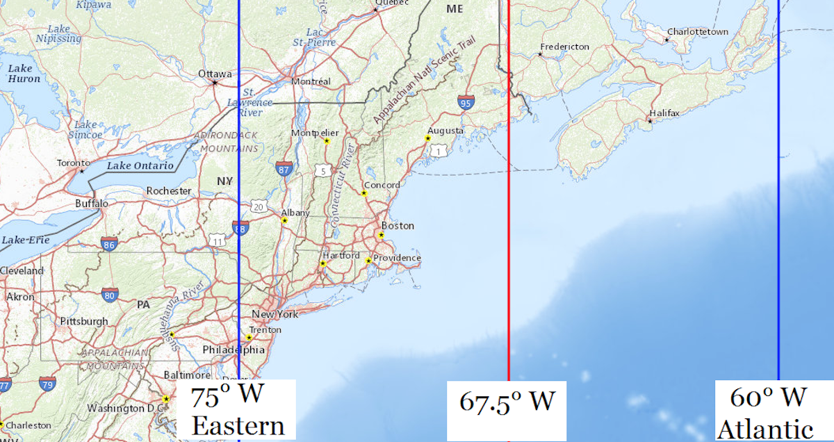
 This close-up shows where 75° west, the line where Eastern Standard Time equals the local mean solar time, crosses through eastern Pennsylvania.