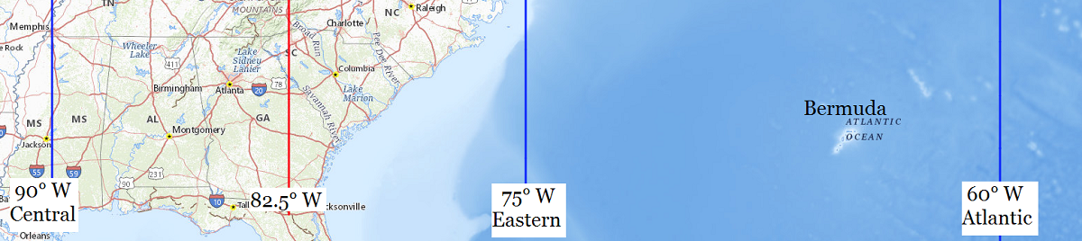
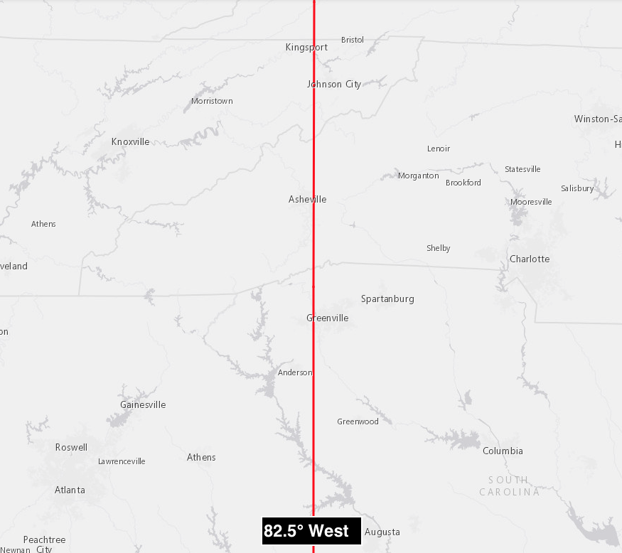
| Location |
Co-Ordinates
(Latitude, Longitude and Elevation) |
Mean solar time at noon
Central Standard Time
(Mountain Daylight Saving Time) |
Mean solar time at noon
Eastern Standard Time
(Central Daylight Saving Time) |
Mean solar time at noon
Atlantic Standard Time
(Eastern Daylight Saving Time) |
A C Corcoran Elementary School,
Charleston County
|
Elevation: 11 meters*
Latitude: 32.9602351° N
Longitude: 80.0599037° W
|
12:39:45 |
11:39:45 |
10:39:45 |
A J Thackston High School (historical),
Orangeburg County
|
Elevation: 66 meters*
Latitude: 33.4865426° N
Longitude: 80.8570366° W
|
12:36:34 |
11:36:34 |
10:36:34 |
A L Corbett Middle School,
Aiken County
|
Elevation: 147 meters*
Latitude: 33.6593158° N
Longitude: 81.3645474° W
|
12:34:32 |
11:34:32 |
10:34:32 |
A Touch of Christ Christian School,
Horry County
|
Elevation: 7 meters*
Latitude: 33.8566358° N
Longitude: 79.0033608° W
|
12:43:59 |
11:43:59 |
10:43:59 |
Aaron Post Office (historical),
Anderson County
|
Elevation: 265 meters*
Latitude: 34.5770533° N
Longitude: 82.6234664° W
|
12:29:30 |
11:29:30 |
10:29:30 |
Abbeville County Training School (historical),
Abbeville County
|
Elevation: 157 meters*
Latitude: 34.1817831° N
Longitude: 82.3695701° W
|
12:30:31 |
11:30:31 |
10:30:31 |
Abbeville High School,
Abbeville County
|
Elevation: 175 meters*
Latitude: 34.1884494° N
Longitude: 82.3756812° W
|
12:30:29 |
11:30:29 |
10:30:29 |
Abbeville Mill Grade School (historical),
Abbeville County
|
Elevation: 164 meters*
Latitude: 34.1723388° N
Longitude: 82.3734592° W
|
12:30:30 |
11:30:30 |
10:30:30 |
Abell School,
Pickens County
|
Elevation: 261 meters*
Latitude: 34.6939955° N
Longitude: 82.8034752° W
|
12:28:47 |
11:28:47 |
10:28:47 |
Abingdon School (historical),
Cherokee County
|
Elevation: 177 meters*
Latitude: 34.9595757° N
Longitude: 81.5148157° W
|
12:33:56 |
11:33:56 |
10:33:56 |
Abner School (historical),
Spartanburg County
|
Elevation: 258 meters*
Latitude: 34.8637306° N
Longitude: 82.1731665° W
|
12:31:18 |
11:31:18 |
10:31:18 |
Abundant Life Academy,
Jasper County
|
Elevation: 6 meters*
Latitude: 32.2505458° N
Longitude: 81.0321928° W
|
12:35:52 |
11:35:52 |
10:35:52 |
Academic Magnet High School,
Charleston County
|
Elevation: 3 meters*
Latitude: 32.8579212° N
Longitude: 79.9634423° W
|
12:40:08 |
11:40:08 |
10:40:08 |
Academy Street School (historical),
Laurens County
|
Elevation: 209 meters*
Latitude: 34.4762387° N
Longitude: 81.8831558° W
|
12:32:28 |
11:32:28 |
10:32:28 |
Academy for Technology and Academics,
Horry County
|
Elevation: 23 meters*
Latitude: 33.9489944° N
Longitude: 79.0284655° W
|
12:43:53 |
11:43:53 |
10:43:53 |
Academy of Fine Arts (historical),
Charleston County
|
Elevation: 2 meters*
Latitude: 32.7757324° N
Longitude: 79.935644° W
|
12:40:15 |
11:40:15 |
10:40:15 |
Adams Run Post Office,
Charleston County
|
Elevation: 12 meters*
Latitude: 32.720069° N
Longitude: 80.3481298° W
|
12:38:36 |
11:38:36 |
10:38:36 |
Adams Run School (historical),
Charleston County
|
Elevation: 11 meters*
Latitude: 32.7165678° N
Longitude: 80.3495452° W
|
12:38:36 |
11:38:36 |
10:38:36 |
Adams Run School,
Charleston County
|
Elevation: 12 meters*
Latitude: 32.7185121° N
Longitude: 80.3481562° W
|
12:38:36 |
11:38:36 |
10:38:36 |
Adamsburg School (historical),
Union County
|
Elevation: 187 meters*
Latitude: 34.7895785° N
Longitude: 81.538431° W
|
12:33:50 |
11:33:50 |
10:33:50 |
Adamsville School,
Marlboro County
|
Elevation: 66 meters*
Latitude: 34.7032148° N
Longitude: 79.6075551° W
|
12:41:34 |
11:41:34 |
10:41:34 |
Africa School (historical),
Spartanburg County
|
Elevation: 279 meters*
Latitude: 35.172895° N
Longitude: 82.0151084° W
|
12:31:56 |
11:31:56 |
10:31:56 |
Aiken County Educational Center,
Aiken County
|
Elevation: 148 meters*
Latitude: 33.5676387° N
Longitude: 81.7289978° W
|
12:33:05 |
11:33:05 |
10:33:05 |
Aiken County Technical College,
Aiken County
|
Elevation: 74 meters*
Latitude: 33.5329148° N
Longitude: 81.8420564° W
|
12:32:37 |
11:32:37 |
10:32:37 |
Aiken County Vocational School,
Aiken County
|
Elevation: 76 meters*
Latitude: 33.5281926° N
Longitude: 81.8434454° W
|
12:32:37 |
11:32:37 |
10:32:37 |
Aiken Day School,
Aiken County
|
Elevation: 151 meters*
Latitude: 33.5565278° N
Longitude: 81.7220533° W
|
12:33:06 |
11:33:06 |
10:33:06 |
Aiken Elementary School,
Aiken County
|
Elevation: 153 meters*
Latitude: 33.5559722° N
Longitude: 81.7209422° W
|
12:33:06 |
11:33:06 |
10:33:06 |
Aiken High School,
Aiken County
|
Elevation: 164 meters*
Latitude: 33.577917° N
Longitude: 81.7128864° W
|
12:33:08 |
11:33:08 |
10:33:08 |
Aiken Junior High School (historical),
Aiken County
|
Elevation: 161 meters*
Latitude: 33.5643056° N
Longitude: 81.7217755° W
|
12:33:06 |
11:33:06 |
10:33:06 |
Aiken Post Office,
Aiken County
|
Elevation: 162 meters*
Latitude: 33.5660984° N
Longitude: 81.7210278° W
|
12:33:06 |
11:33:06 |
10:33:06 |
Aiken Preparatory School,
Aiken County
|
Elevation: 165 meters*
Latitude: 33.564861° N
Longitude: 81.7267755° W
|
12:33:05 |
11:33:05 |
10:33:05 |
Aimwell School (historical),
Fairfield County
|
Elevation: 173 meters*
Latitude: 34.5412533° N
Longitude: 81.1025875° W
|
12:35:35 |
11:35:35 |
10:35:35 |
Aimwell School (historical),
Florence County
|
Elevation: 24 meters*
Latitude: 33.9348849° N
Longitude: 79.5883942° W
|
12:41:38 |
11:41:38 |
10:41:38 |
Aimwell School (historical),
Williamsburg County
|
Elevation: 16 meters*
Latitude: 33.4576661° N
Longitude: 79.6878464° W
|
12:41:14 |
11:41:14 |
10:41:14 |
Airport High School,
Lexington County
|
Elevation: 68 meters*
Latitude: 33.9507081° N
Longitude: 81.1045394° W
|
12:35:34 |
11:35:34 |
10:35:34 |
Airsdale School (historical),
Hampton County
|
Elevation: 36 meters*
Latitude: 32.7818351° N
Longitude: 81.1820484° W
|
12:35:16 |
11:35:16 |
10:35:16 |
Airy Spring School (historical),
Anderson County
|
Elevation: 274 meters*
Latitude: 34.7406721° N
Longitude: 82.5381861° W
|
12:29:50 |
11:29:50 |
10:29:50 |
Albemarle Elementary School,
Charleston County
|
Elevation: 4 meters*
Latitude: 32.7873989° N
Longitude: 79.9923128° W
|
12:40:01 |
11:40:01 |
10:40:01 |
Alcolu Elementary School,
Clarendon County
|
Elevation: 38 meters*
Latitude: 33.7543288° N
Longitude: 80.2131344° W
|
12:39:08 |
11:39:08 |
10:39:08 |
Alcolu Post Office,
Clarendon County
|
Elevation: 36 meters*
Latitude: 33.7504476° N
Longitude: 80.2170933° W
|
12:39:07 |
11:39:07 |
10:39:07 |
Alcorn Middle School,
Richland County
|
Elevation: 96 meters*
Latitude: 34.0551536° N
Longitude: 81.0298135° W
|
12:35:52 |
11:35:52 |
10:35:52 |
Alcot School (historical),
Lee County
|
Elevation: 63 meters*
Latitude: 34.2604319° N
Longitude: 80.1653468° W
|
12:39:20 |
11:39:20 |
10:39:20 |
Alexander Elementary School,
Greenville County
|
Elevation: 301 meters*
Latitude: 34.8562286° N
Longitude: 82.4398459° W
|
12:30:14 |
11:30:14 |
10:30:14 |
Alexander School (historical),
Darlington County
|
Elevation: 48 meters*
Latitude: 34.2270982° N
Longitude: 79.908119° W
|
12:40:22 |
11:40:22 |
10:40:22 |
Alexander School (historical),
Spartanburg County
|
Elevation: 228 meters*
Latitude: 34.9565116° N
Longitude: 81.9270483° W
|
12:32:17 |
11:32:17 |
10:32:17 |
Algary School (historical),
Greenwood County
|
Elevation: 216 meters*
Latitude: 34.3584496° N
Longitude: 82.3012327° W
|
12:30:47 |
11:30:47 |
10:30:47 |
Alice Birney Middle School,
Charleston County
|
Elevation: 10 meters*
Latitude: 32.9427989° N
Longitude: 80.0557479° W
|
12:39:46 |
11:39:46 |
10:39:46 |
Alice Drive Elementary School,
Sumter County
|
Elevation: 54 meters*
Latitude: 33.9326569° N
Longitude: 80.3775813° W
|
12:38:29 |
11:38:29 |
10:38:29 |
Alice Drive Junior High School,
Sumter County
|
Elevation: 55 meters*
Latitude: 33.9326569° N
Longitude: 80.3770257° W
|
12:38:29 |
11:38:29 |
10:38:29 |
Alice Mill School,
Pickens County
|
Elevation: 340 meters*
Latitude: 34.8303933° N
Longitude: 82.6201325° W
|
12:29:31 |
11:29:31 |
10:29:31 |
Allen Chapel School (historical),
Williamsburg County
|
Elevation: 21 meters*
Latitude: 33.7493301° N
Longitude: 79.8500706° W
|
12:40:35 |
11:40:35 |
10:40:35 |
Allen University,
Richland County
|
Elevation: 90 meters*
Latitude: 34.0107106° N
Longitude: 81.0203694° W
|
12:35:55 |
11:35:55 |
10:35:55 |
Allendale Academy,
Allendale County
|
Elevation: 54 meters*
Latitude: 33.014601° N
Longitude: 81.3023293° W
|
12:34:47 |
11:34:47 |
10:34:47 |
Allendale Clemson University Extension Services,
Allendale County
|
Elevation: 57 meters*
Latitude: 33.0134391° N
Longitude: 81.3066027° W
|
12:34:46 |
11:34:46 |
10:34:46 |
Allendale Elementary School,
Allendale County
|
Elevation: 56 meters*
Latitude: 32.9996559° N
Longitude: 81.3014255° W
|
12:34:47 |
11:34:47 |
10:34:47 |
Allendale Fairfax High School,
Allendale County
|
Elevation: 49 meters*
Latitude: 32.9888071° N
Longitude: 81.2824716° W
|
12:34:52 |
11:34:52 |
10:34:52 |
Allendale Fairfax Middle School,
Allendale County
|
Elevation: 45 meters*
Latitude: 32.9822721° N
Longitude: 81.2730291° W
|
12:34:54 |
11:34:54 |
10:34:54 |
Allendale Post Office,
Allendale County
|
Elevation: 57 meters*
Latitude: 33.0091184° N
Longitude: 81.3100553° W
|
12:34:45 |
11:34:45 |
10:34:45 |
Allendale Primary School,
Allendale County
|
Elevation: 55 meters*
Latitude: 33.0005092° N
Longitude: 81.3004603° W
|
12:34:47 |
11:34:47 |
10:34:47 |
Allens School,
Horry County
|
Elevation: 24 meters*
Latitude: 33.9451688° N
Longitude: 79.0800377° W
|
12:43:40 |
11:43:40 |
10:43:40 |
Allison School (historical),
Greenville County
|
Elevation: 283 meters*
Latitude: 35.0201174° N
Longitude: 82.5623478° W
|
12:29:45 |
11:29:45 |
10:29:45 |
Allowance Hall School (historical),
Lancaster County
|
Elevation: 154 meters*
Latitude: 34.6245914° N
Longitude: 80.807018° W
|
12:36:46 |
11:36:46 |
10:36:46 |
Allsbrook School (historical),
Horry County
|
Elevation: 29 meters*
Latitude: 34.0162812° N
Longitude: 78.9441968° W
|
12:44:13 |
11:44:13 |
10:44:13 |
Alma Elementary School,
Cherokee County
|
Elevation: 224 meters*
Latitude: 35.0817951° N
Longitude: 81.6098178° W
|
12:33:33 |
11:33:33 |
10:33:33 |
Alston Middle School,
Dorchester County
|
Elevation: 25 meters*
Latitude: 33.0315835° N
Longitude: 80.1823663° W
|
12:39:16 |
11:39:16 |
10:39:16 |
Amaker School (historical),
Calhoun County
|
Elevation: 63 meters*
Latitude: 33.6526571° N
Longitude: 80.641477° W
|
12:37:26 |
11:37:26 |
10:37:26 |
Ambler School,
Pickens County
|
Elevation: 359 meters*
Latitude: 34.9576176° N
Longitude: 82.664298° W
|
12:29:20 |
11:29:20 |
10:29:20 |
American Creative School,
Lexington County
|
Elevation: 89 meters*
Latitude: 33.9837645° N
Longitude: 81.0753716° W
|
12:35:41 |
11:35:41 |
10:35:41 |
Anderson College,
Anderson County
|
Elevation: 236 meters*
Latitude: 34.5137177° N
Longitude: 82.6387441° W
|
12:29:26 |
11:29:26 |
10:29:26 |
Anderson Post Office,
Anderson County
|
Elevation: 246 meters*
Latitude: 34.5084396° N
Longitude: 82.6490222° W
|
12:29:24 |
11:29:24 |
10:29:24 |
Anderson School,
Berkeley County
|
Elevation: 23 meters*
Latitude: 33.2490576° N
Longitude: 79.967024° W
|
12:40:07 |
11:40:07 |
10:40:07 |
Andrew Jackson Academy,
Bamberg County
|
Elevation: 44 meters*
Latitude: 33.1868513° N
Longitude: 81.0202582° W
|
12:35:55 |
11:35:55 |
10:35:55 |
Andrew Jackson High School,
Lancaster County
|
Elevation: 178 meters*
Latitude: 34.5734858° N
Longitude: 80.6117386° W
|
12:37:33 |
11:37:33 |
10:37:33 |
Andrew Jackson Middle School,
Lancaster County
|
Elevation: 175 meters*
Latitude: 34.5729302° N
Longitude: 80.615072° W
|
12:37:32 |
11:37:32 |
10:37:32 |
Andrews Chapel School (historical),
Greenwood County
|
Elevation: 186 meters*
Latitude: 34.2915095° N
Longitude: 82.1792863° W
|
12:31:16 |
11:31:16 |
10:31:16 |
Andrews Christian School,
Georgetown County
|
Elevation: 6 meters*
Latitude: 33.4559393° N
Longitude: 79.5682469° W
|
12:41:43 |
11:41:43 |
10:41:43 |
Andrews Colored School (historical),
Georgetown County
|
Elevation: 6 meters*
Latitude: 33.4504446° N
Longitude: 79.5681196° W
|
12:41:43 |
11:41:43 |
10:41:43 |
Andrews Elementary School,
Georgetown County
|
Elevation: 6 meters*
Latitude: 33.4560749° N
Longitude: 79.5716061° W
|
12:41:42 |
11:41:42 |
10:41:42 |
Andrews High School,
Georgetown County
|
Elevation: 6 meters*
Latitude: 33.4599317° N
Longitude: 79.5714196° W
|
12:41:42 |
11:41:42 |
10:41:42 |
Andrews Post Office,
Georgetown County
|
Elevation: 6 meters*
Latitude: 33.4526645° N
Longitude: 79.5603076° W
|
12:41:45 |
11:41:45 |
10:41:45 |
Andrews Public School (historical),
Georgetown County
|
Elevation: 6 meters*
Latitude: 33.4532225° N
Longitude: 79.5606193° W
|
12:41:45 |
11:41:45 |
10:41:45 |
Angel Oak Elementary School,
Charleston County
|
Elevation: 7 meters*
Latitude: 32.7235723° N
Longitude: 80.1028947° W
|
12:39:35 |
11:39:35 |
10:39:35 |
Anna Boyd Child Development Center,
Richland County
|
Elevation: 104 meters*
Latitude: 34.0823754° N
Longitude: 80.9698117° W
|
12:36:07 |
11:36:07 |
10:36:07 |
Annie Village School (historical),
Georgetown County
|
Elevation: 6 meters*
Latitude: 33.5446124° N
Longitude: 79.3289415° W
|
12:42:41 |
11:42:41 |
10:42:41 |
Ansel School (historical),
Greenville County
|
Elevation: 289 meters*
Latitude: 34.9656715° N
Longitude: 82.252613° W
|
12:30:59 |
11:30:59 |
10:30:59 |
Ansell School (historical),
Greenville County
|
Elevation: 292 meters*
Latitude: 34.9670603° N
Longitude: 82.2484461° W
|
12:31:00 |
11:31:00 |
10:31:00 |
Antioch Elementary School,
Kershaw County
|
Elevation: 96 meters*
Latitude: 34.2354308° N
Longitude: 80.4784095° W
|
12:38:05 |
11:38:05 |
10:38:05 |
Antioch School (historical),
Berkeley County
|
Elevation: 21 meters*
Latitude: 33.3390561° N
Longitude: 80.0595263° W
|
12:39:45 |
11:39:45 |
10:39:45 |
Antioch School (historical),
Cherokee County
|
Elevation: 232 meters*
Latitude: 35.1545765° N
Longitude: 81.4150857° W
|
12:34:20 |
11:34:20 |
10:34:20 |
Antioch School (historical),
Cherokee County
|
Elevation: 237 meters*
Latitude: 35.1409645° N
Longitude: 81.450921° W
|
12:34:11 |
11:34:11 |
10:34:11 |
Antioch School (historical),
Chesterfield County
|
Elevation: 155 meters*
Latitude: 34.6357096° N
Longitude: 80.2656219° W
|
12:38:56 |
11:38:56 |
10:38:56 |
Antioch School (historical),
Darlington County
|
Elevation: 78 meters*
Latitude: 34.3940428° N
Longitude: 80.1653468° W
|
12:39:20 |
11:39:20 |
10:39:20 |
Antioch School (historical),
Edgefield County
|
Elevation: 162 meters*
Latitude: 33.7695756° N
Longitude: 82.0337282° W
|
12:31:51 |
11:31:51 |
10:31:51 |
Antioch School (historical),
Hampton County
|
Elevation: 25 meters*
Latitude: 32.8485014° N
Longitude: 80.9948286° W
|
12:36:01 |
11:36:01 |
10:36:01 |
Antioch School (historical),
Hampton County
|
Elevation: 25 meters*
Latitude: 32.8151694° N
Longitude: 81.007607° W
|
12:35:58 |
11:35:58 |
10:35:58 |
Antioch School (historical),
Jasper County
|
Elevation: 20 meters*
Latitude: 32.5593477° N
Longitude: 81.1778836° W
|
12:35:17 |
11:35:17 |
10:35:17 |
Antioch School (historical),
Kershaw County
|
Elevation: 87 meters*
Latitude: 34.237375° N
Longitude: 80.5009099° W
|
12:37:59 |
11:37:59 |
10:37:59 |
Antioch School (historical),
Lancaster County
|
Elevation: 194 meters*
Latitude: 34.7143172° N
Longitude: 80.6717339° W
|
12:37:18 |
11:37:18 |
10:37:18 |
Antioch School (historical),
Lancaster County
|
Elevation: 193 meters*
Latitude: 34.7051504° N
Longitude: 80.6753454° W
|
12:37:17 |
11:37:17 |
10:37:17 |
Antioch School (historical),
Laurens County
|
Elevation: 184 meters*
Latitude: 34.5537405° N
Longitude: 81.8348237° W
|
12:32:39 |
11:32:39 |
10:32:39 |
Antioch School (historical),
Pickens County
|
Elevation: 310 meters*
Latitude: 34.96122° N
Longitude: 82.8284722° W
|
12:28:41 |
11:28:41 |
10:28:41 |
Antioch School (historical),
Richland County
|
Elevation: 113 meters*
Latitude: 33.9304314° N
Longitude: 80.7156429° W
|
12:37:08 |
11:37:08 |
10:37:08 |
Antioch School (historical),
Spartanburg County
|
Elevation: 198 meters*
Latitude: 34.6815152° N
Longitude: 81.9856535° W
|
12:32:03 |
11:32:03 |
10:32:03 |
Antioch School (historical),
Spartanburg County
|
Elevation: 219 meters*
Latitude: 34.6984591° N
Longitude: 82.011488° W
|
12:31:57 |
11:31:57 |
10:31:57 |
Antioch School,
Darlington County
|
Elevation: 57 meters*
Latitude: 34.4390441° N
Longitude: 80.0039557° W
|
12:39:59 |
11:39:59 |
10:39:59 |
Antioch School,
Orangeburg County
|
Elevation: 100 meters*
Latitude: 33.5957065° N
Longitude: 81.2139904° W
|
12:35:08 |
11:35:08 |
10:35:08 |
Antioch School,
Richland County
|
Elevation: 77 meters*
Latitude: 33.9173759° N
Longitude: 80.722032° W
|
12:37:06 |
11:37:06 |
10:37:06 |
Antreville School,
Abbeville County
|
Elevation: 211 meters*
Latitude: 34.2937207° N
Longitude: 82.5320719° W
|
12:29:52 |
11:29:52 |
10:29:52 |
Appleton School (historical),
Allendale County
|
Elevation: 79 meters*
Latitude: 33.0440444° N
Longitude: 81.3628851° W
|
12:34:32 |
11:34:32 |
10:34:32 |
Ararat School (historical),
Chester County
|
Elevation: 159 meters*
Latitude: 34.6951426° N
Longitude: 80.9642461° W
|
12:36:08 |
11:36:08 |
10:36:08 |
Arbonville School (historical),
Abbeville County
|
Elevation: 198 meters*
Latitude: 34.2965042° N
Longitude: 82.3412349° W
|
12:30:38 |
11:30:38 |
10:30:38 |
Arcadia Elementary School,
Spartanburg County
|
Elevation: 257 meters*
Latitude: 34.9617873° N
Longitude: 81.9912159° W
|
12:32:02 |
11:32:02 |
10:32:02 |
Archer School,
Charleston County
|
Elevation: 3 meters*
Latitude: 32.7998985° N
Longitude: 79.9417548° W
|
12:40:13 |
11:40:13 |
10:40:13 |
Arden Elementary School,
Richland County
|
Elevation: 95 meters*
Latitude: 34.0498761° N
Longitude: 81.0220355° W
|
12:35:54 |
11:35:54 |
10:35:54 |
Armenia School (historical),
Chester County
|
Elevation: 210 meters*
Latitude: 34.7720816° N
Longitude: 81.2900902° W
|
12:34:50 |
11:34:50 |
10:34:50 |
Armstrong Elementary School,
Greenville County
|
Elevation: 318 meters*
Latitude: 34.9103949° N
Longitude: 82.4626236° W
|
12:30:08 |
11:30:08 |
10:30:08 |
Armstrong School,
Greenville County
|
Elevation: 313 meters*
Latitude: 34.9315059° N
Longitude: 82.4865131° W
|
12:30:03 |
11:30:03 |
10:30:03 |
Arrington School,
Greenville County
|
Elevation: 304 meters*
Latitude: 34.8917839° N
Longitude: 82.4229° W
|
12:30:18 |
11:30:18 |
10:30:18 |
Arrow Wood School (historical),
Spartanburg County
|
Elevation: 282 meters*
Latitude: 35.1640094° N
Longitude: 81.8926048° W
|
12:32:25 |
11:32:25 |
10:32:25 |
Arsenal Academy (historical),
Richland County
|
Elevation: 100 meters*
Latitude: 34.0082099° N
Longitude: 81.0437035° W
|
12:35:49 |
11:35:49 |
10:35:49 |
Asaville School (historical),
Anderson County
|
Elevation: 213 meters*
Latitude: 34.3531647° N
Longitude: 82.5462396° W
|
12:29:48 |
11:29:48 |
10:29:48 |
Asbury School (historical),
Cherokee County
|
Elevation: 181 meters*
Latitude: 34.9201306° N
Longitude: 81.6267643° W
|
12:33:29 |
11:33:29 |
10:33:29 |
Asbury School (historical),
Darlington County
|
Elevation: 51 meters*
Latitude: 34.1268225° N
Longitude: 80.0831252° W
|
12:39:40 |
11:39:40 |
10:39:40 |
Asbury School (historical),
Sumter County
|
Elevation: 36 meters*
Latitude: 33.9607147° N
Longitude: 80.0425725° W
|
12:39:49 |
11:39:49 |
10:39:49 |
Asevorts School (historical),
Cherokee County
|
Elevation: 282 meters*
Latitude: 35.156236° N
Longitude: 81.7409336° W
|
12:33:02 |
11:33:02 |
10:33:02 |
Asevorts School (historical),
Cherokee County
|
Elevation: 287 meters*
Latitude: 35.1476249° N
Longitude: 81.7473228° W
|
12:33:00 |
11:33:00 |
10:33:00 |
Ashdale School (historical),
Beaufort County
|
Elevation: 5 meters*
Latitude: 32.4443582° N
Longitude: 80.6287172° W
|
12:37:29 |
11:37:29 |
10:37:29 |
Ashland School (historical),
Lee County
|
Elevation: 93 meters*
Latitude: 34.3345984° N
Longitude: 80.199792° W
|
12:39:12 |
11:39:12 |
10:39:12 |
Ashleigh School (historical),
Barnwell County
|
Elevation: 83 meters*
Latitude: 33.2995959° N
Longitude: 81.3159392° W
|
12:34:44 |
11:34:44 |
10:34:44 |
Ashleigh School (historical),
Barnwell County
|
Elevation: 84 meters*
Latitude: 33.3079291° N
Longitude: 81.3209392° W
|
12:34:42 |
11:34:42 |
10:34:42 |
Ashley Grove School (historical),
Aiken County
|
Elevation: 135 meters*
Latitude: 33.5162527° N
Longitude: 81.6303858° W
|
12:33:28 |
11:33:28 |
10:33:28 |
Ashley Grove School (historical),
Barnwell County
|
Elevation: 60 meters*
Latitude: 33.205704° N
Longitude: 81.6192771° W
|
12:33:31 |
11:33:31 |
10:33:31 |
Ashley Hall School,
Charleston County
|
Elevation: 2 meters*
Latitude: 32.7868433° N
Longitude: 79.9442552° W
|
12:40:13 |
11:40:13 |
10:40:13 |
Ashley Phosphate School (historical),
Charleston County
|
Elevation: 9 meters*
Latitude: 32.9326734° N
Longitude: 80.0537° W
|
12:39:47 |
11:39:47 |
10:39:47 |
Ashley Ridge High School,
Dorchester County
|
Elevation: 6 meters*
Latitude: 32.924853° N
Longitude: 80.2355424° W
|
12:39:03 |
11:39:03 |
10:39:03 |
Ashley River Elementary School,
Charleston County
|
Elevation: 4 meters*
Latitude: 32.8007858° N
Longitude: 80.0223062° W
|
12:39:54 |
11:39:54 |
10:39:54 |
Ashley River Post Office,
Charleston County
|
Elevation: 3 meters*
Latitude: 32.8086675° N
Longitude: 80.0234728° W
|
12:39:54 |
11:39:54 |
10:39:54 |
Ashton School (historical),
Colleton County
|
Elevation: 33 meters*
Latitude: 33.0184944° N
Longitude: 80.9753805° W
|
12:36:05 |
11:36:05 |
10:36:05 |
Ashwood School (historical),
Lee County
|
Elevation: 59 meters*
Latitude: 34.1079331° N
Longitude: 80.3156319° W
|
12:38:44 |
11:38:44 |
10:38:44 |
Athens School (historical),
Lexington County
|
Elevation: 133 meters*
Latitude: 33.7734865° N
Longitude: 81.0987065° W
|
12:35:36 |
11:35:36 |
10:35:36 |
Athens School (historical),
Lexington County
|
Elevation: 146 meters*
Latitude: 33.7845975° N
Longitude: 81.0995398° W
|
12:35:36 |
11:35:36 |
10:35:36 |
Athens School,
Horry County
|
Elevation: 21 meters*
Latitude: 34.1018335° N
Longitude: 79.0947594° W
|
12:43:37 |
11:43:37 |
10:43:37 |
Atlas Road School,
Richland County
|
Elevation: 47 meters*
Latitude: 33.9426555° N
Longitude: 80.9750909° W
|
12:36:05 |
11:36:05 |
10:36:05 |
Auburn School (historical),
Darlington County
|
Elevation: 58 meters*
Latitude: 34.3726545° N
Longitude: 79.9700653° W
|
12:40:07 |
11:40:07 |
10:40:07 |
Augusta Circle Elementary School,
Greenville County
|
Elevation: 297 meters*
Latitude: 34.8209513° N
Longitude: 82.3942889° W
|
12:30:25 |
11:30:25 |
10:30:25 |
Awendaw Post Office,
Charleston County
|
Elevation: 6 meters*
Latitude: 32.981931° N
Longitude: 79.6572925° W
|
12:41:22 |
11:41:22 |
10:41:22 |
Awendaw School,
Charleston County
|
Elevation: 6 meters*
Latitude: 32.9896156° N
Longitude: 79.6436847° W
|
12:41:25 |
11:41:25 |
10:41:25 |
Aynor Conway Career Center,
Horry County
|
Elevation: 12 meters*
Latitude: 33.8778499° N
Longitude: 79.0988493° W
|
12:43:36 |
11:43:36 |
10:43:36 |
Aynor Elementary School,
Horry County
|
Elevation: 24 meters*
Latitude: 33.9849349° N
Longitude: 79.2104413° W
|
12:43:09 |
11:43:09 |
10:43:09 |
Aynor High School,
Horry County
|
Elevation: 24 meters*
Latitude: 33.9910437° N
Longitude: 79.2032795° W
|
12:43:11 |
11:43:11 |
10:43:11 |
Aynor Middle School,
Horry County
|
Elevation: 30 meters*
Latitude: 33.9985179° N
Longitude: 79.2193961° W
|
12:43:07 |
11:43:07 |
10:43:07 |
Aynor Post Office,
Horry County
|
Elevation: 24 meters*
Latitude: 33.9910935° N
Longitude: 79.1997957° W
|
12:43:12 |
11:43:12 |
10:43:12 |
Aynor School (historical),
Horry County
|
Elevation: 24 meters*
Latitude: 33.991277° N
Longitude: 79.2036544° W
|
12:43:11 |
11:43:11 |
10:43:11 |
B A Gary Middle School,
Darlington County
|
Elevation: 45 meters*
Latitude: 34.2895982° N
Longitude: 79.8722851° W
|
12:40:30 |
11:40:30 |
10:40:30 |
B D Lee Elementary School,
Cherokee County
|
Elevation: 231 meters*
Latitude: 35.0776275° N
Longitude: 81.6617643° W
|
12:33:21 |
11:33:21 |
10:33:21 |
Bachelor Branch School (historical),
Orangeburg County
|
Elevation: 98 meters*
Latitude: 33.5251492° N
Longitude: 81.2998265° W
|
12:34:48 |
11:34:48 |
10:34:48 |
Bacon Hill School (historical),
Sumter County
|
Elevation: 58 meters*
Latitude: 33.7143275° N
Longitude: 80.4656401° W
|
12:38:08 |
11:38:08 |
10:38:08 |
Bailey Bethel School (historical),
McCormick County
|
Elevation: 163 meters*
Latitude: 33.9581825° N
Longitude: 82.1003984° W
|
12:31:35 |
11:31:35 |
10:31:35 |
Bailey School (historical),
Laurens County
|
Elevation: 186 meters*
Latitude: 34.4704023° N
Longitude: 81.9725961° W
|
12:32:06 |
11:32:06 |
10:32:06 |
Bailey School,
Anderson County
|
Elevation: 224 meters*
Latitude: 34.5034397° N
Longitude: 82.6334661° W
|
12:29:27 |
11:29:27 |
10:29:27 |
Bailey School,
Laurens County
|
Elevation: 204 meters*
Latitude: 34.4817942° N
Longitude: 81.8839889° W
|
12:32:27 |
11:32:27 |
10:32:27 |
Baker School (historical),
Sumter County
|
Elevation: 44 meters*
Latitude: 33.9821016° N
Longitude: 80.2620223° W
|
12:38:57 |
11:38:57 |
10:38:57 |
Bakers Chapel School,
Greenville County
|
Elevation: 296 meters*
Latitude: 34.7887292° N
Longitude: 82.4265134° W
|
12:30:17 |
11:30:17 |
10:30:17 |
Baldock School (historical),
Allendale County
|
Elevation: 51 meters*
Latitude: 33.0745985° N
Longitude: 81.4251076° W
|
12:34:17 |
11:34:17 |
10:34:17 |
Ball Town School (historical),
Aiken County
|
Elevation: 164 meters*
Latitude: 33.5895833° N
Longitude: 81.7234419° W
|
12:33:06 |
11:33:06 |
10:33:06 |
Ballard School (historical),
Sumter County
|
Elevation: 55 meters*
Latitude: 33.8551583° N
Longitude: 80.4089714° W
|
12:38:21 |
11:38:21 |
10:38:21 |
Ballenger School (historical),
Spartanburg County
|
Elevation: 298 meters*
Latitude: 34.9859501° N
Longitude: 82.1703881° W
|
12:31:19 |
11:31:19 |
10:31:19 |
Ballentine Post Office,
Richland County
|
Elevation: 115 meters*
Latitude: 34.1307726° N
Longitude: 81.2491956° W
|
12:35:00 |
11:35:00 |
10:35:00 |
Bamberg Ehrhardt High School,
Bamberg County
|
Elevation: 50 meters*
Latitude: 33.3018235° N
Longitude: 81.0309311° W
|
12:35:52 |
11:35:52 |
10:35:52 |
Bamberg Elementary School,
Bamberg County
|
Elevation: 52 meters*
Latitude: 33.3043235° N
Longitude: 81.0281532° W
|
12:35:53 |
11:35:53 |
10:35:53 |
Bamberg Post Office,
Bamberg County
|
Elevation: 48 meters*
Latitude: 33.2963345° N
Longitude: 81.0337721° W
|
12:35:51 |
11:35:51 |
10:35:51 |
Bamburg School (historical),
Cherokee County
|
Elevation: 244 meters*
Latitude: 35.1256877° N
Longitude: 81.4161968° W
|
12:34:20 |
11:34:20 |
10:34:20 |
Bamburg School (historical),
Cherokee County
|
Elevation: 246 meters*
Latitude: 35.1215209° N
Longitude: 81.4192525° W
|
12:34:19 |
11:34:19 |
10:34:19 |
Baptist College at Charleston,
Charleston County
|
Elevation: 9 meters*
Latitude: 32.9835055° N
Longitude: 80.0706439° W
|
12:39:43 |
11:39:43 |
10:39:43 |
Baptist Hill Elementary School,
Charleston County
|
Elevation: 6 meters*
Latitude: 32.7268446° N
Longitude: 80.2617655° W
|
12:38:57 |
11:38:57 |
10:38:57 |
Baptist Hill High School,
Charleston County
|
Elevation: 6 meters*
Latitude: 32.7277814° N
Longitude: 80.2618356° W
|
12:38:57 |
11:38:57 |
10:38:57 |
Barber Mill School (historical),
Lee County
|
Elevation: 45 meters*
Latitude: 34.018213° N
Longitude: 80.1497965° W
|
12:39:24 |
11:39:24 |
10:39:24 |
Barbers Branch School,
Barnwell County
|
Elevation: 55 meters*
Latitude: 33.1879329° N
Longitude: 81.2337165° W
|
12:35:03 |
11:35:03 |
10:35:03 |
Barberville School (historical),
Lancaster County
|
Elevation: 197 meters*
Latitude: 35.0320918° N
Longitude: 80.877018° W
|
12:36:29 |
11:36:29 |
10:36:29 |
Barker School (historical),
Kershaw County
|
Elevation: 102 meters*
Latitude: 34.2801483° N
Longitude: 80.7075814° W
|
12:37:10 |
11:37:10 |
10:37:10 |
Barkers Creek School (historical),
Anderson County
|
Elevation: 220 meters*
Latitude: 34.436778° N
Longitude: 82.4448478° W
|
12:30:13 |
11:30:13 |
10:30:13 |
Barkham School (historical),
Union County
|
Elevation: 176 meters*
Latitude: 34.7717996° N
Longitude: 81.7303779° W
|
12:33:04 |
11:33:04 |
10:33:04 |
Barksdale Harnie School (historical),
Laurens County
|
Elevation: 231 meters*
Latitude: 34.5570663° N
Longitude: 82.0814897° W
|
12:31:40 |
11:31:40 |
10:31:40 |
Barnes School (historical),
Anderson County
|
Elevation: 203 meters*
Latitude: 34.2628858° N
Longitude: 82.6817987° W
|
12:29:16 |
11:29:16 |
10:29:16 |
Barnes School (historical),
Georgetown County
|
Elevation: 6 meters*
Latitude: 33.5690562° N
Longitude: 79.4211678° W
|
12:42:18 |
11:42:18 |
10:42:18 |
Barnwell Academy (historical),
Barnwell County
|
Elevation: 63 meters*
Latitude: 33.246262° N
Longitude: 81.3651067° W
|
12:34:32 |
11:34:32 |
10:34:32 |
Barnwell Elementary School,
Barnwell County
|
Elevation: 60 meters*
Latitude: 33.2395957° N
Longitude: 81.3564955° W
|
12:34:34 |
11:34:34 |
10:34:34 |
Barnwell High School,
Barnwell County
|
Elevation: 61 meters*
Latitude: 33.2294428° N
Longitude: 81.3589372° W
|
12:34:33 |
11:34:33 |
10:34:33 |
Barnwell Post Office,
Barnwell County
|
Elevation: 70 meters*
Latitude: 33.2443936° N
Longitude: 81.3637739° W
|
12:34:32 |
11:34:32 |
10:34:32 |
Barnwell School,
Beaufort County
|
Elevation: 4 meters*
Latitude: 32.4832452° N
Longitude: 80.6659392° W
|
12:37:20 |
11:37:20 |
10:37:20 |
Baron DeKalb High School (historical),
Kershaw County
|
Elevation: 125 meters*
Latitude: 34.3995966° N
Longitude: 80.5936872° W
|
12:37:37 |
11:37:37 |
10:37:37 |
Baron DeKalb School,
Kershaw County
|
Elevation: 126 meters*
Latitude: 34.4001522° N
Longitude: 80.5934094° W
|
12:37:37 |
11:37:37 |
10:37:37 |
Barr Street School,
Lancaster County
|
Elevation: 149 meters*
Latitude: 34.7270925° N
Longitude: 80.7636787° W
|
12:36:56 |
11:36:56 |
10:36:56 |
Barrineau School (historical),
Clarendon County
|
Elevation: 30 meters*
Latitude: 33.8726613° N
Longitude: 79.9081263° W
|
12:40:22 |
11:40:22 |
10:40:22 |
Barrow School (historical),
Berkeley County
|
Elevation: 26 meters*
Latitude: 33.1382251° N
Longitude: 80.0645297° W
|
12:39:44 |
11:39:44 |
10:39:44 |
Barter School,
Horry County
|
Elevation: 24 meters*
Latitude: 33.9704475° N
Longitude: 79.0180901° W
|
12:43:55 |
11:43:55 |
10:43:55 |
Barton School (historical),
Allendale County
|
Elevation: 40 meters*
Latitude: 32.9209939° N
Longitude: 81.2926058° W
|
12:34:49 |
11:34:49 |
10:34:49 |
Bass Grove School (historical),
Aiken County
|
Elevation: 166 meters*
Latitude: 33.6579156° N
Longitude: 81.7542751° W
|
12:32:58 |
11:32:58 |
10:32:58 |
Bates School,
Richland County
|
Elevation: 49 meters*
Latitude: 33.9707113° N
Longitude: 80.9842575° W
|
12:36:03 |
11:36:03 |
10:36:03 |
Bates School,
Sumter County
|
Elevation: 49 meters*
Latitude: 33.9009912° N
Longitude: 80.3492474° W
|
12:38:36 |
11:38:36 |
10:38:36 |
Batesburg Saluda School (historical),
Saluda County
|
Elevation: 163 meters*
Latitude: 33.9168081° N
Longitude: 81.569271° W
|
12:33:43 |
11:33:43 |
10:33:43 |
Batesburg-Leesville Elementary School,
Lexington County
|
Elevation: 203 meters*
Latitude: 33.9065315° N
Longitude: 81.5395483° W
|
12:33:50 |
11:33:50 |
10:33:50 |
Batesburg-Leesville High School,
Lexington County
|
Elevation: 171 meters*
Latitude: 33.8898654° N
Longitude: 81.5345482° W
|
12:33:51 |
11:33:51 |
10:33:51 |
Batesburg-Leesville Middle School,
Lexington County
|
Elevation: 199 meters*
Latitude: 33.9112538° N
Longitude: 81.5301038° W
|
12:33:52 |
11:33:52 |
10:33:52 |
Batesburg-Leesville Primary School,
Lexington County
|
Elevation: 192 meters*
Latitude: 33.9243089° N
Longitude: 81.5351039° W
|
12:33:51 |
11:33:51 |
10:33:51 |
Bath Elementary School,
Aiken County
|
Elevation: 56 meters*
Latitude: 33.5006925° N
Longitude: 81.871224° W
|
12:32:30 |
11:32:30 |
10:32:30 |
Bath Special School,
Aiken County
|
Elevation: 49 meters*
Latitude: 33.4898591° N
Longitude: 81.9051139° W
|
12:32:22 |
11:32:22 |
10:32:22 |
Battery Creek High School,
Beaufort County
|
Elevation: 7 meters*
Latitude: 32.4332813° N
Longitude: 80.7467525° W
|
12:37:00 |
11:37:00 |
10:37:00 |
Battery Park Elementary School,
Williamsburg County
|
Elevation: 16 meters*
Latitude: 33.7270788° N
Longitude: 79.5736457° W
|
12:41:42 |
11:41:42 |
10:41:42 |
Battle Grounds School (historical),
Cherokee County
|
Elevation: 290 meters*
Latitude: 35.137068° N
Longitude: 81.7976021° W
|
12:32:48 |
11:32:48 |
10:32:48 |
Battleground School (historical),
York County
|
Elevation: 239 meters*
Latitude: 35.1223559° N
Longitude: 81.3498041° W
|
12:34:36 |
11:34:36 |
10:34:36 |
Bauknight School (historical),
Edgefield County
|
Elevation: 181 meters*
Latitude: 33.7729136° N
Longitude: 81.8234432° W
|
12:32:42 |
11:32:42 |
10:32:42 |
Bay Springs School (historical),
Chesterfield County
|
Elevation: 106 meters*
Latitude: 34.6168212° N
Longitude: 80.1653442° W
|
12:39:20 |
11:39:20 |
10:39:20 |
Bayboro School,
Horry County
|
Elevation: 31 meters*
Latitude: 34.0176693° N
Longitude: 79.021701° W
|
12:43:54 |
11:43:54 |
10:43:54 |
Baywood School (historical),
Clarendon County
|
Elevation: 26 meters*
Latitude: 33.7137738° N
Longitude: 80.1392448° W
|
12:39:26 |
11:39:26 |
10:39:26 |
Bear Bay School,
Horry County
|
Elevation: 12 meters*
Latitude: 33.9621157° N
Longitude: 78.8072445° W
|
12:44:46 |
11:44:46 |
10:44:46 |
Bear Creek School (historical),
Chesterfield County
|
Elevation: 66 meters*
Latitude: 34.6115441° N
Longitude: 80.0933996° W
|
12:39:37 |
11:39:37 |
10:39:37 |
Bear Pen School (historical),
Oconee County
|
Elevation: 583 meters*
Latitude: 34.9934214° N
Longitude: 83.0257031° W
|
12:27:53 |
11:27:53 |
10:27:53 |
Bears Bluff School (historical),
Charleston County
|
Elevation: 6 meters*
Latitude: 32.6671246° N
Longitude: 80.2106531° W
|
12:39:09 |
11:39:09 |
10:39:09 |
Beaty Bridge School (historical),
Union County
|
Elevation: 123 meters*
Latitude: 34.5868033° N
Longitude: 81.5887132° W
|
12:33:38 |
11:33:38 |
10:33:38 |
Beaufort - Jasper Academy for Career Excellence,
Jasper County
|
Elevation: 6 meters*
Latitude: 32.3537058° N
Longitude: 80.9216101° W
|
12:36:18 |
11:36:18 |
10:36:18 |
Beaufort Academy,
Beaufort County
|
Elevation: 6 meters*
Latitude: 32.4385252° N
Longitude: 80.6389951° W
|
12:37:26 |
11:37:26 |
10:37:26 |
Beaufort College (historical),
Beaufort County
|
Elevation: 3 meters*
Latitude: 32.4363032° N
Longitude: 80.6692729° W
|
12:37:19 |
11:37:19 |
10:37:19 |
Beaufort County School District Adult Education Center,
Beaufort County
|
Elevation: 4 meters*
Latitude: 32.4315969° N
Longitude: 80.6908344° W
|
12:37:14 |
11:37:14 |
10:37:14 |
Beaufort County Training School (historical),
Beaufort County
|
Elevation: 11 meters*
Latitude: 32.4646353° N
Longitude: 80.7423285° W
|
12:37:01 |
11:37:01 |
10:37:01 |
Beaufort Elementary School,
Beaufort County
|
Elevation: 7 meters*
Latitude: 32.4344469° N
Longitude: 80.6825461° W
|
12:37:16 |
11:37:16 |
10:37:16 |
Beaufort High School,
Beaufort County
|
Elevation: 2 meters*
Latitude: 32.4154016° N
Longitude: 80.6604826° W
|
12:37:21 |
11:37:21 |
10:37:21 |
Beaufort Middle School,
Beaufort County
|
Elevation: 6 meters*
Latitude: 32.4013367° N
Longitude: 80.6921093° W
|
12:37:13 |
11:37:13 |
10:37:13 |
Beaufort Post Office,
Beaufort County
|
Elevation: 3 meters*
Latitude: 32.4340109° N
Longitude: 80.6723526° W
|
12:37:18 |
11:37:18 |
10:37:18 |
Beauty Spot School,
Marion County
|
Elevation: 19 meters*
Latitude: 34.0682181° N
Longitude: 79.3592168° W
|
12:42:33 |
11:42:33 |
10:42:33 |
Beaver Creek School (historical),
Chesterfield County
|
Elevation: 88 meters*
Latitude: 34.4795988° N
Longitude: 80.113124° W
|
12:39:32 |
11:39:32 |
10:39:32 |
Beaver Creek School,
Calhoun County
|
Elevation: 105 meters*
Latitude: 33.7273768° N
Longitude: 80.9373139° W
|
12:36:15 |
11:36:15 |
10:36:15 |
Beaver Dam School (historical),
Cherokee County
|
Elevation: 207 meters*
Latitude: 35.031794° N
Longitude: 81.7039888° W
|
12:33:11 |
11:33:11 |
10:33:11 |
Beaver Dam School (historical),
Laurens County
|
Elevation: 189 meters*
Latitude: 34.6504035° N
Longitude: 81.9898191° W
|
12:32:02 |
11:32:02 |
10:32:02 |
Beaver Dam School (historical),
Marlboro County
|
Elevation: 31 meters*
Latitude: 34.6896011° N
Longitude: 79.8186744° W
|
12:40:43 |
11:40:43 |
10:40:43 |
Beaver Dam School (historical),
Newberry County
|
Elevation: 154 meters*
Latitude: 34.3206914° N
Longitude: 81.7087197° W
|
12:33:09 |
11:33:09 |
10:33:09 |
Beck Middle School,
Greenville County
|
Elevation: 288 meters*
Latitude: 34.8356735° N
Longitude: 82.369843° W
|
12:30:31 |
11:30:31 |
10:30:31 |
Bedons School (historical),
Colleton County
|
Elevation: 16 meters*
Latitude: 32.9221148° N
Longitude: 80.6123241° W
|
12:37:33 |
11:37:33 |
10:37:33 |
Beech Hill Elementary School,
Dorchester County
|
Elevation: 12 meters*
Latitude: 32.9504399° N
Longitude: 80.2273269° W
|
12:39:05 |
11:39:05 |
10:39:05 |
Beech Hill School (historical),
Dorchester County
|
Elevation: 12 meters*
Latitude: 32.9718373° N
Longitude: 80.367599° W
|
12:38:31 |
11:38:31 |
10:38:31 |
Beech Island Academy (historical),
Aiken County
|
Elevation: 94 meters*
Latitude: 33.4304171° N
Longitude: 81.8687246° W
|
12:32:31 |
11:32:31 |
10:32:31 |
Belfair School (historical),
Beaufort County
|
Elevation: 6 meters*
Latitude: 32.2615898° N
Longitude: 80.8528865° W
|
12:36:35 |
11:36:35 |
10:36:35 |
Belfast School (historical),
Laurens County
|
Elevation: 162 meters*
Latitude: 34.3367974° N
Longitude: 81.8542755° W
|
12:32:34 |
11:32:34 |
10:32:34 |
Bell Pond School (historical),
Barnwell County
|
Elevation: 76 meters*
Latitude: 33.3259814° N
Longitude: 81.4378847° W
|
12:34:14 |
11:34:14 |
10:34:14 |
Bell School (historical),
Dorchester County
|
Elevation: 27 meters*
Latitude: 33.2034968° N
Longitude: 80.3937069° W
|
12:38:25 |
11:38:25 |
10:38:25 |
Bell Street High School,
Laurens County
|
Elevation: 198 meters*
Latitude: 34.4665161° N
Longitude: 81.8967668° W
|
12:32:24 |
11:32:24 |
10:32:24 |
Bell Town School (historical),
Lancaster County
|
Elevation: 168 meters*
Latitude: 34.6451461° N
Longitude: 80.839241° W
|
12:36:38 |
11:36:38 |
10:36:38 |
Belle Hall Elementary School,
Charleston County
|
Elevation: 6 meters*
Latitude: 32.8472034° N
Longitude: 79.8556613° W
|
12:40:34 |
11:40:34 |
10:40:34 |
Belleview Elementary School,
York County
|
Elevation: 200 meters*
Latitude: 34.9201452° N
Longitude: 81.0025786° W
|
12:35:59 |
11:35:59 |
10:35:59 |
Belleview School (historical),
Spartanburg County
|
Elevation: 252 meters*
Latitude: 34.7840118° N
Longitude: 82.1114965° W
|
12:31:33 |
11:31:33 |
10:31:33 |
Belleville Middle School,
Orangeburg County
|
Elevation: 70 meters*
Latitude: 33.5007089° N
Longitude: 80.8406472° W
|
12:36:38 |
11:36:38 |
10:36:38 |
Belleville School (historical),
Calhoun County
|
Elevation: 102 meters*
Latitude: 33.739321° N
Longitude: 80.8309239° W
|
12:36:40 |
11:36:40 |
10:36:40 |
Bellinger Hill School (historical),
Jasper County
|
Elevation: 4 meters*
Latitude: 32.170482° N
Longitude: 80.9826107° W
|
12:36:04 |
11:36:04 |
10:36:04 |
Bellisle School (historical),
Berkeley County
|
Elevation: 24 meters*
Latitude: 33.4376662° N
Longitude: 80.0925816° W
|
12:39:37 |
11:39:37 |
10:39:37 |
Bells Elementary School,
Colleton County
|
Elevation: 24 meters*
Latitude: 32.9810399° N
Longitude: 80.8509006° W
|
12:36:35 |
11:36:35 |
10:36:35 |
Bellview School (historical),
Richland County
|
Elevation: 167 meters*
Latitude: 34.1920944° N
Longitude: 81.0278673° W
|
12:35:53 |
11:35:53 |
10:35:53 |
Bellvue School (historical),
Greenville County
|
Elevation: 335 meters*
Latitude: 35.0067829° N
Longitude: 82.4120638° W
|
12:30:21 |
11:30:21 |
10:30:21 |
Bellwood School (historical),
Richland County
|
Elevation: 88 meters*
Latitude: 33.938487° N
Longitude: 80.7867549° W
|
12:36:51 |
11:36:51 |
10:36:51 |
Belmont School (historical),
Newberry County
|
Elevation: 164 meters*
Latitude: 34.252635° N
Longitude: 81.7673332° W
|
12:32:55 |
11:32:55 |
10:32:55 |
Belton Elementary School,
Anderson County
|
Elevation: 265 meters*
Latitude: 34.5156656° N
Longitude: 82.4948504° W
|
12:30:01 |
11:30:01 |
10:30:01 |
Belton High School (historical),
Anderson County
|
Elevation: 264 meters*
Latitude: 34.5159433° N
Longitude: 82.4948504° W
|
12:30:01 |
11:30:01 |
10:30:01 |
Belton Post Office,
Anderson County
|
Elevation: 269 meters*
Latitude: 34.5230951° N
Longitude: 82.4953805° W
|
12:30:01 |
11:30:01 |
10:30:01 |
Belton-Honea Path High School,
Anderson County
|
Elevation: 250 meters*
Latitude: 34.4742779° N
Longitude: 82.443181° W
|
12:30:13 |
11:30:13 |
10:30:13 |
Belvedere Elementary School,
Aiken County
|
Elevation: 145 meters*
Latitude: 33.5276359° N
Longitude: 81.9373367° W
|
12:32:15 |
11:32:15 |
10:32:15 |
Belview School (historical),
Spartanburg County
|
Elevation: 240 meters*
Latitude: 34.7729009° N
Longitude: 82.1112186° W
|
12:31:33 |
11:31:33 |
10:31:33 |
Ben Hazel Primary School,
Hampton County
|
Elevation: 35 meters*
Latitude: 32.8800183° N
Longitude: 81.1214834° W
|
12:35:30 |
11:35:30 |
10:35:30 |
Benedict College,
Richland County
|
Elevation: 89 meters*
Latitude: 34.0132106° N
Longitude: 81.0200915° W
|
12:35:55 |
11:35:55 |
10:35:55 |
Bennett School (historical),
Williamsburg County
|
Elevation: 16 meters*
Latitude: 33.5521095° N
Longitude: 79.7736816° W
|
12:40:54 |
11:40:54 |
10:40:54 |
Bennetts Point School,
Colleton County
|
Elevation: 1 meters*
Latitude: 32.5665745° N
Longitude: 80.4656592° W
|
12:38:08 |
11:38:08 |
10:38:08 |
Bennettsville Middle School,
Marlboro County
|
Elevation: 41 meters*
Latitude: 34.6243247° N
Longitude: 79.6928374° W
|
12:41:13 |
11:41:13 |
10:41:13 |
Bennettsville Post Office,
Marlboro County
|
Elevation: 47 meters*
Latitude: 34.6156319° N
Longitude: 79.6854677° W
|
12:41:15 |
11:41:15 |
10:41:15 |
Bennettsville Primary School,
Marlboro County
|
Elevation: 50 meters*
Latitude: 34.6359914° N
Longitude: 79.6845036° W
|
12:41:15 |
11:41:15 |
10:41:15 |
Bens Industial Institute (historical),
Lee County
|
Elevation: 73 meters*
Latitude: 34.2245994° N
Longitude: 80.2575723° W
|
12:38:58 |
11:38:58 |
10:38:58 |
Benson School,
Richland County
|
Elevation: 82 meters*
Latitude: 33.9907108° N
Longitude: 81.022314° W
|
12:35:54 |
11:35:54 |
10:35:54 |
Benton Mill School (historical),
Colleton County
|
Elevation: 24 meters*
Latitude: 32.8779479° N
Longitude: 80.7876033° W
|
12:36:50 |
11:36:50 |
10:36:50 |
Benton's Mill School,
Colleton County
|
Elevation: 25 meters*
Latitude: 32.9004466° N
Longitude: 80.7995473° W
|
12:36:48 |
11:36:48 |
10:36:48 |
Berea Elementary School,
Greenville County
|
Elevation: 323 meters*
Latitude: 34.8851173° N
Longitude: 82.4581794° W
|
12:30:10 |
11:30:10 |
10:30:10 |
Berea High School,
Greenville County
|
Elevation: 319 meters*
Latitude: 34.8748396° N
Longitude: 82.4631799° W
|
12:30:08 |
11:30:08 |
10:30:08 |
Berea School (historical),
Marlboro County
|
Elevation: 51 meters*
Latitude: 34.6246058° N
Longitude: 79.4953274° W
|
12:42:01 |
11:42:01 |
10:42:01 |
Berea School,
Greenville County
|
Elevation: 297 meters*
Latitude: 34.9148393° N
Longitude: 82.4548453° W
|
12:30:10 |
11:30:10 |
10:30:10 |
Berkeley Alternative School,
Berkeley County
|
Elevation: 17 meters*
Latitude: 33.1949981° N
Longitude: 80.0128087° W
|
12:39:56 |
11:39:56 |
10:39:56 |
Berkeley Elementary School,
Berkeley County
|
Elevation: 24 meters*
Latitude: 33.2050228° N
Longitude: 80.0553461° W
|
12:39:46 |
11:39:46 |
10:39:46 |
Berkeley High School,
Berkeley County
|
Elevation: 21 meters*
Latitude: 33.2018508° N
Longitude: 80.0264455° W
|
12:39:53 |
11:39:53 |
10:39:53 |
Berkeley Intermediate School,
Berkeley County
|
Elevation: 14 meters*
Latitude: 33.1962731° N
Longitude: 79.9786324° W
|
12:40:05 |
11:40:05 |
10:40:05 |
Berkeley Middle School,
Berkeley County
|
Elevation: 17 meters*
Latitude: 33.2001048° N
Longitude: 79.9958045° W
|
12:40:01 |
11:40:01 |
10:40:01 |
Berkeley Training School,
Berkeley County
|
Elevation: 14 meters*
Latitude: 33.1923919° N
Longitude: 79.9961923° W
|
12:40:00 |
11:40:00 |
10:40:00 |
Berlin School (historical),
Aiken County
|
Elevation: 137 meters*
Latitude: 33.6718168° N
Longitude: 81.2914911° W
|
12:34:50 |
11:34:50 |
10:34:50 |
Berlin School,
Aiken County
|
Elevation: 125 meters*
Latitude: 33.6748722° N
Longitude: 81.2967688° W
|
12:34:48 |
11:34:48 |
10:34:48 |
Bermuda High School (historical),
Dillon County
|
Elevation: 31 meters*
Latitude: 34.3657171° N
Longitude: 79.2783776° W
|
12:42:53 |
11:42:53 |
10:42:53 |
Bertha School (historical),
Colleton County
|
Elevation: 23 meters*
Latitude: 32.8571144° N
Longitude: 80.8512157° W
|
12:36:35 |
11:36:35 |
10:36:35 |
Beth Eden School (historical),
Newberry County
|
Elevation: 165 meters*
Latitude: 34.3556935° N
Longitude: 81.6245505° W
|
12:33:30 |
11:33:30 |
10:33:30 |
Beth-Shiloh School,
York County
|
Elevation: 237 meters*
Latitude: 35.0287493° N
Longitude: 81.1834077° W
|
12:35:15 |
11:35:15 |
10:35:15 |
Bethany Elementary School,
York County
|
Elevation: 264 meters*
Latitude: 35.1220791° N
Longitude: 81.3061904° W
|
12:34:46 |
11:34:46 |
10:34:46 |
Bethany School (historical),
Anderson County
|
Elevation: 239 meters*
Latitude: 34.4295538° N
Longitude: 82.5067946° W
|
12:29:58 |
11:29:58 |
10:29:58 |
Bethany School (historical),
Laurens County
|
Elevation: 245 meters*
Latitude: 34.7473451° N
Longitude: 82.1389981° W
|
12:31:26 |
11:31:26 |
10:31:26 |
Bethany School (historical),
McCormick County
|
Elevation: 122 meters*
Latitude: 33.648466° N
Longitude: 82.1553977° W
|
12:31:22 |
11:31:22 |
10:31:22 |
Bethany School (historical),
McCormick County
|
Elevation: 132 meters*
Latitude: 33.9240148° N
Longitude: 82.1867892° W
|
12:31:15 |
11:31:15 |
10:31:15 |
Bethany School (historical),
Saluda County
|
Elevation: 151 meters*
Latitude: 34.1215257° N
Longitude: 81.6906629° W
|
12:33:14 |
11:33:14 |
10:33:14 |
Bethany School (historical),
York County
|
Elevation: 209 meters*
Latitude: 34.8601365° N
Longitude: 81.2559161° W
|
12:34:58 |
11:34:58 |
10:34:58 |
Bethcar School (historical),
Aiken County
|
Elevation: 152 meters*
Latitude: 33.6779261° N
Longitude: 81.4381589° W
|
12:34:14 |
11:34:14 |
10:34:14 |
Bethcar School (historical),
Aiken County
|
Elevation: 142 meters*
Latitude: 33.64737° N
Longitude: 81.4498261° W
|
12:34:12 |
11:34:12 |
10:34:12 |
Bethea School (historical),
Abbeville County
|
Elevation: 181 meters*
Latitude: 34.0826189° N
Longitude: 82.3773494° W
|
12:30:29 |
11:30:29 |
10:30:29 |
Betheas Chapel School (historical),
Dillon County
|
Elevation: 35 meters*
Latitude: 34.4154391° N
Longitude: 79.4297713° W
|
12:42:16 |
11:42:16 |
10:42:16 |
Bethel Community School (historical),
Newberry County
|
Elevation: 166 meters*
Latitude: 34.3306953° N
Longitude: 81.5734384° W
|
12:33:42 |
11:33:42 |
10:33:42 |
Bethel Elementary School,
Greenville County
|
Elevation: 281 meters*
Latitude: 34.776508° N
Longitude: 82.2784508° W
|
12:30:53 |
11:30:53 |
10:30:53 |
Bethel Grove School (historical),
Laurens County
|
Elevation: 170 meters*
Latitude: 34.3426216° N
Longitude: 82.1328924° W
|
12:31:28 |
11:31:28 |
10:31:28 |
Bethel School (historical),
Anderson County
|
Elevation: 221 meters*
Latitude: 34.4023324° N
Longitude: 82.4815158° W
|
12:30:04 |
11:30:04 |
10:30:04 |
Bethel School (historical),
Berkeley County
|
Elevation: 9 meters*
Latitude: 33.0582269° N
Longitude: 80.0317518° W
|
12:39:52 |
11:39:52 |
10:39:52 |
Bethel School (historical),
Berkeley County
|
Elevation: 27 meters*
Latitude: 33.4068324° N
Longitude: 80.1350837° W
|
12:39:27 |
11:39:27 |
10:39:27 |
Bethel School (historical),
Chesterfield County
|
Elevation: 73 meters*
Latitude: 34.687378° N
Longitude: 80.0408981° W
|
12:39:50 |
11:39:50 |
10:39:50 |
Bethel School (historical),
Clarendon County
|
Elevation: 34 meters*
Latitude: 33.6540519° N
Longitude: 80.2303592° W
|
12:39:04 |
11:39:04 |
10:39:04 |
Bethel School (historical),
Clarendon County
|
Elevation: 36 meters*
Latitude: 33.6423853° N
Longitude: 80.2328596° W
|
12:39:04 |
11:39:04 |
10:39:04 |
Bethel School (historical),
Clarendon County
|
Elevation: 38 meters*
Latitude: 33.6732184° N
Longitude: 80.2395256° W
|
12:39:02 |
11:39:02 |
10:39:02 |
Bethel School (historical),
Colleton County
|
Elevation: 36 meters*
Latitude: 33.0918295° N
Longitude: 80.7928765° W
|
12:36:49 |
11:36:49 |
10:36:49 |
Bethel School (historical),
Darlington County
|
Elevation: 60 meters*
Latitude: 34.315987° N
Longitude: 80.0233988° W
|
12:39:54 |
11:39:54 |
10:39:54 |
Bethel School (historical),
Fairfield County
|
Elevation: 131 meters*
Latitude: 34.2565381° N
Longitude: 81.1525915° W
|
12:35:23 |
11:35:23 |
10:35:23 |
Bethel School (historical),
Greenville County
|
Elevation: 269 meters*
Latitude: 34.7773413° N
Longitude: 82.2717838° W
|
12:30:54 |
11:30:54 |
10:30:54 |
Bethel School (historical),
Greenwood County
|
Elevation: 161 meters*
Latitude: 34.0523458° N
Longitude: 82.1784562° W
|
12:31:17 |
11:31:17 |
10:31:17 |
Bethel School (historical),
Lancaster County
|
Elevation: 202 meters*
Latitude: 34.8079286° N
Longitude: 80.6400665° W
|
12:37:26 |
11:37:26 |
10:37:26 |
Bethel School (historical),
Laurens County
|
Elevation: 220 meters*
Latitude: 34.4870633° N
Longitude: 82.1806651° W
|
12:31:16 |
11:31:16 |
10:31:16 |
Bethel School (historical),
Orangeburg County
|
Elevation: 26 meters*
Latitude: 33.3084962° N
Longitude: 80.3564812° W
|
12:38:34 |
11:38:34 |
10:38:34 |
Bethel School (historical),
Richland County
|
Elevation: 59 meters*
Latitude: 34.0248772° N
Longitude: 80.9706457° W
|
12:36:07 |
11:36:07 |
10:36:07 |
Bethel School,
Abbeville County
|
Elevation: 181 meters*
Latitude: 34.1145623° N
Longitude: 82.382349° W
|
12:30:28 |
11:30:28 |
10:30:28 |
Bethel School,
Colleton County
|
Elevation: 5 meters*
Latitude: 32.644349° N
Longitude: 80.5967716° W
|
12:37:36 |
11:37:36 |
10:37:36 |
Bethel School,
Colleton County
|
Elevation: 25 meters*
Latitude: 32.9379439° N
Longitude: 80.8578805° W
|
12:36:34 |
11:36:34 |
10:36:34 |
Bethel School,
Florence County
|
Elevation: 21 meters*
Latitude: 33.8409969° N
Longitude: 79.6603419° W
|
12:41:21 |
11:41:21 |
10:41:21 |
Bethel School,
Florence County
|
Elevation: 33 meters*
Latitude: 33.9698824° N
Longitude: 79.8900693° W
|
12:40:26 |
11:40:26 |
10:40:26 |
Bethel School,
Marion County
|
Elevation: 11 meters*
Latitude: 33.9121095° N
Longitude: 79.3419949° W
|
12:42:37 |
11:42:37 |
10:42:37 |
Bethel School,
Orangeburg County
|
Elevation: 103 meters*
Latitude: 33.5607079° N
Longitude: 81.1128757° W
|
12:35:32 |
11:35:32 |
10:35:32 |
Bethel School,
Sumter County
|
Elevation: 85 meters*
Latitude: 33.9057115° N
Longitude: 80.5214737° W
|
12:37:54 |
11:37:54 |
10:37:54 |
Bethel School,
Williamsburg County
|
Elevation: 17 meters*
Latitude: 33.6909996° N
Longitude: 79.4906145° W
|
12:42:02 |
11:42:02 |
10:42:02 |
Bethel School,
Williamsburg County
|
Elevation: 19 meters*
Latitude: 33.5059998° N
Longitude: 79.9359091° W
|
12:40:15 |
11:40:15 |
10:40:15 |
Bethel School,
York County
|
Elevation: 225 meters*
Latitude: 35.0887513° N
Longitude: 81.1256312° W
|
12:35:29 |
11:35:29 |
10:35:29 |
Bethel Woods School,
York County
|
Elevation: 206 meters*
Latitude: 34.9751402° N
Longitude: 81.1414648° W
|
12:35:26 |
11:35:26 |
10:35:26 |
Bethelehem School (historical),
Edgefield County
|
Elevation: 191 meters*
Latitude: 33.7976339° N
Longitude: 81.8873345° W
|
12:32:27 |
11:32:27 |
10:32:27 |
Bethelehem School (historical),
Edgefield County
|
Elevation: 120 meters*
Latitude: 33.5704123° N
Longitude: 82.0059495° W
|
12:31:58 |
11:31:58 |
10:31:58 |
Bethera School (historical),
Berkeley County
|
Elevation: 17 meters*
Latitude: 33.2029463° N
Longitude: 79.7903542° W
|
12:40:50 |
11:40:50 |
10:40:50 |
Bethesda School (historical),
Chesterfield County
|
Elevation: 77 meters*
Latitude: 34.6437668° N
Longitude: 80.0408989° W
|
12:39:50 |
11:39:50 |
10:39:50 |
Bethesda School (historical),
Chesterfield County
|
Elevation: 71 meters*
Latitude: 34.6404335° N
Longitude: 80.0481211° W
|
12:39:48 |
11:39:48 |
10:39:48 |
Bethesda School (historical),
Florence County
|
Elevation: 34 meters*
Latitude: 34.0984913° N
Longitude: 79.7789538° W
|
12:40:53 |
11:40:53 |
10:40:53 |
Bethesda School (historical),
Williamsburg County
|
Elevation: 17 meters*
Latitude: 33.7621089° N
Longitude: 79.6728428° W
|
12:41:18 |
11:41:18 |
10:41:18 |
Bethesda School,
York County
|
Elevation: 179 meters*
Latitude: 34.8976403° N
Longitude: 81.1314683° W
|
12:35:28 |
11:35:28 |
10:35:28 |
Bethiah School (historical),
Abbeville County
|
Elevation: 169 meters*
Latitude: 34.0620639° N
Longitude: 82.3748496° W
|
12:30:30 |
11:30:30 |
10:30:30 |
Bethlehem Elementary School,
Calhoun County
|
Elevation: 99 meters*
Latitude: 33.6732098° N
Longitude: 80.9009249° W
|
12:36:23 |
11:36:23 |
10:36:23 |
Bethlehem School (historical),
Anderson County
|
Elevation: 231 meters*
Latitude: 34.4320519° N
Longitude: 82.60402° W
|
12:29:35 |
11:29:35 |
10:29:35 |
Bethlehem School (historical),
Colleton County
|
Elevation: 14 meters*
Latitude: 32.9598919° N
Longitude: 80.5431571° W
|
12:37:49 |
11:37:49 |
10:37:49 |
Bethlehem School (historical),
Fairfield County
|
Elevation: 150 meters*
Latitude: 34.4320887° N
Longitude: 81.0634208° W
|
12:35:44 |
11:35:44 |
10:35:44 |
Bethlehem School (historical),
Lancaster County
|
Elevation: 212 meters*
Latitude: 34.7593181° N
Longitude: 80.6306216° W
|
12:37:28 |
11:37:28 |
10:37:28 |
Bethlehem School (historical),
Marion County
|
Elevation: 32 meters*
Latitude: 34.2801598° N
Longitude: 79.3819941° W
|
12:42:28 |
11:42:28 |
10:42:28 |
Bethlehem School (historical),
Oconee County
|
Elevation: 520 meters*
Latitude: 34.8628697° N
Longitude: 83.1501537° W
|
12:27:23 |
11:27:23 |
10:27:23 |
Bethlehem School (historical),
Pickens County
|
Elevation: 311 meters*
Latitude: 34.8517817° N
Longitude: 82.6815237° W
|
12:29:16 |
11:29:16 |
10:29:16 |
Bethlehem School (historical),
Saluda County
|
Elevation: 144 meters*
Latitude: 34.0176366° N
Longitude: 81.6826061° W
|
12:33:16 |
11:33:16 |
10:33:16 |
Bethlehem School (historical),
Saluda County
|
Elevation: 170 meters*
Latitude: 33.9020787° N
Longitude: 81.8184431° W
|
12:32:43 |
11:32:43 |
10:32:43 |
Bethlehem School,
Calhoun County
|
Elevation: 102 meters*
Latitude: 33.6723764° N
Longitude: 80.9073139° W
|
12:36:22 |
11:36:22 |
10:36:22 |
Bethlehem School,
Colleton County
|
Elevation: 16 meters*
Latitude: 32.9632252° N
Longitude: 80.5423238° W
|
12:37:49 |
11:37:49 |
10:37:49 |
Bethlehem School,
Williamsburg County
|
Elevation: 17 meters*
Latitude: 33.6451644° N
Longitude: 79.8859061° W
|
12:40:27 |
11:40:27 |
10:40:27 |
Bethune High School,
Kershaw County
|
Elevation: 85 meters*
Latitude: 34.4109872° N
Longitude: 80.3422941° W
|
12:38:37 |
11:38:37 |
10:38:37 |
Bethune Middle School,
Kershaw County
|
Elevation: 84 meters*
Latitude: 34.4118206° N
Longitude: 80.3417384° W
|
12:38:37 |
11:38:37 |
10:38:37 |
Bethune Post Office,
Kershaw County
|
Elevation: 86 meters*
Latitude: 34.4173003° N
Longitude: 80.3417247° W
|
12:38:37 |
11:38:37 |
10:38:37 |
Bethune School,
Charleston County
|
Elevation: 11 meters*
Latitude: 32.9004521° N
Longitude: 80.0198106° W
|
12:39:55 |
11:39:55 |
10:39:55 |
Bethune School,
Spartanburg County
|
Elevation: 290 meters*
Latitude: 35.062895° N
Longitude: 82.0873311° W
|
12:31:39 |
11:31:39 |
10:31:39 |
Bettis Academy,
Aiken County
|
Elevation: 162 meters*
Latitude: 33.6606915° N
Longitude: 81.858445° W
|
12:32:33 |
11:32:33 |
10:32:33 |
Betts Village School (historical),
Georgetown County
|
Elevation: 5 meters*
Latitude: 33.3921121° N
Longitude: 79.1692119° W
|
12:43:19 |
11:43:19 |
10:43:19 |
Beulah Grove School (historical),
Aiken County
|
Elevation: 131 meters*
Latitude: 33.4420894° N
Longitude: 81.5301072° W
|
12:33:52 |
11:33:52 |
10:33:52 |
Beulah School (historical),
Horry County
|
Elevation: 14 meters*
Latitude: 33.9682264° N
Longitude: 78.8886382° W
|
12:44:26 |
11:44:26 |
10:44:26 |
Beulah School (historical),
Sumter County
|
Elevation: 41 meters*
Latitude: 33.9623799° N
Longitude: 80.2486888° W
|
12:39:00 |
11:39:00 |
10:39:00 |
Beulah School (historical),
Sumter County
|
Elevation: 58 meters*
Latitude: 33.8565469° N
Longitude: 80.433972° W
|
12:38:15 |
11:38:15 |
10:38:15 |
Beulah School (historical),
Williamsburg County
|
Elevation: 20 meters*
Latitude: 33.6946089° N
Longitude: 79.7375679° W
|
12:41:02 |
11:41:02 |
10:41:02 |
Beulah School (historical),
Williamsburg County
|
Elevation: 20 meters*
Latitude: 33.6809977° N
Longitude: 79.7697913° W
|
12:40:55 |
11:40:55 |
10:40:55 |
Beulah School,
Williamsburg County
|
Elevation: 21 meters*
Latitude: 33.8251633° N
Longitude: 79.742845° W
|
12:41:01 |
11:41:01 |
10:41:01 |
Bible College,
Greenville County
|
Elevation: 306 meters*
Latitude: 34.8640064° N
Longitude: 82.4098443° W
|
12:30:21 |
11:30:21 |
10:30:21 |
Big Creek School (historical),
Newberry County
|
Elevation: 142 meters*
Latitude: 34.1473617° N
Longitude: 81.5878834° W
|
12:33:38 |
11:33:38 |
10:33:38 |
Big Forks School (historical),
Barnwell County
|
Elevation: 67 meters*
Latitude: 33.1484883° N
Longitude: 81.2662173° W
|
12:34:56 |
11:34:56 |
10:34:56 |
Big Gate School (historical),
Colleton County
|
Elevation: 29 meters*
Latitude: 32.8240613° N
Longitude: 80.7945492° W
|
12:36:49 |
11:36:49 |
10:36:49 |
Big State School (historical),
Beaufort County
|
Elevation: 3 meters*
Latitude: 32.6507371° N
Longitude: 80.7392728° W
|
12:37:02 |
11:37:02 |
10:37:02 |
Big Swamp School,
Florence County
|
Elevation: 17 meters*
Latitude: 33.9168298° N
Longitude: 79.5539486° W
|
12:41:47 |
11:41:47 |
10:41:47 |
Big Swamp School,
Horry County
|
Elevation: 5 meters*
Latitude: 33.7329494° N
Longitude: 78.9436419° W
|
12:44:13 |
11:44:13 |
10:44:13 |
Bills Bay School (historical),
Chesterfield County
|
Elevation: 48 meters*
Latitude: 34.6482119° N
Longitude: 79.9267312° W
|
12:40:17 |
11:40:17 |
10:40:17 |
Bing High School,
Allendale County
|
Elevation: 56 meters*
Latitude: 32.9998791° N
Longitude: 81.3017738° W
|
12:34:47 |
11:34:47 |
10:34:47 |
Bingham School (historical),
Dillon County
|
Elevation: 38 meters*
Latitude: 34.4332159° N
Longitude: 79.5442199° W
|
12:41:49 |
11:41:49 |
10:41:49 |
Birch Creek School,
Williamsburg County
|
Elevation: 10 meters*
Latitude: 33.5490554° N
Longitude: 79.567563° W
|
12:41:43 |
11:41:43 |
10:41:43 |
Birdfield School,
Georgetown County
|
Elevation: 5 meters*
Latitude: 33.5040573° N
Longitude: 79.1969906° W
|
12:43:12 |
11:43:12 |
10:43:12 |
Bishop Branch School (historical),
Anderson County
|
Elevation: 242 meters*
Latitude: 34.6701093° N
Longitude: 82.7143044° W
|
12:29:08 |
11:29:08 |
10:29:08 |
Bishop England High School,
Charleston County
|
Elevation: 3 meters*
Latitude: 32.7843433° N
Longitude: 79.9400885° W
|
12:40:14 |
11:40:14 |
10:40:14 |
Bishop School (historical),
Union County
|
Elevation: 144 meters*
Latitude: 34.6434676° N
Longitude: 81.6681575° W
|
12:33:19 |
11:33:19 |
10:33:19 |
Bishopville Grammar School (historical),
Lee County
|
Elevation: 68 meters*
Latitude: 34.2162662° N
Longitude: 80.2547947° W
|
12:38:58 |
11:38:58 |
10:38:58 |
Bishopville High School,
Lee County
|
Elevation: 71 meters*
Latitude: 34.2279328° N
Longitude: 80.2525722° W
|
12:38:59 |
11:38:59 |
10:38:59 |
Bishopville Middle School,
Lee County
|
Elevation: 66 meters*
Latitude: 34.2234883° N
Longitude: 80.2400719° W
|
12:39:02 |
11:39:02 |
10:39:02 |
Bishopville Post Office,
Lee County
|
Elevation: 67 meters*
Latitude: 34.2176551° N
Longitude: 80.2489612° W
|
12:39:00 |
11:39:00 |
10:39:00 |
Bishopville Primary School,
Lee County
|
Elevation: 68 meters*
Latitude: 34.225155° N
Longitude: 80.2428498° W
|
12:39:01 |
11:39:01 |
10:39:01 |
Black Branch School (historical),
Orangeburg County
|
Elevation: 23 meters*
Latitude: 33.4279418° N
Longitude: 80.2650875° W
|
12:38:56 |
11:38:56 |
10:38:56 |
Black Creek Academy (historical),
Darlington County
|
Elevation: 45 meters*
Latitude: 34.3848772° N
Longitude: 79.9064532° W
|
12:40:22 |
11:40:22 |
10:40:22 |
Black Creek School (historical),
Chesterfield County
|
Elevation: 147 meters*
Latitude: 34.6884878° N
Longitude: 80.2528427° W
|
12:38:59 |
11:38:59 |
10:38:59 |
Black Creek School (historical),
Chesterfield County
|
Elevation: 129 meters*
Latitude: 34.6932102° N
Longitude: 80.3070099° W
|
12:38:46 |
11:38:46 |
10:38:46 |
Black Jack School (historical),
Fairfield County
|
Elevation: 164 meters*
Latitude: 34.3423689° N
Longitude: 81.1256456° W
|
12:35:29 |
11:35:29 |
10:35:29 |
Black River School (historical),
Kershaw County
|
Elevation: 86 meters*
Latitude: 34.3548763° N
Longitude: 80.3897953° W
|
12:38:26 |
11:38:26 |
10:38:26 |
Black Rock School (historical),
Chester County
|
Elevation: 149 meters*
Latitude: 34.71764° N
Longitude: 81.1236969° W
|
12:35:30 |
11:35:30 |
10:35:30 |
Black School (historical),
Union County
|
Elevation: 149 meters*
Latitude: 34.5398591° N
Longitude: 81.5989922° W
|
12:33:36 |
11:33:36 |
10:33:36 |
Black Street Elementary School,
Colleton County
|
Elevation: 18 meters*
Latitude: 32.89281° N
Longitude: 80.6496425° W
|
12:37:24 |
11:37:24 |
10:37:24 |
Black Swamp School (historical),
Florence County
|
Elevation: 36 meters*
Latitude: 34.2743216° N
Longitude: 79.7097822° W
|
12:41:09 |
11:41:09 |
10:41:09 |
Black Tom School (historical),
Berkeley County
|
Elevation: 23 meters*
Latitude: 33.1432239° N
Longitude: 80.1425888° W
|
12:39:25 |
11:39:25 |
10:39:25 |
Black Water Middle School,
Horry County
|
Elevation: 12 meters*
Latitude: 33.8125277° N
Longitude: 78.9843451° W
|
12:44:03 |
11:44:03 |
10:44:03 |
Blacksburg Elementary School,
Cherokee County
|
Elevation: 232 meters*
Latitude: 35.1187409° N
Longitude: 81.5192581° W
|
12:33:55 |
11:33:55 |
10:33:55 |
Blacksburg High School,
Cherokee County
|
Elevation: 233 meters*
Latitude: 35.1140188° N
Longitude: 81.5148135° W
|
12:33:56 |
11:33:56 |
10:33:56 |
Blacksburg Post Office,
Cherokee County
|
Elevation: 240 meters*
Latitude: 35.1182672° N
Longitude: 81.5163876° W
|
12:33:56 |
11:33:56 |
10:33:56 |
Blackstock Elementary School,
Spartanburg County
|
Elevation: 248 meters*
Latitude: 34.9023451° N
Longitude: 81.9756588° W
|
12:32:05 |
11:32:05 |
10:32:05 |
Blackstock School (historical),
Spartanburg County
|
Elevation: 301 meters*
Latitude: 35.1453928° N
Longitude: 82.1945571° W
|
12:31:13 |
11:31:13 |
10:31:13 |
Blackville High School,
Barnwell County
|
Elevation: 99 meters*
Latitude: 33.363763° N
Longitude: 81.2637162° W
|
12:34:56 |
11:34:56 |
10:34:56 |
Blackville Middle School,
Barnwell County
|
Elevation: 91 meters*
Latitude: 33.367374° N
Longitude: 81.2684384° W
|
12:34:55 |
11:34:55 |
10:34:55 |
Blackville Post Office,
Barnwell County
|
Elevation: 88 meters*
Latitude: 33.3553211° N
Longitude: 81.2696272° W
|
12:34:55 |
11:34:55 |
10:34:55 |
Blackville School (historical),
Barnwell County
|
Elevation: 83 meters*
Latitude: 33.349319° N
Longitude: 81.2595495° W
|
12:34:57 |
11:34:57 |
10:34:57 |
Blaine Post Office (historical),
Anderson County
|
Elevation: 283 meters*
Latitude: 34.782061° N
Longitude: 82.5462414° W
|
12:29:48 |
11:29:48 |
10:29:48 |
Blake Dale School (historical),
Anderson County
|
Elevation: 288 meters*
Latitude: 34.7234482° N
Longitude: 82.5729099° W
|
12:29:42 |
11:29:42 |
10:29:42 |
Blake School,
Greenwood County
|
Elevation: 202 meters*
Latitude: 34.1829004° N
Longitude: 82.1542882° W
|
12:31:22 |
11:31:22 |
10:31:22 |
Blakely School,
Williamsburg County
|
Elevation: 16 meters*
Latitude: 33.5071097° N
Longitude: 79.7628484° W
|
12:40:56 |
11:40:56 |
10:40:56 |
Bland School (historical),
Edgefield County
|
Elevation: 167 meters*
Latitude: 33.8270787° N
Longitude: 81.8573335° W
|
12:32:34 |
11:32:34 |
10:32:34 |
Blaney Elementary School,
Kershaw County
|
Elevation: 105 meters*
Latitude: 34.1843157° N
Longitude: 80.7873073° W
|
12:36:51 |
11:36:51 |
10:36:51 |
Blenheim Elementary School,
Marlboro County
|
Elevation: 40 meters*
Latitude: 34.5073812° N
Longitude: 79.6570022° W
|
12:41:22 |
11:41:22 |
10:41:22 |
Blenheim Middle School,
Marlboro County
|
Elevation: 35 meters*
Latitude: 34.5040479° N
Longitude: 79.6550577° W
|
12:41:22 |
11:41:22 |
10:41:22 |
Blenheim School,
Marlboro County
|
Elevation: 40 meters*
Latitude: 34.4901591° N
Longitude: 79.6445016° W
|
12:41:25 |
11:41:25 |
10:41:25 |
Blessed Home School (historical),
Barnwell County
|
Elevation: 92 meters*
Latitude: 33.4826477° N
Longitude: 81.3809387° W
|
12:34:28 |
11:34:28 |
10:34:28 |
Blessed Sacrament School,
Charleston County
|
Elevation: 3 meters*
Latitude: 32.7815657° N
Longitude: 79.9820347° W
|
12:40:04 |
11:40:04 |
10:40:04 |
Block School Number 2 (historical),
Oconee County
|
Elevation: 272 meters*
Latitude: 34.5959326° N
Longitude: 83.07543° W
|
12:27:41 |
11:27:41 |
10:27:41 |
Bloom Hill School (historical),
Sumter County
|
Elevation: 63 meters*
Latitude: 33.7968249° N
Longitude: 80.5348077° W
|
12:37:51 |
11:37:51 |
10:37:51 |
Bloomingvale School,
Williamsburg County
|
Elevation: 15 meters*
Latitude: 33.5548883° N
Longitude: 79.6097867° W
|
12:41:33 |
11:41:33 |
10:41:33 |
Bloomsdale School (historical),
Aiken County
|
Elevation: 95 meters*
Latitude: 33.3579207° N
Longitude: 81.7484451° W
|
12:33:00 |
11:33:00 |
10:33:00 |
Bloomville School (historical),
Clarendon County
|
Elevation: 40 meters*
Latitude: 33.6315525° N
Longitude: 80.166747° W
|
12:39:19 |
11:39:19 |
10:39:19 |
Blossom School,
Florence County
|
Elevation: 23 meters*
Latitude: 33.947107° N
Longitude: 79.5733936° W
|
12:41:42 |
11:41:42 |
10:41:42 |
Blue Branch School (historical),
McCormick County
|
Elevation: 140 meters*
Latitude: 33.9167918° N
Longitude: 82.2354016° W
|
12:31:03 |
11:31:03 |
10:31:03 |
Blue House School (historical),
Colleton County
|
Elevation: 8 meters*
Latitude: 32.7423996° N
Longitude: 80.6920502° W
|
12:37:13 |
11:37:13 |
10:37:13 |
Blue Ridge High School,
Oconee County
|
Elevation: 283 meters*
Latitude: 34.6812117° N
Longitude: 82.9398697° W
|
12:28:14 |
11:28:14 |
10:28:14 |
Blue Ridge School (historical),
Oconee County
|
Elevation: 280 meters*
Latitude: 34.7225967° N
Longitude: 83.0457077° W
|
12:27:49 |
11:27:49 |
10:27:49 |
Blue Ridge School (historical),
Oconee County
|
Elevation: 274 meters*
Latitude: 34.7206523° N
Longitude: 83.04793° W
|
12:27:48 |
11:27:48 |
10:27:48 |
Blue Ridge School (historical),
Pickens County
|
Elevation: 379 meters*
Latitude: 34.9223391° N
Longitude: 82.6304086° W
|
12:29:28 |
11:29:28 |
10:29:28 |
Blue Ridge School,
Greenville County
|
Elevation: 321 meters*
Latitude: 35.0390044° N
Longitude: 82.3115041° W
|
12:30:45 |
11:30:45 |
10:30:45 |
Bluff School (historical),
Abbeville County
|
Elevation: 158 meters*
Latitude: 34.166229° N
Longitude: 82.3290142° W
|
12:30:41 |
11:30:41 |
10:30:41 |
Bluffton Elementary School,
Beaufort County
|
Elevation: 9 meters*
Latitude: 32.2473466° N
Longitude: 80.8983322° W
|
12:36:24 |
11:36:24 |
10:36:24 |
Bluffton High School,
Beaufort County
|
Elevation: 9 meters*
Latitude: 32.2515281° N
Longitude: 80.89876° W
|
12:36:24 |
11:36:24 |
10:36:24 |
Bluffton Post Office,
Beaufort County
|
Elevation: 6 meters*
Latitude: 32.2451224° N
Longitude: 80.8569305° W
|
12:36:34 |
11:36:34 |
10:36:34 |
Blythe School,
Greenville County
|
Elevation: 295 meters*
Latitude: 34.8109514° N
Longitude: 82.3856775° W
|
12:30:27 |
11:30:27 |
10:30:27 |
Blythewood Elementary School,
Richland County
|
Elevation: 149 meters*
Latitude: 34.2198713° N
Longitude: 80.972588° W
|
12:36:06 |
11:36:06 |
10:36:06 |
Bob Jones University,
Greenville County
|
Elevation: 312 meters*
Latitude: 34.8740063° N
Longitude: 82.3640087° W
|
12:30:32 |
11:30:32 |
10:30:32 |
Bodie School (historical),
Aiken County
|
Elevation: 118 meters*
Latitude: 33.658484° N
Longitude: 81.2417683° W
|
12:35:01 |
11:35:01 |
10:35:01 |
Boggy Branch School,
Calhoun County
|
Elevation: 99 meters*
Latitude: 33.6193207° N
Longitude: 80.9181476° W
|
12:36:19 |
11:36:19 |
10:36:19 |
Boiling Spring School (historical),
Barnwell County
|
Elevation: 65 meters*
Latitude: 33.1340412° N
Longitude: 81.4295519° W
|
12:34:16 |
11:34:16 |
10:34:16 |
Boiling Spring School (historical),
Greenville County
|
Elevation: 282 meters*
Latitude: 34.8687287° N
Longitude: 82.2798381° W
|
12:30:52 |
11:30:52 |
10:30:52 |
Boiling Springs Elementary School,
Spartanburg County
|
Elevation: 286 meters*
Latitude: 35.0445636° N
Longitude: 81.983995° W
|
12:32:03 |
11:32:03 |
10:32:03 |
Boiling Springs High School,
Spartanburg County
|
Elevation: 278 meters*
Latitude: 35.0481749° N
Longitude: 81.9787171° W
|
12:32:05 |
11:32:05 |
10:32:05 |
Boiling Springs Junior High School,
Spartanburg County
|
Elevation: 289 meters*
Latitude: 35.046508° N
Longitude: 81.985384° W
|
12:32:03 |
11:32:03 |
10:32:03 |
Boiling Springs Middle School,
Spartanburg County
|
Elevation: 276 meters*
Latitude: 35.0431752° N
Longitude: 81.9709391° W
|
12:32:06 |
11:32:06 |
10:32:06 |
Boiling Springs School,
Lexington County
|
Elevation: 165 meters*
Latitude: 33.8557039° N
Longitude: 81.3142678° W
|
12:34:44 |
11:34:44 |
10:34:44 |
Bold Branch School (historical),
McCormick County
|
Elevation: 140 meters*
Latitude: 34.0226205° N
Longitude: 82.3826281° W
|
12:30:28 |
11:30:28 |
10:30:28 |
Bold Spring School (historical),
Greenwood County
|
Elevation: 177 meters*
Latitude: 34.0381806° N
Longitude: 82.1306772° W
|
12:31:28 |
11:31:28 |
10:31:28 |
Bonds-Wilson High School,
Charleston County
|
Elevation: 7 meters*
Latitude: 32.8835081° N
Longitude: 79.9984214° W
|
12:40:00 |
11:40:00 |
10:40:00 |
Bonnair School,
Florence County
|
Elevation: 34 meters*
Latitude: 34.0484926° N
Longitude: 79.8003442° W
|
12:40:47 |
11:40:47 |
10:40:47 |
Bonneau Post Office,
Berkeley County
|
Elevation: 17 meters*
Latitude: 33.3073179° N
Longitude: 79.9543349° W
|
12:40:10 |
11:40:10 |
10:40:10 |
Bonneau Vocational Center,
Berkeley County
|
Elevation: 16 meters*
Latitude: 33.327668° N
Longitude: 79.9492449° W
|
12:40:12 |
11:40:12 |
10:40:12 |
Bonnett Pond School (historical),
Hampton County
|
Elevation: 28 meters*
Latitude: 32.73045° N
Longitude: 81.1026058° W
|
12:35:35 |
11:35:35 |
10:35:35 |
Bonny Hall School (historical),
Beaufort County
|
Elevation: 3 meters*
Latitude: 32.662681° N
Longitude: 80.7153838° W
|
12:37:08 |
11:37:08 |
10:37:08 |
Boone Creek School Number 1 (historical),
Oconee County
|
Elevation: 270 meters*
Latitude: 34.9337101° N
Longitude: 82.9168104° W
|
12:28:19 |
11:28:19 |
10:28:19 |
Boone Creek School Number 2 (historical),
Oconee County
|
Elevation: 353 meters*
Latitude: 34.9200957° N
Longitude: 82.9504235° W
|
12:28:11 |
11:28:11 |
10:28:11 |
Boones Creek School (historical),
Oconee County
|
Elevation: 251 meters*
Latitude: 34.7826022° N
Longitude: 82.8951459° W
|
12:28:25 |
11:28:25 |
10:28:25 |
Bordeaux School (historical),
McCormick County
|
Elevation: 135 meters*
Latitude: 33.9223449° N
Longitude: 82.4276288° W
|
12:30:17 |
11:30:17 |
10:30:17 |
Borden School (historical),
Sumter County
|
Elevation: 71 meters*
Latitude: 34.0715428° N
Longitude: 80.4673033° W
|
12:38:07 |
11:38:07 |
10:38:07 |
Borough School (historical),
Charleston County
|
Elevation: 4 meters*
Latitude: 32.5882397° N
Longitude: 80.353712° W
|
12:38:35 |
11:38:35 |
10:38:35 |
Bostick School,
Florence County
|
Elevation: 20 meters*
Latitude: 33.9290521° N
Longitude: 79.4972797° W
|
12:42:00 |
11:42:00 |
10:42:00 |
Boulder Bluff Elementary School,
Berkeley County
|
Elevation: 9 meters*
Latitude: 33.0235611° N
Longitude: 80.0265035° W
|
12:39:53 |
11:39:53 |
10:39:53 |
Boundary Street School,
Newberry County
|
Elevation: 161 meters*
Latitude: 34.272639° N
Longitude: 81.6162179° W
|
12:33:32 |
11:33:32 |
10:33:32 |
Bounty Land School (historical),
Oconee County
|
Elevation: 278 meters*
Latitude: 34.7053757° N
Longitude: 82.9934834° W
|
12:28:01 |
11:28:01 |
10:28:01 |
Bounty Land School (historical),
Oconee County
|
Elevation: 273 meters*
Latitude: 34.7264862° N
Longitude: 82.9968171° W
|
12:28:00 |
11:28:00 |
10:28:00 |
Bowen School (historical),
Anderson County
|
Elevation: 226 meters*
Latitude: 34.3614969° N
Longitude: 82.6101307° W
|
12:29:33 |
11:29:33 |
10:29:33 |
Bowling Green School (historical),
York County
|
Elevation: 233 meters*
Latitude: 35.1506931° N
Longitude: 81.2020209° W
|
12:35:11 |
11:35:11 |
10:35:11 |
Bowling Green School (historical),
York County
|
Elevation: 239 meters*
Latitude: 35.1479149° N
Longitude: 81.2184099° W
|
12:35:07 |
11:35:07 |
10:35:07 |
Bowman Elementary School,
Orangeburg County
|
Elevation: 41 meters*
Latitude: 33.350992° N
Longitude: 80.688149° W
|
12:37:14 |
11:37:14 |
10:37:14 |
Bowman High School,
Orangeburg County
|
Elevation: 44 meters*
Latitude: 33.3421032° N
Longitude: 80.6903715° W
|
12:37:14 |
11:37:14 |
10:37:14 |
Bowman Post Office,
Orangeburg County
|
Elevation: 42 meters*
Latitude: 33.349313° N
Longitude: 80.6834533° W
|
12:37:15 |
11:37:15 |
10:37:15 |
Boyd Hill School (historical),
Richland County
|
Elevation: 115 meters*
Latitude: 34.1632044° N
Longitude: 81.2581516° W
|
12:34:58 |
11:34:58 |
10:34:58 |
Boyds Chapel School (historical),
McCormick County
|
Elevation: 169 meters*
Latitude: 34.0431733° N
Longitude: 82.5512428° W
|
12:29:47 |
11:29:47 |
10:29:47 |
Boykin Academy of Performing Arts,
Charleston County
|
Elevation: 4 meters*
Latitude: 32.8826169° N
Longitude: 80.0088323° W
|
12:39:57 |
11:39:57 |
10:39:57 |
Boykin School (historical),
Marlboro County
|
Elevation: 65 meters*
Latitude: 34.7321027° N
Longitude: 79.6522797° W
|
12:41:23 |
11:41:23 |
10:41:23 |
Boykin School,
Kershaw County
|
Elevation: 44 meters*
Latitude: 34.1334854° N
Longitude: 80.5825816° W
|
12:37:40 |
11:37:40 |
10:37:40 |
Boyle School (historical),
Charleston County
|
Elevation: 9 meters*
Latitude: 32.8201752° N
Longitude: 80.2959323° W
|
12:38:48 |
11:38:48 |
10:38:48 |
Boys High School,
Anderson County
|
Elevation: 246 meters*
Latitude: 34.4942728° N
Longitude: 82.6454109° W
|
12:29:25 |
11:29:25 |
10:29:25 |
Bracy School (historical),
Sumter County
|
Elevation: 52 meters*
Latitude: 33.8496033° N
Longitude: 80.3678594° W
|
12:38:31 |
11:38:31 |
10:38:31 |
Bradley School,
Richland County
|
Elevation: 96 meters*
Latitude: 34.0309883° N
Longitude: 80.9917571° W
|
12:36:01 |
11:36:01 |
10:36:01 |
Branch School (historical),
McCormick County
|
Elevation: 124 meters*
Latitude: 33.802072° N
Longitude: 82.2709569° W
|
12:30:54 |
11:30:54 |
10:30:54 |
Branchville Elementary School,
Orangeburg County
|
Elevation: 38 meters*
Latitude: 33.2565486° N
Longitude: 80.8234295° W
|
12:36:42 |
11:36:42 |
10:36:42 |
Branchville High School,
Orangeburg County
|
Elevation: 40 meters*
Latitude: 33.2463643° N
Longitude: 80.7901751° W
|
12:36:50 |
11:36:50 |
10:36:50 |
Branchville Post Office,
Orangeburg County
|
Elevation: 37 meters*
Latitude: 33.2503064° N
Longitude: 80.8172042° W
|
12:36:43 |
11:36:43 |
10:36:43 |
Brannon School (historical),
Union County
|
Elevation: 177 meters*
Latitude: 34.7531899° N
Longitude: 81.594821° W
|
12:33:37 |
11:33:37 |
10:33:37 |
Brasstown School (historical),
Oconee County
|
Elevation: 368 meters*
Latitude: 34.7517601° N
Longitude: 83.2548819° W
|
12:26:58 |
11:26:58 |
10:26:58 |
Breezy Hill School,
Aiken County
|
Elevation: 145 meters*
Latitude: 33.5715255° N
Longitude: 81.8481674° W
|
12:32:36 |
11:32:36 |
10:32:36 |
Brennen School,
Richland County
|
Elevation: 70 meters*
Latitude: 33.9993225° N
Longitude: 80.9762017° W
|
12:36:05 |
11:36:05 |
10:36:05 |
Brentwood High School,
Charleston County
|
Elevation: 6 meters*
Latitude: 32.8623974° N
Longitude: 80.002311° W
|
12:39:59 |
11:39:59 |
10:39:59 |
Brentwood Middle School,
Charleston County
|
Elevation: 5 meters*
Latitude: 32.8587765° N
Longitude: 80.0052761° W
|
12:39:58 |
11:39:58 |
10:39:58 |
Brewer Intermediate School,
Greenwood County
|
Elevation: 189 meters*
Latitude: 34.1979006° N
Longitude: 82.1423434° W
|
12:31:25 |
11:31:25 |
10:31:25 |
Brewerton School (historical),
Laurens County
|
Elevation: 209 meters*
Latitude: 34.4328955° N
Longitude: 82.241506° W
|
12:31:02 |
11:31:02 |
10:31:02 |
Briar Head School,
Calhoun County
|
Elevation: 93 meters*
Latitude: 33.7368211° N
Longitude: 80.8792576° W
|
12:36:28 |
11:36:28 |
10:36:28 |
Briars School (historical),
Beaufort County
|
Elevation: 2 meters*
Latitude: 32.5804628° N
Longitude: 80.6981614° W
|
12:37:12 |
11:37:12 |
10:37:12 |
Brick House School (historical),
Greenwood County
|
Elevation: 159 meters*
Latitude: 34.0634604° N
Longitude: 82.0381745° W
|
12:31:50 |
11:31:50 |
10:31:50 |
Brickyard School,
Berkeley County
|
Elevation: 9 meters*
Latitude: 33.0935035° N
Longitude: 79.7967452° W
|
12:40:48 |
11:40:48 |
10:40:48 |
Bridge Creek School (historical),
Aiken County
|
Elevation: 126 meters*
Latitude: 33.7048623° N
Longitude: 81.6934402° W
|
12:33:13 |
11:33:13 |
10:33:13 |
Briggs Elementary School,
Florence County
|
Elevation: 34 meters*
Latitude: 34.1762669° N
Longitude: 79.7803409° W
|
12:40:52 |
11:40:52 |
10:40:52 |
Briggs Quarter School (historical),
Edgefield County
|
Elevation: 108 meters*
Latitude: 33.6345779° N
Longitude: 82.0195609° W
|
12:31:55 |
11:31:55 |
10:31:55 |
Briggs School (historical),
Clarendon County
|
Elevation: 34 meters*
Latitude: 33.6912743° N
Longitude: 80.0803551° W
|
12:39:40 |
11:39:40 |
10:39:40 |
Bright School (historical),
Orangeburg County
|
Elevation: 25 meters*
Latitude: 33.2946076° N
Longitude: 80.3106474° W
|
12:38:45 |
11:38:45 |
10:38:45 |
Brighton School (historical),
Hampton County
|
Elevation: 22 meters*
Latitude: 32.6257314° N
Longitude: 81.2748263° W
|
12:34:54 |
11:34:54 |
10:34:54 |
Brighton School (historical),
Hampton County
|
Elevation: 21 meters*
Latitude: 32.6315642° N
Longitude: 81.2942709° W
|
12:34:49 |
11:34:49 |
10:34:49 |
Brights Station School (historical),
Pickens County
|
Elevation: 321 meters*
Latitude: 34.8595608° N
Longitude: 82.582908° W
|
12:29:40 |
11:29:40 |
10:29:40 |
Brightsville School (historical),
Marlboro County
|
Elevation: 70 meters*
Latitude: 34.718769° N
Longitude: 79.680059° W
|
12:41:16 |
11:41:16 |
10:41:16 |
Brightville School (historical),
Marlboro County
|
Elevation: 68 meters*
Latitude: 34.715991° N
Longitude: 79.6942264° W
|
12:41:13 |
11:41:13 |
10:41:13 |
Brinkley Academy School (historical),
Aiken County
|
Elevation: 56 meters*
Latitude: 33.2698682° N
Longitude: 81.7412239° W
|
12:33:02 |
11:33:02 |
10:33:02 |
Britt Branch School,
Georgetown County
|
Elevation: 13 meters*
Latitude: 33.379334° N
Longitude: 79.4636717° W
|
12:42:08 |
11:42:08 |
10:42:08 |
Britt School (historical),
Georgetown County
|
Elevation: 8 meters*
Latitude: 33.3890562° N
Longitude: 79.4753388° W
|
12:42:05 |
11:42:05 |
10:42:05 |
Britton Neck High School,
Marion County
|
Elevation: 12 meters*
Latitude: 33.9190539° N
Longitude: 79.3406058° W
|
12:42:38 |
11:42:38 |
10:42:38 |
Brittons Neck Elementary School,
Marion County
|
Elevation: 11 meters*
Latitude: 33.9123146° N
Longitude: 79.3421912° W
|
12:42:37 |
11:42:37 |
10:42:37 |
Britts School (historical),
Chesterfield County
|
Elevation: 80 meters*
Latitude: 34.7923779° N
Longitude: 79.9622849° W
|
12:40:09 |
11:40:09 |
10:40:09 |
Broad River Elementary School,
Beaufort County
|
Elevation: 6 meters*
Latitude: 32.421369° N
Longitude: 80.7559021° W
|
12:36:58 |
11:36:58 |
10:36:58 |
Broad River School (historical),
Fairfield County
|
Elevation: 127 meters*
Latitude: 34.450698° N
Longitude: 81.3875982° W
|
12:34:26 |
11:34:26 |
10:34:26 |
Broad River School (historical),
Newberry County
|
Elevation: 122 meters*
Latitude: 34.3670879° N
Longitude: 81.4050994° W
|
12:34:22 |
11:34:22 |
10:34:22 |
Broad River School (historical),
York County
|
Elevation: 209 meters*
Latitude: 35.0265203° N
Longitude: 81.4581441° W
|
12:34:10 |
11:34:10 |
10:34:10 |
Broad Swamp School (historical),
Williamsburg County
|
Elevation: 19 meters*
Latitude: 33.7109971° N
Longitude: 79.8467375° W
|
12:40:36 |
11:40:36 |
10:40:36 |
Broadmouth School (historical),
Abbeville County
|
Elevation: 219 meters*
Latitude: 34.4431706° N
Longitude: 82.3276207° W
|
12:30:41 |
11:30:41 |
10:30:41 |
Broadwater School,
Hampton County
|
Elevation: 23 meters*
Latitude: 32.7560059° N
Longitude: 80.9762192° W
|
12:36:05 |
11:36:05 |
10:36:05 |
Broadway School (historical),
Anderson County
|
Elevation: 238 meters*
Latitude: 34.5248309° N
Longitude: 82.564575° W
|
12:29:44 |
11:29:44 |
10:29:44 |
Brockington Elementary School,
Florence County
|
Elevation: 45 meters*
Latitude: 34.1393225° N
Longitude: 79.9436773° W
|
12:40:13 |
11:40:13 |
10:40:13 |
Brockington School,
Darlington County
|
Elevation: 49 meters*
Latitude: 34.2865427° N
Longitude: 79.8858963° W
|
12:40:27 |
11:40:27 |
10:40:27 |
Brockman School,
Chester County
|
Elevation: 152 meters*
Latitude: 34.7009725° N
Longitude: 81.2095337° W
|
12:35:09 |
11:35:09 |
10:35:09 |
Brockman School,
Richland County
|
Elevation: 59 meters*
Latitude: 34.0259883° N
Longitude: 80.9750903° W
|
12:36:05 |
11:36:05 |
10:36:05 |
Brogden Memorial School,
Sumter County
|
Elevation: 43 meters*
Latitude: 33.7890498° N
Longitude: 80.3011916° W
|
12:38:47 |
11:38:47 |
10:38:47 |
Brogden School (historical),
Sumter County
|
Elevation: 44 meters*
Latitude: 33.8273823° N
Longitude: 80.2903577° W
|
12:38:50 |
11:38:50 |
10:38:50 |
Brook Glenn Elementary School,
Greenville County
|
Elevation: 297 meters*
Latitude: 34.9106725° N
Longitude: 82.309561° W
|
12:30:45 |
11:30:45 |
10:30:45 |
Brookdale Middle School,
Orangeburg County
|
Elevation: 69 meters*
Latitude: 33.5079311° N
Longitude: 80.8273137° W
|
12:36:41 |
11:36:41 |
10:36:41 |
Brookland - Cayce Grammar School Number 1,
Lexington County
|
Elevation: 85 meters*
Latitude: 33.985885° N
Longitude: 81.0935742° W
|
12:35:37 |
11:35:37 |
10:35:37 |
Brookland School (historical),
Spartanburg County
|
Elevation: 294 meters*
Latitude: 35.1812304° N
Longitude: 81.9289949° W
|
12:32:17 |
11:32:17 |
10:32:17 |
Brookland School (historical),
Spartanburg County
|
Elevation: 252 meters*
Latitude: 35.1523417° N
Longitude: 81.9323281° W
|
12:32:16 |
11:32:16 |
10:32:16 |
Brookland School,
Lexington County
|
Elevation: 77 meters*
Latitude: 33.9890426° N
Longitude: 81.0656489° W
|
12:35:44 |
11:35:44 |
10:35:44 |
Brookland-Cayce High School,
Lexington County
|
Elevation: 60 meters*
Latitude: 33.982654° N
Longitude: 81.0567597° W
|
12:35:46 |
11:35:46 |
10:35:46 |
Brookland-Cayce School Number 2,
Lexington County
|
Elevation: 60 meters*
Latitude: 33.953209° N
Longitude: 81.0750939° W
|
12:35:41 |
11:35:41 |
10:35:41 |
Brooklyn Avenue School (historical),
Lancaster County
|
Elevation: 159 meters*
Latitude: 34.7115369° N
Longitude: 80.7695129° W
|
12:36:55 |
11:36:55 |
10:36:55 |
Brooklyn School (historical),
Chester County
|
Elevation: 157 meters*
Latitude: 34.697917° N
Longitude: 81.2120339° W
|
12:35:09 |
11:35:09 |
10:35:09 |
Brooklyn Spring School,
Lancaster County
|
Elevation: 160 meters*
Latitude: 34.6995921° N
Longitude: 80.7809029° W
|
12:36:52 |
11:36:52 |
10:36:52 |
Brooks School (historical),
Allendale County
|
Elevation: 51 meters*
Latitude: 32.9996004° N
Longitude: 81.4562189° W
|
12:34:10 |
11:34:10 |
10:34:10 |
Brooks School (historical),
Greenwood County
|
Elevation: 179 meters*
Latitude: 34.0823513° N
Longitude: 81.9581718° W
|
12:32:10 |
11:32:10 |
10:32:10 |
Brooksville School (historical),
Horry County
|
Elevation: 12 meters*
Latitude: 33.9046164° N
Longitude: 78.6616818° W
|
12:45:21 |
11:45:21 |
10:45:21 |
Broome High School,
Spartanburg County
|
Elevation: 229 meters*
Latitude: 34.9865134° N
Longitude: 81.8439921° W
|
12:32:37 |
11:32:37 |
10:32:37 |
Brown School (historical),
Calhoun County
|
Elevation: 49 meters*
Latitude: 33.5257127° N
Longitude: 80.6528667° W
|
12:37:23 |
11:37:23 |
10:37:23 |
Brown School (historical),
Greenville County
|
Elevation: 340 meters*
Latitude: 34.9506722° N
Longitude: 82.3676184° W
|
12:30:31 |
11:30:31 |
10:30:31 |
Brown School,
Dorchester County
|
Elevation: 29 meters*
Latitude: 33.2632164° N
Longitude: 80.5473187° W
|
12:37:48 |
11:37:48 |
10:37:48 |
Brown School,
Georgetown County
|
Elevation: 6 meters*
Latitude: 33.5260018° N
Longitude: 79.0692055° W
|
12:43:43 |
11:43:43 |
10:43:43 |
Brown School,
Williamsburg County
|
Elevation: 15 meters*
Latitude: 33.6754436° N
Longitude: 79.5592283° W
|
12:41:45 |
11:41:45 |
10:41:45 |
Brown's Ferry Elementary School,
Georgetown County
|
Elevation: 6 meters*
Latitude: 33.499356° N
Longitude: 79.3616253° W
|
12:42:33 |
11:42:33 |
10:42:33 |
Browning Home and Mather Academy,
Kershaw County
|
Elevation: 60 meters*
Latitude: 34.2451503° N
Longitude: 80.612024° W
|
12:37:33 |
11:37:33 |
10:37:33 |
Brownlee School (historical),
Abbeville County
|
Elevation: 207 meters*
Latitude: 34.2473317° N
Longitude: 82.5645726° W
|
12:29:44 |
11:29:44 |
10:29:44 |
Browns Chapel School (historical),
Richland County
|
Elevation: 134 meters*
Latitude: 33.99071° N
Longitude: 80.8662001° W
|
12:36:32 |
11:36:32 |
10:36:32 |
Browns School (historical),
Barnwell County
|
Elevation: 75 meters*
Latitude: 33.2651526° N
Longitude: 81.2931614° W
|
12:34:49 |
11:34:49 |
10:34:49 |
Browns School (historical),
Florence County
|
Elevation: 19 meters*
Latitude: 33.8304416° N
Longitude: 79.6361744° W
|
12:41:27 |
11:41:27 |
10:41:27 |
Brownsville School (historical),
Marlboro County
|
Elevation: 37 meters*
Latitude: 34.4015475° N
Longitude: 79.6114452° W
|
12:41:33 |
11:41:33 |
10:41:33 |
Brownsville School (historical),
Marlboro County
|
Elevation: 39 meters*
Latitude: 34.442381° N
Longitude: 79.6270011° W
|
12:41:29 |
11:41:29 |
10:41:29 |
Browntown School (historical),
Lee County
|
Elevation: 78 meters*
Latitude: 34.2015436° N
Longitude: 80.311185° W
|
12:38:45 |
11:38:45 |
10:38:45 |
Brownway School (historical),
Horry County
|
Elevation: 6 meters*
Latitude: 33.7932243° N
Longitude: 79.1769878° W
|
12:43:17 |
11:43:17 |
10:43:17 |
Brownwood School (historical),
Florence County
|
Elevation: 34 meters*
Latitude: 34.0221037° N
Longitude: 79.8859017° W
|
12:40:27 |
11:40:27 |
10:40:27 |
Broyles School,
Anderson County
|
Elevation: 237 meters*
Latitude: 34.53177° N
Longitude: 82.8451413° W
|
12:28:37 |
11:28:37 |
10:28:37 |
Brunson Dargan Junior High School,
Darlington County
|
Elevation: 41 meters*
Latitude: 34.3076541° N
Longitude: 79.8800631° W
|
12:40:28 |
11:40:28 |
10:40:28 |
Brunson Elementary School,
Hampton County
|
Elevation: 42 meters*
Latitude: 32.923583° N
Longitude: 81.1877351° W
|
12:35:14 |
11:35:14 |
10:35:14 |
Brunson Post Office,
Hampton County
|
Elevation: 41 meters*
Latitude: 32.9260419° N
Longitude: 81.1888853° W
|
12:35:14 |
11:35:14 |
10:35:14 |
Brunson School (historical),
Edgefield County
|
Elevation: 132 meters*
Latitude: 33.8359632° N
Longitude: 82.0540071° W
|
12:31:47 |
11:31:47 |
10:31:47 |
Brunson School (historical),
Sumter County
|
Elevation: 45 meters*
Latitude: 33.8546043° N
Longitude: 80.2550788° W
|
12:38:58 |
11:38:58 |
10:38:58 |
Brunson School,
Horry County
|
Elevation: 11 meters*
Latitude: 33.9371102° N
Longitude: 79.2417122° W
|
12:43:01 |
11:43:01 |
10:43:01 |
Brushy Creek Post Office (historical),
Anderson County
|
Elevation: 267 meters*
Latitude: 34.7678949° N
Longitude: 82.5284631° W
|
12:29:53 |
11:29:53 |
10:29:53 |
Brushy Creek School,
Greenville County
|
Elevation: 286 meters*
Latitude: 34.8937283° N
Longitude: 82.2945606° W
|
12:30:49 |
11:30:49 |
10:30:49 |
Bryants Academy (historical),
Orangeburg County
|
Elevation: 65 meters*
Latitude: 33.4051555° N
Longitude: 80.9728728° W
|
12:36:06 |
11:36:06 |
10:36:06 |
Bryson Elementary School,
Greenville County
|
Elevation: 272 meters*
Latitude: 34.716787° N
Longitude: 82.2176142° W
|
12:31:07 |
11:31:07 |
10:31:07 |
Bryson Middle School,
Greenville County
|
Elevation: 264 meters*
Latitude: 34.7140091° N
Longitude: 82.2198365° W
|
12:31:07 |
11:31:07 |
10:31:07 |
Buck Creek School (historical),
Spartanburg County
|
Elevation: 255 meters*
Latitude: 35.1162315° N
Longitude: 81.9151052° W
|
12:32:20 |
11:32:20 |
10:32:20 |
Buck Hall School (historical),
Charleston County
|
Elevation: 6 meters*
Latitude: 33.0557254° N
Longitude: 79.5572906° W
|
12:41:46 |
11:41:46 |
10:41:46 |
Buckhead School (historical),
Bamberg County
|
Elevation: 42 meters*
Latitude: 33.1707163° N
Longitude: 80.8628759° W
|
12:36:32 |
11:36:32 |
10:36:32 |
Buckingham School (historical),
Beaufort County
|
Elevation: 0 meters*
Latitude: 32.2324256° N
Longitude: 80.7962195° W
|
12:36:48 |
11:36:48 |
10:36:48 |
Buckner School,
Hampton County
|
Elevation: 25 meters*
Latitude: 32.696007° N
Longitude: 81.1303832° W
|
12:35:28 |
11:35:28 |
10:35:28 |
Bucksport School (historical),
Horry County
|
Elevation: 6 meters*
Latitude: 33.6826696° N
Longitude: 79.1111516° W
|
12:43:33 |
11:43:33 |
10:43:33 |
Buddenville School (historical),
Allendale County
|
Elevation: 57 meters*
Latitude: 32.9612693° N
Longitude: 81.3692736° W
|
12:34:31 |
11:34:31 |
10:34:31 |
Buena Vista Elementary School,
Greenville County
|
Elevation: 284 meters*
Latitude: 34.8862284° N
Longitude: 82.2667816° W
|
12:30:55 |
11:30:55 |
10:30:55 |
Buffalo Elementary School,
Union County
|
Elevation: 172 meters*
Latitude: 34.724856° N
Longitude: 81.6809335° W
|
12:33:16 |
11:33:16 |
10:33:16 |
Buffalo Post Office,
Union County
|
Elevation: 152 meters*
Latitude: 34.721245° N
Longitude: 81.6812114° W
|
12:33:16 |
11:33:16 |
10:33:16 |
Buffalo School (historical),
Cherokee County
|
Elevation: 225 meters*
Latitude: 35.1509617° N
Longitude: 81.5739823° W
|
12:33:42 |
11:33:42 |
10:33:42 |
Buffalo School (historical),
Chesterfield County
|
Elevation: 166 meters*
Latitude: 34.8032084° N
Longitude: 80.5375663° W
|
12:37:50 |
11:37:50 |
10:37:50 |
Buffalo School (historical),
Kershaw County
|
Elevation: 140 meters*
Latitude: 34.5784883° N
Longitude: 80.4211811° W
|
12:38:18 |
11:38:18 |
10:38:18 |
Buffalo School (historical),
Kershaw County
|
Elevation: 131 meters*
Latitude: 34.5637663° N
Longitude: 80.4400707° W
|
12:38:14 |
11:38:14 |
10:38:14 |
Buffalo School (historical),
McCormick County
|
Elevation: 146 meters*
Latitude: 33.949567° N
Longitude: 82.3726277° W
|
12:30:30 |
11:30:30 |
10:30:30 |
Buford Elementary School,
Lancaster County
|
Elevation: 213 meters*
Latitude: 34.7618181° N
Longitude: 80.628955° W
|
12:37:29 |
11:37:29 |
10:37:29 |
Buford High School,
Lancaster County
|
Elevation: 213 meters*
Latitude: 34.7604292° N
Longitude: 80.628955° W
|
12:37:29 |
11:37:29 |
10:37:29 |
Buford School,
Lancaster County
|
Elevation: 213 meters*
Latitude: 34.760707° N
Longitude: 80.628955° W
|
12:37:29 |
11:37:29 |
10:37:29 |
Buford Vocational School,
Lancaster County
|
Elevation: 213 meters*
Latitude: 34.7595958° N
Longitude: 80.6292327° W
|
12:37:28 |
11:37:28 |
10:37:28 |
Buist Academy,
Charleston County
|
Elevation: 3 meters*
Latitude: 32.7870146° N
Longitude: 79.9322872° W
|
12:40:16 |
11:40:16 |
10:40:16 |
Bull Pond School (historical),
Allendale County
|
Elevation: 58 meters*
Latitude: 32.9454366° N
Longitude: 81.3978848° W
|
12:34:24 |
11:34:24 |
10:34:24 |
Bull School (historical),
Orangeburg County
|
Elevation: 39 meters*
Latitude: 33.4198854° N
Longitude: 80.4134224° W
|
12:38:20 |
11:38:20 |
10:38:20 |
Bull School,
Lexington County
|
Elevation: 69 meters*
Latitude: 33.9707091° N
Longitude: 81.0717603° W
|
12:35:42 |
11:35:42 |
10:35:42 |
Bull Swamp School,
Orangeburg County
|
Elevation: 56 meters*
Latitude: 33.5212643° N
Longitude: 80.7800908° W
|
12:36:52 |
11:36:52 |
10:36:52 |
Bullock Creek School (historical),
York County
|
Elevation: 201 meters*
Latitude: 34.8540234° N
Longitude: 81.410091° W
|
12:34:21 |
11:34:21 |
10:34:21 |
Burcalo School (historical),
Aiken County
|
Elevation: 125 meters*
Latitude: 33.5940354° N
Longitude: 81.4973272° W
|
12:34:00 |
11:34:00 |
10:34:00 |
Burgess Elementary School,
Horry County
|
Elevation: 6 meters*
Latitude: 33.6339929° N
Longitude: 79.0112339° W
|
12:43:57 |
11:43:57 |
10:43:57 |
Burgess Road School (historical),
Charleston County
|
Elevation: 3 meters*
Latitude: 32.6546247° N
Longitude: 80.0959279° W
|
12:39:36 |
11:39:36 |
10:39:36 |
Burgess School,
Greenville County
|
Elevation: 265 meters*
Latitude: 34.6367829° N
Longitude: 82.3765114° W
|
12:30:29 |
11:30:29 |
10:30:29 |
Burke High School,
Charleston County
|
Elevation: 3 meters*
Latitude: 32.7934979° N
Longitude: 79.9539502° W
|
12:40:11 |
11:40:11 |
10:40:11 |
Burnettown Elementary School,
Aiken County
|
Elevation: 52 meters*
Latitude: 33.5098591° N
Longitude: 81.859557° W
|
12:32:33 |
11:32:33 |
10:32:33 |
Burns Spring School (historical),
Greenwood County
|
Elevation: 166 meters*
Latitude: 34.0984611° N
Longitude: 82.0023401° W
|
12:31:59 |
11:31:59 |
10:31:59 |
Burnside School,
Richland County
|
Elevation: 82 meters*
Latitude: 33.9693219° N
Longitude: 80.9373124° W
|
12:36:15 |
11:36:15 |
10:36:15 |
Burnt Branch School (historical),
Clarendon County
|
Elevation: 28 meters*
Latitude: 33.846828° N
Longitude: 79.9484054° W
|
12:40:12 |
11:40:12 |
10:40:12 |
Burnt House School (historical),
Abbeville County
|
Elevation: 158 meters*
Latitude: 34.035951° N
Longitude: 82.5801326° W
|
12:29:40 |
11:29:40 |
10:29:40 |
Burr Hill School (historical),
Colleton County
|
Elevation: 6 meters*
Latitude: 32.9243383° N
Longitude: 80.5028799° W
|
12:37:59 |
11:37:59 |
10:37:59 |
Burrows School,
Williamsburg County
|
Elevation: 16 meters*
Latitude: 33.6884987° N
Longitude: 79.6083966° W
|
12:41:33 |
11:41:33 |
10:41:33 |
Burton Post Office,
Beaufort County
|
Elevation: 4 meters*
Latitude: 32.438867° N
Longitude: 80.7035873° W
|
12:37:11 |
11:37:11 |
10:37:11 |
Burton School (historical),
Jasper County
|
Elevation: 14 meters*
Latitude: 32.417413° N
Longitude: 81.0034422° W
|
12:35:59 |
11:35:59 |
10:35:59 |
Burton School,
Richland County
|
Elevation: 84 meters*
Latitude: 34.0418209° N
Longitude: 81.0192578° W
|
12:35:55 |
11:35:55 |
10:35:55 |
Busbee Middle School,
Lexington County
|
Elevation: 64 meters*
Latitude: 33.9665426° N
Longitude: 81.0673158° W
|
12:35:43 |
11:35:43 |
10:35:43 |
Bush River School (historical),
Newberry County
|
Elevation: 174 meters*
Latitude: 34.3062452° N
Longitude: 81.7684432° W
|
12:32:55 |
11:32:55 |
10:32:55 |
Bush River School,
Newberry County
|
Elevation: 171 meters*
Latitude: 34.328467° N
Longitude: 81.7712206° W
|
12:32:54 |
11:32:54 |
10:32:54 |
Butler School (historical),
Cherokee County
|
Elevation: 275 meters*
Latitude: 35.0917901° N
Longitude: 81.8245473° W
|
12:32:42 |
11:32:42 |
10:32:42 |
Butler School (historical),
Clarendon County
|
Elevation: 26 meters*
Latitude: 33.5290525° N
Longitude: 80.3728634° W
|
12:38:30 |
11:38:30 |
10:38:30 |
Butler School (historical),
Saluda County
|
Elevation: 130 meters*
Latitude: 34.0470798° N
Longitude: 81.7337183° W
|
12:33:03 |
11:33:03 |
10:33:03 |
Butler School,
Darlington County
|
Elevation: 66 meters*
Latitude: 34.3584874° N
Longitude: 80.0689559° W
|
12:39:43 |
11:39:43 |
10:39:43 |
Bynum Education Center,
Georgetown County
|
Elevation: 4 meters*
Latitude: 33.3771117° N
Longitude: 79.2872739° W
|
12:42:51 |
11:42:51 |
10:42:51 |
Byrd School,
Aiken County
|
Elevation: 94 meters*
Latitude: 33.571526° N
Longitude: 81.8170555° W
|
12:32:43 |
11:32:43 |
10:32:43 |
Byrd School,
Dorchester County
|
Elevation: 27 meters*
Latitude: 33.1643301° N
Longitude: 80.5175986° W
|
12:37:55 |
11:37:55 |
10:37:55 |
Byrnes High School,
Spartanburg County
|
Elevation: 267 meters*
Latitude: 34.9331744° N
Longitude: 82.1292756° W
|
12:31:28 |
11:31:28 |
10:31:28 |
C A Taylor Elementary School,
Lexington County
|
Elevation: 63 meters*
Latitude: 33.9565428° N
Longitude: 81.0606489° W
|
12:35:45 |
11:35:45 |
10:35:45 |
C C Blaney Elementary School,
Charleston County
|
Elevation: 10 meters*
Latitude: 32.729017° N
Longitude: 80.2884465° W
|
12:38:50 |
11:38:50 |
10:38:50 |
C E Murray High School,
Williamsburg County
|
Elevation: 24 meters*
Latitude: 33.5838445° N
Longitude: 79.9989963° W
|
12:40:00 |
11:40:00 |
10:40:00 |
C E Williams Middle School,
Charleston County
|
Elevation: 3 meters*
Latitude: 32.7984523° N
Longitude: 80.0741092° W
|
12:39:42 |
11:39:42 |
10:39:42 |
Cades - Hebron Elementary School,
Williamsburg County
|
Elevation: 22 meters*
Latitude: 33.7875645° N
Longitude: 79.8072072° W
|
12:40:46 |
11:40:46 |
10:40:46 |
Cades School (historical),
Williamsburg County
|
Elevation: 22 meters*
Latitude: 33.7912744° N
Longitude: 79.7920131° W
|
12:40:49 |
11:40:49 |
10:40:49 |
Cadley Grove School (historical),
Edgefield County
|
Elevation: 180 meters*
Latitude: 33.7076364° N
Longitude: 81.8178878° W
|
12:32:43 |
11:32:43 |
10:32:43 |
Caesars Head Post Office (historical),
Greenville County
|
Elevation: 958 meters*
Latitude: 35.1056727° N
Longitude: 82.6234594° W
|
12:29:30 |
11:29:30 |
10:29:30 |
Cain School,
Darlington County
|
Elevation: 46 meters*
Latitude: 34.2920983° N
Longitude: 79.8597849° W
|
12:40:33 |
11:40:33 |
10:40:33 |
Cainhoy Elementary / Middle School,
Berkeley County
|
Elevation: 9 meters*
Latitude: 33.0209977° N
Longitude: 79.8526161° W
|
12:40:35 |
11:40:35 |
10:40:35 |
Cainhoy High School,
Berkeley County
|
Elevation: 9 meters*
Latitude: 33.0207271° N
Longitude: 79.8525811° W
|
12:40:35 |
11:40:35 |
10:40:35 |
Calamus Pond School (historical),
Berkeley County
|
Elevation: 27 meters*
Latitude: 33.3337763° N
Longitude: 80.1770312° W
|
12:39:17 |
11:39:17 |
10:39:17 |
Caledonia School (historical),
Aiken County
|
Elevation: 157 meters*
Latitude: 33.7393144° N
Longitude: 81.5151034° W
|
12:33:56 |
11:33:56 |
10:33:56 |
Calhoun County High School,
Calhoun County
|
Elevation: 96 meters*
Latitude: 33.6654317° N
Longitude: 80.7989794° W
|
12:36:48 |
11:36:48 |
10:36:48 |
Calhoun Falls High School,
Abbeville County
|
Elevation: 177 meters*
Latitude: 34.0995594° N
Longitude: 82.5965208° W
|
12:29:36 |
11:29:36 |
10:29:36 |
Calhoun School (historical),
Anderson County
|
Elevation: 250 meters*
Latitude: 34.536779° N
Longitude: 82.4356807° W
|
12:30:15 |
11:30:15 |
10:30:15 |
Calhoun Street Elementary School,
Anderson County
|
Elevation: 223 meters*
Latitude: 34.5237184° N
Longitude: 82.6251327° W
|
12:29:29 |
11:29:29 |
10:29:29 |
Calhoun-Orangeburg Vocational Center,
Orangeburg County
|
Elevation: 89 meters*
Latitude: 33.5301534° N
Longitude: 80.8367581° W
|
12:36:39 |
11:36:39 |
10:36:39 |
Callahan School (historical),
Greenville County
|
Elevation: 478 meters*
Latitude: 35.1226159° N
Longitude: 82.3784512° W
|
12:30:29 |
11:30:29 |
10:30:29 |
Calvary Baptist Kindergarten,
Florence County
|
Elevation: 41 meters*
Latitude: 34.1841286° N
Longitude: 79.7808049° W
|
12:40:52 |
11:40:52 |
10:40:52 |
Calvary Christian School,
Horry County
|
Elevation: 7 meters*
Latitude: 33.6682997° N
Longitude: 78.9987549° W
|
12:44:00 |
11:44:00 |
10:44:00 |
Calvary Original Free Will Baptist School,
Georgetown County
|
Elevation: 5 meters*
Latitude: 33.3981225° N
Longitude: 79.2912851° W
|
12:42:50 |
11:42:50 |
10:42:50 |
Calvary School (historical),
Barnwell County
|
Elevation: 94 meters*
Latitude: 33.4079273° N
Longitude: 81.340661° W
|
12:34:38 |
11:34:38 |
10:34:38 |
Calvary School (historical),
Fairfield County
|
Elevation: 136 meters*
Latitude: 34.2801478° N
Longitude: 81.0228661° W
|
12:35:54 |
11:35:54 |
10:35:54 |
Calvary School (historical),
Greenwood County
|
Elevation: 172 meters*
Latitude: 34.231514° N
Longitude: 82.0592854° W
|
12:31:45 |
11:31:45 |
10:31:45 |
Calvary School (historical),
Orangeburg County
|
Elevation: 93 meters*
Latitude: 33.5848761° N
Longitude: 80.9117588° W
|
12:36:21 |
11:36:21 |
10:36:21 |
Calvary School (historical),
Orangeburg County
|
Elevation: 60 meters*
Latitude: 33.4046° N
Longitude: 80.9534281° W
|
12:36:11 |
11:36:11 |
10:36:11 |
Calvary School (historical),
Spartanburg County
|
Elevation: 237 meters*
Latitude: 34.9104046° N
Longitude: 81.8345465° W
|
12:32:39 |
11:32:39 |
10:32:39 |
Calvary School (historical),
Sumter County
|
Elevation: 53 meters*
Latitude: 33.7365499° N
Longitude: 80.4084165° W
|
12:38:21 |
11:38:21 |
10:38:21 |
Calvary School,
Lexington County
|
Elevation: 118 meters*
Latitude: 33.7404321° N
Longitude: 81.0292598° W
|
12:35:52 |
11:35:52 |
10:35:52 |
Camak School,
Laurens County
|
Elevation: 210 meters*
Latitude: 34.4223403° N
Longitude: 82.2290055° W
|
12:31:05 |
11:31:05 |
10:31:05 |
Cambridge Academy,
Greenwood County
|
Elevation: 195 meters*
Latitude: 34.2131765° N
Longitude: 82.1987337° W
|
12:31:12 |
11:31:12 |
10:31:12 |
Camden High School,
Kershaw County
|
Elevation: 64 meters*
Latitude: 34.2526504° N
Longitude: 80.6061903° W
|
12:37:34 |
11:37:34 |
10:37:34 |
Camden Junior High School,
Kershaw County
|
Elevation: 63 meters*
Latitude: 34.2512615° N
Longitude: 80.6059125° W
|
12:37:34 |
11:37:34 |
10:37:34 |
Camden Middle School,
Kershaw County
|
Elevation: 56 meters*
Latitude: 34.2412614° N
Longitude: 80.6148019° W
|
12:37:32 |
11:37:32 |
10:37:32 |
Camden Military Academy,
Kershaw County
|
Elevation: 90 meters*
Latitude: 34.2773739° N
Longitude: 80.5622997° W
|
12:37:45 |
11:37:45 |
10:37:45 |
Camden Post Office,
Kershaw County
|
Elevation: 58 meters*
Latitude: 34.2467254° N
Longitude: 80.6067748° W
|
12:37:34 |
11:37:34 |
10:37:34 |
Camden Primary School,
Kershaw County
|
Elevation: 65 meters*
Latitude: 34.25059° N
Longitude: 80.60325° W
|
12:37:35 |
11:37:35 |
10:37:35 |
Camden Road School (historical),
Orangeburg County
|
Elevation: 38 meters*
Latitude: 33.3904407° N
Longitude: 80.4223125° W
|
12:38:18 |
11:38:18 |
10:38:18 |
Cameron Post Office,
Calhoun County
|
Elevation: 54 meters*
Latitude: 33.5577485° N
Longitude: 80.715487° W
|
12:37:08 |
11:37:08 |
10:37:08 |
Camp Branch School (historical),
Hampton County
|
Elevation: 17 meters*
Latitude: 32.8110027° N
Longitude: 81.0234401° W
|
12:35:54 |
11:35:54 |
10:35:54 |
Camp Branch School,
Bamberg County
|
Elevation: 33 meters*
Latitude: 33.1296049° N
Longitude: 80.923155° W
|
12:36:18 |
11:36:18 |
10:36:18 |
Camp Branch School,
Lexington County
|
Elevation: 167 meters*
Latitude: 33.8882014° N
Longitude: 81.421769° W
|
12:34:18 |
11:34:18 |
10:34:18 |
Camp Creek School (historical),
Lancaster County
|
Elevation: 188 meters*
Latitude: 34.7570942° N
Longitude: 80.6983993° W
|
12:37:12 |
11:37:12 |
10:37:12 |
Camp Creek School (historical),
Lancaster County
|
Elevation: 176 meters*
Latitude: 34.7534827° N
Longitude: 80.7131215° W
|
12:37:08 |
11:37:08 |
10:37:08 |
Camp Creek School (historical),
Lancaster County
|
Elevation: 167 meters*
Latitude: 34.6332016° N
Longitude: 80.8467418° W
|
12:36:36 |
11:36:36 |
10:36:36 |
Camp Ground School (historical),
Richland County
|
Elevation: 155 meters*
Latitude: 34.1451509° N
Longitude: 81.0578688° W
|
12:35:46 |
11:35:46 |
10:35:46 |
Campbell Branch School (historical),
Orangeburg County
|
Elevation: 78 meters*
Latitude: 33.4843181° N
Longitude: 81.1826015° W
|
12:35:16 |
11:35:16 |
10:35:16 |
Campbell School (historical),
Abbeville County
|
Elevation: 198 meters*
Latitude: 34.2342767° N
Longitude: 82.5698508° W
|
12:29:43 |
11:29:43 |
10:29:43 |
Campbell Thicket School (historical),
Dorchester County
|
Elevation: 16 meters*
Latitude: 33.0868344° N
Longitude: 80.3003736° W
|
12:38:47 |
11:38:47 |
10:38:47 |
Campobello School (historical),
Spartanburg County
|
Elevation: 288 meters*
Latitude: 35.1240048° N
Longitude: 82.1392776° W
|
12:31:26 |
11:31:26 |
10:31:26 |
Campobello-Gramling Elementary School,
Spartanburg County
|
Elevation: 291 meters*
Latitude: 35.1015049° N
Longitude: 82.1456664° W
|
12:31:25 |
11:31:25 |
10:31:25 |
Cana School (historical),
Abbeville County
|
Elevation: 155 meters*
Latitude: 34.1490084° N
Longitude: 82.2809581° W
|
12:30:52 |
11:30:52 |
10:30:52 |
Canaan School (historical),
Dillon County
|
Elevation: 38 meters*
Latitude: 34.4290514° N
Longitude: 79.2442082° W
|
12:43:01 |
11:43:01 |
10:43:01 |
Canaan School (historical),
Dorchester County
|
Elevation: 6 meters*
Latitude: 32.9671155° N
Longitude: 80.2984309° W
|
12:38:48 |
11:38:48 |
10:38:48 |
Canaan School (historical),
Orangeburg County
|
Elevation: 48 meters*
Latitude: 33.3321015° N
Longitude: 80.9375958° W
|
12:36:14 |
11:36:14 |
10:36:14 |
Canaan School (historical),
Orangeburg County
|
Elevation: 60 meters*
Latitude: 33.4159885° N
Longitude: 81.0064843° W
|
12:35:58 |
11:35:58 |
10:35:58 |
Canaan School (historical),
Union County
|
Elevation: 152 meters*
Latitude: 34.5865235° N
Longitude: 81.66427° W
|
12:33:20 |
11:33:20 |
10:33:20 |
Canadys Post Office,
Colleton County
|
Elevation: 25 meters*
Latitude: 33.0556° N
Longitude: 80.6204° W
|
12:37:31 |
11:37:31 |
10:37:31 |
Cane Bay Elementary School,
Berkeley County
|
Elevation: 27 meters*
Latitude: 33.1009409° N
Longitude: 80.1212574° W
|
12:39:30 |
11:39:30 |
10:39:30 |
Cane Bay High School,
Berkeley County
|
Elevation: 27 meters*
Latitude: 33.1020925° N
Longitude: 80.122394° W
|
12:39:30 |
11:39:30 |
10:39:30 |
Cane Bay School (historical),
Georgetown County
|
Elevation: 17 meters*
Latitude: 33.7626674° N
Longitude: 79.3189396° W
|
12:42:43 |
11:42:43 |
10:42:43 |
Cane Brake School (historical),
Saluda County
|
Elevation: 144 meters*
Latitude: 33.9968024° N
Longitude: 81.7209397° W
|
12:33:06 |
11:33:06 |
10:33:06 |
Cane Branch School (historical),
Colleton County
|
Elevation: 18 meters*
Latitude: 32.8446163° N
Longitude: 80.7720484° W
|
12:36:54 |
11:36:54 |
10:36:54 |
Cane Branch School (historical),
Williamsburg County
|
Elevation: 19 meters*
Latitude: 33.7107194° N
Longitude: 79.8464598° W
|
12:40:36 |
11:40:36 |
10:40:36 |
Cane Creek School (historical),
Pickens County
|
Elevation: 277 meters*
Latitude: 34.9492678° N
Longitude: 82.8965314° W
|
12:28:24 |
11:28:24 |
10:28:24 |
Cane Spring School (historical),
York County
|
Elevation: 226 meters*
Latitude: 35.0301343° N
Longitude: 81.2997992° W
|
12:34:48 |
11:34:48 |
10:34:48 |
Caney Branch School,
Colleton County
|
Elevation: 27 meters*
Latitude: 32.8662821° N
Longitude: 80.7623255° W
|
12:36:57 |
11:36:57 |
10:36:57 |
Caney Branch School,
Lexington County
|
Elevation: 152 meters*
Latitude: 33.9587536° N
Longitude: 81.4906588° W
|
12:34:02 |
11:34:02 |
10:34:02 |
Cannons Elementary School,
Spartanburg County
|
Elevation: 255 meters*
Latitude: 35.0120678° N
Longitude: 81.8626037° W
|
12:32:32 |
11:32:32 |
10:32:32 |
Cantey Hill School (historical),
Kershaw County
|
Elevation: 103 meters*
Latitude: 34.3118205° N
Longitude: 80.4103517° W
|
12:38:21 |
11:38:21 |
10:38:21 |
Cantey Hill School (historical),
Kershaw County
|
Elevation: 114 meters*
Latitude: 34.3382057° N
Longitude: 80.6514675° W
|
12:37:23 |
11:37:23 |
10:37:23 |
Capernaum School (historical),
Bamberg County
|
Elevation: 63 meters*
Latitude: 33.2851554° N
Longitude: 81.1306569° W
|
12:35:28 |
11:35:28 |
10:35:28 |
Capers Chapel School (historical),
Chester County
|
Elevation: 195 meters*
Latitude: 34.7634711° N
Longitude: 81.2448114° W
|
12:35:01 |
11:35:01 |
10:35:01 |
Capers School (historical),
Aiken County
|
Elevation: 138 meters*
Latitude: 33.4843045° N
Longitude: 81.83289° W
|
12:32:40 |
11:32:40 |
10:32:40 |
Cardinal Newman High School,
Richland County
|
Elevation: 64 meters*
Latitude: 34.0204329° N
Longitude: 80.9706458° W
|
12:36:07 |
11:36:07 |
10:36:07 |
Carem School (historical),
Union County
|
Elevation: 165 meters*
Latitude: 34.6820802° N
Longitude: 81.558711° W
|
12:33:45 |
11:33:45 |
10:33:45 |
Carem School (historical),
Union County
|
Elevation: 171 meters*
Latitude: 34.6876356° N
Longitude: 81.5634331° W
|
12:33:44 |
11:33:44 |
10:33:44 |
Carey Hill School (historical),
Edgefield County
|
Elevation: 119 meters*
Latitude: 33.6676325° N
Longitude: 82.0998407° W
|
12:31:36 |
11:31:36 |
10:31:36 |
Carlisle Elementary School,
Spartanburg County
|
Elevation: 283 meters*
Latitude: 35.0556762° N
Longitude: 81.9356608° W
|
12:32:15 |
11:32:15 |
10:32:15 |
Carlisle Military School (historical),
Bamberg County
|
Elevation: 50 meters*
Latitude: 33.2934902° N
Longitude: 81.0317646° W
|
12:35:52 |
11:35:52 |
10:35:52 |
Carlisle School (historical),
Richland County
|
Elevation: 97 meters*
Latitude: 34.0532087° N
Longitude: 80.8706438° W
|
12:36:31 |
11:36:31 |
10:36:31 |
Carlisle-Santuc School,
Union County
|
Elevation: 173 meters*
Latitude: 34.6229153° N
Longitude: 81.5267671° W
|
12:33:53 |
11:33:53 |
10:33:53 |
Carlsan Elementary School,
Union County
|
Elevation: 168 meters*
Latitude: 34.6243047° N
Longitude: 81.5026002° W
|
12:33:59 |
11:33:59 |
10:33:59 |
Carolina Academy,
Florence County
|
Elevation: 25 meters*
Latitude: 33.876258° N
Longitude: 79.7884321° W
|
12:40:50 |
11:40:50 |
10:40:50 |
Carolina Forest Elementary School,
Horry County
|
Elevation: 12 meters*
Latitude: 33.7625745° N
Longitude: 78.9545059° W
|
12:44:10 |
11:44:10 |
10:44:10 |
Carolina Forest High School,
Horry County
|
Elevation: 12 meters*
Latitude: 33.7781709° N
Longitude: 78.9715137° W
|
12:44:06 |
11:44:06 |
10:44:06 |
Carolina Forest Middle School,
Horry County
|
Elevation: 13 meters*
Latitude: 33.7792186° N
Longitude: 78.9688725° W
|
12:44:07 |
11:44:07 |
10:44:07 |
Carolina Forest Post Office,
Horry County
|
Elevation: 12 meters*
Latitude: 33.7612° N
Longitude: 78.96° W
|
12:44:09 |
11:44:09 |
10:44:09 |
Carolina High School,
Greenville County
|
Elevation: 302 meters*
Latitude: 34.8126179° N
Longitude: 82.4429026° W
|
12:30:13 |
11:30:13 |
10:30:13 |
Carolina School (historical),
Dillon County
|
Elevation: 40 meters*
Latitude: 34.5734953° N
Longitude: 79.4372697° W
|
12:42:15 |
11:42:15 |
10:42:15 |
Carolina School (historical),
Horry County
|
Elevation: 31 meters*
Latitude: 34.1587801° N
Longitude: 78.9366945° W
|
12:44:15 |
11:44:15 |
10:44:15 |
Carolina School,
Darlington County
|
Elevation: 68 meters*
Latitude: 34.3673763° N
Longitude: 80.0886786° W
|
12:39:38 |
11:39:38 |
10:39:38 |
Carris School (historical),
Williamsburg County
|
Elevation: 20 meters*
Latitude: 33.5121101° N
Longitude: 79.8289615° W
|
12:40:41 |
11:40:41 |
10:40:41 |
Carroll School,
Bamberg County
|
Elevation: 48 meters*
Latitude: 33.3032122° N
Longitude: 81.0384314° W
|
12:35:50 |
11:35:50 |
10:35:50 |
Carson School (historical),
Orangeburg County
|
Elevation: 31 meters*
Latitude: 33.3701623° N
Longitude: 80.4806474° W
|
12:38:04 |
11:38:04 |
10:38:04 |
Carswell School (historical),
Anderson County
|
Elevation: 220 meters*
Latitude: 34.346775° N
Longitude: 82.6017969° W
|
12:29:35 |
11:29:35 |
10:29:35 |
Cartersville School (historical),
Florence County
|
Elevation: 47 meters*
Latitude: 34.0904344° N
Longitude: 80.0381249° W
|
12:39:50 |
11:39:50 |
10:39:50 |
Cartledge School (historical),
Edgefield County
|
Elevation: 118 meters*
Latitude: 33.8709631° N
Longitude: 82.0226177° W
|
12:31:54 |
11:31:54 |
10:31:54 |
Carver Elementary School,
Florence County
|
Elevation: 44 meters*
Latitude: 34.2032106° N
Longitude: 79.7847848° W
|
12:40:51 |
11:40:51 |
10:40:51 |
Carver Junior High School,
Spartanburg County
|
Elevation: 226 meters*
Latitude: 34.9370677° N
Longitude: 81.9262146° W
|
12:32:17 |
11:32:17 |
10:32:17 |
Carver School (historical),
Bamberg County
|
Elevation: 50 meters*
Latitude: 33.1557133° N
Longitude: 81.0956577° W
|
12:35:37 |
11:35:37 |
10:35:37 |
Carver School,
Abbeville County
|
Elevation: 211 meters*
Latitude: 34.3376139° N
Longitude: 82.3773461° W
|
12:30:29 |
11:30:29 |
10:30:29 |
Carver School,
Florence County
|
Elevation: 23 meters*
Latitude: 33.8590516° N
Longitude: 79.7584008° W
|
12:40:57 |
11:40:57 |
10:40:57 |
Carver School,
Horry County
|
Elevation: 8 meters*
Latitude: 33.6998937° N
Longitude: 78.8850275° W
|
12:44:27 |
11:44:27 |
10:44:27 |
Carver School,
Kershaw County
|
Elevation: 86 meters*
Latitude: 34.4259873° N
Longitude: 80.3503496° W
|
12:38:35 |
11:38:35 |
10:38:35 |
Carver School,
Newberry County
|
Elevation: 148 meters*
Latitude: 34.5095806° N
Longitude: 81.6273267° W
|
12:33:29 |
11:33:29 |
10:33:29 |
Carver School,
Richland County
|
Elevation: 82 meters*
Latitude: 34.0198771° N
Longitude: 81.0167579° W
|
12:35:55 |
11:35:55 |
10:35:55 |
Carvers Bay High School,
Georgetown County
|
Elevation: 6 meters*
Latitude: 33.5472883° N
Longitude: 79.3326477° W
|
12:42:40 |
11:42:40 |
10:42:40 |
Carvers Bay Middle School,
Georgetown County
|
Elevation: 6 meters*
Latitude: 33.5481109° N
Longitude: 79.3333881° W
|
12:42:39 |
11:42:39 |
10:42:39 |
Casey Pearson School (historical),
Spartanburg County
|
Elevation: 211 meters*
Latitude: 34.7145717° N
Longitude: 81.9667657° W
|
12:32:07 |
11:32:07 |
10:32:07 |
Casey School (historical),
Berkeley County
|
Elevation: 12 meters*
Latitude: 33.0193385° N
Longitude: 80.0434197° W
|
12:39:49 |
11:39:49 |
10:39:49 |
Cashville School (historical),
Spartanburg County
|
Elevation: 251 meters*
Latitude: 34.8109548° N
Longitude: 82.1381647° W
|
12:31:26 |
11:31:26 |
10:31:26 |
Casnoe School (historical),
Cherokee County
|
Elevation: 245 meters*
Latitude: 35.086519° N
Longitude: 81.5150916° W
|
12:33:56 |
11:33:56 |
10:33:56 |
Cassatt Post Office,
Kershaw County
|
Elevation: 119 meters*
Latitude: 34.3646723° N
Longitude: 80.4353829° W
|
12:38:15 |
11:38:15 |
10:38:15 |
Cassatt School (historical),
Kershaw County
|
Elevation: 123 meters*
Latitude: 34.3570985° N
Longitude: 80.4353517° W
|
12:38:15 |
11:38:15 |
10:38:15 |
Castle Heights Junior High School,
York County
|
Elevation: 191 meters*
Latitude: 34.9132005° N
Longitude: 81.0056341° W
|
12:35:58 |
11:35:58 |
10:35:58 |
Cat Pond School (historical),
Chesterfield County
|
Elevation: 79 meters*
Latitude: 34.5282116° N
Longitude: 80.0022895° W
|
12:39:59 |
11:39:59 |
10:39:59 |
Catawba Indian School (historical),
York County
|
Elevation: 180 meters*
Latitude: 34.9070912° N
Longitude: 80.8895186° W
|
12:36:26 |
11:36:26 |
10:36:26 |
Catawba School (historical),
Lancaster County
|
Elevation: 180 meters*
Latitude: 34.7495902° N
Longitude: 80.8450715° W
|
12:36:37 |
11:36:37 |
10:36:37 |
Catawba School (historical),
York County
|
Elevation: 171 meters*
Latitude: 34.845979° N
Longitude: 80.899519° W
|
12:36:24 |
11:36:24 |
10:36:24 |
Catawba School (historical),
York County
|
Elevation: 176 meters*
Latitude: 34.8518121° N
Longitude: 80.9142419° W
|
12:36:20 |
11:36:20 |
10:36:20 |
Catchall Spann School,
Sumter County
|
Elevation: 115 meters*
Latitude: 33.9998761° N
Longitude: 80.4948062° W
|
12:38:01 |
11:38:01 |
10:38:01 |
Cathedral Academy,
Dorchester County
|
Elevation: 10 meters*
Latitude: 32.9247042° N
Longitude: 80.0921045° W
|
12:39:37 |
11:39:37 |
10:39:37 |
Catholic Hill School (historical),
Colleton County
|
Elevation: 11 meters*
Latitude: 32.7768428° N
Longitude: 80.6623271° W
|
12:37:21 |
11:37:21 |
10:37:21 |
Cato Mill School (historical),
Allendale County
|
Elevation: 47 meters*
Latitude: 33.1084868° N
Longitude: 81.401774° W
|
12:34:23 |
11:34:23 |
10:34:23 |
Cattle Creek School,
Dorchester County
|
Elevation: 36 meters*
Latitude: 33.181273° N
Longitude: 80.7267636° W
|
12:37:05 |
11:37:05 |
10:37:05 |
Caughman School (historical),
Newberry County
|
Elevation: 145 meters*
Latitude: 34.1515314° N
Longitude: 81.475103° W
|
12:34:05 |
11:34:05 |
10:34:05 |
Caughmans Road School,
Richland County
|
Elevation: 96 meters*
Latitude: 33.9693217° N
Longitude: 80.9203677° W
|
12:36:19 |
11:36:19 |
10:36:19 |
Cauthen-Clinton Center School,
Lancaster County
|
Elevation: 150 meters*
Latitude: 34.7234813° N
Longitude: 80.7675679° W
|
12:36:55 |
11:36:55 |
10:36:55 |
Cave School (historical),
Allendale County
|
Elevation: 81 meters*
Latitude: 33.0934881° N
Longitude: 81.3337181° W
|
12:34:39 |
11:34:39 |
10:34:39 |
Cavern Branch School,
Colleton County
|
Elevation: 23 meters*
Latitude: 32.8293393° N
Longitude: 80.7723266° W
|
12:36:54 |
11:36:54 |
10:36:54 |
Cavins School (historical),
Spartanburg County
|
Elevation: 211 meters*
Latitude: 34.748739° N
Longitude: 81.9612111° W
|
12:32:09 |
11:32:09 |
10:32:09 |
Cayce School,
Lexington County
|
Elevation: 62 meters*
Latitude: 33.9754318° N
Longitude: 81.0584265° W
|
12:35:45 |
11:35:45 |
10:35:45 |
Cedar Branch School (historical),
Edgefield County
|
Elevation: 104 meters*
Latitude: 33.663744° N
Longitude: 82.044006° W
|
12:31:49 |
11:31:49 |
10:31:49 |
Cedar Branch School (historical),
Edgefield County
|
Elevation: 149 meters*
Latitude: 33.7492981° N
Longitude: 82.0462283° W
|
12:31:48 |
11:31:48 |
10:31:48 |
Cedar Branch School,
Colleton County
|
Elevation: 21 meters*
Latitude: 32.9701637° N
Longitude: 80.9192695° W
|
12:36:19 |
11:36:19 |
10:36:19 |
Cedar Branch School,
Horry County
|
Elevation: 12 meters*
Latitude: 33.9946157° N
Longitude: 78.7716868° W
|
12:44:54 |
11:44:54 |
10:44:54 |
Cedar Creek School (historical),
Aiken County
|
Elevation: 118 meters*
Latitude: 33.4712529° N
Longitude: 81.6414976° W
|
12:33:26 |
11:33:26 |
10:33:26 |
Cedar Creek School (historical),
Georgetown County
|
Elevation: 9 meters*
Latitude: 33.3301671° N
Longitude: 79.6017338° W
|
12:41:35 |
11:41:35 |
10:41:35 |
Cedar Creek School (historical),
Horry County
|
Elevation: 20 meters*
Latitude: 34.1612763° N
Longitude: 79.1258717° W
|
12:43:29 |
11:43:29 |
10:43:29 |
Cedar Creek School (historical),
Lancaster County
|
Elevation: 126 meters*
Latitude: 34.5515358° N
Longitude: 80.8153542° W
|
12:36:44 |
11:36:44 |
10:36:44 |
Cedar Creek School (historical),
Lee County
|
Elevation: 76 meters*
Latitude: 34.2226542° N
Longitude: 80.3459074° W
|
12:38:36 |
11:38:36 |
10:38:36 |
Cedar Creek School (historical),
Richland County
|
Elevation: 97 meters*
Latitude: 34.1873719° N
Longitude: 81.1378702° W
|
12:35:26 |
11:35:26 |
10:35:26 |
Cedar Creek School,
Horry County
|
Elevation: 22 meters*
Latitude: 34.1740555° N
Longitude: 79.0703129° W
|
12:43:43 |
11:43:43 |
10:43:43 |
Cedar Creek School,
Horry County
|
Elevation: 20 meters*
Latitude: 34.1640541° N
Longitude: 79.1258717° W
|
12:43:29 |
11:43:29 |
10:43:29 |
Cedar Grove Elementary School,
Anderson County
|
Elevation: 265 meters*
Latitude: 34.5781676° N
Longitude: 82.498184° W
|
12:30:00 |
11:30:00 |
10:30:00 |
Cedar Grove School (historical),
Abbeville County
|
Elevation: 208 meters*
Latitude: 34.3034429° N
Longitude: 82.5284608° W
|
12:29:53 |
11:29:53 |
10:29:53 |
Cedar Grove School (historical),
Anderson County
|
Elevation: 244 meters*
Latitude: 34.4637214° N
Longitude: 82.4717934° W
|
12:30:06 |
11:30:06 |
10:30:06 |
Cedar Grove School (historical),
Barnwell County
|
Elevation: 77 meters*
Latitude: 33.3204261° N
Longitude: 81.4317735° W
|
12:34:16 |
11:34:16 |
10:34:16 |
Cedar Grove School (historical),
Colleton County
|
Elevation: 7 meters*
Latitude: 32.8060096° N
Longitude: 80.4948254° W
|
12:38:01 |
11:38:01 |
10:38:01 |
Cedar Grove School (historical),
Greenwood County
|
Elevation: 174 meters*
Latitude: 34.0553997° N
Longitude: 82.2451247° W
|
12:31:01 |
11:31:01 |
10:31:01 |
Cedar Grove School (historical),
Hampton County
|
Elevation: 33 meters*
Latitude: 32.9376622° N
Longitude: 81.1126052° W
|
12:35:32 |
11:35:32 |
10:35:32 |
Cedar Grove School (historical),
Jasper County
|
Elevation: 29 meters*
Latitude: 32.6204559° N
Longitude: 81.1312171° W
|
12:35:28 |
11:35:28 |
10:35:28 |
Cedar Grove School (historical),
Lancaster County
|
Elevation: 180 meters*
Latitude: 34.8095914° N
Longitude: 80.8209038° W
|
12:36:42 |
11:36:42 |
10:36:42 |
Cedar Grove School (historical),
Laurens County
|
Elevation: 226 meters*
Latitude: 34.728457° N
Longitude: 82.1017729° W
|
12:31:35 |
11:31:35 |
10:31:35 |
Cedar Grove School (historical),
Lexington County
|
Elevation: 131 meters*
Latitude: 33.9565375° N
Longitude: 81.2275994° W
|
12:35:05 |
11:35:05 |
10:35:05 |
Cedar Grove School (historical),
Marion County
|
Elevation: 20 meters*
Latitude: 34.2026592° N
Longitude: 79.5058884° W
|
12:41:58 |
11:41:58 |
10:41:58 |
Cedar Grove School (historical),
Newberry County
|
Elevation: 156 meters*
Latitude: 34.4726363° N
Longitude: 81.6353829° W
|
12:33:27 |
11:33:27 |
10:33:27 |
Cedar Grove School (historical),
Orangeburg County
|
Elevation: 56 meters*
Latitude: 33.4723762° N
Longitude: 80.8003695° W
|
12:36:47 |
11:36:47 |
10:36:47 |
Cedar Grove School (historical),
Orangeburg County
|
Elevation: 44 meters*
Latitude: 33.3509901° N
Longitude: 80.9084285° W
|
12:36:21 |
11:36:21 |
10:36:21 |
Cedar Grove School (historical),
Saluda County
|
Elevation: 133 meters*
Latitude: 34.0618028° N
Longitude: 81.7106625° W
|
12:33:09 |
11:33:09 |
10:33:09 |
Cedar Grove School (historical),
Saluda County
|
Elevation: 146 meters*
Latitude: 34.069297° N
Longitude: 81.9206703° W
|
12:32:19 |
11:32:19 |
10:32:19 |
Cedar Grove School (historical),
Union County
|
Elevation: 163 meters*
Latitude: 34.7909659° N
Longitude: 81.711211° W
|
12:33:09 |
11:33:09 |
10:33:09 |
Cedar Grove School (historical),
Union County
|
Elevation: 171 meters*
Latitude: 34.8259648° N
Longitude: 81.7423227° W
|
12:33:01 |
11:33:01 |
10:33:01 |
Cedar Grove School (historical),
York County
|
Elevation: 191 meters*
Latitude: 34.8470806° N
Longitude: 81.289252° W
|
12:34:50 |
11:34:50 |
10:34:50 |
Cedar Grove School (historical),
York County
|
Elevation: 217 meters*
Latitude: 35.0259675° N
Longitude: 81.3039662° W
|
12:34:47 |
11:34:47 |
10:34:47 |
Cedar Grove School,
Aiken County
|
Elevation: 120 meters*
Latitude: 33.6429251° N
Longitude: 81.4823265° W
|
12:34:04 |
11:34:04 |
10:34:04 |
Cedar Grove School,
Chester County
|
Elevation: 161 meters*
Latitude: 34.806529° N
Longitude: 81.116194° W
|
12:35:32 |
11:35:32 |
10:35:32 |
Cedar Grove School,
Lexington County
|
Elevation: 128 meters*
Latitude: 33.9865313° N
Longitude: 81.4589918° W
|
12:34:09 |
11:34:09 |
10:34:09 |
Cedar Hill School (historical),
Union County
|
Elevation: 161 meters*
Latitude: 34.7112445° N
Longitude: 81.7176009° W
|
12:33:07 |
11:33:07 |
10:33:07 |
Cedar Hill School (historical),
Union County
|
Elevation: 172 meters*
Latitude: 34.6831889° N
Longitude: 81.7251017° W
|
12:33:05 |
11:33:05 |
10:33:05 |
Cedar Hill School (historical),
York County
|
Elevation: 218 meters*
Latitude: 35.0818011° N
Longitude: 81.3111899° W
|
12:34:45 |
11:34:45 |
10:34:45 |
Cedar Lake School (historical),
Aiken County
|
Elevation: 97 meters*
Latitude: 33.5512559° N
Longitude: 81.5359395° W
|
12:33:51 |
11:33:51 |
10:33:51 |
Cedar Rock School (historical),
Chester County
|
Elevation: 157 meters*
Latitude: 34.6576396° N
Longitude: 81.2398131° W
|
12:35:02 |
11:35:02 |
10:35:02 |
Cedar Rock School (historical),
Kershaw County
|
Elevation: 170 meters*
Latitude: 34.507648° N
Longitude: 80.7681317° W
|
12:36:55 |
11:36:55 |
10:36:55 |
Cedar Rock School (historical),
Pickens County
|
Elevation: 329 meters*
Latitude: 34.8731716° N
Longitude: 82.6390213° W
|
12:29:26 |
11:29:26 |
10:29:26 |
Cedar Rock School (historical),
Pickens County
|
Elevation: 325 meters*
Latitude: 34.8687269° N
Longitude: 82.6490218° W
|
12:29:24 |
11:29:24 |
10:29:24 |
Cedar Spring School (historical),
Abbeville County
|
Elevation: 204 meters*
Latitude: 34.2545585° N
Longitude: 82.3840138° W
|
12:30:27 |
11:30:27 |
10:30:27 |
Cedar Springs School (historical),
McCormick County
|
Elevation: 104 meters*
Latitude: 33.7945734° N
Longitude: 82.1762321° W
|
12:31:17 |
11:31:17 |
10:31:17 |
Cedar Swamp School (historical),
Williamsburg County
|
Elevation: 16 meters*
Latitude: 33.656554° N
Longitude: 79.6728437° W
|
12:41:18 |
11:41:18 |
10:41:18 |
Centenary Post Office,
Marion County
|
Elevation: 17 meters*
Latitude: 34.0319511° N
Longitude: 79.3527785° W
|
12:42:35 |
11:42:35 |
10:42:35 |
Centenary School (historical),
Marion County
|
Elevation: 17 meters*
Latitude: 34.0287743° N
Longitude: 79.3594948° W
|
12:42:33 |
11:42:33 |
10:42:33 |
Centennial School (historical),
Saluda County
|
Elevation: 153 meters*
Latitude: 34.0279111° N
Longitude: 81.8137211° W
|
12:32:44 |
11:32:44 |
10:32:44 |
Center Grove School (historical),
Chesterfield County
|
Elevation: 164 meters*
Latitude: 34.7007103° N
Longitude: 80.3386768° W
|
12:38:38 |
11:38:38 |
10:38:38 |
Center Grove School (historical),
York County
|
Elevation: 222 meters*
Latitude: 34.9976399° N
Longitude: 81.1492413° W
|
12:35:24 |
11:35:24 |
10:35:24 |
Center Hill School (historical),
Calhoun County
|
Elevation: 110 meters*
Latitude: 33.6895989° N
Longitude: 80.9898146° W
|
12:36:02 |
11:36:02 |
10:36:02 |
Center Hill School (historical),
York County
|
Elevation: 246 meters*
Latitude: 35.0870783° N
Longitude: 81.3350805° W
|
12:34:39 |
11:34:39 |
10:34:39 |
Center Hill School,
Calhoun County
|
Elevation: 120 meters*
Latitude: 33.6737655° N
Longitude: 80.9639812° W
|
12:36:08 |
11:36:08 |
10:36:08 |
Center Point School (historical),
Chesterfield County
|
Elevation: 109 meters*
Latitude: 34.7098775° N
Longitude: 80.1431199° W
|
12:39:25 |
11:39:25 |
10:39:25 |
Center Point School (historical),
Laurens County
|
Elevation: 179 meters*
Latitude: 34.3951215° N
Longitude: 82.1173324° W
|
12:31:31 |
11:31:31 |
10:31:31 |
Center Point School (historical),
Lee County
|
Elevation: 46 meters*
Latitude: 34.0246016° N
Longitude: 80.1756303° W
|
12:39:17 |
11:39:17 |
10:39:17 |
Center Rabon School (historical),
Laurens County
|
Elevation: 220 meters*
Latitude: 34.5717861° N
Longitude: 82.1889994° W
|
12:31:14 |
11:31:14 |
10:31:14 |
Center School (historical),
Chesterfield County
|
Elevation: 159 meters*
Latitude: 34.7482106° N
Longitude: 80.2875638° W
|
12:38:50 |
11:38:50 |
10:38:50 |
Center School (historical),
Chesterfield County
|
Elevation: 156 meters*
Latitude: 34.757655° N
Longitude: 80.3020083° W
|
12:38:47 |
11:38:47 |
10:38:47 |
Center School (historical),
Florence County
|
Elevation: 39 meters*
Latitude: 34.0926573° N
Longitude: 79.899789° W
|
12:40:24 |
11:40:24 |
10:40:24 |
Center School (historical),
Orangeburg County
|
Elevation: 42 meters*
Latitude: 33.3773819° N
Longitude: 80.6187035° W
|
12:37:31 |
11:37:31 |
10:37:31 |
Center School,
Aiken County
|
Elevation: 162 meters*
Latitude: 33.645974° N
Longitude: 81.6751072° W
|
12:33:17 |
11:33:17 |
10:33:17 |
Center School,
Darlington County
|
Elevation: 45 meters*
Latitude: 34.1965435° N
Longitude: 79.9139532° W
|
12:40:20 |
11:40:20 |
10:40:20 |
Center School,
Florence County
|
Elevation: 39 meters*
Latitude: 34.0882129° N
Longitude: 79.9156226° W
|
12:40:20 |
11:40:20 |
10:40:20 |
Center School,
Lexington County
|
Elevation: 169 meters*
Latitude: 33.9893116° N
Longitude: 81.3548237° W
|
12:34:34 |
11:34:34 |
10:34:34 |
Center Star School (historical),
Anderson County
|
Elevation: 229 meters*
Latitude: 34.5117777° N
Longitude: 82.4551261° W
|
12:30:10 |
11:30:10 |
10:30:10 |
Centerville School (historical),
Darlington County
|
Elevation: 60 meters*
Latitude: 34.3915436° N
Longitude: 79.9992326° W
|
12:40:00 |
11:40:00 |
10:40:00 |
Centerville School (historical),
Fairfield County
|
Elevation: 138 meters*
Latitude: 34.2734808° N
Longitude: 80.8525849° W
|
12:36:35 |
11:36:35 |
10:36:35 |
Centerville School,
Anderson County
|
Elevation: 249 meters*
Latitude: 34.5278833° N
Longitude: 82.7076355° W
|
12:29:10 |
11:29:10 |
10:29:10 |
Centerville School,
Lexington County
|
Elevation: 184 meters*
Latitude: 33.9576446° N
Longitude: 81.3967687° W
|
12:34:24 |
11:34:24 |
10:34:24 |
Central Elementary School,
Cherokee County
|
Elevation: 246 meters*
Latitude: 35.0676278° N
Longitude: 81.6484306° W
|
12:33:24 |
11:33:24 |
10:33:24 |
Central Elementary School,
Pickens County
|
Elevation: 275 meters*
Latitude: 34.7231638° N
Longitude: 82.7804192° W
|
12:28:52 |
11:28:52 |
10:28:52 |
Central Grammar School (historical),
Anderson County
|
Elevation: 264 meters*
Latitude: 34.5212212° N
Longitude: 82.4970727° W
|
12:30:00 |
11:30:00 |
10:30:00 |
Central High School (historical),
Lee County
|
Elevation: 114 meters*
Latitude: 34.1634872° N
Longitude: 80.4181327° W
|
12:38:19 |
11:38:19 |
10:38:19 |
Central High School,
Chesterfield County
|
Elevation: 174 meters*
Latitude: 34.7515438° N
Longitude: 80.3470088° W
|
12:38:36 |
11:38:36 |
10:38:36 |
Central Hill School (historical),
Lexington County
|
Elevation: 127 meters*
Latitude: 33.731263° N
Longitude: 81.1806541° W
|
12:35:16 |
11:35:16 |
10:35:16 |
Central Junior High School,
Union County
|
Elevation: 192 meters*
Latitude: 34.7181901° N
Longitude: 81.6212109° W
|
12:33:30 |
11:33:30 |
10:33:30 |
Central Post Office,
Pickens County
|
Elevation: 268 meters*
Latitude: 34.7114382° N
Longitude: 82.7904701° W
|
12:28:50 |
11:28:50 |
10:28:50 |
Central School (historical),
Abbeville County
|
Elevation: 183 meters*
Latitude: 34.2584488° N
Longitude: 82.3409577° W
|
12:30:38 |
11:30:38 |
10:30:38 |
Central School (historical),
Aiken County
|
Elevation: 142 meters*
Latitude: 33.6648645° N
Longitude: 81.6331618° W
|
12:33:28 |
11:33:28 |
10:33:28 |
Central School (historical),
Anderson County
|
Elevation: 280 meters*
Latitude: 34.6278908° N
Longitude: 82.5256852° W
|
12:29:53 |
11:29:53 |
10:29:53 |
Central School (historical),
Cherokee County
|
Elevation: 194 meters*
Latitude: 34.8998532° N
Longitude: 81.6317646° W
|
12:33:28 |
11:33:28 |
10:33:28 |
Central School (historical),
Clarendon County
|
Elevation: 40 meters*
Latitude: 33.5751645° N
Longitude: 80.1361917° W
|
12:39:27 |
11:39:27 |
10:39:27 |
Central School (historical),
Edgefield County
|
Elevation: 183 meters*
Latitude: 33.7615261° N
Longitude: 81.7678858° W
|
12:32:55 |
11:32:55 |
10:32:55 |
Central School (historical),
Florence County
|
Elevation: 31 meters*
Latitude: 33.8884944° N
Longitude: 79.9117373° W
|
12:40:21 |
11:40:21 |
10:40:21 |
Central School (historical),
Greenville County
|
Elevation: 303 meters*
Latitude: 34.9362279° N
Longitude: 82.2281681° W
|
12:31:05 |
11:31:05 |
10:31:05 |
Central School (historical),
Horry County
|
Elevation: 29 meters*
Latitude: 34.1662798° N
Longitude: 78.9705851° W
|
12:44:07 |
11:44:07 |
10:44:07 |
Central School (historical),
Kershaw County
|
Elevation: 110 meters*
Latitude: 34.3409873° N
Longitude: 80.3922955° W
|
12:38:25 |
11:38:25 |
10:38:25 |
Central School (historical),
Laurens County
|
Elevation: 212 meters*
Latitude: 34.6381804° N
Longitude: 82.0175977° W
|
12:31:55 |
11:31:55 |
10:31:55 |
Central School,
Greenwood County
|
Elevation: 191 meters*
Latitude: 34.1865117° N
Longitude: 82.1495658° W
|
12:31:24 |
11:31:24 |
10:31:24 |
Central School,
Lancaster County
|
Elevation: 165 meters*
Latitude: 34.7190368° N
Longitude: 80.7739573° W
|
12:36:54 |
11:36:54 |
10:36:54 |
Central School,
Sumter County
|
Elevation: 53 meters*
Latitude: 33.9209908° N
Longitude: 80.3450805° W
|
12:38:37 |
11:38:37 |
10:38:37 |
Central School,
Williamsburg County
|
Elevation: 17 meters*
Latitude: 33.5990542° N
Longitude: 79.6872892° W
|
12:41:15 |
11:41:15 |
10:41:15 |
Central School,
Williamsburg County
|
Elevation: 24 meters*
Latitude: 33.5996094° N
Longitude: 79.865906° W
|
12:40:32 |
11:40:32 |
10:40:32 |
Chabad Academy of Myrtle Beach,
Horry County
|
Elevation: 10 meters*
Latitude: 33.7107437° N
Longitude: 78.8671577° W
|
12:44:31 |
11:44:31 |
10:44:31 |
Chandler School (historical),
Greenville County
|
Elevation: 246 meters*
Latitude: 34.564838° N
Longitude: 82.3287309° W
|
12:30:41 |
11:30:41 |
10:30:41 |
Chandler School (historical),
Sumter County
|
Elevation: 38 meters*
Latitude: 33.9409914° N
Longitude: 80.2584115° W
|
12:38:57 |
11:38:57 |
10:38:57 |
Chapel Hill School,
Horry County
|
Elevation: 28 meters*
Latitude: 34.0246099° N
Longitude: 79.1958761° W
|
12:43:12 |
11:43:12 |
10:43:12 |
Chapel School (historical),
McCormick County
|
Elevation: 152 meters*
Latitude: 34.0359538° N
Longitude: 82.3606829° W
|
12:30:33 |
11:30:33 |
10:30:33 |
Chapel School (historical),
Orangeburg County
|
Elevation: 74 meters*
Latitude: 33.5590428° N
Longitude: 80.9645374° W
|
12:36:08 |
11:36:08 |
10:36:08 |
Chapel School (historical),
York County
|
Elevation: 258 meters*
Latitude: 35.1404124° N
Longitude: 81.3136912° W
|
12:34:44 |
11:34:44 |
10:34:44 |
Chapell School (historical),
Orangeburg County
|
Elevation: 81 meters*
Latitude: 33.4398752° N
Longitude: 81.120655° W
|
12:35:31 |
11:35:31 |
10:35:31 |
Chapin Elementary School,
Lexington County
|
Elevation: 146 meters*
Latitude: 34.1676461° N
Longitude: 81.3545435° W
|
12:34:34 |
11:34:34 |
10:34:34 |
Chapin School (historical),
Beaufort County
|
Elevation: 3 meters*
Latitude: 32.1899279° N
Longitude: 80.7112193° W
|
12:37:09 |
11:37:09 |
10:37:09 |
Chapman High School,
Spartanburg County
|
Elevation: 275 meters*
Latitude: 35.0501172° N
Longitude: 82.1001091° W
|
12:31:35 |
11:31:35 |
10:31:35 |
Chapman Training School (historical),
Chesterfield County
|
Elevation: 44 meters*
Latitude: 34.7018231° N
Longitude: 79.8850637° W
|
12:40:27 |
11:40:27 |
10:40:27 |
Chappel High School,
Spartanburg County
|
Elevation: 256 meters*
Latitude: 34.9542854° N
Longitude: 82.1039971° W
|
12:31:35 |
11:31:35 |
10:31:35 |
Chappell School,
Abbeville County
|
Elevation: 170 meters*
Latitude: 34.1676141° N
Longitude: 82.4712385° W
|
12:30:06 |
11:30:06 |
10:30:06 |
Charity School,
Berkeley County
|
Elevation: 8 meters*
Latitude: 33.0018385° N
Longitude: 79.8495258° W
|
12:40:36 |
11:40:36 |
10:40:36 |
Charles A Brown High School,
Charleston County
|
Elevation: 3 meters*
Latitude: 32.7979541° N
Longitude: 79.9361991° W
|
12:40:15 |
11:40:15 |
10:40:15 |
Charles Pinckney Elementary School,
Charleston County
|
Elevation: 5 meters*
Latitude: 32.8784328° N
Longitude: 79.7874965° W
|
12:40:51 |
11:40:51 |
10:40:51 |
Charlesboro School (historical),
Lancaster County
|
Elevation: 166 meters*
Latitude: 34.6634883° N
Longitude: 80.4681238° W
|
12:38:07 |
11:38:07 |
10:38:07 |
Charlesboro School (historical),
Lancaster County
|
Elevation: 180 meters*
Latitude: 34.670155° N
Longitude: 80.4767348° W
|
12:38:05 |
11:38:05 |
10:38:05 |
Charleston Air Force Base Post Office,
Charleston County
|
Elevation: 11 meters*
Latitude: 32.8999989° N
Longitude: 80.0562029° W
|
12:39:46 |
11:39:46 |
10:39:46 |
Charleston Collegiate School,
Charleston County
|
Elevation: 3 meters*
Latitude: 32.7110151° N
Longitude: 80.0644702° W
|
12:39:44 |
11:39:44 |
10:39:44 |
Charleston County School of the Arts,
Charleston County
|
Elevation: 6 meters*
Latitude: 32.8882843° N
Longitude: 79.9997269° W
|
12:40:00 |
11:40:00 |
10:40:00 |
Charleston Hebrew Institute,
Charleston County
|
Elevation: 3 meters*
Latitude: 32.7876765° N
Longitude: 79.9450886° W
|
12:40:13 |
11:40:13 |
10:40:13 |
Charleston Junior Academy,
Charleston County
|
Elevation: 3 meters*
Latitude: 32.7929542° N
Longitude: 80.0487033° W
|
12:39:48 |
11:39:48 |
10:39:48 |
Charleston Post Office,
Charleston County
|
Elevation: 3 meters*
Latitude: 32.7762883° N
Longitude: 79.9314776° W
|
12:40:16 |
11:40:16 |
10:40:16 |
Charleston Progressive Academy,
Charleston County
|
Elevation: 3 meters*
Latitude: 32.7898978° N
Longitude: 79.9357737° W
|
12:40:15 |
11:40:15 |
10:40:15 |
Charleston Progressive School,
Charleston County
|
Elevation: 3 meters*
Latitude: 32.8001763° N
Longitude: 79.9409215° W
|
12:40:14 |
11:40:14 |
10:40:14 |
Charleston Southern University Bagwell - Settle Track,
Charleston County
|
Elevation: 12 meters*
Latitude: 32.9789° N
Longitude: 80.0677° W
|
12:39:43 |
11:39:43 |
10:39:43 |
Charleston Southern University Brewer Center,
Charleston County
|
Elevation: 6 meters*
Latitude: 32.9834° N
Longitude: 80.0687° W
|
12:39:43 |
11:39:43 |
10:39:43 |
Charleston Southern University C S Jones Hall,
Charleston County
|
Elevation: 11 meters*
Latitude: 32.9813° N
Longitude: 80.0722° W
|
12:39:42 |
11:39:42 |
10:39:42 |
Charleston Southern University Derry Patterson School of Nursing,
Charleston County
|
Elevation: 12 meters*
Latitude: 32.9803° N
Longitude: 80.0735° W
|
12:39:42 |
11:39:42 |
10:39:42 |
Charleston Southern University F K Norris Hall,
Charleston County
|
Elevation: 11 meters*
Latitude: 32.9815° N
Longitude: 80.073° W
|
12:39:42 |
11:39:42 |
10:39:42 |
Charleston Southern University H C Wing Hall,
Charleston County
|
Elevation: 11 meters*
Latitude: 32.9816° N
Longitude: 80.0735° W
|
12:39:42 |
11:39:42 |
10:39:42 |
Charleston Southern University H E Ashby Hall,
Charleston County
|
Elevation: 11 meters*
Latitude: 32.9812° N
Longitude: 80.0717° W
|
12:39:42 |
11:39:42 |
10:39:42 |
Charleston Southern University Hunter Reception Center,
Charleston County
|
Elevation: 13 meters*
Latitude: 32.9796° N
Longitude: 80.0727° W
|
12:39:42 |
11:39:42 |
10:39:42 |
Charleston Southern University Learning Center,
Charleston County
|
Elevation: 9 meters*
Latitude: 32.9822° N
Longitude: 80.07° W
|
12:39:43 |
11:39:43 |
10:39:43 |
Charleston Southern University Littlejohn Parlor,
Charleston County
|
Elevation: 7 meters*
Latitude: 32.9817° N
Longitude: 80.0689° W
|
12:39:43 |
11:39:43 |
10:39:43 |
Charleston Southern University Patsy Morley Pool,
Charleston County
|
Elevation: 8 meters*
Latitude: 32.9835° N
Longitude: 80.0693° W
|
12:39:43 |
11:39:43 |
10:39:43 |
Charleston Southern University Russell East,
Charleston County
|
Elevation: 8 meters*
Latitude: 32.9824° N
Longitude: 80.0696° W
|
12:39:43 |
11:39:43 |
10:39:43 |
Charleston Southern University Russell West,
Charleston County
|
Elevation: 10 meters*
Latitude: 32.9822° N
Longitude: 80.0703° W
|
12:39:43 |
11:39:43 |
10:39:43 |
Charleston Southern University Science Building,
Charleston County
|
Elevation: 10 meters*
Latitude: 32.9824° N
Longitude: 80.0733° W
|
12:39:42 |
11:39:42 |
10:39:42 |
Charleston Southern University Strom Thurmond Center,
Charleston County
|
Elevation: 11 meters*
Latitude: 32.9826° N
Longitude: 80.0712° W
|
12:39:42 |
11:39:42 |
10:39:42 |
Charleston Southern University Whitfield Stadium Center,
Charleston County
|
Elevation: 14 meters*
Latitude: 32.9785° N
Longitude: 80.0686° W
|
12:39:43 |
11:39:43 |
10:39:43 |
Charleston Southern University Whittington Hall,
Charleston County
|
Elevation: 8 meters*
Latitude: 32.9838° N
Longitude: 80.0703° W
|
12:39:43 |
11:39:43 |
10:39:43 |
Charleston Southern University,
Charleston County
|
Elevation: 12 meters*
Latitude: 32.9812894° N
Longitude: 80.0725047° W
|
12:39:42 |
11:39:42 |
10:39:42 |
Charlestone Academy,
Charleston County
|
Elevation: 11 meters*
Latitude: 32.9005289° N
Longitude: 80.0196155° W
|
12:39:55 |
11:39:55 |
10:39:55 |
Charlestowne Academy,
Charleston County
|
Elevation: 8 meters*
Latitude: 32.8818415° N
Longitude: 79.9986992° W
|
12:40:00 |
11:40:00 |
10:40:00 |
Charlotte Thompson School (historical),
Kershaw County
|
Elevation: 81 meters*
Latitude: 34.182097° N
Longitude: 80.5284123° W
|
12:37:53 |
11:37:53 |
10:37:53 |
Charter Oak School,
Lexington County
|
Elevation: 153 meters*
Latitude: 33.9904239° N
Longitude: 81.3012119° W
|
12:34:47 |
11:34:47 |
10:34:47 |
Chattooga School,
Oconee County
|
Elevation: 514 meters*
Latitude: 34.8428699° N
Longitude: 83.1976556° W
|
12:27:12 |
11:27:12 |
10:27:12 |
Chavis Elementary School,
Williamsburg County
|
Elevation: 15 meters*
Latitude: 33.7286455° N
Longitude: 79.4497552° W
|
12:42:12 |
11:42:12 |
10:42:12 |
Chavis School (historical),
Williamsburg County
|
Elevation: 11 meters*
Latitude: 33.7118332° N
Longitude: 79.4503349° W
|
12:42:11 |
11:42:11 |
10:42:11 |
Cheraw Academy,
Chesterfield County
|
Elevation: 53 meters*
Latitude: 34.6979341° N
Longitude: 79.9270085° W
|
12:40:17 |
11:40:17 |
10:40:17 |
Cheraw Elementary School,
Chesterfield County
|
Elevation: 50 meters*
Latitude: 34.6973786° N
Longitude: 79.8878416° W
|
12:40:26 |
11:40:26 |
10:40:26 |
Cheraw High School,
Chesterfield County
|
Elevation: 50 meters*
Latitude: 34.6954342° N
Longitude: 79.8911749° W
|
12:40:26 |
11:40:26 |
10:40:26 |
Cheraw Post Office,
Chesterfield County
|
Elevation: 50 meters*
Latitude: 34.6968518° N
Longitude: 79.8851174° W
|
12:40:27 |
11:40:27 |
10:40:27 |
Cheraw Primary School,
Chesterfield County
|
Elevation: 46 meters*
Latitude: 34.6962675° N
Longitude: 79.8950639° W
|
12:40:25 |
11:40:25 |
10:40:25 |
Cherokee Area Vocational School,
Cherokee County
|
Elevation: 220 meters*
Latitude: 35.0779063° N
Longitude: 81.6039843° W
|
12:33:35 |
11:33:35 |
10:33:35 |
Cherokee Avenue Graded School (historical),
Cherokee County
|
Elevation: 236 meters*
Latitude: 35.0790168° N
Longitude: 81.6381522° W
|
12:33:26 |
11:33:26 |
10:33:26 |
Cherokee Progressive School (historical),
Cherokee County
|
Elevation: 227 meters*
Latitude: 35.0806842° N
Longitude: 81.6000952° W
|
12:33:35 |
11:33:35 |
10:33:35 |
Cherokee School (historical),
Colleton County
|
Elevation: 6 meters*
Latitude: 32.6937903° N
Longitude: 80.7637175° W
|
12:36:56 |
11:36:56 |
10:36:56 |
Cherokee Springs School (historical),
Spartanburg County
|
Elevation: 252 meters*
Latitude: 35.0506774° N
Longitude: 81.8970489° W
|
12:32:24 |
11:32:24 |
10:32:24 |
Cherry Grove Beach Post Office,
Horry County
|
Elevation: 2 meters*
Latitude: 33.8282281° N
Longitude: 78.6433477° W
|
12:45:25 |
11:45:25 |
10:45:25 |
Cherry Grove School (historical),
Darlington County
|
Elevation: 53 meters*
Latitude: 34.3232096° N
Longitude: 79.9381196° W
|
12:40:14 |
11:40:14 |
10:40:14 |
Cherry Grove School,
Hampton County
|
Elevation: 33 meters*
Latitude: 33.0018265° N
Longitude: 81.0778824° W
|
12:35:41 |
11:35:41 |
10:35:41 |
Cherry Grove School,
York County
|
Elevation: 194 meters*
Latitude: 34.9373618° N
Longitude: 81.153133° W
|
12:35:23 |
11:35:23 |
10:35:23 |
Cherry Hill School (historical),
Allendale County
|
Elevation: 46 meters*
Latitude: 32.8457194° N
Longitude: 81.3253827° W
|
12:34:41 |
11:34:41 |
10:34:41 |
Cherry Hill School (historical),
Beaufort County
|
Elevation: 3 meters*
Latitude: 32.2024271° N
Longitude: 80.6956636° W
|
12:37:13 |
11:37:13 |
10:37:13 |
Cherry Hill School (historical),
Berkeley County
|
Elevation: 10 meters*
Latitude: 33.22878° N
Longitude: 79.9414683° W
|
12:40:14 |
11:40:14 |
10:40:14 |
Cherry Hill School (historical),
Oconee County
|
Elevation: 706 meters*
Latitude: 34.9453675° N
Longitude: 83.0890392° W
|
12:27:38 |
11:27:38 |
10:27:38 |
Cherry Hill School (historical),
Orangeburg County
|
Elevation: 74 meters*
Latitude: 33.4920973° N
Longitude: 81.0700969° W
|
12:35:43 |
11:35:43 |
10:35:43 |
Cherry Hill School (historical),
Saluda County
|
Elevation: 137 meters*
Latitude: 34.0326369° N
Longitude: 81.6726061° W
|
12:33:18 |
11:33:18 |
10:33:18 |
Cherryvale School,
Sumter County
|
Elevation: 67 meters*
Latitude: 33.9587663° N
Longitude: 80.4648056° W
|
12:38:08 |
11:38:08 |
10:38:08 |
Chesnee Elementary School,
Spartanburg County
|
Elevation: 272 meters*
Latitude: 35.1528994° N
Longitude: 81.8595482° W
|
12:32:33 |
11:32:33 |
10:32:33 |
Chesnee High School,
Spartanburg County
|
Elevation: 268 meters*
Latitude: 35.1353996° N
Longitude: 81.8617704° W
|
12:32:33 |
11:32:33 |
10:32:33 |
Chesnut Ridge School (historical),
McCormick County
|
Elevation: 156 meters*
Latitude: 33.9462347° N
Longitude: 82.2887366° W
|
12:30:50 |
11:30:50 |
10:30:50 |
Chesnut School (historical),
Cherokee County
|
Elevation: 280 meters*
Latitude: 35.1454013° N
Longitude: 81.7976021° W
|
12:32:48 |
11:32:48 |
10:32:48 |
Chester Christian School,
Chester County
|
Elevation: 165 meters*
Latitude: 34.7115282° N
Longitude: 81.1914774° W
|
12:35:14 |
11:35:14 |
10:35:14 |
Chester High School,
Chester County
|
Elevation: 174 meters*
Latitude: 34.6884728° N
Longitude: 81.2006446° W
|
12:35:11 |
11:35:11 |
10:35:11 |
Chester Post Office,
Chester County
|
Elevation: 159 meters*
Latitude: 34.7085694° N
Longitude: 81.2090345° W
|
12:35:09 |
11:35:09 |
10:35:09 |
Chesterfield High School,
Chesterfield County
|
Elevation: 89 meters*
Latitude: 34.7376557° N
Longitude: 80.0939528° W
|
12:39:37 |
11:39:37 |
10:39:37 |
Chesterfield Middle School,
Chesterfield County
|
Elevation: 79 meters*
Latitude: 34.7315446° N
Longitude: 80.0797862° W
|
12:39:40 |
11:39:40 |
10:39:40 |
Chesterfield School,
Lancaster County
|
Elevation: 170 meters*
Latitude: 34.7168148° N
Longitude: 80.7647902° W
|
12:36:56 |
11:36:56 |
10:36:56 |
Chesterfield-Marlboro School,
Chesterfield County
|
Elevation: 53 meters*
Latitude: 34.7004341° N
Longitude: 79.9386753° W
|
12:40:14 |
11:40:14 |
10:40:14 |
Chesterville Female Seminary (historical),
Chester County
|
Elevation: 163 meters*
Latitude: 34.7076391° N
Longitude: 81.2120338° W
|
12:35:09 |
11:35:09 |
10:35:09 |
Chestnut Grove School,
Chester County
|
Elevation: 178 meters*
Latitude: 34.7712506° N
Longitude: 81.1392517° W
|
12:35:26 |
11:35:26 |
10:35:26 |
Chestview Elementary School,
Greenville County
|
Elevation: 286 meters*
Latitude: 34.9628942° N
Longitude: 82.2217786° W
|
12:31:06 |
11:31:06 |
10:31:06 |
Chicora College (historical),
Greenville County
|
Elevation: 290 meters*
Latitude: 34.8451177° N
Longitude: 82.4026222° W
|
12:30:23 |
11:30:23 |
10:30:23 |
Chicora College (historical),
Richland County
|
Elevation: 92 meters*
Latitude: 34.0107103° N
Longitude: 81.0295363° W
|
12:35:52 |
11:35:52 |
10:35:52 |
Chicora Elementary School,
Charleston County
|
Elevation: 6 meters*
Latitude: 32.8551728° N
Longitude: 79.9697527° W
|
12:40:07 |
11:40:07 |
10:40:07 |
Childrens Gift Academy,
Laurens County
|
Elevation: 203 meters*
Latitude: 34.4690166° N
Longitude: 81.8834341° W
|
12:32:27 |
11:32:27 |
10:32:27 |
China Grove School (historical),
Edgefield County
|
Elevation: 132 meters*
Latitude: 33.7979084° N
Longitude: 82.0503956° W
|
12:31:47 |
11:31:47 |
10:31:47 |
China Grove School (historical),
Edgefield County
|
Elevation: 114 meters*
Latitude: 33.8101303° N
Longitude: 82.0562291° W
|
12:31:46 |
11:31:46 |
10:31:46 |
China Grove School (historical),
Florence County
|
Elevation: 42 meters*
Latitude: 34.1015454° N
Longitude: 79.9825678° W
|
12:40:04 |
11:40:04 |
10:40:04 |
China Grove School (historical),
York County
|
Elevation: 199 meters*
Latitude: 35.0129223° N
Longitude: 81.0497987° W
|
12:35:48 |
11:35:48 |
10:35:48 |
China Springs School (historical),
Aiken County
|
Elevation: 156 meters*
Latitude: 33.6168053° N
Longitude: 81.7303862° W
|
12:33:04 |
11:33:04 |
10:33:04 |
Chinquapin School (historical),
Aiken County
|
Elevation: 177 meters*
Latitude: 33.8523655° N
Longitude: 81.5587152° W
|
12:33:45 |
11:33:45 |
10:33:45 |
Choppee High School,
Georgetown County
|
Elevation: 6 meters*
Latitude: 33.5471123° N
Longitude: 79.3328305° W
|
12:42:40 |
11:42:40 |
10:42:40 |
Choppee Middle School,
Georgetown County
|
Elevation: 6 meters*
Latitude: 33.5476679° N
Longitude: 79.3333861° W
|
12:42:39 |
11:42:39 |
10:42:39 |
Choppee School (historical),
Georgetown County
|
Elevation: 12 meters*
Latitude: 33.5718343° N
Longitude: 79.383666° W
|
12:42:27 |
11:42:27 |
10:42:27 |
Christ Church School,
Greenville County
|
Elevation: 289 meters*
Latitude: 34.7965073° N
Longitude: 82.3498428° W
|
12:30:36 |
11:30:36 |
10:30:36 |
Christian Assembly School,
Florence County
|
Elevation: 34 meters*
Latitude: 34.1558321° N
Longitude: 79.7487643° W
|
12:41:00 |
11:41:00 |
10:41:00 |
Christian Home School (historical),
Chester County
|
Elevation: 185 meters*
Latitude: 34.7887487° N
Longitude: 81.2414763° W
|
12:35:02 |
11:35:02 |
10:35:02 |
Christian Hope School (historical),
Laurens County
|
Elevation: 201 meters*
Latitude: 34.4076189° N
Longitude: 82.2059488° W
|
12:31:10 |
11:31:10 |
10:31:10 |
City Colleges of Chicago,
Charleston County
|
Elevation: 12 meters*
Latitude: 32.898417° N
Longitude: 80.0526243° W
|
12:39:47 |
11:39:47 |
10:39:47 |
Claflin College,
Orangeburg County
|
Elevation: 81 meters*
Latitude: 33.4984867° N
Longitude: 80.8545363° W
|
12:36:34 |
11:36:34 |
10:36:34 |
Claflin School (historical),
Bamberg County
|
Elevation: 41 meters*
Latitude: 33.2326594° N
Longitude: 80.8956527° W
|
12:36:25 |
11:36:25 |
10:36:25 |
Claflin University Asbury Hall,
Orangeburg County
|
Elevation: 82 meters*
Latitude: 33.4986° N
Longitude: 80.8529° W
|
12:36:35 |
11:36:35 |
10:36:35 |
Claflin University Bowen Hall,
Orangeburg County
|
Elevation: 82 meters*
Latitude: 33.4984° N
Longitude: 80.8535° W
|
12:36:35 |
11:36:35 |
10:36:35 |
Claflin University Calhoun Downs Laymen Hall,
Orangeburg County
|
Elevation: 82 meters*
Latitude: 33.4982° N
Longitude: 80.8532° W
|
12:36:35 |
11:36:35 |
10:36:35 |
Claflin University Campus Student Center,
Orangeburg County
|
Elevation: 78 meters*
Latitude: 33.497° N
Longitude: 80.8551° W
|
12:36:34 |
11:36:34 |
10:36:34 |
Claflin University Corson Hall,
Orangeburg County
|
Elevation: 81 meters*
Latitude: 33.4971° N
Longitude: 80.8537° W
|
12:36:35 |
11:36:35 |
10:36:35 |
Claflin University Dunton Hall,
Orangeburg County
|
Elevation: 81 meters*
Latitude: 33.4975° N
Longitude: 80.8531° W
|
12:36:35 |
11:36:35 |
10:36:35 |
Claflin University Dunwalton House,
Orangeburg County
|
Elevation: 81 meters*
Latitude: 33.5007° N
Longitude: 80.8537° W
|
12:36:35 |
11:36:35 |
10:36:35 |
Claflin University Grace Thomas Kennedy Building,
Orangeburg County
|
Elevation: 81 meters*
Latitude: 33.4976° N
Longitude: 80.854° W
|
12:36:35 |
11:36:35 |
10:36:35 |
Claflin University Jonas T Kennedy Health and Physical Education Center,
Orangeburg County
|
Elevation: 80 meters*
Latitude: 33.5018° N
Longitude: 80.8526° W
|
12:36:35 |
11:36:35 |
10:36:35 |
Claflin University Kleist Hall,
Orangeburg County
|
Elevation: 81 meters*
Latitude: 33.4966° N
Longitude: 80.8548° W
|
12:36:34 |
11:36:34 |
10:36:34 |
Claflin University Leadership Development Center,
Orangeburg County
|
Elevation: 81 meters*
Latitude: 33.4968° N
Longitude: 80.8543° W
|
12:36:34 |
11:36:34 |
10:36:34 |
Claflin University Ministers Hall,
Orangeburg County
|
Elevation: 81 meters*
Latitude: 33.4971° N
Longitude: 80.8542° W
|
12:36:34 |
11:36:34 |
10:36:34 |
Claflin University Science Center Annex,
Orangeburg County
|
Elevation: 79 meters*
Latitude: 33.502° N
Longitude: 80.8518° W
|
12:36:35 |
11:36:35 |
10:36:35 |
Claflin University University Dining Hall,
Orangeburg County
|
Elevation: 81 meters*
Latitude: 33.4989° N
Longitude: 80.8524° W
|
12:36:35 |
11:36:35 |
10:36:35 |
Claflin University Visitor Center,
Orangeburg County
|
Elevation: 75 meters*
Latitude: 33.4936° N
Longitude: 80.8552° W
|
12:36:34 |
11:36:34 |
10:36:34 |
Clairmont School (historical),
Oconee County
|
Elevation: 279 meters*
Latitude: 34.6714866° N
Longitude: 83.0568187° W
|
12:27:46 |
11:27:46 |
10:27:46 |
Clarendon Hall School,
Clarendon County
|
Elevation: 38 meters*
Latitude: 33.5946074° N
Longitude: 80.3467509° W
|
12:38:36 |
11:38:36 |
10:38:36 |
Clark School (historical),
Chesterfield County
|
Elevation: 156 meters*
Latitude: 34.6565434° N
Longitude: 80.337289° W
|
12:38:39 |
11:38:39 |
10:38:39 |
Clark School,
Sumter County
|
Elevation: 46 meters*
Latitude: 33.9968232° N
Longitude: 80.2886896° W
|
12:38:50 |
11:38:50 |
10:38:50 |
Clary Line School (historical),
Cherokee County
|
Elevation: 242 meters*
Latitude: 35.0329061° N
Longitude: 81.6417639° W
|
12:33:25 |
11:33:25 |
10:33:25 |
Clay Hill Middle School,
Dorchester County
|
Elevation: 18 meters*
Latitude: 33.0925649° N
Longitude: 80.3125836° W
|
12:38:44 |
11:38:44 |
10:38:44 |
Clayton School (historical),
Richland County
|
Elevation: 44 meters*
Latitude: 33.8609877° N
Longitude: 80.8606454° W
|
12:36:33 |
11:36:33 |
10:36:33 |
Clear Pond School (historical),
Bamberg County
|
Elevation: 46 meters*
Latitude: 33.188492° N
Longitude: 81.0125993° W
|
12:35:56 |
11:35:56 |
10:35:56 |
Clear Pond School,
Bamberg County
|
Elevation: 40 meters*
Latitude: 33.1796031° N
Longitude: 81.0178775° W
|
12:35:55 |
11:35:55 |
10:35:55 |
Clearwater Elementary School,
Aiken County
|
Elevation: 53 meters*
Latitude: 33.4959701° N
Longitude: 81.8962247° W
|
12:32:24 |
11:32:24 |
10:32:24 |
Clearwater School (historical),
Aiken County
|
Elevation: 77 meters*
Latitude: 33.4987476° N
Longitude: 81.9123362° W
|
12:32:21 |
11:32:21 |
10:32:21 |
Cleland School (historical),
Hampton County
|
Elevation: 32 meters*
Latitude: 32.9384954° N
Longitude: 81.1164941° W
|
12:35:32 |
11:35:32 |
10:35:32 |
Clemson Post Office,
Pickens County
|
Elevation: 212 meters*
Latitude: 34.6896524° N
Longitude: 82.8351097° W
|
12:28:39 |
11:28:39 |
10:28:39 |
Clemson University,
Oconee County
|
Elevation: 225 meters*
Latitude: 34.6770492° N
Longitude: 82.8387543° W
|
12:28:38 |
11:28:38 |
10:28:38 |
Cleveland Grove School (historical),
Spartanburg County
|
Elevation: 277 meters*
Latitude: 35.0465072° N
Longitude: 82.0234403° W
|
12:31:54 |
11:31:54 |
10:31:54 |
Cleveland Junior High School,
Spartanburg County
|
Elevation: 258 meters*
Latitude: 34.9592887° N
Longitude: 81.9481597° W
|
12:32:12 |
11:32:12 |
10:32:12 |
Cleveland School (historical),
Anderson County
|
Elevation: 232 meters*
Latitude: 34.484836° N
Longitude: 82.3576213° W
|
12:30:34 |
11:30:34 |
10:30:34 |
Cleveland School (historical),
Kershaw County
|
Elevation: 94 meters*
Latitude: 34.2118192° N
Longitude: 80.5220224° W
|
12:37:54 |
11:37:54 |
10:37:54 |
Cleveland School Monument,
Kershaw County
|
Elevation: 94 meters*
Latitude: 34.2118192° N
Longitude: 80.5220224° W
|
12:37:54 |
11:37:54 |
10:37:54 |
Cleveland School,
Greenville County
|
Elevation: 259 meters*
Latitude: 34.7048391° N
Longitude: 82.4548488° W
|
12:30:10 |
11:30:10 |
10:30:10 |
Cleveland School,
Oconee County
|
Elevation: 264 meters*
Latitude: 34.6409303° N
Longitude: 83.2162691° W
|
12:27:08 |
11:27:08 |
10:27:08 |
Clifdale Elementary School,
Spartanburg County
|
Elevation: 218 meters*
Latitude: 34.9779027° N
Longitude: 81.8370474° W
|
12:32:39 |
11:32:39 |
10:32:39 |
Clifford Female Seminary (historical),
Union County
|
Elevation: 195 meters*
Latitude: 34.7159679° N
Longitude: 81.6159331° W
|
12:33:32 |
11:33:32 |
10:33:32 |
Clifton Elementary School (historical),
Spartanburg County
|
Elevation: 213 meters*
Latitude: 34.986236° N
Longitude: 81.8306585° W
|
12:32:40 |
11:32:40 |
10:32:40 |
Clifton Post Office,
Spartanburg County
|
Elevation: 193 meters*
Latitude: 34.9844788° N
Longitude: 81.8233302° W
|
12:32:42 |
11:32:42 |
10:32:42 |
Climax School (historical),
Lexington County
|
Elevation: 125 meters*
Latitude: 34.0568096° N
Longitude: 81.4387135° W
|
12:34:14 |
11:34:14 |
10:34:14 |
Clinton High School,
Laurens County
|
Elevation: 195 meters*
Latitude: 34.4815171° N
Longitude: 81.8634344° W
|
12:32:32 |
11:32:32 |
10:32:32 |
Clinton Junior College,
York County
|
Elevation: 182 meters*
Latitude: 34.9134769° N
Longitude: 81.0436897° W
|
12:35:49 |
11:35:49 |
10:35:49 |
Clinton School,
Lancaster County
|
Elevation: 149 meters*
Latitude: 34.7257037° N
Longitude: 80.7670122° W
|
12:36:55 |
11:36:55 |
10:36:55 |
Clinton School,
Laurens County
|
Elevation: 200 meters*
Latitude: 34.453739° N
Longitude: 81.883435° W
|
12:32:27 |
11:32:27 |
10:32:27 |
Clio Elementary School,
Marlboro County
|
Elevation: 56 meters*
Latitude: 34.5851607° N
Longitude: 79.5494968° W
|
12:41:48 |
11:41:48 |
10:41:48 |
Clio Middle School,
Marlboro County
|
Elevation: 58 meters*
Latitude: 34.5707166° N
Longitude: 79.5364407° W
|
12:41:51 |
11:41:51 |
10:41:51 |
Clio Post Office,
Marlboro County
|
Elevation: 58 meters*
Latitude: 34.5799768° N
Longitude: 79.5449837° W
|
12:41:49 |
11:41:49 |
10:41:49 |
Clio School,
Horry County
|
Elevation: 31 meters*
Latitude: 34.0071144° N
Longitude: 78.9703096° W
|
12:44:07 |
11:44:07 |
10:44:07 |
Clock Branch School,
Florence County
|
Elevation: 40 meters*
Latitude: 34.1979327° N
Longitude: 79.8411745° W
|
12:40:38 |
11:40:38 |
10:40:38 |
Clover High School,
York County
|
Elevation: 230 meters*
Latitude: 35.096527° N
Longitude: 81.183131° W
|
12:35:16 |
11:35:16 |
10:35:16 |
Clover Junior High School,
York County
|
Elevation: 244 meters*
Latitude: 35.104859° N
Longitude: 81.2206311° W
|
12:35:07 |
11:35:07 |
10:35:07 |
Clover Middle School,
York County
|
Elevation: 249 meters*
Latitude: 35.119581° N
Longitude: 81.2314648° W
|
12:35:04 |
11:35:04 |
10:35:04 |
Clover Post Office,
York County
|
Elevation: 244 meters*
Latitude: 35.1095811° N
Longitude: 81.2250757° W
|
12:35:05 |
11:35:05 |
10:35:05 |
Clover School (historical),
Orangeburg County
|
Elevation: 60 meters*
Latitude: 33.4951537° N
Longitude: 80.9312041° W
|
12:36:16 |
11:36:16 |
10:36:16 |
Clyde School (historical),
Darlington County
|
Elevation: 112 meters*
Latitude: 34.3732094° N
Longitude: 80.21257° W
|
12:39:08 |
11:39:08 |
10:39:08 |
Clyde School (historical),
Saluda County
|
Elevation: 144 meters*
Latitude: 33.9754163° N
Longitude: 81.6223273° W
|
12:33:30 |
11:33:30 |
10:33:30 |
Coastal Academy,
Horry County
|
Elevation: 10 meters*
Latitude: 33.74545° N
Longitude: 78.8364132° W
|
12:44:39 |
11:44:39 |
10:44:39 |
Coastal Carolina University Arcadia Hall,
Horry County
|
Elevation: 12 meters*
Latitude: 33.7949° N
Longitude: 79.0148° W
|
12:43:56 |
11:43:56 |
10:43:56 |
Coastal Carolina University Atheneum Hall,
Horry County
|
Elevation: 12 meters*
Latitude: 33.7936° N
Longitude: 79.0118° W
|
12:43:57 |
11:43:57 |
10:43:57 |
Coastal Carolina University Billy Nichols Tennis Center,
Horry County
|
Elevation: 12 meters*
Latitude: 33.7942° N
Longitude: 79.0165° W
|
12:43:56 |
11:43:56 |
10:43:56 |
Coastal Carolina University Charles L Watson Baseball Stadium - Vrooman Field,
Horry County
|
Elevation: 12 meters*
Latitude: 33.7933° N
Longitude: 79.0149° W
|
12:43:56 |
11:43:56 |
10:43:56 |
Coastal Carolina University E Craig Wall Sr College of Business Administration,
Horry County
|
Elevation: 12 meters*
Latitude: 33.7977° N
Longitude: 79.013° W
|
12:43:56 |
11:43:56 |
10:43:56 |
Coastal Carolina University Edward M Singleton Building,
Horry County
|
Elevation: 12 meters*
Latitude: 33.795° N
Longitude: 79.0117° W
|
12:43:57 |
11:43:57 |
10:43:57 |
Coastal Carolina University Eldred E Prince Building,
Horry County
|
Elevation: 12 meters*
Latitude: 33.7957° N
Longitude: 79.012° W
|
12:43:57 |
11:43:57 |
10:43:57 |
Coastal Carolina University Evergreen Hall,
Horry County
|
Elevation: 11 meters*
Latitude: 33.7963° N
Longitude: 79.0094° W
|
12:43:57 |
11:43:57 |
10:43:57 |
Coastal Carolina University Hampton Hall,
Horry County
|
Elevation: 12 meters*
Latitude: 33.7947° N
Longitude: 79.0137° W
|
12:43:56 |
11:43:56 |
10:43:56 |
Coastal Carolina University Indigo House,
Horry County
|
Elevation: 12 meters*
Latitude: 33.795° N
Longitude: 79.0129° W
|
12:43:56 |
11:43:56 |
10:43:56 |
Coastal Carolina University Joseph W Holiday Tennis Practice Courts,
Horry County
|
Elevation: 12 meters*
Latitude: 33.7934° N
Longitude: 79.014° W
|
12:43:56 |
11:43:56 |
10:43:56 |
Coastal Carolina University Kingston Hall,
Horry County
|
Elevation: 11 meters*
Latitude: 33.7965° N
Longitude: 79.0087° W
|
12:43:57 |
11:43:57 |
10:43:57 |
Coastal Carolina University Library Jackson Student Center,
Horry County
|
Elevation: 11 meters*
Latitude: 33.7956° N
Longitude: 79.0098° W
|
12:43:57 |
11:43:57 |
10:43:57 |
Coastal Carolina University R Cathcart Smith Science Center,
Horry County
|
Elevation: 12 meters*
Latitude: 33.7964° N
Longitude: 79.0111° W
|
12:43:57 |
11:43:57 |
10:43:57 |
Coastal Carolina University Sands Hall,
Horry County
|
Elevation: 12 meters*
Latitude: 33.7979° N
Longitude: 79.0168° W
|
12:43:55 |
11:43:55 |
10:43:55 |
Coastal Carolina University Spadoni College of Education - Kearns Hall,
Horry County
|
Elevation: 12 meters*
Latitude: 33.794° N
Longitude: 79.0105° W
|
12:43:57 |
11:43:57 |
10:43:57 |
Coastal Carolina University Spadoni Park - Graham Family Bell Tower,
Horry County
|
Elevation: 11 meters*
Latitude: 33.7951° N
Longitude: 79.0095° W
|
12:43:57 |
11:43:57 |
10:43:57 |
Coastal Carolina University The Commons - Student Dining Hall,
Horry County
|
Elevation: 12 meters*
Latitude: 33.7998° N
Longitude: 79.0141° W
|
12:43:56 |
11:43:56 |
10:43:56 |
Coastal Carolina University Thomas W and Robin W Edwards College of Humanities and Fine Arts,
Horry County
|
Elevation: 12 meters*
Latitude: 33.7956° N
Longitude: 79.0138° W
|
12:43:56 |
11:43:56 |
10:43:56 |
Coastal Carolina University University Hall,
Horry County
|
Elevation: 11 meters*
Latitude: 33.7953° N
Longitude: 79.0078° W
|
12:43:58 |
11:43:58 |
10:43:58 |
Coastal Carolina University Wheelwright Auditorium,
Horry County
|
Elevation: 11 meters*
Latitude: 33.7944° N
Longitude: 79.0093° W
|
12:43:57 |
11:43:57 |
10:43:57 |
Coastal Carolina University Winyah House,
Horry County
|
Elevation: 12 meters*
Latitude: 33.7975° N
Longitude: 79.0173° W
|
12:43:55 |
11:43:55 |
10:43:55 |
Coastal Post Office,
Horry County
|
Elevation: 9 meters*
Latitude: 33.8014297° N
Longitude: 78.7291432° W
|
12:45:05 |
11:45:05 |
10:45:05 |
Coastal Shores Christian School,
Dorchester County
|
Elevation: 8 meters*
Latitude: 32.9140591° N
Longitude: 80.1064207° W
|
12:39:34 |
11:39:34 |
10:39:34 |
Cobia School (historical),
Clarendon County
|
Elevation: 27 meters*
Latitude: 33.5565525° N
Longitude: 80.2720288° W
|
12:38:54 |
11:38:54 |
10:38:54 |
Cockran School (historical),
Horry County
|
Elevation: 11 meters*
Latitude: 33.8748918° N
Longitude: 79.0700375° W
|
12:43:43 |
11:43:43 |
10:43:43 |
Cockran School,
Horry County
|
Elevation: 11 meters*
Latitude: 33.8754474° N
Longitude: 79.0700375° W
|
12:43:43 |
11:43:43 |
10:43:43 |
Coggins School (historical),
Bamberg County
|
Elevation: 44 meters*
Latitude: 33.1107147° N
Longitude: 81.0378795° W
|
12:35:50 |
11:35:50 |
10:35:50 |
Coggins School (historical),
Laurens County
|
Elevation: 182 meters*
Latitude: 34.2640178° N
Longitude: 81.9376144° W
|
12:32:14 |
11:32:14 |
10:32:14 |
Cohen Street School,
Union County
|
Elevation: 191 meters*
Latitude: 34.7073568° N
Longitude: 81.6178778° W
|
12:33:31 |
11:33:31 |
10:33:31 |
Coker College,
Darlington County
|
Elevation: 66 meters*
Latitude: 34.3782099° N
Longitude: 80.0675672° W
|
12:39:43 |
11:39:43 |
10:39:43 |
Cold Spring School (historical),
Pickens County
|
Elevation: 293 meters*
Latitude: 34.9242835° N
Longitude: 82.719579° W
|
12:29:07 |
11:29:07 |
10:29:07 |
Cold Spring School,
Abbeville County
|
Elevation: 210 meters*
Latitude: 34.239003° N
Longitude: 82.3942918° W
|
12:30:25 |
11:30:25 |
10:30:25 |
Cold Springs School (historical),
Edgefield County
|
Elevation: 141 meters*
Latitude: 33.7637414° N
Longitude: 82.124286° W
|
12:31:30 |
11:31:30 |
10:31:30 |
Cold Well School (historical),
Union County
|
Elevation: 146 meters*
Latitude: 34.5584702° N
Longitude: 81.5892693° W
|
12:33:38 |
11:33:38 |
10:33:38 |
Coldwater School,
Williamsburg County
|
Elevation: 15 meters*
Latitude: 33.657944° N
Longitude: 79.5289496° W
|
12:41:53 |
11:41:53 |
10:41:53 |
Coleman Ridge School (historical),
Edgefield County
|
Elevation: 168 meters*
Latitude: 33.7920836° N
Longitude: 81.7014954° W
|
12:33:11 |
11:33:11 |
10:33:11 |
Coleman School (historical),
Spartanburg County
|
Elevation: 181 meters*
Latitude: 34.8690183° N
Longitude: 81.7839901° W
|
12:32:51 |
11:32:51 |
10:32:51 |
Colerain School (historical),
Union County
|
Elevation: 195 meters*
Latitude: 34.7217987° N
Longitude: 81.7931561° W
|
12:32:49 |
11:32:49 |
10:32:49 |
College Park Elementary School,
Berkeley County
|
Elevation: 11 meters*
Latitude: 33.0160277° N
Longitude: 80.0901196° W
|
12:39:38 |
11:39:38 |
10:39:38 |
College Park Middle School,
Berkeley County
|
Elevation: 12 meters*
Latitude: 33.0188877° N
Longitude: 80.0902843° W
|
12:39:38 |
11:39:38 |
10:39:38 |
College Street School,
Chester County
|
Elevation: 160 meters*
Latitude: 34.6998615° N
Longitude: 81.2064781° W
|
12:35:10 |
11:35:10 |
10:35:10 |
College of Charleston Bell South Building,
Charleston County
|
Elevation: 3 meters*
Latitude: 32.7856° N
Longitude: 79.9388° W
|
12:40:14 |
11:40:14 |
10:40:14 |
College of Charleston Berry Hall,
Charleston County
|
Elevation: 3 meters*
Latitude: 32.7859° N
Longitude: 79.9378° W
|
12:40:14 |
11:40:14 |
10:40:14 |
College of Charleston College Lodge,
Charleston County
|
Elevation: 3 meters*
Latitude: 32.7852° N
Longitude: 79.937° W
|
12:40:15 |
11:40:15 |
10:40:15 |
College of Charleston Craig Cafeteria,
Charleston County
|
Elevation: 4 meters*
Latitude: 32.7832° N
Longitude: 79.9366° W
|
12:40:15 |
11:40:15 |
10:40:15 |
College of Charleston Craig Hall,
Charleston County
|
Elevation: 3 meters*
Latitude: 32.7828° N
Longitude: 79.9367° W
|
12:40:15 |
11:40:15 |
10:40:15 |
College of Charleston Education Center,
Charleston County
|
Elevation: 3 meters*
Latitude: 32.7825° N
Longitude: 79.9362° W
|
12:40:15 |
11:40:15 |
10:40:15 |
College of Charleston Honors College,
Charleston County
|
Elevation: 3 meters*
Latitude: 32.784° N
Longitude: 79.9388° W
|
12:40:14 |
11:40:14 |
10:40:14 |
College of Charleston J C Long and Beatty Center,
Charleston County
|
Elevation: 3 meters*
Latitude: 32.7826° N
Longitude: 79.9355° W
|
12:40:15 |
11:40:15 |
10:40:15 |
College of Charleston Jewish Studies Center,
Charleston County
|
Elevation: 3 meters*
Latitude: 32.7817° N
Longitude: 79.9361° W
|
12:40:15 |
11:40:15 |
10:40:15 |
College of Charleston Kelly House,
Charleston County
|
Elevation: 4 meters*
Latitude: 32.787° N
Longitude: 79.9386° W
|
12:40:14 |
11:40:14 |
10:40:14 |
College of Charleston Lightsey Center,
Charleston County
|
Elevation: 3 meters*
Latitude: 32.7857° N
Longitude: 79.9372° W
|
12:40:15 |
11:40:15 |
10:40:15 |
College of Charleston Maybank Hall,
Charleston County
|
Elevation: 3 meters*
Latitude: 32.7848° N
Longitude: 79.9376° W
|
12:40:14 |
11:40:14 |
10:40:14 |
College of Charleston McAlister Hall,
Charleston County
|
Elevation: 4 meters*
Latitude: 32.7866° N
Longitude: 79.9382° W
|
12:40:14 |
11:40:14 |
10:40:14 |
College of Charleston McConnell Hall,
Charleston County
|
Elevation: 3 meters*
Latitude: 32.781° N
Longitude: 79.937° W
|
12:40:15 |
11:40:15 |
10:40:15 |
College of Charleston Multicultural Center,
Charleston County
|
Elevation: 3 meters*
Latitude: 32.784° N
Longitude: 79.9406° W
|
12:40:14 |
11:40:14 |
10:40:14 |
College of Charleston Porters Lodge,
Charleston County
|
Elevation: 4 meters*
Latitude: 32.7833° N
Longitude: 79.937° W
|
12:40:15 |
11:40:15 |
10:40:15 |
College of Charleston Randolph Hall,
Charleston County
|
Elevation: 3 meters*
Latitude: 32.784° N
Longitude: 79.9375° W
|
12:40:14 |
11:40:14 |
10:40:15 |
College of Charleston Science Center,
Charleston County
|
Elevation: 3 meters*
Latitude: 32.7832° N
Longitude: 79.9382° W
|
12:40:14 |
11:40:14 |
10:40:14 |
College of Charleston Simons Center for the Arts,
Charleston County
|
Elevation: 4 meters*
Latitude: 32.7845° N
Longitude: 79.9368° W
|
12:40:15 |
11:40:15 |
10:40:15 |
College of Charleston Stern Student Center,
Charleston County
|
Elevation: 3 meters*
Latitude: 32.7827° N
Longitude: 79.9376° W
|
12:40:14 |
11:40:14 |
10:40:14 |
College of Charleston The Cistern,
Charleston County
|
Elevation: 3 meters*
Latitude: 32.7837° N
Longitude: 79.9376° W
|
12:40:14 |
11:40:14 |
10:40:14 |
College of Charleston Wellness Center,
Charleston County
|
Elevation: 3 meters*
Latitude: 32.7848° N
Longitude: 79.9387° W
|
12:40:14 |
11:40:14 |
10:40:14 |
College of Charleston,
Charleston County
|
Elevation: 4 meters*
Latitude: 32.7837987° N
Longitude: 79.937295° W
|
12:40:15 |
11:40:15 |
10:40:15 |
Colleton Annex Learning Center,
Colleton County
|
Elevation: 24 meters*
Latitude: 32.9141285° N
Longitude: 80.6500217° W
|
12:37:23 |
11:37:23 |
10:37:23 |
Colleton County Education Center,
Colleton County
|
Elevation: 22 meters*
Latitude: 32.9022152° N
Longitude: 80.6474715° W
|
12:37:24 |
11:37:24 |
10:37:24 |
Colleton County High School,
Colleton County
|
Elevation: 26 meters*
Latitude: 32.9390789° N
Longitude: 80.6388735° W
|
12:37:26 |
11:37:26 |
10:37:26 |
Colleton Elementary School,
Colleton County
|
Elevation: 25 meters*
Latitude: 32.9173919° N
Longitude: 80.6803797° W
|
12:37:16 |
11:37:16 |
10:37:16 |
Colleton Middle School,
Colleton County
|
Elevation: 21 meters*
Latitude: 32.9149499° N
Longitude: 80.6535419° W
|
12:37:23 |
11:37:23 |
10:37:23 |
Collier School (historical),
Edgefield County
|
Elevation: 113 meters*
Latitude: 33.8659632° N
Longitude: 82.0215065° W
|
12:31:54 |
11:31:54 |
10:31:54 |
Collier School,
Orangeburg County
|
Elevation: 43 meters*
Latitude: 33.3018251° N
Longitude: 80.8348176° W
|
12:36:39 |
11:36:39 |
10:36:39 |
Colliers School (historical),
Edgefield County
|
Elevation: 132 meters*
Latitude: 33.7084652° N
Longitude: 82.0770624° W
|
12:31:41 |
11:31:41 |
10:31:41 |
Colonel Brown School (historical),
Newberry County
|
Elevation: 137 meters*
Latitude: 34.3826405° N
Longitude: 81.5353816° W
|
12:33:51 |
11:33:51 |
10:33:51 |
Colonial Hills Christian School,
Greenville County
|
Elevation: 282 meters*
Latitude: 34.911228° N
Longitude: 82.2956714° W
|
12:30:49 |
11:30:49 |
10:30:49 |
Colston School (historical),
Bamberg County
|
Elevation: 49 meters*
Latitude: 33.1809911° N
Longitude: 81.0734345° W
|
12:35:42 |
11:35:42 |
10:35:42 |
Colston School,
Bamberg County
|
Elevation: 46 meters*
Latitude: 33.1646023° N
Longitude: 81.0792682° W
|
12:35:40 |
11:35:40 |
10:35:40 |
Columbia Bible College,
Richland County
|
Elevation: 105 meters*
Latitude: 34.0754298° N
Longitude: 81.0748147° W
|
12:35:42 |
11:35:42 |
10:35:42 |
Columbia College,
Richland County
|
Elevation: 96 meters*
Latitude: 34.0465427° N
Longitude: 81.030647° W
|
12:35:52 |
11:35:52 |
10:35:52 |
Columbia Commercial College,
Richland County
|
Elevation: 93 meters*
Latitude: 34.000433° N
Longitude: 81.0250919° W
|
12:35:53 |
11:35:53 |
10:35:53 |
Columbia High School,
Richland County
|
Elevation: 79 meters*
Latitude: 34.04849° N
Longitude: 81.09145° W
|
12:35:38 |
11:35:38 |
10:35:38 |
Columbia Male Academy (historical),
Richland County
|
Elevation: 90 meters*
Latitude: 34.0120991° N
Longitude: 81.0300919° W
|
12:35:52 |
11:35:52 |
10:35:52 |
Columbia School (historical),
Greenville County
|
Elevation: 230 meters*
Latitude: 34.5228935° N
Longitude: 82.3067852° W
|
12:30:46 |
11:30:46 |
10:30:46 |
Columbia School (historical),
Greenville County
|
Elevation: 234 meters*
Latitude: 34.5153933° N
Longitude: 82.3084519° W
|
12:30:45 |
11:30:45 |
10:30:45 |
Columbia Theological Seminary (historical),
Richland County
|
Elevation: 91 meters*
Latitude: 34.009877° N
Longitude: 81.0292585° W
|
12:35:52 |
11:35:52 |
10:35:52 |
Columbia-Vocational School,
Richland County
|
Elevation: 55 meters*
Latitude: 33.9865437° N
Longitude: 81.0345367° W
|
12:35:51 |
11:35:51 |
10:35:51 |
Columbus Elementary School,
Dillon County
|
Elevation: 34 meters*
Latitude: 34.331552° N
Longitude: 79.1686506° W
|
12:43:19 |
11:43:19 |
10:43:19 |
Columbus High School,
Dillon County
|
Elevation: 36 meters*
Latitude: 34.3304409° N
Longitude: 79.1686506° W
|
12:43:19 |
11:43:19 |
10:43:19 |
Community Bible Academy,
Spartanburg County
|
Elevation: 287 meters*
Latitude: 35.067342° N
Longitude: 81.9567724° W
|
12:32:10 |
11:32:10 |
10:32:10 |
Concord School (historical),
Anderson County
|
Elevation: 222 meters*
Latitude: 34.5584408° N
Longitude: 82.6606898° W
|
12:29:21 |
11:29:21 |
10:29:21 |
Concord School (historical),
Cherokee County
|
Elevation: 228 meters*
Latitude: 35.1254056° N
Longitude: 81.6156509° W
|
12:33:32 |
11:33:32 |
10:33:32 |
Concord School,
Anderson County
|
Elevation: 241 meters*
Latitude: 34.536218° N
Longitude: 82.6570783° W
|
12:29:22 |
11:29:22 |
10:29:22 |
Concord School,
Kershaw County
|
Elevation: 75 meters*
Latitude: 34.0979291° N
Longitude: 80.6975847° W
|
12:37:12 |
11:37:12 |
10:37:12 |
Concrete Primary School,
Anderson County
|
Elevation: 301 meters*
Latitude: 34.7817846° N
Longitude: 82.4898499° W
|
12:30:02 |
11:30:02 |
10:30:02 |
Conder School,
Richland County
|
Elevation: 112 meters*
Latitude: 34.0634867° N
Longitude: 80.9295335° W
|
12:36:16 |
11:36:16 |
10:36:16 |
Cone Elementary School,
Greenville County
|
Elevation: 296 meters*
Latitude: 34.8717841° N
Longitude: 82.4179001° W
|
12:30:19 |
11:30:19 |
10:30:19 |
Congaree Elementary School,
Lexington County
|
Elevation: 56 meters*
Latitude: 33.9120963° N
Longitude: 81.1320405° W
|
12:35:28 |
11:35:28 |
10:35:28 |
Congruity School (historical),
Sumter County
|
Elevation: 42 meters*
Latitude: 33.8748819° N
Longitude: 80.2092442° W
|
12:39:09 |
11:39:09 |
10:39:09 |
Converse College,
Spartanburg County
|
Elevation: 244 meters*
Latitude: 34.9554009° N
Longitude: 81.9181593° W
|
12:32:19 |
11:32:19 |
10:32:19 |
Converse Post Office,
Spartanburg County
|
Elevation: 231 meters*
Latitude: 34.9915169° N
Longitude: 81.8404048° W
|
12:32:38 |
11:32:38 |
10:32:38 |
Conway Christian School,
Horry County
|
Elevation: 9 meters*
Latitude: 33.8648602° N
Longitude: 79.0746133° W
|
12:43:42 |
11:43:42 |
10:43:42 |
Conway Education Center,
Horry County
|
Elevation: 6 meters*
Latitude: 33.8561498° N
Longitude: 79.0519568° W
|
12:43:47 |
11:43:47 |
10:43:47 |
Conway Elementary School,
Horry County
|
Elevation: 5 meters*
Latitude: 33.8497408° N
Longitude: 79.04692° W
|
12:43:48 |
11:43:48 |
10:43:48 |
Conway High School,
Horry County
|
Elevation: 6 meters*
Latitude: 33.8512141° N
Longitude: 79.0765935° W
|
12:43:41 |
11:43:41 |
10:43:41 |
Conway Middle School,
Horry County
|
Elevation: 11 meters*
Latitude: 33.8438447° N
Longitude: 79.0544321° W
|
12:43:46 |
11:43:46 |
10:43:46 |
Conway Post Office,
Horry County
|
Elevation: 9 meters*
Latitude: 33.8373924° N
Longitude: 79.0472586° W
|
12:43:48 |
11:43:48 |
10:43:48 |
Cooks Chapel School (historical),
Allendale County
|
Elevation: 61 meters*
Latitude: 32.94377° N
Longitude: 81.3926069° W
|
12:34:25 |
11:34:25 |
10:34:25 |
Cooks School (historical),
Kershaw County
|
Elevation: 91 meters*
Latitude: 34.2129264° N
Longitude: 80.8467524° W
|
12:36:36 |
11:36:36 |
10:36:36 |
Cool Spring School (historical),
Anderson County
|
Elevation: 235 meters*
Latitude: 34.5614993° N
Longitude: 82.5445745° W
|
12:29:49 |
11:29:49 |
10:29:49 |
Cool Spring School (historical),
Horry County
|
Elevation: 28 meters*
Latitude: 33.9712786° N
Longitude: 79.133929° W
|
12:43:27 |
11:43:27 |
10:43:27 |
Cool Spring School (historical),
Saluda County
|
Elevation: 143 meters*
Latitude: 34.0504162° N
Longitude: 81.6162165° W
|
12:33:32 |
11:33:32 |
10:33:32 |
Cool Springs School (historical),
Pickens County
|
Elevation: 309 meters*
Latitude: 34.9265057° N
Longitude: 82.7134676° W
|
12:29:08 |
11:29:08 |
10:29:08 |
Cooley Springs School (historical),
Spartanburg County
|
Elevation: 290 meters*
Latitude: 35.1384523° N
Longitude: 81.9545508° W
|
12:32:10 |
11:32:10 |
10:32:10 |
Cooley Springs-Fingerville Elementary School,
Spartanburg County
|
Elevation: 300 meters*
Latitude: 35.1473405° N
Longitude: 81.9753848° W
|
12:32:05 |
11:32:05 |
10:32:05 |
Coon Hill School (historical),
York County
|
Elevation: 181 meters*
Latitude: 34.9623543° N
Longitude: 81.4575899° W
|
12:34:10 |
11:34:10 |
10:34:10 |
Cooper Mill School (historical),
Lee County
|
Elevation: 58 meters*
Latitude: 34.1551555° N
Longitude: 80.2125727° W
|
12:39:08 |
11:39:08 |
10:39:08 |
Cooper Post Office (historical),
Williamsburg County
|
Elevation: 14 meters*
Latitude: 33.7346096° N
Longitude: 79.6033961° W
|
12:41:35 |
11:41:35 |
10:41:35 |
Cooper River Education Center,
Charleston County
|
Elevation: 6 meters*
Latitude: 32.8882303° N
Longitude: 80.0003658° W
|
12:39:59 |
11:39:59 |
10:39:59 |
Cooper River School (historical),
Beaufort County
|
Elevation: 6 meters*
Latitude: 32.129097° N
Longitude: 80.8570541° W
|
12:36:34 |
11:36:34 |
10:36:34 |
Cooper School,
Williamsburg County
|
Elevation: 17 meters*
Latitude: 33.7704434° N
Longitude: 79.50117° W
|
12:41:59 |
11:41:59 |
10:41:59 |
Coosa Elementary School,
Beaufort County
|
Elevation: 8 meters*
Latitude: 32.4497769° N
Longitude: 80.6467767° W
|
12:37:24 |
11:37:24 |
10:37:24 |
Coosaw Island School,
Beaufort County
|
Elevation: 3 meters*
Latitude: 32.4813006° N
Longitude: 80.5845499° W
|
12:37:39 |
11:37:39 |
10:37:39 |
Coosaw School (historical),
Beaufort County
|
Elevation: 3 meters*
Latitude: 32.4710233° N
Longitude: 80.5856611° W
|
12:37:39 |
11:37:39 |
10:37:39 |
Coosawhatchie School (historical),
Hampton County
|
Elevation: 35 meters*
Latitude: 32.8151672° N
Longitude: 81.1553825° W
|
12:35:22 |
11:35:22 |
10:35:22 |
Coosawhatchie School (historical),
Jasper County
|
Elevation: 4 meters*
Latitude: 32.5885159° N
Longitude: 80.9264966° W
|
12:36:17 |
11:36:17 |
10:36:17 |
Cope Area Vocational Center,
Orangeburg County
|
Elevation: 59 meters*
Latitude: 33.3748781° N
Longitude: 81.0064849° W
|
12:35:58 |
11:35:58 |
10:35:58 |
Cope Post Office,
Orangeburg County
|
Elevation: 60 meters*
Latitude: 33.3783047° N
Longitude: 81.0073668° W
|
12:35:58 |
11:35:58 |
10:35:58 |
Cope Williams School,
Richland County
|
Elevation: 35 meters*
Latitude: 33.8104334° N
Longitude: 80.6539764° W
|
12:37:23 |
11:37:23 |
10:37:23 |
Copeland School (historical),
Laurens County
|
Elevation: 189 meters*
Latitude: 34.4254071° N
Longitude: 81.8542711° W
|
12:32:34 |
11:32:34 |
10:32:34 |
Copeland School (historical),
Laurens County
|
Elevation: 217 meters*
Latitude: 34.527346° N
Longitude: 81.9928707° W
|
12:32:01 |
11:32:01 |
10:32:01 |
Copper Spring School (historical),
Edgefield County
|
Elevation: 124 meters*
Latitude: 33.8992956° N
Longitude: 82.0512298° W
|
12:31:47 |
11:31:47 |
10:31:47 |
Cordesville Post Office,
Berkeley County
|
Elevation: 17 meters*
Latitude: 33.1337284° N
Longitude: 79.8858055° W
|
12:40:27 |
11:40:27 |
10:40:27 |
Cordesville School,
Berkeley County
|
Elevation: 11 meters*
Latitude: 33.1751697° N
Longitude: 79.9548028° W
|
12:40:10 |
11:40:10 |
10:40:10 |
Cordova Post Office,
Orangeburg County
|
Elevation: 76 meters*
Latitude: 33.4339463° N
Longitude: 80.9252571° W
|
12:36:17 |
11:36:17 |
10:36:17 |
Corinth Elementary School,
Cherokee County
|
Elevation: 248 meters*
Latitude: 35.0090174° N
Longitude: 81.6462088° W
|
12:33:24 |
11:33:24 |
10:33:24 |
Corinth School (historical),
Oconee County
|
Elevation: 279 meters*
Latitude: 34.7134359° N
Longitude: 82.8932015° W
|
12:28:25 |
11:28:25 |
10:28:25 |
Corner Rosenwald School (historical),
Spartanburg County
|
Elevation: 285 meters*
Latitude: 35.0042838° N
Longitude: 82.1328871° W
|
12:31:28 |
11:31:28 |
10:31:28 |
Corner School (historical),
Orangeburg County
|
Elevation: 44 meters*
Latitude: 33.3273795° N
Longitude: 80.9098178° W
|
12:36:21 |
11:36:21 |
10:36:21 |
Cottageville Elementary School,
Colleton County
|
Elevation: 14 meters*
Latitude: 32.9335419° N
Longitude: 80.4817123° W
|
12:38:04 |
11:38:04 |
10:38:04 |
Cottageville Post Office,
Colleton County
|
Elevation: 13 meters*
Latitude: 32.9350598° N
Longitude: 80.4773911° W
|
12:38:05 |
11:38:05 |
10:38:05 |
Coulter Memorial Academy (historical),
Chesterfield County
|
Elevation: 45 meters*
Latitude: 34.7015453° N
Longitude: 79.8853415° W
|
12:40:27 |
11:40:27 |
10:40:27 |
Coulter Mission School (historical),
Marlboro County
|
Elevation: 35 meters*
Latitude: 34.7140455° N
Longitude: 79.8414523° W
|
12:40:38 |
11:40:38 |
10:40:38 |
County Technical Education Center,
York County
|
Elevation: 181 meters*
Latitude: 34.9351457° N
Longitude: 80.995356° W
|
12:36:01 |
11:36:01 |
10:36:01 |
Courtenay School,
Charleston County
|
Elevation: 3 meters*
Latitude: 32.7912875° N
Longitude: 79.9367548° W
|
12:40:15 |
11:40:15 |
10:40:15 |
Courtney School (historical),
Edgefield County
|
Elevation: 175 meters*
Latitude: 33.7018033° N
Longitude: 81.8084431° W
|
12:32:45 |
11:32:45 |
10:32:45 |
Coward Post Office,
Florence County
|
Elevation: 27 meters*
Latitude: 33.9705935° N
Longitude: 79.7493078° W
|
12:41:00 |
11:41:00 |
10:41:00 |
Cowen School (historical),
Union County
|
Elevation: 193 meters*
Latitude: 34.7584674° N
Longitude: 81.6131544° W
|
12:33:32 |
11:33:32 |
10:33:32 |
Cowpens Elementary School,
Spartanburg County
|
Elevation: 250 meters*
Latitude: 35.0256802° N
Longitude: 81.8170473° W
|
12:32:43 |
11:32:43 |
10:32:43 |
Cowpens Junior High School,
Spartanburg County
|
Elevation: 259 meters*
Latitude: 35.0212361° N
Longitude: 81.8070472° W
|
12:32:46 |
11:32:46 |
10:32:46 |
Cowpens Post Office,
Spartanburg County
|
Elevation: 264 meters*
Latitude: 35.0177087° N
Longitude: 81.8043254° W
|
12:32:46 |
11:32:46 |
10:32:46 |
Craig Pond School (historical),
Barnwell County
|
Elevation: 82 meters*
Latitude: 33.2882027° N
Longitude: 81.4856632° W
|
12:34:03 |
11:34:03 |
10:34:03 |
Craigsville School (historical),
Lancaster County
|
Elevation: 170 meters*
Latitude: 34.7751475° N
Longitude: 80.7909019° W
|
12:36:50 |
11:36:50 |
10:36:50 |
Crane Creek School,
Richland County
|
Elevation: 72 meters*
Latitude: 34.0929304° N
Longitude: 81.0270352° W
|
12:35:53 |
11:35:53 |
10:35:53 |
Crane Pond School (historical),
Orangeburg County
|
Elevation: 36 meters*
Latitude: 33.3584961° N
Longitude: 80.4034246° W
|
12:38:23 |
11:38:23 |
10:38:23 |
Crapsedale School (historical),
Hampton County
|
Elevation: 34 meters*
Latitude: 32.7460035° N
Longitude: 81.1795482° W
|
12:35:16 |
11:35:16 |
10:35:16 |
Crawford School (historical),
Oconee County
|
Elevation: 241 meters*
Latitude: 34.5114904° N
Longitude: 83.0473724° W
|
12:27:48 |
11:27:48 |
10:27:48 |
Crawford School,
York County
|
Elevation: 164 meters*
Latitude: 34.8465299° N
Longitude: 81.0948032° W
|
12:35:37 |
11:35:37 |
10:35:37 |
Crayton Middle School,
Richland County
|
Elevation: 73 meters*
Latitude: 34.0165441° N
Longitude: 80.9731459° W
|
12:36:06 |
11:36:06 |
10:36:06 |
Crayton School (historical),
Anderson County
|
Elevation: 243 meters*
Latitude: 34.4351101° N
Longitude: 82.4823493° W
|
12:30:04 |
11:30:04 |
10:30:04 |
Creek Bridge High School,
Marion County
|
Elevation: 18 meters*
Latitude: 34.0395833° N
Longitude: 79.3333955° W
|
12:42:39 |
11:42:39 |
10:42:39 |
Crescent High School,
Anderson County
|
Elevation: 237 meters*
Latitude: 34.3403848° N
Longitude: 82.6890219° W
|
12:29:14 |
11:29:14 |
10:29:14 |
Crescent School (historical),
Kershaw County
|
Elevation: 70 meters*
Latitude: 34.1423725° N
Longitude: 80.7053619° W
|
12:37:10 |
11:37:10 |
10:37:10 |
Crocketville Post Office,
Hampton County
|
Elevation: 36 meters*
Latitude: 32.8802° N
Longitude: 81.0245° W
|
12:35:54 |
11:35:54 |
10:35:54 |
Cromer School (historical),
Newberry County
|
Elevation: 142 meters*
Latitude: 34.3959701° N
Longitude: 81.6459395° W
|
12:33:24 |
11:33:24 |
10:33:24 |
Cross Anchor School (historical),
Spartanburg County
|
Elevation: 198 meters*
Latitude: 34.6376295° N
Longitude: 81.8542669° W
|
12:32:34 |
11:32:34 |
10:32:34 |
Cross County Branch Post Office,
Charleston County
|
Elevation: 11 meters*
Latitude: 32.9054997° N
Longitude: 80.0754976° W
|
12:39:41 |
11:39:41 |
10:39:41 |
Cross Elementary School,
Berkeley County
|
Elevation: 27 meters*
Latitude: 33.3007879° N
Longitude: 80.1671373° W
|
12:39:19 |
11:39:19 |
10:39:19 |
Cross Episcopal School,
Beaufort County
|
Elevation: 6 meters*
Latitude: 32.2640345° N
Longitude: 80.906987° W
|
12:36:22 |
11:36:22 |
10:36:22 |
Cross High School,
Berkeley County
|
Elevation: 27 meters*
Latitude: 33.3513504° N
Longitude: 80.1639926° W
|
12:39:20 |
11:39:20 |
10:39:20 |
Cross Keys School (historical),
Union County
|
Elevation: 191 meters*
Latitude: 34.6323539° N
Longitude: 81.7789915° W
|
12:32:53 |
11:32:53 |
10:32:53 |
Cross Plains School (historical),
Pickens County
|
Elevation: 344 meters*
Latitude: 34.90345° N
Longitude: 82.5970742° W
|
12:29:36 |
11:29:36 |
10:29:36 |
Cross Post Office,
Berkeley County
|
Elevation: 25 meters*
Latitude: 33.3296866° N
Longitude: 80.1529893° W
|
12:39:23 |
11:39:23 |
10:39:23 |
Cross Roads School (historical),
Anderson County
|
Elevation: 234 meters*
Latitude: 34.4828863° N
Longitude: 82.5398518° W
|
12:29:50 |
11:29:50 |
10:29:50 |
Cross Roads School (historical),
Anderson County
|
Elevation: 263 meters*
Latitude: 34.6206663° N
Longitude: 82.604855° W
|
12:29:34 |
11:29:34 |
10:29:34 |
Cross Roads School (historical),
Chesterfield County
|
Elevation: 149 meters*
Latitude: 34.7176548° N
Longitude: 80.2375641° W
|
12:39:02 |
11:39:02 |
10:39:02 |
Cross Roads School (historical),
Chester County
|
Elevation: 167 meters*
Latitude: 34.8045795° N
Longitude: 81.4278716° W
|
12:34:17 |
11:34:17 |
10:34:17 |
Cross Roads School (historical),
Clarendon County
|
Elevation: 34 meters*
Latitude: 33.5673855° N
Longitude: 80.3336958° W
|
12:38:39 |
11:38:39 |
10:38:39 |
Cross Roads School (historical),
Greenwood County
|
Elevation: 185 meters*
Latitude: 34.1253989° N
Longitude: 82.2345684° W
|
12:31:03 |
11:31:03 |
10:31:03 |
Cross Roads School (historical),
Greenwood County
|
Elevation: 204 meters*
Latitude: 34.2837286° N
Longitude: 82.2770674° W
|
12:30:53 |
11:30:53 |
10:30:53 |
Cross Roads School (historical),
Marlboro County
|
Elevation: 54 meters*
Latitude: 34.5518282° N
Longitude: 79.5158842° W
|
12:41:56 |
11:41:56 |
10:41:56 |
Cross Roads School (historical),
Marlboro County
|
Elevation: 29 meters*
Latitude: 34.6848789° N
Longitude: 79.8100632° W
|
12:40:45 |
11:40:45 |
10:40:45 |
Cross Roads School (historical),
Pickens County
|
Elevation: 316 meters*
Latitude: 34.860947° N
Longitude: 82.757638° W
|
12:28:58 |
11:28:58 |
10:28:58 |
Cross Roads School (historical),
York County
|
Elevation: 190 meters*
Latitude: 34.9612574° N
Longitude: 80.998967° W
|
12:36:00 |
11:36:00 |
10:36:00 |
Cross School (historical),
Berkeley County
|
Elevation: 18 meters*
Latitude: 33.4298896° N
Longitude: 80.0078566° W
|
12:39:58 |
11:39:58 |
10:39:58 |
Cross School (historical),
Berkeley County
|
Elevation: 26 meters*
Latitude: 33.2818321° N
Longitude: 80.1692541° W
|
12:39:19 |
11:39:19 |
10:39:19 |
Cross Swamp School,
Colleton County
|
Elevation: 23 meters*
Latitude: 32.959608° N
Longitude: 80.9548258° W
|
12:36:10 |
11:36:10 |
10:36:10 |
Crossroad School (historical),
Lexington County
|
Elevation: 144 meters*
Latitude: 33.760152° N
Longitude: 81.1681534° W
|
12:35:19 |
11:35:19 |
10:35:19 |
Crossroad School,
Richland County
|
Elevation: 116 meters*
Latitude: 33.9443204° N
Longitude: 80.6895313° W
|
12:37:14 |
11:37:14 |
10:37:14 |
Crossroads School (historical),
Greenville County
|
Elevation: 305 meters*
Latitude: 34.9598386° N
Longitude: 82.3628958° W
|
12:30:32 |
11:30:32 |
10:30:32 |
Crossroads School (historical),
Richland County
|
Elevation: 109 meters*
Latitude: 33.9384869° N
Longitude: 80.7745325° W
|
12:36:54 |
11:36:54 |
10:36:54 |
Crossroads School (historical),
Spartanburg County
|
Elevation: 237 meters*
Latitude: 34.9895709° N
Longitude: 81.7764912° W
|
12:32:53 |
11:32:53 |
10:32:53 |
Crossroads School (historical),
York County
|
Elevation: 180 meters*
Latitude: 34.9670911° N
Longitude: 80.9811885° W
|
12:36:04 |
11:36:04 |
10:36:04 |
Crosswell School (historical),
Pickens County
|
Elevation: 286 meters*
Latitude: 34.8431731° N
Longitude: 82.494571° W
|
12:30:01 |
11:30:01 |
10:30:01 |
Crosswell School,
Pickens County
|
Elevation: 297 meters*
Latitude: 34.835673° N
Longitude: 82.5112386° W
|
12:29:57 |
11:29:57 |
10:29:57 |
Crosswell School,
Sumter County
|
Elevation: 49 meters*
Latitude: 33.9334907° N
Longitude: 80.3348024° W
|
12:38:39 |
11:38:39 |
10:38:39 |
Cuba School (historical),
York County
|
Elevation: 207 meters*
Latitude: 34.98819° N
Longitude: 81.2925766° W
|
12:34:49 |
11:34:49 |
10:34:49 |
Culler School (historical),
Lexington County
|
Elevation: 108 meters*
Latitude: 33.7645992° N
Longitude: 80.9814807° W
|
12:36:04 |
11:36:04 |
10:36:04 |
Culler School (historical),
Lexington County
|
Elevation: 117 meters*
Latitude: 33.7632104° N
Longitude: 80.9900919° W
|
12:36:02 |
11:36:02 |
10:36:02 |
Cumberland School (historical),
Georgetown County
|
Elevation: 4 meters*
Latitude: 33.3498894° N
Longitude: 79.4417264° W
|
12:42:13 |
11:42:13 |
10:42:13 |
Cumming Street School,
Spartanburg County
|
Elevation: 239 meters*
Latitude: 34.9640112° N
Longitude: 81.9345485° W
|
12:32:15 |
11:32:15 |
10:32:15 |
Cunningham School (historical),
Spartanburg County
|
Elevation: 280 meters*
Latitude: 34.9981739° N
Longitude: 82.0609407° W
|
12:31:45 |
11:31:45 |
10:31:45 |
Cureton Mill School (historical),
Kershaw County
|
Elevation: 88 meters*
Latitude: 34.2062594° N
Longitude: 80.764251° W
|
12:36:56 |
11:36:56 |
10:36:56 |
Curry Institute (historical),
Lee County
|
Elevation: 50 meters*
Latitude: 34.0446011° N
Longitude: 80.2164644° W
|
12:39:08 |
11:39:08 |
10:39:08 |
Cut Ridge School (historical),
Charleston County
|
Elevation: 2 meters*
Latitude: 32.7326779° N
Longitude: 79.9825912° W
|
12:40:04 |
11:40:04 |
10:40:04 |
Cypress Folk School (historical),
Clarendon County
|
Elevation: 28 meters*
Latitude: 33.738218° N
Longitude: 80.0825766° W
|
12:39:40 |
11:39:40 |
10:39:40 |
Cypress Grove School,
Florence County
|
Elevation: 26 meters*
Latitude: 33.9101618° N
Longitude: 79.7975681° W
|
12:40:48 |
11:40:48 |
10:40:48 |
Cypress School (historical),
Jasper County
|
Elevation: 20 meters*
Latitude: 32.5651812° N
Longitude: 81.1362174° W
|
12:35:27 |
11:35:27 |
10:35:27 |
Cypress School (historical),
Lee County
|
Elevation: 60 meters*
Latitude: 34.2220987° N
Longitude: 80.134791° W
|
12:39:27 |
11:39:27 |
10:39:27 |
Cypress School (historical),
Lee County
|
Elevation: 58 meters*
Latitude: 34.200988° N
Longitude: 80.1364583° W
|
12:39:27 |
11:39:27 |
10:39:27 |
Cypressvale School (historical),
Hampton County
|
Elevation: 25 meters*
Latitude: 32.6854499° N
Longitude: 81.300937° W
|
12:34:47 |
11:34:47 |
10:34:47 |
Cyril B Busbee Elementary School,
Aiken County
|
Elevation: 137 meters*
Latitude: 33.6465379° N
Longitude: 81.3648254° W
|
12:34:32 |
11:34:32 |
10:34:32 |
D P Cooper Elementary School,
Williamsburg County
|
Elevation: 18 meters*
Latitude: 33.4989595° N
Longitude: 79.7700011° W
|
12:40:55 |
11:40:55 |
10:40:55 |
Dacusville Elementary School,
Pickens County
|
Elevation: 333 meters*
Latitude: 34.9392838° N
Longitude: 82.5559604° W
|
12:29:46 |
11:29:46 |
10:29:46 |
Dacusville Junior High School,
Pickens County
|
Elevation: 333 meters*
Latitude: 34.9387282° N
Longitude: 82.5556826° W
|
12:29:46 |
11:29:46 |
10:29:46 |
Daisy Elementary School,
Horry County
|
Elevation: 26 meters*
Latitude: 33.9922728° N
Longitude: 78.8606649° W
|
12:44:33 |
11:44:33 |
10:44:33 |
Daisy School (historical),
Horry County
|
Elevation: 32 meters*
Latitude: 33.999615° N
Longitude: 78.8925273° W
|
12:44:25 |
11:44:25 |
10:44:25 |
Dalcho High School (historical),
Dillon County
|
Elevation: 37 meters*
Latitude: 34.3657159° N
Longitude: 79.4936634° W
|
12:42:01 |
11:42:01 |
10:42:01 |
Dalzell Post Office,
Sumter County
|
Elevation: 66 meters*
Latitude: 34.0159879° N
Longitude: 80.4325819° W
|
12:38:16 |
11:38:16 |
10:38:16 |
Dalzell School,
Sumter County
|
Elevation: 69 meters*
Latitude: 34.0001546° N
Longitude: 80.4395269° W
|
12:38:14 |
11:38:14 |
10:38:14 |
Damascus School (historical),
Greenwood County
|
Elevation: 170 meters*
Latitude: 34.0665143° N
Longitude: 82.100954° W
|
12:31:35 |
11:31:35 |
10:31:35 |
Damascus School (historical),
Oconee County
|
Elevation: 510 meters*
Latitude: 34.7403716° N
Longitude: 83.3015503° W
|
12:26:47 |
11:26:47 |
10:26:47 |
Dan Watkins School (historical),
Newberry County
|
Elevation: 152 meters*
Latitude: 34.2045777° N
Longitude: 81.8145562° W
|
12:32:44 |
11:32:44 |
10:32:44 |
Daniel High School,
Pickens County
|
Elevation: 288 meters*
Latitude: 34.7387169° N
Longitude: 82.8318104° W
|
12:28:40 |
11:28:40 |
10:28:40 |
Daniel Island School,
Berkeley County
|
Elevation: 3 meters*
Latitude: 32.8486351° N
Longitude: 79.9097587° W
|
12:40:21 |
11:40:21 |
10:40:21 |
Daniel Morgan Vocational Center,
Spartanburg County
|
Elevation: 247 meters*
Latitude: 34.9806796° N
Longitude: 81.8634367° W
|
12:32:32 |
11:32:32 |
10:32:32 |
Daniels School,
Florence County
|
Elevation: 21 meters*
Latitude: 33.8793306° N
Longitude: 79.5117251° W
|
12:41:57 |
11:41:57 |
10:41:57 |
Dans Creek School,
Georgetown County
|
Elevation: 4 meters*
Latitude: 33.4876678° N
Longitude: 79.3678326° W
|
12:42:31 |
11:42:31 |
10:42:31 |
Dantzler Middle School,
Orangeburg County
|
Elevation: 37 meters*
Latitude: 33.415996° N
Longitude: 80.500368° W
|
12:37:59 |
11:37:59 |
10:37:59 |
Dargan School (historical),
Marlboro County
|
Elevation: 57 meters*
Latitude: 34.6646019° N
Longitude: 79.7164498° W
|
12:41:08 |
11:41:08 |
10:41:08 |
Darlan School,
Lexington County
|
Elevation: 135 meters*
Latitude: 33.7498732° N
Longitude: 81.2398226° W
|
12:35:02 |
11:35:02 |
10:35:02 |
Darlington Career Center,
Darlington County
|
Elevation: 48 meters*
Latitude: 34.3187653° N
Longitude: 79.8811744° W
|
12:40:28 |
11:40:28 |
10:40:28 |
Darlington Post Office,
Darlington County
|
Elevation: 49 meters*
Latitude: 34.3192834° N
Longitude: 79.8825197° W
|
12:40:28 |
11:40:28 |
10:40:28 |
Daufuskie Island Elementary School,
Beaufort County
|
Elevation: 5 meters*
Latitude: 32.1252905° N
Longitude: 80.8612502° W
|
12:36:33 |
11:36:33 |
10:36:33 |
Daufuskie School (historical),
Beaufort County
|
Elevation: 3 meters*
Latitude: 32.1079868° N
Longitude: 80.8887213° W
|
12:36:26 |
11:36:26 |
10:36:26 |
Daughters of Zion School (historical),
Richland County
|
Elevation: 70 meters*
Latitude: 33.9926532° N
Longitude: 80.7050867° W
|
12:37:10 |
11:37:10 |
10:37:10 |
Davenport High School,
Greenville County
|
Elevation: 312 meters*
Latitude: 34.9417834° N
Longitude: 82.2292792° W
|
12:31:04 |
11:31:04 |
10:31:04 |
Davidson Grove School (historical),
Chesterfield County
|
Elevation: 91 meters*
Latitude: 34.7504333° N
Longitude: 80.1389524° W
|
12:39:26 |
11:39:26 |
10:39:26 |
Davidson-Moberry School (historical),
Charleston County
|
Elevation: 3 meters*
Latitude: 32.8076757° N
Longitude: 80.155373° W
|
12:39:22 |
11:39:22 |
10:39:22 |
Davis School (historical),
Calhoun County
|
Elevation: 92 meters*
Latitude: 33.6182095° N
Longitude: 80.8578692° W
|
12:36:34 |
11:36:34 |
10:36:34 |
Davis School (historical),
Greenwood County
|
Elevation: 184 meters*
Latitude: 34.1359552° N
Longitude: 82.2006785° W
|
12:31:11 |
11:31:11 |
10:31:11 |
Davis Station Post Office,
Clarendon County
|
Elevation: 42 meters*
Latitude: 33.6022929° N
Longitude: 80.2636188° W
|
12:38:56 |
11:38:56 |
10:38:56 |
Dayton School (historical),
Pickens County
|
Elevation: 288 meters*
Latitude: 34.7962274° N
Longitude: 82.5642974° W
|
12:29:44 |
11:29:44 |
10:29:44 |
Dayton School,
Pickens County
|
Elevation: 310 meters*
Latitude: 34.8223387° N
Longitude: 82.5584632° W
|
12:29:45 |
11:29:45 |
10:29:45 |
De La Howe State School,
McCormick County
|
Elevation: 137 meters*
Latitude: 33.9565108° N
Longitude: 82.4184622° W
|
12:30:19 |
11:30:19 |
10:30:19 |
Dead River School (historical),
Aiken County
|
Elevation: 55 meters*
Latitude: 33.4043068° N
Longitude: 81.8912253° W
|
12:32:26 |
11:32:26 |
10:32:26 |
Deadfall School (historical),
Newberry County
|
Elevation: 157 meters*
Latitude: 34.2056924° N
Longitude: 81.6992753° W
|
12:33:12 |
11:33:12 |
10:33:12 |
Deep Branch School,
Horry County
|
Elevation: 10 meters*
Latitude: 33.967116° N
Longitude: 78.7191843° W
|
12:45:07 |
11:45:07 |
10:45:07 |
Deep Creek Elementary School,
Georgetown County
|
Elevation: 12 meters*
Latitude: 33.6985007° N
Longitude: 79.3522749° W
|
12:42:35 |
11:42:35 |
10:42:35 |
Deep Creek School (historical),
Clarendon County
|
Elevation: 39 meters*
Latitude: 33.6204415° N
Longitude: 80.1606359° W
|
12:39:21 |
11:39:21 |
10:39:21 |
Deep Creek School (historical),
Colleton County
|
Elevation: 16 meters*
Latitude: 32.8985006° N
Longitude: 80.8970486° W
|
12:36:24 |
11:36:24 |
10:36:24 |
Deep Creek School,
Anderson County
|
Elevation: 210 meters*
Latitude: 34.5164927° N
Longitude: 82.7845827° W
|
12:28:51 |
11:28:51 |
10:28:51 |
Delemars School (historical),
Dorchester County
|
Elevation: 8 meters*
Latitude: 32.8468411° N
Longitude: 80.2850985° W
|
12:38:51 |
11:38:51 |
10:38:51 |
Delmar Heights School,
Florence County
|
Elevation: 40 meters*
Latitude: 34.170989° N
Longitude: 79.819786° W
|
12:40:43 |
11:40:43 |
10:40:43 |
Delmar School (historical),
Saluda County
|
Elevation: 150 meters*
Latitude: 34.0204184° N
Longitude: 81.5234372° W
|
12:33:54 |
11:33:54 |
10:33:54 |
Delmar School,
Spartanburg County
|
Elevation: 236 meters*
Latitude: 34.9248474° N
Longitude: 81.8751028° W
|
12:32:29 |
11:32:29 |
10:32:29 |
Dendy School,
Laurens County
|
Elevation: 207 meters*
Latitude: 34.4742939° N
Longitude: 81.8931554° W
|
12:32:25 |
11:32:25 |
10:32:25 |
Denmark Post Office,
Bamberg County
|
Elevation: 74 meters*
Latitude: 33.3216564° N
Longitude: 81.142964° W
|
12:35:25 |
11:35:25 |
10:35:25 |
Denmark Technical College,
Bamberg County
|
Elevation: 69 meters*
Latitude: 33.3132106° N
Longitude: 81.1267676° W
|
12:35:29 |
11:35:29 |
10:35:29 |
Denmark-Olar Elementary School,
Bamberg County
|
Elevation: 70 meters*
Latitude: 33.3093218° N
Longitude: 81.1298233° W
|
12:35:28 |
11:35:28 |
10:35:28 |
Denmark-Olar High School,
Bamberg County
|
Elevation: 67 meters*
Latitude: 33.3020994° N
Longitude: 81.1428794° W
|
12:35:25 |
11:35:25 |
10:35:25 |
Denmark-Olar Junior High School,
Bamberg County
|
Elevation: 77 meters*
Latitude: 33.3165435° N
Longitude: 81.1526018° W
|
12:35:23 |
11:35:23 |
10:35:23 |
Dennis High School,
Lee County
|
Elevation: 71 meters*
Latitude: 34.2282106° N
Longitude: 80.25285° W
|
12:38:59 |
11:38:59 |
10:38:59 |
Dennis School,
Lee County
|
Elevation: 69 meters*
Latitude: 34.2243217° N
Longitude: 80.2484054° W
|
12:39:00 |
11:39:00 |
10:39:00 |
Denny Terrace Elementary School,
Richland County
|
Elevation: 89 meters*
Latitude: 34.0670969° N
Longitude: 81.0609255° W
|
12:35:45 |
11:35:45 |
10:35:45 |
Dent Middle School,
Richland County
|
Elevation: 66 meters*
Latitude: 34.0620981° N
Longitude: 80.9545339° W
|
12:36:10 |
11:36:10 |
10:36:10 |
Denver School (historical),
Anderson County
|
Elevation: 243 meters*
Latitude: 34.5812169° N
Longitude: 82.755138° W
|
12:28:58 |
11:28:58 |
10:28:58 |
Deporres School,
Richland County
|
Elevation: 90 meters*
Latitude: 34.0109884° N
Longitude: 81.0187026° W
|
12:35:55 |
11:35:55 |
10:35:55 |
Devon Forest Elementary School,
Berkeley County
|
Elevation: 15 meters*
Latitude: 33.0389507° N
Longitude: 80.0758665° W
|
12:39:41 |
11:39:41 |
10:39:41 |
Diamond Hill School (historical),
Abbeville County
|
Elevation: 190 meters*
Latitude: 34.1923323° N
Longitude: 82.7112449° W
|
12:29:09 |
11:29:09 |
10:29:09 |
Diamond School (historical),
Barnwell County
|
Elevation: 77 meters*
Latitude: 33.1759852° N
Longitude: 81.3956627° W
|
12:34:25 |
11:34:25 |
10:34:25 |
Dicks School (historical),
Sumter County
|
Elevation: 57 meters*
Latitude: 34.0595996° N
Longitude: 80.3570231° W
|
12:38:34 |
11:38:34 |
10:38:34 |
Dillon High School,
Dillon County
|
Elevation: 37 meters*
Latitude: 34.4340509° N
Longitude: 79.3556013° W
|
12:42:34 |
11:42:34 |
10:42:34 |
Dillon Post Office,
Dillon County
|
Elevation: 35 meters*
Latitude: 34.418805° N
Longitude: 79.3746844° W
|
12:42:30 |
11:42:30 |
10:42:30 |
Disputana School (historical),
Spartanburg County
|
Elevation: 262 meters*
Latitude: 34.9248439° N
Longitude: 81.9934373° W
|
12:32:01 |
11:32:01 |
10:32:01 |
Diving Redeemer School,
Berkeley County
|
Elevation: 6 meters*
Latitude: 32.9198962° N
Longitude: 80.0134209° W
|
12:39:56 |
11:39:56 |
10:39:56 |
Dixie High School,
Abbeville County
|
Elevation: 207 meters*
Latitude: 34.3278914° N
Longitude: 82.3876243° W
|
12:30:26 |
11:30:26 |
10:30:26 |
Dixie School (historical),
Lancaster County
|
Elevation: 197 meters*
Latitude: 34.7382066° N
Longitude: 80.6489553° W
|
12:37:24 |
11:37:24 |
10:37:24 |
Dixie School (historical),
York County
|
Elevation: 239 meters*
Latitude: 35.0726348° N
Longitude: 81.2889661° W
|
12:34:50 |
11:34:50 |
10:34:50 |
Dixie School,
Lexington County
|
Elevation: 106 meters*
Latitude: 33.7126538° N
Longitude: 81.0564833° W
|
12:35:46 |
11:35:46 |
10:35:46 |
Dixon Elementary School,
Hampton County
|
Elevation: 34 meters*
Latitude: 32.6743411° N
Longitude: 81.1756601° W
|
12:35:17 |
11:35:17 |
10:35:17 |
Doctor Pond School,
Berkeley County
|
Elevation: 17 meters*
Latitude: 33.3823893° N
Longitude: 79.87202° W
|
12:40:30 |
11:40:30 |
10:40:30 |
Dodd School (historical),
Spartanburg County
|
Elevation: 264 meters*
Latitude: 35.0178965° N
Longitude: 82.0198288° W
|
12:31:55 |
11:31:55 |
10:31:55 |
Dodson School,
Lancaster County
|
Elevation: 164 meters*
Latitude: 34.6948697° N
Longitude: 80.7847921° W
|
12:36:51 |
11:36:51 |
10:36:51 |
Dogwood Neck School,
Horry County
|
Elevation: 8 meters*
Latitude: 33.8518384° N
Longitude: 78.8297459° W
|
12:44:40 |
11:44:40 |
10:44:40 |
Dominick School (historical),
Newberry County
|
Elevation: 163 meters*
Latitude: 34.2873549° N
Longitude: 81.8173332° W
|
12:32:43 |
11:32:43 |
10:32:43 |
Donalds Elementary SChool,
Abbeville County
|
Elevation: 221 meters*
Latitude: 34.3720592° N
Longitude: 82.3454004° W
|
12:30:37 |
11:30:37 |
10:30:37 |
Donalds High School (historical),
Abbeville County
|
Elevation: 221 meters*
Latitude: 34.372337° N
Longitude: 82.3456781° W
|
12:30:37 |
11:30:37 |
10:30:37 |
Donaldson School (historical),
Greenville County
|
Elevation: 295 meters*
Latitude: 34.8337289° N
Longitude: 82.4020668° W
|
12:30:23 |
11:30:23 |
10:30:23 |
Donaldson Vocational Center,
Greenville County
|
Elevation: 282 meters*
Latitude: 34.7667853° N
Longitude: 82.3804005° W
|
12:30:28 |
11:30:28 |
10:30:28 |
Dora Jones-Gayle Elementary School,
Chester County
|
Elevation: 150 meters*
Latitude: 34.700417° N
Longitude: 81.2106449° W
|
12:35:09 |
11:35:09 |
10:35:09 |
Dorange School (historical),
Dorchester County
|
Elevation: 39 meters*
Latitude: 33.2223834° N
Longitude: 80.7109298° W
|
12:37:09 |
11:37:09 |
10:37:09 |
Dorchester Academy,
Dorchester County
|
Elevation: 27 meters*
Latitude: 33.1857182° N
Longitude: 80.5509313° W
|
12:37:47 |
11:37:47 |
10:37:47 |
Dorchester County Career School,
Dorchester County
|
Elevation: 29 meters*
Latitude: 33.1487721° N
Longitude: 80.3881243° W
|
12:38:26 |
11:38:26 |
10:38:26 |
Dorchester Post Office,
Dorchester County
|
Elevation: 32 meters*
Latitude: 33.1413045° N
Longitude: 80.3997705° W
|
12:38:24 |
11:38:24 |
10:38:24 |
Dorchester School (historical),
Charleston County
|
Elevation: 8 meters*
Latitude: 32.8537864° N
Longitude: 80.0164784° W
|
12:39:56 |
11:39:56 |
10:39:56 |
Dorn School (historical),
Edgefield County
|
Elevation: 103 meters*
Latitude: 33.7001316° N
Longitude: 82.135675° W
|
12:31:27 |
11:31:27 |
10:31:27 |
Dorsey Town School,
Williamsburg County
|
Elevation: 12 meters*
Latitude: 33.6190557° N
Longitude: 79.4756143° W
|
12:42:05 |
11:42:05 |
10:42:05 |
Dothan School (historical),
Dillon County
|
Elevation: 34 meters*
Latitude: 34.4001611° N
Longitude: 79.4339384° W
|
12:42:15 |
11:42:15 |
10:42:15 |
Double Pond School (historical),
Barnwell County
|
Elevation: 82 meters*
Latitude: 33.29432° N
Longitude: 81.2537164° W
|
12:34:59 |
11:34:59 |
10:34:59 |
Double Spring School (historical),
Anderson County
|
Elevation: 229 meters*
Latitude: 34.4945474° N
Longitude: 82.8651417° W
|
12:28:32 |
11:28:32 |
10:28:32 |
Douglas School (historical),
Chester County
|
Elevation: 171 meters*
Latitude: 34.6401399° N
Longitude: 81.2420356° W
|
12:35:01 |
11:35:01 |
10:35:01 |
Douglas School (historical),
Clarendon County
|
Elevation: 27 meters*
Latitude: 33.8479389° N
Longitude: 79.9750727° W
|
12:40:05 |
11:40:05 |
10:40:05 |
Douglas School (historical),
Union County
|
Elevation: 146 meters*
Latitude: 34.4951397° N
Longitude: 81.5353807° W
|
12:33:51 |
11:33:51 |
10:33:51 |
Douglas School,
Edgefield County
|
Elevation: 181 meters*
Latitude: 33.7309691° N
Longitude: 81.8384439° W
|
12:32:38 |
11:32:38 |
10:32:38 |
Douglass School (historical),
Lancaster County
|
Elevation: 170 meters*
Latitude: 34.6648693° N
Longitude: 80.801183° W
|
12:36:47 |
11:36:47 |
10:36:47 |
Douthetts Cove School (historical),
Greenville County
|
Elevation: 342 meters*
Latitude: 35.0681731° N
Longitude: 82.6595726° W
|
12:29:21 |
11:29:21 |
10:29:21 |
Downer School,
Aiken County
|
Elevation: 123 meters*
Latitude: 33.4220841° N
Longitude: 81.8606689° W
|
12:32:33 |
11:32:33 |
10:32:33 |
Drake School (historical),
Marlboro County
|
Elevation: 39 meters*
Latitude: 34.470992° N
Longitude: 79.652002° W
|
12:41:23 |
11:41:23 |
10:41:23 |
Drayton Hall Middle School,
Charleston County
|
Elevation: 5 meters*
Latitude: 32.8533043° N
Longitude: 80.0728876° W
|
12:39:42 |
11:39:42 |
10:39:42 |
Drayton Mills School (historical),
Spartanburg County
|
Elevation: 219 meters*
Latitude: 34.9729007° N
Longitude: 81.9076039° W
|
12:32:22 |
11:32:22 |
10:32:22 |
Drayton Street School,
Newberry County
|
Elevation: 143 meters*
Latitude: 34.2665279° N
Longitude: 81.6176069° W
|
12:33:31 |
11:33:31 |
10:33:31 |
Draytonville Elementary School,
Cherokee County
|
Elevation: 227 meters*
Latitude: 35.0334626° N
Longitude: 81.5853728° W
|
12:33:39 |
11:33:39 |
10:33:39 |
Draytonville School (historical),
Cherokee County
|
Elevation: 241 meters*
Latitude: 35.0431847° N
Longitude: 81.5920396° W
|
12:33:37 |
11:33:37 |
10:33:37 |
Dreher High School,
Richland County
|
Elevation: 92 meters*
Latitude: 33.9993109° N
Longitude: 80.9934925° W
|
12:36:01 |
11:36:01 |
10:36:01 |
Drucilla School (historical),
Chesterfield County
|
Elevation: 71 meters*
Latitude: 34.6865447° N
Longitude: 80.0375648° W
|
12:39:50 |
11:39:50 |
10:39:50 |
Dry Branch School (historical),
Barnwell County
|
Elevation: 83 meters*
Latitude: 33.4254289° N
Longitude: 81.2562158° W
|
12:34:58 |
11:34:58 |
10:34:58 |
Dry Branch School (historical),
Marlboro County
|
Elevation: 58 meters*
Latitude: 34.6440482° N
Longitude: 79.6136666° W
|
12:41:32 |
11:41:32 |
10:41:32 |
Dry Branch School (historical),
Richland County
|
Elevation: 65 meters*
Latitude: 33.9043204° N
Longitude: 80.7803663° W
|
12:36:52 |
11:36:52 |
10:36:52 |
Dry Branch School (historical),
York County
|
Elevation: 183 meters*
Latitude: 34.8423569° N
Longitude: 81.412036° W
|
12:34:21 |
11:34:21 |
10:34:21 |
Dry Creek School (historical),
Lancaster County
|
Elevation: 180 meters*
Latitude: 34.6148697° N
Longitude: 80.786184° W
|
12:36:51 |
11:36:51 |
10:36:51 |
Dry Holler School (historical),
Abbeville County
|
Elevation: 150 meters*
Latitude: 34.123447° N
Longitude: 82.6362437° W
|
12:29:27 |
11:29:27 |
10:29:27 |
Dry Hollow School (historical),
Abbeville County
|
Elevation: 183 meters*
Latitude: 34.2801087° N
Longitude: 82.6106855° W
|
12:29:33 |
11:29:33 |
10:29:33 |
Dry Oak School (historical),
Greenville County
|
Elevation: 234 meters*
Latitude: 34.5401143° N
Longitude: 82.3676217° W
|
12:30:31 |
11:30:31 |
10:30:31 |
Dry Swamp School (historical),
Orangeburg County
|
Elevation: 52 meters*
Latitude: 33.3779341° N
Longitude: 80.9025947° W
|
12:36:23 |
11:36:23 |
10:36:23 |
Dry Swamp School,
Hampton County
|
Elevation: 24 meters*
Latitude: 32.9401634° N
Longitude: 81.0251048° W
|
12:35:53 |
11:35:53 |
10:35:53 |
Dryer School,
Colleton County
|
Elevation: 24 meters*
Latitude: 33.0226624° N
Longitude: 80.8939903° W
|
12:36:25 |
11:36:25 |
10:36:25 |
DuRant School (historical),
Lee County
|
Elevation: 91 meters*
Latitude: 34.2312657° N
Longitude: 80.2953507° W
|
12:38:49 |
11:38:49 |
10:38:49 |
Dubose Middle School,
Dorchester County
|
Elevation: 19 meters*
Latitude: 33.0336627° N
Longitude: 80.2375654° W
|
12:39:02 |
11:39:02 |
10:39:02 |
Dubose School (historical),
Sumter County
|
Elevation: 52 meters*
Latitude: 34.0498775° N
Longitude: 80.3500788° W
|
12:38:35 |
11:38:35 |
10:38:35 |
Dudley School (historical),
Marlboro County
|
Elevation: 40 meters*
Latitude: 34.614046° N
Longitude: 79.7436732° W
|
12:41:01 |
11:41:01 |
10:41:01 |
Due West Elementary School,
Abbeville County
|
Elevation: 205 meters*
Latitude: 34.3273358° N
Longitude: 82.3881798° W
|
12:30:26 |
11:30:26 |
10:30:26 |
Duffie School (historical),
Clarendon County
|
Elevation: 38 meters*
Latitude: 33.5576648° N
Longitude: 80.1309141° W
|
12:39:28 |
11:39:28 |
10:39:28 |
Duffy School,
Lexington County
|
Elevation: 147 meters*
Latitude: 33.8279242° N
Longitude: 81.4831585° W
|
12:34:04 |
11:34:04 |
10:34:04 |
Duke School (historical),
Richland County
|
Elevation: 116 meters*
Latitude: 34.2248707° N
Longitude: 80.8839752° W
|
12:36:27 |
11:36:27 |
10:36:27 |
Duke School,
Orangeburg County
|
Elevation: 49 meters*
Latitude: 33.3359911° N
Longitude: 80.7989834° W
|
12:36:48 |
11:36:48 |
10:36:48 |
Duke Street Elementary School,
Greenville County
|
Elevation: 305 meters*
Latitude: 34.9367834° N
Longitude: 82.2345572° W
|
12:31:03 |
11:31:03 |
10:31:03 |
Dunbar School (historical),
Allendale County
|
Elevation: 62 meters*
Latitude: 33.1043188° N
Longitude: 81.5003858° W
|
12:33:59 |
11:33:59 |
10:33:59 |
Dunbar School (historical),
Georgetown County
|
Elevation: 6 meters*
Latitude: 33.5268346° N
Longitude: 79.3542205° W
|
12:42:34 |
11:42:34 |
10:42:34 |
Dunbar School (historical),
Marlboro County
|
Elevation: 40 meters*
Latitude: 34.5371052° N
Longitude: 79.5581085° W
|
12:41:46 |
11:41:46 |
10:41:46 |
Duncan Chapel School,
Greenville County
|
Elevation: 325 meters*
Latitude: 34.909006° N
Longitude: 82.4253997° W
|
12:30:17 |
11:30:17 |
10:30:17 |
Duncan Creek School (historical),
Laurens County
|
Elevation: 192 meters*
Latitude: 34.5620714° N
Longitude: 81.9092646° W
|
12:32:21 |
11:32:21 |
10:32:21 |
Duncan Elementary School,
Spartanburg County
|
Elevation: 269 meters*
Latitude: 34.9303967° N
Longitude: 82.1281645° W
|
12:31:29 |
11:31:29 |
10:31:29 |
Duncan School,
Dorchester County
|
Elevation: 33 meters*
Latitude: 33.2976608° N
Longitude: 80.5600951° W
|
12:37:45 |
11:37:45 |
10:37:45 |
Duncanville School (historical),
Bamberg County
|
Elevation: 49 meters*
Latitude: 33.2143236° N
Longitude: 81.1026014° W
|
12:35:35 |
11:35:35 |
10:35:35 |
Dunns Creek School (historical),
Greenwood County
|
Elevation: 199 meters*
Latitude: 34.3765057° N
Longitude: 82.2812317° W
|
12:30:52 |
11:30:52 |
10:30:52 |
Dunton Memorial School (historical),
Orangeburg County
|
Elevation: 80 meters*
Latitude: 33.5004311° N
Longitude: 80.8520363° W
|
12:36:35 |
11:36:35 |
10:36:35 |
Durham Grove School (historical),
Spartanburg County
|
Elevation: 245 meters*
Latitude: 34.8078993° N
Longitude: 82.1423317° W
|
12:31:25 |
11:31:25 |
10:31:25 |
Durham School (historical),
Horry County
|
Elevation: 25 meters*
Latitude: 34.1126691° N
Longitude: 78.978364° W
|
12:44:05 |
11:44:05 |
10:44:05 |
Dutch Fork Elementary School,
Richland County
|
Elevation: 100 meters*
Latitude: 34.1031945° N
Longitude: 81.1824895° W
|
12:35:16 |
11:35:16 |
10:35:16 |
Dutch Fork School Number 2,
Richland County
|
Elevation: 139 meters*
Latitude: 34.1243158° N
Longitude: 81.2159292° W
|
12:35:08 |
11:35:08 |
10:35:08 |
Dutchman School (historical),
Spartanburg County
|
Elevation: 189 meters*
Latitude: 34.7390198° N
Longitude: 81.841489° W
|
12:32:38 |
11:32:38 |
10:32:38 |
Dwight School (historical),
Dorchester County
|
Elevation: 7 meters*
Latitude: 32.8521187° N
Longitude: 80.2873207° W
|
12:38:51 |
11:38:51 |
10:38:51 |
Dyers Hill School,
Marlboro County
|
Elevation: 30 meters*
Latitude: 34.5837681° N
Longitude: 79.7628404° W
|
12:40:56 |
11:40:56 |
10:40:56 |
Dykes School (historical),
Greenwood County
|
Elevation: 189 meters*
Latitude: 34.2120655° N
Longitude: 82.1934557° W
|
12:31:13 |
11:31:13 |
10:31:13 |
E B Ellington Elementary School,
Charleston County
|
Elevation: 10 meters*
Latitude: 32.7707621° N
Longitude: 80.2130905° W
|
12:39:08 |
11:39:08 |
10:39:08 |
E E Taylor Elementary School,
Richland County
|
Elevation: 83 meters*
Latitude: 34.0318199° N
Longitude: 81.0612038° W
|
12:35:45 |
11:35:45 |
10:35:45 |
E L Wright Middle School,
Richland County
|
Elevation: 81 meters*
Latitude: 34.0832084° N
Longitude: 80.9253666° W
|
12:36:17 |
11:36:17 |
10:36:17 |
Eagle Nest Elementary School,
Dorchester County
|
Elevation: 6 meters*
Latitude: 32.9101615° N
Longitude: 80.1239285° W
|
12:39:30 |
11:39:30 |
10:39:30 |
Earl Davis Elementary School,
Lexington County
|
Elevation: 60 meters*
Latitude: 33.9529312° N
Longitude: 81.0753717° W
|
12:35:41 |
11:35:41 |
10:35:41 |
Earle School (historical),
Aiken County
|
Elevation: 145 meters*
Latitude: 33.6523681° N
Longitude: 81.5353827° W
|
12:33:51 |
11:33:51 |
10:33:51 |
Earle School (historical),
Williamsburg County
|
Elevation: 12 meters*
Latitude: 33.4657219° N
Longitude: 79.6367331° W
|
12:41:27 |
11:41:27 |
10:41:27 |
Earle School (historical),
Williamsburg County
|
Elevation: 12 meters*
Latitude: 33.4673885° N
Longitude: 79.6392332° W
|
12:41:26 |
11:41:26 |
10:41:26 |
Earles Grove School (historical),
Oconee County
|
Elevation: 276 meters*
Latitude: 34.5667674° N
Longitude: 82.9926485° W
|
12:28:01 |
11:28:01 |
10:28:01 |
Early Branch Post Office,
Hampton County
|
Elevation: 23 meters*
Latitude: 32.7461713° N
Longitude: 80.9298675° W
|
12:36:16 |
11:36:16 |
10:36:16 |
Easley Christian School,
Pickens County
|
Elevation: 311 meters*
Latitude: 34.8301164° N
Longitude: 82.566519° W
|
12:29:44 |
11:29:44 |
10:29:44 |
Easley High School,
Pickens County
|
Elevation: 317 meters*
Latitude: 34.8240046° N
Longitude: 82.6026319° W
|
12:29:35 |
11:29:35 |
10:29:35 |
Easley Junior High School,
Pickens County
|
Elevation: 310 meters*
Latitude: 34.8298384° N
Longitude: 82.5826309° W
|
12:29:40 |
11:29:40 |
10:29:40 |
Easley Post Office,
Pickens County
|
Elevation: 317 meters*
Latitude: 34.8192453° N
Longitude: 82.6024363° W
|
12:29:35 |
11:29:35 |
10:29:35 |
East Aiken Elementary School,
Aiken County
|
Elevation: 152 meters*
Latitude: 33.5518071° N
Longitude: 81.6742749° W
|
12:33:18 |
11:33:18 |
10:33:18 |
East Bay Post Office,
Charleston County
|
Elevation: 2 meters*
Latitude: 32.7930997° N
Longitude: 79.9321032° W
|
12:40:16 |
11:40:16 |
10:40:16 |
East Bay School,
Charleston County
|
Elevation: 2 meters*
Latitude: 32.8010095° N
Longitude: 79.9381435° W
|
12:40:14 |
11:40:14 |
10:40:14 |
East Branchville School (historical),
Orangeburg County
|
Elevation: 45 meters*
Latitude: 33.3054367° N
Longitude: 80.7625948° W
|
12:36:56 |
11:36:56 |
10:36:56 |
East Clarendon Elementary School,
Clarendon County
|
Elevation: 30 meters*
Latitude: 33.8465497° N
Longitude: 80.0306295° W
|
12:39:52 |
11:39:52 |
10:39:52 |
East Clarendon High School,
Clarendon County
|
Elevation: 39 meters*
Latitude: 33.8921046° N
Longitude: 80.0150729° W
|
12:39:56 |
11:39:56 |
10:39:56 |
East Clarendon Middle School,
Clarendon County
|
Elevation: 29 meters*
Latitude: 33.8173834° N
Longitude: 80.0520193° W
|
12:39:47 |
11:39:47 |
10:39:47 |
East Clarendon School,
Clarendon County
|
Elevation: 40 meters*
Latitude: 33.892938° N
Longitude: 80.0145173° W
|
12:39:56 |
11:39:56 |
10:39:56 |
East Cooper Private School,
Charleston County
|
Elevation: 6 meters*
Latitude: 32.8010094° N
Longitude: 79.8878638° W
|
12:40:26 |
11:40:26 |
10:40:26 |
East Elementary School,
Dillon County
|
Elevation: 35 meters*
Latitude: 34.4140506° N
Longitude: 79.3628243° W
|
12:42:32 |
11:42:32 |
10:42:32 |
East Elizabeth School (historical),
Orangeburg County
|
Elevation: 92 meters*
Latitude: 33.6204318° N
Longitude: 81.0217605° W
|
12:35:54 |
11:35:54 |
10:35:54 |
East End Graded School (historical),
Greenwood County
|
Elevation: 191 meters*
Latitude: 34.1912337° N
Longitude: 82.1520659° W
|
12:31:23 |
11:31:23 |
10:31:23 |
East End School,
Greenwood County
|
Elevation: 186 meters*
Latitude: 34.1984563° N
Longitude: 82.1378988° W
|
12:31:26 |
11:31:26 |
10:31:26 |
East End School,
Pickens County
|
Elevation: 326 meters*
Latitude: 34.8281715° N
Longitude: 82.594298° W
|
12:29:37 |
11:29:37 |
10:29:37 |
East Gantt Elementary School,
Greenville County
|
Elevation: 280 meters*
Latitude: 34.7759519° N
Longitude: 82.3706775° W
|
12:30:31 |
11:30:31 |
10:30:31 |
East Greer Elementary School,
Spartanburg County
|
Elevation: 283 meters*
Latitude: 34.942617° N
Longitude: 82.2117785° W
|
12:31:09 |
11:31:09 |
10:31:09 |
East Junior High School,
Cherokee County
|
Elevation: 255 meters*
Latitude: 35.0562394° N
Longitude: 81.629541° W
|
12:33:28 |
11:33:28 |
10:33:28 |
East Middle School,
Orangeburg County
|
Elevation: 50 meters*
Latitude: 33.4326574° N
Longitude: 80.675369° W
|
12:37:17 |
11:37:17 |
10:37:17 |
East Montague Post Office,
Charleston County
|
Elevation: 8 meters*
Latitude: 32.881799° N
Longitude: 79.9757967° W
|
12:40:05 |
11:40:05 |
10:40:05 |
East North Street Elementary School,
Greenville County
|
Elevation: 298 meters*
Latitude: 34.8592843° N
Longitude: 82.3709537° W
|
12:30:30 |
11:30:30 |
10:30:30 |
East Orange School,
Orangeburg County
|
Elevation: 58 meters*
Latitude: 33.5270976° N
Longitude: 80.7642572° W
|
12:36:56 |
11:36:56 |
10:36:56 |
East Side School,
Florence County
|
Elevation: 40 meters*
Latitude: 34.1968221° N
Longitude: 79.7492288° W
|
12:41:00 |
11:41:00 |
10:41:00 |
East View School (historical),
Greenville County
|
Elevation: 241 meters*
Latitude: 34.6440043° N
Longitude: 82.4373477° W
|
12:30:15 |
11:30:15 |
10:30:15 |
Eastatoe School (historical),
Pickens County
|
Elevation: 287 meters*
Latitude: 34.9873294° N
Longitude: 82.8454169° W
|
12:28:37 |
11:28:37 |
10:28:37 |
Easterling Primary School,
Marion County
|
Elevation: 23 meters*
Latitude: 34.187142° N
Longitude: 79.3928961° W
|
12:42:25 |
11:42:25 |
10:42:25 |
Eastern School,
Sumter County
|
Elevation: 42 meters*
Latitude: 33.906548° N
Longitude: 80.2114662° W
|
12:39:09 |
11:39:09 |
10:39:09 |
Eastside Elementary School,
Laurens County
|
Elevation: 196 meters*
Latitude: 34.4681842° N
Longitude: 81.8559355° W
|
12:32:34 |
11:32:34 |
10:32:34 |
Eastside High School,
Greenville County
|
Elevation: 291 meters*
Latitude: 34.8937283° N
Longitude: 82.3015054° W
|
12:30:47 |
11:30:47 |
10:30:47 |
Eastside Junior High School,
Marlboro County
|
Elevation: 45 meters*
Latitude: 34.6298805° N
Longitude: 79.6756142° W
|
12:41:17 |
11:41:17 |
10:41:17 |
Eastview School (historical),
York County
|
Elevation: 194 meters*
Latitude: 34.9565289° N
Longitude: 81.1453545° W
|
12:35:25 |
11:35:25 |
10:35:25 |
Eau Claire High School,
Richland County
|
Elevation: 114 meters*
Latitude: 34.048209° N
Longitude: 81.0423141° W
|
12:35:49 |
11:35:49 |
10:35:49 |
Ebenezar School,
Horry County
|
Elevation: 6 meters*
Latitude: 33.7398926° N
Longitude: 79.0839277° W
|
12:43:39 |
11:43:39 |
10:43:39 |
Ebenezer Avenue Elementary School,
York County
|
Elevation: 206 meters*
Latitude: 34.9323667° N
Longitude: 81.0270227° W
|
12:35:53 |
11:35:53 |
10:35:53 |
Ebenezer Baptist Kindergarten,
Florence County
|
Elevation: 43 meters*
Latitude: 34.178273° N
Longitude: 79.8514814° W
|
12:40:35 |
11:40:35 |
10:40:35 |
Ebenezer Elementary School,
Greenville County
|
Elevation: 348 meters*
Latitude: 34.9856723° N
Longitude: 82.4790116° W
|
12:30:05 |
11:30:05 |
10:30:05 |
Ebenezer High School (historical),
Oconee County
|
Elevation: 310 meters*
Latitude: 34.7812066° N
Longitude: 83.0004282° W
|
12:27:59 |
11:27:59 |
10:27:59 |
Ebenezer School (historical),
Anderson County
|
Elevation: 207 meters*
Latitude: 34.3989975° N
Longitude: 82.5576293° W
|
12:29:46 |
11:29:46 |
10:29:46 |
Ebenezer School (historical),
Anderson County
|
Elevation: 207 meters*
Latitude: 34.3853863° N
Longitude: 82.5676295° W
|
12:29:43 |
11:29:43 |
10:29:43 |
Ebenezer School (historical),
Anderson County
|
Elevation: 241 meters*
Latitude: 34.5523281° N
Longitude: 82.7195807° W
|
12:29:07 |
11:29:07 |
10:29:07 |
Ebenezer School (historical),
Barnwell County
|
Elevation: 85 meters*
Latitude: 33.4043171° N
Longitude: 81.3039941° W
|
12:34:47 |
11:34:47 |
10:34:47 |
Ebenezer School (historical),
Berkeley County
|
Elevation: 26 meters*
Latitude: 33.1515583° N
Longitude: 80.059807° W
|
12:39:45 |
11:39:45 |
10:39:45 |
Ebenezer School (historical),
Berkeley County
|
Elevation: 25 meters*
Latitude: 33.2576629° N
Longitude: 80.3250933° W
|
12:38:41 |
11:38:41 |
10:38:41 |
Ebenezer School (historical),
Cherokee County
|
Elevation: 203 meters*
Latitude: 35.009296° N
Longitude: 81.5964846° W
|
12:33:36 |
11:33:36 |
10:33:36 |
Ebenezer School (historical),
Clarendon County
|
Elevation: 32 meters*
Latitude: 33.8651604° N
Longitude: 80.0742413° W
|
12:39:42 |
11:39:42 |
10:39:42 |
Ebenezer School (historical),
Florence County
|
Elevation: 43 meters*
Latitude: 34.1745998° N
Longitude: 79.8522863° W
|
12:40:35 |
11:40:35 |
10:40:35 |
Ebenezer School (historical),
Greenville County
|
Elevation: 318 meters*
Latitude: 35.0884481° N
Longitude: 82.263725° W
|
12:30:56 |
11:30:56 |
10:30:56 |
Ebenezer School (historical),
Kershaw County
|
Elevation: 138 meters*
Latitude: 34.4198721° N
Longitude: 80.6839661° W
|
12:37:15 |
11:37:15 |
10:37:15 |
Ebenezer School (historical),
Marlboro County
|
Elevation: 39 meters*
Latitude: 34.5779367° N
Longitude: 79.6497796° W
|
12:41:24 |
11:41:24 |
10:41:24 |
Ebenezer School (historical),
Marlboro County
|
Elevation: 59 meters*
Latitude: 34.732101° N
Longitude: 79.8072853° W
|
12:40:46 |
11:40:46 |
10:40:46 |
Ebenezer School (historical),
Union County
|
Elevation: 171 meters*
Latitude: 34.8620769° N
Longitude: 81.5673191° W
|
12:33:43 |
11:33:43 |
10:33:43 |
Ebenezer School,
Calhoun County
|
Elevation: 106 meters*
Latitude: 33.6087648° N
Longitude: 80.7978685° W
|
12:36:48 |
11:36:48 |
10:36:48 |
Ebenezer School,
Colleton County
|
Elevation: 13 meters*
Latitude: 32.8204521° N
Longitude: 80.6498261° W
|
12:37:24 |
11:37:24 |
10:37:24 |
Ebenezer School,
Horry County
|
Elevation: 11 meters*
Latitude: 33.9371162° N
Longitude: 78.7325182° W
|
12:45:04 |
11:45:04 |
10:45:04 |
Ebenezer School,
Kershaw County
|
Elevation: 162 meters*
Latitude: 34.4676502° N
Longitude: 80.6853538° W
|
12:37:15 |
11:37:15 |
10:37:15 |
Ebenezer School,
Lee County
|
Elevation: 63 meters*
Latitude: 34.2590431° N
Longitude: 80.1709025° W
|
12:39:18 |
11:39:18 |
10:39:18 |
Ebenezer School,
Orangeburg County
|
Elevation: 99 meters*
Latitude: 33.6595982° N
Longitude: 81.0423165° W
|
12:35:49 |
11:35:49 |
10:35:49 |
Ebenezer School,
Sumter County
|
Elevation: 61 meters*
Latitude: 34.016266° N
Longitude: 80.4031366° W
|
12:38:23 |
11:38:23 |
10:38:23 |
Ebinport Elementary School,
York County
|
Elevation: 196 meters*
Latitude: 34.9687562° N
Longitude: 81.0303554° W
|
12:35:52 |
11:35:52 |
10:35:52 |
Edding Point School (historical),
Beaufort County
|
Elevation: 1 meters*
Latitude: 32.4301919° N
Longitude: 80.5592727° W
|
12:37:45 |
11:37:45 |
10:37:45 |
Eden School (historical),
Bamberg County
|
Elevation: 59 meters*
Latitude: 33.2826558° N
Longitude: 81.1134341° W
|
12:35:32 |
11:35:32 |
10:35:32 |
Eden Street School (historical),
Clarendon County
|
Elevation: 42 meters*
Latitude: 33.7176621° N
Longitude: 80.2861922° W
|
12:38:51 |
11:38:51 |
10:38:51 |
Edens School (historical),
Laurens County
|
Elevation: 230 meters*
Latitude: 34.5798418° N
Longitude: 82.1859437° W
|
12:31:15 |
11:31:15 |
10:31:15 |
Edgefield County Training School (historical),
Edgefield County
|
Elevation: 188 meters*
Latitude: 33.8229136° N
Longitude: 81.7992757° W
|
12:32:48 |
11:32:48 |
10:32:48 |
Edgefield High School (historical),
Edgefield County
|
Elevation: 149 meters*
Latitude: 33.7945774° N
Longitude: 81.9278916° W
|
12:32:17 |
11:32:17 |
10:32:17 |
Edgemoor High School (historical),
Chester County
|
Elevation: 183 meters*
Latitude: 34.8048645° N
Longitude: 81.0095245° W
|
12:35:57 |
11:35:57 |
10:35:57 |
Edgewood Elementary School,
York County
|
Elevation: 180 meters*
Latitude: 34.9048658° N
Longitude: 81.0381343° W
|
12:35:50 |
11:35:50 |
10:35:50 |
Edgewood Middle School,
Greenwood County
|
Elevation: 164 meters*
Latitude: 34.1787379° N
Longitude: 82.0198402° W
|
12:31:55 |
11:31:55 |
10:31:55 |
Edgewood School,
Abbeville County
|
Elevation: 183 meters*
Latitude: 34.2228911° N
Longitude: 82.4329037° W
|
12:30:16 |
11:30:16 |
10:30:16 |
Edisto Beach Elementary School,
Colleton County
|
Elevation: 3 meters*
Latitude: 32.5205301° N
Longitude: 80.2983114° W
|
12:38:48 |
11:38:48 |
10:38:48 |
Edisto High School,
Orangeburg County
|
Elevation: 72 meters*
Latitude: 33.435155° N
Longitude: 80.9159271° W
|
12:36:20 |
11:36:20 |
10:36:20 |
Edisto Island School,
Charleston County
|
Elevation: 3 meters*
Latitude: 32.5729621° N
Longitude: 80.2859326° W
|
12:38:51 |
11:38:51 |
10:38:51 |
Edisto Middle School,
Orangeburg County
|
Elevation: 57 meters*
Latitude: 33.3951557° N
Longitude: 80.9570394° W
|
12:36:10 |
11:36:10 |
10:36:10 |
Edisto Primary School,
Orangeburg County
|
Elevation: 79 meters*
Latitude: 33.4357105° N
Longitude: 80.9228717° W
|
12:36:18 |
11:36:18 |
10:36:18 |
Edisto School (historical),
Aiken County
|
Elevation: 102 meters*
Latitude: 33.4698696° N
Longitude: 81.4051057° W
|
12:34:22 |
11:34:22 |
10:34:22 |
Edisto School (historical),
Bamberg County
|
Elevation: 40 meters*
Latitude: 33.2079377° N
Longitude: 80.8817642° W
|
12:36:28 |
11:36:28 |
10:36:28 |
Edisto School (historical),
Orangeburg County
|
Elevation: 37 meters*
Latitude: 33.2996024° N
Longitude: 80.8995404° W
|
12:36:24 |
11:36:24 |
10:36:24 |
Edisto School,
Colleton County
|
Elevation: 31 meters*
Latitude: 33.1348849° N
Longitude: 80.7398198° W
|
12:37:02 |
11:37:02 |
10:37:02 |
Edith L Frierson Elementary School,
Charleston County
|
Elevation: 4 meters*
Latitude: 32.640563° N
Longitude: 80.1822811° W
|
12:39:16 |
11:39:16 |
10:39:16 |
Edmund A Burns Elementary School,
Charleston County
|
Elevation: 9 meters*
Latitude: 32.8540739° N
Longitude: 79.9916033° W
|
12:40:02 |
11:40:02 |
10:40:02 |
Edmund School (historical),
Lexington County
|
Elevation: 142 meters*
Latitude: 33.8601505° N
Longitude: 81.2003765° W
|
12:35:11 |
11:35:11 |
10:35:11 |
Edmund School (historical),
Lexington County
|
Elevation: 143 meters*
Latitude: 33.8557061° N
Longitude: 81.202321° W
|
12:35:11 |
11:35:11 |
10:35:11 |
Edmunds High School,
Sumter County
|
Elevation: 53 meters*
Latitude: 33.9273795° N
Longitude: 80.3536918° W
|
12:38:35 |
11:38:35 |
10:38:35 |
Edwards Junior High School,
Barnwell County
|
Elevation: 109 meters*
Latitude: 33.3995925° N
Longitude: 81.405384° W
|
12:34:22 |
11:34:22 |
10:34:22 |
Edwards School,
Chesterfield County
|
Elevation: 90 meters*
Latitude: 34.723489° N
Longitude: 80.0839531° W
|
12:39:39 |
11:39:39 |
10:39:39 |
Edwin P Todd Elementary School,
Spartanburg County
|
Elevation: 240 meters*
Latitude: 34.9217916° N
Longitude: 81.888714° W
|
12:32:26 |
11:32:26 |
10:32:26 |
Effingham Post Office,
Florence County
|
Elevation: 34 meters*
Latitude: 34.062937° N
Longitude: 79.7553432° W
|
12:40:58 |
11:40:58 |
10:40:58 |
Ehrhardt Elementary School,
Bamberg County
|
Elevation: 43 meters*
Latitude: 33.0932566° N
Longitude: 81.0143347° W
|
12:35:56 |
11:35:56 |
10:35:56 |
Ehrhardt Post Office,
Bamberg County
|
Elevation: 44 meters*
Latitude: 33.0969365° N
Longitude: 81.0136° W
|
12:35:56 |
11:35:56 |
10:35:56 |
Elbethel School (historical),
Chester County
|
Elevation: 180 meters*
Latitude: 34.7506992° N
Longitude: 80.9195202° W
|
12:36:19 |
11:36:19 |
10:36:19 |
Elbethel School (historical),
Lancaster County
|
Elevation: 182 meters*
Latitude: 34.9598705° N
Longitude: 80.8217384° W
|
12:36:42 |
11:36:42 |
10:36:42 |
Elbow School (historical),
Colleton County
|
Elevation: 27 meters*
Latitude: 32.9007254° N
Longitude: 80.7364911° W
|
12:37:03 |
11:37:03 |
10:37:03 |
Elding School (historical),
Beaufort County
|
Elevation: 8 meters*
Latitude: 32.4201923° N
Longitude: 80.540384° W
|
12:37:50 |
11:37:50 |
10:37:50 |
Eldorado School Number 1,
Horry County
|
Elevation: 11 meters*
Latitude: 33.9248931° N
Longitude: 78.9044725° W
|
12:44:22 |
11:44:22 |
10:44:22 |
Eldorado School Number 2,
Horry County
|
Elevation: 15 meters*
Latitude: 33.9593373° N
Longitude: 78.9305851° W
|
12:44:16 |
11:44:16 |
10:44:16 |
Elford Grove School (historical),
Union County
|
Elevation: 193 meters*
Latitude: 34.8487431° N
Longitude: 81.6328762° W
|
12:33:28 |
11:33:28 |
10:33:28 |
Elgin School (historical),
Lancaster County
|
Elevation: 184 meters*
Latitude: 34.6587606° N
Longitude: 80.7131249° W
|
12:37:08 |
11:37:08 |
10:37:08 |
Elim School (historical),
Florence County
|
Elevation: 33 meters*
Latitude: 34.0376594° N
Longitude: 79.8256225° W
|
12:40:41 |
11:40:41 |
10:40:41 |
Elisha School (historical),
Newberry County
|
Elevation: 143 meters*
Latitude: 34.2143037° N
Longitude: 81.6926086° W
|
12:33:13 |
11:33:13 |
10:33:13 |
Elizabeth School (historical),
Fairfield County
|
Elevation: 148 meters*
Latitude: 34.4973637° N
Longitude: 81.4073209° W
|
12:34:22 |
11:34:22 |
10:34:22 |
Elizabeth School,
Florence County
|
Elevation: 32 meters*
Latitude: 34.115436° N
Longitude: 79.7103406° W
|
12:41:09 |
11:41:09 |
10:41:09 |
Elliott School (historical),
Lee County
|
Elevation: 52 meters*
Latitude: 34.0971006° N
Longitude: 80.1731285° W
|
12:39:18 |
11:39:18 |
10:39:18 |
Ellis Avenue School,
Orangeburg County
|
Elevation: 68 meters*
Latitude: 33.4979312° N
Longitude: 80.8625921° W
|
12:36:32 |
11:36:32 |
10:36:32 |
Ellis Community School (historical),
Jasper County
|
Elevation: 16 meters*
Latitude: 32.4599102° N
Longitude: 81.0609415° W
|
12:35:45 |
11:35:45 |
10:35:45 |
Ellison School (historical),
Abbeville County
|
Elevation: 172 meters*
Latitude: 34.0834489° N
Longitude: 82.5956877° W
|
12:29:37 |
11:29:37 |
10:29:37 |
Elloree Elementary School,
Orangeburg County
|
Elevation: 52 meters*
Latitude: 33.5265486° N
Longitude: 80.5881433° W
|
12:37:38 |
11:37:38 |
10:37:38 |
Elloree High School,
Orangeburg County
|
Elevation: 51 meters*
Latitude: 33.5346046° N
Longitude: 80.5742541° W
|
12:37:42 |
11:37:42 |
10:37:42 |
Elloree Post Office,
Orangeburg County
|
Elevation: 51 meters*
Latitude: 33.5313007° N
Longitude: 80.5722015° W
|
12:37:42 |
11:37:42 |
10:37:42 |
Elm Grove School (historical),
Edgefield County
|
Elevation: 133 meters*
Latitude: 33.7059671° N
Longitude: 81.9412252° W
|
12:32:14 |
11:32:14 |
10:32:14 |
Elmore School (historical),
Dorchester County
|
Elevation: 32 meters*
Latitude: 33.1846089° N
Longitude: 80.3539842° W
|
12:38:35 |
11:38:35 |
10:38:35 |
Elting School (historical),
Beaufort County
|
Elevation: 3 meters*
Latitude: 32.3488076° N
Longitude: 80.6273294° W
|
12:37:29 |
11:37:29 |
10:37:29 |
Emanuel School (historical),
Orangeburg County
|
Elevation: 45 meters*
Latitude: 33.3237684° N
Longitude: 80.9306513° W
|
12:36:16 |
11:36:16 |
10:36:16 |
Emanuel School,
Charleston County
|
Elevation: 3 meters*
Latitude: 32.8048984° N
Longitude: 79.9573109° W
|
12:40:10 |
11:40:10 |
10:40:10 |
Embry - Riddle Aeronautical University,
Charleston County
|
Elevation: 12 meters*
Latitude: 32.8970907° N
Longitude: 80.0539221° W
|
12:39:47 |
11:39:47 |
10:39:47 |
Emerald Junior High School,
Greenwood County
|
Elevation: 196 meters*
Latitude: 34.1854003° N
Longitude: 82.1576216° W
|
12:31:22 |
11:31:22 |
10:31:22 |
Emerald Junior High School,
Greenwood County
|
Elevation: 197 meters*
Latitude: 34.1917882° N
Longitude: 82.1873446° W
|
12:31:15 |
11:31:15 |
10:31:15 |
Emmanuel School (historical),
Lee County
|
Elevation: 60 meters*
Latitude: 34.1918217° N
Longitude: 80.1670149° W
|
12:39:19 |
11:39:19 |
10:39:19 |
Emmanuel School (historical),
Union County
|
Elevation: 181 meters*
Latitude: 34.8451335° N
Longitude: 81.4992624° W
|
12:34:00 |
11:34:00 |
10:34:00 |
Emmanuel School (historical),
York County
|
Elevation: 217 meters*
Latitude: 34.999309° N
Longitude: 81.1000756° W
|
12:35:35 |
11:35:35 |
10:35:35 |
Emmanuel School,
Darlington County
|
Elevation: 61 meters*
Latitude: 34.3812654° N
Longitude: 80.0617337° W
|
12:39:45 |
11:39:45 |
10:39:45 |
Emmett Scott School (historical),
York County
|
Elevation: 187 meters*
Latitude: 34.9170882° N
Longitude: 81.0378564° W
|
12:35:50 |
11:35:50 |
10:35:50 |
Emory School (historical),
Saluda County
|
Elevation: 150 meters*
Latitude: 33.9876361° N
Longitude: 81.7067728° W
|
12:33:10 |
11:33:10 |
10:33:10 |
Enoch School (historical),
Darlington County
|
Elevation: 56 meters*
Latitude: 34.1648775° N
Longitude: 80.1414593° W
|
12:39:26 |
11:39:26 |
10:39:26 |
Enoch Station School (historical),
Dorchester County
|
Elevation: 20 meters*
Latitude: 33.003225° N
Longitude: 80.3856546° W
|
12:38:27 |
11:38:27 |
10:38:27 |
Enon School (historical),
Florence County
|
Elevation: 45 meters*
Latitude: 34.1321002° N
Longitude: 79.9775669° W
|
12:40:05 |
11:40:05 |
10:40:05 |
Enoree Adult Vocational Center,
Greenville County
|
Elevation: 307 meters*
Latitude: 34.9103949° N
Longitude: 82.4437338° W
|
12:30:13 |
11:30:13 |
10:30:13 |
Enoree School (historical),
Greenville County
|
Elevation: 328 meters*
Latitude: 34.9828942° N
Longitude: 82.4026194° W
|
12:30:23 |
11:30:23 |
10:30:23 |
Enterprise School (historical),
Orangeburg County
|
Elevation: 33 meters*
Latitude: 33.3259939° N
Longitude: 80.5778719° W
|
12:37:41 |
11:37:41 |
10:37:41 |
Enterprise School,
Clarendon County
|
Elevation: 32 meters*
Latitude: 33.8265497° N
Longitude: 80.1522991° W
|
12:39:23 |
11:39:23 |
10:39:23 |
Equality Post Office (historical),
Anderson County
|
Elevation: 269 meters*
Latitude: 34.7128913° N
Longitude: 82.6104115° W
|
12:29:33 |
11:29:33 |
10:29:33 |
Erskine College,
Abbeville County
|
Elevation: 208 meters*
Latitude: 34.3303913° N
Longitude: 82.3906798° W
|
12:30:26 |
11:30:26 |
10:30:26 |
Erwin Elementary School,
Lancaster County
|
Elevation: 151 meters*
Latitude: 34.6912573° N
Longitude: 80.8325726° W
|
12:36:40 |
11:36:40 |
10:36:40 |
Estill Elementary School,
Hampton County
|
Elevation: 34 meters*
Latitude: 32.7557739° N
Longitude: 81.2355403° W
|
12:35:03 |
11:35:03 |
10:35:03 |
Estill High School,
Hampton County
|
Elevation: 39 meters*
Latitude: 32.7802013° N
Longitude: 81.2391129° W
|
12:35:02 |
11:35:02 |
10:35:02 |
Estill Middle School,
Hampton County
|
Elevation: 33 meters*
Latitude: 32.7534211° N
Longitude: 81.2512946° W
|
12:34:59 |
11:34:59 |
10:34:59 |
Estill Post Office,
Hampton County
|
Elevation: 33 meters*
Latitude: 32.7587408° N
Longitude: 81.2408873° W
|
12:35:02 |
11:35:02 |
10:35:02 |
Etheridge School (historical),
Saluda County
|
Elevation: 141 meters*
Latitude: 33.9948623° N
Longitude: 81.5428819° W
|
12:33:49 |
11:33:49 |
10:33:49 |
Eulala School (historical),
Saluda County
|
Elevation: 168 meters*
Latitude: 34.0354081° N
Longitude: 81.9231703° W
|
12:32:18 |
11:32:18 |
10:32:18 |
Eulala School (historical),
Saluda County
|
Elevation: 163 meters*
Latitude: 34.0259636° N
Longitude: 81.9256704° W
|
12:32:17 |
11:32:17 |
10:32:17 |
Eureka School (historical),
Abbeville County
|
Elevation: 206 meters*
Latitude: 34.4287273° N
Longitude: 82.2901195° W
|
12:30:50 |
11:30:50 |
10:30:50 |
Eureka School (historical),
Charleston County
|
Elevation: 6 meters*
Latitude: 32.7901765° N
Longitude: 80.3998236° W
|
12:38:24 |
11:38:24 |
10:38:24 |
Eureka School (historical),
Chester County
|
Elevation: 171 meters*
Latitude: 34.7137503° N
Longitude: 81.1939775° W
|
12:35:13 |
11:35:13 |
10:35:13 |
Eustis Park School,
Aiken County
|
Elevation: 147 meters*
Latitude: 33.5665275° N
Longitude: 81.7323312° W
|
12:33:04 |
11:33:04 |
10:33:04 |
Eustis School (historical),
Beaufort County
|
Elevation: 1 meters*
Latitude: 32.404638° N
Longitude: 80.6317732° W
|
12:37:28 |
11:37:28 |
10:37:28 |
Eutawville Post Office,
Orangeburg County
|
Elevation: 34 meters*
Latitude: 33.393853° N
Longitude: 80.3473973° W
|
12:38:36 |
11:38:36 |
10:38:36 |
Eva School (historical),
Saluda County
|
Elevation: 148 meters*
Latitude: 34.0481899° N
Longitude: 81.7753864° W
|
12:32:53 |
11:32:53 |
10:32:53 |
Evans Junior High School,
Spartanburg County
|
Elevation: 242 meters*
Latitude: 34.9492897° N
Longitude: 81.9267704° W
|
12:32:17 |
11:32:17 |
10:32:17 |
Everett School,
Fairfield County
|
Elevation: 179 meters*
Latitude: 34.3620905° N
Longitude: 81.0884223° W
|
12:35:38 |
11:35:38 |
10:35:38 |
Evergreen School (historical),
Anderson County
|
Elevation: 252 meters*
Latitude: 34.6156658° N
Longitude: 82.6190222° W
|
12:29:31 |
11:29:31 |
10:29:31 |
Evergreen School (historical),
Anderson County
|
Elevation: 202 meters*
Latitude: 34.389272° N
Longitude: 82.7643027° W
|
12:28:56 |
11:28:56 |
10:28:56 |
Evergreen School (historical),
Florence County
|
Elevation: 32 meters*
Latitude: 34.0687708° N
Longitude: 79.6772848° W
|
12:41:17 |
11:41:17 |
10:41:17 |
Evergreen School (historical),
Union County
|
Elevation: 141 meters*
Latitude: 34.7112473° N
Longitude: 81.4795425° W
|
12:34:04 |
11:34:04 |
10:34:04 |
Evergreen School,
Florence County
|
Elevation: 26 meters*
Latitude: 34.05766° N
Longitude: 79.672007° W
|
12:41:18 |
11:41:18 |
10:41:18 |
Evergreen School,
Horry County
|
Elevation: 13 meters*
Latitude: 33.7921141° N
Longitude: 79.1103177° W
|
12:43:33 |
11:43:33 |
10:43:33 |
Excelsior Elementary School,
Union County
|
Elevation: 191 meters*
Latitude: 34.7012458° N
Longitude: 81.6173223° W
|
12:33:31 |
11:33:31 |
10:33:31 |
Fair Branch School (historical),
Barnwell County
|
Elevation: 97 meters*
Latitude: 33.3051458° N
Longitude: 81.6056652° W
|
12:33:34 |
11:33:34 |
10:33:34 |
Fair Forest School (historical),
Greenville County
|
Elevation: 314 meters*
Latitude: 34.8320625° N
Longitude: 82.3073401° W
|
12:30:46 |
11:30:46 |
10:30:46 |
Fair Play Elementary School,
Oconee County
|
Elevation: 249 meters*
Latitude: 34.5120462° N
Longitude: 82.9873698° W
|
12:28:03 |
11:28:03 |
10:28:03 |
Fair Play School (historical),
Oconee County
|
Elevation: 246 meters*
Latitude: 34.5095464° N
Longitude: 82.969869° W
|
12:28:07 |
11:28:07 |
10:28:07 |
Fair Play-Oakway School,
Oconee County
|
Elevation: 272 meters*
Latitude: 34.5978777° N
Longitude: 83.0012603° W
|
12:27:59 |
11:27:59 |
10:27:59 |
Fair School (historical),
Orangeburg County
|
Elevation: 50 meters*
Latitude: 33.4248801° N
Longitude: 80.6634246° W
|
12:37:20 |
11:37:20 |
10:37:20 |
Fairfax Elementary School,
Allendale County
|
Elevation: 41 meters*
Latitude: 32.9509381° N
Longitude: 81.2306656° W
|
12:35:04 |
11:35:04 |
10:35:04 |
Fairfax Post Office,
Allendale County
|
Elevation: 41 meters*
Latitude: 32.9593175° N
Longitude: 81.2365232° W
|
12:35:03 |
11:35:03 |
10:35:03 |
Fairfax School (historical),
Saluda County
|
Elevation: 150 meters*
Latitude: 34.0831871° N
Longitude: 81.8767796° W
|
12:32:29 |
11:32:29 |
10:32:29 |
Fairfield County Training School (historical),
Fairfield County
|
Elevation: 161 meters*
Latitude: 34.3834789° N
Longitude: 81.0934222° W
|
12:35:37 |
11:35:37 |
10:35:37 |
Fairfield County Vocational Center,
Fairfield County
|
Elevation: 152 meters*
Latitude: 34.3995896° N
Longitude: 81.0984222° W
|
12:35:36 |
11:35:36 |
10:35:36 |
Fairfield School (historical),
Abbeville County
|
Elevation: 170 meters*
Latitude: 34.2012227° N
Longitude: 82.5384616° W
|
12:29:50 |
11:29:50 |
10:29:50 |
Fairfield School (historical),
Oconee County
|
Elevation: 321 meters*
Latitude: 34.7962055° N
Longitude: 83.0595965° W
|
12:27:45 |
11:27:45 |
10:27:45 |
Fairfield School (historical),
York County
|
Elevation: 166 meters*
Latitude: 34.8898637° N
Longitude: 81.0934128° W
|
12:35:37 |
11:35:37 |
10:35:37 |
Fairfield Station Hilton Head Island Post Office,
Beaufort County
|
Elevation: 3 meters*
Latitude: 32.2172522° N
Longitude: 80.7395828° W
|
12:37:02 |
11:37:02 |
10:37:02 |
Fairforest Elementary School,
Spartanburg County
|
Elevation: 263 meters*
Latitude: 34.9520649° N
Longitude: 82.006216° W
|
12:31:58 |
11:31:58 |
10:31:58 |
Fairforest Middle School,
Spartanburg County
|
Elevation: 264 meters*
Latitude: 34.9601201° N
Longitude: 82.0148276° W
|
12:31:56 |
11:31:56 |
10:31:56 |
Fairlawn School (historical),
Richland County
|
Elevation: 99 meters*
Latitude: 34.1209855° N
Longitude: 80.9928673° W
|
12:36:01 |
11:36:01 |
10:36:01 |
Fairview Elementary School,
Greenville County
|
Elevation: 338 meters*
Latitude: 34.9456719° N
Longitude: 82.2692807° W
|
12:30:55 |
11:30:55 |
10:30:55 |
Fairview High School (historical),
Newberry County
|
Elevation: 139 meters*
Latitude: 34.1412537° N
Longitude: 81.4709362° W
|
12:34:06 |
11:34:06 |
10:34:06 |
Fairview School (historical),
Aiken County
|
Elevation: 143 meters*
Latitude: 33.479307° N
Longitude: 81.6948316° W
|
12:33:13 |
11:33:13 |
10:33:13 |
Fairview School (historical),
Anderson County
|
Elevation: 250 meters*
Latitude: 34.6292713° N
Longitude: 82.8304199° W
|
12:28:40 |
11:28:40 |
10:28:40 |
Fairview School (historical),
Cherokee County
|
Elevation: 266 meters*
Latitude: 35.1176257° N
Longitude: 81.730378° W
|
12:33:04 |
11:33:04 |
10:33:04 |
Fairview School (historical),
Fairfield County
|
Elevation: 160 meters*
Latitude: 34.365424° N
Longitude: 81.1631464° W
|
12:35:20 |
11:35:20 |
10:35:20 |
Fairview School (historical),
Greenville County
|
Elevation: 250 meters*
Latitude: 34.6442853° N
Longitude: 82.2520607° W
|
12:30:59 |
11:30:59 |
10:30:59 |
Fairview School (historical),
Greenville County
|
Elevation: 319 meters*
Latitude: 34.9520606° N
Longitude: 82.2776144° W
|
12:30:53 |
11:30:53 |
10:30:53 |
Fairview School (historical),
Greenwood County
|
Elevation: 173 meters*
Latitude: 34.0906848° N
Longitude: 81.954005° W
|
12:32:11 |
11:32:11 |
10:32:11 |
Fairview School (historical),
Lexington County
|
Elevation: 148 meters*
Latitude: 33.7598717° N
Longitude: 81.3695462° W
|
12:34:31 |
11:34:31 |
10:34:31 |
Fairview School (historical),
Newberry County
|
Elevation: 141 meters*
Latitude: 34.3495864° N
Longitude: 81.4909361° W
|
12:34:02 |
11:34:02 |
10:34:02 |
Fairview School (historical),
Oconee County
|
Elevation: 256 meters*
Latitude: 34.7398219° N
Longitude: 82.9459818° W
|
12:28:12 |
11:28:12 |
10:28:12 |
Fairview School (historical),
Orangeburg County
|
Elevation: 93 meters*
Latitude: 33.4798748° N
Longitude: 81.1031539° W
|
12:35:35 |
11:35:35 |
10:35:35 |
Fairview School (historical),
Saluda County
|
Elevation: 151 meters*
Latitude: 34.0095832° N
Longitude: 81.5937159° W
|
12:33:37 |
11:33:37 |
10:33:37 |
Fairview School (historical),
Spartanburg County
|
Elevation: 279 meters*
Latitude: 34.9987285° N
Longitude: 82.1184422° W
|
12:31:31 |
11:31:31 |
10:31:31 |
Fairview School (historical),
York County
|
Elevation: 220 meters*
Latitude: 35.1431911° N
Longitude: 81.2789671° W
|
12:34:53 |
11:34:53 |
10:34:53 |
Fairview School,
York County
|
Elevation: 235 meters*
Latitude: 35.0570799° N
Longitude: 81.2489631° W
|
12:35:00 |
11:35:00 |
10:35:00 |
Fairview School,
York County
|
Elevation: 218 meters*
Latitude: 35.1459692° N
Longitude: 81.2639664° W
|
12:34:56 |
11:34:56 |
10:34:56 |
Fairwold School,
Richland County
|
Elevation: 96 meters*
Latitude: 34.0587653° N
Longitude: 81.0009236° W
|
12:35:59 |
11:35:59 |
10:35:59 |
Fairy School (historical),
Sumter County
|
Elevation: 43 meters*
Latitude: 33.6704389° N
Longitude: 80.5014744° W
|
12:37:59 |
11:37:59 |
10:37:59 |
Faith Christian School,
Berkeley County
|
Elevation: 20 meters*
Latitude: 33.021547° N
Longitude: 80.1266521° W
|
12:39:29 |
11:39:29 |
10:39:29 |
Faith Mission School,
Lexington County
|
Elevation: 120 meters*
Latitude: 33.7201506° N
Longitude: 81.2628791° W
|
12:34:56 |
11:34:56 |
10:34:56 |
Fant Street Graded School (historical),
Anderson County
|
Elevation: 235 meters*
Latitude: 34.4945506° N
Longitude: 82.6434663° W
|
12:29:25 |
11:29:25 |
10:29:25 |
Farr School (historical),
Union County
|
Elevation: 177 meters*
Latitude: 34.7701342° N
Longitude: 81.5734317° W
|
12:33:42 |
11:33:42 |
10:33:42 |
Faulkner Mountain School (historical),
Edgefield County
|
Elevation: 143 meters*
Latitude: 33.9654071° N
Longitude: 81.9831727° W
|
12:32:04 |
11:32:04 |
10:32:04 |
Fawn Hill School (historical),
Georgetown County
|
Elevation: 6 meters*
Latitude: 33.2404446° N
Longitude: 79.3761686° W
|
12:42:29 |
11:42:29 |
10:42:29 |
Featerville Male and Female Academy (historical),
Fairfield County
|
Elevation: 147 meters*
Latitude: 34.5023639° N
Longitude: 81.3589858° W
|
12:34:33 |
11:34:33 |
10:34:33 |
Federal Station Post Office,
Florence County
|
Elevation: 43 meters*
Latitude: 34.1974° N
Longitude: 79.7734° W
|
12:40:54 |
11:40:54 |
10:40:54 |
Felderville School,
Orangeburg County
|
Elevation: 45 meters*
Latitude: 33.4409926° N
Longitude: 80.6125903° W
|
12:37:32 |
11:37:32 |
10:37:32 |
Felton Rosenwald School (historical),
Clarendon County
|
Elevation: 30 meters*
Latitude: 33.536275° N
Longitude: 80.2406399° W
|
12:39:02 |
11:39:02 |
10:39:02 |
Felton School,
Horry County
|
Elevation: 11 meters*
Latitude: 33.8218361° N
Longitude: 79.1075396° W
|
12:43:34 |
11:43:34 |
10:43:34 |
Felton Training School (historical),
Orangeburg County
|
Elevation: 77 meters*
Latitude: 33.4976534° N
Longitude: 80.8506474° W
|
12:36:35 |
11:36:35 |
10:36:35 |
Fennell Elementary School,
Hampton County
|
Elevation: 14 meters*
Latitude: 32.6928073° N
Longitude: 80.8564965° W
|
12:36:34 |
11:36:34 |
10:36:34 |
Ferris School,
Orangeburg County
|
Elevation: 39 meters*
Latitude: 33.3757155° N
Longitude: 80.6103702° W
|
12:37:33 |
11:37:33 |
10:37:33 |
Ferry Field School (historical),
Charleston County
|
Elevation: 2 meters*
Latitude: 32.7787877° N
Longitude: 80.1034275° W
|
12:39:35 |
11:39:35 |
10:39:35 |
Few School (historical),
Greenville County
|
Elevation: 307 meters*
Latitude: 35.0326154° N
Longitude: 82.3006703° W
|
12:30:47 |
11:30:47 |
10:30:47 |
Fields Point School (historical),
Colleton County
|
Elevation: 3 meters*
Latitude: 32.5718522° N
Longitude: 80.5589938° W
|
12:37:45 |
11:37:45 |
10:37:45 |
Filbert School (historical),
York County
|
Elevation: 244 meters*
Latitude: 35.0481909° N
Longitude: 81.2542408° W
|
12:34:58 |
11:34:58 |
10:34:58 |
Finklea Career Center,
Horry County
|
Elevation: 25 meters*
Latitude: 34.1005075° N
Longitude: 78.9865751° W
|
12:44:03 |
11:44:03 |
10:44:03 |
Finklea High School,
Horry County
|
Elevation: 25 meters*
Latitude: 34.1010025° N
Longitude: 78.9864202° W
|
12:44:03 |
11:44:03 |
10:44:03 |
Finklea School (historical),
Horry County
|
Elevation: 24 meters*
Latitude: 34.0929471° N
Longitude: 78.9786421° W
|
12:44:05 |
11:44:05 |
10:44:05 |
Finley Road Elementary School,
York County
|
Elevation: 186 meters*
Latitude: 34.9284767° N
Longitude: 81.0534116° W
|
12:35:47 |
11:35:47 |
10:35:47 |
Finley School,
Chester County
|
Elevation: 171 meters*
Latitude: 34.7106948° N
Longitude: 81.2009222° W
|
12:35:11 |
11:35:11 |
10:35:11 |
Fire Hill School,
Colleton County
|
Elevation: 24 meters*
Latitude: 32.8701701° N
Longitude: 80.8095482° W
|
12:36:45 |
11:36:45 |
10:36:45 |
First Baptist Kindergarten,
Colleton County
|
Elevation: 26 meters*
Latitude: 32.9012559° N
Longitude: 80.6632352° W
|
12:37:20 |
11:37:20 |
10:37:20 |
Fish School,
York County
|
Elevation: 188 meters*
Latitude: 35.0115364° N
Longitude: 80.9336866° W
|
12:36:15 |
11:36:15 |
10:36:15 |
Fishburne Elementary School,
Berkeley County
|
Elevation: 10 meters*
Latitude: 32.9211194° N
Longitude: 80.0149963° W
|
12:39:56 |
11:39:56 |
10:39:56 |
Fishers Hill School (historical),
Chesterfield County
|
Elevation: 39 meters*
Latitude: 34.671823° N
Longitude: 79.9375645° W
|
12:40:14 |
11:40:14 |
10:40:14 |
Fishing Creek School (historical),
Chester County
|
Elevation: 177 meters*
Latitude: 34.7998632° N
Longitude: 81.0678596° W
|
12:35:43 |
11:35:43 |
10:35:43 |
Fishing Creek School,
Chester County
|
Elevation: 168 meters*
Latitude: 34.8093077° N
Longitude: 81.0739706° W
|
12:35:42 |
11:35:42 |
10:35:42 |
Five Forks School (historical),
Chesterfield County
|
Elevation: 206 meters*
Latitude: 34.7412658° N
Longitude: 80.453677° W
|
12:38:11 |
11:38:11 |
10:38:11 |
Flake Hill School (historical),
Richland County
|
Elevation: 123 meters*
Latitude: 34.1165405° N
Longitude: 81.0542579° W
|
12:35:46 |
11:35:46 |
10:35:46 |
Flat Branch School (historical),
Richland County
|
Elevation: 126 meters*
Latitude: 34.2434813° N
Longitude: 80.8984196° W
|
12:36:24 |
11:36:24 |
10:36:24 |
Flat Creek School (historical),
Lancaster County
|
Elevation: 147 meters*
Latitude: 34.602933° N
Longitude: 80.4511809° W
|
12:38:11 |
11:38:11 |
10:38:11 |
Flat Creek School (historical),
Lancaster County
|
Elevation: 146 meters*
Latitude: 34.6095996° N
Longitude: 80.460903° W
|
12:38:09 |
11:38:09 |
10:38:09 |
Flat Creek Schools,
Lancaster County
|
Elevation: 179 meters*
Latitude: 34.6382102° N
Longitude: 80.5253473° W
|
12:37:53 |
11:37:53 |
10:37:53 |
Flat Rock School (historical),
Anderson County
|
Elevation: 242 meters*
Latitude: 34.4231623° N
Longitude: 82.6504104° W
|
12:29:23 |
11:29:23 |
10:29:23 |
Flat Rock School (historical),
Edgefield County
|
Elevation: 141 meters*
Latitude: 33.7340197° N
Longitude: 82.1348417° W
|
12:31:27 |
11:31:27 |
10:31:27 |
Flat Rock School (historical),
Edgefield County
|
Elevation: 155 meters*
Latitude: 33.9292933° N
Longitude: 82.143177° W
|
12:31:25 |
11:31:25 |
10:31:25 |
Flat Rock School (historical),
Greenville County
|
Elevation: 199 meters*
Latitude: 34.5337277° N
Longitude: 82.2798394° W
|
12:30:52 |
11:30:52 |
10:30:52 |
Flat Rock School (historical),
Greenville County
|
Elevation: 260 meters*
Latitude: 34.6962283° N
Longitude: 82.4098465° W
|
12:30:21 |
11:30:21 |
10:30:21 |
Flat Rock School (historical),
Kershaw County
|
Elevation: 141 meters*
Latitude: 34.4634848° N
Longitude: 80.6384088° W
|
12:37:26 |
11:37:26 |
10:37:26 |
Flat Rock School,
Pickens County
|
Elevation: 275 meters*
Latitude: 34.7559471° N
Longitude: 82.6426354° W
|
12:29:25 |
11:29:25 |
10:29:25 |
Flat Woods School (historical),
Spartanburg County
|
Elevation: 297 meters*
Latitude: 34.8962293° N
Longitude: 82.1976118° W
|
12:31:12 |
11:31:12 |
10:31:12 |
Flatwood School (historical),
Greenwood County
|
Elevation: 194 meters*
Latitude: 34.2495635° N
Longitude: 82.2373456° W
|
12:31:03 |
11:31:03 |
10:31:03 |
Fleet School,
Florence County
|
Elevation: 23 meters*
Latitude: 33.9554405° N
Longitude: 79.5322809° W
|
12:41:52 |
11:41:52 |
10:41:52 |
Fleming School,
Lee County
|
Elevation: 46 meters*
Latitude: 34.055435° N
Longitude: 80.0750713° W
|
12:39:41 |
11:39:41 |
10:39:41 |
Fletcher Grove School (historical),
Marlboro County
|
Elevation: 68 meters*
Latitude: 34.7209929° N
Longitude: 79.5742199° W
|
12:41:42 |
11:41:42 |
10:41:42 |
Fletcher Memorial School,
Marlboro County
|
Elevation: 62 meters*
Latitude: 34.6996039° N
Longitude: 79.5861651° W
|
12:41:39 |
11:41:39 |
10:41:39 |
Flint Hill School (historical),
Greenville County
|
Elevation: 274 meters*
Latitude: 34.7603972° N
Longitude: 82.2723397° W
|
12:30:54 |
11:30:54 |
10:30:54 |
Flint Hill School (historical),
Greenwood County
|
Elevation: 152 meters*
Latitude: 34.0054045° N
Longitude: 82.0706757° W
|
12:31:43 |
11:31:43 |
10:31:43 |
Flint Hill School (historical),
Newberry County
|
Elevation: 166 meters*
Latitude: 34.4587462° N
Longitude: 81.6748283° W
|
12:33:18 |
11:33:18 |
10:33:18 |
Flint Hill School (historical),
York County
|
Elevation: 204 meters*
Latitude: 35.0829233° N
Longitude: 80.9275745° W
|
12:36:17 |
11:36:17 |
10:36:17 |
Flint Ridge School (historical),
Chesterfield County
|
Elevation: 169 meters*
Latitude: 34.7812651° N
Longitude: 80.4983995° W
|
12:38:00 |
11:38:00 |
10:38:00 |
Flint Ridge School (historical),
Lancaster County
|
Elevation: 194 meters*
Latitude: 34.6154295° N
Longitude: 80.6345151° W
|
12:37:27 |
11:37:27 |
10:37:27 |
Flora Branch School,
Orangeburg County
|
Elevation: 94 meters*
Latitude: 33.5798736° N
Longitude: 81.1770447° W
|
12:35:17 |
11:35:17 |
10:35:17 |
Flora High School,
Richland County
|
Elevation: 72 meters*
Latitude: 34.0179331° N
Longitude: 80.983146° W
|
12:36:04 |
11:36:04 |
10:36:04 |
Florence Career Center,
Florence County
|
Elevation: 35 meters*
Latitude: 34.1321015° N
Longitude: 79.7708973° W
|
12:40:54 |
11:40:54 |
10:40:54 |
Florence Christian School,
Florence County
|
Elevation: 35 meters*
Latitude: 34.1507122° N
Longitude: 79.7675635° W
|
12:40:55 |
11:40:55 |
10:40:55 |
Florence County School District 3 Adult Education,
Florence County
|
Elevation: 24 meters*
Latitude: 33.8592556° N
Longitude: 79.7582126° W
|
12:40:58 |
11:40:58 |
10:40:58 |
Florence Post Office,
Florence County
|
Elevation: 43 meters*
Latitude: 34.1961832° N
Longitude: 79.8030977° W
|
12:40:47 |
11:40:47 |
10:40:47 |
Florence-Darlington Technical College,
Florence County
|
Elevation: 39 meters*
Latitude: 34.2437648° N
Longitude: 79.815062° W
|
12:40:44 |
11:40:44 |
10:40:44 |
Florida Street School (historical),
Laurens County
|
Elevation: 203 meters*
Latitude: 34.472628° N
Longitude: 81.8717678° W
|
12:32:30 |
11:32:30 |
10:32:30 |
Flowertown Elementary School,
Dorchester County
|
Elevation: 15 meters*
Latitude: 32.9888429° N
Longitude: 80.2048925° W
|
12:39:10 |
11:39:10 |
10:39:10 |
Floyd D Johnson Vocational Center,
York County
|
Elevation: 217 meters*
Latitude: 34.9676359° N
Longitude: 81.2378528° W
|
12:35:02 |
11:35:02 |
10:35:02 |
Floyd School (historical),
Aiken County
|
Elevation: 140 meters*
Latitude: 33.6006915° N
Longitude: 81.8859461° W
|
12:32:27 |
11:32:27 |
10:32:27 |
Floydale School (historical),
Dillon County
|
Elevation: 34 meters*
Latitude: 34.3229384° N
Longitude: 79.3350472° W
|
12:42:39 |
11:42:39 |
10:42:39 |
Floyds High School,
Horry County
|
Elevation: 27 meters*
Latitude: 34.1890556° N
Longitude: 79.0600343° W
|
12:43:45 |
11:43:45 |
10:43:45 |
Floyds School,
Horry County
|
Elevation: 27 meters*
Latitude: 34.1915555° N
Longitude: 79.0647567° W
|
12:43:44 |
11:43:44 |
10:43:44 |
Folk School,
Colleton County
|
Elevation: 35 meters*
Latitude: 33.0273825° N
Longitude: 81.0253811° W
|
12:35:53 |
11:35:53 |
10:35:53 |
Folly Beach Post Office (historical),
Charleston County
|
Elevation: 3 meters*
Latitude: 32.6551798° N
Longitude: 79.9403673° W
|
12:40:14 |
11:40:14 |
10:40:14 |
Folly Beach Post Office,
Charleston County
|
Elevation: 2 meters*
Latitude: 32.658006° N
Longitude: 79.9413042° W
|
12:40:14 |
11:40:14 |
10:40:14 |
Folly Pond School (historical),
Berkeley County
|
Elevation: 24 meters*
Latitude: 33.3793322° N
Longitude: 80.1523071° W
|
12:39:23 |
11:39:23 |
10:39:23 |
Foot Point School (historical),
Beaufort County
|
Elevation: 6 meters*
Latitude: 32.2757564° N
Longitude: 80.8134415° W
|
12:36:44 |
11:36:44 |
10:36:44 |
Foote Street Elementary School (historical),
Chester County
|
Elevation: 165 meters*
Latitude: 34.7123613° N
Longitude: 81.206478° W
|
12:35:10 |
11:35:10 |
10:35:10 |
Foothills Vocational Center,
Greenville County
|
Elevation: 313 meters*
Latitude: 34.951783° N
Longitude: 82.3051156° W
|
12:30:46 |
11:30:46 |
10:30:46 |
Ford School,
Laurens County
|
Elevation: 215 meters*
Latitude: 34.5215125° N
Longitude: 81.9967591° W
|
12:32:00 |
11:32:00 |
10:32:00 |
Forest Acres Elementary School,
Pickens County
|
Elevation: 311 meters*
Latitude: 34.815394° N
Longitude: 82.5737419° W
|
12:29:42 |
11:29:42 |
10:29:42 |
Forest Chapel School (historical),
Orangeburg County
|
Elevation: 52 meters*
Latitude: 33.4215443° N
Longitude: 80.7584256° W
|
12:36:57 |
11:36:57 |
10:36:57 |
Forest Circle Middle School,
Colleton County
|
Elevation: 25 meters*
Latitude: 32.9176741° N
Longitude: 80.6804242° W
|
12:37:16 |
11:37:16 |
10:37:16 |
Forest Hills Elementary School,
Colleton County
|
Elevation: 22 meters*
Latitude: 32.9126068° N
Longitude: 80.6790334° W
|
12:37:17 |
11:37:17 |
10:37:17 |
Forest Lake School,
Richland County
|
Elevation: 81 meters*
Latitude: 34.0518206° N
Longitude: 80.9512007° W
|
12:36:11 |
11:36:11 |
10:36:11 |
Forestbrook Elementary School,
Horry County
|
Elevation: 8 meters*
Latitude: 33.7171097° N
Longitude: 78.9888616° W
|
12:44:02 |
11:44:02 |
10:44:02 |
Forestbrook Middle School,
Horry County
|
Elevation: 8 meters*
Latitude: 33.7196452° N
Longitude: 78.9846084° W
|
12:44:03 |
11:44:03 |
10:44:03 |
Foreston School (historical),
Clarendon County
|
Elevation: 28 meters*
Latitude: 33.6257199° N
Longitude: 80.0645223° W
|
12:39:44 |
11:39:44 |
10:39:44 |
Forestville School (historical),
Florence County
|
Elevation: 23 meters*
Latitude: 33.9868289° N
Longitude: 79.5245025° W
|
12:41:54 |
11:41:54 |
10:41:54 |
Fork Grove School (historical),
Anderson County
|
Elevation: 242 meters*
Latitude: 34.445386° N
Longitude: 82.5637411° W
|
12:29:44 |
11:29:44 |
10:29:44 |
Fork Hill School (historical),
Lancaster County
|
Elevation: 191 meters*
Latitude: 34.663763° N
Longitude: 80.6203468° W
|
12:37:31 |
11:37:31 |
10:37:31 |
Fork Post Office,
Dillon County
|
Elevation: 29 meters*
Latitude: 34.2894623° N
Longitude: 79.2759759° W
|
12:42:53 |
11:42:53 |
10:42:53 |
Fork Roads School (historical),
Spartanburg County
|
Elevation: 301 meters*
Latitude: 35.0315059° N
Longitude: 82.1245538° W
|
12:31:30 |
11:31:30 |
10:31:30 |
Fork School (historical),
Dillon County
|
Elevation: 32 meters*
Latitude: 34.2882161° N
Longitude: 79.2725457° W
|
12:42:54 |
11:42:54 |
10:42:54 |
Fork School (historical),
Dillon County
|
Elevation: 31 meters*
Latitude: 34.2843271° N
Longitude: 79.2797682° W
|
12:42:52 |
11:42:52 |
10:42:52 |
Fork School (historical),
Greenville County
|
Elevation: 287 meters*
Latitude: 34.8881729° N
Longitude: 82.2698373° W
|
12:30:55 |
11:30:55 |
10:30:55 |
Fork School,
Anderson County
|
Elevation: 206 meters*
Latitude: 34.5367696° N
Longitude: 82.881532° W
|
12:28:28 |
11:28:28 |
10:28:28 |
Fork Shoals Elementary School,
Greenville County
|
Elevation: 241 meters*
Latitude: 34.6192838° N
Longitude: 82.3131747° W
|
12:30:44 |
11:30:44 |
10:30:44 |
Forkville School (historical),
Greenville County
|
Elevation: 238 meters*
Latitude: 34.5606718° N
Longitude: 82.3109522° W
|
12:30:45 |
11:30:45 |
10:30:45 |
Forrest College,
Anderson County
|
Elevation: 239 meters*
Latitude: 34.5006617° N
Longitude: 82.6434664° W
|
12:29:25 |
11:29:25 |
10:29:25 |
Fort Dorchester Elementary School,
Dorchester County
|
Elevation: 5 meters*
Latitude: 32.9371264° N
Longitude: 80.1375166° W
|
12:39:26 |
11:39:26 |
10:39:26 |
Fort Dorchester High School,
Dorchester County
|
Elevation: 10 meters*
Latitude: 32.9263653° N
Longitude: 80.1110928° W
|
12:39:33 |
11:39:33 |
10:39:33 |
Fort George School (historical),
Oconee County
|
Elevation: 305 meters*
Latitude: 34.8634289° N
Longitude: 82.965703° W
|
12:28:08 |
11:28:08 |
10:28:08 |
Fort Johnson Middle School,
Charleston County
|
Elevation: 4 meters*
Latitude: 32.7341597° N
Longitude: 79.9722802° W
|
12:40:06 |
11:40:06 |
10:40:06 |
Fort Lawn Elementary School,
Chester County
|
Elevation: 148 meters*
Latitude: 34.6873666° N
Longitude: 80.8995207° W
|
12:36:24 |
11:36:24 |
10:36:24 |
Fort Lawn Post Office,
Chester County
|
Elevation: 163 meters*
Latitude: 34.6973665° N
Longitude: 80.9006316° W
|
12:36:23 |
11:36:23 |
10:36:23 |
Fort Mill Elementary School,
York County
|
Elevation: 197 meters*
Latitude: 35.0112583° N
Longitude: 80.964243° W
|
12:36:08 |
11:36:08 |
10:36:08 |
Fort Mill High School,
York County
|
Elevation: 195 meters*
Latitude: 35.014036° N
Longitude: 80.9656319° W
|
12:36:08 |
11:36:08 |
10:36:08 |
Fort Mill Middle School,
York County
|
Elevation: 195 meters*
Latitude: 34.9995921° N
Longitude: 80.939798° W
|
12:36:14 |
11:36:14 |
10:36:14 |
Fort Mill Primary School,
York County
|
Elevation: 198 meters*
Latitude: 35.0101473° N
Longitude: 80.9634097° W
|
12:36:08 |
11:36:08 |
10:36:08 |
Fort Motte School,
Calhoun County
|
Elevation: 68 meters*
Latitude: 33.7409886° N
Longitude: 80.7012° W
|
12:37:11 |
11:37:11 |
10:37:11 |
Foster Grove School,
Spartanburg County
|
Elevation: 266 meters*
Latitude: 35.0603991° N
Longitude: 81.9081602° W
|
12:32:22 |
11:32:22 |
10:32:22 |
Foster Park Elementary School,
Union County
|
Elevation: 174 meters*
Latitude: 34.7223568° N
Longitude: 81.6114885° W
|
12:33:33 |
11:33:33 |
10:33:33 |
Foster School (historical),
Spartanburg County
|
Elevation: 218 meters*
Latitude: 34.8937355° N
Longitude: 81.9326028° W
|
12:32:16 |
11:32:16 |
10:32:16 |
Foster School (historical),
Spartanburg County
|
Elevation: 242 meters*
Latitude: 34.8656802° N
Longitude: 81.9570468° W
|
12:32:10 |
11:32:10 |
10:32:10 |
Fosters School,
Union County
|
Elevation: 205 meters*
Latitude: 34.8295764° N
Longitude: 81.6825995° W
|
12:33:16 |
11:33:16 |
10:33:16 |
Foundation School (historical),
York County
|
Elevation: 204 meters*
Latitude: 34.9201464° N
Longitude: 80.9270201° W
|
12:36:17 |
11:36:17 |
10:36:17 |
Fountain Academy (historical),
Aiken County
|
Elevation: 149 meters*
Latitude: 33.6343079° N
Longitude: 81.6581626° W
|
12:33:22 |
11:33:22 |
10:33:22 |
Fountain Inn Elementary School,
Greenville County
|
Elevation: 265 meters*
Latitude: 34.6959537° N
Longitude: 82.2037241° W
|
12:31:11 |
11:31:11 |
10:31:11 |
Four Bridges School (historical),
Sumter County
|
Elevation: 58 meters*
Latitude: 33.9848774° N
Longitude: 80.4159153° W
|
12:38:20 |
11:38:20 |
10:38:20 |
Four Hole School (historical),
Berkeley County
|
Elevation: 24 meters*
Latitude: 33.1709989° N
Longitude: 80.2848162° W
|
12:38:51 |
11:38:51 |
10:38:51 |
Four Hole School,
Orangeburg County
|
Elevation: 48 meters*
Latitude: 33.4901546° N
Longitude: 80.7189791° W
|
12:37:07 |
11:37:07 |
10:37:07 |
Four Mile Branch School (historical),
Chesterfield County
|
Elevation: 46 meters*
Latitude: 34.7359896° N
Longitude: 79.9361749° W
|
12:40:15 |
11:40:15 |
10:40:15 |
Four Mile School (historical),
Barnwell County
|
Elevation: 45 meters*
Latitude: 33.195982° N
Longitude: 81.7137235° W
|
12:33:08 |
11:33:08 |
10:33:08 |
Four Mile School (historical),
Charleston County
|
Elevation: 4 meters*
Latitude: 32.8173978° N
Longitude: 79.8345281° W
|
12:40:39 |
11:40:39 |
10:40:39 |
Four Mile School (historical),
Charleston County
|
Elevation: 2 meters*
Latitude: 32.8251754° N
Longitude: 79.8403616° W
|
12:40:38 |
11:40:38 |
10:40:38 |
Four Mile School (historical),
Horry County
|
Elevation: 10 meters*
Latitude: 33.8729468° N
Longitude: 79.1042058° W
|
12:43:34 |
11:43:34 |
10:43:34 |
Four Pines School,
Orangeburg County
|
Elevation: 108 meters*
Latitude: 33.5626514° N
Longitude: 81.176767° W
|
12:35:17 |
11:35:17 |
10:35:17 |
Fowler School (historical),
Horry County
|
Elevation: 31 meters*
Latitude: 34.1335027° N
Longitude: 78.8953039° W
|
12:44:25 |
11:44:25 |
10:44:25 |
Fowler School,
Williamsburg County
|
Elevation: 17 meters*
Latitude: 33.7237757° N
Longitude: 79.6933994° W
|
12:41:13 |
11:41:13 |
10:41:13 |
Foxville School (historical),
Abbeville County
|
Elevation: 232 meters*
Latitude: 34.3848366° N
Longitude: 82.3548449° W
|
12:30:34 |
11:30:34 |
10:30:34 |
Frances Mack Elementary School,
Lexington County
|
Elevation: 153 meters*
Latitude: 33.8201529° N
Longitude: 81.1039843° W
|
12:35:35 |
11:35:35 |
10:35:35 |
Francis Marion University Allston Housing Office Complex,
Florence County
|
Elevation: 27 meters*
Latitude: 34.1892° N
Longitude: 79.6496° W
|
12:41:24 |
11:41:24 |
10:41:24 |
Francis Marion University Campus Police and Facilities Management,
Florence County
|
Elevation: 28 meters*
Latitude: 34.191° N
Longitude: 79.6528° W
|
12:41:23 |
11:41:23 |
10:41:23 |
Francis Marion University Cottage,
Florence County
|
Elevation: 29 meters*
Latitude: 34.1938° N
Longitude: 79.6527° W
|
12:41:23 |
11:41:23 |
10:41:23 |
Francis Marion University Education Foundation Building,
Florence County
|
Elevation: 30 meters*
Latitude: 34.1957° N
Longitude: 79.6594° W
|
12:41:21 |
11:41:21 |
10:41:21 |
Francis Marion University Ervin Dining Hall,
Florence County
|
Elevation: 28 meters*
Latitude: 34.1902° N
Longitude: 79.65° W
|
12:41:23 |
11:41:23 |
10:41:23 |
Francis Marion University Founders Hall,
Florence County
|
Elevation: 29 meters*
Latitude: 34.1923° N
Longitude: 79.6543° W
|
12:41:22 |
11:41:22 |
10:41:22 |
Francis Marion University Hyman Fine Arts Center,
Florence County
|
Elevation: 29 meters*
Latitude: 34.1921° N
Longitude: 79.6529° W
|
12:41:23 |
11:41:23 |
10:41:23 |
Francis Marion University Leatherman Science Facility,
Florence County
|
Elevation: 29 meters*
Latitude: 34.1907° N
Longitude: 79.6535° W
|
12:41:23 |
11:41:23 |
10:41:23 |
Francis Marion University McNair Science Building,
Florence County
|
Elevation: 30 meters*
Latitude: 34.1907° N
Longitude: 79.654° W
|
12:41:23 |
11:41:23 |
10:41:23 |
Francis Marion University Pee Dee Education Center,
Florence County
|
Elevation: 29 meters*
Latitude: 34.1862° N
Longitude: 79.6552° W
|
12:41:22 |
11:41:22 |
10:41:22 |
Francis Marion University Smith University Center,
Florence County
|
Elevation: 30 meters*
Latitude: 34.1887° N
Longitude: 79.6539° W
|
12:41:23 |
11:41:23 |
10:41:23 |
Francis Marion University Stanton Academic Computer Center,
Florence County
|
Elevation: 29 meters*
Latitude: 34.1932° N
Longitude: 79.6528° W
|
12:41:23 |
11:41:23 |
10:41:23 |
Francis Marion University Stokes Administration Building,
Florence County
|
Elevation: 29 meters*
Latitude: 34.1949° N
Longitude: 79.6538° W
|
12:41:23 |
11:41:23 |
10:41:23 |
Francis Marion University Wallace House,
Florence County
|
Elevation: 29 meters*
Latitude: 34.1952° N
Longitude: 79.6522° W
|
12:41:23 |
11:41:23 |
10:41:23 |
Francis Marion University,
Florence County
|
Elevation: 28 meters*
Latitude: 34.1915459° N
Longitude: 79.6547818° W
|
12:41:22 |
11:41:22 |
10:41:22 |
Franklin Academy (historical),
Lancaster County
|
Elevation: 165 meters*
Latitude: 34.7190368° N
Longitude: 80.7739573° W
|
12:36:54 |
11:36:54 |
10:36:54 |
Fraser Elementary School,
Charleston County
|
Elevation: 3 meters*
Latitude: 32.7962217° N
Longitude: 79.934981° W
|
12:40:15 |
11:40:15 |
10:40:15 |
Frederick School,
Orangeburg County
|
Elevation: 48 meters*
Latitude: 33.369324° N
Longitude: 80.7381487° W
|
12:37:02 |
11:37:02 |
10:37:02 |
Free Hope School (historical),
Richland County
|
Elevation: 122 meters*
Latitude: 34.1451514° N
Longitude: 80.9842557° W
|
12:36:03 |
11:36:03 |
10:36:03 |
Freedman School,
Aiken County
|
Elevation: 96 meters*
Latitude: 33.561804° N
Longitude: 81.8028886° W
|
12:32:47 |
11:32:47 |
10:32:47 |
Freedman Vocational School,
Aiken County
|
Elevation: 66 meters*
Latitude: 33.5759705° N
Longitude: 81.8062218° W
|
12:32:46 |
11:32:46 |
10:32:46 |
Freemont School,
Horry County
|
Elevation: 13 meters*
Latitude: 33.9346162° N
Longitude: 78.7505745° W
|
12:44:59 |
11:44:59 |
10:44:59 |
Freemont School,
Spartanburg County
|
Elevation: 251 meters*
Latitude: 34.9603999° N
Longitude: 81.942882° W
|
12:32:13 |
11:32:13 |
10:32:13 |
Freetown School (historical),
Aiken County
|
Elevation: 107 meters*
Latitude: 33.4576382° N
Longitude: 81.8915027° W
|
12:32:26 |
11:32:26 |
10:32:26 |
Friendship College,
York County
|
Elevation: 193 meters*
Latitude: 34.9293108° N
Longitude: 81.0364672° W
|
12:35:51 |
11:35:51 |
10:35:51 |
Friendship School (historical),
Abbeville County
|
Elevation: 231 meters*
Latitude: 34.3851121° N
Longitude: 82.4259583° W
|
12:30:17 |
11:30:17 |
10:30:17 |
Friendship School (historical),
Anderson County
|
Elevation: 244 meters*
Latitude: 34.508446° N
Longitude: 82.3984565° W
|
12:30:24 |
11:30:24 |
10:30:24 |
Friendship School (historical),
Barnwell County
|
Elevation: 66 meters*
Latitude: 33.1901544° N
Longitude: 81.2701061° W
|
12:34:55 |
11:34:55 |
10:34:55 |
Friendship School (historical),
Edgefield County
|
Elevation: 168 meters*
Latitude: 33.8384661° N
Longitude: 81.91178° W
|
12:32:21 |
11:32:21 |
10:32:21 |
Friendship School (historical),
Florence County
|
Elevation: 31 meters*
Latitude: 34.2207122° N
Longitude: 79.6386697° W
|
12:41:26 |
11:41:26 |
10:41:26 |
Friendship School (historical),
Florence County
|
Elevation: 26 meters*
Latitude: 33.9623842° N
Longitude: 79.6622857° W
|
12:41:21 |
11:41:21 |
10:41:21 |
Friendship School (historical),
Florence County
|
Elevation: 27 meters*
Latitude: 33.9837727° N
Longitude: 79.6717304° W
|
12:41:18 |
11:41:18 |
10:41:18 |
Friendship School (historical),
Greenwood County
|
Elevation: 136 meters*
Latitude: 34.1920712° N
Longitude: 82.0156733° W
|
12:31:56 |
11:31:56 |
10:31:56 |
Friendship School (historical),
Oconee County
|
Elevation: 267 meters*
Latitude: 34.6284353° N
Longitude: 82.9143124° W
|
12:28:20 |
11:28:20 |
10:28:20 |
Friendship School (historical),
Richland County
|
Elevation: 134 meters*
Latitude: 33.9634876° N
Longitude: 80.8517556° W
|
12:36:35 |
11:36:35 |
10:36:35 |
Friendship School (historical),
Spartanburg County
|
Elevation: 300 meters*
Latitude: 34.9859501° N
Longitude: 82.1714992° W
|
12:31:18 |
11:31:18 |
10:31:18 |
Friendship School Number 1 (historical),
Oconee County
|
Elevation: 236 meters*
Latitude: 34.6167695° N
Longitude: 82.8870888° W
|
12:28:27 |
11:28:27 |
10:28:27 |
Friendship School Number 2 (historical),
Oconee County
|
Elevation: 255 meters*
Latitude: 34.6187125° N
Longitude: 82.9354243° W
|
12:28:15 |
11:28:15 |
10:28:15 |
Friendship School,
Aiken County
|
Elevation: 123 meters*
Latitude: 33.5832038° N
Longitude: 81.3792708° W
|
12:34:28 |
11:34:28 |
10:34:28 |
Friendship School,
Clarendon County
|
Elevation: 29 meters*
Latitude: 33.7607177° N
Longitude: 80.0303531° W
|
12:39:52 |
11:39:52 |
10:39:52 |
Friendship School,
Colleton County
|
Elevation: 31 meters*
Latitude: 33.0026606° N
Longitude: 81.0212149° W
|
12:35:54 |
11:35:54 |
10:35:54 |
Friendship School,
Marion County
|
Elevation: 14 meters*
Latitude: 33.9918299° N
Longitude: 79.4178311° W
|
12:42:19 |
11:42:19 |
10:42:19 |
Friendship School,
Spartanburg County
|
Elevation: 213 meters*
Latitude: 34.770963° N
Longitude: 81.8681559° W
|
12:32:31 |
11:32:31 |
10:32:31 |
Friers School (historical),
Spartanburg County
|
Elevation: 239 meters*
Latitude: 34.930398° N
Longitude: 82.060662° W
|
12:31:45 |
11:31:45 |
10:31:45 |
Frost Branch School (historical),
Barnwell County
|
Elevation: 81 meters*
Latitude: 33.4434829° N
Longitude: 81.3145495° W
|
12:34:44 |
11:34:44 |
10:34:44 |
Frost Hill School (historical),
Edgefield County
|
Elevation: 146 meters*
Latitude: 33.9204055° N
Longitude: 82.0959534° W
|
12:31:36 |
11:31:36 |
10:31:36 |
Fruit Hill School (historical),
Saluda County
|
Elevation: 161 meters*
Latitude: 33.9662433° N
Longitude: 81.8692788° W
|
12:32:31 |
11:32:31 |
10:32:31 |
Fuller School,
Colleton County
|
Elevation: 10 meters*
Latitude: 32.8985052° N
Longitude: 80.566769° W
|
12:37:43 |
11:37:43 |
10:37:43 |
Fulmer Junior High School,
Lexington County
|
Elevation: 64 meters*
Latitude: 33.9504302° N
Longitude: 81.1075951° W
|
12:35:34 |
11:35:34 |
10:35:34 |
Fulton School,
Sumter County
|
Elevation: 56 meters*
Latitude: 33.7329375° N
Longitude: 80.5231411° W
|
12:37:54 |
11:37:54 |
10:37:54 |
Furman High School,
Sumter County
|
Elevation: 52 meters*
Latitude: 33.8121037° N
Longitude: 80.4081382° W
|
12:38:22 |
11:38:22 |
10:38:22 |
Furman Post Office,
Hampton County
|
Elevation: 35 meters*
Latitude: 32.6809133° N
Longitude: 81.1859251° W
|
12:35:15 |
11:35:15 |
10:35:15 |
Furman University Womens College,
Greenville County
|
Elevation: 300 meters*
Latitude: 34.8565065° N
Longitude: 82.4006773° W
|
12:30:23 |
11:30:23 |
10:30:23 |
Furman University,
Greenville County
|
Elevation: 292 meters*
Latitude: 34.8417844° N
Longitude: 82.4017888° W
|
12:30:23 |
11:30:23 |
10:30:23 |
Furman University,
Greenville County
|
Elevation: 314 meters*
Latitude: 34.9242837° N
Longitude: 82.4384555° W
|
12:30:14 |
11:30:14 |
10:30:14 |
Gable Post Office,
Clarendon County
|
Elevation: 31 meters*
Latitude: 33.8217878° N
Longitude: 80.1029679° W
|
12:39:35 |
11:39:35 |
10:39:35 |
Gable School (historical),
Clarendon County
|
Elevation: 30 meters*
Latitude: 33.8240499° N
Longitude: 80.1017424° W
|
12:39:35 |
11:39:35 |
10:39:35 |
Gadsden Post Office,
Richland County
|
Elevation: 46 meters*
Latitude: 33.8452388° N
Longitude: 80.765515° W
|
12:36:56 |
11:36:56 |
10:36:56 |
Gadsden School,
Richland County
|
Elevation: 48 meters*
Latitude: 33.8526538° N
Longitude: 80.7675889° W
|
12:36:55 |
11:36:55 |
10:36:55 |
Gaffney Christian Academy,
Cherokee County
|
Elevation: 240 meters*
Latitude: 35.0409617° N
Longitude: 81.6345414° W
|
12:33:27 |
11:33:27 |
10:33:27 |
Gaffney Day School,
Cherokee County
|
Elevation: 252 meters*
Latitude: 35.1217931° N
Longitude: 81.6875984° W
|
12:33:14 |
11:33:14 |
10:33:14 |
Gaffney High School,
Cherokee County
|
Elevation: 246 meters*
Latitude: 35.0670724° N
Longitude: 81.6414859° W
|
12:33:26 |
11:33:26 |
10:33:26 |
Gaffney Post Office,
Cherokee County
|
Elevation: 227 meters*
Latitude: 35.0848244° N
Longitude: 81.6575512° W
|
12:33:22 |
11:33:22 |
10:33:22 |
Gafney Point School,
Richland County
|
Elevation: 119 meters*
Latitude: 34.0634852° N
Longitude: 80.7089744° W
|
12:37:09 |
11:37:09 |
10:37:09 |
Gage School (historical),
Union County
|
Elevation: 108 meters*
Latitude: 34.5376382° N
Longitude: 81.5589915° W
|
12:33:45 |
11:33:45 |
10:33:45 |
Gage School (historical),
Union County
|
Elevation: 160 meters*
Latitude: 34.7495779° N
Longitude: 81.7214888° W
|
12:33:06 |
11:33:06 |
10:33:06 |
Gaillard School,
Orangeburg County
|
Elevation: 29 meters*
Latitude: 33.3896083° N
Longitude: 80.2711997° W
|
12:38:54 |
11:38:54 |
10:38:54 |
Galbrigar School (historical),
Orangeburg County
|
Elevation: 26 meters*
Latitude: 33.3084965° N
Longitude: 80.323425° W
|
12:38:42 |
11:38:42 |
10:38:42 |
Galilee School (historical),
Barnwell County
|
Elevation: 64 meters*
Latitude: 33.2487632° N
Longitude: 81.3226063° W
|
12:34:42 |
11:34:42 |
10:34:42 |
Galilee School (historical),
Cherokee County
|
Elevation: 225 meters*
Latitude: 35.1045736° N
Longitude: 81.552593° W
|
12:33:47 |
11:33:47 |
10:33:47 |
Galilee School (historical),
Darlington County
|
Elevation: 52 meters*
Latitude: 34.2232091° N
Longitude: 80.002287° W
|
12:39:59 |
11:39:59 |
10:39:59 |
Gallman Elementary School,
Newberry County
|
Elevation: 149 meters*
Latitude: 34.2659722° N
Longitude: 81.6214959° W
|
12:33:30 |
11:33:30 |
10:33:30 |
Gallman School (historical),
Richland County
|
Elevation: 67 meters*
Latitude: 33.9301545° N
Longitude: 80.8753674° W
|
12:36:29 |
11:36:29 |
10:36:29 |
Gantt School,
Anderson County
|
Elevation: 241 meters*
Latitude: 34.4448355° N
Longitude: 82.3806784° W
|
12:30:28 |
11:30:28 |
10:30:28 |
Gap Creek School (historical),
Greenville County
|
Elevation: 396 meters*
Latitude: 35.1259506° N
Longitude: 82.5248448° W
|
12:29:54 |
11:29:54 |
10:29:54 |
Gapway School,
Marion County
|
Elevation: 29 meters*
Latitude: 34.1504398° N
Longitude: 79.2500456° W
|
12:42:59 |
11:42:59 |
10:42:59 |
Garden City Beach Post Office (historical),
Horry County
|
Elevation: 0 meters*
Latitude: 33.5737802° N
Longitude: 79.002535° W
|
12:43:59 |
11:43:59 |
10:43:59 |
Gardenville School (historical),
Edgefield County
|
Elevation: 150 meters*
Latitude: 33.6259675° N
Longitude: 81.9734486° W
|
12:32:06 |
11:32:06 |
10:32:06 |
Gardner School,
Orangeburg County
|
Elevation: 46 meters*
Latitude: 33.5076539° N
Longitude: 80.7295345° W
|
12:37:04 |
11:37:04 |
10:37:04 |
Garlington School (historical),
Laurens County
|
Elevation: 130 meters*
Latitude: 34.4998559° N
Longitude: 81.7001062° W
|
12:33:11 |
11:33:11 |
10:33:11 |
Garlington Street Grammar School (historical),
Laurens County
|
Elevation: 200 meters*
Latitude: 34.5029011° N
Longitude: 81.9964808° W
|
12:32:00 |
11:32:00 |
10:32:00 |
Garmany School,
Newberry County
|
Elevation: 101 meters*
Latitude: 34.2762552° N
Longitude: 81.4301009° W
|
12:34:16 |
11:34:16 |
10:34:16 |
Garnett Post Office,
Hampton County
|
Elevation: 23 meters*
Latitude: 32.6064848° N
Longitude: 81.2428633° W
|
12:35:01 |
11:35:01 |
10:35:01 |
Garnett School (historical),
Hampton County
|
Elevation: 22 meters*
Latitude: 32.6043441° N
Longitude: 81.2473264° W
|
12:35:00 |
11:35:00 |
10:35:00 |
Garrett Academy,
Charleston County
|
Elevation: 6 meters*
Latitude: 32.8622938° N
Longitude: 80.0019229° W
|
12:39:59 |
11:39:59 |
10:39:59 |
Gaskins School,
Florence County
|
Elevation: 20 meters*
Latitude: 33.8309967° N
Longitude: 79.6992322° W
|
12:41:12 |
11:41:12 |
10:41:12 |
Gates Ford School (historical),
Kershaw County
|
Elevation: 144 meters*
Latitude: 34.507656° N
Longitude: 80.4886841° W
|
12:38:02 |
11:38:02 |
10:38:02 |
Gates School (historical),
Pickens County
|
Elevation: 322 meters*
Latitude: 34.8226115° N
Longitude: 82.7701395° W
|
12:28:55 |
11:28:55 |
10:28:55 |
Gateway Elementary School,
Greenville County
|
Elevation: 327 meters*
Latitude: 34.9745609° N
Longitude: 82.4248427° W
|
12:30:18 |
11:30:18 |
10:30:18 |
Gault School (historical),
Union County
|
Elevation: 216 meters*
Latitude: 34.8176327° N
Longitude: 81.635932° W
|
12:33:27 |
11:33:27 |
10:33:27 |
Gayle School,
Chester County
|
Elevation: 152 meters*
Latitude: 34.7031945° N
Longitude: 81.2334235° W
|
12:35:03 |
11:35:03 |
10:35:03 |
Geer School,
Anderson County
|
Elevation: 263 meters*
Latitude: 34.5139984° N
Longitude: 82.5104066° W
|
12:29:57 |
11:29:57 |
10:29:57 |
Geiger School,
Fairfield County
|
Elevation: 188 meters*
Latitude: 34.3007028° N
Longitude: 80.9567531° W
|
12:36:10 |
11:36:10 |
10:36:10 |
Generostee School (historical),
Anderson County
|
Elevation: 186 meters*
Latitude: 34.2881629° N
Longitude: 82.7145778° W
|
12:29:08 |
11:29:08 |
10:29:08 |
Generostee School (historical),
Anderson County
|
Elevation: 211 meters*
Latitude: 34.3756609° N
Longitude: 82.7998596° W
|
12:28:48 |
11:28:48 |
10:28:48 |
George Lewis School (historical),
Orangeburg County
|
Elevation: 77 meters*
Latitude: 33.4482103° N
Longitude: 80.9328716° W
|
12:36:16 |
11:36:16 |
10:36:16 |
George School (historical),
Bamberg County
|
Elevation: 35 meters*
Latitude: 33.0987722° N
Longitude: 80.9098222° W
|
12:36:21 |
11:36:21 |
10:36:21 |
Georges School (historical),
Aiken County
|
Elevation: 113 meters*
Latitude: 33.465138° N
Longitude: 81.8770578° W
|
12:32:29 |
11:32:29 |
10:32:29 |
Georgetown Career Center,
Georgetown County
|
Elevation: 4 meters*
Latitude: 33.3868341° N
Longitude: 79.2983855° W
|
12:42:48 |
11:42:48 |
10:42:48 |
Georgetown High School,
Georgetown County
|
Elevation: 5 meters*
Latitude: 33.3866885° N
Longitude: 79.3028249° W
|
12:42:47 |
11:42:47 |
10:42:47 |
Georgetown Middle School,
Georgetown County
|
Elevation: 4 meters*
Latitude: 33.3877721° N
Longitude: 79.2990017° W
|
12:42:48 |
11:42:48 |
10:42:48 |
Georgetown Post Office,
Georgetown County
|
Elevation: 2 meters*
Latitude: 33.371834° N
Longitude: 79.2861628° W
|
12:42:51 |
11:42:51 |
10:42:51 |
Georgetown Public School (historical),
Georgetown County
|
Elevation: 1 meters*
Latitude: 33.3729451° N
Longitude: 79.2861628° W
|
12:42:51 |
11:42:51 |
10:42:51 |
Georgetown School (historical),
Darlington County
|
Elevation: 51 meters*
Latitude: 34.4132112° N
Longitude: 79.8411745° W
|
12:40:38 |
11:40:38 |
10:40:38 |
Georgetown School (historical),
Lee County
|
Elevation: 49 meters*
Latitude: 34.0273789° N
Longitude: 80.2503546° W
|
12:38:59 |
11:38:59 |
10:38:59 |
Georgetown School District Office,
Georgetown County
|
Elevation: 3 meters*
Latitude: 33.3820053° N
Longitude: 79.2959127° W
|
12:42:48 |
11:42:48 |
10:42:48 |
Germanville School (historical),
Charleston County
|
Elevation: 6 meters*
Latitude: 33.1937788° N
Longitude: 79.4472839° W
|
12:42:12 |
11:42:12 |
10:42:12 |
Gethesame School (historical),
Orangeburg County
|
Elevation: 90 meters*
Latitude: 33.6915422° N
Longitude: 81.079262° W
|
12:35:40 |
11:35:40 |
10:35:40 |
Gethsemane School (historical),
Fairfield County
|
Elevation: 148 meters*
Latitude: 34.41681° N
Longitude: 81.3614863° W
|
12:34:33 |
11:34:33 |
10:34:33 |
Geyer Springs School (historical),
McCormick County
|
Elevation: 122 meters*
Latitude: 33.8726253° N
Longitude: 82.3095697° W
|
12:30:45 |
11:30:45 |
10:30:45 |
Gibbs School (historical),
Florence County
|
Elevation: 28 meters*
Latitude: 34.0293278° N
Longitude: 79.5995049° W
|
12:41:36 |
11:41:36 |
10:41:36 |
Gibert Rosenwald School (historical),
McCormick County
|
Elevation: 158 meters*
Latitude: 33.948177° N
Longitude: 82.4770747° W
|
12:30:05 |
11:30:05 |
10:30:05 |
Gifford Post Office,
Hampton County
|
Elevation: 41 meters*
Latitude: 32.8608906° N
Longitude: 81.2375758° W
|
12:35:02 |
11:35:02 |
10:35:02 |
Gifford School (historical),
Hampton County
|
Elevation: 43 meters*
Latitude: 32.8596083° N
Longitude: 81.2409375° W
|
12:35:02 |
11:35:02 |
10:35:02 |
Gifford-Luray School,
Hampton County
|
Elevation: 42 meters*
Latitude: 32.8454424° N
Longitude: 81.2381595° W
|
12:35:02 |
11:35:02 |
10:35:02 |
Gignillial Park Elementary School,
Oconee County
|
Elevation: 290 meters*
Latitude: 34.6925999° N
Longitude: 82.9548705° W
|
12:28:10 |
11:28:10 |
10:28:10 |
Gilbert Elementary School,
Lexington County
|
Elevation: 181 meters*
Latitude: 33.9212566° N
Longitude: 81.3923242° W
|
12:34:25 |
11:34:25 |
10:34:25 |
Gilbert High School,
Lexington County
|
Elevation: 180 meters*
Latitude: 33.9159789° N
Longitude: 81.392602° W
|
12:34:25 |
11:34:25 |
10:34:25 |
Gilbert Post Office,
Lexington County
|
Elevation: 186 meters*
Latitude: 33.9219066° N
Longitude: 81.4000974° W
|
12:34:23 |
11:34:23 |
10:34:23 |
Gilliam Chapel School (historical),
Newberry County
|
Elevation: 116 meters*
Latitude: 34.4090242° N
Longitude: 81.6853848° W
|
12:33:15 |
11:33:15 |
10:33:15 |
Gillisonville School (historical),
Jasper County
|
Elevation: 26 meters*
Latitude: 32.6010144° N
Longitude: 80.9926082° W
|
12:36:01 |
11:36:01 |
10:36:01 |
Gills Creek School (historical),
Richland County
|
Elevation: 101 meters*
Latitude: 34.0632082° N
Longitude: 80.8511989° W
|
12:36:35 |
11:36:35 |
10:36:35 |
Gilmore School (historical),
Abbeville County
|
Elevation: 178 meters*
Latitude: 34.2226159° N
Longitude: 82.3506805° W
|
12:30:35 |
11:30:35 |
10:30:35 |
Gins Branch School (historical),
Bamberg County
|
Elevation: 48 meters*
Latitude: 33.1148803° N
Longitude: 81.1014919° W
|
12:35:35 |
11:35:35 |
10:35:35 |
Girls High School (historical),
Anderson County
|
Elevation: 245 meters*
Latitude: 34.5098285° N
Longitude: 82.6498556° W
|
12:29:24 |
11:29:24 |
10:29:24 |
Girls High School and Normal School (historical),
Charleston County
|
Elevation: 3 meters*
Latitude: 32.782121° N
Longitude: 79.9356439° W
|
12:40:15 |
11:40:15 |
10:40:15 |
Givhans Alternative School,
Dorchester County
|
Elevation: 6 meters*
Latitude: 32.9649069° N
Longitude: 80.2950733° W
|
12:38:49 |
11:38:49 |
10:38:49 |
Gladden Grove School (historical),
Fairfield County
|
Elevation: 156 meters*
Latitude: 34.5379204° N
Longitude: 81.0011952° W
|
12:35:59 |
11:35:59 |
10:35:59 |
Glassy Mount School (historical),
Pickens County
|
Elevation: 347 meters*
Latitude: 34.9167834° N
Longitude: 82.6609655° W
|
12:29:21 |
11:29:21 |
10:29:21 |
Glassy Mountain School (historical),
Greenville County
|
Elevation: 373 meters*
Latitude: 35.1234484° N
Longitude: 82.3106713° W
|
12:30:45 |
11:30:45 |
10:30:45 |
Glendale School,
Florence County
|
Elevation: 27 meters*
Latitude: 33.9029394° N
Longitude: 79.8300688° W
|
12:40:40 |
11:40:40 |
10:40:40 |
Glenn Springs School (historical),
Spartanburg County
|
Elevation: 235 meters*
Latitude: 34.8106849° N
Longitude: 81.8420453° W
|
12:32:37 |
11:32:37 |
10:32:37 |
Glenn Street School,
Anderson County
|
Elevation: 240 meters*
Latitude: 34.5106616° N
Longitude: 82.6640227° W
|
12:29:20 |
11:29:20 |
10:29:20 |
Glenwood School (historical),
Florence County
|
Elevation: 36 meters*
Latitude: 34.0704359° N
Longitude: 79.8692335° W
|
12:40:31 |
11:40:31 |
10:40:31 |
Gloverville Elementary School,
Aiken County
|
Elevation: 84 meters*
Latitude: 33.5237483° N
Longitude: 81.8251116° W
|
12:32:41 |
11:32:41 |
10:32:41 |
Gloverville School (historical),
Colleton County
|
Elevation: 12 meters*
Latitude: 32.9071168° N
Longitude: 80.4970467° W
|
12:38:00 |
11:38:00 |
10:38:00 |
Goins School,
Williamsburg County
|
Elevation: 23 meters*
Latitude: 33.6215536° N
Longitude: 79.9945206° W
|
12:40:01 |
11:40:01 |
10:40:01 |
Gold Hill School (historical),
Lancaster County
|
Elevation: 179 meters*
Latitude: 34.9079252° N
Longitude: 80.8470168° W
|
12:36:36 |
11:36:36 |
10:36:36 |
Gold Hill School (historical),
York County
|
Elevation: 201 meters*
Latitude: 35.0534792° N
Longitude: 80.9756317° W
|
12:36:05 |
11:36:05 |
10:36:05 |
Gold Hill School,
York County
|
Elevation: 198 meters*
Latitude: 35.0212485° N
Longitude: 81.2022961° W
|
12:35:11 |
11:35:11 |
10:35:11 |
Gold Mine School,
Spartanburg County
|
Elevation: 216 meters*
Latitude: 34.959293° N
Longitude: 81.8076024° W
|
12:32:46 |
11:32:46 |
10:32:46 |
Golden Springs School (historical),
Cherokee County
|
Elevation: 214 meters*
Latitude: 35.1004063° N
Longitude: 81.5914835° W
|
12:33:38 |
11:33:38 |
10:33:38 |
Golden Strip Career Center,
Greenville County
|
Elevation: 295 meters*
Latitude: 34.8167851° N
Longitude: 82.2770611° W
|
12:30:53 |
11:30:53 |
10:30:53 |
Goldmine School (historical),
Chester County
|
Elevation: 151 meters*
Latitude: 34.6384748° N
Longitude: 81.0556399° W
|
12:35:46 |
11:35:46 |
10:35:46 |
Golightly School (historical),
Spartanburg County
|
Elevation: 229 meters*
Latitude: 34.8631823° N
Longitude: 81.8839908° W
|
12:32:27 |
11:32:27 |
10:32:27 |
Good Hope School (historical),
Aiken County
|
Elevation: 120 meters*
Latitude: 33.4465286° N
Longitude: 81.7740001° W
|
12:32:54 |
11:32:54 |
10:32:54 |
Good Hope School (historical),
Anderson County
|
Elevation: 221 meters*
Latitude: 34.321496° N
Longitude: 82.696522° W
|
12:29:12 |
11:29:12 |
10:29:12 |
Good Hope School (historical),
Greenwood County
|
Elevation: 182 meters*
Latitude: 34.2498437° N
Longitude: 82.1659548° W
|
12:31:20 |
11:31:20 |
10:31:20 |
Good Hope School (historical),
Greenwood County
|
Elevation: 192 meters*
Latitude: 34.3459523° N
Longitude: 82.2190079° W
|
12:31:07 |
11:31:07 |
10:31:07 |
Good Hope School (historical),
Jasper County
|
Elevation: 6 meters*
Latitude: 32.4713004° N
Longitude: 80.8823297° W
|
12:36:28 |
11:36:28 |
10:36:28 |
Good Hope School (historical),
Jasper County
|
Elevation: 5 meters*
Latitude: 32.4590787° N
Longitude: 80.8973299° W
|
12:36:24 |
11:36:24 |
10:36:24 |
Good Hope School (historical),
Jasper County
|
Elevation: 20 meters*
Latitude: 32.5640702° N
Longitude: 81.1345508° W
|
12:35:27 |
11:35:27 |
10:35:27 |
Good Hope School (historical),
Orangeburg County
|
Elevation: 54 meters*
Latitude: 33.3882102° N
Longitude: 81.0714871° W
|
12:35:42 |
11:35:42 |
10:35:42 |
Good Hope School (historical),
Saluda County
|
Elevation: 181 meters*
Latitude: 33.90986° N
Longitude: 81.6912172° W
|
12:33:14 |
11:33:14 |
10:33:14 |
Good Hope School (historical),
Sumter County
|
Elevation: 43 meters*
Latitude: 33.8209939° N
Longitude: 80.2520235° W
|
12:38:59 |
11:38:59 |
10:38:59 |
Good Hope School (historical),
Sumter County
|
Elevation: 50 meters*
Latitude: 34.0151559° N
Longitude: 80.3248012° W
|
12:38:42 |
11:38:42 |
10:38:42 |
Good Hope School (historical),
Sumter County
|
Elevation: 50 meters*
Latitude: 34.0882084° N
Longitude: 80.5686937° W
|
12:37:43 |
11:37:43 |
10:37:43 |
Good Hope School,
Horry County
|
Elevation: 12 meters*
Latitude: 33.9371149° N
Longitude: 78.9664207° W
|
12:44:08 |
11:44:08 |
10:44:08 |
Good Hope School,
Kershaw County
|
Elevation: 77 meters*
Latitude: 34.3382053° N
Longitude: 80.6673011° W
|
12:37:19 |
11:37:19 |
10:37:19 |
Good Samaritan School,
Charleston County
|
Elevation: 2 meters*
Latitude: 32.8385088° N
Longitude: 79.9603658° W
|
12:40:09 |
11:40:09 |
10:40:09 |
Good Will School (historical),
Orangeburg County
|
Elevation: 90 meters*
Latitude: 33.4934839° N
Longitude: 81.221492° W
|
12:35:06 |
11:35:06 |
10:35:06 |
Goodbys School (historical),
Orangeburg County
|
Elevation: 49 meters*
Latitude: 33.4696037° N
Longitude: 80.6064782° W
|
12:37:34 |
11:37:34 |
10:37:34 |
Goodland School,
Florence County
|
Elevation: 32 meters*
Latitude: 34.0954363° N
Longitude: 79.7339529° W
|
12:41:03 |
11:41:03 |
10:41:03 |
Goodman School (historical),
Chesterfield County
|
Elevation: 41 meters*
Latitude: 34.7354341° N
Longitude: 79.9345082° W
|
12:40:15 |
11:40:15 |
10:40:15 |
Goodwill School (historical),
Clarendon County
|
Elevation: 40 meters*
Latitude: 33.6534965° N
Longitude: 80.1950806° W
|
12:39:13 |
11:39:13 |
10:39:13 |
Goodwill School (historical),
Hampton County
|
Elevation: 43 meters*
Latitude: 32.7785006° N
Longitude: 81.2781585° W
|
12:34:53 |
11:34:53 |
10:34:53 |
Goodwill School,
Sumter County
|
Elevation: 38 meters*
Latitude: 33.9123815° N
Longitude: 80.1492424° W
|
12:39:24 |
11:39:24 |
10:39:24 |
Goose Creek High School,
Berkeley County
|
Elevation: 12 meters*
Latitude: 32.9732358° N
Longitude: 80.0167155° W
|
12:39:55 |
11:39:55 |
10:39:55 |
Goose Creek Post Office,
Berkeley County
|
Elevation: 9 meters*
Latitude: 32.9810059° N
Longitude: 80.0323089° W
|
12:39:52 |
11:39:52 |
10:39:52 |
Goose Creek Primary School,
Berkeley County
|
Elevation: 11 meters*
Latitude: 32.9732031° N
Longitude: 80.0321436° W
|
12:39:52 |
11:39:52 |
10:39:52 |
Gopher Hall School (historical),
Allendale County
|
Elevation: 38 meters*
Latitude: 32.8829401° N
Longitude: 81.3014941° W
|
12:34:47 |
11:34:47 |
10:34:47 |
Gordon High School,
Dillon County
|
Elevation: 35 meters*
Latitude: 34.4004393° N
Longitude: 79.3575466° W
|
12:42:34 |
11:42:34 |
10:42:34 |
Gordon School,
Fairfield County
|
Elevation: 148 meters*
Latitude: 34.3834789° N
Longitude: 81.0978668° W
|
12:35:36 |
11:35:36 |
10:35:36 |
Goucher Elementary School,
Cherokee County
|
Elevation: 207 meters*
Latitude: 34.9876279° N
Longitude: 81.713156° W
|
12:33:08 |
11:33:08 |
10:33:08 |
Goucher School (historical),
Cherokee County
|
Elevation: 207 meters*
Latitude: 34.955962° N
Longitude: 81.7114892° W
|
12:33:09 |
11:33:09 |
10:33:09 |
Govan Post Office,
Bamberg County
|
Elevation: 74 meters*
Latitude: 33.2237667° N
Longitude: 81.1745478° W
|
12:35:18 |
11:35:18 |
10:35:18 |
Govan School (historical),
Bamberg County
|
Elevation: 73 meters*
Latitude: 33.2334887° N
Longitude: 81.1789923° W
|
12:35:17 |
11:35:17 |
10:35:17 |
Governors School for the Arts,
Greenville County
|
Elevation: 287 meters*
Latitude: 34.8612286° N
Longitude: 82.4173447° W
|
12:30:19 |
11:30:19 |
10:30:19 |
Gowdeysville School (historical),
Cherokee County
|
Elevation: 200 meters*
Latitude: 34.9059649° N
Longitude: 81.5703741° W
|
12:33:43 |
11:33:43 |
10:33:43 |
Gowdeysville School (historical),
Cherokee County
|
Elevation: 192 meters*
Latitude: 34.9073536° N
Longitude: 81.582041° W
|
12:33:40 |
11:33:40 |
10:33:40 |
Gower Child Development Center,
Greenville County
|
Elevation: 291 meters*
Latitude: 34.849562° N
Longitude: 82.4167893° W
|
12:30:19 |
11:30:19 |
10:30:19 |
Grace Christian Academy,
Charleston County
|
Elevation: 14 meters*
Latitude: 32.9930425° N
Longitude: 80.1045163° W
|
12:39:34 |
11:39:34 |
10:39:34 |
Grace Christian School,
Horry County
|
Elevation: 30 meters*
Latitude: 34.0883872° N
Longitude: 78.8716468° W
|
12:44:30 |
11:44:30 |
10:44:30 |
Gramling Post Office,
Spartanburg County
|
Elevation: 300 meters*
Latitude: 35.0775651° N
Longitude: 82.1332666° W
|
12:31:28 |
11:31:28 |
10:31:28 |
Grand Strand Career Center,
Horry County
|
Elevation: 11 meters*
Latitude: 33.7562834° N
Longitude: 78.8230789° W
|
12:44:42 |
11:44:42 |
10:44:42 |
Grand Strand Christian Academy,
Horry County
|
Elevation: 8 meters*
Latitude: 33.7446161° N
Longitude: 78.9550315° W
|
12:44:10 |
11:44:10 |
10:44:10 |
Granger School (historical),
Orangeburg County
|
Elevation: 49 meters*
Latitude: 33.4915483° N
Longitude: 80.6009217° W
|
12:37:35 |
11:37:35 |
10:37:35 |
Grant School (historical),
Hampton County
|
Elevation: 28 meters*
Latitude: 32.6837837° N
Longitude: 81.2639921° W
|
12:34:56 |
11:34:56 |
10:34:56 |
Grassy Bay School (historical),
Horry County
|
Elevation: 29 meters*
Latitude: 34.1746129° N
Longitude: 78.9989198° W
|
12:44:00 |
11:44:00 |
10:44:00 |
Grassy Pond School (historical),
Cherokee County
|
Elevation: 263 meters*
Latitude: 35.1373487° N
Longitude: 81.6762089° W
|
12:33:17 |
11:33:17 |
10:33:17 |
Gravel Gully School,
Georgetown County
|
Elevation: 12 meters*
Latitude: 33.6821129° N
Longitude: 79.2272691° W
|
12:43:05 |
11:43:05 |
10:43:05 |
Graves Station School,
Georgetown County
|
Elevation: 6 meters*
Latitude: 33.3921118° N
Longitude: 79.3686668° W
|
12:42:31 |
11:42:31 |
10:42:31 |
Gray Court-Owings School,
Laurens County
|
Elevation: 252 meters*
Latitude: 34.6195661° N
Longitude: 82.1231612° W
|
12:31:30 |
11:31:30 |
10:31:30 |
Grays Academy (historical),
Spartanburg County
|
Elevation: 266 meters*
Latitude: 34.9006748° N
Longitude: 82.1476097° W
|
12:31:24 |
11:31:24 |
10:31:24 |
Grays School (historical),
Laurens County
|
Elevation: 206 meters*
Latitude: 34.7140128° N
Longitude: 82.0864938° W
|
12:31:39 |
11:31:39 |
10:31:39 |
Grays School,
Jasper County
|
Elevation: 28 meters*
Latitude: 32.6740655° N
Longitude: 81.0214968° W
|
12:35:54 |
11:35:54 |
10:35:54 |
Great Branch School,
Orangeburg County
|
Elevation: 87 meters*
Latitude: 33.5232095° N
Longitude: 81.0014827° W
|
12:35:59 |
11:35:59 |
10:35:59 |
Great Cypress School (historical),
Barnwell County
|
Elevation: 83 meters*
Latitude: 33.3004275° N
Longitude: 81.3859399° W
|
12:34:27 |
11:34:27 |
10:34:27 |
Great Falls Elementary School,
Chester County
|
Elevation: 156 meters*
Latitude: 34.5718116° N
Longitude: 80.8961902° W
|
12:36:24 |
11:36:24 |
10:36:24 |
Great Falls High School,
Chester County
|
Elevation: 140 meters*
Latitude: 34.5757° N
Longitude: 80.9170243° W
|
12:36:19 |
11:36:19 |
10:36:19 |
Great Falls Middle School,
Chester County
|
Elevation: 154 meters*
Latitude: 34.5676447° N
Longitude: 80.9048018° W
|
12:36:22 |
11:36:22 |
10:36:22 |
Great Pleasant School (historical),
Williamsburg County
|
Elevation: 15 meters*
Latitude: 33.5318324° N
Longitude: 79.6800674° W
|
12:41:16 |
11:41:16 |
10:41:16 |
Greeleyville Elementary School,
Williamsburg County
|
Elevation: 24 meters*
Latitude: 33.5758668° N
Longitude: 79.990942° W
|
12:40:02 |
11:40:02 |
10:40:02 |
Greeleyville Post Office,
Williamsburg County
|
Elevation: 24 meters*
Latitude: 33.5819543° N
Longitude: 79.9889687° W
|
12:40:02 |
11:40:02 |
10:40:02 |
Green Bethel School,
Cherokee County
|
Elevation: 224 meters*
Latitude: 34.9520725° N
Longitude: 81.7545461° W
|
12:32:58 |
11:32:58 |
10:32:58 |
Green Branch School (historical),
Barnwell County
|
Elevation: 68 meters*
Latitude: 33.2540358° N
Longitude: 81.5598315° W
|
12:33:45 |
11:33:45 |
10:33:45 |
Green Hill School (historical),
Berkeley County
|
Elevation: 21 meters*
Latitude: 33.3909999° N
Longitude: 80.0781373° W
|
12:39:41 |
11:39:41 |
10:39:41 |
Green Hill School (historical),
Chesterfield County
|
Elevation: 95 meters*
Latitude: 34.476265° N
Longitude: 80.14868° W
|
12:39:24 |
11:39:24 |
10:39:24 |
Green Hill School (historical),
Kershaw County
|
Elevation: 105 meters*
Latitude: 34.1648714° N
Longitude: 80.7503625° W
|
12:36:59 |
11:36:59 |
10:36:59 |
Green Hill School,
Kershaw County
|
Elevation: 86 meters*
Latitude: 34.1679273° N
Longitude: 80.7231396° W
|
12:37:06 |
11:37:06 |
10:37:06 |
Green Olive School (historical),
McCormick County
|
Elevation: 111 meters*
Latitude: 33.9778989° N
Longitude: 82.4406851° W
|
12:30:14 |
11:30:14 |
10:30:14 |
Green Olive School (historical),
McCormick County
|
Elevation: 158 meters*
Latitude: 33.9676207° N
Longitude: 82.5012422° W
|
12:29:59 |
11:29:59 |
10:29:59 |
Green Point School (historical),
Spartanburg County
|
Elevation: 286 meters*
Latitude: 35.0881745° N
Longitude: 81.9787176° W
|
12:32:05 |
11:32:05 |
10:32:05 |
Green Pond Post Office,
Colleton County
|
Elevation: 9 meters*
Latitude: 32.7315191° N
Longitude: 80.6141861° W
|
12:37:32 |
11:37:32 |
10:37:32 |
Green Pond School (historical),
Anderson County
|
Elevation: 246 meters*
Latitude: 34.5064927° N
Longitude: 82.7643038° W
|
12:28:56 |
11:28:56 |
10:28:56 |
Green Pond School (historical),
Laurens County
|
Elevation: 246 meters*
Latitude: 34.6231752° N
Longitude: 82.204279° W
|
12:31:10 |
11:31:10 |
10:31:10 |
Green Pond School (historical),
Spartanburg County
|
Elevation: 213 meters*
Latitude: 34.7495762° N
Longitude: 81.8087112° W
|
12:32:45 |
11:32:45 |
10:32:45 |
Green Pond School (historical),
Spartanburg County
|
Elevation: 250 meters*
Latitude: 34.8056786° N
Longitude: 82.0845506° W
|
12:31:39 |
11:31:39 |
10:31:39 |
Green Pond School,
Anderson County
|
Elevation: 246 meters*
Latitude: 34.5064927° N
Longitude: 82.7640261° W
|
12:28:56 |
11:28:56 |
10:28:56 |
Green Savanna School (historical),
Clarendon County
|
Elevation: 41 meters*
Latitude: 33.5912754° N
Longitude: 80.1361914° W
|
12:39:27 |
11:39:27 |
10:39:27 |
Green School,
Sumter County
|
Elevation: 54 meters*
Latitude: 33.9073797° N
Longitude: 80.3781369° W
|
12:38:29 |
11:38:29 |
10:38:29 |
Green School,
Williamsburg County
|
Elevation: 24 meters*
Latitude: 33.6562752° N
Longitude: 79.9847977° W
|
12:40:03 |
11:40:03 |
10:40:03 |
Green Sea Floyds Elementary School,
Horry County
|
Elevation: 24 meters*
Latitude: 34.1426045° N
Longitude: 79.0218162° W
|
12:43:54 |
11:43:54 |
10:43:54 |
Green Sea Floyds High School,
Horry County
|
Elevation: 24 meters*
Latitude: 34.144389° N
Longitude: 79.0207165° W
|
12:43:55 |
11:43:55 |
10:43:55 |
Green Sea-Floyds Middle School,
Horry County
|
Elevation: 26 meters*
Latitude: 34.1268357° N
Longitude: 78.9739192° W
|
12:44:06 |
11:44:06 |
10:44:06 |
Greenbrier Elementary School,
Greenville County
|
Elevation: 278 meters*
Latitude: 34.7598414° N
Longitude: 82.3001189° W
|
12:30:47 |
11:30:47 |
10:30:47 |
Greenbrier School (historical),
Union County
|
Elevation: 142 meters*
Latitude: 34.5656939° N
Longitude: 81.5364906° W
|
12:33:51 |
11:33:51 |
10:33:51 |
Greenbrier School,
Fairfield County
|
Elevation: 173 meters*
Latitude: 34.3109808° N
Longitude: 81.1106455° W
|
12:35:33 |
11:35:33 |
10:35:33 |
Greendale School (historical),
Aiken County
|
Elevation: 71 meters*
Latitude: 33.3556999° N
Longitude: 81.6487211° W
|
12:33:24 |
11:33:24 |
10:33:24 |
Greendale School,
Aiken County
|
Elevation: 105 meters*
Latitude: 33.4073648° N
Longitude: 81.6770543° W
|
12:33:17 |
11:33:17 |
10:33:17 |
Greenhill School (historical),
Chesterfield County
|
Elevation: 74 meters*
Latitude: 34.4712649° N
Longitude: 80.1636801° W
|
12:39:20 |
11:39:20 |
10:39:20 |
Greenland School (historical),
Barnwell County
|
Elevation: 99 meters*
Latitude: 33.289035° N
Longitude: 81.6039987° W
|
12:33:35 |
11:33:35 |
10:33:35 |
Greens Academy School (historical),
Barnwell County
|
Elevation: 90 meters*
Latitude: 33.349314° N
Longitude: 81.4606625° W
|
12:34:09 |
11:34:09 |
10:34:09 |
Greenview Elementary School,
Greenville County
|
Elevation: 294 meters*
Latitude: 34.8045624° N
Longitude: 82.4262352° W
|
12:30:17 |
11:30:17 |
10:30:17 |
Greenview School,
Richland County
|
Elevation: 86 meters*
Latitude: 34.068765° N
Longitude: 80.9942567° W
|
12:36:01 |
11:36:01 |
10:36:01 |
Greenville Female College (historical),
Greenville County
|
Elevation: 303 meters*
Latitude: 34.8562287° N
Longitude: 82.401233° W
|
12:30:23 |
11:30:23 |
10:30:23 |
Greenville High School,
Greenville County
|
Elevation: 310 meters*
Latitude: 34.8395621° N
Longitude: 82.4079003° W
|
12:30:22 |
11:30:22 |
10:30:22 |
Greenville Middle School,
Greenville County
|
Elevation: 292 meters*
Latitude: 34.8581732° N
Longitude: 82.3695647° W
|
12:30:31 |
11:30:31 |
10:30:31 |
Greenville Post Office,
Greenville County
|
Elevation: 296 meters*
Latitude: 34.8547067° N
Longitude: 82.4079477° W
|
12:30:22 |
11:30:22 |
10:30:22 |
Greenville School,
Dorchester County
|
Elevation: 33 meters*
Latitude: 33.1571071° N
Longitude: 80.6742643° W
|
12:37:18 |
11:37:18 |
10:37:18 |
Greenville Street Elementary School,
Abbeville County
|
Elevation: 174 meters*
Latitude: 34.1848382° N
Longitude: 82.3801258° W
|
12:30:28 |
11:30:28 |
10:30:28 |
Greenville Technical Community College,
Greenville County
|
Elevation: 275 meters*
Latitude: 34.8245624° N
Longitude: 82.3706766° W
|
12:30:31 |
11:30:31 |
10:30:31 |
Greenwood Elementary School,
Florence County
|
Elevation: 34 meters*
Latitude: 34.1440461° N
Longitude: 79.7283961° W
|
12:41:05 |
11:41:05 |
10:41:05 |
Greenwood High School,
Greenwood County
|
Elevation: 194 meters*
Latitude: 34.2309547° N
Longitude: 82.1756774° W
|
12:31:17 |
11:31:17 |
10:31:17 |
Greenwood High Vocational Center,
Greenwood County
|
Elevation: 186 meters*
Latitude: 34.2337328° N
Longitude: 82.1659549° W
|
12:31:20 |
11:31:20 |
10:31:20 |
Greenwood School (historical),
Lee County
|
Elevation: 74 meters*
Latitude: 34.268487° N
Longitude: 80.3981296° W
|
12:38:24 |
11:38:24 |
10:38:24 |
Greer High School,
Greenville County
|
Elevation: 297 meters*
Latitude: 34.9456723° N
Longitude: 82.2251124° W
|
12:31:05 |
11:31:05 |
10:31:05 |
Greer Middle School,
Greenville County
|
Elevation: 288 meters*
Latitude: 34.9551163° N
Longitude: 82.2365015° W
|
12:31:03 |
11:31:03 |
10:31:03 |
Greer Post Office,
Greenville County
|
Elevation: 313 meters*
Latitude: 34.9407281° N
Longitude: 82.2459451° W
|
12:31:00 |
11:31:00 |
10:31:00 |
Greg Mathis Charter High School,
Charleston County
|
Elevation: 9 meters*
Latitude: 32.9335648° N
Longitude: 80.0633209° W
|
12:39:44 |
11:39:44 |
10:39:44 |
Gregg Middle School,
Dorchester County
|
Elevation: 15 meters*
Latitude: 32.9901451° N
Longitude: 80.2165921° W
|
12:39:08 |
11:39:08 |
10:39:08 |
Gregg School (historical),
Dorchester County
|
Elevation: 8 meters*
Latitude: 32.9332283° N
Longitude: 80.1756494° W
|
12:39:17 |
11:39:17 |
10:39:17 |
Gregorie School (historical),
Charleston County
|
Elevation: 7 meters*
Latitude: 32.8807296° N
Longitude: 79.7611915° W
|
12:40:57 |
11:40:57 |
10:40:57 |
Grenole School,
Greenwood County
|
Elevation: 191 meters*
Latitude: 34.1676231° N
Longitude: 82.1456769° W
|
12:31:25 |
11:31:25 |
10:31:25 |
Gresham Post Office,
Marion County
|
Elevation: 11 meters*
Latitude: 33.9156168° N
Longitude: 79.3410731° W
|
12:42:38 |
11:42:38 |
10:42:38 |
Gresham School,
Marion County
|
Elevation: 14 meters*
Latitude: 33.9293307° N
Longitude: 79.4192205° W
|
12:42:19 |
11:42:19 |
10:42:19 |
Griffin Hill School (historical),
Cherokee County
|
Elevation: 213 meters*
Latitude: 34.944018° N
Longitude: 81.7039889° W
|
12:33:11 |
11:33:11 |
10:33:11 |
Gritts School (historical),
Fairfield County
|
Elevation: 121 meters*
Latitude: 34.409867° N
Longitude: 81.0203643° W
|
12:35:55 |
11:35:55 |
10:35:55 |
Groomville School (historical),
Berkeley County
|
Elevation: 15 meters*
Latitude: 33.0887816° N
Longitude: 80.0548079° W
|
12:39:46 |
11:39:46 |
10:39:46 |
Grotan School (historical),
Allendale County
|
Elevation: 20 meters*
Latitude: 32.7965545° N
Longitude: 81.3823273° W
|
12:34:28 |
11:34:28 |
10:34:28 |
Grove Elementary School,
Greenville County
|
Elevation: 271 meters*
Latitude: 34.7581741° N
Longitude: 82.4156801° W
|
12:30:20 |
11:30:20 |
10:30:20 |
Grove Hill School (historical),
Berkeley County
|
Elevation: 15 meters*
Latitude: 33.0468377° N
Longitude: 80.0786987° W
|
12:39:41 |
11:39:41 |
10:39:41 |
Grove School (historical),
Anderson County
|
Elevation: 209 meters*
Latitude: 34.3314951° N
Longitude: 82.7543017° W
|
12:28:58 |
11:28:58 |
10:28:58 |
Grove School (historical),
Greenville County
|
Elevation: 275 meters*
Latitude: 34.727062° N
Longitude: 82.4520709° W
|
12:30:11 |
11:30:11 |
10:30:11 |
Grover Chapel School (historical),
Abbeville County
|
Elevation: 165 meters*
Latitude: 34.1520565° N
Longitude: 82.6767999° W
|
12:29:17 |
11:29:17 |
10:29:17 |
Grover Post Office,
Dorchester County
|
Elevation: 26 meters*
Latitude: 33.1058591° N
Longitude: 80.5935791° W
|
12:37:37 |
11:37:37 |
10:37:37 |
Grower Child Development Center,
Greenville County
|
Elevation: 291 meters*
Latitude: 34.849562° N
Longitude: 82.4167893° W
|
12:30:19 |
11:30:19 |
10:30:19 |
Guinyard Elementary School,
Calhoun County
|
Elevation: 73 meters*
Latitude: 33.6493204° N
Longitude: 80.7637013° W
|
12:36:56 |
11:36:56 |
10:36:56 |
Gum Branch School (historical),
Orangeburg County
|
Elevation: 49 meters*
Latitude: 33.5182103° N
Longitude: 80.7106453° W
|
12:37:09 |
11:37:09 |
10:37:09 |
Gum Ford School (historical),
Aiken County
|
Elevation: 132 meters*
Latitude: 33.4518082° N
Longitude: 81.6745538° W
|
12:33:18 |
11:33:18 |
10:33:18 |
Gum Pond School (historical),
Aiken County
|
Elevation: 132 meters*
Latitude: 33.6993154° N
Longitude: 81.4176029° W
|
12:34:19 |
11:34:19 |
10:34:19 |
Gum Pond School (historical),
Allendale County
|
Elevation: 85 meters*
Latitude: 33.1545947° N
Longitude: 81.5406644° W
|
12:33:50 |
11:33:50 |
10:33:50 |
Gum Pond School (historical),
Barnwell County
|
Elevation: 94 meters*
Latitude: 33.3312573° N
Longitude: 81.5259413° W
|
12:33:53 |
11:33:53 |
10:33:53 |
Gum Ridge School (historical),
Aiken County
|
Elevation: 107 meters*
Latitude: 33.4243117° N
Longitude: 81.5398297° W
|
12:33:50 |
11:33:50 |
10:33:50 |
Gum Ridge School,
Aiken County
|
Elevation: 140 meters*
Latitude: 33.6132035° N
Longitude: 81.418993° W
|
12:34:19 |
11:34:19 |
10:34:19 |
Gum Springs School (historical),
Lee County
|
Elevation: 85 meters*
Latitude: 34.2243211° N
Longitude: 80.3264626° W
|
12:38:41 |
11:38:41 |
10:38:41 |
Gum Springs School (historical),
Richland County
|
Elevation: 82 meters*
Latitude: 33.9562646° N
Longitude: 80.7036981° W
|
12:37:11 |
11:37:11 |
10:37:11 |
Gunter Island School (historical),
Horry County
|
Elevation: 9 meters*
Latitude: 33.9779426° N
Longitude: 79.2867139° W
|
12:42:51 |
11:42:51 |
10:42:51 |
Guyton Post Office (historical),
Anderson County
|
Elevation: 272 meters*
Latitude: 34.6565011° N
Longitude: 82.5934659° W
|
12:29:37 |
11:29:37 |
10:29:37 |
H E Corley Elementary School,
Richland County
|
Elevation: 111 meters*
Latitude: 34.1084824° N
Longitude: 81.2120405° W
|
12:35:09 |
11:35:09 |
10:35:09 |
H E McCracken Middle School,
Beaufort County
|
Elevation: 9 meters*
Latitude: 32.2470292° N
Longitude: 80.9005817° W
|
12:36:23 |
11:36:23 |
10:36:23 |
H R Rice School,
Lancaster County
|
Elevation: 145 meters*
Latitude: 34.7248699° N
Longitude: 80.778124° W
|
12:36:53 |
11:36:53 |
10:36:53 |
Haden School (historical),
Aiken County
|
Elevation: 126 meters*
Latitude: 33.5893103° N
Longitude: 81.5839953° W
|
12:33:39 |
11:33:39 |
10:33:39 |
Hagen School (historical),
Abbeville County
|
Elevation: 191 meters*
Latitude: 34.3078935° N
Longitude: 82.3276233° W
|
12:30:41 |
11:30:41 |
10:30:41 |
Hagood Elementary School,
Pickens County
|
Elevation: 332 meters*
Latitude: 34.8967827° N
Longitude: 82.7040235° W
|
12:29:11 |
11:29:11 |
10:29:11 |
Haile Gold Mine School (historical),
Lancaster County
|
Elevation: 160 meters*
Latitude: 34.5818219° N
Longitude: 80.5175711° W
|
12:37:55 |
11:37:55 |
10:37:55 |
Hailey Branch School (historical),
Barnwell County
|
Elevation: 86 meters*
Latitude: 33.3051462° N
Longitude: 81.5628867° W
|
12:33:44 |
11:33:44 |
10:33:44 |
Hainey School (historical),
Union County
|
Elevation: 127 meters*
Latitude: 34.7509684° N
Longitude: 81.4964869° W
|
12:34:00 |
11:34:00 |
10:34:00 |
Halfway Creek School,
Berkeley County
|
Elevation: 11 meters*
Latitude: 33.1135026° N
Longitude: 79.6475722° W
|
12:41:24 |
11:41:24 |
10:41:24 |
Hall School,
Colleton County
|
Elevation: 19 meters*
Latitude: 32.9912794° N
Longitude: 80.5556566° W
|
12:37:46 |
11:37:46 |
10:37:46 |
Halleytown School (historical),
Clarendon County
|
Elevation: 46 meters*
Latitude: 33.6596072° N
Longitude: 80.2645264° W
|
12:38:56 |
11:38:56 |
10:38:56 |
Hamer Post Office,
Dillon County
|
Elevation: 43 meters*
Latitude: 34.4769448° N
Longitude: 79.3268253° W
|
12:42:41 |
11:42:41 |
10:42:41 |
Hamer School (historical),
Dillon County
|
Elevation: 43 meters*
Latitude: 34.4801627° N
Longitude: 79.3164323° W
|
12:42:44 |
11:42:44 |
10:42:44 |
Hamer School,
Dillon County
|
Elevation: 43 meters*
Latitude: 34.4818295° N
Longitude: 79.3158766° W
|
12:42:44 |
11:42:44 |
10:42:44 |
Hamilton School (historical),
Union County
|
Elevation: 129 meters*
Latitude: 34.5043077° N
Longitude: 81.4639896° W
|
12:34:08 |
11:34:08 |
10:34:08 |
Hammett Grove School,
Spartanburg County
|
Elevation: 234 meters*
Latitude: 34.9517945° N
Longitude: 81.7653796° W
|
12:32:56 |
11:32:56 |
10:32:56 |
Hammond Academy,
Richland County
|
Elevation: 64 meters*
Latitude: 33.9637666° N
Longitude: 80.9664795° W
|
12:36:08 |
11:36:08 |
10:36:08 |
Hammond Grove School (historical),
Edgefield County
|
Elevation: 136 meters*
Latitude: 33.8309635° N
Longitude: 82.0373399° W
|
12:31:51 |
11:31:51 |
10:31:51 |
Hammond Hill School,
Aiken County
|
Elevation: 96 meters*
Latitude: 33.5106912° N
Longitude: 81.980949° W
|
12:32:04 |
11:32:04 |
10:32:04 |
Hammond School (historical),
Anderson County
|
Elevation: 248 meters*
Latitude: 34.5559421° N
Longitude: 82.6006876° W
|
12:29:35 |
11:29:35 |
10:29:35 |
Hampton Elementary School,
Hampton County
|
Elevation: 34 meters*
Latitude: 32.8705984° N
Longitude: 81.1184444° W
|
12:35:31 |
11:35:31 |
10:35:31 |
Hampton High School,
Greenville County
|
Elevation: 308 meters*
Latitude: 34.8865062° N
Longitude: 82.3567858° W
|
12:30:34 |
11:30:34 |
10:30:34 |
Hampton Post Office,
Hampton County
|
Elevation: 33 meters*
Latitude: 32.865991° N
Longitude: 81.1106993° W
|
12:35:33 |
11:35:33 |
10:35:33 |
Hampton School (historical),
Bamberg County
|
Elevation: 52 meters*
Latitude: 33.2432129° N
Longitude: 81.0589884° W
|
12:35:45 |
11:35:45 |
10:35:45 |
Hampton School (historical),
Pickens County
|
Elevation: 353 meters*
Latitude: 34.9476129° N
Longitude: 82.7915263° W
|
12:28:50 |
11:28:50 |
10:28:50 |
Hampton School,
Lexington County
|
Elevation: 198 meters*
Latitude: 33.90931° N
Longitude: 81.5120479° W
|
12:33:57 |
11:33:57 |
10:33:57 |
Hampton School,
Sumter County
|
Elevation: 53 meters*
Latitude: 33.9215464° N
Longitude: 80.3453583° W
|
12:38:37 |
11:38:37 |
10:38:37 |
Hampton Street Elementary School (historical),
Colleton County
|
Elevation: 27 meters*
Latitude: 32.9011031° N
Longitude: 80.6599951° W
|
12:37:21 |
11:37:21 |
10:37:21 |
Hanahan Elementary School,
Berkeley County
|
Elevation: 10 meters*
Latitude: 32.934839° N
Longitude: 80.0286527° W
|
12:39:53 |
11:39:53 |
10:39:53 |
Hanahan High School,
Berkeley County
|
Elevation: 11 meters*
Latitude: 32.9152383° N
Longitude: 80.007473° W
|
12:39:58 |
11:39:58 |
10:39:58 |
Hanahan Middle School,
Berkeley County
|
Elevation: 11 meters*
Latitude: 32.9075166° N
Longitude: 79.9940031° W
|
12:40:01 |
11:40:01 |
10:40:01 |
Hanbury Junior High School,
Richland County
|
Elevation: 160 meters*
Latitude: 34.2173714° N
Longitude: 80.9795325° W
|
12:36:04 |
11:36:04 |
10:36:04 |
Hand Middle School,
Richland County
|
Elevation: 87 meters*
Latitude: 33.9946257° N
Longitude: 81.0066505° W
|
12:35:58 |
11:35:58 |
10:35:58 |
Hanging Rock School (historical),
Lancaster County
|
Elevation: 148 meters*
Latitude: 34.5062643° N
Longitude: 80.5953519° W
|
12:37:37 |
11:37:37 |
10:37:37 |
Hankinson School (historical),
Aiken County
|
Elevation: 38 meters*
Latitude: 33.3215323° N
Longitude: 81.8453919° W
|
12:32:37 |
11:32:37 |
10:32:37 |
Hanna High School,
Anderson County
|
Elevation: 234 meters*
Latitude: 34.5287184° N
Longitude: 82.6304107° W
|
12:29:28 |
11:29:28 |
10:29:28 |
Hannah Pamplico Elementary / Middle School,
Florence County
|
Elevation: 22 meters*
Latitude: 33.9419439° N
Longitude: 79.5496461° W
|
12:41:48 |
11:41:48 |
10:41:48 |
Hannah Pamplico High School,
Florence County
|
Elevation: 23 meters*
Latitude: 33.9461835° N
Longitude: 79.5509976° W
|
12:41:47 |
11:41:47 |
10:41:47 |
Hannah School (historical),
Newberry County
|
Elevation: 148 meters*
Latitude: 34.1809718° N
Longitude: 81.6328846° W
|
12:33:28 |
11:33:28 |
10:33:28 |
Hannah School,
Florence County
|
Elevation: 18 meters*
Latitude: 33.8818302° N
Longitude: 79.5672827° W
|
12:41:43 |
11:41:43 |
10:41:43 |
Hannah-Pamplico Elementary School,
Florence County
|
Elevation: 24 meters*
Latitude: 33.9946063° N
Longitude: 79.5722821° W
|
12:41:42 |
11:41:42 |
10:41:42 |
Hannah-Pamplico Middle School,
Florence County
|
Elevation: 26 meters*
Latitude: 33.9996063° N
Longitude: 79.5625595° W
|
12:41:44 |
11:41:44 |
10:41:44 |
Harbison Institute,
Lexington County
|
Elevation: 97 meters*
Latitude: 34.0854276° N
Longitude: 81.1725954° W
|
12:35:18 |
11:35:18 |
10:35:18 |
Harbison School (historical),
Richland County
|
Elevation: 95 meters*
Latitude: 34.088761° N
Longitude: 81.1656507° W
|
12:35:20 |
11:35:20 |
10:35:20 |
Harbison West Elementary School,
Lexington County
|
Elevation: 93 meters*
Latitude: 34.0843166° N
Longitude: 81.1659286° W
|
12:35:20 |
11:35:20 |
10:35:20 |
Harbor View Elementary School,
Charleston County
|
Elevation: 3 meters*
Latitude: 32.756307° N
Longitude: 79.9688234° W
|
12:40:07 |
11:40:07 |
10:40:07 |
Harbourtown Post Office,
Beaufort County
|
Elevation: 3 meters*
Latitude: 32.1312652° N
Longitude: 80.8010833° W
|
12:36:47 |
11:36:47 |
10:36:47 |
Hardeeville Elementary School,
Jasper County
|
Elevation: 5 meters*
Latitude: 32.3288159° N
Longitude: 81.0395105° W
|
12:35:50 |
11:35:50 |
10:35:50 |
Hardeeville Junior High / High School,
Jasper County
|
Elevation: 5 meters*
Latitude: 32.3285947° N
Longitude: 81.0407418° W
|
12:35:50 |
11:35:50 |
10:35:50 |
Hardeeville Post Office,
Jasper County
|
Elevation: 6 meters*
Latitude: 32.290132° N
Longitude: 81.0779769° W
|
12:35:41 |
11:35:41 |
10:35:41 |
Harlee School (historical),
Dillon County
|
Elevation: 42 meters*
Latitude: 34.495996° N
Longitude: 79.3689341° W
|
12:42:31 |
11:42:31 |
10:42:31 |
Harleyville - Ridgeville Elementary School,
Dorchester County
|
Elevation: 26 meters*
Latitude: 33.1544119° N
Longitude: 80.3795657° W
|
12:38:28 |
11:38:28 |
10:38:28 |
Harleyville Post Office,
Dorchester County
|
Elevation: 27 meters*
Latitude: 33.2137022° N
Longitude: 80.4462215° W
|
12:38:12 |
11:38:12 |
10:38:12 |
Harllee School,
Florence County
|
Elevation: 40 meters*
Latitude: 34.1912666° N
Longitude: 79.7595069° W
|
12:40:57 |
11:40:57 |
10:40:57 |
Harmony School (historical),
Allendale County
|
Elevation: 43 meters*
Latitude: 33.0076583° N
Longitude: 81.169828° W
|
12:35:19 |
11:35:19 |
10:35:19 |
Harmony School (historical),
Chester County
|
Elevation: 191 meters*
Latitude: 34.8031989° N
Longitude: 80.9689672° W
|
12:36:07 |
11:36:07 |
10:36:07 |
Harmony School (historical),
Edgefield County
|
Elevation: 195 meters*
Latitude: 33.7998572° N
Longitude: 81.8412217° W
|
12:32:38 |
11:32:38 |
10:32:38 |
Harmony School (historical),
Marlboro County
|
Elevation: 53 meters*
Latitude: 34.6065487° N
Longitude: 79.5911655° W
|
12:41:38 |
11:41:38 |
10:41:38 |
Harris Creek School (historical),
Chesterfield County
|
Elevation: 30 meters*
Latitude: 34.5137677° N
Longitude: 79.867009° W
|
12:40:31 |
11:40:31 |
10:40:31 |
Harris Creek School (historical),
Chesterfield County
|
Elevation: 64 meters*
Latitude: 34.5329342° N
Longitude: 79.9286769° W
|
12:40:17 |
11:40:17 |
10:40:17 |
Harris Grove School (historical),
Edgefield County
|
Elevation: 189 meters*
Latitude: 33.7479122° N
Longitude: 81.8945568° W
|
12:32:25 |
11:32:25 |
10:32:25 |
Harris Grove School (historical),
Laurens County
|
Elevation: 225 meters*
Latitude: 34.6706792° N
Longitude: 82.0789922° W
|
12:31:41 |
11:31:41 |
10:31:41 |
Harris School (historical),
Union County
|
Elevation: 205 meters*
Latitude: 34.8159666° N
Longitude: 81.5723199° W
|
12:33:42 |
11:33:42 |
10:33:42 |
Harrisburg Street Grade School (historical),
Abbeville County
|
Elevation: 185 meters*
Latitude: 34.1842826° N
Longitude: 82.3865148° W
|
12:30:27 |
11:30:27 |
10:30:27 |
Harrison Grove School (historical),
Spartanburg County
|
Elevation: 232 meters*
Latitude: 34.8223487° N
Longitude: 81.9351014° W
|
12:32:15 |
11:32:15 |
10:32:15 |
Hart Springs School (historical),
Saluda County
|
Elevation: 164 meters*
Latitude: 33.8956939° N
Longitude: 81.6817726° W
|
12:33:16 |
11:33:16 |
10:33:16 |
Hartford School (historical),
Newberry County
|
Elevation: 154 meters*
Latitude: 34.2290281° N
Longitude: 81.6126067° W
|
12:33:32 |
11:33:32 |
10:33:32 |
Hartsville Career Center,
Darlington County
|
Elevation: 68 meters*
Latitude: 34.3598763° N
Longitude: 80.0864563° W
|
12:39:39 |
11:39:39 |
10:39:39 |
Hartsville Junior High School,
Darlington County
|
Elevation: 67 meters*
Latitude: 34.3707098° N
Longitude: 80.0797895° W
|
12:39:40 |
11:39:40 |
10:39:40 |
Hartsville Post Office,
Darlington County
|
Elevation: 65 meters*
Latitude: 34.3699944° N
Longitude: 80.068604° W
|
12:39:43 |
11:39:43 |
10:39:43 |
Hartsville Senior High School,
Darlington County
|
Elevation: 67 meters*
Latitude: 34.3609874° N
Longitude: 80.0847896° W
|
12:39:39 |
11:39:39 |
10:39:39 |
Harvin School (historical),
Sumter County
|
Elevation: 61 meters*
Latitude: 33.7668257° N
Longitude: 80.5259187° W
|
12:37:53 |
11:37:53 |
10:37:53 |
Harvin School,
Clarendon County
|
Elevation: 40 meters*
Latitude: 33.7751616° N
Longitude: 80.240357° W
|
12:39:02 |
11:39:02 |
10:39:02 |
Haut Gap Middle School,
Charleston County
|
Elevation: 6 meters*
Latitude: 32.7197401° N
Longitude: 80.0772477° W
|
12:39:41 |
11:39:41 |
10:39:41 |
Hawthorndean Seminary (historical),
Sumter County
|
Elevation: 106 meters*
Latitude: 33.9576547° N
Longitude: 80.5248068° W
|
12:37:54 |
11:37:54 |
10:37:54 |
Hawthorne School (historical),
Aiken County
|
Elevation: 119 meters*
Latitude: 33.3740319° N
Longitude: 81.707333° W
|
12:33:10 |
11:33:10 |
10:33:10 |
Hay School,
Hampton County
|
Elevation: 36 meters*
Latitude: 32.8990543° N
Longitude: 81.0170498° W
|
12:35:55 |
11:35:55 |
10:35:55 |
Hayden School (historical),
Aiken County
|
Elevation: 116 meters*
Latitude: 33.570144° N
Longitude: 81.5653842° W
|
12:33:44 |
11:33:44 |
10:33:44 |
Haygood School (historical),
Pickens County
|
Elevation: 303 meters*
Latitude: 34.9298391° N
Longitude: 82.7229124° W
|
12:29:06 |
11:29:06 |
10:29:06 |
Hayne School (historical),
Greenville County
|
Elevation: 295 meters*
Latitude: 34.8495621° N
Longitude: 82.3881769° W
|
12:30:26 |
11:30:26 |
10:30:26 |
Haywood School,
Bamberg County
|
Elevation: 44 meters*
Latitude: 33.1248813° N
Longitude: 81.0314901° W
|
12:35:52 |
11:35:52 |
10:35:52 |
Hazel Grove School (historical),
Aiken County
|
Elevation: 54 meters*
Latitude: 33.4468052° N
Longitude: 81.8926139° W
|
12:32:25 |
11:32:25 |
10:32:25 |
Healing Spring School (historical),
Barnwell County
|
Elevation: 79 meters*
Latitude: 33.3945956° N
Longitude: 81.275105° W
|
12:34:53 |
11:34:53 |
10:34:53 |
Heath Springs High School (historical),
Lancaster County
|
Elevation: 205 meters*
Latitude: 34.5904285° N
Longitude: 80.6725718° W
|
12:37:18 |
11:37:18 |
10:37:18 |
Heath Springs Post Office,
Lancaster County
|
Elevation: 209 meters*
Latitude: 34.5923928° N
Longitude: 80.6749236° W
|
12:37:18 |
11:37:18 |
10:37:18 |
Heathwood Hall School,
Richland County
|
Elevation: 90 meters*
Latitude: 33.9998781° N
Longitude: 80.9887019° W
|
12:36:02 |
11:36:02 |
10:36:02 |
Heaton School,
Dorchester County
|
Elevation: 30 meters*
Latitude: 33.2234948° N
Longitude: 80.5748195° W
|
12:37:42 |
11:37:42 |
10:37:42 |
Hebron Academy (historical),
Marlboro County
|
Elevation: 54 meters*
Latitude: 34.5762711° N
Longitude: 79.5922768° W
|
12:41:37 |
11:41:37 |
10:41:37 |
Hebron School (historical),
Lee County
|
Elevation: 66 meters*
Latitude: 34.2932098° N
Longitude: 80.1875696° W
|
12:39:14 |
11:39:14 |
10:39:14 |
Hebron School (historical),
Marlboro County
|
Elevation: 53 meters*
Latitude: 34.5601601° N
Longitude: 79.5894989° W
|
12:41:38 |
11:41:38 |
10:41:38 |
Hebron School (historical),
Williamsburg County
|
Elevation: 24 meters*
Latitude: 33.8159956° N
Longitude: 79.8853487° W
|
12:40:27 |
11:40:27 |
10:40:27 |
Hebron School,
Williamsburg County
|
Elevation: 25 meters*
Latitude: 33.819051° N
Longitude: 79.8970156° W
|
12:40:24 |
11:40:24 |
10:40:24 |
Heineman School (historical),
Williamsburg County
|
Elevation: 22 meters*
Latitude: 33.5432216° N
Longitude: 79.9414645° W
|
12:40:14 |
11:40:14 |
10:40:14 |
Helena School (historical),
Newberry County
|
Elevation: 156 meters*
Latitude: 34.2784713° N
Longitude: 81.6506631° W
|
12:33:23 |
11:33:23 |
10:33:23 |
Hemingway Career and Technology Center,
Williamsburg County
|
Elevation: 15 meters*
Latitude: 33.7532771° N
Longitude: 79.4293011° W
|
12:42:16 |
11:42:16 |
10:42:16 |
Hemingway High School,
Williamsburg County
|
Elevation: 16 meters*
Latitude: 33.7479949° N
Longitude: 79.4468352° W
|
12:42:12 |
11:42:12 |
10:42:12 |
Hemingway Post Office,
Williamsburg County
|
Elevation: 16 meters*
Latitude: 33.7529967° N
Longitude: 79.4440994° W
|
12:42:13 |
11:42:13 |
10:42:13 |
Hendersonville Elementary School,
Colleton County
|
Elevation: 12 meters*
Latitude: 32.8037686° N
Longitude: 80.713445° W
|
12:37:08 |
11:37:08 |
10:37:08 |
Hendersonville School (historical),
Colleton County
|
Elevation: 14 meters*
Latitude: 32.797119° N
Longitude: 80.7334383° W
|
12:37:03 |
11:37:03 |
10:37:03 |
Henry E Bonner Elementary School,
Berkeley County
|
Elevation: 10 meters*
Latitude: 33.2653876° N
Longitude: 79.8955884° W
|
12:40:25 |
11:40:25 |
10:40:25 |
Henry School (historical),
Sumter County
|
Elevation: 57 meters*
Latitude: 34.0865421° N
Longitude: 80.5250818° W
|
12:37:53 |
11:37:53 |
10:37:53 |
Henry Timrod Elementary School,
Florence County
|
Elevation: 39 meters*
Latitude: 34.2295996° N
Longitude: 79.7058936° W
|
12:41:10 |
11:41:10 |
10:41:10 |
Henson School (historical),
Spartanburg County
|
Elevation: 287 meters*
Latitude: 35.0015048° N
Longitude: 82.2131668° W
|
12:31:08 |
11:31:08 |
10:31:08 |
Herbert A Wood Elementary School,
Lexington County
|
Elevation: 63 meters*
Latitude: 33.9137637° N
Longitude: 81.1070396° W
|
12:35:34 |
11:35:34 |
10:35:34 |
Hercules School (historical),
Barnwell County
|
Elevation: 79 meters*
Latitude: 33.2187644° N
Longitude: 81.2956616° W
|
12:34:49 |
11:34:49 |
10:34:49 |
Heritage Academy,
Beaufort County
|
Elevation: 2 meters*
Latitude: 32.1579026° N
Longitude: 80.7531928° W
|
12:36:59 |
11:36:59 |
10:36:59 |
Heritage Christian School,
Cherokee County
|
Elevation: 226 meters*
Latitude: 35.0806842° N
Longitude: 81.5998174° W
|
12:33:36 |
11:33:36 |
10:33:36 |
Heritage Hill Academy,
Orangeburg County
|
Elevation: 85 meters*
Latitude: 33.5001521° N
Longitude: 81.1128764° W
|
12:35:32 |
11:35:32 |
10:35:32 |
Hessian Hill School (historical),
Fairfield County
|
Elevation: 148 meters*
Latitude: 34.4904199° N
Longitude: 81.3387073° W
|
12:34:38 |
11:34:38 |
10:34:38 |
Heyward Gibbes Middle School,
Richland County
|
Elevation: 74 meters*
Latitude: 34.0370977° N
Longitude: 81.054259° W
|
12:35:46 |
11:35:46 |
10:35:46 |
Heyward School (historical),
Calhoun County
|
Elevation: 67 meters*
Latitude: 33.8409886° N
Longitude: 80.9992583° W
|
12:36:00 |
11:36:00 |
10:36:00 |
Heyward School (historical),
Colleton County
|
Elevation: 1 meters*
Latitude: 32.7015681° N
Longitude: 80.7198283° W
|
12:37:07 |
11:37:07 |
10:37:07 |
Heyward School (historical),
Colleton County
|
Elevation: 25 meters*
Latitude: 32.848226° N
Longitude: 80.8509381° W
|
12:36:35 |
11:36:35 |
10:36:35 |
Hiawatha School,
Sumter County
|
Elevation: 38 meters*
Latitude: 33.9870982° N
Longitude: 80.5761962° W
|
12:37:41 |
11:37:41 |
10:37:41 |
Hibler School (historical),
McCormick County
|
Elevation: 154 meters*
Latitude: 33.9781809° N
Longitude: 82.1551223° W
|
12:31:22 |
11:31:22 |
10:31:22 |
Hickman School,
Kershaw County
|
Elevation: 87 meters*
Latitude: 34.3307095° N
Longitude: 80.4870194° W
|
12:38:03 |
11:38:03 |
10:38:03 |
Hickman School,
Kershaw County
|
Elevation: 87 meters*
Latitude: 34.338487° N
Longitude: 80.509242° W
|
12:37:57 |
11:37:57 |
10:37:57 |
Hickory Flat Post Office (historical),
Anderson County
|
Elevation: 248 meters*
Latitude: 34.6912206° N
Longitude: 82.7259719° W
|
12:29:05 |
11:29:05 |
10:29:05 |
Hickory Grove School (historical),
Aiken County
|
Elevation: 79 meters*
Latitude: 33.3970889° N
Longitude: 81.5839974° W
|
12:33:39 |
11:33:39 |
10:33:39 |
Hickory Grove School (historical),
Clarendon County
|
Elevation: 29 meters*
Latitude: 33.8796048° N
Longitude: 80.0167397° W
|
12:39:55 |
11:39:55 |
10:39:55 |
Hickory Grove School (historical),
Saluda County
|
Elevation: 134 meters*
Latitude: 34.0926357° N
Longitude: 81.7289967° W
|
12:33:05 |
11:33:05 |
10:33:05 |
Hickory Grove School (historical),
Saluda County
|
Elevation: 144 meters*
Latitude: 34.0873578° N
Longitude: 81.7337189° W
|
12:33:03 |
11:33:03 |
10:33:03 |
Hickory Grove School (historical),
York County
|
Elevation: 205 meters*
Latitude: 34.9904102° N
Longitude: 81.4153636° W
|
12:34:20 |
11:34:20 |
10:34:20 |
Hickory Grove School,
Hampton County
|
Elevation: 34 meters*
Latitude: 32.9776604° N
Longitude: 81.1078829° W
|
12:35:34 |
11:35:34 |
10:35:34 |
Hickory Grove School,
Horry County
|
Elevation: 16 meters*
Latitude: 33.8776709° N
Longitude: 78.9725323° W
|
12:44:06 |
11:44:06 |
10:44:06 |
Hickory Grove-Sharon Elementary School,
York County
|
Elevation: 202 meters*
Latitude: 34.9779104° N
Longitude: 81.4148085° W
|
12:34:20 |
11:34:20 |
10:34:20 |
Hickory Hill School (historical),
Allendale County
|
Elevation: 63 meters*
Latitude: 33.0776561° N
Longitude: 81.2584399° W
|
12:34:57 |
11:34:57 |
10:34:57 |
Hickory Hill School (historical),
Berkeley County
|
Elevation: 22 meters*
Latitude: 33.4034989° N
Longitude: 80.1459174° W
|
12:39:24 |
11:39:24 |
10:39:24 |
Hickory Hill School (historical),
Colleton County
|
Elevation: 6 meters*
Latitude: 32.6440711° N
Longitude: 80.6292719° W
|
12:37:28 |
11:37:28 |
10:37:28 |
Hickory Hill School (historical),
Horry County
|
Elevation: 32 meters*
Latitude: 34.0679472° N
Longitude: 78.9925322° W
|
12:44:01 |
11:44:01 |
10:44:01 |
Hickory Hill School (historical),
Lee County
|
Elevation: 73 meters*
Latitude: 34.1723768° N
Longitude: 80.3422975° W
|
12:38:37 |
11:38:37 |
10:38:37 |
Hickory Hill School (historical),
Orangeburg County
|
Elevation: 40 meters*
Latitude: 33.2579384° N
Longitude: 80.6720405° W
|
12:37:18 |
11:37:18 |
10:37:18 |
Hickory Hill School (historical),
Williamsburg County
|
Elevation: 14 meters*
Latitude: 33.7198872° N
Longitude: 79.6508979° W
|
12:41:23 |
11:41:23 |
10:41:23 |
Hickory Hill School Number 2 (historical),
Horry County
|
Elevation: 33 meters*
Latitude: 34.0343364° N
Longitude: 78.9858656° W
|
12:44:03 |
11:44:03 |
10:44:03 |
Hickory Hill School,
Orangeburg County
|
Elevation: 102 meters*
Latitude: 33.5234861° N
Longitude: 81.0759301° W
|
12:35:41 |
11:35:41 |
10:35:41 |
Hickory Tavern School,
Laurens County
|
Elevation: 222 meters*
Latitude: 34.5190077° N
Longitude: 82.1870542° W
|
12:31:15 |
11:31:15 |
10:31:15 |
Hicks School,
Clarendon County
|
Elevation: 28 meters*
Latitude: 33.870994° N
Longitude: 79.9822947° W
|
12:40:04 |
11:40:04 |
10:40:04 |
Hickson Grove School,
Florence County
|
Elevation: 30 meters*
Latitude: 33.9132169° N
Longitude: 79.8464579° W
|
12:40:36 |
11:40:36 |
10:40:36 |
Higgins Rosenwald School (historical),
Saluda County
|
Elevation: 159 meters*
Latitude: 34.129302° N
Longitude: 81.7478865° W
|
12:33:00 |
11:33:00 |
10:33:00 |
Higgins School (historical),
Saluda County
|
Elevation: 153 meters*
Latitude: 34.1265244° N
Longitude: 81.7420529° W
|
12:33:01 |
11:33:01 |
10:33:01 |
High Hill School (historical),
Dillon County
|
Elevation: 31 meters*
Latitude: 34.3565504° N
Longitude: 79.2564325° W
|
12:42:58 |
11:42:58 |
10:42:58 |
High Hill School (historical),
Florence County
|
Elevation: 28 meters*
Latitude: 34.0468279° N
Longitude: 79.5417247° W
|
12:41:49 |
11:41:49 |
10:41:49 |
High Hill School,
Darlington County
|
Elevation: 48 meters*
Latitude: 34.2318203° N
Longitude: 79.9258969° W
|
12:40:17 |
11:40:17 |
10:40:17 |
High Hill School,
Florence County
|
Elevation: 23 meters*
Latitude: 33.9137735° N
Longitude: 79.6978429° W
|
12:41:12 |
11:41:12 |
10:41:12 |
High Hill School,
Horry County
|
Elevation: 23 meters*
Latitude: 34.1123899° N
Longitude: 79.050868° W
|
12:43:47 |
11:43:47 |
10:43:47 |
High Hills Middle School,
Sumter County
|
Elevation: 95 meters*
Latitude: 33.9859877° N
Longitude: 80.4759169° W
|
12:38:05 |
11:38:05 |
10:38:05 |
High Hills School,
Sumter County
|
Elevation: 57 meters*
Latitude: 33.9893206° N
Longitude: 80.5400847° W
|
12:37:50 |
11:37:50 |
10:37:50 |
High Point School (historical),
Anderson County
|
Elevation: 250 meters*
Latitude: 34.4889996° N
Longitude: 82.4562373° W
|
12:30:10 |
11:30:10 |
10:30:10 |
High Point School (historical),
Chester County
|
Elevation: 172 meters*
Latitude: 34.7454169° N
Longitude: 81.1614758° W
|
12:35:21 |
11:35:21 |
10:35:21 |
High Point School,
Horry County
|
Elevation: 23 meters*
Latitude: 33.8887781° N
Longitude: 79.2139335° W
|
12:43:08 |
11:43:08 |
10:43:08 |
High School of Charleston,
Charleston County
|
Elevation: 2 meters*
Latitude: 32.7848988° N
Longitude: 79.9453665° W
|
12:40:13 |
11:40:13 |
10:40:13 |
Highland School (historical),
Greenville County
|
Elevation: 326 meters*
Latitude: 35.0862265° N
Longitude: 82.3237271° W
|
12:30:42 |
11:30:42 |
10:30:42 |
Highland School (historical),
Spartanburg County
|
Elevation: 225 meters*
Latitude: 34.9426227° N
Longitude: 81.942326° W
|
12:32:13 |
11:32:13 |
10:32:13 |
Highpoint School (historical),
Darlington County
|
Elevation: 66 meters*
Latitude: 34.3009873° N
Longitude: 80.1478464° W
|
12:39:24 |
11:39:24 |
10:39:24 |
Highway School (historical),
Darlington County
|
Elevation: 83 meters*
Latitude: 34.404876° N
Longitude: 80.1695135° W
|
12:39:19 |
11:39:19 |
10:39:19 |
Hilda Post Office,
Barnwell County
|
Elevation: 79 meters*
Latitude: 33.2752° N
Longitude: 81.248° W
|
12:35:00 |
11:35:00 |
10:35:00 |
Hildridge Branch School (historical),
Aiken County
|
Elevation: 159 meters*
Latitude: 33.7354169° N
Longitude: 81.720107° W
|
12:33:07 |
11:33:07 |
10:33:07 |
Hill Branch School (historical),
Dorchester County
|
Elevation: 34 meters*
Latitude: 33.2779385° N
Longitude: 80.577318° W
|
12:37:41 |
11:37:41 |
10:37:41 |
Hill Middle School,
Spartanburg County
|
Elevation: 265 meters*
Latitude: 34.92873° N
Longitude: 82.1298312° W
|
12:31:28 |
11:31:28 |
10:31:28 |
Hill School,
Dorchester County
|
Elevation: 32 meters*
Latitude: 33.2901608° N
Longitude: 80.564262° W
|
12:37:44 |
11:37:44 |
10:37:44 |
Hillcrest High School,
Greenville County
|
Elevation: 271 meters*
Latitude: 34.7162305° N
Longitude: 82.2490053° W
|
12:31:00 |
11:31:00 |
10:31:00 |
Hillcrest Middle School,
Greenville County
|
Elevation: 265 meters*
Latitude: 34.7537307° N
Longitude: 82.2559501° W
|
12:30:58 |
11:30:58 |
10:30:58 |
Hillcrest School,
Newberry County
|
Elevation: 161 meters*
Latitude: 34.3215248° N
Longitude: 81.7045529° W
|
12:33:10 |
11:33:10 |
10:33:10 |
Hillcrest School,
Oconee County
|
Elevation: 280 meters*
Latitude: 34.6578754° N
Longitude: 83.0990425° W
|
12:27:36 |
11:27:36 |
10:27:36 |
Hillcrest School,
Sumter County
|
Elevation: 122 meters*
Latitude: 34.0307097° N
Longitude: 80.4639711° W
|
12:38:08 |
11:38:08 |
10:38:08 |
Hillcrest School,
York County
|
Elevation: 213 meters*
Latitude: 34.8932011° N
Longitude: 80.9495211° W
|
12:36:12 |
11:36:12 |
10:36:12 |
Hillside High School,
Lancaster County
|
Elevation: 214 meters*
Latitude: 34.6020948° N
Longitude: 80.6806269° W
|
12:37:16 |
11:37:16 |
10:37:16 |
Hilltop Elementary School,
Spartanburg County
|
Elevation: 257 meters*
Latitude: 34.9798432° N
Longitude: 81.9620492° W
|
12:32:09 |
11:32:09 |
10:32:09 |
Hilton Head High School,
Beaufort County
|
Elevation: 5 meters*
Latitude: 32.2193191° N
Longitude: 80.7312928° W
|
12:37:04 |
11:37:04 |
10:37:04 |
Hilton Head International Baccalaureate Elementary School,
Beaufort County
|
Elevation: 4 meters*
Latitude: 32.2177286° N
Longitude: 80.7335968° W
|
12:37:03 |
11:37:03 |
10:37:03 |
Hilton Head Island Post Office,
Beaufort County
|
Elevation: 2 meters*
Latitude: 32.1632171° N
Longitude: 80.766629° W
|
12:36:56 |
11:36:56 |
10:36:56 |
Hilton Head Junior High School,
Beaufort County
|
Elevation: 5 meters*
Latitude: 32.2196486° N
Longitude: 80.7126081° W
|
12:37:08 |
11:37:08 |
10:37:08 |
Hilton Head Middle School,
Beaufort County
|
Elevation: 5 meters*
Latitude: 32.2203452° N
Longitude: 80.7292447° W
|
12:37:04 |
11:37:04 |
10:37:04 |
Hilton Head Preparatory School,
Beaufort County
|
Elevation: 1 meters*
Latitude: 32.1355915° N
Longitude: 80.7766515° W
|
12:36:53 |
11:36:53 |
10:36:53 |
Hilton Head School for the Creative Arts,
Beaufort County
|
Elevation: 4 meters*
Latitude: 32.2179427° N
Longitude: 80.7351733° W
|
12:37:03 |
11:37:03 |
10:37:03 |
Hilton Head School,
Beaufort County
|
Elevation: 3 meters*
Latitude: 32.2160381° N
Longitude: 80.7445524° W
|
12:37:01 |
11:37:01 |
10:37:01 |
Hobbyville School (historical),
Spartanburg County
|
Elevation: 214 meters*
Latitude: 34.6942951° N
Longitude: 81.9175993° W
|
12:32:19 |
11:32:19 |
10:32:19 |
Hog Swamp School (historical),
Berkeley County
|
Elevation: 21 meters*
Latitude: 33.2682232° N
Longitude: 80.0603607° W
|
12:39:45 |
11:39:45 |
10:39:45 |
Hollands Store Post Office (historical),
Anderson County
|
Elevation: 210 meters*
Latitude: 34.3917717° N
Longitude: 82.8081935° W
|
12:28:46 |
11:28:46 |
10:28:46 |
Holley School (historical),
Saluda County
|
Elevation: 134 meters*
Latitude: 34.0587524° N
Longitude: 81.5009369° W
|
12:33:59 |
11:33:59 |
10:33:59 |
Holliday School (historical),
Clarendon County
|
Elevation: 34 meters*
Latitude: 33.6271085° N
Longitude: 80.0950787° W
|
12:39:37 |
11:39:37 |
10:39:37 |
Hollis School,
Greenville County
|
Elevation: 298 meters*
Latitude: 34.833451° N
Longitude: 82.4281791° W
|
12:30:17 |
11:30:17 |
10:30:17 |
Hollow Creek School (historical),
Lexington County
|
Elevation: 150 meters*
Latitude: 33.9962559° N
Longitude: 81.349268° W
|
12:34:36 |
11:34:36 |
10:34:36 |
Hollow Creek School (historical),
Lexington County
|
Elevation: 137 meters*
Latitude: 34.00931° N
Longitude: 81.4120466° W
|
12:34:21 |
11:34:21 |
10:34:21 |
Hollow Creek School,
Lexington County
|
Elevation: 143 meters*
Latitude: 33.9851438° N
Longitude: 81.4020466° W
|
12:34:23 |
11:34:23 |
10:34:23 |
Holly Grove School (historical),
Cherokee County
|
Elevation: 215 meters*
Latitude: 35.1626299° N
Longitude: 81.5023125° W
|
12:33:59 |
11:33:59 |
10:33:59 |
Holly Grove School (historical),
Greenville County
|
Elevation: 242 meters*
Latitude: 34.598729° N
Longitude: 82.2573385° W
|
12:30:58 |
11:30:58 |
10:30:58 |
Holly Grove School (historical),
Richland County
|
Elevation: 125 meters*
Latitude: 34.2012608° N
Longitude: 81.0659236° W
|
12:35:44 |
11:35:44 |
10:35:44 |
Holly Hill - Roberts Middle School,
Orangeburg County
|
Elevation: 31 meters*
Latitude: 33.3217274° N
Longitude: 80.4002113° W
|
12:38:23 |
11:38:23 |
10:38:23 |
Holly Hill Academy,
Orangeburg County
|
Elevation: 34 meters*
Latitude: 33.3379404° N
Longitude: 80.4123143° W
|
12:38:21 |
11:38:21 |
10:38:21 |
Holly Hill Elementary School,
Orangeburg County
|
Elevation: 33 meters*
Latitude: 33.3332426° N
Longitude: 80.423058° W
|
12:38:18 |
11:38:18 |
10:38:18 |
Holly Hill Post Office,
Orangeburg County
|
Elevation: 31 meters*
Latitude: 33.3196575° N
Longitude: 80.4110459° W
|
12:38:21 |
11:38:21 |
10:38:21 |
Holly Hill Roberts High School (historical),
Orangeburg County
|
Elevation: 31 meters*
Latitude: 33.3217219° N
Longitude: 80.400212° W
|
12:38:23 |
11:38:23 |
10:38:23 |
Holly Hill Rosenwald School (historical),
Orangeburg County
|
Elevation: 32 meters*
Latitude: 33.3276626° N
Longitude: 80.4037035° W
|
12:38:23 |
11:38:23 |
10:38:23 |
Holly Hill School,
Hampton County
|
Elevation: 37 meters*
Latitude: 32.7723919° N
Longitude: 81.1245496° W
|
12:35:30 |
11:35:30 |
10:35:30 |
Holly Hill-Roberts Junior High School,
Orangeburg County
|
Elevation: 33 meters*
Latitude: 33.3329402° N
Longitude: 80.4228703° W
|
12:38:18 |
11:38:18 |
10:38:18 |
Holly Springs School (historical),
Pickens County
|
Elevation: 284 meters*
Latitude: 34.8131688° N
Longitude: 82.7240266° W
|
12:29:06 |
11:29:06 |
10:29:06 |
Holly Springs School,
Oconee County
|
Elevation: 330 meters*
Latitude: 34.7192615° N
Longitude: 83.20488° W
|
12:27:10 |
11:27:10 |
10:27:10 |
Holly Springs School,
Pickens County
|
Elevation: 343 meters*
Latitude: 34.9723402° N
Longitude: 82.7537459° W
|
12:28:59 |
11:28:59 |
10:28:59 |
Holly Springs School,
Spartanburg County
|
Elevation: 290 meters*
Latitude: 35.0295604° N
Longitude: 82.1864999° W
|
12:31:15 |
11:31:15 |
10:31:15 |
Holly Springs-Motlow Elementary School,
Spartanburg County
|
Elevation: 302 meters*
Latitude: 35.0515047° N
Longitude: 82.1898336° W
|
12:31:14 |
11:31:14 |
10:31:14 |
Hollywood High School,
Saluda County
|
Elevation: 139 meters*
Latitude: 34.0870816° N
Longitude: 81.6681621° W
|
12:33:19 |
11:33:19 |
10:33:19 |
Hollywood Post Office,
Charleston County
|
Elevation: 8 meters*
Latitude: 32.7337745° N
Longitude: 80.2437221° W
|
12:39:01 |
11:39:01 |
10:39:01 |
Holmes Theological Seminary,
Greenville County
|
Elevation: 303 meters*
Latitude: 34.8642842° N
Longitude: 82.4103999° W
|
12:30:21 |
11:30:21 |
10:30:21 |
Holy Cross Faith Memorial School,
Georgetown County
|
Elevation: 4 meters*
Latitude: 33.4627273° N
Longitude: 79.1136355° W
|
12:43:32 |
11:43:32 |
10:43:32 |
Holy Spring School (historical),
Pickens County
|
Elevation: 292 meters*
Latitude: 34.8226134° N
Longitude: 82.7295821° W
|
12:29:04 |
11:29:04 |
10:29:04 |
Holy Springs School (historical),
McCormick County
|
Elevation: 132 meters*
Latitude: 33.9526225° N
Longitude: 82.3684609° W
|
12:30:31 |
11:30:31 |
10:30:31 |
Home Branch School (historical),
Clarendon County
|
Elevation: 44 meters*
Latitude: 33.7565504° N
Longitude: 80.311192° W
|
12:38:45 |
11:38:45 |
10:38:45 |
Homeland Park Elementary School,
Anderson County
|
Elevation: 245 meters*
Latitude: 34.4623284° N
Longitude: 82.6562442° W
|
12:29:22 |
11:29:22 |
10:29:22 |
Homewood Elementary School,
Horry County
|
Elevation: 7 meters*
Latitude: 33.8733181° N
Longitude: 79.0534473° W
|
12:43:47 |
11:43:47 |
10:43:47 |
Homewood School,
Horry County
|
Elevation: 10 meters*
Latitude: 33.8976696° N
Longitude: 79.0586479° W
|
12:43:45 |
11:43:45 |
10:43:45 |
Honea Path High School (historical),
Anderson County
|
Elevation: 240 meters*
Latitude: 34.4476127° N
Longitude: 82.3981791° W
|
12:30:24 |
11:30:24 |
10:30:24 |
Honea Path Middle School,
Anderson County
|
Elevation: 241 meters*
Latitude: 34.4487238° N
Longitude: 82.3979014° W
|
12:30:24 |
11:30:24 |
10:30:24 |
Honea Path Post Office,
Anderson County
|
Elevation: 244 meters*
Latitude: 34.4496508° N
Longitude: 82.3942835° W
|
12:30:25 |
11:30:25 |
10:30:25 |
Honey Hill School (historical),
Berkeley County
|
Elevation: 14 meters*
Latitude: 33.1896125° N
Longitude: 79.5784014° W
|
12:41:41 |
11:41:41 |
10:41:41 |
Honey Horn School (historical),
Beaufort County
|
Elevation: 3 meters*
Latitude: 32.2029833° N
Longitude: 80.7526081° W
|
12:36:59 |
11:36:59 |
10:36:59 |
Honey Tree School,
Spartanburg County
|
Elevation: 278 meters*
Latitude: 35.1131715° N
Longitude: 82.1473333° W
|
12:31:24 |
11:31:24 |
10:31:24 |
Hood Street School,
Richland County
|
Elevation: 78 meters*
Latitude: 34.0107106° N
Longitude: 80.9350898° W
|
12:36:15 |
11:36:15 |
10:36:15 |
Hope Graded School (historical),
Berkeley County
|
Elevation: 22 meters*
Latitude: 33.0451706° N
Longitude: 80.1137003° W
|
12:39:32 |
11:39:32 |
10:39:32 |
Hope Graded School (historical),
Berkeley County
|
Elevation: 26 meters*
Latitude: 33.2262751° N
Longitude: 80.2920376° W
|
12:38:49 |
11:38:49 |
10:38:49 |
Hope School (historical),
Newberry County
|
Elevation: 112 meters*
Latitude: 34.2704239° N
Longitude: 81.3645426° W
|
12:34:32 |
11:34:32 |
10:34:32 |
Hope Station School (historical),
Fairfield County
|
Elevation: 172 meters*
Latitude: 34.5540298° N
Longitude: 81.315928° W
|
12:34:44 |
11:34:44 |
10:34:44 |
Hope Union School (historical),
Saluda County
|
Elevation: 180 meters*
Latitude: 34.1365213° N
Longitude: 81.84539° W
|
12:32:37 |
11:32:37 |
10:32:37 |
Hopewell Rosenwald School (historical),
McCormick County
|
Elevation: 78 meters*
Latitude: 33.6070781° N
Longitude: 82.120119° W
|
12:31:31 |
11:31:31 |
10:31:31 |
Hopewell School (historical),
Anderson County
|
Elevation: 262 meters*
Latitude: 34.5962205° N
Longitude: 82.6290224° W
|
12:29:29 |
11:29:29 |
10:29:29 |
Hopewell School (historical),
Chesterfield County
|
Elevation: 107 meters*
Latitude: 34.5412648° N
Longitude: 80.3164585° W
|
12:38:44 |
11:38:44 |
10:38:44 |
Hopewell School (historical),
Chester County
|
Elevation: 171 meters*
Latitude: 34.5954191° N
Longitude: 81.1392546° W
|
12:35:26 |
11:35:26 |
10:35:26 |
Hopewell School (historical),
Florence County
|
Elevation: 31 meters*
Latitude: 34.1173808° N
Longitude: 79.6647835° W
|
12:41:20 |
11:41:20 |
10:41:20 |
Hopewell School (historical),
Georgetown County
|
Elevation: 14 meters*
Latitude: 33.6723892° N
Longitude: 79.4161669° W
|
12:42:20 |
11:42:20 |
10:42:20 |
Hopewell School (historical),
Greenville County
|
Elevation: 262 meters*
Latitude: 34.6856745° N
Longitude: 82.2603947° W
|
12:30:57 |
11:30:57 |
10:30:57 |
Hopewell School (historical),
Hampton County
|
Elevation: 25 meters*
Latitude: 32.6818392° N
Longitude: 81.2876036° W
|
12:34:50 |
11:34:50 |
10:34:50 |
Hopewell School (historical),
Kershaw County
|
Elevation: 122 meters*
Latitude: 34.2573695° N
Longitude: 80.7692502° W
|
12:36:55 |
11:36:55 |
10:36:55 |
Hopewell School (historical),
Laurens County
|
Elevation: 192 meters*
Latitude: 34.440398° N
Longitude: 82.145387° W
|
12:31:25 |
11:31:25 |
10:31:25 |
Hopewell School (historical),
Marlboro County
|
Elevation: 61 meters*
Latitude: 34.6340488° N
Longitude: 79.5825539° W
|
12:41:40 |
11:41:40 |
10:41:40 |
Hopewell School (historical),
York County
|
Elevation: 211 meters*
Latitude: 34.9537462° N
Longitude: 81.2747998° W
|
12:34:54 |
11:34:54 |
10:34:54 |
Hopewell School (historical),
York County
|
Elevation: 168 meters*
Latitude: 34.9181887° N
Longitude: 81.4439794° W
|
12:34:13 |
11:34:13 |
10:34:13 |
Hopewell School,
Bamberg County
|
Elevation: 42 meters*
Latitude: 33.1829383° N
Longitude: 80.8642645° W
|
12:36:32 |
11:36:32 |
10:36:32 |
Hopewell School,
Florence County
|
Elevation: 30 meters*
Latitude: 34.1321029° N
Longitude: 79.6478382° W
|
12:41:24 |
11:41:24 |
10:41:24 |
Hopkins School (historical),
Richland County
|
Elevation: 49 meters*
Latitude: 33.8987655° N
Longitude: 80.8656452° W
|
12:36:32 |
11:36:32 |
10:36:32 |
Hopkins School,
Richland County
|
Elevation: 52 meters*
Latitude: 33.8859876° N
Longitude: 80.852034° W
|
12:36:35 |
11:36:35 |
10:36:35 |
Hopkins School,
Richland County
|
Elevation: 52 meters*
Latitude: 33.9104323° N
Longitude: 80.8725897° W
|
12:36:30 |
11:36:30 |
10:36:30 |
Horrell Hill Elementary School,
Richland County
|
Elevation: 101 meters*
Latitude: 33.9490431° N
Longitude: 80.8414779° W
|
12:36:38 |
11:36:38 |
10:36:38 |
Horry - Georgetown Technical College,
Horry County
|
Elevation: 7 meters*
Latitude: 33.6588836° N
Longitude: 78.9422724° W
|
12:44:13 |
11:44:13 |
10:44:13 |
Horry County Education Center,
Horry County
|
Elevation: 14 meters*
Latitude: 33.8731223° N
Longitude: 78.9782997° W
|
12:44:05 |
11:44:05 |
10:44:05 |
Horry Elementary School,
Horry County
|
Elevation: 24 meters*
Latitude: 33.9329457° N
Longitude: 79.1333736° W
|
12:43:27 |
11:43:27 |
10:43:27 |
Horry Georgetown Technical College,
Horry County
|
Elevation: 10 meters*
Latitude: 33.7458595° N
Longitude: 78.836473° W
|
12:44:39 |
11:44:39 |
10:44:39 |
Horry-Georgetown Technical College,
Georgetown County
|
Elevation: 6 meters*
Latitude: 33.3221114° N
Longitude: 79.3192203° W
|
12:42:43 |
11:42:43 |
10:42:43 |
Horry-Georgetown Technical College,
Horry County
|
Elevation: 11 meters*
Latitude: 33.7960045° N
Longitude: 79.0036454° W
|
12:43:59 |
11:43:59 |
10:43:59 |
Horse Creek School (historical),
Greenville County
|
Elevation: 228 meters*
Latitude: 34.5820613° N
Longitude: 82.2959515° W
|
12:30:48 |
11:30:48 |
10:30:48 |
Horse Pasture School (historical),
Pickens County
|
Elevation: 564 meters*
Latitude: 35.0492703° N
Longitude: 82.8798608° W
|
12:28:28 |
11:28:28 |
10:28:28 |
Horse Pond School (historical),
Hampton County
|
Elevation: 32 meters*
Latitude: 32.7398932° N
Longitude: 81.1428826° W
|
12:35:25 |
11:35:25 |
10:35:25 |
Horsegall School (historical),
Hampton County
|
Elevation: 26 meters*
Latitude: 32.7332285° N
Longitude: 81.0431628° W
|
12:35:49 |
11:35:49 |
10:35:49 |
Horsepen School (historical),
Greenwood County
|
Elevation: 145 meters*
Latitude: 34.0298496° N
Longitude: 82.0337302° W
|
12:31:51 |
11:31:51 |
10:31:51 |
Hosannah School (historical),
McCormick County
|
Elevation: 119 meters*
Latitude: 33.709853° N
Longitude: 82.1998433° W
|
12:31:12 |
11:31:12 |
10:31:12 |
Houston Elementary School,
Spartanburg County
|
Elevation: 239 meters*
Latitude: 34.9715121° N
Longitude: 81.8995482° W
|
12:32:24 |
11:32:24 |
10:32:24 |
Howard Chapel School (historical),
Clarendon County
|
Elevation: 33 meters*
Latitude: 33.8079392° N
Longitude: 80.0259078° W
|
12:39:53 |
11:39:53 |
10:39:53 |
Howard School (historical),
Georgetown County
|
Elevation: 5 meters*
Latitude: 33.3685006° N
Longitude: 79.2967189° W
|
12:42:48 |
11:42:48 |
10:42:48 |
Howard School (historical),
Newberry County
|
Elevation: 163 meters*
Latitude: 34.2154188° N
Longitude: 81.5417715° W
|
12:33:49 |
11:33:49 |
10:33:49 |
Howard School (historical),
Sumter County
|
Elevation: 41 meters*
Latitude: 33.9557138° N
Longitude: 80.1964654° W
|
12:39:12 |
11:39:12 |
10:39:12 |
Howard School,
Richland County
|
Elevation: 63 meters*
Latitude: 34.0045986° N
Longitude: 81.0489816° W
|
12:35:48 |
11:35:48 |
10:35:48 |
Howe Hall Art Infused Magnet School,
Berkeley County
|
Elevation: 9 meters*
Latitude: 32.9798573° N
Longitude: 80.0280332° W
|
12:39:53 |
11:39:53 |
10:39:53 |
Howe Hall School,
Berkeley County
|
Elevation: 9 meters*
Latitude: 32.9798948° N
Longitude: 80.0281421° W
|
12:39:53 |
11:39:53 |
10:39:53 |
Howell School (historical),
Union County
|
Elevation: 181 meters*
Latitude: 34.8401333° N
Longitude: 81.5248186° W
|
12:33:54 |
11:33:54 |
10:33:54 |
Huckabee School (historical),
Calhoun County
|
Elevation: 78 meters*
Latitude: 33.7995986° N
Longitude: 81.0434267° W
|
12:35:49 |
11:35:49 |
10:35:49 |
Hudgens Academy,
Sumter County
|
Elevation: 40 meters*
Latitude: 33.967659° N
Longitude: 80.0447947° W
|
12:39:49 |
11:39:49 |
10:39:49 |
Hudson Mill School (historical),
Colleton County
|
Elevation: 25 meters*
Latitude: 32.9223899° N
Longitude: 80.8048246° W
|
12:36:46 |
11:36:46 |
10:36:46 |
Huger Post Office,
Berkeley County
|
Elevation: 11 meters*
Latitude: 32.9821955° N
Longitude: 79.8137751° W
|
12:40:44 |
11:40:44 |
10:40:44 |
Huggins Oak School (historical),
Dorchester County
|
Elevation: 36 meters*
Latitude: 33.1821063° N
Longitude: 80.7248192° W
|
12:37:06 |
11:37:06 |
10:37:06 |
Huggins Oak School,
Hampton County
|
Elevation: 22 meters*
Latitude: 32.8246142° N
Longitude: 80.9539953° W
|
12:36:11 |
11:36:11 |
10:36:11 |
Hughes Middle School,
Greenville County
|
Elevation: 290 meters*
Latitude: 34.8076181° N
Longitude: 82.3892889° W
|
12:30:26 |
11:30:26 |
10:30:26 |
Hulls Island School (historical),
Horry County
|
Elevation: 18 meters*
Latitude: 34.0251709° N
Longitude: 78.7947436° W
|
12:44:49 |
11:44:49 |
10:44:49 |
Hulon School (historical),
Lexington County
|
Elevation: 174 meters*
Latitude: 33.8607005° N
Longitude: 81.5073255° W
|
12:33:58 |
11:33:58 |
10:33:58 |
Humber Wood School (historical),
Charleston County
|
Elevation: 6 meters*
Latitude: 32.7496216° N
Longitude: 80.1200952° W
|
12:39:31 |
11:39:31 |
10:39:31 |
Hunley Park Elementary School,
Charleston County
|
Elevation: 11 meters*
Latitude: 32.8924647° N
Longitude: 80.0733375° W
|
12:39:42 |
11:39:42 |
10:39:42 |
Hunter Dewalt School (historical),
Newberry County
|
Elevation: 129 meters*
Latitude: 34.2618095° N
Longitude: 81.4826031° W
|
12:34:04 |
11:34:04 |
10:34:04 |
Hunter School (historical),
Williamsburg County
|
Elevation: 24 meters*
Latitude: 33.538777° N
Longitude: 80.0378563° W
|
12:39:50 |
11:39:50 |
10:39:50 |
Hunter School (historical),
Williamsburg County
|
Elevation: 23 meters*
Latitude: 33.5382214° N
Longitude: 80.0525789° W
|
12:39:47 |
11:39:47 |
10:39:47 |
Hunter-Kinard-Tyler High School,
Orangeburg County
|
Elevation: 70 meters*
Latitude: 33.4462639° N
Longitude: 81.1287108° W
|
12:35:29 |
11:35:29 |
10:35:29 |
Hunters Chapel School (historical),
Bamberg County
|
Elevation: 41 meters*
Latitude: 33.1771043° N
Longitude: 80.920654° W
|
12:36:19 |
11:36:19 |
10:36:19 |
Hunts Bluff School (historical),
Marlboro County
|
Elevation: 28 meters*
Latitude: 34.4840469° N
Longitude: 79.6975597° W
|
12:41:12 |
11:41:12 |
10:41:12 |
Hunts Bluff School (historical),
Marlboro County
|
Elevation: 28 meters*
Latitude: 34.4879354° N
Longitude: 79.7192273° W
|
12:41:07 |
11:41:07 |
10:41:07 |
Hurricane School (historical),
Laurens County
|
Elevation: 160 meters*
Latitude: 34.4829074° N
Longitude: 81.8231588° W
|
12:32:42 |
11:32:42 |
10:32:42 |
Hyatt Park School,
Richland County
|
Elevation: 104 meters*
Latitude: 34.040987° N
Longitude: 81.0378696° W
|
12:35:50 |
11:35:50 |
10:35:50 |
I K Gourdin School,
Berkeley County
|
Elevation: 23 meters*
Latitude: 33.4260008° N
Longitude: 79.9895227° W
|
12:40:02 |
11:40:02 |
10:40:02 |
Immaculate Conception School,
Charleston County
|
Elevation: 3 meters*
Latitude: 32.7904543° N
Longitude: 79.9425885° W
|
12:40:13 |
11:40:13 |
10:40:13 |
Independence Elementary School,
York County
|
Elevation: 195 meters*
Latitude: 34.9048676° N
Longitude: 80.9750777° W
|
12:36:05 |
11:36:05 |
10:36:05 |
Independence School,
Dorchester County
|
Elevation: 36 meters*
Latitude: 33.1987729° N
Longitude: 80.6842636° W
|
12:37:15 |
11:37:15 |
10:37:15 |
Independent School (historical),
Dorchester County
|
Elevation: 32 meters*
Latitude: 33.1848843° N
Longitude: 80.6667639° W
|
12:37:19 |
11:37:19 |
10:37:19 |
India Hook School (historical),
York County
|
Elevation: 187 meters*
Latitude: 35.0026464° N
Longitude: 81.0167439° W
|
12:35:55 |
11:35:55 |
10:35:55 |
Indian Branch School (historical),
Darlington County
|
Elevation: 51 meters*
Latitude: 34.2862647° N
Longitude: 79.9336747° W
|
12:40:15 |
11:40:15 |
10:40:15 |
Indian Branch School (historical),
Darlington County
|
Elevation: 52 meters*
Latitude: 34.2857091° N
Longitude: 79.9464527° W
|
12:40:12 |
11:40:12 |
10:40:12 |
Indian Camp School,
Orangeburg County
|
Elevation: 48 meters*
Latitude: 33.4401574° N
Longitude: 80.6706464° W
|
12:37:19 |
11:37:19 |
10:37:19 |
Indian Field School,
Dorchester County
|
Elevation: 28 meters*
Latitude: 33.2509941° N
Longitude: 80.5209304° W
|
12:37:54 |
11:37:54 |
10:37:54 |
Indian Land Elementary School,
Lancaster County
|
Elevation: 199 meters*
Latitude: 34.9534812° N
Longitude: 80.8486838° W
|
12:36:36 |
11:36:36 |
10:36:36 |
Indian Land High School,
Lancaster County
|
Elevation: 190 meters*
Latitude: 34.953759° N
Longitude: 80.8531284° W
|
12:36:35 |
11:36:35 |
10:36:35 |
Indian Town School,
Williamsburg County
|
Elevation: 16 meters*
Latitude: 33.7271099° N
Longitude: 79.5739507° W
|
12:41:42 |
11:41:42 |
10:41:42 |
Indiantown School (historical),
Williamsburg County
|
Elevation: 16 meters*
Latitude: 33.7248877° N
Longitude: 79.5653393° W
|
12:41:44 |
11:41:44 |
10:41:44 |
Inglenook School (historical),
Williamsburg County
|
Elevation: 21 meters*
Latitude: 33.6784978° N
Longitude: 79.7375681° W
|
12:41:02 |
11:41:02 |
10:41:02 |
Ingram School (historical),
Sumter County
|
Elevation: 55 meters*
Latitude: 33.7904378° N
Longitude: 80.3945269° W
|
12:38:25 |
11:38:25 |
10:38:25 |
Inland School (historical),
Horry County
|
Elevation: 6 meters*
Latitude: 33.6710026° N
Longitude: 79.1394865° W
|
12:43:26 |
11:43:26 |
10:43:26 |
Inman Elementary School,
Spartanburg County
|
Elevation: 296 meters*
Latitude: 35.0481728° N
Longitude: 82.0956644° W
|
12:31:37 |
11:31:37 |
10:31:37 |
Inman Post Office,
Spartanburg County
|
Elevation: 296 meters*
Latitude: 35.0455674° N
Longitude: 82.0914042° W
|
12:31:38 |
11:31:38 |
10:31:38 |
Iola Post Office (historical),
Anderson County
|
Elevation: 247 meters*
Latitude: 34.5970524° N
Longitude: 82.68458° W
|
12:29:15 |
11:29:15 |
10:29:15 |
Ionia School (historical),
Lee County
|
Elevation: 91 meters*
Latitude: 34.2034872° N
Longitude: 80.3984089° W
|
12:38:24 |
11:38:24 |
10:38:24 |
Irby School (historical),
Marlboro County
|
Elevation: 55 meters*
Latitude: 34.7043234° N
Longitude: 79.7878408° W
|
12:40:50 |
11:40:50 |
10:40:50 |
Ireland School (historical),
Orangeburg County
|
Elevation: 37 meters*
Latitude: 33.4212713° N
Longitude: 80.5864796° W
|
12:37:39 |
11:37:39 |
10:37:39 |
Irmo High School,
Lexington County
|
Elevation: 90 meters*
Latitude: 34.0664° N
Longitude: 81.17127° W
|
12:35:18 |
11:35:18 |
10:35:18 |
Irmo Middle School,
Lexington County
|
Elevation: 96 meters*
Latitude: 34.0729275° N
Longitude: 81.1781514° W
|
12:35:17 |
11:35:17 |
10:35:17 |
Irmo-Chapin Career Education Center,
Lexington County
|
Elevation: 91 meters*
Latitude: 34.0690387° N
Longitude: 81.1737069° W
|
12:35:18 |
11:35:18 |
10:35:18 |
Irons Cross Roads School (historical),
Colleton County
|
Elevation: 7 meters*
Latitude: 32.8660073° N
Longitude: 80.4892691° W
|
12:38:02 |
11:38:02 |
10:38:02 |
Irvin Chapel (historical),
Berkeley County
|
Elevation: 11 meters*
Latitude: 33.123781° N
Longitude: 79.8431345° W
|
12:40:37 |
11:40:37 |
10:40:37 |
Isaqueena School Number 1 (historical),
Oconee County
|
Elevation: 275 meters*
Latitude: 34.8248225° N
Longitude: 82.9173682° W
|
12:28:19 |
11:28:19 |
10:28:19 |
Isaqueena School Number 2 (historical),
Oconee County
|
Elevation: 303 meters*
Latitude: 34.8656553° N
Longitude: 82.9184786° W
|
12:28:19 |
11:28:19 |
10:28:19 |
Island Creek School (historical),
Cherokee County
|
Elevation: 272 meters*
Latitude: 35.1612365° N
Longitude: 81.7120434° W
|
12:33:09 |
11:33:09 |
10:33:09 |
Island Creek School (historical),
Cherokee County
|
Elevation: 278 meters*
Latitude: 35.0934571° N
Longitude: 81.8114915° W
|
12:32:45 |
11:32:45 |
10:32:45 |
Island School,
Orangeburg County
|
Elevation: 43 meters*
Latitude: 33.4276608° N
Longitude: 80.5664792° W
|
12:37:44 |
11:37:44 |
10:37:44 |
Islandton Post Office,
Colleton County
|
Elevation: 24 meters*
Latitude: 32.9086087° N
Longitude: 80.9269683° W
|
12:36:17 |
11:36:17 |
10:36:17 |
Islandton School (historical),
Colleton County
|
Elevation: 22 meters*
Latitude: 32.9107216° N
Longitude: 80.9464934° W
|
12:36:12 |
11:36:12 |
10:36:12 |
Isle of Palms Post Office (historical),
Charleston County
|
Elevation: 0 meters*
Latitude: 32.7868428° N
Longitude: 79.7948047° W
|
12:40:49 |
11:40:49 |
10:40:49 |
Isle of Palms Post Office,
Charleston County
|
Elevation: 4 meters*
Latitude: 32.7859853° N
Longitude: 79.7914019° W
|
12:40:50 |
11:40:50 |
10:40:50 |
Iva Elementary School,
Anderson County
|
Elevation: 220 meters*
Latitude: 34.3142743° N
Longitude: 82.6662432° W
|
12:29:20 |
11:29:20 |
10:29:20 |
Iva Post Office,
Anderson County
|
Elevation: 220 meters*
Latitude: 34.3064929° N
Longitude: 82.6620217° W
|
12:29:21 |
11:29:21 |
10:29:21 |
Ivenia Brown Elementary School (historical),
Colleton County
|
Elevation: 4 meters*
Latitude: 32.7269568° N
Longitude: 80.6058851° W
|
12:37:34 |
11:37:34 |
10:37:34 |
J C Lynch Elementary School,
Florence County
|
Elevation: 28 meters*
Latitude: 33.970781° N
Longitude: 79.7517666° W
|
12:40:59 |
11:40:59 |
10:40:59 |
J D Lever School,
Aiken County
|
Elevation: 86 meters*
Latitude: 33.3754195° N
Longitude: 81.8212241° W
|
12:32:42 |
11:32:42 |
10:32:42 |
J G McCracken Junior High School,
Spartanburg County
|
Elevation: 244 meters*
Latitude: 34.9756795° N
Longitude: 81.870659° W
|
12:32:31 |
11:32:31 |
10:32:31 |
J Howard Berry Elementary School,
Charleston County
|
Elevation: 5 meters*
Latitude: 32.8870462° N
Longitude: 79.9978929° W
|
12:40:00 |
11:40:00 |
10:40:00 |
J K Gourdin Elementary School,
Berkeley County
|
Elevation: 24 meters*
Latitude: 33.4252836° N
Longitude: 79.990679° W
|
12:40:02 |
11:40:02 |
10:40:02 |
J L Mann High School,
Greenville County
|
Elevation: 304 meters*
Latitude: 34.811785° N
Longitude: 82.3453979° W
|
12:30:37 |
11:30:37 |
10:30:37 |
J Paul Beam Elementary School,
Cherokee County
|
Elevation: 260 meters*
Latitude: 35.1054041° N
Longitude: 81.7042658° W
|
12:33:10 |
11:33:10 |
10:33:10 |
J Paul Trulock Elementary School,
Florence County
|
Elevation: 25 meters*
Latitude: 33.8882179° N
Longitude: 79.7659008° W
|
12:40:56 |
11:40:56 |
10:40:56 |
J Paul Truluck Middle School,
Florence County
|
Elevation: 24 meters*
Latitude: 33.8743089° N
Longitude: 79.7649057° W
|
12:40:56 |
11:40:56 |
10:40:56 |
J V Martin Junior High School,
Dillon County
|
Elevation: 36 meters*
Latitude: 34.420995° N
Longitude: 79.3733801° W
|
12:42:30 |
11:42:30 |
10:42:30 |
Jack Wood School (historical),
Allendale County
|
Elevation: 51 meters*
Latitude: 33.1234853° N
Longitude: 81.4634411° W
|
12:34:08 |
11:34:08 |
10:34:08 |
Jackson Branch School,
Hampton County
|
Elevation: 32 meters*
Latitude: 32.9740487° N
Longitude: 81.1553833° W
|
12:35:22 |
11:35:22 |
10:35:22 |
Jackson Creek School (historical),
Richland County
|
Elevation: 87 meters*
Latitude: 34.087375° N
Longitude: 80.9395334° W
|
12:36:14 |
11:36:14 |
10:36:14 |
Jackson Elementary School,
Aiken County
|
Elevation: 62 meters*
Latitude: 33.3251437° N
Longitude: 81.7890019° W
|
12:32:50 |
11:32:50 |
10:32:50 |
Jackson Elementary School,
Kershaw County
|
Elevation: 61 meters*
Latitude: 34.2470947° N
Longitude: 80.6117461° W
|
12:37:33 |
11:37:33 |
10:37:33 |
Jackson High School,
Kershaw County
|
Elevation: 61 meters*
Latitude: 34.2462614° N
Longitude: 80.6117461° W
|
12:37:33 |
11:37:33 |
10:37:33 |
Jackson Middle School,
Aiken County
|
Elevation: 104 meters*
Latitude: 33.341532° N
Longitude: 81.7915017° W
|
12:32:50 |
11:32:50 |
10:32:50 |
Jackson Post Office,
Aiken County
|
Elevation: 62 meters*
Latitude: 33.3245823° N
Longitude: 81.7879757° W
|
12:32:50 |
11:32:50 |
10:32:50 |
Jackson Rosenwald School (historical),
Anderson County
|
Elevation: 209 meters*
Latitude: 34.3228863° N
Longitude: 82.6004078° W
|
12:29:35 |
11:29:35 |
10:29:35 |
Jackson School,
Richland County
|
Elevation: 63 meters*
Latitude: 34.0232104° N
Longitude: 80.9484232° W
|
12:36:12 |
11:36:12 |
10:36:12 |
Jacksonboro Post Office,
Colleton County
|
Elevation: 9 meters*
Latitude: 32.772259° N
Longitude: 80.4583623° W
|
12:38:09 |
11:38:09 |
10:38:09 |
Jacksonboro School (historical),
Colleton County
|
Elevation: 9 meters*
Latitude: 32.7840659° N
Longitude: 80.471214° W
|
12:38:06 |
11:38:06 |
10:38:06 |
Jacksonham School (historical),
Lancaster County
|
Elevation: 175 meters*
Latitude: 34.8145933° N
Longitude: 80.7403447° W
|
12:37:02 |
11:37:02 |
10:37:02 |
Jacksonville School (historical),
Aiken County
|
Elevation: 112 meters*
Latitude: 33.5629144° N
Longitude: 81.8512232° W
|
12:32:35 |
11:32:35 |
10:32:35 |
Jackwood Pond School (historical),
Allendale County
|
Elevation: 80 meters*
Latitude: 33.1126522° N
Longitude: 81.476219° W
|
12:34:05 |
11:34:05 |
10:34:05 |
Jacob Mission School (historical),
Richland County
|
Elevation: 96 meters*
Latitude: 33.9854315° N
Longitude: 80.8028659° W
|
12:36:47 |
11:36:47 |
10:36:47 |
Jacob Mission School (historical),
Richland County
|
Elevation: 119 meters*
Latitude: 34.1543169° N
Longitude: 80.8503644° W
|
12:36:35 |
11:36:35 |
10:36:35 |
Jalapa School (historical),
Newberry County
|
Elevation: 165 meters*
Latitude: 34.3384699° N
Longitude: 81.6728853° W
|
12:33:18 |
11:33:18 |
10:33:18 |
James B Edwards Elementary School,
Charleston County
|
Elevation: 6 meters*
Latitude: 32.8184345° N
Longitude: 79.8539487° W
|
12:40:35 |
11:40:35 |
10:40:35 |
James Butler Bonham Academy,
Lexington County
|
Elevation: 159 meters*
Latitude: 33.9340308° N
Longitude: 81.5359372° W
|
12:33:51 |
11:33:51 |
10:33:51 |
James F Byrnes Academy,
Florence County
|
Elevation: 37 meters*
Latitude: 34.2301547° N
Longitude: 79.730061° W
|
12:41:04 |
11:41:04 |
10:41:04 |
James H Hendrix Elementary School,
Spartanburg County
|
Elevation: 266 meters*
Latitude: 35.0042857° N
Longitude: 82.0048282° W
|
12:31:58 |
11:31:58 |
10:31:58 |
James Hope School (historical),
Union County
|
Elevation: 134 meters*
Latitude: 34.7137468° N
Longitude: 81.5223211° W
|
12:33:54 |
11:33:54 |
10:33:54 |
James Island Charter High School,
Charleston County
|
Elevation: 4 meters*
Latitude: 32.7311949° N
Longitude: 79.9342783° W
|
12:40:15 |
11:40:15 |
10:40:15 |
James Island Elementary School,
Charleston County
|
Elevation: 4 meters*
Latitude: 32.7028433° N
Longitude: 79.9757659° W
|
12:40:05 |
11:40:05 |
10:40:05 |
James Island Middle School,
Charleston County
|
Elevation: 3 meters*
Latitude: 32.7329691° N
Longitude: 79.9619634° W
|
12:40:09 |
11:40:09 |
10:40:09 |
James Island Post Office,
Charleston County
|
Elevation: 2 meters*
Latitude: 32.7497037° N
Longitude: 79.9733248° W
|
12:40:06 |
11:40:06 |
10:40:06 |
James J Davis Elementary School,
Beaufort County
|
Elevation: 4 meters*
Latitude: 32.5551813° N
Longitude: 80.7109027° W
|
12:37:09 |
11:37:09 |
10:37:09 |
James School (historical),
Darlington County
|
Elevation: 41 meters*
Latitude: 34.2420981° N
Longitude: 79.8400623° W
|
12:40:38 |
11:40:38 |
10:40:38 |
James Simons Elementary School,
Charleston County
|
Elevation: 3 meters*
Latitude: 32.8007655° N
Longitude: 79.9496317° W
|
12:40:12 |
11:40:12 |
10:40:12 |
Jamestown Post Office,
Berkeley County
|
Elevation: 12 meters*
Latitude: 33.2874462° N
Longitude: 79.6962966° W
|
12:41:12 |
11:41:12 |
10:41:12 |
Jane Edwards Elementary School,
Charleston County
|
Elevation: 4 meters*
Latitude: 32.5808278° N
Longitude: 80.3000497° W
|
12:38:47 |
11:38:47 |
10:38:47 |
Jefferson Avenue Grade School (historical),
Anderson County
|
Elevation: 222 meters*
Latitude: 34.5012174° N
Longitude: 82.6379107° W
|
12:29:26 |
11:29:26 |
10:29:26 |
Jefferson Davis Academy,
Barnwell County
|
Elevation: 92 meters*
Latitude: 33.3443188° N
Longitude: 81.2689941° W
|
12:34:55 |
11:34:55 |
10:34:55 |
Jefferson Elementary School,
Chesterfield County
|
Elevation: 137 meters*
Latitude: 34.6562658° N
Longitude: 80.3886786° W
|
12:38:26 |
11:38:26 |
10:38:26 |
Jefferson High School (historical),
York County
|
Elevation: 223 meters*
Latitude: 34.9856908° N
Longitude: 81.2481291° W
|
12:35:00 |
11:35:00 |
10:35:00 |
Jefferson Primary School,
York County
|
Elevation: 223 meters*
Latitude: 34.984302° N
Longitude: 81.2475737° W
|
12:35:00 |
11:35:00 |
10:35:00 |
Jefferson School,
Aiken County
|
Elevation: 79 meters*
Latitude: 33.496526° N
Longitude: 81.8637239° W
|
12:32:32 |
11:32:32 |
10:32:32 |
Jenkins Hill Elementary School (historical),
Dorchester County
|
Elevation: 26 meters*
Latitude: 33.2128055° N
Longitude: 80.4519726° W
|
12:38:11 |
11:38:11 |
10:38:11 |
Jenkins Junior High School,
Spartanburg County
|
Elevation: 237 meters*
Latitude: 34.9437342° N
Longitude: 81.9278815° W
|
12:32:17 |
11:32:17 |
10:32:17 |
Jenkins School,
Charleston County
|
Elevation: 4 meters*
Latitude: 32.8410088° N
Longitude: 79.9653659° W
|
12:40:08 |
11:40:08 |
10:40:08 |
Jenkins School,
Charleston County
|
Elevation: 8 meters*
Latitude: 32.850731° N
Longitude: 79.9973112° W
|
12:40:00 |
11:40:00 |
10:40:00 |
Jenkins Swamp School (historical),
Dorchester County
|
Elevation: 16 meters*
Latitude: 33.0771103° N
Longitude: 80.5414888° W
|
12:37:50 |
11:37:50 |
10:37:50 |
Jennie Moore Elementary School,
Charleston County
|
Elevation: 4 meters*
Latitude: 32.8503311° N
Longitude: 79.7960045° W
|
12:40:48 |
11:40:48 |
10:40:48 |
Jericho School (historical),
Bamberg County
|
Elevation: 67 meters*
Latitude: 33.3815424° N
Longitude: 81.1498233° W
|
12:35:24 |
11:35:24 |
10:35:24 |
Jericho School (historical),
Beaufort County
|
Elevation: 6 meters*
Latitude: 32.4079719° N
Longitude: 80.7339956° W
|
12:37:03 |
11:37:03 |
10:37:03 |
Jericho School (historical),
Colleton County
|
Elevation: 15 meters*
Latitude: 32.9526708° N
Longitude: 80.45899° W
|
12:38:09 |
11:38:09 |
10:38:09 |
Jerusalem Branch School,
Aiken County
|
Elevation: 109 meters*
Latitude: 33.594038° N
Longitude: 81.3314925° W
|
12:34:40 |
11:34:40 |
10:34:40 |
Jerusalem School (historical),
Aiken County
|
Elevation: 173 meters*
Latitude: 33.764031° N
Longitude: 81.6423277° W
|
12:33:25 |
11:33:25 |
10:33:25 |
Jerusalem School (historical),
Beaufort County
|
Elevation: 8 meters*
Latitude: 32.6093502° N
Longitude: 80.7503841° W
|
12:36:59 |
11:36:59 |
10:36:59 |
Jerusalem School (historical),
Hampton County
|
Elevation: 26 meters*
Latitude: 32.7773939° N
Longitude: 80.9748298° W
|
12:36:06 |
11:36:06 |
10:36:06 |
Jerusalem School (historical),
Lee County
|
Elevation: 72 meters*
Latitude: 34.1712657° N
Longitude: 80.341742° W
|
12:38:37 |
11:38:37 |
10:38:37 |
Jerusalem School (historical),
Orangeburg County
|
Elevation: 72 meters*
Latitude: 33.6023758° N
Longitude: 81.0375946° W
|
12:35:50 |
11:35:50 |
10:35:50 |
Jerusalem School (historical),
Union County
|
Elevation: 205 meters*
Latitude: 34.889853° N
Longitude: 81.6631544° W
|
12:33:20 |
11:33:20 |
10:33:20 |
Jerusalem School,
Williamsburg County
|
Elevation: 18 meters*
Latitude: 33.4376663° N
Longitude: 79.8120175° W
|
12:40:45 |
11:40:45 |
10:40:45 |
Jervy Chapel School,
Berkeley County
|
Elevation: 21 meters*
Latitude: 33.368223° N
Longitude: 79.9092434° W
|
12:40:21 |
11:40:21 |
10:40:21 |
Jesse Boyd Elementary School,
Spartanburg County
|
Elevation: 215 meters*
Latitude: 34.9576242° N
Longitude: 81.8776033° W
|
12:32:29 |
11:32:29 |
10:32:29 |
Jesse S Bobo Elementary School,
Spartanburg County
|
Elevation: 235 meters*
Latitude: 34.9478992° N
Longitude: 81.9806599° W
|
12:32:04 |
11:32:04 |
10:32:04 |
Jeters Chapel School (historical),
Union County
|
Elevation: 148 meters*
Latitude: 34.5698616° N
Longitude: 81.4920451° W
|
12:34:01 |
11:34:01 |
10:34:01 |
Jocassee Post Office (historical),
Oconee County
|
Elevation: 336 meters*
Latitude: 34.9620424° N
Longitude: 82.9229214° W
|
12:28:18 |
11:28:18 |
10:28:18 |
Jocassee School (historical),
Oconee County
|
Elevation: 336 meters*
Latitude: 34.9684294° N
Longitude: 82.937922° W
|
12:28:14 |
11:28:14 |
10:28:14 |
Joe Walker School (historical),
Spartanburg County
|
Elevation: 312 meters*
Latitude: 35.1617824° N
Longitude: 82.1290001° W
|
12:31:29 |
11:31:29 |
10:31:29 |
John C Calhoun Elementary School,
Abbeville County
|
Elevation: 186 meters*
Latitude: 34.1037259° N
Longitude: 82.5979097° W
|
12:29:36 |
11:29:36 |
10:29:36 |
John Ford Middle School,
Calhoun County
|
Elevation: 93 meters*
Latitude: 33.6709872° N
Longitude: 80.7859237° W
|
12:36:51 |
11:36:51 |
10:36:51 |
John Street Primary School Number 1 (historical),
Greenville County
|
Elevation: 300 meters*
Latitude: 34.8548398° N
Longitude: 82.4065111° W
|
12:30:22 |
11:30:22 |
10:30:22 |
Johnakin Middle School,
Marion County
|
Elevation: 22 meters*
Latitude: 34.1703847° N
Longitude: 79.3887626° W
|
12:42:26 |
11:42:26 |
10:42:26 |
Johns Island Post Office,
Charleston County
|
Elevation: 6 meters*
Latitude: 32.7422869° N
Longitude: 80.0422669° W
|
12:39:49 |
11:39:49 |
10:39:49 |
Johnson High School,
Florence County
|
Elevation: 45 meters*
Latitude: 34.1423779° N
Longitude: 79.9464551° W
|
12:40:12 |
11:40:12 |
10:40:12 |
Johnson High School,
Richland County
|
Elevation: 88 meters*
Latitude: 34.0237659° N
Longitude: 81.0181468° W
|
12:35:55 |
11:35:55 |
10:35:55 |
Johnson Middle School,
York County
|
Elevation: 226 meters*
Latitude: 34.9862473° N
Longitude: 81.228685° W
|
12:35:05 |
11:35:05 |
10:35:05 |
Johnson School (historical),
Abbeville County
|
Elevation: 176 meters*
Latitude: 34.1798343° N
Longitude: 82.576241° W
|
12:29:41 |
11:29:41 |
10:29:41 |
Johnson School (historical),
Edgefield County
|
Elevation: 125 meters*
Latitude: 33.9181862° N
Longitude: 81.9601159° W
|
12:32:09 |
11:32:09 |
10:32:09 |
Johnson School (historical),
Kershaw County
|
Elevation: 121 meters*
Latitude: 34.2418143° N
Longitude: 80.8098069° W
|
12:36:45 |
11:36:45 |
10:36:45 |
Johnson School (historical),
Sumter County
|
Elevation: 39 meters*
Latitude: 33.9512702° N
Longitude: 80.065351° W
|
12:39:44 |
11:39:44 |
10:39:44 |
Johnson School (historical),
Union County
|
Elevation: 127 meters*
Latitude: 34.7720791° N
Longitude: 81.5037087° W
|
12:33:59 |
11:33:59 |
10:33:59 |
Johnson School,
Orangeburg County
|
Elevation: 46 meters*
Latitude: 33.3557135° N
Longitude: 80.7250935° W
|
12:37:05 |
11:37:05 |
10:37:05 |
Johnson Swamp School (historical),
Williamsburg County
|
Elevation: 11 meters*
Latitude: 33.4515554° N
Longitude: 79.6195105° W
|
12:41:31 |
11:41:31 |
10:41:31 |
Johnson and Wales University,
Charleston County
|
Elevation: 4 meters*
Latitude: 32.7975112° N
Longitude: 79.9348519° W
|
12:40:15 |
11:40:15 |
10:40:15 |
Johnsonville Elementary School,
Florence County
|
Elevation: 27 meters*
Latitude: 33.8164896° N
Longitude: 79.4458603° W
|
12:42:12 |
11:42:12 |
10:42:12 |
Johnsonville High School,
Florence County
|
Elevation: 27 meters*
Latitude: 33.8160369° N
Longitude: 79.4431439° W
|
12:42:13 |
11:42:13 |
10:42:13 |
Johnsonville Middle School,
Florence County
|
Elevation: 25 meters*
Latitude: 33.8095779° N
Longitude: 79.4467909° W
|
12:42:12 |
11:42:12 |
10:42:12 |
Johnsonville Post Office,
Florence County
|
Elevation: 24 meters*
Latitude: 33.8269131° N
Longitude: 79.4461919° W
|
12:42:12 |
11:42:12 |
10:42:12 |
Johnston Elementary School,
Edgefield County
|
Elevation: 200 meters*
Latitude: 33.8343022° N
Longitude: 81.8039981° W
|
12:32:47 |
11:32:47 |
10:32:47 |
Johnston High School (historical),
Edgefield County
|
Elevation: 196 meters*
Latitude: 33.8348577° N
Longitude: 81.8045537° W
|
12:32:46 |
11:32:46 |
10:32:46 |
Johnston Post Office,
Edgefield County
|
Elevation: 200 meters*
Latitude: 33.8334628° N
Longitude: 81.7990078° W
|
12:32:48 |
11:32:48 |
10:32:48 |
Johnston Primary School,
Edgefield County
|
Elevation: 182 meters*
Latitude: 33.8215247° N
Longitude: 81.7964979° W
|
12:32:48 |
11:32:48 |
10:32:48 |
Johnstone Academy (historical),
Newberry County
|
Elevation: 170 meters*
Latitude: 34.2665291° N
Longitude: 81.5751058° W
|
12:33:41 |
11:33:41 |
10:33:41 |
Joiner Swamp School,
Horry County
|
Elevation: 31 meters*
Latitude: 34.0296119° N
Longitude: 79.0989269° W
|
12:43:36 |
11:43:36 |
10:43:36 |
Joint School (historical),
Orangeburg County
|
Elevation: 39 meters*
Latitude: 33.222939° N
Longitude: 80.7125965° W
|
12:37:08 |
11:37:08 |
10:37:08 |
Jones Cross Roads School (historical),
Lancaster County
|
Elevation: 181 meters*
Latitude: 34.6512591° N
Longitude: 80.7664595° W
|
12:36:56 |
11:36:56 |
10:36:56 |
Jones School,
Chester County
|
Elevation: 165 meters*
Latitude: 34.704028° N
Longitude: 81.2198119° W
|
12:35:07 |
11:35:07 |
10:35:07 |
Jones School,
York County
|
Elevation: 199 meters*
Latitude: 35.0076475° N
Longitude: 80.9397979° W
|
12:36:14 |
11:36:14 |
10:36:14 |
Jonesville Elementary School,
Colleton County
|
Elevation: 15 meters*
Latitude: 32.7329544° N
Longitude: 80.8059401° W
|
12:36:46 |
11:36:46 |
10:36:46 |
Jonesville Elementary School,
Union County
|
Elevation: 209 meters*
Latitude: 34.8376318° N
Longitude: 81.6778772° W
|
12:33:17 |
11:33:17 |
10:33:17 |
Jonesville High School,
Union County
|
Elevation: 210 meters*
Latitude: 34.8376318° N
Longitude: 81.6820439° W
|
12:33:16 |
11:33:16 |
10:33:16 |
Jonesville School (historical),
Greenville County
|
Elevation: 252 meters*
Latitude: 34.7751199° N
Longitude: 82.2267813° W
|
12:31:05 |
11:31:05 |
10:31:05 |
Jordan School (historical),
Barnwell County
|
Elevation: 67 meters*
Latitude: 33.1815396° N
Longitude: 81.4426076° W
|
12:34:13 |
11:34:13 |
10:34:13 |
Jordan School (historical),
Clarendon County
|
Elevation: 33 meters*
Latitude: 33.5982193° N
Longitude: 80.2061932° W
|
12:39:10 |
11:39:10 |
10:39:10 |
Jordan School (historical),
Clarendon County
|
Elevation: 36 meters*
Latitude: 33.6040525° N
Longitude: 80.2078598° W
|
12:39:10 |
11:39:10 |
10:39:10 |
Jordan School (historical),
Greenville County
|
Elevation: 312 meters*
Latitude: 35.0415039° N
Longitude: 82.2506683° W
|
12:30:59 |
11:30:59 |
10:30:59 |
Jordan School (historical),
Sumter County
|
Elevation: 54 meters*
Latitude: 33.9132127° N
Longitude: 80.394804° W
|
12:38:25 |
11:38:25 |
10:38:25 |
Joseph Kershaw School,
Kershaw County
|
Elevation: 81 meters*
Latitude: 34.2698721° N
Longitude: 80.6367463° W
|
12:37:27 |
11:37:27 |
10:37:27 |
Joseph S Shanklin Elementary School,
Beaufort County
|
Elevation: 10 meters*
Latitude: 32.4543891° N
Longitude: 80.7955172° W
|
12:36:49 |
11:36:49 |
10:36:49 |
Joshua School,
Kershaw County
|
Elevation: 64 meters*
Latitude: 34.2718194° N
Longitude: 80.5139652° W
|
12:37:56 |
11:37:56 |
10:37:56 |
Joyce Branch School (historical),
Aiken County
|
Elevation: 155 meters*
Latitude: 33.6229203° N
Longitude: 81.6203844° W
|
12:33:31 |
11:33:31 |
10:33:31 |
Judge Smith School (historical),
Charleston County
|
Elevation: 12 meters*
Latitude: 32.8271194° N
Longitude: 80.2773208° W
|
12:38:53 |
11:38:53 |
10:38:53 |
Julia Academy (historical),
Orangeburg County
|
Elevation: 110 meters*
Latitude: 33.6193176° N
Longitude: 81.2176013° W
|
12:35:07 |
11:35:07 |
10:35:07 |
Juneburn School (historical),
Clarendon County
|
Elevation: 27 meters*
Latitude: 33.7123848° N
Longitude: 80.1664677° W
|
12:39:20 |
11:39:20 |
10:39:20 |
Juniper School (historical),
Chesterfield County
|
Elevation: 87 meters*
Latitude: 34.6221004° N
Longitude: 80.0006213° W
|
12:39:59 |
11:39:59 |
10:39:59 |
Juvenile Corrections School,
Richland County
|
Elevation: 99 meters*
Latitude: 34.075151° N
Longitude: 81.1192605° W
|
12:35:31 |
11:35:31 |
10:35:31 |
Kalmia Hills School,
Aiken County
|
Elevation: 128 meters*
Latitude: 33.56486° N
Longitude: 81.7653875° W
|
12:32:56 |
11:32:56 |
10:32:56 |
Kathwood School (historical),
Aiken County
|
Elevation: 41 meters*
Latitude: 33.3451425° N
Longitude: 81.8528918° W
|
12:32:35 |
11:32:35 |
10:32:35 |
Kay Branch School (historical),
Darlington County
|
Elevation: 65 meters*
Latitude: 34.39821° N
Longitude: 80.0553449° W
|
12:39:46 |
11:39:46 |
10:39:46 |
Keans Neck School (historical),
Beaufort County
|
Elevation: 2 meters*
Latitude: 32.5474088° N
Longitude: 80.6892724° W
|
12:37:14 |
11:37:14 |
10:37:14 |
Keels School,
Richland County
|
Elevation: 75 meters*
Latitude: 34.0768199° N
Longitude: 80.9559227° W
|
12:36:10 |
11:36:10 |
10:36:10 |
Keenan Junior High School,
Richland County
|
Elevation: 97 meters*
Latitude: 34.0393215° N
Longitude: 80.9914793° W
|
12:36:02 |
11:36:02 |
10:36:02 |
Keisler School,
Lexington County
|
Elevation: 142 meters*
Latitude: 33.9432016° N
Longitude: 81.3464904° W
|
12:34:36 |
11:34:36 |
10:34:36 |
Keith School (historical),
Berkeley County
|
Elevation: 10 meters*
Latitude: 32.9285066° N
Longitude: 79.8556382° W
|
12:40:34 |
11:40:34 |
10:40:34 |
Kelley School,
Dorchester County
|
Elevation: 37 meters*
Latitude: 33.2357166° N
Longitude: 80.6575966° W
|
12:37:22 |
11:37:22 |
10:37:22 |
Kelly Miller School,
Fairfield County
|
Elevation: 161 meters*
Latitude: 34.318203° N
Longitude: 81.1250903° W
|
12:35:29 |
11:35:29 |
10:35:29 |
Kelly Pinckney High School,
Union County
|
Elevation: 218 meters*
Latitude: 34.812911° N
Longitude: 81.5887091° W
|
12:33:38 |
11:33:38 |
10:33:38 |
Kelly School (historical),
Union County
|
Elevation: 191 meters*
Latitude: 34.7665228° N
Longitude: 81.6239879° W
|
12:33:30 |
11:33:30 |
10:33:30 |
Kellybell School (historical),
Darlington County
|
Elevation: 79 meters*
Latitude: 34.3473762° N
Longitude: 80.1600689° W
|
12:39:21 |
11:39:21 |
10:39:21 |
Kellytown School (historical),
Darlington County
|
Elevation: 73 meters*
Latitude: 34.3493207° N
Longitude: 80.1434018° W
|
12:39:25 |
11:39:25 |
10:39:25 |
Kemper School (historical),
Dillon County
|
Elevation: 31 meters*
Latitude: 34.308218° N
Longitude: 79.19143° W
|
12:43:14 |
11:43:14 |
10:43:14 |
Kemper School (historical),
Dillon County
|
Elevation: 37 meters*
Latitude: 34.3268291° N
Longitude: 79.1989301° W
|
12:43:12 |
11:43:12 |
10:43:12 |
Kennedy Junior High School,
Aiken County
|
Elevation: 149 meters*
Latitude: 33.5245835° N
Longitude: 81.7137203° W
|
12:33:08 |
11:33:08 |
10:33:08 |
Kennedy Street School,
Anderson County
|
Elevation: 236 meters*
Latitude: 34.4984395° N
Longitude: 82.642633° W
|
12:29:25 |
11:29:25 |
10:29:25 |
Kenny Branch School,
Aiken County
|
Elevation: 129 meters*
Latitude: 33.6918163° N
Longitude: 81.3420468° W
|
12:34:37 |
11:34:37 |
10:34:37 |
Kensington Elementary School,
Georgetown County
|
Elevation: 6 meters*
Latitude: 33.3994397° N
Longitude: 79.2876798° W
|
12:42:50 |
11:42:50 |
10:42:50 |
Keowee High School,
Oconee County
|
Elevation: 292 meters*
Latitude: 34.7884312° N
Longitude: 82.9607041° W
|
12:28:09 |
11:28:09 |
10:28:09 |
Keowee School (historical),
Oconee County
|
Elevation: 291 meters*
Latitude: 34.8142642° N
Longitude: 82.9568145° W
|
12:28:10 |
11:28:10 |
10:28:10 |
Keowee School (historical),
Pickens County
|
Elevation: 253 meters*
Latitude: 34.8834366° N
Longitude: 82.8773652° W
|
12:28:29 |
11:28:29 |
10:28:29 |
Kerney Branch School,
Lexington County
|
Elevation: 144 meters*
Latitude: 33.8420914° N
Longitude: 81.4153801° W
|
12:34:20 |
11:34:20 |
10:34:20 |
Kershaw County Vocational Center,
Kershaw County
|
Elevation: 93 meters*
Latitude: 34.2909852° N
Longitude: 80.5600773° W
|
12:37:45 |
11:37:45 |
10:37:45 |
Kershaw Grammar School,
Lancaster County
|
Elevation: 160 meters*
Latitude: 34.5537644° N
Longitude: 80.5872947° W
|
12:37:39 |
11:37:39 |
10:37:39 |
Kershaw High School (historical),
Lancaster County
|
Elevation: 161 meters*
Latitude: 34.5545976° N
Longitude: 80.5895169° W
|
12:37:38 |
11:37:38 |
10:37:38 |
Kershaw Post Office,
Lancaster County
|
Elevation: 161 meters*
Latitude: 34.5541429° N
Longitude: 80.5876052° W
|
12:37:38 |
11:37:38 |
10:37:38 |
Kershaw Primary School,
Lancaster County
|
Elevation: 158 meters*
Latitude: 34.5537648° N
Longitude: 80.5711834° W
|
12:37:42 |
11:37:42 |
10:37:42 |
Kerswill Academy,
Calhoun County
|
Elevation: 57 meters*
Latitude: 33.6126581° N
Longitude: 80.6139767° W
|
12:37:32 |
11:37:32 |
10:37:32 |
Key School (historical),
Marlboro County
|
Elevation: 37 meters*
Latitude: 34.4207154° N
Longitude: 79.5614431° W
|
12:41:45 |
11:41:45 |
10:41:45 |
Key School (historical),
Marlboro County
|
Elevation: 39 meters*
Latitude: 34.4409921° N
Longitude: 79.6270011° W
|
12:41:29 |
11:41:29 |
10:41:29 |
Kiddie College,
Horry County
|
Elevation: 6 meters*
Latitude: 33.6850759° N
Longitude: 78.9644577° W
|
12:44:08 |
11:44:08 |
10:44:08 |
Killian School (historical),
Richland County
|
Elevation: 105 meters*
Latitude: 34.1376513° N
Longitude: 80.9406439° W
|
12:36:14 |
11:36:14 |
10:36:14 |
Kinard Elementary School,
York County
|
Elevation: 247 meters*
Latitude: 35.1106921° N
Longitude: 81.2311868° W
|
12:35:04 |
11:35:04 |
10:35:04 |
Kinard School (historical),
Greenwood County
|
Elevation: 165 meters*
Latitude: 34.1301284° N
Longitude: 81.974839° W
|
12:32:06 |
11:32:06 |
10:32:06 |
Kinards School (historical),
Newberry County
|
Elevation: 152 meters*
Latitude: 34.2240283° N
Longitude: 81.6059398° W
|
12:33:34 |
11:33:34 |
10:33:34 |
Kinards School (historical),
Newberry County
|
Elevation: 164 meters*
Latitude: 34.3815222° N
Longitude: 81.7584419° W
|
12:32:57 |
11:32:57 |
10:32:57 |
King Creek School (historical),
Allendale County
|
Elevation: 41 meters*
Latitude: 32.852941° N
Longitude: 81.3678834° W
|
12:34:31 |
11:34:31 |
10:34:31 |
King School,
Williamsburg County
|
Elevation: 21 meters*
Latitude: 33.6907201° N
Longitude: 79.7275676° W
|
12:41:05 |
11:41:05 |
10:41:05 |
Kings Creek School (historical),
Cherokee County
|
Elevation: 186 meters*
Latitude: 35.0748539° N
Longitude: 81.4359202° W
|
12:34:15 |
11:34:15 |
10:34:15 |
Kings Creek School (historical),
Newberry County
|
Elevation: 122 meters*
Latitude: 34.4034728° N
Longitude: 81.5595486° W
|
12:33:45 |
11:33:45 |
10:33:45 |
Kings Grove School (historical),
Pickens County
|
Elevation: 295 meters*
Latitude: 34.7801043° N
Longitude: 82.8626446° W
|
12:28:32 |
11:28:32 |
10:28:32 |
Kings Road School,
Charleston County
|
Elevation: 4 meters*
Latitude: 32.7232336° N
Longitude: 79.9509231° W
|
12:40:11 |
11:40:11 |
10:40:11 |
Kingston Elementary School,
Horry County
|
Elevation: 10 meters*
Latitude: 33.9083853° N
Longitude: 78.9362021° W
|
12:44:15 |
11:44:15 |
10:44:15 |
Kingstree Elementary School,
Williamsburg County
|
Elevation: 18 meters*
Latitude: 33.6884613° N
Longitude: 79.8383459° W
|
12:40:38 |
11:40:38 |
10:40:38 |
Kingstree Junior High School,
Williamsburg County
|
Elevation: 20 meters*
Latitude: 33.6738285° N
Longitude: 79.8277703° W
|
12:40:41 |
11:40:41 |
10:40:41 |
Kingstree Post Office,
Williamsburg County
|
Elevation: 19 meters*
Latitude: 33.6646472° N
Longitude: 79.8318605° W
|
12:40:40 |
11:40:40 |
10:40:40 |
Kingstree Senior High School,
Williamsburg County
|
Elevation: 19 meters*
Latitude: 33.6570923° N
Longitude: 79.817788° W
|
12:40:43 |
11:40:43 |
10:40:43 |
Kirkland School,
Kershaw County
|
Elevation: 147 meters*
Latitude: 34.4062607° N
Longitude: 80.6889666° W
|
12:37:14 |
11:37:14 |
10:37:14 |
Kirkland School,
Kershaw County
|
Elevation: 145 meters*
Latitude: 34.3876492° N
Longitude: 80.6978561° W
|
12:37:12 |
11:37:12 |
10:37:12 |
Kirksey School (historical),
Greenwood County
|
Elevation: 145 meters*
Latitude: 34.0345711° N
Longitude: 82.0612309° W
|
12:31:45 |
11:31:45 |
10:31:45 |
Kitchins Mill School (historical),
Aiken County
|
Elevation: 108 meters*
Latitude: 33.5734801° N
Longitude: 81.4631605° W
|
12:34:08 |
11:34:08 |
10:34:08 |
Knight Hill School,
Kershaw County
|
Elevation: 99 meters*
Latitude: 34.2876497° N
Longitude: 80.6498019° W
|
12:37:24 |
11:37:24 |
10:37:24 |
Knight School,
Dorchester County
|
Elevation: 33 meters*
Latitude: 33.2732163° N
Longitude: 80.582596° W
|
12:37:40 |
11:37:40 |
10:37:40 |
Knightsville Elementary School,
Dorchester County
|
Elevation: 22 meters*
Latitude: 33.0083497° N
Longitude: 80.2373243° W
|
12:39:03 |
11:39:03 |
10:39:03 |
Knightsville School (historical),
Dorchester County
|
Elevation: 21 meters*
Latitude: 32.9968374° N
Longitude: 80.2356512° W
|
12:39:03 |
11:39:03 |
10:39:03 |
Knott Hill School (historical),
Union County
|
Elevation: 203 meters*
Latitude: 34.8059644° N
Longitude: 81.7809339° W
|
12:32:52 |
11:32:52 |
10:32:52 |
Koger School,
Colleton County
|
Elevation: 32 meters*
Latitude: 32.9737795° N
Longitude: 80.5951011° W
|
12:37:37 |
11:37:37 |
10:37:37 |
Kollocks School,
Marlboro County
|
Elevation: 54 meters*
Latitude: 34.73099° N
Longitude: 79.8031186° W
|
12:40:47 |
11:40:47 |
10:40:47 |
Kress School (historical),
Hampton County
|
Elevation: 14 meters*
Latitude: 32.6649005° N
Longitude: 80.9289967° W
|
12:36:17 |
11:36:17 |
10:36:17 |
L B Nelson Elementary School,
Richland County
|
Elevation: 130 meters*
Latitude: 34.113485° N
Longitude: 80.8998102° W
|
12:36:24 |
11:36:24 |
10:36:24 |
L E Gable Middle School,
Spartanburg County
|
Elevation: 234 meters*
Latitude: 34.8559585° N
Longitude: 81.9456576° W
|
12:32:13 |
11:32:13 |
10:32:13 |
La France Elementary School,
Anderson County
|
Elevation: 239 meters*
Latitude: 34.6134397° N
Longitude: 82.7645834° W
|
12:28:56 |
11:28:56 |
10:28:56 |
Ladson Elementary School,
Charleston County
|
Elevation: 14 meters*
Latitude: 32.9852049° N
Longitude: 80.1057625° W
|
12:39:34 |
11:39:34 |
10:39:34 |
Ladson Post Office,
Charleston County
|
Elevation: 15 meters*
Latitude: 32.9875515° N
Longitude: 80.0990706° W
|
12:39:36 |
11:39:36 |
10:39:36 |
Lady of the Rosary School,
Greenville County
|
Elevation: 281 meters*
Latitude: 34.7995626° N
Longitude: 82.3809553° W
|
12:30:28 |
11:30:28 |
10:30:28 |
Lady's Island Elementary School,
Beaufort County
|
Elevation: 1 meters*
Latitude: 32.3947728° N
Longitude: 80.6261292° W
|
12:37:29 |
11:37:29 |
10:37:29 |
Lady's Island Middle School,
Beaufort County
|
Elevation: 4 meters*
Latitude: 32.4148101° N
Longitude: 80.6424368° W
|
12:37:25 |
11:37:25 |
10:37:25 |
Laing Elementary School,
Charleston County
|
Elevation: 8 meters*
Latitude: 32.7879541° N
Longitude: 79.87203° W
|
12:40:30 |
11:40:30 |
10:40:30 |
Laing Middle School,
Charleston County
|
Elevation: 6 meters*
Latitude: 32.841368° N
Longitude: 79.8155963° W
|
12:40:44 |
11:40:44 |
10:40:44 |
Lake City Church of Christ School,
Florence County
|
Elevation: 23 meters*
Latitude: 33.8468787° N
Longitude: 79.7683731° W
|
12:40:55 |
11:40:55 |
10:40:55 |
Lake City Elementary School,
Florence County
|
Elevation: 25 meters*
Latitude: 33.8912752° N
Longitude: 79.7681915° W
|
12:40:55 |
11:40:55 |
10:40:55 |
Lake City First Baptist School,
Florence County
|
Elevation: 22 meters*
Latitude: 33.8710829° N
Longitude: 79.7527576° W
|
12:40:59 |
11:40:59 |
10:40:59 |
Lake City High School,
Florence County
|
Elevation: 25 meters*
Latitude: 33.8882606° N
Longitude: 79.7657905° W
|
12:40:56 |
11:40:56 |
10:40:56 |
Lake City Post Office,
Florence County
|
Elevation: 24 meters*
Latitude: 33.8751279° N
Longitude: 79.7569978° W
|
12:40:58 |
11:40:58 |
10:40:58 |
Lake City Primary School,
Florence County
|
Elevation: 24 meters*
Latitude: 33.8743292° N
Longitude: 79.764512° W
|
12:40:56 |
11:40:56 |
10:40:56 |
Lake City Vocational Center,
Florence County
|
Elevation: 24 meters*
Latitude: 33.886829° N
Longitude: 79.7664564° W
|
12:40:56 |
11:40:56 |
10:40:56 |
Lake Forest Elementary School,
Greenville County
|
Elevation: 301 meters*
Latitude: 34.8815063° N
Longitude: 82.3437298° W
|
12:30:37 |
11:30:37 |
10:30:37 |
Lake Swamp School,
Darlington County
|
Elevation: 43 meters*
Latitude: 34.1754326° N
Longitude: 79.9617321° W
|
12:40:09 |
11:40:09 |
10:40:09 |
Lake View Elementary School,
Dillon County
|
Elevation: 35 meters*
Latitude: 34.3312806° N
Longitude: 79.1681167° W
|
12:43:19 |
11:43:19 |
10:43:19 |
Lake View High School,
Dillon County
|
Elevation: 27 meters*
Latitude: 34.3433059° N
Longitude: 79.1620103° W
|
12:43:21 |
11:43:21 |
10:43:21 |
Lake View Middle School,
Dillon County
|
Elevation: 36 meters*
Latitude: 34.3302206° N
Longitude: 79.1686033° W
|
12:43:19 |
11:43:19 |
10:43:19 |
Lake View Post Office,
Dillon County
|
Elevation: 28 meters*
Latitude: 34.3444282° N
Longitude: 79.1679685° W
|
12:43:19 |
11:43:19 |
10:43:19 |
Lake View School (historical),
Darlington County
|
Elevation: 47 meters*
Latitude: 34.1734881° N
Longitude: 79.9739546° W
|
12:40:06 |
11:40:06 |
10:40:06 |
Lakeside Middle School,
Anderson County
|
Elevation: 244 meters*
Latitude: 34.5045497° N
Longitude: 82.6859678° W
|
12:29:15 |
11:29:15 |
10:29:15 |
Lakeview Middle School,
Greenville County
|
Elevation: 305 meters*
Latitude: 34.8881729° N
Longitude: 82.4326227° W
|
12:30:16 |
11:30:16 |
10:30:16 |
Lakeview School,
Greenwood County
|
Elevation: 196 meters*
Latitude: 34.2101211° N
Longitude: 82.1937336° W
|
12:31:13 |
11:31:13 |
10:31:13 |
Lakewood Elementary School,
Horry County
|
Elevation: 9 meters*
Latitude: 33.6495808° N
Longitude: 78.9536607° W
|
12:44:11 |
11:44:11 |
10:44:11 |
Laland School (historical),
Chesterfield County
|
Elevation: 130 meters*
Latitude: 34.4437646° N
Longitude: 80.198125° W
|
12:39:12 |
11:39:12 |
10:39:12 |
Lamar Academy,
Darlington County
|
Elevation: 52 meters*
Latitude: 34.1851546° N
Longitude: 80.0411781° W
|
12:39:50 |
11:39:50 |
10:39:50 |
Lamar Elementary School,
Darlington County
|
Elevation: 52 meters*
Latitude: 34.1715438° N
Longitude: 80.0570122° W
|
12:39:46 |
11:39:46 |
10:39:46 |
Lamar High School,
Darlington County
|
Elevation: 54 meters*
Latitude: 34.1718216° N
Longitude: 80.0561788° W
|
12:39:46 |
11:39:46 |
10:39:46 |
Lambs Elementary School,
Charleston County
|
Elevation: 9 meters*
Latitude: 32.8855438° N
Longitude: 80.0641713° W
|
12:39:44 |
11:39:44 |
10:39:44 |
Lambs School (historical),
Charleston County
|
Elevation: 10 meters*
Latitude: 32.8907298° N
Longitude: 80.0709239° W
|
12:39:42 |
11:39:42 |
10:39:42 |
Lancaster County Vocational School,
Lancaster County
|
Elevation: 137 meters*
Latitude: 34.725981° N
Longitude: 80.7806241° W
|
12:36:52 |
11:36:52 |
10:36:52 |
Lancaster Post Office,
Lancaster County
|
Elevation: 150 meters*
Latitude: 34.7255563° N
Longitude: 80.7727705° W
|
12:36:54 |
11:36:54 |
10:36:54 |
Lancaster Senior High School,
Lancaster County
|
Elevation: 141 meters*
Latitude: 34.7265366° N
Longitude: 80.7781239° W
|
12:36:53 |
11:36:53 |
10:36:53 |
Lander University,
Greenwood County
|
Elevation: 202 meters*
Latitude: 34.1995665° N
Longitude: 82.1651218° W
|
12:31:20 |
11:31:20 |
10:31:20 |
Landmark Christian Academy,
Pickens County
|
Elevation: 311 meters*
Latitude: 34.844004° N
Longitude: 82.6623563° W
|
12:29:21 |
11:29:21 |
10:29:21 |
Lando School,
Chester County
|
Elevation: 175 meters*
Latitude: 34.7773644° N
Longitude: 80.9861905° W
|
12:36:03 |
11:36:03 |
10:36:03 |
Landrum High School,
Spartanburg County
|
Elevation: 301 meters*
Latitude: 35.1759483° N
Longitude: 82.1726125° W
|
12:31:18 |
11:31:18 |
10:31:18 |
Landrum School (historical),
Edgefield County
|
Elevation: 177 meters*
Latitude: 33.6851344° N
Longitude: 81.9226136° W
|
12:32:18 |
11:32:18 |
10:32:18 |
Lands End School (historical),
Beaufort County
|
Elevation: 3 meters*
Latitude: 32.3246419° N
Longitude: 80.608163° W
|
12:37:34 |
11:37:34 |
10:37:34 |
Landsford School (historical),
Chester County
|
Elevation: 185 meters*
Latitude: 34.7745884° N
Longitude: 80.918409° W
|
12:36:19 |
11:36:19 |
10:36:19 |
Lane Creek School (historical),
Georgetown County
|
Elevation: 5 meters*
Latitude: 33.4946124° N
Longitude: 79.3436647° W
|
12:42:37 |
11:42:37 |
10:42:37 |
Lane Post Office,
Williamsburg County
|
Elevation: 21 meters*
Latitude: 33.5229437° N
Longitude: 79.8789628° W
|
12:40:29 |
11:40:29 |
10:40:29 |
Langford School (historical),
Fairfield County
|
Elevation: 125 meters*
Latitude: 34.249871° N
Longitude: 81.0742564° W
|
12:35:42 |
11:35:42 |
10:35:42 |
Langham School,
York County
|
Elevation: 212 meters*
Latitude: 34.9818044° N
Longitude: 81.1956302° W
|
12:35:13 |
11:35:13 |
10:35:13 |
Langley Miliken Elementary School,
Abbeville County
|
Elevation: 146 meters*
Latitude: 34.1662279° N
Longitude: 82.3695703° W
|
12:30:31 |
11:30:31 |
10:30:31 |
Langley-Bath-Clearwater High School,
Aiken County
|
Elevation: 59 meters*
Latitude: 33.5034702° N
Longitude: 81.8653906° W
|
12:32:32 |
11:32:32 |
10:32:32 |
Langston School (historical),
Laurens County
|
Elevation: 185 meters*
Latitude: 34.5676273° N
Longitude: 81.9023205° W
|
12:32:23 |
11:32:23 |
10:32:23 |
Langsyne School (historical),
Calhoun County
|
Elevation: 69 meters*
Latitude: 33.7359896° N
Longitude: 80.6600881° W
|
12:37:21 |
11:37:21 |
10:37:21 |
Lanhams School (historical),
Spartanburg County
|
Elevation: 205 meters*
Latitude: 34.7381841° N
Longitude: 81.932322° W
|
12:32:16 |
11:32:16 |
10:32:16 |
Larimer High School (historical),
Charleston County
|
Elevation: 3 meters*
Latitude: 32.5760175° N
Longitude: 80.2889883° W
|
12:38:50 |
11:38:50 |
10:38:50 |
Latta High School,
Dillon County
|
Elevation: 33 meters*
Latitude: 34.3426604° N
Longitude: 79.4264391° W
|
12:42:17 |
11:42:17 |
10:42:17 |
Latta Post Office,
Dillon County
|
Elevation: 33 meters*
Latitude: 34.3380853° N
Longitude: 79.4335985° W
|
12:42:15 |
11:42:15 |
10:42:15 |
Latta Primary School,
Dillon County
|
Elevation: 33 meters*
Latitude: 34.3418271° N
Longitude: 79.4269947° W
|
12:42:17 |
11:42:17 |
10:42:17 |
Lattimer School,
Dillon County
|
Elevation: 30 meters*
Latitude: 34.3315491° N
Longitude: 79.4264393° W
|
12:42:17 |
11:42:17 |
10:42:17 |
Laurel Creek School,
Greenville County
|
Elevation: 279 meters*
Latitude: 34.7978963° N
Longitude: 82.3315086° W
|
12:30:40 |
11:30:40 |
10:30:40 |
Laurel Grove School (historical),
McCormick County
|
Elevation: 132 meters*
Latitude: 33.6801318° N
Longitude: 82.1776205° W
|
12:31:17 |
11:31:17 |
10:31:17 |
Laurel Hill Primary School,
Charleston County
|
Elevation: 3 meters*
Latitude: 32.8761039° N
Longitude: 79.7881547° W
|
12:40:50 |
11:40:50 |
10:40:50 |
Laurel Hill School (historical),
Georgetown County
|
Elevation: 6 meters*
Latitude: 33.5571132° N
Longitude: 79.0761503° W
|
12:43:41 |
11:43:41 |
10:43:41 |
Laurel Hill School,
Berkeley County
|
Elevation: 14 meters*
Latitude: 33.3473892° N
Longitude: 79.8142412° W
|
12:40:44 |
11:40:44 |
10:40:44 |
Laurence Manning Academy,
Clarendon County
|
Elevation: 37 meters*
Latitude: 33.7090514° N
Longitude: 80.2206355° W
|
12:39:07 |
11:39:07 |
10:39:07 |
Laurens City School (historical),
Laurens County
|
Elevation: 179 meters*
Latitude: 34.5004005° N
Longitude: 82.0184267° W
|
12:31:55 |
11:31:55 |
10:31:55 |
Laurens District High School,
Laurens County
|
Elevation: 221 meters*
Latitude: 34.5023437° N
Longitude: 82.0675982° W
|
12:31:43 |
11:31:43 |
10:31:43 |
Laurens Junior High School,
Laurens County
|
Elevation: 203 meters*
Latitude: 34.4940111° N
Longitude: 82.0406516° W
|
12:31:50 |
11:31:50 |
10:31:50 |
Laurens Post Office,
Laurens County
|
Elevation: 183 meters*
Latitude: 34.4981784° N
Longitude: 82.0153711° W
|
12:31:56 |
11:31:56 |
10:31:56 |
Laurens Primary School,
Laurens County
|
Elevation: 203 meters*
Latitude: 34.5151224° N
Longitude: 82.0395403° W
|
12:31:50 |
11:31:50 |
10:31:50 |
Laurens Street Elementary School,
Aiken County
|
Elevation: 161 meters*
Latitude: 33.5643056° N
Longitude: 81.7220533° W
|
12:33:06 |
11:33:06 |
10:33:06 |
Laway School (historical),
Newberry County
|
Elevation: 122 meters*
Latitude: 34.3909724° N
Longitude: 81.5756601° W
|
12:33:41 |
11:33:41 |
10:33:41 |
Lawtor Bay School (historical),
Hampton County
|
Elevation: 24 meters*
Latitude: 32.7007293° N
Longitude: 81.1173279° W
|
12:35:31 |
11:35:31 |
10:35:31 |
League Middle School,
Greenville County
|
Elevation: 306 meters*
Latitude: 34.8812285° N
Longitude: 82.3731756° W
|
12:30:30 |
11:30:30 |
10:30:30 |
Leaphart Elementary School,
Lexington County
|
Elevation: 71 meters*
Latitude: 34.0526503° N
Longitude: 81.1553734° W
|
12:35:22 |
11:35:22 |
10:35:22 |
Leavelle-McCampbell Middle School,
Aiken County
|
Elevation: 73 meters*
Latitude: 33.5676372° N
Longitude: 81.8062219° W
|
12:32:46 |
11:32:46 |
10:32:46 |
Lebanon School (historical),
Aiken County
|
Elevation: 145 meters*
Latitude: 33.5168066° N
Longitude: 81.6878867° W
|
12:33:14 |
11:33:14 |
10:33:14 |
Lebanon School (historical),
Anderson County
|
Elevation: 247 meters*
Latitude: 34.6176084° N
Longitude: 82.6904139° W
|
12:29:14 |
11:29:14 |
10:29:14 |
Lee County Vacational School,
Lee County
|
Elevation: 71 meters*
Latitude: 34.225155° N
Longitude: 80.2517388° W
|
12:38:59 |
11:38:59 |
10:38:59 |
Lee Rosenwald School (historical),
Beaufort County
|
Elevation: 3 meters*
Latitude: 32.4101925° N
Longitude: 80.4992729° W
|
12:38:00 |
11:38:00 |
10:38:00 |
Leeds School (historical),
Chester County
|
Elevation: 127 meters*
Latitude: 34.6279166° N
Longitude: 81.3942631° W
|
12:34:25 |
11:34:25 |
10:34:25 |
Leesburg School (historical),
Richland County
|
Elevation: 78 meters*
Latitude: 34.0212639° N
Longitude: 80.702864° W
|
12:37:11 |
11:37:11 |
10:37:11 |
Legare School (historical),
Berkeley County
|
Elevation: 28 meters*
Latitude: 33.2798861° N
Longitude: 80.2467576° W
|
12:39:00 |
11:39:00 |
10:39:00 |
Legare School (historical),
Sumter County
|
Elevation: 51 meters*
Latitude: 33.8376588° N
Longitude: 80.4061936° W
|
12:38:22 |
11:38:22 |
10:38:22 |
Legare Street Free School (historical),
Charleston County
|
Elevation: 3 meters*
Latitude: 32.7765656° N
Longitude: 79.9348107° W
|
12:40:15 |
11:40:15 |
10:40:15 |
Legareville School (historical),
Charleston County
|
Elevation: 4 meters*
Latitude: 32.6546245° N
Longitude: 80.054538° W
|
12:39:46 |
11:39:46 |
10:39:46 |
Leith School (historical),
Greenwood County
|
Elevation: 211 meters*
Latitude: 34.3123394° N
Longitude: 82.2826224° W
|
12:30:52 |
11:30:52 |
10:30:52 |
Leith School (historical),
Greenwood County
|
Elevation: 195 meters*
Latitude: 34.3062279° N
Longitude: 82.2956783° W
|
12:30:49 |
11:30:49 |
10:30:49 |
Leitner Grove School (historical),
Fairfield County
|
Elevation: 121 meters*
Latitude: 34.2362606° N
Longitude: 81.1650921° W
|
12:35:20 |
11:35:20 |
10:35:20 |
Leitzsey School (historical),
Newberry County
|
Elevation: 154 meters*
Latitude: 34.3093084° N
Longitude: 81.5101037° W
|
12:33:57 |
11:33:57 |
10:33:57 |
Leland Grove School (historical),
Dillon County
|
Elevation: 51 meters*
Latitude: 34.5868287° N
Longitude: 79.4192132° W
|
12:42:19 |
11:42:19 |
10:42:19 |
Lemira School,
Sumter County
|
Elevation: 42 meters*
Latitude: 33.9118247° N
Longitude: 80.3236912° W
|
12:38:42 |
11:38:42 |
10:38:42 |
Leneuds School (historical),
Williamsburg County
|
Elevation: 11 meters*
Latitude: 33.3573889° N
Longitude: 79.6847924° W
|
12:41:15 |
11:41:15 |
10:41:15 |
Lenoir School (historical),
Spartanburg County
|
Elevation: 265 meters*
Latitude: 35.0354003° N
Longitude: 81.878993° W
|
12:32:29 |
11:32:29 |
10:32:29 |
Leo School,
Florence County
|
Elevation: 19 meters*
Latitude: 33.8396082° N
Longitude: 79.6172848° W
|
12:41:31 |
11:41:31 |
10:41:31 |
Leon School (historical),
Horry County
|
Elevation: 12 meters*
Latitude: 33.9246161° N
Longitude: 78.7627975° W
|
12:44:56 |
11:44:56 |
10:44:56 |
Leslie Primary School,
Greenwood County
|
Elevation: 202 meters*
Latitude: 34.1984554° N
Longitude: 82.1670662° W
|
12:31:19 |
11:31:19 |
10:31:19 |
Lesslie Elementary School,
York County
|
Elevation: 208 meters*
Latitude: 34.895701° N
Longitude: 80.9620216° W
|
12:36:09 |
11:36:09 |
10:36:09 |
Lester Elementary School,
Florence County
|
Elevation: 39 meters*
Latitude: 34.1984895° N
Longitude: 79.695894° W
|
12:41:12 |
11:41:12 |
10:41:12 |
Lester School (historical),
Marlboro County
|
Elevation: 53 meters*
Latitude: 34.6709917° N
Longitude: 79.6614469° W
|
12:41:21 |
11:41:21 |
10:41:21 |
Level Green School (historical),
Dillon County
|
Elevation: 33 meters*
Latitude: 34.3640493° N
Longitude: 79.4703293° W
|
12:42:07 |
11:42:07 |
10:42:07 |
Level Green School (historical),
Marlboro County
|
Elevation: 53 meters*
Latitude: 34.6634907° N
Longitude: 79.7236723° W
|
12:41:06 |
11:41:06 |
10:41:06 |
Level Land School (historical),
Abbeville County
|
Elevation: 205 meters*
Latitude: 34.324833° N
Longitude: 82.4715151° W
|
12:30:06 |
11:30:06 |
10:30:06 |
Lever Chapel School (historical),
Newberry County
|
Elevation: 168 meters*
Latitude: 34.1762513° N
Longitude: 81.5653831° W
|
12:33:44 |
11:33:44 |
10:33:44 |
Lever School (historical),
Richland County
|
Elevation: 75 meters*
Latitude: 34.1940387° N
Longitude: 81.0984246° W
|
12:35:36 |
11:35:36 |
10:35:36 |
Lewis Butler School,
Bamberg County
|
Elevation: 44 meters*
Latitude: 33.0882153° N
Longitude: 81.017324° W
|
12:35:55 |
11:35:55 |
10:35:55 |
Lewis School (historical),
Sumter County
|
Elevation: 43 meters*
Latitude: 33.8787706° N
Longitude: 80.2375782° W
|
12:39:02 |
11:39:02 |
10:39:02 |
Lewis School Number 1,
Horry County
|
Elevation: 33 meters*
Latitude: 34.0496131° N
Longitude: 79.034479° W
|
12:43:51 |
11:43:51 |
10:43:51 |
Lewis School Number 2,
Horry County
|
Elevation: 30 meters*
Latitude: 34.0551678° N
Longitude: 79.0753144° W
|
12:43:41 |
11:43:41 |
10:43:41 |
Lewis School,
Pickens County
|
Elevation: 349 meters*
Latitude: 34.8990006° N
Longitude: 82.7918052° W
|
12:28:49 |
11:28:49 |
10:28:49 |
Lewisville High School,
Chester County
|
Elevation: 175 meters*
Latitude: 34.7259744° N
Longitude: 81.0181371° W
|
12:35:55 |
11:35:55 |
10:35:55 |
Lexington (Downtown) Post Office,
Lexington County
|
Elevation: 134 meters*
Latitude: 33.985345° N
Longitude: 81.2493711° W
|
12:35:00 |
11:35:00 |
10:35:00 |
Lexington Elementary School,
Lexington County
|
Elevation: 120 meters*
Latitude: 33.9854258° N
Longitude: 81.234544° W
|
12:35:03 |
11:35:03 |
10:35:03 |
Lexington High School,
Lexington County
|
Elevation: 167 meters*
Latitude: 33.9776462° N
Longitude: 81.3084342° W
|
12:34:45 |
11:34:45 |
10:34:45 |
Lexington Intermediate School,
Lexington County
|
Elevation: 131 meters*
Latitude: 33.9829254° N
Longitude: 81.2470444° W
|
12:35:00 |
11:35:00 |
10:35:00 |
Lexington Middle,
Lexington County
|
Elevation: 130 meters*
Latitude: 33.9909813° N
Longitude: 81.231766° W
|
12:35:04 |
11:35:04 |
10:35:04 |
Lexington Vocational Education Center,
Lexington County
|
Elevation: 164 meters*
Latitude: 33.9787574° N
Longitude: 81.3045453° W
|
12:34:46 |
11:34:46 |
10:34:46 |
Lexington-Calhoun School (historical),
Calhoun County
|
Elevation: 72 meters*
Latitude: 33.7979319° N
Longitude: 81.0459268° W
|
12:35:48 |
11:35:48 |
10:35:48 |
Liberty Center School (historical),
Anderson County
|
Elevation: 210 meters*
Latitude: 34.3026077° N
Longitude: 82.6745766° W
|
12:29:18 |
11:29:18 |
10:29:18 |
Liberty Colored High School (historical),
Pickens County
|
Elevation: 300 meters*
Latitude: 34.7897222° N
Longitude: 82.6897222° W
|
12:29:14 |
11:29:14 |
10:29:14 |
Liberty Elementary School,
Pickens County
|
Elevation: 314 meters*
Latitude: 34.7895574° N
Longitude: 82.7026374° W
|
12:29:11 |
11:29:11 |
10:29:11 |
Liberty High School,
Pickens County
|
Elevation: 311 meters*
Latitude: 34.7878909° N
Longitude: 82.6970815° W
|
12:29:12 |
11:29:12 |
10:29:12 |
Liberty Hill School (historical),
Clarendon County
|
Elevation: 35 meters*
Latitude: 33.5904406° N
Longitude: 80.3895292° W
|
12:38:26 |
11:38:26 |
10:38:26 |
Liberty Hill School (historical),
Kershaw County
|
Elevation: 168 meters*
Latitude: 34.479314° N
Longitude: 80.7973003° W
|
12:36:48 |
11:36:48 |
10:36:48 |
Liberty Hill School (historical),
Spartanburg County
|
Elevation: 278 meters*
Latitude: 34.8770633° N
Longitude: 82.1859448° W
|
12:31:15 |
11:31:15 |
10:31:15 |
Liberty Hill School (historical),
York County
|
Elevation: 199 meters*
Latitude: 34.8276445° N
Longitude: 80.9386877° W
|
12:36:14 |
11:36:14 |
10:36:14 |
Liberty Hill School (historical),
York County
|
Elevation: 214 meters*
Latitude: 35.0690301° N
Longitude: 81.1039646° W
|
12:35:35 |
11:35:35 |
10:35:35 |
Liberty Hill School,
Charleston County
|
Elevation: 7 meters*
Latitude: 32.8818415° N
Longitude: 80.0000882° W
|
12:39:59 |
11:39:59 |
10:39:59 |
Liberty Hill School,
Clarendon County
|
Elevation: 29 meters*
Latitude: 33.5809962° N
Longitude: 80.395085° W
|
12:38:25 |
11:38:25 |
10:38:25 |
Liberty Hill School,
Lexington County
|
Elevation: 163 meters*
Latitude: 33.8923697° N
Longitude: 81.3226012° W
|
12:34:42 |
11:34:42 |
10:34:42 |
Liberty Middle School,
Pickens County
|
Elevation: 311 meters*
Latitude: 34.787613° N
Longitude: 82.697915° W
|
12:29:12 |
11:29:12 |
10:29:12 |
Liberty Post Office,
Pickens County
|
Elevation: 307 meters*
Latitude: 34.7885942° N
Longitude: 82.6936913° W
|
12:29:13 |
11:29:13 |
10:29:13 |
Liberty Ridge School (historical),
Spartanburg County
|
Elevation: 215 meters*
Latitude: 34.6712389° N
Longitude: 81.9259321° W
|
12:32:17 |
11:32:17 |
10:32:17 |
Liberty School (historical),
Anderson County
|
Elevation: 209 meters*
Latitude: 34.2703859° N
Longitude: 82.6656871° W
|
12:29:20 |
11:29:20 |
10:29:20 |
Liberty School (historical),
Berkeley County
|
Elevation: 10 meters*
Latitude: 33.2840561° N
Longitude: 79.7436849° W
|
12:41:01 |
11:41:01 |
10:41:01 |
Liberty School (historical),
Florence County
|
Elevation: 22 meters*
Latitude: 33.8612745° N
Longitude: 79.6436745° W
|
12:41:25 |
11:41:25 |
10:41:25 |
Liberty School (historical),
Spartanburg County
|
Elevation: 265 meters*
Latitude: 34.9998442° N
Longitude: 81.9103823° W
|
12:32:21 |
11:32:21 |
10:32:21 |
Liberty School,
Florence County
|
Elevation: 22 meters*
Latitude: 33.8757187° N
Longitude: 79.6672864° W
|
12:41:19 |
11:41:19 |
10:41:19 |
Liberty Spring School (historical),
Edgefield County
|
Elevation: 128 meters*
Latitude: 33.8742953° N
Longitude: 82.0917862° W
|
12:31:37 |
11:31:37 |
10:31:37 |
Liberty Street School,
Sumter County
|
Elevation: 51 meters*
Latitude: 33.9190463° N
Longitude: 80.3575808° W
|
12:38:34 |
11:38:34 |
10:38:34 |
Lickville School (historical),
Greenville County
|
Elevation: 239 meters*
Latitude: 34.608172° N
Longitude: 82.3384538° W
|
12:30:38 |
11:30:38 |
10:30:38 |
Lickville School (historical),
Greenville County
|
Elevation: 257 meters*
Latitude: 34.5953937° N
Longitude: 82.3490099° W
|
12:30:36 |
11:30:36 |
10:30:36 |
Lifelong Learning Center,
Florence County
|
Elevation: 24 meters*
Latitude: 33.8591315° N
Longitude: 79.7580251° W
|
12:40:58 |
11:40:58 |
10:40:58 |
Lightwood Knot School (historical),
Aiken County
|
Elevation: 175 meters*
Latitude: 33.7923659° N
Longitude: 81.5884379° W
|
12:33:38 |
11:33:38 |
10:33:38 |
Lima School (historical),
Greenville County
|
Elevation: 335 meters*
Latitude: 35.0840057° N
Longitude: 82.4662322° W
|
12:30:08 |
11:30:08 |
10:30:08 |
Limestone College,
Charleston County
|
Elevation: 10 meters*
Latitude: 32.9356503° N
Longitude: 80.0418323° W
|
12:39:49 |
11:39:49 |
10:39:49 |
Limestone College,
Cherokee County
|
Elevation: 231 meters*
Latitude: 35.0554058° N
Longitude: 81.6495418° W
|
12:33:24 |
11:33:24 |
10:33:24 |
Limestone Elementary SChool,
Cherokee County
|
Elevation: 243 meters*
Latitude: 35.0551281° N
Longitude: 81.6423193° W
|
12:33:25 |
11:33:25 |
10:33:25 |
Limestone School (historical),
Edgefield County
|
Elevation: 136 meters*
Latitude: 33.9079068° N
Longitude: 82.0365073° W
|
12:31:51 |
11:31:51 |
10:31:51 |
Lincoln Branch School (historical),
York County
|
Elevation: 209 meters*
Latitude: 34.977915° N
Longitude: 81.2064637° W
|
12:35:10 |
11:35:10 |
10:35:10 |
Lincoln High School,
Charleston County
|
Elevation: 2 meters*
Latitude: 33.0912335° N
Longitude: 79.4558247° W
|
12:42:10 |
11:42:10 |
10:42:10 |
Lincoln High School,
Sumter County
|
Elevation: 52 meters*
Latitude: 33.9187686° N
Longitude: 80.3475806° W
|
12:38:36 |
11:38:36 |
10:38:36 |
Lincoln Middle School,
Spartanburg County
|
Elevation: 259 meters*
Latitude: 34.9495649° N
Longitude: 82.0123273° W
|
12:31:57 |
11:31:57 |
10:31:57 |
Lincoln School (historical),
Greenville County
|
Elevation: 366 meters*
Latitude: 35.0090055° N
Longitude: 82.4651217° W
|
12:30:08 |
11:30:08 |
10:30:08 |
Lincoln School (historical),
Marlboro County
|
Elevation: 52 meters*
Latitude: 34.5637713° N
Longitude: 79.580054° W
|
12:41:40 |
11:41:40 |
10:41:40 |
Lincoln School,
Greenville County
|
Elevation: 312 meters*
Latitude: 34.951783° N
Longitude: 82.30456° W
|
12:30:46 |
11:30:46 |
10:30:46 |
Lincolnville School (historical),
Charleston County
|
Elevation: 24 meters*
Latitude: 33.0090599° N
Longitude: 80.158703° W
|
12:39:21 |
11:39:21 |
10:39:21 |
Linder School,
Colleton County
|
Elevation: 25 meters*
Latitude: 33.0198873° N
Longitude: 80.7189883° W
|
12:37:07 |
11:37:07 |
10:37:07 |
Lindsey School (historical),
Union County
|
Elevation: 189 meters*
Latitude: 34.8909639° N
Longitude: 81.6778771° W
|
12:33:17 |
11:33:17 |
10:33:17 |
Line School (historical),
Richland County
|
Elevation: 126 meters*
Latitude: 34.1307046° N
Longitude: 81.2278739° W
|
12:35:05 |
11:35:05 |
10:35:05 |
Linton School (historical),
Chesterfield County
|
Elevation: 63 meters*
Latitude: 34.562101° N
Longitude: 79.87312° W
|
12:40:30 |
11:40:30 |
10:40:30 |
Litchfield Books Post Office,
Georgetown County
|
Elevation: 5 meters*
Latitude: 33.4884° N
Longitude: 79.0942° W
|
12:43:37 |
11:43:37 |
10:43:37 |
Little Branch School,
Williamsburg County
|
Elevation: 16 meters*
Latitude: 33.6676656° N
Longitude: 79.5931185° W
|
12:41:37 |
11:41:37 |
10:41:37 |
Little Mill School (historical),
McCormick County
|
Elevation: 117 meters*
Latitude: 33.9501217° N
Longitude: 82.4448517° W
|
12:30:13 |
11:30:13 |
10:30:13 |
Little Mountain Elementary School,
Newberry County
|
Elevation: 184 meters*
Latitude: 34.1932002° N
Longitude: 81.4137119° W
|
12:34:20 |
11:34:20 |
10:34:20 |
Little Mountain School (historical),
Newberry County
|
Elevation: 160 meters*
Latitude: 34.1862563° N
Longitude: 81.391489° W
|
12:34:26 |
11:34:26 |
10:34:26 |
Little River Neck School,
Horry County
|
Elevation: 9 meters*
Latitude: 33.8479502° N
Longitude: 78.6255692° W
|
12:45:29 |
11:45:29 |
10:45:29 |
Little River Post Office,
Horry County
|
Elevation: 13 meters*
Latitude: 33.871522° N
Longitude: 78.6268896° W
|
12:45:29 |
11:45:29 |
10:45:29 |
Little River School (historical),
Horry County
|
Elevation: 15 meters*
Latitude: 33.8787833° N
Longitude: 78.6158466° W
|
12:45:32 |
11:45:32 |
10:45:32 |
Little River School (historical),
Oconee County
|
Elevation: 338 meters*
Latitude: 34.9295346° N
Longitude: 83.0145928° W
|
12:27:56 |
11:27:56 |
10:27:56 |
Little River School,
Horry County
|
Elevation: 13 meters*
Latitude: 33.8710056° N
Longitude: 78.6289027° W
|
12:45:29 |
11:45:29 |
10:45:29 |
Little Rock Post Office,
Dillon County
|
Elevation: 43 meters*
Latitude: 34.4743332° N
Longitude: 79.405992° W
|
12:42:22 |
11:42:22 |
10:42:22 |
Little Rock School (historical),
Colleton County
|
Elevation: 19 meters*
Latitude: 32.9915572° N
Longitude: 80.5553789° W
|
12:37:46 |
11:37:46 |
10:37:46 |
Little Rock School (historical),
Dillon County
|
Elevation: 43 meters*
Latitude: 34.4784956° N
Longitude: 79.4047692° W
|
12:42:22 |
11:42:22 |
10:42:22 |
Little Rock School,
Colleton County
|
Elevation: 23 meters*
Latitude: 32.9734981° N
Longitude: 80.8362126° W
|
12:36:39 |
11:36:39 |
10:36:39 |
Little Swamp School,
Bamberg County
|
Elevation: 35 meters*
Latitude: 33.095439° N
Longitude: 80.9087112° W
|
12:36:21 |
11:36:21 |
10:36:21 |
Little Texas School (historical),
Greenville County
|
Elevation: 317 meters*
Latitude: 34.9651165° N
Longitude: 82.3928971° W
|
12:30:25 |
11:30:25 |
10:30:25 |
Live Oak Post Office,
Horry County
|
Elevation: 8 meters*
Latitude: 33.7451974° N
Longitude: 78.832159° W
|
12:44:40 |
11:44:40 |
10:44:40 |
Live Oak School,
Sumter County
|
Elevation: 55 meters*
Latitude: 34.0851529° N
Longitude: 80.5545268° W
|
12:37:46 |
11:37:46 |
10:37:46 |
Liveoak School,
Jasper County
|
Elevation: 25 meters*
Latitude: 32.5193524° N
Longitude: 81.000386° W
|
12:35:59 |
11:35:59 |
10:35:59 |
Livingston Mill School,
Orangeburg County
|
Elevation: 46 meters*
Latitude: 33.405714° N
Longitude: 80.6584251° W
|
12:37:21 |
11:37:21 |
10:37:21 |
Loadabar School (historical),
Clarendon County
|
Elevation: 31 meters*
Latitude: 33.7634954° N
Longitude: 80.0336864° W
|
12:39:51 |
11:39:51 |
10:39:51 |
Lobeco Post Office,
Beaufort County
|
Elevation: 5 meters*
Latitude: 32.5528044° N
Longitude: 80.7443741° W
|
12:37:01 |
11:37:01 |
10:37:01 |
Lockett Elementary School,
Orangeburg County
|
Elevation: 40 meters*
Latitude: 33.2462941° N
Longitude: 80.7890828° W
|
12:36:50 |
11:36:50 |
10:36:50 |
Lockhart Elementary School,
Union County
|
Elevation: 162 meters*
Latitude: 34.795968° N
Longitude: 81.4681512° W
|
12:34:07 |
11:34:07 |
10:34:07 |
Lockhart High School,
Union County
|
Elevation: 162 meters*
Latitude: 34.795968° N
Longitude: 81.4675957° W
|
12:34:07 |
11:34:07 |
10:34:07 |
Lockhart School (historical),
Saluda County
|
Elevation: 157 meters*
Latitude: 33.9973545° N
Longitude: 81.8506669° W
|
12:32:35 |
11:32:35 |
10:32:35 |
Lockhart School,
Kershaw County
|
Elevation: 130 meters*
Latitude: 34.3987647° N
Longitude: 80.5447975° W
|
12:37:49 |
11:37:49 |
10:37:49 |
Locust Hill School (historical),
Greenville County
|
Elevation: 338 meters*
Latitude: 35.0170604° N
Longitude: 82.3795624° W
|
12:30:28 |
11:30:28 |
10:30:28 |
Lodge Hall School (historical),
Orangeburg County
|
Elevation: 36 meters*
Latitude: 33.4068296° N
Longitude: 80.4523122° W
|
12:38:11 |
11:38:11 |
10:38:11 |
Lodge Post Office,
Colleton County
|
Elevation: 33 meters*
Latitude: 33.0662625° N
Longitude: 80.9530608° W
|
12:36:11 |
11:36:11 |
10:36:11 |
Log Creek School (historical),
Edgefield County
|
Elevation: 136 meters*
Latitude: 33.8706863° N
Longitude: 81.9790052° W
|
12:32:05 |
11:32:05 |
10:32:05 |
Logan School,
Richland County
|
Elevation: 91 meters*
Latitude: 34.0120986° N
Longitude: 81.0448146° W
|
12:35:49 |
11:35:49 |
10:35:49 |
Lone Oak Elementary School,
Spartanburg County
|
Elevation: 271 meters*
Latitude: 34.9892871° N
Longitude: 81.9714941° W
|
12:32:06 |
11:32:06 |
10:32:06 |
Lone Star School,
Hampton County
|
Elevation: 35 meters*
Latitude: 32.9901604° N
Longitude: 81.0703824° W
|
12:35:43 |
11:35:43 |
10:35:43 |
Lonesome Dove School (historical),
Laurens County
|
Elevation: 196 meters*
Latitude: 34.3859579° N
Longitude: 82.0114929° W
|
12:31:57 |
11:31:57 |
10:31:57 |
Long Branch School (historical),
Anderson County
|
Elevation: 236 meters*
Latitude: 34.4442753° N
Longitude: 82.5465183° W
|
12:29:48 |
11:29:48 |
10:29:48 |
Long Branch School (historical),
Barnwell County
|
Elevation: 83 meters*
Latitude: 33.3190383° N
Longitude: 81.3884398° W
|
12:34:26 |
11:34:26 |
10:34:26 |
Long Branch School (historical),
Barnwell County
|
Elevation: 91 meters*
Latitude: 33.2493135° N
Longitude: 81.6465° W
|
12:33:24 |
11:33:24 |
10:33:24 |
Long Branch School (historical),
Edgefield County
|
Elevation: 177 meters*
Latitude: 33.8045823° N
Longitude: 81.7317735° W
|
12:33:04 |
11:33:04 |
10:33:04 |
Long Branch School (historical),
Florence County
|
Elevation: 37 meters*
Latitude: 34.0859912° N
Longitude: 79.8472884° W
|
12:40:36 |
11:40:36 |
10:40:36 |
Long Branch School (historical),
Hampton County
|
Elevation: 21 meters*
Latitude: 32.6015668° N
Longitude: 81.2259379° W
|
12:35:05 |
11:35:05 |
10:35:05 |
Long Branch School (historical),
Laurens County
|
Elevation: 202 meters*
Latitude: 34.5167934° N
Longitude: 81.9020423° W
|
12:32:23 |
11:32:23 |
10:32:23 |
Long Branch School (historical),
Laurens County
|
Elevation: 225 meters*
Latitude: 34.5673442° N
Longitude: 82.0845457° W
|
12:31:39 |
11:31:39 |
10:31:39 |
Long Branch School (historical),
Lexington County
|
Elevation: 78 meters*
Latitude: 33.9568189° N
Longitude: 81.1145397° W
|
12:35:32 |
11:35:32 |
10:35:32 |
Long Branch School (historical),
Pickens County
|
Elevation: 296 meters*
Latitude: 34.7431613° N
Longitude: 82.8340328° W
|
12:28:39 |
11:28:39 |
10:28:39 |
Long Cane Academy,
McCormick County
|
Elevation: 146 meters*
Latitude: 33.9237354° N
Longitude: 82.2845696° W
|
12:30:51 |
11:30:51 |
10:30:51 |
Long Cane School (historical),
Edgefield County
|
Elevation: 137 meters*
Latitude: 33.9079102° N
Longitude: 81.891224° W
|
12:32:26 |
11:32:26 |
10:32:26 |
Long Cane School,
Abbeville County
|
Elevation: 153 meters*
Latitude: 34.1220636° N
Longitude: 82.3184589° W
|
12:30:43 |
11:30:43 |
10:30:43 |
Long Cane School,
Abbeville County
|
Elevation: 189 meters*
Latitude: 34.2223389° N
Longitude: 82.3279026° W
|
12:30:41 |
11:30:41 |
10:30:41 |
Long Creek Academy (historical),
Oconee County
|
Elevation: 521 meters*
Latitude: 34.7898149° N
Longitude: 83.2462695° W
|
12:27:00 |
11:27:00 |
10:27:00 |
Long Creek Post Office,
Oconee County
|
Elevation: 518 meters*
Latitude: 34.7933321° N
Longitude: 83.2687033° W
|
12:26:55 |
11:26:55 |
10:26:55 |
Long Creek School (historical),
Oconee County
|
Elevation: 530 meters*
Latitude: 34.8148153° N
Longitude: 83.1498769° W
|
12:27:24 |
11:27:24 |
10:27:24 |
Long Junior High School,
Chesterfield County
|
Elevation: 47 meters*
Latitude: 34.6976564° N
Longitude: 79.906175° W
|
12:40:22 |
11:40:22 |
10:40:22 |
Long Lane Branch School (historical),
Newberry County
|
Elevation: 132 meters*
Latitude: 34.3962502° N
Longitude: 81.5753824° W
|
12:33:41 |
11:33:41 |
10:33:41 |
Long Lane School (historical),
Newberry County
|
Elevation: 136 meters*
Latitude: 34.3945833° N
Longitude: 81.5803825° W
|
12:33:40 |
11:33:40 |
10:33:40 |
Long Point School (historical),
Charleston County
|
Elevation: 6 meters*
Latitude: 32.8387863° N
Longitude: 79.86564° W
|
12:40:32 |
11:40:32 |
10:40:32 |
Long Ridge School (historical),
Berkeley County
|
Elevation: 22 meters*
Latitude: 33.1496125° N
Longitude: 80.1439777° W
|
12:39:25 |
11:39:25 |
10:39:25 |
Long School,
Horry County
|
Elevation: 12 meters*
Latitude: 33.9257274° N
Longitude: 78.7516857° W
|
12:44:59 |
11:44:59 |
10:44:59 |
Longs Post Office,
Horry County
|
Elevation: 11 meters*
Latitude: 33.9370243° N
Longitude: 78.7326659° W
|
12:45:04 |
11:45:04 |
10:45:04 |
Longs School (historical),
Richland County
|
Elevation: 106 meters*
Latitude: 34.1195963° N
Longitude: 80.9464776° W
|
12:36:12 |
11:36:12 |
10:36:12 |
Longwood School (historical),
Williamsburg County
|
Elevation: 16 meters*
Latitude: 33.7996106° N
Longitude: 79.3864424° W
|
12:42:27 |
11:42:27 |
10:42:27 |
Lord Berkeley Academy,
Berkeley County
|
Elevation: 19 meters*
Latitude: 33.1987804° N
Longitude: 80.0184154° W
|
12:39:55 |
11:39:55 |
10:39:55 |
Loris Elementary School,
Horry County
|
Elevation: 33 meters*
Latitude: 34.0503703° N
Longitude: 78.8630595° W
|
12:44:32 |
11:44:32 |
10:44:32 |
Loris High School,
Horry County
|
Elevation: 32 meters*
Latitude: 34.0416341° N
Longitude: 78.8610598° W
|
12:44:33 |
11:44:33 |
10:44:33 |
Loris Middle School,
Horry County
|
Elevation: 32 meters*
Latitude: 34.0286454° N
Longitude: 78.8547239° W
|
12:44:34 |
11:44:34 |
10:44:34 |
Loris Post Office,
Horry County
|
Elevation: 28 meters*
Latitude: 34.0511993° N
Longitude: 78.8935982° W
|
12:44:25 |
11:44:25 |
10:44:25 |
Love Springs School (historical),
Cherokee County
|
Elevation: 267 meters*
Latitude: 35.0487366° N
Longitude: 81.7776021° W
|
12:32:53 |
11:32:53 |
10:32:53 |
Lowcountry Day School,
Georgetown County
|
Elevation: 6 meters*
Latitude: 33.4373272° N
Longitude: 79.1368169° W
|
12:43:27 |
11:43:27 |
10:43:27 |
Lower Bell Town School (historical),
Lancaster County
|
Elevation: 178 meters*
Latitude: 34.6598681° N
Longitude: 80.8481299° W
|
12:36:36 |
11:36:36 |
10:36:36 |
Lower Grover School,
Dorchester County
|
Elevation: 23 meters*
Latitude: 33.1040538° N
Longitude: 80.5553771° W
|
12:37:46 |
11:37:46 |
10:37:46 |
Lower Richland High School,
Richland County
|
Elevation: 76 meters*
Latitude: 33.9459878° N
Longitude: 80.8720338° W
|
12:36:30 |
11:36:30 |
10:36:30 |
Lower Richland Vocational Center,
Richland County
|
Elevation: 74 meters*
Latitude: 33.9265426° N
Longitude: 80.7809216° W
|
12:36:52 |
11:36:52 |
10:36:52 |
Lowndesville Academy (historical),
Abbeville County
|
Elevation: 178 meters*
Latitude: 34.2103879° N
Longitude: 82.645687° W
|
12:29:25 |
11:29:25 |
10:29:25 |
Lowndesville Elementary School (historical),
Abbeville County
|
Elevation: 185 meters*
Latitude: 34.2128878° N
Longitude: 82.648187° W
|
12:29:24 |
11:29:24 |
10:29:24 |
Lowndesville High School (historical),
Abbeville County
|
Elevation: 181 meters*
Latitude: 34.2095545° N
Longitude: 82.6490205° W
|
12:29:24 |
11:29:24 |
10:29:24 |
Lowndesville Post Office,
Abbeville County
|
Elevation: 178 meters*
Latitude: 34.2106733° N
Longitude: 82.6452718° W
|
12:29:25 |
11:29:25 |
10:29:25 |
Lowry Wilson School,
York County
|
Elevation: 204 meters*
Latitude: 34.8895838° N
Longitude: 81.1567465° W
|
12:35:22 |
11:35:22 |
10:35:22 |
Lowryville School (historical),
Chester County
|
Elevation: 212 meters*
Latitude: 34.8020822° N
Longitude: 81.2275861° W
|
12:35:05 |
11:35:05 |
10:35:05 |
Lucknow School (historical),
Lee County
|
Elevation: 107 meters*
Latitude: 34.2898762° N
Longitude: 80.3420173° W
|
12:38:37 |
11:38:37 |
10:38:37 |
Lugoff Elementary School,
Kershaw County
|
Elevation: 84 meters*
Latitude: 34.2273711° N
Longitude: 80.6914711° W
|
12:37:14 |
11:37:14 |
10:37:14 |
Lugoff School,
Kershaw County
|
Elevation: 84 meters*
Latitude: 34.2104271° N
Longitude: 80.6850823° W
|
12:37:15 |
11:37:15 |
10:37:15 |
Lugoff-Elgin High School,
Kershaw County
|
Elevation: 107 meters*
Latitude: 34.21626° N
Longitude: 80.7039716° W
|
12:37:11 |
11:37:11 |
10:37:11 |
Lugoff-Elgin Middle School,
Kershaw County
|
Elevation: 87 meters*
Latitude: 34.2151486° N
Longitude: 80.7206387° W
|
12:37:07 |
11:37:07 |
10:37:07 |
Luray Post Office,
Hampton County
|
Elevation: 42 meters*
Latitude: 32.8134702° N
Longitude: 81.2397429° W
|
12:35:02 |
11:35:02 |
10:35:02 |
Luray School (historical),
Hampton County
|
Elevation: 43 meters*
Latitude: 32.8118329° N
Longitude: 81.2373256° W
|
12:35:03 |
11:35:03 |
10:35:03 |
Luther L Vaughan Elementary School,
Cherokee County
|
Elevation: 223 meters*
Latitude: 35.1001276° N
Longitude: 81.6428745° W
|
12:33:25 |
11:33:25 |
10:33:25 |
Lydia School (historical),
Darlington County
|
Elevation: 63 meters*
Latitude: 34.2826538° N
Longitude: 80.1053452° W
|
12:39:34 |
11:39:34 |
10:39:34 |
Lykesland School (historical),
Richland County
|
Elevation: 68 meters*
Latitude: 33.9482106° N
Longitude: 80.9156455° W
|
12:36:20 |
11:36:20 |
10:36:20 |
Lyman Elementary School,
Spartanburg County
|
Elevation: 270 meters*
Latitude: 34.9481742° N
Longitude: 82.1217754° W
|
12:31:30 |
11:31:30 |
10:31:30 |
Lyndhurst School (historical),
Florence County
|
Elevation: 28 meters*
Latitude: 34.0362724° N
Longitude: 79.5603367° W
|
12:41:45 |
11:41:45 |
10:41:45 |
Lyon School (historical),
McCormick County
|
Elevation: 161 meters*
Latitude: 33.9573471° N
Longitude: 82.195401° W
|
12:31:13 |
11:31:13 |
10:31:13 |
M R Rivers Middle School,
Charleston County
|
Elevation: 3 meters*
Latitude: 32.80293° N
Longitude: 79.9503629° W
|
12:40:11 |
11:40:11 |
10:40:11 |
Macedonia Elementary School,
Cherokee County
|
Elevation: 268 meters*
Latitude: 35.0748478° N
Longitude: 81.7626016° W
|
12:32:56 |
11:32:56 |
10:32:56 |
Macedonia Middle School,
Barnwell County
|
Elevation: 91 meters*
Latitude: 33.3676518° N
Longitude: 81.2681606° W
|
12:34:55 |
11:34:55 |
10:34:55 |
Macedonia Middle School,
Berkeley County
|
Elevation: 10 meters*
Latitude: 33.2684126° N
Longitude: 79.896756° W
|
12:40:24 |
11:40:24 |
10:40:24 |
Macedonia School (historical),
Chesterfield County
|
Elevation: 123 meters*
Latitude: 34.5918209° N
Longitude: 80.3350685° W
|
12:38:39 |
11:38:39 |
10:38:39 |
Macedonia School (historical),
Hampton County
|
Elevation: 40 meters*
Latitude: 32.8759969° N
Longitude: 81.2101047° W
|
12:35:09 |
11:35:09 |
10:35:09 |
Macedonia School (historical),
Marlboro County
|
Elevation: 41 meters*
Latitude: 34.5393247° N
Longitude: 79.7050601° W
|
12:41:10 |
11:41:10 |
10:41:10 |
Macedonia School (historical),
Union County
|
Elevation: 158 meters*
Latitude: 34.5826312° N
Longitude: 81.7851034° W
|
12:32:51 |
11:32:51 |
10:32:51 |
Macedonia School,
Berkeley County
|
Elevation: 10 meters*
Latitude: 33.2682238° N
Longitude: 79.8953555° W
|
12:40:25 |
11:40:25 |
10:40:25 |
Macedonia School,
Williamsburg County
|
Elevation: 21 meters*
Latitude: 33.4926664° N
Longitude: 79.9067417° W
|
12:40:22 |
11:40:22 |
10:40:22 |
Mack Branch School (historical),
Orangeburg County
|
Elevation: 42 meters*
Latitude: 33.2315497° N
Longitude: 80.7631517° W
|
12:36:56 |
11:36:56 |
10:36:56 |
Mackays Point School (historical),
Jasper County
|
Elevation: 6 meters*
Latitude: 32.5649068° N
Longitude: 80.8551071° W
|
12:36:34 |
11:36:34 |
10:36:34 |
Macks School (historical),
Lexington County
|
Elevation: 127 meters*
Latitude: 33.699319° N
Longitude: 81.1478756° W
|
12:35:24 |
11:35:24 |
10:35:24 |
Madison School (historical),
Oconee County
|
Elevation: 263 meters*
Latitude: 34.5526008° N
Longitude: 82.9990375° W
|
12:28:00 |
11:28:00 |
10:28:00 |
Magnolia Post Office,
Greenwood County
|
Elevation: 201 meters*
Latitude: 34.1893168° N
Longitude: 82.1583445° W
|
12:31:21 |
11:31:21 |
10:31:21 |
Magnolia School (historical),
Florence County
|
Elevation: 29 meters*
Latitude: 34.0293259° N
Longitude: 79.872568° W
|
12:40:30 |
11:40:30 |
10:40:30 |
Magnolia School (historical),
Orangeburg County
|
Elevation: 105 meters*
Latitude: 33.5493176° N
Longitude: 81.2081574° W
|
12:35:10 |
11:35:10 |
10:35:10 |
Magnolia Street Graded School (historical),
Greenwood County
|
Elevation: 200 meters*
Latitude: 34.1901225° N
Longitude: 82.1576216° W
|
12:31:22 |
11:31:22 |
10:31:22 |
Main Street Elementary School,
Florence County
|
Elevation: 23 meters*
Latitude: 33.8710565° N
Longitude: 79.7484106° W
|
12:41:00 |
11:41:00 |
10:41:00 |
Main Street Grammar School (historical),
Union County
|
Elevation: 194 meters*
Latitude: 34.7159678° N
Longitude: 81.619822° W
|
12:33:31 |
11:33:31 |
10:33:31 |
Majors Post Office (historical),
Anderson County
|
Elevation: 286 meters*
Latitude: 34.7259453° N
Longitude: 82.674859° W
|
12:29:18 |
11:29:18 |
10:29:18 |
Malcolm C Hursey Elementary School,
Charleston County
|
Elevation: 7 meters*
Latitude: 32.8751962° N
Longitude: 79.9907226° W
|
12:40:02 |
11:40:02 |
10:40:02 |
Malina School,
Clarendon County
|
Elevation: 31 meters*
Latitude: 33.8396051° N
Longitude: 80.0950755° W
|
12:39:37 |
11:39:37 |
10:39:37 |
Maloney School (historical),
Orangeburg County
|
Elevation: 83 meters*
Latitude: 33.6373743° N
Longitude: 81.1473206° W
|
12:35:24 |
11:35:24 |
10:35:24 |
Malvern Hill School,
Kershaw County
|
Elevation: 86 meters*
Latitude: 34.2751518° N
Longitude: 80.5561885° W
|
12:37:46 |
11:37:46 |
10:37:46 |
Manchester School (historical),
Sumter County
|
Elevation: 62 meters*
Latitude: 33.8246022° N
Longitude: 80.5220295° W
|
12:37:54 |
11:37:54 |
10:37:54 |
Manchester School,
Sumter County
|
Elevation: 57 meters*
Latitude: 33.7409937° N
Longitude: 80.4661955° W
|
12:38:08 |
11:38:08 |
10:38:08 |
Mangum School (historical),
Chesterfield County
|
Elevation: 172 meters*
Latitude: 34.8054317° N
Longitude: 80.4325654° W
|
12:38:16 |
11:38:16 |
10:38:16 |
Mannheim School,
Florence County
|
Elevation: 25 meters*
Latitude: 33.9048851° N
Longitude: 79.6283959° W
|
12:41:29 |
11:41:29 |
10:41:29 |
Manning High School,
Clarendon County
|
Elevation: 39 meters*
Latitude: 33.7018293° N
Longitude: 80.2117466° W
|
12:39:09 |
11:39:09 |
10:39:09 |
Manning Middle School,
Clarendon County
|
Elevation: 38 meters*
Latitude: 33.6971071° N
Longitude: 80.2189691° W
|
12:39:07 |
11:39:07 |
10:39:07 |
Manning Post Office,
Clarendon County
|
Elevation: 38 meters*
Latitude: 33.6938989° N
Longitude: 80.2116348° W
|
12:39:09 |
11:39:09 |
10:39:09 |
Manning Primary School,
Clarendon County
|
Elevation: 37 meters*
Latitude: 33.6979405° N
Longitude: 80.2142467° W
|
12:39:08 |
11:39:08 |
10:39:08 |
Manning School (historical),
Dillon County
|
Elevation: 31 meters*
Latitude: 34.3659944° N
Longitude: 79.357825° W
|
12:42:34 |
11:42:34 |
10:42:34 |
Manning School (historical),
Dillon County
|
Elevation: 34 meters*
Latitude: 34.3679387° N
Longitude: 79.3825481° W
|
12:42:28 |
11:42:28 |
10:42:28 |
Manning School (historical),
Lee County
|
Elevation: 57 meters*
Latitude: 34.0982112° N
Longitude: 80.2978541° W
|
12:38:48 |
11:38:48 |
10:38:48 |
Manning Training School (historical),
Clarendon County
|
Elevation: 38 meters*
Latitude: 33.6968294° N
Longitude: 80.2192468° W
|
12:39:07 |
11:39:07 |
10:39:07 |
Manuels School (historical),
Georgetown County
|
Elevation: 1 meters*
Latitude: 33.2090555° N
Longitude: 79.2492175° W
|
12:43:00 |
11:43:00 |
10:43:00 |
Maple Cane School,
Colleton County
|
Elevation: 30 meters*
Latitude: 33.0307229° N
Longitude: 80.5356562° W
|
12:37:51 |
11:37:51 |
10:37:51 |
Maple Hill School (historical),
Spartanburg County
|
Elevation: 260 meters*
Latitude: 34.9253956° N
Longitude: 82.1887223° W
|
12:31:14 |
11:31:14 |
10:31:14 |
Maple Ridge School (historical),
Union County
|
Elevation: 189 meters*
Latitude: 34.7065243° N
Longitude: 81.5578772° W
|
12:33:46 |
11:33:46 |
10:33:46 |
Maple Springs School (historical),
Anderson County
|
Elevation: 287 meters*
Latitude: 34.7378939° N
Longitude: 82.5476311° W
|
12:29:48 |
11:29:48 |
10:29:48 |
Marantha Christian School,
Florence County
|
Elevation: 40 meters*
Latitude: 34.1773777° N
Longitude: 79.8242303° W
|
12:40:42 |
11:40:42 |
10:40:42 |
Marbing School (historical),
Lee County
|
Elevation: 59 meters*
Latitude: 34.1012664° N
Longitude: 80.3206322° W
|
12:38:43 |
11:38:43 |
10:38:43 |
Marburg School (historical),
Chesterfield County
|
Elevation: 56 meters*
Latitude: 34.6757119° N
Longitude: 79.931731° W
|
12:40:16 |
11:40:16 |
10:40:16 |
Margunart School (historical),
Edgefield County
|
Elevation: 101 meters*
Latitude: 33.6109671° N
Longitude: 82.0523396° W
|
12:31:47 |
11:31:47 |
10:31:47 |
Maridell School (historical),
Greenville County
|
Elevation: 323 meters*
Latitude: 35.0495607° N
Longitude: 82.4206751° W
|
12:30:19 |
11:30:19 |
10:30:19 |
Marion County Technical Education Center,
Marion County
|
Elevation: 28 meters*
Latitude: 34.1862515° N
Longitude: 79.3398599° W
|
12:42:38 |
11:42:38 |
10:42:38 |
Marion County Training School (historical),
Marion County
|
Elevation: 21 meters*
Latitude: 34.1718273° N
Longitude: 79.3961623° W
|
12:42:24 |
11:42:24 |
10:42:24 |
Marion Elementary School,
Marion County
|
Elevation: 21 meters*
Latitude: 34.1787715° N
Longitude: 79.4047737° W
|
12:42:22 |
11:42:22 |
10:42:22 |
Marion High School,
Marion County
|
Elevation: 22 meters*
Latitude: 34.1629807° N
Longitude: 79.3940679° W
|
12:42:25 |
11:42:25 |
10:42:25 |
Marion Intermediate School,
Marion County
|
Elevation: 27 meters*
Latitude: 34.1910628° N
Longitude: 79.3740689° W
|
12:42:30 |
11:42:30 |
10:42:30 |
Marion Post Office,
Marion County
|
Elevation: 22 meters*
Latitude: 34.177093° N
Longitude: 79.4002128° W
|
12:42:23 |
11:42:23 |
10:42:23 |
Marion School,
Williamsburg County
|
Elevation: 20 meters*
Latitude: 33.5409988° N
Longitude: 79.8295167° W
|
12:40:40 |
11:40:40 |
10:40:40 |
Marks School,
Florence County
|
Elevation: 42 meters*
Latitude: 34.1521003° N
Longitude: 79.8822873° W
|
12:40:28 |
11:40:28 |
10:40:28 |
Marlboro Academy,
Marlboro County
|
Elevation: 61 meters*
Latitude: 34.6626589° N
Longitude: 79.6350566° W
|
12:41:27 |
11:41:27 |
10:41:27 |
Marlboro County Industrial and High School (historical),
Marlboro County
|
Elevation: 47 meters*
Latitude: 34.6296027° N
Longitude: 79.6750587° W
|
12:41:17 |
11:41:17 |
10:41:17 |
Marlboro School,
Marlboro County
|
Elevation: 46 meters*
Latitude: 34.6093247° N
Longitude: 79.6922817° W
|
12:41:13 |
11:41:13 |
10:41:13 |
Marrington Elementary School,
Berkeley County
|
Elevation: 12 meters*
Latitude: 32.9680595° N
Longitude: 79.9760612° W
|
12:40:05 |
11:40:05 |
10:40:05 |
Marrington Middle School,
Berkeley County
|
Elevation: 12 meters*
Latitude: 32.9685357° N
Longitude: 79.9735495° W
|
12:40:06 |
11:40:06 |
10:40:06 |
Mars Bluff School,
Florence County
|
Elevation: 29 meters*
Latitude: 34.1868238° N
Longitude: 79.6572819° W
|
12:41:22 |
11:41:22 |
10:41:22 |
Marshall Chapel School (historical),
Greenwood County
|
Elevation: 146 meters*
Latitude: 34.1459591° N
Longitude: 82.0612304° W
|
12:31:45 |
11:31:45 |
10:31:45 |
Marshall Elementary School,
Orangeburg County
|
Elevation: 86 meters*
Latitude: 33.5198757° N
Longitude: 80.8603697° W
|
12:36:33 |
11:36:33 |
10:36:33 |
Marshall School,
Anderson County
|
Elevation: 264 meters*
Latitude: 34.5231656° N
Longitude: 82.5026286° W
|
12:29:59 |
11:29:59 |
10:29:59 |
Marsuella School (historical),
Aiken County
|
Elevation: 173 meters*
Latitude: 33.7673643° N
Longitude: 81.6401054° W
|
12:33:26 |
11:33:26 |
10:33:26 |
Marthas Chapel School (historical),
McCormick County
|
Elevation: 127 meters*
Latitude: 33.8715134° N
Longitude: 82.3806827° W
|
12:30:28 |
11:30:28 |
10:30:28 |
Martin Junior High School Maple Campus,
Dillon County
|
Elevation: 35 meters*
Latitude: 34.4123837° N
Longitude: 79.3822695° W
|
12:42:28 |
11:42:28 |
10:42:28 |
Martin Post Office,
Allendale County
|
Elevation: 38 meters*
Latitude: 33.0763104° N
Longitude: 81.4791379° W
|
12:34:05 |
11:34:05 |
10:34:05 |
Martin School (historical),
Allendale County
|
Elevation: 72 meters*
Latitude: 33.0584874° N
Longitude: 81.4631633° W
|
12:34:08 |
11:34:08 |
10:34:08 |
Martin School (historical),
Pickens County
|
Elevation: 356 meters*
Latitude: 34.8903886° N
Longitude: 82.7984724° W
|
12:28:48 |
11:28:48 |
10:28:48 |
Martin Town School (historical),
Lee County
|
Elevation: 53 meters*
Latitude: 34.0598781° N
Longitude: 80.2995217° W
|
12:38:48 |
11:38:48 |
10:38:48 |
Martins Chapel School,
Horry County
|
Elevation: 30 meters*
Latitude: 34.2193326° N
Longitude: 79.0755904° W
|
12:43:41 |
11:43:41 |
10:43:41 |
Marvin Post Office (historical),
Anderson County
|
Elevation: 216 meters*
Latitude: 34.3992754° N
Longitude: 82.5548515° W
|
12:29:46 |
11:29:46 |
10:29:46 |
Mary Bramlett Elementary School,
Cherokee County
|
Elevation: 227 meters*
Latitude: 35.0762391° N
Longitude: 81.6362078° W
|
12:33:27 |
11:33:27 |
10:33:27 |
Mary Field School,
Beaufort County
|
Elevation: 4 meters*
Latitude: 32.1046536° N
Longitude: 80.8778879° W
|
12:36:29 |
11:36:29 |
10:36:29 |
Mary Ford Elementary School,
Charleston County
|
Elevation: 6 meters*
Latitude: 32.8491493° N
Longitude: 79.97796° W
|
12:40:05 |
11:40:05 |
10:40:05 |
Mary H Wright Elementary School,
Spartanburg County
|
Elevation: 214 meters*
Latitude: 34.9345678° N
Longitude: 81.9267701° W
|
12:32:17 |
11:32:17 |
10:32:17 |
Mary School (historical),
Williamsburg County
|
Elevation: 22 meters*
Latitude: 33.730441° N
Longitude: 79.9095169° W
|
12:40:21 |
11:40:21 |
10:40:21 |
Mary Shane Memorial Grade School,
Laurens County
|
Elevation: 205 meters*
Latitude: 34.4659611° N
Longitude: 81.8817676° W
|
12:32:28 |
11:32:28 |
10:32:28 |
Marysville School (historical),
Georgetown County
|
Elevation: 6 meters*
Latitude: 33.4057233° N
Longitude: 79.1978246° W
|
12:43:12 |
11:43:12 |
10:43:12 |
Maryville Elementary School,
Georgetown County
|
Elevation: 2 meters*
Latitude: 33.3418613° N
Longitude: 79.2925176° W
|
12:42:49 |
11:42:49 |
10:42:49 |
Mashawville School,
Colleton County
|
Elevation: 13 meters*
Latitude: 32.8601731° N
Longitude: 80.6014919° W
|
12:37:35 |
11:37:35 |
10:37:35 |
Massey School (historical),
York County
|
Elevation: 197 meters*
Latitude: 34.9929256° N
Longitude: 80.9175751° W
|
12:36:19 |
11:36:19 |
10:36:19 |
Mather School,
Beaufort County
|
Elevation: 8 meters*
Latitude: 32.4201931° N
Longitude: 80.688162° W
|
12:37:14 |
11:37:14 |
10:37:14 |
Mathews Primary School,
Greenwood County
|
Elevation: 188 meters*
Latitude: 34.1604009° N
Longitude: 82.1465104° W
|
12:31:24 |
11:31:24 |
10:31:24 |
Mathis School (historical),
Fairfield County
|
Elevation: 148 meters*
Latitude: 34.3626448° N
Longitude: 81.3400968° W
|
12:34:38 |
11:34:38 |
10:34:38 |
Mathis School (historical),
Lee County
|
Elevation: 45 meters*
Latitude: 34.0412686° N
Longitude: 80.0586824° W
|
12:39:45 |
11:39:45 |
10:39:45 |
Matilda F Dunston Elementary School,
Charleston County
|
Elevation: 15 meters*
Latitude: 32.8994653° N
Longitude: 80.0094182° W
|
12:39:57 |
11:39:57 |
10:39:57 |
Mauldin Elementary School,
Greenville County
|
Elevation: 277 meters*
Latitude: 34.7795633° N
Longitude: 82.3065077° W
|
12:30:46 |
11:30:46 |
10:30:46 |
Mauldin High School,
Greenville County
|
Elevation: 272 meters*
Latitude: 34.7937299° N
Longitude: 82.2881732° W
|
12:30:50 |
11:30:50 |
10:30:50 |
Mauldin Post Office,
Greenville County
|
Elevation: 283 meters*
Latitude: 34.7850809° N
Longitude: 82.3121301° W
|
12:30:45 |
11:30:45 |
10:30:45 |
May River Academy,
Beaufort County
|
Elevation: 6 meters*
Latitude: 32.2377022° N
Longitude: 80.8545533° W
|
12:36:34 |
11:36:34 |
10:36:34 |
Mayesville Elementary School,
Sumter County
|
Elevation: 44 meters*
Latitude: 33.9912686° N
Longitude: 80.2036874° W
|
12:39:11 |
11:39:11 |
10:39:11 |
Mayesville Post Office,
Sumter County
|
Elevation: 43 meters*
Latitude: 33.9862686° N
Longitude: 80.2103543° W
|
12:39:09 |
11:39:09 |
10:39:09 |
Mayewood School,
Sumter County
|
Elevation: 40 meters*
Latitude: 33.8926594° N
Longitude: 80.1970215° W
|
12:39:12 |
11:39:12 |
10:39:12 |
Mayfield School (historical),
Anderson County
|
Elevation: 258 meters*
Latitude: 34.4817756° N
Longitude: 82.5231845° W
|
12:29:54 |
11:29:54 |
10:29:54 |
Maynard School,
Pickens County
|
Elevation: 355 meters*
Latitude: 34.8965056° N
Longitude: 82.5917963° W
|
12:29:37 |
11:29:37 |
10:29:37 |
Mayo Elementary School,
Spartanburg County
|
Elevation: 269 meters*
Latitude: 35.0812337° N
Longitude: 81.8587148° W
|
12:32:33 |
11:32:33 |
10:32:33 |
Mayo School,
Darlington County
|
Elevation: 46 meters*
Latitude: 34.2918206° N
Longitude: 79.8692294° W
|
12:40:31 |
11:40:31 |
10:40:31 |
McAdams School (historical),
Anderson County
|
Elevation: 227 meters*
Latitude: 34.4245562° N
Longitude: 82.4306805° W
|
12:30:16 |
11:30:16 |
10:30:16 |
McAlhaney School,
Hampton County
|
Elevation: 26 meters*
Latitude: 32.7940579° N
Longitude: 81.1014945° W
|
12:35:35 |
11:35:35 |
10:35:35 |
McBee Elementary School,
Chesterfield County
|
Elevation: 144 meters*
Latitude: 34.4668195° N
Longitude: 80.2520144° W
|
12:38:59 |
11:38:59 |
10:38:59 |
McBeth Grammar School (historical),
Union County
|
Elevation: 188 meters*
Latitude: 34.7070791° N
Longitude: 81.6176° W
|
12:33:31 |
11:33:31 |
10:33:31 |
McCall School (historical),
Marlboro County
|
Elevation: 53 meters*
Latitude: 34.664605° N
Longitude: 79.52894° W
|
12:41:53 |
11:41:53 |
10:41:53 |
McCandless School (historical),
Kershaw County
|
Elevation: 63 meters*
Latitude: 34.2512615° N
Longitude: 80.6048014° W
|
12:37:34 |
11:37:34 |
10:37:34 |
McCants Junior High School,
Anderson County
|
Elevation: 234 meters*
Latitude: 34.5037173° N
Longitude: 82.6448553° W
|
12:29:25 |
11:29:25 |
10:29:25 |
McCants School,
Richland County
|
Elevation: 93 meters*
Latitude: 34.0268202° N
Longitude: 81.0559259° W
|
12:35:46 |
11:35:46 |
10:35:46 |
McCelvey School,
York County
|
Elevation: 229 meters*
Latitude: 34.9901356° N
Longitude: 81.2400734° W
|
12:35:02 |
11:35:02 |
10:35:02 |
McClam School,
Florence County
|
Elevation: 31 meters*
Latitude: 33.9212721° N
Longitude: 79.8700695° W
|
12:40:31 |
11:40:31 |
10:40:31 |
McClellanville Middle School,
Charleston County
|
Elevation: 1 meters*
Latitude: 33.0879195° N
Longitude: 79.4623893° W
|
12:42:09 |
11:42:09 |
10:42:09 |
McColl Elementary School,
Marlboro County
|
Elevation: 60 meters*
Latitude: 34.6715491° N
Longitude: 79.5539412° W
|
12:41:47 |
11:41:47 |
10:41:47 |
McColl Middle School,
Marlboro County
|
Elevation: 60 meters*
Latitude: 34.6709935° N
Longitude: 79.5544968° W
|
12:41:46 |
11:41:46 |
10:41:46 |
McColl Post Office,
Marlboro County
|
Elevation: 59 meters*
Latitude: 34.6677637° N
Longitude: 79.5467152° W
|
12:41:48 |
11:41:48 |
10:41:48 |
McColl-Fletcher Memorial High School,
Marlboro County
|
Elevation: 60 meters*
Latitude: 34.6715491° N
Longitude: 79.5539412° W
|
12:41:47 |
11:41:47 |
10:41:47 |
McCormick Elementary School,
Marion County
|
Elevation: 29 meters*
Latitude: 34.1914944° N
Longitude: 79.2435053° W
|
12:43:01 |
11:43:01 |
10:43:01 |
McCormick Elementary School,
McCormick County
|
Elevation: 162 meters*
Latitude: 33.9145689° N
Longitude: 82.287903° W
|
12:30:50 |
11:30:50 |
10:30:50 |
McCormick Middle School,
McCormick County
|
Elevation: 151 meters*
Latitude: 33.9131801° N
Longitude: 82.2834583° W
|
12:30:51 |
11:30:51 |
10:30:51 |
McCrorey Liston School,
Fairfield County
|
Elevation: 151 meters*
Latitude: 34.393756° N
Longitude: 81.2934282° W
|
12:34:49 |
11:34:49 |
10:34:49 |
McCullough School (historical),
Greenville County
|
Elevation: 238 meters*
Latitude: 34.5328927° N
Longitude: 82.3384535° W
|
12:30:38 |
11:30:38 |
10:30:38 |
McCullough School (historical),
Newberry County
|
Elevation: 125 meters*
Latitude: 34.4295831° N
Longitude: 81.5764932° W
|
12:33:41 |
11:33:41 |
10:33:41 |
McCutcheon School (historical),
Florence County
|
Elevation: 22 meters*
Latitude: 33.8659964° N
Longitude: 79.6781202° W
|
12:41:17 |
11:41:17 |
10:41:17 |
McCutcheon School,
Florence County
|
Elevation: 22 meters*
Latitude: 33.8787739° N
Longitude: 79.7158993° W
|
12:41:08 |
11:41:08 |
10:41:08 |
McDonald Elementary School,
Georgetown County
|
Elevation: 1 meters*
Latitude: 33.3967252° N
Longitude: 79.3187981° W
|
12:42:43 |
11:42:43 |
10:42:43 |
McDonald Green School,
Lancaster County
|
Elevation: 178 meters*
Latitude: 34.654037° N
Longitude: 80.764237° W
|
12:36:56 |
11:36:56 |
10:36:56 |
McDonald School (historical),
Lee County
|
Elevation: 52 meters*
Latitude: 34.0909897° N
Longitude: 80.1356276° W
|
12:39:27 |
11:39:27 |
10:39:27 |
McDowell Grove School (historical),
Spartanburg County
|
Elevation: 282 meters*
Latitude: 35.0973411° N
Longitude: 81.975662° W
|
12:32:05 |
11:32:05 |
10:32:05 |
McElmoyle School,
Anderson County
|
Elevation: 264 meters*
Latitude: 34.7073337° N
Longitude: 82.6743031° W
|
12:29:18 |
11:29:18 |
10:29:18 |
McFadden School (historical),
Clarendon County
|
Elevation: 39 meters*
Latitude: 33.7507176° N
Longitude: 80.2678578° W
|
12:38:55 |
11:38:55 |
10:38:55 |
McGill School (historical),
Cherokee County
|
Elevation: 196 meters*
Latitude: 35.0590198° N
Longitude: 81.4806455° W
|
12:34:04 |
11:34:04 |
10:34:04 |
McGowan School (historical),
Union County
|
Elevation: 187 meters*
Latitude: 34.8565215° N
Longitude: 81.5625969° W
|
12:33:44 |
11:33:44 |
10:33:44 |
McGowen School (historical),
Cherokee County
|
Elevation: 204 meters*
Latitude: 35.0220748° N
Longitude: 81.5164813° W
|
12:33:56 |
11:33:56 |
10:33:56 |
McIihenny School,
Orangeburg County
|
Elevation: 36 meters*
Latitude: 33.2093277° N
Longitude: 80.7778745° W
|
12:36:53 |
11:36:53 |
10:36:53 |
McIver School (historical),
Sumter County
|
Elevation: 44 meters*
Latitude: 33.9134913° N
Longitude: 80.3134131° W
|
12:38:44 |
11:38:44 |
10:38:44 |
McKenzie School,
Florence County
|
Elevation: 44 meters*
Latitude: 34.1951553° N
Longitude: 79.7764515° W
|
12:40:53 |
11:40:53 |
10:40:53 |
McKissick Elementary School,
Pickens County
|
Elevation: 341 meters*
Latitude: 34.8492826° N
Longitude: 82.6101316° W
|
12:29:33 |
11:29:33 |
10:29:33 |
McKnight School,
Florence County
|
Elevation: 31 meters*
Latitude: 34.0518271° N
Longitude: 79.6356169° W
|
12:41:27 |
11:41:27 |
10:41:27 |
McLain Grove School (historical),
Chesterfield County
|
Elevation: 96 meters*
Latitude: 34.7871001° N
Longitude: 80.0028408° W
|
12:39:59 |
11:39:59 |
10:39:59 |
McLaurin Elementary School,
Florence County
|
Elevation: 39 meters*
Latitude: 34.1768227° N
Longitude: 79.7439514° W
|
12:41:01 |
11:41:01 |
10:41:01 |
McLaurin Junior High School,
Sumter County
|
Elevation: 52 meters*
Latitude: 33.9254352° N
Longitude: 80.3478584° W
|
12:38:36 |
11:38:36 |
10:38:36 |
McLaurin School (historical),
Aiken County
|
Elevation: 143 meters*
Latitude: 33.707645° N
Longitude: 81.5720492° W
|
12:33:42 |
11:33:42 |
10:33:42 |
McLean School (historical),
Allendale County
|
Elevation: 34 meters*
Latitude: 32.9243262° N
Longitude: 81.4253848° W
|
12:34:17 |
11:34:17 |
10:34:17 |
McLees School (historical),
Anderson County
|
Elevation: 230 meters*
Latitude: 34.4637153° N
Longitude: 82.759581° W
|
12:28:57 |
11:28:57 |
10:28:57 |
McLenalhan High School,
Florence County
|
Elevation: 42 meters*
Latitude: 34.1898777° N
Longitude: 79.7642292° W
|
12:40:56 |
11:40:56 |
10:40:56 |
McLeod School (historical),
Kershaw County
|
Elevation: 83 meters*
Latitude: 34.1843199° N
Longitude: 80.4786889° W
|
12:38:05 |
11:38:05 |
10:38:05 |
McMaster School,
Richland County
|
Elevation: 95 meters*
Latitude: 34.0026551° N
Longitude: 81.0256474° W
|
12:35:53 |
11:35:53 |
10:35:53 |
McMillan School (historical),
Orangeburg County
|
Elevation: 36 meters*
Latitude: 33.3001581° N
Longitude: 80.8917625° W
|
12:36:25 |
11:36:25 |
10:36:25 |
McPhersonville School (historical),
Hampton County
|
Elevation: 24 meters*
Latitude: 32.6901771° N
Longitude: 80.9167743° W
|
12:36:19 |
11:36:19 |
10:36:19 |
McWhitner School (historical),
Spartanburg County
|
Elevation: 258 meters*
Latitude: 34.9865122° N
Longitude: 81.8814927° W
|
12:32:28 |
11:32:28 |
10:32:28 |
Mead Hall School,
Aiken County
|
Elevation: 144 meters*
Latitude: 33.5495832° N
Longitude: 81.7242756° W
|
12:33:06 |
11:33:06 |
10:33:06 |
Meador School (historical),
Union County
|
Elevation: 159 meters*
Latitude: 34.7026362° N
Longitude: 81.4992655° W
|
12:34:00 |
11:34:00 |
10:34:00 |
Meadow Fork School (historical),
Greenville County
|
Elevation: 308 meters*
Latitude: 35.049005° N
Longitude: 82.3906739° W
|
12:30:26 |
11:30:26 |
10:30:26 |
Meadow Hill School (historical),
Marion County
|
Elevation: 30 meters*
Latitude: 34.2854374° N
Longitude: 79.4344959° W
|
12:42:15 |
11:42:15 |
10:42:15 |
Meadowfield School,
Richland County
|
Elevation: 76 meters*
Latitude: 33.9712666° N
Longitude: 80.9620349° W
|
12:36:09 |
11:36:09 |
10:36:09 |
Mechanicsville School (historical),
Darlington County
|
Elevation: 46 meters*
Latitude: 34.3332104° N
Longitude: 79.7897842° W
|
12:40:50 |
11:40:50 |
10:40:50 |
Medical College of South Carolina,
Charleston County
|
Elevation: 2 meters*
Latitude: 32.784191° N
Longitude: 79.9479723° W
|
12:40:12 |
11:40:12 |
10:40:12 |
Medical University of South Carolina Ashley River Tower,
Charleston County
|
Elevation: 1 meters*
Latitude: 32.7836° N
Longitude: 79.952° W
|
12:40:11 |
11:40:11 |
10:40:11 |
Medical University of South Carolina Cannon Park Place,
Charleston County
|
Elevation: 2 meters*
Latitude: 32.7832° N
Longitude: 79.9449° W
|
12:40:13 |
11:40:13 |
10:40:13 |
Medical University of South Carolina Childrens Research Institute,
Charleston County
|
Elevation: 3 meters*
Latitude: 32.7862° N
Longitude: 79.9481° W
|
12:40:12 |
11:40:12 |
10:40:12 |
Medical University of South Carolina College of Nursing Building,
Charleston County
|
Elevation: 2 meters*
Latitude: 32.7845° N
Longitude: 79.9487° W
|
12:40:12 |
11:40:12 |
10:40:12 |
Medical University of South Carolina Education Center and Library Building,
Charleston County
|
Elevation: 2 meters*
Latitude: 32.7851° N
Longitude: 79.9479° W
|
12:40:12 |
11:40:12 |
10:40:12 |
Medical University of South Carolina Harborview Office Tower,
Charleston County
|
Elevation: 1 meters*
Latitude: 32.7878° N
Longitude: 79.9557° W
|
12:40:10 |
11:40:10 |
10:40:10 |
Medical University of South Carolina Harper Student Center,
Charleston County
|
Elevation: 1 meters*
Latitude: 32.7848° N
Longitude: 79.9523° W
|
12:40:11 |
11:40:11 |
10:40:11 |
Medical University of South Carolina Health Profession Complex A,
Charleston County
|
Elevation: 2 meters*
Latitude: 32.7849° N
Longitude: 79.9454° W
|
12:40:13 |
11:40:13 |
10:40:13 |
Medical University of South Carolina Health Profession Complex B,
Charleston County
|
Elevation: 2 meters*
Latitude: 32.7853° N
Longitude: 79.9455° W
|
12:40:13 |
11:40:13 |
10:40:13 |
Medical University of South Carolina McClennan Banks Building,
Charleston County
|
Elevation: 1 meters*
Latitude: 32.7829° N
Longitude: 79.9515° W
|
12:40:11 |
11:40:11 |
10:40:11 |
Medical University of South Carolina Psychiatric Institute,
Charleston County
|
Elevation: 2 meters*
Latitude: 32.7848° N
Longitude: 79.9498° W
|
12:40:12 |
11:40:12 |
10:40:12 |
Medical University of South Carolina Public Safety Building,
Charleston County
|
Elevation: 1 meters*
Latitude: 32.7845° N
Longitude: 79.9495° W
|
12:40:12 |
11:40:12 |
10:40:12 |
Medical University of South Carolina Rutledge Tower Annex,
Charleston County
|
Elevation: 2 meters*
Latitude: 32.7845° N
Longitude: 79.946° W
|
12:40:12 |
11:40:12 |
10:40:12 |
Medical University of South Carolina Rutledge Tower,
Charleston County
|
Elevation: 2 meters*
Latitude: 32.7839° N
Longitude: 79.9453° W
|
12:40:13 |
11:40:13 |
10:40:13 |
Medical University of South Carolina Science Building and College of Dental Medicine,
Charleston County
|
Elevation: 3 meters*
Latitude: 32.7859° N
Longitude: 79.9479° W
|
12:40:12 |
11:40:12 |
10:40:12 |
Medical University of South Carolina Thurmond Gazes Research Building,
Charleston County
|
Elevation: 1 meters*
Latitude: 32.7845° N
Longitude: 79.9509° W
|
12:40:11 |
11:40:11 |
10:40:11 |
Medical University of South Carolina Wellness Center,
Charleston County
|
Elevation: 1 meters*
Latitude: 32.7852° N
Longitude: 79.9525° W
|
12:40:11 |
11:40:11 |
10:40:11 |
Meeting Street Free School (historical),
Charleston County
|
Elevation: 3 meters*
Latitude: 32.7910097° N
Longitude: 79.9367548° W
|
12:40:15 |
11:40:15 |
10:40:15 |
Meggett School,
Charleston County
|
Elevation: 5 meters*
Latitude: 32.7068452° N
Longitude: 79.9759243° W
|
12:40:05 |
11:40:05 |
10:40:05 |
Meggett School,
Charleston County
|
Elevation: 2 meters*
Latitude: 32.7157339° N
Longitude: 80.2425985° W
|
12:39:01 |
11:39:01 |
10:39:01 |
Mellichamp Elementary School,
Orangeburg County
|
Elevation: 61 meters*
Latitude: 33.4729318° N
Longitude: 80.8573147° W
|
12:36:34 |
11:36:34 |
10:36:34 |
Melton School (historical),
Anderson County
|
Elevation: 266 meters*
Latitude: 34.6706668° N
Longitude: 82.6437459° W
|
12:29:25 |
11:29:25 |
10:29:25 |
Meltons Academy (historical),
Anderson County
|
Elevation: 265 meters*
Latitude: 34.6628888° N
Longitude: 82.6454126° W
|
12:29:25 |
11:29:25 |
10:29:25 |
Melvin School,
Marion County
|
Elevation: 26 meters*
Latitude: 34.1982182° N
Longitude: 79.1992092° W
|
12:43:12 |
11:43:12 |
10:43:12 |
Memminger Elementary School,
Charleston County
|
Elevation: 3 meters*
Latitude: 32.7808033° N
Longitude: 79.9358203° W
|
12:40:15 |
11:40:15 |
10:40:15 |
Menriv Park Elementary School,
Berkeley County
|
Elevation: 10 meters*
Latitude: 32.9779506° N
Longitude: 80.0117525° W
|
12:39:57 |
11:39:57 |
10:39:57 |
Merrywood School,
Greenwood County
|
Elevation: 187 meters*
Latitude: 34.2117884° N
Longitude: 82.1728997° W
|
12:31:18 |
11:31:18 |
10:31:18 |
Mertville School (historical),
Greenville County
|
Elevation: 341 meters*
Latitude: 35.136783° N
Longitude: 82.4106744° W
|
12:30:21 |
11:30:21 |
10:30:21 |
Messer School (historical),
Richland County
|
Elevation: 78 meters*
Latitude: 34.0754294° N
Longitude: 80.7861977° W
|
12:36:51 |
11:36:51 |
10:36:51 |
Methodist College,
Spartanburg County
|
Elevation: 253 meters*
Latitude: 34.9548436° N
Longitude: 81.971771° W
|
12:32:06 |
11:32:06 |
10:32:06 |
Mica School (historical),
Pickens County
|
Elevation: 325 meters*
Latitude: 34.9470616° N
Longitude: 82.5976287° W
|
12:29:36 |
11:29:36 |
10:29:36 |
Michael C Riley Elementary School,
Beaufort County
|
Elevation: 6 meters*
Latitude: 32.2325622° N
Longitude: 80.8574424° W
|
12:36:34 |
11:36:34 |
10:36:34 |
Mickle School,
Kershaw County
|
Elevation: 81 meters*
Latitude: 34.3162593° N
Longitude: 80.7217474° W
|
12:37:06 |
11:37:06 |
10:37:06 |
Mid Carolina High School,
Newberry County
|
Elevation: 167 meters*
Latitude: 34.20963° N
Longitude: 81.47481° W
|
12:34:06 |
11:34:06 |
10:34:06 |
Mid Hill School (historical),
Orangeburg County
|
Elevation: 31 meters*
Latitude: 33.3851637° N
Longitude: 80.2984223° W
|
12:38:48 |
11:38:48 |
10:38:48 |
Mid-Carolina Junior High School,
Newberry County
|
Elevation: 168 meters*
Latitude: 34.2098651° N
Longitude: 81.4748251° W
|
12:34:06 |
11:34:06 |
10:34:06 |
Middendorf School (historical),
Chesterfield County
|
Elevation: 99 meters*
Latitude: 34.5337651° N
Longitude: 80.1592349° W
|
12:39:21 |
11:39:21 |
10:39:21 |
Middle River School (historical),
Greenville County
|
Elevation: 333 meters*
Latitude: 35.0676171° N
Longitude: 82.5145674° W
|
12:29:56 |
11:29:56 |
10:29:56 |
Middle River School (historical),
Greenville County
|
Elevation: 323 meters*
Latitude: 35.072895° N
Longitude: 82.5323458° W
|
12:29:52 |
11:29:52 |
10:29:52 |
Middle School,
Clarendon County
|
Elevation: 42 meters*
Latitude: 33.6071072° N
Longitude: 80.3536953° W
|
12:38:35 |
11:38:35 |
10:38:35 |
Middle School,
Hampton County
|
Elevation: 33 meters*
Latitude: 32.7532243° N
Longitude: 81.2520465° W
|
12:34:59 |
11:34:59 |
10:34:59 |
Middle Willow School (historical),
Orangeburg County
|
Elevation: 81 meters*
Latitude: 33.4787645° N
Longitude: 81.0514852° W
|
12:35:47 |
11:35:47 |
10:35:47 |
Middleton High School,
Charleston County
|
Elevation: 3 meters*
Latitude: 32.8132317° N
Longitude: 80.0256465° W
|
12:39:53 |
11:39:53 |
10:39:53 |
Midland Elementary School,
Horry County
|
Elevation: 30 meters*
Latitude: 34.0205357° N
Longitude: 79.1562411° W
|
12:43:22 |
11:43:22 |
10:43:22 |
Midland Park Elementary School,
Charleston County
|
Elevation: 12 meters*
Latitude: 32.9202237° N
Longitude: 80.0417011° W
|
12:39:49 |
11:39:49 |
10:39:49 |
Midland Technical Education Center,
Richland County
|
Elevation: 51 meters*
Latitude: 33.9879336° N
Longitude: 80.9806462° W
|
12:36:04 |
11:36:04 |
10:36:04 |
Midland Valley High School,
Aiken County
|
Elevation: 98 meters*
Latitude: 33.5259701° N
Longitude: 81.8592791° W
|
12:32:33 |
11:32:33 |
10:32:33 |
Midlands Technical College - Airport Campus,
Lexington County
|
Elevation: 73 meters*
Latitude: 33.9501521° N
Longitude: 81.1170398° W
|
12:35:31 |
11:35:31 |
10:35:31 |
Midok Place School (historical),
Bamberg County
|
Elevation: 68 meters*
Latitude: 33.2318225° N
Longitude: 81.1562139° W
|
12:35:22 |
11:35:22 |
10:35:22 |
Midway School (historical),
Calhoun County
|
Elevation: 50 meters*
Latitude: 33.5190467° N
Longitude: 80.6361997° W
|
12:37:27 |
11:37:27 |
10:37:27 |
Midway School (historical),
Cherokee County
|
Elevation: 259 meters*
Latitude: 35.0917935° N
Longitude: 81.6914877° W
|
12:33:14 |
11:33:14 |
10:33:14 |
Midway School (historical),
Lancaster County
|
Elevation: 164 meters*
Latitude: 34.620711° N
Longitude: 80.501181° W
|
12:37:59 |
11:37:59 |
10:37:59 |
Midway School (historical),
Pickens County
|
Elevation: 309 meters*
Latitude: 34.9473396° N
Longitude: 82.6981886° W
|
12:29:12 |
11:29:12 |
10:29:12 |
Midway School,
Kershaw County
|
Elevation: 84 meters*
Latitude: 34.3507098° N
Longitude: 80.4956304° W
|
12:38:01 |
11:38:01 |
10:38:01 |
Midway School,
Laurens County
|
Elevation: 189 meters*
Latitude: 34.3387372° N
Longitude: 81.9848304° W
|
12:32:03 |
11:32:03 |
10:32:03 |
Midway School,
Williamsburg County
|
Elevation: 16 meters*
Latitude: 33.7615544° N
Longitude: 79.5231153° W
|
12:41:54 |
11:41:54 |
10:41:54 |
Midwood School (historical),
Spartanburg County
|
Elevation: 277 meters*
Latitude: 34.8765079° N
Longitude: 82.1795556° W
|
12:31:16 |
11:31:16 |
10:31:16 |
Mike Creek School (historical),
Cherokee County
|
Elevation: 245 meters*
Latitude: 35.1654047° N
Longitude: 81.6392626° W
|
12:33:26 |
11:33:26 |
10:33:26 |
Mile Creek School (historical),
Pickens County
|
Elevation: 294 meters*
Latitude: 34.8689951° N
Longitude: 82.844864° W
|
12:28:37 |
11:28:37 |
10:28:37 |
Miley Hill School,
Charleston County
|
Elevation: 10 meters*
Latitude: 32.770732° N
Longitude: 80.2134308° W
|
12:39:08 |
11:39:08 |
10:39:08 |
Miley Post Office,
Hampton County
|
Elevation: 25 meters*
Latitude: 32.9487241° N
Longitude: 81.0327574° W
|
12:35:52 |
11:35:52 |
10:35:52 |
Military Magnet Academy,
Charleston County
|
Elevation: 6 meters*
Latitude: 32.8502692° N
Longitude: 79.9679365° W
|
12:40:07 |
11:40:07 |
10:40:07 |
Mill Branch School (historical),
Florence County
|
Elevation: 30 meters*
Latitude: 34.0787714° N
Longitude: 79.5803368° W
|
12:41:40 |
11:41:40 |
10:41:40 |
Mill Branch School,
Orangeburg County
|
Elevation: 45 meters*
Latitude: 33.3204358° N
Longitude: 80.8270394° W
|
12:36:41 |
11:36:41 |
10:36:41 |
Mill Branch School,
Orangeburg County
|
Elevation: 68 meters*
Latitude: 33.5512649° N
Longitude: 80.924537° W
|
12:36:18 |
11:36:18 |
10:36:18 |
Mill Creek School (historical),
Kershaw County
|
Elevation: 97 meters*
Latitude: 34.4254323° N
Longitude: 80.418684° W
|
12:38:19 |
11:38:19 |
10:38:19 |
Mill Creek School (historical),
Oconee County
|
Elevation: 501 meters*
Latitude: 34.8992576° N
Longitude: 83.185154° W
|
12:27:15 |
11:27:15 |
10:27:15 |
Mill Creek School (historical),
Richland County
|
Elevation: 61 meters*
Latitude: 33.9370994° N
Longitude: 80.9225902° W
|
12:36:18 |
11:36:18 |
10:36:18 |
Mill Creek School (historical),
York County
|
Elevation: 187 meters*
Latitude: 35.1226412° N
Longitude: 81.0825759° W
|
12:35:40 |
11:35:40 |
10:35:40 |
Mill Creek School,
Richland County
|
Elevation: 76 meters*
Latitude: 33.9579328° N
Longitude: 80.9192566° W
|
12:36:19 |
11:36:19 |
10:36:19 |
Mill Prong School (historical),
Dillon County
|
Elevation: 44 meters*
Latitude: 34.5682178° N
Longitude: 79.4028239° W
|
12:42:23 |
11:42:23 |
10:42:23 |
Mill Rock School (historical),
Laurens County
|
Elevation: 193 meters*
Latitude: 34.5420646° N
Longitude: 82.1434394° W
|
12:31:25 |
11:31:25 |
10:31:25 |
Mill School,
Abbeville County
|
Elevation: 165 meters*
Latitude: 34.1503978° N
Longitude: 82.2581799° W
|
12:30:58 |
11:30:58 |
10:30:58 |
Mill Swamp School,
Horry County
|
Elevation: 30 meters*
Latitude: 34.0218331° N
Longitude: 79.1553186° W
|
12:43:22 |
11:43:22 |
10:43:22 |
Millbrook School,
Aiken County
|
Elevation: 151 meters*
Latitude: 33.526528° N
Longitude: 81.7148314° W
|
12:33:08 |
11:33:08 |
10:33:08 |
Miller Hill School (historical),
Charleston County
|
Elevation: 4 meters*
Latitude: 32.7182339° N
Longitude: 80.0214815° W
|
12:39:54 |
11:39:54 |
10:39:54 |
Miller School (historical),
Charleston County
|
Elevation: 13 meters*
Latitude: 32.7776761° N
Longitude: 80.2495429° W
|
12:39:00 |
11:39:00 |
10:39:00 |
Millett-Rosenwald School (historical),
Allendale County
|
Elevation: 47 meters*
Latitude: 33.0932081° N
Longitude: 81.5242751° W
|
12:33:54 |
11:33:54 |
10:33:54 |
Millett-Rosenwald School (historical),
Allendale County
|
Elevation: 67 meters*
Latitude: 33.0995966° N
Longitude: 81.5370532° W
|
12:33:51 |
11:33:51 |
10:33:51 |
Millville School,
Hampton County
|
Elevation: 28 meters*
Latitude: 32.8590543° N
Longitude: 81.1406606° W
|
12:35:26 |
11:35:26 |
10:35:26 |
Millwood Elementary School,
Sumter County
|
Elevation: 54 meters*
Latitude: 33.9132129° N
Longitude: 80.3839704° W
|
12:38:27 |
11:38:27 |
10:38:27 |
Millwood School,
Williamsburg County
|
Elevation: 18 meters*
Latitude: 33.6162758° N
Longitude: 79.7578472° W
|
12:40:58 |
11:40:58 |
10:40:58 |
Mims Academy,
Dorchester County
|
Elevation: 26 meters*
Latitude: 33.2071073° N
Longitude: 80.4320409° W
|
12:38:16 |
11:38:16 |
10:38:16 |
Mims High School,
McCormick County
|
Elevation: 148 meters*
Latitude: 33.9140131° N
Longitude: 82.3095701° W
|
12:30:45 |
11:30:45 |
10:30:45 |
Mims School Number 2,
McCormick County
|
Elevation: 121 meters*
Latitude: 33.759574° N
Longitude: 82.2003991° W
|
12:31:11 |
11:31:11 |
10:31:11 |
Mims School Number 3,
McCormick County
|
Elevation: 136 meters*
Latitude: 33.9553994° N
Longitude: 82.4440184° W
|
12:30:13 |
11:30:13 |
10:30:13 |
Mine Creek School (historical),
Saluda County
|
Elevation: 165 meters*
Latitude: 33.909301° N
Longitude: 81.8137208° W
|
12:32:44 |
11:32:44 |
10:32:44 |
Minnie Hughes Elementary School,
Charleston County
|
Elevation: 12 meters*
Latitude: 32.7005341° N
Longitude: 80.3742628° W
|
12:38:30 |
11:38:30 |
10:38:30 |
Minturn School (historical),
Dillon County
|
Elevation: 49 meters*
Latitude: 34.5201621° N
Longitude: 79.4681045° W
|
12:42:07 |
11:42:07 |
10:42:07 |
Minturn School (historical),
Dillon County
|
Elevation: 47 meters*
Latitude: 34.5132177° N
Longitude: 79.4758827° W
|
12:42:05 |
11:42:05 |
10:42:05 |
Miracle Hill School,
Pickens County
|
Elevation: 289 meters*
Latitude: 35.0026182° N
Longitude: 82.6329067° W
|
12:29:28 |
11:29:28 |
10:29:28 |
Mission School (historical),
Berkeley County
|
Elevation: 21 meters*
Latitude: 33.268778° N
Longitude: 80.0920287° W
|
12:39:37 |
11:39:37 |
10:39:37 |
Mission School (historical),
Colleton County
|
Elevation: 33 meters*
Latitude: 33.0298891° N
Longitude: 80.5651005° W
|
12:37:44 |
11:37:44 |
10:37:44 |
Mission School (historical),
Richland County
|
Elevation: 68 meters*
Latitude: 34.0676527° N
Longitude: 81.0517585° W
|
12:35:47 |
11:35:47 |
10:35:47 |
Mitchell Elementary School,
Charleston County
|
Elevation: 3 meters*
Latitude: 32.7945874° N
Longitude: 79.9477205° W
|
12:40:12 |
11:40:12 |
10:40:12 |
Mitchell Road Christian Academy,
Greenville County
|
Elevation: 300 meters*
Latitude: 34.8723397° N
Longitude: 82.3187288° W
|
12:30:43 |
11:30:43 |
10:30:43 |
Mitchell Road Elementary School,
Greenville County
|
Elevation: 291 meters*
Latitude: 34.8767841° N
Longitude: 82.319562° W
|
12:30:43 |
11:30:43 |
10:30:43 |
Mitchell School,
Calhoun County
|
Elevation: 67 meters*
Latitude: 33.6818236° N
Longitude: 80.642588° W
|
12:37:25 |
11:37:25 |
10:37:25 |
Mitford School,
Fairfield County
|
Elevation: 165 meters*
Latitude: 34.5223656° N
Longitude: 80.9667497° W
|
12:36:07 |
11:36:07 |
10:36:07 |
Mizell School (historical),
Dorchester County
|
Elevation: 32 meters*
Latitude: 33.1834978° N
Longitude: 80.350373° W
|
12:38:35 |
11:38:35 |
10:38:35 |
Mollyhorn School (historical),
Newberry County
|
Elevation: 137 meters*
Latitude: 34.4556928° N
Longitude: 81.613716° W
|
12:33:32 |
11:33:32 |
10:33:32 |
Monarch Elementary School,
Union County
|
Elevation: 191 meters*
Latitude: 34.7176348° N
Longitude: 81.5964885° W
|
12:33:36 |
11:33:36 |
10:33:36 |
Monaview School,
Greenville County
|
Elevation: 303 meters*
Latitude: 34.868173° N
Longitude: 82.4359566° W
|
12:30:15 |
11:30:15 |
10:30:15 |
Moncks Corner Post Office,
Berkeley County
|
Elevation: 15 meters*
Latitude: 33.1940243° N
Longitude: 79.9960756° W
|
12:40:00 |
11:40:00 |
10:40:00 |
Monetta School (historical),
Aiken County
|
Elevation: 193 meters*
Latitude: 33.839031° N
Longitude: 81.602327° W
|
12:33:35 |
11:33:35 |
10:33:35 |
Monetta School,
Aiken County
|
Elevation: 194 meters*
Latitude: 33.8465308° N
Longitude: 81.6031603° W
|
12:33:35 |
11:33:35 |
10:33:35 |
Monks Grove School (historical),
Spartanburg County
|
Elevation: 279 meters*
Latitude: 34.9970634° N
Longitude: 82.0187174° W
|
12:31:55 |
11:31:55 |
10:31:55 |
Monoghan School (historical),
Sumter County
|
Elevation: 50 meters*
Latitude: 33.8609916° N
Longitude: 80.3961933° W
|
12:38:24 |
11:38:24 |
10:38:24 |
Monroe Pinkney Middle School,
Lexington County
|
Elevation: 112 meters*
Latitude: 33.7390421° N
Longitude: 81.09704° W
|
12:35:36 |
11:35:36 |
10:35:36 |
Montclare School (historical),
Darlington County
|
Elevation: 54 meters*
Latitude: 34.3973777° N
Longitude: 79.8197851° W
|
12:40:43 |
11:40:43 |
10:40:43 |
Montgomery School (historical),
Lancaster County
|
Elevation: 149 meters*
Latitude: 34.5190352° N
Longitude: 80.840634° W
|
12:36:38 |
11:36:38 |
10:36:38 |
Montgomery School (historical),
Spartanburg County
|
Elevation: 177 meters*
Latitude: 34.6112394° N
Longitude: 81.887877° W
|
12:32:26 |
11:32:26 |
10:32:26 |
Monticello High School (historical),
Fairfield County
|
Elevation: 165 meters*
Latitude: 34.4231997° N
Longitude: 81.2964838° W
|
12:34:48 |
11:34:48 |
10:34:48 |
Monticello School (historical),
Newberry County
|
Elevation: 160 meters*
Latitude: 34.1570854° N
Longitude: 81.5306599° W
|
12:33:52 |
11:33:52 |
10:33:52 |
Montrose School (historical),
Chesterfield County
|
Elevation: 43 meters*
Latitude: 34.6329343° N
Longitude: 79.8847864° W
|
12:40:27 |
11:40:27 |
10:40:27 |
Montvale School (historical),
Pickens County
|
Elevation: 345 meters*
Latitude: 34.9540066° N
Longitude: 82.7393013° W
|
12:29:02 |
11:29:02 |
10:29:02 |
Moore Middle School,
Florence County
|
Elevation: 37 meters*
Latitude: 34.178489° N
Longitude: 79.7914521° W
|
12:40:50 |
11:40:50 |
10:40:50 |
Moore School (historical),
Richland County
|
Elevation: 72 meters*
Latitude: 34.1134857° N
Longitude: 80.9884228° W
|
12:36:02 |
11:36:02 |
10:36:02 |
Moore School (historical),
Spartanburg County
|
Elevation: 213 meters*
Latitude: 34.8292915° N
Longitude: 81.9895462° W
|
12:32:02 |
11:32:02 |
10:32:02 |
Moore School,
Richland County
|
Elevation: 84 meters*
Latitude: 33.9868224° N
Longitude: 81.0098136° W
|
12:35:57 |
11:35:57 |
10:35:57 |
Moore School,
Sumter County
|
Elevation: 53 meters*
Latitude: 33.942657° N
Longitude: 80.346747° W
|
12:38:36 |
11:38:36 |
10:38:36 |
Moores School (historical),
Edgefield County
|
Elevation: 128 meters*
Latitude: 33.8462415° N
Longitude: 82.0095615° W
|
12:31:57 |
11:31:57 |
10:31:57 |
Morgan Elementary School,
Cherokee County
|
Elevation: 323 meters*
Latitude: 35.12568° N
Longitude: 81.7762127° W
|
12:32:53 |
11:32:53 |
10:32:53 |
Morningside Middle School,
Charleston County
|
Elevation: 8 meters*
Latitude: 32.8770395° N
Longitude: 80.0018268° W
|
12:39:59 |
11:39:59 |
10:39:59 |
Morrell School,
Florence County
|
Elevation: 43 meters*
Latitude: 34.111823° N
Longitude: 79.9797896° W
|
12:40:04 |
11:40:04 |
10:40:04 |
Morris Chapel School (historical),
Barnwell County
|
Elevation: 53 meters*
Latitude: 33.2126527° N
Longitude: 81.3226064° W
|
12:34:42 |
11:34:42 |
10:34:42 |
Morris College,
Sumter County
|
Elevation: 53 meters*
Latitude: 33.9368239° N
Longitude: 80.3453582° W
|
12:38:37 |
11:38:37 |
10:38:37 |
Morris School (historical),
Barnwell County
|
Elevation: 67 meters*
Latitude: 33.1720979° N
Longitude: 81.3237177° W
|
12:34:42 |
11:34:42 |
10:34:42 |
Morris School (historical),
Barnwell County
|
Elevation: 64 meters*
Latitude: 33.1715417° N
Longitude: 81.3553847° W
|
12:34:34 |
11:34:34 |
10:34:34 |
Morris School (historical),
Florence County
|
Elevation: 42 meters*
Latitude: 34.132934° N
Longitude: 79.9053436° W
|
12:40:22 |
11:40:22 |
10:40:22 |
Morris School (historical),
Florence County
|
Elevation: 45 meters*
Latitude: 34.1601555° N
Longitude: 79.9122874° W
|
12:40:21 |
11:40:21 |
10:40:21 |
Morris Shoals School (historical),
Anderson County
|
Elevation: 212 meters*
Latitude: 34.4901033° N
Longitude: 82.8373626° W
|
12:28:39 |
11:28:39 |
10:28:39 |
Morris Shoals School (historical),
Anderson County
|
Elevation: 212 meters*
Latitude: 34.4823256° N
Longitude: 82.8401404° W
|
12:28:38 |
11:28:38 |
10:28:38 |
Morris Street Free School (historical),
Charleston County
|
Elevation: 3 meters*
Latitude: 32.7885098° N
Longitude: 79.9439775° W
|
12:40:13 |
11:40:13 |
10:40:13 |
Morrison Elementary School,
Pickens County
|
Elevation: 269 meters*
Latitude: 34.6853835° N
Longitude: 82.8212536° W
|
12:28:42 |
11:28:42 |
10:28:42 |
Morton School,
Greenville County
|
Elevation: 271 meters*
Latitude: 34.7451195° N
Longitude: 82.2692841° W
|
12:30:55 |
11:30:55 |
10:30:55 |
Moss Swamp School (historical),
Charleston County
|
Elevation: 7 meters*
Latitude: 33.1254465° N
Longitude: 79.4897867° W
|
12:42:02 |
11:42:02 |
10:42:02 |
Mossy Oaks Elementary School,
Beaufort County
|
Elevation: 4 meters*
Latitude: 32.3997291° N
Longitude: 80.6928304° W
|
12:37:13 |
11:37:13 |
10:37:13 |
Mossy School (historical),
Aiken County
|
Elevation: 65 meters*
Latitude: 33.3348675° N
Longitude: 81.6059427° W
|
12:33:34 |
11:33:34 |
10:33:34 |
Motlow Creek School (historical),
Spartanburg County
|
Elevation: 302 meters*
Latitude: 35.0765044° N
Longitude: 82.1956673° W
|
12:31:13 |
11:31:13 |
10:31:13 |
Moultrie Middle School,
Charleston County
|
Elevation: 7 meters*
Latitude: 32.7901063° N
Longitude: 79.8721969° W
|
12:40:30 |
11:40:30 |
10:40:30 |
Mount Able School (historical),
Anderson County
|
Elevation: 259 meters*
Latitude: 34.6601109° N
Longitude: 82.6445791° W
|
12:29:25 |
11:29:25 |
10:29:25 |
Mount Arat School (historical),
Williamsburg County
|
Elevation: 10 meters*
Latitude: 33.6029447° N
Longitude: 79.4728366° W
|
12:42:06 |
11:42:06 |
10:42:06 |
Mount Bethel School (historical),
Newberry County
|
Elevation: 173 meters*
Latitude: 34.3204176° N
Longitude: 81.5706607° W
|
12:33:43 |
11:33:43 |
10:33:43 |
Mount Bethlehem School (historical),
Abbeville County
|
Elevation: 182 meters*
Latitude: 34.1173404° N
Longitude: 82.3690154° W
|
12:30:31 |
11:30:31 |
10:30:31 |
Mount Beulah School (historical),
Aiken County
|
Elevation: 131 meters*
Latitude: 33.4432004° N
Longitude: 81.5364962° W
|
12:33:51 |
11:33:51 |
10:33:51 |
Mount Beulah School (historical),
Lee County
|
Elevation: 92 meters*
Latitude: 34.3287651° N
Longitude: 80.2097923° W
|
12:39:09 |
11:39:09 |
10:39:09 |
Mount Beulah School (historical),
Lexington County
|
Elevation: 123 meters*
Latitude: 33.710429° N
Longitude: 81.2184335° W
|
12:35:07 |
11:35:07 |
10:35:07 |
Mount Calvary School (historical),
Allendale County
|
Elevation: 56 meters*
Latitude: 33.0884895° N
Longitude: 81.2414952° W
|
12:35:02 |
11:35:02 |
10:35:02 |
Mount Calvary School (historical),
Dillon County
|
Elevation: 38 meters*
Latitude: 34.416273° N
Longitude: 79.3283784° W
|
12:42:41 |
11:42:41 |
10:42:41 |
Mount Calvary School (historical),
Edgefield County
|
Elevation: 175 meters*
Latitude: 33.8779115° N
Longitude: 81.8540002° W
|
12:32:35 |
11:32:35 |
10:32:35 |
Mount Calvary School (historical),
Horry County
|
Elevation: 14 meters*
Latitude: 33.9007268° N
Longitude: 78.8797489° W
|
12:44:28 |
11:44:28 |
10:44:28 |
Mount Calvary School (historical),
Orangeburg County
|
Elevation: 84 meters*
Latitude: 33.5354314° N
Longitude: 80.9020368° W
|
12:36:23 |
11:36:23 |
10:36:23 |
Mount Calvary School (historical),
Union County
|
Elevation: 187 meters*
Latitude: 34.6381871° N
Longitude: 81.7876022° W
|
12:32:50 |
11:32:50 |
10:32:50 |
Mount Calvary School (historical),
York County
|
Elevation: 189 meters*
Latitude: 34.8437549° N
Longitude: 80.9859121° W
|
12:36:03 |
11:36:03 |
10:36:03 |
Mount Carmel School (historical),
Colleton County
|
Elevation: 24 meters*
Latitude: 33.0004436° N
Longitude: 80.6942665° W
|
12:37:13 |
11:37:13 |
10:37:13 |
Mount Carmel School (historical),
Lancaster County
|
Elevation: 182 meters*
Latitude: 34.5970921° N
Longitude: 80.7784065° W
|
12:36:53 |
11:36:53 |
10:36:53 |
Mount Carmel School (historical),
Laurens County
|
Elevation: 247 meters*
Latitude: 34.6487323° N
Longitude: 82.1542753° W
|
12:31:22 |
11:31:22 |
10:31:22 |
Mount Carmel School,
Calhoun County
|
Elevation: 66 meters*
Latitude: 33.5679311° N
Longitude: 80.7548126° W
|
12:36:58 |
11:36:58 |
10:36:58 |
Mount Carmel School,
Colleton County
|
Elevation: 22 meters*
Latitude: 32.9926661° N
Longitude: 80.6973223° W
|
12:37:12 |
11:37:12 |
10:37:12 |
Mount Carmel School,
Hampton County
|
Elevation: 25 meters*
Latitude: 32.7232281° N
Longitude: 81.1112168° W
|
12:35:33 |
11:35:33 |
10:35:33 |
Mount Chapel School (historical),
Clarendon County
|
Elevation: 40 meters*
Latitude: 33.6259966° N
Longitude: 80.215915° W
|
12:39:08 |
11:39:08 |
10:39:08 |
Mount Cromer School (historical),
Calhoun County
|
Elevation: 57 meters*
Latitude: 33.5590424° N
Longitude: 80.745368° W
|
12:37:01 |
11:37:01 |
10:37:01 |
Mount Ebal School (historical),
Aiken County
|
Elevation: 124 meters*
Latitude: 33.8140346° N
Longitude: 81.5220479° W
|
12:33:54 |
11:33:54 |
10:33:54 |
Mount Elon School (historical),
Chesterfield County
|
Elevation: 106 meters*
Latitude: 34.5818207° N
Longitude: 80.319513° W
|
12:38:43 |
11:38:43 |
10:38:43 |
Mount Elon School (historical),
Chesterfield County
|
Elevation: 113 meters*
Latitude: 34.576543° N
Longitude: 80.3350689° W
|
12:38:39 |
11:38:39 |
10:38:39 |
Mount Figuration School (historical),
Aiken County
|
Elevation: 122 meters*
Latitude: 33.5498582° N
Longitude: 81.9101137° W
|
12:32:21 |
11:32:21 |
10:32:21 |
Mount Gallant Elementary School,
York County
|
Elevation: 195 meters*
Latitude: 35.0112551° N
Longitude: 81.0625763° W
|
12:35:44 |
11:35:44 |
10:35:44 |
Mount Galleger School (historical),
Laurens County
|
Elevation: 193 meters*
Latitude: 34.3953973° N
Longitude: 82.1865037° W
|
12:31:15 |
11:31:15 |
10:31:15 |
Mount Greer School (historical),
Greenwood County
|
Elevation: 158 meters*
Latitude: 34.0017955° N
Longitude: 81.9837287° W
|
12:32:03 |
11:32:03 |
10:32:03 |
Mount Harmon School (historical),
Chesterfield County
|
Elevation: 182 meters*
Latitude: 34.7379326° N
Longitude: 80.3906208° W
|
12:38:26 |
11:38:26 |
10:38:26 |
Mount Hebron School (historical),
Newberry County
|
Elevation: 149 meters*
Latitude: 34.2431989° N
Longitude: 81.4667692° W
|
12:34:07 |
11:34:07 |
10:34:07 |
Mount Herman School,
Horry County
|
Elevation: 17 meters*
Latitude: 33.9115554° N
Longitude: 79.2217114° W
|
12:43:06 |
11:43:06 |
10:43:06 |
Mount Hermon School (historical),
Anderson County
|
Elevation: 238 meters*
Latitude: 34.4598278° N
Longitude: 82.686523° W
|
12:29:15 |
11:29:15 |
10:29:15 |
Mount Holly School (historical),
Orangeburg County
|
Elevation: 38 meters*
Latitude: 33.468219° N
Longitude: 80.4667543° W
|
12:38:07 |
11:38:07 |
10:38:07 |
Mount Holly School,
York County
|
Elevation: 187 meters*
Latitude: 34.8651436° N
Longitude: 81.0134126° W
|
12:35:56 |
11:35:56 |
10:35:56 |
Mount Joshua School (historical),
Kershaw County
|
Elevation: 96 meters*
Latitude: 34.3234807° N
Longitude: 80.772304° W
|
12:36:54 |
11:36:54 |
10:36:54 |
Mount Joshua School (historical),
Sumter County
|
Elevation: 91 meters*
Latitude: 34.0612654° N
Longitude: 80.434525° W
|
12:38:15 |
11:38:15 |
10:38:15 |
Mount Joy School (historical),
Union County
|
Elevation: 188 meters*
Latitude: 34.8390221° N
Longitude: 81.534541° W
|
12:33:51 |
11:33:51 |
10:33:51 |
Mount Lebanon School (historical),
Greenville County
|
Elevation: 315 meters*
Latitude: 35.0317819° N
Longitude: 82.2412235° W
|
12:31:02 |
11:31:02 |
10:31:02 |
Mount Lebanon School (historical),
Greenwood County
|
Elevation: 163 meters*
Latitude: 34.151791° N
Longitude: 82.1106761° W
|
12:31:33 |
11:31:33 |
10:31:33 |
Mount Lebanon School (historical),
McCormick County
|
Elevation: 110 meters*
Latitude: 33.7806846° N
Longitude: 82.2073439° W
|
12:31:10 |
11:31:10 |
10:31:10 |
Mount Lisbon School (historical),
Lee County
|
Elevation: 60 meters*
Latitude: 34.1457113° N
Longitude: 80.2392403° W
|
12:39:02 |
11:39:02 |
10:39:02 |
Mount Moriah School (historical),
Anderson County
|
Elevation: 256 meters*
Latitude: 34.4328842° N
Longitude: 82.6615219° W
|
12:29:21 |
11:29:21 |
10:29:21 |
Mount Moriah School (historical),
Calhoun County
|
Elevation: 110 meters*
Latitude: 33.7870992° N
Longitude: 80.9400913° W
|
12:36:14 |
11:36:14 |
10:36:14 |
Mount Moriah School (historical),
McCormick County
|
Elevation: 115 meters*
Latitude: 33.8495727° N
Longitude: 82.1409539° W
|
12:31:26 |
11:31:26 |
10:31:26 |
Mount Moriah School (historical),
McCormick County
|
Elevation: 150 meters*
Latitude: 33.9123459° N
Longitude: 82.3631826° W
|
12:30:32 |
11:30:32 |
10:30:32 |
Mount Moriah School (historical),
Newberry County
|
Elevation: 134 meters*
Latitude: 34.1081963° N
Longitude: 81.5345487° W
|
12:33:51 |
11:33:51 |
10:33:51 |
Mount Moriah School (historical),
Richland County
|
Elevation: 43 meters*
Latitude: 33.8415432° N
Longitude: 80.834812° W
|
12:36:39 |
11:36:39 |
10:36:39 |
Mount Moses School (historical),
Saluda County
|
Elevation: 140 meters*
Latitude: 34.0265263° N
Longitude: 81.6537169° W
|
12:33:23 |
11:33:23 |
10:33:23 |
Mount Nebo School (historical),
Orangeburg County
|
Elevation: 103 meters*
Latitude: 33.6265431° N
Longitude: 80.9481479° W
|
12:36:12 |
11:36:12 |
10:36:12 |
Mount Nero School (historical),
Clarendon County
|
Elevation: 37 meters*
Latitude: 33.8082167° N
Longitude: 80.1898001° W
|
12:39:14 |
11:39:14 |
10:39:14 |
Mount Olive School (historical),
Calhoun County
|
Elevation: 94 meters*
Latitude: 33.7465432° N
Longitude: 80.8095347° W
|
12:36:45 |
11:36:45 |
10:36:45 |
Mount Olive School (historical),
Chesterfield County
|
Elevation: 106 meters*
Latitude: 34.7084887° N
Longitude: 80.1128422° W
|
12:39:32 |
11:39:32 |
10:39:32 |
Mount Olive School (historical),
Clarendon County
|
Elevation: 39 meters*
Latitude: 33.7668286° N
Longitude: 80.1886894° W
|
12:39:14 |
11:39:14 |
10:39:14 |
Mount Olive School (historical),
Edgefield County
|
Elevation: 135 meters*
Latitude: 33.7170762° N
Longitude: 82.0690067° W
|
12:31:43 |
11:31:43 |
10:31:43 |
Mount Olive School (historical),
Fairfield County
|
Elevation: 175 meters*
Latitude: 34.5384749° N
Longitude: 81.2656486° W
|
12:34:56 |
11:34:56 |
10:34:56 |
Mount Olive School (historical),
Georgetown County
|
Elevation: 6 meters*
Latitude: 33.2693333° N
Longitude: 79.2964418° W
|
12:42:48 |
11:42:48 |
10:42:48 |
Mount Olive School (historical),
Greenwood County
|
Elevation: 177 meters*
Latitude: 34.050962° N
Longitude: 81.9781727° W
|
12:32:05 |
11:32:05 |
10:32:05 |
Mount Olive School (historical),
Horry County
|
Elevation: 24 meters*
Latitude: 34.1482235° N
Longitude: 79.0322554° W
|
12:43:52 |
11:43:52 |
10:43:52 |
Mount Olive School (historical),
Laurens County
|
Elevation: 186 meters*
Latitude: 34.3809539° N
Longitude: 82.1520577° W
|
12:31:23 |
11:31:23 |
10:31:23 |
Mount Olive School (historical),
Newberry County
|
Elevation: 128 meters*
Latitude: 34.1565325° N
Longitude: 81.4389908° W
|
12:34:14 |
11:34:14 |
10:34:14 |
Mount Olive School (historical),
Newberry County
|
Elevation: 132 meters*
Latitude: 34.1643095° N
Longitude: 81.4678806° W
|
12:34:07 |
11:34:07 |
10:34:07 |
Mount Olive School (historical),
Newberry County
|
Elevation: 176 meters*
Latitude: 34.3693008° N
Longitude: 81.7417754° W
|
12:33:01 |
11:33:01 |
10:33:01 |
Mount Olive School (historical),
Orangeburg County
|
Elevation: 44 meters*
Latitude: 33.31627° N
Longitude: 80.7264833° W
|
12:37:05 |
11:37:05 |
10:37:05 |
Mount Olive School,
Hampton County
|
Elevation: 23 meters*
Latitude: 32.8434997° N
Longitude: 81.1239941° W
|
12:35:30 |
11:35:30 |
10:35:30 |
Mount Olive School,
Horry County
|
Elevation: 28 meters*
Latitude: 34.1568346° N
Longitude: 79.0300329° W
|
12:43:52 |
11:43:52 |
10:43:52 |
Mount Olive School,
Orangeburg County
|
Elevation: 35 meters*
Latitude: 33.3973834° N
Longitude: 80.5498135° W
|
12:37:48 |
11:37:48 |
10:37:48 |
Mount Olive View School (historical),
Spartanburg County
|
Elevation: 272 meters*
Latitude: 35.0584574° N
Longitude: 81.8184362° W
|
12:32:43 |
11:32:43 |
10:32:43 |
Mount Olivet School (historical),
Fairfield County
|
Elevation: 166 meters*
Latitude: 34.464588° N
Longitude: 81.0336973° W
|
12:35:51 |
11:35:51 |
10:35:51 |
Mount Pilgrim School (historical),
Fairfield County
|
Elevation: 155 meters*
Latitude: 34.5084755° N
Longitude: 81.2534262° W
|
12:34:59 |
11:34:59 |
10:34:59 |
Mount Pisgah Elementary School,
Kershaw County
|
Elevation: 144 meters*
Latitude: 34.5573774° N
Longitude: 80.4447931° W
|
12:38:13 |
11:38:13 |
10:38:13 |
Mount Pisgah School (historical),
Greenwood County
|
Elevation: 187 meters*
Latitude: 34.1176246° N
Longitude: 82.1106762° W
|
12:31:33 |
11:31:33 |
10:31:33 |
Mount Pisgah School (historical),
Orangeburg County
|
Elevation: 53 meters*
Latitude: 33.3587675° N
Longitude: 80.9656511° W
|
12:36:08 |
11:36:08 |
10:36:08 |
Mount Pisgah School,
Darlington County
|
Elevation: 67 meters*
Latitude: 34.3659875° N
Longitude: 80.0722893° W
|
12:39:42 |
11:39:42 |
10:39:42 |
Mount Pleasant Academy,
Charleston County
|
Elevation: 3 meters*
Latitude: 32.7802796° N
Longitude: 79.8632371° W
|
12:40:32 |
11:40:32 |
10:40:32 |
Mount Pleasant High School,
Lee County
|
Elevation: 49 meters*
Latitude: 34.0668234° N
Longitude: 80.1620178° W
|
12:39:21 |
11:39:21 |
10:39:21 |
Mount Pleasant Post Office,
Charleston County
|
Elevation: 6 meters*
Latitude: 32.7871207° N
Longitude: 79.8761969° W
|
12:40:29 |
11:40:29 |
10:40:29 |
Mount Pleasant School (historical),
Anderson County
|
Elevation: 264 meters*
Latitude: 34.639835° N
Longitude: 82.5490196° W
|
12:29:48 |
11:29:48 |
10:29:48 |
Mount Pleasant School (historical),
Anderson County
|
Elevation: 224 meters*
Latitude: 34.5181587° N
Longitude: 82.8604196° W
|
12:28:33 |
11:28:33 |
10:28:33 |
Mount Pleasant School (historical),
Barnwell County
|
Elevation: 104 meters*
Latitude: 33.3345908° N
Longitude: 81.5026075° W
|
12:33:59 |
11:33:59 |
10:33:59 |
Mount Pleasant School (historical),
Colleton County
|
Elevation: 26 meters*
Latitude: 33.0384984° N
Longitude: 80.6895438° W
|
12:37:14 |
11:37:14 |
10:37:14 |
Mount Pleasant School (historical),
Edgefield County
|
Elevation: 177 meters*
Latitude: 33.7812482° N
Longitude: 81.7659412° W
|
12:32:56 |
11:32:56 |
10:32:56 |
Mount Pleasant School (historical),
Laurens County
|
Elevation: 177 meters*
Latitude: 34.5412422° N
Longitude: 81.7806599° W
|
12:32:52 |
11:32:52 |
10:32:52 |
Mount Pleasant School (historical),
Laurens County
|
Elevation: 194 meters*
Latitude: 34.4137334° N
Longitude: 82.0784394° W
|
12:31:41 |
11:31:41 |
10:31:41 |
Mount Pleasant School (historical),
Lee County
|
Elevation: 51 meters*
Latitude: 34.0657123° N
Longitude: 80.1517398° W
|
12:39:23 |
11:39:23 |
10:39:23 |
Mount Pleasant School (historical),
Lee County
|
Elevation: 59 meters*
Latitude: 34.1932105° N
Longitude: 80.168126° W
|
12:39:19 |
11:39:19 |
10:39:19 |
Mount Pleasant School (historical),
McCormick County
|
Elevation: 154 meters*
Latitude: 33.9831755° N
Longitude: 82.5434656° W
|
12:29:49 |
11:29:49 |
10:29:49 |
Mount Pleasant School (historical),
Newberry County
|
Elevation: 132 meters*
Latitude: 34.3937535° N
Longitude: 81.4451007° W
|
12:34:13 |
11:34:13 |
10:34:13 |
Mount Pleasant School (historical),
Richland County
|
Elevation: 128 meters*
Latitude: 34.0520972° N
Longitude: 80.8392544° W
|
12:36:38 |
11:36:38 |
10:36:38 |
Mount Rona School,
Florence County
|
Elevation: 31 meters*
Latitude: 33.9984947° N
Longitude: 79.6825641° W
|
12:41:16 |
11:41:16 |
10:41:16 |
Mount Rouell School (historical),
Union County
|
Elevation: 197 meters*
Latitude: 34.7984673° N
Longitude: 81.5303752° W
|
12:33:52 |
11:33:52 |
10:33:52 |
Mount Salem School (historical),
Calhoun County
|
Elevation: 83 meters*
Latitude: 33.6843217° N
Longitude: 80.7081447° W
|
12:37:10 |
11:37:10 |
10:37:10 |
Mount Sinai School (historical),
Cherokee County
|
Elevation: 242 meters*
Latitude: 35.1159597° N
Longitude: 81.6950987° W
|
12:33:13 |
11:33:13 |
10:33:13 |
Mount Sinai School (historical),
Greenville County
|
Elevation: 332 meters*
Latitude: 34.9370613° N
Longitude: 82.4498446° W
|
12:30:12 |
11:30:12 |
10:30:12 |
Mount Sinai School (historical),
Sumter County
|
Elevation: 39 meters*
Latitude: 33.9726587° N
Longitude: 80.0672952° W
|
12:39:43 |
11:39:43 |
10:39:43 |
Mount Sinai School (historical),
Sumter County
|
Elevation: 41 meters*
Latitude: 33.9776586° N
Longitude: 80.0717396° W
|
12:39:42 |
11:39:42 |
10:39:42 |
Mount Table School (historical),
Newberry County
|
Elevation: 155 meters*
Latitude: 34.4676366° N
Longitude: 81.628994° W
|
12:33:29 |
11:33:29 |
10:33:29 |
Mount Tabor School (historical),
Darlington County
|
Elevation: 49 meters*
Latitude: 34.1401555° N
Longitude: 80.0322901° W
|
12:39:52 |
11:39:52 |
10:39:52 |
Mount Tabor School (historical),
Lancaster County
|
Elevation: 177 meters*
Latitude: 34.7773703° N
Longitude: 80.7714564° W
|
12:36:54 |
11:36:54 |
10:36:54 |
Mount Tabor School,
Pickens County
|
Elevation: 264 meters*
Latitude: 34.7012179° N
Longitude: 82.8006974° W
|
12:28:47 |
11:28:47 |
10:28:47 |
Mount Tema School (historical),
Darlington County
|
Elevation: 68 meters*
Latitude: 34.3195984° N
Longitude: 80.1256236° W
|
12:39:29 |
11:39:29 |
10:39:29 |
Mount Vernon School (historical),
Laurens County
|
Elevation: 215 meters*
Latitude: 34.5142923° N
Longitude: 81.9348181° W
|
12:32:15 |
11:32:15 |
10:32:15 |
Mount Vernon School (historical),
Sumter County
|
Elevation: 49 meters*
Latitude: 33.9173793° N
Longitude: 80.3917483° W
|
12:38:25 |
11:38:25 |
10:38:25 |
Mount Vernon School (historical),
Williamsburg County
|
Elevation: 26 meters*
Latitude: 33.6993301° N
Longitude: 79.9609076° W
|
12:40:09 |
11:40:09 |
10:40:09 |
Mount Vernon School,
Horry County
|
Elevation: 12 meters*
Latitude: 33.95656° N
Longitude: 78.8439134° W
|
12:44:37 |
11:44:37 |
10:44:37 |
Mount View School (historical),
Abbeville County
|
Elevation: 201 meters*
Latitude: 34.2414985° N
Longitude: 82.5834622° W
|
12:29:39 |
11:29:39 |
10:29:39 |
Mount View School (historical),
Anderson County
|
Elevation: 290 meters*
Latitude: 34.699558° N
Longitude: 82.5904106° W
|
12:29:38 |
11:29:38 |
10:29:38 |
Mount View School (historical),
Anderson County
|
Elevation: 210 meters*
Latitude: 34.3073288° N
Longitude: 82.7526348° W
|
12:28:59 |
11:28:59 |
10:28:59 |
Mount View School (historical),
Spartanburg County
|
Elevation: 271 meters*
Latitude: 35.0465132° N
Longitude: 81.8170473° W
|
12:32:43 |
11:32:43 |
10:32:43 |
Mount View School (historical),
York County
|
Elevation: 230 meters*
Latitude: 35.097077° N
Longitude: 81.3934176° W
|
12:34:25 |
11:34:25 |
10:34:25 |
Mount View School (historical),
York County
|
Elevation: 212 meters*
Latitude: 35.0779103° N
Longitude: 81.3995289° W
|
12:34:24 |
11:34:24 |
10:34:24 |
Mount Visit School (historical),
Fairfield County
|
Elevation: 143 meters*
Latitude: 34.4754209° N
Longitude: 81.2520374° W
|
12:34:59 |
11:34:59 |
10:34:59 |
Mount Willing School (historical),
Saluda County
|
Elevation: 138 meters*
Latitude: 33.9998591° N
Longitude: 81.6703835° W
|
12:33:19 |
11:33:19 |
10:33:19 |
Mount Zion Elementary School,
Charleston County
|
Elevation: 4 meters*
Latitude: 32.6773627° N
Longitude: 80.0441224° W
|
12:39:49 |
11:39:49 |
10:39:49 |
Mount Zion Institute,
Fairfield County
|
Elevation: 169 meters*
Latitude: 34.3837566° N
Longitude: 81.0834219° W
|
12:35:39 |
11:35:39 |
10:35:39 |
Mount Zion School (historical),
Abbeville County
|
Elevation: 196 meters*
Latitude: 34.2801156° N
Longitude: 82.335124° W
|
12:30:39 |
11:30:39 |
10:30:39 |
Mount Zion School (historical),
Aiken County
|
Elevation: 159 meters*
Latitude: 33.7181937° N
Longitude: 81.7439965° W
|
12:33:01 |
11:33:01 |
10:33:01 |
Mount Zion School (historical),
Bamberg County
|
Elevation: 83 meters*
Latitude: 33.3587641° N
Longitude: 81.2081589° W
|
12:35:10 |
11:35:10 |
10:35:10 |
Mount Zion School (historical),
Cherokee County
|
Elevation: 183 meters*
Latitude: 34.958463° N
Longitude: 81.63732° W
|
12:33:27 |
11:33:27 |
10:33:27 |
Mount Zion School (historical),
Chesterfield County
|
Elevation: 80 meters*
Latitude: 34.7976556° N
Longitude: 79.964507° W
|
12:40:08 |
11:40:08 |
10:40:08 |
Mount Zion School (historical),
Darlington County
|
Elevation: 55 meters*
Latitude: 34.4054331° N
Longitude: 79.9011756° W
|
12:40:23 |
11:40:23 |
10:40:23 |
Mount Zion School (historical),
Edgefield County
|
Elevation: 184 meters*
Latitude: 33.666802° N
Longitude: 81.8828902° W
|
12:32:28 |
11:32:28 |
10:32:28 |
Mount Zion School (historical),
Fairfield County
|
Elevation: 160 meters*
Latitude: 34.2776487° N
Longitude: 81.1664805° W
|
12:35:20 |
11:35:20 |
10:35:20 |
Mount Zion School (historical),
Georgetown County
|
Elevation: 6 meters*
Latitude: 33.2482225° N
Longitude: 79.4003365° W
|
12:42:23 |
11:42:23 |
10:42:23 |
Mount Zion School (historical),
Greenville County
|
Elevation: 322 meters*
Latitude: 35.0862278° N
Longitude: 82.4465093° W
|
12:30:12 |
11:30:12 |
10:30:12 |
Mount Zion School (historical),
Greenwood County
|
Elevation: 162 meters*
Latitude: 34.0981823° N
Longitude: 82.0403967° W
|
12:31:50 |
11:31:50 |
10:31:50 |
Mount Zion School (historical),
Greenwood County
|
Elevation: 171 meters*
Latitude: 34.2598454° N
Longitude: 82.1090082° W
|
12:31:33 |
11:31:33 |
10:31:33 |
Mount Zion School (historical),
Horry County
|
Elevation: 9 meters*
Latitude: 33.8557278° N
Longitude: 78.699739° W
|
12:45:12 |
11:45:12 |
10:45:12 |
Mount Zion School (historical),
Kershaw County
|
Elevation: 86 meters*
Latitude: 34.293209° N
Longitude: 80.4864643° W
|
12:38:03 |
11:38:03 |
10:38:03 |
Mount Zion School (historical),
Laurens County
|
Elevation: 182 meters*
Latitude: 34.4037425° N
Longitude: 81.8037181° W
|
12:32:47 |
11:32:47 |
10:32:47 |
Mount Zion School (historical),
Lee County
|
Elevation: 65 meters*
Latitude: 34.3295985° N
Longitude: 80.2750714° W
|
12:38:53 |
11:38:53 |
10:38:53 |
Mount Zion School (historical),
McCormick County
|
Elevation: 143 meters*
Latitude: 33.9765104° N
Longitude: 82.4065177° W
|
12:30:22 |
11:30:22 |
10:30:22 |
Mount Zion School (historical),
Newberry County
|
Elevation: 187 meters*
Latitude: 34.1907003° N
Longitude: 81.408434° W
|
12:34:21 |
11:34:21 |
10:34:21 |
Mount Zion School (historical),
Newberry County
|
Elevation: 157 meters*
Latitude: 34.2243028° N
Longitude: 81.7303875° W
|
12:33:04 |
11:33:04 |
10:33:04 |
Mount Zion School (historical),
Orangeburg County
|
Elevation: 68 meters*
Latitude: 33.4462653° N
Longitude: 81.0350961° W
|
12:35:51 |
11:35:51 |
10:35:51 |
Mount Zion School (historical),
Richland County
|
Elevation: 100 meters*
Latitude: 33.9034876° N
Longitude: 80.6770315° W
|
12:37:17 |
11:37:17 |
10:37:17 |
Mount Zion School (historical),
Richland County
|
Elevation: 167 meters*
Latitude: 34.1898723° N
Longitude: 81.0234227° W
|
12:35:54 |
11:35:54 |
10:35:54 |
Mount Zion School,
Florence County
|
Elevation: 22 meters*
Latitude: 34.1801575° N
Longitude: 79.6436706° W
|
12:41:25 |
11:41:25 |
10:41:25 |
Mount Zion School,
Orangeburg County
|
Elevation: 99 meters*
Latitude: 33.5754314° N
Longitude: 80.825369° W
|
12:36:41 |
11:36:41 |
10:36:41 |
Mount Zion School,
Williamsburg County
|
Elevation: 12 meters*
Latitude: 33.5390552° N
Longitude: 79.5958974° W
|
12:41:36 |
11:41:36 |
10:41:36 |
Mount Zion School,
Williamsburg County
|
Elevation: 21 meters*
Latitude: 33.5298886° N
Longitude: 79.986466° W
|
12:40:03 |
11:40:03 |
10:40:03 |
Mount Zion School,
York County
|
Elevation: 204 meters*
Latitude: 34.8831939° N
Longitude: 81.1886915° W
|
12:35:14 |
11:35:14 |
10:35:14 |
Mountain Creek Post Office (historical),
Anderson County
|
Elevation: 222 meters*
Latitude: 34.4412162° N
Longitude: 82.7276352° W
|
12:29:05 |
11:29:05 |
10:29:05 |
Mountain Creek School (historical),
Anderson County
|
Elevation: 231 meters*
Latitude: 34.4445496° N
Longitude: 82.7181904° W
|
12:29:07 |
11:29:07 |
10:29:07 |
Mountain Grove School (historical),
Greenville County
|
Elevation: 343 meters*
Latitude: 35.021783° N
Longitude: 82.4217864° W
|
12:30:18 |
11:30:18 |
10:30:18 |
Mountain Grove School (historical),
Oconee County
|
Elevation: 502 meters*
Latitude: 34.7950928° N
Longitude: 83.2271021° W
|
12:27:05 |
11:27:05 |
10:27:05 |
Mountain Rest School,
Oconee County
|
Elevation: 509 meters*
Latitude: 34.8431481° N
Longitude: 83.1343202° W
|
12:27:27 |
11:27:27 |
10:27:27 |
Mountain Springs School,
Anderson County
|
Elevation: 243 meters*
Latitude: 34.6017748° N
Longitude: 82.6856912° W
|
12:29:15 |
11:29:15 |
10:29:15 |
Mountain View Elementary School,
Greenville County
|
Elevation: 329 meters*
Latitude: 35.0315047° N
Longitude: 82.3542836° W
|
12:30:34 |
11:30:34 |
10:30:34 |
Mountain View School (historical),
Pickens County
|
Elevation: 327 meters*
Latitude: 34.8314949° N
Longitude: 82.8443092° W
|
12:28:37 |
11:28:37 |
10:28:37 |
Mountain View School (historical),
Spartanburg County
|
Elevation: 276 meters*
Latitude: 35.0887314° N
Longitude: 81.9301054° W
|
12:32:16 |
11:32:16 |
10:32:16 |
Mouzon School,
Williamsburg County
|
Elevation: 21 meters*
Latitude: 33.7321076° N
Longitude: 79.9147949° W
|
12:40:20 |
11:40:20 |
10:40:20 |
Muddy Creek School,
Williamsburg County
|
Elevation: 16 meters*
Latitude: 33.7754441° N
Longitude: 79.4108881° W
|
12:42:21 |
11:42:21 |
10:42:21 |
Mudlick School (historical),
Newberry County
|
Elevation: 156 meters*
Latitude: 34.2692981° N
Longitude: 81.863168° W
|
12:32:32 |
11:32:32 |
10:32:32 |
Mudville School (historical),
Berkeley County
|
Elevation: 27 meters*
Latitude: 33.2087759° N
Longitude: 80.2575928° W
|
12:38:58 |
11:38:58 |
10:38:58 |
Mulberry School (historical),
Cherokee County
|
Elevation: 204 meters*
Latitude: 34.9306856° N
Longitude: 81.6539874° W
|
12:33:23 |
11:33:23 |
10:33:23 |
Mulberry School (historical),
McCormick County
|
Elevation: 149 meters*
Latitude: 34.0712285° N
Longitude: 82.4809627° W
|
12:30:04 |
11:30:04 |
10:30:04 |
Mulberry School (historical),
Sumter County
|
Elevation: 45 meters*
Latitude: 33.8284934° N
Longitude: 80.2914688° W
|
12:38:50 |
11:38:50 |
10:38:50 |
Mulberry School,
Abbeville County
|
Elevation: 115 meters*
Latitude: 34.0634516° N
Longitude: 82.4476289° W
|
12:30:12 |
11:30:12 |
10:30:12 |
Muldrow School (historical),
Sumter County
|
Elevation: 41 meters*
Latitude: 33.9446033° N
Longitude: 80.120908° W
|
12:39:30 |
11:39:30 |
10:39:30 |
Mullins Early Childhood Center,
Marion County
|
Elevation: 31 meters*
Latitude: 34.2139871° N
Longitude: 79.2551631° W
|
12:42:58 |
11:42:58 |
10:42:58 |
Mullins Grade School (historical),
Marion County
|
Elevation: 31 meters*
Latitude: 34.2140497° N
Longitude: 79.2553236° W
|
12:42:58 |
11:42:58 |
10:42:58 |
Mullins High School,
Marion County
|
Elevation: 29 meters*
Latitude: 34.2069332° N
Longitude: 79.2813563° W
|
12:42:52 |
11:42:52 |
10:42:52 |
Mullins Post Office,
Marion County
|
Elevation: 31 meters*
Latitude: 34.2088343° N
Longitude: 79.2547864° W
|
12:42:58 |
11:42:58 |
10:42:58 |
Murchison School (historical),
Marlboro County
|
Elevation: 48 meters*
Latitude: 34.6151582° N
Longitude: 79.6814479° W
|
12:41:16 |
11:41:16 |
10:41:16 |
Murray - Lasaine Elementary School,
Charleston County
|
Elevation: 3 meters*
Latitude: 32.7433207° N
Longitude: 79.9860093° W
|
12:40:03 |
11:40:03 |
10:40:03 |
Murray Branch School (historical),
Dorchester County
|
Elevation: 18 meters*
Latitude: 33.0460026° N
Longitude: 80.2450953° W
|
12:39:01 |
11:39:01 |
10:39:01 |
Murray Branch School,
Orangeburg County
|
Elevation: 40 meters*
Latitude: 33.2584937° N
Longitude: 80.7200958° W
|
12:37:07 |
11:37:07 |
10:37:07 |
Murray Hill Academy,
Charleston County
|
Elevation: 8 meters*
Latitude: 32.8509043° N
Longitude: 79.9974368° W
|
12:40:00 |
11:40:00 |
10:40:00 |
Murray School,
Charleston County
|
Elevation: 1 meters*
Latitude: 32.7740657° N
Longitude: 79.9420332° W
|
12:40:13 |
11:40:13 |
10:40:13 |
Murray School,
Orangeburg County
|
Elevation: 37 meters*
Latitude: 33.3007158° N
Longitude: 80.6303727° W
|
12:37:28 |
11:37:28 |
10:37:28 |
Murrells Inlet Post Office,
Georgetown County
|
Elevation: 6 meters*
Latitude: 33.5565797° N
Longitude: 79.0425194° W
|
12:43:49 |
11:43:49 |
10:43:49 |
Murrysville School (historical),
Berkeley County
|
Elevation: 20 meters*
Latitude: 33.1812792° N
Longitude: 80.1023085° W
|
12:39:35 |
11:39:35 |
10:39:35 |
Musgrove School (historical),
Laurens County
|
Elevation: 188 meters*
Latitude: 34.5581847° N
Longitude: 81.8442676° W
|
12:32:37 |
11:32:37 |
10:32:37 |
Myersville School,
Georgetown County
|
Elevation: 6 meters*
Latitude: 33.572113° N
Longitude: 79.1864341° W
|
12:43:15 |
11:43:15 |
10:43:15 |
Myles W Whitlock Junior High School,
Spartanburg County
|
Elevation: 249 meters*
Latitude: 34.9959552° N
Longitude: 81.9164934° W
|
12:32:20 |
11:32:20 |
10:32:20 |
Myrtle Beach Elementary School,
Horry County
|
Elevation: 10 meters*
Latitude: 33.7132383° N
Longitude: 78.8653309° W
|
12:44:32 |
11:44:32 |
10:44:32 |
Myrtle Beach Grammar School (historical),
Horry County
|
Elevation: 6 meters*
Latitude: 33.6904492° N
Longitude: 78.8864165° W
|
12:44:27 |
11:44:27 |
10:44:27 |
Myrtle Beach High School,
Horry County
|
Elevation: 8 meters*
Latitude: 33.7191821° N
Longitude: 78.8682558° W
|
12:44:31 |
11:44:31 |
10:44:31 |
Myrtle Beach Intermediate School,
Horry County
|
Elevation: 10 meters*
Latitude: 33.7149833° N
Longitude: 78.8629922° W
|
12:44:32 |
11:44:32 |
10:44:32 |
Myrtle Beach Junior High School (historical),
Horry County
|
Elevation: 9 meters*
Latitude: 33.6982272° N
Longitude: 78.8778049° W
|
12:44:29 |
11:44:29 |
10:44:29 |
Myrtle Beach Middle School,
Horry County
|
Elevation: 8 meters*
Latitude: 33.719006° N
Longitude: 78.8648101° W
|
12:44:32 |
11:44:32 |
10:44:32 |
Myrtle Beach Post Office,
Horry County
|
Elevation: 7 meters*
Latitude: 33.690671° N
Longitude: 78.8869298° W
|
12:44:27 |
11:44:27 |
10:44:27 |
Myrtle Beach Primary School,
Horry County
|
Elevation: 9 meters*
Latitude: 33.7143396° N
Longitude: 78.8681213° W
|
12:44:31 |
11:44:31 |
10:44:31 |
Nance School,
Richland County
|
Elevation: 92 meters*
Latitude: 34.0318212° N
Longitude: 81.0187024° W
|
12:35:55 |
11:35:55 |
10:35:55 |
Nativity School,
Charleston County
|
Elevation: 4 meters*
Latitude: 32.7262891° N
Longitude: 79.9689795° W
|
12:40:07 |
11:40:07 |
10:40:07 |
Nazarene School (historical),
Calhoun County
|
Elevation: 104 meters*
Latitude: 33.7245989° N
Longitude: 80.9370361° W
|
12:36:15 |
11:36:15 |
10:36:15 |
Nazarene School (historical),
Jasper County
|
Elevation: 26 meters*
Latitude: 32.5857362° N
Longitude: 81.0976068° W
|
12:35:36 |
11:35:36 |
10:35:36 |
Nazarene School,
Marion County
|
Elevation: 28 meters*
Latitude: 34.1668289° N
Longitude: 79.2331001° W
|
12:43:04 |
11:43:04 |
10:43:04 |
Nazareth School (historical),
Orangeburg County
|
Elevation: 92 meters*
Latitude: 33.5284868° N
Longitude: 80.8589807° W
|
12:36:33 |
11:36:33 |
10:36:33 |
Nazareth School,
York County
|
Elevation: 159 meters*
Latitude: 34.8909756° N
Longitude: 81.0703571° W
|
12:35:43 |
11:35:43 |
10:35:43 |
Neal Post Office (historical),
Anderson County
|
Elevation: 230 meters*
Latitude: 34.481775° N
Longitude: 82.5495743° W
|
12:29:48 |
11:29:48 |
10:29:48 |
Neals Chapel School,
York County
|
Elevation: 215 meters*
Latitude: 34.9362481° N
Longitude: 81.2178551° W
|
12:35:07 |
11:35:07 |
10:35:07 |
Near River School (historical),
Allendale County
|
Elevation: 42 meters*
Latitude: 32.9062721° N
Longitude: 81.3348281° W
|
12:34:39 |
11:34:39 |
10:34:39 |
Nebo School (historical),
Lancaster County
|
Elevation: 190 meters*
Latitude: 34.7915384° N
Longitude: 80.7111776° W
|
12:37:09 |
11:37:09 |
10:37:09 |
Nebo School (historical),
Marion County
|
Elevation: 13 meters*
Latitude: 33.9368314° N
Longitude: 79.3444948° W
|
12:42:37 |
11:42:37 |
10:42:37 |
Nebo School (historical),
Sumter County
|
Elevation: 78 meters*
Latitude: 34.074599° N
Longitude: 80.4039683° W
|
12:38:23 |
11:38:23 |
10:38:23 |
Neds Branch School (historical),
Barnwell County
|
Elevation: 93 meters*
Latitude: 33.1773717° N
Longitude: 81.5456645° W
|
12:33:49 |
11:33:49 |
10:33:49 |
Neds Creek School (historical),
Kershaw County
|
Elevation: 140 meters*
Latitude: 34.5551554° N
Longitude: 80.5156274° W
|
12:37:56 |
11:37:56 |
10:37:56 |
Neeses Primary School,
Orangeburg County
|
Elevation: 101 meters*
Latitude: 33.5290408° N
Longitude: 81.1331546° W
|
12:35:28 |
11:35:28 |
10:35:28 |
Neighborhood School (historical),
Spartanburg County
|
Elevation: 226 meters*
Latitude: 34.8503997° N
Longitude: 82.0828843° W
|
12:31:40 |
11:31:40 |
10:31:40 |
Nero School (historical),
Chester County
|
Elevation: 138 meters*
Latitude: 34.6504209° N
Longitude: 80.9517464° W
|
12:36:11 |
11:36:11 |
10:36:11 |
Nesbitt School,
Spartanburg County
|
Elevation: 214 meters*
Latitude: 34.7612403° N
Longitude: 81.8984335° W
|
12:32:24 |
11:32:24 |
10:32:24 |
Nesmith Post Office,
Williamsburg County
|
Elevation: 14 meters*
Latitude: 33.6581295° N
Longitude: 79.5142124° W
|
12:41:56 |
11:41:56 |
10:41:56 |
Nesmith School,
Williamsburg County
|
Elevation: 14 meters*
Latitude: 33.6551663° N
Longitude: 79.5056154° W
|
12:41:58 |
11:41:58 |
10:41:58 |
Never Fail School (historical),
Williamsburg County
|
Elevation: 18 meters*
Latitude: 33.5993316° N
Longitude: 79.7450691° W
|
12:41:01 |
11:41:01 |
10:41:01 |
Neville School (historical),
Oconee County
|
Elevation: 318 meters*
Latitude: 34.7828721° N
Longitude: 83.1087651° W
|
12:27:33 |
11:27:33 |
10:27:33 |
Nevitt Forest Elementary School,
Anderson County
|
Elevation: 241 meters*
Latitude: 34.4931627° N
Longitude: 82.602076° W
|
12:29:35 |
11:29:35 |
10:29:35 |
New Bedford School (historical),
Spartanburg County
|
Elevation: 283 meters*
Latitude: 35.1473393° N
Longitude: 82.0420532° W
|
12:31:49 |
11:31:49 |
10:31:49 |
New Bethel School (historical),
Lancaster County
|
Elevation: 198 meters*
Latitude: 34.790984° N
Longitude: 80.6486775° W
|
12:37:24 |
11:37:24 |
10:37:24 |
New Bethel School (historical),
Laurens County
|
Elevation: 196 meters*
Latitude: 34.437628° N
Longitude: 81.8884358° W
|
12:32:26 |
11:32:26 |
10:32:26 |
New China School (historical),
Laurens County
|
Elevation: 179 meters*
Latitude: 34.4012379° N
Longitude: 81.9381589° W
|
12:32:14 |
11:32:14 |
10:32:14 |
New Deal School,
Anderson County
|
Elevation: 219 meters*
Latitude: 34.3828837° N
Longitude: 82.7262457° W
|
12:29:05 |
11:29:05 |
10:29:05 |
New Ellenton Post Office,
Aiken County
|
Elevation: 128 meters*
Latitude: 33.4253552° N
Longitude: 81.6851391° W
|
12:33:15 |
11:33:15 |
10:33:15 |
New Emanuel School (historical),
Berkeley County
|
Elevation: 10 meters*
Latitude: 33.2871116° N
Longitude: 79.7570186° W
|
12:40:58 |
11:40:58 |
10:40:58 |
New Galilee School (historical),
Marlboro County
|
Elevation: 42 meters*
Latitude: 34.5751586° N
Longitude: 79.6672805° W
|
12:41:19 |
11:41:19 |
10:41:19 |
New Haven School (historical),
Lee County
|
Elevation: 76 meters*
Latitude: 34.1354325° N
Longitude: 80.3539655° W
|
12:38:35 |
11:38:35 |
10:38:35 |
New Holly School (historical),
Dillon County
|
Elevation: 37 meters*
Latitude: 34.4232168° N
Longitude: 79.4781063° W
|
12:42:05 |
11:42:05 |
10:42:05 |
New Holy School (historical),
Dillon County
|
Elevation: 45 meters*
Latitude: 34.5515509° N
Longitude: 79.4525482° W
|
12:42:11 |
11:42:11 |
10:42:11 |
New Home Rosenwald School (historical),
York County
|
Elevation: 171 meters*
Latitude: 34.8404172° N
Longitude: 81.1514711° W
|
12:35:23 |
11:35:23 |
10:35:23 |
New Home School (historical),
Florence County
|
Elevation: 36 meters*
Latitude: 34.0879347° N
Longitude: 79.9667345° W
|
12:40:07 |
11:40:07 |
10:40:07 |
New Home School,
York County
|
Elevation: 222 meters*
Latitude: 35.0443065° N
Longitude: 81.1453529° W
|
12:35:25 |
11:35:25 |
10:35:25 |
New Hope School (historical),
Anderson County
|
Elevation: 242 meters*
Latitude: 34.54539° N
Longitude: 82.4504038° W
|
12:30:11 |
11:30:11 |
10:30:11 |
New Hope School (historical),
Berkeley County
|
Elevation: 10 meters*
Latitude: 33.1896126° N
Longitude: 79.6311815° W
|
12:41:28 |
11:41:28 |
10:41:28 |
New Hope School (historical),
Berkeley County
|
Elevation: 20 meters*
Latitude: 33.1060018° N
Longitude: 80.1875916° W
|
12:39:14 |
11:39:14 |
10:39:14 |
New Hope School (historical),
Chesterfield County
|
Elevation: 116 meters*
Latitude: 34.4120978° N
Longitude: 80.2364591° W
|
12:39:03 |
11:39:03 |
10:39:03 |
New Hope School (historical),
Clarendon County
|
Elevation: 53 meters*
Latitude: 33.7123834° N
Longitude: 80.4189726° W
|
12:38:19 |
11:38:19 |
10:38:19 |
New Hope School (historical),
Dillon County
|
Elevation: 36 meters*
Latitude: 34.3646048° N
Longitude: 79.475885° W
|
12:42:05 |
11:42:05 |
10:42:05 |
New Hope School (historical),
Fairfield County
|
Elevation: 140 meters*
Latitude: 34.3207031° N
Longitude: 81.1803695° W
|
12:35:16 |
11:35:16 |
10:35:16 |
New Hope School (historical),
Georgetown County
|
Elevation: 12 meters*
Latitude: 33.347945° N
Longitude: 79.4722836° W
|
12:42:06 |
11:42:06 |
10:42:06 |
New Hope School (historical),
Hampton County
|
Elevation: 34 meters*
Latitude: 32.9068311° N
Longitude: 81.0609386° W
|
12:35:45 |
11:35:45 |
10:35:45 |
New Hope School (historical),
Lee County
|
Elevation: 103 meters*
Latitude: 34.2812652° N
Longitude: 80.3314617° W
|
12:38:40 |
11:38:40 |
10:38:40 |
New Hope School (historical),
Marlboro County
|
Elevation: 90 meters*
Latitude: 34.7937669° N
Longitude: 79.8897844° W
|
12:40:26 |
11:40:26 |
10:40:26 |
New Hope School (historical),
Newberry County
|
Elevation: 132 meters*
Latitude: 34.3184772° N
Longitude: 81.4198224° W
|
12:34:19 |
11:34:19 |
10:34:19 |
New Hope School (historical),
Spartanburg County
|
Elevation: 275 meters*
Latitude: 34.9351177° N
Longitude: 82.1856666° W
|
12:31:15 |
11:31:15 |
10:31:15 |
New Hope School (historical),
Union County
|
Elevation: 190 meters*
Latitude: 34.6106889° N
Longitude: 81.7151035° W
|
12:33:08 |
11:33:08 |
10:33:08 |
New Hope School,
Berkeley County
|
Elevation: 8 meters*
Latitude: 33.0771149° N
Longitude: 79.8011901° W
|
12:40:47 |
11:40:47 |
10:40:47 |
New Hope School,
Colleton County
|
Elevation: 28 meters*
Latitude: 32.8265604° N
Longitude: 80.8464942° W
|
12:36:36 |
11:36:36 |
10:36:36 |
New Hope School,
Oconee County
|
Elevation: 235 meters*
Latitude: 34.6617722° N
Longitude: 82.8165309° W
|
12:28:44 |
11:28:44 |
10:28:44 |
New Jerusalem School (historical),
Florence County
|
Elevation: 30 meters*
Latitude: 33.8893279° N
Longitude: 79.903126° W
|
12:40:23 |
11:40:23 |
10:40:23 |
New Light School,
Anderson County
|
Elevation: 239 meters*
Latitude: 34.5956607° N
Longitude: 82.7987513° W
|
12:28:48 |
11:28:48 |
10:28:48 |
New Market School (historical),
Darlington County
|
Elevation: 91 meters*
Latitude: 34.4298763° N
Longitude: 80.1245128° W
|
12:39:30 |
11:39:30 |
10:39:30 |
New Mount Grove School (historical),
Anderson County
|
Elevation: 277 meters*
Latitude: 34.7065055° N
Longitude: 82.4834613° W
|
12:30:03 |
11:30:03 |
10:30:03 |
New Mount Pleasant School (historical),
Anderson County
|
Elevation: 224 meters*
Latitude: 34.3992761° N
Longitude: 82.5115168° W
|
12:29:57 |
11:29:57 |
10:29:57 |
New Mount Pleasant School (historical),
Laurens County
|
Elevation: 205 meters*
Latitude: 34.6467911° N
Longitude: 82.0364883° W
|
12:31:51 |
11:31:51 |
10:31:51 |
New Panola School (historical),
Clarendon County
|
Elevation: 48 meters*
Latitude: 33.6554397° N
Longitude: 80.419251° W
|
12:38:19 |
11:38:19 |
10:38:19 |
New Pilgrim School (historical),
Spartanburg County
|
Elevation: 295 meters*
Latitude: 35.1603946° N
Longitude: 82.0512203° W
|
12:31:47 |
11:31:47 |
10:31:47 |
New Pleasant School (historical),
Cherokee County
|
Elevation: 249 meters*
Latitude: 35.1451273° N
Longitude: 81.6306513° W
|
12:33:28 |
11:33:28 |
10:33:28 |
New Pleasant School (historical),
Cherokee County
|
Elevation: 277 meters*
Latitude: 35.1220679° N
Longitude: 81.8076024° W
|
12:32:46 |
11:32:46 |
10:32:46 |
New Primary School,
Union County
|
Elevation: 185 meters*
Latitude: 34.7109679° N
Longitude: 81.6178777° W
|
12:33:31 |
11:33:31 |
10:33:31 |
New Prospect Christian School,
Florence County
|
Elevation: 20 meters*
Latitude: 33.8664725° N
Longitude: 79.5564846° W
|
12:41:46 |
11:41:46 |
10:41:46 |
New Prospect Elementary School,
Anderson County
|
Elevation: 237 meters*
Latitude: 34.5053827° N
Longitude: 82.7048573° W
|
12:29:10 |
11:29:10 |
10:29:10 |
New Prospect Elementary School,
Spartanburg County
|
Elevation: 283 meters*
Latitude: 35.1284505° N
Longitude: 82.045942° W
|
12:31:48 |
11:31:48 |
10:31:48 |
New Prospect School (historical),
Laurens County
|
Elevation: 207 meters*
Latitude: 34.4417897° N
Longitude: 82.0387118° W
|
12:31:50 |
11:31:50 |
10:31:50 |
New Prospect School (historical),
Spartanburg County
|
Elevation: 213 meters*
Latitude: 34.6817958° N
Longitude: 81.8839886° W
|
12:32:27 |
11:32:27 |
10:32:27 |
New Providence School (historical),
Darlington County
|
Elevation: 47 meters*
Latitude: 34.3395993° N
Longitude: 79.7714507° W
|
12:40:54 |
11:40:54 |
10:40:54 |
New Road School (historical),
Clarendon County
|
Elevation: 46 meters*
Latitude: 33.6876624° N
Longitude: 80.2864706° W
|
12:38:51 |
11:38:51 |
10:38:51 |
New Town School,
Pickens County
|
Elevation: 342 meters*
Latitude: 35.0242849° N
Longitude: 82.6665186° W
|
12:29:20 |
11:29:20 |
10:29:20 |
New Zion School (historical),
Fairfield County
|
Elevation: 142 meters*
Latitude: 34.4357007° N
Longitude: 80.9434171° W
|
12:36:13 |
11:36:13 |
10:36:13 |
New Zion School (historical),
Fairfield County
|
Elevation: 163 meters*
Latitude: 34.5481977° N
Longitude: 81.0942537° W
|
12:35:37 |
11:35:37 |
10:35:37 |
New Zion School (historical),
Greenwood County
|
Elevation: 179 meters*
Latitude: 34.3026211° N
Longitude: 82.1601183° W
|
12:31:21 |
11:31:21 |
10:31:21 |
New Zion School (historical),
York County
|
Elevation: 239 meters*
Latitude: 35.0579111° N
Longitude: 81.3578594° W
|
12:34:34 |
11:34:34 |
10:34:34 |
Newberg School (historical),
Lexington County
|
Elevation: 124 meters*
Latitude: 34.1220909° N
Longitude: 81.3248212° W
|
12:34:42 |
11:34:42 |
10:34:42 |
Newberg School (historical),
Lexington County
|
Elevation: 121 meters*
Latitude: 34.0884793° N
Longitude: 81.3312108° W
|
12:34:40 |
11:34:40 |
10:34:40 |
Newberry College,
Newberry County
|
Elevation: 162 meters*
Latitude: 34.2845831° N
Longitude: 81.6220512° W
|
12:33:30 |
11:33:30 |
10:33:30 |
Newberry High School,
Newberry County
|
Elevation: 160 meters*
Latitude: 34.2834731° N
Longitude: 81.582328° W
|
12:33:40 |
11:33:40 |
10:33:40 |
Newberry Junior High School,
Newberry County
|
Elevation: 156 meters*
Latitude: 34.2798608° N
Longitude: 81.6270514° W
|
12:33:29 |
11:33:29 |
10:33:29 |
Newberry Post Office,
Newberry County
|
Elevation: 146 meters*
Latitude: 34.2764941° N
Longitude: 81.6201901° W
|
12:33:31 |
11:33:31 |
10:33:31 |
Newberry Vocational Center,
Newberry County
|
Elevation: 158 meters*
Latitude: 34.2837511° N
Longitude: 81.5776057° W
|
12:33:41 |
11:33:41 |
10:33:41 |
Newcastle School,
Hampton County
|
Elevation: 24 meters*
Latitude: 32.6996181° N
Longitude: 81.1187168° W
|
12:35:31 |
11:35:31 |
10:35:31 |
Newington Elementary School,
Dorchester County
|
Elevation: 15 meters*
Latitude: 32.9879671° N
Longitude: 80.2067751° W
|
12:39:10 |
11:39:10 |
10:39:10 |
Newman Swamp School (historical),
Darlington County
|
Elevation: 54 meters*
Latitude: 34.1890436° N
Longitude: 80.0914572° W
|
12:39:38 |
11:39:38 |
10:39:38 |
Newry Corinth School,
Oconee County
|
Elevation: 279 meters*
Latitude: 34.721768° N
Longitude: 82.9190361° W
|
12:28:19 |
11:28:19 |
10:28:19 |
Newsomville School (historical),
Lee County
|
Elevation: 58 meters*
Latitude: 34.321543° N
Longitude: 80.2542377° W
|
12:38:58 |
11:38:58 |
10:38:58 |
Newville School,
Colleton County
|
Elevation: 15 meters*
Latitude: 32.7787861° N
Longitude: 80.7678836° W
|
12:36:55 |
11:36:55 |
10:36:55 |
Neyles School (historical),
Colleton County
|
Elevation: 7 meters*
Latitude: 32.8315636° N
Longitude: 80.5592699° W
|
12:37:45 |
11:37:45 |
10:37:45 |
Neyles School (historical),
Colleton County
|
Elevation: 7 meters*
Latitude: 32.8257305° N
Longitude: 80.5595478° W
|
12:37:45 |
11:37:45 |
10:37:45 |
Nicholas School (historical),
Richland County
|
Elevation: 68 meters*
Latitude: 34.1334833° N
Longitude: 81.1470381° W
|
12:35:24 |
11:35:24 |
10:35:24 |
Nichols Elementary School,
Marion County
|
Elevation: 16 meters*
Latitude: 34.2379413° N
Longitude: 79.1486504° W
|
12:43:24 |
11:43:24 |
10:43:24 |
Nichols Post Office,
Marion County
|
Elevation: 16 meters*
Latitude: 34.2323778° N
Longitude: 79.1461785° W
|
12:43:24 |
11:43:24 |
10:43:24 |
Nicholtown Child Development Center,
Greenville County
|
Elevation: 295 meters*
Latitude: 34.8403956° N
Longitude: 82.3767876° W
|
12:30:29 |
11:30:29 |
10:30:29 |
Nine Mile Fork School (historical),
Charleston County
|
Elevation: 4 meters*
Latitude: 32.7032343° N
Longitude: 80.1389846° W
|
12:39:26 |
11:39:26 |
10:39:26 |
Ninety Nine Island School (historical),
Cherokee County
|
Elevation: 200 meters*
Latitude: 35.0576308° N
Longitude: 81.4856459° W
|
12:34:03 |
11:34:03 |
10:34:03 |
Ninety Nine Island School (historical),
Cherokee County
|
Elevation: 174 meters*
Latitude: 35.0412419° N
Longitude: 81.4917575° W
|
12:34:01 |
11:34:01 |
10:34:01 |
Ninety Six Elementary School,
Greenwood County
|
Elevation: 162 meters*
Latitude: 34.1723489° N
Longitude: 82.024007° W
|
12:31:54 |
11:31:54 |
10:31:54 |
Ninety Six High School,
Greenwood County
|
Elevation: 166 meters*
Latitude: 34.164849° N
Longitude: 82.0203959° W
|
12:31:55 |
11:31:55 |
10:31:55 |
Ninety Six Post Office,
Greenwood County
|
Elevation: 167 meters*
Latitude: 34.1769725° N
Longitude: 82.0241969° W
|
12:31:54 |
11:31:54 |
10:31:54 |
Ninevah School (historical),
Florence County
|
Elevation: 18 meters*
Latitude: 33.8421083° N
Longitude: 79.6075622° W
|
12:41:34 |
11:41:34 |
10:41:34 |
Ninevah School (historical),
Florence County
|
Elevation: 18 meters*
Latitude: 33.831275° N
Longitude: 79.6303409° W
|
12:41:28 |
11:41:28 |
10:41:28 |
Nix Elementary School,
Orangeburg County
|
Elevation: 85 meters*
Latitude: 33.5159867° N
Longitude: 80.8420361° W
|
12:36:37 |
11:36:37 |
10:36:37 |
Nixville School,
Hampton County
|
Elevation: 34 meters*
Latitude: 32.7440593° N
Longitude: 81.1670485° W
|
12:35:19 |
11:35:19 |
10:35:19 |
North Aiken School,
Aiken County
|
Elevation: 164 meters*
Latitude: 33.5781949° N
Longitude: 81.710664° W
|
12:33:09 |
11:33:09 |
10:33:09 |
North Anderson School,
Anderson County
|
Elevation: 243 meters*
Latitude: 34.5231621° N
Longitude: 82.6579116° W
|
12:29:22 |
11:29:22 |
10:29:22 |
North Augusta Academy (historical),
Aiken County
|
Elevation: 56 meters*
Latitude: 33.5301363° N
Longitude: 81.89678° W
|
12:32:24 |
11:32:24 |
10:32:24 |
North Augusta Elementary School,
Aiken County
|
Elevation: 81 meters*
Latitude: 33.4970804° N
Longitude: 81.9703932° W
|
12:32:07 |
11:32:07 |
10:32:07 |
North Augusta Grade School (historical),
Aiken County
|
Elevation: 77 meters*
Latitude: 33.4965249° N
Longitude: 81.9687265° W
|
12:32:07 |
11:32:07 |
10:32:07 |
North Augusta High School,
Aiken County
|
Elevation: 102 meters*
Latitude: 33.5362464° N
Longitude: 81.9734487° W
|
12:32:06 |
11:32:06 |
10:32:06 |
North Augusta Middle School,
Aiken County
|
Elevation: 111 meters*
Latitude: 33.4993028° N
Longitude: 81.9506704° W
|
12:32:11 |
11:32:11 |
10:32:11 |
North Augusta Post Office,
Aiken County
|
Elevation: 142 meters*
Latitude: 33.5083668° N
Longitude: 81.9629787° W
|
12:32:08 |
11:32:08 |
10:32:08 |
North Central High School,
Kershaw County
|
Elevation: 137 meters*
Latitude: 34.4326546° N
Longitude: 80.5247967° W
|
12:37:54 |
11:37:54 |
10:37:54 |
North Charleston Elementary School,
Charleston County
|
Elevation: 9 meters*
Latitude: 32.8846623° N
Longitude: 79.9827993° W
|
12:40:04 |
11:40:04 |
10:40:04 |
North Charleston High School,
Charleston County
|
Elevation: 7 meters*
Latitude: 32.8807053° N
Longitude: 79.9787378° W
|
12:40:05 |
11:40:05 |
10:40:05 |
North Charleston Post Office,
Charleston County
|
Elevation: 10 meters*
Latitude: 32.9123719° N
Longitude: 80.0264094° W
|
12:39:53 |
11:39:53 |
10:39:53 |
North Chester School,
Chester County
|
Elevation: 212 meters*
Latitude: 34.7945816° N
Longitude: 81.2656433° W
|
12:34:56 |
11:34:56 |
10:34:56 |
North District Middle School,
Hampton County
|
Elevation: 34 meters*
Latitude: 32.8610475° N
Longitude: 81.0770333° W
|
12:35:41 |
11:35:41 |
10:35:41 |
North Edisto School,
Lexington County
|
Elevation: 114 meters*
Latitude: 33.6804293° N
Longitude: 81.1917662° W
|
12:35:13 |
11:35:13 |
10:35:13 |
North Elementary School,
Orangeburg County
|
Elevation: 77 meters*
Latitude: 33.6048748° N
Longitude: 81.1073195° W
|
12:35:34 |
11:35:34 |
10:35:34 |
North Fant Street School (historical),
Anderson County
|
Elevation: 244 meters*
Latitude: 34.5095508° N
Longitude: 82.6459665° W
|
12:29:24 |
11:29:24 |
10:29:24 |
North Fork School (historical),
Greenville County
|
Elevation: 375 meters*
Latitude: 35.1495607° N
Longitude: 82.4062299° W
|
12:30:22 |
11:30:22 |
10:30:22 |
North Greenville Junior College,
Greenville County
|
Elevation: 328 meters*
Latitude: 35.0690048° N
Longitude: 82.3717843° W
|
12:30:30 |
11:30:30 |
10:30:30 |
North Hampton School (historical),
Berkeley County
|
Elevation: 21 meters*
Latitude: 33.31239° N
Longitude: 80.0317476° W
|
12:39:52 |
11:39:52 |
10:39:52 |
North Hartsville Elementary School,
Darlington County
|
Elevation: 63 meters*
Latitude: 34.3926543° N
Longitude: 80.076734° W
|
12:39:41 |
11:39:41 |
10:39:41 |
North High School,
Orangeburg County
|
Elevation: 85 meters*
Latitude: 33.6195971° N
Longitude: 81.1062082° W
|
12:35:34 |
11:35:34 |
10:35:34 |
North Hodges School,
Greenwood County
|
Elevation: 207 meters*
Latitude: 34.2931744° N
Longitude: 82.2370662° W
|
12:31:03 |
11:31:03 |
10:31:03 |
North Junior High School,
Lancaster County
|
Elevation: 142 meters*
Latitude: 34.7318144° N
Longitude: 80.7803461° W
|
12:36:52 |
11:36:52 |
10:36:52 |
North Lancaster School (historical),
Lancaster County
|
Elevation: 181 meters*
Latitude: 34.7495925° N
Longitude: 80.7645111° W
|
12:36:56 |
11:36:56 |
10:36:56 |
North Lancaster School (historical),
Lancaster County
|
Elevation: 165 meters*
Latitude: 34.7570925° N
Longitude: 80.767567° W
|
12:36:55 |
11:36:55 |
10:36:55 |
North Mullins Primary School,
Marion County
|
Elevation: 30 meters*
Latitude: 34.2199554° N
Longitude: 79.257142° W
|
12:42:58 |
11:42:58 |
10:42:58 |
North Myrtle Beach Christian School,
Horry County
|
Elevation: 12 meters*
Latitude: 33.8566646° N
Longitude: 78.7581219° W
|
12:44:58 |
11:44:58 |
10:44:58 |
North Myrtle Beach Elementary School,
Horry County
|
Elevation: 9 meters*
Latitude: 33.8635613° N
Longitude: 78.7204579° W
|
12:45:07 |
11:45:07 |
10:45:07 |
North Myrtle Beach High School,
Horry County
|
Elevation: 12 meters*
Latitude: 33.8629575° N
Longitude: 78.6680775° W
|
12:45:19 |
11:45:19 |
10:45:19 |
North Myrtle Beach Middle School,
Horry County
|
Elevation: 11 meters*
Latitude: 33.8517786° N
Longitude: 78.6803481° W
|
12:45:16 |
11:45:16 |
10:45:16 |
North Myrtle Beach Post Office,
Horry County
|
Elevation: 7 meters*
Latitude: 33.8227816° N
Longitude: 78.6838354° W
|
12:45:15 |
11:45:15 |
10:45:15 |
North Myrtle Beach Primary School,
Horry County
|
Elevation: 11 meters*
Latitude: 33.8320551° N
Longitude: 78.6658114° W
|
12:45:20 |
11:45:20 |
10:45:20 |
North Pacolet School (historical),
Spartanburg County
|
Elevation: 313 meters*
Latitude: 35.1651163° N
Longitude: 82.0828879° W
|
12:31:40 |
11:31:40 |
10:31:40 |
North Post Office,
Orangeburg County
|
Elevation: 84 meters*
Latitude: 33.6169712° N
Longitude: 81.1033217° W
|
12:35:35 |
11:35:35 |
10:35:35 |
North Providence School,
Orangeburg County
|
Elevation: 39 meters*
Latitude: 33.420439° N
Longitude: 80.554257° W
|
12:37:46 |
11:37:46 |
10:37:46 |
North Springs Elementary School,
Richland County
|
Elevation: 135 meters*
Latitude: 34.1415397° N
Longitude: 80.8861985° W
|
12:36:27 |
11:36:27 |
10:36:27 |
North Vista Elementary School,
Florence County
|
Elevation: 44 meters*
Latitude: 34.2115437° N
Longitude: 79.7645065° W
|
12:40:56 |
11:40:56 |
10:40:56 |
North Willow School (historical),
Orangeburg County
|
Elevation: 88 meters*
Latitude: 33.4795971° N
Longitude: 81.0945424° W
|
12:35:37 |
11:35:37 |
10:35:37 |
Northeast Post Office,
Richland County
|
Elevation: 107 meters*
Latitude: 34.0871973° N
Longitude: 80.9357268° W
|
12:36:15 |
11:36:15 |
10:36:15 |
Northside Christian School,
Charleston County
|
Elevation: 8 meters*
Latitude: 32.9443831° N
Longitude: 80.0549374° W
|
12:39:46 |
11:39:46 |
10:39:46 |
Northside Elementary School,
Colleton County
|
Elevation: 32 meters*
Latitude: 32.9484199° N
Longitude: 80.6161721° W
|
12:37:32 |
11:37:32 |
10:37:32 |
Northside Elementary School,
York County
|
Elevation: 196 meters*
Latitude: 34.9326452° N
Longitude: 81.0100784° W
|
12:35:57 |
11:35:57 |
10:35:57 |
Northside Junior High School,
Greenwood County
|
Elevation: 196 meters*
Latitude: 34.2106774° N
Longitude: 82.1715108° W
|
12:31:18 |
11:31:18 |
10:31:18 |
Northside Middle School,
Lexington County
|
Elevation: 88 meters*
Latitude: 33.9929312° N
Longitude: 81.0764827° W
|
12:35:41 |
11:35:41 |
10:35:41 |
Northside School,
Anderson County
|
Elevation: 229 meters*
Latitude: 34.5159395° N
Longitude: 82.6590226° W
|
12:29:21 |
11:29:21 |
10:29:21 |
Northside School,
Lancaster County
|
Elevation: 165 meters*
Latitude: 34.5698754° N
Longitude: 80.586183° W
|
12:37:39 |
11:37:39 |
10:37:39 |
Northside School,
Oconee County
|
Elevation: 288 meters*
Latitude: 34.694822° N
Longitude: 82.9562595° W
|
12:28:10 |
11:28:10 |
10:28:10 |
Northside School,
Pickens County
|
Elevation: 340 meters*
Latitude: 34.8334492° N
Longitude: 82.5995759° W
|
12:29:36 |
11:29:36 |
10:29:36 |
Northside School,
Spartanburg County
|
Elevation: 230 meters*
Latitude: 34.7465146° N
Longitude: 82.0406581° W
|
12:31:50 |
11:31:50 |
10:31:50 |
Northwest Middle School,
Greenville County
|
Elevation: 346 meters*
Latitude: 34.9992833° N
Longitude: 82.4765112° W
|
12:30:05 |
11:30:05 |
10:30:05 |
Northwestern High School,
York County
|
Elevation: 197 meters*
Latitude: 34.9495869° N
Longitude: 81.0839664° W
|
12:35:39 |
11:35:39 |
10:35:39 |
Northwood Academy Lower School,
Charleston County
|
Elevation: 9 meters*
Latitude: 32.9662142° N
Longitude: 80.0453817° W
|
12:39:49 |
11:39:49 |
10:39:49 |
Northwood Academy Upper School,
Charleston County
|
Elevation: 10 meters*
Latitude: 32.9639282° N
Longitude: 80.0490365° W
|
12:39:48 |
11:39:48 |
10:39:48 |
Northwood Middle School,
Greenville County
|
Elevation: 289 meters*
Latitude: 34.8920616° N
Longitude: 82.3159505° W
|
12:30:44 |
11:30:44 |
10:30:44 |
Norton School (historical),
Horry County
|
Elevation: 32 meters*
Latitude: 34.2098906° N
Longitude: 78.9764181° W
|
12:44:05 |
11:44:05 |
10:44:05 |
Norton School (historical),
Oconee County
|
Elevation: 250 meters*
Latitude: 34.7673238° N
Longitude: 82.9079245° W
|
12:28:22 |
11:28:22 |
10:28:22 |
Norway Post Office,
Orangeburg County
|
Elevation: 73 meters*
Latitude: 33.4509001° N
Longitude: 81.1256431° W
|
12:35:29 |
11:35:29 |
10:35:29 |
Nursery Road Elementary School,
Lexington County
|
Elevation: 86 meters*
Latitude: 34.0620938° N
Longitude: 81.1898187° W
|
12:35:14 |
11:35:14 |
10:35:14 |
O P Earle Elementary School,
Spartanburg County
|
Elevation: 305 meters*
Latitude: 35.1773372° N
Longitude: 82.1751126° W
|
12:31:17 |
11:31:17 |
10:31:17 |
O'Neal High School (historical),
Newberry County
|
Elevation: 166 meters*
Latitude: 34.1487522° N
Longitude: 81.5281599° W
|
12:33:53 |
11:33:53 |
10:33:53 |
O'Neal School (historical),
Greenville County
|
Elevation: 295 meters*
Latitude: 34.9967822° N
Longitude: 82.2773357° W
|
12:30:53 |
11:30:53 |
10:30:53 |
Oak Dale School (historical),
Horry County
|
Elevation: 31 meters*
Latitude: 34.0696147° N
Longitude: 78.828912° W
|
12:44:41 |
11:44:41 |
10:44:41 |
Oak Grove Elementary School,
Lexington County
|
Elevation: 105 meters*
Latitude: 33.9865395° N
Longitude: 81.1584301° W
|
12:35:21 |
11:35:21 |
10:35:21 |
Oak Grove School (historical),
Aiken County
|
Elevation: 149 meters*
Latitude: 33.7487585° N
Longitude: 81.52427° W
|
12:33:54 |
11:33:54 |
10:33:54 |
Oak Grove School (historical),
Anderson County
|
Elevation: 238 meters*
Latitude: 34.5928916° N
Longitude: 82.4412367° W
|
12:30:14 |
11:30:14 |
10:30:14 |
Oak Grove School (historical),
Anderson County
|
Elevation: 281 meters*
Latitude: 34.7067786° N
Longitude: 82.6570802° W
|
12:29:22 |
11:29:22 |
10:29:22 |
Oak Grove School (historical),
Anderson County
|
Elevation: 254 meters*
Latitude: 34.6442744° N
Longitude: 82.7479166° W
|
12:29:00 |
11:29:00 |
10:29:00 |
Oak Grove School (historical),
Bamberg County
|
Elevation: 40 meters*
Latitude: 33.1837706° N
Longitude: 80.944543° W
|
12:36:13 |
11:36:13 |
10:36:13 |
Oak Grove School (historical),
Charleston County
|
Elevation: 9 meters*
Latitude: 32.9023965° N
Longitude: 80.0198105° W
|
12:39:55 |
11:39:55 |
10:39:55 |
Oak Grove School (historical),
Cherokee County
|
Elevation: 242 meters*
Latitude: 35.1062416° N
Longitude: 81.4867566° W
|
12:34:03 |
11:34:03 |
10:34:03 |
Oak Grove School (historical),
Clarendon County
|
Elevation: 42 meters*
Latitude: 33.5982188° N
Longitude: 80.2856391° W
|
12:38:51 |
11:38:51 |
10:38:51 |
Oak Grove School (historical),
Clarendon County
|
Elevation: 38 meters*
Latitude: 33.5937742° N
Longitude: 80.3073061° W
|
12:38:46 |
11:38:46 |
10:38:46 |
Oak Grove School (historical),
Clarendon County
|
Elevation: 42 meters*
Latitude: 33.6004408° N
Longitude: 80.3170283° W
|
12:38:43 |
11:38:43 |
10:38:43 |
Oak Grove School (historical),
Clarendon County
|
Elevation: 50 meters*
Latitude: 33.6962729° N
Longitude: 80.3520271° W
|
12:38:35 |
11:38:35 |
10:38:35 |
Oak Grove School (historical),
Colleton County
|
Elevation: 9 meters*
Latitude: 32.7901768° N
Longitude: 80.4803808° W
|
12:38:04 |
11:38:04 |
10:38:04 |
Oak Grove School (historical),
Darlington County
|
Elevation: 54 meters*
Latitude: 34.3598768° N
Longitude: 79.9136753° W
|
12:40:20 |
11:40:20 |
10:40:20 |
Oak Grove School (historical),
Dillon County
|
Elevation: 41 meters*
Latitude: 34.3412704° N
Longitude: 79.5317206° W
|
12:41:52 |
11:41:52 |
10:41:52 |
Oak Grove School (historical),
Dillon County
|
Elevation: 40 meters*
Latitude: 34.3526592° N
Longitude: 79.5433876° W
|
12:41:49 |
11:41:49 |
10:41:49 |
Oak Grove School (historical),
Edgefield County
|
Elevation: 189 meters*
Latitude: 33.7065242° N
Longitude: 81.8706673° W
|
12:32:31 |
11:32:31 |
10:32:31 |
Oak Grove School (historical),
Edgefield County
|
Elevation: 185 meters*
Latitude: 33.7134684° N
Longitude: 81.8770564° W
|
12:32:29 |
11:32:29 |
10:32:29 |
Oak Grove School (historical),
Edgefield County
|
Elevation: 128 meters*
Latitude: 33.9167966° N
Longitude: 81.9881725° W
|
12:32:02 |
11:32:02 |
10:32:02 |
Oak Grove School (historical),
Edgefield County
|
Elevation: 117 meters*
Latitude: 33.7890191° N
Longitude: 82.0876186° W
|
12:31:38 |
11:31:38 |
10:31:38 |
Oak Grove School (historical),
Florence County
|
Elevation: 29 meters*
Latitude: 34.1448814° N
Longitude: 79.5706133° W
|
12:41:43 |
11:41:43 |
10:41:43 |
Oak Grove School (historical),
Florence County
|
Elevation: 33 meters*
Latitude: 34.0132155° N
Longitude: 79.8445123° W
|
12:40:37 |
11:40:37 |
10:40:37 |
Oak Grove School (historical),
Greenville County
|
Elevation: 290 meters*
Latitude: 34.8203962° N
Longitude: 82.2603937° W
|
12:30:57 |
11:30:57 |
10:30:57 |
Oak Grove School (historical),
Greenwood County
|
Elevation: 139 meters*
Latitude: 34.0951283° N
Longitude: 81.9859506° W
|
12:32:03 |
11:32:03 |
10:32:03 |
Oak Grove School (historical),
Greenwood County
|
Elevation: 213 meters*
Latitude: 34.3576159° N
Longitude: 82.3123441° W
|
12:30:45 |
11:30:45 |
10:30:45 |
Oak Grove School (historical),
Kershaw County
|
Elevation: 89 meters*
Latitude: 34.2107037° N
Longitude: 80.7534174° W
|
12:36:59 |
11:36:59 |
10:36:59 |
Oak Grove School (historical),
Laurens County
|
Elevation: 217 meters*
Latitude: 34.5134585° N
Longitude: 81.9442619° W
|
12:32:13 |
11:32:13 |
10:32:13 |
Oak Grove School (historical),
Laurens County
|
Elevation: 206 meters*
Latitude: 34.5779037° N
Longitude: 81.9512074° W
|
12:32:11 |
11:32:11 |
10:32:11 |
Oak Grove School (historical),
Laurens County
|
Elevation: 187 meters*
Latitude: 34.4548464° N
Longitude: 81.9887079° W
|
12:32:02 |
11:32:02 |
10:32:02 |
Oak Grove School (historical),
Laurens County
|
Elevation: 220 meters*
Latitude: 34.4681731° N
Longitude: 82.241227° W
|
12:31:02 |
11:31:02 |
10:31:02 |
Oak Grove School (historical),
Lee County
|
Elevation: 98 meters*
Latitude: 34.1765426° N
Longitude: 80.4336882° W
|
12:38:15 |
11:38:15 |
10:38:15 |
Oak Grove School (historical),
Lexington County
|
Elevation: 149 meters*
Latitude: 33.98431° N
Longitude: 81.4253803° W
|
12:34:17 |
11:34:17 |
10:34:17 |
Oak Grove School (historical),
Marlboro County
|
Elevation: 38 meters*
Latitude: 34.5273825° N
Longitude: 79.5856099° W
|
12:41:39 |
11:41:39 |
10:41:39 |
Oak Grove School (historical),
Newberry County
|
Elevation: 182 meters*
Latitude: 34.1973655° N
Longitude: 81.4570467° W
|
12:34:10 |
11:34:10 |
10:34:10 |
Oak Grove School (historical),
Oconee County
|
Elevation: 300 meters*
Latitude: 34.7156516° N
Longitude: 83.1165436° W
|
12:27:32 |
11:27:32 |
10:27:32 |
Oak Grove School (historical),
Orangeburg County
|
Elevation: 36 meters*
Latitude: 33.4093294° N
Longitude: 80.4978682° W
|
12:38:00 |
11:38:00 |
10:38:00 |
Oak Grove School (historical),
Orangeburg County
|
Elevation: 42 meters*
Latitude: 33.4596065° N
Longitude: 80.5300887° W
|
12:37:52 |
11:37:52 |
10:37:52 |
Oak Grove School (historical),
Saluda County
|
Elevation: 154 meters*
Latitude: 33.9098553° N
Longitude: 81.8631672° W
|
12:32:32 |
11:32:32 |
10:32:32 |
Oak Grove School,
Anderson County
|
Elevation: 251 meters*
Latitude: 34.6395519° N
Longitude: 82.7504166° W
|
12:28:59 |
11:28:59 |
10:28:59 |
Oak Grove School,
Bamberg County
|
Elevation: 42 meters*
Latitude: 33.1998815° N
Longitude: 80.9445426° W
|
12:36:13 |
11:36:13 |
10:36:13 |
Oak Grove School,
Bamberg County
|
Elevation: 44 meters*
Latitude: 33.134882° N
Longitude: 80.9703778° W
|
12:36:07 |
11:36:07 |
10:36:07 |
Oak Grove School,
Bamberg County
|
Elevation: 44 meters*
Latitude: 33.117382° N
Longitude: 80.9853783° W
|
12:36:03 |
11:36:03 |
10:36:03 |
Oak Grove School,
Barnwell County
|
Elevation: 70 meters*
Latitude: 33.2176545° N
Longitude: 81.2459389° W
|
12:35:00 |
11:35:00 |
10:35:00 |
Oak Grove School,
Clarendon County
|
Elevation: 29 meters*
Latitude: 33.8776609° N
Longitude: 79.9506272° W
|
12:40:11 |
11:40:11 |
10:40:11 |
Oak Grove School,
Colleton County
|
Elevation: 25 meters*
Latitude: 33.0304449° N
Longitude: 80.5492672° W
|
12:37:48 |
11:37:48 |
10:37:48 |
Oak Grove School,
Colleton County
|
Elevation: 27 meters*
Latitude: 32.8996144° N
Longitude: 80.7251023° W
|
12:37:05 |
11:37:05 |
10:37:05 |
Oak Grove School,
Fairfield County
|
Elevation: 187 meters*
Latitude: 34.3270913° N
Longitude: 80.9109183° W
|
12:36:21 |
11:36:21 |
10:36:21 |
Oak Grove School,
Georgetown County
|
Elevation: 12 meters*
Latitude: 33.3860006° N
Longitude: 79.461727° W
|
12:42:09 |
11:42:09 |
10:42:09 |
Oak Grove School,
Horry County
|
Elevation: 11 meters*
Latitude: 33.8729488° N
Longitude: 78.9603093° W
|
12:44:09 |
11:44:09 |
10:44:09 |
Oak Grove School,
Horry County
|
Elevation: 32 meters*
Latitude: 34.2235012° N
Longitude: 79.0100308° W
|
12:43:57 |
11:43:57 |
10:43:57 |
Oak Grove School,
Jasper County
|
Elevation: 28 meters*
Latitude: 32.6718427° N
Longitude: 81.0712179° W
|
12:35:42 |
11:35:42 |
10:35:42 |
Oak Grove School,
Williamsburg County
|
Elevation: 19 meters*
Latitude: 33.6376645° N
Longitude: 79.9067401° W
|
12:40:22 |
11:40:22 |
10:40:22 |
Oak Hill School (historical),
Anderson County
|
Elevation: 260 meters*
Latitude: 34.5653899° N
Longitude: 82.4770718° W
|
12:30:05 |
11:30:05 |
10:30:05 |
Oak Hill School (historical),
Anderson County
|
Elevation: 278 meters*
Latitude: 34.7509514° N
Longitude: 82.4784611° W
|
12:30:05 |
11:30:05 |
10:30:05 |
Oak Hill School (historical),
Chesterfield County
|
Elevation: 188 meters*
Latitude: 34.7432103° N
Longitude: 80.4722883° W
|
12:38:06 |
11:38:06 |
10:38:06 |
Oak Hill School (historical),
Lancaster County
|
Elevation: 184 meters*
Latitude: 34.7190426° N
Longitude: 80.5422893° W
|
12:37:49 |
11:37:49 |
10:37:49 |
Oak Ridge School (historical),
Lancaster County
|
Elevation: 197 meters*
Latitude: 34.6393159° N
Longitude: 80.7225702° W
|
12:37:06 |
11:37:06 |
10:37:06 |
Oak Ridge School (historical),
Lancaster County
|
Elevation: 185 meters*
Latitude: 34.61876° N
Longitude: 80.7336821° W
|
12:37:03 |
11:37:03 |
10:37:03 |
Oak Ridge School (historical),
Orangeburg County
|
Elevation: 98 meters*
Latitude: 33.499596° N
Longitude: 81.1517668° W
|
12:35:23 |
11:35:23 |
10:35:23 |
Oak Ridge School (historical),
Williamsburg County
|
Elevation: 11 meters*
Latitude: 33.4215554° N
Longitude: 79.6434008° W
|
12:41:25 |
11:41:25 |
10:41:25 |
Oak Ridge School,
Marlboro County
|
Elevation: 87 meters*
Latitude: 34.784324° N
Longitude: 79.6781134° W
|
12:41:17 |
11:41:17 |
10:41:17 |
Oak Ridge School,
York County
|
Elevation: 190 meters*
Latitude: 34.9245862° N
Longitude: 81.0942449° W
|
12:35:37 |
11:35:37 |
10:35:37 |
Oak School (historical),
Beaufort County
|
Elevation: 4 meters*
Latitude: 32.3971382° N
Longitude: 80.6017732° W
|
12:37:35 |
11:37:35 |
10:37:35 |
Oak Spring School,
Orangeburg County
|
Elevation: 97 meters*
Latitude: 33.5376498° N
Longitude: 81.269826° W
|
12:34:55 |
11:34:55 |
10:34:55 |
Oak Terrace School,
Charleston County
|
Elevation: 5 meters*
Latitude: 32.8868414° N
Longitude: 79.9975879° W
|
12:40:00 |
11:40:00 |
10:40:00 |
Oak Villa School,
Dorchester County
|
Elevation: 25 meters*
Latitude: 33.1554408° N
Longitude: 80.6287091° W
|
12:37:29 |
11:37:29 |
10:37:29 |
Oakbrook Elementary School,
Dorchester County
|
Elevation: 14 meters*
Latitude: 32.9606025° N
Longitude: 80.1364542° W
|
12:39:27 |
11:39:27 |
10:39:27 |
Oakbrook Middle School,
Dorchester County
|
Elevation: 16 meters*
Latitude: 32.9587455° N
Longitude: 80.1369786° W
|
12:39:27 |
11:39:27 |
10:39:27 |
Oakdale Elementary School,
York County
|
Elevation: 191 meters*
Latitude: 34.8809763° N
Longitude: 81.0436905° W
|
12:35:49 |
11:35:49 |
10:35:49 |
Oakdale School (historical),
Lexington County
|
Elevation: 56 meters*
Latitude: 33.909876° N
Longitude: 81.0642603° W
|
12:35:44 |
11:35:44 |
10:35:44 |
Oakdale School (historical),
Lexington County
|
Elevation: 68 meters*
Latitude: 33.9195982° N
Longitude: 81.0653715° W
|
12:35:44 |
11:35:44 |
10:35:44 |
Oakdale School,
Clarendon County
|
Elevation: 24 meters*
Latitude: 33.7284961° N
Longitude: 79.9878526° W
|
12:40:02 |
11:40:02 |
10:40:02 |
Oakgrove School (historical),
Colleton County
|
Elevation: 24 meters*
Latitude: 32.9234984° N
Longitude: 80.9623267° W
|
12:36:09 |
11:36:09 |
10:36:09 |
Oakhill School (historical),
Chester County
|
Elevation: 190 meters*
Latitude: 34.5798631° N
Longitude: 81.248981° W
|
12:35:00 |
11:35:00 |
10:35:00 |
Oakhurst School (historical),
Lancaster County
|
Elevation: 178 meters*
Latitude: 34.5657078° N
Longitude: 80.6220167° W
|
12:37:30 |
11:37:30 |
10:37:30 |
Oakhurst School (historical),
Lancaster County
|
Elevation: 189 meters*
Latitude: 34.5718182° N
Longitude: 80.6459056° W
|
12:37:24 |
11:37:24 |
10:37:24 |
Oakland Avenue School (historical),
Spartanburg County
|
Elevation: 244 meters*
Latitude: 34.9534563° N
Longitude: 81.9217704° W
|
12:32:18 |
11:32:18 |
10:32:18 |
Oakland Elementary School,
Charleston County
|
Elevation: 3 meters*
Latitude: 32.7868219° N
Longitude: 80.0364776° W
|
12:39:51 |
11:39:51 |
10:39:51 |
Oakland Elementary School,
Sumter County
|
Elevation: 97 meters*
Latitude: 33.9857099° N
Longitude: 80.4914729° W
|
12:38:02 |
11:38:02 |
10:38:02 |
Oakland School (historical),
Bamberg County
|
Elevation: 81 meters*
Latitude: 33.3807087° N
Longitude: 81.1820467° W
|
12:35:16 |
11:35:16 |
10:35:16 |
Oakland School (historical),
Dillon County
|
Elevation: 48 meters*
Latitude: 34.5384959° N
Longitude: 79.3647669° W
|
12:42:32 |
11:42:32 |
10:42:32 |
Oakland School (historical),
Spartanburg County
|
Elevation: 289 meters*
Latitude: 35.0748402° N
Longitude: 82.0264964° W
|
12:31:53 |
11:31:53 |
10:31:53 |
Oakland School,
Orangeburg County
|
Elevation: 101 meters*
Latitude: 33.5418168° N
Longitude: 81.2553815° W
|
12:34:58 |
11:34:58 |
10:34:58 |
Oakley Careers Center,
Berkeley County
|
Elevation: 5 meters*
Latitude: 33.1140398° N
Longitude: 80.0178709° W
|
12:39:55 |
11:39:55 |
10:39:55 |
Oakley Hall School,
Chester County
|
Elevation: 191 meters*
Latitude: 34.7509734° N
Longitude: 81.0842504° W
|
12:35:39 |
11:35:39 |
10:35:39 |
Oakley School (historical),
Berkeley County
|
Elevation: 10 meters*
Latitude: 33.1237815° N
Longitude: 80.0186945° W
|
12:39:55 |
11:39:55 |
10:39:55 |
Oakman Branch School (historical),
Colleton County
|
Elevation: 25 meters*
Latitude: 33.0532209° N
Longitude: 80.645655° W
|
12:37:25 |
11:37:25 |
10:37:25 |
Oakridge School,
Kershaw County
|
Elevation: 130 meters*
Latitude: 34.4940437° N
Longitude: 80.5434072° W
|
12:37:49 |
11:37:49 |
10:37:49 |
Oaks Christian School,
Dorchester County
|
Elevation: 21 meters*
Latitude: 33.0055896° N
Longitude: 80.1732432° W
|
12:39:18 |
11:39:18 |
10:39:18 |
Oaks School (historical),
Clarendon County
|
Elevation: 24 meters*
Latitude: 33.5234969° N
Longitude: 80.4145303° W
|
12:38:20 |
11:38:20 |
10:38:20 |
Oakville School (historical),
Charleston County
|
Elevation: 12 meters*
Latitude: 32.7157344° N
Longitude: 80.342045° W
|
12:38:37 |
11:38:37 |
10:38:37 |
Oakville School,
Charleston County
|
Elevation: 6 meters*
Latitude: 32.7032349° N
Longitude: 80.3364894° W
|
12:38:39 |
11:38:39 |
10:38:39 |
Oakville School,
Lexington County
|
Elevation: 149 meters*
Latitude: 33.9848654° N
Longitude: 81.4267691° W
|
12:34:17 |
11:34:17 |
10:34:17 |
Oakway Elementary School,
Oconee County
|
Elevation: 295 meters*
Latitude: 34.598433° N
Longitude: 83.0265391° W
|
12:27:53 |
11:27:53 |
10:27:53 |
Oakway Middle School,
Oconee County
|
Elevation: 293 meters*
Latitude: 34.5978775° N
Longitude: 83.0265391° W
|
12:27:53 |
11:27:53 |
10:27:53 |
Oakway School (historical),
Oconee County
|
Elevation: 294 meters*
Latitude: 34.5801001° N
Longitude: 83.0182052° W
|
12:27:55 |
11:27:55 |
10:27:55 |
Oakwood School (historical),
Aiken County
|
Elevation: 122 meters*
Latitude: 33.5287547° N
Longitude: 81.5648291° W
|
12:33:44 |
11:33:44 |
10:33:44 |
Oakwood Windsor Elementary School,
Aiken County
|
Elevation: 131 meters*
Latitude: 33.5160543° N
Longitude: 81.5755162° W
|
12:33:41 |
11:33:41 |
10:33:41 |
Oats School (historical),
Darlington County
|
Elevation: 59 meters*
Latitude: 34.2540424° N
Longitude: 80.0742329° W
|
12:39:42 |
11:39:42 |
10:39:42 |
Oattaray School (historical),
Union County
|
Elevation: 186 meters*
Latitude: 34.7140237° N
Longitude: 81.6028775° W
|
12:33:35 |
11:33:35 |
10:33:35 |
Ocean Bay Elementary School,
Horry County
|
Elevation: 12 meters*
Latitude: 33.7686029° N
Longitude: 78.8654599° W
|
12:44:32 |
11:44:32 |
10:44:32 |
Ocean Bay Middle School,
Horry County
|
Elevation: 12 meters*
Latitude: 33.7669732° N
Longitude: 78.8675741° W
|
12:44:31 |
11:44:31 |
10:44:31 |
Ocean Grove School (historical),
Aiken County
|
Elevation: 153 meters*
Latitude: 33.6204211° N
Longitude: 81.5978841° W
|
12:33:36 |
11:33:36 |
10:33:36 |
Ocean Grove School (historical),
Aiken County
|
Elevation: 129 meters*
Latitude: 33.5706971° N
Longitude: 81.6434409° W
|
12:33:25 |
11:33:25 |
10:33:25 |
Oconee Creek School (historical),
Oconee County
|
Elevation: 327 meters*
Latitude: 34.8217608° N
Longitude: 83.0004275° W
|
12:27:59 |
11:27:59 |
10:27:59 |
Oconee Station School (historical),
Oconee County
|
Elevation: 356 meters*
Latitude: 34.8517593° N
Longitude: 83.074596° W
|
12:27:42 |
11:27:42 |
10:27:42 |
Oconee Vocational Center,
Oconee County
|
Elevation: 287 meters*
Latitude: 34.7134312° N
Longitude: 82.9904278° W
|
12:28:02 |
11:28:02 |
10:28:02 |
Odyssey Educational Center,
Dorchester County
|
Elevation: 28 meters*
Latitude: 33.1832805° N
Longitude: 80.5894653° W
|
12:37:38 |
11:37:38 |
10:37:38 |
Ogden School (historical),
York County
|
Elevation: 161 meters*
Latitude: 34.8645855° N
Longitude: 81.096747° W
|
12:35:36 |
11:35:36 |
10:35:36 |
Okanola School,
Aiken County
|
Elevation: 120 meters*
Latitude: 33.5940355° N
Longitude: 81.4873272° W
|
12:34:03 |
11:34:03 |
10:34:03 |
Okatie Elementary School,
Beaufort County
|
Elevation: 5 meters*
Latitude: 32.3234507° N
Longitude: 80.9267434° W
|
12:36:17 |
11:36:17 |
10:36:17 |
Okatie School (historical),
Beaufort County
|
Elevation: 6 meters*
Latitude: 32.2885321° N
Longitude: 80.895109° W
|
12:36:25 |
11:36:25 |
10:36:25 |
Olanta Elementary School,
Florence County
|
Elevation: 36 meters*
Latitude: 33.9384936° N
Longitude: 79.9317371° W
|
12:40:16 |
11:40:16 |
10:40:16 |
Olanta Post Office,
Florence County
|
Elevation: 33 meters*
Latitude: 33.9381495° N
Longitude: 79.933774° W
|
12:40:15 |
11:40:15 |
10:40:15 |
Olar Post Office,
Bamberg County
|
Elevation: 63 meters*
Latitude: 33.18028° N
Longitude: 81.1849409° W
|
12:35:15 |
11:35:15 |
10:35:15 |
Olar School (historical),
Bamberg County
|
Elevation: 49 meters*
Latitude: 33.1715452° N
Longitude: 81.1748262° W
|
12:35:18 |
11:35:18 |
10:35:18 |
Old Bethel School (historical),
Colleton County
|
Elevation: 32 meters*
Latitude: 32.9632243° N
Longitude: 80.6034346° W
|
12:37:35 |
11:37:35 |
10:37:35 |
Old Cokesbury College,
Greenwood County
|
Elevation: 205 meters*
Latitude: 34.2865084° N
Longitude: 82.2167879° W
|
12:31:07 |
11:31:07 |
10:31:07 |
Old Field School (historical),
Marion County
|
Elevation: 32 meters*
Latitude: 34.2479387° N
Longitude: 79.2267108° W
|
12:43:05 |
11:43:05 |
10:43:05 |
Old Field School,
Lexington County
|
Elevation: 190 meters*
Latitude: 33.9473658° N
Longitude: 81.4534361° W
|
12:34:11 |
11:34:11 |
10:34:11 |
Old Hundred School (historical),
Greenville County
|
Elevation: 250 meters*
Latitude: 34.6451168° N
Longitude: 82.3548436° W
|
12:30:34 |
11:30:34 |
10:30:34 |
Old Johnsonville School,
Florence County
|
Elevation: 12 meters*
Latitude: 33.7876658° N
Longitude: 79.4450562° W
|
12:42:13 |
11:42:13 |
10:42:13 |
Old Macedonia School (historical),
Edgefield County
|
Elevation: 156 meters*
Latitude: 33.6265237° N
Longitude: 81.9373364° W
|
12:32:15 |
11:32:15 |
10:32:15 |
Old Troy School (historical),
Greenwood County
|
Elevation: 154 meters*
Latitude: 33.9898446° N
Longitude: 82.2890149° W
|
12:30:50 |
11:30:50 |
10:30:50 |
Oldfield School (historical),
Orangeburg County
|
Elevation: 94 meters*
Latitude: 33.4634877° N
Longitude: 80.949816° W
|
12:36:12 |
11:36:12 |
10:36:12 |
Olive Grove School,
Florence County
|
Elevation: 22 meters*
Latitude: 34.0265494° N
Longitude: 79.7297876° W
|
12:41:04 |
11:41:04 |
10:41:04 |
Olive Grove School,
Orangeburg County
|
Elevation: 57 meters*
Latitude: 33.5043199° N
Longitude: 80.8059245° W
|
12:36:46 |
11:36:46 |
10:36:46 |
Olive School (historical),
York County
|
Elevation: 151 meters*
Latitude: 34.8590247° N
Longitude: 81.3081411° W
|
12:34:46 |
11:34:46 |
10:34:46 |
Olympia School,
Richland County
|
Elevation: 55 meters*
Latitude: 33.9770994° N
Longitude: 81.0278699° W
|
12:35:53 |
11:35:53 |
10:35:53 |
Omega School,
Colleton County
|
Elevation: 27 meters*
Latitude: 32.9285014° N
Longitude: 80.7639905° W
|
12:36:56 |
11:36:56 |
10:36:56 |
Oneal School (historical),
Newberry County
|
Elevation: 134 meters*
Latitude: 34.1209748° N
Longitude: 81.5067704° W
|
12:33:58 |
11:33:58 |
10:33:58 |
Oolenoy School (historical),
Pickens County
|
Elevation: 309 meters*
Latitude: 34.9903959° N
Longitude: 82.6429074° W
|
12:29:25 |
11:29:25 |
10:29:25 |
Opossum College (historical),
Barnwell County
|
Elevation: 72 meters*
Latitude: 33.2929316° N
Longitude: 81.2248267° W
|
12:35:06 |
11:35:06 |
10:35:06 |
Opportunity School,
Lexington County
|
Elevation: 80 meters*
Latitude: 33.9540412° N
Longitude: 81.1117618° W
|
12:35:33 |
11:35:33 |
10:35:33 |
Orange Grove Elementary School,
Charleston County
|
Elevation: 4 meters*
Latitude: 32.8212539° N
Longitude: 80.0011985° W
|
12:39:59 |
11:39:59 |
10:39:59 |
Orange Hill School (historical),
Chesterfield County
|
Elevation: 66 meters*
Latitude: 34.7468229° N
Longitude: 79.9495081° W
|
12:40:12 |
11:40:12 |
10:40:12 |
Orange Hill School (historical),
Sumter County
|
Elevation: 62 meters*
Latitude: 33.8646013° N
Longitude: 80.5159182° W
|
12:37:56 |
11:37:56 |
10:37:56 |
Orange Hill School,
Sumter County
|
Elevation: 62 meters*
Latitude: 33.8643237° N
Longitude: 80.5150849° W
|
12:37:56 |
11:37:56 |
10:37:56 |
Orangeburg Post Office,
Orangeburg County
|
Elevation: 56 meters*
Latitude: 33.49402° N
Longitude: 80.8674056° W
|
12:36:31 |
11:36:31 |
10:36:31 |
Orangeburg-Calhoun Technical College,
Orangeburg County
|
Elevation: 99 meters*
Latitude: 33.5454313° N
Longitude: 80.8289803° W
|
12:36:41 |
11:36:41 |
10:36:41 |
Orangeburg-Wilkinson School,
Orangeburg County
|
Elevation: 77 meters*
Latitude: 33.5076534° N
Longitude: 80.8659253° W
|
12:36:32 |
11:36:32 |
10:36:32 |
Oratory School for Boys (historical),
York County
|
Elevation: 205 meters*
Latitude: 34.9373669° N
Longitude: 81.0245226° W
|
12:35:54 |
11:35:54 |
10:35:54 |
Oro School (historical),
Chesterfield County
|
Elevation: 147 meters*
Latitude: 34.7795993° N
Longitude: 80.3122861° W
|
12:38:45 |
11:38:45 |
10:38:45 |
Oscar Street School (historical),
Greenville County
|
Elevation: 291 meters*
Latitude: 34.8542843° N
Longitude: 82.4101223° W
|
12:30:21 |
11:30:21 |
10:30:21 |
Osceola School (historical),
Lancaster County
|
Elevation: 180 meters*
Latitude: 34.9068147° N
Longitude: 80.8086819° W
|
12:36:45 |
11:36:45 |
10:36:45 |
Oswego School (historical),
Sumter County
|
Elevation: 48 meters*
Latitude: 34.0071008° N
Longitude: 80.2861893° W
|
12:38:51 |
11:38:51 |
10:38:51 |
Othello School,
Florence County
|
Elevation: 22 meters*
Latitude: 34.0240494° N
Longitude: 79.7372879° W
|
12:41:03 |
11:41:03 |
10:41:03 |
Ousley Dale School (historical),
Chesterfield County
|
Elevation: 113 meters*
Latitude: 34.5034881° N
Longitude: 80.0847905° W
|
12:39:39 |
11:39:39 |
10:39:39 |
Ousleydale School (historical),
Chesterfield County
|
Elevation: 116 meters*
Latitude: 34.5076549° N
Longitude: 80.0786793° W
|
12:39:41 |
11:39:41 |
10:39:41 |
Overbrook Child Development Center,
Greenville County
|
Elevation: 286 meters*
Latitude: 34.8531733° N
Longitude: 82.3801209° W
|
12:30:28 |
11:30:28 |
10:30:28 |
Pacolet Elementary School,
Spartanburg County
|
Elevation: 232 meters*
Latitude: 34.8973514° N
Longitude: 81.7664903° W
|
12:32:56 |
11:32:56 |
10:32:56 |
Pacolet Junior High School,
Spartanburg County
|
Elevation: 234 meters*
Latitude: 34.8981848° N
Longitude: 81.7634346° W
|
12:32:56 |
11:32:56 |
10:32:56 |
Pacolet School (historical),
Spartanburg County
|
Elevation: 206 meters*
Latitude: 34.9162401° N
Longitude: 81.7570458° W
|
12:32:58 |
11:32:58 |
10:32:58 |
Pacolet School (historical),
Spartanburg County
|
Elevation: 259 meters*
Latitude: 35.1112319° N
Longitude: 81.9053827° W
|
12:32:22 |
11:32:22 |
10:32:22 |
Pageland Middle School,
Chesterfield County
|
Elevation: 195 meters*
Latitude: 34.7737657° N
Longitude: 80.3872871° W
|
12:38:27 |
11:38:27 |
10:38:27 |
Pageland Post Office,
Chesterfield County
|
Elevation: 198 meters*
Latitude: 34.7737511° N
Longitude: 80.392369° W
|
12:38:25 |
11:38:25 |
10:38:25 |
Paige Point School (historical),
Beaufort County
|
Elevation: 6 meters*
Latitude: 32.5649076° N
Longitude: 80.7803843° W
|
12:36:52 |
11:36:52 |
10:36:52 |
Pair School,
Lexington County
|
Elevation: 81 meters*
Latitude: 33.9687639° N
Longitude: 81.0928723° W
|
12:35:37 |
11:35:37 |
10:35:37 |
Palestine School (historical),
Pickens County
|
Elevation: 290 meters*
Latitude: 34.8384371° N
Longitude: 82.8715326° W
|
12:28:30 |
11:28:30 |
10:28:30 |
Pallachucola School (historical),
Hampton County
|
Elevation: 22 meters*
Latitude: 32.6065661° N
Longitude: 81.251493° W
|
12:34:59 |
11:34:59 |
10:34:59 |
Palmer College,
Charleston County
|
Elevation: 2 meters*
Latitude: 32.7804545° N
Longitude: 79.9442554° W
|
12:40:13 |
11:40:13 |
10:40:13 |
Palmer College,
Richland County
|
Elevation: 91 meters*
Latitude: 34.0115436° N
Longitude: 81.028703° W
|
12:35:53 |
11:35:53 |
10:35:53 |
Palmetto Bays Elementary School,
Horry County
|
Elevation: 7 meters*
Latitude: 33.7297191° N
Longitude: 79.0207277° W
|
12:43:55 |
11:43:55 |
10:43:55 |
Palmetto Creek School (historical),
Marlboro County
|
Elevation: 85 meters*
Latitude: 34.7759895° N
Longitude: 79.7864511° W
|
12:40:51 |
11:40:51 |
10:40:51 |
Palmetto Elementary School (historical),
Marion County
|
Elevation: 29 meters*
Latitude: 34.2054548° N
Longitude: 79.2633936° W
|
12:42:56 |
11:42:56 |
10:42:56 |
Palmetto High School,
Anderson County
|
Elevation: 263 meters*
Latitude: 34.6306698° N
Longitude: 82.4784609° W
|
12:30:05 |
11:30:05 |
10:30:05 |
Palmetto High School,
Marion County
|
Elevation: 29 meters*
Latitude: 34.2057165° N
Longitude: 79.2669907° W
|
12:42:55 |
11:42:55 |
10:42:55 |
Palmetto Middle School,
Anderson County
|
Elevation: 264 meters*
Latitude: 34.6306698° N
Longitude: 82.4781831° W
|
12:30:05 |
11:30:05 |
10:30:05 |
Palmetto Middle School,
Marion County
|
Elevation: 29 meters*
Latitude: 34.2052963° N
Longitude: 79.2667177° W
|
12:42:55 |
11:42:55 |
10:42:55 |
Palmetto Primary School,
Anderson County
|
Elevation: 263 meters*
Latitude: 34.6312253° N
Longitude: 82.4790165° W
|
12:30:05 |
11:30:05 |
10:30:05 |
Palmetto School (historical),
Chesterfield County
|
Elevation: 100 meters*
Latitude: 34.5462658° N
Longitude: 80.1095121° W
|
12:39:33 |
11:39:33 |
10:39:33 |
Palmetto School (historical),
Darlington County
|
Elevation: 40 meters*
Latitude: 34.2657094° N
Longitude: 79.7970061° W
|
12:40:48 |
11:40:48 |
10:40:48 |
Palmetto School (historical),
Darlington County
|
Elevation: 40 meters*
Latitude: 34.2626538° N
Longitude: 79.8028396° W
|
12:40:47 |
11:40:47 |
10:40:47 |
Palmetto School,
Florence County
|
Elevation: 42 meters*
Latitude: 34.2270986° N
Longitude: 79.8147846° W
|
12:40:44 |
11:40:44 |
10:40:44 |
Pamplico Post Office,
Florence County
|
Elevation: 25 meters*
Latitude: 33.9957635° N
Longitude: 79.5673926° W
|
12:41:43 |
11:41:43 |
10:41:43 |
Panole School (historical),
Clarendon County
|
Elevation: 46 meters*
Latitude: 33.6357178° N
Longitude: 80.4014733° W
|
12:38:23 |
11:38:23 |
10:38:23 |
Paradise School (historical),
Union County
|
Elevation: 150 meters*
Latitude: 34.6351382° N
Longitude: 81.4456536° W
|
12:34:13 |
11:34:13 |
10:34:13 |
Paris Elementary School,
Greenville County
|
Elevation: 327 meters*
Latitude: 34.9087281° N
Longitude: 82.3651191° W
|
12:30:32 |
11:30:32 |
10:30:32 |
Park Circle Elementary School,
Charleston County
|
Elevation: 5 meters*
Latitude: 32.8743416° N
Longitude: 79.990088° W
|
12:40:02 |
11:40:02 |
10:40:02 |
Park Hills Elementary School,
Spartanburg County
|
Elevation: 241 meters*
Latitude: 34.9301228° N
Longitude: 81.9517703° W
|
12:32:11 |
11:32:11 |
10:32:11 |
Park School (historical),
Barnwell County
|
Elevation: 47 meters*
Latitude: 33.2157035° N
Longitude: 81.7312239° W
|
12:33:04 |
11:33:04 |
10:33:04 |
Park University - Beaufort - Marine Corps Air Station,
Beaufort County
|
Elevation: 5 meters*
Latitude: 32.4609668° N
Longitude: 80.7240715° W
|
12:37:06 |
11:37:06 |
10:37:06 |
Parker High School,
Greenville County
|
Elevation: 294 meters*
Latitude: 34.8590064° N
Longitude: 82.4265119° W
|
12:30:17 |
11:30:17 |
10:30:17 |
Parker School,
Edgefield County
|
Elevation: 174 meters*
Latitude: 33.803744° N
Longitude: 81.9253915° W
|
12:32:17 |
11:32:17 |
10:32:17 |
Parker School,
Kershaw County
|
Elevation: 100 meters*
Latitude: 34.270426° N
Longitude: 80.7106373° W
|
12:37:09 |
11:37:09 |
10:37:09 |
Parkers Ferry School (historical),
Charleston County
|
Elevation: 3 meters*
Latitude: 32.7510111° N
Longitude: 80.3956572° W
|
12:38:25 |
11:38:25 |
10:38:25 |
Parnassus School (historical),
Marlboro County
|
Elevation: 40 meters*
Latitude: 34.4926591° N
Longitude: 79.6450572° W
|
12:41:25 |
11:41:25 |
10:41:25 |
Parris Island Post Office,
Beaufort County
|
Elevation: 2 meters*
Latitude: 32.3491454° N
Longitude: 80.6777161° W
|
12:37:17 |
11:37:17 |
10:37:17 |
Pate School,
Darlington County
|
Elevation: 48 meters*
Latitude: 34.2876537° N
Longitude: 79.8975632° W
|
12:40:24 |
11:40:24 |
10:40:24 |
Pate View School (historical),
Lee County
|
Elevation: 93 meters*
Latitude: 34.2718207° N
Longitude: 80.3447953° W
|
12:38:37 |
11:38:37 |
10:38:37 |
Patrick Henry Academy,
Hampton County
|
Elevation: 34 meters*
Latitude: 32.7568811° N
Longitude: 81.1834982° W
|
12:35:15 |
11:35:15 |
10:35:15 |
Pats Branch School (historical),
Chesterfield County
|
Elevation: 71 meters*
Latitude: 34.6365451° N
Longitude: 79.9664541° W
|
12:40:08 |
11:40:08 |
10:40:08 |
Pats Branch School (historical),
Chesterfield County
|
Elevation: 81 meters*
Latitude: 34.6187672° N
Longitude: 79.9939547° W
|
12:40:01 |
11:40:01 |
10:40:01 |
Patterson Mill School (historical),
Barnwell County
|
Elevation: 61 meters*
Latitude: 33.1793166° N
Longitude: 81.478719° W
|
12:34:05 |
11:34:05 |
10:34:05 |
Paul M Dorman High School,
Spartanburg County
|
Elevation: 256 meters*
Latitude: 34.9353994° N
Longitude: 81.9859375° W
|
12:32:03 |
11:32:03 |
10:32:03 |
Pauline Post Office,
Spartanburg County
|
Elevation: 233 meters*
Latitude: 34.8304567° N
Longitude: 81.871548° W
|
12:32:30 |
11:32:30 |
10:32:30 |
Pauline School (historical),
Spartanburg County
|
Elevation: 238 meters*
Latitude: 34.8367944° N
Longitude: 81.8728792° W
|
12:32:30 |
11:32:30 |
10:32:30 |
Pauline School,
Spartanburg County
|
Elevation: 227 meters*
Latitude: 34.814573° N
Longitude: 81.8634343° W
|
12:32:32 |
11:32:32 |
10:32:32 |
Pauline-Glenn Springs Elementary School,
Spartanburg County
|
Elevation: 229 meters*
Latitude: 34.8254061° N
Longitude: 81.8626012° W
|
12:32:32 |
11:32:32 |
10:32:32 |
Pawley's Island Montessori School,
Georgetown County
|
Elevation: 6 meters*
Latitude: 33.4300681° N
Longitude: 79.1466414° W
|
12:43:24 |
11:43:24 |
10:43:24 |
Pawleys Island Post Office (historical),
Georgetown County
|
Elevation: 1 meters*
Latitude: 33.4332236° N
Longitude: 79.1214313° W
|
12:43:30 |
11:43:30 |
10:43:30 |
Pawleys Island Post Office,
Georgetown County
|
Elevation: 5 meters*
Latitude: 33.4452949° N
Longitude: 79.1239732° W
|
12:43:30 |
11:43:30 |
10:43:30 |
Pawleys Swamp School (historical),
Horry County
|
Elevation: 6 meters*
Latitude: 33.7571134° N
Longitude: 79.1861553° W
|
12:43:15 |
11:43:15 |
10:43:15 |
Paxville Post Office,
Clarendon County
|
Elevation: 56 meters*
Latitude: 33.7383° N
Longitude: 80.3577° W
|
12:38:34 |
11:38:34 |
10:38:34 |
Paxville School (historical),
Clarendon County
|
Elevation: 57 meters*
Latitude: 33.7396057° N
Longitude: 80.3631378° W
|
12:38:32 |
11:38:32 |
10:38:32 |
Peak School (historical),
Newberry County
|
Elevation: 107 meters*
Latitude: 34.2334807° N
Longitude: 81.3284304° W
|
12:34:41 |
11:34:41 |
10:34:41 |
Peak School (historical),
Newberry County
|
Elevation: 70 meters*
Latitude: 34.2401473° N
Longitude: 81.3359306° W
|
12:34:39 |
11:34:39 |
10:34:39 |
Pee Dee Academy,
Horry County
|
Elevation: 27 meters*
Latitude: 34.2032221° N
Longitude: 79.0630898° W
|
12:43:44 |
11:43:44 |
10:43:44 |
Pee Dee Elementary School,
Horry County
|
Elevation: 8 meters*
Latitude: 33.8144331° N
Longitude: 79.1505609° W
|
12:43:23 |
11:43:23 |
10:43:23 |
Pee Dee School (historical),
Horry County
|
Elevation: 18 meters*
Latitude: 33.836279° N
Longitude: 79.1936551° W
|
12:43:13 |
11:43:13 |
10:43:13 |
Pee Dee School (historical),
Marion County
|
Elevation: 16 meters*
Latitude: 34.2073811° N
Longitude: 79.5228333° W
|
12:41:54 |
11:41:54 |
10:41:54 |
Pee Dee School,
Florence County
|
Elevation: 20 meters*
Latitude: 33.9165522° N
Longitude: 79.5261698° W
|
12:41:53 |
11:41:53 |
10:41:53 |
Pegues School (historical),
Marlboro County
|
Elevation: 55 meters*
Latitude: 34.7487676° N
Longitude: 79.8633966° W
|
12:40:32 |
11:40:32 |
10:40:32 |
Pelham Road Elementary School,
Greenville County
|
Elevation: 298 meters*
Latitude: 34.8587288° N
Longitude: 82.3106731° W
|
12:30:45 |
11:30:45 |
10:30:45 |
Pelham School (historical),
Spartanburg County
|
Elevation: 249 meters*
Latitude: 34.8645627° N
Longitude: 82.2248356° W
|
12:31:06 |
11:31:06 |
10:31:06 |
Pelion Elementary School,
Lexington County
|
Elevation: 123 meters*
Latitude: 33.7640395° N
Longitude: 81.2501007° W
|
12:34:59 |
11:34:59 |
10:34:59 |
Pelion High School,
Lexington County
|
Elevation: 115 meters*
Latitude: 33.7579285° N
Longitude: 81.2534341° W
|
12:34:59 |
11:34:59 |
10:34:59 |
Pelzer Primary School,
Anderson County
|
Elevation: 245 meters*
Latitude: 34.6428927° N
Longitude: 82.46096° W
|
12:30:09 |
11:30:09 |
10:30:09 |
Pemel School,
Colleton County
|
Elevation: 18 meters*
Latitude: 32.8490613° N
Longitude: 80.7095479° W
|
12:37:09 |
11:37:09 |
10:37:09 |
Penderborough School,
Marion County
|
Elevation: 27 meters*
Latitude: 34.1440507° N
Longitude: 79.2933806° W
|
12:42:49 |
11:42:49 |
10:42:49 |
Pendleton Academy (historical),
Anderson County
|
Elevation: 256 meters*
Latitude: 34.6520509° N
Longitude: 82.7848627° W
|
12:28:51 |
11:28:51 |
10:28:51 |
Pendleton Elementary School,
Anderson County
|
Elevation: 256 meters*
Latitude: 34.6520512° N
Longitude: 82.7773624° W
|
12:28:53 |
11:28:53 |
10:28:53 |
Pendleton High School,
Anderson County
|
Elevation: 248 meters*
Latitude: 34.6556628° N
Longitude: 82.7679176° W
|
12:28:55 |
11:28:55 |
10:28:55 |
Pendleton Junior High School,
Anderson County
|
Elevation: 248 meters*
Latitude: 34.6556628° N
Longitude: 82.7693065° W
|
12:28:55 |
11:28:55 |
10:28:55 |
Peniel School (historical),
Colleton County
|
Elevation: 21 meters*
Latitude: 32.8482281° N
Longitude: 80.7092701° W
|
12:37:09 |
11:37:09 |
10:37:09 |
Penn Branch School (historical),
Hampton County
|
Elevation: 34 meters*
Latitude: 32.9112729° N
Longitude: 81.2173274° W
|
12:35:07 |
11:35:07 |
10:35:07 |
Penn Creek School (historical),
Saluda County
|
Elevation: 145 meters*
Latitude: 33.9454115° N
Longitude: 81.8203878° W
|
12:32:43 |
11:32:43 |
10:32:43 |
Pennyroyal School,
Georgetown County
|
Elevation: 4 meters*
Latitude: 33.3421115° N
Longitude: 79.3686672° W
|
12:42:31 |
11:42:31 |
10:42:31 |
Peoples School,
Colleton County
|
Elevation: 32 meters*
Latitude: 32.9387806° N
Longitude: 80.6209349° W
|
12:37:30 |
11:37:30 |
10:37:30 |
Pepper School (historical),
Greenville County
|
Elevation: 283 meters*
Latitude: 34.7037287° N
Longitude: 82.3934568° W
|
12:30:25 |
11:30:25 |
10:30:25 |
Pepperhill Elementary School,
Charleston County
|
Elevation: 8 meters*
Latitude: 32.9373048° N
Longitude: 80.0762372° W
|
12:39:41 |
11:39:41 |
10:39:41 |
Perrin-Thomas School,
Richland County
|
Elevation: 61 meters*
Latitude: 33.9784888° N
Longitude: 81.0142582° W
|
12:35:56 |
11:35:56 |
10:35:56 |
Perry School,
Anderson County
|
Elevation: 229 meters*
Latitude: 34.4992726° N
Longitude: 82.6534667° W
|
12:29:23 |
11:29:23 |
10:29:23 |
Persimmon Creek School (historical),
Saluda County
|
Elevation: 148 meters*
Latitude: 34.0943009° N
Longitude: 81.7828873° W
|
12:32:52 |
11:32:52 |
10:32:52 |
Peru School (historical),
Georgetown County
|
Elevation: 2 meters*
Latitude: 33.4251678° N
Longitude: 79.2672726° W
|
12:42:55 |
11:42:55 |
10:42:55 |
Peru School (historical),
Spartanburg County
|
Elevation: 279 meters*
Latitude: 35.0873426° N
Longitude: 81.9295497° W
|
12:32:16 |
11:32:16 |
10:32:16 |
Peters Creek School (historical),
Pickens County
|
Elevation: 320 meters*
Latitude: 34.9798396° N
Longitude: 82.56846° W
|
12:29:43 |
11:29:43 |
10:29:43 |
Peters School (historical),
Aiken County
|
Elevation: 113 meters*
Latitude: 33.4443128° N
Longitude: 81.4776065° W
|
12:34:05 |
11:34:05 |
10:34:05 |
Petersburg School,
Chesterfield County
|
Elevation: 190 meters*
Latitude: 34.7818211° N
Longitude: 80.4017316° W
|
12:38:23 |
11:38:23 |
10:38:23 |
Philadelphia School (historical),
Cherokee County
|
Elevation: 216 meters*
Latitude: 35.0337388° N
Longitude: 81.6784321° W
|
12:33:17 |
11:33:17 |
10:33:17 |
Philadelphia School (historical),
Darlington County
|
Elevation: 54 meters*
Latitude: 34.2226537° N
Longitude: 80.0303434° W
|
12:39:52 |
11:39:52 |
10:39:52 |
Philadelphia School (historical),
York County
|
Elevation: 225 meters*
Latitude: 34.9381922° N
Longitude: 81.2275771° W
|
12:35:05 |
11:35:05 |
10:35:05 |
Philippi School (historical),
Saluda County
|
Elevation: 137 meters*
Latitude: 34.0565288° N
Longitude: 81.5578823° W
|
12:33:46 |
11:33:46 |
10:33:46 |
Philipsville School,
Jasper County
|
Elevation: 26 meters*
Latitude: 32.6901752° N
Longitude: 81.0548293° W
|
12:35:46 |
11:35:46 |
10:35:46 |
Phillips School (historical),
Aiken County
|
Elevation: 95 meters*
Latitude: 33.4576388° N
Longitude: 81.8248344° W
|
12:32:42 |
11:32:42 |
10:32:42 |
Phillips School,
Charleston County
|
Elevation: 3 meters*
Latitude: 32.8835074° N
Longitude: 79.8106375° W
|
12:40:45 |
11:40:45 |
10:40:45 |
Phoenix School (historical),
Greenwood County
|
Elevation: 187 meters*
Latitude: 34.0779029° N
Longitude: 82.1070652° W
|
12:31:34 |
11:31:34 |
10:31:34 |
Pickens Center for Exceptional Children,
Pickens County
|
Elevation: 305 meters*
Latitude: 34.8876158° N
Longitude: 82.6976346° W
|
12:29:12 |
11:29:12 |
10:29:12 |
Pickens Elementary School,
Pickens County
|
Elevation: 321 meters*
Latitude: 34.8745598° N
Longitude: 82.6995794° W
|
12:29:12 |
11:29:12 |
10:29:12 |
Pickens Junior High School,
Pickens County
|
Elevation: 346 meters*
Latitude: 34.8978938° N
Longitude: 82.7023567° W
|
12:29:11 |
11:29:11 |
10:29:11 |
Pickens Post Office,
Pickens County
|
Elevation: 323 meters*
Latitude: 34.8822336° N
Longitude: 82.7040062° W
|
12:29:11 |
11:29:11 |
10:29:11 |
Pickens Senior High School,
Pickens County
|
Elevation: 329 meters*
Latitude: 34.8870601° N
Longitude: 82.7034682° W
|
12:29:11 |
11:29:11 |
10:29:11 |
Pickens Vocational School,
Pickens County
|
Elevation: 327 meters*
Latitude: 34.8378927° N
Longitude: 82.6665234° W
|
12:29:20 |
11:29:20 |
10:29:20 |
Pickett Post Office (historical),
Oconee County
|
Elevation: 339 meters*
Latitude: 34.8287046° N
Longitude: 83.0457066° W
|
12:27:49 |
11:27:49 |
10:27:49 |
Piedmont School (historical),
Laurens County
|
Elevation: 164 meters*
Latitude: 34.3384622° N
Longitude: 81.9051086° W
|
12:32:22 |
11:32:22 |
10:32:22 |
Piedmont School (historical),
Richland County
|
Elevation: 133 meters*
Latitude: 34.1270935° N
Longitude: 81.2178737° W
|
12:35:07 |
11:35:07 |
10:35:07 |
Piedmont School (historical),
Spartanburg County
|
Elevation: 276 meters*
Latitude: 35.1106778° N
Longitude: 81.8567703° W
|
12:32:34 |
11:32:34 |
10:32:34 |
Piedmont Technical College,
Greenwood County
|
Elevation: 177 meters*
Latitude: 34.2079012° N
Longitude: 82.1203983° W
|
12:31:31 |
11:31:31 |
10:31:31 |
Piercetown School (historical),
Anderson County
|
Elevation: 277 meters*
Latitude: 34.6590012° N
Longitude: 82.5920769° W
|
12:29:37 |
11:29:37 |
10:29:37 |
Piervillle School (historical),
Abbeville County
|
Elevation: 180 meters*
Latitude: 34.1278979° N
Longitude: 82.2706802° W
|
12:30:55 |
11:30:55 |
10:30:55 |
Pilgrim School (historical),
Richland County
|
Elevation: 67 meters*
Latitude: 34.0854308° N
Longitude: 81.0192572° W
|
12:35:55 |
11:35:55 |
10:35:55 |
Pilgrim School,
Chester County
|
Elevation: 185 meters*
Latitude: 34.7437477° N
Longitude: 81.3781499° W
|
12:34:29 |
11:34:29 |
10:34:29 |
Pinckney Island School (historical),
Beaufort County
|
Elevation: 2 meters*
Latitude: 32.2507586° N
Longitude: 80.761219° W
|
12:36:57 |
11:36:57 |
10:36:57 |
Pine Bluff School (historical),
York County
|
Elevation: 233 meters*
Latitude: 35.0979154° N
Longitude: 81.1964644° W
|
12:35:12 |
11:35:12 |
10:35:12 |
Pine Bluff School (historical),
York County
|
Elevation: 194 meters*
Latitude: 34.9151353° N
Longitude: 81.2934146° W
|
12:34:49 |
11:34:49 |
10:34:49 |
Pine Bluff School,
York County
|
Elevation: 206 meters*
Latitude: 35.0837496° N
Longitude: 81.171742° W
|
12:35:18 |
11:35:18 |
10:35:18 |
Pine Burr School,
Abbeville County
|
Elevation: 175 meters*
Latitude: 34.2323402° N
Longitude: 82.2809575° W
|
12:30:52 |
11:30:52 |
10:30:52 |
Pine Crest School,
Aiken County
|
Elevation: 164 meters*
Latitude: 33.5743054° N
Longitude: 81.72872° W
|
12:33:05 |
11:33:05 |
10:33:05 |
Pine Dale School (historical),
Clarendon County
|
Elevation: 30 meters*
Latitude: 33.889605° N
Longitude: 79.9689608° W
|
12:40:07 |
11:40:07 |
10:40:07 |
Pine Forest High School,
Chesterfield County
|
Elevation: 142 meters*
Latitude: 34.4607085° N
Longitude: 80.2547923° W
|
12:38:58 |
11:38:58 |
10:38:58 |
Pine Forest School (historical),
Aiken County
|
Elevation: 144 meters*
Latitude: 33.500693° N
Longitude: 81.8159449° W
|
12:32:44 |
11:32:44 |
10:32:44 |
Pine Forest School (historical),
Berkeley County
|
Elevation: 25 meters*
Latitude: 33.0915587° N
Longitude: 80.1078659° W
|
12:39:34 |
11:39:34 |
10:39:34 |
Pine Forest School (historical),
Orangeburg County
|
Elevation: 53 meters*
Latitude: 33.4234885° N
Longitude: 80.8806491° W
|
12:36:28 |
11:36:28 |
10:36:28 |
Pine Forest School,
Dorchester County
|
Elevation: 31 meters*
Latitude: 33.232939° N
Longitude: 80.5934303° W
|
12:37:37 |
11:37:37 |
10:37:37 |
Pine Grove Academy (historical),
Kershaw County
|
Elevation: 64 meters*
Latitude: 34.2534837° N
Longitude: 80.605357° W
|
12:37:34 |
11:37:34 |
10:37:34 |
Pine Grove School (historical),
Abbeville County
|
Elevation: 171 meters*
Latitude: 34.1948343° N
Longitude: 82.5165166° W
|
12:29:56 |
11:29:56 |
10:29:56 |
Pine Grove School (historical),
Abbeville County
|
Elevation: 163 meters*
Latitude: 34.135392° N
Longitude: 82.5404074° W
|
12:29:50 |
11:29:50 |
10:29:50 |
Pine Grove School (historical),
Aiken County
|
Elevation: 90 meters*
Latitude: 33.5190255° N
Longitude: 81.8820575° W
|
12:32:28 |
11:32:28 |
10:32:28 |
Pine Grove School (historical),
Clarendon County
|
Elevation: 40 meters*
Latitude: 33.5976634° N
Longitude: 80.2484165° W
|
12:39:00 |
11:39:00 |
10:39:00 |
Pine Grove School (historical),
Edgefield County
|
Elevation: 161 meters*
Latitude: 33.8615219° N
Longitude: 81.8903905° W
|
12:32:26 |
11:32:26 |
10:32:26 |
Pine Grove School (historical),
Edgefield County
|
Elevation: 92 meters*
Latitude: 33.6520774° N
Longitude: 82.0662288° W
|
12:31:44 |
11:31:44 |
10:31:44 |
Pine Grove School (historical),
Greenwood County
|
Elevation: 192 meters*
Latitude: 34.0992911° N
Longitude: 82.1281768° W
|
12:31:29 |
11:31:29 |
10:31:29 |
Pine Grove School (historical),
Greenwood County
|
Elevation: 205 meters*
Latitude: 34.2303987° N
Longitude: 82.1920667° W
|
12:31:13 |
11:31:13 |
10:31:13 |
Pine Grove School (historical),
McCormick County
|
Elevation: 119 meters*
Latitude: 33.8234602° N
Longitude: 82.2879021° W
|
12:30:50 |
11:30:50 |
10:30:50 |
Pine Grove School (historical),
Richland County
|
Elevation: 74 meters*
Latitude: 34.0623733° N
Longitude: 81.1225943° W
|
12:35:30 |
11:35:30 |
10:35:30 |
Pine Grove School (historical),
Saluda County
|
Elevation: 162 meters*
Latitude: 33.9476363° N
Longitude: 81.7203843° W
|
12:33:07 |
11:33:07 |
10:33:07 |
Pine Grove School (historical),
Spartanburg County
|
Elevation: 246 meters*
Latitude: 34.8465149° N
Longitude: 81.9253796° W
|
12:32:17 |
11:32:17 |
10:32:17 |
Pine Grove School (historical),
Williamsburg County
|
Elevation: 12 meters*
Latitude: 33.3571111° N
Longitude: 79.6911815° W
|
12:41:14 |
11:41:14 |
10:41:14 |
Pine Grove School (historical),
Williamsburg County
|
Elevation: 22 meters*
Latitude: 33.7643309° N
Longitude: 79.7167332° W
|
12:41:07 |
11:41:07 |
10:41:07 |
Pine Grove School,
Abbeville County
|
Elevation: 178 meters*
Latitude: 34.1720595° N
Longitude: 82.4298489° W
|
12:30:16 |
11:30:16 |
10:30:16 |
Pine Grove School,
Bamberg County
|
Elevation: 46 meters*
Latitude: 33.2429362° N
Longitude: 80.9850976° W
|
12:36:03 |
11:36:03 |
10:36:03 |
Pine Grove School,
Calhoun County
|
Elevation: 61 meters*
Latitude: 33.6409912° N
Longitude: 80.6150877° W
|
12:37:32 |
11:37:32 |
10:37:32 |
Pine Grove School,
Dorchester County
|
Elevation: 25 meters*
Latitude: 33.1440526° N
Longitude: 80.564543° W
|
12:37:44 |
11:37:44 |
10:37:44 |
Pine Grove School,
Horry County
|
Elevation: 10 meters*
Latitude: 33.8610044° N
Longitude: 78.9389192° W
|
12:44:14 |
11:44:14 |
10:44:14 |
Pine Grove School,
Horry County
|
Elevation: 24 meters*
Latitude: 34.098779° N
Longitude: 79.0508681° W
|
12:43:47 |
11:43:47 |
10:43:47 |
Pine Grove School,
Kershaw County
|
Elevation: 122 meters*
Latitude: 34.2745921° N
Longitude: 80.7320267° W
|
12:37:04 |
11:37:04 |
10:37:04 |
Pine Grove School,
Richland County
|
Elevation: 80 meters*
Latitude: 34.0193195° N
Longitude: 80.7011973° W
|
12:37:11 |
11:37:11 |
10:37:11 |
Pine Hill School (historical),
Colleton County
|
Elevation: 8 meters*
Latitude: 32.835175° N
Longitude: 80.4162124° W
|
12:38:20 |
11:38:20 |
10:38:20 |
Pine Hill School (historical),
Dillon County
|
Elevation: 35 meters*
Latitude: 34.4382169° N
Longitude: 79.4858842° W
|
12:42:03 |
11:42:03 |
10:42:03 |
Pine Hill School (historical),
Dorchester County
|
Elevation: 17 meters*
Latitude: 33.0301696° N
Longitude: 80.2559292° W
|
12:38:58 |
11:38:58 |
10:38:58 |
Pine Hill School (historical),
Edgefield County
|
Elevation: 196 meters*
Latitude: 33.8315254° N
Longitude: 81.7637188° W
|
12:32:56 |
11:32:56 |
10:32:56 |
Pine Hill School (historical),
Edgefield County
|
Elevation: 141 meters*
Latitude: 33.8148533° N
Longitude: 81.9965054° W
|
12:32:00 |
11:32:00 |
10:32:00 |
Pine Hill School (historical),
Greenville County
|
Elevation: 220 meters*
Latitude: 34.5431728° N
Longitude: 82.2631719° W
|
12:30:56 |
11:30:56 |
10:30:56 |
Pine Hill School (historical),
Sumter County
|
Elevation: 55 meters*
Latitude: 33.8996011° N
Longitude: 80.4625836° W
|
12:38:08 |
11:38:08 |
10:38:08 |
Pine Hill School,
Orangeburg County
|
Elevation: 101 meters*
Latitude: 33.5218198° N
Longitude: 81.0506513° W
|
12:35:47 |
11:35:47 |
10:35:47 |
Pine Island School (historical),
Horry County
|
Elevation: 7 meters*
Latitude: 33.7312827° N
Longitude: 78.9480866° W
|
12:44:12 |
11:44:12 |
10:44:12 |
Pine Knox Junior High School,
Aiken County
|
Elevation: 136 meters*
Latitude: 33.5287466° N
Longitude: 81.9706709° W
|
12:32:07 |
11:32:07 |
10:32:07 |
Pine Level School (historical),
Horry County
|
Elevation: 23 meters*
Latitude: 33.9573883° N
Longitude: 79.212544° W
|
12:43:08 |
11:43:08 |
10:43:08 |
Pine Level School,
Jasper County
|
Elevation: 26 meters*
Latitude: 32.7054525° N
Longitude: 81.0281632° W
|
12:35:53 |
11:35:53 |
10:35:53 |
Pine Pleasant School (historical),
Greenwood County
|
Elevation: 163 meters*
Latitude: 34.1373519° N
Longitude: 81.9315042° W
|
12:32:16 |
11:32:16 |
10:32:16 |
Pine Ridge Middle School,
Lexington County
|
Elevation: 69 meters*
Latitude: 33.912097° N
Longitude: 81.1059285° W
|
12:35:34 |
11:35:34 |
10:35:34 |
Pine Ridge School (historical),
Berkeley County
|
Elevation: 21 meters*
Latitude: 33.0468374° N
Longitude: 80.1070333° W
|
12:39:34 |
11:39:34 |
10:39:34 |
Pine Savannah School,
Jasper County
|
Elevation: 29 meters*
Latitude: 32.6593426° N
Longitude: 81.1303835° W
|
12:35:28 |
11:35:28 |
10:35:28 |
Pine Street Elementary School,
Oconee County
|
Elevation: 305 meters*
Latitude: 34.7589843° N
Longitude: 83.0732087° W
|
12:27:42 |
11:27:42 |
10:27:42 |
Pine Street Elementary School,
Spartanburg County
|
Elevation: 238 meters*
Latitude: 34.9442903° N
Longitude: 81.9112146° W
|
12:32:21 |
11:32:21 |
10:32:21 |
Pine Tree Hill Elementary School,
Kershaw County
|
Elevation: 59 meters*
Latitude: 34.2518175° N
Longitude: 80.5867453° W
|
12:37:39 |
11:37:39 |
10:37:39 |
Pinecrest Elementary School,
Aiken County
|
Elevation: 165 meters*
Latitude: 33.5656949° N
Longitude: 81.7092752° W
|
12:33:09 |
11:33:09 |
10:33:09 |
Pinecrest School,
Greenwood County
|
Elevation: 192 meters*
Latitude: 34.2309548° N
Longitude: 82.172344° W
|
12:31:18 |
11:31:18 |
10:31:18 |
Pinehaven Post Office,
Charleston County
|
Elevation: 10 meters*
Latitude: 32.8576978° N
Longitude: 79.9857988° W
|
12:40:03 |
11:40:03 |
10:40:03 |
Pineland School,
Horry County
|
Elevation: 22 meters*
Latitude: 34.2212762° N
Longitude: 79.1022587° W
|
12:43:35 |
11:43:35 |
10:43:35 |
Pineview School,
Lexington County
|
Elevation: 99 meters*
Latitude: 33.9973739° N
Longitude: 81.1239844° W
|
12:35:30 |
11:35:30 |
10:35:30 |
Pineville Post Office,
Berkeley County
|
Elevation: 25 meters*
Latitude: 33.4306754° N
Longitude: 80.0246785° W
|
12:39:54 |
11:39:54 |
10:39:54 |
Pineville School,
Marlboro County
|
Elevation: 80 meters*
Latitude: 34.7865458° N
Longitude: 79.7045036° W
|
12:41:10 |
11:41:10 |
10:41:10 |
Pineville School,
Marlboro County
|
Elevation: 77 meters*
Latitude: 34.7576569° N
Longitude: 79.7328395° W
|
12:41:04 |
11:41:04 |
10:41:04 |
Pineville School,
Orangeburg County
|
Elevation: 48 meters*
Latitude: 33.3996018° N
Longitude: 80.6973145° W
|
12:37:12 |
11:37:12 |
10:37:12 |
Pineville School,
York County
|
Elevation: 190 meters*
Latitude: 34.9573634° N
Longitude: 81.116188° W
|
12:35:32 |
11:35:32 |
10:35:32 |
Pinewood Post Office,
Sumter County
|
Elevation: 58 meters*
Latitude: 33.7398025° N
Longitude: 80.4624564° W
|
12:38:09 |
11:38:09 |
10:38:09 |
Pinewood Preparatory School,
Dorchester County
|
Elevation: 17 meters*
Latitude: 33.0250813° N
Longitude: 80.2416569° W
|
12:39:02 |
11:39:02 |
10:39:02 |
Pinewood School (historical),
Richland County
|
Elevation: 55 meters*
Latitude: 33.890432° N
Longitude: 80.8406449° W
|
12:36:38 |
11:36:38 |
10:36:38 |
Piney Creek School (historical),
Chesterfield County
|
Elevation: 69 meters*
Latitude: 34.5832118° N
Longitude: 79.9706214° W
|
12:40:07 |
11:40:07 |
10:40:07 |
Piney Forest School,
Williamsburg County
|
Elevation: 10 meters*
Latitude: 33.5304447° N
Longitude: 79.5167278° W
|
12:41:55 |
11:41:55 |
10:41:55 |
Piney Grove (historical),
Chester County
|
Elevation: 173 meters*
Latitude: 34.7054149° N
Longitude: 81.4092625° W
|
12:34:21 |
11:34:21 |
10:34:21 |
Piney Grove School (historical),
Abbeville County
|
Elevation: 193 meters*
Latitude: 34.4140052° N
Longitude: 82.2898421° W
|
12:30:50 |
11:30:50 |
10:30:50 |
Piney Grove School (historical),
Abbeville County
|
Elevation: 198 meters*
Latitude: 34.4534485° N
Longitude: 82.3195645° W
|
12:30:43 |
11:30:43 |
10:30:43 |
Piney Grove School (historical),
Aiken County
|
Elevation: 122 meters*
Latitude: 33.5732029° N
Longitude: 81.4303825° W
|
12:34:16 |
11:34:16 |
10:34:16 |
Piney Grove School (historical),
Anderson County
|
Elevation: 235 meters*
Latitude: 34.5828839° N
Longitude: 82.7431931° W
|
12:29:01 |
11:29:01 |
10:29:01 |
Piney Grove School (historical),
Chesterfield County
|
Elevation: 58 meters*
Latitude: 34.5782117° N
Longitude: 79.9750661° W
|
12:40:05 |
11:40:05 |
10:40:05 |
Piney Grove School (historical),
Chesterfield County
|
Elevation: 66 meters*
Latitude: 34.7371003° N
Longitude: 80.0478418° W
|
12:39:48 |
11:39:48 |
10:39:48 |
Piney Grove School (historical),
Fairfield County
|
Elevation: 142 meters*
Latitude: 34.3845901° N
Longitude: 80.9681409° W
|
12:36:07 |
11:36:07 |
10:36:07 |
Piney Grove School (historical),
Fairfield County
|
Elevation: 126 meters*
Latitude: 34.2398709° N
Longitude: 81.0267555° W
|
12:35:53 |
11:35:53 |
10:35:53 |
Piney Grove School (historical),
McCormick County
|
Elevation: 154 meters*
Latitude: 33.9056823° N
Longitude: 82.1634551° W
|
12:31:20 |
11:31:20 |
10:31:20 |
Piney Grove School (historical),
Richland County
|
Elevation: 136 meters*
Latitude: 34.2090363° N
Longitude: 81.3234307° W
|
12:34:42 |
11:34:42 |
10:34:42 |
Piney Grove School (historical),
Spartanburg County
|
Elevation: 289 meters*
Latitude: 35.1762291° N
Longitude: 81.9773296° W
|
12:32:05 |
11:32:05 |
10:32:05 |
Piney Grove School (historical),
Spartanburg County
|
Elevation: 270 meters*
Latitude: 34.9806721° N
Longitude: 82.1967777° W
|
12:31:12 |
11:31:12 |
10:31:12 |
Piney Grove School,
Colleton County
|
Elevation: 38 meters*
Latitude: 33.1429391° N
Longitude: 80.8423206° W
|
12:36:37 |
11:36:37 |
10:36:37 |
Piney Grove School,
Colleton County
|
Elevation: 25 meters*
Latitude: 32.9593298° N
Longitude: 80.9826041° W
|
12:36:04 |
11:36:04 |
10:36:04 |
Piney Hill School (historical),
Spartanburg County
|
Elevation: 245 meters*
Latitude: 34.8967871° N
Longitude: 82.0917739° W
|
12:31:37 |
11:31:37 |
10:31:37 |
Piney Woods School (historical),
Lexington County
|
Elevation: 134 meters*
Latitude: 34.149589° N
Longitude: 81.4001007° W
|
12:34:23 |
11:34:23 |
10:34:23 |
Pinopolis Post Office,
Berkeley County
|
Elevation: 27 meters*
Latitude: 33.2306244° N
Longitude: 80.0365434° W
|
12:39:51 |
11:39:51 |
10:39:51 |
Pinopolis School (historical),
Berkeley County
|
Elevation: 26 meters*
Latitude: 33.2373906° N
Longitude: 80.0345265° W
|
12:39:51 |
11:39:51 |
10:39:51 |
Pisgah Cemetery (historical),
Lexington County
|
Elevation: 67 meters*
Latitude: 33.9223759° N
Longitude: 81.0664826° W
|
12:35:44 |
11:35:44 |
10:35:44 |
Pisgah School (historical),
Berkeley County
|
Elevation: 19 meters*
Latitude: 33.1543325° N
Longitude: 80.3062059° W
|
12:38:46 |
11:38:46 |
10:38:46 |
Pisgah School (historical),
Kershaw County
|
Elevation: 120 meters*
Latitude: 34.5601548° N
Longitude: 80.4014592° W
|
12:38:23 |
11:38:23 |
10:38:23 |
Pisgah School,
Horry County
|
Elevation: 22 meters*
Latitude: 34.1112762° N
Longitude: 79.1558737° W
|
12:43:22 |
11:43:22 |
10:43:22 |
Pittsburg School (historical),
Greenwood County
|
Elevation: 153 meters*
Latitude: 33.9823507° N
Longitude: 82.0059516° W
|
12:31:58 |
11:31:58 |
10:31:58 |
Pittsburg School (historical),
Greenwood County
|
Elevation: 151 meters*
Latitude: 34.0012393° N
Longitude: 82.008174° W
|
12:31:58 |
11:31:58 |
10:31:58 |
Pittsburg School (historical),
Saluda County
|
Elevation: 170 meters*
Latitude: 33.9923513° N
Longitude: 81.9765061° W
|
12:32:05 |
11:32:05 |
10:32:05 |
Plain Elementary School,
Greenville County
|
Elevation: 260 meters*
Latitude: 34.7337304° N
Longitude: 82.2823403° W
|
12:30:52 |
11:30:52 |
10:30:52 |
Plains School (historical),
Chesterfield County
|
Elevation: 188 meters*
Latitude: 34.7068215° N
Longitude: 80.4150664° W
|
12:38:20 |
11:38:20 |
10:38:20 |
Plainview School,
Chesterfield County
|
Elevation: 107 meters*
Latitude: 34.5140444° N
Longitude: 80.0417344° W
|
12:39:49 |
11:39:49 |
10:39:49 |
Plantersville Elementary School,
Georgetown County
|
Elevation: 6 meters*
Latitude: 33.5297288° N
Longitude: 79.2106365° W
|
12:43:09 |
11:43:09 |
10:43:09 |
Plato School (historical),
Aiken County
|
Elevation: 177 meters*
Latitude: 33.7268048° N
Longitude: 81.7437186° W
|
12:33:01 |
11:33:01 |
10:33:01 |
Platts School (historical),
Hampton County
|
Elevation: 35 meters*
Latitude: 32.9840489° N
Longitude: 81.1134384° W
|
12:35:32 |
11:35:32 |
10:35:32 |
Pleasant Branch School (historical),
Orangeburg County
|
Elevation: 77 meters*
Latitude: 33.4676513° N
Longitude: 81.2026025° W
|
12:35:11 |
11:35:11 |
10:35:11 |
Pleasant Fall School,
Spartanburg County
|
Elevation: 248 meters*
Latitude: 34.8973448° N
Longitude: 81.9901034° W
|
12:32:02 |
11:32:02 |
10:32:02 |
Pleasant Grove School (historical),
Anderson County
|
Elevation: 227 meters*
Latitude: 34.3678852° N
Longitude: 82.6459652° W
|
12:29:24 |
11:29:24 |
10:29:24 |
Pleasant Grove School (historical),
Cherokee County
|
Elevation: 173 meters*
Latitude: 34.8931883° N
Longitude: 81.4987056° W
|
12:34:00 |
11:34:00 |
10:34:00 |
Pleasant Grove School (historical),
Chesterfield County
|
Elevation: 63 meters*
Latitude: 34.7051562° N
Longitude: 79.9542308° W
|
12:40:10 |
11:40:10 |
10:40:10 |
Pleasant Grove School (historical),
Chesterfield County
|
Elevation: 101 meters*
Latitude: 34.7579337° N
Longitude: 80.0172859° W
|
12:39:55 |
11:39:55 |
10:39:55 |
Pleasant Grove School (historical),
Clarendon County
|
Elevation: 37 meters*
Latitude: 33.7607176° N
Longitude: 80.1556332° W
|
12:39:22 |
11:39:22 |
10:39:22 |
Pleasant Grove School (historical),
Colleton County
|
Elevation: 22 meters*
Latitude: 33.0007223° N
Longitude: 80.6373226° W
|
12:37:27 |
11:37:27 |
10:37:27 |
Pleasant Grove School (historical),
Darlington County
|
Elevation: 44 meters*
Latitude: 34.2976543° N
Longitude: 79.7886729° W
|
12:40:50 |
11:40:50 |
10:40:50 |
Pleasant Grove School (historical),
Edgefield County
|
Elevation: 157 meters*
Latitude: 33.827354° N
Longitude: 81.960393° W
|
12:32:09 |
11:32:09 |
10:32:09 |
Pleasant Grove School (historical),
Kershaw County
|
Elevation: 107 meters*
Latitude: 34.4029326° N
Longitude: 80.4828519° W
|
12:38:04 |
11:38:04 |
10:38:04 |
Pleasant Grove School (historical),
Kershaw County
|
Elevation: 162 meters*
Latitude: 34.5107075° N
Longitude: 80.6359076° W
|
12:37:27 |
11:37:27 |
10:37:27 |
Pleasant Grove School (historical),
Pickens County
|
Elevation: 359 meters*
Latitude: 35.0290067° N
Longitude: 82.6245723° W
|
12:29:30 |
11:29:30 |
10:29:30 |
Pleasant Grove School (historical),
Saluda County
|
Elevation: 141 meters*
Latitude: 34.0620842° N
Longitude: 81.5609379° W
|
12:33:45 |
11:33:45 |
10:33:45 |
Pleasant Grove School (historical),
Spartanburg County
|
Elevation: 296 meters*
Latitude: 35.0909501° N
Longitude: 82.0973317° W
|
12:31:36 |
11:31:36 |
10:31:36 |
Pleasant Grove School (historical),
Spartanburg County
|
Elevation: 306 meters*
Latitude: 35.1203931° N
Longitude: 82.1845565° W
|
12:31:15 |
11:31:15 |
10:31:15 |
Pleasant Grove School,
Abbeville County
|
Elevation: 145 meters*
Latitude: 34.1062276° N
Longitude: 82.4623506° W
|
12:30:09 |
11:30:09 |
10:30:09 |
Pleasant Grove School,
Chester County
|
Elevation: 182 meters*
Latitude: 34.760974° N
Longitude: 81.054249° W
|
12:35:46 |
11:35:46 |
10:35:46 |
Pleasant Grove School,
Greenville County
|
Elevation: 295 meters*
Latitude: 34.9106728° N
Longitude: 82.2362244° W
|
12:31:03 |
11:31:03 |
10:31:03 |
Pleasant Grove School,
Sumter County
|
Elevation: 41 meters*
Latitude: 33.9943252° N
Longitude: 80.0456276° W
|
12:39:49 |
11:39:49 |
10:39:49 |
Pleasant Hill Elementary,
Georgetown County
|
Elevation: 11 meters*
Latitude: 33.6792138° N
Longitude: 79.3564839° W
|
12:42:34 |
11:42:34 |
10:42:34 |
Pleasant Hill High School,
Georgetown County
|
Elevation: 12 meters*
Latitude: 33.6801673° N
Longitude: 79.368109° W
|
12:42:31 |
11:42:31 |
10:42:31 |
Pleasant Hill Middle School,
Georgetown County
|
Elevation: 12 meters*
Latitude: 33.6801673° N
Longitude: 79.3672757° W
|
12:42:31 |
11:42:31 |
10:42:31 |
Pleasant Hill School (historical),
Anderson County
|
Elevation: 214 meters*
Latitude: 34.4356647° N
Longitude: 82.519295° W
|
12:29:55 |
11:29:55 |
10:29:55 |
Pleasant Hill School (historical),
Barnwell County
|
Elevation: 86 meters*
Latitude: 33.324591° N
Longitude: 81.4942741° W
|
12:34:01 |
11:34:01 |
10:34:01 |
Pleasant Hill School (historical),
Chester County
|
Elevation: 159 meters*
Latitude: 34.8079137° N
Longitude: 81.359813° W
|
12:34:33 |
11:34:33 |
10:34:33 |
Pleasant Hill School (historical),
Dillon County
|
Elevation: 42 meters*
Latitude: 34.4371069° N
Longitude: 79.261431° W
|
12:42:57 |
11:42:57 |
10:42:57 |
Pleasant Hill School (historical),
Dillon County
|
Elevation: 35 meters*
Latitude: 34.3868274° N
Longitude: 79.4708844° W
|
12:42:06 |
11:42:06 |
10:42:06 |
Pleasant Hill School (historical),
Greenville County
|
Elevation: 344 meters*
Latitude: 35.0642818° N
Longitude: 82.2865034° W
|
12:30:51 |
11:30:51 |
10:30:51 |
Pleasant Hill School (historical),
Lancaster County
|
Elevation: 208 meters*
Latitude: 34.625428° N
Longitude: 80.687015° W
|
12:37:15 |
11:37:15 |
10:37:15 |
Pleasant Hill School (historical),
Lexington County
|
Elevation: 105 meters*
Latitude: 33.7329299° N
Longitude: 81.1634313° W
|
12:35:20 |
11:35:20 |
10:35:20 |
Pleasant Hill School (historical),
Lexington County
|
Elevation: 147 meters*
Latitude: 33.9682023° N
Longitude: 81.2942673° W
|
12:34:49 |
11:34:49 |
10:34:49 |
Pleasant Hill School (historical),
Marion County
|
Elevation: 34 meters*
Latitude: 34.2396045° N
Longitude: 79.2936583° W
|
12:42:49 |
11:42:49 |
10:42:49 |
Pleasant Hill School (historical),
Newberry County
|
Elevation: 138 meters*
Latitude: 34.3951422° N
Longitude: 81.4601013° W
|
12:34:09 |
11:34:09 |
10:34:09 |
Pleasant Hill School (historical),
Pickens County
|
Elevation: 304 meters*
Latitude: 34.7695508° N
Longitude: 82.8284767° W
|
12:28:41 |
11:28:41 |
10:28:41 |
Pleasant Hill School,
Horry County
|
Elevation: 26 meters*
Latitude: 34.004054° N
Longitude: 79.2347669° W
|
12:43:03 |
11:43:03 |
10:43:03 |
Pleasant Lane School (historical),
Edgefield County
|
Elevation: 148 meters*
Latitude: 33.9315181° N
Longitude: 82.0078957° W
|
12:31:58 |
11:31:58 |
10:31:58 |
Pleasant Lane School (historical),
Edgefield County
|
Elevation: 141 meters*
Latitude: 33.9245737° N
Longitude: 82.0098401° W
|
12:31:57 |
11:31:57 |
10:31:57 |
Pleasant Plains School (historical),
Lancaster County
|
Elevation: 189 meters*
Latitude: 34.6223758° N
Longitude: 80.565348° W
|
12:37:44 |
11:37:44 |
10:37:44 |
Pleasant Retreat School (historical),
Greenville County
|
Elevation: 346 meters*
Latitude: 35.0095609° N
Longitude: 82.4520655° W
|
12:30:11 |
11:30:11 |
10:30:11 |
Pleasant Ridge School,
York County
|
Elevation: 178 meters*
Latitude: 34.8556982° N
Longitude: 81.0425799° W
|
12:35:49 |
11:35:49 |
10:35:49 |
Pleasant Springs School (historical),
Lexington County
|
Elevation: 88 meters*
Latitude: 34.0640378° N
Longitude: 81.2092637° W
|
12:35:09 |
11:35:09 |
10:35:09 |
Pleasant Valley School (historical),
Lancaster County
|
Elevation: 198 meters*
Latitude: 34.9907039° N
Longitude: 80.853962° W
|
12:36:35 |
11:36:35 |
10:36:35 |
Pleasant Valley School (historical),
Lancaster County
|
Elevation: 200 meters*
Latitude: 35.0015372° N
Longitude: 80.8622956° W
|
12:36:33 |
11:36:33 |
10:36:33 |
Pleasant View School (historical),
Greenville County
|
Elevation: 243 meters*
Latitude: 34.6490079° N
Longitude: 82.237893° W
|
12:31:02 |
11:31:02 |
10:31:02 |
Pleasantdale School (historical),
Aiken County
|
Elevation: 123 meters*
Latitude: 33.3820863° N
Longitude: 81.7698341° W
|
12:32:55 |
11:32:55 |
10:32:55 |
Pleasantview School (historical),
Anderson County
|
Elevation: 296 meters*
Latitude: 34.7887289° N
Longitude: 82.4890164° W
|
12:30:02 |
11:30:02 |
10:30:02 |
Pliney School (historical),
Greenville County
|
Elevation: 260 meters*
Latitude: 34.8067862° N
Longitude: 82.2195583° W
|
12:31:07 |
11:31:07 |
10:31:07 |
Plum Branch School (historical),
Saluda County
|
Elevation: 150 meters*
Latitude: 33.9973547° N
Longitude: 81.8442777° W
|
12:32:37 |
11:32:37 |
10:32:37 |
Plum Hill School (historical),
Sumter County
|
Elevation: 35 meters*
Latitude: 33.9187707° N
Longitude: 80.0553512° W
|
12:39:46 |
11:39:46 |
10:39:46 |
Plumhaw School,
Sumter County
|
Elevation: 37 meters*
Latitude: 33.9398814° N
Longitude: 80.0797959° W
|
12:39:40 |
11:39:40 |
10:39:40 |
Pocotaligo School (historical),
Jasper County
|
Elevation: 3 meters*
Latitude: 32.6382363° N
Longitude: 80.8606627° W
|
12:36:33 |
11:36:33 |
10:36:33 |
Poinsett School (historical),
Greenville County
|
Elevation: 301 meters*
Latitude: 34.8537287° N
Longitude: 82.4215118° W
|
12:30:18 |
11:30:18 |
10:30:18 |
Pokefield School,
Darlington County
|
Elevation: 36 meters*
Latitude: 34.2390427° N
Longitude: 79.8350623° W
|
12:40:39 |
11:40:39 |
10:40:39 |
Polly Bottom School,
Colleton County
|
Elevation: 16 meters*
Latitude: 32.7818403° N
Longitude: 80.8462175° W
|
12:36:36 |
11:36:36 |
10:36:36 |
Pomaria Elementary School,
Newberry County
|
Elevation: 129 meters*
Latitude: 34.269589° N
Longitude: 81.4181559° W
|
12:34:19 |
11:34:19 |
10:34:19 |
Pomaria High School (historical),
Newberry County
|
Elevation: 93 meters*
Latitude: 34.2765333° N
Longitude: 81.422045° W
|
12:34:18 |
11:34:18 |
10:34:18 |
Pond Branch School,
Lexington County
|
Elevation: 137 meters*
Latitude: 33.8707025° N
Longitude: 81.3767685° W
|
12:34:29 |
11:34:29 |
10:34:29 |
Pond Hollow School (historical),
Darlington County
|
Elevation: 123 meters*
Latitude: 34.4729326° N
Longitude: 80.076457° W
|
12:39:41 |
11:39:41 |
10:39:41 |
Pond Hollow School (historical),
Darlington County
|
Elevation: 123 meters*
Latitude: 34.4418211° N
Longitude: 80.093957° W
|
12:39:37 |
11:39:37 |
10:39:37 |
Pope School (historical),
Beaufort County
|
Elevation: 5 meters*
Latitude: 32.2340923° N
Longitude: 80.702608° W
|
12:37:11 |
11:37:11 |
10:37:11 |
Poplar Branch School (historical),
Saluda County
|
Elevation: 155 meters*
Latitude: 33.9587484° N
Longitude: 81.6795503° W
|
12:33:16 |
11:33:16 |
10:33:16 |
Poplar Grove Davidic School (historical),
Abbeville County
|
Elevation: 174 meters*
Latitude: 34.1778942° N
Longitude: 82.3754037° W
|
12:30:29 |
11:30:29 |
10:30:29 |
Poplar Grove School (historical),
Abbeville County
|
Elevation: 132 meters*
Latitude: 34.0967857° N
Longitude: 82.3540154° W
|
12:30:35 |
11:30:35 |
10:30:35 |
Poplar Grove School (historical),
Bamberg County
|
Elevation: 44 meters*
Latitude: 33.2187699° N
Longitude: 80.9767647° W
|
12:36:05 |
11:36:05 |
10:36:05 |
Poplar Grove School (historical),
Union County
|
Elevation: 160 meters*
Latitude: 34.6312481° N
Longitude: 81.5406561° W
|
12:33:50 |
11:33:50 |
10:33:50 |
Poplar Hill School,
Horry County
|
Elevation: 29 meters*
Latitude: 33.9818348° N
Longitude: 79.0983717° W
|
12:43:36 |
11:43:36 |
10:43:36 |
Poplar School (historical),
Horry County
|
Elevation: 12 meters*
Latitude: 33.8537834° N
Longitude: 78.6802938° W
|
12:45:16 |
11:45:16 |
10:45:16 |
Poplar School,
Horry County
|
Elevation: 19 meters*
Latitude: 33.943503° N
Longitude: 79.0292018° W
|
12:43:52 |
11:43:52 |
10:43:52 |
Poplar Spring School (historical),
Orangeburg County
|
Elevation: 71 meters*
Latitude: 33.4873761° N
Longitude: 80.9400933° W
|
12:36:14 |
11:36:14 |
10:36:14 |
Poplar Spring School (historical),
Pickens County
|
Elevation: 270 meters*
Latitude: 34.7384394° N
Longitude: 82.825699° W
|
12:28:41 |
11:28:41 |
10:28:41 |
Poplar Springs School (historical),
Anderson County
|
Elevation: 265 meters*
Latitude: 34.6628904° N
Longitude: 82.5842988° W
|
12:29:39 |
11:29:39 |
10:29:39 |
Poplar Springs School (historical),
Edgefield County
|
Elevation: 108 meters*
Latitude: 33.699576° N
Longitude: 82.1345638° W
|
12:31:27 |
11:31:27 |
10:31:27 |
Poplar Springs School (historical),
Greenville County
|
Elevation: 276 meters*
Latitude: 34.7784522° N
Longitude: 82.3053966° W
|
12:30:46 |
11:30:46 |
10:30:46 |
Poplar Springs School (historical),
Laurens County
|
Elevation: 203 meters*
Latitude: 34.4390075° N
Longitude: 82.2067808° W
|
12:31:10 |
11:31:10 |
10:31:10 |
Poplar Springs School (historical),
Oconee County
|
Elevation: 512 meters*
Latitude: 34.8187034° N
Longitude: 83.2354352° W
|
12:27:03 |
11:27:03 |
10:27:03 |
Poplar Springs School (historical),
Spartanburg County
|
Elevation: 234 meters*
Latitude: 34.8670665° N
Longitude: 82.0517718° W
|
12:31:47 |
11:31:47 |
10:31:47 |
Poplar Springs School,
Lexington County
|
Elevation: 153 meters*
Latitude: 33.8904226° N
Longitude: 81.4706585° W
|
12:34:07 |
11:34:07 |
10:34:07 |
Poplar Training School (historical),
Horry County
|
Elevation: 11 meters*
Latitude: 33.8543388° N
Longitude: 78.7650199° W
|
12:44:56 |
11:44:56 |
10:44:56 |
Popular Hill School,
Orangeburg County
|
Elevation: 63 meters*
Latitude: 33.4262648° N
Longitude: 81.0900984° W
|
12:35:38 |
11:35:38 |
10:35:38 |
Porcher Elementary School,
Charleston County
|
Elevation: 5 meters*
Latitude: 33.0023931° N
Longitude: 79.6453514° W
|
12:41:25 |
11:41:25 |
10:41:25 |
Port Royal Elementary School,
Beaufort County
|
Elevation: 4 meters*
Latitude: 32.3781397° N
Longitude: 80.6920949° W
|
12:37:13 |
11:37:13 |
10:37:13 |
Port Royal Post Office,
Beaufort County
|
Elevation: 8 meters*
Latitude: 32.3824171° N
Longitude: 80.692868° W
|
12:37:13 |
11:37:13 |
10:37:13 |
Porter Academy (historical),
Charleston County
|
Elevation: 3 meters*
Latitude: 32.7860099° N
Longitude: 79.9481443° W
|
12:40:12 |
11:40:12 |
10:40:12 |
Porter Gaud School,
Charleston County
|
Elevation: 4 meters*
Latitude: 32.7740658° N
Longitude: 79.9642564° W
|
12:40:08 |
11:40:08 |
10:40:08 |
Porter School (historical),
Beaufort County
|
Elevation: 6 meters*
Latitude: 32.4190824° N
Longitude: 80.7573289° W
|
12:36:58 |
11:36:58 |
10:36:58 |
Powell Bay School (historical),
Orangeburg County
|
Elevation: 26 meters*
Latitude: 33.3137747° N
Longitude: 80.2767573° W
|
12:38:53 |
11:38:53 |
10:38:53 |
Powell School (historical),
Horry County
|
Elevation: 29 meters*
Latitude: 34.1151694° N
Longitude: 78.9264168° W
|
12:44:17 |
11:44:17 |
10:44:17 |
Poynor Junior High School,
Florence County
|
Elevation: 42 meters*
Latitude: 34.193211° N
Longitude: 79.7658958° W
|
12:40:56 |
11:40:56 |
10:40:56 |
Praise Christian Academy,
Beaufort County
|
Elevation: 7 meters*
Latitude: 32.3815126° N
Longitude: 80.7307259° W
|
12:37:04 |
11:37:04 |
10:37:04 |
Prater School (historical),
Pickens County
|
Elevation: 311 meters*
Latitude: 34.8509443° N
Longitude: 82.7868062° W
|
12:28:51 |
11:28:51 |
10:28:51 |
Pregnall School (historical),
Dorchester County
|
Elevation: 26 meters*
Latitude: 33.1604417° N
Longitude: 80.4734315° W
|
12:38:06 |
11:38:06 |
10:38:06 |
Presbyterian College,
Laurens County
|
Elevation: 206 meters*
Latitude: 34.4642946° N
Longitude: 81.8784346° W
|
12:32:29 |
11:32:29 |
10:32:29 |
Prescot School (historical),
Beaufort County
|
Elevation: 7 meters*
Latitude: 32.624349° N
Longitude: 80.7867732° W
|
12:36:51 |
11:36:51 |
10:36:51 |
Presley School (historical),
Newberry County
|
Elevation: 124 meters*
Latitude: 34.352087° N
Longitude: 81.458157° W
|
12:34:10 |
11:34:10 |
10:34:10 |
Prices Post Office (historical),
Spartanburg County
|
Elevation: 198 meters*
Latitude: 34.7759602° N
Longitude: 81.9701006° W
|
12:32:07 |
11:32:07 |
10:32:07 |
Prince Carr School,
Chesterfield County
|
Elevation: 44 meters*
Latitude: 34.6043232° N
Longitude: 79.8778421° W
|
12:40:29 |
11:40:29 |
10:40:29 |
Prince Hill School (historical),
Berkeley County
|
Elevation: 23 meters*
Latitude: 33.4132229° N
Longitude: 80.0289686° W
|
12:39:53 |
11:39:53 |
10:39:53 |
Prince School (historical),
Orangeburg County
|
Elevation: 79 meters*
Latitude: 33.4257107° N
Longitude: 80.9495388° W
|
12:36:12 |
11:36:12 |
10:36:12 |
Prince WIlliam School (historical),
Hampton County
|
Elevation: 34 meters*
Latitude: 32.9171072° N
Longitude: 81.132883° W
|
12:35:28 |
11:35:28 |
10:35:28 |
Prince William School,
Hampton County
|
Elevation: 34 meters*
Latitude: 32.9012747° N
Longitude: 81.1289941° W
|
12:35:29 |
11:35:29 |
10:35:29 |
Privateer School (historical),
Sumter County
|
Elevation: 53 meters*
Latitude: 33.8318256° N
Longitude: 80.4092492° W
|
12:38:21 |
11:38:21 |
10:38:21 |
Promised Land School (historical),
Greenwood County
|
Elevation: 190 meters*
Latitude: 34.1306764° N
Longitude: 82.2409574° W
|
12:31:02 |
11:31:02 |
10:31:02 |
Promised Land School,
Berkeley County
|
Elevation: 7 meters*
Latitude: 33.0773935° N
Longitude: 79.9875831° W
|
12:40:02 |
11:40:02 |
10:40:02 |
Promised Land School,
Charleston County
|
Elevation: 3 meters*
Latitude: 32.6371255° N
Longitude: 80.1470403° W
|
12:39:24 |
11:39:24 |
10:39:24 |
Promised Land School,
Greenwood County
|
Elevation: 188 meters*
Latitude: 34.124843° N
Longitude: 82.2442909° W
|
12:31:01 |
11:31:01 |
10:31:01 |
Prospect School (historical),
Florence County
|
Elevation: 11 meters*
Latitude: 33.8309976° N
Longitude: 79.5531158° W
|
12:41:47 |
11:41:47 |
10:41:47 |
Prospect School (historical),
Orangeburg County
|
Elevation: 47 meters*
Latitude: 33.3434911° N
Longitude: 80.7567605° W
|
12:36:58 |
11:36:58 |
10:36:58 |
Prosperity Elementary School,
Newberry County
|
Elevation: 169 meters*
Latitude: 34.2118078° N
Longitude: 81.537327° W
|
12:33:51 |
11:33:51 |
10:33:51 |
Prosperity High School (historical),
Newberry County
|
Elevation: 169 meters*
Latitude: 34.2118078° N
Longitude: 81.537327° W
|
12:33:51 |
11:33:51 |
10:33:51 |
Providence School (historical),
Chesterfield County
|
Elevation: 87 meters*
Latitude: 34.4795978° N
Longitude: 80.3070151° W
|
12:38:46 |
11:38:46 |
10:38:46 |
Providence School (historical),
Kershaw County
|
Elevation: 117 meters*
Latitude: 34.4423775° N
Longitude: 80.487296° W
|
12:38:03 |
11:38:03 |
10:38:03 |
Providence School (historical),
Laurens County
|
Elevation: 196 meters*
Latitude: 34.4598494° N
Longitude: 81.8995449° W
|
12:32:24 |
11:32:24 |
10:32:24 |
Providence School (historical),
Lexington County
|
Elevation: 149 meters*
Latitude: 34.0198693° N
Longitude: 81.2637109° W
|
12:34:56 |
11:34:56 |
10:34:56 |
Providence School (historical),
Lexington County
|
Elevation: 147 meters*
Latitude: 34.1765341° N
Longitude: 81.3873223° W
|
12:34:27 |
11:34:27 |
10:34:27 |
Providence School (historical),
Oconee County
|
Elevation: 257 meters*
Latitude: 34.5814901° N
Longitude: 82.9565359° W
|
12:28:10 |
11:28:10 |
10:28:10 |
Providence School (historical),
Oconee County
|
Elevation: 280 meters*
Latitude: 34.5970449° N
Longitude: 82.975148° W
|
12:28:05 |
11:28:05 |
10:28:05 |
Providence School (historical),
Saluda County
|
Elevation: 158 meters*
Latitude: 33.9643065° N
Longitude: 81.5853824° W
|
12:33:39 |
11:33:39 |
10:33:39 |
Providence School (historical),
Saluda County
|
Elevation: 150 meters*
Latitude: 33.9320845° N
Longitude: 81.5989937° W
|
12:33:36 |
11:33:36 |
10:33:36 |
Providence School (historical),
Saluda County
|
Elevation: 130 meters*
Latitude: 34.0929146° N
Longitude: 81.6842736° W
|
12:33:15 |
11:33:15 |
10:33:15 |
Providence School (historical),
Sumter County
|
Elevation: 112 meters*
Latitude: 34.0265429° N
Longitude: 80.4725826° W
|
12:38:06 |
11:38:06 |
10:38:06 |
Providence School (historical),
York County
|
Elevation: 217 meters*
Latitude: 34.8304146° N
Longitude: 81.2595295° W
|
12:34:57 |
11:34:57 |
10:34:57 |
Providence School,
Calhoun County
|
Elevation: 87 meters*
Latitude: 33.6148759° N
Longitude: 80.7437012° W
|
12:37:01 |
11:37:01 |
10:37:01 |
Providence School,
Colleton County
|
Elevation: 28 meters*
Latitude: 33.0246112° N
Longitude: 80.5873226° W
|
12:37:39 |
11:37:39 |
10:37:39 |
Providence School,
Orangeburg County
|
Elevation: 38 meters*
Latitude: 33.4298845° N
Longitude: 80.5187008° W
|
12:37:55 |
11:37:55 |
10:37:55 |
Providence School,
Orangeburg County
|
Elevation: 34 meters*
Latitude: 33.3918282° N
Longitude: 80.5389803° W
|
12:37:50 |
11:37:50 |
10:37:50 |
Providence School,
Sumter County
|
Elevation: 41 meters*
Latitude: 33.8082159° N
Longitude: 80.3206362° W
|
12:38:43 |
11:38:43 |
10:38:43 |
Purity School (historical),
Fairfield County
|
Elevation: 157 meters*
Latitude: 34.5220856° N
Longitude: 81.3687081° W
|
12:34:31 |
11:34:31 |
10:34:31 |
Putnam School (historical),
Union County
|
Elevation: 198 meters*
Latitude: 34.7417997° N
Longitude: 81.7584336° W
|
12:32:57 |
11:32:57 |
10:32:57 |
Quarry School (historical),
Greenwood County
|
Elevation: 184 meters*
Latitude: 34.2290123° N
Longitude: 82.1137314° W
|
12:31:32 |
11:31:32 |
10:31:32 |
Queendale School (historical),
Anderson County
|
Elevation: 239 meters*
Latitude: 34.5723251° N
Longitude: 82.8840326° W
|
12:28:27 |
11:28:27 |
10:28:27 |
Quietude School (historical),
Darlington County
|
Elevation: 49 meters*
Latitude: 34.1357112° N
Longitude: 80.0347903° W
|
12:39:51 |
11:39:51 |
10:39:51 |
Quinby Post Office,
Florence County
|
Elevation: 42 meters*
Latitude: 34.2293898° N
Longitude: 79.7407652° W
|
12:41:02 |
11:41:02 |
10:41:02 |
Quinby School,
Berkeley County
|
Elevation: 10 meters*
Latitude: 33.1021145° N
Longitude: 79.8034119° W
|
12:40:47 |
11:40:47 |
10:40:47 |
Quinns Chapel School (historical),
Sumter County
|
Elevation: 51 meters*
Latitude: 33.9909892° N
Longitude: 80.3459134° W
|
12:38:36 |
11:38:36 |
10:38:36 |
R B Stall High School,
Charleston County
|
Elevation: 10 meters*
Latitude: 32.9424822° N
Longitude: 80.0575694° W
|
12:39:46 |
11:39:46 |
10:39:46 |
R C Edward Junior High School,
Pickens County
|
Elevation: 220 meters*
Latitude: 34.730662° N
Longitude: 82.8181986° W
|
12:28:43 |
11:28:43 |
10:28:43 |
R D Schroder Middle School,
Charleston County
|
Elevation: 10 meters*
Latitude: 32.728802° N
Longitude: 80.2907148° W
|
12:38:50 |
11:38:50 |
10:38:50 |
R P Anderson Area Vocational Center,
Spartanburg County
|
Elevation: 229 meters*
Latitude: 34.8362354° N
Longitude: 81.997602° W
|
12:32:00 |
11:32:00 |
10:32:00 |
Rafting Creek School,
Sumter County
|
Elevation: 48 meters*
Latitude: 34.05182° N
Longitude: 80.5439721° W
|
12:37:49 |
11:37:49 |
10:37:49 |
Rainey Town School (historical),
York County
|
Elevation: 194 meters*
Latitude: 34.9145789° N
Longitude: 81.3514738° W
|
12:34:35 |
11:34:35 |
10:34:35 |
Rains Centenary Early Childhood Center,
Marion County
|
Elevation: 25 meters*
Latitude: 34.087041° N
Longitude: 79.3176061° W
|
12:42:43 |
11:42:43 |
10:42:43 |
Rains Post Office,
Marion County
|
Elevation: 26 meters*
Latitude: 34.0986355° N
Longitude: 79.3160598° W
|
12:42:44 |
11:42:44 |
10:42:44 |
Rambay School (historical),
Clarendon County
|
Elevation: 49 meters*
Latitude: 33.6496069° N
Longitude: 80.3231386° W
|
12:38:42 |
11:38:42 |
10:38:42 |
Randolph School,
Orangeburg County
|
Elevation: 71 meters*
Latitude: 33.5476538° N
Longitude: 80.9189814° W
|
12:36:19 |
11:36:19 |
10:36:19 |
Rantowles School (historical),
Charleston County
|
Elevation: 8 meters*
Latitude: 32.7746209° N
Longitude: 80.1559291° W
|
12:39:22 |
11:39:22 |
10:39:22 |
Ravenel Elementary School,
Oconee County
|
Elevation: 242 meters*
Latitude: 34.6853803° N
Longitude: 82.8957012° W
|
12:28:25 |
11:28:25 |
10:28:25 |
Ravenel Post Office,
Charleston County
|
Elevation: 12 meters*
Latitude: 32.7763512° N
Longitude: 80.2452509° W
|
12:39:01 |
11:39:01 |
10:39:01 |
Ravenel School,
Charleston County
|
Elevation: 9 meters*
Latitude: 32.7632322° N
Longitude: 80.2342648° W
|
12:39:03 |
11:39:03 |
10:39:03 |
Rawlinson Road Junior High School,
York County
|
Elevation: 198 meters*
Latitude: 34.9515313° N
Longitude: 81.0875774° W
|
12:35:38 |
11:35:38 |
10:35:38 |
Ready Creek School (historical),
Saluda County
|
Elevation: 165 meters*
Latitude: 33.9062471° N
Longitude: 81.7489959° W
|
12:33:00 |
11:33:00 |
10:33:00 |
Ready School (historical),
Anderson County
|
Elevation: 242 meters*
Latitude: 34.619549° N
Longitude: 82.8265307° W
|
12:28:41 |
11:28:41 |
10:28:41 |
Ready School (historical),
Anderson County
|
Elevation: 233 meters*
Latitude: 34.5964931° N
Longitude: 82.8343084° W
|
12:28:39 |
11:28:39 |
10:28:39 |
Red Bank Elementary School,
Lexington County
|
Elevation: 106 meters*
Latitude: 33.9370929° N
Longitude: 81.2362108° W
|
12:35:03 |
11:35:03 |
10:35:03 |
Red Hill School (historical),
Darlington County
|
Elevation: 26 meters*
Latitude: 34.4562674° N
Longitude: 79.8086742° W
|
12:40:45 |
11:40:45 |
10:40:45 |
Red Hill School (historical),
Edgefield County
|
Elevation: 142 meters*
Latitude: 33.7667971° N
Longitude: 82.1070633° W
|
12:31:34 |
11:31:34 |
10:31:34 |
Red Hill School (historical),
Florence County
|
Elevation: 43 meters*
Latitude: 34.151267° N
Longitude: 79.8872873° W
|
12:40:27 |
11:40:27 |
10:40:27 |
Red Hill School (historical),
Kershaw County
|
Elevation: 129 meters*
Latitude: 34.4473707° N
Longitude: 80.7372995° W
|
12:37:03 |
11:37:03 |
10:37:03 |
Red Hill School (historical),
Kershaw County
|
Elevation: 130 meters*
Latitude: 34.424315° N
Longitude: 80.7386891° W
|
12:37:02 |
11:37:02 |
10:37:02 |
Red Hill School (historical),
Lancaster County
|
Elevation: 213 meters*
Latitude: 34.6895959° N
Longitude: 80.6342347° W
|
12:37:27 |
11:37:27 |
10:37:27 |
Red Hill School (historical),
Orangeburg County
|
Elevation: 109 meters*
Latitude: 33.5832059° N
Longitude: 81.2495474° W
|
12:35:00 |
11:35:00 |
10:35:00 |
Red Hill School (historical),
Richland County
|
Elevation: 47 meters*
Latitude: 33.855987° N
Longitude: 80.7473108° W
|
12:37:00 |
11:37:00 |
10:37:00 |
Red Hill School (historical),
Saluda County
|
Elevation: 155 meters*
Latitude: 34.0442999° N
Longitude: 81.8156657° W
|
12:32:44 |
11:32:44 |
10:32:44 |
Red Hill School,
Aiken County
|
Elevation: 146 meters*
Latitude: 33.6762594° N
Longitude: 81.4323256° W
|
12:34:16 |
11:34:16 |
10:34:16 |
Red Hill School,
Florence County
|
Elevation: 39 meters*
Latitude: 34.2282106° N
Longitude: 79.7186718° W
|
12:41:07 |
11:41:07 |
10:41:07 |
Red Hill School,
Hampton County
|
Elevation: 26 meters*
Latitude: 32.7582271° N
Longitude: 81.0478848° W
|
12:35:48 |
11:35:48 |
10:35:48 |
Red Hill School,
Horry County
|
Elevation: 19 meters*
Latitude: 33.9996092° N
Longitude: 79.2581013° W
|
12:42:58 |
11:42:58 |
10:42:58 |
Red Oak Grove School (historical),
Edgefield County
|
Elevation: 112 meters*
Latitude: 33.7120755° N
Longitude: 82.1606756° W
|
12:31:21 |
11:31:21 |
10:31:21 |
Red Oak School (historical),
Bamberg County
|
Elevation: 38 meters*
Latitude: 33.0529371° N
Longitude: 81.0689924° W
|
12:35:43 |
11:35:43 |
10:35:43 |
Red River School (historical),
York County
|
Elevation: 160 meters*
Latitude: 34.9587577° N
Longitude: 80.9664658° W
|
12:36:08 |
11:36:08 |
10:36:08 |
Red Root School (historical),
Colleton County
|
Elevation: 24 meters*
Latitude: 32.9554438° N
Longitude: 80.818435° W
|
12:36:43 |
11:36:43 |
10:36:43 |
Red Star School (historical),
Lexington County
|
Elevation: 132 meters*
Latitude: 34.0295865° N
Longitude: 81.4656585° W
|
12:34:08 |
11:34:08 |
10:34:08 |
Red Top School,
Charleston County
|
Elevation: 1 meters*
Latitude: 32.8015649° N
Longitude: 80.1192608° W
|
12:39:31 |
11:39:31 |
10:39:31 |
Redbank School,
Colleton County
|
Elevation: 25 meters*
Latitude: 33.0532212° N
Longitude: 80.6228774° W
|
12:37:30 |
11:37:30 |
10:37:30 |
Redds Branch School (historical),
Aiken County
|
Elevation: 134 meters*
Latitude: 33.5643077° N
Longitude: 81.6578857° W
|
12:33:22 |
11:33:22 |
10:33:22 |
Redeemer School (historical),
Berkeley County
|
Elevation: 24 meters*
Latitude: 33.439611° N
Longitude: 80.0609138° W
|
12:39:45 |
11:39:45 |
10:39:45 |
Redoak School (historical),
Colleton County
|
Elevation: 14 meters*
Latitude: 32.9810031° N
Longitude: 80.4526007° W
|
12:38:11 |
11:38:11 |
10:38:11 |
Reedy Branch School (historical),
Barnwell County
|
Elevation: 73 meters*
Latitude: 33.2615418° N
Longitude: 81.2842724° W
|
12:34:51 |
11:34:51 |
10:34:51 |
Reedy Branch School (historical),
Lee County
|
Elevation: 88 meters*
Latitude: 34.2451536° N
Longitude: 80.4028523° W
|
12:38:23 |
11:38:23 |
10:38:23 |
Reedy Branch School (historical),
Marlboro County
|
Elevation: 45 meters*
Latitude: 34.6157171° N
Longitude: 79.4836602° W
|
12:42:03 |
11:42:03 |
10:42:03 |
Reedy Creek School (historical),
Dillon County
|
Elevation: 46 meters*
Latitude: 34.4929399° N
Longitude: 79.4775496° W
|
12:42:05 |
11:42:05 |
10:42:05 |
Reedy Fork School (historical),
Oconee County
|
Elevation: 246 meters*
Latitude: 34.6473226° N
Longitude: 82.9557033° W
|
12:28:10 |
11:28:10 |
10:28:10 |
Reedy Grove School (historical),
Laurens County
|
Elevation: 228 meters*
Latitude: 34.506232° N
Longitude: 82.0959343° W
|
12:31:36 |
11:31:36 |
10:31:36 |
Reedy Point School (historical),
Richland County
|
Elevation: 43 meters*
Latitude: 33.926822° N
Longitude: 80.9620352° W
|
12:36:09 |
11:36:09 |
10:36:09 |
Reedy River School (historical),
Greenville County
|
Elevation: 341 meters*
Latitude: 34.9442835° N
Longitude: 82.4401218° W
|
12:30:14 |
11:30:14 |
10:30:14 |
Reese Creek School (historical),
Barnwell County
|
Elevation: 83 meters*
Latitude: 33.4482054° N
Longitude: 81.3048272° W
|
12:34:46 |
11:34:46 |
10:34:46 |
Reeves School (historical),
Richland County
|
Elevation: 51 meters*
Latitude: 33.8815433° N
Longitude: 80.8606453° W
|
12:36:33 |
11:36:33 |
10:36:33 |
Reevesville School (historical),
Clarendon County
|
Elevation: 40 meters*
Latitude: 33.7776616° N
Longitude: 80.2386903° W
|
12:39:02 |
11:39:02 |
10:39:02 |
Rehabilitation Career Development Center,
Orangeburg County
|
Elevation: 66 meters*
Latitude: 33.4868204° N
Longitude: 80.8570366° W
|
12:36:34 |
11:36:34 |
10:36:34 |
Rehobeth School (historical),
Horry County
|
Elevation: 22 meters*
Latitude: 33.952666° N
Longitude: 79.2228223° W
|
12:43:06 |
11:43:06 |
10:43:06 |
Rehobeth School,
Greenville County
|
Elevation: 258 meters*
Latitude: 34.685672° N
Longitude: 82.4470705° W
|
12:30:12 |
11:30:12 |
10:30:12 |
Rehoboth School (historical),
Colleton County
|
Elevation: 20 meters*
Latitude: 33.0015577° N
Longitude: 80.4864901° W
|
12:38:03 |
11:38:03 |
10:38:03 |
Rehoboth School (historical),
Colleton County
|
Elevation: 21 meters*
Latitude: 32.999891° N
Longitude: 80.4881567° W
|
12:38:02 |
11:38:02 |
10:38:02 |
Rehoboth School,
Horry County
|
Elevation: 19 meters*
Latitude: 34.0584994° N
Longitude: 79.1483736° W
|
12:43:24 |
11:43:24 |
10:43:24 |
Reid School,
Greenville County
|
Elevation: 306 meters*
Latitude: 34.939561° N
Longitude: 82.3481733° W
|
12:30:36 |
11:30:36 |
10:30:36 |
Reidville Elementary School,
Spartanburg County
|
Elevation: 249 meters*
Latitude: 34.8609542° N
Longitude: 82.1148304° W
|
12:31:32 |
11:31:32 |
10:31:32 |
Reileys School (historical),
Abbeville County
|
Elevation: 152 meters*
Latitude: 34.0734499° N
Longitude: 82.541242° W
|
12:29:50 |
11:29:50 |
10:29:50 |
Rembert Memorial School (historical),
Sumter County
|
Elevation: 74 meters*
Latitude: 34.0654314° N
Longitude: 80.4970264° W
|
12:38:00 |
11:38:00 |
10:38:00 |
Remleys Point School (historical),
Charleston County
|
Elevation: 8 meters*
Latitude: 32.8107315° N
Longitude: 79.8878636° W
|
12:40:26 |
11:40:26 |
10:40:26 |
Remount Road Elementary School,
Charleston County
|
Elevation: 15 meters*
Latitude: 32.8993411° N
Longitude: 80.0095324° W
|
12:39:57 |
11:39:57 |
10:39:57 |
Renno School (historical),
Laurens County
|
Elevation: 177 meters*
Latitude: 34.4820757° N
Longitude: 81.773995° W
|
12:32:54 |
11:32:54 |
10:32:54 |
Retreat School (historical),
Oconee County
|
Elevation: 292 meters*
Latitude: 34.6264877° N
Longitude: 83.0570961° W
|
12:27:46 |
11:27:46 |
10:27:46 |
Retreat School (historical),
Oconee County
|
Elevation: 274 meters*
Latitude: 34.6414872° N
Longitude: 83.0645965° W
|
12:27:44 |
11:27:44 |
10:27:44 |
Retreat School (historical),
Williamsburg County
|
Elevation: 27 meters*
Latitude: 33.6726638° N
Longitude: 79.9761862° W
|
12:40:05 |
11:40:05 |
10:40:05 |
Return School (historical),
Oconee County
|
Elevation: 277 meters*
Latitude: 34.6395436° N
Longitude: 82.9937604° W
|
12:28:01 |
11:28:01 |
10:28:01 |
Return School (historical),
Oconee County
|
Elevation: 267 meters*
Latitude: 34.6470431° N
Longitude: 83.0170948° W
|
12:27:55 |
11:27:55 |
10:27:55 |
Reuben School,
Newberry County
|
Elevation: 156 meters*
Latitude: 34.2365253° N
Longitude: 81.7203874° W
|
12:33:07 |
11:33:07 |
10:33:07 |
Reunion School,
Pickens County
|
Elevation: 319 meters*
Latitude: 34.8062254° N
Longitude: 82.660135° W
|
12:29:21 |
11:29:21 |
10:29:21 |
Rhett School,
Charleston County
|
Elevation: 3 meters*
Latitude: 32.7940653° N
Longitude: 79.952311° W
|
12:40:11 |
11:40:11 |
10:40:11 |
Ricepatch School (historical),
Colleton County
|
Elevation: 21 meters*
Latitude: 32.9146104° N
Longitude: 80.9306598° W
|
12:36:16 |
11:36:16 |
10:36:16 |
Rich Hill School (historical),
Lancaster County
|
Elevation: 205 meters*
Latitude: 34.6584844° N
Longitude: 80.6520137° W
|
12:37:23 |
11:37:23 |
10:37:23 |
Rich Mountain School (historical),
Oconee County
|
Elevation: 512 meters*
Latitude: 34.7673164° N
Longitude: 83.1582115° W
|
12:27:22 |
11:27:22 |
10:27:22 |
Richard Carroll Middle School,
Bamberg County
|
Elevation: 49 meters*
Latitude: 33.304601° N
Longitude: 81.0381535° W
|
12:35:50 |
11:35:50 |
10:35:50 |
Richard Winn Academy,
Fairfield County
|
Elevation: 156 meters*
Latitude: 34.4187558° N
Longitude: 81.0925885° W
|
12:35:37 |
11:35:37 |
10:35:37 |
Richards School,
Richland County
|
Elevation: 94 meters*
Latitude: 34.0543183° N
Longitude: 81.1039827° W
|
12:35:35 |
11:35:35 |
10:35:35 |
Richardson School (historical),
Berkeley County
|
Elevation: 27 meters*
Latitude: 33.3801642° N
Longitude: 80.2345324° W
|
12:39:03 |
11:39:03 |
10:39:03 |
Richardson School,
Horry County
|
Elevation: 6 meters*
Latitude: 33.6665584° N
Longitude: 79.1061514° W
|
12:43:34 |
11:43:34 |
10:43:34 |
Richfield School (historical),
Georgetown County
|
Elevation: 6 meters*
Latitude: 33.2182225° N
Longitude: 79.3269994° W
|
12:42:41 |
11:42:41 |
10:42:41 |
Richland Northeast High School,
Richland County
|
Elevation: 100 meters*
Latitude: 34.0568203° N
Longitude: 80.9362004° W
|
12:36:15 |
11:36:15 |
10:36:15 |
Richland Northeast Vocational Annex,
Richland County
|
Elevation: 97 meters*
Latitude: 34.055987° N
Longitude: 80.9381448° W
|
12:36:14 |
11:36:14 |
10:36:14 |
Richland Post Office,
Oconee County
|
Elevation: 251 meters*
Latitude: 34.6765222° N
Longitude: 83.0260429° W
|
12:27:53 |
11:27:53 |
10:27:53 |
Richland School (historical),
Oconee County
|
Elevation: 251 meters*
Latitude: 34.6784313° N
Longitude: 83.0187619° W
|
12:27:55 |
11:27:55 |
10:27:55 |
Richland School (historical),
Saluda County
|
Elevation: 158 meters*
Latitude: 33.952637° N
Longitude: 81.6928839° W
|
12:33:13 |
11:33:13 |
10:33:13 |
Richmond Drive Elementary School,
York County
|
Elevation: 197 meters*
Latitude: 34.9520894° N
Longitude: 81.0248002° W
|
12:35:54 |
11:35:54 |
10:35:54 |
Ridge Branch Rosenwald School (historical),
Saluda County
|
Elevation: 159 meters*
Latitude: 33.909862° N
Longitude: 81.6262163° W
|
12:33:29 |
11:33:29 |
10:33:29 |
Ridge Hill High School,
Saluda County
|
Elevation: 195 meters*
Latitude: 33.8509732° N
Longitude: 81.6570501° W
|
12:33:22 |
11:33:22 |
10:33:22 |
Ridge Road School (historical),
Lexington County
|
Elevation: 154 meters*
Latitude: 33.9640305° N
Longitude: 81.5192703° W
|
12:33:55 |
11:33:55 |
10:33:55 |
Ridge Road School,
Lexington County
|
Elevation: 155 meters*
Latitude: 33.9962526° N
Longitude: 81.4856588° W
|
12:34:03 |
11:34:03 |
10:34:03 |
Ridge Spring School (historical),
Newberry County
|
Elevation: 154 meters*
Latitude: 34.1954117° N
Longitude: 81.7962223° W
|
12:32:48 |
11:32:48 |
10:32:48 |
Ridge Spring-Monetta High School,
Aiken County
|
Elevation: 193 meters*
Latitude: 33.8226416° N
Longitude: 81.6256607° W
|
12:33:29 |
11:33:29 |
10:33:29 |
Ridgeland Elementary School,
Jasper County
|
Elevation: 16 meters*
Latitude: 32.4836589° N
Longitude: 80.95609° W
|
12:36:10 |
11:36:10 |
10:36:10 |
Ridgeland High School,
Jasper County
|
Elevation: 16 meters*
Latitude: 32.4837199° N
Longitude: 80.9562283° W
|
12:36:10 |
11:36:10 |
10:36:10 |
Ridgeland Junior High School,
Jasper County
|
Elevation: 16 meters*
Latitude: 32.4836038° N
Longitude: 80.9559586° W
|
12:36:10 |
11:36:10 |
10:36:10 |
Ridgeland Post Office,
Jasper County
|
Elevation: 19 meters*
Latitude: 32.4818472° N
Longitude: 80.9845626° W
|
12:36:03 |
11:36:03 |
10:36:03 |
Ridgeville Post Office,
Dorchester County
|
Elevation: 23 meters*
Latitude: 33.0969188° N
Longitude: 80.3123599° W
|
12:38:45 |
11:38:45 |
10:38:45 |
Ridgewood School,
Richland County
|
Elevation: 96 meters*
Latitude: 34.0537644° N
Longitude: 81.0412028° W
|
12:35:50 |
11:35:50 |
10:35:50 |
Rikard School,
Newberry County
|
Elevation: 172 meters*
Latitude: 34.198197° N
Longitude: 81.5264934° W
|
12:33:53 |
11:33:53 |
10:33:53 |
Risen Christ Lutheran School,
Horry County
|
Elevation: 6 meters*
Latitude: 33.7967066° N
Longitude: 78.7474939° W
|
12:45:00 |
11:45:00 |
10:45:00 |
Ritchentown School (historical),
McCormick County
|
Elevation: 125 meters*
Latitude: 33.8576273° N
Longitude: 82.1942887° W
|
12:31:13 |
11:31:13 |
10:31:13 |
Ritter School (historical),
Colleton County
|
Elevation: 7 meters*
Latitude: 32.7885091° N
Longitude: 80.6412156° W
|
12:37:26 |
11:37:26 |
10:37:26 |
Rivelon Elementary School,
Orangeburg County
|
Elevation: 68 meters*
Latitude: 33.4759873° N
Longitude: 80.9006485° W
|
12:36:23 |
11:36:23 |
10:36:23 |
River Oaks Middle School,
Dorchester County
|
Elevation: 4 meters*
Latitude: 32.9092945° N
Longitude: 80.124849° W
|
12:39:30 |
11:39:30 |
10:39:30 |
River View School (historical),
York County
|
Elevation: 212 meters*
Latitude: 35.0182025° N
Longitude: 80.9811879° W
|
12:36:04 |
11:36:04 |
10:36:04 |
Riverbend Christian Academy,
Charleston County
|
Elevation: 10 meters*
Latitude: 32.8907715° N
Longitude: 80.0707462° W
|
12:39:43 |
11:39:43 |
10:39:43 |
Riverside High School,
Greenville County
|
Elevation: 272 meters*
Latitude: 34.9040059° N
Longitude: 82.2565031° W
|
12:30:58 |
11:30:58 |
10:30:58 |
Riverside High School,
Saluda County
|
Elevation: 127 meters*
Latitude: 34.0070791° N
Longitude: 81.7562182° W
|
12:32:58 |
11:32:58 |
10:32:58 |
Riverside Middle School,
Anderson County
|
Elevation: 232 meters*
Latitude: 34.6545506° N
Longitude: 82.7959743° W
|
12:28:48 |
11:28:48 |
10:28:48 |
Riverside School (historical),
Orangeburg County
|
Elevation: 63 meters*
Latitude: 33.4832094° N
Longitude: 80.8650924° W
|
12:36:32 |
11:36:32 |
10:36:32 |
Riverside School,
Lee County
|
Elevation: 54 meters*
Latitude: 34.0834896° N
Longitude: 80.2256303° W
|
12:39:05 |
11:39:05 |
10:39:05 |
Riverside School,
Richland County
|
Elevation: 89 meters*
Latitude: 34.0734844° N
Longitude: 81.1150938° W
|
12:35:32 |
11:35:32 |
10:35:32 |
Riverside School,
Spartanburg County
|
Elevation: 173 meters*
Latitude: 34.7501288° N
Longitude: 81.9259333° W
|
12:32:17 |
11:32:17 |
10:32:17 |
Riverview School,
York County
|
Elevation: 212 meters*
Latitude: 35.0290356° N
Longitude: 80.9675763° W
|
12:36:07 |
11:36:07 |
10:36:07 |
Road Branch School (historical),
Chesterfield County
|
Elevation: 154 meters*
Latitude: 34.6734878° N
Longitude: 80.3183994° W
|
12:38:43 |
11:38:43 |
10:38:43 |
Roadside School (historical),
Colleton County
|
Elevation: 24 meters*
Latitude: 33.0073887° N
Longitude: 80.6367669° W
|
12:37:27 |
11:37:27 |
10:37:27 |
Roadside School (historical),
Colleton County
|
Elevation: 5 meters*
Latitude: 32.7485099° N
Longitude: 80.7534397° W
|
12:36:59 |
11:36:59 |
10:36:59 |
Roadside School,
Colleton County
|
Elevation: 22 meters*
Latitude: 32.9790565° N
Longitude: 80.6359341° W
|
12:37:27 |
11:37:27 |
10:37:27 |
Roanoke School (historical),
Pickens County
|
Elevation: 279 meters*
Latitude: 34.8278914° N
Longitude: 82.7293042° W
|
12:29:04 |
11:29:04 |
10:29:04 |
Robbs School (historical),
Cherokee County
|
Elevation: 264 meters*
Latitude: 35.1617924° N
Longitude: 81.6973206° W
|
12:33:12 |
11:33:12 |
10:33:12 |
Robert E Lee Academy,
Lee County
|
Elevation: 61 meters*
Latitude: 34.2234882° N
Longitude: 80.2306271° W
|
12:39:04 |
11:39:04 |
10:39:04 |
Robert Smalls High School,
Beaufort County
|
Elevation: 5 meters*
Latitude: 32.4385254° N
Longitude: 80.6862175° W
|
12:37:15 |
11:37:15 |
10:37:15 |
Robert Smalls Middle School,
Beaufort County
|
Elevation: 4 meters*
Latitude: 32.4253877° N
Longitude: 80.7373557° W
|
12:37:03 |
11:37:03 |
10:37:03 |
Roberts Post Office (historical),
Anderson County
|
Elevation: 233 meters*
Latitude: 34.4576041° N
Longitude: 82.7887489° W
|
12:28:50 |
11:28:50 |
10:28:50 |
Roberts School (historical),
Anderson County
|
Elevation: 232 meters*
Latitude: 34.4606597° N
Longitude: 82.7865267° W
|
12:28:51 |
11:28:51 |
10:28:51 |
Robertson School (historical),
Greenville County
|
Elevation: 358 meters*
Latitude: 35.1156712° N
Longitude: 82.3531726° W
|
12:30:35 |
11:30:35 |
10:30:35 |
Robertsville School (historical),
Jasper County
|
Elevation: 21 meters*
Latitude: 32.5826794° N
Longitude: 81.1953831° W
|
12:35:13 |
11:35:13 |
10:35:13 |
Robinson School (historical),
Darlington County
|
Elevation: 59 meters*
Latitude: 34.4476556° N
Longitude: 79.9503437° W
|
12:40:11 |
11:40:11 |
10:40:11 |
Robinson School (historical),
Edgefield County
|
Elevation: 129 meters*
Latitude: 33.8334632° N
Longitude: 82.0540071° W
|
12:31:47 |
11:31:47 |
10:31:47 |
Robinson School (historical),
McCormick County
|
Elevation: 162 meters*
Latitude: 33.9659569° N
Longitude: 82.2451246° W
|
12:31:01 |
11:31:01 |
10:31:01 |
Rock Bridge School (historical),
Laurens County
|
Elevation: 201 meters*
Latitude: 34.4245718° N
Longitude: 81.9098247° W
|
12:32:21 |
11:32:21 |
10:32:21 |
Rock Buffalo School (historical),
Abbeville County
|
Elevation: 178 meters*
Latitude: 34.1198402° N
Longitude: 82.3742932° W
|
12:30:30 |
11:30:30 |
10:30:30 |
Rock Creek School (historical),
Greenville County
|
Elevation: 243 meters*
Latitude: 34.7087298° N
Longitude: 82.3037302° W
|
12:30:47 |
11:30:47 |
10:30:47 |
Rock Grove School (historical),
Edgefield County
|
Elevation: 123 meters*
Latitude: 33.8815168° N
Longitude: 82.1273428° W
|
12:31:29 |
11:31:29 |
10:31:29 |
Rock Grove School (historical),
McCormick County
|
Elevation: 123 meters*
Latitude: 33.7504076° N
Longitude: 82.2015101° W
|
12:31:11 |
11:31:11 |
10:31:11 |
Rock Hill Alternative School,
York County
|
Elevation: 201 meters*
Latitude: 34.9212556° N
Longitude: 81.0220229° W
|
12:35:54 |
11:35:54 |
10:35:54 |
Rock Hill Career Development Center,
York County
|
Elevation: 196 meters*
Latitude: 34.9479205° N
Longitude: 81.0800776° W
|
12:35:40 |
11:35:40 |
10:35:40 |
Rock Hill College of Commerce (historical),
York County
|
Elevation: 204 meters*
Latitude: 34.9354224° N
Longitude: 81.0267448° W
|
12:35:53 |
11:35:53 |
10:35:53 |
Rock Hill High School,
York County
|
Elevation: 182 meters*
Latitude: 34.9023674° N
Longitude: 80.9800779° W
|
12:36:04 |
11:36:04 |
10:36:04 |
Rock Hill Post Office,
York County
|
Elevation: 199 meters*
Latitude: 34.9273575° N
Longitude: 81.0327955° W
|
12:35:52 |
11:35:52 |
10:35:52 |
Rock Hill School (historical),
Abbeville County
|
Elevation: 192 meters*
Latitude: 34.264832° N
Longitude: 82.522627° W
|
12:29:54 |
11:29:54 |
10:29:54 |
Rock Hill School (historical),
Anderson County
|
Elevation: 273 meters*
Latitude: 34.7001164° N
Longitude: 82.485128° W
|
12:30:03 |
11:30:03 |
10:30:03 |
Rock Hill School (historical),
Darlington County
|
Elevation: 81 meters*
Latitude: 34.3576539° N
Longitude: 80.2250703° W
|
12:39:05 |
11:39:05 |
10:39:05 |
Rock Hill School (historical),
Fairfield County
|
Elevation: 124 meters*
Latitude: 34.2568161° N
Longitude: 81.2623163° W
|
12:34:57 |
11:34:57 |
10:34:57 |
Rock Hill School (historical),
Greenville County
|
Elevation: 245 meters*
Latitude: 34.6270627° N
Longitude: 82.2576165° W
|
12:30:58 |
11:30:58 |
10:30:58 |
Rock Hill School (historical),
Laurens County
|
Elevation: 209 meters*
Latitude: 34.5984582° N
Longitude: 81.9898175° W
|
12:32:02 |
11:32:02 |
10:32:02 |
Rock Hill School (historical),
Lee County
|
Elevation: 69 meters*
Latitude: 34.1776542° N
Longitude: 80.3820204° W
|
12:38:28 |
11:38:28 |
10:38:28 |
Rock Hill School (historical),
Lexington County
|
Elevation: 122 meters*
Latitude: 33.7318172° N
Longitude: 81.2784346° W
|
12:34:53 |
11:34:53 |
10:34:53 |
Rock Hill School (historical),
McCormick County
|
Elevation: 132 meters*
Latitude: 33.999566° N
Longitude: 82.3454052° W
|
12:30:37 |
11:30:37 |
10:30:37 |
Rock Hill School (historical),
Newberry County
|
Elevation: 178 meters*
Latitude: 34.254307° N
Longitude: 81.5751059° W
|
12:33:41 |
11:33:41 |
10:33:41 |
Rock Hill School (historical),
Orangeburg County
|
Elevation: 35 meters*
Latitude: 33.3976627° N
Longitude: 80.4634238° W
|
12:38:08 |
11:38:08 |
10:38:08 |
Rock Hill School (historical),
Richland County
|
Elevation: 43 meters*
Latitude: 33.9034883° N
Longitude: 80.9270349° W
|
12:36:17 |
11:36:17 |
10:36:17 |
Rock Hill School (historical),
Richland County
|
Elevation: 46 meters*
Latitude: 33.911544° N
Longitude: 80.938146° W
|
12:36:14 |
11:36:14 |
10:36:14 |
Rock Hill School (historical),
Spartanburg County
|
Elevation: 308 meters*
Latitude: 35.0881728° N
Longitude: 82.0748311° W
|
12:31:42 |
11:31:42 |
10:31:42 |
Rock Hill School (historical),
Union County
|
Elevation: 210 meters*
Latitude: 34.8754084° N
Longitude: 81.7164891° W
|
12:33:08 |
11:33:08 |
10:33:08 |
Rock Hill School,
Abbeville County
|
Elevation: 187 meters*
Latitude: 34.2148354° N
Longitude: 82.4442928° W
|
12:30:13 |
11:30:13 |
10:30:13 |
Rock Hill School,
Anderson County
|
Elevation: 277 meters*
Latitude: 34.7015053° N
Longitude: 82.4845724° W
|
12:30:03 |
11:30:03 |
10:30:03 |
Rock Mills Post Office (historical),
Anderson County
|
Elevation: 199 meters*
Latitude: 34.4176048° N
Longitude: 82.7701366° W
|
12:28:55 |
11:28:55 |
10:28:55 |
Rock School,
Pickens County
|
Elevation: 331 meters*
Latitude: 35.0009523° N
Longitude: 82.7098544° W
|
12:29:09 |
11:29:09 |
10:29:09 |
Rock Shed School (historical),
Sumter County
|
Elevation: 73 meters*
Latitude: 34.0693202° N
Longitude: 80.4992485° W
|
12:38:00 |
11:38:00 |
10:38:00 |
Rock Spring School (historical),
Abbeville County
|
Elevation: 184 meters*
Latitude: 34.222061° N
Longitude: 82.3292914° W
|
12:30:40 |
11:30:40 |
10:30:40 |
Rock Spring School (historical),
Jasper County
|
Elevation: 24 meters*
Latitude: 32.6690663° N
Longitude: 80.9845526° W
|
12:36:03 |
11:36:03 |
10:36:03 |
Rock Springs School (historical),
Abbeville County
|
Elevation: 241 meters*
Latitude: 34.4234464° N
Longitude: 82.3895679° W
|
12:30:26 |
11:30:26 |
10:30:26 |
Rock Springs School (historical),
Cherokee County
|
Elevation: 234 meters*
Latitude: 35.1629067° N
Longitude: 81.5481477° W
|
12:33:48 |
11:33:48 |
10:33:48 |
Rock Springs School (historical),
Chesterfield County
|
Elevation: 124 meters*
Latitude: 34.7340441° N
Longitude: 80.1964527° W
|
12:39:12 |
11:39:12 |
10:39:12 |
Rock Springs School (historical),
Laurens County
|
Elevation: 206 meters*
Latitude: 34.4412339° N
Longitude: 82.0470458° W
|
12:31:48 |
11:31:48 |
10:31:48 |
Rockland School (historical),
Clarendon County
|
Elevation: 42 meters*
Latitude: 33.6896061° N
Longitude: 80.3775833° W
|
12:38:29 |
11:38:29 |
10:38:29 |
Rockmart School (historical),
Clarendon County
|
Elevation: 51 meters*
Latitude: 33.6762729° N
Longitude: 80.3970282° W
|
12:38:24 |
11:38:24 |
10:38:24 |
Rocks Creek School (historical),
Berkeley County
|
Elevation: 21 meters*
Latitude: 33.4140534° N
Longitude: 80.2145308° W
|
12:39:08 |
11:39:08 |
10:39:08 |
Rocksville School (historical),
Aiken County
|
Elevation: 139 meters*
Latitude: 33.5043042° N
Longitude: 81.8067779° W
|
12:32:46 |
11:32:46 |
10:32:46 |
Rocky Bottom School (historical),
Pickens County
|
Elevation: 541 meters*
Latitude: 35.04039° N
Longitude: 82.8043018° W
|
12:28:46 |
11:28:46 |
10:28:46 |
Rocky Branch School (historical),
Hampton County
|
Elevation: 27 meters*
Latitude: 32.7721162° N
Longitude: 80.9839967° W
|
12:36:03 |
11:36:03 |
10:36:03 |
Rocky Creek School (historical),
Fairfield County
|
Elevation: 145 meters*
Latitude: 34.4129213° N
Longitude: 81.3545416° W
|
12:34:34 |
11:34:34 |
10:34:34 |
Rocky Creek School (historical),
Union County
|
Elevation: 207 meters*
Latitude: 34.7973552° N
Longitude: 81.6500991° W
|
12:33:23 |
11:33:23 |
10:33:23 |
Rocky Mount School (historical),
Anderson County
|
Elevation: 228 meters*
Latitude: 34.4812253° N
Longitude: 82.3467875° W
|
12:30:36 |
11:30:36 |
10:30:36 |
Rocky Mount School (historical),
Greenville County
|
Elevation: 323 meters*
Latitude: 34.8853951° N
Longitude: 82.4695689° W
|
12:30:07 |
11:30:07 |
10:30:07 |
Rocky Mount School (historical),
Laurens County
|
Elevation: 219 meters*
Latitude: 34.5787298° N
Longitude: 82.2201133° W
|
12:31:07 |
11:31:07 |
10:31:07 |
Rocky Mountain School (historical),
Greenwood County
|
Elevation: 175 meters*
Latitude: 34.3684524° N
Longitude: 82.2081729° W
|
12:31:10 |
11:31:10 |
10:31:10 |
Rocky River School (historical),
Abbeville County
|
Elevation: 176 meters*
Latitude: 34.1598355° N
Longitude: 82.5365179° W
|
12:29:51 |
11:29:51 |
10:29:51 |
Rocky River School (historical),
Anderson County
|
Elevation: 217 meters*
Latitude: 34.4273299° N
Longitude: 82.6004088° W
|
12:29:35 |
11:29:35 |
10:29:35 |
Rocky Swamp School (historical),
Orangeburg County
|
Elevation: 90 meters*
Latitude: 33.4745958° N
Longitude: 81.187324° W
|
12:35:15 |
11:35:15 |
10:35:15 |
Roebuck Intermediate School,
Spartanburg County
|
Elevation: 232 meters*
Latitude: 34.875402° N
Longitude: 81.9606581° W
|
12:32:09 |
11:32:09 |
10:32:09 |
Roebuck Primary School,
Spartanburg County
|
Elevation: 244 meters*
Latitude: 34.8648468° N
Longitude: 81.9576024° W
|
12:32:10 |
11:32:10 |
10:32:10 |
Rollings Middle School of the Arts,
Dorchester County
|
Elevation: 20 meters*
Latitude: 33.0102967° N
Longitude: 80.1822586° W
|
12:39:16 |
11:39:16 |
10:39:16 |
Ronald E McNair Elementary School,
Charleston County
|
Elevation: 10 meters*
Latitude: 32.8632745° N
Longitude: 79.9799543° W
|
12:40:04 |
11:40:04 |
10:40:04 |
Ronald E McNair Middle School,
Florence County
|
Elevation: 24 meters*
Latitude: 33.8690515° N
Longitude: 79.7673707° W
|
12:40:55 |
11:40:55 |
10:40:55 |
Roper Grove School (historical),
Marlboro County
|
Elevation: 73 meters*
Latitude: 34.7165459° N
Longitude: 79.74034° W
|
12:41:02 |
11:41:02 |
10:41:02 |
Roper Hospital School of Practical Nursing,
Charleston County
|
Elevation: 1 meters*
Latitude: 32.782584° N
Longitude: 79.9495939° W
|
12:40:12 |
11:40:12 |
10:40:12 |
Roper Mountain Environmental Science Center,
Greenville County
|
Elevation: 364 meters*
Latitude: 34.840118° N
Longitude: 82.3078956° W
|
12:30:46 |
11:30:46 |
10:30:46 |
Roper School (historical),
Williamsburg County
|
Elevation: 20 meters*
Latitude: 33.8079417° N
Longitude: 79.6667312° W
|
12:41:19 |
11:41:19 |
10:41:19 |
Ropers School (historical),
Edgefield County
|
Elevation: 135 meters*
Latitude: 33.6809665° N
Longitude: 81.98456° W
|
12:32:03 |
11:32:03 |
10:32:03 |
Rosa Hill School (historical),
Aiken County
|
Elevation: 133 meters*
Latitude: 33.6562571° N
Longitude: 81.5317714° W
|
12:33:52 |
11:33:52 |
10:33:52 |
Rosa Hill School (historical),
Aiken County
|
Elevation: 144 meters*
Latitude: 33.5645812° N
Longitude: 81.8415007° W
|
12:32:38 |
11:32:38 |
10:32:38 |
Rose Hill School (historical),
Sumter County
|
Elevation: 42 meters*
Latitude: 33.9862695° N
Longitude: 80.0811842° W
|
12:39:40 |
11:39:40 |
10:39:40 |
Rose School (historical),
Sumter County
|
Elevation: 61 meters*
Latitude: 33.8046036° N
Longitude: 80.4459169° W
|
12:38:12 |
11:38:12 |
10:38:12 |
Rose Spring School (historical),
Newberry County
|
Elevation: 165 meters*
Latitude: 34.3523602° N
Longitude: 81.6228839° W
|
12:33:30 |
11:33:30 |
10:33:30 |
Rosemary Middle School,
Georgetown County
|
Elevation: 6 meters*
Latitude: 33.4627201° N
Longitude: 79.5687295° W
|
12:41:43 |
11:41:43 |
10:41:43 |
Rosemary School (historical),
Aiken County
|
Elevation: 109 meters*
Latitude: 33.4706989° N
Longitude: 81.5831633° W
|
12:33:40 |
11:33:40 |
10:33:40 |
Rosemary School (historical),
Barnwell County
|
Elevation: 101 meters*
Latitude: 33.3782024° N
Longitude: 81.4692735° W
|
12:34:07 |
11:34:07 |
10:34:07 |
Rosemary School,
Barnwell County
|
Elevation: 65 meters*
Latitude: 33.1395999° N
Longitude: 81.2462172° W
|
12:35:00 |
11:35:00 |
10:35:00 |
Rosemont School (historical),
Georgetown County
|
Elevation: 1 meters*
Latitude: 33.3951675° N
Longitude: 79.2822736° W
|
12:42:52 |
11:42:52 |
10:42:52 |
Rosemont School (historical),
Laurens County
|
Elevation: 175 meters*
Latitude: 34.3051247° N
Longitude: 82.0467801° W
|
12:31:48 |
11:31:48 |
10:31:48 |
Rosemont School,
Charleston County
|
Elevation: 2 meters*
Latitude: 32.8315646° N
Longitude: 79.9573102° W
|
12:40:10 |
11:40:10 |
10:40:10 |
Rosenwald School (historical),
Allendale County
|
Elevation: 43 meters*
Latitude: 32.8534964° N
Longitude: 81.3814947° W
|
12:34:28 |
11:34:28 |
10:34:28 |
Rosenwald School (historical),
York County
|
Elevation: 176 meters*
Latitude: 34.86014° N
Longitude: 81.1342476° W
|
12:35:27 |
11:35:27 |
10:35:27 |
Rosenwald School,
Darlington County
|
Elevation: 29 meters*
Latitude: 34.50349° N
Longitude: 79.8514532° W
|
12:40:35 |
11:40:35 |
10:40:35 |
Rosenwold School (historical),
Greenwood County
|
Elevation: 157 meters*
Latitude: 33.9979002° N
Longitude: 82.2767923° W
|
12:30:53 |
11:30:53 |
10:30:53 |
Rosewald Consolidated School,
Darlington County
|
Elevation: 57 meters*
Latitude: 34.4768231° N
Longitude: 79.8597865° W
|
12:40:33 |
11:40:33 |
10:40:33 |
Rosewood Elementary School,
York County
|
Elevation: 186 meters*
Latitude: 34.9784795° N
Longitude: 81.0120221° W
|
12:35:57 |
11:35:57 |
10:35:57 |
Rosewood School,
Richland County
|
Elevation: 76 meters*
Latitude: 33.9871004° N
Longitude: 80.9956465° W
|
12:36:01 |
11:36:01 |
10:36:01 |
Rossville School (historical),
Chester County
|
Elevation: 136 meters*
Latitude: 34.6076424° N
Longitude: 80.990638° W
|
12:36:02 |
11:36:02 |
10:36:02 |
Rosy Hill School (historical),
Aiken County
|
Elevation: 119 meters*
Latitude: 33.6309787° N
Longitude: 81.5406607° W
|
12:33:50 |
11:33:50 |
10:33:50 |
Rough Branch School (historical),
Williamsburg County
|
Elevation: 18 meters*
Latitude: 33.7718308° N
Longitude: 79.7122886° W
|
12:41:09 |
11:41:09 |
10:41:09 |
Round Hill School,
Lexington County
|
Elevation: 141 meters*
Latitude: 33.9312582° N
Longitude: 81.3064899° W
|
12:34:46 |
11:34:46 |
10:34:46 |
Round Mountain School (historical),
Oconee County
|
Elevation: 520 meters*
Latitude: 34.7925927° N
Longitude: 83.240436° W
|
12:27:02 |
11:27:02 |
10:27:02 |
Round O Post Office,
Colleton County
|
Elevation: 12 meters*
Latitude: 32.9370778° N
Longitude: 80.5398758° W
|
12:37:50 |
11:37:50 |
10:37:50 |
Round O School (historical),
Darlington County
|
Elevation: 54 meters*
Latitude: 34.381822° N
Longitude: 79.8211739° W
|
12:40:42 |
11:40:42 |
10:40:42 |
Round O School (historical),
Darlington County
|
Elevation: 55 meters*
Latitude: 34.3857109° N
Longitude: 79.837841° W
|
12:40:38 |
11:40:38 |
10:40:38 |
Round Top School (historical),
Aiken County
|
Elevation: 135 meters*
Latitude: 33.6159796° N
Longitude: 81.5131605° W
|
12:33:56 |
11:33:56 |
10:33:56 |
Round Top School (historical),
Richland County
|
Elevation: 124 meters*
Latitude: 34.2093158° N
Longitude: 80.9131425° W
|
12:36:20 |
11:36:20 |
10:36:20 |
Roundtree School (historical),
Barnwell County
|
Elevation: 93 meters*
Latitude: 33.1657055° N
Longitude: 81.5267752° W
|
12:33:53 |
11:33:53 |
10:33:53 |
Rowe School (historical),
Calhoun County
|
Elevation: 98 meters*
Latitude: 33.645432° N
Longitude: 80.9262031° W
|
12:36:17 |
11:36:17 |
10:36:17 |
Rowe School,
Calhoun County
|
Elevation: 103 meters*
Latitude: 33.636265° N
Longitude: 80.8406466° W
|
12:36:38 |
11:36:38 |
10:36:38 |
Rowesville Post Office,
Orangeburg County
|
Elevation: 52 meters*
Latitude: 33.3710835° N
Longitude: 80.8356292° W
|
12:36:39 |
11:36:39 |
10:36:39 |
Rowesville School (historical),
Orangeburg County
|
Elevation: 50 meters*
Latitude: 33.3676568° N
Longitude: 80.8298163° W
|
12:36:40 |
11:36:40 |
10:36:40 |
Roy Hudgens Academy,
Florence County
|
Elevation: 44 meters*
Latitude: 34.1243229° N
Longitude: 79.942011° W
|
12:40:13 |
11:40:13 |
10:40:13 |
Royall Elementary School,
Florence County
|
Elevation: 44 meters*
Latitude: 34.1868221° N
Longitude: 79.7920074° W
|
12:40:49 |
11:40:49 |
10:40:49 |
Ruby Elementary School,
Chesterfield County
|
Elevation: 118 meters*
Latitude: 34.7404331° N
Longitude: 80.1875637° W
|
12:39:14 |
11:39:14 |
10:39:14 |
Ruffin High School,
Colleton County
|
Elevation: 23 meters*
Latitude: 33.0121083° N
Longitude: 80.8070446° W
|
12:36:46 |
11:36:46 |
10:36:46 |
Ruffin Middle School,
Colleton County
|
Elevation: 23 meters*
Latitude: 33.0124163° N
Longitude: 80.8070534° W
|
12:36:46 |
11:36:46 |
10:36:46 |
Ruffin Post Office,
Colleton County
|
Elevation: 23 meters*
Latitude: 33.006841° N
Longitude: 80.8128707° W
|
12:36:44 |
11:36:44 |
10:36:44 |
Ruhamah School (historical),
Pickens County
|
Elevation: 253 meters*
Latitude: 34.7428896° N
Longitude: 82.6968046° W
|
12:29:12 |
11:29:12 |
10:29:12 |
Rum Gully School (historical),
Colleton County
|
Elevation: 24 meters*
Latitude: 33.0312732° N
Longitude: 80.9012124° W
|
12:36:23 |
11:36:23 |
10:36:23 |
Rum Gully School,
Colleton County
|
Elevation: 20 meters*
Latitude: 32.9332212° N
Longitude: 80.9067701° W
|
12:36:22 |
11:36:22 |
10:36:22 |
Runnymede School (historical),
Charleston County
|
Elevation: 8 meters*
Latitude: 32.8682302° N
Longitude: 80.0878695° W
|
12:39:38 |
11:39:38 |
10:39:38 |
Russel School (historical),
Hampton County
|
Elevation: 31 meters*
Latitude: 32.6960055° N
Longitude: 81.2420473° W
|
12:35:01 |
11:35:01 |
10:35:01 |
Russell Schhol (historical),
Chester County
|
Elevation: 185 meters*
Latitude: 34.5668083° N
Longitude: 81.1625892° W
|
12:35:20 |
11:35:20 |
10:35:20 |
Russellville Post Office,
Berkeley County
|
Elevation: 23 meters*
Latitude: 33.4090565° N
Longitude: 79.9861894° W
|
12:40:03 |
11:40:03 |
10:40:03 |
Russellville School (historical),
Berkeley County
|
Elevation: 24 meters*
Latitude: 33.4076676° N
Longitude: 79.9792448° W
|
12:40:04 |
11:40:04 |
10:40:04 |
Rutledge College,
Spartanburg County
|
Elevation: 240 meters*
Latitude: 34.9559557° N
Longitude: 81.937604° W
|
12:32:14 |
11:32:14 |
10:32:14 |
S A Heyward Career Center,
Richland County
|
Elevation: 69 meters*
Latitude: 34.0412657° N
Longitude: 80.9839791° W
|
12:36:03 |
11:36:03 |
10:36:03 |
Sacred Heart School,
Charleston County
|
Elevation: 3 meters*
Latitude: 32.7998985° N
Longitude: 79.9473106° W
|
12:40:12 |
11:40:12 |
10:40:12 |
Saddlers Creek Post Office (historical),
Anderson County
|
Elevation: 212 meters*
Latitude: 34.450104° N
Longitude: 82.8206947° W
|
12:28:43 |
11:28:43 |
10:28:43 |
Saint Albans School (historical),
Greenville County
|
Elevation: 245 meters*
Latitude: 34.6873404° N
Longitude: 82.3178975° W
|
12:30:43 |
11:30:43 |
10:30:43 |
Saint Albans School (historical),
Greenville County
|
Elevation: 263 meters*
Latitude: 34.7112295° N
Longitude: 82.3351206° W
|
12:30:39 |
11:30:39 |
10:30:39 |
Saint Andrews Elementary School,
Charleston County
|
Elevation: 3 meters*
Latitude: 32.7777691° N
Longitude: 79.9814979° W
|
12:40:04 |
11:40:04 |
10:40:04 |
Saint Andrews Middle School,
Charleston County
|
Elevation: 6 meters*
Latitude: 32.7909816° N
Longitude: 80.0211656° W
|
12:39:54 |
11:39:54 |
10:39:54 |
Saint Andrews Middle School,
Richland County
|
Elevation: 92 meters*
Latitude: 34.0273747° N
Longitude: 81.0878715° W
|
12:35:38 |
11:35:38 |
10:35:38 |
Saint Andrews Post Office,
Charleston County
|
Elevation: 4 meters*
Latitude: 32.7915138° N
Longitude: 79.989846° W
|
12:40:02 |
11:40:02 |
10:40:02 |
Saint Andrews School,
Horry County
|
Elevation: 9 meters*
Latitude: 33.7148598° N
Longitude: 78.8580101° W
|
12:44:34 |
11:44:34 |
10:44:34 |
Saint Andrews School,
Richland County
|
Elevation: 91 meters*
Latitude: 34.0259858° N
Longitude: 81.0875937° W
|
12:35:38 |
11:35:38 |
10:35:38 |
Saint Angela Academy,
Aiken County
|
Elevation: 149 meters*
Latitude: 33.5462499° N
Longitude: 81.7248313° W
|
12:33:06 |
11:33:06 |
10:33:06 |
Saint Anne School,
Sumter County
|
Elevation: 50 meters*
Latitude: 33.9190465° N
Longitude: 80.3373025° W
|
12:38:39 |
11:38:39 |
10:38:39 |
Saint Annes School,
York County
|
Elevation: 190 meters*
Latitude: 34.9140334° N
Longitude: 81.0192452° W
|
12:35:55 |
11:35:55 |
10:35:55 |
Saint Anthonys School,
Florence County
|
Elevation: 43 meters*
Latitude: 34.1990438° N
Longitude: 79.8231186° W
|
12:40:42 |
11:40:42 |
10:40:42 |
Saint Anthonys School,
Greenville County
|
Elevation: 301 meters*
Latitude: 34.8481732° N
Longitude: 82.4170672° W
|
12:30:19 |
11:30:19 |
10:30:19 |
Saint Barnabas School (historical),
Fairfield County
|
Elevation: 132 meters*
Latitude: 34.2957038° N
Longitude: 81.2664831° W
|
12:34:56 |
11:34:56 |
10:34:56 |
Saint Charlotte School (historical),
McCormick County
|
Elevation: 140 meters*
Latitude: 33.9206784° N
Longitude: 82.4223509° W
|
12:30:18 |
11:30:18 |
10:30:18 |
Saint Cyprian School,
Georgetown County
|
Elevation: 3 meters*
Latitude: 33.374334° N
Longitude: 79.2969966° W
|
12:42:48 |
11:42:48 |
10:42:48 |
Saint Davids Academy,
Darlington County
|
Elevation: 55 meters*
Latitude: 34.5051567° N
Longitude: 79.8567311° W
|
12:40:34 |
11:40:34 |
10:40:34 |
Saint Euphrasia School,
Lexington County
|
Elevation: 198 meters*
Latitude: 33.9237534° N
Longitude: 81.5337149° W
|
12:33:51 |
11:33:51 |
10:33:51 |
Saint Francis Xaviers School,
Charleston County
|
Elevation: 2 meters*
Latitude: 32.7843433° N
Longitude: 79.945922° W
|
12:40:12 |
11:40:12 |
10:40:12 |
Saint George Adult Learning Center,
Dorchester County
|
Elevation: 28 meters*
Latitude: 33.1848271° N
Longitude: 80.5853653° W
|
12:37:39 |
11:37:39 |
10:37:39 |
Saint George Elementary School,
Dorchester County
|
Elevation: 30 meters*
Latitude: 33.1884958° N
Longitude: 80.5742644° W
|
12:37:42 |
11:37:42 |
10:37:42 |
Saint George Middle School,
Dorchester County
|
Elevation: 31 meters*
Latitude: 33.19479° N
Longitude: 80.577592° W
|
12:37:41 |
11:37:41 |
10:37:41 |
Saint George Post Office,
Dorchester County
|
Elevation: 29 meters*
Latitude: 33.1961453° N
Longitude: 80.5999954° W
|
12:37:36 |
11:37:36 |
10:37:36 |
Saint George School (historical),
Orangeburg County
|
Elevation: 96 meters*
Latitude: 33.4795986° N
Longitude: 80.9956496° W
|
12:36:01 |
11:36:01 |
10:36:01 |
Saint Gerard School,
Aiken County
|
Elevation: 157 meters*
Latitude: 33.5679173° N
Longitude: 81.7034418° W
|
12:33:11 |
11:33:11 |
10:33:11 |
Saint Helena Elementary School,
Beaufort County
|
Elevation: 5 meters*
Latitude: 32.4014208° N
Longitude: 80.5636417° W
|
12:37:44 |
11:37:44 |
10:37:44 |
Saint Helena Island Post Office,
Beaufort County
|
Elevation: 4 meters*
Latitude: 32.3950972° N
Longitude: 80.5850571° W
|
12:37:39 |
11:37:39 |
10:37:39 |
Saint Holiness School (historical),
Fairfield County
|
Elevation: 108 meters*
Latitude: 34.2901485° N
Longitude: 81.2614829° W
|
12:34:57 |
11:34:57 |
10:34:57 |
Saint James Elementary School,
Horry County
|
Elevation: 6 meters*
Latitude: 33.6241789° N
Longitude: 79.0350058° W
|
12:43:51 |
11:43:51 |
10:43:51 |
Saint James Gaillard Elementary School,
Orangeburg County
|
Elevation: 35 meters*
Latitude: 33.3888795° N
Longitude: 80.3335261° W
|
12:38:39 |
11:38:39 |
10:38:39 |
Saint James High School,
Horry County
|
Elevation: 6 meters*
Latitude: 33.6153715° N
Longitude: 79.0527589° W
|
12:43:47 |
11:43:47 |
10:43:47 |
Saint James Middle School,
Horry County
|
Elevation: 6 meters*
Latitude: 33.6218908° N
Longitude: 79.0351017° W
|
12:43:51 |
11:43:51 |
10:43:51 |
Saint James Santee Elementary School,
Charleston County
|
Elevation: 5 meters*
Latitude: 33.0619212° N
Longitude: 79.5388773° W
|
12:41:50 |
11:41:50 |
10:41:50 |
Saint James School (historical),
Chesterfield County
|
Elevation: 51 meters*
Latitude: 34.6643223° N
Longitude: 80.0561763° W
|
12:39:46 |
11:39:46 |
10:39:46 |
Saint James School (historical),
Clarendon County
|
Elevation: 25 meters*
Latitude: 33.5307194° N
Longitude: 80.271196° W
|
12:38:54 |
11:38:54 |
10:38:54 |
Saint James School (historical),
Orangeburg County
|
Elevation: 30 meters*
Latitude: 33.4076636° N
Longitude: 80.322033° W
|
12:38:42 |
11:38:42 |
10:38:42 |
Saint James School (historical),
Orangeburg County
|
Elevation: 45 meters*
Latitude: 33.2912703° N
Longitude: 80.775373° W
|
12:36:53 |
11:36:53 |
10:36:53 |
Saint James School (historical),
Sumter County
|
Elevation: 56 meters*
Latitude: 33.7926603° N
Longitude: 80.3567483° W
|
12:38:34 |
11:38:34 |
10:38:34 |
Saint James School (historical),
Sumter County
|
Elevation: 70 meters*
Latitude: 34.0518213° N
Longitude: 80.4153582° W
|
12:38:20 |
11:38:20 |
10:38:20 |
Saint James School (historical),
Sumter County
|
Elevation: 73 meters*
Latitude: 34.1020981° N
Longitude: 80.4661912° W
|
12:38:08 |
11:38:08 |
10:38:08 |
Saint James School (historical),
Williamsburg County
|
Elevation: 22 meters*
Latitude: 33.6326645° N
Longitude: 79.9750755° W
|
12:40:05 |
11:40:05 |
10:40:05 |
Saint James School (historical),
York County
|
Elevation: 188 meters*
Latitude: 35.0657016° N
Longitude: 80.932297° W
|
12:36:16 |
11:36:16 |
10:36:16 |
Saint James School (historical),
York County
|
Elevation: 243 meters*
Latitude: 35.0640238° N
Longitude: 81.2800764° W
|
12:34:52 |
11:34:52 |
10:34:52 |
Saint James School Number 1 (historical),
Lee County
|
Elevation: 56 meters*
Latitude: 34.1034894° N
Longitude: 80.2484083° W
|
12:39:00 |
11:39:00 |
10:39:00 |
Saint James School Number 2 (historical),
Lee County
|
Elevation: 61 meters*
Latitude: 34.1218224° N
Longitude: 80.2703528° W
|
12:38:55 |
11:38:55 |
10:38:55 |
Saint James School,
Charleston County
|
Elevation: 6 meters*
Latitude: 33.0390591° N
Longitude: 79.5989596° W
|
12:41:36 |
11:41:36 |
10:41:36 |
Saint James School,
Charleston County
|
Elevation: 4 meters*
Latitude: 32.7204559° N
Longitude: 79.9559234° W
|
12:40:10 |
11:40:10 |
10:40:10 |
Saint James School,
Lexington County
|
Elevation: 137 meters*
Latitude: 33.7812611° N
Longitude: 81.2862121° W
|
12:34:51 |
11:34:51 |
10:34:51 |
Saint James School,
Marion County
|
Elevation: 26 meters*
Latitude: 34.0609964° N
Longitude: 79.3139372° W
|
12:42:44 |
11:42:44 |
10:42:44 |
Saint James School,
Williamsburg County
|
Elevation: 20 meters*
Latitude: 33.4751664° N
Longitude: 79.8842413° W
|
12:40:27 |
11:40:27 |
10:40:27 |
Saint John Elementary School,
Calhoun County
|
Elevation: 51 meters*
Latitude: 33.5501553° N
Longitude: 80.6959228° W
|
12:37:12 |
11:37:12 |
10:37:12 |
Saint John School (historical),
Barnwell County
|
Elevation: 61 meters*
Latitude: 33.1379301° N
Longitude: 81.4237186° W
|
12:34:18 |
11:34:18 |
10:34:18 |
Saint John School (historical),
Clarendon County
|
Elevation: 47 meters*
Latitude: 33.700162° N
Longitude: 80.3220265° W
|
12:38:42 |
11:38:42 |
10:38:42 |
Saint John School (historical),
Clarendon County
|
Elevation: 44 meters*
Latitude: 33.6884953° N
Longitude: 80.3350826° W
|
12:38:39 |
11:38:39 |
10:38:39 |
Saint John School (historical),
Darlington County
|
Elevation: 62 meters*
Latitude: 34.2790426° N
Longitude: 80.0861779° W
|
12:39:39 |
11:39:39 |
10:39:39 |
Saint John School (historical),
Fairfield County
|
Elevation: 161 meters*
Latitude: 34.4393109° N
Longitude: 81.1239782° W
|
12:35:30 |
11:35:30 |
10:35:30 |
Saint John School (historical),
Hampton County
|
Elevation: 24 meters*
Latitude: 32.877667° N
Longitude: 80.9789945° W
|
12:36:05 |
11:36:05 |
10:36:05 |
Saint John School (historical),
Orangeburg County
|
Elevation: 54 meters*
Latitude: 33.3982115° N
Longitude: 80.8378714° W
|
12:36:38 |
11:36:38 |
10:36:38 |
Saint John School (historical),
Williamsburg County
|
Elevation: 23 meters*
Latitude: 33.7571069° N
Longitude: 79.9600736° W
|
12:40:09 |
11:40:09 |
10:40:09 |
Saint John School,
Calhoun County
|
Elevation: 51 meters*
Latitude: 33.5520998° N
Longitude: 80.6953672° W
|
12:37:13 |
11:37:13 |
10:37:13 |
Saint John School,
Florence County
|
Elevation: 30 meters*
Latitude: 33.8993281° N
Longitude: 79.8611806° W
|
12:40:33 |
11:40:33 |
10:40:33 |
Saint John School,
Orangeburg County
|
Elevation: 72 meters*
Latitude: 33.6007094° N
Longitude: 80.873425° W
|
12:36:30 |
11:36:30 |
10:36:30 |
Saint John School,
Sumter County
|
Elevation: 38 meters*
Latitude: 33.9890479° N
Longitude: 79.9953487° W
|
12:40:01 |
11:40:01 |
10:40:01 |
Saint John School,
Williamsburg County
|
Elevation: 16 meters*
Latitude: 33.4909989° N
Longitude: 79.7142357° W
|
12:41:08 |
11:41:08 |
10:41:08 |
Saint John School,
Williamsburg County
|
Elevation: 26 meters*
Latitude: 33.8587731° N
Longitude: 79.8428473° W
|
12:40:37 |
11:40:37 |
10:40:37 |
Saint John's Catholic School,
Charleston County
|
Elevation: 9 meters*
Latitude: 32.8649818° N
Longitude: 79.9784211° W
|
12:40:05 |
11:40:05 |
10:40:05 |
Saint John's High School,
Charleston County
|
Elevation: 7 meters*
Latitude: 32.7246797° N
Longitude: 80.0989363° W
|
12:39:36 |
11:39:36 |
10:39:36 |
Saint Johns High School (historical),
Spartanburg County
|
Elevation: 246 meters*
Latitude: 34.9556787° N
Longitude: 81.917326° W
|
12:32:19 |
11:32:19 |
10:32:19 |
Saint Johns High School,
Darlington County
|
Elevation: 49 meters*
Latitude: 34.3195986° N
Longitude: 79.8800632° W
|
12:40:28 |
11:40:28 |
10:40:28 |
Saint Johns School (historical),
Greenville County
|
Elevation: 325 meters*
Latitude: 34.9476169° N
Longitude: 82.4726232° W
|
12:30:06 |
11:30:06 |
10:30:06 |
Saint Johns School (historical),
Hampton County
|
Elevation: 21 meters*
Latitude: 32.7768397° N
Longitude: 80.8973291° W
|
12:36:24 |
11:36:24 |
10:36:24 |
Saint Johns School (historical),
Lexington County
|
Elevation: 125 meters*
Latitude: 34.0148665° N
Longitude: 81.3717682° W
|
12:34:30 |
11:34:30 |
10:34:30 |
Saint Johns School (historical),
Newberry County
|
Elevation: 109 meters*
Latitude: 34.2523685° N
Longitude: 81.3700986° W
|
12:34:31 |
11:34:31 |
10:34:31 |
Saint Johns School (historical),
Richland County
|
Elevation: 103 meters*
Latitude: 34.1670938° N
Longitude: 81.20065° W
|
12:35:11 |
11:35:11 |
10:35:11 |
Saint Johns School (historical),
Williamsburg County
|
Elevation: 18 meters*
Latitude: 33.5351663° N
Longitude: 80.0025775° W
|
12:39:59 |
11:39:59 |
10:39:59 |
Saint Johns School,
Darlington County
|
Elevation: 45 meters*
Latitude: 34.305154° N
Longitude: 79.8756185° W
|
12:40:29 |
11:40:29 |
10:40:29 |
Saint Johns School,
Greenville County
|
Elevation: 299 meters*
Latitude: 34.8551176° N
Longitude: 82.4062332° W
|
12:30:22 |
11:30:22 |
10:30:22 |
Saint Johns School,
Sumter County
|
Elevation: 38 meters*
Latitude: 33.987659° N
Longitude: 79.9981264° W
|
12:40:00 |
11:40:00 |
10:40:00 |
Saint Josephs School,
Anderson County
|
Elevation: 226 meters*
Latitude: 34.5273294° N
Longitude: 82.6323551° W
|
12:29:28 |
11:29:28 |
10:29:28 |
Saint Josephs School,
Charleston County
|
Elevation: 3 meters*
Latitude: 32.7860098° N
Longitude: 79.9320325° W
|
12:40:16 |
11:40:16 |
10:40:16 |
Saint Jude School,
Sumter County
|
Elevation: 52 meters*
Latitude: 33.9165464° N
Longitude: 80.3545252° W
|
12:38:34 |
11:38:34 |
10:38:34 |
Saint Lawrence School,
Williamsburg County
|
Elevation: 17 meters*
Latitude: 33.5468318° N
Longitude: 79.7661814° W
|
12:40:56 |
11:40:56 |
10:40:56 |
Saint Luke School (historical),
Dillon County
|
Elevation: 46 meters*
Latitude: 34.5173848° N
Longitude: 79.3706006° W
|
12:42:31 |
11:42:31 |
10:42:31 |
Saint Luke School (historical),
Dorchester County
|
Elevation: 19 meters*
Latitude: 33.0973869° N
Longitude: 80.5992657° W
|
12:37:36 |
11:37:36 |
10:37:36 |
Saint Luke School (historical),
Sumter County
|
Elevation: 63 meters*
Latitude: 33.9751551° N
Longitude: 80.4400827° W
|
12:38:14 |
11:38:14 |
10:38:14 |
Saint Luke's Children's Center,
Dorchester County
|
Elevation: 18 meters*
Latitude: 33.0185684° N
Longitude: 80.1796183° W
|
12:39:16 |
11:39:16 |
10:39:16 |
Saint Lukes School (historical),
Aiken County
|
Elevation: 113 meters*
Latitude: 33.6123596° N
Longitude: 81.7823319° W
|
12:32:52 |
11:32:52 |
10:32:52 |
Saint Lukes School (historical),
Calhoun County
|
Elevation: 68 meters*
Latitude: 33.6415464° N
Longitude: 80.6281434° W
|
12:37:29 |
11:37:29 |
10:37:29 |
Saint Lukes School (historical),
Georgetown County
|
Elevation: 8 meters*
Latitude: 33.6148895° N
Longitude: 79.4064446° W
|
12:42:22 |
11:42:22 |
10:42:22 |
Saint Lukes School (historical),
Greenville County
|
Elevation: 311 meters*
Latitude: 34.9820607° N
Longitude: 82.3834518° W
|
12:30:27 |
11:30:27 |
10:30:27 |
Saint Lukes School (historical),
Newberry County
|
Elevation: 128 meters*
Latitude: 34.321255° N
Longitude: 81.4167667° W
|
12:34:19 |
11:34:19 |
10:34:19 |
Saint Lukes School (historical),
Orangeburg County
|
Elevation: 49 meters*
Latitude: 33.3454353° N
Longitude: 80.8056498° W
|
12:36:46 |
11:36:46 |
10:36:46 |
Saint Lukes School (historical),
Union County
|
Elevation: 183 meters*
Latitude: 34.7165229° N
Longitude: 81.665378° W
|
12:33:20 |
11:33:20 |
10:33:20 |
Saint Lukes School,
Williamsburg County
|
Elevation: 24 meters*
Latitude: 33.837107° N
Longitude: 79.8050687° W
|
12:40:46 |
11:40:46 |
10:40:46 |
Saint Mark Elementary School,
Williamsburg County
|
Elevation: 15 meters*
Latitude: 33.5722463° N
Longitude: 79.6442073° W
|
12:41:25 |
11:41:25 |
10:41:25 |
Saint Mark School (historical),
Clarendon County
|
Elevation: 26 meters*
Latitude: 33.8090506° N
Longitude: 79.9731287° W
|
12:40:06 |
11:40:06 |
10:40:06 |
Saint Mark School (historical),
Fairfield County
|
Elevation: 183 meters*
Latitude: 34.3065361° N
Longitude: 81.0392549° W
|
12:35:50 |
11:35:50 |
10:35:50 |
Saint Mark School (historical),
Lee County
|
Elevation: 63 meters*
Latitude: 34.1540443° N
Longitude: 80.2725743° W
|
12:38:54 |
11:38:54 |
10:38:54 |
Saint Mark School,
Florence County
|
Elevation: 17 meters*
Latitude: 33.8751645° N
Longitude: 79.4508891° W
|
12:42:11 |
11:42:11 |
10:42:11 |
Saint Mark School,
Georgetown County
|
Elevation: 6 meters*
Latitude: 33.5293352° N
Longitude: 79.2294923° W
|
12:43:04 |
11:43:04 |
10:43:04 |
Saint Mark School,
Sumter County
|
Elevation: 35 meters*
Latitude: 33.9965484° N
Longitude: 79.9331252° W
|
12:40:16 |
11:40:16 |
10:40:16 |
Saint Marks School (historical),
Allendale County
|
Elevation: 52 meters*
Latitude: 32.9587696° N
Longitude: 81.3539957° W
|
12:34:35 |
11:34:35 |
10:34:35 |
Saint Marks School (historical),
Clarendon County
|
Elevation: 38 meters*
Latitude: 33.7429401° N
Longitude: 80.1514668° W
|
12:39:23 |
11:39:23 |
10:39:23 |
Saint Marks School (historical),
Darlington County
|
Elevation: 49 meters*
Latitude: 34.1545996° N
Longitude: 80.0242339° W
|
12:39:54 |
11:39:54 |
10:39:54 |
Saint Marks School (historical),
Marlboro County
|
Elevation: 38 meters*
Latitude: 34.6096014° N
Longitude: 79.7633959° W
|
12:40:56 |
11:40:56 |
10:40:56 |
Saint Marks School (historical),
Williamsburg County
|
Elevation: 15 meters*
Latitude: 33.5743324° N
Longitude: 79.6447879° W
|
12:41:25 |
11:41:25 |
10:41:25 |
Saint Marks School,
Williamsburg County
|
Elevation: 16 meters*
Latitude: 33.7718316° N
Longitude: 79.5883953° W
|
12:41:38 |
11:41:38 |
10:41:38 |
Saint Marys Education Center,
York County
|
Elevation: 186 meters*
Latitude: 34.9170882° N
Longitude: 81.0398008° W
|
12:35:50 |
11:35:50 |
10:35:50 |
Saint Marys Help of Christians School,
Aiken County
|
Elevation: 157 meters*
Latitude: 33.5595835° N
Longitude: 81.7162199° W
|
12:33:08 |
11:33:08 |
10:33:08 |
Saint Marys School (historical),
Barnwell County
|
Elevation: 43 meters*
Latitude: 33.1212626° N
Longitude: 81.5934432° W
|
12:33:37 |
11:33:37 |
10:33:37 |
Saint Marys School (historical),
Clarendon County
|
Elevation: 48 meters*
Latitude: 33.7412727° N
Longitude: 80.3220258° W
|
12:38:42 |
11:38:42 |
10:38:42 |
Saint Marys School (historical),
Dorchester County
|
Elevation: 25 meters*
Latitude: 33.1840518° N
Longitude: 80.5125983° W
|
12:37:56 |
11:37:56 |
10:37:56 |
Saint Marys School (historical),
Williamsburg County
|
Elevation: 16 meters*
Latitude: 33.541554° N
Longitude: 79.7545144° W
|
12:40:58 |
11:40:58 |
10:40:58 |
Saint Marys School,
Darlington County
|
Elevation: 62 meters*
Latitude: 34.3787653° N
Longitude: 80.0747895° W
|
12:39:42 |
11:39:42 |
10:39:42 |
Saint Marys School,
Georgetown County
|
Elevation: 0 meters*
Latitude: 33.3676673° N
Longitude: 79.2819959° W
|
12:42:52 |
11:42:52 |
10:42:52 |
Saint Marys School,
Greenville County
|
Elevation: 293 meters*
Latitude: 34.8534509° N
Longitude: 82.402622° W
|
12:30:23 |
11:30:23 |
10:30:23 |
Saint Marys School,
McCormick County
|
Elevation: 144 meters*
Latitude: 34.0231754° N
Longitude: 82.4320736° W
|
12:30:16 |
11:30:16 |
10:30:16 |
Saint Mathew School (historical),
Kershaw County
|
Elevation: 73 meters*
Latitude: 34.1907083° N
Longitude: 80.5178563° W
|
12:37:55 |
11:37:55 |
10:37:55 |
Saint Mathews Post Office,
Calhoun County
|
Elevation: 82 meters*
Latitude: 33.666547° N
Longitude: 80.7767531° W
|
12:36:53 |
11:36:53 |
10:36:53 |
Saint Mathews School (historical),
Lee County
|
Elevation: 83 meters*
Latitude: 34.2862655° N
Longitude: 80.2697939° W
|
12:38:55 |
11:38:55 |
10:38:55 |
Saint Mathews School,
Sumter County
|
Elevation: 42 meters*
Latitude: 33.8684923° N
Longitude: 80.3159135° W
|
12:38:44 |
11:38:44 |
10:38:44 |
Saint Matthews School (historical),
Barnwell County
|
Elevation: 90 meters*
Latitude: 33.4182051° N
Longitude: 81.3331609° W
|
12:34:40 |
11:34:40 |
10:34:40 |
Saint Matthews School (historical),
Clarendon County
|
Elevation: 29 meters*
Latitude: 33.6807186° N
Longitude: 80.1575792° W
|
12:39:22 |
11:39:22 |
10:39:22 |
Saint Matthews School (historical),
Fairfield County
|
Elevation: 106 meters*
Latitude: 34.2579274° N
Longitude: 81.218704° W
|
12:35:07 |
11:35:07 |
10:35:07 |
Saint Matthews School (historical),
Lee County
|
Elevation: 52 meters*
Latitude: 34.0843231° N
Longitude: 80.1928517° W
|
12:39:13 |
11:39:13 |
10:39:13 |
Saint Matthews School (historical),
Lee County
|
Elevation: 82 meters*
Latitude: 34.2843211° N
Longitude: 80.2667382° W
|
12:38:55 |
11:38:55 |
10:38:55 |
Saint Matthews School (historical),
Lee County
|
Elevation: 95 meters*
Latitude: 34.3382096° N
Longitude: 80.3364613° W
|
12:38:39 |
11:38:39 |
10:38:39 |
Saint Matthews School (historical),
Williamsburg County
|
Elevation: 16 meters*
Latitude: 33.7812772° N
Longitude: 79.4239442° W
|
12:42:18 |
11:42:18 |
10:42:18 |
Saint Matthews School,
Williamsburg County
|
Elevation: 25 meters*
Latitude: 33.5771096° N
Longitude: 79.871462° W
|
12:40:30 |
11:40:30 |
10:40:30 |
Saint Michael School (historical),
Clarendon County
|
Elevation: 23 meters*
Latitude: 33.7265516° N
Longitude: 80.0039641° W
|
12:39:59 |
11:39:59 |
10:39:59 |
Saint Michael School,
Williamsburg County
|
Elevation: 16 meters*
Latitude: 33.656554° N
Longitude: 79.6781216° W
|
12:41:17 |
11:41:17 |
10:41:17 |
Saint Michaels School,
Sumter County
|
Elevation: 65 meters*
Latitude: 33.9326557° N
Longitude: 80.4778616° W
|
12:38:05 |
11:38:05 |
10:38:05 |
Saint Patricks School,
Charleston County
|
Elevation: 3 meters*
Latitude: 32.7882321° N
Longitude: 79.9403662° W
|
12:40:14 |
11:40:14 |
10:40:14 |
Saint Paul School (historical),
Anderson County
|
Elevation: 277 meters*
Latitude: 34.7795612° N
Longitude: 82.5401301° W
|
12:29:50 |
11:29:50 |
10:29:50 |
Saint Paul School (historical),
Barnwell County
|
Elevation: 78 meters*
Latitude: 33.2587591° N
Longitude: 81.4628854° W
|
12:34:08 |
11:34:08 |
10:34:08 |
Saint Paul School (historical),
Beaufort County
|
Elevation: 6 meters*
Latitude: 32.4065831° N
Longitude: 80.7353845° W
|
12:37:03 |
11:37:03 |
10:37:03 |
Saint Paul School (historical),
Cherokee County
|
Elevation: 258 meters*
Latitude: 35.1559652° N
Longitude: 81.4248085° W
|
12:34:18 |
11:34:18 |
10:34:18 |
Saint Paul School (historical),
Darlington County
|
Elevation: 42 meters*
Latitude: 34.3293219° N
Longitude: 79.7300607° W
|
12:41:04 |
11:41:04 |
10:41:04 |
Saint Paul School (historical),
Dorchester County
|
Elevation: 24 meters*
Latitude: 33.2026625° N
Longitude: 80.4853755° W
|
12:38:03 |
11:38:03 |
10:38:03 |
Saint Paul School (historical),
Florence County
|
Elevation: 23 meters*
Latitude: 33.9076625° N
Longitude: 79.696454° W
|
12:41:12 |
11:41:12 |
10:41:12 |
Saint Paul School (historical),
Georgetown County
|
Elevation: 6 meters*
Latitude: 33.3560005° N
Longitude: 79.500896° W
|
12:41:59 |
11:41:59 |
10:41:59 |
Saint Paul School (historical),
Lancaster County
|
Elevation: 209 meters*
Latitude: 34.7195976° N
Longitude: 80.5631226° W
|
12:37:44 |
11:37:44 |
10:37:44 |
Saint Paul School (historical),
Lee County
|
Elevation: 55 meters*
Latitude: 34.1446° N
Longitude: 80.181461° W
|
12:39:16 |
11:39:16 |
10:39:16 |
Saint Paul School (historical),
Lexington County
|
Elevation: 47 meters*
Latitude: 33.8826543° N
Longitude: 81.0456486° W
|
12:35:49 |
11:35:49 |
10:35:49 |
Saint Paul School (historical),
Marlboro County
|
Elevation: 67 meters*
Latitude: 34.7098815° N
Longitude: 79.6000547° W
|
12:41:35 |
11:41:35 |
10:41:35 |
Saint Paul School (historical),
Orangeburg County
|
Elevation: 27 meters*
Latitude: 33.366275° N
Longitude: 80.255089° W
|
12:38:58 |
11:38:58 |
10:38:58 |
Saint Paul School (historical),
Orangeburg County
|
Elevation: 28 meters*
Latitude: 33.3376638° N
Longitude: 80.2678677° W
|
12:38:55 |
11:38:55 |
10:38:55 |
Saint Paul School (historical),
York County
|
Elevation: 193 meters*
Latitude: 34.8256935° N
Longitude: 81.2136953° W
|
12:35:08 |
11:35:08 |
10:35:08 |
Saint Paul School,
Florence County
|
Elevation: 22 meters*
Latitude: 33.811831° N
Longitude: 79.5947842° W
|
12:41:37 |
11:41:37 |
10:41:37 |
Saint Paul School,
Hampton County
|
Elevation: 35 meters*
Latitude: 32.8868313° N
Longitude: 81.1087164° W
|
12:35:33 |
11:35:33 |
10:35:33 |
Saint Paul School,
Horry County
|
Elevation: 11 meters*
Latitude: 33.8982257° N
Longitude: 79.0269796° W
|
12:43:53 |
11:43:53 |
10:43:53 |
Saint Paul School,
Marion County
|
Elevation: 15 meters*
Latitude: 34.0176626° N
Longitude: 79.4294981° W
|
12:42:16 |
11:42:16 |
10:42:16 |
Saint Pauls School (historical),
Williamsburg County
|
Elevation: 19 meters*
Latitude: 33.6279425° N
Longitude: 79.7503468° W
|
12:40:59 |
11:40:59 |
10:40:59 |
Saint Pauls School,
Charleston County
|
Elevation: 10 meters*
Latitude: 32.7279558° N
Longitude: 80.2917662° W
|
12:38:49 |
11:38:49 |
10:38:49 |
Saint Pauls School,
McCormick County
|
Elevation: 153 meters*
Latitude: 34.0745616° N
Longitude: 82.4834627° W
|
12:30:03 |
11:30:03 |
10:30:03 |
Saint Pauls School,
Spartanburg County
|
Elevation: 246 meters*
Latitude: 34.9523451° N
Longitude: 81.9256593° W
|
12:32:17 |
11:32:17 |
10:32:17 |
Saint Peter School (historical),
Calhoun County
|
Elevation: 58 meters*
Latitude: 33.5682101° N
Longitude: 80.7189787° W
|
12:37:07 |
11:37:07 |
10:37:07 |
Saint Peter School (historical),
Lee County
|
Elevation: 41 meters*
Latitude: 33.9859911° N
Longitude: 80.1714644° W
|
12:39:18 |
11:39:18 |
10:39:18 |
Saint Peters School (historical),
Anderson County
|
Elevation: 296 meters*
Latitude: 34.771229° N
Longitude: 82.4879056° W
|
12:30:02 |
11:30:02 |
10:30:02 |
Saint Peters School (historical),
Barnwell County
|
Elevation: 98 meters*
Latitude: 33.37126° N
Longitude: 81.3837172° W
|
12:34:27 |
11:34:27 |
10:34:27 |
Saint Peters School (historical),
Cherokee County
|
Elevation: 238 meters*
Latitude: 35.1676303° N
Longitude: 81.482867° W
|
12:34:04 |
11:34:04 |
10:34:04 |
Saint Peters School (historical),
Chesterfield County
|
Elevation: 50 meters*
Latitude: 34.6937675° N
Longitude: 79.8917304° W
|
12:40:25 |
11:40:25 |
10:40:25 |
Saint Peters School (historical),
Clarendon County
|
Elevation: 49 meters*
Latitude: 33.6554394° N
Longitude: 80.4623072° W
|
12:38:09 |
11:38:09 |
10:38:09 |
Saint Peters School (historical),
Colleton County
|
Elevation: 14 meters*
Latitude: 32.8715614° N
Longitude: 80.6139917° W
|
12:37:32 |
11:37:32 |
10:37:32 |
Saint Peters School (historical),
Dorchester County
|
Elevation: 31 meters*
Latitude: 33.1379413° N
Longitude: 80.6284316° W
|
12:37:29 |
11:37:29 |
10:37:29 |
Saint Peters School (historical),
Fairfield County
|
Elevation: 156 meters*
Latitude: 34.3657013° N
Longitude: 81.2900949° W
|
12:34:50 |
11:34:50 |
10:34:50 |
Saint Peters School,
Calhoun County
|
Elevation: 117 meters*
Latitude: 33.6615433° N
Longitude: 80.9748147° W
|
12:36:06 |
11:36:06 |
10:36:06 |
Saint Peters School,
Richland County
|
Elevation: 94 meters*
Latitude: 34.0054324° N
Longitude: 81.0378701° W
|
12:35:50 |
11:35:50 |
10:35:50 |
Saint Philip Street Free School (historical),
Charleston County
|
Elevation: 4 meters*
Latitude: 32.7832322° N
Longitude: 79.936755° W
|
12:40:15 |
11:40:15 |
10:40:15 |
Saint Phillip's Lutheran Kindergarten,
Horry County
|
Elevation: 10 meters*
Latitude: 33.7360815° N
Longitude: 78.8312619° W
|
12:44:40 |
11:44:40 |
10:44:40 |
Saint Phillips School (historical),
Aiken County
|
Elevation: 121 meters*
Latitude: 33.4473611° N
Longitude: 81.8490018° W
|
12:32:36 |
11:32:36 |
10:32:36 |
Saint Phillips School (historical),
Clarendon County
|
Elevation: 28 meters*
Latitude: 33.6029402° N
Longitude: 80.4525854° W
|
12:38:11 |
11:38:11 |
10:38:11 |
Saint Phillips School (historical),
Lee County
|
Elevation: 89 meters*
Latitude: 34.2398757° N
Longitude: 80.412297° W
|
12:38:21 |
11:38:21 |
10:38:21 |
Saint Phillips School (historical),
Newberry County
|
Elevation: 152 meters*
Latitude: 34.2990307° N
Longitude: 81.5084371° W
|
12:33:57 |
11:33:57 |
10:33:57 |
Saint Phillips School,
Richland County
|
Elevation: 51 meters*
Latitude: 33.8493219° N
Longitude: 80.6509204° W
|
12:37:23 |
11:37:23 |
10:37:23 |
Saint Stephen Elementary School,
Berkeley County
|
Elevation: 23 meters*
Latitude: 33.3986793° N
Longitude: 79.9288291° W
|
12:40:17 |
11:40:17 |
10:40:17 |
Saint Stephen High School,
Berkeley County
|
Elevation: 25 meters*
Latitude: 33.3946119° N
Longitude: 79.9431328° W
|
12:40:13 |
11:40:13 |
10:40:13 |
Saint Stephen Middle School,
Berkeley County
|
Elevation: 22 meters*
Latitude: 33.405259° N
Longitude: 79.9337521° W
|
12:40:15 |
11:40:15 |
10:40:15 |
Saint Stephen Post Office,
Berkeley County
|
Elevation: 23 meters*
Latitude: 33.4088222° N
Longitude: 79.9284105° W
|
12:40:17 |
11:40:17 |
10:40:17 |
Saint Thomas School (historical),
Berkeley County
|
Elevation: 7 meters*
Latitude: 32.8885077° N
Longitude: 79.9292523° W
|
12:40:16 |
11:40:16 |
10:40:16 |
Salem School (historical),
Allendale County
|
Elevation: 78 meters*
Latitude: 33.1418176° N
Longitude: 81.4931635° W
|
12:34:01 |
11:34:01 |
10:34:01 |
Salem School (historical),
Bamberg County
|
Elevation: 68 meters*
Latitude: 33.2732102° N
Longitude: 81.1917701° W
|
12:35:13 |
11:35:13 |
10:35:13 |
Salem School (historical),
Bamberg County
|
Elevation: 72 meters*
Latitude: 33.2759878° N
Longitude: 81.2012149° W
|
12:35:11 |
11:35:11 |
10:35:11 |
Salem School (historical),
Clarendon County
|
Elevation: 31 meters*
Latitude: 33.8479386° N
Longitude: 80.0472965° W
|
12:39:48 |
11:39:48 |
10:39:48 |
Salem School (historical),
Florence County
|
Elevation: 27 meters*
Latitude: 33.9551612° N
Longitude: 79.8039568° W
|
12:40:47 |
11:40:47 |
10:40:47 |
Salem School (historical),
Greenville County
|
Elevation: 320 meters*
Latitude: 35.08206° N
Longitude: 82.3403944° W
|
12:30:38 |
11:30:38 |
10:30:38 |
Salem School (historical),
Greenwood County
|
Elevation: 149 meters*
Latitude: 34.1809619° N
Longitude: 81.9615051° W
|
12:32:09 |
11:32:09 |
10:32:09 |
Salem School (historical),
Marlboro County
|
Elevation: 40 meters*
Latitude: 34.5362691° N
Longitude: 79.7039489° W
|
12:41:11 |
11:41:11 |
10:41:11 |
Salem School (historical),
Spartanburg County
|
Elevation: 244 meters*
Latitude: 34.7726241° N
Longitude: 82.076772° W
|
12:31:41 |
11:31:41 |
10:31:41 |
Salem School,
Horry County
|
Elevation: 12 meters*
Latitude: 33.821838° N
Longitude: 78.9530867° W
|
12:44:11 |
11:44:11 |
10:44:11 |
Salley Post Office,
Aiken County
|
Elevation: 114 meters*
Latitude: 33.5661022° N
Longitude: 81.3039976° W
|
12:34:47 |
11:34:47 |
10:34:47 |
Saltertown School,
Sumter County
|
Elevation: 44 meters*
Latitude: 33.9446018° N
Longitude: 80.3120239° W
|
12:38:45 |
11:38:45 |
10:38:45 |
Saluda Academy (historical),
Newberry County
|
Elevation: 140 meters*
Latitude: 34.1259739° N
Longitude: 81.5439935° W
|
12:33:49 |
11:33:49 |
10:33:49 |
Saluda Elementary School,
Saluda County
|
Elevation: 149 meters*
Latitude: 34.005412° N
Longitude: 81.7776081° W
|
12:32:53 |
11:32:53 |
10:32:53 |
Saluda High School,
Saluda County
|
Elevation: 147 meters*
Latitude: 34.0043009° N
Longitude: 81.7781636° W
|
12:32:53 |
11:32:53 |
10:32:53 |
Saluda Post Office,
Saluda County
|
Elevation: 147 meters*
Latitude: 34.0012454° N
Longitude: 81.773719° W
|
12:32:54 |
11:32:54 |
10:32:54 |
Saluda River School,
Lexington County
|
Elevation: 81 meters*
Latitude: 34.0012641° N
Longitude: 81.0862052° W
|
12:35:39 |
11:35:39 |
10:35:39 |
Saluda Rosenwald School (historical),
Saluda County
|
Elevation: 195 meters*
Latitude: 33.8740301° N
Longitude: 81.6073271° W
|
12:33:34 |
11:33:34 |
10:33:34 |
Samaria School (historical),
Lexington County
|
Elevation: 133 meters*
Latitude: 33.8326463° N
Longitude: 81.4803808° W
|
12:34:04 |
11:34:04 |
10:34:04 |
Sampit Elementary School,
Georgetown County
|
Elevation: 5 meters*
Latitude: 33.3634249° N
Longitude: 79.4466069° W
|
12:42:12 |
11:42:12 |
10:42:12 |
Sams Point School (historical),
Beaufort County
|
Elevation: 5 meters*
Latitude: 32.4918558° N
Longitude: 80.6176055° W
|
12:37:31 |
11:37:31 |
10:37:31 |
Sand Hill School (historical),
Charleston County
|
Elevation: 5 meters*
Latitude: 32.6718465° N
Longitude: 80.1098172° W
|
12:39:33 |
11:39:33 |
10:39:33 |
Sand Hill School (historical),
Dorchester County
|
Elevation: 6 meters*
Latitude: 32.8910065° N
Longitude: 80.3323213° W
|
12:38:40 |
11:38:40 |
10:38:40 |
Sand Hill School (historical),
Hampton County
|
Elevation: 25 meters*
Latitude: 32.6851719° N
Longitude: 81.3192706° W
|
12:34:43 |
11:34:43 |
10:34:43 |
Sand Hill School (historical),
Jasper County
|
Elevation: 27 meters*
Latitude: 32.6771199° N
Longitude: 81.0870509° W
|
12:35:39 |
11:35:39 |
10:35:39 |
Sand Hill School (historical),
Lancaster County
|
Elevation: 148 meters*
Latitude: 34.5329319° N
Longitude: 80.5614618° W
|
12:37:45 |
11:37:45 |
10:37:45 |
Sand Hill School (historical),
Lexington County
|
Elevation: 81 meters*
Latitude: 33.872652° N
Longitude: 81.1337074° W
|
12:35:27 |
11:35:27 |
10:35:27 |
Sand Hill School (historical),
McCormick County
|
Elevation: 150 meters*
Latitude: 33.9323487° N
Longitude: 82.1462327° W
|
12:31:24 |
11:31:24 |
10:31:24 |
Sand Hill School,
Orangeburg County
|
Elevation: 102 meters*
Latitude: 33.520985° N
Longitude: 81.1439885° W
|
12:35:25 |
11:35:25 |
10:35:25 |
Sand Hill School,
Orangeburg County
|
Elevation: 106 meters*
Latitude: 33.5451508° N
Longitude: 81.2114909° W
|
12:35:09 |
11:35:09 |
10:35:09 |
Sand Level School (historical),
Richland County
|
Elevation: 129 meters*
Latitude: 34.1662618° N
Longitude: 80.9734219° W
|
12:36:06 |
11:36:06 |
10:36:06 |
Sand Ridge School (historical),
Dorchester County
|
Elevation: 26 meters*
Latitude: 33.0837774° N
Longitude: 80.4712106° W
|
12:38:06 |
11:38:06 |
10:38:06 |
Sand Ridge School (historical),
Dorchester County
|
Elevation: 32 meters*
Latitude: 33.0951659° N
Longitude: 80.4795438° W
|
12:38:04 |
11:38:04 |
10:38:04 |
Sand Ridge School (historical),
Greenwood County
|
Elevation: 178 meters*
Latitude: 34.0590168° N
Longitude: 82.0065071° W
|
12:31:58 |
11:31:58 |
10:31:58 |
Sand Ridge School (historical),
Jasper County
|
Elevation: 13 meters*
Latitude: 32.5521246° N
Longitude: 81.266494° W
|
12:34:56 |
11:34:56 |
10:34:56 |
Sandbed School (historical),
Clarendon County
|
Elevation: 35 meters*
Latitude: 33.5768301° N
Longitude: 80.2748061° W
|
12:38:54 |
11:38:54 |
10:38:54 |
Sanders - Clyde Elementary School,
Charleston County
|
Elevation: 2 meters*
Latitude: 32.801133° N
Longitude: 79.9379947° W
|
12:40:14 |
11:40:14 |
10:40:14 |
Sanders Branch School,
Hampton County
|
Elevation: 33 meters*
Latitude: 32.8790542° N
Longitude: 81.0820498° W
|
12:35:40 |
11:35:40 |
10:35:40 |
Sanders School,
Laurens County
|
Elevation: 191 meters*
Latitude: 34.4870675° N
Longitude: 82.0092604° W
|
12:31:57 |
11:31:57 |
10:31:57 |
Sandhill School (historical),
Colleton County
|
Elevation: 18 meters*
Latitude: 32.9260051° N
Longitude: 80.4484344° W
|
12:38:12 |
11:38:12 |
10:38:12 |
Sandhill School (historical),
Marlboro County
|
Elevation: 39 meters*
Latitude: 34.4723815° N
Longitude: 79.6214452° W
|
12:41:30 |
11:41:30 |
10:41:30 |
Sandhill School,
Florence County
|
Elevation: 24 meters*
Latitude: 34.2304336° N
Longitude: 79.6722816° W
|
12:41:18 |
11:41:18 |
10:41:18 |
Sandhill School,
Hampton County
|
Elevation: 20 meters*
Latitude: 32.7868371° N
Longitude: 81.0314959° W
|
12:35:52 |
11:35:52 |
10:35:52 |
Sandhills Post Office,
Richland County
|
Elevation: 110 meters*
Latitude: 34.1406757° N
Longitude: 80.9031991° W
|
12:36:23 |
11:36:23 |
10:36:23 |
Sandridge School,
Berkeley County
|
Elevation: 29 meters*
Latitude: 33.2615526° N
Longitude: 80.257314° W
|
12:38:58 |
11:38:58 |
10:38:58 |
Sandy Bay School,
Williamsburg County
|
Elevation: 20 meters*
Latitude: 33.7537745° N
Longitude: 79.8350702° W
|
12:40:39 |
11:40:39 |
10:40:39 |
Sandy Bay School,
Williamsburg County
|
Elevation: 21 meters*
Latitude: 33.7476634° N
Longitude: 79.854793° W
|
12:40:34 |
11:40:34 |
10:40:34 |
Sandy Bluff School (historical),
Lee County
|
Elevation: 68 meters*
Latitude: 34.271821° N
Longitude: 80.1967365° W
|
12:39:12 |
11:39:12 |
10:39:12 |
Sandy Drain School (historical),
Hampton County
|
Elevation: 35 meters*
Latitude: 32.7262825° N
Longitude: 81.1712153° W
|
12:35:18 |
11:35:18 |
10:35:18 |
Sandy Grove School (historical),
Williamsburg County
|
Elevation: 24 meters*
Latitude: 33.7832179° N
Longitude: 79.9367392° W
|
12:40:15 |
11:40:15 |
10:40:15 |
Sandy Hill School (historical),
Florence County
|
Elevation: 24 meters*
Latitude: 34.0184935° N
Longitude: 79.7878447° W
|
12:40:50 |
11:40:50 |
10:40:50 |
Sandy Hill School (historical),
Jasper County
|
Elevation: 6 meters*
Latitude: 32.505743° N
Longitude: 80.8876073° W
|
12:36:26 |
11:36:26 |
10:36:26 |
Sandy Hill School (historical),
Jasper County
|
Elevation: 7 meters*
Latitude: 32.3949153° N
Longitude: 80.9067749° W
|
12:36:22 |
11:36:22 |
10:36:22 |
Sandy Island School,
Georgetown County
|
Elevation: 5 meters*
Latitude: 33.5210017° N
Longitude: 79.1294867° W
|
12:43:28 |
11:43:28 |
10:43:28 |
Sandy Plains School,
Horry County
|
Elevation: 18 meters*
Latitude: 34.0698867° N
Longitude: 79.2094878° W
|
12:43:09 |
11:43:09 |
10:43:09 |
Sandy Run Academy,
Lexington County
|
Elevation: 141 meters*
Latitude: 33.8143199° N
Longitude: 81.0920394° W
|
12:35:37 |
11:35:37 |
10:35:37 |
Sandy Run School (historical),
Calhoun County
|
Elevation: 113 meters*
Latitude: 33.7834881° N
Longitude: 80.9512026° W
|
12:36:11 |
11:36:11 |
10:36:11 |
Sandy Run School (historical),
Chesterfield County
|
Elevation: 100 meters*
Latitude: 34.5298761° N
Longitude: 80.3384035° W
|
12:38:38 |
11:38:38 |
10:38:38 |
Sandy Run School,
Bamberg County
|
Elevation: 35 meters*
Latitude: 33.1832166° N
Longitude: 80.8189864° W
|
12:36:43 |
11:36:43 |
10:36:43 |
Sandy Run School,
Hampton County
|
Elevation: 41 meters*
Latitude: 32.8751661° N
Longitude: 81.0401057° W
|
12:35:50 |
11:35:50 |
10:35:50 |
Sandy Run School,
Hampton County
|
Elevation: 35 meters*
Latitude: 32.8940541° N
Longitude: 81.0417721° W
|
12:35:49 |
11:35:49 |
10:35:49 |
Sandy Run School,
Orangeburg County
|
Elevation: 42 meters*
Latitude: 33.2940484° N
Longitude: 80.7195394° W
|
12:37:07 |
11:37:07 |
10:37:07 |
Sandy Springs School (historical),
Laurens County
|
Elevation: 208 meters*
Latitude: 34.5681816° N
Longitude: 81.9434298° W
|
12:32:13 |
11:32:13 |
10:32:13 |
Sangaree Elementary School,
Berkeley County
|
Elevation: 15 meters*
Latitude: 33.0351679° N
Longitude: 80.1086361° W
|
12:39:33 |
11:39:33 |
10:39:33 |
Sangaree Intermediate School,
Berkeley County
|
Elevation: 14 meters*
Latitude: 33.0349759° N
Longitude: 80.1064124° W
|
12:39:34 |
11:39:34 |
10:39:34 |
Sangaree Middle School,
Berkeley County
|
Elevation: 14 meters*
Latitude: 33.0271934° N
Longitude: 80.107858° W
|
12:39:34 |
11:39:34 |
10:39:34 |
Sanoma School (historical),
Greenville County
|
Elevation: 267 meters*
Latitude: 34.6626167° N
Longitude: 82.3867897° W
|
12:30:27 |
11:30:27 |
10:30:27 |
Sans Souci Elementary School,
Greenville County
|
Elevation: 308 meters*
Latitude: 34.8845617° N
Longitude: 82.4131774° W
|
12:30:20 |
11:30:20 |
10:30:20 |
Santee Post Office,
Orangeburg County
|
Elevation: 41 meters*
Latitude: 33.4840642° N
Longitude: 80.4786° W
|
12:38:05 |
11:38:05 |
10:38:05 |
Santee Rosenwald School (historical),
Clarendon County
|
Elevation: 28 meters*
Latitude: 33.5590539° N
Longitude: 80.0984132° W
|
12:39:36 |
11:39:36 |
10:39:36 |
Santee School (historical),
Charleston County
|
Elevation: 6 meters*
Latitude: 33.1848899° N
Longitude: 79.4272829° W
|
12:42:17 |
11:42:17 |
10:42:17 |
Santee School (historical),
Clarendon County
|
Elevation: 29 meters*
Latitude: 33.4940528° N
Longitude: 80.3842529° W
|
12:38:27 |
11:38:27 |
10:38:27 |
Santee School,
Charleston County
|
Elevation: 2 meters*
Latitude: 33.2015562° N
Longitude: 79.3903364° W
|
12:42:26 |
11:42:26 |
10:42:26 |
Santiago School (historical),
Greenville County
|
Elevation: 222 meters*
Latitude: 34.5612284° N
Longitude: 82.2656721° W
|
12:30:56 |
11:30:56 |
10:30:56 |
Santiago School (historical),
York County
|
Elevation: 253 meters*
Latitude: 35.0898559° N
Longitude: 81.3450811° W
|
12:34:37 |
11:34:37 |
10:34:37 |
Santuck School (historical),
Union County
|
Elevation: 170 meters*
Latitude: 34.6340261° N
Longitude: 81.5270447° W
|
12:33:53 |
11:33:53 |
10:33:53 |
Sara Collins Elementary School,
Greenville County
|
Elevation: 269 meters*
Latitude: 34.8142848° N
Longitude: 82.3656765° W
|
12:30:32 |
11:30:32 |
10:30:32 |
Sarah Matthew School (historical),
Richland County
|
Elevation: 89 meters*
Latitude: 34.0743192° N
Longitude: 81.0559252° W
|
12:35:46 |
11:35:46 |
10:35:46 |
Sardinia Post Office,
Clarendon County
|
Elevation: 31 meters*
Latitude: 33.834° N
Longitude: 80.0829° W
|
12:39:40 |
11:39:40 |
10:39:40 |
Sardis Indian School (historical),
Dillon County
|
Elevation: 40 meters*
Latitude: 34.3248823° N
Longitude: 79.4328286° W
|
12:42:16 |
11:42:16 |
10:42:16 |
Sardis School (historical),
Saluda County
|
Elevation: 156 meters*
Latitude: 34.0018041° N
Longitude: 81.6489944° W
|
12:33:24 |
11:33:24 |
10:33:24 |
Sardis School (historical),
Union County
|
Elevation: 181 meters*
Latitude: 34.6693016° N
Longitude: 81.626212° W
|
12:33:29 |
11:33:29 |
10:33:29 |
Sardis School,
Orangeburg County
|
Elevation: 40 meters*
Latitude: 33.2676595° N
Longitude: 80.8173182° W
|
12:36:43 |
11:36:43 |
10:36:43 |
Sarratt School (historical),
Cherokee County
|
Elevation: 263 meters*
Latitude: 35.0537375° N
Longitude: 81.7439902° W
|
12:33:01 |
11:33:01 |
10:33:01 |
Satchel Ford Road School,
Richland County
|
Elevation: 82 meters*
Latitude: 34.0359879° N
Longitude: 80.9725901° W
|
12:36:06 |
11:36:06 |
10:36:06 |
Savage Glover School,
Sumter County
|
Elevation: 51 meters*
Latitude: 33.9087689° N
Longitude: 80.3470251° W
|
12:38:36 |
11:38:36 |
10:38:36 |
Savannah Bluff School,
Horry County
|
Elevation: 12 meters*
Latitude: 33.8040599° N
Longitude: 79.0172572° W
|
12:43:55 |
11:43:55 |
10:43:55 |
Savannah Grove Elementary School,
Florence County
|
Elevation: 38 meters*
Latitude: 34.1473785° N
Longitude: 79.8275644° W
|
12:40:41 |
11:40:41 |
10:40:41 |
Savannah Grove School,
Florence County
|
Elevation: 38 meters*
Latitude: 34.1501563° N
Longitude: 79.8214532° W
|
12:40:42 |
11:40:42 |
10:40:42 |
Sawmill School (historical),
Berkeley County
|
Elevation: 13 meters*
Latitude: 33.1157259° N
Longitude: 79.9023027° W
|
12:40:23 |
11:40:23 |
10:40:23 |
Sawyerdale School,
Orangeburg County
|
Elevation: 123 meters*
Latitude: 33.5915395° N
Longitude: 81.2334356° W
|
12:35:03 |
11:35:03 |
10:35:03 |
Saxon School (historical),
Spartanburg County
|
Elevation: 250 meters*
Latitude: 34.9590103° N
Longitude: 81.9698267° W
|
12:32:07 |
11:32:07 |
10:32:07 |
Schneider School,
Richland County
|
Elevation: 89 meters*
Latitude: 33.9990448° N
Longitude: 81.0034244° W
|
12:35:59 |
11:35:59 |
10:35:59 |
Schofield High School,
Aiken County
|
Elevation: 158 meters*
Latitude: 33.5606949° N
Longitude: 81.7103865° W
|
12:33:09 |
11:33:09 |
10:33:09 |
School Number 1,
Beaufort County
|
Elevation: 11 meters*
Latitude: 32.4571353° N
Longitude: 80.7926068° W
|
12:36:49 |
11:36:49 |
10:36:49 |
School Number 2,
Beaufort County
|
Elevation: 11 meters*
Latitude: 32.4646349° N
Longitude: 80.7892733° W
|
12:36:50 |
11:36:50 |
10:36:50 |
School Number 82,
Dorchester County
|
Elevation: 38 meters*
Latitude: 33.213217° N
Longitude: 80.7181521° W
|
12:37:07 |
11:37:07 |
10:37:07 |
School for Exceptional Children,
Beaufort County
|
Elevation: 5 meters*
Latitude: 32.5551862° N
Longitude: 80.7451062° W
|
12:37:01 |
11:37:01 |
10:37:01 |
Scotch School,
Marion County
|
Elevation: 27 meters*
Latitude: 34.2082179° N
Longitude: 79.2053207° W
|
12:43:10 |
11:43:10 |
10:43:10 |
Scotia School (historical),
Hampton County
|
Elevation: 28 meters*
Latitude: 32.6832285° N
Longitude: 81.2417697° W
|
12:35:01 |
11:35:01 |
10:35:01 |
Scott Branch School,
Clarendon County
|
Elevation: 43 meters*
Latitude: 33.6101627° N
Longitude: 80.3584175° W
|
12:38:33 |
11:38:33 |
10:38:33 |
Scottville School (historical),
Lee County
|
Elevation: 40 meters*
Latitude: 33.9590472° N
Longitude: 80.1653534° W
|
12:39:20 |
11:39:20 |
10:39:20 |
Scranton Elementary School,
Florence County
|
Elevation: 26 meters*
Latitude: 33.9120381° N
Longitude: 79.7477835° W
|
12:41:00 |
11:41:00 |
10:41:00 |
Scranton Post Office,
Florence County
|
Elevation: 28 meters*
Latitude: 33.915962° N
Longitude: 79.7454064° W
|
12:41:01 |
11:41:01 |
10:41:01 |
Scuffletown School (historical),
Richland County
|
Elevation: 120 meters*
Latitude: 34.0718182° N
Longitude: 80.7328636° W
|
12:37:04 |
11:37:04 |
10:37:04 |
Sea Pines Montessori School,
Beaufort County
|
Elevation: 1 meters*
Latitude: 32.1355116° N
Longitude: 80.7774825° W
|
12:36:53 |
11:36:53 |
10:36:53 |
Sea Side School (historical),
Charleston County
|
Elevation: 3 meters*
Latitude: 32.5357415° N
Longitude: 80.2978774° W
|
12:38:48 |
11:38:48 |
10:38:48 |
Seabrook Post Office,
Beaufort County
|
Elevation: 4 meters*
Latitude: 32.5282835° N
Longitude: 80.7663314° W
|
12:36:56 |
11:36:56 |
10:36:56 |
Seabrook School (historical),
Beaufort County
|
Elevation: 6 meters*
Latitude: 32.518799° N
Longitude: 80.752884° W
|
12:36:59 |
11:36:59 |
10:36:59 |
Seabrook School (historical),
Colleton County
|
Elevation: 3 meters*
Latitude: 32.527409° N
Longitude: 80.4087135° W
|
12:38:21 |
11:38:21 |
10:38:21 |
Searles School (historical),
McCormick County
|
Elevation: 139 meters*
Latitude: 33.8587369° N
Longitude: 82.2998471° W
|
12:30:48 |
11:30:48 |
10:30:48 |
Seaside Elementary School,
Horry County
|
Elevation: 5 meters*
Latitude: 33.5991386° N
Longitude: 79.0017979° W
|
12:43:59 |
11:43:59 |
10:43:59 |
Sedalia School (historical),
Union County
|
Elevation: 181 meters*
Latitude: 34.612355° N
Longitude: 81.7362149° W
|
12:33:03 |
11:33:03 |
10:33:03 |
Sedgefield Intermediate School,
Berkeley County
|
Elevation: 10 meters*
Latitude: 32.9777764° N
Longitude: 80.0147337° W
|
12:39:56 |
11:39:56 |
10:39:56 |
Sedgefield Middle School,
Berkeley County
|
Elevation: 10 meters*
Latitude: 32.9780778° N
Longitude: 80.0119283° W
|
12:39:57 |
11:39:57 |
10:39:57 |
Seekwell School (historical),
Newberry County
|
Elevation: 138 meters*
Latitude: 34.4473635° N
Longitude: 81.4959356° W
|
12:34:00 |
11:34:00 |
10:34:00 |
Seeleys Creek School (historical),
Chester County
|
Elevation: 148 meters*
Latitude: 34.7176381° N
Longitude: 81.2812028° W
|
12:34:52 |
11:34:52 |
10:34:52 |
Seigling School (historical),
Allendale County
|
Elevation: 65 meters*
Latitude: 33.0412671° N
Longitude: 81.3231626° W
|
12:34:42 |
11:34:42 |
10:34:42 |
Seivern School (historical),
Aiken County
|
Elevation: 135 meters*
Latitude: 33.7023711° N
Longitude: 81.4031583° W
|
12:34:23 |
11:34:23 |
10:34:23 |
Sellers Indian School (historical),
Dillon County
|
Elevation: 20 meters*
Latitude: 34.277937° N
Longitude: 79.4861646° W
|
12:42:03 |
11:42:03 |
10:42:03 |
Seminole Road School,
Richland County
|
Elevation: 95 meters*
Latitude: 34.0434851° N
Longitude: 81.102594° W
|
12:35:35 |
11:35:35 |
10:35:35 |
Seneca High School,
Oconee County
|
Elevation: 280 meters*
Latitude: 34.6756551° N
Longitude: 82.9698709° W
|
12:28:07 |
11:28:07 |
10:28:07 |
Seneca Post Office,
Oconee County
|
Elevation: 288 meters*
Latitude: 34.6851625° N
Longitude: 82.9470482° W
|
12:28:12 |
11:28:12 |
10:28:12 |
Seneca Preschool,
Oconee County
|
Elevation: 288 meters*
Latitude: 34.6834337° N
Longitude: 82.9440366° W
|
12:28:13 |
11:28:13 |
10:28:13 |
Septima P Clark Corporate Academy,
Charleston County
|
Elevation: 5 meters*
Latitude: 32.7065999° N
Longitude: 79.9757544° W
|
12:40:05 |
11:40:05 |
10:40:05 |
Septus Post Office (historical),
Anderson County
|
Elevation: 272 meters*
Latitude: 34.633165° N
Longitude: 82.6704133° W
|
12:29:19 |
11:29:19 |
10:29:19 |
Seven Mile School (historical),
Charleston County
|
Elevation: 6 meters*
Latitude: 32.8554525° N
Longitude: 79.8009153° W
|
12:40:47 |
11:40:47 |
10:40:47 |
Seven Oaks School,
Lexington County
|
Elevation: 94 meters*
Latitude: 34.0437623° N
Longitude: 81.1256502° W
|
12:35:29 |
11:35:29 |
10:35:29 |
Sevier Middle School,
Greenville County
|
Elevation: 325 meters*
Latitude: 34.9067838° N
Longitude: 82.3637302° W
|
12:30:32 |
11:30:32 |
10:30:32 |
Shad School (historical),
Jasper County
|
Elevation: 3 meters*
Latitude: 32.1774253° N
Longitude: 81.0484447° W
|
12:35:48 |
11:35:48 |
10:35:48 |
Shady Grove School (historical),
Abbeville County
|
Elevation: 203 meters*
Latitude: 34.4190054° N
Longitude: 82.2845639° W
|
12:30:51 |
11:30:51 |
10:30:51 |
Shady Grove School (historical),
Anderson County
|
Elevation: 232 meters*
Latitude: 34.6584418° N
Longitude: 82.7301383° W
|
12:29:04 |
11:29:04 |
10:29:04 |
Shady Grove School (historical),
Cherokee County
|
Elevation: 267 meters*
Latitude: 35.1009586° N
Longitude: 81.7589902° W
|
12:32:57 |
11:32:57 |
10:32:57 |
Shady Grove School (historical),
Fairfield County
|
Elevation: 158 meters*
Latitude: 34.4134782° N
Longitude: 81.1617572° W
|
12:35:21 |
11:35:21 |
10:35:21 |
Shady Grove School (historical),
Greenville County
|
Elevation: 260 meters*
Latitude: 34.6337268° N
Longitude: 82.402346° W
|
12:30:23 |
11:30:23 |
10:30:23 |
Shady Grove School (historical),
Laurens County
|
Elevation: 172 meters*
Latitude: 34.4434657° N
Longitude: 81.7573298° W
|
12:32:58 |
11:32:58 |
10:32:58 |
Shady Grove School (historical),
Laurens County
|
Elevation: 177 meters*
Latitude: 34.4384656° N
Longitude: 81.7637186° W
|
12:32:56 |
11:32:56 |
10:32:56 |
Shady Grove School (historical),
Pickens County
|
Elevation: 290 meters*
Latitude: 34.9162182° N
Longitude: 82.8401405° W
|
12:28:38 |
11:28:38 |
10:28:38 |
Shady Grove School (historical),
Richland County
|
Elevation: 94 meters*
Latitude: 34.0662628° N
Longitude: 80.7206412° W
|
12:37:07 |
11:37:07 |
10:37:07 |
Shady Grove School (historical),
Richland County
|
Elevation: 119 meters*
Latitude: 34.2137598° N
Longitude: 80.8709195° W
|
12:36:30 |
11:36:30 |
10:36:30 |
Shady Grove School (historical),
Richland County
|
Elevation: 101 meters*
Latitude: 34.2165376° N
Longitude: 80.8850864° W
|
12:36:27 |
11:36:27 |
10:36:27 |
Shady Grove School (historical),
Spartanburg County
|
Elevation: 231 meters*
Latitude: 34.8165119° N
Longitude: 82.0751057° W
|
12:31:41 |
11:31:41 |
10:31:41 |
Shady Grove School (historical),
Spartanburg County
|
Elevation: 264 meters*
Latitude: 34.9884516° N
Longitude: 82.0762188° W
|
12:31:41 |
11:31:41 |
10:31:41 |
Shady Grove School,
Abbeville County
|
Elevation: 159 meters*
Latitude: 34.1262263° N
Longitude: 82.4876284° W
|
12:30:02 |
11:30:02 |
10:30:02 |
Shady Grove School,
Allendale County
|
Elevation: 46 meters*
Latitude: 33.0643242° N
Longitude: 81.1776053° W
|
12:35:17 |
11:35:17 |
10:35:17 |
Shady Grove School,
Orangeburg County
|
Elevation: 82 meters*
Latitude: 33.555709° N
Longitude: 81.0417618° W
|
12:35:49 |
11:35:49 |
10:35:49 |
Shamrock School (historical),
Kershaw County
|
Elevation: 119 meters*
Latitude: 34.4673773° N
Longitude: 80.4417394° W
|
12:38:13 |
11:38:13 |
10:38:13 |
Shannon Forest Christian School,
Greenville County
|
Elevation: 286 meters*
Latitude: 34.8417847° N
Longitude: 82.2715049° W
|
12:30:54 |
11:30:54 |
10:30:54 |
Shannon School,
Chesterfield County
|
Elevation: 112 meters*
Latitude: 34.6459881° N
Longitude: 80.3984012° W
|
12:38:24 |
11:38:24 |
10:38:24 |
Sharon School (historical),
York County
|
Elevation: 185 meters*
Latitude: 34.908751° N
Longitude: 81.1442455° W
|
12:35:25 |
11:35:25 |
10:35:25 |
Sharon School (historical),
York County
|
Elevation: 195 meters*
Latitude: 34.9606895° N
Longitude: 81.3486934° W
|
12:34:36 |
11:34:36 |
10:34:36 |
Sharon School,
Abbeville County
|
Elevation: 195 meters*
Latitude: 34.1353944° N
Longitude: 82.4154049° W
|
12:30:20 |
11:30:20 |
10:30:20 |
Sharperson Junior High School,
Orangeburg County
|
Elevation: 79 meters*
Latitude: 33.5007089° N
Longitude: 80.8514808° W
|
12:36:35 |
11:36:35 |
10:36:35 |
Sharpes Hill School (historical),
Lexington County
|
Elevation: 148 meters*
Latitude: 33.8145962° N
Longitude: 81.1578751° W
|
12:35:22 |
11:35:22 |
10:35:22 |
Shavers School,
Williamsburg County
|
Elevation: 15 meters*
Latitude: 33.7276664° N
Longitude: 79.4495013° W
|
12:42:12 |
11:42:12 |
10:42:12 |
Shaw Fork School (historical),
Aiken County
|
Elevation: 135 meters*
Latitude: 33.5837557° N
Longitude: 81.5506615° W
|
12:33:47 |
11:33:47 |
10:33:47 |
Shaw Heights Elementary School,
Sumter County
|
Elevation: 106 meters*
Latitude: 33.9854322° N
Longitude: 80.4823059° W
|
12:38:04 |
11:38:04 |
10:38:04 |
Shaw School,
Williamsburg County
|
Elevation: 17 meters*
Latitude: 33.6298869° N
Longitude: 79.7970148° W
|
12:40:48 |
11:40:48 |
10:40:48 |
Shaws Creek School (historical),
Edgefield County
|
Elevation: 183 meters*
Latitude: 33.7726349° N
Longitude: 81.8590001° W
|
12:32:33 |
11:32:33 |
10:32:33 |
Shaws Fork School (historical),
Aiken County
|
Elevation: 134 meters*
Latitude: 33.5784774° N
Longitude: 81.5656618° W
|
12:33:44 |
11:33:44 |
10:33:44 |
Shaws Mission School (historical),
Lee County
|
Elevation: 101 meters*
Latitude: 34.2615432° N
Longitude: 80.3067391° W
|
12:38:46 |
11:38:46 |
10:38:46 |
Sheep Island School (historical),
Berkeley County
|
Elevation: 24 meters*
Latitude: 33.1073912° N
Longitude: 80.1442561° W
|
12:39:25 |
11:39:25 |
10:39:25 |
Sheldon School (historical),
Beaufort County
|
Elevation: 6 meters*
Latitude: 32.6021277° N
Longitude: 80.7987177° W
|
12:36:48 |
11:36:48 |
10:36:48 |
Shell Point Elementary School,
Beaufort County
|
Elevation: 4 meters*
Latitude: 32.3858979° N
Longitude: 80.7432021° W
|
12:37:01 |
11:37:01 |
10:37:01 |
Shepherd Grove School (historical),
Dorchester County
|
Elevation: 8 meters*
Latitude: 32.9232277° N
Longitude: 80.3712106° W
|
12:38:30 |
11:38:30 |
10:38:30 |
Sheridan Elementary School,
Orangeburg County
|
Elevation: 75 meters*
Latitude: 33.5143202° N
Longitude: 80.8770365° W
|
12:36:29 |
11:36:29 |
10:36:29 |
Sheridan School (historical),
Colleton County
|
Elevation: 12 meters*
Latitude: 33.0426679° N
Longitude: 80.436766° W
|
12:38:15 |
11:38:15 |
10:38:15 |
Shiloh School (historical),
Aiken County
|
Elevation: 156 meters*
Latitude: 33.6440289° N
Longitude: 81.6928853° W
|
12:33:13 |
11:33:13 |
10:33:13 |
Shiloh School (historical),
Anderson County
|
Elevation: 209 meters*
Latitude: 34.3914939° N
Longitude: 82.8081935° W
|
12:28:46 |
11:28:46 |
10:28:46 |
Shiloh School (historical),
Chesterfield County
|
Elevation: 84 meters*
Latitude: 34.674322° N
Longitude: 80.1050651° W
|
12:39:34 |
11:39:34 |
10:39:34 |
Shiloh School (historical),
Fairfield County
|
Elevation: 129 meters*
Latitude: 34.257649° N
Longitude: 81.1306465° W
|
12:35:28 |
11:35:28 |
10:35:28 |
Shiloh School (historical),
Fairfield County
|
Elevation: 101 meters*
Latitude: 34.2084828° N
Longitude: 81.1973156° W
|
12:35:12 |
11:35:12 |
10:35:12 |
Shiloh School (historical),
Georgetown County
|
Elevation: 6 meters*
Latitude: 33.2896112° N
Longitude: 79.3317213° W
|
12:42:40 |
11:42:40 |
10:42:40 |
Shiloh School (historical),
Newberry County
|
Elevation: 163 meters*
Latitude: 34.2159743° N
Longitude: 81.5423271° W
|
12:33:49 |
11:33:49 |
10:33:49 |
Shiloh School (historical),
Oconee County
|
Elevation: 249 meters*
Latitude: 34.6639917° N
Longitude: 82.8879229° W
|
12:28:26 |
11:28:26 |
10:28:26 |
Shiloh School (historical),
Oconee County
|
Elevation: 269 meters*
Latitude: 34.6689915° N
Longitude: 82.894312° W
|
12:28:25 |
11:28:25 |
10:28:25 |
Shiloh School (historical),
Saluda County
|
Elevation: 167 meters*
Latitude: 34.0734654° N
Longitude: 81.8562233° W
|
12:32:34 |
11:32:34 |
10:32:34 |
Shiloh School (historical),
Spartanburg County
|
Elevation: 217 meters*
Latitude: 34.8256847° N
Longitude: 81.83649° W
|
12:32:39 |
11:32:39 |
10:32:39 |
Shiloh School (historical),
Spartanburg County
|
Elevation: 272 meters*
Latitude: 34.9778953° N
Longitude: 82.1384427° W
|
12:31:26 |
11:31:26 |
10:31:26 |
Shiloh School (historical),
York County
|
Elevation: 168 meters*
Latitude: 34.9129114° N
Longitude: 81.4136999° W
|
12:34:20 |
11:34:20 |
10:34:20 |
Shiloh School,
Abbeville County
|
Elevation: 180 meters*
Latitude: 34.248173° N
Longitude: 82.2876241° W
|
12:30:50 |
11:30:50 |
10:30:50 |
Shiloh School,
Darlington County
|
Elevation: 53 meters*
Latitude: 34.23432° N
Longitude: 79.9795085° W
|
12:40:04 |
11:40:04 |
10:40:04 |
Shiloh School,
Richland County
|
Elevation: 102 meters*
Latitude: 33.9001544° N
Longitude: 80.6692536° W
|
12:37:19 |
11:37:19 |
10:37:19 |
Shirley School (historical),
Hampton County
|
Elevation: 23 meters*
Latitude: 32.6593401° N
Longitude: 81.3159376° W
|
12:34:44 |
11:34:44 |
10:34:44 |
Shoal Creek School (historical),
Pickens County
|
Elevation: 317 meters*
Latitude: 34.9565061° N
Longitude: 82.5620714° W
|
12:29:45 |
11:29:45 |
10:29:45 |
Shrocks Mill School (historical),
Lee County
|
Elevation: 94 meters*
Latitude: 34.2845981° N
Longitude: 80.4070185° W
|
12:38:22 |
11:38:22 |
10:38:22 |
Shrub Branch School (historical),
Barnwell County
|
Elevation: 101 meters*
Latitude: 33.3626502° N
Longitude: 81.335939° W
|
12:34:39 |
11:34:39 |
10:34:39 |
Shulerville Post Office,
Berkeley County
|
Elevation: 10 meters*
Latitude: 33.199057° N
Longitude: 79.6284035° W
|
12:41:29 |
11:41:29 |
10:41:29 |
Silent Grove School (historical),
Horry County
|
Elevation: 25 meters*
Latitude: 34.0996136° N
Longitude: 78.9805866° W
|
12:44:04 |
11:44:04 |
10:44:04 |
Siloam School (historical),
Richland County
|
Elevation: 76 meters*
Latitude: 33.9354319° N
Longitude: 80.8253666° W
|
12:36:41 |
11:36:41 |
10:36:41 |
Silver Bluff High School,
Aiken County
|
Elevation: 76 meters*
Latitude: 33.4112521° N
Longitude: 81.7595557° W
|
12:32:57 |
11:32:57 |
10:32:57 |
Silver Dune School (historical),
Richland County
|
Elevation: 100 meters*
Latitude: 34.096819° N
Longitude: 80.9161996° W
|
12:36:20 |
11:36:20 |
10:36:20 |
Silver Hill School (historical),
Anderson County
|
Elevation: 224 meters*
Latitude: 34.5337247° N
Longitude: 82.3887339° W
|
12:30:26 |
11:30:26 |
10:30:26 |
Silver Hill School (historical),
Anderson County
|
Elevation: 210 meters*
Latitude: 34.2537192° N
Longitude: 82.6820764° W
|
12:29:16 |
11:29:16 |
10:29:16 |
Silver Hill School (historical),
Dorchester County
|
Elevation: 15 meters*
Latitude: 33.081834° N
Longitude: 80.3662084° W
|
12:38:32 |
11:38:32 |
10:38:32 |
Silver School (historical),
Clarendon County
|
Elevation: 50 meters*
Latitude: 33.6779398° N
Longitude: 80.3520274° W
|
12:38:35 |
11:38:35 |
10:38:35 |
Silver Spring School (historical),
Barnwell County
|
Elevation: 95 meters*
Latitude: 33.4307035° N
Longitude: 81.3998281° W
|
12:34:24 |
11:34:24 |
10:34:24 |
Silver Street School (historical),
Newberry County
|
Elevation: 149 meters*
Latitude: 34.2193031° N
Longitude: 81.7151092° W
|
12:33:08 |
11:33:08 |
10:33:08 |
Simmons Johnsville School (historical),
Colleton County
|
Elevation: 37 meters*
Latitude: 33.1276624° N
Longitude: 80.7798202° W
|
12:36:52 |
11:36:52 |
10:36:52 |
Simmons Ridge School (historical),
Edgefield County
|
Elevation: 172 meters*
Latitude: 33.8284664° N
Longitude: 81.904002° W
|
12:32:23 |
11:32:23 |
10:32:23 |
Simonton School,
Charleston County
|
Elevation: 3 meters*
Latitude: 32.7885098° N
Longitude: 79.9436997° W
|
12:40:13 |
11:40:13 |
10:40:13 |
Simpson Creek School,
Horry County
|
Elevation: 12 meters*
Latitude: 33.9868377° N
Longitude: 78.8378019° W
|
12:44:38 |
11:44:38 |
10:44:38 |
Simpson School,
Pickens County
|
Elevation: 318 meters*
Latitude: 34.8340047° N
Longitude: 82.6090209° W
|
12:29:33 |
11:29:33 |
10:29:33 |
Simpsonville Elementary School,
Greenville County
|
Elevation: 264 meters*
Latitude: 34.7403974° N
Longitude: 82.2531722° W
|
12:30:59 |
11:30:59 |
10:30:59 |
Simpsonville Post Office,
Greenville County
|
Elevation: 270 meters*
Latitude: 34.7493333° N
Longitude: 82.2615015° W
|
12:30:57 |
11:30:57 |
10:30:57 |
Sims Chapel School (historical),
Union County
|
Elevation: 118 meters*
Latitude: 34.5512511° N
Longitude: 81.4548219° W
|
12:34:10 |
11:34:10 |
10:34:10 |
Sims Chapel School,
Spartanburg County
|
Elevation: 225 meters*
Latitude: 34.9156794° N
Longitude: 81.9326032° W
|
12:32:16 |
11:32:16 |
10:32:16 |
Sims High School,
Union County
|
Elevation: 183 meters*
Latitude: 34.7009681° N
Longitude: 81.6101° W
|
12:33:33 |
11:33:33 |
10:33:33 |
Sinai School (historical),
Anderson County
|
Elevation: 209 meters*
Latitude: 34.4220493° N
Longitude: 82.7520803° W
|
12:28:59 |
11:28:59 |
10:28:59 |
Sinai School (historical),
Hampton County
|
Elevation: 37 meters*
Latitude: 32.8732221° N
Longitude: 81.0256613° W
|
12:35:53 |
11:35:53 |
10:35:53 |
Singletary School,
Marion County
|
Elevation: 17 meters*
Latitude: 34.1382162° N
Longitude: 79.4522759° W
|
12:42:11 |
11:42:11 |
10:42:11 |
Singleton School (historical),
Williamsburg County
|
Elevation: 23 meters*
Latitude: 33.8079419° N
Longitude: 79.6386747° W
|
12:41:26 |
11:41:26 |
10:41:26 |
Sirrine Elementary School,
Greenville County
|
Elevation: 282 meters*
Latitude: 34.7884516° N
Longitude: 82.3848447° W
|
12:30:27 |
11:30:27 |
10:30:27 |
Six Mile Elementary School,
Pickens County
|
Elevation: 315 meters*
Latitude: 34.8114968° N
Longitude: 82.8145862° W
|
12:28:44 |
11:28:44 |
10:28:44 |
Six Mile School (historical),
Pickens County
|
Elevation: 309 meters*
Latitude: 34.8248291° N
Longitude: 82.8309755° W
|
12:28:40 |
11:28:40 |
10:28:40 |
Skull Branch School,
Colleton County
|
Elevation: 32 meters*
Latitude: 33.0379446° N
Longitude: 80.556767° W
|
12:37:46 |
11:37:46 |
10:37:46 |
Skyland School,
Greenville County
|
Elevation: 311 meters*
Latitude: 35.0448373° N
Longitude: 82.265669° W
|
12:30:56 |
11:30:56 |
10:30:56 |
Slabtown Academy (historical),
Anderson County
|
Elevation: 276 meters*
Latitude: 34.7070575° N
Longitude: 82.6181895° W
|
12:29:31 |
11:29:31 |
10:29:31 |
Slader Nelson School (historical),
Clarendon County
|
Elevation: 26 meters*
Latitude: 33.5384969° N
Longitude: 80.3295295° W
|
12:38:40 |
11:38:40 |
10:38:40 |
Slater-Marietta Elementary School,
Greenville County
|
Elevation: 303 meters*
Latitude: 35.0228946° N
Longitude: 82.4970673° W
|
12:30:00 |
11:30:00 |
10:30:00 |
Sleepy Hollow School,
Aiken County
|
Elevation: 110 meters*
Latitude: 33.4079186° N
Longitude: 81.8015012° W
|
12:32:47 |
11:32:47 |
10:32:47 |
Small School,
Chesterfield County
|
Elevation: 45 meters*
Latitude: 34.7023786° N
Longitude: 79.8831192° W
|
12:40:28 |
11:40:28 |
10:40:28 |
Smeltzer School (historical),
Oconee County
|
Elevation: 339 meters*
Latitude: 34.9342574° N
Longitude: 82.9943142° W
|
12:28:01 |
11:28:01 |
10:28:01 |
Smith Cross Roads School (historical),
Abbeville County
|
Elevation: 154 meters*
Latitude: 34.142336° N
Longitude: 82.5512409° W
|
12:29:47 |
11:29:47 |
10:29:47 |
Smith Ford School (historical),
Cherokee County
|
Elevation: 181 meters*
Latitude: 34.9784646° N
Longitude: 81.4945365° W
|
12:34:01 |
11:34:01 |
10:34:01 |
Smith Hill School (historical),
Orangeburg County
|
Elevation: 29 meters*
Latitude: 33.3948859° N
Longitude: 80.2995332° W
|
12:38:48 |
11:38:48 |
10:38:48 |
Smith School (historical),
Anderson County
|
Elevation: 251 meters*
Latitude: 34.5926071° N
Longitude: 82.7140255° W
|
12:29:08 |
11:29:08 |
10:29:08 |
Smith School (historical),
Anderson County
|
Elevation: 254 meters*
Latitude: 34.5814956° N
Longitude: 82.7201367° W
|
12:29:07 |
11:29:07 |
10:29:07 |
Smith School (historical),
York County
|
Elevation: 169 meters*
Latitude: 34.9856872° N
Longitude: 81.4678677° W
|
12:34:07 |
11:34:07 |
10:34:07 |
Smith School,
Lexington County
|
Elevation: 132 meters*
Latitude: 33.7812609° N
Longitude: 81.3037123° W
|
12:34:47 |
11:34:47 |
10:34:47 |
Smith Swamp School,
Marion County
|
Elevation: 26 meters*
Latitude: 34.187383° N
Longitude: 79.3336599° W
|
12:42:39 |
11:42:39 |
10:42:39 |
Smiths Chapel School (historical),
Spartanburg County
|
Elevation: 300 meters*
Latitude: 35.1465049° N
Longitude: 82.1187218° W
|
12:31:31 |
11:31:31 |
10:31:31 |
Smiths School (historical),
Marlboro County
|
Elevation: 45 meters*
Latitude: 34.6559902° N
Longitude: 79.7656182° W
|
12:40:56 |
11:40:56 |
10:40:56 |
Smiths School (historical),
York County
|
Elevation: 164 meters*
Latitude: 34.8223624° N
Longitude: 81.1178601° W
|
12:35:31 |
11:35:31 |
10:35:31 |
Smiths School (historical),
York County
|
Elevation: 208 meters*
Latitude: 35.0340221° N
Longitude: 81.360637° W
|
12:34:33 |
11:34:33 |
10:34:33 |
Smithville School (historical),
Chesterfield County
|
Elevation: 80 meters*
Latitude: 34.7082118° N
Longitude: 79.9675643° W
|
12:40:07 |
11:40:07 |
10:40:07 |
Smithville School,
Abbeville County
|
Elevation: 183 meters*
Latitude: 34.1878968° N
Longitude: 82.2734577° W
|
12:30:54 |
11:30:54 |
10:30:54 |
Smoaks Middle School,
Colleton County
|
Elevation: 35 meters*
Latitude: 33.0908575° N
Longitude: 80.7985255° W
|
12:36:48 |
11:36:48 |
10:36:48 |
Smoaks Post Office,
Colleton County
|
Elevation: 32 meters*
Latitude: 33.0882161° N
Longitude: 80.813504° W
|
12:36:44 |
11:36:44 |
10:36:44 |
Smyrna School (historical),
Lexington County
|
Elevation: 143 meters*
Latitude: 33.7770932° N
Longitude: 81.3995465° W
|
12:34:24 |
11:34:24 |
10:34:24 |
Smyrna School (historical),
York County
|
Elevation: 221 meters*
Latitude: 35.0320768° N
Longitude: 81.4053625° W
|
12:34:22 |
11:34:22 |
10:34:22 |
Smythes School (historical),
Aiken County
|
Elevation: 95 meters*
Latitude: 33.5232036° N
Longitude: 81.3667715° W
|
12:34:31 |
11:34:31 |
10:34:31 |
Snake Swamp School (historical),
Orangeburg County
|
Elevation: 86 meters*
Latitude: 33.46571° N
Longitude: 80.9856497° W
|
12:36:03 |
11:36:03 |
10:36:03 |
Snell Branch School (historical),
Orangeburg County
|
Elevation: 38 meters*
Latitude: 33.2826602° N
Longitude: 80.6531509° W
|
12:37:23 |
11:37:23 |
10:37:23 |
Sniders School (historical),
Colleton County
|
Elevation: 24 meters*
Latitude: 32.8901687° N
Longitude: 80.8381591° W
|
12:36:38 |
11:36:38 |
10:36:38 |
Snipe School (historical),
Colleton County
|
Elevation: 11 meters*
Latitude: 32.9073943° N
Longitude: 80.5176023° W
|
12:37:55 |
11:37:55 |
10:37:55 |
Snipe School,
Colleton County
|
Elevation: 4 meters*
Latitude: 32.8910061° N
Longitude: 80.518158° W
|
12:37:55 |
11:37:55 |
10:37:55 |
Snow Creek School (historical),
Oconee County
|
Elevation: 209 meters*
Latitude: 34.6167671° N
Longitude: 82.9687591° W
|
12:28:07 |
11:28:07 |
10:28:07 |
Snow Hill School (historical),
Anderson County
|
Elevation: 228 meters*
Latitude: 34.3776094° N
Longitude: 82.5198501° W
|
12:29:55 |
11:29:55 |
10:29:55 |
Snow Hill School (historical),
Chesterfield County
|
Elevation: 108 meters*
Latitude: 34.7945999° N
Longitude: 80.0250629° W
|
12:39:53 |
11:39:53 |
10:39:53 |
Snow Hill School,
Williamsburg County
|
Elevation: 27 meters*
Latitude: 33.6818304° N
Longitude: 79.9792417° W
|
12:40:04 |
11:40:04 |
10:40:04 |
Snowville School,
Aiken County
|
Elevation: 147 meters*
Latitude: 33.686537° N
Longitude: 81.4620479° W
|
12:34:09 |
11:34:09 |
10:34:09 |
Soapstone School (historical),
Pickens County
|
Elevation: 334 meters*
Latitude: 35.0142847° N
Longitude: 82.6315174° W
|
12:29:28 |
11:29:28 |
10:29:28 |
Socastee Elementary School,
Horry County
|
Elevation: 6 meters*
Latitude: 33.6837499° N
Longitude: 79.0002354° W
|
12:43:59 |
11:43:59 |
10:43:59 |
Socastee High School,
Horry County
|
Elevation: 5 meters*
Latitude: 33.6846879° N
Longitude: 78.9974515° W
|
12:44:00 |
11:44:00 |
10:44:00 |
Socastee Middle School,
Horry County
|
Elevation: 6 meters*
Latitude: 33.6832263° N
Longitude: 79.0000344° W
|
12:43:59 |
11:43:59 |
10:43:59 |
Society Corner School (historical),
Charleston County
|
Elevation: 3 meters*
Latitude: 32.7151783° N
Longitude: 79.9570345° W
|
12:40:10 |
11:40:10 |
10:40:10 |
Society Hill School (historical),
Clarendon County
|
Elevation: 26 meters*
Latitude: 33.5365533° N
Longitude: 80.1900829° W
|
12:39:14 |
11:39:14 |
10:39:14 |
Solomons Cross Roads School (historical),
Hampton County
|
Elevation: 45 meters*
Latitude: 32.7946106° N
Longitude: 81.3217707° W
|
12:34:42 |
11:34:42 |
10:34:42 |
Sonavista Elementary School,
Darlington County
|
Elevation: 58 meters*
Latitude: 34.3907099° N
Longitude: 80.0703451° W
|
12:39:43 |
11:39:43 |
10:39:43 |
South Aiken High School,
Aiken County
|
Elevation: 149 meters*
Latitude: 33.5259725° N
Longitude: 81.7117757° W
|
12:33:09 |
11:33:09 |
10:33:09 |
South Carolina Industrial School,
Florence County
|
Elevation: 40 meters*
Latitude: 34.1829335° N
Longitude: 79.7567293° W
|
12:40:58 |
11:40:58 |
10:40:58 |
South Carolina State College,
Orangeburg County
|
Elevation: 79 meters*
Latitude: 33.4973756° N
Longitude: 80.8520363° W
|
12:36:35 |
11:36:35 |
10:36:35 |
South Carolina State University Abandon House,
Orangeburg County
|
Elevation: 79 meters*
Latitude: 33.4973° N
Longitude: 80.852° W
|
12:36:35 |
11:36:35 |
10:36:35 |
South Carolina State University Administration Building,
Orangeburg County
|
Elevation: 79 meters*
Latitude: 33.4951° N
Longitude: 80.8547° W
|
12:36:34 |
11:36:34 |
10:36:34 |
South Carolina State University Alumni House,
Orangeburg County
|
Elevation: 78 meters*
Latitude: 33.4941° N
Longitude: 80.8523° W
|
12:36:35 |
11:36:35 |
10:36:35 |
South Carolina State University Battiste Hall,
Orangeburg County
|
Elevation: 72 meters*
Latitude: 33.4973° N
Longitude: 80.8475° W
|
12:36:36 |
11:36:36 |
10:36:36 |
South Carolina State University Belcher Hall,
Orangeburg County
|
Elevation: 78 meters*
Latitude: 33.4939° N
Longitude: 80.8539° W
|
12:36:35 |
11:36:35 |
10:36:35 |
South Carolina State University Bethea Hall,
Orangeburg County
|
Elevation: 78 meters*
Latitude: 33.4987° N
Longitude: 80.851° W
|
12:36:35 |
11:36:35 |
10:36:35 |
South Carolina State University Bradham Hall,
Orangeburg County
|
Elevation: 80 meters*
Latitude: 33.4968° N
Longitude: 80.853° W
|
12:36:35 |
11:36:35 |
10:36:35 |
South Carolina State University Crawford Hall Engineering Building,
Orangeburg County
|
Elevation: 78 meters*
Latitude: 33.4961° N
Longitude: 80.8515° W
|
12:36:35 |
11:36:35 |
10:36:35 |
South Carolina State University Crawford Zimmerman Building,
Orangeburg County
|
Elevation: 79 meters*
Latitude: 33.495° N
Longitude: 80.8524° W
|
12:36:35 |
11:36:35 |
10:36:35 |
South Carolina State University Dukes Gymnasium,
Orangeburg County
|
Elevation: 77 meters*
Latitude: 33.4973° N
Longitude: 80.8503° W
|
12:36:35 |
11:36:35 |
10:36:35 |
South Carolina State University Earle Hall,
Orangeburg County
|
Elevation: 77 meters*
Latitude: 33.4967° N
Longitude: 80.8504° W
|
12:36:35 |
11:36:35 |
10:36:35 |
South Carolina State University Felton Gymnasium,
Orangeburg County
|
Elevation: 73 meters*
Latitude: 33.4979° N
Longitude: 80.8475° W
|
12:36:36 |
11:36:36 |
10:36:36 |
South Carolina State University Felton Laboratory School,
Orangeburg County
|
Elevation: 73 meters*
Latitude: 33.4984° N
Longitude: 80.8478° W
|
12:36:36 |
11:36:36 |
10:36:36 |
South Carolina State University Felton Preschool,
Orangeburg County
|
Elevation: 72 meters*
Latitude: 33.499° N
Longitude: 80.8475° W
|
12:36:36 |
11:36:36 |
10:36:36 |
South Carolina State University Fine Arts Center,
Orangeburg County
|
Elevation: 71 meters*
Latitude: 33.5003° N
Longitude: 80.8477° W
|
12:36:36 |
11:36:36 |
10:36:36 |
South Carolina State University Hodge Hall,
Orangeburg County
|
Elevation: 79 meters*
Latitude: 33.4976° N
Longitude: 80.8518° W
|
12:36:35 |
11:36:35 |
10:36:35 |
South Carolina State University Housing Office,
Orangeburg County
|
Elevation: 78 meters*
Latitude: 33.4981° N
Longitude: 80.8507° W
|
12:36:35 |
11:36:35 |
10:36:35 |
South Carolina State University Lewis Laboratory,
Orangeburg County
|
Elevation: 78 meters*
Latitude: 33.4959° N
Longitude: 80.8511° W
|
12:36:35 |
11:36:35 |
10:36:35 |
South Carolina State University Lowman Hall,
Orangeburg County
|
Elevation: 81 meters*
Latitude: 33.4954° N
Longitude: 80.8538° W
|
12:36:35 |
11:36:35 |
10:36:35 |
South Carolina State University Manning Hall,
Orangeburg County
|
Elevation: 80 meters*
Latitude: 33.4965° N
Longitude: 80.8528° W
|
12:36:35 |
11:36:35 |
10:36:35 |
South Carolina State University Mason Hall,
Orangeburg County
|
Elevation: 69 meters*
Latitude: 33.5018° N
Longitude: 80.8471° W
|
12:36:36 |
11:36:36 |
10:36:36 |
South Carolina State University Mays Hall One,
Orangeburg County
|
Elevation: 77 meters*
Latitude: 33.4992° N
Longitude: 80.8499° W
|
12:36:36 |
11:36:36 |
10:36:36 |
South Carolina State University Mays Hall Two,
Orangeburg County
|
Elevation: 78 meters*
Latitude: 33.4994° N
Longitude: 80.8503° W
|
12:36:35 |
11:36:35 |
10:36:35 |
South Carolina State University Miller Hall,
Orangeburg County
|
Elevation: 77 meters*
Latitude: 33.4965° N
Longitude: 80.851° W
|
12:36:35 |
11:36:35 |
10:36:35 |
South Carolina State University Mitchell Hall,
Orangeburg County
|
Elevation: 71 meters*
Latitude: 33.4974° N
Longitude: 80.8469° W
|
12:36:36 |
11:36:36 |
10:36:36 |
South Carolina State University Moss Hall Annex,
Orangeburg County
|
Elevation: 79 meters*
Latitude: 33.4941° N
Longitude: 80.8527° W
|
12:36:35 |
11:36:35 |
10:36:35 |
South Carolina State University Moss Hall,
Orangeburg County
|
Elevation: 81 meters*
Latitude: 33.4948° N
Longitude: 80.8535° W
|
12:36:35 |
11:36:35 |
10:36:35 |
South Carolina State University Nance Hall,
Orangeburg County
|
Elevation: 80 meters*
Latitude: 33.4961° N
Longitude: 80.8546° W
|
12:36:34 |
11:36:34 |
10:36:34 |
South Carolina State University Nix Hall,
Orangeburg County
|
Elevation: 71 meters*
Latitude: 33.5° N
Longitude: 80.8472° W
|
12:36:36 |
11:36:36 |
10:36:36 |
South Carolina State University Popular Hall,
Orangeburg County
|
Elevation: 78 meters*
Latitude: 33.4997° N
Longitude: 80.8505° W
|
12:36:35 |
11:36:35 |
10:36:35 |
South Carolina State University Staley Hall,
Orangeburg County
|
Elevation: 70 meters*
Latitude: 33.4999° N
Longitude: 80.8462° W
|
12:36:36 |
11:36:36 |
10:36:36 |
South Carolina State University Student Center,
Orangeburg County
|
Elevation: 79 meters*
Latitude: 33.4972° N
Longitude: 80.8513° W
|
12:36:35 |
11:36:35 |
10:36:35 |
South Carolina State University Student Services Building,
Orangeburg County
|
Elevation: 78 meters*
Latitude: 33.4979° N
Longitude: 80.8509° W
|
12:36:35 |
11:36:35 |
10:36:35 |
South Carolina State University Truth Hall,
Orangeburg County
|
Elevation: 77 meters*
Latitude: 33.4969° N
Longitude: 80.8483° W
|
12:36:36 |
11:36:36 |
10:36:36 |
South Carolina State University Tumer A - wing,
Orangeburg County
|
Elevation: 76 meters*
Latitude: 33.4987° N
Longitude: 80.8495° W
|
12:36:36 |
11:36:36 |
10:36:36 |
South Carolina State University Tumer B - wing,
Orangeburg County
|
Elevation: 76 meters*
Latitude: 33.4987° N
Longitude: 80.8489° W
|
12:36:36 |
11:36:36 |
10:36:36 |
South Carolina State University Tumer D - wing,
Orangeburg County
|
Elevation: 76 meters*
Latitude: 33.4983° N
Longitude: 80.8492° W
|
12:36:36 |
11:36:36 |
10:36:36 |
South Carolina State University Washington Dining Hall,
Orangeburg County
|
Elevation: 80 meters*
Latitude: 33.4958° N
Longitude: 80.8524° W
|
12:36:35 |
11:36:35 |
10:36:35 |
South Carolina State University Wilkinson Hall,
Orangeburg County
|
Elevation: 81 meters*
Latitude: 33.4957° N
Longitude: 80.8533° W
|
12:36:35 |
11:36:35 |
10:36:35 |
South Carolina State University Williams Hall,
Orangeburg County
|
Elevation: 76 meters*
Latitude: 33.4972° N
Longitude: 80.8493° W
|
12:36:36 |
11:36:36 |
10:36:36 |
South Carolina State Vocational Rehabilitation Center,
Lexington County
|
Elevation: 73 meters*
Latitude: 33.9520967° N
Longitude: 81.110373° W
|
12:35:33 |
11:35:33 |
10:35:33 |
South Conway Elementary School,
Horry County
|
Elevation: 12 meters*
Latitude: 33.8205519° N
Longitude: 79.0760608° W
|
12:43:41 |
11:43:41 |
10:43:41 |
South Dillon Elementary School,
Dillon County
|
Elevation: 35 meters*
Latitude: 34.4059948° N
Longitude: 79.3689358° W
|
12:42:31 |
11:42:31 |
10:42:31 |
South Fant Street School,
Anderson County
|
Elevation: 233 meters*
Latitude: 34.4889952° N
Longitude: 82.6415218° W
|
12:29:26 |
11:29:26 |
10:29:26 |
South Florence High School,
Florence County
|
Elevation: 35 meters*
Latitude: 34.1318238° N
Longitude: 79.7717306° W
|
12:40:54 |
11:40:54 |
10:40:54 |
South Florence Post Office,
Florence County
|
Elevation: 37 meters*
Latitude: 34.1666002° N
Longitude: 79.7710009° W
|
12:40:54 |
11:40:54 |
10:40:54 |
South Goodland School,
Orangeburg County
|
Elevation: 95 meters*
Latitude: 33.5037616° N
Longitude: 81.2209363° W
|
12:35:06 |
11:35:06 |
10:35:06 |
South Junior High School,
Lancaster County
|
Elevation: 157 meters*
Latitude: 34.700981° N
Longitude: 80.7797916° W
|
12:36:52 |
11:36:52 |
10:36:52 |
South Kilbourne School,
Richland County
|
Elevation: 55 meters*
Latitude: 33.9734891° N
Longitude: 80.9895353° W
|
12:36:02 |
11:36:02 |
10:36:02 |
South Main Street School (historical),
Abbeville County
|
Elevation: 166 meters*
Latitude: 34.1728943° N
Longitude: 82.3740148° W
|
12:30:30 |
11:30:30 |
10:30:30 |
South Pine School (historical),
Beaufort County
|
Elevation: 3 meters*
Latitude: 32.3499186° N
Longitude: 80.6267738° W
|
12:37:29 |
11:37:29 |
10:37:29 |
South Union School (historical),
Oconee County
|
Elevation: 274 meters*
Latitude: 34.5498228° N
Longitude: 83.050984° W
|
12:27:47 |
11:27:47 |
10:27:47 |
South Union School (historical),
Oconee County
|
Elevation: 269 meters*
Latitude: 34.5426007° N
Longitude: 83.0554287° W
|
12:27:46 |
11:27:46 |
10:27:46 |
South Willow School (historical),
Orangeburg County
|
Elevation: 73 meters*
Latitude: 33.4220983° N
Longitude: 81.0825982° W
|
12:35:40 |
11:35:40 |
10:35:40 |
South of the Border Post Office,
Dillon County
|
Elevation: 38 meters*
Latitude: 34.4997° N
Longitude: 79.3087° W
|
12:42:45 |
11:42:45 |
10:42:45 |
Southern Illinios University - Charleston Campus,
Charleston County
|
Elevation: 12 meters*
Latitude: 32.8971058° N
Longitude: 80.0539221° W
|
12:39:47 |
11:39:47 |
10:39:47 |
Southern Methodist College,
Orangeburg County
|
Elevation: 62 meters*
Latitude: 33.4815427° N
Longitude: 80.8595367° W
|
12:36:33 |
11:36:33 |
10:36:33 |
Southside Elementary School,
Marion County
|
Elevation: 23 meters*
Latitude: 34.1723828° N
Longitude: 79.3936622° W
|
12:42:25 |
11:42:25 |
10:42:25 |
Southside Elementary School,
Spartanburg County
|
Elevation: 241 meters*
Latitude: 34.9417898° N
Longitude: 81.9295481° W
|
12:32:16 |
11:32:16 |
10:32:16 |
Southside High School,
Greenville County
|
Elevation: 275 meters*
Latitude: 34.7962293° N
Longitude: 82.3965118° W
|
12:30:24 |
11:30:24 |
10:30:24 |
Southside Junior High School,
Greenwood County
|
Elevation: 193 meters*
Latitude: 34.1826231° N
Longitude: 82.1381766° W
|
12:31:26 |
11:31:26 |
10:31:26 |
Southside Middle School,
Florence County
|
Elevation: 34 meters*
Latitude: 34.1329349° N
Longitude: 79.7697862° W
|
12:40:55 |
11:40:55 |
10:40:55 |
Southside School,
Anderson County
|
Elevation: 243 meters*
Latitude: 34.4842729° N
Longitude: 82.6456885° W
|
12:29:25 |
11:29:25 |
10:29:25 |
Southside School,
Chester County
|
Elevation: 170 meters*
Latitude: 34.6943062° N
Longitude: 81.1939777° W
|
12:35:13 |
11:35:13 |
10:35:13 |
Southside School,
Darlington County
|
Elevation: 67 meters*
Latitude: 34.3473762° N
Longitude: 80.0795115° W
|
12:39:40 |
11:39:40 |
10:39:40 |
Southside School,
Lancaster County
|
Elevation: 163 meters*
Latitude: 34.7109817° N
Longitude: 80.7561789° W
|
12:36:58 |
11:36:58 |
10:36:58 |
Southside School,
Oconee County
|
Elevation: 284 meters*
Latitude: 34.6770443° N
Longitude: 82.9593149° W
|
12:28:09 |
11:28:09 |
10:28:09 |
Southside School,
Spartanburg County
|
Elevation: 220 meters*
Latitude: 34.7276255° N
Longitude: 82.0376019° W
|
12:31:50 |
11:31:50 |
10:31:50 |
Southwood Middle School,
Anderson County
|
Elevation: 236 meters*
Latitude: 34.4903836° N
Longitude: 82.662078° W
|
12:29:21 |
11:29:21 |
10:29:21 |
Spann Elementary School,
Dorchester County
|
Elevation: 15 meters*
Latitude: 33.009493° N
Longitude: 80.1797416° W
|
12:39:16 |
11:39:16 |
10:39:16 |
Spartanburg Community College,
Spartanburg County
|
Elevation: 259 meters*
Latitude: 34.9745647° N
Longitude: 81.9903829° W
|
12:32:02 |
11:32:02 |
10:32:02 |
Spartanburg Day School,
Spartanburg County
|
Elevation: 251 meters*
Latitude: 34.9765121° N
Longitude: 81.8928816° W
|
12:32:25 |
11:32:25 |
10:32:25 |
Spartanburg Senior High School,
Spartanburg County
|
Elevation: 221 meters*
Latitude: 34.9565125° N
Longitude: 81.8978813° W
|
12:32:24 |
11:32:24 |
10:32:24 |
Spaulding Elementary School,
Darlington County
|
Elevation: 53 meters*
Latitude: 34.1637662° N
Longitude: 80.0620125° W
|
12:39:45 |
11:39:45 |
10:39:45 |
Spaulding High School,
Darlington County
|
Elevation: 53 meters*
Latitude: 34.1629329° N
Longitude: 80.0609014° W
|
12:39:45 |
11:39:45 |
10:39:45 |
Spearman School (historical),
Anderson County
|
Elevation: 274 meters*
Latitude: 34.6848359° N
Longitude: 82.5701318° W
|
12:29:43 |
11:29:43 |
10:29:43 |
Spearman School,
Anderson County
|
Elevation: 286 meters*
Latitude: 34.6809475° N
Longitude: 82.547353° W
|
12:29:48 |
11:29:48 |
10:29:48 |
Spears Creek School (historical),
Richland County
|
Elevation: 103 meters*
Latitude: 34.1037624° N
Longitude: 80.826198° W
|
12:36:41 |
11:36:41 |
10:36:41 |
Speers Street School,
Newberry County
|
Elevation: 148 meters*
Latitude: 34.2795831° N
Longitude: 81.6226069° W
|
12:33:30 |
11:33:30 |
10:33:30 |
Spence School (historical),
Chesterfield County
|
Elevation: 49 meters*
Latitude: 34.7193227° N
Longitude: 80.0139532° W
|
12:39:56 |
11:39:56 |
10:39:56 |
Spiderweb School (historical),
Aiken County
|
Elevation: 82 meters*
Latitude: 33.4090294° N
Longitude: 81.8203905° W
|
12:32:43 |
11:32:43 |
10:32:43 |
Spires School (historical),
Orangeburg County
|
Elevation: 67 meters*
Latitude: 33.4120986° N
Longitude: 81.0709312° W
|
12:35:42 |
11:35:42 |
10:35:42 |
Sport Bridge School (historical),
Beaufort County
|
Elevation: 4 meters*
Latitude: 32.3146413° N
Longitude: 80.9342757° W
|
12:36:15 |
11:36:15 |
10:36:15 |
Spring Branch School (historical),
Aiken County
|
Elevation: 106 meters*
Latitude: 33.4982016° N
Longitude: 81.4606615° W
|
12:34:09 |
11:34:09 |
10:34:09 |
Spring Branch School (historical),
Bamberg County
|
Elevation: 50 meters*
Latitude: 33.3357115° N
Longitude: 81.0487091° W
|
12:35:48 |
11:35:48 |
10:35:48 |
Spring Branch School (historical),
Barnwell County
|
Elevation: 56 meters*
Latitude: 33.1695941° N
Longitude: 81.5948322° W
|
12:33:37 |
11:33:37 |
10:33:37 |
Spring Branch School (historical),
Horry County
|
Elevation: 32 meters*
Latitude: 34.2587779° N
Longitude: 79.0339208° W
|
12:43:51 |
11:43:51 |
10:43:51 |
Spring Branch School (historical),
Williamsburg County
|
Elevation: 22 meters*
Latitude: 33.686276° N
Longitude: 79.6883995° W
|
12:41:14 |
11:41:14 |
10:41:14 |
Spring Branch School,
Marion County
|
Elevation: 32 meters*
Latitude: 34.243215° N
Longitude: 79.4003288° W
|
12:42:23 |
11:42:23 |
10:42:23 |
Spring Dale School (historical),
Lancaster County
|
Elevation: 180 meters*
Latitude: 34.8298682° N
Longitude: 80.8720176° W
|
12:36:30 |
11:36:30 |
10:36:30 |
Spring Grove School (historical),
Charleston County
|
Elevation: 9 meters*
Latitude: 32.7876763° N
Longitude: 80.3523226° W
|
12:38:35 |
11:38:35 |
10:38:35 |
Spring Grove School (historical),
Clarendon County
|
Elevation: 49 meters*
Latitude: 33.6612726° N
Longitude: 80.4711962° W
|
12:38:06 |
11:38:06 |
10:38:06 |
Spring Grove School (historical),
Edgefield County
|
Elevation: 107 meters*
Latitude: 33.6051339° N
Longitude: 82.0590064° W
|
12:31:45 |
11:31:45 |
10:31:45 |
Spring Hill School (historical),
Chesterfield County
|
Elevation: 77 meters*
Latitude: 34.599878° N
Longitude: 80.0233995° W
|
12:39:54 |
11:39:54 |
10:39:54 |
Spring Hill School (historical),
Clarendon County
|
Elevation: 39 meters*
Latitude: 33.5862745° N
Longitude: 80.2656391° W
|
12:38:56 |
11:38:56 |
10:38:56 |
Spring Hill School (historical),
Dillon County
|
Elevation: 37 meters*
Latitude: 34.3576613° N
Longitude: 79.3011564° W
|
12:42:47 |
11:42:47 |
10:42:47 |
Spring Hill School (historical),
Laurens County
|
Elevation: 156 meters*
Latitude: 34.5340231° N
Longitude: 81.682605° W
|
12:33:16 |
11:33:16 |
10:33:16 |
Spring Hill School (historical),
Lee County
|
Elevation: 100 meters*
Latitude: 34.1515427° N
Longitude: 80.4381335° W
|
12:38:14 |
11:38:14 |
10:38:14 |
Spring Hill School (historical),
Orangeburg County
|
Elevation: 25 meters*
Latitude: 33.4068305° N
Longitude: 80.2973106° W
|
12:38:48 |
11:38:48 |
10:38:48 |
Spring Hill School (historical),
Richland County
|
Elevation: 122 meters*
Latitude: 34.1659818° N
Longitude: 81.2700964° W
|
12:34:55 |
11:34:55 |
10:34:55 |
Spring Island School (historical),
Beaufort County
|
Elevation: 6 meters*
Latitude: 32.3276977° N
Longitude: 80.8267746° W
|
12:36:41 |
11:36:41 |
10:36:41 |
Spring School,
Darlington County
|
Elevation: 48 meters*
Latitude: 34.3176542° N
Longitude: 79.8764521° W
|
12:40:29 |
11:40:29 |
10:40:29 |
Spring Valley High School,
Richland County
|
Elevation: 127 meters*
Latitude: 34.1112627° N
Longitude: 80.8823099° W
|
12:36:28 |
11:36:28 |
10:36:28 |
Springdale School,
Lexington County
|
Elevation: 87 meters*
Latitude: 33.9654297° N
Longitude: 81.1217621° W
|
12:35:30 |
11:35:30 |
10:35:30 |
Springfield Elementary School,
Charleston County
|
Elevation: 4 meters*
Latitude: 32.8362779° N
Longitude: 80.0588885° W
|
12:39:45 |
11:39:45 |
10:39:45 |
Springfield Elementary School,
Orangeburg County
|
Elevation: 93 meters*
Latitude: 33.4948719° N
Longitude: 81.2745488° W
|
12:34:54 |
11:34:54 |
10:34:54 |
Springfield Post Office,
Orangeburg County
|
Elevation: 90 meters*
Latitude: 33.4967129° N
Longitude: 81.279965° W
|
12:34:52 |
11:34:52 |
10:34:52 |
Springfield Rosenwall School,
Orangeburg County
|
Elevation: 95 meters*
Latitude: 33.5098714° N
Longitude: 81.2989934° W
|
12:34:48 |
11:34:48 |
10:34:48 |
Springfield School (historical),
Anderson County
|
Elevation: 233 meters*
Latitude: 34.4548263° N
Longitude: 82.8023606° W
|
12:28:47 |
11:28:47 |
10:28:47 |
Springfield School (historical),
Edgefield County
|
Elevation: 143 meters*
Latitude: 33.9406839° N
Longitude: 82.0487302° W
|
12:31:48 |
11:31:48 |
10:31:48 |
Springfield School (historical),
Greenwood County
|
Elevation: 177 meters*
Latitude: 34.2265121° N
Longitude: 82.1209538° W
|
12:31:30 |
11:31:30 |
10:31:30 |
Springfield School (historical),
McCormick County
|
Elevation: 124 meters*
Latitude: 33.8651252° N
Longitude: 82.3392926° W
|
12:30:38 |
11:30:38 |
10:30:38 |
Springhill School,
Clarendon County
|
Elevation: 38 meters*
Latitude: 33.568219° N
Longitude: 80.3023066° W
|
12:38:47 |
11:38:47 |
10:38:47 |
Springs School (historical),
Lancaster County
|
Elevation: 154 meters*
Latitude: 34.7095922° N
Longitude: 80.7753467° W
|
12:36:53 |
11:36:53 |
10:36:53 |
Springtown School,
Colleton County
|
Elevation: 27 meters*
Latitude: 33.101275° N
Longitude: 80.6812096° W
|
12:37:16 |
11:37:16 |
10:37:16 |
Springville School,
Marion County
|
Elevation: 18 meters*
Latitude: 34.1771043° N
Longitude: 79.4694984° W
|
12:42:07 |
11:42:07 |
10:42:07 |
Stafford School (historical),
Chesterfield County
|
Elevation: 64 meters*
Latitude: 34.6626561° N
Longitude: 79.9967318° W
|
12:40:00 |
11:40:00 |
10:40:00 |
Stallsville School (historical),
Dorchester County
|
Elevation: 22 meters*
Latitude: 32.9946155° N
Longitude: 80.1873157° W
|
12:39:15 |
11:39:15 |
10:39:15 |
Standing Springs School (historical),
Greenville County
|
Elevation: 264 meters*
Latitude: 34.7309524° N
Longitude: 82.2962299° W
|
12:30:48 |
11:30:48 |
10:30:48 |
Star Farm School (historical),
Cherokee County
|
Elevation: 165 meters*
Latitude: 34.9379094° N
Longitude: 81.5259276° W
|
12:33:53 |
11:33:53 |
10:33:53 |
Star Farm School (historical),
Cherokee County
|
Elevation: 180 meters*
Latitude: 34.9415202° N
Longitude: 81.5414837° W
|
12:33:50 |
11:33:50 |
10:33:50 |
Starr Elementary School,
Anderson County
|
Elevation: 237 meters*
Latitude: 34.385662° N
Longitude: 82.6948558° W
|
12:29:13 |
11:29:13 |
10:29:13 |
Starr Post Office,
Anderson County
|
Elevation: 233 meters*
Latitude: 34.3697215° N
Longitude: 82.6930123° W
|
12:29:13 |
11:29:13 |
10:29:13 |
Startex Elementary School,
Spartanburg County
|
Elevation: 256 meters*
Latitude: 34.9312305° N
Longitude: 82.0981634° W
|
12:31:36 |
11:31:36 |
10:31:36 |
State Line School (historical),
Cherokee County
|
Elevation: 275 meters*
Latitude: 35.1704008° N
Longitude: 81.800102° W
|
12:32:47 |
11:32:47 |
10:32:47 |
State School for the Deaf and Blind,
Spartanburg County
|
Elevation: 232 meters*
Latitude: 34.9106811° N
Longitude: 81.8803804° W
|
12:32:28 |
11:32:28 |
10:32:28 |
Stateburg School,
Sumter County
|
Elevation: 96 meters*
Latitude: 33.9501548° N
Longitude: 80.5298069° W
|
12:37:52 |
11:37:52 |
10:37:52 |
Steel Creek School (historical),
Barnwell County
|
Elevation: 40 meters*
Latitude: 33.1443173° N
Longitude: 81.6303885° W
|
12:33:28 |
11:33:28 |
10:33:28 |
Steel Hill School (historical),
Lancaster County
|
Elevation: 200 meters*
Latitude: 34.8826481° N
Longitude: 80.7970145° W
|
12:36:48 |
11:36:48 |
10:36:48 |
Stephens School,
Orangeburg County
|
Elevation: 34 meters*
Latitude: 33.3268269° N
Longitude: 80.611483° W
|
12:37:33 |
11:37:33 |
10:37:33 |
Sterling High School (historical),
Greenville County
|
Elevation: 301 meters*
Latitude: 34.8381733° N
Longitude: 82.419012° W
|
12:30:19 |
11:30:19 |
10:30:19 |
Stewart Heights Elementary School,
Dillon County
|
Elevation: 36 meters*
Latitude: 34.4251617° N
Longitude: 79.3844915° W
|
12:42:27 |
11:42:27 |
10:42:27 |
Stewart School (historical),
Greenville County
|
Elevation: 261 meters*
Latitude: 34.7584549° N
Longitude: 82.1790007° W
|
12:31:17 |
11:31:17 |
10:31:17 |
Stewarton School (historical),
Berkeley County
|
Elevation: 21 meters*
Latitude: 33.3682224° N
Longitude: 80.0748042° W
|
12:39:42 |
11:39:42 |
10:39:42 |
Stiles Point Elementary School,
Charleston County
|
Elevation: 3 meters*
Latitude: 32.7380683° N
Longitude: 79.9274506° W
|
12:40:17 |
11:40:17 |
10:40:17 |
Stiles R Mellichamp Graded School (historical),
Orangeburg County
|
Elevation: 67 meters*
Latitude: 33.4870981° N
Longitude: 80.8567588° W
|
12:36:34 |
11:36:34 |
10:36:34 |
Still School (historical),
Allendale County
|
Elevation: 43 meters*
Latitude: 32.8307203° N
Longitude: 81.3039933° W
|
12:34:47 |
11:34:47 |
10:34:47 |
Stockton School (historical),
Kershaw County
|
Elevation: 64 meters*
Latitude: 34.1745966° N
Longitude: 80.5556354° W
|
12:37:46 |
11:37:46 |
10:37:46 |
Stokes School (historical),
Colleton County
|
Elevation: 24 meters*
Latitude: 32.9660002° N
Longitude: 80.724545° W
|
12:37:06 |
11:37:06 |
10:37:06 |
Stone Branch School (historical),
Colleton County
|
Elevation: 30 meters*
Latitude: 32.8807266° N
Longitude: 80.7087138° W
|
12:37:09 |
11:37:09 |
10:37:09 |
Stone Elementary School,
Greenville County
|
Elevation: 295 meters*
Latitude: 34.8653953° N
Longitude: 82.3978993° W
|
12:30:24 |
11:30:24 |
10:30:24 |
Stone Hill School,
Sumter County
|
Elevation: 51 meters*
Latitude: 33.9018247° N
Longitude: 80.3364693° W
|
12:38:39 |
11:38:39 |
10:38:39 |
Stoneboro School (historical),
Kershaw County
|
Elevation: 182 meters*
Latitude: 34.5426488° N
Longitude: 80.7359073° W
|
12:37:03 |
11:37:03 |
10:37:03 |
Stoneboro School (historical),
Kershaw County
|
Elevation: 174 meters*
Latitude: 34.5404265° N
Longitude: 80.7381296° W
|
12:37:02 |
11:37:02 |
10:37:02 |
Stonehill Special School,
Sumter County
|
Elevation: 51 meters*
Latitude: 33.9021024° N
Longitude: 80.336747° W
|
12:38:39 |
11:38:39 |
10:38:39 |
Stoney Hill School (historical),
Newberry County
|
Elevation: 178 meters*
Latitude: 34.1654176° N
Longitude: 81.5795499° W
|
12:33:40 |
11:33:40 |
10:33:40 |
Stoney Hill School,
Richland County
|
Elevation: 40 meters*
Latitude: 33.8251545° N
Longitude: 80.7111994° W
|
12:37:09 |
11:37:09 |
10:37:09 |
Stoney School (historical),
Beaufort County
|
Elevation: 6 meters*
Latitude: 32.2343677° N
Longitude: 80.9434432° W
|
12:36:13 |
11:36:13 |
10:36:13 |
Stono Park Elementary School,
Charleston County
|
Elevation: 3 meters*
Latitude: 32.7797941° N
Longitude: 80.0156149° W
|
12:39:56 |
11:39:56 |
10:39:56 |
Stony Bay School,
Bamberg County
|
Elevation: 44 meters*
Latitude: 33.1232143° N
Longitude: 81.058713° W
|
12:35:45 |
11:35:45 |
10:35:45 |
Stooping Pine School (historical),
York County
|
Elevation: 181 meters*
Latitude: 35.0059648° N
Longitude: 81.4600888° W
|
12:34:09 |
11:34:09 |
10:34:09 |
Storeville Post Office (historical),
Anderson County
|
Elevation: 192 meters*
Latitude: 34.3592752° N
Longitude: 82.5804075° W
|
12:29:40 |
11:29:40 |
10:29:40 |
Storm Branch Academy (historical),
Aiken County
|
Elevation: 139 meters*
Latitude: 33.4781944° N
Longitude: 81.7526103° W
|
12:32:59 |
11:32:59 |
10:32:59 |
Stratford High School,
Berkeley County
|
Elevation: 14 meters*
Latitude: 33.0140506° N
Longitude: 80.0849617° W
|
12:39:39 |
11:39:39 |
10:39:39 |
Strickland School,
Colleton County
|
Elevation: 36 meters*
Latitude: 33.0823843° N
Longitude: 80.8534329° W
|
12:36:35 |
11:36:35 |
10:36:35 |
Stumpy Pond School (historical),
Allendale County
|
Elevation: 43 meters*
Latitude: 32.9993254° N
Longitude: 81.1539946° W
|
12:35:23 |
11:35:23 |
10:35:23 |
Stutch School (historical),
Orangeburg County
|
Elevation: 27 meters*
Latitude: 33.3637752° N
Longitude: 80.2398108° W
|
12:39:02 |
11:39:02 |
10:39:02 |
Stutz School (historical),
Orangeburg County
|
Elevation: 26 meters*
Latitude: 33.348775° N
Longitude: 80.2600895° W
|
12:38:57 |
11:38:57 |
10:38:57 |
Suddath School (historical),
Saluda County
|
Elevation: 150 meters*
Latitude: 33.9651339° N
Longitude: 81.8059426° W
|
12:32:46 |
11:32:46 |
10:32:46 |
Sullivan Junior High School,
York County
|
Elevation: 202 meters*
Latitude: 34.9584793° N
Longitude: 81.0050781° W
|
12:35:58 |
11:35:58 |
10:35:58 |
Sullivan School (historical),
Edgefield County
|
Elevation: 160 meters*
Latitude: 33.9215162° N
Longitude: 82.1162318° W
|
12:31:32 |
11:31:32 |
10:31:32 |
Sullivan Street Elementary School (historical),
Greenville County
|
Elevation: 287 meters*
Latitude: 34.8340067° N
Longitude: 82.4101227° W
|
12:30:21 |
11:30:21 |
10:30:21 |
Sullivans Island Elementary School,
Charleston County
|
Elevation: 2 meters*
Latitude: 32.7595855° N
Longitude: 79.8396833° W
|
12:40:38 |
11:40:38 |
10:40:38 |
Sullivans Island Post Office,
Charleston County
|
Elevation: 2 meters*
Latitude: 32.7609609° N
Longitude: 79.8398257° W
|
12:40:38 |
11:40:38 |
10:40:38 |
Summerall Post Office,
Aiken County
|
Elevation: 156 meters*
Latitude: 33.5138213° N
Longitude: 81.7346404° W
|
12:33:03 |
11:33:03 |
10:33:03 |
Summerfield Elementary School Annex,
Aiken County
|
Elevation: 130 meters*
Latitude: 33.5084692° N
Longitude: 81.9570595° W
|
12:32:10 |
11:32:10 |
10:32:10 |
Summerfield Elementary School,
Aiken County
|
Elevation: 110 meters*
Latitude: 33.5004138° N
Longitude: 81.9548372° W
|
12:32:10 |
11:32:10 |
10:32:10 |
Summerton Graded School (historical),
Clarendon County
|
Elevation: 43 meters*
Latitude: 33.6068295° N
Longitude: 80.3525842° W
|
12:38:35 |
11:38:35 |
10:38:35 |
Summerton High School (historical),
Clarendon County
|
Elevation: 42 meters*
Latitude: 33.6068295° N
Longitude: 80.3536953° W
|
12:38:35 |
11:38:35 |
10:38:35 |
Summerville Catholic School,
Dorchester County
|
Elevation: 14 meters*
Latitude: 33.0081172° N
Longitude: 80.1760497° W
|
12:39:17 |
11:39:17 |
10:39:17 |
Summerville Elementary School,
Dorchester County
|
Elevation: 19 meters*
Latitude: 33.0094147° N
Longitude: 80.1833758° W
|
12:39:15 |
11:39:15 |
10:39:15 |
Summerville High School,
Dorchester County
|
Elevation: 19 meters*
Latitude: 32.9943647° N
Longitude: 80.218598° W
|
12:39:07 |
11:39:07 |
10:39:07 |
Summerville High-Gregg Camp School,
Dorchester County
|
Elevation: 15 meters*
Latitude: 32.9898932° N
Longitude: 80.2164838° W
|
12:39:08 |
11:39:08 |
10:39:08 |
Summerville Post Office,
Dorchester County
|
Elevation: 19 meters*
Latitude: 33.0215733° N
Longitude: 80.1690307° W
|
12:39:19 |
11:39:19 |
10:39:19 |
Summerville School (historical),
Richland County
|
Elevation: 139 meters*
Latitude: 34.20987° N
Longitude: 81.3103747° W
|
12:34:45 |
11:34:45 |
10:34:45 |
Summerville School,
Florence County
|
Elevation: 31 meters*
Latitude: 34.2159904° N
Longitude: 79.615058° W
|
12:41:32 |
11:41:32 |
10:41:32 |
Summitt Drive Elementary School,
Greenville County
|
Elevation: 300 meters*
Latitude: 34.875673° N
Longitude: 82.3826206° W
|
12:30:28 |
11:30:28 |
10:30:28 |
Sumter Area Technical College,
Sumter County
|
Elevation: 53 meters*
Latitude: 33.9332125° N
Longitude: 80.3709144° W
|
12:38:30 |
11:38:30 |
10:38:30 |
Sumter County Career Center,
Sumter County
|
Elevation: 55 meters*
Latitude: 33.8984908° N
Longitude: 80.3950819° W
|
12:38:25 |
11:38:25 |
10:38:25 |
Sumter Female Institute (historical),
Sumter County
|
Elevation: 52 meters*
Latitude: 33.9246018° N
Longitude: 80.3442471° W
|
12:38:37 |
11:38:37 |
10:38:37 |
Sumter High School,
Sumter County
|
Elevation: 55 meters*
Latitude: 33.8973797° N
Longitude: 80.3928597° W
|
12:38:25 |
11:38:25 |
10:38:25 |
Sumter Post Office,
Sumter County
|
Elevation: 52 meters*
Latitude: 33.9182132° N
Longitude: 80.3417471° W
|
12:38:37 |
11:38:37 |
10:38:37 |
Sumter School (historical),
Berkeley County
|
Elevation: 22 meters*
Latitude: 33.3548901° N
Longitude: 79.9575782° W
|
12:40:10 |
11:40:10 |
10:40:10 |
Sumter School (historical),
Saluda County
|
Elevation: 160 meters*
Latitude: 33.9137478° N
Longitude: 81.7228844° W
|
12:33:06 |
11:33:06 |
10:33:06 |
Sumter School (historical),
Saluda County
|
Elevation: 161 meters*
Latitude: 33.9243023° N
Longitude: 81.7570516° W
|
12:32:58 |
11:32:58 |
10:32:58 |
Sun Down School (historical),
Berkeley County
|
Elevation: 29 meters*
Latitude: 33.1723913° N
Longitude: 80.0545286° W
|
12:39:46 |
11:39:46 |
10:39:46 |
Sunbar School (historical),
Darlington County
|
Elevation: 96 meters*
Latitude: 34.4590439° N
Longitude: 80.0456231° W
|
12:39:49 |
11:39:49 |
10:39:49 |
Sunny Plain School,
Calhoun County
|
Elevation: 114 meters*
Latitude: 33.7087655° N
Longitude: 80.8956469° W
|
12:36:25 |
11:36:25 |
10:36:25 |
Sunny Side Post Office (historical),
Cherokee County
|
Elevation: 163 meters*
Latitude: 34.9101323° N
Longitude: 81.5025943° W
|
12:33:59 |
11:33:59 |
10:33:59 |
Sunny South School (historical),
Lexington County
|
Elevation: 116 meters*
Latitude: 33.8987606° N
Longitude: 81.2195437° W
|
12:35:07 |
11:35:07 |
10:35:07 |
Sunnyside School (historical),
Cherokee County
|
Elevation: 163 meters*
Latitude: 34.9098545° N
Longitude: 81.5025943° W
|
12:33:59 |
11:33:59 |
10:33:59 |
Sunnyside School,
Sumter County
|
Elevation: 35 meters*
Latitude: 33.9090486° N
Longitude: 80.0653516° W
|
12:39:44 |
11:39:44 |
10:39:44 |
Sunset Park Elementary School,
York County
|
Elevation: 185 meters*
Latitude: 34.9201435° N
Longitude: 81.0478563° W
|
12:35:48 |
11:35:48 |
10:35:48 |
Sunset Park School (historical),
Newberry County
|
Elevation: 142 meters*
Latitude: 34.2468051° N
Longitude: 81.6445521° W
|
12:33:25 |
11:33:25 |
10:33:25 |
Sunshine School (historical),
Barnwell County
|
Elevation: 62 meters*
Latitude: 33.4084854° N
Longitude: 81.2164923° W
|
12:35:08 |
11:35:08 |
10:35:08 |
Sunshine School (historical),
Barnwell County
|
Elevation: 79 meters*
Latitude: 33.4045963° N
Longitude: 81.228715° W
|
12:35:05 |
11:35:05 |
10:35:05 |
Sunshine School (historical),
Chester County
|
Elevation: 118 meters*
Latitude: 34.6315284° N
Longitude: 81.3087047° W
|
12:34:45 |
11:34:45 |
10:34:45 |
Surfside Beach Post Office,
Horry County
|
Elevation: 8 meters*
Latitude: 33.6140522° N
Longitude: 78.9789198° W
|
12:44:05 |
11:44:05 |
10:44:05 |
Susan Jamison Grove School (historical),
Edgefield County
|
Elevation: 174 meters*
Latitude: 33.76069° N
Longitude: 81.8862232° W
|
12:32:27 |
11:32:27 |
10:32:27 |
Sutton School (historical),
Williamsburg County
|
Elevation: 17 meters*
Latitude: 33.4054441° N
Longitude: 79.7725726° W
|
12:40:54 |
11:40:54 |
10:40:54 |
Sutton Springs School (historical),
York County
|
Elevation: 222 meters*
Latitude: 35.0015232° N
Longitude: 81.2931314° W
|
12:34:49 |
11:34:49 |
10:34:49 |
Swafford Vocational Center,
Spartanburg County
|
Elevation: 274 meters*
Latitude: 35.1228954° N
Longitude: 82.0223302° W
|
12:31:54 |
11:31:54 |
10:31:54 |
Swansea Elementary School,
Lexington County
|
Elevation: 110 meters*
Latitude: 33.7448753° N
Longitude: 81.1078737° W
|
12:35:34 |
11:35:34 |
10:35:34 |
Swansea High School,
Lexington County
|
Elevation: 109 meters*
Latitude: 33.7365422° N
Longitude: 81.0939844° W
|
12:35:37 |
11:35:37 |
10:35:37 |
Swansea Junior High School,
Lexington County
|
Elevation: 125 meters*
Latitude: 33.7340422° N
Longitude: 81.0923176° W
|
12:35:37 |
11:35:37 |
10:35:37 |
Swansea Post Office,
Lexington County
|
Elevation: 102 meters*
Latitude: 33.7366398° N
Longitude: 81.100092° W
|
12:35:35 |
11:35:35 |
10:35:35 |
Swansea School (historical),
Lexington County
|
Elevation: 126 meters*
Latitude: 33.7323755° N
Longitude: 81.0906509° W
|
12:35:38 |
11:35:38 |
10:35:38 |
Sweet Branch School (historical),
Barnwell County
|
Elevation: 69 meters*
Latitude: 33.239599° N
Longitude: 81.2278827° W
|
12:35:05 |
11:35:05 |
10:35:05 |
Sweet Branch School (historical),
Hampton County
|
Elevation: 40 meters*
Latitude: 32.7437801° N
Longitude: 81.2826027° W
|
12:34:52 |
11:34:52 |
10:34:52 |
Sweet Gum School (historical),
Lexington County
|
Elevation: 116 meters*
Latitude: 34.0093175° N
Longitude: 81.1475962° W
|
12:35:24 |
11:35:24 |
10:35:24 |
Sweet Gum School,
Bamberg County
|
Elevation: 49 meters*
Latitude: 33.1518244° N
Longitude: 81.1001024° W
|
12:35:35 |
11:35:35 |
10:35:35 |
Sweet Home School (historical),
Chesterfield County
|
Elevation: 123 meters*
Latitude: 34.6868216° N
Longitude: 80.1858982° W
|
12:39:15 |
11:39:15 |
10:39:15 |
Sweet Home School (historical),
Kershaw County
|
Elevation: 90 meters*
Latitude: 34.2782072° N
Longitude: 80.5656331° W
|
12:37:44 |
11:37:44 |
10:37:44 |
Sweet Home School,
Horry County
|
Elevation: 12 meters*
Latitude: 33.9993381° N
Longitude: 78.7527969° W
|
12:44:59 |
11:44:59 |
10:44:59 |
Sweet Home School,
Horry County
|
Elevation: 24 meters*
Latitude: 34.0226709° N
Longitude: 78.8047442° W
|
12:44:46 |
11:44:46 |
10:44:46 |
Sweet Prospect School (historical),
Fairfield County
|
Elevation: 145 meters*
Latitude: 34.4706989° N
Longitude: 81.2006469° W
|
12:35:11 |
11:35:11 |
10:35:11 |
Sweet Springs School (historical),
Anderson County
|
Elevation: 240 meters*
Latitude: 34.5076083° N
Longitude: 82.5554081° W
|
12:29:46 |
11:29:46 |
10:29:46 |
Swift Creek School (historical),
Darlington County
|
Elevation: 50 meters*
Latitude: 34.3132094° N
Longitude: 79.9742311° W
|
12:40:06 |
11:40:06 |
10:40:06 |
Swift Creek School (historical),
Kershaw County
|
Elevation: 48 meters*
Latitude: 34.1301522° N
Longitude: 80.5778594° W
|
12:37:41 |
11:37:41 |
10:37:41 |
Sycamore Post Office,
Allendale County
|
Elevation: 47 meters*
Latitude: 33.0364163° N
Longitude: 81.2242933° W
|
12:35:06 |
11:35:06 |
10:35:06 |
Sylvia Circle Elementary School,
York County
|
Elevation: 191 meters*
Latitude: 34.9112553° N
Longitude: 81.0253565° W
|
12:35:53 |
11:35:53 |
10:35:53 |
Symmes School (historical),
Pickens County
|
Elevation: 254 meters*
Latitude: 34.7273328° N
Longitude: 82.7245835° W
|
12:29:06 |
11:29:06 |
10:29:06 |
T E Mabry Junior High School,
Spartanburg County
|
Elevation: 290 meters*
Latitude: 35.0520616° N
Longitude: 82.0981645° W
|
12:31:36 |
11:31:36 |
10:31:36 |
Tabernacle School (historical),
Lancaster County
|
Elevation: 166 meters*
Latitude: 34.7943185° N
Longitude: 80.5928441° W
|
12:37:37 |
11:37:37 |
10:37:37 |
Tabernacle School (historical),
Newberry County
|
Elevation: 163 meters*
Latitude: 34.4170784° N
Longitude: 81.7212188° W
|
12:33:06 |
11:33:06 |
10:33:06 |
Tabernacle School (historical),
York County
|
Elevation: 222 meters*
Latitude: 34.8743122° N
Longitude: 80.9306315° W
|
12:36:16 |
11:36:16 |
10:36:16 |
Tabernacle School,
Abbeville County
|
Elevation: 177 meters*
Latitude: 34.2059505° N
Longitude: 82.323736° W
|
12:30:42 |
11:30:42 |
10:30:42 |
Tabernacle School,
Florence County
|
Elevation: 30 meters*
Latitude: 34.054327° N
Longitude: 79.6497841° W
|
12:41:24 |
11:41:24 |
10:41:24 |
Tabernacle School,
Lexington County
|
Elevation: 137 meters*
Latitude: 33.7998702° N
Longitude: 81.4187134° W
|
12:34:19 |
11:34:19 |
10:34:19 |
Tabernacle School,
Marion County
|
Elevation: 14 meters*
Latitude: 34.0698841° N
Longitude: 79.427831° W
|
12:42:17 |
11:42:17 |
10:42:17 |
Tabor School (historical),
Colleton County
|
Elevation: 23 meters*
Latitude: 32.8771147° N
Longitude: 80.7781587° W
|
12:36:53 |
11:36:53 |
10:36:53 |
Tabor School,
Colleton County
|
Elevation: 25 meters*
Latitude: 32.9540555° N
Longitude: 80.7851013° W
|
12:36:51 |
11:36:51 |
10:36:51 |
Talatha School (historical),
Aiken County
|
Elevation: 102 meters*
Latitude: 33.4065308° N
Longitude: 81.7167772° W
|
12:33:07 |
11:33:07 |
10:33:07 |
Talatha-Hawthorne School,
Aiken County
|
Elevation: 125 meters*
Latitude: 33.4004204° N
Longitude: 81.685388° W
|
12:33:15 |
11:33:15 |
10:33:15 |
Tallahassee School (historical),
Jasper County
|
Elevation: 17 meters*
Latitude: 32.5118534° N
Longitude: 80.9314966° W
|
12:36:16 |
11:36:16 |
10:36:16 |
Tamassee DAR School,
Oconee County
|
Elevation: 333 meters*
Latitude: 34.8834251° N
Longitude: 83.0176493° W
|
12:27:55 |
11:27:55 |
10:27:55 |
Tamassee/Salem Middle-High School,
Oconee County
|
Elevation: 337 meters*
Latitude: 34.8898158° N
Longitude: 82.9790365° W
|
12:28:05 |
11:28:05 |
10:28:05 |
Tanglewood Middle School,
Greenville County
|
Elevation: 302 meters*
Latitude: 34.8256733° N
Longitude: 82.4692923° W
|
12:30:07 |
11:30:07 |
10:30:07 |
Tank School (historical),
Lancaster County
|
Elevation: 144 meters*
Latitude: 34.5898683° N
Longitude: 80.8434096° W
|
12:36:37 |
11:36:37 |
10:36:37 |
Tank School (historical),
Lancaster County
|
Elevation: 155 meters*
Latitude: 34.5815349° N
Longitude: 80.847299° W
|
12:36:36 |
11:36:36 |
10:36:36 |
Tans Bay High School,
Florence County
|
Elevation: 36 meters*
Latitude: 34.1148797° N
Longitude: 79.7828424° W
|
12:40:52 |
11:40:52 |
10:40:52 |
Tans Bay School,
Florence County
|
Elevation: 34 meters*
Latitude: 34.1226573° N
Longitude: 79.7878423° W
|
12:40:50 |
11:40:50 |
10:40:50 |
Tara Hall School,
Georgetown County
|
Elevation: 6 meters*
Latitude: 33.5850028° N
Longitude: 79.4090424° W
|
12:42:21 |
11:42:21 |
10:42:21 |
Tarboro School (historical),
Jasper County
|
Elevation: 20 meters*
Latitude: 32.5404601° N
Longitude: 81.1592728° W
|
12:35:21 |
11:35:21 |
10:35:21 |
Target School (historical),
Orangeburg County
|
Elevation: 29 meters*
Latitude: 33.3276622° N
Longitude: 80.4498153° W
|
12:38:12 |
11:38:12 |
10:38:12 |
Taxahaw School (historical),
Lancaster County
|
Elevation: 193 meters*
Latitude: 34.6843214° N
Longitude: 80.5131236° W
|
12:37:56 |
11:37:56 |
10:37:56 |
Taxahaw School (historical),
Lancaster County
|
Elevation: 199 meters*
Latitude: 34.6893213° N
Longitude: 80.5164569° W
|
12:37:56 |
11:37:56 |
10:37:56 |
Taylor Chapel School (historical),
Richland County
|
Elevation: 120 meters*
Latitude: 34.1482062° N
Longitude: 81.0795359° W
|
12:35:40 |
11:35:40 |
10:35:40 |
Taylors Elementary School,
Greenville County
|
Elevation: 283 meters*
Latitude: 34.9201168° N
Longitude: 82.2942823° W
|
12:30:49 |
11:30:49 |
10:30:49 |
Taylors Post Office,
Greenville County
|
Elevation: 262 meters*
Latitude: 34.9277009° N
Longitude: 82.3010675° W
|
12:30:47 |
11:30:47 |
10:30:47 |
Taylors School (historical),
Anderson County
|
Elevation: 205 meters*
Latitude: 34.4806602° N
Longitude: 82.7231909° W
|
12:29:06 |
11:29:06 |
10:29:06 |
Technical College of Low Country,
Beaufort County
|
Elevation: 6 meters*
Latitude: 32.420029° N
Longitude: 80.6894281° W
|
12:37:14 |
11:37:14 |
10:37:14 |
Temple Zion School (historical),
Richland County
|
Elevation: 77 meters*
Latitude: 34.0870962° N
Longitude: 81.0753702° W
|
12:35:41 |
11:35:41 |
10:35:41 |
Terrells Bay High School (historical),
Marion County
|
Elevation: 17 meters*
Latitude: 34.0281247° N
Longitude: 79.3596731° W
|
12:42:33 |
11:42:33 |
10:42:33 |
Terry School,
Williamsburg County
|
Elevation: 20 meters*
Latitude: 33.4940549° N
Longitude: 79.8384064° W
|
12:40:38 |
11:40:38 |
10:40:38 |
Texas School (historical),
Dorchester County
|
Elevation: 26 meters*
Latitude: 33.1384973° N
Longitude: 80.5450988° W
|
12:37:49 |
11:37:49 |
10:37:49 |
Texas School (historical),
Richland County
|
Elevation: 96 meters*
Latitude: 34.0370967° N
Longitude: 80.725364° W
|
12:37:05 |
11:37:05 |
10:37:05 |
Texas School,
Dorchester County
|
Elevation: 25 meters*
Latitude: 33.1290532° N
Longitude: 80.5414879° W
|
12:37:50 |
11:37:50 |
10:37:50 |
The Academy for the Arts Science and Technology,
Horry County
|
Elevation: 10 meters*
Latitude: 33.7643499° N
Longitude: 78.8674772° W
|
12:44:31 |
11:44:31 |
10:44:31 |
The Anderson Academy,
Anderson County
|
Elevation: 251 meters*
Latitude: 34.6084418° N
Longitude: 82.6770798° W
|
12:29:17 |
11:29:17 |
10:29:17 |
The Catawba School,
York County
|
Elevation: 168 meters*
Latitude: 34.9798679° N
Longitude: 81.0225775° W
|
12:35:54 |
11:35:54 |
10:35:54 |
The Charles Lea Center,
Spartanburg County
|
Elevation: 251 meters*
Latitude: 34.9829005° N
Longitude: 81.9045485° W
|
12:32:22 |
11:32:22 |
10:32:22 |
The Citadel Bond Hall,
Charleston County
|
Elevation: 3 meters*
Latitude: 32.7959° N
Longitude: 79.9593° W
|
12:40:09 |
11:40:09 |
10:40:09 |
The Citadel Byrd Hall,
Charleston County
|
Elevation: 3 meters*
Latitude: 32.7955° N
Longitude: 79.9596° W
|
12:40:09 |
11:40:09 |
10:40:09 |
The Citadel Cadet Services Building,
Charleston County
|
Elevation: 4 meters*
Latitude: 32.7974° N
Longitude: 79.9628° W
|
12:40:08 |
11:40:08 |
10:40:08 |
The Citadel Capers Hall,
Charleston County
|
Elevation: 4 meters*
Latitude: 32.7964° N
Longitude: 79.9584° W
|
12:40:09 |
11:40:09 |
10:40:09 |
The Citadel Coward Hall,
Charleston County
|
Elevation: 4 meters*
Latitude: 32.7967° N
Longitude: 79.962° W
|
12:40:09 |
11:40:09 |
10:40:09 |
The Citadel Deas Hall,
Charleston County
|
Elevation: 2 meters*
Latitude: 32.7992° N
Longitude: 79.9631° W
|
12:40:08 |
11:40:08 |
10:40:08 |
The Citadel Duckett Hall,
Charleston County
|
Elevation: 3 meters*
Latitude: 32.7957° N
Longitude: 79.9599° W
|
12:40:09 |
11:40:09 |
10:40:09 |
The Citadel Earle Tennis Facility,
Charleston County
|
Elevation: 3 meters*
Latitude: 32.7947° N
Longitude: 79.9609° W
|
12:40:09 |
11:40:09 |
10:40:09 |
The Citadel Faculty House,
Charleston County
|
Elevation: 4 meters*
Latitude: 32.7963° N
Longitude: 79.9577° W
|
12:40:10 |
11:40:10 |
10:40:10 |
The Citadel Grimsley Hall,
Charleston County
|
Elevation: 4 meters*
Latitude: 32.799° N
Longitude: 79.9612° W
|
12:40:09 |
11:40:09 |
10:40:09 |
The Citadel Howie Bell Tower,
Charleston County
|
Elevation: 4 meters*
Latitude: 32.7982° N
Longitude: 79.959° W
|
12:40:09 |
11:40:09 |
10:40:09 |
The Citadel Jenkins Hall,
Charleston County
|
Elevation: 4 meters*
Latitude: 32.7993° N
Longitude: 79.9604° W
|
12:40:09 |
11:40:09 |
10:40:09 |
The Citadel Letellier Hall,
Charleston County
|
Elevation: 3 meters*
Latitude: 32.7988° N
Longitude: 79.9615° W
|
12:40:09 |
11:40:09 |
10:40:09 |
The Citadel Mark Clark Hall,
Charleston County
|
Elevation: 4 meters*
Latitude: 32.7986° N
Longitude: 79.9594° W
|
12:40:09 |
11:40:09 |
10:40:09 |
The Citadel McAlister Field House,
Charleston County
|
Elevation: 3 meters*
Latitude: 32.7985° N
Longitude: 79.9625° W
|
12:40:08 |
11:40:08 |
10:40:08 |
The Citadel Seignious Hall,
Charleston County
|
Elevation: 3 meters*
Latitude: 32.7982° N
Longitude: 79.9634° W
|
12:40:08 |
11:40:08 |
10:40:08 |
The Citadel Summerall Field,
Charleston County
|
Elevation: 4 meters*
Latitude: 32.7975° N
Longitude: 79.9603° W
|
12:40:09 |
11:40:09 |
10:40:09 |
The Citadel Thompson Hall,
Charleston County
|
Elevation: 4 meters*
Latitude: 32.7991° N
Longitude: 79.9608° W
|
12:40:09 |
11:40:09 |
10:40:09 |
The Citadel Vandiver Hall,
Charleston County
|
Elevation: 3 meters*
Latitude: 32.7984° N
Longitude: 79.9631° W
|
12:40:08 |
11:40:08 |
10:40:08 |
The Citadel Watts Barracks,
Charleston County
|
Elevation: 4 meters*
Latitude: 32.7959° N
Longitude: 79.9616° W
|
12:40:09 |
11:40:09 |
10:40:09 |
The Citadel Wilson Field,
Charleston County
|
Elevation: 3 meters*
Latitude: 32.8003° N
Longitude: 79.9607° W
|
12:40:09 |
11:40:09 |
10:40:09 |
The Citadel,
Charleston County
|
Elevation: 3 meters*
Latitude: 32.7958° N
Longitude: 79.9594° W
|
12:40:09 |
11:40:09 |
10:40:09 |
The Gazebo School,
Dorchester County
|
Elevation: 23 meters*
Latitude: 32.9908115° N
Longitude: 80.1903684° W
|
12:39:14 |
11:39:14 |
10:39:14 |
The King's Academy,
Williamsburg County
|
Elevation: 19 meters*
Latitude: 33.7007805° N
Longitude: 79.8632331° W
|
12:40:32 |
11:40:32 |
10:40:32 |
The Learning Center,
Abbeville County
|
Elevation: 177 meters*
Latitude: 34.1917825° N
Longitude: 82.3804035° W
|
12:30:28 |
11:30:28 |
10:30:28 |
The Living Word Christian School,
Williamsburg County
|
Elevation: 18 meters*
Latitude: 33.6936595° N
Longitude: 79.856875° W
|
12:40:34 |
11:40:34 |
10:40:34 |
Thicketty Mountain School (historical),
Cherokee County
|
Elevation: 268 meters*
Latitude: 35.1031805° N
Longitude: 81.7684349° W
|
12:32:55 |
11:32:55 |
10:32:55 |
Thomas C Cario Middle School,
Charleston County
|
Elevation: 3 meters*
Latitude: 32.8751157° N
Longitude: 79.783449° W
|
12:40:51 |
11:40:51 |
10:40:51 |
Thomas Grove School (historical),
Aiken County
|
Elevation: 55 meters*
Latitude: 33.3204216° N
Longitude: 81.7998354° W
|
12:32:48 |
11:32:48 |
10:32:48 |
Thomas Grove School (historical),
Barnwell County
|
Elevation: 58 meters*
Latitude: 33.1929268° N
Longitude: 81.5084415° W
|
12:33:57 |
11:33:57 |
10:33:57 |
Thomas Hart Academy,
Darlington County
|
Elevation: 64 meters*
Latitude: 34.3165427° N
Longitude: 80.0525662° W
|
12:39:47 |
11:39:47 |
10:39:47 |
Thomas School (historical),
Williamsburg County
|
Elevation: 19 meters*
Latitude: 33.6546089° N
Longitude: 79.8053482° W
|
12:40:46 |
11:40:46 |
10:40:46 |
Thomas School,
Richland County
|
Elevation: 105 meters*
Latitude: 34.0626537° N
Longitude: 81.0184242° W
|
12:35:55 |
11:35:55 |
10:35:55 |
Thomas Sumter Academy,
Sumter County
|
Elevation: 54 meters*
Latitude: 33.8262702° N
Longitude: 80.3942489° W
|
12:38:25 |
11:38:25 |
10:38:25 |
Thomas Sumter Academy,
Sumter County
|
Elevation: 124 meters*
Latitude: 34.0334874° N
Longitude: 80.4628599° W
|
12:38:08 |
11:38:08 |
10:38:08 |
Thomastown School (historical),
Lee County
|
Elevation: 82 meters*
Latitude: 34.2065435° N
Longitude: 80.3178517° W
|
12:38:43 |
11:38:43 |
10:38:43 |
Thompson School (historical),
Hampton County
|
Elevation: 32 meters*
Latitude: 32.7760003° N
Longitude: 81.335104° W
|
12:34:39 |
11:34:39 |
10:34:39 |
Thompson School (historical),
Williamsburg County
|
Elevation: 13 meters*
Latitude: 33.7423874° N
Longitude: 79.5967291° W
|
12:41:36 |
11:41:36 |
10:41:36 |
Thompson School,
Spartanburg County
|
Elevation: 248 meters*
Latitude: 34.9840112° N
Longitude: 81.9170487° W
|
12:32:19 |
11:32:19 |
10:32:19 |
Thompson School,
Union County
|
Elevation: 174 meters*
Latitude: 34.8087427° N
Longitude: 81.759545° W
|
12:32:57 |
11:32:57 |
10:32:57 |
Thorn School (historical),
Fairfield County
|
Elevation: 92 meters*
Latitude: 34.3873694° N
Longitude: 80.8109143° W
|
12:36:45 |
11:36:45 |
10:36:45 |
Thornhill School (historical),
Kershaw County
|
Elevation: 172 meters*
Latitude: 34.4959843° N
Longitude: 80.6647973° W
|
12:37:20 |
11:37:20 |
10:37:20 |
Thorntree School (historical),
Fairfield County
|
Elevation: 141 meters*
Latitude: 34.3062584° N
Longitude: 80.8492506° W
|
12:36:36 |
11:36:36 |
10:36:36 |
Thornwell School,
Darlington County
|
Elevation: 65 meters*
Latitude: 34.3812654° N
Longitude: 80.0642337° W
|
12:39:44 |
11:39:44 |
10:39:44 |
Three Corners School (historical),
Lancaster County
|
Elevation: 164 meters*
Latitude: 34.5093191° N
Longitude: 80.6197964° W
|
12:37:31 |
11:37:31 |
10:37:31 |
Three Fork School (historical),
Lancaster County
|
Elevation: 172 meters*
Latitude: 34.6990411° N
Longitude: 80.6050678° W
|
12:37:34 |
11:37:34 |
10:37:34 |
Three and Twenty School (historical),
Anderson County
|
Elevation: 294 meters*
Latitude: 34.7473374° N
Longitude: 82.587633° W
|
12:29:38 |
11:29:38 |
10:29:38 |
Thunderbolt Career and Technology Center,
Colleton County
|
Elevation: 31 meters*
Latitude: 32.9332146° N
Longitude: 80.6281346° W
|
12:37:29 |
11:37:29 |
10:37:29 |
Thurmond High School,
Edgefield County
|
Elevation: 197 meters*
Latitude: 33.8076344° N
Longitude: 81.8642781° W
|
12:32:32 |
11:32:32 |
10:32:32 |
Tiger Eye School (historical),
Greenville County
|
Elevation: 323 meters*
Latitude: 35.0573371° N
Longitude: 82.2556687° W
|
12:30:58 |
11:30:58 |
10:30:58 |
Tigerville Elementary School,
Greenville County
|
Elevation: 308 meters*
Latitude: 35.0742826° N
Longitude: 82.3670619° W
|
12:30:31 |
11:30:31 |
10:30:31 |
Tillman School (historical),
Saluda County
|
Elevation: 147 meters*
Latitude: 33.9779177° N
Longitude: 81.5673266° W
|
12:33:43 |
11:33:43 |
10:33:43 |
Tillman School,
Jasper County
|
Elevation: 16 meters*
Latitude: 32.4657428° N
Longitude: 81.1092744° W
|
12:35:33 |
11:35:33 |
10:35:33 |
Timber Ridge School (historical),
Cherokee County
|
Elevation: 192 meters*
Latitude: 34.9651295° N
Longitude: 81.6381532° W
|
12:33:26 |
11:33:26 |
10:33:26 |
Timberland High School,
Berkeley County
|
Elevation: 16 meters*
Latitude: 33.3367111° N
Longitude: 79.8904552° W
|
12:40:26 |
11:40:26 |
10:40:26 |
Timmerman School,
Richland County
|
Elevation: 60 meters*
Latitude: 34.0326549° N
Longitude: 80.9823125° W
|
12:36:04 |
11:36:04 |
10:36:04 |
Timmonsville Area Vocational Center,
Florence County
|
Elevation: 45 meters*
Latitude: 34.1307116° N
Longitude: 79.9508998° W
|
12:40:11 |
11:40:11 |
10:40:11 |
Timmonsville High School,
Florence County
|
Elevation: 46 meters*
Latitude: 34.1284894° N
Longitude: 79.9481221° W
|
12:40:12 |
11:40:12 |
10:40:12 |
Timmonsville Post Office,
Florence County
|
Elevation: 45 meters*
Latitude: 34.1359537° N
Longitude: 79.9401363° W
|
12:40:14 |
11:40:14 |
10:40:14 |
Timmonsville School (historical),
Chesterfield County
|
Elevation: 89 meters*
Latitude: 34.786822° N
Longitude: 80.1711742° W
|
12:39:18 |
11:39:18 |
10:39:18 |
Timrod School (historical),
Kershaw County
|
Elevation: 90 meters*
Latitude: 34.5037653° N
Longitude: 80.3620157° W
|
12:38:33 |
11:38:33 |
10:38:33 |
Tindal School,
Sumter County
|
Elevation: 53 meters*
Latitude: 33.8187709° N
Longitude: 80.3495257° W
|
12:38:36 |
11:38:36 |
10:38:36 |
Tinker Creek School (historical),
Union County
|
Elevation: 146 meters*
Latitude: 34.6137477° N
Longitude: 81.5712124° W
|
12:33:42 |
11:33:42 |
10:33:42 |
Tinker Creek School (historical),
Union County
|
Elevation: 160 meters*
Latitude: 34.6509693° N
Longitude: 81.5723228° W
|
12:33:42 |
11:33:42 |
10:33:42 |
Tinkers Creek School (historical),
Barnwell County
|
Elevation: 102 meters*
Latitude: 33.3762579° N
Longitude: 81.4728847° W
|
12:34:06 |
11:34:06 |
10:34:06 |
Tirzah School (historical),
York County
|
Elevation: 213 meters*
Latitude: 34.9940291° N
Longitude: 81.1428528° W
|
12:35:25 |
11:35:25 |
10:35:25 |
Titi School (historical),
Jasper County
|
Elevation: 21 meters*
Latitude: 32.6182331° N
Longitude: 81.1831606° W
|
12:35:16 |
11:35:16 |
10:35:16 |
Tobys Bluff School (historical),
Colleton County
|
Elevation: 23 meters*
Latitude: 32.9190543° N
Longitude: 80.9601046° W
|
12:36:09 |
11:36:09 |
10:36:09 |
Todd School,
Marion County
|
Elevation: 29 meters*
Latitude: 34.177661° N
Longitude: 79.3233817° W
|
12:42:42 |
11:42:42 |
10:42:42 |
Todd Swamp School (historical),
Horry County
|
Elevation: 6 meters*
Latitude: 33.9110047° N
Longitude: 78.8286347° W
|
12:44:41 |
11:44:41 |
10:44:41 |
Toddville School (historical),
Horry County
|
Elevation: 6 meters*
Latitude: 33.7585038° N
Longitude: 79.0755937° W
|
12:43:41 |
11:43:41 |
10:43:41 |
Tokeena School (historical),
Oconee County
|
Elevation: 246 meters*
Latitude: 34.5576018° N
Longitude: 82.9395904° W
|
12:28:14 |
11:28:14 |
10:28:14 |
Tomlinson High School,
Williamsburg County
|
Elevation: 15 meters*
Latitude: 33.6701643° N
Longitude: 79.8203484° W
|
12:40:43 |
11:40:43 |
10:40:43 |
Tompkins School (historical),
Edgefield County
|
Elevation: 131 meters*
Latitude: 33.9215201° N
Longitude: 81.9309479° W
|
12:32:16 |
11:32:16 |
10:32:16 |
Toms Creek School (historical),
Richland County
|
Elevation: 113 meters*
Latitude: 33.9812643° N
Longitude: 80.7598097° W
|
12:36:57 |
11:36:57 |
10:36:57 |
Tony Creek Post Office (historical),
Anderson County
|
Elevation: 196 meters*
Latitude: 34.5559466° N
Longitude: 82.4198467° W
|
12:30:19 |
11:30:19 |
10:30:19 |
Town Creek School (historical),
Pickens County
|
Elevation: 342 meters*
Latitude: 34.928728° N
Longitude: 82.6692989° W
|
12:29:19 |
11:29:19 |
10:29:19 |
Town Creek School (historical),
Pickens County
|
Elevation: 313 meters*
Latitude: 34.8992828° N
Longitude: 82.6926341° W
|
12:29:13 |
11:29:13 |
10:29:13 |
Towne-McDonald School (historical),
Beaufort County
|
Elevation: 3 meters*
Latitude: 32.3626952° N
Longitude: 80.5662182° W
|
12:37:44 |
11:37:44 |
10:37:44 |
Townville Elementary School,
Anderson County
|
Elevation: 245 meters*
Latitude: 34.5631581° N
Longitude: 82.9031999° W
|
12:28:23 |
11:28:23 |
10:28:23 |
Tradesville School (historical),
Lancaster County
|
Elevation: 155 meters*
Latitude: 34.7601537° N
Longitude: 80.5281217° W
|
12:37:53 |
11:37:53 |
10:37:53 |
Tram Road School (historical),
Hampton County
|
Elevation: 20 meters*
Latitude: 32.7812823° N
Longitude: 80.9923299° W
|
12:36:01 |
11:36:01 |
10:36:01 |
Tram Road School (historical),
Sumter County
|
Elevation: 44 meters*
Latitude: 33.9112697° N
Longitude: 80.2681342° W
|
12:38:55 |
11:38:55 |
10:38:55 |
Travelers Rest Elementary School,
Greenville County
|
Elevation: 331 meters*
Latitude: 34.9690055° N
Longitude: 82.4412325° W
|
12:30:14 |
11:30:14 |
10:30:14 |
Travelers Rest High School,
Greenville County
|
Elevation: 333 meters*
Latitude: 34.954839° N
Longitude: 82.4426217° W
|
12:30:13 |
11:30:13 |
10:30:13 |
Travis Academy,
Lexington County
|
Elevation: 121 meters*
Latitude: 33.7637644° N
Longitude: 81.0928731° W
|
12:35:37 |
11:35:37 |
10:35:37 |
Trenton High School (historical),
Edgefield County
|
Elevation: 188 meters*
Latitude: 33.7404135° N
Longitude: 81.8392771° W
|
12:32:38 |
11:32:38 |
10:32:38 |
Tri-County Technical Education Center,
Anderson County
|
Elevation: 257 meters*
Latitude: 34.6420505° N
Longitude: 82.7915295° W
|
12:28:50 |
11:28:50 |
10:28:50 |
Trident School,
Charleston County
|
Elevation: 5 meters*
Latitude: 32.828231° N
Longitude: 79.8495285° W
|
12:40:36 |
11:40:36 |
10:40:36 |
Trident Technical College,
Berkeley County
|
Elevation: 22 meters*
Latitude: 33.1707725° N
Longitude: 80.0454999° W
|
12:39:49 |
11:39:49 |
10:39:49 |
Trident Technical College,
Charleston County
|
Elevation: 3 meters*
Latitude: 32.7974981° N
Longitude: 79.9364729° W
|
12:40:15 |
11:40:15 |
10:40:15 |
Trident Technical College,
Charleston County
|
Elevation: 12 meters*
Latitude: 32.9260878° N
Longitude: 80.0309633° W
|
12:39:52 |
11:39:52 |
10:39:52 |
Trifalia School,
Florence County
|
Elevation: 26 meters*
Latitude: 33.919606° N
Longitude: 79.8020125° W
|
12:40:47 |
11:40:47 |
10:40:47 |
Trinity Christian School,
York County
|
Elevation: 205 meters*
Latitude: 34.9473672° N
Longitude: 81.0231336° W
|
12:35:54 |
11:35:54 |
10:35:54 |
Trinity Ridge School (historical),
Laurens County
|
Elevation: 227 meters*
Latitude: 34.5112323° N
Longitude: 82.0873225° W
|
12:31:39 |
11:31:39 |
10:31:39 |
Trinity Rosenwald School (historical),
Saluda County
|
Elevation: 165 meters*
Latitude: 34.0370759° N
Longitude: 81.8790018° W
|
12:32:29 |
11:32:29 |
10:32:29 |
Trinity School (historical),
Allendale County
|
Elevation: 34 meters*
Latitude: 32.9007163° N
Longitude: 81.4151067° W
|
12:34:20 |
11:34:20 |
10:34:20 |
Trinity School (historical),
Clarendon County
|
Elevation: 33 meters*
Latitude: 33.7407179° N
Longitude: 80.1875787° W
|
12:39:14 |
11:39:14 |
10:39:14 |
Trinity School (historical),
Colleton County
|
Elevation: 8 meters*
Latitude: 32.8260088° N
Longitude: 80.4917695° W
|
12:38:01 |
11:38:01 |
10:38:01 |
Trinity School (historical),
Florence County
|
Elevation: 27 meters*
Latitude: 33.9926618° N
Longitude: 79.6045056° W
|
12:41:34 |
11:41:34 |
10:41:34 |
Trinity School (historical),
Newberry County
|
Elevation: 131 meters*
Latitude: 34.4693082° N
Longitude: 81.4584341° W
|
12:34:09 |
11:34:09 |
10:34:09 |
Trinity School (historical),
Newberry County
|
Elevation: 164 meters*
Latitude: 34.2573584° N
Longitude: 81.7228876° W
|
12:33:06 |
11:33:06 |
10:33:06 |
Trinity School (historical),
Newberry County
|
Elevation: 164 meters*
Latitude: 34.2487471° N
Longitude: 81.7364991° W
|
12:33:03 |
11:33:03 |
10:33:03 |
Trinity School (historical),
Saluda County
|
Elevation: 156 meters*
Latitude: 34.0348534° N
Longitude: 81.8895577° W
|
12:32:26 |
11:32:26 |
10:32:26 |
Trinity School (historical),
Spartanburg County
|
Elevation: 207 meters*
Latitude: 34.6526279° N
Longitude: 81.9150988° W
|
12:32:20 |
11:32:20 |
10:32:20 |
Trinity School,
Florence County
|
Elevation: 15 meters*
Latitude: 33.8648869° N
Longitude: 79.4470001° W
|
12:42:12 |
11:42:12 |
10:42:12 |
Trinity School,
Orangeburg County
|
Elevation: 105 meters*
Latitude: 33.6715425° N
Longitude: 81.055928° W
|
12:35:46 |
11:35:46 |
10:35:46 |
Triune School,
Aiken County
|
Elevation: 140 meters*
Latitude: 33.5334689° N
Longitude: 81.9531704° W
|
12:32:11 |
11:32:11 |
10:32:11 |
Truesdale School,
Kershaw County
|
Elevation: 127 meters*
Latitude: 34.427096° N
Longitude: 80.6247983° W
|
12:37:30 |
11:37:30 |
10:37:30 |
Tryon Street Elementary School,
Greenville County
|
Elevation: 307 meters*
Latitude: 34.9465053° N
Longitude: 82.2437241° W
|
12:31:01 |
11:31:01 |
10:31:01 |
Turbeville Post Office,
Clarendon County
|
Elevation: 40 meters*
Latitude: 33.8897867° N
Longitude: 80.024808° W
|
12:39:54 |
11:39:54 |
10:39:54 |
Turkey Branch School (historical),
Orangeburg County
|
Elevation: 97 meters*
Latitude: 33.5357089° N
Longitude: 81.0417619° W
|
12:35:49 |
11:35:49 |
10:35:49 |
Turkey Creek School (historical),
Lee County
|
Elevation: 71 meters*
Latitude: 34.3245985° N
Longitude: 80.2872939° W
|
12:38:51 |
11:38:51 |
10:38:51 |
Turkey Creek School (historical),
Lee County
|
Elevation: 75 meters*
Latitude: 34.3334873° N
Longitude: 80.3047941° W
|
12:38:46 |
11:38:46 |
10:38:46 |
Turkey Pond School (historical),
Dorchester County
|
Elevation: 34 meters*
Latitude: 33.2418276° N
Longitude: 80.6203745° W
|
12:37:31 |
11:37:31 |
10:37:31 |
Turner School (historical),
Fairfield County
|
Elevation: 136 meters*
Latitude: 34.275703° N
Longitude: 80.8414735° W
|
12:36:38 |
11:36:38 |
10:36:38 |
Twelve Mile School (historical),
Charleston County
|
Elevation: 5 meters*
Latitude: 32.916562° N
Longitude: 79.7186892° W
|
12:41:07 |
11:41:07 |
10:41:07 |
Twelve Mile School (historical),
Pickens County
|
Elevation: 294 meters*
Latitude: 34.9084483° N
Longitude: 82.7609702° W
|
12:28:57 |
11:28:57 |
10:28:57 |
Twelve Mile School (historical),
Pickens County
|
Elevation: 311 meters*
Latitude: 34.9228922° N
Longitude: 82.7718036° W
|
12:28:54 |
11:28:54 |
10:28:54 |
Twenty Four Mile School,
Charleston County
|
Elevation: 5 meters*
Latitude: 33.0276705° N
Longitude: 79.6272945° W
|
12:41:29 |
11:41:29 |
10:41:29 |
Twenty One Mile School (historical),
Charleston County
|
Elevation: 6 meters*
Latitude: 32.9810047° N
Longitude: 79.6600746° W
|
12:41:21 |
11:41:21 |
10:41:21 |
Twin City School,
Lexington County
|
Elevation: 195 meters*
Latitude: 33.8995869° N
Longitude: 81.5459373° W
|
12:33:48 |
11:33:48 |
10:33:48 |
Two Mile School (historical),
Orangeburg County
|
Elevation: 72 meters*
Latitude: 33.4548761° N
Longitude: 81.0428741° W
|
12:35:49 |
11:35:49 |
10:35:49 |
US Naval Weapons Station Post Office,
Berkeley County
|
Elevation: 7 meters*
Latitude: 32.9668° N
Longitude: 79.9931° W
|
12:40:01 |
11:40:01 |
10:40:01 |
Ulmer Post Office,
Allendale County
|
Elevation: 49 meters*
Latitude: 33.0955899° N
Longitude: 81.20744° W
|
12:35:10 |
11:35:10 |
10:35:10 |
Underwood School (historical),
Spartanburg County
|
Elevation: 199 meters*
Latitude: 34.8765144° N
Longitude: 81.9114912° W
|
12:32:21 |
11:32:21 |
10:32:21 |
Underwood School,
Spartanburg County
|
Elevation: 238 meters*
Latitude: 34.8437376° N
Longitude: 81.9117683° W
|
12:32:21 |
11:32:21 |
10:32:21 |
Union Academy (historical),
Aiken County
|
Elevation: 112 meters*
Latitude: 33.5443148° N
Longitude: 81.3681601° W
|
12:34:31 |
11:34:31 |
10:34:31 |
Union Academy (historical),
Union County
|
Elevation: 185 meters*
Latitude: 34.7118012° N
Longitude: 81.6245444° W
|
12:33:30 |
11:33:30 |
10:33:30 |
Union Academy,
Union County
|
Elevation: 177 meters*
Latitude: 34.7326341° N
Longitude: 81.6495441° W
|
12:33:24 |
11:33:24 |
10:33:24 |
Union Branch School (historical),
Barnwell County
|
Elevation: 92 meters*
Latitude: 33.2673686° N
Longitude: 81.638444° W
|
12:33:26 |
11:33:26 |
10:33:26 |
Union Branch School (historical),
Union County
|
Elevation: 182 meters*
Latitude: 34.8565209° N
Longitude: 81.6200981° W
|
12:33:31 |
11:33:31 |
10:33:31 |
Union Chapel School,
Horry County
|
Elevation: 15 meters*
Latitude: 34.0437757° N
Longitude: 79.2247664° W
|
12:43:06 |
11:43:06 |
10:43:06 |
Union Harbor School (historical),
Calhoun County
|
Elevation: 110 meters*
Latitude: 33.6895986° N
Longitude: 80.8509243° W
|
12:36:35 |
11:36:35 |
10:36:35 |
Union High School (historical),
Anderson County
|
Elevation: 261 meters*
Latitude: 34.5120538° N
Longitude: 82.5159623° W
|
12:29:56 |
11:29:56 |
10:29:56 |
Union High School (historical),
Dillon County
|
Elevation: 32 meters*
Latitude: 34.3973845° N
Longitude: 79.2355973° W
|
12:43:03 |
11:43:03 |
10:43:03 |
Union High School,
Union County
|
Elevation: 194 meters*
Latitude: 34.7159679° N
Longitude: 81.614822° W
|
12:33:32 |
11:33:32 |
10:33:32 |
Union Hill School,
Aiken County
|
Elevation: 121 meters*
Latitude: 33.6429282° N
Longitude: 81.2551023° W
|
12:34:58 |
11:34:58 |
10:34:58 |
Union Hill School,
Clarendon County
|
Elevation: 31 meters*
Latitude: 33.9034936° N
Longitude: 79.9792385° W
|
12:40:04 |
11:40:04 |
10:40:04 |
Union Public School (historical),
Georgetown County
|
Elevation: 8 meters*
Latitude: 33.6354448° N
Longitude: 79.4253342° W
|
12:42:17 |
11:42:17 |
10:42:17 |
Union School (historical),
Allendale County
|
Elevation: 41 meters*
Latitude: 33.0254366° N
Longitude: 81.1242715° W
|
12:35:30 |
11:35:30 |
10:35:30 |
Union School (historical),
Anderson County
|
Elevation: 256 meters*
Latitude: 34.5759439° N
Longitude: 82.5526305° W
|
12:29:47 |
11:29:47 |
10:29:47 |
Union School (historical),
Calhoun County
|
Elevation: 54 meters*
Latitude: 33.5837715° N
Longitude: 80.5573092° W
|
12:37:46 |
11:37:46 |
10:37:46 |
Union School (historical),
Chesterfield County
|
Elevation: 108 meters*
Latitude: 34.4062645° N
Longitude: 80.2553483° W
|
12:38:58 |
11:38:58 |
10:38:58 |
Union School (historical),
Dillon County
|
Elevation: 30 meters*
Latitude: 34.3912732° N
Longitude: 79.2405977° W
|
12:43:02 |
11:43:02 |
10:43:02 |
Union School (historical),
Edgefield County
|
Elevation: 180 meters*
Latitude: 33.7526358° N
Longitude: 81.8345547° W
|
12:32:39 |
11:32:39 |
10:32:39 |
Union School (historical),
Fairfield County
|
Elevation: 151 meters*
Latitude: 34.3234807° N
Longitude: 81.1612023° W
|
12:35:21 |
11:35:21 |
10:35:21 |
Union School (historical),
Georgetown County
|
Elevation: 9 meters*
Latitude: 33.6373892° N
Longitude: 79.4236674° W
|
12:42:18 |
11:42:18 |
10:42:18 |
Union School (historical),
Greenwood County
|
Elevation: 159 meters*
Latitude: 34.0056797° N
Longitude: 82.1842899° W
|
12:31:15 |
11:31:15 |
10:31:15 |
Union School (historical),
Lancaster County
|
Elevation: 195 meters*
Latitude: 34.7184856° N
Longitude: 80.5981226° W
|
12:37:36 |
11:37:36 |
10:37:36 |
Union School (historical),
Lancaster County
|
Elevation: 196 meters*
Latitude: 34.7595953° N
Longitude: 80.6495105° W
|
12:37:24 |
11:37:24 |
10:37:24 |
Union School (historical),
Newberry County
|
Elevation: 145 meters*
Latitude: 34.2645861° N
Longitude: 81.5198265° W
|
12:33:55 |
11:33:55 |
10:33:55 |
Union School (historical),
Oconee County
|
Elevation: 263 meters*
Latitude: 34.6237096° N
Longitude: 83.0951532° W
|
12:27:37 |
11:27:37 |
10:27:37 |
Union School (historical),
Richland County
|
Elevation: 96 meters*
Latitude: 33.9962649° N
Longitude: 80.8150882° W
|
12:36:44 |
11:36:44 |
10:36:44 |
Union School (historical),
Spartanburg County
|
Elevation: 223 meters*
Latitude: 34.8867939° N
Longitude: 81.8423241° W
|
12:32:37 |
11:32:37 |
10:32:37 |
Union School (historical),
Spartanburg County
|
Elevation: 243 meters*
Latitude: 34.9115097° N
Longitude: 82.0548282° W
|
12:31:46 |
11:31:46 |
10:31:46 |
Union School (historical),
Sumter County
|
Elevation: 94 meters*
Latitude: 34.1387643° N
Longitude: 80.5020241° W
|
12:37:59 |
11:37:59 |
10:37:59 |
Union School,
Allendale County
|
Elevation: 43 meters*
Latitude: 33.0290475° N
Longitude: 81.1317715° W
|
12:35:28 |
11:35:28 |
10:35:28 |
Union School,
Bamberg County
|
Elevation: 53 meters*
Latitude: 33.2162679° N
Longitude: 81.105657° W
|
12:35:34 |
11:35:34 |
10:35:34 |
Union School,
Florence County
|
Elevation: 24 meters*
Latitude: 33.9412731° N
Longitude: 79.7117321° W
|
12:41:09 |
11:41:09 |
10:41:09 |
Union School,
Williamsburg County
|
Elevation: 22 meters*
Latitude: 33.7834962° N
Longitude: 79.8606261° W
|
12:40:33 |
11:40:33 |
10:40:33 |
Union School,
Williamsburg County
|
Elevation: 21 meters*
Latitude: 33.570721° N
Longitude: 79.9047964° W
|
12:40:22 |
11:40:22 |
10:40:22 |
Unionville Female Academy (historical),
Union County
|
Elevation: 192 meters*
Latitude: 34.7176345° N
Longitude: 81.6212109° W
|
12:33:30 |
11:33:30 |
10:33:30 |
Unionville Male Academy (historical),
Union County
|
Elevation: 189 meters*
Latitude: 34.7115235° N
Longitude: 81.6192665° W
|
12:33:31 |
11:33:31 |
10:33:31 |
Unity School (historical),
Lancaster County
|
Elevation: 190 meters*
Latitude: 34.7965386° N
Longitude: 80.7003443° W
|
12:37:11 |
11:37:11 |
10:37:11 |
Unity School (historical),
Lancaster County
|
Elevation: 189 meters*
Latitude: 34.7898716° N
Longitude: 80.713122° W
|
12:37:08 |
11:37:08 |
10:37:08 |
Unity School (historical),
Orangeburg County
|
Elevation: 31 meters*
Latitude: 33.3368296° N
Longitude: 80.3723138° W
|
12:38:30 |
11:38:30 |
10:38:30 |
Unity School (historical),
York County
|
Elevation: 193 meters*
Latitude: 34.8690237° N
Longitude: 81.3742551° W
|
12:34:30 |
11:34:30 |
10:34:30 |
University of South Carolina - Beaufort Campus,
Beaufort County
|
Elevation: 3 meters*
Latitude: 32.4365244° N
Longitude: 80.6691647° W
|
12:37:19 |
11:37:19 |
10:37:19 |
University of South Carolina Extension Colle,
Lancaster County
|
Elevation: 167 meters*
Latitude: 34.7365364° N
Longitude: 80.7864574° W
|
12:36:51 |
11:36:51 |
10:36:51 |
University of South Carolina Regional Campus,
Union County
|
Elevation: 193 meters*
Latitude: 34.7162456° N
Longitude: 81.619822° W
|
12:33:31 |
11:33:31 |
10:33:31 |
University of South Carolina Salkehatchie - Main Campus,
Allendale County
|
Elevation: 54 meters*
Latitude: 33.0113421° N
Longitude: 81.2989253° W
|
12:34:48 |
11:34:48 |
10:34:48 |
University of South Carolina Salkehatchie - Main Campus,
Allendale County
|
Elevation: 54 meters*
Latitude: 33.0114115° N
Longitude: 81.2989587° W
|
12:34:48 |
11:34:48 |
10:34:48 |
University of South Carolina Salkehatchie - Walterboro Campus,
Colleton County
|
Elevation: 24 meters*
Latitude: 32.9011363° N
Longitude: 80.6531999° W
|
12:37:23 |
11:37:23 |
10:37:23 |
University of South Carolina Salkehatchie East Gymnasium,
Colleton County
|
Elevation: 24 meters*
Latitude: 32.9013° N
Longitude: 80.6522° W
|
12:37:23 |
11:37:23 |
10:37:23 |
University of South Carolina Salkehatchie East Liberal Arts Building,
Colleton County
|
Elevation: 24 meters*
Latitude: 32.9009° N
Longitude: 80.6533° W
|
12:37:23 |
11:37:23 |
10:37:23 |
University of South Carolina Salkehatchie East Main Building,
Colleton County
|
Elevation: 24 meters*
Latitude: 32.9004° N
Longitude: 80.6531° W
|
12:37:23 |
11:37:23 |
10:37:23 |
University of South Carolina Salkehatchie East Science Building,
Colleton County
|
Elevation: 24 meters*
Latitude: 32.9015° N
Longitude: 80.6535° W
|
12:37:23 |
11:37:23 |
10:37:23 |
University of South Carolina Salkehatchie West Art House,
Allendale County
|
Elevation: 57 meters*
Latitude: 33.015° N
Longitude: 81.3043° W
|
12:34:46 |
11:34:46 |
10:34:46 |
University of South Carolina Salkehatchie West Conference Center,
Allendale County
|
Elevation: 54 meters*
Latitude: 33.0152° N
Longitude: 81.3025° W
|
12:34:47 |
11:34:47 |
10:34:47 |
University of South Carolina Salkehatchie West Education Building,
Allendale County
|
Elevation: 56 meters*
Latitude: 33.0151° N
Longitude: 81.3036° W
|
12:34:47 |
11:34:47 |
10:34:47 |
University of South Carolina Salkehatchie West Faculty House,
Allendale County
|
Elevation: 56 meters*
Latitude: 33.0148° N
Longitude: 81.3041° W
|
12:34:47 |
11:34:47 |
10:34:47 |
University of South Carolina Salkehatchie West Leadership Institute Building,
Allendale County
|
Elevation: 54 meters*
Latitude: 33.0117° N
Longitude: 81.3005° W
|
12:34:47 |
11:34:47 |
10:34:47 |
University of South Carolina Salkehatchie West Office Building,
Allendale County
|
Elevation: 55 meters*
Latitude: 33.0143° N
Longitude: 81.3036° W
|
12:34:47 |
11:34:47 |
10:34:47 |
University of South Carolina Salkehatchie West Original Classroom,
Allendale County
|
Elevation: 55 meters*
Latitude: 33.0145° N
Longitude: 81.3027° W
|
12:34:47 |
11:34:47 |
10:34:47 |
University of South Carolina Salkehatchie West Science and Administration Building,
Allendale County
|
Elevation: 54 meters*
Latitude: 33.0127° N
Longitude: 81.299° W
|
12:34:48 |
11:34:48 |
10:34:48 |
University of South Carolina Salkehatchie West Student Services Building,
Allendale County
|
Elevation: 54 meters*
Latitude: 33.0143° N
Longitude: 81.3018° W
|
12:34:47 |
11:34:47 |
10:34:47 |
University of South Carolina Salkehatchie West Wellness Center,
Allendale County
|
Elevation: 54 meters*
Latitude: 33.0141° N
Longitude: 81.2966° W
|
12:34:48 |
11:34:48 |
10:34:48 |
University of South Carolina Upstate,
Spartanburg County
|
Elevation: 264 meters*
Latitude: 34.9951203° N
Longitude: 81.9701053° W
|
12:32:07 |
11:32:07 |
10:32:07 |
University of South Carolina at Aiken,
Aiken County
|
Elevation: 124 meters*
Latitude: 33.5734711° N
Longitude: 81.7673319° W
|
12:32:55 |
11:32:55 |
10:32:55 |
University of South Carolina at Beaufort North Campus Barnwell House,
Beaufort County
|
Elevation: 4 meters*
Latitude: 32.4357° N
Longitude: 80.6703° W
|
12:37:19 |
11:37:19 |
10:37:19 |
University of South Carolina at Beaufort North Campus Beaufort College,
Beaufort County
|
Elevation: 4 meters*
Latitude: 32.4365° N
Longitude: 80.6694° W
|
12:37:19 |
11:37:19 |
10:37:19 |
University of South Carolina at Beaufort North Campus Elliott House,
Beaufort County
|
Elevation: 4 meters*
Latitude: 32.4359° N
Longitude: 80.6702° W
|
12:37:19 |
11:37:19 |
10:37:19 |
University of South Carolina at Beaufort North Campus Grayson Faculty House,
Beaufort County
|
Elevation: 4 meters*
Latitude: 32.4382° N
Longitude: 80.6696° W
|
12:37:19 |
11:37:19 |
10:37:19 |
University of South Carolina at Beaufort North Campus Hamilton House,
Beaufort County
|
Elevation: 3 meters*
Latitude: 32.4357° N
Longitude: 80.6701° W
|
12:37:19 |
11:37:19 |
10:37:19 |
University of South Carolina at Beaufort North Campus Performing Arts Center,
Beaufort County
|
Elevation: 4 meters*
Latitude: 32.4374° N
Longitude: 80.6693° W
|
12:37:19 |
11:37:19 |
10:37:19 |
University of South Carolina at Beaufort North Campus Science Building,
Beaufort County
|
Elevation: 3 meters*
Latitude: 32.4382° N
Longitude: 80.6693° W
|
12:37:19 |
11:37:19 |
10:37:19 |
University of South Carolina-Coastal Carolina College,
Horry County
|
Elevation: 12 meters*
Latitude: 33.7937822° N
Longitude: 79.0119791° W
|
12:43:57 |
11:43:57 |
10:43:57 |
University of South Carolina-Sumter,
Sumter County
|
Elevation: 54 meters*
Latitude: 33.9343236° N
Longitude: 80.3736923° W
|
12:38:30 |
11:38:30 |
10:38:30 |
University of South Carolina,
Aiken County
|
Elevation: 146 meters*
Latitude: 33.5545832° N
Longitude: 81.7253868° W
|
12:33:05 |
11:33:05 |
10:33:05 |
University of South Carolina,
Richland County
|
Elevation: 94 meters*
Latitude: 33.999044° N
Longitude: 81.0264808° W
|
12:35:53 |
11:35:53 |
10:35:53 |
Upper Bell Town School (historical),
Lancaster County
|
Elevation: 177 meters*
Latitude: 34.6623686° N
Longitude: 80.8264621° W
|
12:36:41 |
11:36:41 |
10:36:41 |
Upper Center Hill School,
Calhoun County
|
Elevation: 102 meters*
Latitude: 33.7098768° N
Longitude: 80.9945367° W
|
12:36:01 |
11:36:01 |
10:36:01 |
Upper Limestone School,
Orangeburg County
|
Elevation: 93 meters*
Latitude: 33.6179319° N
Longitude: 80.9534258° W
|
12:36:11 |
11:36:11 |
10:36:11 |
Utica Elementary School,
Oconee County
|
Elevation: 285 meters*
Latitude: 34.6748234° N
Longitude: 82.9265358° W
|
12:28:17 |
11:28:17 |
10:28:17 |
Utopia School (historical),
Greenwood County
|
Elevation: 191 meters*
Latitude: 34.1342907° N
Longitude: 82.1287322° W
|
12:31:29 |
11:31:29 |
10:31:29 |
Utopia School (historical),
Newberry County
|
Elevation: 123 meters*
Latitude: 34.176527° N
Longitude: 81.6453849° W
|
12:33:25 |
11:33:25 |
10:33:25 |
Utopia School,
Saluda County
|
Elevation: 145 meters*
Latitude: 34.0187522° N
Longitude: 81.5009369° W
|
12:33:59 |
11:33:59 |
10:33:59 |
Valley Falls Grade School (historical),
Spartanburg County
|
Elevation: 244 meters*
Latitude: 35.0137309° N
Longitude: 81.9762167° W
|
12:32:05 |
11:32:05 |
10:32:05 |
Valley Forge School,
Horry County
|
Elevation: 31 meters*
Latitude: 33.9929465° N
Longitude: 79.0647589° W
|
12:43:44 |
11:43:44 |
10:43:44 |
Vance Post Office,
Orangeburg County
|
Elevation: 40 meters*
Latitude: 33.4361463° N
Longitude: 80.4242697° W
|
12:38:18 |
11:38:18 |
10:38:18 |
Vance Providence Elementary School,
Orangeburg County
|
Elevation: 40 meters*
Latitude: 33.4306341° N
Longitude: 80.4209955° W
|
12:38:18 |
11:38:18 |
10:38:18 |
Varennes Elementary School,
Anderson County
|
Elevation: 224 meters*
Latitude: 34.4701056° N
Longitude: 82.6818006° W
|
12:29:16 |
11:29:16 |
10:29:16 |
Varennes Post Office (historical),
Anderson County
|
Elevation: 226 meters*
Latitude: 34.4373296° N
Longitude: 82.6095758° W
|
12:29:33 |
11:29:33 |
10:29:33 |
Varner School,
Berkeley County
|
Elevation: 20 meters*
Latitude: 33.0715593° N
Longitude: 80.0864764° W
|
12:39:39 |
11:39:39 |
10:39:39 |
Varnville Elementary School,
Hampton County
|
Elevation: 34 meters*
Latitude: 32.8494363° N
Longitude: 81.072601° W
|
12:35:42 |
11:35:42 |
10:35:42 |
Varnville Post Office,
Hampton County
|
Elevation: 33 meters*
Latitude: 32.8511136° N
Longitude: 81.0796401° W
|
12:35:40 |
11:35:40 |
10:35:40 |
Vaucluse Elementary School,
Aiken County
|
Elevation: 84 meters*
Latitude: 33.6093038° N
Longitude: 81.8059437° W
|
12:32:46 |
11:32:46 |
10:32:46 |
Vaucluse School (historical),
Aiken County
|
Elevation: 110 meters*
Latitude: 33.6129152° N
Longitude: 81.7826097° W
|
12:32:52 |
11:32:52 |
10:32:52 |
Vaughanville School (historical),
Newberry County
|
Elevation: 166 meters*
Latitude: 34.2423534° N
Longitude: 81.8790028° W
|
12:32:29 |
11:32:29 |
10:32:29 |
Vaughn School (historical),
Chesterfield County
|
Elevation: 100 meters*
Latitude: 34.7868222° N
Longitude: 80.096452° W
|
12:39:36 |
11:39:36 |
10:39:36 |
Veals School (historical),
Richland County
|
Elevation: 87 meters*
Latitude: 33.9809884° N
Longitude: 80.9242565° W
|
12:36:18 |
11:36:18 |
10:36:18 |
Vermillion School (historical),
Abbeville County
|
Elevation: 223 meters*
Latitude: 34.4126147° N
Longitude: 82.3426218° W
|
12:30:37 |
11:30:37 |
10:30:37 |
Victor Monaghan School (historical),
Oconee County
|
Elevation: 302 meters*
Latitude: 34.7584289° N
Longitude: 83.0615417° W
|
12:27:45 |
11:27:45 |
10:27:45 |
Victoria School (historical),
York County
|
Elevation: 192 meters*
Latitude: 34.9256995° N
Longitude: 81.039245° W
|
12:35:50 |
11:35:50 |
10:35:50 |
Vidalia Academy (historical),
Dillon County
|
Elevation: 31 meters*
Latitude: 34.3365492° N
Longitude: 79.4272726° W
|
12:42:17 |
11:42:17 |
10:42:17 |
Vigilant School (historical),
Berkeley County
|
Elevation: 9 meters*
Latitude: 33.2104457° N
Longitude: 79.6184029° W
|
12:41:31 |
11:41:31 |
10:41:31 |
Village Creek School (historical),
Oconee County
|
Elevation: 570 meters*
Latitude: 34.89648° N
Longitude: 83.1251523° W
|
12:27:29 |
11:27:29 |
10:27:29 |
Vineland School,
Pickens County
|
Elevation: 313 meters*
Latitude: 34.887895° N
Longitude: 82.5151265° W
|
12:29:56 |
11:29:56 |
10:29:56 |
Virginia Pack Elementary School,
Richland County
|
Elevation: 90 meters*
Latitude: 34.0443213° N
Longitude: 81.004535° W
|
12:35:58 |
11:35:58 |
10:35:58 |
Virgo School,
Horry County
|
Elevation: 6 meters*
Latitude: 33.733781° N
Longitude: 79.1178184° W
|
12:43:31 |
11:43:31 |
10:43:31 |
Voorhees College Alan M Voorhees Science and Technology Center,
Bamberg County
|
Elevation: 68 meters*
Latitude: 33.3049° N
Longitude: 81.1275° W
|
12:35:29 |
11:35:29 |
10:35:29 |
Voorhees College Battle Hall,
Bamberg County
|
Elevation: 71 meters*
Latitude: 33.3091° N
Longitude: 81.1278° W
|
12:35:29 |
11:35:29 |
10:35:29 |
Voorhees College Bedford Hall,
Bamberg County
|
Elevation: 69 meters*
Latitude: 33.3048° N
Longitude: 81.1281° W
|
12:35:29 |
11:35:29 |
10:35:29 |
Voorhees College Blanton Hall,
Bamberg County
|
Elevation: 70 meters*
Latitude: 33.3084° N
Longitude: 81.1256° W
|
12:35:29 |
11:35:29 |
10:35:29 |
Voorhees College Booker T Washington Building,
Bamberg County
|
Elevation: 69 meters*
Latitude: 33.3057° N
Longitude: 81.1311° W
|
12:35:28 |
11:35:28 |
10:35:28 |
Voorhees College Dining Hall and Conference Center,
Bamberg County
|
Elevation: 72 meters*
Latitude: 33.3099° N
Longitude: 81.1269° W
|
12:35:29 |
11:35:29 |
10:35:29 |
Voorhees College Guerry Finlay Hall,
Bamberg County
|
Elevation: 69 meters*
Latitude: 33.3084° N
Longitude: 81.1282° W
|
12:35:29 |
11:35:29 |
10:35:29 |
Voorhees College Halmi Hall,
Bamberg County
|
Elevation: 68 meters*
Latitude: 33.3077° N
Longitude: 81.1261° W
|
12:35:29 |
11:35:29 |
10:35:29 |
Voorhees College Leonard E Dawson Health and Human Resources Center,
Bamberg County
|
Elevation: 69 meters*
Latitude: 33.3074° N
Longitude: 81.1301° W
|
12:35:28 |
11:35:28 |
10:35:28 |
Voorhees College Massachusetts Hall,
Bamberg County
|
Elevation: 70 meters*
Latitude: 33.3054° N
Longitude: 81.1293° W
|
12:35:28 |
11:35:28 |
10:35:28 |
Voorhees College Matthew A Golson Humanities Education and Fine Arts Building,
Bamberg County
|
Elevation: 69 meters*
Latitude: 33.3076° N
Longitude: 81.129° W
|
12:35:29 |
11:35:29 |
10:35:29 |
Voorhees College Menafee Hall,
Bamberg County
|
Elevation: 72 meters*
Latitude: 33.3101° N
Longitude: 81.1255° W
|
12:35:29 |
11:35:29 |
10:35:29 |
Voorhees College Presidents House,
Bamberg County
|
Elevation: 69 meters*
Latitude: 33.3063° N
Longitude: 81.1269° W
|
12:35:29 |
11:35:29 |
10:35:29 |
Voorhees College Saint James Building,
Bamberg County
|
Elevation: 70 meters*
Latitude: 33.3056° N
Longitude: 81.1298° W
|
12:35:28 |
11:35:28 |
10:35:28 |
Voorhees College Wilkinson Building,
Bamberg County
|
Elevation: 68 meters*
Latitude: 33.3054° N
Longitude: 81.1273° W
|
12:35:29 |
11:35:29 |
10:35:29 |
Voorhees College Wright Hall,
Bamberg County
|
Elevation: 69 meters*
Latitude: 33.3047° N
Longitude: 81.1289° W
|
12:35:29 |
11:35:29 |
10:35:29 |
Voorhees College,
Bamberg County
|
Elevation: 68 meters*
Latitude: 33.305433° N
Longitude: 81.1270454° W
|
12:35:29 |
11:35:29 |
10:35:29 |
Vox School,
Florence County
|
Elevation: 26 meters*
Latitude: 33.8046092° N
Longitude: 79.5397822° W
|
12:41:50 |
11:41:50 |
10:41:50 |
W A Perry Middle School,
Richland County
|
Elevation: 94 meters*
Latitude: 34.0318214° N
Longitude: 81.01398° W
|
12:35:56 |
11:35:56 |
10:35:56 |
W B Goodwin Elementary School,
Charleston County
|
Elevation: 4 meters*
Latitude: 32.8606507° N
Longitude: 80.0482959° W
|
12:39:48 |
11:39:48 |
10:39:48 |
W G Langley Public School (historical),
Aiken County
|
Elevation: 53 meters*
Latitude: 33.5184703° N
Longitude: 81.8431676° W
|
12:32:37 |
11:32:37 |
10:32:37 |
W G Sanders Middle School,
Richland County
|
Elevation: 89 meters*
Latitude: 34.0620985° N
Longitude: 81.0017569° W
|
12:35:59 |
11:35:59 |
10:35:59 |
W Herbert Chapman Elementary School,
Spartanburg County
|
Elevation: 247 meters*
Latitude: 34.9953996° N
Longitude: 81.9209378° W
|
12:32:18 |
11:32:18 |
10:32:18 |
W M Anderson Primary School,
Williamsburg County
|
Elevation: 19 meters*
Latitude: 33.6711691° N
Longitude: 79.820659° W
|
12:40:43 |
11:40:43 |
10:40:43 |
Waccamaw Academy,
Horry County
|
Elevation: 10 meters*
Latitude: 33.8037818° N
Longitude: 79.0342025° W
|
12:43:51 |
11:43:51 |
10:43:51 |
Waccamaw Elementary School,
Georgetown County
|
Elevation: 4 meters*
Latitude: 33.4553733° N
Longitude: 79.1357568° W
|
12:43:27 |
11:43:27 |
10:43:27 |
Waccamaw Elementary School,
Horry County
|
Elevation: 8 meters*
Latitude: 33.8132323° N
Longitude: 79.0242372° W
|
12:43:54 |
11:43:54 |
10:43:54 |
Waccamaw High School,
Georgetown County
|
Elevation: 4 meters*
Latitude: 33.4516401° N
Longitude: 79.145574° W
|
12:43:25 |
11:43:25 |
10:43:25 |
Waccamaw Intermediate School,
Georgetown County
|
Elevation: 6 meters*
Latitude: 33.4932241° N
Longitude: 79.0958343° W
|
12:43:36 |
11:43:36 |
10:43:36 |
Waccamaw Middle School,
Georgetown County
|
Elevation: 6 meters*
Latitude: 33.4926041° N
Longitude: 79.0958479° W
|
12:43:36 |
11:43:36 |
10:43:36 |
Waccamaw School,
Horry County
|
Elevation: 12 meters*
Latitude: 33.9065609° N
Longitude: 78.6561261° W
|
12:45:22 |
11:45:22 |
10:45:22 |
Wade Hampton Academy,
Orangeburg County
|
Elevation: 57 meters*
Latitude: 33.5234869° N
Longitude: 80.8881477° W
|
12:36:26 |
11:36:26 |
10:36:26 |
Wade Hampton Elementary School,
Greenville County
|
Elevation: 308 meters*
Latitude: 34.8956728° N
Longitude: 82.3551189° W
|
12:30:34 |
11:30:34 |
10:30:34 |
Wade Hampton High School,
Hampton County
|
Elevation: 30 meters*
Latitude: 32.8589099° N
Longitude: 81.0891635° W
|
12:35:38 |
11:35:38 |
10:35:38 |
Wadmalaw Island Post Office,
Charleston County
|
Elevation: 4 meters*
Latitude: 32.658236° N
Longitude: 80.1714855° W
|
12:39:18 |
11:39:18 |
10:39:18 |
Wadmalaw School,
Charleston County
|
Elevation: 6 meters*
Latitude: 32.6671245° N
Longitude: 80.1717632° W
|
12:39:18 |
11:39:18 |
10:39:18 |
Wadsworth Number 2 School (historical),
Laurens County
|
Elevation: 188 meters*
Latitude: 34.3817965° N
Longitude: 81.859551° W
|
12:32:33 |
11:32:33 |
10:32:33 |
Wadsworth School (historical),
Laurens County
|
Elevation: 192 meters*
Latitude: 34.383741° N
Longitude: 81.8576065° W
|
12:32:34 |
11:32:34 |
10:32:34 |
Wagener-Salley High School,
Aiken County
|
Elevation: 136 meters*
Latitude: 33.6473712° N
Longitude: 81.3645476° W
|
12:34:32 |
11:34:32 |
10:34:32 |
Wakeforest School (historical),
Spartanburg County
|
Elevation: 271 meters*
Latitude: 35.1728948° N
Longitude: 82.0303866° W
|
12:31:52 |
11:31:52 |
10:31:52 |
Walhalla Elementary School,
Oconee County
|
Elevation: 302 meters*
Latitude: 34.7781509° N
Longitude: 83.0323737° W
|
12:27:52 |
11:27:52 |
10:27:52 |
Walhalla Graded School (historical),
Oconee County
|
Elevation: 313 meters*
Latitude: 34.7698174° N
Longitude: 83.0609859° W
|
12:27:45 |
11:27:45 |
10:27:45 |
Walhalla Graded School (historical),
Oconee County
|
Elevation: 310 meters*
Latitude: 34.7670397° N
Longitude: 83.064875° W
|
12:27:44 |
11:27:44 |
10:27:44 |
Walhalla High School,
Oconee County
|
Elevation: 310 meters*
Latitude: 34.7831505° N
Longitude: 83.0565411° W
|
12:27:46 |
11:27:46 |
10:27:46 |
Walhalla Middle School,
Oconee County
|
Elevation: 309 meters*
Latitude: 34.7864837° N
Longitude: 83.0559854° W
|
12:27:46 |
11:27:46 |
10:27:46 |
Walhalla Post Office,
Oconee County
|
Elevation: 304 meters*
Latitude: 34.7675905° N
Longitude: 83.0680045° W
|
12:27:43 |
11:27:43 |
10:27:43 |
Walker School (historical),
Edgefield County
|
Elevation: 95 meters*
Latitude: 33.6048562° N
Longitude: 81.9995605° W
|
12:32:00 |
11:32:00 |
10:32:00 |
Walker School (historical),
Jasper County
|
Elevation: 14 meters*
Latitude: 32.5212971° N
Longitude: 80.9556634° W
|
12:36:10 |
11:36:10 |
10:36:10 |
Wallace Elementary School,
Marlboro County
|
Elevation: 45 meters*
Latitude: 34.7168233° N
Longitude: 79.8367299° W
|
12:40:39 |
11:40:39 |
10:40:39 |
Wallace Gregg Elementary School,
Florence County
|
Elevation: 28 meters*
Latitude: 34.1776576° N
Longitude: 79.6372815° W
|
12:41:27 |
11:41:27 |
10:41:27 |
Wallace Middle School,
Marlboro County
|
Elevation: 44 meters*
Latitude: 34.7165455° N
Longitude: 79.8372855° W
|
12:40:39 |
11:40:39 |
10:40:39 |
Wallace School (historical),
Chesterfield County
|
Elevation: 47 meters*
Latitude: 34.5126564° N
Longitude: 79.9247881° W
|
12:40:18 |
11:40:18 |
10:40:18 |
Wallaceville School (historical),
Fairfield County
|
Elevation: 112 meters*
Latitude: 34.2332054° N
Longitude: 81.237316° W
|
12:35:03 |
11:35:03 |
10:35:03 |
Walnut Grove School (historical),
Edgefield County
|
Elevation: 137 meters*
Latitude: 33.7829104° N
Longitude: 81.95067° W
|
12:32:11 |
11:32:11 |
10:32:11 |
Walnut Grove School (historical),
Greenwood County
|
Elevation: 184 meters*
Latitude: 34.3448406° N
Longitude: 82.2373422° W
|
12:31:03 |
11:31:03 |
10:31:03 |
Walnut Grove School (historical),
Orangeburg County
|
Elevation: 25 meters*
Latitude: 33.4034973° N
Longitude: 80.2517546° W
|
12:38:59 |
11:38:59 |
10:38:59 |
Walnut Grove School (historical),
Spartanburg County
|
Elevation: 235 meters*
Latitude: 34.7954056° N
Longitude: 81.9151009° W
|
12:32:20 |
11:32:20 |
10:32:20 |
Walnut Grove School,
Abbeville County
|
Elevation: 165 meters*
Latitude: 34.0995619° N
Longitude: 82.4267944° W
|
12:30:17 |
11:30:17 |
10:30:17 |
Walterboro Post Office,
Colleton County
|
Elevation: 26 meters*
Latitude: 32.9033063° N
Longitude: 80.6633652° W
|
12:37:20 |
11:37:20 |
10:37:20 |
Wamba School (historical),
Chesterfield County
|
Elevation: 109 meters*
Latitude: 34.7496° N
Longitude: 80.127008° W
|
12:39:29 |
11:39:29 |
10:39:29 |
Wamble Hill School (historical),
Chesterfield County
|
Elevation: 112 meters*
Latitude: 34.7498778° N
Longitude: 80.1264525° W
|
12:39:29 |
11:39:29 |
10:39:29 |
Wampee School (historical),
Horry County
|
Elevation: 10 meters*
Latitude: 33.8618388° N
Longitude: 78.7330737° W
|
12:45:04 |
11:45:04 |
10:45:04 |
Wando High School,
Charleston County
|
Elevation: 4 meters*
Latitude: 32.8857963° N
Longitude: 79.7592113° W
|
12:40:57 |
11:40:57 |
10:40:57 |
Wando School (historical),
Berkeley County
|
Elevation: 5 meters*
Latitude: 32.9337843° N
Longitude: 79.8323042° W
|
12:40:40 |
11:40:40 |
10:40:40 |
Waner Grove School (historical),
Orangeburg County
|
Elevation: 27 meters*
Latitude: 33.4029417° N
Longitude: 80.2606436° W
|
12:38:57 |
11:38:57 |
10:38:57 |
Ward School (historical),
Williamsburg County
|
Elevation: 17 meters*
Latitude: 33.5076653° N
Longitude: 79.7636818° W
|
12:40:56 |
11:40:56 |
10:40:56 |
Wardlaw Junior High School,
Richland County
|
Elevation: 91 meters*
Latitude: 34.0132099° N
Longitude: 81.0423145° W
|
12:35:49 |
11:35:49 |
10:35:49 |
Wards Cross School (historical),
Colleton County
|
Elevation: 10 meters*
Latitude: 32.83073° N
Longitude: 80.5962146° W
|
12:37:36 |
11:37:36 |
10:37:36 |
Ware Shoals Elementary School,
Greenwood County
|
Elevation: 194 meters*
Latitude: 34.3926181° N
Longitude: 82.2384516° W
|
12:31:02 |
11:31:02 |
10:31:02 |
Ware Shoals High School,
Greenwood County
|
Elevation: 198 meters*
Latitude: 34.3931737° N
Longitude: 82.2387294° W
|
12:31:02 |
11:31:02 |
10:31:02 |
Ware Shoals Junior High School,
Greenwood County
|
Elevation: 161 meters*
Latitude: 34.3951176° N
Longitude: 82.2531746° W
|
12:30:59 |
11:30:59 |
10:30:59 |
Ware Shoals Post Office,
Greenwood County
|
Elevation: 190 meters*
Latitude: 34.3992167° N
Longitude: 82.2452509° W
|
12:31:01 |
11:31:01 |
10:31:01 |
Warrenville Elementary School,
Aiken County
|
Elevation: 72 meters*
Latitude: 33.5498595° N
Longitude: 81.806222° W
|
12:32:46 |
11:32:46 |
10:32:46 |
Warrior Creek School (historical),
Laurens County
|
Elevation: 199 meters*
Latitude: 34.5426228° N
Longitude: 82.0384299° W
|
12:31:50 |
11:31:50 |
10:31:50 |
Warsaw School (historical),
Williamsburg County
|
Elevation: 6 meters*
Latitude: 33.5196109° N
Longitude: 79.5781191° W
|
12:41:41 |
11:41:41 |
10:41:41 |
Warsaw School,
Williamsburg County
|
Elevation: 12 meters*
Latitude: 33.5335° N
Longitude: 79.5508958° W
|
12:41:47 |
11:41:47 |
10:41:47 |
Wash School (historical),
Edgefield County
|
Elevation: 108 meters*
Latitude: 33.8209627° N
Longitude: 82.1078973° W
|
12:31:34 |
11:31:34 |
10:31:34 |
Washington Center School,
Greenville County
|
Elevation: 307 meters*
Latitude: 34.880673° N
Longitude: 82.3940099° W
|
12:30:25 |
11:30:25 |
10:30:25 |
Washington High School,
Richland County
|
Elevation: 69 meters*
Latitude: 33.994044° N
Longitude: 81.0256474° W
|
12:35:53 |
11:35:53 |
10:35:53 |
Washington School (historical),
Berkeley County
|
Elevation: 17 meters*
Latitude: 33.2043346° N
Longitude: 79.5597893° W
|
12:41:45 |
11:41:45 |
10:41:45 |
Washington School (historical),
Berkeley County
|
Elevation: 22 meters*
Latitude: 33.0793359° N
Longitude: 80.1817584° W
|
12:39:16 |
11:39:16 |
10:39:16 |
Washington School (historical),
Greenville County
|
Elevation: 294 meters*
Latitude: 34.9978931° N
Longitude: 82.2498345° W
|
12:31:00 |
11:31:00 |
10:31:00 |
Washington School,
Sumter County
|
Elevation: 53 meters*
Latitude: 33.9209908° N
Longitude: 80.3450805° W
|
12:38:37 |
11:38:37 |
10:38:37 |
Washington Street Elementary School,
Darlington County
|
Elevation: 67 meters*
Latitude: 34.3607097° N
Longitude: 80.0747893° W
|
12:39:42 |
11:39:42 |
10:39:42 |
Wassa School (historical),
Beaufort County
|
Elevation: 3 meters*
Latitude: 32.4085266° N
Longitude: 80.6103843° W
|
12:37:33 |
11:37:33 |
10:37:33 |
Wateree School (historical),
Kershaw County
|
Elevation: 104 meters*
Latitude: 34.3345927° N
Longitude: 80.7200802° W
|
12:37:07 |
11:37:07 |
10:37:07 |
Wateree School,
Lexington County
|
Elevation: 144 meters*
Latitude: 33.8240369° N
Longitude: 81.3756574° W
|
12:34:29 |
11:34:29 |
10:34:29 |
Watkins School,
Anderson County
|
Elevation: 240 meters*
Latitude: 34.4442796° N
Longitude: 82.3929012° W
|
12:30:25 |
11:30:25 |
10:30:25 |
Watkins School,
Richland County
|
Elevation: 94 meters*
Latitude: 34.027655° N
Longitude: 81.0067575° W
|
12:35:58 |
11:35:58 |
10:35:58 |
Watsen School (historical),
Saluda County
|
Elevation: 189 meters*
Latitude: 33.8579136° N
Longitude: 81.7784415° W
|
12:32:53 |
11:32:53 |
10:32:53 |
Watson School,
Horry County
|
Elevation: 32 meters*
Latitude: 34.0654478° N
Longitude: 78.8944712° W
|
12:44:25 |
11:44:25 |
10:44:25 |
Waverly School,
Richland County
|
Elevation: 90 meters*
Latitude: 34.0076552° N
Longitude: 81.0170359° W
|
12:35:55 |
11:35:55 |
10:35:55 |
Waycross School (historical),
Greenville County
|
Elevation: 242 meters*
Latitude: 34.732621° N
Longitude: 82.1987241° W
|
12:31:12 |
11:31:12 |
10:31:12 |
Wayside Christian School,
Spartanburg County
|
Elevation: 258 meters*
Latitude: 34.9381749° N
Longitude: 82.0942744° W
|
12:31:37 |
11:31:37 |
10:31:37 |
Wayside School (historical),
Richland County
|
Elevation: 113 meters*
Latitude: 34.1862609° N
Longitude: 81.13037° W
|
12:35:28 |
11:35:28 |
10:35:28 |
Wayside School,
Williamsburg County
|
Elevation: 24 meters*
Latitude: 33.7298863° N
Longitude: 79.7656239° W
|
12:40:56 |
11:40:56 |
10:40:56 |
Weber School,
Richland County
|
Elevation: 56 meters*
Latitude: 33.8748764° N
Longitude: 80.7003655° W
|
12:37:11 |
11:37:11 |
10:37:11 |
Webster University,
Beaufort County
|
Elevation: 5 meters*
Latitude: 32.3924075° N
Longitude: 80.6839781° W
|
12:37:15 |
11:37:15 |
10:37:15 |
Webster University,
Charleston County
|
Elevation: 10 meters*
Latitude: 32.9360462° N
Longitude: 80.0493939° W
|
12:39:48 |
11:39:48 |
10:39:48 |
Wedgefield School,
Sumter County
|
Elevation: 75 meters*
Latitude: 33.8921007° N
Longitude: 80.5159181° W
|
12:37:56 |
11:37:56 |
10:37:56 |
Wee Nee School,
Williamsburg County
|
Elevation: 20 meters*
Latitude: 33.6754418° N
Longitude: 79.897295° W
|
12:40:24 |
11:40:24 |
10:40:24 |
Wee Tee School (historical),
Williamsburg County
|
Elevation: 18 meters*
Latitude: 33.4526662° N
Longitude: 79.8209065° W
|
12:40:42 |
11:40:42 |
10:40:42 |
Weeping Mary School,
Kershaw County
|
Elevation: 68 meters*
Latitude: 34.1412616° N
Longitude: 80.696195° W
|
12:37:12 |
11:37:12 |
10:37:12 |
Weeping Mary School,
York County
|
Elevation: 191 meters*
Latitude: 34.9354194° N
Longitude: 81.1020223° W
|
12:35:35 |
11:35:35 |
10:35:35 |
Weeping Willow School,
Marion County
|
Elevation: 15 meters*
Latitude: 34.107106° N
Longitude: 79.3953294° W
|
12:42:25 |
11:42:25 |
10:42:25 |
Welch Green School (historical),
Colleton County
|
Elevation: 32 meters*
Latitude: 32.9618355° N
Longitude: 80.6048235° W
|
12:37:34 |
11:37:34 |
10:37:34 |
Welcome School,
Greenville County
|
Elevation: 301 meters*
Latitude: 34.8209511° N
Longitude: 82.4434579° W
|
12:30:13 |
11:30:13 |
10:30:13 |
Welfare School (historical),
Anderson County
|
Elevation: 236 meters*
Latitude: 34.4901078° N
Longitude: 82.5692972° W
|
12:29:43 |
11:29:43 |
10:29:43 |
Wellford Elementary School,
Spartanburg County
|
Elevation: 255 meters*
Latitude: 34.9506746° N
Longitude: 82.0928856° W
|
12:31:37 |
11:31:37 |
10:31:37 |
Wellford Intermediate School,
Spartanburg County
|
Elevation: 255 meters*
Latitude: 34.9601185° N
Longitude: 82.1076084° W
|
12:31:34 |
11:31:34 |
10:31:34 |
Wellford Primary School,
Spartanburg County
|
Elevation: 252 meters*
Latitude: 34.9581742° N
Longitude: 82.1039972° W
|
12:31:35 |
11:31:35 |
10:31:35 |
Wellford School (historical),
Spartanburg County
|
Elevation: 271 meters*
Latitude: 34.9459522° N
Longitude: 82.1037193° W
|
12:31:35 |
11:31:35 |
10:31:35 |
Wellridge School (historical),
Chester County
|
Elevation: 168 meters*
Latitude: 34.6245858° N
Longitude: 81.0803633° W
|
12:35:40 |
11:35:40 |
10:35:40 |
Wells Church (historical),
Edgefield County
|
Elevation: 139 meters*
Latitude: 33.7334655° N
Longitude: 81.9953937° W
|
12:32:01 |
11:32:01 |
10:32:01 |
Wells School (historical),
Clarendon County
|
Elevation: 54 meters*
Latitude: 33.6876613° N
Longitude: 80.4450845° W
|
12:38:13 |
11:38:13 |
10:38:13 |
Wesley Chapel School (historical),
Darlington County
|
Elevation: 58 meters*
Latitude: 34.2957091° N
Longitude: 80.0208985° W
|
12:39:54 |
11:39:54 |
10:39:54 |
Wesley School (historical),
Anderson County
|
Elevation: 302 meters*
Latitude: 34.7728938° N
Longitude: 82.5712428° W
|
12:29:42 |
11:29:42 |
10:29:42 |
Wesley School (historical),
Colleton County
|
Elevation: 22 meters*
Latitude: 32.984891° N
Longitude: 80.5339903° W
|
12:37:51 |
11:37:51 |
10:37:51 |
Wesley School (historical),
Marlboro County
|
Elevation: 51 meters*
Latitude: 34.5929393° N
Longitude: 79.5025501° W
|
12:41:59 |
11:41:59 |
10:41:59 |
Wesley School,
Berkeley County
|
Elevation: 7 meters*
Latitude: 33.1960014° N
Longitude: 79.6009023° W
|
12:41:35 |
11:41:35 |
10:41:35 |
Wesleyan Methodist College,
Pickens County
|
Elevation: 283 meters*
Latitude: 34.7284425° N
Longitude: 82.7618073° W
|
12:28:57 |
11:28:57 |
10:28:57 |
Wesleyan School,
Florence County
|
Elevation: 42 meters*
Latitude: 34.2382096° N
Longitude: 79.7881173° W
|
12:40:50 |
11:40:50 |
10:40:50 |
West Ashley High School,
Charleston County
|
Elevation: 5 meters*
Latitude: 32.8196039° N
Longitude: 80.0745341° W
|
12:39:42 |
11:39:42 |
10:39:42 |
West Ashley Middle School,
Charleston County
|
Elevation: 3 meters*
Latitude: 32.8133714° N
Longitude: 80.0256502° W
|
12:39:53 |
11:39:53 |
10:39:53 |
West Branch School (historical),
Kershaw County
|
Elevation: 118 meters*
Latitude: 34.4807106° N
Longitude: 80.4289614° W
|
12:38:17 |
11:38:17 |
10:38:17 |
West Chester School,
Chester County
|
Elevation: 190 meters*
Latitude: 34.7281928° N
Longitude: 81.3473159° W
|
12:34:36 |
11:34:36 |
10:34:36 |
West Columbia Post Office,
Lexington County
|
Elevation: 83 meters*
Latitude: 33.9918203° N
Longitude: 81.0700936° W
|
12:35:43 |
11:35:43 |
10:35:43 |
West Dunklin School,
Greenville County
|
Elevation: 252 meters*
Latitude: 34.5840034° N
Longitude: 82.3981789° W
|
12:30:24 |
11:30:24 |
10:30:24 |
West End Elementary School,
Cherokee County
|
Elevation: 236 meters*
Latitude: 35.0784609° N
Longitude: 81.6537085° W
|
12:33:23 |
11:33:23 |
10:33:23 |
West End School (historical),
Spartanburg County
|
Elevation: 238 meters*
Latitude: 34.9490114° N
Longitude: 81.9414928° W
|
12:32:14 |
11:32:14 |
10:32:14 |
West End School (historical),
York County
|
Elevation: 198 meters*
Latitude: 34.9354216° N
Longitude: 81.0481336° W
|
12:35:48 |
11:35:48 |
10:35:48 |
West End School,
Pickens County
|
Elevation: 328 meters*
Latitude: 34.8267824° N
Longitude: 82.6095766° W
|
12:29:33 |
11:29:33 |
10:29:33 |
West End School,
Union County
|
Elevation: 176 meters*
Latitude: 34.7151344° N
Longitude: 81.6314889° W
|
12:33:28 |
11:33:28 |
10:33:28 |
West Florence High School,
Florence County
|
Elevation: 43 meters*
Latitude: 34.1948772° N
Longitude: 79.8239521° W
|
12:40:42 |
11:40:42 |
10:40:42 |
West Gantt School (historical),
Greenville County
|
Elevation: 291 meters*
Latitude: 34.7834515° N
Longitude: 82.4292913° W
|
12:30:16 |
11:30:16 |
10:30:16 |
West Greenville Elementary School,
Greenville County
|
Elevation: 306 meters*
Latitude: 34.8492843° N
Longitude: 82.4259565° W
|
12:30:17 |
11:30:17 |
10:30:17 |
West Hartsville School,
Darlington County
|
Elevation: 73 meters*
Latitude: 34.3557096° N
Longitude: 80.1411796° W
|
12:39:26 |
11:39:26 |
10:39:26 |
West Hodges Intermediate School,
Greenwood County
|
Elevation: 212 meters*
Latitude: 34.2870627° N
Longitude: 82.2537337° W
|
12:30:59 |
11:30:59 |
10:30:59 |
West Junior High School,
Cherokee County
|
Elevation: 220 meters*
Latitude: 35.0715164° N
Longitude: 81.6662091° W
|
12:33:20 |
11:33:20 |
10:33:20 |
West Lee School,
Lee County
|
Elevation: 117 meters*
Latitude: 34.1632095° N
Longitude: 80.4200772° W
|
12:38:19 |
11:38:19 |
10:38:19 |
West Market Street Graded School (historical),
Anderson County
|
Elevation: 231 meters*
Latitude: 34.5009392° N
Longitude: 82.6548556° W
|
12:29:22 |
11:29:22 |
10:29:22 |
West Market Street School,
Anderson County
|
Elevation: 240 meters*
Latitude: 34.4976053° N
Longitude: 82.6831898° W
|
12:29:16 |
11:29:16 |
10:29:16 |
West Middle School,
Orangeburg County
|
Elevation: 51 meters*
Latitude: 33.4137668° N
Longitude: 80.7487034° W
|
12:37:00 |
11:37:00 |
10:37:00 |
West Orange School (historical),
Orangeburg County
|
Elevation: 90 meters*
Latitude: 33.5782096° N
Longitude: 80.9695374° W
|
12:36:07 |
11:36:07 |
10:36:07 |
West Pelzer Primary School,
Anderson County
|
Elevation: 272 meters*
Latitude: 34.6453925° N
Longitude: 82.480961° W
|
12:30:04 |
11:30:04 |
10:30:04 |
West Pond School (historical),
Edgefield County
|
Elevation: 163 meters*
Latitude: 33.9215157° N
Longitude: 82.1384546° W
|
12:31:26 |
11:31:26 |
10:31:26 |
West School (historical),
Orangeburg County
|
Elevation: 40 meters*
Latitude: 33.2554383° N
Longitude: 80.7462069° W
|
12:37:00 |
11:37:00 |
10:37:00 |
West Side School (historical),
Greenwood County
|
Elevation: 194 meters*
Latitude: 34.184289° N
Longitude: 82.164844° W
|
12:31:20 |
11:31:20 |
10:31:20 |
West Springs Elementary School (historical),
Union County
|
Elevation: 213 meters*
Latitude: 34.7729096° N
Longitude: 81.7842669° W
|
12:32:51 |
11:32:51 |
10:32:51 |
West Springs School (historical),
Union County
|
Elevation: 202 meters*
Latitude: 34.7615211° N
Longitude: 81.7817668° W
|
12:32:52 |
11:32:52 |
10:32:52 |
West Union Post Office,
Oconee County
|
Elevation: 287 meters*
Latitude: 34.7568753° N
Longitude: 83.0465961° W
|
12:27:48 |
11:27:48 |
10:27:48 |
West View Elementary School,
Spartanburg County
|
Elevation: 265 meters*
Latitude: 34.9253992° N
Longitude: 82.002882° W
|
12:31:59 |
11:31:59 |
10:31:59 |
West Willow School (historical),
Orangeburg County
|
Elevation: 64 meters*
Latitude: 33.4370966° N
Longitude: 81.1789907° W
|
12:35:17 |
11:35:17 |
10:35:17 |
West-Oak High School,
Oconee County
|
Elevation: 292 meters*
Latitude: 34.6206546° N
Longitude: 83.0498736° W
|
12:27:48 |
11:27:48 |
10:27:48 |
Westberry School (historical),
Sumter County
|
Elevation: 47 meters*
Latitude: 34.0145979° N
Longitude: 80.5575844° W
|
12:37:46 |
11:37:46 |
10:37:46 |
Westcliff School,
Greenville County
|
Elevation: 315 meters*
Latitude: 34.8645618° N
Longitude: 82.4665137° W
|
12:30:08 |
11:30:08 |
10:30:08 |
Westminister Christian School,
York County
|
Elevation: 187 meters*
Latitude: 34.9548673° N
Longitude: 81.0242445° W
|
12:35:54 |
11:35:54 |
10:35:54 |
Westminister School (historical),
Clarendon County
|
Elevation: 35 meters*
Latitude: 33.8221052° N
Longitude: 80.1945222° W
|
12:39:13 |
11:39:13 |
10:39:13 |
Westminster Elementary School,
Oconee County
|
Elevation: 273 meters*
Latitude: 34.6764862° N
Longitude: 83.0851532° W
|
12:27:39 |
11:27:39 |
10:27:39 |
Westminster Middle School,
Oconee County
|
Elevation: 281 meters*
Latitude: 34.677875° N
Longitude: 83.0923757° W
|
12:27:37 |
11:27:37 |
10:27:37 |
Westminster Post Office,
Oconee County
|
Elevation: 281 meters*
Latitude: 34.6604242° N
Longitude: 83.0912361° W
|
12:27:38 |
11:27:38 |
10:27:38 |
Westminster Preschool,
Oconee County
|
Elevation: 275 meters*
Latitude: 34.6592643° N
Longitude: 83.0984869° W
|
12:27:36 |
11:27:36 |
10:27:36 |
Westminster Public School (historical),
Oconee County
|
Elevation: 279 meters*
Latitude: 34.6662086° N
Longitude: 83.09182° W
|
12:27:37 |
11:27:37 |
10:27:37 |
Westminster School (historical),
Oconee County
|
Elevation: 281 meters*
Latitude: 34.6523201° N
Longitude: 83.0848752° W
|
12:27:39 |
11:27:39 |
10:27:39 |
Weston School (historical),
Richland County
|
Elevation: 55 meters*
Latitude: 33.8809871° N
Longitude: 80.7770331° W
|
12:36:53 |
11:36:53 |
10:36:53 |
Westside High School (historical),
Lancaster County
|
Elevation: 158 meters*
Latitude: 34.5465421° N
Longitude: 80.5889616° W
|
12:37:38 |
11:37:38 |
10:37:38 |
Westside High School,
Anderson County
|
Elevation: 224 meters*
Latitude: 34.4970501° N
Longitude: 82.6640226° W
|
12:29:20 |
11:29:20 |
10:29:20 |
Westside High School,
Anderson County
|
Elevation: 245 meters*
Latitude: 34.5176056° N
Longitude: 82.6906903° W
|
12:29:14 |
11:29:14 |
10:29:14 |
Westview Elementary School,
Berkeley County
|
Elevation: 14 meters*
Latitude: 33.005402° N
Longitude: 80.0482568° W
|
12:39:48 |
11:39:48 |
10:39:48 |
Westview Middle School,
Berkeley County
|
Elevation: 15 meters*
Latitude: 33.0071087° N
Longitude: 80.0491971° W
|
12:39:48 |
11:39:48 |
10:39:48 |
Westview Primary School,
Berkeley County
|
Elevation: 7 meters*
Latitude: 32.9993571° N
Longitude: 80.0500967° W
|
12:39:47 |
11:39:47 |
10:39:47 |
Westview School (historical),
Abbeville County
|
Elevation: 217 meters*
Latitude: 34.3737226° N
Longitude: 82.4467922° W
|
12:30:12 |
11:30:12 |
10:30:12 |
Westville School (historical),
Kershaw County
|
Elevation: 138 meters*
Latitude: 34.4454302° N
Longitude: 80.604242° W
|
12:37:34 |
11:37:34 |
10:37:34 |
Wexford School (historical),
Chesterfield County
|
Elevation: 108 meters*
Latitude: 34.7776554° N
Longitude: 80.1622854° W
|
12:39:21 |
11:39:21 |
10:39:21 |
Whale Branch Elementary School,
Beaufort County
|
Elevation: 0 meters*
Latitude: 32.5350519° N
Longitude: 80.7046801° W
|
12:37:10 |
11:37:10 |
10:37:10 |
Whale Branch Middle School,
Beaufort County
|
Elevation: 3 meters*
Latitude: 32.5333695° N
Longitude: 80.7447487° W
|
12:37:01 |
11:37:01 |
10:37:01 |
White Bluff School (historical),
Lancaster County
|
Elevation: 191 meters*
Latitude: 34.6632093° N
Longitude: 80.5564577° W
|
12:37:46 |
11:37:46 |
10:37:46 |
White Creek School (historical),
Marlboro County
|
Elevation: 63 meters*
Latitude: 34.7898782° N
Longitude: 79.8000618° W
|
12:40:47 |
11:40:47 |
10:40:47 |
White Hall School (historical),
Anderson County
|
Elevation: 244 meters*
Latitude: 34.5556632° N
Longitude: 82.6518005° W
|
12:29:23 |
11:29:23 |
10:29:23 |
White Hall School (historical),
Colleton County
|
Elevation: 8 meters*
Latitude: 32.7124014° N
Longitude: 80.6326052° W
|
12:37:28 |
11:37:28 |
10:37:28 |
White Hall School (historical),
Spartanburg County
|
Elevation: 277 meters*
Latitude: 35.1215065° N
Longitude: 82.0220524° W
|
12:31:54 |
11:31:54 |
10:31:54 |
White Hall School,
Fairfield County
|
Elevation: 135 meters*
Latitude: 34.3062585° N
Longitude: 81.286206° W
|
12:34:51 |
11:34:51 |
10:34:51 |
White Knoll School (historical),
Lexington County
|
Elevation: 94 meters*
Latitude: 33.9473723° N
Longitude: 81.1834311° W
|
12:35:15 |
11:35:15 |
10:35:15 |
White Oak School (historical),
Chesterfield County
|
Elevation: 130 meters*
Latitude: 34.6745991° N
Longitude: 80.192843° W
|
12:39:13 |
11:39:13 |
10:39:13 |
White Oak School (historical),
Chesterfield County
|
Elevation: 142 meters*
Latitude: 34.6845992° N
Longitude: 80.1947872° W
|
12:39:13 |
11:39:13 |
10:39:13 |
White Oak School (historical),
Fairfield County
|
Elevation: 155 meters*
Latitude: 34.40709° N
Longitude: 80.9411954° W
|
12:36:14 |
11:36:14 |
10:36:14 |
White Oak School (historical),
Lancaster County
|
Elevation: 180 meters*
Latitude: 34.8495912° N
Longitude: 80.8472943° W
|
12:36:36 |
11:36:36 |
10:36:36 |
White Oak School (historical),
Pickens County
|
Elevation: 242 meters*
Latitude: 34.71761° N
Longitude: 82.7340282° W
|
12:29:03 |
11:29:03 |
10:29:03 |
White Oak School,
Horry County
|
Elevation: 24 meters*
Latitude: 33.9851703° N
Longitude: 78.9525309° W
|
12:44:11 |
11:44:11 |
10:44:11 |
White Plains School (historical),
Anderson County
|
Elevation: 291 meters*
Latitude: 34.6728921° N
Longitude: 82.5340191° W
|
12:29:51 |
11:29:51 |
10:29:51 |
White Plains School (historical),
Cherokee County
|
Elevation: 227 meters*
Latitude: 34.9909607° N
Longitude: 81.7431571° W
|
12:33:01 |
11:33:01 |
10:33:01 |
White Plains School (historical),
Chesterfield County
|
Elevation: 171 meters*
Latitude: 34.6907105° N
Longitude: 80.431456° W
|
12:38:16 |
11:38:16 |
10:38:16 |
White Plains School (historical),
Darlington County
|
Elevation: 47 meters*
Latitude: 34.3968218° N
Longitude: 79.9022866° W
|
12:40:23 |
11:40:23 |
10:40:23 |
White Plains Schools (historical),
Cherokee County
|
Elevation: 217 meters*
Latitude: 34.9945718° N
Longitude: 81.7373236° W
|
12:33:03 |
11:33:03 |
10:33:03 |
White Pond School (historical),
Dorchester County
|
Elevation: 25 meters*
Latitude: 33.2476611° N
Longitude: 80.4848192° W
|
12:38:03 |
11:38:03 |
10:38:03 |
White Pond School,
Dorchester County
|
Elevation: 28 meters*
Latitude: 33.245161° N
Longitude: 80.5073195° W
|
12:37:58 |
11:37:58 |
10:37:58 |
White Rock Post Office,
Richland County
|
Elevation: 136 meters*
Latitude: 34.1427543° N
Longitude: 81.2680597° W
|
12:34:55 |
11:34:55 |
10:34:55 |
White Stone Post Office,
Spartanburg County
|
Elevation: 243 meters*
Latitude: 34.9034394° N
Longitude: 81.8177608° W
|
12:32:43 |
11:32:43 |
10:32:43 |
White Stone School (historical),
Spartanburg County
|
Elevation: 243 meters*
Latitude: 34.9037385° N
Longitude: 81.8198241° W
|
12:32:43 |
11:32:43 |
10:32:43 |
White Stone School (historical),
Spartanburg County
|
Elevation: 237 meters*
Latitude: 34.9034605° N
Longitude: 81.8264909° W
|
12:32:41 |
11:32:41 |
10:32:41 |
White Swamp School (historical),
Berkeley County
|
Elevation: 25 meters*
Latitude: 33.3493324° N
Longitude: 80.1481408° W
|
12:39:24 |
11:39:24 |
10:39:24 |
Whitebridge School (historical),
Berkeley County
|
Elevation: 21 meters*
Latitude: 33.3373897° N
Longitude: 80.0403589° W
|
12:39:50 |
11:39:50 |
10:39:50 |
Whitehall Elementary School,
Anderson County
|
Elevation: 244 meters*
Latitude: 34.5301062° N
Longitude: 82.679579° W
|
12:29:16 |
11:29:16 |
10:29:16 |
Whitehall School (historical),
Greenwood County
|
Elevation: 149 meters*
Latitude: 34.0884559° N
Longitude: 82.1998455° W
|
12:31:12 |
11:31:12 |
10:31:12 |
Whiteoak School (historical),
Williamsburg County
|
Elevation: 24 meters*
Latitude: 33.7182198° N
Longitude: 79.7522904° W
|
12:40:59 |
11:40:59 |
10:40:59 |
Whitesides Elementary School,
Charleston County
|
Elevation: 5 meters*
Latitude: 32.7974557° N
Longitude: 79.8530772° W
|
12:40:35 |
11:40:35 |
10:40:35 |
Whitesville Elementary School,
Berkeley County
|
Elevation: 20 meters*
Latitude: 33.1499046° N
Longitude: 80.0496061° W
|
12:39:48 |
11:39:48 |
10:39:48 |
Whitesville School (historical),
Berkeley County
|
Elevation: 28 meters*
Latitude: 33.1848911° N
Longitude: 80.0534172° W
|
12:39:47 |
11:39:47 |
10:39:47 |
Whitetown School (historical),
McCormick County
|
Elevation: 126 meters*
Latitude: 33.8587382° N
Longitude: 82.2065114° W
|
12:31:10 |
11:31:10 |
10:31:10 |
Whitmire High School,
Newberry County
|
Elevation: 129 meters*
Latitude: 34.502637° N
Longitude: 81.6073264° W
|
12:33:34 |
11:33:34 |
10:33:34 |
Whitney School (historical),
Spartanburg County
|
Elevation: 223 meters*
Latitude: 34.9815108° N
Longitude: 81.9306599° W
|
12:32:16 |
11:32:16 |
10:32:16 |
Whittaker Elementary School,
Orangeburg County
|
Elevation: 65 meters*
Latitude: 33.4929313° N
Longitude: 80.8353696° W
|
12:36:39 |
11:36:39 |
10:36:39 |
Whittemore Park Middle School,
Horry County
|
Elevation: 12 meters*
Latitude: 33.8367155° N
Longitude: 79.069853° W
|
12:43:43 |
11:43:43 |
10:43:43 |
Whitten Village Training School,
Laurens County
|
Elevation: 197 meters*
Latitude: 34.4665182° N
Longitude: 81.8376032° W
|
12:32:38 |
11:32:38 |
10:32:38 |
Wideman School (historical),
McCormick County
|
Elevation: 164 meters*
Latitude: 33.9373457° N
Longitude: 82.3187373° W
|
12:30:43 |
11:30:43 |
10:30:43 |
Wideman School (historical),
McCormick County
|
Elevation: 158 meters*
Latitude: 33.9451231° N
Longitude: 82.3340155° W
|
12:30:39 |
11:30:39 |
10:30:39 |
Wiggins School (historical),
Colleton County
|
Elevation: 9 meters*
Latitude: 32.6015732° N
Longitude: 80.5503826° W
|
12:37:47 |
11:37:47 |
10:37:47 |
Wilburns School (historical),
Union County
|
Elevation: 172 meters*
Latitude: 34.6798557° N
Longitude: 81.7123239° W
|
12:33:09 |
11:33:09 |
10:33:09 |
Wilder School,
Sumter County
|
Elevation: 50 meters*
Latitude: 33.8979359° N
Longitude: 80.3411917° W
|
12:38:38 |
11:38:38 |
10:38:38 |
Wildwood School,
Horry County
|
Elevation: 6 meters*
Latitude: 33.5873914° N
Longitude: 79.0286475° W
|
12:43:53 |
11:43:53 |
10:43:53 |
Wildwood School,
Richland County
|
Elevation: 113 meters*
Latitude: 34.089319° N
Longitude: 80.8900881° W
|
12:36:26 |
11:36:26 |
10:36:26 |
Wilkerson School (historical),
York County
|
Elevation: 180 meters*
Latitude: 34.9551322° N
Longitude: 81.4634239° W
|
12:34:08 |
11:34:08 |
10:34:08 |
Wilkinsville School (historical),
Cherokee County
|
Elevation: 194 meters*
Latitude: 34.9751307° N
Longitude: 81.5373162° W
|
12:33:51 |
11:33:51 |
10:33:51 |
Wilkinsville School (historical),
Cherokee County
|
Elevation: 201 meters*
Latitude: 34.9884637° N
Longitude: 81.5439829° W
|
12:33:49 |
11:33:49 |
10:33:49 |
Wilksburg School (historical),
Chester County
|
Elevation: 181 meters*
Latitude: 34.7440252° N
Longitude: 81.3995395° W
|
12:34:24 |
11:34:24 |
10:34:24 |
William C Bynum School (historical),
Georgetown County
|
Elevation: 4 meters*
Latitude: 33.3771117° N
Longitude: 79.2872739° W
|
12:42:51 |
11:42:51 |
10:42:51 |
William Reeves Elementary School,
Dorchester County
|
Elevation: 18 meters*
Latitude: 33.0333851° N
Longitude: 80.2408141° W
|
12:39:02 |
11:39:02 |
10:39:02 |
Williams Memorial Elementary School,
Dorchester County
|
Elevation: 28 meters*
Latitude: 33.1831503° N
Longitude: 80.5894694° W
|
12:37:38 |
11:37:38 |
10:37:38 |
Williams Middle School,
Florence County
|
Elevation: 44 meters*
Latitude: 34.2137659° N
Longitude: 79.7686732° W
|
12:40:55 |
11:40:55 |
10:40:55 |
Williams Post Office,
Colleton County
|
Elevation: 32 meters*
Latitude: 33.0356801° N
Longitude: 80.8407638° W
|
12:36:38 |
11:36:38 |
10:36:38 |
Williams School,
Chester County
|
Elevation: 180 meters*
Latitude: 34.780972° N
Longitude: 81.1834193° W
|
12:35:15 |
11:35:15 |
10:35:15 |
Williamsburg County Headstart School,
Williamsburg County
|
Elevation: 14 meters*
Latitude: 33.4820506° N
Longitude: 79.6691681° W
|
12:41:19 |
11:41:19 |
10:41:19 |
Williamsburg Technical College,
Williamsburg County
|
Elevation: 19 meters*
Latitude: 33.659501° N
Longitude: 79.8165276° W
|
12:40:44 |
11:40:44 |
10:40:44 |
Williamsburg-Blakely Elementary/Middle School,
Williamsburg County
|
Elevation: 18 meters*
Latitude: 33.4993321° N
Longitude: 79.7700709° W
|
12:40:55 |
11:40:55 |
10:40:55 |
Williamston Female College (historical),
Anderson County
|
Elevation: 246 meters*
Latitude: 34.6190027° N
Longitude: 82.4787387° W
|
12:30:05 |
11:30:05 |
10:30:05 |
Williford School (historical),
Anderson County
|
Elevation: 228 meters*
Latitude: 34.4259378° N
Longitude: 82.7959711° W
|
12:28:48 |
11:28:48 |
10:28:48 |
Willington Academy,
Orangeburg County
|
Elevation: 73 meters*
Latitude: 33.542098° N
Longitude: 80.886481° W
|
12:36:27 |
11:36:27 |
10:36:27 |
Willington School (historical),
McCormick County
|
Elevation: 144 meters*
Latitude: 33.9717876° N
Longitude: 82.4679081° W
|
12:30:07 |
11:30:07 |
10:30:07 |
Willis Grove School (historical),
Spartanburg County
|
Elevation: 217 meters*
Latitude: 34.7209605° N
Longitude: 81.9745436° W
|
12:32:06 |
11:32:06 |
10:32:06 |
Willis School (historical),
Marlboro County
|
Elevation: 58 meters*
Latitude: 34.6204384° N
Longitude: 79.5428298° W
|
12:41:49 |
11:41:49 |
10:41:49 |
Williston-Elko High School,
Barnwell County
|
Elevation: 101 meters*
Latitude: 33.3965369° N
Longitude: 81.4139952° W
|
12:34:20 |
11:34:20 |
10:34:20 |
Williston-Elko Middle School,
Barnwell County
|
Elevation: 104 meters*
Latitude: 33.3957036° N
Longitude: 81.412884° W
|
12:34:20 |
11:34:20 |
10:34:20 |
Willow Branch School (historical),
Saluda County
|
Elevation: 159 meters*
Latitude: 33.9368051° N
Longitude: 81.6562167° W
|
12:33:22 |
11:33:22 |
10:33:22 |
Willow Creek School,
Florence County
|
Elevation: 31 meters*
Latitude: 34.0990476° N
Longitude: 79.7008961° W
|
12:41:11 |
11:41:11 |
10:41:11 |
Willow Drive School,
Sumter County
|
Elevation: 53 meters*
Latitude: 33.9362681° N
Longitude: 80.3614697° W
|
12:38:33 |
11:38:33 |
10:38:33 |
Willow Grove School,
Sumter County
|
Elevation: 41 meters*
Latitude: 34.0295976° N
Longitude: 80.5839733° W
|
12:37:39 |
11:37:39 |
10:37:39 |
Willow Springs School (historical),
Edgefield County
|
Elevation: 140 meters*
Latitude: 33.9404088° N
Longitude: 81.9303925° W
|
12:32:16 |
11:32:16 |
10:32:16 |
Wilson Hall School,
Sumter County
|
Elevation: 55 meters*
Latitude: 33.9354343° N
Longitude: 80.4056375° W
|
12:38:22 |
11:38:22 |
10:38:22 |
Wilson High School,
Florence County
|
Elevation: 44 meters*
Latitude: 34.2198772° N
Longitude: 79.7308945° W
|
12:41:04 |
11:41:04 |
10:41:04 |
Wilson Junior High School (historical),
Florence County
|
Elevation: 44 meters*
Latitude: 34.2076549° N
Longitude: 79.7670066° W
|
12:40:55 |
11:40:55 |
10:40:55 |
Wilson Mill School (historical),
Clarendon County
|
Elevation: 35 meters*
Latitude: 33.6765522° N
Longitude: 80.1100782° W
|
12:39:33 |
11:39:33 |
10:39:33 |
Wilson School (historical),
Clarendon County
|
Elevation: 35 meters*
Latitude: 33.6734966° N
Longitude: 80.1098005° W
|
12:39:33 |
11:39:33 |
10:39:33 |
Wilson School (historical),
Clarendon County
|
Elevation: 35 meters*
Latitude: 33.6637745° N
Longitude: 80.1164675° W
|
12:39:32 |
11:39:32 |
10:39:32 |
Wilson School (historical),
Marlboro County
|
Elevation: 55 meters*
Latitude: 34.6896012° N
Longitude: 79.7728407° W
|
12:40:54 |
11:40:54 |
10:40:54 |
Wilson Union School (historical),
Clarendon County
|
Elevation: 36 meters*
Latitude: 33.6646078° N
Longitude: 80.1178564° W
|
12:39:31 |
11:39:31 |
10:39:31 |
Wilson Vocational Annex,
Richland County
|
Elevation: 129 meters*
Latitude: 34.1132071° N
Longitude: 80.8836988° W
|
12:36:27 |
11:36:27 |
10:36:27 |
Wimbley Branch School (historical),
Edgefield County
|
Elevation: 177 meters*
Latitude: 33.810695° N
Longitude: 81.6898284° W
|
12:33:14 |
11:33:14 |
10:33:14 |
Windlamtown School (historical),
Darlington County
|
Elevation: 54 meters*
Latitude: 34.1951546° N
Longitude: 80.0964572° W
|
12:39:36 |
11:39:36 |
10:39:36 |
Windsor Elementary School,
Aiken County
|
Elevation: 121 meters*
Latitude: 33.4776449° N
Longitude: 81.5192734° W
|
12:33:55 |
11:33:55 |
10:33:55 |
Windsor Hill Elementary School,
Dorchester County
|
Elevation: 6 meters*
Latitude: 32.9364786° N
Longitude: 80.1015493° W
|
12:39:35 |
11:39:35 |
10:39:35 |
Windsor School (historical),
Aiken County
|
Elevation: 109 meters*
Latitude: 33.4787565° N
Longitude: 81.4981619° W
|
12:34:00 |
11:34:00 |
10:34:00 |
Windsor School,
Richland County
|
Elevation: 103 meters*
Latitude: 34.0893192° N
Longitude: 80.920922° W
|
12:36:18 |
11:36:18 |
10:36:18 |
Winn School,
Sumter County
|
Elevation: 49 meters*
Latitude: 33.9376569° N
Longitude: 80.3650809° W
|
12:38:32 |
11:38:32 |
10:38:32 |
Winnsboro High School,
Fairfield County
|
Elevation: 170 meters*
Latitude: 34.3595906° N
Longitude: 81.0995337° W
|
12:35:36 |
11:35:36 |
10:35:36 |
Winnsboro Post Office,
Fairfield County
|
Elevation: 160 meters*
Latitude: 34.3829234° N
Longitude: 81.0870331° W
|
12:35:39 |
11:35:39 |
10:35:39 |
Winora School (historical),
Abbeville County
|
Elevation: 223 meters*
Latitude: 34.3826137° N
Longitude: 82.3776235° W
|
12:30:29 |
11:30:29 |
10:30:29 |
Winthrop College,
York County
|
Elevation: 211 meters*
Latitude: 34.9407003° N
Longitude: 81.0284114° W
|
12:35:53 |
11:35:53 |
10:35:53 |
Winyah High School,
Georgetown County
|
Elevation: 2 meters*
Latitude: 33.3732229° N
Longitude: 79.2867183° W
|
12:42:51 |
11:42:51 |
10:42:51 |
Winzo School (historical),
Chesterfield County
|
Elevation: 173 meters*
Latitude: 34.7704326° N
Longitude: 80.3289531° W
|
12:38:41 |
11:38:41 |
10:38:41 |
Wishwell School,
Hampton County
|
Elevation: 37 meters*
Latitude: 32.8268325° N
Longitude: 81.2178817° W
|
12:35:07 |
11:35:07 |
10:35:07 |
Wison High School,
Florence County
|
Elevation: 45 meters*
Latitude: 34.2132104° N
Longitude: 79.7642287° W
|
12:40:56 |
11:40:56 |
10:40:56 |
Witherow School (historical),
Chester County
|
Elevation: 154 meters*
Latitude: 34.7020836° N
Longitude: 81.2089782° W
|
12:35:09 |
11:35:09 |
10:35:09 |
Withers School,
Richland County
|
Elevation: 85 meters*
Latitude: 34.0293209° N
Longitude: 81.0300917° W
|
12:35:52 |
11:35:52 |
10:35:52 |
Witherspoon School,
Lee County
|
Elevation: 42 meters*
Latitude: 33.9776581° N
Longitude: 80.1542417° W
|
12:39:22 |
11:39:22 |
10:39:22 |
Wittee School,
Williamsburg County
|
Elevation: 11 meters*
Latitude: 33.3854442° N
Longitude: 79.7311827° W
|
12:41:04 |
11:41:04 |
10:41:04 |
Witty School (historical),
Kershaw County
|
Elevation: 109 meters*
Latitude: 34.3615416° N
Longitude: 80.5609095° W
|
12:37:45 |
11:37:45 |
10:37:45 |
Wofford College,
Spartanburg County
|
Elevation: 249 meters*
Latitude: 34.9590113° N
Longitude: 81.9353819° W
|
12:32:15 |
11:32:15 |
10:32:15 |
Wolf Bay School (historical),
Sumter County
|
Elevation: 43 meters*
Latitude: 33.8965479° N
Longitude: 80.2609119° W
|
12:38:57 |
11:38:57 |
10:38:57 |
Wolf Creek School (historical),
Colleton County
|
Elevation: 27 meters*
Latitude: 32.9479463° N
Longitude: 80.6709345° W
|
12:37:18 |
11:37:18 |
10:37:18 |
Wolf Creek School (historical),
Pickens County
|
Elevation: 312 meters*
Latitude: 34.8678926° N
Longitude: 82.7359701° W
|
12:29:03 |
11:29:03 |
10:29:03 |
Wolfpit School (historical),
Aiken County
|
Elevation: 109 meters*
Latitude: 33.3993121° N
Longitude: 81.5326076° W
|
12:33:52 |
11:33:52 |
10:33:52 |
Wolfton School,
Orangeburg County
|
Elevation: 89 meters*
Latitude: 33.5843208° N
Longitude: 80.9898154° W
|
12:36:02 |
11:36:02 |
10:36:02 |
Woodfields School,
Greenwood County
|
Elevation: 191 meters*
Latitude: 34.1842898° N
Longitude: 82.1387322° W
|
12:31:26 |
11:31:26 |
10:31:26 |
Woodland Elementary School,
Greenville County
|
Elevation: 295 meters*
Latitude: 34.921228° N
Longitude: 82.2390021° W
|
12:31:02 |
11:31:02 |
10:31:02 |
Woodland Hall Kindergarten,
Charleston County
|
Elevation: 7 meters*
Latitude: 32.8285395° N
Longitude: 79.8456929° W
|
12:40:37 |
11:40:37 |
10:40:37 |
Woodland Heights Elementary School,
Spartanburg County
|
Elevation: 245 meters*
Latitude: 34.9298446° N
Longitude: 81.9642704° W
|
12:32:08 |
11:32:08 |
10:32:08 |
Woodland High School,
Dorchester County
|
Elevation: 30 meters*
Latitude: 33.1348466° N
Longitude: 80.3868872° W
|
12:38:27 |
11:38:27 |
10:38:27 |
Woodland Park School,
Horry County
|
Elevation: 7 meters*
Latitude: 33.6587818° N
Longitude: 78.9416977° W
|
12:44:13 |
11:44:13 |
10:44:13 |
Woodland School (historical),
Florence County
|
Elevation: 31 meters*
Latitude: 34.0832158° N
Longitude: 79.5842257° W
|
12:41:39 |
11:41:39 |
10:41:39 |
Woodlawn School (historical),
Bamberg County
|
Elevation: 40 meters*
Latitude: 33.2429369° N
Longitude: 80.9178749° W
|
12:36:19 |
11:36:19 |
10:36:19 |
Woodlawn School (historical),
Greenwood County
|
Elevation: 198 meters*
Latitude: 34.1898426° N
Longitude: 82.2251234° W
|
12:31:05 |
11:31:05 |
10:31:05 |
Woodlawn School (historical),
Spartanburg County
|
Elevation: 262 meters*
Latitude: 34.8403979° N
Longitude: 82.1678886° W
|
12:31:19 |
11:31:19 |
10:31:19 |
Woodlawn School,
Greenwood County
|
Elevation: 198 meters*
Latitude: 34.1890093° N
Longitude: 82.2259567° W
|
12:31:05 |
11:31:05 |
10:31:05 |
Woodmont High School,
Greenville County
|
Elevation: 274 meters*
Latitude: 34.6898393° N
Longitude: 82.4034573° W
|
12:30:23 |
11:30:23 |
10:30:23 |
Woodrow School (historical),
Lee County
|
Elevation: 68 meters*
Latitude: 34.0987659° N
Longitude: 80.3728558° W
|
12:38:30 |
11:38:30 |
10:38:30 |
Woodruff Elementary School,
Spartanburg County
|
Elevation: 229 meters*
Latitude: 34.7309595° N
Longitude: 82.0145448° W
|
12:31:56 |
11:31:56 |
10:31:56 |
Woodruff Junior High School,
Spartanburg County
|
Elevation: 227 meters*
Latitude: 34.7362373° N
Longitude: 82.0164896° W
|
12:31:56 |
11:31:56 |
10:31:56 |
Woodruff Post Office,
Spartanburg County
|
Elevation: 238 meters*
Latitude: 34.7417924° N
Longitude: 82.0398246° W
|
12:31:50 |
11:31:50 |
10:31:50 |
Woodruff Senior High School,
Spartanburg County
|
Elevation: 232 meters*
Latitude: 34.7323482° N
Longitude: 82.0228788° W
|
12:31:54 |
11:31:54 |
10:31:54 |
Woods School (historical),
Kershaw County
|
Elevation: 123 meters*
Latitude: 34.2829251° N
Longitude: 80.7598049° W
|
12:36:57 |
11:36:57 |
10:36:57 |
Woodside High School,
Greenville County
|
Elevation: 271 meters*
Latitude: 34.646783° N
Longitude: 82.389012° W
|
12:30:26 |
11:30:26 |
10:30:26 |
Woodson School (historical),
Union County
|
Elevation: 181 meters*
Latitude: 34.7662445° N
Longitude: 81.6817661° W
|
12:33:16 |
11:33:16 |
10:33:16 |
Woodson School,
Laurens County
|
Elevation: 181 meters*
Latitude: 34.4048533° N
Longitude: 81.8120511° W
|
12:32:45 |
11:32:45 |
10:32:45 |
Woodward School (historical),
Fairfield County
|
Elevation: 183 meters*
Latitude: 34.5162533° N
Longitude: 81.1939798° W
|
12:35:13 |
11:35:13 |
10:35:13 |
Wren High School,
Anderson County
|
Elevation: 289 meters*
Latitude: 34.7217823° N
Longitude: 82.5454087° W
|
12:29:49 |
11:29:49 |
10:29:49 |
Wren Middle School,
Anderson County
|
Elevation: 286 meters*
Latitude: 34.724838° N
Longitude: 82.5442974° W
|
12:29:49 |
11:29:49 |
10:29:49 |
Wren Primary School,
Anderson County
|
Elevation: 286 meters*
Latitude: 34.7251158° N
Longitude: 82.5448531° W
|
12:29:49 |
11:29:49 |
10:29:49 |
Wright Elementary School,
Anderson County
|
Elevation: 225 meters*
Latitude: 34.3987202° N
Longitude: 82.5281839° W
|
12:29:53 |
11:29:53 |
10:29:53 |
Wright Middle School,
Abbeville County
|
Elevation: 153 meters*
Latitude: 34.1837276° N
Longitude: 82.3665146° W
|
12:30:32 |
11:30:32 |
10:30:32 |
Wright School (historical),
Orangeburg County
|
Elevation: 59 meters*
Latitude: 33.3846003° N
Longitude: 80.9689841° W
|
12:36:07 |
11:36:07 |
10:36:07 |
Wyatts School (historical),
Union County
|
Elevation: 158 meters*
Latitude: 34.7184656° N
Longitude: 81.7789897° W
|
12:32:53 |
11:32:53 |
10:32:53 |
Wymans School,
Hampton County
|
Elevation: 31 meters*
Latitude: 32.9946053° N
Longitude: 81.0198261° W
|
12:35:55 |
11:35:55 |
10:35:55 |
Yaw Branch School (historical),
Barnwell County
|
Elevation: 93 meters*
Latitude: 33.4526486° N
Longitude: 81.356772° W
|
12:34:34 |
11:34:34 |
10:34:34 |
Yemassee Post Office,
Hampton County
|
Elevation: 14 meters*
Latitude: 32.6898664° N
Longitude: 80.8481262° W
|
12:36:36 |
11:36:36 |
10:36:36 |
Yemassee School (historical),
Hampton County
|
Elevation: 12 meters*
Latitude: 32.7001775° N
Longitude: 80.8539961° W
|
12:36:35 |
11:36:35 |
10:36:35 |
Yonges Island Post Office (historical),
Charleston County
|
Elevation: 4 meters*
Latitude: 32.6901793° N
Longitude: 80.2245424° W
|
12:39:06 |
11:39:06 |
10:39:06 |
York Comprehensive High School,
York County
|
Elevation: 219 meters*
Latitude: 34.9676358° N
Longitude: 81.2392416° W
|
12:35:02 |
11:35:02 |
10:35:02 |
York Junior High School,
York County
|
Elevation: 209 meters*
Latitude: 34.9690248° N
Longitude: 81.2384082° W
|
12:35:02 |
11:35:02 |
10:35:02 |
York Post Office,
York County
|
Elevation: 230 meters*
Latitude: 34.9937466° N
Longitude: 81.2406287° W
|
12:35:02 |
11:35:02 |
10:35:02 |
York Road Elementary School,
York County
|
Elevation: 196 meters*
Latitude: 34.9476429° N
Longitude: 81.0742443° W
|
12:35:42 |
11:35:42 |
10:35:42 |
York Road School,
Chester County
|
Elevation: 172 meters*
Latitude: 34.7295832° N
Longitude: 81.2039777° W
|
12:35:11 |
11:35:11 |
10:35:11 |
York Technical College,
York County
|
Elevation: 181 meters*
Latitude: 34.9354236° N
Longitude: 80.9950782° W
|
12:36:01 |
11:36:01 |
10:36:01 |
Young Macedonia School (historical),
Edgefield County
|
Elevation: 140 meters*
Latitude: 33.6259674° N
Longitude: 81.9756709° W
|
12:32:05 |
11:32:05 |
10:32:05 |
Young School (historical),
Cherokee County
|
Elevation: 238 meters*
Latitude: 35.1390175° N
Longitude: 81.5714823° W
|
12:33:42 |
11:33:42 |
10:33:42 |
Youngs Chapel School (historical),
Greenwood County
|
Elevation: 165 meters*
Latitude: 34.1923473° N
Longitude: 82.0717859° W
|
12:31:42 |
11:31:42 |
10:31:42 |
Youngs Post Office (historical),
Laurens County
|
Elevation: 223 meters*
Latitude: 34.6715124° N
Longitude: 82.0801034° W
|
12:31:40 |
11:31:40 |
10:31:40 |
Youngs School (historical),
Chesterfield County
|
Elevation: 41 meters*
Latitude: 34.6248787° N
Longitude: 79.8814531° W
|
12:40:28 |
11:40:28 |
10:40:28 |
Youngs School (historical),
Laurens County
|
Elevation: 212 meters*
Latitude: 34.675124° N
Longitude: 82.0645468° W
|
12:31:44 |
11:31:44 |
10:31:44 |
Youngs School (historical),
McCormick County
|
Elevation: 157 meters*
Latitude: 33.990122° N
Longitude: 82.3251269° W
|
12:30:41 |
11:30:41 |
10:30:41 |
Youngs School,
Allendale County
|
Elevation: 40 meters*
Latitude: 32.9996024° N
Longitude: 81.2009396° W
|
12:35:11 |
11:35:11 |
10:35:11 |
Z L Madden Elementary School,
Spartanburg County
|
Elevation: 249 meters*
Latitude: 34.9720659° N
Longitude: 81.9514934° W
|
12:32:11 |
11:32:11 |
10:32:11 |
Zion Chapel School (historical),
McCormick County
|
Elevation: 132 meters*
Latitude: 33.9292924° N
Longitude: 82.1904006° W
|
12:31:14 |
11:31:14 |
10:31:14 |
Zion Hill School (historical),
Bamberg County
|
Elevation: 66 meters*
Latitude: 33.3582102° N
Longitude: 81.1070442° W
|
12:35:34 |
11:35:34 |
10:35:34 |
Zion Hill School (historical),
Chesterfield County
|
Elevation: 116 meters*
Latitude: 34.5682101° N
Longitude: 80.1345118° W
|
12:39:27 |
11:39:27 |
10:39:27 |
Zion Hill School (historical),
Edgefield County
|
Elevation: 108 meters*
Latitude: 33.6751334° N
Longitude: 81.9801154° W
|
12:32:04 |
11:32:04 |
10:32:04 |
Zion Hill School (historical),
Richland County
|
Elevation: 78 meters*
Latitude: 34.0570963° N
Longitude: 80.7298082° W
|
12:37:04 |
11:37:04 |
10:37:04 |
Zion Hill School (historical),
York County
|
Elevation: 218 meters*
Latitude: 35.1329168° N
Longitude: 81.1517427° W
|
12:35:23 |
11:35:23 |
10:35:23 |
Zion School (historical),
Berkeley County
|
Elevation: 26 meters*
Latitude: 33.3643316° N
Longitude: 80.1934201° W
|
12:39:13 |
11:39:13 |
10:39:13 |
Zion School (historical),
Chesterfield County
|
Elevation: 177 meters*
Latitude: 34.7470993° N
Longitude: 80.3589536° W
|
12:38:33 |
11:38:33 |
10:38:33 |
Zion School (historical),
Colleton County
|
Elevation: 3 meters*
Latitude: 32.677959° N
Longitude: 80.5262154° W
|
12:37:53 |
11:37:53 |
10:37:53 |
Zion School (historical),
Dorchester County
|
Elevation: 23 meters*
Latitude: 33.0835001° N
Longitude: 80.419265° W
|
12:38:19 |
11:38:19 |
10:38:19 |
Zion School (historical),
Marion County
|
Elevation: 32 meters*
Latitude: 34.2601599° N
Longitude: 79.3128255° W
|
12:42:44 |
11:42:44 |
10:42:44 |
Zion School (historical),
Marion County
|
Elevation: 34 meters*
Latitude: 34.2565488° N
Longitude: 79.3153256° W
|
12:42:44 |
11:42:44 |
10:42:44 |
Zion School (historical),
Oconee County
|
Elevation: 305 meters*
Latitude: 34.745651° N
Longitude: 83.1034877° W
|
12:27:35 |
11:27:35 |
10:27:35 |
Zion School (historical),
Pickens County
|
Elevation: 285 meters*
Latitude: 34.7901152° N
Longitude: 82.6067995° W
|
12:29:34 |
11:29:34 |
10:29:34 |
Zion School (historical),
Richland County
|
Elevation: 155 meters*
Latitude: 34.1687616° N
Longitude: 81.0417568° W
|
12:35:49 |
11:35:49 |
10:35:49 |
Zion School,
Anderson County
|
Elevation: 242 meters*
Latitude: 34.5670488° N
Longitude: 82.8056956° W
|
12:28:46 |
11:28:46 |
10:28:46 |
Zion School,
Florence County
|
Elevation: 22 meters*
Latitude: 33.8665521° N
Longitude: 79.6642307° W
|
12:41:20 |
11:41:20 |
10:41:20 |
Zion School,
Horry County
|
Elevation: 15 meters*
Latitude: 34.026831° N
Longitude: 79.2525455° W
|
12:42:59 |
11:42:59 |
10:42:59 |
Zoan School,
Horry County
|
Elevation: 31 meters*
Latitude: 34.0668349° N
Longitude: 79.0530908° W
|
12:43:47 |
11:43:47 |
10:43:47 |
Zoar Hill School (historical),
Clarendon County
|
Elevation: 45 meters*
Latitude: 33.6334962° N
Longitude: 80.2842494° W
|
12:38:51 |
11:38:51 |
10:38:51 |
Zoar School (historical),
Chesterfield County
|
Elevation: 93 meters*
Latitude: 34.7654336° N
Longitude: 80.0225635° W
|
12:39:54 |
11:39:54 |
10:39:54 |
Zoar School (historical),
Saluda County
|
Elevation: 156 meters*
Latitude: 34.0868008° N
Longitude: 81.785665° W
|
12:32:51 |
11:32:51 |
10:32:51 |
Zoar School (historical),
Spartanburg County
|
Elevation: 187 meters*
Latitude: 34.6229055° N
Longitude: 81.9114875° W
|
12:32:21 |
11:32:21 |
10:32:21 |
Zoar School (historical),
Spartanburg County
|
Elevation: 287 meters*
Latitude: 34.9703945° N
Longitude: 82.1973334° W
|
12:31:12 |
11:31:12 |
10:31:12 |
Zoar School (historical),
York County
|
Elevation: 218 meters*
Latitude: 35.0854103° N
Longitude: 81.400918° W
|
12:34:23 |
11:34:23 |
10:34:23 |