Home page ... Resources for Students
Daylight Saving Time — End it, don’ extend it!
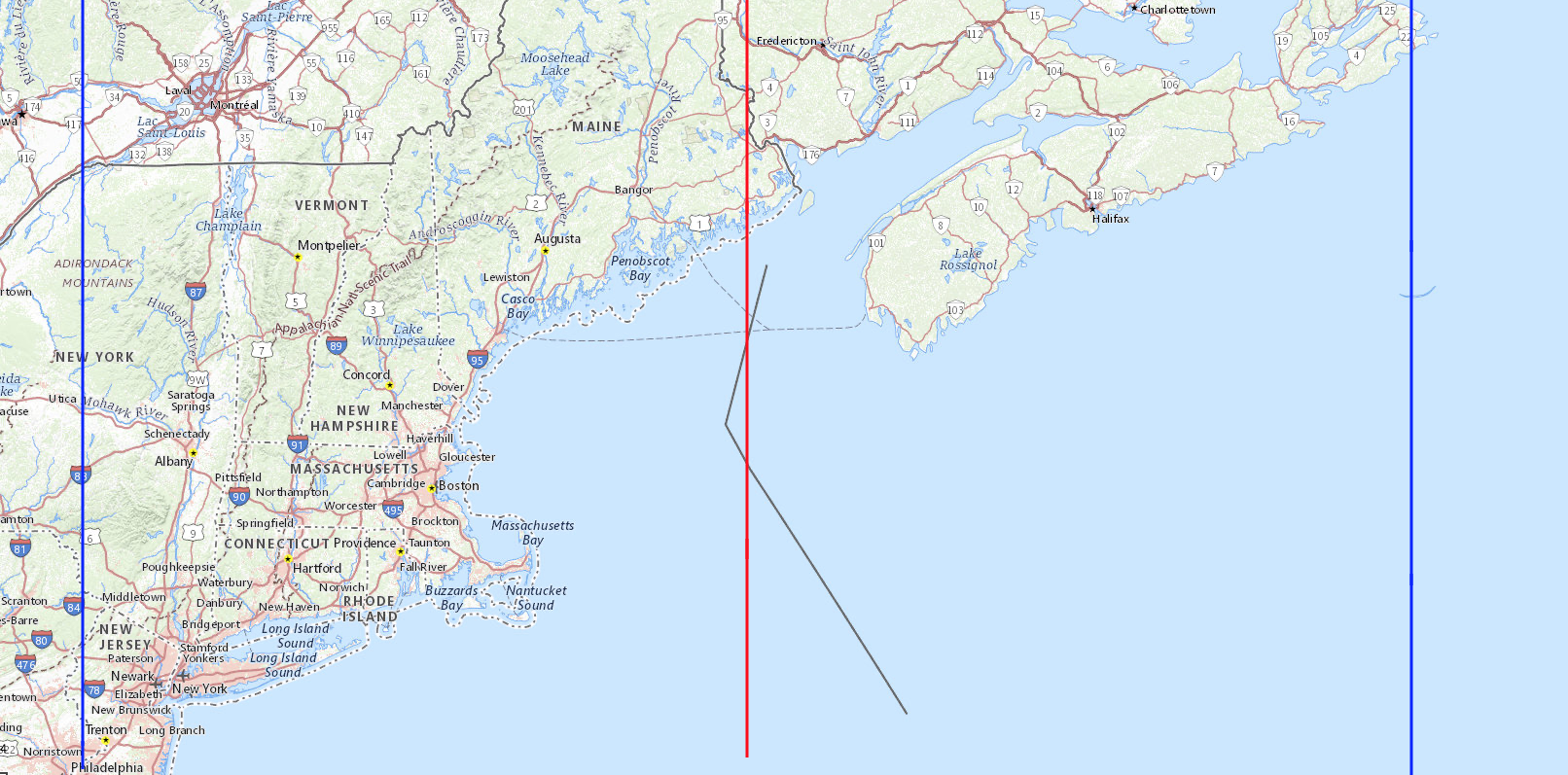
Eastern Standard Time is the mean solar time of 75° west, the blue line at the left. Eastern Daylight Saving Time is the same as Atlantic Standard Time. That is the mean solar time of 60° west, the blue line at the right. Halfway between them, 67.5° west, where the boundary between Eastern Standard Time and Atlantic Standard Time belongs, is the red line down the middle, and all of Vermont is clearly west of it.
Vermont clearly does not belong on Atlantic Standard Time. She is simply too far west for that.
When Eastern Standard Time is in effect, the clocks in Isle La Motte Elementary School in Isle La Motte are 6 minutes and 37 seconds ahead of their local mean solar time. When Eastern Daylight Saving Time, which is the same as Atlantic Standard Time, is used, those same clocks are 53 minutes and 23 seconds ahead of their local mean solar time.
Politicians should not be putting Vermont on the wrong time to benefit some special interest groups at the expense of others.
“Facts are stubborn things; and whatever may be our wishes, our inclinations, or the dictates of our passion, they cannot alter the state of facts and evidence.” — John Adams, Argument in Defense of the British Soldiers in the Boston Massacre Trials, 4 December 1770.
Supporters of year-round daylight saving time argue: Changing the clocks twice a year really stinks. Let’s keep the clocks set to the wrong time year-round. They think the government can give them more daylight by tampering with the clocks, which is like thinking you can gain or lose weight by tampering with your scale.
Supporters of year-round daylight saving time argue that folks have become habituated more to daylight saving time, observing it 8 months every year, than to standard time; but this is because lawmakers forced it onto us. If this bad habit is passed onto little children who are learning how to tell time, when will the bad habit ever be broken?
Supporters of year-round standard time argue: Changing the clocks twice a year really stinks, and forces people to observe the wrong time of day when daylight saving time is in effect. End it, don’t extend it. Let’s not kick the can down the road and burden future generations with the wrong time. Over the years, businesses will adapt, using winter hours and summer hours, same as libraries do. Let’s keep the clocks set to the time that most closely approximates their actual mean solar time. If you want a long sunlit afternoon, then work from 7:00 to 16:00 standard time, which is the same as 8:00 to 17:00 daylight saving time. Petition your employer, but don’t try to force everybody to keep their clocks set to the wrong time.
A State can exempt herself from daylight saving time without federal approval. See15 U.S. Code § 260a(a)(1) , but year-round daylight saving time requires an Act of Congress.
Earth rotates on its axis in 23 hours, 56 minutes and 4.098903691 seconds1, but moves along on its orbit during that time, so it takes a few minutes longer for your hemisphere to face the Sun again. Since the orbit is not circular, the length of a solar day varies during the year. To avoid having days of different lengths, the mean (average) day of 24 hours is used. If the Sun transits your meridian, on average, 12 hours after your clock strikes midnight, then your clock is set to the mean (average) solar time of your longitude. For more about solar (Sun) days versus sidereal (other stars) days, see https://www.universetoday.com/47181/earths-rotation/
As used on this website, a place belongs on a time that is no more than 30 minutes away from its local mean solar time. A time zone boundary belongs at the meridian where the local mean solar time is 30 minutes ahead of the standard time in the time zone to the west and 30 minutes behind the standard time in the time zone to the east. Obviously, minor adjustments are recommendable so that the actual boundaries do not run through Tampa, Florida or Oklahoma City, Oklahoma and Brownsville, Texas. The boundary between the Eastern Time Zone and the Atlantic Time Zone, running along the international boundary between Maine, U.S.A. and New Brunswick, Canada, is an example of a minor adjustment.
Yellow background indicates the correct time zone, with a difference less than 30 minutes from local mean solar time.
| Location | Co-Ordinates (Latitude, Longitude and Elevation) |
Eastern Standard Time (Central Daylight Saving Time) |
Atlantic Standard Time (Eastern Daylight Saving Time) |
| Academy School, Windham County |
12:09:36 | 11:09:36 | |
| Adamant Post Office, Washington County |
12:09:59 | 11:09:59 | |
| Adams School, Windham County |
12:08:52 | 11:08:52 | |
| Addison Central School, Addison County |
12:06:46 | 11:06:46 | |
| Addison Central Supervisory Union, Addison County |
12:07:21 | 11:07:21 | |
| Addison County Child Care Services, Addison County |
12:07:20 | 11:07:20 | |
| Addison Northeast Supervisory Union, Addison County |
12:07:37 | 11:07:37 | |
| Addison Northwest Supervisory Union, Addison County |
12:06:59 | 11:06:59 | |
| Addison Rutland Supervisory Union, Rutland County |
12:06:56 | 11:06:56 | |
| Aiken School, Rutland County |
12:06:40 | 11:06:40 | |
| Albany Community School, Orleans County |
12:10:29 | 11:10:29 | |
| Albany Post Office, Orleans County |
12:10:28 | 11:10:28 | |
| Albert Bridge School, Windsor County |
12:10:07 | 11:10:07 | |
| Albert D Lawton Intermediate School, Chittenden County |
12:07:36 | 11:07:36 | |
| Alburgh Community Educational Center, Grand Isle County |
12:06:48 | 11:06:48 | |
| Alburgh Post Office, Grand Isle County |
12:06:47 | 11:06:47 | |
| Allen Brook School, Chittenden County |
12:07:36 | 11:07:36 | |
| Annettes Playschool Il, Chittenden County |
12:07:34 | 11:07:34 | |
| Arlington Memorial High School, Bennington County |
12:07:23 | 11:07:23 | |
| Arlington Post Office, Bennington County |
12:07:22 | 11:07:22 | |
| Arlington School, Caledonia County |
12:11:55 | 11:11:55 | |
| Arnold School, Rutland County |
12:07:31 | 11:07:31 | |
| Ascutney Post Office, Windsor County |
12:10:22 | 11:10:22 | |
| Athens Elementary School, Windham County |
12:09:43 | 11:09:43 | |
| Augmentative Learning and Movement Center, Lamoille County |
12:09:37 | 11:09:37 | |
| Aurora School, Addison County |
12:07:23 | 11:07:23 | |
| Austine School for the Deaf and Hard of Hearing, Windham County |
12:09:41 | 11:09:41 | |
| Bailey Mills School (historical), Windsor County |
12:09:33 | 11:09:33 | |
| Baird Center for Children, Chittenden County |
12:07:08 | 11:07:08 | |
| Bakersfield Elementary School, Franklin County |
12:08:47 | 11:08:47 | |
| Bakersfield Post Office, Franklin County |
12:08:47 | 11:08:47 | |
| Baldwin School, Chittenden County |
12:07:27 | 11:07:27 | |
| Baltimore School (historical), Windsor County |
12:09:42 | 11:09:42 | |
| Bangall School, Rutland County |
12:07:02 | 11:07:02 | |
| Baptist Hill School, Essex County |
12:13:09 | 11:13:09 | |
| Baptist Street School, Orange County |
12:09:59 | 11:09:59 | |
| Barber School, Bennington County |
12:07:15 | 11:07:15 | |
| Barlow Saint School, Franklin County |
12:07:41 | 11:07:41 | |
| Barnard Central School, Windsor County |
12:09:31 | 11:09:31 | |
| Barnard Post Office, Windsor County |
12:09:31 | 11:09:31 | |
| Barnet Elementary School, Caledonia County |
12:11:40 | 11:11:40 | |
| Barnet Post Office, Caledonia County |
12:11:48 | 11:11:48 | |
| Barnum Hill School, Addison County |
12:06:43 | 11:06:43 | |
| Barre City Elementary and Middle School, Washington County |
12:09:58 | 11:09:58 | |
| Barre Post Office, Washington County |
12:09:59 | 11:09:59 | |
| Barre Regional Vocational Technical Center, Washington County |
12:10:01 | 11:10:01 | |
| Barre Supervisory Union, Washington County |
12:10:01 | 11:10:01 | |
| Barre Town Elementary and Middle School, Washington County |
12:10:03 | 11:10:03 | |
| Barstow Memorial School, Rutland County |
12:08:11 | 11:08:11 | |
| Barton Academy (historical), Orleans County |
12:11:16 | 11:11:16 | |
| Barton Graded School, Orleans County |
12:11:16 | 11:11:16 | |
| Barton Post Office, Orleans County |
12:11:17 | 11:11:17 | |
| Barton School (historical), Windsor County |
12:09:07 | 11:09:07 | |
| Basin Harbor School, Addison County |
12:06:37 | 11:06:37 | |
| Basswood School, Franklin County |
12:08:53 | 11:08:53 | |
| Battenkill Valley Supervisory Union, Bennington County |
12:07:23 | 11:07:23 | |
| Battles School, Orange County |
12:09:05 | 11:09:05 | |
| Bean School, Caledonia County |
12:12:11 | 11:12:11 | |
| Beanville School, Orange County |
12:09:20 | 11:09:20 | |
| Bear Hill School, Orange County |
12:09:29 | 11:09:29 | |
| Beebe Plain Post Office, Orleans County |
12:11:25 | 11:11:25 | |
| Beech Street School, Bennington County |
12:07:18 | 11:07:18 | |
| Beecher Falls Post Office, Essex County |
12:13:58 | 11:13:58 | |
| Beeman Elementary School, Addison County |
12:07:23 | 11:07:23 | |
| Bellow Free Academy Union High School, Franklin County |
12:07:40 | 11:07:40 | |
| Bellows Falls Middle School, Windham County |
12:10:12 | 11:10:12 | |
| Bellows Falls Post Office, Windham County |
12:10:13 | 11:10:13 | |
| Bellows Falls Union High School, Windham County |
12:10:13 | 11:10:13 | |
| Bellows Free Academy, Franklin County |
12:07:56 | 11:07:56 | |
| Bellwether School, Chittenden County |
12:07:29 | 11:07:29 | |
| Belmont Post Office, Rutland County |
12:08:42 | 11:08:42 | |
| Belvidere Elementary School, Lamoille County |
12:09:11 | 11:09:11 | |
| Bennington College, Bennington County |
12:07:02 | 11:07:02 | |
| Bennington Elementary School, Bennington County |
12:07:13 | 11:07:13 | |
| Bennington Post Office, Bennington County |
12:07:12 | 11:07:12 | |
| Bennington School Incorporated, Bennington County |
12:07:06 | 11:07:06 | |
| Benson Post Office, Rutland County |
12:06:45 | 11:06:45 | |
| Benson Village School, Rutland County |
12:06:47 | 11:06:47 | |
| Berkshire Elementary School, Franklin County |
12:08:56 | 11:08:56 | |
| Berlin Elementary School, Washington County |
12:09:42 | 11:09:42 | |
| Bethel Elementary School, Windsor County |
12:09:25 | 11:09:25 | |
| Bethel Post Office, Windsor County |
12:09:27 | 11:09:27 | |
| Bickford School, Caledonia County |
12:11:28 | 11:11:28 | |
| Bingham Memorial School, Addison County |
12:07:10 | 11:07:10 | |
| Bishop Marshall School, Lamoille County |
12:09:32 | 11:09:32 | |
| Black River Academy (historical), Windsor County |
12:09:12 | 11:09:12 | |
| Black River High School, Windsor County |
12:09:14 | 11:09:14 | |
| Blakey School, Chittenden County |
12:07:12 | 11:07:12 | |
| Blood Bank School, Orange County |
12:11:11 | 11:11:11 | |
| Blood Brook School, Orange County |
12:11:10 | 11:11:10 | |
| Bloody Brook Schoolhouse (historical), Lamoille County |
12:09:15 | 11:09:15 | |
| Blue Mountain School, Orange County |
12:11:40 | 11:11:40 | |
| Blue Mountain Supervisory Union, Orange County |
12:11:40 | 11:11:40 | |
| Bolton Memorial School, Chittenden County |
12:08:37 | 11:08:37 | |
| Bomoseen Post Office, Rutland County |
12:07:09 | 11:07:09 | |
| Bondville Post Office, Bennington County |
12:08:29 | 11:08:29 | |
| Boyce School, Orange County |
12:09:43 | 11:09:43 | |
| Boynton Hills School (historical), Windsor County |
12:09:08 | 11:09:08 | |
| Bradford Elementary School, Orange County |
12:11:30 | 11:11:30 | |
| Bradford Post Office, Orange County |
12:11:29 | 11:11:29 | |
| Bradley School, Rutland County |
12:07:06 | 11:07:06 | |
| Braintree Elementary School, Orange County |
12:09:06 | 11:09:06 | |
| Branch School (historical), Addison County |
12:08:27 | 11:08:27 | |
| Branch School (historical), Windsor County |
12:08:40 | 11:08:40 | |
| Branch School, Franklin County |
12:08:48 | 11:08:48 | |
| Branch School, Orleans County |
12:10:17 | 11:10:17 | |
| Branch School, Windham County |
12:09:07 | 11:09:07 | |
| Brandon Post Office, Rutland County |
12:07:37 | 11:07:37 | |
| Brandon State School, Rutland County |
12:07:33 | 11:07:33 | |
| Brattleboro Area Middle School, Windham County |
12:09:45 | 11:09:45 | |
| Brattleboro Community School, Windham County |
12:09:45 | 11:09:45 | |
| Brattleboro Music Center School, Windham County |
12:09:45 | 11:09:45 | |
| Brattleboro Post Office, Windham County |
12:09:45 | 11:09:45 | |
| Brattleboro Union High School, Windham County |
12:09:45 | 11:09:45 | |
| Bread Loaf School of English, Addison County |
12:08:02 | 11:08:02 | |
| Brewster Pierce Memorial School, Chittenden County |
12:08:08 | 11:08:08 | |
| Bridge School, Addison County |
12:07:20 | 11:07:20 | |
| Bridgewater Corners Post Office, Windsor County |
12:09:22 | 11:09:22 | |
| Bridgewater Post Office, Windsor County |
12:09:31 | 11:09:31 | |
| Bridgewater Village School, Windsor County |
12:09:30 | 11:09:30 | |
| Bridport Central School, Addison County |
12:06:44 | 11:06:44 | |
| Bridport Post Office, Addison County |
12:06:44 | 11:06:44 | |
| Brighton Elementary School, Essex County |
12:12:25 | 11:12:25 | |
| Brighton School, Orleans County |
12:10:42 | 11:10:42 | |
| Bristol Elementary School, Addison County |
12:07:41 | 11:07:41 | |
| Bristol Post Office, Addison County |
12:07:40 | 11:07:40 | |
| Brock Hill School (historical), Orange County |
12:11:26 | 11:11:26 | |
| Bromley Brook School, Bennington County |
12:07:57 | 11:07:57 | |
| Brook School (historical), Essex County |
12:12:35 | 11:12:35 | |
| Brookfield Elementary School, Orange County |
12:09:34 | 11:09:34 | |
| Brookfield Post Office, Orange County |
12:09:36 | 11:09:36 | |
| Brookhaven Learning Center, Orange County |
12:10:12 | 11:10:12 | |
| Brookline Elementary School, Windham County |
12:09:34 | 11:09:34 | |
| Brooklyn School, Bennington County |
12:07:15 | 11:07:15 | |
| Brookside School, Caledonia County |
12:12:14 | 11:12:14 | |
| Brookside School, Chittenden County |
12:07:51 | 11:07:51 | |
| Brookside School, Washington County |
12:10:01 | 11:10:01 | |
| Brown School (historical), Rutland County |
12:08:39 | 11:08:39 | |
| Brown School, Orleans County |
12:10:48 | 11:10:48 | |
| Brown School, Orleans County |
12:10:34 | 11:10:34 | |
| Brownell Mountain Seventh Day Adventist School, Chittenden County |
12:07:29 | 11:07:29 | |
| Brownington Central School, Orleans County |
12:11:26 | 11:11:26 | |
| Browns River Middle School, Chittenden County |
12:08:13 | 11:08:13 | |
| Brownsville Post Office, Windsor County |
12:10:06 | 11:10:06 | |
| Buck Hollow School, Franklin County |
12:08:03 | 11:08:03 | |
| Buck School, Orleans County |
12:12:06 | 11:12:06 | |
| Buckley School (historical), Franklin County |
12:08:37 | 11:08:37 | |
| Bull Run School, Washington County |
12:09:15 | 11:09:15 | |
| Bump School, Rutland County |
12:06:56 | 11:06:56 | |
| Bundy School, Caledonia County |
12:12:18 | 11:12:18 | |
| Burington School, Orleans County |
12:10:39 | 11:10:39 | |
| Burke Mountain Academy, Caledonia County |
12:12:22 | 11:12:22 | |
| Burke Town School, Caledonia County |
12:12:09 | 11:12:09 | |
| Burlington Champlain Post Office, Chittenden County |
12:07:10 | 11:07:10 | |
| Burlington College, Chittenden County |
12:07:06 | 11:07:06 | |
| Burlington High School, Chittenden County |
12:07:03 | 11:07:03 | |
| Burlington Post Office, Chittenden County |
12:07:08 | 11:07:08 | |
| Burlington Post Office, Chittenden County |
12:07:08 | 11:07:08 | |
| Burlington School District, Chittenden County |
12:07:13 | 11:07:13 | |
| Burlington Technical Center, Chittenden County |
12:07:03 | 11:07:03 | |
| Burr Pond School, Rutland County |
12:07:16 | 11:07:16 | |
| Burr and Burton Academy, Bennington County |
12:07:41 | 11:07:41 | |
| Burridge School, Orange County |
12:09:05 | 11:09:05 | |
| Burton Hill School, Orleans County |
12:11:00 | 11:11:00 | |
| Bushnell School, Bennington County |
12:07:18 | 11:07:18 | |
| Cabot Post Office, Washington County |
12:10:45 | 11:10:45 | |
| Cabot School, Washington County |
12:10:45 | 11:10:45 | |
| Cady School, Addison County |
12:07:27 | 11:07:27 | |
| Calais Elementary School, Washington County |
12:10:11 | 11:10:11 | |
| Calais Post Office, Washington County |
12:10:01 | 11:10:01 | |
| Caledonia School, Caledonia County |
12:11:57 | 11:11:57 | |
| Callan School, Franklin County |
12:08:07 | 11:08:07 | |
| Cambridge Elementary School, Lamoille County |
12:08:41 | 11:08:41 | |
| Cambridge Post Office, Lamoille County |
12:08:29 | 11:08:29 | |
| Cambridgeport Post Office, Windham County |
12:09:46 | 11:09:46 | |
| Camels Hump Middle School, Chittenden County |
12:08:01 | 11:08:01 | |
| Canaan Post Office, Essex County |
12:13:52 | 11:13:52 | |
| Canal Street School, Windham County |
12:09:45 | 11:09:45 | |
| Canann Elementary School, Essex County |
12:13:50 | 11:13:50 | |
| Canann High School, Essex County |
12:13:50 | 11:13:50 | |
| Caste School (historical), Essex County |
12:12:21 | 11:12:21 | |
| Castleton Hubbardton Elementary School, Rutland County |
12:07:09 | 11:07:09 | |
| Castleton Post Office, Rutland County |
12:07:17 | 11:07:17 | |
| Castleton University, Rutland County |
12:07:16 | 11:07:16 | |
| Castleton Village School, Rutland County |
12:07:17 | 11:07:17 | |
| Catamount Elementary School, Bennington County |
12:07:13 | 11:07:13 | |
| Cavendish Center School (historical), Windsor County |
12:09:34 | 11:09:34 | |
| Cavendish Post Office, Windsor County |
12:09:33 | 11:09:33 | |
| Cavendish Town Elementary School, Windsor County |
12:09:27 | 11:09:27 | |
| Center School, Rutland County |
12:06:36 | 11:06:36 | |
| Center School, Washington County |
12:10:17 | 11:10:17 | |
| Center for Northern Studies, Lamoille County |
12:10:15 | 11:10:15 | |
| Centerpoint Adolescent Treatment Services, Chittenden County |
12:07:22 | 11:07:22 | |
| Central Elementary School, Windham County |
12:10:11 | 11:10:11 | |
| Central School, Addison County |
12:07:29 | 11:07:29 | |
| Central School, Essex County |
12:13:36 | 11:13:36 | |
| Central Vermont Academy, Washington County |
12:09:50 | 11:09:50 | |
| Chamberlain Elementary School, Chittenden County |
12:07:20 | 11:07:20 | |
| Champlain Christian Academy, Franklin County |
12:07:40 | 11:07:40 | |
| Champlain College, Chittenden County |
12:07:10 | 11:07:10 | |
| Champlain Elementary School, Chittenden County |
12:07:08 | 11:07:08 | |
| Champlain Valley Christian School, Addison County |
12:07:03 | 11:07:03 | |
| Champlain Valley Union High School, Chittenden County |
12:07:33 | 11:07:33 | |
| Chandler School (historical), Windsor County |
12:09:44 | 11:09:44 | |
| Chandler School, Caledonia County |
12:11:38 | 11:11:38 | |
| Chapel School, Bennington County |
12:07:16 | 11:07:16 | |
| Charles P Smith Elementary School, Chittenden County |
12:07:01 | 11:07:01 | |
| Charleston Elementary School, Orleans County |
12:11:55 | 11:11:55 | |
| Charlotte Central School, Chittenden County |
12:07:05 | 11:07:05 | |
| Charlotte Post Office, Chittenden County |
12:06:59 | 11:06:59 | |
| Chelsea Post Office, Orange County |
12:10:12 | 11:10:12 | |
| Chelsea Public School, Orange County |
12:10:12 | 11:10:12 | |
| Chelsea West Hill, Orange County |
12:09:57 | 11:09:57 | |
| Cherry Hill Elementary School, Windham County |
12:10:12 | 11:10:12 | |
| Chester - Andover Elementary School, Windsor County |
12:09:37 | 11:09:37 | |
| Chester Post Office, Windsor County |
12:09:37 | 11:09:37 | |
| Childs School, Addison County |
12:06:58 | 11:06:58 | |
| Chittenden Central Supervisory Union, Chittenden County |
12:07:34 | 11:07:34 | |
| Chittenden Post Office, Rutland County |
12:08:11 | 11:08:11 | |
| Chittenden South Supervisory Union, Chittenden County |
12:07:04 | 11:07:04 | |
| Christ Covenant School of Randolph, Orange County |
12:09:20 | 11:09:20 | |
| Christ The King School, Chittenden County |
12:07:09 | 11:07:09 | |
| Christ The King School, Rutland County |
12:08:06 | 11:08:06 | |
| Christian Heritage School, Windham County |
12:09:39 | 11:09:39 | |
| Christy School, Lamoille County |
12:09:28 | 11:09:28 | |
| Clarendon Elementary School, Rutland County |
12:08:07 | 11:08:07 | |
| Clogston School, Orange County |
12:09:36 | 11:09:36 | |
| Cobble Hill School, Washington County |
12:10:04 | 11:10:04 | |
| Cobblestone School, Bennington County |
12:07:04 | 11:07:04 | |
| Colchester High School, Chittenden County |
12:07:08 | 11:07:08 | |
| Colchester Middle School, Chittenden County |
12:07:09 | 11:07:09 | |
| Colchester Post Office, Chittenden County |
12:07:09 | 11:07:09 | |
| Cole School, Lamoille County |
12:09:20 | 11:09:20 | |
| College of Saint Joseph, Rutland County |
12:07:59 | 11:07:59 | |
| Community College of Vermont, Chittenden County |
12:07:08 | 11:07:08 | |
| Community College of Vermont, Franklin County |
12:07:38 | 11:07:38 | |
| Community College of Vermont, Lamoille County |
12:09:37 | 11:09:37 | |
| Community College of Vermont, Rutland County |
12:08:04 | 11:08:04 | |
| Community College of Vermont, Windsor County |
12:10:05 | 11:10:05 | |
| Community Collge of Vermont, Bennington County |
12:07:12 | 11:07:12 | |
| Community Schoolhouse, Windham County |
12:09:44 | 11:09:44 | |
| Concord High School / Graded School, Essex County |
12:12:26 | 11:12:26 | |
| Concord Post Office, Essex County |
12:12:26 | 11:12:26 | |
| Cooks School, Franklin County |
12:09:04 | 11:09:04 | |
| Corinth Post Office, Orange County |
12:10:50 | 11:10:50 | |
| Corinth Post Office, Orange County |
12:10:50 | 11:10:50 | |
| Cornerstone Christian School, Caledonia County |
12:11:49 | 11:11:49 | |
| Cornerstone School, Caledonia County |
12:11:58 | 11:11:58 | |
| Coventry Center School, Orleans County |
12:11:07 | 11:11:07 | |
| Coventry Post Office, Orleans County |
12:10:56 | 11:10:56 | |
| Coventry Village School, Orleans County |
12:10:56 | 11:10:56 | |
| Craftsbury Academy, Orleans County |
12:10:28 | 11:10:28 | |
| Craftsbury Common Post Office, Orleans County |
12:10:28 | 11:10:28 | |
| Craftsbury Post Office, Orleans County |
12:10:30 | 11:10:30 | |
| Craftsbury School (historical), Orleans County |
12:10:32 | 11:10:32 | |
| Craftsbury Schools, Orleans County |
12:10:28 | 11:10:28 | |
| Crane School, Addison County |
12:06:50 | 11:06:50 | |
| Creek School, Chittenden County |
12:08:14 | 11:08:14 | |
| Creek School, Franklin County |
12:08:24 | 11:08:24 | |
| Crossett Brook Middle School, Washington County |
12:08:59 | 11:08:59 | |
| Crossett Hill School, Washington County |
12:08:50 | 11:08:50 | |
| Currier Memorial School, Rutland County |
12:08:01 | 11:08:01 | |
| Cuttingsville Post Office, Rutland County |
12:08:28 | 11:08:28 | |
| Dairy Hill School, Windsor County |
12:10:04 | 11:10:04 | |
| Dana School (historical), Rutland County |
12:08:07 | 11:08:07 | |
| Danby Post Office, Rutland County |
12:08:00 | 11:08:00 | |
| Danville Post Office, Caledonia County |
12:11:26 | 11:11:26 | |
| Danville School, Caledonia County |
12:11:25 | 11:11:25 | |
| Day School, Orleans County |
12:11:16 | 11:11:16 | |
| Day School, Windsor County |
12:10:19 | 11:10:19 | |
| Deerfield Valley Elementary School, Windham County |
12:08:33 | 11:08:33 | |
| Delano School, Lamoille County |
12:09:45 | 11:09:45 | |
| Derby Elementary School, Orleans County |
12:11:31 | 11:11:31 | |
| Derby Line Post Office, Orleans County |
12:11:35 | 11:11:35 | |
| Derby Post Office, Orleans County |
12:11:28 | 11:11:28 | |
| District School Number 15, Rutland County |
12:08:13 | 11:08:13 | |
| District School Number 8 (historical), Chittenden County |
12:07:07 | 11:07:07 | |
| District Six Schoolhouse, Addison County |
12:06:48 | 11:06:48 | |
| Dorset Post Office, Bennington County |
12:07:36 | 11:07:36 | |
| Dorset School, Bennington County |
12:07:44 | 11:07:44 | |
| Dothan Brook School, Windsor County |
12:10:42 | 11:10:42 | |
| Doty Memorial School, Washington County |
12:09:48 | 11:09:48 | |
| Dover Elementary School, Windham County |
12:08:45 | 11:08:45 | |
| Dover Post Office, Windham County |
12:08:47 | 11:08:47 | |
| Duffy Hill School (historical), Franklin County |
12:08:37 | 11:08:37 | |
| Dummerston Schools, Windham County |
12:09:50 | 11:09:50 | |
| Durkee School, Washington County |
12:08:37 | 11:08:37 | |
| Dwinell School, Washington County |
12:10:22 | 11:10:22 | |
| Dyer School, Rutland County |
12:08:07 | 11:08:07 | |
| E Taylor Hatton School, Orleans County |
12:11:56 | 11:11:56 | |
| Early Childhood Center, Bennington County |
12:07:02 | 11:07:02 | |
| Early Learning Preschool Center, Chittenden County |
12:07:08 | 11:07:08 | |
| East Arlington Post Office, Bennington County |
12:07:26 | 11:07:26 | |
| East Barre Post Office, Washington County |
12:10:11 | 11:10:11 | |
| East Brownington School, Orleans County |
12:11:39 | 11:11:39 | |
| East Burke Post Office, Caledonia County |
12:12:13 | 11:12:13 | |
| East Burke School, Caledonia County |
12:12:13 | 11:12:13 | |
| East Calais Post Office, Washington County |
12:10:16 | 11:10:16 | |
| East Charleston Post Office, Orleans County |
12:12:02 | 11:12:02 | |
| East Corinth Post Office, Orange County |
12:11:06 | 11:11:06 | |
| East Dorset Post Office, Bennington County |
12:07:57 | 11:07:57 | |
| East Dover Post Office, Windham County |
12:08:55 | 11:08:55 | |
| East Fairfield Post Office, Franklin County |
12:08:34 | 11:08:34 | |
| East Hardwick Post Office, Caledonia County |
12:10:46 | 11:10:46 | |
| East Haven Post Office, Essex County |
12:12:26 | 11:12:26 | |
| East Haven River School, Essex County |
12:12:25 | 11:12:25 | |
| East Hill School, Caledonia County |
12:11:25 | 11:11:25 | |
| East Hill School, Windsor County |
12:09:13 | 11:09:13 | |
| East Middlebury Post Office, Addison County |
12:07:34 | 11:07:34 | |
| East Montpelier Elementary School, Washington County |
12:10:01 | 11:10:01 | |
| East Montpelier Post Office, Washington County |
12:10:02 | 11:10:02 | |
| East Panton School, Addison County |
12:06:52 | 11:06:52 | |
| East Poultney Post Office, Rutland County |
12:07:10 | 11:07:10 | |
| East Randolph Post Office, Orange County |
12:09:47 | 11:09:47 | |
| East Ryegate Post Office, Caledonia County |
12:11:44 | 11:11:44 | |
| East Saint Johnsbury Post Office, Caledonia County |
12:12:12 | 11:12:12 | |
| East School, Windsor County |
12:10:06 | 11:10:06 | |
| East Thetford Post Office, Orange County |
12:11:14 | 11:11:14 | |
| East Valley Academy, Orange County |
12:09:47 | 11:09:47 | |
| East Wallingford Post Office, Rutland County |
12:08:29 | 11:08:29 | |
| Easton School, Windham County |
12:09:39 | 11:09:39 | |
| Ed-u-care Children's Center, Chittenden County |
12:07:27 | 11:07:27 | |
| Eden Central School, Lamoille County |
12:09:44 | 11:09:44 | |
| Eden Post Office, Lamoille County |
12:09:45 | 11:09:45 | |
| Edmonds High School, Chittenden County |
12:07:10 | 11:07:10 | |
| Edmunds Elementary School, Chittenden County |
12:07:10 | 11:07:10 | |
| Edmunds Middle School, Chittenden County |
12:07:09 | 11:07:09 | |
| Edwards School, Orange County |
12:09:58 | 11:09:58 | |
| Egypt School (historical), Franklin County |
12:08:38 | 11:08:38 | |
| Elm Hill School, Windsor County |
12:10:03 | 11:10:03 | |
| Elm Saint School, Franklin County |
12:07:37 | 11:07:37 | |
| Elmore School, Lamoille County |
12:09:54 | 11:09:54 | |
| Ely School, Orange County |
12:11:16 | 11:11:16 | |
| English Settlement School, Chittenden County |
12:08:21 | 11:08:21 | |
| Enosburg Falls Elementary School, Franklin County |
12:08:47 | 11:08:47 | |
| Enosburg Falls Middle and High School, Franklin County |
12:08:47 | 11:08:47 | |
| Enosburg Falls Post Office, Franklin County |
12:08:46 | 11:08:46 | |
| Essential Early Education, Chittenden County |
12:07:13 | 11:07:13 | |
| Essex - Caledonia Supervisory Union, Essex County |
12:12:26 | 11:12:26 | |
| Essex Early Education Center, Chittenden County |
12:07:34 | 11:07:34 | |
| Essex Elementary School, Chittenden County |
12:07:46 | 11:07:46 | |
| Essex High School, Chittenden County |
12:07:33 | 11:07:33 | |
| Essex Junction Post Office, Chittenden County |
12:07:41 | 11:07:41 | |
| Essex Junction Regional Technology Center, Chittenden County |
12:07:33 | 11:07:33 | |
| Essex Middle School, Chittenden County |
12:07:45 | 11:07:45 | |
| Essex Town School District, Chittenden County |
12:07:47 | 11:07:47 | |
| Esteyville School, Windham County |
12:09:43 | 11:09:43 | |
| Eureka Schoolhouse (historical), Windsor County |
12:10:12 | 11:10:12 | |
| Fair Haven Grade School, Rutland County |
12:06:56 | 11:06:56 | |
| Fair Haven Post Office, Rutland County |
12:06:56 | 11:06:56 | |
| Fair Haven Union High School, Rutland County |
12:06:55 | 11:06:55 | |
| Fairfax Post Office, Franklin County |
12:07:57 | 11:07:57 | |
| Fairfield Center School, Franklin County |
12:08:12 | 11:08:12 | |
| Fairfield Post Office, Franklin County |
12:08:14 | 11:08:14 | |
| Fairfield Saint School, Franklin County |
12:07:41 | 11:07:41 | |
| Fairlee Post Office, Orange County |
12:11:24 | 11:11:24 | |
| Family Center of Washington County, Washington County |
12:09:43 | 11:09:43 | |
| Farrar School, Orleans County |
12:10:52 | 11:10:52 | |
| Fayston Elementary School, Washington County |
12:08:27 | 11:08:27 | |
| Felton School, Addison County |
12:07:08 | 11:07:08 | |
| Ferrisburgh Central School, Addison County |
12:07:00 | 11:07:00 | |
| Ferrisburgh Post Office, Addison County |
12:07:00 | 11:07:00 | |
| Fiddock School, Chittenden County |
12:08:22 | 11:08:22 | |
| Field of Dreams Too School, Chittenden County |
12:07:29 | 11:07:29 | |
| Fields of Harvest Ministries, Lamoille County |
12:09:16 | 11:09:16 | |
| Fieroe Mill School, Caledonia County |
12:11:59 | 11:11:59 | |
| Fisher Elementary School, Bennington County |
12:07:23 | 11:07:23 | |
| Fisk School, Orleans County |
12:11:30 | 11:11:30 | |
| Fletcher Elementary School, Franklin County |
12:08:18 | 11:08:18 | |
| Fletcher Elementary School, Lamoille County |
12:08:28 | 11:08:28 | |
| Fletcher Farm School for the Arts and Crafts, Windsor County |
12:09:18 | 11:09:18 | |
| Flood Brook Union School, Windham County |
12:08:36 | 11:08:36 | |
| Florence Post Office, Rutland County |
12:07:46 | 11:07:46 | |
| Flynn School, Windsor County |
12:09:23 | 11:09:23 | |
| Folsom Educational and Community Center, Grand Isle County |
12:06:47 | 11:06:47 | |
| Forest Dale Post Office, Rutland County |
12:07:46 | 11:07:46 | |
| Forest Hill School (historical), Franklin County |
12:08:15 | 11:08:15 | |
| Forrest Ward Memorial School, Bennington County |
12:07:10 | 11:07:10 | |
| Founders Memorial School, Chittenden County |
12:07:46 | 11:07:46 | |
| Four Corners School, Caledonia County |
12:11:49 | 11:11:49 | |
| Four Corners School, Caledonia County |
12:11:32 | 11:11:32 | |
| Four Corners School, Washington County |
12:10:01 | 11:10:01 | |
| Francis Hicks Memorial School, Windham County |
12:09:39 | 11:09:39 | |
| Frank Adams School, Caledonia County |
12:11:54 | 11:11:54 | |
| Franklin Central School, Franklin County |
12:08:19 | 11:08:19 | |
| Franklin Central Supervisory Union, Franklin County |
12:07:39 | 11:07:39 | |
| Franklin Northwest Supervisory Union, Franklin County |
12:07:33 | 11:07:33 | |
| Franklin Post Office, Franklin County |
12:08:20 | 11:08:20 | |
| Frederick H Tuttle Middle School, Chittenden County |
12:07:17 | 11:07:17 | |
| Furnace School, Rutland County |
12:07:58 | 11:07:58 | |
| Gage School, Addison County |
12:06:57 | 11:06:57 | |
| Gailer School, Addison County |
12:07:20 | 11:07:20 | |
| Gateway School, Windsor County |
12:10:06 | 11:10:06 | |
| Gaysville Post Office, Windsor County |
12:09:12 | 11:09:12 | |
| Georgia Elementary School, Franklin County |
12:07:32 | 11:07:32 | |
| Georgia Middle School, Franklin County |
12:07:32 | 11:07:32 | |
| Gilchrist School (historical), Windsor County |
12:09:26 | 11:09:26 | |
| Gilman Post Office, Essex County |
12:13:07 | 11:13:07 | |
| Gilman School, Orange County |
12:09:37 | 11:09:37 | |
| Glidden School, Washington County |
12:09:07 | 11:09:07 | |
| Glover Community School, Orleans County |
12:11:14 | 11:11:14 | |
| Glover Post Office, Orleans County |
12:11:14 | 11:11:14 | |
| Goddard College, Washington County |
12:10:14 | 11:10:14 | |
| Goes Hollow School, Caledonia County |
12:11:44 | 11:11:44 | |
| Good Shepherd Catholic School, Caledonia County |
12:11:55 | 11:11:55 | |
| Goodnough School, Rutland County |
12:07:53 | 11:07:53 | |
| Goshen School (historical), Orange County |
12:11:26 | 11:11:26 | |
| Gould School (historical), Franklin County |
12:08:22 | 11:08:22 | |
| Governors Right School, Chittenden County |
12:08:07 | 11:08:07 | |
| Grace Christian School, Bennington County |
12:07:12 | 11:07:12 | |
| Grafton Elementary School, Windham County |
12:09:33 | 11:09:33 | |
| Grafton Post Office, Windham County |
12:09:33 | 11:09:33 | |
| Grahamville School, Bennington County |
12:08:24 | 11:08:24 | |
| Granby Central School, Essex County |
12:12:58 | 11:12:58 | |
| Granby Post Office, Essex County |
12:12:57 | 11:12:57 | |
| Grand Isle Post Office, Grand Isle County |
12:06:49 | 11:06:49 | |
| Grand Isle School, Grand Isle County |
12:06:50 | 11:06:50 | |
| Grand Isle Supervisory Union, Grand Isle County |
12:06:54 | 11:06:54 | |
| Graniteville Post Office, Washington County |
12:10:02 | 11:10:02 | |
| Granville Post Office, Addison County |
12:08:36 | 11:08:36 | |
| Granville Village School, Addison County |
12:08:37 | 11:08:37 | |
| Graves School (historical), Caledonia County |
12:12:09 | 11:12:09 | |
| Green Mountain College, Rutland County |
12:07:02 | 11:07:02 | |
| Green Mountain School, Washington County |
12:09:45 | 11:09:45 | |
| Green Mountain Union High School, Windsor County |
12:09:40 | 11:09:40 | |
| Green Mountain Valley School, Washington County |
12:08:35 | 11:08:35 | |
| Green Mountain Waldorf School, Lamoille County |
12:10:10 | 11:10:10 | |
| Green School, Orleans County |
12:11:50 | 11:11:50 | |
| Green Street School, Windham County |
12:09:44 | 11:09:44 | |
| Greensboro Bend Post Office, Orleans County |
12:10:56 | 11:10:56 | |
| Greensboro Post Office, Orleans County |
12:10:49 | 11:10:49 | |
| Groton Post Office, Caledonia County |
12:11:13 | 11:11:13 | |
| Grout School, Windsor County |
12:10:26 | 11:10:26 | |
| Guildhall Elementary School, Essex County |
12:13:44 | 11:13:44 | |
| Guildhall Post Office, Essex County |
12:13:44 | 11:13:44 | |
| Guilford Central School, Windham County |
12:09:30 | 11:09:30 | |
| Halifax School, Windham County |
12:08:55 | 11:08:55 | |
| Hampshire School, Lamoille County |
12:10:17 | 11:10:17 | |
| Hancock Post Office, Addison County |
12:08:38 | 11:08:38 | |
| Hancock Village School, Addison County |
12:08:38 | 11:08:38 | |
| Hardwick Elementary School, Caledonia County |
12:10:31 | 11:10:31 | |
| Hardwick Post Office, Caledonia County |
12:10:32 | 11:10:32 | |
| Hardwood Flats School, Lamoille County |
12:10:00 | 11:10:00 | |
| Harlow Bridge School, Washington County |
12:09:18 | 11:09:18 | |
| Hartford Area Career and Technical Center, Windsor County |
12:10:43 | 11:10:43 | |
| Hartford High School, Windsor County |
12:10:43 | 11:10:43 | |
| Hartford Memorial Middle School, Windsor County |
12:10:43 | 11:10:43 | |
| Hartford Post Office, Windsor County |
12:10:39 | 11:10:39 | |
| Hartford School District Office, Windsor County |
12:10:43 | 11:10:43 | |
| Hartland Elementary School, Windsor County |
12:10:25 | 11:10:25 | |
| Hartland Four Corners Post Office, Windsor County |
12:10:18 | 11:10:18 | |
| Hartland Post Office, Windsor County |
12:10:24 | 11:10:24 | |
| Harvest Christian School, Lamoille County |
12:09:21 | 11:09:21 | |
| Harvey School, Chittenden County |
12:08:30 | 11:08:30 | |
| Harwood Hill School, Bennington County |
12:07:09 | 11:07:09 | |
| Harwood Union Middle and High School, Washington County |
12:08:51 | 11:08:51 | |
| Hastings School (historical), Caledonia County |
12:12:00 | 11:12:00 | |
| Havenwood School, Rutland County |
12:08:01 | 11:08:01 | |
| Hawthorn School, Addison County |
12:06:30 | 11:06:30 | |
| Hazen Road School, Orleans County |
12:10:41 | 11:10:41 | |
| Hazen Union High School, Caledonia County |
12:10:32 | 11:10:32 | |
| Heath School, Orleans County |
12:11:20 | 11:11:20 | |
| Heights School, Caledonia County |
12:11:21 | 11:11:21 | |
| Hemingway School (historical), Windsor County |
12:09:13 | 11:09:13 | |
| Herrick School, Franklin County |
12:08:30 | 11:08:30 | |
| Hiawatha Elementary School, Chittenden County |
12:07:29 | 11:07:29 | |
| Highgate Center Post Office, Franklin County |
12:07:49 | 11:07:49 | |
| Highgate Elementary School, Franklin County |
12:07:49 | 11:07:49 | |
| Highgate Springs Post Office, Franklin County |
12:07:34 | 11:07:34 | |
| Highland School, Caledonia County |
12:11:45 | 11:11:45 | |
| Higley School, Windham County |
12:09:38 | 11:09:38 | |
| Hiland Hall School, Bennington County |
12:07:09 | 11:07:09 | |
| Hill School (historical), Caledonia County |
12:12:04 | 11:12:04 | |
| Hill School, Rutland County |
12:07:10 | 11:07:10 | |
| Hillside School, Lamoille County |
12:09:13 | 11:09:13 | |
| Hilltop Montessori School, Windham County |
12:09:42 | 11:09:42 | |
| Hinesburg Community School, Chittenden County |
12:07:34 | 11:07:34 | |
| Hinesburg Post Office, Chittenden County |
12:07:34 | 11:07:34 | |
| Hinton School, Orleans County |
12:11:55 | 11:11:55 | |
| Hitchcock School, Orleans County |
12:10:24 | 11:10:24 | |
| Holland Elementary School, Orleans County |
12:11:56 | 11:11:56 | |
| Holy Angel School, Franklin County |
12:07:37 | 11:07:37 | |
| Holy Family Catholic School, Windsor County |
12:10:04 | 11:10:04 | |
| Hough Crossing School, Addison County |
12:06:40 | 11:06:40 | |
| Houston Hill School, Caledonia County |
12:10:44 | 11:10:44 | |
| Howard Hill School, Rutland County |
12:06:54 | 11:06:54 | |
| Howden Hall School, Addison County |
12:07:40 | 11:07:40 | |
| Howe Hill School, Windsor County |
12:10:03 | 11:10:03 | |
| Hubbard School (historical), Franklin County |
12:08:07 | 11:08:07 | |
| Hull Crest School, Chittenden County |
12:07:11 | 11:07:11 | |
| Huntington Post Office, Chittenden County |
12:08:03 | 11:08:03 | |
| Hyde Park Elementary School, Lamoille County |
12:09:32 | 11:09:32 | |
| Hyde Park Post Office, Lamoille County |
12:09:31 | 11:09:31 | |
| Hydeville Post Office, Rutland County |
12:07:05 | 11:07:05 | |
| Hydeville School (historical), Rutland County |
12:07:04 | 11:07:04 | |
| Independent Baptist Church of Christ School, Windham County |
12:10:13 | 11:10:13 | |
| International Children's School, Chittenden County |
12:07:18 | 11:07:18 | |
| Ira Allen School (historical), Chittenden County |
12:07:13 | 11:07:13 | |
| Irasburg Post Office, Orleans County |
12:10:53 | 11:10:53 | |
| Irasburg Village School, Orleans County |
12:10:54 | 11:10:54 | |
| Irish Settlement School, Chittenden County |
12:08:28 | 11:08:28 | |
| Island Pond Post Office, Essex County |
12:12:28 | 11:12:28 | |
| Isle La Motte Elementary School, Grand Isle County |
12:06:36 | 11:06:36 | |
| Isle La Motte Post Office, Grand Isle County |
12:06:38 | 11:06:38 | |
| Jackson School, Caledonia County |
12:10:29 | 11:10:29 | |
| Jacksonville Post Office, Windham County |
12:08:42 | 11:08:42 | |
| Jamaica Post Office, Windham County |
12:08:52 | 11:08:52 | |
| Jamaica Village School, Windham County |
12:08:53 | 11:08:53 | |
| Jay Westfield Elementary School, Orleans County |
12:10:15 | 11:10:15 | |
| Jeffersonville Post Office, Lamoille County |
12:08:40 | 11:08:40 | |
| Jericho Center Post Office, Chittenden County |
12:08:06 | 11:08:06 | |
| Jericho Elementary School, Chittenden County |
12:08:02 | 11:08:02 | |
| Jericho Post Office, Chittenden County |
12:08:01 | 11:08:01 | |
| Jerusalem School (historical), Windsor County |
12:08:54 | 11:08:54 | |
| Jerusalem School, Addison County |
12:07:22 | 11:07:22 | |
| John F Kennedy Elementary School, Chittenden County |
12:07:16 | 11:07:16 | |
| John J Flynn Elementary School, Chittenden County |
12:06:57 | 11:06:57 | |
| Johnson Elementary School, Lamoille County |
12:09:17 | 11:09:17 | |
| Johnson Post Office, Lamoille County |
12:09:16 | 11:09:16 | |
| Johnson State College, Lamoille County |
12:09:18 | 11:09:18 | |
| Jonesville Academy, Chittenden County |
12:08:14 | 11:08:14 | |
| Jonesville Post Office, Chittenden County |
12:08:15 | 11:08:15 | |
| Justin Morgan Christian School, Orange County |
12:09:27 | 11:09:27 | |
| Kidderhood School, Orange County |
12:11:11 | 11:11:11 | |
| Killington Mountain School, Rutland County |
12:08:50 | 11:08:50 | |
| Killington Post Office, Rutland County |
12:08:45 | 11:08:45 | |
| Kindle Farm School, Windham County |
12:09:24 | 11:09:24 | |
| King George School, Caledonia County |
12:11:42 | 11:11:42 | |
| King School, Washington County |
12:10:24 | 11:10:24 | |
| Kingsbury Branch Community School, Washington County |
12:10:18 | 11:10:18 | |
| Kurn Hattin Homes School, Windham County |
12:10:05 | 11:10:05 | |
| Lake Champlain Waldorf School, Chittenden County |
12:07:03 | 11:07:03 | |
| Lake Dunmore School, Addison County |
12:07:35 | 11:07:35 | |
| Lake Elmore Post Office, Lamoille County |
12:09:54 | 11:09:54 | |
| Lake Iroquois School, Chittenden County |
12:07:37 | 11:07:37 | |
| Lake Region Union High School, Orleans County |
12:11:07 | 11:11:07 | |
| Lake School, Addison County |
12:06:24 | 11:06:24 | |
| Lake View School, Orleans County |
12:11:41 | 11:11:41 | |
| Lakeview Union School, Orleans County |
12:10:49 | 11:10:49 | |
| Lamoille Area Vocational Center, Lamoille County |
12:09:28 | 11:09:28 | |
| Lamoille County Grammar School (historical), Lamoille County |
12:09:18 | 11:09:18 | |
| Lamoille North Supervisory Union, Lamoille County |
12:09:27 | 11:09:27 | |
| Lamoille Union Middle and High School, Lamoille County |
12:09:28 | 11:09:28 | |
| Lamoille Valley Learning Together, Lamoille County |
12:09:32 | 11:09:32 | |
| Lamson School, Washington County |
12:09:34 | 11:09:34 | |
| Landgrove School, Bennington County |
12:08:34 | 11:08:34 | |
| Landmark College, Windham County |
12:09:56 | 11:09:56 | |
| Lapland School, Franklin County |
12:08:32 | 11:08:32 | |
| Laraway School, Lamoille County |
12:09:17 | 11:09:17 | |
| Lawrence Barnes Elementary School, Chittenden County |
12:07:07 | 11:07:07 | |
| Leicester Central School, Addison County |
12:07:33 | 11:07:33 | |
| Leighton Hill School (historical), Orange County |
12:11:33 | 11:11:33 | |
| Leland and Gray Seminary (historical), Windham County |
12:09:19 | 11:09:19 | |
| Leland and Gray Union Middle and High School, Windham County |
12:09:19 | 11:09:19 | |
| Lime Kiln School (historical), Orange County |
12:11:18 | 11:11:18 | |
| Lincoln Community School, Addison County |
12:08:03 | 11:08:03 | |
| Lincoln School, Rutland County |
12:08:05 | 11:08:05 | |
| Lincoln Street School, Caledonia County |
12:11:59 | 11:11:59 | |
| Locke School, Lamoille County |
12:09:01 | 11:09:01 | |
| Locust Creek School, Windsor County |
12:09:27 | 11:09:27 | |
| Londonderry Post Office, Windham County |
12:08:44 | 11:08:44 | |
| Long Trail School, Bennington County |
12:07:36 | 11:07:36 | |
| Longfellow School, Rutland County |
12:08:05 | 11:08:05 | |
| Lost Nation School (historical), Franklin County |
12:08:24 | 11:08:24 | |
| Lothrop School, Rutland County |
12:07:55 | 11:07:55 | |
| Lowell Graded School, Orleans County |
12:10:12 | 11:10:12 | |
| Lowell Post Office (historical), Orleans County |
12:10:10 | 11:10:10 | |
| Lowell Post Office, Orleans County |
12:10:11 | 11:10:11 | |
| Lower Waterford Post Office, Caledonia County |
12:12:22 | 11:12:22 | |
| Ludlow Elementary School, Windsor County |
12:09:14 | 11:09:14 | |
| Ludlow Post Office, Windsor County |
12:09:10 | 11:09:10 | |
| Lunenburg Elementary School, Essex County |
12:13:15 | 11:13:15 | |
| Lunenburg Post Office, Essex County |
12:13:16 | 11:13:16 | |
| Lunenburg and Gillman Schools, Essex County |
12:13:08 | 11:13:08 | |
| Lyman C Hunt Middle School, Chittenden County |
12:07:00 | 11:07:00 | |
| Lyman Post Office, Windsor County |
12:10:43 | 11:10:43 | |
| Lynde School, Orange County |
12:09:46 | 11:09:46 | |
| Lyndon Center Post Office, Caledonia County |
12:11:57 | 11:11:57 | |
| Lyndon Educational Alternative Resources Network, Caledonia County |
12:11:59 | 11:11:59 | |
| Lyndon Institute, Caledonia County |
12:11:56 | 11:11:56 | |
| Lyndon Post Office, Caledonia County |
12:11:57 | 11:11:57 | |
| Lyndon State College, Caledonia County |
12:11:53 | 11:11:53 | |
| Lyndon Town School, Caledonia County |
12:12:03 | 11:12:03 | |
| Lyndonville Post Office, Caledonia County |
12:11:59 | 11:11:59 | |
| Machine Gun School (historical), Chittenden County |
12:08:24 | 11:08:24 | |
| Main Street Middle School, Washington County |
12:09:43 | 11:09:43 | |
| Malletts Bay Elementary School, Chittenden County |
12:07:10 | 11:07:10 | |
| Manchester Center Post Office, Bennington County |
12:07:48 | 11:07:48 | |
| Manchester Elementary / Middle School, Bennington County |
12:07:47 | 11:07:47 | |
| Manchester Post Office, Bennington County |
12:07:42 | 11:07:42 | |
| Maple Grove School, Bennington County |
12:07:18 | 11:07:18 | |
| Maple Hill School (historical), Windsor County |
12:08:36 | 11:08:36 | |
| Maple Street School, Bennington County |
12:07:46 | 11:07:46 | |
| Marion W Cross School, Windsor County |
12:10:46 | 11:10:46 | |
| Marlboro College, Windham County |
12:09:03 | 11:09:03 | |
| Marlboro Elementary School, Windham County |
12:09:07 | 11:09:07 | |
| Marlboro Post Office, Windham County |
12:09:05 | 11:09:05 | |
| Marsh School, Windsor County |
12:10:08 | 11:10:08 | |
| Marshall School, Caledonia County |
12:12:09 | 11:12:09 | |
| Marshfield Post Office, Washington County |
12:10:36 | 11:10:36 | |
| Mary Hogan Elementary School, Addison County |
12:07:21 | 11:07:21 | |
| Mary Johnson Children's Center, Addison County |
12:07:20 | 11:07:20 | |
| Mary S Babcock Elementary School, Franklin County |
12:07:32 | 11:07:32 | |
| Mater Christi School, Chittenden County |
12:07:12 | 11:07:12 | |
| Mc Indoe Falls Post Office, Caledonia County |
12:11:44 | 11:11:44 | |
| McCarty School (historical), Franklin County |
12:08:06 | 11:08:06 | |
| McIndoes Academy, Caledonia County |
12:11:44 | 11:11:44 | |
| Meadowbrook School, Windsor County |
12:10:17 | 11:10:17 | |
| Meadows School, Windham County |
12:09:44 | 11:09:44 | |
| Mettawee Community School, Rutland County |
12:07:06 | 11:07:06 | |
| Mid Vermont Christian School, Windsor County |
12:10:17 | 11:10:17 | |
| Middlebury College, Addison County |
12:07:17 | 11:07:17 | |
| Middlebury Post Office, Addison County |
12:07:19 | 11:07:19 | |
| Middlebury Summer College, Addison County |
12:08:01 | 11:08:01 | |
| Middlebury Union High School, Addison County |
12:07:20 | 11:07:20 | |
| Middlebury Union Middle School, Addison County |
12:07:23 | 11:07:23 | |
| Middletown Springs Elementary School, Rutland County |
12:07:31 | 11:07:31 | |
| Middletown Springs Post Office, Rutland County |
12:07:31 | 11:07:31 | |
| Mill River Union High School, Rutland County |
12:08:06 | 11:08:06 | |
| Millers Run School, Caledonia County |
12:11:31 | 11:11:31 | |
| Milton Elementary School, Chittenden County |
12:07:33 | 11:07:33 | |
| Milton Middle / High School, Chittenden County |
12:07:31 | 11:07:31 | |
| Milton Post Office, Chittenden County |
12:07:31 | 11:07:31 | |
| Milton School District, Chittenden County |
12:07:33 | 11:07:33 | |
| Missisquoi Valley Union High School, Franklin County |
12:07:35 | 11:07:35 | |
| Molly Stark Elementary School, Bennington County |
12:07:11 | 11:07:11 | |
| Monkton Central School, Addison County |
12:07:26 | 11:07:26 | |
| Monkton Post Office, Addison County |
12:07:33 | 11:07:33 | |
| Monteverdi Music School, Washington County |
12:09:42 | 11:09:42 | |
| Montgomery Center Post Office, Franklin County |
12:09:33 | 11:09:33 | |
| Montgomery Elementary School, Franklin County |
12:09:32 | 11:09:32 | |
| Montgomery Post Office, Franklin County |
12:09:26 | 11:09:26 | |
| Montpelier High School, Washington County |
12:09:39 | 11:09:39 | |
| Montpelier Post Office, Washington County |
12:09:41 | 11:09:41 | |
| Montpelier Public Schools, Washington County |
12:09:42 | 11:09:42 | |
| Monument Elementary School, Bennington County |
12:07:09 | 11:07:09 | |
| Moretown Elementary School, Washington County |
12:08:56 | 11:08:56 | |
| Moretown Post Office, Washington County |
12:08:57 | 11:08:57 | |
| Morgan Post Office, Orleans County |
12:11:56 | 11:11:56 | |
| Morrill School, Caledonia County |
12:11:30 | 11:11:30 | |
| Morristown Elementary School, Lamoille County |
12:09:39 | 11:09:39 | |
| Morrisville Graded School, Lamoille County |
12:09:37 | 11:09:37 | |
| Morrisville Post Office, Lamoille County |
12:09:36 | 11:09:36 | |
| Morrisville Post Office, Lamoille County |
12:09:36 | 11:09:36 | |
| Moscow Post Office, Lamoille County |
12:09:08 | 11:09:08 | |
| Mount Abraham Union High School, Addison County |
12:07:37 | 11:07:37 | |
| Mount Anthony High School, Bennington County |
12:07:14 | 11:07:14 | |
| Mount Anthony Union High School, Bennington County |
12:07:14 | 11:07:14 | |
| Mount Anthony Union Middle School, Bennington County |
12:07:14 | 11:07:14 | |
| Mount Holly Elementary School, Rutland County |
12:08:42 | 11:08:42 | |
| Mount Holly Post Office, Rutland County |
12:08:41 | 11:08:41 | |
| Mount Hunger School, Caledonia County |
12:12:11 | 11:12:11 | |
| Mount Laurel School, Bennington County |
12:07:49 | 11:07:49 | |
| Mount Mansfield Union High School, Chittenden County |
12:08:09 | 11:08:09 | |
| Mount Mansfield Winter Academy, Lamoille County |
12:08:53 | 11:08:53 | |
| Mount Philo School, Chittenden County |
12:07:03 | 11:07:03 | |
| Mount Pleasant School, Bennington County |
12:07:28 | 11:07:28 | |
| Mount Saint Joseph Academy, Rutland County |
12:08:03 | 11:08:03 | |
| Mount Snow Academy, Windham County |
12:08:26 | 11:08:26 | |
| Mountain School at Winhall, Bennington County |
12:08:26 | 11:08:26 | |
| Mountain View Christian Academy, Rutland County |
12:07:47 | 11:07:47 | |
| Mountain View Community School, Rutland County |
12:08:04 | 11:08:04 | |
| Mud City School, Lamoille County |
12:09:17 | 11:09:17 | |
| Muddy Brook School, Chittenden County |
12:07:31 | 11:07:31 | |
| Munchkinland Montessori School, Franklin County |
12:07:40 | 11:07:40 | |
| Neighborhood Schoolhouse, Windham County |
12:09:41 | 11:09:41 | |
| Neshobe School, Rutland County |
12:07:46 | 11:07:46 | |
| New Eldridge School, Chittenden County |
12:07:22 | 11:07:22 | |
| New England Culinary Institute - Essex Campus, Chittenden County |
12:07:41 | 11:07:41 | |
| New England Culinary Institute Admission Office, Washington County |
12:09:44 | 11:09:44 | |
| New England Culinary Institute, Washington County |
12:09:45 | 11:09:45 | |
| New Haven Post Office, Addison County |
12:07:16 | 11:07:16 | |
| New Palmer School, Chittenden County |
12:07:14 | 11:07:14 | |
| New School of Montpelier, Washington County |
12:09:43 | 11:09:43 | |
| New Testament Christian Academy, Franklin County |
12:08:04 | 11:08:04 | |
| Newark School, Caledonia County |
12:12:11 | 11:12:11 | |
| Newbury Christian School, Orange County |
12:11:45 | 11:11:45 | |
| Newbury Elementary School, Orange County |
12:11:45 | 11:11:45 | |
| Newbury Post Office, Orange County |
12:11:46 | 11:11:46 | |
| Newfane Elementary School, Windham County |
12:09:23 | 11:09:23 | |
| Newfane Post Office, Windham County |
12:09:22 | 11:09:22 | |
| Newport Center Post Office, Orleans County |
12:10:46 | 11:10:46 | |
| Newport City Elementary School, Orleans County |
12:11:13 | 11:11:13 | |
| Newport Post Office, Orleans County |
12:11:10 | 11:11:10 | |
| Newport Town Elementary School, Orleans County |
12:10:46 | 11:10:46 | |
| Newton Elementary School, Orange County |
12:10:32 | 11:10:32 | |
| Niles School, Bennington County |
12:07:02 | 11:07:02 | |
| North American Hockey Academy, Lamoille County |
12:08:58 | 11:08:58 | |
| North Avenue Christian School, Chittenden County |
12:07:02 | 11:07:02 | |
| North Bennington Graded School, Bennington County |
12:07:01 | 11:07:01 | |
| North Bennington Post Office, Bennington County |
12:07:01 | 11:07:01 | |
| North Branch School, Orange County |
12:09:43 | 11:09:43 | |
| North Brattleboro Post Office, Windham County |
12:09:46 | 11:09:46 | |
| North Breton School, Rutland County |
12:07:27 | 11:07:27 | |
| North Browington School, Orleans County |
12:11:21 | 11:11:21 | |
| North Burlington Post Office, Chittenden County |
12:07:01 | 11:07:01 | |
| North Calais School, Washington County |
12:10:10 | 11:10:10 | |
| North Clarendon Post Office, Rutland County |
12:08:07 | 11:08:07 | |
| North Concord Post Office, Essex County |
12:12:33 | 11:12:33 | |
| North Concord School (historical), Essex County |
12:12:32 | 11:12:32 | |
| North Country Career Center, Orleans County |
12:11:11 | 11:11:11 | |
| North Country Christian Academy, Chittenden County |
12:07:35 | 11:07:35 | |
| North Country Union High School, Orleans County |
12:11:11 | 11:11:11 | |
| North Country Union Junior High School, Orleans County |
12:11:28 | 11:11:28 | |
| North Ferrisburgh Post Office, Addison County |
12:07:05 | 11:07:05 | |
| North Hartland Post Office, Windsor County |
12:10:34 | 11:10:34 | |
| North Hero Elementary School, Grand Isle County |
12:06:56 | 11:06:56 | |
| North Hero Post Office, Grand Isle County |
12:06:50 | 11:06:50 | |
| North Hollow School (historical), Addison County |
12:08:41 | 11:08:41 | |
| North Hollow School, Windsor County |
12:08:44 | 11:08:44 | |
| North Hyde Park Post Office, Lamoille County |
12:09:36 | 11:09:36 | |
| North Kirby School, Caledonia County |
12:12:17 | 11:12:17 | |
| North Pomfret Post Office, Windsor County |
12:10:04 | 11:10:04 | |
| North Pownal Post Office, Bennington County |
12:06:55 | 11:06:55 | |
| North School (historical), Franklin County |
12:08:48 | 11:08:48 | |
| North Springfield Post Office, Windsor County |
12:09:54 | 11:09:54 | |
| North Thetford Post Office, Orange County |
12:11:15 | 11:11:15 | |
| North Troy Post Office, Orleans County |
12:10:23 | 11:10:23 | |
| Northam School, Rutland County |
12:08:41 | 11:08:41 | |
| Northeast Primary School, Rutland County |
12:08:09 | 11:08:09 | |
| Northfield Day Care, Washington County |
12:09:22 | 11:09:22 | |
| Northfield Elementary School, Washington County |
12:09:21 | 11:09:21 | |
| Northfield Falls Post Office, Washington County |
12:09:24 | 11:09:24 | |
| Northfield Middle / High School, Washington County |
12:09:21 | 11:09:21 | |
| Northfield Post Office, Washington County |
12:09:22 | 11:09:22 | |
| Northside Christian Academy, Bennington County |
12:07:42 | 11:07:42 | |
| Northwest Primary School, Rutland County |
12:08:02 | 11:08:02 | |
| Norton Post Office, Essex County |
12:12:48 | 11:12:48 | |
| Norton Village School, Essex County |
12:12:49 | 11:12:49 | |
| Nortontown School, Addison County |
12:06:37 | 11:06:37 | |
| Norwich Post Office, Windsor County |
12:10:45 | 11:10:45 | |
| Norwich University, Washington County |
12:09:21 | 11:09:21 | |
| Number 12 School, Orange County |
12:09:49 | 11:09:49 | |
| Number 9 School, Washington County |
12:09:21 | 11:09:21 | |
| Oak Grove School, Windham County |
12:09:46 | 11:09:46 | |
| Oak Hill School, Bennington County |
12:07:03 | 11:07:03 | |
| Oak Hill School, Chittenden County |
12:07:38 | 11:07:38 | |
| Okemo Mountain School, Windsor County |
12:09:14 | 11:09:14 | |
| Old Buck School (historical), Orleans County |
12:12:05 | 11:12:05 | |
| Old Center Rutland School (historical), Rutland County |
12:07:58 | 11:07:58 | |
| Old City Falls School, Orange County |
12:10:31 | 11:10:31 | |
| Old Red School, Caledonia County |
12:11:33 | 11:11:33 | |
| Old Stowe High School (historical), Lamoille County |
12:09:15 | 11:09:15 | |
| Ontop School, Chittenden County |
12:07:11 | 11:07:11 | |
| Open Fields School, Orange County |
12:11:05 | 11:11:05 | |
| Orange Center School, Orange County |
12:10:23 | 11:10:23 | |
| Orange County Grammar School (historical), Orange County |
12:09:34 | 11:09:34 | |
| Orange North Supervisory Union, Orange County |
12:09:48 | 11:09:48 | |
| Orchard Elementary School, Chittenden County |
12:07:10 | 11:07:10 | |
| Orchard Valley School, Washington County |
12:10:10 | 11:10:10 | |
| Orleans County Grammar School (historical), Orleans County |
12:11:19 | 11:11:19 | |
| Orleans Elementary School, Orleans County |
12:11:12 | 11:11:12 | |
| Orleans Essex North Supervisory Union, Orleans County |
12:11:06 | 11:11:06 | |
| Orleans Post Office, Orleans County |
12:11:11 | 11:11:11 | |
| Ormsby Hill School, Bennington County |
12:07:38 | 11:07:38 | |
| Orwell Post Office, Addison County |
12:06:48 | 11:06:48 | |
| Orwell Village School, Addison County |
12:06:48 | 11:06:48 | |
| Ottauquechee School, Windsor County |
12:10:19 | 11:10:19 | |
| Otter Creek Child Care, Addison County |
12:07:18 | 11:07:18 | |
| Otter Valley Union High School, Rutland County |
12:07:47 | 11:07:47 | |
| Oxbow High School, Orange County |
12:11:32 | 11:11:32 | |
| Packer School, Caledonia County |
12:12:17 | 11:12:17 | |
| Parish School, Orleans County |
12:11:15 | 11:11:15 | |
| Park Farm School, Windsor County |
12:10:10 | 11:10:10 | |
| Park Street School, Rutland County |
12:08:06 | 11:08:06 | |
| Park Street School, Windsor County |
12:10:03 | 11:10:03 | |
| Parsons School, Franklin County |
12:08:28 | 11:08:28 | |
| Parsons School, Rutland County |
12:07:24 | 11:07:24 | |
| Passumpsic Post Office, Caledonia County |
12:11:53 | 11:11:53 | |
| Pathways Academy, Franklin County |
12:07:40 | 11:07:40 | |
| Patricia Hannaford Career Center, Addison County |
12:07:21 | 11:07:21 | |
| Pawlet Post Office, Rutland County |
12:07:17 | 11:07:17 | |
| Pawlet Village School, Rutland County |
12:07:16 | 11:07:16 | |
| Peacham Elementary School, Caledonia County |
12:11:20 | 11:11:20 | |
| Peacham Post Office, Caledonia County |
12:11:18 | 11:11:18 | |
| Pearl Street Post Office, Chittenden County |
12:07:31 | 11:07:31 | |
| Pekin School, Washington County |
12:10:09 | 11:10:09 | |
| Penny Street School, Caledonia County |
12:11:12 | 11:11:12 | |
| Peoples Academy High School, Lamoille County |
12:09:38 | 11:09:38 | |
| Peoples Academy Middle School, Lamoille County |
12:09:38 | 11:09:38 | |
| Perkinsville Post Office, Windsor County |
12:09:56 | 11:09:56 | |
| Peru Post Office, Bennington County |
12:08:24 | 11:08:24 | |
| Phillips School, Washington County |
12:08:55 | 11:08:55 | |
| Pierpoint Primary Learning Center, Rutland County |
12:08:02 | 11:08:02 | |
| Pine Ridge School, Chittenden County |
12:07:50 | 11:07:50 | |
| Pittsfield Post Office, Rutland County |
12:08:44 | 11:08:44 | |
| Pittsford Post Office, Rutland County |
12:07:53 | 11:07:53 | |
| Plain School, Addison County |
12:07:38 | 11:07:38 | |
| Plain School, Chittenden County |
12:07:31 | 11:07:31 | |
| Plainfield Post Office, Washington County |
12:10:16 | 11:10:16 | |
| Pleasant Valley School (historical), Windsor County |
12:09:51 | 11:09:51 | |
| Pleasant Valley School, Bennington County |
12:06:58 | 11:06:58 | |
| Pleasant Valley School, Lamoille County |
12:10:09 | 11:10:09 | |
| Plymouth Elementary School, Windsor County |
12:09:01 | 11:09:01 | |
| Plymouth Post Office, Windsor County |
12:09:06 | 11:09:06 | |
| Poker Hill School, Chittenden County |
12:08:17 | 11:08:17 | |
| Pomeroy School (historical), Franklin County |
12:08:22 | 11:08:22 | |
| Pomfret Elementary School, Windsor County |
12:09:53 | 11:09:53 | |
| Pond School, Franklin County |
12:08:24 | 11:08:24 | |
| Porterboro School, Addison County |
12:06:47 | 11:06:47 | |
| Porters Point Elementary School, Chittenden County |
12:06:58 | 11:06:58 | |
| Portland Street School, Caledonia County |
12:11:58 | 11:11:58 | |
| Post Mills Post Office, Orange County |
12:10:57 | 11:10:57 | |
| Potter's House School, Windsor County |
12:10:37 | 11:10:37 | |
| Poultney Elementary School, Rutland County |
12:07:02 | 11:07:02 | |
| Poultney High School, Rutland County |
12:07:04 | 11:07:04 | |
| Poultney Post Office, Rutland County |
12:07:03 | 11:07:03 | |
| Powers School, Orleans County |
12:11:33 | 11:11:33 | |
| Pownal Elementary School, Bennington County |
12:07:07 | 11:07:07 | |
| Pownal Post Office, Bennington County |
12:07:03 | 11:07:03 | |
| Pratt School, Addison County |
12:06:45 | 11:06:45 | |
| Prindle School, Chittenden County |
12:07:18 | 11:07:18 | |
| Proctor Elementary School, Rutland County |
12:07:50 | 11:07:50 | |
| Proctor Junior / Senior High School, Rutland County |
12:07:52 | 11:07:52 | |
| Proctor Post Office, Rutland County |
12:07:51 | 11:07:51 | |
| Proctorsville Post Office, Windsor County |
12:09:26 | 11:09:26 | |
| Pudding Hill School, Caledonia County |
12:11:55 | 11:11:55 | |
| Pumpkin Hill School, Caledonia County |
12:11:41 | 11:11:41 | |
| Pumpkin Village School, Franklin County |
12:08:21 | 11:08:21 | |
| Putney Central School, Windham County |
12:09:53 | 11:09:53 | |
| Putney Grammar School, Windham County |
12:09:50 | 11:09:50 | |
| Putney Post Office, Windham County |
12:09:54 | 11:09:54 | |
| Quarry Hill School, Addison County |
12:07:33 | 11:07:33 | |
| Quarry School, Orange County |
12:10:03 | 11:10:03 | |
| Quechee Post Office, Windsor County |
12:10:18 | 11:10:18 | |
| Rabbit Hollow School, Washington County |
12:09:05 | 11:09:05 | |
| Ralston Corner School (historical), Essex County |
12:12:39 | 11:12:39 | |
| Randolph Center Post Office, Orange County |
12:09:34 | 11:09:34 | |
| Randolph Center School, Orange County |
12:09:34 | 11:09:34 | |
| Randolph Elementary School, Orange County |
12:09:21 | 11:09:21 | |
| Randolph Post Office, Orange County |
12:09:20 | 11:09:20 | |
| Randolph Schools, Orange County |
12:09:20 | 11:09:20 | |
| Randolph Technical Career Center, Orange County |
12:09:21 | 11:09:21 | |
| Randolph Union High School, Orange County |
12:09:21 | 11:09:21 | |
| Reading Elementary School, Windsor County |
12:09:51 | 11:09:51 | |
| Reading Post Office, Windsor County |
12:09:51 | 11:09:51 | |
| Readsboro Central School, Bennington County |
12:08:14 | 11:08:14 | |
| Readsboro Post Office, Bennington County |
12:08:11 | 11:08:11 | |
| Red Cedar School, Addison County |
12:07:34 | 11:07:34 | |
| Red School, Caledonia County |
12:11:38 | 11:11:38 | |
| Red Village School, Caledonia County |
12:12:04 | 11:12:04 | |
| Remick School (historical), Caledonia County |
12:12:16 | 11:12:16 | |
| Renaissance School, Chittenden County |
12:07:00 | 11:07:00 | |
| Rice Hill School (historical), Franklin County |
12:08:11 | 11:08:11 | |
| Rice Memorial High School, Chittenden County |
12:07:11 | 11:07:11 | |
| Richford Elementary School, Franklin County |
12:09:17 | 11:09:17 | |
| Richford Junior / Senior High School, Franklin County |
12:09:19 | 11:09:19 | |
| Richford Post Office, Franklin County |
12:09:18 | 11:09:18 | |
| Richmond Elementary School, Chittenden County |
12:08:01 | 11:08:01 | |
| Richmond Post Office, Chittenden County |
12:08:01 | 11:08:01 | |
| Rick Marcotte Central Elementary School, Chittenden County |
12:07:17 | 11:07:17 | |
| Ripton Elementary School, Addison County |
12:07:50 | 11:07:50 | |
| River School (historical), Windsor County |
12:08:50 | 11:08:50 | |
| River Valley Technical Center, Windsor County |
12:10:05 | 11:10:05 | |
| River View School, Franklin County |
12:08:22 | 11:08:22 | |
| Riverbend Career and Technical Center, Orange County |
12:11:32 | 11:11:32 | |
| Riverside Middle School, Windsor County |
12:10:00 | 11:10:00 | |
| Riverside School, Bennington County |
12:06:59 | 11:06:59 | |
| Riverside School, Caledonia County |
12:12:01 | 11:12:01 | |
| Riverside School, Lamoille County |
12:10:02 | 11:10:02 | |
| Robinson Elementary School, Addison County |
12:07:46 | 11:07:46 | |
| Robinson School, Orange County |
12:10:17 | 11:10:17 | |
| Rochester Elementary / High School, Windsor County |
12:08:45 | 11:08:45 | |
| Rochester Post Office, Windsor County |
12:08:46 | 11:08:46 | |
| Rock Point School, Chittenden County |
12:07:03 | 11:07:03 | |
| Round School, Windham County |
12:09:35 | 11:09:35 | |
| Roxbury Post Office, Washington County |
12:09:03 | 11:09:03 | |
| Roxbury Village School, Washington County |
12:09:04 | 11:09:04 | |
| Rumney Memorial School, Washington County |
12:09:35 | 11:09:35 | |
| Rupert Post Office, Bennington County |
12:07:06 | 11:07:06 | |
| Rupert Village School, Bennington County |
12:07:06 | 11:07:06 | |
| Rush Meadow School (historical), Windsor County |
12:09:55 | 11:09:55 | |
| Rutland Area Christian School, Rutland County |
12:08:05 | 11:08:05 | |
| Rutland Central School District Office, Rutland County |
12:08:07 | 11:08:07 | |
| Rutland City School District Office, Rutland County |
12:08:05 | 11:08:05 | |
| Rutland County Grammar School (historical), Rutland County |
12:07:17 | 11:07:17 | |
| Rutland High School, Rutland County |
12:08:10 | 11:08:10 | |
| Rutland Intermediate School, Rutland County |
12:08:04 | 11:08:04 | |
| Rutland Learning Center, Rutland County |
12:08:04 | 11:08:04 | |
| Rutland Middle School, Rutland County |
12:08:04 | 11:08:04 | |
| Rutland Northeast Supervisory Union, Rutland County |
12:07:35 | 11:07:35 | |
| Rutland Post Office, Rutland County |
12:08:04 | 11:08:04 | |
| Rutland South Supervisory Union, Rutland County |
12:08:07 | 11:08:07 | |
| Rutland Southwest Essential Early Education Program, Rutland County |
12:07:04 | 11:07:04 | |
| Rutland Town Elementary School, Rutland County |
12:08:08 | 11:08:08 | |
| Rutland Windsor Supervisory Union, Windsor County |
12:09:11 | 11:09:11 | |
| Sacred Heart School, Bennington County |
12:07:13 | 11:07:13 | |
| Sacred Heart School, Orleans County |
12:11:08 | 11:11:08 | |
| Saint Albans Bay Post Office, Franklin County |
12:07:26 | 11:07:26 | |
| Saint Albans City School, Franklin County |
12:07:38 | 11:07:38 | |
| Saint Albans Post Office, Franklin County |
12:07:40 | 11:07:40 | |
| Saint Albans Town Educational Center, Franklin County |
12:07:39 | 11:07:39 | |
| Saint Albert School, Essex County |
12:13:58 | 11:13:58 | |
| Saint Francis Xavier School, Chittenden County |
12:07:14 | 11:07:14 | |
| Saint George School, Chittenden County |
12:07:29 | 11:07:29 | |
| Saint Johnsbury Academy, Caledonia County |
12:11:55 | 11:11:55 | |
| Saint Johnsbury Center Post Office, Caledonia County |
12:11:56 | 11:11:56 | |
| Saint Johnsbury Middle School, Caledonia County |
12:11:53 | 11:11:53 | |
| Saint Johnsbury Post Office, Caledonia County |
12:11:54 | 11:11:54 | |
| Saint Johnsbury School District, Caledonia County |
12:11:53 | 11:11:53 | |
| Saint Johnsbury School, Caledonia County |
12:11:54 | 11:11:54 | |
| Saint Johnsbury Seventh Day Adventist Elementary School, Caledonia County |
12:11:57 | 11:11:57 | |
| Saint Joseph Catholic School, Chittenden County |
12:07:08 | 11:07:08 | |
| Saint Joseph College, Bennington County |
12:07:08 | 11:07:08 | |
| Saint Mary's Catholic Elementary School, Addison County |
12:07:18 | 11:07:18 | |
| Saint Mary's School, Rutland County |
12:06:55 | 11:06:55 | |
| Saint Michael School, Washington County |
12:09:42 | 11:09:42 | |
| Saint Michael's College, Chittenden County |
12:07:20 | 11:07:20 | |
| Saint Michaels Roman Catholic School, Windham County |
12:09:46 | 11:09:46 | |
| Saint Monica School, Washington County |
12:09:59 | 11:09:59 | |
| Saint Pauls Catholic School, Orleans County |
12:11:18 | 11:11:18 | |
| Saint Peters School, Rutland County |
12:08:03 | 11:08:03 | |
| Saint Stanislaus Kostka School, Rutland County |
12:07:47 | 11:07:47 | |
| Salisbury Community School, Addison County |
12:07:31 | 11:07:31 | |
| Salisbury Post Office, Addison County |
12:07:35 | 11:07:35 | |
| Samuel Morey Elementary School, Orange County |
12:11:24 | 11:11:24 | |
| Sand Road School, Addison County |
12:06:48 | 11:06:48 | |
| Sawyer Stand School, Windsor County |
12:09:31 | 11:09:31 | |
| Saxon Hill Cooperative School, Chittenden County |
12:08:00 | 11:08:00 | |
| Saxtons River Elementary School, Windham County |
12:09:58 | 11:09:58 | |
| Saxtons River Montessori School, Windham County |
12:09:57 | 11:09:57 | |
| Saxtons River Post Office, Windham County |
12:09:57 | 11:09:57 | |
| School Number 1 (historical), Franklin County |
12:08:32 | 11:08:32 | |
| School Number 10 (historical), Franklin County |
12:08:58 | 11:08:58 | |
| School Number 11, Franklin County |
12:08:59 | 11:08:59 | |
| School Number 12 (historical), Bennington County |
12:07:59 | 11:07:59 | |
| School Number 12, Chittenden County |
12:08:09 | 11:08:09 | |
| School Number 14, Franklin County |
12:07:34 | 11:07:34 | |
| School Number 1, Addison County |
12:07:41 | 11:07:41 | |
| School Number 1, Addison County |
12:07:11 | 11:07:11 | |
| School Number 1, Orange County |
12:10:07 | 11:10:07 | |
| School Number 1, Rutland County |
12:07:18 | 11:07:18 | |
| School Number 1, Windham County |
12:08:43 | 11:08:43 | |
| School Number 2, Addison County |
12:07:37 | 11:07:37 | |
| School Number 2, Addison County |
12:07:10 | 11:07:10 | |
| School Number 2, Chittenden County |
12:07:30 | 11:07:30 | |
| School Number 3 (historical), Caledonia County |
12:11:23 | 11:11:23 | |
| School Number 3, Chittenden County |
12:07:13 | 11:07:13 | |
| School Number 3, Orange County |
12:10:08 | 11:10:08 | |
| School Number 3, Windham County |
12:08:43 | 11:08:43 | |
| School Number 4, Addison County |
12:07:29 | 11:07:29 | |
| School Number 4, Addison County |
12:07:08 | 11:07:08 | |
| School Number 4, Chittenden County |
12:07:04 | 11:07:04 | |
| School Number 5 (historical), Franklin County |
12:08:39 | 11:08:39 | |
| School Number 5, Franklin County |
12:08:31 | 11:08:31 | |
| School Number 5, Windham County |
12:08:25 | 11:08:25 | |
| School Number 6, Addison County |
12:06:59 | 11:06:59 | |
| School Number 6, Caledonia County |
12:11:19 | 11:11:19 | |
| School Number 6, Chittenden County |
12:07:44 | 11:07:44 | |
| School Number 6, Franklin County |
12:08:03 | 11:08:03 | |
| School Number 7 (historical), Franklin County |
12:08:33 | 11:08:33 | |
| School Number 7, Franklin County |
12:08:36 | 11:08:36 | |
| School Number 7, Orange County |
12:11:17 | 11:11:17 | |
| School Number 8 (historical), Franklin County |
12:08:38 | 11:08:38 | |
| School Number 8, Chittenden County |
12:07:15 | 11:07:15 | |
| School Number 8, Orange County |
12:09:58 | 11:09:58 | |
| School Number 9, Orange County |
12:11:04 | 11:11:04 | |
| School Street School, Chittenden County |
12:07:33 | 11:07:33 | |
| School for International Training, Windham County |
12:09:44 | 11:09:44 | |
| Schoolhouse District 10 School (historical), Washington County |
12:08:51 | 11:08:51 | |
| Schoolhouse Incorporated, Chittenden County |
12:07:08 | 11:07:08 | |
| Shaftsbury Elementary School, Bennington County |
12:07:10 | 11:07:10 | |
| Shaftsbury Post Office, Bennington County |
12:07:09 | 11:07:09 | |
| Sharon Academy High School, Windsor County |
12:10:04 | 11:10:04 | |
| Sharon Academy Middle School, Windsor County |
12:10:11 | 11:10:11 | |
| Sharon Broad Brook School, Windsor County |
12:10:03 | 11:10:03 | |
| Sharon Elementary School, Windsor County |
12:10:10 | 11:10:10 | |
| Sharon Post Office, Windsor County |
12:10:10 | 11:10:10 | |
| Sheffield Post Office, Caledonia County |
12:11:32 | 11:11:32 | |
| Shelburne Community School, Chittenden County |
12:07:03 | 11:07:03 | |
| Shelburne Post Office, Chittenden County |
12:07:06 | 11:07:06 | |
| Sheldon Elementary School, Franklin County |
12:08:07 | 11:08:07 | |
| Sheldon Post Office, Franklin County |
12:08:12 | 11:08:12 | |
| Sheldon Springs Post Office, Franklin County |
12:08:06 | 11:08:06 | |
| Shepardson School, Franklin County |
12:08:15 | 11:08:15 | |
| Sherburne Center Post Office, Rutland County |
12:08:54 | 11:08:54 | |
| Sherburne Elementary School, Rutland County |
12:08:49 | 11:08:49 | |
| Sherburne School, Caledonia County |
12:11:27 | 11:11:27 | |
| Sherburne Valley School, Rutland County |
12:08:52 | 11:08:52 | |
| Shoreham Center School, Addison County |
12:06:54 | 11:06:54 | |
| Shoreham Elementary School, Addison County |
12:06:44 | 11:06:44 | |
| Shoreham Post Office, Addison County |
12:06:45 | 11:06:45 | |
| Shrewsbury Mountain School, Rutland County |
12:08:40 | 11:08:40 | |
| Silvertown School, Chittenden County |
12:07:13 | 11:07:13 | |
| Simsbury School (historical), Windsor County |
12:09:20 | 11:09:20 | |
| Smiley School, Lamoille County |
12:08:54 | 11:08:54 | |
| Smilie Elementary School, Chittenden County |
12:08:29 | 11:08:29 | |
| Smith School, Addison County |
12:06:56 | 11:06:56 | |
| Smith School, Addison County |
12:06:51 | 11:06:51 | |
| Smokeshire School (historical), Windsor County |
12:09:23 | 11:09:23 | |
| Snow School, Bennington County |
12:07:18 | 11:07:18 | |
| Soule School, Franklin County |
12:08:09 | 11:08:09 | |
| South Barre Post Office, Washington County |
12:09:58 | 11:09:58 | |
| South Branch School, Orange County |
12:09:45 | 11:09:45 | |
| South Branch School, Orange County |
12:09:09 | 11:09:09 | |
| South Burlington High School, Chittenden County |
12:07:17 | 11:07:17 | |
| South Burlington Montessori School, Chittenden County |
12:07:20 | 11:07:20 | |
| South Burlington Post Office, Chittenden County |
12:07:18 | 11:07:18 | |
| South Burlington School District, Chittenden County |
12:07:17 | 11:07:17 | |
| South Corinth School (historical), Orange County |
12:11:04 | 11:11:04 | |
| South Dorset Post Office, Bennington County |
12:07:41 | 11:07:41 | |
| South Groton School (historical), Caledonia County |
12:11:07 | 11:11:07 | |
| South Hero Post Office, Grand Isle County |
12:06:47 | 11:06:47 | |
| South Kirby School, Caledonia County |
12:12:23 | 11:12:23 | |
| South Londonderry Post Office, Windham County |
12:08:44 | 11:08:44 | |
| South Lunenburg School, Essex County |
12:13:18 | 11:13:18 | |
| South Pomfret Post Office, Windsor County |
12:09:50 | 11:09:50 | |
| South Reading Schoolhouse (historical), Windsor County |
12:09:38 | 11:09:38 | |
| South Royalton Post Office, Windsor County |
12:09:54 | 11:09:54 | |
| South Royalton School, Windsor County |
12:09:55 | 11:09:55 | |
| South Ryegate Post Office, Caledonia County |
12:11:26 | 11:11:26 | |
| South School, Washington County |
12:10:13 | 11:10:13 | |
| South Strafford Post Office, Orange County |
12:10:33 | 11:10:33 | |
| South West Thayer School, Chittenden County |
12:07:00 | 11:07:00 | |
| South Whiting School, Addison County |
12:07:09 | 11:07:09 | |
| South Woodstock Post Office, Windsor County |
12:09:52 | 11:09:52 | |
| Southeast Hill School, Orange County |
12:09:50 | 11:09:50 | |
| Southern Vermont College, Bennington County |
12:07:07 | 11:07:07 | |
| Southern Vermont Education Center, Windsor County |
12:10:04 | 11:10:04 | |
| Southshire Community School, Bennington County |
12:07:01 | 11:07:01 | |
| Southwest Vermont Career Development Center, Bennington County |
12:07:14 | 11:07:14 | |
| Southwest Vermont Supervisory Union, Bennington County |
12:07:18 | 11:07:18 | |
| Spaulding High School, Washington County |
12:10:01 | 11:10:01 | |
| Spring Hill School, Washington County |
12:08:46 | 11:08:46 | |
| Springfield High School, Windsor County |
12:10:05 | 11:10:05 | |
| Springfield Post Office, Windsor County |
12:10:04 | 11:10:04 | |
| Springfield Supervisory Union, Windsor County |
12:10:03 | 11:10:03 | |
| Springhouse School, Washington County |
12:10:07 | 11:10:07 | |
| Squabble Hollow School, Caledonia County |
12:11:49 | 11:11:49 | |
| Stafford Technical Center, Rutland County |
12:08:10 | 11:08:10 | |
| Stamford Elementary School, Bennington County |
12:07:43 | 11:07:43 | |
| Stanton School, Caledonia County |
12:11:30 | 11:11:30 | |
| Star School, Caledonia County |
12:10:56 | 11:10:56 | |
| Stark School, Caledonia County |
12:11:53 | 11:11:53 | |
| Starksboro Post Office, Addison County |
12:07:46 | 11:07:46 | |
| State School of Agriculture, Orange County |
12:09:34 | 11:09:34 | |
| Sterling College, Orleans County |
12:10:28 | 11:10:28 | |
| Stevens School, Caledonia County |
12:11:18 | 11:11:18 | |
| Stevens School, Orange County |
12:11:08 | 11:11:08 | |
| Stockbridge Central School, Windsor County |
12:09:07 | 11:09:07 | |
| Stockbridge Post Office, Windsor County |
12:08:56 | 11:08:56 | |
| Stockin School (historical), Windsor County |
12:09:53 | 11:09:53 | |
| Stony Point School, Rutland County |
12:06:36 | 11:06:36 | |
| Stowe Elementary School, Lamoille County |
12:09:15 | 11:09:15 | |
| Stowe Middle / High School, Lamoille County |
12:09:05 | 11:09:05 | |
| Stowe Post Office, Lamoille County |
12:09:15 | 11:09:15 | |
| Strafford Post Office, Orange County |
12:10:29 | 11:10:29 | |
| Stratton Mountain School, Windham County |
12:08:26 | 11:08:26 | |
| Success School, Rutland County |
12:08:09 | 11:08:09 | |
| Sudbury Country School, Rutland County |
12:07:15 | 11:07:15 | |
| Summit Street School, Chittenden County |
12:07:32 | 11:07:32 | |
| Sumner Street School, Caledonia County |
12:11:54 | 11:11:54 | |
| Sunderland Elementary School, Bennington County |
12:07:29 | 11:07:29 | |
| Sunrise School, Washington County |
12:08:44 | 11:08:44 | |
| Sutton Village School, Caledonia County |
12:11:53 | 11:11:53 | |
| Swale School, Rutland County |
12:06:25 | 11:06:25 | |
| Swamp School, Franklin County |
12:07:56 | 11:07:56 | |
| Swaney Bean School, Orange County |
12:10:53 | 11:10:53 | |
| Swanton Elementary School, Franklin County |
12:07:32 | 11:07:32 | |
| Swanton Post Office, Franklin County |
12:07:30 | 11:07:30 | |
| Taftsville Post Office, Windsor County |
12:10:07 | 11:10:07 | |
| Tampico School, Caledonia County |
12:11:37 | 11:11:37 | |
| Taplin Hill School (historical), Orange County |
12:11:04 | 11:11:04 | |
| Tarbell Hill School, Windsor County |
12:09:43 | 11:09:43 | |
| Texas School (historical), Addison County |
12:08:24 | 11:08:24 | |
| Texas School (historical), Essex County |
12:12:42 | 11:12:42 | |
| Thatcher Brook Primary School, Washington County |
12:08:59 | 11:08:59 | |
| The Community School, Windham County |
12:10:13 | 11:10:13 | |
| The Compass School, Windham County |
12:10:15 | 11:10:15 | |
| The Experiment School, Windham County |
12:09:47 | 11:09:47 | |
| The Gailer School, Chittenden County |
12:07:07 | 11:07:07 | |
| The Greenwood School, Windham County |
12:09:47 | 11:09:47 | |
| The Maplehill School, Washington County |
12:10:23 | 11:10:23 | |
| The Mennonite School, Lamoille County |
12:09:58 | 11:09:58 | |
| The Mountain School, Orange County |
12:10:39 | 11:10:39 | |
| The Putney School, Windham County |
12:09:47 | 11:09:47 | |
| The Schoolhouse Learning Center, Chittenden County |
12:07:17 | 11:07:17 | |
| The University of Vermont, Chittenden County |
12:07:11 | 11:07:11 | |
| Thetford Academy, Orange County |
12:11:04 | 11:11:04 | |
| Thetford Center Post Office, Orange County |
12:11:00 | 11:11:00 | |
| Thetford Elementary School, Orange County |
12:11:04 | 11:11:04 | |
| Thetford Post Office, Orange County |
12:11:04 | 11:11:04 | |
| Thomas Fleming Elementary School, Chittenden County |
12:07:32 | 11:07:32 | |
| Tinmouth Elementary School, Rutland County |
12:07:47 | 11:07:47 | |
| Towers School, Chittenden County |
12:08:01 | 11:08:01 | |
| Town Farm School (historical), Orange County |
12:11:33 | 11:11:33 | |
| Town Hill School, Lamoille County |
12:10:10 | 11:10:10 | |
| Town School Number 2, Windham County |
12:09:29 | 11:09:29 | |
| Towns Corner School, Chittenden County |
12:07:20 | 11:07:20 | |
| Townshend Elementary School, Windham County |
12:09:19 | 11:09:19 | |
| Townshend Post Office, Windham County |
12:09:19 | 11:09:19 | |
| Trebo School (historical), Windsor County |
12:09:40 | 11:09:40 | |
| Trinity Baptist School, Chittenden County |
12:07:33 | 11:07:33 | |
| Trinity College Child Care Center, Chittenden County |
12:07:13 | 11:07:13 | |
| Trinity College, Chittenden County |
12:07:13 | 11:07:13 | |
| Troy Post Office, Orleans County |
12:10:22 | 11:10:22 | |
| Troy School, Orleans County |
12:10:22 | 11:10:22 | |
| Tunbridge Central School, Orange County |
12:10:06 | 11:10:06 | |
| Tunbridge Post Office, Orange County |
12:10:01 | 11:10:01 | |
| Turnpike School, Rutland County |
12:07:15 | 11:07:15 | |
| Turnpike School, Rutland County |
12:06:48 | 11:06:48 | |
| Turtle Island Children's Center, Washington County |
12:09:42 | 11:09:42 | |
| Twin Valley High School, Windham County |
12:08:31 | 11:08:31 | |
| Twin Valley Middle School, Windham County |
12:08:38 | 11:08:38 | |
| Twinfield Union School, Washington County |
12:10:25 | 11:10:25 | |
| U-32 High School, Washington County |
12:09:53 | 11:09:53 | |
| Underhill Center Post Office, Chittenden County |
12:08:23 | 11:08:23 | |
| Underhill Central School, Chittenden County |
12:08:25 | 11:08:25 | |
| Underhill ID Elementary School, Chittenden County |
12:08:13 | 11:08:13 | |
| Underhill Post Office, Chittenden County |
12:08:13 | 11:08:13 | |
| Union 36 School, Orange County |
12:10:57 | 11:10:57 | |
| Union Baptist Christian School, Caledonia County |
12:11:53 | 11:11:53 | |
| Union Elementary School, Washington County |
12:09:42 | 11:09:42 | |
| Union Memorial Elementary School, Chittenden County |
12:07:21 | 11:07:21 | |
| Union Street School, Windsor County |
12:10:02 | 11:10:02 | |
| United Christian Academy, Orleans County |
12:11:08 | 11:11:08 | |
| Upper Valley Waldorf School, Windsor County |
12:10:19 | 11:10:19 | |
| Valley Ridge Student Center, Windham County |
12:09:00 | 11:09:00 | |
| Valley School, Washington County |
12:09:30 | 11:09:30 | |
| Valley School, Windham County |
12:08:51 | 11:08:51 | |
| Vanderhoof School, Addison County |
12:06:28 | 11:06:28 | |
| Varney School, Bennington County |
12:07:11 | 11:07:11 | |
| Vergennes Post Office, Addison County |
12:06:59 | 11:06:59 | |
| Vergennes Union Elementary School, Addison County |
12:07:00 | 11:07:00 | |
| Vergennes Union High School, Addison County |
12:07:01 | 11:07:01 | |
| Vermont Academy, Windham County |
12:09:57 | 11:09:57 | |
| Vermont Achievement Center, Rutland County |
12:08:05 | 11:08:05 | |
| Vermont Center for Deaf and Hard of Hearing, Chittenden County |
12:07:33 | 11:07:33 | |
| Vermont College T W Gallery and Arts Center, Washington County |
12:09:43 | 11:09:43 | |
| Vermont Commons School, Chittenden County |
12:07:10 | 11:07:10 | |
| Vermont Consultants for Language and Learning Incorporated, Washington County |
12:09:43 | 11:09:43 | |
| Vermont Industrial School (historical), Addison County |
12:07:01 | 11:07:01 | |
| Vermont Institute for Science Math and Technology Dillingham Hall, Washington County |
12:09:43 | 11:09:43 | |
| Vermont Law School, Windsor County |
12:09:54 | 11:09:54 | |
| Vermont Police Academy, Rutland County |
12:07:53 | 11:07:53 | |
| Vermont Studio School, Lamoille County |
12:09:17 | 11:09:17 | |
| Vermont Technical College, Orange County |
12:09:34 | 11:09:34 | |
| Vernon Elementary School, Windham County |
12:09:55 | 11:09:55 | |
| Vernon Post Office, Windham County |
12:09:56 | 11:09:56 | |
| Vershire Elementary School, Orange County |
12:10:32 | 11:10:32 | |
| Vershire Post Office, Orange County |
12:10:44 | 11:10:44 | |
| Wadleigh School (historical), Windsor County |
12:09:12 | 11:09:12 | |
| Waits River Valley School, Orange County |
12:10:57 | 11:10:57 | |
| Waitsfield Children's Center, Washington County |
12:08:40 | 11:08:40 | |
| Waitsfield Elementary School, Washington County |
12:08:43 | 11:08:43 | |
| Waitsfield Post Office, Washington County |
12:08:38 | 11:08:38 | |
| Walden Four Corners School, Caledonia County |
12:11:02 | 11:11:02 | |
| Walden Post Office, Caledonia County |
12:11:06 | 11:11:06 | |
| Walden School, Caledonia County |
12:11:07 | 11:11:07 | |
| Wallingford Post Office, Rutland County |
12:08:05 | 11:08:05 | |
| Wallingford Village School, Rutland County |
12:08:05 | 11:08:05 | |
| Walter Harvey School, Caledonia County |
12:11:22 | 11:11:22 | |
| Ward School, Caledonia County |
12:12:06 | 11:12:06 | |
| Wardsboro Elementary School, Windham County |
12:08:51 | 11:08:51 | |
| Wardsboro Post Office, Windham County |
12:08:50 | 11:08:50 | |
| Warren Elementary School, Washington County |
12:08:35 | 11:08:35 | |
| Warren Post Office, Washington County |
12:08:34 | 11:08:34 | |
| Washington Central Supervisory Union, Washington County |
12:09:45 | 11:09:45 | |
| Washington Northeast Supervisory Union, Washington County |
12:10:24 | 11:10:24 | |
| Washington Post Office, Orange County |
12:10:16 | 11:10:16 | |
| Washington South Supervisory Union, Washington County |
12:09:21 | 11:09:21 | |
| Washington Village School, Orange County |
12:10:16 | 11:10:16 | |
| Waterbury Center Post Office, Washington County |
12:09:07 | 11:09:07 | |
| Waterbury Children's Space, Washington County |
12:08:59 | 11:08:59 | |
| Waterbury Post Office, Washington County |
12:08:57 | 11:08:57 | |
| Waterford Elementary School, Caledonia County |
12:12:17 | 11:12:17 | |
| Waterville Elementary School, Lamoille County |
12:09:00 | 11:09:00 | |
| Waterville Post Office, Lamoille County |
12:08:56 | 11:08:56 | |
| Weatherhead Hollow School, Windham County |
12:09:35 | 11:09:35 | |
| Weathersfield Elementary School, Windsor County |
12:09:55 | 11:09:55 | |
| Weathersfield Middle School, Windsor County |
12:10:21 | 11:10:21 | |
| Webster School, Addison County |
12:06:41 | 11:06:41 | |
| Webster School, Rutland County |
12:07:13 | 11:07:13 | |
| Websterville Baptist Christian School, Washington County |
12:10:06 | 11:10:06 | |
| Websterville Post Office, Washington County |
12:10:07 | 11:10:07 | |
| Wellman School, Windham County |
12:09:27 | 11:09:27 | |
| Wells Post Office, Rutland County |
12:07:10 | 11:07:10 | |
| Wells River Post Office, Orange County |
12:11:48 | 11:11:48 | |
| Wells Village School, Rutland County |
12:07:10 | 11:07:10 | |
| Wellspring School, Orange County |
12:10:12 | 11:10:12 | |
| West Berlin School, Washington County |
12:09:26 | 11:09:26 | |
| West Bradford School (historical), Orange County |
12:11:12 | 11:11:12 | |
| West Brattleboro Post Office, Windham County |
12:09:35 | 11:09:35 | |
| West Burke Post Office, Caledonia County |
12:12:04 | 11:12:04 | |
| West Charleston Post Office, Orleans County |
12:11:46 | 11:11:46 | |
| West Danville Post Office, Caledonia County |
12:11:13 | 11:11:13 | |
| West Dover Post Office, Windham County |
12:08:32 | 11:08:32 | |
| West Dummerston Post Office, Windham County |
12:09:32 | 11:09:32 | |
| West Glover Post Office, Orleans County |
12:11:05 | 11:11:05 | |
| West Halifax Post Office, Windham County |
12:08:54 | 11:08:54 | |
| West Hill School (historical), Windsor County |
12:08:20 | 11:08:20 | |
| West Hill School, Orleans County |
12:10:39 | 11:10:39 | |
| West Lunenburg School, Essex County |
12:13:03 | 11:13:03 | |
| West Milton School, Chittenden County |
12:07:17 | 11:07:17 | |
| West Newbury Post Office, Orange County |
12:11:30 | 11:11:30 | |
| West Panton School, Addison County |
12:06:37 | 11:06:37 | |
| West Pawlet Post Office, Rutland County |
12:06:59 | 11:06:59 | |
| West Pawlet School, Rutland County |
12:06:59 | 11:06:59 | |
| West River Montessori School, Windham County |
12:08:42 | 11:08:42 | |
| West Rupert Post Office, Bennington County |
12:07:01 | 11:07:01 | |
| West Rutland Post Office, Rutland County |
12:07:49 | 11:07:49 | |
| West Rutland School, Rutland County |
12:07:47 | 11:07:47 | |
| West School (historical), Franklin County |
12:08:41 | 11:08:41 | |
| West Springfield School (historical), Windsor County |
12:09:54 | 11:09:54 | |
| West Street School, Orange County |
12:09:29 | 11:09:29 | |
| West Topsham Post Office, Orange County |
12:10:44 | 11:10:44 | |
| West Townshend Post Office, Windham County |
12:09:09 | 11:09:09 | |
| West Wardsboro Post Office, Windham County |
12:08:36 | 11:08:36 | |
| Westfield Post Office, Orleans County |
12:10:17 | 11:10:17 | |
| Westford Elementary School, Chittenden County |
12:07:55 | 11:07:55 | |
| Westford Post Office, Chittenden County |
12:07:56 | 11:07:56 | |
| Westford School, Chittenden County |
12:08:16 | 11:08:16 | |
| Westminster Center School, Windham County |
12:10:08 | 11:10:08 | |
| Westminster Institute (historical), Windham County |
12:10:08 | 11:10:08 | |
| Westminster Post Office, Windham County |
12:10:10 | 11:10:10 | |
| Westminster Station Post Office, Windham County |
12:10:14 | 11:10:14 | |
| Westminster West School, Windham County |
12:09:50 | 11:09:50 | |
| Weston Post Office, Windsor County |
12:08:49 | 11:08:49 | |
| Westshire Elementary School, Orange County |
12:10:57 | 11:10:57 | |
| Weybridge Elementary School, Addison County |
12:07:09 | 11:07:09 | |
| Wheeler Elementary School, Chittenden County |
12:07:08 | 11:07:08 | |
| Wheeler School (historical), Windsor County |
12:09:23 | 11:09:23 | |
| Whipple Hollow School, Rutland County |
12:07:44 | 11:07:44 | |
| Whitcomb Junior / Senior High School, Windsor County |
12:09:25 | 11:09:25 | |
| White River Junction Post Office, Windsor County |
12:10:40 | 11:10:40 | |
| White River School, Windsor County |
12:10:43 | 11:10:43 | |
| White School (historical), Rutland County |
12:08:48 | 11:08:48 | |
| White School, Caledonia County |
12:12:20 | 11:12:20 | |
| Whiting Post Office, Addison County |
12:07:11 | 11:07:11 | |
| Whiting Village School, Addison County |
12:07:11 | 11:07:11 | |
| Whitingham Elementary School, Windham County |
12:08:38 | 11:08:38 | |
| Whitingham Post Office, Windham County |
12:08:27 | 11:08:27 | |
| Wiggins School, Caledonia County |
12:11:09 | 11:11:09 | |
| Wilder Post Office, Windsor County |
12:10:46 | 11:10:46 | |
| Williamstown Elementary School, Orange County |
12:09:49 | 11:09:49 | |
| Williamstown Middle and High School, Orange County |
12:09:48 | 11:09:48 | |
| Williamstown Post Office, Orange County |
12:09:49 | 11:09:49 | |
| Williamsville Post Office, Windham County |
12:09:16 | 11:09:16 | |
| Williston Central School, Chittenden County |
12:07:42 | 11:07:42 | |
| Williston Post Office, Chittenden County |
12:07:32 | 11:07:32 | |
| Willmarth School, Addison County |
12:06:48 | 11:06:48 | |
| Willoughby School, Orleans County |
12:11:31 | 11:11:31 | |
| Willow Brook School, Rutland County |
12:07:23 | 11:07:23 | |
| Willow School, Windsor County |
12:10:43 | 11:10:43 | |
| Wilmington Post Office, Windham County |
12:08:31 | 11:08:31 | |
| Windham Central Supervisory Union, Windham County |
12:09:17 | 11:09:17 | |
| Windham Elementary School, Windham County |
12:09:05 | 11:09:05 | |
| Windham Northeast Supervisory Union, Windham County |
12:10:13 | 11:10:13 | |
| Windham Regional Career Center, Windham County |
12:09:44 | 11:09:44 | |
| Windham Southeast Supervisory Union, Windham County |
12:09:45 | 11:09:45 | |
| Windham Southwest Supervisory Union, Windham County |
12:08:26 | 11:08:26 | |
| Windsor Central Supervisory Union, Windsor County |
12:09:49 | 11:09:49 | |
| Windsor High School, Windsor County |
12:10:25 | 11:10:25 | |
| Windsor Post Office, Windsor County |
12:10:27 | 11:10:27 | |
| Windsor Southeast Supervisory Union, Windsor County |
12:10:27 | 11:10:27 | |
| Windsor Southwest Supervisory Union, Windsor County |
12:09:38 | 11:09:38 | |
| Windsor State Street School, Windsor County |
12:10:25 | 11:10:25 | |
| Winooski Junior / Senior High School, Chittenden County |
12:07:16 | 11:07:16 | |
| Winooski Post Office, Chittenden County |
12:07:15 | 11:07:15 | |
| Winooski School District, Chittenden County |
12:07:16 | 11:07:16 | |
| Wolcott Elementary School, Lamoille County |
12:10:11 | 11:10:11 | |
| Wolcott Post Office, Lamoille County |
12:10:09 | 11:10:09 | |
| Woodbury College, Washington County |
12:09:42 | 11:09:42 | |
| Woodbury Elementary School, Washington County |
12:10:20 | 11:10:20 | |
| Woodbury Post Office, Washington County |
12:10:20 | 11:10:20 | |
| Woodford Hollow Elementary School, Bennington County |
12:07:27 | 11:07:27 | |
| Woodstock Elementary School, Windsor County |
12:09:55 | 11:09:55 | |
| Woodstock Post Office, Windsor County |
12:09:55 | 11:09:55 | |
| Woodstock Union High School, Windsor County |
12:09:49 | 11:09:49 | |
| Woodstock Union Middle School, Windsor County |
12:09:49 | 11:09:49 | |
| Woodward School, Franklin County |
12:09:33 | 11:09:33 | |
| Worcester Post Office, Washington County |
12:09:47 | 11:09:47 | |
| World Learning School, Windham County |
12:09:44 | 11:09:44 | |
| Wright School, Orleans County |
12:10:54 | 11:10:54 | |
| YMCA Preschool and Kindergarten, Chittenden County |
12:07:09 | 11:07:09 | |
| Young School, Addison County |
12:07:02 | 11:07:02 |
The times were computed by subtracting the longitude from the longitude of the meridian where the stated standard time is the local mean solar time, dividing the result by 15 (the number of degrees of longitude it takes to make a difference of one hour), to arrive at the number of hours (which may be negative), adding the result to 12 (the number of hours that 12:00:00 is), and then converting the result in hours to hours, minutes and seconds. Any decimal fraction of a second is truncated (removed), so 11:30:00.9 is closer to 12:00:00 than to 11:00 even though it appears as 11:30:00. The latitude is not involved in the calculation but is supplied for reference.
* While the source file (downloaded from here) also gives elevations in feet, and elevation is totally irrelevant to the point made here, this is the webmaster’s way of saying “in your face” to those potholes who have been preventing us from securing the blessings of the metric system to ourselves and our posterity all these years.