| Location |
Co-Ordinates
(Latitude, Longitude and Elevation) |
Mean solar time at noon
Central Standard Time
(Mountain Daylight Saving Time) |
Mean solar time at noon
Eastern Standard Time
(Central Daylight Saving Time) |
Mean solar time at noon
Atlantic Standard Time
(Eastern Daylight Saving Time) |
Aarons Fork School (historical),
Kanawha County
|
Elevation: 215 meters*
Latitude: 38.4923176° N
Longitude: 81.5342908° W
|
12:33:51 |
11:33:51 |
10:33:51 |
Abraham Post Office,
Raleigh County
|
Elevation: 758 meters*
Latitude: 37.7903951° N
Longitude: 80.9548145° W
|
12:36:10 |
11:36:10 |
10:36:10 |
Abrams Run School (historical),
Lewis County
|
Elevation: 350 meters*
Latitude: 38.8598202° N
Longitude: 80.4934224° W
|
12:38:01 |
11:38:01 |
10:38:01 |
Abundant Life Christian Academy,
Randolph County
|
Elevation: 600 meters*
Latitude: 38.8439174° N
Longitude: 79.8735851° W
|
12:40:30 |
11:40:30 |
10:40:30 |
Abundant Life Christian School,
Ohio County
|
Elevation: 243 meters*
Latitude: 40.0659202° N
Longitude: 80.6050671° W
|
12:37:34 |
11:37:34 |
10:37:34 |
Abundant Life Christian School,
Ohio County
|
Elevation: 198 meters*
Latitude: 40.0355952° N
Longitude: 80.7270341° W
|
12:37:05 |
11:37:05 |
10:37:05 |
Academic Learning Center,
Berkeley County
|
Elevation: 162 meters*
Latitude: 39.408° N
Longitude: 77.9929167° W
|
12:48:01 |
11:48:01 |
10:48:01 |
Academy Primary School (historical),
Upshur County
|
Elevation: 444 meters*
Latitude: 38.9862647° N
Longitude: 80.2251925° W
|
12:39:05 |
11:39:05 |
10:39:05 |
Academy Programs,
Marion County
|
Elevation: 291 meters*
Latitude: 39.448415° N
Longitude: 80.164044° W
|
12:39:20 |
11:39:20 |
10:39:20 |
Academy of Careers and Technology,
Raleigh County
|
Elevation: 711 meters*
Latitude: 37.7952425° N
Longitude: 81.1653392° W
|
12:35:20 |
11:35:20 |
10:35:20 |
Accident School (historical),
Grant County
|
Elevation: 897 meters*
Latitude: 39.2359392° N
Longitude: 79.2603183° W
|
12:42:57 |
11:42:57 |
10:42:57 |
Accident School (historical),
Preston County
|
Elevation: 839 meters*
Latitude: 39.2826041° N
Longitude: 79.5389439° W
|
12:41:50 |
11:41:50 |
10:41:50 |
Accoville Post Office,
Logan County
|
Elevation: 250 meters*
Latitude: 37.7658913° N
Longitude: 81.8412925° W
|
12:32:38 |
11:32:38 |
10:32:38 |
Adair Run School (historical),
Mercer County
|
Elevation: 553 meters*
Latitude: 37.3617872° N
Longitude: 80.8956363° W
|
12:36:25 |
11:36:25 |
10:36:25 |
Adaline School (historical),
Marshall County
|
Elevation: 439 meters*
Latitude: 39.8084124° N
Longitude: 80.6039694° W
|
12:37:35 |
11:37:35 |
10:37:35 |
Adaline School (historical),
Marshall County
|
Elevation: 253 meters*
Latitude: 39.7645238° N
Longitude: 80.647584° W
|
12:37:24 |
11:37:24 |
10:37:24 |
Adamston Elementary School,
Harrison County
|
Elevation: 305 meters*
Latitude: 39.2913059° N
Longitude: 80.3590498° W
|
12:38:33 |
11:38:33 |
10:38:33 |
Adrian Post Office,
Upshur County
|
Elevation: 435 meters*
Latitude: 38.9047759° N
Longitude: 80.2756926° W
|
12:38:53 |
11:38:53 |
10:38:53 |
Advent Post Office,
Jackson County
|
Elevation: 226 meters*
Latitude: 38.6075919° N
Longitude: 81.5648473° W
|
12:33:44 |
11:33:44 |
10:33:44 |
Aetna School (historical),
Kanawha County
|
Elevation: 211 meters*
Latitude: 38.4164835° N
Longitude: 81.6981821° W
|
12:33:12 |
11:33:12 |
10:33:12 |
Aetna-Dell School (historical),
Kanawha County
|
Elevation: 195 meters*
Latitude: 38.4012061° N
Longitude: 81.6942928° W
|
12:33:13 |
11:33:13 |
10:33:13 |
Airport School (historical),
Kanawha County
|
Elevation: 295 meters*
Latitude: 38.3598196° N
Longitude: 81.6131788° W
|
12:33:32 |
11:33:32 |
10:33:32 |
Alban Elementary School,
Kanawha County
|
Elevation: 179 meters*
Latitude: 38.385563° N
Longitude: 81.8127175° W
|
12:32:44 |
11:32:44 |
10:32:44 |
Albright Elementary School (historical),
Preston County
|
Elevation: 379 meters*
Latitude: 39.4936995° N
Longitude: 79.6400523° W
|
12:41:26 |
11:41:26 |
10:41:26 |
Alder School (historical),
Preston County
|
Elevation: 452 meters*
Latitude: 39.4325899° N
Longitude: 79.8011736° W
|
12:40:47 |
11:40:47 |
10:40:47 |
Alderson Broaddus University,
Barbour County
|
Elevation: 482 meters*
Latitude: 39.1580673° N
Longitude: 80.0477276° W
|
12:39:48 |
11:39:48 |
10:39:48 |
Alderson Elementary School,
Greenbrier County
|
Elevation: 472 meters*
Latitude: 37.7270006° N
Longitude: 80.636071° W
|
12:37:27 |
11:37:27 |
10:37:27 |
Alderson Post Office,
Monroe County
|
Elevation: 473 meters*
Latitude: 37.7238254° N
Longitude: 80.643942° W
|
12:37:25 |
11:37:25 |
10:37:25 |
Alkol Post Office,
Lincoln County
|
Elevation: 225 meters*
Latitude: 38.1650888° N
Longitude: 81.9215661° W
|
12:32:18 |
11:32:18 |
10:32:18 |
All Saints Catholic School,
Marshall County
|
Elevation: 209 meters*
Latitude: 39.9192481° N
Longitude: 80.7428341° W
|
12:37:01 |
11:37:01 |
10:37:01 |
Alldredge Academy (historical),
Tucker County
|
Elevation: 944 meters*
Latitude: 39.1294605° N
Longitude: 79.4630095° W
|
12:42:08 |
11:42:08 |
10:42:08 |
Allegheny Mountain School (historical),
Greenbrier County
|
Elevation: 954 meters*
Latitude: 37.8915116° N
Longitude: 80.1461765° W
|
12:39:24 |
11:39:24 |
10:39:24 |
Allegheny Public School (historical),
Brooke County
|
Elevation: 210 meters*
Latitude: 40.3314581° N
Longitude: 80.5936842° W
|
12:37:37 |
11:37:37 |
10:37:37 |
Allegheny School (historical),
Monroe County
|
Elevation: 746 meters*
Latitude: 37.5898472° N
Longitude: 80.3136715° W
|
12:38:44 |
11:38:44 |
10:38:44 |
Allen Junction Post Office,
Wyoming County
|
Elevation: 450 meters*
Latitude: 37.5884897° N
Longitude: 81.3520182° W
|
12:34:35 |
11:34:35 |
10:34:35 |
Allen School (historical),
Doddridge County
|
Elevation: 229 meters*
Latitude: 39.395083° N
Longitude: 80.7051017° W
|
12:37:10 |
11:37:10 |
10:37:10 |
Allen School (historical),
Harrison County
|
Elevation: 317 meters*
Latitude: 39.3348103° N
Longitude: 80.365645° W
|
12:38:32 |
11:38:32 |
10:38:32 |
Allen School (historical),
Marshall County
|
Elevation: 418 meters*
Latitude: 39.9245201° N
Longitude: 80.6503577° W
|
12:37:23 |
11:37:23 |
10:37:23 |
Allen School (historical),
Marshall County
|
Elevation: 395 meters*
Latitude: 39.9931295° N
Longitude: 80.6864691° W
|
12:37:15 |
11:37:15 |
10:37:15 |
Allen T Allison Elementary School,
Hancock County
|
Elevation: 214 meters*
Latitude: 40.6156592° N
Longitude: 80.561576° W
|
12:37:45 |
11:37:45 |
10:37:45 |
Alley-Majorsville School (historical),
Marshall County
|
Elevation: 253 meters*
Latitude: 39.9609093° N
Longitude: 80.5264608° W
|
12:37:53 |
11:37:53 |
10:37:53 |
Alliance Christian School (historical),
Monongalia County
|
Elevation: 304 meters*
Latitude: 39.6503195° N
Longitude: 79.9738867° W
|
12:40:06 |
11:40:06 |
10:40:06 |
Alloy Post Office,
Fayette County
|
Elevation: 201 meters*
Latitude: 38.1376675° N
Longitude: 81.2747435° W
|
12:34:54 |
11:34:54 |
10:34:54 |
Alma Post Office,
Tyler County
|
Elevation: 233 meters*
Latitude: 39.4323268° N
Longitude: 80.8400799° W
|
12:36:38 |
11:36:38 |
10:36:38 |
Alonzo School (historical),
Raleigh County
|
Elevation: 445 meters*
Latitude: 37.8370554° N
Longitude: 81.4417732° W
|
12:34:13 |
11:34:13 |
10:34:13 |
Alpha School (historical),
Kanawha County
|
Elevation: 363 meters*
Latitude: 38.2887105° N
Longitude: 81.5956768° W
|
12:33:37 |
11:33:37 |
10:33:37 |
Alpoca Post Office,
Wyoming County
|
Elevation: 462 meters*
Latitude: 37.5398366° N
Longitude: 81.3859357° W
|
12:34:27 |
11:34:27 |
10:34:27 |
Alt School (historical),
Pendleton County
|
Elevation: 380 meters*
Latitude: 38.8437233° N
Longitude: 79.237817° W
|
12:43:02 |
11:43:02 |
10:43:02 |
Altamont School (historical),
Fayette County
|
Elevation: 599 meters*
Latitude: 38.0378891° N
Longitude: 81.0770454° W
|
12:35:41 |
11:35:41 |
10:35:41 |
Altavista School (historical),
Greenbrier County
|
Elevation: 690 meters*
Latitude: 37.7073443° N
Longitude: 80.4734056° W
|
12:38:06 |
11:38:06 |
10:38:06 |
Altavista School (historical),
Harrison County
|
Elevation: 318 meters*
Latitude: 39.2714787° N
Longitude: 80.3303672° W
|
12:38:40 |
11:38:40 |
10:38:40 |
Alternate Learning Center at Jefferson Elementary School (historical),
Wood County
|
Elevation: 196 meters*
Latitude: 39.2661111° N
Longitude: 81.5416667° W
|
12:33:49 |
11:33:49 |
10:33:49 |
Alternative Education Learning Center (historical),
Raleigh County
|
Elevation: 707 meters*
Latitude: 37.7081944° N
Longitude: 81.2560278° W
|
12:34:58 |
11:34:58 |
10:34:58 |
Alternative Learning Center,
Monongalia County
|
Elevation: 380 meters*
Latitude: 39.6394576° N
Longitude: 80.0331922° W
|
12:39:52 |
11:39:52 |
10:39:52 |
Altizer Elementary School,
Cabell County
|
Elevation: 168 meters*
Latitude: 38.4154056° N
Longitude: 82.3641813° W
|
12:30:32 |
11:30:32 |
10:30:32 |
Altizer School (historical),
Cabell County
|
Elevation: 168 meters*
Latitude: 38.4156399° N
Longitude: 82.3643174° W
|
12:30:32 |
11:30:32 |
10:30:32 |
Alto Visto School (historical),
Webster County
|
Elevation: 642 meters*
Latitude: 38.3689982° N
Longitude: 80.6178685° W
|
12:37:31 |
11:37:31 |
10:37:31 |
Alum Bridge Elementary School,
Lewis County
|
Elevation: 249 meters*
Latitude: 39.038554° N
Longitude: 80.6566688° W
|
12:37:22 |
11:37:22 |
10:37:22 |
Alum Bridge Post Office,
Lewis County
|
Elevation: 248 meters*
Latitude: 39.0383334° N
Longitude: 80.6581901° W
|
12:37:22 |
11:37:22 |
10:37:22 |
Alum Creek Elementary School,
Kanawha County
|
Elevation: 217 meters*
Latitude: 38.2707069° N
Longitude: 81.7770991° W
|
12:32:53 |
11:32:53 |
10:32:53 |
Alum Creek Post Office,
Kanawha County
|
Elevation: 190 meters*
Latitude: 38.2849355° N
Longitude: 81.8066213° W
|
12:32:46 |
11:32:46 |
10:32:46 |
Alum Fork School (historical),
Ritchie County
|
Elevation: 264 meters*
Latitude: 39.1050846° N
Longitude: 80.9259405° W
|
12:36:17 |
11:36:17 |
10:36:17 |
Alum Point School (historical),
Mercer County
|
Elevation: 657 meters*
Latitude: 37.4759512° N
Longitude: 81.1003709° W
|
12:35:35 |
11:35:35 |
10:35:35 |
Alvy Post Office,
Tyler County
|
Elevation: 247 meters*
Latitude: 39.4453601° N
Longitude: 80.6981566° W
|
12:37:12 |
11:37:12 |
10:37:12 |
Amana Christian Day School,
Monroe County
|
Elevation: 736 meters*
Latitude: 37.5459624° N
Longitude: 80.4253501° W
|
12:38:17 |
11:38:17 |
10:38:17 |
Ambler School (historical),
Roane County
|
Elevation: 336 meters*
Latitude: 38.5978714° N
Longitude: 81.433455° W
|
12:34:15 |
11:34:15 |
10:34:15 |
Amboy School (historical),
Preston County
|
Elevation: 808 meters*
Latitude: 39.3562099° N
Longitude: 79.5697763° W
|
12:41:43 |
11:41:43 |
10:41:43 |
Ameagle Post Office,
Raleigh County
|
Elevation: 339 meters*
Latitude: 37.9470535° N
Longitude: 81.4162197° W
|
12:34:20 |
11:34:20 |
10:34:20 |
Amherstdale Elementary School (historical),
Logan County
|
Elevation: 280 meters*
Latitude: 37.7881627° N
Longitude: 81.8031727° W
|
12:32:47 |
11:32:47 |
10:32:47 |
Amherstdale Post Office,
Logan County
|
Elevation: 273 meters*
Latitude: 37.78377° N
Longitude: 81.8141486° W
|
12:32:44 |
11:32:44 |
10:32:44 |
Amma Post Office,
Roane County
|
Elevation: 208 meters*
Latitude: 38.5748454° N
Longitude: 81.2610101° W
|
12:34:57 |
11:34:57 |
10:34:57 |
Anawalt Elementary School,
McDowell County
|
Elevation: 530 meters*
Latitude: 37.3294038° N
Longitude: 81.4363464° W
|
12:34:15 |
11:34:15 |
10:34:15 |
Anawalt Post Office,
McDowell County
|
Elevation: 514 meters*
Latitude: 37.3359787° N
Longitude: 81.4345892° W
|
12:34:15 |
11:34:15 |
10:34:15 |
Anderson School (historical),
Nicholas County
|
Elevation: 733 meters*
Latitude: 38.3159443° N
Longitude: 80.6212014° W
|
12:37:30 |
11:37:30 |
10:37:30 |
Andrew Jackson Middle School,
Kanawha County
|
Elevation: 214 meters*
Latitude: 38.4261229° N
Longitude: 81.7828741° W
|
12:32:52 |
11:32:52 |
10:32:52 |
Andrews Heights Elementary School,
Kanawha County
|
Elevation: 185 meters*
Latitude: 38.343975° N
Longitude: 81.8467485° W
|
12:32:36 |
11:32:36 |
10:32:36 |
Anmoore Post Office,
Harrison County
|
Elevation: 311 meters*
Latitude: 39.2561828° N
Longitude: 80.2916815° W
|
12:38:49 |
11:38:49 |
10:38:49 |
Anmoore Public School (historical),
Harrison County
|
Elevation: 315 meters*
Latitude: 39.2584237° N
Longitude: 80.2898106° W
|
12:38:50 |
11:38:50 |
10:38:50 |
Ann Run School (historical),
Harrison County
|
Elevation: 322 meters*
Latitude: 39.3109229° N
Longitude: 80.2253633° W
|
12:39:05 |
11:39:05 |
10:39:05 |
Anna Jarvis Elementary School,
Taylor County
|
Elevation: 403 meters*
Latitude: 39.3474264° N
Longitude: 80.0189631° W
|
12:39:55 |
11:39:55 |
10:39:55 |
Annamoriah Post Office,
Calhoun County
|
Elevation: 298 meters*
Latitude: 38.9400836° N
Longitude: 81.2276167° W
|
12:35:05 |
11:35:05 |
10:35:05 |
Annamoriah School (historical),
Calhoun County
|
Elevation: 229 meters*
Latitude: 38.9186961° N
Longitude: 81.1887265° W
|
12:35:14 |
11:35:14 |
10:35:14 |
Anne Bailey Elementary School,
Kanawha County
|
Elevation: 183 meters*
Latitude: 38.4007303° N
Longitude: 81.8568993° W
|
12:32:34 |
11:32:34 |
10:32:34 |
Anns Run School (historical),
Wirt County
|
Elevation: 210 meters*
Latitude: 38.9286947° N
Longitude: 81.2820625° W
|
12:34:52 |
11:34:52 |
10:34:52 |
Ansted Elementary School,
Fayette County
|
Elevation: 408 meters*
Latitude: 38.1347757° N
Longitude: 81.0916096° W
|
12:35:38 |
11:35:38 |
10:35:38 |
Ansted Middle School,
Fayette County
|
Elevation: 404 meters*
Latitude: 38.1333347° N
Longitude: 81.0960091° W
|
12:35:36 |
11:35:36 |
10:35:36 |
Ansted Post Office,
Fayette County
|
Elevation: 404 meters*
Latitude: 38.1342613° N
Longitude: 81.0950539° W
|
12:35:37 |
11:35:37 |
10:35:37 |
Anthony Correctional Center,
Greenbrier County
|
Elevation: 626 meters*
Latitude: 37.963173° N
Longitude: 80.126804° W
|
12:39:29 |
11:39:29 |
10:39:29 |
Anthony Creek School (historical),
Greenbrier County
|
Elevation: 595 meters*
Latitude: 37.9159551° N
Longitude: 80.2081241° W
|
12:39:10 |
11:39:10 |
10:39:10 |
Anthony Creek School (historical),
Nicholas County
|
Elevation: 377 meters*
Latitude: 38.4739938° N
Longitude: 80.72593° W
|
12:37:05 |
11:37:05 |
10:37:05 |
Anthony Post Office,
Greenbrier County
|
Elevation: 561 meters*
Latitude: 37.895121° N
Longitude: 80.3306285° W
|
12:38:40 |
11:38:40 |
10:38:40 |
Antioch School (historical),
Wetzel County
|
Elevation: 430 meters*
Latitude: 39.7034118° N
Longitude: 80.7395359° W
|
12:37:02 |
11:37:02 |
10:37:02 |
Apostolic Christian Academy,
Harrison County
|
Elevation: 322 meters*
Latitude: 39.3047502° N
Longitude: 80.3438996° W
|
12:38:37 |
11:38:37 |
10:38:37 |
Apostolic Christian Temple School,
Marion County
|
Elevation: 302 meters*
Latitude: 39.4782812° N
Longitude: 80.1309561° W
|
12:39:28 |
11:39:28 |
10:39:28 |
Appalachian Bible College,
Raleigh County
|
Elevation: 698 meters*
Latitude: 37.8533612° N
Longitude: 81.2009695° W
|
12:35:11 |
11:35:11 |
10:35:11 |
Apple Grove Post Office,
Mason County
|
Elevation: 180 meters*
Latitude: 38.6635611° N
Longitude: 82.1683268° W
|
12:31:19 |
11:31:19 |
10:31:19 |
Apple Grove School (historical),
Calhoun County
|
Elevation: 267 meters*
Latitude: 38.7809242° N
Longitude: 81.0670558° W
|
12:35:43 |
11:35:43 |
10:35:43 |
Aracoma Grade School (historical),
Logan County
|
Elevation: 206 meters*
Latitude: 37.8592701° N
Longitude: 81.9901249° W
|
12:32:02 |
11:32:02 |
10:32:02 |
Aracoma High School (historical),
Logan County
|
Elevation: 211 meters*
Latitude: 37.850659° N
Longitude: 82.0004029° W
|
12:31:59 |
11:31:59 |
10:31:59 |
Arbovale Post Office,
Pocahontas County
|
Elevation: 831 meters*
Latitude: 38.4340073° N
Longitude: 79.81589° W
|
12:40:44 |
11:40:44 |
10:40:44 |
Arbuckle Post Office,
Mason County
|
Elevation: 177 meters*
Latitude: 38.7161958° N
Longitude: 81.9487484° W
|
12:32:12 |
11:32:12 |
10:32:12 |
Arbuckle School (historical),
Greenbrier County
|
Elevation: 694 meters*
Latitude: 37.856232° N
Longitude: 80.4128527° W
|
12:38:20 |
11:38:20 |
10:38:20 |
Arbuckle School (historical),
Mason County
|
Elevation: 177 meters*
Latitude: 38.6695301° N
Longitude: 81.9404145° W
|
12:32:14 |
11:32:14 |
10:32:14 |
Arches School (historical),
Wetzel County
|
Elevation: 277 meters*
Latitude: 39.4614729° N
Longitude: 80.5845402° W
|
12:37:39 |
11:37:39 |
10:37:39 |
Armstrong School (historical),
Nicholas County
|
Elevation: 629 meters*
Latitude: 38.3017763° N
Longitude: 80.7925968° W
|
12:36:49 |
11:36:49 |
10:36:49 |
Armstrong School (historical),
Nicholas County
|
Elevation: 602 meters*
Latitude: 38.2984425° N
Longitude: 80.8192641° W
|
12:36:43 |
11:36:43 |
10:36:43 |
Arnett Post Office,
Raleigh County
|
Elevation: 473 meters*
Latitude: 37.835307° N
Longitude: 81.4299575° W
|
12:34:16 |
11:34:16 |
10:34:16 |
Arnettsville Elementary School (historical),
Monongalia County
|
Elevation: 371 meters*
Latitude: 39.5879308° N
Longitude: 80.0916861° W
|
12:39:37 |
11:39:37 |
10:39:37 |
Arnoldsburg Post Office,
Calhoun County
|
Elevation: 225 meters*
Latitude: 38.7893655° N
Longitude: 81.1286808° W
|
12:35:29 |
11:35:29 |
10:35:29 |
Arnoldsburg School,
Calhoun County
|
Elevation: 227 meters*
Latitude: 38.7875693° N
Longitude: 81.1333393° W
|
12:35:27 |
11:35:27 |
10:35:27 |
Arthur I Boreman Elementary School,
Tyler County
|
Elevation: 216 meters*
Latitude: 39.4757778° N
Longitude: 80.8589566° W
|
12:36:33 |
11:36:33 |
10:36:33 |
Arthur M Gustke Child Shelter School,
Wood County
|
Elevation: 203 meters*
Latitude: 39.2735833° N
Longitude: 81.5453889° W
|
12:33:49 |
11:33:49 |
10:33:49 |
Arthur Post Office,
Grant County
|
Elevation: 329 meters*
Latitude: 39.0734414° N
Longitude: 79.1119786° W
|
12:43:33 |
11:43:33 |
10:43:33 |
Arthurdale Post Office,
Preston County
|
Elevation: 537 meters*
Latitude: 39.4942362° N
Longitude: 79.8149768° W
|
12:40:44 |
11:40:44 |
10:40:44 |
Arthurdale School (historical),
Preston County
|
Elevation: 527 meters*
Latitude: 39.4950858° N
Longitude: 79.8111714° W
|
12:40:45 |
11:40:45 |
10:40:45 |
Artie Post Office,
Raleigh County
|
Elevation: 414 meters*
Latitude: 37.9331656° N
Longitude: 81.3603851° W
|
12:34:33 |
11:34:33 |
10:34:33 |
Asbury Post Office,
Greenbrier County
|
Elevation: 640 meters*
Latitude: 37.8196232° N
Longitude: 80.5611894° W
|
12:37:45 |
11:37:45 |
10:37:45 |
Asbury School (historical),
Kanawha County
|
Elevation: 313 meters*
Latitude: 38.552036° N
Longitude: 81.6770724° W
|
12:33:17 |
11:33:17 |
10:33:17 |
Ash Flat School (historical),
Mineral County
|
Elevation: 463 meters*
Latitude: 39.3095455° N
Longitude: 79.055586° W
|
12:43:46 |
11:43:46 |
10:43:46 |
Ash Hill School (historical),
Monroe County
|
Elevation: 620 meters*
Latitude: 37.6084552° N
Longitude: 80.645075° W
|
12:37:25 |
11:37:25 |
10:37:25 |
Ash School (historical),
Tyler County
|
Elevation: 219 meters*
Latitude: 39.453967° N
Longitude: 80.9153852° W
|
12:36:20 |
11:36:20 |
10:36:20 |
Ashby School (historical),
Jackson County
|
Elevation: 219 meters*
Latitude: 38.617592° N
Longitude: 81.5340132° W
|
12:33:51 |
11:33:51 |
10:33:51 |
Ashby School (historical),
Wood County
|
Elevation: 265 meters*
Latitude: 39.3036859° N
Longitude: 81.4781772° W
|
12:34:05 |
11:34:05 |
10:34:05 |
Ashford Post Office,
Boone County
|
Elevation: 198 meters*
Latitude: 38.1792667° N
Longitude: 81.7112328° W
|
12:33:09 |
11:33:09 |
10:33:09 |
Ashford Rumble Elementary School,
Boone County
|
Elevation: 221 meters*
Latitude: 38.1836626° N
Longitude: 81.7006952° W
|
12:33:11 |
11:33:11 |
10:33:11 |
Ashland Post Office,
McDowell County
|
Elevation: 641 meters*
Latitude: 37.4090044° N
Longitude: 81.3537129° W
|
12:34:35 |
11:34:35 |
10:34:35 |
Ashton Elementary School,
Mason County
|
Elevation: 177 meters*
Latitude: 38.6254417° N
Longitude: 82.1555474° W
|
12:31:22 |
11:31:22 |
10:31:22 |
Ashton Post Office,
Mason County
|
Elevation: 172 meters*
Latitude: 38.6276206° N
Longitude: 82.1648559° W
|
12:31:20 |
11:31:20 |
10:31:20 |
Atenville Elementary School,
Lincoln County
|
Elevation: 191 meters*
Latitude: 38.0481944° N
Longitude: 82.1436111° W
|
12:31:25 |
11:31:25 |
10:31:25 |
Athens Elementary School (historical),
Mercer County
|
Elevation: 785 meters*
Latitude: 37.4215081° N
Longitude: 81.0150882° W
|
12:35:56 |
11:35:56 |
10:35:56 |
Athens Elementary School,
Mercer County
|
Elevation: 786 meters*
Latitude: 37.4216241° N
Longitude: 81.0151276° W
|
12:35:56 |
11:35:56 |
10:35:56 |
Athens High School (historical),
Mercer County
|
Elevation: 786 meters*
Latitude: 37.4217859° N
Longitude: 81.0150882° W
|
12:35:56 |
11:35:56 |
10:35:56 |
Athens Post Office,
Mercer County
|
Elevation: 787 meters*
Latitude: 37.4236028° N
Longitude: 81.0145481° W
|
12:35:56 |
11:35:56 |
10:35:56 |
Atkinson School (historical),
Kanawha County
|
Elevation: 210 meters*
Latitude: 38.4212065° N
Longitude: 81.6423475° W
|
12:33:25 |
11:33:25 |
10:33:25 |
Auburn Post Office,
Ritchie County
|
Elevation: 253 meters*
Latitude: 39.0957025° N
Longitude: 80.8557365° W
|
12:36:34 |
11:36:34 |
10:36:34 |
Augusta Elementary School,
Hampshire County
|
Elevation: 407 meters*
Latitude: 39.2931598° N
Longitude: 78.640334° W
|
12:45:26 |
11:45:26 |
10:45:26 |
Augusta Levy Learning Center,
Ohio County
|
Elevation: 206 meters*
Latitude: 40.0833433° N
Longitude: 80.7260402° W
|
12:37:05 |
11:37:05 |
10:37:05 |
Augusta Post Office,
Hampshire County
|
Elevation: 401 meters*
Latitude: 39.295235° N
Longitude: 78.639017° W
|
12:45:26 |
11:45:26 |
10:45:26 |
Aurora Elementary School,
Preston County
|
Elevation: 803 meters*
Latitude: 39.3235834° N
Longitude: 79.5503271° W
|
12:41:47 |
11:41:47 |
10:41:47 |
Aurora Post Office,
Preston County
|
Elevation: 806 meters*
Latitude: 39.3240926° N
Longitude: 79.5540553° W
|
12:41:47 |
11:41:47 |
10:41:47 |
Auto Post Office,
Greenbrier County
|
Elevation: 713 meters*
Latitude: 37.9634538° N
Longitude: 80.3234071° W
|
12:38:42 |
11:38:42 |
10:38:42 |
Avalanche School (historical),
Mason County
|
Elevation: 216 meters*
Latitude: 38.9342469° N
Longitude: 81.9604159° W
|
12:32:09 |
11:32:09 |
10:32:09 |
Avis School (historical),
Logan County
|
Elevation: 283 meters*
Latitude: 37.8667676° N
Longitude: 82.1048538° W
|
12:31:34 |
11:31:34 |
10:31:34 |
Avondale Post Office,
McDowell County
|
Elevation: 313 meters*
Latitude: 37.4169527° N
Longitude: 81.7889919° W
|
12:32:50 |
11:32:50 |
10:32:50 |
Avondale School (historical),
Tyler County
|
Elevation: 260 meters*
Latitude: 39.4770248° N
Longitude: 80.7759373° W
|
12:36:53 |
11:36:53 |
10:36:53 |
Ayres School (historical),
Harrison County
|
Elevation: 328 meters*
Latitude: 39.2434231° N
Longitude: 80.4359261° W
|
12:38:15 |
11:38:15 |
10:38:15 |
B M Spurr School of Practical Nursing,
Marshall County
|
Elevation: 208 meters*
Latitude: 39.9459913° N
Longitude: 80.7524937° W
|
12:36:59 |
11:36:59 |
10:36:59 |
Bachelors Hall School (historical),
Summers County
|
Elevation: 799 meters*
Latitude: 37.7659524° N
Longitude: 80.7978639° W
|
12:36:48 |
11:36:48 |
10:36:48 |
Back Creek Valley Elementary School,
Berkeley County
|
Elevation: 164 meters*
Latitude: 39.4071391° N
Longitude: 78.1482186° W
|
12:47:24 |
11:47:24 |
10:47:24 |
Back Fork School (historical),
Braxton County
|
Elevation: 295 meters*
Latitude: 38.7567635° N
Longitude: 80.7612106° W
|
12:36:57 |
11:36:57 |
10:36:57 |
Back Fork School (historical),
Lewis County
|
Elevation: 294 meters*
Latitude: 39.0828682° N
Longitude: 80.6420421° W
|
12:37:25 |
11:37:25 |
10:37:25 |
Backus School (historical),
Nicholas County
|
Elevation: 445 meters*
Latitude: 38.230664° N
Longitude: 80.9834341° W
|
12:36:03 |
11:36:03 |
10:36:03 |
Badger Run School (historical),
Tyler County
|
Elevation: 257 meters*
Latitude: 39.5520208° N
Longitude: 80.9392725° W
|
12:36:14 |
11:36:14 |
10:36:14 |
Bailey School (historical),
Gilmer County
|
Elevation: 234 meters*
Latitude: 38.9864781° N
Longitude: 80.838159° W
|
12:36:38 |
11:36:38 |
10:36:38 |
Bailey School (historical),
Lewis County
|
Elevation: 332 meters*
Latitude: 39.0859258° N
Longitude: 80.511204° W
|
12:37:57 |
11:37:57 |
10:37:57 |
Bailey School (historical),
Mercer County
|
Elevation: 664 meters*
Latitude: 37.3826171° N
Longitude: 81.1939856° W
|
12:35:13 |
11:35:13 |
10:35:13 |
Bailey School (historical),
Mercer County
|
Elevation: 813 meters*
Latitude: 37.2528953° N
Longitude: 81.2084297° W
|
12:35:09 |
11:35:09 |
10:35:09 |
Bailey School (historical),
Upshur County
|
Elevation: 556 meters*
Latitude: 38.9523223° N
Longitude: 80.1895258° W
|
12:39:14 |
11:39:14 |
10:39:14 |
Baileysville Elementary and Middle School,
Wyoming County
|
Elevation: 354 meters*
Latitude: 37.5903445° N
Longitude: 81.6731666° W
|
12:33:18 |
11:33:18 |
10:33:18 |
Baileysville High School (historical),
Wyoming County
|
Elevation: 354 meters*
Latitude: 37.5903891° N
Longitude: 81.673166° W
|
12:33:18 |
11:33:18 |
10:33:18 |
Baisden Post Office,
Mingo County
|
Elevation: 312 meters*
Latitude: 37.5865016° N
Longitude: 81.9081359° W
|
12:32:22 |
11:32:22 |
10:32:22 |
Baker Elementary School (historical),
Kanawha County
|
Elevation: 181 meters*
Latitude: 38.4173146° N
Longitude: 81.8454087° W
|
12:32:37 |
11:32:37 |
10:32:37 |
Baker Post Office,
Hardy County
|
Elevation: 399 meters*
Latitude: 39.0408119° N
Longitude: 78.7468404° W
|
12:45:00 |
11:45:00 |
10:45:00 |
Baker Ridge School (historical),
McDowell County
|
Elevation: 593 meters*
Latitude: 37.3645558° N
Longitude: 81.9012311° W
|
12:32:23 |
11:32:23 |
10:32:23 |
Baker Run School (historical),
Hardy County
|
Elevation: 408 meters*
Latitude: 39.0409413° N
Longitude: 78.7489069° W
|
12:45:00 |
11:45:00 |
10:45:00 |
Baker Run School (historical),
Hardy County
|
Elevation: 402 meters*
Latitude: 39.043719° N
Longitude: 78.7505736° W
|
12:44:59 |
11:44:59 |
10:44:59 |
Baker School (historical),
Grant County
|
Elevation: 395 meters*
Latitude: 39.2062163° N
Longitude: 79.0978108° W
|
12:43:36 |
11:43:36 |
10:43:36 |
Baker School (historical),
Greenbrier County
|
Elevation: 512 meters*
Latitude: 37.7587316° N
Longitude: 80.6220241° W
|
12:37:30 |
11:37:30 |
10:37:30 |
Baker School (historical),
Monroe County
|
Elevation: 542 meters*
Latitude: 37.5234566° N
Longitude: 80.595347° W
|
12:37:37 |
11:37:37 |
10:37:37 |
Bakers Ridge School (historical),
Monongalia County
|
Elevation: 352 meters*
Latitude: 39.6736915° N
Longitude: 79.948395° W
|
12:40:12 |
11:40:12 |
10:40:12 |
Bakerton Post Office,
Jefferson County
|
Elevation: 131 meters*
Latitude: 39.362695° N
Longitude: 77.7626695° W
|
12:48:56 |
11:48:56 |
10:48:56 |
Bald Knob Post Office,
Boone County
|
Elevation: 331 meters*
Latitude: 37.87233° N
Longitude: 81.6356684° W
|
12:33:27 |
11:33:27 |
10:33:27 |
Baldwin School (historical),
Greenbrier County
|
Elevation: 757 meters*
Latitude: 38.0628963° N
Longitude: 80.4295235° W
|
12:38:16 |
11:38:16 |
10:38:16 |
Ball School (historical),
Mercer County
|
Elevation: 780 meters*
Latitude: 37.4487304° N
Longitude: 81.005366° W
|
12:35:58 |
11:35:58 |
10:35:58 |
Ball School (historical),
Wood County
|
Elevation: 272 meters*
Latitude: 39.1972986° N
Longitude: 81.6029039° W
|
12:33:35 |
11:33:35 |
10:33:35 |
Ballard Christian School,
Monroe County
|
Elevation: 637 meters*
Latitude: 37.4971238° N
Longitude: 80.7726151° W
|
12:36:54 |
11:36:54 |
10:36:54 |
Ballard Post Office,
Monroe County
|
Elevation: 647 meters*
Latitude: 37.4737885° N
Longitude: 80.7795839° W
|
12:36:52 |
11:36:52 |
10:36:52 |
Ballengee Post Office,
Summers County
|
Elevation: 568 meters*
Latitude: 37.6181766° N
Longitude: 80.7378573° W
|
12:37:02 |
11:37:02 |
10:37:02 |
Ballengee School (historical),
Summers County
|
Elevation: 486 meters*
Latitude: 37.6726198° N
Longitude: 80.8178622° W
|
12:36:43 |
11:36:43 |
10:36:43 |
Balls Gap School (historical),
Cabell County
|
Elevation: 185 meters*
Latitude: 38.3581446° N
Longitude: 82.1287513° W
|
12:31:29 |
11:31:29 |
10:31:29 |
Balm of Gilead School (historical),
Greenbrier County
|
Elevation: 630 meters*
Latitude: 37.7920658° N
Longitude: 80.4178516° W
|
12:38:19 |
11:38:19 |
10:38:19 |
Bamboo School (historical),
Nicholas County
|
Elevation: 873 meters*
Latitude: 38.0967818° N
Longitude: 80.7184241° W
|
12:37:07 |
11:37:07 |
10:37:07 |
Bamgardner School (historical),
Harrison County
|
Elevation: 341 meters*
Latitude: 39.187315° N
Longitude: 80.2425863° W
|
12:39:01 |
11:39:01 |
10:39:01 |
Bancroft Post Office,
Putnam County
|
Elevation: 180 meters*
Latitude: 38.5085233° N
Longitude: 81.8390749° W
|
12:32:38 |
11:32:38 |
10:32:38 |
Bandytown Post Office,
Boone County
|
Elevation: 308 meters*
Latitude: 37.9406619° N
Longitude: 81.6406699° W
|
12:33:26 |
11:33:26 |
10:33:26 |
Banner School (historical),
Roane County
|
Elevation: 258 meters*
Latitude: 38.7239797° N
Longitude: 81.262896° W
|
12:34:56 |
11:34:56 |
10:34:56 |
Bar Run School (historical),
Jackson County
|
Elevation: 204 meters*
Latitude: 38.9189707° N
Longitude: 81.7479087° W
|
12:33:00 |
11:33:00 |
10:33:00 |
Barbe School (historical),
Kanawha County
|
Elevation: 196 meters*
Latitude: 38.4128736° N
Longitude: 81.6320693° W
|
12:33:28 |
11:33:28 |
10:33:28 |
Barbecue Run School (historical),
Braxton County
|
Elevation: 279 meters*
Latitude: 38.8387092° N
Longitude: 80.5206454° W
|
12:37:55 |
11:37:55 |
10:37:55 |
Barber School (historical),
Mercer County
|
Elevation: 816 meters*
Latitude: 37.4042856° N
Longitude: 81.0406447° W
|
12:35:50 |
11:35:50 |
10:35:50 |
Barbour High School (historical),
Barbour County
|
Elevation: 544 meters*
Latitude: 39.1081553° N
Longitude: 79.9925782° W
|
12:40:01 |
11:40:01 |
10:40:01 |
Barboursville Elementary School (historical),
Cabell County
|
Elevation: 175 meters*
Latitude: 38.4073077° N
Longitude: 82.2957035° W
|
12:30:49 |
11:30:49 |
10:30:49 |
Barboursville Elementary School (historical),
Cabell County
|
Elevation: 176 meters*
Latitude: 38.4074856° N
Longitude: 82.2967149° W
|
12:30:48 |
11:30:48 |
10:30:48 |
Barboursville High School (historical),
Cabell County
|
Elevation: 177 meters*
Latitude: 38.4036966° N
Longitude: 82.2951479° W
|
12:30:49 |
11:30:49 |
10:30:49 |
Barboursville Mall Post Office,
Cabell County
|
Elevation: 183 meters*
Latitude: 38.4222948° N
Longitude: 82.267086° W
|
12:30:55 |
11:30:55 |
10:30:55 |
Barboursville Middle School,
Cabell County
|
Elevation: 177 meters*
Latitude: 38.4031661° N
Longitude: 82.294339° W
|
12:30:49 |
11:30:49 |
10:30:49 |
Barboursville Post Office,
Cabell County
|
Elevation: 177 meters*
Latitude: 38.4085415° N
Longitude: 82.2961286° W
|
12:30:48 |
11:30:48 |
10:30:48 |
Barboursville School,
Cabell County
|
Elevation: 177 meters*
Latitude: 38.3890114° N
Longitude: 82.3025133° W
|
12:30:47 |
11:30:47 |
10:30:47 |
Barker School (historical),
Cabell County
|
Elevation: 284 meters*
Latitude: 38.5045302° N
Longitude: 82.1907004° W
|
12:31:14 |
11:31:14 |
10:31:14 |
Barker School (historical),
Logan County
|
Elevation: 238 meters*
Latitude: 37.9642683° N
Longitude: 81.9417915° W
|
12:32:13 |
11:32:13 |
10:32:13 |
Barnes Junior High School (historical),
Marion County
|
Elevation: 308 meters*
Latitude: 39.5009176° N
Longitude: 80.1370218° W
|
12:39:27 |
11:39:27 |
10:39:27 |
Barnes Learning Center,
Marion County
|
Elevation: 309 meters*
Latitude: 39.5009993° N
Longitude: 80.1369131° W
|
12:39:27 |
11:39:27 |
10:39:27 |
Barnes Run School (historical),
Roane County
|
Elevation: 252 meters*
Latitude: 38.8895294° N
Longitude: 81.2781736° W
|
12:34:53 |
11:34:53 |
10:34:53 |
Barnes School (historical),
Taylor County
|
Elevation: 376 meters*
Latitude: 39.3320355° N
Longitude: 80.0750794° W
|
12:39:41 |
11:39:41 |
10:39:41 |
Barnet Run School (historical),
Webster County
|
Elevation: 490 meters*
Latitude: 38.463717° N
Longitude: 80.6470374° W
|
12:37:24 |
11:37:24 |
10:37:24 |
Barnett School (historical),
Cabell County
|
Elevation: 172 meters*
Latitude: 38.4167499° N
Longitude: 82.430709° W
|
12:30:16 |
11:30:16 |
10:30:16 |
Barr School (historical),
Calhoun County
|
Elevation: 307 meters*
Latitude: 38.8692545° N
Longitude: 81.1001125° W
|
12:35:35 |
11:35:35 |
10:35:35 |
Barr School (historical),
Monongalia County
|
Elevation: 324 meters*
Latitude: 39.6817469° N
Longitude: 80.2981313° W
|
12:38:48 |
11:38:48 |
10:38:48 |
Barrackville Elementary - Middle School,
Marion County
|
Elevation: 294 meters*
Latitude: 39.5020525° N
Longitude: 80.1661109° W
|
12:39:20 |
11:39:20 |
10:39:20 |
Barrackville Post Office,
Marion County
|
Elevation: 284 meters*
Latitude: 39.5044757° N
Longitude: 80.1675924° W
|
12:39:19 |
11:39:19 |
10:39:19 |
Barrett Post Office,
Boone County
|
Elevation: 304 meters*
Latitude: 37.8862181° N
Longitude: 81.6670586° W
|
12:33:19 |
11:33:19 |
10:33:19 |
Bartlett School (historical),
Barbour County
|
Elevation: 520 meters*
Latitude: 39.1050994° N
Longitude: 80.0114677° W
|
12:39:57 |
11:39:57 |
10:39:57 |
Bartlett School (historical),
Ritchie County
|
Elevation: 277 meters*
Latitude: 39.0806413° N
Longitude: 80.8984395° W
|
12:36:24 |
11:36:24 |
10:36:24 |
Bartlett School (historical),
Roane County
|
Elevation: 249 meters*
Latitude: 38.8392534° N
Longitude: 81.2915075° W
|
12:34:50 |
11:34:50 |
10:34:50 |
Bartlett School (historical),
Taylor County
|
Elevation: 376 meters*
Latitude: 39.2609283° N
Longitude: 80.0170242° W
|
12:39:55 |
11:39:55 |
10:39:55 |
Bartley Elementary School (historical),
McDowell County
|
Elevation: 388 meters*
Latitude: 37.3414167° N
Longitude: 81.72675° W
|
12:33:05 |
11:33:05 |
10:33:05 |
Bartley Post Office,
McDowell County
|
Elevation: 386 meters*
Latitude: 37.3385909° N
Longitude: 81.7335833° W
|
12:33:03 |
11:33:03 |
10:33:03 |
Bartow Post Office,
Pocahontas County
|
Elevation: 842 meters*
Latitude: 38.5429439° N
Longitude: 79.788899° W
|
12:40:50 |
11:40:50 |
10:40:50 |
Basin Post Office,
Wyoming County
|
Elevation: 719 meters*
Latitude: 37.5312263° N
Longitude: 81.2942676° W
|
12:34:49 |
11:34:49 |
10:34:49 |
Basore Schoolhouse (historical),
Hardy County
|
Elevation: 540 meters*
Latitude: 38.8637229° N
Longitude: 78.8286338° W
|
12:44:41 |
11:44:41 |
10:44:41 |
Baxter School (historical),
Kanawha County
|
Elevation: 197 meters*
Latitude: 38.4487072° N
Longitude: 81.5609572° W
|
12:33:45 |
11:33:45 |
10:33:45 |
Baxter School (historical),
Marion County
|
Elevation: 284 meters*
Latitude: 39.546472° N
Longitude: 80.1428535° W
|
12:39:25 |
11:39:25 |
10:39:25 |
Bayard Post Office,
Grant County
|
Elevation: 715 meters*
Latitude: 39.2731303° N
Longitude: 79.366419° W
|
12:42:32 |
11:42:32 |
10:42:32 |
Bays School (historical),
Nicholas County
|
Elevation: 581 meters*
Latitude: 38.1126125° N
Longitude: 80.876207° W
|
12:36:29 |
11:36:29 |
10:36:29 |
Beale Elementary School,
Mason County
|
Elevation: 180 meters*
Latitude: 38.7659393° N
Longitude: 82.1957725° W
|
12:31:13 |
11:31:13 |
10:31:13 |
Bean School (historical),
Nicholas County
|
Elevation: 658 meters*
Latitude: 38.1953899° N
Longitude: 80.8012064° W
|
12:36:47 |
11:36:47 |
10:36:47 |
Bear Branch School (historical),
Lincoln County
|
Elevation: 248 meters*
Latitude: 38.1287077° N
Longitude: 82.0087416° W
|
12:31:57 |
11:31:57 |
10:31:57 |
Bear Camp School (historical),
Upshur County
|
Elevation: 666 meters*
Latitude: 38.7523275° N
Longitude: 80.1734103° W
|
12:39:18 |
11:39:18 |
10:39:18 |
Bear Fork School (historical),
Doddridge County
|
Elevation: 272 meters*
Latitude: 39.1225871° N
Longitude: 80.7806587° W
|
12:36:52 |
11:36:52 |
10:36:52 |
Bear Run School (historical),
Calhoun County
|
Elevation: 248 meters*
Latitude: 38.7437033° N
Longitude: 81.056222° W
|
12:35:46 |
11:35:46 |
10:35:46 |
Bear Run School (historical),
Gilmer County
|
Elevation: 260 meters*
Latitude: 38.9078704° N
Longitude: 80.7698229° W
|
12:36:55 |
11:36:55 |
10:36:55 |
Bear Run School (historical),
Wetzel County
|
Elevation: 303 meters*
Latitude: 39.6700821° N
Longitude: 80.5636958° W
|
12:37:44 |
11:37:44 |
10:37:44 |
Beards Fork Elementary School (historical),
Fayette County
|
Elevation: 345 meters*
Latitude: 38.0742754° N
Longitude: 81.2314963° W
|
12:35:04 |
11:35:04 |
10:35:04 |
Bearwallow School (historical),
Mason County
|
Elevation: 282 meters*
Latitude: 38.8228602° N
Longitude: 81.9565268° W
|
12:32:10 |
11:32:10 |
10:32:10 |
Beatty School (historical),
Preston County
|
Elevation: 525 meters*
Latitude: 39.392596° N
Longitude: 79.5961652° W
|
12:41:36 |
11:41:36 |
10:41:36 |
Beatty School (historical),
Wirt County
|
Elevation: 222 meters*
Latitude: 38.971471° N
Longitude: 81.3181742° W
|
12:34:43 |
11:34:43 |
10:34:43 |
Beatysville School (historical),
Jackson County
|
Elevation: 252 meters*
Latitude: 39.0373018° N
Longitude: 81.6267934° W
|
12:33:29 |
11:33:29 |
10:33:29 |
Beaver Creek School (historical),
Pocahontas County
|
Elevation: 744 meters*
Latitude: 38.1223436° N
Longitude: 80.08562° W
|
12:39:39 |
11:39:39 |
10:39:39 |
Beaver Elementary School (historical),
Raleigh County
|
Elevation: 659 meters*
Latitude: 37.7470602° N
Longitude: 81.1392645° W
|
12:35:26 |
11:35:26 |
10:35:26 |
Beaver Elementary School,
Nicholas County
|
Elevation: 672 meters*
Latitude: 38.3379805° N
Longitude: 80.676867° W
|
12:37:17 |
11:37:17 |
10:37:17 |
Beaver Junior High School (historical),
Raleigh County
|
Elevation: 717 meters*
Latitude: 37.7462271° N
Longitude: 81.1253753° W
|
12:35:29 |
11:35:29 |
10:35:29 |
Beaver Post Office,
Raleigh County
|
Elevation: 656 meters*
Latitude: 37.7502406° N
Longitude: 81.1375265° W
|
12:35:26 |
11:35:26 |
10:35:26 |
Beaver Run School (historical),
Mineral County
|
Elevation: 237 meters*
Latitude: 39.3470431° N
Longitude: 78.8669665° W
|
12:44:31 |
11:44:31 |
10:44:31 |
Beaver Run School (historical),
Webster County
|
Elevation: 693 meters*
Latitude: 38.4353875° N
Longitude: 80.4056371° W
|
12:38:22 |
11:38:22 |
10:38:22 |
Beaverdam School (historical),
Pocahontas County
|
Elevation: 1080 meters*
Latitude: 38.2415073° N
Longitude: 80.1814586° W
|
12:39:16 |
11:39:16 |
10:39:16 |
Beaverdam School (historical),
Roane County
|
Elevation: 302 meters*
Latitude: 38.9000846° N
Longitude: 81.3040075° W
|
12:34:47 |
11:34:47 |
10:34:47 |
Beaverdam School (historical),
Wetzel County
|
Elevation: 287 meters*
Latitude: 39.698971° N
Longitude: 80.5520269° W
|
12:37:47 |
11:37:47 |
10:37:47 |
Beckley - Stratton Middle School,
Raleigh County
|
Elevation: 720 meters*
Latitude: 37.7848521° N
Longitude: 81.155015° W
|
12:35:22 |
11:35:22 |
10:35:22 |
Beckley Center,
Raleigh County
|
Elevation: 746 meters*
Latitude: 37.825115° N
Longitude: 81.19339° W
|
12:35:13 |
11:35:13 |
10:35:13 |
Beckley Elementary School,
Raleigh County
|
Elevation: 719 meters*
Latitude: 37.7803324° N
Longitude: 81.1571337° W
|
12:35:22 |
11:35:22 |
10:35:22 |
Beckley Junior High School (historical),
Raleigh County
|
Elevation: 729 meters*
Latitude: 37.7759° N
Longitude: 81.1839° W
|
12:35:15 |
11:35:15 |
10:35:15 |
Beckley Post Office,
Raleigh County
|
Elevation: 705 meters*
Latitude: 37.8092598° N
Longitude: 81.1816553° W
|
12:35:16 |
11:35:16 |
10:35:16 |
Beckner School (historical),
Tucker County
|
Elevation: 481 meters*
Latitude: 39.1364947° N
Longitude: 79.6631177° W
|
12:41:20 |
11:41:20 |
10:41:20 |
Beckwith School (historical),
Fayette County
|
Elevation: 432 meters*
Latitude: 38.0959428° N
Longitude: 81.1264927° W
|
12:35:29 |
11:35:29 |
10:35:29 |
Beddington School (historical),
Berkeley County
|
Elevation: 110 meters*
Latitude: 39.5225979° N
Longitude: 77.897219° W
|
12:48:24 |
11:48:24 |
10:48:24 |
Bedington Elementary School,
Berkeley County
|
Elevation: 125 meters*
Latitude: 39.5258216° N
Longitude: 77.916941° W
|
12:48:19 |
11:48:19 |
10:48:19 |
Bedington Post Office (historical),
Berkeley County
|
Elevation: 117 meters*
Latitude: 39.5223201° N
Longitude: 77.9061081° W
|
12:48:22 |
11:48:22 |
10:48:22 |
Bee Branch School (historical),
McDowell County
|
Elevation: 302 meters*
Latitude: 37.4956658° N
Longitude: 81.9370644° W
|
12:32:15 |
11:32:15 |
10:32:15 |
Bee Branch School (historical),
Raleigh County
|
Elevation: 514 meters*
Latitude: 37.8303894° N
Longitude: 81.3889945° W
|
12:34:26 |
11:34:26 |
10:34:26 |
Beech Bend School (historical),
Monroe County
|
Elevation: 706 meters*
Latitude: 37.6284565° N
Longitude: 80.4811798° W
|
12:38:04 |
11:38:04 |
10:38:04 |
Beech Bottom Post Office,
Brooke County
|
Elevation: 213 meters*
Latitude: 40.226383° N
Longitude: 80.65224° W
|
12:37:23 |
11:37:23 |
10:37:23 |
Beech Bottom Primary School,
Brooke County
|
Elevation: 225 meters*
Latitude: 40.225829° N
Longitude: 80.6509116° W
|
12:37:23 |
11:37:23 |
10:37:23 |
Beech Creek School (historical),
Mingo County
|
Elevation: 295 meters*
Latitude: 37.582052° N
Longitude: 82.0451259° W
|
12:31:49 |
11:31:49 |
10:31:49 |
Beech Fork School (historical),
Wayne County
|
Elevation: 203 meters*
Latitude: 38.2292543° N
Longitude: 82.3143136° W
|
12:30:44 |
11:30:44 |
10:30:44 |
Beech Grove School (historical),
Jackson County
|
Elevation: 210 meters*
Latitude: 39.011469° N
Longitude: 81.6217931° W
|
12:33:30 |
11:33:30 |
10:33:30 |
Beech Grove School (historical),
Jackson County
|
Elevation: 198 meters*
Latitude: 38.8017507° N
Longitude: 81.8256889° W
|
12:32:41 |
11:32:41 |
10:32:41 |
Beech Grove School (historical),
Mason County
|
Elevation: 182 meters*
Latitude: 38.5573078° N
Longitude: 82.1409765° W
|
12:31:26 |
11:31:26 |
10:31:26 |
Beech Grove School (historical),
Summers County
|
Elevation: 587 meters*
Latitude: 37.6920645° N
Longitude: 80.7678608° W
|
12:36:55 |
11:36:55 |
10:36:55 |
Beech Grove School (historical),
Summers County
|
Elevation: 511 meters*
Latitude: 37.8237293° N
Longitude: 80.8103657° W
|
12:36:45 |
11:36:45 |
10:36:45 |
Beech Hill School (historical),
Mason County
|
Elevation: 176 meters*
Latitude: 38.7670275° N
Longitude: 82.0059728° W
|
12:31:58 |
11:31:58 |
10:31:58 |
Beech Lick School (historical),
Doddridge County
|
Elevation: 296 meters*
Latitude: 39.1725889° N
Longitude: 80.6120423° W
|
12:37:33 |
11:37:33 |
10:37:33 |
Beech Run School (historical),
Fayette County
|
Elevation: 425 meters*
Latitude: 38.2006639° N
Longitude: 81.0414912° W
|
12:35:50 |
11:35:50 |
10:35:50 |
Beech Run School (historical),
Preston County
|
Elevation: 644 meters*
Latitude: 39.5436967° N
Longitude: 79.662552° W
|
12:41:20 |
11:41:20 |
10:41:20 |
Beech Run School (historical),
Summers County
|
Elevation: 472 meters*
Latitude: 37.6553969° N
Longitude: 80.9131435° W
|
12:36:20 |
11:36:20 |
10:36:20 |
Beechwood School (historical),
Wood County
|
Elevation: 185 meters*
Latitude: 39.2867416° N
Longitude: 81.5476242° W
|
12:33:48 |
11:33:48 |
10:33:48 |
Beelers Station School (historical),
Marshall County
|
Elevation: 413 meters*
Latitude: 39.8820219° N
Longitude: 80.5867442° W
|
12:37:39 |
11:37:39 |
10:37:39 |
Beeson Post Office,
Mercer County
|
Elevation: 806 meters*
Latitude: 37.4640056° N
Longitude: 81.1953752° W
|
12:35:13 |
11:35:13 |
10:35:13 |
Beeson School (historical),
Ritchie County
|
Elevation: 250 meters*
Latitude: 39.2173036° N
Longitude: 80.9576086° W
|
12:36:10 |
11:36:10 |
10:36:10 |
Belcher School (historical),
Mercer County
|
Elevation: 801 meters*
Latitude: 37.3487294° N
Longitude: 81.0939801° W
|
12:35:37 |
11:35:37 |
10:35:37 |
Belgrove School (historical),
Jackson County
|
Elevation: 230 meters*
Latitude: 38.7006446° N
Longitude: 81.595126° W
|
12:33:37 |
11:33:37 |
10:33:37 |
Believers Mennonite Faith Christian School,
Grant County
|
Elevation: 299 meters*
Latitude: 38.99446° N
Longitude: 79.171698° W
|
12:43:18 |
11:43:18 |
10:43:18 |
Belington Elementary School,
Barbour County
|
Elevation: 528 meters*
Latitude: 39.0322078° N
Longitude: 79.9260588° W
|
12:40:17 |
11:40:17 |
10:40:17 |
Belington Head Start Center,
Barbour County
|
Elevation: 534 meters*
Latitude: 39.0231694° N
Longitude: 79.9335891° W
|
12:40:15 |
11:40:15 |
10:40:15 |
Belington Middle School,
Barbour County
|
Elevation: 532 meters*
Latitude: 39.0333739° N
Longitude: 79.9253148° W
|
12:40:17 |
11:40:17 |
10:40:17 |
Belington Post Office,
Barbour County
|
Elevation: 520 meters*
Latitude: 39.0220077° N
Longitude: 79.936881° W
|
12:40:15 |
11:40:15 |
10:40:15 |
Bell Hill School (historical),
Calhoun County
|
Elevation: 309 meters*
Latitude: 38.9123077° N
Longitude: 81.1662258° W
|
12:35:20 |
11:35:20 |
10:35:20 |
Bell School (historical),
Calhoun County
|
Elevation: 229 meters*
Latitude: 39.0067498° N
Longitude: 81.1292799° W
|
12:35:28 |
11:35:28 |
10:35:28 |
Bell School (historical),
Gilmer County
|
Elevation: 226 meters*
Latitude: 38.9764771° N
Longitude: 80.8981611° W
|
12:36:24 |
11:36:24 |
10:36:24 |
Bell School (historical),
Nicholas County
|
Elevation: 638 meters*
Latitude: 38.1592781° N
Longitude: 80.8912082° W
|
12:36:26 |
11:36:26 |
10:36:26 |
Bell School (historical),
Nicholas County
|
Elevation: 397 meters*
Latitude: 38.2784409° N
Longitude: 80.9595453° W
|
12:36:09 |
11:36:09 |
10:36:09 |
Bell School (historical),
Ritchie County
|
Elevation: 255 meters*
Latitude: 39.0284179° N
Longitude: 81.0151097° W
|
12:35:56 |
11:35:56 |
10:35:56 |
Bell School (historical),
Wirt County
|
Elevation: 218 meters*
Latitude: 39.0073039° N
Longitude: 81.2084491° W
|
12:35:09 |
11:35:09 |
10:35:09 |
Belle Elementary School,
Kanawha County
|
Elevation: 184 meters*
Latitude: 38.2327501° N
Longitude: 81.5397455° W
|
12:33:50 |
11:33:50 |
10:33:50 |
Belle Post Office,
Kanawha County
|
Elevation: 183 meters*
Latitude: 38.2313785° N
Longitude: 81.5373244° W
|
12:33:51 |
11:33:51 |
10:33:51 |
Belle School (historical),
Kanawha County
|
Elevation: 192 meters*
Latitude: 38.5609265° N
Longitude: 81.560125° W
|
12:33:45 |
11:33:45 |
10:33:45 |
Bellepoint Elementary School (historical),
Summers County
|
Elevation: 423 meters*
Latitude: 37.6478972° N
Longitude: 80.8820309° W
|
12:36:28 |
11:36:28 |
10:36:28 |
Belleview School (historical),
Preston County
|
Elevation: 792 meters*
Latitude: 39.3525987° N
Longitude: 79.593111° W
|
12:41:37 |
11:41:37 |
10:41:37 |
Belleville Post Office,
Wood County
|
Elevation: 182 meters*
Latitude: 39.138358° N
Longitude: 81.7306386° W
|
12:33:04 |
11:33:04 |
10:33:04 |
Bellton Mill School (historical),
Marshall County
|
Elevation: 449 meters*
Latitude: 39.7398039° N
Longitude: 80.5511912° W
|
12:37:47 |
11:37:47 |
10:37:47 |
Belmont Elementary School,
Pleasants County
|
Elevation: 196 meters*
Latitude: 39.377799° N
Longitude: 81.2639493° W
|
12:34:56 |
11:34:56 |
10:34:56 |
Belmont Post Office,
Pleasants County
|
Elevation: 196 meters*
Latitude: 39.3791528° N
Longitude: 81.2592729° W
|
12:34:57 |
11:34:57 |
10:34:57 |
Belmont School (historical),
Nicholas County
|
Elevation: 549 meters*
Latitude: 38.2373324° N
Longitude: 80.8698201° W
|
12:36:31 |
11:36:31 |
10:36:31 |
Belmont School (historical),
Roane County
|
Elevation: 271 meters*
Latitude: 38.7645327° N
Longitude: 81.5065121° W
|
12:33:58 |
11:33:58 |
10:33:58 |
Belva Post Office,
Nicholas County
|
Elevation: 211 meters*
Latitude: 38.2322588° N
Longitude: 81.1892968° W
|
12:35:14 |
11:35:14 |
10:35:14 |
Belvil Elementary School (historical),
Kanawha County
|
Elevation: 178 meters*
Latitude: 38.3814825° N
Longitude: 81.815407° W
|
12:32:44 |
11:32:44 |
10:32:44 |
Ben Creek School (historical),
Mingo County
|
Elevation: 270 meters*
Latitude: 37.563998° N
Longitude: 81.955121° W
|
12:32:10 |
11:32:10 |
10:32:10 |
Ben Dale School (historical),
Lewis County
|
Elevation: 318 meters*
Latitude: 39.01565° N
Longitude: 80.4803687° W
|
12:38:04 |
11:38:04 |
10:38:04 |
Ben Franklin Career Center,
Kanawha County
|
Elevation: 186 meters*
Latitude: 38.3678717° N
Longitude: 81.7537361° W
|
12:32:59 |
11:32:59 |
10:32:59 |
Bennett School (historical),
Lewis County
|
Elevation: 334 meters*
Latitude: 38.9150974° N
Longitude: 80.4406437° W
|
12:38:14 |
11:38:14 |
10:38:14 |
Bennett School (historical),
Summers County
|
Elevation: 712 meters*
Latitude: 37.6156754° N
Longitude: 80.8673073° W
|
12:36:31 |
11:36:31 |
10:36:31 |
Bens Run Post Office,
Tyler County
|
Elevation: 195 meters*
Latitude: 39.4653532° N
Longitude: 81.1059446° W
|
12:35:34 |
11:35:34 |
10:35:34 |
Benson School (historical),
Upshur County
|
Elevation: 579 meters*
Latitude: 38.8984353° N
Longitude: 80.1592461° W
|
12:39:21 |
11:39:21 |
10:39:21 |
Bentree Post Office,
Clay County
|
Elevation: 274 meters*
Latitude: 38.2834382° N
Longitude: 81.1909428° W
|
12:35:14 |
11:35:14 |
10:35:14 |
Benwood Post Office,
Marshall County
|
Elevation: 199 meters*
Latitude: 40.0193746° N
Longitude: 80.7331355° W
|
12:37:04 |
11:37:04 |
10:37:04 |
Benwood School (historical),
Wetzel County
|
Elevation: 397 meters*
Latitude: 39.6506334° N
Longitude: 80.8117639° W
|
12:36:45 |
11:36:45 |
10:36:45 |
Berea Post Office,
Ritchie County
|
Elevation: 233 meters*
Latitude: 39.1350838° N
Longitude: 80.9331631° W
|
12:36:16 |
11:36:16 |
10:36:16 |
Berean Baptist School,
Harrison County
|
Elevation: 298 meters*
Latitude: 39.365816° N
Longitude: 80.314436° W
|
12:38:44 |
11:38:44 |
10:38:44 |
Bergdoll School (historical),
Grant County
|
Elevation: 515 meters*
Latitude: 38.8717785° N
Longitude: 79.1164235° W
|
12:43:32 |
11:43:32 |
10:43:32 |
Bergoo Post Office,
Webster County
|
Elevation: 553 meters*
Latitude: 38.4868643° N
Longitude: 80.3007218° W
|
12:38:47 |
11:38:47 |
10:38:47 |
Berkeley Heights Elementary School,
Berkeley County
|
Elevation: 137 meters*
Latitude: 39.4447131° N
Longitude: 77.9659888° W
|
12:48:08 |
11:48:08 |
10:48:08 |
Berkeley School (historical),
Taylor County
|
Elevation: 333 meters*
Latitude: 39.2681497° N
Longitude: 80.0470249° W
|
12:39:48 |
11:39:48 |
10:39:48 |
Berkeley Springs High School,
Morgan County
|
Elevation: 191 meters*
Latitude: 39.617956° N
Longitude: 78.2324852° W
|
12:47:04 |
11:47:04 |
10:47:04 |
Berkeley Springs Junior-Senior High School (historical),
Morgan County
|
Elevation: 191 meters*
Latitude: 39.618149° N
Longitude: 78.2325077° W
|
12:47:04 |
11:47:04 |
10:47:04 |
Berkeley Springs Post Office,
Morgan County
|
Elevation: 189 meters*
Latitude: 39.6325973° N
Longitude: 78.2240324° W
|
12:47:06 |
11:47:06 |
10:47:06 |
Berkeley Springs Seventh Day Adventist School,
Morgan County
|
Elevation: 235 meters*
Latitude: 39.5791001° N
Longitude: 78.2547688° W
|
12:46:58 |
11:46:58 |
10:46:58 |
Berlin McKinney Elementary School,
Wyoming County
|
Elevation: 393 meters*
Latitude: 37.6877701° N
Longitude: 81.6242085° W
|
12:33:30 |
11:33:30 |
10:33:30 |
Berry Branch School (historical),
Lincoln County
|
Elevation: 242 meters*
Latitude: 38.0970421° N
Longitude: 81.9901291° W
|
12:32:02 |
11:32:02 |
10:32:02 |
Berryburg School (historical),
Barbour County
|
Elevation: 430 meters*
Latitude: 39.1978733° N
Longitude: 80.0845261° W
|
12:39:39 |
11:39:39 |
10:39:39 |
Bertha School (historical),
Summers County
|
Elevation: 430 meters*
Latitude: 37.578731° N
Longitude: 80.8814737° W
|
12:36:28 |
11:36:28 |
10:36:28 |
Berwind Elementary School (historical),
McDowell County
|
Elevation: 454 meters*
Latitude: 37.270478° N
Longitude: 81.6658973° W
|
12:33:20 |
11:33:20 |
10:33:20 |
Berwind Post Office,
McDowell County
|
Elevation: 449 meters*
Latitude: 37.2669418° N
Longitude: 81.6656753° W
|
12:33:20 |
11:33:20 |
10:33:20 |
Beth Haven Christian School,
Logan County
|
Elevation: 261 meters*
Latitude: 37.7685453° N
Longitude: 81.9866968° W
|
12:32:03 |
11:32:03 |
10:32:03 |
Bethany College,
Brooke County
|
Elevation: 262 meters*
Latitude: 40.2054067° N
Longitude: 80.5577248° W
|
12:37:46 |
11:37:46 |
10:37:46 |
Bethany Post Office,
Brooke County
|
Elevation: 270 meters*
Latitude: 40.2068674° N
Longitude: 80.5567271° W
|
12:37:46 |
11:37:46 |
10:37:46 |
Bethany Primary School (historical),
Brooke County
|
Elevation: 281 meters*
Latitude: 40.2077778° N
Longitude: 80.5560278° W
|
12:37:46 |
11:37:46 |
10:37:46 |
Bethel School (historical),
Greenbrier County
|
Elevation: 701 meters*
Latitude: 37.9356754° N
Longitude: 80.4878569° W
|
12:38:02 |
11:38:02 |
10:38:02 |
Bethel School (historical),
Hardy County
|
Elevation: 303 meters*
Latitude: 39.1653833° N
Longitude: 78.9761387° W
|
12:44:05 |
11:44:05 |
10:44:05 |
Bethel School (historical),
Marion County
|
Elevation: 320 meters*
Latitude: 39.5486938° N
Longitude: 80.228691° W
|
12:39:05 |
11:39:05 |
10:39:05 |
Bethel School (historical),
Marshall County
|
Elevation: 384 meters*
Latitude: 39.8242445° N
Longitude: 80.662861° W
|
12:37:20 |
11:37:20 |
10:37:20 |
Bethel School (historical),
Monongalia County
|
Elevation: 489 meters*
Latitude: 39.4953631° N
Longitude: 79.9720134° W
|
12:40:06 |
11:40:06 |
10:40:06 |
Bethel School (historical),
Pocahontas County
|
Elevation: 840 meters*
Latitude: 38.2565105° N
Longitude: 79.9500594° W
|
12:40:11 |
11:40:11 |
10:40:11 |
Bethel Schoolhouse (historical),
Hampshire County
|
Elevation: 462 meters*
Latitude: 39.1826047° N
Longitude: 78.7258495° W
|
12:45:05 |
11:45:05 |
10:45:05 |
Bethlehem Elementary School,
Ohio County
|
Elevation: 387 meters*
Latitude: 40.0448961° N
Longitude: 80.6918879° W
|
12:37:13 |
11:37:13 |
10:37:13 |
Betty L School (historical),
Kanawha County
|
Elevation: 183 meters*
Latitude: 38.5100919° N
Longitude: 81.7226291° W
|
12:33:06 |
11:33:06 |
10:33:06 |
Beulah School (historical),
Webster County
|
Elevation: 456 meters*
Latitude: 38.6942698° N
Longitude: 80.4159177° W
|
12:38:20 |
11:38:20 |
10:38:20 |
Beverly Elementary School,
Randolph County
|
Elevation: 602 meters*
Latitude: 38.8432998° N
Longitude: 79.8722197° W
|
12:40:30 |
11:40:30 |
10:40:30 |
Beverly Hills Middle School,
Cabell County
|
Elevation: 197 meters*
Latitude: 38.4075326° N
Longitude: 82.3913415° W
|
12:30:26 |
11:30:26 |
10:30:26 |
Beverly Hills Post Office,
Cabell County
|
Elevation: 178 meters*
Latitude: 38.409054° N
Longitude: 82.4026832° W
|
12:30:23 |
11:30:23 |
10:30:23 |
Beverly Post Office,
Randolph County
|
Elevation: 600 meters*
Latitude: 38.8400843° N
Longitude: 79.8711668° W
|
12:40:30 |
11:40:30 |
10:40:30 |
Bible Baptist Christian School,
Kanawha County
|
Elevation: 206 meters*
Latitude: 38.4878353° N
Longitude: 81.6610543° W
|
12:33:21 |
11:33:21 |
10:33:21 |
Bible Center School,
Kanawha County
|
Elevation: 232 meters*
Latitude: 38.343506° N
Longitude: 81.6772348° W
|
12:33:17 |
11:33:17 |
10:33:17 |
Bice School (historical),
Harrison County
|
Elevation: 320 meters*
Latitude: 39.4295302° N
Longitude: 80.3211978° W
|
12:38:42 |
11:38:42 |
10:38:42 |
Bickmore Post Office,
Clay County
|
Elevation: 289 meters*
Latitude: 38.3817863° N
Longitude: 81.1112786° W
|
12:35:33 |
11:35:33 |
10:35:33 |
Bickmore School (historical),
Clay County
|
Elevation: 297 meters*
Latitude: 38.3823251° N
Longitude: 81.1117749° W
|
12:35:33 |
11:35:33 |
10:35:33 |
Big Bend Post Office,
Calhoun County
|
Elevation: 206 meters*
Latitude: 38.9632596° N
Longitude: 81.1617528° W
|
12:35:21 |
11:35:21 |
10:35:21 |
Big Bend School (historical),
Calhoun County
|
Elevation: 238 meters*
Latitude: 38.9506395° N
Longitude: 81.1887265° W
|
12:35:14 |
11:35:14 |
10:35:14 |
Big Bend School (historical),
Upshur County
|
Elevation: 571 meters*
Latitude: 38.8881569° N
Longitude: 80.2128586° W
|
12:39:08 |
11:39:08 |
10:39:08 |
Big Branch School (historical),
Lincoln County
|
Elevation: 211 meters*
Latitude: 38.0137078° N
Longitude: 82.1554141° W
|
12:31:22 |
11:31:22 |
10:31:22 |
Big Branch School (historical),
Wayne County
|
Elevation: 189 meters*
Latitude: 38.1942531° N
Longitude: 82.4565417° W
|
12:30:10 |
11:30:10 |
10:30:10 |
Big Champion School (historical),
Wood County
|
Elevation: 258 meters*
Latitude: 39.1609104° N
Longitude: 81.6890183° W
|
12:33:14 |
11:33:14 |
10:33:14 |
Big Chimney Post Office,
Kanawha County
|
Elevation: 186 meters*
Latitude: 38.4059919° N
Longitude: 81.5396306° W
|
12:33:50 |
11:33:50 |
10:33:50 |
Big Clear Creek School (historical),
Greenbrier County
|
Elevation: 989 meters*
Latitude: 37.9887286° N
Longitude: 80.6800873° W
|
12:37:16 |
11:37:16 |
10:37:16 |
Big Cove School (historical),
Monroe County
|
Elevation: 511 meters*
Latitude: 37.6415107° N
Longitude: 80.6270198° W
|
12:37:29 |
11:37:29 |
10:37:29 |
Big Creek High School,
McDowell County
|
Elevation: 416 meters*
Latitude: 37.3041915° N
Longitude: 81.6740132° W
|
12:33:18 |
11:33:18 |
10:33:18 |
Big Creek Post Office,
Logan County
|
Elevation: 194 meters*
Latitude: 38.0038226° N
Longitude: 82.0404679° W
|
12:31:50 |
11:31:50 |
10:31:50 |
Big Creek School (historical),
Lincoln County
|
Elevation: 213 meters*
Latitude: 38.2450906° N
Longitude: 82.1437503° W
|
12:31:25 |
11:31:25 |
10:31:25 |
Big Creek School (historical),
Roane County
|
Elevation: 224 meters*
Latitude: 38.6634251° N
Longitude: 81.4242881° W
|
12:34:18 |
11:34:18 |
10:34:18 |
Big Elm Elementary School,
Harrison County
|
Elevation: 290 meters*
Latitude: 39.4050247° N
Longitude: 80.285843° W
|
12:38:51 |
11:38:51 |
10:38:51 |
Big Fork School (historical),
Kanawha County
|
Elevation: 210 meters*
Latitude: 38.4853744° N
Longitude: 81.4559552° W
|
12:34:10 |
11:34:10 |
10:34:10 |
Big Laurel School (historical),
Wayne County
|
Elevation: 256 meters*
Latitude: 38.0623159° N
Longitude: 82.2356968° W
|
12:31:03 |
11:31:03 |
10:31:03 |
Big Lynn School (historical),
Wayne County
|
Elevation: 210 meters*
Latitude: 38.1342556° N
Longitude: 82.4065388° W
|
12:30:22 |
11:30:22 |
10:30:22 |
Big Otter Elementary School,
Clay County
|
Elevation: 294 meters*
Latitude: 38.58749° N
Longitude: 81.03432° W
|
12:35:51 |
11:35:51 |
10:35:51 |
Big Otter Post Office,
Clay County
|
Elevation: 262 meters*
Latitude: 38.5909306° N
Longitude: 81.0426085° W
|
12:35:49 |
11:35:49 |
10:35:49 |
Big Run Post Office,
Wetzel County
|
Elevation: 250 meters*
Latitude: 39.5845271° N
Longitude: 80.5773125° W
|
12:37:41 |
11:37:41 |
10:37:41 |
Big Run School (historical),
Doddridge County
|
Elevation: 267 meters*
Latitude: 39.3414751° N
Longitude: 80.57593° W
|
12:37:41 |
11:37:41 |
10:37:41 |
Big Run School (historical),
Lewis County
|
Elevation: 343 meters*
Latitude: 38.8464876° N
Longitude: 80.465088° W
|
12:38:08 |
11:38:08 |
10:38:08 |
Big Run School (historical),
Marshall County
|
Elevation: 442 meters*
Latitude: 39.7970246° N
Longitude: 80.5609119° W
|
12:37:45 |
11:37:45 |
10:37:45 |
Big Run School (historical),
Ritchie County
|
Elevation: 243 meters*
Latitude: 39.2334108° N
Longitude: 81.1776128° W
|
12:35:17 |
11:35:17 |
10:35:17 |
Big Run School (historical),
Tyler County
|
Elevation: 221 meters*
Latitude: 39.3759136° N
Longitude: 80.8687176° W
|
12:36:31 |
11:36:31 |
10:36:31 |
Big Sandy Post Office,
McDowell County
|
Elevation: 338 meters*
Latitude: 37.4592555° N
Longitude: 81.702717° W
|
12:33:11 |
11:33:11 |
10:33:11 |
Big Scary School (historical),
Putnam County
|
Elevation: 197 meters*
Latitude: 38.4281471° N
Longitude: 81.8876324° W
|
12:32:26 |
11:32:26 |
10:32:26 |
Big Springs Post Office,
Calhoun County
|
Elevation: 245 meters*
Latitude: 38.9846082° N
Longitude: 81.073342° W
|
12:35:42 |
11:35:42 |
10:35:42 |
Big Spruce School (historical),
Mason County
|
Elevation: 218 meters*
Latitude: 38.762307° N
Longitude: 81.8354115° W
|
12:32:39 |
11:32:39 |
10:32:39 |
Big Wheeling Creek School (historical),
Marshall County
|
Elevation: 216 meters*
Latitude: 40.015907° N
Longitude: 80.652578° W
|
12:37:23 |
11:37:23 |
10:37:23 |
Bigley School (historical),
Kanawha County
|
Elevation: 183 meters*
Latitude: 38.3603748° N
Longitude: 81.6359571° W
|
12:33:27 |
11:33:27 |
10:33:27 |
Bill Knob School (historical),
Webster County
|
Elevation: 932 meters*
Latitude: 38.4851097° N
Longitude: 80.3239671° W
|
12:38:42 |
11:38:42 |
10:38:42 |
Billings School (historical),
Roane County
|
Elevation: 215 meters*
Latitude: 38.851197° N
Longitude: 81.4028986° W
|
12:34:23 |
11:34:23 |
10:34:23 |
Billips School (historical),
McDowell County
|
Elevation: 589 meters*
Latitude: 37.2440037° N
Longitude: 81.5720519° W
|
12:33:42 |
11:33:42 |
10:33:42 |
Billy Branch School (historical),
Wayne County
|
Elevation: 215 meters*
Latitude: 38.0987005° N
Longitude: 82.4412621° W
|
12:30:14 |
11:30:14 |
10:30:14 |
Bim Post Office (historical),
Boone County
|
Elevation: 279 meters*
Latitude: 37.922606° N
Longitude: 81.6862266° W
|
12:33:15 |
11:33:15 |
10:33:15 |
Bim Post Office,
Boone County
|
Elevation: 280 meters*
Latitude: 37.9220126° N
Longitude: 81.6871031° W
|
12:33:15 |
11:33:15 |
10:33:15 |
Birch Grove School (historical),
Morgan County
|
Elevation: 257 meters*
Latitude: 39.4750965° N
Longitude: 78.3005625° W
|
12:46:47 |
11:46:47 |
10:46:47 |
Birch River Elementary School,
Nicholas County
|
Elevation: 343 meters*
Latitude: 38.4973385° N
Longitude: 80.7483663° W
|
12:37:00 |
11:37:00 |
10:37:00 |
Birch River Post Office,
Nicholas County
|
Elevation: 340 meters*
Latitude: 38.4972536° N
Longitude: 80.7558196° W
|
12:36:58 |
11:36:58 |
10:36:58 |
Birch Run School (historical),
Doddridge County
|
Elevation: 318 meters*
Latitude: 39.1817556° N
Longitude: 80.6000976° W
|
12:37:35 |
11:37:35 |
10:37:35 |
Bird Ridge School (historical),
Wood County
|
Elevation: 258 meters*
Latitude: 39.217576° N
Longitude: 81.6723511° W
|
12:33:18 |
11:33:18 |
10:33:18 |
Bird School (historical),
Gilmer County
|
Elevation: 340 meters*
Latitude: 38.8798121° N
Longitude: 80.9478849° W
|
12:36:12 |
11:36:12 |
10:36:12 |
Bird School (historical),
Mercer County
|
Elevation: 797 meters*
Latitude: 37.4531753° N
Longitude: 80.9695309° W
|
12:36:07 |
11:36:07 |
10:36:07 |
Birds Run School (historical),
Harrison County
|
Elevation: 327 meters*
Latitude: 39.180649° N
Longitude: 80.2184188° W
|
12:39:07 |
11:39:07 |
10:39:07 |
Bishop Donahue High School,
Marshall County
|
Elevation: 210 meters*
Latitude: 39.9925834° N
Longitude: 80.7307326° W
|
12:37:04 |
11:37:04 |
10:37:04 |
Bivens School (historical),
Greenbrier County
|
Elevation: 796 meters*
Latitude: 37.9228964° N
Longitude: 80.6436955° W
|
12:37:25 |
11:37:25 |
10:37:25 |
Black Hill School (historical),
Wirt County
|
Elevation: 302 meters*
Latitude: 39.0475799° N
Longitude: 81.4392875° W
|
12:34:14 |
11:34:14 |
10:34:14 |
Black Lick School (historical),
Putnam County
|
Elevation: 185 meters*
Latitude: 38.4948114° N
Longitude: 81.9543024° W
|
12:32:10 |
11:32:10 |
10:32:10 |
Blacks Chapel School (historical),
Nicholas County
|
Elevation: 603 meters*
Latitude: 38.2189998° N
Longitude: 80.848986° W
|
12:36:36 |
11:36:36 |
10:36:36 |
Blackshere Elementary School,
Marion County
|
Elevation: 321 meters*
Latitude: 39.5221763° N
Longitude: 80.3218375° W
|
12:38:42 |
11:38:42 |
10:38:42 |
Blacksville Elementary School (historical),
Monongalia County
|
Elevation: 299 meters*
Latitude: 39.7189677° N
Longitude: 80.2156269° W
|
12:39:08 |
11:39:08 |
10:39:08 |
Blacksville Post Office,
Monongalia County
|
Elevation: 304 meters*
Latitude: 39.7206877° N
Longitude: 80.2123532° W
|
12:39:09 |
11:39:09 |
10:39:09 |
Blaine Post Office (historical),
Mineral County
|
Elevation: 489 meters*
Latitude: 39.3867647° N
Longitude: 79.180591° W
|
12:43:16 |
11:43:16 |
10:43:16 |
Blair Post Office,
Logan County
|
Elevation: 301 meters*
Latitude: 37.8758409° N
Longitude: 81.8304504° W
|
12:32:40 |
11:32:40 |
10:32:40 |
Blairs Ridge School (historical),
Marshall County
|
Elevation: 385 meters*
Latitude: 39.8981319° N
Longitude: 80.6536919° W
|
12:37:23 |
11:37:23 |
10:37:23 |
Blairton School (historical),
Berkeley County
|
Elevation: 126 meters*
Latitude: 39.4512101° N
Longitude: 77.9230526° W
|
12:48:18 |
11:48:18 |
10:48:18 |
Blake School (historical),
Harrison County
|
Elevation: 338 meters*
Latitude: 39.1214827° N
Longitude: 80.3125874° W
|
12:38:44 |
11:38:44 |
10:38:44 |
Blandville Post Office,
Doddridge County
|
Elevation: 250 meters*
Latitude: 39.257863° N
Longitude: 80.7128805° W
|
12:37:08 |
11:37:08 |
10:37:08 |
Blenn Run School (historical),
Wetzel County
|
Elevation: 262 meters*
Latitude: 39.6106354° N
Longitude: 80.7203735° W
|
12:37:07 |
11:37:07 |
10:37:07 |
Blennerhassett Elementary School,
Wood County
|
Elevation: 221 meters*
Latitude: 39.2594092° N
Longitude: 81.6156166° W
|
12:33:32 |
11:33:32 |
10:33:32 |
Blennerhassett Middle School,
Wood County
|
Elevation: 220 meters*
Latitude: 39.2594235° N
Longitude: 81.6164213° W
|
12:33:32 |
11:33:32 |
10:33:32 |
Blessed Trinity Elementary School,
Ohio County
|
Elevation: 199 meters*
Latitude: 40.0731281° N
Longitude: 80.7336934° W
|
12:37:03 |
11:37:03 |
10:37:03 |
Bloody Run School (historical),
Gilmer County
|
Elevation: 243 meters*
Latitude: 39.0270337° N
Longitude: 80.7801019° W
|
12:36:52 |
11:36:52 |
10:36:52 |
Bloomery Post Office,
Hampshire County
|
Elevation: 311 meters*
Latitude: 39.3845758° N
Longitude: 78.3716811° W
|
12:46:30 |
11:46:30 |
10:46:30 |
Bloomery School (historical),
Hampshire County
|
Elevation: 353 meters*
Latitude: 39.3684323° N
Longitude: 78.3733406° W
|
12:46:30 |
11:46:30 |
10:46:30 |
Bloomingrose Post Office,
Boone County
|
Elevation: 210 meters*
Latitude: 38.1440575° N
Longitude: 81.6358013° W
|
12:33:27 |
11:33:27 |
10:33:27 |
Blount Post Office,
Kanawha County
|
Elevation: 239 meters*
Latitude: 38.3212122° N
Longitude: 81.429562° W
|
12:34:16 |
11:34:16 |
10:34:16 |
Blue Creek Academy,
Kanawha County
|
Elevation: 411 meters*
Latitude: 38.387643° N
Longitude: 81.336006° W
|
12:34:39 |
11:34:39 |
10:34:39 |
Blue Creek Post Office,
Kanawha County
|
Elevation: 190 meters*
Latitude: 38.4518589° N
Longitude: 81.4561307° W
|
12:34:10 |
11:34:10 |
10:34:10 |
Blue Jay Post Office,
Raleigh County
|
Elevation: 677 meters*
Latitude: 37.7381715° N
Longitude: 81.135931° W
|
12:35:27 |
11:35:27 |
10:35:27 |
Blue Lick School (historical),
Harrison County
|
Elevation: 342 meters*
Latitude: 39.1453712° N
Longitude: 80.2886981° W
|
12:38:50 |
11:38:50 |
10:38:50 |
Blue Lick School (historical),
Monroe County
|
Elevation: 584 meters*
Latitude: 37.4645671° N
Longitude: 80.6895167° W
|
12:37:14 |
11:37:14 |
10:37:14 |
Blue Lick School (historical),
Pocahontas County
|
Elevation: 776 meters*
Latitude: 38.1798407° N
Longitude: 80.2261826° W
|
12:39:05 |
11:39:05 |
10:39:05 |
Blue Ridge Elementary School,
Jefferson County
|
Elevation: 194 meters*
Latitude: 39.2422939° N
Longitude: 77.7856885° W
|
12:48:51 |
11:48:51 |
10:48:51 |
Blue Sulphur Springs Junior High School (historical),
Greenbrier County
|
Elevation: 561 meters*
Latitude: 37.8292864° N
Longitude: 80.6350818° W
|
12:37:27 |
11:37:27 |
10:37:27 |
Blue Swamp School (historical),
Greenbrier County
|
Elevation: 621 meters*
Latitude: 37.8256773° N
Longitude: 80.2653476° W
|
12:38:56 |
11:38:56 |
10:38:56 |
Bluefield High School,
Mercer County
|
Elevation: 808 meters*
Latitude: 37.2485793° N
Longitude: 81.2177837° W
|
12:35:07 |
11:35:07 |
10:35:07 |
Bluefield Intermediate School,
Mercer County
|
Elevation: 787 meters*
Latitude: 37.2427469° N
Longitude: 81.2286657° W
|
12:35:05 |
11:35:05 |
10:35:05 |
Bluefield Middle School,
Mercer County
|
Elevation: 779 meters*
Latitude: 37.2513925° N
Longitude: 81.2457822° W
|
12:35:01 |
11:35:01 |
10:35:01 |
Bluefield Post Office,
Mercer County
|
Elevation: 829 meters*
Latitude: 37.2519899° N
Longitude: 81.2055482° W
|
12:35:10 |
11:35:10 |
10:35:10 |
Bluefield State College,
Mercer County
|
Elevation: 776 meters*
Latitude: 37.2662251° N
Longitude: 81.2382069° W
|
12:35:02 |
11:35:02 |
10:35:02 |
Bluerock School (historical),
Hardy County
|
Elevation: 326 meters*
Latitude: 38.882056° N
Longitude: 79.0441983° W
|
12:43:49 |
11:43:49 |
10:43:49 |
Bluestone School (historical),
Mercer County
|
Elevation: 690 meters*
Latitude: 37.3287273° N
Longitude: 81.3128786° W
|
12:34:44 |
11:34:44 |
10:34:44 |
Bluestone View School (historical),
Summers County
|
Elevation: 749 meters*
Latitude: 37.5653966° N
Longitude: 81.009257° W
|
12:35:57 |
11:35:57 |
10:35:57 |
Blueville Grade School (historical),
Taylor County
|
Elevation: 389 meters*
Latitude: 39.3467584° N
Longitude: 79.9964648° W
|
12:40:00 |
11:40:00 |
10:40:00 |
Bluewell Elementary School,
Mercer County
|
Elevation: 795 meters*
Latitude: 37.3138111° N
Longitude: 81.2588425° W
|
12:34:57 |
11:34:57 |
10:34:57 |
Board of Child Care,
Berkeley County
|
Elevation: 128 meters*
Latitude: 39.531588° N
Longitude: 77.899664° W
|
12:48:24 |
11:48:24 |
10:48:24 |
Bob White Post Office,
Boone County
|
Elevation: 256 meters*
Latitude: 37.9534382° N
Longitude: 81.7184504° W
|
12:33:07 |
11:33:07 |
10:33:07 |
Bogal School (historical),
Wood County
|
Elevation: 309 meters*
Latitude: 39.1209114° N
Longitude: 81.5204007° W
|
12:33:55 |
11:33:55 |
10:33:55 |
Boggs Fork School (historical),
Roane County
|
Elevation: 239 meters*
Latitude: 38.775089° N
Longitude: 81.2703962° W
|
12:34:55 |
11:34:55 |
10:34:55 |
Boggs Post Office,
Webster County
|
Elevation: 492 meters*
Latitude: 38.4684392° N
Longitude: 80.6245364° W
|
12:37:30 |
11:37:30 |
10:37:30 |
Boggs Run School (historical),
Marshall County
|
Elevation: 231 meters*
Latitude: 40.0092401° N
Longitude: 80.7261934° W
|
12:37:05 |
11:37:05 |
10:37:05 |
Boggs Run School (historical),
Pocahontas County
|
Elevation: 896 meters*
Latitude: 38.1040074° N
Longitude: 80.3339646° W
|
12:38:39 |
11:38:39 |
10:38:39 |
Boggs School (historical),
Pendleton County
|
Elevation: 670 meters*
Latitude: 38.8465006° N
Longitude: 79.4011578° W
|
12:42:23 |
11:42:23 |
10:42:23 |
Boggs School (historical),
Roane County
|
Elevation: 212 meters*
Latitude: 38.8845294° N
Longitude: 81.3523419° W
|
12:34:35 |
11:34:35 |
10:34:35 |
Boggs School (historical),
Roane County
|
Elevation: 236 meters*
Latitude: 38.8331421° N
Longitude: 81.4253991° W
|
12:34:17 |
11:34:17 |
10:34:17 |
Bolivar Christian Academy (historical),
Jefferson County
|
Elevation: 167 meters*
Latitude: 39.327961° N
Longitude: 77.7554176° W
|
12:48:58 |
11:48:58 |
10:48:58 |
Bolt Post Office,
Raleigh County
|
Elevation: 605 meters*
Latitude: 37.7621836° N
Longitude: 81.4115874° W
|
12:34:21 |
11:34:21 |
10:34:21 |
Bomont Post Office,
Clay County
|
Elevation: 259 meters*
Latitude: 38.4498223° N
Longitude: 81.2312257° W
|
12:35:04 |
11:35:04 |
10:35:04 |
Bonham Elementary School (historical),
Kanawha County
|
Elevation: 185 meters*
Latitude: 38.4093739° N
Longitude: 81.6545832° W
|
12:33:22 |
11:33:22 |
10:33:22 |
Bonner Mountain School (historical),
Randolph County
|
Elevation: 814 meters*
Latitude: 38.9559433° N
Longitude: 79.4764404° W
|
12:42:05 |
11:42:05 |
10:42:05 |
Bonner School (historical),
Hardy County
|
Elevation: 517 meters*
Latitude: 39.1262172° N
Longitude: 78.7577956° W
|
12:44:58 |
11:44:58 |
10:44:58 |
Bonniefield School (historical),
Preston County
|
Elevation: 569 meters*
Latitude: 39.4159254° N
Longitude: 79.7253372° W
|
12:41:05 |
11:41:05 |
10:41:05 |
Booher Run School (historical),
Tyler County
|
Elevation: 248 meters*
Latitude: 39.4345256° N
Longitude: 80.7670483° W
|
12:36:55 |
11:36:55 |
10:36:55 |
Boomer Christian Academy,
Fayette County
|
Elevation: 196 meters*
Latitude: 38.1494295° N
Longitude: 81.2872813° W
|
12:34:51 |
11:34:51 |
10:34:51 |
Boomer Post Office,
Fayette County
|
Elevation: 200 meters*
Latitude: 38.1495876° N
Longitude: 81.2860694° W
|
12:34:51 |
11:34:51 |
10:34:51 |
Boone Career and Technical Center,
Boone County
|
Elevation: 233 meters*
Latitude: 38.1032838° N
Longitude: 81.8096012° W
|
12:32:45 |
11:32:45 |
10:32:45 |
Boone School (historical),
Summers County
|
Elevation: 469 meters*
Latitude: 37.6692871° N
Longitude: 80.754804° W
|
12:36:58 |
11:36:58 |
10:36:58 |
Boone School (historical),
Summers County
|
Elevation: 657 meters*
Latitude: 37.6306762° N
Longitude: 80.7686923° W
|
12:36:55 |
11:36:55 |
10:36:55 |
Booth Post Office,
Monongalia County
|
Elevation: 318 meters*
Latitude: 39.5967492° N
Longitude: 80.0128452° W
|
12:39:56 |
11:39:56 |
10:39:56 |
Borderland Post Office,
Mingo County
|
Elevation: 207 meters*
Latitude: 37.7153781° N
Longitude: 82.3068083° W
|
12:30:46 |
11:30:46 |
10:30:46 |
Boreman School (historical),
Wood County
|
Elevation: 192 meters*
Latitude: 39.2978527° N
Longitude: 81.4559542° W
|
12:34:10 |
11:34:10 |
10:34:10 |
Borland School (historical),
Pleasants County
|
Elevation: 212 meters*
Latitude: 39.29452° N
Longitude: 81.273448° W
|
12:34:54 |
11:34:54 |
10:34:54 |
Borror School (historical),
Pendleton County
|
Elevation: 443 meters*
Latitude: 38.8315013° N
Longitude: 79.1855927° W
|
12:43:15 |
11:43:15 |
10:43:15 |
Bowden Post Office,
Randolph County
|
Elevation: 683 meters*
Latitude: 38.9083213° N
Longitude: 79.6979581° W
|
12:41:12 |
11:41:12 |
10:41:12 |
Bower School (historical),
Raleigh County
|
Elevation: 797 meters*
Latitude: 37.6759485° N
Longitude: 81.2106553° W
|
12:35:09 |
11:35:09 |
10:35:09 |
Bowling Elementary School (historical),
Greenbrier County
|
Elevation: 664 meters*
Latitude: 37.8078989° N
Longitude: 80.4459082° W
|
12:38:12 |
11:38:12 |
10:38:12 |
Bowling High School (historical),
Greenbrier County
|
Elevation: 662 meters*
Latitude: 37.8078989° N
Longitude: 80.4456304° W
|
12:38:13 |
11:38:13 |
10:38:13 |
Bowman School (historical),
Hardy County
|
Elevation: 471 meters*
Latitude: 38.9028888° N
Longitude: 78.8516901° W
|
12:44:35 |
11:44:35 |
10:44:35 |
Bowman School (historical),
Marshall County
|
Elevation: 375 meters*
Latitude: 39.7709093° N
Longitude: 80.8381487° W
|
12:36:38 |
11:36:38 |
10:36:38 |
Bowman School (historical),
McDowell County
|
Elevation: 641 meters*
Latitude: 37.2403932° N
Longitude: 81.5067734° W
|
12:33:58 |
11:33:58 |
10:33:58 |
Bowyer School (historical),
Raleigh County
|
Elevation: 869 meters*
Latitude: 37.6645602° N
Longitude: 81.1720427° W
|
12:35:18 |
11:35:18 |
10:35:18 |
Boyd School (historical),
Summers County
|
Elevation: 507 meters*
Latitude: 37.7412314° N
Longitude: 80.6775811° W
|
12:37:17 |
11:37:17 |
10:37:17 |
Boyer School (historical),
Pocahontas County
|
Elevation: 823 meters*
Latitude: 38.490395° N
Longitude: 79.7978345° W
|
12:40:48 |
11:40:48 |
10:40:48 |
Boyle School (historical),
Barbour County
|
Elevation: 494 meters*
Latitude: 39.1548211° N
Longitude: 79.975911° W
|
12:40:05 |
11:40:05 |
10:40:05 |
Bozoo Post Office,
Monroe County
|
Elevation: 675 meters*
Latitude: 37.4631768° N
Longitude: 80.822857° W
|
12:36:42 |
11:36:42 |
10:36:42 |
Braddock School (historical),
Hampshire County
|
Elevation: 389 meters*
Latitude: 39.4156523° N
Longitude: 78.5005661° W
|
12:45:59 |
11:45:59 |
10:45:59 |
Bradley Elementary School,
Raleigh County
|
Elevation: 742 meters*
Latitude: 37.848045° N
Longitude: 81.1933° W
|
12:35:13 |
11:35:13 |
10:35:13 |
Bradley Post Office,
Raleigh County
|
Elevation: 673 meters*
Latitude: 37.8668619° N
Longitude: 81.1937831° W
|
12:35:13 |
11:35:13 |
10:35:13 |
Bradley School (historical),
Raleigh County
|
Elevation: 664 meters*
Latitude: 37.8765018° N
Longitude: 81.1876021° W
|
12:35:14 |
11:35:14 |
10:35:14 |
Bradshaw Elementary School,
McDowell County
|
Elevation: 354 meters*
Latitude: 37.359508° N
Longitude: 81.8026934° W
|
12:32:47 |
11:32:47 |
10:32:47 |
Bradshaw Junior High School (historical),
McDowell County
|
Elevation: 354 meters*
Latitude: 37.3587233° N
Longitude: 81.8023362° W
|
12:32:47 |
11:32:47 |
10:32:47 |
Bradshaw Post Office,
McDowell County
|
Elevation: 357 meters*
Latitude: 37.3518519° N
Longitude: 81.8005392° W
|
12:32:47 |
11:32:47 |
10:32:47 |
Bradshaw School (historical),
McDowell County
|
Elevation: 427 meters*
Latitude: 37.319279° N
Longitude: 81.8187261° W
|
12:32:43 |
11:32:43 |
10:32:43 |
Bradshaw School (historical),
Summers County
|
Elevation: 495 meters*
Latitude: 37.5462321° N
Longitude: 80.8034137° W
|
12:36:47 |
11:36:47 |
10:36:47 |
Brady School (historical),
Pocahontas County
|
Elevation: 824 meters*
Latitude: 38.4623364° N
Longitude: 80.0981244° W
|
12:39:36 |
11:39:36 |
10:39:36 |
Bragg School (historical),
Raleigh County
|
Elevation: 406 meters*
Latitude: 37.7328963° N
Longitude: 80.9123118° W
|
12:36:21 |
11:36:21 |
10:36:21 |
Bragg School (historical),
Raleigh County
|
Elevation: 894 meters*
Latitude: 37.7770616° N
Longitude: 80.9900933° W
|
12:36:02 |
11:36:02 |
10:36:02 |
Braham School (historical),
Preston County
|
Elevation: 734 meters*
Latitude: 39.3845397° N
Longitude: 79.6639467° W
|
12:41:20 |
11:41:20 |
10:41:20 |
Brake School (historical),
Grant County
|
Elevation: 291 meters*
Latitude: 38.9589993° N
Longitude: 79.1178125° W
|
12:43:31 |
11:43:31 |
10:43:31 |
Brammer School (historical),
Mercer County
|
Elevation: 952 meters*
Latitude: 37.5851167° N
Longitude: 81.1456519° W
|
12:35:25 |
11:35:25 |
10:35:25 |
Brammer School (historical),
Raleigh County
|
Elevation: 891 meters*
Latitude: 37.6501168° N
Longitude: 81.1120402° W
|
12:35:33 |
11:35:33 |
10:35:33 |
Brammer School (historical),
Raleigh County
|
Elevation: 807 meters*
Latitude: 37.7242813° N
Longitude: 81.2373233° W
|
12:35:03 |
11:35:03 |
10:35:03 |
Bramwell Elementary School (historical),
Mercer County
|
Elevation: 714 meters*
Latitude: 37.3281719° N
Longitude: 81.3064895° W
|
12:34:46 |
11:34:46 |
10:34:46 |
Bramwell High School (historical),
Mercer County
|
Elevation: 720 meters*
Latitude: 37.3273385° N
Longitude: 81.3067673° W
|
12:34:46 |
11:34:46 |
10:34:46 |
Bramwell Post Office,
Mercer County
|
Elevation: 686 meters*
Latitude: 37.3251355° N
Longitude: 81.3121874° W
|
12:34:45 |
11:34:45 |
10:34:45 |
Branchland Elementary School (historical),
Lincoln County
|
Elevation: 178 meters*
Latitude: 38.2200899° N
Longitude: 82.2051418° W
|
12:31:10 |
11:31:10 |
10:31:10 |
Branchland Post Office,
Lincoln County
|
Elevation: 181 meters*
Latitude: 38.2285362° N
Longitude: 82.2035862° W
|
12:31:11 |
11:31:11 |
10:31:11 |
Brandywine Elementary School,
Pendleton County
|
Elevation: 480 meters*
Latitude: 38.6277238° N
Longitude: 79.2440037° W
|
12:43:01 |
11:43:01 |
10:43:01 |
Brandywine Post Office,
Pendleton County
|
Elevation: 482 meters*
Latitude: 38.6259412° N
Longitude: 79.2439357° W
|
12:43:01 |
11:43:01 |
10:43:01 |
Bratton School (historical),
Mercer County
|
Elevation: 746 meters*
Latitude: 37.3409507° N
Longitude: 81.1787066° W
|
12:35:17 |
11:35:17 |
10:35:17 |
Braxton County High School,
Braxton County
|
Elevation: 339 meters*
Latitude: 38.6958965° N
Longitude: 80.667074° W
|
12:37:19 |
11:37:19 |
10:37:19 |
Braxton County Middle School,
Braxton County
|
Elevation: 335 meters*
Latitude: 38.6947976° N
Longitude: 80.6634057° W
|
12:37:20 |
11:37:20 |
10:37:20 |
Breeden Post Office,
Mingo County
|
Elevation: 255 meters*
Latitude: 37.9259837° N
Longitude: 82.2581825° W
|
12:30:58 |
11:30:58 |
10:30:58 |
Brenton Post Office,
Wyoming County
|
Elevation: 360 meters*
Latitude: 37.5956053° N
Longitude: 81.6348731° W
|
12:33:27 |
11:33:27 |
10:33:27 |
Bretside School (historical),
Preston County
|
Elevation: 747 meters*
Latitude: 39.3312125° N
Longitude: 79.5103297° W
|
12:41:57 |
11:41:57 |
10:41:57 |
Bretz Post Office,
Preston County
|
Elevation: 552 meters*
Latitude: 39.5431397° N
Longitude: 79.8006139° W
|
12:40:47 |
11:40:47 |
10:40:47 |
Brick School (historical),
Marshall County
|
Elevation: 199 meters*
Latitude: 39.7361875° N
Longitude: 80.837872° W
|
12:36:38 |
11:36:38 |
10:36:38 |
Bridge Elementary School,
Kanawha County
|
Elevation: 186 meters*
Latitude: 38.4448756° N
Longitude: 81.4669315° W
|
12:34:07 |
11:34:07 |
10:34:07 |
Bridge Run School (historical),
Upshur County
|
Elevation: 445 meters*
Latitude: 39.0242633° N
Longitude: 80.2925854° W
|
12:38:49 |
11:38:49 |
10:38:49 |
Bridge School (historical),
Mercer County
|
Elevation: 750 meters*
Latitude: 37.3445623° N
Longitude: 81.1312042° W
|
12:35:28 |
11:35:28 |
10:35:28 |
Bridge Street Middle School,
Ohio County
|
Elevation: 213 meters*
Latitude: 40.0426765° N
Longitude: 80.6612834° W
|
12:37:21 |
11:37:21 |
10:37:21 |
Bridgeport High School,
Harrison County
|
Elevation: 294 meters*
Latitude: 39.2896197° N
Longitude: 80.2634484° W
|
12:38:56 |
11:38:56 |
10:38:56 |
Bridgeport Middle School,
Harrison County
|
Elevation: 297 meters*
Latitude: 39.2878164° N
Longitude: 80.2619546° W
|
12:38:57 |
11:38:57 |
10:38:57 |
Bridgeport Post Office,
Harrison County
|
Elevation: 305 meters*
Latitude: 39.2824473° N
Longitude: 80.2565827° W
|
12:38:58 |
11:38:58 |
10:38:58 |
Bridgeview Elementary School,
Kanawha County
|
Elevation: 181 meters*
Latitude: 38.352688° N
Longitude: 81.7361947° W
|
12:33:03 |
11:33:03 |
10:33:03 |
Briscoe Run Christian Academy,
Wood County
|
Elevation: 190 meters*
Latitude: 39.2903288° N
Longitude: 81.5216485° W
|
12:33:54 |
11:33:54 |
10:33:54 |
Bristol Grade School (historical),
Harrison County
|
Elevation: 320 meters*
Latitude: 39.2898102° N
Longitude: 80.5270397° W
|
12:37:53 |
11:37:53 |
10:37:53 |
Bristol High School (historical),
Harrison County
|
Elevation: 331 meters*
Latitude: 39.2906436° N
Longitude: 80.5273175° W
|
12:37:53 |
11:37:53 |
10:37:53 |
Bristol Post Office,
Harrison County
|
Elevation: 313 meters*
Latitude: 39.2873103° N
Longitude: 80.5239841° W
|
12:37:54 |
11:37:54 |
10:37:54 |
Britt Run School (historical),
Marshall County
|
Elevation: 216 meters*
Latitude: 40.0131294° N
Longitude: 80.6523002° W
|
12:37:23 |
11:37:23 |
10:37:23 |
Brittain School (historical),
Taylor County
|
Elevation: 317 meters*
Latitude: 39.3789785° N
Longitude: 80.052577° W
|
12:39:47 |
11:39:47 |
10:39:47 |
Broad Branch School (historical),
Lincoln County
|
Elevation: 240 meters*
Latitude: 38.0342656° N
Longitude: 82.0145734° W
|
12:31:56 |
11:31:56 |
10:31:56 |
Broad Creek School (historical),
Mason County
|
Elevation: 184 meters*
Latitude: 38.957302° N
Longitude: 81.9595824° W
|
12:32:09 |
11:32:09 |
10:32:09 |
Broad Ford School (historical),
Preston County
|
Elevation: 796 meters*
Latitude: 39.4742585° N
Longitude: 79.5325483° W
|
12:41:52 |
11:41:52 |
10:41:52 |
Broad Run School (historical),
Doddridge County
|
Elevation: 259 meters*
Latitude: 39.4225835° N
Longitude: 80.6509325° W
|
12:37:23 |
11:37:23 |
10:37:23 |
Broad Run School (historical),
Mason County
|
Elevation: 209 meters*
Latitude: 38.9548021° N
Longitude: 81.9529156° W
|
12:32:11 |
11:32:11 |
10:32:11 |
Broad Run School (historical),
Pleasants County
|
Elevation: 201 meters*
Latitude: 39.38952° N
Longitude: 81.1812238° W
|
12:35:16 |
11:35:16 |
10:35:16 |
Broadview Elementary School,
Hancock County
|
Elevation: 363 meters*
Latitude: 40.4129445° N
Longitude: 80.5250911° W
|
12:37:53 |
11:37:53 |
10:37:53 |
Broadway Elementary School (historical),
Harrison County
|
Elevation: 307 meters*
Latitude: 39.2698121° N
Longitude: 80.322867° W
|
12:38:42 |
11:38:42 |
10:38:42 |
Broadway School (historical),
Hampshire County
|
Elevation: 349 meters*
Latitude: 39.3467664° N
Longitude: 78.3563955° W
|
12:46:34 |
11:46:34 |
10:46:34 |
Brohard Post Office,
Wirt County
|
Elevation: 279 meters*
Latitude: 39.0361928° N
Longitude: 81.1773368° W
|
12:35:17 |
11:35:17 |
10:35:17 |
Brooke County Alternative Center,
Brooke County
|
Elevation: 208 meters*
Latitude: 40.2888817° N
Longitude: 80.6077583° W
|
12:37:34 |
11:37:34 |
10:37:34 |
Brooke High School,
Brooke County
|
Elevation: 214 meters*
Latitude: 40.3032591° N
Longitude: 80.5859185° W
|
12:37:39 |
11:37:39 |
10:37:39 |
Brookhaven Elementary School,
Monongalia County
|
Elevation: 318 meters*
Latitude: 39.6102713° N
Longitude: 79.9051024° W
|
12:40:22 |
11:40:22 |
10:40:22 |
Brooklyn Public School (historical),
Wetzel County
|
Elevation: 191 meters*
Latitude: 39.6350771° N
Longitude: 80.8600998° W
|
12:36:33 |
11:36:33 |
10:36:33 |
Brooks Post Office,
Summers County
|
Elevation: 408 meters*
Latitude: 37.7267854° N
Longitude: 80.8936999° W
|
12:36:25 |
11:36:25 |
10:36:25 |
Brooks School (historical),
Upshur County
|
Elevation: 688 meters*
Latitude: 38.7617711° N
Longitude: 80.2167451° W
|
12:39:07 |
11:39:07 |
10:39:07 |
Brooks-Adair School (historical),
Raleigh County
|
Elevation: 720 meters*
Latitude: 37.7851144° N
Longitude: 81.1914893° W
|
12:35:14 |
11:35:14 |
10:35:14 |
Brookside Childrens Home,
Kanawha County
|
Elevation: 211 meters*
Latitude: 38.317795° N
Longitude: 81.606573° W
|
12:33:34 |
11:33:34 |
10:33:34 |
Brooksville School (historical),
Calhoun County
|
Elevation: 206 meters*
Latitude: 38.9606396° N
Longitude: 81.1587254° W
|
12:35:21 |
11:35:21 |
10:35:21 |
Brookview Elementary School,
Boone County
|
Elevation: 215 meters*
Latitude: 38.1042484° N
Longitude: 81.825784° W
|
12:32:41 |
11:32:41 |
10:32:41 |
Brown School (historical),
Clay County
|
Elevation: 289 meters*
Latitude: 38.3506591° N
Longitude: 81.1409422° W
|
12:35:26 |
11:35:26 |
10:35:26 |
Brown School (historical),
Greenbrier County
|
Elevation: 607 meters*
Latitude: 37.9326219° N
Longitude: 80.1914569° W
|
12:39:14 |
11:39:14 |
10:39:14 |
Brown School (historical),
Greenbrier County
|
Elevation: 842 meters*
Latitude: 37.9034513° N
Longitude: 80.735365° W
|
12:37:03 |
11:37:03 |
10:37:03 |
Brown School (historical),
Jackson County
|
Elevation: 226 meters*
Latitude: 38.8436941° N
Longitude: 81.8298558° W
|
12:32:40 |
11:32:40 |
10:32:40 |
Browns Chapel Elementary School,
Monongalia County
|
Elevation: 598 meters*
Latitude: 39.4964743° N
Longitude: 79.9142324° W
|
12:40:20 |
11:40:20 |
10:40:20 |
Browns Creek District High School (historical),
McDowell County
|
Elevation: 420 meters*
Latitude: 37.4312246° N
Longitude: 81.5826068° W
|
12:33:40 |
11:33:40 |
10:33:40 |
Browns Creek School (historical),
Pocahontas County
|
Elevation: 715 meters*
Latitude: 38.215955° N
Longitude: 79.9911718° W
|
12:40:02 |
11:40:02 |
10:40:02 |
Browns Ridge School (historical),
Mercer County
|
Elevation: 768 meters*
Latitude: 37.484564° N
Longitude: 80.9723094° W
|
12:36:06 |
11:36:06 |
10:36:06 |
Browns School (historical),
Monroe County
|
Elevation: 861 meters*
Latitude: 37.6023445° N
Longitude: 80.6172957° W
|
12:37:31 |
11:37:31 |
10:37:31 |
Browns School (historical),
Pleasants County
|
Elevation: 339 meters*
Latitude: 39.4434091° N
Longitude: 81.097889° W
|
12:35:36 |
11:35:36 |
10:35:36 |
Brownsburg School (historical),
Pocahontas County
|
Elevation: 802 meters*
Latitude: 38.2673418° N
Longitude: 80.0753428° W
|
12:39:41 |
11:39:41 |
10:39:41 |
Bruceton Junior High School (historical),
Preston County
|
Elevation: 468 meters*
Latitude: 39.6578585° N
Longitude: 79.6419928° W
|
12:41:25 |
11:41:25 |
10:41:25 |
Bruceton Mills Elementary School (historical),
Preston County
|
Elevation: 468 meters*
Latitude: 39.6578585° N
Longitude: 79.6422706° W
|
12:41:25 |
11:41:25 |
10:41:25 |
Bruceton Mills Post Office,
Preston County
|
Elevation: 465 meters*
Latitude: 39.659108° N
Longitude: 79.6401094° W
|
12:41:26 |
11:41:26 |
10:41:26 |
Bruceton School,
Preston County
|
Elevation: 467 meters*
Latitude: 39.6577669° N
Longitude: 79.6416065° W
|
12:41:26 |
11:41:26 |
10:41:26 |
Bruffeys Creek School (historical),
Pocahontas County
|
Elevation: 811 meters*
Latitude: 38.1423406° N
Longitude: 80.2878518° W
|
12:38:50 |
11:38:50 |
10:38:50 |
Brummage School (historical),
Marion County
|
Elevation: 312 meters*
Latitude: 39.5942494° N
Longitude: 80.3673043° W
|
12:38:31 |
11:38:31 |
10:38:31 |
Bruno Post Office,
Logan County
|
Elevation: 229 meters*
Latitude: 37.6915114° N
Longitude: 81.8691064° W
|
12:32:31 |
11:32:31 |
10:32:31 |
Brush Run School (historical),
Pocahontas County
|
Elevation: 873 meters*
Latitude: 38.5006726° N
Longitude: 79.7895009° W
|
12:40:50 |
11:40:50 |
10:40:50 |
Brush Run School (historical),
Tyler County
|
Elevation: 252 meters*
Latitude: 39.3603558° N
Longitude: 81.0006651° W
|
12:35:59 |
11:35:59 |
10:35:59 |
Brush School (historical),
Kanawha County
|
Elevation: 225 meters*
Latitude: 38.4723156° N
Longitude: 81.6842941° W
|
12:33:15 |
11:33:15 |
10:33:15 |
Brushfork Elementary School,
Mercer County
|
Elevation: 724 meters*
Latitude: 37.2824166° N
Longitude: 81.2534241° W
|
12:34:59 |
11:34:59 |
10:34:59 |
Brushy Flat School (historical),
Greenbrier County
|
Elevation: 818 meters*
Latitude: 38.0451191° N
Longitude: 80.3895218° W
|
12:38:26 |
11:38:26 |
10:38:26 |
Brushy Flat School (historical),
Greenbrier County
|
Elevation: 682 meters*
Latitude: 37.8865084° N
Longitude: 80.5798034° W
|
12:37:40 |
11:37:40 |
10:37:40 |
Brushy Flat School (historical),
Pocahontas County
|
Elevation: 781 meters*
Latitude: 38.263731° N
Longitude: 80.0606198° W
|
12:39:45 |
11:39:45 |
10:39:45 |
Brushy Fork School (historical),
Barbour County
|
Elevation: 374 meters*
Latitude: 39.1853725° N
Longitude: 80.1434166° W
|
12:39:25 |
11:39:25 |
10:39:25 |
Brushy Fork School (historical),
Barbour County
|
Elevation: 344 meters*
Latitude: 39.191483° N
Longitude: 80.1686952° W
|
12:39:19 |
11:39:19 |
10:39:19 |
Brushy Fork School (historical),
Lincoln County
|
Elevation: 249 meters*
Latitude: 38.1834299° N
Longitude: 81.9184617° W
|
12:32:19 |
11:32:19 |
10:32:19 |
Brushy Fork School (historical),
Tucker County
|
Elevation: 637 meters*
Latitude: 39.1828803° N
Longitude: 79.8128481° W
|
12:40:44 |
11:40:44 |
10:40:44 |
Brushy Fork School (historical),
Wirt County
|
Elevation: 241 meters*
Latitude: 39.0370248° N
Longitude: 81.2748395° W
|
12:34:54 |
11:34:54 |
10:34:54 |
Brushy Fork Seventh Day Adventist School,
Upshur County
|
Elevation: 445 meters*
Latitude: 38.9948154° N
Longitude: 80.2713812° W
|
12:38:54 |
11:38:54 |
10:38:54 |
Brushy Peak School (historical),
Ritchie County
|
Elevation: 252 meters*
Latitude: 39.2839651° N
Longitude: 81.2181689° W
|
12:35:07 |
11:35:07 |
10:35:07 |
Brushy Ridge School (historical),
Greenbrier County
|
Elevation: 751 meters*
Latitude: 37.8551201° N
Longitude: 80.5500794° W
|
12:37:47 |
11:37:47 |
10:37:47 |
Brushy Run School (historical),
Grant County
|
Elevation: 330 meters*
Latitude: 39.0831635° N
Longitude: 79.1092006° W
|
12:43:33 |
11:43:33 |
10:43:33 |
Brushy Run School (historical),
Pendleton County
|
Elevation: 621 meters*
Latitude: 38.8209453° N
Longitude: 79.4289367° W
|
12:42:17 |
11:42:17 |
10:42:17 |
Brushy School (historical),
McDowell County
|
Elevation: 653 meters*
Latitude: 37.3484449° N
Longitude: 81.8876193° W
|
12:32:26 |
11:32:26 |
10:32:26 |
Bryan School (historical),
Raleigh County
|
Elevation: 851 meters*
Latitude: 37.8034494° N
Longitude: 81.0345397° W
|
12:35:51 |
11:35:51 |
10:35:51 |
Bryan School (historical),
Wirt County
|
Elevation: 221 meters*
Latitude: 38.9600821° N
Longitude: 81.5167896° W
|
12:33:55 |
11:33:55 |
10:33:55 |
Bryant School (historical),
Nicholas County
|
Elevation: 680 meters*
Latitude: 38.2492783° N
Longitude: 80.7678733° W
|
12:36:55 |
11:36:55 |
10:36:55 |
Bryant School (historical),
Nicholas County
|
Elevation: 657 meters*
Latitude: 38.2628886° N
Longitude: 80.7912074° W
|
12:36:50 |
11:36:50 |
10:36:50 |
Bryn School (historical),
Hampshire County
|
Elevation: 425 meters*
Latitude: 39.2639912° N
Longitude: 78.6600138° W
|
12:45:21 |
11:45:21 |
10:45:21 |
Buck Run School (historical),
Lewis County
|
Elevation: 269 meters*
Latitude: 39.1162002° N
Longitude: 80.674266° W
|
12:37:18 |
11:37:18 |
10:37:18 |
Buck Run School (historical),
Pocahontas County
|
Elevation: 740 meters*
Latitude: 38.2126197° N
Longitude: 80.1225668° W
|
12:39:30 |
11:39:30 |
10:39:30 |
Buck Run School (historical),
Ritchie County
|
Elevation: 288 meters*
Latitude: 39.3086921° N
Longitude: 80.8920516° W
|
12:36:25 |
11:36:25 |
10:36:25 |
Buck Run School (historical),
Taylor County
|
Elevation: 338 meters*
Latitude: 39.2806481° N
Longitude: 80.1123045° W
|
12:39:33 |
11:39:33 |
10:39:33 |
Buck Run School (historical),
Wood County
|
Elevation: 222 meters*
Latitude: 39.1075783° N
Longitude: 81.5706803° W
|
12:33:43 |
11:33:43 |
10:33:43 |
Buckeye Post Office,
Pocahontas County
|
Elevation: 649 meters*
Latitude: 38.1885879° N
Longitude: 80.135426° W
|
12:39:27 |
11:39:27 |
10:39:27 |
Buckeye School (historical),
Monroe County
|
Elevation: 520 meters*
Latitude: 37.564289° N
Longitude: 80.656185° W
|
12:37:22 |
11:37:22 |
10:37:22 |
Buckeye School (historical),
Pocahontas County
|
Elevation: 645 meters*
Latitude: 38.186231° N
Longitude: 80.1350672° W
|
12:39:27 |
11:39:27 |
10:39:27 |
Buckeye School (historical),
Webster County
|
Elevation: 696 meters*
Latitude: 38.3442774° N
Longitude: 80.5453651° W
|
12:37:49 |
11:37:49 |
10:37:49 |
Buckhannon - Upshur High School,
Upshur County
|
Elevation: 468 meters*
Latitude: 38.9512518° N
Longitude: 80.243188° W
|
12:39:01 |
11:39:01 |
10:39:01 |
Buckhannon - Upshur Middle School,
Upshur County
|
Elevation: 443 meters*
Latitude: 38.9708879° N
Longitude: 80.231177° W
|
12:39:04 |
11:39:04 |
10:39:04 |
Buckhannon Academy Elementary School,
Upshur County
|
Elevation: 441 meters*
Latitude: 38.9869205° N
Longitude: 80.2244365° W
|
12:39:06 |
11:39:06 |
10:39:06 |
Buckhannon Post Office,
Upshur County
|
Elevation: 433 meters*
Latitude: 38.9932619° N
Longitude: 80.2294188° W
|
12:39:04 |
11:39:04 |
10:39:04 |
Buckhannon Run School (historical),
Lewis County
|
Elevation: 328 meters*
Latitude: 39.0392625° N
Longitude: 80.3289756° W
|
12:38:41 |
11:38:41 |
10:38:41 |
Buckhannon Upshur Intermediate School (historical),
Upshur County
|
Elevation: 441 meters*
Latitude: 38.9868754° N
Longitude: 80.2244189° W
|
12:39:06 |
11:39:06 |
10:39:06 |
Buckhorn School (historical),
Gilmer County
|
Elevation: 252 meters*
Latitude: 39.0489771° N
Longitude: 80.8084364° W
|
12:36:45 |
11:36:45 |
10:36:45 |
Buckhorn School (historical),
Nicholas County
|
Elevation: 821 meters*
Latitude: 38.134558° N
Longitude: 80.7792602° W
|
12:36:52 |
11:36:52 |
10:36:52 |
Buckle School (historical),
Mason County
|
Elevation: 251 meters*
Latitude: 38.6392517° N
Longitude: 82.0656964° W
|
12:31:44 |
11:31:44 |
10:31:44 |
Bucklick School (historical),
Nicholas County
|
Elevation: 354 meters*
Latitude: 38.2403855° N
Longitude: 81.0226023° W
|
12:35:54 |
11:35:54 |
10:35:54 |
Bud Post Office,
Wyoming County
|
Elevation: 478 meters*
Latitude: 37.5331617° N
Longitude: 81.3765497° W
|
12:34:29 |
11:34:29 |
10:34:29 |
Buena Vista School (historical),
Kanawha County
|
Elevation: 226 meters*
Latitude: 38.4889825° N
Longitude: 81.6473491° W
|
12:33:24 |
11:33:24 |
10:33:24 |
Buffalo Academy (historical),
Putnam County
|
Elevation: 176 meters*
Latitude: 38.6175864° N
Longitude: 81.9804154° W
|
12:32:04 |
11:32:04 |
10:32:04 |
Buffalo Elementary School,
Logan County
|
Elevation: 255 meters*
Latitude: 37.7695855° N
Longitude: 81.8363589° W
|
12:32:39 |
11:32:39 |
10:32:39 |
Buffalo Elementary School,
Putnam County
|
Elevation: 176 meters*
Latitude: 38.6096936° N
Longitude: 81.9869779° W
|
12:32:03 |
11:32:03 |
10:32:03 |
Buffalo Elementary School,
Wayne County
|
Elevation: 172 meters*
Latitude: 38.3495294° N
Longitude: 82.5157813° W
|
12:29:56 |
11:29:56 |
10:29:56 |
Buffalo High School (historical),
Wayne County
|
Elevation: 173 meters*
Latitude: 38.3484162° N
Longitude: 82.5157118° W
|
12:29:56 |
11:29:56 |
10:29:56 |
Buffalo High School,
Putnam County
|
Elevation: 174 meters*
Latitude: 38.6060142° N
Longitude: 81.9925461° W
|
12:32:01 |
11:32:01 |
10:32:01 |
Buffalo Lick School (historical),
Jackson County
|
Elevation: 207 meters*
Latitude: 38.7739755° N
Longitude: 81.6348494° W
|
12:33:27 |
11:33:27 |
10:33:27 |
Buffalo Middle School,
Wayne County
|
Elevation: 173 meters*
Latitude: 38.3482439° N
Longitude: 82.5131034° W
|
12:29:56 |
11:29:56 |
10:29:56 |
Buffalo Post Office,
Putnam County
|
Elevation: 173 meters*
Latitude: 38.6189973° N
Longitude: 81.980215° W
|
12:32:04 |
11:32:04 |
10:32:04 |
Buffalo Ridge School (historical),
Pocahontas County
|
Elevation: 1301 meters*
Latitude: 38.4440077° N
Longitude: 79.7553321° W
|
12:40:58 |
11:40:58 |
10:40:58 |
Buffalo Run School (historical),
Tyler County
|
Elevation: 205 meters*
Latitude: 39.4850759° N
Longitude: 81.0073317° W
|
12:35:58 |
11:35:58 |
10:35:58 |
Buffalo Run School (historical),
Wetzel County
|
Elevation: 262 meters*
Latitude: 39.4939715° N
Longitude: 80.6350979° W
|
12:37:27 |
11:37:27 |
10:37:27 |
Buffalo School (historical),
Fayette County
|
Elevation: 765 meters*
Latitude: 37.8715069° N
Longitude: 80.7670319° W
|
12:36:55 |
11:36:55 |
10:36:55 |
Buffalo School (historical),
Harrison County
|
Elevation: 334 meters*
Latitude: 39.2131458° N
Longitude: 80.4639821° W
|
12:38:08 |
11:38:08 |
10:38:08 |
Buffalo School (historical),
Jackson County
|
Elevation: 213 meters*
Latitude: 38.8248083° N
Longitude: 81.533735° W
|
12:33:51 |
11:33:51 |
10:33:51 |
Buffalo School (historical),
Mingo County
|
Elevation: 285 meters*
Latitude: 37.6970462° N
Longitude: 82.2320827° W
|
12:31:04 |
11:31:04 |
10:31:04 |
Buffalo School (historical),
Ritchie County
|
Elevation: 195 meters*
Latitude: 39.134245° N
Longitude: 81.2737272° W
|
12:34:54 |
11:34:54 |
10:34:54 |
Buffalo School (historical),
Summers County
|
Elevation: 467 meters*
Latitude: 37.5445646° N
Longitude: 80.8806395° W
|
12:36:28 |
11:36:28 |
10:36:28 |
Buffalo School (historical),
Webster County
|
Elevation: 432 meters*
Latitude: 38.7156587° N
Longitude: 80.3800833° W
|
12:38:28 |
11:38:28 |
10:38:28 |
Buffalo School (historical),
Wirt County
|
Elevation: 331 meters*
Latitude: 38.9661931° N
Longitude: 81.4212318° W
|
12:34:18 |
11:34:18 |
10:34:18 |
Buffalo Schoolhouse (historical),
Preston County
|
Elevation: 466 meters*
Latitude: 39.4331477° N
Longitude: 79.658111° W
|
12:41:22 |
11:41:22 |
10:41:22 |
Buffington School (historical),
Cabell County
|
Elevation: 172 meters*
Latitude: 38.4184162° N
Longitude: 82.4482097° W
|
12:30:12 |
11:30:12 |
10:30:12 |
Bufflick School (historical),
Kanawha County
|
Elevation: 221 meters*
Latitude: 38.5212076° N
Longitude: 81.3753978° W
|
12:34:29 |
11:34:29 |
10:34:29 |
Bug Run School (historical),
Mason County
|
Elevation: 197 meters*
Latitude: 38.8017497° N
Longitude: 81.9370816° W
|
12:32:15 |
11:32:15 |
10:32:15 |
Buky Run School (historical),
Ritchie County
|
Elevation: 235 meters*
Latitude: 39.2428554° N
Longitude: 81.1565013° W
|
12:35:22 |
11:35:22 |
10:35:22 |
Bulger School (historical),
Lincoln County
|
Elevation: 282 meters*
Latitude: 38.1284305° N
Longitude: 81.971518° W
|
12:32:06 |
11:32:06 |
10:32:06 |
Bull Creek School (historical),
McDowell County
|
Elevation: 360 meters*
Latitude: 37.4734434° N
Longitude: 81.9762332° W
|
12:32:05 |
11:32:05 |
10:32:05 |
Bull Run School (historical),
Tucker County
|
Elevation: 594 meters*
Latitude: 39.219825° N
Longitude: 79.7811804° W
|
12:40:52 |
11:40:52 |
10:40:52 |
Bull Run School (historical),
Upshur County
|
Elevation: 460 meters*
Latitude: 38.9234322° N
Longitude: 80.3117509° W
|
12:38:45 |
11:38:45 |
10:38:45 |
Bulwark School (historical),
Logan County
|
Elevation: 219 meters*
Latitude: 37.9309321° N
Longitude: 82.1418011° W
|
12:31:25 |
11:31:25 |
10:31:25 |
Bunker Hill Elementary School,
Berkeley County
|
Elevation: 178 meters*
Latitude: 39.321417° N
Longitude: 78.0578534° W
|
12:47:46 |
11:47:46 |
10:47:46 |
Bunker Hill Post Office,
Berkeley County
|
Elevation: 170 meters*
Latitude: 39.3361647° N
Longitude: 78.0533137° W
|
12:47:47 |
11:47:47 |
10:47:47 |
Bunnell Run School (historical),
Ritchie County
|
Elevation: 248 meters*
Latitude: 39.2600799° N
Longitude: 80.9903873° W
|
12:36:02 |
11:36:02 |
10:36:02 |
Burch Elementary School,
Mingo County
|
Elevation: 225 meters*
Latitude: 37.7193911° N
Longitude: 82.1889536° W
|
12:31:14 |
11:31:14 |
10:31:14 |
Burch High School (historical),
Mingo County
|
Elevation: 249 meters*
Latitude: 37.6772688° N
Longitude: 82.1791558° W
|
12:31:17 |
11:31:17 |
10:31:17 |
Burch School (historical),
Marshall County
|
Elevation: 388 meters*
Latitude: 39.7614657° N
Longitude: 80.7973136° W
|
12:36:48 |
11:36:48 |
10:36:48 |
Burdett School (historical),
Greenbrier County
|
Elevation: 637 meters*
Latitude: 37.9837314° N
Longitude: 80.3378525° W
|
12:38:38 |
11:38:38 |
10:38:38 |
Burger School (historical),
Lincoln County
|
Elevation: 210 meters*
Latitude: 38.2209241° N
Longitude: 82.1634731° W
|
12:31:20 |
11:31:20 |
10:31:20 |
Burke School (historical),
Upshur County
|
Elevation: 642 meters*
Latitude: 38.9576015° N
Longitude: 80.1061905° W
|
12:39:34 |
11:39:34 |
10:39:34 |
Burke Street Elementary School,
Berkeley County
|
Elevation: 139 meters*
Latitude: 39.4585984° N
Longitude: 77.9680315° W
|
12:48:07 |
11:48:07 |
10:48:07 |
Burkhart School (historical),
Berkeley County
|
Elevation: 160 meters*
Latitude: 39.4056552° N
Longitude: 77.9958318° W
|
12:48:01 |
11:48:01 |
10:48:01 |
Burlington Center,
Mineral County
|
Elevation: 228 meters*
Latitude: 39.3374276° N
Longitude: 78.9207979° W
|
12:44:19 |
11:44:19 |
10:44:19 |
Burlington Post Office,
Mineral County
|
Elevation: 225 meters*
Latitude: 39.3369095° N
Longitude: 78.917615° W
|
12:44:19 |
11:44:19 |
10:44:19 |
Burlington Primary School,
Mineral County
|
Elevation: 228 meters*
Latitude: 39.3361735° N
Longitude: 78.9188269° W
|
12:44:19 |
11:44:19 |
10:44:19 |
Burning Springs High School (historical),
Wirt County
|
Elevation: 201 meters*
Latitude: 38.9817484° N
Longitude: 81.3070628° W
|
12:34:46 |
11:34:46 |
10:34:46 |
Burns Chapel School (historical),
Monongalia County
|
Elevation: 643 meters*
Latitude: 39.5723053° N
Longitude: 79.8764503° W
|
12:40:29 |
11:40:29 |
10:40:29 |
Burns School (historical),
Preston County
|
Elevation: 597 meters*
Latitude: 39.332876° N
Longitude: 79.7089512° W
|
12:41:09 |
11:41:09 |
10:41:09 |
Burnsville Elementary School,
Braxton County
|
Elevation: 234 meters*
Latitude: 38.8589713° N
Longitude: 80.6569473° W
|
12:37:22 |
11:37:22 |
10:37:22 |
Burnsville Post Office,
Braxton County
|
Elevation: 234 meters*
Latitude: 38.8547761° N
Longitude: 80.655497° W
|
12:37:22 |
11:37:22 |
10:37:22 |
Burnsville School (historical),
Braxton County
|
Elevation: 233 meters*
Latitude: 38.8589846° N
Longitude: 80.6567624° W
|
12:37:22 |
11:37:22 |
10:37:22 |
Burnt House Post Office,
Ritchie County
|
Elevation: 247 meters*
Latitude: 39.0459181° N
Longitude: 80.9870533° W
|
12:36:03 |
11:36:03 |
10:36:03 |
Burr School (historical),
Pocahontas County
|
Elevation: 802 meters*
Latitude: 38.0870658° N
Longitude: 80.1181213° W
|
12:39:31 |
11:39:31 |
10:39:31 |
Burr School (historical),
Upshur County
|
Elevation: 644 meters*
Latitude: 38.8573239° N
Longitude: 80.2398031° W
|
12:39:02 |
11:39:02 |
10:39:02 |
Burton Elementary School (historical),
Wetzel County
|
Elevation: 330 meters*
Latitude: 39.6653602° N
Longitude: 80.4303578° W
|
12:38:16 |
11:38:16 |
10:38:16 |
Bus Kirk School,
Mingo County
|
Elevation: 252 meters*
Latitude: 37.947597° N
Longitude: 82.2137499° W
|
12:31:08 |
11:31:08 |
10:31:08 |
Bush Flat School (historical),
Mercer County
|
Elevation: 724 meters*
Latitude: 37.4390074° N
Longitude: 81.0625908° W
|
12:35:44 |
11:35:44 |
10:35:44 |
Bush School (historical),
Summers County
|
Elevation: 521 meters*
Latitude: 37.6956759° N
Longitude: 80.734804° W
|
12:37:03 |
11:37:03 |
10:37:03 |
Butcher Fork School (historical),
Lewis County
|
Elevation: 254 meters*
Latitude: 39.0523131° N
Longitude: 80.6556533° W
|
12:37:22 |
11:37:22 |
10:37:22 |
Butcher Public School (historical),
Marion County
|
Elevation: 297 meters*
Latitude: 39.4806405° N
Longitude: 80.1503564° W
|
12:39:23 |
11:39:23 |
10:39:23 |
Butler School (historical),
Mercer County
|
Elevation: 649 meters*
Latitude: 37.4587311° N
Longitude: 80.9350848° W
|
12:36:15 |
11:36:15 |
10:36:15 |
Butt School (historical),
Mercer County
|
Elevation: 717 meters*
Latitude: 37.3098387° N
Longitude: 81.2867667° W
|
12:34:51 |
11:34:51 |
10:34:51 |
C W Shipley Elementary School,
Jefferson County
|
Elevation: 146 meters*
Latitude: 39.3181759° N
Longitude: 77.7802192° W
|
12:48:52 |
11:48:52 |
10:48:52 |
Cabell Alternative High School,
Kanawha County
|
Elevation: 181 meters*
Latitude: 38.3650964° N
Longitude: 81.6612357° W
|
12:33:21 |
11:33:21 |
10:33:21 |
Cabell County Alternative School,
Cabell County
|
Elevation: 167 meters*
Latitude: 38.4272501° N
Longitude: 82.4003181° W
|
12:30:23 |
11:30:23 |
10:30:23 |
Cabell County Career Technology Center,
Cabell County
|
Elevation: 208 meters*
Latitude: 38.4031355° N
Longitude: 82.3723762° W
|
12:30:30 |
11:30:30 |
10:30:30 |
Cabell Midland High School,
Cabell County
|
Elevation: 177 meters*
Latitude: 38.4284631° N
Longitude: 82.2077522° W
|
12:31:10 |
11:31:10 |
10:31:10 |
Cabell School (historical),
Cabell County
|
Elevation: 167 meters*
Latitude: 38.4134159° N
Longitude: 82.4743218° W
|
12:30:06 |
11:30:06 |
10:30:06 |
Cabin Creek Post Office,
Kanawha County
|
Elevation: 188 meters*
Latitude: 38.1953394° N
Longitude: 81.4905512° W
|
12:34:02 |
11:34:02 |
10:34:02 |
Cabin Ridge School (historical),
Calhoun County
|
Elevation: 312 meters*
Latitude: 38.8142561° N
Longitude: 81.1140019° W
|
12:35:32 |
11:35:32 |
10:35:32 |
Cabin Run School (historical),
Ritchie County
|
Elevation: 207 meters*
Latitude: 39.1675779° N
Longitude: 81.2381702° W
|
12:35:02 |
11:35:02 |
10:35:02 |
Cabin Schoolhouse (historical),
Grant County
|
Elevation: 322 meters*
Latitude: 38.9978877° N
Longitude: 79.2080942° W
|
12:43:10 |
11:43:10 |
10:43:10 |
Cabins Post Office,
Grant County
|
Elevation: 319 meters*
Latitude: 38.9951442° N
Longitude: 79.2129798° W
|
12:43:08 |
11:43:08 |
10:43:08 |
Caesar Mountain School (historical),
Pocahontas County
|
Elevation: 913 meters*
Latitude: 38.1409519° N
Longitude: 80.2589617° W
|
12:38:57 |
11:38:57 |
10:38:57 |
Cain Run School (historical),
Ritchie County
|
Elevation: 280 meters*
Latitude: 39.1009169° N
Longitude: 80.9842755° W
|
12:36:03 |
11:36:03 |
10:36:03 |
Cain Run School (historical),
Roane County
|
Elevation: 223 meters*
Latitude: 38.9200836° N
Longitude: 81.4287322° W
|
12:34:17 |
11:34:17 |
10:34:17 |
Cain School (historical),
Tyler County
|
Elevation: 252 meters*
Latitude: 39.3300812° N
Longitude: 80.8614953° W
|
12:36:33 |
11:36:33 |
10:36:33 |
Cairo Elementary School (historical),
Ritchie County
|
Elevation: 251 meters*
Latitude: 39.2086894° N
Longitude: 81.1598349° W
|
12:35:21 |
11:35:21 |
10:35:21 |
Cairo Middle School (historical),
Ritchie County
|
Elevation: 245 meters*
Latitude: 39.2078561° N
Longitude: 81.1603905° W
|
12:35:21 |
11:35:21 |
10:35:21 |
Cairo Post Office,
Ritchie County
|
Elevation: 205 meters*
Latitude: 39.2086173° N
Longitude: 81.1561275° W
|
12:35:22 |
11:35:22 |
10:35:22 |
Calbert School (historical),
Wirt County
|
Elevation: 327 meters*
Latitude: 38.9803592° N
Longitude: 81.5298456° W
|
12:33:52 |
11:33:52 |
10:33:52 |
Calcutta School (historical),
Pleasants County
|
Elevation: 318 meters*
Latitude: 39.3567425° N
Longitude: 81.1915018° W
|
12:35:14 |
11:35:14 |
10:35:14 |
Caldwell Post Office,
Greenbrier County
|
Elevation: 517 meters*
Latitude: 37.7809154° N
Longitude: 80.3937203° W
|
12:38:25 |
11:38:25 |
10:38:25 |
Caldwell School (historical),
Hardy County
|
Elevation: 506 meters*
Latitude: 38.8423344° N
Longitude: 78.8883586° W
|
12:44:26 |
11:44:26 |
10:44:26 |
Caldwell School (historical),
Harrison County
|
Elevation: 301 meters*
Latitude: 39.3831425° N
Longitude: 80.4370354° W
|
12:38:15 |
11:38:15 |
10:38:15 |
Cale School (historical),
Preston County
|
Elevation: 637 meters*
Latitude: 39.5867503° N
Longitude: 79.667829° W
|
12:41:19 |
11:41:19 |
10:41:19 |
Calf Creek School (historical),
Pleasants County
|
Elevation: 236 meters*
Latitude: 39.3406307° N
Longitude: 81.3051159° W
|
12:34:46 |
11:34:46 |
10:34:46 |
Calhoun - Gilmer Career Center,
Calhoun County
|
Elevation: 218 meters*
Latitude: 38.8993407° N
Longitude: 81.0143858° W
|
12:35:56 |
11:35:56 |
10:35:56 |
Calhoun County High School (historical),
Calhoun County
|
Elevation: 213 meters*
Latitude: 38.9198086° N
Longitude: 81.0934455° W
|
12:35:37 |
11:35:37 |
10:35:37 |
Calhoun Middle - High School,
Calhoun County
|
Elevation: 334 meters*
Latitude: 38.837701° N
Longitude: 81.1128446° W
|
12:35:32 |
11:35:32 |
10:35:32 |
Calm School (historical),
Wirt County
|
Elevation: 224 meters*
Latitude: 38.9948034° N
Longitude: 81.3678974° W
|
12:34:31 |
11:34:31 |
10:34:31 |
Calvary Baptist Academy,
Putnam County
|
Elevation: 214 meters*
Latitude: 38.4443895° N
Longitude: 81.9745827° W
|
12:32:06 |
11:32:06 |
10:32:06 |
Calvary Christian School,
Marion County
|
Elevation: 287 meters*
Latitude: 39.4875895° N
Longitude: 80.1114153° W
|
12:39:33 |
11:39:33 |
10:39:33 |
Calvary Christian School,
Marion County
|
Elevation: 301 meters*
Latitude: 39.5292503° N
Longitude: 80.3473071° W
|
12:38:36 |
11:38:36 |
10:38:36 |
Calvin Post Office,
Nicholas County
|
Elevation: 681 meters*
Latitude: 38.3365384° N
Longitude: 80.7128708° W
|
12:37:08 |
11:37:08 |
10:37:08 |
Cambridge School (historical),
Berkeley County
|
Elevation: 157 meters*
Latitude: 39.400933° N
Longitude: 77.9569421° W
|
12:48:10 |
11:48:10 |
10:48:10 |
Camden Post Office,
Lewis County
|
Elevation: 336 meters*
Latitude: 39.0544977° N
Longitude: 80.5665628° W
|
12:37:44 |
11:37:44 |
10:37:44 |
Camden on Gauley Post Office,
Webster County
|
Elevation: 618 meters*
Latitude: 38.3659867° N
Longitude: 80.5973319° W
|
12:37:36 |
11:37:36 |
10:37:36 |
Cameron Elementary School,
Marshall County
|
Elevation: 321 meters*
Latitude: 39.82601° N
Longitude: 80.5649° W
|
12:37:44 |
11:37:44 |
10:37:44 |
Cameron High School,
Marshall County
|
Elevation: 351 meters*
Latitude: 39.8485372° N
Longitude: 80.5544704° W
|
12:37:46 |
11:37:46 |
10:37:46 |
Cameron Post Office,
Marshall County
|
Elevation: 320 meters*
Latitude: 39.8252806° N
Longitude: 80.5713505° W
|
12:37:42 |
11:37:42 |
10:37:42 |
Cammack Childrens Center,
Cabell County
|
Elevation: 168 meters*
Latitude: 38.416136° N
Longitude: 82.458702° W
|
12:30:09 |
11:30:09 |
10:30:09 |
Cammack Elementary School (historical),
Cabell County
|
Elevation: 170 meters*
Latitude: 38.4113056° N
Longitude: 82.4521667° W
|
12:30:11 |
11:30:11 |
10:30:11 |
Cammack Middle School (historical),
Cabell County
|
Elevation: 170 meters*
Latitude: 38.4113056° N
Longitude: 82.4521667° W
|
12:30:11 |
11:30:11 |
10:30:11 |
Cammack School (historical),
Cabell County
|
Elevation: 170 meters*
Latitude: 38.4106385° N
Longitude: 82.4526543° W
|
12:30:11 |
11:30:11 |
10:30:11 |
Camp Branch School (historical),
Hardy County
|
Elevation: 504 meters*
Latitude: 39.0417748° N
Longitude: 78.8172433° W
|
12:44:43 |
11:44:43 |
10:44:43 |
Camp Creek Post Office,
Mercer County
|
Elevation: 629 meters*
Latitude: 37.488607° N
Longitude: 81.1003359° W
|
12:35:35 |
11:35:35 |
10:35:35 |
Camp Creek School (historical),
Boone County
|
Elevation: 247 meters*
Latitude: 38.1173224° N
Longitude: 81.7892893° W
|
12:32:50 |
11:32:50 |
10:32:50 |
Camp Creek School (historical),
Kanawha County
|
Elevation: 205 meters*
Latitude: 38.583982° N
Longitude: 81.5256796° W
|
12:33:53 |
11:33:53 |
10:33:53 |
Camp Creek School (historical),
Mercer County
|
Elevation: 619 meters*
Latitude: 37.4895623° N
Longitude: 81.0998155° W
|
12:35:36 |
11:35:36 |
10:35:36 |
Camp Creek School (historical),
Wayne County
|
Elevation: 208 meters*
Latitude: 38.1687002° N
Longitude: 82.3337582° W
|
12:30:39 |
11:30:39 |
10:30:39 |
Camp Creek School (historical),
Wayne County
|
Elevation: 193 meters*
Latitude: 37.9484262° N
Longitude: 82.4732062° W
|
12:30:06 |
11:30:06 |
10:30:06 |
Camp Mistake School (historical),
Doddridge County
|
Elevation: 278 meters*
Latitude: 39.3559153° N
Longitude: 80.7973271° W
|
12:36:48 |
11:36:48 |
10:36:48 |
Camp Run School (historical),
Doddridge County
|
Elevation: 263 meters*
Latitude: 39.1606412° N
Longitude: 80.8101045° W
|
12:36:45 |
11:36:45 |
10:36:45 |
Camp Run School (historical),
Monongalia County
|
Elevation: 326 meters*
Latitude: 39.6909144° N
Longitude: 80.3667436° W
|
12:38:31 |
11:38:31 |
10:38:31 |
Camp Run School (historical),
Ritchie County
|
Elevation: 270 meters*
Latitude: 39.265911° N
Longitude: 81.1262229° W
|
12:35:29 |
11:35:29 |
10:35:29 |
Camp Wasp School (historical),
Raleigh County
|
Elevation: 841 meters*
Latitude: 37.6003939° N
Longitude: 81.1795424° W
|
12:35:16 |
11:35:16 |
10:35:16 |
Campbell School (historical),
Barbour County
|
Elevation: 541 meters*
Latitude: 39.0520441° N
Longitude: 80.0723021° W
|
12:39:42 |
11:39:42 |
10:39:42 |
Canaan School (historical),
Preston County
|
Elevation: 438 meters*
Latitude: 39.3478716° N
Longitude: 79.8861815° W
|
12:40:27 |
11:40:27 |
10:40:27 |
Cane Branch School (historical),
Fayette County
|
Elevation: 326 meters*
Latitude: 38.1567745° N
Longitude: 81.1676064° W
|
12:35:19 |
11:35:19 |
10:35:19 |
Cane Fork School (historical),
Kanawha County
|
Elevation: 204 meters*
Latitude: 38.2978762° N
Longitude: 81.6442893° W
|
12:33:25 |
11:33:25 |
10:33:25 |
Canebrake Post Office,
McDowell County
|
Elevation: 468 meters*
Latitude: 37.250392° N
Longitude: 81.6462195° W
|
12:33:24 |
11:33:24 |
10:33:24 |
Canfield School (historical),
Randolph County
|
Elevation: 632 meters*
Latitude: 38.9378851° N
Longitude: 79.7714537° W
|
12:40:54 |
11:40:54 |
10:40:54 |
Cannelton Post Office,
Fayette County
|
Elevation: 205 meters*
Latitude: 38.1914831° N
Longitude: 81.2961611° W
|
12:34:48 |
11:34:48 |
10:34:48 |
Cannon School (historical),
Tucker County
|
Elevation: 832 meters*
Latitude: 39.2123289° N
Longitude: 79.5339446° W
|
12:41:51 |
11:41:51 |
10:41:51 |
Canvas Elementary School (historical),
Nicholas County
|
Elevation: 678 meters*
Latitude: 38.2601111° N
Longitude: 80.776207° W
|
12:36:53 |
11:36:53 |
10:36:53 |
Canvas Post Office,
Nicholas County
|
Elevation: 673 meters*
Latitude: 38.2649655° N
Longitude: 80.7759746° W
|
12:36:53 |
11:36:53 |
10:36:53 |
Capels Post Office,
McDowell County
|
Elevation: 429 meters*
Latitude: 37.4542799° N
Longitude: 81.5998295° W
|
12:33:36 |
11:33:36 |
10:33:36 |
Caperton Center for Applied Technology Center,
Wood County
|
Elevation: 225 meters*
Latitude: 39.2164548° N
Longitude: 81.5066412° W
|
12:33:58 |
11:33:58 |
10:33:58 |
Caperton School (historical),
Mercer County
|
Elevation: 826 meters*
Latitude: 37.4020642° N
Longitude: 80.9575849° W
|
12:36:10 |
11:36:10 |
10:36:10 |
Capital High School,
Kanawha County
|
Elevation: 219 meters*
Latitude: 38.3723639° N
Longitude: 81.5764547° W
|
12:33:41 |
11:33:41 |
10:33:41 |
Capon Bridge Elementary School,
Hampshire County
|
Elevation: 263 meters*
Latitude: 39.3028523° N
Longitude: 78.4371142° W
|
12:46:15 |
11:46:15 |
10:46:15 |
Capon Bridge Middle School,
Hampshire County
|
Elevation: 270 meters*
Latitude: 39.3043819° N
Longitude: 78.4389115° W
|
12:46:14 |
11:46:14 |
10:46:14 |
Capon Bridge Post Office,
Hampshire County
|
Elevation: 250 meters*
Latitude: 39.2987747° N
Longitude: 78.4359445° W
|
12:46:15 |
11:46:15 |
10:46:15 |
Capon School (historical),
Hampshire County
|
Elevation: 378 meters*
Latitude: 39.190937° N
Longitude: 78.4552856° W
|
12:46:10 |
11:46:10 |
10:46:10 |
Capon Springs Post Office,
Hampshire County
|
Elevation: 364 meters*
Latitude: 39.1394872° N
Longitude: 78.4880298° W
|
12:46:02 |
11:46:02 |
10:46:02 |
Cappo Run School (historical),
Wetzel County
|
Elevation: 341 meters*
Latitude: 39.703693° N
Longitude: 80.4256333° W
|
12:38:17 |
11:38:17 |
10:38:17 |
Captain Booth School (historical),
Marion County
|
Elevation: 285 meters*
Latitude: 39.4384191° N
Longitude: 80.2081378° W
|
12:39:10 |
11:39:10 |
10:39:10 |
Captina-Graysville School (historical),
Marshall County
|
Elevation: 203 meters*
Latitude: 39.8192423° N
Longitude: 80.8134243° W
|
12:36:44 |
11:36:44 |
10:36:44 |
Carbon Post Office,
Kanawha County
|
Elevation: 371 meters*
Latitude: 38.0195522° N
Longitude: 81.4056656° W
|
12:34:22 |
11:34:22 |
10:34:22 |
Carder School (historical),
Taylor County
|
Elevation: 362 meters*
Latitude: 39.3675898° N
Longitude: 80.0714671° W
|
12:39:42 |
11:39:42 |
10:39:42 |
Career and Technical Education Center,
Barbour County
|
Elevation: 554 meters*
Latitude: 39.1098803° N
Longitude: 79.994313° W
|
12:40:01 |
11:40:01 |
10:40:01 |
Career and Technology Center,
McDowell County
|
Elevation: 415 meters*
Latitude: 37.41507° N
Longitude: 81.5957318° W
|
12:33:37 |
11:33:37 |
10:33:37 |
Caretta Post Office,
McDowell County
|
Elevation: 451 meters*
Latitude: 37.3334467° N
Longitude: 81.6751091° W
|
12:33:17 |
11:33:17 |
10:33:17 |
Carlin School (historical),
Barbour County
|
Elevation: 412 meters*
Latitude: 39.2189853° N
Longitude: 80.0081351° W
|
12:39:58 |
11:39:58 |
10:39:58 |
Carlos School (historical),
McDowell County
|
Elevation: 323 meters*
Latitude: 37.4009452° N
Longitude: 81.7945582° W
|
12:32:49 |
11:32:49 |
10:32:49 |
Carmel School (historical),
Roane County
|
Elevation: 262 meters*
Latitude: 38.849253° N
Longitude: 81.3181746° W
|
12:34:43 |
11:34:43 |
10:34:43 |
Carney School (historical),
Wetzel County
|
Elevation: 313 meters*
Latitude: 39.6423056° N
Longitude: 80.4820271° W
|
12:38:04 |
11:38:04 |
10:38:04 |
Carnifex School (historical),
Fayette County
|
Elevation: 535 meters*
Latitude: 38.1917762° N
Longitude: 80.9684331° W
|
12:36:07 |
11:36:07 |
10:36:07 |
Carolina Post Office,
Marion County
|
Elevation: 357 meters*
Latitude: 39.478312° N
Longitude: 80.2720833° W
|
12:38:54 |
11:38:54 |
10:38:54 |
Carpenter School (historical),
Upshur County
|
Elevation: 835 meters*
Latitude: 38.7751051° N
Longitude: 80.149799° W
|
12:39:24 |
11:39:24 |
10:39:24 |
Carper School (historical),
Mercer County
|
Elevation: 687 meters*
Latitude: 37.3262297° N
Longitude: 81.0731453° W
|
12:35:42 |
11:35:42 |
10:35:42 |
Carr Elementary School (historical),
Doddridge County
|
Elevation: 256 meters*
Latitude: 39.335918° N
Longitude: 80.6659337° W
|
12:37:20 |
11:37:20 |
10:37:20 |
Carr School (historical),
Mercer County
|
Elevation: 749 meters*
Latitude: 37.3398399° N
Longitude: 81.151483° W
|
12:35:23 |
11:35:23 |
10:35:23 |
Carr School (historical),
Pendleton County
|
Elevation: 521 meters*
Latitude: 38.9017779° N
Longitude: 79.3330995° W
|
12:42:40 |
11:42:40 |
10:42:40 |
Carroll Hill School (historical),
Greenbrier County
|
Elevation: 724 meters*
Latitude: 37.9295645° N
Longitude: 80.4425774° W
|
12:38:13 |
11:38:13 |
10:38:13 |
Carver Career Center,
Kanawha County
|
Elevation: 184 meters*
Latitude: 38.2894409° N
Longitude: 81.5628295° W
|
12:33:44 |
11:33:44 |
10:33:44 |
Carver School (historical),
Brooke County
|
Elevation: 204 meters*
Latitude: 40.2625704° N
Longitude: 80.6150747° W
|
12:37:32 |
11:37:32 |
10:37:32 |
Caryle School (historical),
Harrison County
|
Elevation: 303 meters*
Latitude: 39.2770341° N
Longitude: 80.3334227° W
|
12:38:39 |
11:38:39 |
10:38:39 |
Cascade School (historical),
Tucker County
|
Elevation: 745 meters*
Latitude: 39.0281644° N
Longitude: 79.5228322° W
|
12:41:54 |
11:41:54 |
10:41:54 |
Casey School (historical),
Lewis County
|
Elevation: 289 meters*
Latitude: 39.0581472° N
Longitude: 80.6034292° W
|
12:37:35 |
11:37:35 |
10:37:35 |
Cash Valley School (historical),
Preston County
|
Elevation: 759 meters*
Latitude: 39.2848267° N
Longitude: 79.5003306° W
|
12:41:59 |
11:41:59 |
10:41:59 |
Cass District Junior High School (historical),
Monongalia County
|
Elevation: 275 meters*
Latitude: 39.6589698° N
Longitude: 80.0064537° W
|
12:39:58 |
11:39:58 |
10:39:58 |
Cass Elementary School (historical),
Monongalia County
|
Elevation: 271 meters*
Latitude: 39.6584722° N
Longitude: 80.0060556° W
|
12:39:58 |
11:39:58 |
10:39:58 |
Cass School (historical),
Pocahontas County
|
Elevation: 755 meters*
Latitude: 38.3953961° N
Longitude: 79.919505° W
|
12:40:19 |
11:40:19 |
10:40:19 |
Cassie Post Office (historical),
Wayne County
|
Elevation: 181 meters*
Latitude: 37.9270377° N
Longitude: 82.4807063° W
|
12:30:04 |
11:30:04 |
10:30:04 |
Cassville Junior High School (historical),
Monongalia County
|
Elevation: 307 meters*
Latitude: 39.6675805° N
Longitude: 80.0636781° W
|
12:39:44 |
11:39:44 |
10:39:44 |
Cassville Post Office,
Monongalia County
|
Elevation: 304 meters*
Latitude: 39.6650565° N
Longitude: 80.0615568° W
|
12:39:45 |
11:39:45 |
10:39:45 |
Catfish School (historical),
Harrison County
|
Elevation: 308 meters*
Latitude: 39.3303658° N
Longitude: 80.4359251° W
|
12:38:15 |
11:38:15 |
10:38:15 |
Cathedral Elementary School,
Ohio County
|
Elevation: 213 meters*
Latitude: 40.0661838° N
Longitude: 80.7189704° W
|
12:37:07 |
11:37:07 |
10:37:07 |
Cather School (historical),
Gilmer County
|
Elevation: 237 meters*
Latitude: 38.9634226° N
Longitude: 80.8651044° W
|
12:36:32 |
11:36:32 |
10:36:32 |
Caton School (historical),
Doddridge County
|
Elevation: 292 meters*
Latitude: 39.3228642° N
Longitude: 80.5842638° W
|
12:37:39 |
11:37:39 |
10:37:39 |
Catwba Grove School (historical),
Putnam County
|
Elevation: 247 meters*
Latitude: 38.6417553° N
Longitude: 81.7315187° W
|
12:33:04 |
11:33:04 |
10:33:04 |
Cave Branch School (historical),
Summers County
|
Elevation: 431 meters*
Latitude: 37.650953° N
Longitude: 80.8478629° W
|
12:36:36 |
11:36:36 |
10:36:36 |
Cave Ridge School (historical),
Summers County
|
Elevation: 690 meters*
Latitude: 37.6423412° N
Longitude: 80.9250882° W
|
12:36:17 |
11:36:17 |
10:36:17 |
Cave School (historical),
Pendleton County
|
Elevation: 668 meters*
Latitude: 38.7837238° N
Longitude: 79.3753228° W
|
12:42:29 |
11:42:29 |
10:42:29 |
Cedar Cliff School (historical),
Mercer County
|
Elevation: 760 meters*
Latitude: 37.3790061° N
Longitude: 81.1845406° W
|
12:35:15 |
11:35:15 |
10:35:15 |
Cedar Creek School (historical),
Braxton County
|
Elevation: 266 meters*
Latitude: 38.7773187° N
Longitude: 80.7484324° W
|
12:37:00 |
11:37:00 |
10:37:00 |
Cedar Grove Community School,
Kanawha County
|
Elevation: 187 meters*
Latitude: 38.2175496° N
Longitude: 81.4286669° W
|
12:34:17 |
11:34:17 |
10:34:17 |
Cedar Grove Elementary School (historical),
Wood County
|
Elevation: 233 meters*
Latitude: 39.2231313° N
Longitude: 81.5073446° W
|
12:33:58 |
11:33:58 |
10:33:58 |
Cedar Grove Elementary School,
Kanawha County
|
Elevation: 186 meters*
Latitude: 38.2170602° N
Longitude: 81.4288523° W
|
12:34:17 |
11:34:17 |
10:34:17 |
Cedar Grove Middle School,
Kanawha County
|
Elevation: 187 meters*
Latitude: 38.2176477° N
Longitude: 81.4286234° W
|
12:34:17 |
11:34:17 |
10:34:17 |
Cedar Grove Post Office,
Kanawha County
|
Elevation: 187 meters*
Latitude: 38.2195046° N
Longitude: 81.4313793° W
|
12:34:16 |
11:34:16 |
10:34:16 |
Cedar Grove School (historical),
Berkeley County
|
Elevation: 139 meters*
Latitude: 39.5964855° N
Longitude: 77.8722187° W
|
12:48:30 |
11:48:30 |
10:48:30 |
Cedar Grove School (historical),
Calhoun County
|
Elevation: 213 meters*
Latitude: 38.8884184° N
Longitude: 81.2492842° W
|
12:35:00 |
11:35:00 |
10:35:00 |
Cedar Grove School (historical),
Jackson County
|
Elevation: 199 meters*
Latitude: 38.5684254° N
Longitude: 81.6204044° W
|
12:33:31 |
11:33:31 |
10:33:31 |
Cedar Grove School (historical),
Ritchie County
|
Elevation: 229 meters*
Latitude: 39.1009147° N
Longitude: 81.1106678° W
|
12:35:33 |
11:35:33 |
10:35:33 |
Cedar Hill School (historical),
Wirt County
|
Elevation: 198 meters*
Latitude: 39.0150807° N
Longitude: 81.3459523° W
|
12:34:36 |
11:34:36 |
10:34:36 |
Cedar Rock-Pone Ridge School (historical),
Marshall County
|
Elevation: 349 meters*
Latitude: 39.9453537° N
Longitude: 80.5767418° W
|
12:37:41 |
11:37:41 |
10:37:41 |
Cedar Run School (historical),
Doddridge County
|
Elevation: 229 meters*
Latitude: 39.3200827° N
Longitude: 80.7884381° W
|
12:36:50 |
11:36:50 |
10:36:50 |
Cedar Run School (historical),
Jackson County
|
Elevation: 228 meters*
Latitude: 38.9103596° N
Longitude: 81.780132° W
|
12:32:52 |
11:32:52 |
10:32:52 |
Cedarville Post Office,
Gilmer County
|
Elevation: 239 meters*
Latitude: 38.842949° N
Longitude: 80.8202437° W
|
12:36:43 |
11:36:43 |
10:36:43 |
Centennial School (historical),
Marshall County
|
Elevation: 400 meters*
Latitude: 39.7481332° N
Longitude: 80.7617567° W
|
12:36:57 |
11:36:57 |
10:36:57 |
Centennial School (historical),
Monroe County
|
Elevation: 775 meters*
Latitude: 37.5731806° N
Longitude: 80.3517275° W
|
12:38:35 |
11:38:35 |
10:38:35 |
Centennial School (historical),
Wood County
|
Elevation: 330 meters*
Latitude: 39.0873009° N
Longitude: 81.5792917° W
|
12:33:40 |
11:33:40 |
10:33:40 |
Centennial Schoolhouse (historical),
Jackson County
|
Elevation: 195 meters*
Latitude: 38.8436954° N
Longitude: 81.6687394° W
|
12:33:19 |
11:33:19 |
10:33:19 |
Center Hill School (historical),
Barbour County
|
Elevation: 475 meters*
Latitude: 39.2384293° N
Longitude: 80.0025796° W
|
12:39:59 |
11:39:59 |
10:39:59 |
Center Hill School (historical),
Wirt County
|
Elevation: 244 meters*
Latitude: 39.1175783° N
Longitude: 81.4231757° W
|
12:34:18 |
11:34:18 |
10:34:18 |
Center McMechen Elementary School,
Marshall County
|
Elevation: 221 meters*
Latitude: 39.9889823° N
Longitude: 80.728082° W
|
12:37:05 |
11:37:05 |
10:37:05 |
Center Point Post Office,
Doddridge County
|
Elevation: 243 meters*
Latitude: 39.3911954° N
Longitude: 80.6350987° W
|
12:37:27 |
11:37:27 |
10:37:27 |
Center School (historical),
Marshall County
|
Elevation: 399 meters*
Latitude: 39.8297992° N
Longitude: 80.7073076° W
|
12:37:10 |
11:37:10 |
10:37:10 |
Center School (historical),
Preston County
|
Elevation: 649 meters*
Latitude: 39.5706412° N
Longitude: 79.5800478° W
|
12:41:40 |
11:41:40 |
10:41:40 |
Center Star School (historical),
Jackson County
|
Elevation: 188 meters*
Latitude: 39.0020243° N
Longitude: 81.7234634° W
|
12:33:06 |
11:33:06 |
10:33:06 |
Center Valley School (historical),
Pleasants County
|
Elevation: 223 meters*
Latitude: 39.3486874° N
Longitude: 81.1634457° W
|
12:35:20 |
11:35:20 |
10:35:20 |
Center Valley School (historical),
Wirt County
|
Elevation: 221 meters*
Latitude: 39.014525° N
Longitude: 81.4803996° W
|
12:34:04 |
11:34:04 |
10:34:04 |
Central Catholic High School,
Ohio County
|
Elevation: 212 meters*
Latitude: 40.0661343° N
Longitude: 80.7196327° W
|
12:37:07 |
11:37:07 |
10:37:07 |
Central City Elementary School,
Cabell County
|
Elevation: 167 meters*
Latitude: 38.4104196° N
Longitude: 82.4905585° W
|
12:30:02 |
11:30:02 |
10:30:02 |
Central Elementary School (historical),
Marion County
|
Elevation: 302 meters*
Latitude: 39.480085° N
Longitude: 80.1373001° W
|
12:39:27 |
11:39:27 |
10:39:27 |
Central Elementary School (historical),
Mason County
|
Elevation: 174 meters*
Latitude: 38.8500806° N
Longitude: 82.1376446° W
|
12:31:26 |
11:31:26 |
10:31:26 |
Central Elementary School (historical),
Raleigh County
|
Elevation: 736 meters*
Latitude: 37.7754356° N
Longitude: 81.186813° W
|
12:35:15 |
11:35:15 |
10:35:15 |
Central Elementary School (historical),
Upshur County
|
Elevation: 437 meters*
Latitude: 38.9908013° N
Longitude: 80.2223407° W
|
12:39:06 |
11:39:06 |
10:39:06 |
Central Elementary School,
Kanawha County
|
Elevation: 196 meters*
Latitude: 38.3827516° N
Longitude: 81.8315087° W
|
12:32:40 |
11:32:40 |
10:32:40 |
Central Elementary School,
Marshall County
|
Elevation: 209 meters*
Latitude: 39.918216° N
Longitude: 80.7447309° W
|
12:37:01 |
11:37:01 |
10:37:01 |
Central High School (historical),
Ohio County
|
Elevation: 212 meters*
Latitude: 40.0661838° N
Longitude: 80.719526° W
|
12:37:07 |
11:37:07 |
10:37:07 |
Central Junior High School (historical),
Brooke County
|
Elevation: 206 meters*
Latitude: 40.2745146° N
Longitude: 80.6081297° W
|
12:37:34 |
11:37:34 |
10:37:34 |
Central Junior High School (historical),
Hancock County
|
Elevation: 240 meters*
Latitude: 40.4103456° N
Longitude: 80.5911835° W
|
12:37:38 |
11:37:38 |
10:37:38 |
Central Junior High School (historical),
Harrison County
|
Elevation: 305 meters*
Latitude: 39.2812006° N
Longitude: 80.3364784° W
|
12:38:39 |
11:38:39 |
10:38:39 |
Central Junior High School (historical),
Mercer County
|
Elevation: 797 meters*
Latitude: 37.2656729° N
Longitude: 81.2300977° W
|
12:35:04 |
11:35:04 |
10:35:04 |
Central Junior High School (historical),
Monongalia County
|
Elevation: 275 meters*
Latitude: 39.629526° N
Longitude: 79.9545078° W
|
12:40:10 |
11:40:10 |
10:40:10 |
Central Preston Middle School,
Preston County
|
Elevation: 533 meters*
Latitude: 39.4619776° N
Longitude: 79.6824801° W
|
12:41:16 |
11:41:16 |
10:41:16 |
Central Public School (historical),
Wetzel County
|
Elevation: 191 meters*
Latitude: 39.6434102° N
Longitude: 80.864544° W
|
12:36:32 |
11:36:32 |
10:36:32 |
Central School (historical),
Brooke County
|
Elevation: 201 meters*
Latitude: 40.2778479° N
Longitude: 80.6103521° W
|
12:37:33 |
11:37:33 |
10:37:33 |
Central School (historical),
Cabell County
|
Elevation: 300 meters*
Latitude: 38.5136962° N
Longitude: 82.2332021° W
|
12:31:04 |
11:31:04 |
10:31:04 |
Central School (historical),
Greenbrier County
|
Elevation: 629 meters*
Latitude: 37.832343° N
Longitude: 80.4878545° W
|
12:38:02 |
11:38:02 |
10:38:02 |
Central School (historical),
Hampshire County
|
Elevation: 407 meters*
Latitude: 39.2562135° N
Longitude: 78.5966784° W
|
12:45:36 |
11:45:36 |
10:45:36 |
Central School (historical),
Marshall County
|
Elevation: 216 meters*
Latitude: 39.9892404° N
Longitude: 80.7289717° W
|
12:37:05 |
11:37:05 |
10:37:05 |
Central School (historical),
Mason County
|
Elevation: 173 meters*
Latitude: 38.8439696° N
Longitude: 82.1368111° W
|
12:31:27 |
11:31:27 |
10:31:27 |
Central School (historical),
Monongalia County
|
Elevation: 287 meters*
Latitude: 39.6309148° N
Longitude: 79.9520077° W
|
12:40:11 |
11:40:11 |
10:40:11 |
Central School (historical),
Putnam County
|
Elevation: 197 meters*
Latitude: 38.3462028° N
Longitude: 81.9995787° W
|
12:32:00 |
11:32:00 |
10:32:00 |
Central School (historical),
Randolph County
|
Elevation: 621 meters*
Latitude: 39.0553818° N
Longitude: 79.83757° W
|
12:40:38 |
11:40:38 |
10:40:38 |
Central School (historical),
Randolph County
|
Elevation: 587 meters*
Latitude: 38.9237175° N
Longitude: 79.8472905° W
|
12:40:36 |
11:40:36 |
10:40:36 |
Centralia Post Office,
Braxton County
|
Elevation: 323 meters*
Latitude: 38.6231582° N
Longitude: 80.5670346° W
|
12:37:43 |
11:37:43 |
10:37:43 |
Century Post Office,
Barbour County
|
Elevation: 475 meters*
Latitude: 39.1014851° N
Longitude: 80.189528° W
|
12:39:14 |
11:39:14 |
10:39:14 |
Century School (historical),
Barbour County
|
Elevation: 451 meters*
Latitude: 39.0987074° N
Longitude: 80.1870279° W
|
12:39:15 |
11:39:15 |
10:39:15 |
Ceredo - Kenova Middle School,
Wayne County
|
Elevation: 170 meters*
Latitude: 38.3915465° N
Longitude: 82.5641856° W
|
12:29:44 |
11:29:44 |
10:29:44 |
Ceredo Elementary School,
Wayne County
|
Elevation: 167 meters*
Latitude: 38.3939683° N
Longitude: 82.5586095° W
|
12:29:45 |
11:29:45 |
10:29:45 |
Ceredo Post Office,
Wayne County
|
Elevation: 167 meters*
Latitude: 38.3965288° N
Longitude: 82.5615895° W
|
12:29:45 |
11:29:45 |
10:29:45 |
Ceredo-Kenova High School (historical),
Wayne County
|
Elevation: 168 meters*
Latitude: 38.3998044° N
Longitude: 82.5684915° W
|
12:29:43 |
11:29:43 |
10:29:43 |
Ceres Elementary School,
Mercer County
|
Elevation: 743 meters*
Latitude: 37.3073797° N
Longitude: 81.1478742° W
|
12:35:24 |
11:35:24 |
10:35:24 |
Chafin School (historical),
Mingo County
|
Elevation: 302 meters*
Latitude: 37.6314948° N
Longitude: 82.0890178° W
|
12:31:38 |
11:31:38 |
10:31:38 |
Chamberlain Elementary School,
Kanawha County
|
Elevation: 186 meters*
Latitude: 38.3191148° N
Longitude: 81.5803644° W
|
12:33:40 |
11:33:40 |
10:33:40 |
Chambers School (historical),
Roane County
|
Elevation: 321 meters*
Latitude: 38.7300905° N
Longitude: 81.2873409° W
|
12:34:51 |
11:34:51 |
10:34:51 |
Chandler Elementary School,
Kanawha County
|
Elevation: 184 meters*
Latitude: 38.3802631° N
Longitude: 81.6622757° W
|
12:33:21 |
11:33:21 |
10:33:21 |
Chandler School (historical),
Lincoln County
|
Elevation: 272 meters*
Latitude: 38.0342664° N
Longitude: 81.959849° W
|
12:32:09 |
11:32:09 |
10:32:09 |
Channel School (historical),
Randolph County
|
Elevation: 649 meters*
Latitude: 38.6826102° N
Longitude: 79.9736801° W
|
12:40:06 |
11:40:06 |
10:40:06 |
Chapman School (historical),
Nicholas County
|
Elevation: 751 meters*
Latitude: 38.2645564° N
Longitude: 80.6928706° W
|
12:37:13 |
11:37:13 |
10:37:13 |
Chapmanville East Elementary School,
Logan County
|
Elevation: 198 meters*
Latitude: 37.9682678° N
Longitude: 82.0205476° W
|
12:31:55 |
11:31:55 |
10:31:55 |
Chapmanville Middle School,
Logan County
|
Elevation: 195 meters*
Latitude: 37.9746958° N
Longitude: 82.0301285° W
|
12:31:52 |
11:31:52 |
10:31:52 |
Chapmanville Post Office,
Logan County
|
Elevation: 200 meters*
Latitude: 37.9667685° N
Longitude: 82.019479° W
|
12:31:55 |
11:31:55 |
10:31:55 |
Chapmanville Regional High School,
Logan County
|
Elevation: 196 meters*
Latitude: 37.9774424° N
Longitude: 82.0264633° W
|
12:31:53 |
11:31:53 |
10:31:53 |
Charity Fork School (historical),
Upshur County
|
Elevation: 359 meters*
Latitude: 39.1006513° N
Longitude: 80.2164732° W
|
12:39:08 |
11:39:08 |
10:39:08 |
Charity School (historical),
Greenbrier County
|
Elevation: 751 meters*
Latitude: 37.872621° N
Longitude: 80.362018° W
|
12:38:33 |
11:38:33 |
10:38:33 |
Charles Town Middle School,
Jefferson County
|
Elevation: 159 meters*
Latitude: 39.2779359° N
Longitude: 77.8481689° W
|
12:48:36 |
11:48:36 |
10:48:36 |
Charles Town Post Office,
Jefferson County
|
Elevation: 156 meters*
Latitude: 39.288773° N
Longitude: 77.860019° W
|
12:48:33 |
11:48:33 |
10:48:33 |
Charleston Catholic High School,
Kanawha County
|
Elevation: 183 meters*
Latitude: 38.3467752° N
Longitude: 81.6334268° W
|
12:33:27 |
11:33:27 |
10:33:27 |
Charleston High School (historical),
Kanawha County
|
Elevation: 182 meters*
Latitude: 38.3470418° N
Longitude: 81.6284566° W
|
12:33:29 |
11:33:29 |
10:33:29 |
Charleston Post Office,
Kanawha County
|
Elevation: 182 meters*
Latitude: 38.3496592° N
Longitude: 81.631472° W
|
12:33:28 |
11:33:28 |
10:33:28 |
Charleston Seventh Day Adventist School,
Kanawha County
|
Elevation: 183 meters*
Latitude: 38.359877° N
Longitude: 81.6537179° W
|
12:33:23 |
11:33:23 |
10:33:23 |
Charlton Heights Post Office,
Fayette County
|
Elevation: 202 meters*
Latitude: 38.1238805° N
Longitude: 81.2340845° W
|
12:35:03 |
11:35:03 |
10:35:03 |
Charmco Post Office,
Greenbrier County
|
Elevation: 733 meters*
Latitude: 38.0024416° N
Longitude: 80.7372784° W
|
12:37:03 |
11:37:03 |
10:37:03 |
Chattaroy Elementary School (historical),
Mingo County
|
Elevation: 210 meters*
Latitude: 37.7045453° N
Longitude: 82.2748626° W
|
12:30:54 |
11:30:54 |
10:30:54 |
Chattaroy Post Office,
Mingo County
|
Elevation: 205 meters*
Latitude: 37.7042921° N
Longitude: 82.27808° W
|
12:30:53 |
11:30:53 |
10:30:53 |
Cheat Lake Elementary School,
Monongalia County
|
Elevation: 316 meters*
Latitude: 39.6526678° N
Longitude: 79.8677946° W
|
12:40:31 |
11:40:31 |
10:40:31 |
Cheat Lake Junior High School (historical),
Preston County
|
Elevation: 323 meters*
Latitude: 39.6523028° N
Longitude: 79.8672808° W
|
12:40:31 |
11:40:31 |
10:40:31 |
Cheat Lake Middle School,
Monongalia County
|
Elevation: 322 meters*
Latitude: 39.6523359° N
Longitude: 79.8675175° W
|
12:40:31 |
11:40:31 |
10:40:31 |
Chelyan Elementary School (historical),
Kanawha County
|
Elevation: 186 meters*
Latitude: 38.1964921° N
Longitude: 81.4934498° W
|
12:34:01 |
11:34:01 |
10:34:01 |
Chelyan Post Office,
Kanawha County
|
Elevation: 188 meters*
Latitude: 38.1937143° N
Longitude: 81.4926164° W
|
12:34:01 |
11:34:01 |
10:34:01 |
Cherry Falls School (historical),
Webster County
|
Elevation: 461 meters*
Latitude: 38.4698309° N
Longitude: 80.4011928° W
|
12:38:23 |
11:38:23 |
10:38:23 |
Cherry Fork School (historical),
Randolph County
|
Elevation: 618 meters*
Latitude: 39.0581603° N
Longitude: 79.7997904° W
|
12:40:48 |
11:40:48 |
10:40:48 |
Cherry Fork School (historical),
Upshur County
|
Elevation: 434 meters*
Latitude: 38.7914901° N
Longitude: 80.3898069° W
|
12:38:26 |
11:38:26 |
10:38:26 |
Cherry Grove School (historical),
Gilmer County
|
Elevation: 260 meters*
Latitude: 39.0200862° N
Longitude: 80.9464963° W
|
12:36:12 |
11:36:12 |
10:36:12 |
Cherry Grove School (historical),
Jackson County
|
Elevation: 265 meters*
Latitude: 39.0800785° N
Longitude: 81.7356863° W
|
12:33:03 |
11:33:03 |
10:33:03 |
Cherry Grove School (historical),
Pocahontas County
|
Elevation: 950 meters*
Latitude: 38.5098382° N
Longitude: 79.8661713° W
|
12:40:32 |
11:40:32 |
10:40:32 |
Cherry Grove School (historical),
Preston County
|
Elevation: 618 meters*
Latitude: 39.6225832° N
Longitude: 79.554212° W
|
12:41:46 |
11:41:46 |
10:41:46 |
Cherry River Elementary School,
Nicholas County
|
Elevation: 665 meters*
Latitude: 38.219007° N
Longitude: 80.5533209° W
|
12:37:47 |
11:37:47 |
10:37:47 |
Cherry Row School (historical),
Greenbrier County
|
Elevation: 638 meters*
Latitude: 37.7103997° N
Longitude: 80.5111848° W
|
12:37:57 |
11:37:57 |
10:37:57 |
Cherry Run School (historical),
Morgan County
|
Elevation: 173 meters*
Latitude: 39.6300952° N
Longitude: 78.0380567° W
|
12:47:50 |
11:47:50 |
10:47:50 |
Cherrycamp School (historical),
Harrison County
|
Elevation: 332 meters*
Latitude: 39.3048096° N
Longitude: 80.5464848° W
|
12:37:48 |
11:37:48 |
10:37:48 |
Chesapeake Elementary School,
Kanawha County
|
Elevation: 187 meters*
Latitude: 38.2155163° N
Longitude: 81.5262334° W
|
12:33:53 |
11:33:53 |
10:33:53 |
Chesapeake Post Office,
Kanawha County
|
Elevation: 186 meters*
Latitude: 38.2192688° N
Longitude: 81.5306735° W
|
12:33:52 |
11:33:52 |
10:33:52 |
Chesnut Grove School (historical),
Fayette County
|
Elevation: 641 meters*
Latitude: 38.1045566° N
Longitude: 80.9112078° W
|
12:36:21 |
11:36:21 |
10:36:21 |
Chesnut Knob School (historical),
Fayette County
|
Elevation: 901 meters*
Latitude: 37.9153928° N
Longitude: 80.9587058° W
|
12:36:09 |
11:36:09 |
10:36:09 |
Chester Post Office,
Hancock County
|
Elevation: 218 meters*
Latitude: 40.6114807° N
Longitude: 80.5658359° W
|
12:37:44 |
11:37:44 |
10:37:44 |
Chestnut Bottom School (historical),
Webster County
|
Elevation: 583 meters*
Latitude: 38.5023323° N
Longitude: 80.2747983° W
|
12:38:54 |
11:38:54 |
10:38:54 |
Chestnut Cove School (historical),
Hardy County
|
Elevation: 639 meters*
Latitude: 39.1198285° N
Longitude: 78.8355769° W
|
12:44:39 |
11:44:39 |
10:44:39 |
Chestnut Flat School (historical),
Greenbrier County
|
Elevation: 751 meters*
Latitude: 37.9028981° N
Longitude: 80.4434102° W
|
12:38:13 |
11:38:13 |
10:38:13 |
Chestnut Grove School (historical),
Barbour County
|
Elevation: 524 meters*
Latitude: 39.2012113° N
Longitude: 79.8859072° W
|
12:40:27 |
11:40:27 |
10:40:27 |
Chestnut Grove School (historical),
Greenbrier County
|
Elevation: 692 meters*
Latitude: 37.716511° N
Longitude: 80.4486831° W
|
12:38:12 |
11:38:12 |
10:38:12 |
Chestnut Grove School (historical),
Hampshire County
|
Elevation: 450 meters*
Latitude: 39.3389878° N
Longitude: 78.718905° W
|
12:45:07 |
11:45:07 |
10:45:07 |
Chestnut Grove School (historical),
Marshall County
|
Elevation: 386 meters*
Latitude: 39.9761855° N
Longitude: 80.6675796° W
|
12:37:19 |
11:37:19 |
10:37:19 |
Chestnut Grove School (historical),
Monroe County
|
Elevation: 782 meters*
Latitude: 37.6812327° N
Longitude: 80.5942423° W
|
12:37:37 |
11:37:37 |
10:37:37 |
Chestnut Grove School (historical),
Randolph County
|
Elevation: 680 meters*
Latitude: 38.9087198° N
Longitude: 79.6995053° W
|
12:41:12 |
11:41:12 |
10:41:12 |
Chestnut Grove School (historical),
Randolph County
|
Elevation: 997 meters*
Latitude: 38.5459469° N
Longitude: 80.0003448° W
|
12:39:59 |
11:39:59 |
10:39:59 |
Chestnut Grove School (historical),
Ritchie County
|
Elevation: 252 meters*
Latitude: 39.2995248° N
Longitude: 80.9303859° W
|
12:36:16 |
11:36:16 |
10:36:16 |
Chestnut Grove School (historical),
Summers County
|
Elevation: 723 meters*
Latitude: 37.6634515° N
Longitude: 80.9978694° W
|
12:36:00 |
11:36:00 |
10:36:00 |
Chestnut Grove School (historical),
Summers County
|
Elevation: 923 meters*
Latitude: 37.6328955° N
Longitude: 81.0500932° W
|
12:35:47 |
11:35:47 |
10:35:47 |
Chestnut Grove School (historical),
Tucker County
|
Elevation: 730 meters*
Latitude: 39.2181594° N
Longitude: 79.7489567° W
|
12:41:00 |
11:41:00 |
10:41:00 |
Chestnut Grove School (historical),
Webster County
|
Elevation: 549 meters*
Latitude: 38.6995469° N
Longitude: 80.4448077° W
|
12:38:13 |
11:38:13 |
10:38:13 |
Chestnut Hill School (historical),
Jefferson County
|
Elevation: 174 meters*
Latitude: 39.2717681° N
Longitude: 77.768049° W
|
12:48:55 |
11:48:55 |
10:48:55 |
Chestnut Hill School (historical),
Monroe County
|
Elevation: 624 meters*
Latitude: 37.4695656° N
Longitude: 80.8145234° W
|
12:36:44 |
11:36:44 |
10:36:44 |
Chestnut Knob School (historical),
Mercer County
|
Elevation: 834 meters*
Latitude: 37.4053981° N
Longitude: 80.9059156° W
|
12:36:22 |
11:36:22 |
10:36:22 |
Chestnut Mountain School (historical),
Summers County
|
Elevation: 957 meters*
Latitude: 37.7381747° N
Longitude: 80.8378647° W
|
12:36:38 |
11:36:38 |
10:36:38 |
Chestnut Ridge School (historical),
Greenbrier County
|
Elevation: 898 meters*
Latitude: 38.0517855° N
Longitude: 80.4067447° W
|
12:38:22 |
11:38:22 |
10:38:22 |
Chestnut Ridge School (historical),
Preston County
|
Elevation: 594 meters*
Latitude: 39.3839818° N
Longitude: 79.8108985° W
|
12:40:45 |
11:40:45 |
10:40:45 |
Chestnut Ridge School (historical),
Raleigh County
|
Elevation: 840 meters*
Latitude: 37.6140052° N
Longitude: 81.1584305° W
|
12:35:21 |
11:35:21 |
10:35:21 |
Chestnut School (historical),
Randolph County
|
Elevation: 685 meters*
Latitude: 38.9106642° N
Longitude: 79.70145° W
|
12:41:11 |
11:41:11 |
10:41:11 |
Chestnutlick School (historical),
Gilmer County
|
Elevation: 270 meters*
Latitude: 38.8228693° N
Longitude: 80.9445513° W
|
12:36:13 |
11:36:13 |
10:36:13 |
Chieftain School (historical),
Harrison County
|
Elevation: 328 meters*
Latitude: 39.2992554° N
Longitude: 80.4245363° W
|
12:38:18 |
11:38:18 |
10:38:18 |
Child Development Center of Central West Virginia,
Upshur County
|
Elevation: 433 meters*
Latitude: 38.9906666° N
Longitude: 80.215148° W
|
12:39:08 |
11:39:08 |
10:39:08 |
Childers School (historical),
Lincoln County
|
Elevation: 190 meters*
Latitude: 38.2662009° N
Longitude: 82.1606958° W
|
12:31:21 |
11:31:21 |
10:31:21 |
Childrens Learning Center,
Calhoun County
|
Elevation: 224 meters*
Latitude: 38.7880791° N
Longitude: 81.1319697° W
|
12:35:28 |
11:35:28 |
10:35:28 |
Chiselfinger School (historical),
Wetzel County
|
Elevation: 395 meters*
Latitude: 39.5673013° N
Longitude: 80.7831561° W
|
12:36:52 |
11:36:52 |
10:36:52 |
Chloe Post Office,
Calhoun County
|
Elevation: 243 meters*
Latitude: 38.692038° N
Longitude: 81.0859447° W
|
12:35:39 |
11:35:39 |
10:35:39 |
Christ Academy Limited,
Mason County
|
Elevation: 180 meters*
Latitude: 38.9042778° N
Longitude: 82.1209167° W
|
12:31:30 |
11:31:30 |
10:31:30 |
Christian Elementary School (historical),
Logan County
|
Elevation: 232 meters*
Latitude: 37.6895526° N
Longitude: 81.8542845° W
|
12:32:34 |
11:32:34 |
10:32:34 |
Christian Faith Academy,
Boone County
|
Elevation: 244 meters*
Latitude: 37.9724302° N
Longitude: 81.7134259° W
|
12:33:08 |
11:33:08 |
10:33:08 |
Christian Fellowship Learning Center,
Upshur County
|
Elevation: 436 meters*
Latitude: 38.9627822° N
Longitude: 80.2305249° W
|
12:39:04 |
11:39:04 |
10:39:04 |
Chub Run School (historical),
Harrison County
|
Elevation: 311 meters*
Latitude: 39.2106472° N
Longitude: 80.3064774° W
|
12:38:46 |
11:38:46 |
10:38:46 |
Circle A School (historical),
Marshall County
|
Elevation: 229 meters*
Latitude: 39.8928536° N
Longitude: 80.7014724° W
|
12:37:11 |
11:37:11 |
10:37:11 |
Circleville Post Office,
Pendleton County
|
Elevation: 624 meters*
Latitude: 38.6721392° N
Longitude: 79.4904387° W
|
12:42:02 |
11:42:02 |
10:42:02 |
Cirtsville School (historical),
Raleigh County
|
Elevation: 532 meters*
Latitude: 37.8740009° N
Longitude: 81.2614933° W
|
12:34:57 |
11:34:57 |
10:34:57 |
Clark School (historical),
Lewis County
|
Elevation: 327 meters*
Latitude: 38.9731518° N
Longitude: 80.4195328° W
|
12:38:19 |
11:38:19 |
10:38:19 |
Clark School (historical),
Mercer County
|
Elevation: 789 meters*
Latitude: 37.5251177° N
Longitude: 81.1034272° W
|
12:35:35 |
11:35:35 |
10:35:35 |
Clarksburg (Downtown) Post Office,
Harrison County
|
Elevation: 307 meters*
Latitude: 39.2815817° N
Longitude: 80.3428506° W
|
12:38:37 |
11:38:37 |
10:38:37 |
Clarksburg Center Branch Campus Fairmont State College,
Harrison County
|
Elevation: 304 meters*
Latitude: 39.2798118° N
Longitude: 80.3300893° W
|
12:38:40 |
11:38:40 |
10:38:40 |
Clarksburg Post Office,
Harrison County
|
Elevation: 389 meters*
Latitude: 39.2732736° N
Longitude: 80.283659° W
|
12:38:51 |
11:38:51 |
10:38:51 |
Clarksburg Wesleyan Methodist School (historical),
Harrison County
|
Elevation: 306 meters*
Latitude: 39.2700112° N
Longitude: 80.3200175° W
|
12:38:43 |
11:38:43 |
10:38:43 |
Clarksburg Wesleyan Methodist School,
Harrison County
|
Elevation: 316 meters*
Latitude: 39.2695868° N
Longitude: 80.3177133° W
|
12:38:43 |
11:38:43 |
10:38:43 |
Clary Street Learning Center (historical),
Mineral County
|
Elevation: 256 meters*
Latitude: 39.4459275° N
Longitude: 78.9866938° W
|
12:44:03 |
11:44:03 |
10:44:03 |
Clawson School (historical),
Pocahontas County
|
Elevation: 694 meters*
Latitude: 38.2612316° N
Longitude: 80.0270071° W
|
12:39:53 |
11:39:53 |
10:39:53 |
Clay Battelle High School (historical),
Monongalia County
|
Elevation: 299 meters*
Latitude: 39.7197734° N
Longitude: 80.2231644° W
|
12:39:06 |
11:39:06 |
10:39:06 |
Clay Christian Academy,
Clay County
|
Elevation: 391 meters*
Latitude: 38.4709727° N
Longitude: 81.0494671° W
|
12:35:48 |
11:35:48 |
10:35:48 |
Clay County Elementary School,
Clay County
|
Elevation: 229 meters*
Latitude: 38.4610305° N
Longitude: 81.0839655° W
|
12:35:39 |
11:35:39 |
10:35:39 |
Clay County High School,
Clay County
|
Elevation: 215 meters*
Latitude: 38.4460685° N
Longitude: 81.0924855° W
|
12:35:37 |
11:35:37 |
10:35:37 |
Clay County Middle School,
Clay County
|
Elevation: 243 meters*
Latitude: 38.4604279° N
Longitude: 81.0816299° W
|
12:35:40 |
11:35:40 |
10:35:40 |
Clay Lick School (historical),
Tucker County
|
Elevation: 473 meters*
Latitude: 39.179549° N
Longitude: 79.7200657° W
|
12:41:07 |
11:41:07 |
10:41:07 |
Clay Post Office,
Clay County
|
Elevation: 217 meters*
Latitude: 38.4607531° N
Longitude: 81.0864896° W
|
12:35:39 |
11:35:39 |
10:35:39 |
Clay School (historical),
Ohio County
|
Elevation: 219 meters*
Latitude: 40.0656283° N
Longitude: 80.7142479° W
|
12:37:08 |
11:37:08 |
10:37:08 |
Clay School (historical),
Wood County
|
Elevation: 207 meters*
Latitude: 39.2611862° N
Longitude: 81.46651° W
|
12:34:08 |
11:34:08 |
10:34:08 |
Claylick School (historical),
Doddridge County
|
Elevation: 271 meters*
Latitude: 39.2592495° N
Longitude: 80.8395505° W
|
12:36:38 |
11:36:38 |
10:36:38 |
Claylick School (historical),
Jackson County
|
Elevation: 183 meters*
Latitude: 38.8306396° N
Longitude: 81.7354082° W
|
12:33:03 |
11:33:03 |
10:33:03 |
Claylick School (historical),
Randolph County
|
Elevation: 599 meters*
Latitude: 38.9723274° N
Longitude: 79.8597922° W
|
12:40:33 |
11:40:33 |
10:40:33 |
Claymont Childrens School (historical),
Jefferson County
|
Elevation: 154 meters*
Latitude: 39.283747° N
Longitude: 77.8616602° W
|
12:48:33 |
11:48:33 |
10:48:33 |
Clear Creek Post Office,
Raleigh County
|
Elevation: 447 meters*
Latitude: 37.9157752° N
Longitude: 81.3435158° W
|
12:34:37 |
11:34:37 |
10:34:37 |
Clear Fork District Elementary School,
Raleigh County
|
Elevation: 418 meters*
Latitude: 37.9293278° N
Longitude: 81.3572688° W
|
12:34:34 |
11:34:34 |
10:34:34 |
Clear Fork Post Office,
Wyoming County
|
Elevation: 364 meters*
Latitude: 37.628337° N
Longitude: 81.679312° W
|
12:33:16 |
11:33:16 |
10:33:16 |
Cleavenger School (historical),
Upshur County
|
Elevation: 450 meters*
Latitude: 38.9839863° N
Longitude: 80.3103631° W
|
12:38:45 |
11:38:45 |
10:38:45 |
Cleaves School (historical),
Hardy County
|
Elevation: 865 meters*
Latitude: 38.8590009° N
Longitude: 78.9603061° W
|
12:44:09 |
11:44:09 |
10:44:09 |
Clemtown School (historical),
Barbour County
|
Elevation: 550 meters*
Latitude: 39.2345412° N
Longitude: 79.978134° W
|
12:40:05 |
11:40:05 |
10:40:05 |
Clendenin Elementary School,
Kanawha County
|
Elevation: 191 meters*
Latitude: 38.4907579° N
Longitude: 81.3389368° W
|
12:34:38 |
11:34:38 |
10:34:38 |
Clendenin Middle School (historical),
Kanawha County
|
Elevation: 191 meters*
Latitude: 38.48982° N
Longitude: 81.34623° W
|
12:34:36 |
11:34:36 |
10:34:36 |
Clendenin Post Office,
Kanawha County
|
Elevation: 190 meters*
Latitude: 38.4885489° N
Longitude: 81.3494506° W
|
12:34:36 |
11:34:36 |
10:34:36 |
Clendenin School (historical),
Fayette County
|
Elevation: 471 meters*
Latitude: 38.1417761° N
Longitude: 81.0528796° W
|
12:35:47 |
11:35:47 |
10:35:47 |
Clendenin School (historical),
Greenbrier County
|
Elevation: 783 meters*
Latitude: 37.9790095° N
Longitude: 80.2945174° W
|
12:38:49 |
11:38:49 |
10:38:49 |
Cleveland School (historical),
Braxton County
|
Elevation: 515 meters*
Latitude: 38.6159356° N
Longitude: 80.6070364° W
|
12:37:34 |
11:37:34 |
10:37:34 |
Cleveland School (historical),
Greenbrier County
|
Elevation: 609 meters*
Latitude: 37.8006753° N
Longitude: 80.6736936° W
|
12:37:18 |
11:37:18 |
10:37:18 |
Cleveland School (historical),
Hampshire County
|
Elevation: 364 meters*
Latitude: 39.4345396° N
Longitude: 78.6183473° W
|
12:45:31 |
11:45:31 |
10:45:31 |
Cleveland School (historical),
Hampshire County
|
Elevation: 483 meters*
Latitude: 39.3156556° N
Longitude: 78.7122379° W
|
12:45:09 |
11:45:09 |
10:45:09 |
Cleveland School (historical),
Raleigh County
|
Elevation: 734 meters*
Latitude: 37.766503° N
Longitude: 81.2406573° W
|
12:35:02 |
11:35:02 |
10:35:02 |
Cleveland-Arnold School (historical),
Marshall County
|
Elevation: 211 meters*
Latitude: 39.8072986° N
Longitude: 80.7767561° W
|
12:36:53 |
11:36:53 |
10:36:53 |
Clifftop School (historical),
Raleigh County
|
Elevation: 796 meters*
Latitude: 37.7640047° N
Longitude: 81.119542° W
|
12:35:31 |
11:35:31 |
10:35:31 |
Cline School (historical),
Mingo County
|
Elevation: 345 meters*
Latitude: 37.5737206° N
Longitude: 81.8901185° W
|
12:32:26 |
11:32:26 |
10:32:26 |
Clintonville Post Office,
Greenbrier County
|
Elevation: 802 meters*
Latitude: 37.8937303° N
Longitude: 80.6020266° W
|
12:37:35 |
11:37:35 |
10:37:35 |
Clio Post Office,
Roane County
|
Elevation: 224 meters*
Latitude: 38.580651° N
Longitude: 81.3012294° W
|
12:34:47 |
11:34:47 |
10:34:47 |
Close Mountain School (historical),
Tucker County
|
Elevation: 858 meters*
Latitude: 39.1789953° N
Longitude: 79.5781134° W
|
12:41:41 |
11:41:41 |
10:41:41 |
Clothier Post Office,
Logan County
|
Elevation: 246 meters*
Latitude: 37.9449782° N
Longitude: 81.8146233° W
|
12:32:44 |
11:32:44 |
10:32:44 |
Cloudy School (historical),
Ritchie County
|
Elevation: 300 meters*
Latitude: 39.1478558° N
Longitude: 81.3017833° W
|
12:34:47 |
11:34:47 |
10:34:47 |
Clouston School (historical),
Marshall County
|
Elevation: 328 meters*
Latitude: 39.8473011° N
Longitude: 80.5545212° W
|
12:37:46 |
11:37:46 |
10:37:46 |
Clover Fork School (historical),
Lewis County
|
Elevation: 253 meters*
Latitude: 38.8689858° N
Longitude: 80.5556472° W
|
12:37:46 |
11:37:46 |
10:37:46 |
Clover Lick School (historical),
Pocahontas County
|
Elevation: 709 meters*
Latitude: 38.3348416° N
Longitude: 79.9711728° W
|
12:40:06 |
11:40:06 |
10:40:06 |
Clover Post Office (historical),
Roane County
|
Elevation: 322 meters*
Latitude: 38.727035° N
Longitude: 81.2848408° W
|
12:34:51 |
11:34:51 |
10:34:51 |
Cloverdale School (historical),
Doddridge County
|
Elevation: 286 meters*
Latitude: 39.3164747° N
Longitude: 80.6245433° W
|
12:37:30 |
11:37:30 |
10:37:30 |
Cloverdale School (historical),
Mason County
|
Elevation: 188 meters*
Latitude: 38.7136965° N
Longitude: 81.8806905° W
|
12:32:28 |
11:32:28 |
10:32:28 |
Cloverdale School (historical),
Monroe County
|
Elevation: 658 meters*
Latitude: 37.4484545° N
Longitude: 80.8217454° W
|
12:36:42 |
11:36:42 |
10:36:42 |
Coal Branch School (historical),
Lincoln County
|
Elevation: 189 meters*
Latitude: 38.010375° N
Longitude: 82.1343017° W
|
12:31:27 |
11:31:27 |
10:31:27 |
Coal City Elementary School,
Raleigh County
|
Elevation: 798 meters*
Latitude: 37.6952597° N
Longitude: 81.2207455° W
|
12:35:07 |
11:35:07 |
10:35:07 |
Coal City Post Office,
Raleigh County
|
Elevation: 800 meters*
Latitude: 37.6867255° N
Longitude: 81.2182127° W
|
12:35:07 |
11:35:07 |
10:35:07 |
Coal Fork Post Office,
Kanawha County
|
Elevation: 189 meters*
Latitude: 38.3167666° N
Longitude: 81.5237312° W
|
12:33:54 |
11:33:54 |
10:33:54 |
Coal Hollow School (historical),
Greenbrier County
|
Elevation: 776 meters*
Latitude: 37.8992845° N
Longitude: 80.75481° W
|
12:36:58 |
11:36:58 |
10:36:58 |
Coal Lick School (historical),
Marion County
|
Elevation: 339 meters*
Latitude: 39.4525853° N
Longitude: 80.3631432° W
|
12:38:32 |
11:38:32 |
10:38:32 |
Coal Lick School (historical),
Marion County
|
Elevation: 328 meters*
Latitude: 39.4731406° N
Longitude: 80.4100889° W
|
12:38:21 |
11:38:21 |
10:38:21 |
Coal Mountain Post Office,
Wyoming County
|
Elevation: 439 meters*
Latitude: 37.6830063° N
Longitude: 81.7247056° W
|
12:33:06 |
11:33:06 |
10:33:06 |
Coal Mountain School (historical),
Wyoming County
|
Elevation: 392 meters*
Latitude: 37.6664986° N
Longitude: 81.7326133° W
|
12:33:04 |
11:33:04 |
10:33:04 |
Coalbank School (historical),
Greenbrier County
|
Elevation: 590 meters*
Latitude: 37.805677° N
Longitude: 80.3845175° W
|
12:38:27 |
11:38:27 |
10:38:27 |
Coaldale Post Office,
Mercer County
|
Elevation: 766 meters*
Latitude: 37.3628937° N
Longitude: 81.3345458° W
|
12:34:39 |
11:34:39 |
10:34:39 |
Coallick Run School (historical),
Tyler County
|
Elevation: 214 meters*
Latitude: 39.5417443° N
Longitude: 80.8823269° W
|
12:36:28 |
11:36:28 |
10:36:28 |
Coalton Elementary School,
Randolph County
|
Elevation: 661 meters*
Latitude: 38.8962233° N
Longitude: 79.9684546° W
|
12:40:07 |
11:40:07 |
10:40:07 |
Coalton Post Office,
Randolph County
|
Elevation: 663 meters*
Latitude: 38.8959092° N
Longitude: 79.9666274° W
|
12:40:08 |
11:40:08 |
10:40:08 |
Coalwood Post Office,
McDowell County
|
Elevation: 444 meters*
Latitude: 37.3870576° N
Longitude: 81.6526087° W
|
12:33:23 |
11:33:23 |
10:33:23 |
Coberley School (historical),
Tucker County
|
Elevation: 591 meters*
Latitude: 39.0964941° N
Longitude: 79.7486773° W
|
12:41:00 |
11:41:00 |
10:41:00 |
Coburn Fork School (historical),
Harrison County
|
Elevation: 330 meters*
Latitude: 39.2381447° N
Longitude: 80.5187064° W
|
12:37:55 |
11:37:55 |
10:37:55 |
Coburn School (historical),
Harrison County
|
Elevation: 319 meters*
Latitude: 39.2492565° N
Longitude: 80.4195368° W
|
12:38:19 |
11:38:19 |
10:38:19 |
Coe School (historical),
Marshall County
|
Elevation: 332 meters*
Latitude: 39.8484118° N
Longitude: 80.577578° W
|
12:37:41 |
11:37:41 |
10:37:41 |
Cokeley School (historical),
Ritchie County
|
Elevation: 257 meters*
Latitude: 39.2150793° N
Longitude: 81.0845556° W
|
12:35:39 |
11:35:39 |
10:35:39 |
Cokeleys Post Office (historical),
Ritchie County
|
Elevation: 328 meters*
Latitude: 39.1636912° N
Longitude: 81.1065008° W
|
12:35:34 |
11:35:34 |
10:35:34 |
Cold Knob School (historical),
Greenbrier County
|
Elevation: 845 meters*
Latitude: 38.039563° N
Longitude: 80.4709138° W
|
12:38:06 |
11:38:06 |
10:38:06 |
Cold Run School (historical),
Pocahontas County
|
Elevation: 846 meters*
Latitude: 38.3984513° N
Longitude: 79.9400615° W
|
12:40:14 |
11:40:14 |
10:40:14 |
Cold Spring School (historical),
Clay County
|
Elevation: 313 meters*
Latitude: 38.4056565° N
Longitude: 81.2626148° W
|
12:34:56 |
11:34:56 |
10:34:56 |
Cold Stream School (historical),
Hampshire County
|
Elevation: 247 meters*
Latitude: 39.3284332° N
Longitude: 78.4316747° W
|
12:46:16 |
11:46:16 |
10:46:16 |
Coleman School (historical),
Fayette County
|
Elevation: 507 meters*
Latitude: 37.9870549° N
Longitude: 81.2251056° W
|
12:35:05 |
11:35:05 |
10:35:05 |
Coles School (historical),
Summers County
|
Elevation: 544 meters*
Latitude: 37.7595628° N
Longitude: 80.8898116° W
|
12:36:26 |
11:36:26 |
10:36:26 |
Colfax Elementary School (historical),
Marion County
|
Elevation: 279 meters*
Latitude: 39.4373088° N
Longitude: 80.1284119° W
|
12:39:29 |
11:39:29 |
10:39:29 |
Colfax Post Office,
Marion County
|
Elevation: 275 meters*
Latitude: 39.4353026° N
Longitude: 80.1311002° W
|
12:39:28 |
11:39:28 |
10:39:28 |
College Grove School (historical),
Wirt County
|
Elevation: 228 meters*
Latitude: 38.9884146° N
Longitude: 81.5026224° W
|
12:33:59 |
11:33:59 |
10:33:59 |
College Hill School (historical),
Wood County
|
Elevation: 276 meters*
Latitude: 39.1539661° N
Longitude: 81.6676285° W
|
12:33:19 |
11:33:19 |
10:33:19 |
Collier Primary School,
Brooke County
|
Elevation: 245 meters*
Latitude: 40.3668071° N
Longitude: 80.5418274° W
|
12:37:49 |
11:37:49 |
10:37:49 |
Colliers Post Office,
Brooke County
|
Elevation: 243 meters*
Latitude: 40.3667381° N
Longitude: 80.5380825° W
|
12:37:50 |
11:37:50 |
10:37:50 |
Collins High School (historical),
Fayette County
|
Elevation: 604 meters*
Latitude: 37.9734448° N
Longitude: 81.158714° W
|
12:35:21 |
11:35:21 |
10:35:21 |
Collins Middle School,
Fayette County
|
Elevation: 603 meters*
Latitude: 37.9739496° N
Longitude: 81.1578713° W
|
12:35:22 |
11:35:22 |
10:35:22 |
Collins School (historical),
Lincoln County
|
Elevation: 214 meters*
Latitude: 38.2648114° N
Longitude: 82.1884749° W
|
12:31:14 |
11:31:14 |
10:31:14 |
Collins School (historical),
McDowell County
|
Elevation: 630 meters*
Latitude: 37.383445° N
Longitude: 81.8445609° W
|
12:32:37 |
11:32:37 |
10:32:37 |
Collins School (historical),
Monroe County
|
Elevation: 715 meters*
Latitude: 37.5820672° N
Longitude: 80.5834044° W
|
12:37:39 |
11:37:39 |
10:37:39 |
Comet School (historical),
Jackson County
|
Elevation: 191 meters*
Latitude: 38.8981382° N
Longitude: 81.7017959° W
|
12:33:11 |
11:33:11 |
10:33:11 |
Comfort Elementary School (historical),
Boone County
|
Elevation: 211 meters*
Latitude: 38.1303805° N
Longitude: 81.6145624° W
|
12:33:32 |
11:33:32 |
10:33:32 |
Comfort Post Office,
Boone County
|
Elevation: 213 meters*
Latitude: 38.1336926° N
Longitude: 81.6172992° W
|
12:33:31 |
11:33:31 |
10:33:31 |
Compuhigh School,
Monongalia County
|
Elevation: 276 meters*
Latitude: 39.6236141° N
Longitude: 79.9479531° W
|
12:40:12 |
11:40:12 |
10:40:12 |
Conaway School (historical),
Tyler County
|
Elevation: 262 meters*
Latitude: 39.5003581° N
Longitude: 80.7609368° W
|
12:36:57 |
11:36:57 |
10:36:57 |
Concord School (historical),
Preston County
|
Elevation: 547 meters*
Latitude: 39.4128688° N
Longitude: 79.8147863° W
|
12:40:44 |
11:40:44 |
10:40:44 |
Concord University,
Mercer County
|
Elevation: 783 meters*
Latitude: 37.4241587° N
Longitude: 81.0053585° W
|
12:35:58 |
11:35:58 |
10:35:58 |
Confidence Elementary School,
Putnam County
|
Elevation: 296 meters*
Latitude: 38.5812319° N
Longitude: 81.7765084° W
|
12:32:53 |
11:32:53 |
10:32:53 |
Conley School (historical),
Logan County
|
Elevation: 260 meters*
Latitude: 37.9134335° N
Longitude: 82.0915203° W
|
12:31:38 |
11:31:38 |
10:31:38 |
Conley School (historical),
Wyoming County
|
Elevation: 472 meters*
Latitude: 37.6009474° N
Longitude: 81.3770471° W
|
12:34:29 |
11:34:29 |
10:34:29 |
Connelly School (historical),
Lincoln County
|
Elevation: 331 meters*
Latitude: 38.0687097° N
Longitude: 81.980406° W
|
12:32:04 |
11:32:04 |
10:32:04 |
Conner School (historical),
Gilmer County
|
Elevation: 264 meters*
Latitude: 38.9689809° N
Longitude: 80.7112099° W
|
12:37:09 |
11:37:09 |
10:37:09 |
Conner Street Elementary School,
Putnam County
|
Elevation: 214 meters*
Latitude: 38.4345399° N
Longitude: 82.0225868° W
|
12:31:54 |
11:31:54 |
10:31:54 |
Conquerors Christian School (historical),
Kanawha County
|
Elevation: 179 meters*
Latitude: 38.3757° N
Longitude: 81.6759075° W
|
12:33:17 |
11:33:17 |
10:33:17 |
Cookman School (historical),
Webster County
|
Elevation: 689 meters*
Latitude: 38.425108° N
Longitude: 80.5486993° W
|
12:37:48 |
11:37:48 |
10:37:48 |
Cooks Run School (historical),
Monroe County
|
Elevation: 581 meters*
Latitude: 37.5101225° N
Longitude: 80.6870179° W
|
12:37:15 |
11:37:15 |
10:37:15 |
Cool Ridge Post Office,
Raleigh County
|
Elevation: 886 meters*
Latitude: 37.6516833° N
Longitude: 81.0967361° W
|
12:35:36 |
11:35:36 |
10:35:36 |
Cool Spring School (historical),
Webster County
|
Elevation: 456 meters*
Latitude: 38.5628838° N
Longitude: 80.4239725° W
|
12:38:18 |
11:38:18 |
10:38:18 |
Cool Spring School (historical),
Wirt County
|
Elevation: 224 meters*
Latitude: 39.0442469° N
Longitude: 81.292062° W
|
12:34:49 |
11:34:49 |
10:34:49 |
Cool Springs School (historical),
Monongalia County
|
Elevation: 645 meters*
Latitude: 39.5475839° N
Longitude: 79.8781178° W
|
12:40:29 |
11:40:29 |
10:40:29 |
Coons Run School (historical),
Marion County
|
Elevation: 296 meters*
Latitude: 39.4331413° N
Longitude: 80.2406394° W
|
12:39:02 |
11:39:02 |
10:39:02 |
Cooper School (historical),
Gilmer County
|
Elevation: 261 meters*
Latitude: 39.0059204° N
Longitude: 80.9159396° W
|
12:36:20 |
11:36:20 |
10:36:20 |
Copen Post Office,
Braxton County
|
Elevation: 256 meters*
Latitude: 38.837873° N
Longitude: 80.7303765° W
|
12:37:04 |
11:37:04 |
10:37:04 |
Copenhaver School (historical),
Nicholas County
|
Elevation: 500 meters*
Latitude: 38.2284431° N
Longitude: 80.9037098° W
|
12:36:23 |
11:36:23 |
10:36:23 |
Copley Trace School (historical),
Lincoln County
|
Elevation: 251 meters*
Latitude: 37.9920402° N
Longitude: 82.2273622° W
|
12:31:05 |
11:31:05 |
10:31:05 |
Copper Fork School (historical),
Jackson County
|
Elevation: 206 meters*
Latitude: 38.9298043° N
Longitude: 81.6598501° W
|
12:33:21 |
11:33:21 |
10:33:21 |
Copperas School (historical),
Logan County
|
Elevation: 246 meters*
Latitude: 37.8281577° N
Longitude: 82.08763° W
|
12:31:38 |
11:31:38 |
10:31:38 |
Corbin School (historical),
Taylor County
|
Elevation: 355 meters*
Latitude: 39.3500891° N
Longitude: 80.1692492° W
|
12:39:19 |
11:39:19 |
10:39:19 |
Core Elementary School (historical),
Monongalia County
|
Elevation: 291 meters*
Latitude: 39.6792468° N
Longitude: 80.1072907° W
|
12:39:34 |
11:39:34 |
10:39:34 |
Core Post Office,
Monongalia County
|
Elevation: 290 meters*
Latitude: 39.6795245° N
Longitude: 80.1086796° W
|
12:39:33 |
11:39:33 |
10:39:33 |
Core Road School (historical),
Wood County
|
Elevation: 238 meters*
Latitude: 39.2734082° N
Longitude: 81.4970665° W
|
12:34:00 |
11:34:00 |
10:34:00 |
Corinne Post Office,
Wyoming County
|
Elevation: 442 meters*
Latitude: 37.5739634° N
Longitude: 81.3615026° W
|
12:34:33 |
11:34:33 |
10:34:33 |
Corley Hall School (historical),
Barbour County
|
Elevation: 555 meters*
Latitude: 39.0792673° N
Longitude: 79.9859109° W
|
12:40:03 |
11:40:03 |
10:40:03 |
Corlis School (historical),
Fayette County
|
Elevation: 841 meters*
Latitude: 38.026781° N
Longitude: 80.8739831° W
|
12:36:30 |
11:36:30 |
10:36:30 |
Cornstalk Post Office,
Greenbrier County
|
Elevation: 659 meters*
Latitude: 37.9465083° N
Longitude: 80.5300809° W
|
12:37:52 |
11:37:52 |
10:37:52 |
Cornwell School (historical),
Hampshire County
|
Elevation: 372 meters*
Latitude: 39.4487059° N
Longitude: 78.5977914° W
|
12:45:36 |
11:45:36 |
10:45:36 |
Cornwell School (historical),
Hampshire County
|
Elevation: 422 meters*
Latitude: 39.3820415° N
Longitude: 78.668626° W
|
12:45:19 |
11:45:19 |
10:45:19 |
Corpus Christi School,
Ohio County
|
Elevation: 209 meters*
Latitude: 40.1165524° N
Longitude: 80.6980635° W
|
12:37:12 |
11:37:12 |
10:37:12 |
Cortland Grade School (historical),
Tucker County
|
Elevation: 988 meters*
Latitude: 39.0556644° N
Longitude: 79.4353278° W
|
12:42:15 |
11:42:15 |
10:42:15 |
Corton Post Office,
Kanawha County
|
Elevation: 195 meters*
Latitude: 38.484821° N
Longitude: 81.267061° W
|
12:34:55 |
11:34:55 |
10:34:55 |
Cosner School (historical),
Tucker County
|
Elevation: 1007 meters*
Latitude: 39.0276091° N
Longitude: 79.4433837° W
|
12:42:13 |
11:42:13 |
10:42:13 |
Costa Post Office,
Boone County
|
Elevation: 200 meters*
Latitude: 38.1660675° N
Longitude: 81.7092413° W
|
12:33:09 |
11:33:09 |
10:33:09 |
Cothem School (historical),
Wood County
|
Elevation: 203 meters*
Latitude: 39.2064651° N
Longitude: 81.5898478° W
|
12:33:38 |
11:33:38 |
10:33:38 |
Cottageville Elementary School,
Jackson County
|
Elevation: 185 meters*
Latitude: 38.8664769° N
Longitude: 81.8262626° W
|
12:32:41 |
11:32:41 |
10:32:41 |
Cottageville Post Office,
Jackson County
|
Elevation: 180 meters*
Latitude: 38.8671218° N
Longitude: 81.8195583° W
|
12:32:43 |
11:32:43 |
10:32:43 |
Cottle Glade School (historical),
Nicholas County
|
Elevation: 667 meters*
Latitude: 38.3467766° N
Longitude: 80.6267575° W
|
12:37:29 |
11:37:29 |
10:37:29 |
Cottle Post Office,
Nicholas County
|
Elevation: 669 meters*
Latitude: 38.346221° N
Longitude: 80.6267575° W
|
12:37:29 |
11:37:29 |
10:37:29 |
Cottle School (historical),
Roane County
|
Elevation: 249 meters*
Latitude: 38.8234198° N
Longitude: 81.5015118° W
|
12:33:59 |
11:33:59 |
10:33:59 |
Cottrill School (historical),
Harrison County
|
Elevation: 342 meters*
Latitude: 39.1650916° N
Longitude: 80.4317582° W
|
12:38:16 |
11:38:16 |
10:38:16 |
Coulter Chapel School (historical),
Monroe County
|
Elevation: 590 meters*
Latitude: 37.4781786° N
Longitude: 80.6606266° W
|
12:37:21 |
11:37:21 |
10:37:21 |
Country Day School,
Jefferson County
|
Elevation: 166 meters*
Latitude: 39.3102385° N
Longitude: 77.9433887° W
|
12:48:13 |
11:48:13 |
10:48:13 |
County High School (historical),
Pocahontas County
|
Elevation: 820 meters*
Latitude: 38.2878987° N
Longitude: 79.9325593° W
|
12:40:16 |
11:40:16 |
10:40:16 |
Courtwright School (historical),
Marshall County
|
Elevation: 420 meters*
Latitude: 39.8067458° N
Longitude: 80.607303° W
|
12:37:34 |
11:37:34 |
10:37:34 |
Cove Creek School (historical),
Monroe County
|
Elevation: 592 meters*
Latitude: 37.6459575° N
Longitude: 80.2670066° W
|
12:38:55 |
11:38:55 |
10:38:55 |
Cove Hill School (historical),
Pocahontas County
|
Elevation: 810 meters*
Latitude: 38.2834548° N
Longitude: 79.8839462° W
|
12:40:27 |
11:40:27 |
10:40:27 |
Cove Hollow School (historical),
Clay County
|
Elevation: 439 meters*
Latitude: 38.4173247° N
Longitude: 81.0601068° W
|
12:35:45 |
11:35:45 |
10:35:45 |
Cove Post Office,
Hancock County
|
Elevation: 215 meters*
Latitude: 40.4007723° N
Longitude: 80.5907913° W
|
12:37:38 |
11:37:38 |
10:37:38 |
Cove Run School (historical),
Lewis County
|
Elevation: 261 meters*
Latitude: 38.988426° N
Longitude: 80.6300959° W
|
12:37:28 |
11:37:28 |
10:37:28 |
Cove School (historical),
Hancock County
|
Elevation: 222 meters*
Latitude: 40.4028458° N
Longitude: 80.5878501° W
|
12:37:38 |
11:37:38 |
10:37:38 |
Covel Post Office,
Wyoming County
|
Elevation: 589 meters*
Latitude: 37.490914° N
Longitude: 81.3218997° W
|
12:34:42 |
11:34:42 |
10:34:42 |
Covenant Christian School,
Monongalia County
|
Elevation: 286 meters*
Latitude: 39.6091726° N
Longitude: 79.9340101° W
|
12:40:15 |
11:40:15 |
10:40:15 |
Covenant School,
Cabell County
|
Elevation: 185 meters*
Latitude: 38.4187405° N
Longitude: 82.293211° W
|
12:30:49 |
11:30:49 |
10:30:49 |
Cow Run School (historical),
Upshur County
|
Elevation: 527 meters*
Latitude: 38.8092675° N
Longitude: 80.3817513° W
|
12:38:28 |
11:38:28 |
10:38:28 |
Cowen Post Office,
Webster County
|
Elevation: 687 meters*
Latitude: 38.4105611° N
Longitude: 80.5573754° W
|
12:37:46 |
11:37:46 |
10:37:46 |
Cox Landing Elementary School,
Cabell County
|
Elevation: 173 meters*
Latitude: 38.4731104° N
Longitude: 82.303873° W
|
12:30:47 |
11:30:47 |
10:30:47 |
Cox Landing Middle School (historical),
Cabell County
|
Elevation: 171 meters*
Latitude: 38.4748067° N
Longitude: 82.3045934° W
|
12:30:46 |
11:30:46 |
10:30:46 |
Cox School (historical),
Summers County
|
Elevation: 567 meters*
Latitude: 37.686231° N
Longitude: 80.7934171° W
|
12:36:49 |
11:36:49 |
10:36:49 |
Coxs Mills Post Office,
Gilmer County
|
Elevation: 242 meters*
Latitude: 39.0459212° N
Longitude: 80.8295482° W
|
12:36:40 |
11:36:40 |
10:36:40 |
Crab Orchard Elementary School,
Raleigh County
|
Elevation: 713 meters*
Latitude: 37.7394214° N
Longitude: 81.2299751° W
|
12:35:04 |
11:35:04 |
10:35:04 |
Crab Orchard Post Office,
Raleigh County
|
Elevation: 697 meters*
Latitude: 37.7403041° N
Longitude: 81.2333725° W
|
12:35:03 |
11:35:03 |
10:35:03 |
Crab Run School (historical),
Hardy County
|
Elevation: 518 meters*
Latitude: 38.8276125° N
Longitude: 78.9178044° W
|
12:44:19 |
11:44:19 |
10:44:19 |
Craigsville Elementary School,
Nicholas County
|
Elevation: 702 meters*
Latitude: 38.3288439° N
Longitude: 80.6518697° W
|
12:37:23 |
11:37:23 |
10:37:23 |
Craigsville Post Office,
Nicholas County
|
Elevation: 700 meters*
Latitude: 38.3250378° N
Longitude: 80.6541816° W
|
12:37:22 |
11:37:22 |
10:37:22 |
Cranberry - Prosperity Elementary School,
Raleigh County
|
Elevation: 728 meters*
Latitude: 37.8212442° N
Longitude: 81.1912466° W
|
12:35:14 |
11:35:14 |
10:35:14 |
Cranberry Post Office,
Raleigh County
|
Elevation: 712 meters*
Latitude: 37.8223359° N
Longitude: 81.199268° W
|
12:35:12 |
11:35:12 |
10:35:12 |
Crane School (historical),
Preston County
|
Elevation: 591 meters*
Latitude: 39.5050885° N
Longitude: 79.6022725° W
|
12:41:35 |
11:41:35 |
10:41:35 |
Cranesville School (historical),
Preston County
|
Elevation: 797 meters*
Latitude: 39.5514768° N
Longitude: 79.4928224° W
|
12:42:01 |
11:42:01 |
10:42:01 |
Crawford School (historical),
Randolph County
|
Elevation: 622 meters*
Latitude: 38.771775° N
Longitude: 79.9389583° W
|
12:40:14 |
11:40:14 |
10:40:14 |
Crawford School (historical),
Summers County
|
Elevation: 522 meters*
Latitude: 37.6842865° N
Longitude: 80.8081399° W
|
12:36:46 |
11:36:46 |
10:36:46 |
Crawley Post Office,
Greenbrier County
|
Elevation: 795 meters*
Latitude: 37.9229715° N
Longitude: 80.6421773° W
|
12:37:25 |
11:37:25 |
10:37:25 |
Crawley School (historical),
Greenbrier County
|
Elevation: 790 meters*
Latitude: 37.9242852° N
Longitude: 80.6464734° W
|
12:37:24 |
11:37:24 |
10:37:24 |
Creed Collins Elementary School,
Ritchie County
|
Elevation: 271 meters*
Latitude: 39.2860742° N
Longitude: 80.9719571° W
|
12:36:06 |
11:36:06 |
10:36:06 |
Cresap School (historical),
Marshall County
|
Elevation: 215 meters*
Latitude: 39.830631° N
Longitude: 80.8145352° W
|
12:36:44 |
11:36:44 |
10:36:44 |
Crescent Elementary School,
Raleigh County
|
Elevation: 754 meters*
Latitude: 37.7874252° N
Longitude: 81.2098881° W
|
12:35:09 |
11:35:09 |
10:35:09 |
Crescent School (historical),
Monroe County
|
Elevation: 744 meters*
Latitude: 37.5165137° N
Longitude: 80.4661736° W
|
12:38:08 |
11:38:08 |
10:38:08 |
Creston School (historical),
Wirt County
|
Elevation: 199 meters*
Latitude: 38.9442498° N
Longitude: 81.2712289° W
|
12:34:54 |
11:34:54 |
10:34:54 |
Creswell School (historical),
Wetzel County
|
Elevation: 418 meters*
Latitude: 39.6125815° N
Longitude: 80.62648° W
|
12:37:29 |
11:37:29 |
10:37:29 |
Crichton Elementary School,
Greenbrier County
|
Elevation: 900 meters*
Latitude: 38.0553794° N
Longitude: 80.7120452° W
|
12:37:09 |
11:37:09 |
10:37:09 |
Crichton Elementary-Junior High School (historical),
Greenbrier County
|
Elevation: 899 meters*
Latitude: 38.055116° N
Longitude: 80.7120342° W
|
12:37:09 |
11:37:09 |
10:37:09 |
Criders School (historical),
Hardy County
|
Elevation: 843 meters*
Latitude: 38.8467789° N
Longitude: 79.0025301° W
|
12:43:59 |
11:43:59 |
10:43:59 |
Criss Elementary School,
Wood County
|
Elevation: 191 meters*
Latitude: 39.2704133° N
Longitude: 81.5203319° W
|
12:33:55 |
11:33:55 |
10:33:55 |
Crites Mountain School (historical),
Braxton County
|
Elevation: 603 meters*
Latitude: 38.5381592° N
Longitude: 80.6712057° W
|
12:37:18 |
11:37:18 |
10:37:18 |
Crites School (historical),
Barbour County
|
Elevation: 358 meters*
Latitude: 39.1242626° N
Longitude: 80.17175° W
|
12:39:18 |
11:39:18 |
10:39:18 |
Crites School (historical),
Grant County
|
Elevation: 316 meters*
Latitude: 38.9612214° N
Longitude: 79.0917002° W
|
12:43:37 |
11:43:37 |
10:43:37 |
Critton School (historical),
Hampshire County
|
Elevation: 339 meters*
Latitude: 39.4578735° N
Longitude: 78.4588991° W
|
12:46:09 |
11:46:09 |
10:46:09 |
Crooked Creek School (historical),
Logan County
|
Elevation: 216 meters*
Latitude: 37.8828575° N
Longitude: 81.9768604° W
|
12:32:05 |
11:32:05 |
10:32:05 |
Crooked Fork School (historical),
Pocahontas County
|
Elevation: 935 meters*
Latitude: 38.3251177° N
Longitude: 80.0967335° W
|
12:39:36 |
11:39:36 |
10:39:36 |
Crooked Run School (historical),
Fayette County
|
Elevation: 576 meters*
Latitude: 38.0320554° N
Longitude: 81.1073242° W
|
12:35:34 |
11:35:34 |
10:35:34 |
Crooked Run School (historical),
Gilmer County
|
Elevation: 287 meters*
Latitude: 38.8984239° N
Longitude: 80.8870493° W
|
12:36:27 |
11:36:27 |
10:36:27 |
Crooked Run School (historical),
Harrison County
|
Elevation: 325 meters*
Latitude: 39.3125886° N
Longitude: 80.3798125° W
|
12:38:28 |
11:38:28 |
10:38:28 |
Crooked Run School (historical),
Lewis County
|
Elevation: 281 meters*
Latitude: 39.0217583° N
Longitude: 80.6506526° W
|
12:37:23 |
11:37:23 |
10:37:23 |
Crosby School (historical),
Clay County
|
Elevation: 329 meters*
Latitude: 38.3342702° N
Longitude: 81.1948329° W
|
12:35:13 |
11:35:13 |
10:35:13 |
Cross Country Christian Academy,
Roane County
|
Elevation: 225 meters*
Latitude: 38.59687° N
Longitude: 81.179209° W
|
12:35:16 |
11:35:16 |
10:35:16 |
Cross Creek School (historical),
Putnam County
|
Elevation: 254 meters*
Latitude: 38.5967538° N
Longitude: 81.9523588° W
|
12:32:11 |
11:32:11 |
10:32:11 |
Cross Lanes Christian School,
Kanawha County
|
Elevation: 212 meters*
Latitude: 38.4380985° N
Longitude: 81.7835749° W
|
12:32:51 |
11:32:51 |
10:32:51 |
Cross Lanes Elementary School,
Kanawha County
|
Elevation: 214 meters*
Latitude: 38.4215051° N
Longitude: 81.7892037° W
|
12:32:50 |
11:32:50 |
10:32:50 |
Cross Lanes Post Office,
Kanawha County
|
Elevation: 215 meters*
Latitude: 38.4323381° N
Longitude: 81.7700162° W
|
12:32:55 |
11:32:55 |
10:32:55 |
Cross Roads School (historical),
Marshall County
|
Elevation: 416 meters*
Latitude: 39.9097996° N
Longitude: 80.5314626° W
|
12:37:52 |
11:37:52 |
10:37:52 |
Cross School (historical),
Mineral County
|
Elevation: 601 meters*
Latitude: 39.4300954° N
Longitude: 79.0916981° W
|
12:43:37 |
11:43:37 |
10:43:37 |
Cross School (historical),
Tucker County
|
Elevation: 650 meters*
Latitude: 39.146492° N
Longitude: 79.8103476° W
|
12:40:45 |
11:40:45 |
10:40:45 |
Crossroads School (historical),
Monongalia County
|
Elevation: 330 meters*
Latitude: 39.6539697° N
Longitude: 80.3009105° W
|
12:38:47 |
11:38:47 |
10:38:47 |
Crossroads School (historical),
Summers County
|
Elevation: 598 meters*
Latitude: 37.6303987° N
Longitude: 80.7323018° W
|
12:37:04 |
11:37:04 |
10:37:04 |
Croston School (historical),
Barbour County
|
Elevation: 578 meters*
Latitude: 39.1617649° N
Longitude: 79.9959121° W
|
12:40:00 |
11:40:00 |
10:40:00 |
Crow Summit Post Office (historical),
Jackson County
|
Elevation: 212 meters*
Latitude: 38.90713° N
Longitude: 81.68837° W
|
12:33:14 |
11:33:14 |
10:33:14 |
Crown Hill Post Office,
Kanawha County
|
Elevation: 194 meters*
Latitude: 38.2001041° N
Longitude: 81.4140034° W
|
12:34:20 |
11:34:20 |
10:34:20 |
Crown Hill School (historical),
Putnam County
|
Elevation: 280 meters*
Latitude: 38.6139771° N
Longitude: 81.8248548° W
|
12:32:42 |
11:32:42 |
10:32:42 |
Crown Post Office,
Logan County
|
Elevation: 247 meters*
Latitude: 37.7589962° N
Longitude: 81.8437292° W
|
12:32:37 |
11:32:37 |
10:32:37 |
Crum Elementary School,
Wayne County
|
Elevation: 188 meters*
Latitude: 37.9065529° N
Longitude: 82.447609° W
|
12:30:12 |
11:30:12 |
10:30:12 |
Crum Middle School,
Wayne County
|
Elevation: 188 meters*
Latitude: 37.9066967° N
Longitude: 82.4484271° W
|
12:30:12 |
11:30:12 |
10:30:12 |
Crum Post Office,
Wayne County
|
Elevation: 186 meters*
Latitude: 37.9028686° N
Longitude: 82.4418012° W
|
12:30:13 |
11:30:13 |
10:30:13 |
Crumpler Post Office,
McDowell County
|
Elevation: 735 meters*
Latitude: 37.4284488° N
Longitude: 81.336768° W
|
12:34:39 |
11:34:39 |
10:34:39 |
Crystal School (historical),
Mercer County
|
Elevation: 680 meters*
Latitude: 37.365672° N
Longitude: 81.2617663° W
|
12:34:57 |
11:34:57 |
10:34:57 |
Cub School (historical),
Gilmer County
|
Elevation: 253 meters*
Latitude: 38.7787047° N
Longitude: 80.9012162° W
|
12:36:23 |
11:36:23 |
10:36:23 |
Cuba School (historical),
Jackson County
|
Elevation: 275 meters*
Latitude: 38.9900804° N
Longitude: 81.6606834° W
|
12:33:21 |
11:33:21 |
10:33:21 |
Cubbys Child Care Center,
Harrison County
|
Elevation: 303 meters*
Latitude: 39.289512° N
Longitude: 80.243828° W
|
12:39:01 |
11:39:01 |
10:39:01 |
Cucumber Post Office,
McDowell County
|
Elevation: 462 meters*
Latitude: 37.2791999° N
Longitude: 81.6278995° W
|
12:33:29 |
11:33:29 |
10:33:29 |
Culler Run School (historical),
Hardy County
|
Elevation: 563 meters*
Latitude: 38.8523343° N
Longitude: 78.9366939° W
|
12:44:15 |
11:44:15 |
10:44:15 |
Culloden Elementary School,
Cabell County
|
Elevation: 215 meters*
Latitude: 38.41951° N
Longitude: 82.0617485° W
|
12:31:45 |
11:31:45 |
10:31:45 |
Culloden Post Office,
Cabell County
|
Elevation: 214 meters*
Latitude: 38.4191515° N
Longitude: 82.0666482° W
|
12:31:44 |
11:31:44 |
10:31:44 |
Cumberland Heights Elementary School (historical),
Mercer County
|
Elevation: 830 meters*
Latitude: 37.2581732° N
Longitude: 81.1953735° W
|
12:35:13 |
11:35:13 |
10:35:13 |
Cummins Creek School (historical),
Pocahontas County
|
Elevation: 769 meters*
Latitude: 38.1537327° N
Longitude: 80.0481184° W
|
12:39:48 |
11:39:48 |
10:39:48 |
Cunningham School (historical),
Marion County
|
Elevation: 326 meters*
Latitude: 39.52314° N
Longitude: 80.4634222° W
|
12:38:08 |
11:38:08 |
10:38:08 |
Cuppert School (historical),
Preston County
|
Elevation: 651 meters*
Latitude: 39.7103565° N
Longitude: 79.509208° W
|
12:41:57 |
11:41:57 |
10:41:57 |
Curry Chapel School,
Lincoln County
|
Elevation: 226 meters*
Latitude: 38.3217564° N
Longitude: 82.1243061° W
|
12:31:30 |
11:31:30 |
10:31:30 |
Curry School (historical),
Greenbrier County
|
Elevation: 621 meters*
Latitude: 37.7528991° N
Longitude: 80.5217426° W
|
12:37:54 |
11:37:54 |
10:37:54 |
Curtis School (historical),
Roane County
|
Elevation: 239 meters*
Latitude: 38.7925877° N
Longitude: 81.4412329° W
|
12:34:14 |
11:34:14 |
10:34:14 |
Custer School (historical),
Harrison County
|
Elevation: 293 meters*
Latitude: 39.2606455° N
Longitude: 80.3609238° W
|
12:38:33 |
11:38:33 |
10:38:33 |
Cutright School (historical),
Upshur County
|
Elevation: 671 meters*
Latitude: 38.8253811° N
Longitude: 80.1870232° W
|
12:39:15 |
11:39:15 |
10:39:15 |
Cuzzart Post Office,
Preston County
|
Elevation: 641 meters*
Latitude: 39.5939735° N
Longitude: 79.5639354° W
|
12:41:44 |
11:41:44 |
10:41:44 |
Cuzzie School (historical),
Lincoln County
|
Elevation: 215 meters*
Latitude: 38.1234256° N
Longitude: 82.2220858° W
|
12:31:06 |
11:31:06 |
10:31:06 |
Cyclone Post Office,
Wyoming County
|
Elevation: 352 meters*
Latitude: 37.7350306° N
Longitude: 81.6869992° W
|
12:33:15 |
11:33:15 |
10:33:15 |
Dailey Post Office,
Randolph County
|
Elevation: 603 meters*
Latitude: 38.7965242° N
Longitude: 79.8992258° W
|
12:40:24 |
11:40:24 |
10:40:24 |
Daisy Westfall Cokeley Technical Center,
Ritchie County
|
Elevation: 260 meters*
Latitude: 39.2092165° N
Longitude: 81.0444823° W
|
12:35:49 |
11:35:49 |
10:35:49 |
Dallas Post Office,
Marshall County
|
Elevation: 420 meters*
Latitude: 40.0164922° N
Longitude: 80.5270244° W
|
12:37:53 |
11:37:53 |
10:37:53 |
Dallas School (historical),
Marshall County
|
Elevation: 427 meters*
Latitude: 40.0136857° N
Longitude: 80.5281263° W
|
12:37:53 |
11:37:53 |
10:37:53 |
Dalton School Number 3 (historical),
Logan County
|
Elevation: 275 meters*
Latitude: 37.9062107° N
Longitude: 82.1293001° W
|
12:31:28 |
11:31:28 |
10:31:28 |
Damron School (historical),
Wayne County
|
Elevation: 336 meters*
Latitude: 38.0775905° N
Longitude: 82.4059825° W
|
12:30:22 |
11:30:22 |
10:30:22 |
Dan Bias School (historical),
Lincoln County
|
Elevation: 200 meters*
Latitude: 38.3195336° N
Longitude: 82.1504184° W
|
12:31:23 |
11:31:23 |
10:31:23 |
Danese Christian Academy,
Fayette County
|
Elevation: 824 meters*
Latitude: 37.9220554° N
Longitude: 80.8921903° W
|
12:36:25 |
11:36:25 |
10:36:25 |
Danese Elementary School,
Fayette County
|
Elevation: 800 meters*
Latitude: 37.9414936° N
Longitude: 80.9068533° W
|
12:36:22 |
11:36:22 |
10:36:22 |
Danese Post Office,
Fayette County
|
Elevation: 803 meters*
Latitude: 37.9308883° N
Longitude: 80.9029833° W
|
12:36:23 |
11:36:23 |
10:36:23 |
Danese School (historical),
Fayette County
|
Elevation: 801 meters*
Latitude: 37.941782° N
Longitude: 80.907038° W
|
12:36:22 |
11:36:22 |
10:36:22 |
Daniell School (historical),
Wirt County
|
Elevation: 202 meters*
Latitude: 38.9698042° N
Longitude: 81.3903979° W
|
12:34:26 |
11:34:26 |
10:34:26 |
Daniels Elementary School,
Raleigh County
|
Elevation: 757 meters*
Latitude: 37.7445564° N
Longitude: 81.1101473° W
|
12:35:33 |
11:35:33 |
10:35:33 |
Daniels Post Office,
Raleigh County
|
Elevation: 724 meters*
Latitude: 37.743422° N
Longitude: 81.1248504° W
|
12:35:30 |
11:35:30 |
10:35:30 |
Daniels Run School (historical),
Calhoun County
|
Elevation: 229 meters*
Latitude: 38.8237° N
Longitude: 81.1292802° W
|
12:35:28 |
11:35:28 |
10:35:28 |
Dansie School (historical),
Greenbrier County
|
Elevation: 688 meters*
Latitude: 37.9942864° N
Longitude: 80.4214669° W
|
12:38:18 |
11:38:18 |
10:38:18 |
Danville Elementary School (historical),
Boone County
|
Elevation: 225 meters*
Latitude: 38.0795449° N
Longitude: 81.8317899° W
|
12:32:40 |
11:32:40 |
10:32:40 |
Danville Post Office,
Boone County
|
Elevation: 211 meters*
Latitude: 38.0765802° N
Longitude: 81.8310586° W
|
12:32:40 |
11:32:40 |
10:32:40 |
Danville School (historical),
Barbour County
|
Elevation: 457 meters*
Latitude: 39.2231557° N
Longitude: 79.8750737° W
|
12:40:29 |
11:40:29 |
10:40:29 |
Darkesville School (historical),
Berkeley County
|
Elevation: 165 meters*
Latitude: 39.3764889° N
Longitude: 78.0230546° W
|
12:47:54 |
11:47:54 |
10:47:54 |
Darling School (historical),
Wood County
|
Elevation: 220 meters*
Latitude: 39.3203528° N
Longitude: 81.3931744° W
|
12:34:25 |
11:34:25 |
10:34:25 |
Davey School (historical),
Hampshire County
|
Elevation: 447 meters*
Latitude: 39.2606583° N
Longitude: 78.730016° W
|
12:45:04 |
11:45:04 |
10:45:04 |
Davin Post Office,
Logan County
|
Elevation: 247 meters*
Latitude: 37.7320929° N
Longitude: 81.8277686° W
|
12:32:41 |
11:32:41 |
10:32:41 |
Davis - Stuart School,
Greenbrier County
|
Elevation: 648 meters*
Latitude: 37.7596947° N
Longitude: 80.5076419° W
|
12:37:58 |
11:37:58 |
10:37:58 |
Davis Creek Elementary School,
Cabell County
|
Elevation: 171 meters*
Latitude: 38.3857146° N
Longitude: 82.3324593° W
|
12:30:40 |
11:30:40 |
10:30:40 |
Davis Creek School (historical),
Cabell County
|
Elevation: 169 meters*
Latitude: 38.3856407° N
Longitude: 82.3323714° W
|
12:30:40 |
11:30:40 |
10:30:40 |
Davis Elementary School,
Braxton County
|
Elevation: 268 meters*
Latitude: 38.6714856° N
Longitude: 80.7748657° W
|
12:36:54 |
11:36:54 |
10:36:54 |
Davis High School (historical),
Tucker County
|
Elevation: 968 meters*
Latitude: 39.1320523° N
Longitude: 79.4667184° W
|
12:42:07 |
11:42:07 |
10:42:07 |
Davis Post Office,
Tucker County
|
Elevation: 945 meters*
Latitude: 39.1286342° N
Longitude: 79.465166° W
|
12:42:08 |
11:42:08 |
10:42:08 |
Davis Ridge School (historical),
Marion County
|
Elevation: 376 meters*
Latitude: 39.4842509° N
Longitude: 80.241472° W
|
12:39:02 |
11:39:02 |
10:39:02 |
Davis School (historical),
Harrison County
|
Elevation: 310 meters*
Latitude: 39.3361988° N
Longitude: 80.4895377° W
|
12:38:02 |
11:38:02 |
10:38:02 |
Davis School (historical),
McDowell County
|
Elevation: 628 meters*
Latitude: 37.3428897° N
Longitude: 81.8603954° W
|
12:32:33 |
11:32:33 |
10:32:33 |
Davis School (historical),
Mineral County
|
Elevation: 205 meters*
Latitude: 39.4737035° N
Longitude: 78.8041865° W
|
12:44:46 |
11:44:46 |
10:44:46 |
Davis School (historical),
Summers County
|
Elevation: 527 meters*
Latitude: 37.6112321° N
Longitude: 80.7403572° W
|
12:37:02 |
11:37:02 |
10:37:02 |
Davis Stuart School (historical),
Greenbrier County
|
Elevation: 646 meters*
Latitude: 37.7598435° N
Longitude: 80.5081312° W
|
12:37:58 |
11:37:58 |
10:37:58 |
Davis Thomas Elementary Middle School,
Tucker County
|
Elevation: 977 meters*
Latitude: 39.1468964° N
Longitude: 79.4933335° W
|
12:42:01 |
11:42:01 |
10:42:01 |
Davis and Elkins College,
Randolph County
|
Elevation: 619 meters*
Latitude: 38.930972° N
Longitude: 79.8471917° W
|
12:40:36 |
11:40:36 |
10:40:36 |
Davisville Post Office,
Wood County
|
Elevation: 194 meters*
Latitude: 39.1992077° N
Longitude: 81.4616293° W
|
12:34:09 |
11:34:09 |
10:34:09 |
Davy Post Office,
McDowell County
|
Elevation: 361 meters*
Latitude: 37.4782267° N
Longitude: 81.6537371° W
|
12:33:23 |
11:33:23 |
10:33:23 |
Dawes Post Office,
Kanawha County
|
Elevation: 209 meters*
Latitude: 38.1435305° N
Longitude: 81.4519704° W
|
12:34:11 |
11:34:11 |
10:34:11 |
Dawson School (historical),
Gilmer County
|
Elevation: 237 meters*
Latitude: 38.9195348° N
Longitude: 80.8676043° W
|
12:36:31 |
11:36:31 |
10:36:31 |
Dawson School (historical),
Mercer County
|
Elevation: 766 meters*
Latitude: 37.3076171° N
Longitude: 81.2245421° W
|
12:35:06 |
11:35:06 |
10:35:06 |
Dawson School (historical),
Nicholas County
|
Elevation: 777 meters*
Latitude: 38.2434461° N
Longitude: 80.6689804° W
|
12:37:19 |
11:37:19 |
10:37:19 |
Daybrook Elementary School,
Monongalia County
|
Elevation: 307 meters*
Latitude: 39.6668221° N
Longitude: 80.2123362° W
|
12:39:09 |
11:39:09 |
10:39:09 |
Daybrook High School (historical),
Monongalia County
|
Elevation: 306 meters*
Latitude: 39.6670244° N
Longitude: 80.2117402° W
|
12:39:09 |
11:39:09 |
10:39:09 |
De Kalb School (historical),
Gilmer County
|
Elevation: 226 meters*
Latitude: 38.9300886° N
Longitude: 80.942607° W
|
12:36:13 |
11:36:13 |
10:36:13 |
De Sales Heights Academy (historical),
Wood County
|
Elevation: 199 meters*
Latitude: 39.2759083° N
Longitude: 81.5529022° W
|
12:33:47 |
11:33:47 |
10:33:47 |
Dean Schoolhouse (historical),
Taylor County
|
Elevation: 489 meters*
Latitude: 39.4045337° N
Longitude: 79.9831285° W
|
12:40:04 |
11:40:04 |
10:40:04 |
Deep Hollow School (historical),
Preston County
|
Elevation: 452 meters*
Latitude: 39.5492525° N
Longitude: 79.6317171° W
|
12:41:28 |
11:41:28 |
10:41:28 |
Deep Run School (historical),
Hampshire County
|
Elevation: 314 meters*
Latitude: 39.1637159° N
Longitude: 78.6372357° W
|
12:45:27 |
11:45:27 |
10:45:27 |
Deep Spring School (historical),
Grant County
|
Elevation: 657 meters*
Latitude: 38.8406679° N
Longitude: 79.1205902° W
|
12:43:31 |
11:43:31 |
10:43:31 |
Deep Valley School (historical),
Calhoun County
|
Elevation: 263 meters*
Latitude: 39.0023067° N
Longitude: 81.0542775° W
|
12:35:46 |
11:35:46 |
10:35:46 |
Deep Valley School (historical),
Calhoun County
|
Elevation: 247 meters*
Latitude: 38.8450876° N
Longitude: 81.1723372° W
|
12:35:18 |
11:35:18 |
10:35:18 |
Dehue Post Office,
Logan County
|
Elevation: 230 meters*
Latitude: 37.810661° N
Longitude: 81.9134547° W
|
12:32:20 |
11:32:20 |
10:32:20 |
Delbarton Post Office,
Mingo County
|
Elevation: 228 meters*
Latitude: 37.7107496° N
Longitude: 82.1829869° W
|
12:31:16 |
11:31:16 |
10:31:16 |
Dellslow Post Office,
Monongalia County
|
Elevation: 262 meters*
Latitude: 39.6196554° N
Longitude: 79.9244124° W
|
12:40:18 |
11:40:18 |
10:40:18 |
Delray Post Office,
Hampshire County
|
Elevation: 306 meters*
Latitude: 39.1945484° N
Longitude: 78.6044567° W
|
12:45:34 |
11:45:34 |
10:45:34 |
Democracy School (historical),
Marshall County
|
Elevation: 203 meters*
Latitude: 39.7303544° N
Longitude: 80.8309275° W
|
12:36:40 |
11:36:40 |
10:36:40 |
Den Run School (historical),
Ritchie County
|
Elevation: 252 meters*
Latitude: 39.1642478° N
Longitude: 81.0448327° W
|
12:35:49 |
11:35:49 |
10:35:49 |
Denmar School (historical),
Pocahontas County
|
Elevation: 625 meters*
Latitude: 38.0831755° N
Longitude: 80.2264599° W
|
12:39:05 |
11:39:05 |
10:39:05 |
Dent School (historical),
Monongalia County
|
Elevation: 263 meters*
Latitude: 39.6403592° N
Longitude: 79.9825644° W
|
12:40:04 |
11:40:04 |
10:40:04 |
Denver Elementary School (historical),
Preston County
|
Elevation: 615 meters*
Latitude: 39.3817604° N
Longitude: 79.7711744° W
|
12:40:54 |
11:40:54 |
10:40:54 |
Denver Heights School (historical),
Marshall County
|
Elevation: 435 meters*
Latitude: 39.7314709° N
Longitude: 80.5403578° W
|
12:37:50 |
11:37:50 |
10:37:50 |
Denver School (historical),
Hampshire County
|
Elevation: 427 meters*
Latitude: 39.2153816° N
Longitude: 78.6814035° W
|
12:45:16 |
11:45:16 |
10:45:16 |
Des Moines School (historical),
Wetzel County
|
Elevation: 297 meters*
Latitude: 39.7100797° N
Longitude: 80.6739768° W
|
12:37:18 |
11:37:18 |
10:37:18 |
Despard Junior High School (historical),
Harrison County
|
Elevation: 316 meters*
Latitude: 39.2856452° N
Longitude: 80.3100886° W
|
12:38:45 |
11:38:45 |
10:38:45 |
Dewey School (historical),
Hampshire County
|
Elevation: 317 meters*
Latitude: 39.3937078° N
Longitude: 78.637792° W
|
12:45:26 |
11:45:26 |
10:45:26 |
Dewey School (historical),
Wetzel County
|
Elevation: 413 meters*
Latitude: 39.7000817° N
Longitude: 80.573139° W
|
12:37:42 |
11:37:42 |
10:37:42 |
Dewey School (historical),
Wood County
|
Elevation: 227 meters*
Latitude: 39.1756324° N
Longitude: 81.7351312° W
|
12:33:03 |
11:33:03 |
10:33:03 |
Dial School (historical),
Lincoln County
|
Elevation: 185 meters*
Latitude: 38.1998123° N
Longitude: 82.2234758° W
|
12:31:06 |
11:31:06 |
10:31:06 |
Diana Elementary School,
Webster County
|
Elevation: 390 meters*
Latitude: 38.5720241° N
Longitude: 80.4551094° W
|
12:38:10 |
11:38:10 |
10:38:10 |
Diana Post Office,
Webster County
|
Elevation: 399 meters*
Latitude: 38.5639102° N
Longitude: 80.4455007° W
|
12:38:13 |
11:38:13 |
10:38:13 |
Dick Raymond School (historical),
Raleigh County
|
Elevation: 900 meters*
Latitude: 37.7209516° N
Longitude: 80.9453684° W
|
12:36:13 |
11:36:13 |
10:36:13 |
Dickerson School (historical),
Fayette County
|
Elevation: 211 meters*
Latitude: 38.2006624° N
Longitude: 81.1803854° W
|
12:35:16 |
11:35:16 |
10:35:16 |
Digman School (historical),
Barbour County
|
Elevation: 554 meters*
Latitude: 39.1667682° N
Longitude: 79.8628503° W
|
12:40:32 |
11:40:32 |
10:40:32 |
Dille Post Office,
Clay County
|
Elevation: 365 meters*
Latitude: 38.4894737° N
Longitude: 80.8253148° W
|
12:36:41 |
11:36:41 |
10:36:41 |
Dille School (historical),
Clay County
|
Elevation: 382 meters*
Latitude: 38.4812146° N
Longitude: 80.8206555° W
|
12:36:43 |
11:36:43 |
10:36:43 |
Dillon School (historical),
Raleigh County
|
Elevation: 539 meters*
Latitude: 37.8312231° N
Longitude: 81.3417715° W
|
12:34:37 |
11:34:37 |
10:34:37 |
Dingess Elementary School,
Mingo County
|
Elevation: 323 meters*
Latitude: 37.8548547° N
Longitude: 82.1502782° W
|
12:31:23 |
11:31:23 |
10:31:23 |
Dingess Post Office,
Mingo County
|
Elevation: 297 meters*
Latitude: 37.8732913° N
Longitude: 82.1762352° W
|
12:31:17 |
11:31:17 |
10:31:17 |
Dingess School (historical),
Logan County
|
Elevation: 257 meters*
Latitude: 37.9653769° N
Longitude: 82.0884652° W
|
12:31:38 |
11:31:38 |
10:31:38 |
Dingess School (historical),
Raleigh County
|
Elevation: 595 meters*
Latitude: 37.7953907° N
Longitude: 81.3181592° W
|
12:34:43 |
11:34:43 |
10:34:43 |
District High School (historical),
Harrison County
|
Elevation: 298 meters*
Latitude: 39.3978644° N
Longitude: 80.2956419° W
|
12:38:49 |
11:38:49 |
10:38:49 |
District High School (historical),
Kanawha County
|
Elevation: 218 meters*
Latitude: 38.2714857° N
Longitude: 81.7754033° W
|
12:32:53 |
11:32:53 |
10:32:53 |
District School (historical),
Marshall County
|
Elevation: 409 meters*
Latitude: 39.9386865° N
Longitude: 80.6486906° W
|
12:37:24 |
11:37:24 |
10:37:24 |
Divide Elementary School,
Fayette County
|
Elevation: 725 meters*
Latitude: 38.0659926° N
Longitude: 80.9629108° W
|
12:36:08 |
11:36:08 |
10:36:08 |
Dixie Elementary School,
Nicholas County
|
Elevation: 1219 meters*
Latitude: 38.2544444° N
Longitude: 80.1920556° W
|
12:39:13 |
11:39:13 |
10:39:13 |
Dixie Elementary School,
Nicholas County
|
Elevation: 228 meters*
Latitude: 38.2544778° N
Longitude: 81.1920308° W
|
12:35:13 |
11:35:13 |
10:35:13 |
Dixie Post Office,
Nicholas County
|
Elevation: 223 meters*
Latitude: 38.2515705° N
Longitude: 81.1926754° W
|
12:35:13 |
11:35:13 |
10:35:13 |
Dixon School (historical),
Marshall County
|
Elevation: 421 meters*
Latitude: 39.8111898° N
Longitude: 80.6281372° W
|
12:37:29 |
11:37:29 |
10:37:29 |
Doctor N B Groves Workcenter,
Berkeley County
|
Elevation: 179 meters*
Latitude: 39.5323792° N
Longitude: 77.9761662° W
|
12:48:05 |
11:48:05 |
10:48:05 |
Doctors Creek School (historical),
Kanawha County
|
Elevation: 195 meters*
Latitude: 38.5109303° N
Longitude: 81.3584528° W
|
12:34:33 |
11:34:33 |
10:34:33 |
Doddridge County Elementary School,
Doddridge County
|
Elevation: 254 meters*
Latitude: 39.2876384° N
Longitude: 80.7432874° W
|
12:37:01 |
11:37:01 |
10:37:01 |
Doddridge County High School,
Doddridge County
|
Elevation: 363 meters*
Latitude: 39.2776042° N
Longitude: 80.7842206° W
|
12:36:51 |
11:36:51 |
10:36:51 |
Doddridge County Middle School,
Doddridge County
|
Elevation: 252 meters*
Latitude: 39.2884719° N
Longitude: 80.7415125° W
|
12:37:02 |
11:37:02 |
10:37:02 |
Dodrell School (historical),
Webster County
|
Elevation: 949 meters*
Latitude: 38.5173308° N
Longitude: 80.3359124° W
|
12:38:39 |
11:38:39 |
10:38:39 |
Dogwood Gap School (historical),
Fayette County
|
Elevation: 621 meters*
Latitude: 38.1267769° N
Longitude: 81.0109333° W
|
12:35:57 |
11:35:57 |
10:35:57 |
Dogwood Ridge School (historical),
Fayette County
|
Elevation: 523 meters*
Latitude: 38.1028882° N
Longitude: 81.040934° W
|
12:35:50 |
11:35:50 |
10:35:50 |
Dollie Hill Christian Academy,
Kanawha County
|
Elevation: 214 meters*
Latitude: 38.332879° N
Longitude: 81.782062° W
|
12:32:52 |
11:32:52 |
10:32:52 |
Dollie School (historical),
Lincoln County
|
Elevation: 252 meters*
Latitude: 38.0434324° N
Longitude: 81.9884613° W
|
12:32:02 |
11:32:02 |
10:32:02 |
Dollie Spring School (historical),
Harrison County
|
Elevation: 342 meters*
Latitude: 39.3231446° N
Longitude: 80.2381412° W
|
12:39:02 |
11:39:02 |
10:39:02 |
Donald R Kuhn Juvenile Diagnostic and Detention Center,
Boone County
|
Elevation: 204 meters*
Latitude: 38.137588° N
Longitude: 81.837695° W
|
12:32:38 |
11:32:38 |
10:32:38 |
Donaldson School (historical),
Hampshire County
|
Elevation: 204 meters*
Latitude: 39.490648° N
Longitude: 78.6608488° W
|
12:45:21 |
11:45:21 |
10:45:21 |
Donley Run School (historical),
Randolph County
|
Elevation: 628 meters*
Latitude: 38.7142762° N
Longitude: 79.957569° W
|
12:40:10 |
11:40:10 |
10:40:10 |
Donohue Post Office (historical),
Ritchie County
|
Elevation: 247 meters*
Latitude: 39.208411° N
Longitude: 81.1962245° W
|
12:35:12 |
11:35:12 |
10:35:12 |
Doolin School (historical),
Wetzel County
|
Elevation: 236 meters*
Latitude: 39.6342446° N
Longitude: 80.8150982° W
|
12:36:44 |
11:36:44 |
10:36:44 |
Dorcas Elementary School,
Grant County
|
Elevation: 322 meters*
Latitude: 38.9397033° N
Longitude: 79.1057889° W
|
12:43:34 |
11:43:34 |
10:43:34 |
Dorcas Post Office,
Grant County
|
Elevation: 330 meters*
Latitude: 38.938444° N
Longitude: 79.1064231° W
|
12:43:34 |
11:43:34 |
10:43:34 |
Dorothy Post Office,
Raleigh County
|
Elevation: 292 meters*
Latitude: 37.9577262° N
Longitude: 81.47437° W
|
12:34:06 |
11:34:06 |
10:34:06 |
Dorsey Annex (historical),
Monongalia County
|
Elevation: 294 meters*
Latitude: 39.6082916° N
Longitude: 79.9448637° W
|
12:40:13 |
11:40:13 |
10:40:13 |
Dothan Post Office,
Fayette County
|
Elevation: 582 meters*
Latitude: 37.9628888° N
Longitude: 81.2131602° W
|
12:35:08 |
11:35:08 |
10:35:08 |
Dott Post Office,
Mercer County
|
Elevation: 738 meters*
Latitude: 37.4645604° N
Longitude: 81.2459331° W
|
12:35:00 |
11:35:00 |
10:35:00 |
Double Camp Run School (historical),
Doddridge County
|
Elevation: 270 meters*
Latitude: 39.1914771° N
Longitude: 80.6267653° W
|
12:37:29 |
11:37:29 |
10:37:29 |
Dougher School (historical),
Greenbrier County
|
Elevation: 828 meters*
Latitude: 37.8667857° N
Longitude: 80.6639727° W
|
12:37:20 |
11:37:20 |
10:37:20 |
Douglas Grove School (historical),
Berkeley County
|
Elevation: 162 meters*
Latitude: 39.4178772° N
Longitude: 77.9555532° W
|
12:48:10 |
11:48:10 |
10:48:10 |
Douglas Run School (historical),
Harrison County
|
Elevation: 337 meters*
Latitude: 39.2520359° N
Longitude: 80.2159196° W
|
12:39:08 |
11:39:08 |
10:39:08 |
Douglas School (historical),
Logan County
|
Elevation: 253 meters*
Latitude: 37.7495502° N
Longitude: 81.9981789° W
|
12:32:00 |
11:32:00 |
10:32:00 |
Douthat Creek School (historical),
Pocahontas County
|
Elevation: 746 meters*
Latitude: 38.1465114° N
Longitude: 79.9914492° W
|
12:40:02 |
11:40:02 |
10:40:02 |
Dover School (historical),
Hardy County
|
Elevation: 337 meters*
Latitude: 39.0556636° N
Longitude: 78.9130809° W
|
12:44:20 |
11:44:20 |
10:44:20 |
Drag Creek School (historical),
Wayne County
|
Elevation: 186 meters*
Latitude: 37.9731481° N
Longitude: 82.4601504° W
|
12:30:09 |
11:30:09 |
10:30:09 |
Drennen Post Office,
Nicholas County
|
Elevation: 343 meters*
Latitude: 38.2707521° N
Longitude: 80.9976543° W
|
12:36:00 |
11:36:00 |
10:36:00 |
Drift Run School (historical),
Jackson County
|
Elevation: 202 meters*
Latitude: 38.9539705° N
Longitude: 81.6390161° W
|
12:33:26 |
11:33:26 |
10:33:26 |
Dropping Lick School (historical),
Monroe County
|
Elevation: 620 meters*
Latitude: 37.517346° N
Longitude: 80.5622895° W
|
12:37:45 |
11:37:45 |
10:37:45 |
Drummond Post Office,
Kanawha County
|
Elevation: 187 meters*
Latitude: 38.2142691° N
Longitude: 81.5173397° W
|
12:33:55 |
11:33:55 |
10:33:55 |
Dry Branch Post Office,
Kanawha County
|
Elevation: 193 meters*
Latitude: 38.1775405° N
Longitude: 81.4644304° W
|
12:34:08 |
11:34:08 |
10:34:08 |
Dry Branch School (historical),
Kanawha County
|
Elevation: 201 meters*
Latitude: 38.3353742° N
Longitude: 81.7059583° W
|
12:33:10 |
11:33:10 |
10:33:10 |
Dry Branch School (historical),
Lincoln County
|
Elevation: 224 meters*
Latitude: 38.2753718° N
Longitude: 81.9415199° W
|
12:32:14 |
11:32:14 |
10:32:14 |
Dry Creek Post Office,
Raleigh County
|
Elevation: 387 meters*
Latitude: 37.8601216° N
Longitude: 81.4634638° W
|
12:34:08 |
11:34:08 |
10:34:08 |
Dry Creek School (historical),
Monroe County
|
Elevation: 573 meters*
Latitude: 37.4348448° N
Longitude: 80.7025722° W
|
12:37:11 |
11:37:11 |
10:37:11 |
Dry Creek School (historical),
Pocahontas County
|
Elevation: 681 meters*
Latitude: 38.200953° N
Longitude: 80.1342339° W
|
12:39:27 |
11:39:27 |
10:39:27 |
Dry Fork School (historical),
Lewis County
|
Elevation: 379 meters*
Latitude: 39.0687034° N
Longitude: 80.5450939° W
|
12:37:49 |
11:37:49 |
10:37:49 |
Dry Fork School (historical),
Lewis County
|
Elevation: 259 meters*
Latitude: 39.1059229° N
Longitude: 80.6592653° W
|
12:37:21 |
11:37:21 |
10:37:21 |
Dry Fork School (historical),
Randolph County
|
Elevation: 846 meters*
Latitude: 38.8217778° N
Longitude: 79.58311° W
|
12:41:40 |
11:41:40 |
10:41:40 |
Dry Hill School (historical),
Raleigh County
|
Elevation: 739 meters*
Latitude: 37.8126135° N
Longitude: 81.2253799° W
|
12:35:05 |
11:35:05 |
10:35:05 |
Dry Hill School (historical),
Roane County
|
Elevation: 304 meters*
Latitude: 38.8350871° N
Longitude: 81.2448398° W
|
12:35:01 |
11:35:01 |
10:35:01 |
Dry Pond School (historical),
Monroe County
|
Elevation: 658 meters*
Latitude: 37.4881778° N
Longitude: 80.724797° W
|
12:37:06 |
11:37:06 |
10:37:06 |
Dry Ridge School (historical),
Kanawha County
|
Elevation: 371 meters*
Latitude: 38.4328777° N
Longitude: 81.2840049° W
|
12:34:51 |
11:34:51 |
10:34:51 |
Dry Run School (historical),
Berkeley County
|
Elevation: 169 meters*
Latitude: 39.4898203° N
Longitude: 77.99611° W
|
12:48:00 |
11:48:00 |
10:48:00 |
Dry Run School (historical),
Gilmer County
|
Elevation: 261 meters*
Latitude: 38.9192585° N
Longitude: 80.7973239° W
|
12:36:48 |
11:36:48 |
10:36:48 |
Dry Run School (historical),
Randolph County
|
Elevation: 644 meters*
Latitude: 38.7251095° N
Longitude: 79.939235° W
|
12:40:14 |
11:40:14 |
10:40:14 |
Dry Run School (historical),
Tyler County
|
Elevation: 236 meters*
Latitude: 39.5511881° N
Longitude: 80.9070494° W
|
12:36:22 |
11:36:22 |
10:36:22 |
Dryfork Post Office,
Randolph County
|
Elevation: 685 meters*
Latitude: 38.972118° N
Longitude: 79.4976372° W
|
12:42:00 |
11:42:00 |
10:42:00 |
Du Pont High School (historical),
Kanawha County
|
Elevation: 188 meters*
Latitude: 38.2701003° N
Longitude: 81.5667867° W
|
12:33:43 |
11:33:43 |
10:33:43 |
Du Pont Middle School,
Kanawha County
|
Elevation: 187 meters*
Latitude: 38.2699358° N
Longitude: 81.5672342° W
|
12:33:43 |
11:33:43 |
10:33:43 |
Dubois Public School (historical),
Mingo County
|
Elevation: 217 meters*
Latitude: 37.6734349° N
Longitude: 82.2701404° W
|
12:30:55 |
11:30:55 |
10:30:55 |
Duck Creek School (historical),
Gilmer County
|
Elevation: 265 meters*
Latitude: 38.8964813° N
Longitude: 80.7978794° W
|
12:36:48 |
11:36:48 |
10:36:48 |
Duck Creek School (historical),
Harrison County
|
Elevation: 328 meters*
Latitude: 39.1537033° N
Longitude: 80.3953681° W
|
12:38:25 |
11:38:25 |
10:38:25 |
Duck Post Office,
Braxton County
|
Elevation: 245 meters*
Latitude: 38.5921799° N
Longitude: 80.9369536° W
|
12:36:15 |
11:36:15 |
10:36:15 |
Dudley Fork School (historical),
Marion County
|
Elevation: 334 meters*
Latitude: 39.5870267° N
Longitude: 80.3184144° W
|
12:38:43 |
11:38:43 |
10:38:43 |
Duffields Post Office,
Jefferson County
|
Elevation: 148 meters*
Latitude: 39.3626004° N
Longitude: 77.8274948° W
|
12:48:41 |
11:48:41 |
10:48:41 |
Duffy School (historical),
Nicholas County
|
Elevation: 574 meters*
Latitude: 38.3995507° N
Longitude: 80.8014872° W
|
12:36:47 |
11:36:47 |
10:36:47 |
Dug Hill School (historical),
Hampshire County
|
Elevation: 240 meters*
Latitude: 39.4612062° N
Longitude: 78.5152893° W
|
12:45:56 |
11:45:56 |
10:45:56 |
Duhring Post Office,
Mercer County
|
Elevation: 686 meters*
Latitude: 37.3481721° N
Longitude: 81.2662108° W
|
12:34:56 |
11:34:56 |
10:34:56 |
Dulls Creek School (historical),
Clay County
|
Elevation: 196 meters*
Latitude: 38.4962101° N
Longitude: 81.2090035° W
|
12:35:09 |
11:35:09 |
10:35:09 |
Dumpling Run School (historical),
Braxton County
|
Elevation: 266 meters*
Latitude: 38.8803733° N
Longitude: 80.6314839° W
|
12:37:28 |
11:37:28 |
10:37:28 |
Dunbar High School (historical),
McDowell County
|
Elevation: 423 meters*
Latitude: 37.4342803° N
Longitude: 81.5737177° W
|
12:33:42 |
11:33:42 |
10:33:42 |
Dunbar Intermediate School,
Kanawha County
|
Elevation: 181 meters*
Latitude: 38.3595849° N
Longitude: 81.743229° W
|
12:33:01 |
11:33:01 |
10:33:01 |
Dunbar Middle School (historical),
Marion County
|
Elevation: 298 meters*
Latitude: 39.48685° N
Longitude: 80.1464862° W
|
12:39:24 |
11:39:24 |
10:39:24 |
Dunbar Middle School,
Kanawha County
|
Elevation: 180 meters*
Latitude: 38.3651468° N
Longitude: 81.7561761° W
|
12:32:58 |
11:32:58 |
10:32:58 |
Dunbar Post Office,
Kanawha County
|
Elevation: 183 meters*
Latitude: 38.357979° N
Longitude: 81.7396585° W
|
12:33:02 |
11:33:02 |
10:33:02 |
Dunbar Primary School,
Kanawha County
|
Elevation: 180 meters*
Latitude: 38.3617937° N
Longitude: 81.7543832° W
|
12:32:58 |
11:32:58 |
10:32:58 |
Dunbar Public School (historical),
Ohio County
|
Elevation: 221 meters*
Latitude: 40.0486845° N
Longitude: 80.6403549° W
|
12:37:26 |
11:37:26 |
10:37:26 |
Dunbar School (historical),
Hancock County
|
Elevation: 245 meters*
Latitude: 40.4117345° N
Longitude: 80.583961° W
|
12:37:39 |
11:37:39 |
10:37:39 |
Dunbar School (historical),
Mercer County
|
Elevation: 787 meters*
Latitude: 37.3737292° N
Longitude: 81.1089812° W
|
12:35:33 |
11:35:33 |
10:35:33 |
Duncan School (historical),
Fayette County
|
Elevation: 506 meters*
Latitude: 38.1076099° N
Longitude: 81.0717685° W
|
12:35:42 |
11:35:42 |
10:35:42 |
Duncan School (historical),
Marion County
|
Elevation: 333 meters*
Latitude: 39.4709185° N
Longitude: 80.469813° W
|
12:38:07 |
11:38:07 |
10:38:07 |
Dunlow Elementary School,
Wayne County
|
Elevation: 210 meters*
Latitude: 38.0271655° N
Longitude: 82.4331573° W
|
12:30:16 |
11:30:16 |
10:30:16 |
Dunlow Post Office,
Wayne County
|
Elevation: 211 meters*
Latitude: 38.0231428° N
Longitude: 82.4318153° W
|
12:30:16 |
11:30:16 |
10:30:16 |
Dunmore Grade School (historical),
Pocahontas County
|
Elevation: 753 meters*
Latitude: 38.3617863° N
Longitude: 79.8800584° W
|
12:40:28 |
11:40:28 |
10:40:28 |
Dunmore Post Office,
Pocahontas County
|
Elevation: 753 meters*
Latitude: 38.3626452° N
Longitude: 79.8812231° W
|
12:40:28 |
11:40:28 |
10:40:28 |
Dunns Consolidated School (historical),
Mercer County
|
Elevation: 553 meters*
Latitude: 37.5440072° N
Longitude: 81.0523141° W
|
12:35:47 |
11:35:47 |
10:35:47 |
Durbin Grade School (historical),
Pocahontas County
|
Elevation: 853 meters*
Latitude: 38.5459488° N
Longitude: 79.8217256° W
|
12:40:42 |
11:40:42 |
10:40:42 |
Durbin Post Office,
Pocahontas County
|
Elevation: 829 meters*
Latitude: 38.5474617° N
Longitude: 79.8287188° W
|
12:40:41 |
11:40:41 |
10:40:41 |
Durgon School (historical),
Hardy County
|
Elevation: 269 meters*
Latitude: 38.9878876° N
Longitude: 79.0319755° W
|
12:43:52 |
11:43:52 |
10:43:52 |
Dutch Lick School (historical),
Hampshire County
|
Elevation: 255 meters*
Latitude: 39.397319° N
Longitude: 78.596402° W
|
12:45:36 |
11:45:36 |
10:45:36 |
Duval High School (historical),
Lincoln County
|
Elevation: 204 meters*
Latitude: 38.2386389° N
Longitude: 81.9935° W
|
12:32:01 |
11:32:01 |
10:32:01 |
Duval PK - 8 School,
Lincoln County
|
Elevation: 203 meters*
Latitude: 38.2388093° N
Longitude: 81.9929407° W
|
12:32:01 |
11:32:01 |
10:32:01 |
Eagle Avenue School (historical),
Jefferson County
|
Elevation: 158 meters*
Latitude: 39.2873236° N
Longitude: 77.8708288° W
|
12:48:31 |
11:48:31 |
10:48:31 |
Eagle Intermediate School,
Berkeley County
|
Elevation: 154 meters*
Latitude: 39.4812653° N
Longitude: 77.9469222° W
|
12:48:12 |
11:48:12 |
10:48:12 |
Eagle School (historical),
Berkeley County
|
Elevation: 114 meters*
Latitude: 39.468432° N
Longitude: 77.9255527° W
|
12:48:17 |
11:48:17 |
10:48:17 |
Eagles School (historical),
Pocahontas County
|
Elevation: 822 meters*
Latitude: 38.1570623° N
Longitude: 80.3172976° W
|
12:38:43 |
11:38:43 |
10:38:43 |
Earl School (historical),
Boone County
|
Elevation: 192 meters*
Latitude: 38.1884309° N
Longitude: 81.8495706° W
|
12:32:36 |
11:32:36 |
10:32:36 |
Earling Elementary School (historical),
Logan County
|
Elevation: 220 meters*
Latitude: 37.7639953° N
Longitude: 81.9153985° W
|
12:32:20 |
11:32:20 |
10:32:20 |
East Bank High School (historical),
Kanawha County
|
Elevation: 184 meters*
Latitude: 38.2148255° N
Longitude: 81.4520602° W
|
12:34:11 |
11:34:11 |
10:34:11 |
East Bank Middle School,
Kanawha County
|
Elevation: 185 meters*
Latitude: 38.2149583° N
Longitude: 81.4517023° W
|
12:34:11 |
11:34:11 |
10:34:11 |
East Bank Post Office,
Kanawha County
|
Elevation: 194 meters*
Latitude: 38.2172119° N
Longitude: 81.4398711° W
|
12:34:14 |
11:34:14 |
10:34:14 |
East Beckley Post Office,
Raleigh County
|
Elevation: 721 meters*
Latitude: 37.7707076° N
Longitude: 81.1679895° W
|
12:35:19 |
11:35:19 |
10:35:19 |
East Buckeye School (historical),
Pocahontas County
|
Elevation: 643 meters*
Latitude: 38.18762° N
Longitude: 80.1275669° W
|
12:39:29 |
11:39:29 |
10:39:29 |
East Chapmanville Elementary School (historical),
Logan County
|
Elevation: 196 meters*
Latitude: 37.9756558° N
Longitude: 82.0179059° W
|
12:31:55 |
11:31:55 |
10:31:55 |
East Dale Elementary School,
Marion County
|
Elevation: 295 meters*
Latitude: 39.4934761° N
Longitude: 80.0957529° W
|
12:39:37 |
11:39:37 |
10:39:37 |
East End Public School (historical),
Mingo County
|
Elevation: 220 meters*
Latitude: 37.6648241° N
Longitude: 82.2606955° W
|
12:30:57 |
11:30:57 |
10:30:57 |
East End School (historical),
Fayette County
|
Elevation: 594 meters*
Latitude: 37.9837227° N
Longitude: 81.1367688° W
|
12:35:27 |
11:35:27 |
10:35:27 |
East End School (historical),
Mercer County
|
Elevation: 800 meters*
Latitude: 37.2737285° N
Longitude: 81.2098189° W
|
12:35:09 |
11:35:09 |
10:35:09 |
East End School (historical),
Taylor County
|
Elevation: 313 meters*
Latitude: 39.3387029° N
Longitude: 80.0092433° W
|
12:39:57 |
11:39:57 |
10:39:57 |
East Fairmont High School,
Marion County
|
Elevation: 350 meters*
Latitude: 39.4507836° N
Longitude: 80.1566054° W
|
12:39:22 |
11:39:22 |
10:39:22 |
East Fairmont Middle School,
Marion County
|
Elevation: 300 meters*
Latitude: 39.4805259° N
Longitude: 80.1308942° W
|
12:39:28 |
11:39:28 |
10:39:28 |
East Hardy Early Middle School,
Hardy County
|
Elevation: 423 meters*
Latitude: 39.0479921° N
Longitude: 78.7590444° W
|
12:44:57 |
11:44:57 |
10:44:57 |
East Hardy High School,
Hardy County
|
Elevation: 437 meters*
Latitude: 39.0472381° N
Longitude: 78.760622° W
|
12:44:57 |
11:44:57 |
10:44:57 |
East High School (historical),
Cabell County
|
Elevation: 167 meters*
Latitude: 38.4275836° N
Longitude: 82.3993189° W
|
12:30:24 |
11:30:24 |
10:30:24 |
East Lynn Elementary School,
Wayne County
|
Elevation: 191 meters*
Latitude: 38.1624584° N
Longitude: 82.383463° W
|
12:30:27 |
11:30:27 |
10:30:27 |
East Lynn Post Office,
Wayne County
|
Elevation: 191 meters*
Latitude: 38.1620404° N
Longitude: 82.3909518° W
|
12:30:26 |
11:30:26 |
10:30:26 |
East Park Elementary School,
Marion County
|
Elevation: 307 meters*
Latitude: 39.4814298° N
Longitude: 80.1218449° W
|
12:39:30 |
11:39:30 |
10:39:30 |
East Park School (historical),
Raleigh County
|
Elevation: 719 meters*
Latitude: 37.7831702° N
Longitude: 81.1828779° W
|
12:35:16 |
11:35:16 |
10:35:16 |
East Preston Junior High School (historical),
Preston County
|
Elevation: 792 meters*
Latitude: 39.4428716° N
Longitude: 79.5361606° W
|
12:41:51 |
11:41:51 |
10:41:51 |
East Run School (historical),
Marion County
|
Elevation: 300 meters*
Latitude: 39.5039727° N
Longitude: 80.2923066° W
|
12:38:49 |
11:38:49 |
10:38:49 |
East Sattes School (historical),
Kanawha County
|
Elevation: 180 meters*
Latitude: 38.3942598° N
Longitude: 81.8270742° W
|
12:32:41 |
11:32:41 |
10:32:41 |
East Side High School (historical),
Marion County
|
Elevation: 296 meters*
Latitude: 39.4814739° N
Longitude: 80.1325777° W
|
12:39:28 |
11:39:28 |
10:39:28 |
East Side Post Office,
Marion County
|
Elevation: 291 meters*
Latitude: 39.4817193° N
Longitude: 80.1375218° W
|
12:39:26 |
11:39:26 |
10:39:26 |
East Twentyninth Street School (historical),
Ohio County
|
Elevation: 230 meters*
Latitude: 40.0495173° N
Longitude: 80.7136924° W
|
12:37:08 |
11:37:08 |
10:37:08 |
East View School (historical),
Wetzel County
|
Elevation: 437 meters*
Latitude: 39.65425° N
Longitude: 80.5092495° W
|
12:37:57 |
11:37:57 |
10:37:57 |
Eastbrook Elementary School,
Putnam County
|
Elevation: 216 meters*
Latitude: 38.4658357° N
Longitude: 81.8662911° W
|
12:32:32 |
11:32:32 |
10:32:32 |
Eastern Greenbrier Middle School,
Greenbrier County
|
Elevation: 680 meters*
Latitude: 37.7738132° N
Longitude: 80.4729789° W
|
12:38:06 |
11:38:06 |
10:38:06 |
Eastern Panhandle Christian Academy,
Berkeley County
|
Elevation: 169 meters*
Latitude: 39.331331° N
Longitude: 78.013192° W
|
12:47:56 |
11:47:56 |
10:47:56 |
Eastern Panhandle Training Center (historical),
Berkeley County
|
Elevation: 179 meters*
Latitude: 39.5323196° N
Longitude: 77.9763876° W
|
12:48:05 |
11:48:05 |
10:48:05 |
Easton Elementary School,
Monongalia County
|
Elevation: 307 meters*
Latitude: 39.6529588° N
Longitude: 79.9145133° W
|
12:40:20 |
11:40:20 |
10:40:20 |
Eastview Public School (historical),
Harrison County
|
Elevation: 321 meters*
Latitude: 39.2703678° N
Longitude: 80.3109222° W
|
12:38:45 |
11:38:45 |
10:38:45 |
Ebenezer School (historical),
Barbour County
|
Elevation: 340 meters*
Latitude: 39.1589843° N
Longitude: 80.1445274° W
|
12:39:25 |
11:39:25 |
10:39:25 |
Ebenezer School (historical),
Brooke County
|
Elevation: 225 meters*
Latitude: 40.3070142° N
Longitude: 80.5625716° W
|
12:37:44 |
11:37:44 |
10:37:44 |
Ebenezer School (historical),
Fayette County
|
Elevation: 841 meters*
Latitude: 37.9076158° N
Longitude: 80.9073151° W
|
12:36:22 |
11:36:22 |
10:36:22 |
Eberly School (historical),
Nicholas County
|
Elevation: 590 meters*
Latitude: 38.3206645° N
Longitude: 80.7981527° W
|
12:36:48 |
11:36:48 |
10:36:48 |
Eburnean School (historical),
Fayette County
|
Elevation: 837 meters*
Latitude: 37.8631723° N
Longitude: 80.8956471° W
|
12:36:25 |
11:36:25 |
10:36:25 |
Eccles Post Office,
Raleigh County
|
Elevation: 634 meters*
Latitude: 37.7838302° N
Longitude: 81.2672014° W
|
12:34:55 |
11:34:55 |
10:34:55 |
Echo Schoolhouse (historical),
Jackson County
|
Elevation: 265 meters*
Latitude: 38.8078624° N
Longitude: 81.7362415° W
|
12:33:03 |
11:33:03 |
10:33:03 |
Eckle School (historical),
Greenbrier County
|
Elevation: 607 meters*
Latitude: 37.834566° N
Longitude: 80.2803482° W
|
12:38:52 |
11:38:52 |
10:38:52 |
Edgarton Post Office,
Mingo County
|
Elevation: 222 meters*
Latitude: 37.5686403° N
Longitude: 82.1425472° W
|
12:31:25 |
11:31:25 |
10:31:25 |
Edgelawn School (historical),
Wood County
|
Elevation: 195 meters*
Latitude: 39.2334088° N
Longitude: 81.5212341° W
|
12:33:54 |
11:33:54 |
10:33:54 |
Edgewood Primary School (historical),
Brooke County
|
Elevation: 222 meters*
Latitude: 40.3918634° N
Longitude: 80.5983085° W
|
12:37:36 |
11:37:36 |
10:37:36 |
Edgewood School (historical),
Grant County
|
Elevation: 363 meters*
Latitude: 38.8776117° N
Longitude: 79.2094827° W
|
12:43:09 |
11:43:09 |
10:43:09 |
Edgewood School (historical),
Greenbrier County
|
Elevation: 697 meters*
Latitude: 37.8342878° N
Longitude: 80.3956294° W
|
12:38:25 |
11:38:25 |
10:38:25 |
Edgington Lane Public School (historical),
Ohio County
|
Elevation: 208 meters*
Latitude: 40.0775727° N
Longitude: 80.6817459° W
|
12:37:16 |
11:37:16 |
10:37:16 |
Edison Elementary School (historical),
Kanawha County
|
Elevation: 183 meters*
Latitude: 38.3639848° N
Longitude: 81.6965143° W
|
12:33:12 |
11:33:12 |
10:33:12 |
Edison Middle School,
Wood County
|
Elevation: 212 meters*
Latitude: 39.2315101° N
Longitude: 81.5323536° W
|
12:33:52 |
11:33:52 |
10:33:52 |
Edmond Post Office,
Fayette County
|
Elevation: 634 meters*
Latitude: 38.0592958° N
Longitude: 81.0199321° W
|
12:35:55 |
11:35:55 |
10:35:55 |
Edray District High School (historical),
Pocahontas County
|
Elevation: 765 meters*
Latitude: 38.2662304° N
Longitude: 80.0928436° W
|
12:39:37 |
11:39:37 |
10:39:37 |
Edray School House (historical),
Pocahontas County
|
Elevation: 764 meters*
Latitude: 38.2717859° N
Longitude: 80.0914548° W
|
12:39:38 |
11:39:38 |
10:39:38 |
Eds Fork School (historical),
Kanawha County
|
Elevation: 234 meters*
Latitude: 38.4456545° N
Longitude: 81.3434512° W
|
12:34:37 |
11:34:37 |
10:34:37 |
Efaw School (historical),
Monongalia County
|
Elevation: 350 meters*
Latitude: 39.6239705° N
Longitude: 80.3175792° W
|
12:38:43 |
11:38:43 |
10:38:43 |
Egeria School (historical),
Raleigh County
|
Elevation: 916 meters*
Latitude: 37.5478939° N
Longitude: 81.2056541° W
|
12:35:10 |
11:35:10 |
10:35:10 |
Eglon Post Office,
Preston County
|
Elevation: 798 meters*
Latitude: 39.3012331° N
Longitude: 79.5194002° W
|
12:41:55 |
11:41:55 |
10:41:55 |
Egypt School (historical),
Roane County
|
Elevation: 324 meters*
Latitude: 38.8117545° N
Longitude: 81.2581735° W
|
12:34:58 |
11:34:58 |
10:34:58 |
Eightmile School (historical),
Mason County
|
Elevation: 176 meters*
Latitude: 38.7978602° N
Longitude: 82.0209734° W
|
12:31:54 |
11:31:54 |
10:31:54 |
Elbert Post Office,
McDowell County
|
Elevation: 469 meters*
Latitude: 37.3346498° N
Longitude: 81.5402148° W
|
12:33:50 |
11:33:50 |
10:33:50 |
Elder School (historical),
Tyler County
|
Elevation: 235 meters*
Latitude: 39.4578581° N
Longitude: 80.7964934° W
|
12:36:48 |
11:36:48 |
10:36:48 |
Eleanor Post Office,
Putnam County
|
Elevation: 182 meters*
Latitude: 38.532902° N
Longitude: 81.9206776° W
|
12:32:19 |
11:32:19 |
10:32:19 |
Elgood Grade School (historical),
Mercer County
|
Elevation: 863 meters*
Latitude: 37.3992868° N
Longitude: 80.930639° W
|
12:36:16 |
11:36:16 |
10:36:16 |
Elizabeth Grade School (historical),
Wirt County
|
Elevation: 197 meters*
Latitude: 39.0611907° N
Longitude: 81.3970642° W
|
12:34:24 |
11:34:24 |
10:34:24 |
Elizabeth Post Office,
Wirt County
|
Elevation: 197 meters*
Latitude: 39.0611171° N
Longitude: 81.3939509° W
|
12:34:25 |
11:34:25 |
10:34:25 |
Elk Elementary School,
Kanawha County
|
Elevation: 184 meters*
Latitude: 38.3942631° N
Longitude: 81.5661344° W
|
12:33:44 |
11:33:44 |
10:33:44 |
Elk Garden Post Office,
Mineral County
|
Elevation: 698 meters*
Latitude: 39.3836947° N
Longitude: 79.1550172° W
|
12:43:22 |
11:43:22 |
10:43:22 |
Elk Garden Primary School,
Mineral County
|
Elevation: 697 meters*
Latitude: 39.3807635° N
Longitude: 79.1523578° W
|
12:43:23 |
11:43:23 |
10:43:23 |
Elk School (historical),
Mingo County
|
Elevation: 263 meters*
Latitude: 37.7334363° N
Longitude: 82.1415213° W
|
12:31:26 |
11:31:26 |
10:31:26 |
Elk Valley Christian School,
Kanawha County
|
Elevation: 185 meters*
Latitude: 38.4428865° N
Longitude: 81.4718375° W
|
12:34:06 |
11:34:06 |
10:34:06 |
Elkhorn School (historical),
Randolph County
|
Elevation: 731 meters*
Latitude: 38.8342757° N
Longitude: 79.7950639° W
|
12:40:49 |
11:40:49 |
10:40:49 |
Elkins High School,
Randolph County
|
Elevation: 602 meters*
Latitude: 38.8916933° N
Longitude: 79.8522308° W
|
12:40:35 |
11:40:35 |
10:40:35 |
Elkins Middle School,
Randolph County
|
Elevation: 601 meters*
Latitude: 38.9272914° N
Longitude: 79.8634461° W
|
12:40:32 |
11:40:32 |
10:40:32 |
Elkins Mountain School,
Randolph County
|
Elevation: 643 meters*
Latitude: 38.9238076° N
Longitude: 79.8350687° W
|
12:40:39 |
11:40:39 |
10:40:39 |
Elkins Post Office,
Randolph County
|
Elevation: 586 meters*
Latitude: 38.9246643° N
Longitude: 79.8462358° W
|
12:40:36 |
11:40:36 |
10:40:36 |
Elklick School (historical),
Doddridge County
|
Elevation: 236 meters*
Latitude: 39.4064716° N
Longitude: 80.7120464° W
|
12:37:09 |
11:37:09 |
10:37:09 |
Elkview Middle School,
Kanawha County
|
Elevation: 187 meters*
Latitude: 38.4426159° N
Longitude: 81.4778997° W
|
12:34:05 |
11:34:05 |
10:34:05 |
Elkview Post Office,
Kanawha County
|
Elevation: 186 meters*
Latitude: 38.439019° N
Longitude: 81.4873849° W
|
12:34:03 |
11:34:03 |
10:34:03 |
Elkview Schoolhouse (historical),
Clay County
|
Elevation: 239 meters*
Latitude: 38.475934° N
Longitude: 81.078164° W
|
12:35:41 |
11:35:41 |
10:35:41 |
Ellenboro Elementary School,
Ritchie County
|
Elevation: 279 meters*
Latitude: 39.2682075° N
Longitude: 81.0565603° W
|
12:35:46 |
11:35:46 |
10:35:46 |
Ellenboro Post Office,
Ritchie County
|
Elevation: 246 meters*
Latitude: 39.2669496° N
Longitude: 81.0542393° W
|
12:35:46 |
11:35:46 |
10:35:46 |
Elliott School (historical),
Harrison County
|
Elevation: 344 meters*
Latitude: 39.3511988° N
Longitude: 80.3934234° W
|
12:38:25 |
11:38:25 |
10:38:25 |
Ellis Run School (historical),
Gilmer County
|
Elevation: 236 meters*
Latitude: 38.9984232° N
Longitude: 80.7876018° W
|
12:36:50 |
11:36:50 |
10:36:50 |
Ellison School (historical),
Mercer County
|
Elevation: 768 meters*
Latitude: 37.4931741° N
Longitude: 81.0603693° W
|
12:35:45 |
11:35:45 |
10:35:45 |
Ellsworth Middle School (historical),
Tyler County
|
Elevation: 228 meters*
Latitude: 39.4967443° N
Longitude: 80.9042736° W
|
12:36:22 |
11:36:22 |
10:36:22 |
Elm Fall School (historical),
Calhoun County
|
Elevation: 241 meters*
Latitude: 38.7753685° N
Longitude: 81.1012237° W
|
12:35:35 |
11:35:35 |
10:35:35 |
Elm Grove Elementary School,
Ohio County
|
Elevation: 215 meters*
Latitude: 40.0287588° N
Longitude: 80.6520656° W
|
12:37:23 |
11:37:23 |
10:37:23 |
Elm Grove Post Office,
Ohio County
|
Elevation: 208 meters*
Latitude: 40.0447252° N
Longitude: 80.6584206° W
|
12:37:21 |
11:37:21 |
10:37:21 |
Elm Grove School (historical),
Wetzel County
|
Elevation: 254 meters*
Latitude: 39.5667495° N
Longitude: 80.579258° W
|
12:37:40 |
11:37:40 |
10:37:40 |
Elm Run School (historical),
Ritchie County
|
Elevation: 247 meters*
Latitude: 39.1692465° N
Longitude: 81.1184454° W
|
12:35:31 |
11:35:31 |
10:35:31 |
Elm Run School (historical),
Ritchie County
|
Elevation: 226 meters*
Latitude: 39.1700794° N
Longitude: 81.143446° W
|
12:35:25 |
11:35:25 |
10:35:25 |
Elmore School (historical),
Mercer County
|
Elevation: 830 meters*
Latitude: 37.33623° N
Longitude: 81.0398103° W
|
12:35:50 |
11:35:50 |
10:35:50 |
Elton Post Office,
Summers County
|
Elevation: 528 meters*
Latitude: 37.8273404° N
Longitude: 80.8039767° W
|
12:36:47 |
11:36:47 |
10:36:47 |
Ely School (historical),
Lincoln County
|
Elevation: 240 meters*
Latitude: 38.2112075° N
Longitude: 81.8887391° W
|
12:32:26 |
11:32:26 |
10:32:26 |
Emboden School (historical),
Hampshire County
|
Elevation: 370 meters*
Latitude: 39.375931° N
Longitude: 78.586957° W
|
12:45:39 |
11:45:39 |
10:45:39 |
Emerson Elementary School,
Wood County
|
Elevation: 208 meters*
Latitude: 39.2875836° N
Longitude: 81.5287084° W
|
12:33:53 |
11:33:53 |
10:33:53 |
Emmanuel Christian School,
Harrison County
|
Elevation: 329 meters*
Latitude: 39.2927091° N
Longitude: 80.3460182° W
|
12:38:36 |
11:38:36 |
10:38:36 |
Emmett Post Office,
Logan County
|
Elevation: 256 meters*
Latitude: 37.6826085° N
Longitude: 81.8267835° W
|
12:32:41 |
11:32:41 |
10:32:41 |
Emmons School (historical),
Cabell County
|
Elevation: 172 meters*
Latitude: 38.4281391° N
Longitude: 82.4029302° W
|
12:30:23 |
11:30:23 |
10:30:23 |
Empire School (historical),
Mineral County
|
Elevation: 799 meters*
Latitude: 39.3473225° N
Longitude: 79.2194819° W
|
12:43:07 |
11:43:07 |
10:43:07 |
Engel School (historical),
Braxton County
|
Elevation: 273 meters*
Latitude: 38.763429° N
Longitude: 80.8117681° W
|
12:36:45 |
11:36:45 |
10:36:45 |
Engle Run School (historical),
Pleasants County
|
Elevation: 191 meters*
Latitude: 39.4509088° N
Longitude: 81.1187227° W
|
12:35:31 |
11:35:31 |
10:35:31 |
English Post Office,
McDowell County
|
Elevation: 392 meters*
Latitude: 37.3392797° N
Longitude: 81.7148321° W
|
12:33:08 |
11:33:08 |
10:33:08 |
Enon School (historical),
Morgan County
|
Elevation: 218 meters*
Latitude: 39.4850956° N
Longitude: 78.3766754° W
|
12:46:29 |
11:46:29 |
10:46:29 |
Ensign School (historical),
Cabell County
|
Elevation: 165 meters*
Latitude: 38.4250833° N
Longitude: 82.4204309° W
|
12:30:19 |
11:30:19 |
10:30:19 |
Enslow Middle School,
Cabell County
|
Elevation: 173 meters*
Latitude: 38.4289967° N
Longitude: 82.4091499° W
|
12:30:21 |
11:30:21 |
10:30:21 |
Enterprise Post Office,
Harrison County
|
Elevation: 284 meters*
Latitude: 39.4217183° N
Longitude: 80.2777285° W
|
12:38:53 |
11:38:53 |
10:38:53 |
Enterprise School (historical),
Roane County
|
Elevation: 312 meters*
Latitude: 38.7067565° N
Longitude: 81.5226238° W
|
12:33:54 |
11:33:54 |
10:33:54 |
Erbacon Post Office,
Webster County
|
Elevation: 465 meters*
Latitude: 38.519473° N
Longitude: 80.5893498° W
|
12:37:38 |
11:37:38 |
10:37:38 |
Eskdale Post Office,
Kanawha County
|
Elevation: 245 meters*
Latitude: 38.0920388° N
Longitude: 81.443671° W
|
12:34:13 |
11:34:13 |
10:34:13 |
Esler School (historical),
Harrison County
|
Elevation: 328 meters*
Latitude: 39.4414747° N
Longitude: 80.4831472° W
|
12:38:04 |
11:38:04 |
10:38:04 |
Estep School (historical),
McDowell County
|
Elevation: 658 meters*
Latitude: 37.3676116° N
Longitude: 81.8734516° W
|
12:32:30 |
11:32:30 |
10:32:30 |
Estep School (historical),
McDowell County
|
Elevation: 596 meters*
Latitude: 37.3717782° N
Longitude: 81.8790075° W
|
12:32:29 |
11:32:29 |
10:32:29 |
Estuary School (historical),
Fayette County
|
Elevation: 363 meters*
Latitude: 37.8734477° N
Longitude: 81.071209° W
|
12:35:42 |
11:35:42 |
10:35:42 |
Ethel Post Office,
Logan County
|
Elevation: 236 meters*
Latitude: 37.859802° N
Longitude: 81.9252991° W
|
12:32:17 |
11:32:17 |
10:32:17 |
Eureka School (historical),
Fayette County
|
Elevation: 903 meters*
Latitude: 37.9884493° N
Longitude: 80.8006468° W
|
12:36:47 |
11:36:47 |
10:36:47 |
Eureka School (historical),
Grant County
|
Elevation: 527 meters*
Latitude: 39.107608° N
Longitude: 79.2250391° W
|
12:43:05 |
11:43:05 |
10:43:05 |
Eureka School (historical),
Mineral County
|
Elevation: 261 meters*
Latitude: 39.3959297° N
Longitude: 78.9025237° W
|
12:44:23 |
11:44:23 |
10:44:23 |
Evans Elementary School,
Jackson County
|
Elevation: 184 meters*
Latitude: 38.8222705° N
Longitude: 81.7834078° W
|
12:32:51 |
11:32:51 |
10:32:51 |
Evans Post Office,
Jackson County
|
Elevation: 181 meters*
Latitude: 38.8213756° N
Longitude: 81.7792832° W
|
12:32:52 |
11:32:52 |
10:32:52 |
Evansdale Elementary School (historical),
Monongalia County
|
Elevation: 317 meters*
Latitude: 39.6498033° N
Longitude: 79.9661744° W
|
12:40:08 |
11:40:08 |
10:40:08 |
Evergreen School (historical),
Putnam County
|
Elevation: 269 meters*
Latitude: 38.5889752° N
Longitude: 82.0356949° W
|
12:31:51 |
11:31:51 |
10:31:51 |
Ewing School (historical),
Monroe County
|
Elevation: 699 meters*
Latitude: 37.6442892° N
Longitude: 80.5353494° W
|
12:37:51 |
11:37:51 |
10:37:51 |
Excelsior School (historical),
Fayette County
|
Elevation: 534 meters*
Latitude: 37.9831687° N
Longitude: 81.0175978° W
|
12:35:55 |
11:35:55 |
10:35:55 |
Excelsior School (historical),
Grant County
|
Elevation: 548 meters*
Latitude: 39.1487182° N
Longitude: 79.2022602° W
|
12:43:11 |
11:43:11 |
10:43:11 |
Excelsior School (historical),
Mason County
|
Elevation: 255 meters*
Latitude: 38.8614704° N
Longitude: 81.9818053° W
|
12:32:04 |
11:32:04 |
10:32:04 |
Excelsior School (historical),
Tyler County
|
Elevation: 258 meters*
Latitude: 39.5147977° N
Longitude: 81.0209426° W
|
12:35:54 |
11:35:54 |
10:35:54 |
Excelsior School (historical),
Upshur County
|
Elevation: 516 meters*
Latitude: 38.9556565° N
Longitude: 80.1400802° W
|
12:39:26 |
11:39:26 |
10:39:26 |
Excelsior School (historical),
Webster County
|
Elevation: 794 meters*
Latitude: 38.4545525° N
Longitude: 80.4667513° W
|
12:38:07 |
11:38:07 |
10:38:07 |
Explorer Academy,
Cabell County
|
Elevation: 195 meters*
Latitude: 38.4034197° N
Longitude: 82.3863715° W
|
12:30:27 |
11:30:27 |
10:30:27 |
Fair Hope School (historical),
Randolph County
|
Elevation: 678 meters*
Latitude: 38.9306595° N
Longitude: 80.0034094° W
|
12:39:59 |
11:39:59 |
10:39:59 |
Fairdale Elementary School,
Raleigh County
|
Elevation: 592 meters*
Latitude: 37.7830374° N
Longitude: 81.366942° W
|
12:34:31 |
11:34:31 |
10:34:31 |
Fairdale Post Office,
Raleigh County
|
Elevation: 577 meters*
Latitude: 37.7799551° N
Longitude: 81.3633129° W
|
12:34:32 |
11:34:32 |
10:34:32 |
Fairfield School (historical),
Cabell County
|
Elevation: 172 meters*
Latitude: 38.4145276° N
Longitude: 82.4312646° W
|
12:30:16 |
11:30:16 |
10:30:16 |
Fairhaven Christian School,
Kanawha County
|
Elevation: 192 meters*
Latitude: 38.3230251° N
Longitude: 81.5081192° W
|
12:33:58 |
11:33:58 |
10:33:58 |
Fairmont Catholic Grade School,
Marion County
|
Elevation: 308 meters*
Latitude: 39.4868454° N
Longitude: 80.1418111° W
|
12:39:25 |
11:39:25 |
10:39:25 |
Fairmont Christian Academy (historical),
Marion County
|
Elevation: 316 meters*
Latitude: 39.5048167° N
Longitude: 80.1350265° W
|
12:39:27 |
11:39:27 |
10:39:27 |
Fairmont Post Office,
Marion County
|
Elevation: 299 meters*
Latitude: 39.4859138° N
Longitude: 80.1422458° W
|
12:39:25 |
11:39:25 |
10:39:25 |
Fairmont School (historical),
Jefferson County
|
Elevation: 221 meters*
Latitude: 39.1942701° N
Longitude: 77.8280502° W
|
12:48:41 |
11:48:41 |
10:48:41 |
Fairmont School (historical),
Ritchie County
|
Elevation: 308 meters*
Latitude: 39.262856° N
Longitude: 81.0934446° W
|
12:35:37 |
11:35:37 |
10:35:37 |
Fairmont Senior High School,
Marion County
|
Elevation: 308 meters*
Latitude: 39.4782685° N
Longitude: 80.1572823° W
|
12:39:22 |
11:39:22 |
10:39:22 |
Fairmont State University,
Marion County
|
Elevation: 316 meters*
Latitude: 39.482802° N
Longitude: 80.1612727° W
|
12:39:21 |
11:39:21 |
10:39:21 |
Fairplain Elementary School,
Jackson County
|
Elevation: 238 meters*
Latitude: 38.744862° N
Longitude: 81.6816086° W
|
12:33:16 |
11:33:16 |
10:33:16 |
Fairplains Elementary School,
Wood County
|
Elevation: 190 meters*
Latitude: 39.2442613° N
Longitude: 81.53215° W
|
12:33:52 |
11:33:52 |
10:33:52 |
Fairplains/TREK,
Wood County
|
Elevation: 190 meters*
Latitude: 39.244262° N
Longitude: 81.532215° W
|
12:33:52 |
11:33:52 |
10:33:52 |
Fairview Elementary School (historical),
Kanawha County
|
Elevation: 207 meters*
Latitude: 38.3889819° N
Longitude: 81.8487415° W
|
12:32:36 |
11:32:36 |
10:32:36 |
Fairview Elementary School,
Marion County
|
Elevation: 322 meters*
Latitude: 39.5939493° N
Longitude: 80.2479495° W
|
12:39:00 |
11:39:00 |
10:39:00 |
Fairview Middle School,
Marion County
|
Elevation: 312 meters*
Latitude: 39.5922629° N
Longitude: 80.2527143° W
|
12:38:59 |
11:38:59 |
10:38:59 |
Fairview Post Office,
Marion County
|
Elevation: 304 meters*
Latitude: 39.5922508° N
Longitude: 80.2470448° W
|
12:39:00 |
11:39:00 |
10:39:00 |
Fairview School (historical),
Berkeley County
|
Elevation: 150 meters*
Latitude: 39.460099° N
Longitude: 77.8669402° W
|
12:48:31 |
11:48:31 |
10:48:31 |
Fairview School (historical),
Calhoun County
|
Elevation: 342 meters*
Latitude: 38.8823108° N
Longitude: 81.0176097° W
|
12:35:55 |
11:35:55 |
10:35:55 |
Fairview School (historical),
Fayette County
|
Elevation: 414 meters*
Latitude: 38.1234421° N
Longitude: 81.1367713° W
|
12:35:27 |
11:35:27 |
10:35:27 |
Fairview School (historical),
Gilmer County
|
Elevation: 312 meters*
Latitude: 38.8612045° N
Longitude: 80.7937124° W
|
12:36:49 |
11:36:49 |
10:36:49 |
Fairview School (historical),
Grant County
|
Elevation: 366 meters*
Latitude: 38.9626104° N
Longitude: 79.1575364° W
|
12:43:22 |
11:43:22 |
10:43:22 |
Fairview School (historical),
Greenbrier County
|
Elevation: 705 meters*
Latitude: 37.8603986° N
Longitude: 80.4300755° W
|
12:38:16 |
11:38:16 |
10:38:16 |
Fairview School (historical),
Greenbrier County
|
Elevation: 645 meters*
Latitude: 37.8745645° N
Longitude: 80.525079° W
|
12:37:53 |
11:37:53 |
10:37:53 |
Fairview School (historical),
Jackson County
|
Elevation: 297 meters*
Latitude: 38.9364715° N
Longitude: 81.545124° W
|
12:33:49 |
11:33:49 |
10:33:49 |
Fairview School (historical),
Jackson County
|
Elevation: 295 meters*
Latitude: 38.8375828° N
Longitude: 81.8651348° W
|
12:32:32 |
11:32:32 |
10:32:32 |
Fairview School (historical),
Lewis County
|
Elevation: 326 meters*
Latitude: 39.0748165° N
Longitude: 80.3781442° W
|
12:38:29 |
11:38:29 |
10:38:29 |
Fairview School (historical),
Lewis County
|
Elevation: 321 meters*
Latitude: 39.1156468° N
Longitude: 80.5514837° W
|
12:37:47 |
11:37:47 |
10:37:47 |
Fairview School (historical),
Lincoln County
|
Elevation: 227 meters*
Latitude: 38.2745389° N
Longitude: 81.9145745° W
|
12:32:20 |
11:32:20 |
10:32:20 |
Fairview School (historical),
Marshall County
|
Elevation: 402 meters*
Latitude: 39.9367416° N
Longitude: 80.7089718° W
|
12:37:09 |
11:37:09 |
10:37:09 |
Fairview School (historical),
Marshall County
|
Elevation: 389 meters*
Latitude: 39.7364663° N
Longitude: 80.7817583° W
|
12:36:52 |
11:36:52 |
10:36:52 |
Fairview School (historical),
Mason County
|
Elevation: 207 meters*
Latitude: 38.9800791° N
Longitude: 82.0101398° W
|
12:31:57 |
11:31:57 |
10:31:57 |
Fairview School (historical),
Mercer County
|
Elevation: 849 meters*
Latitude: 37.5462285° N
Longitude: 81.115928° W
|
12:35:32 |
11:35:32 |
10:35:32 |
Fairview School (historical),
Mercer County
|
Elevation: 775 meters*
Latitude: 37.2520618° N
Longitude: 81.2214861° W
|
12:35:06 |
11:35:06 |
10:35:06 |
Fairview School (historical),
Monroe County
|
Elevation: 683 meters*
Latitude: 37.5031788° N
Longitude: 80.6284035° W
|
12:37:29 |
11:37:29 |
10:37:29 |
Fairview School (historical),
Monroe County
|
Elevation: 595 meters*
Latitude: 37.5087326° N
Longitude: 80.7809116° W
|
12:36:52 |
11:36:52 |
10:36:52 |
Fairview School (historical),
Pocahontas County
|
Elevation: 837 meters*
Latitude: 38.2823422° N
Longitude: 80.0261741° W
|
12:39:53 |
11:39:53 |
10:39:53 |
Fairview School (historical),
Preston County
|
Elevation: 671 meters*
Latitude: 39.3331527° N
Longitude: 79.7664541° W
|
12:40:56 |
11:40:56 |
10:40:56 |
Fairview School (historical),
Preston County
|
Elevation: 563 meters*
Latitude: 39.4364778° N
Longitude: 79.8786775° W
|
12:40:29 |
11:40:29 |
10:40:29 |
Fairview School (historical),
Raleigh County
|
Elevation: 638 meters*
Latitude: 37.769557° N
Longitude: 81.4103824° W
|
12:34:21 |
11:34:21 |
10:34:21 |
Fairview School (historical),
Randolph County
|
Elevation: 912 meters*
Latitude: 38.472337° N
Longitude: 80.0461782° W
|
12:39:48 |
11:39:48 |
10:39:48 |
Fairview School (historical),
Ritchie County
|
Elevation: 319 meters*
Latitude: 39.1672998° N
Longitude: 81.286505° W
|
12:34:51 |
11:34:51 |
10:34:51 |
Fairview School (historical),
Roane County
|
Elevation: 353 meters*
Latitude: 38.7073135° N
Longitude: 81.279285° W
|
12:34:52 |
11:34:52 |
10:34:52 |
Fairview School (historical),
Roane County
|
Elevation: 362 meters*
Latitude: 38.5528732° N
Longitude: 81.3878982° W
|
12:34:26 |
11:34:26 |
10:34:26 |
Fairview School (historical),
Roane County
|
Elevation: 346 meters*
Latitude: 38.811754° N
Longitude: 81.3951208° W
|
12:34:25 |
11:34:25 |
10:34:25 |
Fairview School (historical),
Roane County
|
Elevation: 316 meters*
Latitude: 38.6756461° N
Longitude: 81.527624° W
|
12:33:53 |
11:33:53 |
10:33:53 |
Fairview School (historical),
Tucker County
|
Elevation: 742 meters*
Latitude: 39.2137164° N
Longitude: 79.6372837° W
|
12:41:27 |
11:41:27 |
10:41:27 |
Fairview School (historical),
Tyler County
|
Elevation: 361 meters*
Latitude: 39.3714704° N
Longitude: 80.8081606° W
|
12:36:46 |
11:36:46 |
10:36:46 |
Fairview School (historical),
Tyler County
|
Elevation: 359 meters*
Latitude: 39.4186903° N
Longitude: 80.8876068° W
|
12:36:26 |
11:36:26 |
10:36:26 |
Fairview School (historical),
Upshur County
|
Elevation: 571 meters*
Latitude: 38.8984361° N
Longitude: 80.1123005° W
|
12:39:33 |
11:39:33 |
10:39:33 |
Fairview School (historical),
Wetzel County
|
Elevation: 447 meters*
Latitude: 39.6556364° N
Longitude: 80.6420338° W
|
12:37:25 |
11:37:25 |
10:37:25 |
Fairview School (historical),
Wood County
|
Elevation: 312 meters*
Latitude: 39.1575775° N
Longitude: 81.4040084° W
|
12:34:23 |
11:34:23 |
10:34:23 |
Fairview School (historical),
Wood County
|
Elevation: 244 meters*
Latitude: 39.1728548° N
Longitude: 81.4667878° W
|
12:34:07 |
11:34:07 |
10:34:07 |
Fairview Schoolhouse (historical),
Nicholas County
|
Elevation: 691 meters*
Latitude: 38.4473272° N
Longitude: 80.7875986° W
|
12:36:50 |
11:36:50 |
10:36:50 |
Fairwind School (historical),
Mercer County
|
Elevation: 838 meters*
Latitude: 37.5423392° N
Longitude: 81.1448181° W
|
12:35:25 |
11:35:25 |
10:35:25 |
Faith Christian Academy - North Berkeley Campus,
Berkeley County
|
Elevation: 148 meters*
Latitude: 39.4845201° N
Longitude: 77.9483935° W
|
12:48:12 |
11:48:12 |
10:48:12 |
Faith Christian Academy,
Berkeley County
|
Elevation: 150 meters*
Latitude: 39.4579833° N
Longitude: 77.9028376° W
|
12:48:23 |
11:48:23 |
10:48:23 |
Fall River Elementary School,
McDowell County
|
Elevation: 340 meters*
Latitude: 37.4581307° N
Longitude: 81.7045157° W
|
12:33:10 |
11:33:10 |
10:33:10 |
Fall Run School (historical),
Harrison County
|
Elevation: 320 meters*
Latitude: 39.2000921° N
Longitude: 80.2798097° W
|
12:38:52 |
11:38:52 |
10:38:52 |
Fall Run-Wild Cat Hollow School (historical),
Marshall County
|
Elevation: 396 meters*
Latitude: 39.7461933° N
Longitude: 80.5223005° W
|
12:37:54 |
11:37:54 |
10:37:54 |
Fallbrook School (historical),
Greenbrier County
|
Elevation: 932 meters*
Latitude: 38.1415043° N
Longitude: 80.6067538° W
|
12:37:34 |
11:37:34 |
10:37:34 |
Falling Rock Post Office,
Kanawha County
|
Elevation: 188 meters*
Latitude: 38.4683754° N
Longitude: 81.4017918° W
|
12:34:23 |
11:34:23 |
10:34:23 |
Falling Rock School (historical),
Summers County
|
Elevation: 503 meters*
Latitude: 37.6162298° N
Longitude: 80.9867569° W
|
12:36:03 |
11:36:03 |
10:36:03 |
Falling Spring School (historical),
Greenbrier County
|
Elevation: 631 meters*
Latitude: 37.9962311° N
Longitude: 80.362298° W
|
12:38:33 |
11:38:33 |
10:38:33 |
Falling Timber School (historical),
Wetzel County
|
Elevation: 292 meters*
Latitude: 39.5286947° N
Longitude: 80.5531478° W
|
12:37:47 |
11:37:47 |
10:37:47 |
Falling Waters Post Office,
Berkeley County
|
Elevation: 159 meters*
Latitude: 39.5903781° N
Longitude: 77.8567844° W
|
12:48:34 |
11:48:34 |
10:48:34 |
Falling Waters School (historical),
Berkeley County
|
Elevation: 111 meters*
Latitude: 39.5670415° N
Longitude: 77.8827745° W
|
12:48:28 |
11:48:28 |
10:48:28 |
Falls Creek School (historical),
Kanawha County
|
Elevation: 202 meters*
Latitude: 38.32443° N
Longitude: 81.87304° W
|
12:32:30 |
11:32:30 |
10:32:30 |
Falls School (historical),
Grant County
|
Elevation: 421 meters*
Latitude: 39.1734393° N
Longitude: 79.1061446° W
|
12:43:34 |
11:43:34 |
10:43:34 |
Falls View Elementary School (historical),
Fayette County
|
Elevation: 203 meters*
Latitude: 38.1284408° N
Longitude: 81.2506645° W
|
12:34:59 |
11:34:59 |
10:34:59 |
Fanlight School (historical),
Wetzel County
|
Elevation: 418 meters*
Latitude: 39.7117477° N
Longitude: 80.6053622° W
|
12:37:34 |
11:37:34 |
10:37:34 |
Fanrock Post Office,
Wyoming County
|
Elevation: 366 meters*
Latitude: 37.5667784° N
Longitude: 81.6523318° W
|
12:33:23 |
11:33:23 |
10:33:23 |
Farin School (historical),
Harrison County
|
Elevation: 283 meters*
Latitude: 39.3489768° N
Longitude: 80.3295326° W
|
12:38:40 |
11:38:40 |
10:38:40 |
Faris School (historical),
Harrison County
|
Elevation: 325 meters*
Latitude: 39.2628686° N
Longitude: 80.2392534° W
|
12:39:02 |
11:39:02 |
10:39:02 |
Farley School (historical),
Summers County
|
Elevation: 795 meters*
Latitude: 37.528453° N
Longitude: 80.9481423° W
|
12:36:12 |
11:36:12 |
10:36:12 |
Farmington Post Office,
Marion County
|
Elevation: 286 meters*
Latitude: 39.5134361° N
Longitude: 80.2490138° W
|
12:39:00 |
11:39:00 |
10:39:00 |
Fayette Institute of Technology,
Fayette County
|
Elevation: 607 meters*
Latitude: 37.9888834° N
Longitude: 81.1469051° W
|
12:35:24 |
11:35:24 |
10:35:24 |
Fayette Saint School (historical),
Raleigh County
|
Elevation: 712 meters*
Latitude: 37.7709481° N
Longitude: 81.1845443° W
|
12:35:15 |
11:35:15 |
10:35:15 |
Fayetteville Elementary School,
Fayette County
|
Elevation: 563 meters*
Latitude: 38.052441° N
Longitude: 81.1063172° W
|
12:35:34 |
11:35:34 |
10:35:34 |
Fayetteville High School,
Fayette County
|
Elevation: 570 meters*
Latitude: 38.0453177° N
Longitude: 81.1136619° W
|
12:35:32 |
11:35:32 |
10:35:32 |
Fayetteville Middle School (historical),
Fayette County
|
Elevation: 571 meters*
Latitude: 38.0531944° N
Longitude: 81.1070833° W
|
12:35:34 |
11:35:34 |
10:35:34 |
Fayetteville Post Office,
Fayette County
|
Elevation: 554 meters*
Latitude: 38.0524304° N
Longitude: 81.1044826° W
|
12:35:34 |
11:35:34 |
10:35:34 |
Fearnster School (historical),
Greenbrier County
|
Elevation: 495 meters*
Latitude: 37.7717873° N
Longitude: 80.6000792° W
|
12:37:35 |
11:37:35 |
10:37:35 |
Federal Post Office,
Mercer County
|
Elevation: 795 meters*
Latitude: 37.2672239° N
Longitude: 81.2214912° W
|
12:35:06 |
11:35:06 |
10:35:06 |
Feed My Sheep Christian School,
Barbour County
|
Elevation: 395 meters*
Latitude: 39.1557756° N
Longitude: 80.0416045° W
|
12:39:50 |
11:39:50 |
10:39:50 |
Fellowship Christian Academy,
Taylor County
|
Elevation: 300 meters*
Latitude: 39.3474513° N
Longitude: 80.0383939° W
|
12:39:50 |
11:39:50 |
10:39:50 |
Fellowsville Elementary School,
Preston County
|
Elevation: 416 meters*
Latitude: 39.3296126° N
Longitude: 79.8230178° W
|
12:40:42 |
11:40:42 |
10:40:42 |
Felton School (historical),
Barbour County
|
Elevation: 527 meters*
Latitude: 39.1884308° N
Longitude: 79.9973012° W
|
12:40:00 |
11:40:00 |
10:40:00 |
Fenwick Post Office,
Nicholas County
|
Elevation: 642 meters*
Latitude: 38.2299604° N
Longitude: 80.5828244° W
|
12:37:40 |
11:37:40 |
10:37:40 |
Fernbank Public School (historical),
Kanawha County
|
Elevation: 280 meters*
Latitude: 38.3406529° N
Longitude: 81.6434569° W
|
12:33:25 |
11:33:25 |
10:33:25 |
Ferndale School (historical),
Wayne County
|
Elevation: 178 meters*
Latitude: 38.39286° N
Longitude: 82.5771028° W
|
12:29:41 |
11:29:41 |
10:29:41 |
Ferrell School (historical),
Mingo County
|
Elevation: 425 meters*
Latitude: 37.648996° N
Longitude: 82.0145684° W
|
12:31:56 |
11:31:56 |
10:31:56 |
Ferrellsburg Elementary School (historical),
Lincoln County
|
Elevation: 191 meters*
Latitude: 38.0230556° N
Longitude: 82.1032222° W
|
12:31:35 |
11:31:35 |
10:31:35 |
Fetty School (historical),
Cabell County
|
Elevation: 170 meters*
Latitude: 38.4323062° N
Longitude: 82.36904° W
|
12:30:31 |
11:30:31 |
10:30:31 |
Fez School (historical),
Lincoln County
|
Elevation: 210 meters*
Latitude: 38.1864819° N
Longitude: 82.1070809° W
|
12:31:34 |
11:31:34 |
10:31:34 |
Fifth Ward School (historical),
Marion County
|
Elevation: 311 meters*
Latitude: 39.4839736° N
Longitude: 80.1542453° W
|
12:39:22 |
11:39:22 |
10:39:22 |
Fill Run School (historical),
Pocahontas County
|
Elevation: 978 meters*
Latitude: 38.5787256° N
Longitude: 79.8414495° W
|
12:40:38 |
11:40:38 |
10:40:38 |
First Ward Elementary School (historical),
Monongalia County
|
Elevation: 286 meters*
Latitude: 39.6178597° N
Longitude: 79.9653422° W
|
12:40:08 |
11:40:08 |
10:40:08 |
First Ward School (historical),
Marshall County
|
Elevation: 211 meters*
Latitude: 39.9256304° N
Longitude: 80.7370291° W
|
12:37:03 |
11:37:03 |
10:37:03 |
First Ward School (historical),
Randolph County
|
Elevation: 585 meters*
Latitude: 38.9170509° N
Longitude: 79.8514573° W
|
12:40:35 |
11:40:35 |
10:40:35 |
Fish School (historical),
Marshall County
|
Elevation: 405 meters*
Latitude: 39.7742467° N
Longitude: 80.6031369° W
|
12:37:35 |
11:37:35 |
10:37:35 |
Fisher Post Office,
Hardy County
|
Elevation: 262 meters*
Latitude: 39.0512194° N
Longitude: 79.0033628° W
|
12:43:59 |
11:43:59 |
10:43:59 |
Fisher School (historical),
Jackson County
|
Elevation: 273 meters*
Latitude: 38.6175908° N
Longitude: 81.6220711° W
|
12:33:30 |
11:33:30 |
10:33:30 |
Five Forks Post Office,
Calhoun County
|
Elevation: 357 meters*
Latitude: 38.9670299° N
Longitude: 81.059° W
|
12:35:45 |
11:35:45 |
10:35:45 |
Flag Run School (historical),
Taylor County
|
Elevation: 339 meters*
Latitude: 39.259816° N
Longitude: 80.0828597° W
|
12:39:40 |
11:39:40 |
10:39:40 |
Flagg Run School (historical),
Harrison County
|
Elevation: 309 meters*
Latitude: 39.347032° N
Longitude: 80.4412028° W
|
12:38:14 |
11:38:14 |
10:38:14 |
Flagrock School (historical),
Jackson County
|
Elevation: 286 meters*
Latitude: 38.7875844° N
Longitude: 81.8106884° W
|
12:32:45 |
11:32:45 |
10:32:45 |
Flannigan School (historical),
Fayette County
|
Elevation: 671 meters*
Latitude: 38.0248347° N
Longitude: 80.9937088° W
|
12:36:01 |
11:36:01 |
10:36:01 |
Flannigan School (historical),
Randolph County
|
Elevation: 903 meters*
Latitude: 38.8978874° N
Longitude: 79.6222795° W
|
12:41:30 |
11:41:30 |
10:41:30 |
Flat Fork School (historical),
Clay County
|
Elevation: 337 meters*
Latitude: 38.5070455° N
Longitude: 80.9434373° W
|
12:36:13 |
11:36:13 |
10:36:13 |
Flat Run School (historical),
Marion County
|
Elevation: 333 meters*
Latitude: 39.5942491° N
Longitude: 80.3389702° W
|
12:38:38 |
11:38:38 |
10:38:38 |
Flat Run School (historical),
Marion County
|
Elevation: 305 meters*
Latitude: 39.5750828° N
Longitude: 80.3425824° W
|
12:38:37 |
11:38:37 |
10:38:37 |
Flat Top Post Office,
Mercer County
|
Elevation: 989 meters*
Latitude: 37.5890423° N
Longitude: 81.1079935° W
|
12:35:34 |
11:35:34 |
10:35:34 |
Flat Top School (historical),
Mercer County
|
Elevation: 987 meters*
Latitude: 37.5828949° N
Longitude: 81.1150951° W
|
12:35:32 |
11:35:32 |
10:35:32 |
Flat Top School (historical),
Tucker County
|
Elevation: 715 meters*
Latitude: 38.9778874° N
Longitude: 79.4964416° W
|
12:42:00 |
11:42:00 |
10:42:00 |
Flat Woods School (historical),
Barbour County
|
Elevation: 479 meters*
Latitude: 39.1237088° N
Longitude: 80.0742473° W
|
12:39:42 |
11:39:42 |
10:39:42 |
Flatts School (historical),
Monongalia County
|
Elevation: 306 meters*
Latitude: 39.6581364° N
Longitude: 79.9631184° W
|
12:40:08 |
11:40:08 |
10:40:08 |
Flatwoods Elementary School,
Braxton County
|
Elevation: 329 meters*
Latitude: 38.7202952° N
Longitude: 80.6551135° W
|
12:37:22 |
11:37:22 |
10:37:22 |
Flatwoods Post Office,
Braxton County
|
Elevation: 324 meters*
Latitude: 38.7216599° N
Longitude: 80.6530043° W
|
12:37:23 |
11:37:23 |
10:37:23 |
Fleger Ridge School (historical),
Nicholas County
|
Elevation: 896 meters*
Latitude: 38.1390028° N
Longitude: 80.7545374° W
|
12:36:58 |
11:36:58 |
10:36:58 |
Fleming School (historical),
Marion County
|
Elevation: 312 meters*
Latitude: 39.4717519° N
Longitude: 80.1511899° W
|
12:39:23 |
11:39:23 |
10:39:23 |
Flemington Elementary School,
Taylor County
|
Elevation: 334 meters*
Latitude: 39.2669174° N
Longitude: 80.1188492° W
|
12:39:31 |
11:39:31 |
10:39:31 |
Flemington Post Office,
Taylor County
|
Elevation: 309 meters*
Latitude: 39.2658762° N
Longitude: 80.131886° W
|
12:39:28 |
11:39:28 |
10:39:28 |
Flinderation School (historical),
Harrison County
|
Elevation: 314 meters*
Latitude: 39.3009214° N
Longitude: 80.5103723° W
|
12:37:57 |
11:37:57 |
10:37:57 |
Flinn Elementary School,
Kanawha County
|
Elevation: 243 meters*
Latitude: 38.4807297° N
Longitude: 81.6709905° W
|
12:33:18 |
11:33:18 |
10:33:18 |
Flinn School (historical),
Wood County
|
Elevation: 198 meters*
Latitude: 39.0748009° N
Longitude: 81.6879069° W
|
12:33:14 |
11:33:14 |
10:33:14 |
Flint Run School (historical),
Wirt County
|
Elevation: 215 meters*
Latitude: 39.1053567° N
Longitude: 81.2970614° W
|
12:34:48 |
11:34:48 |
10:34:48 |
Flint School (historical),
Roane County
|
Elevation: 242 meters*
Latitude: 38.7514777° N
Longitude: 81.5012342° W
|
12:33:59 |
11:33:59 |
10:33:59 |
Flusher School (historical),
Lewis County
|
Elevation: 281 meters*
Latitude: 38.9828718° N
Longitude: 80.5556486° W
|
12:37:46 |
11:37:46 |
10:37:46 |
Fockler School (historical),
Nicholas County
|
Elevation: 569 meters*
Latitude: 38.3414965° N
Longitude: 80.8378764° W
|
12:36:38 |
11:36:38 |
10:36:38 |
Fola Post Office,
Clay County
|
Elevation: 336 meters*
Latitude: 38.3578815° N
Longitude: 81.1037186° W
|
12:35:35 |
11:35:35 |
10:35:35 |
Follansbee Middle School,
Brooke County
|
Elevation: 222 meters*
Latitude: 40.3355081° N
Longitude: 80.5952974° W
|
12:37:37 |
11:37:37 |
10:37:37 |
Follansbee Post Office,
Brooke County
|
Elevation: 203 meters*
Latitude: 40.3293461° N
Longitude: 80.5964105° W
|
12:37:36 |
11:37:36 |
10:37:36 |
Folsom Post Office,
Wetzel County
|
Elevation: 279 meters*
Latitude: 39.4718527° N
Longitude: 80.5248591° W
|
12:37:54 |
11:37:54 |
10:37:54 |
Folsom School (historical),
Wetzel County
|
Elevation: 276 meters*
Latitude: 39.4717515° N
Longitude: 80.5281486° W
|
12:37:53 |
11:37:53 |
10:37:53 |
Fonzo Post Office (historical),
Ritchie County
|
Elevation: 222 meters*
Latitude: 39.0734163° N
Longitude: 81.0512219° W
|
12:35:47 |
11:35:47 |
10:35:47 |
Ford Elementary School (historical),
Kanawha County
|
Elevation: 183 meters*
Latitude: 38.3595398° N
Longitude: 81.7304039° W
|
12:33:04 |
11:33:04 |
10:33:04 |
Fords Run School (historical),
Barbour County
|
Elevation: 455 meters*
Latitude: 39.1542647° N
Longitude: 80.0150793° W
|
12:39:56 |
11:39:56 |
10:39:56 |
Forest Dale School (historical),
Preston County
|
Elevation: 801 meters*
Latitude: 39.2578826° N
Longitude: 79.6078376° W
|
12:41:34 |
11:41:34 |
10:41:34 |
Forest Hill Post Office,
Summers County
|
Elevation: 575 meters*
Latitude: 37.5728131° N
Longitude: 80.7882931° W
|
12:36:50 |
11:36:50 |
10:36:50 |
Forest Hill School (historical),
Berkeley County
|
Elevation: 184 meters*
Latitude: 39.4306546° N
Longitude: 78.0205548° W
|
12:47:55 |
11:47:55 |
10:47:55 |
Forest Hill School (historical),
Grant County
|
Elevation: 626 meters*
Latitude: 39.1606624° N
Longitude: 79.1864261° W
|
12:43:15 |
11:43:15 |
10:43:15 |
Forest Run School (historical),
Monroe County
|
Elevation: 794 meters*
Latitude: 37.6317904° N
Longitude: 80.3945102° W
|
12:38:25 |
11:38:25 |
10:38:25 |
Forest School (historical),
Mingo County
|
Elevation: 227 meters*
Latitude: 37.73538° N
Longitude: 82.177079° W
|
12:31:17 |
11:31:17 |
10:31:17 |
Forest View School (historical),
Greenbrier County
|
Elevation: 840 meters*
Latitude: 38.0823371° N
Longitude: 80.7578697° W
|
12:36:58 |
11:36:58 |
10:36:58 |
Forestdale School (historical),
Greenbrier County
|
Elevation: 689 meters*
Latitude: 37.7273443° N
Longitude: 80.4200718° W
|
12:38:19 |
11:38:19 |
10:38:19 |
Fork Bottom School (historical),
Raleigh County
|
Elevation: 458 meters*
Latitude: 37.9153882° N
Longitude: 81.3467733° W
|
12:34:36 |
11:34:36 |
10:34:36 |
Fork Mountain School (historical),
Nicholas County
|
Elevation: 852 meters*
Latitude: 38.2342813° N
Longitude: 80.5045289° W
|
12:37:58 |
11:37:58 |
10:37:58 |
Fork Mountain School (historical),
Tucker County
|
Elevation: 565 meters*
Latitude: 39.0853842° N
Longitude: 79.6636728° W
|
12:41:20 |
11:41:20 |
10:41:20 |
Forked Pine School (historical),
Mason County
|
Elevation: 275 meters*
Latitude: 38.7764728° N
Longitude: 81.8959691° W
|
12:32:24 |
11:32:24 |
10:32:24 |
Forks of Arnold Creek School (historical),
Doddridge County
|
Elevation: 246 meters*
Latitude: 39.2700832° N
Longitude: 80.8064943° W
|
12:36:46 |
11:36:46 |
10:36:46 |
Forksburg School (historical),
Marion County
|
Elevation: 425 meters*
Latitude: 39.4781412° N
Longitude: 80.0470179° W
|
12:39:48 |
11:39:48 |
10:39:48 |
Forman Gate School (historical),
Preston County
|
Elevation: 562 meters*
Latitude: 39.5228651° N
Longitude: 79.6169949° W
|
12:41:31 |
11:41:31 |
10:41:31 |
Fort Ashby Post Office,
Mineral County
|
Elevation: 188 meters*
Latitude: 39.5005433° N
Longitude: 78.7667756° W
|
12:44:55 |
11:44:55 |
10:44:55 |
Fort Ashby Primary School,
Mineral County
|
Elevation: 182 meters*
Latitude: 39.5051442° N
Longitude: 78.7645856° W
|
12:44:56 |
11:44:56 |
10:44:56 |
Fort Gay Elementary School,
Wayne County
|
Elevation: 178 meters*
Latitude: 38.1174922° N
Longitude: 82.5923494° W
|
12:29:37 |
11:29:37 |
10:29:37 |
Fort Gay PK - 8 School,
Wayne County
|
Elevation: 177 meters*
Latitude: 38.1167793° N
Longitude: 82.5937603° W
|
12:29:37 |
11:29:37 |
10:29:37 |
Fort Gay Post Office,
Wayne County
|
Elevation: 176 meters*
Latitude: 38.116642° N
Longitude: 82.5946388° W
|
12:29:37 |
11:29:37 |
10:29:37 |
Fort Hill Elementary School (historical),
Kanawha County
|
Elevation: 267 meters*
Latitude: 38.3506525° N
Longitude: 81.6567907° W
|
12:33:22 |
11:33:22 |
10:33:22 |
Fort Martin School (historical),
Monongalia County
|
Elevation: 330 meters*
Latitude: 39.7064684° N
Longitude: 79.9522829° W
|
12:40:11 |
11:40:11 |
10:40:11 |
Fort Neal Post Office,
Wood County
|
Elevation: 195 meters*
Latitude: 39.2506819° N
Longitude: 81.553122° W
|
12:33:47 |
11:33:47 |
10:33:47 |
Fort Spring Post Office,
Greenbrier County
|
Elevation: 496 meters*
Latitude: 37.744288° N
Longitude: 80.5403541° W
|
12:37:50 |
11:37:50 |
10:37:50 |
Foster Post Office,
Boone County
|
Elevation: 275 meters*
Latitude: 38.0991146° N
Longitude: 81.7733893° W
|
12:32:54 |
11:32:54 |
10:32:54 |
Foster School (historical),
Summers County
|
Elevation: 784 meters*
Latitude: 37.5915088° N
Longitude: 80.8742514° W
|
12:36:30 |
11:36:30 |
10:36:30 |
Fountain Primary School,
Mineral County
|
Elevation: 287 meters*
Latitude: 39.4209746° N
Longitude: 78.9369602° W
|
12:44:15 |
11:44:15 |
10:44:15 |
Four States Post Office,
Marion County
|
Elevation: 318 meters*
Latitude: 39.4789417° N
Longitude: 80.307155° W
|
12:38:46 |
11:38:46 |
10:38:46 |
Fox School (historical),
Summers County
|
Elevation: 833 meters*
Latitude: 37.7103977° N
Longitude: 80.774806° W
|
12:36:54 |
11:36:54 |
10:36:54 |
Frame School (historical),
Greenbrier County
|
Elevation: 735 meters*
Latitude: 37.9531735° N
Longitude: 80.6806419° W
|
12:37:16 |
11:37:16 |
10:37:16 |
Frametown Elementary School,
Braxton County
|
Elevation: 266 meters*
Latitude: 38.6379913° N
Longitude: 80.8537355° W
|
12:36:35 |
11:36:35 |
10:36:35 |
Frametown Post Office,
Braxton County
|
Elevation: 249 meters*
Latitude: 38.6373437° N
Longitude: 80.8560072° W
|
12:36:34 |
11:36:34 |
10:36:34 |
Frances Creek School (historical),
Lincoln County
|
Elevation: 273 meters*
Latitude: 37.9998185° N
Longitude: 82.1965273° W
|
12:31:12 |
11:31:12 |
10:31:12 |
Frankford Elementary School (historical),
Greenbrier County
|
Elevation: 671 meters*
Latitude: 37.9276204° N
Longitude: 80.3836864° W
|
12:38:27 |
11:38:27 |
10:38:27 |
Frankford Elementary School,
Greenbrier County
|
Elevation: 671 meters*
Latitude: 37.9278541° N
Longitude: 80.3837645° W
|
12:38:27 |
11:38:27 |
10:38:27 |
Frankford Post Office,
Greenbrier County
|
Elevation: 672 meters*
Latitude: 37.9248674° N
Longitude: 80.3847352° W
|
12:38:27 |
11:38:27 |
10:38:27 |
Frankfort High School,
Mineral County
|
Elevation: 280 meters*
Latitude: 39.5481673° N
Longitude: 78.8034585° W
|
12:44:47 |
11:44:47 |
10:44:47 |
Frankfort Intermediate School,
Mineral County
|
Elevation: 214 meters*
Latitude: 39.5083126° N
Longitude: 78.7574992° W
|
12:44:58 |
11:44:58 |
10:44:58 |
Frankfort Middle School,
Mineral County
|
Elevation: 282 meters*
Latitude: 39.5409741° N
Longitude: 78.8040029° W
|
12:44:47 |
11:44:47 |
10:44:47 |
Frankhauser School (historical),
Wood County
|
Elevation: 266 meters*
Latitude: 39.1842433° N
Longitude: 81.6298493° W
|
12:33:28 |
11:33:28 |
10:33:28 |
Franklin D Roosevelt School (historical),
Mason County
|
Elevation: 206 meters*
Latitude: 38.845359° N
Longitude: 82.0643084° W
|
12:31:44 |
11:31:44 |
10:31:44 |
Franklin Elementary School,
Pendleton County
|
Elevation: 515 meters*
Latitude: 38.6453484° N
Longitude: 79.327667° W
|
12:42:41 |
11:42:41 |
10:42:41 |
Franklin Elementary School,
Wood County
|
Elevation: 218 meters*
Latitude: 39.2436507° N
Longitude: 81.5546214° W
|
12:33:46 |
11:33:46 |
10:33:46 |
Franklin Junior High School (historical),
Wood County
|
Elevation: 223 meters*
Latitude: 39.2439642° N
Longitude: 81.5487351° W
|
12:33:48 |
11:33:48 |
10:33:48 |
Franklin Post Office,
Pendleton County
|
Elevation: 528 meters*
Latitude: 38.643348° N
Longitude: 79.3313757° W
|
12:42:40 |
11:42:40 |
10:42:40 |
Franklin Primary School,
Brooke County
|
Elevation: 381 meters*
Latitude: 40.2726079° N
Longitude: 80.5380846° W
|
12:37:50 |
11:37:50 |
10:37:50 |
Franklin-Lower Graysville School (historical),
Marshall County
|
Elevation: 197 meters*
Latitude: 39.7931315° N
Longitude: 80.8248143° W
|
12:36:42 |
11:36:42 |
10:36:42 |
Fravel Run School (historical),
Hardy County
|
Elevation: 463 meters*
Latitude: 38.9753873° N
Longitude: 78.8158548° W
|
12:44:44 |
11:44:44 |
10:44:44 |
Fraziers Bottom Post Office,
Putnam County
|
Elevation: 175 meters*
Latitude: 38.5650114° N
Longitude: 81.9822852° W
|
12:32:04 |
11:32:04 |
10:32:04 |
Fred W Eberle Technical Center,
Upshur County
|
Elevation: 433 meters*
Latitude: 39.001908° N
Longitude: 80.225278° W
|
12:39:05 |
11:39:05 |
10:39:05 |
Fredonia School (historical),
Marshall County
|
Elevation: 402 meters*
Latitude: 39.7731327° N
Longitude: 80.7637007° W
|
12:36:56 |
11:36:56 |
10:36:56 |
Freedom Christian Academy,
Kanawha County
|
Elevation: 182 meters*
Latitude: 38.4212954° N
Longitude: 81.8398208° W
|
12:32:38 |
11:32:38 |
10:32:38 |
Freemans Creek School (historical),
Lewis County
|
Elevation: 310 meters*
Latitude: 39.1000925° N
Longitude: 80.4856477° W
|
12:38:03 |
11:38:03 |
10:38:03 |
Freeport School (historical),
Wirt County
|
Elevation: 232 meters*
Latitude: 39.1398003° N
Longitude: 81.3298397° W
|
12:34:40 |
11:34:40 |
10:34:40 |
French Creek Elementary School,
Upshur County
|
Elevation: 480 meters*
Latitude: 38.8900876° N
Longitude: 80.2909341° W
|
12:38:50 |
11:38:50 |
10:38:50 |
French Creek Post Office,
Upshur County
|
Elevation: 472 meters*
Latitude: 38.8911027° N
Longitude: 80.2937547° W
|
12:38:49 |
11:38:49 |
10:38:49 |
Frenchton Post Office,
Upshur County
|
Elevation: 460 meters*
Latitude: 38.8756551° N
Longitude: 80.3570294° W
|
12:38:34 |
11:38:34 |
10:38:34 |
Friendly Post Office,
Tyler County
|
Elevation: 190 meters*
Latitude: 39.5145516° N
Longitude: 81.061449° W
|
12:35:45 |
11:35:45 |
10:35:45 |
Friendship School (historical),
Preston County
|
Elevation: 584 meters*
Latitude: 39.6000822° N
Longitude: 79.799779° W
|
12:40:48 |
11:40:48 |
10:40:48 |
Friendship School (historical),
Wetzel County
|
Elevation: 409 meters*
Latitude: 39.6467456° N
Longitude: 80.7487062° W
|
12:37:00 |
11:37:00 |
10:37:00 |
Frissbang School (historical),
Monongalia County
|
Elevation: 313 meters*
Latitude: 39.620637° N
Longitude: 80.1297941° W
|
12:39:28 |
11:39:28 |
10:39:28 |
Frost School (historical),
Pocahontas County
|
Elevation: 790 meters*
Latitude: 38.2695663° N
Longitude: 79.8814458° W
|
12:40:28 |
11:40:28 |
10:40:28 |
Frosty Hollow School (historical),
Hardy County
|
Elevation: 407 meters*
Latitude: 39.0512196° N
Longitude: 79.0647544° W
|
12:43:44 |
11:43:44 |
10:43:44 |
Frum School (historical),
Doddridge County
|
Elevation: 278 meters*
Latitude: 39.3684193° N
Longitude: 80.5612069° W
|
12:37:45 |
11:37:45 |
10:37:45 |
Fruth School (historical),
Kanawha County
|
Elevation: 181 meters*
Latitude: 38.352875° N
Longitude: 81.6354014° W
|
12:33:27 |
11:33:27 |
10:33:27 |
Fry School (historical),
Greenbrier County
|
Elevation: 789 meters*
Latitude: 37.7976207° N
Longitude: 80.5378554° W
|
12:37:50 |
11:37:50 |
10:37:50 |
Frye School (historical),
Grant County
|
Elevation: 403 meters*
Latitude: 39.0989964° N
Longitude: 79.0816993° W
|
12:43:40 |
11:43:40 |
10:43:40 |
Fulton Public School (historical),
Ohio County
|
Elevation: 199 meters*
Latitude: 40.0764615° N
Longitude: 80.7098031° W
|
12:37:09 |
11:37:09 |
10:37:09 |
Fulton School (historical),
Raleigh County
|
Elevation: 373 meters*
Latitude: 37.9403874° N
Longitude: 81.3826079° W
|
12:34:28 |
11:34:28 |
10:34:28 |
Furbee School (historical),
Marion County
|
Elevation: 331 meters*
Latitude: 39.6136941° N
Longitude: 80.4225827° W
|
12:38:18 |
11:38:18 |
10:38:18 |
Furnace School (historical),
Hampshire County
|
Elevation: 237 meters*
Latitude: 39.4098198° N
Longitude: 78.3988972° W
|
12:46:24 |
11:46:24 |
10:46:24 |
Gabbert School (historical),
Greenbrier County
|
Elevation: 729 meters*
Latitude: 37.9445651° N
Longitude: 80.3217401° W
|
12:38:42 |
11:38:42 |
10:38:42 |
Gabe Fork School (historical),
Taylor County
|
Elevation: 346 meters*
Latitude: 39.2556491° N
Longitude: 80.1059161° W
|
12:39:34 |
11:39:34 |
10:39:34 |
Gadd School (historical),
Mercer County
|
Elevation: 797 meters*
Latitude: 37.5112292° N
Longitude: 81.0789815° W
|
12:35:41 |
11:35:41 |
10:35:41 |
Gain School (historical),
Doddridge County
|
Elevation: 255 meters*
Latitude: 39.2598058° N
Longitude: 80.7937162° W
|
12:36:49 |
11:36:49 |
10:36:49 |
Gainer School (historical),
Randolph County
|
Elevation: 616 meters*
Latitude: 39.0878818° N
Longitude: 79.8122914° W
|
12:40:45 |
11:40:45 |
10:40:45 |
Gallagher Post Office,
Kanawha County
|
Elevation: 198 meters*
Latitude: 38.1742665° N
Longitude: 81.4021566° W
|
12:34:23 |
11:34:23 |
10:34:23 |
Gallaher School (historical),
Cabell County
|
Elevation: 197 meters*
Latitude: 38.4061948° N
Longitude: 82.4062635° W
|
12:30:22 |
11:30:22 |
10:30:22 |
Gallipolis Ferry Post Office,
Mason County
|
Elevation: 181 meters*
Latitude: 38.7725836° N
Longitude: 82.1994881° W
|
12:31:12 |
11:31:12 |
10:31:12 |
Galloway Post Office,
Barbour County
|
Elevation: 328 meters*
Latitude: 39.2329646° N
Longitude: 80.1231608° W
|
12:39:30 |
11:39:30 |
10:39:30 |
Gamble Run School (historical),
Tyler County
|
Elevation: 271 meters*
Latitude: 39.5920208° N
Longitude: 80.922326° W
|
12:36:18 |
11:36:18 |
10:36:18 |
Games School (historical),
Marshall County
|
Elevation: 406 meters*
Latitude: 39.821188° N
Longitude: 80.7234197° W
|
12:37:06 |
11:37:06 |
10:37:06 |
Gandeeville Post Office,
Roane County
|
Elevation: 246 meters*
Latitude: 38.7049835° N
Longitude: 81.4106512° W
|
12:34:21 |
11:34:21 |
10:34:21 |
Gap Mills Elem/Jr High School (historical),
Monroe County
|
Elevation: 720 meters*
Latitude: 37.5617914° N
Longitude: 80.4045067° W
|
12:38:22 |
11:38:22 |
10:38:22 |
Gap Mills Post Office,
Monroe County
|
Elevation: 752 meters*
Latitude: 37.5659399° N
Longitude: 80.3654993° W
|
12:38:32 |
11:38:32 |
10:38:32 |
Gap Run School (historical),
Hardy County
|
Elevation: 557 meters*
Latitude: 38.997887° N
Longitude: 78.8661347° W
|
12:44:32 |
11:44:32 |
10:44:32 |
Garden Ground School (historical),
Fayette County
|
Elevation: 729 meters*
Latitude: 37.8806696° N
Longitude: 81.0917653° W
|
12:35:37 |
11:35:37 |
10:35:37 |
Garnet Career Center,
Kanawha County
|
Elevation: 183 meters*
Latitude: 38.3511327° N
Longitude: 81.6297583° W
|
12:33:28 |
11:33:28 |
10:33:28 |
Garrett Creek School (historical),
Wayne County
|
Elevation: 199 meters*
Latitude: 38.2403628° N
Longitude: 82.4654315° W
|
12:30:08 |
11:30:08 |
10:30:08 |
Garrett School (historical),
Harrison County
|
Elevation: 308 meters*
Latitude: 39.3400881° N
Longitude: 80.3436999° W
|
12:38:37 |
11:38:37 |
10:38:37 |
Garrett School (historical),
Harrison County
|
Elevation: 327 meters*
Latitude: 39.4084192° N
Longitude: 80.530094° W
|
12:37:52 |
11:37:52 |
10:37:52 |
Garretts Bend School (historical),
Lincoln County
|
Elevation: 216 meters*
Latitude: 38.3056494° N
Longitude: 81.9129085° W
|
12:32:20 |
11:32:20 |
10:32:20 |
Gary Elementary School (historical),
McDowell County
|
Elevation: 433 meters*
Latitude: 37.3607222° N
Longitude: 81.5481667° W
|
12:33:48 |
11:33:48 |
10:33:48 |
Gary Post Office,
McDowell County
|
Elevation: 429 meters*
Latitude: 37.366266° N
Longitude: 81.5512499° W
|
12:33:47 |
11:33:47 |
10:33:47 |
Gassaway Post Office,
Braxton County
|
Elevation: 258 meters*
Latitude: 38.6706964° N
Longitude: 80.7760211° W
|
12:36:53 |
11:36:53 |
10:36:53 |
Gates Ridge School (historical),
Wood County
|
Elevation: 311 meters*
Latitude: 39.040913° N
Longitude: 81.5792917° W
|
12:33:40 |
11:33:40 |
10:33:40 |
Gates School (historical),
Mineral County
|
Elevation: 292 meters*
Latitude: 39.4473161° N
Longitude: 78.9122464° W
|
12:44:21 |
11:44:21 |
10:44:21 |
Gateway Achievement Center,
Marshall County
|
Elevation: 224 meters*
Latitude: 39.9304925° N
Longitude: 80.7368604° W
|
12:37:03 |
11:37:03 |
10:37:03 |
Gatewood Elementary School,
Fayette County
|
Elevation: 609 meters*
Latitude: 38.0067864° N
Longitude: 81.0654026° W
|
12:35:44 |
11:35:44 |
10:35:44 |
Gauley Bridge Elementary School,
Fayette County
|
Elevation: 243 meters*
Latitude: 38.1675632° N
Longitude: 81.1958814° W
|
12:35:12 |
11:35:12 |
10:35:12 |
Gauley Bridge High School (historical),
Fayette County
|
Elevation: 245 meters*
Latitude: 38.1684722° N
Longitude: 81.1945° W
|
12:35:13 |
11:35:13 |
10:35:13 |
Gauley Bridge Middle School (historical),
Fayette County
|
Elevation: 242 meters*
Latitude: 38.1676073° N
Longitude: 81.1951076° W
|
12:35:13 |
11:35:13 |
10:35:13 |
Gauley Bridge Post Office,
Fayette County
|
Elevation: 203 meters*
Latitude: 38.1678123° N
Longitude: 81.192769° W
|
12:35:13 |
11:35:13 |
10:35:13 |
Gauley Mills Post Office,
Webster County
|
Elevation: 634 meters*
Latitude: 38.3620542° N
Longitude: 80.5848114° W
|
12:37:39 |
11:37:39 |
10:37:39 |
Gawthrop School (historical),
Barbour County
|
Elevation: 466 meters*
Latitude: 39.0628761° N
Longitude: 80.1309149° W
|
12:39:28 |
11:39:28 |
10:39:28 |
Gay Post Office,
Jackson County
|
Elevation: 242 meters*
Latitude: 38.77064° N
Longitude: 81.5555065° W
|
12:33:46 |
11:33:46 |
10:33:46 |
Geary Elementary School,
Roane County
|
Elevation: 229 meters*
Latitude: 38.6208174° N
Longitude: 81.2409853° W
|
12:35:02 |
11:35:02 |
10:35:02 |
Gene Spadaro Regional Juvenile Center,
Fayette County
|
Elevation: 547 meters*
Latitude: 37.885483° N
Longitude: 81.166576° W
|
12:35:20 |
11:35:20 |
10:35:20 |
General Alfred E Beckley Post Office,
Raleigh County
|
Elevation: 734 meters*
Latitude: 37.7780516° N
Longitude: 81.1906945° W
|
12:35:14 |
11:35:14 |
10:35:14 |
Genesis Youth Center (historical),
Harrison County
|
Elevation: 333 meters*
Latitude: 39.2779149° N
Longitude: 80.3478759° W
|
12:38:36 |
11:38:36 |
10:38:36 |
Genoa Elementary School,
Wayne County
|
Elevation: 197 meters*
Latitude: 38.1270836° N
Longitude: 82.462717° W
|
12:30:08 |
11:30:08 |
10:30:08 |
Genoa Post Office,
Wayne County
|
Elevation: 196 meters*
Latitude: 38.1218352° N
Longitude: 82.4596137° W
|
12:30:09 |
11:30:09 |
10:30:09 |
Genoa School (historical),
Mercer County
|
Elevation: 785 meters*
Latitude: 37.2648395° N
Longitude: 81.2223195° W
|
12:35:06 |
11:35:06 |
10:35:06 |
George C Weimer Elementary School,
Kanawha County
|
Elevation: 186 meters*
Latitude: 38.3754729° N
Longitude: 81.7887485° W
|
12:32:50 |
11:32:50 |
10:32:50 |
George School (historical),
Greenbrier County
|
Elevation: 646 meters*
Latitude: 37.8106766° N
Longitude: 80.4739647° W
|
12:38:06 |
11:38:06 |
10:38:06 |
George School (historical),
Greenbrier County
|
Elevation: 511 meters*
Latitude: 37.8181756° N
Longitude: 80.6092473° W
|
12:37:33 |
11:37:33 |
10:37:33 |
George Ward Elementary School,
Randolph County
|
Elevation: 620 meters*
Latitude: 38.7290878° N
Longitude: 79.9704558° W
|
12:40:07 |
11:40:07 |
10:40:07 |
George Washington Elementary School,
Putnam County
|
Elevation: 185 meters*
Latitude: 38.537142° N
Longitude: 81.9266357° W
|
12:32:17 |
11:32:17 |
10:32:17 |
George Washington High School,
Kanawha County
|
Elevation: 302 meters*
Latitude: 38.3337442° N
Longitude: 81.6566354° W
|
12:33:22 |
11:33:22 |
10:33:22 |
George Washington Middle School,
Putnam County
|
Elevation: 185 meters*
Latitude: 38.5367156° N
Longitude: 81.9253287° W
|
12:32:17 |
11:32:17 |
10:32:17 |
Georgetown School (historical),
Berkeley County
|
Elevation: 142 meters*
Latitude: 39.5739856° N
Longitude: 77.9627764° W
|
12:48:08 |
11:48:08 |
10:48:08 |
Georgetown School (historical),
Randolph County
|
Elevation: 589 meters*
Latitude: 38.8845511° N
Longitude: 79.8834025° W
|
12:40:27 |
11:40:27 |
10:40:27 |
Germany School (historical),
Greenbrier County
|
Elevation: 831 meters*
Latitude: 37.9706755° N
Longitude: 80.4250777° W
|
12:38:17 |
11:38:17 |
10:38:17 |
Germany School (historical),
Greenbrier County
|
Elevation: 942 meters*
Latitude: 38.0734485° N
Longitude: 80.7537027° W
|
12:36:59 |
11:36:59 |
10:36:59 |
Gerrardstown Elementary School,
Berkeley County
|
Elevation: 211 meters*
Latitude: 39.3720866° N
Longitude: 78.0940966° W
|
12:47:37 |
11:47:37 |
10:47:37 |
Gerrardstown Post Office,
Berkeley County
|
Elevation: 210 meters*
Latitude: 39.373996° N
Longitude: 78.0986429° W
|
12:47:36 |
11:47:36 |
10:47:36 |
Getz School (historical),
Grant County
|
Elevation: 472 meters*
Latitude: 38.9056668° N
Longitude: 79.0875334° W
|
12:43:38 |
11:43:38 |
10:43:38 |
Ghent Elementary School,
Raleigh County
|
Elevation: 889 meters*
Latitude: 37.6302552° N
Longitude: 81.1085918° W
|
12:35:33 |
11:35:33 |
10:35:33 |
Ghent Post Office,
Raleigh County
|
Elevation: 908 meters*
Latitude: 37.6164018° N
Longitude: 81.11545° W
|
12:35:32 |
11:35:32 |
10:35:32 |
Giatto School (historical),
Mercer County
|
Elevation: 730 meters*
Latitude: 37.4156717° N
Longitude: 81.261211° W
|
12:34:57 |
11:34:57 |
10:34:57 |
Gihon Elementary School,
Wood County
|
Elevation: 200 meters*
Latitude: 39.2341985° N
Longitude: 81.5520465° W
|
12:33:47 |
11:33:47 |
10:33:47 |
Gilbert Elementary School,
Mingo County
|
Elevation: 263 meters*
Latitude: 37.617632° N
Longitude: 81.8819688° W
|
12:32:28 |
11:32:28 |
10:32:28 |
Gilbert High School (historical),
Mingo County
|
Elevation: 290 meters*
Latitude: 37.6358955° N
Longitude: 81.9121804° W
|
12:32:21 |
11:32:21 |
10:32:21 |
Gilbert Post Office,
Mingo County
|
Elevation: 266 meters*
Latitude: 37.6156097° N
Longitude: 81.8637987° W
|
12:32:32 |
11:32:32 |
10:32:32 |
Gilbert School (historical),
Wetzel County
|
Elevation: 464 meters*
Latitude: 39.5186951° N
Longitude: 80.5389811° W
|
12:37:50 |
11:37:50 |
10:37:50 |
Gilboa Post Office,
Nicholas County
|
Elevation: 399 meters*
Latitude: 38.3030227° N
Longitude: 80.9353389° W
|
12:36:15 |
11:36:15 |
10:36:15 |
Gilboa School (historical),
Greenbrier County
|
Elevation: 665 meters*
Latitude: 37.9367872° N
Longitude: 80.3584079° W
|
12:38:33 |
11:38:33 |
10:38:33 |
Gilgal School (historical),
Nicholas County
|
Elevation: 660 meters*
Latitude: 38.1881674° N
Longitude: 80.8312071° W
|
12:36:40 |
11:36:40 |
10:36:40 |
Gill School (historical),
Mason County
|
Elevation: 274 meters*
Latitude: 38.8634149° N
Longitude: 81.9631936° W
|
12:32:08 |
11:32:08 |
10:32:08 |
Gillespi School (historical),
Boone County
|
Elevation: 196 meters*
Latitude: 38.2089875° N
Longitude: 81.7565124° W
|
12:32:58 |
11:32:58 |
10:32:58 |
Gilmer County High School,
Gilmer County
|
Elevation: 249 meters*
Latitude: 38.9390221° N
Longitude: 80.834385° W
|
12:36:39 |
11:36:39 |
10:36:39 |
Gilmer Post Office,
Gilmer County
|
Elevation: 224 meters*
Latitude: 38.879261° N
Longitude: 80.7153762° W
|
12:37:08 |
11:37:08 |
10:37:08 |
Gilmore Elementary School,
Jackson County
|
Elevation: 188 meters*
Latitude: 38.9127816° N
Longitude: 81.6598312° W
|
12:33:21 |
11:33:21 |
10:33:21 |
Gilmore High School (historical),
Jackson County
|
Elevation: 188 meters*
Latitude: 38.9128603° N
Longitude: 81.6595723° W
|
12:33:21 |
11:33:21 |
10:33:21 |
Gist School (historical),
Brooke County
|
Elevation: 363 meters*
Latitude: 40.2434042° N
Longitude: 80.5328482° W
|
12:37:52 |
11:37:52 |
10:37:52 |
Given Post Office,
Jackson County
|
Elevation: 202 meters*
Latitude: 38.730601° N
Longitude: 81.7288871° W
|
12:33:05 |
11:33:05 |
10:33:05 |
Glace Post Office,
Monroe County
|
Elevation: 768 meters*
Latitude: 37.6704011° N
Longitude: 80.3450663° W
|
12:38:37 |
11:38:37 |
10:38:37 |
Glace School (historical),
Monroe County
|
Elevation: 776 meters*
Latitude: 37.6790121° N
Longitude: 80.3439557° W
|
12:38:37 |
11:38:37 |
10:38:37 |
Glade Creek Elementary School,
Nicholas County
|
Elevation: 596 meters*
Latitude: 38.319471° N
Longitude: 80.8000262° W
|
12:36:47 |
11:36:47 |
10:36:47 |
Glade Elementary School,
Webster County
|
Elevation: 683 meters*
Latitude: 38.4077274° N
Longitude: 80.5552417° W
|
12:37:46 |
11:37:46 |
10:37:46 |
Glade Meadows School (historical),
Preston County
|
Elevation: 559 meters*
Latitude: 39.5739734° N
Longitude: 79.6442171° W
|
12:41:25 |
11:41:25 |
10:41:25 |
Glade Run School (historical),
Doddridge County
|
Elevation: 245 meters*
Latitude: 39.3395286° N
Longitude: 80.689268° W
|
12:37:14 |
11:37:14 |
10:37:14 |
Glade Run School (historical),
Randolph County
|
Elevation: 608 meters*
Latitude: 38.7684422° N
Longitude: 79.902012° W
|
12:40:23 |
11:40:23 |
10:40:23 |
Glade Run School (historical),
Taylor County
|
Elevation: 448 meters*
Latitude: 39.3162055° N
Longitude: 79.9375742° W
|
12:40:14 |
11:40:14 |
10:40:14 |
Glade School (historical),
Marion County
|
Elevation: 341 meters*
Latitude: 39.4939737° N
Longitude: 80.4581456° W
|
12:38:10 |
11:38:10 |
10:38:10 |
Glady Creek School (historical),
Marion County
|
Elevation: 422 meters*
Latitude: 39.403422° N
Longitude: 80.040909° W
|
12:39:50 |
11:39:50 |
10:39:50 |
Glady Post Office,
Randolph County
|
Elevation: 872 meters*
Latitude: 38.7981662° N
Longitude: 79.7192263° W
|
12:41:07 |
11:41:07 |
10:41:07 |
Glady School (historical),
Upshur County
|
Elevation: 446 meters*
Latitude: 38.9414877° N
Longitude: 80.2878617° W
|
12:38:50 |
11:38:50 |
10:38:50 |
Glen Dale Elementary School,
Marshall County
|
Elevation: 210 meters*
Latitude: 39.9475134° N
Longitude: 80.7530406° W
|
12:36:59 |
11:36:59 |
10:36:59 |
Glen Dale Post Office,
Marshall County
|
Elevation: 215 meters*
Latitude: 39.9512466° N
Longitude: 80.7530971° W
|
12:36:59 |
11:36:59 |
10:36:59 |
Glen Daniel Post Office,
Raleigh County
|
Elevation: 579 meters*
Latitude: 37.7792278° N
Longitude: 81.3413591° W
|
12:34:38 |
11:34:38 |
10:34:38 |
Glen Easton-Gunn School (historical),
Marshall County
|
Elevation: 286 meters*
Latitude: 39.8325778° N
Longitude: 80.6495267° W
|
12:37:24 |
11:37:24 |
10:37:24 |
Glen Ferris Post Office,
Fayette County
|
Elevation: 201 meters*
Latitude: 38.1499295° N
Longitude: 81.2154159° W
|
12:35:08 |
11:35:08 |
10:35:08 |
Glen Fork Elementary and Middle School,
Wyoming County
|
Elevation: 436 meters*
Latitude: 37.6952408° N
Longitude: 81.5248072° W
|
12:33:54 |
11:33:54 |
10:33:54 |
Glen Fork Post Office,
Wyoming County
|
Elevation: 430 meters*
Latitude: 37.6976473° N
Longitude: 81.5308141° W
|
12:33:52 |
11:33:52 |
10:33:52 |
Glen Jean Elementary School (historical),
Fayette County
|
Elevation: 510 meters*
Latitude: 37.9295568° N
Longitude: 81.1498239° W
|
12:35:24 |
11:35:24 |
10:35:24 |
Glen Jean Post Office,
Fayette County
|
Elevation: 489 meters*
Latitude: 37.9281934° N
Longitude: 81.1559479° W
|
12:35:22 |
11:35:22 |
10:35:22 |
Glen Post Office,
Clay County
|
Elevation: 309 meters*
Latitude: 38.3939329° N
Longitude: 81.2430016° W
|
12:35:01 |
11:35:01 |
10:35:01 |
Glen Rogers Grade School (historical),
Wyoming County
|
Elevation: 572 meters*
Latitude: 37.7092798° N
Longitude: 81.423993° W
|
12:34:18 |
11:34:18 |
10:34:18 |
Glen Rogers High School (historical),
Wyoming County
|
Elevation: 554 meters*
Latitude: 37.712335° N
Longitude: 81.452049° W
|
12:34:11 |
11:34:11 |
10:34:11 |
Glen Rogers Post Office,
Wyoming County
|
Elevation: 565 meters*
Latitude: 37.7159031° N
Longitude: 81.4166727° W
|
12:34:19 |
11:34:19 |
10:34:19 |
Glendale Public School (historical),
Marshall County
|
Elevation: 210 meters*
Latitude: 39.9472964° N
Longitude: 80.7539741° W
|
12:36:59 |
11:36:59 |
10:36:59 |
Glendale School (historical),
Fayette County
|
Elevation: 773 meters*
Latitude: 37.8573381° N
Longitude: 80.9739831° W
|
12:36:06 |
11:36:06 |
10:36:06 |
Glendale School (historical),
Monroe County
|
Elevation: 611 meters*
Latitude: 37.4467886° N
Longitude: 80.7511863° W
|
12:36:59 |
11:36:59 |
10:36:59 |
Glendon Post Office (historical),
Braxton County
|
Elevation: 242 meters*
Latitude: 38.5912104° N
Longitude: 80.8887142° W
|
12:36:26 |
11:36:26 |
10:36:26 |
Glengary Post Office,
Berkeley County
|
Elevation: 154 meters*
Latitude: 39.3895438° N
Longitude: 78.154169° W
|
12:47:22 |
11:47:22 |
10:47:22 |
Glenray Post Office (historical),
Summers County
|
Elevation: 471 meters*
Latitude: 37.7270649° N
Longitude: 80.6720248° W
|
12:37:18 |
11:37:18 |
10:37:18 |
Glenville Elementary School,
Gilmer County
|
Elevation: 226 meters*
Latitude: 38.9433463° N
Longitude: 80.8119152° W
|
12:36:45 |
11:36:45 |
10:36:45 |
Glenville Post Office,
Gilmer County
|
Elevation: 221 meters*
Latitude: 38.9330168° N
Longitude: 80.8368839° W
|
12:36:39 |
11:36:39 |
10:36:39 |
Glenville State College,
Gilmer County
|
Elevation: 258 meters*
Latitude: 38.9352784° N
Longitude: 80.8333972° W
|
12:36:39 |
11:36:39 |
10:36:39 |
Glenwood Elementary School (historical),
Mercer County
|
Elevation: 761 meters*
Latitude: 37.3395621° N
Longitude: 81.1503718° W
|
12:35:23 |
11:35:23 |
10:35:23 |
Glenwood Elementary School,
Kanawha County
|
Elevation: 183 meters*
Latitude: 38.3630303° N
Longitude: 81.6549532° W
|
12:33:22 |
11:33:22 |
10:33:22 |
Glenwood Junior High School (historical),
Mercer County
|
Elevation: 759 meters*
Latitude: 37.3398399° N
Longitude: 81.1503718° W
|
12:35:23 |
11:35:23 |
10:35:23 |
Glenwood Post Office,
Mason County
|
Elevation: 168 meters*
Latitude: 38.5912078° N
Longitude: 82.188872° W
|
12:31:14 |
11:31:14 |
10:31:14 |
Glenwood School (historical),
Hampshire County
|
Elevation: 295 meters*
Latitude: 39.2737127° N
Longitude: 78.4305629° W
|
12:46:16 |
11:46:16 |
10:46:16 |
Glenwood School (historical),
Monroe County
|
Elevation: 531 meters*
Latitude: 37.5559546° N
Longitude: 80.7564674° W
|
12:36:58 |
11:36:58 |
10:36:58 |
Glenwood School (historical),
Pleasants County
|
Elevation: 254 meters*
Latitude: 39.3242435° N
Longitude: 81.1423343° W
|
12:35:25 |
11:35:25 |
10:35:25 |
Glenwood School,
Mercer County
|
Elevation: 750 meters*
Latitude: 37.3372903° N
Longitude: 81.1523001° W
|
12:35:23 |
11:35:23 |
10:35:23 |
Glover Gap School (historical),
Marion County
|
Elevation: 319 meters*
Latitude: 39.6064717° N
Longitude: 80.3981379° W
|
12:38:24 |
11:38:24 |
10:38:24 |
Glover School (historical),
Preston County
|
Elevation: 635 meters*
Latitude: 39.6928573° N
Longitude: 79.5564327° W
|
12:41:46 |
11:41:46 |
10:41:46 |
Gluck Run School (historical),
Gilmer County
|
Elevation: 242 meters*
Latitude: 38.9417579° N
Longitude: 80.7976019° W
|
12:36:48 |
11:36:48 |
10:36:48 |
Gods Way Christian School,
Hardy County
|
Elevation: 294 meters*
Latitude: 38.9866° N
Longitude: 79.0222° W
|
12:43:54 |
11:43:54 |
10:43:54 |
Goff School (historical),
Barbour County
|
Elevation: 657 meters*
Latitude: 38.9717698° N
Longitude: 79.9945211° W
|
12:40:01 |
11:40:01 |
10:40:01 |
Goff School (historical),
Jackson County
|
Elevation: 218 meters*
Latitude: 38.5887031° N
Longitude: 81.5931814° W
|
12:33:37 |
11:33:37 |
10:33:37 |
Goff School (historical),
Monongalia County
|
Elevation: 522 meters*
Latitude: 39.5625834° N
Longitude: 79.9075633° W
|
12:40:22 |
11:40:22 |
10:40:22 |
Goffs Post Office (historical),
Ritchie County
|
Elevation: 216 meters*
Latitude: 39.091194° N
Longitude: 81.0331658° W
|
12:35:52 |
11:35:52 |
10:35:52 |
Golden Don School (historical),
Tyler County
|
Elevation: 259 meters*
Latitude: 39.4545265° N
Longitude: 80.6978789° W
|
12:37:12 |
11:37:12 |
10:37:12 |
Golden Down School (historical),
Tyler County
|
Elevation: 241 meters*
Latitude: 39.4553554° N
Longitude: 80.9412191° W
|
12:36:14 |
11:36:14 |
10:36:14 |
Golden Number 2 School (historical),
Marshall County
|
Elevation: 413 meters*
Latitude: 39.9809086° N
Longitude: 80.5370163° W
|
12:37:51 |
11:37:51 |
10:37:51 |
Goodwin School (historical),
Harrison County
|
Elevation: 342 meters*
Latitude: 39.2473143° N
Longitude: 80.1917521° W
|
12:39:13 |
11:39:13 |
10:39:13 |
Goose Creek School (historical),
Kanawha County
|
Elevation: 221 meters*
Latitude: 38.5650939° N
Longitude: 81.5079014° W
|
12:33:58 |
11:33:58 |
10:33:58 |
Goose Creek School (historical),
Marion County
|
Elevation: 365 meters*
Latitude: 39.4261982° N
Longitude: 80.1098003° W
|
12:39:33 |
11:39:33 |
10:39:33 |
Goosenest School (historical),
Calhoun County
|
Elevation: 268 meters*
Latitude: 38.9134175° N
Longitude: 81.2631733° W
|
12:34:56 |
11:34:56 |
10:34:56 |
Goosepen School (historical),
Lewis County
|
Elevation: 276 meters*
Latitude: 38.9334281° N
Longitude: 80.5853715° W
|
12:37:39 |
11:37:39 |
10:37:39 |
Gorby School (historical),
Marshall County
|
Elevation: 397 meters*
Latitude: 39.8281328° N
Longitude: 80.6998072° W
|
12:37:12 |
11:37:12 |
10:37:12 |
Gordon Post Office,
Boone County
|
Elevation: 278 meters*
Latitude: 37.9895563° N
Longitude: 81.6905414° W
|
12:33:14 |
11:33:14 |
10:33:14 |
Gordon School (historical),
Preston County
|
Elevation: 538 meters*
Latitude: 39.4817532° N
Longitude: 79.8497851° W
|
12:40:36 |
11:40:36 |
10:40:36 |
Gore School (historical),
Harrison County
|
Elevation: 320 meters*
Latitude: 39.356755° N
Longitude: 80.2164732° W
|
12:39:08 |
11:39:08 |
10:39:08 |
Gore School (historical),
Harrison County
|
Elevation: 321 meters*
Latitude: 39.3167553° N
Longitude: 80.3509227° W
|
12:38:35 |
11:38:35 |
10:38:35 |
Gore School (historical),
Mercer County
|
Elevation: 576 meters*
Latitude: 37.4478982° N
Longitude: 80.9009162° W
|
12:36:23 |
11:36:23 |
10:36:23 |
Gormania Post Office,
Grant County
|
Elevation: 709 meters*
Latitude: 39.292551° N
Longitude: 79.345563° W
|
12:42:37 |
11:42:37 |
10:42:37 |
Gormley School (historical),
Upshur County
|
Elevation: 651 meters*
Latitude: 38.9720458° N
Longitude: 80.0884125° W
|
12:39:38 |
11:39:38 |
10:39:38 |
Gorrell Run School (historical),
Tyler County
|
Elevation: 264 meters*
Latitude: 39.4953565° N
Longitude: 80.8481612° W
|
12:36:36 |
11:36:36 |
10:36:36 |
Gorrell School (historical),
Tyler County
|
Elevation: 219 meters*
Latitude: 39.4878548° N
Longitude: 80.9456636° W
|
12:36:13 |
11:36:13 |
10:36:13 |
Goshen School (historical),
Jackson County
|
Elevation: 284 meters*
Latitude: 38.6520348° N
Longitude: 81.5865146° W
|
12:33:39 |
11:33:39 |
10:33:39 |
Gott School (historical),
Mercer County
|
Elevation: 804 meters*
Latitude: 37.3637288° N
Longitude: 81.1412049° W
|
12:35:26 |
11:35:26 |
10:35:26 |
Grace Christian School,
Cabell County
|
Elevation: 167 meters*
Latitude: 38.4126436° N
Longitude: 82.4759024° W
|
12:30:05 |
11:30:05 |
10:30:05 |
Grade School (historical),
Berkeley County
|
Elevation: 173 meters*
Latitude: 39.326212° N
Longitude: 78.0097207° W
|
12:47:57 |
11:47:57 |
10:47:57 |
Grafton High School,
Taylor County
|
Elevation: 301 meters*
Latitude: 39.3390773° N
Longitude: 80.0319958° W
|
12:39:52 |
11:39:52 |
10:39:52 |
Grafton Middle School (historical),
Taylor County
|
Elevation: 353 meters*
Latitude: 39.3428692° N
Longitude: 80.0228549° W
|
12:39:54 |
11:39:54 |
10:39:54 |
Grafton Post Office,
Taylor County
|
Elevation: 312 meters*
Latitude: 39.3411374° N
Longitude: 80.0244538° W
|
12:39:54 |
11:39:54 |
10:39:54 |
Grand Camp School (historical),
Upshur County
|
Elevation: 463 meters*
Latitude: 38.8806566° N
Longitude: 80.2442481° W
|
12:39:01 |
11:39:01 |
10:39:01 |
Grand Central Mall Post Office,
Wood County
|
Elevation: 186 meters*
Latitude: 39.3000344° N
Longitude: 81.5521368° W
|
12:33:47 |
11:33:47 |
10:33:47 |
Grandview Elementary School,
Kanawha County
|
Elevation: 194 meters*
Latitude: 38.3816263° N
Longitude: 81.681286° W
|
12:33:16 |
11:33:16 |
10:33:16 |
Grandview School (historical),
Hancock County
|
Elevation: 312 meters*
Latitude: 40.6175649° N
Longitude: 80.5409024° W
|
12:37:50 |
11:37:50 |
10:37:50 |
Grandview School (historical),
Kanawha County
|
Elevation: 337 meters*
Latitude: 38.289819° N
Longitude: 81.7448472° W
|
12:33:01 |
11:33:01 |
10:33:01 |
Grandview School (historical),
Wetzel County
|
Elevation: 414 meters*
Latitude: 39.6850789° N
Longitude: 80.726203° W
|
12:37:05 |
11:37:05 |
10:37:05 |
Grange Hall School (historical),
Preston County
|
Elevation: 849 meters*
Latitude: 39.2970472° N
Longitude: 79.5600557° W
|
12:41:45 |
11:41:45 |
10:41:45 |
Grangeville School (historical),
Marion County
|
Elevation: 318 meters*
Latitude: 39.4606409° N
Longitude: 80.4062° W
|
12:38:22 |
11:38:22 |
10:38:22 |
Grant School (historical),
Kanawha County
|
Elevation: 191 meters*
Latitude: 38.2014935° N
Longitude: 81.3715023° W
|
12:34:30 |
11:34:30 |
10:34:30 |
Grant School (historical),
Monongalia County
|
Elevation: 387 meters*
Latitude: 39.5711942° N
Longitude: 80.0145128° W
|
12:39:56 |
11:39:56 |
10:39:56 |
Grant Town Post Office,
Marion County
|
Elevation: 298 meters*
Latitude: 39.5558508° N
Longitude: 80.1799817° W
|
12:39:16 |
11:39:16 |
10:39:16 |
Grantsville Graded School (historical),
Calhoun County
|
Elevation: 214 meters*
Latitude: 38.9198086° N
Longitude: 81.0931677° W
|
12:35:37 |
11:35:37 |
10:35:37 |
Grantsville Post Office,
Calhoun County
|
Elevation: 214 meters*
Latitude: 38.9233455° N
Longitude: 81.0966343° W
|
12:35:36 |
11:35:36 |
10:35:36 |
Granville Post Office,
Monongalia County
|
Elevation: 247 meters*
Latitude: 39.6470024° N
Longitude: 79.9879597° W
|
12:40:02 |
11:40:02 |
10:40:02 |
Granville School (historical),
Monongalia County
|
Elevation: 252 meters*
Latitude: 39.6425813° N
Longitude: 79.9858978° W
|
12:40:03 |
11:40:03 |
10:40:03 |
Grapevine School (historical),
McDowell County
|
Elevation: 624 meters*
Latitude: 37.4103895° N
Longitude: 81.8173372° W
|
12:32:43 |
11:32:43 |
10:32:43 |
Grapevine School (historical),
Summers County
|
Elevation: 437 meters*
Latitude: 37.7931737° N
Longitude: 80.8664781° W
|
12:36:32 |
11:36:32 |
10:36:32 |
Grass Run School (historical),
Lewis County
|
Elevation: 315 meters*
Latitude: 39.0139844° N
Longitude: 80.399255° W
|
12:38:24 |
11:38:24 |
10:38:24 |
Grass Run School (historical),
Ritchie County
|
Elevation: 239 meters*
Latitude: 39.0500842° N
Longitude: 81.0151097° W
|
12:35:56 |
11:35:56 |
10:35:56 |
Grassy Branch School (historical),
Mercer County
|
Elevation: 723 meters*
Latitude: 37.4231733° N
Longitude: 81.1284271° W
|
12:35:29 |
11:35:29 |
10:35:29 |
Grassy Branch School (historical),
Mercer County
|
Elevation: 739 meters*
Latitude: 37.2765065° N
Longitude: 81.1903734° W
|
12:35:14 |
11:35:14 |
10:35:14 |
Grassy Creek School (historical),
Nicholas County
|
Elevation: 733 meters*
Latitude: 38.1787251° N
Longitude: 80.6714794° W
|
12:37:18 |
11:37:18 |
10:37:18 |
Grassy Lick Elementary School (historical),
Hampshire County
|
Elevation: 467 meters*
Latitude: 39.1848268° N
Longitude: 78.7286274° W
|
12:45:05 |
11:45:05 |
10:45:05 |
Grassy Meadows Post Office,
Greenbrier County
|
Elevation: 748 meters*
Latitude: 37.8270634° N
Longitude: 80.7214738° W
|
12:37:06 |
11:37:06 |
10:37:06 |
Grassy Ridge School (historical),
Grant County
|
Elevation: 1039 meters*
Latitude: 39.1764957° N
Longitude: 79.2422619° W
|
12:43:01 |
11:43:01 |
10:43:01 |
Grassy Ridge School (historical),
Pocahontas County
|
Elevation: 964 meters*
Latitude: 38.5865038° N
Longitude: 79.785336° W
|
12:40:51 |
11:40:51 |
10:40:51 |
Grassy Run School (historical),
Marion County
|
Elevation: 348 meters*
Latitude: 39.4403647° N
Longitude: 80.0781317° W
|
12:39:41 |
11:39:41 |
10:39:41 |
Grave Creek School (historical),
Marshall County
|
Elevation: 223 meters*
Latitude: 39.8747981° N
Longitude: 80.7245296° W
|
12:37:06 |
11:37:06 |
10:37:06 |
Gravel School (historical),
Marshall County
|
Elevation: 207 meters*
Latitude: 39.7578537° N
Longitude: 80.8584277° W
|
12:36:33 |
11:36:33 |
10:36:33 |
Gravelpoint School (historical),
Greenbrier County
|
Elevation: 673 meters*
Latitude: 37.8837318° N
Longitude: 80.3931303° W
|
12:38:25 |
11:38:25 |
10:38:25 |
Graysville School (historical),
Marshall County
|
Elevation: 210 meters*
Latitude: 39.8153538° N
Longitude: 80.7920344° W
|
12:36:49 |
11:36:49 |
10:36:49 |
Great Cacapon Elementary School (historical),
Morgan County
|
Elevation: 156 meters*
Latitude: 39.6189817° N
Longitude: 78.2930647° W
|
12:46:49 |
11:46:49 |
10:46:49 |
Great Cacapon Post Office,
Morgan County
|
Elevation: 147 meters*
Latitude: 39.6188406° N
Longitude: 78.2851812° W
|
12:46:51 |
11:46:51 |
10:46:51 |
Greater Beckley Christian School,
Raleigh County
|
Elevation: 735 meters*
Latitude: 37.8355041° N
Longitude: 81.2000845° W
|
12:35:11 |
11:35:11 |
10:35:11 |
Grecian Bend School (historical),
Mercer County
|
Elevation: 789 meters*
Latitude: 37.4876175° N
Longitude: 81.1289835° W
|
12:35:29 |
11:35:29 |
10:35:29 |
Green Bank Elementary - Middle School,
Pocahontas County
|
Elevation: 823 meters*
Latitude: 38.425389° N
Longitude: 79.8258016° W
|
12:40:41 |
11:40:41 |
10:40:41 |
Green Bank Post Office,
Pocahontas County
|
Elevation: 806 meters*
Latitude: 38.419344° N
Longitude: 79.8318704° W
|
12:40:40 |
11:40:40 |
10:40:40 |
Green Bottom School (historical),
Cabell County
|
Elevation: 179 meters*
Latitude: 38.5653615° N
Longitude: 82.2812598° W
|
12:30:52 |
11:30:52 |
10:30:52 |
Green Bottom School (historical),
Kanawha County
|
Elevation: 255 meters*
Latitude: 38.3545435° N
Longitude: 81.5178986° W
|
12:33:55 |
11:33:55 |
10:33:55 |
Green Hill School (historical),
Braxton County
|
Elevation: 430 meters*
Latitude: 38.7659338° N
Longitude: 80.4798096° W
|
12:38:04 |
11:38:04 |
10:38:04 |
Green Hill School (historical),
Pocahontas County
|
Elevation: 751 meters*
Latitude: 38.2498417° N
Longitude: 80.1083996° W
|
12:39:33 |
11:39:33 |
10:39:33 |
Green Point School (historical),
Marshall County
|
Elevation: 377 meters*
Latitude: 39.961742° N
Longitude: 80.6047986° W
|
12:37:34 |
11:37:34 |
10:37:34 |
Green Spring Elementary School (historical),
Hampshire County
|
Elevation: 170 meters*
Latitude: 39.5278696° N
Longitude: 78.619737° W
|
12:45:31 |
11:45:31 |
10:45:31 |
Green Spring Post Office,
Hampshire County
|
Elevation: 168 meters*
Latitude: 39.5299146° N
Longitude: 78.618886° W
|
12:45:31 |
11:45:31 |
10:45:31 |
Green Springs School (historical),
Mercer County
|
Elevation: 687 meters*
Latitude: 37.4201206° N
Longitude: 80.8806368° W
|
12:36:28 |
11:36:28 |
10:36:28 |
Green Sulphur Springs Post Office,
Summers County
|
Elevation: 480 meters*
Latitude: 37.8098405° N
Longitude: 80.8161989° W
|
12:36:44 |
11:36:44 |
10:36:44 |
Green Valley School (historical),
Marshall County
|
Elevation: 336 meters*
Latitude: 39.8275797° N
Longitude: 80.5403545° W
|
12:37:50 |
11:37:50 |
10:37:50 |
Green Valley School (historical),
Mercer County
|
Elevation: 759 meters*
Latitude: 37.3156738° N
Longitude: 81.1128696° W
|
12:35:32 |
11:35:32 |
10:35:32 |
Green Valley School (historical),
Monroe County
|
Elevation: 621 meters*
Latitude: 37.4012333° N
Longitude: 80.7320173° W
|
12:37:04 |
11:37:04 |
10:37:04 |
Green Valley School (historical),
Preston County
|
Elevation: 594 meters*
Latitude: 39.255936° N
Longitude: 79.7575683° W
|
12:40:58 |
11:40:58 |
10:40:58 |
Green Valley School (historical),
Wetzel County
|
Elevation: 345 meters*
Latitude: 39.6700811° N
Longitude: 80.6200875° W
|
12:37:31 |
11:37:31 |
10:37:31 |
Green Valley School (historical),
Wetzel County
|
Elevation: 351 meters*
Latitude: 39.6878574° N
Longitude: 80.6912011° W
|
12:37:14 |
11:37:14 |
10:37:14 |
Green Valley School (historical),
Wood County
|
Elevation: 210 meters*
Latitude: 39.1617438° N
Longitude: 81.6012371° W
|
12:33:35 |
11:33:35 |
10:33:35 |
Greenawalt School (historical),
Pendleton County
|
Elevation: 587 meters*
Latitude: 38.77178° N
Longitude: 79.2003153° W
|
12:43:11 |
11:43:11 |
10:43:11 |
Greenbrier Academy for Girls,
Summers County
|
Elevation: 482 meters*
Latitude: 37.6854935° N
Longitude: 80.7182606° W
|
12:37:07 |
11:37:07 |
10:37:07 |
Greenbrier College for Women (historical),
Greenbrier County
|
Elevation: 639 meters*
Latitude: 37.8017879° N
Longitude: 80.4489638° W
|
12:38:12 |
11:38:12 |
10:38:12 |
Greenbrier East High School,
Greenbrier County
|
Elevation: 675 meters*
Latitude: 37.775762° N
Longitude: 80.4704725° W
|
12:38:07 |
11:38:07 |
10:38:07 |
Greenbrier Episcopal School,
Greenbrier County
|
Elevation: 642 meters*
Latitude: 37.8056381° N
Longitude: 80.4662398° W
|
12:38:08 |
11:38:08 |
10:38:08 |
Greenbrier High School (historical),
Greenbrier County
|
Elevation: 534 meters*
Latitude: 37.7492883° N
Longitude: 80.4722966° W
|
12:38:06 |
11:38:06 |
10:38:06 |
Greenbrier Military Academy (historical),
Greenbrier County
|
Elevation: 654 meters*
Latitude: 37.8040101° N
Longitude: 80.4378524° W
|
12:38:14 |
11:38:14 |
10:38:14 |
Greenbrier School (historical),
McDowell County
|
Elevation: 375 meters*
Latitude: 37.4659438° N
Longitude: 81.9312313° W
|
12:32:16 |
11:32:16 |
10:32:16 |
Greenbrier School (historical),
Summers County
|
Elevation: 482 meters*
Latitude: 37.6217875° N
Longitude: 80.7517468° W
|
12:36:59 |
11:36:59 |
10:36:59 |
Greenbrier School (historical),
Summers County
|
Elevation: 448 meters*
Latitude: 37.6701191° N
Longitude: 80.8909207° W
|
12:36:26 |
11:36:26 |
10:36:26 |
Greenbrier Valley Christian Academy,
Greenbrier County
|
Elevation: 608 meters*
Latitude: 37.8167885° N
Longitude: 80.2706254° W
|
12:38:55 |
11:38:55 |
10:38:55 |
Greenbrier Valley School (historical),
Greenbrier County
|
Elevation: 666 meters*
Latitude: 37.7717881° N
Longitude: 80.4689637° W
|
12:38:07 |
11:38:07 |
10:38:07 |
Greenbrier West High School,
Greenbrier County
|
Elevation: 749 meters*
Latitude: 38.0031208° N
Longitude: 80.7327887° W
|
12:37:04 |
11:37:04 |
10:37:04 |
Greenfield School (historical),
Marshall County
|
Elevation: 416 meters*
Latitude: 39.7414689° N
Longitude: 80.6423068° W
|
12:37:25 |
11:37:25 |
10:37:25 |
Greenlee School (historical),
Wetzel County
|
Elevation: 262 meters*
Latitude: 39.6014654° N
Longitude: 80.9120475° W
|
12:36:21 |
11:36:21 |
10:36:21 |
Greenmont Elementary School,
Wood County
|
Elevation: 195 meters*
Latitude: 39.3471637° N
Longitude: 81.5395664° W
|
12:33:50 |
11:33:50 |
10:33:50 |
Greenrock School (historical),
Mercer County
|
Elevation: 772 meters*
Latitude: 37.4737306° N
Longitude: 80.9881433° W
|
12:36:02 |
11:36:02 |
10:36:02 |
Greensburg School (historical),
Berkeley County
|
Elevation: 141 meters*
Latitude: 39.4937095° N
Longitude: 77.8894408° W
|
12:48:26 |
11:48:26 |
10:48:26 |
Greenville Elementary School (historical),
Monroe County
|
Elevation: 516 meters*
Latitude: 37.5417889° N
Longitude: 80.6820187° W
|
12:37:16 |
11:37:16 |
10:37:16 |
Greenville Post Office,
Monroe County
|
Elevation: 519 meters*
Latitude: 37.5438332° N
Longitude: 80.6819249° W
|
12:37:16 |
11:37:16 |
10:37:16 |
Greenville School (historical),
Preston County
|
Elevation: 510 meters*
Latitude: 39.6728575° N
Longitude: 79.7117176° W
|
12:41:09 |
11:41:09 |
10:41:09 |
Greenwood Elementary School,
Morgan County
|
Elevation: 309 meters*
Latitude: 39.4827779° N
Longitude: 78.2212177° W
|
12:47:06 |
11:47:06 |
10:47:06 |
Greenwood Post Office,
Doddridge County
|
Elevation: 348 meters*
Latitude: 39.2581374° N
Longitude: 80.8906628° W
|
12:36:26 |
11:36:26 |
10:36:26 |
Greenwood School (historical),
Marshall County
|
Elevation: 408 meters*
Latitude: 39.7825797° N
Longitude: 80.6109149° W
|
12:37:33 |
11:37:33 |
10:37:33 |
Greenwood School (historical),
Morgan County
|
Elevation: 323 meters*
Latitude: 39.4428757° N
Longitude: 78.2325051° W
|
12:47:04 |
11:47:04 |
10:47:04 |
Greenwood School (historical),
Wetzel County
|
Elevation: 440 meters*
Latitude: 39.6689687° N
Longitude: 80.6878687° W
|
12:37:14 |
11:37:14 |
10:37:14 |
Greggsville Public School (historical),
Ohio County
|
Elevation: 225 meters*
Latitude: 40.0903503° N
Longitude: 80.6884129° W
|
12:37:14 |
11:37:14 |
10:37:14 |
Gregory Run School (historical),
Harrison County
|
Elevation: 316 meters*
Latitude: 39.3248104° N
Longitude: 80.4012019° W
|
12:38:23 |
11:38:23 |
10:38:23 |
Gregory School (historical),
Webster County
|
Elevation: 760 meters*
Latitude: 38.5089969° N
Longitude: 80.3786921° W
|
12:38:29 |
11:38:29 |
10:38:29 |
Grieves Run School (historical),
Wirt County
|
Elevation: 193 meters*
Latitude: 39.0817459° N
Longitude: 81.3817859° W
|
12:34:28 |
11:34:28 |
10:34:28 |
Griffith Creek School (historical),
Summers County
|
Elevation: 562 meters*
Latitude: 37.7387312° N
Longitude: 80.7100822° W
|
12:37:09 |
11:37:09 |
10:37:09 |
Griffithsville Elementary School (historical),
Lincoln County
|
Elevation: 278 meters*
Latitude: 38.2421667° N
Longitude: 81.9940833° W
|
12:32:01 |
11:32:01 |
10:32:01 |
Griffithsville Post Office,
Lincoln County
|
Elevation: 203 meters*
Latitude: 38.2389184° N
Longitude: 81.9917837° W
|
12:32:01 |
11:32:01 |
10:32:01 |
Grimes School (historical),
Pocahontas County
|
Elevation: 755 meters*
Latitude: 38.1773413° N
Longitude: 80.1934032° W
|
12:39:13 |
11:39:13 |
10:39:13 |
Grimms Landing Post Office,
Mason County
|
Elevation: 174 meters*
Latitude: 38.6775855° N
Longitude: 81.9487481° W
|
12:32:12 |
11:32:12 |
10:32:12 |
Grove School (historical),
Mineral County
|
Elevation: 221 meters*
Latitude: 39.4578711° N
Longitude: 78.8794672° W
|
12:44:28 |
11:44:28 |
10:44:28 |
Gum Spring School (historical),
Pocahontas County
|
Elevation: 838 meters*
Latitude: 38.3726197° N
Longitude: 79.8400569° W
|
12:40:38 |
11:40:38 |
10:40:38 |
Guseman School (historical),
Preston County
|
Elevation: 533 meters*
Latitude: 39.5823068° N
Longitude: 79.6094932° W
|
12:41:33 |
11:41:33 |
10:41:33 |
Guthrie School (historical),
Preston County
|
Elevation: 571 meters*
Latitude: 39.6620253° N
Longitude: 79.5839347° W
|
12:41:39 |
11:41:39 |
10:41:39 |
Guyan Valley High School (historical),
Lincoln County
|
Elevation: 182 meters*
Latitude: 38.2486944° N
Longitude: 82.1896667° W
|
12:31:14 |
11:31:14 |
10:31:14 |
Guyan Valley Middle School,
Lincoln County
|
Elevation: 181 meters*
Latitude: 38.2489233° N
Longitude: 82.1899603° W
|
12:31:14 |
11:31:14 |
10:31:14 |
Guyan Valley Special Ed Center (historical),
Wyoming County
|
Elevation: 358 meters*
Latitude: 37.5953896° N
Longitude: 81.6259422° W
|
12:33:29 |
11:33:29 |
10:33:29 |
Guyandotte Elementary School,
Cabell County
|
Elevation: 167 meters*
Latitude: 38.426819° N
Longitude: 82.3845786° W
|
12:30:27 |
11:30:27 |
10:30:27 |
Guyandotte Post Office,
Cabell County
|
Elevation: 168 meters*
Latitude: 38.4299623° N
Longitude: 82.3887519° W
|
12:30:26 |
11:30:26 |
10:30:26 |
Gwinn School (historical),
Fayette County
|
Elevation: 515 meters*
Latitude: 38.1684426° N
Longitude: 81.0159341° W
|
12:35:56 |
11:35:56 |
10:35:56 |
Gypsy Post Office,
Harrison County
|
Elevation: 299 meters*
Latitude: 39.3673573° N
Longitude: 80.3122378° W
|
12:38:45 |
11:38:45 |
10:38:45 |
H E White Elementary School,
Clay County
|
Elevation: 260 meters*
Latitude: 38.44652° N
Longitude: 81.229927° W
|
12:35:04 |
11:35:04 |
10:35:04 |
Hacker Valley Elementary School,
Webster County
|
Elevation: 453 meters*
Latitude: 38.6514061° N
Longitude: 80.388876° W
|
12:38:26 |
11:38:26 |
10:38:26 |
Hacker Valley Post Office,
Webster County
|
Elevation: 452 meters*
Latitude: 38.6460379° N
Longitude: 80.3923178° W
|
12:38:25 |
11:38:25 |
10:38:25 |
Hackers School (historical),
Barbour County
|
Elevation: 406 meters*
Latitude: 39.1767633° N
Longitude: 80.0556362° W
|
12:39:46 |
11:39:46 |
10:39:46 |
Hager School (historical),
Lincoln County
|
Elevation: 224 meters*
Latitude: 38.2148149° N
Longitude: 82.0840247° W
|
12:31:39 |
11:31:39 |
10:31:39 |
Hagerman School (historical),
McDowell County
|
Elevation: 484 meters*
Latitude: 37.3045568° N
Longitude: 81.8303936° W
|
12:32:40 |
11:32:40 |
10:32:40 |
Haleville School (historical),
Lewis County
|
Elevation: 316 meters*
Latitude: 39.048705° N
Longitude: 80.4628686° W
|
12:38:08 |
11:38:08 |
10:38:08 |
Halidon School (historical),
Summers County
|
Elevation: 520 meters*
Latitude: 37.7870633° N
Longitude: 80.7886974° W
|
12:36:50 |
11:36:50 |
10:36:50 |
Hall School (historical),
Gilmer County
|
Elevation: 239 meters*
Latitude: 39.0031434° N
Longitude: 80.8845496° W
|
12:36:27 |
11:36:27 |
10:36:27 |
Hall School (historical),
Harrison County
|
Elevation: 334 meters*
Latitude: 39.1950903° N
Longitude: 80.4992606° W
|
12:38:00 |
11:38:00 |
10:38:00 |
Hall School (historical),
Marshall County
|
Elevation: 206 meters*
Latitude: 39.793688° N
Longitude: 80.7553665° W
|
12:36:58 |
11:36:58 |
10:36:58 |
Hall School (historical),
Ritchie County
|
Elevation: 241 meters*
Latitude: 39.1084185° N
Longitude: 80.8909395° W
|
12:36:26 |
11:36:26 |
10:36:26 |
Halls Run School (historical),
Harrison County
|
Elevation: 358 meters*
Latitude: 39.2534216° N
Longitude: 80.5425964° W
|
12:37:49 |
11:37:49 |
10:37:49 |
Halltown Post Office,
Jefferson County
|
Elevation: 121 meters*
Latitude: 39.313694° N
Longitude: 77.7974551° W
|
12:48:48 |
11:48:48 |
10:48:48 |
Halpritter School (historical),
Preston County
|
Elevation: 567 meters*
Latitude: 39.3595398° N
Longitude: 79.7639528° W
|
12:40:56 |
11:40:56 |
10:40:56 |
Halterman School (historical),
Hardy County
|
Elevation: 499 meters*
Latitude: 38.7990019° N
Longitude: 78.8922479° W
|
12:44:25 |
11:44:25 |
10:44:25 |
Hambleton Post Office,
Tucker County
|
Elevation: 526 meters*
Latitude: 39.0813237° N
Longitude: 79.644818° W
|
12:41:25 |
11:41:25 |
10:41:25 |
Hamilton Creek School (historical),
Lincoln County
|
Elevation: 222 meters*
Latitude: 38.1075949° N
Longitude: 82.1143022° W
|
12:31:32 |
11:31:32 |
10:31:32 |
Hamilton Middle School,
Wood County
|
Elevation: 200 meters*
Latitude: 39.2853582° N
Longitude: 81.5219789° W
|
12:33:54 |
11:33:54 |
10:33:54 |
Hamlin Elementary School (historical),
Lincoln County
|
Elevation: 203 meters*
Latitude: 38.2790513° N
Longitude: 82.1009872° W
|
12:31:35 |
11:31:35 |
10:31:35 |
Hamlin High School (historical),
Lincoln County
|
Elevation: 204 meters*
Latitude: 38.2792222° N
Longitude: 82.1014167° W
|
12:31:35 |
11:31:35 |
10:31:35 |
Hamlin Post Office,
Lincoln County
|
Elevation: 200 meters*
Latitude: 38.2784421° N
Longitude: 82.1025349° W
|
12:31:35 |
11:31:35 |
10:31:35 |
Hammond School (historical),
Brooke County
|
Elevation: 363 meters*
Latitude: 40.2020156° N
Longitude: 80.6289646° W
|
12:37:29 |
11:37:29 |
10:37:29 |
Hammond School (historical),
Taylor County
|
Elevation: 407 meters*
Latitude: 39.3898108° N
Longitude: 80.097023° W
|
12:39:36 |
11:39:36 |
10:39:36 |
Hampden Post Office,
Mingo County
|
Elevation: 324 meters*
Latitude: 37.6381637° N
Longitude: 81.9423431° W
|
12:32:13 |
11:32:13 |
10:32:13 |
Hampshire County Career Training Center,
Hampshire County
|
Elevation: 438 meters*
Latitude: 39.3259724° N
Longitude: 78.7006682° W
|
12:45:11 |
11:45:11 |
10:45:11 |
Hampshire High School,
Hampshire County
|
Elevation: 437 meters*
Latitude: 39.3256568° N
Longitude: 78.6989861° W
|
12:45:12 |
11:45:12 |
10:45:12 |
Hampshire School (historical),
Mineral County
|
Elevation: 656 meters*
Latitude: 39.4450945° N
Longitude: 79.0616968° W
|
12:43:45 |
11:43:45 |
10:43:45 |
Hamrick School (historical),
Tucker County
|
Elevation: 550 meters*
Latitude: 39.0789957° N
Longitude: 79.6386715° W
|
12:41:26 |
11:41:26 |
10:41:26 |
Hancock School (historical),
Mercer County
|
Elevation: 785 meters*
Latitude: 37.274284° N
Longitude: 81.2195416° W
|
12:35:07 |
11:35:07 |
10:35:07 |
Hancock School (historical),
Raleigh County
|
Elevation: 753 meters*
Latitude: 37.7528927° N
Longitude: 81.2020446° W
|
12:35:11 |
11:35:11 |
10:35:11 |
Handley Post Office,
Kanawha County
|
Elevation: 194 meters*
Latitude: 38.1869675° N
Longitude: 81.3642838° W
|
12:34:32 |
11:34:32 |
10:34:32 |
Haney School (historical),
Wayne County
|
Elevation: 212 meters*
Latitude: 38.1031456° N
Longitude: 82.3968157° W
|
12:30:24 |
11:30:24 |
10:30:24 |
Hanger School (historical),
Greenbrier County
|
Elevation: 733 meters*
Latitude: 37.7534541° N
Longitude: 80.5956341° W
|
12:37:37 |
11:37:37 |
10:37:37 |
Hanging Rock School (historical),
Barbour County
|
Elevation: 433 meters*
Latitude: 39.1387093° N
Longitude: 80.0278573° W
|
12:39:53 |
11:39:53 |
10:39:53 |
Hanging Run School (historical),
Barbour County
|
Elevation: 592 meters*
Latitude: 38.9903798° N
Longitude: 80.0317448° W
|
12:39:52 |
11:39:52 |
10:39:52 |
Hannah School (historical),
Harrison County
|
Elevation: 327 meters*
Latitude: 39.3739759° N
Longitude: 80.4900928° W
|
12:38:02 |
11:38:02 |
10:38:02 |
Hannah School (historical),
Pocahontas County
|
Elevation: 867 meters*
Latitude: 38.3756716° N
Longitude: 80.1242353° W
|
12:39:30 |
11:39:30 |
10:39:30 |
Hannahsville School (historical),
Tucker County
|
Elevation: 454 meters*
Latitude: 39.2526038° N
Longitude: 79.7025654° W
|
12:41:11 |
11:41:11 |
10:41:11 |
Hannan Junior - Senior High School,
Mason County
|
Elevation: 226 meters*
Latitude: 38.567198° N
Longitude: 82.0732395° W
|
12:31:42 |
11:31:42 |
10:31:42 |
Hannan Ridge School (historical),
Wood County
|
Elevation: 314 meters*
Latitude: 39.2842423° N
Longitude: 81.2948376° W
|
12:34:49 |
11:34:49 |
10:34:49 |
Hannan School (historical),
Mason County
|
Elevation: 227 meters*
Latitude: 38.566753° N
Longitude: 82.073474° W
|
12:31:42 |
11:31:42 |
10:31:42 |
Hanover Post Office,
Wyoming County
|
Elevation: 329 meters*
Latitude: 37.5560211° N
Longitude: 81.7887245° W
|
12:32:50 |
11:32:50 |
10:32:50 |
Hans Creek School (historical),
Monroe County
|
Elevation: 502 meters*
Latitude: 37.5087332° N
Longitude: 80.7231308° W
|
12:37:06 |
11:37:06 |
10:37:06 |
Hansel School (historical),
Kanawha County
|
Elevation: 415 meters*
Latitude: 38.3273237° N
Longitude: 81.3826165° W
|
12:34:28 |
11:34:28 |
10:34:28 |
Hansford Post Office,
Kanawha County
|
Elevation: 188 meters*
Latitude: 38.2045519° N
Longitude: 81.3962366° W
|
12:34:24 |
11:34:24 |
10:34:24 |
Hansford School (historical),
Kanawha County
|
Elevation: 181 meters*
Latitude: 38.3828713° N
Longitude: 81.8206849° W
|
12:32:43 |
11:32:43 |
10:32:43 |
Harbert School (historical),
Harrison County
|
Elevation: 313 meters*
Latitude: 39.3881424° N
Longitude: 80.3898117° W
|
12:38:26 |
11:38:26 |
10:38:26 |
Hardcamp School (historical),
Roane County
|
Elevation: 245 meters*
Latitude: 38.5937058° N
Longitude: 81.3278968° W
|
12:34:41 |
11:34:41 |
10:34:41 |
Harden Elementary School (historical),
Harrison County
|
Elevation: 317 meters*
Latitude: 39.2852175° N
Longitude: 80.5478549° W
|
12:37:48 |
11:37:48 |
10:37:48 |
Hardy School (historical),
Mercer County
|
Elevation: 584 meters*
Latitude: 37.309008° N
Longitude: 81.0278649° W
|
12:35:53 |
11:35:53 |
10:35:53 |
Hardy Union School (historical),
Mingo County
|
Elevation: 318 meters*
Latitude: 37.5270544° N
Longitude: 81.9028965° W
|
12:32:23 |
11:32:23 |
10:32:23 |
Harman Post Office,
Randolph County
|
Elevation: 722 meters*
Latitude: 38.9223809° N
Longitude: 79.5241563° W
|
12:41:54 |
11:41:54 |
10:41:54 |
Harman School,
Randolph County
|
Elevation: 728 meters*
Latitude: 38.9205723° N
Longitude: 79.5221941° W
|
12:41:54 |
11:41:54 |
10:41:54 |
Harmon School (historical),
Mercer County
|
Elevation: 870 meters*
Latitude: 37.3581731° N
Longitude: 81.1642615° W
|
12:35:20 |
11:35:20 |
10:35:20 |
Harmon School (historical),
Summers County
|
Elevation: 462 meters*
Latitude: 37.5134541° N
Longitude: 80.8500818° W
|
12:36:35 |
11:36:35 |
10:36:35 |
Harmon School (historical),
Tucker County
|
Elevation: 1009 meters*
Latitude: 39.0409423° N
Longitude: 79.4039372° W
|
12:42:23 |
11:42:23 |
10:42:23 |
Harmony Grove School (historical),
Taylor County
|
Elevation: 355 meters*
Latitude: 39.3487006° N
Longitude: 80.145915° W
|
12:39:24 |
11:39:24 |
10:39:24 |
Harmony Post Office,
Roane County
|
Elevation: 221 meters*
Latitude: 38.6853686° N
Longitude: 81.4792893° W
|
12:34:04 |
11:34:04 |
10:34:04 |
Harmony School (historical),
Doddridge County
|
Elevation: 262 meters*
Latitude: 39.1675852° N
Longitude: 80.8195492° W
|
12:36:43 |
11:36:43 |
10:36:43 |
Harmony School (historical),
Grant County
|
Elevation: 330 meters*
Latitude: 38.98761° N
Longitude: 79.158092° W
|
12:43:22 |
11:43:22 |
10:43:22 |
Harmony School (historical),
Mason County
|
Elevation: 272 meters*
Latitude: 38.811749° N
Longitude: 81.9956947° W
|
12:32:01 |
11:32:01 |
10:32:01 |
Harmony School (historical),
Preston County
|
Elevation: 518 meters*
Latitude: 39.423979° N
Longitude: 79.8386759° W
|
12:40:38 |
11:40:38 |
10:40:38 |
Harmony Schoolhouse (historical),
Jackson County
|
Elevation: 206 meters*
Latitude: 38.8389745° N
Longitude: 81.5462354° W
|
12:33:48 |
11:33:48 |
10:33:48 |
Harness School (historical),
Mineral County
|
Elevation: 280 meters*
Latitude: 39.2573254° N
Longitude: 79.0053062° W
|
12:43:58 |
11:43:58 |
10:43:58 |
Harper Gap School (historical),
Pendleton County
|
Elevation: 541 meters*
Latitude: 38.8084456° N
Longitude: 79.3775453° W
|
12:42:29 |
11:42:29 |
10:42:29 |
Harper Post Office,
Raleigh County
|
Elevation: 651 meters*
Latitude: 37.8006025° N
Longitude: 81.2598817° W
|
12:34:57 |
11:34:57 |
10:34:57 |
Harper Schoolhouse (historical),
Tucker County
|
Elevation: 574 meters*
Latitude: 39.1223266° N
Longitude: 79.773401° W
|
12:40:54 |
11:40:54 |
10:40:54 |
Harpers Ferry Middle School,
Jefferson County
|
Elevation: 160 meters*
Latitude: 39.3227213° N
Longitude: 77.7560192° W
|
12:48:58 |
11:48:58 |
10:48:58 |
Harpers Ferry Post Office,
Jefferson County
|
Elevation: 134 meters*
Latitude: 39.3265924° N
Longitude: 77.7449577° W
|
12:49:01 |
11:49:01 |
10:49:01 |
Harr School (historical),
Tucker County
|
Elevation: 1012 meters*
Latitude: 39.0048316° N
Longitude: 79.4556064° W
|
12:42:10 |
11:42:10 |
10:42:10 |
Harrah School (historical),
Fayette County
|
Elevation: 804 meters*
Latitude: 37.846783° N
Longitude: 80.9578712° W
|
12:36:10 |
11:36:10 |
10:36:10 |
Harris School (historical),
Doddridge County
|
Elevation: 253 meters*
Latitude: 39.2961929° N
Longitude: 80.860662° W
|
12:36:33 |
11:36:33 |
10:36:33 |
Harris School (historical),
Marshall County
|
Elevation: 372 meters*
Latitude: 39.850633° N
Longitude: 80.652582° W
|
12:37:23 |
11:37:23 |
10:37:23 |
Harrison County Alternative Learning Center,
Harrison County
|
Elevation: 302 meters*
Latitude: 39.3100687° N
Longitude: 80.3554677° W
|
12:38:34 |
11:38:34 |
10:38:34 |
Harrison Post Office,
Clay County
|
Elevation: 364 meters*
Latitude: 38.5048235° N
Longitude: 80.939826° W
|
12:36:14 |
11:36:14 |
10:36:14 |
Harrison School (historical),
Summers County
|
Elevation: 967 meters*
Latitude: 37.7940083° N
Longitude: 80.7234174° W
|
12:37:06 |
11:37:06 |
10:37:06 |
Harrisville Elementary School,
Ritchie County
|
Elevation: 270 meters*
Latitude: 39.2134718° N
Longitude: 81.0441999° W
|
12:35:49 |
11:35:49 |
10:35:49 |
Harrisville Post Office,
Ritchie County
|
Elevation: 257 meters*
Latitude: 39.2084715° N
Longitude: 81.0479522° W
|
12:35:48 |
11:35:48 |
10:35:48 |
Harry School (historical),
Mercer County
|
Elevation: 763 meters*
Latitude: 37.267617° N
Longitude: 81.260377° W
|
12:34:57 |
11:34:57 |
10:34:57 |
Hart Chapel Christian Academy,
Randolph County
|
Elevation: 649 meters*
Latitude: 38.8795675° N
Longitude: 79.8069305° W
|
12:40:46 |
11:40:46 |
10:40:46 |
Hart School (historical),
Randolph County
|
Elevation: 652 meters*
Latitude: 38.8798301° N
Longitude: 79.806732° W
|
12:40:46 |
11:40:46 |
10:40:46 |
Harter Hill School (historical),
Marion County
|
Elevation: 380 meters*
Latitude: 39.457585° N
Longitude: 80.2873074° W
|
12:38:51 |
11:38:51 |
10:38:51 |
Hartford Early Childhood Center (historical),
Mason County
|
Elevation: 176 meters*
Latitude: 39.0078565° N
Longitude: 81.9937503° W
|
12:32:01 |
11:32:01 |
10:32:01 |
Hartford Post Office,
Mason County
|
Elevation: 176 meters*
Latitude: 39.003585° N
Longitude: 81.9880815° W
|
12:32:02 |
11:32:02 |
10:32:02 |
Hartley School (historical),
Ritchie County
|
Elevation: 355 meters*
Latitude: 39.1395249° N
Longitude: 81.1170566° W
|
12:35:31 |
11:35:31 |
10:35:31 |
Hartley School (historical),
Wirt County
|
Elevation: 291 meters*
Latitude: 39.0339706° N
Longitude: 81.1776146° W
|
12:35:17 |
11:35:17 |
10:35:17 |
Hartman School (historical),
Harrison County
|
Elevation: 324 meters*
Latitude: 39.2909225° N
Longitude: 80.347034° W
|
12:38:36 |
11:38:36 |
10:38:36 |
Hartman Special Education Program,
Harrison County
|
Elevation: 343 meters*
Latitude: 39.2586898° N
Longitude: 80.3509004° W
|
12:38:35 |
11:38:35 |
10:38:35 |
Harts High School (historical),
Lincoln County
|
Elevation: 186 meters*
Latitude: 38.0213889° N
Longitude: 82.1281111° W
|
12:31:29 |
11:31:29 |
10:31:29 |
Harts Intermediate School,
Lincoln County
|
Elevation: 189 meters*
Latitude: 38.0216972° N
Longitude: 82.1286196° W
|
12:31:29 |
11:31:29 |
10:31:29 |
Harts Post Office,
Lincoln County
|
Elevation: 191 meters*
Latitude: 38.0311061° N
Longitude: 82.1297853° W
|
12:31:28 |
11:31:28 |
10:31:28 |
Harts Primary School (historical),
Lincoln County
|
Elevation: 191 meters*
Latitude: 38.0484541° N
Longitude: 82.1435635° W
|
12:31:25 |
11:31:25 |
10:31:25 |
Harts Run School (historical),
Greenbrier County
|
Elevation: 574 meters*
Latitude: 37.7462331° N
Longitude: 80.3586822° W
|
12:38:33 |
11:38:33 |
10:38:33 |
Harvey Creek School (historical),
Lincoln County
|
Elevation: 191 meters*
Latitude: 38.3234243° N
Longitude: 82.0559697° W
|
12:31:46 |
11:31:46 |
10:31:46 |
Harvey Creek School (historical),
Putnam County
|
Elevation: 221 meters*
Latitude: 38.3150918° N
Longitude: 82.0240237° W
|
12:31:54 |
11:31:54 |
10:31:54 |
Harvey Post Office,
Fayette County
|
Elevation: 515 meters*
Latitude: 37.9345569° N
Longitude: 81.1376014° W
|
12:35:26 |
11:35:26 |
10:35:26 |
Harveytown Elementary School (historical),
Cabell County
|
Elevation: 174 meters*
Latitude: 38.4011938° N
Longitude: 82.4732106° W
|
12:30:06 |
11:30:06 |
10:30:06 |
Harveytown School (historical),
Cabell County
|
Elevation: 166 meters*
Latitude: 38.402027° N
Longitude: 82.4826554° W
|
12:30:04 |
11:30:04 |
10:30:04 |
Haslebacher School (historical),
Randolph County
|
Elevation: 865 meters*
Latitude: 38.6817735° N
Longitude: 80.1984097° W
|
12:39:12 |
11:39:12 |
10:39:12 |
Hastings Run School (historical),
Harrison County
|
Elevation: 335 meters*
Latitude: 39.1778703° N
Longitude: 80.3014768° W
|
12:38:47 |
11:38:47 |
10:38:47 |
Hatcher School (historical),
Raleigh County
|
Elevation: 881 meters*
Latitude: 37.5534491° N
Longitude: 81.2234327° W
|
12:35:06 |
11:35:06 |
10:35:06 |
Hawver School (historical),
Greenbrier County
|
Elevation: 691 meters*
Latitude: 37.7651209° N
Longitude: 80.5642444° W
|
12:37:44 |
11:37:44 |
10:37:44 |
Hayes Middle School,
Kanawha County
|
Elevation: 184 meters*
Latitude: 38.373295° N
Longitude: 81.8420602° W
|
12:32:37 |
11:32:37 |
10:32:37 |
Haymond Ridge School (historical),
Tyler County
|
Elevation: 335 meters*
Latitude: 39.3470253° N
Longitude: 80.8631619° W
|
12:36:32 |
11:36:32 |
10:36:32 |
Haymond School (historical),
Taylor County
|
Elevation: 422 meters*
Latitude: 39.3881462° N
Longitude: 79.947294° W
|
12:40:12 |
11:40:12 |
10:40:12 |
Haynes School (historical),
Fayette County
|
Elevation: 577 meters*
Latitude: 38.1026126° N
Longitude: 80.8828737° W
|
12:36:28 |
11:36:28 |
10:36:28 |
Hays School (historical),
Wetzel County
|
Elevation: 353 meters*
Latitude: 39.6467485° N
Longitude: 80.5936986° W
|
12:37:37 |
11:37:37 |
10:37:37 |
Haywood Post Office,
Harrison County
|
Elevation: 304 meters*
Latitude: 39.380739° N
Longitude: 80.3365574° W
|
12:38:39 |
11:38:39 |
10:38:39 |
Hazel Green School (historical),
Marshall County
|
Elevation: 335 meters*
Latitude: 39.9517428° N
Longitude: 80.5461844° W
|
12:37:48 |
11:37:48 |
10:37:48 |
Hazel Valley School (historical),
Mason County
|
Elevation: 187 meters*
Latitude: 38.8006373° N
Longitude: 82.1073655° W
|
12:31:34 |
11:31:34 |
10:31:34 |
Hazelton Post Office,
Preston County
|
Elevation: 576 meters*
Latitude: 39.6536928° N
Longitude: 79.5297658° W
|
12:41:52 |
11:41:52 |
10:41:52 |
Hazelwood School (historical),
Randolph County
|
Elevation: 607 meters*
Latitude: 38.8617742° N
Longitude: 79.8600676° W
|
12:40:33 |
11:40:33 |
10:40:33 |
Head Start - Central West Virginia Community Action,
Harrison County
|
Elevation: 308 meters*
Latitude: 39.272167° N
Longitude: 80.352168° W
|
12:38:35 |
11:38:35 |
10:38:35 |
Heaston School (historical),
Upshur County
|
Elevation: 570 meters*
Latitude: 38.7939903° N
Longitude: 80.3689729° W
|
12:38:31 |
11:38:31 |
10:38:31 |
Heaters Fork School (historical),
Gilmer County
|
Elevation: 256 meters*
Latitude: 38.9050943° N
Longitude: 80.6689856° W
|
12:37:19 |
11:37:19 |
10:37:19 |
Heaters Post Office,
Braxton County
|
Elevation: 264 meters*
Latitude: 38.7619902° N
Longitude: 80.6419681° W
|
12:37:25 |
11:37:25 |
10:37:25 |
Hebron Post Office,
Pleasants County
|
Elevation: 231 meters*
Latitude: 39.3606334° N
Longitude: 81.0181654° W
|
12:35:55 |
11:35:55 |
10:35:55 |
Hedgesville Elementary School,
Berkeley County
|
Elevation: 177 meters*
Latitude: 39.5520882° N
Longitude: 77.9906943° W
|
12:48:02 |
11:48:02 |
10:48:02 |
Hedgesville High School,
Berkeley County
|
Elevation: 168 meters*
Latitude: 39.5370249° N
Longitude: 77.9820867° W
|
12:48:04 |
11:48:04 |
10:48:04 |
Hedgesville Middle School,
Berkeley County
|
Elevation: 199 meters*
Latitude: 39.5562316° N
Longitude: 77.9906868° W
|
12:48:02 |
11:48:02 |
10:48:02 |
Hedgesville Post Office,
Berkeley County
|
Elevation: 166 meters*
Latitude: 39.5577887° N
Longitude: 78.0012762° W
|
12:47:59 |
11:47:59 |
10:47:59 |
Hefner School (historical),
Pocahontas County
|
Elevation: 746 meters*
Latitude: 38.2081749° N
Longitude: 80.1522904° W
|
12:39:23 |
11:39:23 |
10:39:23 |
Heishman School (historical),
Hardy County
|
Elevation: 342 meters*
Latitude: 39.0523296° N
Longitude: 78.6344584° W
|
12:45:27 |
11:45:27 |
10:45:27 |
Heishman School (historical),
Hardy County
|
Elevation: 533 meters*
Latitude: 38.9667762° N
Longitude: 78.6780715° W
|
12:45:17 |
11:45:17 |
10:45:17 |
Helen Post Office,
Raleigh County
|
Elevation: 502 meters*
Latitude: 37.637749° N
Longitude: 81.3138801° W
|
12:34:44 |
11:34:44 |
10:34:44 |
Hellem School (historical),
Greenbrier County
|
Elevation: 865 meters*
Latitude: 38.0823378° N
Longitude: 80.6981452° W
|
12:37:12 |
11:37:12 |
10:37:12 |
Helvetia Post Office,
Randolph County
|
Elevation: 684 meters*
Latitude: 38.705235° N
Longitude: 80.2019561° W
|
12:39:11 |
11:39:11 |
10:39:11 |
Hemlock School (historical),
Wetzel County
|
Elevation: 224 meters*
Latitude: 39.6198015° N
Longitude: 80.7434296° W
|
12:37:01 |
11:37:01 |
10:37:01 |
Hemphill-Capels School (historical),
McDowell County
|
Elevation: 398 meters*
Latitude: 37.4492799° N
Longitude: 81.6023296° W
|
12:33:35 |
11:33:35 |
10:33:35 |
Henderson Post Office,
Mason County
|
Elevation: 172 meters*
Latitude: 38.8344853° N
Longitude: 82.1398522° W
|
12:31:26 |
11:31:26 |
10:31:26 |
Henderson School (historical),
Taylor County
|
Elevation: 438 meters*
Latitude: 39.3939783° N
Longitude: 80.0181306° W
|
12:39:55 |
11:39:55 |
10:39:55 |
Hendricks Post Office,
Tucker County
|
Elevation: 523 meters*
Latitude: 39.0752209° N
Longitude: 79.6313104° W
|
12:41:28 |
11:41:28 |
10:41:28 |
Henlawson Post Office,
Logan County
|
Elevation: 202 meters*
Latitude: 37.9025386° N
Longitude: 81.9883993° W
|
12:32:02 |
11:32:02 |
10:32:02 |
Henning School (historical),
Greenbrier County
|
Elevation: 685 meters*
Latitude: 37.8892875° N
Longitude: 80.3636851° W
|
12:38:32 |
11:38:32 |
10:38:32 |
Henry Camp School (historical),
Pleasants County
|
Elevation: 222 meters*
Latitude: 39.3486865° N
Longitude: 81.2376137° W
|
12:35:02 |
11:35:02 |
10:35:02 |
Henry J Kaiser Elementary School,
Jackson County
|
Elevation: 197 meters*
Latitude: 38.9606025° N
Longitude: 81.7614412° W
|
12:32:57 |
11:32:57 |
10:32:57 |
Henry School (historical),
Wood County
|
Elevation: 228 meters*
Latitude: 39.1831323° N
Longitude: 81.6673508° W
|
12:33:19 |
11:33:19 |
10:33:19 |
Hensley Post Office,
McDowell County
|
Elevation: 345 meters*
Latitude: 37.4726671° N
Longitude: 81.702464° W
|
12:33:11 |
11:33:11 |
10:33:11 |
Hensley School (historical),
Logan County
|
Elevation: 266 meters*
Latitude: 37.9253771° N
Longitude: 82.1237445° W
|
12:31:30 |
11:31:30 |
10:31:30 |
Hepzibah Elementary School,
Taylor County
|
Elevation: 351 meters*
Latitude: 39.3502778° N
Longitude: 80.1681389° W
|
12:39:19 |
11:39:19 |
10:39:19 |
Hepzibah Post Office,
Harrison County
|
Elevation: 312 meters*
Latitude: 39.3335888° N
Longitude: 80.3330195° W
|
12:38:40 |
11:38:40 |
10:38:40 |
Herbert Hoover High School,
Kanawha County
|
Elevation: 189 meters*
Latitude: 38.4730146° N
Longitude: 81.394737° W
|
12:34:25 |
11:34:25 |
10:34:25 |
Heritage Christian Academy,
Jackson County
|
Elevation: 186 meters*
Latitude: 38.9572735° N
Longitude: 81.7679397° W
|
12:32:55 |
11:32:55 |
10:32:55 |
Heritage Christian School,
Harrison County
|
Elevation: 326 meters*
Latitude: 39.2817421° N
Longitude: 80.2538958° W
|
12:38:59 |
11:38:59 |
10:38:59 |
Herndon Consolidated Elementary and Middle School,
Wyoming County
|
Elevation: 496 meters*
Latitude: 37.5259381° N
Longitude: 81.3714106° W
|
12:34:30 |
11:34:30 |
10:34:30 |
Herndon High School (historical),
Wyoming County
|
Elevation: 581 meters*
Latitude: 37.5020594° N
Longitude: 81.3339903° W
|
12:34:39 |
11:34:39 |
10:34:39 |
Hernshaw Post Office,
Kanawha County
|
Elevation: 205 meters*
Latitude: 38.2254415° N
Longitude: 81.6022863° W
|
12:33:35 |
11:33:35 |
10:33:35 |
Hess School (historical),
Fayette County
|
Elevation: 456 meters*
Latitude: 38.1184428° N
Longitude: 81.0851026° W
|
12:35:39 |
11:35:39 |
10:35:39 |
Hess School (historical),
Marion County
|
Elevation: 302 meters*
Latitude: 39.4598073° N
Longitude: 80.3361978° W
|
12:38:39 |
11:38:39 |
10:38:39 |
Hewett Post Office,
Boone County
|
Elevation: 249 meters*
Latitude: 37.9632711° N
Longitude: 81.8516357° W
|
12:32:35 |
11:32:35 |
10:32:35 |
Hiawatha Post Office,
Mercer County
|
Elevation: 737 meters*
Latitude: 37.4371832° N
Longitude: 81.2439144° W
|
12:35:01 |
11:35:01 |
10:35:01 |
Hickman Run School (historical),
Marion County
|
Elevation: 325 meters*
Latitude: 39.4639746° N
Longitude: 80.1159106° W
|
12:39:32 |
11:39:32 |
10:39:32 |
Hickman School (historical),
Nicholas County
|
Elevation: 629 meters*
Latitude: 38.3351093° N
Longitude: 80.7350954° W
|
12:37:03 |
11:37:03 |
10:37:03 |
Hickory Grove School (historical),
Tucker County
|
Elevation: 670 meters*
Latitude: 39.2028835° N
Longitude: 79.6175603° W
|
12:41:31 |
11:41:31 |
10:41:31 |
Hickory Grove School (historical),
Wirt County
|
Elevation: 318 meters*
Latitude: 39.0795235° N
Longitude: 81.457899° W
|
12:34:10 |
11:34:10 |
10:34:10 |
Hickory Knob School (historical),
Wetzel County
|
Elevation: 464 meters*
Latitude: 39.5359174° N
Longitude: 80.5234238° W
|
12:37:54 |
11:37:54 |
10:37:54 |
Hicks School (historical),
Marshall County
|
Elevation: 340 meters*
Latitude: 39.8486902° N
Longitude: 80.5389649° W
|
12:37:50 |
11:37:50 |
10:37:50 |
Hicks School (historical),
Nicholas County
|
Elevation: 688 meters*
Latitude: 38.3095549° N
Longitude: 80.6987047° W
|
12:37:12 |
11:37:12 |
10:37:12 |
Hico Post Office,
Fayette County
|
Elevation: 665 meters*
Latitude: 38.1129634° N
Longitude: 81.0032478° W
|
12:35:59 |
11:35:59 |
10:35:59 |
High Knob School (historical),
Braxton County
|
Elevation: 462 meters*
Latitude: 38.7039896° N
Longitude: 80.572313° W
|
12:37:42 |
11:37:42 |
10:37:42 |
High Knob School (historical),
McDowell County
|
Elevation: 585 meters*
Latitude: 37.4334448° N
Longitude: 81.8184484° W
|
12:32:43 |
11:32:43 |
10:32:43 |
High Lawn Elementary School (historical),
Kanawha County
|
Elevation: 182 meters*
Latitude: 38.377316° N
Longitude: 81.8067954° W
|
12:32:46 |
11:32:46 |
10:32:46 |
High Ridge School (historical),
Pendleton County
|
Elevation: 579 meters*
Latitude: 38.7981685° N
Longitude: 79.2397613° W
|
12:43:02 |
11:43:02 |
10:43:02 |
High Rock School (historical),
Pendleton County
|
Elevation: 699 meters*
Latitude: 38.8001129° N
Longitude: 79.1825369° W
|
12:43:16 |
11:43:16 |
10:43:16 |
High Street Public School (historical),
Berkeley County
|
Elevation: 146 meters*
Latitude: 39.4581544° N
Longitude: 77.9566645° W
|
12:48:10 |
11:48:10 |
10:48:10 |
High Top School (historical),
Lincoln County
|
Elevation: 395 meters*
Latitude: 37.9917635° N
Longitude: 82.1779151° W
|
12:31:17 |
11:31:17 |
10:31:17 |
High View Post Office,
Hampshire County
|
Elevation: 412 meters*
Latitude: 39.2211977° N
Longitude: 78.4160167° W
|
12:46:20 |
11:46:20 |
10:46:20 |
Highland Adventist School,
Randolph County
|
Elevation: 585 meters*
Latitude: 38.9499862° N
Longitude: 79.8457412° W
|
12:40:37 |
11:40:37 |
10:40:37 |
Highland Green School (historical),
Monroe County
|
Elevation: 658 meters*
Latitude: 37.6670673° N
Longitude: 80.4361802° W
|
12:38:15 |
11:38:15 |
10:38:15 |
Highland Post Office,
Ritchie County
|
Elevation: 241 meters*
Latitude: 39.3036894° N
Longitude: 81.0523327° W
|
12:35:47 |
11:35:47 |
10:35:47 |
Highland School (historical),
Lincoln County
|
Elevation: 331 meters*
Latitude: 38.284538° N
Longitude: 81.9576317° W
|
12:32:10 |
11:32:10 |
10:32:10 |
Highland School (historical),
Morgan County
|
Elevation: 292 meters*
Latitude: 39.5373179° N
Longitude: 78.2000054° W
|
12:47:11 |
11:47:11 |
10:47:11 |
Highland School (historical),
Wetzel County
|
Elevation: 421 meters*
Latitude: 39.6989669° N
Longitude: 80.7670374° W
|
12:36:55 |
11:36:55 |
10:36:55 |
Highlawn Elementary School,
Cabell County
|
Elevation: 174 meters*
Latitude: 38.4300043° N
Longitude: 82.4113959° W
|
12:30:21 |
11:30:21 |
10:30:21 |
Highview School (historical),
Hampshire County
|
Elevation: 496 meters*
Latitude: 39.2923233° N
Longitude: 78.728905° W
|
12:45:05 |
11:45:05 |
10:45:05 |
Hill Grove School (historical),
Roane County
|
Elevation: 330 meters*
Latitude: 38.8031435° N
Longitude: 81.3145636° W
|
12:34:44 |
11:34:44 |
10:34:44 |
Hill Grove School (historical),
Wirt County
|
Elevation: 197 meters*
Latitude: 38.9556382° N
Longitude: 81.3409525° W
|
12:34:38 |
11:34:38 |
10:34:38 |
Hill School (historical),
Marion County
|
Elevation: 309 meters*
Latitude: 39.4931403° N
Longitude: 80.1086872° W
|
12:39:33 |
11:39:33 |
10:39:33 |
Hill School (historical),
Mason County
|
Elevation: 182 meters*
Latitude: 38.7778612° N
Longitude: 81.9487487° W
|
12:32:12 |
11:32:12 |
10:32:12 |
Hill Valley School (historical),
Kanawha County
|
Elevation: 223 meters*
Latitude: 38.3292625° N
Longitude: 81.7492925° W
|
12:33:00 |
11:33:00 |
10:33:00 |
Hill Valley School (historical),
Kanawha County
|
Elevation: 227 meters*
Latitude: 38.3289847° N
Longitude: 81.7504038° W
|
12:32:59 |
11:32:59 |
10:32:59 |
Hills Run School (historical),
Tyler County
|
Elevation: 249 meters*
Latitude: 39.5159114° N
Longitude: 80.8692721° W
|
12:36:31 |
11:36:31 |
10:36:31 |
Hillsboro Elementary School,
Pocahontas County
|
Elevation: 706 meters*
Latitude: 38.1372457° N
Longitude: 80.2093056° W
|
12:39:09 |
11:39:09 |
10:39:09 |
Hillsboro Post Office,
Pocahontas County
|
Elevation: 704 meters*
Latitude: 38.136388° N
Longitude: 80.2118529° W
|
12:39:09 |
11:39:09 |
10:39:09 |
Hillside School (historical),
Fayette County
|
Elevation: 809 meters*
Latitude: 37.9812257° N
Longitude: 80.9078722° W
|
12:36:22 |
11:36:22 |
10:36:22 |
Hillside School (historical),
Pocahontas County
|
Elevation: 777 meters*
Latitude: 38.3523423° N
Longitude: 79.8558905° W
|
12:40:34 |
11:40:34 |
10:40:34 |
Hilltop Elementary School,
Marshall County
|
Elevation: 398 meters*
Latitude: 39.9964303° N
Longitude: 80.6747426° W
|
12:37:18 |
11:37:18 |
10:37:18 |
Hilltop Post Office,
Fayette County
|
Elevation: 571 meters*
Latitude: 37.9455611° N
Longitude: 81.1507095° W
|
12:35:23 |
11:35:23 |
10:35:23 |
Hillview School (historical),
Greenbrier County
|
Elevation: 633 meters*
Latitude: 37.8262312° N
Longitude: 80.583691° W
|
12:37:39 |
11:37:39 |
10:37:39 |
Hilton School (historical),
Monroe County
|
Elevation: 763 meters*
Latitude: 37.6551235° N
Longitude: 80.3556213° W
|
12:38:34 |
11:38:34 |
10:38:34 |
Hines Post Office,
Greenbrier County
|
Elevation: 737 meters*
Latitude: 37.9815061° N
Longitude: 80.7164773° W
|
12:37:08 |
11:37:08 |
10:37:08 |
Hines School (historical),
Braxton County
|
Elevation: 285 meters*
Latitude: 38.8156509° N
Longitude: 80.7567662° W
|
12:36:58 |
11:36:58 |
10:36:58 |
Hines School (historical),
Hardy County
|
Elevation: 450 meters*
Latitude: 39.0870515° N
Longitude: 78.8697454° W
|
12:44:31 |
11:44:31 |
10:44:31 |
Hinkle School (historical),
Doddridge County
|
Elevation: 300 meters*
Latitude: 39.2037003° N
Longitude: 80.5550962° W
|
12:37:46 |
11:37:46 |
10:37:46 |
Hinkle School (historical),
Hardy County
|
Elevation: 613 meters*
Latitude: 38.8092795° N
Longitude: 79.1175345° W
|
12:43:31 |
11:43:31 |
10:43:31 |
Hinkle School (historical),
Marshall County
|
Elevation: 421 meters*
Latitude: 39.7739693° N
Longitude: 80.5811914° W
|
12:37:40 |
11:37:40 |
10:37:40 |
Hinkle School (historical),
Nicholas County
|
Elevation: 907 meters*
Latitude: 38.2742795° N
Longitude: 80.568421° W
|
12:37:43 |
11:37:43 |
10:37:43 |
Hinton Area Elementary School,
Summers County
|
Elevation: 446 meters*
Latitude: 37.6703116° N
Longitude: 80.891562° W
|
12:36:26 |
11:36:26 |
10:36:26 |
Hinton Junior-Senior High School (historical),
Summers County
|
Elevation: 447 meters*
Latitude: 37.6745635° N
Longitude: 80.8881429° W
|
12:36:26 |
11:36:26 |
10:36:26 |
Hinton Post Office,
Summers County
|
Elevation: 445 meters*
Latitude: 37.6725873° N
Longitude: 80.890799° W
|
12:36:26 |
11:36:26 |
10:36:26 |
Hite - Saunders Elementary School,
Cabell County
|
Elevation: 189 meters*
Latitude: 38.3820213° N
Longitude: 82.3769926° W
|
12:30:29 |
11:30:29 |
10:30:29 |
Hockert School (historical),
Preston County
|
Elevation: 792 meters*
Latitude: 39.2523286° N
Longitude: 79.5153325° W
|
12:41:56 |
11:41:56 |
10:41:56 |
Hodges School (historical),
Putnam County
|
Elevation: 177 meters*
Latitude: 38.508144° N
Longitude: 81.9943038° W
|
12:32:01 |
11:32:01 |
10:32:01 |
Hodgesville Elementary School,
Upshur County
|
Elevation: 432 meters*
Latitude: 39.0637901° N
Longitude: 80.1798466° W
|
12:39:16 |
11:39:16 |
10:39:16 |
Hoffman School (historical),
Barbour County
|
Elevation: 466 meters*
Latitude: 39.1895434° N
Longitude: 79.9381318° W
|
12:40:14 |
11:40:14 |
10:40:14 |
Hog Camp School (historical),
Harrison County
|
Elevation: 319 meters*
Latitude: 39.1464799° N
Longitude: 80.5192606° W
|
12:37:55 |
11:37:55 |
10:37:55 |
Hog Knob School (historical),
Calhoun County
|
Elevation: 320 meters*
Latitude: 38.8998098° N
Longitude: 81.0509441° W
|
12:35:47 |
11:35:47 |
10:35:47 |
Holden Central Elementary School,
Logan County
|
Elevation: 236 meters*
Latitude: 37.8279307° N
Longitude: 82.0768776° W
|
12:31:41 |
11:31:41 |
10:31:41 |
Holden Post Office,
Logan County
|
Elevation: 225 meters*
Latitude: 37.8259406° N
Longitude: 82.0611642° W
|
12:31:45 |
11:31:45 |
10:31:45 |
Holderby School (historical),
Cabell County
|
Elevation: 170 meters*
Latitude: 38.4214722° N
Longitude: 82.421542° W
|
12:30:18 |
11:30:18 |
10:30:18 |
Holliday School (historical),
Greenbrier County
|
Elevation: 687 meters*
Latitude: 37.7515106° N
Longitude: 80.4203508° W
|
12:38:19 |
11:38:19 |
10:38:19 |
Holliday-Lewis School (historical),
Greenbrier County
|
Elevation: 667 meters*
Latitude: 37.7537328° N
Longitude: 80.425351° W
|
12:38:17 |
11:38:17 |
10:38:17 |
Hollidays Cove Post Office,
Hancock County
|
Elevation: 214 meters*
Latitude: 40.4009013° N
Longitude: 80.590628° W
|
12:37:38 |
11:37:38 |
10:37:38 |
Hollister School (historical),
Webster County
|
Elevation: 685 meters*
Latitude: 38.3987202° N
Longitude: 80.5245313° W
|
12:37:54 |
11:37:54 |
10:37:54 |
Holly Meadows School (historical),
Tucker County
|
Elevation: 492 meters*
Latitude: 39.122328° N
Longitude: 79.6750627° W
|
12:41:17 |
11:41:17 |
10:41:17 |
Hollywood Elementary School,
Raleigh County
|
Elevation: 772 meters*
Latitude: 37.7724098° N
Longitude: 81.2234572° W
|
12:35:06 |
11:35:06 |
10:35:06 |
Holt School (historical),
Mercer County
|
Elevation: 673 meters*
Latitude: 37.3023411° N
Longitude: 81.0459213° W
|
12:35:48 |
11:35:48 |
10:35:48 |
Holz Elementary School,
Kanawha County
|
Elevation: 323 meters*
Latitude: 38.3248445° N
Longitude: 81.6414726° W
|
12:33:26 |
11:33:26 |
10:33:26 |
Home Wood School (historical),
Wood County
|
Elevation: 241 meters*
Latitude: 39.2056318° N
Longitude: 81.6220713° W
|
12:33:30 |
11:33:30 |
10:33:30 |
Homestead Elementary School,
Randolph County
|
Elevation: 614 meters*
Latitude: 38.7890777° N
Longitude: 79.9049186° W
|
12:40:22 |
11:40:22 |
10:40:22 |
Hometown Elementary School,
Putnam County
|
Elevation: 179 meters*
Latitude: 38.5362922° N
Longitude: 81.8620449° W
|
12:32:33 |
11:32:33 |
10:32:33 |
Hometown Post Office,
Putnam County
|
Elevation: 181 meters*
Latitude: 38.5335021° N
Longitude: 81.8592014° W
|
12:32:33 |
11:32:33 |
10:32:33 |
Hooge Street Public School (historical),
Berkeley County
|
Elevation: 143 meters*
Latitude: 39.4631543° N
Longitude: 77.959998° W
|
12:48:09 |
11:48:09 |
10:48:09 |
Hoover School (historical),
Pocahontas County
|
Elevation: 979 meters*
Latitude: 38.5448375° N
Longitude: 79.8506157° W
|
12:40:35 |
11:40:35 |
10:40:35 |
Hooverson Heights Primary School,
Brooke County
|
Elevation: 310 meters*
Latitude: 40.324628° N
Longitude: 80.5790764° W
|
12:37:41 |
11:37:41 |
10:37:41 |
Hope Hill School (historical),
Wood County
|
Elevation: 194 meters*
Latitude: 39.2342422° N
Longitude: 81.5629024° W
|
12:33:44 |
11:33:44 |
10:33:44 |
Hope School (historical),
Marshall County
|
Elevation: 229 meters*
Latitude: 39.7659123° N
Longitude: 80.6670293° W
|
12:37:19 |
11:37:19 |
10:37:19 |
Hope School (historical),
Raleigh County
|
Elevation: 293 meters*
Latitude: 37.9562195° N
Longitude: 81.4709431° W
|
12:34:06 |
11:34:06 |
10:34:06 |
Hope School (historical),
Wirt County
|
Elevation: 230 meters*
Latitude: 38.9414716° N
Longitude: 81.5048448° W
|
12:33:58 |
11:33:58 |
10:33:58 |
Hopedale School (historical),
Jackson County
|
Elevation: 193 meters*
Latitude: 38.9548033° N
Longitude: 81.704296° W
|
12:33:10 |
11:33:10 |
10:33:10 |
Hopedale School (historical),
Mason County
|
Elevation: 240 meters*
Latitude: 38.7561951° N
Longitude: 81.9337481° W
|
12:32:15 |
11:32:15 |
10:32:15 |
Hopeville Post Office (historical),
Grant County
|
Elevation: 353 meters*
Latitude: 38.9673325° N
Longitude: 79.2867088° W
|
12:42:51 |
11:42:51 |
10:42:51 |
Hopeville School (historical),
Grant County
|
Elevation: 354 meters*
Latitude: 38.9834435° N
Longitude: 79.2697636° W
|
12:42:55 |
11:42:55 |
10:42:55 |
Hopewell School (historical),
Greenbrier County
|
Elevation: 642 meters*
Latitude: 37.9287307° N
Longitude: 80.5281359° W
|
12:37:53 |
11:37:53 |
10:37:53 |
Hopewell School (historical),
Hampshire County
|
Elevation: 376 meters*
Latitude: 39.3145445° N
Longitude: 78.5872343° W
|
12:45:39 |
11:45:39 |
10:45:39 |
Hopewell School (historical),
Lewis County
|
Elevation: 249 meters*
Latitude: 39.0100911° N
Longitude: 80.699821° W
|
12:37:12 |
11:37:12 |
10:37:12 |
Hopewell School (historical),
Marion County
|
Elevation: 327 meters*
Latitude: 39.4673079° N
Longitude: 80.0936872° W
|
12:39:37 |
11:39:37 |
10:39:37 |
Hopewell School (historical),
Tyler County
|
Elevation: 263 meters*
Latitude: 39.4103561° N
Longitude: 80.9442748° W
|
12:36:13 |
11:36:13 |
10:36:13 |
Hopkins Lick School (historical),
Hampshire County
|
Elevation: 206 meters*
Latitude: 39.4512063° N
Longitude: 78.5400121° W
|
12:45:50 |
11:45:50 |
10:45:50 |
Hopkins School (historical),
Mercer County
|
Elevation: 718 meters*
Latitude: 37.4167849° N
Longitude: 81.0895362° W
|
12:35:38 |
11:35:38 |
10:35:38 |
Horace Mann Middle School,
Kanawha County
|
Elevation: 186 meters*
Latitude: 38.3245813° N
Longitude: 81.5858423° W
|
12:33:39 |
11:33:39 |
10:33:39 |
Horn Camp School (historical),
Hampshire County
|
Elevation: 501 meters*
Latitude: 39.1784382° N
Longitude: 78.7719625° W
|
12:44:54 |
11:44:54 |
10:44:54 |
Horner Post Office,
Lewis County
|
Elevation: 318 meters*
Latitude: 38.999391° N
Longitude: 80.3836248° W
|
12:38:27 |
11:38:27 |
10:38:27 |
Horner Run School (historical),
Harrison County
|
Elevation: 322 meters*
Latitude: 39.3850874° N
Longitude: 80.2150837° W
|
12:39:08 |
11:39:08 |
10:39:08 |
Horner School (historical),
Lewis County
|
Elevation: 320 meters*
Latitude: 39.0014849° N
Longitude: 80.3823099° W
|
12:38:28 |
11:38:28 |
10:38:28 |
Horse Ridge School (historical),
Nicholas County
|
Elevation: 920 meters*
Latitude: 38.2384474° N
Longitude: 80.5403639° W
|
12:37:50 |
11:37:50 |
10:37:50 |
Horse Shoe Run Post Office,
Preston County
|
Elevation: 793 meters*
Latitude: 39.2714941° N
Longitude: 79.5136651° W
|
12:41:56 |
11:41:56 |
10:41:56 |
Horseneck School (historical),
Pleasants County
|
Elevation: 226 meters*
Latitude: 39.3203531° N
Longitude: 81.2942821° W
|
12:34:49 |
11:34:49 |
10:34:49 |
Horseshoe Bend School (historical),
Greenbrier County
|
Elevation: 633 meters*
Latitude: 37.7453995° N
Longitude: 80.4400733° W
|
12:38:14 |
11:38:14 |
10:38:14 |
Horseshoe Bend School (historical),
Tucker County
|
Elevation: 500 meters*
Latitude: 39.1492723° N
Longitude: 79.6725628° W
|
12:41:18 |
11:41:18 |
10:41:18 |
Horseshoe School (historical),
Mineral County
|
Elevation: 229 meters*
Latitude: 39.4720369° N
Longitude: 78.8369656° W
|
12:44:39 |
11:44:39 |
10:44:39 |
House of Prayer Christian Academy,
Raleigh County
|
Elevation: 706 meters*
Latitude: 37.7072609° N
Longitude: 81.2465733° W
|
12:35:00 |
11:35:00 |
10:35:00 |
Howard Creek School (historical),
Summers County
|
Elevation: 448 meters*
Latitude: 37.640398° N
Longitude: 80.8003606° W
|
12:36:47 |
11:36:47 |
10:36:47 |
Howard School (historical),
Marshall County
|
Elevation: 423 meters*
Latitude: 39.7328578° N
Longitude: 80.6428629° W
|
12:37:25 |
11:37:25 |
10:37:25 |
Howell School (historical),
Mason County
|
Elevation: 279 meters*
Latitude: 38.8656373° N
Longitude: 81.9387484° W
|
12:32:14 |
11:32:14 |
10:32:14 |
Hoy School (historical),
Hampshire County
|
Elevation: 371 meters*
Latitude: 39.3245441° N
Longitude: 78.5472332° W
|
12:45:48 |
11:45:48 |
10:45:48 |
Hoyes Run School (historical),
Preston County
|
Elevation: 824 meters*
Latitude: 39.5189785° N
Longitude: 79.5053236° W
|
12:41:58 |
11:41:58 |
10:41:58 |
Hubball School (historical),
Lincoln County
|
Elevation: 194 meters*
Latitude: 38.1981465° N
Longitude: 82.1876407° W
|
12:31:14 |
11:31:14 |
10:31:14 |
Hubbard School (historical),
Kanawha County
|
Elevation: 191 meters*
Latitude: 38.3659311° N
Longitude: 81.5809559° W
|
12:33:40 |
11:33:40 |
10:33:40 |
Hudson School (historical),
Kanawha County
|
Elevation: 222 meters*
Latitude: 38.323151° N
Longitude: 81.7840158° W
|
12:32:51 |
11:32:51 |
10:32:51 |
Huey Run School (historical),
Marion County
|
Elevation: 323 meters*
Latitude: 39.5014734° N
Longitude: 80.4211999° W
|
12:38:18 |
11:38:18 |
10:38:18 |
Huff Consolidated Elementary and Middle School,
Wyoming County
|
Elevation: 361 meters*
Latitude: 37.5856121° N
Longitude: 81.8067794° W
|
12:32:46 |
11:32:46 |
10:32:46 |
Huff Creek School (historical),
Wyoming County
|
Elevation: 328 meters*
Latitude: 37.5548327° N
Longitude: 81.789281° W
|
12:32:50 |
11:32:50 |
10:32:50 |
Huff School (historical),
Mason County
|
Elevation: 204 meters*
Latitude: 38.8339717° N
Longitude: 81.8831909° W
|
12:32:28 |
11:32:28 |
10:32:28 |
Hugh Dingess Elementary School,
Logan County
|
Elevation: 198 meters*
Latitude: 37.9783071° N
Longitude: 82.1387214° W
|
12:31:26 |
11:31:26 |
10:31:26 |
Hughes Run School (historical),
Webster County
|
Elevation: 978 meters*
Latitude: 38.4528885° N
Longitude: 80.3172998° W
|
12:38:43 |
11:38:43 |
10:38:43 |
Hugheston Post Office,
Kanawha County
|
Elevation: 192 meters*
Latitude: 38.2116775° N
Longitude: 81.3671454° W
|
12:34:31 |
11:34:31 |
10:34:31 |
Hull School (historical),
Greenbrier County
|
Elevation: 615 meters*
Latitude: 37.9159546° N
Longitude: 80.2484038° W
|
12:39:00 |
11:39:00 |
10:39:00 |
Hull School (historical),
Monroe County
|
Elevation: 749 meters*
Latitude: 37.5945681° N
Longitude: 80.4728445° W
|
12:38:06 |
11:38:06 |
10:38:06 |
Humphrey School (historical),
Wood County
|
Elevation: 188 meters*
Latitude: 39.143133° N
Longitude: 81.729853° W
|
12:33:04 |
11:33:04 |
10:33:04 |
Hundred High School,
Wetzel County
|
Elevation: 317 meters*
Latitude: 39.6784459° N
Longitude: 80.4546766° W
|
12:38:10 |
11:38:10 |
10:38:10 |
Hundred Post Office,
Wetzel County
|
Elevation: 314 meters*
Latitude: 39.683837° N
Longitude: 80.4590707° W
|
12:38:09 |
11:38:09 |
10:38:09 |
Hunley School (historical),
Summers County
|
Elevation: 887 meters*
Latitude: 37.8528958° N
Longitude: 80.7953658° W
|
12:36:49 |
11:36:49 |
10:36:49 |
Hunt Post Office,
Logan County
|
Elevation: 230 meters*
Latitude: 37.7209409° N
Longitude: 81.8717854° W
|
12:32:30 |
11:32:30 |
10:32:30 |
Hunt School (historical),
Mercer County
|
Elevation: 801 meters*
Latitude: 37.3215065° N
Longitude: 81.1675948° W
|
12:35:19 |
11:35:19 |
10:35:19 |
Hunt School (historical),
Roane County
|
Elevation: 331 meters*
Latitude: 38.6087041° N
Longitude: 81.4717892° W
|
12:34:06 |
11:34:06 |
10:34:06 |
Hunter Fork School (historical),
Barbour County
|
Elevation: 533 meters*
Latitude: 39.0606585° N
Longitude: 79.892295° W
|
12:40:25 |
11:40:25 |
10:40:25 |
Hunter Springs School (historical),
Monroe County
|
Elevation: 504 meters*
Latitude: 37.5292893° N
Longitude: 80.6581282° W
|
12:37:22 |
11:37:22 |
10:37:22 |
Huntington (Downtown) Post Office,
Cabell County
|
Elevation: 167 meters*
Latitude: 38.4238662° N
Longitude: 82.4380119° W
|
12:30:14 |
11:30:14 |
10:30:14 |
Huntington High School,
Cabell County
|
Elevation: 249 meters*
Latitude: 38.3935518° N
Longitude: 82.3985379° W
|
12:30:24 |
11:30:24 |
10:30:24 |
Huntington Junior College,
Cabell County
|
Elevation: 172 meters*
Latitude: 38.4197847° N
Longitude: 82.4432105° W
|
12:30:13 |
11:30:13 |
10:30:13 |
Huntington Middle School,
Cabell County
|
Elevation: 170 meters*
Latitude: 38.4107023° N
Longitude: 82.4524969° W
|
12:30:11 |
11:30:11 |
10:30:11 |
Huntington Post Office,
Cabell County
|
Elevation: 163 meters*
Latitude: 38.415806° N
Longitude: 82.4748343° W
|
12:30:06 |
11:30:06 |
10:30:06 |
Hupp School (historical),
Marshall County
|
Elevation: 436 meters*
Latitude: 39.8009139° N
Longitude: 80.5281323° W
|
12:37:53 |
11:37:53 |
10:37:53 |
Hurling School (historical),
Raleigh County
|
Elevation: 497 meters*
Latitude: 37.8287223° N
Longitude: 81.4326063° W
|
12:34:16 |
11:34:16 |
10:34:16 |
Hurricane Elementary School (historical),
Putnam County
|
Elevation: 199 meters*
Latitude: 38.4273119° N
Longitude: 82.0193033° W
|
12:31:55 |
11:31:55 |
10:31:55 |
Hurricane High School,
Putnam County
|
Elevation: 194 meters*
Latitude: 38.4375495° N
Longitude: 82.0058172° W
|
12:31:58 |
11:31:58 |
10:31:58 |
Hurricane Middle School,
Putnam County
|
Elevation: 201 meters*
Latitude: 38.4280244° N
Longitude: 82.0193367° W
|
12:31:55 |
11:31:55 |
10:31:55 |
Hurricane Post Office,
Putnam County
|
Elevation: 210 meters*
Latitude: 38.4345615° N
Longitude: 82.0118432° W
|
12:31:57 |
11:31:57 |
10:31:57 |
Hurricane Ridge School (historical),
Greenbrier County
|
Elevation: 822 meters*
Latitude: 38.0381708° N
Longitude: 80.7948143° W
|
12:36:49 |
11:36:49 |
10:36:49 |
Hurricane School (historical),
Mercer County
|
Elevation: 808 meters*
Latitude: 37.2920618° N
Longitude: 81.2006518° W
|
12:35:11 |
11:35:11 |
10:35:11 |
Hurricane Town Elementary School,
Putnam County
|
Elevation: 213 meters*
Latitude: 38.4242135° N
Longitude: 82.0308876° W
|
12:31:52 |
11:31:52 |
10:31:52 |
Hutchinson School (historical),
Braxton County
|
Elevation: 275 meters*
Latitude: 38.8106521° N
Longitude: 80.6878745° W
|
12:37:14 |
11:37:14 |
10:37:14 |
Huttonsville Post Office,
Randolph County
|
Elevation: 624 meters*
Latitude: 38.7138435° N
Longitude: 79.979196° W
|
12:40:04 |
11:40:04 |
10:40:04 |
Iaeger Elementary School,
McDowell County
|
Elevation: 298 meters*
Latitude: 37.4625073° N
Longitude: 81.8191819° W
|
12:32:43 |
11:32:43 |
10:32:43 |
Iaeger High School,
McDowell County
|
Elevation: 299 meters*
Latitude: 37.4622765° N
Longitude: 81.8185937° W
|
12:32:43 |
11:32:43 |
10:32:43 |
Iaeger Post Office,
McDowell County
|
Elevation: 300 meters*
Latitude: 37.4644964° N
Longitude: 81.8139131° W
|
12:32:44 |
11:32:44 |
10:32:44 |
Idamay Post Office,
Marion County
|
Elevation: 354 meters*
Latitude: 39.4947504° N
Longitude: 80.2606169° W
|
12:38:57 |
11:38:57 |
10:38:57 |
Ikes Fork Post Office,
Wyoming County
|
Elevation: 382 meters*
Latitude: 37.5217647° N
Longitude: 81.8047526° W
|
12:32:46 |
11:32:46 |
10:32:46 |
Independence High School,
Raleigh County
|
Elevation: 797 meters*
Latitude: 37.6965816° N
Longitude: 81.2235165° W
|
12:35:06 |
11:35:06 |
10:35:06 |
Independence Middle School,
Raleigh County
|
Elevation: 789 meters*
Latitude: 37.6972101° N
Longitude: 81.2258902° W
|
12:35:05 |
11:35:05 |
10:35:05 |
Independence Post Office (historical),
Preston County
|
Elevation: 373 meters*
Latitude: 39.3945358° N
Longitude: 79.8711788° W
|
12:40:30 |
11:40:30 |
10:40:30 |
Independence School (historical),
Barbour County
|
Elevation: 489 meters*
Latitude: 39.123154° N
Longitude: 80.0411909° W
|
12:39:50 |
11:39:50 |
10:39:50 |
Independence School (historical),
Hampshire County
|
Elevation: 301 meters*
Latitude: 39.2953786° N
Longitude: 78.5341769° W
|
12:45:51 |
11:45:51 |
10:45:51 |
Indian Camp School (historical),
Upshur County
|
Elevation: 582 meters*
Latitude: 38.849269° N
Longitude: 80.2142467° W
|
12:39:08 |
11:39:08 |
10:39:08 |
Indian Creek School (historical),
Monroe County
|
Elevation: 476 meters*
Latitude: 37.5567884° N
Longitude: 80.7245213° W
|
12:37:06 |
11:37:06 |
10:37:06 |
Indian Draft School (historical),
Monroe County
|
Elevation: 582 meters*
Latitude: 37.5865106° N
Longitude: 80.6906318° W
|
12:37:14 |
11:37:14 |
10:37:14 |
Indian Mills Post Office,
Summers County
|
Elevation: 468 meters*
Latitude: 37.5309543° N
Longitude: 80.8167472° W
|
12:36:43 |
11:36:43 |
10:36:43 |
Indian Run School (historical),
Ritchie County
|
Elevation: 265 meters*
Latitude: 39.1836924° N
Longitude: 81.0014985° W
|
12:35:59 |
11:35:59 |
10:35:59 |
Indian Run School (historical),
Ritchie County
|
Elevation: 226 meters*
Latitude: 39.1303589° N
Longitude: 81.0906671° W
|
12:35:38 |
11:35:38 |
10:35:38 |
Indore Post Office,
Clay County
|
Elevation: 269 meters*
Latitude: 38.3589858° N
Longitude: 81.1537914° W
|
12:35:23 |
11:35:23 |
10:35:23 |
Ingleside School (historical),
Mercer County
|
Elevation: 595 meters*
Latitude: 37.3145632° N
Longitude: 81.0548108° W
|
12:35:46 |
11:35:46 |
10:35:46 |
Ingleside School (historical),
Preston County
|
Elevation: 433 meters*
Latitude: 39.4436998° N
Longitude: 79.8600651° W
|
12:40:33 |
11:40:33 |
10:40:33 |
Ingram School (historical),
Ritchie County
|
Elevation: 360 meters*
Latitude: 39.300632° N
Longitude: 81.1884462° W
|
12:35:14 |
11:35:14 |
10:35:14 |
Institute Elementary School (historical),
Raleigh County
|
Elevation: 731 meters*
Latitude: 37.7731266° N
Longitude: 81.1917359° W
|
12:35:13 |
11:35:13 |
10:35:13 |
Institute Post Office,
Kanawha County
|
Elevation: 188 meters*
Latitude: 38.3857205° N
Longitude: 81.7685333° W
|
12:32:55 |
11:32:55 |
10:32:55 |
Institute School,
Kanawha County
|
Elevation: 185 meters*
Latitude: 38.3789833° N
Longitude: 81.7648497° W
|
12:32:56 |
11:32:56 |
10:32:56 |
Integrity Christian School (historical),
Preston County
|
Elevation: 615 meters*
Latitude: 39.4497685° N
Longitude: 79.7141249° W
|
12:41:08 |
11:41:08 |
10:41:08 |
International Academy of Design and Technology (historical),
Marion County
|
Elevation: 289 meters*
Latitude: 39.4325852° N
Longitude: 80.2078737° W
|
12:39:10 |
11:39:10 |
10:39:10 |
Inwood Post Office,
Berkeley County
|
Elevation: 172 meters*
Latitude: 39.3598083° N
Longitude: 78.039106° W
|
12:47:50 |
11:47:50 |
10:47:50 |
Inwood Primary School,
Berkeley County
|
Elevation: 175 meters*
Latitude: 39.3588207° N
Longitude: 78.0394312° W
|
12:47:50 |
11:47:50 |
10:47:50 |
Ireland Post Office,
Lewis County
|
Elevation: 352 meters*
Latitude: 38.8148908° N
Longitude: 80.4610744° W
|
12:38:09 |
11:38:09 |
10:38:09 |
Irish Ridge School (historical),
Preston County
|
Elevation: 586 meters*
Latitude: 39.4381453° N
Longitude: 79.7867281° W
|
12:40:51 |
11:40:51 |
10:40:51 |
Irish Ridge-Hazel Dell School (historical),
Marshall County
|
Elevation: 403 meters*
Latitude: 39.9439647° N
Longitude: 80.5920205° W
|
12:37:37 |
11:37:37 |
10:37:37 |
Irish School (historical),
Raleigh County
|
Elevation: 802 meters*
Latitude: 37.7665067° N
Longitude: 80.9437026° W
|
12:36:13 |
11:36:13 |
10:36:13 |
Iron Spring School (historical),
Marion County
|
Elevation: 349 meters*
Latitude: 39.5670266° N
Longitude: 80.2550802° W
|
12:38:58 |
11:38:58 |
10:38:58 |
Isaac Creek School (historical),
Harrison County
|
Elevation: 326 meters*
Latitude: 39.3634207° N
Longitude: 80.4167573° W
|
12:38:19 |
11:38:19 |
10:38:19 |
Isaac School (historical),
Lincoln County
|
Elevation: 200 meters*
Latitude: 38.2481456° N
Longitude: 82.1659736° W
|
12:31:20 |
11:31:20 |
10:31:20 |
Isaacs Fork School (historical),
Lewis County
|
Elevation: 322 meters*
Latitude: 39.0995349° N
Longitude: 80.612319° W
|
12:37:33 |
11:37:33 |
10:37:33 |
Isaban Post Office,
Mingo County
|
Elevation: 346 meters*
Latitude: 37.5284434° N
Longitude: 81.8898404° W
|
12:32:26 |
11:32:26 |
10:32:26 |
Island Creek School (historical),
Lincoln County
|
Elevation: 225 meters*
Latitude: 38.2831508° N
Longitude: 81.8554062° W
|
12:32:34 |
11:32:34 |
10:32:34 |
Island Creek School (historical),
Logan County
|
Elevation: 414 meters*
Latitude: 37.6676069° N
Longitude: 82.005679° W
|
12:31:58 |
11:31:58 |
10:31:58 |
Island Creek School (historical),
Summers County
|
Elevation: 469 meters*
Latitude: 37.4626205° N
Longitude: 80.8920271° W
|
12:36:25 |
11:36:25 |
10:36:25 |
Island Run School (historical),
Roane County
|
Elevation: 232 meters*
Latitude: 38.7798113° N
Longitude: 81.2345618° W
|
12:35:03 |
11:35:03 |
10:35:03 |
Island Run School (historical),
Wirt County
|
Elevation: 212 meters*
Latitude: 38.9567494° N
Longitude: 81.254284° W
|
12:34:58 |
11:34:58 |
10:34:58 |
Israel School (historical),
Randolph County
|
Elevation: 595 meters*
Latitude: 39.0264937° N
Longitude: 79.8200688° W
|
12:40:43 |
11:40:43 |
10:40:43 |
Itmann Post Office,
Wyoming County
|
Elevation: 424 meters*
Latitude: 37.5647089° N
Longitude: 81.4125234° W
|
12:34:20 |
11:34:20 |
10:34:20 |
Itmann School (historical),
Wyoming County
|
Elevation: 421 meters*
Latitude: 37.572614° N
Longitude: 81.4187142° W
|
12:34:19 |
11:34:19 |
10:34:19 |
Ivy Hill School (historical),
Randolph County
|
Elevation: 615 meters*
Latitude: 39.0251045° N
Longitude: 79.8400698° W
|
12:40:38 |
11:40:38 |
10:40:38 |
Ivydale Elementary School (historical),
Clay County
|
Elevation: 232 meters*
Latitude: 38.5340966° N
Longitude: 81.0380558° W
|
12:35:50 |
11:35:50 |
10:35:50 |
Ivydale Post Office,
Clay County
|
Elevation: 231 meters*
Latitude: 38.5327131° N
Longitude: 81.0297392° W
|
12:35:52 |
11:35:52 |
10:35:52 |
J E Robins Elementary School,
Kanawha County
|
Elevation: 216 meters*
Latitude: 38.3708585° N
Longitude: 81.6509243° W
|
12:33:23 |
11:33:23 |
10:33:23 |
JM Chick Buckbee Juvenile Center,
Hampshire County
|
Elevation: 374 meters*
Latitude: 39.303014° N
Longitude: 78.64448° W
|
12:45:25 |
11:45:25 |
10:45:25 |
Jack Deeds School (historical),
Summers County
|
Elevation: 721 meters*
Latitude: 37.6753961° N
Longitude: 80.9831467° W
|
12:36:04 |
11:36:04 |
10:36:04 |
Jackson Hall School (historical),
Pleasants County
|
Elevation: 319 meters*
Latitude: 39.3959095° N
Longitude: 81.1148337° W
|
12:35:32 |
11:35:32 |
10:35:32 |
Jackson High School (historical),
Kanawha County
|
Elevation: 201 meters*
Latitude: 38.3667633° N
Longitude: 81.6476243° W
|
12:33:24 |
11:33:24 |
10:33:24 |
Jackson Middle School,
Wood County
|
Elevation: 196 meters*
Latitude: 39.3246029° N
Longitude: 81.5367855° W
|
12:33:51 |
11:33:51 |
10:33:51 |
Jackson School (historical),
Calhoun County
|
Elevation: 223 meters*
Latitude: 38.9836954° N
Longitude: 81.0973345° W
|
12:35:36 |
11:35:36 |
10:35:36 |
Jackson School (historical),
Ritchie County
|
Elevation: 216 meters*
Latitude: 39.1284122° N
Longitude: 81.2256704° W
|
12:35:05 |
11:35:05 |
10:35:05 |
Jackson Union School (historical),
Roane County
|
Elevation: 341 meters*
Latitude: 38.6123165° N
Longitude: 81.3059518° W
|
12:34:46 |
11:34:46 |
10:34:46 |
Jacksonburg Post Office,
Wetzel County
|
Elevation: 227 meters*
Latitude: 39.5331225° N
Longitude: 80.6421448° W
|
12:37:25 |
11:37:25 |
10:37:25 |
Jacob Bennet School (historical),
Raleigh County
|
Elevation: 877 meters*
Latitude: 37.7359511° N
Longitude: 80.9912038° W
|
12:36:02 |
11:36:02 |
10:36:02 |
Jakes Run Early Childhood Center,
Monongalia County
|
Elevation: 297 meters*
Latitude: 39.6765813° N
Longitude: 80.1614976° W
|
12:39:21 |
11:39:21 |
10:39:21 |
James H Tiger Morton Juvenile Center,
Kanawha County
|
Elevation: 185 meters*
Latitude: 38.374659° N
Longitude: 81.759993° W
|
12:32:57 |
11:32:57 |
10:32:57 |
James Monroe High School,
Monroe County
|
Elevation: 610 meters*
Latitude: 37.4821304° N
Longitude: 80.6591125° W
|
12:37:21 |
11:37:21 |
10:37:21 |
James Rumsey Technical Institute,
Berkeley County
|
Elevation: 178 meters*
Latitude: 39.5327874° N
Longitude: 77.9791235° W
|
12:48:05 |
11:48:05 |
10:48:05 |
Jamestown School (historical),
Pleasants County
|
Elevation: 201 meters*
Latitude: 39.3659101° N
Longitude: 81.1037225° W
|
12:35:35 |
11:35:35 |
10:35:35 |
Jammie Darrian Christian Academy,
Mingo County
|
Elevation: 264 meters*
Latitude: 37.598542° N
Longitude: 81.855306° W
|
12:32:34 |
11:32:34 |
10:32:34 |
Jane Lew Elementary School,
Lewis County
|
Elevation: 331 meters*
Latitude: 39.1149663° N
Longitude: 80.4067285° W
|
12:38:22 |
11:38:22 |
10:38:22 |
Jane Lew Post Office,
Lewis County
|
Elevation: 313 meters*
Latitude: 39.1046021° N
Longitude: 80.4000238° W
|
12:38:23 |
11:38:23 |
10:38:23 |
Jarrell School (historical),
Mercer County
|
Elevation: 703 meters*
Latitude: 37.2909516° N
Longitude: 81.10648° W
|
12:35:34 |
11:35:34 |
10:35:34 |
Jarrell School (historical),
Raleigh County
|
Elevation: 389 meters*
Latitude: 37.8853875° N
Longitude: 81.4756638° W
|
12:34:05 |
11:34:05 |
10:34:05 |
Jarrett School (historical),
Monroe County
|
Elevation: 473 meters*
Latitude: 37.6862322° N
Longitude: 80.6514671° W
|
12:37:23 |
11:37:23 |
10:37:23 |
Jayenne Elementary School,
Marion County
|
Elevation: 297 meters*
Latitude: 39.4730489° N
Longitude: 80.1769957° W
|
12:39:17 |
11:39:17 |
10:39:17 |
Jefferson Elementary School (historical),
Cabell County
|
Elevation: 167 meters*
Latitude: 38.4084157° N
Longitude: 82.4871001° W
|
12:30:03 |
11:30:03 |
10:30:03 |
Jefferson Elementary School (historical),
Hancock County
|
Elevation: 236 meters*
Latitude: 40.6185816° N
Longitude: 80.5993623° W
|
12:37:36 |
11:37:36 |
10:37:36 |
Jefferson Elementary School,
Wood County
|
Elevation: 195 meters*
Latitude: 39.2667854° N
Longitude: 81.5417473° W
|
12:33:49 |
11:33:49 |
10:33:49 |
Jefferson High School,
Jefferson County
|
Elevation: 162 meters*
Latitude: 39.3526218° N
Longitude: 77.832934° W
|
12:48:40 |
11:48:40 |
10:48:40 |
Jefferson Junior High School (historical),
Kanawha County
|
Elevation: 183 meters*
Latitude: 38.3450975° N
Longitude: 81.6284566° W
|
12:33:29 |
11:33:29 |
10:33:29 |
Jefferson Primary School,
Brooke County
|
Elevation: 208 meters*
Latitude: 40.330937° N
Longitude: 80.594144° W
|
12:37:37 |
11:37:37 |
10:37:37 |
Jefferson School (historical),
Brooke County
|
Elevation: 208 meters*
Latitude: 40.3309025° N
Longitude: 80.5942397° W
|
12:37:37 |
11:37:37 |
10:37:37 |
Jefferson School (historical),
Hancock County
|
Elevation: 332 meters*
Latitude: 40.4600671° N
Longitude: 80.5625707° W
|
12:37:44 |
11:37:44 |
10:37:44 |
Jefferson School (historical),
Hancock County
|
Elevation: 237 meters*
Latitude: 40.6183976° N
Longitude: 80.5992382° W
|
12:37:36 |
11:37:36 |
10:37:36 |
Jefferson School (historical),
Jackson County
|
Elevation: 227 meters*
Latitude: 38.8575852° N
Longitude: 81.5317904° W
|
12:33:52 |
11:33:52 |
10:33:52 |
Jefferson School (historical),
Tyler County
|
Elevation: 249 meters*
Latitude: 39.3867478° N
Longitude: 80.8164941° W
|
12:36:44 |
11:36:44 |
10:36:44 |
Jefferson Special School (historical),
Ohio County
|
Elevation: 217 meters*
Latitude: 40.0661838° N
Longitude: 80.7120255° W
|
12:37:09 |
11:37:09 |
10:37:09 |
Jeffrey - Spencer Elementary School,
Boone County
|
Elevation: 256 meters*
Latitude: 37.9643104° N
Longitude: 81.8473077° W
|
12:32:36 |
11:32:36 |
10:32:36 |
Jeffrey Post Office,
Boone County
|
Elevation: 238 meters*
Latitude: 37.9716386° N
Longitude: 81.8227823° W
|
12:32:42 |
11:32:42 |
10:32:42 |
Jenkinjones Post Office,
McDowell County
|
Elevation: 561 meters*
Latitude: 37.2965301° N
Longitude: 81.4331166° W
|
12:34:16 |
11:34:16 |
10:34:16 |
Jenks Fork School (historical),
Upshur County
|
Elevation: 660 meters*
Latitude: 38.824271° N
Longitude: 80.1289661° W
|
12:39:29 |
11:39:29 |
10:39:29 |
Jennie Creek School (historical),
Mingo County
|
Elevation: 239 meters*
Latitude: 37.8870408° N
Longitude: 82.3331995° W
|
12:30:40 |
11:30:40 |
10:30:40 |
Jennings Randolph Elementary School,
Randolph County
|
Elevation: 590 meters*
Latitude: 38.912384° N
Longitude: 79.8606536° W
|
12:40:33 |
11:40:33 |
10:40:33 |
Jerome Park School (historical),
Monongalia County
|
Elevation: 281 meters*
Latitude: 39.6303593° N
Longitude: 79.9328402° W
|
12:40:16 |
11:40:16 |
10:40:16 |
Jerrys Run School (historical),
Wood County
|
Elevation: 192 meters*
Latitude: 39.0731344° N
Longitude: 81.6531833° W
|
12:33:23 |
11:33:23 |
10:33:23 |
Jersey School (historical),
Hampshire County
|
Elevation: 381 meters*
Latitude: 39.3770418° N
Longitude: 78.6472365° W
|
12:45:24 |
11:45:24 |
10:45:24 |
Jerseywood School (historical),
Gilmer County
|
Elevation: 253 meters*
Latitude: 38.9617594° N
Longitude: 80.6789865° W
|
12:37:17 |
11:37:17 |
10:37:17 |
Jesse Post Office,
Wyoming County
|
Elevation: 420 meters*
Latitude: 37.6698974° N
Longitude: 81.576283° W
|
12:33:41 |
11:33:41 |
10:33:41 |
Jesse Run School (historical),
Calhoun County
|
Elevation: 240 meters*
Latitude: 38.8139775° N
Longitude: 81.1756707° W
|
12:35:17 |
11:35:17 |
10:35:17 |
Jewell School (historical),
Lewis County
|
Elevation: 328 meters*
Latitude: 38.9589853° N
Longitude: 80.4345331° W
|
12:38:15 |
11:38:15 |
10:38:15 |
Jewell School (historical),
McDowell County
|
Elevation: 664 meters*
Latitude: 37.351223° N
Longitude: 81.8409497° W
|
12:32:38 |
11:32:38 |
10:32:38 |
Jewell School (historical),
Raleigh County
|
Elevation: 879 meters*
Latitude: 37.5470603° N
Longitude: 81.2173213° W
|
12:35:07 |
11:35:07 |
10:35:07 |
Job Run School (historical),
Gilmer County
|
Elevation: 353 meters*
Latitude: 38.9503655° N
Longitude: 80.9637189° W
|
12:36:08 |
11:36:08 |
10:36:08 |
Jockeycamp Run School (historical),
Doddridge County
|
Elevation: 256 meters*
Latitude: 39.301473° N
Longitude: 80.7306587° W
|
12:37:04 |
11:37:04 |
10:37:04 |
Joels Branch School (historical),
Wayne County
|
Elevation: 205 meters*
Latitude: 38.1411987° N
Longitude: 82.4798754° W
|
12:30:04 |
11:30:04 |
10:30:04 |
Joes Run School (historical),
Gilmer County
|
Elevation: 240 meters*
Latitude: 38.9231488° N
Longitude: 80.7089873° W
|
12:37:09 |
11:37:09 |
10:37:09 |
John Adams Middle School,
Kanawha County
|
Elevation: 315 meters*
Latitude: 38.3270036° N
Longitude: 81.6594736° W
|
12:33:21 |
11:33:21 |
10:33:21 |
John D Rockefeller IV Career Center,
Hancock County
|
Elevation: 258 meters*
Latitude: 40.5325836° N
Longitude: 80.6206886° W
|
12:37:31 |
11:37:31 |
10:37:31 |
John Hansford School (historical),
Kanawha County
|
Elevation: 194 meters*
Latitude: 38.2009374° N
Longitude: 81.4140034° W
|
12:34:20 |
11:34:20 |
10:34:20 |
John J Cornwell Elementary School,
Hampshire County
|
Elevation: 372 meters*
Latitude: 39.4485402° N
Longitude: 78.5976096° W
|
12:45:36 |
11:45:36 |
10:45:36 |
John Marshall Adult Preparatory School,
Marshall County
|
Elevation: 205 meters*
Latitude: 39.9425879° N
Longitude: 80.7536667° W
|
12:36:59 |
11:36:59 |
10:36:59 |
John Marshall High School,
Marshall County
|
Elevation: 203 meters*
Latitude: 39.9418524° N
Longitude: 80.7534831° W
|
12:36:59 |
11:36:59 |
10:36:59 |
John Street Public School (historical),
Berkeley County
|
Elevation: 135 meters*
Latitude: 39.4553766° N
Longitude: 77.9652759° W
|
12:48:08 |
11:48:08 |
10:48:08 |
Johnson Creek School (historical),
Roane County
|
Elevation: 243 meters*
Latitude: 38.6306492° N
Longitude: 81.3178967° W
|
12:34:43 |
11:34:43 |
10:34:43 |
Johnson Elementary School,
Harrison County
|
Elevation: 295 meters*
Latitude: 39.2906484° N
Longitude: 80.2638073° W
|
12:38:56 |
11:38:56 |
10:38:56 |
Johnson Fork School (historical),
Doddridge County
|
Elevation: 288 meters*
Latitude: 39.1984217° N
Longitude: 80.606487° W
|
12:37:34 |
11:37:34 |
10:37:34 |
Johnson School (historical),
Harrison County
|
Elevation: 325 meters*
Latitude: 39.3473103° N
Longitude: 80.2528637° W
|
12:38:59 |
11:38:59 |
10:38:59 |
Johnson School (historical),
Mercer County
|
Elevation: 826 meters*
Latitude: 37.366508° N
Longitude: 81.0234211° W
|
12:35:54 |
11:35:54 |
10:35:54 |
Johnson School (historical),
Tucker County
|
Elevation: 648 meters*
Latitude: 38.9817761° N
Longitude: 79.5161648° W
|
12:41:56 |
11:41:56 |
10:41:56 |
Johnsonville School (historical),
Grant County
|
Elevation: 341 meters*
Latitude: 39.0892746° N
Longitude: 79.1342017° W
|
12:43:27 |
11:43:27 |
10:43:27 |
Johnston Elementary School (historical),
Cabell County
|
Elevation: 171 meters*
Latitude: 38.4139717° N
Longitude: 82.4601546° W
|
12:30:09 |
11:30:09 |
10:30:09 |
Johnston High School (historical),
Doddridge County
|
Elevation: 358 meters*
Latitude: 39.2809205° N
Longitude: 80.5800975° W
|
12:37:40 |
11:37:40 |
10:37:40 |
Johnstown School (historical),
Raleigh County
|
Elevation: 723 meters*
Latitude: 37.7817815° N
Longitude: 81.1684329° W
|
12:35:19 |
11:35:19 |
10:35:19 |
Jolo Post Office,
McDowell County
|
Elevation: 407 meters*
Latitude: 37.3237235° N
Longitude: 81.8205623° W
|
12:32:43 |
11:32:43 |
10:32:43 |
Jolo School (historical),
McDowell County
|
Elevation: 429 meters*
Latitude: 37.3259455° N
Longitude: 81.8278934° W
|
12:32:41 |
11:32:41 |
10:32:41 |
Jonben Post Office,
Raleigh County
|
Elevation: 698 meters*
Latitude: 37.6548378° N
Longitude: 81.1914878° W
|
12:35:14 |
11:35:14 |
10:35:14 |
Jones School (historical),
Mercer County
|
Elevation: 806 meters*
Latitude: 37.2667841° N
Longitude: 81.2173192° W
|
12:35:07 |
11:35:07 |
10:35:07 |
Jones School (historical),
Summers County
|
Elevation: 694 meters*
Latitude: 37.7784516° N
Longitude: 80.864811° W
|
12:36:32 |
11:36:32 |
10:36:32 |
Jones School (historical),
Taylor County
|
Elevation: 426 meters*
Latitude: 39.3325928° N
Longitude: 79.9731308° W
|
12:40:06 |
11:40:06 |
10:40:06 |
Jones Springs Post Office,
Berkeley County
|
Elevation: 174 meters*
Latitude: 39.4909308° N
Longitude: 78.0952796° W
|
12:47:37 |
11:47:37 |
10:47:37 |
Joseph School (historical),
Tyler County
|
Elevation: 260 meters*
Latitude: 39.3600787° N
Longitude: 80.9659421° W
|
12:36:08 |
11:36:08 |
10:36:08 |
Josephine Post Office,
Raleigh County
|
Elevation: 616 meters*
Latitude: 37.6206248° N
Longitude: 81.2218288° W
|
12:35:06 |
11:35:06 |
10:35:06 |
Joy Run School (historical),
Wetzel County
|
Elevation: 340 meters*
Latitude: 39.6834153° N
Longitude: 80.4186898° W
|
12:38:19 |
11:38:19 |
10:38:19 |
Judy School (historical),
Grant County
|
Elevation: 379 meters*
Latitude: 38.863723° N
Longitude: 79.151147° W
|
12:43:23 |
11:43:23 |
10:43:23 |
Jug Run School (historical),
Tyler County
|
Elevation: 216 meters*
Latitude: 39.4578566° N
Longitude: 80.8776065° W
|
12:36:29 |
11:36:29 |
10:36:29 |
Julian Post Office,
Boone County
|
Elevation: 203 meters*
Latitude: 38.1556551° N
Longitude: 81.8536416° W
|
12:32:35 |
11:32:35 |
10:32:35 |
Jumbo School,
Webster County
|
Elevation: 538 meters*
Latitude: 38.5626069° N
Longitude: 80.3706367° W
|
12:38:31 |
11:38:31 |
10:38:31 |
Jumping Branch Elementary School,
Summers County
|
Elevation: 738 meters*
Latitude: 37.653482° N
Longitude: 80.9710091° W
|
12:36:06 |
11:36:06 |
10:36:06 |
Jumping Branch Post Office,
Summers County
|
Elevation: 723 meters*
Latitude: 37.6603726° N
Longitude: 80.9855293° W
|
12:36:03 |
11:36:03 |
10:36:03 |
Junior Elelmentary School,
Barbour County
|
Elevation: 540 meters*
Latitude: 38.9776483° N
Longitude: 79.956739° W
|
12:40:10 |
11:40:10 |
10:40:10 |
Junior Post Office,
Barbour County
|
Elevation: 533 meters*
Latitude: 38.9783638° N
Longitude: 79.9498285° W
|
12:40:12 |
11:40:12 |
10:40:12 |
Justice Elementary School,
Logan County
|
Elevation: 202 meters*
Latitude: 37.8938563° N
Longitude: 81.9918557° W
|
12:32:01 |
11:32:01 |
10:32:01 |
Justice Post Office,
Mingo County
|
Elevation: 272 meters*
Latitude: 37.5889065° N
Longitude: 81.8365778° W
|
12:32:39 |
11:32:39 |
10:32:39 |
Justice School (historical),
McDowell County
|
Elevation: 433 meters*
Latitude: 37.3734445° N
Longitude: 81.918732° W
|
12:32:19 |
11:32:19 |
10:32:19 |
KARE Academy,
Preston County
|
Elevation: 567 meters*
Latitude: 39.4698086° N
Longitude: 79.6870167° W
|
12:41:15 |
11:41:15 |
10:41:15 |
Kabletown School (historical),
Jefferson County
|
Elevation: 142 meters*
Latitude: 39.2114918° N
Longitude: 77.8605508° W
|
12:48:33 |
11:48:33 |
10:48:33 |
Kanawha City Elementary School,
Kanawha County
|
Elevation: 183 meters*
Latitude: 38.3296396° N
Longitude: 81.595524° W
|
12:33:37 |
11:33:37 |
10:33:37 |
Kanawha City Post Office,
Kanawha County
|
Elevation: 187 meters*
Latitude: 38.3223382° N
Longitude: 81.5825769° W
|
12:33:40 |
11:33:40 |
10:33:40 |
Kanawha County Schools Academy,
Kanawha County
|
Elevation: 218 meters*
Latitude: 38.372292° N
Longitude: 81.576325° W
|
12:33:41 |
11:33:41 |
10:33:41 |
Kanawha Elementary School,
Wood County
|
Elevation: 194 meters*
Latitude: 39.19963° N
Longitude: 81.4594443° W
|
12:34:09 |
11:34:09 |
10:34:09 |
Kanawha Head Post Office,
Upshur County
|
Elevation: 521 meters*
Latitude: 38.7708808° N
Longitude: 80.3496868° W
|
12:38:36 |
11:38:36 |
10:38:36 |
Kanawha Run School (historical),
Upshur County
|
Elevation: 520 meters*
Latitude: 38.8453788° N
Longitude: 80.303416° W
|
12:38:47 |
11:38:47 |
10:38:47 |
Kanawha School,
Kanawha County
|
Elevation: 185 meters*
Latitude: 38.33982° N
Longitude: 81.6179007° W
|
12:33:31 |
11:33:31 |
10:33:31 |
Kanes School (historical),
Wirt County
|
Elevation: 266 meters*
Latitude: 38.9139729° N
Longitude: 81.3512306° W
|
12:34:35 |
11:34:35 |
10:34:35 |
Kasson Elementary / Middle School,
Barbour County
|
Elevation: 454 meters*
Latitude: 39.228599° N
Longitude: 79.878352° W
|
12:40:29 |
11:40:29 |
10:40:29 |
Kasson Post Office,
Barbour County
|
Elevation: 451 meters*
Latitude: 39.2248222° N
Longitude: 79.8750737° W
|
12:40:29 |
11:40:29 |
10:40:29 |
Kausooth School (historical),
Marshall County
|
Elevation: 269 meters*
Latitude: 39.7584139° N
Longitude: 80.5959148° W
|
12:37:36 |
11:37:36 |
10:37:36 |
Kearneysville Post Office,
Jefferson County
|
Elevation: 172 meters*
Latitude: 39.3869586° N
Longitude: 77.8858217° W
|
12:48:27 |
11:48:27 |
10:48:27 |
Kedron School (historical),
Hampshire County
|
Elevation: 354 meters*
Latitude: 39.3537098° N
Longitude: 78.5475113° W
|
12:45:48 |
11:45:48 |
10:45:48 |
Keel Spring School (historical),
Pendleton County
|
Elevation: 746 meters*
Latitude: 38.8151121° N
Longitude: 79.4139359° W
|
12:42:20 |
11:42:20 |
10:42:20 |
Keener School (historical),
Taylor County
|
Elevation: 361 meters*
Latitude: 39.3603689° N
Longitude: 79.9945197° W
|
12:40:01 |
11:40:01 |
10:40:01 |
Kegley Elementary School (historical),
Mercer County
|
Elevation: 737 meters*
Latitude: 37.3962288° N
Longitude: 81.1353717° W
|
12:35:27 |
11:35:27 |
10:35:27 |
Kegley Post Office,
Mercer County
|
Elevation: 736 meters*
Latitude: 37.396767° N
Longitude: 81.1320824° W
|
12:35:28 |
11:35:28 |
10:35:28 |
Keller School (historical),
Tyler County
|
Elevation: 304 meters*
Latitude: 39.505077° N
Longitude: 80.9301075° W
|
12:36:16 |
11:36:16 |
10:36:16 |
Kellogg Elementary East School,
Wayne County
|
Elevation: 167 meters*
Latitude: 38.399° N
Longitude: 82.5074444° W
|
12:29:58 |
11:29:58 |
10:29:58 |
Kellogg Elementary School,
Wayne County
|
Elevation: 166 meters*
Latitude: 38.3972208° N
Longitude: 82.5179251° W
|
12:29:55 |
11:29:55 |
10:29:55 |
Kellogg School (historical),
Wayne County
|
Elevation: 166 meters*
Latitude: 38.3973045° N
Longitude: 82.5179344° W
|
12:29:55 |
11:29:55 |
10:29:55 |
Kelly Knob School (historical),
Wayne County
|
Elevation: 403 meters*
Latitude: 37.9617618° N
Longitude: 82.312366° W
|
12:30:45 |
11:30:45 |
10:30:45 |
Kelly Miller School (historical),
Harrison County
|
Elevation: 289 meters*
Latitude: 39.2767564° N
Longitude: 80.335645° W
|
12:38:39 |
11:38:39 |
10:38:39 |
Kelly School (historical),
Preston County
|
Elevation: 806 meters*
Latitude: 39.5334215° N
Longitude: 79.5397692° W
|
12:41:50 |
11:41:50 |
10:41:50 |
Kellysville Post Office,
Mercer County
|
Elevation: 506 meters*
Latitude: 37.3449156° N
Longitude: 80.9255658° W
|
12:36:17 |
11:36:17 |
10:36:17 |
Kendall School (historical),
Wetzel County
|
Elevation: 448 meters*
Latitude: 39.5506387° N
Longitude: 80.5700919° W
|
12:37:43 |
11:37:43 |
10:37:43 |
Kenna Elementary School,
Jackson County
|
Elevation: 250 meters*
Latitude: 38.6694564° N
Longitude: 81.6641708° W
|
12:33:20 |
11:33:20 |
10:33:20 |
Kenna Elementary School,
Kanawha County
|
Elevation: 264 meters*
Latitude: 38.338585° N
Longitude: 81.6833078° W
|
12:33:16 |
11:33:16 |
10:33:16 |
Kenna Post Office,
Jackson County
|
Elevation: 244 meters*
Latitude: 38.6757221° N
Longitude: 81.6582798° W
|
12:33:22 |
11:33:22 |
10:33:22 |
Kenneth Honey Rubenstein Center,
Tucker County
|
Elevation: 949 meters*
Latitude: 39.149119° N
Longitude: 79.442784° W
|
12:42:13 |
11:42:13 |
10:42:13 |
Kenova Christian School (historical),
Wayne County
|
Elevation: 172 meters*
Latitude: 38.4012794° N
Longitude: 82.5838826° W
|
12:29:39 |
11:29:39 |
10:29:39 |
Kenova Elementary School,
Wayne County
|
Elevation: 167 meters*
Latitude: 38.3991147° N
Longitude: 82.5682832° W
|
12:29:43 |
11:29:43 |
10:29:43 |
Kenova Post Office,
Wayne County
|
Elevation: 170 meters*
Latitude: 38.398894° N
Longitude: 82.5775423° W
|
12:29:41 |
11:29:41 |
10:29:41 |
Kent School (historical),
Cabell County
|
Elevation: 195 meters*
Latitude: 38.4034174° N
Longitude: 82.3865405° W
|
12:30:27 |
11:30:27 |
10:30:27 |
Kentuck Fork School (historical),
Lincoln County
|
Elevation: 201 meters*
Latitude: 38.2020339° N
Longitude: 82.2456991° W
|
12:31:01 |
11:31:01 |
10:31:01 |
Kentuck Post Office,
Jackson County
|
Elevation: 283 meters*
Latitude: 38.6553681° N
Longitude: 81.589848° W
|
12:33:38 |
11:33:38 |
10:33:38 |
Kerens Post Office,
Randolph County
|
Elevation: 592 meters*
Latitude: 39.0116383° N
Longitude: 79.8133508° W
|
12:40:44 |
11:40:44 |
10:40:44 |
Kermit PK - 8 School,
Mingo County
|
Elevation: 194 meters*
Latitude: 37.809542° N
Longitude: 82.398877° W
|
12:30:24 |
11:30:24 |
10:30:24 |
Kermit Post Office,
Mingo County
|
Elevation: 192 meters*
Latitude: 37.8373791° N
Longitude: 82.4081421° W
|
12:30:22 |
11:30:22 |
10:30:22 |
Kerns School (historical),
Hampshire County
|
Elevation: 285 meters*
Latitude: 39.4314832° N
Longitude: 78.7430728° W
|
12:45:01 |
11:45:01 |
10:45:01 |
Kerr School (historical),
Barbour County
|
Elevation: 653 meters*
Latitude: 39.0353785° N
Longitude: 80.0411901° W
|
12:39:50 |
11:39:50 |
10:39:50 |
Kerr School (historical),
Pocahontas County
|
Elevation: 861 meters*
Latitude: 38.4737288° N
Longitude: 79.7870004° W
|
12:40:51 |
11:40:51 |
10:40:51 |
Keslers Cross Lanes Post Office,
Nicholas County
|
Elevation: 480 meters*
Latitude: 38.2301522° N
Longitude: 80.9333407° W
|
12:36:15 |
11:36:15 |
10:36:15 |
Kesling School (historical),
Upshur County
|
Elevation: 517 meters*
Latitude: 39.0109328° N
Longitude: 80.1409145° W
|
12:39:26 |
11:39:26 |
10:39:26 |
Kessler Post Office,
Greenbrier County
|
Elevation: 741 meters*
Latitude: 37.9853954° N
Longitude: 80.6692534° W
|
12:37:19 |
11:37:19 |
10:37:19 |
Kessler School (historical),
Nicholas County
|
Elevation: 481 meters*
Latitude: 38.2337203° N
Longitude: 80.9353774° W
|
12:36:15 |
11:36:15 |
10:36:15 |
Ketterman School (historical),
Grant County
|
Elevation: 357 meters*
Latitude: 38.8945559° N
Longitude: 79.243373° W
|
12:43:01 |
11:43:01 |
10:43:01 |
Ketterman School (historical),
Hardy County
|
Elevation: 614 meters*
Latitude: 38.893167° N
Longitude: 79.0755884° W
|
12:43:41 |
11:43:41 |
10:43:41 |
Kettle Run School (historical),
Randolph County
|
Elevation: 578 meters*
Latitude: 38.889548° N
Longitude: 80.076466° W
|
12:39:41 |
11:39:41 |
10:39:41 |
Keys School (historical),
Doddridge County
|
Elevation: 263 meters*
Latitude: 39.3206409° N
Longitude: 80.6464887° W
|
12:37:24 |
11:37:24 |
10:37:24 |
Keyser Headstart,
Mineral County
|
Elevation: 256 meters*
Latitude: 39.44261° N
Longitude: 78.9822° W
|
12:44:04 |
11:44:04 |
10:44:04 |
Keyser High School,
Mineral County
|
Elevation: 311 meters*
Latitude: 39.4001482° N
Longitude: 79.0210483° W
|
12:43:54 |
11:43:54 |
10:43:54 |
Keyser Post Office,
Mineral County
|
Elevation: 247 meters*
Latitude: 39.4396818° N
Longitude: 78.9763231° W
|
12:44:05 |
11:44:05 |
10:44:05 |
Keyser Primary / Middle School,
Mineral County
|
Elevation: 253 meters*
Latitude: 39.4266548° N
Longitude: 78.9891608° W
|
12:44:02 |
11:44:02 |
10:44:02 |
Keystone Elementary School (historical),
McDowell County
|
Elevation: 519 meters*
Latitude: 37.4128925° N
Longitude: 81.4512148° W
|
12:34:11 |
11:34:11 |
10:34:11 |
Keystone Post Office,
McDowell County
|
Elevation: 498 meters*
Latitude: 37.4153925° N
Longitude: 81.450937° W
|
12:34:11 |
11:34:11 |
10:34:11 |
Keystone-Eckman Negro High School (historical),
McDowell County
|
Elevation: 508 meters*
Latitude: 37.4103925° N
Longitude: 81.4609372° W
|
12:34:09 |
11:34:09 |
10:34:09 |
Kiah Creek School (historical),
Wayne County
|
Elevation: 224 meters*
Latitude: 38.0467606° N
Longitude: 82.2529198° W
|
12:30:59 |
11:30:59 |
10:30:59 |
Kiahsville Post Office,
Wayne County
|
Elevation: 220 meters*
Latitude: 38.09073° N
Longitude: 82.277701° W
|
12:30:53 |
11:30:53 |
10:30:53 |
Kieffer Post Office,
Greenbrier County
|
Elevation: 765 meters*
Latitude: 37.9403965° N
Longitude: 80.6073057° W
|
12:37:34 |
11:37:34 |
10:37:34 |
Kimball Elementary School,
McDowell County
|
Elevation: 461 meters*
Latitude: 37.4203203° N
Longitude: 81.4974181° W
|
12:34:00 |
11:34:00 |
10:34:00 |
Kimball Post Office,
McDowell County
|
Elevation: 461 meters*
Latitude: 37.4218601° N
Longitude: 81.49873° W
|
12:34:00 |
11:34:00 |
10:34:00 |
Kimberly Elementary School (historical),
Fayette County
|
Elevation: 187 meters*
Latitude: 38.1417735° N
Longitude: 81.2867767° W
|
12:34:51 |
11:34:51 |
10:34:51 |
Kimberly Post Office,
Fayette County
|
Elevation: 198 meters*
Latitude: 38.1391415° N
Longitude: 81.2991674° W
|
12:34:48 |
11:34:48 |
10:34:48 |
Kimzies School (historical),
Hardy County
|
Elevation: 456 meters*
Latitude: 38.9681653° N
Longitude: 78.8441894° W
|
12:44:37 |
11:44:37 |
10:44:37 |
Kincade School (historical),
Hampshire County
|
Elevation: 340 meters*
Latitude: 39.4778702° N
Longitude: 78.71085° W
|
12:45:09 |
11:45:09 |
10:45:09 |
Kincaid Post Office,
Fayette County
|
Elevation: 350 meters*
Latitude: 38.0369306° N
Longitude: 81.2704916° W
|
12:34:55 |
11:34:55 |
10:34:55 |
Kincaid School (historical),
Fayette County
|
Elevation: 776 meters*
Latitude: 37.8437283° N
Longitude: 80.8773128° W
|
12:36:29 |
11:36:29 |
10:36:29 |
Kincaid School (historical),
Monongalia County
|
Elevation: 435 meters*
Latitude: 39.4906411° N
Longitude: 79.9764583° W
|
12:40:05 |
11:40:05 |
10:40:05 |
King Creek School (historical),
Lincoln County
|
Elevation: 224 meters*
Latitude: 38.2750949° N
Longitude: 81.8895737° W
|
12:32:26 |
11:32:26 |
10:32:26 |
King Knob School (historical),
Ritchie County
|
Elevation: 348 meters*
Latitude: 39.1253595° N
Longitude: 81.0606664° W
|
12:35:45 |
11:35:45 |
10:35:45 |
King School (historical),
Upshur County
|
Elevation: 487 meters*
Latitude: 38.9795438° N
Longitude: 80.1928598° W
|
12:39:13 |
11:39:13 |
10:39:13 |
King Summit School (historical),
Randolph County
|
Elevation: 732 meters*
Latitude: 38.899549° N
Longitude: 80.0047976° W
|
12:39:58 |
11:39:58 |
10:39:58 |
Kingfisher School (historical),
Webster County
|
Elevation: 740 meters*
Latitude: 38.4631641° N
Longitude: 80.4267495° W
|
12:38:17 |
11:38:17 |
10:38:17 |
Kingmont Elementary School (historical),
Marion County
|
Elevation: 557 meters*
Latitude: 39.4687222° N
Longitude: 79.6864722° W
|
12:41:15 |
11:41:15 |
10:41:15 |
Kingmont Post Office,
Marion County
|
Elevation: 299 meters*
Latitude: 39.4460845° N
Longitude: 80.1754594° W
|
12:39:17 |
11:39:17 |
10:39:17 |
Kings School (historical),
Marshall County
|
Elevation: 202 meters*
Latitude: 39.9811849° N
Longitude: 80.7309164° W
|
12:37:04 |
11:37:04 |
10:37:04 |
Kingsville Post Office (historical),
Randolph County
|
Elevation: 730 meters*
Latitude: 38.9298256° N
Longitude: 80.0342435° W
|
12:39:51 |
11:39:51 |
10:39:51 |
Kingsway Christian Academy (historical),
Jefferson County
|
Elevation: 166 meters*
Latitude: 39.3052933° N
Longitude: 77.858204° W
|
12:48:34 |
11:48:34 |
10:48:34 |
Kingwood Elementary School,
Preston County
|
Elevation: 556 meters*
Latitude: 39.4686097° N
Longitude: 79.6864517° W
|
12:41:15 |
11:41:15 |
10:41:15 |
Kingwood Post Office,
Preston County
|
Elevation: 542 meters*
Latitude: 39.4721773° N
Longitude: 79.6809862° W
|
12:41:16 |
11:41:16 |
10:41:16 |
Kirby Post Office,
Hampshire County
|
Elevation: 462 meters*
Latitude: 39.1826047° N
Longitude: 78.7258495° W
|
12:45:05 |
11:45:05 |
10:45:05 |
Kirby School (historical),
Summers County
|
Elevation: 761 meters*
Latitude: 37.710676° N
Longitude: 80.7031365° W
|
12:37:11 |
11:37:11 |
10:37:11 |
Kistler Post Office,
Logan County
|
Elevation: 237 meters*
Latitude: 37.7564925° N
Longitude: 81.8598961° W
|
12:32:33 |
11:32:33 |
10:32:33 |
Kitsonville Public School (historical),
Lewis County
|
Elevation: 321 meters*
Latitude: 39.0312052° N
Longitude: 80.4731464° W
|
12:38:06 |
11:38:06 |
10:38:06 |
Kline Gap School (historical),
Grant County
|
Elevation: 411 meters*
Latitude: 39.0714974° N
Longitude: 79.1925378° W
|
12:43:13 |
11:43:13 |
10:43:13 |
Klipstine School (historical),
Calhoun County
|
Elevation: 233 meters*
Latitude: 38.9848069° N
Longitude: 81.0717781° W
|
12:35:42 |
11:35:42 |
10:35:42 |
Klondike Schoolhouse (historical),
Jackson County
|
Elevation: 316 meters*
Latitude: 38.9656367° N
Longitude: 81.6615168° W
|
12:33:21 |
11:33:21 |
10:33:21 |
Knabenshue School (historical),
Upshur County
|
Elevation: 705 meters*
Latitude: 38.7534372° N
Longitude: 80.2664688° W
|
12:38:56 |
11:38:56 |
10:38:56 |
Knapp School (historical),
Greenbrier County
|
Elevation: 517 meters*
Latitude: 37.7912311° N
Longitude: 80.6456368° W
|
12:37:25 |
11:37:25 |
10:37:25 |
Knawl Creek School (historical),
Braxton County
|
Elevation: 273 meters*
Latitude: 38.8162099° N
Longitude: 80.5134226° W
|
12:37:56 |
11:37:56 |
10:37:56 |
Knawl School (historical),
Braxton County
|
Elevation: 239 meters*
Latitude: 38.8275974° N
Longitude: 80.5889815° W
|
12:37:38 |
11:37:38 |
10:37:38 |
Knight Fork School (historical),
Doddridge County
|
Elevation: 278 meters*
Latitude: 39.3617493° N
Longitude: 80.7592706° W
|
12:36:57 |
11:36:57 |
10:36:57 |
Knight School (historical),
Calhoun County
|
Elevation: 254 meters*
Latitude: 38.8228675° N
Longitude: 81.0651113° W
|
12:35:44 |
11:35:44 |
10:35:44 |
Knob Elementary School (historical),
Mercer County
|
Elevation: 737 meters*
Latitude: 37.3678961° N
Longitude: 81.0925914° W
|
12:35:37 |
11:35:37 |
10:35:37 |
Knob Fork School (historical),
Wyoming County
|
Elevation: 620 meters*
Latitude: 37.7684452° N
Longitude: 81.4867724° W
|
12:34:03 |
11:34:03 |
10:34:03 |
Knob Ridge School (historical),
Summers County
|
Elevation: 827 meters*
Latitude: 37.5326192° N
Longitude: 80.9925891° W
|
12:36:01 |
11:36:01 |
10:36:01 |
Knobly School (historical),
Grant County
|
Elevation: 416 meters*
Latitude: 39.2548261° N
Longitude: 79.0741982° W
|
12:43:42 |
11:43:42 |
10:43:42 |
Knobly School (historical),
Mineral County
|
Elevation: 263 meters*
Latitude: 39.488703° N
Longitude: 78.8800229° W
|
12:44:28 |
11:44:28 |
10:44:28 |
Knottsville School (historical),
Taylor County
|
Elevation: 454 meters*
Latitude: 39.3106496° N
Longitude: 79.9647979° W
|
12:40:08 |
11:40:08 |
10:40:08 |
Koblegard School (historical),
Harrison County
|
Elevation: 310 meters*
Latitude: 39.2253684° N
Longitude: 80.3870355° W
|
12:38:27 |
11:38:27 |
10:38:27 |
Koontz School (historical),
Fayette County
|
Elevation: 555 meters*
Latitude: 38.1756654° N
Longitude: 80.9664883° W
|
12:36:08 |
11:36:08 |
10:36:08 |
Kramer School (historical),
Greenbrier County
|
Elevation: 796 meters*
Latitude: 37.8215096° N
Longitude: 80.5178553° W
|
12:37:55 |
11:37:55 |
10:37:55 |
Kruger Street School (historical),
Ohio County
|
Elevation: 215 meters*
Latitude: 40.0403512° N
Longitude: 80.6584115° W
|
12:37:21 |
11:37:21 |
10:37:21 |
Kyle Bowling School (historical),
Mercer County
|
Elevation: 771 meters*
Latitude: 37.4576183° N
Longitude: 81.0795363° W
|
12:35:40 |
11:35:40 |
10:35:40 |
Kyle Elementary School (historical),
Kanawha County
|
Elevation: 180 meters*
Latitude: 38.3567624° N
Longitude: 81.7148479° W
|
12:33:08 |
11:33:08 |
10:33:08 |
Kyle Post Office,
McDowell County
|
Elevation: 548 meters*
Latitude: 37.4068181° N
Longitude: 81.4256655° W
|
12:34:17 |
11:34:17 |
10:34:17 |
Kyle School (historical),
Pendleton County
|
Elevation: 468 meters*
Latitude: 38.8223347° N
Longitude: 79.2730961° W
|
12:42:54 |
11:42:54 |
10:42:54 |
L Ridge School (historical),
Hampshire County
|
Elevation: 337 meters*
Latitude: 39.1951036° N
Longitude: 78.4644524° W
|
12:46:08 |
11:46:08 |
10:46:08 |
Labell School (historical),
Tyler County
|
Elevation: 220 meters*
Latitude: 39.4098034° N
Longitude: 80.7903823° W
|
12:36:50 |
11:36:50 |
10:36:50 |
Lady Hall School (historical),
Monroe County
|
Elevation: 715 meters*
Latitude: 37.6342889° N
Longitude: 80.588129° W
|
12:37:38 |
11:37:38 |
10:37:38 |
Laeger Elementary School,
McDowell County
|
Elevation: 300 meters*
Latitude: 37.4631938° N
Longitude: 81.8210493° W
|
12:32:42 |
11:32:42 |
10:32:42 |
Lahmansville Post Office,
Grant County
|
Elevation: 341 meters*
Latitude: 39.1376066° N
Longitude: 79.0772545° W
|
12:43:41 |
11:43:41 |
10:43:41 |
Lake Elementary School (historical),
Logan County
|
Elevation: 292 meters*
Latitude: 37.9314919° N
Longitude: 81.8965117° W
|
12:32:24 |
11:32:24 |
10:32:24 |
Lake Post Office,
Logan County
|
Elevation: 296 meters*
Latitude: 37.9297046° N
Longitude: 81.9015073° W
|
12:32:23 |
11:32:23 |
10:32:23 |
Lake School (historical),
Marion County
|
Elevation: 529 meters*
Latitude: 39.4275881° N
Longitude: 80.0009064° W
|
12:39:59 |
11:39:59 |
10:39:59 |
Lakeside Elementary School,
Putnam County
|
Elevation: 215 meters*
Latitude: 38.4126436° N
Longitude: 82.0067787° W
|
12:31:58 |
11:31:58 |
10:31:58 |
Lakewood Elementary School,
Kanawha County
|
Elevation: 187 meters*
Latitude: 38.368664° N
Longitude: 81.8372887° W
|
12:32:39 |
11:32:39 |
10:32:39 |
Lambert School (historical),
Randolph County
|
Elevation: 893 meters*
Latitude: 38.861777° N
Longitude: 79.6092228° W
|
12:41:33 |
11:41:33 |
10:41:33 |
Lamp of Youth Christian Academy,
Pocahontas County
|
Elevation: 799 meters*
Latitude: 38.4168868° N
Longitude: 79.837231° W
|
12:40:39 |
11:40:39 |
10:40:39 |
Landecker School (historical),
Hardy County
|
Elevation: 466 meters*
Latitude: 39.1051062° N
Longitude: 78.6458474° W
|
12:45:24 |
11:45:24 |
10:45:24 |
Lane School (historical),
Logan County
|
Elevation: 202 meters*
Latitude: 37.982045° N
Longitude: 81.9895712° W
|
12:32:02 |
11:32:02 |
10:32:02 |
Lane School (historical),
Summers County
|
Elevation: 751 meters*
Latitude: 37.8431733° N
Longitude: 80.8281444° W
|
12:36:41 |
11:36:41 |
10:36:41 |
Lanes School (historical),
Berkeley County
|
Elevation: 157 meters*
Latitude: 39.5820413° N
Longitude: 77.8544404° W
|
12:48:34 |
11:48:34 |
10:48:34 |
Lansing Post Office,
Fayette County
|
Elevation: 531 meters*
Latitude: 38.0729701° N
Longitude: 81.0722361° W
|
12:35:42 |
11:35:42 |
10:35:42 |
Larmon School (historical),
Mercer County
|
Elevation: 780 meters*
Latitude: 37.3837297° N
Longitude: 81.0667568° W
|
12:35:43 |
11:35:43 |
10:35:43 |
Lashmeet - Matoaka School,
Mercer County
|
Elevation: 829 meters*
Latitude: 37.4267702° N
Longitude: 81.2223334° W
|
12:35:06 |
11:35:06 |
10:35:06 |
Lashmeet Elementary School (historical),
Mercer County
|
Elevation: 771 meters*
Latitude: 37.4215057° N
Longitude: 81.1987083° W
|
12:35:12 |
11:35:12 |
10:35:12 |
Lashmeet Post Office,
Mercer County
|
Elevation: 771 meters*
Latitude: 37.421903° N
Longitude: 81.2013156° W
|
12:35:11 |
11:35:11 |
10:35:11 |
Last Chance School (historical),
Wood County
|
Elevation: 326 meters*
Latitude: 39.2692424° N
Longitude: 81.3056713° W
|
12:34:46 |
11:34:46 |
10:34:46 |
Latham Ridge School (historical),
Jackson County
|
Elevation: 243 meters*
Latitude: 38.9114708° N
Longitude: 81.7581867° W
|
12:32:58 |
11:32:58 |
10:32:58 |
Latham School (historical),
Upshur County
|
Elevation: 603 meters*
Latitude: 38.933435° N
Longitude: 80.1236904° W
|
12:39:30 |
11:39:30 |
10:39:30 |
Laurel Branch School (historical),
Mingo County
|
Elevation: 311 meters*
Latitude: 37.8592645° N
Longitude: 82.2762524° W
|
12:30:53 |
11:30:53 |
10:30:53 |
Laurel Branch School (historical),
Raleigh County
|
Elevation: 525 meters*
Latitude: 37.8645565° N
Longitude: 81.2709377° W
|
12:34:54 |
11:34:54 |
10:34:54 |
Laurel City School (historical),
Boone County
|
Elevation: 254 meters*
Latitude: 37.9567703° N
Longitude: 81.8115091° W
|
12:32:45 |
11:32:45 |
10:32:45 |
Laurel Creek School (historical),
Randolph County
|
Elevation: 584 meters*
Latitude: 38.9067699° N
Longitude: 80.0775775° W
|
12:39:41 |
11:39:41 |
10:39:41 |
Laurel Fork School (historical),
Gilmer County
|
Elevation: 232 meters*
Latitude: 38.9770311° N
Longitude: 80.9770528° W
|
12:36:05 |
11:36:05 |
10:36:05 |
Laurel Fork School (historical),
Kanawha County
|
Elevation: 349 meters*
Latitude: 38.2878816° N
Longitude: 81.2742792° W
|
12:34:54 |
11:34:54 |
10:34:54 |
Laurel Fork School (historical),
Lincoln County
|
Elevation: 237 meters*
Latitude: 38.1364836° N
Longitude: 82.0879125° W
|
12:31:38 |
11:31:38 |
10:31:38 |
Laurel Glen School (historical),
Preston County
|
Elevation: 762 meters*
Latitude: 39.548421° N
Longitude: 79.5219902° W
|
12:41:54 |
11:41:54 |
10:41:54 |
Laurel Hill School (historical),
Barbour County
|
Elevation: 613 meters*
Latitude: 39.0887138° N
Longitude: 79.8739611° W
|
12:40:30 |
11:40:30 |
10:40:30 |
Laurel Hill School (historical),
Barbour County
|
Elevation: 592 meters*
Latitude: 39.0101036° N
Longitude: 79.9081286° W
|
12:40:22 |
11:40:22 |
10:40:22 |
Laurel Hill School (historical),
Greenbrier County
|
Elevation: 720 meters*
Latitude: 38.0328979° N
Longitude: 80.2720171° W
|
12:38:54 |
11:38:54 |
10:38:54 |
Laurel Hill School (historical),
Roane County
|
Elevation: 238 meters*
Latitude: 38.7825881° N
Longitude: 81.428177° W
|
12:34:17 |
11:34:17 |
10:34:17 |
Laurel Hills School (historical),
Randolph County
|
Elevation: 605 meters*
Latitude: 38.9506609° N
Longitude: 79.8839596° W
|
12:40:27 |
11:40:27 |
10:40:27 |
Laurel Point School (historical),
Marshall County
|
Elevation: 360 meters*
Latitude: 39.8934099° N
Longitude: 80.6367466° W
|
12:37:27 |
11:37:27 |
10:37:27 |
Laurel Point School (historical),
Monongalia County
|
Elevation: 320 meters*
Latitude: 39.6189708° N
Longitude: 80.0300674° W
|
12:39:52 |
11:39:52 |
10:39:52 |
Laurel Run School (historical),
Gilmer County
|
Elevation: 246 meters*
Latitude: 38.8023159° N
Longitude: 80.8603814° W
|
12:36:33 |
11:36:33 |
10:36:33 |
Laurel Run School (historical),
Harrison County
|
Elevation: 313 meters*
Latitude: 39.2592558° N
Longitude: 80.4889833° W
|
12:38:02 |
11:38:02 |
10:38:02 |
Laurel Run School (historical),
Lewis County
|
Elevation: 358 meters*
Latitude: 38.8764875° N
Longitude: 80.4223093° W
|
12:38:18 |
11:38:18 |
10:38:18 |
Laurel Run School (historical),
Lewis County
|
Elevation: 262 meters*
Latitude: 39.0462011° N
Longitude: 80.7195445° W
|
12:37:07 |
11:37:07 |
10:37:07 |
Laurel Run School (historical),
Taylor County
|
Elevation: 438 meters*
Latitude: 39.4212004° N
Longitude: 79.9172912° W
|
12:40:19 |
11:40:19 |
10:40:19 |
Laurel Run School (historical),
Upshur County
|
Elevation: 547 meters*
Latitude: 38.8873243° N
Longitude: 80.1700796° W
|
12:39:19 |
11:39:19 |
10:39:19 |
Laurel School (historical),
Lincoln County
|
Elevation: 199 meters*
Latitude: 38.3114791° N
Longitude: 82.1065274° W
|
12:31:34 |
11:31:34 |
10:31:34 |
Laurel School (historical),
Roane County
|
Elevation: 217 meters*
Latitude: 38.7939774° N
Longitude: 81.2453955° W
|
12:35:01 |
11:35:01 |
10:35:01 |
Laurel Valley School (historical),
Mercer County
|
Elevation: 550 meters*
Latitude: 37.5367852° N
Longitude: 81.0414802° W
|
12:35:50 |
11:35:50 |
10:35:50 |
Lauretta B Millsop Primary School,
Brooke County
|
Elevation: 340 meters*
Latitude: 40.3949833° N
Longitude: 80.6117101° W
|
12:37:33 |
11:37:33 |
10:37:33 |
Lavalette Elementary School,
Wayne County
|
Elevation: 175 meters*
Latitude: 38.3218843° N
Longitude: 82.4442786° W
|
12:30:13 |
11:30:13 |
10:30:13 |
Lavalette Post Office,
Wayne County
|
Elevation: 170 meters*
Latitude: 38.3233985° N
Longitude: 82.4495001° W
|
12:30:12 |
11:30:12 |
10:30:12 |
Lawford Post Office (historical),
Ritchie County
|
Elevation: 249 meters*
Latitude: 39.0686964° N
Longitude: 80.9356628° W
|
12:36:15 |
11:36:15 |
10:36:15 |
Lawson Street School (historical),
Mercer County
|
Elevation: 807 meters*
Latitude: 37.2709505° N
Longitude: 81.22982° W
|
12:35:04 |
11:35:04 |
10:35:04 |
Layland Post Office,
Fayette County
|
Elevation: 870 meters*
Latitude: 37.9088684° N
Longitude: 80.9576335° W
|
12:36:10 |
11:36:10 |
10:36:10 |
Layman School (historical),
Marion County
|
Elevation: 447 meters*
Latitude: 39.4878632° N
Longitude: 80.0253499° W
|
12:39:53 |
11:39:53 |
10:39:53 |
LeRoy Post Office,
Jackson County
|
Elevation: 199 meters*
Latitude: 38.9050522° N
Longitude: 81.5444299° W
|
12:33:49 |
11:33:49 |
10:33:49 |
Leachtown School (historical),
Wood County
|
Elevation: 210 meters*
Latitude: 39.1542442° N
Longitude: 81.4384537° W
|
12:34:14 |
11:34:14 |
10:34:14 |
Leafy Glen School (historical),
Wood County
|
Elevation: 198 meters*
Latitude: 39.1892432° N
Longitude: 81.5045667° W
|
12:33:58 |
11:33:58 |
10:33:58 |
Leaning Oak School (historical),
Roane County
|
Elevation: 246 meters*
Latitude: 38.7742553° N
Longitude: 81.3798428° W
|
12:34:28 |
11:34:28 |
10:34:28 |
Leatherbark School (historical),
Gilmer County
|
Elevation: 265 meters*
Latitude: 38.8453707° N
Longitude: 80.8448254° W
|
12:36:37 |
11:36:37 |
10:36:37 |
Leatherbark School (historical),
Ritchie County
|
Elevation: 248 meters*
Latitude: 39.0281395° N
Longitude: 81.0581665° W
|
12:35:46 |
11:35:46 |
10:35:46 |
Leatherwood School (historical),
Summers County
|
Elevation: 476 meters*
Latitude: 37.639286° N
Longitude: 80.8978648° W
|
12:36:24 |
11:36:24 |
10:36:24 |
Leckie Post Office,
McDowell County
|
Elevation: 545 meters*
Latitude: 37.3437265° N
Longitude: 81.4173256° W
|
12:34:19 |
11:34:19 |
10:34:19 |
Lee Bell School (historical),
Randolph County
|
Elevation: 680 meters*
Latitude: 38.6639995° N
Longitude: 79.9814578° W
|
12:40:04 |
11:40:04 |
10:40:04 |
Lee Ward School (historical),
Taylor County
|
Elevation: 334 meters*
Latitude: 39.3445356° N
Longitude: 80.0384109° W
|
12:39:50 |
11:39:50 |
10:39:50 |
Leet School (historical),
Lincoln County
|
Elevation: 198 meters*
Latitude: 38.0770408° N
Longitude: 82.0834667° W
|
12:31:39 |
11:31:39 |
10:31:39 |
Leffler School (historical),
Brooke County
|
Elevation: 384 meters*
Latitude: 40.1864604° N
Longitude: 80.6125749° W
|
12:37:32 |
11:37:32 |
10:37:32 |
Left Hand Post Office,
Roane County
|
Elevation: 225 meters*
Latitude: 38.6191516° N
Longitude: 81.2482721° W
|
12:35:00 |
11:35:00 |
10:35:00 |
Lefthand School (historical),
Lincoln County
|
Elevation: 223 meters*
Latitude: 38.0503762° N
Longitude: 82.0173516° W
|
12:31:55 |
11:31:55 |
10:31:55 |
Legg School (historical),
Fayette County
|
Elevation: 564 meters*
Latitude: 38.151221° N
Longitude: 80.9937109° W
|
12:36:01 |
11:36:01 |
10:36:01 |
Legg School (historical),
Kanawha County
|
Elevation: 230 meters*
Latitude: 38.4842615° N
Longitude: 81.5870697° W
|
12:33:39 |
11:33:39 |
10:33:39 |
Leggett School (historical),
Doddridge County
|
Elevation: 346 meters*
Latitude: 39.1842511° N
Longitude: 80.8453834° W
|
12:36:37 |
11:36:37 |
10:36:37 |
Leivasy Elementary School (historical),
Nicholas County
|
Elevation: 728 meters*
Latitude: 38.1673362° N
Longitude: 80.6912021° W
|
12:37:14 |
11:37:14 |
10:37:14 |
Leivasy Post Office,
Nicholas County
|
Elevation: 711 meters*
Latitude: 38.1611368° N
Longitude: 80.6905331° W
|
12:37:14 |
11:37:14 |
10:37:14 |
Lemuels Run School (historical),
Calhoun County
|
Elevation: 223 meters*
Latitude: 38.939251° N
Longitude: 81.1845596° W
|
12:35:15 |
11:35:15 |
10:35:15 |
Lenore Elementary School (historical),
Mingo County
|
Elevation: 196 meters*
Latitude: 37.8000989° N
Longitude: 82.2843077° W
|
12:30:51 |
11:30:51 |
10:30:51 |
Lenore Middle School (historical),
Mingo County
|
Elevation: 207 meters*
Latitude: 37.7995433° N
Longitude: 82.2859745° W
|
12:30:51 |
11:30:51 |
10:30:51 |
Lenore PK - 8 School,
Mingo County
|
Elevation: 197 meters*
Latitude: 37.7977605° N
Longitude: 82.2897075° W
|
12:30:50 |
11:30:50 |
10:30:50 |
Lenore Post Office,
Mingo County
|
Elevation: 199 meters*
Latitude: 37.797695° N
Longitude: 82.2848518° W
|
12:30:51 |
11:30:51 |
10:30:51 |
Leon Elementary School,
Mason County
|
Elevation: 215 meters*
Latitude: 38.7446089° N
Longitude: 81.9545296° W
|
12:32:10 |
11:32:10 |
10:32:10 |
Leon Post Office,
Mason County
|
Elevation: 174 meters*
Latitude: 38.7503548° N
Longitude: 81.9602214° W
|
12:32:09 |
11:32:09 |
10:32:09 |
Lerona Post Office,
Mercer County
|
Elevation: 771 meters*
Latitude: 37.4996583° N
Longitude: 80.9787487° W
|
12:36:05 |
11:36:05 |
10:36:05 |
Lerona-Speedway School (historical),
Mercer County
|
Elevation: 770 meters*
Latitude: 37.499564° N
Longitude: 80.9786989° W
|
12:36:05 |
11:36:05 |
10:36:05 |
Lesage Post Office,
Cabell County
|
Elevation: 172 meters*
Latitude: 38.4869996° N
Longitude: 82.3027305° W
|
12:30:47 |
11:30:47 |
10:30:47 |
Leslie Post Office,
Greenbrier County
|
Elevation: 866 meters*
Latitude: 38.0459632° N
Longitude: 80.7224199° W
|
12:37:06 |
11:37:06 |
10:37:06 |
Lester Elementary School,
Raleigh County
|
Elevation: 628 meters*
Latitude: 37.7296849° N
Longitude: 81.3063801° W
|
12:34:46 |
11:34:46 |
10:34:46 |
Lester Post Office,
Raleigh County
|
Elevation: 621 meters*
Latitude: 37.7343624° N
Longitude: 81.2998332° W
|
12:34:48 |
11:34:48 |
10:34:48 |
Lester School (historical),
McDowell County
|
Elevation: 644 meters*
Latitude: 37.3370561° N
Longitude: 81.8970644° W
|
12:32:24 |
11:32:24 |
10:32:24 |
Lester School (historical),
Raleigh County
|
Elevation: 547 meters*
Latitude: 37.8442791° N
Longitude: 81.2737151° W
|
12:34:54 |
11:34:54 |
10:34:54 |
Letart Post Office,
Mason County
|
Elevation: 185 meters*
Latitude: 38.8922823° N
Longitude: 81.9393591° W
|
12:32:14 |
11:32:14 |
10:32:14 |
Letter Gap Post Office,
Gilmer County
|
Elevation: 268 meters*
Latitude: 38.8856463° N
Longitude: 80.9006609° W
|
12:36:23 |
11:36:23 |
10:36:23 |
Levels Elementary School (historical),
Hampshire County
|
Elevation: 364 meters*
Latitude: 39.4814828° N
Longitude: 78.5580683° W
|
12:45:46 |
11:45:46 |
10:45:46 |
Lewis County Christian School,
Lewis County
|
Elevation: 310 meters*
Latitude: 39.0406° N
Longitude: 80.4655° W
|
12:38:08 |
11:38:08 |
10:38:08 |
Lewis County High School,
Lewis County
|
Elevation: 323 meters*
Latitude: 39.0197099° N
Longitude: 80.4787925° W
|
12:38:05 |
11:38:05 |
10:38:05 |
Lewis School (historical),
Greenbrier County
|
Elevation: 757 meters*
Latitude: 37.8126193° N
Longitude: 80.7114731° W
|
12:37:09 |
11:37:09 |
10:37:09 |
Lewis School (historical),
Randolph County
|
Elevation: 618 meters*
Latitude: 38.7298272° N
Longitude: 80.231745° W
|
12:39:04 |
11:39:04 |
10:39:04 |
Lewis Williams School (historical),
Raleigh County
|
Elevation: 637 meters*
Latitude: 37.8456684° N
Longitude: 81.2351031° W
|
12:35:03 |
11:35:03 |
10:35:03 |
Lewisburg Baptist Acadamy,
Greenbrier County
|
Elevation: 677 meters*
Latitude: 37.8152777° N
Longitude: 80.433437° W
|
12:38:15 |
11:38:15 |
10:38:15 |
Lewisburg Elementary School,
Greenbrier County
|
Elevation: 669 meters*
Latitude: 37.8029427° N
Longitude: 80.4538776° W
|
12:38:11 |
11:38:11 |
10:38:11 |
Lewisburg High School (historical),
Greenbrier County
|
Elevation: 657 meters*
Latitude: 37.8012323° N
Longitude: 80.4406301° W
|
12:38:14 |
11:38:14 |
10:38:14 |
Lewisburg Post Office,
Greenbrier County
|
Elevation: 640 meters*
Latitude: 37.8009374° N
Longitude: 80.4437312° W
|
12:38:13 |
11:38:13 |
10:38:13 |
Liberty Elementary School,
Hancock County
|
Elevation: 374 meters*
Latitude: 40.4169764° N
Longitude: 80.5428549° W
|
12:37:49 |
11:37:49 |
10:37:49 |
Liberty High School,
Harrison County
|
Elevation: 340 meters*
Latitude: 39.2762315° N
Longitude: 80.3977442° W
|
12:38:24 |
11:38:24 |
10:38:24 |
Liberty High School,
Raleigh County
|
Elevation: 595 meters*
Latitude: 37.7950517° N
Longitude: 81.332894° W
|
12:34:40 |
11:34:40 |
10:34:40 |
Liberty Post Office,
Putnam County
|
Elevation: 236 meters*
Latitude: 38.6054093° N
Longitude: 81.7296159° W
|
12:33:04 |
11:33:04 |
10:33:04 |
Liberty School (historical),
Barbour County
|
Elevation: 502 meters*
Latitude: 39.1814899° N
Longitude: 79.8717397° W
|
12:40:30 |
11:40:30 |
10:40:30 |
Liberty School (historical),
Greenbrier County
|
Elevation: 698 meters*
Latitude: 37.9270637° N
Longitude: 80.5534146° W
|
12:37:47 |
11:37:47 |
10:37:47 |
Liberty School (historical),
Greenbrier County
|
Elevation: 775 meters*
Latitude: 37.8826185° N
Longitude: 80.7025855° W
|
12:37:11 |
11:37:11 |
10:37:11 |
Liberty School (historical),
Jackson County
|
Elevation: 198 meters*
Latitude: 39.0361904° N
Longitude: 81.7042961° W
|
12:33:10 |
11:33:10 |
10:33:10 |
Liberty School (historical),
Lewis County
|
Elevation: 280 meters*
Latitude: 39.0403695° N
Longitude: 80.6195407° W
|
12:37:31 |
11:37:31 |
10:37:31 |
Liberty School (historical),
Mercer County
|
Elevation: 887 meters*
Latitude: 37.3865087° N
Longitude: 80.9614738° W
|
12:36:09 |
11:36:09 |
10:36:09 |
Liberty School (historical),
Putnam County
|
Elevation: 253 meters*
Latitude: 38.6064784° N
Longitude: 81.7298518° W
|
12:33:04 |
11:33:04 |
10:33:04 |
Lick Creek School (historical),
Boone County
|
Elevation: 226 meters*
Latitude: 38.0767666° N
Longitude: 81.878736° W
|
12:32:29 |
11:32:29 |
10:32:29 |
Lick Creek School (historical),
Summers County
|
Elevation: 475 meters*
Latitude: 37.4765093° N
Longitude: 80.9020279° W
|
12:36:23 |
11:36:23 |
10:36:23 |
Lick Fork School (historical),
Fayette County
|
Elevation: 460 meters*
Latitude: 37.9714993° N
Longitude: 81.2562174° W
|
12:34:58 |
11:34:58 |
10:34:58 |
Lick Fork School (historical),
Gilmer County
|
Elevation: 254 meters*
Latitude: 38.8437032° N
Longitude: 80.8851047° W
|
12:36:27 |
11:36:27 |
10:36:27 |
Lick Run School (historical),
Barbour County
|
Elevation: 370 meters*
Latitude: 39.255374° N
Longitude: 79.9773006° W
|
12:40:05 |
11:40:05 |
10:40:05 |
Lick Run School (historical),
Gilmer County
|
Elevation: 320 meters*
Latitude: 39.0878654° N
Longitude: 80.7948254° W
|
12:36:49 |
11:36:49 |
10:36:49 |
Lick Run School (historical),
Jackson County
|
Elevation: 199 meters*
Latitude: 38.8928598° N
Longitude: 81.8045772° W
|
12:32:46 |
11:32:46 |
10:32:46 |
Lick Run School (historical),
Preston County
|
Elevation: 562 meters*
Latitude: 39.5434201° N
Longitude: 79.5881043° W
|
12:41:38 |
11:41:38 |
10:41:38 |
Lick Run School (historical),
Ritchie County
|
Elevation: 226 meters*
Latitude: 39.0678595° N
Longitude: 81.136502° W
|
12:35:27 |
11:35:27 |
10:35:27 |
Lick Run School (historical),
Wirt County
|
Elevation: 205 meters*
Latitude: 39.1556333° N
Longitude: 81.3403955° W
|
12:34:38 |
11:34:38 |
10:34:38 |
Lick School (historical),
Summers County
|
Elevation: 475 meters*
Latitude: 37.5181767° N
Longitude: 80.8148024° W
|
12:36:44 |
11:36:44 |
10:36:44 |
Licking Creek School (historical),
Tucker County
|
Elevation: 517 meters*
Latitude: 39.2367702° N
Longitude: 79.7495125° W
|
12:41:00 |
11:41:00 |
10:41:00 |
Licking Creek School (historical),
Tucker County
|
Elevation: 508 meters*
Latitude: 39.2364924° N
Longitude: 79.7506236° W
|
12:40:59 |
11:40:59 |
10:40:59 |
Light of Life Christian School (historical),
Marion County
|
Elevation: 304 meters*
Latitude: 39.4897231° N
Longitude: 80.1134022° W
|
12:39:32 |
11:39:32 |
10:39:32 |
Light of Life Christian School,
Marion County
|
Elevation: 285 meters*
Latitude: 39.4812755° N
Longitude: 80.1340148° W
|
12:39:27 |
11:39:27 |
10:39:27 |
Lighthouse Christian Academy,
Putnam County
|
Elevation: 210 meters*
Latitude: 38.4197236° N
Longitude: 82.032322° W
|
12:31:52 |
11:31:52 |
10:31:52 |
Lilly Heights School (historical),
Summers County
|
Elevation: 806 meters*
Latitude: 37.5765076° N
Longitude: 81.0053682° W
|
12:35:58 |
11:35:58 |
10:35:58 |
Lilly Number 11 School (historical),
Clay County
|
Elevation: 351 meters*
Latitude: 38.3684365° N
Longitude: 81.1267752° W
|
12:35:29 |
11:35:29 |
10:35:29 |
Lilly School (historical),
Raleigh County
|
Elevation: 959 meters*
Latitude: 37.6006727° N
Longitude: 81.1067616° W
|
12:35:34 |
11:35:34 |
10:35:34 |
Lily School (historical),
Summers County
|
Elevation: 850 meters*
Latitude: 37.8315068° N
Longitude: 80.8253664° W
|
12:36:41 |
11:36:41 |
10:36:41 |
Lima Post Office,
Tyler County
|
Elevation: 234 meters*
Latitude: 39.4403594° N
Longitude: 80.7439921° W
|
12:37:01 |
11:37:01 |
10:37:01 |
Lime Plant School (historical),
Preston County
|
Elevation: 764 meters*
Latitude: 39.4570379° N
Longitude: 79.5017141° W
|
12:41:59 |
11:41:59 |
10:41:59 |
Lime Rock School (historical),
Tucker County
|
Elevation: 571 meters*
Latitude: 39.0842738° N
Longitude: 79.6108923° W
|
12:41:33 |
11:41:33 |
10:41:33 |
Limestone Elementary School (historical),
Marshall County
|
Elevation: 409 meters*
Latitude: 39.9385672° N
Longitude: 80.6482852° W
|
12:37:24 |
11:37:24 |
10:37:24 |
Limestone School (historical),
Lewis County
|
Elevation: 341 meters*
Latitude: 39.0320376° N
Longitude: 80.5370375° W
|
12:37:51 |
11:37:51 |
10:37:51 |
Limestone School (historical),
Lincoln County
|
Elevation: 218 meters*
Latitude: 38.0200987° N
Longitude: 82.0401301° W
|
12:31:50 |
11:31:50 |
10:31:50 |
Limestone School (historical),
Tucker County
|
Elevation: 777 meters*
Latitude: 39.2373267° N
Longitude: 79.676175° W
|
12:41:17 |
11:41:17 |
10:41:17 |
Limestone School (historical),
Wetzel County
|
Elevation: 367 meters*
Latitude: 39.6353564° N
Longitude: 80.7717632° W
|
12:36:54 |
11:36:54 |
10:36:54 |
Lincoln County High School,
Lincoln County
|
Elevation: 204 meters*
Latitude: 38.2757893° N
Longitude: 82.1160407° W
|
12:31:32 |
11:31:32 |
10:31:32 |
Lincoln High School,
Harrison County
|
Elevation: 327 meters*
Latitude: 39.3807242° N
Longitude: 80.3109324° W
|
12:38:45 |
11:38:45 |
10:38:45 |
Lincoln Middle School,
Harrison County
|
Elevation: 327 meters*
Latitude: 39.3812694° N
Longitude: 80.3102574° W
|
12:38:45 |
11:38:45 |
10:38:45 |
Lincoln School (historical),
Cabell County
|
Elevation: 176 meters*
Latitude: 38.4178613° N
Longitude: 82.4126527° W
|
12:30:20 |
11:30:20 |
10:30:20 |
Lincoln School (historical),
Kanawha County
|
Elevation: 184 meters*
Latitude: 38.36343° N
Longitude: 81.6456796° W
|
12:33:25 |
11:33:25 |
10:33:25 |
Lincoln School (historical),
Ohio County
|
Elevation: 243 meters*
Latitude: 40.0711837° N
Longitude: 80.7217482° W
|
12:37:06 |
11:37:06 |
10:37:06 |
Lincoln School (historical),
Putnam County
|
Elevation: 213 meters*
Latitude: 38.5631454° N
Longitude: 81.7873534° W
|
12:32:51 |
11:32:51 |
10:32:51 |
Lincoln School (historical),
Raleigh County
|
Elevation: 730 meters*
Latitude: 37.7734481° N
Longitude: 81.1762108° W
|
12:35:17 |
11:35:17 |
10:35:17 |
Lincoln School (historical),
Wood County
|
Elevation: 205 meters*
Latitude: 39.2878527° N
Longitude: 81.5454019° W
|
12:33:49 |
11:33:49 |
10:33:49 |
Linden Post Office,
Roane County
|
Elevation: 234 meters*
Latitude: 38.7198136° N
Longitude: 81.2106719° W
|
12:35:09 |
11:35:09 |
10:35:09 |
Linden School (historical),
Harrison County
|
Elevation: 311 meters*
Latitude: 39.2792563° N
Longitude: 80.3281447° W
|
12:38:41 |
11:38:41 |
10:38:41 |
Linden School (historical),
Roane County
|
Elevation: 233 meters*
Latitude: 38.7114807° N
Longitude: 81.2012271° W
|
12:35:11 |
11:35:11 |
10:35:11 |
Lindside Post Office,
Monroe County
|
Elevation: 610 meters*
Latitude: 37.4522963° N
Longitude: 80.6718853° W
|
12:37:18 |
11:37:18 |
10:37:18 |
Line Run-Dague School (historical),
Marshall County
|
Elevation: 266 meters*
Latitude: 39.955909° N
Longitude: 80.5722969° W
|
12:37:42 |
11:37:42 |
10:37:42 |
Linn Post Office,
Gilmer County
|
Elevation: 246 meters*
Latitude: 39.0081599° N
Longitude: 80.7182517° W
|
12:37:07 |
11:37:07 |
10:37:07 |
Linsly School,
Ohio County
|
Elevation: 208 meters*
Latitude: 40.074469° N
Longitude: 80.6945007° W
|
12:37:13 |
11:37:13 |
10:37:13 |
Linwood School (historical),
Pocahontas County
|
Elevation: 895 meters*
Latitude: 38.4203938° N
Longitude: 80.0517331° W
|
12:39:47 |
11:39:47 |
10:39:47 |
Liston School (historical),
Wetzel County
|
Elevation: 319 meters*
Latitude: 39.6692496° N
Longitude: 80.5267495° W
|
12:37:53 |
11:37:53 |
10:37:53 |
Little Birch Elementary School,
Braxton County
|
Elevation: 339 meters*
Latitude: 38.5795703° N
Longitude: 80.7097886° W
|
12:37:09 |
11:37:09 |
10:37:09 |
Little Birch Post Office,
Braxton County
|
Elevation: 342 meters*
Latitude: 38.5818024° N
Longitude: 80.7085236° W
|
12:37:09 |
11:37:09 |
10:37:09 |
Little Capon School (historical),
Hampshire County
|
Elevation: 325 meters*
Latitude: 39.3120446° N
Longitude: 78.6789036° W
|
12:45:17 |
11:45:17 |
10:45:17 |
Little Champion School (historical),
Wood County
|
Elevation: 257 meters*
Latitude: 39.1303555° N
Longitude: 81.6684618° W
|
12:33:19 |
11:33:19 |
10:33:19 |
Little Cove School (historical),
Gilmer County
|
Elevation: 266 meters*
Latitude: 39.0800889° N
Longitude: 80.7381567° W
|
12:37:02 |
11:37:02 |
10:37:02 |
Little Creek School (historical),
Grant County
|
Elevation: 868 meters*
Latitude: 39.2184392° N
Longitude: 79.2189274° W
|
12:43:07 |
11:43:07 |
10:43:07 |
Little Creek School (historical),
McDowell County
|
Elevation: 578 meters*
Latitude: 37.3317824° N
Longitude: 81.3889916° W
|
12:34:26 |
11:34:26 |
10:34:26 |
Little Creek School,
Calhoun County
|
Elevation: 211 meters*
Latitude: 38.9228617° N
Longitude: 81.2556731° W
|
12:34:58 |
11:34:58 |
10:34:58 |
Little Dents Run School (historical),
Marion County
|
Elevation: 316 meters*
Latitude: 39.5400836° N
Longitude: 80.3681405° W
|
12:38:31 |
11:38:31 |
10:38:31 |
Little Elk School (historical),
Harrison County
|
Elevation: 333 meters*
Latitude: 39.4198084° N
Longitude: 80.4623135° W
|
12:38:09 |
11:38:09 |
10:38:09 |
Little Falls Post Office,
Monongalia County
|
Elevation: 260 meters*
Latitude: 39.5575835° N
Longitude: 79.9995126° W
|
12:40:00 |
11:40:00 |
10:40:00 |
Little Forest School (historical),
Mason County
|
Elevation: 242 meters*
Latitude: 38.9434132° N
Longitude: 81.9904169° W
|
12:32:02 |
11:32:02 |
10:32:02 |
Little Glade School (historical),
Webster County
|
Elevation: 698 meters*
Latitude: 38.382887° N
Longitude: 80.5759223° W
|
12:37:41 |
11:37:41 |
10:37:41 |
Little Island Run School (historical),
Wirt County
|
Elevation: 218 meters*
Latitude: 39.1050788° N
Longitude: 81.3331734° W
|
12:34:40 |
11:34:40 |
10:34:40 |
Little Knawl Creek School (historical),
Braxton County
|
Elevation: 247 meters*
Latitude: 38.815376° N
Longitude: 80.5542576° W
|
12:37:46 |
11:37:46 |
10:37:46 |
Little Laurel School (historical),
Nicholas County
|
Elevation: 688 meters*
Latitude: 38.204559° N
Longitude: 80.5589752° W
|
12:37:45 |
11:37:45 |
10:37:45 |
Little Leatherbark School (historical),
Calhoun County
|
Elevation: 226 meters*
Latitude: 38.8123105° N
Longitude: 81.2095608° W
|
12:35:09 |
11:35:09 |
10:35:09 |
Little Mountain School (historical),
Nicholas County
|
Elevation: 821 meters*
Latitude: 38.2081704° N
Longitude: 80.5317519° W
|
12:37:52 |
11:37:52 |
10:37:52 |
Little Pecks Run School (historical),
Upshur County
|
Elevation: 452 meters*
Latitude: 39.0839854° N
Longitude: 80.1948057° W
|
12:39:13 |
11:39:13 |
10:39:13 |
Littlepage School (historical),
Kanawha County
|
Elevation: 209 meters*
Latitude: 38.3750962° N
Longitude: 81.6634581° W
|
12:33:20 |
11:33:20 |
10:33:20 |
Littleton Post Office,
Wetzel County
|
Elevation: 283 meters*
Latitude: 39.7000162° N
Longitude: 80.5170279° W
|
12:37:55 |
11:37:55 |
10:37:55 |
Lively School (historical),
Monroe County
|
Elevation: 550 meters*
Latitude: 37.6162323° N
Longitude: 80.718134° W
|
12:37:07 |
11:37:07 |
10:37:07 |
Lively School (historical),
Summers County
|
Elevation: 880 meters*
Latitude: 37.7537306° N
Longitude: 80.7700848° W
|
12:36:55 |
11:36:55 |
10:36:55 |
Livesay School (historical),
Greenbrier County
|
Elevation: 647 meters*
Latitude: 37.7745657° N
Longitude: 80.4806307° W
|
12:38:04 |
11:38:04 |
10:38:04 |
Living Faith Christian Academy (historical),
Kanawha County
|
Elevation: 195 meters*
Latitude: 38.2458005° N
Longitude: 81.5694023° W
|
12:33:43 |
11:33:43 |
10:33:43 |
Lizemore Elementary School,
Clay County
|
Elevation: 310 meters*
Latitude: 38.3307674° N
Longitude: 81.1793376° W
|
12:35:16 |
11:35:16 |
10:35:16 |
Lizemores Post Office,
Clay County
|
Elevation: 299 meters*
Latitude: 38.3348007° N
Longitude: 81.1741823° W
|
12:35:18 |
11:35:18 |
10:35:18 |
Llewellyn Run School (historical),
Marion County
|
Elevation: 313 meters*
Latitude: 39.567305° N
Longitude: 80.3339715° W
|
12:38:39 |
11:38:39 |
10:38:39 |
Lobata Post Office,
Mingo County
|
Elevation: 210 meters*
Latitude: 37.6492703° N
Longitude: 82.1876355° W
|
12:31:14 |
11:31:14 |
10:31:14 |
Lobell School (historical),
Pleasants County
|
Elevation: 354 meters*
Latitude: 39.3756316° N
Longitude: 81.1598346° W
|
12:35:21 |
11:35:21 |
10:35:21 |
Lochgelly Post Office,
Fayette County
|
Elevation: 592 meters*
Latitude: 38.0105664° N
Longitude: 81.1452729° W
|
12:35:25 |
11:35:25 |
10:35:25 |
Lockbridge Post Office,
Summers County
|
Elevation: 767 meters*
Latitude: 37.8240067° N
Longitude: 80.8498115° W
|
12:36:36 |
11:36:36 |
10:36:36 |
Lockney Post Office,
Gilmer County
|
Elevation: 221 meters*
Latitude: 38.8525903° N
Longitude: 80.9662189° W
|
12:36:08 |
11:36:08 |
10:36:08 |
Locust Creek School (historical),
Pocahontas County
|
Elevation: 649 meters*
Latitude: 38.101786° N
Longitude: 80.2495166° W
|
12:39:00 |
11:39:00 |
10:39:00 |
Locust Grove School (historical),
Berkeley County
|
Elevation: 240 meters*
Latitude: 39.5150969° N
Longitude: 78.1047245° W
|
12:47:34 |
11:47:34 |
10:47:34 |
Locust Grove School (historical),
Jackson County
|
Elevation: 278 meters*
Latitude: 38.8684162° N
Longitude: 81.7576312° W
|
12:32:58 |
11:32:58 |
10:32:58 |
Locust Grove School (historical),
Marshall County
|
Elevation: 404 meters*
Latitude: 40.0034076° N
Longitude: 80.5900744° W
|
12:37:38 |
11:37:38 |
10:37:38 |
Locust Grove School (historical),
Mercer County
|
Elevation: 788 meters*
Latitude: 37.3573385° N
Longitude: 81.2764889° W
|
12:34:53 |
11:34:53 |
10:34:53 |
Locust Grove School (historical),
Tyler County
|
Elevation: 302 meters*
Latitude: 39.5514646° N
Longitude: 80.9764959° W
|
12:36:05 |
11:36:05 |
10:36:05 |
Locust Grove School (historical),
Webster County
|
Elevation: 705 meters*
Latitude: 38.4098304° N
Longitude: 80.5900899° W
|
12:37:38 |
11:37:38 |
10:37:38 |
Locust Grove School House (historical),
Preston County
|
Elevation: 638 meters*
Latitude: 39.635638° N
Longitude: 79.5667123° W
|
12:41:43 |
11:41:43 |
10:41:43 |
Locust Knob School (historical),
Pleasants County
|
Elevation: 338 meters*
Latitude: 39.40841° N
Longitude: 81.0551105° W
|
12:35:46 |
11:35:46 |
10:35:46 |
Locust Ridge School (historical),
Wood County
|
Elevation: 299 meters*
Latitude: 39.1692436° N
Longitude: 81.617071° W
|
12:33:31 |
11:33:31 |
10:33:31 |
Locust Spring School (historical),
Greenbrier County
|
Elevation: 638 meters*
Latitude: 37.9584534° N
Longitude: 80.396743° W
|
12:38:24 |
11:38:24 |
10:38:24 |
Locust Valley School (historical),
Wood County
|
Elevation: 196 meters*
Latitude: 39.1706325° N
Longitude: 81.5756805° W
|
12:33:41 |
11:33:41 |
10:33:41 |
Logan Central Grade School (historical),
Logan County
|
Elevation: 224 meters*
Latitude: 37.849548° N
Longitude: 81.9912358° W
|
12:32:02 |
11:32:02 |
10:32:02 |
Logan Central Junior High School (historical),
Logan County
|
Elevation: 217 meters*
Latitude: 37.8492703° N
Longitude: 81.9912358° W
|
12:32:02 |
11:32:02 |
10:32:02 |
Logan Elementary School,
Logan County
|
Elevation: 206 meters*
Latitude: 37.852402° N
Longitude: 81.994587° W
|
12:32:01 |
11:32:01 |
10:32:01 |
Logan High School,
Logan County
|
Elevation: 205 meters*
Latitude: 37.8520938° N
Longitude: 81.9957937° W
|
12:32:01 |
11:32:01 |
10:32:01 |
Logan Junior High School Number 1 (historical),
Logan County
|
Elevation: 206 meters*
Latitude: 37.8434372° N
Longitude: 81.9806798° W
|
12:32:04 |
11:32:04 |
10:32:04 |
Logan Middle School,
Logan County
|
Elevation: 205 meters*
Latitude: 37.8499186° N
Longitude: 81.995945° W
|
12:32:00 |
11:32:00 |
10:32:00 |
Logan Post Office,
Logan County
|
Elevation: 208 meters*
Latitude: 37.8478356° N
Longitude: 81.9912243° W
|
12:32:02 |
11:32:02 |
10:32:02 |
Logan Pride Head Start Center,
Logan County
|
Elevation: 204 meters*
Latitude: 37.8431111° N
Longitude: 81.9807778° W
|
12:32:04 |
11:32:04 |
10:32:04 |
Logg-Odell School (historical),
Kanawha County
|
Elevation: 190 meters*
Latitude: 38.3642628° N
Longitude: 81.6851251° W
|
12:33:15 |
11:33:15 |
10:33:15 |
Logrow School (historical),
Brooke County
|
Elevation: 239 meters*
Latitude: 40.3720131° N
Longitude: 80.5478483° W
|
12:37:48 |
11:37:48 |
10:37:48 |
London Post Office,
Kanawha County
|
Elevation: 195 meters*
Latitude: 38.1959993° N
Longitude: 81.3694727° W
|
12:34:31 |
11:34:31 |
10:34:31 |
Lone Cedar School (historical),
Jackson County
|
Elevation: 204 meters*
Latitude: 39.0506348° N
Longitude: 81.6745729° W
|
12:33:18 |
11:33:18 |
10:33:18 |
Lone Grove School (historical),
Putnam County
|
Elevation: 310 meters*
Latitude: 38.6303664° N
Longitude: 81.7545749° W
|
12:32:58 |
11:32:58 |
10:32:58 |
Lone Oak School (historical),
Jackson County
|
Elevation: 260 meters*
Latitude: 38.8620269° N
Longitude: 81.8459675° W
|
12:32:36 |
11:32:36 |
10:32:36 |
Lone Oak School (historical),
Marshall County
|
Elevation: 399 meters*
Latitude: 39.9822972° N
Longitude: 80.5709072° W
|
12:37:42 |
11:37:42 |
10:37:42 |
Lone Oak School (historical),
Marshall County
|
Elevation: 425 meters*
Latitude: 39.8925771° N
Longitude: 80.600078° W
|
12:37:35 |
11:37:35 |
10:37:35 |
Lone Oak School (historical),
Marshall County
|
Elevation: 389 meters*
Latitude: 40.0009076° N
Longitude: 80.6039642° W
|
12:37:35 |
11:37:35 |
10:37:35 |
Lone Star School (historical),
Jackson County
|
Elevation: 219 meters*
Latitude: 38.7317552° N
Longitude: 81.5676252° W
|
12:33:43 |
11:33:43 |
10:33:43 |
Lone Star School (historical),
Jackson County
|
Elevation: 266 meters*
Latitude: 39.0067468° N
Longitude: 81.6484608° W
|
12:33:24 |
11:33:24 |
10:33:24 |
Lone Star School (historical),
Nicholas County
|
Elevation: 627 meters*
Latitude: 38.322884° N
Longitude: 80.9645462° W
|
12:36:08 |
11:36:08 |
10:36:08 |
Lone Star School (historical),
Wirt County
|
Elevation: 227 meters*
Latitude: 38.9342499° N
Longitude: 81.4142873° W
|
12:34:20 |
11:34:20 |
10:34:20 |
Lone Valley School (historical),
Ritchie County
|
Elevation: 242 meters*
Latitude: 39.2784102° N
Longitude: 81.1751126° W
|
12:35:17 |
11:35:17 |
10:35:17 |
Lonepine School (historical),
Jackson County
|
Elevation: 204 meters*
Latitude: 38.862305° N
Longitude: 81.7998548° W
|
12:32:48 |
11:32:48 |
10:32:48 |
Lonesome Low School (historical),
Kanawha County
|
Elevation: 203 meters*
Latitude: 38.5770356° N
Longitude: 81.66485° W
|
12:33:20 |
11:33:20 |
10:33:20 |
Lonetree School (historical),
Tyler County
|
Elevation: 237 meters*
Latitude: 39.5292454° N
Longitude: 80.8276038° W
|
12:36:41 |
11:36:41 |
10:36:41 |
Long Bottom School (historical),
Roane County
|
Elevation: 216 meters*
Latitude: 38.8795292° N
Longitude: 81.4712332° W
|
12:34:06 |
11:34:06 |
10:34:06 |
Long Drain School,
Wetzel County
|
Elevation: 309 meters*
Latitude: 39.661606° N
Longitude: 80.4844462° W
|
12:38:03 |
11:38:03 |
10:38:03 |
Long Lick School (historical),
Hardy County
|
Elevation: 463 meters*
Latitude: 39.0631631° N
Longitude: 78.7836305° W
|
12:44:51 |
11:44:51 |
10:44:51 |
Long Reach School (historical),
Tyler County
|
Elevation: 194 meters*
Latitude: 39.4814642° N
Longitude: 81.097889° W
|
12:35:36 |
11:35:36 |
10:35:36 |
Long Run School (historical),
Braxton County
|
Elevation: 258 meters*
Latitude: 38.8064865° N
Longitude: 80.6181492° W
|
12:37:31 |
11:37:31 |
10:37:31 |
Long Run School (historical),
Randolph County
|
Elevation: 654 meters*
Latitude: 38.8273272° N
Longitude: 80.0775758° W
|
12:39:41 |
11:39:41 |
10:39:41 |
Long Run School (historical),
Taylor County
|
Elevation: 348 meters*
Latitude: 39.2912036° N
Longitude: 80.0867477° W
|
12:39:39 |
11:39:39 |
10:39:39 |
Long Wanted School (historical),
Raleigh County
|
Elevation: 851 meters*
Latitude: 37.53456° N
Longitude: 81.2464892° W
|
12:35:00 |
11:35:00 |
10:35:00 |
Longpole School (historical),
McDowell County
|
Elevation: 353 meters*
Latitude: 37.5251104° N
Longitude: 81.858728° W
|
12:32:33 |
11:32:33 |
10:32:33 |
Longshoal School (historical),
Braxton County
|
Elevation: 242 meters*
Latitude: 38.8800945° N
Longitude: 80.698431° W
|
12:37:12 |
11:37:12 |
10:37:12 |
Longview School (historical),
Jackson County
|
Elevation: 289 meters*
Latitude: 38.7956398° N
Longitude: 81.8156886° W
|
12:32:44 |
11:32:44 |
10:32:44 |
Lookout Post Office,
Fayette County
|
Elevation: 750 meters*
Latitude: 38.0579304° N
Longitude: 80.963352° W
|
12:36:08 |
11:36:08 |
10:36:08 |
Looneyville Post Office,
Roane County
|
Elevation: 239 meters*
Latitude: 38.6591627° N
Longitude: 81.2922772° W
|
12:34:49 |
11:34:49 |
10:34:49 |
Loop School (historical),
Fayette County
|
Elevation: 904 meters*
Latitude: 38.04317° N
Longitude: 80.8467603° W
|
12:36:36 |
11:36:36 |
10:36:36 |
Lorado Post Office,
Logan County
|
Elevation: 357 meters*
Latitude: 37.7963192° N
Longitude: 81.7299412° W
|
12:33:04 |
11:33:04 |
10:33:04 |
Lorentz Post Office,
Upshur County
|
Elevation: 441 meters*
Latitude: 39.0107464° N
Longitude: 80.3016001° W
|
12:38:47 |
11:38:47 |
10:38:47 |
Lorrie Yeager Juvenile Center,
Wood County
|
Elevation: 192 meters*
Latitude: 39.252642° N
Longitude: 81.564055° W
|
12:33:44 |
11:33:44 |
10:33:44 |
Lory School (historical),
Boone County
|
Elevation: 216 meters*
Latitude: 38.1314881° N
Longitude: 81.8329022° W
|
12:32:40 |
11:32:40 |
10:32:40 |
Lost City Post Office,
Hardy County
|
Elevation: 455 meters*
Latitude: 38.9302351° N
Longitude: 78.8340991° W
|
12:44:39 |
11:44:39 |
10:44:39 |
Lost Creek Elementary School,
Harrison County
|
Elevation: 331 meters*
Latitude: 39.1636056° N
Longitude: 80.3499678° W
|
12:38:36 |
11:38:36 |
10:38:36 |
Lost Creek Post Office,
Harrison County
|
Elevation: 311 meters*
Latitude: 39.1605337° N
Longitude: 80.3505049° W
|
12:38:35 |
11:38:35 |
10:38:35 |
Lost River Post Office,
Hardy County
|
Elevation: 423 meters*
Latitude: 38.9528878° N
Longitude: 78.8041877° W
|
12:44:46 |
11:44:46 |
10:44:46 |
Lost Run School (historical),
Harrison County
|
Elevation: 336 meters*
Latitude: 39.3700866° N
Longitude: 80.5262054° W
|
12:37:53 |
11:37:53 |
10:37:53 |
Lost Run School (historical),
Webster County
|
Elevation: 542 meters*
Latitude: 38.4870504° N
Longitude: 80.5459219° W
|
12:37:48 |
11:37:48 |
10:37:48 |
Loudenville School (historical),
Marshall County
|
Elevation: 330 meters*
Latitude: 39.8356341° N
Longitude: 80.5989684° W
|
12:37:36 |
11:37:36 |
10:37:36 |
Loudon District Junior High School (historical),
Kanawha County
|
Elevation: 301 meters*
Latitude: 38.2492678° N
Longitude: 81.5523415° W
|
12:33:47 |
11:33:47 |
10:33:47 |
Loudon High School (historical),
Kanawha County
|
Elevation: 182 meters*
Latitude: 38.3664848° N
Longitude: 81.6912364° W
|
12:33:14 |
11:33:14 |
10:33:14 |
Lough School (historical),
Barbour County
|
Elevation: 362 meters*
Latitude: 39.2389835° N
Longitude: 80.0745262° W
|
12:39:42 |
11:39:42 |
10:39:42 |
Lough School (historical),
Pendleton County
|
Elevation: 481 meters*
Latitude: 38.7981685° N
Longitude: 79.2125381° W
|
12:43:08 |
11:43:08 |
10:43:08 |
Low Gap School (historical),
Gilmer County
|
Elevation: 223 meters*
Latitude: 38.8950934° N
Longitude: 80.7448219° W
|
12:37:01 |
11:37:01 |
10:37:01 |
Low Gap School (historical),
Gilmer County
|
Elevation: 350 meters*
Latitude: 39.0078661° N
Longitude: 80.8539931° W
|
12:36:35 |
11:36:35 |
10:36:35 |
Low Gap School (historical),
Kanawha County
|
Elevation: 424 meters*
Latitude: 38.2601042° N
Longitude: 81.2990016° W
|
12:34:48 |
11:34:48 |
10:34:48 |
Low Gap School (historical),
McDowell County
|
Elevation: 683 meters*
Latitude: 37.3692791° N
Longitude: 81.7617783° W
|
12:32:57 |
11:32:57 |
10:32:57 |
Low Gap School (historical),
Mercer County
|
Elevation: 705 meters*
Latitude: 37.3948404° N
Longitude: 81.0931472° W
|
12:35:37 |
11:35:37 |
10:35:37 |
Low Gap School (historical),
Raleigh County
|
Elevation: 924 meters*
Latitude: 37.6076167° N
Longitude: 81.1334294° W
|
12:35:27 |
11:35:27 |
10:35:27 |
Low Gap School (historical),
Raleigh County
|
Elevation: 871 meters*
Latitude: 37.5995607° N
Longitude: 81.1687086° W
|
12:35:19 |
11:35:19 |
10:35:19 |
Low Gap School (historical),
Ritchie County
|
Elevation: 227 meters*
Latitude: 39.2120232° N
Longitude: 81.125112° W
|
12:35:29 |
11:35:29 |
10:35:29 |
Low Gap School (historical),
Summers County
|
Elevation: 684 meters*
Latitude: 37.5720647° N
Longitude: 80.8461942° W
|
12:36:36 |
11:36:36 |
10:36:36 |
Low Gap School (historical),
Tyler County
|
Elevation: 301 meters*
Latitude: 39.3836925° N
Longitude: 80.801216° W
|
12:36:47 |
11:36:47 |
10:36:47 |
Low Gap School (historical),
Tyler County
|
Elevation: 313 meters*
Latitude: 39.5311867° N
Longitude: 80.991497° W
|
12:36:02 |
11:36:02 |
10:36:02 |
Low Gap School (historical),
Upshur County
|
Elevation: 577 meters*
Latitude: 39.0292664° N
Longitude: 80.1067472° W
|
12:39:34 |
11:39:34 |
10:39:34 |
Lowe School (historical),
Marion County
|
Elevation: 305 meters*
Latitude: 39.4170308° N
Longitude: 80.2153609° W
|
12:39:08 |
11:39:08 |
10:39:08 |
Lowe School (historical),
Marshall County
|
Elevation: 448 meters*
Latitude: 39.8711888° N
Longitude: 80.5936894° W
|
12:37:37 |
11:37:37 |
10:37:37 |
Lower Addis Run School (historical),
Ritchie County
|
Elevation: 211 meters*
Latitude: 39.1859123° N
Longitude: 81.148446° W
|
12:35:24 |
11:35:24 |
10:35:24 |
Lower Bane School (historical),
Marshall County
|
Elevation: 397 meters*
Latitude: 39.8700767° N
Longitude: 80.6689712° W
|
12:37:19 |
11:37:19 |
10:37:19 |
Lower Bear Run School (historical),
Ritchie County
|
Elevation: 211 meters*
Latitude: 39.0748021° N
Longitude: 81.2303935° W
|
12:35:04 |
11:35:04 |
10:35:04 |
Lower Beverlin Fork School (historical),
Doddridge County
|
Elevation: 255 meters*
Latitude: 39.4100845° N
Longitude: 80.6048194° W
|
12:37:34 |
11:37:34 |
10:37:34 |
Lower Big Battle School (historical),
Doddridge County
|
Elevation: 262 meters*
Latitude: 39.3620294° N
Longitude: 80.6239874° W
|
12:37:30 |
11:37:30 |
10:37:30 |
Lower Big Creek School (historical),
Lincoln County
|
Elevation: 198 meters*
Latitude: 38.2525908° N
Longitude: 82.1259718° W
|
12:31:29 |
11:31:29 |
10:31:29 |
Lower Big Run School (historical),
Braxton County
|
Elevation: 262 meters*
Latitude: 38.7948205° N
Longitude: 80.5873144° W
|
12:37:39 |
11:37:39 |
10:37:39 |
Lower Brushy Fork School (historical),
Barbour County
|
Elevation: 344 meters*
Latitude: 39.1914826° N
Longitude: 80.1889736° W
|
12:39:14 |
11:39:14 |
10:39:14 |
Lower Brushy Fork School (historical),
Upshur County
|
Elevation: 436 meters*
Latitude: 38.9950978° N
Longitude: 80.2623062° W
|
12:38:57 |
11:38:57 |
10:38:57 |
Lower Bull Run School (historical),
Gilmer County
|
Elevation: 240 meters*
Latitude: 38.8675926° N
Longitude: 80.8289916° W
|
12:36:41 |
11:36:41 |
10:36:41 |
Lower Cabin Run School (historical),
Ritchie County
|
Elevation: 250 meters*
Latitude: 39.2489707° N
Longitude: 80.8998297° W
|
12:36:24 |
11:36:24 |
10:36:24 |
Lower Coon Creek School (historical),
Lincoln County
|
Elevation: 184 meters*
Latitude: 38.3475899° N
Longitude: 82.0906939° W
|
12:31:38 |
11:31:38 |
10:31:38 |
Lower Cunningham Run School (historical),
Harrison County
|
Elevation: 310 meters*
Latitude: 39.4273081° N
Longitude: 80.3723105° W
|
12:38:30 |
11:38:30 |
10:38:30 |
Lower Darling School (historical),
Wood County
|
Elevation: 190 meters*
Latitude: 39.3536858° N
Longitude: 81.4034526° W
|
12:34:23 |
11:34:23 |
10:34:23 |
Lower Davisson Run School (historical),
Harrison County
|
Elevation: 301 meters*
Latitude: 39.2656452° N
Longitude: 80.3914803° W
|
12:38:26 |
11:38:26 |
10:38:26 |
Lower Drawdy School (historical),
Boone County
|
Elevation: 207 meters*
Latitude: 38.1362126° N
Longitude: 81.6815088° W
|
12:33:16 |
11:33:16 |
10:33:16 |
Lower Franks Run School (historical),
Doddridge County
|
Elevation: 240 meters*
Latitude: 39.4000841° N
Longitude: 80.6409322° W
|
12:37:26 |
11:37:26 |
10:37:26 |
Lower Geelick School (historical),
Lewis County
|
Elevation: 312 meters*
Latitude: 39.0853707° N
Longitude: 80.4781473° W
|
12:38:05 |
11:38:05 |
10:38:05 |
Lower Glade School (historical),
Marion County
|
Elevation: 318 meters*
Latitude: 39.4800849° N
Longitude: 80.4359229° W
|
12:38:15 |
11:38:15 |
10:38:15 |
Lower Glady School (historical),
Lewis County
|
Elevation: 327 meters*
Latitude: 38.9812067° N
Longitude: 80.4512006° W
|
12:38:11 |
11:38:11 |
10:38:11 |
Lower Grassy Run School (historical),
Upshur County
|
Elevation: 493 meters*
Latitude: 38.9003791° N
Longitude: 80.1936916° W
|
12:39:13 |
11:39:13 |
10:39:13 |
Lower Hurricane School (historical),
Roane County
|
Elevation: 209 meters*
Latitude: 38.5548182° N
Longitude: 81.3226187° W
|
12:34:42 |
11:34:42 |
10:34:42 |
Lower Indian Fork School (historical),
Barbour County
|
Elevation: 365 meters*
Latitude: 39.1209307° N
Longitude: 80.0948034° W
|
12:39:37 |
11:39:37 |
10:39:37 |
Lower Island Run School (historical),
Ritchie County
|
Elevation: 213 meters*
Latitude: 39.0859127° N
Longitude: 81.2595607° W
|
12:34:57 |
11:34:57 |
10:34:57 |
Lower Jesse Run School (historical),
Lewis County
|
Elevation: 314 meters*
Latitude: 39.1042603° N
Longitude: 80.3756445° W
|
12:38:29 |
11:38:29 |
10:38:29 |
Lower Laurel Fork School (historical),
Upshur County
|
Elevation: 448 meters*
Latitude: 38.8687121° N
Longitude: 80.2653597° W
|
12:38:56 |
11:38:56 |
10:38:56 |
Lower Laurel School (historical),
Wayne County
|
Elevation: 198 meters*
Latitude: 38.1367562° N
Longitude: 82.3654259° W
|
12:30:32 |
11:30:32 |
10:30:32 |
Lower Lynncamp School (historical),
Ritchie County
|
Elevation: 248 meters*
Latitude: 39.2361928° N
Longitude: 80.9214968° W
|
12:36:18 |
11:36:18 |
10:36:18 |
Lower Mill Creek School (historical),
Kanawha County
|
Elevation: 216 meters*
Latitude: 38.3881535° N
Longitude: 81.5420665° W
|
12:33:49 |
11:33:49 |
10:33:49 |
Lower Newberne School (historical),
Gilmer County
|
Elevation: 260 meters*
Latitude: 39.0334201° N
Longitude: 80.8976059° W
|
12:36:24 |
11:36:24 |
10:36:24 |
Lower Otterslide School (historical),
Ritchie County
|
Elevation: 241 meters*
Latitude: 39.1364732° N
Longitude: 80.9034401° W
|
12:36:23 |
11:36:23 |
10:36:23 |
Lower Oxford School (historical),
Ritchie County
|
Elevation: 328 meters*
Latitude: 39.1939723° N
Longitude: 80.8837178° W
|
12:36:27 |
11:36:27 |
10:36:27 |
Lower Pinch School (historical),
Kanawha County
|
Elevation: 210 meters*
Latitude: 38.415098° N
Longitude: 81.4867879° W
|
12:34:03 |
11:34:03 |
10:34:03 |
Lower Plum Run School (historical),
Marion County
|
Elevation: 305 meters*
Latitude: 39.5286943° N
Longitude: 80.2856385° W
|
12:38:51 |
11:38:51 |
10:38:51 |
Lower Pursley School (historical),
Tyler County
|
Elevation: 229 meters*
Latitude: 39.531188° N
Longitude: 80.9256618° W
|
12:36:17 |
11:36:17 |
10:36:17 |
Lower Riggins Run School (historical),
Doddridge County
|
Elevation: 246 meters*
Latitude: 39.3870281° N
Longitude: 80.6767671° W
|
12:37:17 |
11:37:17 |
10:37:17 |
Lower Run School (historical),
Doddridge County
|
Elevation: 261 meters*
Latitude: 39.156752° N
Longitude: 80.8320494° W
|
12:36:40 |
11:36:40 |
10:36:40 |
Lower Rush Run School (historical),
Gilmer County
|
Elevation: 258 meters*
Latitude: 39.0898104° N
Longitude: 80.7634355° W
|
12:36:56 |
11:36:56 |
10:36:56 |
Lower Saint Clara School (historical),
Doddridge County
|
Elevation: 261 meters*
Latitude: 39.1236997° N
Longitude: 80.6903779° W
|
12:37:14 |
11:37:14 |
10:37:14 |
Lower Sand Hill School (historical),
Marshall County
|
Elevation: 393 meters*
Latitude: 39.9828526° N
Longitude: 80.5947974° W
|
12:37:37 |
11:37:37 |
10:37:37 |
Lower Sleith School (historical),
Braxton County
|
Elevation: 303 meters*
Latitude: 38.642597° N
Longitude: 80.9398275° W
|
12:36:14 |
11:36:14 |
10:36:14 |
Lower Stillwell School (historical),
Wood County
|
Elevation: 193 meters*
Latitude: 39.2145205° N
Longitude: 81.4470649° W
|
12:34:12 |
11:34:12 |
10:34:12 |
Lower Sycamore School (historical),
Doddridge County
|
Elevation: 254 meters*
Latitude: 39.3903628° N
Longitude: 80.595097° W
|
12:37:37 |
11:37:37 |
10:37:37 |
Lower Tuckahoe School (historical),
Greenbrier County
|
Elevation: 604 meters*
Latitude: 37.7606777° N
Longitude: 80.2725691° W
|
12:38:54 |
11:38:54 |
10:38:54 |
Lower Turkey Creek School (historical),
Wayne County
|
Elevation: 245 meters*
Latitude: 37.9398173° N
Longitude: 82.3448672° W
|
12:30:37 |
11:30:37 |
10:30:37 |
Lower Vandal School (historical),
Roane County
|
Elevation: 226 meters*
Latitude: 38.7811996° N
Longitude: 81.3403976° W
|
12:34:38 |
11:34:38 |
10:34:38 |
Lower Walnut School (historical),
Lewis County
|
Elevation: 258 meters*
Latitude: 39.0500904° N
Longitude: 80.6873211° W
|
12:37:15 |
11:37:15 |
10:37:15 |
Lower Whiteoak School (historical),
Ritchie County
|
Elevation: 236 meters*
Latitude: 39.167028° N
Longitude: 80.9023292° W
|
12:36:23 |
11:36:23 |
10:36:23 |
Lowland School (historical),
Kanawha County
|
Elevation: 205 meters*
Latitude: 38.4167607° N
Longitude: 81.733183° W
|
12:33:04 |
11:33:04 |
10:33:04 |
Lowman School (historical),
Wetzel County
|
Elevation: 422 meters*
Latitude: 39.562027° N
Longitude: 80.5950924° W
|
12:37:37 |
11:37:37 |
10:37:37 |
Lowther School (historical),
Doddridge County
|
Elevation: 315 meters*
Latitude: 39.2353659° N
Longitude: 80.5789865° W
|
12:37:41 |
11:37:41 |
10:37:41 |
Lowther School (historical),
Doddridge County
|
Elevation: 271 meters*
Latitude: 39.2842526° N
Longitude: 80.6484334° W
|
12:37:24 |
11:37:24 |
10:37:24 |
Lubeck Elementary School,
Wood County
|
Elevation: 230 meters*
Latitude: 39.2369824° N
Longitude: 81.6288435° W
|
12:33:29 |
11:33:29 |
10:33:29 |
Lucas School (historical),
Lincoln County
|
Elevation: 199 meters*
Latitude: 38.0503752° N
Longitude: 82.0659653° W
|
12:31:44 |
11:31:44 |
10:31:44 |
Lucile School (historical),
Wirt County
|
Elevation: 211 meters*
Latitude: 38.9461939° N
Longitude: 81.3867867° W
|
12:34:27 |
11:34:27 |
10:34:27 |
Lucretia School (historical),
Taylor County
|
Elevation: 372 meters*
Latitude: 39.3298145° N
Longitude: 79.9992432° W
|
12:40:00 |
11:40:00 |
10:40:00 |
Lumberport Elementary School,
Harrison County
|
Elevation: 314 meters*
Latitude: 39.3772447° N
Longitude: 80.3488713° W
|
12:38:36 |
11:38:36 |
10:38:36 |
Lumberport Post Office,
Harrison County
|
Elevation: 282 meters*
Latitude: 39.3745086° N
Longitude: 80.3475308° W
|
12:38:36 |
11:38:36 |
10:38:36 |
Lumoos School (historical),
Wood County
|
Elevation: 282 meters*
Latitude: 39.2503531° N
Longitude: 81.4328977° W
|
12:34:16 |
11:34:16 |
10:34:16 |
Luxemburg School (historical),
Hardy County
|
Elevation: 525 meters*
Latitude: 39.1006623° N
Longitude: 78.7886305° W
|
12:44:50 |
11:44:50 |
10:44:50 |
Lyburn Post Office,
Logan County
|
Elevation: 215 meters*
Latitude: 37.8028832° N
Longitude: 81.9292884° W
|
12:32:16 |
11:32:16 |
10:32:16 |
Lycans Ridge School (historical),
Wayne County
|
Elevation: 323 meters*
Latitude: 38.0889789° N
Longitude: 82.4193165° W
|
12:30:19 |
11:30:19 |
10:30:19 |
Lyceum Preparatory Academy,
Ohio County
|
Elevation: 215 meters*
Latitude: 40.066212° N
Longitude: 80.718493° W
|
12:37:07 |
11:37:07 |
10:37:07 |
Lynch Run School (historical),
Gilmer County
|
Elevation: 277 meters*
Latitude: 38.9331479° N
Longitude: 80.7523224° W
|
12:36:59 |
11:36:59 |
10:36:59 |
Lynch School (historical),
Calhoun County
|
Elevation: 230 meters*
Latitude: 38.8206443° N
Longitude: 81.1537255° W
|
12:35:23 |
11:35:23 |
10:35:23 |
Lynco Post Office,
Wyoming County
|
Elevation: 375 meters*
Latitude: 37.6858507° N
Longitude: 81.6581735° W
|
12:33:22 |
11:33:22 |
10:33:22 |
Lynn Camp School (historical),
Marshall County
|
Elevation: 232 meters*
Latitude: 39.7675783° N
Longitude: 80.7053646° W
|
12:37:10 |
11:37:10 |
10:37:10 |
Lynn Dale School (historical),
Preston County
|
Elevation: 731 meters*
Latitude: 39.6228616° N
Longitude: 79.4914317° W
|
12:42:02 |
11:42:02 |
10:42:02 |
Lynn School (historical),
Taylor County
|
Elevation: 325 meters*
Latitude: 39.3720336° N
Longitude: 80.104246° W
|
12:39:34 |
11:39:34 |
10:39:34 |
Lynn Valley School (historical),
Jackson County
|
Elevation: 191 meters*
Latitude: 38.9767479° N
Longitude: 81.5887365° W
|
12:33:38 |
11:33:38 |
10:33:38 |
Lyons School (historical),
Tyler County
|
Elevation: 297 meters*
Latitude: 39.4511944° N
Longitude: 80.6334315° W
|
12:37:27 |
11:37:27 |
10:37:27 |
Maben Post Office,
Wyoming County
|
Elevation: 487 meters*
Latitude: 37.6381693° N
Longitude: 81.3939921° W
|
12:34:25 |
11:34:25 |
10:34:25 |
Mabie Post Office,
Randolph County
|
Elevation: 685 meters*
Latitude: 38.8777487° N
Longitude: 79.9849091° W
|
12:40:03 |
11:40:03 |
10:40:03 |
Mabscott Christian Academy,
Raleigh County
|
Elevation: 698 meters*
Latitude: 37.775656° N
Longitude: 81.213001° W
|
12:35:08 |
11:35:08 |
10:35:08 |
Mabscott Elementary School,
Raleigh County
|
Elevation: 713 meters*
Latitude: 37.7718692° N
Longitude: 81.205905° W
|
12:35:10 |
11:35:10 |
10:35:10 |
Mabscott Post Office,
Raleigh County
|
Elevation: 708 meters*
Latitude: 37.770046° N
Longitude: 81.2074153° W
|
12:35:10 |
11:35:10 |
10:35:10 |
MacArthur Post Office,
Raleigh County
|
Elevation: 715 meters*
Latitude: 37.7535134° N
Longitude: 81.217936° W
|
12:35:07 |
11:35:07 |
10:35:07 |
Mace School (historical),
Pocahontas County
|
Elevation: 994 meters*
Latitude: 38.4487266° N
Longitude: 80.0370108° W
|
12:39:51 |
11:39:51 |
10:39:51 |
Macedonia School (historical),
Tucker County
|
Elevation: 474 meters*
Latitude: 39.2092709° N
Longitude: 79.7206216° W
|
12:41:07 |
11:41:07 |
10:41:07 |
Macedonia School (historical),
Upshur County
|
Elevation: 457 meters*
Latitude: 39.0273207° N
Longitude: 80.1736933° W
|
12:39:18 |
11:39:18 |
10:39:18 |
Macedonia School (historical),
Wetzel County
|
Elevation: 436 meters*
Latitude: 39.7048025° N
Longitude: 80.6414755° W
|
12:37:26 |
11:37:26 |
10:37:26 |
Macfarlan Post Office,
Ritchie County
|
Elevation: 199 meters*
Latitude: 39.0780945° N
Longitude: 81.198939° W
|
12:35:12 |
11:35:12 |
10:35:12 |
Mackeyville School (historical),
Tucker County
|
Elevation: 803 meters*
Latitude: 39.114551° N
Longitude: 79.6233932° W
|
12:41:30 |
11:41:30 |
10:41:30 |
Macomber School (historical),
Preston County
|
Elevation: 484 meters*
Latitude: 39.3076001° N
Longitude: 79.6950626° W
|
12:41:13 |
11:41:13 |
10:41:13 |
Madam Creek School (historical),
Summers County
|
Elevation: 443 meters*
Latitude: 37.6728967° N
Longitude: 80.9111994° W
|
12:36:21 |
11:36:21 |
10:36:21 |
Madam Creek School (historical),
Summers County
|
Elevation: 488 meters*
Latitude: 37.6770631° N
Longitude: 80.9303669° W
|
12:36:16 |
11:36:16 |
10:36:16 |
Madison Elementary Preschool Annex (historical),
Boone County
|
Elevation: 223 meters*
Latitude: 38.0340312° N
Longitude: 81.780097° W
|
12:32:52 |
11:32:52 |
10:32:52 |
Madison Elementary School,
Boone County
|
Elevation: 236 meters*
Latitude: 38.0626642° N
Longitude: 81.8165933° W
|
12:32:44 |
11:32:44 |
10:32:44 |
Madison Elementary School,
Ohio County
|
Elevation: 199 meters*
Latitude: 40.0722005° N
Longitude: 80.733578° W
|
12:37:03 |
11:37:03 |
10:37:03 |
Madison Elementary School,
Wood County
|
Elevation: 207 meters*
Latitude: 39.2834897° N
Longitude: 81.5335714° W
|
12:33:51 |
11:33:51 |
10:33:51 |
Madison Middle School,
Boone County
|
Elevation: 210 meters*
Latitude: 38.0724108° N
Longitude: 81.8276025° W
|
12:32:41 |
11:32:41 |
10:32:41 |
Madison Post Office,
Boone County
|
Elevation: 217 meters*
Latitude: 38.0617334° N
Longitude: 81.8231393° W
|
12:32:42 |
11:32:42 |
10:32:42 |
Madonna Center for Children,
Harrison County
|
Elevation: 319 meters*
Latitude: 39.279826° N
Longitude: 80.326019° W
|
12:38:41 |
11:38:41 |
10:38:41 |
Magnolia High School,
Wetzel County
|
Elevation: 192 meters*
Latitude: 39.64622° N
Longitude: 80.8607356° W
|
12:36:33 |
11:36:33 |
10:36:33 |
Magnolia School (historical),
Morgan County
|
Elevation: 176 meters*
Latitude: 39.5609263° N
Longitude: 78.425011° W
|
12:46:17 |
11:46:17 |
10:46:17 |
Magnolia School (historical),
Upshur County
|
Elevation: 600 meters*
Latitude: 38.8173245° N
Longitude: 80.2620253° W
|
12:38:57 |
11:38:57 |
10:38:57 |
Mahan School (historical),
Brooke County
|
Elevation: 205 meters*
Latitude: 40.3234026° N
Longitude: 80.5947954° W
|
12:37:37 |
11:37:37 |
10:37:37 |
Mahan School (historical),
Marion County
|
Elevation: 314 meters*
Latitude: 39.5378611° N
Longitude: 80.3289728° W
|
12:38:41 |
11:38:41 |
10:38:41 |
Mahone Post Office,
Ritchie County
|
Elevation: 308 meters*
Latitude: 39.1092485° N
Longitude: 81.0748335° W
|
12:35:42 |
11:35:42 |
10:35:42 |
Maidstone School (historical),
Berkeley County
|
Elevation: 157 meters*
Latitude: 39.5956523° N
Longitude: 77.8419402° W
|
12:48:37 |
11:48:37 |
10:48:37 |
Maidsville Post Office,
Monongalia County
|
Elevation: 248 meters*
Latitude: 39.6784182° N
Longitude: 79.9789583° W
|
12:40:05 |
11:40:05 |
10:40:05 |
Main Street Primary School (historical),
Upshur County
|
Elevation: 434 meters*
Latitude: 38.9939873° N
Longitude: 80.2270275° W
|
12:39:05 |
11:39:05 |
10:39:05 |
Maitland-Superior Junior High School (historical),
McDowell County
|
Elevation: 420 meters*
Latitude: 37.4234471° N
Longitude: 81.5492725° W
|
12:33:48 |
11:33:48 |
10:33:48 |
Malden Elementary School,
Kanawha County
|
Elevation: 183 meters*
Latitude: 38.3007738° N
Longitude: 81.558346° W
|
12:33:45 |
11:33:45 |
10:33:45 |
Malden Post Office,
Kanawha County
|
Elevation: 186 meters*
Latitude: 38.2992665° N
Longitude: 81.5573427° W
|
12:33:46 |
11:33:46 |
10:33:46 |
Mallory Elementary School (historical),
Logan County
|
Elevation: 242 meters*
Latitude: 37.72983° N
Longitude: 81.8381732° W
|
12:32:38 |
11:32:38 |
10:32:38 |
Mallory Post Office,
Logan County
|
Elevation: 236 meters*
Latitude: 37.7264119° N
Longitude: 81.847853° W
|
12:32:36 |
11:32:36 |
10:32:36 |
Mallow School (historical),
Pendleton County
|
Elevation: 760 meters*
Latitude: 38.7637238° N
Longitude: 79.4525482° W
|
12:42:11 |
11:42:11 |
10:42:11 |
Mammoth Post Office,
Kanawha County
|
Elevation: 246 meters*
Latitude: 38.2647297° N
Longitude: 81.3668043° W
|
12:34:31 |
11:34:31 |
10:34:31 |
Man Elementary School,
Logan County
|
Elevation: 233 meters*
Latitude: 37.7271267° N
Longitude: 81.8547924° W
|
12:32:34 |
11:32:34 |
10:32:34 |
Man High School,
Logan County
|
Elevation: 226 meters*
Latitude: 37.7304602° N
Longitude: 81.876769° W
|
12:32:29 |
11:32:29 |
10:32:29 |
Man Junior High School (historical),
Logan County
|
Elevation: 227 meters*
Latitude: 37.7467739° N
Longitude: 81.8698411° W
|
12:32:31 |
11:32:31 |
10:32:31 |
Man Middle School,
Logan County
|
Elevation: 233 meters*
Latitude: 37.7273886° N
Longitude: 81.8554708° W
|
12:32:34 |
11:32:34 |
10:32:34 |
Man Post Office,
Logan County
|
Elevation: 224 meters*
Latitude: 37.7436954° N
Longitude: 81.8724659° W
|
12:32:30 |
11:32:30 |
10:32:30 |
Mandeville School (historical),
Summers County
|
Elevation: 530 meters*
Latitude: 37.4895654° N
Longitude: 80.8331359° W
|
12:36:40 |
11:36:40 |
10:36:40 |
Manila School (historical),
Boone County
|
Elevation: 244 meters*
Latitude: 37.9887123° N
Longitude: 81.9334583° W
|
12:32:15 |
11:32:15 |
10:32:15 |
Mankin School (historical),
Preston County
|
Elevation: 644 meters*
Latitude: 39.4089808° N
Longitude: 79.770062° W
|
12:40:55 |
11:40:55 |
10:40:55 |
Mann Knob School (historical),
Lincoln County
|
Elevation: 399 meters*
Latitude: 38.0206512° N
Longitude: 82.2001389° W
|
12:31:11 |
11:31:11 |
10:31:11 |
Mann School (historical),
Monroe County
|
Elevation: 663 meters*
Latitude: 37.6167896° N
Longitude: 80.5256254° W
|
12:37:53 |
11:37:53 |
10:37:53 |
Mannington Middle School,
Marion County
|
Elevation: 296 meters*
Latitude: 39.5289558° N
Longitude: 80.3441681° W
|
12:38:37 |
11:38:37 |
10:38:37 |
Mannington Post Office,
Marion County
|
Elevation: 297 meters*
Latitude: 39.5307599° N
Longitude: 80.3431164° W
|
12:38:37 |
11:38:37 |
10:38:37 |
Mansfield School (historical),
Barbour County
|
Elevation: 435 meters*
Latitude: 39.1492641° N
Longitude: 80.0553582° W
|
12:39:46 |
11:39:46 |
10:39:46 |
Maple Dale School (historical),
Pendleton County
|
Elevation: 386 meters*
Latitude: 38.8770561° N
Longitude: 79.2603182° W
|
12:42:57 |
11:42:57 |
10:42:57 |
Maple Grove School (historical),
Greenbrier County
|
Elevation: 601 meters*
Latitude: 37.6912336° N
Longitude: 80.4434039° W
|
12:38:13 |
11:38:13 |
10:38:13 |
Maple Grove School (historical),
Pocahontas County
|
Elevation: 705 meters*
Latitude: 38.063731° N
Longitude: 80.2475719° W
|
12:39:00 |
11:39:00 |
10:39:00 |
Maple Grove School (historical),
Tucker County
|
Elevation: 983 meters*
Latitude: 39.0803863° N
Longitude: 79.4308831° W
|
12:42:16 |
11:42:16 |
10:42:16 |
Maple Run School (historical),
Taylor County
|
Elevation: 403 meters*
Latitude: 39.3367608° N
Longitude: 79.9009049° W
|
12:40:23 |
11:40:23 |
10:40:23 |
Maplewood School (historical),
Wood County
|
Elevation: 197 meters*
Latitude: 39.3089637° N
Longitude: 81.5437353° W
|
12:33:49 |
11:33:49 |
10:33:49 |
Maranatha Christian Academy,
Hampshire County
|
Elevation: 226 meters*
Latitude: 39.3570779° N
Longitude: 78.752642° W
|
12:44:59 |
11:44:59 |
10:44:59 |
Maranatha Christian Academy,
Monongalia County
|
Elevation: 290 meters*
Latitude: 39.6764229° N
Longitude: 79.8949811° W
|
12:40:25 |
11:40:25 |
10:40:25 |
Marion County Adult and Community Education Center,
Marion County
|
Elevation: 309 meters*
Latitude: 39.4836337° N
Longitude: 80.1541288° W
|
12:39:23 |
11:39:23 |
10:39:23 |
Marion County Technical Center,
Marion County
|
Elevation: 338 meters*
Latitude: 39.5115787° N
Longitude: 80.3024185° W
|
12:38:47 |
11:38:47 |
10:38:47 |
Markwood School (historical),
Hardy County
|
Elevation: 554 meters*
Latitude: 39.1467723° N
Longitude: 78.7977973° W
|
12:44:48 |
11:44:48 |
10:44:48 |
Marland Heights Elementary School (historical),
Hancock County
|
Elevation: 327 meters*
Latitude: 40.3978457° N
Longitude: 80.6056287° W
|
12:37:34 |
11:37:34 |
10:37:34 |
Marlinton Elementary School,
Pocahontas County
|
Elevation: 648 meters*
Latitude: 38.2207964° N
Longitude: 80.0935751° W
|
12:39:37 |
11:39:37 |
10:39:37 |
Marlinton Middle School,
Pocahontas County
|
Elevation: 769 meters*
Latitude: 38.2004952° N
Longitude: 80.1107994° W
|
12:39:33 |
11:39:33 |
10:39:33 |
Marlinton Post Office,
Pocahontas County
|
Elevation: 648 meters*
Latitude: 38.2214994° N
Longitude: 80.0933421° W
|
12:39:37 |
11:39:37 |
10:39:37 |
Marlowe Elementary School,
Berkeley County
|
Elevation: 160 meters*
Latitude: 39.5869252° N
Longitude: 77.8600578° W
|
12:48:33 |
11:48:33 |
10:48:33 |
Marmet Elementary School,
Kanawha County
|
Elevation: 186 meters*
Latitude: 38.2457925° N
Longitude: 81.5667002° W
|
12:33:43 |
11:33:43 |
10:33:43 |
Marmet Post Office,
Kanawha County
|
Elevation: 187 meters*
Latitude: 38.2459604° N
Longitude: 81.5678598° W
|
12:33:43 |
11:33:43 |
10:33:43 |
Marple School (historical),
Upshur County
|
Elevation: 635 meters*
Latitude: 38.7959365° N
Longitude: 80.2392464° W
|
12:39:02 |
11:39:02 |
10:39:02 |
Marrowbone School (historical),
Mingo County
|
Elevation: 195 meters*
Latitude: 37.8606519° N
Longitude: 82.3798679° W
|
12:30:28 |
11:30:28 |
10:30:28 |
Marsh Fork Elementary School,
Raleigh County
|
Elevation: 305 meters*
Latitude: 37.8780552° N
Longitude: 81.5262128° W
|
12:33:53 |
11:33:53 |
10:33:53 |
Marsh Fork High School (historical),
Raleigh County
|
Elevation: 288 meters*
Latitude: 37.9073308° N
Longitude: 81.528999° W
|
12:33:53 |
11:33:53 |
10:33:53 |
Marsh School (historical),
Lewis County
|
Elevation: 357 meters*
Latitude: 38.8964873° N
Longitude: 80.3992532° W
|
12:38:24 |
11:38:24 |
10:38:24 |
Marshall Junior High School (historical),
Cabell County
|
Elevation: 167 meters*
Latitude: 38.4225832° N
Longitude: 82.4273756° W
|
12:30:17 |
11:30:17 |
10:30:17 |
Marshall School (historical),
Hardy County
|
Elevation: 404 meters*
Latitude: 39.1489943° N
Longitude: 78.7239053° W
|
12:45:06 |
11:45:06 |
10:45:06 |
Marshall University - Edwards School of Medicine,
Cabell County
|
Elevation: 181 meters*
Latitude: 38.4101401° N
Longitude: 82.427516° W
|
12:30:17 |
11:30:17 |
10:30:17 |
Marshall University - Graduate College,
Kanawha County
|
Elevation: 228 meters*
Latitude: 38.3571303° N
Longitude: 81.6976925° W
|
12:33:12 |
11:33:12 |
10:33:12 |
Marshall University Post Office,
Cabell County
|
Elevation: 167 meters*
Latitude: 38.4258844° N
Longitude: 82.4226722° W
|
12:30:18 |
11:30:18 |
10:30:18 |
Marshall University,
Cabell County
|
Elevation: 171 meters*
Latitude: 38.4231936° N
Longitude: 82.4307599° W
|
12:30:16 |
11:30:16 |
10:30:16 |
Martha Elementary School,
Cabell County
|
Elevation: 176 meters*
Latitude: 38.3793456° N
Longitude: 82.2862066° W
|
12:30:51 |
11:30:51 |
10:30:51 |
Martin Beulah School (historical),
Barbour County
|
Elevation: 497 meters*
Latitude: 39.2789853° N
Longitude: 79.9322976° W
|
12:40:16 |
11:40:16 |
10:40:16 |
Martin Branch School (historical),
Kanawha County
|
Elevation: 185 meters*
Latitude: 38.4770373° N
Longitude: 81.7092948° W
|
12:33:09 |
11:33:09 |
10:33:09 |
Martin Elementary School,
Wood County
|
Elevation: 212 meters*
Latitude: 39.2321749° N
Longitude: 81.529709° W
|
12:33:52 |
11:33:52 |
10:33:52 |
Martin School (historical),
Kanawha County
|
Elevation: 257 meters*
Latitude: 38.3506534° N
Longitude: 81.6029006° W
|
12:33:35 |
11:33:35 |
10:33:35 |
Martin School (historical),
Lincoln County
|
Elevation: 256 meters*
Latitude: 38.1364859° N
Longitude: 81.9701292° W
|
12:32:07 |
11:32:07 |
10:32:07 |
Martin School (historical),
Marshall County
|
Elevation: 402 meters*
Latitude: 39.8681319° N
Longitude: 80.7011952° W
|
12:37:11 |
11:37:11 |
10:37:11 |
Martin School (historical),
Mercer County
|
Elevation: 712 meters*
Latitude: 37.4290084° N
Longitude: 80.9831423° W
|
12:36:04 |
11:36:04 |
10:36:04 |
Martin School (historical),
Monongalia County
|
Elevation: 519 meters*
Latitude: 39.4623094° N
Longitude: 79.9109003° W
|
12:40:21 |
11:40:21 |
10:40:21 |
Martinsburg Academy (historical),
Berkeley County
|
Elevation: 135 meters*
Latitude: 39.4531544° N
Longitude: 77.9677759° W
|
12:48:07 |
11:48:07 |
10:48:07 |
Martinsburg Christian Academy,
Berkeley County
|
Elevation: 140 meters*
Latitude: 39.5037332° N
Longitude: 77.9397265° W
|
12:48:14 |
11:48:14 |
10:48:14 |
Martinsburg High School Vocational Division,
Berkeley County
|
Elevation: 134 meters*
Latitude: 39.4534321° N
Longitude: 77.9652759° W
|
12:48:08 |
11:48:08 |
10:48:08 |
Martinsburg High School,
Berkeley County
|
Elevation: 138 meters*
Latitude: 39.4485908° N
Longitude: 77.9682085° W
|
12:48:07 |
11:48:07 |
10:48:07 |
Martinsburg North Middle School,
Berkeley County
|
Elevation: 157 meters*
Latitude: 39.4717219° N
Longitude: 77.9496417° W
|
12:48:12 |
11:48:12 |
10:48:12 |
Martinsburg Post Office,
Berkeley County
|
Elevation: 145 meters*
Latitude: 39.479765° N
Longitude: 77.9569124° W
|
12:48:10 |
11:48:10 |
10:48:10 |
Martinsburg South Middle School,
Berkeley County
|
Elevation: 140 meters*
Latitude: 39.4498391° N
Longitude: 77.9688535° W
|
12:48:07 |
11:48:07 |
10:48:07 |
Marvin Grove School (historical),
Monroe County
|
Elevation: 658 meters*
Latitude: 37.619566° N
Longitude: 80.6745211° W
|
12:37:18 |
11:37:18 |
10:37:18 |
Mary C Snow Westside Elementary School,
Kanawha County
|
Elevation: 181 meters*
Latitude: 38.3643951° N
Longitude: 81.6611739° W
|
12:33:21 |
11:33:21 |
10:33:21 |
Mary Ingles Elementary School,
Kanawha County
|
Elevation: 201 meters*
Latitude: 38.333991° N
Longitude: 81.4935678° W
|
12:34:01 |
11:34:01 |
10:34:01 |
Marysville School (historical),
Barbour County
|
Elevation: 519 meters*
Latitude: 39.0745457° N
Longitude: 79.956465° W
|
12:40:10 |
11:40:10 |
10:40:10 |
Mason - Dixon Elementary School,
Monongalia County
|
Elevation: 308 meters*
Latitude: 39.7102658° N
Longitude: 80.2534875° W
|
12:38:59 |
11:38:59 |
10:38:59 |
Mason County Career Center,
Mason County
|
Elevation: 182 meters*
Latitude: 38.8815849° N
Longitude: 82.1210167° W
|
12:31:30 |
11:31:30 |
10:31:30 |
Mason Elementary School (historical),
Mason County
|
Elevation: 185 meters*
Latitude: 39.0207101° N
Longitude: 82.0239502° W
|
12:31:54 |
11:31:54 |
10:31:54 |
Mason Post Office,
Mason County
|
Elevation: 178 meters*
Latitude: 39.0213317° N
Longitude: 82.0301067° W
|
12:31:52 |
11:31:52 |
10:31:52 |
Masontown Post Office,
Preston County
|
Elevation: 553 meters*
Latitude: 39.5526142° N
Longitude: 79.7974338° W
|
12:40:48 |
11:40:48 |
10:40:48 |
Matewan High School,
Mingo County
|
Elevation: 213 meters*
Latitude: 37.6422739° N
Longitude: 82.1755286° W
|
12:31:17 |
11:31:17 |
10:31:17 |
Matewan Middle School,
Mingo County
|
Elevation: 212 meters*
Latitude: 37.6431477° N
Longitude: 82.1755772° W
|
12:31:17 |
11:31:17 |
10:31:17 |
Matewan PK - 8 School,
Mingo County
|
Elevation: 217 meters*
Latitude: 37.6243033° N
Longitude: 82.1533482° W
|
12:31:23 |
11:31:23 |
10:31:23 |
Matewan Post Office,
Mingo County
|
Elevation: 214 meters*
Latitude: 37.623038° N
Longitude: 82.1655393° W
|
12:31:20 |
11:31:20 |
10:31:20 |
Matheny Post Office,
Wyoming County
|
Elevation: 413 meters*
Latitude: 37.6647911° N
Longitude: 81.5997174° W
|
12:33:36 |
11:33:36 |
10:33:36 |
Mathias Post Office,
Hardy County
|
Elevation: 465 meters*
Latitude: 38.8765516° N
Longitude: 78.865725° W
|
12:44:32 |
11:44:32 |
10:44:32 |
Matoaka Elementary School (historical),
Mercer County
|
Elevation: 719 meters*
Latitude: 37.4198385° N
Longitude: 81.2423216° W
|
12:35:01 |
11:35:01 |
10:35:01 |
Matoaka High School (historical),
Mercer County
|
Elevation: 719 meters*
Latitude: 37.4201163° N
Longitude: 81.2425994° W
|
12:35:01 |
11:35:01 |
10:35:01 |
Matoaka Post Office,
Mercer County
|
Elevation: 720 meters*
Latitude: 37.4195811° N
Longitude: 81.2436194° W
|
12:35:01 |
11:35:01 |
10:35:01 |
Maul Fork School (historical),
Lincoln County
|
Elevation: 234 meters*
Latitude: 38.1942623° N
Longitude: 81.9631856° W
|
12:32:08 |
11:32:08 |
10:32:08 |
Maxwell Hill Elementary School,
Raleigh County
|
Elevation: 746 meters*
Latitude: 37.8078528° N
Longitude: 81.1976668° W
|
12:35:12 |
11:35:12 |
10:35:12 |
Maxwell School (historical),
Doddridge County
|
Elevation: 287 meters*
Latitude: 39.1628652° N
Longitude: 80.7112125° W
|
12:37:09 |
11:37:09 |
10:37:09 |
Maxwelton Post Office,
Greenbrier County
|
Elevation: 713 meters*
Latitude: 37.8632279° N
Longitude: 80.410468° W
|
12:38:21 |
11:38:21 |
10:38:21 |
Mayberry School (historical),
Wirt County
|
Elevation: 202 meters*
Latitude: 38.9934145° N
Longitude: 81.410676° W
|
12:34:21 |
11:34:21 |
10:34:21 |
Maybeury Post Office,
McDowell County
|
Elevation: 628 meters*
Latitude: 37.3687817° N
Longitude: 81.368057° W
|
12:34:31 |
11:34:31 |
10:34:31 |
Mayflower School (historical),
Nicholas County
|
Elevation: 799 meters*
Latitude: 38.2342792° N
Longitude: 80.7156488° W
|
12:37:08 |
11:37:08 |
10:37:08 |
Maysel Post Office,
Clay County
|
Elevation: 311 meters*
Latitude: 38.4861797° N
Longitude: 81.1122386° W
|
12:35:33 |
11:35:33 |
10:35:33 |
Maysel School (historical),
Clay County
|
Elevation: 304 meters*
Latitude: 38.4876° N
Longitude: 81.1139992° W
|
12:35:32 |
11:35:32 |
10:35:32 |
Maysville Elementary School,
Grant County
|
Elevation: 395 meters*
Latitude: 39.1154058° N
Longitude: 79.1626575° W
|
12:43:20 |
11:43:20 |
10:43:20 |
Maysville Post Office,
Grant County
|
Elevation: 411 meters*
Latitude: 39.1075779° N
Longitude: 79.1519327° W
|
12:43:23 |
11:43:23 |
10:43:23 |
McCann School (historical),
Lewis County
|
Elevation: 331 meters*
Latitude: 39.1223144° N
Longitude: 80.4698143° W
|
12:38:07 |
11:38:07 |
10:38:07 |
McCauley Run School (historical),
Braxton County
|
Elevation: 273 meters*
Latitude: 38.8609295° N
Longitude: 80.6181497° W
|
12:37:31 |
11:37:31 |
10:37:31 |
McClung School (historical),
Greenbrier County
|
Elevation: 770 meters*
Latitude: 37.8692855° N
Longitude: 80.6834178° W
|
12:37:15 |
11:37:15 |
10:37:15 |
McComas High School (historical),
Mercer County
|
Elevation: 722 meters*
Latitude: 37.4006716° N
Longitude: 81.2876004° W
|
12:34:50 |
11:34:50 |
10:34:50 |
McComas Post Office,
Mercer County
|
Elevation: 713 meters*
Latitude: 37.3903938° N
Longitude: 81.2909337° W
|
12:34:50 |
11:34:50 |
10:34:50 |
McComas School (historical),
Cabell County
|
Elevation: 190 meters*
Latitude: 38.2767535° N
Longitude: 82.307925° W
|
12:30:46 |
11:30:46 |
10:30:46 |
McComas School (historical),
Wayne County
|
Elevation: 232 meters*
Latitude: 38.0095384° N
Longitude: 82.3126442° W
|
12:30:44 |
11:30:44 |
10:30:44 |
McConkey School (historical),
Taylor County
|
Elevation: 460 meters*
Latitude: 39.4128668° N
Longitude: 79.9775724° W
|
12:40:05 |
11:40:05 |
10:40:05 |
McConnell Post Office,
Logan County
|
Elevation: 213 meters*
Latitude: 37.8248266° N
Longitude: 81.9665124° W
|
12:32:08 |
11:32:08 |
10:32:08 |
McConnell School (historical),
Marshall County
|
Elevation: 384 meters*
Latitude: 39.9959073° N
Longitude: 80.6592452° W
|
12:37:21 |
11:37:21 |
10:37:21 |
McCorkle Pre-School Center (historical),
Lincoln County
|
Elevation: 197 meters*
Latitude: 38.2148192° N
Longitude: 81.8487378° W
|
12:32:36 |
11:32:36 |
10:32:36 |
McCubin School (historical),
Berkeley County
|
Elevation: 173 meters*
Latitude: 39.3628778° N
Longitude: 78.1594467° W
|
12:47:21 |
11:47:21 |
10:47:21 |
McCutcheon School (historical),
Lewis County
|
Elevation: 414 meters*
Latitude: 38.8120444° N
Longitude: 80.4364755° W
|
12:38:15 |
11:38:15 |
10:38:15 |
McCutcheon School (historical),
Wirt County
|
Elevation: 215 meters*
Latitude: 38.9256391° N
Longitude: 81.3901203° W
|
12:34:26 |
11:34:26 |
10:34:26 |
McDonald School (historical),
Marshall County
|
Elevation: 396 meters*
Latitude: 39.7770245° N
Longitude: 80.5967476° W
|
12:37:36 |
11:37:36 |
10:37:36 |
McDowell County Adult Learning Center,
McDowell County
|
Elevation: 415 meters*
Latitude: 37.4151611° N
Longitude: 81.5948889° W
|
12:33:37 |
11:33:37 |
10:33:37 |
McDowell County Vocational School,
McDowell County
|
Elevation: 414 meters*
Latitude: 37.4151135° N
Longitude: 81.595385° W
|
12:33:37 |
11:33:37 |
10:33:37 |
McGraw School (historical),
Jackson County
|
Elevation: 221 meters*
Latitude: 38.9864697° N
Longitude: 81.6054038° W
|
12:33:34 |
11:33:34 |
10:33:34 |
McGraws Post Office,
Wyoming County
|
Elevation: 551 meters*
Latitude: 37.6712648° N
Longitude: 81.4647674° W
|
12:34:08 |
11:34:08 |
10:34:08 |
McGwiggan Public School (historical),
Kanawha County
|
Elevation: 182 meters*
Latitude: 38.3339868° N
Longitude: 81.6206784° W
|
12:33:31 |
11:33:31 |
10:33:31 |
McIntire Fork School (historical),
Harrison County
|
Elevation: 326 meters*
Latitude: 39.3786978° N
Longitude: 80.5148159° W
|
12:37:56 |
11:37:56 |
10:37:56 |
McKeefrey School (historical),
Marshall County
|
Elevation: 220 meters*
Latitude: 39.8964636° N
Longitude: 80.7895325° W
|
12:36:50 |
11:36:50 |
10:36:50 |
McKenzie School (historical),
Mercer County
|
Elevation: 868 meters*
Latitude: 37.3912312° N
Longitude: 80.9289721° W
|
12:36:17 |
11:36:17 |
10:36:17 |
McKinley Elementary School,
Wood County
|
Elevation: 203 meters*
Latitude: 39.275542° N
Longitude: 81.5444235° W
|
12:33:49 |
11:33:49 |
10:33:49 |
McKinley Middle School,
Kanawha County
|
Elevation: 185 meters*
Latitude: 38.3756984° N
Longitude: 81.7908566° W
|
12:32:50 |
11:32:50 |
10:32:50 |
McKinley School (historical),
Jackson County
|
Elevation: 329 meters*
Latitude: 38.7503634° N
Longitude: 81.775965° W
|
12:32:53 |
11:32:53 |
10:32:53 |
McKinley School (historical),
Kanawha County
|
Elevation: 200 meters*
Latitude: 38.4917609° N
Longitude: 81.6120705° W
|
12:33:33 |
11:33:33 |
10:33:33 |
McKinley School (historical),
McDowell County
|
Elevation: 333 meters*
Latitude: 37.4714993° N
Longitude: 81.9392871° W
|
12:32:14 |
11:32:14 |
10:32:14 |
McKinley School (historical),
Wirt County
|
Elevation: 218 meters*
Latitude: 39.0973009° N
Longitude: 81.4545655° W
|
12:34:10 |
11:34:10 |
10:34:10 |
McKinley Vocational High School (historical),
Ohio County
|
Elevation: 208 meters*
Latitude: 40.0631283° N
Longitude: 80.7173036° W
|
12:37:07 |
11:37:07 |
10:37:07 |
McKinleyville School (historical),
Brooke County
|
Elevation: 219 meters*
Latitude: 40.2436818° N
Longitude: 80.5945181° W
|
12:37:37 |
11:37:37 |
10:37:37 |
McKinney Public School (historical),
Cabell County
|
Elevation: 166 meters*
Latitude: 38.4186938° N
Longitude: 82.4640437° W
|
12:30:08 |
11:30:08 |
10:30:08 |
McLaughlin School (historical),
Pocahontas County
|
Elevation: 764 meters*
Latitude: 38.3409532° N
Longitude: 79.8989477° W
|
12:40:24 |
11:40:24 |
10:40:24 |
McMechen Post Office,
Marshall County
|
Elevation: 215 meters*
Latitude: 39.9890707° N
Longitude: 80.7291377° W
|
12:37:05 |
11:37:05 |
10:37:05 |
McMillen School (historical),
Doddridge County
|
Elevation: 248 meters*
Latitude: 39.3542504° N
Longitude: 80.7056575° W
|
12:37:10 |
11:37:10 |
10:37:10 |
McMillon School (historical),
Nicholas County
|
Elevation: 670 meters*
Latitude: 38.1759453° N
Longitude: 80.8300957° W
|
12:36:40 |
11:36:40 |
10:36:40 |
McNinch Elementary School,
Marshall County
|
Elevation: 210 meters*
Latitude: 39.9222918° N
Longitude: 80.7227084° W
|
12:37:06 |
11:37:06 |
10:37:06 |
McPherson School (historical),
Harrison County
|
Elevation: 341 meters*
Latitude: 39.1684228° N
Longitude: 80.5792632° W
|
12:37:40 |
11:37:40 |
10:37:40 |
McQueen School (historical),
Greenbrier County
|
Elevation: 767 meters*
Latitude: 37.8284538° N
Longitude: 80.5320226° W
|
12:37:52 |
11:37:52 |
10:37:52 |
Mcdowell County Alternative School (historical),
McDowell County
|
Elevation: 421 meters*
Latitude: 37.4147222° N
Longitude: 81.5961667° W
|
12:33:36 |
11:33:36 |
10:33:36 |
Meadland School (historical),
Taylor County
|
Elevation: 415 meters*
Latitude: 39.3239792° N
Longitude: 80.1520269° W
|
12:39:23 |
11:39:23 |
10:39:23 |
Meadow Bluff Post Office,
Greenbrier County
|
Elevation: 749 meters*
Latitude: 37.903452° N
Longitude: 80.6517508° W
|
12:37:23 |
11:37:23 |
10:37:23 |
Meadow Bridge Elementary School,
Fayette County
|
Elevation: 744 meters*
Latitude: 37.8683186° N
Longitude: 80.8623599° W
|
12:36:33 |
11:36:33 |
10:36:33 |
Meadow Bridge High School,
Fayette County
|
Elevation: 743 meters*
Latitude: 37.8678747° N
Longitude: 80.8612809° W
|
12:36:33 |
11:36:33 |
10:36:33 |
Meadow Bridge Junior-Senior High School (historical),
Fayette County
|
Elevation: 744 meters*
Latitude: 37.8678948° N
Longitude: 80.8617572° W
|
12:36:33 |
11:36:33 |
10:36:33 |
Meadow Bridge Post Office,
Fayette County
|
Elevation: 742 meters*
Latitude: 37.852524° N
Longitude: 80.856976° W
|
12:36:34 |
11:36:34 |
10:36:34 |
Meadow Creek Post Office,
Summers County
|
Elevation: 390 meters*
Latitude: 37.8064477° N
Longitude: 80.9214264° W
|
12:36:18 |
11:36:18 |
10:36:18 |
Meadow Creek School (historical),
Nicholas County
|
Elevation: 481 meters*
Latitude: 38.2228872° N
Longitude: 80.9314882° W
|
12:36:16 |
11:36:16 |
10:36:16 |
Meadow Dell School (historical),
Mercer County
|
Elevation: 725 meters*
Latitude: 37.4773411° N
Longitude: 81.0292564° W
|
12:35:52 |
11:35:52 |
10:35:52 |
Meadow Inn School (historical),
Raleigh County
|
Elevation: 589 meters*
Latitude: 37.7770568° N
Longitude: 81.4081603° W
|
12:34:22 |
11:34:22 |
10:34:22 |
Meadow Mountain School (historical),
Greenbrier County
|
Elevation: 809 meters*
Latitude: 37.9117859° N
Longitude: 80.5870265° W
|
12:37:39 |
11:37:39 |
10:37:39 |
Meadow Run School (historical),
Ritchie County
|
Elevation: 279 meters*
Latitude: 39.3039657° N
Longitude: 81.1578901° W
|
12:35:22 |
11:35:22 |
10:35:22 |
Meadow View School (historical),
Gilmer County
|
Elevation: 232 meters*
Latitude: 39.0175904° N
Longitude: 80.7331556° W
|
12:37:04 |
11:37:04 |
10:37:04 |
Meadowbrook Post Office,
Harrison County
|
Elevation: 296 meters*
Latitude: 39.3494163° N
Longitude: 80.3119696° W
|
12:38:45 |
11:38:45 |
10:38:45 |
Meadowdale School (historical),
Greenbrier County
|
Elevation: 775 meters*
Latitude: 37.9256733° N
Longitude: 80.7361989° W
|
12:37:03 |
11:37:03 |
10:37:03 |
Meadowdale School (historical),
Marion County
|
Elevation: 298 meters*
Latitude: 39.4911959° N
Longitude: 80.0939644° W
|
12:39:37 |
11:39:37 |
10:39:37 |
Meadowfield School (historical),
Cabell County
|
Elevation: 287 meters*
Latitude: 38.522586° N
Longitude: 82.1581992° W
|
12:31:22 |
11:31:22 |
10:31:22 |
Meadows Elementary School,
Cabell County
|
Elevation: 174 meters*
Latitude: 38.4040987° N
Longitude: 82.4274634° W
|
12:30:17 |
11:30:17 |
10:30:17 |
Meadows School (historical),
Cabell County
|
Elevation: 173 meters*
Latitude: 38.4039723° N
Longitude: 82.4273754° W
|
12:30:17 |
11:30:17 |
10:30:17 |
Meadowville School (historical),
Barbour County
|
Elevation: 479 meters*
Latitude: 39.1178791° N
Longitude: 79.9092408° W
|
12:40:21 |
11:40:21 |
10:40:21 |
Mechanicsburg School (historical),
Hampshire County
|
Elevation: 242 meters*
Latitude: 39.3489874° N
Longitude: 78.8030749° W
|
12:44:47 |
11:44:47 |
10:44:47 |
Medley Post Office,
Grant County
|
Elevation: 318 meters*
Latitude: 39.17705° N
Longitude: 79.0572534° W
|
12:43:46 |
11:43:46 |
10:43:46 |
Meighen School (historical),
Marshall County
|
Elevation: 210 meters*
Latitude: 39.7881332° N
Longitude: 80.7209204° W
|
12:37:06 |
11:37:06 |
10:37:06 |
Melburn School (historical),
Tyler County
|
Elevation: 244 meters*
Latitude: 39.4411929° N
Longitude: 80.7317693° W
|
12:37:04 |
11:37:04 |
10:37:04 |
Mellin Post Office (historical),
Ritchie County
|
Elevation: 325 meters*
Latitude: 39.1203577° N
Longitude: 81.1731692° W
|
12:35:18 |
11:35:18 |
10:35:18 |
Melrose Elementary School,
Mercer County
|
Elevation: 756 meters*
Latitude: 37.3889257° N
Longitude: 81.053821° W
|
12:35:47 |
11:35:47 |
10:35:47 |
Memorial Elementary School,
Mercer County
|
Elevation: 804 meters*
Latitude: 37.2583093° N
Longitude: 81.2096678° W
|
12:35:09 |
11:35:09 |
10:35:09 |
Mentor School (historical),
Wood County
|
Elevation: 268 meters*
Latitude: 39.0461906° N
Longitude: 81.6087372° W
|
12:33:33 |
11:33:33 |
10:33:33 |
Mercer Christian Academy Elementary School,
Mercer County
|
Elevation: 747 meters*
Latitude: 37.36437° N
Longitude: 81.0680983° W
|
12:35:43 |
11:35:43 |
10:35:43 |
Mercer County Early Learning Center,
Mercer County
|
Elevation: 800 meters*
Latitude: 37.3804512° N
Longitude: 81.0961564° W
|
12:35:36 |
11:35:36 |
10:35:36 |
Mercer County Technical Education Center,
Mercer County
|
Elevation: 729 meters*
Latitude: 37.3595406° N
Longitude: 81.1042071° W
|
12:35:34 |
11:35:34 |
10:35:34 |
Mercer County Vocational School (historical),
Mercer County
|
Elevation: 743 meters*
Latitude: 37.3367844° N
Longitude: 81.1517607° W
|
12:35:23 |
11:35:23 |
10:35:23 |
Mercer Elementary School,
Mercer County
|
Elevation: 738 meters*
Latitude: 37.3671695° N
Longitude: 81.0999995° W
|
12:35:36 |
11:35:36 |
10:35:36 |
Mercer School (historical),
Kanawha County
|
Elevation: 183 meters*
Latitude: 38.3475974° N
Longitude: 81.6312345° W
|
12:33:28 |
11:33:28 |
10:33:28 |
Mercy Baptist Academy,
Hancock County
|
Elevation: 358 meters*
Latitude: 40.4094793° N
Longitude: 80.5313788° W
|
12:37:52 |
11:37:52 |
10:37:52 |
Meriden School (historical),
Barbour County
|
Elevation: 401 meters*
Latitude: 39.1625977° N
Longitude: 80.0209128° W
|
12:39:54 |
11:39:54 |
10:39:54 |
Merrifield School (historical),
Wetzel County
|
Elevation: 313 meters*
Latitude: 39.5692508° N
Longitude: 80.5064766° W
|
12:37:58 |
11:37:58 |
10:37:58 |
Messenger School (historical),
Preston County
|
Elevation: 767 meters*
Latitude: 39.4539812° N
Longitude: 79.577551° W
|
12:41:41 |
11:41:41 |
10:41:41 |
Metz Post Office,
Marion County
|
Elevation: 307 meters*
Latitude: 39.5792496° N
Longitude: 80.3684163° W
|
12:38:31 |
11:38:31 |
10:38:31 |
Metz School (historical),
Marion County
|
Elevation: 313 meters*
Latitude: 39.5425839° N
Longitude: 80.42592° W
|
12:38:17 |
11:38:17 |
10:38:17 |
Meyers School (historical),
Kanawha County
|
Elevation: 202 meters*
Latitude: 38.4784273° N
Longitude: 81.6423488° W
|
12:33:25 |
11:33:25 |
10:33:25 |
Miami Post Office,
Kanawha County
|
Elevation: 204 meters*
Latitude: 38.1515518° N
Longitude: 81.4476675° W
|
12:34:12 |
11:34:12 |
10:34:12 |
Michael School (historical),
Mercer County
|
Elevation: 784 meters*
Latitude: 37.4587287° N
Longitude: 81.1303721° W
|
12:35:28 |
11:35:28 |
10:35:28 |
Mick Hill School (historical),
Upshur County
|
Elevation: 492 meters*
Latitude: 39.0464851° N
Longitude: 80.2820298° W
|
12:38:52 |
11:38:52 |
10:38:52 |
Mick Run School (historical),
Hampshire County
|
Elevation: 319 meters*
Latitude: 39.188993° N
Longitude: 78.6191794° W
|
12:45:31 |
11:45:31 |
10:45:31 |
Mid - Ohio Valley Technical Institute,
Pleasants County
|
Elevation: 196 meters*
Latitude: 39.422785° N
Longitude: 81.18021° W
|
12:35:16 |
11:35:16 |
10:35:16 |
Mid Ohio Valley Montessori School,
Wood County
|
Elevation: 201 meters*
Latitude: 39.2881° N
Longitude: 81.5258° W
|
12:33:53 |
11:33:53 |
10:33:53 |
Midcap School (historical),
Wetzel County
|
Elevation: 250 meters*
Latitude: 39.7034109° N
Longitude: 80.787038° W
|
12:36:51 |
11:36:51 |
10:36:51 |
Middle Creek Elementary School,
Ohio County
|
Elevation: 221 meters*
Latitude: 40.0427346° N
Longitude: 80.6291747° W
|
12:37:28 |
11:37:28 |
10:37:28 |
Middle Creek School (historical),
Lincoln County
|
Elevation: 213 meters*
Latitude: 38.2534255° N
Longitude: 82.0626355° W
|
12:31:44 |
11:31:44 |
10:31:44 |
Middle Creek School,
Marshall County
|
Elevation: 288 meters*
Latitude: 40.0442407° N
Longitude: 80.5509053° W
|
12:37:47 |
11:37:47 |
10:37:47 |
Middle Ellis School (historical),
Gilmer County
|
Elevation: 248 meters*
Latitude: 38.9620364° N
Longitude: 80.7212103° W
|
12:37:06 |
11:37:06 |
10:37:06 |
Middle Hurricane School (historical),
Roane County
|
Elevation: 220 meters*
Latitude: 38.5795398° N
Longitude: 81.3017849° W
|
12:34:47 |
11:34:47 |
10:34:47 |
Middle Island School,
Doddridge County
|
Elevation: 250 meters*
Latitude: 39.2478635° N
Longitude: 80.6937131° W
|
12:37:13 |
11:37:13 |
10:37:13 |
Middle Point School (historical),
Doddridge County
|
Elevation: 376 meters*
Latitude: 39.2061969° N
Longitude: 80.7462145° W
|
12:37:00 |
11:37:00 |
10:37:00 |
Middle Ridge School (historical),
Kanawha County
|
Elevation: 331 meters*
Latitude: 38.3059308° N
Longitude: 81.6820682° W
|
12:33:16 |
11:33:16 |
10:33:16 |
Middle Ridge School (historical),
Wood County
|
Elevation: 294 meters*
Latitude: 39.2817422° N
Longitude: 81.3306721° W
|
12:34:40 |
11:34:40 |
10:34:40 |
Middle Run School (historical),
Harrison County
|
Elevation: 324 meters*
Latitude: 39.4364748° N
Longitude: 80.4975922° W
|
12:38:00 |
11:38:00 |
10:38:00 |
Middle Run School (historical),
Lewis County
|
Elevation: 332 meters*
Latitude: 39.0142607° N
Longitude: 80.5075917° W
|
12:37:58 |
11:37:58 |
10:37:58 |
Middle Trace School (historical),
Jackson County
|
Elevation: 205 meters*
Latitude: 38.8761949° N
Longitude: 81.6262379° W
|
12:33:29 |
11:33:29 |
10:33:29 |
Middlebourne Post Office,
Tyler County
|
Elevation: 225 meters*
Latitude: 39.4928834° N
Longitude: 80.904776° W
|
12:36:22 |
11:36:22 |
10:36:22 |
Middleville School (historical),
Taylor County
|
Elevation: 344 meters*
Latitude: 39.3137011° N
Longitude: 80.1914731° W
|
12:39:14 |
11:39:14 |
10:39:14 |
Midkiff Elementary School (historical),
Lincoln County
|
Elevation: 188 meters*
Latitude: 38.1803694° N
Longitude: 82.1795844° W
|
12:31:16 |
11:31:16 |
10:31:16 |
Midkiff Post Office,
Lincoln County
|
Elevation: 182 meters*
Latitude: 38.1761562° N
Longitude: 82.176563° W
|
12:31:17 |
11:31:17 |
10:31:17 |
Midkiff School (historical),
Kanawha County
|
Elevation: 255 meters*
Latitude: 38.2795417° N
Longitude: 81.7351245° W
|
12:33:03 |
11:33:03 |
10:33:03 |
Midland Elementary School,
Randolph County
|
Elevation: 602 meters*
Latitude: 38.8905029° N
Longitude: 79.8506362° W
|
12:40:35 |
11:40:35 |
10:40:35 |
Midland Trail Elementary School,
Kanawha County
|
Elevation: 188 meters*
Latitude: 38.2103616° N
Longitude: 81.5153162° W
|
12:33:56 |
11:33:56 |
10:33:56 |
Midland Trail High School,
Fayette County
|
Elevation: 704 meters*
Latitude: 38.112248° N
Longitude: 80.9961744° W
|
12:36:00 |
11:36:00 |
10:36:00 |
Midway Elementary School (historical),
Kanawha County
|
Elevation: 187 meters*
Latitude: 38.3175998° N
Longitude: 81.5287313° W
|
12:33:53 |
11:33:53 |
10:33:53 |
Midway Elementary School,
Lincoln County
|
Elevation: 208 meters*
Latitude: 38.2598726° N
Longitude: 81.8360787° W
|
12:32:39 |
11:32:39 |
10:32:39 |
Midway Post Office,
Raleigh County
|
Elevation: 749 meters*
Latitude: 37.7144073° N
Longitude: 81.2379869° W
|
12:35:02 |
11:35:02 |
10:35:02 |
Mikes Run School (historical),
Mineral County
|
Elevation: 319 meters*
Latitude: 39.289824° N
Longitude: 79.0303073° W
|
12:43:52 |
11:43:52 |
10:43:52 |
Milam Post Office,
Hardy County
|
Elevation: 365 meters*
Latitude: 38.8192794° N
Longitude: 79.0939225° W
|
12:43:37 |
11:43:37 |
10:43:37 |
Milam School (historical),
Wayne County
|
Elevation: 219 meters*
Latitude: 38.0431484° N
Longitude: 82.3243118° W
|
12:30:42 |
11:30:42 |
10:30:42 |
Miles School (historical),
Fayette County
|
Elevation: 613 meters*
Latitude: 37.9948343° N
Longitude: 81.0789892° W
|
12:35:41 |
11:35:41 |
10:35:41 |
Mill Creek Elementary School (historical),
Hampshire County
|
Elevation: 282 meters*
Latitude: 39.2409369° N
Longitude: 78.921969° W
|
12:44:18 |
11:44:18 |
10:44:18 |
Mill Creek Intermediate School,
Berkeley County
|
Elevation: 174 meters*
Latitude: 39.3467814° N
Longitude: 78.0462231° W
|
12:47:48 |
11:47:48 |
10:47:48 |
Mill Creek Post Office,
Randolph County
|
Elevation: 623 meters*
Latitude: 38.7292634° N
Longitude: 79.9719498° W
|
12:40:06 |
11:40:06 |
10:40:06 |
Mill Creek School (historical),
Greenbrier County
|
Elevation: 1016 meters*
Latitude: 38.0228947° N
Longitude: 80.6795324° W
|
12:37:16 |
11:37:16 |
10:37:16 |
Mill Creek School (historical),
Logan County
|
Elevation: 225 meters*
Latitude: 37.9351021° N
Longitude: 81.9565138° W
|
12:32:10 |
11:32:10 |
10:32:10 |
Mill Gap School (historical),
Hardy County
|
Elevation: 544 meters*
Latitude: 38.9606653° N
Longitude: 78.7730752° W
|
12:44:54 |
11:44:54 |
10:44:54 |
Mill Point Post Office,
Pocahontas County
|
Elevation: 687 meters*
Latitude: 38.1537307° N
Longitude: 80.1822915° W
|
12:39:16 |
11:39:16 |
10:39:16 |
Mill Run School (historical),
Tucker County
|
Elevation: 697 meters*
Latitude: 39.0345529° N
Longitude: 79.5406107° W
|
12:41:50 |
11:41:50 |
10:41:50 |
Mill Run School (historical),
Webster County
|
Elevation: 512 meters*
Latitude: 38.4778873° N
Longitude: 80.3470236° W
|
12:38:36 |
11:38:36 |
10:38:36 |
Mill School (historical),
Raleigh County
|
Elevation: 712 meters*
Latitude: 37.7848362° N
Longitude: 81.2289906° W
|
12:35:05 |
11:35:05 |
10:35:05 |
Mill Spring School (historical),
Greenbrier County
|
Elevation: 681 meters*
Latitude: 38.0301197° N
Longitude: 80.3367418° W
|
12:38:39 |
11:38:39 |
10:38:39 |
Milldale School (historical),
Mineral County
|
Elevation: 262 meters*
Latitude: 39.4737037° N
Longitude: 78.8897455° W
|
12:44:26 |
11:44:26 |
10:44:26 |
Miller Junior High School (historical),
Marion County
|
Elevation: 317 meters*
Latitude: 39.4890773° N
Longitude: 80.1415833° W
|
12:39:26 |
11:39:26 |
10:39:26 |
Miller School (historical),
Boone County
|
Elevation: 254 meters*
Latitude: 38.0362118° N
Longitude: 81.8867909° W
|
12:32:27 |
11:32:27 |
10:32:27 |
Miller School (historical),
Hardy County
|
Elevation: 427 meters*
Latitude: 39.0003868° N
Longitude: 78.7808531° W
|
12:44:52 |
11:44:52 |
10:44:52 |
Miller School (historical),
Kanawha County
|
Elevation: 231 meters*
Latitude: 38.4625951° N
Longitude: 81.6012363° W
|
12:33:35 |
11:33:35 |
10:33:35 |
Miller School (historical),
Kanawha County
|
Elevation: 206 meters*
Latitude: 38.423429° N
Longitude: 81.6220693° W
|
12:33:30 |
11:33:30 |
10:33:30 |
Miller School (historical),
Lincoln County
|
Elevation: 198 meters*
Latitude: 38.2531484° N
Longitude: 82.0356897° W
|
12:31:51 |
11:31:51 |
10:31:51 |
Miller School (historical),
Marshall County
|
Elevation: 389 meters*
Latitude: 39.7870211° N
Longitude: 80.7737009° W
|
12:36:54 |
11:36:54 |
10:36:54 |
Millerville School (historical),
Roane County
|
Elevation: 214 meters*
Latitude: 38.8403643° N
Longitude: 81.3442862° W
|
12:34:37 |
11:34:37 |
10:34:37 |
Mills Mountain School (historical),
Webster County
|
Elevation: 674 meters*
Latitude: 38.3862211° N
Longitude: 80.4864739° W
|
12:38:03 |
11:38:03 |
10:38:03 |
Millsop School (historical),
Brooke County
|
Elevation: 339 meters*
Latitude: 40.395068° N
Longitude: 80.6114624° W
|
12:37:33 |
11:37:33 |
10:37:33 |
Millstone Post Office,
Calhoun County
|
Elevation: 246 meters*
Latitude: 38.8014517° N
Longitude: 81.0973282° W
|
12:35:36 |
11:35:36 |
10:35:36 |
Millstone School (historical),
Lewis County
|
Elevation: 402 meters*
Latitude: 39.1328693° N
Longitude: 80.5073156° W
|
12:37:58 |
11:37:58 |
10:37:58 |
Millstone School (historical),
Randolph County
|
Elevation: 679 meters*
Latitude: 38.794276° N
Longitude: 79.8358983° W
|
12:40:39 |
11:40:39 |
10:40:39 |
Millstone School (historical),
Roane County
|
Elevation: 240 meters*
Latitude: 38.7470345° N
Longitude: 81.2520625° W
|
12:34:59 |
11:34:59 |
10:34:59 |
Milltown School,
Nicholas County
|
Elevation: 676 meters*
Latitude: 38.2281701° N
Longitude: 80.5248075° W
|
12:37:54 |
11:37:54 |
10:37:54 |
Millville Post Office,
Jefferson County
|
Elevation: 106 meters*
Latitude: 39.2945456° N
Longitude: 77.7841604° W
|
12:48:51 |
11:48:51 |
10:48:51 |
Millwood Post Office,
Jackson County
|
Elevation: 189 meters*
Latitude: 38.8980082° N
Longitude: 81.8342495° W
|
12:32:39 |
11:32:39 |
10:32:39 |
Milo School (historical),
Morgan County
|
Elevation: 316 meters*
Latitude: 39.5025948° N
Longitude: 78.3994539° W
|
12:46:24 |
11:46:24 |
10:46:24 |
Milton Elementary School,
Cabell County
|
Elevation: 177 meters*
Latitude: 38.4373552° N
Longitude: 82.1357918° W
|
12:31:27 |
11:31:27 |
10:31:27 |
Milton Hall School (historical),
Monroe County
|
Elevation: 643 meters*
Latitude: 37.6006769° N
Longitude: 80.7156334° W
|
12:37:08 |
11:37:08 |
10:37:08 |
Milton High School (historical),
Cabell County
|
Elevation: 177 meters*
Latitude: 38.4328655° N
Longitude: 82.1395862° W
|
12:31:26 |
11:31:26 |
10:31:26 |
Milton Middle School,
Cabell County
|
Elevation: 209 meters*
Latitude: 38.4376576° N
Longitude: 82.1510747° W
|
12:31:23 |
11:31:23 |
10:31:23 |
Milton Post Office,
Cabell County
|
Elevation: 177 meters*
Latitude: 38.4345165° N
Longitude: 82.1359612° W
|
12:31:27 |
11:31:27 |
10:31:27 |
Minden Post Office,
Fayette County
|
Elevation: 476 meters*
Latitude: 37.9752712° N
Longitude: 81.1149069° W
|
12:35:32 |
11:35:32 |
10:35:32 |
Mine Spring School (historical),
Hardy County
|
Elevation: 576 meters*
Latitude: 39.0078867° N
Longitude: 78.8308553° W
|
12:44:40 |
11:44:40 |
10:44:40 |
Miner School (historical),
Harrison County
|
Elevation: 305 meters*
Latitude: 39.3042559° N
Longitude: 80.2742538° W
|
12:38:54 |
11:38:54 |
10:38:54 |
Mineral County Alternative School,
Mineral County
|
Elevation: 256 meters*
Latitude: 39.44591° N
Longitude: 78.98674° W
|
12:44:03 |
11:44:03 |
10:44:03 |
Mineral County Technical Center,
Mineral County
|
Elevation: 252 meters*
Latitude: 39.427826° N
Longitude: 78.9875468° W
|
12:44:02 |
11:44:02 |
10:44:02 |
Mineral School (historical),
Mineral County
|
Elevation: 285 meters*
Latitude: 39.4245396° N
Longitude: 78.9608595° W
|
12:44:09 |
11:44:09 |
10:44:09 |
Mineral Wells Elementary School,
Wood County
|
Elevation: 196 meters*
Latitude: 39.1770741° N
Longitude: 81.5130187° W
|
12:33:56 |
11:33:56 |
10:33:56 |
Mineral Wells Post Office,
Wood County
|
Elevation: 194 meters*
Latitude: 39.1830851° N
Longitude: 81.5195404° W
|
12:33:55 |
11:33:55 |
10:33:55 |
Mingo Career and Technical Center,
Mingo County
|
Elevation: 250 meters*
Latitude: 37.6768377° N
Longitude: 82.1770468° W
|
12:31:17 |
11:31:17 |
10:31:17 |
Mingo Christian School,
Mingo County
|
Elevation: 198 meters*
Latitude: 37.7854386° N
Longitude: 82.2597151° W
|
12:30:57 |
11:30:57 |
10:30:57 |
Mingo School (historical),
Berkeley County
|
Elevation: 181 meters*
Latitude: 39.5639849° N
Longitude: 78.0902801° W
|
12:47:38 |
11:47:38 |
10:47:38 |
Minnehaha Springs Post Office,
Pocahontas County
|
Elevation: 713 meters*
Latitude: 38.1629002° N
Longitude: 79.9806154° W
|
12:40:04 |
11:40:04 |
10:40:04 |
Minnora Post Office,
Calhoun County
|
Elevation: 236 meters*
Latitude: 38.7092596° N
Longitude: 81.0984454° W
|
12:35:36 |
11:35:36 |
10:35:36 |
Minnora School (historical),
Calhoun County
|
Elevation: 238 meters*
Latitude: 38.7137037° N
Longitude: 81.1070569° W
|
12:35:34 |
11:35:34 |
10:35:34 |
Minter School (historical),
Fayette County
|
Elevation: 444 meters*
Latitude: 38.1606647° N
Longitude: 81.0503798° W
|
12:35:47 |
11:35:47 |
10:35:47 |
Miracle Meadows School,
Harrison County
|
Elevation: 343 meters*
Latitude: 39.2630136° N
Longitude: 80.5766927° W
|
12:37:41 |
11:37:41 |
10:37:41 |
Mission Ridge School (historical),
Mason County
|
Elevation: 241 meters*
Latitude: 38.9414684° N
Longitude: 82.0540305° W
|
12:31:47 |
11:31:47 |
10:31:47 |
Mitchell School (historical),
Ritchie County
|
Elevation: 324 meters*
Latitude: 39.1434155° N
Longitude: 81.0034429° W
|
12:35:59 |
11:35:59 |
10:35:59 |
Moatsville Post Office,
Barbour County
|
Elevation: 399 meters*
Latitude: 39.1969591° N
Longitude: 79.9176581° W
|
12:40:19 |
11:40:19 |
10:40:19 |
Moatsville School (historical),
Barbour County
|
Elevation: 379 meters*
Latitude: 39.2095431° N
Longitude: 79.9336873° W
|
12:40:15 |
11:40:15 |
10:40:15 |
Mod Run School (historical),
Marion County
|
Elevation: 332 meters*
Latitude: 39.5553606° N
Longitude: 80.3031377° W
|
12:38:47 |
11:38:47 |
10:38:47 |
Monitor School (historical),
Wood County
|
Elevation: 272 meters*
Latitude: 39.1328555° N
Longitude: 81.6412386° W
|
12:33:26 |
11:33:26 |
10:33:26 |
Monongah Elementary School,
Marion County
|
Elevation: 297 meters*
Latitude: 39.4649289° N
Longitude: 80.2234399° W
|
12:39:06 |
11:39:06 |
10:39:06 |
Monongah Middle School,
Marion County
|
Elevation: 295 meters*
Latitude: 39.4620422° N
Longitude: 80.2182047° W
|
12:39:07 |
11:39:07 |
10:39:07 |
Monongalia Academy (historical),
Monongalia County
|
Elevation: 276 meters*
Latitude: 39.6303594° N
Longitude: 79.95423° W
|
12:40:10 |
11:40:10 |
10:40:10 |
Monongalia County Technical Education Center,
Monongalia County
|
Elevation: 284 meters*
Latitude: 39.6111652° N
Longitude: 79.9572748° W
|
12:40:10 |
11:40:10 |
10:40:10 |
Monroe County Technical Center,
Monroe County
|
Elevation: 610 meters*
Latitude: 37.4834091° N
Longitude: 80.6579884° W
|
12:37:22 |
11:37:22 |
10:37:22 |
Monroe Draft School (historical),
Greenbrier County
|
Elevation: 550 meters*
Latitude: 37.7626217° N
Longitude: 80.3978504° W
|
12:38:24 |
11:38:24 |
10:38:24 |
Monroe Elementary School (historical),
Cabell County
|
Elevation: 169 meters*
Latitude: 38.409527° N
Longitude: 82.4745996° W
|
12:30:06 |
11:30:06 |
10:30:06 |
Montana Mines Post Office,
Marion County
|
Elevation: 301 meters*
Latitude: 39.5269227° N
Longitude: 80.108583° W
|
12:39:33 |
11:39:33 |
10:39:33 |
Montcalm Elementary School,
Mercer County
|
Elevation: 681 meters*
Latitude: 37.3575705° N
Longitude: 81.2425466° W
|
12:35:01 |
11:35:01 |
10:35:01 |
Montcalm High School,
Mercer County
|
Elevation: 708 meters*
Latitude: 37.3461183° N
Longitude: 81.2555875° W
|
12:34:58 |
11:34:58 |
10:34:58 |
Montcalm Post Office,
Mercer County
|
Elevation: 675 meters*
Latitude: 37.3474104° N
Longitude: 81.2528516° W
|
12:34:59 |
11:34:59 |
10:34:59 |
Montcoal Post Office,
Raleigh County
|
Elevation: 286 meters*
Latitude: 37.9131641° N
Longitude: 81.5320548° W
|
12:33:52 |
11:33:52 |
10:33:52 |
Monterville Post Office,
Randolph County
|
Elevation: 984 meters*
Latitude: 38.5576116° N
Longitude: 80.0989596° W
|
12:39:36 |
11:39:36 |
10:39:36 |
Montessori Children's House (historical),
Raleigh County
|
Elevation: 739 meters*
Latitude: 37.777666° N
Longitude: 81.187572° W
|
12:35:14 |
11:35:14 |
10:35:14 |
Montessori Childrens Center (historical),
Ohio County
|
Elevation: 382 meters*
Latitude: 40.043123° N
Longitude: 80.688993° W
|
12:37:14 |
11:37:14 |
10:37:14 |
Montessori Childrens Center,
Ohio County
|
Elevation: 382 meters*
Latitude: 40.0431225° N
Longitude: 80.688993° W
|
12:37:14 |
11:37:14 |
10:37:14 |
Montessori Early Learning Center,
Randolph County
|
Elevation: 584 meters*
Latitude: 38.9201091° N
Longitude: 79.850004° W
|
12:40:35 |
11:40:35 |
10:40:35 |
Montessori Experience School,
Wood County
|
Elevation: 202 meters*
Latitude: 39.2728143° N
Longitude: 81.5368706° W
|
12:33:51 |
11:33:51 |
10:33:51 |
Montgomery Middle School (historical),
Fayette County
|
Elevation: 192 meters*
Latitude: 38.1825741° N
Longitude: 81.3265358° W
|
12:34:41 |
11:34:41 |
10:34:41 |
Montgomery Post Office,
Fayette County
|
Elevation: 193 meters*
Latitude: 38.1814079° N
Longitude: 81.3231041° W
|
12:34:42 |
11:34:42 |
10:34:42 |
Montgomery School (historical),
Doddridge County
|
Elevation: 231 meters*
Latitude: 39.3225818° N
Longitude: 80.8376059° W
|
12:36:38 |
11:36:38 |
10:36:38 |
Monticella Public School (historical),
Harrison County
|
Elevation: 308 meters*
Latitude: 39.2720341° N
Longitude: 80.3520345° W
|
12:38:35 |
11:38:35 |
10:38:35 |
Montrose Elementary School,
Kanawha County
|
Elevation: 231 meters*
Latitude: 38.3567635° N
Longitude: 81.6852383° W
|
12:33:15 |
11:33:15 |
10:33:15 |
Montrose Post Office,
Randolph County
|
Elevation: 605 meters*
Latitude: 39.0664893° N
Longitude: 79.8092648° W
|
12:40:45 |
11:40:45 |
10:40:45 |
Mooney School (historical),
Boone County
|
Elevation: 356 meters*
Latitude: 37.9237181° N
Longitude: 81.6206689° W
|
12:33:31 |
11:33:31 |
10:33:31 |
Moonrise School (historical),
Ritchie County
|
Elevation: 384 meters*
Latitude: 39.1084199° N
Longitude: 80.8226042° W
|
12:36:42 |
11:36:42 |
10:36:42 |
Moore School (historical),
Nicholas County
|
Elevation: 686 meters*
Latitude: 38.2814996° N
Longitude: 80.760929° W
|
12:36:57 |
11:36:57 |
10:36:57 |
Moore School (historical),
Pocahontas County
|
Elevation: 747 meters*
Latitude: 38.2287334° N
Longitude: 79.9111687° W
|
12:40:21 |
11:40:21 |
10:40:21 |
Moore School (historical),
Putnam County
|
Elevation: 205 meters*
Latitude: 38.3014807° N
Longitude: 82.0376352° W
|
12:31:50 |
11:31:50 |
10:31:50 |
Moore School (historical),
Roane County
|
Elevation: 211 meters*
Latitude: 38.8859181° N
Longitude: 81.4084541° W
|
12:34:21 |
11:34:21 |
10:34:21 |
Moorefield Elementary School,
Hardy County
|
Elevation: 244 meters*
Latitude: 39.0687105° N
Longitude: 78.9692364° W
|
12:44:07 |
11:44:07 |
10:44:07 |
Moorefield High School,
Hardy County
|
Elevation: 244 meters*
Latitude: 39.068823° N
Longitude: 78.9676618° W
|
12:44:07 |
11:44:07 |
10:44:07 |
Moorefield Intermediate School,
Hardy County
|
Elevation: 296 meters*
Latitude: 39.0687554° N
Longitude: 78.9479227° W
|
12:44:12 |
11:44:12 |
10:44:12 |
Moorefield Middle School,
Hardy County
|
Elevation: 296 meters*
Latitude: 39.0691219° N
Longitude: 78.9450474° W
|
12:44:13 |
11:44:13 |
10:44:13 |
Moorefield Post Office,
Hardy County
|
Elevation: 247 meters*
Latitude: 39.070638° N
Longitude: 78.9605615° W
|
12:44:09 |
11:44:09 |
10:44:09 |
Moran School (historical),
Marion County
|
Elevation: 514 meters*
Latitude: 39.4536982° N
Longitude: 79.9806265° W
|
12:40:04 |
11:40:04 |
10:40:04 |
Morgan Academy,
Berkeley County
|
Elevation: 146 meters*
Latitude: 39.4381987° N
Longitude: 77.8618053° W
|
12:48:33 |
11:48:33 |
10:48:33 |
Morgan Heights School (historical),
Monongalia County
|
Elevation: 286 meters*
Latitude: 39.6309149° N
Longitude: 79.9836759° W
|
12:40:03 |
11:40:03 |
10:40:03 |
Morgan Ridge School (historical),
Wetzel County
|
Elevation: 410 meters*
Latitude: 39.5956356° N
Longitude: 80.7212077° W
|
12:37:06 |
11:37:06 |
10:37:06 |
Morgan School (historical),
Harrison County
|
Elevation: 319 meters*
Latitude: 39.2789784° N
Longitude: 80.3581457° W
|
12:38:34 |
11:38:34 |
10:38:34 |
Morgan School (historical),
Webster County
|
Elevation: 958 meters*
Latitude: 38.6109412° N
Longitude: 80.2400765° W
|
12:39:02 |
11:39:02 |
10:39:02 |
Morgantown (Downtown) Post Office,
Monongalia County
|
Elevation: 260 meters*
Latitude: 39.6267844° N
Longitude: 79.9579779° W
|
12:40:10 |
11:40:10 |
10:40:10 |
Morgantown Christian Academy,
Monongalia County
|
Elevation: 285 meters*
Latitude: 39.611408° N
Longitude: 79.9367571° W
|
12:40:15 |
11:40:15 |
10:40:15 |
Morgantown Early Learning Academy,
Monongalia County
|
Elevation: 394 meters*
Latitude: 39.5850918° N
Longitude: 79.9677496° W
|
12:40:07 |
11:40:07 |
10:40:07 |
Morgantown Female Institute (historical),
Monongalia County
|
Elevation: 267 meters*
Latitude: 39.6284149° N
Longitude: 79.9578414° W
|
12:40:10 |
11:40:10 |
10:40:10 |
Morgantown High School,
Monongalia County
|
Elevation: 284 meters*
Latitude: 39.624111° N
Longitude: 79.9563261° W
|
12:40:10 |
11:40:10 |
10:40:10 |
Morgantown Learning Academy,
Monongalia County
|
Elevation: 312 meters*
Latitude: 39.6488035° N
Longitude: 79.9116484° W
|
12:40:21 |
11:40:21 |
10:40:21 |
Morgantown Post Office,
Monongalia County
|
Elevation: 389 meters*
Latitude: 39.5946852° N
Longitude: 79.9518998° W
|
12:40:11 |
11:40:11 |
10:40:11 |
Morning Star School (historical),
Jackson County
|
Elevation: 201 meters*
Latitude: 38.9917469° N
Longitude: 81.709574° W
|
12:33:09 |
11:33:09 |
10:33:09 |
Morning Star School (historical),
Roane County
|
Elevation: 247 meters*
Latitude: 38.775366° N
Longitude: 81.4578999° W
|
12:34:10 |
11:34:10 |
10:34:10 |
Morning Star School (historical),
Tyler County
|
Elevation: 253 meters*
Latitude: 39.3692479° N
Longitude: 80.8270499° W
|
12:36:41 |
11:36:41 |
10:36:41 |
Morning Star School,
Kanawha County
|
Elevation: 208 meters*
Latitude: 38.4475938° N
Longitude: 81.7004051° W
|
12:33:11 |
11:33:11 |
10:33:11 |
Morris Run School (historical),
Wetzel County
|
Elevation: 346 meters*
Latitude: 39.6567482° N
Longitude: 80.6048097° W
|
12:37:34 |
11:37:34 |
10:37:34 |
Morris School (historical),
Harrison County
|
Elevation: 331 meters*
Latitude: 39.208423° N
Longitude: 80.5195393° W
|
12:37:55 |
11:37:55 |
10:37:55 |
Morris School (historical),
Kanawha County
|
Elevation: 209 meters*
Latitude: 38.4931496° N
Longitude: 81.6170707° W
|
12:33:31 |
11:33:31 |
10:33:31 |
Morris School (historical),
Tyler County
|
Elevation: 238 meters*
Latitude: 39.447581° N
Longitude: 80.7656593° W
|
12:36:56 |
11:36:56 |
10:36:56 |
Morris School (historical),
Tyler County
|
Elevation: 229 meters*
Latitude: 39.4864645° N
Longitude: 81.0462213° W
|
12:35:48 |
11:35:48 |
10:35:48 |
Morrison School (historical),
Lewis County
|
Elevation: 344 meters*
Latitude: 38.8942649° N
Longitude: 80.416476° W
|
12:38:20 |
11:38:20 |
10:38:20 |
Morrisvale School (historical),
Boone County
|
Elevation: 230 meters*
Latitude: 38.1364869° N
Longitude: 81.9040158° W
|
12:32:23 |
11:32:23 |
10:32:23 |
Morton Grove School (historical),
Morgan County
|
Elevation: 302 meters*
Latitude: 39.4820411° N
Longitude: 78.2627841° W
|
12:46:56 |
11:46:56 |
10:46:56 |
Morton School (historical),
Brooke County
|
Elevation: 322 meters*
Latitude: 40.3728463° N
Longitude: 80.5850724° W
|
12:37:39 |
11:37:39 |
10:37:39 |
Moss Run School (historical),
Harrison County
|
Elevation: 303 meters*
Latitude: 39.270091° N
Longitude: 80.2139748° W
|
12:39:08 |
11:39:08 |
10:39:08 |
Mother Goose Land Kindergarten,
Harrison County
|
Elevation: 316 meters*
Latitude: 39.2642373° N
Longitude: 80.3221525° W
|
12:38:42 |
11:38:42 |
10:38:42 |
Mound Elementary School (historical),
Kanawha County
|
Elevation: 186 meters*
Latitude: 38.3656506° N
Longitude: 81.74596° W
|
12:33:00 |
11:33:00 |
10:33:00 |
Mound Run School (historical),
Gilmer County
|
Elevation: 250 meters*
Latitude: 39.0175875° N
Longitude: 80.8823274° W
|
12:36:28 |
11:36:28 |
10:36:28 |
Moundsville Christian School (historical),
Marshall County
|
Elevation: 209 meters*
Latitude: 39.92034° N
Longitude: 80.7307073° W
|
12:37:04 |
11:37:04 |
10:37:04 |
Moundsville Middle School,
Marshall County
|
Elevation: 205 meters*
Latitude: 39.9225848° N
Longitude: 80.7456434° W
|
12:37:01 |
11:37:01 |
10:37:01 |
Moundsville Post Office,
Marshall County
|
Elevation: 212 meters*
Latitude: 39.9222219° N
Longitude: 80.738438° W
|
12:37:02 |
11:37:02 |
10:37:02 |
Mount Abraham School (historical),
Monroe County
|
Elevation: 629 meters*
Latitude: 37.5342884° N
Longitude: 80.7425771° W
|
12:37:01 |
11:37:01 |
10:37:01 |
Mount Airy School (historical),
Berkeley County
|
Elevation: 146 meters*
Latitude: 39.4309327° N
Longitude: 77.8883296° W
|
12:48:26 |
11:48:26 |
10:48:26 |
Mount Airy School (historical),
Taylor County
|
Elevation: 451 meters*
Latitude: 39.2800947° N
Longitude: 79.9931337° W
|
12:40:01 |
11:40:01 |
10:40:01 |
Mount Alto Post Office,
Jackson County
|
Elevation: 220 meters*
Latitude: 38.8656377° N
Longitude: 81.881802° W
|
12:32:28 |
11:32:28 |
10:32:28 |
Mount Beulah School (historical),
Calhoun County
|
Elevation: 253 meters*
Latitude: 38.9042518° N
Longitude: 81.2098384° W
|
12:35:09 |
11:35:09 |
10:35:09 |
Mount Beulah School,
Barbour County
|
Elevation: 510 meters*
Latitude: 39.2150974° N
Longitude: 79.9761894° W
|
12:40:05 |
11:40:05 |
10:40:05 |
Mount Carbon Post Office,
Fayette County
|
Elevation: 199 meters*
Latitude: 38.1393415° N
Longitude: 81.2871714° W
|
12:34:51 |
11:34:51 |
10:34:51 |
Mount Carmel School (historical),
Wood County
|
Elevation: 301 meters*
Latitude: 39.1711884° N
Longitude: 81.369285° W
|
12:34:31 |
11:34:31 |
10:34:31 |
Mount Clair School,
Marion County
|
Elevation: 461 meters*
Latitude: 39.4628641° N
Longitude: 80.040907° W
|
12:39:50 |
11:39:50 |
10:39:50 |
Mount Clair-Chestnut Ridge School (historical),
Marshall County
|
Elevation: 386 meters*
Latitude: 39.9256323° N
Longitude: 80.5584081° W
|
12:37:45 |
11:37:45 |
10:37:45 |
Mount Clare Post Office,
Harrison County
|
Elevation: 305 meters*
Latitude: 39.2232387° N
Longitude: 80.3494373° W
|
12:38:36 |
11:38:36 |
10:38:36 |
Mount Contention Schoolhouse (historical),
Barbour County
|
Elevation: 573 meters*
Latitude: 39.2214864° N
Longitude: 79.9650778° W
|
12:40:08 |
11:40:08 |
10:40:08 |
Mount Dewey School (historical),
Pleasants County
|
Elevation: 278 meters*
Latitude: 39.3703531° N
Longitude: 81.2253913° W
|
12:35:05 |
11:35:05 |
10:35:05 |
Mount Garfield School (historical),
Morgan County
|
Elevation: 245 meters*
Latitude: 39.5345396° N
Longitude: 78.2752852° W
|
12:46:53 |
11:46:53 |
10:46:53 |
Mount Gay Post Office,
Logan County
|
Elevation: 204 meters*
Latitude: 37.8460076° N
Longitude: 82.0141613° W
|
12:31:56 |
11:31:56 |
10:31:56 |
Mount Gay Public School (historical),
Logan County
|
Elevation: 204 meters*
Latitude: 37.8459366° N
Longitude: 82.0137369° W
|
12:31:56 |
11:31:56 |
10:31:56 |
Mount Harmony School (historical),
Ritchie County
|
Elevation: 329 meters*
Latitude: 39.2231371° N
Longitude: 80.9462195° W
|
12:36:12 |
11:36:12 |
10:36:12 |
Mount Hebron School,
Barbour County
|
Elevation: 530 meters*
Latitude: 39.0775989° N
Longitude: 80.0781358° W
|
12:39:41 |
11:39:41 |
10:39:41 |
Mount Hobart School (historical),
Marshall County
|
Elevation: 381 meters*
Latitude: 39.7975765° N
Longitude: 80.779812° W
|
12:36:52 |
11:36:52 |
10:36:52 |
Mount Hope Elementary School,
Fayette County
|
Elevation: 530 meters*
Latitude: 37.8944913° N
Longitude: 81.1633707° W
|
12:35:20 |
11:35:20 |
10:35:20 |
Mount Hope High School,
Fayette County
|
Elevation: 527 meters*
Latitude: 37.8976339° N
Longitude: 81.1568275° W
|
12:35:22 |
11:35:22 |
10:35:22 |
Mount Hope Middle School (historical),
Fayette County
|
Elevation: 529 meters*
Latitude: 37.8928907° N
Longitude: 81.1659349° W
|
12:35:20 |
11:35:20 |
10:35:20 |
Mount Hope Post Office,
Fayette County
|
Elevation: 522 meters*
Latitude: 37.8950753° N
Longitude: 81.1651595° W
|
12:35:20 |
11:35:20 |
10:35:20 |
Mount Hope School (historical),
Grant County
|
Elevation: 521 meters*
Latitude: 38.9187222° N
Longitude: 79.143369° W
|
12:43:25 |
11:43:25 |
10:43:25 |
Mount Hope School (historical),
Marshall County
|
Elevation: 409 meters*
Latitude: 39.9378543° N
Longitude: 80.5422957° W
|
12:37:49 |
11:37:49 |
10:37:49 |
Mount Hope School (historical),
Monroe County
|
Elevation: 688 meters*
Latitude: 37.5373464° N
Longitude: 80.5011762° W
|
12:37:59 |
11:37:59 |
10:37:59 |
Mount Hope School (historical),
Monroe County
|
Elevation: 715 meters*
Latitude: 37.6537325° N
Longitude: 80.6514658° W
|
12:37:23 |
11:37:23 |
10:37:23 |
Mount Hope School (historical),
Nicholas County
|
Elevation: 861 meters*
Latitude: 38.2290025° N
Longitude: 80.6162002° W
|
12:37:32 |
11:37:32 |
10:37:32 |
Mount Hope School (historical),
Pendleton County
|
Elevation: 919 meters*
Latitude: 38.752336° N
Longitude: 79.068366° W
|
12:43:43 |
11:43:43 |
10:43:43 |
Mount Hope School (historical),
Tucker County
|
Elevation: 872 meters*
Latitude: 39.234272° N
Longitude: 79.6225608° W
|
12:41:30 |
11:41:30 |
10:41:30 |
Mount Hope School (historical),
Tyler County
|
Elevation: 358 meters*
Latitude: 39.5875775° N
Longitude: 80.8598242° W
|
12:36:33 |
11:36:33 |
10:36:33 |
Mount Hope School (historical),
Wetzel County
|
Elevation: 428 meters*
Latitude: 39.5839692° N
Longitude: 80.7075966° W
|
12:37:10 |
11:37:10 |
10:37:10 |
Mount Hope School (historical),
Wood County
|
Elevation: 338 meters*
Latitude: 39.0784122° N
Longitude: 81.5890144° W
|
12:33:38 |
11:33:38 |
10:33:38 |
Mount Jacobs School (historical),
Wetzel County
|
Elevation: 398 meters*
Latitude: 39.6289668° N
Longitude: 80.8142651° W
|
12:36:44 |
11:36:44 |
10:36:44 |
Mount Lebanon School (historical),
Pocahontas County
|
Elevation: 845 meters*
Latitude: 38.1212297° N
Longitude: 80.293963° W
|
12:38:49 |
11:38:49 |
10:38:49 |
Mount Lookout Elementary School,
Nicholas County
|
Elevation: 655 meters*
Latitude: 38.1563008° N
Longitude: 80.8736848° W
|
12:36:30 |
11:36:30 |
10:36:30 |
Mount Lookout Post Office,
Nicholas County
|
Elevation: 604 meters*
Latitude: 38.1642986° N
Longitude: 80.9087699° W
|
12:36:21 |
11:36:21 |
10:36:21 |
Mount Lookout School (historical),
Greenbrier County
|
Elevation: 843 meters*
Latitude: 37.9417846° N
Longitude: 80.6939755° W
|
12:37:13 |
11:37:13 |
10:37:13 |
Mount Morris School (historical),
Barbour County
|
Elevation: 483 meters*
Latitude: 39.2509317° N
Longitude: 79.9117422° W
|
12:40:21 |
11:40:21 |
10:40:21 |
Mount Nebo Elementary School,
Nicholas County
|
Elevation: 615 meters*
Latitude: 38.2085649° N
Longitude: 80.8534741° W
|
12:36:35 |
11:36:35 |
10:36:35 |
Mount Nebo Post Office,
Nicholas County
|
Elevation: 627 meters*
Latitude: 38.1997505° N
Longitude: 80.8528055° W
|
12:36:35 |
11:36:35 |
10:36:35 |
Mount Nebo School (historical),
Preston County
|
Elevation: 517 meters*
Latitude: 39.6034158° N
Longitude: 79.7072747° W
|
12:41:10 |
11:41:10 |
10:41:10 |
Mount Nebo School (historical),
Tyler County
|
Elevation: 375 meters*
Latitude: 39.49508° N
Longitude: 80.7795484° W
|
12:36:52 |
11:36:52 |
10:36:52 |
Mount Nebo School,
Marion County
|
Elevation: 495 meters*
Latitude: 39.4595311° N
Longitude: 80.0114613° W
|
12:39:57 |
11:39:57 |
10:39:57 |
Mount Olive School (historical),
Fayette County
|
Elevation: 483 meters*
Latitude: 38.2392722° N
Longitude: 81.2345548° W
|
12:35:03 |
11:35:03 |
10:35:03 |
Mount Olive School (historical),
Mason County
|
Elevation: 176 meters*
Latitude: 38.6167515° N
Longitude: 82.1256985° W
|
12:31:29 |
11:31:29 |
10:31:29 |
Mount Olive School (historical),
Tucker County
|
Elevation: 703 meters*
Latitude: 39.189272° N
Longitude: 79.6575624° W
|
12:41:22 |
11:41:22 |
10:41:22 |
Mount Olive School (historical),
Wetzel County
|
Elevation: 427 meters*
Latitude: 39.6561904° N
Longitude: 80.7214822° W
|
12:37:06 |
11:37:06 |
10:37:06 |
Mount Pleasant School (historical),
Monroe County
|
Elevation: 676 meters*
Latitude: 37.70651° N
Longitude: 80.6259112° W
|
12:37:29 |
11:37:29 |
10:37:29 |
Mount Pleasant School (historical),
Pocahontas County
|
Elevation: 814 meters*
Latitude: 38.3284539° N
Longitude: 79.8611682° W
|
12:40:33 |
11:40:33 |
10:40:33 |
Mount Pleasant School (historical),
Pocahontas County
|
Elevation: 766 meters*
Latitude: 38.2815081° N
Longitude: 80.0739541° W
|
12:39:42 |
11:39:42 |
10:39:42 |
Mount Pleasant School (historical),
Preston County
|
Elevation: 442 meters*
Latitude: 39.6417476° N
Longitude: 79.8592251° W
|
12:40:33 |
11:40:33 |
10:40:33 |
Mount Pleasant School (historical),
Taylor County
|
Elevation: 456 meters*
Latitude: 39.3100954° N
Longitude: 79.9056284° W
|
12:40:22 |
11:40:22 |
10:40:22 |
Mount Pleasant School (historical),
Wirt County
|
Elevation: 319 meters*
Latitude: 38.933139° N
Longitude: 81.3115076° W
|
12:34:45 |
11:34:45 |
10:34:45 |
Mount Prospect School (historical),
Greenbrier County
|
Elevation: 914 meters*
Latitude: 37.9306746° N
Longitude: 80.5906382° W
|
12:37:38 |
11:37:38 |
10:37:38 |
Mount Prospect School (historical),
Tucker County
|
Elevation: 762 meters*
Latitude: 39.2064935° N
Longitude: 79.6939535° W
|
12:41:13 |
11:41:13 |
10:41:13 |
Mount Sinai School (historical),
Wayne County
|
Elevation: 230 meters*
Latitude: 37.9809284° N
Longitude: 82.2837538° W
|
12:30:51 |
11:30:51 |
10:30:51 |
Mount Storm Post Office,
Grant County
|
Elevation: 870 meters*
Latitude: 39.2778091° N
Longitude: 79.2403747° W
|
12:43:02 |
11:43:02 |
10:43:02 |
Mount Tabor Christian School,
Raleigh County
|
Elevation: 750 meters*
Latitude: 37.7944757° N
Longitude: 81.2319639° W
|
12:35:04 |
11:35:04 |
10:35:04 |
Mount Tabor School (historical),
Pocahontas County
|
Elevation: 874 meters*
Latitude: 38.2284552° N
Longitude: 79.9545037° W
|
12:40:10 |
11:40:10 |
10:40:10 |
Mount Tabor School (historical),
Raleigh County
|
Elevation: 755 meters*
Latitude: 37.7926138° N
Longitude: 81.2317686° W
|
12:35:04 |
11:35:04 |
10:35:04 |
Mount Thomas School (historical),
Webster County
|
Elevation: 734 meters*
Latitude: 38.4853832° N
Longitude: 80.6206475° W
|
12:37:31 |
11:37:31 |
10:37:31 |
Mount Trimble School (historical),
Morgan County
|
Elevation: 205 meters*
Latitude: 39.640372° N
Longitude: 78.1075037° W
|
12:47:34 |
11:47:34 |
10:47:34 |
Mount Union School (historical),
Hampshire County
|
Elevation: 343 meters*
Latitude: 39.3900977° N
Longitude: 78.4797321° W
|
12:46:04 |
11:46:04 |
10:46:04 |
Mount Vale School (historical),
Greenbrier County
|
Elevation: 725 meters*
Latitude: 38.0253967° N
Longitude: 80.4653579° W
|
12:38:08 |
11:38:08 |
10:38:08 |
Mount Vernon Elementary School,
Barbour County
|
Elevation: 325 meters*
Latitude: 39.2208576° N
Longitude: 80.1417684° W
|
12:39:25 |
11:39:25 |
10:39:25 |
Mount Vernon School (historical),
Grant County
|
Elevation: 896 meters*
Latitude: 39.2570495° N
Longitude: 79.2305944° W
|
12:43:04 |
11:43:04 |
10:43:04 |
Mount Vernon School (historical),
Greenbrier County
|
Elevation: 720 meters*
Latitude: 37.9453979° N
Longitude: 80.4275772° W
|
12:38:17 |
11:38:17 |
10:38:17 |
Mount Vernon School (historical),
Greenbrier County
|
Elevation: 586 meters*
Latitude: 37.7251213° N
Longitude: 80.57341° W
|
12:37:42 |
11:37:42 |
10:37:42 |
Mount Vernon School (historical),
Greenbrier County
|
Elevation: 823 meters*
Latitude: 37.7815088° N
Longitude: 80.6750821° W
|
12:37:17 |
11:37:17 |
10:37:17 |
Mount Vernon School (historical),
Randolph County
|
Elevation: 635 meters*
Latitude: 38.8223307° N
Longitude: 79.8486773° W
|
12:40:36 |
11:40:36 |
10:40:36 |
Mount Vernon School (historical),
Ritchie County
|
Elevation: 278 meters*
Latitude: 39.3389693° N
Longitude: 80.8967738° W
|
12:36:24 |
11:36:24 |
10:36:24 |
Mount Vernon School (historical),
Roane County
|
Elevation: 278 meters*
Latitude: 38.9203613° N
Longitude: 81.4559549° W
|
12:34:10 |
11:34:10 |
10:34:10 |
Mount View High School,
McDowell County
|
Elevation: 650 meters*
Latitude: 37.4037205° N
Longitude: 81.5426807° W
|
12:33:49 |
11:33:49 |
10:33:49 |
Mount View Middle School (historical),
McDowell County
|
Elevation: 242 meters*
Latitude: 38.4199444° N
Longitude: 81.4390833° W
|
12:34:14 |
11:34:14 |
10:34:14 |
Mount View School (historical),
Hardy County
|
Elevation: 432 meters*
Latitude: 39.217882° N
Longitude: 78.9680824° W
|
12:44:07 |
11:44:07 |
10:44:07 |
Mount View School (historical),
Raleigh County
|
Elevation: 649 meters*
Latitude: 37.4039444° N
Longitude: 81.5428611° W
|
12:33:49 |
11:33:49 |
10:33:49 |
Mount Zion Post Office,
Calhoun County
|
Elevation: 337 meters*
Latitude: 38.8544087° N
Longitude: 81.1244453° W
|
12:35:30 |
11:35:30 |
10:35:30 |
Mount Zion School (historical),
Clay County
|
Elevation: 378 meters*
Latitude: 38.4653781° N
Longitude: 81.155945° W
|
12:35:22 |
11:35:22 |
10:35:22 |
Mount Zion School (historical),
Pocahontas County
|
Elevation: 928 meters*
Latitude: 38.2653993° N
Longitude: 79.9289476° W
|
12:40:17 |
11:40:17 |
10:40:17 |
Mount Zion School (historical),
Preston County
|
Elevation: 625 meters*
Latitude: 39.5706396° N
Longitude: 79.6878302° W
|
12:41:14 |
11:41:14 |
10:41:14 |
Mount Zion School (historical),
Ritchie County
|
Elevation: 339 meters*
Latitude: 39.15536° N
Longitude: 80.9884425° W
|
12:36:02 |
11:36:02 |
10:36:02 |
Mount Zion School (historical),
Tucker County
|
Elevation: 716 meters*
Latitude: 39.139549° N
Longitude: 79.7520113° W
|
12:40:59 |
11:40:59 |
10:40:59 |
Mount Zion School (historical),
Tyler County
|
Elevation: 383 meters*
Latitude: 39.500635° N
Longitude: 80.8064935° W
|
12:36:46 |
11:36:46 |
10:36:46 |
Mount Zion School (historical),
Upshur County
|
Elevation: 604 meters*
Latitude: 38.9764895° N
Longitude: 80.1303582° W
|
12:39:28 |
11:39:28 |
10:39:28 |
Mount de Chantal Academy (historical),
Ohio County
|
Elevation: 224 meters*
Latitude: 40.0694983° N
Longitude: 80.6936658° W
|
12:37:13 |
11:37:13 |
10:37:13 |
Mountain Flower School (historical),
Jackson County
|
Elevation: 315 meters*
Latitude: 39.023413° N
Longitude: 81.6590168° W
|
12:33:21 |
11:33:21 |
10:33:21 |
Mountain Flower School (historical),
Jackson County
|
Elevation: 280 meters*
Latitude: 38.7625855° N
Longitude: 81.7579089° W
|
12:32:58 |
11:32:58 |
10:32:58 |
Mountain Flower School (historical),
Mason County
|
Elevation: 271 meters*
Latitude: 38.8164718° N
Longitude: 81.9154143° W
|
12:32:20 |
11:32:20 |
10:32:20 |
Mountain Flower School (historical),
Wood County
|
Elevation: 298 meters*
Latitude: 39.1550776° N
Longitude: 81.3895635° W
|
12:34:26 |
11:34:26 |
10:34:26 |
Mountain Grove School (historical),
Berkeley County
|
Elevation: 230 meters*
Latitude: 39.4564872° N
Longitude: 78.0777788° W
|
12:47:41 |
11:47:41 |
10:47:41 |
Mountain Grove School (historical),
Preston County
|
Elevation: 573 meters*
Latitude: 39.6995231° N
Longitude: 79.6986609° W
|
12:41:12 |
11:41:12 |
10:41:12 |
Mountain Hill School (historical),
Marshall County
|
Elevation: 401 meters*
Latitude: 39.7825785° N
Longitude: 80.6748071° W
|
12:37:18 |
11:37:18 |
10:37:18 |
Mountain Post Office,
Ritchie County
|
Elevation: 269 meters*
Latitude: 39.3556354° N
Longitude: 80.9109408° W
|
12:36:21 |
11:36:21 |
10:36:21 |
Mountain Ridge Intermediate School,
Berkeley County
|
Elevation: 205 meters*
Latitude: 39.3682037° N
Longitude: 78.0793125° W
|
12:47:40 |
11:47:40 |
10:47:40 |
Mountain Run School (historical),
Preston County
|
Elevation: 798 meters*
Latitude: 39.4459257° N
Longitude: 79.5997745° W
|
12:41:36 |
11:41:36 |
10:41:36 |
Mountain School (historical),
Fayette County
|
Elevation: 1005 meters*
Latitude: 37.9187282° N
Longitude: 80.789256° W
|
12:36:50 |
11:36:50 |
10:36:50 |
Mountain State Academy,
Doddridge County
|
Elevation: 241 meters*
Latitude: 39.392078° N
Longitude: 80.635344° W
|
12:37:27 |
11:37:27 |
10:37:27 |
Mountain State Christian Academy,
Nicholas County
|
Elevation: 573 meters*
Latitude: 38.2795536° N
Longitude: 80.8573205° W
|
12:36:34 |
11:36:34 |
10:36:34 |
Mountain State Christian School,
Cabell County
|
Elevation: 217 meters*
Latitude: 38.4144708° N
Longitude: 82.0713539° W
|
12:31:42 |
11:31:42 |
10:31:42 |
Mountain State College,
Wood County
|
Elevation: 201 meters*
Latitude: 39.2737854° N
Longitude: 81.5487633° W
|
12:33:48 |
11:33:48 |
10:33:48 |
Mountain State High School (historical),
Greenbrier County
|
Elevation: 503 meters*
Latitude: 37.7326208° N
Longitude: 80.6309124° W
|
12:37:28 |
11:37:28 |
10:37:28 |
Mountain State University,
Raleigh County
|
Elevation: 728 meters*
Latitude: 37.7759238° N
Longitude: 81.1840203° W
|
12:35:15 |
11:35:15 |
10:35:15 |
Mountain Tea School (historical),
Wetzel County
|
Elevation: 234 meters*
Latitude: 39.6198018° N
Longitude: 80.7248176° W
|
12:37:06 |
11:37:06 |
10:37:06 |
Mountain Top School (historical),
Grant County
|
Elevation: 524 meters*
Latitude: 39.1042746° N
Longitude: 79.1961489° W
|
12:43:12 |
11:43:12 |
10:43:12 |
Mountain Valley School (historical),
Grant County
|
Elevation: 481 meters*
Latitude: 39.2723256° N
Longitude: 79.1236449° W
|
12:43:30 |
11:43:30 |
10:43:30 |
Mountain View Christian School,
Fayette County
|
Elevation: 569 meters*
Latitude: 37.9377328° N
Longitude: 81.1558721° W
|
12:35:22 |
11:35:22 |
10:35:22 |
Mountain View Elementary School,
Putnam County
|
Elevation: 219 meters*
Latitude: 38.4465562° N
Longitude: 81.9427987° W
|
12:32:13 |
11:32:13 |
10:32:13 |
Mountain View Elementary and Middle School,
Monroe County
|
Elevation: 639 meters*
Latitude: 37.5862133° N
Longitude: 80.5456015° W
|
12:37:49 |
11:37:49 |
10:37:49 |
Mountain View School (historical),
Barbour County
|
Elevation: 521 meters*
Latitude: 39.0945454° N
Longitude: 79.9456313° W
|
12:40:13 |
11:40:13 |
10:40:13 |
Mountain View School (historical),
Greenbrier County
|
Elevation: 850 meters*
Latitude: 37.8967869° N
Longitude: 80.4789668° W
|
12:38:05 |
11:38:05 |
10:38:05 |
Mountain View School (historical),
Hampshire County
|
Elevation: 356 meters*
Latitude: 39.2409359° N
Longitude: 78.4205624° W
|
12:46:19 |
11:46:19 |
10:46:19 |
Mountain View School (historical),
Hardy County
|
Elevation: 520 meters*
Latitude: 38.9126107° N
Longitude: 78.7947431° W
|
12:44:49 |
11:44:49 |
10:44:49 |
Mountain View School (historical),
Preston County
|
Elevation: 740 meters*
Latitude: 39.6073065° N
Longitude: 79.5292113° W
|
12:41:52 |
11:41:52 |
10:41:52 |
Mountain View School (historical),
Preston County
|
Elevation: 722 meters*
Latitude: 39.3584294° N
Longitude: 79.7286733° W
|
12:41:05 |
11:41:05 |
10:41:05 |
Mountain View School (historical),
Summers County
|
Elevation: 904 meters*
Latitude: 37.7812297° N
Longitude: 80.8339767° W
|
12:36:39 |
11:36:39 |
10:36:39 |
Mountain View School (historical),
Tyler County
|
Elevation: 352 meters*
Latitude: 39.4375775° N
Longitude: 80.9626086° W
|
12:36:08 |
11:36:08 |
10:36:08 |
Mountain View School,
Monongalia County
|
Elevation: 614 meters*
Latitude: 39.5434173° N
Longitude: 79.9028415° W
|
12:40:23 |
11:40:23 |
10:40:23 |
Mountaindale School (historical),
Grant County
|
Elevation: 377 meters*
Latitude: 38.9137223° N
Longitude: 79.196149° W
|
12:43:12 |
11:43:12 |
10:43:12 |
Mountaineer Middle School,
Harrison County
|
Elevation: 359 meters*
Latitude: 39.2780624° N
Longitude: 80.3970507° W
|
12:38:24 |
11:38:24 |
10:38:24 |
Mountaineer Middle School,
Monongalia County
|
Elevation: 368 meters*
Latitude: 39.6374601° N
Longitude: 79.9469434° W
|
12:40:12 |
11:40:12 |
10:40:12 |
Mountaineer Montessori School,
Kanawha County
|
Elevation: 183 meters*
Latitude: 38.3339533° N
Longitude: 81.6204404° W
|
12:33:31 |
11:33:31 |
10:33:31 |
Mountainview Elementary School,
Monongalia County
|
Elevation: 298 meters*
Latitude: 39.6106022° N
Longitude: 79.9432633° W
|
12:40:13 |
11:40:13 |
10:40:13 |
Mowles School (historical),
Mercer County
|
Elevation: 812 meters*
Latitude: 37.2792839° N
Longitude: 81.2270421° W
|
12:35:05 |
11:35:05 |
10:35:05 |
Mozart School (historical),
Marshall County
|
Elevation: 383 meters*
Latitude: 40.0311843° N
Longitude: 80.7067476° W
|
12:37:10 |
11:37:10 |
10:37:10 |
Mud Hill School (historical),
Wirt County
|
Elevation: 228 meters*
Latitude: 39.0764682° N
Longitude: 81.3845638° W
|
12:34:27 |
11:34:27 |
10:34:27 |
Mud Run School (historical),
Barbour County
|
Elevation: 483 meters*
Latitude: 39.090935° N
Longitude: 79.9175744° W
|
12:40:19 |
11:40:19 |
10:40:19 |
Mud Run School (historical),
Jackson County
|
Elevation: 194 meters*
Latitude: 38.8736945° N
Longitude: 81.6856843° W
|
12:33:15 |
11:33:15 |
10:33:15 |
Mud School,
Boone County
|
Elevation: 279 meters*
Latitude: 38.0562106° N
Longitude: 81.9387376° W
|
12:32:14 |
11:32:14 |
10:32:14 |
Muddlety Elementary School (historical),
Nicholas County
|
Elevation: 566 meters*
Latitude: 38.3676069° N
Longitude: 80.8281542° W
|
12:36:41 |
11:36:41 |
10:36:41 |
Muddy Creek School (historical),
Tyler County
|
Elevation: 234 meters*
Latitude: 39.4764685° N
Longitude: 80.8159383° W
|
12:36:44 |
11:36:44 |
10:36:44 |
Muddy Cut School (historical),
Wood County
|
Elevation: 194 meters*
Latitude: 39.1709104° N
Longitude: 81.4245644° W
|
12:34:18 |
11:34:18 |
10:34:18 |
Mudhole School (historical),
Mercer County
|
Elevation: 578 meters*
Latitude: 37.4426204° N
Longitude: 80.9006383° W
|
12:36:23 |
11:36:23 |
10:36:23 |
Mudlick School (historical),
Braxton County
|
Elevation: 253 meters*
Latitude: 38.8287089° N
Longitude: 80.5589803° W
|
12:37:45 |
11:37:45 |
10:37:45 |
Mudlick School (historical),
Gilmer County
|
Elevation: 260 meters*
Latitude: 38.8198146° N
Longitude: 80.9034386° W
|
12:36:23 |
11:36:23 |
10:36:23 |
Mudlick School (historical),
Harrison County
|
Elevation: 324 meters*
Latitude: 39.2145368° N
Longitude: 80.2231416° W
|
12:39:06 |
11:39:06 |
10:39:06 |
Mudlick School (historical),
Marion County
|
Elevation: 349 meters*
Latitude: 39.4436982° N
Longitude: 80.0367408° W
|
12:39:51 |
11:39:51 |
10:39:51 |
Mudlick School (historical),
Upshur County
|
Elevation: 448 meters*
Latitude: 39.0170416° N
Longitude: 80.2600843° W
|
12:38:57 |
11:38:57 |
10:38:57 |
Mulberry Ridge School (historical),
Upshur County
|
Elevation: 517 meters*
Latitude: 38.8684336° N
Longitude: 80.3139724° W
|
12:38:44 |
11:38:44 |
10:38:44 |
Mullen School (historical),
Webster County
|
Elevation: 826 meters*
Latitude: 38.3373331° N
Longitude: 80.5498096° W
|
12:37:48 |
11:37:48 |
10:37:48 |
Mullens Elementary School,
Wyoming County
|
Elevation: 466 meters*
Latitude: 37.6009138° N
Longitude: 81.3777192° W
|
12:34:29 |
11:34:29 |
10:34:29 |
Mullens High School (historical),
Wyoming County
|
Elevation: 438 meters*
Latitude: 37.5892809° N
Longitude: 81.3753804° W
|
12:34:29 |
11:34:29 |
10:34:29 |
Mullens Middle School,
Wyoming County
|
Elevation: 437 meters*
Latitude: 37.5890831° N
Longitude: 81.3751737° W
|
12:34:29 |
11:34:29 |
10:34:29 |
Mullens Post Office,
Wyoming County
|
Elevation: 432 meters*
Latitude: 37.5851867° N
Longitude: 81.3803879° W
|
12:34:28 |
11:34:28 |
10:34:28 |
Munday Post Office,
Wirt County
|
Elevation: 235 meters*
Latitude: 39.0061929° N
Longitude: 81.2062268° W
|
12:35:10 |
11:35:10 |
10:35:10 |
Murphy School (historical),
Tucker County
|
Elevation: 813 meters*
Latitude: 39.17427° N
Longitude: 79.7864579° W
|
12:40:51 |
11:40:51 |
10:40:51 |
Murphytown Elementary School (historical),
Wood County
|
Elevation: 195 meters*
Latitude: 39.228409° N
Longitude: 81.4470648° W
|
12:34:12 |
11:34:12 |
10:34:12 |
Murray School (historical),
Lewis County
|
Elevation: 293 meters*
Latitude: 39.0195368° N
Longitude: 80.6050954° W
|
12:37:34 |
11:37:34 |
10:37:34 |
Murray School (historical),
Marion County
|
Elevation: 328 meters*
Latitude: 39.5811946° N
Longitude: 80.4367515° W
|
12:38:15 |
11:38:15 |
10:38:15 |
Musselman High School,
Berkeley County
|
Elevation: 173 meters*
Latitude: 39.3518407° N
Longitude: 78.0414035° W
|
12:47:50 |
11:47:50 |
10:47:50 |
Musselman Middle School,
Berkeley County
|
Elevation: 178 meters*
Latitude: 39.3475693° N
Longitude: 78.0492057° W
|
12:47:48 |
11:47:48 |
10:47:48 |
Mutton Town School (historical),
Harrison County
|
Elevation: 293 meters*
Latitude: 39.2209241° N
Longitude: 80.3750907° W
|
12:38:29 |
11:38:29 |
10:38:29 |
Mylan Park Elementary School,
Monongalia County
|
Elevation: 382 meters*
Latitude: 39.6423861° N
Longitude: 80.0303564° W
|
12:39:52 |
11:39:52 |
10:39:52 |
Mylius School (historical),
Randolph County
|
Elevation: 836 meters*
Latitude: 38.9478866° N
Longitude: 79.6211692° W
|
12:41:30 |
11:41:30 |
10:41:30 |
Myra Post Office,
Lincoln County
|
Elevation: 205 meters*
Latitude: 38.2217586° N
Longitude: 82.1123595° W
|
12:31:33 |
11:31:33 |
10:31:33 |
Myrtle Elementary School (historical),
Mingo County
|
Elevation: 221 meters*
Latitude: 37.7676013° N
Longitude: 82.1901356° W
|
12:31:14 |
11:31:14 |
10:31:14 |
Myrtle Post Office,
Mingo County
|
Elevation: 225 meters*
Latitude: 37.7695456° N
Longitude: 82.1915246° W
|
12:31:14 |
11:31:14 |
10:31:14 |
Nail Run School (historical),
Randolph County
|
Elevation: 593 meters*
Latitude: 39.0131622° N
Longitude: 79.7150635° W
|
12:41:08 |
11:41:08 |
10:41:08 |
Nallen Post Office,
Fayette County
|
Elevation: 578 meters*
Latitude: 38.1065057° N
Longitude: 80.8798843° W
|
12:36:28 |
11:36:28 |
10:36:28 |
Naoma Post Office,
Raleigh County
|
Elevation: 367 meters*
Latitude: 37.8665906° N
Longitude: 81.4869065° W
|
12:34:03 |
11:34:03 |
10:34:03 |
Napier Post Office,
Braxton County
|
Elevation: 306 meters*
Latitude: 38.7877485° N
Longitude: 80.602391° W
|
12:37:35 |
11:37:35 |
10:37:35 |
Narrows Run School (historical),
Tyler County
|
Elevation: 229 meters*
Latitude: 39.5664662° N
Longitude: 80.8826036° W
|
12:36:28 |
11:36:28 |
10:36:28 |
Nash School (historical),
Wood County
|
Elevation: 195 meters*
Latitude: 39.2739639° N
Longitude: 81.5554022° W
|
12:33:46 |
11:33:46 |
10:33:46 |
National Grade School (historical),
Monongalia County
|
Elevation: 368 meters*
Latitude: 39.5886936° N
Longitude: 80.0545141° W
|
12:39:46 |
11:39:46 |
10:39:46 |
National Institute of Technology - Cross Lanes Campus,
Kanawha County
|
Elevation: 219 meters*
Latitude: 38.4232475° N
Longitude: 81.7893458° W
|
12:32:50 |
11:32:50 |
10:32:50 |
National Mine Health and Safety Academy,
Raleigh County
|
Elevation: 761 meters*
Latitude: 37.7766043° N
Longitude: 81.1213173° W
|
12:35:30 |
11:35:30 |
10:35:30 |
National Training School for Boys (historical),
Monongalia County
|
Elevation: 277 meters*
Latitude: 39.6028601° N
Longitude: 79.9497863° W
|
12:40:12 |
11:40:12 |
10:40:12 |
Naugatuck Post Office,
Mingo County
|
Elevation: 194 meters*
Latitude: 37.7910249° N
Longitude: 82.3474009° W
|
12:30:36 |
11:30:36 |
10:30:36 |
Nauvoo School (historical),
Marshall County
|
Elevation: 438 meters*
Latitude: 39.7992453° N
Longitude: 80.6470274° W
|
12:37:24 |
11:37:24 |
10:37:24 |
Nazarene Christian Academy,
McDowell County
|
Elevation: 399 meters*
Latitude: 37.4125464° N
Longitude: 81.5813301° W
|
12:33:40 |
11:33:40 |
10:33:40 |
Neale Elementary School,
Wood County
|
Elevation: 192 meters*
Latitude: 39.3222976° N
Longitude: 81.5522369° W
|
12:33:47 |
11:33:47 |
10:33:47 |
Nebo Post Office,
Clay County
|
Elevation: 282 meters*
Latitude: 38.6347834° N
Longitude: 81.0422759° W
|
12:35:49 |
11:35:49 |
10:35:49 |
Nebo School (historical),
Roane County
|
Elevation: 323 meters*
Latitude: 38.8361976° N
Longitude: 81.3751203° W
|
12:34:29 |
11:34:29 |
10:34:29 |
Nebo School (historical),
Upshur County
|
Elevation: 653 meters*
Latitude: 38.9895455° N
Longitude: 80.0839684° W
|
12:39:39 |
11:39:39 |
10:39:39 |
Neel School (historical),
Mercer County
|
Elevation: 616 meters*
Latitude: 37.333176° N
Longitude: 80.9075809° W
|
12:36:22 |
11:36:22 |
10:36:22 |
Neff School (historical),
Summers County
|
Elevation: 523 meters*
Latitude: 37.5953979° N
Longitude: 80.8525839° W
|
12:36:35 |
11:36:35 |
10:36:35 |
Nellis Elementary School,
Boone County
|
Elevation: 232 meters*
Latitude: 38.150017° N
Longitude: 81.7446786° W
|
12:33:01 |
11:33:01 |
10:33:01 |
Nellis Post Office,
Boone County
|
Elevation: 226 meters*
Latitude: 38.1501849° N
Longitude: 81.7432155° W
|
12:33:01 |
11:33:01 |
10:33:01 |
Nemours Post Office,
Mercer County
|
Elevation: 712 meters*
Latitude: 37.3023973° N
Longitude: 81.30516° W
|
12:34:46 |
11:34:46 |
10:34:46 |
Nemours School (historical),
Mercer County
|
Elevation: 715 meters*
Latitude: 37.3020608° N
Longitude: 81.3073228° W
|
12:34:46 |
11:34:46 |
10:34:46 |
Neola Post Office,
Greenbrier County
|
Elevation: 621 meters*
Latitude: 37.9659558° N
Longitude: 80.1300655° W
|
12:39:28 |
11:39:28 |
10:39:28 |
Nestorville School (historical),
Barbour County
|
Elevation: 417 meters*
Latitude: 39.1856555° N
Longitude: 79.9106304° W
|
12:40:21 |
11:40:21 |
10:40:21 |
Nethken School (historical),
Mineral County
|
Elevation: 748 meters*
Latitude: 39.3748207° N
Longitude: 79.1580902° W
|
12:43:22 |
11:43:22 |
10:43:22 |
Nettie Elementary School (historical),
Nicholas County
|
Elevation: 844 meters*
Latitude: 38.219002° N
Longitude: 80.6875919° W
|
12:37:14 |
11:37:14 |
10:37:14 |
Nettie Post Office,
Nicholas County
|
Elevation: 837 meters*
Latitude: 38.2242841° N
Longitude: 80.6860142° W
|
12:37:15 |
11:37:15 |
10:37:15 |
New Academie School,
Raleigh County
|
Elevation: 719 meters*
Latitude: 37.7998367° N
Longitude: 81.1681554° W
|
12:35:19 |
11:35:19 |
10:35:19 |
New Creek Post Office,
Mineral County
|
Elevation: 294 meters*
Latitude: 39.3739939° N
Longitude: 79.0285673° W
|
12:43:53 |
11:43:53 |
10:43:53 |
New Creek Primary School,
Mineral County
|
Elevation: 306 meters*
Latitude: 39.3746122° N
Longitude: 79.0306312° W
|
12:43:52 |
11:43:52 |
10:43:52 |
New Cumberland Elementary School (historical),
Hancock County
|
Elevation: 217 meters*
Latitude: 40.4992328° N
Longitude: 80.6078504° W
|
12:37:34 |
11:37:34 |
10:37:34 |
New Cumberland Post Office,
Hancock County
|
Elevation: 221 meters*
Latitude: 40.4959707° N
Longitude: 80.605648° W
|
12:37:34 |
11:37:34 |
10:37:34 |
New Era Christian Academy,
Randolph County
|
Elevation: 599 meters*
Latitude: 38.8993425° N
Longitude: 79.8406199° W
|
12:40:38 |
11:40:38 |
10:40:38 |
New Era School (historical),
Jackson County
|
Elevation: 309 meters*
Latitude: 39.029802° N
Longitude: 81.6020703° W
|
12:33:35 |
11:33:35 |
10:33:35 |
New Era School (historical),
Wood County
|
Elevation: 271 meters*
Latitude: 39.1878544° N
Longitude: 81.5892922° W
|
12:33:38 |
11:33:38 |
10:33:38 |
New Haven Elementary School,
Mason County
|
Elevation: 182 meters*
Latitude: 38.9877491° N
Longitude: 81.9691742° W
|
12:32:07 |
11:32:07 |
10:32:07 |
New Haven Post Office,
Mason County
|
Elevation: 184 meters*
Latitude: 38.9856797° N
Longitude: 81.9699909° W
|
12:32:07 |
11:32:07 |
10:32:07 |
New Haven School (historical),
Berkeley County
|
Elevation: 174 meters*
Latitude: 39.3801° N
Longitude: 77.9802759° W
|
12:48:04 |
11:48:04 |
10:48:04 |
New High School,
McDowell County
|
Elevation: 353 meters*
Latitude: 37.3585324° N
Longitude: 81.801715° W
|
12:32:47 |
11:32:47 |
10:32:47 |
New Home School (historical),
Putnam County
|
Elevation: 313 meters*
Latitude: 38.670643° N
Longitude: 81.7826316° W
|
12:32:52 |
11:32:52 |
10:32:52 |
New Hope School (historical),
Berkeley County
|
Elevation: 173 meters*
Latitude: 39.3987104° N
Longitude: 78.1319463° W
|
12:47:28 |
11:47:28 |
10:47:28 |
New Hope School (historical),
Fayette County
|
Elevation: 539 meters*
Latitude: 37.9587228° N
Longitude: 81.1645472° W
|
12:35:20 |
11:35:20 |
10:35:20 |
New Hope School (historical),
Lincoln County
|
Elevation: 237 meters*
Latitude: 38.2512063° N
Longitude: 81.9042959° W
|
12:32:22 |
11:32:22 |
10:32:22 |
New Hope School (historical),
Monroe County
|
Elevation: 643 meters*
Latitude: 37.5798435° N
Longitude: 80.7428563° W
|
12:37:01 |
11:37:01 |
10:37:01 |
New Hope School (historical),
Nicholas County
|
Elevation: 883 meters*
Latitude: 38.2184471° N
Longitude: 80.6139777° W
|
12:37:32 |
11:37:32 |
10:37:32 |
New Hope School,
Kanawha County
|
Elevation: 226 meters*
Latitude: 38.4370422° N
Longitude: 81.4623433° W
|
12:34:09 |
11:34:09 |
10:34:09 |
New Interest School (historical),
Jackson County
|
Elevation: 191 meters*
Latitude: 38.8514722° N
Longitude: 81.7606868° W
|
12:32:57 |
11:32:57 |
10:32:57 |
New Jersey School (historical),
Putnam County
|
Elevation: 291 meters*
Latitude: 38.6561985° N
Longitude: 81.8087434° W
|
12:32:45 |
11:32:45 |
10:32:45 |
New Junction School (historical),
Hampshire County
|
Elevation: 369 meters*
Latitude: 39.2778794° N
Longitude: 78.6214017° W
|
12:45:30 |
11:45:30 |
10:45:30 |
New Lane School (historical),
Hardy County
|
Elevation: 302 meters*
Latitude: 39.1926048° N
Longitude: 78.9341921° W
|
12:44:15 |
11:44:15 |
10:44:15 |
New Life Christian Academy,
Nicholas County
|
Elevation: 584 meters*
Latitude: 38.2767717° N
Longitude: 80.8478436° W
|
12:36:36 |
11:36:36 |
10:36:36 |
New Life Christian School,
Randolph County
|
Elevation: 599 meters*
Latitude: 38.8989291° N
Longitude: 79.840251° W
|
12:40:38 |
11:40:38 |
10:40:38 |
New Manchester Elementary School,
Hancock County
|
Elevation: 360 meters*
Latitude: 40.5290606° N
Longitude: 80.5767449° W
|
12:37:41 |
11:37:41 |
10:37:41 |
New Manchester Post Office,
Hancock County
|
Elevation: 365 meters*
Latitude: 40.5314065° N
Longitude: 80.5791294° W
|
12:37:41 |
11:37:41 |
10:37:41 |
New Martinsville Elementary School,
Wetzel County
|
Elevation: 204 meters*
Latitude: 39.6812936° N
Longitude: 80.8558044° W
|
12:36:34 |
11:36:34 |
10:36:34 |
New Martinsville Post Office,
Wetzel County
|
Elevation: 192 meters*
Latitude: 39.6409796° N
Longitude: 80.865959° W
|
12:36:32 |
11:36:32 |
10:36:32 |
New Mayton School (historical),
Webster County
|
Elevation: 808 meters*
Latitude: 38.665939° N
Longitude: 80.295635° W
|
12:38:49 |
11:38:49 |
10:38:49 |
New Milton Post Office,
Doddridge County
|
Elevation: 252 meters*
Latitude: 39.2322998° N
Longitude: 80.6835064° W
|
12:37:15 |
11:37:15 |
10:37:15 |
New Milton School (historical),
Nicholas County
|
Elevation: 598 meters*
Latitude: 38.1664998° N
Longitude: 80.9131533° W
|
12:36:20 |
11:36:20 |
10:36:20 |
New Piedmont School (historical),
Greenbrier County
|
Elevation: 671 meters*
Latitude: 38.0053971° N
Longitude: 80.4636909° W
|
12:38:08 |
11:38:08 |
10:38:08 |
New Pleasant Valley School (historical),
Pocahontas County
|
Elevation: 902 meters*
Latitude: 38.3567837° N
Longitude: 80.091456° W
|
12:39:38 |
11:39:38 |
10:39:38 |
New Prospect School (historical),
Greenbrier County
|
Elevation: 818 meters*
Latitude: 38.0753913° N
Longitude: 80.8606502° W
|
12:36:33 |
11:36:33 |
10:36:33 |
New Richmond Post Office,
Wyoming County
|
Elevation: 412 meters*
Latitude: 37.5699411° N
Longitude: 81.4861795° W
|
12:34:03 |
11:34:03 |
10:34:03 |
New River Elementary School,
Fayette County
|
Elevation: 604 meters*
Latitude: 37.9880791° N
Longitude: 81.1459155° W
|
12:35:24 |
11:35:24 |
10:35:24 |
New Testament Christ Academy,
Taylor County
|
Elevation: 302 meters*
Latitude: 39.3471111° N
Longitude: 80.03925° W
|
12:39:50 |
11:39:50 |
10:39:50 |
New Zion School (historical),
Mercer County
|
Elevation: 835 meters*
Latitude: 37.3648424° N
Longitude: 80.9250825° W
|
12:36:17 |
11:36:17 |
10:36:17 |
Newark Post Office,
Wirt County
|
Elevation: 191 meters*
Latitude: 39.1170228° N
Longitude: 81.3987306° W
|
12:34:24 |
11:34:24 |
10:34:24 |
Newark School (historical),
Wirt County
|
Elevation: 197 meters*
Latitude: 39.1203561° N
Longitude: 81.3962306° W
|
12:34:24 |
11:34:24 |
10:34:24 |
Newberne Post Office,
Gilmer County
|
Elevation: 264 meters*
Latitude: 39.0439756° N
Longitude: 80.8934391° W
|
12:36:25 |
11:36:25 |
10:36:25 |
Newburg Elementary School (historical),
Preston County
|
Elevation: 391 meters*
Latitude: 39.3867589° N
Longitude: 79.8503448° W
|
12:40:35 |
11:40:35 |
10:40:35 |
Newburg Post Office,
Preston County
|
Elevation: 371 meters*
Latitude: 39.3883052° N
Longitude: 79.8524828° W
|
12:40:35 |
11:40:35 |
10:40:35 |
Newell Post Office,
Hancock County
|
Elevation: 231 meters*
Latitude: 40.6193785° N
Longitude: 80.5981969° W
|
12:37:36 |
11:37:36 |
10:37:36 |
Newhall Elementary School (historical),
McDowell County
|
Elevation: 490 meters*
Latitude: 37.2640032° N
Longitude: 81.6198302° W
|
12:33:31 |
11:33:31 |
10:33:31 |
Newhall Post Office,
McDowell County
|
Elevation: 480 meters*
Latitude: 37.26526° N
Longitude: 81.618957° W
|
12:33:31 |
11:33:31 |
10:33:31 |
Newton Post Office,
Roane County
|
Elevation: 220 meters*
Latitude: 38.5916767° N
Longitude: 81.179149° W
|
12:35:17 |
11:35:17 |
10:35:17 |
Newton School (historical),
Berkeley County
|
Elevation: 132 meters*
Latitude: 39.4959318° N
Longitude: 77.8561068° W
|
12:48:34 |
11:48:34 |
10:48:34 |
Newtown Post Office,
Mingo County
|
Elevation: 298 meters*
Latitude: 37.6317995° N
Longitude: 82.0904445° W
|
12:31:38 |
11:31:38 |
10:31:38 |
Nicholas County Career and Technical Center,
Nicholas County
|
Elevation: 700 meters*
Latitude: 38.3272953° N
Longitude: 80.650007° W
|
12:37:23 |
11:37:23 |
10:37:23 |
Nicholas County High School,
Nicholas County
|
Elevation: 565 meters*
Latitude: 38.3216241° N
Longitude: 80.8315724° W
|
12:36:40 |
11:36:40 |
10:36:40 |
Nicholas School (historical),
Nicholas County
|
Elevation: 867 meters*
Latitude: 38.3148338° N
Longitude: 80.5536985° W
|
12:37:47 |
11:37:47 |
10:37:47 |
Nichols Elementary School,
Cabell County
|
Elevation: 202 meters*
Latitude: 38.4191095° N
Longitude: 82.254261° W
|
12:30:58 |
11:30:58 |
10:30:58 |
Nicut Post Office,
Calhoun County
|
Elevation: 257 meters*
Latitude: 38.7137046° N
Longitude: 81.0223315° W
|
12:35:54 |
11:35:54 |
10:35:54 |
Nimitz Post Office,
Summers County
|
Elevation: 768 meters*
Latitude: 37.6462403° N
Longitude: 80.960735° W
|
12:36:09 |
11:36:09 |
10:36:09 |
Ninemile School (historical),
Pleasants County
|
Elevation: 345 meters*
Latitude: 39.3417436° N
Longitude: 81.114556° W
|
12:35:32 |
11:35:32 |
10:35:32 |
Ninemile Schoolhouse (historical),
Pleasants County
|
Elevation: 338 meters*
Latitude: 39.3453546° N
Longitude: 81.1195561° W
|
12:35:31 |
11:35:31 |
10:35:31 |
Nipetown School (historical),
Berkeley County
|
Elevation: 136 meters*
Latitude: 39.5323198° N
Longitude: 77.9272197° W
|
12:48:17 |
11:48:17 |
10:48:17 |
Nitro Elementary School,
Kanawha County
|
Elevation: 184 meters*
Latitude: 38.4204446° N
Longitude: 81.8403817° W
|
12:32:38 |
11:32:38 |
10:32:38 |
Nitro High School,
Kanawha County
|
Elevation: 181 meters*
Latitude: 38.4191324° N
Longitude: 81.8456689° W
|
12:32:37 |
11:32:37 |
10:32:37 |
Nitro Post Office,
Kanawha County
|
Elevation: 181 meters*
Latitude: 38.4219815° N
Longitude: 81.8391263° W
|
12:32:38 |
11:32:38 |
10:32:38 |
Nixon School (historical),
Marion County
|
Elevation: 388 meters*
Latitude: 39.4050872° N
Longitude: 80.1795261° W
|
12:39:16 |
11:39:16 |
10:39:16 |
Nixon School (historical),
Marshall County
|
Elevation: 388 meters*
Latitude: 39.8359096° N
Longitude: 80.7478652° W
|
12:37:00 |
11:37:00 |
10:37:00 |
Nixon School (historical),
Nicholas County
|
Elevation: 838 meters*
Latitude: 38.1717814° N
Longitude: 80.6186993° W
|
12:37:31 |
11:37:31 |
10:37:31 |
Nobe Post Office,
Calhoun County
|
Elevation: 335 meters*
Latitude: 38.9848076° N
Longitude: 81.0359436° W
|
12:35:51 |
11:35:51 |
10:35:51 |
Nolan Elementary School (historical),
Mingo County
|
Elevation: 198 meters*
Latitude: 37.7431551° N
Longitude: 82.3331982° W
|
12:30:40 |
11:30:40 |
10:30:40 |
Nolan Post Office,
Mingo County
|
Elevation: 200 meters*
Latitude: 37.7403774° N
Longitude: 82.3304204° W
|
12:30:40 |
11:30:40 |
10:30:40 |
Nolan Run School (historical),
Harrison County
|
Elevation: 317 meters*
Latitude: 39.3892535° N
Longitude: 80.3703667° W
|
12:38:31 |
11:38:31 |
10:38:31 |
Norman School (historical),
Webster County
|
Elevation: 695 meters*
Latitude: 38.4553842° N
Longitude: 80.6217583° W
|
12:37:30 |
11:37:30 |
10:37:30 |
Normantown Elementary School,
Gilmer County
|
Elevation: 225 meters*
Latitude: 38.8507348° N
Longitude: 80.937642° W
|
12:36:14 |
11:36:14 |
10:36:14 |
Normantown Post Office,
Gilmer County
|
Elevation: 225 meters*
Latitude: 38.8508306° N
Longitude: 80.9359746° W
|
12:36:15 |
11:36:15 |
10:36:15 |
Norris School (historical),
Lewis County
|
Elevation: 320 meters*
Latitude: 39.0906484° N
Longitude: 80.478703° W
|
12:38:05 |
11:38:05 |
10:38:05 |
North Avenue School (historical),
Preston County
|
Elevation: 699 meters*
Latitude: 39.6850803° N
Longitude: 79.4847633° W
|
12:42:03 |
11:42:03 |
10:42:03 |
North Berkeley Primary School (historical),
Morgan County
|
Elevation: 196 meters*
Latitude: 39.6345375° N
Longitude: 78.2188964° W
|
12:47:07 |
11:47:07 |
10:47:07 |
North Christian School,
Wood County
|
Elevation: 206 meters*
Latitude: 39.2861568° N
Longitude: 81.5383662° W
|
12:33:50 |
11:33:50 |
10:33:50 |
North Elementary School,
Monongalia County
|
Elevation: 334 meters*
Latitude: 39.660669° N
Longitude: 79.9567443° W
|
12:40:10 |
11:40:10 |
10:40:10 |
North Elementary School,
Randolph County
|
Elevation: 603 meters*
Latitude: 38.9454624° N
Longitude: 79.8488642° W
|
12:40:36 |
11:40:36 |
10:40:36 |
North Fork Christian School,
Grant County
|
Elevation: 284 meters*
Latitude: 38.9921775° N
Longitude: 79.1256563° W
|
12:43:29 |
11:43:29 |
10:43:29 |
North Fork Elementary School,
Pendleton County
|
Elevation: 634 meters*
Latitude: 38.6732411° N
Longitude: 79.4931415° W
|
12:42:01 |
11:42:01 |
10:42:01 |
North Fork School (historical),
Boone County
|
Elevation: 226 meters*
Latitude: 38.0084337° N
Longitude: 81.9562372° W
|
12:32:10 |
11:32:10 |
10:32:10 |
North Fork School (historical),
Pocahontas County
|
Elevation: 899 meters*
Latitude: 38.4176192° N
Longitude: 79.7819994° W
|
12:40:52 |
11:40:52 |
10:40:52 |
North Fork School (historical),
Pocahontas County
|
Elevation: 780 meters*
Latitude: 38.0823444° N
Longitude: 80.0595074° W
|
12:39:45 |
11:39:45 |
10:39:45 |
North Jefferson Elementary School,
Jefferson County
|
Elevation: 179 meters*
Latitude: 39.3683377° N
Longitude: 77.8810529° W
|
12:48:28 |
11:48:28 |
10:48:28 |
North Marion High School,
Marion County
|
Elevation: 338 meters*
Latitude: 39.5122549° N
Longitude: 80.3010959° W
|
12:38:47 |
11:38:47 |
10:38:47 |
North Matewan Post Office,
Mingo County
|
Elevation: 220 meters*
Latitude: 37.6271456° N
Longitude: 82.1485714° W
|
12:31:24 |
11:31:24 |
10:31:24 |
North Mountain School (historical),
Hardy County
|
Elevation: 412 meters*
Latitude: 39.0851063° N
Longitude: 78.5377883° W
|
12:45:50 |
11:45:50 |
10:45:50 |
North Park Primary School (historical),
Ohio County
|
Elevation: 322 meters*
Latitude: 40.0867391° N
Longitude: 80.7159145° W
|
12:37:08 |
11:37:08 |
10:37:08 |
North Parkersburg Post Office,
Wood County
|
Elevation: 208 meters*
Latitude: 39.2870769° N
Longitude: 81.5317395° W
|
12:33:52 |
11:33:52 |
10:33:52 |
North Point School (historical),
Wirt County
|
Elevation: 193 meters*
Latitude: 39.0653574° N
Longitude: 81.3740082° W
|
12:34:30 |
11:34:30 |
10:34:30 |
North Spring Post Office,
Wyoming County
|
Elevation: 336 meters*
Latitude: 37.5684434° N
Longitude: 81.8256715° W
|
12:32:41 |
11:32:41 |
10:32:41 |
North Star School (historical),
Roane County
|
Elevation: 228 meters*
Latitude: 38.8103648° N
Longitude: 81.4717889° W
|
12:34:06 |
11:34:06 |
10:34:06 |
North Texas School (historical),
Hampshire County
|
Elevation: 358 meters*
Latitude: 39.2187145° N
Longitude: 78.6102901° W
|
12:45:33 |
11:45:33 |
10:45:33 |
North View Elementary School,
Harrison County
|
Elevation: 323 meters*
Latitude: 39.295069° N
Longitude: 80.3479013° W
|
12:38:36 |
11:38:36 |
10:38:36 |
Northfork District High School (historical),
McDowell County
|
Elevation: 520 meters*
Latitude: 37.4145592° N
Longitude: 81.4337144° W
|
12:34:15 |
11:34:15 |
10:34:15 |
Northfork Post Office,
McDowell County
|
Elevation: 521 meters*
Latitude: 37.4146069° N
Longitude: 81.4342601° W
|
12:34:15 |
11:34:15 |
10:34:15 |
Norton Post Office,
Randolph County
|
Elevation: 570 meters*
Latitude: 38.93816° N
Longitude: 79.9617409° W
|
12:40:09 |
11:40:09 |
10:40:09 |
Norwood Elementary School,
Harrison County
|
Elevation: 308 meters*
Latitude: 39.2501458° N
Longitude: 80.3163708° W
|
12:38:44 |
11:38:44 |
10:38:44 |
Notre Dame High School,
Harrison County
|
Elevation: 302 meters*
Latitude: 39.2793838° N
Longitude: 80.3330401° W
|
12:38:40 |
11:38:40 |
10:38:40 |
Nova Post Office (historical),
Summers County
|
Elevation: 792 meters*
Latitude: 37.6317865° N
Longitude: 80.8542515° W
|
12:36:34 |
11:36:34 |
10:36:34 |
Nuttall Middle School,
Fayette County
|
Elevation: 752 meters*
Latitude: 38.0587175° N
Longitude: 80.9653936° W
|
12:36:08 |
11:36:08 |
10:36:08 |
Nutter Farm School (historical),
Ritchie County
|
Elevation: 230 meters*
Latitude: 39.2431321° N
Longitude: 81.2290025° W
|
12:35:05 |
11:35:05 |
10:35:05 |
Nutter Form School (historical),
Ritchie County
|
Elevation: 257 meters*
Latitude: 39.2559102° N
Longitude: 81.191224° W
|
12:35:14 |
11:35:14 |
10:35:14 |
Nutter Fort Intermediate School,
Harrison County
|
Elevation: 315 meters*
Latitude: 39.2605522° N
Longitude: 80.3257595° W
|
12:38:41 |
11:38:41 |
10:38:41 |
Nutter Fort Primary School,
Harrison County
|
Elevation: 316 meters*
Latitude: 39.2597897° N
Longitude: 80.3249208° W
|
12:38:42 |
11:38:42 |
10:38:42 |
Nutter School (historical),
Greenbrier County
|
Elevation: 932 meters*
Latitude: 38.0837255° N
Longitude: 80.7934263° W
|
12:36:49 |
11:36:49 |
10:36:49 |
Nutterville School (historical),
Greenbrier County
|
Elevation: 877 meters*
Latitude: 38.080114° N
Longitude: 80.8237049° W
|
12:36:42 |
11:36:42 |
10:36:42 |
Nye Valley School (historical),
Lincoln County
|
Elevation: 189 meters*
Latitude: 38.3364797° N
Longitude: 82.054581° W
|
12:31:46 |
11:31:46 |
10:31:46 |
O'Donohue School (historical),
Summers County
|
Elevation: 834 meters*
Latitude: 37.7056737° N
Longitude: 80.9734247° W
|
12:36:06 |
11:36:06 |
10:36:06 |
Oak Dale School (historical),
Marshall County
|
Elevation: 387 meters*
Latitude: 39.9553532° N
Longitude: 80.6109102° W
|
12:37:33 |
11:37:33 |
10:37:33 |
Oak Forest School (historical),
Monongalia County
|
Elevation: 440 meters*
Latitude: 39.7036925° N
Longitude: 80.396466° W
|
12:38:24 |
11:38:24 |
10:38:24 |
Oak Glen High School,
Hancock County
|
Elevation: 327 meters*
Latitude: 40.5432866° N
Longitude: 80.5592988° W
|
12:37:45 |
11:37:45 |
10:37:45 |
Oak Glen Middle School,
Hancock County
|
Elevation: 346 meters*
Latitude: 40.5444165° N
Longitude: 80.559784° W
|
12:37:45 |
11:37:45 |
10:37:45 |
Oak Grove School (historical),
Berkeley County
|
Elevation: 134 meters*
Latitude: 39.5089869° N
Longitude: 77.9338865° W
|
12:48:15 |
11:48:15 |
10:48:15 |
Oak Grove School (historical),
Gilmer County
|
Elevation: 364 meters*
Latitude: 38.8064812° N
Longitude: 80.9284395° W
|
12:36:17 |
11:36:17 |
10:36:17 |
Oak Grove School (historical),
Greenbrier County
|
Elevation: 744 meters*
Latitude: 37.9156745° N
Longitude: 80.6139721° W
|
12:37:32 |
11:37:32 |
10:37:32 |
Oak Grove School (historical),
Jackson County
|
Elevation: 202 meters*
Latitude: 38.9323046° N
Longitude: 81.6073483° W
|
12:33:34 |
11:33:34 |
10:33:34 |
Oak Grove School (historical),
Lewis County
|
Elevation: 307 meters*
Latitude: 38.9639836° N
Longitude: 80.5423146° W
|
12:37:49 |
11:37:49 |
10:37:49 |
Oak Grove School (historical),
Marshall County
|
Elevation: 337 meters*
Latitude: 39.928687° N
Longitude: 80.6253562° W
|
12:37:29 |
11:37:29 |
10:37:29 |
Oak Grove School (historical),
Mercer County
|
Elevation: 782 meters*
Latitude: 37.479286° N
Longitude: 81.0034219° W
|
12:35:59 |
11:35:59 |
10:35:59 |
Oak Grove School (historical),
Monongalia County
|
Elevation: 324 meters*
Latitude: 39.678413° N
Longitude: 79.8428345° W
|
12:40:37 |
11:40:37 |
10:40:37 |
Oak Grove School (historical),
Monroe County
|
Elevation: 711 meters*
Latitude: 37.6342899° N
Longitude: 80.4650684° W
|
12:38:08 |
11:38:08 |
10:38:08 |
Oak Grove School (historical),
Nicholas County
|
Elevation: 707 meters*
Latitude: 38.291778° N
Longitude: 80.6734256° W
|
12:37:18 |
11:37:18 |
10:37:18 |
Oak Grove School (historical),
Nicholas County
|
Elevation: 566 meters*
Latitude: 38.1537222° N
Longitude: 80.9178755° W
|
12:36:19 |
11:36:19 |
10:36:19 |
Oak Grove School (historical),
Pleasants County
|
Elevation: 308 meters*
Latitude: 39.3820218° N
Longitude: 81.0223321° W
|
12:35:54 |
11:35:54 |
10:35:54 |
Oak Grove School (historical),
Pleasants County
|
Elevation: 226 meters*
Latitude: 39.3297973° N
Longitude: 81.3440061° W
|
12:34:37 |
11:34:37 |
10:34:37 |
Oak Grove School (historical),
Pocahontas County
|
Elevation: 854 meters*
Latitude: 38.3984526° N
Longitude: 79.8170007° W
|
12:40:43 |
11:40:43 |
10:40:43 |
Oak Grove School (historical),
Pocahontas County
|
Elevation: 819 meters*
Latitude: 38.0931746° N
Longitude: 80.3022965° W
|
12:38:47 |
11:38:47 |
10:38:47 |
Oak Grove School (historical),
Randolph County
|
Elevation: 633 meters*
Latitude: 39.0276053° N
Longitude: 79.7892339° W
|
12:40:50 |
11:40:50 |
10:40:50 |
Oak Grove School (historical),
Ritchie County
|
Elevation: 320 meters*
Latitude: 39.0520281° N
Longitude: 81.0364993° W
|
12:35:51 |
11:35:51 |
10:35:51 |
Oak Grove School (historical),
Roane County
|
Elevation: 215 meters*
Latitude: 38.8539752° N
Longitude: 81.2592845° W
|
12:34:57 |
11:34:57 |
10:34:57 |
Oak Grove School (historical),
Taylor County
|
Elevation: 515 meters*
Latitude: 39.4128675° N
Longitude: 79.9228474° W
|
12:40:18 |
11:40:18 |
10:40:18 |
Oak Grove School (historical),
Tyler County
|
Elevation: 233 meters*
Latitude: 39.440637° N
Longitude: 80.7517701° W
|
12:36:59 |
11:36:59 |
10:36:59 |
Oak Grove School (historical),
Upshur County
|
Elevation: 456 meters*
Latitude: 38.898711° N
Longitude: 80.2845274° W
|
12:38:51 |
11:38:51 |
10:38:51 |
Oak Grove School (historical),
Upshur County
|
Elevation: 524 meters*
Latitude: 38.7737133° N
Longitude: 80.3456384° W
|
12:38:37 |
11:38:37 |
10:38:37 |
Oak Grove School (historical),
Wetzel County
|
Elevation: 422 meters*
Latitude: 39.6020272° N
Longitude: 80.5614774° W
|
12:37:45 |
11:37:45 |
10:37:45 |
Oak Grove School (historical),
Wood County
|
Elevation: 276 meters*
Latitude: 39.2031321° N
Longitude: 81.3978968° W
|
12:34:24 |
11:34:24 |
10:34:24 |
Oak Grove School (historical),
Wood County
|
Elevation: 201 meters*
Latitude: 39.2178537° N
Longitude: 81.4748435° W
|
12:34:06 |
11:34:06 |
10:34:06 |
Oak Grove School (historical),
Wood County
|
Elevation: 268 meters*
Latitude: 39.3456302° N
Longitude: 81.4790108° W
|
12:34:05 |
11:34:05 |
10:34:05 |
Oak Grove School (historical),
Wood County
|
Elevation: 200 meters*
Latitude: 39.0620234° N
Longitude: 81.6492942° W
|
12:33:24 |
11:33:24 |
10:33:24 |
Oak Hill East End Elementary School (historical),
Fayette County
|
Elevation: 595 meters*
Latitude: 37.9835144° N
Longitude: 81.1367382° W
|
12:35:27 |
11:35:27 |
10:35:27 |
Oak Hill Elementary School (historical),
Fayette County
|
Elevation: 608 meters*
Latitude: 37.9747956° N
Longitude: 81.1495536° W
|
12:35:24 |
11:35:24 |
10:35:24 |
Oak Hill High School,
Fayette County
|
Elevation: 606 meters*
Latitude: 37.9912465° N
Longitude: 81.1478689° W
|
12:35:24 |
11:35:24 |
10:35:24 |
Oak Hill Post Office,
Fayette County
|
Elevation: 608 meters*
Latitude: 37.9738204° N
Longitude: 81.1449892° W
|
12:35:25 |
11:35:25 |
10:35:25 |
Oak Hill School (historical),
Calhoun County
|
Elevation: 327 meters*
Latitude: 38.9217541° N
Longitude: 81.0195542° W
|
12:35:55 |
11:35:55 |
10:35:55 |
Oak Hill School (historical),
Grant County
|
Elevation: 450 meters*
Latitude: 39.1367737° N
Longitude: 79.1522579° W
|
12:43:23 |
11:43:23 |
10:43:23 |
Oak Hill School (historical),
Monroe County
|
Elevation: 640 meters*
Latitude: 37.4912337° N
Longitude: 80.6836838° W
|
12:37:15 |
11:37:15 |
10:37:15 |
Oak Hill School (historical),
Nicholas County
|
Elevation: 641 meters*
Latitude: 38.2095558° N
Longitude: 80.8278741° W
|
12:36:41 |
11:36:41 |
10:36:41 |
Oak Hill School (historical),
Pleasants County
|
Elevation: 328 meters*
Latitude: 39.3431329° N
Longitude: 81.0845555° W
|
12:35:39 |
11:35:39 |
10:35:39 |
Oak Hill School (historical),
Pocahontas County
|
Elevation: 917 meters*
Latitude: 38.4415074° N
Longitude: 79.7864445° W
|
12:40:51 |
11:40:51 |
10:40:51 |
Oak Hill School (historical),
Roane County
|
Elevation: 351 meters*
Latitude: 38.6253718° N
Longitude: 81.2873404° W
|
12:34:51 |
11:34:51 |
10:34:51 |
Oak Hill School (historical),
Wirt County
|
Elevation: 213 meters*
Latitude: 39.1017454° N
Longitude: 81.4070642° W
|
12:34:22 |
11:34:22 |
10:34:22 |
Oak Ridge School (historical),
Kanawha County
|
Elevation: 313 meters*
Latitude: 38.3487092° N
Longitude: 81.5829001° W
|
12:33:40 |
11:33:40 |
10:33:40 |
Oak Valley School (historical),
Raleigh County
|
Elevation: 541 meters*
Latitude: 37.8740007° N
Longitude: 81.2795491° W
|
12:34:52 |
11:34:52 |
10:34:52 |
Oak Valley School (historical),
Wood County
|
Elevation: 193 meters*
Latitude: 39.132022° N
Longitude: 81.6967962° W
|
12:33:12 |
11:33:12 |
10:33:12 |
Oak View School (historical),
Greenbrier County
|
Elevation: 720 meters*
Latitude: 37.9606754° N
Longitude: 80.4434114° W
|
12:38:13 |
11:38:13 |
10:38:13 |
Oakdale School (historical),
Grant County
|
Elevation: 555 meters*
Latitude: 39.2287163° N
Longitude: 79.1550355° W
|
12:43:22 |
11:43:22 |
10:43:22 |
Oakdale School (historical),
Hardy County
|
Elevation: 296 meters*
Latitude: 39.0395531° N
Longitude: 79.0444758° W
|
12:43:49 |
11:43:49 |
10:43:49 |
Oakdale School (historical),
Monongalia County
|
Elevation: 541 meters*
Latitude: 39.4586983° N
Longitude: 79.9386797° W
|
12:40:14 |
11:40:14 |
10:40:14 |
Oakgrove School (historical),
Mason County
|
Elevation: 203 meters*
Latitude: 38.8825812° N
Longitude: 81.9687494° W
|
12:32:07 |
11:32:07 |
10:32:07 |
Oakhill School (historical),
Kanawha County
|
Elevation: 420 meters*
Latitude: 38.3798229° N
Longitude: 81.3323384° W
|
12:34:40 |
11:34:40 |
10:34:40 |
Oakland School (historical),
Fayette County
|
Elevation: 195 meters*
Latitude: 38.1731615° N
Longitude: 81.3056667° W
|
12:34:46 |
11:34:46 |
10:34:46 |
Oakland School (historical),
Morgan County
|
Elevation: 289 meters*
Latitude: 39.4745415° N
Longitude: 78.2216718° W
|
12:47:06 |
11:47:06 |
10:47:06 |
Oakland School (historical),
Tyler County
|
Elevation: 256 meters*
Latitude: 39.4520269° N
Longitude: 80.6792668° W
|
12:37:16 |
11:37:16 |
10:37:16 |
Oakvale Elementary School,
Mercer County
|
Elevation: 529 meters*
Latitude: 37.339842° N
Longitude: 80.9548058° W
|
12:36:10 |
11:36:10 |
10:36:10 |
Oakvale School,
Mercer County
|
Elevation: 528 meters*
Latitude: 37.3399602° N
Longitude: 80.9547117° W
|
12:36:10 |
11:36:10 |
10:36:10 |
Oakville School (historical),
Fayette County
|
Elevation: 616 meters*
Latitude: 38.0034447° N
Longitude: 81.1259355° W
|
12:35:29 |
11:35:29 |
10:35:29 |
Oakwood Elementary School (historical),
Kanawha County
|
Elevation: 264 meters*
Latitude: 38.3420413° N
Longitude: 81.665402° W
|
12:33:20 |
11:33:20 |
10:33:20 |
Oceana High School (historical),
Wyoming County
|
Elevation: 390 meters*
Latitude: 37.6867776° N
Longitude: 81.6253874° W
|
12:33:29 |
11:33:29 |
10:33:29 |
Oceana Middle School,
Wyoming County
|
Elevation: 390 meters*
Latitude: 37.6866702° N
Longitude: 81.6252954° W
|
12:33:29 |
11:33:29 |
10:33:29 |
Oceana Post Office,
Wyoming County
|
Elevation: 385 meters*
Latitude: 37.6956248° N
Longitude: 81.6346505° W
|
12:33:27 |
11:33:27 |
10:33:27 |
Odd Post Office,
Raleigh County
|
Elevation: 807 meters*
Latitude: 37.5931271° N
Longitude: 81.1939156° W
|
12:35:13 |
11:35:13 |
10:35:13 |
Odell School (historical),
Kanawha County
|
Elevation: 402 meters*
Latitude: 38.399822° N
Longitude: 81.3653954° W
|
12:34:32 |
11:34:32 |
10:34:32 |
Odell School (historical),
Nicholas County
|
Elevation: 776 meters*
Latitude: 38.2009463° N
Longitude: 80.7312044° W
|
12:37:04 |
11:37:04 |
10:37:04 |
Ohio Valley University,
Wood County
|
Elevation: 254 meters*
Latitude: 39.3124218° N
Longitude: 81.5376788° W
|
12:33:50 |
11:33:50 |
10:33:50 |
Oil Ridge School (historical),
Ritchie County
|
Elevation: 340 meters*
Latitude: 39.1589685° N
Longitude: 81.1442793° W
|
12:35:25 |
11:35:25 |
10:35:25 |
Oil Rock School (historical),
Wirt County
|
Elevation: 202 meters*
Latitude: 39.0531355° N
Longitude: 81.3323406° W
|
12:34:40 |
11:34:40 |
10:34:40 |
Oklahoma School (historical),
Putnam County
|
Elevation: 307 meters*
Latitude: 38.5998111° N
Longitude: 81.7923537° W
|
12:32:49 |
11:32:49 |
10:32:49 |
Old Boreman School (historical),
Wood County
|
Elevation: 205 meters*
Latitude: 39.2892416° N
Longitude: 81.4667878° W
|
12:34:07 |
11:34:07 |
10:34:07 |
Old Field School (historical),
Lewis County
|
Elevation: 259 meters*
Latitude: 38.9812034° N
Longitude: 80.6698196° W
|
12:37:19 |
11:37:19 |
10:37:19 |
Old Field School (historical),
Marshall County
|
Elevation: 427 meters*
Latitude: 39.9195202° N
Longitude: 80.6548025° W
|
12:37:22 |
11:37:22 |
10:37:22 |
Old Fields Post Office,
Hardy County
|
Elevation: 247 meters*
Latitude: 39.1356263° N
Longitude: 78.9517717° W
|
12:44:11 |
11:44:11 |
10:44:11 |
Old Fields School (historical),
Hardy County
|
Elevation: 244 meters*
Latitude: 39.1362172° N
Longitude: 78.9486376° W
|
12:44:12 |
11:44:12 |
10:44:12 |
Old Ruble School (historical),
Wirt County
|
Elevation: 203 meters*
Latitude: 38.9817484° N
Longitude: 81.314563° W
|
12:34:44 |
11:34:44 |
10:34:44 |
Oldfield School,
Mingo County
|
Elevation: 209 meters*
Latitude: 37.7753768° N
Longitude: 82.3170867° W
|
12:30:43 |
11:30:43 |
10:30:43 |
Oley Junior High School (historical),
Cabell County
|
Elevation: 173 meters*
Latitude: 38.4198053° N
Longitude: 82.4351537° W
|
12:30:15 |
11:30:15 |
10:30:15 |
Oley School (historical),
Cabell County
|
Elevation: 169 meters*
Latitude: 38.4206387° N
Longitude: 82.4357092° W
|
12:30:15 |
11:30:15 |
10:30:15 |
Olive Hill School (historical),
Barbour County
|
Elevation: 592 meters*
Latitude: 39.1528764° N
Longitude: 79.9898006° W
|
12:40:02 |
11:40:02 |
10:40:02 |
Oliver School (historical),
Pocahontas County
|
Elevation: 874 meters*
Latitude: 38.4209509° N
Longitude: 79.9231166° W
|
12:40:18 |
11:40:18 |
10:40:18 |
Omar Elementary School,
Logan County
|
Elevation: 239 meters*
Latitude: 37.7697453° N
Longitude: 81.9892433° W
|
12:32:02 |
11:32:02 |
10:32:02 |
Omar Post Office,
Logan County
|
Elevation: 249 meters*
Latitude: 37.7557842° N
Longitude: 81.9999155° W
|
12:32:00 |
11:32:00 |
10:32:00 |
Omega Bible Academy,
Mingo County
|
Elevation: 228 meters*
Latitude: 37.6360854° N
Longitude: 82.1466986° W
|
12:31:24 |
11:31:24 |
10:31:24 |
Ona Elementary School,
Cabell County
|
Elevation: 208 meters*
Latitude: 38.4250223° N
Longitude: 82.2156868° W
|
12:31:08 |
11:31:08 |
10:31:08 |
Ona Middle School (historical),
Cabell County
|
Elevation: 177 meters*
Latitude: 38.4278644° N
Longitude: 82.2068112° W
|
12:31:10 |
11:31:10 |
10:31:10 |
Ona Post Office,
Cabell County
|
Elevation: 193 meters*
Latitude: 38.4247085° N
Longitude: 82.2122132° W
|
12:31:09 |
11:31:09 |
10:31:09 |
Ona School (historical),
Jackson County
|
Elevation: 191 meters*
Latitude: 39.0175795° N
Longitude: 81.7490199° W
|
12:33:00 |
11:33:00 |
10:33:00 |
Onego Post Office,
Pendleton County
|
Elevation: 539 meters*
Latitude: 38.8476345° N
Longitude: 79.4217286° W
|
12:42:18 |
11:42:18 |
10:42:18 |
Opequon Elementary School,
Berkeley County
|
Elevation: 156 meters*
Latitude: 39.4722494° N
Longitude: 77.9452763° W
|
12:48:13 |
11:48:13 |
10:48:13 |
Opportunity Learning Center,
Jefferson County
|
Elevation: 155 meters*
Latitude: 39.2871008° N
Longitude: 77.8615687° W
|
12:48:33 |
11:48:33 |
10:48:33 |
Orchard Branch School (historical),
Lincoln County
|
Elevation: 196 meters*
Latitude: 38.0889828° N
Longitude: 82.1915282° W
|
12:31:14 |
11:31:14 |
10:31:14 |
Orchard Grove School (historical),
Jackson County
|
Elevation: 197 meters*
Latitude: 38.9873026° N
Longitude: 81.6867954° W
|
12:33:15 |
11:33:15 |
10:33:15 |
Orchard View Intermediate School,
Berkeley County
|
Elevation: 177 meters*
Latitude: 39.4540777° N
Longitude: 78.0033911° W
|
12:47:59 |
11:47:59 |
10:47:59 |
Ordnance Elementary School (historical),
Mason County
|
Elevation: 180 meters*
Latitude: 38.8739692° N
Longitude: 82.1268108° W
|
12:31:29 |
11:31:29 |
10:31:29 |
Ordnance Park School (historical),
Kanawha County
|
Elevation: 179 meters*
Latitude: 38.3825938° N
Longitude: 81.802351° W
|
12:32:47 |
11:32:47 |
10:32:47 |
Organ Cave School (historical),
Greenbrier County
|
Elevation: 664 meters*
Latitude: 37.7126222° N
Longitude: 80.4411827° W
|
12:38:14 |
11:38:14 |
10:38:14 |
Orgas Post Office,
Boone County
|
Elevation: 226 meters*
Latitude: 38.0556306° N
Longitude: 81.5736034° W
|
12:33:42 |
11:33:42 |
10:33:42 |
Orlando Post Office,
Lewis County
|
Elevation: 238 meters*
Latitude: 38.8712943° N
Longitude: 80.5926895° W
|
12:37:37 |
11:37:37 |
10:37:37 |
Orma Post Office,
Calhoun County
|
Elevation: 227 meters*
Latitude: 38.752959° N
Longitude: 81.0996215° W
|
12:35:36 |
11:35:36 |
10:35:36 |
Orndoff School (historical),
Webster County
|
Elevation: 564 meters*
Latitude: 38.5181621° N
Longitude: 80.4484176° W
|
12:38:12 |
11:38:12 |
10:38:12 |
Orr Mountain School (historical),
Grant County
|
Elevation: 624 meters*
Latitude: 39.0753857° N
Longitude: 79.0728103° W
|
12:43:42 |
11:43:42 |
10:43:42 |
Osborne School (historical),
Gilmer County
|
Elevation: 240 meters*
Latitude: 39.0559222° N
Longitude: 80.7670463° W
|
12:36:55 |
11:36:55 |
10:36:55 |
Ottawa Post Office,
Boone County
|
Elevation: 242 meters*
Latitude: 37.9569586° N
Longitude: 81.8163863° W
|
12:32:44 |
11:32:44 |
10:32:44 |
Otter Creek School (historical),
Nicholas County
|
Elevation: 323 meters*
Latitude: 38.2559404° N
Longitude: 81.0439923° W
|
12:35:49 |
11:35:49 |
10:35:49 |
Otter Creek School (historical),
Tucker County
|
Elevation: 567 meters*
Latitude: 39.0428854° N
Longitude: 79.605614° W
|
12:41:34 |
11:41:34 |
10:41:34 |
Otter Den School (historical),
Wetzel County
|
Elevation: 220 meters*
Latitude: 39.5520254° N
Longitude: 80.6912087° W
|
12:37:14 |
11:37:14 |
10:37:14 |
Our Lady of Fatima Catholic School,
Cabell County
|
Elevation: 203 meters*
Latitude: 38.4035532° N
Longitude: 82.4007987° W
|
12:30:23 |
11:30:23 |
10:30:23 |
Our Lady of Lebanon School,
Ohio County
|
Elevation: 214 meters*
Latitude: 40.0586838° N
Longitude: 80.7217483° W
|
12:37:06 |
11:37:06 |
10:37:06 |
Our Lady of Peace School,
Marshall County
|
Elevation: 392 meters*
Latitude: 40.0213892° N
Longitude: 80.696666° W
|
12:37:12 |
11:37:12 |
10:37:12 |
Ousleys Gap School (historical),
Cabell County
|
Elevation: 246 meters*
Latitude: 38.3595312° N
Longitude: 82.2462565° W
|
12:31:00 |
11:31:00 |
10:31:00 |
Outreach Christian Academy (historical),
Lewis County
|
Elevation: 307 meters*
Latitude: 39.0869444° N
Longitude: 80.4759722° W
|
12:38:05 |
11:38:05 |
10:38:05 |
Outreach Christian School (historical),
Lewis County
|
Elevation: 314 meters*
Latitude: 39.052325° N
Longitude: 80.4696105° W
|
12:38:07 |
11:38:07 |
10:38:07 |
Ovapa Post Office,
Clay County
|
Elevation: 266 meters*
Latitude: 38.5214876° N
Longitude: 81.1490012° W
|
12:35:24 |
11:35:24 |
10:35:24 |
Overbrook Elementary School,
Kanawha County
|
Elevation: 288 meters*
Latitude: 38.3376047° N
Longitude: 81.6577798° W
|
12:33:22 |
11:33:22 |
10:33:22 |
Overfield School (historical),
Barbour County
|
Elevation: 321 meters*
Latitude: 39.1667609° N
Longitude: 80.2009181° W
|
12:39:11 |
11:39:11 |
10:39:11 |
Owens School (historical),
Kanawha County
|
Elevation: 183 meters*
Latitude: 38.3037107° N
Longitude: 81.5640097° W
|
12:33:44 |
11:33:44 |
10:33:44 |
Owl Hill School (historical),
Wirt County
|
Elevation: 314 meters*
Latitude: 39.0181363° N
Longitude: 81.3117849° W
|
12:34:45 |
11:34:45 |
10:34:45 |
Oxbow School (historical),
Ritchie County
|
Elevation: 198 meters*
Latitude: 39.1020238° N
Longitude: 81.2290042° W
|
12:35:05 |
11:35:05 |
10:35:05 |
Oxley School (historical),
Mercer County
|
Elevation: 723 meters*
Latitude: 37.4437301° N
Longitude: 81.0289782° W
|
12:35:53 |
11:35:53 |
10:35:53 |
Packs Branch School (historical),
Fayette County
|
Elevation: 496 meters*
Latitude: 37.9056672° N
Longitude: 81.2478826° W
|
12:35:00 |
11:35:00 |
10:35:00 |
Packsville Post Office,
Raleigh County
|
Elevation: 279 meters*
Latitude: 37.9501078° N
Longitude: 81.5253888° W
|
12:33:53 |
11:33:53 |
10:33:53 |
Paden City Elementary School,
Wetzel County
|
Elevation: 198 meters*
Latitude: 39.6105345° N
Longitude: 80.9256787° W
|
12:36:17 |
11:36:17 |
10:36:17 |
Paden City High School,
Wetzel County
|
Elevation: 201 meters*
Latitude: 39.6057591° N
Longitude: 80.9319576° W
|
12:36:16 |
11:36:16 |
10:36:16 |
Paden City Middle School (historical),
Tyler County
|
Elevation: 199 meters*
Latitude: 39.6009093° N
Longitude: 80.940104° W
|
12:36:14 |
11:36:14 |
10:36:14 |
Paden City Post Office,
Wetzel County
|
Elevation: 198 meters*
Latitude: 39.604986° N
Longitude: 80.9350501° W
|
12:36:15 |
11:36:15 |
10:36:15 |
Page Elementary School (historical),
Fayette County
|
Elevation: 346 meters*
Latitude: 38.0467755° N
Longitude: 81.2678857° W
|
12:34:55 |
11:34:55 |
10:34:55 |
Page Jackson Elementary School,
Jefferson County
|
Elevation: 163 meters*
Latitude: 39.2704962° N
Longitude: 77.8747282° W
|
12:48:30 |
11:48:30 |
10:48:30 |
Page-Jackson High School (historical),
Jefferson County
|
Elevation: 154 meters*
Latitude: 39.2839903° N
Longitude: 77.8616619° W
|
12:48:33 |
11:48:33 |
10:48:33 |
Pageton Post Office,
McDowell County
|
Elevation: 472 meters*
Latitude: 37.349159° N
Longitude: 81.4682328° W
|
12:34:07 |
11:34:07 |
10:34:07 |
Paige School (historical),
Mineral County
|
Elevation: 246 meters*
Latitude: 39.3681533° N
Longitude: 78.8936344° W
|
12:44:25 |
11:44:25 |
10:44:25 |
Painter School (historical),
Mineral County
|
Elevation: 222 meters*
Latitude: 39.482314° N
Longitude: 78.7597403° W
|
12:44:57 |
11:44:57 |
10:44:57 |
Palestine Post Office,
Wirt County
|
Elevation: 208 meters*
Latitude: 39.0308369° N
Longitude: 81.4067504° W
|
12:34:22 |
11:34:22 |
10:34:22 |
Palestine School (historical),
Jackson County
|
Elevation: 191 meters*
Latitude: 38.7714753° N
Longitude: 81.6540167° W
|
12:33:23 |
11:33:23 |
10:33:23 |
Palestine School (historical),
Wirt County
|
Elevation: 214 meters*
Latitude: 39.0300803° N
Longitude: 81.4034534° W
|
12:34:23 |
11:34:23 |
10:34:23 |
Palmer School (historical),
Brooke County
|
Elevation: 245 meters*
Latitude: 40.238682° N
Longitude: 80.5631275° W
|
12:37:44 |
11:37:44 |
10:37:44 |
Pancake School (historical),
Hampshire County
|
Elevation: 210 meters*
Latitude: 39.3020451° N
Longitude: 78.7997412° W
|
12:44:48 |
11:44:48 |
10:44:48 |
Panther Branch School (historical),
Summers County
|
Elevation: 505 meters*
Latitude: 37.4870646° N
Longitude: 80.9203624° W
|
12:36:19 |
11:36:19 |
10:36:19 |
Panther Creek Elementary School,
Nicholas County
|
Elevation: 824 meters*
Latitude: 38.2289107° N
Longitude: 80.7054919° W
|
12:37:10 |
11:37:10 |
10:37:10 |
Panther Elementary School (historical),
McDowell County
|
Elevation: 281 meters*
Latitude: 37.4787217° N
Longitude: 81.9006742° W
|
12:32:23 |
11:32:23 |
10:32:23 |
Panther Fork School (historical),
Upshur County
|
Elevation: 331 meters*
Latitude: 38.7701017° N
Longitude: 80.3911955° W
|
12:38:26 |
11:38:26 |
10:38:26 |
Panther Post Office,
McDowell County
|
Elevation: 289 meters*
Latitude: 37.4764199° N
Longitude: 81.9025271° W
|
12:32:23 |
11:32:23 |
10:32:23 |
Pantherlick School (historical),
Webster County
|
Elevation: 574 meters*
Latitude: 38.5409414° N
Longitude: 80.3328571° W
|
12:38:40 |
11:38:40 |
10:38:40 |
Parish Hill School (historical),
Mercer County
|
Elevation: 701 meters*
Latitude: 37.4242868° N
Longitude: 80.9275838° W
|
12:36:17 |
11:36:17 |
10:36:17 |
Park Central High School (historical),
Mercer County
|
Elevation: 782 meters*
Latitude: 37.2681728° N
Longitude: 81.2320423° W
|
12:35:04 |
11:35:04 |
10:35:04 |
Park Hills School (historical),
Cabell County
|
Elevation: 269 meters*
Latitude: 38.3967501° N
Longitude: 82.4345979° W
|
12:30:15 |
11:30:15 |
10:30:15 |
Park Middle School,
Raleigh County
|
Elevation: 729 meters*
Latitude: 37.7715536° N
Longitude: 81.1911238° W
|
12:35:14 |
11:35:14 |
10:35:14 |
Park School (historical),
Pleasants County
|
Elevation: 210 meters*
Latitude: 39.3936865° N
Longitude: 81.1970574° W
|
12:35:12 |
11:35:12 |
10:35:12 |
Park School (historical),
Wood County
|
Elevation: 192 meters*
Latitude: 39.2672972° N
Longitude: 81.5340125° W
|
12:33:51 |
11:33:51 |
10:33:51 |
Park View Elementary School (historical),
Marshall County
|
Elevation: 225 meters*
Latitude: 39.9303955° N
Longitude: 80.73655° W
|
12:37:03 |
11:37:03 |
10:37:03 |
Park View Elementary School (historical),
Ohio County
|
Elevation: 239 meters*
Latitude: 40.0550731° N
Longitude: 80.6614672° W
|
12:37:21 |
11:37:21 |
10:37:21 |
Park View School (historical),
Taylor County
|
Elevation: 309 meters*
Latitude: 39.3175924° N
Longitude: 80.0278559° W
|
12:39:53 |
11:39:53 |
10:39:53 |
Parker School (historical),
Greenbrier County
|
Elevation: 743 meters*
Latitude: 38.0765079° N
Longitude: 80.3320198° W
|
12:38:40 |
11:38:40 |
10:38:40 |
Parker School (historical),
Monroe County
|
Elevation: 841 meters*
Latitude: 37.6276237° N
Longitude: 80.4047881° W
|
12:38:22 |
11:38:22 |
10:38:22 |
Parker School (historical),
Wayne County
|
Elevation: 228 meters*
Latitude: 38.0198169° N
Longitude: 82.2512527° W
|
12:30:59 |
11:30:59 |
10:30:59 |
Parkersburg Academy,
Wood County
|
Elevation: 200 meters*
Latitude: 39.2893353° N
Longitude: 81.5250033° W
|
12:33:53 |
11:33:53 |
10:33:53 |
Parkersburg Catholic Elementary School,
Wood County
|
Elevation: 194 meters*
Latitude: 39.2685494° N
Longitude: 81.5574118° W
|
12:33:46 |
11:33:46 |
10:33:46 |
Parkersburg Catholic High School,
Wood County
|
Elevation: 191 meters*
Latitude: 39.2813011° N
Longitude: 81.5224289° W
|
12:33:54 |
11:33:54 |
10:33:54 |
Parkersburg Catholic High School,
Wood County
|
Elevation: 192 meters*
Latitude: 39.2812142° N
Longitude: 81.5224457° W
|
12:33:54 |
11:33:54 |
10:33:54 |
Parkersburg Christian School,
Wood County
|
Elevation: 240 meters*
Latitude: 39.2738309° N
Longitude: 81.4966909° W
|
12:34:00 |
11:34:00 |
10:34:00 |
Parkersburg High School,
Wood County
|
Elevation: 206 meters*
Latitude: 39.2786442° N
Longitude: 81.5448581° W
|
12:33:49 |
11:33:49 |
10:33:49 |
Parkersburg Post Office,
Wood County
|
Elevation: 187 meters*
Latitude: 39.2667418° N
Longitude: 81.5620691° W
|
12:33:45 |
11:33:45 |
10:33:45 |
Parkersburg South High School,
Wood County
|
Elevation: 223 meters*
Latitude: 39.2438129° N
Longitude: 81.5486775° W
|
12:33:48 |
11:33:48 |
10:33:48 |
Parks School (historical),
Grant County
|
Elevation: 321 meters*
Latitude: 39.0381645° N
Longitude: 79.1208681° W
|
12:43:30 |
11:43:30 |
10:43:30 |
Parkway Elementary School (historical),
Kanawha County
|
Elevation: 178 meters*
Latitude: 38.3850936° N
Longitude: 81.8126292° W
|
12:32:44 |
11:32:44 |
10:32:44 |
Parren School (historical),
Hardy County
|
Elevation: 276 meters*
Latitude: 39.0070536° N
Longitude: 78.9539164° W
|
12:44:11 |
11:44:11 |
10:44:11 |
Parrish Fork School (historical),
Wirt County
|
Elevation: 219 meters*
Latitude: 39.0731351° N
Longitude: 81.325118° W
|
12:34:41 |
11:34:41 |
10:34:41 |
Parsons Elementary School (historical),
Tucker County
|
Elevation: 512 meters*
Latitude: 39.0970504° N
Longitude: 79.682285° W
|
12:41:16 |
11:41:16 |
10:41:16 |
Parsons High School (historical),
Tucker County
|
Elevation: 513 meters*
Latitude: 39.1014949° N
Longitude: 79.6853408° W
|
12:41:15 |
11:41:15 |
10:41:15 |
Parsons Post Office,
Tucker County
|
Elevation: 501 meters*
Latitude: 39.0981785° N
Longitude: 79.681024° W
|
12:41:16 |
11:41:16 |
10:41:16 |
Parsons School (historical),
Kanawha County
|
Elevation: 268 meters*
Latitude: 38.3784296° N
Longitude: 81.6504024° W
|
12:33:23 |
11:33:23 |
10:33:23 |
Patent School (historical),
Monroe County
|
Elevation: 652 meters*
Latitude: 37.6798445° N
Longitude: 80.5070165° W
|
12:37:58 |
11:37:58 |
10:37:58 |
Patterson Creek School (historical),
Summers County
|
Elevation: 752 meters*
Latitude: 37.8120635° N
Longitude: 80.7309181° W
|
12:37:04 |
11:37:04 |
10:37:04 |
Patterson School (historical),
Fayette County
|
Elevation: 877 meters*
Latitude: 37.8603952° N
Longitude: 80.8350896° W
|
12:36:39 |
11:36:39 |
10:36:39 |
Patterson School (historical),
Harrison County
|
Elevation: 326 meters*
Latitude: 39.2728655° N
Longitude: 80.5575967° W
|
12:37:46 |
11:37:46 |
10:37:46 |
Patton School (historical),
Kanawha County
|
Elevation: 216 meters*
Latitude: 38.4356511° N
Longitude: 81.613736° W
|
12:33:32 |
11:33:32 |
10:33:32 |
Paw Paw Elementary School,
Morgan County
|
Elevation: 178 meters*
Latitude: 39.527444° N
Longitude: 78.4539601° W
|
12:46:11 |
11:46:11 |
10:46:11 |
Paw Paw High School,
Morgan County
|
Elevation: 178 meters*
Latitude: 39.5275573° N
Longitude: 78.4548728° W
|
12:46:10 |
11:46:10 |
10:46:10 |
Paw Paw Post Office,
Morgan County
|
Elevation: 166 meters*
Latitude: 39.5334988° N
Longitude: 78.457371° W
|
12:46:10 |
11:46:10 |
10:46:10 |
Paw Paw School (historical),
Marshall County
|
Elevation: 402 meters*
Latitude: 39.9781296° N
Longitude: 80.708693° W
|
12:37:09 |
11:37:09 |
10:37:09 |
Pawpaw School (historical),
Gilmer County
|
Elevation: 337 meters*
Latitude: 39.0703658° N
Longitude: 80.7978808° W
|
12:36:48 |
11:36:48 |
10:36:48 |
Pawpaw School (historical),
Monongalia County
|
Elevation: 322 meters*
Latitude: 39.617859° N
Longitude: 80.2725783° W
|
12:38:54 |
11:38:54 |
10:38:54 |
Pax Elementary School (historical),
Fayette County
|
Elevation: 515 meters*
Latitude: 37.9115002° N
Longitude: 81.2634385° W
|
12:34:56 |
11:34:56 |
10:34:56 |
Pax Post Office,
Fayette County
|
Elevation: 508 meters*
Latitude: 37.9113443° N
Longitude: 81.2648053° W
|
12:34:56 |
11:34:56 |
10:34:56 |
Paynes School (historical),
Summers County
|
Elevation: 453 meters*
Latitude: 37.7701184° N
Longitude: 80.8753668° W
|
12:36:29 |
11:36:29 |
10:36:29 |
Paynesville Post Office,
McDowell County
|
Elevation: 703 meters*
Latitude: 37.3335494° N
Longitude: 81.8793243° W
|
12:32:28 |
11:32:28 |
10:32:28 |
Pea Ridge Elementary School (historical),
Cabell County
|
Elevation: 204 meters*
Latitude: 38.4170293° N
Longitude: 82.3218157° W
|
12:30:42 |
11:30:42 |
10:30:42 |
Pea Ridge School (historical),
Lincoln County
|
Elevation: 316 meters*
Latitude: 38.118429° N
Longitude: 82.064022° W
|
12:31:44 |
11:31:44 |
10:31:44 |
Peach Creek Post Office,
Logan County
|
Elevation: 201 meters*
Latitude: 37.8791759° N
Longitude: 81.9857561° W
|
12:32:03 |
11:32:03 |
10:32:03 |
Peach Creek Public School (historical),
Logan County
|
Elevation: 208 meters*
Latitude: 37.8753809° N
Longitude: 81.9817914° W
|
12:32:04 |
11:32:04 |
10:32:04 |
Peachtree School (historical),
Gilmer County
|
Elevation: 246 meters*
Latitude: 38.8528694° N
Longitude: 80.8973274° W
|
12:36:24 |
11:36:24 |
10:36:24 |
Peachtree School (historical),
Raleigh County
|
Elevation: 491 meters*
Latitude: 37.8095557° N
Longitude: 81.4648286° W
|
12:34:08 |
11:34:08 |
10:34:08 |
Peck School (historical),
Summers County
|
Elevation: 573 meters*
Latitude: 37.4709541° N
Longitude: 80.8539699° W
|
12:36:35 |
11:36:35 |
10:36:35 |
Pecks Mill Post Office,
Logan County
|
Elevation: 211 meters*
Latitude: 37.9288676° N
Longitude: 81.9811673° W
|
12:32:04 |
11:32:04 |
10:32:04 |
Pecks School (historical),
Nicholas County
|
Elevation: 575 meters*
Latitude: 38.2978867° N
Longitude: 80.840098° W
|
12:36:38 |
11:36:38 |
10:36:38 |
Peeltree Run School (historical),
Harrison County
|
Elevation: 327 meters*
Latitude: 39.1256501° N
Longitude: 80.2453633° W
|
12:39:01 |
11:39:01 |
10:39:01 |
Peewee School (historical),
Wirt County
|
Elevation: 203 meters*
Latitude: 38.9650821° N
Longitude: 81.480122° W
|
12:34:04 |
11:34:04 |
10:34:04 |
Pell School (historical),
Preston County
|
Elevation: 555 meters*
Latitude: 39.4623103° N
Longitude: 79.7925607° W
|
12:40:49 |
11:40:49 |
10:40:49 |
Pemberton Post Office,
Raleigh County
|
Elevation: 688 meters*
Latitude: 37.7192816° N
Longitude: 81.2201005° W
|
12:35:07 |
11:35:07 |
10:35:07 |
Pembroke School (historical),
Greenbrier County
|
Elevation: 702 meters*
Latitude: 37.9937303° N
Longitude: 80.5011921° W
|
12:37:59 |
11:37:59 |
10:37:59 |
Pence Springs Post Office,
Summers County
|
Elevation: 468 meters*
Latitude: 37.6780666° N
Longitude: 80.7255186° W
|
12:37:05 |
11:37:05 |
10:37:05 |
Pendleton County Middle / High School,
Pendleton County
|
Elevation: 541 meters*
Latitude: 38.6522461° N
Longitude: 79.3257282° W
|
12:42:41 |
11:42:41 |
10:42:41 |
Pendleton School (historical),
Fayette County
|
Elevation: 416 meters*
Latitude: 38.1037206° N
Longitude: 81.1164925° W
|
12:35:32 |
11:35:32 |
10:35:32 |
Peniel School (historical),
Roane County
|
Elevation: 225 meters*
Latitude: 38.8345307° N
Longitude: 81.4617886° W
|
12:34:09 |
11:34:09 |
10:34:09 |
Pennington School (historical),
Mercer County
|
Elevation: 890 meters*
Latitude: 37.3834533° N
Longitude: 80.9345278° W
|
12:36:15 |
11:36:15 |
10:36:15 |
Pennington School (historical),
Randolph County
|
Elevation: 763 meters*
Latitude: 38.9434433° N
Longitude: 79.5083862° W
|
12:41:57 |
11:41:57 |
10:41:57 |
Pennsboro Post Office,
Ritchie County
|
Elevation: 260 meters*
Latitude: 39.2847089° N
Longitude: 80.9700901° W
|
12:36:07 |
11:36:07 |
10:36:07 |
Pentress Post Office,
Monongalia County
|
Elevation: 302 meters*
Latitude: 39.7087285° N
Longitude: 80.1622334° W
|
12:39:21 |
11:39:21 |
10:39:21 |
Pentress Primary School (historical),
Monongalia County
|
Elevation: 331 meters*
Latitude: 39.707857° N
Longitude: 80.1647919° W
|
12:39:20 |
11:39:20 |
10:39:20 |
Peoples Christian Academy,
Morgan County
|
Elevation: 150 meters*
Latitude: 39.6161054° N
Longitude: 78.2937459° W
|
12:46:49 |
11:46:49 |
10:46:49 |
Perkins Post Office,
Gilmer County
|
Elevation: 249 meters*
Latitude: 38.7837042° N
Longitude: 80.9170501° W
|
12:36:19 |
11:36:19 |
10:36:19 |
Perry School (historical),
Greenbrier County
|
Elevation: 615 meters*
Latitude: 37.7090105° N
Longitude: 80.5509084° W
|
12:37:47 |
11:37:47 |
10:37:47 |
Persinger School (historical),
Greenbrier County
|
Elevation: 712 meters*
Latitude: 37.8590092° N
Longitude: 80.5242452° W
|
12:37:54 |
11:37:54 |
10:37:54 |
Peters Run School (historical),
Ohio County
|
Elevation: 286 meters*
Latitude: 40.0881284° N
Longitude: 80.6322987° W
|
12:37:28 |
11:37:28 |
10:37:28 |
Peters Run School (historical),
Roane County
|
Elevation: 228 meters*
Latitude: 38.8734187° N
Longitude: 81.3226191° W
|
12:34:42 |
11:34:42 |
10:34:42 |
Petersburg Elementary School,
Grant County
|
Elevation: 283 meters*
Latitude: 39.001419° N
Longitude: 79.1164405° W
|
12:43:32 |
11:43:32 |
10:43:32 |
Petersburg High School,
Grant County
|
Elevation: 304 meters*
Latitude: 38.999685° N
Longitude: 79.1222719° W
|
12:43:30 |
11:43:30 |
10:43:30 |
Petersburg Post Office,
Grant County
|
Elevation: 328 meters*
Latitude: 39.0021857° N
Longitude: 79.1398118° W
|
12:43:26 |
11:43:26 |
10:43:26 |
Peterson Central Elementary School,
Lewis County
|
Elevation: 321 meters*
Latitude: 39.0245022° N
Longitude: 80.4150854° W
|
12:38:20 |
11:38:20 |
10:38:20 |
Peterson-Central Elementary School (historical),
Lewis County
|
Elevation: 323 meters*
Latitude: 39.019962° N
Longitude: 80.478596° W
|
12:38:05 |
11:38:05 |
10:38:05 |
Peterstown Elementary School,
Monroe County
|
Elevation: 527 meters*
Latitude: 37.4008062° N
Longitude: 80.7911864° W
|
12:36:50 |
11:36:50 |
10:36:50 |
Peterstown High School (historical),
Monroe County
|
Elevation: 525 meters*
Latitude: 37.4001215° N
Longitude: 80.792854° W
|
12:36:49 |
11:36:49 |
10:36:49 |
Peterstown Middle School,
Monroe County
|
Elevation: 525 meters*
Latitude: 37.4002101° N
Longitude: 80.79281° W
|
12:36:49 |
11:36:49 |
10:36:49 |
Peterstown Post Office,
Monroe County
|
Elevation: 493 meters*
Latitude: 37.3975321° N
Longitude: 80.7999929° W
|
12:36:48 |
11:36:48 |
10:36:48 |
Pettry Post Office (historical),
Mercer County
|
Elevation: 785 meters*
Latitude: 37.4362308° N
Longitude: 80.9642525° W
|
12:36:08 |
11:36:08 |
10:36:08 |
Pettus Elementary School (historical),
Raleigh County
|
Elevation: 259 meters*
Latitude: 37.9581631° N
Longitude: 81.5351115° W
|
12:33:51 |
11:33:51 |
10:33:51 |
Peyton Head Start,
Cabell County
|
Elevation: 208 meters*
Latitude: 38.4136109° N
Longitude: 82.399329° W
|
12:30:24 |
11:30:24 |
10:30:24 |
Peyton Riffle School (historical),
Braxton County
|
Elevation: 245 meters*
Latitude: 38.8278748° N
Longitude: 80.6170382° W
|
12:37:31 |
11:37:31 |
10:37:31 |
Peytona Grade School (historical),
Boone County
|
Elevation: 204 meters*
Latitude: 38.1370459° N
Longitude: 81.6806754° W
|
12:33:16 |
11:33:16 |
10:33:16 |
Peytona Post Office,
Boone County
|
Elevation: 209 meters*
Latitude: 38.1370584° N
Longitude: 81.6785165° W
|
12:33:17 |
11:33:17 |
10:33:17 |
Pharaoh Run School (historical),
Marion County
|
Elevation: 326 meters*
Latitude: 39.557583° N
Longitude: 80.1200741° W
|
12:39:31 |
11:39:31 |
10:39:31 |
Phelps School (historical),
Barbour County
|
Elevation: 528 meters*
Latitude: 39.22121° N
Longitude: 79.918409° W
|
12:40:19 |
11:40:19 |
10:40:19 |
Philip Barbour High School,
Barbour County
|
Elevation: 545 meters*
Latitude: 39.1087479° N
Longitude: 79.9927341° W
|
12:40:01 |
11:40:01 |
10:40:01 |
Philip Run School (historical),
Calhoun County
|
Elevation: 230 meters*
Latitude: 38.9045312° N
Longitude: 81.0978902° W
|
12:35:36 |
11:35:36 |
10:35:36 |
Philippi Christian Academy (historical),
Barbour County
|
Elevation: 501 meters*
Latitude: 39.1769772° N
Longitude: 79.9307451° W
|
12:40:16 |
11:40:16 |
10:40:16 |
Philippi Elementary School,
Barbour County
|
Elevation: 431 meters*
Latitude: 39.1519382° N
Longitude: 80.0638028° W
|
12:39:44 |
11:39:44 |
10:39:44 |
Philippi Head Start Center,
Barbour County
|
Elevation: 398 meters*
Latitude: 39.1448008° N
Longitude: 80.0402135° W
|
12:39:50 |
11:39:50 |
10:39:50 |
Philippi Middle School,
Barbour County
|
Elevation: 436 meters*
Latitude: 39.1520681° N
Longitude: 80.0654949° W
|
12:39:44 |
11:39:44 |
10:39:44 |
Philippi Post Office,
Barbour County
|
Elevation: 398 meters*
Latitude: 39.150101° N
Longitude: 80.0379954° W
|
12:39:50 |
11:39:50 |
10:39:50 |
Phillips School (historical),
Monongalia County
|
Elevation: 298 meters*
Latitude: 39.6189708° N
Longitude: 80.0108998° W
|
12:39:57 |
11:39:57 |
10:39:57 |
Phillips School (historical),
Raleigh County
|
Elevation: 784 meters*
Latitude: 37.6823386° N
Longitude: 81.1242633° W
|
12:35:30 |
11:35:30 |
10:35:30 |
Phillips School (historical),
Ritchie County
|
Elevation: 212 meters*
Latitude: 39.1656342° N
Longitude: 81.1992805° W
|
12:35:12 |
11:35:12 |
10:35:12 |
Phils Lick School (historical),
Hardy County
|
Elevation: 502 meters*
Latitude: 39.0703853° N
Longitude: 78.8744679° W
|
12:44:30 |
11:44:30 |
10:44:30 |
Phoenix Center Alternative School,
McDowell County
|
Elevation: 398 meters*
Latitude: 37.4345863° N
Longitude: 81.581405° W
|
12:33:40 |
11:33:40 |
10:33:40 |
Pickens Post Office,
Randolph County
|
Elevation: 821 meters*
Latitude: 38.6549593° N
Longitude: 80.2113465° W
|
12:39:09 |
11:39:09 |
10:39:09 |
Pickens School,
Randolph County
|
Elevation: 828 meters*
Latitude: 38.6495326° N
Longitude: 80.2145583° W
|
12:39:08 |
11:39:08 |
10:39:08 |
Piedmont Elementary School,
Kanawha County
|
Elevation: 183 meters*
Latitude: 38.3439752° N
Longitude: 81.6268274° W
|
12:33:29 |
11:33:29 |
10:33:29 |
Piedmont Post Office,
Mineral County
|
Elevation: 276 meters*
Latitude: 39.480705° N
Longitude: 79.0465382° W
|
12:43:48 |
11:43:48 |
10:43:48 |
Pierce School (historical),
Marshall County
|
Elevation: 373 meters*
Latitude: 39.9020198° N
Longitude: 80.7198065° W
|
12:37:07 |
11:37:07 |
10:37:07 |
Pierpoint Public School (historical),
Harrison County
|
Elevation: 297 meters*
Latitude: 39.2825895° N
Longitude: 80.3470342° W
|
12:38:36 |
11:38:36 |
10:38:36 |
Pifer School (historical),
Tucker County
|
Elevation: 802 meters*
Latitude: 39.1798262° N
Longitude: 79.7589567° W
|
12:40:57 |
11:40:57 |
10:40:57 |
Pigeon Creek School (historical),
Mercer County
|
Elevation: 572 meters*
Latitude: 37.3240088° N
Longitude: 80.9511942° W
|
12:36:11 |
11:36:11 |
10:36:11 |
Pigeonroost Run School (historical),
Wood County
|
Elevation: 201 meters*
Latitude: 39.3628524° N
Longitude: 81.4442874° W
|
12:34:13 |
11:34:13 |
10:34:13 |
Piggin Run School (historical),
Doddridge County
|
Elevation: 270 meters*
Latitude: 39.3173055° N
Longitude: 80.7637153° W
|
12:36:56 |
11:36:56 |
10:36:56 |
Piggott School (historical),
Doddridge County
|
Elevation: 244 meters*
Latitude: 39.3125821° N
Longitude: 80.8295501° W
|
12:36:40 |
11:36:40 |
10:36:40 |
Pigtail School (historical),
Harrison County
|
Elevation: 341 meters*
Latitude: 39.2364814° N
Longitude: 80.1867518° W
|
12:39:15 |
11:39:15 |
10:39:15 |
Pike Fork School (historical),
Doddridge County
|
Elevation: 278 meters*
Latitude: 39.3850857° N
Longitude: 80.564818° W
|
12:37:44 |
11:37:44 |
10:37:44 |
Pike School (historical),
Hampshire County
|
Elevation: 326 meters*
Latitude: 39.2912123° N
Longitude: 78.4000069° W
|
12:46:23 |
11:46:23 |
10:46:23 |
Pikeside Learning Center,
Berkeley County
|
Elevation: 162 meters*
Latitude: 39.4080183° N
Longitude: 77.9927309° W
|
12:48:01 |
11:48:01 |
10:48:01 |
Pikeview High School,
Mercer County
|
Elevation: 743 meters*
Latitude: 37.4283405° N
Longitude: 81.0600212° W
|
12:35:45 |
11:35:45 |
10:35:45 |
Pikeview Middle School,
Mercer County
|
Elevation: 742 meters*
Latitude: 37.4267866° N
Longitude: 81.0616172° W
|
12:35:45 |
11:35:45 |
10:35:45 |
Pinch Elementary School,
Kanawha County
|
Elevation: 230 meters*
Latitude: 38.405202° N
Longitude: 81.4813141° W
|
12:34:04 |
11:34:04 |
10:34:04 |
Pinch Post Office,
Kanawha County
|
Elevation: 217 meters*
Latitude: 38.4106036° N
Longitude: 81.4826328° W
|
12:34:04 |
11:34:04 |
10:34:04 |
Pine Alley School (historical),
Calhoun County
|
Elevation: 299 meters*
Latitude: 38.94925° N
Longitude: 81.2278944° W
|
12:35:05 |
11:35:05 |
10:35:05 |
Pine Bluff School (historical),
Fayette County
|
Elevation: 621 meters*
Latitude: 38.1342776° N
Longitude: 80.9553762° W
|
12:36:10 |
11:36:10 |
10:36:10 |
Pine Grove Post Office,
Wetzel County
|
Elevation: 219 meters*
Latitude: 39.5631758° N
Longitude: 80.6789769° W
|
12:37:17 |
11:37:17 |
10:37:17 |
Pine Grove School (historical),
Calhoun County
|
Elevation: 232 meters*
Latitude: 38.9945273° N
Longitude: 81.1603921° W
|
12:35:21 |
11:35:21 |
10:35:21 |
Pine Grove School (historical),
Calhoun County
|
Elevation: 307 meters*
Latitude: 38.8628641° N
Longitude: 81.226228° W
|
12:35:05 |
11:35:05 |
10:35:05 |
Pine Grove School (historical),
Fayette County
|
Elevation: 783 meters*
Latitude: 37.9584485° N
Longitude: 80.8925935° W
|
12:36:25 |
11:36:25 |
10:36:25 |
Pine Grove School (historical),
Gilmer County
|
Elevation: 235 meters*
Latitude: 39.03259° N
Longitude: 80.7348226° W
|
12:37:03 |
11:37:03 |
10:37:03 |
Pine Grove School (historical),
Greenbrier County
|
Elevation: 702 meters*
Latitude: 38.0462342° N
Longitude: 80.0295058° W
|
12:39:52 |
11:39:52 |
10:39:52 |
Pine Grove School (historical),
Greenbrier County
|
Elevation: 788 meters*
Latitude: 37.8373426° N
Longitude: 80.5334117° W
|
12:37:51 |
11:37:51 |
10:37:51 |
Pine Grove School (historical),
Lincoln County
|
Elevation: 226 meters*
Latitude: 38.1353717° N
Longitude: 82.1279145° W
|
12:31:29 |
11:31:29 |
10:31:29 |
Pine Grove School (historical),
Mercer County
|
Elevation: 744 meters*
Latitude: 37.5095637° N
Longitude: 80.9995334° W
|
12:36:00 |
11:36:00 |
10:36:00 |
Pine Grove School (historical),
Monroe County
|
Elevation: 662 meters*
Latitude: 37.4584557° N
Longitude: 80.7103511° W
|
12:37:09 |
11:37:09 |
10:37:09 |
Pine Grove School (historical),
Nicholas County
|
Elevation: 574 meters*
Latitude: 38.1803886° N
Longitude: 80.9012089° W
|
12:36:23 |
11:36:23 |
10:36:23 |
Pine Grove School (historical),
Nicholas County
|
Elevation: 396 meters*
Latitude: 38.2267749° N
Longitude: 81.0062125° W
|
12:35:58 |
11:35:58 |
10:35:58 |
Pine Grove School (historical),
Pocahontas County
|
Elevation: 835 meters*
Latitude: 38.4465072° N
Longitude: 79.7997784° W
|
12:40:48 |
11:40:48 |
10:40:48 |
Pine Grove School (historical),
Pocahontas County
|
Elevation: 782 meters*
Latitude: 38.2715079° N
Longitude: 80.1022885° W
|
12:39:35 |
11:39:35 |
10:39:35 |
Pine Grove School (historical),
Preston County
|
Elevation: 697 meters*
Latitude: 39.5781414° N
Longitude: 79.5347679° W
|
12:41:51 |
11:41:51 |
10:41:51 |
Pine Grove School (historical),
Preston County
|
Elevation: 496 meters*
Latitude: 39.3828741° N
Longitude: 79.6150554° W
|
12:41:32 |
11:41:32 |
10:41:32 |
Pine Grove School (historical),
Putnam County
|
Elevation: 268 meters*
Latitude: 38.515921° N
Longitude: 82.0412502° W
|
12:31:50 |
11:31:50 |
10:31:50 |
Pine Grove School (historical),
Randolph County
|
Elevation: 919 meters*
Latitude: 38.8509431° N
Longitude: 79.6931151° W
|
12:41:13 |
11:41:13 |
10:41:13 |
Pine Grove School (historical),
Randolph County
|
Elevation: 766 meters*
Latitude: 38.5206692° N
Longitude: 80.0386789° W
|
12:39:50 |
11:39:50 |
10:39:50 |
Pine Grove School (historical),
Ritchie County
|
Elevation: 250 meters*
Latitude: 39.1320283° N
Longitude: 80.9303853° W
|
12:36:16 |
11:36:16 |
10:36:16 |
Pine Grove School (historical),
Ritchie County
|
Elevation: 336 meters*
Latitude: 39.2984107° N
Longitude: 81.120945° W
|
12:35:30 |
11:35:30 |
10:35:30 |
Pine Grove School (historical),
Roane County
|
Elevation: 206 meters*
Latitude: 38.536486° N
Longitude: 81.2706727° W
|
12:34:55 |
11:34:55 |
10:34:55 |
Pine Grove School (historical),
Tucker County
|
Elevation: 550 meters*
Latitude: 39.1945506° N
Longitude: 79.5836695° W
|
12:41:39 |
11:41:39 |
10:41:39 |
Pine Grove School (historical),
Webster County
|
Elevation: 623 meters*
Latitude: 38.4239967° N
Longitude: 80.5814785° W
|
12:37:40 |
11:37:40 |
10:37:40 |
Pine Grove School (historical),
Wood County
|
Elevation: 261 meters*
Latitude: 39.1945209° N
Longitude: 81.6901295° W
|
12:33:14 |
11:33:14 |
10:33:14 |
Pine Hill School (historical),
Marshall County
|
Elevation: 393 meters*
Latitude: 39.9670192° N
Longitude: 80.6420227° W
|
12:37:25 |
11:37:25 |
10:37:25 |
Pine Orchard School (historical),
Berkeley County
|
Elevation: 171 meters*
Latitude: 39.2984347° N
Longitude: 78.0386101° W
|
12:47:50 |
11:47:50 |
10:47:50 |
Pine Point School (historical),
Wetzel County
|
Elevation: 233 meters*
Latitude: 39.5792483° N
Longitude: 80.6428715° W
|
12:37:25 |
11:37:25 |
10:37:25 |
Pine Ridge School (historical),
Hardy County
|
Elevation: 437 meters*
Latitude: 39.0506632° N
Longitude: 78.6969606° W
|
12:45:12 |
11:45:12 |
10:45:12 |
Pine Run School (historical),
Doddridge County
|
Elevation: 243 meters*
Latitude: 39.3328605° N
Longitude: 80.7792711° W
|
12:36:52 |
11:36:52 |
10:36:52 |
Pine Run School (historical),
Lewis County
|
Elevation: 255 meters*
Latitude: 38.9325943° N
Longitude: 80.6237063° W
|
12:37:30 |
11:37:30 |
10:37:30 |
Pine Run School (historical),
Preston County
|
Elevation: 799 meters*
Latitude: 39.4137065° N
Longitude: 79.5494955° W
|
12:41:48 |
11:41:48 |
10:41:48 |
Pine Top School (historical),
Kanawha County
|
Elevation: 321 meters*
Latitude: 38.3203753° N
Longitude: 81.662068° W
|
12:33:21 |
11:33:21 |
10:33:21 |
Pine Twist School (historical),
Wirt County
|
Elevation: 318 meters*
Latitude: 39.0775795° N
Longitude: 81.290395° W
|
12:34:50 |
11:34:50 |
10:34:50 |
Pineville Elementary School,
Wyoming County
|
Elevation: 401 meters*
Latitude: 37.5779852° N
Longitude: 81.5355346° W
|
12:33:51 |
11:33:51 |
10:33:51 |
Pineville High School (historical),
Wyoming County
|
Elevation: 401 meters*
Latitude: 37.5770573° N
Longitude: 81.5364945° W
|
12:33:51 |
11:33:51 |
10:33:51 |
Pineville Middle School,
Wyoming County
|
Elevation: 401 meters*
Latitude: 37.5771437° N
Longitude: 81.536533° W
|
12:33:51 |
11:33:51 |
10:33:51 |
Pineville Post Office,
Wyoming County
|
Elevation: 394 meters*
Latitude: 37.5829125° N
Longitude: 81.5400839° W
|
12:33:50 |
11:33:50 |
10:33:50 |
Piney Flat School (historical),
Mercer County
|
Elevation: 781 meters*
Latitude: 37.5209518° N
Longitude: 81.0517581° W
|
12:35:47 |
11:35:47 |
10:35:47 |
Piney Fork School (historical),
Logan County
|
Elevation: 219 meters*
Latitude: 37.9909315° N
Longitude: 82.1079112° W
|
12:31:34 |
11:31:34 |
10:31:34 |
Piney Grove School (historical),
Morgan County
|
Elevation: 346 meters*
Latitude: 39.4148207° N
Longitude: 78.241116° W
|
12:47:02 |
11:47:02 |
10:47:02 |
Piney Oaks Ece Center (historical),
Raleigh County
|
Elevation: 726 meters*
Latitude: 37.7612262° N
Longitude: 81.1737105° W
|
12:35:18 |
11:35:18 |
10:35:18 |
Piney Oaks School (historical),
Raleigh County
|
Elevation: 726 meters*
Latitude: 37.7612262° N
Longitude: 81.1739883° W
|
12:35:18 |
11:35:18 |
10:35:18 |
Piney Point School (historical),
Kanawha County
|
Elevation: 214 meters*
Latitude: 38.4145403° N
Longitude: 81.6204024° W
|
12:33:31 |
11:33:31 |
10:33:31 |
Piney Ridge School (historical),
Wetzel County
|
Elevation: 432 meters*
Latitude: 39.5056365° N
Longitude: 80.7237128° W
|
12:37:06 |
11:37:06 |
10:37:06 |
Piney View Elementary School (historical),
Raleigh County
|
Elevation: 713 meters*
Latitude: 37.8359476° N
Longitude: 81.1345438° W
|
12:35:27 |
11:35:27 |
10:35:27 |
Piney View Post Office,
Raleigh County
|
Elevation: 715 meters*
Latitude: 37.8359259° N
Longitude: 81.1332966° W
|
12:35:28 |
11:35:28 |
10:35:28 |
Pinoak School (historical),
Hampshire County
|
Elevation: 367 meters*
Latitude: 39.4378742° N
Longitude: 78.4513987° W
|
12:46:11 |
11:46:11 |
10:46:11 |
Pinoak School (historical),
Mercer County
|
Elevation: 810 meters*
Latitude: 37.4642834° N
Longitude: 81.195653° W
|
12:35:13 |
11:35:13 |
10:35:13 |
Pioneer School (historical),
Marshall County
|
Elevation: 417 meters*
Latitude: 39.7248001° N
Longitude: 80.7589802° W
|
12:36:57 |
11:36:57 |
10:36:57 |
Piper School (historical),
Braxton County
|
Elevation: 265 meters*
Latitude: 38.7678721° N
Longitude: 80.8792708° W
|
12:36:28 |
11:36:28 |
10:36:28 |
Pipestem Christian Academy,
Summers County
|
Elevation: 739 meters*
Latitude: 37.5335603° N
Longitude: 80.963962° W
|
12:36:08 |
11:36:08 |
10:36:08 |
Pipestem Grade School (historical),
Summers County
|
Elevation: 740 meters*
Latitude: 37.545675° N
Longitude: 80.9617544° W
|
12:36:09 |
11:36:09 |
10:36:09 |
Pipestem Post Office,
Summers County
|
Elevation: 735 meters*
Latitude: 37.5298009° N
Longitude: 80.9652598° W
|
12:36:08 |
11:36:08 |
10:36:08 |
Pipestem School (historical),
Summers County
|
Elevation: 779 meters*
Latitude: 37.5131753° N
Longitude: 80.9606427° W
|
12:36:09 |
11:36:09 |
10:36:09 |
Pisgah School (historical),
Preston County
|
Elevation: 645 meters*
Latitude: 39.6448027° N
Longitude: 79.7547757° W
|
12:40:58 |
11:40:58 |
10:40:58 |
Pleasant Dale School (historical),
Harrison County
|
Elevation: 355 meters*
Latitude: 39.4317526° N
Longitude: 80.3987002° W
|
12:38:24 |
11:38:24 |
10:38:24 |
Pleasant Dale School (historical),
Tyler County
|
Elevation: 264 meters*
Latitude: 39.4536881° N
Longitude: 80.9756643° W
|
12:36:05 |
11:36:05 |
10:36:05 |
Pleasant Day Child Development Center,
Lewis County
|
Elevation: 312 meters*
Latitude: 39.0440171° N
Longitude: 80.4644483° W
|
12:38:08 |
11:38:08 |
10:38:08 |
Pleasant Dell School (historical),
Kanawha County
|
Elevation: 202 meters*
Latitude: 38.3981506° N
Longitude: 81.6973484° W
|
12:33:12 |
11:33:12 |
10:33:12 |
Pleasant Grove School (historical),
Hampshire County
|
Elevation: 339 meters*
Latitude: 39.312045° N
Longitude: 78.37834° W
|
12:46:29 |
11:46:29 |
10:46:29 |
Pleasant Grove School (historical),
Jackson County
|
Elevation: 206 meters*
Latitude: 38.5895364° N
Longitude: 81.5915147° W
|
12:33:38 |
11:33:38 |
10:33:38 |
Pleasant Grove School (historical),
Monroe County
|
Elevation: 607 meters*
Latitude: 37.503733° N
Longitude: 80.748132° W
|
12:37:00 |
11:37:00 |
10:37:00 |
Pleasant Grove School (historical),
Pocahontas County
|
Elevation: 697 meters*
Latitude: 38.1465084° N
Longitude: 80.1942364° W
|
12:39:13 |
11:39:13 |
10:39:13 |
Pleasant Hill Elementary School,
Calhoun County
|
Elevation: 362 meters*
Latitude: 38.9498118° N
Longitude: 81.0592636° W
|
12:35:45 |
11:35:45 |
10:35:45 |
Pleasant Hill School (historical),
Barbour County
|
Elevation: 566 meters*
Latitude: 39.1184353° N
Longitude: 79.8800728° W
|
12:40:28 |
11:40:28 |
10:40:28 |
Pleasant Hill School (historical),
Braxton County
|
Elevation: 406 meters*
Latitude: 38.7628778° N
Longitude: 80.5203667° W
|
12:37:55 |
11:37:55 |
10:37:55 |
Pleasant Hill School (historical),
Fayette County
|
Elevation: 832 meters*
Latitude: 38.0440028° N
Longitude: 80.8756501° W
|
12:36:29 |
11:36:29 |
10:36:29 |
Pleasant Hill School (historical),
Kanawha County
|
Elevation: 186 meters*
Latitude: 38.3375944° N
Longitude: 81.8312398° W
|
12:32:40 |
11:32:40 |
10:32:40 |
Pleasant Hill School (historical),
Mercer County
|
Elevation: 631 meters*
Latitude: 37.3787316° N
Longitude: 80.8914699° W
|
12:36:26 |
11:36:26 |
10:36:26 |
Pleasant Hill School (historical),
Monongalia County
|
Elevation: 364 meters*
Latitude: 39.7084125° N
Longitude: 79.9092254° W
|
12:40:21 |
11:40:21 |
10:40:21 |
Pleasant Hill School (historical),
Wood County
|
Elevation: 241 meters*
Latitude: 39.1173001° N
Longitude: 81.7059632° W
|
12:33:10 |
11:33:10 |
10:33:10 |
Pleasant Point School (historical),
Barbour County
|
Elevation: 630 meters*
Latitude: 39.0617675° N
Longitude: 80.0000781° W
|
12:39:59 |
11:39:59 |
10:39:59 |
Pleasant Point School (historical),
Marion County
|
Elevation: 304 meters*
Latitude: 39.5581383° N
Longitude: 80.1811882° W
|
12:39:16 |
11:39:16 |
10:39:16 |
Pleasant Ridge School (historical),
Jackson County
|
Elevation: 295 meters*
Latitude: 38.7209224° N
Longitude: 81.5454023° W
|
12:33:49 |
11:33:49 |
10:33:49 |
Pleasant Ridge School (historical),
Pleasants County
|
Elevation: 289 meters*
Latitude: 39.4622981° N
Longitude: 81.0520548° W
|
12:35:47 |
11:35:47 |
10:35:47 |
Pleasant Ridge School (historical),
Pocahontas County
|
Elevation: 756 meters*
Latitude: 38.2534535° N
Longitude: 80.0564529° W
|
12:39:46 |
11:39:46 |
10:39:46 |
Pleasant Ridge School (historical),
Ritchie County
|
Elevation: 319 meters*
Latitude: 39.0470259° N
Longitude: 81.1751144° W
|
12:35:17 |
11:35:17 |
10:35:17 |
Pleasant Ridge School (historical),
Upshur County
|
Elevation: 596 meters*
Latitude: 38.8176017° N
Longitude: 80.306749° W
|
12:38:46 |
11:38:46 |
10:38:46 |
Pleasant Ridge School (historical),
Webster County
|
Elevation: 806 meters*
Latitude: 38.4317753° N
Longitude: 80.4811963° W
|
12:38:04 |
11:38:04 |
10:38:04 |
Pleasant Run School (historical),
Randolph County
|
Elevation: 649 meters*
Latitude: 39.0223283° N
Longitude: 79.7475652° W
|
12:41:00 |
11:41:00 |
10:41:00 |
Pleasant Vale School (historical),
Tucker County
|
Elevation: 502 meters*
Latitude: 39.1656615° N
Longitude: 79.6314497° W
|
12:41:28 |
11:41:28 |
10:41:28 |
Pleasant Valley Elementary School (historical),
Wood County
|
Elevation: 223 meters*
Latitude: 39.2439646° N
Longitude: 81.3662289° W
|
12:34:32 |
11:34:32 |
10:34:32 |
Pleasant Valley Elementary School,
Marion County
|
Elevation: 331 meters*
Latitude: 39.4590388° N
Longitude: 80.1445625° W
|
12:39:25 |
11:39:25 |
10:39:25 |
Pleasant Valley Number 14 School (historical),
Marshall County
|
Elevation: 349 meters*
Latitude: 39.9284091° N
Longitude: 80.6334122° W
|
12:37:27 |
11:37:27 |
10:37:27 |
Pleasant Valley School (historical),
Barbour County
|
Elevation: 418 meters*
Latitude: 39.2800977° N
Longitude: 79.8820174° W
|
12:40:28 |
11:40:28 |
10:40:28 |
Pleasant Valley School (historical),
Greenbrier County
|
Elevation: 591 meters*
Latitude: 37.8009551° N
Longitude: 80.2795143° W
|
12:38:52 |
11:38:52 |
10:38:52 |
Pleasant Valley School (historical),
Greenbrier County
|
Elevation: 677 meters*
Latitude: 37.9570637° N
Longitude: 80.5228587° W
|
12:37:54 |
11:37:54 |
10:37:54 |
Pleasant Valley School (historical),
Marshall County
|
Elevation: 412 meters*
Latitude: 39.9103542° N
Longitude: 80.6214676° W
|
12:37:30 |
11:37:30 |
10:37:30 |
Pleasant Valley School (historical),
Monroe County
|
Elevation: 651 meters*
Latitude: 37.6845671° N
Longitude: 80.4203473° W
|
12:38:19 |
11:38:19 |
10:38:19 |
Pleasant Valley School (historical),
Preston County
|
Elevation: 555 meters*
Latitude: 39.6184156° N
Longitude: 79.6689394° W
|
12:41:19 |
11:41:19 |
10:41:19 |
Pleasant Valley School (historical),
Ritchie County
|
Elevation: 224 meters*
Latitude: 39.1167502° N
Longitude: 80.9701086° W
|
12:36:07 |
11:36:07 |
10:36:07 |
Pleasant Valley School (historical),
Roane County
|
Elevation: 211 meters*
Latitude: 38.8117548° N
Longitude: 81.2262281° W
|
12:35:05 |
11:35:05 |
10:35:05 |
Pleasant Valley School (historical),
Wetzel County
|
Elevation: 258 meters*
Latitude: 39.6064659° N
Longitude: 80.8773239° W
|
12:36:29 |
11:36:29 |
10:36:29 |
Pleasant Valley School (historical),
Wirt County
|
Elevation: 197 meters*
Latitude: 39.0567464° N
Longitude: 81.4301206° W
|
12:34:16 |
11:34:16 |
10:34:16 |
Pleasant Valley School (historical),
Wood County
|
Elevation: 209 meters*
Latitude: 39.3220191° N
Longitude: 81.4740105° W
|
12:34:06 |
11:34:06 |
10:34:06 |
Pleasant Valley School (historical),
Wood County
|
Elevation: 217 meters*
Latitude: 39.2103539° N
Longitude: 81.5781807° W
|
12:33:41 |
11:33:41 |
10:33:41 |
Pleasant Valley Schoolhouse (historical),
Preston County
|
Elevation: 453 meters*
Latitude: 39.2751026° N
Longitude: 79.6825633° W
|
12:41:16 |
11:41:16 |
10:41:16 |
Pleasant View Elementary School (historical),
Lincoln County
|
Elevation: 182 meters*
Latitude: 38.2489783° N
Longitude: 82.1898637° W
|
12:31:14 |
11:31:14 |
10:31:14 |
Pleasant View Elementary School,
Morgan County
|
Elevation: 207 meters*
Latitude: 39.6090832° N
Longitude: 78.0806578° W
|
12:47:40 |
11:47:40 |
10:47:40 |
Pleasant View School (historical),
Cabell County
|
Elevation: 281 meters*
Latitude: 38.5028642° N
Longitude: 82.1506988° W
|
12:31:23 |
11:31:23 |
10:31:23 |
Pleasant View School (historical),
Greenbrier County
|
Elevation: 644 meters*
Latitude: 37.9709536° N
Longitude: 80.3586863° W
|
12:38:33 |
11:38:33 |
10:38:33 |
Pleasant View School (historical),
Putnam County
|
Elevation: 215 meters*
Latitude: 38.3675918° N
Longitude: 81.9640225° W
|
12:32:08 |
11:32:08 |
10:32:08 |
Pleasant View School (historical),
Randolph County
|
Elevation: 629 meters*
Latitude: 38.8567747° N
Longitude: 79.8370108° W
|
12:40:39 |
11:40:39 |
10:40:39 |
Pleasant View School (historical),
Summers County
|
Elevation: 560 meters*
Latitude: 37.5978987° N
Longitude: 80.7620244° W
|
12:36:57 |
11:36:57 |
10:36:57 |
Pleasant View School (historical),
Summers County
|
Elevation: 813 meters*
Latitude: 37.7003973° N
Longitude: 80.8248077° W
|
12:36:42 |
11:36:42 |
10:36:42 |
Pleasant View School (historical),
Summers County
|
Elevation: 747 meters*
Latitude: 37.5801194° N
Longitude: 80.9373096° W
|
12:36:15 |
11:36:15 |
10:36:15 |
Pleasant View School (historical),
Webster County
|
Elevation: 540 meters*
Latitude: 38.7192687° N
Longitude: 80.4520304° W
|
12:38:11 |
11:38:11 |
10:38:11 |
Pleasantdale School (historical),
Wirt County
|
Elevation: 252 meters*
Latitude: 38.9456383° N
Longitude: 81.4551215° W
|
12:34:10 |
11:34:10 |
10:34:10 |
Pleasants County Middle School,
Pleasants County
|
Elevation: 197 meters*
Latitude: 39.3778585° N
Longitude: 81.2631797° W
|
12:34:56 |
11:34:56 |
10:34:56 |
Pliny Post Office,
Putnam County
|
Elevation: 174 meters*
Latitude: 38.6209195° N
Longitude: 81.9870823° W
|
12:32:03 |
11:32:03 |
10:32:03 |
Plum Grove School (historical),
Fayette County
|
Elevation: 888 meters*
Latitude: 37.9342814° N
Longitude: 80.9578728° W
|
12:36:10 |
11:36:10 |
10:36:10 |
Plum Orchard School (historical),
Jackson County
|
Elevation: 238 meters*
Latitude: 38.6992554° N
Longitude: 81.6190156° W
|
12:33:31 |
11:33:31 |
10:33:31 |
Plum Road School (historical),
Tyler County
|
Elevation: 240 meters*
Latitude: 39.3748° N
Longitude: 80.9992761° W
|
12:36:00 |
11:36:00 |
10:36:00 |
Plumley School (historical),
Raleigh County
|
Elevation: 873 meters*
Latitude: 37.8095611° N
Longitude: 80.97676° W
|
12:36:05 |
11:36:05 |
10:36:05 |
Plumorchard School (historical),
Fayette County
|
Elevation: 517 meters*
Latitude: 37.9520553° N
Longitude: 81.2351052° W
|
12:35:03 |
11:35:03 |
10:35:03 |
Poage Lane School (historical),
Pocahontas County
|
Elevation: 848 meters*
Latitude: 38.3126195° N
Longitude: 80.0083961° W
|
12:39:57 |
11:39:57 |
10:39:57 |
Poca Elementary School,
Putnam County
|
Elevation: 183 meters*
Latitude: 38.477464° N
Longitude: 81.8131327° W
|
12:32:44 |
11:32:44 |
10:32:44 |
Poca High School,
Putnam County
|
Elevation: 180 meters*
Latitude: 38.4585974° N
Longitude: 81.8164036° W
|
12:32:44 |
11:32:44 |
10:32:44 |
Poca Middle School,
Putnam County
|
Elevation: 183 meters*
Latitude: 38.4768013° N
Longitude: 81.8125422° W
|
12:32:44 |
11:32:44 |
10:32:44 |
Poca Post Office,
Putnam County
|
Elevation: 180 meters*
Latitude: 38.4758892° N
Longitude: 81.814065° W
|
12:32:44 |
11:32:44 |
10:32:44 |
Pocahontas County High School,
Pocahontas County
|
Elevation: 821 meters*
Latitude: 38.2876898° N
Longitude: 79.932274° W
|
12:40:16 |
11:40:16 |
10:40:16 |
Poe Post Office,
Nicholas County
|
Elevation: 418 meters*
Latitude: 38.2523305° N
Longitude: 80.9651007° W
|
12:36:08 |
11:36:08 |
10:36:08 |
Point Comfort Public School (historical),
Harrison County
|
Elevation: 295 meters*
Latitude: 39.2825894° N
Longitude: 80.3537011° W
|
12:38:35 |
11:38:35 |
10:38:35 |
Point Harmony Elementary School,
Kanawha County
|
Elevation: 214 meters*
Latitude: 38.4310185° N
Longitude: 81.771552° W
|
12:32:54 |
11:32:54 |
10:32:54 |
Point Harmony School (historical),
Kanawha County
|
Elevation: 192 meters*
Latitude: 38.542869° N
Longitude: 81.7176291° W
|
12:33:07 |
11:33:07 |
10:33:07 |
Point Harmony School (historical),
Kanawha County
|
Elevation: 220 meters*
Latitude: 38.4323152° N
Longitude: 81.7709622° W
|
12:32:54 |
11:32:54 |
10:32:54 |
Point Lookout School (historical),
Pleasants County
|
Elevation: 324 meters*
Latitude: 39.4528536° N
Longitude: 81.0792775° W
|
12:35:40 |
11:35:40 |
10:35:40 |
Point Pleasant Intermediate School,
Mason County
|
Elevation: 180 meters*
Latitude: 38.873003° N
Longitude: 82.1275627° W
|
12:31:29 |
11:31:29 |
10:31:29 |
Point Pleasant Junior - Senior High School,
Mason County
|
Elevation: 182 meters*
Latitude: 38.8798679° N
Longitude: 82.1210286° W
|
12:31:30 |
11:31:30 |
10:31:30 |
Point Pleasant Middle School (historical),
Mason County
|
Elevation: 182 meters*
Latitude: 38.8654596° N
Longitude: 82.1253804° W
|
12:31:29 |
11:31:29 |
10:31:29 |
Point Pleasant Post Office,
Mason County
|
Elevation: 172 meters*
Latitude: 38.8424451° N
Longitude: 82.1391496° W
|
12:31:26 |
11:31:26 |
10:31:26 |
Point Pleasant Primary School,
Mason County
|
Elevation: 178 meters*
Latitude: 38.8637018° N
Longitude: 82.1300206° W
|
12:31:28 |
11:31:28 |
10:31:28 |
Pointlick School (historical),
Kanawha County
|
Elevation: 215 meters*
Latitude: 38.3212114° N
Longitude: 81.4934527° W
|
12:34:01 |
11:34:01 |
10:34:01 |
Points Post Office,
Hampshire County
|
Elevation: 362 meters*
Latitude: 39.435058° N
Longitude: 78.6174437° W
|
12:45:31 |
11:45:31 |
10:45:31 |
Poland School (historical),
Hampshire County
|
Elevation: 208 meters*
Latitude: 39.4045402° N
Longitude: 78.7144608° W
|
12:45:08 |
11:45:08 |
10:45:08 |
Polk Creek Elementary School (historical),
Lewis County
|
Elevation: 312 meters*
Latitude: 39.0487388° N
Longitude: 80.4818017° W
|
12:38:04 |
11:38:04 |
10:38:04 |
Pond Creek School (historical),
Wood County
|
Elevation: 241 meters*
Latitude: 39.0511906° N
Longitude: 81.5679025° W
|
12:33:43 |
11:33:43 |
10:33:43 |
Pond Gap Post Office,
Kanawha County
|
Elevation: 339 meters*
Latitude: 38.2790003° N
Longitude: 81.2856004° W
|
12:34:51 |
11:34:51 |
10:34:51 |
Poplar Creek School (historical),
Nicholas County
|
Elevation: 376 meters*
Latitude: 38.4887156° N
Longitude: 80.7125963° W
|
12:37:08 |
11:37:08 |
10:37:08 |
Poplar School (historical),
Grant County
|
Elevation: 496 meters*
Latitude: 39.247604° N
Longitude: 79.0530862° W
|
12:43:47 |
11:43:47 |
10:43:47 |
Poplarlick School (historical),
Gilmer County
|
Elevation: 276 meters*
Latitude: 38.8034264° N
Longitude: 80.8928826° W
|
12:36:25 |
11:36:25 |
10:36:25 |
Porters Falls Post Office,
Wetzel County
|
Elevation: 206 meters*
Latitude: 39.5798013° N
Longitude: 80.7764886° W
|
12:36:53 |
11:36:53 |
10:36:53 |
Possum Hollow School (historical),
Mercer County
|
Elevation: 639 meters*
Latitude: 37.3390085° N
Longitude: 80.9767514° W
|
12:36:05 |
11:36:05 |
10:36:05 |
Post School (historical),
Harrison County
|
Elevation: 321 meters*
Latitude: 39.2298121° N
Longitude: 80.4570376° W
|
12:38:10 |
11:38:10 |
10:38:10 |
Post School (historical),
Taylor County
|
Elevation: 414 meters*
Latitude: 39.3650906° N
Longitude: 80.0156315° W
|
12:39:56 |
11:39:56 |
10:39:56 |
Post School (historical),
Upshur County
|
Elevation: 654 meters*
Latitude: 39.0023234° N
Longitude: 80.0617458° W
|
12:39:45 |
11:39:45 |
10:39:45 |
Potomac Center,
Hampshire County
|
Elevation: 226 meters*
Latitude: 39.3524336° N
Longitude: 78.7572095° W
|
12:44:58 |
11:44:58 |
10:44:58 |
Potomac State College of West Virginia University,
Mineral County
|
Elevation: 288 meters*
Latitude: 39.4382735° N
Longitude: 78.9815042° W
|
12:44:04 |
11:44:04 |
10:44:04 |
Potomack Intermediate School,
Berkeley County
|
Elevation: 146 meters*
Latitude: 39.5412174° N
Longitude: 77.9063557° W
|
12:48:22 |
11:48:22 |
10:48:22 |
Potter Run School (historical),
Hardy County
|
Elevation: 320 meters*
Latitude: 39.0448304° N
Longitude: 78.9258593° W
|
12:44:17 |
11:44:17 |
10:44:17 |
Potter's House Christian School,
Grant County
|
Elevation: 284 meters*
Latitude: 38.9908446° N
Longitude: 79.1247267° W
|
12:43:30 |
11:43:30 |
10:43:30 |
Potts School (historical),
Wetzel County
|
Elevation: 306 meters*
Latitude: 39.627304° N
Longitude: 80.6012001° W
|
12:37:35 |
11:37:35 |
10:37:35 |
Powder Lick School (historical),
Hardy County
|
Elevation: 325 meters*
Latitude: 39.1976047° N
Longitude: 78.9716938° W
|
12:44:06 |
11:44:06 |
10:44:06 |
Powders School (historical),
Hardy County
|
Elevation: 371 meters*
Latitude: 39.1464949° N
Longitude: 79.0014178° W
|
12:43:59 |
11:43:59 |
10:43:59 |
Powell School (historical),
Marion County
|
Elevation: 355 meters*
Latitude: 39.4089766° N
Longitude: 80.1203568° W
|
12:39:31 |
11:39:31 |
10:39:31 |
Powellton Elementary School (historical),
Fayette County
|
Elevation: 265 meters*
Latitude: 38.0951072° N
Longitude: 81.328999° W
|
12:34:41 |
11:34:41 |
10:34:41 |
Powellton Post Office,
Fayette County
|
Elevation: 279 meters*
Latitude: 38.0909082° N
Longitude: 81.3162806° W
|
12:34:44 |
11:34:44 |
10:34:44 |
Powhatan College for Young Women (historical),
Jefferson County
|
Elevation: 164 meters*
Latitude: 39.2953791° N
Longitude: 77.8586064° W
|
12:48:33 |
11:48:33 |
10:48:33 |
Powhatan Post Office,
McDowell County
|
Elevation: 551 meters*
Latitude: 37.4009483° N
Longitude: 81.4198253° W
|
12:34:19 |
11:34:19 |
10:34:19 |
Powley Creek School (historical),
Summers County
|
Elevation: 504 meters*
Latitude: 37.6631756° N
Longitude: 80.8020279° W
|
12:36:47 |
11:36:47 |
10:36:47 |
Praise Christian Academy,
Marshall County
|
Elevation: 206 meters*
Latitude: 39.9403221° N
Longitude: 80.7556333° W
|
12:36:58 |
11:36:58 |
10:36:58 |
Pratt Elementary School,
Kanawha County
|
Elevation: 190 meters*
Latitude: 38.2085954° N
Longitude: 81.38995° W
|
12:34:26 |
11:34:26 |
10:34:26 |
Pratt Post Office,
Kanawha County
|
Elevation: 193 meters*
Latitude: 38.2107948° N
Longitude: 81.3834616° W
|
12:34:27 |
11:34:27 |
10:34:27 |
Premier Post Office,
McDowell County
|
Elevation: 455 meters*
Latitude: 37.4212257° N
Longitude: 81.6387113° W
|
12:33:26 |
11:33:26 |
10:33:26 |
Prenter Post Office,
Boone County
|
Elevation: 300 meters*
Latitude: 38.012605° N
Longitude: 81.6309489° W
|
12:33:28 |
11:33:28 |
10:33:28 |
Pressley Ridge Morgantown Program School,
Monongalia County
|
Elevation: 295 meters*
Latitude: 39.6325806° N
Longitude: 79.981783° W
|
12:40:04 |
11:40:04 |
10:40:04 |
Pressley Ridge School at Grant Gardens,
Cabell County
|
Elevation: 182 meters*
Latitude: 38.4339177° N
Longitude: 82.2033847° W
|
12:31:11 |
11:31:11 |
10:31:11 |
Pressley Ridge School,
Harrison County
|
Elevation: 313 meters*
Latitude: 39.2251491° N
Longitude: 80.3876369° W
|
12:38:26 |
11:38:26 |
10:38:26 |
Pressley Ridge at White Oak Village,
Wood County
|
Elevation: 312 meters*
Latitude: 39.2417843° N
Longitude: 81.2884861° W
|
12:34:50 |
11:34:50 |
10:34:50 |
Preston High School,
Preston County
|
Elevation: 540 meters*
Latitude: 39.4612864° N
Longitude: 79.6779577° W
|
12:41:17 |
11:41:17 |
10:41:17 |
Preston Street School (historical),
Mercer County
|
Elevation: 769 meters*
Latitude: 37.2620618° N
Longitude: 81.2164858° W
|
12:35:08 |
11:35:08 |
10:35:08 |
Pretty Ridge School (historical),
Pendleton County
|
Elevation: 585 meters*
Latitude: 38.8056682° N
Longitude: 79.3144868° W
|
12:42:44 |
11:42:44 |
10:42:44 |
Price Fork School (historical),
Wetzel County
|
Elevation: 301 meters*
Latitude: 39.4959181° N
Longitude: 80.4831464° W
|
12:38:04 |
11:38:04 |
10:38:04 |
Prichard Elementary School,
Wayne County
|
Elevation: 179 meters*
Latitude: 38.240779° N
Longitude: 82.5991173° W
|
12:29:36 |
11:29:36 |
10:29:36 |
Prichard Post Office,
Wayne County
|
Elevation: 180 meters*
Latitude: 38.2422305° N
Longitude: 82.5963392° W
|
12:29:36 |
11:29:36 |
10:29:36 |
Pride of Green School,
Wetzel County
|
Elevation: 210 meters*
Latitude: 39.6028566° N
Longitude: 80.779543° W
|
12:36:52 |
11:36:52 |
10:36:52 |
Prince Post Office,
Fayette County
|
Elevation: 365 meters*
Latitude: 37.8560304° N
Longitude: 81.0643344° W
|
12:35:44 |
11:35:44 |
10:35:44 |
Princeton Academy (historical),
Mercer County
|
Elevation: 765 meters*
Latitude: 37.3717849° N
Longitude: 81.1020363° W
|
12:35:35 |
11:35:35 |
10:35:35 |
Princeton Middle School,
Mercer County
|
Elevation: 748 meters*
Latitude: 37.3691583° N
Longitude: 81.1027305° W
|
12:35:35 |
11:35:35 |
10:35:35 |
Princeton Post Office,
Mercer County
|
Elevation: 747 meters*
Latitude: 37.3690841° N
Longitude: 81.0980989° W
|
12:35:36 |
11:35:36 |
10:35:36 |
Princeton Primary School,
Mercer County
|
Elevation: 729 meters*
Latitude: 37.356655° N
Longitude: 81.1015422° W
|
12:35:35 |
11:35:35 |
10:35:35 |
Princeton Senior High School,
Mercer County
|
Elevation: 729 meters*
Latitude: 37.359301° N
Longitude: 81.10157° W
|
12:35:35 |
11:35:35 |
10:35:35 |
Princewick Post Office,
Raleigh County
|
Elevation: 757 meters*
Latitude: 37.6596191° N
Longitude: 81.2257149° W
|
12:35:05 |
11:35:05 |
10:35:05 |
Pritchard School (historical),
Barbour County
|
Elevation: 566 meters*
Latitude: 39.2425971° N
Longitude: 79.9603556° W
|
12:40:09 |
11:40:09 |
10:40:09 |
Procious Post Office,
Clay County
|
Elevation: 198 meters*
Latitude: 38.4961665° N
Longitude: 81.2084119° W
|
12:35:09 |
11:35:09 |
10:35:09 |
Proctor Post Office,
Wetzel County
|
Elevation: 196 meters*
Latitude: 39.7076906° N
Longitude: 80.8233682° W
|
12:36:42 |
11:36:42 |
10:36:42 |
Progress Ridge School (historical),
Wood County
|
Elevation: 333 meters*
Latitude: 39.2134097° N
Longitude: 81.363729° W
|
12:34:32 |
11:34:32 |
10:34:32 |
Progressive School (historical),
Barbour County
|
Elevation: 600 meters*
Latitude: 39.0187136° N
Longitude: 79.966465° W
|
12:40:08 |
11:40:08 |
10:40:08 |
Prosperity Post Office,
Raleigh County
|
Elevation: 758 meters*
Latitude: 37.8390023° N
Longitude: 81.2001018° W
|
12:35:11 |
11:35:11 |
10:35:11 |
Prosperity Post Office,
Raleigh County
|
Elevation: 752 meters*
Latitude: 37.8383341° N
Longitude: 81.2007926° W
|
12:35:11 |
11:35:11 |
10:35:11 |
Prosperity School (historical),
Calhoun County
|
Elevation: 259 meters*
Latitude: 39.0061948° N
Longitude: 81.0970567° W
|
12:35:36 |
11:35:36 |
10:35:36 |
Prosperity School (historical),
Fayette County
|
Elevation: 759 meters*
Latitude: 38.0509468° N
Longitude: 80.8920396° W
|
12:36:25 |
11:36:25 |
10:36:25 |
Prosperity School (historical),
Mercer County
|
Elevation: 957 meters*
Latitude: 37.4051157° N
Longitude: 81.3181565° W
|
12:34:43 |
11:34:43 |
10:34:43 |
Pruntytown Elementary School (historical),
Taylor County
|
Elevation: 389 meters*
Latitude: 39.3350556° N
Longitude: 80.0786667° W
|
12:39:41 |
11:39:41 |
10:39:41 |
Pullman Post Office,
Ritchie County
|
Elevation: 263 meters*
Latitude: 39.1868104° N
Longitude: 80.9506087° W
|
12:36:11 |
11:36:11 |
10:36:11 |
Pumpkin Knob School (historical),
Wood County
|
Elevation: 273 meters*
Latitude: 39.3145195° N
Longitude: 81.36234° W
|
12:34:33 |
11:34:33 |
10:34:33 |
Purgitsville Post Office,
Hampshire County
|
Elevation: 284 meters*
Latitude: 39.24106° N
Longitude: 78.9226417° W
|
12:44:18 |
11:44:18 |
10:44:18 |
Pursglove Post Office,
Monongalia County
|
Elevation: 278 meters*
Latitude: 39.6670762° N
Longitude: 80.0236482° W
|
12:39:54 |
11:39:54 |
10:39:54 |
Putnam Career and Technical Center,
Putnam County
|
Elevation: 183 meters*
Latitude: 38.5350828° N
Longitude: 81.9233554° W
|
12:32:18 |
11:32:18 |
10:32:18 |
Quantico School (historical),
Grant County
|
Elevation: 376 meters*
Latitude: 39.0414979° N
Longitude: 79.1772594° W
|
12:43:17 |
11:43:17 |
10:43:17 |
Queen School (historical),
Mercer County
|
Elevation: 769 meters*
Latitude: 37.3540082° N
Longitude: 81.003142° W
|
12:35:59 |
11:35:59 |
10:35:59 |
Queen of Gore School (historical),
Hampshire County
|
Elevation: 379 meters*
Latitude: 39.3787088° N
Longitude: 78.5522339° W
|
12:45:47 |
11:45:47 |
10:45:47 |
Quiet Dell School (historical),
Marion County
|
Elevation: 446 meters*
Latitude: 39.4186988° N
Longitude: 80.0767434° W
|
12:39:41 |
11:39:41 |
10:39:41 |
Quincy Post Office,
Kanawha County
|
Elevation: 192 meters*
Latitude: 38.203714° N
Longitude: 81.5026169° W
|
12:33:59 |
11:33:59 |
10:33:59 |
Quinton School (historical),
Fayette County
|
Elevation: 931 meters*
Latitude: 37.9051167° N
Longitude: 80.8417573° W
|
12:36:37 |
11:36:37 |
10:36:37 |
Quinwood Post Office,
Greenbrier County
|
Elevation: 917 meters*
Latitude: 38.0578093° N
Longitude: 80.7063716° W
|
12:37:10 |
11:37:10 |
10:37:10 |
Raccoon School (historical),
Harrison County
|
Elevation: 325 meters*
Latitude: 39.158427° N
Longitude: 80.2395302° W
|
12:39:02 |
11:39:02 |
10:39:02 |
Rachel Post Office,
Marion County
|
Elevation: 291 meters*
Latitude: 39.5171691° N
Longitude: 80.3036771° W
|
12:38:47 |
11:38:47 |
10:38:47 |
Racine Post Office,
Boone County
|
Elevation: 243 meters*
Latitude: 38.1582465° N
Longitude: 81.6413183° W
|
12:33:26 |
11:33:26 |
10:33:26 |
Racine-Peytona Elementary School (historical),
Boone County
|
Elevation: 209 meters*
Latitude: 38.1389907° N
Longitude: 81.6540081° W
|
12:33:23 |
11:33:23 |
10:33:23 |
Radabaugh School (historical),
Lewis County
|
Elevation: 327 meters*
Latitude: 38.9425969° N
Longitude: 80.4225881° W
|
12:38:18 |
11:38:18 |
10:38:18 |
Ragland Post Office,
Mingo County
|
Elevation: 271 meters*
Latitude: 37.702705° N
Longitude: 82.1279506° W
|
12:31:29 |
11:31:29 |
10:31:29 |
Raider School (historical),
Jackson County
|
Elevation: 208 meters*
Latitude: 38.7920308° N
Longitude: 81.6017928° W
|
12:33:35 |
11:33:35 |
10:33:35 |
Rainelle Christian Academy,
Greenbrier County
|
Elevation: 743 meters*
Latitude: 37.9605385° N
Longitude: 80.7514636° W
|
12:36:59 |
11:36:59 |
10:36:59 |
Rainelle Elementary School,
Greenbrier County
|
Elevation: 741 meters*
Latitude: 37.9679888° N
Longitude: 80.780255° W
|
12:36:52 |
11:36:52 |
10:36:52 |
Rainelle Elementary-Junior High School (historical),
Greenbrier County
|
Elevation: 741 meters*
Latitude: 37.9678944° N
Longitude: 80.7800902° W
|
12:36:52 |
11:36:52 |
10:36:52 |
Rainelle Post Office,
Greenbrier County
|
Elevation: 733 meters*
Latitude: 37.9684404° N
Longitude: 80.7702886° W
|
12:36:55 |
11:36:55 |
10:36:55 |
Raleigh - Boone Technical Center,
Raleigh County
|
Elevation: 259 meters*
Latitude: 37.9584005° N
Longitude: 81.5350321° W
|
12:33:51 |
11:33:51 |
10:33:51 |
Raleigh County Vocational School,
Raleigh County
|
Elevation: 716 meters*
Latitude: 37.7728925° N
Longitude: 81.1892667° W
|
12:35:14 |
11:35:14 |
10:35:14 |
Raleigh Post Office,
Raleigh County
|
Elevation: 644 meters*
Latitude: 37.7570507° N
Longitude: 81.1686289° W
|
12:35:19 |
11:35:19 |
10:35:19 |
Ralph R Willis Career and Technical Center,
Logan County
|
Elevation: 211 meters*
Latitude: 37.8269559° N
Longitude: 81.9429093° W
|
12:32:13 |
11:32:13 |
10:32:13 |
Ralston School (historical),
Jackson County
|
Elevation: 216 meters*
Latitude: 39.0284128° N
Longitude: 81.6890179° W
|
12:33:14 |
11:33:14 |
10:33:14 |
Ramage Elementary School,
Boone County
|
Elevation: 231 meters*
Latitude: 37.9828799° N
Longitude: 81.8225747° W
|
12:32:42 |
11:32:42 |
10:32:42 |
Ramage Post Office,
Boone County
|
Elevation: 232 meters*
Latitude: 37.9862139° N
Longitude: 81.8217877° W
|
12:32:42 |
11:32:42 |
10:32:42 |
Ramer Center School (historical),
Berkeley County
|
Elevation: 144 meters*
Latitude: 39.4596496° N
Longitude: 77.9691656° W
|
12:48:07 |
11:48:07 |
10:48:07 |
Ramer Memorial School (historical),
Berkeley County
|
Elevation: 143 meters*
Latitude: 39.4595431° N
Longitude: 77.9694426° W
|
12:48:07 |
11:48:07 |
10:48:07 |
Ramsey Elementary School (historical),
Mercer County
|
Elevation: 803 meters*
Latitude: 37.2676173° N
Longitude: 81.2234307° W
|
12:35:06 |
11:35:06 |
10:35:06 |
Ramsey School (historical),
Clay County
|
Elevation: 409 meters*
Latitude: 38.4409367° N
Longitude: 80.9228802° W
|
12:36:18 |
11:36:18 |
10:36:18 |
Rand Elementary School (historical),
Kanawha County
|
Elevation: 188 meters*
Latitude: 38.2748224° N
Longitude: 81.5656757° W
|
12:33:44 |
11:33:44 |
10:33:44 |
Rand Post Office (historical),
Kanawha County
|
Elevation: 186 meters*
Latitude: 38.2809334° N
Longitude: 81.5640092° W
|
12:33:44 |
11:33:44 |
10:33:44 |
Randall School (historical),
Monongalia County
|
Elevation: 283 meters*
Latitude: 39.6634141° N
Longitude: 79.992564° W
|
12:40:01 |
11:40:01 |
10:40:01 |
Randolph County Alternative Center,
Randolph County
|
Elevation: 585 meters*
Latitude: 38.9195213° N
Longitude: 79.8517882° W
|
12:40:35 |
11:40:35 |
10:40:35 |
Randolph School (historical),
Doddridge County
|
Elevation: 278 meters*
Latitude: 39.2461984° N
Longitude: 80.6100989° W
|
12:37:33 |
11:37:33 |
10:37:33 |
Randolph School (historical),
Doddridge County
|
Elevation: 265 meters*
Latitude: 39.2431414° N
Longitude: 80.6926019° W
|
12:37:13 |
11:37:13 |
10:37:13 |
Randolph Technical Center,
Randolph County
|
Elevation: 601 meters*
Latitude: 38.8907666° N
Longitude: 79.8521049° W
|
12:40:35 |
11:40:35 |
10:40:35 |
Ranger Elementary School,
Lincoln County
|
Elevation: 186 meters*
Latitude: 38.1220352° N
Longitude: 82.1909533° W
|
12:31:14 |
11:31:14 |
10:31:14 |
Ranger Post Office,
Lincoln County
|
Elevation: 186 meters*
Latitude: 38.1207421° N
Longitude: 82.1875922° W
|
12:31:14 |
11:31:14 |
10:31:14 |
Rangoon Post Office,
Barbour County
|
Elevation: 420 meters*
Latitude: 39.0687098° N
Longitude: 80.1034142° W
|
12:39:35 |
11:39:35 |
10:39:35 |
Ranson Elementary School,
Jefferson County
|
Elevation: 161 meters*
Latitude: 39.3034508° N
Longitude: 77.8618173° W
|
12:48:33 |
11:48:33 |
10:48:33 |
Ranson Post Office,
Jefferson County
|
Elevation: 164 meters*
Latitude: 39.3050481° N
Longitude: 77.8652184° W
|
12:48:32 |
11:48:32 |
10:48:32 |
Ranson Public School (historical),
Jefferson County
|
Elevation: 156 meters*
Latitude: 39.2956569° N
Longitude: 77.8613843° W
|
12:48:33 |
11:48:33 |
10:48:33 |
Rapp School (historical),
Greenbrier County
|
Elevation: 592 meters*
Latitude: 37.9767867° N
Longitude: 80.3970211° W
|
12:38:24 |
11:38:24 |
10:38:24 |
Ravencliff Post Office,
Wyoming County
|
Elevation: 533 meters*
Latitude: 37.6907559° N
Longitude: 81.4845729° W
|
12:34:03 |
11:34:03 |
10:34:03 |
Ravenswood Grade School,
Jackson County
|
Elevation: 196 meters*
Latitude: 38.9441429° N
Longitude: 81.7368743° W
|
12:33:03 |
11:33:03 |
10:33:03 |
Ravenswood High School,
Jackson County
|
Elevation: 188 meters*
Latitude: 38.9522436° N
Longitude: 81.759909° W
|
12:32:57 |
11:32:57 |
10:32:57 |
Ravenswood Middle School,
Jackson County
|
Elevation: 189 meters*
Latitude: 38.9506573° N
Longitude: 81.7589861° W
|
12:32:57 |
11:32:57 |
10:32:57 |
Ravenswood Post Office,
Jackson County
|
Elevation: 187 meters*
Latitude: 38.9569819° N
Longitude: 81.7693376° W
|
12:32:55 |
11:32:55 |
10:32:55 |
Rawl Post Office,
Mingo County
|
Elevation: 223 meters*
Latitude: 37.6460384° N
Longitude: 82.2167931° W
|
12:31:07 |
11:31:07 |
10:31:07 |
Rayon School (historical),
Wood County
|
Elevation: 191 meters*
Latitude: 39.2347977° N
Longitude: 81.5373458° W
|
12:33:51 |
11:33:51 |
10:33:51 |
Rayon Trek Center (historical),
Wood County
|
Elevation: 191 meters*
Latitude: 39.2347787° N
Longitude: 81.5371293° W
|
12:33:51 |
11:33:51 |
10:33:51 |
Raysal Post Office,
McDowell County
|
Elevation: 364 meters*
Latitude: 37.3438005° N
Longitude: 81.7822225° W
|
12:32:52 |
11:32:52 |
10:32:52 |
Raywood School (historical),
Pocahontas County
|
Elevation: 731 meters*
Latitude: 38.3667856° N
Longitude: 79.9339496° W
|
12:40:15 |
11:40:15 |
10:40:15 |
Reader High School (historical),
Wetzel County
|
Elevation: 211 meters*
Latitude: 39.5692468° N
Longitude: 80.7314875° W
|
12:37:04 |
11:37:04 |
10:37:04 |
Reader Post Office,
Wetzel County
|
Elevation: 211 meters*
Latitude: 39.5710557° N
Longitude: 80.7309527° W
|
12:37:04 |
11:37:04 |
10:37:04 |
Reamer Hill School (historical),
Kanawha County
|
Elevation: 214 meters*
Latitude: 38.4712091° N
Longitude: 81.3692858° W
|
12:34:31 |
11:34:31 |
10:34:31 |
Red Ben School (historical),
Ritchie County
|
Elevation: 211 meters*
Latitude: 39.0789699° N
Longitude: 81.1603915° W
|
12:35:21 |
11:35:21 |
10:35:21 |
Red Bud School (historical),
Hampshire County
|
Elevation: 360 meters*
Latitude: 39.1784374° N
Longitude: 78.4361184° W
|
12:46:15 |
11:46:15 |
10:46:15 |
Red Creek Post Office,
Tucker County
|
Elevation: 795 meters*
Latitude: 39.0017084° N
Longitude: 79.4988978° W
|
12:42:00 |
11:42:00 |
10:42:00 |
Red Hill School (historical),
Morgan County
|
Elevation: 187 meters*
Latitude: 39.6592608° N
Longitude: 78.0800029° W
|
12:47:40 |
11:47:40 |
10:47:40 |
Red Hill School (historical),
Wood County
|
Elevation: 193 meters*
Latitude: 39.1217448° N
Longitude: 81.4645656° W
|
12:34:08 |
11:34:08 |
10:34:08 |
Red Hill School (historical),
Wood County
|
Elevation: 275 meters*
Latitude: 39.2428531° N
Longitude: 81.480677° W
|
12:34:04 |
11:34:04 |
10:34:04 |
Red House Post Office,
Putnam County
|
Elevation: 182 meters*
Latitude: 38.5455717° N
Longitude: 81.8747099° W
|
12:32:30 |
11:32:30 |
10:32:30 |
Red Jacket Elementary School (historical),
Mingo County
|
Elevation: 238 meters*
Latitude: 37.6456602° N
Longitude: 82.1420769° W
|
12:31:25 |
11:31:25 |
10:31:25 |
Red Jacket Post Office,
Mingo County
|
Elevation: 246 meters*
Latitude: 37.6493429° N
Longitude: 82.1324929° W
|
12:31:28 |
11:31:28 |
10:31:28 |
Red Jacket School (historical),
Mingo County
|
Elevation: 254 meters*
Latitude: 37.6512159° N
Longitude: 82.1237424° W
|
12:31:30 |
11:31:30 |
10:31:30 |
Red Joe School (historical),
Putnam County
|
Elevation: 198 meters*
Latitude: 38.529254° N
Longitude: 82.0462505° W
|
12:31:48 |
11:31:48 |
10:31:48 |
Red Knob School (historical),
Upshur County
|
Elevation: 486 meters*
Latitude: 38.963155° N
Longitude: 80.2170267° W
|
12:39:07 |
11:39:07 |
10:39:07 |
Red Mud School (historical),
Mason County
|
Elevation: 296 meters*
Latitude: 38.8125832° N
Longitude: 81.8884689° W
|
12:32:26 |
11:32:26 |
10:32:26 |
Red Rose School (historical),
Jackson County
|
Elevation: 292 meters*
Latitude: 38.9275827° N
Longitude: 81.5767917° W
|
12:33:41 |
11:33:41 |
10:33:41 |
Red Spring School (historical),
Summers County
|
Elevation: 579 meters*
Latitude: 37.8031745° N
Longitude: 80.771475° W
|
12:36:54 |
11:36:54 |
10:36:54 |
Red Star School (historical),
Mineral County
|
Elevation: 284 meters*
Latitude: 39.3003789° N
Longitude: 78.9936389° W
|
12:44:01 |
11:44:01 |
10:44:01 |
Redbird School (historical),
Raleigh County
|
Elevation: 562 meters*
Latitude: 37.7917786° N
Longitude: 81.4359388° W
|
12:34:15 |
11:34:15 |
10:34:15 |
Redbrush School (historical),
Raleigh County
|
Elevation: 603 meters*
Latitude: 37.7712237° N
Longitude: 81.4053824° W
|
12:34:22 |
11:34:22 |
10:34:22 |
Redbush School (historical),
Jackson County
|
Elevation: 189 meters*
Latitude: 38.9820252° N
Longitude: 81.6334602° W
|
12:33:27 |
11:33:27 |
10:33:27 |
Redlick School (historical),
Lewis County
|
Elevation: 288 meters*
Latitude: 38.8770415° N
Longitude: 80.5228683° W
|
12:37:54 |
11:37:54 |
10:37:54 |
Redoak School (historical),
Preston County
|
Elevation: 792 meters*
Latitude: 39.3228759° N
Longitude: 79.755343° W
|
12:40:58 |
11:40:58 |
10:40:58 |
Redoak School (historical),
Webster County
|
Elevation: 1049 meters*
Latitude: 38.4778889° N
Longitude: 80.2550749° W
|
12:38:58 |
11:38:58 |
10:38:58 |
Redrock Schoolhouse (historical),
Preston County
|
Elevation: 640 meters*
Latitude: 39.3026009° N
Longitude: 79.6664502° W
|
12:41:20 |
11:41:20 |
10:41:20 |
Redstar Post Office,
Fayette County
|
Elevation: 491 meters*
Latitude: 37.9323346° N
Longitude: 81.1473239° W
|
12:35:24 |
11:35:24 |
10:35:24 |
Reeds Creek School (historical),
Pendleton County
|
Elevation: 536 meters*
Latitude: 38.7626132° N
Longitude: 79.3228203° W
|
12:42:42 |
11:42:42 |
10:42:42 |
Reedsville Post Office,
Preston County
|
Elevation: 540 meters*
Latitude: 39.5092492° N
Longitude: 79.7902718° W
|
12:40:50 |
11:40:50 |
10:40:50 |
Reedy Creek School (historical),
Wyoming County
|
Elevation: 354 meters*
Latitude: 37.5334443° N
Longitude: 81.7653911° W
|
12:32:56 |
11:32:56 |
10:32:56 |
Reedy Elementary School,
Roane County
|
Elevation: 220 meters*
Latitude: 38.9018826° N
Longitude: 81.4299067° W
|
12:34:16 |
11:34:16 |
10:34:16 |
Reedy Post Office,
Roane County
|
Elevation: 207 meters*
Latitude: 38.9000843° N
Longitude: 81.4237321° W
|
12:34:18 |
11:34:18 |
10:34:18 |
Reedy School (historical),
Wyoming County
|
Elevation: 356 meters*
Latitude: 37.6189991° N
Longitude: 81.7412243° W
|
12:33:02 |
11:33:02 |
10:33:02 |
Reger School (historical),
Lewis County
|
Elevation: 355 meters*
Latitude: 38.888431° N
Longitude: 80.4625885° W
|
12:38:08 |
11:38:08 |
10:38:08 |
Regional Christian School,
Mingo County
|
Elevation: 240 meters*
Latitude: 37.6934768° N
Longitude: 82.1832763° W
|
12:31:16 |
11:31:16 |
10:31:16 |
Relihan School (historical),
Greenbrier County
|
Elevation: 782 meters*
Latitude: 37.887063° N
Longitude: 80.686474° W
|
12:37:15 |
11:37:15 |
10:37:15 |
Renick Post Office,
Greenbrier County
|
Elevation: 624 meters*
Latitude: 37.9930497° N
Longitude: 80.3615898° W
|
12:38:33 |
11:38:33 |
10:38:33 |
Revere School (historical),
Gilmer County
|
Elevation: 236 meters*
Latitude: 38.9834193° N
Longitude: 81.0020536° W
|
12:35:59 |
11:35:59 |
10:35:59 |
Revolution Christian Academy,
Wayne County
|
Elevation: 168 meters*
Latitude: 38.3963553° N
Longitude: 82.5543631° W
|
12:29:46 |
11:29:46 |
10:29:46 |
Reymann Memorial Farms West Virginia University,
Hardy County
|
Elevation: 295 meters*
Latitude: 39.1059392° N
Longitude: 78.5808452° W
|
12:45:40 |
11:45:40 |
10:45:40 |
Reynolds School (historical),
Hardy County
|
Elevation: 429 meters*
Latitude: 39.0214973° N
Longitude: 78.7677968° W
|
12:44:55 |
11:44:55 |
10:44:55 |
Reynolds School (historical),
Monroe County
|
Elevation: 846 meters*
Latitude: 37.6170666° N
Longitude: 80.6020178° W
|
12:37:35 |
11:37:35 |
10:37:35 |
Reynolds School (historical),
Webster County
|
Elevation: 678 meters*
Latitude: 38.4387188° N
Longitude: 80.5423102° W
|
12:37:49 |
11:37:49 |
10:37:49 |
Reynoldsville Post Office,
Harrison County
|
Elevation: 322 meters*
Latitude: 39.2887526° N
Longitude: 80.434887° W
|
12:38:15 |
11:38:15 |
10:38:15 |
Rhodell Post Office,
Raleigh County
|
Elevation: 493 meters*
Latitude: 37.6082407° N
Longitude: 81.30527° W
|
12:34:46 |
11:34:46 |
10:34:46 |
Rhodes School (historical),
Preston County
|
Elevation: 693 meters*
Latitude: 39.4131497° N
Longitude: 79.6242213° W
|
12:41:30 |
11:41:30 |
10:41:30 |
Rice School (historical),
Marshall County
|
Elevation: 439 meters*
Latitude: 39.725082° N
Longitude: 80.5448028° W
|
12:37:49 |
11:37:49 |
10:37:49 |
Rich Creek School (historical),
Mercer County
|
Elevation: 812 meters*
Latitude: 37.442061° N
Longitude: 81.2053755° W
|
12:35:10 |
11:35:10 |
10:35:10 |
Rich Creek School (historical),
Monroe County
|
Elevation: 565 meters*
Latitude: 37.4276219° N
Longitude: 80.7503525° W
|
12:36:59 |
11:36:59 |
10:36:59 |
Rich Creek School (historical),
Wayne County
|
Elevation: 206 meters*
Latitude: 38.0756466° N
Longitude: 82.380148° W
|
12:30:28 |
11:30:28 |
10:30:28 |
Rich Hollow School (historical),
Greenbrier County
|
Elevation: 624 meters*
Latitude: 37.8051209° N
Longitude: 80.5034099° W
|
12:37:59 |
11:37:59 |
10:37:59 |
Rich Mountain School (historical),
Randolph County
|
Elevation: 788 meters*
Latitude: 38.9601096° N
Longitude: 79.5256094° W
|
12:41:53 |
11:41:53 |
10:41:53 |
Rich Mountain School (historical),
Randolph County
|
Elevation: 695 meters*
Latitude: 38.9337159° N
Longitude: 79.938962° W
|
12:40:14 |
11:40:14 |
10:40:14 |
Richmond Elementary School,
Kanawha County
|
Elevation: 218 meters*
Latitude: 38.3456079° N
Longitude: 81.7244073° W
|
12:33:06 |
11:33:06 |
10:33:06 |
Richmond School (historical),
Raleigh County
|
Elevation: 416 meters*
Latitude: 37.762896° N
Longitude: 80.9006453° W
|
12:36:23 |
11:36:23 |
10:36:23 |
Richmond School (historical),
Raleigh County
|
Elevation: 889 meters*
Latitude: 37.7551177° N
Longitude: 80.9812037° W
|
12:36:04 |
11:36:04 |
10:36:04 |
Richwood High School,
Nicholas County
|
Elevation: 672 meters*
Latitude: 38.2233223° N
Longitude: 80.5293958° W
|
12:37:52 |
11:37:52 |
10:37:52 |
Richwood Middle School,
Nicholas County
|
Elevation: 672 meters*
Latitude: 38.2244764° N
Longitude: 80.5278456° W
|
12:37:53 |
11:37:53 |
10:37:53 |
Richwood Post Office,
Nicholas County
|
Elevation: 673 meters*
Latitude: 38.2253209° N
Longitude: 80.5322378° W
|
12:37:52 |
11:37:52 |
10:37:52 |
Ridenour School (historical),
Preston County
|
Elevation: 495 meters*
Latitude: 39.3123194° N
Longitude: 79.8264579° W
|
12:40:41 |
11:40:41 |
10:40:41 |
Rider Creek School (historical),
Putnam County
|
Elevation: 238 meters*
Latitude: 38.3973136° N
Longitude: 81.9476337° W
|
12:32:12 |
11:32:12 |
10:32:12 |
Rider School (historical),
Braxton County
|
Elevation: 303 meters*
Latitude: 38.7520398° N
Longitude: 80.842047° W
|
12:36:37 |
11:36:37 |
10:36:37 |
Ridge School (historical),
Berkeley County
|
Elevation: 253 meters*
Latitude: 39.3403784° N
Longitude: 78.1094453° W
|
12:47:33 |
11:47:33 |
10:47:33 |
Ridge School (historical),
Doddridge County
|
Elevation: 363 meters*
Latitude: 39.3634174° N
Longitude: 80.6767673° W
|
12:37:17 |
11:37:17 |
10:37:17 |
Ridge School (historical),
Summers County
|
Elevation: 729 meters*
Latitude: 37.5645642° N
Longitude: 80.9100858° W
|
12:36:21 |
11:36:21 |
10:36:21 |
Ridgedale Elementary School,
Monongalia County
|
Elevation: 463 meters*
Latitude: 39.5506091° N
Longitude: 79.9399773° W
|
12:40:14 |
11:40:14 |
10:40:14 |
Ridgedale School (historical),
Hampshire County
|
Elevation: 444 meters*
Latitude: 39.2795461° N
Longitude: 78.7000152° W
|
12:45:11 |
11:45:11 |
10:45:11 |
Ridgeley Post Office,
Mineral County
|
Elevation: 188 meters*
Latitude: 39.6436613° N
Longitude: 78.7683534° W
|
12:44:55 |
11:44:55 |
10:44:55 |
Ridgeley Primary School (historical),
Mineral County
|
Elevation: 188 meters*
Latitude: 39.6436989° N
Longitude: 78.7697409° W
|
12:44:55 |
11:44:55 |
10:44:55 |
Ridgeview Post Office,
Boone County
|
Elevation: 249 meters*
Latitude: 38.1389891° N
Longitude: 81.7598443° W
|
12:32:57 |
11:32:57 |
10:32:57 |
Ridgeway School (historical),
Berkeley County
|
Elevation: 189 meters*
Latitude: 39.2984347° N
Longitude: 78.0761109° W
|
12:47:41 |
11:47:41 |
10:47:41 |
Riffle Creek School (historical),
Randolph County
|
Elevation: 754 meters*
Latitude: 38.6590002° N
Longitude: 79.9342332° W
|
12:40:15 |
11:40:15 |
10:40:15 |
Riffle Post Office,
Braxton County
|
Elevation: 286 meters*
Latitude: 38.7439864° N
Longitude: 80.7414875° W
|
12:37:02 |
11:37:02 |
10:37:02 |
Riffle School (historical),
Braxton County
|
Elevation: 239 meters*
Latitude: 38.8403746° N
Longitude: 80.6106492° W
|
12:37:33 |
11:37:33 |
10:37:33 |
Riffle School (historical),
Braxton County
|
Elevation: 239 meters*
Latitude: 38.8423189° N
Longitude: 80.6134271° W
|
12:37:32 |
11:37:32 |
10:37:32 |
Rig Post Office,
Hardy County
|
Elevation: 289 meters*
Latitude: 39.0387198° N
Longitude: 79.0455869° W
|
12:43:49 |
11:43:49 |
10:43:49 |
Riggs School (historical),
Marshall County
|
Elevation: 371 meters*
Latitude: 39.8828531° N
Longitude: 80.7556422° W
|
12:36:58 |
11:36:58 |
10:36:58 |
Righthand Fork School (historical),
Mingo County
|
Elevation: 259 meters*
Latitude: 37.5623301° N
Longitude: 82.0465148° W
|
12:31:48 |
11:31:48 |
10:31:48 |
Riley Mills School (historical),
Wyoming County
|
Elevation: 1041 meters*
Latitude: 37.5073381° N
Longitude: 81.231766° W
|
12:35:04 |
11:35:04 |
10:35:04 |
Rio Elementary School (historical),
Hampshire County
|
Elevation: 344 meters*
Latitude: 39.1389944° N
Longitude: 78.6697369° W
|
12:45:19 |
11:45:19 |
10:45:19 |
Rio Post Office,
Hampshire County
|
Elevation: 345 meters*
Latitude: 39.1394125° N
Longitude: 78.6706869° W
|
12:45:19 |
11:45:19 |
10:45:19 |
Ripley Elementary School,
Jackson County
|
Elevation: 187 meters*
Latitude: 38.8153908° N
Longitude: 81.7002061° W
|
12:33:11 |
11:33:11 |
10:33:11 |
Ripley High School,
Jackson County
|
Elevation: 186 meters*
Latitude: 38.8124789° N
Longitude: 81.7012687° W
|
12:33:11 |
11:33:11 |
10:33:11 |
Ripley Middle School,
Jackson County
|
Elevation: 187 meters*
Latitude: 38.8073117° N
Longitude: 81.7051565° W
|
12:33:10 |
11:33:10 |
10:33:10 |
Ripley Post Office,
Jackson County
|
Elevation: 187 meters*
Latitude: 38.8186863° N
Longitude: 81.7112266° W
|
12:33:09 |
11:33:09 |
10:33:09 |
Rippon Post Office,
Jefferson County
|
Elevation: 155 meters*
Latitude: 39.22282° N
Longitude: 77.901955° W
|
12:48:23 |
11:48:23 |
10:48:23 |
Rising Sun School (historical),
Jackson County
|
Elevation: 189 meters*
Latitude: 38.8950834° N
Longitude: 81.6048483° W
|
12:33:34 |
11:33:34 |
10:33:34 |
Rising Sun School (historical),
Tyler County
|
Elevation: 332 meters*
Latitude: 39.480914° N
Longitude: 80.75177° W
|
12:36:59 |
11:36:59 |
10:36:59 |
Rising Sun School (historical),
Wirt County
|
Elevation: 211 meters*
Latitude: 39.0942457° N
Longitude: 81.3612298° W
|
12:34:33 |
11:34:33 |
10:34:33 |
Rising Sun School (historical),
Wood County
|
Elevation: 320 meters*
Latitude: 39.2542421° N
Longitude: 81.4117858° W
|
12:34:21 |
11:34:21 |
10:34:21 |
Rising Sun School (historical),
Wood County
|
Elevation: 234 meters*
Latitude: 39.0809123° N
Longitude: 81.5162339° W
|
12:33:56 |
11:33:56 |
10:33:56 |
Ritchie County High School,
Ritchie County
|
Elevation: 255 meters*
Latitude: 39.2627608° N
Longitude: 81.0638577° W
|
12:35:44 |
11:35:44 |
10:35:44 |
Ritchie County Middle School,
Ritchie County
|
Elevation: 255 meters*
Latitude: 39.2627133° N
Longitude: 81.0630369° W
|
12:35:44 |
11:35:44 |
10:35:44 |
Ritchie Elementary School,
Ohio County
|
Elevation: 200 meters*
Latitude: 40.0448945° N
Longitude: 80.7237024° W
|
12:37:06 |
11:37:06 |
10:37:06 |
Ritchie Mine School (historical),
Ritchie County
|
Elevation: 203 meters*
Latitude: 39.0814697° N
Longitude: 81.1715029° W
|
12:35:18 |
11:35:18 |
10:35:18 |
River Run School (historical),
Marion County
|
Elevation: 318 meters*
Latitude: 39.4006433° N
Longitude: 80.1431358° W
|
12:39:25 |
11:39:25 |
10:39:25 |
River School (historical),
Taylor County
|
Elevation: 421 meters*
Latitude: 39.2623178° N
Longitude: 79.9867452° W
|
12:40:03 |
11:40:03 |
10:40:03 |
River Valley Academy,
Wirt County
|
Elevation: 193 meters*
Latitude: 39.01303° N
Longitude: 81.429118° W
|
12:34:17 |
11:34:17 |
10:34:17 |
River View High School,
McDowell County
|
Elevation: 364 meters*
Latitude: 37.3577525° N
Longitude: 81.8019177° W
|
12:32:47 |
11:32:47 |
10:32:47 |
Riverdale School (historical),
Barbour County
|
Elevation: 418 meters*
Latitude: 39.222598° N
Longitude: 79.9486882° W
|
12:40:12 |
11:40:12 |
10:40:12 |
Riverdale School (historical),
Hampshire County
|
Elevation: 263 meters*
Latitude: 39.2339916° N
Longitude: 78.4641745° W
|
12:46:08 |
11:46:08 |
10:46:08 |
Riverdale School (historical),
Randolph County
|
Elevation: 622 meters*
Latitude: 38.9576069° N
Longitude: 79.770343° W
|
12:40:55 |
11:40:55 |
10:40:55 |
Riverside Elementary School (historical),
Monongalia County
|
Elevation: 262 meters*
Latitude: 39.6405451° N
Longitude: 79.9826038° W
|
12:40:04 |
11:40:04 |
10:40:04 |
Riverside High School,
Kanawha County
|
Elevation: 188 meters*
Latitude: 38.2077448° N
Longitude: 81.5129892° W
|
12:33:56 |
11:33:56 |
10:33:56 |
Riverside School (historical),
Hardy County
|
Elevation: 258 meters*
Latitude: 39.0173313° N
Longitude: 79.020586° W
|
12:43:55 |
11:43:55 |
10:43:55 |
Riverside School (historical),
Jefferson County
|
Elevation: 124 meters*
Latitude: 39.2662126° N
Longitude: 77.7897161° W
|
12:48:50 |
11:48:50 |
10:48:50 |
Riverside School (historical),
Pocahontas County
|
Elevation: 649 meters*
Latitude: 38.1515089° N
Longitude: 80.1561791° W
|
12:39:22 |
11:39:22 |
10:39:22 |
Riverside School (historical),
Summers County
|
Elevation: 474 meters*
Latitude: 37.6937319° N
Longitude: 80.6825797° W
|
12:37:16 |
11:37:16 |
10:37:16 |
Riverton Post Office,
Pendleton County
|
Elevation: 542 meters*
Latitude: 38.7459638° N
Longitude: 79.4358585° W
|
12:42:15 |
11:42:15 |
10:42:15 |
Riverview School (historical),
Brooke County
|
Elevation: 219 meters*
Latitude: 40.2675703° N
Longitude: 80.6106299° W
|
12:37:33 |
11:37:33 |
10:37:33 |
Riverview School (historical),
Kanawha County
|
Elevation: 208 meters*
Latitude: 38.3373204° N
Longitude: 81.5940112° W
|
12:33:37 |
11:33:37 |
10:33:37 |
Riverview School (historical),
Putnam County
|
Elevation: 276 meters*
Latitude: 38.610086° N
Longitude: 82.0284726° W
|
12:31:53 |
11:31:53 |
10:31:53 |
Riverview School (historical),
Summers County
|
Elevation: 550 meters*
Latitude: 37.6726209° N
Longitude: 80.694246° W
|
12:37:13 |
11:37:13 |
10:37:13 |
Riverview School (historical),
Wirt County
|
Elevation: 201 meters*
Latitude: 38.977582° N
Longitude: 81.2470616° W
|
12:35:00 |
11:35:00 |
10:35:00 |
Rivesville Elementary - Middle School,
Marion County
|
Elevation: 294 meters*
Latitude: 39.5315809° N
Longitude: 80.12793° W
|
12:39:29 |
11:39:29 |
10:39:29 |
Rivesville Post Office,
Marion County
|
Elevation: 267 meters*
Latitude: 39.5298599° N
Longitude: 80.1192966° W
|
12:39:31 |
11:39:31 |
10:39:31 |
Road Branch Elementary and Middle School,
Wyoming County
|
Elevation: 382 meters*
Latitude: 37.7537526° N
Longitude: 81.6700747° W
|
12:33:19 |
11:33:19 |
10:33:19 |
Road Branch School (historical),
Mingo County
|
Elevation: 204 meters*
Latitude: 37.7628772° N
Longitude: 82.3065306° W
|
12:30:46 |
11:30:46 |
10:30:46 |
Road Fork School (historical),
Lincoln County
|
Elevation: 214 meters*
Latitude: 38.0887046° N
Longitude: 82.2101403° W
|
12:31:09 |
11:31:09 |
10:31:09 |
Road School (historical),
Harrison County
|
Elevation: 310 meters*
Latitude: 39.1445363° N
Longitude: 80.4520363° W
|
12:38:11 |
11:38:11 |
10:38:11 |
Roane - Jackson Technical Center,
Jackson County
|
Elevation: 199 meters*
Latitude: 38.8220813° N
Longitude: 81.5613325° W
|
12:33:45 |
11:33:45 |
10:33:45 |
Roane County High School,
Roane County
|
Elevation: 249 meters*
Latitude: 38.773831° N
Longitude: 81.3658744° W
|
12:34:32 |
11:34:32 |
10:34:32 |
Roane Jackson Technical Center,
Jackson County
|
Elevation: 199 meters*
Latitude: 38.822161° N
Longitude: 81.5610962° W
|
12:33:45 |
11:33:45 |
10:33:45 |
Roanoke Elementary School,
Lewis County
|
Elevation: 351 meters*
Latitude: 38.9218038° N
Longitude: 80.5097811° W
|
12:37:57 |
11:37:57 |
10:37:57 |
Roanoke School (historical),
Mason County
|
Elevation: 268 meters*
Latitude: 38.862582° N
Longitude: 81.9112475° W
|
12:32:21 |
11:32:21 |
10:32:21 |
Roaring School (historical),
Pendleton County
|
Elevation: 657 meters*
Latitude: 38.8817779° N
Longitude: 79.4058806° W
|
12:42:22 |
11:42:22 |
10:42:22 |
Robert C Byrd High School,
Harrison County
|
Elevation: 344 meters*
Latitude: 39.2585182° N
Longitude: 80.3516456° W
|
12:38:35 |
11:38:35 |
10:38:35 |
Robert L Bland Middle School,
Lewis County
|
Elevation: 309 meters*
Latitude: 39.0394327° N
Longitude: 80.462276° W
|
12:38:09 |
11:38:09 |
10:38:09 |
Robert L Shell Juvenile Center,
Cabell County
|
Elevation: 176 meters*
Latitude: 38.41802° N
Longitude: 82.291719° W
|
12:30:49 |
11:30:49 |
10:30:49 |
Roberts Fork School (historical),
Doddridge County
|
Elevation: 289 meters*
Latitude: 39.1567554° N
Longitude: 80.6428766° W
|
12:37:25 |
11:37:25 |
10:37:25 |
Roberts School (historical),
McDowell County
|
Elevation: 633 meters*
Latitude: 37.3956673° N
Longitude: 81.8281711° W
|
12:32:41 |
11:32:41 |
10:32:41 |
Robertsburg Post Office,
Putnam County
|
Elevation: 176 meters*
Latitude: 38.6556415° N
Longitude: 81.9515259° W
|
12:32:11 |
11:32:11 |
10:32:11 |
Robinette Post Office,
Logan County
|
Elevation: 287 meters*
Latitude: 37.7845517° N
Longitude: 81.7937279° W
|
12:32:49 |
11:32:49 |
10:32:49 |
Robins School (historical),
Kanawha County
|
Elevation: 216 meters*
Latitude: 38.3709298° N
Longitude: 81.6512355° W
|
12:33:23 |
11:33:23 |
10:33:23 |
Robinson Ridge School (historical),
Wetzel County
|
Elevation: 423 meters*
Latitude: 39.6811935° N
Longitude: 80.5470276° W
|
12:37:48 |
11:37:48 |
10:37:48 |
Robinson Run School (historical),
Roane County
|
Elevation: 254 meters*
Latitude: 38.6037052° N
Longitude: 81.3578976° W
|
12:34:34 |
11:34:34 |
10:34:34 |
Robinson School (historical),
Harrison County
|
Elevation: 335 meters*
Latitude: 39.4042532° N
Longitude: 80.365644° W
|
12:38:32 |
11:38:32 |
10:38:32 |
Robinson School (historical),
Kanawha County
|
Elevation: 198 meters*
Latitude: 38.3728704° N
Longitude: 81.8979094° W
|
12:32:24 |
11:32:24 |
10:32:24 |
Robinson School (historical),
Marion County
|
Elevation: 301 meters*
Latitude: 39.452863° N
Longitude: 80.3248086° W
|
12:38:42 |
11:38:42 |
10:38:42 |
Robinson School (historical),
Putnam County
|
Elevation: 277 meters*
Latitude: 38.5806439° N
Longitude: 81.8815231° W
|
12:32:28 |
11:32:28 |
10:32:28 |
Robinson School (historical),
Taylor County
|
Elevation: 373 meters*
Latitude: 39.2884275° N
Longitude: 79.9975781° W
|
12:40:00 |
11:40:00 |
10:40:00 |
Robson Post Office,
Fayette County
|
Elevation: 258 meters*
Latitude: 38.1051803° N
Longitude: 81.2512441° W
|
12:34:59 |
11:34:59 |
10:34:59 |
Rock Bottom School (historical),
Summers County
|
Elevation: 822 meters*
Latitude: 37.7301194° N
Longitude: 80.8134191° W
|
12:36:44 |
11:36:44 |
10:36:44 |
Rock Branch Elementary School,
Putnam County
|
Elevation: 184 meters*
Latitude: 38.4476541° N
Longitude: 81.819063° W
|
12:32:43 |
11:32:43 |
10:32:43 |
Rock Camp School (historical),
Monroe County
|
Elevation: 658 meters*
Latitude: 37.4770682° N
Longitude: 80.5900673° W
|
12:37:38 |
11:37:38 |
10:37:38 |
Rock Camp School (historical),
Roane County
|
Elevation: 252 meters*
Latitude: 38.7886996° N
Longitude: 81.2823408° W
|
12:34:52 |
11:34:52 |
10:34:52 |
Rock Cave Elementary School,
Upshur County
|
Elevation: 547 meters*
Latitude: 38.8439852° N
Longitude: 80.3322417° W
|
12:38:40 |
11:38:40 |
10:38:40 |
Rock Cave Post Office,
Upshur County
|
Elevation: 529 meters*
Latitude: 38.8369133° N
Longitude: 80.343° W
|
12:38:37 |
11:38:37 |
10:38:37 |
Rock Cliff School (historical),
Greenbrier County
|
Elevation: 866 meters*
Latitude: 37.966785° N
Longitude: 80.6245292° W
|
12:37:30 |
11:37:30 |
10:37:30 |
Rock Creek Post Office,
Raleigh County
|
Elevation: 404 meters*
Latitude: 37.8506083° N
Longitude: 81.4508629° W
|
12:34:11 |
11:34:11 |
10:34:11 |
Rock Creek School (historical),
Boone County
|
Elevation: 210 meters*
Latitude: 38.0992666° N
Longitude: 81.8365128° W
|
12:32:39 |
11:32:39 |
10:32:39 |
Rock Creek School (historical),
Roane County
|
Elevation: 235 meters*
Latitude: 38.6145376° N
Longitude: 81.4248437° W
|
12:34:18 |
11:34:18 |
10:34:18 |
Rock Elementary School (historical),
Mercer County
|
Elevation: 681 meters*
Latitude: 37.3681724° N
Longitude: 81.2212091° W
|
12:35:06 |
11:35:06 |
10:35:06 |
Rock Ford School (historical),
Barbour County
|
Elevation: 475 meters*
Latitude: 39.1431553° N
Longitude: 79.9547988° W
|
12:40:10 |
11:40:10 |
10:40:10 |
Rock Lick School (historical),
Marshall County
|
Elevation: 454 meters*
Latitude: 39.8731341° N
Longitude: 80.5275746° W
|
12:37:53 |
11:37:53 |
10:37:53 |
Rock Post Office,
Mercer County
|
Elevation: 669 meters*
Latitude: 37.3687387° N
Longitude: 81.2224058° W
|
12:35:06 |
11:35:06 |
10:35:06 |
Rock Run School (historical),
Doddridge County
|
Elevation: 252 meters*
Latitude: 39.3070281° N
Longitude: 80.7523262° W
|
12:36:59 |
11:36:59 |
10:36:59 |
Rock Run School (historical),
Tyler County
|
Elevation: 268 meters*
Latitude: 39.4250769° N
Longitude: 81.0101096° W
|
12:35:57 |
11:35:57 |
10:35:57 |
Rock Run School (historical),
Wirt County
|
Elevation: 278 meters*
Latitude: 39.0323029° N
Longitude: 81.2401165° W
|
12:35:02 |
11:35:02 |
10:35:02 |
Rock Run School (historical),
Wirt County
|
Elevation: 216 meters*
Latitude: 39.124245° N
Longitude: 81.3553962° W
|
12:34:34 |
11:34:34 |
10:34:34 |
Rock Springs School (historical),
Upshur County
|
Elevation: 596 meters*
Latitude: 39.0056559° N
Longitude: 80.1084137° W
|
12:39:33 |
11:39:33 |
10:39:33 |
Rock Union School (historical),
Taylor County
|
Elevation: 339 meters*
Latitude: 39.3892544° N
Longitude: 80.1798043° W
|
12:39:16 |
11:39:16 |
10:39:16 |
Rock Valley School (historical),
Wirt County
|
Elevation: 230 meters*
Latitude: 38.9395273° N
Longitude: 81.4759553° W
|
12:34:05 |
11:34:05 |
10:34:05 |
Rock View Post Office,
Wyoming County
|
Elevation: 518 meters*
Latitude: 37.6312487° N
Longitude: 81.5451391° W
|
12:33:49 |
11:33:49 |
10:33:49 |
Rock of Ages School (historical),
Fayette County
|
Elevation: 882 meters*
Latitude: 37.8912274° N
Longitude: 80.8875919° W
|
12:36:26 |
11:36:26 |
10:36:26 |
Rockcamp School (historical),
Greenbrier County
|
Elevation: 711 meters*
Latitude: 38.0890074° N
Longitude: 80.3734105° W
|
12:38:30 |
11:38:30 |
10:38:30 |
Rockcamp School (historical),
Ritchie County
|
Elevation: 242 meters*
Latitude: 39.2095251° N
Longitude: 81.0045541° W
|
12:35:58 |
11:35:58 |
10:35:58 |
Rockcamp School (historical),
Wetzel County
|
Elevation: 322 meters*
Latitude: 39.7017492° N
Longitude: 80.4631343° W
|
12:38:08 |
11:38:08 |
10:38:08 |
Rockdale School (historical),
Marshall County
|
Elevation: 357 meters*
Latitude: 39.8070224° N
Longitude: 80.6770288° W
|
12:37:17 |
11:37:17 |
10:37:17 |
Rockhold School (historical),
Wirt County
|
Elevation: 222 meters*
Latitude: 39.0695239° N
Longitude: 81.3581744° W
|
12:34:34 |
11:34:34 |
10:34:34 |
Rockport School (historical),
Wood County
|
Elevation: 207 meters*
Latitude: 39.0853566° N
Longitude: 81.5456794° W
|
12:33:49 |
11:33:49 |
10:33:49 |
Rocky Branch School (historical),
Taylor County
|
Elevation: 343 meters*
Latitude: 39.3287044° N
Longitude: 79.9559079° W
|
12:40:10 |
11:40:10 |
10:40:10 |
Rocky Fork School (historical),
Gilmer County
|
Elevation: 273 meters*
Latitude: 38.9142613° N
Longitude: 80.6345398° W
|
12:37:27 |
11:37:27 |
10:37:27 |
Rocky Hollow School (historical),
Mercer County
|
Elevation: 706 meters*
Latitude: 37.3406743° N
Longitude: 81.0598115° W
|
12:35:45 |
11:35:45 |
10:35:45 |
Rocky Knob School (historical),
Jackson County
|
Elevation: 304 meters*
Latitude: 38.750921° N
Longitude: 81.5973483° W
|
12:33:36 |
11:33:36 |
10:33:36 |
Rocky Knob School (historical),
Wood County
|
Elevation: 290 meters*
Latitude: 39.1822993° N
Longitude: 81.3515067° W
|
12:34:35 |
11:34:35 |
10:34:35 |
Rocky Knoll Elementary School (historical),
Berkeley County
|
Elevation: 163 meters*
Latitude: 39.4423211° N
Longitude: 77.9963876° W
|
12:48:00 |
11:48:00 |
10:48:00 |
Rocky Knoll Seventh - Day Adventist School,
Berkeley County
|
Elevation: 164 meters*
Latitude: 39.4423774° N
Longitude: 77.9969883° W
|
12:48:00 |
11:48:00 |
10:48:00 |
Rocky Point School (historical),
Nicholas County
|
Elevation: 634 meters*
Latitude: 38.1548341° N
Longitude: 80.8659296° W
|
12:36:32 |
11:36:32 |
10:36:32 |
Rocky Point School (historical),
Raleigh County
|
Elevation: 551 meters*
Latitude: 37.8306677° N
Longitude: 81.3356603° W
|
12:34:39 |
11:34:39 |
10:34:39 |
Rocky Pond School (historical),
Gilmer County
|
Elevation: 249 meters*
Latitude: 39.0534225° N
Longitude: 80.7562126° W
|
12:36:58 |
11:36:58 |
10:36:58 |
Rodas School (historical),
Doddridge County
|
Elevation: 273 meters*
Latitude: 39.146476° N
Longitude: 80.7476026° W
|
12:37:00 |
11:37:00 |
10:37:00 |
Roderfield Post Office,
McDowell County
|
Elevation: 333 meters*
Latitude: 37.4450673° N
Longitude: 81.7002083° W
|
12:33:11 |
11:33:11 |
10:33:11 |
Roderick School (historical),
Taylor County
|
Elevation: 541 meters*
Latitude: 39.4109231° N
Longitude: 79.9264588° W
|
12:40:17 |
11:40:17 |
10:40:17 |
Rodgers School (historical),
Mineral County
|
Elevation: 347 meters*
Latitude: 39.3875969° N
Longitude: 78.9672487° W
|
12:44:07 |
11:44:07 |
10:44:07 |
Rogers Fork School (historical),
Roane County
|
Elevation: 227 meters*
Latitude: 38.5770411° N
Longitude: 81.1626133° W
|
12:35:20 |
11:35:20 |
10:35:20 |
Rohrbaugh School (historical),
Grant County
|
Elevation: 842 meters*
Latitude: 39.0259427° N
Longitude: 79.294765° W
|
12:42:49 |
11:42:49 |
10:42:49 |
Romance Post Office,
Jackson County
|
Elevation: 207 meters*
Latitude: 38.5978694° N
Longitude: 81.5992926° W
|
12:33:36 |
11:33:36 |
10:33:36 |
Romney Classical Institute (historical),
Hampshire County
|
Elevation: 259 meters*
Latitude: 39.3392655° N
Longitude: 78.7505725° W
|
12:44:59 |
11:44:59 |
10:44:59 |
Romney Elementary School,
Hampshire County
|
Elevation: 246 meters*
Latitude: 39.3433753° N
Longitude: 78.7646465° W
|
12:44:56 |
11:44:56 |
10:44:56 |
Romney Middle School,
Hampshire County
|
Elevation: 463 meters*
Latitude: 39.3241267° N
Longitude: 78.700711° W
|
12:45:11 |
11:45:11 |
10:45:11 |
Romney Post Office,
Hampshire County
|
Elevation: 247 meters*
Latitude: 39.3429902° N
Longitude: 78.7576191° W
|
12:44:58 |
11:44:58 |
10:44:58 |
Romont School (historical),
Fayette County
|
Elevation: 416 meters*
Latitude: 38.170664° N
Longitude: 81.0937149° W
|
12:35:37 |
11:35:37 |
10:35:37 |
Ronceverte Elementary School,
Greenbrier County
|
Elevation: 651 meters*
Latitude: 37.7625782° N
Longitude: 80.4757514° W
|
12:38:05 |
11:38:05 |
10:38:05 |
Ronceverte Post Office,
Greenbrier County
|
Elevation: 507 meters*
Latitude: 37.7485906° N
Longitude: 80.4651478° W
|
12:38:08 |
11:38:08 |
10:38:08 |
Rooker School (historical),
Raleigh County
|
Elevation: 562 meters*
Latitude: 37.828724° N
Longitude: 81.25677° W
|
12:34:58 |
11:34:58 |
10:34:58 |
Roosevelt Elementary School (historical),
Wood County
|
Elevation: 193 meters*
Latitude: 39.252853° N
Longitude: 81.5706804° W
|
12:33:43 |
11:33:43 |
10:33:43 |
Roosevelt Elementary School,
Mason County
|
Elevation: 207 meters*
Latitude: 38.8457985° N
Longitude: 82.0646111° W
|
12:31:44 |
11:31:44 |
10:31:44 |
Roosevelt Junior High School (historical),
Kanawha County
|
Elevation: 184 meters*
Latitude: 38.344542° N
Longitude: 81.621512° W
|
12:33:30 |
11:33:30 |
10:33:30 |
Roosevelt School (historical),
Jackson County
|
Elevation: 217 meters*
Latitude: 38.6042586° N
Longitude: 81.5709586° W
|
12:33:42 |
11:33:42 |
10:33:42 |
Roosevelt School (historical),
Kanawha County
|
Elevation: 246 meters*
Latitude: 38.4923172° N
Longitude: 81.5629027° W
|
12:33:44 |
11:33:44 |
10:33:44 |
Roosevelt School (historical),
Logan County
|
Elevation: 214 meters*
Latitude: 37.950376° N
Longitude: 82.1509686° W
|
12:31:23 |
11:31:23 |
10:31:23 |
Roosevelt School (historical),
McDowell County
|
Elevation: 688 meters*
Latitude: 37.371223° N
Longitude: 81.824282° W
|
12:32:42 |
11:32:42 |
10:32:42 |
Roosevelt-Wilson Junior High School (historical),
Harrison County
|
Elevation: 304 meters*
Latitude: 39.2606457° N
Longitude: 80.3231449° W
|
12:38:42 |
11:38:42 |
10:38:42 |
Rooting Creek School (historical),
Upshur County
|
Elevation: 350 meters*
Latitude: 39.0870395° N
Longitude: 80.2817526° W
|
12:38:52 |
11:38:52 |
10:38:52 |
Rosbys Rock School (historical),
Marshall County
|
Elevation: 250 meters*
Latitude: 39.8425767° N
Longitude: 80.7125854° W
|
12:37:08 |
11:37:08 |
10:37:08 |
Rose Hill School (historical),
Nicholas County
|
Elevation: 446 meters*
Latitude: 38.5387129° N
Longitude: 80.8212116° W
|
12:36:42 |
11:36:42 |
10:36:42 |
Rosedale Elementary School,
Fayette County
|
Elevation: 614 meters*
Latitude: 37.9987353° N
Longitude: 81.135208° W
|
12:35:27 |
11:35:27 |
10:35:27 |
Rosedale Post Office,
Gilmer County
|
Elevation: 234 meters*
Latitude: 38.7422088° N
Longitude: 80.9431495° W
|
12:36:13 |
11:36:13 |
10:36:13 |
Rosedale School (historical),
Hampshire County
|
Elevation: 388 meters*
Latitude: 39.2634351° N
Longitude: 78.5019534° W
|
12:45:59 |
11:45:59 |
10:45:59 |
Rosedale School (historical),
Hampshire County
|
Elevation: 228 meters*
Latitude: 39.2545475° N
Longitude: 78.8236311° W
|
12:44:42 |
11:44:42 |
10:44:42 |
Rosefield School (historical),
Wetzel County
|
Elevation: 416 meters*
Latitude: 39.6773025° N
Longitude: 80.6589779° W
|
12:37:21 |
11:37:21 |
10:37:21 |
Rosemont Elementary School,
Berkeley County
|
Elevation: 153 meters*
Latitude: 39.4592043° N
Longitude: 77.9819641° W
|
12:48:04 |
11:48:04 |
10:48:04 |
Rosemont Post Office,
Taylor County
|
Elevation: 308 meters*
Latitude: 39.2691136° N
Longitude: 80.1589656° W
|
12:39:21 |
11:39:21 |
10:39:21 |
Rosenberger School (historical),
Marshall County
|
Elevation: 306 meters*
Latitude: 39.9081327° N
Longitude: 80.5606309° W
|
12:37:45 |
11:37:45 |
10:37:45 |
Rosenkrantz School (historical),
Randolph County
|
Elevation: 752 meters*
Latitude: 38.6265007° N
Longitude: 79.9631227° W
|
12:40:08 |
11:40:08 |
10:40:08 |
Rosetta School (historical),
Clay County
|
Elevation: 343 meters*
Latitude: 38.3556593° N
Longitude: 81.1051075° W
|
12:35:34 |
11:35:34 |
10:35:34 |
Ross Run School (historical),
Tyler County
|
Elevation: 245 meters*
Latitude: 39.3861916° N
Longitude: 80.846217° W
|
12:36:36 |
11:36:36 |
10:36:36 |
Ross School (historical),
Doddridge County
|
Elevation: 279 meters*
Latitude: 39.2209213° N
Longitude: 80.6025982° W
|
12:37:35 |
11:37:35 |
10:37:35 |
Ross School (historical),
Wetzel County
|
Elevation: 260 meters*
Latitude: 39.4973036° N
Longitude: 80.6995453° W
|
12:37:12 |
11:37:12 |
10:37:12 |
Rothlisberger School (historical),
Wetzel County
|
Elevation: 400 meters*
Latitude: 39.659244° N
Longitude: 80.8306531° W
|
12:36:40 |
11:36:40 |
10:36:40 |
Round Bottom School (historical),
Marshall County
|
Elevation: 229 meters*
Latitude: 39.9042412° N
Longitude: 80.7942548° W
|
12:36:49 |
11:36:49 |
10:36:49 |
Round Knob School (historical),
Roane County
|
Elevation: 241 meters*
Latitude: 38.6967578° N
Longitude: 81.3659535° W
|
12:34:32 |
11:34:32 |
10:34:32 |
Rowles Run School (historical),
Calhoun County
|
Elevation: 232 meters*
Latitude: 38.8859194° N
Longitude: 81.1890044° W
|
12:35:14 |
11:35:14 |
10:35:14 |
Rowlesburg Post Office,
Preston County
|
Elevation: 426 meters*
Latitude: 39.346896° N
Longitude: 79.6680894° W
|
12:41:19 |
11:41:19 |
10:41:19 |
Rowlesburg School,
Preston County
|
Elevation: 427 meters*
Latitude: 39.3561192° N
Longitude: 79.6861736° W
|
12:41:15 |
11:41:15 |
10:41:15 |
Roxalana Elementary School (historical),
Kanawha County
|
Elevation: 201 meters*
Latitude: 38.3670397° N
Longitude: 81.7273484° W
|
12:33:05 |
11:33:05 |
10:33:05 |
Roxalia School (historical),
Monroe County
|
Elevation: 748 meters*
Latitude: 37.5909578° N
Longitude: 80.3670069° W
|
12:38:31 |
11:38:31 |
10:38:31 |
Royal Glen School (historical),
Grant County
|
Elevation: 307 meters*
Latitude: 38.9939988° N
Longitude: 79.1750373° W
|
12:43:17 |
11:43:17 |
10:43:17 |
Ruckman School (historical),
Pocahontas County
|
Elevation: 698 meters*
Latitude: 38.1637308° N
Longitude: 80.1645129° W
|
12:39:20 |
11:39:20 |
10:39:20 |
Rudkin School (historical),
Gilmer County
|
Elevation: 393 meters*
Latitude: 38.9034273° N
Longitude: 80.6900975° W
|
12:37:14 |
11:37:14 |
10:37:14 |
Ruffner Elementary School,
Kanawha County
|
Elevation: 300 meters*
Latitude: 38.3505174° N
Longitude: 81.5919382° W
|
12:33:37 |
11:33:37 |
10:33:37 |
Runa Post Office,
Nicholas County
|
Elevation: 678 meters*
Latitude: 38.1426124° N
Longitude: 80.8478734° W
|
12:36:36 |
11:36:36 |
10:36:36 |
Rupert Elementary School,
Greenbrier County
|
Elevation: 743 meters*
Latitude: 37.9653624° N
Longitude: 80.6874072° W
|
12:37:15 |
11:37:15 |
10:37:15 |
Rupert Elementary-Junior High School (historical),
Greenbrier County
|
Elevation: 743 meters*
Latitude: 37.9651177° N
Longitude: 80.687587° W
|
12:37:14 |
11:37:14 |
10:37:14 |
Rupert Post Office,
Greenbrier County
|
Elevation: 743 meters*
Latitude: 37.9628501° N
Longitude: 80.6890165° W
|
12:37:14 |
11:37:14 |
10:37:14 |
Rush Fork School (historical),
Tyler County
|
Elevation: 252 meters*
Latitude: 39.430355° N
Longitude: 80.9837202° W
|
12:36:03 |
11:36:03 |
10:36:03 |
Rush Run School (historical),
Pleasants County
|
Elevation: 216 meters*
Latitude: 39.3061865° N
Longitude: 81.308727° W
|
12:34:45 |
11:34:45 |
10:34:45 |
Rush Run School (historical),
Wetzel County
|
Elevation: 325 meters*
Latitude: 39.6617494° N
Longitude: 80.448414° W
|
12:38:12 |
11:38:12 |
10:38:12 |
Rush Run School (historical),
Wirt County
|
Elevation: 206 meters*
Latitude: 39.0070253° N
Longitude: 81.3948423° W
|
12:34:25 |
11:34:25 |
10:34:25 |
Ruthlawn Elementary School,
Kanawha County
|
Elevation: 270 meters*
Latitude: 38.3221412° N
Longitude: 81.7200563° W
|
12:33:07 |
11:33:07 |
10:33:07 |
Sabraton Elementary School (historical),
Monongalia County
|
Elevation: 268 meters*
Latitude: 39.6223039° N
Longitude: 79.9220065° W
|
12:40:18 |
11:40:18 |
10:40:18 |
Sabraton Post Office,
Monongalia County
|
Elevation: 260 meters*
Latitude: 39.6231373° N
Longitude: 79.9233955° W
|
12:40:18 |
11:40:18 |
10:40:18 |
Sacred Heart Catholic School,
Mingo County
|
Elevation: 207 meters*
Latitude: 37.6761793° N
Longitude: 82.2781214° W
|
12:30:53 |
11:30:53 |
10:30:53 |
Sacred Heart Grade School,
Kanawha County
|
Elevation: 183 meters*
Latitude: 38.3475559° N
Longitude: 81.6325075° W
|
12:33:28 |
11:33:28 |
10:33:28 |
Sacred Heart School,
Cabell County
|
Elevation: 167 meters*
Latitude: 38.4084157° N
Longitude: 82.489878° W
|
12:30:02 |
11:30:02 |
10:30:02 |
Sacred Heart School,
Mercer County
|
Elevation: 783 meters*
Latitude: 37.271784° N
Longitude: 81.2164859° W
|
12:35:08 |
11:35:08 |
10:35:08 |
Sacred Heart of Mary School,
Hancock County
|
Elevation: 348 meters*
Latitude: 40.4064308° N
Longitude: 80.5331092° W
|
12:37:52 |
11:37:52 |
10:37:52 |
Saffles Retreat School (historical),
Webster County
|
Elevation: 557 meters*
Latitude: 38.6901022° N
Longitude: 80.4800868° W
|
12:38:04 |
11:38:04 |
10:38:04 |
Saint Agnes School,
Kanawha County
|
Elevation: 182 meters*
Latitude: 38.3217164° N
Longitude: 81.5794412° W
|
12:33:40 |
11:33:40 |
10:33:40 |
Saint Albans Elementary School (historical),
Kanawha County
|
Elevation: 180 meters*
Latitude: 38.3859268° N
Longitude: 81.8137403° W
|
12:32:44 |
11:32:44 |
10:32:44 |
Saint Albans High School,
Kanawha County
|
Elevation: 185 meters*
Latitude: 38.3792421° N
Longitude: 81.8125268° W
|
12:32:44 |
11:32:44 |
10:32:44 |
Saint Albans Post Office,
Kanawha County
|
Elevation: 181 meters*
Latitude: 38.387581° N
Longitude: 81.8391534° W
|
12:32:38 |
11:32:38 |
10:32:38 |
Saint Andrews School,
Brooke County
|
Elevation: 206 meters*
Latitude: 40.3295136° N
Longitude: 80.5945175° W
|
12:37:37 |
11:37:37 |
10:37:37 |
Saint Andrews School,
Wood County
|
Elevation: 203 meters*
Latitude: 39.2759083° N
Longitude: 81.5434573° W
|
12:33:49 |
11:33:49 |
10:33:49 |
Saint Anthony Catholic School,
Kanawha County
|
Elevation: 182 meters*
Latitude: 38.3664285° N
Longitude: 81.6566736° W
|
12:33:22 |
11:33:22 |
10:33:22 |
Saint Augustine School,
Taylor County
|
Elevation: 332 meters*
Latitude: 39.3420359° N
Longitude: 80.0189658° W
|
12:39:55 |
11:39:55 |
10:39:55 |
Saint Bernards School (historical),
Lewis County
|
Elevation: 367 meters*
Latitude: 38.9925932° N
Longitude: 80.5928724° W
|
12:37:37 |
11:37:37 |
10:37:37 |
Saint Brendens School,
Randolph County
|
Elevation: 587 meters*
Latitude: 38.925662° N
Longitude: 79.8464572° W
|
12:40:36 |
11:40:36 |
10:40:36 |
Saint Francis Central Catholic School,
Monongalia County
|
Elevation: 404 meters*
Latitude: 39.5815085° N
Longitude: 79.9510466° W
|
12:40:11 |
11:40:11 |
10:40:11 |
Saint Francis High School (historical),
Monongalia County
|
Elevation: 310 meters*
Latitude: 39.6498033° N
Longitude: 79.9697857° W
|
12:40:07 |
11:40:07 |
10:40:07 |
Saint Francis School,
Mineral County
|
Elevation: 257 meters*
Latitude: 39.4423166° N
Longitude: 78.9816936° W
|
12:44:04 |
11:44:04 |
10:44:04 |
Saint Francis Xaviers School,
Wood County
|
Elevation: 193 meters*
Latitude: 39.2684084° N
Longitude: 81.5579023° W
|
12:33:46 |
11:33:46 |
10:33:46 |
Saint Francis de Sales Grade School,
Raleigh County
|
Elevation: 722 meters*
Latitude: 37.7696642° N
Longitude: 81.1976249° W
|
12:35:12 |
11:35:12 |
10:35:12 |
Saint Francis of Assisi School,
Kanawha County
|
Elevation: 182 meters*
Latitude: 38.3837577° N
Longitude: 81.8247966° W
|
12:32:42 |
11:32:42 |
10:32:42 |
Saint George Academy,
Tucker County
|
Elevation: 477 meters*
Latitude: 39.1634384° N
Longitude: 79.6986755° W
|
12:41:12 |
11:41:12 |
10:41:12 |
Saint James School,
Harrison County
|
Elevation: 320 meters*
Latitude: 39.2953669° N
Longitude: 80.350923° W
|
12:38:35 |
11:38:35 |
10:38:35 |
Saint James and John School,
Marshall County
|
Elevation: 196 meters*
Latitude: 40.0162466° N
Longitude: 80.7344936° W
|
12:37:03 |
11:37:03 |
10:37:03 |
Saint Joan of Arc School,
Ohio County
|
Elevation: 204 meters*
Latitude: 40.0759059° N
Longitude: 80.705914° W
|
12:37:10 |
11:37:10 |
10:37:10 |
Saint John Heart and Hand Day Care,
Kanawha County
|
Elevation: 183 meters*
Latitude: 38.364822° N
Longitude: 81.693361° W
|
12:33:13 |
11:33:13 |
10:33:13 |
Saint John Parish School,
Brooke County
|
Elevation: 202 meters*
Latitude: 40.2753172° N
Longitude: 80.6100763° W
|
12:37:33 |
11:37:33 |
10:37:33 |
Saint Johns School,
Marshall County
|
Elevation: 196 meters*
Latitude: 40.0161843° N
Longitude: 80.7342493° W
|
12:37:03 |
11:37:03 |
10:37:03 |
Saint Joseph Catholic School,
Cabell County
|
Elevation: 173 meters*
Latitude: 38.4198991° N
Longitude: 82.4360465° W
|
12:30:15 |
11:30:15 |
10:30:15 |
Saint Joseph Central Catholic High School,
Cabell County
|
Elevation: 173 meters*
Latitude: 38.4190828° N
Longitude: 82.4357566° W
|
12:30:15 |
11:30:15 |
10:30:15 |
Saint Joseph Parish School,
Berkeley County
|
Elevation: 131 meters*
Latitude: 39.4535092° N
Longitude: 77.9644662° W
|
12:48:08 |
11:48:08 |
10:48:08 |
Saint Joseph School (historical),
Marshall County
|
Elevation: 444 meters*
Latitude: 39.7328564° N
Longitude: 80.717311° W
|
12:37:07 |
11:37:07 |
10:37:07 |
Saint Joseph the Worker School,
Hancock County
|
Elevation: 377 meters*
Latitude: 40.4103551° N
Longitude: 80.5514793° W
|
12:37:47 |
11:37:47 |
10:37:47 |
Saint Josephs School,
Preston County
|
Elevation: 718 meters*
Latitude: 39.4500892° N
Longitude: 79.7503369° W
|
12:40:59 |
11:40:59 |
10:40:59 |
Saint Josephs Seminary,
Wood County
|
Elevation: 258 meters*
Latitude: 39.3125747° N
Longitude: 81.5379018° W
|
12:33:50 |
11:33:50 |
10:33:50 |
Saint Ladislaus School,
Ohio County
|
Elevation: 199 meters*
Latitude: 40.0356286° N
Longitude: 80.7248042° W
|
12:37:06 |
11:37:06 |
10:37:06 |
Saint Margaret Marys School,
Wood County
|
Elevation: 206 meters*
Latitude: 39.2806305° N
Longitude: 81.5404017° W
|
12:33:50 |
11:33:50 |
10:33:50 |
Saint Mary Central School,
Harrison County
|
Elevation: 295 meters*
Latitude: 39.2792563° N
Longitude: 80.3337005° W
|
12:38:39 |
11:38:39 |
10:38:39 |
Saint Mary's Apostolic School,
Pleasants County
|
Elevation: 199 meters*
Latitude: 39.4173793° N
Longitude: 81.1835512° W
|
12:35:15 |
11:35:15 |
10:35:15 |
Saint Mary's Central Grade School,
Harrison County
|
Elevation: 295 meters*
Latitude: 39.2792891° N
Longitude: 80.3338353° W
|
12:38:39 |
11:38:39 |
10:38:39 |
Saint Marys Catholic School,
Harrison County
|
Elevation: 318 meters*
Latitude: 39.2798118° N
Longitude: 80.3262003° W
|
12:38:41 |
11:38:41 |
10:38:41 |
Saint Marys Elementary School,
Pleasants County
|
Elevation: 203 meters*
Latitude: 39.3900375° N
Longitude: 81.2030873° W
|
12:35:11 |
11:35:11 |
10:35:11 |
Saint Marys High School,
Pleasants County
|
Elevation: 196 meters*
Latitude: 39.424362° N
Longitude: 81.1792418° W
|
12:35:16 |
11:35:16 |
10:35:16 |
Saint Marys Post Office,
Pleasants County
|
Elevation: 191 meters*
Latitude: 39.3910044° N
Longitude: 81.2054864° W
|
12:35:10 |
11:35:10 |
10:35:10 |
Saint Marys School (historical),
Webster County
|
Elevation: 669 meters*
Latitude: 38.4853867° N
Longitude: 80.3673024° W
|
12:38:31 |
11:38:31 |
10:38:31 |
Saint Marys School of Nursing,
Cabell County
|
Elevation: 175 meters*
Latitude: 38.4331391° N
Longitude: 82.4009857° W
|
12:30:23 |
11:30:23 |
10:30:23 |
Saint Marys School,
Ohio County
|
Elevation: 201 meters*
Latitude: 40.0467396° N
Longitude: 80.7239708° W
|
12:37:06 |
11:37:06 |
10:37:06 |
Saint Michael Parish School,
Ohio County
|
Elevation: 205 meters*
Latitude: 40.0732991° N
Longitude: 80.6826517° W
|
12:37:16 |
11:37:16 |
10:37:16 |
Saint Patrick School,
Lewis County
|
Elevation: 310 meters*
Latitude: 39.0380743° N
Longitude: 80.4653287° W
|
12:38:08 |
11:38:08 |
10:38:08 |
Saint Paul Catholic School,
Hancock County
|
Elevation: 209 meters*
Latitude: 40.3996407° N
Longitude: 80.5886776° W
|
12:37:38 |
11:37:38 |
10:37:38 |
Saint Pauls School (historical),
Hancock County
|
Elevation: 237 meters*
Latitude: 40.4200676° N
Longitude: 80.5895167° W
|
12:37:38 |
11:37:38 |
10:37:38 |
Saint Peter Claver School,
Cabell County
|
Elevation: 174 meters*
Latitude: 38.4159165° N
Longitude: 82.4312646° W
|
12:30:16 |
11:30:16 |
10:30:16 |
Saint Peters School (historical),
Jefferson County
|
Elevation: 103 meters*
Latitude: 39.3226009° N
Longitude: 77.7316593° W
|
12:49:04 |
11:49:04 |
10:49:04 |
Saint Peters School,
Marion County
|
Elevation: 316 meters*
Latitude: 39.4873069° N
Longitude: 80.1414669° W
|
12:39:26 |
11:39:26 |
10:39:26 |
Saint Thomas School (historical),
Tucker County
|
Elevation: 934 meters*
Latitude: 39.150941° N
Longitude: 79.4953312° W
|
12:42:01 |
11:42:01 |
10:42:01 |
Saint Vincent de Paul School,
Ohio County
|
Elevation: 212 meters*
Latitude: 40.0424441° N
Longitude: 80.6553438° W
|
12:37:22 |
11:37:22 |
10:37:22 |
Saint Vincents School,
Wetzel County
|
Elevation: 203 meters*
Latitude: 39.6720211° N
Longitude: 80.858987° W
|
12:36:33 |
11:36:33 |
10:36:33 |
Saints Peter and Paul Catholic School,
Fayette County
|
Elevation: 595 meters*
Latitude: 37.9852817° N
Longitude: 81.1434395° W
|
12:35:25 |
11:35:25 |
10:35:25 |
Saints Peter and Paul Catholic School,
Marion County
|
Elevation: 293 meters*
Latitude: 39.4612174° N
Longitude: 80.2185928° W
|
12:39:07 |
11:39:07 |
10:39:07 |
Salem Baptist School (historical),
Doddridge County
|
Elevation: 300 meters*
Latitude: 39.3073333° N
Longitude: 80.6763056° W
|
12:37:17 |
11:37:17 |
10:37:17 |
Salem College (historical),
Harrison County
|
Elevation: 321 meters*
Latitude: 39.2828654° N
Longitude: 80.5581521° W
|
12:37:46 |
11:37:46 |
10:37:46 |
Salem College-Clarksburg Branch (historical),
Harrison County
|
Elevation: 295 meters*
Latitude: 39.2823116° N
Longitude: 80.3542566° W
|
12:38:34 |
11:38:34 |
10:38:34 |
Salem Elementary School,
Harrison County
|
Elevation: 348 meters*
Latitude: 39.2857154° N
Longitude: 80.5775248° W
|
12:37:41 |
11:37:41 |
10:37:41 |
Salem International University,
Harrison County
|
Elevation: 347 meters*
Latitude: 39.2889437° N
Longitude: 80.5712238° W
|
12:37:42 |
11:37:42 |
10:37:42 |
Salem Middle School (historical),
Harrison County
|
Elevation: 334 meters*
Latitude: 39.2836987° N
Longitude: 80.5567632° W
|
12:37:46 |
11:37:46 |
10:37:46 |
Salem Post Office,
Harrison County
|
Elevation: 320 meters*
Latitude: 39.2830474° N
Longitude: 80.5607023° W
|
12:37:45 |
11:37:45 |
10:37:45 |
Salem School (historical),
Preston County
|
Elevation: 630 meters*
Latitude: 39.7039677° N
Longitude: 79.5789334° W
|
12:41:41 |
11:41:41 |
10:41:41 |
Salem School (historical),
Preston County
|
Elevation: 535 meters*
Latitude: 39.3151004° N
Longitude: 79.6453375° W
|
12:41:25 |
11:41:25 |
10:41:25 |
Salem School (historical),
Tucker County
|
Elevation: 579 meters*
Latitude: 39.0367725° N
Longitude: 79.7561769° W
|
12:40:58 |
11:40:58 |
10:40:58 |
Salem School (historical),
Upshur County
|
Elevation: 603 meters*
Latitude: 38.7823247° N
Longitude: 80.3131375° W
|
12:38:44 |
11:38:44 |
10:38:44 |
Salisbury School (historical),
Pocahontas County
|
Elevation: 876 meters*
Latitude: 38.4853955° N
Longitude: 79.7625551° W
|
12:40:56 |
11:40:56 |
10:40:56 |
Salomis Montessori School (historical),
Ohio County
|
Elevation: 225 meters*
Latitude: 40.0905229° N
Longitude: 80.6883939° W
|
12:37:14 |
11:37:14 |
10:37:14 |
Salt Hill School (historical),
Jackson County
|
Elevation: 206 meters*
Latitude: 38.7853635° N
Longitude: 81.6845732° W
|
12:33:15 |
11:33:15 |
10:33:15 |
Salt Rock Elementary School,
Cabell County
|
Elevation: 179 meters*
Latitude: 38.3209789° N
Longitude: 82.2209299° W
|
12:31:06 |
11:31:06 |
10:31:06 |
Salt Rock Post Office,
Cabell County
|
Elevation: 179 meters*
Latitude: 38.3216861° N
Longitude: 82.2218977° W
|
12:31:06 |
11:31:06 |
10:31:06 |
Salt Sulphur School (historical),
Monroe County
|
Elevation: 570 meters*
Latitude: 37.566512° N
Longitude: 80.5692363° W
|
12:37:43 |
11:37:43 |
10:37:43 |
Sam Perdue Juvenile Center,
Mercer County
|
Elevation: 815 meters*
Latitude: 37.331605° N
Longitude: 81.127424° W
|
12:35:29 |
11:35:29 |
10:35:29 |
Sand Branch School (historical),
Raleigh County
|
Elevation: 636 meters*
Latitude: 37.8590017° N
Longitude: 81.2181583° W
|
12:35:07 |
11:35:07 |
10:35:07 |
Sand Creek School (historical),
Lincoln County
|
Elevation: 194 meters*
Latitude: 38.0525963° N
Longitude: 82.1204128° W
|
12:31:31 |
11:31:31 |
10:31:31 |
Sand Fork Elementary School,
Gilmer County
|
Elevation: 241 meters*
Latitude: 38.913877° N
Longitude: 80.7458444° W
|
12:37:00 |
11:37:00 |
10:37:00 |
Sand Fork Post Office,
Gilmer County
|
Elevation: 229 meters*
Latitude: 38.915205° N
Longitude: 80.7500868° W
|
12:36:59 |
11:36:59 |
10:36:59 |
Sand Fork School (historical),
Gilmer County
|
Elevation: 249 meters*
Latitude: 38.9478709° N
Longitude: 80.6762084° W
|
12:37:17 |
11:37:17 |
10:37:17 |
Sand Fork School (historical),
Lewis County
|
Elevation: 343 meters*
Latitude: 39.149257° N
Longitude: 80.55954° W
|
12:37:45 |
11:37:45 |
10:37:45 |
Sand Fork School (historical),
Lincoln County
|
Elevation: 223 meters*
Latitude: 38.1967618° N
Longitude: 81.9937423° W
|
12:32:01 |
11:32:01 |
10:32:01 |
Sand Gap School (historical),
Mercer County
|
Elevation: 889 meters*
Latitude: 37.4728939° N
Longitude: 81.2300991° W
|
12:35:04 |
11:35:04 |
10:35:04 |
Sand Hill Elementary School,
Marshall County
|
Elevation: 445 meters*
Latitude: 40.0158918° N
Longitude: 80.5586513° W
|
12:37:45 |
11:37:45 |
10:37:45 |
Sand Hill School (historical),
Jackson County
|
Elevation: 301 meters*
Latitude: 38.7498102° N
Longitude: 81.5701253° W
|
12:33:43 |
11:33:43 |
10:33:43 |
Sand Knob School (historical),
Summers County
|
Elevation: 740 meters*
Latitude: 37.6145633° N
Longitude: 80.9584223° W
|
12:36:09 |
11:36:09 |
10:36:09 |
Sand Knob School (historical),
Summers County
|
Elevation: 908 meters*
Latitude: 37.6003958° N
Longitude: 81.0473147° W
|
12:35:48 |
11:35:48 |
10:35:48 |
Sand Lick School (historical),
Taylor County
|
Elevation: 356 meters*
Latitude: 39.2873147° N
Longitude: 80.0975816° W
|
12:39:36 |
11:39:36 |
10:39:36 |
Sand Ridge Post Office,
Calhoun County
|
Elevation: 350 meters*
Latitude: 38.8020347° N
Longitude: 81.066778° W
|
12:35:43 |
11:35:43 |
10:35:43 |
Sand Ridge School (historical),
Barbour County
|
Elevation: 534 meters*
Latitude: 39.1131564° N
Longitude: 79.9356309° W
|
12:40:15 |
11:40:15 |
10:40:15 |
Sand Run School (historical),
Barbour County
|
Elevation: 476 meters*
Latitude: 39.132322° N
Longitude: 79.9625769° W
|
12:40:08 |
11:40:08 |
10:40:08 |
Sand Run School (historical),
Preston County
|
Elevation: 486 meters*
Latitude: 39.3706482° N
Longitude: 79.8814582° W
|
12:40:28 |
11:40:28 |
10:40:28 |
Sand Run School (historical),
Upshur County
|
Elevation: 507 meters*
Latitude: 38.9345455° N
Longitude: 80.1592468° W
|
12:39:21 |
11:39:21 |
10:39:21 |
Sand Spring School (historical),
Summers County
|
Elevation: 794 meters*
Latitude: 37.6295642° N
Longitude: 80.8545293° W
|
12:36:34 |
11:36:34 |
10:36:34 |
Sandhill School (historical),
Harrison County
|
Elevation: 306 meters*
Latitude: 39.2514789° N
Longitude: 80.3775912° W
|
12:38:29 |
11:38:29 |
10:38:29 |
Sandhill School (historical),
Putnam County
|
Elevation: 333 meters*
Latitude: 38.6056448° N
Longitude: 81.7523525° W
|
12:32:59 |
11:32:59 |
10:32:59 |
Sandlick School (historical),
Mercer County
|
Elevation: 789 meters*
Latitude: 37.3390059° N
Longitude: 81.2212089° W
|
12:35:06 |
11:35:06 |
10:35:06 |
Sandstone Elementary School (historical),
Summers County
|
Elevation: 414 meters*
Latitude: 37.7823402° N
Longitude: 80.8956455° W
|
12:36:25 |
11:36:25 |
10:36:25 |
Sandstone Post Office,
Summers County
|
Elevation: 393 meters*
Latitude: 37.7739048° N
Longitude: 80.8917343° W
|
12:36:25 |
11:36:25 |
10:36:25 |
Sandy Hollow School (historical),
Hampshire County
|
Elevation: 261 meters*
Latitude: 39.2884348° N
Longitude: 78.892801° W
|
12:44:25 |
11:44:25 |
10:44:25 |
Sandy Knob School (historical),
Roane County
|
Elevation: 246 meters*
Latitude: 38.5609282° N
Longitude: 81.4195657° W
|
12:34:19 |
11:34:19 |
10:34:19 |
Sandy Ridge School (historical),
Hampshire County
|
Elevation: 408 meters*
Latitude: 39.3409327° N
Longitude: 78.4588977° W
|
12:46:09 |
11:46:09 |
10:46:09 |
Sandy River Middle School,
McDowell County
|
Elevation: 313 meters*
Latitude: 37.4185097° N
Longitude: 81.7896149° W
|
12:32:50 |
11:32:50 |
10:32:50 |
Sandy School (historical),
Preston County
|
Elevation: 401 meters*
Latitude: 39.3103739° N
Longitude: 79.8761826° W
|
12:40:29 |
11:40:29 |
10:40:29 |
Sandyville Post Office,
Jackson County
|
Elevation: 184 meters*
Latitude: 38.9091985° N
Longitude: 81.6641968° W
|
12:33:20 |
11:33:20 |
10:33:20 |
Sanford Elementary School (historical),
Marshall County
|
Elevation: 210 meters*
Latitude: 39.9219971° N
Longitude: 80.7341754° W
|
12:37:03 |
11:37:03 |
10:37:03 |
Sarah Ann Post Office,
Logan County
|
Elevation: 299 meters*
Latitude: 37.713003° N
Longitude: 81.9888728° W
|
12:32:02 |
11:32:02 |
10:32:02 |
Sardis High School (historical),
Harrison County
|
Elevation: 336 meters*
Latitude: 39.3328658° N
Longitude: 80.4156466° W
|
12:38:20 |
11:38:20 |
10:38:20 |
Sarton Post Office,
Monroe County
|
Elevation: 728 meters*
Latitude: 37.5823445° N
Longitude: 80.6361847° W
|
12:37:27 |
11:37:27 |
10:37:27 |
Sarver School (historical),
Monongalia County
|
Elevation: 660 meters*
Latitude: 39.5645278° N
Longitude: 79.8720058° W
|
12:40:30 |
11:40:30 |
10:40:30 |
Sarvis Fork School (historical),
Jackson County
|
Elevation: 206 meters*
Latitude: 38.9225825° N
Longitude: 81.6223488° W
|
12:33:30 |
11:33:30 |
10:33:30 |
Sassafras School (historical),
Lewis County
|
Elevation: 349 meters*
Latitude: 39.0289815° N
Longitude: 80.5778723° W
|
12:37:41 |
11:37:41 |
10:37:41 |
Saunders School (historical),
Preston County
|
Elevation: 661 meters*
Latitude: 39.3506526° N
Longitude: 79.7050613° W
|
12:41:10 |
11:41:10 |
10:41:10 |
Savannah School (historical),
Greenbrier County
|
Elevation: 662 meters*
Latitude: 37.8967872° N
Longitude: 80.4131312° W
|
12:38:20 |
11:38:20 |
10:38:20 |
Sawmill Hollow School (historical),
Greenbrier County
|
Elevation: 582 meters*
Latitude: 37.8253973° N
Longitude: 80.6653606° W
|
12:37:20 |
11:37:20 |
10:37:20 |
Sawmill School (historical),
Kanawha County
|
Elevation: 191 meters*
Latitude: 38.3195416° N
Longitude: 81.680124° W
|
12:33:16 |
11:33:16 |
10:33:16 |
Sawyer School (historical),
Taylor County
|
Elevation: 399 meters*
Latitude: 39.2778727° N
Longitude: 79.9881336° W
|
12:40:02 |
11:40:02 |
10:40:02 |
Saxon Post Office,
Raleigh County
|
Elevation: 532 meters*
Latitude: 37.7984453° N
Longitude: 81.4148275° W
|
12:34:20 |
11:34:20 |
10:34:20 |
Sayre School (historical),
Jackson County
|
Elevation: 198 meters*
Latitude: 38.5884246° N
Longitude: 81.6387382° W
|
12:33:26 |
11:33:26 |
10:33:26 |
Scafens School (historical),
Raleigh County
|
Elevation: 658 meters*
Latitude: 37.7878912° N
Longitude: 81.2726029° W
|
12:34:54 |
11:34:54 |
10:34:54 |
Scarbro Elementary School (historical),
Fayette County
|
Elevation: 539 meters*
Latitude: 37.9591223° N
Longitude: 81.164487° W
|
12:35:20 |
11:35:20 |
10:35:20 |
Scarbro Post Office,
Fayette County
|
Elevation: 520 meters*
Latitude: 37.9466779° N
Longitude: 81.163847° W
|
12:35:20 |
11:35:20 |
10:35:20 |
Scary School (historical),
Lincoln County
|
Elevation: 208 meters*
Latitude: 38.2345374° N
Longitude: 82.0440231° W
|
12:31:49 |
11:31:49 |
10:31:49 |
Scheidler Run School (historical),
Wetzel County
|
Elevation: 262 meters*
Latitude: 39.6450799° N
Longitude: 80.6981482° W
|
12:37:12 |
11:37:12 |
10:37:12 |
Schell School (historical),
Mineral County
|
Elevation: 800 meters*
Latitude: 39.3373232° N
Longitude: 79.2444831° W
|
12:43:01 |
11:43:01 |
10:43:01 |
Scherr Post Office,
Grant County
|
Elevation: 474 meters*
Latitude: 39.192606° N
Longitude: 79.1694807° W
|
12:43:19 |
11:43:19 |
10:43:19 |
Schley School (historical),
Monroe County
|
Elevation: 699 meters*
Latitude: 37.5798459° N
Longitude: 80.4992336° W
|
12:38:00 |
11:38:00 |
10:38:00 |
Schmucker School (historical),
Pendleton County
|
Elevation: 484 meters*
Latitude: 38.7767799° N
Longitude: 79.2450392° W
|
12:43:01 |
11:43:01 |
10:43:01 |
School Number 1 (historical),
Monongalia County
|
Elevation: 311 meters*
Latitude: 39.676192° N
Longitude: 80.3378549° W
|
12:38:38 |
11:38:38 |
10:38:38 |
School Number 16 (historical),
Preston County
|
Elevation: 425 meters*
Latitude: 39.2820433° N
Longitude: 79.833404° W
|
12:40:39 |
11:40:39 |
10:40:39 |
School Number 17 (historical),
Tyler County
|
Elevation: 343 meters*
Latitude: 39.5478564° N
Longitude: 80.8220471° W
|
12:36:42 |
11:36:42 |
10:36:42 |
School Number 3 (historical),
Tyler County
|
Elevation: 219 meters*
Latitude: 39.5281338° N
Longitude: 80.8542711° W
|
12:36:34 |
11:36:34 |
10:36:34 |
School Number 4 (historical),
Fayette County
|
Elevation: 236 meters*
Latitude: 38.2001057° N
Longitude: 81.2817777° W
|
12:34:52 |
11:34:52 |
10:34:52 |
Schultz Run School (historical),
Pleasants County
|
Elevation: 222 meters*
Latitude: 39.3378537° N
Longitude: 81.1987241° W
|
12:35:12 |
11:35:12 |
10:35:12 |
Schutto School (historical),
Doddridge County
|
Elevation: 255 meters*
Latitude: 39.3698076° N
Longitude: 80.5975973° W
|
12:37:36 |
11:37:36 |
10:37:36 |
Science School (historical),
Jackson County
|
Elevation: 220 meters*
Latitude: 38.7573103° N
Longitude: 81.5479023° W
|
12:33:48 |
11:33:48 |
10:33:48 |
Scotch Hill School (historical),
Preston County
|
Elevation: 509 meters*
Latitude: 39.3742594° N
Longitude: 79.8622903° W
|
12:40:33 |
11:40:33 |
10:40:33 |
Scott Depot Post Office,
Putnam County
|
Elevation: 203 meters*
Latitude: 38.4509315° N
Longitude: 81.9309952° W
|
12:32:16 |
11:32:16 |
10:32:16 |
Scott High School,
Boone County
|
Elevation: 213 meters*
Latitude: 38.0728418° N
Longitude: 81.8302346° W
|
12:32:40 |
11:32:40 |
10:32:40 |
Scott Run School (historical),
Brooke County
|
Elevation: 228 meters*
Latitude: 40.3003478° N
Longitude: 80.5325701° W
|
12:37:52 |
11:37:52 |
10:37:52 |
Scott School (historical),
Grant County
|
Elevation: 339 meters*
Latitude: 39.0514976° N
Longitude: 79.1378132° W
|
12:43:26 |
11:43:26 |
10:43:26 |
Scott Teays Elementary School,
Putnam County
|
Elevation: 225 meters*
Latitude: 38.4482423° N
Longitude: 81.9101677° W
|
12:32:21 |
11:32:21 |
10:32:21 |
Scottdale School (historical),
Monongalia County
|
Elevation: 299 meters*
Latitude: 39.6664696° N
Longitude: 80.0342324° W
|
12:39:51 |
11:39:51 |
10:39:51 |
Scrabble School (historical),
Berkeley County
|
Elevation: 115 meters*
Latitude: 39.4837099° N
Longitude: 77.8336062° W
|
12:48:39 |
11:48:39 |
10:48:39 |
Scratchgravel School (historical),
Mercer County
|
Elevation: 772 meters*
Latitude: 37.3753981° N
Longitude: 80.9095263° W
|
12:36:21 |
11:36:21 |
10:36:21 |
Second Creek High School (historical),
Monroe County
|
Elevation: 578 meters*
Latitude: 37.6623451° N
Longitude: 80.4534027° W
|
12:38:11 |
11:38:11 |
10:38:11 |
Second Creek School (historical),
Jackson County
|
Elevation: 230 meters*
Latitude: 38.640369° N
Longitude: 81.5517913° W
|
12:33:47 |
11:33:47 |
10:33:47 |
Second Fork School (historical),
Lincoln County
|
Elevation: 227 meters*
Latitude: 38.1725937° N
Longitude: 82.0906909° W
|
12:31:38 |
11:31:38 |
10:31:38 |
Second Ward Grade School (historical),
Monongalia County
|
Elevation: 309 meters*
Latitude: 39.6214707° N
Longitude: 79.9483967° W
|
12:40:12 |
11:40:12 |
10:40:12 |
Second Ward School (historical),
Monongalia County
|
Elevation: 300 meters*
Latitude: 39.6231374° N
Longitude: 79.9514524° W
|
12:40:11 |
11:40:11 |
10:40:11 |
Sedalia Elementary School (historical),
Doddridge County
|
Elevation: 259 meters*
Latitude: 39.3567527° N
Longitude: 80.5762076° W
|
12:37:41 |
11:37:41 |
10:37:41 |
Seldom Seen School (historical),
Putnam County
|
Elevation: 229 meters*
Latitude: 38.6703655° N
Longitude: 81.7484637° W
|
12:33:00 |
11:33:00 |
10:33:00 |
Sell School (historical),
Preston County
|
Elevation: 822 meters*
Latitude: 39.2498284° N
Longitude: 79.5381116° W
|
12:41:50 |
11:41:50 |
10:41:50 |
Seneca Rock Elementary School (historical),
Pendleton County
|
Elevation: 473 meters*
Latitude: 38.8406675° N
Longitude: 79.3722675° W
|
12:42:30 |
11:42:30 |
10:42:30 |
Seneca Rocks Post Office,
Pendleton County
|
Elevation: 489 meters*
Latitude: 38.8362317° N
Longitude: 79.3881672° W
|
12:42:26 |
11:42:26 |
10:42:26 |
Seneca School (historical),
Monongalia County
|
Elevation: 281 meters*
Latitude: 39.6400813° N
Longitude: 79.9581188° W
|
12:40:10 |
11:40:10 |
10:40:10 |
Seneca School (historical),
Pendleton County
|
Elevation: 473 meters*
Latitude: 38.8431675° N
Longitude: 79.3744899° W
|
12:42:30 |
11:42:30 |
10:42:30 |
Seneca Trail Christian Academy,
Greenbrier County
|
Elevation: 709 meters*
Latitude: 37.727419° N
Longitude: 80.4461489° W
|
12:38:12 |
11:38:12 |
10:38:12 |
Serena School (historical),
Fayette County
|
Elevation: 936 meters*
Latitude: 37.8623386° N
Longitude: 80.9178702° W
|
12:36:19 |
11:36:19 |
10:36:19 |
Seth Post Office,
Boone County
|
Elevation: 216 meters*
Latitude: 38.1133677° N
Longitude: 81.6212253° W
|
12:33:30 |
11:33:30 |
10:33:30 |
Seven Pines School (historical),
Wood County
|
Elevation: 207 meters*
Latitude: 39.1497996° N
Longitude: 81.5315123° W
|
12:33:52 |
11:33:52 |
10:33:52 |
Sewell Mountain School (historical),
Raleigh County
|
Elevation: 712 meters*
Latitude: 37.690119° N
Longitude: 80.895088° W
|
12:36:25 |
11:36:25 |
10:36:25 |
Shade Creek School (historical),
Fayette County
|
Elevation: 437 meters*
Latitude: 38.1451092° N
Longitude: 81.0678802° W
|
12:35:43 |
11:35:43 |
10:35:43 |
Shadeland School (historical),
Doddridge County
|
Elevation: 233 meters*
Latitude: 39.3828606° N
Longitude: 80.7287139° W
|
12:37:05 |
11:37:05 |
10:37:05 |
Shady Glen School (historical),
Hancock County
|
Elevation: 245 meters*
Latitude: 40.4814555° N
Longitude: 80.5770157° W
|
12:37:41 |
11:37:41 |
10:37:41 |
Shady Grove School (historical),
Hampshire County
|
Elevation: 319 meters*
Latitude: 39.3275994° N
Longitude: 78.7322386° W
|
12:45:04 |
11:45:04 |
10:45:04 |
Shady Grove School (historical),
Hardy County
|
Elevation: 434 meters*
Latitude: 39.0189971° N
Longitude: 78.6719599° W
|
12:45:18 |
11:45:18 |
10:45:18 |
Shady Grove School (historical),
Harrison County
|
Elevation: 348 meters*
Latitude: 39.2228667° N
Longitude: 80.5453739° W
|
12:37:49 |
11:37:49 |
10:37:49 |
Shady Grove School (historical),
McDowell County
|
Elevation: 527 meters*
Latitude: 37.2851154° N
Longitude: 81.4756608° W
|
12:34:05 |
11:34:05 |
10:34:05 |
Shady Grove School (historical),
Monroe County
|
Elevation: 759 meters*
Latitude: 37.5790112° N
Longitude: 80.639518° W
|
12:37:26 |
11:37:26 |
10:37:26 |
Shady Spring Elementary School,
Raleigh County
|
Elevation: 849 meters*
Latitude: 37.6906053° N
Longitude: 81.1022804° W
|
12:35:35 |
11:35:35 |
10:35:35 |
Shady Spring High School,
Raleigh County
|
Elevation: 842 meters*
Latitude: 37.7019979° N
Longitude: 81.0924126° W
|
12:35:37 |
11:35:37 |
10:35:37 |
Shady Spring Middle School,
Raleigh County
|
Elevation: 845 meters*
Latitude: 37.6938945° N
Longitude: 81.1026689° W
|
12:35:35 |
11:35:35 |
10:35:35 |
Shady Spring Post Office,
Raleigh County
|
Elevation: 836 meters*
Latitude: 37.7041076° N
Longitude: 81.0942142° W
|
12:35:37 |
11:35:37 |
10:35:37 |
Shadybrook Primary Center (historical),
Lewis County
|
Elevation: 328 meters*
Latitude: 39.049816° N
Longitude: 80.4670354° W
|
12:38:07 |
11:38:07 |
10:38:07 |
Shafer School (historical),
Jackson County
|
Elevation: 309 meters*
Latitude: 39.0270239° N
Longitude: 81.7092963° W
|
12:33:09 |
11:33:09 |
10:33:09 |
Shafer School (historical),
Preston County
|
Elevation: 666 meters*
Latitude: 39.6381382° N
Longitude: 79.5239327° W
|
12:41:54 |
11:41:54 |
10:41:54 |
Shaffer School (historical),
Marion County
|
Elevation: 445 meters*
Latitude: 39.4950844° N
Longitude: 80.3917546° W
|
12:38:25 |
11:38:25 |
10:38:25 |
Shaffertown School (historical),
Tucker County
|
Elevation: 573 meters*
Latitude: 39.2212172° N
Longitude: 79.567002° W
|
12:41:43 |
11:41:43 |
10:41:43 |
Shahan School (historical),
Harrison County
|
Elevation: 304 meters*
Latitude: 39.3028661° N
Longitude: 80.4862048° W
|
12:38:03 |
11:38:03 |
10:38:03 |
Shanghai School (historical),
Berkeley County
|
Elevation: 166 meters*
Latitude: 39.4434316° N
Longitude: 78.1305578° W
|
12:47:28 |
11:47:28 |
10:47:28 |
Shanks Post Office,
Hampshire County
|
Elevation: 341 meters*
Latitude: 39.3137274° N
Longitude: 78.686602° W
|
12:45:15 |
11:45:15 |
10:45:15 |
Sharon Dawes Elementary School,
Kanawha County
|
Elevation: 208 meters*
Latitude: 38.148987° N
Longitude: 81.4484751° W
|
12:34:12 |
11:34:12 |
10:34:12 |
Sharon Post Office,
Kanawha County
|
Elevation: 209 meters*
Latitude: 38.1592712° N
Longitude: 81.4487255° W
|
12:34:12 |
11:34:12 |
10:34:12 |
Sharon-Dawes Consolidated School (historical),
Kanawha County
|
Elevation: 208 meters*
Latitude: 38.1489936° N
Longitude: 81.4484474° W
|
12:34:12 |
11:34:12 |
10:34:12 |
Sharp School (historical),
Greenbrier County
|
Elevation: 771 meters*
Latitude: 37.9090074° N
Longitude: 80.6678627° W
|
12:37:19 |
11:37:19 |
10:37:19 |
Sharples High School (historical),
Logan County
|
Elevation: 270 meters*
Latitude: 37.9112157° N
Longitude: 81.8067859° W
|
12:32:46 |
11:32:46 |
10:32:46 |
Sharples Post Office,
Logan County
|
Elevation: 257 meters*
Latitude: 37.9228913° N
Longitude: 81.8291553° W
|
12:32:41 |
11:32:41 |
10:32:41 |
Sharps Turn School (historical),
Mercer County
|
Elevation: 638 meters*
Latitude: 37.430118° N
Longitude: 81.1014815° W
|
12:35:35 |
11:35:35 |
10:35:35 |
Shavers Mountain School (historical),
Tucker County
|
Elevation: 785 meters*
Latitude: 39.0117751° N
Longitude: 79.568112° W
|
12:41:43 |
11:41:43 |
10:41:43 |
Shavers Run School (historical),
Randolph County
|
Elevation: 680 meters*
Latitude: 38.7337206° N
Longitude: 79.9214566° W
|
12:40:18 |
11:40:18 |
10:40:18 |
Shaw School (historical),
Marion County
|
Elevation: 324 meters*
Latitude: 39.4489756° N
Longitude: 80.0578528° W
|
12:39:46 |
11:39:46 |
10:39:46 |
Shawkey School (historical),
Barbour County
|
Elevation: 502 meters*
Latitude: 39.0620467° N
Longitude: 79.9211854° W
|
12:40:18 |
11:40:18 |
10:40:18 |
Shawnee Community Center,
Kanawha County
|
Elevation: 185 meters*
Latitude: 38.3730537° N
Longitude: 81.7564252° W
|
12:32:58 |
11:32:58 |
10:32:58 |
Shawnee Hills Rieg School (historical),
Kanawha County
|
Elevation: 209 meters*
Latitude: 38.3795389° N
Longitude: 81.7562384° W
|
12:32:58 |
11:32:58 |
10:32:58 |
Shawver School (historical),
Fayette County
|
Elevation: 634 meters*
Latitude: 38.1195559° N
Longitude: 80.9337087° W
|
12:36:15 |
11:36:15 |
10:36:15 |
Sheep Gap School (historical),
Wood County
|
Elevation: 240 meters*
Latitude: 39.1922987° N
Longitude: 81.7217973° W
|
12:33:06 |
11:33:06 |
10:33:06 |
Sheets Mill School (historical),
Harrison County
|
Elevation: 313 meters*
Latitude: 39.1825917° N
Longitude: 80.3762013° W
|
12:38:29 |
11:38:29 |
10:38:29 |
Shelton College (historical),
Kanawha County
|
Elevation: 230 meters*
Latitude: 38.3820377° N
Longitude: 81.8354076° W
|
12:32:39 |
11:32:39 |
10:32:39 |
Shelton School (historical),
Fayette County
|
Elevation: 691 meters*
Latitude: 38.0290025° N
Longitude: 80.9150955° W
|
12:36:20 |
11:36:20 |
10:36:20 |
Shelving Rock School (historical),
Wirt County
|
Elevation: 224 meters*
Latitude: 39.0870233° N
Longitude: 81.4720659° W
|
12:34:06 |
11:34:06 |
10:34:06 |
Shenandoah Junction Post Office,
Jefferson County
|
Elevation: 158 meters*
Latitude: 39.3594705° N
Longitude: 77.8436792° W
|
12:48:37 |
11:48:37 |
10:48:37 |
Shenango School (historical),
Wetzel County
|
Elevation: 260 meters*
Latitude: 39.5853585° N
Longitude: 80.6873177° W
|
12:37:15 |
11:37:15 |
10:37:15 |
Shepherd School (historical),
Jefferson County
|
Elevation: 138 meters*
Latitude: 39.468988° N
Longitude: 77.8097167° W
|
12:48:45 |
11:48:45 |
10:48:45 |
Shepherd University,
Jefferson County
|
Elevation: 114 meters*
Latitude: 39.4336164° N
Longitude: 77.8040999° W
|
12:48:47 |
11:48:47 |
10:48:47 |
Shepherdstown Elementary School,
Jefferson County
|
Elevation: 131 meters*
Latitude: 39.4260065° N
Longitude: 77.8081921° W
|
12:48:46 |
11:48:46 |
10:48:46 |
Shepherdstown Middle School,
Jefferson County
|
Elevation: 135 meters*
Latitude: 39.4272832° N
Longitude: 77.8114353° W
|
12:48:45 |
11:48:45 |
10:48:45 |
Shepherdstown Post Office,
Jefferson County
|
Elevation: 125 meters*
Latitude: 39.4289321° N
Longitude: 77.8066484° W
|
12:48:46 |
11:48:46 |
10:48:46 |
Sherman Elementary School,
Boone County
|
Elevation: 211 meters*
Latitude: 38.1305391° N
Longitude: 81.6147882° W
|
12:33:32 |
11:33:32 |
10:33:32 |
Sherman High School,
Boone County
|
Elevation: 212 meters*
Latitude: 38.1144173° N
Longitude: 81.6217538° W
|
12:33:30 |
11:33:30 |
10:33:30 |
Sherman Junior High School,
Boone County
|
Elevation: 211 meters*
Latitude: 38.1150861° N
Longitude: 81.6214895° W
|
12:33:30 |
11:33:30 |
10:33:30 |
Sherman Post Office,
Jackson County
|
Elevation: 183 meters*
Latitude: 38.9898022° N
Longitude: 81.7620758° W
|
12:32:57 |
11:32:57 |
10:32:57 |
Sherrard Elementary School (historical),
Marshall County
|
Elevation: 398 meters*
Latitude: 39.9880232° N
Longitude: 80.6753954° W
|
12:37:17 |
11:37:17 |
10:37:17 |
Sherrard High School (historical),
Marshall County
|
Elevation: 395 meters*
Latitude: 39.9886852° N
Longitude: 80.6753575° W
|
12:37:17 |
11:37:17 |
10:37:17 |
Sherrard Middle School,
Marshall County
|
Elevation: 409 meters*
Latitude: 39.9968347° N
Longitude: 80.6795672° W
|
12:37:16 |
11:37:16 |
10:37:16 |
Shiloh School (historical),
Hampshire County
|
Elevation: 342 meters*
Latitude: 39.4200957° N
Longitude: 78.6241806° W
|
12:45:30 |
11:45:30 |
10:45:30 |
Shinar School (historical),
Upshur County
|
Elevation: 527 meters*
Latitude: 38.7648245° N
Longitude: 80.3584165° W
|
12:38:33 |
11:38:33 |
10:38:33 |
Shinbrier - Coopers School (historical),
Mercer County
|
Elevation: 708 meters*
Latitude: 37.3241° N
Longitude: 81.3243° W
|
12:34:42 |
11:34:42 |
10:34:42 |
Shindle School (historical),
Nicholas County
|
Elevation: 737 meters*
Latitude: 38.3059445° N
Longitude: 80.6292572° W
|
12:37:28 |
11:37:28 |
10:37:28 |
Shinn Run School (historical),
Harrison County
|
Elevation: 320 meters*
Latitude: 39.4061975° N
Longitude: 80.4114788° W
|
12:38:21 |
11:38:21 |
10:38:21 |
Shinnston Post Office,
Harrison County
|
Elevation: 277 meters*
Latitude: 39.4007612° N
Longitude: 80.2970028° W
|
12:38:48 |
11:38:48 |
10:38:48 |
Shires School (historical),
Monroe County
|
Elevation: 720 meters*
Latitude: 37.4523457° N
Longitude: 80.6300687° W
|
12:37:28 |
11:37:28 |
10:37:28 |
Shirley Post Office,
Tyler County
|
Elevation: 224 meters*
Latitude: 39.3978095° N
Longitude: 80.766559° W
|
12:36:56 |
11:36:56 |
10:36:56 |
Shively Post Office,
Logan County
|
Elevation: 203 meters*
Latitude: 37.9656541° N
Longitude: 82.1179114° W
|
12:31:31 |
11:31:31 |
10:31:31 |
Shoals Elementary School,
Kanawha County
|
Elevation: 213 meters*
Latitude: 38.3901087° N
Longitude: 81.5935725° W
|
12:33:37 |
11:33:37 |
10:33:37 |
Shoals Post Office,
Wayne County
|
Elevation: 173 meters*
Latitude: 38.3265445° N
Longitude: 82.4725025° W
|
12:30:06 |
11:30:06 |
10:30:06 |
Shock School (historical),
Gilmer County
|
Elevation: 236 meters*
Latitude: 38.8489818° N
Longitude: 80.838714° W
|
12:36:38 |
11:36:38 |
10:36:38 |
Shockey School (historical),
Barbour County
|
Elevation: 623 meters*
Latitude: 39.0612115° N
Longitude: 80.0228565° W
|
12:39:54 |
11:39:54 |
10:39:54 |
Shoemaker School (historical),
Hardy County
|
Elevation: 478 meters*
Latitude: 38.9314994° N
Longitude: 78.8544678° W
|
12:44:34 |
11:44:34 |
10:44:34 |
Shoock School (historical),
Grant County
|
Elevation: 468 meters*
Latitude: 38.9078891° N
Longitude: 79.2275391° W
|
12:43:05 |
11:43:05 |
10:43:05 |
Shooks Run School (historical),
Barbour County
|
Elevation: 477 meters*
Latitude: 39.1600967° N
Longitude: 80.0739699° W
|
12:39:42 |
11:39:42 |
10:39:42 |
Short Bend Schoolhouse (historical),
Jackson County
|
Elevation: 270 meters*
Latitude: 38.8150849° N
Longitude: 81.6854066° W
|
12:33:15 |
11:33:15 |
10:33:15 |
Short Creek Post Office,
Brooke County
|
Elevation: 205 meters*
Latitude: 40.1851421° N
Longitude: 80.671413° W
|
12:37:18 |
11:37:18 |
10:37:18 |
Short Gap Primary School (historical),
Mineral County
|
Elevation: 250 meters*
Latitude: 39.5417568° N
Longitude: 78.8141869° W
|
12:44:44 |
11:44:44 |
10:44:44 |
Short Line School,
Wetzel County
|
Elevation: 214 meters*
Latitude: 39.5703481° N
Longitude: 80.7256008° W
|
12:37:05 |
11:37:05 |
10:37:05 |
Short Run School (historical),
Ritchie County
|
Elevation: 229 meters*
Latitude: 39.2122993° N
Longitude: 81.231503° W
|
12:35:04 |
11:35:04 |
10:35:04 |
Shortridge School (historical),
McDowell County
|
Elevation: 670 meters*
Latitude: 37.3728901° N
Longitude: 81.7767792° W
|
12:32:53 |
11:32:53 |
10:32:53 |
Shrewsbury Post Office,
Kanawha County
|
Elevation: 192 meters*
Latitude: 38.2070476° N
Longitude: 81.4701161° W
|
12:34:07 |
11:34:07 |
10:34:07 |
Shuman School (historical),
Wetzel County
|
Elevation: 273 meters*
Latitude: 39.6209144° N
Longitude: 80.6439803° W
|
12:37:25 |
11:37:25 |
10:37:25 |
Shumate School (historical),
Raleigh County
|
Elevation: 527 meters*
Latitude: 37.8176121° N
Longitude: 81.3595493° W
|
12:34:33 |
11:34:33 |
10:34:33 |
Sias Post Office,
Lincoln County
|
Elevation: 222 meters*
Latitude: 38.1870377° N
Longitude: 82.0898578° W
|
12:31:38 |
11:31:38 |
10:31:38 |
Sias School (historical),
Lincoln County
|
Elevation: 228 meters*
Latitude: 38.0653724° N
Longitude: 82.1904167° W
|
12:31:14 |
11:31:14 |
10:31:14 |
Sigley School (historical),
Preston County
|
Elevation: 753 meters*
Latitude: 39.3000998° N
Longitude: 79.7528439° W
|
12:40:59 |
11:40:59 |
10:40:59 |
Sikora Montessori School,
Ohio County
|
Elevation: 210 meters*
Latitude: 40.0452696° N
Longitude: 80.6583854° W
|
12:37:21 |
11:37:21 |
10:37:21 |
Silent Grove School (historical),
Barbour County
|
Elevation: 552 meters*
Latitude: 39.125099° N
Longitude: 80.0050788° W
|
12:39:58 |
11:39:58 |
10:39:58 |
Silver Cliff School (historical),
Raleigh County
|
Elevation: 753 meters*
Latitude: 37.8148359° N
Longitude: 81.2059348° W
|
12:35:10 |
11:35:10 |
10:35:10 |
Silver Grove School (historical),
Jefferson County
|
Elevation: 201 meters*
Latitude: 39.2978789° N
Longitude: 77.7530487° W
|
12:48:59 |
11:48:59 |
10:48:59 |
Silver Springs Elementary School (historical),
Mercer County
|
Elevation: 800 meters*
Latitude: 37.380396° N
Longitude: 81.0962028° W
|
12:35:36 |
11:35:36 |
10:35:36 |
Silver Valley School (historical),
Jackson County
|
Elevation: 187 meters*
Latitude: 38.8175836° N
Longitude: 81.8312447° W
|
12:32:40 |
11:32:40 |
10:32:40 |
Silverside School (historical),
Marshall County
|
Elevation: 385 meters*
Latitude: 40.0128515° N
Longitude: 80.6731347° W
|
12:37:18 |
11:37:18 |
10:37:18 |
Simmons Creek School (historical),
Kanawha County
|
Elevation: 221 meters*
Latitude: 38.2539904° N
Longitude: 81.5237298° W
|
12:33:54 |
11:33:54 |
10:33:54 |
Simmons Post Office,
Wood County
|
Elevation: 199 meters*
Latitude: 39.2699025° N
Longitude: 81.5535003° W
|
12:33:47 |
11:33:47 |
10:33:47 |
Simms School (historical),
Cabell County
|
Elevation: 175 meters*
Latitude: 38.4139722° N
Longitude: 82.4262644° W
|
12:30:17 |
11:30:17 |
10:30:17 |
Simon Post Office,
Wyoming County
|
Elevation: 359 meters*
Latitude: 37.6229624° N
Longitude: 81.7013275° W
|
12:33:11 |
11:33:11 |
10:33:11 |
Simpkins School (historical),
Mingo County
|
Elevation: 336 meters*
Latitude: 37.5759414° N
Longitude: 82.0223465° W
|
12:31:54 |
11:31:54 |
10:31:54 |
Simpson Elementary School,
Harrison County
|
Elevation: 309 meters*
Latitude: 39.2861722° N
Longitude: 80.2523066° W
|
12:38:59 |
11:38:59 |
10:38:59 |
Simpson High School (historical),
Taylor County
|
Elevation: 356 meters*
Latitude: 39.2673156° N
Longitude: 80.0870262° W
|
12:39:39 |
11:39:39 |
10:39:39 |
Simpson Post Office,
Taylor County
|
Elevation: 324 meters*
Latitude: 39.2668419° N
Longitude: 80.0936431° W
|
12:39:37 |
11:39:37 |
10:39:37 |
Sims School (historical),
Fayette County
|
Elevation: 880 meters*
Latitude: 37.9620601° N
Longitude: 80.8520367° W
|
12:36:35 |
11:36:35 |
10:36:35 |
Sims School (historical),
Greenbrier County
|
Elevation: 966 meters*
Latitude: 37.9390059° N
Longitude: 80.7756449° W
|
12:36:53 |
11:36:53 |
10:36:53 |
Sinaiville School (historical),
Jackson County
|
Elevation: 226 meters*
Latitude: 38.7311991° N
Longitude: 81.6134599° W
|
12:33:32 |
11:33:32 |
10:33:32 |
Singleton School (historical),
Braxton County
|
Elevation: 275 meters*
Latitude: 38.7753762° N
Longitude: 80.6145376° W
|
12:37:32 |
11:37:32 |
10:37:32 |
Sinks Grove Post Office,
Monroe County
|
Elevation: 664 meters*
Latitude: 37.6654957° N
Longitude: 80.5411503° W
|
12:37:50 |
11:37:50 |
10:37:50 |
Sipe School (historical),
Barbour County
|
Elevation: 673 meters*
Latitude: 39.0148241° N
Longitude: 80.0053557° W
|
12:39:58 |
11:39:58 |
10:39:58 |
Sisler School (historical),
Preston County
|
Elevation: 613 meters*
Latitude: 39.4331495° N
Longitude: 79.56394° W
|
12:41:44 |
11:41:44 |
10:41:44 |
Sissonville Elementary School,
Kanawha County
|
Elevation: 192 meters*
Latitude: 38.5289782° N
Longitude: 81.6297794° W
|
12:33:28 |
11:33:28 |
10:33:28 |
Sissonville High School,
Kanawha County
|
Elevation: 241 meters*
Latitude: 38.4746441° N
Longitude: 81.67276° W
|
12:33:18 |
11:33:18 |
10:33:18 |
Sissonville Middle School,
Kanawha County
|
Elevation: 226 meters*
Latitude: 38.4637732° N
Longitude: 81.669379° W
|
12:33:19 |
11:33:19 |
10:33:19 |
Sissonville Post Office,
Kanawha County
|
Elevation: 227 meters*
Latitude: 38.466479° N
Longitude: 81.6690443° W
|
12:33:19 |
11:33:19 |
10:33:19 |
Sistersville Elementary School,
Tyler County
|
Elevation: 254 meters*
Latitude: 39.5546869° N
Longitude: 80.9990698° W
|
12:36:00 |
11:36:00 |
10:36:00 |
Sistersville High School (historical),
Tyler County
|
Elevation: 195 meters*
Latitude: 39.5609085° N
Longitude: 81.0020518° W
|
12:35:59 |
11:35:59 |
10:35:59 |
Sistersville Junior High School (historical),
Tyler County
|
Elevation: 195 meters*
Latitude: 39.5606308° N
Longitude: 81.0023296° W
|
12:35:59 |
11:35:59 |
10:35:59 |
Sistersville Post Office,
Tyler County
|
Elevation: 198 meters*
Latitude: 39.5646357° N
Longitude: 80.9946219° W
|
12:36:01 |
11:36:01 |
10:36:01 |
Sites School (historical),
Grant County
|
Elevation: 307 meters*
Latitude: 38.9376108° N
Longitude: 79.164481° W
|
12:43:20 |
11:43:20 |
10:43:20 |
Skelton Post Office,
Raleigh County
|
Elevation: 702 meters*
Latitude: 37.8114429° N
Longitude: 81.1840302° W
|
12:35:15 |
11:35:15 |
10:35:15 |
Skidmore School (historical),
Braxton County
|
Elevation: 436 meters*
Latitude: 38.7142636° N
Longitude: 80.8187126° W
|
12:36:43 |
11:36:43 |
10:36:43 |
Skygusty Post Office,
McDowell County
|
Elevation: 471 meters*
Latitude: 37.3256707° N
Longitude: 81.4762161° W
|
12:34:05 |
11:34:05 |
10:34:05 |
Skyview Elementary School,
Monongalia County
|
Elevation: 377 meters*
Latitude: 39.6168974° N
Longitude: 79.9813429° W
|
12:40:04 |
11:40:04 |
10:40:04 |
Slab Camp School (historical),
Upshur County
|
Elevation: 461 meters*
Latitude: 38.9023213° N
Longitude: 80.3353625° W
|
12:38:39 |
11:38:39 |
10:38:39 |
Slab Fork Post Office,
Raleigh County
|
Elevation: 564 meters*
Latitude: 37.6868334° N
Longitude: 81.3303861° W
|
12:34:40 |
11:34:40 |
10:34:40 |
Slabcamp School (historical),
Greenbrier County
|
Elevation: 929 meters*
Latitude: 37.982621° N
Longitude: 80.2370152° W
|
12:39:03 |
11:39:03 |
10:39:03 |
Slabtown Schoolhouse (historical),
Preston County
|
Elevation: 555 meters*
Latitude: 39.49953° N
Longitude: 79.7820029° W
|
12:40:52 |
11:40:52 |
10:40:52 |
Slanesville Christian School,
Hampshire County
|
Elevation: 378 meters*
Latitude: 39.3833364° N
Longitude: 78.5314778° W
|
12:45:52 |
11:45:52 |
10:45:52 |
Slanesville Elementary School,
Hampshire County
|
Elevation: 367 meters*
Latitude: 39.3707038° N
Longitude: 78.5306471° W
|
12:45:52 |
11:45:52 |
10:45:52 |
Slanesville Post Office,
Hampshire County
|
Elevation: 362 meters*
Latitude: 39.373687° N
Longitude: 78.5232526° W
|
12:45:54 |
11:45:54 |
10:45:54 |
Slate Rock School (historical),
Hardy County
|
Elevation: 331 meters*
Latitude: 39.0834397° N
Longitude: 78.5622336° W
|
12:45:45 |
11:45:45 |
10:45:45 |
Slate School (historical),
Wood County
|
Elevation: 190 meters*
Latitude: 39.1295224° N
Longitude: 81.4470652° W
|
12:34:12 |
11:34:12 |
10:34:12 |
Slate School (historical),
Wood County
|
Elevation: 201 meters*
Latitude: 39.171188° N
Longitude: 81.4906774° W
|
12:34:02 |
11:34:02 |
10:34:02 |
Slatyfork Post Office,
Pocahontas County
|
Elevation: 832 meters*
Latitude: 38.4169451° N
Longitude: 80.1106209° W
|
12:39:33 |
11:39:33 |
10:39:33 |
Slaughter Run School (historical),
Doddridge County
|
Elevation: 227 meters*
Latitude: 39.3350821° N
Longitude: 80.8084385° W
|
12:36:45 |
11:36:45 |
10:36:45 |
Sled Run School (historical),
Pleasants County
|
Elevation: 205 meters*
Latitude: 39.3439641° N
Longitude: 81.276226° W
|
12:34:53 |
11:34:53 |
10:34:53 |
Sleepy Creek Post Office,
Morgan County
|
Elevation: 124 meters*
Latitude: 39.6675939° N
Longitude: 78.0825031° W
|
12:47:40 |
11:47:40 |
10:47:40 |
Slidinghill School (historical),
Gilmer County
|
Elevation: 233 meters*
Latitude: 38.895927° N
Longitude: 80.7231543° W
|
12:37:06 |
11:37:06 |
10:37:06 |
Sliphill School (historical),
Kanawha County
|
Elevation: 183 meters*
Latitude: 38.3939847° N
Longitude: 81.6573473° W
|
12:33:22 |
11:33:22 |
10:33:22 |
Small World Academy,
Mineral County
|
Elevation: 178 meters*
Latitude: 39.5074851° N
Longitude: 78.7738044° W
|
12:44:54 |
11:44:54 |
10:44:54 |
Smith Creek School (historical),
Cabell County
|
Elevation: 188 meters*
Latitude: 38.3173096° N
Longitude: 82.2426448° W
|
12:31:01 |
11:31:01 |
10:31:01 |
Smith Mountain School (historical),
Pendleton County
|
Elevation: 856 meters*
Latitude: 38.9114998° N
Longitude: 79.3636566° W
|
12:42:32 |
11:42:32 |
10:42:32 |
Smith Run School (historical),
Lewis County
|
Elevation: 333 meters*
Latitude: 39.0456501° N
Longitude: 80.4192561° W
|
12:38:19 |
11:38:19 |
10:38:19 |
Smith Run School (historical),
Ritchie County
|
Elevation: 226 meters*
Latitude: 39.1128608° N
Longitude: 80.9989983° W
|
12:36:00 |
11:36:00 |
10:36:00 |
Smith School (historical),
Doddridge County
|
Elevation: 274 meters*
Latitude: 39.1389766° N
Longitude: 80.7264906° W
|
12:37:05 |
11:37:05 |
10:37:05 |
Smith School (historical),
Harrison County
|
Elevation: 294 meters*
Latitude: 39.3325884° N
Longitude: 80.2889761° W
|
12:38:50 |
11:38:50 |
10:38:50 |
Smith School (historical),
Harrison County
|
Elevation: 322 meters*
Latitude: 39.3656428° N
Longitude: 80.4648144° W
|
12:38:08 |
11:38:08 |
10:38:08 |
Smith School (historical),
Monroe County
|
Elevation: 616 meters*
Latitude: 37.5387344° N
Longitude: 80.5853472° W
|
12:37:39 |
11:37:39 |
10:37:39 |
Smith School (historical),
Wayne County
|
Elevation: 198 meters*
Latitude: 38.244251° N
Longitude: 82.5032109° W
|
12:29:59 |
11:29:59 |
10:29:59 |
Smithburg Post Office,
Doddridge County
|
Elevation: 246 meters*
Latitude: 39.2903801° N
Longitude: 80.7349779° W
|
12:37:03 |
11:37:03 |
10:37:03 |
Smithers Post Office,
Fayette County
|
Elevation: 194 meters*
Latitude: 38.1780285° N
Longitude: 81.3057404° W
|
12:34:46 |
11:34:46 |
10:34:46 |
Smithfield Post Office,
Wetzel County
|
Elevation: 258 meters*
Latitude: 39.4995442° N
Longitude: 80.5617314° W
|
12:37:45 |
11:37:45 |
10:37:45 |
Smiths School (historical),
Berkeley County
|
Elevation: 200 meters*
Latitude: 39.4539874° N
Longitude: 78.050278° W
|
12:47:47 |
11:47:47 |
10:47:47 |
Smithville Elementary School,
Ritchie County
|
Elevation: 217 meters*
Latitude: 39.0740741° N
Longitude: 81.0917926° W
|
12:35:37 |
11:35:37 |
10:35:37 |
Smithville Post Office,
Ritchie County
|
Elevation: 211 meters*
Latitude: 39.0752485° N
Longitude: 81.0956598° W
|
12:35:37 |
11:35:37 |
10:35:37 |
Smoke Camp School (historical),
Lewis County
|
Elevation: 375 meters*
Latitude: 39.1442566° N
Longitude: 80.5892632° W
|
12:37:38 |
11:37:38 |
10:37:38 |
Smoot Elementary School,
Greenbrier County
|
Elevation: 762 meters*
Latitude: 37.8831256° N
Longitude: 80.6642133° W
|
12:37:20 |
11:37:20 |
10:37:20 |
Smoot Elementary-Junior High School (historical),
Greenbrier County
|
Elevation: 761 meters*
Latitude: 37.8828966° N
Longitude: 80.6642508° W
|
12:37:20 |
11:37:20 |
10:37:20 |
Smoot Post Office,
Greenbrier County
|
Elevation: 753 meters*
Latitude: 37.8804353° N
Longitude: 80.6643885° W
|
12:37:20 |
11:37:20 |
10:37:20 |
Snake Run School (historical),
Doddridge County
|
Elevation: 278 meters*
Latitude: 39.2061985° N
Longitude: 80.6542666° W
|
12:37:22 |
11:37:22 |
10:37:22 |
Snakeroot School (historical),
Calhoun County
|
Elevation: 217 meters*
Latitude: 38.8562005° N
Longitude: 81.0081648° W
|
12:35:58 |
11:35:58 |
10:35:58 |
Sneed School (historical),
Mercer County
|
Elevation: 811 meters*
Latitude: 37.5267835° N
Longitude: 81.164541° W
|
12:35:20 |
11:35:20 |
10:35:20 |
Snider School (historical),
Calhoun County
|
Elevation: 305 meters*
Latitude: 38.9998064° N
Longitude: 81.0776117° W
|
12:35:41 |
11:35:41 |
10:35:41 |
Snodgrass School (historical),
Marion County
|
Elevation: 326 meters*
Latitude: 39.5639729° N
Longitude: 80.4611977° W
|
12:38:09 |
11:38:09 |
10:38:09 |
Snow Hill School (historical),
Nicholas County
|
Elevation: 874 meters*
Latitude: 38.1162256° N
Longitude: 80.7445366° W
|
12:37:01 |
11:37:01 |
10:37:01 |
Snowy Creek School (historical),
Preston County
|
Elevation: 808 meters*
Latitude: 39.3867639° N
Longitude: 79.5494965° W
|
12:41:48 |
11:41:48 |
10:41:48 |
Snuffers School (historical),
Raleigh County
|
Elevation: 617 meters*
Latitude: 37.7887243° N
Longitude: 81.3012144° W
|
12:34:47 |
11:34:47 |
10:34:47 |
Snuffville School (historical),
Webster County
|
Elevation: 470 meters*
Latitude: 38.5370503° N
Longitude: 80.458696° W
|
12:38:09 |
11:38:09 |
10:38:09 |
Snyder School (historical),
Doddridge County
|
Elevation: 264 meters*
Latitude: 39.2089758° N
Longitude: 80.6781564° W
|
12:37:17 |
11:37:17 |
10:37:17 |
Snyder School (historical),
Upshur County
|
Elevation: 389 meters*
Latitude: 38.936765° N
Longitude: 80.3339741° W
|
12:38:39 |
11:38:39 |
10:38:39 |
Snyder Springs School (historical),
Hardy County
|
Elevation: 554 meters*
Latitude: 38.8615008° N
Longitude: 78.8989146° W
|
12:44:24 |
11:44:24 |
10:44:24 |
Society Hill School (historical),
Wood County
|
Elevation: 209 meters*
Latitude: 39.1761879° N
Longitude: 81.5087336° W
|
12:33:57 |
11:33:57 |
10:33:57 |
Sod Post Office,
Lincoln County
|
Elevation: 237 meters*
Latitude: 38.24424° N
Longitude: 81.8764936° W
|
12:32:29 |
11:32:29 |
10:32:29 |
Solomon Springs School (historical),
Greenbrier County
|
Elevation: 573 meters*
Latitude: 37.7665105° N
Longitude: 80.4159065° W
|
12:38:20 |
11:38:20 |
10:38:20 |
Sonlight Christian Academy,
Wyoming County
|
Elevation: 429 meters*
Latitude: 37.5726709° N
Longitude: 81.3935415° W
|
12:34:25 |
11:34:25 |
10:34:25 |
Sophia - Soak Creek Elementary School,
Raleigh County
|
Elevation: 720 meters*
Latitude: 37.7048681° N
Longitude: 81.2732741° W
|
12:34:54 |
11:34:54 |
10:34:54 |
Sophia Christian Academy,
Raleigh County
|
Elevation: 721 meters*
Latitude: 37.7051143° N
Longitude: 81.2734351° W
|
12:34:54 |
11:34:54 |
10:34:54 |
Sophia Junior High School (historical),
Raleigh County
|
Elevation: 722 meters*
Latitude: 37.7090034° N
Longitude: 81.2526015° W
|
12:34:59 |
11:34:59 |
10:34:59 |
Sophia Post Office,
Raleigh County
|
Elevation: 707 meters*
Latitude: 37.7090072° N
Longitude: 81.2499494° W
|
12:35:00 |
11:35:00 |
10:35:00 |
South Avenue School (historical),
Preston County
|
Elevation: 737 meters*
Latitude: 39.6545264° N
Longitude: 79.4928199° W
|
12:42:01 |
11:42:01 |
10:42:01 |
South Branch Career and Technical Center,
Grant County
|
Elevation: 292 meters*
Latitude: 39.0005711° N
Longitude: 79.1201571° W
|
12:43:31 |
11:43:31 |
10:43:31 |
South Branch School (historical),
Hampshire County
|
Elevation: 222 meters*
Latitude: 39.3259329° N
Longitude: 78.7972412° W
|
12:44:48 |
11:44:48 |
10:44:48 |
South Bridge School (historical),
Ohio County
|
Elevation: 218 meters*
Latitude: 40.0509066° N
Longitude: 80.6436884° W
|
12:37:25 |
11:37:25 |
10:37:25 |
South Charleston Christian Academy,
Kanawha County
|
Elevation: 183 meters*
Latitude: 38.367799° N
Longitude: 81.6991014° W
|
12:33:12 |
11:33:12 |
10:33:12 |
South Charleston High School,
Kanawha County
|
Elevation: 217 meters*
Latitude: 38.3481065° N
Longitude: 81.7352945° W
|
12:33:03 |
11:33:03 |
10:33:03 |
South Charleston Middle School,
Kanawha County
|
Elevation: 183 meters*
Latitude: 38.3663293° N
Longitude: 81.6912729° W
|
12:33:14 |
11:33:14 |
10:33:14 |
South Charleston Post Office,
Kanawha County
|
Elevation: 182 meters*
Latitude: 38.3668952° N
Longitude: 81.6948665° W
|
12:33:13 |
11:33:13 |
10:33:13 |
South Chelyan Primary School (historical),
Kanawha County
|
Elevation: 188 meters*
Latitude: 38.1934365° N
Longitude: 81.4959497° W
|
12:34:00 |
11:34:00 |
10:34:00 |
South Harrison High School,
Harrison County
|
Elevation: 310 meters*
Latitude: 39.1871222° N
Longitude: 80.38849° W
|
12:38:26 |
11:38:26 |
10:38:26 |
South Harrison Middle School,
Harrison County
|
Elevation: 310 meters*
Latitude: 39.1868111° N
Longitude: 80.3872038° W
|
12:38:27 |
11:38:27 |
10:38:27 |
South Jefferson Elementary School,
Jefferson County
|
Elevation: 176 meters*
Latitude: 39.2547918° N
Longitude: 77.9305122° W
|
12:48:16 |
11:48:16 |
10:48:16 |
South Man Elementary School,
Logan County
|
Elevation: 225 meters*
Latitude: 37.7378958° N
Longitude: 81.8767323° W
|
12:32:29 |
11:32:29 |
10:32:29 |
South Middle School,
Monongalia County
|
Elevation: 291 meters*
Latitude: 39.6127928° N
Longitude: 79.9552504° W
|
12:40:10 |
11:40:10 |
10:40:10 |
South Park School (historical),
Kanawha County
|
Elevation: 247 meters*
Latitude: 38.3067655° N
Longitude: 81.6053997° W
|
12:33:34 |
11:33:34 |
10:33:34 |
South Preston Middle School,
Preston County
|
Elevation: 560 meters*
Latitude: 39.3971107° N
Longitude: 79.7446017° W
|
12:41:01 |
11:41:01 |
10:41:01 |
South State Street School (historical),
Marion County
|
Elevation: 318 meters*
Latitude: 39.4759184° N
Longitude: 80.1356335° W
|
12:39:27 |
11:39:27 |
10:39:27 |
Southern Mountain Center - Marshall University,
Logan County
|
Elevation: 212 meters*
Latitude: 37.8515613° N
Longitude: 82.0229345° W
|
12:31:54 |
11:31:54 |
10:31:54 |
Southern West Virginia Community / Technical College - Williamson Campus,
Mingo County
|
Elevation: 202 meters*
Latitude: 37.6755082° N
Longitude: 82.2933386° W
|
12:30:49 |
11:30:49 |
10:30:49 |
Southern West Virginia Community and Technical College - Logan Campus,
Logan County
|
Elevation: 214 meters*
Latitude: 37.8517395° N
Longitude: 82.0228922° W
|
12:31:54 |
11:31:54 |
10:31:54 |
Southridge Centre Post Office,
Kanawha County
|
Elevation: 272 meters*
Latitude: 38.3231023° N
Longitude: 81.7128478° W
|
12:33:08 |
11:33:08 |
10:33:08 |
Southside Elementary School,
Cabell County
|
Elevation: 170 meters*
Latitude: 38.4111619° N
Longitude: 82.4525156° W
|
12:30:11 |
11:30:11 |
10:30:11 |
Southside K - 8 School,
McDowell County
|
Elevation: 415 meters*
Latitude: 37.30484° N
Longitude: 81.67406° W
|
12:33:18 |
11:33:18 |
10:33:18 |
Southside Post Office,
Mason County
|
Elevation: 174 meters*
Latitude: 38.7177235° N
Longitude: 81.9694401° W
|
12:32:07 |
11:32:07 |
10:32:07 |
Spangler School (historical),
Kanawha County
|
Elevation: 304 meters*
Latitude: 38.3203807° N
Longitude: 81.2795578° W
|
12:34:52 |
11:34:52 |
10:34:52 |
Spanishburg High School (historical),
Mercer County
|
Elevation: 630 meters*
Latitude: 37.4395622° N
Longitude: 81.1198158° W
|
12:35:31 |
11:35:31 |
10:35:31 |
Spanishburg Post Office,
Mercer County
|
Elevation: 631 meters*
Latitude: 37.4417364° N
Longitude: 81.1213618° W
|
12:35:30 |
11:35:30 |
10:35:30 |
Spanishburg School,
Mercer County
|
Elevation: 630 meters*
Latitude: 37.4406149° N
Longitude: 81.1194107° W
|
12:35:31 |
11:35:31 |
10:35:31 |
Spawlick School (historical),
Barbour County
|
Elevation: 358 meters*
Latitude: 39.1517631° N
Longitude: 80.1020262° W
|
12:39:35 |
11:39:35 |
10:39:35 |
Spelter Post Office,
Harrison County
|
Elevation: 301 meters*
Latitude: 39.3470704° N
Longitude: 80.3180555° W
|
12:38:43 |
11:38:43 |
10:38:43 |
Spencer Elementary School,
Roane County
|
Elevation: 243 meters*
Latitude: 38.7918793° N
Longitude: 81.3503606° W
|
12:34:35 |
11:34:35 |
10:34:35 |
Spencer High School (historical),
Roane County
|
Elevation: 224 meters*
Latitude: 38.8048099° N
Longitude: 81.3526199° W
|
12:34:35 |
11:34:35 |
10:34:35 |
Spencer Middle School,
Roane County
|
Elevation: 223 meters*
Latitude: 38.8048396° N
Longitude: 81.352686° W
|
12:34:35 |
11:34:35 |
10:34:35 |
Spencer Post Office,
Roane County
|
Elevation: 226 meters*
Latitude: 38.8015874° N
Longitude: 81.3488854° W
|
12:34:36 |
11:34:36 |
10:34:36 |
Sperry Run School (historical),
Hardy County
|
Elevation: 394 meters*
Latitude: 39.0937177° N
Longitude: 78.700016° W
|
12:45:11 |
11:45:11 |
10:45:11 |
Sperry School (historical),
Doddridge County
|
Elevation: 294 meters*
Latitude: 39.1912° N
Longitude: 80.5892639° W
|
12:37:38 |
11:37:38 |
10:37:38 |
Spice Run School (historical),
Pleasants County
|
Elevation: 245 meters*
Latitude: 39.314798° N
Longitude: 81.2240024° W
|
12:35:06 |
11:35:06 |
10:35:06 |
Spicelick School (historical),
Summers County
|
Elevation: 870 meters*
Latitude: 37.7337308° N
Longitude: 80.7739733° W
|
12:36:54 |
11:36:54 |
10:36:54 |
Spider Den School (historical),
Monroe County
|
Elevation: 644 meters*
Latitude: 37.6851221° N
Longitude: 80.5261842° W
|
12:37:53 |
11:37:53 |
10:37:53 |
Spiero Academy,
Ohio County
|
Elevation: 317 meters*
Latitude: 40.093846° N
Longitude: 80.625189° W
|
12:37:29 |
11:37:29 |
10:37:29 |
Spotts Ridge School (historical),
Greenbrier County
|
Elevation: 798 meters*
Latitude: 37.8826193° N
Longitude: 80.6098044° W
|
12:37:33 |
11:37:33 |
10:37:33 |
Sprague Consolidated Grade School (historical),
Raleigh County
|
Elevation: 700 meters*
Latitude: 37.7901144° N
Longitude: 81.1889893° W
|
12:35:14 |
11:35:14 |
10:35:14 |
Sprigg Post Office,
Mingo County
|
Elevation: 216 meters*
Latitude: 37.6284372° N
Longitude: 82.193747° W
|
12:31:13 |
11:31:13 |
10:31:13 |
Spring Dale Post Office,
Fayette County
|
Elevation: 828 meters*
Latitude: 37.8842207° N
Longitude: 80.8082532° W
|
12:36:46 |
11:36:46 |
10:36:46 |
Spring Hill Elementary School (historical),
Kanawha County
|
Elevation: 183 meters*
Latitude: 38.3531511° N
Longitude: 81.7315149° W
|
12:33:04 |
11:33:04 |
10:33:04 |
Spring Hill Elementary School,
Cabell County
|
Elevation: 188 meters*
Latitude: 38.412018° N
Longitude: 82.4204215° W
|
12:30:19 |
11:30:19 |
10:30:19 |
Spring Hill Junior High School (historical),
Kanawha County
|
Elevation: 181 meters*
Latitude: 38.3525955° N
Longitude: 81.7359594° W
|
12:33:03 |
11:33:03 |
10:33:03 |
Spring Hill Post Office,
Kanawha County
|
Elevation: 182 meters*
Latitude: 38.3545399° N
Longitude: 81.7304038° W
|
12:33:04 |
11:33:04 |
10:33:04 |
Spring Hill School (historical),
Monroe County
|
Elevation: 682 meters*
Latitude: 37.6240122° N
Longitude: 80.4686791° W
|
12:38:07 |
11:38:07 |
10:38:07 |
Spring Hollow School (historical),
Putnam County
|
Elevation: 206 meters*
Latitude: 38.3323151° N
Longitude: 81.9365209° W
|
12:32:15 |
11:32:15 |
10:32:15 |
Spring Mills Middle School,
Berkeley County
|
Elevation: 139 meters*
Latitude: 39.5412192° N
Longitude: 77.9014185° W
|
12:48:23 |
11:48:23 |
10:48:23 |
Spring Mountain School (historical),
Mineral County
|
Elevation: 667 meters*
Latitude: 39.4381503° N
Longitude: 79.0272511° W
|
12:43:53 |
11:43:53 |
10:43:53 |
Spring Valley Career and Technical Education Center,
Wayne County
|
Elevation: 186 meters*
Latitude: 38.38288° N
Longitude: 82.52473° W
|
12:29:54 |
11:29:54 |
10:29:54 |
Spring Valley High School,
Wayne County
|
Elevation: 177 meters*
Latitude: 38.3785474° N
Longitude: 82.5274686° W
|
12:29:53 |
11:29:53 |
10:29:53 |
Springdale School (historical),
Fayette County
|
Elevation: 866 meters*
Latitude: 37.8723399° N
Longitude: 80.7923106° W
|
12:36:49 |
11:36:49 |
10:36:49 |
Springer School (historical),
Marion County
|
Elevation: 320 meters*
Latitude: 39.4506419° N
Longitude: 80.1025771° W
|
12:39:35 |
11:39:35 |
10:39:35 |
Springfield - Green Spring Elementary School,
Hampshire County
|
Elevation: 230 meters*
Latitude: 39.4501585° N
Longitude: 78.6964943° W
|
12:45:12 |
11:45:12 |
10:45:12 |
Springfield Post Office,
Hampshire County
|
Elevation: 227 meters*
Latitude: 39.452482° N
Longitude: 78.6967862° W
|
12:45:12 |
11:45:12 |
10:45:12 |
Springston School (historical),
Gilmer County
|
Elevation: 232 meters*
Latitude: 39.0134228° N
Longitude: 80.7853797° W
|
12:36:51 |
11:36:51 |
10:36:51 |
Springton Junior High School (historical),
Mercer County
|
Elevation: 738 meters*
Latitude: 37.4592827° N
Longitude: 81.2478777° W
|
12:35:00 |
11:35:00 |
10:35:00 |
Springton Post Office,
Mercer County
|
Elevation: 737 meters*
Latitude: 37.4562271° N
Longitude: 81.2456553° W
|
12:35:01 |
11:35:01 |
10:35:01 |
Spruce Flats School (historical),
Pocahontas County
|
Elevation: 1069 meters*
Latitude: 38.2334524° N
Longitude: 80.1470124° W
|
12:39:24 |
11:39:24 |
10:39:24 |
Spruce Grove School (historical),
Nicholas County
|
Elevation: 787 meters*
Latitude: 38.1542799° N
Longitude: 80.7814829° W
|
12:36:52 |
11:36:52 |
10:36:52 |
Spruce Hollow School (historical),
Calhoun County
|
Elevation: 244 meters*
Latitude: 38.9770285° N
Longitude: 81.1226131° W
|
12:35:30 |
11:35:30 |
10:35:30 |
Spruce Run School (historical),
Gilmer County
|
Elevation: 249 meters*
Latitude: 38.8923141° N
Longitude: 80.8270471° W
|
12:36:41 |
11:36:41 |
10:36:41 |
Spruce Run School (historical),
Monroe County
|
Elevation: 698 meters*
Latitude: 37.4345675° N
Longitude: 80.6617365° W
|
12:37:21 |
11:37:21 |
10:37:21 |
Spruce Run School (historical),
Summers County
|
Elevation: 481 meters*
Latitude: 37.5948429° N
Longitude: 80.7920256° W
|
12:36:49 |
11:36:49 |
10:36:49 |
Spruce School (historical),
Gilmer County
|
Elevation: 223 meters*
Latitude: 38.9048134° N
Longitude: 80.8478813° W
|
12:36:36 |
11:36:36 |
10:36:36 |
Spruce School (historical),
Logan County
|
Elevation: 269 meters*
Latitude: 37.9128823° N
Longitude: 81.8087305° W
|
12:32:45 |
11:32:45 |
10:32:45 |
Spruce School (historical),
Pocahontas County
|
Elevation: 1180 meters*
Latitude: 38.4570608° N
Longitude: 79.9567298° W
|
12:40:10 |
11:40:10 |
10:40:10 |
Spruce School (historical),
Raleigh County
|
Elevation: 501 meters*
Latitude: 37.867056° N
Longitude: 81.3176052° W
|
12:34:43 |
11:34:43 |
10:34:43 |
Spurgeon School (historical),
Preston County
|
Elevation: 614 meters*
Latitude: 39.6800803° N
Longitude: 79.5217093° W
|
12:41:54 |
11:41:54 |
10:41:54 |
Spurlockville Post Office (historical),
Lincoln County
|
Elevation: 233 meters*
Latitude: 38.1273186° N
Longitude: 82.0198532° W
|
12:31:55 |
11:31:55 |
10:31:55 |
Spurlockville Post Office,
Lincoln County
|
Elevation: 233 meters*
Latitude: 38.1274116° N
Longitude: 82.0197886° W
|
12:31:55 |
11:31:55 |
10:31:55 |
Spurlockville School (historical),
Lincoln County
|
Elevation: 245 meters*
Latitude: 38.1378734° N
Longitude: 82.0423546° W
|
12:31:49 |
11:31:49 |
10:31:49 |
Spurr School,
Marshall County
|
Elevation: 206 meters*
Latitude: 39.9222969° N
Longitude: 80.7453631° W
|
12:37:01 |
11:37:01 |
10:37:01 |
Squire Post Office,
McDowell County
|
Elevation: 505 meters*
Latitude: 37.2393051° N
Longitude: 81.6096524° W
|
12:33:33 |
11:33:33 |
10:33:33 |
Squires School (historical),
Braxton County
|
Elevation: 290 meters*
Latitude: 38.799541° N
Longitude: 80.7006527° W
|
12:37:11 |
11:37:11 |
10:37:11 |
Squirrel Alley School (historical),
Marshall County
|
Elevation: 357 meters*
Latitude: 39.8073019° N
Longitude: 80.5739679° W
|
12:37:42 |
11:37:42 |
10:37:42 |
Stalmaker School (historical),
Roane County
|
Elevation: 278 meters*
Latitude: 38.8723071° N
Longitude: 81.5051228° W
|
12:33:58 |
11:33:58 |
10:33:58 |
Stalnaker School (historical),
Roane County
|
Elevation: 252 meters*
Latitude: 38.7453674° N
Longitude: 81.3737316° W
|
12:34:30 |
11:34:30 |
10:34:30 |
Stanaford Elementary School,
Raleigh County
|
Elevation: 722 meters*
Latitude: 37.812472° N
Longitude: 81.1539802° W
|
12:35:23 |
11:35:23 |
10:35:23 |
Stanaford Post Office,
Raleigh County
|
Elevation: 713 meters*
Latitude: 37.8148524° N
Longitude: 81.1601746° W
|
12:35:21 |
11:35:21 |
10:35:21 |
Stanbaugh School (historical),
Preston County
|
Elevation: 858 meters*
Latitude: 39.231218° N
Longitude: 79.5036651° W
|
12:41:59 |
11:41:59 |
10:41:59 |
Star City Post Office,
Monongalia County
|
Elevation: 293 meters*
Latitude: 39.6579349° N
Longitude: 79.9831852° W
|
12:40:04 |
11:40:04 |
10:40:04 |
Star City Public School (historical),
Monongalia County
|
Elevation: 293 meters*
Latitude: 39.6575809° N
Longitude: 79.9864529° W
|
12:40:03 |
11:40:03 |
10:40:03 |
Star School (historical),
Pleasants County
|
Elevation: 267 meters*
Latitude: 39.3206321° N
Longitude: 81.1662236° W
|
12:35:20 |
11:35:20 |
10:35:20 |
Star School (historical),
Raleigh County
|
Elevation: 583 meters*
Latitude: 37.7998343° N
Longitude: 81.392605° W
|
12:34:25 |
11:34:25 |
10:34:25 |
Stark School (historical),
Pocahontas County
|
Elevation: 1140 meters*
Latitude: 38.6706694° N
Longitude: 79.6700553° W
|
12:41:19 |
11:41:19 |
10:41:19 |
State Flower School (historical),
Greenbrier County
|
Elevation: 742 meters*
Latitude: 37.9231738° N
Longitude: 80.686197° W
|
12:37:15 |
11:37:15 |
10:37:15 |
State Police Academy,
Kanawha County
|
Elevation: 208 meters*
Latitude: 38.3812055° N
Longitude: 81.7581829° W
|
12:32:58 |
11:32:58 |
10:32:58 |
State Road School (historical),
Marion County
|
Elevation: 327 meters*
Latitude: 39.593972° N
Longitude: 80.4075833° W
|
12:38:22 |
11:38:22 |
10:38:22 |
State Run School (historical),
Wetzel County
|
Elevation: 233 meters*
Latitude: 39.5561907° N
Longitude: 80.7642672° W
|
12:36:56 |
11:36:56 |
10:36:56 |
Station C Clarksburg Post Office,
Harrison County
|
Elevation: 294 meters*
Latitude: 39.2687011° N
Longitude: 80.3125889° W
|
12:38:44 |
11:38:44 |
10:38:44 |
Station C Post Office,
Kanawha County
|
Elevation: 182 meters*
Latitude: 38.3764078° N
Longitude: 81.6743051° W
|
12:33:18 |
11:33:18 |
10:33:18 |
Staunton Elementary School (historical),
Kanawha County
|
Elevation: 227 meters*
Latitude: 38.3567627° N
Longitude: 81.6965141° W
|
12:33:12 |
11:33:12 |
10:33:12 |
Steelton School (historical),
Wetzel County
|
Elevation: 204 meters*
Latitude: 39.68091° N
Longitude: 80.8567642° W
|
12:36:34 |
11:36:34 |
10:36:34 |
Steenrod Elementary School,
Ohio County
|
Elevation: 219 meters*
Latitude: 40.0599251° N
Longitude: 80.6764372° W
|
12:37:17 |
11:37:17 |
10:37:17 |
Steer Run School (historical),
Gilmer County
|
Elevation: 264 meters*
Latitude: 38.8292595° N
Longitude: 80.8720485° W
|
12:36:30 |
11:36:30 |
10:36:30 |
Stemple Ridge School (historical),
Preston County
|
Elevation: 835 meters*
Latitude: 39.2664934° N
Longitude: 79.583947° W
|
12:41:39 |
11:41:39 |
10:41:39 |
Stephens Fork School (historical),
Wood County
|
Elevation: 214 meters*
Latitude: 39.1214669° N
Longitude: 81.5734582° W
|
12:33:42 |
11:33:42 |
10:33:42 |
Stephenson Post Office,
Wyoming County
|
Elevation: 479 meters*
Latitude: 37.5791607° N
Longitude: 81.3306866° W
|
12:34:40 |
11:34:40 |
10:34:40 |
Stevens School (historical),
Calhoun County
|
Elevation: 239 meters*
Latitude: 38.920364° N
Longitude: 81.1056681° W
|
12:35:34 |
11:35:34 |
10:35:34 |
Stewart Creek School (historical),
Gilmer County
|
Elevation: 239 meters*
Latitude: 38.9592576° N
Longitude: 80.787046° W
|
12:36:51 |
11:36:51 |
10:36:51 |
Stewart Run School (historical),
Barbour County
|
Elevation: 343 meters*
Latitude: 39.1800951° N
Longitude: 80.131194° W
|
12:39:28 |
11:39:28 |
10:39:28 |
Stewart Run School (historical),
Ritchie County
|
Elevation: 246 meters*
Latitude: 39.2520238° N
Longitude: 81.0270545° W
|
12:35:53 |
11:35:53 |
10:35:53 |
Stillwell School (historical),
Wood County
|
Elevation: 198 meters*
Latitude: 39.2222982° N
Longitude: 81.4159528° W
|
12:34:20 |
11:34:20 |
10:34:20 |
Stinson School (historical),
Lincoln County
|
Elevation: 253 meters*
Latitude: 38.1689847° N
Longitude: 81.9948528° W
|
12:32:01 |
11:32:01 |
10:32:01 |
Stinson School (historical),
Mercer County
|
Elevation: 787 meters*
Latitude: 37.3665076° N
Longitude: 81.0545338° W
|
12:35:46 |
11:35:46 |
10:35:46 |
Stinson School (historical),
Mercer County
|
Elevation: 833 meters*
Latitude: 37.2726172° N
Longitude: 81.227042° W
|
12:35:05 |
11:35:05 |
10:35:05 |
Stirrat School (historical),
Logan County
|
Elevation: 285 meters*
Latitude: 37.7317727° N
Longitude: 82.0040125° W
|
12:31:59 |
11:31:59 |
10:31:59 |
Stoco High School (historical),
Raleigh County
|
Elevation: 800 meters*
Latitude: 37.6867818° N
Longitude: 81.2181557° W
|
12:35:07 |
11:35:07 |
10:35:07 |
Stoco Jr High School (historical),
Raleigh County
|
Elevation: 557 meters*
Latitude: 37.631504° N
Longitude: 81.2384339° W
|
12:35:02 |
11:35:02 |
10:35:02 |
Stollings Elementary School (historical),
Logan County
|
Elevation: 205 meters*
Latitude: 37.8381598° N
Longitude: 81.9634569° W
|
12:32:08 |
11:32:08 |
10:32:08 |
Stollings Post Office,
Logan County
|
Elevation: 206 meters*
Latitude: 37.8349464° N
Longitude: 81.9668649° W
|
12:32:07 |
11:32:07 |
10:32:07 |
Stonecoal Block School (historical),
Wayne County
|
Elevation: 220 meters*
Latitude: 37.8700959° N
Longitude: 82.3976466° W
|
12:30:24 |
11:30:24 |
10:30:24 |
Stonecoal School (historical),
Barbour County
|
Elevation: 535 meters*
Latitude: 38.9998254° N
Longitude: 79.9478528° W
|
12:40:12 |
11:40:12 |
10:40:12 |
Stonecoal School (historical),
Braxton County
|
Elevation: 477 meters*
Latitude: 38.7334341° N
Longitude: 80.5145328° W
|
12:37:56 |
11:37:56 |
10:37:56 |
Stonecoal School (historical),
Wayne County
|
Elevation: 181 meters*
Latitude: 37.8784288° N
Longitude: 82.4107027° W
|
12:30:21 |
11:30:21 |
10:30:21 |
Stonewall Jackson Middle School,
Kanawha County
|
Elevation: 199 meters*
Latitude: 38.367756° N
Longitude: 81.649624° W
|
12:33:24 |
11:33:24 |
10:33:24 |
Stonewall New Post Office,
Kanawha County
|
Elevation: 181 meters*
Latitude: 38.3607943° N
Longitude: 81.6483009° W
|
12:33:24 |
11:33:24 |
10:33:24 |
Stonewall School (historical),
Hampshire County
|
Elevation: 401 meters*
Latitude: 39.3176° N
Longitude: 78.6308467° W
|
12:45:28 |
11:45:28 |
10:45:28 |
Stony Battle School (historical),
Marshall County
|
Elevation: 423 meters*
Latitude: 39.8975769° N
Longitude: 80.6003557° W
|
12:37:35 |
11:37:35 |
10:37:35 |
Stony Bottom School (historical),
Pocahontas County
|
Elevation: 744 meters*
Latitude: 38.3637297° N
Longitude: 79.9708955° W
|
12:40:06 |
11:40:06 |
10:40:06 |
Stony Hollow School (historical),
Marshall County
|
Elevation: 222 meters*
Latitude: 39.7642455° N
Longitude: 80.67953° W
|
12:37:16 |
11:37:16 |
10:37:16 |
Stony Point School (historical),
Mercer County
|
Elevation: 791 meters*
Latitude: 37.309284° N
Longitude: 81.2031521° W
|
12:35:11 |
11:35:11 |
10:35:11 |
Stony Point School (historical),
Roane County
|
Elevation: 215 meters*
Latitude: 38.8714741° N
Longitude: 81.436788° W
|
12:34:15 |
11:34:15 |
10:34:15 |
Storer College (historical),
Jefferson County
|
Elevation: 162 meters*
Latitude: 39.3239897° N
Longitude: 77.7413818° W
|
12:49:02 |
11:49:02 |
10:49:02 |
Stouts Mills Post Office,
Gilmer County
|
Elevation: 244 meters*
Latitude: 38.8964824° N
Longitude: 80.7353771° W
|
12:37:03 |
11:37:03 |
10:37:03 |
Stover School (historical),
Raleigh County
|
Elevation: 494 meters*
Latitude: 37.8801112° N
Longitude: 81.3326057° W
|
12:34:40 |
11:34:40 |
10:34:40 |
Straight Fork School (historical),
Ritchie County
|
Elevation: 248 meters*
Latitude: 39.0645291° N
Longitude: 80.9709417° W
|
12:36:06 |
11:36:06 |
10:36:06 |
Straight Fork School (historical),
Upshur County
|
Elevation: 462 meters*
Latitude: 38.8467665° N
Longitude: 80.3864744° W
|
12:38:27 |
11:38:27 |
10:38:27 |
Straight Run School (historical),
Jackson County
|
Elevation: 206 meters*
Latitude: 38.7209218° N
Longitude: 81.5915148° W
|
12:33:38 |
11:33:38 |
10:33:38 |
Straight Run School (historical),
Lewis County
|
Elevation: 268 meters*
Latitude: 39.0806454° N
Longitude: 80.6784323° W
|
12:37:17 |
11:37:17 |
10:37:17 |
Straley Elementary School,
Mercer County
|
Elevation: 753 meters*
Latitude: 37.3707595° N
Longitude: 81.094387° W
|
12:35:37 |
11:35:37 |
10:35:37 |
Straley School (historical),
Lewis County
|
Elevation: 347 meters*
Latitude: 39.1200907° N
Longitude: 80.5745401° W
|
12:37:42 |
11:37:42 |
10:37:42 |
Strange Creek Post Office,
Braxton County
|
Elevation: 245 meters*
Latitude: 38.5634333° N
Longitude: 80.8981586° W
|
12:36:24 |
11:36:24 |
10:36:24 |
Stratton Elementary School,
Raleigh County
|
Elevation: 719 meters*
Latitude: 37.7665839° N
Longitude: 81.173861° W
|
12:35:18 |
11:35:18 |
10:35:18 |
Stratton Junior High School (historical),
Raleigh County
|
Elevation: 721 meters*
Latitude: 37.7662261° N
Longitude: 81.1737106° W
|
12:35:18 |
11:35:18 |
10:35:18 |
Strawderman School (historical),
Hardy County
|
Elevation: 515 meters*
Latitude: 38.8865003° N
Longitude: 78.8930808° W
|
12:44:25 |
11:44:25 |
10:44:25 |
Stumptown Post Office,
Gilmer County
|
Elevation: 217 meters*
Latitude: 38.8478677° N
Longitude: 80.9942754° W
|
12:36:01 |
11:36:01 |
10:36:01 |
Sturgiss School (historical),
Monongalia County
|
Elevation: 679 meters*
Latitude: 39.5995266° N
Longitude: 79.8320028° W
|
12:40:40 |
11:40:40 |
10:40:40 |
Stutler Fork School (historical),
Harrison County
|
Elevation: 342 meters*
Latitude: 39.1800904° N
Longitude: 80.5150944° W
|
12:37:56 |
11:37:56 |
10:37:56 |
Suck School (historical),
Summers County
|
Elevation: 561 meters*
Latitude: 37.5926186° N
Longitude: 81.0056462° W
|
12:35:58 |
11:35:58 |
10:35:58 |
Sugar Camp School (historical),
Wetzel County
|
Elevation: 227 meters*
Latitude: 39.5461916° N
Longitude: 80.7200993° W
|
12:37:07 |
11:37:07 |
10:37:07 |
Sugar Creek School (historical),
Kanawha County
|
Elevation: 180 meters*
Latitude: 38.3856516° N
Longitude: 81.6542914° W
|
12:33:22 |
11:33:22 |
10:33:22 |
Sugar Grove Post Office,
Pendleton County
|
Elevation: 572 meters*
Latitude: 38.5109977° N
Longitude: 79.3215867° W
|
12:42:42 |
11:42:42 |
10:42:42 |
Sugar Grove School (historical),
Doddridge County
|
Elevation: 269 meters*
Latitude: 39.1770327° N
Longitude: 80.6406545° W
|
12:37:26 |
11:37:26 |
10:37:26 |
Sugar Grove School (historical),
Gilmer County
|
Elevation: 271 meters*
Latitude: 39.0009239° N
Longitude: 80.7434336° W
|
12:37:01 |
11:37:01 |
10:37:01 |
Sugar Grove School (historical),
Gilmer County
|
Elevation: 247 meters*
Latitude: 38.955646° N
Longitude: 80.8201027° W
|
12:36:43 |
11:36:43 |
10:36:43 |
Sugar Grove School (historical),
Greenbrier County
|
Elevation: 688 meters*
Latitude: 38.0795632° N
Longitude: 80.3506316° W
|
12:38:35 |
11:38:35 |
10:38:35 |
Sugar Grove School (historical),
Greenbrier County
|
Elevation: 764 meters*
Latitude: 37.9473396° N
Longitude: 80.7342548° W
|
12:37:03 |
11:37:03 |
10:37:03 |
Sugar Grove School (historical),
Hampshire County
|
Elevation: 441 meters*
Latitude: 39.2403811° N
Longitude: 78.7130709° W
|
12:45:08 |
11:45:08 |
10:45:08 |
Sugar Grove School (historical),
Kanawha County
|
Elevation: 220 meters*
Latitude: 38.5781458° N
Longitude: 81.7292961° W
|
12:33:04 |
11:33:04 |
10:33:04 |
Sugar Grove School (historical),
Monongalia County
|
Elevation: 378 meters*
Latitude: 39.7134121° N
Longitude: 79.872557° W
|
12:40:30 |
11:40:30 |
10:40:30 |
Sugar Grove School (historical),
Monroe County
|
Elevation: 703 meters*
Latitude: 37.5315152° N
Longitude: 80.2906114° W
|
12:38:50 |
11:38:50 |
10:38:50 |
Sugar Grove School (historical),
Taylor County
|
Elevation: 328 meters*
Latitude: 39.3050923° N
Longitude: 80.0695245° W
|
12:39:43 |
11:39:43 |
10:39:43 |
Sugar Grove School (historical),
Tyler County
|
Elevation: 206 meters*
Latitude: 39.5122986° N
Longitude: 80.9614969° W
|
12:36:09 |
11:36:09 |
10:36:09 |
Sugar Grove School (historical),
Upshur County
|
Elevation: 349 meters*
Latitude: 39.0642632° N
Longitude: 80.2253619° W
|
12:39:05 |
11:39:05 |
10:39:05 |
Sugar Grove School (historical),
Wetzel County
|
Elevation: 312 meters*
Latitude: 39.6775832° N
Longitude: 80.5031368° W
|
12:37:59 |
11:37:59 |
10:37:59 |
Sugar Grove School (historical),
Wirt County
|
Elevation: 243 meters*
Latitude: 39.0248026° N
Longitude: 81.4692882° W
|
12:34:07 |
11:34:07 |
10:34:07 |
Sugar Tree School (historical),
Monroe County
|
Elevation: 666 meters*
Latitude: 37.6645664° N
Longitude: 80.5675739° W
|
12:37:43 |
11:37:43 |
10:37:43 |
Sugar Valley School (historical),
Pleasants County
|
Elevation: 298 meters*
Latitude: 39.4117436° N
Longitude: 81.0312211° W
|
12:35:52 |
11:35:52 |
10:35:52 |
Sugar Valley School (historical),
Preston County
|
Elevation: 525 meters*
Latitude: 39.6114718° N
Longitude: 79.6406049° W
|
12:41:26 |
11:41:26 |
10:41:26 |
Sugar Valley School (historical),
Tyler County
|
Elevation: 257 meters*
Latitude: 39.575632° N
Longitude: 80.927049° W
|
12:36:17 |
11:36:17 |
10:36:17 |
Sugarcamp School (historical),
Lewis County
|
Elevation: 354 meters*
Latitude: 38.8350995° N
Longitude: 80.43092° W
|
12:38:16 |
11:38:16 |
10:38:16 |
Sugardale School (historical),
Wetzel County
|
Elevation: 204 meters*
Latitude: 39.6939663° N
Longitude: 80.8067615° W
|
12:36:46 |
11:36:46 |
10:36:46 |
Sugargrove School (historical),
Nicholas County
|
Elevation: 882 meters*
Latitude: 38.1103914° N
Longitude: 80.8073161° W
|
12:36:46 |
11:36:46 |
10:36:46 |
Sugarland School (historical),
Tucker County
|
Elevation: 827 meters*
Latitude: 39.1442732° N
Longitude: 79.6008922° W
|
12:41:35 |
11:41:35 |
10:41:35 |
Sulphur Spring School (historical),
Berkeley County
|
Elevation: 212 meters*
Latitude: 39.4737088° N
Longitude: 78.1275025° W
|
12:47:29 |
11:47:29 |
10:47:29 |
Sumerco Post Office,
Lincoln County
|
Elevation: 357 meters*
Latitude: 38.237401° N
Longitude: 81.894979° W
|
12:32:25 |
11:32:25 |
10:32:25 |
Summer School (historical),
Preston County
|
Elevation: 445 meters*
Latitude: 39.310652° N
Longitude: 79.8628487° W
|
12:40:32 |
11:40:32 |
10:40:32 |
Summerlee Gifted Center (historical),
Fayette County
|
Elevation: 609 meters*
Latitude: 38.0034443° N
Longitude: 81.1598257° W
|
12:35:21 |
11:35:21 |
10:35:21 |
Summers County High School,
Summers County
|
Elevation: 410 meters*
Latitude: 37.7070951° N
Longitude: 80.8881303° W
|
12:36:26 |
11:36:26 |
10:36:26 |
Summers Middle School,
Summers County
|
Elevation: 446 meters*
Latitude: 37.674566° N
Longitude: 80.8882537° W
|
12:36:26 |
11:36:26 |
10:36:26 |
Summers School (historical),
Monongalia County
|
Elevation: 487 meters*
Latitude: 39.5803607° N
Longitude: 79.9008957° W
|
12:40:23 |
11:40:23 |
10:40:23 |
Summersville Elementary School,
Nicholas County
|
Elevation: 576 meters*
Latitude: 38.2783514° N
Longitude: 80.8568463° W
|
12:36:34 |
11:36:34 |
10:36:34 |
Summersville Middle School,
Nicholas County
|
Elevation: 562 meters*
Latitude: 38.3214112° N
Longitude: 80.8282513° W
|
12:36:41 |
11:36:41 |
10:36:41 |
Summersville Post Office,
Nicholas County
|
Elevation: 566 meters*
Latitude: 38.2822645° N
Longitude: 80.8562286° W
|
12:36:34 |
11:36:34 |
10:36:34 |
Summersville Seventh Day Adventist School,
Nicholas County
|
Elevation: 591 meters*
Latitude: 38.3146821° N
Longitude: 80.8136028° W
|
12:36:44 |
11:36:44 |
10:36:44 |
Summerville School (historical),
Jackson County
|
Elevation: 220 meters*
Latitude: 39.0036917° N
Longitude: 81.5562353° W
|
12:33:46 |
11:33:46 |
10:33:46 |
Summit Park Elementary School (historical),
Harrison County
|
Elevation: 316 meters*
Latitude: 39.2856452° N
Longitude: 80.3098108° W
|
12:38:45 |
11:38:45 |
10:38:45 |
Summit Point Post Office,
Jefferson County
|
Elevation: 191 meters*
Latitude: 39.2489615° N
Longitude: 77.9576583° W
|
12:48:10 |
11:48:10 |
10:48:10 |
Summit School (historical),
Pocahontas County
|
Elevation: 1316 meters*
Latitude: 38.4315084° N
Longitude: 79.6906074° W
|
12:41:14 |
11:41:14 |
10:41:14 |
Sumner School (historical),
Wood County
|
Elevation: 204 meters*
Latitude: 39.2686861° N
Longitude: 81.5531798° W
|
12:33:47 |
11:33:47 |
10:33:47 |
Sun Valley Elementary School,
Mercer County
|
Elevation: 793 meters*
Latitude: 37.4848134° N
Longitude: 80.9978886° W
|
12:36:00 |
11:36:00 |
10:36:00 |
Suncrest Elementary School,
Monongalia County
|
Elevation: 303 meters*
Latitude: 39.6606837° N
Longitude: 79.9767164° W
|
12:40:05 |
11:40:05 |
10:40:05 |
Suncrest Middle School,
Monongalia County
|
Elevation: 316 meters*
Latitude: 39.6527862° N
Longitude: 79.9709083° W
|
12:40:06 |
11:40:06 |
10:40:06 |
Sunday Road School (historical),
Fayette County
|
Elevation: 655 meters*
Latitude: 38.1278881° N
Longitude: 80.9984328° W
|
12:36:00 |
11:36:00 |
10:36:00 |
Sundial Post Office,
Raleigh County
|
Elevation: 324 meters*
Latitude: 37.8764983° N
Longitude: 81.515109° W
|
12:33:56 |
11:33:56 |
10:33:56 |
Sunflower School (historical),
Roane County
|
Elevation: 222 meters*
Latitude: 38.905084° N
Longitude: 81.4776221° W
|
12:34:05 |
11:34:05 |
10:34:05 |
Sunny Point School (historical),
Roane County
|
Elevation: 340 meters*
Latitude: 38.806476° N
Longitude: 81.5001229° W
|
12:33:59 |
11:33:59 |
10:33:59 |
Sunny Point School (historical),
Upshur County
|
Elevation: 646 meters*
Latitude: 38.8581592° N
Longitude: 80.1181331° W
|
12:39:31 |
11:39:31 |
10:39:31 |
Sunnybank School (historical),
Roane County
|
Elevation: 259 meters*
Latitude: 38.7509225° N
Longitude: 81.4123435° W
|
12:34:21 |
11:34:21 |
10:34:21 |
Sunnydale School (historical),
Lincoln County
|
Elevation: 212 meters*
Latitude: 38.2923166° N
Longitude: 81.8965188° W
|
12:32:24 |
11:32:24 |
10:32:24 |
Sunnyside School (historical),
Marshall County
|
Elevation: 382 meters*
Latitude: 40.0286844° N
Longitude: 80.6928581° W
|
12:37:13 |
11:37:13 |
10:37:13 |
Sunnyside School (historical),
Mason County
|
Elevation: 183 meters*
Latitude: 38.6506394° N
Longitude: 82.1632001° W
|
12:31:20 |
11:31:20 |
10:31:20 |
Sunnyside School (historical),
Mineral County
|
Elevation: 362 meters*
Latitude: 39.3639871° N
Longitude: 79.0219733° W
|
12:43:54 |
11:43:54 |
10:43:54 |
Sunnyside School (historical),
Wood County
|
Elevation: 208 meters*
Latitude: 39.1409109° N
Longitude: 81.5042889° W
|
12:33:58 |
11:33:58 |
10:33:58 |
Sunrise School (historical),
Pocahontas County
|
Elevation: 944 meters*
Latitude: 38.105119° N
Longitude: 80.2742398° W
|
12:38:54 |
11:38:54 |
10:38:54 |
Sunset School (historical),
Kanawha County
|
Elevation: 227 meters*
Latitude: 38.3539862° N
Longitude: 81.6240123° W
|
12:33:30 |
11:33:30 |
10:33:30 |
Sunset School (historical),
Pocahontas County
|
Elevation: 721 meters*
Latitude: 38.1981779° N
Longitude: 79.9456143° W
|
12:40:13 |
11:40:13 |
10:40:13 |
Sunshine School (historical),
Jackson County
|
Elevation: 205 meters*
Latitude: 39.0506346° N
Longitude: 81.7304083° W
|
12:33:04 |
11:33:04 |
10:33:04 |
Sunshine School (historical),
Tyler County
|
Elevation: 355 meters*
Latitude: 39.3167477° N
Longitude: 80.8848292° W
|
12:36:27 |
11:36:27 |
10:36:27 |
Superior Post Office,
McDowell County
|
Elevation: 427 meters*
Latitude: 37.4206695° N
Longitude: 81.5420501° W
|
12:33:49 |
11:33:49 |
10:33:49 |
Surveyor Post Office,
Raleigh County
|
Elevation: 593 meters*
Latitude: 37.7699737° N
Longitude: 81.3231684° W
|
12:34:42 |
11:34:42 |
10:34:42 |
Sutton Elementary School,
Braxton County
|
Elevation: 289 meters*
Latitude: 38.6671775° N
Longitude: 80.7074271° W
|
12:37:10 |
11:37:10 |
10:37:10 |
Sutton Post Office,
Braxton County
|
Elevation: 255 meters*
Latitude: 38.6636992° N
Longitude: 80.7081057° W
|
12:37:10 |
11:37:10 |
10:37:10 |
Sutton School (historical),
Berkeley County
|
Elevation: 143 meters*
Latitude: 39.4145439° N
Longitude: 77.9541643° W
|
12:48:11 |
11:48:11 |
10:48:11 |
Swacker School (historical),
Randolph County
|
Elevation: 744 meters*
Latitude: 38.4967794° N
Longitude: 80.1303483° W
|
12:39:28 |
11:39:28 |
10:39:28 |
Swamp Run School (historical),
Upshur County
|
Elevation: 600 meters*
Latitude: 39.0248226° N
Longitude: 80.0748019° W
|
12:39:42 |
11:39:42 |
10:39:42 |
Sweedlin Valley School (historical),
Pendleton County
|
Elevation: 425 meters*
Latitude: 38.7648357° N
Longitude: 79.121979° W
|
12:43:30 |
11:43:30 |
10:43:30 |
Sweet Springs Post Office,
Monroe County
|
Elevation: 611 meters*
Latitude: 37.6304025° N
Longitude: 80.2420047° W
|
12:39:01 |
11:39:01 |
10:39:01 |
Sweetland Post Office,
Lincoln County
|
Elevation: 196 meters*
Latitude: 38.2598147° N
Longitude: 82.042079° W
|
12:31:49 |
11:31:49 |
10:31:49 |
Swimley School (historical),
Jefferson County
|
Elevation: 173 meters*
Latitude: 39.2673242° N
Longitude: 77.9955534° W
|
12:48:01 |
11:48:01 |
10:48:01 |
Swiss Post Office,
Nicholas County
|
Elevation: 228 meters*
Latitude: 38.239678° N
Longitude: 81.1252127° W
|
12:35:29 |
11:35:29 |
10:35:29 |
Switchback Elementary School (historical),
McDowell County
|
Elevation: 617 meters*
Latitude: 37.3745598° N
Longitude: 81.3931582° W
|
12:34:25 |
11:34:25 |
10:34:25 |
Switchback Post Office,
McDowell County
|
Elevation: 619 meters*
Latitude: 37.3713588° N
Longitude: 81.3840778° W
|
12:34:27 |
11:34:27 |
10:34:27 |
Switzer Post Office,
Logan County
|
Elevation: 229 meters*
Latitude: 37.7907938° N
Longitude: 81.9907933° W
|
12:32:02 |
11:32:02 |
10:32:02 |
Swope School (historical),
Monroe County
|
Elevation: 652 meters*
Latitude: 37.4806789° N
Longitude: 80.6328475° W
|
12:37:28 |
11:37:28 |
10:37:28 |
Sycamore Dale School (historical),
Harrison County
|
Elevation: 310 meters*
Latitude: 39.2270348° N
Longitude: 80.4064806° W
|
12:38:22 |
11:38:22 |
10:38:22 |
Sycamore Grove School (historical),
Doddridge County
|
Elevation: 224 meters*
Latitude: 39.3414705° N
Longitude: 80.8301057° W
|
12:36:40 |
11:36:40 |
10:36:40 |
Sycamore Hollow School,
Mason County
|
Elevation: 223 meters*
Latitude: 38.9212733° N
Longitude: 81.9777596° W
|
12:32:05 |
11:32:05 |
10:32:05 |
Sycamore Run School (historical),
Wood County
|
Elevation: 201 meters*
Latitude: 39.1461885° N
Longitude: 81.5670691° W
|
12:33:43 |
11:33:43 |
10:33:43 |
Sycamore School (historical),
Mineral County
|
Elevation: 192 meters*
Latitude: 39.4509268° N
Longitude: 78.8136313° W
|
12:44:44 |
11:44:44 |
10:44:44 |
Sycamore School (historical),
Putnam County
|
Elevation: 206 meters*
Latitude: 38.3645353° N
Longitude: 82.0215245° W
|
12:31:54 |
11:31:54 |
10:31:54 |
Sycamore School (historical),
Raleigh County
|
Elevation: 403 meters*
Latitude: 37.9323317° N
Longitude: 81.4101082° W
|
12:34:21 |
11:34:21 |
10:34:21 |
Sycamore School (historical),
Summers County
|
Elevation: 446 meters*
Latitude: 37.6176192° N
Longitude: 80.9328658° W
|
12:36:16 |
11:36:16 |
10:36:16 |
Sycamore School (historical),
Wayne County
|
Elevation: 200 meters*
Latitude: 38.1317549° N
Longitude: 82.4562631° W
|
12:30:10 |
11:30:10 |
10:30:10 |
Sylvan Retreat School (historical),
Berkeley County
|
Elevation: 191 meters*
Latitude: 39.3151011° N
Longitude: 78.0830556° W
|
12:47:40 |
11:47:40 |
10:47:40 |
Sylvester Elementary School (historical),
Boone County
|
Elevation: 238 meters*
Latitude: 38.0109394° N
Longitude: 81.5606689° W
|
12:33:45 |
11:33:45 |
10:33:45 |
Sylvester Post Office,
Boone County
|
Elevation: 240 meters*
Latitude: 38.0117371° N
Longitude: 81.5598814° W
|
12:33:45 |
11:33:45 |
10:33:45 |
Sylvia School (historical),
Raleigh County
|
Elevation: 727 meters*
Latitude: 37.7706706° N
Longitude: 81.1662104° W
|
12:35:20 |
11:35:20 |
10:35:20 |
Sylvia School (historical),
Raleigh County
|
Elevation: 727 meters*
Latitude: 37.7698372° N
Longitude: 81.173155° W
|
12:35:18 |
11:35:18 |
10:35:18 |
T A Lowery Elementary School,
Jefferson County
|
Elevation: 174 meters*
Latitude: 39.3567356° N
Longitude: 77.8535142° W
|
12:48:35 |
11:48:35 |
10:48:35 |
Taber School (historical),
Monongalia County
|
Elevation: 427 meters*
Latitude: 39.7134137° N
Longitude: 80.3436864° W
|
12:38:37 |
11:38:37 |
10:38:37 |
Tackett School (historical),
Kanawha County
|
Elevation: 180 meters*
Latitude: 38.3953704° N
Longitude: 81.8606864° W
|
12:32:33 |
11:32:33 |
10:32:33 |
Tad Post Office,
Kanawha County
|
Elevation: 200 meters*
Latitude: 38.3337714° N
Longitude: 81.4928141° W
|
12:34:01 |
11:34:01 |
10:34:01 |
Taft Elementary School (historical),
Kanawha County
|
Elevation: 187 meters*
Latitude: 38.3634305° N
Longitude: 81.6179012° W
|
12:33:31 |
11:33:31 |
10:33:31 |
Talcott Elementary School,
Summers County
|
Elevation: 489 meters*
Latitude: 37.6533503° N
Longitude: 80.7554735° W
|
12:36:58 |
11:36:58 |
10:36:58 |
Talcott Post Office,
Summers County
|
Elevation: 462 meters*
Latitude: 37.6509613° N
Longitude: 80.7514636° W
|
12:36:59 |
11:36:59 |
10:36:59 |
Talkington Fork School (historical),
Doddridge County
|
Elevation: 288 meters*
Latitude: 39.4278627° N
Longitude: 80.5698177° W
|
12:37:43 |
11:37:43 |
10:37:43 |
Tallmansville Post Office,
Upshur County
|
Elevation: 503 meters*
Latitude: 38.9100038° N
Longitude: 80.1762774° W
|
12:39:17 |
11:39:17 |
10:39:17 |
Tammany School (historical),
Roane County
|
Elevation: 245 meters*
Latitude: 38.8289759° N
Longitude: 81.3009521° W
|
12:34:47 |
11:34:47 |
10:34:47 |
Tango School (historical),
Lincoln County
|
Elevation: 232 meters*
Latitude: 38.2520392° N
Longitude: 81.9254078° W
|
12:32:17 |
11:32:17 |
10:32:17 |
Tanner Fork School (historical),
Gilmer County
|
Elevation: 226 meters*
Latitude: 38.7770368° N
Longitude: 80.9667742° W
|
12:36:07 |
11:36:07 |
10:36:07 |
Tanner Post Office,
Gilmer County
|
Elevation: 232 meters*
Latitude: 38.9820315° N
Longitude: 80.9481629° W
|
12:36:12 |
11:36:12 |
10:36:12 |
Tanner Run School (historical),
Roane County
|
Elevation: 254 meters*
Latitude: 38.7914769° N
Longitude: 81.3920652° W
|
12:34:25 |
11:34:25 |
10:34:25 |
Tanyard School (historical),
Pendleton County
|
Elevation: 552 meters*
Latitude: 38.7848347° N
Longitude: 79.4164357° W
|
12:42:20 |
11:42:20 |
10:42:20 |
Taplin Post Office,
Logan County
|
Elevation: 224 meters*
Latitude: 37.7551068° N
Longitude: 81.8942864° W
|
12:32:25 |
11:32:25 |
10:32:25 |
Tappan School (historical),
Taylor County
|
Elevation: 328 meters*
Latitude: 39.3767551° N
Longitude: 80.158137° W
|
12:39:22 |
11:39:22 |
10:39:22 |
Tariff Post Office,
Roane County
|
Elevation: 247 meters*
Latitude: 38.6789818° N
Longitude: 81.1984489° W
|
12:35:12 |
11:35:12 |
10:35:12 |
Tarkiln School (historical),
Ritchie County
|
Elevation: 292 meters*
Latitude: 39.127023° N
Longitude: 81.2473377° W
|
12:35:00 |
11:35:00 |
10:35:00 |
Tarsaville School (historical),
Kanawha County
|
Elevation: 228 meters*
Latitude: 38.5389843° N
Longitude: 81.4270659° W
|
12:34:17 |
11:34:17 |
10:34:17 |
Tavennerville Elementary School (historical),
Wood County
|
Elevation: 192 meters*
Latitude: 39.2506307° N
Longitude: 81.5467906° W
|
12:33:48 |
11:33:48 |
10:33:48 |
Taylor County Middle School,
Taylor County
|
Elevation: 421 meters*
Latitude: 39.3405049° N
Longitude: 80.0761776° W
|
12:39:41 |
11:39:41 |
10:39:41 |
Taylor County Technical Center,
Taylor County
|
Elevation: 301 meters*
Latitude: 39.3383278° N
Longitude: 80.0333088° W
|
12:39:52 |
11:39:52 |
10:39:52 |
Taylor Drain School (historical),
Barbour County
|
Elevation: 406 meters*
Latitude: 39.2020407° N
Longitude: 80.0381359° W
|
12:39:50 |
11:39:50 |
10:39:50 |
Taylor School (historical),
Hampshire County
|
Elevation: 235 meters*
Latitude: 39.4625939° N
Longitude: 78.62807° W
|
12:45:29 |
11:45:29 |
10:45:29 |
Taylor School (historical),
Mercer County
|
Elevation: 847 meters*
Latitude: 37.3751161° N
Longitude: 81.3006561° W
|
12:34:47 |
11:34:47 |
10:34:47 |
Taylor School (historical),
Raleigh County
|
Elevation: 819 meters*
Latitude: 37.6606721° N
Longitude: 81.1287077° W
|
12:35:29 |
11:35:29 |
10:35:29 |
Taylor School (historical),
Ritchie County
|
Elevation: 265 meters*
Latitude: 39.254803° N
Longitude: 80.948164° W
|
12:36:12 |
11:36:12 |
10:36:12 |
Taylor School (historical),
Taylor County
|
Elevation: 323 meters*
Latitude: 39.3656439° N
Longitude: 80.191472° W
|
12:39:14 |
11:39:14 |
10:39:14 |
Taylors Ridge School (historical),
Marshall County
|
Elevation: 371 meters*
Latitude: 39.8411868° N
Longitude: 80.7803667° W
|
12:36:52 |
11:36:52 |
10:36:52 |
Tea Garden School (historical),
Wetzel County
|
Elevation: 344 meters*
Latitude: 39.6195281° N
Longitude: 80.5025846° W
|
12:37:59 |
11:37:59 |
10:37:59 |
Teays Post Office,
Putnam County
|
Elevation: 211 meters*
Latitude: 38.4561464° N
Longitude: 81.9269219° W
|
12:32:17 |
11:32:17 |
10:32:17 |
Teays Valley Christian School,
Putnam County
|
Elevation: 222 meters*
Latitude: 38.4490663° N
Longitude: 81.9031029° W
|
12:32:23 |
11:32:23 |
10:32:23 |
Technical High School (historical),
Kanawha County
|
Elevation: 183 meters*
Latitude: 38.3512084° N
Longitude: 81.6301235° W
|
12:33:28 |
11:33:28 |
10:33:28 |
Teel Education Center,
Raleigh County
|
Elevation: 723 meters*
Latitude: 37.7953922° N
Longitude: 81.1826003° W
|
12:35:16 |
11:35:16 |
10:35:16 |
Tenmile School (historical),
Kanawha County
|
Elevation: 261 meters*
Latitude: 38.3059348° N
Longitude: 81.4228949° W
|
12:34:18 |
11:34:18 |
10:34:18 |
Tenmile School (historical),
Tyler County
|
Elevation: 234 meters*
Latitude: 39.5642445° N
Longitude: 80.8573252° W
|
12:36:34 |
11:36:34 |
10:36:34 |
Tennant School (historical),
Monongalia County
|
Elevation: 318 meters*
Latitude: 39.6642468° N
Longitude: 80.2628535° W
|
12:38:56 |
11:38:56 |
10:38:56 |
Tennerton Elementary School,
Upshur County
|
Elevation: 447 meters*
Latitude: 38.9633617° N
Longitude: 80.2380381° W
|
12:39:02 |
11:39:02 |
10:39:02 |
Tennerton School (historical),
Upshur County
|
Elevation: 447 meters*
Latitude: 38.9634323° N
Longitude: 80.2381383° W
|
12:39:02 |
11:39:02 |
10:39:02 |
Tent School (historical),
Brooke County
|
Elevation: 374 meters*
Latitude: 40.3467359° N
Longitude: 80.5320142° W
|
12:37:52 |
11:37:52 |
10:37:52 |
Terra Alta / East Preston School,
Preston County
|
Elevation: 793 meters*
Latitude: 39.4431705° N
Longitude: 79.5354041° W
|
12:41:51 |
11:41:51 |
10:41:51 |
Terra Alta Elementary School (historical),
Preston County
|
Elevation: 794 meters*
Latitude: 39.4481488° N
Longitude: 79.5483832° W
|
12:41:48 |
11:41:48 |
10:41:48 |
Terra Alta High School (historical),
Preston County
|
Elevation: 794 meters*
Latitude: 39.4425938° N
Longitude: 79.535605° W
|
12:41:51 |
11:41:51 |
10:41:51 |
Terra Alta Post Office,
Preston County
|
Elevation: 789 meters*
Latitude: 39.4425262° N
Longitude: 79.5341892° W
|
12:41:51 |
11:41:51 |
10:41:51 |
Terra Alta School (historical),
Hardy County
|
Elevation: 724 meters*
Latitude: 38.9967758° N
Longitude: 78.8194659° W
|
12:44:43 |
11:44:43 |
10:44:43 |
Terra Alta School (historical),
Harrison County
|
Elevation: 390 meters*
Latitude: 39.3725874° N
Longitude: 80.2442517° W
|
12:39:01 |
11:39:01 |
10:39:01 |
Terra Firma School (historical),
Grant County
|
Elevation: 822 meters*
Latitude: 39.2939917° N
Longitude: 79.1803141° W
|
12:43:16 |
11:43:16 |
10:43:16 |
Terrill School (historical),
Marshall County
|
Elevation: 422 meters*
Latitude: 39.8681329° N
Longitude: 80.6300803° W
|
12:37:28 |
11:37:28 |
10:37:28 |
Terry Post Office,
Raleigh County
|
Elevation: 569 meters*
Latitude: 37.8437255° N
Longitude: 81.1167655° W
|
12:35:31 |
11:35:31 |
10:35:31 |
Terry School (historical),
Mercer County
|
Elevation: 751 meters*
Latitude: 37.3273396° N
Longitude: 81.1859291° W
|
12:35:15 |
11:35:15 |
10:35:15 |
Teter School (historical),
Upshur County
|
Elevation: 430 meters*
Latitude: 39.0617646° N
Longitude: 80.1556377° W
|
12:39:22 |
11:39:22 |
10:39:22 |
Teutonia-Peabody School (historical),
Marshall County
|
Elevation: 401 meters*
Latitude: 39.7489674° N
Longitude: 80.713421° W
|
12:37:08 |
11:37:08 |
10:37:08 |
Thacker Post Office,
Mingo County
|
Elevation: 215 meters*
Latitude: 37.5948279° N
Longitude: 82.133743° W
|
12:31:27 |
11:31:27 |
10:31:27 |
Thacker School (historical),
Mingo County
|
Elevation: 257 meters*
Latitude: 37.5967727° N
Longitude: 82.1134639° W
|
12:31:32 |
11:31:32 |
10:31:32 |
The Academy at Mountain State University,
Raleigh County
|
Elevation: 739 meters*
Latitude: 37.776274° N
Longitude: 81.18645° W
|
12:35:15 |
11:35:15 |
10:35:15 |
The Highland School,
Ritchie County
|
Elevation: 245 meters*
Latitude: 39.3052187° N
Longitude: 81.0526514° W
|
12:35:47 |
11:35:47 |
10:35:47 |
The Joy of Learning Montessori,
Jefferson County
|
Elevation: 157 meters*
Latitude: 39.324043° N
Longitude: 77.750104° W
|
12:48:59 |
11:48:59 |
10:48:59 |
Third Run School (historical),
Gilmer County
|
Elevation: 234 meters*
Latitude: 38.9564775° N
Longitude: 80.9062169° W
|
12:36:22 |
11:36:22 |
10:36:22 |
Third Ward Elementary School,
Randolph County
|
Elevation: 602 meters*
Latitude: 38.9341201° N
Longitude: 79.8666732° W
|
12:40:31 |
11:40:31 |
10:40:31 |
Thomas High School (historical),
Tucker County
|
Elevation: 942 meters*
Latitude: 39.1467745° N
Longitude: 79.4969978° W
|
12:42:00 |
11:42:00 |
10:42:00 |
Thomas Post Office,
Tucker County
|
Elevation: 908 meters*
Latitude: 39.1476903° N
Longitude: 79.499473° W
|
12:42:00 |
11:42:00 |
10:42:00 |
Thomas Run School (historical),
Wood County
|
Elevation: 189 meters*
Latitude: 39.101467° N
Longitude: 81.7315196° W
|
12:33:04 |
11:33:04 |
10:33:04 |
Thomas School (historical),
Fayette County
|
Elevation: 779 meters*
Latitude: 37.8512271° N
Longitude: 80.9750941° W
|
12:36:05 |
11:36:05 |
10:36:05 |
Thomas School (historical),
Logan County
|
Elevation: 200 meters*
Latitude: 38.0042668° N
Longitude: 81.9904051° W
|
12:32:02 |
11:32:02 |
10:32:02 |
Thomas School (historical),
Mason County
|
Elevation: 271 meters*
Latitude: 38.8311933° N
Longitude: 81.971805° W
|
12:32:06 |
11:32:06 |
10:32:06 |
Thomas School (historical),
Mercer County
|
Elevation: 683 meters*
Latitude: 37.344565° N
Longitude: 80.8806352° W
|
12:36:28 |
11:36:28 |
10:36:28 |
Thomas School (historical),
Wetzel County
|
Elevation: 308 meters*
Latitude: 39.65925° N
Longitude: 80.4861929° W
|
12:38:03 |
11:38:03 |
10:38:03 |
Thomas Spring School (historical),
Pocahontas County
|
Elevation: 795 meters*
Latitude: 38.3653956° N
Longitude: 80.0306202° W
|
12:39:52 |
11:39:52 |
10:39:52 |
Thompson Branch School (historical),
Lincoln County
|
Elevation: 199 meters*
Latitude: 37.993153° N
Longitude: 82.14708° W
|
12:31:24 |
11:31:24 |
10:31:24 |
Thompson School (historical),
Greenbrier County
|
Elevation: 748 meters*
Latitude: 37.8445634° N
Longitude: 80.6998067° W
|
12:37:12 |
11:37:12 |
10:37:12 |
Thompson School (historical),
Mercer County
|
Elevation: 787 meters*
Latitude: 37.3748417° N
Longitude: 80.9900862° W
|
12:36:02 |
11:36:02 |
10:36:02 |
Thompson School (historical),
Mercer County
|
Elevation: 777 meters*
Latitude: 37.2765069° N
Longitude: 81.1481488° W
|
12:35:24 |
11:35:24 |
10:35:24 |
Thompson School (historical),
Wayne County
|
Elevation: 194 meters*
Latitude: 38.0695337° N
Longitude: 82.5115424° W
|
12:29:57 |
11:29:57 |
10:29:57 |
Thorn Elementary School (historical),
Mercer County
|
Elevation: 736 meters*
Latitude: 37.3709517° N
Longitude: 81.0814797° W
|
12:35:40 |
11:35:40 |
10:35:40 |
Thorn Run School (historical),
Grant County
|
Elevation: 337 meters*
Latitude: 39.2156605° N
Longitude: 79.0766985° W
|
12:43:41 |
11:43:41 |
10:43:41 |
Thorney Creek School (historical),
Pocahontas County
|
Elevation: 814 meters*
Latitude: 38.2892875° N
Longitude: 79.9370039° W
|
12:40:15 |
11:40:15 |
10:40:15 |
Thorns Run School (historical),
Wirt County
|
Elevation: 199 meters*
Latitude: 38.9842482° N
Longitude: 81.4478991° W
|
12:34:12 |
11:34:12 |
10:34:12 |
Thornton Post Office,
Taylor County
|
Elevation: 333 meters*
Latitude: 39.3426867° N
Longitude: 79.9374747° W
|
12:40:15 |
11:40:15 |
10:40:15 |
Thorny Knob School (historical),
Nicholas County
|
Elevation: 825 meters*
Latitude: 38.2351133° N
Longitude: 80.6348122° W
|
12:37:27 |
11:37:27 |
10:37:27 |
Thorpe Post Office,
McDowell County
|
Elevation: 442 meters*
Latitude: 37.3666583° N
Longitude: 81.5101692° W
|
12:33:57 |
11:33:57 |
10:33:57 |
Thrasher Spring School (historical),
Hardy County
|
Elevation: 368 meters*
Latitude: 39.1803829° N
Longitude: 78.9905837° W
|
12:44:02 |
11:44:02 |
10:44:02 |
Three Churches Post Office,
Hampshire County
|
Elevation: 397 meters*
Latitude: 39.4023185° N
Longitude: 78.6539036° W
|
12:45:23 |
11:45:23 |
10:45:23 |
Three Forks School (historical),
McDowell County
|
Elevation: 432 meters*
Latitude: 37.3201124° N
Longitude: 81.8101144° W
|
12:32:45 |
11:32:45 |
10:32:45 |
Three Forks of Sycamore School (historical),
Jackson County
|
Elevation: 211 meters*
Latitude: 38.8656389° N
Longitude: 81.7154076° W
|
12:33:08 |
11:33:08 |
10:33:08 |
Threelick School (historical),
Lewis County
|
Elevation: 291 meters*
Latitude: 38.9081511° N
Longitude: 80.5806487° W
|
12:37:40 |
11:37:40 |
10:37:40 |
Threemile School (historical),
Calhoun County
|
Elevation: 239 meters*
Latitude: 39.0239712° N
Longitude: 81.1528917° W
|
12:35:23 |
11:35:23 |
10:35:23 |
Timber Mountain School (historical),
Hampshire County
|
Elevation: 489 meters*
Latitude: 39.2956563° N
Longitude: 78.5069539° W
|
12:45:58 |
11:45:58 |
10:45:58 |
Timber Ridge School (historical),
Morgan County
|
Elevation: 344 meters*
Latitude: 39.4425975° N
Longitude: 78.2838952° W
|
12:46:51 |
11:46:51 |
10:46:51 |
Tincher Post Office (historical),
Greenbrier County
|
Elevation: 757 meters*
Latitude: 37.9087289° N
Longitude: 80.7495322° W
|
12:37:00 |
11:37:00 |
10:37:00 |
Tioga Post Office,
Nicholas County
|
Elevation: 684 meters*
Latitude: 38.4204261° N
Longitude: 80.6579593° W
|
12:37:22 |
11:37:22 |
10:37:22 |
Tiskelwah Elementary School (historical),
Kanawha County
|
Elevation: 184 meters*
Latitude: 38.3689853° N
Longitude: 81.6579024° W
|
12:33:22 |
11:33:22 |
10:33:22 |
Tolbert School (historical),
Nicholas County
|
Elevation: 821 meters*
Latitude: 38.2042801° N
Longitude: 80.6837025° W
|
12:37:15 |
11:37:15 |
10:37:15 |
Toll Gate Post Office,
Ritchie County
|
Elevation: 238 meters*
Latitude: 39.2731367° N
Longitude: 80.9142744° W
|
12:36:20 |
11:36:20 |
10:36:20 |
Tolsia High School,
Wayne County
|
Elevation: 183 meters*
Latitude: 38.0008039° N
Longitude: 82.5002235° W
|
12:29:59 |
11:29:59 |
10:29:59 |
Tomahawk Intermediate School,
Berkeley County
|
Elevation: 145 meters*
Latitude: 39.5538644° N
Longitude: 78.0209342° W
|
12:47:54 |
11:47:54 |
10:47:54 |
Tommy Ridge School (historical),
Raleigh County
|
Elevation: 790 meters*
Latitude: 37.5662266° N
Longitude: 81.2345444° W
|
12:35:03 |
11:35:03 |
10:35:03 |
Toms Run School (historical),
Marshall County
|
Elevation: 235 meters*
Latitude: 39.9120199° N
Longitude: 80.6942493° W
|
12:37:13 |
11:37:13 |
10:37:13 |
Toney Fork School (historical),
Raleigh County
|
Elevation: 464 meters*
Latitude: 37.9101107° N
Longitude: 81.3331619° W
|
12:34:40 |
11:34:40 |
10:34:40 |
Toney School (historical),
Fayette County
|
Elevation: 530 meters*
Latitude: 37.9731665° N
Longitude: 81.2067712° W
|
12:35:10 |
11:35:10 |
10:35:10 |
Toney School (historical),
Lincoln County
|
Elevation: 220 meters*
Latitude: 38.0420425° N
Longitude: 82.0431862° W
|
12:31:49 |
11:31:49 |
10:31:49 |
Topsy School (historical),
Hardy County
|
Elevation: 840 meters*
Latitude: 38.952888° N
Longitude: 78.938916° W
|
12:44:14 |
11:44:14 |
10:44:14 |
Tornado Post Office,
Kanawha County
|
Elevation: 185 meters*
Latitude: 38.3431439° N
Longitude: 81.8491803° W
|
12:32:36 |
11:32:36 |
10:32:36 |
Towers School (historical),
Harrison County
|
Elevation: 308 meters*
Latitude: 39.2812006° N
Longitude: 80.3373117° W
|
12:38:39 |
11:38:39 |
10:38:39 |
Town Center Post Office,
Kanawha County
|
Elevation: 180 meters*
Latitude: 38.353985° N
Longitude: 81.6375848° W
|
12:33:26 |
11:33:26 |
10:33:26 |
Township Hall School (historical),
Marshall County
|
Elevation: 245 meters*
Latitude: 39.7556363° N
Longitude: 80.5948037° W
|
12:37:37 |
11:37:37 |
10:37:37 |
Trace Fork School (historical),
Lincoln County
|
Elevation: 196 meters*
Latitude: 38.2287001° N
Longitude: 82.2326433° W
|
12:31:04 |
11:31:04 |
10:31:04 |
Trace Fork School (historical),
McDowell County
|
Elevation: 330 meters*
Latitude: 37.4448331° N
Longitude: 81.8945632° W
|
12:32:25 |
11:32:25 |
10:32:25 |
Trace School (historical),
Braxton County
|
Elevation: 278 meters*
Latitude: 38.7806513° N
Longitude: 80.7887118° W
|
12:36:50 |
11:36:50 |
10:36:50 |
Trainer School (historical),
Pocahontas County
|
Elevation: 726 meters*
Latitude: 38.0670676° N
Longitude: 80.0031157° W
|
12:39:59 |
11:39:59 |
10:39:59 |
Trap Fork School (historical),
McDowell County
|
Elevation: 484 meters*
Latitude: 37.442333° N
Longitude: 81.9056748° W
|
12:32:22 |
11:32:22 |
10:32:22 |
Trap Hill High School (historical),
Raleigh County
|
Elevation: 594 meters*
Latitude: 37.7684466° N
Longitude: 81.3214921° W
|
12:34:42 |
11:34:42 |
10:34:42 |
Trap Hill Middle School,
Raleigh County
|
Elevation: 590 meters*
Latitude: 37.7941892° N
Longitude: 81.3364774° W
|
12:34:39 |
11:34:39 |
10:34:39 |
Tri-County High School (historical),
Harrison County
|
Elevation: 306 meters*
Latitude: 39.3114444° N
Longitude: 80.3594444° W
|
12:38:33 |
11:38:33 |
10:38:33 |
Triadelphia High School (historical),
Ohio County
|
Elevation: 229 meters*
Latitude: 40.0597952° N
Longitude: 80.6750791° W
|
12:37:17 |
11:37:17 |
10:37:17 |
Triadelphia Middle School,
Ohio County
|
Elevation: 230 meters*
Latitude: 40.0600678° N
Longitude: 80.6748025° W
|
12:37:18 |
11:37:18 |
10:37:18 |
Triadelphia Post Office,
Ohio County
|
Elevation: 224 meters*
Latitude: 40.0526271° N
Longitude: 80.6299815° W
|
12:37:28 |
11:37:28 |
10:37:28 |
Trimble School (historical),
Nicholas County
|
Elevation: 639 meters*
Latitude: 38.2651116° N
Longitude: 80.7295388° W
|
12:37:04 |
11:37:04 |
10:37:04 |
Trinity Christian Academy,
Raleigh County
|
Elevation: 723 meters*
Latitude: 37.8111315° N
Longitude: 81.1890914° W
|
12:35:14 |
11:35:14 |
10:35:14 |
Trinity Christian High School (historical),
Monongalia County
|
Elevation: 397 meters*
Latitude: 39.6456598° N
Longitude: 79.8907356° W
|
12:40:26 |
11:40:26 |
10:40:26 |
Trinity Christian School,
Monongalia County
|
Elevation: 365 meters*
Latitude: 39.621166° N
Longitude: 79.9162947° W
|
12:40:20 |
11:40:20 |
10:40:20 |
Triplett School (historical),
Clay County
|
Elevation: 412 meters*
Latitude: 38.4756566° N
Longitude: 81.03594° W
|
12:35:51 |
11:35:51 |
10:35:51 |
Triplett School (historical),
Roane County
|
Elevation: 255 meters*
Latitude: 38.8109211° N
Longitude: 81.2790073° W
|
12:34:53 |
11:34:53 |
10:34:53 |
Triumph School (historical),
Marshall County
|
Elevation: 419 meters*
Latitude: 39.7284129° N
Longitude: 80.665642° W
|
12:37:20 |
11:37:20 |
10:37:20 |
Triune School (historical),
Preston County
|
Elevation: 414 meters*
Latitude: 39.4539773° N
Longitude: 79.8220071° W
|
12:40:42 |
11:40:42 |
10:40:42 |
Trough Fork School (historical),
Wayne County
|
Elevation: 263 meters*
Latitude: 38.0425947° N
Longitude: 82.2145843° W
|
12:31:08 |
11:31:08 |
10:31:08 |
Trough School (historical),
Doddridge County
|
Elevation: 273 meters*
Latitude: 39.2589752° N
Longitude: 80.651767° W
|
12:37:23 |
11:37:23 |
10:37:23 |
Trough Spring School (historical),
Randolph County
|
Elevation: 878 meters*
Latitude: 38.5148355° N
Longitude: 80.0672908° W
|
12:39:43 |
11:39:43 |
10:39:43 |
Trout Post Office,
Greenbrier County
|
Elevation: 691 meters*
Latitude: 38.0170634° N
Longitude: 80.4678579° W
|
12:38:07 |
11:38:07 |
10:38:07 |
Trout Valley School (historical),
Nicholas County
|
Elevation: 740 meters*
Latitude: 38.1367812° N
Longitude: 80.7048132° W
|
12:37:10 |
11:37:10 |
10:37:10 |
Troy Elementary School,
Gilmer County
|
Elevation: 232 meters*
Latitude: 39.0204405° N
Longitude: 80.7649575° W
|
12:36:56 |
11:36:56 |
10:36:56 |
Troy Post Office,
Gilmer County
|
Elevation: 229 meters*
Latitude: 39.0200882° N
Longitude: 80.7642162° W
|
12:36:56 |
11:36:56 |
10:36:56 |
True Post Office,
Summers County
|
Elevation: 749 meters*
Latitude: 37.5795638° N
Longitude: 80.9378652° W
|
12:36:14 |
11:36:14 |
10:36:14 |
True School (historical),
Summers County
|
Elevation: 464 meters*
Latitude: 37.5962306° N
Longitude: 80.9150867° W
|
12:36:20 |
11:36:20 |
10:36:20 |
Trump Run School (historical),
Pocahontas County
|
Elevation: 655 meters*
Latitude: 38.0715086° N
Longitude: 80.2503499° W
|
12:38:59 |
11:38:59 |
10:38:59 |
Truslow Public School (historical),
Kanawha County
|
Elevation: 180 meters*
Latitude: 38.3545415° N
Longitude: 81.6376237° W
|
12:33:26 |
11:33:26 |
10:33:26 |
Truth and Liberty Christian School,
Putnam County
|
Elevation: 215 meters*
Latitude: 38.431505° N
Longitude: 82.0221338° W
|
12:31:54 |
11:31:54 |
10:31:54 |
Truthway Christian Academy,
Logan County
|
Elevation: 199 meters*
Latitude: 37.9468912° N
Longitude: 82.0162696° W
|
12:31:56 |
11:31:56 |
10:31:56 |
Tucker Christian Academy (historical),
Tucker County
|
Elevation: 501 meters*
Latitude: 39.0978554° N
Longitude: 79.6792795° W
|
12:41:16 |
11:41:16 |
10:41:16 |
Tucker County High School,
Tucker County
|
Elevation: 1072 meters*
Latitude: 39.1375971° N
Longitude: 79.5831468° W
|
12:41:40 |
11:41:40 |
10:41:40 |
Tucker Valley Annex School,
Tucker County
|
Elevation: 514 meters*
Latitude: 39.1016325° N
Longitude: 79.6855569° W
|
12:41:15 |
11:41:15 |
10:41:15 |
Tucker Valley Elementary and Middle School,
Tucker County
|
Elevation: 550 meters*
Latitude: 39.1025199° N
Longitude: 79.6699493° W
|
12:41:19 |
11:41:19 |
10:41:19 |
Tug Valley High School,
Mingo County
|
Elevation: 196 meters*
Latitude: 37.7927475° N
Longitude: 82.3403389° W
|
12:30:38 |
11:30:38 |
10:30:38 |
Tumbling Run School (historical),
Gilmer County
|
Elevation: 279 meters*
Latitude: 38.8978725° N
Longitude: 80.6509292° W
|
12:37:23 |
11:37:23 |
10:37:23 |
Tunnel Hill School (historical),
Marshall County
|
Elevation: 452 meters*
Latitude: 39.8170243° N
Longitude: 80.5411881° W
|
12:37:50 |
11:37:50 |
10:37:50 |
Tunnel School (historical),
Wetzel County
|
Elevation: 356 meters*
Latitude: 39.4367522° N
Longitude: 80.5264824° W
|
12:37:53 |
11:37:53 |
10:37:53 |
Tunnelton Denver Elementary School,
Preston County
|
Elevation: 614 meters*
Latitude: 39.3816732° N
Longitude: 79.7713325° W
|
12:40:54 |
11:40:54 |
10:40:54 |
Tunnelton Post Office,
Preston County
|
Elevation: 559 meters*
Latitude: 39.3915536° N
Longitude: 79.7476981° W
|
12:41:00 |
11:41:00 |
10:41:00 |
Turkey Fork School (historical),
Gilmer County
|
Elevation: 252 meters*
Latitude: 38.8806489° N
Longitude: 80.7717672° W
|
12:36:54 |
11:36:54 |
10:36:54 |
Turkey Fork School (historical),
Jackson County
|
Elevation: 200 meters*
Latitude: 38.9373045° N
Longitude: 81.5884588° W
|
12:33:38 |
11:33:38 |
10:33:38 |
Turkey Ridge Independent Baptist,
Wyoming County
|
Elevation: 406 meters*
Latitude: 37.676534° N
Longitude: 81.614945° W
|
12:33:32 |
11:33:32 |
10:33:32 |
Turkey Run School (historical),
Jackson County
|
Elevation: 198 meters*
Latitude: 38.9742471° N
Longitude: 81.7523533° W
|
12:32:59 |
11:32:59 |
10:32:59 |
Turkey Run School (historical),
Upshur County
|
Elevation: 435 meters*
Latitude: 39.0381526° N
Longitude: 80.2386951° W
|
12:39:02 |
11:39:02 |
10:39:02 |
Turkeybone School (historical),
Randolph County
|
Elevation: 1057 meters*
Latitude: 38.6228864° N
Longitude: 80.1767412° W
|
12:39:17 |
11:39:17 |
10:39:17 |
Turner School (historical),
Kanawha County
|
Elevation: 203 meters*
Latitude: 38.4742653° N
Longitude: 81.3117842° W
|
12:34:45 |
11:34:45 |
10:34:45 |
Turner School (historical),
Lewis County
|
Elevation: 323 meters*
Latitude: 39.0348159° N
Longitude: 80.5000917° W
|
12:37:59 |
11:37:59 |
10:37:59 |
Turner School (historical),
Summers County
|
Elevation: 589 meters*
Latitude: 37.6090092° N
Longitude: 80.8223051° W
|
12:36:42 |
11:36:42 |
10:36:42 |
Turners School (historical),
Raleigh County
|
Elevation: 549 meters*
Latitude: 37.8284457° N
Longitude: 81.3045486° W
|
12:34:46 |
11:34:46 |
10:34:46 |
Turtle Creek Post Office,
Boone County
|
Elevation: 247 meters*
Latitude: 38.0342716° N
Longitude: 81.8748363° W
|
12:32:30 |
11:32:30 |
10:32:30 |
Tuscarora Elementary School,
Berkeley County
|
Elevation: 155 meters*
Latitude: 39.4768813° N
Longitude: 77.9751661° W
|
12:48:05 |
11:48:05 |
10:48:05 |
Tuscarora School (historical),
Berkeley County
|
Elevation: 163 meters*
Latitude: 39.4637096° N
Longitude: 77.9977766° W
|
12:48:00 |
11:48:00 |
10:48:00 |
Twenty-Mile School (historical),
Nicholas County
|
Elevation: 348 meters*
Latitude: 38.3376052° N
Longitude: 81.0048254° W
|
12:35:58 |
11:35:58 |
10:35:58 |
Twilight Post Office,
Boone County
|
Elevation: 327 meters*
Latitude: 37.9250005° N
Longitude: 81.6219664° W
|
12:33:30 |
11:33:30 |
10:33:30 |
Twin Branch Pentecostal Academy,
McDowell County
|
Elevation: 357 meters*
Latitude: 37.4756937° N
Longitude: 81.66861° W
|
12:33:19 |
11:33:19 |
10:33:19 |
Twin Branch Post Office,
McDowell County
|
Elevation: 355 meters*
Latitude: 37.4790013° N
Longitude: 81.6678873° W
|
12:33:19 |
11:33:19 |
10:33:19 |
Twin City Christian Academy (historical),
Kanawha County
|
Elevation: 182 meters*
Latitude: 38.402813° N
Longitude: 81.839891° W
|
12:32:38 |
11:32:38 |
10:32:38 |
Two Lick School (historical),
Harrison County
|
Elevation: 324 meters*
Latitude: 39.16898° N
Longitude: 80.4795374° W
|
12:38:04 |
11:38:04 |
10:38:04 |
Two Ripple Run School (historical),
Wirt County
|
Elevation: 192 meters*
Latitude: 39.04508° N
Longitude: 81.3798417° W
|
12:34:28 |
11:34:28 |
10:34:28 |
Two Run School (historical),
Wirt County
|
Elevation: 215 meters*
Latitude: 38.9992478° N
Longitude: 81.2795622° W
|
12:34:52 |
11:34:52 |
10:34:52 |
Two Runs School (historical),
Wirt County
|
Elevation: 228 meters*
Latitude: 38.9628601° N
Longitude: 81.38262° W
|
12:34:28 |
11:34:28 |
10:34:28 |
Twolick School (historical),
Wirt County
|
Elevation: 210 meters*
Latitude: 38.9828593° N
Longitude: 81.4634549° W
|
12:34:08 |
11:34:08 |
10:34:08 |
Twomery School (historical),
Wood County
|
Elevation: 226 meters*
Latitude: 39.1042449° N
Longitude: 81.6434608° W
|
12:33:25 |
11:33:25 |
10:33:25 |
Twomile School (historical),
Wayne County
|
Elevation: 192 meters*
Latitude: 38.1703652° N
Longitude: 82.4357071° W
|
12:30:15 |
11:30:15 |
10:30:15 |
Tygart School (historical),
Wood County
|
Elevation: 193 meters*
Latitude: 39.2481308° N
Longitude: 81.5592911° W
|
12:33:45 |
11:33:45 |
10:33:45 |
Tygart Valley School (historical),
Wood County
|
Elevation: 193 meters*
Latitude: 39.1761879° N
Longitude: 81.5440127° W
|
12:33:49 |
11:33:49 |
10:33:49 |
Tygarts Valley Middle and High School,
Randolph County
|
Elevation: 626 meters*
Latitude: 38.7268257° N
Longitude: 79.9721571° W
|
12:40:06 |
11:40:06 |
10:40:06 |
Tyler Consolidated High School,
Tyler County
|
Elevation: 222 meters*
Latitude: 39.5207498° N
Longitude: 80.8947886° W
|
12:36:25 |
11:36:25 |
10:36:25 |
Tyler Consolidated Middle School,
Tyler County
|
Elevation: 222 meters*
Latitude: 39.5205214° N
Longitude: 80.894765° W
|
12:36:25 |
11:36:25 |
10:36:25 |
Tyler County High School (historical),
Tyler County
|
Elevation: 228 meters*
Latitude: 39.4922999° N
Longitude: 80.9059404° W
|
12:36:22 |
11:36:22 |
10:36:22 |
Tyler Elementary School (historical),
Kanawha County
|
Elevation: 189 meters*
Latitude: 38.387595° N
Longitude: 81.7156819° W
|
12:33:08 |
11:33:08 |
10:33:08 |
Tyler Middle School,
Kanawha County
|
Elevation: 189 meters*
Latitude: 38.3876184° N
Longitude: 81.7158558° W
|
12:33:08 |
11:33:08 |
10:33:08 |
Tyre School (historical),
Randolph County
|
Elevation: 666 meters*
Latitude: 38.92705° N
Longitude: 79.8984042° W
|
12:40:24 |
11:40:24 |
10:40:24 |
Uler Post Office,
Roane County
|
Elevation: 232 meters*
Latitude: 38.6178733° N
Longitude: 81.1434462° W
|
12:35:25 |
11:35:25 |
10:35:25 |
Uneeda Grade School (historical),
Boone County
|
Elevation: 223 meters*
Latitude: 38.0339912° N
Longitude: 81.7798428° W
|
12:32:52 |
11:32:52 |
10:32:52 |
Uneeda Post Office,
Boone County
|
Elevation: 218 meters*
Latitude: 38.0368235° N
Longitude: 81.7858392° W
|
12:32:51 |
11:32:51 |
10:32:51 |
Unexpected School (historical),
Kanawha County
|
Elevation: 211 meters*
Latitude: 38.5431465° N
Longitude: 81.7365185° W
|
12:33:03 |
11:33:03 |
10:33:03 |
Unger Post Office,
Morgan County
|
Elevation: 268 meters*
Latitude: 39.4367646° N
Longitude: 78.25445° W
|
12:46:58 |
11:46:58 |
10:46:58 |
Union Corner School (historical),
Berkeley County
|
Elevation: 235 meters*
Latitude: 39.3978772° N
Longitude: 78.079445° W
|
12:47:40 |
11:47:40 |
10:47:40 |
Union Educational Complex,
Grant County
|
Elevation: 863 meters*
Latitude: 39.2744234° N
Longitude: 79.279861° W
|
12:42:52 |
11:42:52 |
10:42:52 |
Union Elementary School (historical),
Monroe County
|
Elevation: 635 meters*
Latitude: 37.5851232° N
Longitude: 80.5431248° W
|
12:37:49 |
11:37:49 |
10:37:49 |
Union Elementary School,
Upshur County
|
Elevation: 537 meters*
Latitude: 38.967016° N
Longitude: 80.1680494° W
|
12:39:19 |
11:39:19 |
10:39:19 |
Union Gap School (historical),
Lincoln County
|
Elevation: 326 meters*
Latitude: 38.1131509° N
Longitude: 82.0912456° W
|
12:31:38 |
11:31:38 |
10:31:38 |
Union Grove School (historical),
Preston County
|
Elevation: 576 meters*
Latitude: 39.6131387° N
Longitude: 79.6133815° W
|
12:41:32 |
11:41:32 |
10:41:32 |
Union High School (historical),
Marshall County
|
Elevation: 215 meters*
Latitude: 40.000629° N
Longitude: 80.7325827° W
|
12:37:04 |
11:37:04 |
10:37:04 |
Union High School,
Grant County
|
Elevation: 868 meters*
Latitude: 39.2778819° N
Longitude: 79.2419836° W
|
12:43:01 |
11:43:01 |
10:43:01 |
Union Junior High School (historical),
Marshall County
|
Elevation: 430 meters*
Latitude: 39.8606313° N
Longitude: 80.7598096° W
|
12:36:57 |
11:36:57 |
10:36:57 |
Union Mills School (historical),
Pleasants County
|
Elevation: 203 meters*
Latitude: 39.3809096° N
Longitude: 81.1303896° W
|
12:35:28 |
11:35:28 |
10:35:28 |
Union Post Office,
Monroe County
|
Elevation: 634 meters*
Latitude: 37.5904132° N
Longitude: 80.5430159° W
|
12:37:49 |
11:37:49 |
10:37:49 |
Union Ridge School (historical),
Ritchie County
|
Elevation: 327 meters*
Latitude: 39.2481343° N
Longitude: 81.0795554° W
|
12:35:40 |
11:35:40 |
10:35:40 |
Union School (historical),
Barbour County
|
Elevation: 572 meters*
Latitude: 39.100099° N
Longitude: 80.0392461° W
|
12:39:50 |
11:39:50 |
10:39:50 |
Union School (historical),
Hampshire County
|
Elevation: 245 meters*
Latitude: 39.315378° N
Longitude: 78.8686333° W
|
12:44:31 |
11:44:31 |
10:44:31 |
Union School (historical),
Jackson County
|
Elevation: 208 meters*
Latitude: 38.8398071° N
Longitude: 81.6181821° W
|
12:33:31 |
11:33:31 |
10:33:31 |
Union School (historical),
Kanawha County
|
Elevation: 207 meters*
Latitude: 38.4637055° N
Longitude: 81.636515° W
|
12:33:27 |
11:33:27 |
10:33:27 |
Union School (historical),
Lewis County
|
Elevation: 505 meters*
Latitude: 38.8698213° N
Longitude: 80.3967527° W
|
12:38:24 |
11:38:24 |
10:38:24 |
Union School (historical),
Marion County
|
Elevation: 329 meters*
Latitude: 39.6120268° N
Longitude: 80.3656367° W
|
12:38:32 |
11:38:32 |
10:38:32 |
Union School (historical),
Mason County
|
Elevation: 254 meters*
Latitude: 38.7950828° N
Longitude: 81.9776386° W
|
12:32:05 |
11:32:05 |
10:32:05 |
Union School (historical),
Monongalia County
|
Elevation: 320 meters*
Latitude: 39.6598029° N
Longitude: 80.302577° W
|
12:38:47 |
11:38:47 |
10:38:47 |
Union School (historical),
Preston County
|
Elevation: 614 meters*
Latitude: 39.4514804° N
Longitude: 79.6256088° W
|
12:41:29 |
11:41:29 |
10:41:29 |
Union School (historical),
Randolph County
|
Elevation: 859 meters*
Latitude: 38.7292728° N
Longitude: 80.1611873° W
|
12:39:21 |
11:39:21 |
10:39:21 |
Union School (historical),
Roane County
|
Elevation: 247 meters*
Latitude: 38.78481° N
Longitude: 81.4817892° W
|
12:34:04 |
11:34:04 |
10:34:04 |
Union School (historical),
Upshur County
|
Elevation: 649 meters*
Latitude: 38.9039912° N
Longitude: 80.1325789° W
|
12:39:28 |
11:39:28 |
10:39:28 |
Union School (historical),
Wetzel County
|
Elevation: 194 meters*
Latitude: 39.6136889° N
Longitude: 80.829822° W
|
12:36:40 |
11:36:40 |
10:36:40 |
Union School (historical),
Wood County
|
Elevation: 306 meters*
Latitude: 39.3086863° N
Longitude: 81.3506729° W
|
12:34:35 |
11:34:35 |
10:34:35 |
Union Senior High School (historical),
Monroe County
|
Elevation: 640 meters*
Latitude: 37.586512° N
Longitude: 80.5464584° W
|
12:37:48 |
11:37:48 |
10:37:48 |
United Technical Center,
Harrison County
|
Elevation: 305 meters*
Latitude: 39.3106587° N
Longitude: 80.3582994° W
|
12:38:34 |
11:38:34 |
10:38:34 |
Unity School (historical),
Mercer County
|
Elevation: 783 meters*
Latitude: 37.4270632° N
Longitude: 81.0412007° W
|
12:35:50 |
11:35:50 |
10:35:50 |
University High School,
Monongalia County
|
Elevation: 387 meters*
Latitude: 39.687621° N
Longitude: 79.9285888° W
|
12:40:17 |
11:40:17 |
10:40:17 |
University High School,
Monongalia County
|
Elevation: 368 meters*
Latitude: 39.6372082° N
Longitude: 79.9471609° W
|
12:40:12 |
11:40:12 |
10:40:12 |
University of Charleston,
Kanawha County
|
Elevation: 183 meters*
Latitude: 38.3330652° N
Longitude: 81.6152765° W
|
12:33:32 |
11:33:32 |
10:33:32 |
Upper Addis School (historical),
Ritchie County
|
Elevation: 266 meters*
Latitude: 39.1795244° N
Longitude: 81.0940004° W
|
12:35:37 |
11:35:37 |
10:35:37 |
Upper Arnold Creek School (historical),
Doddridge County
|
Elevation: 296 meters*
Latitude: 39.2364725° N
Longitude: 80.8206611° W
|
12:36:43 |
11:36:43 |
10:36:43 |
Upper Bane School (historical),
Marshall County
|
Elevation: 408 meters*
Latitude: 39.8736891° N
Longitude: 80.5661878° W
|
12:37:44 |
11:37:44 |
10:37:44 |
Upper Bear Run School (historical),
Ritchie County
|
Elevation: 263 meters*
Latitude: 39.0411915° N
Longitude: 81.241783° W
|
12:35:01 |
11:35:01 |
10:35:01 |
Upper Beverlin Fork School (historical),
Doddridge County
|
Elevation: 291 meters*
Latitude: 39.4361953° N
Longitude: 80.5973189° W
|
12:37:36 |
11:37:36 |
10:37:36 |
Upper Big Battle School (historical),
Doddridge County
|
Elevation: 269 meters*
Latitude: 39.3514741° N
Longitude: 80.6264876° W
|
12:37:29 |
11:37:29 |
10:37:29 |
Upper Big Run School (historical),
Braxton County
|
Elevation: 374 meters*
Latitude: 38.7609325° N
Longitude: 80.582036° W
|
12:37:40 |
11:37:40 |
10:37:40 |
Upper Big Run School (historical),
Gilmer County
|
Elevation: 268 meters*
Latitude: 39.0334212° N
Longitude: 80.8417706° W
|
12:36:37 |
11:36:37 |
10:36:37 |
Upper Bowman School (historical),
Marshall County
|
Elevation: 235 meters*
Latitude: 39.7800784° N
Longitude: 80.6881411° W
|
12:37:14 |
11:37:14 |
10:37:14 |
Upper Buckeye School (historical),
Doddridge County
|
Elevation: 305 meters*
Latitude: 39.2961975° N
Longitude: 80.6114875° W
|
12:37:33 |
11:37:33 |
10:37:33 |
Upper Buckeye School (historical),
Lincoln County
|
Elevation: 232 meters*
Latitude: 38.2284292° N
Longitude: 81.8934618° W
|
12:32:25 |
11:32:25 |
10:32:25 |
Upper Cabin Run School (historical),
Doddridge County
|
Elevation: 274 meters*
Latitude: 39.2353607° N
Longitude: 80.8609398° W
|
12:36:33 |
11:36:33 |
10:36:33 |
Upper Clover Fork School (historical),
Lewis County
|
Elevation: 288 meters*
Latitude: 38.8620419° N
Longitude: 80.5209235° W
|
12:37:54 |
11:37:54 |
10:37:54 |
Upper Davisson Run School (historical),
Harrison County
|
Elevation: 327 meters*
Latitude: 39.2645338° N
Longitude: 80.4239812° W
|
12:38:18 |
11:38:18 |
10:38:18 |
Upper Dents Run School (historical),
Marion County
|
Elevation: 317 meters*
Latitude: 39.5578614° N
Longitude: 80.4039741° W
|
12:38:23 |
11:38:23 |
10:38:23 |
Upper Devil Hole School (historical),
Ritchie County
|
Elevation: 220 meters*
Latitude: 39.143413° N
Longitude: 81.1570575° W
|
12:35:22 |
11:35:22 |
10:35:22 |
Upper Elk School (historical),
Webster County
|
Elevation: 647 meters*
Latitude: 38.5195551° N
Longitude: 80.2172962° W
|
12:39:07 |
11:39:07 |
10:39:07 |
Upper Franks Run School (historical),
Doddridge County
|
Elevation: 276 meters*
Latitude: 39.4309172° N
Longitude: 80.6212089° W
|
12:37:30 |
11:37:30 |
10:37:30 |
Upper Furbee School (historical),
Marion County
|
Elevation: 336 meters*
Latitude: 39.629805° N
Longitude: 80.4239707° W
|
12:38:18 |
11:38:18 |
10:38:18 |
Upper Geelick School (historical),
Lewis County
|
Elevation: 313 meters*
Latitude: 39.0706487° N
Longitude: 80.4870363° W
|
12:38:03 |
11:38:03 |
10:38:03 |
Upper Glady School (historical),
Lewis County
|
Elevation: 350 meters*
Latitude: 38.9845402° N
Longitude: 80.4320334° W
|
12:38:16 |
11:38:16 |
10:38:16 |
Upper Grapevine School (historical),
Kanawha County
|
Elevation: 217 meters*
Latitude: 38.5217607° N
Longitude: 81.5731808° W
|
12:33:42 |
11:33:42 |
10:33:42 |
Upper Indian Fork School (historical),
Barbour County
|
Elevation: 394 meters*
Latitude: 39.1217633° N
Longitude: 80.1350824° W
|
12:39:27 |
11:39:27 |
10:39:27 |
Upper Indian Fork School (historical),
Doddridge County
|
Elevation: 287 meters*
Latitude: 39.1589777° N
Longitude: 80.6312095° W
|
12:37:28 |
11:37:28 |
10:37:28 |
Upper Indian Run School (historical),
Harrison County
|
Elevation: 322 meters*
Latitude: 39.3178651° N
Longitude: 80.5387065° W
|
12:37:50 |
11:37:50 |
10:37:50 |
Upper Island Run School (historical),
Wirt County
|
Elevation: 215 meters*
Latitude: 39.0814683° N
Longitude: 81.2670609° W
|
12:34:55 |
11:34:55 |
10:34:55 |
Upper Jesse Run School (historical),
Lewis County
|
Elevation: 332 meters*
Latitude: 39.0850946° N
Longitude: 80.3261984° W
|
12:38:41 |
11:38:41 |
10:38:41 |
Upper Kanawha Valley Christian School,
Kanawha County
|
Elevation: 184 meters*
Latitude: 38.2216646° N
Longitude: 81.5343286° W
|
12:33:51 |
11:33:51 |
10:33:51 |
Upper Laurel School (historical),
Gilmer County
|
Elevation: 253 meters*
Latitude: 39.0048081° N
Longitude: 80.978164° W
|
12:36:05 |
11:36:05 |
10:36:05 |
Upper Laurel School (historical),
Lincoln County
|
Elevation: 239 meters*
Latitude: 38.202316° N
Longitude: 82.0493005° W
|
12:31:48 |
11:31:48 |
10:31:48 |
Upper Laurel School (historical),
Wayne County
|
Elevation: 231 meters*
Latitude: 38.1359234° N
Longitude: 82.3287576° W
|
12:30:41 |
11:30:41 |
10:30:41 |
Upper Little Creek School (historical),
Greenbrier County
|
Elevation: 633 meters*
Latitude: 37.9687326° N
Longitude: 80.2036802° W
|
12:39:11 |
11:39:11 |
10:39:11 |
Upper Long Run School (historical),
Doddridge County
|
Elevation: 288 meters*
Latitude: 39.2795311° N
Longitude: 80.6100987° W
|
12:37:33 |
11:37:33 |
10:37:33 |
Upper Long Run School (historical),
Doddridge County
|
Elevation: 266 meters*
Latitude: 39.2906373° N
Longitude: 80.8701067° W
|
12:36:31 |
11:36:31 |
10:36:31 |
Upper Lynncamp School (historical),
Ritchie County
|
Elevation: 278 meters*
Latitude: 39.2159154° N
Longitude: 80.9256634° W
|
12:36:17 |
11:36:17 |
10:36:17 |
Upper Murphy Creek School (historical),
Lewis County
|
Elevation: 385 meters*
Latitude: 39.0106489° N
Longitude: 80.558149° W
|
12:37:46 |
11:37:46 |
10:37:46 |
Upper Newberne School (historical),
Gilmer County
|
Elevation: 273 meters*
Latitude: 39.052031° N
Longitude: 80.888439° W
|
12:36:26 |
11:36:26 |
10:36:26 |
Upper Nutter Fork School (historical),
Doddridge County
|
Elevation: 285 meters*
Latitude: 39.3281392° N
Longitude: 80.7342699° W
|
12:37:03 |
11:37:03 |
10:37:03 |
Upper Otterslide School (historical),
Ritchie County
|
Elevation: 239 meters*
Latitude: 39.1481405° N
Longitude: 80.8606612° W
|
12:36:33 |
11:36:33 |
10:36:33 |
Upper Oxford School (historical),
Doddridge County
|
Elevation: 257 meters*
Latitude: 39.2064724° N
Longitude: 80.8648285° W
|
12:36:32 |
11:36:32 |
10:36:32 |
Upper Pack Branch School (historical),
Fayette County
|
Elevation: 552 meters*
Latitude: 37.9037231° N
Longitude: 81.2151036° W
|
12:35:08 |
11:35:08 |
10:35:08 |
Upper Pecks Run School (historical),
Upshur County
|
Elevation: 445 meters*
Latitude: 39.0895402° N
Longitude: 80.2261955° W
|
12:39:05 |
11:39:05 |
10:39:05 |
Upper Pinch School (historical),
Kanawha County
|
Elevation: 254 meters*
Latitude: 38.4095429° N
Longitude: 81.4578982° W
|
12:34:10 |
11:34:10 |
10:34:10 |
Upper Pine Creek School (historical),
Calhoun County
|
Elevation: 240 meters*
Latitude: 38.8798094° N
Longitude: 81.1187242° W
|
12:35:31 |
11:35:31 |
10:35:31 |
Upper Plum Run School (historical),
Marion County
|
Elevation: 333 meters*
Latitude: 39.5773045° N
Longitude: 80.2900807° W
|
12:38:50 |
11:38:50 |
10:38:50 |
Upper Point Mountain School (historical),
Webster County
|
Elevation: 1038 meters*
Latitude: 38.5498319° N
Longitude: 80.2267415° W
|
12:39:05 |
11:39:05 |
10:39:05 |
Upper Riggins Run School (historical),
Doddridge County
|
Elevation: 269 meters*
Latitude: 39.3684175° N
Longitude: 80.6637112° W
|
12:37:20 |
11:37:20 |
10:37:20 |
Upper Rush Run School (historical),
Doddridge County
|
Elevation: 291 meters*
Latitude: 39.1231432° N
Longitude: 80.7551025° W
|
12:36:58 |
11:36:58 |
10:36:58 |
Upper Saint Clara School (historical),
Doddridge County
|
Elevation: 268 meters*
Latitude: 39.1359218° N
Longitude: 80.6798221° W
|
12:37:16 |
11:37:16 |
10:37:16 |
Upper Sand Hill School (historical),
Marshall County
|
Elevation: 426 meters*
Latitude: 40.0084078° N
Longitude: 80.5625728° W
|
12:37:44 |
11:37:44 |
10:37:44 |
Upper Sycamore School (historical),
Doddridge County
|
Elevation: 288 meters*
Latitude: 39.4086966° N
Longitude: 80.5534283° W
|
12:37:47 |
11:37:47 |
10:37:47 |
Upper Tenmile School (historical),
Upshur County
|
Elevation: 678 meters*
Latitude: 38.852603° N
Longitude: 80.1623009° W
|
12:39:21 |
11:39:21 |
10:39:21 |
Upper Trace School (historical),
Logan County
|
Elevation: 250 meters*
Latitude: 37.9689861° N
Longitude: 82.1834706° W
|
12:31:15 |
11:31:15 |
10:31:15 |
Upper Tract Post Office,
Pendleton County
|
Elevation: 484 meters*
Latitude: 38.7896503° N
Longitude: 79.283658° W
|
12:42:51 |
11:42:51 |
10:42:51 |
Upper Tuckahoe School (historical),
Greenbrier County
|
Elevation: 651 meters*
Latitude: 37.724567° N
Longitude: 80.2925679° W
|
12:38:49 |
11:38:49 |
10:38:49 |
Upper Vandal School (historical),
Roane County
|
Elevation: 236 meters*
Latitude: 38.7648114° N
Longitude: 81.3228973° W
|
12:34:42 |
11:34:42 |
10:34:42 |
Upper Walnut School (historical),
Lewis County
|
Elevation: 289 meters*
Latitude: 39.0823123° N
Longitude: 80.6589872° W
|
12:37:21 |
11:37:21 |
10:37:21 |
Upper Whiteoak School (historical),
Ritchie County
|
Elevation: 245 meters*
Latitude: 39.1914718° N
Longitude: 80.9089962° W
|
12:36:21 |
11:36:21 |
10:36:21 |
Upper Wills Creek School (historical),
Kanawha County
|
Elevation: 265 meters*
Latitude: 38.5200962° N
Longitude: 81.4106765° W
|
12:34:21 |
11:34:21 |
10:34:21 |
Upper Witcher School (historical),
Kanawha County
|
Elevation: 217 meters*
Latitude: 38.2423246° N
Longitude: 81.4798395° W
|
12:34:04 |
11:34:04 |
10:34:04 |
Upper Wolf Run School (historical),
Marshall County
|
Elevation: 404 meters*
Latitude: 39.9136877° N
Longitude: 80.5892434° W
|
12:37:38 |
11:37:38 |
10:37:38 |
Upperglade Post Office,
Webster County
|
Elevation: 701 meters*
Latitude: 38.4109914° N
Longitude: 80.5049327° W
|
12:37:58 |
11:37:58 |
10:37:58 |
Upshur County Christian Academy,
Upshur County
|
Elevation: 440 meters*
Latitude: 38.9819999° N
Longitude: 80.2237609° W
|
12:39:06 |
11:39:06 |
10:39:06 |
Upshur County Trade School,
Upshur County
|
Elevation: 439 meters*
Latitude: 38.9878764° N
Longitude: 80.2245273° W
|
12:39:06 |
11:39:06 |
10:39:06 |
Upton School (historical),
Monroe County
|
Elevation: 709 meters*
Latitude: 37.5945662° N
Longitude: 80.676187° W
|
12:37:17 |
11:37:17 |
10:37:17 |
Utt School (historical),
Wetzel County
|
Elevation: 470 meters*
Latitude: 39.621749° N
Longitude: 80.581755° W
|
12:37:40 |
11:37:40 |
10:37:40 |
Vadis Post Office,
Lewis County
|
Elevation: 239 meters*
Latitude: 39.0428681° N
Longitude: 80.704266° W
|
12:37:10 |
11:37:10 |
10:37:10 |
Vale School (historical),
Preston County
|
Elevation: 538 meters*
Latitude: 39.6231384° N
Longitude: 79.5925471° W
|
12:41:37 |
11:41:37 |
10:41:37 |
Valley Bell School (historical),
Jackson County
|
Elevation: 190 meters*
Latitude: 38.8798056° N
Longitude: 81.6615169° W
|
12:33:21 |
11:33:21 |
10:33:21 |
Valley Belle School (historical),
Roane County
|
Elevation: 215 meters*
Latitude: 38.6478693° N
Longitude: 81.5115125° W
|
12:33:57 |
11:33:57 |
10:33:57 |
Valley Belle School (historical),
Wood County
|
Elevation: 201 meters*
Latitude: 39.1042451° N
Longitude: 81.5509574° W
|
12:33:47 |
11:33:47 |
10:33:47 |
Valley Bend Post Office,
Randolph County
|
Elevation: 612 meters*
Latitude: 38.7723604° N
Longitude: 79.9286998° W
|
12:40:17 |
11:40:17 |
10:40:17 |
Valley Bend School (historical),
Marion County
|
Elevation: 332 meters*
Latitude: 39.4292533° N
Longitude: 80.151191° W
|
12:39:23 |
11:39:23 |
10:39:23 |
Valley Chapel Post Office,
Lewis County
|
Elevation: 310 meters*
Latitude: 39.1100922° N
Longitude: 80.494537° W
|
12:38:01 |
11:38:01 |
10:38:01 |
Valley Dell School (historical),
Barbour County
|
Elevation: 544 meters*
Latitude: 39.0912111° N
Longitude: 80.0011895° W
|
12:39:59 |
11:39:59 |
10:39:59 |
Valley Elementary School,
Fayette County
|
Elevation: 195 meters*
Latitude: 38.1815958° N
Longitude: 81.3089355° W
|
12:34:45 |
11:34:45 |
10:34:45 |
Valley Elementary School,
Preston County
|
Elevation: 527 meters*
Latitude: 39.4965475° N
Longitude: 79.8115279° W
|
12:40:45 |
11:40:45 |
10:40:45 |
Valley Forge School (historical),
Roane County
|
Elevation: 222 meters*
Latitude: 38.8575856° N
Longitude: 81.4617886° W
|
12:34:09 |
11:34:09 |
10:34:09 |
Valley Fork Elementary School (historical),
Clay County
|
Elevation: 311 meters*
Latitude: 38.528296° N
Longitude: 81.1187968° W
|
12:35:31 |
11:35:31 |
10:35:31 |
Valley Fork Post Office,
Clay County
|
Elevation: 288 meters*
Latitude: 38.5253766° N
Longitude: 81.1187221° W
|
12:35:31 |
11:35:31 |
10:35:31 |
Valley Grove Elementary School (historical),
Kanawha County
|
Elevation: 227 meters*
Latitude: 38.359543° N
Longitude: 81.5415104° W
|
12:33:50 |
11:33:50 |
10:33:50 |
Valley Grove Post Office,
Ohio County
|
Elevation: 283 meters*
Latitude: 40.0870973° N
Longitude: 80.5708087° W
|
12:37:43 |
11:37:43 |
10:37:43 |
Valley Grove School (historical),
Marshall County
|
Elevation: 325 meters*
Latitude: 40.0956288° N
Longitude: 80.5545165° W
|
12:37:46 |
11:37:46 |
10:37:46 |
Valley Head Elementary School,
Randolph County
|
Elevation: 726 meters*
Latitude: 38.5431712° N
Longitude: 80.0350686° W
|
12:39:51 |
11:39:51 |
10:39:51 |
Valley Head Post Office,
Randolph County
|
Elevation: 723 meters*
Latitude: 38.5452517° N
Longitude: 80.0359804° W
|
12:39:51 |
11:39:51 |
10:39:51 |
Valley High School,
Fayette County
|
Elevation: 195 meters*
Latitude: 38.1815479° N
Longitude: 81.3105243° W
|
12:34:45 |
11:34:45 |
10:34:45 |
Valley High School,
Wetzel County
|
Elevation: 216 meters*
Latitude: 39.5639873° N
Longitude: 80.6773389° W
|
12:37:17 |
11:37:17 |
10:37:17 |
Valley School (historical),
Monongalia County
|
Elevation: 321 meters*
Latitude: 39.6661927° N
Longitude: 80.3711896° W
|
12:38:30 |
11:38:30 |
10:38:30 |
Valley School (historical),
Preston County
|
Elevation: 571 meters*
Latitude: 39.7006341° N
Longitude: 79.7319956° W
|
12:41:04 |
11:41:04 |
10:41:04 |
Valley School (historical),
Tucker County
|
Elevation: 534 meters*
Latitude: 39.2084368° N
Longitude: 79.7620127° W
|
12:40:57 |
11:40:57 |
10:40:57 |
Valley Star School (historical),
Jackson County
|
Elevation: 199 meters*
Latitude: 39.0159129° N
Longitude: 81.731797° W
|
12:33:04 |
11:33:04 |
10:33:04 |
Valley View Elementary School,
Berkeley County
|
Elevation: 169 meters*
Latitude: 39.3825467° N
Longitude: 78.0139662° W
|
12:47:56 |
11:47:56 |
10:47:56 |
Valley View School (historical),
Clay County
|
Elevation: 279 meters*
Latitude: 38.4406556° N
Longitude: 81.2570598° W
|
12:34:58 |
11:34:58 |
10:34:58 |
Valley View Seventh Day Adventist School,
Mercer County
|
Elevation: 778 meters*
Latitude: 37.3058963° N
Longitude: 81.1323099° W
|
12:35:28 |
11:35:28 |
10:35:28 |
Vallscreek Post Office,
McDowell County
|
Elevation: 478 meters*
Latitude: 37.2331699° N
Longitude: 81.638442° W
|
12:33:26 |
11:33:26 |
10:33:26 |
Van Camp School (historical),
Wetzel County
|
Elevation: 236 meters*
Latitude: 39.5928548° N
Longitude: 80.8881582° W
|
12:36:26 |
11:36:26 |
10:36:26 |
Van Devender Middle School,
Wood County
|
Elevation: 203 meters*
Latitude: 39.2868777° N
Longitude: 81.5426856° W
|
12:33:49 |
11:33:49 |
10:33:49 |
Van Elementary School,
Boone County
|
Elevation: 244 meters*
Latitude: 37.9718917° N
Longitude: 81.7137797° W
|
12:33:08 |
11:33:08 |
10:33:08 |
Van Horn Elementary School (historical),
Harrison County
|
Elevation: 326 meters*
Latitude: 39.2832636° N
Longitude: 80.5681914° W
|
12:37:43 |
11:37:43 |
10:37:43 |
Van Junior - Senior High School,
Boone County
|
Elevation: 280 meters*
Latitude: 37.9703866° N
Longitude: 81.7126745° W
|
12:33:08 |
11:33:08 |
10:33:08 |
Van Meter School (historical),
Berkeley County
|
Elevation: 156 meters*
Latitude: 39.4081552° N
Longitude: 77.9183301° W
|
12:48:19 |
11:48:19 |
10:48:19 |
Van Post Office,
Boone County
|
Elevation: 247 meters*
Latitude: 37.9681341° N
Longitude: 81.7144824° W
|
12:33:08 |
11:33:08 |
10:33:08 |
Vance School (historical),
Webster County
|
Elevation: 510 meters*
Latitude: 38.6389945° N
Longitude: 80.337303° W
|
12:38:39 |
11:38:39 |
10:38:39 |
Vanclevesville School (historical),
Berkeley County
|
Elevation: 146 meters*
Latitude: 39.4289882° N
Longitude: 77.9055521° W
|
12:48:22 |
11:48:22 |
10:48:22 |
Vandale School (historical),
Roane County
|
Elevation: 232 meters*
Latitude: 38.7659225° N
Longitude: 81.3123415° W
|
12:34:45 |
11:34:45 |
10:34:45 |
Vandalia School (historical),
Kanawha County
|
Elevation: 232 meters*
Latitude: 38.3609297° N
Longitude: 81.6701247° W
|
12:33:19 |
11:33:19 |
10:33:19 |
Vandevort School (historical),
Monongalia County
|
Elevation: 358 meters*
Latitude: 39.6242483° N
Longitude: 79.8833935° W
|
12:40:27 |
11:40:27 |
10:40:27 |
Varney Elementary School (historical),
Mingo County
|
Elevation: 302 meters*
Latitude: 37.6703824° N
Longitude: 82.12152° W
|
12:31:30 |
11:31:30 |
10:31:30 |
Varney Post Office,
Mingo County
|
Elevation: 295 meters*
Latitude: 37.670333° N
Longitude: 82.1177448° W
|
12:31:31 |
11:31:31 |
10:31:31 |
Verdunville Elementary School,
Logan County
|
Elevation: 245 meters*
Latitude: 37.8479388° N
Longitude: 82.0456658° W
|
12:31:49 |
11:31:49 |
10:31:49 |
Verdunville Post Office,
Logan County
|
Elevation: 223 meters*
Latitude: 37.8469506° N
Longitude: 82.0480232° W
|
12:31:48 |
11:31:48 |
10:31:48 |
Verner Post Office,
Logan County
|
Elevation: 235 meters*
Latitude: 37.6645317° N
Longitude: 81.8497382° W
|
12:32:36 |
11:32:36 |
10:32:36 |
Vernon School (historical),
Wetzel County
|
Elevation: 403 meters*
Latitude: 39.6559112° N
Longitude: 80.798152° W
|
12:36:48 |
11:36:48 |
10:36:48 |
Vest School (historical),
Mercer County
|
Elevation: 883 meters*
Latitude: 37.3895645° N
Longitude: 80.9267497° W
|
12:36:17 |
11:36:17 |
10:36:17 |
Vicki V Douglas Juvenile Center,
Berkeley County
|
Elevation: 135 meters*
Latitude: 39.446066° N
Longitude: 77.964217° W
|
12:48:08 |
11:48:08 |
10:48:08 |
Victor Post Office,
Fayette County
|
Elevation: 432 meters*
Latitude: 38.1317594° N
Longitude: 81.0750521° W
|
12:35:41 |
11:35:41 |
10:35:41 |
Victor School (historical),
Nicholas County
|
Elevation: 227 meters*
Latitude: 38.2448283° N
Longitude: 81.1626077° W
|
12:35:20 |
11:35:20 |
10:35:20 |
Victor School (historical),
Summers County
|
Elevation: 595 meters*
Latitude: 37.7765082° N
Longitude: 80.7620295° W
|
12:36:57 |
11:36:57 |
10:36:57 |
Victory Baptist Academy,
Raleigh County
|
Elevation: 816 meters*
Latitude: 37.7627691° N
Longitude: 81.1123172° W
|
12:35:33 |
11:35:33 |
10:35:33 |
Victory Christian Academy (historical),
Ohio County
|
Elevation: 350 meters*
Latitude: 40.0656192° N
Longitude: 80.6299443° W
|
12:37:28 |
11:37:28 |
10:37:28 |
Victory High School (historical),
Harrison County
|
Elevation: 304 meters*
Latitude: 39.2914781° N
Longitude: 80.3589789° W
|
12:38:33 |
11:38:33 |
10:38:33 |
Victory School (historical),
Fayette County
|
Elevation: 607 meters*
Latitude: 38.0220561° N
Longitude: 81.0639891° W
|
12:35:44 |
11:35:44 |
10:35:44 |
Victory School (historical),
Hampshire County
|
Elevation: 188 meters*
Latitude: 39.464818° N
Longitude: 78.4136204° W
|
12:46:20 |
11:46:20 |
10:46:20 |
Victory School (historical),
Hampshire County
|
Elevation: 333 meters*
Latitude: 39.4195408° N
Longitude: 78.5319559° W
|
12:45:52 |
11:45:52 |
10:45:52 |
Victory School (historical),
Hampshire County
|
Elevation: 366 meters*
Latitude: 39.2603801° N
Longitude: 78.6291794° W
|
12:45:28 |
11:45:28 |
10:45:28 |
Victory School (historical),
Jackson County
|
Elevation: 217 meters*
Latitude: 38.8470292° N
Longitude: 81.6062373° W
|
12:33:34 |
11:33:34 |
10:33:34 |
Victory School (historical),
Jackson County
|
Elevation: 250 meters*
Latitude: 38.7523076° N
Longitude: 81.7937434° W
|
12:32:49 |
11:32:49 |
10:32:49 |
Victory School (historical),
Preston County
|
Elevation: 878 meters*
Latitude: 39.5167561° N
Longitude: 79.5267134° W
|
12:41:53 |
11:41:53 |
10:41:53 |
Victory School (historical),
Randolph County
|
Elevation: 622 meters*
Latitude: 39.0751039° N
Longitude: 79.8261808° W
|
12:40:41 |
11:40:41 |
10:40:41 |
Victory School (historical),
Ritchie County
|
Elevation: 301 meters*
Latitude: 39.2359126° N
Longitude: 81.0562218° W
|
12:35:46 |
11:35:46 |
10:35:46 |
Victory School (historical),
Ritchie County
|
Elevation: 217 meters*
Latitude: 39.1975772° N
Longitude: 81.2403922° W
|
12:35:02 |
11:35:02 |
10:35:02 |
Victory-Pleasant Ridge School (historical),
Marshall County
|
Elevation: 418 meters*
Latitude: 39.7489683° N
Longitude: 80.6684187° W
|
12:37:19 |
11:37:19 |
10:37:19 |
Vienna Elementary School,
Wood County
|
Elevation: 197 meters*
Latitude: 39.3313189° N
Longitude: 81.5424872° W
|
12:33:49 |
11:33:49 |
10:33:49 |
Vienna Post Office,
Wood County
|
Elevation: 193 meters*
Latitude: 39.3230776° N
Longitude: 81.5498739° W
|
12:33:48 |
11:33:48 |
10:33:48 |
View School (historical),
Greenbrier County
|
Elevation: 1090 meters*
Latitude: 38.1592827° N
Longitude: 80.5050835° W
|
12:37:58 |
11:37:58 |
10:37:58 |
Village School (historical),
Kanawha County
|
Elevation: 225 meters*
Latitude: 38.3445399° N
Longitude: 81.7481818° W
|
12:33:00 |
11:33:00 |
10:33:00 |
Vincen School (historical),
Wetzel County
|
Elevation: 390 meters*
Latitude: 39.5442461° N
Longitude: 80.7817683° W
|
12:36:52 |
11:36:52 |
10:36:52 |
Vincent School (historical),
Wirt County
|
Elevation: 217 meters*
Latitude: 38.9817484° N
Longitude: 81.3590084° W
|
12:34:33 |
11:34:33 |
10:34:33 |
Vinita School (historical),
Hampshire County
|
Elevation: 241 meters*
Latitude: 39.4162074° N
Longitude: 78.5652902° W
|
12:45:44 |
11:45:44 |
10:45:44 |
Vinson High School (historical),
Wayne County
|
Elevation: 170 meters*
Latitude: 38.3995267° N
Longitude: 82.5107119° W
|
12:29:57 |
11:29:57 |
10:29:57 |
Vinson Middle School,
Wayne County
|
Elevation: 170 meters*
Latitude: 38.3992616° N
Longitude: 82.5110663° W
|
12:29:57 |
11:29:57 |
10:29:57 |
Viola School (historical),
Marshall County
|
Elevation: 246 meters*
Latitude: 39.9672975° N
Longitude: 80.5850751° W
|
12:37:39 |
11:37:39 |
10:37:39 |
Viola School (historical),
Monroe County
|
Elevation: 627 meters*
Latitude: 37.6212359° N
Longitude: 80.2564491° W
|
12:38:58 |
11:38:58 |
10:38:58 |
Vires School (historical),
Greenbrier County
|
Elevation: 700 meters*
Latitude: 38.0140079° N
Longitude: 80.4884141° W
|
12:38:02 |
11:38:02 |
10:38:02 |
Voc Tech Adult Programs School,
Cabell County
|
Elevation: 205 meters*
Latitude: 38.403° N
Longitude: 82.3721111° W
|
12:30:30 |
11:30:30 |
10:30:30 |
Volga Century Elementary School,
Barbour County
|
Elevation: 435 meters*
Latitude: 39.087224° N
Longitude: 80.1437392° W
|
12:39:25 |
11:39:25 |
10:39:25 |
Volga Post Office,
Barbour County
|
Elevation: 429 meters*
Latitude: 39.0825123° N
Longitude: 80.1360833° W
|
12:39:27 |
11:39:27 |
10:39:27 |
WVU Aeronautical Engineering Lab,
Monongalia County
|
Elevation: 376 meters*
Latitude: 39.6456366° N
Longitude: 79.9175612° W
|
12:40:19 |
11:40:19 |
10:40:19 |
WVU Animal Husbandry Farm,
Monongalia County
|
Elevation: 328 meters*
Latitude: 39.6623028° N
Longitude: 79.9283944° W
|
12:40:17 |
11:40:17 |
10:40:17 |
Wade Elementary School (historical),
Mercer County
|
Elevation: 768 meters*
Latitude: 37.2617839° N
Longitude: 81.2400983° W
|
12:35:02 |
11:35:02 |
10:35:02 |
Wade School (historical),
Monongalia County
|
Elevation: 274 meters*
Latitude: 39.6789693° N
Longitude: 79.9797851° W
|
12:40:04 |
11:40:04 |
10:40:04 |
Wadestown Elementary School (historical),
Monongalia County
|
Elevation: 312 meters*
Latitude: 39.6781365° N
Longitude: 80.3367435° W
|
12:38:39 |
11:38:39 |
10:38:39 |
Wadestown Post Office,
Monongalia County
|
Elevation: 311 meters*
Latitude: 39.6759142° N
Longitude: 80.3375771° W
|
12:38:38 |
11:38:38 |
10:38:38 |
Wadeville School (historical),
Wood County
|
Elevation: 205 meters*
Latitude: 39.1534106° N
Longitude: 81.6404053° W
|
12:33:26 |
11:33:26 |
10:33:26 |
Wahama Junior / Senior High School,
Mason County
|
Elevation: 184 meters*
Latitude: 39.00991° N
Longitude: 82.0363895° W
|
12:31:51 |
11:31:51 |
10:31:51 |
Wahoo School (historical),
Nicholas County
|
Elevation: 749 meters*
Latitude: 38.1606694° N
Longitude: 80.7317591° W
|
12:37:04 |
11:37:04 |
10:37:04 |
Waiteville Post Office,
Monroe County
|
Elevation: 669 meters*
Latitude: 37.4737369° N
Longitude: 80.4214477° W
|
12:38:18 |
11:38:18 |
10:38:18 |
Waitman Barbe Elementary School (historical),
Monongalia County
|
Elevation: 357 meters*
Latitude: 39.5993889° N
Longitude: 80.0082778° W
|
12:39:58 |
11:39:58 |
10:39:58 |
Waitman-Barbe Junior High School (historical),
Monongalia County
|
Elevation: 360 meters*
Latitude: 39.5998046° N
Longitude: 80.0081226° W
|
12:39:58 |
11:39:58 |
10:39:58 |
Wake Forest School (historical),
Kanawha County
|
Elevation: 282 meters*
Latitude: 38.0573289° N
Longitude: 81.4426117° W
|
12:34:13 |
11:34:13 |
10:34:13 |
Walker Elementary School (historical),
Wood County
|
Elevation: 194 meters*
Latitude: 39.180077° N
Longitude: 81.3842854° W
|
12:34:27 |
11:34:27 |
10:34:27 |
Walker Fork School (historical),
Braxton County
|
Elevation: 279 meters*
Latitude: 38.8309282° N
Longitude: 80.7570441° W
|
12:36:58 |
11:36:58 |
10:36:58 |
Walker Post Office,
Wood County
|
Elevation: 191 meters*
Latitude: 39.1790446° N
Longitude: 81.3843922° W
|
12:34:27 |
11:34:27 |
10:34:27 |
Walker School (historical),
Clay County
|
Elevation: 288 meters*
Latitude: 38.6550954° N
Longitude: 81.0223307° W
|
12:35:54 |
11:35:54 |
10:35:54 |
Walker School (historical),
Lincoln County
|
Elevation: 203 meters*
Latitude: 38.0156531° N
Longitude: 82.1079115° W
|
12:31:34 |
11:31:34 |
10:31:34 |
Walkersville Post Office,
Lewis County
|
Elevation: 333 meters*
Latitude: 38.8722546° N
Longitude: 80.4511743° W
|
12:38:11 |
11:38:11 |
10:38:11 |
Wallace Heights School (historical),
Kanawha County
|
Elevation: 221 meters*
Latitude: 38.4584274° N
Longitude: 81.6623488° W
|
12:33:21 |
11:33:21 |
10:33:21 |
Wallace Post Office,
Harrison County
|
Elevation: 310 meters*
Latitude: 39.4104223° N
Longitude: 80.4899953° W
|
12:38:02 |
11:38:02 |
10:38:02 |
Wallace School (historical),
Monroe County
|
Elevation: 718 meters*
Latitude: 37.4931798° N
Longitude: 80.5467321° W
|
12:37:48 |
11:37:48 |
10:37:48 |
Wallback Post Office,
Clay County
|
Elevation: 242 meters*
Latitude: 38.5515933° N
Longitude: 81.133138° W
|
12:35:28 |
11:35:28 |
10:35:28 |
Walnut Bottom School (historical),
Hardy County
|
Elevation: 376 meters*
Latitude: 39.1059403° N
Longitude: 79.015863° W
|
12:43:56 |
11:43:56 |
10:43:56 |
Walnut Flat School (historical),
Fayette County
|
Elevation: 854 meters*
Latitude: 37.8798388° N
Longitude: 80.8773136° W
|
12:36:29 |
11:36:29 |
10:36:29 |
Walnut Fork School (historical),
Tyler County
|
Elevation: 256 meters*
Latitude: 39.4709145° N
Longitude: 80.7364917° W
|
12:37:03 |
11:37:03 |
10:37:03 |
Walnut Gap School (historical),
Kanawha County
|
Elevation: 320 meters*
Latitude: 38.3337101° N
Longitude: 81.5562324° W
|
12:33:46 |
11:33:46 |
10:33:46 |
Walnut Grove School (historical),
Cabell County
|
Elevation: 175 meters*
Latitude: 38.5609179° N
Longitude: 82.2207018° W
|
12:31:07 |
11:31:07 |
10:31:07 |
Walnut Grove School (historical),
Gilmer County
|
Elevation: 263 meters*
Latitude: 38.9037007° N
Longitude: 80.9287176° W
|
12:36:17 |
11:36:17 |
10:36:17 |
Walnut Grove School (historical),
Hampshire County
|
Elevation: 273 meters*
Latitude: 39.3378775° N
Longitude: 78.4158411° W
|
12:46:20 |
11:46:20 |
10:46:20 |
Walnut Grove School (historical),
Hampshire County
|
Elevation: 329 meters*
Latitude: 39.3001007° N
Longitude: 78.6677921° W
|
12:45:19 |
11:45:19 |
10:45:19 |
Walnut Grove School (historical),
Jackson County
|
Elevation: 187 meters*
Latitude: 38.8314735° N
Longitude: 81.6740173° W
|
12:33:18 |
11:33:18 |
10:33:18 |
Walnut Grove School (historical),
Jackson County
|
Elevation: 199 meters*
Latitude: 38.8328613° N
Longitude: 81.7954102° W
|
12:32:49 |
11:32:49 |
10:32:49 |
Walnut Grove School (historical),
Marshall County
|
Elevation: 398 meters*
Latitude: 39.727303° N
Longitude: 80.6042501° W
|
12:37:34 |
11:37:34 |
10:37:34 |
Walnut Grove School (historical),
Marshall County
|
Elevation: 388 meters*
Latitude: 40.0159072° N
Longitude: 80.6275766° W
|
12:37:29 |
11:37:29 |
10:37:29 |
Walnut Grove School (historical),
Upshur County
|
Elevation: 343 meters*
Latitude: 39.0692622° N
Longitude: 80.290086° W
|
12:38:50 |
11:38:50 |
10:38:50 |
Walnut Grove School (historical),
Wayne County
|
Elevation: 202 meters*
Latitude: 37.9109286° N
Longitude: 82.3754238° W
|
12:30:29 |
11:30:29 |
10:30:29 |
Walnut Hill School (historical),
Pleasants County
|
Elevation: 320 meters*
Latitude: 39.4336868° N
Longitude: 81.1187227° W
|
12:35:31 |
11:35:31 |
10:35:31 |
Walnut Hill School (historical),
Ritchie County
|
Elevation: 272 meters*
Latitude: 39.2986899° N
Longitude: 81.0176099° W
|
12:35:55 |
11:35:55 |
10:35:55 |
Walnut Knob School (historical),
Fayette County
|
Elevation: 861 meters*
Latitude: 37.8948378° N
Longitude: 80.9392603° W
|
12:36:14 |
11:36:14 |
10:36:14 |
Walnut Knob School (historical),
Monroe County
|
Elevation: 779 meters*
Latitude: 37.4656794° N
Longitude: 80.595345° W
|
12:37:37 |
11:37:37 |
10:37:37 |
Walnut Run School (historical),
Pleasants County
|
Elevation: 243 meters*
Latitude: 39.3672995° N
Longitude: 81.053166° W
|
12:35:47 |
11:35:47 |
10:35:47 |
Walnut Run School (historical),
Tyler County
|
Elevation: 257 meters*
Latitude: 39.3975778° N
Longitude: 80.9781645° W
|
12:36:05 |
11:36:05 |
10:36:05 |
Walton Elementary - Middle School,
Roane County
|
Elevation: 215 meters*
Latitude: 38.6336979° N
Longitude: 81.400314° W
|
12:34:23 |
11:34:23 |
10:34:23 |
Walton Junior-Senior High School (historical),
Roane County
|
Elevation: 257 meters*
Latitude: 38.6373149° N
Longitude: 81.398732° W
|
12:34:24 |
11:34:24 |
10:34:24 |
Walton Post Office,
Roane County
|
Elevation: 216 meters*
Latitude: 38.6388031° N
Longitude: 81.4031559° W
|
12:34:23 |
11:34:23 |
10:34:23 |
Wana Post Office,
Monongalia County
|
Elevation: 311 meters*
Latitude: 39.703481° N
Longitude: 80.2988918° W
|
12:38:48 |
11:38:48 |
10:38:48 |
Wanless Elementary School (historical),
Pocahontas County
|
Elevation: 898 meters*
Latitude: 38.4401173° N
Longitude: 79.9053385° W
|
12:40:22 |
11:40:22 |
10:40:22 |
War Branch School (historical),
McDowell County
|
Elevation: 378 meters*
Latitude: 37.498722° N
Longitude: 81.8370603° W
|
12:32:39 |
11:32:39 |
10:32:39 |
War Elementary School (historical),
McDowell County
|
Elevation: 408 meters*
Latitude: 37.302307° N
Longitude: 81.690386° W
|
12:33:14 |
11:33:14 |
10:33:14 |
War Junior High School,
McDowell County
|
Elevation: 407 meters*
Latitude: 37.3035556° N
Longitude: 81.6926944° W
|
12:33:13 |
11:33:13 |
10:33:13 |
War Post Office,
McDowell County
|
Elevation: 410 meters*
Latitude: 37.3013114° N
Longitude: 81.6852714° W
|
12:33:15 |
11:33:15 |
10:33:15 |
Ward School (historical),
Barbour County
|
Elevation: 437 meters*
Latitude: 39.0937081° N
Longitude: 80.1553604° W
|
12:39:22 |
11:39:22 |
10:39:22 |
Ward School (historical),
Lewis County
|
Elevation: 333 meters*
Latitude: 38.99565° N
Longitude: 80.5125916° W
|
12:37:56 |
11:37:56 |
10:37:56 |
Ward School (historical),
Summers County
|
Elevation: 789 meters*
Latitude: 37.7437299° N
Longitude: 80.8681437° W
|
12:36:31 |
11:36:31 |
10:36:31 |
Wardensville High School (historical),
Hardy County
|
Elevation: 306 meters*
Latitude: 39.0803844° N
Longitude: 78.5914013° W
|
12:45:38 |
11:45:38 |
10:45:38 |
Wardensville Post Office,
Hardy County
|
Elevation: 308 meters*
Latitude: 39.0759852° N
Longitude: 78.5949066° W
|
12:45:37 |
11:45:37 |
10:45:37 |
Warfield School (historical),
Marshall County
|
Elevation: 437 meters*
Latitude: 39.7375801° N
Longitude: 80.6389735° W
|
12:37:26 |
11:37:26 |
10:37:26 |
Warm Springs Intermediate School,
Morgan County
|
Elevation: 234 meters*
Latitude: 39.6328553° N
Longitude: 78.2021985° W
|
12:47:11 |
11:47:11 |
10:47:11 |
Warm Springs Middle School,
Morgan County
|
Elevation: 243 meters*
Latitude: 39.6288089° N
Longitude: 78.2057315° W
|
12:47:10 |
11:47:10 |
10:47:10 |
Warner School (historical),
Braxton County
|
Elevation: 296 meters*
Latitude: 38.8320429° N
Longitude: 80.5048113° W
|
12:37:58 |
11:37:58 |
10:37:58 |
Warriormine Post Office,
McDowell County
|
Elevation: 436 meters*
Latitude: 37.2932502° N
Longitude: 81.6968505° W
|
12:33:12 |
11:33:12 |
10:33:12 |
Warwood Elementary School (historical),
Ohio County
|
Elevation: 205 meters*
Latitude: 40.1139791° N
Longitude: 80.7007327° W
|
12:37:11 |
11:37:11 |
10:37:11 |
Warwood Post Office,
Ohio County
|
Elevation: 210 meters*
Latitude: 40.1098735° N
Longitude: 80.698651° W
|
12:37:12 |
11:37:12 |
10:37:12 |
Warwood School,
Ohio County
|
Elevation: 206 meters*
Latitude: 40.1141969° N
Longitude: 80.7012798° W
|
12:37:11 |
11:37:11 |
10:37:11 |
Washburn Post Office (historical),
Ritchie County
|
Elevation: 232 meters*
Latitude: 39.1425815° N
Longitude: 81.0464995° W
|
12:35:48 |
11:35:48 |
10:35:48 |
Washington District Elementary School,
Upshur County
|
Elevation: 567 meters*
Latitude: 38.9247095° N
Longitude: 80.1893702° W
|
12:39:14 |
11:39:14 |
10:39:14 |
Washington High School,
Jefferson County
|
Elevation: 165 meters*
Latitude: 39.2595328° N
Longitude: 77.8803011° W
|
12:48:28 |
11:48:28 |
10:48:28 |
Washington Irving High School (historical),
Harrison County
|
Elevation: 328 meters*
Latitude: 39.2781452° N
Longitude: 80.3431452° W
|
12:38:37 |
11:38:37 |
10:38:37 |
Washington Irving Middle School,
Harrison County
|
Elevation: 328 meters*
Latitude: 39.2781421° N
Longitude: 80.3428562° W
|
12:38:37 |
11:38:37 |
10:38:37 |
Washington Lands Elementary School,
Marshall County
|
Elevation: 214 meters*
Latitude: 39.8944251° N
Longitude: 80.7925831° W
|
12:36:49 |
11:36:49 |
10:36:49 |
Washington Manor School (historical),
Preston County
|
Elevation: 761 meters*
Latitude: 39.4209287° N
Longitude: 79.5253275° W
|
12:41:53 |
11:41:53 |
10:41:53 |
Washington Post Office,
Wood County
|
Elevation: 198 meters*
Latitude: 39.2614508° N
Longitude: 81.6709586° W
|
12:33:18 |
11:33:18 |
10:33:18 |
Washington School (historical),
Brooke County
|
Elevation: 209 meters*
Latitude: 40.2889588° N
Longitude: 80.6075741° W
|
12:37:34 |
11:37:34 |
10:37:34 |
Washington School (historical),
Cabell County
|
Elevation: 167 meters*
Latitude: 38.4103601° N
Longitude: 82.4904336° W
|
12:30:02 |
11:30:02 |
10:30:02 |
Washington School (historical),
Ohio County
|
Elevation: 213 meters*
Latitude: 40.0778503° N
Longitude: 80.7256373° W
|
12:37:05 |
11:37:05 |
10:37:05 |
Washington School (historical),
Wood County
|
Elevation: 195 meters*
Latitude: 39.2667417° N
Longitude: 81.5420683° W
|
12:33:49 |
11:33:49 |
10:33:49 |
Washington School (historical),
Wood County
|
Elevation: 208 meters*
Latitude: 39.2392423° N
Longitude: 81.675129° W
|
12:33:17 |
11:33:17 |
10:33:17 |
Wasp School (historical),
Pleasants County
|
Elevation: 244 meters*
Latitude: 39.4303543° N
Longitude: 81.0431657° W
|
12:35:49 |
11:35:49 |
10:35:49 |
Wass School (historical),
Ritchie County
|
Elevation: 239 meters*
Latitude: 39.1192492° N
Longitude: 81.0201099° W
|
12:35:55 |
11:35:55 |
10:35:55 |
Wass School (historical),
Ritchie County
|
Elevation: 255 meters*
Latitude: 39.1284156° N
Longitude: 81.0209433° W
|
12:35:54 |
11:35:54 |
10:35:54 |
Water Camp School (historical),
Barbour County
|
Elevation: 713 meters*
Latitude: 38.9728802° N
Longitude: 80.0348001° W
|
12:39:51 |
11:39:51 |
10:39:51 |
Watson Elementary School,
Marion County
|
Elevation: 315 meters*
Latitude: 39.4620482° N
Longitude: 80.1668442° W
|
12:39:19 |
11:39:19 |
10:39:19 |
Watson School (historical),
Hampshire County
|
Elevation: 477 meters*
Latitude: 39.2395476° N
Longitude: 78.6877925° W
|
12:45:14 |
11:45:14 |
10:45:14 |
Watson School (historical),
Lewis County
|
Elevation: 328 meters*
Latitude: 38.9200969° N
Longitude: 80.462589° W
|
12:38:08 |
11:38:08 |
10:38:08 |
Watson School (historical),
Webster County
|
Elevation: 685 meters*
Latitude: 38.4359414° N
Longitude: 80.5081419° W
|
12:37:58 |
11:37:58 |
10:37:58 |
Watts Elementary School,
Kanawha County
|
Elevation: 238 meters*
Latitude: 38.3656498° N
Longitude: 81.6359413° W
|
12:33:27 |
11:33:27 |
10:33:27 |
Waugh School (historical),
Lewis County
|
Elevation: 309 meters*
Latitude: 39.1028707° N
Longitude: 80.4417576° W
|
12:38:13 |
11:38:13 |
10:38:13 |
Waverly Elementary School,
Wood County
|
Elevation: 190 meters*
Latitude: 39.3383081° N
Longitude: 81.3838531° W
|
12:34:27 |
11:34:27 |
10:34:27 |
Waverly Post Office,
Wood County
|
Elevation: 188 meters*
Latitude: 39.3362791° N
Longitude: 81.3796394° W
|
12:34:28 |
11:34:28 |
10:34:28 |
Waymans Ridge School (historical),
Marshall County
|
Elevation: 412 meters*
Latitude: 39.9031315° N
Longitude: 80.6770263° W
|
12:37:17 |
11:37:17 |
10:37:17 |
Wayne County North Vocational Technical School (historical),
Wayne County
|
Elevation: 186 meters*
Latitude: 38.38288° N
Longitude: 82.52473° W
|
12:29:54 |
11:29:54 |
10:29:54 |
Wayne Elementary School,
Wayne County
|
Elevation: 180 meters*
Latitude: 38.2542961° N
Longitude: 82.4289167° W
|
12:30:17 |
11:30:17 |
10:30:17 |
Wayne High School,
Wayne County
|
Elevation: 181 meters*
Latitude: 38.2467272° N
Longitude: 82.4343053° W
|
12:30:15 |
11:30:15 |
10:30:15 |
Wayne Middle School,
Wayne County
|
Elevation: 180 meters*
Latitude: 38.2451119° N
Longitude: 82.4349839° W
|
12:30:15 |
11:30:15 |
10:30:15 |
Wayne Post Office,
Wayne County
|
Elevation: 213 meters*
Latitude: 38.2223516° N
Longitude: 82.4426388° W
|
12:30:13 |
11:30:13 |
10:30:13 |
Wayne School (historical),
Marshall County
|
Elevation: 387 meters*
Latitude: 39.743688° N
Longitude: 80.8042589° W
|
12:36:46 |
11:36:46 |
10:36:46 |
Wayside Post Office,
Monroe County
|
Elevation: 606 meters*
Latitude: 37.5923557° N
Longitude: 80.6885794° W
|
12:37:14 |
11:37:14 |
10:37:14 |
Webb School (historical),
Kanawha County
|
Elevation: 199 meters*
Latitude: 38.3339838° N
Longitude: 81.8001277° W
|
12:32:47 |
11:32:47 |
10:32:47 |
Webb School (historical),
Lincoln County
|
Elevation: 201 meters*
Latitude: 38.3056451° N
Longitude: 82.1443067° W
|
12:31:25 |
11:31:25 |
10:31:25 |
Weberwood Elementary School,
Kanawha County
|
Elevation: 256 meters*
Latitude: 38.3531007° N
Longitude: 81.670229° W
|
12:33:19 |
11:33:19 |
10:33:19 |
Webster County High School,
Webster County
|
Elevation: 723 meters*
Latitude: 38.4071198° N
Longitude: 80.50594° W
|
12:37:58 |
11:37:58 |
10:37:58 |
Webster School (historical),
Ohio County
|
Elevation: 204 meters*
Latitude: 40.0542395° N
Longitude: 80.7239708° W
|
12:37:06 |
11:37:06 |
10:37:06 |
Webster Springs Elementary School,
Webster County
|
Elevation: 448 meters*
Latitude: 38.4740868° N
Longitude: 80.4119993° W
|
12:38:21 |
11:38:21 |
10:38:21 |
Webster Springs Post Office,
Webster County
|
Elevation: 445 meters*
Latitude: 38.4793662° N
Longitude: 80.412293° W
|
12:38:21 |
11:38:21 |
10:38:21 |
Wee Disciples Christian Academy,
Jefferson County
|
Elevation: 184 meters*
Latitude: 39.3353224° N
Longitude: 77.9068773° W
|
12:48:22 |
11:48:22 |
10:48:22 |
Wee Disciples Christian Enrichment Program,
Harrison County
|
Elevation: 158 meters*
Latitude: 39.290563° N
Longitude: 77.862371° W
|
12:48:33 |
11:48:33 |
10:48:33 |
Weir High School,
Hancock County
|
Elevation: 334 meters*
Latitude: 40.4054168° N
Longitude: 80.5772353° W
|
12:37:41 |
11:37:41 |
10:37:41 |
Weir Middle School,
Hancock County
|
Elevation: 347 meters*
Latitude: 40.4063115° N
Longitude: 80.5753616° W
|
12:37:41 |
11:37:41 |
10:37:41 |
Weirton Christian Academy,
Brooke County
|
Elevation: 219 meters*
Latitude: 40.3966231° N
Longitude: 80.5682793° W
|
12:37:43 |
11:37:43 |
10:37:43 |
Weirton Elementary School (historical),
Hancock County
|
Elevation: 236 meters*
Latitude: 40.4222898° N
Longitude: 80.5925724° W
|
12:37:37 |
11:37:37 |
10:37:37 |
Weirton Heights Elementary School,
Hancock County
|
Elevation: 361 meters*
Latitude: 40.4182032° N
Longitude: 80.5710748° W
|
12:37:42 |
11:37:42 |
10:37:42 |
Weirton Madonna High School,
Hancock County
|
Elevation: 376 meters*
Latitude: 40.4096305° N
Longitude: 80.5513358° W
|
12:37:47 |
11:37:47 |
10:37:47 |
Weirton Post Office,
Hancock County
|
Elevation: 365 meters*
Latitude: 40.4088439° N
Longitude: 80.5466368° W
|
12:37:48 |
11:37:48 |
10:37:48 |
Weirwood School (historical),
Raleigh County
|
Elevation: 741 meters*
Latitude: 37.7562272° N
Longitude: 81.1050969° W
|
12:35:34 |
11:35:34 |
10:35:34 |
Welch Elementary School,
McDowell County
|
Elevation: 438 meters*
Latitude: 37.4492583° N
Longitude: 81.5639138° W
|
12:33:44 |
11:33:44 |
10:33:44 |
Welch Middle School (historical),
McDowell County
|
Elevation: 423 meters*
Latitude: 37.4312246° N
Longitude: 81.582329° W
|
12:33:40 |
11:33:40 |
10:33:40 |
Welch Post Office,
McDowell County
|
Elevation: 394 meters*
Latitude: 37.43083° N
Longitude: 81.585904° W
|
12:33:39 |
11:33:39 |
10:33:39 |
Welcome School (historical),
Marshall County
|
Elevation: 206 meters*
Latitude: 39.7520204° N
Longitude: 80.8542609° W
|
12:36:34 |
11:36:34 |
10:36:34 |
Wells Bottom School (historical),
Marshall County
|
Elevation: 207 meters*
Latitude: 39.7428541° N
Longitude: 80.8434275° W
|
12:36:37 |
11:36:37 |
10:36:37 |
Wells High School (historical),
Hancock County
|
Elevation: 231 meters*
Latitude: 40.6170086° N
Longitude: 80.6078498° W
|
12:37:34 |
11:37:34 |
10:37:34 |
Wells School (historical),
Brooke County
|
Elevation: 303 meters*
Latitude: 40.2403485° N
Longitude: 80.6264643° W
|
12:37:29 |
11:37:29 |
10:37:29 |
Wellsburg Middle School,
Brooke County
|
Elevation: 203 meters*
Latitude: 40.2775143° N
Longitude: 80.6118708° W
|
12:37:33 |
11:37:33 |
10:37:33 |
Wellsburg Post Office,
Brooke County
|
Elevation: 202 meters*
Latitude: 40.2722694° N
Longitude: 80.6114791° W
|
12:37:33 |
11:37:33 |
10:37:33 |
Wellsburg Primary School,
Brooke County
|
Elevation: 202 meters*
Latitude: 40.2779966° N
Longitude: 80.6101053° W
|
12:37:33 |
11:37:33 |
10:37:33 |
Welltown School (historical),
Berkeley County
|
Elevation: 165 meters*
Latitude: 39.518431° N
Longitude: 77.9761097° W
|
12:48:05 |
11:48:05 |
10:48:05 |
Welton School (historical),
Mineral County
|
Elevation: 256 meters*
Latitude: 39.2709358° N
Longitude: 78.9800272° W
|
12:44:04 |
11:44:04 |
10:44:04 |
Wendel Post Office,
Taylor County
|
Elevation: 364 meters*
Latitude: 39.2964809° N
Longitude: 80.1050816° W
|
12:39:34 |
11:39:34 |
10:39:34 |
Wesley Chapel School (historical),
Pocahontas County
|
Elevation: 840 meters*
Latitude: 38.37012° N
Longitude: 79.8195004° W
|
12:40:43 |
11:40:43 |
10:40:43 |
Wesleyan Holiness Academy,
Mason County
|
Elevation: 178 meters*
Latitude: 38.8656867° N
Longitude: 82.1298377° W
|
12:31:28 |
11:31:28 |
10:31:28 |
Wesleyan Holiness Bible College,
Mason County
|
Elevation: 177 meters*
Latitude: 38.8654667° N
Longitude: 82.1297587° W
|
12:31:28 |
11:31:28 |
10:31:28 |
West Chapmanville Elementary School,
Logan County
|
Elevation: 197 meters*
Latitude: 37.9771286° N
Longitude: 82.023645° W
|
12:31:54 |
11:31:54 |
10:31:54 |
West Columbia Elementary School (historical),
Mason County
|
Elevation: 180 meters*
Latitude: 38.9814677° N
Longitude: 82.0606974° W
|
12:31:45 |
11:31:45 |
10:31:45 |
West Columbia Post Office,
Mason County
|
Elevation: 175 meters*
Latitude: 38.9857245° N
Longitude: 82.0590263° W
|
12:31:45 |
11:31:45 |
10:31:45 |
West Droop School (historical),
Pocahontas County
|
Elevation: 942 meters*
Latitude: 38.073175° N
Longitude: 80.2875736° W
|
12:38:50 |
11:38:50 |
10:38:50 |
West Dunbar School (historical),
Kanawha County
|
Elevation: 185 meters*
Latitude: 38.3731503° N
Longitude: 81.7562382° W
|
12:32:58 |
11:32:58 |
10:32:58 |
West End School (historical),
Cabell County
|
Elevation: 168 meters*
Latitude: 38.4206385° N
Longitude: 82.446543° W
|
12:30:12 |
11:30:12 |
10:30:12 |
West Fairmont Middle School,
Marion County
|
Elevation: 296 meters*
Latitude: 39.4702678° N
Longitude: 80.1504349° W
|
12:39:23 |
11:39:23 |
10:39:23 |
West Fork School (historical),
Calhoun County
|
Elevation: 230 meters*
Latitude: 38.8253662° N
Longitude: 81.1678927° W
|
12:35:19 |
11:35:19 |
10:35:19 |
West Hamlin Elementary School,
Lincoln County
|
Elevation: 182 meters*
Latitude: 38.2939983° N
Longitude: 82.1961144° W
|
12:31:12 |
11:31:12 |
10:31:12 |
West Hamlin Post Office,
Lincoln County
|
Elevation: 180 meters*
Latitude: 38.2872894° N
Longitude: 82.1950836° W
|
12:31:13 |
11:31:13 |
10:31:13 |
West Hill School (historical),
Taylor County
|
Elevation: 418 meters*
Latitude: 39.2795384° N
Longitude: 80.0261905° W
|
12:39:53 |
11:39:53 |
10:39:53 |
West Huntington Post Office (historical),
Cabell County
|
Elevation: 167 meters*
Latitude: 38.4117492° N
Longitude: 82.4807109° W
|
12:30:04 |
11:30:04 |
10:30:04 |
West Liberty Elementary School,
Ohio County
|
Elevation: 365 meters*
Latitude: 40.1698234° N
Longitude: 80.5983711° W
|
12:37:36 |
11:37:36 |
10:37:36 |
West Liberty University,
Ohio County
|
Elevation: 342 meters*
Latitude: 40.1644091° N
Longitude: 80.6022525° W
|
12:37:35 |
11:37:35 |
10:37:35 |
West Logan Post Office,
Logan County
|
Elevation: 206 meters*
Latitude: 37.8673254° N
Longitude: 81.9859582° W
|
12:32:03 |
11:32:03 |
10:32:03 |
West Logan Public School (historical),
Logan County
|
Elevation: 211 meters*
Latitude: 37.8695476° N
Longitude: 81.9865138° W
|
12:32:03 |
11:32:03 |
10:32:03 |
West Milford Elementary School,
Harrison County
|
Elevation: 321 meters*
Latitude: 39.2021611° N
Longitude: 80.4018071° W
|
12:38:23 |
11:38:23 |
10:38:23 |
West Milford Post Office,
Harrison County
|
Elevation: 305 meters*
Latitude: 39.2002926° N
Longitude: 80.4038894° W
|
12:38:23 |
11:38:23 |
10:38:23 |
West Point School (historical),
Barbour County
|
Elevation: 551 meters*
Latitude: 39.2287121° N
Longitude: 79.8414611° W
|
12:40:38 |
11:40:38 |
10:40:38 |
West Point School (historical),
Wirt County
|
Elevation: 309 meters*
Latitude: 39.0828569° N
Longitude: 81.4162313° W
|
12:34:20 |
11:34:20 |
10:34:20 |
West Point School (historical),
Wood County
|
Elevation: 200 meters*
Latitude: 39.2125761° N
Longitude: 81.6495724° W
|
12:33:24 |
11:33:24 |
10:33:24 |
West Preston Middle School,
Preston County
|
Elevation: 555 meters*
Latitude: 39.550392° N
Longitude: 79.7981612° W
|
12:40:48 |
11:40:48 |
10:40:48 |
West Sattes School (historical),
Kanawha County
|
Elevation: 180 meters*
Latitude: 38.3962041° N
Longitude: 81.8370746° W
|
12:32:39 |
11:32:39 |
10:32:39 |
West School (historical),
Marion County
|
Elevation: 308 meters*
Latitude: 39.522584° N
Longitude: 80.3884199° W
|
12:38:26 |
11:38:26 |
10:38:26 |
West Side School (historical),
Taylor County
|
Elevation: 313 meters*
Latitude: 39.3350917° N
Longitude: 80.0245218° W
|
12:39:54 |
11:39:54 |
10:39:54 |
West Taylor Elementary School,
Taylor County
|
Elevation: 421 meters*
Latitude: 39.3224219° N
Longitude: 80.1530515° W
|
12:39:23 |
11:39:23 |
10:39:23 |
West Teays Elementary School,
Putnam County
|
Elevation: 212 meters*
Latitude: 38.4461862° N
Longitude: 81.9729042° W
|
12:32:06 |
11:32:06 |
10:32:06 |
West Union Elementary School (historical),
Doddridge County
|
Elevation: 244 meters*
Latitude: 39.2995277° N
Longitude: 80.7764935° W
|
12:36:53 |
11:36:53 |
10:36:53 |
West Union Post Office,
Doddridge County
|
Elevation: 253 meters*
Latitude: 39.293988° N
Longitude: 80.7773353° W
|
12:36:53 |
11:36:53 |
10:36:53 |
West Union School (historical),
Pocahontas County
|
Elevation: 818 meters*
Latitude: 38.2631742° N
Longitude: 80.1414569° W
|
12:39:26 |
11:39:26 |
10:39:26 |
West Virginia Business College - Nutter Fort,
Harrison County
|
Elevation: 305 meters*
Latitude: 39.2602827° N
Longitude: 80.3238468° W
|
12:38:42 |
11:38:42 |
10:38:42 |
West Virginia Childrens Home,
Randolph County
|
Elevation: 597 meters*
Latitude: 38.934417° N
Longitude: 79.8588784° W
|
12:40:33 |
11:40:33 |
10:40:33 |
West Virginia Industral Home for Girls (historical),
Doddridge County
|
Elevation: 356 meters*
Latitude: 39.2806428° N
Longitude: 80.5800975° W
|
12:37:40 |
11:37:40 |
10:37:40 |
West Virginia Industrial Home for Youth,
Doddridge County
|
Elevation: 355 meters*
Latitude: 39.2802829° N
Longitude: 80.5793743° W
|
12:37:40 |
11:37:40 |
10:37:40 |
West Virginia Industrial School for Boys (historical),
Taylor County
|
Elevation: 381 meters*
Latitude: 39.3298134° N
Longitude: 80.0739684° W
|
12:39:42 |
11:39:42 |
10:39:42 |
West Virginia Institute of Technology,
Fayette County
|
Elevation: 215 meters*
Latitude: 38.1793596° N
Longitude: 81.3248255° W
|
12:34:42 |
11:34:42 |
10:34:42 |
West Virginia Junior College,
Kanawha County
|
Elevation: 183 meters*
Latitude: 38.3480553° N
Longitude: 81.6340987° W
|
12:33:27 |
11:33:27 |
10:33:27 |
West Virginia Junior College,
Monongalia County
|
Elevation: 277 meters*
Latitude: 39.6324881° N
Longitude: 79.9549986° W
|
12:40:10 |
11:40:10 |
10:40:10 |
West Virginia Northern Community College - New Martinsburg,
Wetzel County
|
Elevation: 194 meters*
Latitude: 39.6395154° N
Longitude: 80.8655927° W
|
12:36:32 |
11:36:32 |
10:36:32 |
West Virginia Northern Community College - Wheeling Campus,
Ohio County
|
Elevation: 201 meters*
Latitude: 40.0633402° N
Longitude: 80.7213769° W
|
12:37:06 |
11:37:06 |
10:37:06 |
West Virginia School for the Blind,
Hampshire County
|
Elevation: 251 meters*
Latitude: 39.3414529° N
Longitude: 78.7511669° W
|
12:44:59 |
11:44:59 |
10:44:59 |
West Virginia School of Osteopathic Medicine,
Greenbrier County
|
Elevation: 653 meters*
Latitude: 37.8041947° N
Longitude: 80.4377822° W
|
12:38:14 |
11:38:14 |
10:38:14 |
West Virginia State Training School,
Pleasants County
|
Elevation: 194 meters*
Latitude: 39.4306309° N
Longitude: 81.1692791° W
|
12:35:19 |
11:35:19 |
10:35:19 |
West Virginia State University,
Kanawha County
|
Elevation: 187 meters*
Latitude: 38.3826009° N
Longitude: 81.7654805° W
|
12:32:56 |
11:32:56 |
10:32:56 |
West Virginia University Agronomy Farm,
Monongalia County
|
Elevation: 362 meters*
Latitude: 39.6481365° N
Longitude: 79.913672° W
|
12:40:20 |
11:40:20 |
10:40:20 |
West Virginia University Dairy Farm,
Monongalia County
|
Elevation: 390 meters*
Latitude: 39.6400812° N
Longitude: 79.9378401° W
|
12:40:14 |
11:40:14 |
10:40:14 |
West Virginia University Experimental Farm,
Jefferson County
|
Elevation: 158 meters*
Latitude: 39.3959332° N
Longitude: 77.8880517° W
|
12:48:26 |
11:48:26 |
10:48:26 |
West Virginia University Experimental Station,
Mason County
|
Elevation: 194 meters*
Latitude: 38.9142464° N
Longitude: 82.1020878° W
|
12:31:35 |
11:31:35 |
10:31:35 |
West Virginia University Horticultural Farm,
Monongalia County
|
Elevation: 383 meters*
Latitude: 39.64647° N
Longitude: 79.935062° W
|
12:40:15 |
11:40:15 |
10:40:15 |
West Virginia University Parkerburg Branch,
Wood County
|
Elevation: 207 meters*
Latitude: 39.286186° N
Longitude: 81.5379016° W
|
12:33:50 |
11:33:50 |
10:33:50 |
West Virginia University Poultry Farm,
Monongalia County
|
Elevation: 329 meters*
Latitude: 39.6581364° N
Longitude: 79.9436731° W
|
12:40:13 |
11:40:13 |
10:40:13 |
West Virginia University School of Dentistry,
Monongalia County
|
Elevation: 342 meters*
Latitude: 39.6536927° N
Longitude: 79.9574495° W
|
12:40:10 |
11:40:10 |
10:40:10 |
West Virginia University at Parkersburg,
Wood County
|
Elevation: 229 meters*
Latitude: 39.2166078° N
Longitude: 81.5051481° W
|
12:33:58 |
11:33:58 |
10:33:58 |
West Virginia University,
Monongalia County
|
Elevation: 287 meters*
Latitude: 39.6359525° N
Longitude: 79.9554458° W
|
12:40:10 |
11:40:10 |
10:40:10 |
West Virginia Wesleyan College,
Upshur County
|
Elevation: 443 meters*
Latitude: 38.990014° N
Longitude: 80.2196947° W
|
12:39:07 |
11:39:07 |
10:39:07 |
West Williamson Elementary School (historical),
Mingo County
|
Elevation: 205 meters*
Latitude: 37.6731569° N
Longitude: 82.2901412° W
|
12:30:50 |
11:30:50 |
10:30:50 |
Westerman School (historical),
Taylor County
|
Elevation: 327 meters*
Latitude: 39.354537° N
Longitude: 79.9303501° W
|
12:40:16 |
11:40:16 |
10:40:16 |
Western Greenbrier Middle School,
Greenbrier County
|
Elevation: 764 meters*
Latitude: 37.9556939° N
Longitude: 80.6679853° W
|
12:37:19 |
11:37:19 |
10:37:19 |
Westmoreland Middle School (historical),
Wayne County
|
Elevation: 168 meters*
Latitude: 38.399249° N
Longitude: 82.5076564° W
|
12:29:58 |
11:29:58 |
10:29:58 |
Weston Central Elementary School (historical),
Lewis County
|
Elevation: 309 meters*
Latitude: 39.0381497° N
Longitude: 80.4645351° W
|
12:38:08 |
11:38:08 |
10:38:08 |
Weston Colored School (historical),
Lewis County
|
Elevation: 309 meters*
Latitude: 39.0400941° N
Longitude: 80.4639796° W
|
12:38:08 |
11:38:08 |
10:38:08 |
Weston High School (historical),
Lewis County
|
Elevation: 310 meters*
Latitude: 39.0378719° N
Longitude: 80.4639796° W
|
12:38:08 |
11:38:08 |
10:38:08 |
Weston Post Office,
Lewis County
|
Elevation: 312 meters*
Latitude: 39.0368265° N
Longitude: 80.4673507° W
|
12:38:07 |
11:38:07 |
10:38:07 |
Westover Elementary School (historical),
Monongalia County
|
Elevation: 282 meters*
Latitude: 39.6378661° N
Longitude: 79.9653621° W
|
12:40:08 |
11:40:08 |
10:40:08 |
Westover Junior High School (historical),
Monongalia County
|
Elevation: 282 meters*
Latitude: 39.638137° N
Longitude: 79.9653415° W
|
12:40:08 |
11:40:08 |
10:40:08 |
Westside High School,
Wyoming County
|
Elevation: 373 meters*
Latitude: 37.6563748° N
Longitude: 81.6629726° W
|
12:33:20 |
11:33:20 |
10:33:20 |
Westview School (historical),
Greenbrier County
|
Elevation: 765 meters*
Latitude: 37.9517851° N
Longitude: 80.6220287° W
|
12:37:30 |
11:37:30 |
10:37:30 |
Westwood Middle School,
Monongalia County
|
Elevation: 383 meters*
Latitude: 39.618305° N
Longitude: 79.9787489° W
|
12:40:05 |
11:40:05 |
10:40:05 |
Wet Branch School (historical),
Kanawha County
|
Elevation: 192 meters*
Latitude: 38.1776039° N
Longitude: 81.465393° W
|
12:34:08 |
11:34:08 |
10:34:08 |
Wetzel County Center for Children and Families,
Wetzel County
|
Elevation: 202 meters*
Latitude: 39.6809481° N
Longitude: 80.8580411° W
|
12:36:34 |
11:36:34 |
10:36:34 |
Wetzel County School District Office,
Wetzel County
|
Elevation: 191 meters*
Latitude: 39.6349343° N
Longitude: 80.8601185° W
|
12:36:33 |
11:36:33 |
10:36:33 |
Wharncliffe Post Office,
Mingo County
|
Elevation: 262 meters*
Latitude: 37.5566859° N
Longitude: 81.97017° W
|
12:32:07 |
11:32:07 |
10:32:07 |
Wharton Elementary School,
Boone County
|
Elevation: 297 meters*
Latitude: 37.8944584° N
Longitude: 81.6718548° W
|
12:33:18 |
11:33:18 |
10:33:18 |
Wharton Junior High School (historical),
Boone County
|
Elevation: 304 meters*
Latitude: 37.8867737° N
Longitude: 81.6676143° W
|
12:33:19 |
11:33:19 |
10:33:19 |
Wharton Post Office,
Boone County
|
Elevation: 295 meters*
Latitude: 37.8972908° N
Longitude: 81.6713178° W
|
12:33:18 |
11:33:18 |
10:33:18 |
Wheel Run School (historical),
Summers County
|
Elevation: 666 meters*
Latitude: 37.5478984° N
Longitude: 80.8400822° W
|
12:36:38 |
11:36:38 |
10:36:38 |
Wheeling (Downtown) Post Office,
Ohio County
|
Elevation: 208 meters*
Latitude: 40.0676458° N
Longitude: 80.7217296° W
|
12:37:06 |
11:37:06 |
10:37:06 |
Wheeling Catholic Elementary School,
Ohio County
|
Elevation: 212 meters*
Latitude: 40.0660305° N
Longitude: 80.7195103° W
|
12:37:07 |
11:37:07 |
10:37:07 |
Wheeling Country Day School,
Ohio County
|
Elevation: 208 meters*
Latitude: 40.0785245° N
Longitude: 80.6957613° W
|
12:37:13 |
11:37:13 |
10:37:13 |
Wheeling High School (historical),
Ohio County
|
Elevation: 208 meters*
Latitude: 40.0606283° N
Longitude: 80.7225818° W
|
12:37:06 |
11:37:06 |
10:37:06 |
Wheeling Jesuit University,
Ohio County
|
Elevation: 221 meters*
Latitude: 40.0708653° N
Longitude: 80.690801° W
|
12:37:14 |
11:37:14 |
10:37:14 |
Wheeling Middle School,
Ohio County
|
Elevation: 197 meters*
Latitude: 40.0472662° N
Longitude: 80.7263588° W
|
12:37:05 |
11:37:05 |
10:37:05 |
Wheeling Park High School,
Ohio County
|
Elevation: 383 meters*
Latitude: 40.0692565° N
Longitude: 80.6537315° W
|
12:37:23 |
11:37:23 |
10:37:23 |
Wheeling Post Office,
Ohio County
|
Elevation: 199 meters*
Latitude: 40.0561574° N
Longitude: 80.7254891° W
|
12:37:05 |
11:37:05 |
10:37:05 |
Wheeling Seventh Day Adventist School,
Ohio County
|
Elevation: 207 meters*
Latitude: 40.0779798° N
Longitude: 80.6826068° W
|
12:37:16 |
11:37:16 |
10:37:16 |
Whetsell School (historical),
Preston County
|
Elevation: 520 meters*
Latitude: 39.4200929° N
Longitude: 79.6670009° W
|
12:41:19 |
11:41:19 |
10:41:19 |
Whetstone School (historical),
Marion County
|
Elevation: 303 meters*
Latitude: 39.5223061° N
Longitude: 80.370086° W
|
12:38:31 |
11:38:31 |
10:38:31 |
Whetstone School (historical),
Wood County
|
Elevation: 321 meters*
Latitude: 39.0956339° N
Longitude: 81.6712396° W
|
12:33:18 |
11:33:18 |
10:33:18 |
Whitby Post Office,
Raleigh County
|
Elevation: 698 meters*
Latitude: 37.6659489° N
Longitude: 81.1856543° W
|
12:35:15 |
11:35:15 |
10:35:15 |
White Buck School (historical),
Nicholas County
|
Elevation: 842 meters*
Latitude: 38.1262262° N
Longitude: 80.657589° W
|
12:37:22 |
11:37:22 |
10:37:22 |
White Doll School (historical),
Lewis County
|
Elevation: 336 meters*
Latitude: 38.9359292° N
Longitude: 80.5109241° W
|
12:37:57 |
11:37:57 |
10:37:57 |
White Hall Elementary School,
Marion County
|
Elevation: 363 meters*
Latitude: 39.4190866° N
Longitude: 80.1769912° W
|
12:39:17 |
11:39:17 |
10:39:17 |
White Hall School (historical),
Grant County
|
Elevation: 704 meters*
Latitude: 39.3095466° N
Longitude: 79.2136487° W
|
12:43:08 |
11:43:08 |
10:43:08 |
White Oak Grove School (historical),
Upshur County
|
Elevation: 336 meters*
Latitude: 39.0725958° N
Longitude: 80.2556405° W
|
12:38:58 |
11:38:58 |
10:38:58 |
White Oak Post Office,
Raleigh County
|
Elevation: 856 meters*
Latitude: 37.6942668° N
Longitude: 81.0761602° W
|
12:35:41 |
11:35:41 |
10:35:41 |
White Oak School (historical),
Barbour County
|
Elevation: 490 meters*
Latitude: 39.1462117° N
Longitude: 79.914797° W
|
12:40:20 |
11:40:20 |
10:40:20 |
White Oak School (historical),
Logan County
|
Elevation: 283 meters*
Latitude: 37.9173221° N
Longitude: 82.1040211° W
|
12:31:35 |
11:31:35 |
10:31:35 |
White Pine School (historical),
Jackson County
|
Elevation: 222 meters*
Latitude: 38.6973118° N
Longitude: 81.5581804° W
|
12:33:46 |
11:33:46 |
10:33:46 |
White Ridge School (historical),
Tucker County
|
Elevation: 866 meters*
Latitude: 39.2431606° N
Longitude: 79.6347838° W
|
12:41:27 |
11:41:27 |
10:41:27 |
White Rock School (historical),
Marion County
|
Elevation: 368 meters*
Latitude: 39.4898063° N
Longitude: 80.2211931° W
|
12:39:06 |
11:39:06 |
10:39:06 |
White Rose School (historical),
Jackson County
|
Elevation: 301 meters*
Latitude: 38.8800843° N
Longitude: 81.5526244° W
|
12:33:47 |
11:33:47 |
10:33:47 |
White Rose School (historical),
Raleigh County
|
Elevation: 581 meters*
Latitude: 37.7923347° N
Longitude: 81.3664933° W
|
12:34:32 |
11:34:32 |
10:34:32 |
White School (historical),
Fayette County
|
Elevation: 454 meters*
Latitude: 38.2051089° N
Longitude: 80.9884338° W
|
12:36:02 |
11:36:02 |
10:36:02 |
White School (historical),
Greenbrier County
|
Elevation: 678 meters*
Latitude: 37.8248433° N
Longitude: 80.42063° W
|
12:38:19 |
11:38:19 |
10:38:19 |
White School (historical),
Lewis County
|
Elevation: 329 meters*
Latitude: 39.0878693° N
Longitude: 80.5645393° W
|
12:37:44 |
11:37:44 |
10:37:44 |
White School (historical),
Marion County
|
Elevation: 347 meters*
Latitude: 39.5792505° N
Longitude: 80.4589745° W
|
12:38:09 |
11:38:09 |
10:38:09 |
White School (historical),
Mercer County
|
Elevation: 639 meters*
Latitude: 37.3362304° N
Longitude: 81.001475° W
|
12:35:59 |
11:35:59 |
10:35:59 |
White School (historical),
Preston County
|
Elevation: 558 meters*
Latitude: 39.7020231° N
Longitude: 79.662826° W
|
12:41:20 |
11:41:20 |
10:41:20 |
White Star School (historical),
Putnam County
|
Elevation: 181 meters*
Latitude: 38.6225871° N
Longitude: 81.9034685° W
|
12:32:23 |
11:32:23 |
10:32:23 |
White Sulphur Springs Elementary School,
Greenbrier County
|
Elevation: 568 meters*
Latitude: 37.7947308° N
Longitude: 80.2952799° W
|
12:38:49 |
11:38:49 |
10:38:49 |
White Sulphur Springs Post Office,
Greenbrier County
|
Elevation: 565 meters*
Latitude: 37.7960457° N
Longitude: 80.2984347° W
|
12:38:48 |
11:38:48 |
10:38:48 |
Whiteoak Grove School (historical),
Upshur County
|
Elevation: 336 meters*
Latitude: 39.0725958° N
Longitude: 80.2564739° W
|
12:38:58 |
11:38:58 |
10:38:58 |
Whiteoak School (historical),
Raleigh County
|
Elevation: 413 meters*
Latitude: 37.9356656° N
Longitude: 81.3564962° W
|
12:34:34 |
11:34:34 |
10:34:34 |
Whiteoak School (historical),
Summers County
|
Elevation: 748 meters*
Latitude: 37.6537293° N
Longitude: 81.0084252° W
|
12:35:57 |
11:35:57 |
10:35:57 |
Whites Camp School (historical),
Upshur County
|
Elevation: 484 meters*
Latitude: 38.8267672° N
Longitude: 80.3764737° W
|
12:38:29 |
11:38:29 |
10:38:29 |
Whites Draft School (historical),
Greenbrier County
|
Elevation: 623 meters*
Latitude: 37.895122° N
Longitude: 80.198679° W
|
12:39:12 |
11:39:12 |
10:39:12 |
Whites School (historical),
Mercer County
|
Elevation: 800 meters*
Latitude: 37.4006751° N
Longitude: 80.989531° W
|
12:36:02 |
11:36:02 |
10:36:02 |
Whites School (historical),
Randolph County
|
Elevation: 608 meters*
Latitude: 38.8342744° N
Longitude: 79.8917351° W
|
12:40:25 |
11:40:25 |
10:40:25 |
Whitesville Elementary School,
Boone County
|
Elevation: 250 meters*
Latitude: 37.9821846° N
Longitude: 81.5358151° W
|
12:33:51 |
11:33:51 |
10:33:51 |
Whitesville Post Office,
Boone County
|
Elevation: 248 meters*
Latitude: 37.9853063° N
Longitude: 81.5426844° W
|
12:33:49 |
11:33:49 |
10:33:49 |
Whitethorn Elementary School,
Mercer County
|
Elevation: 757 meters*
Latitude: 37.2497732° N
Longitude: 81.2306264° W
|
12:35:04 |
11:35:04 |
10:35:04 |
Whitman Post Office,
Logan County
|
Elevation: 224 meters*
Latitude: 37.818676° N
Longitude: 82.025542° W
|
12:31:53 |
11:31:53 |
10:31:53 |
Whitman School (historical),
Logan County
|
Elevation: 213 meters*
Latitude: 37.8284366° N
Longitude: 82.0320711° W
|
12:31:52 |
11:31:52 |
10:31:52 |
Whitmer School (historical),
Hardy County
|
Elevation: 622 meters*
Latitude: 38.8301124° N
Longitude: 78.8369676° W
|
12:44:39 |
11:44:39 |
10:44:39 |
Whittaker Post Office,
Kanawha County
|
Elevation: 244 meters*
Latitude: 38.0795513° N
Longitude: 81.3806664° W
|
12:34:28 |
11:34:28 |
10:34:28 |
Whitten School (historical),
Lincoln County
|
Elevation: 227 meters*
Latitude: 38.1584289° N
Longitude: 82.0173537° W
|
12:31:55 |
11:31:55 |
10:31:55 |
Wick Post Office,
Tyler County
|
Elevation: 242 meters*
Latitude: 39.4136888° N
Longitude: 80.9742755° W
|
12:36:06 |
11:36:06 |
10:36:06 |
Wickwire School (historical),
Taylor County
|
Elevation: 328 meters*
Latitude: 39.3792571° N
Longitude: 79.9884076° W
|
12:40:02 |
11:40:02 |
10:40:02 |
Widen Post Office,
Clay County
|
Elevation: 343 meters*
Latitude: 38.4613274° N
Longitude: 80.864229° W
|
12:36:32 |
11:36:32 |
10:36:32 |
Widmyer Elementary School,
Morgan County
|
Elevation: 197 meters*
Latitude: 39.6137422° N
Longitude: 78.236293° W
|
12:47:03 |
11:47:03 |
10:47:03 |
Wigal School (historical),
Wood County
|
Elevation: 226 meters*
Latitude: 39.1234112° N
Longitude: 81.6095707° W
|
12:33:33 |
11:33:33 |
10:33:33 |
Wilcoe Post Office,
McDowell County
|
Elevation: 425 meters*
Latitude: 37.3786717° N
Longitude: 81.5620834° W
|
12:33:45 |
11:33:45 |
10:33:45 |
Wildell School (historical),
Pocahontas County
|
Elevation: 933 meters*
Latitude: 38.7134452° N
Longitude: 79.7772827° W
|
12:40:53 |
11:40:53 |
10:40:53 |
Wildwood Middle School,
Jefferson County
|
Elevation: 165 meters*
Latitude: 39.3564923° N
Longitude: 77.833651° W
|
12:48:39 |
11:48:39 |
10:48:39 |
Wiles Hill School (historical),
Monongalia County
|
Elevation: 363 meters*
Latitude: 39.6431368° N
Longitude: 79.9520073° W
|
12:40:11 |
11:40:11 |
10:40:11 |
Wiley Ford Post Office,
Mineral County
|
Elevation: 194 meters*
Latitude: 39.6177205° N
Longitude: 78.7751844° W
|
12:44:53 |
11:44:53 |
10:44:53 |
Wiley Ford Primary School,
Mineral County
|
Elevation: 216 meters*
Latitude: 39.6105389° N
Longitude: 78.7736404° W
|
12:44:54 |
11:44:54 |
10:44:54 |
Wiley School (historical),
Mercer County
|
Elevation: 510 meters*
Latitude: 37.4731755° N
Longitude: 80.9484191° W
|
12:36:12 |
11:36:12 |
10:36:12 |
Wilkins School (historical),
Hardy County
|
Elevation: 790 meters*
Latitude: 38.891778° N
Longitude: 78.9397495° W
|
12:44:14 |
11:44:14 |
10:44:14 |
Wilkinson Post Office,
Logan County
|
Elevation: 209 meters*
Latitude: 37.8267848° N
Longitude: 81.9981855° W
|
12:32:00 |
11:32:00 |
10:32:00 |
Willard School (historical),
Greenbrier County
|
Elevation: 752 meters*
Latitude: 37.8440076° N
Longitude: 80.72953° W
|
12:37:04 |
11:37:04 |
10:37:04 |
Williams Camp School (historical),
Webster County
|
Elevation: 411 meters*
Latitude: 38.7145469° N
Longitude: 80.4267516° W
|
12:38:17 |
11:38:17 |
10:38:17 |
Williams Mountain Post Office,
Boone County
|
Elevation: 505 meters*
Latitude: 38.0278819° N
Longitude: 81.6701171° W
|
12:33:19 |
11:33:19 |
10:33:19 |
Williams School (historical),
Harrison County
|
Elevation: 315 meters*
Latitude: 39.3339764° N
Longitude: 80.5117608° W
|
12:37:57 |
11:37:57 |
10:37:57 |
Williams School (historical),
Wood County
|
Elevation: 274 meters*
Latitude: 39.1936875° N
Longitude: 81.5959591° W
|
12:33:36 |
11:33:36 |
10:33:36 |
Williams Valley School (historical),
Wetzel County
|
Elevation: 273 meters*
Latitude: 39.6548026° N
Longitude: 80.6659239° W
|
12:37:20 |
11:37:20 |
10:37:20 |
Williamsburg Elementary School (historical),
Greenbrier County
|
Elevation: 669 meters*
Latitude: 37.967863° N
Longitude: 80.4963079° W
|
12:38:00 |
11:38:00 |
10:38:00 |
Williamsburg High School (historical),
Greenbrier County
|
Elevation: 670 meters*
Latitude: 37.9678973° N
Longitude: 80.4964691° W
|
12:38:00 |
11:38:00 |
10:38:00 |
Williamsburg Post Office,
Greenbrier County
|
Elevation: 669 meters*
Latitude: 37.968648° N
Longitude: 80.4929242° W
|
12:38:01 |
11:38:01 |
10:38:01 |
Williamson Christian School,
Mingo County
|
Elevation: 201 meters*
Latitude: 37.673581° N
Longitude: 82.278589° W
|
12:30:53 |
11:30:53 |
10:30:53 |
Williamson High School,
Mingo County
|
Elevation: 217 meters*
Latitude: 37.6755173° N
Longitude: 82.274767° W
|
12:30:54 |
11:30:54 |
10:30:54 |
Williamson Middle School,
Mingo County
|
Elevation: 219 meters*
Latitude: 37.6755816° N
Longitude: 82.2745514° W
|
12:30:54 |
11:30:54 |
10:30:54 |
Williamson PK - 8 School,
Mingo County
|
Elevation: 203 meters*
Latitude: 37.6695264° N
Longitude: 82.2882107° W
|
12:30:50 |
11:30:50 |
10:30:50 |
Williamson Post Office,
Mingo County
|
Elevation: 201 meters*
Latitude: 37.6738612° N
Longitude: 82.2787265° W
|
12:30:53 |
11:30:53 |
10:30:53 |
Williamstown Elementary School,
Wood County
|
Elevation: 195 meters*
Latitude: 39.4018968° N
Longitude: 81.4535074° W
|
12:34:11 |
11:34:11 |
10:34:11 |
Williamstown High School,
Wood County
|
Elevation: 192 meters*
Latitude: 39.4003134° N
Longitude: 81.451748° W
|
12:34:11 |
11:34:11 |
10:34:11 |
Williamstown Junior-Senior High School (historical),
Wood County
|
Elevation: 194 meters*
Latitude: 39.4006299° N
Longitude: 81.4515101° W
|
12:34:11 |
11:34:11 |
10:34:11 |
Williamstown Post Office,
Wood County
|
Elevation: 193 meters*
Latitude: 39.4011837° N
Longitude: 81.4474429° W
|
12:34:12 |
11:34:12 |
10:34:12 |
Willis White School (historical),
Mercer County
|
Elevation: 801 meters*
Latitude: 37.475117° N
Longitude: 81.1687074° W
|
12:35:19 |
11:35:19 |
10:35:19 |
Willow Bend Post Office,
Monroe County
|
Elevation: 578 meters*
Latitude: 37.537346° N
Longitude: 80.540067° W
|
12:37:50 |
11:37:50 |
10:37:50 |
Willow Bend School (historical),
Roane County
|
Elevation: 227 meters*
Latitude: 38.8256426° N
Longitude: 81.3320639° W
|
12:34:40 |
11:34:40 |
10:34:40 |
Willow Brook School (historical),
Upshur County
|
Elevation: 342 meters*
Latitude: 38.9598202° N
Longitude: 80.3148072° W
|
12:38:44 |
11:38:44 |
10:38:44 |
Willow Dale-Union School (historical),
Marshall County
|
Elevation: 241 meters*
Latitude: 39.9522967° N
Longitude: 80.7103604° W
|
12:37:09 |
11:37:09 |
10:37:09 |
Willow Fork School (historical),
Tyler County
|
Elevation: 239 meters*
Latitude: 39.5689658° N
Longitude: 80.9031596° W
|
12:36:23 |
11:36:23 |
10:36:23 |
Willow Grove School (historical),
Roane County
|
Elevation: 211 meters*
Latitude: 38.5603734° N
Longitude: 81.3484527° W
|
12:34:36 |
11:34:36 |
10:34:36 |
Willow Grove School (historical),
Wetzel County
|
Elevation: 276 meters*
Latitude: 39.5548044° N
Longitude: 80.622872° W
|
12:37:30 |
11:37:30 |
10:37:30 |
Willow Island Post Office,
Pleasants County
|
Elevation: 197 meters*
Latitude: 39.3547972° N
Longitude: 81.3070604° W
|
12:34:46 |
11:34:46 |
10:34:46 |
Willow Island School (historical),
Pleasants County
|
Elevation: 197 meters*
Latitude: 39.3917425° N
Longitude: 81.1612235° W
|
12:35:21 |
11:35:21 |
10:35:21 |
Willow Run School (historical),
Wood County
|
Elevation: 206 meters*
Latitude: 39.1164668° N
Longitude: 81.670684° W
|
12:33:19 |
11:33:19 |
10:33:19 |
Willow Tree School (historical),
Hampshire County
|
Elevation: 417 meters*
Latitude: 39.3478764° N
Longitude: 78.687793° W
|
12:45:14 |
11:45:14 |
10:45:14 |
Willowdale School (historical),
Jackson County
|
Elevation: 234 meters*
Latitude: 38.8653622° N
Longitude: 81.5931813° W
|
12:33:37 |
11:33:37 |
10:33:37 |
Willowton School (historical),
Mercer County
|
Elevation: 484 meters*
Latitude: 37.3565097° N
Longitude: 80.867857° W
|
12:36:31 |
11:36:31 |
10:36:31 |
Wilsie Post Office,
Braxton County
|
Elevation: 289 meters*
Latitude: 38.6873187° N
Longitude: 80.8853816° W
|
12:36:27 |
11:36:27 |
10:36:27 |
Wilson High School (historical),
Kanawha County
|
Elevation: 202 meters*
Latitude: 38.3687076° N
Longitude: 81.6534577° W
|
12:33:23 |
11:33:23 |
10:33:23 |
Wilson High School (historical),
Raleigh County
|
Elevation: 719 meters*
Latitude: 37.7984479° N
Longitude: 81.1642663° W
|
12:35:20 |
11:35:20 |
10:35:20 |
Wilson Post Office (historical),
Grant County
|
Elevation: 761 meters*
Latitude: 39.253591° N
Longitude: 79.398065° W
|
12:42:24 |
11:42:24 |
10:42:24 |
Wilson School (historical),
Mineral County
|
Elevation: 395 meters*
Latitude: 39.3848193° N
Longitude: 78.9955832° W
|
12:44:01 |
11:44:01 |
10:44:01 |
Wilson School (historical),
Randolph County
|
Elevation: 624 meters*
Latitude: 38.7528866° N
Longitude: 79.9384022° W
|
12:40:14 |
11:40:14 |
10:40:14 |
Wilson School (historical),
Taylor County
|
Elevation: 450 meters*
Latitude: 39.3673135° N
Longitude: 79.9681292° W
|
12:40:07 |
11:40:07 |
10:40:07 |
Wilson School (historical),
Wayne County
|
Elevation: 193 meters*
Latitude: 38.1509208° N
Longitude: 82.4682083° W
|
12:30:07 |
11:30:07 |
10:30:07 |
Wilsonburg Elementary School,
Harrison County
|
Elevation: 303 meters*
Latitude: 39.2933361° N
Longitude: 80.3971618° W
|
12:38:24 |
11:38:24 |
10:38:24 |
Wilsondale Post Office,
Wayne County
|
Elevation: 232 meters*
Latitude: 37.9519063° N
Longitude: 82.3296151° W
|
12:30:40 |
11:30:40 |
10:30:40 |
Wiltshire School (historical),
Jefferson County
|
Elevation: 182 meters*
Latitude: 39.3362118° N
Longitude: 77.8886071° W
|
12:48:26 |
11:48:26 |
10:48:26 |
Wimmers School (historical),
McDowell County
|
Elevation: 735 meters*
Latitude: 37.2853903° N
Longitude: 81.834005° W
|
12:32:39 |
11:32:39 |
10:32:39 |
Winchester Avenue Elementary School,
Berkeley County
|
Elevation: 146 meters*
Latitude: 39.4521313° N
Longitude: 77.9756926° W
|
12:48:05 |
11:48:05 |
10:48:05 |
Windhover Montessori School (historical),
Ohio County
|
Elevation: 205 meters*
Latitude: 40.0763736° N
Longitude: 80.6824614° W
|
12:37:16 |
11:37:16 |
10:37:16 |
Winding Gulf Post Office,
Raleigh County
|
Elevation: 698 meters*
Latitude: 37.6784481° N
Longitude: 81.2401009° W
|
12:35:02 |
11:35:02 |
10:35:02 |
Winding School (historical),
Wood County
|
Elevation: 210 meters*
Latitude: 39.263964° N
Longitude: 81.4603987° W
|
12:34:09 |
11:34:09 |
10:34:09 |
Windsor Heights Post Office,
Brooke County
|
Elevation: 306 meters*
Latitude: 40.1908813° N
Longitude: 80.6637044° W
|
12:37:20 |
11:37:20 |
10:37:20 |
Windsor Heights School (historical),
Brooke County
|
Elevation: 307 meters*
Latitude: 40.1914601° N
Longitude: 80.6636888° W
|
12:37:20 |
11:37:20 |
10:37:20 |
Windy Gap School (historical),
Marshall County
|
Elevation: 412 meters*
Latitude: 39.7853564° N
Longitude: 80.6673066° W
|
12:37:19 |
11:37:19 |
10:37:19 |
Windy Gap School (historical),
Webster County
|
Elevation: 829 meters*
Latitude: 38.6506618° N
Longitude: 80.2853567° W
|
12:38:51 |
11:38:51 |
10:38:51 |
Windy Mountain Learning Center (historical),
Mercer County
|
Elevation: 799 meters*
Latitude: 37.2676314° N
Longitude: 81.2229576° W
|
12:35:06 |
11:35:06 |
10:35:06 |
Windy Run Grade School (historical),
Braxton County
|
Elevation: 363 meters*
Latitude: 38.5970459° N
Longitude: 80.7231527° W
|
12:37:06 |
11:37:06 |
10:37:06 |
Windydale School (historical),
Monroe County
|
Elevation: 617 meters*
Latitude: 37.5028994° N
Longitude: 80.7767445° W
|
12:36:53 |
11:36:53 |
10:36:53 |
Wine Spring School (historical),
Hardy County
|
Elevation: 371 meters*
Latitude: 38.8137239° N
Longitude: 79.0992004° W
|
12:43:36 |
11:43:36 |
10:43:36 |
Winebrenner School (historical),
Nicholas County
|
Elevation: 369 meters*
Latitude: 38.2806629° N
Longitude: 80.9745458° W
|
12:36:06 |
11:36:06 |
10:36:06 |
Winfield Elementary School,
Putnam County
|
Elevation: 184 meters*
Latitude: 38.5309126° N
Longitude: 81.8950633° W
|
12:32:25 |
11:32:25 |
10:32:25 |
Winfield High School,
Putnam County
|
Elevation: 178 meters*
Latitude: 38.5382919° N
Longitude: 81.8782328° W
|
12:32:29 |
11:32:29 |
10:32:29 |
Winfield Middle School,
Putnam County
|
Elevation: 184 meters*
Latitude: 38.5351929° N
Longitude: 81.8885777° W
|
12:32:26 |
11:32:26 |
10:32:26 |
Winfield Post Office,
Putnam County
|
Elevation: 181 meters*
Latitude: 38.5363027° N
Longitude: 81.8890927° W
|
12:32:26 |
11:32:26 |
10:32:26 |
Winfield School (historical),
Marion County
|
Elevation: 296 meters*
Latitude: 39.4800853° N
Longitude: 80.0831307° W
|
12:39:40 |
11:39:40 |
10:39:40 |
Wingrove School (historical),
Raleigh County
|
Elevation: 534 meters*
Latitude: 37.8320562° N
Longitude: 81.3587163° W
|
12:34:33 |
11:34:33 |
10:34:33 |
Winifrede Post Office,
Kanawha County
|
Elevation: 183 meters*
Latitude: 38.2108201° N
Longitude: 81.5294971° W
|
12:33:52 |
11:33:52 |
10:33:52 |
Wirt County High School,
Wirt County
|
Elevation: 194 meters*
Latitude: 39.0630996° N
Longitude: 81.3917952° W
|
12:34:25 |
11:34:25 |
10:34:25 |
Wirt County Middle School,
Wirt County
|
Elevation: 194 meters*
Latitude: 39.0584259° N
Longitude: 81.3911517° W
|
12:34:26 |
11:34:26 |
10:34:26 |
Wirt County Primary Center,
Wirt County
|
Elevation: 194 meters*
Latitude: 39.0581344° N
Longitude: 81.3914145° W
|
12:34:26 |
11:34:26 |
10:34:26 |
Wise School (historical),
Monroe County
|
Elevation: 729 meters*
Latitude: 37.5823448° N
Longitude: 80.6072944° W
|
12:37:34 |
11:37:34 |
10:37:34 |
Woco School (historical),
Marshall County
|
Elevation: 198 meters*
Latitude: 39.8181313° N
Longitude: 80.8075907° W
|
12:36:46 |
11:36:46 |
10:36:46 |
Wolf Creek School (historical),
Fayette County
|
Elevation: 547 meters*
Latitude: 38.0362223° N
Longitude: 81.0856568° W
|
12:35:39 |
11:35:39 |
10:35:39 |
Wolf Pen Post Office,
Wyoming County
|
Elevation: 390 meters*
Latitude: 37.537057° N
Longitude: 81.5937184° W
|
12:33:37 |
11:33:37 |
10:33:37 |
Wolf Run School (historical),
Lewis County
|
Elevation: 276 meters*
Latitude: 39.1173122° N
Longitude: 80.6181528° W
|
12:37:31 |
11:37:31 |
10:37:31 |
Wolf Run School (historical),
Pleasants County
|
Elevation: 194 meters*
Latitude: 39.4081315° N
Longitude: 81.1353897° W
|
12:35:27 |
11:35:27 |
10:35:27 |
Wolf Run School (historical),
Wood County
|
Elevation: 223 meters*
Latitude: 39.0978564° N
Longitude: 81.5109559° W
|
12:33:57 |
11:33:57 |
10:33:57 |
Wolf School (historical),
Tucker County
|
Elevation: 852 meters*
Latitude: 39.2056584° N
Longitude: 79.7909029° W
|
12:40:50 |
11:40:50 |
10:40:50 |
Wolf Summit Post Office,
Harrison County
|
Elevation: 359 meters*
Latitude: 39.2828666° N
Longitude: 80.4567597° W
|
12:38:10 |
11:38:10 |
10:38:10 |
Wolfcreek Post Office,
Monroe County
|
Elevation: 493 meters*
Latitude: 37.6653921° N
Longitude: 80.6222644° W
|
12:37:30 |
11:37:30 |
10:37:30 |
Wolford School (historical),
Tucker County
|
Elevation: 874 meters*
Latitude: 38.989554° N
Longitude: 79.4675514° W
|
12:42:07 |
11:42:07 |
10:42:07 |
Wolfpen School (historical),
Tyler County
|
Elevation: 263 meters*
Latitude: 39.556745° N
Longitude: 80.8356582° W
|
12:36:39 |
11:36:39 |
10:36:39 |
Wood County Christian School,
Wood County
|
Elevation: 197 meters*
Latitude: 39.39543° N
Longitude: 81.4494734° W
|
12:34:12 |
11:34:12 |
10:34:12 |
Wood County Technical Center,
Wood County
|
Elevation: 220 meters*
Latitude: 39.2426351° N
Longitude: 81.5479296° W
|
12:33:48 |
11:33:48 |
10:33:48 |
Wood School (historical),
Hampshire County
|
Elevation: 239 meters*
Latitude: 39.2106598° N
Longitude: 78.8544661° W
|
12:44:34 |
11:44:34 |
10:44:34 |
Wood School (historical),
Mason County
|
Elevation: 275 meters*
Latitude: 38.7692506° N
Longitude: 81.9148586° W
|
12:32:20 |
11:32:20 |
10:32:20 |
Woodburn Elementary School,
Monongalia County
|
Elevation: 348 meters*
Latitude: 39.6313195° N
Longitude: 79.9413936° W
|
12:40:14 |
11:40:14 |
10:40:14 |
Woodhill School (historical),
Marshall County
|
Elevation: 417 meters*
Latitude: 39.9478528° N
Longitude: 80.6664691° W
|
12:37:20 |
11:37:20 |
10:37:20 |
Woodland Hill School (historical),
Marshall County
|
Elevation: 392 meters*
Latitude: 39.7825762° N
Longitude: 80.8137029° W
|
12:36:44 |
11:36:44 |
10:36:44 |
Woodland School (historical),
Greenbrier County
|
Elevation: 708 meters*
Latitude: 37.9645649° N
Longitude: 80.3261851° W
|
12:38:41 |
11:38:41 |
10:38:41 |
Woodland School (historical),
Monroe County
|
Elevation: 698 meters*
Latitude: 37.5787351° N
Longitude: 80.4575653° W
|
12:38:10 |
11:38:10 |
10:38:10 |
Woodland School (historical),
Wetzel County
|
Elevation: 410 meters*
Latitude: 39.6759109° N
Longitude: 80.8067624° W
|
12:36:46 |
11:36:46 |
10:36:46 |
Woodlawn School (historical),
Hampshire County
|
Elevation: 409 meters*
Latitude: 39.3384324° N
Longitude: 78.5980681° W
|
12:45:36 |
11:45:36 |
10:45:36 |
Woodramtown School (historical),
Summers County
|
Elevation: 563 meters*
Latitude: 37.6381757° N
Longitude: 80.8106387° W
|
12:36:45 |
11:36:45 |
10:36:45 |
Woodrow School (historical),
Hampshire County
|
Elevation: 330 meters*
Latitude: 39.4939836° N
Longitude: 78.436399° W
|
12:46:15 |
11:46:15 |
10:46:15 |
Woodrow School (historical),
Pocahontas County
|
Elevation: 983 meters*
Latitude: 38.281229° N
Longitude: 80.157569° W
|
12:39:22 |
11:39:22 |
10:39:22 |
Woodrow Wilson High School,
Raleigh County
|
Elevation: 719 meters*
Latitude: 37.7986208° N
Longitude: 81.1644354° W
|
12:35:20 |
11:35:20 |
10:35:20 |
Woods School (historical),
Mason County
|
Elevation: 220 meters*
Latitude: 38.7325829° N
Longitude: 82.1068096° W
|
12:31:34 |
11:31:34 |
10:31:34 |
Woodsdale Elementary School,
Ohio County
|
Elevation: 204 meters*
Latitude: 40.0790364° N
Longitude: 80.692205° W
|
12:37:13 |
11:37:13 |
10:37:13 |
Woodville Post Office,
Lincoln County
|
Elevation: 216 meters*
Latitude: 38.1603753° N
Longitude: 81.8976272° W
|
12:32:24 |
11:32:24 |
10:32:24 |
Woodville School (historical),
Lincoln County
|
Elevation: 223 meters*
Latitude: 38.1614863° N
Longitude: 81.9051275° W
|
12:32:22 |
11:32:22 |
10:32:22 |
Workman Creek School (historical),
Raleigh County
|
Elevation: 470 meters*
Latitude: 37.8992774° N
Longitude: 81.346773° W
|
12:34:36 |
11:34:36 |
10:34:36 |
Workman School (historical),
Logan County
|
Elevation: 233 meters*
Latitude: 37.9914874° N
Longitude: 82.0876322° W
|
12:31:38 |
11:31:38 |
10:31:38 |
Worth Post Office,
McDowell County
|
Elevation: 576 meters*
Latitude: 37.4167818° N
Longitude: 81.3953804° W
|
12:34:25 |
11:34:25 |
10:34:25 |
Worthington Elementary School,
Wood County
|
Elevation: 190 meters*
Latitude: 39.285271° N
Longitude: 81.517108° W
|
12:33:55 |
11:33:55 |
10:33:55 |
Worthington Post Office,
Marion County
|
Elevation: 273 meters*
Latitude: 39.451677° N
Longitude: 80.2624823° W
|
12:38:57 |
11:38:57 |
10:38:57 |
Wright Denny Intermediate School,
Jefferson County
|
Elevation: 157 meters*
Latitude: 39.2872514° N
Longitude: 77.8611° W
|
12:48:33 |
11:48:33 |
10:48:33 |
Wright School (historical),
Mercer County
|
Elevation: 588 meters*
Latitude: 37.3442863° N
Longitude: 80.9792516° W
|
12:36:04 |
11:36:04 |
10:36:04 |
Wyant School (historical),
Lewis County
|
Elevation: 294 meters*
Latitude: 38.9517605° N
Longitude: 80.6245398° W
|
12:37:30 |
11:37:30 |
10:37:30 |
Wyatt Post Office,
Harrison County
|
Elevation: 295 meters*
Latitude: 39.4357413° N
Longitude: 80.3552136° W
|
12:38:34 |
11:38:34 |
10:38:34 |
Wyco Post Office,
Wyoming County
|
Elevation: 478 meters*
Latitude: 37.6026882° N
Longitude: 81.3431508° W
|
12:34:37 |
11:34:37 |
10:34:37 |
Wymer Post Office,
Randolph County
|
Elevation: 980 meters*
Latitude: 38.893443° N
Longitude: 79.6167236° W
|
12:41:31 |
11:41:31 |
10:41:31 |
Wyoming County Career and Technical Center,
Wyoming County
|
Elevation: 438 meters*
Latitude: 37.5910674° N
Longitude: 81.5124227° W
|
12:33:57 |
11:33:57 |
10:33:57 |
Wyoming County East High School,
Wyoming County
|
Elevation: 412 meters*
Latitude: 37.57026° N
Longitude: 81.4709582° W
|
12:34:06 |
11:34:06 |
10:34:06 |
Wyoming Post Office,
Wyoming County
|
Elevation: 369 meters*
Latitude: 37.5820049° N
Longitude: 81.600482° W
|
12:33:35 |
11:33:35 |
10:33:35 |
YMCA Happy Kids Pre School,
Raleigh County
|
Elevation: 734 meters*
Latitude: 37.7772778° N
Longitude: 81.1867222° W
|
12:35:15 |
11:35:15 |
10:35:15 |
Yawkey Post Office,
Lincoln County
|
Elevation: 209 meters*
Latitude: 38.224011° N
Longitude: 81.9627287° W
|
12:32:08 |
11:32:08 |
10:32:08 |
Yeager School (historical),
Mason County
|
Elevation: 250 meters*
Latitude: 38.8028611° N
Longitude: 81.904025° W
|
12:32:23 |
11:32:23 |
10:32:23 |
Yellow Spring Post Office,
Hampshire County
|
Elevation: 270 meters*
Latitude: 39.1827348° N
Longitude: 78.507964° W
|
12:45:58 |
11:45:58 |
10:45:58 |
Yewglade School (historical),
Pocahontas County
|
Elevation: 951 meters*
Latitude: 38.3953948° N
Longitude: 80.0308985° W
|
12:39:52 |
11:39:52 |
10:39:52 |
Yoho School (historical),
Marshall County
|
Elevation: 399 meters*
Latitude: 39.7292444° N
Longitude: 80.7662025° W
|
12:36:56 |
11:36:56 |
10:36:56 |
Yolyn Post Office,
Logan County
|
Elevation: 297 meters*
Latitude: 37.8301055° N
Longitude: 81.8692868° W
|
12:32:31 |
11:32:31 |
10:32:31 |
York Run School (historical),
Preston County
|
Elevation: 476 meters*
Latitude: 39.3550944° N
Longitude: 79.8311785° W
|
12:40:40 |
11:40:40 |
10:40:40 |
Young School (historical),
Harrison County
|
Elevation: 351 meters*
Latitude: 39.1606486° N
Longitude: 80.2964764° W
|
12:38:48 |
11:38:48 |
10:38:48 |
Young Street School (historical),
Mercer County
|
Elevation: 815 meters*
Latitude: 37.2656729° N
Longitude: 81.2237085° W
|
12:35:06 |
11:35:06 |
10:35:06 |
Youth Services System - Northern Regional Juvenile Detention Facility,
Ohio County
|
Elevation: 212 meters*
Latitude: 40.0691629° N
Longitude: 80.7218282° W
|
12:37:06 |
11:37:06 |
10:37:06 |
Yukon School (historical),
Kanawha County
|
Elevation: 195 meters*
Latitude: 38.5567599° N
Longitude: 81.5631806° W
|
12:33:44 |
11:33:44 |
10:33:44 |
Yuma School (historical),
Logan County
|
Elevation: 270 meters*
Latitude: 37.8270484° N
Longitude: 82.0006802° W
|
12:31:59 |
11:31:59 |
10:31:59 |
Zeising Junior High School (historical),
Harrison County
|
Elevation: 304 meters*
Latitude: 39.3456436° N
Longitude: 80.3189768° W
|
12:38:43 |
11:38:43 |
10:38:43 |
Zela Elementary School,
Nicholas County
|
Elevation: 406 meters*
Latitude: 38.2850559° N
Longitude: 80.9508685° W
|
12:36:11 |
11:36:11 |
10:36:11 |
Zenith School (historical),
Monroe County
|
Elevation: 754 meters*
Latitude: 37.507069° N
Longitude: 80.4947855° W
|
12:38:01 |
11:38:01 |
10:38:01 |
Zion Christian Academy (historical),
Kanawha County
|
Elevation: 180 meters*
Latitude: 38.3823626° N
Longitude: 81.8050831° W
|
12:32:46 |
11:32:46 |
10:32:46 |
Zion School (historical),
Upshur County
|
Elevation: 662 meters*
Latitude: 38.7764922° N
Longitude: 80.2656358° W
|
12:38:56 |
11:38:56 |
10:38:56 |
Zona School (historical),
Roane County
|
Elevation: 253 meters*
Latitude: 38.7303675° N
Longitude: 81.4448442° W
|
12:34:13 |
11:34:13 |
10:34:13 |
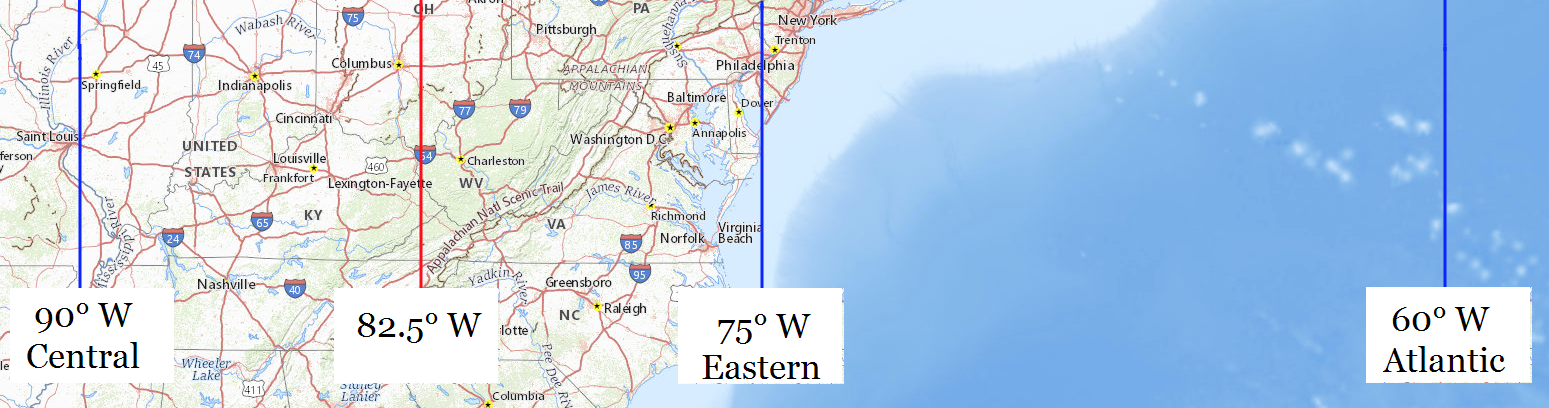 Central Standard Time is the mean solar time at longitude 90° west, the blue line at the left. Eastern Standard Time is the mean solar time at longitude 75° west, the blue line down the middle, and all of Virginia is west of that. The boundary between Eastern Standard Time and Central Standard Time belongs halfway between 75° and 90° west, the red line between them. Eastern Daylight Saving Time is the same as Atlantic Standard Time, the mean solar time at 60° west longitude, the blue line at the right.